Embed Size (px)
Citation preview
LOWER FLY AREA STUDY
“You can’t buy another life from a store”
OK-FLY SOCIAL MONITORING PROJECT REPORT No. 9
for Ok Tedi Mining Limited
Original publication details: David Lawrence North Australia Research Unit Lot 8688 Ellengowan Drive Brinkin NT 0810 John Burton (editor) Pacific Social Mapping 49 Wentworth Avenue CANBERRA ACT 2604 Australia Unisearch PNG Pty Ltd Box 320 UNIVERSITY NCD Papua New Guinea
Reprint publication details: David Lawrence Resource Management in Asia-Pacific Program Research School of Pacific and Asian Studies Australian National University ACT 0200 Australia John Burton (editor) Resource Management in Asia-Pacific Program Research School of Pacific and Asian Studies Australian National University ACT 0200 Australia
May 1995 reprinted October 2004
EDITOR’S PREFACE
This volume is the ninth in a series of reports for the Ok-Fly Social Monitoring Project. Colin Filer’s Baseline documentation. OFSMP Report No. 1 and my own The Ningerum LGC area. OFSMP Report No. 2, appeared in 1991. My Advance report summary for Ningerum-Awin area study. OFSMP Report No. 3, David King’s Statistical geography of the Fly River Development Trust. OFSMP Report No. 4, and the two major studies from the 1992 fieldwork, Stuart Kirsch’s The Yonggom people of the Ok Tedi and Moian Census Divisions: an area study. OFSMP Report No. 5 and my Development in the North Fly and Ningerum-Awin area study. OFSMP Report No. 6, were completed in 1993. I gave a precis of our findings to 1993 in Social monitoring at the Ok Tedi project. Summary report to mid-1993. OFSMP Report No. 7.
In 1994, a final round of fieldwork studies was undertaken; this work has been summarised in Interim findings for 1994. OFSMP Report No. 8. In the present volume David Lawrence gives an account of his meetings with villagers at public meetings in the South Fly section of the river and estuary.
***
Lawrence’s report reinforces the pattern we have found elsewhere that villagers’ perspectives on the environment and of their place in development differ considerably from those arising from formal studies in both subject areas. I will develop this theme at greater length elsewhere, but I believe there to be at least three distinct factors that account for this. I also find that the factors are such that practical steps can be taken to improve matters.
The first factor is that while villagers and environmental specialists are both close to their subject matter, the villagers living in it and the specialists studying it intensively, they ‘know’ it in significantly different ways. Very good demonstrations of this are extremely hard to show from both sides—or perhaps, to both sides. Almost any discussion is made at the risk of alienating or patronising one side or the other. Nonetheless, a reasonable model is that of the clash of interests in local planning and, in particular, the ‘not-in-my-backyard’ syndrome. Let’s say a waste facility of some description is proposed adjacent to a residential area. The residents will always be expected to fight tooth and nail to have it built somewhere else regardless of (a) how clean the facility can be made and (b) abstract arguments about the benefit to the community as a whole. The point is not about how clean or dirty it will be; it is about what may be called ‘diminishment’. By this I mean the diminishing of the quality of life, something that has few empirical measures and, I would argue, none that residents will accept for the purposes of arbitration.
This situation fits that found in South Fly; in fact, it fits the whole river system with specific complaints being duplicated in widely separated places. For example, a constant complaint in villages in the Middle and Upper Fly was that deckhands were seen washing down the copper boats at the Kiunga wharf, thus spilling slurry into the Upper Fly, and this was a source of contamination in the river. Lawrence listened to exactly the same complaint at Koabu (p. 35), this time about the washing down of returning copper boats. OTML always stresses that copper slurry is money and that deckhands cannot have been hosing off areas where any may have been present. The explanation is fruitless, as a belief in the recklessness
ii
of washing copper into the river ‘on purpose’ is so resilient it defies rebuttal. Equally, a ‘German scientist’ was said to have told villagers ‘not to drink the water’ at several places in the Middle and Upper Fly, and here too at Dede (p. 61). Now, we know that two German environmentalists from the Starnberg Institute paid a (very) brief visit to Western Province in 1991 and a German postgraduate student has worked for a longer period in the Middle Fly, but we do not know if any of these could have visited Dede or, if they did, what they may have said there. Personally, I am beginning to attribute these researchers with the supernatural abilities of Sido, the Kiwai culture hero (or Nggiwe or Wiwa, the Awin and Boazi culture heroes) in their gift for communication, not to mention the vast distances they were able to cover in so short a time. Be that as it may, I am sure redress lies not so much in providing more information, as in a rapprochement between ‘village environmentalists’ and ‘laboratory environmentalists’.
pabilities. Unfortunately, there is no way ahead at all without political recognition of this.
between government and villagers and between large companies like OTML and villagers.
ll the villages of a province, or the 102 villages of the Trust, will always have
The second factor is seen where a planning proposal pits interest groups within the community against each other. The recent controversy over wood-chip licences in Australia is a good illustration. In cases such as this, the diminishment felt by some community members runs squarely up against the benefits enjoyed by others. In the wood-chip case, few in either camp wish to change places. Along the Fly, Lawrence shows that the villagers who complain of lifestyle diminishment do not reject the package of benefits offered by the Trust. Indeed, Lawrence reports they are desperate for development. Our studies have not taken us among the mine lease landowners, whose loss of traditional lifestyle is by all accounts great, but those who have succeeded in business in other mine enclave areas, notably Porgera, appear to have few intrinsic objections to mining. These lucky few have effectively ceased to be ‘impacted villagers’; they are now themselves ‘miners’ or ‘oil people’. In the case of South Fly, indeed any parts of Western Province that do not qualify for formal compensations under mining legislation, I believe that the redress does not lie in simply providing more benefits; I argue elsewhere (Burton 1994) that the successive application of extra grants has not profited the province, because it overloads existing political and bureaucratic ca
The third factor is unrelated to environmental issues. It concerns culture, development and the behaviour between two parties interacting with one another. There are few places in rural Papua New Guinea—probably none at all—where a well-resourced party can deal with an unresourced one without eventual rancour. Satisfactory relationships in village situations are those where both parties demonstrate (a) unqualified reciprocity, just as the members of extended families in rural Papua New Guinea are expected to do among themselves and (b) absolute evenhandedness, as big-men must do when making public distributions. I would say that these are standards that are almost unattainable in dealings
To start with, the resources of the larger organisation cannot be placed at the exclusive, unqualified disposal of each village—tough decisions about the division of a cake of finite size among ato be made.
At the same time, it is interesting that a mathematical evenhandedness in distribution is insufficient, according to Lawrence’s data. At many villages he reports that villagers believed they were cheated out of their pay for building construction, yet disclosed amounts that were exact multiples of the Trust’s K6/day labourer’s rate. Although I have never been
- iii -
present at a Board of Management meeting, I can well imagine the form of discussion over the setting of this rate, being as it is some 33% above the exhaustively debated official rural minimum wage of K45/fortnight, or K4.50/day. I am certain that Board members, naturally, would have ruled out paying than the minimum wage, would have been keen to pay a premium above it, but not so high an amount as to antagonise other service providers in the area (notably the Montfort mission, whose staff consistently reported a sharp decline in voluntary help on mission business, e.g. unloading mission supplies from river boats). In spite of this, not one person at any village meeting spoke up in praise of the decision to pay above the minimum rate, none ever discussed pay in comparison to equivalent work at, say, a District HQ or DPI station, and, where it is noted by Lawrence (in about half the villages), people spoke as if they did not know that pay was calculated by the day.
complaint, among other things, that villagers ‘received no employment’ on Trust projects.
e says that people were confused, and confusing, about how the payments were structured.
by bush telegraph from village to village. This clearly occurred at Dede/Wasua (see p. 62).
cketed by contractors who did not finish their jobs (pp. 33, 45, 47, 49, 50, 51, 59, 63, 66).
Lawrence is not alone in finding this. Chris Brown, the General Manager of OTML, was presented with a letter by Dibura Moiba, the president of the Kiwai Local Government Council, when he visited Tabubil with a delegation of Kiwai LGC councillors in April 1994. In the letter, it was the council’s
Lawrence had specific discussions with his informants on the subject of pay for work on Trust projects. H
I do not believe there are discrepancies over the number of days worked, and I do not believe the Trust supervisors and contractors who organise the work fail to tell villagers how their pay is worked out when settling up with them. I identify the problem as arising out of tensions within and between villages. Some jobs take longer than others (especially in locating underground water sources and laying pipes) and varying numbers of labourers are needed on each village visit (and, indeed, turn up for work on successive days). As a result the amount paid will not be the same at each village, and I can be almost 100% certain that it is these final figures that villagers report among themselves and that go
As I wrote elsewhere early in 1994, villagers all over Papua New Guinea first express dissatisfaction by saying the kiap, or liaison officer, or local member, or whoever, fails to come and see them. The complaint heard second is that the person comes but is ‘all talk’ and never backs words with action. The third complaint is that what explains the second is his trickery and his innate greed: he talks of giving this or that, but actually goes away and corruptly diverts the things for himself or his own people. To summarise a longer discussion, the claims can be very true in content, or they can be very false—the stimulus for complaining lies in a feeling of breakdown in the relationship between the villager and the outside party, not specifically in the grievances themselves. Lawrence’s new reports from the villages of the Fly Estuary reinforce this pattern. ‘No one ever visits us’ was said frequently (pp. 32, 37, 42, 44, 48, 49, 61, 66, 70). Where visits were made, it was often said that an officer, from whatever agency, talked but nothing happened, ‘kept secrets’, ‘did not report back’, or ‘ran away’ from the villager’s problems (pp. 35, 38, 53, 55, 70). It was often alleged that the provincial government’s SSG money was handed to wantoks of the projects officers, given out to the wrong people in Daru, or po
- iv -
I stress again that the form that these accusations take is foremost a cultural one; they are the standard complaints made when anyone fails to live up to village ideals of reciprocity and distribution. Some of the complaints are groundless, as far as can be determined, but others are, as all members of the OFSMP team have found, only too true. It was a great difficulty for us to tell the difference; in fact there was no way other than doing exhaustive detective work ourselves. It is a notable source of exasperation to service providers and contractors, from missions to engineering companies to the Trust, that groundless complaints can be laid
e attention to the manner of contact with villagers and by constantly monitoring the quality of the relationship between villagers and the company, much ground
responsibilities of ownership and maintenance—the value of the existing projects is limited, on any score. (I
tters, and at the moment the parent whose sick child dies needlessly, or the family whose mother dies in child birth, has
er at Porgera. An analysis on SSG-type village projects is given in OFSMP Report No. 6 on the Ningerum area, Burton
rethink the way rural administration and development, and village liaison are handled in the future. Practical advice on this will be presented in the project’s completion reports.
John Burton, May 1995
with no impunity, but causing a good deal of ill-feeling and personal hurt nonetheless.
As I mentioned earlier, there may be no perfect solution to this problem, but by paying possibly excessiv
can be made up.
On the question of what means of project delivery would be more satisfactory to villagers, frank discussions are required. It is certain, though, that if villagers go on complaining about them as they do at present—and at the same time failing to take over the
discuss Trust projects at greater length in my 1995 report on Middle Fly.)
A constant point of disappointment for villagers, undoubtedly due to the Trust’s circumscribed field of action, concerns up-keep and the supply of consumables for the major assets that the Trust supplies like aid posts and schools. For example, there is a dire shortage of books at schools (p. 33) and medicines at aid posts (pp. 22, 26, 31), but as things stand the Trust would overstep itself if it acceded to requests to provide them. In the case of ordering medicines, there was an exchange of correspondence between the OTML CMO and the provincial Health Department on precisely this subject in 1992; the outcome was that almost all aspects of health remain off-limits to OTML, except in the 40km zone around Tabubil. From the viewpoint of the village, though, it is the result that ma
plenty of justification to reflect on the injustice of the situation.
At several places, villagers said that SSG benefits should be handled by the Trust (pp. 33, 59, 63), which I take as vote of confidence in it, but again this lies outside the Trust’s sphere of action. The SSG is not a benefit deducted by government from OTML revenues and handed to the provincial government; it is funded out of general revenue—but villagers do not know this! (There are models for the direct delivery of benefits, such as the Infrastructure Tax Credit Scheme, used successfully by Plac
[1993], and more will follow on Middle Fly in a later report.)
When all of the three factors I have discussed are combined, the result is distrust of environmental monitoring, a cynical view of the modern state, and the culturally-felt injury of supposing oneself ignored by the better off. In respect of the South Fly, it is unfortunate to have to convey so few positive views from the villages. However, there are ways for all parties to
- v -

Map 1. The Kiwai Area: Kiwaian and Tirio language families.
- vi -
EXECUTIVE SUMMARY
This report relays perceptions of environmental change and rural development from villages in the South Fly region. Villagers may err on points of fact, but the things recorded here do reflect what they believe to be true: these are village attitudes, understandings and perceptions.
Concerns about the environment
The area covered by this report comprises the low mud islands, mangrove, sago and nipa swamps and muddy river channels of the Fly Estuary. This waterway is a highly productive fishery for local people, whose livelihood is still dominated by the traditional subsistence methods of fishing, processing sago, gardening and collecting bush foods, shellfish and raw materials. All of them saw environmental changes in the estuary and, because of its importance in their daily lives, their concerns are therefore of considerable importance and must be taken seriously regardless of their basis in fact. The universal concerns were:
• damage to gardens and village lands caused by flooding; • reduced fish catches in the estuary and off-river swamps; • muddy and contaminated drinking water; • the appearance of diseased fish; • disease in garden crops; • the silting of estuarine channels and the appearance of new sandbanks; • the introduction of Anabas sp.
It is very likely that village perceptions do not match environmental assessment by OTML and the Department of Environment and Conservation, but this simply points to a wide gap in communication between the company, the government and the people. English is widely spoken and complex terms are understood but, in all villages, people complained that they were not informed about environmental changes, had never been briefed by the OTML Environment Department and had never seen officers from the Department of Environment and Conservation. Officers from the Department of Primary Industry and the Fisheries Research office on Daru have occasionally visited the Fly Estuary but they are ill-informed about environmental matters and have only created further confusion among the villagers. There was no faith in the Community Relations officer on Daru, whose position was seen essentially as an irrelevance.
Reactions to the Trust
The Fly Estuary is one of the least developed areas of Papua New Guinea. Lines of communication and transport are poor or non-existent, health and education are under-resourced and facilities within the village, such as sanitation, water supplies and aid posts are primitive. There is no concerted effort to control endemic diseases. There are few economic opportunities in villages and, as a result, high out-migration to ‘corner’ settlements in Daru is a feature of the South Fly way of life.
There was a high level of consensus in villages about the inadequacy of buildings and tanks supplied by the Lower Ok Tedi/Fly River Development Trust. The main complaints were:
- vii -
• the projects did not reflect what people wanted; • the building designs were culturally inappropriate (no front verandah and a single sloping roof
rather than a gabled roof); • water tanks have earth foundations and linings which deteriorate and leak, are low to the
ground and are subject to contamination, and the taps supplied cannot be locked and therefore water can be stolen;
• poor quality flooring, roofing and walls, and foundations which are not embedded in concrete in soft, sandy soils;
• poor or inappropriate fixtures were used, notably soft timbers that rotted, and metal louvres, nails and bolts which rusted;
On the positive side, solar pumps are generally regarded as successful although the batteries have to be replaced and the plastic pipes, laid on the ground, can be damaged or broken.
Contacts with Trust officers were the subject of much comment. It is not appropriate for officers to fly into villages by helicopter, make a quick appraisal of village needs and then leave. This is considered particularly discourteous and is much resented. Villagers also commented that many items requested are not supplied and they sometimes get buildings, or equipment such as fishing kits, that they do not want or cannot use.
The provision of VDF money raises considerable anger. The money is provided once a year and is almost always disbursed among villagers. This allocation to individuals must be made in cash so a long trip has to be made to the only bank in the area on Daru to cash the cheque. This is also dangerous for the distances travelled are long and Daru has many dangers for people carrying large sums of cash. Payments to individuals are usually around K20 and the money is quickly spent, usually on store goods. Villagers cannot see the point of this money
Women commented that the single most important items for women’s economic development are sewing machines and the Women’s Fellowship groups say they have often asked for them at meetings. The cost per machine is not great—about K150 for the hand operated ‘Singer’ type—but, while some had apparently been supplied at the time of fieldwork, the women said the Trust was not responding to them.
It was generally the case that villagers conflated the provincial government’s Special Support Grant (SSG) funds with Trust projects and VDF money or, even when acknowledging these as separate sources of aid, still wanted to discuss them together. All villages complained that SSG money was given to Daru residents who claim affected area residency status. Applications from villages in the Fly Estuary are usually not successful or the money given is totally inadequate for any meaningful development project. There is no consultation from the SSG Projects Office on Daru with the villages and no follow up on the project development. In the cases of both the VDF and the SSG, women’s development issues were also ignored.
- viii -
RECOMMENDATIONS
1. The operation of the Lower Ok Tedi/Fly River Development Trust should be reviewed. Infrastructure provided by the Trust to villages in the Lower Fly is inadequate, poor in quality and culturally inappropriate. A complete review of the building program in the Lower Fly needs to be undertaken (see page 73).
2. There is little effective communication between the Trust officers and the villagers in the Lower Fly area. The Community Relations officer on Daru may liaise effectively with government in Daru but does not communicate with the people in the affected area. Lines of communication between OTML and the village people should be improved urgently. Trust officers should evaluate culturally appropriate ways of approaching and working in villages (see page 73).
3. The options for VDF should be spelt out in much more detail as its purpose is by no means clear to villagers. Similarly, the employment of villagers on Trust projects should be explained again, with consideration given to equal lump-sum payments for equal projects being allocated to villages or sub-villages (see page 74).
4. In the case of the SSG, it would be appropriate for OTML to seek support from the peak industry body, the Chamber of Mining and Petroleum, for SSG programmes to be given visibly independent management and for proper accounting procedures to be demonstrated (see page 74).
5. Women’s development should be taken seriously. The women’s social networks are extensive and can be utilised for both education and public relations purposes. OTML should employ women to manage a women’s development program targeting women’s issues. (see page 74).
6. Environmental information must be provided to villagers directly; it cannot be assumed that the Provincial or National Government bureaucracies are able to provide anything more than second-hand and inaccurate information. However, there is a high degree of distrust of OTML in the villages and it is not recommended that OTML Environment Department officers approach villages at the present time. Considerable liaison and public relations work needs to be undertaken before information programs commence (see page 75).
- ix -
TABLE OF CONTENTS
Editor’s Preface ii
Executive Summary vii
Recommendations ix
Terms and Abbreviations xii
Chapter 1 Project description and methodology 1
Chapter 2 The Kiwai 5
Chapter 3 Daru 15 KADAWA (NON-TRUST) 17 KATATAI (NON-TRUST) 21 DOROGORI (NON-TRUST) 23 HAWI POINT (NON-TRUST) 24
Chapter 4 The Dudi Coast 25 PARAMA 25 SUI 28 SEVERIMABU 30 KOABU 33 MADAME 36
Chapter 4 Islands 39 SEPE 41 U’UWO 43 SAGAPADI 45 AGOBARO 47 IPISIA 49 OROMOSAPUA 50 SAMARE 51 WAPI 53 ADURU 56
Chapter 5 Manowetti 60 WASUA/DEDE 60 DOUMORI 63 PAGANA 65 ABERAGEREMA 66 TEAPOPO / ARATO + DEMAGO KENAME, WARIOBODORO 68
Chapter 6 Findings and Recommendations 72
Appendix A Itinerary, this survey 1
Appendix B Wards in the Kiwai Local Government Council 1
Appendix C Population statistics for Kiwai area 1
- x -
Appendix D Clans represented in Kiwai villages 1
Appendix E Further commentary on land tenure by John Burton 1
Bibliography 1
Plates Map – the Kiwai area: Kiwaian and Tirio languagef families
- xi -
TERMS AND ABBREVIATIONS
AIDAB Australian International Development Assistance Bureau. The Australian government’s lead aid agency. Has funded environmental studies in the Torres Strait. (Name changed to AusAid in 1995).
APCM Asia Pacific Christian Mission, formerly the UFM and a forerunner in Western Province of the ECP.
ECP Evangelical Church of Papua, successor to the APCM. The national headquarters are at Halengoali, Tari, and, in Western Province, at Balimo.
FRPG Fly River Provincial Government, referring specifically to the political half of ‘the provincial government’. The administrative half is the Department of Western, a public service department.
LGC Local Government Council. The formal third tier of government in Papua New Guinea, operating through Provincial Affairs departments and funded through a line in provincial budgets. (Some provinces operate a Community Government system instead.)
LMS London Missionary Society; in Papua from 1871/72.
OTML Ok Tedi Mining Limited. The operator of the Ok Tedi mine project. The successor to the discoverer, Kennecott (until March 1975), the Ok Tedi Development Company (March 1975 to March 1976), and Dampier Mining/BHP (March 1976 to February 1981). Until recently, the shareholders were BHP, Amoco, a consortium of German metal mining institutions, and the Papua New Guinea government
SSG Special Support Grant. An ex-gratia payment, nominally set at 1% of the province’s mine exports, given to a mining province by the national government to assist with infrastructure improvements.
Trust village Village in the Ok Tedi-Fly River Development Trust.
Trust, the Lower Ok Tedi-Fly River Development Trust, ‘the Trust’.
UFM Unevangelised Fields Mission, a forerunner in Western Province of the ECP, notably among the Gogodala and Suki people.
VDF Village Development Fund. Grants of money made as part of the Trust budget to each person recorded by annual census as living in a Trust village.
xii
CHAPTER 1
PROJECT DESCRIPTION AND METHODOLOGY
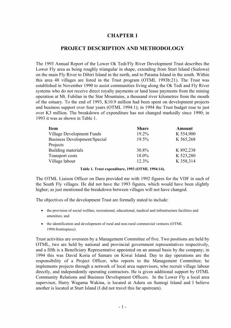
The 1993 Annual Report of the Lower Ok Tedi/Fly River Development Trust describes the Lower Fly area as being roughly triangular in shape, extending from Sturt Island (Sialowa) on the main Fly River to Dibiri Island in the north, and to Parama Island in the south. Within this area 48 villages are listed in the Trust program (OTML 1993b:21). The Trust was established in November 1990 to assist communities living along the Ok Tedi and Fly River systems who do not receive direct royalty payments or land lease payments from the mining operation at Mt. Fubilan in the Star Mountains, a thousand river kilometres from the mouth of the estuary. To the end of 1993, K10.9 million had been spent on development projects and business support over four years (OTML 1994:1); in 1994 the Trust budget rose to just over K3 million. The breakdown of expenditure has not changed markedly since 1990; in 1993 it was as shown in Table 1.
Item Share Amount Village Development Funds 19.2% K 554,900 Business Development/Special Projects
19.5% K 565,268
Building materials 30.8% K 892,238 Transport costs 18.0% K 523,280 Village labour 12.3% K 358,314
Table 1. Trust expenditure, 1993 (OTML 1994:14).
The OTML Liaison Officer on Daru provided me with 1992 figures for the VDF in each of the South Fly villages. He did not have the 1993 figures, which would have been slightly higher; as just mentioned the breakdown between villages will not have changed.
The objectives of the development Trust are formally stated to include:
• the provision of social welfare, recreational, educational, medical and infrastructure facilities and amenities; and
• the identification and development of rural and non-rural commercial ventures (OTML 1994:frontispiece).
Trust activities are overseen by a Management Committee of five. Two positions are held by OTML, two are held by national and provincial government representatives respectively, and a fifth is a Beneficiary Representative appointed on an annual basis by the company; in 1994 this was David Koria of Samare on Kiwai Island. Day to day operations are the responsibility of a Project Officer, who reports to the Management Committee; he implements projects through a network of local area supervisors, who recruit village labour directly, and independently operating contractors. He is given additional support by OTML Community Relations and Business Development Officers. In the Lower Fly a local area supervisor, Harry Wagama Wakina, is located at Aduru on Sumogi Island and I believe another is located at Sturt Island (I did not travel this far upstream).
- 1 -
This project
The objectives of the Ok-Fly Social Monitoring Project are to complete the social mapping coverage of the Fly River corridor, and to investigate village development issues in the region. I was contracted, by the principal contractor Unisearch PNG Pty Ltd, in collaboration with the contracting partner, Pacific Social Mapping Pty Ltd, to assess the effectiveness of the OTML’s Lower Ok Tedi/Fly River Development Trust programs in the Lower Fly area, and to record local village perceptions of environment changes as a result of the mining operation. The project was managed by Dr John Burton of Pacific Social Mapping. My background
the Torres Strait, Daru, and Fly Estuary regions since 1985 and completed
My methods
For this study, I visited 24 villages in the area during five field trips while based at the
The field trips concentrated on villages in the Fly Estuary region extending in a triangle
Area Location Corresponds with Languages (dialects) the estuary Coastal Kiwai sub-dialects
s art) tti
Table 2. The three parts of the Fly Estuary.
Villages were not chosen at random. The Kiwai Local Government Council office at Daru
During the field trips I attempted, as much as possible, to stay overnight in each village.
I have worked inmy doctoral research on customary exchange across Torres Strait in 1990 (Lawrence 1994). Recently, I assisted in the preparation of the Western and Gulf Coastal Zone Management Plan pre-feasibility study for AIDAB (Cordell, Sullivan and Lawrence 1993) and between 1990 and 1993 was coordinator of the Torres Strait Baseline Study for the Great Barrier Reef Marine Park Authority (Lawrence and Cansfield-Smith 1991).
village of Kadawa, near Daru. These field trips were undertaken in two stages: the first was a preliminary assessment between 25 March and 5 April 1994 during which the villages of Kadawa, Katatai and Dorogori along with the fishing camp at Hawi Point, were surveyed. The second was undertaken between 10 August and 9 September 1994. Four trips were made during this period: the first to Sui and Parama, the second from Sumogi Island to Sui, the third around Kiwai Island and the fourth from Wasua to Teapopo.
from Wasua, near Doumori Island, to Teapopo in the east, and to Kadawa in the south. I also included villages on Kiwai and Aibinio Islands. In this report I make use of three geographic terms for parts of the Fly Estuary: Dudi, Islands and Manowetti (Table 2).
Dudi S. bank of West Kiwai CD Island Islands in the estuary East Kiwai CD (p Island Kiwai + Makayam Manowe N. bank of the estuary East Kiwai CD (part) Doumori + Wabuda Kiwai
provided a list of villages and wards. The villages within a ward are usually interrelated or at least have some economic or social connections. From each ward cluster I chose the largest or the most central village to visit. In many cases I also visited a secondary village as well. In this way I was able to cover seven out of ten East Kiwai wards, though only four out of nine West Kiwai wards, during the field trip (see Appendix A).
Villages are usually empty during the day when people go to gardens or fishing and sago making camps. In the evening, after work has been completed, people are more relaxed and willing to hold public meetings or to talk with visitors. All villages approached permitted us
- 2 -
to stay in the village, usually in an empty development Trust building. Staying overnight in the village also allowed us to reciprocate village hospitality by providing tea, coffee, rice etc to elders and other visitors. As we were also travelling during the day in an open boat and needed some time to clean up and unpack gear, this method of work was more suitable for us as well.
Village meetings
tings in each village. All meetings were well attended; sometimes over 50
Meetings often lasted two to three hours with older men staying longer to complete
How I explained myself
In each village I explained who I was, what I was doing travelling ‘alone’ through the Fly
I did not use a structured interview in the strictest sense of the term—that is, a rather formal
I held public meeto 100 people attended each night. I requested that women from fellowship groups and young people from the youth fellowship attend also. Meetings were conducted in English and Kiwai. My companions were fluent in both languages and there is a high level of understanding of complex English language terms among the Kiwai. In each village there are a number of, usually unemployed, English speaking High School graduates and all Kiwai language conversations were translated in front of the village. My comprehension of spoken Kiwai is sufficient enough for me to understand the tenor of the conversation and I am confident that conversations were interpreted correctly and without bias.
conversations or to raise important, sometimes personal, matters. The level of attendance, and the length of the conversations, was an indication of the level of seriousness that people attached to the matters under discussion. It is also indicative of the lack of contact village people have with governmental officials, company employees and anyone in a position of power or influence. All meetings were constructive and even when serious issues were being discussed, such as environmental change and local perceptions of corruption among officials on Daru, people were friendly and co-operative.
Estuary, who my companions were and why I selected them, what I would do with the information gained from the village and where the report would eventually end up. I explained that the report would eventually reach officials of the Ok Tedi Mining Limited but that I was not an employee of the company and that they could discuss issues freely with me and I would report them as they were presented to me. The general feeling was that people hoped the company would read the report and understand that this report would express the opinions of the villagers of the Lower Fly area.
survey schedule—as this would have been culturally inappropriate for what I wanted to know and would have elicited only set answers. Instead, I worked through a set of open topics, asking the villagers to tell me details of the village development projects in the village, to give their opinions of the projects and buildings, and to discuss issues relating to development generally. Following that I asked people to describe the way of life of the village and to give me details of any environmental changes that they noticed in their village areas. I followed the same format in each village. The emphasis was on allowing the villagers to talk to me, rather than the other way around.
The older men usually spoke first, as is custom, and then other men followed. I asked questions of the women, usually through an older man or a village leader, and am confident
- 3 -
that if some contradiction had been apparent the women would have resolved the matter publicly. Kiwai women are not reticent about expressing themselves publicly.
Confusion of SSG with VDF
Cash grants are available to South Fly people from two sources: the Village Development Funds (VDF) which are paid annually to Trust villages from the Trust’s budget, and the Special Support Grant (SSG), which is a national government budget item given to the provincial governments of the mining and petroleum provinces.
The value of the annual SSG allocation is supposedly calculated at 1% of the export value of mine production and, according to the agreements, 40% of each year’s SSG allocation is earmarked for the South Fly (Burton 1991:32, fn 34). The problem is that documentation relating to the management of the SSG allocation is almost non-existent while the criteria used for the selection of particular projects for funding—the projects are not distributed evenly—can only be guessed at by villagers. In consequence there is no real understanding of the operation of the programme and villagers in the Fly Estuary discussed the SSG and VDF interchangeably, as both sets of funds having their origins in mine production. This explains the inclusion of comments about the SSG in the village reports, even though the SSG is unconnected with the activities of the Trust.
Key informants and village contacts
At the beginning of each village report in the text are listed the names of people who assisted me in organising a meeting, translating the discussion and who provided accommodation or other assistance. It should not be assumed that only these people provided the comments on the environmental situation or on the development programs.
Acknowledgments
John Burton provided guidance on the project’s aims and background and has done the production editing of the manuscript, and has added the maps, from my field annotations, and Appendixes B-E. At the Environment Department of Ok Tedi Mining Limited I would particularly like to thank Ian Wood and Andrew Storey. Andrew maintained a daily radio schedule with us in the field. This was a source of great entertainment for us all. I am also grateful to the staff of the Environment Department of Ok Tedi Mining Limited for the provision of a good quality fibreglass dinghy, adequate fuel and equipment.
The study was hampered by extremely poor weather conditions in the study area and by my suffering a prolonged attack of malaria during the final part of the study. I particularly wish to acknowledge the hard work, care and kindness of my friends, Nanu Moses, Baera Nawaira and Koromo Wagoi from the Wamuba clan in Kadawa. Not only did they understand the nature of the study and assist in this work, but they cared for me when I became ill. I am very much in their debt. Thanks also to the Goinawo clan in Kadawa for allowing me to live in their village area and to use their facilities.
- 4 -
CHAPTER 2
THE KIWAI
The Fly Estuary, covering an area of approximately 7100 square kilometres between 8° and 8° 15’ S and between 143° and 143° 45’ E, is about 80 kilometres in width. The largest island in the estuary, Kiwai Island, is approximately 60 kilometres in length and between 5 and 10 kilometres in width. The average water depth in the estuary is only about 8 metres, and passages between islands are usually long, narrow and shallow. The estuary is a tidal current/river flow dominated system (Wolanski, Trenorden and King 1990). These opposing pressures result in a mass of water and sediments which alternate according to the tidal movements in the estuary channels. The Fly Estuary is relatively small compared with other systems, such as the Mekong, and Wolanski et al. (1990) state this indicates the estuary is comparatively recent and that little sedimentation has occurred. The estuary is characterised by shallow water and strong tidal currents.
OTML disposes of processed mine tailings and waste rock into the Ok Tedi and its tributaries. The Ok Tedi in turn flows into the Fly River which discharges through the Fly Estuary into the Gulf of Papua. Because the Fly Estuary is a tide-dominated system and this means that the amount of sediment discharged into the marine environment is greater than for a sediment-dominated system (e.g. Mississippi). However, the estuary also contains a large mass of mobile or fluid sediment that buffers the effects of changes in sediment input on the amount of sediment deposited in the delta front. The total annual natural sediment load of the Fly River is approximately 100 million tonnes of which the Strickland River, joining the Fly at Everill Junction, contributes about 70% of the total. To this is added mining fines and overburden from both the Ok Tedi mine and the Porgera mine which is located in the highlands at the headwaters of the Strickland River. Approximately 80,000 tonnes of tailings and 100,000 tonnes of waste rock enter the Fly River system each day from the Ok Tedi mining operations. The annual total is about 58 million tonnes. Approximately 40 million tonnes of this reaches the Fly River and the bulk is transported through to the Fly Estuary. In the estuary the sediment becomes mobilised into a layer of fine mud about two metres thick which occupies about two-thirds of the estuary. The residence time for the sediment in the estuary has been estimated at 100 years. The effect of this discharge of fines and overburden is monitored by the OTML Environment Department (e.g. OTML 1993a; Cook 1994:258-263). A considerable amount has now been written on the tailings disposal system and its effects on the riverine and marine environments (see Lawrence and Cansfield-Smith 1991).
There are about forty small and medium sized islands in the estuary and most are extremely low, swampy and covered in mangroves and nipa palms. Inland, on the larger islands, are freshwater swamps and dry savanna country. The rainfall is about two metres a year, and while most of this rain falls in the normal, southeast monsoonal season of December to April, local squalls and showers are common throughout the year. A reversal of season occurs in the adjoining areas to the east, possibly as nearby as at the Bamu River and in Gulf Province, and to the north, in the Fly headwaters, with most rain falling in the northwest
- 5 -
season (cf. McAlpine et al. 1983: Fig. 3.9). The weather is often windy for the estuary faces almost directly southeast and the dominant winds between May and November are from that direction. As a result, travel by small boat in the estuary is often difficult and dangerous.
ans, as well as Torres Strait Islanders. Pearlshelling commenced at Warrior Island in 1868.
towards missionisation of the Torres Strait and the southwestern Papua New Guinea coast.
hurch. The villages of the Dudi coast are predominantly adherents to the United Church.
now at Halengoali, Tari. The ECP is influential along the Manowetti coast and on Daru.
Contact history
In 1606, de Prado and Torres made a brief anchorage off Parama, but no contact with Kiwai people is known from his voyage. Later, the southern coastal area of Papua New Guinea was charted from 1842 by Captain Blackwood during the voyages of the Fly and Bramble (Lawrence 1994:260). After 1860 the Torres Strait became a centre for commercial pearling and bêche-de-mer fishing with a labour force of Pacific Islanders, Australian Aborigines and Europe
The London Missionary Society
Missionary activity commenced in region in 1871 when the London Missionary Society established a base on Darnley Island; from there the LMS began a steady move
In 1872 Pacific Islander pastors were landed at Mawatta near the Bineturi on the southwestern coast. However the missions did not prosper until James Chalmers, locally known as ‘Tamate’, assumed responsibility in the Western Province after 1886. Chalmers established a base at Saguane on Kiwai Island (see Figure 2, p. 40) but, after the death of his wife, he relocated the mission on Daru in 1900. He was killed in 1901 at Goaribari Island and is the subject of a substantial biographical literature. The LMS, by joining with other churches in Papua New Guinea, such as the Methodists, has evolved into the present-day United C
The Evangelical Church of Papua
The ECP is an evangelical church established in 1966 out of the former Unevangelised Fields Mission (UFM) which had been granted use of the Madiri Plantation by Papuan Industries Limited (also a mission society) in 1932. Mission activity among the Gogodala was active before the Second World War; after the war Australian and New Zealander evangelical missionaries were successful in converting most of the remaining Gogodala and Suki people to Christianity. The UFM changed its name to Asia Pacific Christian Mission in the 1960s, and then the ECP was constituted. The ECP and the Asia Pacific Christian Mission are two parts to the one religious organisation with the APCM headquarters and mission training school based
Daru
By 1895 Daru was the administrative and mission centre of the Western Division, essentially today’s Western Province. The influence of Daru increased during the colonial period and this has had a significant effect on the social and economic development of the Lower Fly region. Daru remains the only centre for commerce, business, government administration, communication, higher education and transport in the region. The Lower Fly
- 6 -
area is economically depressed, has poorly developed infrastructures and high unemployment. Daru is a major centre for crime in the region and continues to both attract and repel people from the Lower Fly.
43. The variability and lack of reliability of census data has been discussed by King (1993).
ds in the Torres Strait, and (b) the descendants of Kadawa people who live in these places.
age head counts; at no Trust village were only residents considered to be village members.
elate to variations in village name or the amalgamation of villages (see
in the case of the SSG programme. These points will be taken up in the body of the report.
ween the villages of Kiwai Island and the villages along the Dudi coast and down to Daru.
Population
The population of the Fly Estuary region is difficult to accurately determine and the figures presented in this report highlight the problems of knowing what village populations really area. The 1980 national census for 49 villages in the East Gogodala, East Kiwai and West Kiwai census areas gives a total population figure of 7812. The 1990 national census figure is 10,577 while the 1990 OTML census conduced at the same time gives a population figure of 15,060 with a 1991 a total of 14,9
A point of some sensitivity in relation to the Trust concerns exactly what numbers of people live in Kiwai villages as opposed to ‘camps’ nearer to Daru and corners in Daru itself. I was frequently given population figures by village Chairmen that differed widely from those taken from national government and OTML censuses. To take Kadawa (not a Trust village, but I know where the absentees are located) as an illustration, Kadawans say they number between 1000 and 1200 persons when the latest national count was 369. The excess can be explained (it is uncertain the census figure is accurate) by including (a) Kadawa-born residents of Daru corners, other Kiwai villages, and various islan
Parama is another village with many people in Daru corners and in the eastern islands of the Torres Strait. Among the names of urban census units in Daru are ‘Samare’, ‘Ipisia 2’, ‘Kenedibi’ and ‘Gaima’; these are villages in the estuary. Different villages in my survey tended to include more or less of the absentees in their vill
The villages listed by King (1993) do not reconcile exactly with those listed in the latest Trust report (OTML 1993b). Where possible I will attempt to reconcile these differences. Mostly they rAppendix B).
Daru has a immense impact on life in all Trust villages in the Lower Fly, and has an importance in village life that has not been fully realised in the Trust. There is considerable movement to and from Daru by Fly Estuary villagers and this has a marked impact on the delivery and usefulness of all rural development efforts, whether these are delivered by the Trust, missions, or the government as
Language and cultural history
The Fly Estuary is the traditional home of the Kiwai-speaking people who, legend states, originated from Barasaro near Iasa on Kiwai Island (see Figure 2, p. 40) and spread out to the Dudi coast from there. There is a strong relationship bet
- 7 -
In surveys with a cut-off date of about 1970, there were some 22,700 Kiwai-speaking people (Würm 1973: 225; Würm and Hattori 1981), the key groups in the Fly Estuary being the 11,400 speakers of Southern Kiwai and Wabuda Kiwai (see Table 3). To this must be added the 950 speakers of dialects in the Tirio family between Madame and the Bituri River. There is some discrepancy with Busse’s equivalent Kiwai figure for 1980 of only 9,800 (Busse 1991: 124), and it is difficult to reconcile the difference between the estimated number of language speakers and the population numbers obtained by village census collecting; this is very likely due to constant population movements. As is evident from King’s figures, there is little reliability in the growth rates that can be calculated from census data (King 1993).
The main dialects are Bamu Kiwai, spoken in the Bamu estuary—outside the immediate area of this project—but also in squatter settlements on Daru and in the middle reaches of the Oriomo River, near Daru; Wabuda Kiwai, spoken at Wapi on Aibinio Island, on Wabuda Island, Dibiri Island and some north coast villages; and Southern Kiwai, spoken on Kiwai Island, the Dudi and Manowetti coasts and along the southwest coast from near Daru to Mabudawan (see Map in endpapersMap 1).
- 8 -
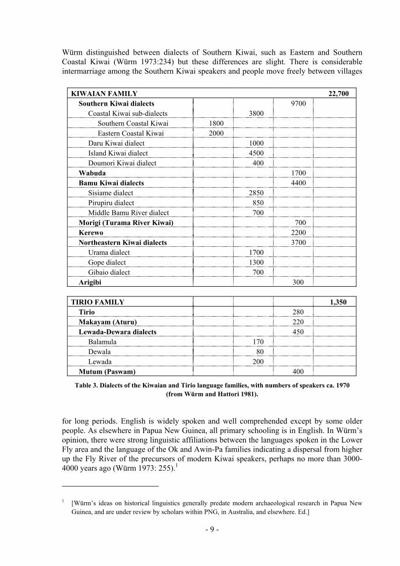
Würm distinguished between dialects of Southern Kiwai, such as Eastern and Southern Coastal Kiwai (Würm 1973:234) but these differences are slight. There is considerable intermarriage among the Southern Kiwai speakers and people move freely between villages
for long periods. English is widely spoken and well comprehended except by some older people. As elsewhere in Papua New Guinea, all primary schooling is in English. In Würm’s opinion, there were strong linguistic affiliations between the languages spoken in the Lower Fly area and the language of the Ok and Awin-Pa families indicating a dispersal from higher up the Fly River of the precursors of modern Kiwai speakers, perhaps no more than 3000-4000 years ago (Würm 1973: 255).1
KIWAIAN FAMILY 22,700 Southern Kiwai dialects 9700 Coastal Kiwai sub-dialects 3800 Southern Coastal Kiwai 1800 Eastern Coastal Kiwai 2000 Daru Kiwai dialect 1000 Island Kiwai dialect 4500 Doumori Kiwai dialect 400 Wabuda 1700 Bamu Kiwai dialects 4400 Sisiame dialect 2850 Pirupiru dialect 850 Middle Bamu River dialect 700 Morigi (Turama River Kiwai) 700 Kerewo 2200 Northeastern Kiwai dialects 3700 Urama dialect 1700 Gope dialect 1300 Gibaio dialect 700 Arigibi 300 TIRIO FAMILY 1,350 Tirio 280 Makayam (Aturu) 220 Lewada-Dewara dialects 450 Balamula 170 Dewala 80 Lewada 200 Mutum (Paswam) 400
Table 3. Dialects of the Kiwaian and Tirio language families, with numbers of speakers ca. 1970 (from Würm and Hattori 1981).
1 [Würm’s ideas on historical linguistics generally predate modern archaeological research in Papua New Guinea, and are under review by scholars within PNG, in Australia, and elsewhere. Ed.]
- 9 -
There are linguistic and cultural affiliations between the inland people of the southwestern coast and the Torres Strait Islanders (Lawrence 1994:Fig. 28). It is important to note that the southern coast and the Fly Estuary people have been actively engaged in trading and intermarriage right across this area since before European contact. The movement of canoes in exchange for Conus sp. shells was the most important feature of this dynamic economic system and elements of inter-cultural exchange still persist. The Torres Strait Treaty between Australia and Papua New Guinea recognises the rights of traditional inhabitants from both sides of the border to move freely for traditional purposes such as trade, ceremonies and visits to kin (see Burton 1995 for further discussion of cross-border rights).
The use of the name ‘Kiwai’
The term Kiwai was used in the colonial period to refer to the whole native population of the southern part of the Western Province. Gunnar Landtman, in his study of the social customs of the Kiwai undertaken between 1910 and 1912, used the term in a generic sense to mean speakers of Kiwai but he also mistakenly used it to refer to people from the Bine, Gizra and Gidra speaking groups on the Pahoturi, Binaturi and Oriomo Rivers who use Kiwai as a second language (Landtman 1927). Landtman was a protegé of the British ethnographer A.C. Haddon who pioneered ethnographic research in the Torres Strait and also published details of pre-contact Kiwai cultural history (Haddon 1901-1935). The name Kiwai was later used to refer to the people from Kiwai Island in the Fly Estuary or to refer to speakers of Southern Kiwai and variants. Currently it is used to refer to people who speak Kiwai and live in the Kiwai census divisions (Filer 1991: 40).
Resources and settlements
Subsistence economy
Subsistence patterns along the southwestern coast and in the Fly Estuary vary according to geography and topography. Overall slash and burn horticulture is combined with fishing and hunting. The most common horticulture products are taro, Colocasia esculenta; yams, Dioscorea sp; bananas, Musa sp; sugarcane, Saccharum officinarum; sweet potatoes, Ipomea batatas; and coconuts, Cocos nucifera. Semi-domesticated sago, Metroxylon sp, provides much of the carbohydrate diet.
Gardening is a subsistence activity in which all people participate. Garden vegetables and fruit are collected daily and vegetables are occasionally sold in the markets in Daru but most vegetable and meat sellers are from inland (non-Kiwai) ‘bush’ villages. The Kiwai do not have extensive gardens due to the nature of the coastal soil, the size of the islands and the location of villages near the sea of river which restricts the amount of land available for gardening.
The markets at Daru provide an outlet for buying and selling goods that exploit the geographical differences in resources across the region. Fish, dugong and turtle are sold by the coastal village people to the Fly Estuary people; Fly Estuary villagers bring sago, bananas and coconuts to sell to Daru inhabitants and the coastal villagers.
- 10 -
Fishing and hunting
The hunting on land of cassowary, pigs, deer, wallabies and birds is still important to the local village economy and wild meat is an important part of the protein diet. Fishing is a daily activity for all coastal and island villagers. The main artisanal fishery centres around barramundi which migrate down the Fly River and along the Dudi and southwestern coasts. The fish are caught in long gill nets strung at right angles to the beach and the catch sold to seafood factories on Daru. Other fish, such as mullet, mudfish (a species of gudgeon), and catfish, are eaten or sold in the Daru market.
Along the southwestern coast, the hunting of dugong, Dugong dugon and sea turtle (principally green turtle, Chelonia mydas, with hawksbill turtle, Eretmochelys imbricata, flatback and loggerhead turtle less abundant) in the Torres Strait is common.
Marsh and Saalfield (1991) found that the dugong population of Torres Strait was around 12,500 animals, with 500-1000 being taken annually by local hunters. They also mention that ‘the dugong catch by the people of the Western Province on Papua New Guinea ... is believed to have declined substantially since the sale of dugong meat was banned in 1984’ (1991:193, my emphasis); however, since wildlife inspectors cannot effectively monitor individual sales, dugong continues to be on offer at the Daru market.
The sustainability of the turtle catch is, at present, uncertain (Kwan 1991). Kiwai hunters can certainly bring in large numbers using very basic equipment; for example, on my visit to Kadawa in March 1994, a expedition returned from the Auwomaza reef, a traditional fishing on the PNG side of the international fishing boundary with Australia, with 19 turtles. The party had been away for several days on ‘Bani’, a tataku canoe named after a well-known Kadawa founder (see below p. 18), and one other sailing canoe.
Villages
Kiwai villages are built close to the sea, or on narrow rivers and waterways. Houses are small, consisting of two to three rooms, built of folded nipa palm walls and a sago thatch roof. Floors are black palm; struts and supports are made of mangrove. The houses may look flimsy but are actually strongly built, cool and can be broken down if necessary and rebuilt elsewhere. In the northern part of the Fly Estuary villages are physically different. People use plaited sago canes woven into broad screens rather than nipa palm for walls. This is a Gogodala custom that has been adopted by some Kiwai in the northern part of the estuary. These walls are more attractive, but are not as water-proof as the closely folded nipa palm.
Kiwai villages vary tremendously in their internal dynamics. Some are noisy and full of life, others quiet and sleepy. By comparison with societies higher up the Fly, the Kiwai have a richer and more complex material culture—their canoes have elaborate rigging and they make and maintain a much wider range of baskets, nets and other fishing equipment—lending a ‘busy’ air to their villages. Consequently, their ability to travel within the estuary and by sea over considerable distances and their long tradition of contact with other cultures
- 11 -
(Lawrence 1994:259 ff.) means that the Kiwai are unusually well-informed on many subjects and have a good awareness of development issues. 2
Canoe types
Access between villages is made by boat or canoe. Currently, there has been a considerable technological change with canoes being replaced by fibreglass ‘banana’ boats powered by outboard motors. However, travelling distances are long, and as Daru is the only major centre for fuel, canoes are still used. Canoes are still obtained from the Dibiri Island or from the Balamula areas and traded down to Daru and the coastal villages.
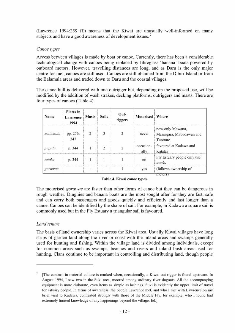
The canoe hull is delivered with one outrigger but, depending on the proposed use, will be modified by the addition of wash strakes, decking platforms, outriggers and masts. There are four types of canoes (Table 4).
Name Plates in
Lawrence 1994
Masts Sails Out-riggers
Motorised Where
motomoto pp. 256, 347
2 3 2 never now only Mawatta, Masingara, Mabudawan and Tureture
puputu p. 344 1 2 2 occasion-ally
favoured at Kadawa and Katatai
tataku p. 344 1 1 1 no Fly Estuary people only use tataku
gorowae - - 1 yes (follows ownership of motors)
Table 4. Kiwai canoe types.
The motorised gorawae are faster than other forms of canoe but they can be dangerous in
Land tenure
The basis of land ownership varies across the Kiwai area. Usually Kiwai villages have long
rough weather. Dinghies and banana boats are the most sought after for they are fast, safe and can carry both passengers and goods quickly and efficiently and last longer than a canoe. Canoes can be identified by the shape of sail. For example, in Kadawa a square sail is commonly used but in the Fly Estuary a triangular sail is favoured.
strips of garden land along the river or coast with the inland areas and swamps generally used for hunting and fishing. Within the village land is divided among individuals, except for common areas such as swamps, beaches and rivers and inland bush areas used for hunting. Clans continue to be important in controlling and distributing land, though people
2 [The contrast in material culture is marked when, occasionally, a Kiwai out-rigger is found upstream. In August 1994, I saw two in the Suki area, moored among ordinary river dugouts. All the accompanying equipment is more elaborate, even items as simple as lashings. Suki is evidently the upper limit of travel for estuary people. In terms of awareness, the people Lawrence met, and who I met with Lawrence on my brief visit to Kadawa, contrasted strongly with those of the Middle Fly, for example, who I found had extremely limited knowledge of any happenings beyond the village. Ed.]
- 12 -
say the strength and unity of clans is much reduced today, compared with the situation earlier in the century, due to out-migration and a high number of marriages among partners from areas not traditionally in contact with each other. Individual areas of garden lands are fenced and marked, as are some coconut trees and water wells. Garden areas are allocated to individuals through family or relatives and the produce grown on these garden belongs to the grower. However, there is a considerable amount of exchange of foods among the clans and family and people occasionally work communally in gardens. Husbands and wives often have their own garden plots. Hunting and fishing is more communal although parts of rivers, banks, reefs and channels belong to certain villages. Fishing in such areas without permission is regarded as stealing. (for further commentary on land tenure, see Appendix E).
Political organisation
Traditionally, the Kiwai did not have chiefs or hereditary ranks. Authority was exercised collectively by senior men who were usually the heads of clan groupings. Village leaders are mostly middle-aged men who have obtained positions of influence in the village such as pastors, village policemen, church elders, council chairmen etc. Women exercise considerable influence although they do not hold public office except within the Women’s Fellowship organisation of the community church.
The United Church is a powerful social, cultural and political force in the village and this is the result of the historic control of power and influence gained by the London Missionary Society in the Fly Estuary during the colonial period. The LMS was, in parts of Papua and the Torres Strait, virtually a theocracy. Only recently have other churches moved into Kiwai-speaking villages and there is some local disquiet about the influence of opposing church factions within the village as this threatens the established religious and political organisation of villages.
Each village in the area I covered had a Community Council consisting of a Chairman and several committee members. This is quite distinct from the Local Government Council and the Chairman was a different person to the LGC Councillor. It is not clear to me how the Community Council is convened; it seems likely that it runs alongside church organisations in each village. In general, the village Chairman is the most immediately important leader; the LGC Councillor seemed to be a more ineffectual position, probably because Local Government meetings take place outside the village and because the LGC is starved of funds to do visible village development projects.
The wards and members of the Kiwai Local Government Council are listed in Appendix B. Some villages in my survey are in the Fly-Gogodala Local Government Council on the north coast of the Fly Estuary, which principally represents Gogodala-speaking villages. The council offices are at Balimo. One village, Dorogori (not in the Trust), is in the Oriomo-Bituri Local Government Council.
As in other parts of Western Province, there are some inconsistencies with the representation of village in the Kiwai and Gogodala Local Government Councils. For example, Damera is in the Kiwai Local Government Council but is inhabited by predominantly Malawade speaking from the Gogodala area to the north while Pagana, which is Kiwai speaking and the sister village of Doumori, is part of the Fly-Gogodala Local Government Council. I
- 13 -
attempted, as much as was possible under the circumstances, to visit at least one village from each ward.
- 14 -
CHAPTER 3
DARU
It is not possible to understand the problems of village development and the difficulties faced by people in the Lower Fly area with regard to lack of information on environmental matters without comprehending the role and importance of Daru.
Daru Town
Daru is the Provincial capital and so the main Provincial Government offices are located
Provincial government
Most offices were either closed or operated by a few staff. In defence of the local public
Churches and schools
also the administrative centre for the main religious organisations operating in the
urches in the
Daru has a fluctuating population residing in two fairly well defined areas: the old colonial art of town built along the highest ridge to the east where the churches, hospital and
roana e.g. Mabudawan corner, Sepe corner, Samare corner. Within these small settlements
there. The Provincial Government was under suspension at the time of this field work so it was not possible, unfortunately, to interview local politicians. The Provincial Government has been dismissed twice and public servants are universally distrusted by villagers.
servants it must be said that they work under difficult conditions. Offices are poorly serviced and in run-down condition. Financial restrictions make travel to provincial towns and villages almost impossible. This means that Daru public servants have become isolated from the people they serve and consequently the villagers are resentful of the lifestyle of public servants and the fact that they have no opportunities to question pubic officials about village development problems.
There are few officers from the National Government on Daru and the Department of Environment and Conservation has no office on the island. Consequently information on environmental issues relating to mining operations in the Fly River cannot be discussed with the appropriate officers directly. The telephones of all government departments were cut for the whole time I was in Papua New Guinea because they had not paid their telephone accounts. It is understandable that public servants are apathetic.
Daru is Lower Fly area. The main churches are the Catholic and the United Churches which both have their headquarters on Daru. Some fundamentalist churches such as the New Apostolic Church, Destiny Chapel and the Seventh Day Adventists also have small chsuburban areas. The Daru High School is located near the airport and three other primary schools are also located on the island. The oldest school, Chalmers Primary School, is near the centre of town and is in poor condition.
Corners
pgovernment housing are located, and the ‘corner’ settlements built to the west of the main
d on the lowest part of town. The corners are divided by roads and gardens into village mes,
- 15 -
live village people either on a semi-permanent basis or during visits to Daru for medical treatment, shopping, government business etc. The corner has become a substitute for the real village for children going to high school or old people wishing to live near medical attention and younger relatives. For young people Daru is exciting and dangerous and life in the village boring and dull.
urbs have been built recently near the airport and past the hospital but the
mostly built by Bamu Kiwai, the wharf and some government offices, and the only hotel. The airport and prison are to the south of the
to have been sold to a Highlands consortium and it is assumed that it will reopen sometime in 1995. There are two very profitable liquor outlets on the island: Barramundi Bar and Bistro and
el.
s one of the worst in Papua New Guinea. Prices are high and the quality dards are very poor and there is little attempt to regulate the sale of
species, such e (see above, p. 11). The most common items meat, s
vegetables and some swee at the tradestores on Daru for rice, ods are kept in the bigger stores but
of the produce nd-grade.
ses are sent on to Port . There a mmon.
The sleazy reputation of Daru has spread far and wide in the province, with the proffering of dwellers from a particular area just
y Estuary.3 As might be imagined, sexually transmitted diseases have a high
Some newer subfocus of Daru is confined to the area near the wharf. Between the old town and the corners are newer housing, the high school, tradestores, the only bank and the post office. On the waterfront are further squatter settlements,
township.
Other squatter settlements are located on the southern side of the island, these are mostly temporary dwelling for other Bamu Kiwai people. The Bamu settlements are comparatively recent and the inhabitants have moved away from the poverty and hopelessness of the Bamu in search of economic opportunities in Daru.
Commercial
There are only three main tradestores on the island: TDS, Daru Trading and Jim’s Trading. All are owned by Asian businessmen. Prices are high even for Papua New Guinea. The only locally owned stores, Fly River Trading and Karawame Trading, were closed under instructions from the owners. The old Fly River Trading store has been rumoured
the tavern at the Wyben Hot
The local market ilow. Hygiene stanendangered as dugong and turtlsold are fish, wild ago, bananas, betel nut imported from the Highlands, a few green
t potatoes. Mostly people shopflour, sugar, tinned meat and tinned fish. Some frozen gothe quality is generally seco
Health
The hospital is in urgent need of upgrading and most serious caMoresby Hospital re no private doctors on Daru. Malaria is co
Prostitution by both sexes is common. Women charge about K2, men apparently nothing.
wives for paid sex adding a special notoriety to corner outside the Fl
3 [An agenda paper for a women’s workshop held in Kiuga, 27 Sep-1 Aug 1992, lists issues of concern to the participants. North Fly women gave river pollution, garden flooding and lack information as their top worries. In South Fly, women gave logging, prostitution, ‘husbands sell their wives’ and STDs as theirs. Ed.]
- 16 -
incidence and, anecdotally, informants report a high rate of re-infection. Given such favourable circumstances for all STDs, and the virtual collapse of health services, there is little chance that the spread of STDs can be contained. As Daru has a separate reputation for being the prime smuggling route between Papua New Guinea and Australia, there are obvious implications for public health policy in the Torres Strait.4
Law and order
Sohigthe
Ot
The roads have been improved since 1992 but the wharf is now in poor condition. The airbathe
Da
It business with officials on Daru. There is a general feeling of apathy about the place and it is cerpla
Vi
cial problems, such as alcohol abuse and crime, are major problems. Marijuana from the hlands is freely available. There is a large police presence on the island and Daru houses main prison for the Western Province.
her facilities
port, fortunately, is in good condition. There is no public transport. There is only one nk on the island, the Daru branch of the PNG Banking Corporation and the post office has only working public telephone which operates on a one minute per call basis.
ru: summary
is difficult to describe the problems faced by people from villages wishing to conduct
tainly dangerous on the island. For men from the villages Daru is exciting and flash, a ce for illicit sexual encounters and for acting out. Women, wisely, stay at home.
llages adjacent to Daru
KADAWA (NON-TRUST)
4 [This has obvious implications for an HIV outbreak in this area, were this to occur. Dr. Paul Turner (pers. comm.) has commented to me that this is indeed a very real risk. Ed.]
Population: 1980: 245; 1990: 369. Population growt
Language: Clans:
Stores: Churches: Transport: Community SchAid post:
Main informants:
Extra informatiPublic me
h: The difference in the figures represents a ‘growth’ of 4.18% p.a., but this isunlikely—both figures are suspect.
Council: Kiwai LGC. E. Coastal Kiwai. Goinawo, Buduru, Wamuba, Waibina.
Two canteens. Bethel #2 United Church. Generally sailing canoes at the time of fieldwork.
ool: In the village, but closed. Three grades when open. Bush materials AP.
Biza Gera, Kimai Segadamo, Deacon Gegera Mause, Siabu Gibuma, Seaea Onii and Nanu Moses.
on: Dega Kamaira, the story of Bagari. eting: Yes.
- 17 -
Kadawa and Katatai are not Trust villages. I surveyed them because the Kadawa/Katatai people are traditional land owners of the Toro Passage and Dudi coast area as far as Arimaturi, near the old Sui village site. They are therefore owners of land and fishing areas within the Trust area. The village is located on the southwestern coast facing the southeast and Daru is clearly visible from the village. They are closely related to Parama village.
Oral history
When the Kiwai began moving out from Kiwai Island some moved across to the Dudi coast. One man, Sewota, sailed as far south as Koipomuba near the present village of Katatai. Another man, Bagari from Kuru, was living there and he told Sewota to go to live at Huboturi, near the entrance to Toro Passage. Bani, from Boigu Island, came from the west and he went to live with Sewota. Later, Sewota went to live near Gewi and Bani and Sewota’s son went to Doridori. Gewi and Doridori are both on the Dudi bank north of Toro Passage.
At Doridori other people joined Bani and they established two longhouses called Kudin and Wasigena. From Doridori the village split and the senior clans groups, the Gebarubi, went and established Parama village. The group of junior clans, the Kadawarubi, went south back along the coast and established a village near Katatai. Here, Bidedu, another man from Kuru, found the people on the coast and the two groups, one from the Fly Estuary and one from inland, formed the village at Dudupartu near the mouth of the Oriomo River. Later, Biza, one of the people found by Bidedu established a village opposite Daru at Mawatta-Dodomea.
hese two groups, particularly the men Gamea and Kuke, sailed west and The products of the union of tfounded villages at Mawatta on the Binaturi River, and Tureture. Gamea had also gathered people from the Fly Estuary, Parama and Daru to settle on the beach east of the Oriomo River. The Kiwai learnt gardening from the people from inland, and fishing and marine hunting from the Torres Strait Islanders who were then occupying Daru. The present village area of Kadawa (meaning: to run away from the waves) was named by Bagari.
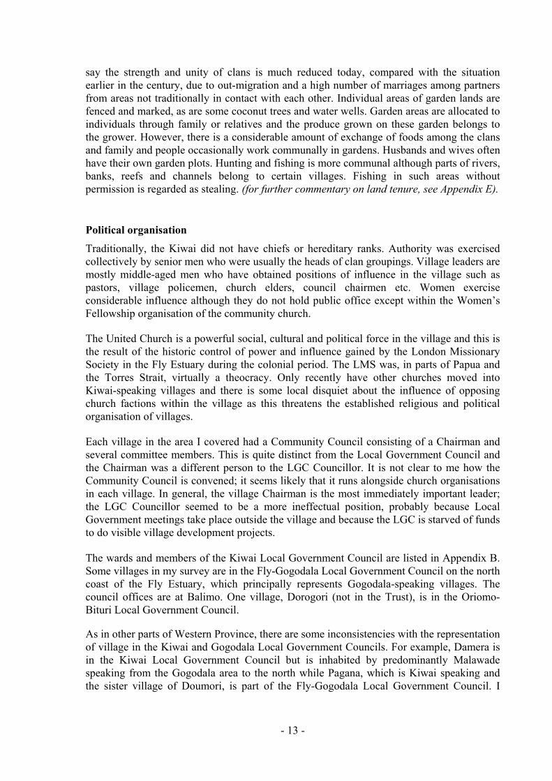
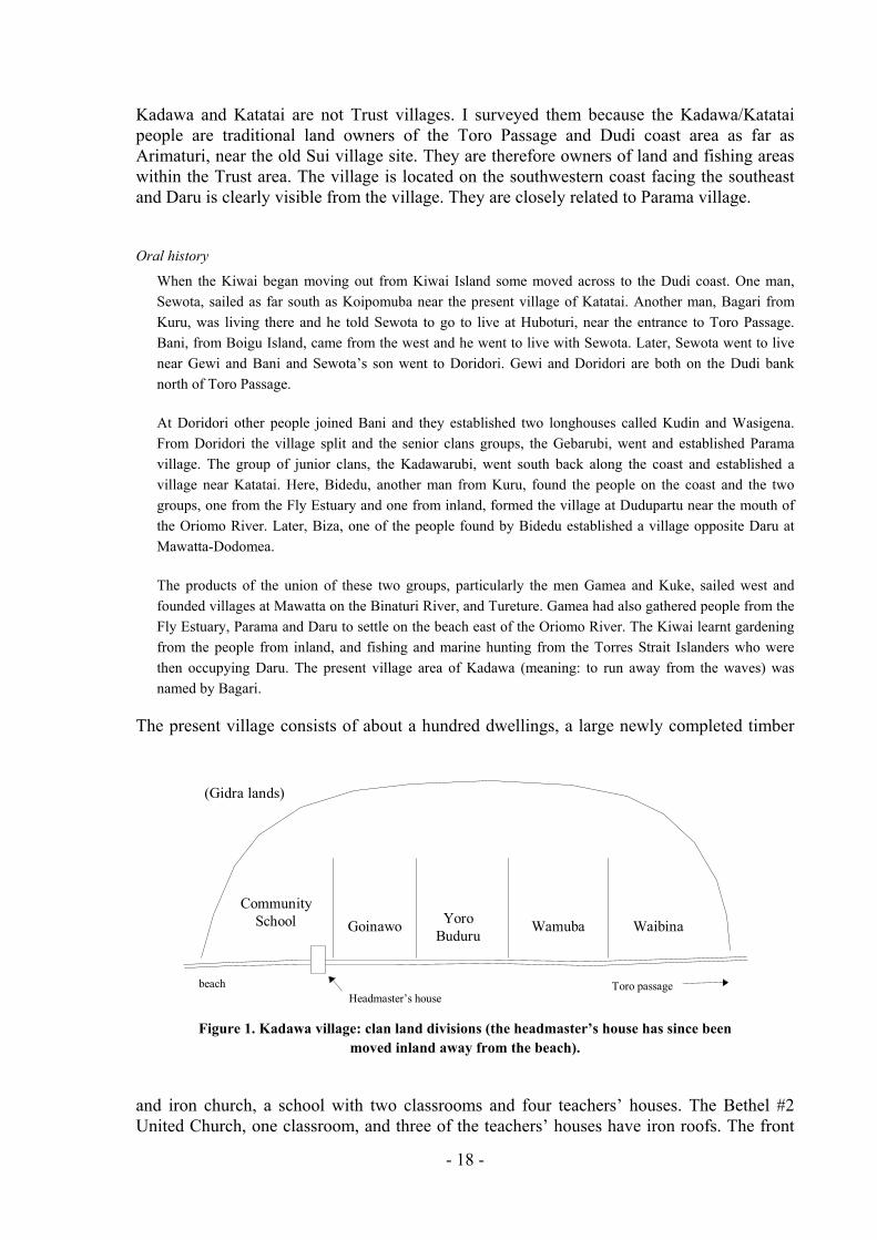
The present village consists of about a hundred dwellings, a large newly completed timber
(Gidra lands)
CommunitySchool WaibinaWamubaYoro
BuduruGoinawo
beachHeadmaster’s house
Toro passage
and iron church, a school with two classrooms and four teachers’ houses. The Bethel #2 United Church, one classroom, and three of the teachers’ houses have iron roofs. The front
Figure 1. Kadawa village: clan land divisions (the headmaster’s house has since been moved inland away from the beach).
- 18 -
of the village is gradually being eroded by wave action and behind the village is a large brackish swamp. The village will be moved to the inside of the swamp within the next year of two and the land has already been cleared and housing allotments allocated. This site is
each front from Kadawa to Katatai.
Daru is the principal shopping centre for Kadawa and dinghies and canoes move backwards days. There are a few small village canteens which get supplies from
Daru at a 15% discount from Daru Trading. They usually stock tinned foods, Mutrus
The major environmental problem facing Kadawa is beach erosion. The direct implication at many other places in the region, lies in the threat to the village itself. In
this case, the strand line at the community school has receded many metres such that the
ng perch are eaten by larger native fishes and when the perch raises its dorsal spines, these can penetrate the mouth or stomach of the large fish and
villagers make is that few other fish species are caught near the village at present. Some people complain that barramundi are also in decline.
WIt relpro
generally known as Kuwakara. There are four clans in Kadawa: Goinawo, (Yoro) Buduru, Wamuba and Waibina (a very small clan), each siting its houses in its own division along the coastal strip (Figure 1).
Fish sales provide a regular source of income. Juvenile barramundi migrate along this coast and are intercepted as they pass in front of the village in October and November. This annual barramundi catch is sold to the seafood factory on Daru at a standard rate of K1.00/kg. Young men also catch crayfish on the reef and sell them to the Daru freezer. Dugong and turtle (see above, p. 11) are hunted on the reefs in the Torres Strait, mainly at Auwomaza (part of the Warrior Reefs) and on the Kadawa home reef at Wamero. Vegetable gardens are located along the narrow b
and forwards on most
roughcut cigarettes and some small household items, such as matches and kerosene. The village has an elected Community Council. There is also a School Parents’ Committee, a Women’s Church Fellowship group, a Youth Fellowship group and a Sunday School.
Environmental issues
for villagers, as
headmaster’s house straddled the high water mark in April 1994 (Plate 1, p. 3). The school was already closed at the time of my visit for repairs to the classrooms (after many years of neglect). I had no indication that the house was to be included in the current round of repairs, but later in 1994 the villagers moved it themselves to a safer location.
The second problem concerns the climbing perch, Anabas testudineus. This introduced fish has spread into the Fly River system from Irian Jaya since 1989 (Smith 1992) and is now common in rivers and swamps throughout the area. Along the beach front at Kadawa, an ebb tide leaves Anabas flapping on the sand—at least one in every ten metre square.
Local opinion is that the small climbi
kill it. However, little reliable information reaches Kadawa; to the villagers the only previously known exotic is Tilapia, and when they do not call Anabas ‘the walking fish’, they say ‘Tilapia’. Whether it is a threat to native fish stocks or it is not, the observation that
hatever the exact nature of its effect on other fish, the fact that it is present at all is serious. constitutes a significant environmental threat to the subsistence fishery which has no ationship to mining operations in the Fly River system. But equally serious is the fact that per information concerning the introduction of Anabas and its effects on the native fish
- 19 -
stocks is essentially unavailable to villagers. This is another indication of the ineffectiveness of the provincial Department of Primary Industry and the other fisheries agencies, only twenty minutes away by boat in Daru.
d problem concerns the transport of sediment from the Fly along the Daru Roads. In
southwestern coast (Harris 1991:79), with another 2% carried south into the Torres Strait as a whole (1991:80).
o travel around Parama Island and across 5
ssues
Kadawa is outside the Trust and receives few services and little support for village projects. explained that presenting their development concerns to me did
School closure
People in Kadawa are poor and services are few. The Kadawa Community School was e classrooms needed repairs, and the teachers
to Daru to fill vacancies at Daru primary schools. The school services nd Katatai vill Kadawa, grades 2-4 being taught before the
s must do basic sc aterials; most repairs requiring tradesmen are the responsibility of the provincial government. The main problems were
n of the school grounds. Even after oom was rebuilt the school did not open immediately. Finally, the school was in late October, n in a Grade 6, so as to give them the
The thirquantitative terms, sediment delivery to the coastal environment, and thus impact from mining operations, is minor; estimates are that only 0.32% of the annual sediment discharge from the Fly River finds its way through the Toro Passage and along the
Nonetheless, village people from Kadawa and Katatai point to a build-up of sandbanks across the mouth of Toro Passage and it is now impossible, from personal experience, to get into the Fly Estuary through Toro Passage at low tide. This adds an extra hazard to travel through the Toro Passage during the south easterlies when rough seas at the entrance make for difficult navigation and when it is not possible tthe Parama ‘home’ reef, Podomaza.
Development i
It should be noted here that Inot signify a intention on the part of OTML that they would be included in future. However, people have genuine development problems and as coastal landowners and as an integral part of the Kiwai Council they do have a case for consideration. The following gives an indication of the problems faced by the three related villages of Kadawa, Katatai and Dorogori.
closed during my stay in the village because thhad been removedDorogori a ages in addition toclosure. In April 1994, the desperate condition of most of the school buildings was obvious. Parent hool maintenance and provide m
saltwater corrosion of the roofing sheets and beach erosioone classrreopened but only with 24 childrechance a High School place in 1995.
5 [Lawrence highlights a difficulty of emphasis that villagers in many places have with the environmental monitoring programme. In this case, the Kadawans would find it irrelevant whether 0.32% of the sediment—270,000 tonnes—comes their way or not. This is a regional calculation; what matters is to individuals is the local form that any regional disturbance takes. With sediment, even if only a tenth, or even a hundredth, of what is calculated is being delivered, the concern of all villagers is that it forms a sand bar outside their village.
- 20 -
The case highlights the precarious position of village education throughout the Fly Estuary. School fees are K7 per year: K2 for the school and K5 for the board of management. This is affordable by villagers, but many students who pass Grade 6 do not go on to High School
The village has a small aid post made from bush materials for the treatment of simple
vices Dorogori and Katatai.
There is no reticulated water supply. All washing and drinking water is collected from wells he coastal sand dunes. The quality of the water varies and women
available to evacuate people to Daru hospital.
Trust
e helped the P&T association keep the school open, for example.)
simply because families cannot afford the K120 per year boarding fee or the K80 a year day student fee. This is a common problem in all the villages surveyed.
Health
medical cases such as malaria, cuts and sores but most people travel to Daru for medical attention at the hospital. The aid post also ser
dug along the back of tmust walk long distances to collect the daily water supply. During the late dry season the wells will dry out completely and water must then be obtained from the public taps at Daru or from water wells belonging to Dorogori village.
Despite the proximity to Daru transportation is a problem. Few people own good quality boats and although canoes are still common they are usually in use for fishing. In the case of any medical emergency there is often not enough transport
Would like to join the
Kadawa people would naturally like to belong to the Trust and would like water tanks, solar pumps for water, village lighting, access to dinghies and motors and sewing machines for the women. Because the village is having to move back from the beach permanent buildings are not suitable. However, the village sees benefit in being supplied with materials, such as roofing iron, nails and tools. (Properly organised, this would hav
KATATAI (NON-TRUST) Population: 1980: 161; 1990: 239. Population growth: The difference in the figures represents a ‘growth’ of 4.03% p.a., but this is
unlikely—both figures are suspect. Clans: Goinawo, Buduru, Wamuba, Waibina.
wai LGC. Coastal Kiwai.
Katatai has a population of about 600. There are about fifty dwellings all of which are made from bush materials. There are four clans in the village: Goinawo, Buduru, Wamuba and
Council: KiLanguage: E. Stores: Two canteens. Churches: United Church (deacon only). Transport: No motors, sailing canoes only. Community School: Nearest is Kadawa (temp closed). Aid post: Nearest is Kadawa (bush materials).
Main informants: Fred Lifu and Joe Karabai. Public meetings: Held at Gaziro (fishing camp) and at Katatai.
- 21 -
Waibina but people livbuilt a beautiful new c
e in mixed groups not in special clan areas. The village has recently hurch building designed by the same man who designed the Bethel #2
Kadawa. The c on roof but no water catchment system. The
season although some old
outh Fellowship and a Sunday here is no school and the aid
ditional medicine or go to Kadawa. There g is done on Daru. Because the
s no outboard m e markets and shops.
village across the coastal swamps.
Environmental issues
exit of Toro Passage. The climbing perch is common in all creeks and swamps near the village. Local opinion is that fish stocks, particularly
ater supply for the village (at least two water tanks) and sewing machines for the women. There are no permanent buildings, apart from the church, and a community hall is also needed. There is
of particular concern when the Kadawa school was closed as the u. The
church in hurch has a new irvillage had relocated to the temporary fishing camp at Gaziro for the start of the barramundi
people and children were still living in the village.
The United Church at Katatai has a Women’s Fellowship, a YSchool but no pastor. Services are conducted by the deacons. Tpost contains no supplies so people still rely on traare two small canteens but, like Kadawa, most shoppinvillage ha otors people use canoes to sail to th
The only water well is 3 to 4 hours walk away from the However, the water is good and permanent.
The most noticeable problem, from my own experience, is the increase in the number of sandbanks near the entrance and
barramundi, are in decline. Elders also report areas of green slime on the beach in front of the village; they say that the green slime is the same colour as corroded copper, and they attribute this to copper in the discharge from the Fly River.
Development issues
Like the Kadawa people, they expressed their concerns over lack of development in the region and their worries about environmental changes. The village is also being eroded by the sea but unlike Kadawa there is no dry land behind the village to move to. The village is poor and fish catch has declined. Lack of transport means the village can only access nearby fishing areas and they are dependent upon the annual barramundi catch.
Land dispute
Currently there is also a dispute with Parama over Kadawa and Katatai people using the Warione area between Gaziro and Podomaza. According to the village this is a Katatai and Kadawa fishing area but because of the dispute people do not use it frequently. This restricts the fishing catch and impacts on village incomes. People usually go to Gewi and Doridori for fishing but on my field trip the weather was extremely bad and travel by canoe past Toro Passage was dangerous.
Would like to join the Trust
The village would like a community freezer, dinghies and motors, a good w
no school and this waschildren were not permitted by the Division of Education to attend school on Dar
- 22 -
village would also like solar lighting. As the soil is very salty concrete foundations do not last long.
DOROGORI (NON-TRUST) Population: 1980: 132; 1990: 131. Population growth: The difference in the figures represents a ‘decline’ of 0.08% p.a., but I
consider both undercount Dorogori by as many as one hundred people; the village Chairman’s book has 275 names.
Clans: (not ascertained)
Council: Oriomo-Bituri LGC. Gidra. (Daru).
inghies, two motors, sailing canoes.
erials).
: a Moywou, Jogowa Ubugale, Peter Gedare, Pastor Trevor Samson and Dulu Buag.
Dorogori village is directly adjacent to Kadawa and the village people make use of the
ose association with
rom the estuary are using the money to leave their home villages and resettle near Daru. This means they are
ce resources of the southwest coastal people and poaching on the home
not live in clan divisions; the village site is communally owned. However, people do have personal garden lands and sago patches. The people have garden places inland away from the coast and only a few workers live on Daru. The village is very poor, there are only about 40 dwellings of various type and quality. Unlike Kadawa some of the houses are built on the ground. There is no school but some Dorogori students do go on to Daru High School from the Kadawa school each year. The people of Dorogori make a living selling vegetables and fish in Daru. However, many Bamu Kiwai have relocated closer to Daru on Dorogori land and they cut sago and hunt animals without permission. Despite approaches to the police nothing has been done to stop this activity.
Language: Stores: Churches: United Church. Transport: No dCommunity School: Nearest is Kadawa. Aid post: Nearest is Kadawa (bush mat
Main informants Sibon
Public meeting: Yes.
Dorogori was settled by people from Kuru, Woroi and Abam who relocated about 60 years ago to be near the coast because of problems with mosquitoes inland. The former name of this part of the beach was Hawi.
school and aid post at Kadawa. The Dorogori people are all Gidra, not Kiwai, speakers but understand Kiwai because of their location near Daru and their clKadawa. Dorogori is part of the Oriomo-Bituri Local Government Council.
As at Kadawa and Katatai I emphasised in the village meeting that the information and list of village development needs would not mean that the Trust would assist the village. However, people expressed a desire to have their voice heard by the company particularly as they feel that the Trust is not working in the Fly Estuary and the people f
now utilising the scarreefs of the local villages. Cases in point are the Ipisia people’s camp at Hawi Pt, about 2km west of Dorogori and a Fly River people’s camp at the mouth of Muwogido Creek about 4km west of the mouth of the Oriomo River.
Dorogori people do
- 23 -
Environmental issues
The main environmental problem is salt water intrusion into the village and gardens.
Development issues
The village has an urgent need for water tanks. When the high tides come the sea nearly
HAWI POINT (NON-TRUST)
meets the Oriomo River and the gardens and the village are flooded. The village has no permanent buildings, even the church is made from bush materials, and people expressed a desire for a school, aid post, community hall and church. There are no dinghies in the village, although there are two outboard motors, and people use small canoes to sail to Daru. There are concerns that in a medical emergency people may die before they reach hospital. Wild deer and pigs are a problem and people would like to be able to fence the village and gardens with wire fencing.
Population: ca. 15 rowth:
Main informant:
shing camp at Haw ced by people from the uary. Hawi camp is occupied by people from Ipisia village on Kiwai Island and is
hing camp when they run out of t small bush material dwellings and a
m the village of Oromosapua on Kiwai Island has ed on the ot de of the Oriomo River at Aberamuba.
, but people do not want to return to Ipisia to live. They prefer to be near Daru where they can sell fish and wild meats but they do not want to live on Daru because it is
ey have very little garden land at Hawi.
Population g n/a Clans: n/a
Eabi Mipa. Public meeting: n/a.
The fi i Point highlights some of the problems faFly Estused by people from the Ipisia corner on Daru as a fisseafood on Daru. The camp consists of about eighpermanent population of about fifteen people.
A similar camp inhabited by people frobeen establish her si
The Kowea clan settled at Hawi on the land belonging to the Bizamawoto clan (clan of Biza the ancestor). The camp receives no financial assistance from Ipisia and no government assistance
dangerous. Children from the camp sometimes attend school at Kadawa.
Development issues
The comment was that the development assistance money given to Ipisia is not enough to encourage people to return to the village to live and that there has been no real development in Ipisia. Consequently, people would rather leave to live on the coast near Daru even though they have coconut and sago areas back on Kiwai Island and th
- 24 -
CHAPTER 4 THE DUDI COAST
The Dudi coast extends from Parama in the south to Wederehiamo in the north. Along this windswept coast are the villages of Sui, Daware, Severimabu, Koabu, Madame and Wederehiamo. The only villages not surveyed were Daware (associated with Sui) and Wederehiamo (associated with Madame). The Dudi coastal villages are important because all river transport must travel close to the coast going north into the estuary and south to Daru because the Fly Estuary is too dangerous to cross from Parama to Kiwai Island. The sea from Parama to Daware can also be particularly rough and dangerous as this area faces directly into the southeasterly winds and rain. All the villages in this area are included in the Trust program.
PARAMA Population: 1980: 104; 1990: 290; OTML 1991, 240. Population growth: The difference in the figures represents a ‘growth’ of 10.8% p.a., but this is
unlikely—certainly the 1980 figure is an undercount.
Main informants: (leaders absent) Public meeting: Yes.
The public meeting at Parama was attended by only about fifty people because many were
ith a additional thousand people in them. However, given both the NSO and OTML censuses of Parama in 1990-91 and the NSO total population count for Daru in 1990 of
en and their children. There are also Parama settlements throughout the Torres Strait, notably on Yorke
some of these people may be classed as ‘Daru’.
Council: Kiwai LGC. Language: E. Coastal Kiwai. Clans: Doriomo, Marowadai, Sobogu, Miaridai, Gaidai.
Stores: Four canteens. Churches: United Church. Transport: (No data.) Community School: In the village: three teachers, two double classrooms. Aid post: Built by Trust; not staffed by FRPG, people travel to Daru.
absent in Daru for the funeral of the suspended Deputy Premier whose wife was from Parama.
The Parama people claimed to number about six hundred, with three Parama corners on Daru w
8,501, it is obvious that they have in mind something other than a strict count of Parama residents and absentees in corners. It is most likely that these very large figures are taken to include all those of Parama parentage, such as out-married Parama wom
and Darnley Islands, and
There are five clans on Parama: Doriomo, Marowadai, Sobogu, Miaridai and Gaidai. The village is laid out in clan areas with Doriomo closest to the school grounds (north) and Gaidai to the south of the village. There are separate school and mission (church) areas.
- 25 -
There are about 40-50 dwellings but, as with most Kiwai villages, the houses and buildings are often a mixture of bush material and factory produced building materials.
The church is an old building with an iron roof connected to an old Southern Cross tank
re are three teachers and two double classrooms, one each built by the Trust and contractors working for the Provincial Government.
Parama village is surrounded by water and is very swampy after rain or at high tide; it is
tal issues
Development issues
has built a haus win, converted for use as a canteen, a double classroom at the
Provincial Government has not been attached to any building (the Fly Estuary is littered with useless fibreglass water tanks that were supplied without bolts or taps).
Thwo classroom is poor and the
at e ground is
removed from the Mabudawan corner on Daru. The tank has a hole in it and is useless for water collection. There are about six iron-roofed, or partly iron-roofed houses in the village. The village well is at the end of a bush track and is used when the tanks run dry or are locked up to conserve water for a forthcoming ceremony or festival. The school teachers’ houses are all new and all have iron roofs. The school has 84 children attending in grades 1, 3 and 6. The
The community is strong and has an active United Church with a Women’s Fellowship, Youth Fellowship and Sunday School. The school Parent’s Committee operates and the Community Council is active. There are also four canteens in the village supplied from Daru. The aid post has no medicine and people prefer to go to Daru for treatment at the hospital.
frequently flooded by the tide and then gardens are destroyed.
Environmen
The intrusion of sea water into the village is a constant problem. Surprisingly, perhaps, there are no climbing perch at Parama or in the swamps. It would appear that the fish are found mostly along the Dudi coast, though the villagers from Kiwai Island do report them there. As at Kadawa, people have noticed the green slime on the beach, especially at low tide and they are concerned because they have no information on this. Because people are subsistence fishermen they are concerned about the conservation of marine resources. One man stated: ‘We survive out of the sea’ and that OTML ‘better look at our life properly’.
The Trustschool, a community hall, a women’s fellowship hall, an aid post. The louvres of the community hall are rusted and the windows cannot be closed. This is a common problem with metal louvres in a salt water environment. Consequently, wind and rain come into the room.
The Trust has attached tanks to these buildings. In addition, a fibreglass tank supplied by the
Quality of construction
ere are considerable problems with the construction of the Trust buildings. Some relate to rkmanship; for example, the fit-off of the fibro walls of the
walls have lifted off the struts in places. Other problems relate to the conditions for building Parama and similarly situated villages. Cement cannot be used in Parama as th
- 26 -
too salty (and gravel for mixing concrete is limited everywhere). The Trust uses metal posts with a plate and bolt arrangement to permit them to be set straight into firm ground, but this led people to question the safety of buildings erected on ground subject to regular flooding.
d a wooden post that is much larger in diameter. The metal post is designed principally for a vertical loading; it is much less able to
and sideways movement. I think it would be alarming to sleep in an enclosed haus win in a storm.6
consider to be of poor quality.
rn handle is preferred because the tap can be locked and children cannot tamper with the taps. It was suggested that one large tank would be more useful that a series
all ones; a solar pump could lift water from the freshwater swamp into a central tank in the village. In another context, it was suggested that each clan have a tank. This appears at
r visitors, together with individual clan tanks supplied by a solar pump.
s
ing. The fish catch at Parama market on Daru or
omen’s fellowship requested five Requests were also made for
timber, nails, and roofing iron so that people can add to their family dwellings particularly a Island does not have areas of nipa palm for house building and people have to go
From personal observation the metal stumps are suitable for dry ground, but are too slender and become unstable in saturated ground. The comparison is with conventional method of excavating a metre-deep hole and packing fill aroun
withst
The school principal complained that the timbers used in the construction of the classroom are soft. Some minor repairs are undertaken locally. In comparison with the Trust building, the double classroom, built by local contractors for the Provincial Government, is admired. It is made from timber with a gable roof, the louvre windows work and the walls and ceiling are fully lined. The style of the building is considered both aesthetically pleasing and culturally appropriate. By comparison, the development Trust buildings are not admired and people feel slighted to be given something that they
The aid post is not used but the community hall and the women’s fellowship building are in comparatively good condition.
Tank design
A fair number of comments were received about the Trust’s water tanks (at all villages).7 At Parama, one tank has a turn handle which is lockable but the other three have push button heads. The tu
of sm
first to contradict the need for a central large tank but it would seem that the idea is to have a large tank to supply the mission, and to be available fo
Request
People requested the supply of a freezer for community fishincludes barramundi, crayfish, prawns and table fish which are sold in the to the sea ned by Daru Tfood factory ow rading. The wsewing machines, plus tables, chairs and sports equipment.
as Param
6 [These exact p e been tackled and appear to have been largely solved with the (BHP Award-anchors manufactured by
roblems havwinning) screw-in ground Palmer Steel Industries and marketed by Instant
Aust) Pty Ltd ls will be given outside this report. Ed.] 7 [Note that many of the shortcomings of the original design are acknowledged by the Trust’s project staff,
who say it was a compromise to allow tanks to be installed quickly in all Trust villages. Ed.]
Foundations ( . Detai
- 27 -
to Sui for materials. The school principal requested fencing for the school as there have been cases of vandalism.
I recorded a request for a tractor and trailer for community work, and for a TV to keep the t of trouble but these suggestions were later criticised as frivolous by other
pefro
VD
AtwaSe ed by villagers to have been K3000 (OTML 1992 figure: K2500). The money is paid into a bank account in the name of the Parama Village
children ouople. However, transport to and from Daru continues to be a major problem for villagers m Parama and throughout the Fly Estuary region.
F
the time of this field trip, the 1994 annual payments for VDF had not been distributed. It s rumoured that the Trust officers would be visiting after Independence Day (16 ptember). The 1993 payment was stat
Development Corporation. The corporation has assisted with the establishment of canteens and some private businesses. There were complaints that the VDF was only shared through elders and that people wanted payments made directly to individuals and that OTML should investigate ways of distributing the money better.
Parama people were critical of the scale of payments and stated that they wanted to be treated like the Ok Tedi people. If VDF is distributed to individuals they said payments would be less than K4 per person per year, whereas in the Ok Tedi area these payments were understood to be more than K100 per person per year; they did not know why they are treated differently. Obviously, any calculation of what the per capita amount is must depend on what the Parama population really is. If it is 600 as the villagers claimed (see p. 25), then K5 is the figure; if it is about 250, following the OTML count, then it is a higher, but still modest sum.
SSG
Village people stated that they had not been very successful in attracting SSG money. They did not know what was happening with the SSG money.
SUI Population: 1980: 182; 1990: 160; OTML 1991, 182.
Stores: None. Churches: United Church. Transport: Three or four motorised canoes, no dinghies, plus sailing canoes.
In the village: three teachers, two double classrooms.
Population growth: Nil growth in the last decade according to these figures. Council: Kiwai LGC. Language: E. Coastal Kiwai. Clans: Marowadai, Gaidai, Doriomo, Hegeidai.
Community School: Aid post: None, people travel to Daru.
Main informants: Pastor Keawo Taina, Gaigai Abio, Maido Ubia, Uba Noora, Sam Naimaru, and Paul and Rebecca Sisah.
Public meeting: Yes.
- 28 -
Sui was settled by a mixture of people from the Fly Estuary and from the Aramo area on the Oriomo River who came out to the coast to live.
Oral history
Originally the village was located closer to Doridori at a place now called Old Sui. The village story is that people were frightened by the waves and one old man dispelled their fears and they came together and
arly government records say that the people were encouraged by mission teachers
about 40 dwellings in the village. Most people live in the village and only a few workers have moved to Daru. Other are at Port
by and one family is at Kiunga. There is a village council and the United Church in
d the school has two double classroom buildings, one each from the Trust and the Provincial Government, and three teachers’ houses. However, the contractor for the
ncial Government classroom, Paul Rigo from Daru, did not finish the building and so it tarting to deteriorate.
While the building needs only windows, some flooring in one room, two doors and water tanks before it is completed the children attend school in a small bush material classroom
water tank.
ch has an iron roof, one solar nd one h tanks, one of which is not connected. As Sui has
cases of fever and sores, they must for medical attention or rely on traditional medicines.
ental issues
not have islands to use for gardening as Morigi and Daware islands belong to Daware d to Severimabu
island. At low tide on the slime on the beaches
settled on the coast. Efrom Parama to resettle on the coast and they had than moved north with Parama people in search of sago (Lawrence 1994: 313). Sui people have intermarried with Kiwai Island people, particularly from Iasa, and retain strong economic links with the Dudi coastal villages as far as Lewada, Tirio and Balamula. Men from Sui also went into the Torres Strait to work on the pearling boats in the colonial period and have connections with some Torres Strait islands.
The villagers put their current population at 346, but the same doubts must apply to this number as expressed above under Parama (see p. 25). The village is built along the beach which at low tide is broad and dry. However, at high tide the sea comes close to the village. Because the village faces the southeast it is very windy and the sea can be rough. Sui was used as a resting place on the way back to Daru because there are many sandbanks between the village and Toro Passage and these cannot be crossed in the dark. Formerly people lived on clan areas but now the village is mixed. There are
MoresSui has a Women’s Fellowship and a Youth Fellowship. Most people are fishermen, and make sago for sale. There are only about three or four motorised canoes and no dinghies in the village. Generally people use small and medium sized canoes to sail to Daru and to the garden and sago places along the coast.
There are three teachers, and 68 children at school. Children from Daware also attend school at Sui an
Provicannot be used and at present it lies open to the wind and rain and is s
nearby. The school has one
In the village there are two tanks attached to the church whipump and tank, a aus win with twono aid post, and people complained that there were manygo to Daru
Environm
Sui garden lands extend from Arimaturi in the south to Duboinamuba in the north. They do
village and Mibu Island (Suruwapo), formerly a copra plantation, belongevillage. Mibu now is now occupied by Bamu squatters and people are nervous of visiting the
beach people have noticed a smelly, green
- 29 -
extending as far south as Parama and Kadawa. At neap tide this is particularly noticeable but at high tide it washes away. Some small creeks have been closed by sandbanks and some more sandbanks are noticeable running parallel to the coast. The climbing perch is common here and can be found in the creeks and swamps along the coast. People catch catfish, salmon and barramundi but the people say the fish do not taste good any more and the number of fish in the creeks is lower than before.
Development issues
gardens near there. As there are lots of wild pigs in the bush they would like to fence off the village with pig wire.
age is concerned that the Trust undertakes little maintenance of the buildings in the They would particularly like the haus win to be enclosed with walls and windows so
llowship group with Sui. They are: Kadawa, Katatai, Dorogori, and Peawa and Parama. The women suggested that the six villages be
d one dinghy and motor to serve all villages.
s could not be confirmed. The village stated that the VDF payment for 1993 was K960 and that Daware received K600 (OTML 1992 figures: Sui K3900 and
900). There were no individual payments and the fate of the money was not
ge thought that no SSG applications had been made last year.
People want the Provincial Government classroom finished and they need more tanks for the dry season. They want to make a road to the solar pump and to make
The villvillage. that it can be used for meetings and so that it can be locked. The school teachers would like a radio kit so that they can call for emergencies and they would like to have their own transport and they also requested new housing to replace the old bush material dwellings. The women want sewing machines and a church fellowship dinghy with motor. There are six villages linked into women’s church fe
allocate
VDF
People stated that VDF money was received in 1993 but used by the Council on Daru and they did not know much about the payments. The village chairman was absent at the time of the meeting and thi
Daware Kknown.
SSG
The villa
SEVERIMABU Population: 1980: 286; 1990: 274; OTML 1991, 740. Population growth: Confused figures. Council: Kiwai LGC. Language: E. Coastal Kiwai. Clans: Boromotoburu, Ipirubi, Gagaripasa and Miparidai.
One canteen. Stores: Churches: United Church, Destiny Chapel. Transport: Several dinghies, plus sailing canoes. Community School: In the village: three teachers, one double classroom, one classroom/library,
three grades. Aid post: Trust built AP, APO absent, AP in unhygienic condition.
- 30 -
Main informants: Bompa Warere, Tabia Warere, Amea Kaiba, the brother of chairman Michael Buu, Pastor David Tobias and Pastor Segero Taina.
Public meeting: Yes.
Severimabu is a large village of possibly 450 to 550 people located on a small rise back from the water. Part of the village is low and close to the village but the other half is set well back from the water on the inland side of a broad, dry open area. The small United Church is
council structure, and both the United Church and the Destiny Chapel have Women’s Fellowship and Youth Fellowship groups. The is an
t Committee and a School Parents’ Committee.
material houses built by the village.
Economy
wary and sell wild meat, fish, sago and bananas in Daru. Their
lassroom buildings, the aid post, one small village hall, one haus win and one solar tank with pump. The small hall is without a tank but the haus win has a
ed. The haus win, built in 1991, was the first building constructed by the Trust in . The solar tank and pump was built in 1994.
located at one end of this open area with the Destiny Chapel at the other. People do not live in clan land divisions. People rely on canoes for travel and there were about ten small canoes on the river bank at the time of this visit. There may be as many as five dinghies in the village, but as both the school teachers and the Chairman were in Daru for pay Friday I could not count them directly. There is one small canteen selling cigarettes etc.
The village has the usual local government
Ok Tedi Developmen
School
The school is located at the back of the village and consists of one double classroom, and one classroom/library building, both from the development Trust. There is also one bush material building. There are 93 children in classes 1, 3 and 4. It is a level three school. The school head teacher lives in a government house near the school and the other teachers live in bush
Health
There is an aid post which the village has altered with the addition of a verandah and closed in walls. The aid post was in an appalling condition with needles and medicines lying on the dirty tables and benches. The APO had gone to Daru to collect his pay had left the building accessible to children and the public. Understandably, people prefer to go to Daru for medical attention.
People hunt deer and cassomain food is sago and this is obtained from Dubuwaro and Sissabu islands and from along the coast. Severimabu land extends down to near Daware village and stops just before Koabu.
Trust installations
The Trust has built two c
tank attachthe village
- 31 -
Environmental issues
People complained that sandbanks were coming up in the river channels between the islands and the mainland. This is the main dinghy passage and during high tides the passage is dangerous. Before when it rained the water drained into the sea but now the gardens are flooded and the waterways into the bush overflow. They fear for their lives and do not understand what is happening in the river.
In the olden days life was hard but they knew that things did not go wrong and their lives free. People are afraid that the pollution from the river will affect the sago and
and turtle from the reef they get stomach pains. The catfish have large heads, small tails and no blood. The mudfish have
and the barramundi does not taste good. People are living in fear and some are
Severimabu has good soil and people stated that concrete will not be eaten away like in the er south. They want concrete foundations and good quality buildings with ble roofs). The solar battery panel to operate the pump was placed on the
they will not be damaged. The s too sm
balloon liners were also criticised e tanks were no te foundations and the balloon liners have had to
aced. The village w all tanks.
payment was a constant s mplaint in all the Fly Estuary villages.8 First, they said ent was per person for the whole project, and not calculated at a daily rate;
secondly, the amount paid to each villager appeared to vary throughout the area; and thirdly
were coconuts because the water enters the gardens and sago grows on soft, swampy ground. The village is also worried that they drink the water from the swamp and the river water flows into the swamp during high tides. In the dry season Koabu, Auti and Kubira villages must use this swamp water.
As the villagers stated, today, when they eat dugong
sores planning to run away into the bush. They see the research vessel, Western Venturer, pass by often but it does not stop. No one talks to them about their problems and if anyone dies then it will be the company’s problem, they say.
Development issues
Complaints about Trust installations
The village was highly critical of the quality and type of building constructed for them by the Trust. The main complaints were about the style of building, the materials used for construction and poor foundations. The timbers in the haus win had certainly deteriorated badly and although the building is only four or five years old it will be unsafe in a couple of years.
salty soils furth‘two roofs’ (gaground and people want the pipes buried into the soil so that one village hall i all for the Women’s Fellowship to work in and the women want sewing machines for the sewing club. The tanks and because th t built on concrebe repl anted large Southern Cross tanks rather than sm
Complaints about payment
The Severimabu villagers say they were paid K18 each for working on Trust projects. This ource of co
the paym
reface, p. iii.] 8 [See discussion in editor’s p
- 32 -
people have to provide their own tools to work. The speakers felt that they had the expertise ledge to be ruct buildings for themselves provided the materials
and tools were supplied.
motor was not accepted. The school is in urgent need of desks and books9 and a permanent classroom building. Criticism was levelled
ater tank. The women wanted improved
ong individuals with each getting about K14. This was considered not enough to cover food coasts nor damage to gardens. They were instructed to make a local business with the money
divide it but people wanted a share of the cash.
SS
A rundispigprotol stead. The complaints were that the grant applications, if successful, were always paid at a lower figure that the amount requested. For example, people who applied for K3000-5000 were given K200-600.
U
and local know able to const
Requests
The women wanted sewing machines but despite requesting these from the Trust they did not receive any. Also a request for a dinghy and
at the OTML Liaison Officer on Daru. They felt that the liaison officer presented the interests of the company to the villagers rather than presenting the needs of the people to the company. The pastors of the United Church and Destiny Chapel both wanted permanent buildings, with furniture for the church, electric light for night meetings and a new pastor’s house. The Destiny Chapel also wanted their own wheath service and better medical attention for women and children.
VDF
In 1993 the village received K6500 (OTML 1992 figure: K6500). This was divided into three parts and allocated to three sections of the village. The money was then divided am
and not
G
few projects have been funded through the SSG program. The chicken project is not ning now although a fuel service and the canteen are both operating. There was some cussion about a piggery and a crocodile farm but it was difficult to ascertain whether the gery and crocodile were failed projects or unsuccessful applications. There was a blem with the Department of Primary Industries about ordering chickens and they were
d to start a duck farm in
Attitudes to the SSG programme as a whole were essentially negative. Villagers believed that the Planning Office on Daru was taking the money and failing to pass it on. If they had their way, it would be paid directly to the village from OTML and the Provincial Government would not be involved at all.10
KOABPopulation: 1980: 149; 1990: 257; OTML 1991, 355. Population growth: The difference in the figures probably reflects population movement, and the
1980 figure may be an undercount; about 350 would seem correct.
9 [See discussion, p. v.] 10 [See also discussion, p. v.]
- 33 -
Council: Kiwai LGC. Language: E. Coastal Kiwai. Clans: Nabea, Gagaipasa, Sokomabu, Doumabu and Mabere.
Stores: (No data). Churches: United Church. Transport: (No data.) Community School: In the village: three grades, one Trust-built classroom, bush materials
classrooms. Aid post: Built by FRPG under SSG programme; orderly in residence.
Thomas Taruwae Oburo, Roy Pedi See comments.
u was conducted under the house of Thomas Taruwae Oburo, a
e orderly’s
Madame and Wederehiamo villages are closely related. At the turn of the century warfare was common in the estuary area and the Wederehiamo villagers
Koabu villagers had originally lived together. Wederehiamo people had come from Sepe and Koabu ple from Mugu, near Teapopo. Madame was originally located near Madiri but when the people moved
again and formed the present villages. The original villages at the top of Dudi were Tirio, Madame, and Meai near Severimabu. Severimabu, Koabu and Wederehiamo are newer
ages (Lawrence 1994: 313).
the village uses the swamp water, people are concerned about the its quality. They say they are left in the dark about environmental issues. They have many concerns but say they are only told that the environment is healthy and that everything is satisfactory, yet they say they see mudfish with sores and other dying animals, catfish with big heads and small tails.
animals that feed on the bottom of the river are at risk from mine pollution.
Main informants: Public meeting:
Koabu is located close to Severimabu. The village is built on flat, dry land about two to three metres above the river at low tide and consists of about 30-40 dwellings. People do not live on separate clan lands. Unlike Severimabu, the village runs at right angles to the river and the school is located at the back of the village beyond a large grassy paddock. The church and hall divides the village into two areas.
The interview in Koabformer provincial member for West Fly constituency, and was largely controlled by Mr Oburo. It was the only meeting conducted where active participation of the villagers was not received. (Women were kept off to one side, for example.) Nevertheless, the findings are consistent with those obtained from other villages.
The Trust has built one single classroom building, two small houses with three tanks and a solar tank and pump. The Provincial Government has built an aid post and thhouse. The school has room for grades 1, 3 and 4 and students from Madame also go to school at Koabu. There is a United Church with Women’s Fellowship, Youth Fellowship and Sunday School, and an Ok Tedi Development Committee.
Cultural
The Koabu village lands extend from halfway between Koabu and Severimabu to near Madame. They do not have any islands in the estuary of their own. Koabu,
andpeoto the present location they were joined by the people from Kiwai Island and Manowetti coast and formed one large village. Later, they split
vill
Environmental issues
The high tides from the river pass up the narrow streams and reach the swamps and, because
They believe that all
- 34 -
People say they are sick all the time and their cuts get bigger rather than healing up. They say they are frightened to fish and are not as successful in catching fish as they were before the mine started. They claim garden foods do not taste the same as before and sago is not good. As the sago is washed in river water this makes people concerned.
t the Provincial Government and OTML are not cooperating because they Provincial Government or the
ent. Thsediment from the mine. that glitter in the sun. They have
Sepe11 and they know the river is
company there and he felt that the company was keeping secrets. They think that liaison
ment issues
e not happ s provided by the Trust. are only us casionally and the main use is to catch rain water to fill the
workers did not take time to finish the job properly and the villagers received only K14 to K18 for their part in assisting the Trust workers. They do not
upplied were useless. The village urgently needs good school buildings and a reliable water supply.
It is their view thaare not visited by anyone from the company, nor from the National Governm ere are lots of sandbanks and they believe that these were made by
On the sandbanks are minerals also seen the copper boats being washed at sea near polluted and as they take their food from the river and sea they worry. One man in the village had worked in Bougainville and he had seen the problems caused by a multinational
officer should visit the village and not just sit in Daru.
Develop
The people w y witThe buildings ed oc
er h the style and quality of the building
tanks. The louvre windows stick. The posts of the buildings are just driven into the ground and the style of construction is not what villages think is appropriate. The school was built in 1992, and while the water tanks are working the foundations are poor (see above under Parama, p. 27). The classroom moves when the children walk around and the teacher is sometimes frightened.
Koabu is dry land and not salty so concrete can be used. The village has been provided withfibreglass tank by the Provincial Government but it has not been installed because the tank came without fittings. However, people praised the new APO’s house as being of superior quality and better standard of construction. The building came from Lae as a kit and the village contractor won the tender. They felt that all community projects should also be undertaken this way. The Trust was criticised for rushing the construction work.
The complaint was that the Trust
like the way the pipes to the solar pump were laid on top of the ground near the school and the villagers were required to cover the pipes themselves because people were concerned that the solar panels would be damaged by animals if they were placed on the ground. The village would like three solar panel lights for the village plus bush knives, chickens, ducks and cows, etc. However the fishing kits s
VDF
In 1993 the village received between K3000-4000 (OTML figure 1992: K2950). The money was divided among each clan.
11 [See discussion p. ii.]
- 35 -
SSG
They also have problems with the SSG applications. There was some discussion about who should control the distribution of the SSG money. Oburo supported that role of the Provincial Government but it was interesting that others disagreed. Oburo argued that the
does its best and when it started again (this occurred in November Provincial Government 1994) then things would be better in the Lower Fly. The new aid post had been, it was assumed, funded from SSG money.12
MADAME Population: 1980: 159; 1990: 207; OTML 1991, 355. Population growth: The difference in the figures reflects ‘growth’ of 2.67% p.a.. There may have
been as few as 280 residents in 1994. Council: Kiwai LGC.
aturi according to an old man from the village) only a few metres from the Fly Estuary. The village was very muddy after high tides. In fact, the whole village was covered by at
d by a wooded hill. At the new site two tanks and a solar pump are being installed. In the new site the Trust has built one haus win with tank and one small hall. The village will soon break down the
and rebuilt it at the new site. Madame land extends from the village to
Language: E. Coastal Kiwai. Clans: Gagaripasa, Korowa Gagaripasa, Haragu, Wariodai, Wariosaragu, Dipamodai,
Kasiware, Agidai, Sokomabu, Abeerapo and Sio.
Stores: None. Churches: United Church. Transport: (No data.) Community School: Nearest is Koabu. Aid post: None; villagers use Koaba or go to Daru.
Main informants: Willie Omere, Robin Doene and Maneka Omere Public meeting: Yes.
Madame is an old village located on the banks of the Madameturi (the real name of which is Peaw
least one metre of muddy water during the night of our stay and this made access to and from houses and boats extremely difficult. This is also a health problem for the washing and toilet places are also flooded on the same tide and the water flows back through the village.
The village is being moved soon to dry, high land about 500 metres from the present location. The new village location is excellent; the land is dry and is backe
hall in the old village Gagomaierapo, the point before the Madiri, and Madame also claim rights to Badu Island between Dudi and Kiwai Island.
The population is about 280 (NSO 1990 figure: 207: OTML 1991 figure: 211). The village contains 12 small clans. Some of these are likely to be sub-clans. The village houses are old and many are broken down but the people are not repairing houses, nor building new homes, in anticipation of the change to a better location. The people from Madame are mostly hunters and gardeners and not fishermen.
12 [This was correct, K25,000 was allocated to it in the 1993 FRPG budget. Ed.]
- 36 -
The Trust had built a two small buildings in the village. The village hall was largely unused and the walls had either been damaged or come apart from the upright frames. The second building had originally been a haus win but the sides had been filled in with metal sheeting to make a home for the pastor. There were no canteens, no school and no aid post and only a small church. The 32 school age children from Madame go to school at Koabu during the week before returning for the weekend to collect food for the next week. The village uses Koabu in medical emergencies or people travel directly to Daru. Madame, Koabu and Wederehiamo are part of the one United Church group.
Environmental issues
ain environmental concerns relate to fishing and gardening. People remarked that are not enough coconuts on the trees today and that the coconuts do not develop like
must have been visited by the Trust staff, but the villagers were here complaining of an absence of formal consultation.) Because of the food problems they
ostly bananas and feel hungry quickly. The taste of the food has changed and the coconut water does not taste as good. The bananas now do not get fat and because the skin is
ecause they are frightened of the pollution in the estuary. They now find dead fish, particularly catfish, mudfish, barramundi and crocodiles, in the river but there are plenty of climbing perch and prawns. The mudfish have sores and are now difficult to catch. They only get meat from hunting now because of the lack of fish. One old man stated that soon they will only have dogs to eat. The lack of environmental information is critical to a village like Madame. For example, one man from Koabu was visiting Madame and on his way home his canoe overturned and he was drowned. The question asked was: Did the poison kill him? Such rumours and concerns spread easily among people in the Fly Estuary villages. People also complained that they became itchy after swimming in the water. They are concerned about the quality of the water because they use it for washing and making sago which they then eat.
Development issues
People said the village was poorer than it was before and there are problems with education, transportation and food supplies. The main project for the village is the construction of the new village inland. For this the villagers want assistance in the form of axes, hammers, nails, safety boots, bush knives, and chainsaws.
The mthere they did before. The sago no longer grows tall, and now the trees are small and thin even though the sago is taken from the same areas as before and they use their old garden places on Badu Island as well. The river water is only good enough to use for washing now but they still have to wash sago in the river and the eat that. Sandbanks are common and the people have noticed a large sandbank from Gagomaierabo Point to Koabu and others between Badu Island and Auti on Kiwai Island. Some people said the river was muddy and milky and not as clean as it once was.
People say the village has never been visited by the OTML Environment Department or ‘anyone else’. (Obviously it
eat m
thick the food inside is small. The leaves of bananas go brown early before the fruit is ripe. Daru people do not want to buy their garden foods any more b
- 37 -
Because they do not have an aid post they either go to the aid post at Koabu or else across the estuary to Teapopo and from there are sent either to Balimo or to Daru. Because they are worried about medical emergencies they want a community radio. There have been complications with childbirth attribu tion. The complaint has been that internal haemorrhaging has been caus and some women, including one at nearby Wederehiamo, retained their placenta after giving birth. These have all been blamed on the mining operations.
plantation dongas of the colonial period. The village was critical of the way in which Trust officers visited and asked for a list of important requests and then chose
villagers’ needs. The women wanted sewing machines but they were not
among families as a cash payment. The village felt that the VDF scheme did not work well. objected to the way in which it was distributed by a Trust officer visiting for only a period once a year and who arrived by helicopter. Apparently the cheque was just
haalsPeflohebu
SS
Apfar
ted to the pollued by poison
Complaints about the small development Trust building were well founded. The internal timbers were soft, the walls had separated from the trusses and the roof leaked. The high tide flowed under the building and people were nervous about the state of the foundations. For the new village people want a aid post, a school, a proper church building and a youth hall. The buildings should have gable roofs. The one sloping roof was compared, unfavourably, with the old style
to ignore the delivered. Women in the new village want a bigger building for meetings and the sewing club. The village is capable of constructing its own buildings but needs timber, iron and other materials.
VDF
The payment for 1993 was K3480 (OTML 1992 figure: K3400). The money was divided
Theyshort
nded to anyone from the village and this embarrassed the elders. The Trust officer was o reported to have said that Madame was only fit for dogs and animals and not humans. ople felt strongly about this insult particularly as they are well aware of the problems with oding and have working hard to create a new village with little resources and no outside lp. The liaison officer from Daru came once with the VDF cheque to talk to the villagers t has not been seen since.
G
plications had been made for a fuel service, community transport and for a chicken/duck m. They have not heard anything from the Planning office.
- 38 -
CHAPTER 4 ISLANDS
Kiwai Island, the largest island in the Fly Estuary, is the traditional home of the Kiwai-speaking people. The island is 60 kilometres long; it is generally more fertile at the southeastern end, where Samare village is situated. The inland part of the island at the northwesterly end, near Sepe, is mostly sago swamp whereas in the south, between Sagapadi village and Samare, the inland is higher and covered by some good vegetation and tall trees. The original home of the Kiwai, at Barasaro, was inland from Iasa village on the higher, more fertile land.
Oral history
The most important ancestor legend of the Kiwai is the story of Sido. The legend of Sido links the islands of the Fly Estuary to the southwest coast and the northern Torres Strait. It may be seen not only as a descriptive account of how the area became inhabited but also as a political document for the movements of Sido are mirrored in the movements out of Kiwai Island and along the southwest coast by the Kiwai people themselves. The following is a very brief account of a long and complex story of which a number of similar versions exist:
Sido
Sido was created at Dibiri, but was chased away and went to U’uwo on Kiwai Island. There he met two women joined together at the waist. By magic one of the women gave birth to Sido (his rebirth) and after he grew they taught him the secrets of hunting and fishing. In return, he split them into two women with a ball of sago. One day Sido went out hunting and met an old man who took Sido to his home. The old man had bananas and coconuts which Sido stole. He then took the old man to the house of the two women and they all lived together. Sido was responsible for bringing together the knowledge of hunting, fishing and gardening. The old man also made a drum which when beaten called out the name of Sido future lover. Sido was then told to go to Iasa to a longhouse there. By magic Sido was transported across the island by a swinging tree that shot Sido into the air. At Iasa Sido met Sagaru his lover. Sido and Sagaru had sex and then commenced their journeys around Kiwai Island but Sagaru ran away because Sido did not satisfy her. Sido followed Sagaru around the island and after he learnt to make a canoe he crossed to Mibu. Sido followed Sagaru to Mabudawan, and from there to Boigu. At Boigu a man Meuri wanted Sagaru and fought with Sido over her. Meuri killed Sido and cut off his head. Sagaru drank water from the head and then threw it away into the bush. The place where the head landed is now a well that is always filled with fresh water. Sagaru was killed after she ran away from Meuri and Sido’s spirit returned to U’uwo where it lies near the village in a place that is always fresh and green.
The place near U’uwo is considered to be an important site still and people are discouraged, politely, from visiting it. The large tree that shot Sido to Iasa is to be found near the present Sagapadi village. Under the tree are many large stone axe heads.
- 39 -
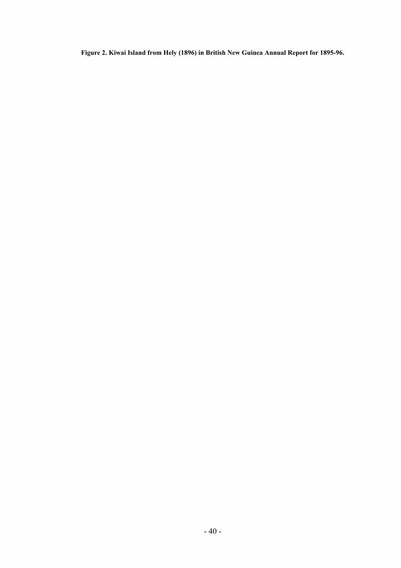
Figure 2. Kiwai Island from Hely (1896) in British New Guinea Annual Report for 1895-96.
- 40 -
Historical land divisions
In 1896 Hely published a map of Kiwai Island which showed it divided into ‘tribal’ areas (see Figure 2; Filer 1991: 45). The area called Auti indicates the present lands of Sepe village, which originated from the old villages of Auti and Sumai. A new village has recently been formed as a break-away from Sepe and this has been re-established back at the old Auti site. Sumai or Paara on the aid post belongs to Sepe and Severimabu. Doropodai indicates the land of Doropo village which was the old village of U’Uwo and Kubira combined; the areas labelled Kubira and Doropodai belong to both U’Uwo and Kubira villages. Wiorubi is the land of the Sagapadi village (a recent amalgamation of the Wapa’ura and Sagasia villages); Iasa the land of the Iasa village, and Samare the land of the Ipisia, Agobaro, Oromosapua (which are related villages) and Samare (related to Iasa).
SEPE Population: 1980: 120; 1990: 85; OTML 1991, 309. Population growth: The village has recently split to re-establish Auti. Council: Kiwai LGC. Language: Island Kiwai. Clans: Agridai, Miridai, Morigiro, Gagaripasa and Oiduo.
None.
A story collected by Gunnar Landtman between 1910 and 1912 states that Sepe, along with the villages of Iasa, Kubira, Doropo, Paara and U’uwo, was established after the Kiwai moved out from Barasaro. From
to Sumai and then split. One group moved up the coast to Auti and another back to
There are five clans at Sepe now. Two further clans, Sokomabu and Dudumabu, make up the group who moved to Auti. The people do not live on clan lands partly because the front of the village has been constantly eroding into the river and the houses are moving back
I f stuary. The church was ed so much that
Stores: Churches: United Church. Transport: (No data.) Community School: Nearest is U’uwo; child are weekly boarders. Aid post: None; villagers use or go to Daru.
Main informants: Eabi Gename Public meeting: Yes.
Sepe villagers now number 169, by their own count, but last year the village split and another group of 204 people went to re-establish the village at Auti. Many Sepe people live in Daru and the village population has been considerably reduced by out-migration.
Oral history
Sepe the people movedSepe. Another story states that people moved from Barasaro to Mibu Island and then to Sui. From there they followed the coast to Severimabu and crossed back to Kiwai Island settling at Sumai. Because land was scarce, they split at Sumai and one group went to Auti. Later, people moved from Auti to establish Sepe and another group moved to establish Severimabu (Lawrence 1994: 316-7). The villages of Sepe and Severimabu are related. The stories are evidence of the close relations between the Kiwai Island villages and the Dudi coast villages.
further into the bush and swamps behind the village. This erosion is dramatic. In 1986 when irst visited Sepe village it had the oldest LMS church in the Fly E
then located in the middle of the village but the bank of the river has erod
- 41 -
the church was in danger of falling into the river so it has been broken down and will be rebuilt further inland. The distance lost in eight years is about 200 metres.
There is no school at Sepe and no aid post. Daru is the only shopping place as there is no canteen either. Children have to travel to U’uwo to school and only return at the weekends. The only aid post on Kiwai Island is now at Samare, but the nearest medical facilities for Sepe people are at Teapopo, on the north coast of the estuary. The chairman of the village has drawn up a plan of the village to assist in any future developments. The village is also flooded at high tide and the ground covered in thick mud for a few days following the tide. Sepe garden lands extend down both sides of the coast; on one side half way to U’uwo, on the other past Auti. As there are kin ties with Sumai, some people have lands down past Sumai village.
Peoplebefore
would like to see developments in the village; they feel that they had a good life but now life has changed for the worse. Although they hoped this report would bring
ain concerns related to the poor quality of garden foods. The fruit is not of the same y as before. The gardens are behind the village and along the banks of the river and
correct and they are upset that no one has ever been to the village to talk to them about the environment. There has been a great change to fishing. People said that they no longer catch mudfish,
mullet and only a few catfish. There are many sandbanks off the front of the n Wamimuba and Badu Island and along the coast near U’uwo. The copper
causes erosion to the banks in
accuse the boat of not both
Development Issues
ouses have been built at Auti by the development Trust. In o tanks and a solar pump. The
ar pump ted that Carrier 1, the due to be replaced.
Madiri to get water. The village is not e Trust bui and they want permanent buildings. The small house was
built in 1992 and is in poor condition. The water will eventually eat into the foundations and
the village problems to the attention of the company they were also aware of the law suit being brought against OTML by the landowners association and stated that they would not say anything about OTML in case it was used against them in court.
Environmental Issues
The mqualitthey think that these areas are subject to flooding and erosion. The village was highly critical of the OTML Environment Department pamphlet which states that the water is fit to drink.13 The village believes that all the answers to the questions are in
barramundi orvillage, betweebarge sails close to the village and the wake from the barge front of the village. The wake has also overturned canoes in Sepe Creek, they say, and they
ering to slow down as it passes in front of the village.14
Two water tanks and two small hSepe the Trust has built one haus win, one small house, twtanks and the sol are not working although it should be noTrust barge, called into Sepe a few days after I left and these tanks were In the dry season they have to go to Madame and happy with th ldings
13 [Assumed to be the OTML Environment Bulletin numbered 1/1993. I will have more say about this and village reactions to the delivery of information in my report later in 1995. Ed.]
e of correspondence between all Fly villages and OTML. Ed.] 14 [This is a constant sourc
- 42 -
the building will have to be moved. The village would like bridges over the creeks, sewing machines, building materials and good quality permanent water tanks. The solar pump was considered a good idea but the pipes were laid on the ground and it was stated that dry coconuts had fallen and broken the pipes. The haus win is used only for storage, in fact the pieces of the old mission church are stored on the platform. The village would like
ly15 paid K18 for three days work assisting with the construction of projects in the village. They
indicated by the movement of people
mmunity outboard motor and put some money in an account. (In general, people obtain fuel for their
Application was made for seven projects: two fishery projects, women’s sewing machines, two poultry projects, crocodile farming, and a tradestore. The applications were lodged in
consideration by the Planning Office on Daru.
assistance with the reconstruction of the church. The men complained that they were on
would prefer to be given the materials and to build for themselves. The most urgent requirements are for nails, timber and roofing iron. I should note here that there are some obvious internal conflicts in Sepe village, and this isout to Auti and the sizeable out-migration to Daru, and future development projects should be evaluated in light of these problems.
VDF
The village say they received about K2000 in 1993 (this may exclude Auti; official figures for earlier years were K2400 in 1990 and K2600 in 1992). The council bought a co
outboards as the opportunity arises, but it is always short; the council chairman did not have fuel for travel to a meeting in Daru.) Auti did not receive separate funding in 1992 but presumably some money has been given in recent VDF allocations.
SSG
May 1994 and are under
U’UWO Population: 1980: 294; 1990: 254; OTML 1991, 566. Population growth: People actually claim fewer residents than the OTML count; OTML may have
counted a hundred people from Kubira with the U’uwo residents.
Stores: None. Churches: United Church, Seventh Day Adventist.
(No data.) Community School: In village, Level 3, four grades; one teacher short.
U’uwo is a large village located between Sepe and the old village site of Doropo. Villagers put the population at 448. There is also a corner in Daru for U’uwo but not many people
Council: Kiwai LGC. Language: Island Kiwai. Clans: Oiduo 1, Oiduo 2, Duapei, Sokomabu, Toromabu, Gagoma, Gagaripasa,
Sakara and Gawari.
Transport:
Aid post: None; villagers use Teapopo or Samare, or go to Daru.
Main informants: Asani Kimai and Bogi Kiwao. Public meeting: Yes.
[See d15 iscussion, p. iii.]
- 43 -
from the village live there. The school in the village teachers Grades 1-3 and 5 and is a Level 3 Community School. It is one teacher short at present because a teacher did not like living in the village and left and he has not been replaced. Both the SDAs and United Church have fellowship groups and Sunday schools.
U’Uwo owns the islands of Daura and Uramumeritanu and these are used for gardening.
The old village for U’Uwo was Doropo. When the village was spoiled by water they made a new village but the people separated and some went to Kubira to form a village there. Kubira and U’Uwo are from the one original village.
The village is badly affected by flooding for at least five or six days a month. The ground becomes covered in thick river mud and the community has dug large drains through the village in an attempt to remove the water from the village quickly once the tide goes down. However this does not solve the problem of the mud and the potential health hazard to the village especially as there is no aid post and people have to travel to Teapopo or to Samare. There are no canteens. Villagers have to shop on Daru or in other villages nearby.
rust has built one double classroom with no tanks, one haus win with tank which is sed as a private house after having been enclosed with split sago, one solar pump and
ank for the school.
They have seen the Western Venturer travel past but it has never stopped and no one has come in to talk with the village. There has never been anyone from the Provincial or the
s and nothing is made available to the people.16
Development Issues
The complaint of U’Uwo villagers was that the Trust may be working in the Upper Fly area of the lower part of the Western the rest of the country.
The Tnow utank under construction at the time of this visit, and there is one church building with tank. There are four tanks in all. The village has many blue water containers supplied by OTML and a Provincial Government fibreglass tank lies useless in the village. The Provincial Government has also provided a double classroom with t
Environmental Issues
The tide floods the village and the people are not sure if the water is safe because they do not know what chemicals are used in the mine. They want to be resettled but there is no land inside the bush and they say that the Government and the company will need to decide where to move people. The villagers complained that there were sandbanks everywhere in the river and that the amount of fish available had dropped. Before there were plenty of barramundi, catfish, mudfish, crabs, prawns, and freshwater turtles but not now.
National Government
but it is not working in the Fly Estuary. The peopleProvince are missing out on the benefits that are going to
16 [Again, Trust staff must ha ssroom, tanks etc, and representatives of government school and the Ward councillor, Umagi Kimai.
ve come to put in the claare present at U’uwo in the form of the teaching staff at the Ed.]
- 44 -
The foundation nks and the s of the ta Trust buildings were criticised as being unsafe. The ould have set in concrete. The church and school tanks are used for
drinking and the solar tank, now being built, will be used for washing. The solar tank is now
and need
nt, was built by a Daru contracting firm, Bagewa Company, and the village is happy with that building. Men were employed as labourers on the construction and everything went well. The choice of
as the man contracted to build the aid post has not supplied the
foundations sh been
being built and this was requested last year but they do not know when the next visit will be. However, the people who originally dug the ditches for the plastic piping from the pump to the tank were not paid and people are angry. The village also wanted a community hall, solar lights and a two-way radio. They would prefer assistance with timber, nails and tools. When they are employed to help with the building they only received K18 for three days, but they had to work for four days and they got no more money. The women requested sewing machines and materials as well as an aid post.
It was suggested that a Vocational Training Centre be established in the Lower Fly area, probably near Severimabu or Koabu, to train young people to be mechanics, carpenters and to teach marine skills. At Grade 6 when children leave school they are unskilled further education. There is no secondary education available other than at Daru and there are many problems associated with sending children to live in Daru. The Provincial Government was accused of not helping the village.
VDF
In 1993 the allocation figure given to me was K6200 (OTML 1992 figure: K6200). This money was divided among the whole village but only among the adults. They are only visited by the liaison office when the VDF cheque is to be distributed. They need advice on small business operations and community development.
SSG
They applied for an aid post and a double classroom. The classroom has been built but not the aid post. The school building, funded by the Provincial Governme
contractor is important building. Some people said that the contractor was Waguna Contractors from Daru whose principal was a senior member of the Kiwai Local Government Council. This complaint could not be verified in Daru.
SAGAPADI Population: 1980: Wapa’ura, 56, Sagasia, 46; 1990: Wapa’ura, 56, Sagasia, 23; OTML
1991, Wapa’ura, 80, Sagasia, no count. New village, 1990; combines Wapa’ura and Sagasia. Note: OTML uses the Population growth: spelling Sagapari.
Council: Kiwai LGC. Language: Island Kiwai. Clans: ?
Stores: None. Churches: Most are Seventh Day Adventist (no church building), some Apostolic Church,
Destiny Chapel; no UC. Transport: (No data.) Community School: Samare
- 45 -
Aid post: None; villagers use Samare, or go to Daru.
Main informant: Vincent Papa. Public meeting: Yes.
Sagapand S
adi village was established in 1990 as an amalgamation of the villages of Wapa’ura agasia. They came together when the present chairman, Vincent Papa, returned from
s and tree stumps through the swamp. The road is gradually being made by the village during the dry season but the work is long and
and the village has only a few workers. There are only about twenty dwellings at
on Aibinio Island, form a single village group.
The villagers put their population at 167, with 79 from Sagasia and 88 from Wapa’ura. Most to the SDA church but have no church building as yet. There are a ho belong to the Apostolic Church and Destiny Chapel but no one
a has one small house, with tank, lopment
rebuilt in the new village on the e a haus win and tank at the ocean
water tank on each the end of the villa the back of the village will be the school and aid post with
ater tank.
lace to s d people must all go to Samare for medical attention or to ssage so the journey must be
ent to talk with them about environmental matters. They are only visited when the VDF cheques are handed out to the villages.
construction of a dry road from the village to the beach through the swamp and they need
trong rain squalls blow in form the southeast; consequently the shelters are cold, windy and the rain comes in. As the timber used in the construction of the
school at St Peters College in Rabaul. His mother was from Wapa’ura and father from Samare and he persuaded the villagers to come together and establish a new village on high dry land near the old Sagasia village site. The village is about 500 metres inland and at present can only be reached by crossing cut log
hard present. The village is divided into two lines of houses, Sagasia on one side and Wapa’ura on the other, facing each other across a dry field. There is good timber and good gardening land nearby. Sagapadi and Aibinio,
of the people belongcouple of families wbelongs to the United Church. The old village of Wapa’urbuilt by the deve Trust and there is also one at Sagasia which is beginning to be undermined by the sea. Both will be broken down andappropriate side. The plan will be for the village to havfront of the village, then a line of houses on each side of the field and aside at ge. Atanother w
Daru is the only p hop, anDaru. It is usually not possible to cross from Samare to Toro Pamade via Sepe and then across to Madame and down the Dudi coast.
Environmental Issues
The villagers catch big fish (groupers) very close to the shore now and this never happened before. Many sandbanks are coming up along the coast and the water is very muddy. The men thought this may be causing the big fish to swim near the beach. They have not been visited by anyone from the Environment Department of OTML or from the Provincial Governm
Development Issues
The development of the village is the top priority for its inhabitants. They want help with the
material such as timber, nails and tools to assist in the construction of village housing. The villagers do not like the haus win built by the Trust because the southern coast of Kiwai Island is very windy and s
- 46 -
Trust buildings is very soft and of poor quality it deteriorates quickly. The second haus win is currently used as a temporary dwelling. The village would like a school, community hall and aid post. When the Trust workers came last time the village men only received K12 for assisting with work despite having to carry the heavy building materials across the swamp. The women are still waiting for sewing machines.
They have had no money from the SSG. The comment was that the money goes to wantoks in Daru and not to needy villagers.
VDF
The VDF payments for 1993 were put at K1800 and K1700 for Wapaura and Sagasia respectively (OTML 1992 figures: K1250 and K1700 for Wapaura and Sagapari [sic]; presuming the allocation to Sagapari refers to Sagasia). The money was shared among the villagers and some allocated to business groups.
SSG
AGOBARO Population: 1980: 42; 1990: 38; OTML 1991, 70. Population growth: OTML’s figure of 70 is the closest. The NSO figures must have omitted school
children or other temporary absentees. Council: Kiwai LGC. Language: Island Kiwai. Clans: Geserimabu, Simaka, Dudumabu, Waiapo and Kaoria
ru.
Main informant: Norbert Aowa, Sipi Oburo Domo and Imagi Akuru.
corner at Daru and some village people live there. Agobaro is small, built back from the beach on dry sandy soil and protected from the southeast winds by a
point and coastal vegetation. There are only about 15-20 buildings in a line on either f a village road. The village is surrounded by good gardens and eventually a new
Stores: None. Churches: Catholic. Agobaro attend church at Oromosapua. Transport: (No data.) Community School: Samare. Aid post: None; villagers use Samare, or go to Da
Public meeting: Yes.
Ipisia, Agobaro and Oromosapua form a village group with one village council; I visited all three (see Ipisia and Oromosapua below). Agobaro villagers put their number at 73. The story of the three villages states that when the Kiwai people moved out from Barasaro some went to Ipisia. Gradually the village population grew and they then decided to divide into three groups. Some stayed at Ipisia, some went to Oromosapua and some to Agobaro. They remained at those places and began to cross to Abaura to make gardens. Ipisia means ‘in the middle’.
There is an Agobaro
small side ovillage will be built at the back of the present village on the site of some large garden plots.
- 47 -
There is no church at Agobaro and people go to Oromosapua on Sunday because they are Catholic. They must shop at Daru or at Samare because there are no village canteens. The only aid post is at Samare.
hildren all attend school in Samare and return at weekend along the beach or by canoe along Abereoromo or Ipiratanu creeks. They do not often take canoes around the Samare
Environmental issues
has a severe water problem in the dry season. At times they only have coconut out pollution and the slime on the
on bothvillage to discuss their the river,
nly a narrow passage between the at low tide. Travelling to Samare is
e found many g perch in the cree swamps behind the village.
ment issues
gs in the village: two haus win, and one small house, The haus w ar to the beach is unused except as a temporary shelter, the
ent Trust be asked to
with the type of building constructed by the Trust for the villagers say that the Trust buildings move and do not have proper concrete foundations. As well, the tanks leak and there are problems with insects going into the tanks and spoiling the water.
private dwelling has had a large awning built along the front of the
access to western medicines.
The c
Point as the wind is usually too strong.
The village water to drink when the well goes dry. They are scared abbeaches is comm at Agobaro and Sagapadi at low tide. No one has been to the
problems and they too have noticed sandbanks in particularly near Saguane and Oromosapua. There is osandbanks and the beach and even this passage dries updangerous now because of the shallow water and strong winds. They havclimbin ks and
Develop
The Trust has built three small buildinall with tanks. in nesmall house is used as a dwelling by the main landowner and another haus win was partially filled in and was also being used as a dwelling. Villagers produced a plan of the PNGDF two-story, three-bedroom private residence of the type constructed at defence force establishments as married quarters and requested that the developmbuild this sort of house for the village.
The villagers also requested a community hall and a double classroom. A school was high priority as children were sent away to Samare and the children have a hard life having to look after themselves at school and travel long distances back to the village. Transport is a constant problem and a community dinghy and motor are needed. At present they use transport from Samare but have to pay for the ride to Daru.
They are not happy
The haus win used as a building in an attempt to provide shelter and protection from the wind and rain. A gable roof is much preferred to the single roof built by the Trust workers. The blue containers supplied by OTML also get contaminated with insects because the fly screen deteriorates and gets broken. The women have not received any sewing machines and they want their own church building. They are also not happy with the medical service at Samare. They try to go to Daru in an emergency and still use traditional medicine because they do not have
- 48 -
VDF
The villagers say they received K1500 in 1993 (OTML 1992 figure: K950). The first payments went into a village account but now the money is distributed to the villagers. This also creates problems. Because the money is given once a year as a cheque someone has to go to Daru to cash it. There the Agobaro corner people demand a share of the money. The villagers want the payment to be made in cash in future so that they won’t have arguments with the corner inhabitants. They have had fights in the corner and the police have had to intervene.
SSG
SSG is not helping them, and Ipisia and Oromosapua have the same problems. The comment was the SSG is only assisting the people from the corners in Daru.
IPISIA Population: 1980: 84; 1990: 82; OTML 1991, 85. Population growth: These figures conflict with the 160 persons claimed by the villagers; however,
with only 15 houses, the lower figures would appear to be correct. il: Kiwai LGC. age: Island Kiwai.
Community School: Samare, but few are said to attend (see text). Aid post: None; villagers use Samare, or go to Daru.
au Daini. .
ouple of broken down buildings, built in the middle of which is the church er about 160.
few children go to l at Samare; one reason given was that the village does not e back and along the
e village and the a for fishing using small canoes. They have the villa t high tide the sea floods across the village and the water
e moved the village back but ld houses using the old methods of binding the
er, not by p ence but because they do not have money for materials such
CouncLanguClans: Sokomabu, Mabere, Kauria, Noriduo, Oiduo and Dudumabu
Stores: None. Churches: United Church. Transport: River-type dugouts only.
Main informant: KimPublic meeting: Yes
Ipisia is a poor village of about 15 dwellings, and a calong the beach. The village surrounds a flat sandy field and a community haus win. The villagers say they numb
Only a schoohave enough food to send to the children there. The gardens are at thside of th y also cross to Abaurdry lands behind ge but aflows through the church and into the garden lands. They havstill they are flooded. They mostly buitimbers togeth referas nails and bolts.
Environmental issues
They are worried about the flooding of the village and the gardens. Because of the flooding they want to move the village inland but do not have the resources. There is one large sandbank near the village, some between Samare and Saguane and the point, and one near Mibu Island. No one has been to discuss the environment with them. They see people from
- 49 -
the ‘Western Venturer’ coming to collect material but they are never told what the tests report. They also want boots for walking on the beach when the pollution comes.
ike a generator, solar lights and wooden buildings with gable roofs and tanks as well as a canteen or tradestore. The houses built by the Trust are not in good condition. When they move inland they want to the
n and moved inland also.
oved but only K4000 was received and the village wants to know what happen to the other K6000. (Note:
ould not be verified in Daru as the office was closed).
Development issues
The village has no transport apart from small fishing canoes. There is only one outboard motor in the village and they need at least four dinghies and motors. They also use transport from Samare. There is no school nor aid post. They have three Trust buildings: two enclosed small houses and one haus win, with tanks. The first haus win is in a dilapidated condition and the pastor lives in one enclosed house. They would l
buildings broken dow
They would also like a new church building and believe that the Trust would do better to give building material to the village and let them build for themselves.
VDF
The 1993 allocation under the VDF was estimated to be K3160 (OTML 1992 figure: K1850) but the villagers also said they only received about K15 each. This would make a more realistic total of K2400 rather than the estimated figure. They believe that the best way is to divide the village into family groups and allocate money that way.
SSG
They do not have much success with SSG applications. One man received some money. For example, one application for K10,000 for a canteen was submitted and appr
this c
OROMOSAPUA Population: 1980: 167; 1990: 112; OTML 1991, 170. Population growth: Villagers say they number 200. Council: Kiwai LGC.
Island Kiwai. Demago, Miparimabu, Maberamabu and Obosawaere.
t: o Daru.
ormant: uda Sare. ing:
live o is Catholic but is run by a pastor who is permitted to be married. He takes service, Sunday school and fellowship but communion
d at Samar sts visit from Daru. The village is small
Language: Clans:
Stores: None. Churches: Catholic (their church is also attended by Agobaro). Transport: River type dugouts only. Community School: Samare. Aid pos None; villagers use Samare, or go t
Main inf Pastor IPublic meet Yes.
Some p n Daru. Teople also he village
must be receive e when the sisters and prie
- 50 -
and the Trust has built three small buildings and tanks. All buildings are being used as dwellings and the pastor lives in one. They can travel to Samare by road but only during the dry season, the road is flooded at high tide and during the wet. Medical care is only
Environmental issues
or the flooding problem the village is concerned about pollution in the river and sea. Thbehadri
De
Thpoquan ome in between the wall and the roof. The bolts are not tight and the water leaks from the tanks and as the foundation have
The village received K3450 in 1993 (OTML 1992 figure: K3600). The money was divided
SAMARE
available at Samare. When the high tide comes it also floods the village and the gardens from both sides. The only dry land is inland at the old coconut plantation site about 10 minutes walk away. Saltwater is spoiling the village, the wells and the gardens. They have no canteens and no transport apart from small river canoes.
Apart fey do not get any information on the environment and they say they do not go fishing cause they are frightened. They have seen and heard of catfish and mudfish with sores and ve noticed the climbing perch in the rivers and swamps. The three tanks are the only nking water because the seawater has spoiled the wells.
velopment issues
ere is no school and no aid post in the village and no transport to run a canteen. If the llution comes they want to have their own medical centre. The villagers complained of the ality of the buildings erected by the Trust. The joint and timbers are weak and the roof d walls have holes and insects and small animals can c
been build on sand the salt has gone into the tanks. They now drink salt water and fresh water mixed. They have asked for other buildings such as a double sized building for use as a church but they want it to look like a church. The women have asked for sewing machines. Also they need material, cotton and needles. Nothing has been received.
VDF
among clans in the village but it was not considered sufficient for the people.
SSG
They applied for funding under SSG allocation but are still waiting for an answer. They requested money for outboard motors, dinghies, funds for the construction of the road to Samare and for the establishment of a tradestore but they believe the people at Daru are getting the money and not the villagers.
Population: 1980: 260; 1990: 254; OTML 1991, 541. Population growth: Villagers say they number 302; however, there is a large corner on Daru. Council: Kiwai LGC. Language: Island Kiwai. Clans: Orobudai, Kurukaka and Mabere.
Stores: Three.
- 51 -
Churches: Catholic (their church is also attended by Agobaro). Transport: River type dugouts only. Community School: In village, Grade 1, 2, 4. Aid post: In village.
David Koria and Kowea Apai. Yes (note: Because of the bad weather it was not possible to travel to Iasa or
rovincial government. The village at Saguane is now considered abandoned by the people at Samare
and Samare lands extend to near Iasa.
es Chalmers established a LMS mission station at Saguane, on the coast near Samare, about 1895 but
Montfort Fathers (SMM) established a mission at Daru. The Samare church is now managed from Daru.
There is also a large Samare corner at Daru and it was estimated that over half the village
aid post and school areas located behind the village. The school, formerly run by the church but now a Provincial Government school, has 89 students in Grades 1, 2 and 4. One teacher’s house built by the church and there is one Trust house with tank. Only
nts go on to Daru High School from the southern Kiwai Island area.
a number of pe ings in Samare including: one ssroom with tank, one haus win with
ial Government building. A small
There are three canteens in one owned by the village Chairman. The mission area contains a sister’s house and a priest’s house, both with fibreglass water tanks.
uildings: a clinic with nk, one small w omen with no beds and two dwellings. All
nor repa
Main informants: Public meeting:
Kubira).
Samare is a Catholic mission station and the largest village on Kiwai Island, at its southern end. The church is well kept but the mission houses are in need of repairs. The airstrip at Samare is no longer functioning because it has not been maintained by the p
but one man still lives there and he collects some VDF payments and the people from Samare want this man to go back to Iasa. This was a source of local conflict.
History
Originally the people all lived at Iasa but there was a shortage of space there so some of them moved out. The three clans of the village at first lived in separate areas near Samare Point but later together came to Samare and they went first to a village near the point. That village was washed away and so they moved further inland to the present location. Iasa and Samare are related villages
Jamrelocated it to Daru in 1900 (Lawrence 1994). The site of the mission was subsequently washed away (Beaver 1920: 153). The LMS operations were not successful in the Fly Estuary and after 1914 the LMS handed operations in the Torres Strait over to the Church of England. The Western Province remained largely dominated by the LMS and it was not until 1959 that the
lives in Daru. The village is located on flat dry country inland from the canoe landing. There is a long road from the beach to the village which is laid out around a rectangular open area with the mission,
a few stude
There are rmanent and semi-permanent buildtin and timber building with no tank, one double clatwo tanks and one tank attached to a broken Provinccanteen has been built on the platform of one haus win but it is not operating at present.
in the village, the ma
There is a health post (a Health Sub-Centre?) in the village with four ba Trust ta ard for pregnant wbuildings need mi irs.
- 52 -
Environment
ge during high tides and the garden areas behind the village are t getting much fish these days and sandbanks are appearing
al issues
Sea water floods the villaalso flooded. They are no near Samare Point. Also, Orope Island is now dry land and it was only mangroves before.
The chairman of Samare, David Koria, is the beneficiary member on the Board of Trustees of the Trust. He has attended two meetings so far. He felt that the problems of the Lower Fly
ent from those of the Upper Fly and hoped that his presence at the meetings woev
ThThbutimhavilsew ut these have not been supplied. The fishing kits supplied were useless as they were for river, but not ocean, fishing. They are now used for prawn
were not successful. The applications were for chicken and crocodile farms. The Planning Office on Daru does not communicate
Sometimes they find dead fish and crabs and there are many climbing perch in the swamps. The environment scientists come and make collections but do not report back to the villagers. Sago and fish are the only reliable foods and when the fish are hard to catch people only have sago to eat.
Developmental issues
were differuld help to bring changes to the Fly Estuary area. The beneficiary member is changed
ery year and next year the position will return to a member from the Upper Fly.
e condition of the Trust buildings was poor and little maintenance had been undertaken. e villagers would also like gable roofs rather than the flat roofs and complained about the ilding foundations being place in sandy weak soil. People would prefer materials such as ber, nails and iron. The washing water comes from wells and when this goes dry water
s to be obtained from far inland. The main problems are water and the poor gardens. The lage would like to see two or three projects a year not just one. The women wanted ing machines and materials b
fishing only. They would also like village lighting and one tank.
VDF
The 1993 allocation was K5800. The chairman had details of the payments from 1990 and these were: 1990, K5200; 1991, K5400; 1992, K5600 (OTML 1992 figure: K5600). The money was allocated to twelve family groups and the people approved of this way of dividing the money but felt that the amounts were too low.
SSG
They submitted four applications for SSG funding but
with the village.
WAPI Population: 1980: 170; 1990: 185; OTML 1991, 230.
Villagers say they number 243. Council: Kiwai LGC. Population growth:
Language: Wabuda Kiwai. Clans: Sibaro, Segera, Soge, Miparimabu, Waruku, Agidai, Saragu, Sowako, Kair,
Boromo and Borimabu.
Stores: One canteen (in haus win); fuel service.
- 53 -
Churches: Seventh Day Adventist, Apostolic Church (no UC). Transport: At least one outboard? Community School: Children are term boarders at Teapopo, Gaima and Damera.
o Kiwai Island to complete the survey there).
s of Gesoa, Dameratamu, Maipani, Tirere, Sagaro and Maduduwo. The island of Dibiri, Wabuda, Umuda, Purutu and Dibiri are their lands. Aibinio Island, however, does not belong to the Wabuda Kiwai group as it belongs to
r village to Sagapadi on Kiwai Island.
so, Ato and Komei. The clan leaders took the people to Wabuda and then to Purutu. From there they separated
or, with only about 20 dwellings. Like other villages at the northern end of the Fly Estuary islands it is flooded during high tides so the ground is often
Day Adventists and the Apostolic Church. The Wabuda Kiwai are not part of the United Church. The Trust community hall serves as church to both groups, they take separate services in the building on Sunday. The Youth and Women’s Fellowships are
cted together, but Sunday Schools are separate.
ee buildings in the village: the community hall, the haus win (now canteen) and one haus win. There are four water tanks, all in good condition.
Aid post: Nearest at Samare or Teapopo.
Main informants: Asa Saso, Konigi Muri, Buruga Saso, Gineio Poto. Oral history of Wapi: Kato Buia Public meeting: Yes (note: because of the bad weather we were advised by the people of Wapi
not to go to Dameratamu because it would mean sailing into the southeasterly winds across Umuda Sea. There were also stories of raskol problems at Gesoa and so I decided to return t
The village at Wapi on Aibinio Island is located up a narrow creek, Orasuguturi, running off the large Aibinio Passage which divides Aibinio and Purutu Islands. The Wapi people are living on land given to them by Aibinio village. They speak Wabuda Kiwai language like their neighbours in the village
Aibinio village, a siste
Oral history
In former times legend states that a man lived on two logs at Bisubarai, out from Umuda. A crab ate his bottom and from that sand rose and formed the islands. There were four groups of ancestors: Agea, Sa
and some went to Dibiri. That was the time of tribal fighting and one group, the Kuraigi, became lost in the bush. They are still searching for this group of people on Purutu Island. The village then moved to Urio on Manowetti. Magic was used to kill people there and so they went to Wapi old village on Purutu near the mouth of a creek on the western side of the island not far from the mouth of Aibinio Passage almost opposite U’Uwo. This old garden and sago land is now called Mirisia and the Wapi people call the north entrance of the Fly River, Mirisiaturi.. Later, a crocodile attacked people there and so they came to the present village about 60 years ago.
The village is small and po
muddy. The village is quite isolated and the people have few visitors.
The children from Wapi go to school at Teapopo, Gaima and Damera and only come home at end of the year or during long holidays. The people do not live in clan areas and the village is spread out in two lines on either side of a central open area. There is no medical attention in the village and people have to travel to Samare or to Teapopo. There are two churches: Seventh
condu
In addition to the one community canteen, located in a development Trust haus win that has been enclosed with split sago canes, there are two family run chicken farms and a fuel service. The Trust has built thr
- 54 -
Environmental issues
ssistance with the move as they have to clear the land and build a village and move the development Trust buildings to the new site.
complained that the fish caught today do not taste as good as in the old days channels were deep, but now
ming up arly across the north entrance between lso blocked in places at low
aipani. From Toro Passage, near a, to Samare are ma
n office on Daru and the ited. The last visit by anyone from
as in 1993 for d F cheque. They believe the liaison officer only runs away from their problems.
path from the
high school graduates, but they have no
Transport is a problem. They long. The four water tanks are good but the foundations are poor and the tanks low to the
thenewause
The village is low lying and flooded for between two to five days each month during high tides. The village elders want to move back to Purutu Island to an old village site on high ground (marked at 24m ASL on the topographic map) between Purutu Creek and Matono Creek at the northeastern corner of Purutu. They would need a
The village alsoand that they do not have much fish any more. Before, the sandbanks are co in all the channels particulSepe and Aibinio Passage. The mouth of Aibinio passage is atide and there are other sandbanks near Tirere and MParam ny sandbanks as well.
They would like to discuss these matters with the liaisoEnvironment Dep but they are only rarely visartment OTML w elivery of the VD
Development issues
The community hall has been welcomed as it is used as a church but the haus win is seen as a temporary ‘garden house’. The villagers would like to have the buildings covered in with walls, and a gable roof not a flat roof. The salty water is eating the foundation pipes and the foundations should have been placed in concrete. There is a muddy walkingvillage to Aibinio passage and the village would like iron bridges for the creek crossings.
The women asked for sewing machines, elastic, material, cotton thread and two Coleman lights but the Trust has not given them, or even responded to the request. They also need a village aid post. Some villages, such as Gesoa, Dameratamu and Aibinio, have received fishing kits, small knives and sewing machines but not Wapi. People would prefer to have timber, iron, nails and tools rather than have the buildings from the Trust for they need to encourage employment in the village. They have work; these youths need sporting equipment for recreation and to keep them occupied because the village is worried about juvenile crime. Although they have a peace officer the only magistrate is at Gesoa.
use canoes because fuel is expensive and the trip to Daru is
ground. Consequently, when the village floods the foundations of the tank become wet and tank sinks. The muddy water is said to enter through the tap. They do not have a swamp
arby and so do not have a solar pump. There are two small wells with salty water for shing, and two wells with fresh water for drinking located in the bush but these are soon d up in the dry.
- 55 -
VDF
The 1993 allocation was K3850 (OTML 1992 figure: K3700). The villagers received K20 each and the balance was invested in the community business. They hope eventually to have a village tradestore like Karawame Trading in Daru. The money was first divided into clans
G seemed to be good at the start but it has now failed. The chicken farm received
and then given to individuals.
SSG
The SSK2000 to start the project but the operator could not get chickens from the DPI so he bought village chickens. They apply to the Planning Office but often do not hear from them again. They would like a duck farm, a crocodile farm and a tradestore.
ADURU Population: 1980: 226; 1990: 305; OTML 1991, 314. Population growth: Villagers say they number 347. Council: Fly-Gogodala LGC. Language: Makayam (‘Aturu’ in Würm’s list). Clans: Sarak, Aisak, Akaraba, Pitigdar, Koindara, Warida and Usuruk.
Stores: One canteen in community hall. Churches: Evangelical Church of Papua; also Baha’i. Transport: ? Community School: Children go to Tapila and Gaima. Aid post: Nearest at Teapopo.
Main informants: Harry Wagama Wakina, Nalaba Kanupa, Kadaro Kaidua and Gawada Wedere. Public meeting: Yes.
ge, well-ordered village on Sumogi Island (or Sugu in Gogodala)
ura) area before settling between
Aduru (Adulu) is a larbetween the Dudi coast and the Manowetti coast at the mouth of the Fly River. The village is organised around a large grassed playing field and contains approximately 30-40 dwellings as well as a church but has no school and no aid post. The children attend school in Tapila and Gaima and people usually go to Teapopo for medical attention.
The people originally lived at Suame, beyond Canoe Island, but because of raids by the Suki people they fled down the river and had all settled, by the 1960s, near the mouth of the Bituri River.17 They then moved to the Balamula (BaramTapila and Madiri. Later, they were given land on Sumogi Island and established a village at
17 [The Aduru people—at least a section them—are the survivors of the ‘Weredai massacre’ of late 1926. ‘Weredai’ (or in Annual Reports, ‘Weriadai’) is the clan name Warida + dai (properly + dairubi), ‘people’, found by Lawrence. Hides places their village at ‘Jauni Creek’, which is what we have as Suame Creek. He says ‘it was not really a village, for all the people lived under one roof, an enormous dubu with a hundred cubicles or compartments’ (1938:150). See Hides 1938, Papua Annual Report 1927-28, p. 9, and also Haddon 1901-35, v. 3, p. 306. A total of 39 (or, in another account, ca. 50) people were killed by the Suki and their heads removed. The village relocated in stages from 1926, when within six months of the massacre they had already established the new village on the Bituri River (Hides 1938:159). See the section of my 1995 report on Suki for further detail. Ed.]
- 56 -
Toro on the Madiri side of the island. The eastern part of the island belongs to the Tirio and Balamula people but the western part of the island belongs to Dewala (Dewara) village who still have sago places there (Lawrence 1994: 314).
The language spoken by the Aduru people is called Makayam, although Würm has this as Würm and Hattori 1981). Koindara is the largest of the seven clans
which are grouped into three clusters for the communal use of canoes and outboard motors.
an important canoe making region. The Makayam speaking people are in a favoured position between the
The village is well kept but is flooded at high tide. During the public meeting in the ECP
a and the schedule of the transport determines the availability of work.
ental issues
the presence of sandbanks and the muddy water.
Sandbanks are developing rapidly everywhere in the Fly River and the boat channel between SGaand now they catch only catfish (called helicopter catfish because they have a small round
‘Aturu’ (see Map 1;
This is not considered very successful. The clan structure is not as strong in Aduru as among the Kiwai although, in former times, people did live in clan blocks. As the front part of the village washed away people were forced to live in mixed clan groups rather than in separate divisions. However, the clans are still regarded as the basis for garden land allocations and resource use.
The Balamula area is the source of the best canoe timber and continues to be
Gogodala, Kiwai and Suki groups to be able to act as middlemen in trading up and down the river.
church the water rose to almost half a metre across the village. In the morning the whole village was covered in thick mud. This is common.
Aduru is also the base for the Trust operations to the 48 villages in the Lower Fly. A large platform has been constructed on the bank of the river in front of the village and the barge unloads materials and equipment here for use by the development Trust in the Kiwai area. A radio-transmitter has been installed in the village and the local Area Supervisor, Harry Wagama Wakina, was a former kiap. The men from the village are employed as casual labourers at K6 per day to unload the transports but it is not regular employment as the nature of the lo d
The local church belongs to the ECP (Evangelical Church of Papua). This church is strong among the Gogodala having its base at Balimo; it has a number of strictly observed social restrictions such as no drinking, no smoking, no gambling, and no dancing. Consequently, it is not popular among the Kiwai. There is also one Baha’i family in Aduru. The ECP also have Women’s Fellowship, Youth Fellowship and Sunday schools in each village.
Environm
The village expressed strong concerns about environmental problems. Located at the mouth of the river they are especially concerned about pollution. They complained of low numbers of fish in the river and now they are forced to buy fish from the Manowetti side. People feel that all the fish have gone away as far as Balimo to escape from the muddy water. The monthly flooding of the village creates potential health problems and also contaminates the drinking wells. The village is concerned about damage to the gardens, and lack of fish, about
umogi and the Dudi side is almost gone. There are also sandbanks between Aduru and ima and the boat passage is very small. Before they caught many mudfish but not now,
- 57 -
tail). There are many climbing perch and the fish ponds silt up after floods. In the dry season they have to get water from the mainland. The water from the river is fresh and is used for drinking and washing but only after the mud has settled out. Sago is the main food but now it goes bad after three to five days whereas before it lasted for one week. This is because the sago is washed in river water.
ment of an aid post in the village before one could be constructed. The buildings supplied by the Trust were criticised for being shoddy, of poor quality construction, and not
per village style (that is they did not have a gable roof). The women complained that their building was like a ‘match box’ and they could not all use it at one time.
children do not finish school. The suggestion was that the development projects were not permanent and that the buildings were not going to last long after the mine finishes. The comment was that the company is just wasting money on poor projects when it should be building permanent buildings and useful projects. The statement was: the company is just trying to ‘grease us up’. There feeling was that there is no employment in the Trust and no community involvement. People request one thing and are supplied with another. They have no control over developments, for example, navigation lights were built on people’s gardening lands and they received no compensation.18
People want food production projects such as chicken, duck and pig farms. The village duck farm is successful but the chicken farm was not; all the chickens were eaten in six weeks. The fish ponds work but they have to clean them of mud every month. There is no assistance from the DPI on Daru and no skills training. A pig project failed because DPI did not assist with disease control. They also have many problems with human health, especially intestinal complaints. People are sent to Balimo for treatment and the doctor at Balimo told them to
As with other villages in the region, Aduru lacks information on the environmental changes and they have conflicting opinions on the effects of mining operations on their immediate environment. They do not get visits from OTML, nor from the government but unfortunately they also say that they do not trust the company officers or the scientists. They feel these people are only playing games with them.
Development issues
The Trust has built a large community hall which has been divided into a small canteen and radio office, a Women’s Fellowship hall and a haus win for rain catchment. The village requested a aid post but was told that the provincial health authorities would have to approve the place
of pro
There are no concrete bases for either the buildings or the tanks and consequently the tanks began to leak after one year because of subsidence of the soil. Because the tank is low to the ground muddy water enters through the tap when the village is flooded.
The need for a school was considered urgent. Parents have to support children in Tapila and Gaima and this costs money because of transport. Also many
18 [This is a controversial point all across PNG wherever pylons, navigation aids, repeater stations etc are located. No conclusions should be drawn on any case without carefully checking with the departments concerned. Ed.]
- 58 -
avoid certain types of food. This made people frightened because they do not know why he said that.
On the wall at the community hall was a list of suggestions for village projects. These included: housing for non-residents aid workers; pre-cut materials for furniture, steps, doors and shutters; timber packs in a variety of sizes; canoe decking; tradestore outfitting such as shelving, counters, shutters, doors, etc; small storage sheds;
Trust. The former chemical containers have been modified by the Vocational School at Kiunga into water
VDF
ru for 1993 was K5000 (OTML 1992 figure: K4850). The money illagers on a per capita basis but people only received about K15
ers but part, about K1000, will s and
SSG
The village claimed that some urban people in Daru are getting the SSG money. They leave Estuary and go to d then claim to be from the affected areas. The
refer that SSG projects should
lled by the comp ment was made that
and are not helping other villagers. This could not be verified.
such as teachers and
timber to enclose the underneath of houses for storage and security; trusses for village roofing; flooring for village housing; wharf decking, and family toilets. The construction of alternative technology, such as small water catchers using the blue plastic containers distributed by OTML with a funnel-shaped, metal water-catcher on four legs, rather like an inverted umbrella, were also proposed by the village. This equipment could also be taken into the gardens and sago camps.
I consider that the use of the blue containers poses a problem for the
containers but the corrosive liquid labels are still visible on the side. The labels should be removed and it should be clearly stated that the recycled containers have been cleaned and made completely safe for collecting drinking water. If they have been provided for the storage of washing water only, then this should be indicated.
The VDF allocation to Aduwas divided up among the veach. In 1994 the allocation will be divided among the villagbe used for village developments and improvements such as roads to the garden placebridges.
the Fly live on Daru anvillagers say there is no control over SSG funding and would pshould be managed by the Trust rather than through the Provincial Government. SSGbe contro any not the government. For example, the comthe local DPI officers at Tapila and Dewara have their own projects funded by SSG money
- 59 -
CHAPTER 5 MANOWETTI
MathecoanthespeanPu
ThregindtheKa
W
nowetti, or the north coast, extends from Doumori Island in the west to Dibiri Island in east. The coast is long, flat and low with little physical relief. The villages along this
ast are usually built right on the Fly River bank or, occasionally, set back from the coast d accessed via a small creek which may be dry at low tide. The people in the villages of Manowetti coast are mostly Kiwai speaking. Kaviapu, and Gaima are Gogodala aking but Urio (Kenedibi) and Damera are Malawade speaking (related to Gogodala),
d from Maduduwo to Maipani the people speak Wabuda Kiwai (part of the Wabudu and rutu Islands group). Manowetti is known as Gebone by the Gogodala.
e field trip along this coast commenced at Wasua/Dede, the largest village in the coastal ion. This village is part of the development Trust and the story of the origin of Wasua icates the extent of the movement of the Gogodala people away from the Balimo area to Manowetti coast.. The Fly River is called Gimaioturi by the Kiwai along this coast and lama Wasewa by the Gogodala speakers.
ASUA/DEDE ulation: 1980: 446; 1990: 631; OTML 1991, 927. ulation growth: Difficult to com
PopPop pare the figures directly; population is now about 1000. Council: Fly-Gogodala LGC.
Stores: At least 2 canteens.
t: Wasua Station has a Health Sub-Centre.
Main informants: Keyana Maba, Mula Naila, Muda Ibor, Mr Sawasi (Headmaster) and Sr. Kawito (Health Centre). Yes.
area. The village is built on high land, with good soil and a fine climate. The country around the village is fertile and supports a substantial population. This contrasts greatly with the
lations on the islands of the Fly Estuary.
Language: Gogodala. Clans: White: Awawa, Tabama, Abini.
Yellow: Lalamana, Wagumisi. Red: Asipari, Wabadala, Siboko, Gasinapo.
Churches: Evangelical Church of Papua. Transport: Four hours to Balimo by truck, else sea to Daru. Community School: In the village with 276 students, catering for a wide area; Grades 1-6. Aid pos
Public meeting:
The village of Dede and the government, former ECP mission station of Wasua are located on the mainland close to the boat channel behind Doumori Island. The village is reached along a long, muddy path through the sago swamp from the boat landing. People must carry all goods and luggage from the boat landing to the village this way. The only other access routes into the village are by air from Balimo or by road from Balimo during the dry season. Dede is the name of the village and Wasua the name for the government station near the airstrip however people now generally use the name Wasua to refer to the whole village
poor soils and low popu
- 60 -
The people of Dede are Gogodala speaking and the village, and its sister village of Paedeya between Dede and Pagana, are members of the Fly-Gogodala Local Government Council based at Balimo. The village belongs to the ECP.
Oral history
River. On the way they
have left. It was the sediment in the river that forced the mission to move. This story resembles that collected by Crawford (1981: 33).
Abini. The yellow clans are Lalamana and Wagumisi. The red clans are Asipari, Wabadala, Siboko and
They said they were warned by a German scientist19 that the water was not fit to drink but as no one has been to the village from the Environment Department, or from the Government, they do not know what to think of the river water. Sago is also used for building material and it is
The origin story of Dede is long and complex, and contains elements of the strict fundamentalist Christianity of the Gogodala people. I have had to summarise the story here: The ancestors originated at Awana Saba. There they were not married and had no children. They travelled to Dudi and then to Dalu and there they were permitted to marry. Then they found they did not have enough land and they fought amongst themselves. The ancestors then travelled to Makopia and to Salona. From there they boarded a canoe called Saliki, each person had his or her own section of the boat and they went to Dawana. They were not permitted to mix with each other, but in the morning it was found that some people had had sex with each other. Those who had were told to stay behind, the others went on to Baiga. From there they travelled on. They went from Lake Murray across the land as far as the Aramiafought other people. One man, Waliwali, led the people and it was Waliwali who killed the spirit of the land and made it possible for men to live. He called his land Dogono but gave right to name parts of the land to other leaders and clans. The clans were divided into groups called after colours. From Dogono some people moved out and tribal fighting broke out. At a place called Masanowa there were problems between men and women and they killed the spirit of the canoe, Sulilki. It now sticks out of the swamp there, halfway to Balimo. One woman went to cut sago but when she did the tree called out and the people took fright and ran away. They travelled far and lived in many places. Eventually, they came to near Dede. When the mission arrived in 1931 they were living at Imata, further along the highway towards Balimo. The mission and government then brought them to Dede. From Dede the first pastors went out to other parts of the Gogodala area. The storytellers believe that if the river system was still good the missionaries would not
There are three corners in Dede village: Dede, Biya 1 and Biya 2. The clans in Dede are still grouped according to colour: the white clans are Awawa, Tabama and
Gasinapo.
The road to Balimo was opened in 1989 but has deteriorated and now people prefer to shop at Daru rather than take the truck to Balimo because it takes four hours on a rough, bumpy road.
Environmental issues
The main concerns relating to environmental maters are to do with garden foods and the Fly River system. The main source of food is sago and this grows in the swamps and along the banks of the rivers. The villagers are concerned about the quality of the sago as they have to use river water to wash the sago pulp. People feel that the water is no longer safe
19 [See discussion, p. iii.]
- 61 -
important to their lives. The bananas and other vegetables also do not grow as well as
uble classroom at the school. There are three tanks at the school but only one is working. Some tanks have
creen tops, the others have metal tops and the tanks with screen tops allow the algae to
The level four school is large, with eight teachers and a student population of 274, as it services a number of local communities. Each of Grades 1-6 has at least one class. The Trust
ol was not completed because the louvres were not installed and so the er the window with sago palm slats to stop vandalism. The headmaster
e had sent a letter to the Trust ved a reply. Under the national
hool is scheduled to begin teaching an added burden on the school
n the District and said that the only thing taught at the Balimo Vocational School was grass-
t the environment and public health and are in e
a new classroom ent style is preferred.
ub-Centre asua is in poor condition and badly in need of repairs. Equipment is in short supply. The housing for staff is appalling. There is only a limited
before.
Development issues
There are three haus win (only two seem to be connected to tanks) and a do
only sgrow. The problem with the tanks is the quality of the liner balloons. They have a well in the swamps about 12 to 15 kilometres away that produces good water but it is too far to go. They would like a solar pump connected to bring water from that well into the village and the school. The village would like three community halls, one for each corner. However, people do not like the type of buildings provided. The village would like building materials as they are good carpenters and would finish the buildings themselves.
building at the schovillagers had to covstated that he thought the buildings were of poor quality and hrequesting maintenance to the school but had not receirestructuring of primary and secondary education the scGrade 7 in the 1995 school year. However, this will befacilities. The young people were highly critical of the further education available withi
cutting.
The school teachers have strong opinions aboua position to influence public attitudes. A priority for the school is a solar pump from thwell and , the provincial governm
The Health S at W
water supply and the senior nursing sister lives in part of an old mission house that is falling into ruin. Other staff are forced to live in the village as there is no other accommodation. The senior sister requested a permanent house for the officer in charge, a lawn mower and a water tank. The village tractor was not working during my visit.
People also complained about inequalities in payment for assistance with Trust work. At Dede labourers were paid K18 for working on the school but at Paedeya, 7km east of Wasua, they complained of only being paid K12.20 The women’s fellowship would like materials, and sewing machines. There are three fellowship groups in the village and one group, Biya 1, has received a machine but the other two groups have had nothing.
20 [See discussion, p. iii]
- 62 -
VDF
According o t the meeting the village was paid K10,150 in 1993 (OTML 1992 figure:
ad was good. The truck is now broken down and the village is awaiting spare parts from Port Moresby.
r that SSG funds be administered by the Trust. They feel that the people of the Western Province are not receiving their fair share of the
riority needs to be given to development of the Western Province.
K9850). The money has been placed in a passbook account. The 1990-1992 allocations were banked and then the village purchased a PMV to provide transport to and from Balimo. The truck, it was claimed, was able make ten trips a day when the ro 21
SSG
Applications have been made for a variety of projects, such as chicken, and crocodile farms and fishing projects. In 1993 two projects were funded: a piggery at Dede and a poultry project for Biya 1. The amounts were smaller than requested and they feel the office has misappropriated the funds. They would prefe
mining profits and that p
DOUMORI Population: 1980: 187; 1990: 271; OTML 1991, 346. Population growth: Villagers say they number about 500. Council: Kiwai LGC. Language: Doumori Kiwai. Clans: Hipara, Sikira, Gaidei, Doriomo, Kadame, Oigu, Soge, Gawape, Siwau,
Mabera amd Areare.
Stores: Three canteens. Churches: Apostolic Church. Transport: ?
Children are weekly boarders at Wasua, but in dispute over land with Dede.
ild a mission. The missionaries were then told by the old men to go to Wasua as that was high ground. Subsequently, the UFM built their mission and this attracted
godala to come out and settle near the river. According to Prince and Prince (1991) Drysdale, Twyman and Berger were among the first UFM missionaries in the region and
Community School: Aid post: In the village.
Main informants: Nemade Sapera. Public meeting: Yes.
Doumori is a Kiwai speaking village on Doumori Island. The village belongs to the Apostolic Church which also has a Women’s Fellowship, a Youth Fellowship and a Sunday School in the village. The old men in the village stated that the missionaries, Mr (Albert) Drysdale, Mr (Len) Twyman and Mr (Theo) Berger, had first come to Doumori asking for land on which to bu
the Go
they moved out of the original mission base at Madiri in the late 1930s to the relative safety of the northern bank of the Fly because the Suki raiders were threatening the development of
21 s 50km from Wasua. Ed.] [Note that Balimo i
- 63 -
the church and the Balimo and Wasua areas offered more security and a potentially larger 22
e present village is the fourth Doumori village, the others have all been washed away by the Fly which here is called Imieioromo.
l at Doumori and the children travel to Wasua every Sunday and come ut they do have a small aid post. There are three small canteens in the
e parents com ifficult time in Wasua school lothing and other belongings. The fact
o add to the conflict between
ental issues
rough into the swamps. They fish all around eginim Islands, and they share the
islands with Pagana. However, they are in dispute with Dede and Paedeya over rights to ittle Doum ori) and claim that the sago planted by Dede along
s was only d recently and on land belonging to Doumori village. They drink river water and have problems with fresh water collecting in the village. The climbing
e. When the river floods it damages the foundations of the tanks. They use the blue plastic containers from OTML for water storage but the fibreglass tanks, supplied by the provincial government, are still in pieces waiting for parts. The liaison office form Daru
population.
Pagana and Doumori are the one village but Pagana belongs to the Fly-Gogodala Local Government Council. Th
There is no schooback on Friday bvillage. Th plained that the children have a dbecause people break into their dormitory and steal cthat there is a land dispute between Doumori and Dede may alsvillagers. They would like their own school.
Environm
The high tides flood the village and flow right ththe islan i Island between Doumori and Sumogid and at A
Doumori and L ori (Sobodoumthe river bank plante
perch is found in all the rivers and swamps and now they find that there are no mudfish although in the 1960s and 1970s there were plenty of fish but now, even with nets, the catch is low. People are really wondering if the river is spoiled and they feel they should be paid compensation.
Development issues
The village has one haus win, one small community hall and one large community hall, all with tanks. The buildings are used for meetings, mainly by the Women’s Fellowship. They would like a proper health centre because it is difficult for women to get to Wasua when they are sick or having babies. They want long term projects so they can be self-supporting when the mining stops. The tank and the buildings are poor quality and no maintenance has been don
does not visit them.
VDF
The 1993 payment was K4200 and village records show that 1992 payment was K4050 (OTML 1992 figure: K4050), the 1991 payment was K3900 and the 1990 payment was
22 [Twyman was successful in bringing his mission to Suki after WWII, and is well remembered by Suki informants. Ed.]
- 64 -
K3740. They have set up some projects because they cannot run businesses with such small amounts of money.
SSG
uccess with SSG applications. Some business groups have established They have had some scanteens and apparently they have a crocodile farm. Family groups are often involved in small business ventures.
PAGANA Population: 1980: 166; 1990: 144; OTML 1991, 333. Population growth: Villagers say they number 372. Council: Fly-Gogodala LGC. Language: Doumori Kiwai. Clans: (as Doumori)
Stores: One canteen; fuel service. Churches: ECP and Apostolic Church.
ort: Canoes, truck to Balimo. nity School: Nearest is at Gaima.
Pagana is a sister village to Doumori. Pagana was the original village and people moved out ori. The clan groups are the same as at Doumori and the people
s are worried about the children as there are no medical facilities at Gaima. Gaima is on Pagana land and their lands extend past Kaviapu to near Aberagerema. The north coast lands are owned by the Kiwai
Kaviapu have been allowed to settle on this coastal land is part of the Fly-Gogodala Local Government Council not
lives in Paedeya and does not oe and foot to catch a truck from
Environmental issues
In the old days everything was fine but now the bananas are small and do not grow well. They do not eat much fish because they are worried about the pollution. They have seen fish with big heads and small tails and do not catch mudfish and catfish much any more. Mostly tis
TranspCommuAid post: Nearest is Doumori, else Wasua or Teapopo.
Main informants: Nemade Sapera. Public meeting: Yes.
from there to settle on Doumbelong to either the Apostolic Church or to the ECP. The villagers go to Umuda Island to sell sago and bananas to the workers cutting timber and sail by canoe to Daru to sell produce and on Friday they go to Wasua for market day to sell garden foods. They visit the Doumori aid post but also go to Wasua and Teapopo for important medical cases and from there to Daru or Balimo. The children go to school at Gaima but the parent
but the villagers of Gaima andcalled Alibi. However, Paganathe Kiwai Local Government Council. The local councillor visit them much. They can visit Balimo but must go by canWasua.
hey see climbing perch and they believe this feeds on other fish. They believe the pollution chasing the fish away. Before they drank the river water but not now.
- 65 -
They hav tal fact sheets given out by OTML but de the environmen o not believe the answers. ent was: ‘The questions are right but the answers are wrong’. No one has been to
ms with that they face many problems, particularly with cerns about the w tion. They would like to shift to higher ground
d the othe f Paedeya, Doumori and Pagana all want to shift to ay from the flooding.
visitors. The ground at Pagana is soft and muddy and they have
ived about K12. They are not happy that the payment in the Lower Fly is lower than that made to villages at Tabubil.23
me ill and the ducks did not lay eggs properly but still the DPI does not visit them.
The statemdiscuss the proble them. They said their con ater and the pollunear Gaima an r villages ohigher land aw
Development issues
The women applied for sewing machines but they did not get any. Doumori received two machines but not Pagana. Because the women want to make clothes and they have two church fellowships they want to have separate machines. As there are two church denominations in the village, and some internal conflicts, the village would like two church buildings. The village has received three haus win from the Trust. All three have tanks and one has been enclosed with sago palm slats to form a small village tradestore. There is also one small Trust hall. The village is not very happy with the buildings; if they were a bit bigger they could be used byproblems with the foundations and complained about the soft timbers obtained from the Sturt Island sawmill. They would prefer hardwood timbers and floors. The women stated that the fellowship hall was too small for all the women to gather in. However, all the tanks work and are fitted with taps that can be locked. A solar pump has been connected to one tank. They would like iron for roofing so that each house can collect water.
VDF
The village received K3750 in 1993 (OTML 1992 figure: K3600). In the last two years they have invested in community projects such as a canteen and a fuel service. Last year it was split among the villagers and each person rece
SSG
Each person applies separately if they want SSG however, in 1992, the community applied for a cattle project and requested K7700. The money was given to the DPI but the village did not receive the cattle. They have started projects but the chickens beca
ABERAGEREMA Population: 1980: 241; 1990: 408; OTML 1991, 563. Population growth: Villagers say they number about 800. Council: Kiwai LGC.
instances, around Ningerum, in the Middle Fly, and here in the South Fly, of river 23 [We have found manyvillagers believing themselves poorly treated in comparison to the Ok Tedi landowners, that is the Faiwol and Wopkaimin at Tabubil, who of course receive royalties and lease payments. To these complainants the degree of impact was not an issue; their own impact merited a full packages of benefits, in their eyes. Ed.]
- 66 -
Language: Island Kiwai. Clans: Harare, Diware, Ipirubi, Gurahe, Gagare, Matarodarimo, Oiduo, Uwaru and
Pande
Stores: Five canteens, but all empty at time of visit. Churches: Seventh Day Adventist and Apostolic Church. Transport: Sailing canoes only. Community School: Nearest is Teapopo. Aid post: Nearest is Teapopo.
Main informants: Marai Dugi. Public meeting: Yes.
Aberagerema is a large well ordered village on elevated land not subject to flooding. The
xtending to near Pagana. Some garden areas are flooded but the better garden areas near the river are not. The villagers go to Daru for shopping but not to Balimo. Mostly they live according to clan groupings but recently they have begun to live in mixed groups. They
five canteens in the village but all are empty awaiting resupply from Daru because
The village is connected to the river by two roads cut through the coastal vegetation. The ceived enough funding to cut two. Wariobodoro are branches of
nd resettled further to the east. The current located on the bank of the river but kept
ed away. They etti coast and disputed the claim made by Kiwai Islanders t d.
lly visit each village along the coast. The biggest me are close to the village;
ms are ed
The children go to Teapopo for schooling but in the windy season the children cannot return They only have sail canoes but no gainst the tide. Even if the students
primary school it is h school because of the cost and only one or two each year att cation. When they finish high school there are
sues
They are worried about the effect of mining on the gardens. Now they seem to only find
the company nor by the go s. They are worried about the quality of the water in the swamp and only use it for washing.
village is laid out on a long rectangular shape with a mixture of new housing and open plots as yet unoccupied. Their gardens are located near the river and in the country behind the village e
have transport is a constant problem for store owners. The village has two religious denominations: the SDA and the Apostolic Church. Each church has its own fellowship groups and Sunday school.
village had planned to have three roads but they only reThe villages of Kename and Teapopo (Arato) andAberagerema which split from the main village avillage is relatively new as the old village was being wash have always lived on the Manow
hat the village originated from Kiwai Islan
The only aid post is at Teapopo but a health patrol does occasionadical problem is malaria as the swamps
their main proble ucation and health.
to Teapopo because of the strong winds and currents. motorised canoes and this hinders their ability to sail afinish hard for them to go to hig
empt higher eduusually no jobs for the graduates and then they are just unemployed and idle.
Environmental is
climbing perch in the swamps and not a variety of fish like before. They are not visited by vernment officer
- 67 -
Development issues
ired and metal tops fitted. Apparently, a logging company proposes to build a sawmill near the village and
a day and sometimes K17 for the whole project. They would rather the company gave them material and tools
gle community project.
They would like a school and an aid post. The Trust has already built one haus win, and three small halls (two with tanks) and a solar pump connected to a tank. There are three tanks for the whole village. The haus win is used occasionally but the small hall is used only by the women’s fellowship. The buildings were not considered to be useful. As with other villagers, the Aberagerema people complained of the quality of the timbers used in the Trust building and the poor foundations. The tanks have all had to be repa
although they could not be sure of the name of the company they were sure that it was not the Kabusi group that current log on Umuda. This proposal is welcomed as it would provide employment. When they help the Trust workers they sometimes get K6
24
and let them construct their own buildings. The women would like sewing machines, materials, and sewing kits. Some men thought fishing kits would be useful as well.
VDF
The village say they received K4000-K5000 last year (OTML 1992 figure: K5100). Some years they divide the money between villagers and others they use it for a sin
SSG
They apply to Daru for funding but no one ever gets any money. They have heard that personal applications were limited to K5000 and community applications were only permitted to K15,000. There are no SSG funded projects in the village.
TEAPOPO / ARATO + DEMAGO KENAME, WARIOBODORO Population: Teapopo 1980:; 1990:; OTML 1991,
Arato 1980, ; 1990, no count; OTML 1991, 253; (Demago—new village, part of Arato); Kename 1980, ; 1990, 672; OTML 1991, 178;
Wariodobo 1980, ; 1990, 253; OTML 1991, 359. Population growth: Arato villagers say they number about 229 (official figures may include station
personnel); Demago est. at 120; Kename est. now at 290; Wariadobo est. now at 370 Kiwai LGC. Council:
Language: Island Kiwai. Clans: Arato: Harare, Kopo, Mototatu
Demago: Demago
Stores: Ararto, 2 canteens; Wariodobo, 1 canteen; Kename, 1 canteen. Churches: Seventh Day Adventist.
24 [See discussion, p. iii.]
- 68 -
Transport: Sailing canoes only.
has now divided into Arato and Demago. The public meeting was held at Arato but was attended not only by people from Arato, Demago and Teapopo but
e until their treatment is finished; this may take up to a week.
apu. Canoe journeys are also difficult for the villagers from Teapopo to Maipani for the river is nearly always rough past Teapopo and during this
pulation of approximately 190 children in grades 1 to 6 but there are many multiple classes and a shortage of teachers. Consequently there is a shortage of water
ing and the distance to travel.
is built along the coastal foreshore, slightly back from the river. The land is dry and ably fertile. However, the high tide comes in to the edge of the village. In
ebalo and Wariura are used by the Kiwai villages of Aberagerema to Wariobodoro for sago, coconuts and
able gardens but each village has lands on either side of the village for its own local
swers on it. Before there
Community School: Nearest is Teapopo. Aid post: Nearest is Teapopo.
Main informants: Kikia Serege (Arato), Kesawa Duge (Wariobodoro), Harry Wapere (Kename), Robin Gagarimabu
Public meeting: Yes.
There are three villages located at Teapopo. The government station and school area is Teapopo, and this is the name used along the north coast for the village. The main village nearby is Arato but this
also by people from Kename and Wariobodoro who had made the journey during bad weather to talk about their concerns and have their comments reported.
The population figures probably include the school teachers and medical centre personnel as well as some residents from nearby village, particularly Sepe, who are required to wait in the villag
The clans in Arato are: Harare, Kopo, Mototatu and Demago (who now live in their own village). The villagers are all SDA and all the children go to school at Teapopo. They usually go to Daru for shopping as they can only access Balimo via Wasua and this is a very long journey. For this reason they would like a road along the north coast connecting the coastal villages to Wasua or Kavi
trip we were advised not to go further east as the weather was deteriorating.
The Health Sub-Centre at Teapopo is particularly busy as it serves the north coast and islands and there is a large resident school population. It is staffed by two sisters and two orderlies supervised by the Officer in Charge. The level four school, with nine teachers, serves a student po
in the Teapopo station and even the villages run out of water during the dry season. Few children go on to Daru High School because of the cost of liv
Arato reasonWariobodoro and Kename the situation is more serious with the high tides flooding both villages regularly. There are two canteens in Arato, one in Kename and one in Wariobodoro. The church is strong in all three villages and each village has its own women’s fellowship group, youth fellowship group and Sunday school. The islands of G
vegetgardens as well.
Environmental issues
They have received no information on environmental issues apart from the OTML Environment Department pamphlet and they do not trust the an
- 69 -
were plenty of mudfish but now they do not have the numbers of fish that they had before apart from the climbing perch which is common in all the swamps. The garden produce is not as good as before and the gardens are often flooded. There is a strong belief that pollution has driven the fish away and although both DPI and Fisheries Research from Daru have visited the v e results of their research. There are many sandbanks and now the river is becoming shallow and this makes the flooding of the villages more acute.
ng the day the children use the school tank but the dormitories use the village tanks at night. They cannot drink the river water but
difficult to sail a canoe all the way to Daru. All three villages requested community dinghies and motors. Kename and Arato also requested
ad received the materials and cottons requested. These were the only villages interviewed that had actually received machines and materials requested.
f repair and the teachers’ houses have been constructed by the villagers out of bush materials. Similarly, the health centre is in poor repair. Staff housing is inadequate. In addition to the
is no kitchen and relatives must being a patient food and care for them
rato received K1900, Wariobodoro K1175
illage the village has not received notification of th
Development issues
Arato village has two small halls with one tank and one solar pump. One tank is attached to a half finished haus win/store. Demago has a haus win and one tank. Wariobodoro has two haus win and one solar pump and Kename has one haus win, one large village hall and one solar pump and tank. All buildings are considered to be badly built and made with rotten timbers. They want houses with gable roofs and all three villages want churches. The school has an urgent need for a double classroom and duri
can use it for washing and in the dry season have to drink swamp water. There were complaints about the quality of the balloon liners in the tanks, though repairs had already been made by the Trust.
Transport is a big problem as it is very
village lighting systems and all villages reported concerns about the quality of the foundations for the buildings and tanks installed. Arato village would like to be able to connect the solar pump to a village reticulation system with taps in various parts of the village.
People would prefer to receive building materials and construct the houses, churches and halls for themselves. The women’s fellowship groups in Kename and Wariobodoro had both received four sewing machines each, and Arato fellowship h
There is a need to upgrade the facilities at the school as some buildings are in urgent need o
lack of bedding thereduring the stay in hospital. Both the school and the health centre requested two-way radios for emergency use.
The villagers complained of the way in which they were paid for assisting the Trust workers with construction work. They were paid K18 for their work.
VDF
The people at the meeting stated that in 1993 Aand Kename K4951 (OTML 1992 figures: Arato K1900, Wariobodoro K3550 and Kename
- 70 -
K4800). The money was shared among the villagers but in Kename some money was given to business groups. They would rather have compensation than VDF.
SSG
They apply for SSG money but only one or two have ever been successful. They have made submissions for crocodile, chicken, and duck farms, for a piggery, and for cattle and fish projects as well as for canteens. The Provincial Government has the applications but the villages have received no answers. Teapopo station wants an airport and what have they received? K5000 for initial work but this was not enough to finish the project. They want an airstrip for emergency use. They need help with the construction.
- 71 -
CHAPTER 6 FINDINGS AND RECOMMENDATIONS
Constraints
There is a high degree of consistency among village perceptions. This may be questioned and could even be seen as the result of prompting answers or asking leading questions. However, I was very careful not to ask direct, leading questions and often changed the order of questioning or the wording of the questions and I have worked with the Kiwai long enough to know if my questions were being misinterpreted or misunderstood. As I have
ojects in each village came from the villagers themselves there may be some inconsistencies with official records. I have tried to ve n and O h villag
The possibility of village collusion and inter-group agreement on answers is also unlikely. Co e time e under f answers. In fact, when I was leaving I was still receiving messages from other villages that I had not been able to visit requesting me to come to talk with them as they all had similar
tion and welfare are primitive and under res d other basic needs are inadequate. Consequently there is a high incidence of disease, partic u to escape the boredom and apathy of village life.
The Trust does provide significant amounts of cash to villages in the affected area; in 1992 the South Bank, which includes the Dudi villages received K40,200, the North Bank
stated, the presence of women at all meetings (except one, p. 34) ensured that any male political or cultural bias would have been contained.
As details of the population and Trust development pr
rify figures (for example, by including a comparison with national statistical informatioTML data) and have attempted as best as I could to see all Trust buildings in eac
e. This was not always possible.
mmunication between villages occurs rapidly but not systematically. Certainly by thwe finished our four patrols through the area the reason for our visit had becomstood but villagers had not been given time to get together and organise a set pattern o
concerns but wanted their own individual stories recorded. This would counter the idea that villages were planning to present a uniform set of responses.
Findings
Findings can be summarised into two areas: development issues and environmental issues.
Development Issues
The Fly Estuary is one of the poorest areas of Papua New Guinea. It has been long neglected by both colonial and national governments and remains economically and socially marginalised. Communication systems, telephones, radios etc, are almost non-existent, transportation is poor, services such as health, educa
ourced and village services, such as sanitation, water supply and garbage disposal an
ularly malaria, and considerable out-migration to village ‘corner’ settlements in Dar
- 72 -
(Manowetti villages) received K83,750 and the Islands received K40,600. The Trust also
or quality, notably the timbers supplied by
be reviewed. Infrastructure provided by the Trust to villages in the Lower Fly is
ed urgently. Trust officers should evaluate culturally appropriate ways of
The d e SSG o each o be di F monealways disbursed among villagers and it is pointless for Trust officers to suggest that
provides school buildings and small village structures which are certainly needed. There is no complaint with the need for the Trust—it is well understood that considerable village development work should be undertaken in the Lower Fly; the complaints focus on the type of infrastructure, the appropriateness of the buildings and the quality of the material used in construction.
There was a high level of consensus in villages about the inadequacy of the OTML Trust not only in the type of development provided but also in the way in which development was given and the quality of infrastructure supplied. Complaints about Trust buildings can be summarised as follows. The materials are of pothe Sturt Island sawmill which are described as soft, and the metal louvres, nails and bolts which rust quickly, locking the windows either open to let in the rain and wind or closed to make the buildings unpleasant and hot. The flooring, roofing and walls are of poor quality and rot and make the buildings unsafe. The foundations are not embedded in concrete but placed in soft, sandy soils and culturally inappropriate designs such as the lack of a front verandah and a single sloping roof rather than a gabled roof are constantly criticised.
The water tanks supplied by the Trust have also been criticised because they have earth foundations, are low to the ground and subject to contamination during flooding. The balloon inner-linings deteriorate, and then the tanks leak. In addition, some of the taps supplied cannot be locked and therefore water can be stolen. Solar pumps are generally regarded as more successful although the batteries have to be replaced and the plastic pipes, laid on the ground, can be damaged or broken.
Recommendation 1. The operation of the Lower Ok Tedi/Fly River Development Trust shouldinadequate, poor in quality and culturally inappropriate. A complete review of the building program in the Lower Fly needs to be undertaken.
Contacts with Trust officers were also the subject of much negative comment. It is not appropriate for any officer to fly into a village by helicopter to make a quick appraisal of village needs and then leave. This is considered particularly discourteous and is much resented. Villagers also commented that many items requested are not supplied and they sometimes get buildings, or equipment such as fishing kits, that they do not want or cannot use.
Recommendation 2. There is little effective communication between the Trust officers and the villagers in the Lower Fly area. The Community Relations officer on Daru may liaise effectively with government in Daru but does not communicate with the people in the affected area. Lines of communication between OTML and the village people should be improvapproaching and working in villages.
isbursement of Trust workers’ wages, the VDF (Village Development Fund) and th(Special Support Grant) were also the subject of much complaint. The sums paid tvillager for assisting Trust workers with construction projects appear to the villagers tfferent in each village. This has created anger and mistrust. The provision of VDy also generates considerable anger. The money is provided once a year and most
- 73 -
villagers invest the money for community projects. In poor villages cash is needed to pay school fees and to buy essential items. The cultural practice of sharing resources also acts against anyone wanting to hold cash or have savings. People simply do not trust community leaders, banks and businesses with their money and will not support Eurocentric notions of saving and investment. This allocation to individuals must be made in cash so a long trip has to be made to the only bank in the area on Daru to cash the cheque. This is also dangerous.
The SSG funds which we ent to provide for village development schemes are a u. The complaint was that the money is usually given to Daru residents who claim affected area residency status. Applications fro ges in the ary are usually not sis totally inadequate for any meaningful development project. There is little or no feedback from the SS ice on Daru with the villages and up on the project development ar tha ower Fly the SSG pr ective.
As things stand, the provision of VDF and the SSG program e have led to few positive results. If one intention of the V nd SSG allocations was t le want to stay in the village o D they have not been successful; camp dwellers near Daru were a said 4).
Recomme optio F should be spelt ou ore detail as its purpos clear ers. Similarly, the emp illagers on Trust proje ed onsideration given p-sum payments for equal projects being allocated to villages or sub-villages.
Recomme e ca SSG, it would be ap OTML to seek suppor indus in oleum, for SSG progra n v nt and for proper accounting proce ate
Women’s de s ar arginalised and e part of overall village ne ve ong opinions, strong local community-based organisatio ren t needs. Wome d that the single most impo me nomic development amachines a item ake their own clothes and make clothing for their families or for sale in th their expenditure on expensive clothing from tradestores in Daru is minimised. The cost per machine is not great—about K150 for the hand operated ‘Singer’ type—but despite repeated requests from the Women’s Fellowship groups in villages they are still not provided throughout the region.
The other important development needs for women are for comprehensive family medical care and quality primary education. STDs have a very incidence in South Fly and are a major issue of concern to women there (see p. 17).
Recommendation 5. Women’s development should be taken seriously. The women’s social networks are extensive and can be utilised for both education and public relations purposes. OTML should employ women to manage a women’s development program targeting women’s issues.
re supplied to the Provincial Governmvailable only by application from Dar
m villa Fly Estu uccessful or the money given
G Projects Off no follow . It would appe t in the L ogram is ineff
mDF a o make peop
s and not to move t aru thenmong those who so explicitly (p. 2
ndation 3. The ns for VD t in much me is by no means to villag loyment of v
cts should be explain again, with c to equal lum
ndation 4. In th se of the propriate for t from the peak mmes to be give
try body, the Chamber of Misibly independent manageme
ing and Petr
dures to be demonstr d.
velopment issue e ignored or m assumed to beds. Women ha very strns and very diffe t developmen n commentertant items for wo n’s eco re sewing machines. Sewing re not a frivolous . If women can m
e village, then
- 74 -
Environmental issues
Concerns were expressed by all villagers about possible environmental changes to the river system but in all cases these concerns were m ation available to them. fish with sores and women’s health problems, are seen as interrelated issues when, in fact, they are only distantly connected. It is easy to dismiss village assessments of environmental ch age pe nal Go the Go
Vi ental changes and had not been approached by the OTML Environment Department. They had little faith in the OTML Li o ce on o extens is by the Department of Environment and Conservation based in Port Moresby. Officers from the Department of Primary Industry and the Fisheries Research office on Daru have occasionally visited the Fly Estuary but they are often ill-informed v atters and have only created fur e a er is and the Karai radio service from Daru is heard in all villages throughout the area. It would be appropriate, and sensible, to t exis g services offere m and place articles in the national ne s which are widely read E ere are a number of well educated, but ployed, high school graduates in villages, and complex terms are understood oung ople could be e i villages as they are socially aware and travel frequently. Communication between official agencies, the company and villages mu the concerns I have reported here are to be answered. The Fly Estuary is a vast area of low mud islands, mangrove, sago and nipa swamps and muddy riv c o on-Kiwai it is no t fortable, environm r, it the traditional h e and respect their local environment. When the mine began in the early 1980s the Fly Estuary was a productiv h -u ilised and badly fi nomy of the people involved (as it still does) fishing, processing sago, gardening, hunting and collecting a nd b ce ch river system, and to gardens, are therefore of considerable importance and must be taken seriously, regardless of their basi e oncerns relate t oo the river and swamps, dam e s by local flood u drinking water, diseased fish and garden foods, silting of river channels and the increase in the number of sandbanks and the introduction of non-native fish species (Anabas sp). All these problems v lity to affect villag en already precarious.
Recom d v onmental informa b ; it cann b a or o to provide anything more and inaccura ion. However, there is a high g ust of OTML in the v d OTML Environment Department officers approach villages derable liaison and public relations work needs to be undertaken before information programs commence.
agnified by the lack of informLack of information means that environmental and social problems, for example
ange as evidence of village ignorance and unsophistication, and it is true that villrceptions may not match environmental assessment by OTML and the Natiovernment, but this simply means that communication between the company, vernment and the people is urgently needed.
llage people complained that they were not informed about environm
ais n Offi Daru. N ion work undertaken
about en ironmental mth r confusion mong the villag s. English widely spoken
u ilise the
tin d by com unity radiow papers
unem in the Fly stuary. Th
. These y pe ffective lia son workers in
st be established if
er hannels. T n t an attrac ive, nor a particularly coment. Howeve is ome of th Kiwai and they know
e, t ough under t managed, shery and the subsistence eco
se foods a ush foods. Con rns over anges to the
s in fact. Villag c o: local fl ding, lack of fish inage to gard n ing and m ddy water, contaminated
ha e the abi e subsist ce economies which are
men ation 6. En ir tion must e provided to villagers directlyot e assumed th t the Provincial
than second-hand National G vernment bureaucracies are able
te informat de ree of distr illages an it is not recommended that
at the present time. Consi
- 75 -
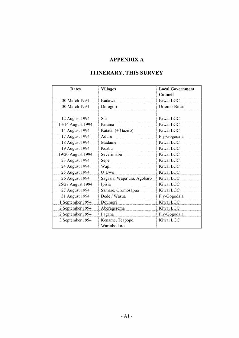
PPEN X A
ITINERARY, THIS SURVEY
Dates Villages Local Government Council
A DI
30
12 August 1994 Su Kiwai LGC i 13/14 August 1994 Parama Kiwai LGC
14
18 August 1994 Madame Kiwai LGC 19 A
epe K LGC 24 August 1994 Wapi Kiwai LGC 25 August 1994
’ur ro 2
amar osapede
2
30 March 1994 Kadawa Kiwai LGC March 1994 Dorogori Oriomo-Bituri
August 1994 Katatai (+ Gaziro) Kiwai LGC 17 August 1994 Aduru Fly-Gogodala
ugust 1994 Koabu Kiwai LGC 19/20 August 1994 Severimabu Kiwai LGC
23 August 1994 S iwai
U’Uwo Kiwai LGC 26 August 1994 Sagasia, Wapa a, Agoba Kiwai LGC 6/27 August 1994 Ipisia Kiwai LGC 27 August 1994 S e, Orom ua Kiwai LGC 31 August 1994 D / Wasua Fly-Gogodala
1 September 1994 Doumori Kiwai LGC 2 September 1994 Aberagerema Kiwai LGC
September 1994 Pagana Fly-Gogodala 3 September 1994 Kename, Teapopo,
Wariobodoro Kiwai LGC
- A1 -
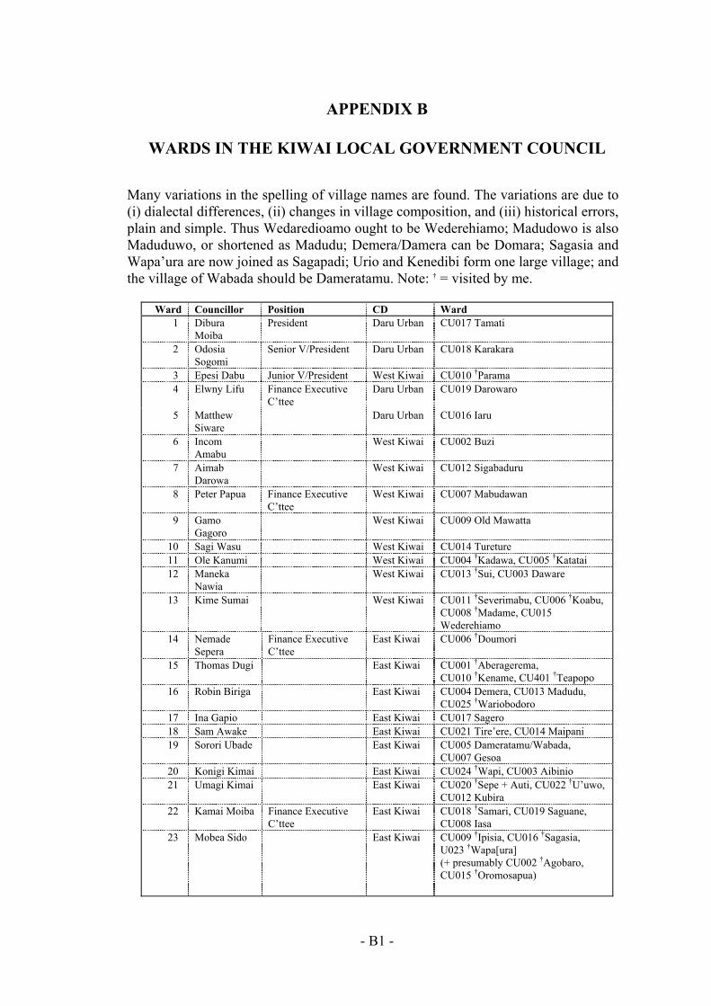
- B1 -
APPENDIX B
WARDS IN THE KIWAI LOCAL GOVERNMENT COUNCIL
Many variations in the spelling of village names are found. The variations are due to (i) dialectal differences, (ii) changes in village composition, and (iii) historical errors, plain and simple. Thus Wedaredioamo ought to be Wederehiamo; Madudowo is also Maduduwo, or shortened as Madudu; Demera/Damera can be Domara; Sagasia and Wapa’ura are now joined as Sagapadi; Urio and Kenedibi form one large village; and the village of Wabada should be Dameratamu. Note: † = visited by me.
Ward Councillor Position CD Ward 1 Dibura
Moiba President Daru Urban CU017 Tamati
2 Odosia Sogomi
Senior V/President Daru Urban CU018 Karakara
3 Epesi Dabu Junior V/President West Kiwai CU010 †Parama 4 Elwny Lifu Finance Executive
C’ttee Daru Urban CU019 Darowaro
5 Matthew Siware
Daru Urban CU016 Iaru
6 Incom Amabu
West Kiwai CU002 Buzi
7 Aimab Darowa
West Kiwai CU012 Sigabaduru
8 Peter Papua Finance Executive C’ttee
West Kiwai CU007 Mabudawan
9 Gamo Gagoro
West Kiwai CU009 Old Mawatta
10 Sagi Wasu West Kiwai CU014 Tureture 11 Ole Kanumi West Kiwai CU004 †Kadawa, CU005 †Katatai 12 Maneka
Nawia West Kiwai CU013 †Sui, CU003 Daware
13 Kime Sumai West Kiwai CU011 †Severimabu, CU006 †Koabu, CU008 †Madame, CU015 Wederehiamo
14 Nemade Sepera
Finance Executive C’ttee
East Kiwai CU006 †Doumori
15 Thomas Dugi East Kiwai CU001 †Aberagerema, CU010 †Kename, CU401 †Teapopo
16 Robin Biriga East Kiwai CU004 Demera, CU013 Madudu, CU025 †Wariobodoro
17 Ina Gapio East Kiwai CU017 Sagero 18 Sam Awake East Kiwai CU021 Tire’ere, CU014 Maipani 19 Sorori Ubade East Kiwai CU005 Dameratamu/Wabada,
CU007 Gesoa 20 Konigi Kimai East Kiwai CU024 †Wapi, CU003 Aibinio 21 Umagi Kimai East Kiwai CU020 †Sepe + Auti, CU022 †U’uwo,
CU012 Kubira 22 Kamai Moiba Finance Executive
C’ttee East Kiwai CU018 †Samari, CU019 Saguane,
CU008 Iasa 23 Mobea Sido East Kiwai CU009 †Ipisia, CU016 †Sagasia,
U023 †Wapa[ura] (+ presumably CU002 †Agobaro, CU015 †Oromosapua)
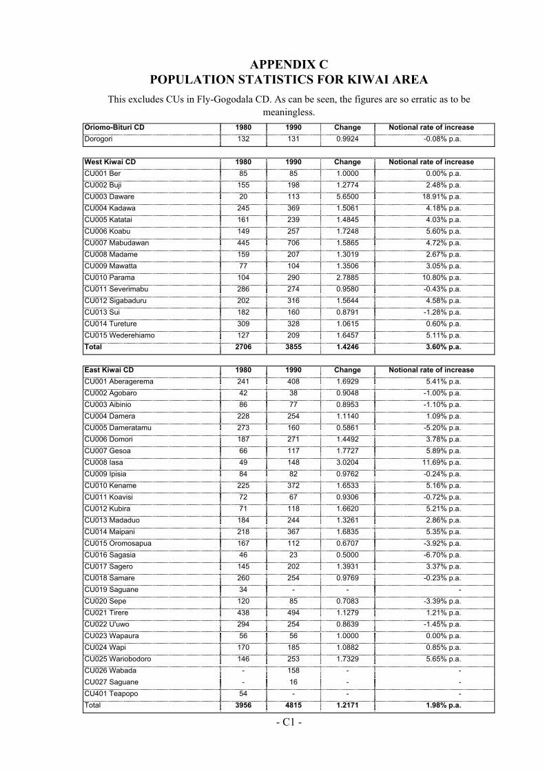
APPENDIX C POPULATION STATISTICS FOR KIWAI AREA
This excludes CUs in Fly-Gogodala CD. As can be seen, the figures are so erratic as to be
Oriomo-Bituri CD 1980 1990 Change Notional rate of increase
meaningless.
Dorogori 132 131 0.9924 -0.08% p.a.
West Kiwai CD 1980 1990 Change Notional rate of increase CU001 Ber 85 85 1.0000 0.00% p.a. CU002 Buji 155 198 1.2774 2.48% p.a. CU003 Daware 20 113 5.6500 18.91% p.a. CU004 Kadawa 245 369 1.5061 4.18% p.a. CU005 Katatai 161 239 1.4845 4.03% p.a. CU006 Koabu 149 257 1.7248 5.60% p.a. CU007 Mabudawan 445 706 1.5865 4.72% p.a. CU008 Madame 159 207 1.3019 2.67% p.a. CU009 Mawatta 77 104 1.3506 3.05% p.a. CU010 Parama 104 290 2.7885 10.80% p.a. CU011 Severimabu 286 274 0.9580 -0.43% p.a. CU012 Sigabaduru 202 316 1.5644 4.58% p.a. CU013 Sui 182 160 0.8791 -1.28% p.a. CU014 Tureture 309 328 1.0615 0.60% p.a. CU015 Wederehiamo 127 209 1.6457 5.11% p.a. Total 2706 3855 1.4246 3.60% p.a.
East Kiwai CD 1980 1990 Change Notional rate of increase CU001 Aberagerema 241 408 1.6929 5.41% p.a. CU002 Agobaro 42 38 0.9048 -1.00% p.a. CU003 Aibinio 86 77 0.8953 -1.10% p.a. CU004 Damera 228 254 1.1140 1.09% p.a. CU005 Dameratamu 273 160 0.5861 -5.20% p.a. CU006 Domori 187 271 1.4492 3.78% p.a. CU007 Gesoa 66 117 1.7727 5.89% p.a. CU008 Iasa 49 148 3.0204 11.69% p.a. CU009 Ipisia 84 82 0.9762 -0.24% p.a. CU010 Kename 225 372 1.6533 5.16% p.a. CU011 Koavisi 72 67 0.9306 -0.72% p.a. CU012 Kubira 71 118 1.6620 5.21% p.a. CU013 Madaduo 184 244 1.3261 2.86% p.a. CU014 Maipani 218 367 1.6835 5.35% p.a. CU015 Oromosapua 167 112 0.6707 -3.92% p.a. CU016 Sagasia 46 23 0.5000 -6.70% p.a. CU017 Sagero 145 202 1.3931 3.37% p.a. CU018 Samare 260 254 0.9769 -0.23% p.a. CU019 Saguane 34 - - - CU020 Sepe 120 85 0.7083 -3.39% p.a. CU021 Tirere 438 494 1.1279 1.21% p.a. CU022 U'uwo 294 254 0.8639 -1.45% p.a. CU023 Wapaura 56 56 1.0000 0.00% p.a. CU024 Wapi 170 185 1.0882 0.85% p.a. CU025 Wariobodoro 146 253 1.7329 5.65% p.a. CU026 Wabada - 158 - - CU027 Saguane - 16 - - CU401 Teapopo 54 - - - Total 3956 4815 1.2171 1.98% p.a.
- C1 -

- 2 -
APPENDIX D
CLANS REPRESENTED IN KIWAI VILLAGES
- D1 -
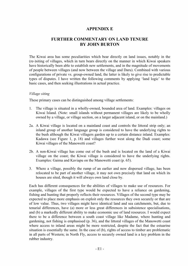
APPENDIX E
FURTHER COMMENTARY ON LAND TENURE BY JOHN BURTON
The Kiwai area has some peculiarities which bear directly on land issues, notably in the (re-)siting of villages, which in turn bears directly on the manner in which Kiwai speakers have historically been able to establish new settlements, and in the magnitude of movements of people between villages (and now between the village and Daru). Combined with various configurations of private vs. group-owned land, the latter is likely to give rise to predictable types of disputes. I have written the following comments by applying ‘land logic’ to the basic cases, and then seeking illustrations in actual practice.
Village siting
These primary cases can be distinguished among village settlements:
1. The village is situated in a wholly-owned, bounded area of land. Examples: villages on Kiwai Island. (Note: small islands without permanent villages are likely to be wholly owned by a village, or village section, on a larger adjacent island, or on the mainland.)
2a. A Kiwai village is located on a mainland coast and controls the littoral strip only; an inland group of another language group is considered to have the underlying rights to the bush although the Kiwai villagers garden up to a certain distance inland. Examples: Kadawa (see Figure 1, p. 18) and villages further west along the Dudi coast; some Kiwai villages of the Manowetti coast?
2b. A non-Kiwai village has come out of the bush and is located on the land of a Kiwai village on the coast; the Kiwai village is considered to have the underlying rights. Examples: Gaima and Kaviapu on the Manowetti coast (p. 65).
3. Where a village, possibly the rump of an earlier and now dispersed village, has been relocated to be part of another village, it may not own precisely that land on which its houses are sited, though it will always own land close by.
Each has different consequences for the abilities of villages to make use of resources. For example, villages of the first type would be expected to have a reliance on gardening, fishing and hunting that properly reflects their resources. Villages of the second type may be expected to place more emphasis on exploit only the resources they own securely or that are of low value. Thus, two villages might have identical land and sea catchments, but, due to tenurial differences, have (a) more or less great differences in subsistence specialisations, and (b) a markedly different ability to make economic use of land resources. I would expect there to be a difference between a south coast village like Madame, where hunting and gardening, not fishing is emphasised (p. 36), and the littoral villages of the Manowetti coast where access to inland areas might be more restricted, despite the fact that the estuarine situation is essentially the same. In the case of (b), rights of access to timber are problematic in all parts of Western; in North Fly, access to securely owned land is a key problem in the rubber industry.
- E1 -
In the third case, leaders in the rump or ‘client’ village may be given little recognition in the running of village affairs. In Nort tances occur where leaders from the dominant, primary village claim exclusive control over VDF payments (though we do not know how successfully). We may suspect, but do not know, that similar problems are faced by some Kiwai villagers.
Sp individually owned in that the nt
ga .e. land not, or not now, in cultivation, can also be privately owned or it can be held in common
Thfunctions of the clan is to regulate access to land. As Lawrence says (on p. 12), types of
hu may not, unless they are first
Another function of groups, whether these are clans or the aggegated clans of a village, is to th, the
en have already been passed on to them when the former owner was alive. But any that is not,
rt to
In the context of the Kiwai area, a similar situation must arise when a private owner moves or
oth f land without express permission, but also oup
rig
In Papua New Guinea, urban workers have returned to find coconuts, coffee or other cash crops planted on their land. The encroachers are often successful in asserting
s usually find it hard to reclaim what was theirs before they left. Even if the parties are close relatives, the supposed owners can find
W phenomenon among the Kiwai, Lawrence’s it
ex able tensions existing between home he
fre he ‘w between residents and absentees.
Thint on and, notably where they have good education and jobs and are important contributors to
h Fly Trust villages, ins
Private land, public land and absentees
eaking in general terms, gardening land may be consideredgardener, or some person who has previous gardened the land and who has given the prese
rdener temporary use rights, has individualised the land by personal action. Bush land, i
by some larger ‘public’.
is ‘public’ may be a whole village, or it may be a clan within a village where a primary
common land include swamps, beaches, rivers and so on. All group members may fish andnt freely on common land—but members of other groups
granted special permission.
be able, at least in theory, to resume private land. For example, on a person’s deaprivate land that they owned will normally be directly claimed by heirs—or it may ev
perhaps by oversight or because the status of the land was already ambiguous, will revepublic ownership.
away from the village for some years. A dispute is likely to occur if the owner’s relativeser group members encroach on parcels o
without active opposition. Their justification comes from the consideration of the grhts that still exist over individual land.
many parts of
possessive rights and the former owner
themselves shut out of important areas of economic activity.
hile we have not directly examined this information on the sheer numbers of non-residents claimed at each village would make
tremely surprising if there were not considerresidents and absentees over the issues of land and resources. A case in point is t
quency with which villagers grumble about development grants being diverted to trong people’ living in the corners of Daru. This is certainly an area of disputation
e Trust focusses only on those taken to be residents but, as Lawrence notes in his roduction, it should be realised that absentees are a major factor in the village equati
- E2 -
village incomes through remittances, they may have prominent leadership roles in iety. The focus on the village is correct, but it worth bearing in mind that many importa
cisions made about village developm
village soc nt de ent are taken by people who do not live there.
- E3 -
- BIB1 -
BIBLIOGRAPHY
Project area documentation
BURTON, J.E. 1991. The Ningerum LGC Area. Ok-Fly Social Monitoring Project. Report No. 2. Port Moresby: Unisearch PNG Pty Ltd For Ok Tedi Mining Limited
BURTON, J.E. 1993. Development in the North Fly and Ningerum-Awin area study. Ok-Fly Social Monitoring Project. Report No. 6. Port Moresby: Unisearch PNG Pty Ltd For Ok Tedi Mining Limited
BURTON, J.E. 1994. ‘Local-level mining benefit in a mal-administered regional economy: the case of Western Province, Papua New Guinea’. Paper presented at Workshop on Mining in the Asia-Pacific Region, Research School of Pacific and Asian Studies, Australian National University, Canberra.
FILER, COLIN 1991. Baseline documentation. Ok-Fly Social Monitoring Project Report No. 1. Port Moresby: Unisearch PNG Pty Ltd for Ok Tedi Mining Limited.
JACKSON, RICHARD T. 1993. Cracked pot or copper bottomed investment? The development of the Ok Tedi project 1982-91, a personal view. Townsville: James Cook University, Melanesian Studies Centre.
KING, DAVID 1993. Statistical geography of the Fly River Development Trust. Ok-Fly Social Monitoring Project Report No. 4. Port Moresby: Unisearch PNG Pty Ltd for Ok Tedi Mining Limited.
OK TEDI MINING LIMITED 1993A. APL compliance and additional environmental monitoring program: 1992 Annual Report. Tabubil: Ok Tedi Mining Limited, Environment Department. Report No. ENV 93-04
OK TEDI MINING LIMITED 1993B. Lower Ok Tedi/Fly River Development Trust: Annual Report 1992. Port Moresby: Ok Tedi Mining Limited.
OK TEDI MINING LIMITED 1994. Lower Ok Tedi/Fly River Development Trust: Annual Report 1994. Port Moresby: Ok Tedi Mining Limited.
SMITH, ROSS 1992. Climbing perch, Anabas testudineus. OTML Environment Department [office memorandum]
Environmental and mining references
COOK, ALAN 1994. ‘Environmental aspects of mining and petroleum industries in Papua New Guinea.’ In Economic Insights Pty Ltd Papua New Guinea: the role of government in economic development. Canberra: AIDAB, pp. 245-272.
CORDELL, JOHN, MARJORIE SULLIVAN AND DAVID LAWRENCE 1993. PNG Western and Gulf Coastal Zone Management Plan. (Report to AIDAB)
HARRIS, PETER T. 1991. ‘Sedimentation at the juncture of the Fly River delta and northern Great Barrier Reef’ In David Lawrence and Tim Cansfield-Smith (eds) Sustainable Development for Traditional Inhabitants of the Torres Strait Region. Townsville: Great Barrier Reef Marine Park Authority, pp. 59-86.
KWAN, DONNA (1991). ‘The artisanal turtle fishery in Daru, Papua New Guinea’. In David Lawrence and Tim Cansfield-Smith (eds) Sustainable Development for Traditional Inhabitants of the Torres Strait Region. Townsville: Great Barrier Reef Marine Park Authority, pp. 239-240.
- BIB2 -
LAWRENCE, DAVID AND TIM CANSFIELD-SMITH (EDS) 1991. Sustainable development for traditional inhabitants of the Torres Strait region. Townsville: Great Barrier Reef Marine Park Authority.
MARSH, HELENE AND KEITH SAALFIELD (1991). ‘The status of dugong in Torres Strait’. In David Lawrence and Tim Cansfield-Smith (eds) Sustainable Development for Traditional Inhabitants of the Torres Strait Region. Townsville: Great Barrier Reef Marine Park Authority, pp. 187-194.
MCALPINE, J.R. AND GAEL KEIG WITH R. FALLS 1983. Climate of Papua New Guinea. Canberra: Commonwealth Scientific and Industrial Research Organization, and Australian National University Press
WOLANSKI, ERIC, MARK TRENORDEN AND BRIAN KING 1990. Fly River estuary and Gulf of Papua: oceanography and sediment dynamics data report: November 1990. Townsville: Australian Institute of Marine Science.
Ethnographic, historical and general references
BEAVER, WILFRED N. 1920. Unexplored New Guinea. London: Seeley, Service and Co. BUSSE, MARK 1991. ‘Kiwai’. In Terence E. Hays (ed.) Encyclopedia of World Cultures. Volume II.
Boston: GK Hall, pp. 124-127. CRAWFORD, A.L. 1981. Aida: life and ceremony of the Gogodala. Bathurst: Robert Brown for the
National Cultural Council of Papua New Guinea. HADDON, A.C. 1901-1935. Reports of the Cambridge Anthropological Expedition to Torres Straits.
Cambridge: Cambridge University Press. LANDTMAN, GUNNAR 1927. The Kiwai Papuans of British New Guinea. London: Macmillan. LAWRENCE, DAVID 1994. ‘Customary exchange across Torres Strait’. Memoirs of the Queensland
Museum Volume 34, Part 2. NATIONAL STATISTICAL OFFICE 1983. Provincial data system: rural community register: Western
Province. Port Moresby: National Statistical Office.
PRINCE, JOHN AND MOYRA PRINCE 1991. A church is born. Asia Pacific Christian Mission. WÜRM, S.A. 1973. ‘The Kiwaiian language family’ In K. Franklin (ed.) The Linguistic situation in
the Gulf District and adjacent areas, Papua New Guinea. Canberra: Australian National University, Research School of Pacific Studies, Department of Linguistics. Pacific Linguistics - Series C No. 26, pp. 219-260.
WÜRM, S.A. AND SHIRÔ HATTORI 1981. Language atlas of the Pacific area. Canberra: Australian Academy of the Humanities in collaboration with the Japan Academy
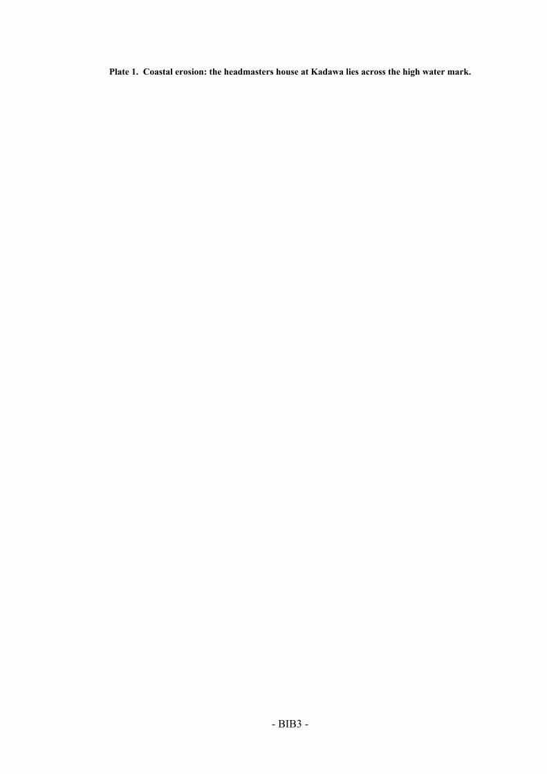
- BIB3 -
Plate 1. Coastal erosion: the headmasters house at Kadawa lies across the high water mark.


