Embed Size (px)
Citation preview
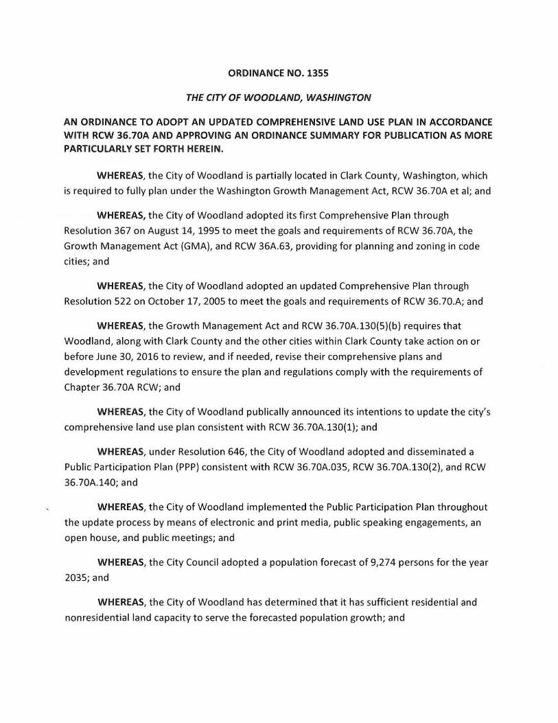
ORDINANCE NO. 1355
THE CITY OF WOODLAND, WASHINGTON
AN ORDINANCE TO ADOPT AN UPDATED COMPREHENSIVE LAND USE PLAN IN ACCORDANCE WITH RCW 36.70A AND APPROVING AN ORDINANCE SUMMARY FOR PUBLICATION AS MORE PARTICULARLY SET FORTH HEREIN .
WHEREAS , the City of Woodland is partially located in Clark County, Washington , which
is required to fully plan under the Washington Growth Management Act, RCW 36.70A et al; and
WHEREAS, the City of Woodland adopted its fir st Comprehensive Plan through
Resolution 367 on August 14, 1995 to meet the goals and requirements of RCW 36 .70A, the
Growth Management Act (GMA), and RCW 36A.63, providing for planning and zoning in code
cities ; and
WHEREAS, the City of Woodland adopted an updated Comprehensive Plan through
Resolution 522 on October 17, 2005 to meet the goals and requirements of RCW 36.70.A; and
WHEREAS, the Growth Management Act and RCW 36 .70A . 130(5)(b) require s that
Woodland , along with Clark County and the other cities within Clark County take action on or
before June 30, 2016 to review, and if needed , revise their comprehens ive plans and
development regulations to ensure the plan and regulations comply with the requirements of
Chapter 36 . 70A RCW; and
WHEREAS, the City of Woodland publically announced its intentions to update the city 's
comprehensive land use plan consistent with RCW 36 . 70A.130(1) ; and
WHEREAS, under Resolution 646, the City of Woodland adopted and disseminated a
Public Participation Plan (PPP) consi stent w ith RCW 36 .70A .035 , RCW 36 .70A.130(2) , and RCW
36 . 70A .140; and
WHEREAS, the City of Woodland implemented the Public Participation Plan throughout
the update proces s by mean s of electronic and print media , public speaking engagements, an
open hou se, and public meetings; and
WHEREAS , the City Council adopted a population foreca st of 9,274 persons for the year
2035 ; and
WHEREAS, the City of Woodland has determined that it has sufficient residential and
nonre si dential land capacity to serve the foreca sted population growth; and
WHEREAS, the Planning Commission held work sessions and meetings on April 24, 2014,
May 15, 2014, June 19, 2014, July 24 , 2014, March 19, 2015 , September 17, 2015, October 28,
2015, November 19 , 2015, December 17, 2015 and February 18, 2016 and public hearings on
June 18, 2015 and January 21, 2016 after which they forwarded a recommendation to the City
Council to approve the propo sed Comprehensive Plan Update ; and
WHEREAS, the City Council held work sessions and meetings on June 16, 2014,
September 2, 2014, December 1, 2014, December 15, 2014 , February 2, 2015, June 15, 2015 ,
September 21 , 2015, October 19, 2015, January 19, 2016 , and February 16, 2016 and public
hearings on August 18, 2014, December 21 , 2015 , March 7, 2016 and March 21 , 2016 ; and
WHEREAS, the proposed Comprehensive Plan Update was submitted to the State
Department of Commerce for comment on December 12, 2015;
WHEREAS, consistent with WAC 197-11-340(2), after evaluating the potential significant
adverse effects of amending the Comprehensive Plan and supporting land use documents , the
City of Woodland issued a Determination of Nonsignificance on February 11, 2016 ; and
WHEREAS, the City of Woodland has reviewed the capital facility facilities and service s,
including water , sanitary sewer , transportation, park s and recreation , and general facilities , as
required under RCW 36 .70A .070(3) and found them adequate to serve the forecasted
population ; and
WHEREAS, the City Council finds that this ordinance complies w ith the adoption
requirements of the Growth Management Act , Chapter 36 .70A RCW;
NOW, THEREFORE, BE IT ORDAINED BY THE CITY COUNCIL OF THE CITY OF
WOODLAND AS FOLLOWS :
Section 1. Findings. The City Council hereby adopts the recitals set forth above.
Section 2. Public Interest. The Woodland City Council finds that it is in the publicinterest to adopt the updated Woodland Comprehensive Plan , in compliance with RCW 36 .70A ,to ensure that the City has planned realistically for future growth and has identified adequate lands for the projected population growth .
Section 3 . Compliance with RCW36. 70A.130 .The Woodland City Council reviewed it sComprehensive Plan for con sistency with RCW 36 .70A and finds that it has met its obligation under RCW 36 .70A . 130 and that no additional amendments to the Comprehen sive Plan are necessary at thi s time.
Section 4. Adoption of 2016 Woodland Comprehensive Plan . The 2016 WoodlandComprehensive Plan , as set forth in the attached Ex hibit A and fully incorporated herein by thi s reference, is hereby adopted and approved in its entirety as the comprehen sive plan for the City of Woodland , Washington .
Section 5 . Adoption of the Comprehensive Plan Map. The Woodland City Counciladopts the updated Woodland Comprehen sive Plan Map attached hereto as Exhibit " B" superseding previously adopted Comprehensive Plan Maps.
Section 6 . Adoption of the Updated Zoning Map . The Woodland City Coun cil finds thatthe updated Woodland Zoning Map is con si stent with the updated Woodland Comprehen sive Plan Map and hereby adopts the updated Woodland Zoning Map attached hereto as Exhibit " C" superseding previou sly adopted Zoning Maps.
Section 7. Copy to Department of Commerce. Pursuant to RCW 36 .70A . 106{3), thi sordinance shall be transmitted to the Wa shington State Department of Commerce within ten days of adoption as requ i red by law .
Section 8 . Corrections. The City Clerk and codifier s of this ordinance are authorized to make necessary clerical correction s to this ordinance including, but not limited to , the correction of scriveners ' /clerical error s, reference s, ordinance numbering , section s/ subsection numbers and any references thereto.
Section 9. Severability. If any section , sentence , clause or phra se in this Ordinance should be held to be invalid or unconstitutiona l by a court of competent jurisdiction , such invalidity or uncon stitutionality shall not affect the valid ity of con stitutionality of any other section , sentence , clause or pha se of thi s Ordinance.
Section 10. Applicability . This ordinance shall apply within the current city limits and the Woodland Urban Growth Area as identified on the Woodland Comprehen sive Plan Map.
Section 11. Effective Date. This ordinance shall become effective on April 21 , 2016 .
ADOPTED this 21 s t day of March , 2016 .
CITY O F WOODLAND, WASHINGTON
Approved :
&L -->!William A. Finn , Mayo r
Atte st :
William El ing , Ci
SUMMARY OF ORDINANCE NO. 1355
OF THE CITY OF WOODLAND, WASHINGTON
On March 21, 2016 the City Council of the City of Woodland, Washington, approved Ordinance No . 1355 the main point which may be summarized by its title as follows:
AN ORDINANCE TO ADOPT AN UPDATED COMPREHENSIVE LAND USE PLAN IN ACCORDANCE
WITH RCW 36.70A AND APPROV I NG AN ORDINANCE SUMMARY FOR PUBLICATION AS MORE
PARTICULARLY SET FORTH HEREIN.
The full text of this Ordinance will be mailed upon request.
APPROVED by the City Council at their meeting on 21 st day of March , 2016 .
Published:Effective :
April 13, 2016April 21 , 2016
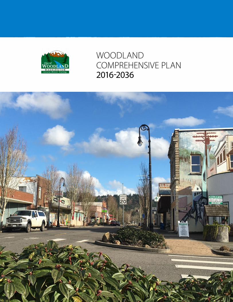
WOODLAND COMPREHENSIVE PLAN 2016-2036
City of Woodland, Washington 2016 Comprehensive Plan March 22, 2016
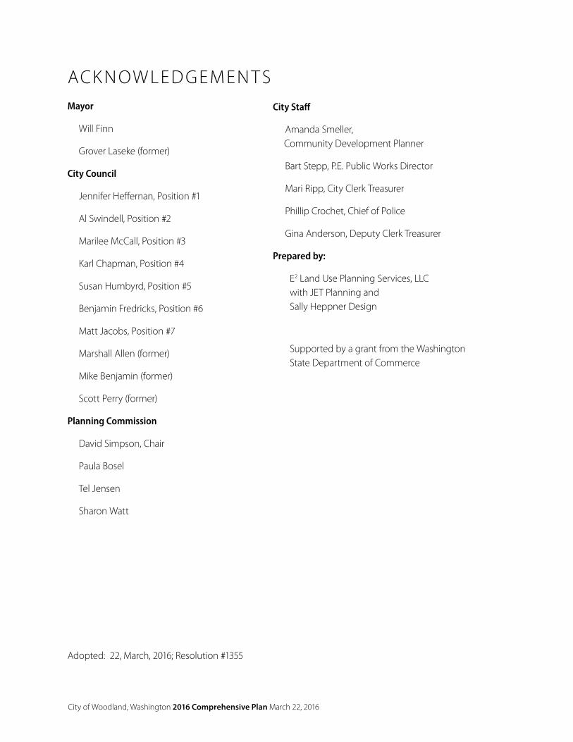
ACK N OW LED GEMEN T SMayor
Will Finn
Grover Laseke (former)
City Council
Jennifer Heffernan, Position #1
Al Swindell, Position #2
Marilee McCall, Position #3
Karl Chapman, Position #4
Susan Humbyrd, Position #5
Benjamin Fredricks, Position #6
Matt Jacobs, Position #7
Marshall Allen (former)
Mike Benjamin (former)
Scott Perry (former)
Planning Commission
David Simpson, Chair
Paula Bosel
Tel Jensen
Sharon Watt
City Staff
Amanda Smeller, Community Development Planner
Bart Stepp, P.E. Public Works Director
Mari Ripp, City Clerk Treasurer
Phillip Crochet, Chief of Police
Gina Anderson, Deputy Clerk Treasurer
Prepared by:
E2 Land Use Planning Services, LLC with JET Planning and Sally Heppner Design
Supported by a grant from the Washington State Department of Commerce
Adopted: 22, March, 2016; Resolution #1355
City of Woodland, Washington 2016 Comprehensive Plan March 22, 2016
CO N T EN T SACKNOWLEDGEMENTS
TABLES, MAPS, AND FIGURES
INTRODUCTION & COMMUNITY VISION (V) ____________________________________1
1.1. Goals and Policies ___________________________________________1
1.2. Woodland Guiding Principals ___________________________________1
1.3. Woodland Community Vision __________________________________2
1.4 Statutory & Regulatory Framework ______________________________4
PUBLIC INVOLVEMENT (PI) ________________________________________________ 11
2.1 Public Participation Plan ______________________________________ 11
2.2 Citizen Participation _________________________________________13
LAND USE (LU) __________________________________________________________15
3.1 Land Use Planning Assumptions _______________________________15
3.2 Land Use Designations ______________________________________18
3.3 Goals and Policies __________________________________________21
3.4 Historic Preservation ________________________________________22
3.5 Goals and Policies __________________________________________23
HOUSING (H) ___________________________________________________________25
4.1 Demographics ____________________________________________25
4.2 Housing Inventory and Analysis ________________________________26
4.3 Statement of Policies that Encourage Affordable Housing ____________26
4.4 Growth Management Act ____________________________________26
4.5 Goals and Policies __________________________________________27
ECONOMIC DEVELOPMENT (EC) ____________________________________________31
5.1 Workforce Data ____________________________________________31
5.3 Goals and Policies __________________________________________38
TRANSPORTATION (T) ____________________________________________________41
6.1 E xisting Conditions _________________________________________41
6.2 2015 Capital Improvement Plan (CIP) ____________________________43
6.3 Financing and Implementation ________________________________50
City of Woodland, Washington 2016 Comprehensive Plan March 22, 2016
PARKS, RECREATION AND OPEN SPACE (PR) ___________________________________51
7.1 E xisting Conditions _________________________________________52
7.2 Projected Needs ___________________________________________55
7.3 Project Capital Improvement Costs _____________________________57
CAPITAL FACILITIES (CF) __________________________________________________61
8.1 Sanitary Sewer: Existing Conditions _____________________________61
8.2 Sanitary Sewer: Projected Needs _______________________________65
8.3 Drinking Water: Existing Conditions _____________________________65
8.4 Projected Water Service Area, ERUs and Demand __________________69
8.5 Library, Emergency Services, and Schools ________________________69
8.6 Goals and Policies __________________________________________71
ENERGY AND UTILITIES (EU) _______________________________________________75
9.1 Electricity _________________________________________________75
9.2 Natural Gas _______________________________________________76
9.3 Telecommunications ________________________________________76
9.4 Implementation of Timely Processes ____________________________76
ENVIRONMENT (E) _______________________________________________________81
10.1 E xisting Conditions _________________________________________82
10.2 Environmental Regulations ___________________________________84
10.3 Goals and Policies __________________________________________85
GROWTH MANAGEMENT (GM) _____________________________________________87
11.1 Consistency _______________________________________________87
11.2 Plan Amendments _________________________________________87
11.3 Urban Growth Areas ________________________________________88
11.4 Essential Public Facilities _____________________________________88
11.5 Goals and Policies __________________________________________89
APPENDICES ___________________________________________________________91
Appendix A Public Participation Plan ________________________________91
Appendix B Key Terms and Acronyms _______________________________94
City of Woodland, Washington 2016 Comprehensive Plan March 22, 2016
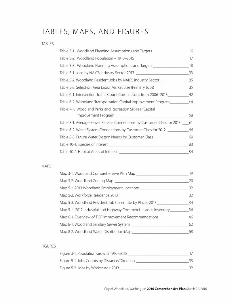
TABLE S, M APS, AND FIGUR E STABLES
Table 3-1. Woodland Planning Assumptions and Targets _________________16
Table 3-2. Woodland Population – 1910–2015 _________________________ 17
Table 3-3. Woodland Planning Assumptions and Targets _________________18
Table 5-1. Jobs by NAICS Industry Sector 2013 _________________________33
Table 5-2. Woodland Resident Jobs by NAICS Industry Sector _____________35
Table 5-3. Selection Area Labor Market Size (Primary Jobs) ________________35
Table 6-1. Intersection Traffic Count Comparisons from 2006–2013 __________42
Table 6-2. Woodland Transportation Capital Improvement Program _________44
Table 7-1. Woodland Parks and Recreation Six-Year Capital Improvement Program ___________________________________58
Table 8-1. Average Sewer Service Connections by Customer Class for 2013 ___61
Table 8-2. Water System Connections by Customer Class for 2012 __________66
Table 8-3. Future Water System Needs by Customer Class ________________69
Table 10-1. Species of Interest ______________________________________83
Table 10-2. Habitat Areas of Interest _________________________________84
MAPS
Map 3-1. Woodland Comprehensive Plan Map _________________________19
Map 3-2. Woodland Zoning Map ___________________________________20
Map 5-1. 2013 Woodland Employment Locations _______________________32
Map 5-2. Workforce Residence 2013 _________________________________32
Map 5-3. Woodland Resident Job Commute by Places 2013 _______________34
Map 5-4. 2012 Industrial and Highway Commercial Lands Inventory_________36
Map 6-1. Overview of TISP Improvement Recommendations ______________46
Map 8-1. Woodland Sanitary Sewer System ___________________________62
Map 8-2. Woodland Water Distribution Map ___________________________68
FIGURES
Figure 3-1. Population Growth 1910–2015 _____________________________ 17
Figure 5-1. Jobs Counts by Distance/Direction _________________________33
Figure 5-2. Jobs by Worker Age 2013 _________________________________32
City of Woodland, Washington 2016 Comprehensive Plan March 22, 2016
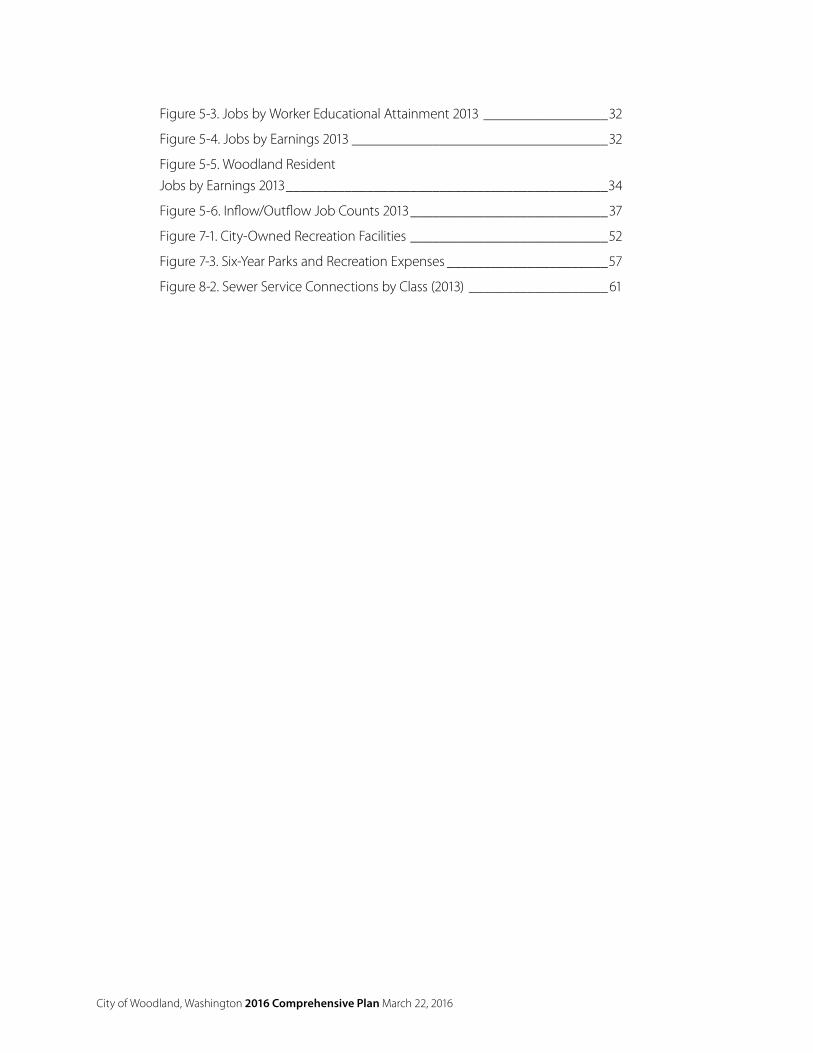
Figure 5-3. Jobs by Worker Educational Attainment 2013 _________________32
Figure 5-4. Jobs by Earnings 2013 ___________________________________32
Figure 5-5. Woodland ResidentJobs by Earnings 2013 ____________________________________________34
Figure 5-6. Inflow/Outflow Job Counts 2013 ___________________________37
Figure 7-1. City-Owned Recreation Facilities ___________________________52
Figure 7-3. Six-Year Parks and Recreation Expenses ______________________57
Figure 8-2. Sewer Service Connections by Class (2013) ___________________61
City of Woodland, Washington 2016 Comprehensive Plan Section 1 Introduction and Community Vision V-1
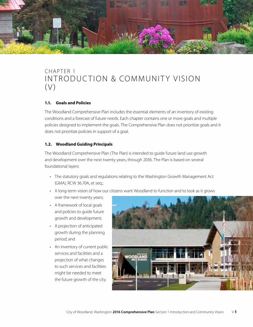
CHAP T ER 1IN T RO DUC T I O N & COMMUNI T Y V IS I O N ( V )
1.1. Goals and Policies
The Woodland Comprehensive Plan includes the essential elements of an inventory of existing conditions and a forecast of future needs. Each chapter contains one or more goals and multiple policies designed to implement the goals. The Comprehensive Plan does not prioritize goals and it does not prioritize policies in support of a goal.
1.2. Woodland Guiding Principals
The Woodland Comprehensive Plan (The Plan) is intended to guide future land use growth and development over the next twenty years, through 2036. The Plan is based on several foundational layers:
• The statutory goals and regulations relating to the Washington Growth Management Act (GMA), RCW 36.70A, et seq.;
• A long-term vision of how our citizens want Woodland to function and to look as it grows over the next twenty years;
• A framework of local goals and policies to guide future growth and development;
• A projection of anticipated growth during the planning period; and
• An inventory of current public services and facilities and a projection of what changes to such services and facilities might be needed to meet the future growth of the city.
V-2 City of Woodland, Washington 2016 Comprehensive Plan Section 1 Introduction and Community Vision
1.3. Woodland Community Vision
Woodland has a profound commitment to community values, prudent planning, and careful execution that preserves resources and maintains the integrity of family neighborhoods. Woodland is a community rich in history and proud of its rural heritage. Its vision reflects its history and deep commitment to the preservation of those attributes that have made it a successful and welcoming place to live and work.
Woodland will experience continued population growth, greater diversity, higher citizen expectations, and increased demand for essential public services. These challenges will be met through the innovative use of technology, internal process improvement, creative programs, and careful planning. The city will seek new and broader strategic partnerships, invest more in economic development, and establish integrated services that ensure safe, balanced, wholesome, and harmonious neighborhoods.
Over the next twenty years Woodland will grow to a population of 9,274 residents. A moderate growth rate of 2.3% annually will allow Woodland to remain a community where local and regional services are readily accessible.
Woodland Welcomes
Woodland is a safe, diverse and welcoming community for current and new residents, businesses, and tourists. Its small-town atmosphere and prime location relative to larger metropolitan areas and recreation areas make it an attractive destination. While we value and respect our heritage, we are committed to adapting to changes in the regional economy, responding to the rapid regional growth pressures, and responsibly managing our local natural and historic resources.
Woodland is Diverse
Woodland is committed to serve all of its citizens and has facilitated the development of more diverse housing opportunities than any nearby city. The city will continue its commitment to provide housing opportunities for a wide variety of personal and family needs at various income levels. The city will encourage construction of well-planned, integrated, and affordable housing while preserving Woodland’s close-knit community and commitment to families and harmonious neighborhoods.
Woodland Grows
Woodland has a rich agricultural and resource heritage and a burgeoning industrial Port, both of which can provide cornerstones for Woodland’s economic future. Because of our location along the Interstate 5 corridor and access to rail and river transportation, Woodland is, and will continue to be, a commercial service center for southern Cowlitz County and northern Clark County. Woodland will develop and maintain a magnetic, highly active and vibrant business community that generates consistent, stable and sustainable economic growth and local jobs.
City of Woodland, Washington 2016 Comprehensive Plan Section 1 Introduction and Community Vision V-3
Woodland Engages
Woodland residents are highly engaged in community events and festivals, and the city aims to increase engagement in city government. The city believes public participation is essential to good government and is committed to open and transparent governance and will actively reach out to its citizens to participate in the public processes.
Woodland Coordinates
The city will dedicate additional effort to developing local and regional partnerships and strategic alliances that help facilitate coordination and land use consistency among jurisdictions and agencies.
Woodland Moves
The city will improve and expand its transportation and pedestrian infrastructure. Interstate 5 is a boon and a barrier to mobility. The Scott Avenue reconnection and sidewalks from downtown to the Intermediate School will improve mobility. Improved bicycle and pedestrian connections will facilitate cross-town movement.
Woodland Serves
Woodland’s school system is an asset that will draw families to the community. Residents enjoy the city’s parks, trails and other recreational opportunities. Residents value and fund police, fire and emergency response services. Proficient government agencies maintain existing city assets and coordinate future development.
Woodland Protects and Manages
Woodland values its natural setting, defined by its relationship with places like Horseshoe Lake, the Lewis River, and Mt. St Helens. Future development will be managed to minimize impacts to the city’s natural amenities. Parks and trails provide public access to these natural amenities and ensure they are available to future generation.
Vision Principles
V 1 Woodland is a small, relatively affordable, full-service community enhanced by proximity to regional outdoor and metropolitan resources.
V 2 The city will maintain small-town community identity based around livable neighborhoods and quality schools while accommodating moderate growth.
V 3 The city will prioritize future expansion of industrial and commercial economic opportunities to attract family-wage jobs in the community and commercial services for residents.
V 4 The city will expand infrastructure to serve planned development and will maintain adequate levels of service to support the current and future community.
V-4 City of Woodland, Washington 2016 Comprehensive Plan Section 1 Introduction and Community Vision
V 5 The city will cultivate environmental assets like Horseshoe Lake and the Lewis River for both recreational use in the form of parks and trails, and environmental protection.
1.4 Statutory & Regulatory Framework
Growth Management Act (GMA)
The Washington State Growth Management Act (GMA), 36.70A RCW, requires counties which meet population and growth criteria to develop, adopt and maintain a comprehensive land use planning process consistent with the requirements of the GMA. Among other requirements, comprehensive plans must ensure that projected growth in urban areas be accommodated through a range of urban densities, that capital facilities keep pace with the growth, and that critical natural resource areas are protected and managed.
Woodland is in an unusual situation in that it is partially in Clark County, which is required to fully plan under the Act, and largely in Cowlitz County, which is only required to partially-plan under the Act.1 The city crafted this Comprehensive Plan to be consistent with RCW 36.70A, the Clark County Countywide Planning Policies, and the Planning Assumptions adopted by the Clark County Board of Councilors.
What’s in the Comprehensive Plan?
Chapter 1, Introduction and Community Vision, describes the 20-year visions for Woodland.
Chapter 2, Public Involvement, reaffirms the city’s commitment to open and transparent governmentand its desire to engage and listen to the community.
Chapter 3, Land Use, describes the planning assumptions underlying the Plan, the housing and employment targets, and respect for the city’s past.
Chapter 4, Housing, describes what will be done to ensure that adequate housing will be available for all economic segments of the community.
Chapter 5, Economic Development, describes what will be done to enhance job growth and retention.
Chapter 6, Transportation, describes the vision for transportation and transportation facilities within the city limits and Urban Growth Area (UGA).
Chapter 7, Parks, Recreation and Open Space, describes community-wide goals and standards for parks and recreation facilities.
Chapter 8, Capital Facilities, describes how roads, water, sewer, parks, and other public facilities and services will be provided.
1 See Western Washington Growth Management Hearings Board, Case No. 95-2-0068, finding Woodland must fully plan under the GMA.
City of Woodland, Washington 2016 Comprehensive Plan Section 1 Introduction and Community Vision V-5
Chapter 9, Energy and Utilities, reflects the city’s commitment to ensure that public and private utilities are available to accommodate future growth and ensure its long term sustainability.
Chapter 10, Environment, describes how critical environmental resources will be managed and protected.
Chapter 11, Growth Management, identifies how the city will comply with the Growth Management Act over time and work cooperatively with other agencies and districts.
Woodland Supporting Plans and Regulations
The GMA requires jurisdictions planning under the Act to implement the goals and policies of the local comprehensive plan. Woodland implements The Plan, thereby achieving compliance with the Act, through implementation of the Woodland Capital Facilities Plan and the Woodland Municipal Code, particularly Chapters 15 - Environment, 16 - Subdivisions, 17 - Zoning, 18 - Annexation, and 19 - Development Code Administration.
This Comprehensive Plan adopts the following plans by reference:
• Woodland Capital Facilities Plan, including specific elements for:
− Transportation
− Sanitary Sewer
− Potable Water
− Parks and Recreation
− Schools
Impact fees and system development charges are adopted by resolution separately.

City of Woodland, Washington 2016 Comprehensive Plan Section 2 Public Involvement PI-11
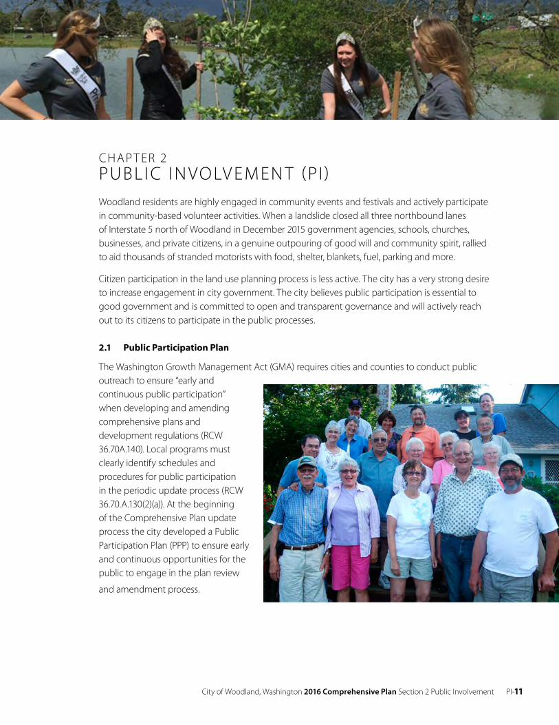
CHAP T ER 2PUBL I C IN VO LV EMEN T (PI)Woodland residents are highly engaged in community events and festivals and actively participate in community-based volunteer activities. When a landslide closed all three northbound lanes of Interstate 5 north of Woodland in December 2015 government agencies, schools, churches, businesses, and private citizens, in a genuine outpouring of good will and community spirit, rallied to aid thousands of stranded motorists with food, shelter, blankets, fuel, parking and more.
Citizen participation in the land use planning process is less active. The city has a very strong desire to increase engagement in city government. The city believes public participation is essential to good government and is committed to open and transparent governance and will actively reach out to its citizens to participate in the public processes.
2.1 Public Participation Plan
The Washington Growth Management Act (GMA) requires cities and counties to conduct public outreach to ensure “early and continuous public participation” when developing and amending comprehensive plans and development regulations (RCW 36.70A.140). Local programs must clearly identify schedules and procedures for public participation in the periodic update process (RCW 36.70.A.130(2)(a)). At the beginning of the Comprehensive Plan update process the city developed a Public Participation Plan (PPP) to ensure early and continuous opportunities for the public to engage in the plan review
and amendment process.
PI-12 City of Woodland, Washington 2016 Comprehensive Plan Section 2 Public Involvement
The Goals of the Public Participation Plan were to:
1. Ensure broad participation by identifying key interest groups and soliciting input from the public.
2. Maintain effective communication and coordination.
3. Focus resources on issues most likely to be of interest to the public.
4. Distribute information and public notices early and efficiently.
The Scope of Work for the PPP was divided into three (3) phases of activity:
Phase I: Review Comprehensive Plan and Development Code for compliance with state law; identify plan areas to be amended; scope the breadth of the update publicly.
Phase II: Address the issues identified in Phase I.
Phase III: Conduct public hearings and take legislative action.
Elements of the Public Participation Program included:
• Post meeting notices online, in print, and by mail for all meetings and hearings.
• Post planning documents related to the update on the city web pages
• Use interactive and mailed community surveys.
• Maintain an email distribution list and database.
• Conduct an Open House to solicit public feedback.
• Maintain active coordination with Clark County in terms of topics and timelines.
On May 15, 2014 the Planning Commission conducted a public hearing on the PPP and sent the recommended PPP to the City Council. The City Council reviewed the Planning Commission’s recommendations and adopted the PPP on June 16, 2014. The city sent a draft of the PPP to the Washington Department of Commerce 60 days prior to Council final action on the participation plan.
City of Woodland, Washington 2016 Comprehensive Plan Section 2 Public Involvement PI-13
2.2 Citizen Participation
The city government is committed to implement the Comprehensive Plan in an open and transparent public process. The city will:
• disseminate information about land use planning proposals and development review through traditional and electronic media;
• provide ample opportunity for written and oral public comment;
• provide early and effective notice of public meetings, including work sessions, regular meetings and hearings of the Planning Commission and City Council;
• provide meaningful opportunities for public discussion before the Planning Commission and City Council, as appropriate; and
• consider and respond to public comments offered during the land use review process and public hearings; and strive to maintain the city’s web pages and web presence current.
Goal
PI 1 The city government will continue to ensure that citizens have full opportunity to be heard and to participate in city governmental affairs.
Policies
PI 1 The city shall develop and implement a process to ensure early and continuous public participation in the comprehensive planning process, including the annual amendment, emergency amendment, and the periodic update processes.
PI 2 The city will coordinate with agencies providing social services in the city.
PI 3 Consistent with state statute and city policies, Woodland will use local resources to encourage local involvement in community actions and to enhance community pride.
PI4 Woodland will encourage public and private involvement in community traditions as well as active encouragement of volunteerism and activism.
PI 5 The city shall develop and implement a process to ensure that regulatory or administrative actions do not result in an unconstitutional taking of private property.

PI-14 City of Woodland, Washington 2016 Comprehensive Plan Section 2 Public Involvement
City of Woodland, Washington 2016 Comprehensive Plan Section 3 Land Use LU-15
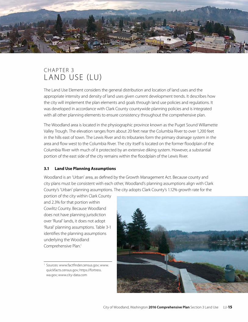
CHAP T ER 3L AND USE (LU)The Land Use Element considers the general distribution and location of land uses and the appropriate intensity and density of land uses given current development trends. It describes how the city will implement the plan elements and goals through land use policies and regulations. It was developed in accordance with Clark County countywide planning policies and is integrated with all other planning elements to ensure consistency throughout the comprehensive plan.
The Woodland area is located in the physiographic province known as the Puget Sound Willamette Valley Trough. The elevation ranges from about 20 feet near the Columbia River to over 1,200 feet in the hills east of town. The Lewis River and its tributaries form the primary drainage system in the area and flow west to the Columbia River. The city itself is located on the former floodplain of the Columbia River with much of it protected by an extensive diking system. However, a substantial portion of the east side of the city remains within the floodplain of the Lewis River.
3.1 Land Use Planning Assumptions
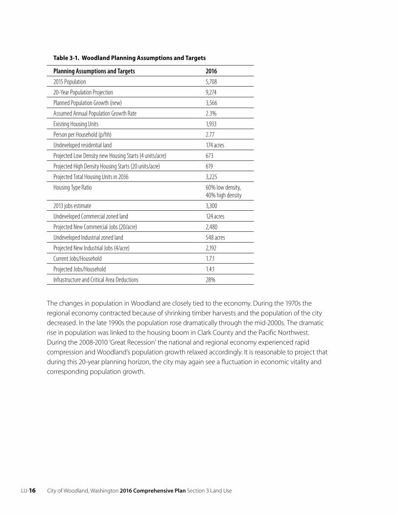
Woodland is an ‘Urban’ area, as defined by the Growth Management Act. Because county and city plans must be consistent with each other, Woodland’s planning assumptions align with Clark County’s ‘Urban’ planning assumptions. The city adopts Clark County’s 1.12% growth rate for the portion of the city within Clark County and 2.3% for that portion within Cowlitz County. Because Woodland does not have planning jurisdiction over ‘Rural’ lands, it does not adopt ‘Rural’ planning assumptions. Table 3-1 identifies the planning assumptions underlying the Woodland Comprehensive Plan.1
1 Sources: www.factfinder.census.gov; www. quickfacts.census.gov; https://fortress. wa.gov; www.city-data.com
LU-16 City of Woodland, Washington 2016 Comprehensive Plan Section 3 Land Use
Table 3-1. Woodland Planning Assumptions and Targets
Planning Assumptions and Targets 2016
2015 Population 5,708
20-Year Population Projection 9,274
Planned Population Growth (new) 3,566
Assumed Annual Population Growth Rate 2.3%
Existing Housing Units 1,933
Person per Household (p/hh) 2.77
Undeveloped residential land 174 acres
Projected Low Density new Housing Starts (4 units/acre) 673
Projected High Density Housing Starts (20 units/acre) 619
Projected Total Housing Units in 2036 3,225
Housing Type Ratio 60% low density, 40% high density
2013 jobs estimate 3,300
Undeveloped Commercial zoned land 124 acres
Projected New Commercial Jobs (20/acre) 2,480
Undeveloped Industrial zoned land 548 acres
Projected New Industrial Jobs (4/acre) 2,192
Current Jobs/Household 1.7:1
Projected Jobs/Household 1.4:1
Infrastructure and Critical Area Deductions 28%
The changes in population in Woodland are closely tied to the economy. During the 1970s the regional economy contracted because of shrinking timber harvests and the population of the city decreased. In the late 1990s the population rose dramatically through the mid-2000s. The dramatic rise in population was linked to the housing boom in Clark County and the Pacific Northwest. During the 2008-2010 ‘Great Recession’ the national and regional economy experienced rapid compression and Woodland’s population growth relaxed accordingly. It is reasonable to project that during this 20-year planning horizon, the city may again see a fluctuation in economic vitality and corresponding population growth.
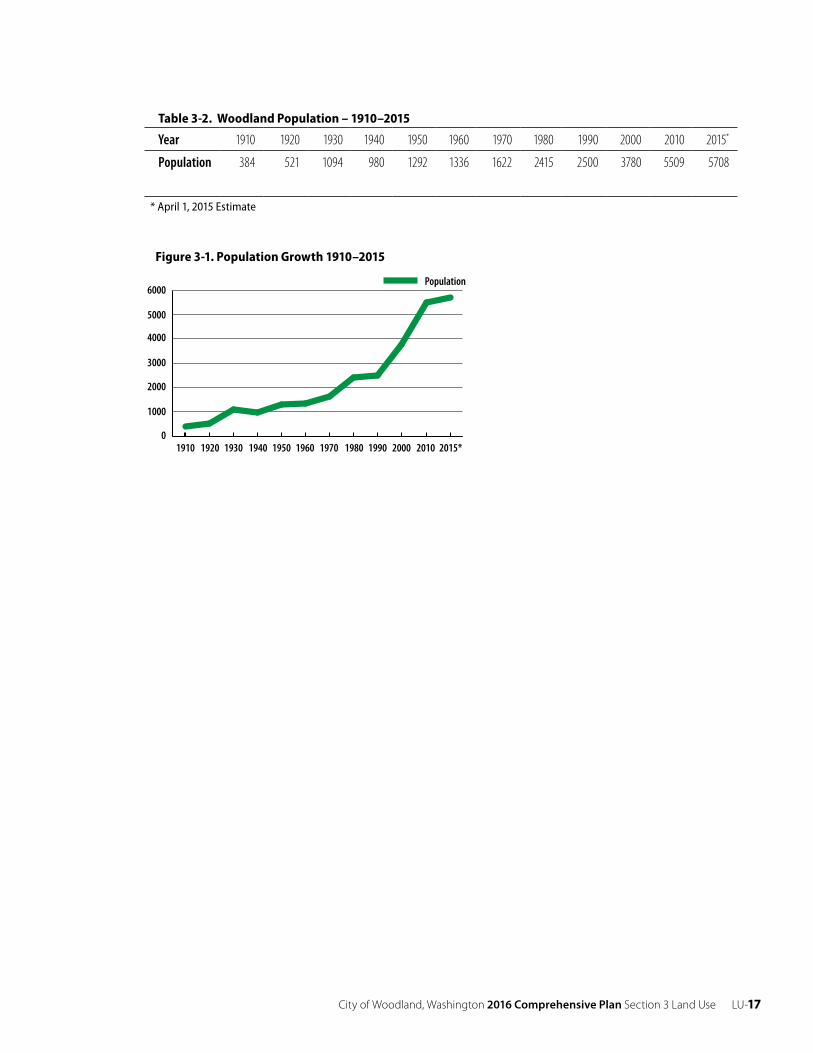
City of Woodland, Washington 2016 Comprehensive Plan Section 3 Land Use LU-17
Table 3-2. Woodland Population – 1910–2015
Year 1910 1920 1930 1940 1950 1960 1970 1980 1990 2000 2010 2015*
Population 384 521 1094 980 1292 1336 1622 2415 2500 3780 5509 5708
* April 1, 2015 Estimate
Figure 3-1. Population Growth 1910–2015
0
1000
2000
3000
4000
5000
6000
2015*2010 2000 1990 1980 1970 1960 1950 1940 1930 1920 1910
Population
LU-18 City of Woodland, Washington 2016 Comprehensive Plan Section 3 Land Use
3.2 Land Use Designations
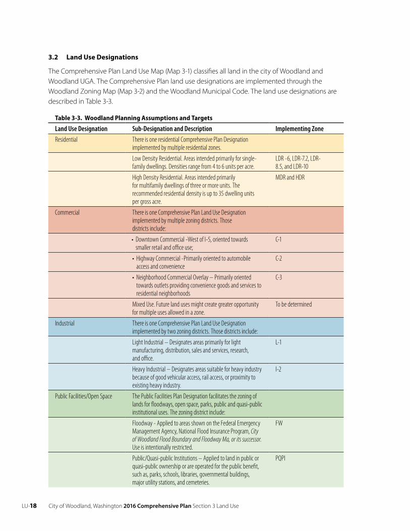
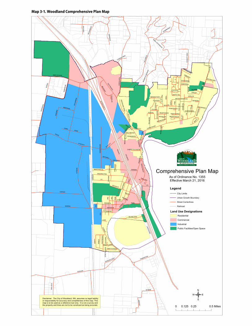
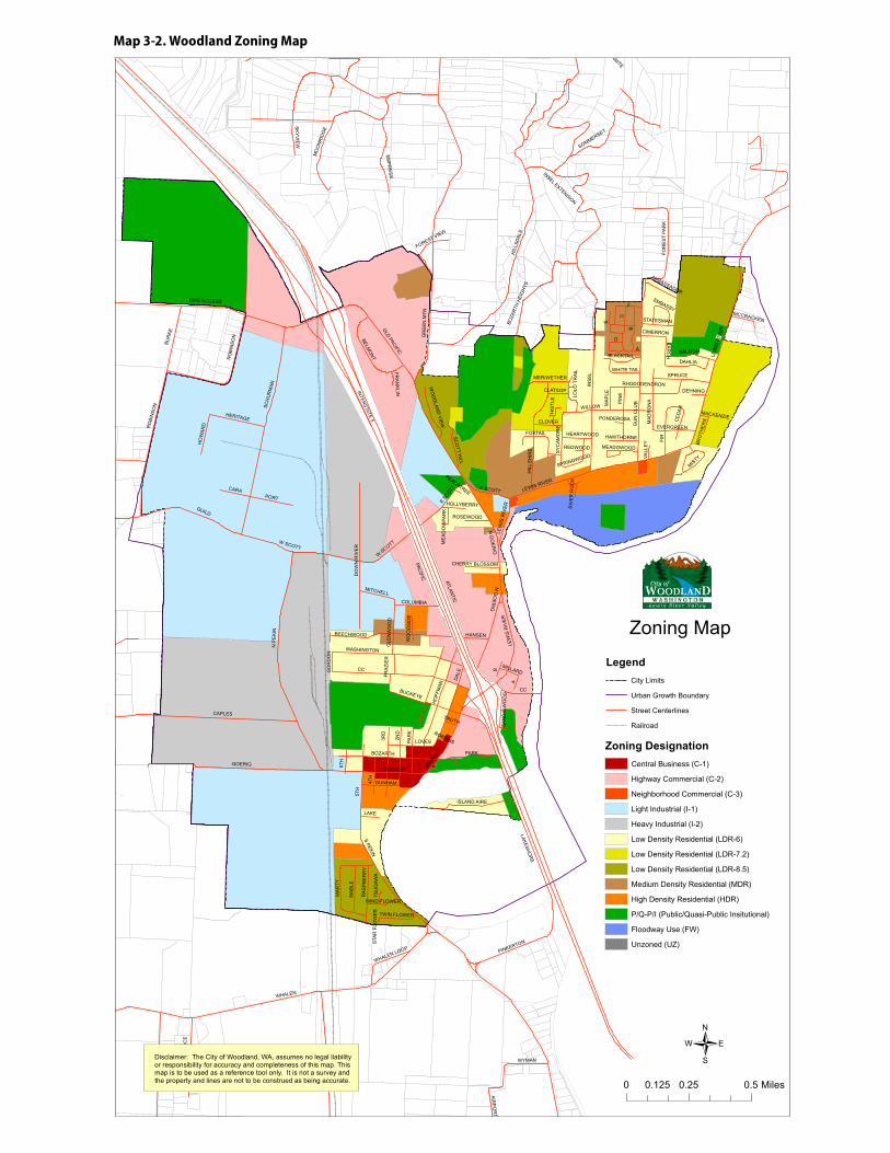
The Comprehensive Plan Land Use Map (Map 3-1) classifies all land in the city of Woodland and Woodland UGA. The Comprehensive Plan land use designations are implemented through the Woodland Zoning Map (Map 3-2) and the Woodland Municipal Code. The land use designations are described in Table 3-3.
Table 3-3. Woodland Planning Assumptions and Targets
Land Use Designation Sub-Designation and Description Implementing Zone
Residential There is one residential Comprehensive Plan Designation implemented by multiple residential zones.
Low Density Residential. Areas intended primarily for single- family dwellings. Densities range from 4 to 6 units per acre.
LDR -6, LDR-7.2, LDR- 8.5, and LDR-10
High Density Residential. Areas intended primarily for multifamily dwellings of three or more units. The recommended residential density is up to 35 dwelling units per gross acre.
MDR and HDR
Commercial There is one Comprehensive Plan Land Use Designation implemented by multiple zoning districts. Those districts include:
• Downtown Commercial -West of I-5, oriented towards smaller retail and office use;
C-1
• Highway Commercial -Primarily oriented to automobile access and convenience
C-2
• Neighborhood Commercial Overlay – Primarily oriented towards outlets providing convenience goods and services to residential neighborhoods
C-3
Mixed Use. Future land uses might create greater opportunity for multiple uses allowed in a zone.
To be determined
Industrial There is one Comprehensive Plan Land Use Designation implemented by two zoning districts. Those districts include:
Light Industrial – Designates areas primarily for light manufacturing, distribution, sales and services, research, and office.
L-1
Heavy Industrial – Designates areas suitable for heavy industry because of good vehicular access, rail access, or proximity to existing heavy industry.
I-2
Public Facilities/Open Space The Public Facilities Plan Designation facilitates the zoning of lands for floodways, open space, parks, public and quasi-public institutional uses. The zoning district include:
Floodway - Applied to areas shown on the Federal Emergency Management Agency, National Flood Insurance Program, City of Woodland Flood Boundary and Floodway Ma, or its successor. Use is intentionally restricted.
FW
Public/Quasi-public Institutions – Applied to land in public or quasi-public ownership or are operated for the public benefit, such as, parks, schools, libraries, governmental buildings, major utility stations, and cemeteries.
PQPI
City of Woodland, Washington 2016 Comprehensive Plan Section 3 Land Use LU-19
LEW
IS R
IVER
N G
OER
IGN
GO
ERIG
S PEKIN
INTERSTATE 5
BUR
KE
GOERIG
CAPLES
W SCOTT
HEARTWOOD
GUILD
W SCOTT
RO
BIN
SON
WHALEN
CC
GOERIG
HIL
LSD
ALE
RHODODENDRON
PEACHTREE
EVERGREEN
REDWOOD
WA
LLA
CE
ATLANTIC
BLACKTAIL
LOLO
TR
AIL
HO
FFM
AN
INS
EL
A
THIS
TLE
DIKE ACCESSSC
HU
RM
AN
PINKERTON
PAR
K
WYMAN
HOLLYBERRY
EMP
RE
SS
LAKESHO
RE
GU
N C
LUB
MA
RTY
RO
BIN
SON
MA
BLE
ISLAND AIRE
AIRP
OR
T
BELMO
NT
BEECHWOOD
DO
WN
RIV
ER
MACKENZIE
DAHLIA
MEADOWOOD
HERITAGE
CARA
LOVES
FOR
EST
PAR
K
LEWIS RIVER
PARK
MO
ON
RID
GE
BOZA
RTH
HEIG
HTS
HIL
LSH
IRE
ME
AD
OW
PAR
K
LEW
ISR
IVER
E
HO
WAR
D
STA
R F
LOW
ER
WO
OD
LAND
VIEW
SOMMERSET
BUCKEYE
SKY
VIE
W
MITCHELL
DAL
E
GR
EE
N M
TN
LAKE
WHALEN LOOP
INSEL EXTENSION
SALMON
LEW
IS R
IVER
A
WIND FLOWER
RA
SP
BE
RR
Y
WHITE TAIL
E SC
OTT
CC
D
B
6TH
BOZARTH
SCO
TT HILL
C
TWIN FLOWER
TSU
GAW
A
AMBASSADOR
B
FRA
ZIE
R
MISTY
CLATSOP
CLOVER
CIMERRON
3RD
N P
EK
IN
DAVIDSON
GO
RD
ON
MCCRACKEN
EMBASSY
VALL
EY
CHERRY BLOSSOM
FOXTAIL
TRUTH
SAN
DA
LWO
OD
F
BRO
THER
S
MERIWETHER
DEHNING
SPRINGWOOD
MILLARD
DUNHAM
PONDEROSA
FOREST VIEW
RIV
ER
RO
CK
5TH
MA
PLE
FIR
FRA
NK
LIN
WO
OD
SID
E
WILLOW4T
H
ROSEWOOD
ROBBINS
HANSEN
STATESMAN
HAWTHORNE
PIN
E
E SCOTT
SPRUCE
WASHINGTON
PACIFIC
2ND
LAR
CH
CED
AR
GLE
NW
OO
D
MA
DR
ON
A
SYC
AM
OR
E
PORT
OLD PACIFIC
COLUMBIA
/0 0.25 0.50.125 Miles
Disclaimer: The City of Woodland, WA, assumes no legal liability or responsibility for accuracy and completeness of this map. This map is to be used as a reference tool only. It is not a survey and the property and lines are not to be construed as being accurate.
Comprehensive Plan Map
LegendCity Limits
Urban Growth Boundary
Street Centerlines
Railroad
As of Ordinance No. 1355Effective March 21, 2016
Land Use DesignationsResidential
Commercial
Industrial
Public Facilities/Open Space
Map 3-1. Woodland Comprehensive Plan Map
LU-20 City of Woodland, Washington 2016 Comprehensive Plan Section 3 Land Use
LEW
IS R
IVER
S PEKIN
INTERSTATE 5
BUR
KE
GOERIG
CAPLES
W SCOTT
HEARTWOOD
GUILD
W SCOTT
RO
BIN
SON
WHALEN
CC
GOERIG
HIL
LSD
ALE
RHODODENDRON
PEACHTREE
EVERGREEN
REDWOOD
WA
LLA
CE
ATLANTIC
BLACKTAIL
LOLO
TR
AIL
HO
FFM
AN
INS
EL
A
THIS
TLE
DIKE ACCESS
SCH
UR
MAN
PINKERTON
PAR
K
SOM
ME
RS
ET
WYMAN
HOLLYBERRYEM
PR
ES
S
LAKESHO
RE
GU
N C
LUB
MA
RTY
RO
BIN
SON
MA
BLE
ISLAND AIRE
AIRP
OR
T
BELMO
NT
BEECHWOOD
DO
WN
RIV
ER
MACKENZIE
DAHLIA
MEADOWOOD
HERITAGE
CARA
LOVES
FOR
EST
PAR
K
LEWIS RIVER
PARK
MO
ON
RID
GE
BOZA
RTH
HEIG
HTS
HIL
LSH
IRE
ME
AD
OW
PAR
K
LEW
ISR
IVER
E
HO
WAR
D
STA
R F
LOW
ER
WO
OD
LAND
VIEW
NG
OE
RIG
SOMMERSET
BUCKEYE
SKY
VIE
WMITCHELL
DAL
E
GR
EE
N M
TN
LAKE
ANITE
WHALEN LOOP
INSEL EXTENSION
SALMON
LEW
IS R
IVER
A
WIND FLOWER
RA
SP
BE
RR
YWHITE TAIL
E SC
OTT
CC
D
B
6TH
BOZARTH
SCO
TT HILL
C
TWIN FLOWER
TSU
GAW
A
AMBASSADOR
B
FRA
ZIE
R
MISTY
CLATSOP
CLOVER
CIMERRON
3RD
N P
EK
IN
DAVIDSON
GO
RD
ON
MCCRACKEN
N G
OE
RIG
EMBASSY
VALL
EY
CHERRY BLOSSOM
FOXTAIL
TRUTH
SAN
DA
LWO
OD
F
BRO
THER
S
MERIWETHER
DEHNING
SPRINGWOOD
MILLARD
DUNHAM
PONDEROSA
FOREST VIEW
RIV
ER
RO
CK
5TH
MA
PLE
FIR
FRA
NK
LIN
WO
OD
SID
EWILLOW
4TH
ROSEWOOD
ROBBINS
HANSEN
STATESMAN
HAWTHORNE
PIN
E
E SCOTT
SPRUCE
WASHINGTON
PACIFIC
2ND
LAR
CH
CED
AR
GLE
NW
OO
D
MA
DR
ON
A
SYC
AM
OR
E
PORT
OLD PACIFIC
COLUMBIA
/0 0.25 0.50.125 Miles
Disclaimer: The City of Woodland, WA, assumes no legal liabilityor responsibility for accuracy and completeness of this map. Thismap is to be used as a reference tool only. It is not a survey andthe property and lines are not to be construed as being accurate.
Zoning MapLegend
City Limits
Urban Growth Boundary
Street Centerlines
Railroad
Zoning DesignationCentral Business (C-1)
Highway Commercial (C-2)
Neighborhood Commercial (C-3)
Light Industrial (I-1)
Heavy Industrial (I-2)
Low Density Residential (LDR-6)
Low Density Residential (LDR-7.2)
Low Density Residential (LDR-8.5)
Medium Density Residential (MDR)
High Density Residential (HDR)
P/Q-P/I (Public/Quasi-Public Insitutional)
Floodway Use (FW)
Unzoned (UZ)
Map 3-2. Woodland Zoning Map
City of Woodland, Washington 2016 Comprehensive Plan Section 3 Land Use LU-21
3.3 Goals and Policies
Goal
LU 1 Protect and enhance the character and long-term stability of the city through current standards for land development and subdivision.
Policies
LU 1.1 Design, size and construct subdivision streets, sidewalks, alleys, water lines, sewer lines, and other utilities and facilities in accordance with city standards, ordinances, and plans.
LU 1.2 Proponents of development shall pay their fair and proportionate share of the cost of repair and improvement of affected properties, facilities, or services if the development will adversely affect or overload adjacent or nearby public properties, facilities, or services..
LU 1.3 Place utilities underground where possible.
LU 1.4 Coordinate with police department, fire department, school district, and other relevant public agency comments during the development review process.
LU 1.5 Encourage innovative residential land development techniques to provide greater housing opportunity and variety of living environments.
LU 1.6 Subdivisions should provide public and/or private open space, consistent with city standards, to fulfill the active and passive recreation needs of new residents.
LU 1.7 Design and site subdivisions to preserve natural features to the extent feasible.
LU 1.8 Require appropriate mitigation for any development proposal that results in a reduction of the Level of Service (LOS) standard for the public facilities identified in the Capital Facilities Element.
LU 1.9 The city shall prepare written findings documenting that a proposed subdivisions provides appropriate provision for: streets or roads, sidewalks, alleys, other public ways, transit stops, and other features that assure safe walking conditions for students; potable water supplies [RCW 19.27.097], sanitary wastes, and drainage ways (stormwater retention and detention); open spaces, parks and recreation, and playgrounds; and schools and school grounds, consistent with RCW 58.17.110(2)(a).
LU 1.10 Ensure that the character and location of land uses provides the best opportunity for economic benefit and the enjoyment and the protection of natural and cultural resources while minimizing the threat to health, safety, and welfare posed by hazards, nuisances, incompatible land uses, and environmental degradation.
LU 1.11 Eliminate incompatible land uses through active code enforcement or available regulatory measures.
LU 1.12 Promote physical activity through land use policies and capital facility plans which consider urban planning approaches that promote physical activity.
LU-22 City of Woodland, Washington 2016 Comprehensive Plan Section 3 Land Use
3.4 Historic Preservation
In 1845 Adolphus Lee Lewes, a retired employee of the Hudson’s Bay and surveyor, took up a land claim on property south of the present day city of Woodland in the general area of Whalen Road.
Prior to the establishment of Woodland there were several small communities in the area. The community of Pekin, near present-day Holland Bulb Farm, had its own Post Office and store but was destroyed in the 1896 flood. Kerns, which was east of Woodland (Schurman’s corner), had a Post Office and Steamer Landing. Caples Landing was west of Woodland on the Columbia and Martins Landing was north of Woodland.
A.W. Scott platted Woodland in 1889 but the town did not incorporate until 1906. Steamboats plied the waters of SW Washington before the development of a reliable road system. The Steamer “Mascot” had a colorful history herself and is commemorated by a sculpture in Hoffman Plaza. (Donated by Margaret Colf Hepola.) The Lucia Mason (possibly spelled the Lucea Mason) sailed from 1883-1991 and was launched in St. Helens in 1883 by the Farmers Transportation Co. of Pekin, Washington. The steamer continued on the Lewis River run for about eight years, sinking one last time above Kerns (Schurmans Corner) when it hit a snag. In 1913, the road bridge crossed the Lewis River, signaling the demise of the ferry service across the river and eventually transforming the north/south road system into Woodland’s River of Commerce.
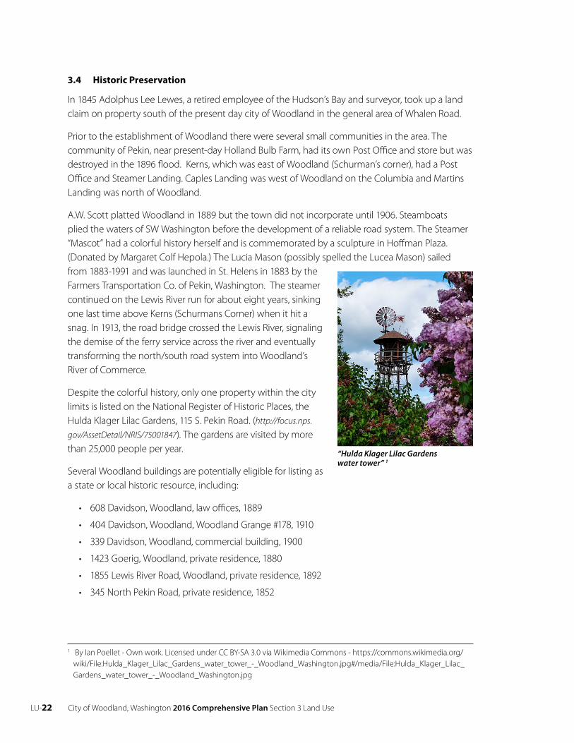
Despite the colorful history, only one property within the city limits is listed on the National Register of Historic Places, the Hulda Klager Lilac Gardens, 115 S. Pekin Road. (http://focus.nps.
gov/AssetDetail/NRIS/75001847 ). The gardens are visited by morethan 25,000 people per year.
Several Woodland buildings are potentially eligible for listing as a state or local historic resource, including:
• 608 Davidson, Woodland, law offices, 1889
• 404 Davidson, Woodland, Woodland Grange #178, 1910
• 339 Davidson, Woodland, commercial building, 1900
• 1423 Goerig, Woodland, private residence, 1880
• 1855 Lewis River Road, Woodland, private residence, 1892
• 345 North Pekin Road, private residence, 1852
“Hulda Klager Lilac Gardens water tower” 1
1 By Ian Poellet - Own work. Licensed under CC BY-SA 3.0 via Wikimedia Commons - https://commons.wikimedia.org/wiki/File:Hulda_Klager_Lilac_Gardens_water_tower_-_Woodland_Washington.jpg#/media/File:Hulda_Klager_Lilac_Gardens_water_tower_-_Woodland_Washington.jpg
City of Woodland, Washington 2016 Comprehensive Plan Section 3 Land Use LU-23
Historic resources are an excellent resource for teaching students about the significance of prior persons, places and events. They can be key ingredient to the local tourist industry. Historic resources can play an essential role in the revitalization of an older downtown. More work needs to be done on a local level to inventory and preserve historic buildings and places.
3.5 Goals and Policies
Goal
LU 2 Encourage the protection and preservation of significant historic, archaeological, architectural, aesthetic, and cultural resources.
Policies
LU 2.1 Encourage the identification and preservation of local historic properties to create public awareness of the city’s beginnings, aesthetic appreciation of architecture, maintenance of community identity, and furtherance of tourism and economic activity.
LU 2.2 Encourage owners of qualified properties to preserve, maintain and rehabilitate their properties and assist them in applying for listing on the State and National Registers of Historic Places.
LU 2.3 Encourage identification and rehabilitation of historically significant buildings in a manner that respects their architectural integrity.
LU2.4 Encourage rehabilitation of historic buildings as a feature of a downtown revitalization program.
LU 2.5 Investigate the potential of establishing a local historic preservation program in consultation with the Washington State Office of Archaeology and Historic Preservation and interested citizens.

LU-24 City of Woodland, Washington 2016 Comprehensive Plan Section 3 Land Use
City of Woodland, Washington 2016 Comprehensive Plan Section 4 Housing H-25
CHAP T ER 4H OUSING (H)Woodland is committed to maintaining and enhancing our existing neighborhoods while accommodating future growth in new neighborhoods. Land use goals and policies ensure that the city maintains an adequate supply of residential land. The housing goals and policies emphasize preserving existing residential neighborhoods, creating infill opportunities and identifying where and how new low density and medium density housing will develop.
4.1 Demographics1
In 2014 the population of Woodland was roughly divided between 53% female and 47% male. The median age was 28.8. Only 9.6% of the population was over the age of 65. Racially, 91.4% of the population identified as White, 17.9% of the population identified as Hispanic, approximately 2.6% self-identified as Asian, and less than 1% as Black or African American.
The median household income was $65,065. Poverty was and is an issue in Woodland. In 2014 17.4% of all families and 23.4% of all residents lived below the federal poverty level ($11,670 one person/household and $23,850 four persons per household). 2 Poverty levels differed dramatically across the city. East of I-5, observed poverty levels ranged from 6.4% furthest east to 12.2% closer to the freeway. West of I-5 observed property levels ranged from 5.56% in the southern part of the city to 15.7% near the downtown, to 25.5% at the western end of town.3 Approximately 22% of the employed workforce did not have health care in 2014.
1 Data sources consulted include: 2010-2014 American Community Survey 5-Year Estimates; www.data.wa.gov; www.census.gov; www.factfinder.census.gov unless otherwise indicated.
2 https://aspe.hhs.gov/2014-poverty-guidelines 3 http://www.city-data.com/income/income-Woodland-Washington.html

H-26 City of Woodland, Washington 2016 Comprehensive Plan Section 4 Housing
4.2 Housing Inventory and Analysis 4
2014 demographic trends provide a snapshot of the current growth patterns and provide evidence of future activity.
• In 2014, there were 1,933 dwelling units in Woodland, an increase of 554 units above the 2000 housing stock.
• In 2014 approximately 67.9% of the housing units in Woodland were single-family detached units. There were 391 multifamily, attached dwellings between 2 to 19 units, 73 attached units in complexes of 20 or more units, and 156 mobile homes.
• Woodland’s housing stock is fairly new. Approximately 70% of all units were built after 1990 and only 5% of the homes were built prior to 1939. All dwellings have indoor plumbing.
• Sixty-five percent (65%) of all units were owner occupied. Rental vacancy rate was 5.6%.
• The median price of an owner-occupied unit was $170,800; the median mortgage was $1,611 per month, and median rent was $911 per month.
• Over 75% of all mortgages were less than 30% of household income while 53% of all renters paid more than 30% of household income towards monthly rent.
• On average, each unit contained approximately 2.77 persons per household.
The 2015 year-end population was approximately 5,708 and the projected 2036 population is 9,274. To accommodate the addition population of 3,566 persons the city will need an additional 1,288 dwelling units. Woodland has enough vacant buildable lands to accommodate 1,292 new units. By 2036 Woodland may be a city of approximately 3,225 dwellings.
4.3 Statement of Policies that Encourage Affordable Housing
• Within the city limits Woodland will strive to maintain a housing stock of 60% detached low density housing and 40% medium to high density units.
• The city residential and future mixed use zoning districts will establish minimum densities.
• Development regulations should ‘bevel’ perimeter lot sizes to help blend the transition between low density and medium density zoning districts.
• Consistent with state law, ‘stick-built’ and manufactured housing are allowed in all residential districts.
4.4 Growth Management Act
The GMA requires that a housing element be included in the comprehensive plan. Advanced planning for housing ensures that adequate and affordable housing is available to the community,
4 Source: U.S. Census Bureau, 2010-2014 American Community Survey 5-Year Estimates; www.data.wa.gov; www.census.gov; www.factfinder.census.gov
City of Woodland, Washington 2016 Comprehensive Plan Section 4 Housing H -27
and helps to plan for needed infrastructure improvements such as parks, schools, roads, water systems, etc. The GMA established the following housing goal:
• Encourage the availability of affordable housing to all economic segments of the population of this state, promote a variety of residential densities and housing types, and encourage preservation of existing housing.
The Procedural Criteria for Adopting Comprehensive Plans and Development Regulations for the Act further specifies that the Housing Element of the 20-Year Plan (WAC 365-195-310) shall, at a minimum, contain:
• An inventory and analysis of existing and projected housing needs;
• A statement of goals, policies, and objectives for the preservation, improvement and development of housing;
• An identification of sufficient land for housing, including government-assisted housing, housing for low-income families, manufactured housing, medium density housing and group homes and foster care facilities;
• Adequate provisions for existing and projected needs of all economic segments of the community.
The Act further requires inter-jurisdictional coordination and development of county-wide policies considering affordable housing and its distribution regionally.
A 1993 legislative amendment requires that all cities and public agencies develop an inventory of public properties no longer needed for use and which may be available for affordable housing. The inventory identifies individual property locations, size, and current zoning category. Public agencies include all school districts and state departments of natural resources, transportation, social and health services, correction, and general administration. The inventory is provided by the city to the Washington State Office of Community Trade and Economic Development and is to be updated annually by November 1.
The city is required by the State Housing Act of 1993 to include provisions for accessory housing. Such provisions are subject to regulations, conditions, and limitations as determined by City Council (RCW A.63.230).
4.5 Goals and Policies
Goals
H 1 Strive to ensure fair and equal access to housing for all people throughout the city regardless of race, color, national or ethnic origin, religion, creed, age, sex, marital status, or disability.
H 2 Achieve a well-balanced and well-organized combination of open space, commercial, industrial, recreation, and public uses served by a convenient and efficient transportation network while protecting the fabric and character of residential neighborhoods.
H-28 City of Woodland, Washington 2016 Comprehensive Plan Section 4 Housing
Neighborhood Conservation
Goal
H 3 Promote desirable neighborhoods that support property values by fostering the maintenance and improvement of the physical condition of the existing housing stock and neighborhoods in the city.
Policies
H 3.1 Foster the organization of neighborhood-based groups that encourage housing maintenance and improvement and assist homeowners in improving neighborhood quality of life.
H 3.2 Initiate coordination with neighborhood-based groups or other volunteer organizations to promote rehabilitation and community revitalization efforts.
H 3.3 Advance neighborhood revitalization through public facility improvements servicing the area (storm drainage, street paving, and recreation). The city should continue to evaluate public facilities and services in redeveloping areas.
H 3.4 Promote the maintenance, rehabilitation and reuse of existing residences and neighborhoods as a priority, and use redevelopment only selectively to upgrade badly deteriorated areas.
H 3.5 Continue to implement the code enforcement program to ensure basic maintenance of residential properties.
H 3.6 Consider incentives to motivate owners to repair and improve maintenance of their structures, such as a potential housing rehabilitation program.
Inclusive Housing
Goal
H 4 Provide for a variety of housing types and densities, and a range of affordable housing.
Policies
H 4.1 Encourage adequate provision of low and moderate-income housing opportunities to meet inventory goals and the distribution of such housing throughout the city.
H 4.2 Act positively on programs and proposals that would increase the availability of low cost housing and assistance to lower income households, including elderly.
H 4.3 Actively participate in regional housing planning and coordination programs and work closely with local, regional, state and federal housing providers to see that housing needs of lower income persons are met.
H 4.4 Work with local, regional, state and federal housing providers to educate citizens on existing housing programs and other opportunities for housing assistance.
City of Woodland, Washington 2016 Comprehensive Plan Section 4 Housing H -29
H 4.5 Carefully examine the needs of the current and projected residents, in order to direct new housing development, rehabilitated housing, and assisted housing developments to where it is most needed.
H 4.6 Work to increase the opportunity for all residents to purchase or rent affordable safe and sanitary housing.
H 4.7 Address the needs of the elderly and prepare for an aging population. Strategies the city may pursue include:
• Review the availability of land zoned for high-density housing;
• Encourage the construction of multi-family structures with smaller living units (with one or two bedrooms) and more compact housing types (cluster, townhouse, apartment, or condominiums);
• Consider the proximity to shopping, medical facilities, libraries, public transportation routes, retail and service centers, and parks.
Planning and Design for Housing
Goal
H 5 Strive to create neighborhoods which enhance residential quality of life by providing adequate buffers from noise, odors, and other environmental stresses.
Policies
H 5.1 Encourage a development pattern that provides a range of densities and living environments.
H 5.2 Encourage Planned Unit Residential Developments as an alternative form of residential development to promote flexibility and creativity in the layout and design of new residential development large enough to effectively incorporate natural features and economical provision of services.
H 5.3 Ensure subdivisions develop with adequate transportation access both within the development and to surrounding land uses. Require public streets unless the developer proves an alternative private access is superior to the public street standard.
H 5.4 Require adequate off-street parking within multi-family developments to ensure residential on-street parking is not needed.
H 5.5 Strive to achieve average densities for new development to promote efficiency of land use and variety of lot sizes for residents. Single-family dwellings shall provide a minimum density of four units per acre and multifamily dwellings an average density of 20 units per acre.
H 5.6 Regulate manufactured housing similar to ‘stick built’ housing as required by state law.
H-30 City of Woodland, Washington 2016 Comprehensive Plan Section 4 Housing
Location
Goal
H 6 Locate housing in areas with compatible surrounding uses and where residents are able to access needed amenities.
Policies
H 6.1 Allow retirement housing to locate near medical, transportation and shopping facilities.
H 6.2 Site high density residential development in areas that are:
1. located near commercial areas, downtown, schools, employment centers, and parks and recreational facilities;
2. near sewer, water, storm drainage facilities, and streets capable of a high level of service and where access is safe and convenient; and
3. not constrained by critical areas or natural limitations.
H 6.3 Allow upper story residential uses of downtown buildings.
H 6.4 Encourage appropriately scaled infill development of vacant residentially classified land that is integrated into the neighborhood.
H 6.5 Allow limited opportunities for moderate density in low-density residential areas such as individual duplexes and accessory dwelling units through appropriate review processes to minimize impacts to the neighborhood.
City of Woodland, Washington 2016 Comprehensive Plan Section 5 Economic Development EC-31
CHAP T ER 5ECO N OMI C DE V ELO PMEN T (EC )Cowlitz County continues to feel the effects of the ‘Great Recession’. Countywide, Cowlitz County experienced a loss of nearly 4,200 jobs between 2007 and 2012. Regionally the unemployment rate has been shrinking as the economy rebounds but Cowlitz County unemployment rate in May 2015 was at 7.6%, a percentage point higher than Clark County and 2.3% higher than the national average at that time. Manufacturing remains the strongest employment sector in the County and has showed stronger gains than the housing industry in the county. In the short-term Cowlitz County should experience a 1.5% employment growth rate.1
5.1 Workforce Data2
Jobs in Woodland
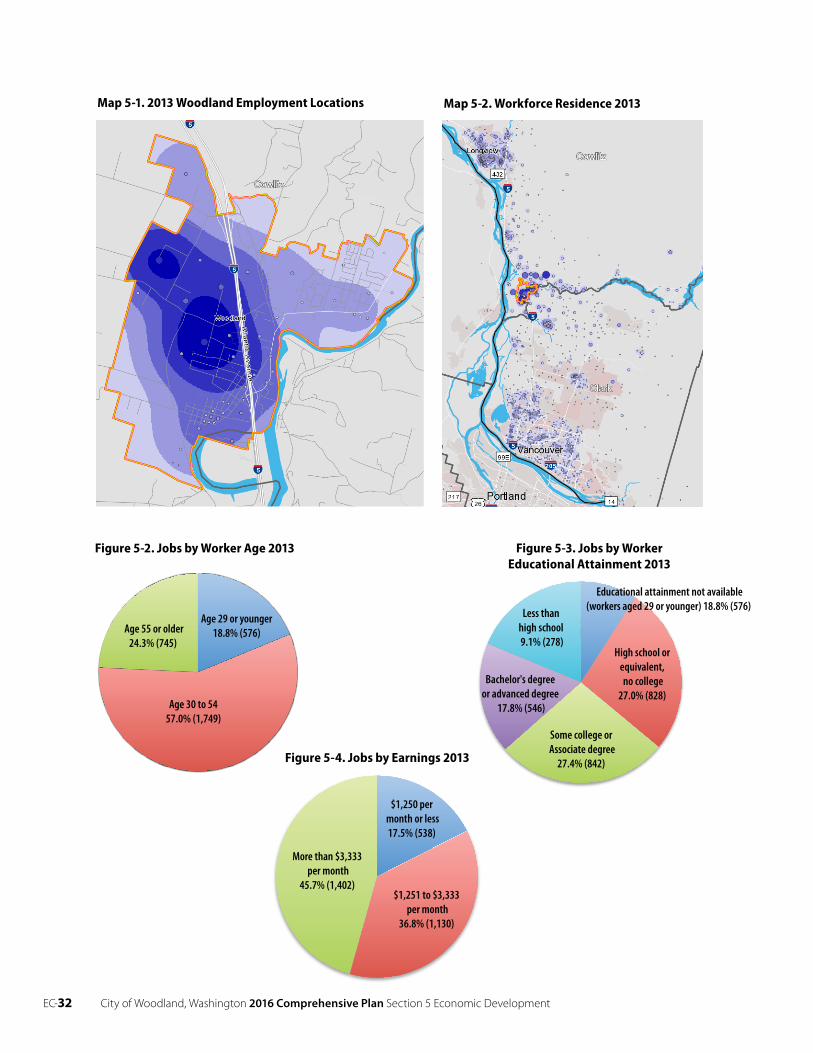
In 2013 approximately 3,070 people held a primary job3 in Woodland.4 The Industrial zoning districts, as expected, produced the heaviest concentration of jobs. See Map 5-1 2013 Employment Location. (Darker colors indicate areas of more intense job concentration.)
Woodland has become an employment attractor. Figure 5-1 Jobs Counts by Distance/Direction shows that most of the 2013 in-bound work force had a 10 to 24 mile, one way commute. Longview and the Vancouver area residents represented 45.6% of the in-bound work force. See Map 5-2 Workforce Residence 2013. Almost 30% of the 2013 workforce traveled ten miles or less each way. Fourteen percent (14%) of the workers commuted 50 miles or more to work in Woodland.
Approximately 75% of the jobs in Woodland were held by workers aged
1 Washington State Employment Security Department
2 2010-2014 American Community Survey 5-Year Estimates; www.data.wa.gov; www.census.gov; www.factfinder. census.gov.
3 A ‘primary’ job is one worker holding one job. 4 http://onthemap.ces.census.gov/
EC-32 City of Woodland, Washington 2016 Comprehensive Plan Section 5 Economic Development
Age 30 to 5457.0% (1,749)
Age 55 or older24.3% (745)
Age 29 or younger18.8% (576)
$1,250 per month or less17.5% (538)
$1,251 to $3,333 per month
36.8% (1,130)
More than $3,333 per month
45.7% (1,402)
Age 30 to 5457.0% (1,749)
Less thanhigh school9.1% (278)
High school or equivalent, no college
27.0% (828)
Some college or Associate degree
27.4% (842)
Bachelor's degree or advanced degree
17.8% (546)
Educational attainment not available (workers aged 29 or younger) 18.8% (576)
27.0%
Figure 5-2. Jobs by Worker Age 2013
Figure 5-4. Jobs by Earnings 2013
Figure 5-3. Jobs by Worker Educational Attainment 2013
Map 5-1. 2013 Woodland Employment Locations Map 5-2. Workforce Residence 2013
City of Woodland, Washington 2016 Comprehensive Plan Section 5 Economic Development EC-33
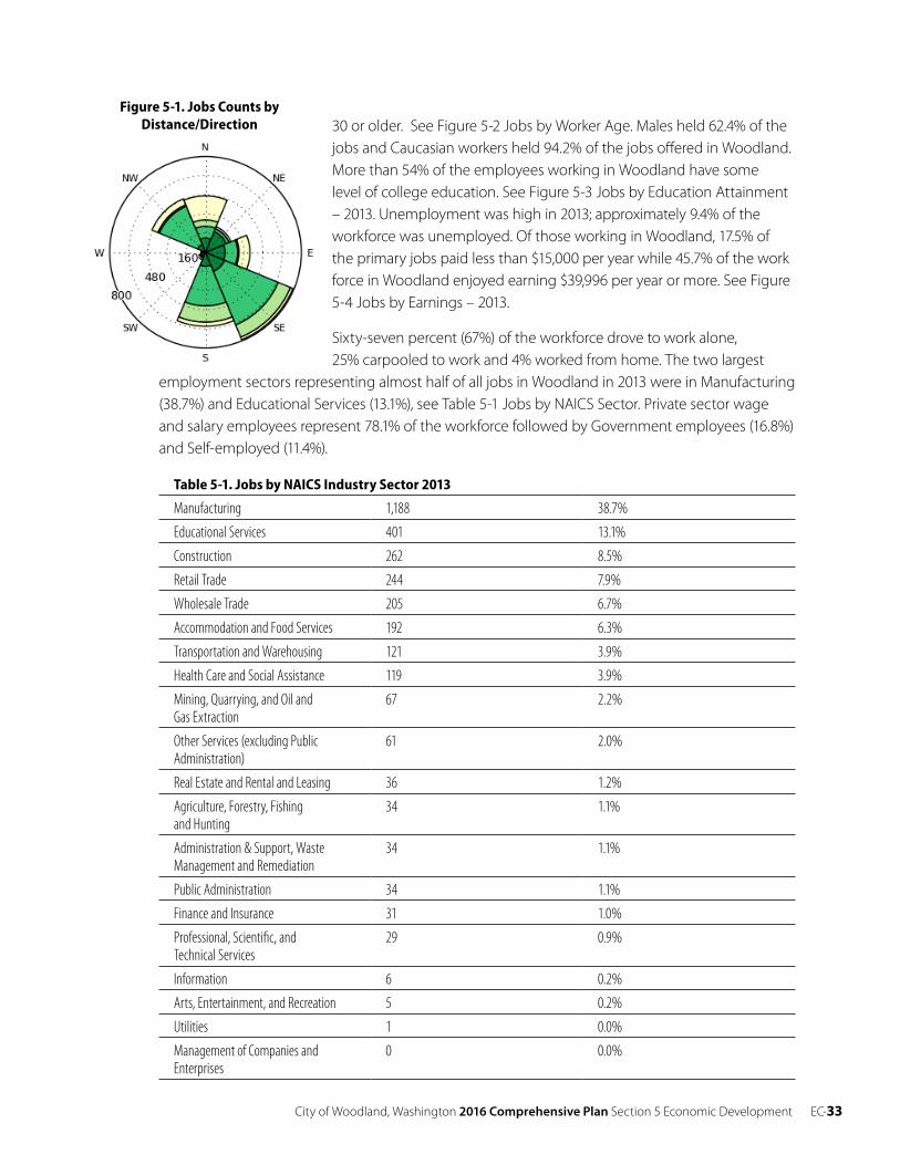
30 or older. See Figure 5-2 Jobs by Worker Age. Males held 62.4% of the jobs and Caucasian workers held 94.2% of the jobs offered in Woodland. More than 54% of the employees working in Woodland have some level of college education. See Figure 5-3 Jobs by Education Attainment – 2013. Unemployment was high in 2013; approximately 9.4% of the workforce was unemployed. Of those working in Woodland, 17.5% of the primary jobs paid less than $15,000 per year while 45.7% of the work force in Woodland enjoyed earning $39,996 per year or more. See Figure 5-4 Jobs by Earnings – 2013.
Sixty-seven percent (67%) of the workforce drove to work alone, 25% carpooled to work and 4% worked from home. The two largest
employment sectors representing almost half of all jobs in Woodland in 2013 were in Manufacturing (38.7%) and Educational Services (13.1%), see Table 5-1 Jobs by NAICS Sector. Private sector wage and salary employees represent 78.1% of the workforce followed by Government employees (16.8%) and Self-employed (11.4%).
Table 5-1. Jobs by NAICS Industry Sector 2013
Manufacturing 1,188 38.7%
Educational Services 401 13.1%
Construction 262 8.5%
Retail Trade 244 7.9%
Wholesale Trade 205 6.7%
Accommodation and Food Services 192 6.3%
Transportation and Warehousing 121 3.9%
Health Care and Social Assistance 119 3.9%
Mining, Quarrying, and Oil and Gas Extraction
67 2.2%
Other Services (excluding Public Administration)
61 2.0%
Real Estate and Rental and Leasing 36 1.2%
Agriculture, Forestry, Fishing and Hunting
34 1.1%
Administration & Support, Waste Management and Remediation
34 1.1%
Public Administration 34 1.1%
Finance and Insurance 31 1.0%
Professional, Scientific, and Technical Services
29 0.9%
Information 6 0.2%
Arts, Entertainment, and Recreation 5 0.2%
Utilities 1 0.0%
Management of Companies and Enterprises
0 0.0%
Figure 5-1. Jobs Counts by Distance/Direction
EC-34 City of Woodland, Washington 2016 Comprehensive Plan Section 5 Economic Development
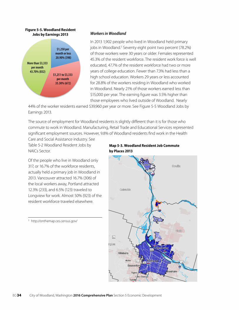
Workers in Woodland
In 2013 1,902 people who lived in Woodland held primary jobs in Woodland.5 Seventy eight point two percent (78.2%) of those workers were 30 years or older. Females represented 45.3% of the resident workforce. The resident work force is well educated, 47.7% of the resident workforce had two or more years of college education. Fewer than 7.3% had less than a high school education. Workers 29 years or less accounted for 28.8% of the workers residing in Woodland who workedin Woodland. Nearly 21% of those workers earned less than $15,000 per year. The earning figure was 3.5% higher than those employees who lived outside of Woodland. Nearly
44% of the worker residents earned $39,960 per year or more. See Figure 5-5 Woodland Jobs by Earnings 2013.
The source of employment for Woodland residents is slightly different than it is for those who commute to work in Woodland. Manufacturing, Retail Trade and Educational Services represented significant employment sources. However, 9.8% of Woodland residents find work in the Health Care and Social Assistance industry. SeeTable 5-2 Woodland Resident Jobs by NAICs Sector.
Of the people who live in Woodland only 317, or 16.7% of the workforce residents, actually held a primary job in Woodland in 2013. Vancouver attracted 16.7% (306) of the local workers away, Portland attracted 12.3% (233), and 6.5% (123) traveled to Longview for work. Almost 50% (923) of the resident workforce traveled elsewhere.
5 http://onthemap.ces.census.gov/
$1,250 per month or less 20.90% (398)
$1,251 to $3,333 per month
35.30% (672)
More than $3,333 per month
43.70% (832)
Figure 5-5. Woodland Resident Jobs by Earnings 2013
Map 5-3. Woodland Resident Job Commute by Places 2013
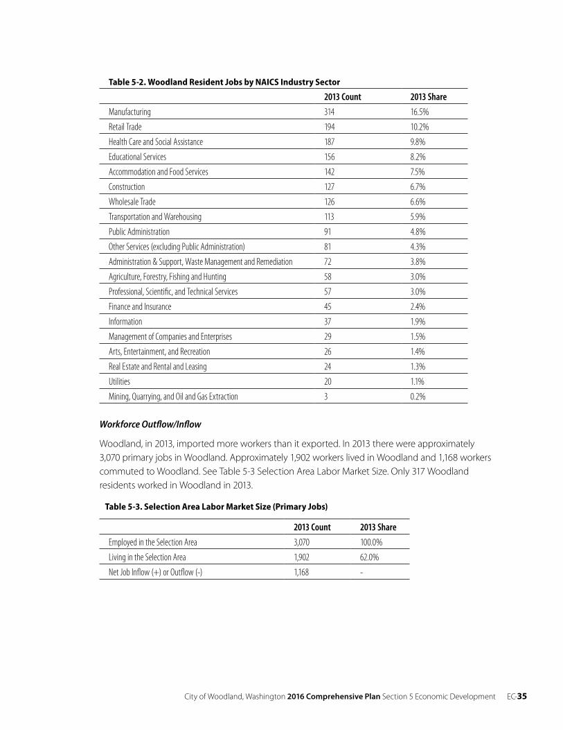
City of Woodland, Washington 2016 Comprehensive Plan Section 5 Economic Development EC-35
Table 5-2. Woodland Resident Jobs by NAICS Industry Sector
2013 Count 2013 Share
Manufacturing 314 16.5%
Retail Trade 194 10.2%
Health Care and Social Assistance 187 9.8%
Educational Services 156 8.2%
Accommodation and Food Services 142 7.5%
Construction 127 6.7%
Wholesale Trade 126 6.6%
Transportation and Warehousing 113 5.9%
Public Administration 91 4.8%
Other Services (excluding Public Administration) 81 4.3%
Administration & Support, Waste Management and Remediation 72 3.8%
Agriculture, Forestry, Fishing and Hunting 58 3.0%
Professional, Scientific, and Technical Services 57 3.0%
Finance and Insurance 45 2.4%
Information 37 1.9%
Management of Companies and Enterprises 29 1.5%
Arts, Entertainment, and Recreation 26 1.4%
Real Estate and Rental and Leasing 24 1.3%
Utilities 20 1.1%
Mining, Quarrying, and Oil and Gas Extraction 3 0.2%
Workforce Outflow/Inflow
Woodland, in 2013, imported more workers than it exported. In 2013 there were approximately 3,070 primary jobs in Woodland. Approximately 1,902 workers lived in Woodland and 1,168 workers commuted to Woodland. See Table 5-3 Selection Area Labor Market Size. Only 317 Woodland residents worked in Woodland in 2013.
Table 5-3. Selection Area Labor Market Size (Primary Jobs)
2013 Count 2013 Share
Employed in the Selection Area 3,070 100.0%
Living in the Selection Area 1,902 62.0%
Net Job Inflow (+) or Outflow (-) 1,168 -
EC-36 City of Woodland, Washington 2016 Comprehensive Plan Section 5 Economic Development
Map 5-4. 2012 Industrial and Highway Commercial Lands Inventory
CC
INSE
L
PEKIN N
F
CAPLES
PAR
K
RO
BIN
SON
PACIFIC
5TH
E
OLD PACIFIC
ATLANTIC
B
SCH
UR
MAN
HIL
LSD
ALE
PEKIN S
DIKE
GU
N C
LUB
DAL
E
GOERIG RD
GOERIG
VIS
TA
2ND
FIR
C
SCOTT W
3RD
PINKERTO
N
GR
EEN
MO
UN
TAIN
WILLOWD
OW
N R
IVER
BOZARTH
HIL
LSH
IRE
HO
FFM
AN A
D
4TH
DAVIDSON
BUR
KE
BEECHWOOD
PIN
E
GUILD
LAKESHO
RE
WASHINGTON
PORT
MA
RTY
LEWIS R
IVER
SCOTT
E
LOVES
MA
BLE
SCOTT
BELMONT
MA
DR
ON
A
6TH
HERITAGE
CARA
BOZA
RTH
HEI
GH
TS
RAS
PBE
RR
Y
DIKE ACCESS
HO
WAR
D
BLACKTAIL
COLUMBIA
DUNHAM
GLE
NW
OO
D
BUCKEYE
MITCHELL
STENERSON
LAKE
SAN
DA
LWO
OD
CLOVER
MA
PLE
SCO
TT HILL
FOR
ES
T PA
RK
LOLO
TR
AIL
WHITETAIL
SYC
AM
OR
E
WO
OD
LAND
VIEW
HANSEN
MERIWETHER
LAR
CH
SPRINGWOOD
MILLARD
CIMERRON
HAWTHORNE
TWIN FLOWER S
ROSEWOOD
EMB
ASS
YVA
LLE
Y
CHERRY BLOSSOM
LOG
AN
BE
RR
Y
TRUTH
FOXT
AIL
FRA
NKLIN
MEADOWOOD
ROBBINS
FOREST VIEW
TSU
GAW
A
GO
RD
ON
RIV
ER
RO
CK
REDWOOD
A
CC
BUCKEYE
C
B
GO
ERIG
GUILD
PARK
B
WASHINGTON
LEWIS RIVER
2012 Industrial and Highway Commercial Lands Inventory
Disclaimer: The City of Woodland, WA, assumes no legal liability or responsibility for accuracy and completeness of this map. This map is to be used as a reference tool only. It is not a survey and the property and lines are not to be construed as being accurate.
0 0.25 0.5 0.750.125
Miles
LegendIndustrial Land - Services Adjacent
Parcels UseUse
Industrial Developed
Residential Use - Industrial Designation
Partially Developed Industrial
Industrial Undeveloped
Industrial Undeveloped Envrn Constraints Suspected
Commercial Developed
Residential Use - Commercial Designation
Commercial Undeveloped
Commercial Undeveloped Envrn Constraints Suspected
Public Facility or Infrastructure
F
City of Woodland, Washington 2016 Comprehensive Plan Section 5 Economic Development EC-37
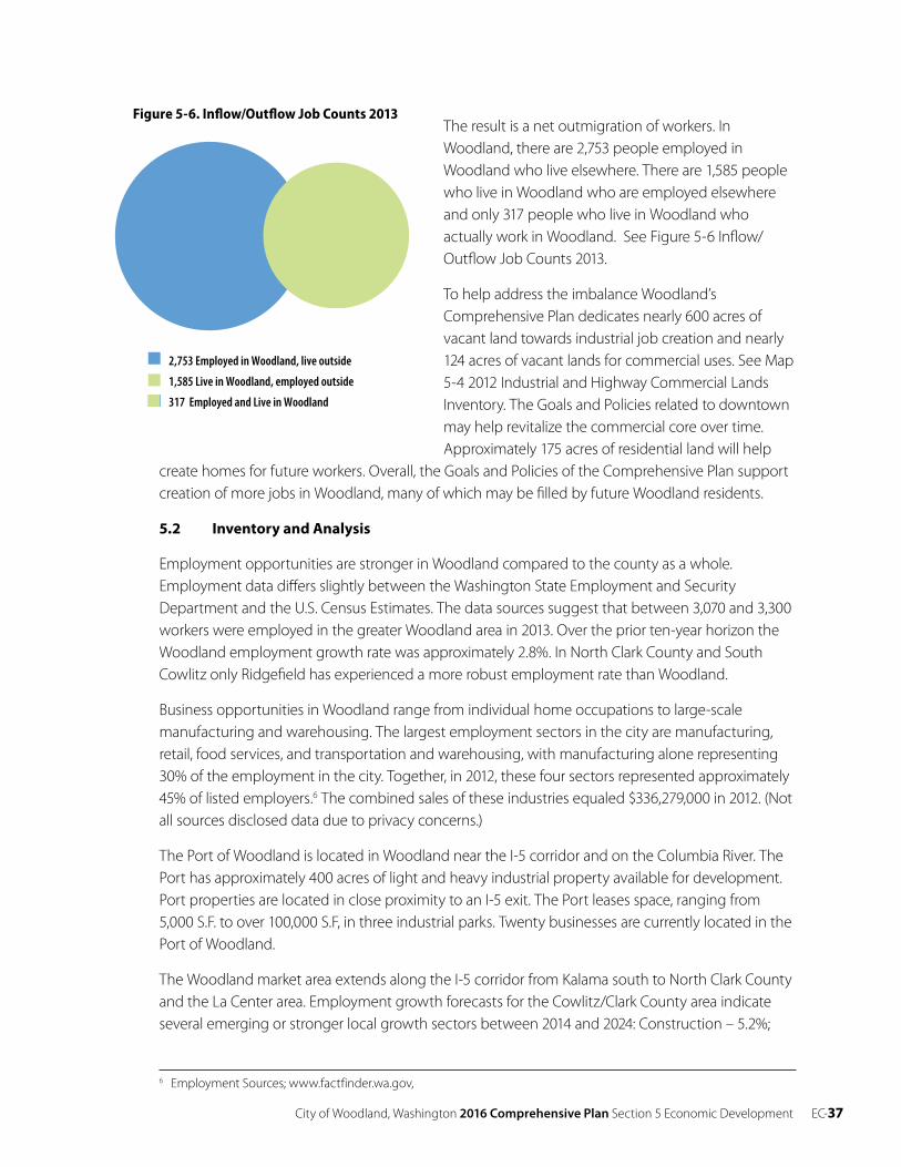
The result is a net outmigration of workers. In Woodland, there are 2,753 people employed in Woodland who live elsewhere. There are 1,585 people who live in Woodland who are employed elsewhere and only 317 people who live in Woodland who actually work in Woodland. See Figure 5-6 Inflow/ Outflow Job Counts 2013.
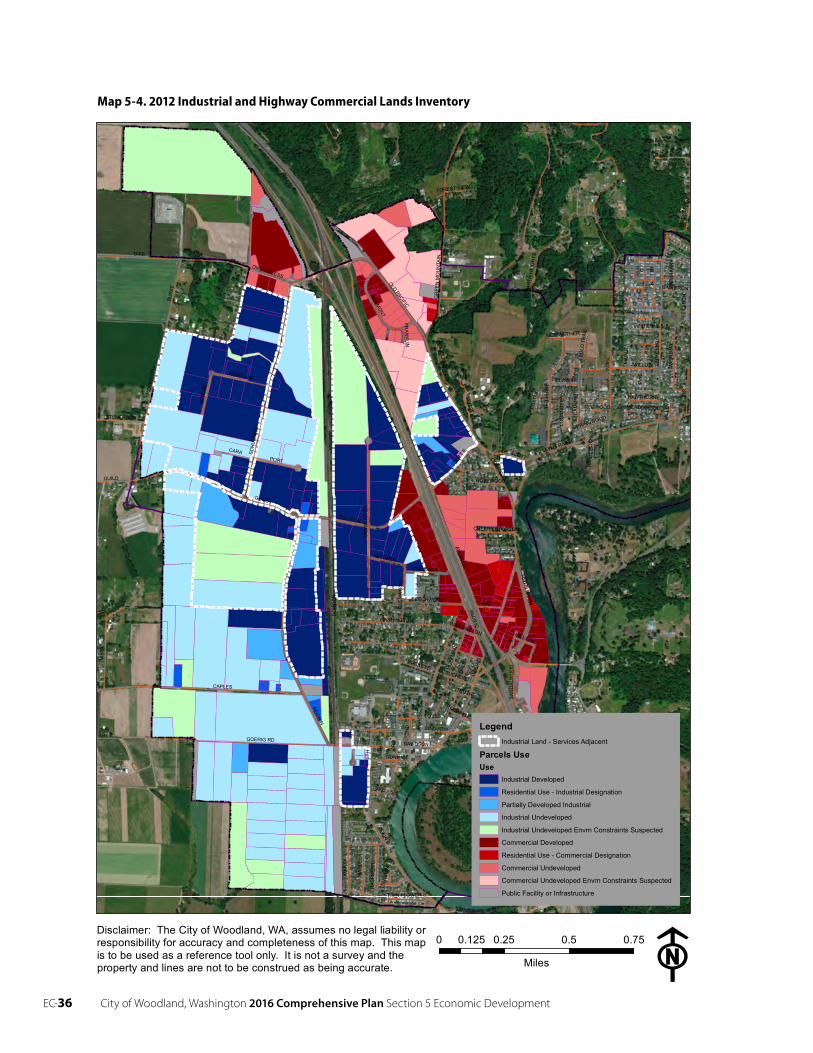
To help address the imbalance Woodland’s Comprehensive Plan dedicates nearly 600 acres of vacant land towards industrial job creation and nearly 124 acres of vacant lands for commercial uses. See Map 5-4 2012 Industrial and Highway Commercial Lands Inventory. The Goals and Policies related to downtownmay help revitalize the commercial core over time. Approximately 175 acres of residential land will help
create homes for future workers. Overall, the Goals and Policies of the Comprehensive Plan support creation of more jobs in Woodland, many of which may be filled by future Woodland residents.
5.2 Inventory and Analysis
Employment opportunities are stronger in Woodland compared to the county as a whole. Employment data differs slightly between the Washington State Employment and Security Department and the U.S. Census Estimates. The data sources suggest that between 3,070 and 3,300 workers were employed in the greater Woodland area in 2013. Over the prior ten-year horizon the Woodland employment growth rate was approximately 2.8%. In North Clark County and South Cowlitz only Ridgefield has experienced a more robust employment rate than Woodland.
Business opportunities in Woodland range from individual home occupations to large-scale manufacturing and warehousing. The largest employment sectors in the city are manufacturing, retail, food services, and transportation and warehousing, with manufacturing alone representing 30% of the employment in the city. Together, in 2012, these four sectors represented approximately 45% of listed employers.6 The combined sales of these industries equaled $336,279,000 in 2012. (Not all sources disclosed data due to privacy concerns.)
The Port of Woodland is located in Woodland near the I-5 corridor and on the Columbia River. The Port has approximately 400 acres of light and heavy industrial property available for development. Port properties are located in close proximity to an I-5 exit. The Port leases space, ranging from 5,000 S.F. to over 100,000 S.F, in three industrial parks. Twenty businesses are currently located in the Port of Woodland.
The Woodland market area extends along the I-5 corridor from Kalama south to North Clark County and the La Center area. Employment growth forecasts for the Cowlitz/Clark County area indicate several emerging or stronger local growth sectors between 2014 and 2024: Construction – 5.2%;
6 Employment Sources; www.factfinder.wa.gov,
2,753 Employed in Woodland, live outside
1,585 Live in Woodland, employed outside
317 Employed and Live in Woodland
Figure 5-6. Inflow/Outflow Job Counts 2013
EC-38 City of Woodland, Washington 2016 Comprehensive Plan Section 5 Economic Development
Information – 3%; Professional Services – 3%; Health & Social Assistance – 2.6%; Wholesale trade – 2.5%; and Education – 2.2%.7
5.3 Goals and Policies
The city’s 20-year focus is to continue to foster economic growth within those industries that have sustained the community and to foster re-investment in the city center. Balanced economic growth is the goal.
Goal
EC 1 Support a diverse and balanced local economy to ensure sustained growth, locally available commercial services, and varied employment opportunities.
Policies
EC 1.1 Plan for adequate public facilities and services necessary to attract and support economic development.
EC 1.2 Develop Woodland’s position as the commercial center serving southern Cowlitz County and the recreation trade of the upper Lewis River and Mount St. Helens area.
EC 1.3 Actively participate in county, state and federal planning and programs for Mount St. Helens related tourism and recreation development, to promote consistency with local objectives and policies.
EC 1.4 Work in partnership with downtown businesses, property owners, and community interest groups to maintain and enhance the downtown area as a retail trade, service, professional office, financial office, governmental office, and cultural center of the city.
EC 1.5 Use the advantage of freeway visibility to establish the city as a traveler/tourist service center.
Partnerships
Goal
EC 2 Partner with agencies and organizations to increase opportunities for economic growth.
Policies
EC 2.1 Support and participate actively in the work of the Cowlitz Economic Development Council and other local and regional economic development programs, planning, and actions.
EC 2.2 Coordinate with and seek economic development assistance from the Port of Woodland, Cowlitz Economic Development Council, Washington Department of Commerce and private property owners to work towards economic development and diversity.
7 Washington State Employment Security Department.
City of Woodland, Washington 2016 Comprehensive Plan Section 5 Economic Development EC-39
Commercial Land Use/Central Business District
Goal
EC 3 Encourage expansion and redevelopment of existing industries and business in the community.
Policies
EC 3.1 Work with community groups to continue event programming in Horseshoe Lake Park to bring people downtown.
EC 3.2 Continue to foster downtown redevelopment to support tourism and economic development generally, protection of existing public investments, protection and expansion of the tax base, overcoming of obstacles to privately initiated investments in downtown, and maintenance of community identity and appearance, because only the city can marshal certain financial resources and public improvements.
EC 3.3 Maintain active and cooperative partnership between the city, business and property owners, civic groups, and citizens to promote successful business district redevelopment, including downtown.
EC 3.4 Encourage more professional offices and local services to locate within the Downtown Business District.
EC 3.5 Require new commercial development to minimize off-site impacts on adjacent users and neighborhoods, provide access for persons of all abilities, and enhance ease of use for customers.
EC 3.6 Cluster commercial uses near intersections of major and/or secondary arterials or adjacent to existing commercial land uses.
EC 3.7 Develop areas classified for commercial use on the Land Use Plan Map before other areas are reclassified for commercial use. A market factor may be appropriate to ensure sufficient land and price stability.
EC 3.8 Encourage downtown revitalization by supporting the expansion of commercial and multi- family residential use.
Industrial Land Use
Goal
EC 4 Create a stable and diversified economy offering a wide variety of employment opportunities.
Policies
EC 4.1 Support the relocation of nonconforming industries to appropriate industrial areas designated by the plan.
EC 4.2 Preserve prime industrial sites and reserve suitable land for future industrial expansion.
EC- 40 City of Woodland, Washington 2016 Comprehensive Plan Section 5 Economic Development
EC 4.3 Manage off-site impacts of industrial development such as lighting, parking, access, utilities, and drainage through the development review process.
EC 4.4 Locate heavy to moderate industrial activities near railroads and/or major arterials adjacent to large land areas that are not adjacent to school properties, commercial and residential areas.
EC 4.5 Require industrial activities that discharge pollutants to adhere to all federal, state and local pollution abatement standards and mandates.
EC 4.6 Allow interim uses like agriculture and open space for vacant industrial sites to prevent encroachment by incompatible non-industrial uses.
EC 4.7 Use techniques such as master plans and binding site plans to facilitate development of professionally designed industrial parks that make efficient use of public services and facilities, maximize compatibility with adjacent non-industrial uses, and maintain the city’s overall attractiveness.
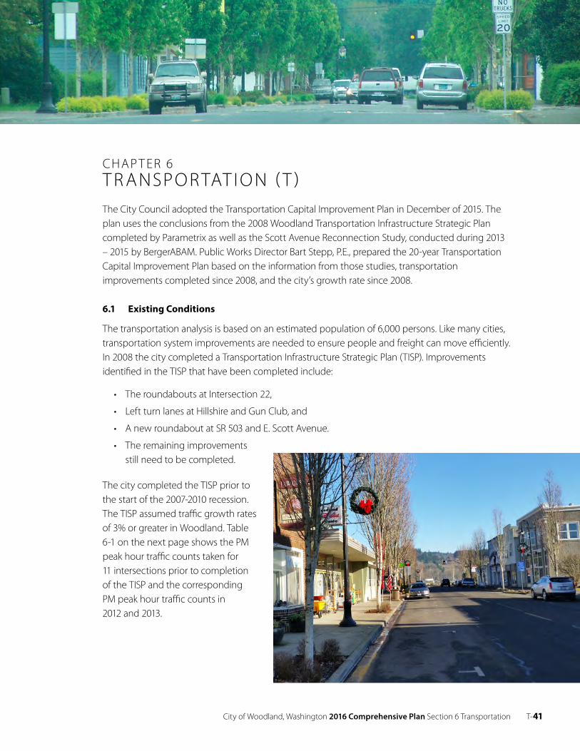
City of Woodland, Washington 2016 Comprehensive Plan Section 6 Transportation T- 41
CHAP T ER 6T R ANSPO R TAT I O N ( T )The City Council adopted the Transportation Capital Improvement Plan in December of 2015. The plan uses the conclusions from the 2008 Woodland Transportation Infrastructure Strategic Plan completed by Parametrix as well as the Scott Avenue Reconnection Study, conducted during 2013 – 2015 by BergerABAM. Public Works Director Bart Stepp, P.E., prepared the 20-year Transportation Capital Improvement Plan based on the information from those studies, transportation improvements completed since 2008, and the city’s growth rate since 2008.
6.1 E xisting Conditions
The transportation analysis is based on an estimated population of 6,000 persons. Like many cities, transportation system improvements are needed to ensure people and freight can move efficiently. In 2008 the city completed a Transportation Infrastructure Strategic Plan (TISP). Improvements identified in the TISP that have been completed include:
• The roundabouts at Intersection 22,
• Left turn lanes at Hillshire and Gun Club, and
• A new roundabout at SR 503 and E. Scott Avenue.
• The remaining improvements still need to be completed.
The city completed the TISP prior to the start of the 2007-2010 recession. The TISP assumed traffic growth rates of 3% or greater in Woodland. Table 6-1 on the next page shows the PM peak hour traffic counts taken for 11 intersections prior to completion of the TISP and the corresponding PM peak hour traffic counts in 2012 and 2013.
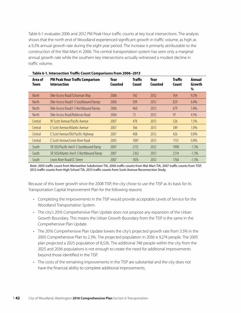
T- 42 City of Woodland, Washington 2016 Comprehensive Plan Section 6 Transportation
Table 6-1 evaluates 2006 and 2012 PM Peak Hour traffic counts at key local intersections. The analysis shows that the north end of Woodland experienced significant growth in traffic volume, as high as a 9.2% annual growth rate during the eight year period. The increase is primarily attributable to the construction of the Wal-Mart in 2006. The central transportation system has seen only a marginal annual growth rate while the southern key intersections actually witnessed a modest decline in traffic volume.
Table 6-1. Intersection Traffic Count Comparisons from 2006–2013
Area ofTown
PM Peak Hour Traffic Comparison Intersection
Year Counted
Traffic Count
Year Counted
Traffic Count
Annual Growth %
North Dike Access Road/Schurman Way 2006 342 2012 764 9.2%
North Dike Access Road/I-5 Southbound Ramps 2006 509 2012 829 6.4%
North Dike Access Road/I-5 Northbound Ramps 2006 460 2012 679 5.4%
North Dike Access Road/Robinson Road 2006 73 2012 97 4.1%
Central W Scott Avenue/Pacific Avenue 2007 478 2013 526 1.5%
Central E Scott Avenue/Atlantic Avenue 2007 366 2013 389 1.0%
Central E Scott Avenue/Old Pacific Highway 2007 408 2012 426 0.8%
Central E Scott Avenue/Lewis River Road 2005 1087 2012 1155 0.8%
South SR 503/Pacific Ave/I-5 Southbound Ramp 2007 2115 2012 1990 -1.3%
South SR 503/Atlantic Ave/I-5 Northbound Ramp 2007 2362 2012 2214 -1.3%
South Lewis River Road/CC Street 2007 1876 2012 1760 -1.3%Note: 2005 traffic count from Meriwether Subdivision TIA, 2006 traffic counts from Wal-Mart TIA, 2007 traffic counts from TISP, 2012 traffic counts from High School TIA, 2013 traffic counts from Scott Avenue Reconnection Study.
Because of this lower growth since the 2008 TISP, the city chose to use the TISP as its basis for its Transportation Capital Improvement Plan for the following reasons:
• Completing the improvements in the TISP would provide acceptable Levels of Service for the Woodland Transportation System.
• The city’s 2016 Comprehensive Plan Update does not propose any expansion of the Urban Growth Boundary. This means the Urban Growth Boundary from the TISP is the same in the Comprehensive Plan Update.
• The 2016 Comprehensive Plan Update lowers the city’s projected growth rate from 3.5% in the 2005 Comprehensive Plan to 2.3%. The projected population in 2036 is 9,274 people. The 2005 plan projected a 2025 population of 8,526. The additional 748 people within the city from the 2025 and 2036 populations is not enough to create the need for additional improvements beyond those identified in the TISP.
• The costs of the remaining improvements in the TISP are substantial and the city does not have the financial ability to complete additional improvements.
City of Woodland, Washington 2016 Comprehensive Plan Section 6 Transportation T-43
The TISP provides a detailed analysis of the city of Woodland Transportation System.1 The TISP also included substantial public outreach to identify the preferred alternatives.
6.2 2015 Capital Improvement Plan (CIP)
Map 6-1, provides an overview of the major focus areas for which recommended improvements were identified in the Woodland Transportation Infrastructure Strategic Plan (TISP). Projects of the magnitude identified in the TISP are typically constructed using a combination of funding and financing over several years or even decades, and they often require a combination of local, state, and federal funding participation. The major focus areas are identified as:
A I-5/Dike Road Roundabouts – The improvements identified in this area have been completed. The 2015 CIP does not identify any needed improvements in this area.
B Scott Avenue Reconnection Area – No improvement have been completed in this area. The city has completed an alternatives analysis and identified raising I-5 and connecting Scott Avenue underneath I-5 as the preferred project alternative.
C I-5/SR 503 Interchange Improvements – No improvements have been completed since the completion of the TISP. The city was awarded $1.47 in federal funds in 2014 to complete the design and ROW for shifting the CC Street traffic onto Millard. Design of this project is expected to start in the fall of 2016 when the federal funds become available.
D SR 503 Widening – Some of the improvements identified in the TISP for this area have been completed. Left turn lanes were installed at the intersections of Hillshire and Gun Club and a roundabout was installed at the E. Scott Avenue intersection. Timing and funding of additional improvements have not been identified.
Recommended Short-Term (0 – 6 years) and Long-Term (6 – 20 years) projects that need to be completed are presented in Table 6-2 on page 4. The short-term improvements can be found in the Woodland 2016-2021 Six Year Transportation Improvement Program which was approved by City Council on 6/1/15 (Resolution 655). Cost estimates have been updated from the 2008 TISP to 2015 dollars. The names of some projects have been altered from the 2008 TISP to better reflect the projects in their current form.
The three projects identified in the 2016 – 2021 time period are:
• Scott Avenue Reconnection Project – Raise I-5 and connect west and east Scott Avenue with signals at Pacific and W. Scott and Atlantic and E. Scott.
• I-5/SR 503 Interchange Improvements Project – Shift CC Bridge traffic onto A and Millard with a new traffic signal at SR 503 and Millard. Remove the existing traffic signal near CC Street and SR 503 and close off CC Street at SR 503.
• E. Scott/Old Pacific Highway Intersection Project – Improve intersection through re-alignment, traffic signal, medians, or other improvements.
1 For more information on the TISP see http://www.ci.woodland.wa.us/departments/public-works/transportation.php.
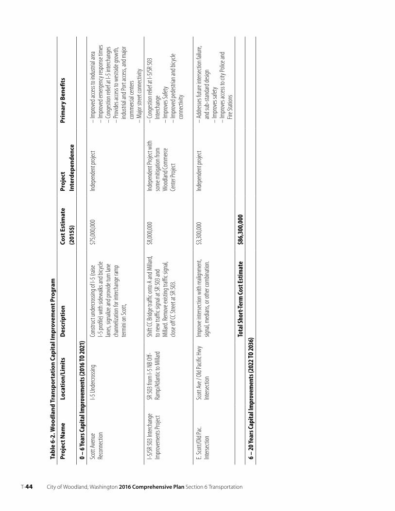
T-44 City of Woodland, Washington 2016 Comprehensive Plan Section 6 Transportation
Tabl
e6-
2. W
oodl
and
Tran
spor
tati
onCa
pita
l Im
prov
emen
t Pro
gram
Proj
ect N
ame
Loca
tion
/Lim
its
Des
crip
tion
Cost
Esti
mat
e
(201
5$)
Proj
ect
Inte
rdep
ende
nce
Prim
ary
Ben
efits
0– 6
Year
sCap
italI
mpr
ovem
ents
(201
6 TO
2021
) Sc
ottA
venu
e Re
conn
ectio
nI-5
Und
ercro
ssing
Co
nstru
ctun
dercr
ossin
gofI-
5 (rai
seI-5
profi
le) w
ith si
dewa
lks an
d bicy
cle
lanes
,sign
alize
and p
rovid
e tur
n lan
e ch
anne
lizati
on fo
r inter
chan
ge ra
mp
term
inion
Scot
t,
$75,0
00,00
0Ind
epen
dent
proje
ct–
Impr
oved
acce
ss to
indu
strial
area
–
Impr
oved
emerg
ency
resp
onse
times
–
Cong
estio
n reli
efat
I-5 in
terch
ange
s–
Prov
ides a
ccess
to w
estsi
de gr
owth
, ind
ustri
al an
d Por
t acce
ss, an
d majo
r co
mm
ercial
cent
ers
– M
ajor s
treet
conn
ectiv
ity
I-5/S
R503
Inter
chan
ge
Impr
ovem
ents
Proje
ct SR
503 f
rom
I-5 N
B Off-
Ra
mp/
Atlan
tic to
Milla
rd
Shift
CC Br
idge t
raffic o
nto A
and M
illard
, to
new
traffi
c sign
alat
SR 50
3and
Milla
rd.R
emov
e exis
ting t
raffic s
ignal,
clo
seoff
CC St
reeta
tSR 5
03.
$8,00
0,000
Indep
ende
ntPr
oject
with
so
me m
itigati
on fr
om
Woo
dland
Com
merc
e Ce
nter
Proje
ct
– Co
nges
tion r
elief
at I-5
/SR 5
03
Interc
hang
e –
Impr
oves
Safet
y –
Impr
oved
pede
strian
and b
icycle
co
nnec
tivity
E.Sc
ott/O
ld Pa
c.Int
ersec
tion
Scot
tAve
/ Old
Pacifi
cHwy
Inters
ectio
nIm
prov
eint
ersec
tionw
ith re
align
men
t, sig
nal,m
edian
s, or
othe
r com
binati
on.
$3,30
0,000
Indep
ende
ntpr
oject
–Ad
dres
ses f
utur
e int
ersec
tion f
ailur
e,an
dsub
-stan
dard
desig
n –
Impr
oves
safet
y –
Impr
oves
acce
ss to
city
Polic
e and
Fir
e Stat
ions
Tota
lSho
rt-Te
rmCo
stEs
timat
e$8
6,30
0,00
06–
20 Ye
arsC
apita
lIm
prov
emen
ts(2
022T
O20
36)
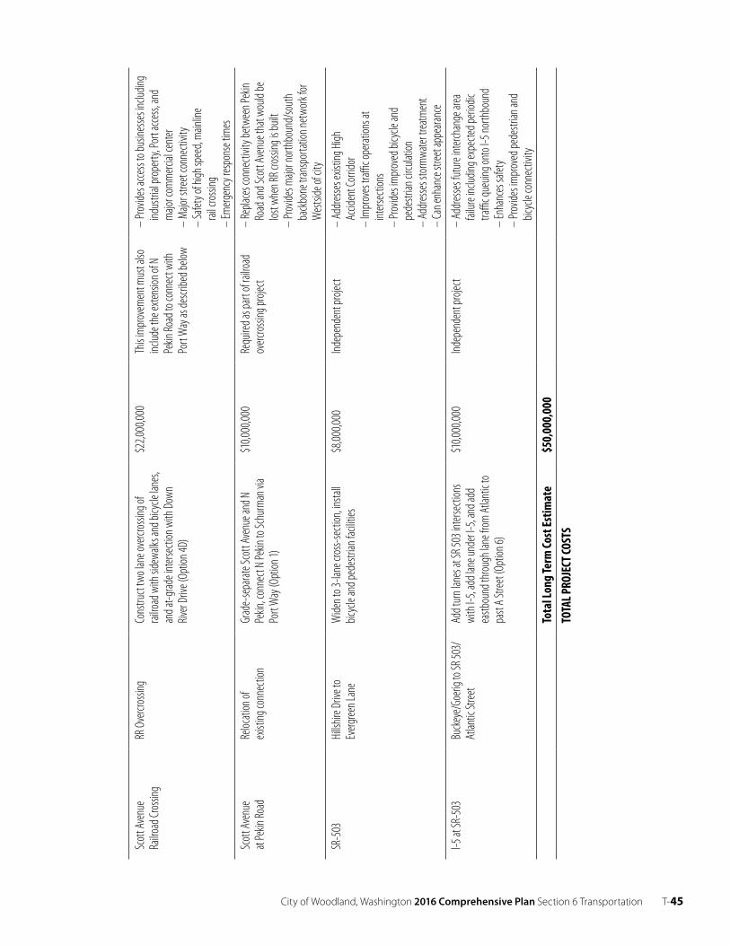
City of Woodland, Washington 2016 Comprehensive Plan Section 6 Transportation T-45
Scot
tAve
nue
Railro
adCr
ossin
g RR
Overc
rossi
ngCo
nstru
cttw
o lan
e ove
rcros
sing o
f rai
lroad
with
side
walks
and b
icycle
lane
s, an
dat-g
rade i
nters
ectio
n with
Dow
n Riv
erDr
ive (O
ption
4D)
$22,0
00,00
0Th
isim
prov
emen
t mus
t also
inc
ludet
he ex
tensio
nofN
Pe
kinRo
ad to
conn
ect w
ith
Port
Way
as de
scrib
ed be
low
–Pr
ovide
s acce
ss to
busin
esse
s inc
luding
ind
ustri
al pr
oper
ty, Po
rt ac
cess,
and
majo
r com
merc
ial ce
nter
– M
ajor s
treet
conn
ectiv
ity
– Sa
fety o
f high
spee
d, m
ainlin
e rai
l cro
ssing
–
Emerg
ency
resp
onse
times
Scot
t Ave
nue
atPe
kin Ro
ad
Reloc
ation
of ex
isting
conn
ectio
n Gr
ade-
sepa
rateS
cott
Aven
uean
dN
Pekin
,con
nect
N Pe
kin to
Schu
rman
via
Port
Way
(Opt
ion 1)
$10,0
00,00
0Re
quire
das p
art o
f rail
road
ov
ercro
ssing
proje
ct–
Repla
ces c
onne
ctivit
y bet
ween
Pekin
Ro
adan
d Sco
tt Av
enue
that
would
be
lost w
hen R
R cro
ssing
is bu
ilt –
Prov
ides m
ajor n
orth
boun
d/so
uth
back
bone
tran
spor
tation
netw
ork f
or
Wes
tside
of ci
ty
SR-5
03Hi
llshir
eDriv
e to
Everg
reen L
ane
Wide
nto 3
-lane
cros
s-sec
tion,
instal
l bic
ycle
and p
edes
trian
facil
ities
$8,00
0,000
Indep
ende
ntpr
oject
– Ad
dres
ses e
xistin
g High
Ac
ciden
t Cor
ridor
–
Impr
oves
traffi
c ope
ration
s at
inters
ectio
ns
– Pr
ovide
s im
prov
ed bi
cycle
and
pede
strian
circu
lation
–
Addr
esse
s sto
rmwa
ter tr
eatm
ent
– Ca
n enh
ance
stree
t app
earan
ce
I-5at
SR-5
03Bu
ckey
e/Go
erigt
oSR 5
03/
Atlan
ticStr
eet
Addt
urn l
anes
atSR
503i
nters
ectio
nswi
thI-5
, add
lane
unde
r I-5,
and a
dd
eastb
ound
thro
ugh l
ane f
rom
Atla
ntic
to
past
A Str
eet (
Optio
n 6)
$10,0
00,00
0Ind
epen
dent
proje
ct–
Addr
esse
s fut
ure i
nterc
hang
e area
fai
lure i
nclud
ing ex
pecte
d peri
odic
traffi
c que
uing o
nto I
-5 no
rthbo
und
– En
hanc
es sa
fety
– Pr
ovide
s im
prov
ed pe
destr
ian an
d bic
ycle
conn
ectiv
ity
Tota
lLon
g Te
rm Co
st Es
timat
e$5
0,00
0,00
0TO
TAL P
ROJE
CT CO
STS
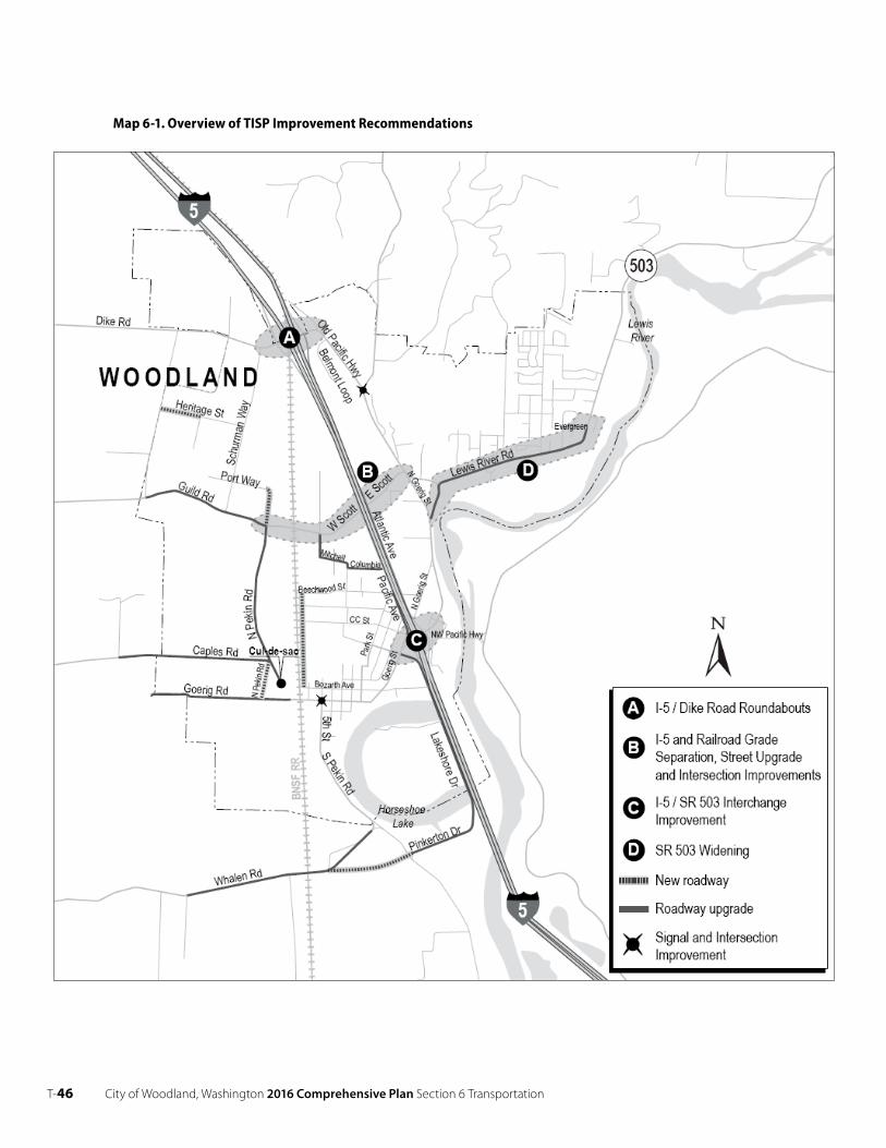
T- 46 City of Woodland, Washington 2016 Comprehensive Plan Section 6 Transportation
Map 6-1. Overview of TISP Improvement Recommendations
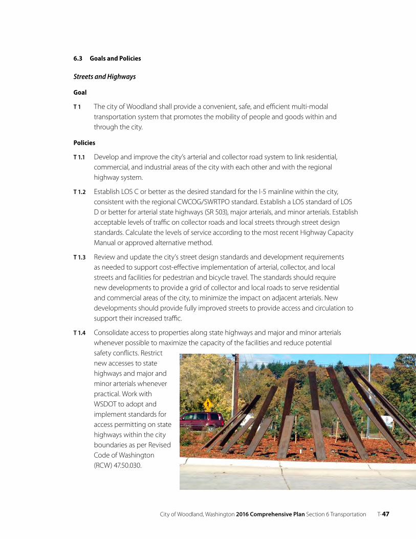
City of Woodland, Washington 2016 Comprehensive Plan Section 6 Transportation T- 47
6.3 Goals and Policies
Streets and Highways
Goal
T 1 The city of Woodland shall provide a convenient, safe, and efficient multi-modal transportation system that promotes the mobility of people and goods within and through the city.
Policies
T 1.1 Develop and improve the city’s arterial and collector road system to link residential, commercial, and industrial areas of the city with each other and with the regional highway system.
T 1.2 Establish LOS C or better as the desired standard for the I-5 mainline within the city, consistent with the regional CWCOG/SWRTPO standard. Establish a LOS standard of LOS D or better for arterial state highways (SR 503), major arterials, and minor arterials. Establish acceptable levels of traffic on collector roads and local streets through street design standards. Calculate the levels of service according to the most recent Highway Capacity Manual or approved alternative method.
T 1.3 Review and update the city’s street design standards and development requirements as needed to support cost-effective implementation of arterial, collector, and local streets and facilities for pedestrian and bicycle travel. The standards should require new developments to provide a grid of collector and local roads to serve residential and commercial areas of the city, to minimize the impact on adjacent arterials. New developments should provide fully improved streets to provide access and circulation to support their increased traffic.
T 1.4 Consolidate access to properties along state highways and major and minor arterials whenever possible to maximize the capacity of the facilities and reduce potential safety conflicts. Restrict new accesses to state highways and major and minor arterials whenever practical. Work with WSDOT to adopt and implement standards for access permitting on state highways within the city boundaries as per Revised Code of Washington (RCW) 47.50.030.
T- 48 City of Woodland, Washington 2016 Comprehensive Plan Section 6 Transportation
T 1.5 Work with WSDOT to provide signing and improvements to the arterial system to encourage use of the Dike Road interchange for travel between I-5 and SR 503.
T 1.6 Include and fund a comprehensive maintenance and operations program for capital projects.
T 1.7 Provide curbs, storm drainage, sidewalks, street lights, and landscaped planting/utility strips, as well as adequate roadway widths and surfaces on local and collector street system improvement projects where possible.
T 1.8 Evaluate the opportunities, location, and cost of providing an additional safe and efficient way out of town.
T 1.9 Evaluate other methods of route connectivity for the east side area of the city, easing the burden on Lewis River Road.
Subdivision Streets
Goal
T 2 Review preliminary plats and consider internal traffic circulation patterns and potential impacts on nearby streets and highways to ensure adequate transportation facilities are built to serve new development.
Policies
T 2.1 Design subdivision streets so as to plan for future connection to adjoining subdivisions when possible.
T 2.2 Keep intersections of local and collector streets with principal and minor arterials to a minimum in the design of new subdivisions.
T 2.3 Require access to residential lots in new subdivisions from an interior street system rather than from major and minor arterials when possible. Keep direct driveway access onto major and minor arterials to a minimum.
T 2.4 Install sidewalks (on both sides unless impracticable), curbs, and drainage gutters along arterials, collector streets, and local streets to enhance pedestrian safety and control surface water runoff.
T 2.5 Design and lay out streets to follow the more gradual natural contours of the land and avoid steep grades.
Truck Routes
Goal
T 3 Enhance truck access to/from I-5 and other regional facilities to minimize the impact of trucks on residential and commercial areas of the city.
City of Woodland, Washington 2016 Comprehensive Plan Section 6 Transportation T- 49
Policies
T 3.1 Design roadways designated as truck routes to meet the capacity and safety needs of heavy vehicles.
Pedestrian and Bicycle
Goal
T 4 Develop facilities to provide safe pedestrian and bicycle travel, to promote alternative transportation modes and to support recreational activity.
Policies
T 4.1 Include sidewalks and bicycle lanes, where feasible, as part of identified improvements to SR 503 and other arterials within the UGA.
T 4.2 Provide a grid of local streets to support pedestrian and bicycle travel within and between neighborhoods.
T 4.3 Require new developments to provide adequate pedestrian access to adjacent roads and/ or trails.
T 4.4 Develop and sign a system of bicycle routes providing for travel within the city with connections to regional and major local destinations.
Transit and Transportation Demand Management
Goal
T 5 Enhance use of transit and carpools by providing park-and-ride facilities and coordinated regional services.
Policies
T 5.1 Encourage ridesharing programs by working with major employers to establish transportation coordinators and ride-matching services.
T 5.2 Support and cooperate with WSDOT on retaining and upgrading the existing park-and- ride lot at the SR 503/I-5 interchange.
Rail, Air, and Water Transportation
Goal
T 6 Support Burlington Northern Santa Fe Railroad, Port of Woodland, and the Washington State Department of Transportation Aviation to maintain and enhance operations of rail and air transportation in the City of Woodland and connections to water transportation on the Columbia River.
T-50 City of Woodland, Washington 2016 Comprehensive Plan Section 6 Transportation
Policies
T 6.1 Coordinate regularly with providers and operators of the railroad, airport, and port facilities to ensure compatibility of improvements with city goals and implementation programs. Work with providers to help fund safety and access/ circulation improvements to support economic development and recreation associated with rail, air, and water transportation.
T 6.2 Airport Land Use Compatibility.
Create zoning districts and development regulations that discourage the siting of incompatible uses adjacent to general aviation airports. The zoning regulations must be filed with the Aviation Division of WSDOT.
6.3 Financing and Implementation
Goal
T 7 Work with multiple agencies to secure funding to implement transportation improvements in a timely manner.
Policies
T 7.1 Identify and update costs of future transportation system improvement needs required to provide acceptable levels of service and safety as part of the six-year Transportation Improvement Program.
T 7.2 Annually update and adopt a six-year Transportation Improvement Program to support timely implementation of the Transportation Plan. Review priorities based on updated traffic conditions and development patterns. Base the program on realistic funding capabilities of the city and other agencies.
T 7.3 Use regional, state and grant funding to help fund improvements to SR 503, I-5, and arterials serving regional traffic and economic development.
T 7.4 Require developers to construct or pay a proportionate share of arterial, collectors, and local streets needed to serve new developments.
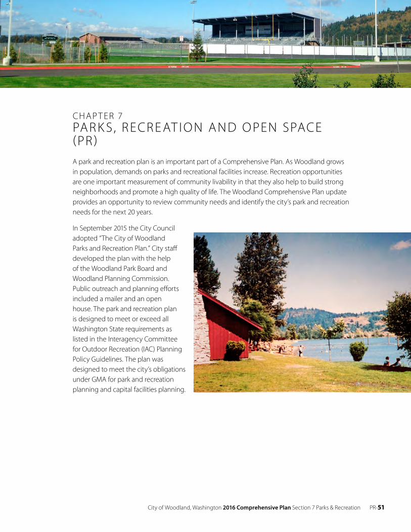
City of Woodland, Washington 2016 Comprehensive Plan Section 7 Parks & Recreation PR-51
CHAP T ER 7PAR K S , R ECR E AT I O N AND O PEN SPACE (PR )A park and recreation plan is an important part of a Comprehensive Plan. As Woodland grows in population, demands on parks and recreational facilities increase. Recreation opportunities are one important measurement of community livability in that they also help to build strong neighborhoods and promote a high quality of life. The Woodland Comprehensive Plan update provides an opportunity to review community needs and identify the city’s park and recreation needs for the next 20 years.
In September 2015 the City Council adopted “The City of Woodland Parks and Recreation Plan.” City staff developed the plan with the help of the Woodland Park Board and Woodland Planning Commission. Public outreach and planning efforts included a mailer and an open house. The park and recreation plan is designed to meet or exceed all Washington State requirements as listed in the Interagency Committee for Outdoor Recreation (IAC) Planning Policy Guidelines. The plan was designed to meet the city’s obligations under GMA for park and recreation planning and capital facilities planning.
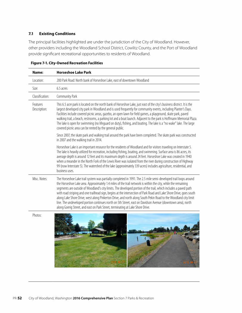
PR-52 City of Woodland, Washington 2016 Comprehensive Plan Section 7 Parks & Recreation
7.1 E xisting Conditions
The principal facilities highlighted are under the jurisdiction of the City of Woodland. However, other providers including the Woodland School District, Cowlitz County, and the Port of Woodland provide significant recreational opportunities to residents of Woodland.
Figure 7-1. City-Owned Recreation Facilities
Name: Horseshoe Lake Park
Location: 200 Park Road: North bank of Horseshoe Lake, east of downtown Woodland
Size: 6.5 acres
Classification: Community Park
FeaturesDescription:
This 6.5 acre park is located on the north bank of Horseshoe Lake, just east of the city’s business district. It is thelargest developed city park in Woodland and is used frequently for community events, including Planter’s Days. Facilities include covered picnic areas, gazebo, an open lawn for field games, a playground, skate park, paved walking trail, a beach, restrooms, a parking lot and a boat launch. Adjacent to the park is Hoffmann Memorial Plaza. The lake is open for swimming (no lifeguard on duty), fishing, and boating. The lake is a “no wake” lake. The large covered picnic area can be rented by the general public.
Since 2007, the skate park and walking trail around the park have been completed. The skate park was constructed in 2007 and the walking trail in 2014.
Horseshoe Lake is an important resource for the residents of Woodland and for visitors traveling on Interstate 5. The lake is heavily utilized for recreation, including fishing, boating, and swimming. Surface area is 86 acres, its average depth is around 12 feet and its maximum depth is around 24 feet. Horseshoe Lake was created in 1940 when a meander in the North Fork of the Lewis River was isolated from the river during construction of Highway 99 (now Interstate 5). The watershed of the lake (approximately 339 acres) includes agriculture, residential, and business uses.
Misc. Notes: The Horseshoe Lake trail system was partially completed in 1991. The 2.5 mile semi-developed trail loops around the Horseshoe Lake area. Approximately 1.4 miles of the trail network is within the city, while the remaining segments are outside of Woodland’s city limits. The developed portion of the trail, which includes a paved path with road striping and one trailhead sign, begins at the intersection of Park Road and Lake Shore Drive, goes south along Lake Shore Drive, west along Pinkerton Drive, and north along South Pekin Road to the Woodland city limit line. The undeveloped portion continues north on 5th Street, east on Davidson Avenue (downtown area), north along Goerig Street, and east on Park Street, terminating at Lake Shore Drive.
Photos:
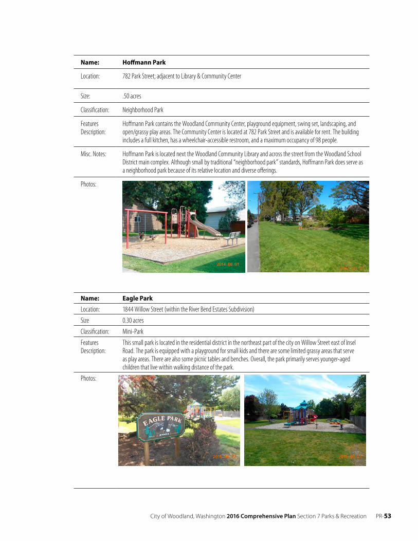
City of Woodland, Washington 2016 Comprehensive Plan Section 7 Parks & Recreation PR-53
Name: Hoffmann Park
Location: 782 Park Street; adjacent to Library & Community Center
Size: .50 acres
Classification: Neighborhood Park
FeaturesDescription:
Hoffmann Park contains the Woodland Community Center, playground equipment, swing set, landscaping, andopen/grassy play areas. The Community Center is located at 782 Park Street and is available for rent. The building includes a full kitchen, has a wheelchair-accessible restroom, and a maximum occupancy of 98 people.
Misc. Notes: Hoffmann Park is located next the Woodland Community Library and across the street from the Woodland School District main complex. Although small by traditional “neighborhood park” standards, Hoffmann Park does serve as a neighborhood park because of its relative location and diverse offerings.
Photos:
Name: Eagle Park
Location: 1844 Willow Street (within the River Bend Estates Subdivision)
Size 0.30 acres
Classification: Mini-Park
FeaturesDescription:
This small park is located in the residential district in the northeast part of the city on Willow Street east of InselRoad. The park is equipped with a playground for small kids and there are some limited grassy areas that serve as play areas. There are also some picnic tables and benches. Overall, the park primarily serves younger-aged children that live within walking distance of the park.
Photos:
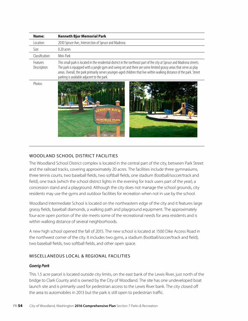
PR-54 City of Woodland, Washington 2016 Comprehensive Plan Section 7 Parks & Recreation
Name: Kenneth Bjur Memorial Park
Location: 2030 Spruce Ave.; Intersection of Spruce and Madrona
Size: 0.20 acres
Classification: Mini-Park
FeaturesDescription:
This small park is located in the residential district in the northeast part of the city at Spruce and Madrona streets.The park is equipped with a jungle gym and swing set and there are some limited grassy areas that serve as play areas. Overall, the park primarily serves younger-aged children that live within walking distance of the park. Street parking is available adjacent to the park.
Photos:
WOODLAND SCHOOL DISTRICT FACILITIES
The Woodland School District complex is located in the central part of the city, between Park Street and the railroad tracks, covering approximately 20 acres. The facilities include three gymnasiums, three tennis courts, two baseball fields, two softball fields, one stadium (football/soccer/track and field), one track (which the school district lights in the evening for track users part of the year), a concession stand and a playground. Although the city does not manage the school grounds, city residents may use the gyms and outdoor facilities for recreation when not in use by the school.
Woodland Intermediate School is located on the northeastern edge of the city and it features large grassy fields, baseball diamonds, a walking path and playground equipment. The approximately four-acre open portion of the site meets some of the recreational needs for area residents and is within walking distance of several neighborhoods.
A new high school opened the fall of 2015. The new school is located at 1500 Dike Access Road in the northwest corner of the city. It includes two gyms, a stadium (football/soccer/track and field), two baseball fields, two softball fields, and other open space.
MISCELLANEOUS LOCAL & REGIONAL FACILITIES
Goerig Park
This 1.5 acre parcel is located outside city limits, on the east bank of the Lewis River, just north of the bridge to Clark County and is owned by the City of Woodland. The site has one undeveloped boat launch site and is primarily used for pedestrian access to the Lewis River bank. The city closed off the area to automobiles in 2013 but the park is still open to pedestrian traffic.

City of Woodland, Washington 2016 Comprehensive Plan Section 7 Parks & Recreation PR-55
Paradise Point State Park and Boat Launch
Paradise Point State Park is located three miles south of Woodland off Exit 16 (I-5) outside of La Center. The regional park is located on the south side of the Lewis River and includes RV camp sites, picnic tables, hiking trails, a boat launch, parking and restrooms. The park also provides access to the East Fork Lewis River for swimming, fishing and boating.
Lewis River Golf Course
East of Woodland (5.5 miles), along the Lewis River Road, is the privately owned and operated 18- hole Lewis River Golf Course and club house. Open all year, it attracts golfers from the local area and from the Portland-Vancouver and Longview-Kelso areas.
Lewis River Little League Fields
This facility is located on Green Mountain Road and is owned and operated by Lewis River Little League and includes approximately two acres of developed land west of Green Mountain Road and 11 acres of land to the east. Facilities include one softball, one T-ball, one minor and one major ball field.
Hulda Klager Lilac Gardens
The Hulda Klager Lilac Gardens are located at the southern end of the city along South Pekin Road. The property contains a two story frame house constructed in 1903 by the father of Hulda Klager, “The Lilac Lady”. A small barn and several outbuildings are located on the northwest corner of the property. The remainder of the property is comprised of over 100 other species of trees, shrubs and plants. The home and gardens are open to the public. The Hulda Klager Lilac Gardens property is listed on the National Register of Historic Places and on the Washington State Heritage Register.
Cowlitz County
The Finn Hall Wayside (Memorial Park) is located a few miles east of Woodland on SR-503 and is managed as a cultural and historic area. The wayside is four acres in size and includes picnic and open space areas.
7.2 Projected Needs
The 2015 Woodland Parks and Recreation Plan projected that, based on adopted Level of Service standards; the city will need the following parks and recreation facilities over the 20-year planning horizon:
• Additional parks on the east side of I-5. Multiple parks could be supported by the existing population and the spatial distribution of residents.
• Additional land and types of recreational offerings at Horseshoe Park. Construction of Scott Hill Park & Sports Complex would provide a new community park that could help to serve the neighborhood park needs of eastside residents and provide citizens with a broader array of activities.
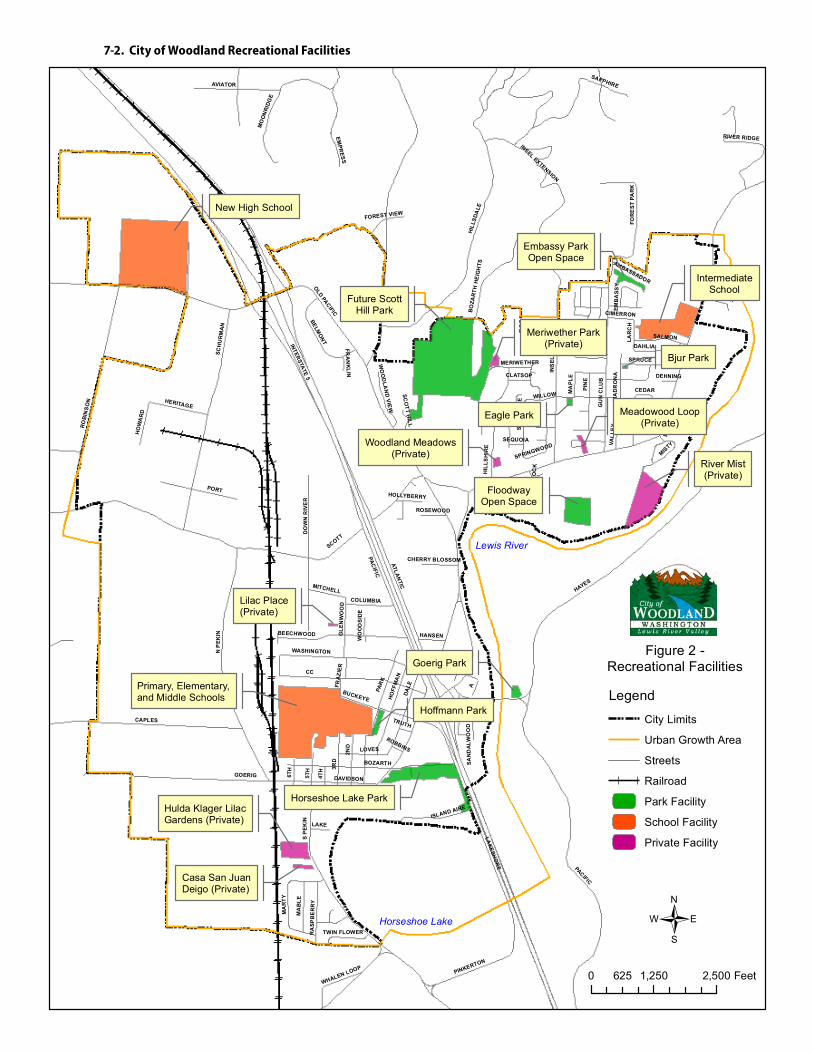
7-2. City of Woodland Recreational Facilities
Horseshoe Lake
Lewis River
HOLLYBERRY
GOERIG
CAPLES
SCOTT
RO
BIN
SO
N
CC
HILL
SDA
LE
3RD
ATLANTIC
INTERSTATE 5
5TH
PAR
K
INS
EL
D
PACIFIC
A
SAPPHIRE
SCH
UR
MA
N
PINKERTON
FIR
PORT
2ND
EMPR
ESS
LAKESH
OR
E
MA
RTY
MA
BLE
ISLAND AIRE
HOFF
MA
N
BELMONT
DO
WN
RIV
ER
BEECHWOOD
RIVER RIDGE
DAHLIA
HERITAGE
LOVES
FOR
EST
PAR
K
MO
ON
RIDG
E
PIN
E
BO
ZAR
TH H
EIG
HTS
OLD PACIFIC
AVIATOR
DALE
HIL
LSH
IRE
HO
WA
RD
WASHINGTON
COLUMBIA
MA
DR
ON
A
4TH
6TH
WILLOW
GU
N C
LUB
BUCKEYE
MITCHELL
GRANITE
LAKE
WHALEN LOOP
SPRUCE
INSEL EXTENSION
MA
PLE
SALMON
RA
SPB
ER
RY
WO
OD
LAN
D V
IEW
HANSEN
WHITE TAIL
BLACKTAIL
CEDAR
BOZARTH
SATU
RN
SCO
TT HILL
TWIN FLOWER
GLE
NW
OO
D
AMBASSADOR
MISTY
FRA
ZIER
CIMERRON
CLATSOP
THIS
TLE
SP
EKIN
WO
OD
SID
E
ROSEWOOD
MCCRACKEN
SYC
AM
OR
E
EMB
ASS
YVA
LLE
Y
LAR
CH
CHERRY BLOSSOM
TRUTH
FOXTAIL
SAN
DA
LWO
OD
BRO
THER
S
MERIWETHER
DEHNING
SPRINGWOODSEQUOIA
DAVIDSON
MILLARD
FRA
NK
LIN
ROBBINS
FOREST VIEWN
PEK
IN
RIV
ER R
OC
K
A
HAYES
PACIFIC
Figure 2 -Recreational Facilities
/0 1,250 2,500625 Feet
Legend
City Limits
Urban Growth Area
Streets
Railroad
Park Facility
School Facility
Private Facility
New High School
Bjur Park
Eagle Park
FloodwayOpen Space
Future ScottHill Park
IntermediateSchool
Horseshoe Lake Park
Hoffmann Park
Goerig Park
Primary, Elementary,and Middle Schools
Hulda Klager LilacGardens (Private)
Embassy ParkOpen Space
Meriwether Park(Private)
Meadowood Loop(Private)
Woodland Meadows(Private)
Lilac Place(Private)
Casa San JuanDeigo (Private)
River Mist(Private)
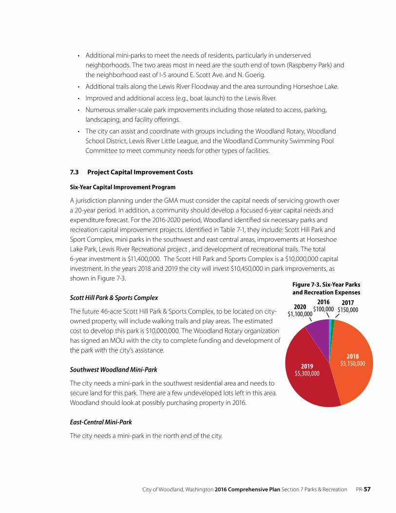
City of Woodland, Washington 2016 Comprehensive Plan Section 7 Parks & Recreation PR-57
7-2. City of Woodland Recreational Facilities
Horseshoe Lake
Lewis River
HOLLYBERRY
GOERIG
CAPLES
SCOTT
RO
BIN
SO
N
CC
HILL
SDA
LE
3RD
ATLANTIC
INTERSTATE 5
5TH
PAR
K
INS
EL
D
PACIFIC
A
SAPPHIRE
SCH
UR
MA
N
PINKERTON
FIR
PORT
2ND
EMPR
ESS
LAKESH
OR
E
MA
RTY
MA
BLE
ISLAND AIRE
HOFF
MA
N
BELMONT
DO
WN
RIV
ER
BEECHWOOD
RIVER RIDGE
DAHLIA
HERITAGE
LOVES
FOR
EST
PA
RK
MO
ON
RIDG
E
PIN
E
BO
ZAR
TH H
EIG
HTS
OLD PACIFIC
AVIATOR
DALE
HIL
LSH
IRE
HO
WA
RD
WASHINGTON
COLUMBIA
MA
DR
ON
A
4TH
6TH
WILLOW
GU
N C
LUB
BUCKEYE
MITCHELL
GRANITE
LAKE
WHALEN LOOP
SPRUCE
INSEL EXTENSION
MA
PLE
SALMON
RA
SPB
ER
RY
WO
OD
LAN
D V
IEW
HANSEN
WHITE TAIL
BLACKTAIL
CEDAR
BOZARTH
SATU
RN
SCO
TT HILL
TWIN FLOWER
GLE
NW
OO
D
AMBASSADOR
MISTY
FRA
ZIER
CIMERRON
CLATSOP
THIS
TLE
S P
EKIN
WO
OD
SID
E
ROSEWOOD
MCCRACKEN
SYC
AM
OR
E
EMB
ASS
YVA
LLE
Y
LAR
CH
CHERRY BLOSSOM
TRUTH
FOXTAIL
SAN
DA
LWO
OD
BRO
THER
S
MERIWETHER
DEHNING
SPRINGWOODSEQUOIA
DAVIDSON
MILLARD
FRA
NK
LIN
ROBBINS
FOREST VIEW
N P
EKIN
RIV
ER R
OC
K
A
HAYES
PACIFIC
Figure 2 -Recreational Facilities
/0 1,250 2,500625 Feet
Legend
City Limits
Urban Growth Area
Streets
Railroad
Park Facility
School Facility
Private Facility
New High School
Bjur Park
Eagle Park
FloodwayOpen Space
Future ScottHill Park
IntermediateSchool
Horseshoe Lake Park
Hoffmann Park
Goerig Park
Primary, Elementary,and Middle Schools
Hulda Klager LilacGardens (Private)
Embassy ParkOpen Space
Meriwether Park(Private)
Meadowood Loop(Private)
Woodland Meadows(Private)
Lilac Place(Private)
Casa San JuanDeigo (Private)
River Mist(Private)
• Additional mini-parks to meet the needs of residents, particularly in underserved neighborhoods. The two areas most in need are the south end of town (Raspberry Park) and the neighborhood east of I-5 around E. Scott Ave. and N. Goerig.
• Additional trails along the Lewis River Floodway and the area surrounding Horseshoe Lake.
• Improved and additional access (e.g., boat launch) to the Lewis River.
• Numerous smaller-scale park improvements including those related to access, parking, landscaping, and facility offerings.
• The city can assist and coordinate with groups including the Woodland Rotary, Woodland School District, Lewis River Little League, and the Woodland Community Swimming Pool Committee to meet community needs for other types of facilities.
7.3 Project Capital Improvement Costs
Six-Year Capital Improvement Program
A jurisdiction planning under the GMA must consider the capital needs of servicing growth over a 20-year period. In addition, a community should develop a focused 6-year capital needs and expenditure forecast. For the 2016-2020 period, Woodland identified six necessary parks and recreation capital improvement projects. Identified in Table 7-1, they include: Scott Hill Park and Sport Complex, mini parks in the southwest and east central areas, improvements at Horseshoe Lake Park, Lewis River Recreational project , and development of recreational trails. The total 6-year investment is $11,400,000. The Scott Hill Park and Sports Complex is a $10,000,000 capital investment. In the years 2018 and 2019 the city will invest $10,450,000 in park improvements, as shown in Figure 7-3.
Scott Hill Park & Sports Complex
The future 46-acre Scott Hill Park & Sports Complex, to be located on city- owned property, will include walking trails and play areas. The estimated cost to develop this park is $10,000,000. The Woodland Rotary organization has signed an MOU with the city to complete funding and development of the park with the city’s assistance.
Southwest Woodland Mini-Park
The city needs a mini-park in the southwest residential area and needs to secure land for this park. There are a few undeveloped lots left in this area. Woodland should look at possibly purchasing property in 2016.
East-Central Mini-Park
The city needs a mini-park in the north end of the city.
2020$1,100,000
2019$5,300,000
2018$5,150,000
2017$150,000
2016$100,000
Figure 7-3. Six-Year Parks and Recreation Expenses
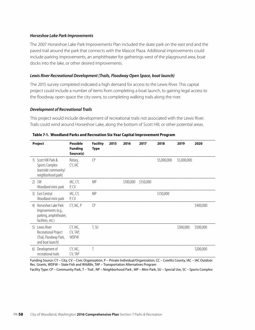
PR-58 City of Woodland, Washington 2016 Comprehensive Plan Section 7 Parks & Recreation
Horseshoe Lake Park Improvements
The 2007 Horseshoe Lake Park Improvements Plan included the skate park on the east end and the paved trail around the park that connects with the Mascot Plaza. Additional improvements could include parking improvements, an amphitheater for gatherings west of the playground area, boat docks into the lake, or other desired improvements.
Lewis River Recreational Development (Trails, Floodway Open Space, boat launch)
The 2015 survey completed indicated a high demand for access to the Lewis River. This capital project could include a number of items from completing a boat launch, to gaining legal access to the floodway open space the city owns, to completing walking trails along the river.
Development of Recreational Trails
This project would include development of recreational trails not associated with the Lewis River. Trails could wind around Horseshoe Lake, along the bottom of Scott Hill, or other potential areas.
Table 7-1. Woodland Parks and Recreation Six-Year Capital Improvement Program
Project Possible Funding Source(s)
Facility Type
2015 2016 2017 2018 2019 2020
1) Scott Hill Park &Sports Complex (eastside community/ neighborhood park)
Rotary, CY, IAC
CP $5,000,000 $5,000,000
2) SWWoodland mini-park
IAC, CY,P, CV
MP $100,000 $150,000
3) East CentralWoodland mini-park
IAC, CY,P, CV
MP $150,000
4) Horseshoe Lake Park Improvements (e.g., parking, amphitheater, facilities, etc.)
CY, IAC, P CP $400,000
5) Lewis RiverRecreational Project(Trail, Floodway Park, and boat launch)
CY, IAC,CV, TAP,WDFW
T, SU $300,000 $500,000
6) Development ofrecreational trails
CY, IAC,CV, TAP
T $200,000
Funding Source: CY – City, CV – Civic Organization, P – Private Individual/Organization, CC – Cowlitz County, IAC – IAC Outdoor Rec. Grants, WDFW – State Fish and Wildlife, TAP – Transportation Alternatives Program Facility Type: CP – Community Park, T – Trail , NP – Neighborhood Park , MP – Mini-Park, SU – Special Use, SC – Sports Complex
City of Woodland, Washington 2016 Comprehensive Plan Section 7 Parks & Recreation PR-59
7.4 Goals and Policies
Goal
PR 1 Create and preserve park and recreation opportunities for all residents within the City of Woodland and surrounding area.
Policies
PR 1.1 Provide a variety of parks and landscaped open space areas and recreation opportunities throughout Woodland.
PR 1.2 Continue to upgrade parks to keep pace with changes in recreational demand and citizen needs.
PR 1.3 Require all residential single-family subdivisions and multi-family development projects to (a) dedicate land for park areas, (b) provide for improvements to existing facilities or (c) provide monetary compensation (e.g., impact fees) to the City of Woodland for the acquisition and development of park lands or for the needed capital improvements to existing park and recreation areas.
PR 1.4 Continue to cooperate with other public, quasi-public, and private organizations, agencies and groups to jointly provide needed recreation facilities and programs.
Tourism
Goal
PR 2 Make recreation a cornerstone of Woodland’s economic and tourism development.
Policies
PR 2.1 Work with the Woodland Chamber of Commerce to support tourism programs through active facility management and park development.
Funding
Goal
PR 3 Provide continued funding for city park land acquisition and development programs.
Policies
PR 3.1 Maintain the park land acquisition budget in the proposed Capital Improvements Program and Budget.
PR 3.2 E xplore possible grant programs geared toward water quality improvement projects.
PR 3.3 Encourage the Parks Department and the Woodland School District to work in concert when purchasing new lands and developing playground activity programs, whenever possible.
PR- 60 City of Woodland, Washington 2016 Comprehensive Plan Section 7 Parks & Recreation
Trails
Goal
PR 4 Provide for year round use of walking, biking and jogging trails throughout Woodland.
Policies
PR 4.1 Link the existing downtown business district and Horseshoe Lake Park, with the objective of making the park an active part of the business community.
PR 4.2 Develop and implement an open space and trail plan along portions of Horseshoe Lake, the Lewis and Columbia rivers, and within major developed areas of the city by using city- owned property, land dedication, recreation easements and critical area buffers.
PR 4.3 Identify open space corridors that might be useful for recreation, wildlife habitat, trails, and connection of critical areas.
Waters
Goal
PR 5 Provide additional public access to the banks of the Lewis River, Horseshoe Lake and other regional facilities.
Policies
PR 5.1 Provide and encourage adequate boat launch and handicapped fishing access sites at Horseshoe Lake and on the Lewis River and other regional facilities.
PR 5.2 Continue to acquire and create more park lands around Horseshoe Lake.
PR 5.3 Encourage the Washington State Department of Fish and Wildlife and local sportsman clubs to identify, acquire and develop access and boat launch sites along the Lewis and Columbia rivers.
PR 5.4 Pursue development of city-owned land within the Lewis River floodway into a primarily passive recreation area in partnership with state agencies.
PR 5.5 Update the city’s park and recreation plan and incorporate appropriate elements of the plan into the city’s comprehensive plan.

City of Woodland, Washington 2016 Comprehensive Plan Section 8 Capital Facilities CF- 61
CHAP T ER 8C API TAL FACIL I T IE S (CF)SANI TARY SE W ER
8.1 Sanitary Sewer: Existing Conditions
Sewer Service Area
The city of Woodland’s current sewer service area includes approximately 2,625 acres within its corporate limits and 2,967 acres within its Urban Growth Area (UGA), as shown on Map 8-1. The city’s sewer service boundary coincides with the UGA. The collection system is primarily conventional gravity sewer systems and consists of an estimated 129,500 feet of mainline gravity sewers and approximately 16,460 feet of force main with 14 lift stations. There are no adjacent water/sewer systems to the Woodland system. The nearest sewer system to the city is the city of St. Helens, which is directly across the Columbia River
The city of Woodland has its own designated sewer service area. Woodland Wastewater Treatment Plant (WWTP) treats all Woodland sanitary waste. Table 8-1 provides an estimate of the average number of Woodland sewer connections in 2013. Single-family residential represents the largest sector of sewer connections, as shown in Figure 8-2. A single connection may serve more than one multi-family residential unit. A single industrial connection may generate more flow than a residential connection.
Table 8-1. Average Sewer Service Connections by Customer Class for 2013
Customer Class 2013
Single-Family Residential 1,510
Multi-Family Residential(1) 78
Commercial(2) 339
Industrial 7
Total 1,933
Based on City of Woodland billing data. (1) Multi-family connections include apartments, recreational vehicle parks, and mobile home parks. (2) Commercial connections also include churches, schools, city accounts, and motels.
Industrial7
Commercial339
Multi-FamilyResidential
78
Single-Family Residential1,510
Figure 8-2. Sewer Service Connections by Class (2013)
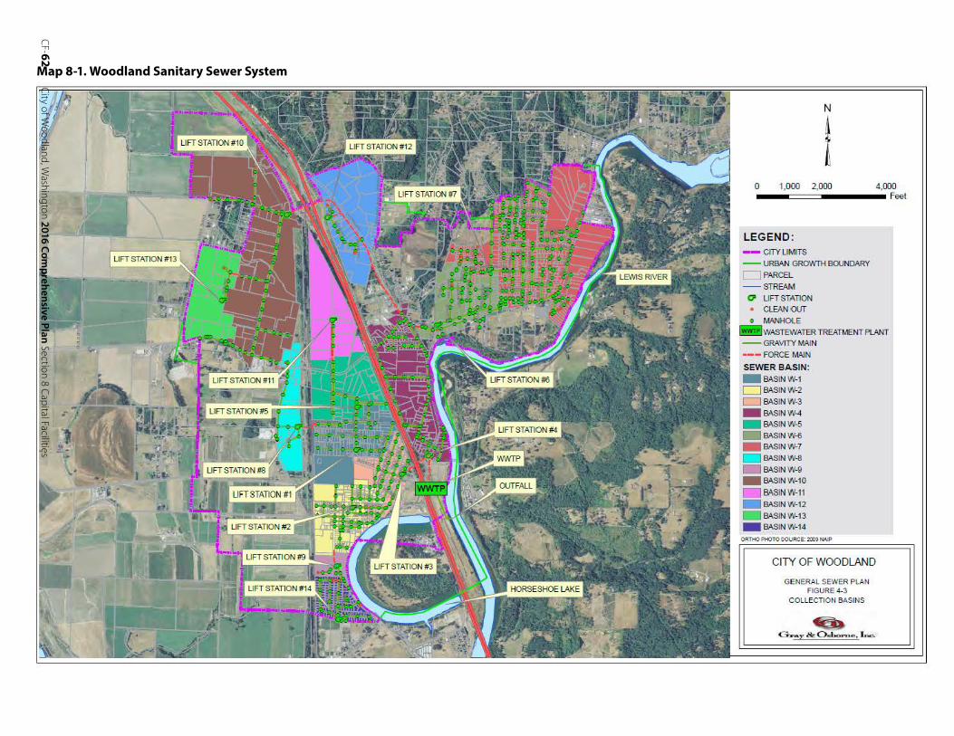
CF-62
CityofW
oodland,Washington
2016Com
prehensivePlan
Section8
CapitalFacilities
Map 8-1. Woodland Sanitary Sewer System
N
l0 1,00 0 2,000 4,000
LEGEND : -- CITY LIMITS -- URBAN GROWTH BOUNDARY CJ PARCEL - STREAM
0 UFTSTATI ON • CLEAN OUT e MANHOLE
IWWTPIWASTEWATERTREATMENT PLANT -- GRAVITY MAIN
·-- FORCE MAIN SEWER BASIN : - BASIN W-1 CJ BASIN W-2CJ BASIN W-3- BASIN W-4- BASIN W-5- BASIN W-6- BASIN W-7- BASIN W-8- BASIN W-9- BASIN W-10
- BASIN W-11 - BASIN W-12 - BASIN W-13 - BASIN W-14
ORTHO PHOTO SOURCE:2009 NAIP
CITY O F WOODLAND
GE NERAL SEW ER P LAN FIGURE 4-3
CO L LECTION BASINS
~G.'Al:_ & 0 61ho,:-ne. L a.e ..
Feet
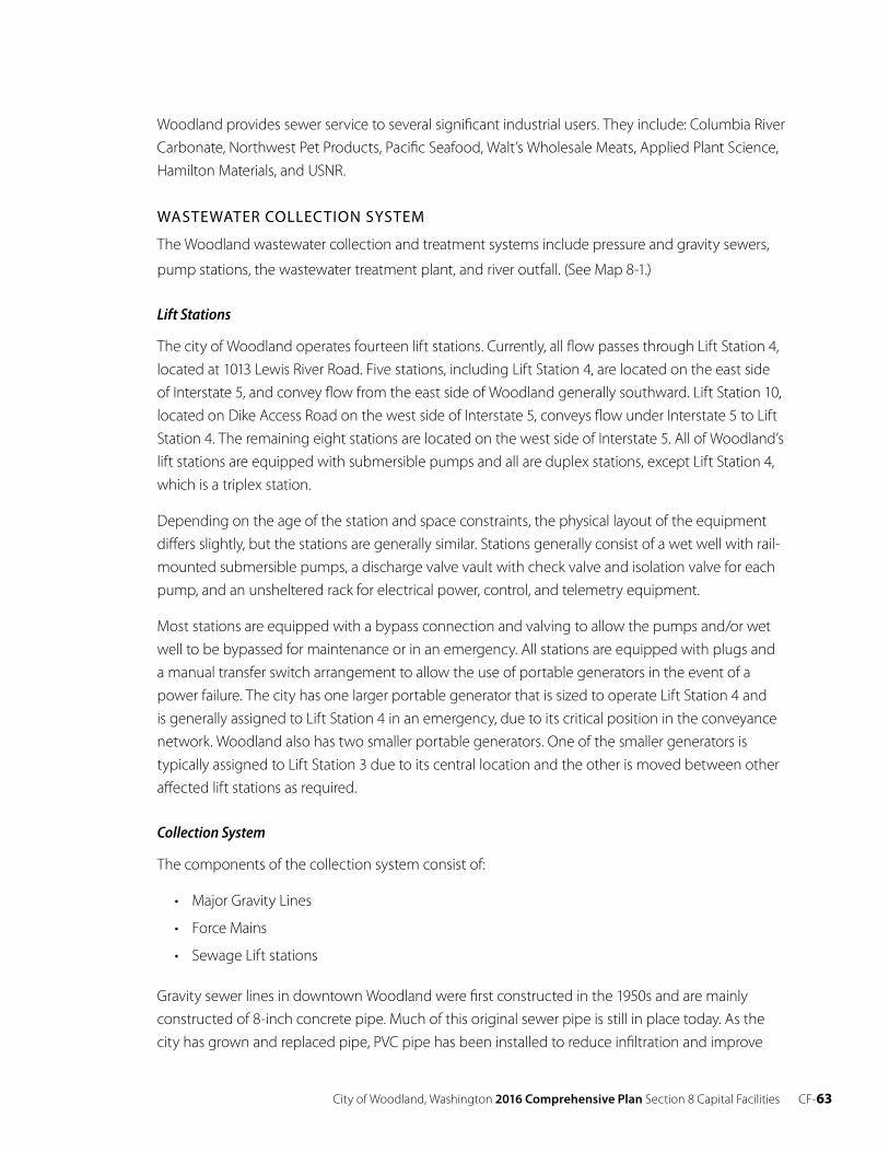
City of Woodland, Washington 2016 Comprehensive Plan Section 8 Capital Facilities CF- 63
Woodland provides sewer service to several significant industrial users. They include: Columbia River Carbonate, Northwest Pet Products, Pacific Seafood, Walt’s Wholesale Meats, Applied Plant Science, Hamilton Materials, and USNR.
WASTEWATER COLLECTION SYSTEM
The Woodland wastewater collection and treatment systems include pressure and gravity sewers,
pump stations, the wastewater treatment plant, and river outfall. (See Map 8-1.)
Lift Stations
The city of Woodland operates fourteen lift stations. Currently, all flow passes through Lift Station 4, located at 1013 Lewis River Road. Five stations, including Lift Station 4, are located on the east side of Interstate 5, and convey flow from the east side of Woodland generally southward. Lift Station 10, located on Dike Access Road on the west side of Interstate 5, conveys flow under Interstate 5 to Lift Station 4. The remaining eight stations are located on the west side of Interstate 5. All of Woodland’s lift stations are equipped with submersible pumps and all are duplex stations, except Lift Station 4, which is a triplex station.
Depending on the age of the station and space constraints, the physical layout of the equipment differs slightly, but the stations are generally similar. Stations generally consist of a wet well with rail- mounted submersible pumps, a discharge valve vault with check valve and isolation valve for each pump, and an unsheltered rack for electrical power, control, and telemetry equipment.
Most stations are equipped with a bypass connection and valving to allow the pumps and/or wet well to be bypassed for maintenance or in an emergency. All stations are equipped with plugs and a manual transfer switch arrangement to allow the use of portable generators in the event of a power failure. The city has one larger portable generator that is sized to operate Lift Station 4 and is generally assigned to Lift Station 4 in an emergency, due to its critical position in the conveyance network. Woodland also has two smaller portable generators. One of the smaller generators is typically assigned to Lift Station 3 due to its central location and the other is moved between other affected lift stations as required.
Collection System
The components of the collection system consist of:
• Major Gravity Lines
• Force Mains
• Sewage Lift stations
Gravity sewer lines in downtown Woodland were first constructed in the 1950s and are mainly constructed of 8-inch concrete pipe. Much of this original sewer pipe is still in place today. As the city has grown and replaced pipe, PVC pipe has been installed to reduce infiltration and improve
CF- 64 City of Woodland, Washington 2016 Comprehensive Plan Section 8 Capital Facilities
the condition of the sanitary sewer system. In 2013, 13,521 feet of concrete mains and 3,959 feet of transite mains were relined with HDPE and 257 feet of main was replaced with PVC.
Wastewater is discharged to the city’s wastewater treatment facility, which has an outfall in the Lewis River. The sewer system service area is generally flat and gradually slopes toward the Lewis River, where the treatment facility is located. Most of the collection system consists of gravity sewers, which drain to pump stations, and force mains. The current system consists of 4-inch to 16- inch diameter pipe, constructed of concrete, PVC and transite.
The Woodland sanitary sewer system contains a total of approximately 566 manholes which vary in construction material from all-brick to the newer precast concrete manholes. The older, all-brick and concrete block manholes present a greater opportunity for infiltration to occur than the newer precast manholes.
Collection Areas
The Woodland collection system is divided into a total of fourteen collection areas, or drainage basins. These collection areas predominantly follow the natural drainage patterns of the service area and each area drains to a pump station. (See City of Woodland General Sewer Plan, 2015.)
Wastewater Treatment Plant
The city constructed the first wastewater treatment plant at the present location in 1954. Major improvements to the plant were completed in 1974. In 1993, the city added a submerged biological contactor (SBC) to increase capacity. In 1996, the city installed a new rotary fine screen at the headworks and a new generator. The 1999 City of Woodland General Sewer and Facility Plan (1999 Sewer Plan) recommended upgrades to the WWTP to accommodate the then-current and projected future influent flows and loadings which were approaching and exceeding design criteria and NPDES limits. At the direction of the City Council, the 1999 Sewer Plan used an annual growth rate of 5.0 percent. In 2001 the city converted the WWTP from an RBC/SBC plant to a sequencing batch reactor (SBR) plant. The NPDES permit was issued on April 1, 2012, and expires on March 31, 2017. The WWTP monthly, average influent flows range from 0.41 mgd to 0.64 mgd. The 2009 to 2013 dry season average of 0.47 mgd includes dry season infiltration.
In Woodland, the water service area and the sewer service area are very similar in size. The majority of the sewer service connections are single-family residential customers. The total number of sewer connections for the city in 2013 was 1,933. Equivalent Residential Unit (ERU) Use of ERUs is a way to express the amount of water consumption or sewage produced by non-residential customers as an equivalent number of residential customers. The average daily single-family residential winter water use from 2010 to 2014 ranged from a low of 140 gpd/SFR to a high of 145 gpd/SFR. The wastewater ERU value is calculated based on winter water use (in order to exclude water used for irrigation). Based on the average of historical water use records for the years 2010 to 2014, average winter residential water use is 142 gallons per household. However, based on analysis of the data, it is estimated that only 95 percent of the winter water use makes it into the wastewater system. Thus, the average wastewater ERU value is 135 gpd/ERU.
City of Woodland, Washington 2016 Comprehensive Plan Section 8 Capital Facilities CF- 65
Expressed as a percentage of total sewer processed the following land use activity occurs:
• Single-Family Residential = 39%;
• Multi-Family Residential = 14%;
• Commercial = 22
• Industrial = 16%;
• Churches/Schools/City = 2%; and
• Motels/RV/Mobile Home Parks = 6%
8.2 Sanitary Sewer: Projected Needs
Projected Service Area Population, ERUS and Flows
In 2013 Woodland’s population was 5,625. The city served 3.474 ERUs. The projected 20-year ERUs are 6,188. The average design flow of the treatment plant is 0.71 mgd with two basins operating, or 1.42 with three, and the peak design flow is 1.62 mgd with two basins and 3.24 with three, which correspond to the annual average flow and the peak day flow, respectively. The projected average annual flow and the projected peak day flow are well within the existing treatment plant capacity for the 20-year planning horizon as long as three basins are used when necessary.
The 2014 General Sewer Plan concluded the city of Woodland WWTP was operating successfully at loadings well below the permitted and design loading limits. There is no compelling basis to recommend immediate improvements to the WWTP to improve energy efficiency.
8.3 Drinking Water: Existing Conditions
Woodland owns and operates a water system consisting of one horizontal collector well hydrologically connected to the Lewis River, a water treatment plant with pump station, two reservoirs, and a distribution system. The water system serves the entire corporate limits and UGA. Service can be provided to any location within the UGA, provided it agrees to annexation prior to service being installed. The city of Woodland currently has municipal water rights issued by Department of Ecology (Ecology) for a maximum instantaneous withdrawal of 2,800 gallons per minute (gpm) from its well near the Lewis River.
Water Service Area
Woodland’s current water service area includes approximately 2,625 acres within its corporate limits and 2,967 acres within its Urban Growth Area (UGA). The city’s water service boundary coincides with the UGA. There are no adjacent water systems to the Woodland system. There are several small water systems within one mile of the UGA, in addition to numerous private wells around the service area.
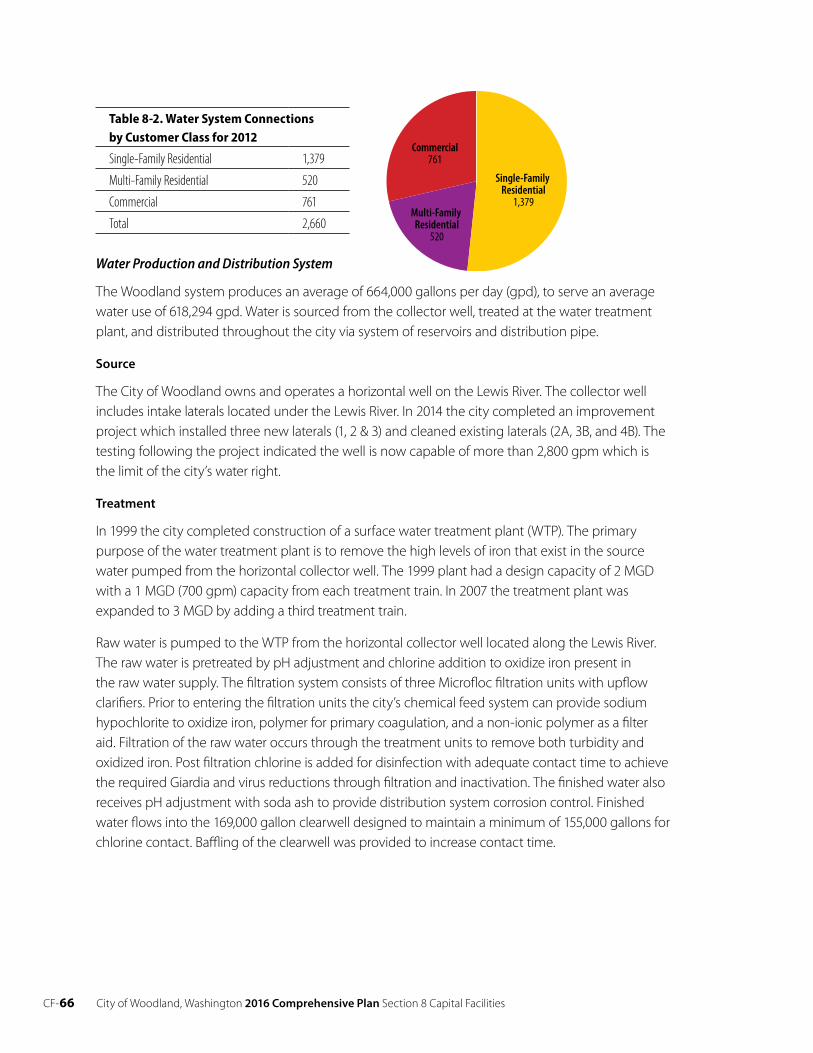
CF- 66 City of Woodland, Washington 2016 Comprehensive Plan Section 8 Capital Facilities
Table 8-2. Water System Connections by Customer Class for 2012
Single-Family Residential 1,379
Multi-Family Residential 520
Commercial 761
Total 2,660
Water Production and Distribution System
The Woodland system produces an average of 664,000 gallons per day (gpd), to serve an average water use of 618,294 gpd. Water is sourced from the collector well, treated at the water treatment plant, and distributed throughout the city via system of reservoirs and distribution pipe.
Source
The City of Woodland owns and operates a horizontal well on the Lewis River. The collector well includes intake laterals located under the Lewis River. In 2014 the city completed an improvement project which installed three new laterals (1, 2 & 3) and cleaned existing laterals (2A, 3B, and 4B). The testing following the project indicated the well is now capable of more than 2,800 gpm which is the limit of the city’s water right.
Treatment
In 1999 the city completed construction of a surface water treatment plant (WTP). The primary purpose of the water treatment plant is to remove the high levels of iron that exist in the source water pumped from the horizontal collector well. The 1999 plant had a design capacity of 2 MGD with a 1 MGD (700 gpm) capacity from each treatment train. In 2007 the treatment plant was expanded to 3 MGD by adding a third treatment train.
Raw water is pumped to the WTP from the horizontal collector well located along the Lewis River. The raw water is pretreated by pH adjustment and chlorine addition to oxidize iron present in the raw water supply. The filtration system consists of three Microfloc filtration units with upflow clarifiers. Prior to entering the filtration units the city’s chemical feed system can provide sodium hypochlorite to oxidize iron, polymer for primary coagulation, and a non-ionic polymer as a filter aid. Filtration of the raw water occurs through the treatment units to remove both turbidity and oxidized iron. Post filtration chlorine is added for disinfection with adequate contact time to achieve the required Giardia and virus reductions through filtration and inactivation. The finished water also receives pH adjustment with soda ash to provide distribution system corrosion control. Finished water flows into the 169,000 gallon clearwell designed to maintain a minimum of 155,000 gallons for chlorine contact. Baffling of the clearwell was provided to increase contact time.
Commercial761
Multi-FamilyResidential
520
Single-FamilyResidential1,379
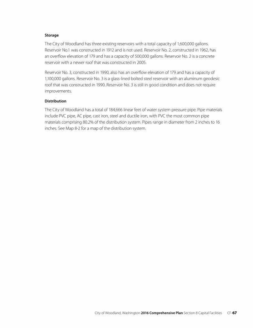
City of Woodland, Washington 2016 Comprehensive Plan Section 8 Capital Facilities CF- 67
Storage
The City of Woodland has three existing reservoirs with a total capacity of 1,600,000 gallons.Reservoir No.1 was constructed in 1912 and is not used. Reservoir No. 2, constructed in 1962, hasan overflow elevation of 179 and has a capacity of 500,000 gallons. Reservoir No. 2 is a concretereservoir with a newer roof that was constructed in 2005.
Reservoir No. 3, constructed in 1990, also has an overflow elevation of 179 and has a capacity of 1,100,000 gallons. Reservoir No. 3 is a glass-lined bolted steel reservoir with an aluminum geodesic roof that was constructed in 1990. Reservoir No. 3 is still in good condition and does not require improvements.
Distribution
The City of Woodland has a total of 184,666 linear feet of water system pressure pipe. Pipe materials include PVC pipe, AC pipe, cast iron, steel and ductile iron, with PVC the most common pipe materials comprising 80.2% of the distribution system. Pipes range in diameter from 2 inches to 16 inches. See Map 8-2 for a map of the distribution system.
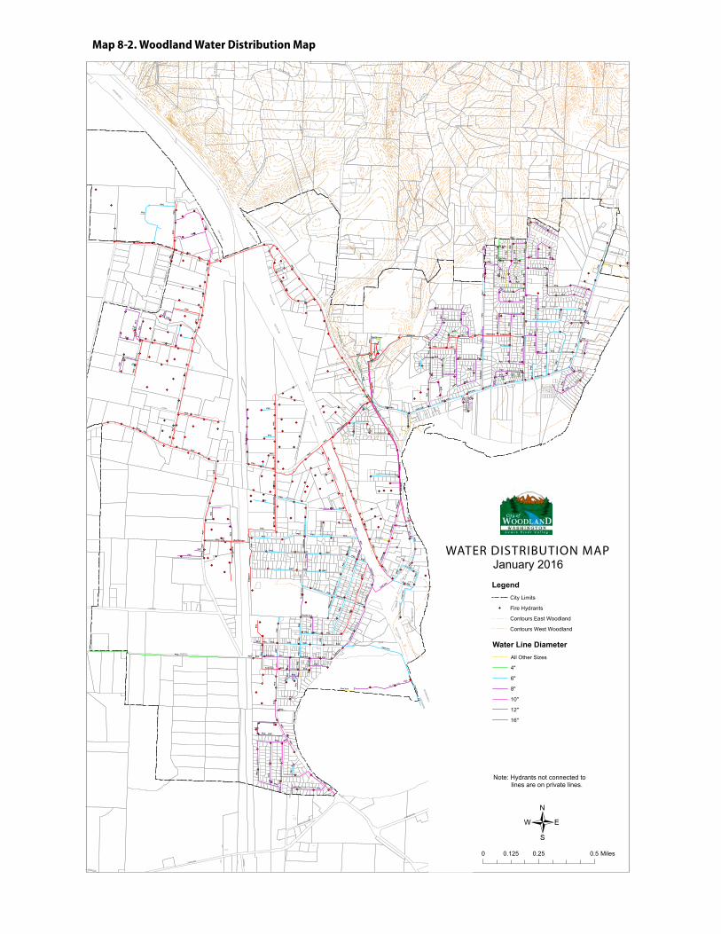
CF- 68 City of Woodland, Washington 2016 Comprehensive Plan Section 8 Capital Facilities
Map 8-2. Woodland Water Distribution Map
G!.
G!.
G!.
G!.
G!.
G!.
G!.
G!.
G!.
G!.
G!.
G!.
G!.
G!.
G!.
G!.G!.
G!.G!.
G!. G!.
G!.G!. G!.
G!.G!.
G!.G!.G!.
G!.
G!.
G!.
G!.
G!.
G!.
G!.
G!.
G!.
G!.
G!.
G!.
G!.
G!.
G!.
G!.
G!.
G!.
G!.
G!.
G!.
G!.
G!.
G!.
G!.
G!.
G!.
G!.
G!.
G!.
G!. G!.G!.
G!.G!.
G!.G!.G!.
G!.
G!.
G!.
G!. G!. G!.
G!.
G!. G!.
G!.G!.
G!.G!.
G!.
G!.
G!. G!.
G!.
G!.
G!.
G!.
G!.
G!. G!.
G!.G!.G!.
G!.G!.
G!.
G!.
G!.
G!.
G!.G!.
G!.
G!.
G!.
G!. G!. G!.
G!.
G!.
G!.
G!.
G!.
G!.G!.G!.
G!.
G!.
G!.
G!.G!.
G!.
G!.
G!.
G!.
G!.G!.
G!.
G!.
G!.G!.G!.
G!.G!. G!.
G!.G!.
G!.
G!. G!.
G!.
G!.
G!.
G!.G!.G!.
G!.
G!.
G!.G!.G!.
G!.
G!.
G!.
G!.
G!.
G!.
G!.
G!.
G!.G!.
G!. G!.
G!. G!. G!.
G!.
G!. G!. G!.G!.
G!. G!. G!.
G!.
G!.
G!.
G!.G!.
G!.
G!.
G!.
G!.
G!.
G!.G!.
G!.
G!.
G!.
G!.
G!.
G!.G!.
G!.
G!.
G!.
G!.
G!.
G!.
G!.G!.
G!.G!.
G!.
G!.
G!.
G!.
G!.
G!.
G!.
G!.
G!.
G!.G!.
G!.
G!.
G!.
G!.
G!.
G!.G!.
G!.G!.
G!.
G!.
G!.G!.
G!.
G!.
G!.
G!.
G!.
G!.
G!.
G!.
G!.
G!.G!.
G!.G!.
G!.
G!.
G!.
G!.
G!.
G!.
G!.
G!.
G!.G!.
G!.
G!.
G!.
G!.
G!.
G!.
G!.
G!.
G!.G!.
G!.
G!.
G!.
G!.
G!.
G!.
G!.
G!.
G!.
G!.
G!.
G!.
G!.G!. G!. G!.
G!.
G!.
G!.
G!.
G!.G!.
G!.
G!.
G!.
G!.
G!. G!.
G!.
G!.
G!.
G!. G!.
G!.
G!.
G!.
G!.
G!.
G!.
G!.
G!.
G!.
G!.
G!.G!.
G!.G!.
G!.
G!.
G!.
G!.
G!.
G!.
G!.
G!.
G!.
G!.
G!.
G!.
G!.G!.
G!.
G!.G!.
G!.G!.
G!.
G!.
G!.
G!.
G!. G!.
G!.
G!.
G!.
G!.
G!.G!.G!.
G!.
G!.
G!.
G!.
G!.
G!.
G!.
G!.
G!.
G!.
G!.
G!.
G!.
G!.
G!. G!.
G!.
G!.
G!.
G!.
G!.
G!.
G!.
G!.
G!.
G!. G!.
G!.
G!.G!.
G!.
G!.G!.
G!.
G!.
G!.
G!.
G!.
G!.
G!.
G!.
G!.
G!.
G!.
G!.
G!.
G!.
G!.
G!.
G!.
G!.
G!.
G!.
G!.
G!.
G!.
G!.
G!.
G!.
G!.
G!.
G!.
G!.
G!.
G!.
G!.
G!.
G!.G!.
G!.
G!.
G!.
G!.
G!.G!. G!.
G!.
G!.
G!.
G!.
G!.
G!.
G!.
G!.
G!.G!.
G!.
G!.
G!.
G!.
G!.
G!.
G!. G!.
G!.G!.G!.
G!.
G!.
G!.
G!.
G!.
G!.
G!.
G!.
G!.
G!.
G!.
G!.
G!.
G!.G!.
G!.
G!.
G!.
G!.
INTER
STATE 5
CC
INSE
L
PEKI
N
LEW
IS R
IVER
F
WHALEN
HILLSD
ALE
PAR
K
GUILD
PACIFIC
GOERIG
RO
BIN
SON
5TH
E
CAPLES
ATLANTIC
B
SCH
UR
MAN
SCOTT
3RD
GU
N C
LUB
OLD PACIFIC
DIKE ACCESS
DAL
E
LAKESHO
RE
GR
EEN
MO
UN
TAIN
2ND
FIR
CPI
NE
EXIT22
ON
DO
WN
RIV
ER
WILLOW
HIL
LSH
IRE
HO
FFM
AN
BOZARTH
A
D
4TH
DAVIDSON
BUR
KE
AVIATOR
WASHINGTON
SAPPHIRE
PINKERTON
BEECHWOOD
EXIT22
OFF
MOONRIDGE
EXIT 21 ON
PORT
EMPR
ESS
MA
RTY
LOVES
MA
BLE
ISLAND AIRE
SPRUCE
6TH
MA
DR
ON
A
BELMONT
SALMON
DAHLIA
EXIT22 N ON
HERITAGE
SOMMERSET
CARA
FOR
ES
TPA
RK
INSEL EXTENSION
EXIT
21
OFF
BOZA
RTH
HEI
GH
TS
EXIT 21 S ON
RAS
PBE
RR
Y
HO
WAR
D
SYC
AM
OR
E
LAR
CH
COLUMBIA
DUNHAM
GLE
NW
OO
D
SCO
TT HILL
CED
AR
RED
BIR
D
BUCKEYE
SKY
VIEW
MITCHELL
MISTY
LAKE
WHALEN LOOP
CLOVER
MA
PLE
BLACKTAIL
BRIM
STONE
LOLO
TR
AIL
SAN
DA
LWO
OD
WO
OD
LAND
VIEW
HANSEN
WHITE TAIL
MERIWETHER
KUH
NIS
STATESMAN
TWIN FLOWER
SPR
ING
WO
OD
RHODODENDRON
AMBASSADOR
MILLARD
EVERGREEN
CLATSOP
FRA
ZIE
R
THIS
TLE
CIMERRON
HAWTHORNEHEARTWOOD
WINDFLOWER
GO
RD
ON
MCCRACKEN
ROSEWOOD
EMB
ASS
Y
VALL
EY
HOLLYBERRY
CHERRY BLOSSOM
LOG
AN
BE
RR
Y
FOXTAIL
TRUTH
BRO
THER
S
MIL
KY
WAY
WO
OD
SID
E
GR
AN
ITE
DEHNING
SEQUOIA
FRAN
KLIN
MEADOWOOD
ROBBINS
FOREST VIEW
ME
AD
OW
PAR
K
RIV
ER
RO
CK
TRE
ATM
ENT
PLA
NT
PONDEROSA
PEACH TREE
STAR
FLO
WER
BUCKEYE
CC
INTER
STATE 5
B
GO
RD
ON
SCOTT
C
A
GO
ERIG
PEKIN
PARK
RHODODENDRON
GOERIG
WHALEN
EXIT22
OFF
B
SCOTT
INTERSTATE 5
LEWIS R
IVER
EXIT 21 OFF
FRA
ZIE
R
40
60
80
20
100
120
140
160180
200
220
240
260280
300
320
340
360 380
420
440
460
400
480
500
520
540
20
380
460
200
180
420
340
20
160
500
440
460
320
160
440
120
160
160
480
20
40
20
400
120
140
360
20
80
140
80
60
40
20
100
120
140
160
180
200
220
240
260
280300
320
340
360
380
400
420440
460
480
500
520
540
560
580
600620
640660
680
700
720
740
760780
800
120
20
580480
280300
40
460
20
440
260
340
40
40
460
580
60
460
40
500
240
440
160
20
360
480
20
420
520380
120
320240
500
180
40
200
160
140
400
160
20
480
140
220
40
Cast Iron
PVC
Asb
esto
s
Ductile Iron
Gal
vani
zed
Stee
l
PVC
PVC
Cast Iron
PVC
PVC
PVC
Asb
esto
s
Cast Iron
PVC
Asb
esto
s
PVC
PVC
PVC
Cast Iron
PVC
PVC
PVC
PVC
Cast Iron
Cast Ir
on
Asbe
stos
PVC
PVC
PVC
PVC
PVC
PVC
PVCPV
C
Asb
esto
s
PVC
PVC
Asb
esto
s
PVC
PVC
PVC
PVC
Asb
esto
s
PVC
PVC
PVC
PVC
PVC
PVC
PVC
PVC
PVC
PVC
PVC
PVC
PVC
PVC
PVC
PVC
PVC
PVC
PVC
PVC
PVC
PVC
PVC
PVC
PVC
PVC
PVC
PVC
PVC
Asbestos
PVC
PVC
PVC
PVC
PVC
PVC
PVC
PVC
PVC
PVC
PVC
Duc
tile
Iron
Cast Iron
PVC
PVC
PVC
PVC
PVC
PVC
PVC
PVC
PVC
PVC
PVC
PVC
PVCPVC
PVC
PVC
PVC
PVC
PVC
PVC
PVC
PVC
PVC
PVC
PVC
Asbe
stos
Duct
ile Ir
on
PVC
Cast Iron
PVC
Asb
esto
s
PVC
PVC
PVC
Duc
tile
Iron
PVC
PVC
PVC
PVC
PVC
PVC
Asbestos
PVC
Cast Iron
PVC
PVC
PVC
PVC
PVC
Asbestos
Cast
Iron
PVC
Cast Iron
PVC
Cast Iron
Cast Iron
PVC
Cast Iron
Asbestos
PVC
PVC
PVC
PVC
PVC
PVC
PVC
Cast Iron
Cast Iro
n
PVC
PVC
PVC
PVC
PVC
PVC
PVC
Asbestos
PVC
PVC
Asbestos
PVC
PVC
Asbestos
PVC
PVC
PVC
PVC
PVC
Ductile Iron
PVC
PVC
PVC
PVC
PVC
Ductile Iron
PVC
PVC
PVC
PVC
PVC
PVC
Cas
t Iro
n
PVC
Ductile Iron
PVC
PVC
PVC
PVC
PVC
PVC
PVC
Asb
esto
s
PVCDuctile Iron
Ductile Iron
PVC
PVC
PVC
PVC
PVC
PVC
PVC
PVC
Asb
esto
s
PVC
PVC
PVC
PVC
PVC
PVC
PVC
PVC
Cast Iron
PVC
PVC
Asbe
stos
Cast Iron
Asb
esto
s
PVC
PVC
PVC
PVC
PVC
PVC
PVC
PVC
PVC
PVC
Ductile Iron
PVC
PVC
PVC
PVC
PVC
PVC
PVC
PVC
PVC
PVC
PVC
PVC
PVC
PVC
PVC
PVC
PVC
PVC
Asb
esto
s
PVC
PVC
PVC
PVC
PVC
PVC
PVC
PVC
Cast Iron
PVC
PVC
PVC
Cast Iron
PVC
PVC
PVC
PVC
PVC
PVC
PVC
PVC
PVC
PVC
PVC
PVC
PVC
PVC
PVC
Ductile Iron
PVC
PVC
PVC
PVC
PVC
PVC
PVC
PVC
PVC
PVC
Asbe
stos
PVC
Ductile Iron
PVC
PVC
PVC
PVC
PVC
PVC
Cast
Iron
PVCPVC
PVC
PVC
PVC
PVC
PVC
PVC
PVC
PVC
PVC
PVC
PVC
PVC
PVC
PVC
PVC
PVC
Asbestos
PVC
PVC
PVC
PVC
PVC
Asbe
stos
PVC
PVC
PVC
PVC
Duc
tile
Iron
Asbe
stos
PVC
PVC
PVC
PVC
PVC
PVC
PVC
Water Line DiameterAll Other Sizes
4"
6"
8"
10"
12"
16"
WATER DISTIBUTION MAPJanuary 2016
Note: Hydrants not connected tolines are on private lines.
0 0.25 0.50.125 Miles
/
LegendCity Limits
G!. Fire Hydrants
Contours East Woodland
Contours West Woodland
WATER DISTRIBUTION MAP
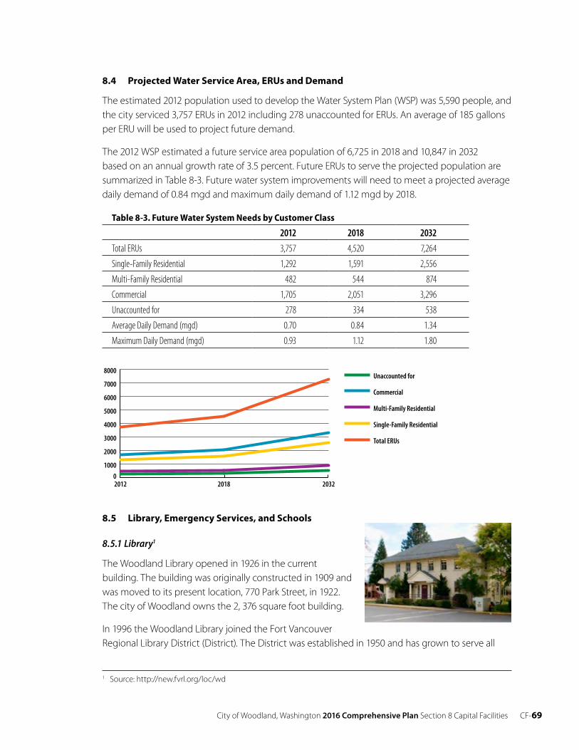
City of Woodland, Washington 2016 Comprehensive Plan Section 8 Capital Facilities CF-69
8.4 Projected Water Service Area, ERUs and Demand
The estimated 2012 population used to develop the Water System Plan (WSP) was 5,590 people, and the city serviced 3,757 ERUs in 2012 including 278 unaccounted for ERUs. An average of 185 gallons per ERU will be used to project future demand.
The 2012 WSP estimated a future service area population of 6,725 in 2018 and 10,847 in 2032 based on an annual growth rate of 3.5 percent. Future ERUs to serve the projected population are summarized in Table 8-3. Future water system improvements will need to meet a projected average daily demand of 0.84 mgd and maximum daily demand of 1.12 mgd by 2018.
Table 8-3. Future Water System Needs by Customer Class
2012 2018 2032
Total ERUs 3,757 4,520 7,264
Single-Family Residential 1,292 1,591 2,556
Multi-Family Residential 482 544 874
Commercial 1,705 2,051 3,296
Unaccounted for 278 334 538
Average Daily Demand (mgd) 0.70 0.84 1.34
Maximum Daily Demand (mgd) 0.93 1.12 1.80
8.5 Library, Emergency Services, and Schools
8.5.1 Library1
The Woodland Library opened in 1926 in the current building. The building was originally constructed in 1909 andwas moved to its present location, 770 Park Street, in 1922.The city of Woodland owns the 2, 376 square foot building.
In 1996 the Woodland Library joined the Fort Vancouver Regional Library District (District). The District was established in 1950 and has grown to serve all
1 Source: http://new.fvrl.org/loc/wd
0
1000
2000
3000
4000
5000
6000
7000
8000Unaccounted for
Commercial
Multi-Family Residential
Single-Family Residential
Total ERUs
203220182012
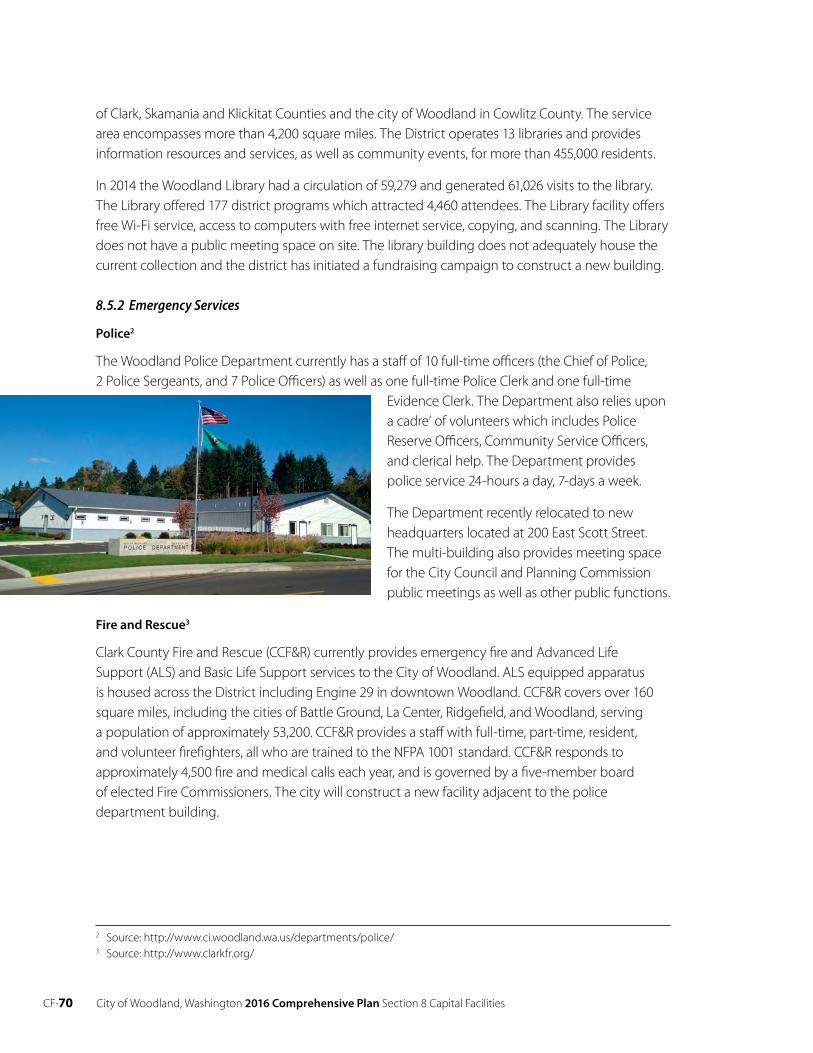
CF-70 City of Woodland, Washington 2016 Comprehensive Plan Section 8 Capital Facilities
of Clark, Skamania and Klickitat Counties and the city of Woodland in Cowlitz County. The service area encompasses more than 4,200 square miles. The District operates 13 libraries and provides information resources and services, as well as community events, for more than 455,000 residents.
In 2014 the Woodland Library had a circulation of 59,279 and generated 61,026 visits to the library. The Library offered 177 district programs which attracted 4,460 attendees. The Library facility offers free Wi-Fi service, access to computers with free internet service, copying, and scanning. The Library does not have a public meeting space on site. The library building does not adequately house the current collection and the district has initiated a fundraising campaign to construct a new building.
8.5.2 Emergency Services
Police2
The Woodland Police Department currently has a staff of 10 full-time officers (the Chief of Police, 2 Police Sergeants, and 7 Police Officers) as well as one full-time Police Clerk and one full-time
Evidence Clerk. The Department also relies upon a cadre’ of volunteers which includes Police Reserve Officers, Community Service Officers, and clerical help. The Department provides police service 24-hours a day, 7-days a week.
The Department recently relocated to new headquarters located at 200 East Scott Street. The multi-building also provides meeting space for the City Council and Planning Commission public meetings as well as other public functions.
Fire and Rescue3
Clark County Fire and Rescue (CCF&R) currently provides emergency fire and Advanced Life Support (ALS) and Basic Life Support services to the City of Woodland. ALS equipped apparatus is housed across the District including Engine 29 in downtown Woodland. CCF&R covers over 160 square miles, including the cities of Battle Ground, La Center, Ridgefield, and Woodland, serving a population of approximately 53,200. CCF&R provides a staff with full-time, part-time, resident, and volunteer firefighters, all who are trained to the NFPA 1001 standard. CCF&R responds to approximately 4,500 fire and medical calls each year, and is governed by a five-member board of elected Fire Commissioners. The city will construct a new facility adjacent to the police department building.
2 Source: http://www.ci.woodland.wa.us/departments/police/ 3 Source: http://www.clarkfr.org/
City of Woodland, Washington 2016 Comprehensive Plan Section 8 Capital Facilities CF-71
8.5.3 Schools4
Woodland Public Schools serves about 2200 students in 5 traditional public schools: (Yale School, Woodland Primary School, Woodland Intermediate School, Woodland Middle School, and Woodland High School) and two Alternative Learning Programs (Lewis River Academy, and TEAM High School).
In 2016 the Woodland High School opened a new facility on Dike Access Road. The High School integrates technology in the classroom via internet access available to all students with parental permission. The High School offers a wide array of vocational electives, including the opportunity to use Clark County’s Vocational Skills Center and area community colleges. Woodland High School is an active participant in the College in the High School program with Central Washington University and Lower Columbia College. Students are able to earn college credits while attending several advanced classes.
The Woodland School District updated its Capital Facilities Plan in 2016.
8.6 Goals and Policies
Public Facilities and Services
Goal
CF 1 Ensure that public facilities and services are provided, operated and maintained effectively and efficiently and that new or extended public facilities and services in Woodland and the urban growth area are made available in a logical, timely and equitable manner.
Policies
CF 1.1 Encourage development of areas currently served, prior to opening new areas for development.
CF 1.2 Design and construct public facilities and services to handle the anticipated growth of the service area, and to minimize future maintenance and repair costs.
CF 1.3 Provide public sanitary sewer, water and related facilities services necessary to adequately serve a proposed development.
CF 1.4 Consider impacts on future city development and land use patterns regarding the timing and location of new facilities and the improvement of existing facilities.
Goal
CF 2 Locate public facilities and services to provide maximum benefit and minimum harm to property owners and citizens.
4 Source: http://www.woodlandschools.org/
CF-72 City of Woodland, Washington 2016 Comprehensive Plan Section 8 Capital Facilities
Policies
CF 2.1 Allow the location and construction of public facilities (e.g., Public Works shop, pump house, parks, etc.) in any zoning district.
CF 2.2 Locate public facilities and utilities to: (a) maximize the efficiency of services provided; (b) minimize their costs; and (c) minimize their impacts upon the natural environment, particularly to critical areas.
CF 2.3 Adopt and implement a process and criteria for identifying and siting essential public facilities (EPFs). EPFs may include: state education facilities, state and local correctional facilities; solid waste handling facilities; in-patient facilities, including substance abuse facilities; and mental health facilities.
Law, Fire and Emergencies
Goal
CF 3 Provide for police, fire and emergency service protection that creates a safe environment to residents and visitors alike.
Policies
CF 3.1 Encourage operational long-range planning by the city Police and Fire District to ensure continued adequate manpower, equipment and facilities.
CF 3.2 Encourage continued volunteer and paid staff emergency training programs to maintain high standard of efficiency.
Educational Facilities
Goal
CF 4 Coordinate with the Woodland School District on capital facilities planning efforts and facilities plans.
Policies
CF 4.1 Coordinate school site selection with the city’s comprehensive plan.
CF 4.2 Locate schools away from incompatible land uses such as existing or potential intensive commercial or industrial areas.
CF 4.3 Locate school sites to provide the best possible access to the student population served, on or convenient to a collector or higher functional class street.
CF 4.4 Develop school sites in conjunction with parks and recreational areas whenever possible to allow joint acquisition of both school and recreation facilities. The school district should coordinate with the city Park Board.
City of Woodland, Washington 2016 Comprehensive Plan Section 8 Capital Facilities CF-73
Coordination
Goal
CF 5 Coordinate planning and provision of capital facilities and services with other agencies.
Policies
CF 5.1 Work with federal, state, county, and other agencies toward maintenance of adequate dikes and flood prevention measures along the Lewis River.
CF 5.2 Participate actively in the regional community and in furtherance of intergovernmental coordination, planning, and sharing of public facilities.
CF 5.3 Coordinate with other agencies regarding the planning, siting and improvement of road, educational, and other public facilities which might affect Woodland but are outside of the city’s jurisdiction.
CF 5.4 Maintain and when possible, enhance the levels of police and fire protection, ambulance and emergency response, public library, and solid waste collection services available to city residents.
CF 5.5 Continue active participation with county-wide and/or regional solid waste and hazardous waste management programs.
CF 5.6 Continue active involvement with the Cowlitz County Health Department.
Funding
Goal
CF 6 Fund capital facilities adequately to fulfill the expectations of the Comprehensive Plan.
Policies
CF 6.1 Conduct long-range capital improvements programming and financing to ensure that facilities and services are available to meet future needs and that existing facilities and services are maintained and improved.
CF 6.2 Apply for state and federal grants and other funds to assist development and improvement of sewer, water, and other public facilities and services.
CF 6.3 Re-assess the Land Use Element if probable funding for capital facilities falls short or take other measures to ensure that the Land Use Element, the Capital Facilities Element and the financing plan in the Capital Facilities Element are coordinated and consistent.
CF-74 City of Woodland, Washington 2016 Comprehensive Plan Section 8 Capital Facilities
Concurrency
Goal
CF 7 Ensure that facilities and services necessary to support development are adequate to serve the development at the time the development is available for occupancy and use without decreasing current service levels below locally established standards.
Policies
CF 7.1 Adopt concurrency policies which require that public facilities and infrastructure are either in place or committed before the city approves new development. Committed projects are those which are funded and will be completed within a six year time period.
CF 7.2 Require development projects to meet minimum Level of Service (LOS) thresholds for transportation facilities. If the proposal does not meet minimum LOS standards the city shall either deny the proposal or condition its approval on measures proportionate to and reasonably related to the impacts the development imposes.
CF 7.3 Allow a development to satisfy concurrency requirements in any of three ways:
a) Finding that LOS will exceed minimum LOS thresholds after the project is completed (i.e. full build out);
b) Negotiating a binding plan between the applicant and the service provider that assures adequate public/private funding of necessary facilities to satisfy minimum LOS thresholds within a six year time period; or
c) Constructing a development in phases, with the first phase to be completed within current minimum LOS thresholds and subsequent phase(s) to be approved after adopting a binding plan for funding of additional capital facilities needed to maintain minimum LOS threshold standards.
CF 7.4 Establish procedures, in conjunction with Cowlitz and Clark counties, for expedited review and approval of development projects which exceed LOS thresholds, as well as for projects requiring binding plans for funding of additional improvements that will be needed to maintain LOS thresholds over a time period not exceeding ten years.
CF 7.5 Require a public or private service provider to complete the facilities within the time frame stipulated by the binding plan. Failure to complete construction of identified facilities subject to concurrency within the schedule stipulated could result in reimbursement of developer impact fees or other contributions allowed by the Growth Management Act.
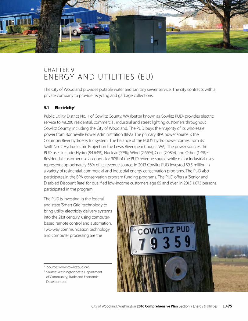
City of Woodland, Washington 2016 Comprehensive Plan Section 9 Energy & Utilities EU-75
CHAP T ER 9ENERGY AND U T IL I T IE S (EU)The City of Woodland provides potable water and sanitary sewer service. The city contracts with a private company to provide recycling and garbage collections.
9.1 Electricity1
Public Utility District No. 1 of Cowlitz County, WA (better known as Cowlitz PUD) provides electric service to 48,200 residential, commercial, industrial and street lighting customers throughout Cowlitz County, including the City of Woodland. The PUD buys the majority of its wholesale power from Bonneville Power Administration (BPA). The primary BPA power source is the Columbia River hydroelectric system. The balance of the PUD’s hydro power comes from its Swift No. 2 Hydroelectric Project on the Lewis River (near Cougar, WA). The power sources the PUD uses include: Hydro (84.64%), Nuclear (9.7%), Wind (2.66%), Coal (2.08%), and Other (1.4%). 2 Residential customer use accounts for 30% of the PUD revenue source while major industrial uses represent approximately 56% of its revenue source. In 2013 Cowlitz PUD invested $9.5 million in a variety of residential, commercial and industrial energy conservation programs. The PUD also participates in the BPA conservation program funding programs. The PUD offers a ‘Senior and Disabled Discount Rate’ for qualified low-income customers age 65 and over. In 2013 1,073 persons participated in the program.
The PUD is investing in the federal and state ‘Smart Grid’ technology to bring utility electricity delivery systems into the 21st century, using computer- based remote control and automation. Two-way communication technology and computer processing are the
1 Source: www.cowlitzpud.ord. 2 Source: Washington State Department
of Community, Trade and Economic Development.
EU-76 City of Woodland, Washington 2016 Comprehensive Plan Section 9 Energy & Utilities
heart of the ‘Smart Grid’ system. The intent is to improve efficiency on the electricity grid and in the energy users’ homes and offices.
When projections show that future demand may exceed available supply the PUD will evaluate a range of options including conservation, system improvements and purchasing additional power from hydro or other sources. Consequently, the utility anticipates that it has adequate capacity to meet the anticipated service demands.
9.2 Natural Gas3
Cascade Natural Gas Corporation provides natural gas service to the city of Woodland. The district office is located in Longview. There are an estimated 913 natural gas customers in Woodland who consumed an estimated 2 million cubic feet of natural gas in September 2015. Woodland consumes less than 1% of the natural gas used in the State of Washington. Approximately 33% of all homes in the State of Washington are heated by natural gas. The average Woodland residential gas rate was $11.61/cubic foot in 2015, approximately 28% less than the U.S. average. Because of the low price of natural gas the trend is to add natural gas as an option for new house construction.
Northwest Pipeline owns and operates more than 7,000 miles of interstate pipeline including those in Cowlitz County. Distribution lines to serve new residential or industrial development are provided on an as-needed basis in accordance with local, state and federal regulations. In August 2015 the Federal Energy Regulatory Commission (FERC) issued a draft Environmental Impact Statement relating to the construction of a 36 inch liquefied natural gas pipeline from Woodland, WA to Sumas, WA.4 The primary purpose of the projects is to export an equivalent of about 456 billion cubic feet per year of natural gas to foreign markets.
9.3 Telecommunications
Cellular and fiber optic technologies are transforming the way service is delivered worldwide and locally. The physical barriers that separate data, video and voice technologies are rapidly disappearing. The increased power and capability of handheld devices is transforming how people communicate and conduct business. There are multiple phone and internet service providers operating in SW Washington. Frontier provides land line, wireless, broadband, and DSL in the city. Comcast, and Verizon are the primary providers of wireless telecommunication service in Woodland.
9.4 Implementation of Timely Processes
Goal
EU 1 Process permits and approvals for utility facilities in a fair and timely manner and in accord with development regulations.
3 Source: http://www.cngc.com/ , http://naturalgaslocal.com/states/washington/woodland/ , http://apps1.eere.energy.gov/states/renewable_energy.cfm/state=WA
4 https://www.federalregister.gov/articles/2015/08/11/2015-19686/lng-development-company-llc-oregon-pipeline-company-llc-northwest-pipeline-llc-notice-of
City of Woodland, Washington 2016 Comprehensive Plan Section 9 Energy & Utilities EU-77
Policies
EU 1.1 Provide timely effective notice to private utilities prior to new construction and maintenance and repair of existing roads, to coordinate trenching activities.
Goal
EU 2 Facilitate the development of all utilities at the appropriate levels of service to accommodate growth that is anticipated to occur in the city, and ensure utilities are safe, reliable, aesthetically compatible with surrounding land uses, and available at reasonable economic costs.
Policies
EU 2.1 Encourage provision of an efficient, cost effective and reliable utility service by ensuring land will be made available for the location of utility lines, including location within transportation corridors.
EU 2.2 Promote, when reasonably feasible, co-location of new public and private utility distribution facilities in shared trenches and coordination of construction timing to minimize construction-related disruptions and reduce the cost of utility delivery.
EU 2.3 Promote the extension of utility distribution lines to and within the Urban Growth Area.
EU 2.4 Ensure that all maintenance, repair, installation, and replacement activities by utilities are consistent with the city’s critical areas ordinances.
EU 2.5 Encourage communication among the WUTC and utilities regulated by the WUTC regarding the requirements of the Growth Management Act, especially the requirement that service be provided concurrently with or in advance of demand.
EU 2.6 Encourage system design practices intended to minimize the number and duration of interruptions to customer service.
Goal
EU 3 Encourage the development of modern telecommunication technologies (e.g., high- speed internet) vital for a thriving business community, which add to the quality of life for area residents.
Energy Conservation and Conversion
Goal
EU 4 Manage and upgrade city infrastructure to conserve resources.
Policies
EU 4.1 Encourage conservation of resources to delay the need for additional facilities for electrical energy and water resources and achieve improved air quality.
EU-78 City of Woodland, Washington 2016 Comprehensive Plan Section 9 Energy & Utilities
EU 4.2 Facilitate the conversion of city infrastructure to cost-effective and environmentally sensitive alternative technologies and energy sources, such as LED lighting.
EU 4.3 Evaluate potential for conversion of the city fleet to cleaner fuels.
EU 4.4 Facilitate the provision of utilities that are environmentally sensitive, safe and reliable, aesthetically compatible with the surrounding land uses, and available at reasonable economic costs.
Coordination with the Land Use Element
Goal
EU 5 Coordinate city land use planning with the utility providers’ planning and encourage providers to utilize the Land Use Element and Urban Growth Area in planning future facilities.
Policies
EU 5.1 Use maps of the existing and proposed utility facility corridors to determine consistency of such designations with the elements of the comprehensive plan.
EU 5.2 Assure that the comprehensive plan designates areas available for the location of utility facilities.
EU 5.3 Allow electric vehicle charging stations in all zoning districts of the city.
EU 5.4 Establish bicycle routes.
EU 5.5 Improve and provide for sidewalks and safe pedestrian movement throughout the city.
Energy
Goal
UE 6 Reduce energy demands by developing and implementing energy conservation measures.
Policies
EU 6.1 Support and encourage residents to participate in efforts by the Cowlitz Public Utility Districts and local governments in the Cowlitz-Wahkiakum region to develop and carry out energy conservation and renewable resource development activities and programs.
EU 6.2 Encourage and work with the commercial and industrial sectors in efforts to investigate and apply energy efficient technologies and methods,
EU 6.3 Encourage and work with home builders and residents in efforts to weatherize houses and apply energy efficient home building, heating, and cooling techniques.
EU 6.4 Provide information to developers, builders, and others concerning techniques for energy efficient land development, subdivision and building design.
City of Woodland, Washington 2016 Comprehensive Plan Section 9 Energy & Utilities EU-79
EU 6.5 Provide information to developers, builders, and others concerning location of vacant, serviced land.
EU 6.6 Cooperate with large employers in establishing ride sharing, van pool, or park-and- ride programs.
EU 6.7 Improve and provide for sidewalks and safe pedestrian movement throughout the city.

EU- 80 City of Woodland, Washington 2016 Comprehensive Plan Section 9 Energy & Utilities
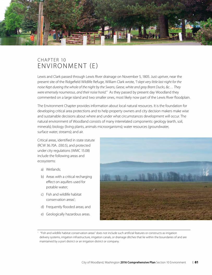
City of Woodland, Washington 2016 Comprehensive Plan Section 10 Environment E- 81
CHAP T ER 10EN V IRO NMEN T (E )Lewis and Clark passed through Lewis River drainage on November 5, 1805. Just upriver, near the present site of the Ridgefield Wildlife Refuge, William Clark wrote, “I slept very little last night for the noise Kept dureing the whole of the night by the Swans, Geese, white and gray Brant Ducks, &c… They were emensely noumerous, and their noise horid.” As they passed by present day Woodland they commented on a large island and two smaller ones, most likely now part of the Lewis River floodplain.
The Environment Chapter provides information about local natural resources. It is the foundation for developing critical area protections and to help property owners and city decision makers make wise and sustainable decisions about where and under what circumstances development will occur. The natural environment of Woodland consists of many interrelated components: geology (earth, soil, minerals); biology (living plants, animals microorganisms); water resources (groundwater, surface water, streams); and air.
Critical areas, identified in state statute (RCW 36.70A. .030.5), and protected under city regulations (WMC 15.08) include the following areas and ecosystems:
a) Wetlands;
b) Areas with a critical recharging effect on aquifers used for potable water;
c) Fish and wildlife habitat conservation areas1;
d) Frequently flooded areas; and
e) Geologically hazardous areas.
1 “Fish and wildlife habitat conservation areas” does not include such artificial features or constructs as irrigation delivery systems, irrigation infrastructure, irrigation canals, or drainage ditches that lie within the boundaries of and are maintained by a port district or an irrigation district or company.
E- 82 City of Woodland, Washington 2016 Comprehensive Plan Section 10 Environment
10.1 E xisting Conditions
Topography and Geology – Some land in the community is not suitable for development because it is too steep or geologically unstable, such as in the northern end of the city. The Woodland area is located in the physiographic province known as the Puget Sound Willamette Valley Trough. The elevation ranges from about 20 feet near the Columbia River to over 1,200 feet in the hills east of town. The north fork of the Lewis River and its tributaries form the primary drainage system in the area and flow west to the Columbia River. Much of the city is located on the former floodplain of the Columbia River and is protected by an extensive diking system. The hills to the north and east are part of the Cowlitz and Hatchet Mountain Formations. They are comprised of marine and non-marine arkosic sandstone, shale, siltstone and coal beds with inner-bedded basalt flows. They also include pyroclastic rocks, andesite and breccia. The soils of the river plain are mostly silt and sand loams.
Surface Water – Rivers and other surface waters are important because they provide habitat for wildlife and marine creatures, because of their scenic value, because they convey storm waters away from the land, and because of the transportation function they played historically and today.
The Lewis River is the primary surface water resource in Woodland. Draining from Mt. Adams and Mt. St. Helens through a series of dams, it runs along the east side of the city. It is the city’s water source via the horizontal collector well, it is used extensively for recreation, it enhances the community, aesthetically, and it provides drainage. Horseshoe Lake was once part of the river, but was sealed off in 1940 when Public Service Highway 1 (now Interstate 5) was constructed. Local streams running through the UGA include Robinson Creek, a tributary of the Lewis River, and Burris Creek, which drains into the Columbia River.
Ground Water – Ground water is replenished from precipitation and surface water filtering through the ground to aquifers. The ground water system is interconnected and pollution in the local area may influence the quality of water used elsewhere. The Critical Areas Ordinance specifies the types of land uses that are acceptable within the aquifer recharge area. All proposed developments in the zone will be required to comply with the Critical Areas Ordinance.
Frequently Flooded Areas – The Federal Emergency Management Agency has defined the extent of the 100-year flood boundary (i.e. areas subject to a one percent or greater chance of flooding in any given year) in order to establish actuarial flood insurance rates and assist communities in efforts to promote sound flood plain management. Development on flood plains retards their ability to absorb water, restricts the flow of water from land areas, and causes hazards downstream. The city has passed a Flood Damage Prevention Ordinance with the purpose of limiting damage to individuals, property, and natural systems. The Flood Insurance Rate Map is located at the city hall annex. Approximately 520 acres of land are below the base flood elevation. The city does not allow any residences in the floodway.
From the 1950’s, to the mid 1990’s flooding was not a major problem in Woodland. However, because of residential development in the East Woodland floodplains and hills surrounding them, the city became concerned that the recent and future development could cause problems. In
City of Woodland, Washington 2016 Comprehensive Plan Section 10 Environment E-83
February 1996, the Lewis River and Robinson Creek overflowed their banks and flooded most of the area east of East Scott Avenue. The city adopted the City of Woodland Comprehensive Flood Hazard and Drainage Management Plan in May 2000.
Wetlands – Wetlands are fragile ecosystems that assist in the reduction of erosion, flooding, and ground and surface water pollution. Other wetland values include scenic and recreational, agricultural, and water supply recharge uses. Wetlands also provide an important habitat for wildlife, plants, and fisheries. The city has wetlands inventory information garnered from the National Wetlands Inventory [NWI] maps. The city and NWI hydric soil maps guide the city in determining where wetlands might exist.
Woodland regulates development in and around wetlands. The city’s wetlands program includes provisions for innovative land use techniques to minimize impacts, acquisition of certain high value wetlands, restoration of degraded wetlands, and public education.
Air Quality – There is limited information available regarding air quality in the Woodland area. This indicates that no chronic problems exist or no events have occurred to warrant investigation by the Southwest Clean Air Agency or the Department of Ecology. There has not been any development in or around the community that causes long-term adverse impacts to the air shed, and we can assume that local residents will continue to enjoy clean air for years to come.
Vegetation and Wildlife – Disturbance of ecological communities and division into isolated habitats are the major cause for the decline in animal and plant species. Conserving viable ecological habitats in an interconnected system is the most effective way of conserving vegetation and wildlife. Many habitats that are conserved for environmental or scenic reasons cannot survive division into small isolated land parcels.
Species of interest that are known to frequent or inhabit the lower Lewis River basin and which the city protects through implementation of the Critical Areas Ordinance are listed in Table 10-1.
Table 10-1. Species of Interest2
Common name Species Status
Bald Eagle Haliaeetus leucocephalus Federal Species of Concern
Coho Salmon Oncorhynchus kisutch Federal Threatened
Chinook Oncorhynchus tshawytscha Federal Threatened
Fall Chinook Salmon Oncorhynchus tshawytscha Federal Threatened
Fall Chum Oncorhynchus keta NA
Dolly Varden/Bull Trout Salvelinus malma N/A
Cutthroat Oncorhynchus clarki Federal Candidate
Steelhead Oncorhynchus mykiss Federal Threatened
Sockeye Salmon Oncorhynchus nerka N/A
2 Source: http://apps.wdfw.wa.gov/phsontheweb/, see also Appendix B, WDFW PHS 2013 Distribution by County
E- 84 City of Woodland, Washington 2016 Comprehensive Plan Section 10 Environment
Fish and Wildlife Habitat Conservation Areas – The city relies on the Washington Department
of Fish and Wildlife classification system for fish and wildlife habitat conservation areas. The city
recognizes that the urban environment is shared with fish and wildlife and that the associated
habitats exist within a regional habitat system. Consequently, the city will coordinate the local
management program with other jurisdictions in the bioregion. The city protects fish and wildlife
areas through application of the Critical Areas Ordinance.
Habitat areas of interest which the city protects through implementation of the Critical Areas
Ordinance are listed in Table 10-2.
Table 10-2. Habitat Areas of Interest
Common Name Priority Area
Oak Woodlands Terrestrial Habitat
Freshwater/Forested Shrub Wetland Aquatic Habitat
Freshwater Emergent Wetland Aquatic Habitat
Waterfowl Concentrations Regular concentrations
Cavity-nesting ducks Breeding area
Open Space
Open spaces perform important functions, such as, buffering different land uses, increasing
property values at the edge of open space, and improving the quality of life in the community.
Open space can include parks, trails, utility corridors, critical areas and their buffers. One mechanism
the city uses to create open space is by application of the Critical Areas Ordinance during the
development review process. The interconnection of open spaces is lacking, especially in East
Woodland. In West Woodland, with its extensive sidewalk system, most people can safely walk to
Horseshoe Lake Park or the Woodland school complex.
10.2 Environmental Regulations
Many local decisions are affected by state and federal environmental regulations. They include:
The federal Clean Water Act of 1972, the federal Water Pollution Control Act of 1972, the
federal Endangered Species Act of 1973, the Washington State Environmental Policy Act (SEPA)
the Washington State Shoreline Management Act (SMA) and the Washington State Growth
Management Act (GMA). The city has adopted development regulations relating to SEPA (WMC
15.04) and the SMA (WMC 15.06). The city’s Critical Areas Ordinance is based on Best Available
Science as required by RCW 36.70A.172. (WMC 15.08)
City of Woodland, Washington 2016 Comprehensive Plan Section 10 Environment E- 85
10.3 Goals and Policies
Goal
E 1 Be an effective steward of the environment, protect critical areas, and conserve land, air, water, cultural, and energy resources.
Policies
E 1.1 Develop critical areas policies and regulations which use the best available science (BAS) to protect the functions and values of critical areas, and give “special consideration” to conservation or protection measures necessary to preserve or enhance anadromous fisheries.
E 1.2 Designate critical areas and the adoption of regulations for the protection of such areas. Critical areas that must be protected include the following areas and ecosystems:
1. Wetlands; 2. Areas of critical recharging effect on aquifers used for potable water;3. Fish and wildlife habitat conservation areas;4. Frequently flooded areas; and 5. Geologically hazardous areas.
E 1.3 Adopt development regulations which limit future development within critical areas and their buffers consistent with the functions and values of those resources.
E 1.4 Ensure development is compatible with other environmental factors, such as ground water, climate, scenic, historic and cultural resources, and wildlife.
E 1.5 Achieve no net loss of wetland values and functions through the development review process and develop programs to increase wetlands functions, values, and acreage in the long-term.
E 1.6 Develop creative mechanisms for protecting critical areas on-site.
E 1.7 Coordinate with other jurisdictions in the region on resource use, protection, and management issues that cross jurisdictional boundaries, such as, stormwater management, water supply, non-point water quality, and shoreline management.
E 1.8 Implement measures designed to improve the water quality of Horseshoe Lake, enhance natural resources and/or encourage preservation in and around the lake area.
E 1.9 Implement measures along the bank of the Lewis River to improve water quality, enhance natural resources, and encourage habitat preservation.
E- 86 City of Woodland, Washington 2016 Comprehensive Plan Section 10 Environment
Shorelands
Goal
E 2 The goals and policies of the city’s shoreline master program approved under RCW 90.58 are elements of the comprehensive plan. See RCW 36.70A.480 and WAC 365-196-580.
Policy
E 2.1 Adopt development regulations which limit future development within shorelines and associated critical areas and their buffers consistent with the functions and values of those resources.
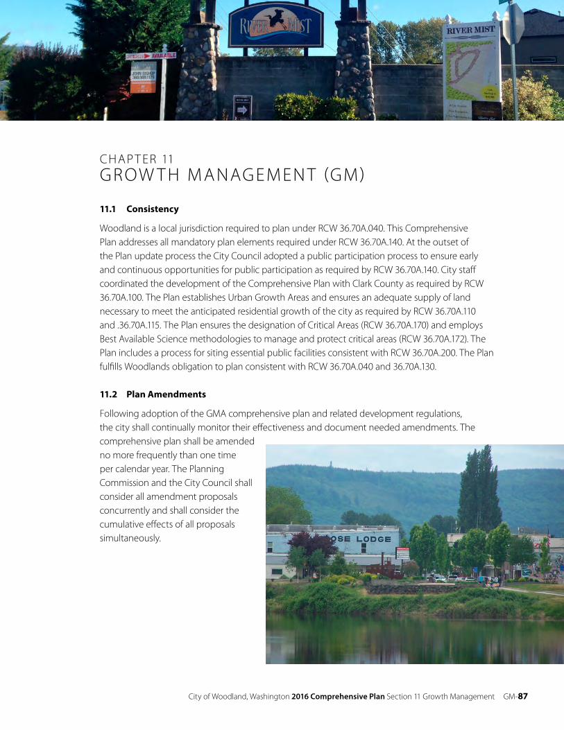
City of Woodland, Washington 2016 Comprehensive Plan Section 11 Growth Management GM- 87
CHAP T ER 11GROW T H M ANAGEMEN T (GM)
11.1 Consistency
Woodland is a local jurisdiction required to plan under RCW 36.70A.040. This Comprehensive Plan addresses all mandatory plan elements required under RCW 36.70A.140. At the outset of the Plan update process the City Council adopted a public participation process to ensure early and continuous opportunities for public participation as required by RCW 36.70A.140. City staff coordinated the development of the Comprehensive Plan with Clark County as required by RCW 36.70A.100. The Plan establishes Urban Growth Areas and ensures an adequate supply of land necessary to meet the anticipated residential growth of the city as required by RCW 36.70A.110 and .36.70A.115. The Plan ensures the designation of Critical Areas (RCW 36.70A.170) and employs Best Available Science methodologies to manage and protect critical areas (RCW 36.70A.172). The Plan includes a process for siting essential public facilities consistent with RCW 36.70A.200. The Plan fulfills Woodlands obligation to plan consistent with RCW 36.70A.040 and 36.70A.130.
11.2 Plan Amendments
Following adoption of the GMA comprehensive plan and related development regulations, the city shall continually monitor their effectiveness and document needed amendments. The comprehensive plan shall be amended no more frequently than one time per calendar year. The Planning Commission and the City Council shall consider all amendment proposals concurrently and shall consider the cumulative effects of all proposals simultaneously.
GM- 88 City of Woodland, Washington 2016 Comprehensive Plan Section 11 Growth Management
The comprehensive plan may be revised or amended outside the annual schedule if the City Council finds the amendment is necessary because of a pending emergency or because of a court order. The city may amend an element of its capital facilities plan annually or in conjunction with a budget amendment.
11.3 Urban Growth Areas
The Urban Growth Area Boundary establishes the geographic boundaries of the Woodland planning jurisdiction. Because the city straddles two counties, it has urban growth areas with Clark and Cowlitz counties. The Urban Growth Area boundary is represented on the Comprehensive Plan Map. The location of the boundary is based on factors, such as, environmental constraints, the concentrations of existing development, the existing infrastructure and services, past urban designations and the location of designated agricultural resource lands.
New development requiring urban services will be located in the Urban Growth Area. Central sewer and water, stormwater facilities, utilities, telecommunication lines, and local roads will be extended to development in these areas and be built to city standards. The city shall not provide urban level services outside of its growth boundary except as provided by state law. The city shall coordinate public services with both Clark and Cowlitz counties, as necessary.
11.4 Essential Public Facilities
Essential public facilities (e.g. airports, state education facilities and state or regional transportation facilities, state and local correctional facilities, solid waste handling facilities and inpatient facilities including substance abuse facilities, mental health facilities, and group homes) as defined by the state Office of Financial Management, shall be allowed in Woodland. Neither the Comprehensive Plan nor the Woodland Municipal Code shall prohibit the siting of essential public services.
When essential public facilities are proposed, the city will appoint an advisory City-Wide Site Evaluation Committee composed of citizen members selected to represent a broad range of interest groups and expertise. The committee, at a minimum, shall include one member with technical expertise relating to the type of facility proposed and two members of the Planning Commission. The committee will develop specific siting criteria for the proposed project and identify, analyze, and rank potential project sites. The committee will establish a reasonable work schedule for completion of this task.
City of Woodland, Washington 2016 Comprehensive Plan Section 11 Growth Management GM- 89
The City-Wide Site Evaluation Committee will at a minimum consider the following:
• E xisting city standards for siting such facilities.
• E xisting public facilities and their effect on the community.
• The relative potential for reshaping the economy, environment, and the community character.
• The location of resource lands or critical areas.
• Essential public facilities should not be located beyond the Urban Growth Area unless they are self-contained and do not require the extension of urban governmental services.
• The city will use timely press releases, newspaper notices, public information meetings, its website, and public hearings to notify citizens in all relevant jurisdictions. The city will notify adjacent jurisdictions of the proposed project and will solicit review and comment on the recommendations of the City-Wide Site Evaluation Committee.
11.5 Goals and Policies
Goal
GM 1 Manage growth so that the delivery of public facilities and services will occur in a fiscally responsible manner to support development and redevelopment in the city.
Policies
GM 1.1 Require development and land use proposals within the Woodland Urban Growth Area to be consistent with the Woodland Comprehensive Plan and applicable elements of the Clark or Cowlitz County Comprehensive Plans.
GM 1.2 Require proposed development within the Urban Growth Area to either annex to the city of Woodland or the county or require applicants to enter into a binding agreement with the city for future annexation.
GM 1.3 Be the only purveyor of sewer and water services within the Urban Growth Boundary.
GM 1.4 Require development within the Urban Growth Area to connect to the city sewer and water systems unless connection is not possible. When connection is not possible the applicant must enter into a binding agreement with the city for future connection and annexation.
GM 1.5 Prohibit extension of city sewer and water services beyond the Woodland Urban Growth Boundary unless it is necessary to meet a demonstrated public health or safety issue.
GM 1.6 Design sewage collection and water distribution systems within the Urban Growth Area to serve the anticipated future growth.
GM 1.7 Require a development to extend sewer and water lines in the Urban Growth Area when necessary.
GM 1.8 Apply city standards to all street/road development within the Urban Growth Area.
GM 1.9 Apply city standards to drainage facility development within the Urban Growth Area.
GM-90 City of Woodland, Washington 2016 Comprehensive Plan Section 11 Growth Management
GM 1.10 Apply city standards to all sewer or water system development.
GM 1.11 Allow annexations to the city which meet the city’s development objectives and form logical extensions of city boundaries.
Goal
GM 2 Ensure coordinated planning and decision-making among general and special purpose governments with respect to urban services, development, and other appropriate programs and activities in the Woodland area.
Policies
GM 2.1 Coordinate urban service planning, such as for sewer, water, roads, and parks, in and immediately adjacent to the Urban Growth Area among all affected jurisdictions.
GM 2.2 Coordinate long-range comprehensive planning and decision-making on current land use proposals within and immediately adjacent to the Urban Growth Area among all affected jurisdictions, including Clark and Cowlitz counties
GM 2.3 Cooperate with applicable federal, state, and local environmental agencies in the review and approval of development proposals within the adopted Urban Growth Area.
City of Woodland, Washington 2016 Comprehensive Plan Appendices 91
VO LUME I IAPPEND I CE S
Appendix A Public Participation Plan
Purpose
The Washington State Growth Management Act (GMA) requires cities and counties to conduct outreach to ensure “early and continuous public participation” in developing and amending comprehensive plans and development regulations (RCW 36.70A.140). The GMA also requires that local programs clearly identify schedules and procedures for public participation in the periodic update process (RCW 36.70.A.130(2)(a)). The purpose of this Public Participation Plan (PPP) is to ensure compliance with the statute by identifying the scope of proposed activity and potential timeframes for participation and decision making.
Goals
1. Ensure broad participation by identifying key interest groups and soliciting input from the public.
2. Maintain effective communication and coordination.
3. Focus resources on issues most likely to be of interest to the public.
4. Distribute information and public notices early and efficiently.
Scope of Work
The Scope of Work is segregated into three phases:
Phase I: Review Comprehensive Plan and Development Code for compliance with state law; identify plan areas to be amended; scope the breadth of the update publicly.
Phase II: Address the issues identified in Phase I.
Phase III: Conduct public hearings and take legislative action.
92 City of Woodland, Washington 2016 Comprehensive Plan Appendices
Phase I
• Conduct a thorough review of GMA requirements and compilation of amendments since the 2007 update, using the GMA Periodic Update Checklist and other resources.
• Review the Comprehensive Plan and development regulations to determine whether revisions will be required to ensure consistency with GMA amendments.
• Re-asses the vision expressed in the Comprehensive Plan; has it changed?
• Analyze the Urban Growth Area (UGAs) to ensure it is sized to accommodate 20 years of population and employment growth, based on the adopted Office of Financial Management (OFM) range.
• Identify corrective actions, if necessary, such as, altering the size of the UGA or changing the allowed uses and densities or planning assumptions.
• Inventory and assess Capital Facilities necessary to implement the 20-year plan.
• Provide a status report to the public, the Planning Commission and the City Council.
Phase II
• Adopt an ordinance or resolution stating that the City has reviewed its Comprehensive Plan, consistent with RCW 36.70A.130, and finds that no amendments are necessary or some amendments are required.
• Propose updates and amendments to the Comprehensive Plan through public work sessions and hearings before the Planning Commission and City Council.
• Conduct SEPA review in conjunction with Clark County.
Phase III
• Planning Commission will conduct public hearings on the proposed Comprehensive Plan amendments and will forward a recommendation to the City Council.
• The City will provide the Department of Commerce with notice and text of the proposed amendments at least 60 days prior to final adoption.
• The City Council will conduct separate public hearings on the proposed amendments and will take legislative action.
• Forward adopted amendments to the Department of Commerce and Clark County.
City of Woodland, Washington 2016 Comprehensive Plan Appendices 93
Public Participation Program Structure
Techniques and Strategies
The public participation methods employed may include:
• Use innovative technologies whenever possible, such as, posting meeting notices online, interactive surveys, and links to informative programming.
• Provide public notices and information releases through print, posting, mail and email. Publicize through community channels such as schools, social clubs, and local websites as well. Post all hearing notices and materials on the City’s website.
• Maintain an email distribution list and database to disseminate public information and notices of meetings.
• Identify and reach out to stakeholders, such as, the school district, neighborhood associations, business groups, and civic organizations.
• Conduct public workshops, public meetings, and open houses at times convenient to the public and at locations that are accessible. Workshops and/or listening posts may involve presentations by staff and consultants, question and answer sessions or interactive activities.
• Use informal gatherings and planned community events to solicit public feedback on City planning efforts, such as, Hot Summer Nights, Planters Days, club meetings, and similar opportunities.
• Depending upon the scope of the update, consider the creation of technical advisory groups composed of persons with specific technical expertise to assist the staff, consultants, and Planning Commission.
Preliminary Schedule
• Phase I: March 2014 – Fall 2014
− Establish preliminary scope of work and public participation plan and adopt same; select population and employment targets; assess regional growth trends; inventory and assess capital facilities; inventory vacant and buildable lands; assess existing Comprehensive Plan and Development Code for compliance with GMA; Council to adopt resolution stating GMA review has occurred.
• Phase II: January 2015 – December 2015
− Accelerate public outreach on plan vision and policies; evaluate UGA and planning assumptions; initiate revisions to plan policies and make recommendations for changes to the development regulations, if necessary; develop revised plan that incorporates community vision, planning assumptions, and plan policies; communicate and coordinate with County and State agencies regarding SEPA and proposed plan amendments.
• Phase III: January 2016 – February 2016
− Conduct public hearings before the Planning Commission; send notice to Commerce of proposed amendments 60 days prior to adoption; City Council to conduct public hearings and take legislative action; notify Commerce of final action.
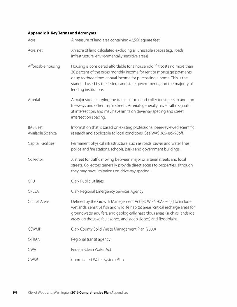
94 City of Woodland, Washington 2016 Comprehensive Plan Appendices
Appendix B Key Terms and Acronyms
Acre A measure of land area containing 43,560 square feet
Acre, net An acre of land calculated excluding all unusable spaces (e.g., roads, infrastructure, environmentally sensitive areas)
Affordable housing Housing is considered affordable for a household if it costs no more than 30 percent of the gross monthly income for rent or mortgage payments or up to three times annual income for purchasing a home. This is the standard used by the federal and state governments, and the majority of lending institutions.
Arterial A major street carrying the traffic of local and collector streets to and from freeways and other major streets. Arterials generally have traffic signals at intersection, and may have limits on driveway spacing and street intersection spacing.
BAS BestAvailable Science
Information that is based on existing professional peer-reviewed scientificresearch and applicable to local conditions. See WAS 365-195-90off.
Capital Facilities Permanent physical infrastructure, such as roads, sewer and water lines, police and fire stations, schools, parks and government buildings.
Collector A street for traffic moving between major or arterial streets and local streets. Collectors generally provide direct access to properties, although they may have limitations on driveway spacing.
CPU Clark Public Utilities
CRESA Clark Regional Emergency Services Agency
Critical Areas Defined by the Growth Management Act (RCW 36.70A.030[5] to include wetlands, sensitive fish and wildlife habitat areas, critical recharge areas for groundwater aquifers, and geologically hazardous areas (such as landslide areas, earthquake fault zones, and steep slopes) and floodplains.
CSWMP Clark County Solid Waste Management Plan (2000)
C-TRAN Regional transit agency
CWA Federal Clean Water Act
CWSP Coordinated Water System Plan
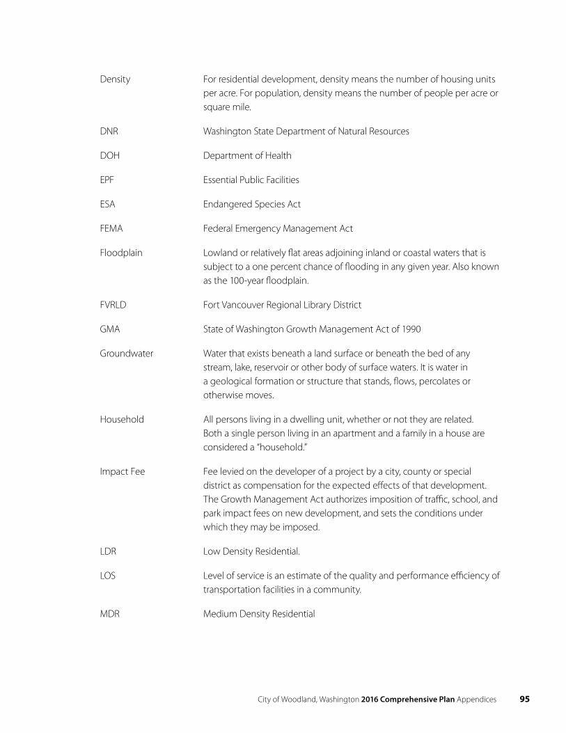
City of Woodland, Washington 2016 Comprehensive Plan Appendices 95
Density For residential development, density means the number of housing units per acre. For population, density means the number of people per acre or square mile.
DNR Washington State Department of Natural Resources
DOH Department of Health
EPF Essential Public Facilities
ESA Endangered Species Act
FEMA Federal Emergency Management Act
Floodplain Lowland or relatively flat areas adjoining inland or coastal waters that is subject to a one percent chance of flooding in any given year. Also known as the 100-year floodplain.
FVRLD Fort Vancouver Regional Library District
GMA State of Washington Growth Management Act of 1990
Groundwater Water that exists beneath a land surface or beneath the bed of any stream, lake, reservoir or other body of surface waters. It is water in a geological formation or structure that stands, flows, percolates or otherwise moves.
Household All persons living in a dwelling unit, whether or not they are related. Both a single person living in an apartment and a family in a house are considered a “household.”
Impact Fee Fee levied on the developer of a project by a city, county or special district as compensation for the expected effects of that development. The Growth Management Act authorizes imposition of traffic, school, and park impact fees on new development, and sets the conditions under which they may be imposed.
LDR Low Density Residential.
LOS Level of service is an estimate of the quality and performance efficiency of transportation facilities in a community.
MDR Medium Density Residential
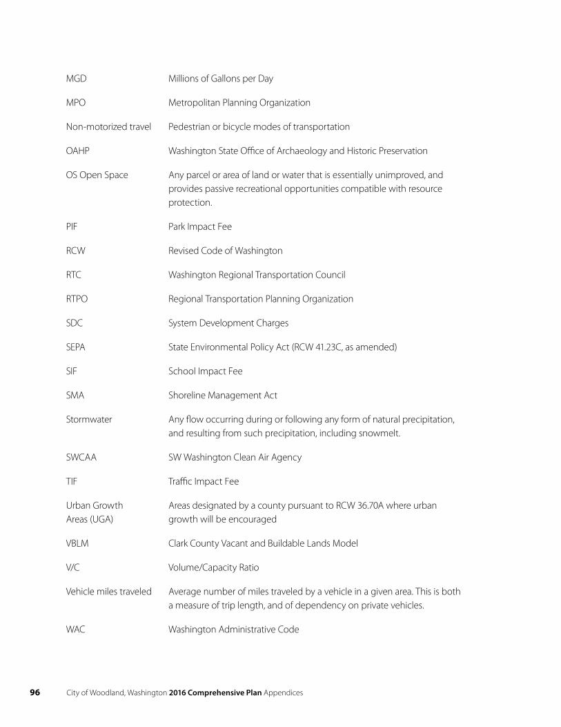
96 City of Woodland, Washington 2016 Comprehensive Plan Appendices
MGD Millions of Gallons per Day
MPO Metropolitan Planning Organization
Non-motorized travel Pedestrian or bicycle modes of transportation
OAHP Washington State Office of Archaeology and Historic Preservation
OS Open Space Any parcel or area of land or water that is essentially unimproved, and provides passive recreational opportunities compatible with resource protection.
PIF Park Impact Fee
RCW Revised Code of Washington
RTC Washington Regional Transportation Council
RTPO Regional Transportation Planning Organization
SDC System Development Charges
SEPA State Environmental Policy Act (RCW 41.23C, as amended)
SIF School Impact Fee
SMA Shoreline Management Act
Stormwater Any flow occurring during or following any form of natural precipitation, and resulting from such precipitation, including snowmelt.
SWCAA SW Washington Clean Air Agency
TIF Traffic Impact Fee
Urban GrowthAreas (UGA)
Areas designated by a county pursuant to RCW 36.70A where urbangrowth will be encouraged
VBLM Clark County Vacant and Buildable Lands Model
V/C Volume/Capacity Ratio
Vehicle miles traveled Average number of miles traveled by a vehicle in a given area. This is both a measure of trip length, and of dependency on private vehicles.
WAC Washington Administrative Code
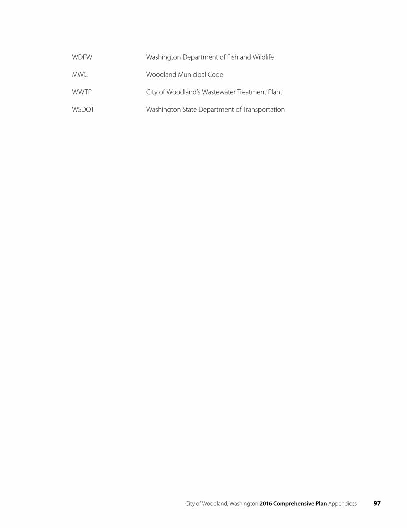
City of Woodland, Washington 2016 Comprehensive Plan Appendices 97
WDFW Washington Department of Fish and Wildlife
MWC Woodland Municipal Code
WWTP City of Woodland’s Wastewater Treatment Plant
WSDOT Washington State Department of Transportation
City of Woodland, Washington 2016 Comprehensive Plan