Embed Size (px)
Citation preview

73
Photography in Historical Archaeology
STANLEY
PHOTOGRAPHY AND STRATIGRAPHY For the archaeologist to go into the field
without cameras and the ability to use them to record in black and white and in color the data the site has to reveal is as unthinkable as his approaching a site with- out a theoretical background or without a shovel and trowel. Yet, there are archaeo- logists who treat the camera only as an incidental tool with which snapshots can be taken during the course of excavation, much as one might do on a Sunday after- noon outing. Since excavation is such a destructive process, destroying in its wake each stratigraphic page as it is revealed, it certainly behooves the archaeologist to obtain the most complete record possible of these historical pages as they are sys- tematically laid bare and then erased through the process of archaeology. Yet, we see excavation reports revealing only what the site looked like after excavation was complete; with little record of the pages forever lost that were ripped from context as archaeology took its toll of the stratigraphic text. The responsibility of the archaeologist in recording this story as he destroys the record cannot be overempha- sized; too much film can hardly be expos- ed in making a record of the data-revealing features and layers forming the evidence for the story the archaeologist is trying to reveal, record, analyze and interpret as it occurred on the site being studied.
This major emphasis that this writer feels should be placed on photography as a data collecting tool could be countered with the argument that the archaeologist’s drawings and measurements of his site plan and the various significant profiles adequately record for posterity the strati- graphic record he has destroyed. However,
A. SOUTH
when profile drawings are compared with photographs of the same profile, it be- comes obviously clear that the photo- graphic record is primary data whereas the drawings represent data of a second- ary nature. Drawings are in this regard somewhat more flexible in that interpre- tive comments can be added clarifying stratigraphic relationships; however, this can also be done by photographic means both in the field and in the use of inter- pretive overlays in archaeological reports. The point here is that archaeological re- ports should contain not only data draw- ings of the archaeological pages revealed through excavation, but should also in- clude the primary data record in the form of photographs. Drawings and photo- graphs used together form a basic archaeo- logical record.
The position has been raised that a photograph of a stratigraphic profile which reveals trowel and shovel marks and their shadows, shadows of brick and rubble in layers, etc., is a more inferior record than that provided by the archaeologist’s drawing of the same pro- file. And this, of course, is true, and illus- trates the close relationship between the use of the camera as a data collecting tool and the technique practiced by the archaeologist; for to properly record by means of the camera the stratigraphic layering the archaeologist sees in his pro- file, the profile must be as cleanly cut and free of irregularities as possible, and where shadows obscure or distort the evi- dence, then the archaeologist must wait for a cloud to allow shadowless photo- graphs to be taken (this writer has often waited days to allow for proper lighting conditions to prevail) ; and finally the pro-

74 HISTORICAL ARCHAEOLOGT 1968
file must be gently dampened by a fine mist spray to compensate for the drying of the upper layers that usually occurs during the process of excavation, allowing for a uniform presentation of the strati- graphic relationships as they exist in ma- trix within the ground. Of course one does not take a photograph of a carelessly cleaned area casting long shadows from cross-lighting; to what end would such a photograph be taken in the first place? Thus it becomes clear that to use the camera as a basic data collecting tool the greatest amount of care must be taken in preparing the area that is to be photo- graphed so as to reveal the story; first to the archaeologist so he can make his drawings with the greatest accuracy, and secondly, while he has the area thus clean- ed, to record it with the camera.
In this regard this writer has found that there is within our field of historical archaeology a reluctance on the part of some archaeological practitioners to see the necessity for such an emphasis on neat- ness and care in the cleaning and record- ing of archaeological data through photo- graphy. The view as expressed to this writer by more than one archaeologist is that the process of cleaning an area for photography is too expensive and needless- ly slows down the excavation of the site. The question is asked as to whether the resulting photographs are worth all this extra time and effort. The question is also asked as to whether the neatness emph- asis is not just a fetish of the archaeolog- ist designed to give an impression of com- petence in good technique through photo- graphs. In answer to these charges against the “neatness addicts” this writer must point out this procedure of emphasizing neatness and clean-cut layers and profiles is not done only to reved a pretty looking picture; rather this process is executed as a standard technique designed to best reveal the plan and stratigraphy of arch- aeological sites for recording by the arch- aeologist, whether he use drawings alone or combines photography with these in his data collecting process. It is true that some additional care in cleaning is neces- sary in preparing an area for photography, but the additional expense is well justified in the resulting primary data photographs. As routine procedure cleaning is carried out, revealing the delicate as well as the
obvious soil differences to the view of the archaeologist for his “reading,” why should he not then photograph this data as it lies exposed? To argue that careful cleaning is unnesessary or too costly for taking of photographs is an invalid argu- ment, for the cleaning is not done for the photography; it is done to reveal the stratigraphy or feature, and the camera is then only used to make a permanent primary record of what it is that the archaeologist has revealed through his standard procedure of removing the layers of the site. Many features such as post- holes in red subsoil backfilled with red sub- soil, or a red subsoil covered by a once- displaced red subsoil layer is a difficult situation to read properly until carefully cleaned and mist-sprayed to reveal the subtle differences that exist between the layers. Again, the amount of extra pre- paration for photographically revealing the data is well worth the effort. If an archaeologist does not frequently utilize photography to record the evidence he is revealing on the excuse that cleaning for photography takes much time, then I would suggest that his technique is ques- tionable in terms of his seeing the data that is there to be revealed, for cleaning is not done for photography, but for gat- hering all the data that the site has to of- fer, and with only a little more work an area can be cleaned for photographic re- cording.
With these points in mind it becomes obvious that the archaeologist must be able to operate the camera, just as he must master the use of the transit before he goes into the field. This paper is not de- signed to go into the various details of photographic aids that might be utilized to advantage by the archaeologist. How- ever, a 4 x 5 inch studio type camera with all the adjustments for lens and film plane in order to bring into sharp focus any pro- file taken from almost any angle, is con- sidered a necessity. The standard speed graphic is not flexible enough for all archaeological needs. Along with this camera the archaeologist should have a 35”. single-lens reflex camera for mak- ing color slides; and if duplicates are an- ticipated, it is best to shoot a number of originals in the field for this purpose than to order duplicates made from an original; it is cheaper, and the quality of the slides

PHOTOGRAPHT 75
is much superior. F l a s h attachments should be in the field close at hand, and if power is available floodlights also. Movies too, are an excellent means of recording not only archaeological data, but are of particular value in recording the archaeo- logical process itself for use in interpretive museum programs telling the story of archaeology in relation to the development of an historic site.
In the foregoing section emphasis has been placed on the use of the camera as a data collecting tool for the field archaeo- logist. This was done due to the fact that the field data collecting process revolves around the basic archaeological concept of stratigraphy, whether in plan or profile, vertical or horizontal, and photographs al- low the archaeologist to record this data as it is revealed; allows him to destroy the site and have it too.
PHOTOGRAPHY AND TYPOLOGY Another basic archaeological tool is
typology, dealing with the evolutionary de- velopment of forms in time and space, and this is intimately related to the concept of stratigraphy through the recovery of arti- fact forms in stratigraphic context, typo- logy is a laboratory and analytical pro- cedure with roots in the layers of the archaeological site. Photography plays a role here also in allowing for the visual recording of the forms as revealed through relationships on the site, as well as in mak- ing comparisons with similar forms from other sites. As standard procedure the his- torical archaeologist makes a photographic record of the artifacts recovered from his sites and files these with pertinent con- textual data so that excavated artifacts can be recalled by form and context from the files and study and analysis under- taken toward the understanding of the de- velopment of these in time and space, the basic typological approach.
The photographs taken in this phase of the archaeological process are usually furnished with a standard scale somewhere in the picture. A one-inch grid on the back- ground glass has been found to be an ef- fective means of establishing scale for these file-record photographs. For illustra- tions in published papers it is often not necessary to indicate scale, a more effec- tive and meaningful presentation being ac- complished through an arrangement of
objects with a pleasing yet unobtrusive background. Unless there is a need for em- phasis on scale, there is usually no point in indicating scale in illustrative photographs demonstrating the relationship between artifact forms. In illustrating objects with three dimensional forms such as ceramic bowls, a scale when reduced to the flat plane of a photographic page, has little meaning or usefulness.
For recording close-up detail of artifact types, yet allowing for the greatest depth of field, the single-lens reflex camera with a telephoto lens is the answer. Extension rings and bellows are useful, but result in an extremely shallow depth of field which can be overcome by using the telephoto lens for close-up photographs.
PHOTOGRAPHY AND TOPOGRAPHY Another area in which the historical
archaeologist finds photography a useful tool is in the study of the topography of the site. British archaeologists have long utilized aerial photographs to locate topo- graphical features, and in certain situa- tions this technique is used on American sites in order to locate historic archaeo- logical features. In several instances this writer has located cellars and wells on the evidence provided by the greener grass growing above such features. Another use of aerial photographs in the background research for the location of historical sites that has proved most effective for this writer has been the correlation of property lines seen on the photograph as the edge of fields and woods, with deed records and land grants. An example of this was seen when an attempt was made to locate the site of Fort Dobbs, a small fort of 1756 to 1764 located near the town of Statesville, North Carolina. A 1761 deed record de- scribed a one mile square tract beginning a t a point near the forks of Fourth Creek, and established the fact that Fort Dobbs was located near the southwest corner of this tract. This deed was describing a tract that was originally granted to John Ed- wards from Lord Granville dated March 5, 1752. Thus the exact positioning of this tract on the present topography of the area near the forks of Fourth Creek was significant, for to do so would allow Fort Dobbs to be relatively pinpointed. The deed

76 HISTORICAL ARCHAEOLOGY 1968
records ended with this 1761 deed, so a genealogical development of the tract could not be pursued from deed to deed, and an attempt to work back from the pre- sent deed records also ended in failure. However, the location of the original 1752 surveyed tract was exactly located by ex- amination of the aerial photograph of the area which revealed property lines that had been the same since the original 1752 survey, and could be seen in tree-lines and field and fence lines present today. By us- ing a clear plastic overlay over the photo- graph the position of the tract in question was clearly shown in the background re- search report on Fort Dobbs. This cor- relation was made in April, 1967, and dur- ing the summer of 1968 an archaeological examination of the suspected area of the location of Fort Dobbs was undertaken, and as a result the moat around the fort was located, and plans are now underway to completely excavate and rebuild Fort Dobbs.
A similar correlation was made between deed records and an aerial photograph in the study of the stockaded home of Wil- liam Brice known as Fort Brice which was a place of refuge in 1711 for the citizens of New Bern, North Carolina. Through this technique a three-acre tract on which the fort stood was pinpointed and placed in position on the aerial photograph us- ing the overlay technique. Through this means, then, the historical archaeologist is able to utilize photography in the loca- tion of historical tracts and features that might otherwise remain unknown through the absence of documentation. Such an approach might not always prove fruitful, but it is certainly a possibility that should not be overlooked in the examination of the documents and correlating these with the topography of an historical site.
Aerial photography is also of value in recording excavations covering broad areas, like an entire town site such as the eighteenth-century Moravian settlement of Bethabara. By using the aerial photo- graph of the excavated ruins and compar- ing this with the eighteenth-century map of the town, a most effective correlation can be seen. On such large sites it is the on- ly way that effective photography can be done covering the entire site. By flying low over the ruins and shooting straight down the archaeologist has a view of in-
dividual ruins that are most valuable in recording visually the evidence he has un- covered. Here again, he should always take both black and white and color photo- graphs.
PHOTOGRAPHY IN RESTORATION ARCHAEULOGY
Needless to say, photography is a valu- able aid in the examination and recording of data revealed in a standing house of historic interest that is scheduled for re- storation. Historical archaeologists are in- creasingly called on to conduct excavations adjacent to and inside standing buildings, and they often find themselves recording evidence as to old doorways, windows, walks, chimneys, etc. revealed not only in the earth, but in the walls of the structure they are studying in relation to their below ground excavations. Thus it becomes dif- ficult to say just where the archaeological and the architectural phases of the study divide. A study in restoration archaeology, therefore, would necessarily involve con- siderable photography in order to most graphically illustrate the differences be- tween brick courses, plaster layers, floor levels, etc., and it is inconveivable that such a study could be carried out properly without the considerable aid of the camera in recording for the architect and the archaeologist the data the house has to reveal. In this respect interpretive signs can often be extremely useful in pointing out the periods involved in certain archi- tectural features, at least to the extent of pointing out which century certain features were added to the original ones. This can be done with small lettering sets of the same type used in placing the site name and/or number, photo number, feature number, and date on the photo identifica- tion board placed in each photographed area. Needless to say, when such inter- pretive data is placed in the photograph one should be quite sure of their accuracy before placing them there, for if they are not proved to be accurate, the photograph is useless. It would be wise, therefore, when using such interpretive labels on stratigraphic 1 a y e r s in archaeological sites, to take one negative without any in- terpretive statement attached to the pro- file as standard procedure in order to obtain a primary data record.

PI i04OGRAPHT 77
Another phase of photography in resto- ration archaeology is the use of old photo- graphs as an interpretive aid in the study of structures that are no longer standing. The historical archaeologist frequently finds himself called on to excavate the ruin of a structure that was standing un- til a few years ago, and for which a num- ber of photographs may be in existence. These then constitute a reference for the archaeologist, and he may find himself counting brick courses seen in the photo- graph, and scaling the photograph to de- termine its relationship with the ruin he is examining in order to effect a more per- fect correlation and interpretation of the structure as it once was.
GOALS-TECHNIQUE A point should be made here relative
to the relationship between archaeology done as an aid to the restoration of a standing structure, and that carried out on a structure that is in ruins. It should be emphasized that stratigraphic and typological studies can still be made at the site of standing structures, for garbage was often thrown out the b a c k door throughout the entire period of a stand- ing structure, resulting in a fine deposit of stratigraphic pages for the archaeologist to leaf through. A destroyed structure also leaves its stratigraphic pages, so I do not think we can separate these types of sites and state that one is by nature more productive than the other. Our concern with stratigraphy and typology should remain consistent as basic to the archaeo- logical approach. The fact that the re- sult of our digging reveals an entire foun- dation wall in one case, and only a strati- graphic picture against a standing founda- ation wall in another should not cause us to value one type of site as being “better” or more productive than the other. This point is made because the position has sometimes been taken that excavation in connection with architectural structures is somehow less valid than that taken in or- der to determine something of value in terms of stratigraphy and typology in re- lation to changing forms through time, and I cannot see that this view is neces- sarily valid. I will s u r e l y agree that archaeology undertaken on an historic ruin with only the goal of revealing the extent of the foundation wall is a bastard-
iza tion of the archaeological approach, for if this is the only goal, then anyone can follow a wall (provided it is solid masonry and not just a trace where a wall once was). The archaeologist should apply himself to excavating those ruins on which he can utilize the archaeological process, which, by definition, involves the study of stratigraphic data with the view of deter- mining something of the development of the site from the context of the artifacts recovered, and from the archaeologist’s knowledge of changing forms through time, as determined through typological and historical data. In short, then, the archaeologist is constantly interpreting his site based on his available information as to the evolution of various f o r m s through time, and at the same time he is refining this knowledge relative to these changes in forms through association of artifact forms within known stratigraphic context within each site; the archaeologist applies his knowledge to the interpretation of the site, a constant two-way feed-back process.
One may ask how this relates to use of photography in recording data on historic sites? It relates in that wall-following as a goal is not archaeology, and the photo- graphic recording of a foundation wall af- ter excavation is not nearly as important archaeologically as the photographs taken of the stratigraphic relationship that ex- isted in the layers adjacent to the foun- dation wall which were destroyed in the process of revealing the foundation wall. The wall will be there for some time after t h e archaeologist is through with his work, in most cases, but the stratigraphic record of the layering, the construction ditch outline, the midden deposit beside the back door, the fill layer over the floor, the burned charcoal layer of the house, the association of the wine bottles dividers, razors and teacups found lying together on the floor will never be the same again, and if they were not recorded photograph- ically as well as graphically, then the ex- cavator has not fulfilled his responsibility to his archaeological profession and to the site he is examining. Why do these rela- tionships assume such importance? Not merely because once they are moved they are no longer in their original context, though this is important, but because these features and artifacts in their rela-

78 HISTORICAL ARCHAEOLOG'Y 1968
tionship with each other, reveal in some cases specific historical data, and in other a more general understanding of the cul- ture represented by the particular ruin under study. Interpretations based on archaeological excavation can only be as valid as the degree to which the strati- graphic and typological data was con- trolled through careful, methodical, con- trolled, systematic field technique designed to reveal and record the stratigraphy and features, allowing the archaeologist to typologically analyze and interpret the historical documentation. It behooves the archaeologist, therefore, to make it his business to carefully reveal the archaeo- logical record, and to abundantly record it not only through drawings, b u t photo- graphs as well.
PHOTOGRAPHY IN RECORDING THE ARCHAEOLOGICAL PROCESS
AS AN HISTORICAL DOCUMENT From the moment the archaeologist sets
foot on a site he has a responsibility to record the process he brings with him and with which he examines the historic ruins he finds. This includes various views of the areas to be excavated before any cleaning and archaeology has begun, as well as a complete record of the various process utilized by him in the excava- tion of the site. If machines are used, these should be photographed a t work, if large crews are used, these should be re- corded as they work, if only one laborer is used he should be s h o w n as he goes through the various stages of archaeology with the archaeologist. This might seem to be an unnecessary use of film, but the archaeologist is going through a process in the development of the historic site which forms a transition between the oc- cupants who once made the site their home or work area, and the time when the site is interpreted to the public through exhibits and/or reports. The archaeolo- gist is engaged in an historical process and his report becomes an historical docu- ment, and he should keep this in mind, and make sure that this process of which he is a part is adequately recorded.
Photographs before, during, and after excavation should be taken, in order to show the developing process as excava- tion is carried out. Any techniques for revealing and recording should be photo-
graphed such as mapping, sifting, trowel- ing, shoveling, etc., in order that a record of these activities survives. Photographs should also be taken with the view of us- ing them in public relations, for newspa- per articles, magazine articles, etc., and these should reveal the archaeologist, a visitor to the site, or a dignitary, to provide human interest. A profile or plan view of a ruin is not likely to be published by a newspaper or magazine without the added element of human interest.
If a museum is planned for the site, or interpretive exhibits likely to be utilized in telling the story the site has to offer, then photographs for these should be tak- en as the archaeological process is carried out; for later the archaeologist will be called on to furnish photographs of what he did there to the exhibit's designer who is planning the interpretive museum story. In short, the camera is again seen as a primary tool for the archaeologist, and one which should always be close at hand throughout the study, and development, and interpretation of an historic site.
The following photographs and accom- panying comments are presented in order to illustrate some of the points made in this paper relative to the significant role the camera plays in the recording of archaeological d at a specifically, a n d throughout the process of historical ar- chaeology generally. The illustrated steps will be familiar to most historical archaeol- ogists, no doubt, and are not presented as anything new by any means, for the cam- era is generally considered a basic data collecting tool. The attempt here has been to point out some of the ways in which the camera is being used in histori- cal archaeology, and some of the problems involved. The avoidance of the technical aspects of photography is intentional, for each archaeologist has his own pet ap- proach to the handling of photographic equipment.
A detailed paper can easily be written on each phase of photography as utilized in historical archaeology. Of particular in- terest would be a careful study of the ef- fect of various filters on recording of stratigraphic layers seen in profiles. I have avoided using filters to emphasize certain colored layers over others as being a means of distortion of data: for instance

PHOIOGRAPHT 79
orthochromatic film will render all orange to red layers much darker than panchro- matic film; and the same effect can be achieved by using various filters. Perhaps, however, in certain instances, it would be good to have this freedom for the visual separation of stratigraphic layers is often so slight that the camera film does not make a distinction whereas the eye of the archaeologist could see a difference.
In this regard I should mention the dis- tinction I make between what I consider primary photographic data, and sec~ndary photographic data. If panchromatic film is used (providing the truest rendering in tones of gray of the various colored layers of the earth), and the area to be photo- graphed has been cleanly troweled a n d then mist-sprayed (revealing a palisade ditch with postmolds, for instance) and this area is then photographed, I consider this as a primary data photograph. As is sometimes the case the difference in the soil discoloration as seen by the archaeolo- gist is slight, then a second photograph is then taken, but only after the tip of the trowel has been used to outline the fea- tures seen by the eye of the archaeologist (the edge of the ditch and the postmolds) . This photograph is considered to be a s8c- ondary data photograph, for what is being shown is the archaeologist’s trowel mark, and not a true line as revealed, (though his line would directly correspond with what he saw). In the case of a very long ditch, a hundred feet or so long, such as a palisade ditch outline, even this tech- nique will not show the far line of the ditch even from the top of the tall step- ladder or telephone line repairman’s hy- draulic bucket. In this case another sec-
ondary or tertiary technique can be uti- lized to allow the ditch to show in the photograph, and this is to fasten nails along the edge of the ditch outline as each point along each curve, and a white string stretched along these nails throughout the length of the ditch, thus revealing its posi- tion on the ground. It is emphasized that this technique should not be used except in those situations where a primary data photograph is thought not able to reveal the entire feature as is desired. Another type of photographic data is the photo- graph of the excavated palisade ditch, re- vealing the archaeologist’s work in re- moving the fill soil from the ditch. This type of tertiary data record is also useful and should be recorded.
Secondary and tertiary data photo- graphs are good for illustrated slide pro- grams where the audience cannot always determine exactly what the archaeologist is trying to point out in tern of a soil difference. A slide of the primary data photograph can be shown, followed by a secondary data slide, and the audience in- variably will respond with sounds of rec- ognition, illustrating that the brown stain in the picture that to the archaeologist appears as an obvious palisade ditch, does not appear so obvious to the layman. How- ever, the archaeologist should not utilize secondary data photographs in the presen- tation of his archaeological report if he can avoid it, but must strive to obtain the best possible primary photographic rec- ord of the sometimes elusive stains and specks representing activity by men in other times; for these ephemeral clues con- stitute basic data of archaeology.
80 HISTORICAL ARCHAEOLOG7 1968
PLATE 1
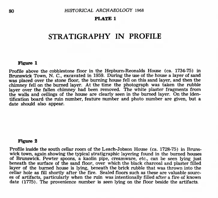
STRATIGRAPHY I N PROFILE
ng-ure 1 Profile above the cobblestone floor in the Hepburn-Reonalds House (ca. 1734-75) in Brunswick Town, N. C., excavated in 1959. During the use of the house a layer of sand was placed over the stone floor, the burning house fell on this sand layer, and then the chimney fell on the burned layer. At the time the photograph was taken the rubble layer over the fallen chimney had been removed. The white plaster fragments from the walls and ceilings of the house are clearly seen in the burned layer. On the iden- tification board the ruin number, feature number and photo number are given, but a date should also appear.
Figolle 2
Profile inside the south cellar room of the Leach-Jobson House (ca. 1728-75) in Bruns- wick town, again showing the typical stratigraphic layering found in the burned houses of Brunswick. Pewter spoons, a kaolin pipe, creamware, etc., can be seen lying just beneath the surface of the sand floor, over which the black charcoal and plaster filled layer of the burned house is lying, beneath the brick rubble that was thrown into the cellar hole as fill shortly after the fire. Sealed floors such as these are valuable sourc- es of artifacts, particularly when the ruin was intentionally filled after a fire of known date (1775). The provenience number is seen lying on the floor beside the artifacts.

PHOTOGRAPH'Y 81
PLATE 1
Figure 1
Figure 2

82 HISTORICAL ARCHAEOLOGT 1968
Figure 3 (Top) PLATE 1 Figure 4 (Bottom)

PHOTOGRAPHY 83
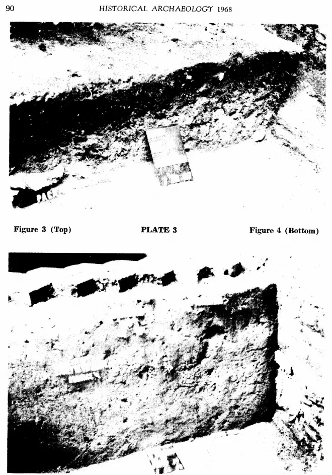
Figure 3 Cellar of the dependency for the pottery shop (ca. 1756-71) at Bethabara, N. C., prior to excavation of the remaining section. The first test section was excavated and wat- er was found to stand in the bottom half. After waiting most of the summer for the water level to drop, a drain was installed from the outside, tunneling beneath the cel- lar wall. This drained the cellar and allowed the remaining half to be excavated.
Figum 4
Profile of the area used by Gottfried Aust, the Bethabara potter, as a kiln waster dump, between 1763 and 1771. The black ash and charcoal layer near the bottom was from cleaning out the firebox of a kiln; containing many types of kiln furniture and waster vessels. The sharply tilting stratigraphic layers above this early deposit also contained waster materials and kiln furniture of a later time. The standard procedure of excavating by depositional layers allows deposits such as this to be removed in meaningful contextual units. Water continuously flowed from the bottom area of the subsoil bank at the left, making frequent pumping and bailing a necessity.

84 HISTORICAL ARCHAEOLOGY 1968
PLATE 2
STRATIGRAPHY IN PROFILE
Flgure1 Deposit of kiln waster sherds lying in a pit beside the pottery shop at Bethabara (1755-1771). When artifacts can be photographed in place with a profile remaining intact above them such as is seen here, the relationship of the objects to the layer in which they are found can be better demonstrated than if the entire area is cleaned of all overburden of soil before the photograph is taken. In close-up photographs the identification number, date, etc., is made with small letters and numbers and is placed so that it can be cropped out of the picture when it is printed. The most effective means of taking close-up photographs and still showing the provenience number is to place the number only on the profile or floor where it will show, but will not be overly obtrusive into the photograph. Notice the soil crumb lying in the plate; a distracting element once it is brought to the attention. Fortunately this was seen at the time and an additional photograph without the crumb was taken.
Figure 2
Profile inside the tunnel at Russellborough (1752-1776) a t Brunswick, showing the position of the artifacts as they were found at this point. Throughout the length of the tunnel the bottom layer revealed a similar pipcture. Although the archaeologist be digging in a well OP a tunnel, he can still obtain photographs to record his strati- graphic evidence.

PHOTOGRAPHY 85
PLATE 2
Figure 1

86 HISTORICAL ARCHAEOLOGY 1968
PLATE 2
Figure 3
Figure 4

PHOSOGRAPHT 87
Figure 3 George Demmy cleaning the kiln waster dump at the Christ - Krause pottery shop (1786 - ca. 1802) in Bethabara. The deposit here lay a t a depth of three feet, but as excavation continued, following this stratigraphic layer, twenty feet away it lay be- neath eight feet of eroded hillside. It is advantageous when stratigraphy can be shown photographically as a deposit in plan with a vertical profile over it as seen here. An intrusive ditch (beneath George’s foot) crossed the square at this point, thus remov- ing the deposit of kiln waster sherds in that area.
Figure 4 The same deposit in a different square revealing the wet mucky conditions under which the archaeologist had to work, making removal of the kiln waster materials nec- essary as excavation proceeded; however, once the area was cleaned to the profile rap- id bailing was carried out in order to take the photographs seen here before the area became flooded again.

88 HISTORICAL ARCHAEOLOGT 1968
PLATE 3
STRATIGRAPHY IN PROFILE
l%P= 1 The construction ditch profile a t the Leach-Jobson House (ca. 1728-75) ; a valuable repository of artifacts that would date prior to the construction of the house, which was standing in 1728. Sand such as this presents a particular problem in that it dries rapidly, thus preventing the exposure of large horizontal areas for photographing, for in an area of a ten foot square the mist spray dries on one side of the square before it can be applied to the other. Cloudy and moist days are best f o r photographing such horizontal areas to reveal postholes, ditches, etc.
Figure 2
Stratigraphic profile against the stone and brick porch support footing at the Espy Ruin in Brunswick, (ca. 1731-1775) revealing the old humus layer which was the top of the ground at the time the house was built, and the layers of fill applied soon after in order to level the yard and bury the stone footing for the porch support. The ob- jects found in this stratigraphic layer are of particular interest since they would date from around 1731 when the Espy house was built.

PHOTOGRAPHY 89
Figure 1
c
Figure 2
PLATE 3
90 HISTORICAL ARCHAEOLOGY 1968
Figure 3 (Top) PLATE 3 Figure 4 (Bottom)

PHOTOGRAPH?’ 91
Figure 3 Profile against the east wing of the Paca House in Annapolis, Maryland showing the gray wood-ash layer lying on the subsoil, containing oyster shells and ceramics from the 1760-70 period, allowing for the association of this midden with William Paca, builder of the house in 1763. Sometimes interpretive labels such as those used here can be used to advantage, but accuracy should be well established before these are used. The fact that the subsoil clay here was scorched indicates that hot ashes from the hearths were thrown here soon after the occupation of the house.
mgure4 Profile against the west hyphen of the Paca House illustrating what sometimes hap- pens in photographs; the film just does not pick up the distinctions the archaeologist saw. The color slides of this same profile show the layering much better; as does a “secondary data” photograph which shows the lines scratched by the archaeologist in order to visually record the layers. Perhaps here a filter could have been used to ad- vantage. Needless to say, the profile drawing here would be more meaningful in a report than this photograph. However, by using the stratigraphic layer letters against the profile as was done here, a quick reference to the text and drawings is made avail- able. This is a case where a “secondary data” photograph would be more meaning- ful in the report.
SUMMARY
In Plates 1 through 3 stratigraphic profiles have been selected from various sites ex- cavated over a period of ten years, revealing some of the types of stratigraphy encoun- tered by the historical archaeologist. As can be seen in these plates, historic sites pre- sent a stratigraphic picture that is neither shallow nor thoroughly mixed; on the contrary, they are often deeply stratified, with time-capsule layers sealed in context, presenting a most interesting challenge for the historical archaeologist.

92 HISTORICAL ARCHAEOLOGY 1968
PLATE 4
STRATIGRAPHY- ARTIFACTS I N CONTEXT
Figure 1 In order to visually record a stratigraphic layer containing large numbers of arti- facts the entire layer is often exposed revealing the artifacts lying in place as they were found. This view of the kiln waster dump layer from the Christ-Krause Pottery Shop in Bethabara illustrates this standard procedure, and reveals the advantage of photography in visually recording the deposit as opposed to a drawing of the layer. The exposure of this layer was carried out by Glenn Little under adverse conditions, since constant pumping had to be maintained in order to keep the area dry. The ar- chaeologist worked while lying on his stomach on a board suspended by ropes from the surface eight feet above the waster dump level.
Figure 2
A view of a kiln waster deposit in a pit extending beneath the stone wall of the 1797 addition to the Salem pottery shop in Old Salem. In photographs such as this the relationship between the stone wall and the stratigraphic layers above it can be seen, as well as the relationship between the artifact loaded feature and the wall, and to the chimney of the 1842 addition to the Fifth House to the right. Photographs showing these relationships are more valuable in this respect than that seen in the lower right taken of the same deposit wherein only the relationship between the feature and the stone wall are seen. Both types of photograph, therefore, should be taken in order to fully record the data.

PHOTOGRAPHY 93
PLATE 4
Figure 2

94 HISTORICAL ARCHAEOLOGY 1968
PLATE 4
Figure 3
4

PHO‘TOGRAPHT 95
Figure 3
Close-up of the same kiln waster deposit at Old Salem revealed by Gamy Stone, il- lustrating the advantage of such photographs for showing detailed objects such as sagger fragments, pugging coil fragments, and a fragment of rouletted “fine pottery” in the uuper left corner. Each type of photograph of the same deposit reveals par- ticular features of value in recording and interpretation of the site, emphasizing the need for taking many photographs from various angles and varying degrees of close- ness in order to properly record the situation as it is seen in context.
Figure 4
Medium-Close-up view of the kiln waster dump pit at the pottery shop at Salem show- ing fragments in the pit beneath the 1797 wall, as well as fragments of saggers, crown trivets, and twisted handles of the “fine pottery” which was being made by Rudolph Christ from the 1770’s to the 19th century, and which has been found to so closely resemble some of the ware being made in English potteries. The provenience number S49-19R indicates Lot 49 in Salem, area 19, and level R; pinpointing the provenience of the material in context.

96 HISTORICAL ARCHAEOLOGY 1968
PLATE 5
STRATIGRAPHY -ARTIFACTS I N CONTEXT
Figure 1 A group of artifacts lying in situ on the floor of the south room of the Leach-Jobson House ruin in Brunswick Town. The edge of a brick partition wall can be seen to the left, and the black shadow at the top was cast by the profile of the square, illus- trating the fact that sunlight that is often excellent for lighting horizontally cleaned strata, is not desirable for illustrating profiles a t the same time; thus a second photo- graph was needed to completely record this data, and to establish the relationship of this floor level with the stratigraphy of the site. Sometimes drawings must be called on to properly orient the viewer to the relationship of a photographically recorded layer to the site.
Figure 2
The association of objects in context is revealed in this view of a green glazed mug lying in situ beside a fragment of the polychrome slipware typical of the ware of Ru- dolph Christ, as revealed in his waster dump at Bethabara. Such close-up photographs are quite valuable in terms of process, for illustrating both the various stages of the archaeological process, and for showing the objects as they were found in the earth; for now these objects have both been completely restored and are on exhibit in a museum; and this photograph illustrates a step in the process of transferring such artifacts from their archaeological context through restoration, and study, to their final resting place in the museum exhibit. Photographing the objects after they are re- stored is only the final photograph in a long series of photographs that should have been taken as the objects make their way from the earth to the archives.

PHOTOGRAPHY 97
. - .I
Figure 1 (Top) PLATE 5 Figure 2 (Bottom)

98 HISTORICAL ARCHAEOLOGY 1968
Figure 3 (Top) PLATE 5 Figure 4 (Bottom)

PHOTOGRAPHY 99 Figure 3
A flintlock pistol revealed by George Demmy a t the ruin of the mansion of Russell- borough a t Brunswick Town, showing its matrix of white plaster from the walls and ceilings, and the relationship of this layer to the brick floor beneath. It would have been easy enough to pick up the pistol and all the parts without taking this photo- graph, but an important step in the archaeological process as well as the in situ rela- tionship of the various parts of the pistol itself, would have been lost.
Figure 4
Wine bottles with the seal of William Dry “Cape Fear 1766”, a pair of brass dividers, a group of straight razors, and a whole teacup were found lying together on the floor of Russellborough, and illustrate the association of these objects. Also found in the matrix around this deposit were other artifacts, and cabinet hinges, indicating that these were likely stored in a common cabinet before the fire of 1776 destroyed the structure, effectively sealing in strata, the record.
100 HISTORICAL ARCHAEOLOG'Y 1968
PLATE 6
ARCHAEOLOGY IN PLAN-
ARCHITECTURAL FEATURES
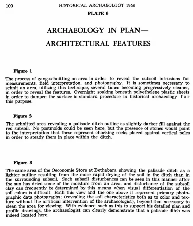
Figure 1 The process of gang-schnitting an area in order to reveal the subsoil intrusions for measurements, field interpretation, and photography. It is sometimes necessary to schnit an area, utilizing this technique, several times becoming progressively cleaner, in order to reveal the features. Overnight soaking beneath polyethelene plastic sheets in order to dampen the surface is standard procedure in historical archaeology f o r this purpose.
Figure! 2 The schnitted area revealing a palisade ditch outline as slightly darker fill against the red subsoil. No postmolds could be seen here, but the presence of stones would point to the interpretation that these represent chocking rocks placed against vertical poles in order to steady them in place within the ditch.
Figure 3 The same area of the Oeconomie Store at Bethabara showing the palisade ditch as a lighter outline resulting from the more rapid drying of the soil in the ditch than in the surrounding subsoil. Such subsoil disturbances can be seen in this manner after the sun has dried some of the moisture from an area, and disturbance of the subsoil clay can frequently be determined by this means when visual differentiation of the soil colors is difficult. Both this view and the one above it represent primary photo- graphic data photographs; (revealing the soil characteristics both as to color and tex- ture without the artificial intervention of the archaeologist), beyond that necessary to clean the area for viewing. With evidence such as this to support his detailed plan and profile drawings, the archaeologist can clearly demonstrate that a palisade ditch was indeed located here.

PHOTOGRAPHY 101
Figure 1
PLATE 6
Figure 2 Figure 3

102 HISTORICAL ARCHAEOLOGY 1968
Figure 4 (Top) PLATE 6 Figure 5 (Bottom)

PHOTOGRAPHY 103 Figure 4
A primary photographic data type picture showing palisade postmold impressions against the background of the ditch fill, which in turn is seen against the subsoil clay background. As is revealed here, the difference between the soil colors is so slight as to make the discovery and following of such clues difficult; and requires the standard schnitting and re-schnitting process to allow for photography. The ditch was dug in 1756 and the posts were removed in 1763, resulting in few instances where the post- molds could be discerned.
Figure 5
The same section of palisade ditch from a different view, showing the effects of outlining by the tip of the trowel. This type photograph, is a secondary type of evidence, but is sometimes done in order to emphasize features, but should not by any means replace the primary photograph, but only used in conjunction with it. A tertiary photograph- ic data picture of this same feature would show it after the archaeologist had com- pletely excavated it. Again tertiary data photos are of value, but should by no means replace the primary 6ata views, for it is the primary data shots that can most effec- tively be used as evidence for the existence of a feature such as this.
104 HISTORICAL ARCHAEOLOGY 1968
PLATE 7
ARCHAEOLOGY IN PLAN-
ARCHITECTURAL FEATURES
Figure 1
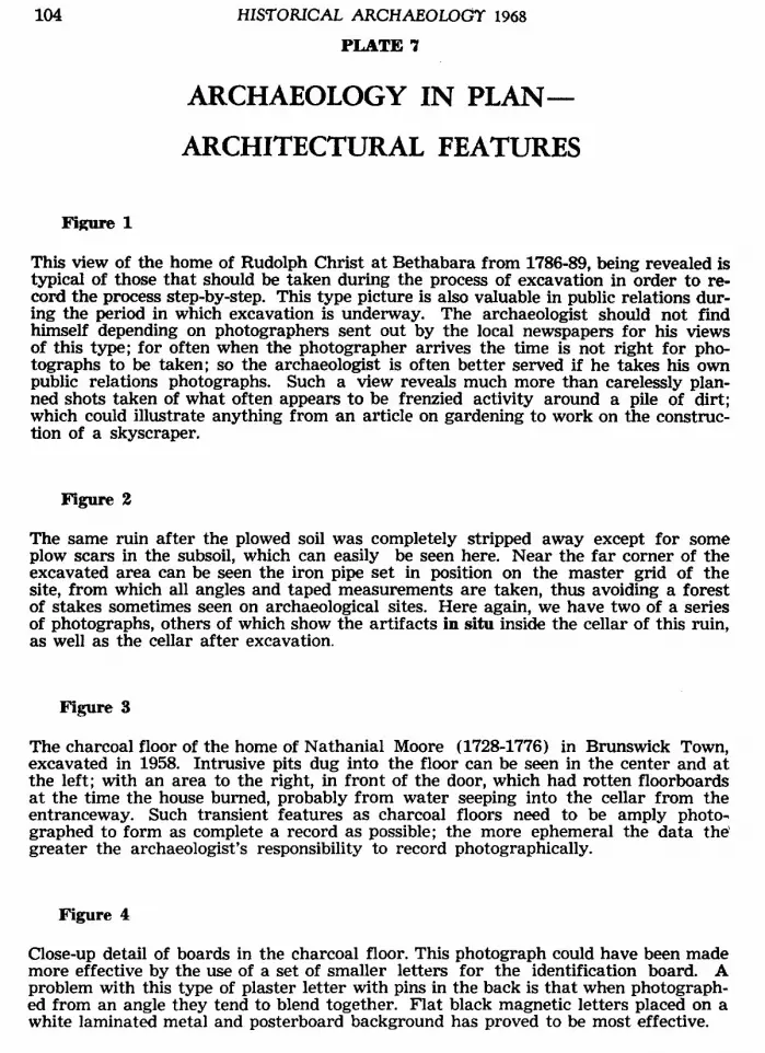
This view of the home of Rudolph Christ a t Bethabara from 1786-89, being revealed is typical of those that should be taken during the process of excavation in order to re- cord the process step-by-step. This type picture is also valuable in public relations dur- ing the period in which excavation is underway. The archaeologist should not find himself depending on photographers sent out by the local newspapers for his views of this type; for often when the photographer arrives the time is not right for pho- tographs to be taken; so the archaeologist is often better served if he takes his own public relations photographs. Such a view reveals much more than carelessly plan- ned shots taken of what often appears to be frenzied activity around a pile of dirt; which could illustrate anything from an article on gardening to work on the construc- tion of a skyscraper.
The same ruin after the plowed soil was completely stripped away except for some plow scars in the subsoil, which can easily be seen here. Near the far corner of the excavated area can be seen the iron pipe set in position on the master grid of the site, from which all angles and taped measurements are taken, thus avoiding a forest of stakes sometimes seen on archaeological sites. Here again, we have two of a series of photographs, others of which show the artifacts in situ inside the cellar of this ruin, as well as the cellar after excavation.
Figure 3
The charcoal floor of the home of Nathanial Moore (1728-1776) in Brunswick Town, excavated in 1958. Intrusive pits dug into the floor can be seen in the center and at the left; with an area to the right, in front of the door, which had rotten floorboards at the time the house burned, probably from water seeping into the cellar from the entranceway. Such transient features as charcoal floors need to be amply photo- graphed to form as complete a record as possible; the more ephemeral the data the' greater the archaeologist's responsibility to record photographically.
Figure 4
Close-up detail of boards in the charcoal floor. This photograph could have been made more effective by the use of a set of smaller letters for the identification board. A problem with this type of plaster letter with pins in the back is that when photograph- ed from an angle they tend to blend together. Flat black magnetic letters placed on a white laminated metal and posterboard background has proved to be most effective.

PHOTOGRAPHT 105
PLATE 7
Figure 1
Figure 4
Figure 3

106 HISTORICAL ARCHAEOLOGY 1968
PLATE 8
TYPOLOGY -
PHOTOGRAPHY IN THE LABORATORY
Figure 1 In order to form a permanent record of each artifact recovered from the ground the historical archaeologist must record thousands of items, and the most effective way of doing this is to use the camera to identify each fragment, which is then placed on a data card for instant recall whenever needed for analysis. These record photographs are not designed for publication purposes, but to provide a permanent record of each object, along with its provenience data and the archaeologist’s verbal description and comment. Publication photographs are of a different type, and serve a different pur- pose. The one-inch grid background provides a convenient scale, and the complete catalog number for each object is included in the photograph. The 4 x 5 inch camera is used for these data photographs, and when prints are made each object is cut apart from the others and mounted on an individual artifact card. Since each object will be cut apart from the others it does not matter that some of the escutcheon plates shown here are upside down to the others, though if each were oriented the same, the pho- tograph could possibly have been used in a report if necessary.
Figure 2
In order to show detail the artifact file photos can be taken larger than normal size such as was done here to show the detail on these small padlocks.
Figure 3 Two-tined forks, the only type yet found at Brunswick Town, are shown here in this artifact file photo. Combination iron and bone, and other combination material arti- facts sometimes present difficulty in lighting, due to the different reflective surfaces. The ideal background for such photographs is usually white, but in some instances a slight gray tone can hardly be avoided. If standard photographic procedure is fol- lowed in the laboratory a greater uniformity in results can be obtained. For this reason a standard photographic set-up should be established.
Figure 4
In some cases many objects can be shown in one photograph, but this usually results in loss of detail, as is seen here in this view of Brunswick Town buckles and frag- ments. Another problem illustrated here is the fact that in order to best reveal detail it is often necessary to use a cross-light on the subject, yet, if this cross-light is at too low an angle it will result in a loss of reflection from the surface of the artifact producing a black appearing object, showing no surface detail a t all, just the opposite of what was intended by using a cross-light. Therefore, care should be taken not to attempt to illustrate too many small objects in one plate, or to place the cross-light too low.

PHOTOGRAPHY 107
Figure 1
PLATE 8
Figure 3 Fimre 4

10s HISTORICAL ARCHAEOLOGT 1968
PLATE 9
TYPOLOGY -ARCHAEOLOGICAL ANALYSIS
AND INTERPRETATION
Figure 1
Typological analysis for the purpose of learning something of the evolutionary devel- opment of forms in time and space is basic to the archaeological process. Photograph- ic comparison of artifact forms is a standard means of illustrating the similarity be- tween forms in time and space in archaeological reports. One photograph, such as that shown here will instantly allow the viewer to make his own comparison as to the similarity in form between the earliest type of Leeds redware with cream-colored ter- minal spriggs shown on the left, with that made by Rudolph Christ at Salem between 1773 and 7797, (recovered from the kiln waster deposit found on the Fifth House lot in Salem in August, 1968). Leeds mug photographed by Brad Rausehenberg of Old Sa- lem, Inc. through the courtesy of the M. Mellanay Delhom Collection in the Mint Mu- seum of Art, Charlotte, North Carolina.
Figure 2 An example of how photography can aid toward a more effective interpretation of archaeological data. The apothecary jar made by Gottfried Aust and recovered from excavations a t Bethabara along with medicine bottles and a glass tumbler, have been used to illustrate the report on the excavation of the 1759 Doctor’s Laboratory and the Apothecary Shop built in 1763. Used in this manner the objects stimulate the imagination in a manner not possible with straightforward scaled photographs of artifacts. Such photographs are ideal in helping to interpret a mood and feeling for an era to the public through archaeology.
Figure 3
An excavated candlestick and pipe from Bethabara are used here to help relay pho- tographically something of the feeling for the culture, and the mood of the activities of the people whose life-patterns are reflected in the artifacts recovered by the ar- chaeologist. Such photographs are a visual aid to accompany the dialogue of the archaeologist as he attempts to relay to others some of the understanding he has been able to arrive at through the careful, systematic process of historical archaeology, combining the historical record and his search through the pages of the earth.

PHOTOGRAPHY
PLATE 9
109
Figure 1
Figure 2
Figure 3

110 HISTORICAL ARCHAEOLOGY 1968
PLATE 10
TOPOGRAPHY -AERIAL PHOTOGRAPHY
m g m 1 The aerial photograph of a section of Iredell County, North Carolina, showing the tract of 640 acres granted to John Edwards by Lord John Granville in 1752. Note the property lines still visible as a result of the continuous use of the original lines in la- ter transfer of property. As a result of this topographical correlation, the site “where- on Fort Dobbs now stands” was correlated with the traditional site, and excavation in the summer of 1968 revealed the moat around the fort site. Through such topo- graphical correlation with land grants and deed records, the historical archaeologist is considerably aided in his search to pinpoint elusive historic sites.
Figure 2
Aerial photography can also be used to advantage to show excavation in progress, and to reveal an overall view of large historic sites. In this view of Bethabara the exca- vated and stabilized cellar holes can be seen in relation to the palisade fence replaced in the original ditch and to other, modern features of the site, such as the interpretive trails built for use of visitors. This photograph presents a striking comparison with the 1760 and the 1766 maps of Bethabara.

PHOlOCRAPHT 111
PLATE 10
Figure 1

1l2 zirsromu ARCHAEOLOGY 19611
PLATE 11
PHOTOGRAPHY
IN RESTORATION ARCHAEOLOGY
Figure 1 In archaeology in and around standing buildings the historical archaeologist finds him- self workiig with the above-ground architectural features to a greater degree than is possible with architectural ruins. This view of the details inside a corner of a hearth is typical of the type of interpretation that presents itself, and for which photography becomes a vital aid. Although the various changes in this hearth will be recorded through drawings, the photograph clearly shows the nineteenth century strengthening of the chimney and narrowing of the width of the hearth in comparison to the origi- nal eighteenth century hearth. The twentieth century firebrick hearth, already par- tially removed when this photograph was taken, is also shown. Such photographs are of value in making a record of the situation as it was before restoration was under- taken, and throughout restoration such photos should accompany the work to record the process.
Figure 2
Here the archaeologist cut through later floors and floor joists (showing circular saw marks)to reveal the stone foundation wall and original sill seat on which a fragment of rotten sill was still lying in place. Here small adhesive backed letters proved effec- tive fastened to a photographic film holder slide as a photo identification board..
Figure 3 Typical restoration archaeology type photograph showing the interior of a kitchen to the left, with the original exterior wall in the center, with the original exterior of the kitchen to the right (now inside a twentieth century bay). Here wood floors were removed to reveal a brick floor, beneath which an inlet for a drain through the wall was found, which was an original feature of the 1763 kitchen wing here at the Paca House. This home of William Paca is now being restored by Historic Annapolis, Inc., with archaeology carried out through Contract Archaeology, Inc. The exterior fea- ture of the drain can be seen on the right side of the wing wall, where interpretive signs were used to aid in the visual interpretation of the feature.
Figure 4 A close-up of the drain construction on the exterior wall of the house during excava- tion, with interpretive labels in place. Note how in this detailed photograph details of construction are revealed that could not be seen from the photo taken directly above the feature, illustrating again the necessity for taking many photographs to adequate- ly record data in restoration archaeology as well as in other historical archaeology.

PHOTOGRAPHT 113
PLATE 11
Figure 1
Figure 2
Figure 3 Figure 4


