Embed Size (px)
Citation preview
* Correspondence to: T.Northern Illinois Universit
Copyright © 2014 John
Archaeological ProspectionArchaeol. Prospect. (2014)Published online in Wiley Online Library(wileyonlinelibrary.com) DOI: 10.1002/arp.1476
Prospecting for New Questions: IntegratingGeophysics to Define AnthropologicalResearch Objectives and Inform ExcavationStrategies at Monumental Sites
TIMOTHY HORSLEY1*, ALICE WRIGHT2 AND CASEY BARRIER2
1 Horsley Archaeological Prospection, LLC; Department of Anthropology, Northern Illinois University,DeKalb, IL 60115, USA2 Museum of Anthropology, University of Michigan, Ann Arbor, MI 48109, USA
ABSTRACT Geophysical data have the potential to sign
ificantly contribute to archaeological research projects when effectively in-tegrated with more traditional methods. Although pre-existing archaeological questions about a site may be answeredusing geophysical methods, beginning an investigation with an extensive geophysical survey can assist in understand-ing the function and archaeological potential of a site, and may even transform preconceptions about the type andspatial organisation of features that are present. In this way, these prospection tools not only accurately locate andmap features to allow recovery of cultural material for identification and dating, we argue that they can go much further,allowing us to prospect for new and appropriate archaeological and anthropological research questions. Such anapproach is best realised when geophysical and traditional archaeologists work together to define new objectivesand strategies to address them, and by maintaining this collaboration to allow continual feedback between geophys-ical and archaeological data. A flexible research design is therefore essential in order to allow the methodologies toadapt to the site, the results, and the questions being posed. This methodology is demonstrated through two casestudies from mound sites in southeast USA: the transitional Mississippian Washausen site in Illinois; and the MiddleWoodland Garden Creek site in North Carolina. In both cases, integrating geophysical methods throughout the archae-ological investigations has resulted in multiple phases of generating and addressing new research objectives. Althoughclearly beneficial at these two mound sites in southeast USA, this interdisciplinary approach has obvious implicationswell beyond these temporal and geographical areas. Copyright © 2014 John Wiley & Sons, Ltd.Key words: Geophysics; integrated survey; mound; southeast USA; Middle Woodland; Mississippian
Introduction
Geophysical methods have become a common part ofthe archaeologist’s toolkit in southeastern North Amer-ica, where they are increasingly utilised to explore largesites and landscapes (e.g. Kvamme, 2003; Peterson,2007; Horsley and Wall, 2009, 2010; Thompson andPluckhahn, 2010, 2012; Burks and Cook, 2011; Butleret al., 2011). Often, however, these non-invasivemethods have been used more narrowly, to locatespecific buried features for targeting in subsequent exca-vations. This is especially true in commercial applications
Horsley, Department of Anthropology,y, USA. E-mail: [email protected]
Wiley & Sons, Ltd.
that require the production of maps of anomalies worthmore invasive testing.Although very effective in these situations, we
illustrate that geophysics can be deployed to betteradvantage in research contexts. (This paper focuses onresearch-driven projects, but our approach—and geo-physical surveys in general—is also amenable to com-mercial contexts: e.g. Johnson and Haley, 2006;Lockhart and Green, 2006). In the mid-1990s, Boucher(1996) argued that geophysical methods were not usedto their full potential. Citing examples from the UK, hedetermined that this resulted from poor communicationbetween geophysicists and archaeologists. Nearly twodecades on, this issue is still commonplace in manyregions, but recent calls for the use of non-invasivemethods ‘beyond mere prospection’ (Conyers andLeckebusch, 2010) and for ‘inquiry-based geophysics’
Received 11 September 2013Accepted 1 January 2014
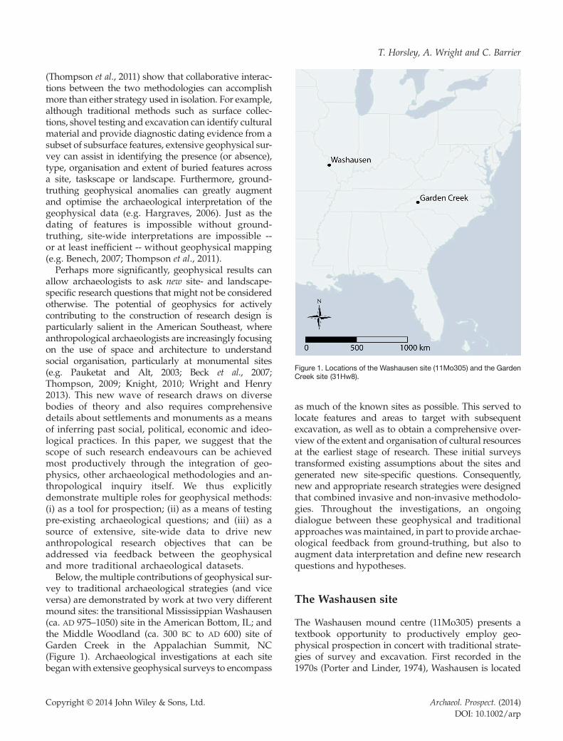
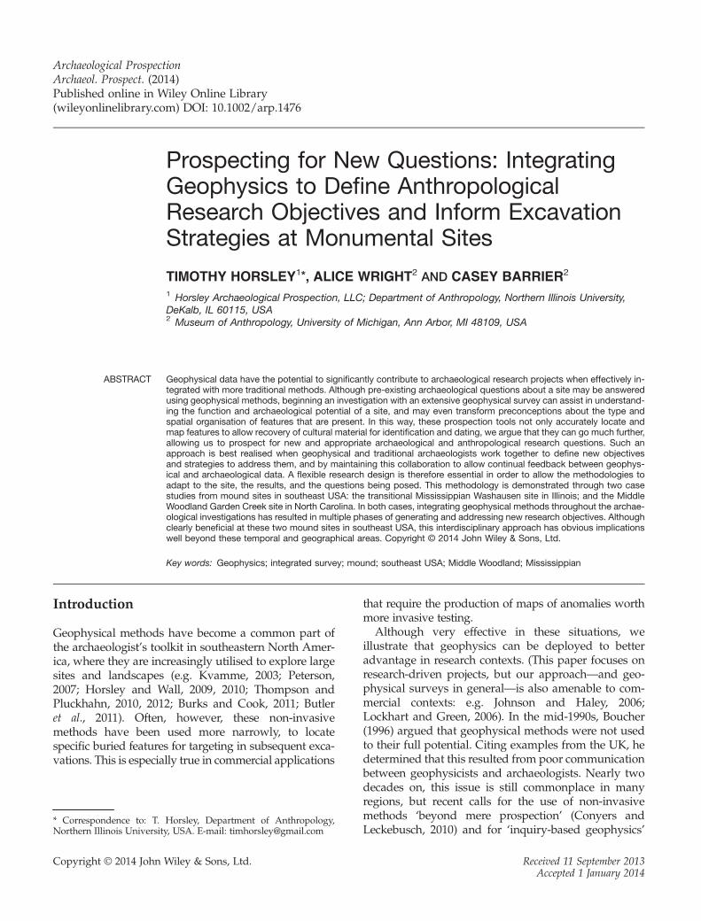
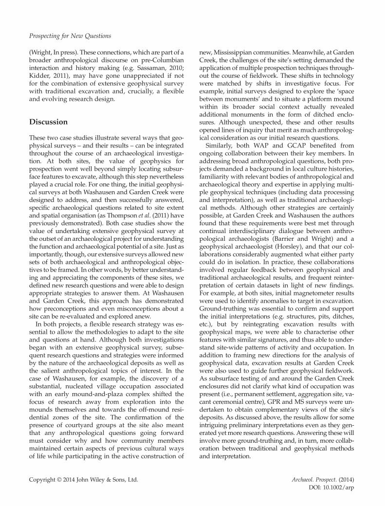
Figure 1. Locations of the Washausen site (11Mo305) and the GardenCreek site (31Hw8).
T. Horsley, A. Wright and C. Barrier
(Thompson et al., 2011) show that collaborative interac-tions between the two methodologies can accomplishmore than either strategy used in isolation. For example,although traditional methods such as surface collec-tions, shovel testing and excavation can identify culturalmaterial and provide diagnostic dating evidence from asubset of subsurface features, extensive geophysical sur-vey can assist in identifying the presence (or absence),type, organisation and extent of buried features acrossa site, taskscape or landscape. Furthermore, ground-truthing geophysical anomalies can greatly augmentand optimise the archaeological interpretation of thegeophysical data (e.g. Hargraves, 2006). Just as thedating of features is impossible without ground-truthing, site-wide interpretations are impossible --or at least inefficient -- without geophysical mapping(e.g. Benech, 2007; Thompson et al., 2011).Perhaps more significantly, geophysical results can
allow archaeologists to ask new site- and landscape-specific research questions that might not be consideredotherwise. The potential of geophysics for activelycontributing to the construction of research design isparticularly salient in the American Southeast, whereanthropological archaeologists are increasingly focusingon the use of space and architecture to understandsocial organisation, particularly at monumental sites(e.g. Pauketat and Alt, 2003; Beck et al., 2007;Thompson, 2009; Knight, 2010; Wright and Henry2013). This new wave of research draws on diversebodies of theory and also requires comprehensivedetails about settlements and monuments as a meansof inferring past social, political, economic and ideo-logical practices. In this paper, we suggest that thescope of such research endeavours can be achievedmost productively through the integration of geo-physics, other archaeological methodologies and an-thropological inquiry itself. We thus explicitlydemonstrate multiple roles for geophysical methods:(i) as a tool for prospection; (ii) as a means of testingpre-existing archaeological questions; and (iii) as asource of extensive, site-wide data to drive newanthropological research objectives that can beaddressed via feedback between the geophysicaland more traditional archaeological datasets.Below, the multiple contributions of geophysical sur-
vey to traditional archaeological strategies (and viceversa) are demonstrated by work at two very differentmound sites: the transitional Mississippian Washausen(ca. AD 975–1050) site in the American Bottom, IL; andthe Middle Woodland (ca. 300 BC to AD 600) site ofGarden Creek in the Appalachian Summit, NC(Figure 1). Archaeological investigations at each sitebeganwith extensive geophysical surveys to encompass
Copyright © 2014 John Wiley & Sons, Ltd.
as much of the known sites as possible. This served tolocate features and areas to target with subsequentexcavation, as well as to obtain a comprehensive over-view of the extent and organisation of cultural resourcesat the earliest stage of research. These initial surveystransformed existing assumptions about the sites andgenerated new site-specific questions. Consequently,new and appropriate research strategies were designedthat combined invasive and non-invasive methodolo-gies. Throughout the investigations, an ongoingdialogue between these geophysical and traditionalapproaches was maintained, in part to provide archae-ological feedback from ground-truthing, but also toaugment data interpretation and define new researchquestions and hypotheses.
The Washausen site
The Washausen mound centre (11Mo305) presents atextbook opportunity to productively employ geo-physical prospection in concert with traditional strate-gies of survey and excavation. First recorded in the1970s (Porter and Linder, 1974), Washausen is located
Archaeol. Prospect. (2014)DOI: 10.1002/arp
Prospecting for New Questions
in the Mississippi River floodplain region of theAmerican Bottom in west-central Illinois, approxi-mately 38 km south of the famous Mississippian centreof Cahokia. Unlike Cahokia, which underwent a largeurban expansion and several phases of indigenous set-tlement reorganisation over a few centuries (Pauketat,2004; Kelly and Brown, In press), Washausen was a rel-atively short-term occupation, essentially a ‘singlecomponent’ site. Thanks to the present-day agricul-tural landscape, few recent disturbances have im-pacted the site’s subsurface features below the 0.3-m-deep modern plough zone.Chronologically, Washausen straddles the early
Mississippian transition in the region during theeleventh century AD (Kelly, 2006; Bailey, 2007;Betzenhauser, 2011). Two to three earthen platformmounds – traditionally considered a classic componentof Mississippian culture – were constructed at the set-tlement, representing some of the earliest examples ofthis form of monumentality in the greater AmericanBottom (see Milner, 2006). Noting the potentialsignificance of the site for addressing issues pertainingto the Mississippian emergence, over the past decade,several archaeologists have conducted fieldwork atWashausen (Burks, 2004; Kelly, 2006; Bailey, 2007;Betzenhauser, 2011; Kelly and Brown, 2012, p. 122;Barrier and Horsley, In press).In 2011, two of the co-authors (Barrier and Horsley)
began a research programme that sought to integrategeophysical methodologies into the longer-term inves-tigative plans at Washausen. Previous work at the siteinformed our initial research design. Earlier geophysi-cal surveys over portions of the site and the patterningof surface materials suggested the presence of a rela-tively open plaza between the remnant mounds, andprovided evidence that these ploughed-down monu-ments were initially constructed as square-shapedplatforms (see Burks, 2004; Bailey, 2007; Betzenhauser,2011). Magnetometer surveys demonstrated the pres-ence of the intact remains of structures and associatedfeatures below the plough zone. Of particular note,the apparent clustering of structures was reminiscentof what archaeologists refer to as ‘courtyard’ residen-tial groups (Betzenhauser, 2011, p. 130). Courtyardgroups, found at most American Bottom floodplainsites in the centuries leading up to the Mississippianperiod, typically consisted of a number of structuressurrounding small community squares with centralposts and pits (see Kelly, 1990a), and probably repre-sent the material remains of co-residential corporategroups (Kelly, 2000, p. 167; Pauketat, 2003, p. 43).With this accumulated knowledge, the Washausen
Archaeological Project (WAP, directed by Barrier)
Copyright © 2014 John Wiley & Sons, Ltd.
was designed to contribute to an important archaeo-logical discourse regarding community organisationduring the early Mississippian transition in theAmerican Bottom. At this time (ca. AD 1050), nucleatedvillages were abandoned in favour of a settlementpattern that included dispersed farmsteads and a fewmound-towns (Kelly, 1990b; Emerson, 1997; Pauketat,2004; Milner, 2006, p. xii). At new Mississippianmound centres, such as Cahokia, courtyard groupswere replaced by larger residential zones orientedaround plazas and mounds (Pauketat, 1994; Mehrerand Collins, 1995; Collins, 1997).The persistence of courtyard groups at Washausen
(as well as other American Bottom sites, such as thosein the nearby upland Richland Complex: see Alt, 2002;Pauketat, 2003) offered an opportunity to assess the re-lationship between settlement and social organisationat one of the earliest Mississippian mound-and-plazacentres in the region. Therefore, we devised a plan toconduct an extensive magnetometer survey across theentire site to recover as much information as possibleregarding the existence and spatial extent ofWashausen’s occupation. The WAP’s initial researchquestions included: (i) what was the nature and extentof occupation at the site; (ii) is there any evidence for anucleated settlement, potentially consisting of court-yard groups; and (iii) what is the spatial relationshipbetween the residential occupation and the mound-and-plaza complex?After establishing a grid of 30-m squares across the
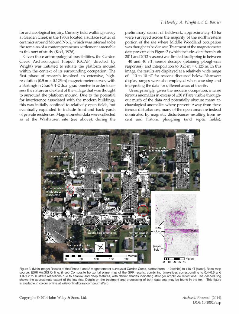
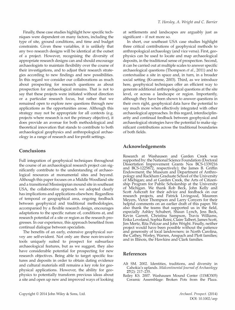
centre of the Washausen site, a Bartington Grad601-2dual fluxgate gradiometer was used to collect readingsat 0.125m intervals along traverses spaced 0.5m apart.Alternate lines were walked in opposite directionsalong marked guide ropes, and the survey was ex-tended as necessary to ensure full coverage of the occu-pation area, ultimately encompassing a total area of8 ha. An extract of the results, shown in Figure 2, ispresented after clipping of the data to between �30and 30 nT, followed by destriping to remove stripescaused by heading mismatch errors between the twosensor pairs (see Horsley and Wilbourn, 2009). It wasdecided not to apply a stronger destriping methodsuch as zero mean traverse, which would havereduced the plough scar responses (visible as E–Wtrending stripes), but produced grid-edge discontinu-ities in the grids containing the three large and intenseferrous responses and the broad anomalies associatedwith palaeochannels. Slight de-staggering (0.06m)was necessary on a few select grids to correct for posi-tional shifts between adjacent traverses, and limitededge-matching was applied to ensure smooth transi-tions between adjacent grids. Finally, the data were
Archaeol. Prospect. (2014)DOI: 10.1002/arp
Figure 2. (Left) Extract of the Washausen site magnetometer results showing the core occupation area, plotted from�3.5 (white) to +3.5 nT (black).Details on data treatment and processing can be found in the text. (Right) Simplified interpretation of the same area, produced with reference todifferently processed data sets and following ground-truthing.
T. Horsley, A. Wright and C. Barrier
interpolated to a resolution of 0.25m × 0.125m (using anon-linear sin(x)/x function) to smooth the resultingimage and aid interpretation.The floodplain setting of the Washausen site provides
a relatively magnetically homogeneous background,upon which it is possible to identify numerous re-sponses of archaeological origin. These include around200 rectangular positive anomalies, measuring up toaround 4.8m on the longest axis, and between 0.5 nTand 4 nT in strength. Such responses are consistent withbeing produced by the remains of basin structures,and their sizes, shapes and clustering into groupsresembles excavation plans from other sites in theregion (e.g. Kelly, 1990a). Other anomalies that aresimilar to these ‘basin responses’, but are weaker ornon-rectangular, may represent basins that containlower concentrations of magnetically enhanced soil(possibly indicating different functions), or mightinstead be due to thin spreads of midden material.Discrete and more intense positive magnetic anomalies(up to around 6 nT), probably indicate the locations ofburnt deposits, either as hearths or pits containing burntsoil and fire-cracked rock. At the centre of these habita-tion anomalies, and bounded to the north by clearresponses associated with Mound A, is a relativelymagnetically quiet area that indicates the central plaza.A scatter of small bipolar responses (suggesting laterhistoric activity on this slightly higher ground) largely
Copyright © 2014 John Wiley & Sons, Ltd.
obscures Mound B, and any trace of a potential MoundC is masked by an intense bipolar response that proba-bly indicates a vertical iron pipe, such as a well.The results therefore provide evidence for substantial
occupation representing a nucleated village settlementconsisting of numerous courtyard groups distributedaround a central mound-and-plaza complex (Horsley andBarrier, 2011; Barrier, 2012). These findings initiated a sec-ond phase of archaeo-anthropological research designedto address the role of courtyard groups in the constructionof new community identities and integrative institutionsimplicated by the building of monumental platformmounds and a plaza (see Barrier and Horsley, In press).These issues were tackled through five months of
targeted excavations of particular site features selectedusing the magnetometer results. Although the analysisof excavated materials is ongoing, these data are poisedto inform us about activities occurring in and aroundstructures, courtyard groups and public spaces (Barrieret al., 2013). For example, WAP researchers are investigat-ing how courtyard groups used public spaces for com-munal ceremonies. Specifically, we are analysing faunal,botanical and sediment micromorphological samples, aswell as ceramic and lithic debris and obtaining newAMS radiocarbon dates to situate the deposition of thesematerials in relation to events at Cahokia.The combined geophysical and excavation results
from phases one and two are being utilised to design
Archaeol. Prospect. (2014)DOI: 10.1002/arp
Prospecting for New Questions
yet a third phase of research to address additionalquestions of anthropological significance concerning:(i) the growth and development of the mound andvillage settlement at Washausen (see below); (ii) thenature of interactions between constituent socialgroups who were participants in the construction ofearly regional platform mounds and community insti-tutions; and (iii) a more detailed understanding of thetiming of events at the site. Importantly, the integrationof data from geophysical survey, excavations and ma-terial analyses allow for an exploration of the socialhistory of Washausen that would be impossible usingany one of these approaches in isolation. For example,excavation evidence has aided reinterpretation of themagnetometer data and allowed, to some extent, theextrapolation of inferred patterns of behaviour acrossthe entire site. In other words, our interpretations arenot limited to those buildings and courtyard groupsthat we sampled with traditional excavation methods.This integrated approach is allowing us to devise ad-
ditional research objectives to investigate the spatialpatterning of individual elements of the Washausencommunity and to present site-wide information aboutan early Mississippian mound centre in the AmericanBottom. For one example, the ground-truthed magne-tometer data have been utilised to construct a demo-graphic profile of the Washausen settlement (Barrierand Horsley, In press). A total of five inferred basinstructures were targeted for partial excavation. Theseexcavations confirmed the geophysical interpretation(e.g. basin dimensions and orientation), and haveallowed an assessment of structure frequency andmorphology across the site. With a relatively completesite map, and using established regional methodolo-gies for calculating the number of individuals perstructure based on building size, we were able to calcu-late a population estimate for the entire Washausenvillage. This information was compared to populationestimates from earlier regional villages to construct ademographic profile of village growth and declinediachronically. Our knowledge of the spatial organisationof Washausen’s transitional Mississippian periodcommunity allowed us to demonstrate that thecreation of larger communities during the tenth andeleventh centuries AD resulted through frequentresidential migrations as courtyard groups fissionedand re-aggregated to new communities.This example demonstrates that feedback between
geophysical and more traditional archaeological datasetscan provide sources of new anthropological researchobjectives otherwise unattainable. Only after ground-truthed geophysical data were utilised for creation of acomplete site map at Washausen was the potential for a
Copyright © 2014 John Wiley & Sons, Ltd.
study of regional, village demographic trajectoriesrealised. Thus, the data collected during WAP’s initialphase of prospection are still instigating new anthropo-logical research questions, the answers to which contrib-ute to our knowledge about Mississippian historicaldevelopments in this region. In this way, the geophysicalsurvey has been instrumental at each phase of research,both as a tool for classic prospection and in the produc-tion of data being utilised to address issues of spatialityas well as settlement and social organisation.
The Garden Creek site
The Garden Creek site (31Hw8) in western NorthCarolina offered another opportunity for two of theauthors (Wright and Horsley) to integrate geophysicalsurvey and traditional field methods to answer anddevelop anthropological research questions. Comparedwith Washausen, Garden Creek presented some interest-ing challenges for archaeological investigation. The site iscurrently occupied by a suburban neighbourhood, whichboth obscures surface visibility and precludes extensivesubsurface testing. Moreover, the clay-rich soils of the sitewere intensely ploughed from about 1800 to 1950, signi-ficantly impacting the site’s prehistoric ground surface.Despite these difficulties, previous research at
Garden Creek indicated that the site had considerablepotential for addressing questions related to the socialorganisation of complex hunter–gatherers. Intermit-tently investigated since the 1880s (Heye, 1919;Dickens, 1976; Keel, 1976), Garden Creek is best knowntoday as the location of a platform mound (GardenCreek Mound No. 2) dating to the late MiddleWoodland Connestee phase, ca. AD 200–600. Similarmounds have been identified at otherMiddleWoodlandsites across southeast USA, where communities ofhunter–gatherer–gardeners do not appear to havebeen organized according to institutionalised inequal-ities (e.g. Sears 1956; Knight, 1990, 2001; Jefferies, 1994;Lindauer and Blitz, 1997; Milanich et al., 1997; Kimballet al., 2010). This research contributes to a growing bodyof work in the Eastern Woodlands (e.g. Buikstra andCharles, 1999; Thompson and Turck, 2009; Sassaman,2010; Kidder, 2011; Howey, 2012) that challenges tradi-tional models that view monuments such as platformmounds as indicators of emergent sociopolitical hierar-chies (Childe, 1950; Renfrew, 1973). To begin to under-stand how a relatively small-scale, egalitarian societycoordinated mound building, it is important to knowwhat institutions structured these communities in bothdaily practice and in communal contexts. To that end,villages and other occupation contexts are prime targets
Archaeol. Prospect. (2014)DOI: 10.1002/arp
T. Horsley, A. Wright and C. Barrier
for archaeological inquiry. Cursory field walking surveyat Garden Creek in the 1960s located a surface scatter ofceramics aroundMoundNo. 2, whichwas inferred to bethe remains of a contemporaneous settlement amenableto this sort of study (Keel, 1976).Given these anthropological possibilities, the Garden
Creek Archaeological Project (GCAP, directed byWright) was initiated to situate the platform moundwithin the context of its surrounding occupation. Thefirst phase of research involved an extensive, high-resolution (0.5m × 0.125m) magnetometer survey witha Bartington Grad601-2 dual gradiometer in order to as-sess the nature and extent of the village thatwas thoughtto surround the platform mound. Due to the potentialfor interference associated with the modern buildings,this was initially confined to relatively open fields, buteventually expanded to include front and back yardsof private residences. Magnetometer datawere collectedas at the Washausen site (see above); during the
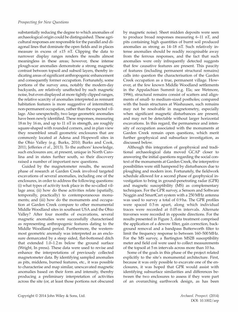
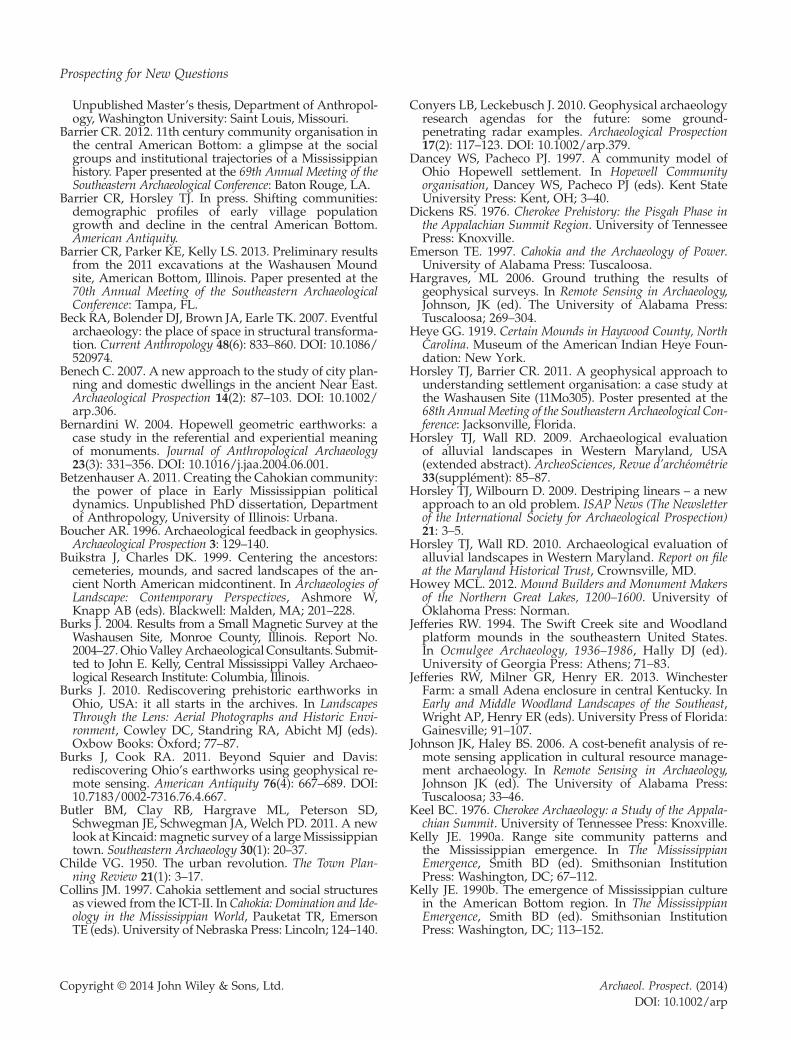
Figure 3. (Main image) Results of the Phase 1 and 2 magnetometer surveys asource: ESRI ArcGIS Online. (Inset) Composite horizontal plane map of th1.0–1.2 to illustrate reflections due to shallow and deep features, with darkshows the approximate extent of the low rise. Details on the treatment andis available in colour online at wileyonlinelibrary.com/journal/arp
Copyright © 2014 John Wiley & Sons, Ltd.
preliminary season of fieldwork, approximately 4.5 hawere surveyed across the majority of the northwesternportion of the site where Middle Woodland occupationwas thought to bedensest. Treatment of themagnetometerdata presented in Figure 3 (which includes data from both2011 and 2012 seasons)was limited to: clipping to between�40 and 40 nT; sensor destripe (retaining plough-scarresponses); and interpolation to 0.25m × 0.125m. In thisimage, the results are displayed at a relatively wide rangeof �10 to 10 nT for reasons discussed below. Narrowerdisplay ranges were also employed when assessing andinterpreting the data for different areas of the site.Unsurprisingly, given the modern occupation, intense
ferrous anomalies in excess of ±20 nTare visible through-out much of the data and potentially obscure many ar-chaeological anomalies where present. Away from theseferrous disturbances, many of the open areas are insteaddominated by magnetic disturbances resulting from re-cent and historic ploughing (and septic fields),
t Garden Creek, plotted from�10 (white) to +10 nT (black). Base-mape GPR results, combining time-slices corresponding to 0.4–0.6 ander shades indicating stronger amplitude reflections. The dashed ringprocessing of both data sets may be found in the text. This figure
Archaeol. Prospect. (2014)DOI: 10.1002/arp
Prospecting for New Questions
substantially reducing the degree to which anomalies ofarchaeological origin could be distinguished. These agri-cultural responses are responsible for the parallel and di-agonal lines that dominate the open fields and in placesmeasure in excess of ±15 nT. Clipping the data tonarrower display ranges renders the results almostmeaningless in these areas; however, these intenseplough-scar anomalies demonstrate a strong magneticcontrast between topsoil and subsoil layers, thereby in-dicating areas of significant anthropogenic enhancementand consequently former occupation. Fortunately, someportions of the survey area, notably the modern-daybackyards, are relatively unaffected by such magneticnoise, but even displayed atmore tightly clipped ranges,the relative scarcity of anomalies interpreted as remnanthabitation features is more suggestive of intermittent,non-permanent occupation, rather than the expected vil-lage. Also unexpectedly, two large geometric anomalieshave been newly identified. These responses, measuring18m by 16m, and up to 11 nT in strength, are roughlysquare-shapedwith rounded corners, and in plan viewthey resembled small geometric enclosures that arecommonly located at Adena and Hopewell sites inthe Ohio Valley (e.g. Burks, 2010; Burks and Cook,2011; Jefferies et al., 2013). To the authors’ knowledge,such enclosures are, at present, unique in North Caro-lina and in states further south, so their discoveryraised a number of important new questions.Guided by the magnetometer results, the second
phase of research at Garden Creek involved targetedexcavations of several anomalies, including one of theenclosures, in order to address the following questions:(i) what types of activity took place in the so-called vil-lage area; (ii) how do these activities relate (spatially,temporally, practically) to contemporaneous monu-ments; and (iii) how do the monuments and occupa-tion at Garden Creek compare to other monumentalMiddle Woodland sites in southeast USA and the OhioValley? After four months of excavations, severalmagnetic anomalies were successfully characterisedas representing anthropogenic features dating to theMiddle Woodland period. Furthermore, the western-most geometric anomaly was interpreted as an enclo-sure demarcated by a steep sided, flat-bottomed ditchthat extended 1.0–1.2m below the ground surface(Wright, In press). These data were used to revise andenhance the interpretations of previously collectedmagnetometer data. By identifying sampled anomaliesas pits, middens, burned features, etc., it was possibleto characterise and map similar, unexcavated magneticanomalies based on their form and intensity, therebyproducing a preliminary interpretation of activitiesacross the site (or, at least those portions not obscured
Copyright © 2014 John Wiley & Sons, Ltd.
by magnetic noise). Sheet midden deposits were seento produce broad responses measuring 6–11 nT, andpits containing high quantities of burnt soil producedanomalies as strong as 14–18 nT. Such relatively in-tense anomalies should be readily recognisable awayfrom the ferrous responses, and the fact that suchanomalies were only infrequently detected suggeststhat few causative features are present. This paucityof features (including permanent structural remains)calls into question the characterisation of the GardenCreek occupation as a true, permanent village. How-ever, at the few known Middle Woodland settlementsin the Appalachian Summit (e.g. Ela; see Wetmore,1996), structural remains consist of scatters and align-ments of small- to medium-sized postholes; comparedwith the basin structures at Washausen, such remainsmay not be resolvable in magnetometry, especiallywhen significant magnetic disturbances are present,and may not be detectable without larger horizontalexcavations. In this regard, the permanence and inten-sity of occupation associated with the monuments atGarden Creek remain open questions, which meritfurther geophysical and subsurface investigation, asdiscussed below.Although this integration of geophysical and tradi-
tional archaeological data moved GCAP closer toanswering the initial questions regarding the social con-text of the monuments at Garden Creek, the interpretivepossibilities were still hampered by disturbances due toploughing and modern iron. Fortunately, the fieldworkschedule allowed for a second phase of geophysical in-vestigation to bring in ground-penetrating radar (GPR)and magnetic susceptibility (MS) as complementarytechniques. For the GPR survey, a Sensors and SoftwareNoggin and SmartCart system with a 250MHz antennawas used to survey a total of 0.9 ha. The GPR profileswere spaced 0.5m apart, along which individualtraces were recorded at 0.05m intervals. Alternatetraverses were recorded in opposite directions. For theresults presented in Figure 3, data treatment comprisedthe application of a dewow filter, gain correction, back-ground removal and a bandpass Butterworth filter tolimit the frequency response to between 160–500MHz.For the MS survey, a Bartington MS2B susceptibilitymeter and field coil were used to collect measurementsof the topsoil at 5m intervals across more than 10 ha.Some of the goals in this phase of the project related
explicitly to the site’s monumental architecture. First,because it was only possible to excavate one of the en-closures, it was hoped that GPR would assist withidentifying subsurface similarities and differences be-tween the two enclosures to assess if they were partof an overarching earthwork design, as has been
Archaeol. Prospect. (2014)DOI: 10.1002/arp
T. Horsley, A. Wright and C. Barrier
observed at contemporaneous Hopewell sites. Second,by conducting the GPR survey over and immediatelyaround the two enclosures, it was possible to includea low rise adjacent to the eastern enclosure that hadbeen observed during field walking. The aim was tohelp confirm its origin as anthropogenic and, if so,how it was related to the enclosure.All of these questions were successfully answered.
The GPR data, rendered into time slices, clearlyrevealed each enclosure in plan form, unobscured bythe various disturbances that plagued previousmagnetometer survey efforts (see Figure 3 inset). Theresults confirm the enclosures’ nearly identical foot-prints and that the eastern enclosure is another ditch.The GPR results also show that the suspicious rise atGarden Creek is a newly identified mound and that itoverlays and thus post-dates the eastern enclosure.The relative ages of these monuments cannot be fur-ther specified using currently available information,but their exact temporal relationship merits furtherinvestigation through coring, excavation and analysisof excavated materials.The second phase of geophysical survey at Garden
Creek also continued to investigate the organisationand overall size of the occupation area, this time witha greater appreciation of the challenges presented bythe modern landscape. In particular, we wanted toassess the provisional interpretation of the magnetom-eter survey results, which suggested that this occupa-tion might not have been a true village as initiallyassumed. This issue was especially saliant to our an-thropological investigations of the context of MiddleWoodland monumentality in general, because MiddleWoodland platform mound sites in southeast USAare nearly always associated with a village midden(Knight, 2001), whereas those of the Ohio Valleyare frequently characterised as ‘vacant ceremonialcentres’ (e.g. Prufer, 1964; Dancey and Pacheco 1997;Bernardini, 2004). Expanded magnetometer surveyacross an additional 2.5 ha, complemented by MS sur-vey, helped to address this issue. Overall, the effectsof ploughing still limited the effectiveness of magne-tometry, although potentially significant anomalieswere identified more than 200m away from MoundNo. 2, far beyond Keel’s proposed village boundary.Again, further investigation will be required to obtainessential dating evidence.Enhanced magnetic susceptibility readings to the
south of Mound 2 (120–240 × 10�5 SI compared with40 × 10�5 SI for apparently ‘off-site’ areas), suggestthat this might have been an area of relatively high ac-tivity, possible occupation – a possibility that will alsorequire verification through more intrusive methods.
Copyright © 2014 John Wiley & Sons, Ltd.
Although the original magnetometer survey revealedonly a few large, discrete responses, these new resultsmay indicate the presence of a settlement consistingof small features, single-post structures and dispersedmidden deposits too small and subtle to be detectedusing this method. More broadly, MS values areelevated across a large portion of the landform inwhich ploughing obscured magnetometer results(reaching 300 × 10�5 SI in places, dropping off tobelow 40 × 10�5 SI to the northwest and southeast). ThesehigherMS values do not correspond to known variationsin geology or soil type, and although there are observabledifferences between gardens and hayfields, differences inland use do not easily explain the general trend. Withoutground-truthing, it is impossible to say if these signaturesare the result of anthropogenic activity, and furthermore,if they are contemporaneous with the construction anduse of Mound No. 2. Nevertheless, these results offer ex-citing ground for continued integration of geophysicaland traditional archaeological data at Garden Creek, asa means of assessing its occupation both over time andin comparative perspective.Finally, by providing a clearer view of subsurface
deposits below the plough zone, GPR made it possibleto more thoroughly characterise the organisation ofoff-monument activity at the site. Particularly southand east of the eastern enclosure, numerous discretereflections were identified, and although ground-truthing of these features has yet to be conducted, itseems likely that many of them are negative featuressuch as storage and refuse pits, depressed hearthsand burned areas, and perhaps even large postholes.The presence of such materials in this area wouldmean that the areal extent of the occupation at GardenCreek was far greater than suggested in the 1960s.Moreover, if other ‘noisy’ portions of the magnetome-ter survey area are also proven to have dense concen-trations of features below the plough zone, then thelocal occupation would be one of the largest pre-Columbian settlements in the Appalachian Summit,much less a pre-agricultural, Middle Woodland one.At present, these ideas hinge on the contemporane-
ity of the hypothetical deposits -- a fact that cannotbe ascertained without a considerable amount ofground-truthing. Nevertheless, our current knowledgeabout Garden Creek has allowed us to posit reasonableanswers to certain research questions and to developentirely new research objectives. In addition toattempting to contextualise a local monumental phe-nomenon (i.e. the platform mound), ongoing researchat Garden Creek is now exploring patterns of interactionbetween the Appalachian Summit, the Ohio Valley andthe Deep South during the Middle Woodland period
Archaeol. Prospect. (2014)DOI: 10.1002/arp
Prospecting for New Questions
(Wright, In press). These connections, which are part of abroader anthropological discourse on pre-Columbianinteraction and history making (e.g. Sassaman, 2010;Kidder, 2011), may have gone unappreciated if notfor the combination of extensive geophysical surveywith traditional excavation and, crucially, a flexibleand evolving research design.
Discussion
These two case studies illustrate several ways that geo-physical surveys – and their results – can be integratedthroughout the course of an archaeological investiga-tion. At both sites, the value of geophysics forprospection went well beyond simply locating subsur-face features to excavate, although this step neverthelessplayed a crucial role. For one thing, the initial geophysi-cal surveys at both Washausen and Garden Creek weredesigned to address, and then successfully answered,specific archaeological questions related to site extentand spatial organisation (as Thompson et al. (2011) havepreviously demonstrated). Both case studies show thevalue of undertaking extensive geophysical survey atthe outset of an archaeological project for understandingthe function and archaeological potential of a site. Just asimportantly, though, our extensive surveys allowed newsets of both archaeological and anthropological objec-tives to be framed. In otherwords, by better understand-ing and appreciating the components of these sites, wedefined new research questions and were able to designappropriate strategies to answer them. At Washausenand Garden Creek, this approach has demonstratedhow preconceptions and even misconceptions about asite can be re-evaluated and explored anew.In both projects, a flexible research strategy was es-
sential to allow the methodologies to adapt to the siteand questions at hand. Although both investigationsbegan with an extensive geophysical survey, subse-quent research questions and strategies were informedby the nature of the archaeological deposits as well asthe salient anthropological topics of interest. In thecase of Washausen, for example, the discovery of asubstantial, nucleated village occupation associatedwith an early mound-and-plaza complex shifted thefocus of research away from exploration into themounds themselves and towards the off-mound resi-dential zones of the site. The confirmation of thepresence of courtyard groups at the site also meantthat any anthropological questions going forwardmust consider why and how community membersmaintained certain aspects of previous cultural waysof life while participating in the active construction of
Copyright © 2014 John Wiley & Sons, Ltd.
new,Mississippian communities. Meanwhile, at GardenCreek, the challenges of the site’s setting demanded theapplication of multiple prospection techniques through-out the course of fieldwork. These shifts in technologywere matched by shifts in investigative focus. Forexample, initial surveys designed to explore the ‘spacebetween monuments’ and to situate a platform moundwithin its broader social context actually revealedadditional monuments in the form of ditched enclo-sures. Although unexpected, these and other resultsopened lines of inquiry that merit as much anthropolog-ical consideration as our initial research questions.Similarly, both WAP and GCAP benefited from
ongoing collaboration between their key members. Inaddressing broad anthropological questions, both pro-jects demanded a background in local culture histories,familiarity with relevant bodies of anthropological andarchaeological theory and expertise in applying multi-ple geophysical techniques (including data processingand interpretation), as well as traditional archaeologi-cal methods. Although other strategies are certainlypossible, at Garden Creek and Washausen the authorsfound that these requirements were best met throughcontinual interdisciplinary dialogue between anthro-pological archaeologists (Barrier and Wright) and ageophysical archaeologist (Horsley), and that our col-laborations considerably augmented what either partycould do in isolation. In practice, these collaborationsinvolved regular feedback between geophysical andtraditional archaeological results, and frequent reinter-pretation of certain datasets in light of new findings.For example, at both sites, initial magnetometer resultswere used to identify anomalies to target in excavation.Ground-truthing was essential to confirm and supportthe initial interpretations (e.g. structures, pits, ditches,etc.), but by reintegrating excavation results withgeophysical maps, we were able to characterise otherfeatures with similar signatures, and thus able to under-stand site-wide patterns of activity and occupation. Inaddition to framing new directions for the analysis ofgeophysical data, excavation results at Garden Creekwere also used to guide further geophysical fieldwork.As subsurface testing of and around the Garden Creekenclosures did not clarify what kind of occupation waspresent (i.e., permanent settlement, aggregation site, va-cant ceremonial centre), GPR and MS surveys were un-dertaken to obtain complementary views of the site’sdeposits. As discussed above, the results allow for someintriguing preliminary interpretations even as they gen-erated yetmore research questions. Answering thesewillinvolve more ground-truthing and, in turn, more collab-oration between traditional and geophysical methodsand interpretation.
Archaeol. Prospect. (2014)DOI: 10.1002/arp
T. Horsley, A. Wright and C. Barrier
Finally, these case studies highlight how specific tech-niques were dependent on many factors, including thetype of site, ground conditions, and time and budgetconstraints. Given these variables, it is unlikely thatany two research designs will be identical at the outsetof a project. However, recognising the diversity ofappropriate research designs can and should encouragearchaeologists to maintain flexibility over the course oftheir investigations, and to adjust their research strate-gies according to new findings and new possibilities.In this regard we consider our collaborations as muchabout prospecting for research questions as aboutprospection for archaeological remains. That is not tosay that these projects were initiated without directionor a particular research focus, but rather that weremained open to explore new questions through newapplications as the opportunities arose. Although thisstrategy may not be appropriate for all contexts (e.g.projects where research is not the primary objective), itdoes provide an avenue for both methodological andtheoretical innovation that stands to contribute to botharchaeological geophysics and anthropological archae-ology in a range of research and for-profit settings.
Conclusions
Full integration of geophysical techniques throughoutthe course of an archaeological research project can sig-nificantly contribute to the understanding of archaeo-logical resources at monumental sites and beyond.Although this paper focuses on a Middle Woodland siteand a transitionalMississippianmound site in southeastUSA, the collaborative approach we adopted clearlyhas implications and applications elsewhere. Regardlessof temporal or geographical area, ongoing feedbackbetween geophysical and traditional methodologies,accompanied by a flexible research design, encouragesadaptations to the specific nature of, conditions at, andresearch potential of a site or region as the research pro-gresses. In our experience, this approach benefited fromcontinual dialogue between specialists.The benefits of an early, extensive geophysical sur-
vey are self-evident. Not only are these non-invasivetools uniquely suited to prospect for subsurfacearchaeological features, but as we suggest, they alsohave considerable potential for prospecting for newresearch objectives. Being able to target specific fea-tures and deposits in order to obtain dating evidenceand cultural materials still remains a key role for geo-physical applications. However, the ability for geo-physics to potentially transform previous ideas abouta site and open up new and improved ways of looking
Copyright © 2014 John Wiley & Sons, Ltd.
at settlements and landscapes are arguably just assignificant – if not more so.In short, our southeast USA case studies highlight
three critical contributions of geophysical methods toanthropological archaeology (and vice versa). First, geo-physics can be used to locate and map archaeologicaldeposits, in the traditional sense of prospection. Second,it can be carried out at multiple scales to answer specificarchaeological questions (Thompson et al., 2011) and tocontextualise a site in space and, in turn, in a broadersocial setting (Kvamme, 2003). Third, as we introducehere, geophysical techniques offer an efficient way togenerate additional anthropological questions at the sitelevel, or across a landscape or region. Importantly,although they have been shown to answer questions intheir own right, geophysical data have the potential tosay much more when effectively integrated with otherarchaeological approaches. In this regard, interdisciplin-arity and continual feedback between geophysical andarchaeological strategies have the potential to make sig-nificant contributions across the traditional boundariesof both fields.
Acknowledgements
Research at Washausen and Garden Creek wassupported by: theNational Science Foundation (DoctoralDissertation Improvement Grants Nos BCS-1339216and BCS-1225872, respectively); the James B. GriffinEndowment; the Museum and Department of Anthro-pology and RackhamGraduate School of the Universityof Michigan; and at Garden Creek, the Arts of Citizen-ship Program for Public Scholarship at the Universityof Michigan. We thank Rob Beck, John Kelly andScott Ashcraft for their advice and feedback on ourresearch projects, and Patrick Livingood, MaureenMeyers, Victor Thompson and Larry Conyers for theirhelpful comments on an earlier draft of this paper. Wealso thank the teams that supported us in the field,especially Ashley Schubert, Shaun Lynch, Jess Beck,Kevin Garrett, Christina Sampson, Travis Williams,Erika Loveland, Sophia Reini, Claire Talbert, James Scott,JimMertz, Rita Pelczar and John Wright. Finally, neitherproject would have been possible without the patienceand generosity of local landowners: in North Carolina,the Cathey, Worley, Warren, Anspach and Plott families;and in Illinois, the Hawkins and Clark families.
References
Alt SM. 2002. Identities, traditions, and diversity inCahokia’s uplands.Midcontinental Journal of Archaeology27(2): 217–235.
Bailey KS. 2007. Washausen Mound Center (11MO305)Ceramic Assemblage: Broken Pots from the Plaza.
Archaeol. Prospect. (2014)DOI: 10.1002/arp
Prospecting for New Questions
Unpublished Master’s thesis, Department of Anthropol-ogy, Washington University: Saint Louis, Missouri.
Barrier CR. 2012. 11th century community organisation inthe central American Bottom: a glimpse at the socialgroups and institutional trajectories of a Mississippianhistory. Paper presented at the 69th Annual Meeting of theSoutheastern Archaeological Conference: Baton Rouge, LA.
Barrier CR, Horsley TJ. In press. Shifting communities:demographic profiles of early village populationgrowth and decline in the central American Bottom.American Antiquity.
Barrier CR, Parker KE, Kelly LS. 2013. Preliminary resultsfrom the 2011 excavations at the Washausen Moundsite, American Bottom, Illinois. Paper presented at the70th Annual Meeting of the Southeastern ArchaeologicalConference: Tampa, FL.
Beck RA, Bolender DJ, Brown JA, Earle TK. 2007. Eventfularchaeology: the place of space in structural transforma-tion. Current Anthropology 48(6): 833–860. DOI: 10.1086/520974.
Benech C. 2007. A new approach to the study of city plan-ning and domestic dwellings in the ancient Near East.Archaeological Prospection 14(2): 87–103. DOI: 10.1002/arp.306.
Bernardini W. 2004. Hopewell geometric earthworks: acase study in the referential and experiential meaningof monuments. Journal of Anthropological Archaeology23(3): 331–356. DOI: 10.1016/j.jaa.2004.06.001.
Betzenhauser A. 2011. Creating the Cahokian community:the power of place in Early Mississippian politicaldynamics. Unpublished PhD dissertation, Departmentof Anthropology, University of Illinois: Urbana.
Boucher AR. 1996. Archaeological feedback in geophysics.Archaeological Prospection 3: 129–140.
Buikstra J, Charles DK. 1999. Centering the ancestors:cemeteries, mounds, and sacred landscapes of the an-cient North American midcontinent. In Archaeologies ofLandscape: Contemporary Perspectives, Ashmore W,Knapp AB (eds). Blackwell: Malden, MA; 201–228.
Burks J. 2004. Results from a Small Magnetic Survey at theWashausen Site, Monroe County, Illinois. Report No.2004–27. OhioValleyArchaeological Consultants. Submit-ted to John E. Kelly, Central Mississippi Valley Archaeo-logical Research Institute: Columbia, Illinois.
Burks J. 2010. Rediscovering prehistoric earthworks inOhio, USA: it all starts in the archives. In LandscapesThrough the Lens: Aerial Photographs and Historic Envi-ronment, Cowley DC, Standring RA, Abicht MJ (eds).Oxbow Books: Oxford; 77–87.
Burks J, Cook RA. 2011. Beyond Squier and Davis:rediscovering Ohio’s earthworks using geophysical re-mote sensing. American Antiquity 76(4): 667–689. DOI:10.7183/0002-7316.76.4.667.
Butler BM, Clay RB, Hargrave ML, Peterson SD,Schwegman JE, Schwegman JA, Welch PD. 2011. A newlook at Kincaid: magnetic survey of a largeMississippiantown. Southeastern Archaeology 30(1): 20–37.
Childe VG. 1950. The urban revolution. The Town Plan-ning Review 21(1): 3–17.
Collins JM. 1997. Cahokia settlement and social structuresas viewed from the ICT-II. In Cahokia: Domination and Ide-ology in the Mississippian World, Pauketat TR, EmersonTE (eds). University of Nebraska Press: Lincoln; 124–140.
Copyright © 2014 John Wiley & Sons, Ltd.
Conyers LB, Leckebusch J. 2010. Geophysical archaeologyresearch agendas for the future: some ground-penetrating radar examples. Archaeological Prospection17(2): 117–123. DOI: 10.1002/arp.379.
Dancey WS, Pacheco PJ. 1997. A community model ofOhio Hopewell settlement. In Hopewell Communityorganisation, Dancey WS, Pacheco PJ (eds). Kent StateUniversity Press: Kent, OH; 3–40.
Dickens RS. 1976. Cherokee Prehistory: the Pisgah Phase inthe Appalachian Summit Region. University of TennesseePress: Knoxville.
Emerson TE. 1997. Cahokia and the Archaeology of Power.University of Alabama Press: Tuscaloosa.
Hargraves, ML 2006. Ground truthing the results ofgeophysical surveys. In Remote Sensing in Archaeology,Johnson, JK (ed). The University of Alabama Press:Tuscaloosa; 269–304.
Heye GG. 1919. Certain Mounds in Haywood County, NorthCarolina. Museum of the American Indian Heye Foun-dation: New York.
Horsley TJ, Barrier CR. 2011. A geophysical approach tounderstanding settlement organisation: a case study atthe Washausen Site (11Mo305). Poster presented at the68th AnnualMeeting of the Southeastern Archaeological Con-ference: Jacksonville, Florida.
Horsley TJ, Wall RD. 2009. Archaeological evaluationof alluvial landscapes in Western Maryland, USA(extended abstract). ArcheoSciences, Revue d’archéométrie33(supplément): 85–87.
Horsley TJ, Wilbourn D. 2009. Destriping linears – a newapproach to an old problem. ISAP News (The Newsletterof the International Society for Archaeological Prospection)21: 3–5.
Horsley TJ, Wall RD. 2010. Archaeological evaluation ofalluvial landscapes in Western Maryland. Report on fileat the Maryland Historical Trust, Crownsville, MD.
Howey MCL. 2012. Mound Builders and Monument Makersof the Northern Great Lakes, 1200–1600. University ofOklahoma Press: Norman.
Jefferies RW. 1994. The Swift Creek site and Woodlandplatform mounds in the southeastern United States.In Ocmulgee Archaeology, 1936–1986, Hally DJ (ed).University of Georgia Press: Athens; 71–83.
Jefferies RW, Milner GR, Henry ER. 2013. WinchesterFarm: a small Adena enclosure in central Kentucky. InEarly and Middle Woodland Landscapes of the Southeast,Wright AP, Henry ER (eds). University Press of Florida:Gainesville; 91–107.
Johnson JK, Haley BS. 2006. A cost-benefit analysis of re-mote sensing application in cultural resource manage-ment archaeology. In Remote Sensing in Archaeology,Johnson JK (ed). The University of Alabama Press:Tuscaloosa; 33–46.
Keel BC. 1976. Cherokee Archaeology: a Study of the Appala-chian Summit. University of Tennessee Press: Knoxville.
Kelly JE. 1990a. Range site community patterns andthe Mississippian emergence. In The MississippianEmergence, Smith BD (ed). Smithsonian InstitutionPress: Washington, DC; 67–112.
Kelly JE. 1990b. The emergence of Mississippian culturein the American Bottom region. In The MississippianEmergence, Smith BD (ed). Smithsonian InstitutionPress: Washington, DC; 113–152.
Archaeol. Prospect. (2014)DOI: 10.1002/arp
T. Horsley, A. Wright and C. Barrier
Kelly JE. 2000. The nature and context of EmergentMississippian cultural dynamics in the greater AmericanBottom. In Late Woodland Societies: Tradition and Transfor-mation across the Midcontinent, Emerson TE, McElrathDL, Fortier AC (eds). University of Nebraska Press:Lincoln; 163–175.
Kelly JE. 2006. Washausen and the ‘Big Bang’: under-standing the context of the ripple effect. Paperpresented at the 63rd Annual Meeting of the SoutheasternArchaeological Conference: Little Rock, AR.
Kelly JE, Brown JA. 2012. In search of cosmic power:contextualizing spiritual journeys between Cahokiaand the St. Francois Mountains. In Archaeology of Spiri-tualities, Rountree K, Morris C, Peatfield AAD (eds).Springer-Verlag: New York; 107–129.
Kelly JE, Brown JA. In press. Cahokia: the processes andprinciples of the creation of an early Mississippian city.In Making Ancient Cities: Space and Place in Early UrbanSocieties, Creekmore AT, Fisher KD (eds). CambridgeUniversity Press: Cambridge, UK.
Kidder TR. 2011. Transforming hunter–gatherer historyat Poverty Point. In Hunter–Gatherer Archaeology asHistorical Process, SassamanKE,HollyD (eds). Universityof Arizona Press: Tucson; 95–119.
Kimball LR, Whyte TR, Crites GD. 2010. The BiltmoreMound and Hopewellian mound use in the SouthernAppalachians. Southeastern Archaeology 29(1): 44–58.
Knight VJ. 1990. Excavation of the Truncated Mound at theWalling Site: Middle Woodland Culture and Copena in theTennessee Valley. Office of Archaeological Research,Alabama State Museum of Natural History: Huntsville.
Knight VJ. 2001. Feasting and the emergence of platformmound ceremonialism in eastern North America. InFeasts: Archaeological and Ethnographic Perspectives onFood, Politics, and Power, Dietler M, Hayden B (ed).Smithsonian Institution Press: Washington, DC;239–254.
Knight VJ. 2010. Mound Excavations at Moundville: Archi-tecture, Elites, and Social Order. University of AlabamaPress: Tuscaloosa.
Kvamme KL. 2003. Geophysical surveys as landscapearchaeology. American Antiquity 68(3): 435–458. DOI:10.2307/3557103
Lindauer O, Blitz JH. 1997. Higher ground: the archaeol-ogy of North American platform mounds. Journal ofArchaeological Research 5(2): 169–207. DOI: 10.1007/BF02229110.
Lockhart JJ, Green, TJ. 2006. The current and potential roleof archaeogeophysics in cultural resource managementin the United States. In Remote Sensing in Archaeology,Johnson, JK (ed). The University of Alabama Press:Tuscaloosa; 17–32.
Mehrer MW, Collins JM. 1995. Household archaeology atCahokia and its hinterlands. InMississippian Communitiesand Households, Rogers JD, Smith BD (eds). University ofAlabama Press: Tuscaloosa; 32–57.
Milanich JT, Cordell AS, Knight VJ, Kohler TA, Sigler-Lavelle BJ. 1997. Archaeology of Northern Florida A.D.200–900: The McKeithenWeeden Island Culture. UniversityPress of Florida: Gainesville.
Milner GR. 2006. The Cahokia Chiefdom: The Archaeology of aMississippian Society. Reprint. University Press of Florida:Gainesville.
Copyright © 2014 John Wiley & Sons, Ltd.
Pauketat TR. 1994. The Ascent of Chiefs: Cahokia and Missis-sippian Politics in Native North America. University ofAlabama Press: Tuscaloosa.
Pauketat TR. 2003. Resettled farmers and the making of aMississippian polity. American Antiquity 68(1):39–66.DOI: 10.2307/3557032.
Pauketat TR. 2004 Ancient Cahokia and the Mississippians.Cambridge University Press: Cambridge.
Pauketat TR, Alt SM. 2003. Mounds, memory, andcontested Mississippian history. In Archaeologies ofMemory, Van Dyke R, Alcock SE (eds). Wiley-Blackwell:New York; 151–179.
Peterson S. 2007. Surface mapping and subsurface imag-ing of the Mann archaeological site (12-Po-2), PoseyCounty, Indiana. HPF 21517–11 Report on file at the Indi-ana Department of Natural Resources, Division of HistoricPreservation Archeology.
Porter JW, Linder J. 1974. An archaeological survey of theMississippi Valley in St. Clair, Monroe, and Randolphcounties. In Preliminary Report of the 1973 Historic SitesSurvey Archaeological Reconnaissance of Selected Areas inthe State of Illinois. Illinois Archaeological Survey:Urbana; 28–34.
Prufer OH. 1964. The Hopewell complex of Ohio. InHopewellian Studies, Caldwell JR, Hall RL (eds). ScientificPapers Volume 12, Illinois State Museum: Springfield;35–83.
Renfrew C. 1973. Monuments, Mobilization and Socialorganisation in Neolithic Wessex. Duckworth: London.
Sassaman KE. 2010. The Eastern Archaic Historicized.AltaMira: New York.
Sears WH. 1956. Excavations at Kolomoki: Final Report.University of Georgia Press: Athens.
Thompson VD. 2009. The Mississippian production ofspace through earthen pyramids and public buildingson the Georgia coast, USA. World Archaeology 41(3):445–470. DOI: 10.1080/00438240903112435.
Thompson VD, Pluckhahn TJ. 2010. History, complexhunter–gatherers, and the mounds and monuments ofCrystal River, Florida, USA: a geophysical perspective.The Journal of Island and Coastal Archaeology 5(1): 33–51.DOI: 10.1080/15564890903249811
Thompson VD, Pluckhahn TJ. 2012. Monumentalizationand ritual landscapes at Fort Center in the LakeOkeechobee Basin of South Florida. Journal of Anthropo-logical Archaeology 31(1): 49–65. DOI: 10.1016/j.jaa.2011.10.002.
Thompson VD, Turck JA. 2009. Adaptive cycles of coastalhunter–gatherers. American Antiquity 74(2): 255–278.
Thompson VD, Arnold PJ, Pluckhahn TJ, VanderwarkerAM. 2011. Situating remote sensing in anthropologicalarchaeology. Archaeological Prospection 18(3): 195–213.DOI: 10.1002/arp.400.
Wetmore RY. 1996. The Connestee Component of the ElaSite (31SW5). InUpland Archaeology in the East, Symposium5. Barfield EB, Barfield MB (eds). Archaeological Societyof Virginia: Richmond; 22–237.
Wright AP. In press. History, monumentality, and interac-tion in the Appalachian Summit Middle Woodland.American Antiquity.
Wright AP, Henry ER (eds). 2013. Social Landscapes and theEarly and Middle Woodland Southeast. University Press ofFlorida: Gainesville.
Archaeol. Prospect. (2014)DOI: 10.1002/arp