Embed Size (px)
Citation preview

Geomorphology 179 (2012) 58–70
Contents lists available at SciVerse ScienceDirect
Geomorphology
j ourna l homepage: www.e lsev ie r .com/ locate /geomorph
Quantifying denudation rates and sediment storage on the eastern Altiplano, Bolivia,using cosmogenic 10Be, 26Al, and in situ 14C
Kristina Hippe a,⁎, Florian Kober b, Gerold Zeilinger c, Susan Ivy-Ochs d, Colin Maden a, Lukas Wacker d,Peter W. Kubik d, Rainer Wieler a
a Institute of Geochemistry and Petrology, ETH Zürich, Clausiusstrasse 25, CH-8092 Zürich, Switzerlandb Geological Institute, ETH Zürich, Sonneggstrasse 5, CH-8092 Zürich, Switzerlandc Institute of Earth and Environmental Science, University of Potsdam, Karl-Liebknecht-Str. 24‐25, D-14476 Potsdam-Golm, Germanyd Laboratory of Ion Beam Physics, ETH Zürich, Schafmattstrasse 20, CH-8093 Zürich, Switzerland
⁎ Corresponding author. Tel.: +41 44 632 47 97; faxE-mail address: [email protected] (K. Hippe).
0169-555X/$ – see front matter © 2012 Elsevier B.V. Alhttp://dx.doi.org/10.1016/j.geomorph.2012.07.031
a b s t r a c t
a r t i c l e i n f oArticle history:Received 5 January 2012Received in revised form 29 July 2012Accepted 31 July 2012Available online 7 August 2012
Keywords:Cosmogenic nuclidesDenudationSediment storageIn situ 14CAltiplano
Denudation processes and sediment transfer are investigated in a high-elevation, low-relief environment(eastern Altiplano, Bolivia) using 10Be, 26Al, and in situ 14C analysis in fluvial sediments. Concentrationsof the long-lived nuclides 10Be and 26Al yield consistently low catchment-wide denudation rates of~3–29 mm ky−1 (integrating over 21–194 ky), which reflect the low geomorphic gradients and the discon-tinuity of fluvial transport along the eastern Altiplano margin. No significant correlation is recorded betweendenudation rates of individual catchments and morphological basin parameters (slope, area, elevation). Thisis attributed to the overall little variability in morphology. The agreement between the denudation rates andpublished modern sediment discharge data suggests steady landscape evolution of the eastern Altiplano fromthe latest Pleistocene until today. While 10Be and 26Al provide long-term estimates on sediment production,in situ cosmogenic 14C is used to trace short-term sediment storage. In situ 14C concentrations are compara-tively low indicating that 14C decayed during alluvial storage over at least the past ~11–20 ky. We assumestorage at shallow depth (2 m) and consider the influence of soil-mantled hillslopes on the in situ 14C con-centration. Our results illustrate the importance of sediment storage even over short distances and demon-strate the potential of in situ 14C to study sediment routing and transfer times within drainage systems.However, this study also demonstrates that the long-lived 10Be and 26Al nuclides can provide adequateestimates on long-term denudation rates even if sediment transport is not fast but interrupted by severalthousands of years of storage.
© 2012 Elsevier B.V. All rights reserved.
1. Introduction
Denudation is one of the key elements that define the topographicevolution of mountain belts and shape landscapes (e.g., Horton, 1999;Willet, 1999; Whipple, 2009). In continental sedimentary systems,denudation marks the starting point of complex mass transfer pro-cesses and defines the input rates of material entering the drainagesystem (Allen, 1998). Understanding the processes that controllong-term denudation and sediment transfer is fundamental to re-construct mass flux and the large-scale geodynamic and geomorphicevolution of mountainous landscapes. Observational constraints andthe quantification of denudation rates and transfer times providethe basis for geodynamic modelling of landscape evolution (e.g.,Ehlers and Poulsen, 2009).
In the central Andes denudation processes have been studied inwidely different tectonic, climatic, and topographic settings (e.g.,
: +41 44 632 11 79.
l rights reserved.
Montgomery et al., 2001; Safran et al., 2005; Zeilinger andSchlunegger, 2007; Kober et al., 2009; Insel et al., 2010). However,one of the most prominent features of the Central Andes, the largeintramontane Altiplano basin, has yet received little attention. TheAltiplano is a tectonically passive, high elevation plateau, boundedby the tectonically active mountain chains of the Eastern andWesternCordillera. The Altiplano forms one of the largest, internally drained,continental sedimentary basins and has been an important regionof sediment accumulation in the Cenozoic (Lamb et al., 1997). TheAltiplano plateau acts as a large-scale climatic barrier separating theeastern continental moisture from the western SE-Pacific moisturesources (Garreaud et al., 2003). Therefore, it is considered to play animportant role for the South American climate and atmospheric circu-lation (Garreaud et al., 2003; Barnes and Ehlers, 2009; Ehlers andPoulsen, 2009). Low denudation rates, resulting from this specificclimatic and tectonic situation, have been proposed as an essentialcondition for the large accumulation of material resulting in plateauformation (Masek et al., 1994; Montgomery et al., 2001; Norton andSchlunegger, 2011). However, data that quantify denudation on the

59K. Hippe et al. / Geomorphology 179 (2012) 58–70
Altiplano are sparse and mainly limited to a few sediment dischargemeasurements (Guyot et al., 1990, 1992) that reflect the modernsituation. To gain insights into the landscape-forming processes thatoccur over millennial and longer timescales, this study applies cosmo-genic nuclide analysis and investigates denudation rates and process-es as well as sediment transfer on the Bolivian Altiplano.
Our study focuses on an area along the eastern Altiplano–Rio LaPaz drainage divide (Fig. 1). With the headwaters of the Rio La Pazcutting into the Altiplano, a sharp transition between the flat plateauand the rapidly incising systems of the Rio La Paz and the EasternCordillera was formed (Safran et al., 2005; Zeilinger and Schlunegger,2007). For the Rio La Paz a strong feedback between erosionalunloading by focussed incision and crustal rebound has been suggested(Zeilinger and Schlunegger, 2007). It was proposed that this feedbackmechanism causes weak flexural rebound along the Altiplano–Rio LaPaz drainage divide and, thus, maintains internal drainage along theeastern Altiplano. Here, we investigate to which extent the processeseast of the drainage divide have an impact on the landscape evolutionof the adjacent Altiplano.
We present catchment-averaged denudation rates and evaluatesediment storage based on the analysis of the three cosmogenicnuclides 10Be, 26Al, and in situ 14C in river-borne sediment. The key as-pect is the widely different half-lives of these isotopes (10Be 1.4 My,26Al 0.7 My, and 14C 5730 y, respectively), which cover differenttime intervals and thereby give information on temporal changes insurface exposure or denudation. The 10Be–26Al nuclide pair is com-monly used to unravel complex exposure and denudation historiesand to gain information on the long-term stability or variability of geo-logic and/or climatic conditions (e.g., Biermann et al., 1999; Grangerand Muzikar, 2001). The measurement of 10Be or 26Al concentrations
Fig. 1. Shaded relief map of western Bolivia showing the geographic context of ourstudy area (white rectangle) on the eastern Altiplano. Sampling sites for cosmogenicnuclide analysis are indicated with white diamonds. Sediment gauging stations(black diamonds) are given according to Guyot et al. (1990, 1992).Map source: ASTER GDEM Version 1, METI and NASA.
from river sediments provides spatially averaged denudation ratesover any defined catchment size (e.g., Brown et al., 1995; Biermannand Steig, 1996; von Blanckenburg, 2005) and allows identifyingand/or isolating climatic, topographic, and lithological factors thatcontrol local and regional denudation. These cosmogenicnuclide-derived denudation rates integrate over variable climate con-ditions that have prevailed on the Altiplano throughout the late Qua-ternary (e.g., Baker et al., 2001; Placzek et al., 2006). By comparingthese rates with published sediment discharge data (Guyot et al.,1990, 1992), temporal changes in surface denudation – as have beenproposed for the eastern Andean fold-and-thrust belt (Insel et al.,2010) – can be evaluated. Here, the analysis of the long-lived nuclides10Be and 26Al is combined with measurements of the short-lived insitu 14C isotope.Wewill show that in situ 14C is a unique tool to direct-ly determine the duration of sediment storage and, thus, provides anewmethod to investigate transport-storage relations within a fluvialsystem. The combination of all three isotopes will characterize andquantify denudation processes on the eastern Altiplano and illustratethe importance of sediment storage in such a landscape. This willtherefore provide a better understanding of the source-to-sink pro-cesses that modify intramontane basins over timescales of thousandsto a few hundred thousand years.
2. Study area
2.1. Geologic setting
The Altiplano is a ~250-km-wide plateau within the central Andesrepresenting a distinct morphotectonic unit formed of coalesced sed-imentary basins. Since the Eocene, sediment from a proto-cordillera,which today is the Eastern Cordillera, and the volcanic arc in thewest (today the Western Cordillera) was accumulated rapidly withinthe Altiplano basin (Lamb et al., 1997). Plateau formation is assumedto result from crustal thickening caused by horizontal shortening in-volving thermal weakening of the crustal base from subduction-related processes (Isacks, 1988; Allmendinger et al., 1997). Ege et al.(2007) proposed the early Oligocene (33–27 My) as the time of theonset of exhumation of the present plateau area with initial deforma-tion localized at the eastward propagating frontal thrusts (Elger et al.,2005). For the principal phase of uplift, opposing geodynamic modelshave suggested rapid plateau rise during the late Miocene (e.g.,Garzione et al., 2008) as well as constant and slow plateau growthover the last 25 My (Ehlers and Poulsen, 2009). At the eastern Altiplano,tectonic activity continued until ~7 My (Ege et al., 2007), but weakPlio-Pleistocene deformation on the northern Bolivian Altiplano wasfound along a NW–SE oriented thrust fault south of La Paz and insome weak regional folding (Dewey and Lamb, 1992). Minor normalfault systems running parallel to and cutting through the Altiplanoedge have been attributed to late Pleistocene tectonic activity due to on-going shortening (Imaizumi et al., 2000).
Today, the Bolivian Altiplano basin fill is composed of thick de-posits of Paleogene/Neogene to Quaternary sediments and volcanicrocks from ignimbrite eruptions in the late Miocene to Pliocene(Allmendinger et al., 1997). Few topographic highs, mainly alongthe eastern Altiplano margin, expose the underlying Palaeozoic andMesozoic basement of Ordovician to Cretaceous rocks. Small expo-sures of Neogene granitic plutons occur on the eastern Altiplano inproximity to the Cordillera Real (Fig. 2).
2.2. Geomorphology and climate
The Altiplano plateau has an average elevation of ~3800 m and ischaracterized by a flat, low-relief surface and smooth hillslopes. Veg-etation is limited to grass and sporadic small bushes forming a steppelandscape. The Altiplano basin is drained internally. The drainage net-work on the eastern Altiplano shows a tectonic imprint with major,

60 K. Hippe et al. / Geomorphology 179 (2012) 58–70
higher order channels following the main structural trend (NW–SE).In contrast, smaller tributaries directly draining the Altiplano marginrun mostly in a NE–SW direction, roughly perpendicular to the mainstreams (Fig. 2). In the SE, channel direction changes gradually andtributary streams run parallel to the Cordillera. Precipitation on theAltiplano is largely restricted to the summer season (Nov–Mar) anddepends on the westward transport of moisture from the interiorof the continent (Garreaud and Aceituno, 2001; Garreaud et al.,2003). This accounts for a west-to-east gradient in rainfall from~250 mm y−1 at the Western Cordillera to ~560 mm y−1 in the LaPaz area (Bookhagen and Strecker, 2008). A strong intra-annual vari-ability in rainfall causes most small streams to dry out partially orcompletely during the dry season. Thus, fluvial sediment transportis limited to the rainy season, which is characterized by episodic,often heavy rainfall and flooding (Guyot et al., 1992; Garreaud et al.,2003). However, given the low relief of the landscape, the occurrenceof landslides or debris flows is unlikely or spatially insignificant.Aeolian sediment transport occurs during the dry season but is ofminor importance.
Within several kilometres from the Altiplano margin, the land-scape is characterized by rounded hills comprising mainly Palaeozoicunits. With increasing distance from the Rio La Paz–Altiplano drain-age divide, these hills are replaced by alluvial fans and floodplains.Ephemeral channels cutting into the sedimentary deposits havecreated small terraces (up to ~2 m; Fig. 3A). Coarse gravel depositsthat are frequently exposed in these terraces record episodic eventsof increased fluvial energy and capacity.
Modern glaciations in the Bolivian Eastern Cordillera are mainlyrestricted to the high peaks above 6000 m altitude (Clapperton etal., 1997). Modern equilibrium-line altitudes (ELA) in the area of LaPaz have been determined to be in the range of 5100–5300 m forglaciers facing the Altiplano (Seltzer, 1992; Francou et al., 1995).Glacial deposits (boulders, gravel, clay) and moraines occurring NWof La Paz (Fig. 2; GEOBOL, 1991–1994; Smith et al., 2005) illustratethe limited downward extent of glaciers onto the Altiplano duringthe Late Pleistocene and have been used to assess a depression ofthe ELA during the last local glacial maximum of between ~300 and800 m (Klein et al., 1999; Smith et al., 2005). The timing of morainedeposition has been dated by 10Be to ~34–23 ky BP (Smith et al.,2005, 2008).
3. Methods
3.1. Drainage characteristics and sampling strategy
The study area extends over a distance of ~150 km along theeastern margin of the Bolivian Altiplano between 16° and 17° S. Thesampling area is divided into a northern part draining toward theLago Titicaca in the NW, and a southern part whose streams flowinto the Rio Desaguadero draining toward the Lago Poopo and theSalars de Coipasa and Uyuni in the south (Fig. 1). Samples were takenfrom 19 catchments, of which 16 directly border the Altiplano–Rio LaPaz drainage divide (Fig. 2). Sediment samples were collected fromthe active stream or in the part of the river channel that seemed tohave been active most recently (Fig. 3). The associated catchmentsizes range from 14 km2 to 1420 km2 (Table 1). Sampling of adjacentcatchments with different sizes but otherwise similar parametersallows us to check for the influence of catchment size on the rate ofsurface denudation. Sample 18‐5was taken from themain stream com-prising all sampled subcatchments draining toward the NW. An addi-tional sample (123) was taken farther SW on the Altiplano fromthe Rio Desaguadero (Fig. 2). Sample 123 represents a large-scalespatial average of northern Altiplano denudation because its drainagearea (~18,000 km2) includes the central Altiplano, the WesternCordillera, and the Lago Titicaca.
3.2. Multiple cosmogenic nuclide analysis
The 10Be isotope is the most commonly used cosmogenic nuclidefor the investigation of Earth surface denudation and has been suc-cessfully applied to obtain basin-averaged denudation rates in a vari-ety of settings (e.g., Brown et al., 1995; Biermann and Steig, 1996;Schaller et al., 2001; Wittmann et al., 2007; Binnie et al., 2008;Kober et al., 2009). In the simplest case, the cosmogenic nuclide con-centration of a sediment sample is entirely attributed to the nuclideaccumulation on the hillslopes. Later changes in the cosmogenic nu-clide inventory during the transit of the sediment through a catch-ment are considered to be negligible if transport times are short(von Blanckenburg, 2005; Wittmann and von Blanckenburg, 2009).This assumption might hold for many natural settings where longtransit times (105–106 years) are usually not assumed (e.g., Dietrichand Dunne, 1978; Nakamura et al., 1995; Lancaster and Casebeer,2007). Studies on surface denudation rates are therefore often basedentirely on the 10Be isotope. In slowly evolving landscapes, however,the cosmogenic nuclide concentration in the sediment might bedistorted by longer residence times within a basin. Cosmogenicnuclides might further accumulate during near-surface floodplainstorage or the concentration might decrease by radioactive decayduring deep sediment burial. In such a case, information about thenature and duration of transport processes can be obtained by thecombined analysis of two or more nuclides with different half-lives(cf. Wittmann and von Blanckenburg, 2009).
In viewof the episodic character of erosional processes on the easternAltiplano and of the low geomorphic gradients, sediment storage in ourstudy area is likely. To test this assumption and to verify that 10Be concen-trations are adequate long-term denudation proxies, we have combined10Be analyseswith 26Al and in situ 14Cmeasurements. The 26Al/10Be ratiorecords themedium- to long-term denudation history in the range of 104
to 106 years, but short-term storage episodes are not resolvable withthese long-lived nuclides (Wittmann and von Blanckenburg, 2009). Theshort-lived in situ 14C, however, is sensitive to variations in the order of103 to 104 years and can provide constraints on surface evolution andprocesses during the Holocene and late Pleistocene.
3.3. Sample preparation
All three nuclides – 10Be, 26Al, and in situ 14C – were analysed inquartz. Sediment samples were sieved to a grain size of 0.25–1 mm.Quartz was isolated by chemical dissolution with weak HF (Kohl andNishiizumi, 1992) and, if necessary, by additional magnetic and/orheavy liquid separation. For 10Be and 26Al analysis, quartz separateswere dissolved in concentrated hydrofluoric (HF) and nitric (HNO3)acid alongwith 0.3 g of an in-house 9Be carrier solution. A small aliquotwas taken from each sample solution for the measurement of the Alconcentration. Separation of Be andAlwas achieved by anion and cationexchange and pH-sensitive precipitations (Ivy-Ochs, 1996; Ochs andIvy-Ochs, 1997). The 10Be/9Be and 26Al/27Al ratios were measured atthe ETH Zurich accelerator mass spectrometry (AMS) facility (Synal etal., 1997). The mean subtracted blank represents mainly the 10Be/9Beratio of the carrier material added and has a 10Be/9Be ratio of (4.2±2.0)×10−15 (n=5). The Al concentration was determined by standardaddition to the untreated aliquots of the dissolved samples using induc-tively coupled plasmamass spectrometry (ICP-MS). The average of tworepeatmeasurements of four standard addition aliquots per samplewastaken. In total, 10Be concentrations were obtained for 20 samples; 26Alconcentrations were measured for 13 of those (Table 1).
In situ 14C concentrations were obtained for four samples (18‐7, 24‐3,24‐6, and 25‐4). Sample extraction was performed at ETH Zürich fol-lowing the methods of Hippe et al. (2009, in press). About 5 g ofclean quartz was preheated at ~700 °C to remove atmospheric 14Ccontamination. In situ produced 14C was then extracted during twosubsequent heating steps at 1550–1600 °C. The 14C concentrations

Fig. 2. Simplified geological map of the study area (after SERGEOMIN, 2001). With the exception of a few granitoids, the eastern Altiplano is dominated by siliciclastic, sedimentarydeposits. Palaeozoic sediments crop out mostly along the Altiplano margin, forming topographic heights (see Fig. 8), and east of the drainage divide. Sampling sites for cosmogenicnuclide analyses are given together with the locations of the gauging stations (according to Guyot et al., 1990, 1992). The location of the northernmost gauging station SU is given inFig. 1 with the black diamond at the northeastern shore of the Lago Titicaca.
61K. Hippe et al. / Geomorphology 179 (2012) 58–70
were measured separately for both extraction steps and finally addedto yield a total concentration (Table 2). Sample 24‐3 was degassedafter a modified extraction protocol during one single extraction step(cf. Hippe et al., in press). Samples were measured with the gas ionsource of the MICADAS AMS system at ETH Zürich (Ruff et al., 2007;Synal et al., 2007; Wacker et al., 2010). Subtracted long-term averageprocessing blanks are (2.80±1.02)×104 14C atoms (±1 stdev, n=11) for the first and (1.48±0.66)×104 14C (±1 stdev, n=10) for thesecond extraction step, respectively, and (4.55±2.19)×104 14C (±1stdev, n=9) for the modified extraction method. To check for analyti-cal reproducibility, two aliquots of sample 18‐7 were analysed. The twoindependent runs (separated by two months) gave identical resultswithin 1σ and we use the mean value from both analyses for furthercalculations.
3.4. Data reduction and denudation rate calculations
In order to calculate catchment-wide denudation rates from themeasured cosmogenic nuclide concentrations, catchment-averagednuclide production rates were computed based on a digital elevationmodel (DEM) at 30-m resolution (ASTER GDEM). Scaling to altitudeand latitude was done following the scheme of Lal (1991)/Stone
(2000). Topographic shielding corrections were calculated to be b1%and were therefore neglected. No shielding correction for snow orvegetation cover was deemed necessary. Denudation rates were cal-culated based on the formalism of Schaller et al. (2002), where nu-clide production by spallation, stopped, and fast muons,respectively, is taken into account separately. For all isotopes, statisti-cal errors together with blank errors and errors on the productionrates were propagated in all calculations. For 26Al and 10Be, the sealevel high latitude (SLHL) spallation production rates adopted inthis study are 30.2±2.6 at g−1 y−1 and 4.49±0.39 at g−1 y−1
(Stone, 2000; Balco et al., 2008), respectively, using the revised 10Behalf-life of 1.387±0.012 My (Chmeleff et al., 2010; Korschinek etal., 2010). For in situ 14C, a SLHL spallation production rate of12.29±0.99 at g−1 y−1 was used, based on a re-evaluation of publishedin situ 14C calibration data (Lifton, pers. comm.). The contribution due tomuonic productionwas calculated separately for stopped and fast muonsapplying the online accessible MATLAB code of the CRONUS calculator(Balco et al., 2008), which implements the results of Heisinger et al.(2002a,b) from irradiation experiments. Parameters were adjusted toallow muon scaling for in situ 14C based on the muon cross-sections aspublished in Heisinger et al. (2002a,b). For comparison, the muoniccontribution of 10Be and 26Al has additionally been calculated using
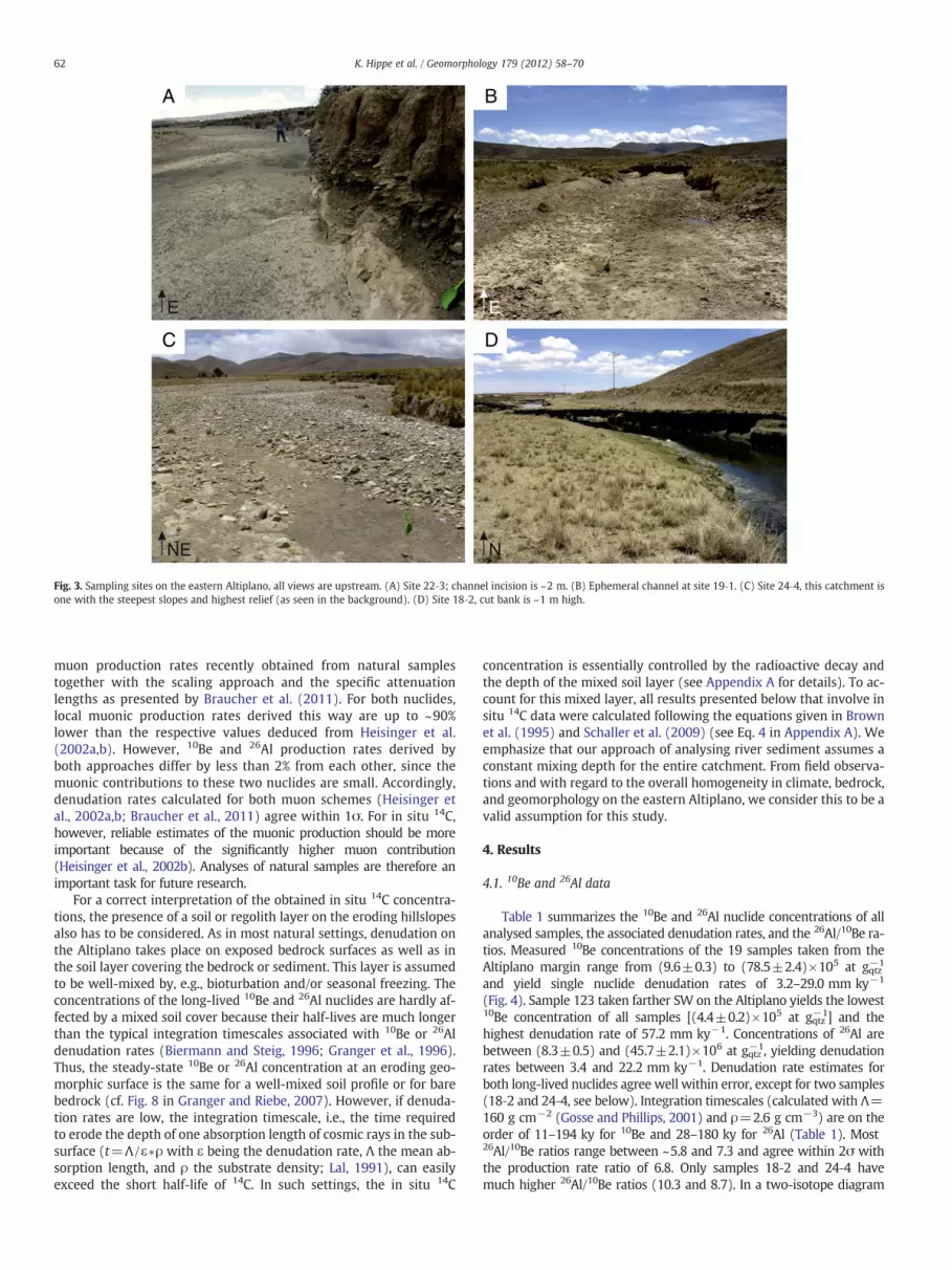
Fig. 3. Sampling sites on the eastern Altiplano, all views are upstream. (A) Site 22‐3; channel incision is ~2 m. (B) Ephemeral channel at site 19‐1. (C) Site 24‐4, this catchment isone with the steepest slopes and highest relief (as seen in the background). (D) Site 18‐2, cut bank is ~1 m high.
62 K. Hippe et al. / Geomorphology 179 (2012) 58–70
muon production rates recently obtained from natural samplestogether with the scaling approach and the specific attenuationlengths as presented by Braucher et al. (2011). For both nuclides,local muonic production rates derived this way are up to ~90%lower than the respective values deduced from Heisinger et al.(2002a,b). However, 10Be and 26Al production rates derived byboth approaches differ by less than 2% from each other, since themuonic contributions to these two nuclides are small. Accordingly,denudation rates calculated for both muon schemes (Heisinger etal., 2002a,b; Braucher et al., 2011) agree within 1σ. For in situ 14C,however, reliable estimates of the muonic production should be moreimportant because of the significantly higher muon contribution(Heisinger et al., 2002b). Analyses of natural samples are therefore animportant task for future research.
For a correct interpretation of the obtained in situ 14C concentra-tions, the presence of a soil or regolith layer on the eroding hillslopesalso has to be considered. As in most natural settings, denudation onthe Altiplano takes place on exposed bedrock surfaces as well as inthe soil layer covering the bedrock or sediment. This layer is assumedto be well-mixed by, e.g., bioturbation and/or seasonal freezing. Theconcentrations of the long-lived 10Be and 26Al nuclides are hardly af-fected by a mixed soil cover because their half-lives are much longerthan the typical integration timescales associated with 10Be or 26Aldenudation rates (Biermann and Steig, 1996; Granger et al., 1996).Thus, the steady-state 10Be or 26Al concentration at an eroding geo-morphic surface is the same for a well-mixed soil profile or for barebedrock (cf. Fig. 8 in Granger and Riebe, 2007). However, if denuda-tion rates are low, the integration timescale, i.e., the time requiredto erode the depth of one absorption length of cosmic rays in the sub-surface (t=Λ /ε∗ρ with ε being the denudation rate, Λ the mean ab-sorption length, and ρ the substrate density; Lal, 1991), can easilyexceed the short half-life of 14C. In such settings, the in situ 14C
concentration is essentially controlled by the radioactive decay andthe depth of the mixed soil layer (see Appendix A for details). To ac-count for this mixed layer, all results presented below that involve insitu 14C data were calculated following the equations given in Brownet al. (1995) and Schaller et al. (2009) (see Eq. 4 in Appendix A). Weemphasize that our approach of analysing river sediment assumes aconstant mixing depth for the entire catchment. From field observa-tions and with regard to the overall homogeneity in climate, bedrock,and geomorphology on the eastern Altiplano, we consider this to be avalid assumption for this study.
4. Results
4.1. 10Be and 26Al data
Table 1 summarizes the 10Be and 26Al nuclide concentrations of allanalysed samples, the associated denudation rates, and the 26Al/10Be ra-tios. Measured 10Be concentrations of the 19 samples taken from theAltiplano margin range from (9.6±0.3) to (78.5±2.4)×105 at gqtz−1
and yield single nuclide denudation rates of 3.2–29.0 mm ky−1
(Fig. 4). Sample 123 taken farther SW on the Altiplano yields the lowest10Be concentration of all samples [(4.4±0.2)×105 at gqtz−1] and thehighest denudation rate of 57.2 mm ky−1. Concentrations of 26Al arebetween (8.3±0.5) and (45.7±2.1)×106 at gqtz−1, yielding denudationrates between 3.4 and 22.2 mm ky−1. Denudation rate estimates forboth long-lived nuclides agree well within error, except for two samples(18‐2 and 24‐4, see below). Integration timescales (calculated with Λ=160 g cm−2 (Gosse and Phillips, 2001) and ρ=2.6 g cm−3) are on theorder of 11–194 ky for 10Be and 28–180 ky for 26Al (Table 1). Most26Al/10Be ratios range between ~5.8 and 7.3 and agree within 2σ withthe production rate ratio of 6.8. Only samples 18‐2 and 24‐4 havemuch higher 26Al/10Be ratios (10.3 and 8.7). In a two-isotope diagram

Table 1Sample locations, basin characteristics, cosmogenic nuclide data (10Be and 26Al), and calculated denudation rates; all errors are 1σ.
SampleID
Sampling location Basinarea
Meanaltitude
Palaeozoicrocks
Meanslope
Measuredconcentrationsa
26Al/10Be Production ratesb Denudation ratesc Integrationtime
Lat °S Lon °W (km2) (m) (%) (°) 10Be(105 at g−1)
26Al(106 at g−1)
10Be(at g−1 y−1)
26Al(at g−1 y−1)
10Be(mm ky−1)
26Al(mm ky−1)
10Be(ky)
26Al(ky)
18-2 16.6437 68.3240 197.0 4022 4.5 2.1 18.30±0.75 18.74±1.01 10.3±0.7 36.6 247.4 12.9±1.2 8.0±0.8 47.9 76.918-4 16.5741 68.3656 149.5 4355 45.3 7.7 78.45±2.36 45.69±2.07 5.8±0.3 42.7 288.3 3.2±0.3 3.4±0.3 194.1 180.418-5 16.5730 68.3661 1420.1 4022 27.2 3.8 36.63±1.10 – – 36.6 – 6.2±0.6 – 99.4 –
18-6 16.6659 68.2869 123.0 4009 16.3 3.4 51.83±1.56 37.92±1.69 7.3±0.4 36.5 246.4 4.2±0.4 3.5±0.4 145.4 173.718-7 16.6832 68.2745 13.7 3915 15.1 2.8 47.65±1.43 30.18±1.56 6.3±0.4 34.8 235.3 4.4±0.4 4.4±0.4 139.4 139.819-1 16.9152 68.1612 16.3 4017 0.5 4.6 26.45±0.80 – – 36.7 – 8.8±0.8 – 70.3 –
22-3 16.7777 68.1906 62.9 4085 0.0 6.4 15.92±0.48 – – 37.8 – 15.3±1.4 – 40.1 –
22-6 17.0328 68.0941 246.9 4101 59.1 6.6 42.68±1.54 28.14±1.57 6.6±0.4 38.1 257.5 5.5±0.5 5.3±0.5 112.3 116.324-1 17.1060 67.9911 35.3 4172 41.5 10.3 46.00±1.38 28.29±1.46 6.2±0.4 39.4 266.3 5.2±0.5 5.5±0.6 117.5 112.724-2 17.1233 67.9637 25.2 4094 70.4 9.0 48.43±1.45 32.98±1.40 6.8±0.4 38.0 256.8 4.8±0.4 4.4±0.4 129.2 140.224-3 17.2678 67.8591 39.0 4363 72.8 15.8 13.65±0.90 8.65±0.69 6.4±0.7 43.1 290.7 20.5±2.2 21.7±2.6 30.1 28.424-4 17.2941 67.8099 30.4 4324 94.1 17.2 9.55±0.32 8.31±0.54 8.7±0.6 42.3 285.6 29.0±2.7 22.2±2.4 21.2 27.724-5 17.3840 67.6443 36.6 4214 77.0 11.4 31.17±0.94 – – 40.2 – 8.1±0.7 – 76.0 –
24-6 17.3847 67.6353 103.9 4089 70.2 10.0 41.09±1.23 29.85±1.71 7.3±0.5 38.1 257.0 5.7±0.5 4.9±0.5 108.1 124.824-8 17.4515 67.6328 351.7 4015 41.6 7.8 25.77±0.77 – – 36.9 – 9.1±0.8 – 67.9 –
25-2 17.2831 67.3090 111.4 4334 97.8 8.6 19.38±0.62 12.67±0.71 6.6±0.4 42.5 287.2 14.1±1.3 14.3±1.5 43.7 43.025-3 17.3304 67.3922 74.6 4177 26.9 4.5 56.87±2.16 39.93±2.26 7.0±0.5 39.6 267.1 4.2±0.4 3.7±0.4 147.6 168.025-4 17.3662 67.5615 174.4 4057 29.4 8.0 26.81±0.81 17.60±1.01 6.6±0.4 37.4 252.3 8.8±0.8 8.8±0.9 70.0 70.3122 17.2297 68.0686 303.3 4171 15.3 6.4 22.06±0.66 – – 39.5 – 11.4±1.1 – 53.9 –
123 17.4781 68.3923 ~17900d 4076 n/a 4.8 4.37±0.16 – – 37.8 – 57.2±5.4 – 10.8 –
a Analyses were normalized to the ETH AMS standards S2007N for Be (calibrated to 07KNSTD) and ZAL94N (calibrated to KNSTD) for Al (Kubik and Christl, 2010).b Total basin-wide production rates from spallogenic and muonic production. Errors are 8.7% for 10Be and 8.6% for 26Al, respectively (Stone, 2000; Balco et al., 2008).c Errors include the statistical error of the AMS and ICP-MS (for 27Al) analyses, including the blank error and the uncertainty of the production rates.d Including only the drainage area south of the Lago Titicaca.
63K. Hippe et al. / Geomorphology 179 (2012) 58–70
(26Al/10Be vs. 10Be), most data points cluster around the erosion islanddefined by the lines of continuous exposure/no erosion and steady-state erosion (Fig. 5). From these results a simple exposure/denudationhistory without long-term (105–106 years) sediment storage can be in-ferred. Results for samples 18‐2 and 24‐4 that plot above the erosion is-land in the ‘forbidden field’ are most probably caused by a combinationof analytical reasons.
4.2. In situ 14C data
In situ 14C concentrations in the four analysed samples range from(2.54±0.04) to (3.72±0.04)×105 at gqtz−1 (Table 2). All in situ 14Cconcentrations are consistently lower than expected from the con-centrations of 10Be and 26Al under the assumption of simple exposure
Table 2In situ 14C dataa. All errors are 1σ.
Sample ID AMS ID Sample mass (g) CO2 yield (μg)b Fraction mod
18-7e ETH-40446.01 5.17 13.6 (-) 1.661±0.01718-7f ETH-40446.02 5.17 1.9 (7.9) 0.320±0.008Total18-7 g ETH-40885.01 5.63 16.7 (‐) 1.406±0.01418-7 h ETH-40886.01 5.63 2.5 (7.7) 0.367±0.009TotalMean24-3 ETH-45659.1 5.16 7.7 (‐) 0.549±0.00824-6a ETH-40447.01 5.30 28.4 (‐) 0.985±0.01124-6b ETH-40447.02 5.30 3.9 (7.4) 0.524±0.008Total25-4b ETH-41520.01 4.92 10.1 (‐) 1.569±0.01825-4c ETH-41520.02 4.92 2.1 (7.9) 0.604±0.010Total
a For samples 18‐7, 24‐6, and 25‐4, the results of both extraction steps and the total concentwo aliquots have been measured. The mean value of both total concentrations has been used
b Numbers in brackets give amount of ‘dead’ CO2 gas added. Uncertainty deriving from thec Normalized to δ 13C of−25‰ VPDB and AD 1950.d Calculated after Eq. 1 in Hippe et al. (in press).e Calculated after Eq. 2 in Hippe et al. (in press). Blank corrected and corrected for the additi
and steady-state conditions. Thus, in a single nuclide approach theseconcentrations would correspond to comparatively high denudationrates of 152–264 mm ky−1 with short integration times coveringthe late Holocene (2.3–4.1 ky).
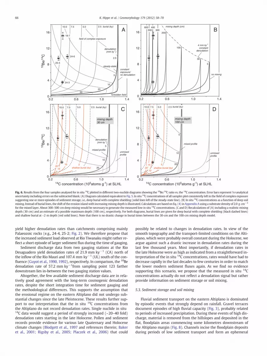
Ratios of 10Be/14C range between 3.6 and 15.2, which are muchhigher than the production ratio of 0.31. In a two-nuclide diagram(10Be/14C vs. 14C) the data points therefore plot well within thefield of complex exposure (Fig. 6). This implies significant storage ofthe sampled sediment. The simplest case of deep burial with com-plete shielding of the sediment requires a minimum storage overthe past 7.9–10.5 ky to reduce the in situ 14C concentrations from sat-uration to the measured values (Fig. 6A). Combined 10Be–14Cpaleodenudation rates (dotted lines) are in the same range as 10Beor 26Al denudation rates. The development of the in situ 14C
ern F14Cc δ13Cmeas14C/12Cabs (10−12)d 14C (105 at g−1)e 10Be/14C
−16.30 1.996±0.020 2.57±0.03−49.84 0.358±0.009 0.31±0.02
2.88±0.04−16.92 1.687±0.016 2.47±0.03−45.04 0.416±0.010 0.35±0.01
2.82±0.032.85±0.02 15.2±0.5
−24.37 0.649±0.009 3.49±0.06 3.1±0.2−21.07 1.172±0.013 3.11±0.04−41.08 0.598±0.009 0.61±0.02
3.72±0.04 11.3±0.4−16.61 1.883±0.022 1.88±0.03−45.07 0.684±0.012 0.66±0.02
2.54±0.04 9.7±0.3
tration are given. Sample 24‐3 was extracted in one single heating step. For sample 18‐7for all further calculations. Data interpretation and discussion is based on the bold values.CO2 pressure reading is 0.07 μg.
on of ‘dead’ CO2 gas with a mean 14C concentration of 315±118 at μg−1 CO2 (1σ, n=12).

64 K. Hippe et al. / Geomorphology 179 (2012) 58–70
concentration as a function of the thickness of a well-mixed soil layeris illustrated in a modified two-isotope diagram (10Be/14C vs. 14C;Fig. 6B). A long-term denudation rate of 4 mm ky−1, which is theminimum value of the 10Be-derived denudation rates of the four sam-ples analysed for in situ 14C, was included into the calculations. Thisrate slightly influences the position of the constant exposure linesand defines the upper limit of the 10Be/14C ratio for each depth.Fig. 6B shows that the measured in situ 14C data would correspondto mixing depths of as much as ~300–500 cm. In the discussionbelow, we will evaluate these results and present an interpretationthat accounts for a combination of soil mixing and sediment storage(Fig. 6C and D).
5. Discussion
Denudation on the eastern Altiplano is dominated by diffusiveerosion processes on the hillslopes (e.g., soil creep, overland flow,gully erosion; cf. Simpson and Schlunegger, 2003) that are reflectedin the 10Be and 26Al catchment-wide denudation rates. In the follow-ing, the spatial variability of these denudation rates will be discussedwith regard to local changes in geomorphic parameters. Because pre-cipitation is constant throughout the study area, we will concentrateon catchment morphology and lithology (Fig. 7). Possible temporalvariations in denudation rates will be evaluated by comparing resultsfrom the different cosmogenic nuclides with modern sediment loaddata (Guyot et al., 1990, 1992). In situ 14C will then be used to recon-struct complex sediment exposure and quantify sediment storage.
Fig. 4. Catchment-wide denudation rates calculated from 10Be and 26Al concentrations. Sampples analysed additionally for in situ 14C are 18‐7, 24‐3, 24‐6, and 25‐4. Sediment gauging srates were calculated from the mass flux (t km−2 y−1) of the suspended material. Note thdiamond at the northeastern shore of the Lago Titicaca.Map source: ASTER GDEM Version 1, METI and NASA.
The 10Be and 26Al data imply consistently low denudation ratesof ~3–29 mm ky−1 for the eastern Altiplano. These overall lowcatchment-wide denudation rates are a common feature oflow-relief landscapes worldwide (e.g., Biermann and Caffee, 2001;Hewawasam et al., 2003; Cox et al., 2009). However, our study areaon the eastern Altiplano is situated at the geomorphic transition to-ward the adjacent Rio La Paz basin characterized by huge contrastsin denudation processes and topography (Fig. 8). This settingprobably has its nearest equivalent in passive continental margin es-carpments that also exhibit strong morphologic contrasts betweenthe escarpment and the higher-elevated plateau area (e.g., Ollier,1985; Kooi and Beaumont, 1994; Seidl et al., 1996). In the Rio LaPaz basin, geomorphology is strongly affected by tectonic forcing(Zeilinger and Schlunegger, 2007). Landslides and other masswasting processes are prevalent (Blodgett and Isacks, 2007) and con-trol headward expansion of the drainage basin into the Altiplano(Zeilinger and Schlunegger, 2007). With ~200–600 mm ky−1 (Safranet al., 2005) and ~100–600 mm ky−1 (Zeilinger et al., 2009), respec-tively, cosmogenic nuclide-derived denudation rates reported for theRio La Paz basin and the Eastern Cordillera are more than two ordersof magnitude higher than 10Be and 26Al denudation rates presentedhere for the eastern Altiplano. These data illustrate a remarkable shiftin denudation processes and rates with changing geomorphologywith-in a distance of only a few kilometres. Furthermore, these contrasts ex-ceed by far differences in denudation rates reported for comparableplateau-escarpment settings (Heimsath et al., 2006; Vanacker et al.,2007).
ling sites are given with their associated drainage basins (except for sample 123). Sam-tations are named according to Guyot et al. (1990, 1992). Gauging-derived denudationat the location of the northernmost gauging station SU is given in Fig. 1 with the black

3
5
7
9
1.E+04 1.E+05 1.E+06 1.E+07
26A
l/10B
e
10Be concentration (atoms g-1) at SLHL
18-2
24-4
24-3
25-2
25-4
24-6
22-624-1
18-4
18-7
25-318-6
24-2constantexposure
steady-statedenudation
0.5
1.0
100 10 1
forbidden field
burial (Myr)
denudation (mm kyr-1)
field of complex exposure
Fig. 5. Two-nuclide diagram showing the 26Al/10Be ratio vs. the 10Be concentration.Error bars show 1σ analytical uncertainty including errors on the subtracted blank.The erosion island, the field of simple exposure/denudation, is enclosed by the linesof constant exposure and steady-state denudation (thick black lines). Dashed lines rep-resent 10Be–26Al paleodenudation rates; solid lines are burial lines illustrating the de-crease in the 26Al/10Be ratio for long-term sediment storage at great depths (completeshielding). Most data points plot in the erosion island within uncertainties, suggestinga simple exposure/denudation history. Samples 18‐2 and 24‐4 plot in the ‘forbiddenfield’ above the constant exposure line. These exceptionally high 26Al/10Be ratios areinterpreted as analytical artefacts.
65K. Hippe et al. / Geomorphology 179 (2012) 58–70
Interestingly, sample 123 indicates that the average large-scaledenudation rate on the northern Altiplano is somewhat higher(~57 mm ky−1) than the rates on the eastern Altiplano margin. Aspart of the sediment in the Rio Desaguadero is derived from theWestern Cordillera, this result might indicate that denudation ratesin the Western Cordillera are higher. In fact, a study on denudationin the Chilean Andes has presented cosmogenic nuclide-derived de-nudation rates of up to 46 mm ky−1 for the Western Cordillera,close to the Altiplano (Kober et al., 2007).
5.1. Geomorphic parameters and spatial variability of denudation rates
To assess the importance of basin topography on the denudationrates of the individual catchments, surface parameters such as catch-ment area, elevation, mean hillslope angle, and mean relief wereextracted from a DEM. We will discuss denudation rates based onthe 10Be data only, but results presented here are equally applicablefor the 26Al data. In situ 14C data are not included here because wedo not consider the concentration of that nuclide to be primarily con-trolled by denudation (see discussion below).
The catchments investigated for this study on the eastern Altiplanovary in size by up to two orders of magnitude. However, no influenceof catchment area on the denudation rates can be observed (Fig. 7A).The smallest (18–7, 14 km2) and the largest (18–5, 1420 km2) catch-ments yield similarly low denudation rates (Fig. 3). This shows that aslong as mass wasting is absent adequate denudation estimates can begained even from small basins.
For the majority of catchments that are between 3900 and 4300 masl, no correlation between denudation rates and mean basin altitude(Fig. 7B) is indicated. However, overall highest denudation rates werederived from basins at high mean altitudes above ~4300 m asl. Interest-ingly, the overall lowest denudation rate was obtained for a high eleva-tion catchment (18‐4). This is the only catchment that shows a clearglacial modification of the headwaters with glacial valley morphology
and moraine deposits ~10 km from the drainage divide. Althoughfluvioglacial deposits have also been mapped within the upstreamareas of catchments 18‐2, 18‐6, and 25‐2 (Fig. 2; GEOBOL, 1991–1994),no obvious trend in the denudation rates of those catchments is observedin our data. Thus, the actual impact of glaciation on themeasured 10Be or26Al concentrations is difficult to evaluate, but seems to be minor.
Mean basin slope is correlated with catchment lithology, moreprecisely with the percentage of Palaeozoic rocks within a catchment(Fig. 7C, Table 1). This indicates a stronger resistance of Palaeozoicformations to weathering and erosion processes resulting in an in-crease in topography. However, no clear correlation is given betweendenudation rates and the amount of Palaeozoic rocks. Interestingly,the two highest denudation rates are from catchments with thehighest mean basin slopes (24‐3 and 24‐4; Fig. 7D) implying a moreefficient removal of sediment from steeper slopes. On the otherhand, for the majority of catchments with mean slopes b12° there isno obvious correlation between mean basin slope and denudationrates. This suggests that most slope angles are too low to exert a dis-tinct control on denudation rates. These results are supported by sim-ilar observations reported from the high-elevation plateau at the SriLankan escarpment (Vanacker et al., 2007). Several studies have pro-posed a linear correlation between denudation rates and mean slope(or local relief) in low-relief, low-gradient settings (e.g., Ahnert,1970; Montgomery and Brandon, 2002; Ouimet et al., 2009). Butthis correlation is in most cases defined over a wide range of basinslopes or mean relief, which by far exceeds the gradients on the Alti-plano. From the data presented here, we suppose that only when acertain threshold slope angle is exceeded can an explicit increase indenudation rates be expected. This might be the case for catchments24‐3 and 24‐4 whose steeper slopes allow a more efficient transportfrom the hillslopes. Because the relation between basin mean local re-lief (calculated over a 1-km-diameter circle) and denudation rate isnearly identical to the one shown for mean basin slope and denuda-tion rate, it is not separately discussed here.
In conclusion, our results show that individual denudation ratesare not coupled to interbasin variations in geomorphic parametersbecause these variations are altogether small. However, the low geo-morphic gradients essentially influence sediment routing by limitingsediment transport capacity and facilitate sediment storage.
5.2. Temporal stability — cosmogenic nuclide data vs. sediment yield
To evaluate recent changes of denudation rates on the easternAltiplano, the cosmogenic nuclide-derived denudation rates are com-pared with denudation rates inferred from annual sediment dis-charge measurements. The mass flux (t km−2 y−1) of suspendedmaterial collected at five hydrometrical stations (Fig. 4) in the north-ern Altiplano and published by Guyot et al. (1990, 1992) wasconverted into denudation rates assuming a substrate density of2.6 g cm−3 (thus, 2.6 t km−2 y−1 corresponds to 1 mm ky−1). Theintegration time over which these data have been collected is1–6 years.
Two gauging stations (SU and JJ; Fig. 2) on streams directlydraining the eastern Altiplano margin yield denudation rates of 1.9and 7.8 mm ky−1, respectively. These data are in good agreementwith similarly low 10Be and 26Al denudation rates obtained formany of the investigated catchments along the Altiplano margin(Fig. 4). A comparatively high sediment gauging-derived denudationrate of 40.7 mm ky−1 has been recorded for the small Rio Tiwanaku(TI, ~50 km NW of our study area) whose catchment is comparableto most catchments studied here in terms of area, elevation, relief,slope and lithology. Guyot et al. (1992) attributed the high amountof suspended material in the Rio Tiwanaku to the presence of uncon-solidated Quaternary sediments, which are easily eroded duringfloods. Several catchments investigated in this study are also domi-nated by Quaternary deposits (e.g., 18‐2, 19‐1, 25‐3) but do not
0
4
8
12
16
0.2 0.6 1.0 1.4
mixing depth (cm)
0
100
200300
400500
no mixing
4 mm ky-1
constant denudation
30
0
4
8
12
16
0.2 0.6 1.0 1.4
10B
e/14
C
25-4
24-6
18-7
csteady-state
7.5 5.0
5
denudation (mm ky-1)
2.5 burial (ky)10.0
forbidden field
2.5
10
2050
0
4
8
12
16
0.2 0.6 1.0 1.414C concentration (105atoms g-1) at SLHL14C concentration (105atoms g-1) at SLHL
unmixed profile
mixing depth 100 cm
burial (ky)
mixed profile
5
10
1520 shallow burial (ky)
5
10
20
7.5 5.0 2.510.0
0
4
8
12
16
0.2 0.6 1.0 1.4
10B
e/14
C
unmixed profile
mixing depth 30 cm
7.5 5.0 2.5 burial (ky)
mixed profile
510
1520
10.0
shallow burial (ky)
5
10
20
denudation (mm ky-1)
field of complex exposure
24-3
600
onstantexposure/no denudation
BA
DC
Fig. 6. Results from the four samples analysed for in situ 14C plotted in different two-nuclide diagrams showing the 10Be/14C ratio vs. the 14C concentration. Error bars represent 1σ analyticaluncertainty including errors on the subtracted blank. (A)Diagram calculated equivalent to Fig. 5. In situ 14C concentrations of all samples plot consistently left in thefield of complex exposuresuggesting one ormore episodes of sediment storage, i.e., deep burial with complete shielding (solid lines left of the steady-state line). (B) In situ 14C concentrations as a function of deep soilmixing. Instead of burial lines, the shift of theerosion islandwith increasingmixing depth is illustrated. Calculations are based onEq. (4) inAppendixAusinga substrate density of 2.0 g cm−3
for themixed layer. About 300–500 cmdeepmixingwould be necessary to generate themeasured low in situ 14C concentrations. (C and D) Recalculations of (A) including a realistic mixingdepth (30 cm) and an estimate of a possible maximum depth (100 cm), respectively. For both diagrams, burial lines are given for deep burial with complete shielding (black dashed lines)and shallow burial at ~2 m depth (red solid lines). Note that there is no drastic change in burial times between the 30-cm and the 100-cm mixing depth model.
66 K. Hippe et al. / Geomorphology 179 (2012) 58–70
yield higher denudation rates than catchments comprising mainlyPalaeozoic rocks (e.g., 24‐4, 25‐2; Fig. 2). We therefore propose thatthe increased sediment load observed at Rio Tiwanakumight rather re-flect a short episode of larger sediment flux during the time of gauging.
Sediment discharge data from two gauging stations at the RioDesaguadero yield denudation rates of 21.9 mm ky−1 (CA) north ofthe inflow of the Rio Mauri and 107.4 mm ky−1 (UL) south of the con-fluence (Guyot et al., 1990, 1992), respectively. In comparison, the 10Bedenudation rate of 57.2 mm ky−1from sampling point 123 fartherdownstream lies in-between the two gauging station values.
Altogether, the few available sediment discharge data are in rela-tively good agreement with the long-term cosmogenic denudationrates, despite the short integration time for sediment gauging andthe methodological differences. This supports the assumption thatthe erosional regime on the eastern Altiplano did not undergo sub-stantial changes since the late Pleistocene. These results further sup-port to our interpretation that the in situ 14C concentrations fromthe Altiplano do not record denudation rates. Single nuclide in situ14C data would suggest a period of strongly increased (~20–40 fold)denudation rates starting in the late Holocene. Pollen and sedimentrecords provide evidence for various late Quaternary and Holoceneclimate changes (Blodgett et al., 1997 and references therein; Bakeret al., 2001; Rigsby et al., 2005; Placzek et al., 2006) that could
possibly be related to changes in denudation rates. In view of thesmooth topography and the transport-limited conditions on the Alti-plano, which were probably overall constant during the Holocene, weargue against such a drastic increase in denudation rates during thelast few thousand years. Most importantly, if denudation rates inthe late Holocene were as high as indicated from a straightforward in-terpretation of the in situ 14C concentrations, rates would have had todecrease rapidly in the last decades to few centuries in order to matchthe lower modern sediment fluxes again. As we find no evidencesupporting this scenario, we propose that the measured in situ 14Cconcentrations actually do not reflect a denudation signal but ratherprovide information on sediment storage or soil mixing.
5.3. Sediment storage and soil mixing
Fluvial sediment transport on the eastern Altiplano is dominatedby episodic events that strongly depend on rainfall. Gravel terracesdocument episodes of high fluvial capacity (Fig. 3), probably relatedto periods of increased precipitation. During these events of high dis-charge, material is removed from the hillslopes and deposited in theflat, floodplain areas commencing some kilometres downstream ofthe Altiplano margin (Fig. 8). Channels incise the floodplain depositsduring periods of low sediment transport and form an ephemeral

0
10
20
30
40
3800 4000 4200 4400
mean altitude (m)
B
0
4
8
12
16
20
0
10
20
30
40
0 20 40 60 80 100
mea
n sl
ope
(deg
ree)
10B
e de
nuda
tion
rate
(m
m k
y-1)
10B
e de
nuda
tion
rate
(m
m k
y-1)
10B
e de
nuda
tion
rate
(m
m k
y-1)
10B
e de
nuda
tion
rate
(m
m k
y-1)
Palaeozoic rocks (%)
denudation rate
mean slope
C
0
10
20
30
40
100010010catchment area (km2)
A
0
10
20
30
40
0 5 10 15 20
mean slope (degree)
D
24-3
24-4
Fig. 7. The 10Be denudation rates as a function of different geomorphic parameters for each catchment. Results for 26Al are nearly identical and therefore not shown here. Results forsample 123 are excluded because the northern Rio Desaguadero does not drain the eastern Altiplano. (A) Although the studied catchments vary in size by up to two orders of mag-nitude, long-term denudation rates do not correlate with basin area. (B) There is no statistical correlation between basin elevation and denudation rate. Catchments with thehighest mean basin altitude yielded the highest denudation rates, but also the lowest. (C) The mean basin slope correlates positively with the amount of Palaeozoic rocks withina catchment. In contrast, there is no correlation between amount of Palaeozoic rocks and denudation rates. (D) The two highest denudation rates were obtained for catchments withthe highest mean basin slopes. However, for basins with slopes b12°, no correlation between denudation rate and hillslope steepness exists.
67K. Hippe et al. / Geomorphology 179 (2012) 58–70
fluvial network with temporarily active channels migrating laterallyover the floodplain area.
Usually, sediment transfer or floodplain storage times, respectively,cannot be inferred from the concentrations of 10Be and 26Al becausein most settings residence times are too short to be resolvable by thisnuclide pair (cf. Wittmann and von Blanckenburg, 2009). This is alsothe case for the eastern Altiplano where a simple and continuousexposure/denudation history is suggested from the 10Be and 26Alconcentrations (Fig. 5). Because the results for in situ 14C do not agreewith steady exposure, the in situ 14C concentrations are used as indica-tors for floodplain storage or soil mixing depth. Two end-membermodels are illustrated in Fig. 6. The first model (Fig. 6A) ignores soilmixing and interprets the low 14C concentrations to be entirely causedby sediment storage. Suggested storage times cover the intervalfrom 7.9 to 10.5 ky until today (complete shielding) and have to beconsidered minimum estimates. With repeated episodes of sedimentstorage and reworking and/or burial at shallow depths, i.e. incompleteshielding, calculated storage times would further increase. Importantly,these results are well consistent with the geomorphic and climatic set-ting of the eastern Altiplano (floodplains, episodic rainfall).
Because denudation on the Altiplano occurs mainly on soil coveredhillslopes, the impact of soil mixing on the in situ 14C concentrationhas to be taken into account as discussed in Section 4.2. In the simplestcase of no sediment storage, in situ 14C concentrations can be directlyconverted into soil mixing depths that, for samples studied here,would correspond to depths of 300–500 cm(Fig. 6B). This seemsunrea-sonably large compared to field observations that indicate typical soildepths in the range of 20–30 cm or less. These estimates are similar tosoil depths reported from comparable settings in central Peru andnorthern Chile (Wilcox et al., 1988; Owen et al., 2010). Because a30-cm-deep, well-mixed soil is not sufficient to produce such low insitu 14C concentrations (Fig. 6B) a combination of soil mixing and sedi-ment storage is most likely. Including a 30-cm-deep mixed layer on the
hillslopes into the sediment storage model results in only slightlyshorter floodplain storage times compared to the no-mixing scenario(7.0–9.8 ky vs. 7.9–10.5 ky; Fig. 6C). For comparison, a mixing depthof 100 cm, which we consider a maximum estimate for the eastern Al-tiplano, still yields sediment storage for 4.6–7.4 ky (Fig. 6D). Thesemodels assume complete shielding, i.e., deep burial, of the sedimentduring residence on the floodplain. However, channels in the studyarea do not incise deeply and usually do not excavate sediment frommore than ~2-m depth. Such shallow storage would increase the resi-dence time by ~40–50% (assuming a single storage episode; Fig. 6Cand D) because of further low in situ 14C production during storage.
Altogether, we suppose that the solution given in Fig. 6C, i.e.,30-cm mixed soil on the hillslopes and shallow sediment storage onthe floodplain, is the most realistic reflection of the environmentalconditions on the eastern Altiplano. Comparing Fig. 6C to A showsthat, in this case, nuclide decay during sediment storage is the criticalelement controlling the in situ 14C concentrations. Although soilmixing has only a minor influence on the samples studied here, thediscussion above illustrates that in other settings in situ 14C couldbe applied to investigate the actual degree of mixing within soils.
While all storage times presented here are minimum estimates as-suming a single, recent sediment cycle, several periods of sedimentstorage and reexposure may be more likely and would lead to evenlonger residence times. Notably, sediment storage does not have tobe restricted to the floodplain or alluvial fan area surrounding thesampling site. As shown on the example of catchment 24‐6, gentlysloping channel reaches in the upstream area provide further poten-tial sites for sediment deposition (Fig. 8).
6. Summary and conclusions
Geomorphology and climate define denudation on the Bolivianeastern Altiplano by controlling the dynamics of erosional processes

Fig. 8. Reliefmap (ASTERGDEMVersion 1,METI andNASA) of the southern part of the study area illustrating local topography and geomorphic processes on the easternAltiplano (top) aswell as the topographic contrasts between the Altiplano and the Rio La Paz drainage basin (bottom). The catchment of sample 24‐6, forwhich all three cosmogenic nuclideswere analysed,is highlighted. The colour coding allows to differentiate between sediment‐producing hillslopes along theAltiplano–Rio La Paz drainage divide and theflat, low elevation areas at the tran-sition to the floodplain. The small inset gives channel profiles for the eastern andwesternmain reacheswithin that catchment. Vertical, red dashed linesmark channel segmentswith verylow channel slope angles (b2°), which could present possible domains for sediment storage. Note that the eastern reach of catchment 24‐6 exhibits such low slopes also along anupstreamchannel segment, proposing that sediment storage does not necessarily have to be restricted to the area close to the sampling site.With crossing the drainage divide toward the Rio La Pazwatershed, relief and local slope strongly increase.
68 K. Hippe et al. / Geomorphology 179 (2012) 58–70
and the transport capacity of the fluvial system. Our analyses of cos-mogenic 10Be and 26Al in fluvial sediments show consistently low de-nudation rates on the order of ~3–29 mm ky−1 that reflect slowsediment production on the hillslopes along the Altiplano margin(Fig. 8). These denudation rates are one to two orders of magnitudelower than in the adjacent Rio La Paz basin and the Eastern Cordilleraand coincide with a sharp contrast in geomorphology and denudationprocesses. Although the formation of topographic highs along theAltiplano–Rio La Paz drainage divide might result from isostatic com-pensation centred in the Rio La Paz basin (Zeilinger and Schlunegger,2007), denudation processes on the eastern Altiplano appear to belargely disconnected from the rapid, tectonically controlled processesin the Rio La Paz basin.
Denudation rates in the individual catchments studied here varyby more than one order of magnitude. However, no clear correlationbetween local denudation rates and variations in geomorphic basinparameters (relief/slope/basin area) can be observed. This might re-sult from the overall low topographic gradients in the study area.There is a good agreement between cosmogenic nuclide-derived de-nudation rates obtained from the long-lived nuclides 10Be and 26Aland modern sediment discharge data. These data suggest that therate at which sediment is removed from the eastern Altiplano todayis of the same order as the rate of sediment production by hillslopedenudation since the latest Pleistocene. While for the central Andeanfold-thrust belt a significant increase in denudation rates during the
Holocene was suggested (Insel et al., 2010), data from the easternAltiplano do not record any temporal variation in denudation rates.Altogether, our results point at a long-term (~105 y) geomorphicand isotopic (10Be, 26Al) steady-state for the eastern Altiplano.
Concentrations of in situ cosmogenic 14C do not give informationabout catchment-wide denudation rates but provide evidence for sedi-ment storage on the eastern Altiplano. The low in situ 14C concentrationsare in agreement with at least one episode of sediment storage and par-tial shielding lasting throughmost of the Holocene or even up to ~20 ky(Fig. 6C). However, several periods of storage and reworking during sed-iment routing through a catchment are even more likely. Most impor-tantly, results are consistent with the geomorphic setting of the easternAltiplano and the episodically occurring fluvial processes. This studyproves that over comparatively short distances (several kilometres, seeFig. 8) sediment storage can be an important element in low gradientlandscapes.Moreover, it illustrates that in situ 14C is a valuable tool to in-vestigate sediment routingwithinfluvial systems as it gives fundamentalinformation on the sediment flux and residence time.
Acknowledgements
We thank SERGEOMIN, La Paz, Bolivia, and S. Tawackoli for logisticalsupport. Many thanks to D. Granger and N. Lifton for instructive discus-sions and to S. Fahrni for assistance with the in situ 14C AMS measure-ments. We also thank A. Süsli, D. Niederer, and U. Menet for their
69K. Hippe et al. / Geomorphology 179 (2012) 58–70
continuous support at the in situ 14C extraction system. Critical reviewsby H. Wittmann and four anonymous reviewers helped improve thismanuscript. KH was partially funded by a grant from the SNF awardedto C. Schlüchter.
Appendix A. Determining the cosmogenic nuclide concentrationin an eroding, well-mixed soil layer
The development of the cosmogenic nuclide concentration withina bioturbated, well-mixed soil or regolith layer of constant thicknesshas been described in detail by Brown et al. (1995), Lal and Chen(2005), and Granger and Riebe (2007) and is given by:
d Nð Þdt
¼ Ph i− Nh iλ− Nh i sρx
þ N xð Þ sρx
ð1Þ
where ⟨N⟩ is the mean nuclide concentration within the mixed layerand is a function of the average production rate ⟨P⟩ over the entiremixing depth (x). Nuclides are lost from the mixed layer by denuda-tion (ε) and radioactive decay (λ) but also added by the incorporationof material from below with a concentration N(x) and with a rate (ε)equal to the denudation rate.
Moreover, mixing is assumed to be rapid so that the nuclide con-centration is uniform over the entire mixed layer.
The mean production rate ⟨P⟩ and the nuclide concentration N(x)at the top of the unmixed parent material can be derived from thelocal surface production rate P(0) by (Brown et al., 1995):
Ph i ¼ ∑iPi 0ð Þ Λ i
ρx1−e−ρx=Λ i� �
ð2Þ
and
N xð Þ ¼ ∑iPi 0ð Þ
λþ ρs=Λ ie−ρx=Λ i 1−e−t λþρs=Λ ið Þ� �
: ð3Þ
The subscript i denotes the different production pathways of nucle-onic andmuonic nuclide production. Coefficients given in Schaller et al.(2002) were used for depth scaling of the surface production rate.Solving Eq. (1) for ⟨N⟩ yields the expression below (Eq. 4), which hasbeen modified after Brown et al. (1995) and Schaller et al. (2009):
Nh i ¼ ∑i
Λ ieρx=Λ i
Λ i−ρx
!Pi 0ð Þλþ ρε
Λ i
1−e−t λþρs
Λi
� � !" #
þ∑i
1−Λ ieρx=Λ i
Λ i−ρx
!Pi 0ð Þ
λρx=Λ i þ ρε=Λ i1−e−t λþs=xð Þ� �� �
ð4Þ
Eq. (4) was used in this study for all calculations involving in situ 14Cand for the modelling of Fig. 6(A–D).
References
Ahnert, F., 1970. Functional relationships between denudation, relief, and uplift in largemid-latitude drainage basins. American Journal of Science 268, 243–263.
Allen, P.A., 1998. From landscapes into geological history. Nature 451, 274–276.Allmendinger, R.W., Jordan, T.E., Kay, S.M., Isacks, B.L., 1997. The evolution of the
Altiplano-Puna plateau of the central Andes. Annual Reviews of Earth and PlanetarySciences 25, 139–174.
Baker, P.A., Seltzer, G.O., Fritz, S.C., Dunbar, R.B., Grove, M.J., Tapia, P.M., Cross, S.L.,Rowe, H.D., Broda, J.P., 2001. The history of South American tropical precipitationfor the past 25,000 years. Science 291, 640–643.
Balco, G., Stone, J.O., Lifton, N.A., Dunai, T.J., 2008. A complete and easily accessiblemeans of calculating surface exposure ages or erosion rates from 10Be and 26Almeasurements. Quaternary Geochronology 3, 174–195.
Barnes, J.B., Ehlers, T.A., 2009. Endmember models for Andean Plateau uplift. Earth-ScienceReviews 97, 105–132.
Biermann, P.R., Caffee, M., 2001. Slow rates of rock surface erosion and sedimentproduction across the Namib Desert and escarpment, southern Africa. AmericanJournal of Science 301, 326–358.
Biermann, P., Steig, E.J., 1996. Estimating rates of denudation using cosmogenic isotopeabundances in sediment. Earth Surface Processes and Landforms 21, 125–139.
Biermann, P.R., Marsella, K.A., Patterson, C., Thompson Davis, P., Caffee, M., 1999. Mid-Pleistocene cosmogenic minimum-age limits for pre-Wisconsian glacial surfaces insouthwestern Minnesota and southern Baffin Island: a multiple nuclide approach.Geomorphology 27, 25–39.
Binnie, S.A., Phillips, W.M., Summerfield, M.A., Fifield, L.K., Spotila, J.A., 2008. Patterns ofdenudation through time in the San Bernardino Mountains, California: implicationsfor early-stage orogenesis. Earth and Planetary Science Letters 276, 62–72.
Blodgett, T.A., Isacks, B.L., 2007. Landslide erosion rate in the Eastern Cordillera ofnorthern Bolivia. Earth Interactions 11, 1–30.
Blodgett, T.A., Lenters, J.D., Isacks, B.L., 1997. Constraints on the origin of paleolake ex-pansion in the central Andes. Earth Interactions 1, 1–28.
Bookhagen, B., Strecker, M.R., 2008. Orographic barriers, high-resolution TRMM rain-fall, and relief variations along the eastern Andes. Geophysical Research Letters35, L06403. http://dx.doi.org/10.1029/2007GL032011.
Braucher, R., Merchel, S., Borgomano, J., Bourlès, D.L., 2011. Production of cosmogenicradionuclides at great depth: a multi element approach. Earth and PlanetaryScience Letters 309, 1–9.
Brown, E.T., Stallard, R.F., Larsen, M.C., Raisbeck, G.M., Yiou, F., 1995. Denudation ratesdetermined from the accumulation of in situ-produced 10Be in the Luquillo Exper-imental Forest, Puerto Rico. Earth and Planetary Science Letters 129, 193–202.
Chmeleff, J., von Blanckenburg, F., Kossert, K., Jakob, D., 2010. Determination of the 10Behalf-life by multi-collector ICP-MS and liquid scintillation counting. Nuclear Instru-ments and Methods in Physics Research B 268, 192–199.
Clapperton, C.M., Clayton, J.D., Benn, D.I., Marden, C.J., Argollo, J., 1997. Late Quaternaryglacier advances and palaeolake highstands in the Bolivian Altiplano. QuaternaryInternational 38/39, 49–59.
Cox, R., Biermann, P., Jungers, M.C., Rakotondrazafy, A.F.M., 2009. Erosion rates andsediment sources in Madagascar inferred from 10Be analysis of lavaka, slope, andriver sediment. Journal of Geology 117, 363–376.
Dewey, J.F., Lamb, S.H., 1992. Active tectonics of the Andes. Tectonophysics 205, 79–95.Dietrich, W.E., Dunne, T., 1978. Sediment budget for a small catchment in mountainous
terrain. Zeitschrift für Geomorphologie, Supplementband 29, 191–206.Ege, H., Sobel, E.R., Scheuber, E., Jacobshagen, V., 2007. Exhumation history of the
southern Altiplano plateau (southern Bolivia) constrained by apatite fission trackthermochronology. Tectonics 26. http://dx.doi.org/10.1029/2005TC001869.
Ehlers, T.A., Poulsen, C.J., 2009. Influence of Andean uplift on climate andpaleoaltimetry estimates. Earth and Planetary Science Letters 281, 238–248.
Elger, K., Oncken, O., Glodny, J., 2005. Plateau-style accumulation of deformation:Southern Altiplano. Tectonics 24. http://dx.doi.org/10.1029/2004TC001675.
Francou, B., Ribstein, P., Saravia, R., Tiriau, E., 1995. Monthly balance and water dis-charge of an inter-tropical glacier: Zongo Glacier, Cordillera Real, Bolivia, 16°S.Journal of Glaciology 42, 61–67.
Garreaud, R.D., Aceituno, P., 2001. Interannual rainfall variability over the South AmericanAltiplano. Journal of Climate 14, 2779–2789.
Garreaud, R., Vuille, M., Clement, A.C., 2003. The climate of the Altiplano: observed currentconditions and mechanisms of past changes. Palaeogeography, Palaeoclimatology,Palaeoecology 194, 5–22.
Garzione, C.N., Hoke, G.D., Libarkin, J.C., Withers, S., MacFadden, B., Eiler, J., Ghosh, P.,Mulch, A., 2008. Rise of the Andes. Science 320, 1304–1307.
GEOBOL — Servicio Geologico de Bolivia, 1991–1994. Carta Geologica de Bolivia, Scale1:100.000. Publicacion SGB SERIE I-CGB, La Paz.
Gosse, J.C., Phillips, F.M., 2001. Terrestrial in situ cosmogenic nuclides: theory andapplication. Quaternary Science Reviews 20, 1475–1560.
Granger, D.E., Muzikar, P.F., 2001. Dating sediment burial with in situ-produced cosmo-genic nuclides: theory, techniques, and limitations. Earth and Planetary ScienceLetters 188, 269–281.
Granger, D.E., Riebe, C.S., 2007. Cosmogenic nuclides in weathering and erosion. In:Drever, J.I. (Ed.), Treatise on Geochemistry. Surface and GroundWater, Weatheringand Soils, 5. Elsevier, London, pp. 1–43.
Granger, D.E., Kirchner, J.W., Finkel, R., 1996. Spatially averaged long-term erosionrates measured from in situ-produced cosmogenic nuclides in alluvial sediment.Journal of Geology 104, 249–257.
Guyot, J.L., Roche, M.A., Noriega, L., Calle, H., Quintanilla, J., 1990. Salinities and sedi-ment transport in the Bolivian Highlands. Journal of Hydrology 113, 147–162.
Guyot, J.L., Wasson, J.-G., Quintanilla, J., Calle, H., 1992. Dissolved matter and suspendedsediment loads in some inflow rivers and in the Rio Desaguadero. In: Dejoux, C.,Iltis, A. (Eds.), Lake Titicaca: A Synthesis of Limnological Knowledge. KluwerAcademic Publishers, Dordrecht, Netherlands, pp. 113–119.
Heimsath, A.M., Chappell, J., Finkel, R.C., Fifield, K., Alimanovic, A., 2006. Escarpment ero-sion and landscape evolution in southeastern Australia. In: Willett, S.D., Hovius, N.,Brandon, M.T., Fisher, D.M. (Eds.), Tectonics, Climate and Landscape Evolution. Geo-logical Society of America Special Paper 398, Boulder, USA, pp. 173–190.
Heisinger, B., Lal, D., Jull, A.J.T., Kubik, P., Ivy-Ochs, S., Neumaier, S., Knie, K., Lazarev, V.,Nolte, E., 2002a. Production of selected cosmogenic radionuclides by muons: 1.Fast muons. Earth and Planetary Science Letters 200, 345–355.
Heisinger, B., Lal, D., Jull, A.J.T., Kubik, P., Ivy-Ochs, S., Knie, K., Nolte, E., 2002b. Productionof selected cosmogenic radionuclides by muons: 2. Capture of negative muons. Earthand Planetary Science Letters 200, 357–369.
Hewawasam, T., von Blanckenburg, F., Schaller, M., Kubik, P., 2003. Increase of humanover natural erosion rates in tropical highlands constrained by cosmogenic nuclides.Geology 31, 597–600.
Hippe, K., Kober, F., Baur, H., Ruff, M., Wacker, L., Wieler, R., 2009. The current perfor-mance of the in situ 14C extraction line at ETH. Quaternary Geochronology 4,493–500.

70 K. Hippe et al. / Geomorphology 179 (2012) 58–70
Hippe, K., Kober, F., Wacker, L., Fahrni, S.M., Ivy-Ochs, S., Akçar, N., Schlüchter, C.,Wieler, R. An update on cosmogenic in situ 14C analysis at ETH Zürich. NuclearInstruments and Methods in Physics Research B, in press.
Horton, B.K., 1999. Erosional control on the geometry and kinematics of thrust beltdevelopment in the central Andes. Tectonics 18, 1292–1304.
Imaizumi, T., Nogami, M., Hirakawa, K., Koaze, T., 2000. Active faults and Quaternarygeo-history of the Altiplano on the foot of the Cordillera Real, Bolivia. GeographicalReports of Tokyo Metropolitan University, Departmental Bulletin Paper 35, Tokyo,Japan, pp. 51–58.
Insel, N., Ehlers, T.A., Schaller, M., Barnes, J.B., Tawackoli, S., Poulsen, C.J., 2010. Spatialand temporal variability in denudation across the Bolivian Andes from multiplegeochronometers. Geomorphology 122, 65–77.
Isacks, B.L., 1988. Uplift of the central Andean Plateau and bending of the Bolivianorocline. Journal of Geophysical Research 93, 3211–3231.
Ivy-Ochs, S., 1996. The dating of rock surfaces using in situ produced 10Be, 26Al and 36Cl,with examples from Antarctica and the Swiss Alps. Ph.D. Thesis, ETH Zürich.
Klein, A.G., Seltzer, G.O., Isacks, B.L., 1999. Modern and last local glacial maximumsnowlines in the Central Andes of Peru, Bolivia, and Northern Chile. QuaternaryScience Reviews 18, 63–84.
Kober, F., Ivy-Ochs, S., Schlunegger, F., Baur, H., Kubik, P.W., Wieler, R., 2007. Denudationrates and a topography-driven rainfall threshold in northern Chile: multiple cosmo-genic nuclide data and sediment yield budgets. Geomorphology 83, 97–120.
Kober, F., Ivy-Ochs, S., Zeilinger, G., Schlunegger, F., Kubik, P.W., Baur, H., Wieler, R.,2009. Complex multiple cosmogenic nuclide concentration and histories in thearid Rio Lluta catchment, northern Chile. Earth Surface Processes and Landforms34, 398–412.
Kohl, C.P., Nishiizumi, K., 1992. Chemical isolation of quartz for measurement of in-situ-produced cosmogenic nuclides. Geochimica et Cosmochimica Acta 56,3583–3587.
Kooi, H., Beaumont, C., 1994. Escarpment evolution on high-elevation rifted margins:insights derived from a surface processes model that combines diffusion, advec-tion, and reaction. Journal of Geophysical Research 99, 12191–12209.
Korschinek, G., Bergmaier, A., Faestermann, T., Gerstmann, U.C., Knie, K., Rugel, G.,Wallner, A., Dillmann, I., Dollinger, G., Lierse von Gostomski, C., Kossert, K., Maiti,M., Poutivtsev, M., Remmert, A., 2010. A new value for the half-life of 10Be by heavy-ion elastic recoil detection and liquid scintillation counting. Nuclear Instruments andMethods in Physics Research B 268, 187–191.
Kubik, P.W., Christl, M., 2010. 10Be and 26Al measurements at the Zurich 6 MV TandemAMS facility. Nuclear Instruments and Methods in Physics Research B 268,880–883.
Lal, D., 1991. Cosmic ray labelling of erosion surfaces: in situ nuclide production ratesand erosion models. Earth and Planetary Science Letters 104, 424–439.
Lal, D., Chen, J., 2005. Cosmic ray labelling of erosion surfaces II: special cases of expo-sure histories of boulders, soils and beach terraces. Earth and Planetary ScienceLetters 236, 797–813.
Lamb, S., Hoke, L., Kennan, L., Dewey, J., 1997. Cenozoic evolution of the Central Andesin Bolivia and northern Chile. In: Burg, J.-P., Ford, M. (Eds.), Orogeny Through Time,Geological Society London Special Publication 121, pp. 237–264.
Lancaster, S.T., Casebeer, N.E., 2007. Sediment storage and evacuation in headwatervalleys at the transition between debris-flow and fluvial processes. Geology 35,1027–1030.
Masek, J.G., Isacks, B.L., Gubbels, T.L., Fielding, E.J., 1994. Erosion and tectonics at themargin of continental plateaus. Journal of Geophysical Research 99, 13941–13956.
Montgomery, D.R., Brandon, M.T., 2002. Topographic controls on erosion rates in tec-tonically active mountain ranges. Earth and Planetary Science Letters 201,481–489.
Montgomery, D.R., Balco, G., Willett, S.D., 2001. Climate, tectonics, and the morphologyof the Andes. Geology 29, 579–582.
Nakamura, F., Maita, H., Araya, T., 1995. Sediment routing analyses based on chronolog-ical changes in hillslope and riverbed morphologies. Earth Surface Processes andLandforms 20, 333–346.
Norton, K., Schlunegger, F., 2011. Migrating deformation in the central Andes from en-hanced orographic rainfall. Nature Communications 2, 584.
Ochs, M., Ivy-Ochs, S., 1997. The chemical behaviour of Be, Al, Fe, Ca and Mg duringAMS target preparation from terrestrial silicates modelled with chemical specia-tion calculations. Nuclear Instruments and Methods in Physics Research B 123,235–240.
Ollier, C.D., 1985. Morphotectonics of continental margins with great escarpments. In:Morisawa, M., Hack, J.T. (Eds.), Tectonic Geomorphology. Allen and Unwin, Boston,pp. 3–25.
Ouimet, W.B., Whipple, E.X., Granger, D.E., 2009. Beyond threshold hillslopes: channeladjustment to base-level fall in tectonically active mountain ranges. Geology 37,579–582.
Owen, J.J., Amundson, R., Dietrich, W.E., Nishiizumi, K., Sutter, B., Chong, G., 2010. Thesensitivity of hillslope bedrock erosion to precipitation. Earth Surface Processesand Landforms 36, 117–135.
Placzek, C., Quade, J., Patchett, P.J., 2006. Geochronology and stratigraphy of latePleistocene lake cycles on the southern Bolivian Altiplano: implications for causesof tropical climate change. Geological Society of America Bulletin 118, 515–532.
Rigsby, C.A., Bradbury, J.P., Baker, P.A., Rollins, S.M., Warren, M.R., 2005. Late Quaternarypalaeolakes, rivers, and wetlands on the Bolivian Altiplano and their palaeoclimaticimplications. Journal of Quaternary Science 20, 671–691.
Ruff, M., Wacker, L., Gäggeler, H.W., Suter, M., Synal, H.-A., Szidat, S., 2007. A gas ionsource for radiocarbon measurements at 200 kV. Radiocarbon 49, 790–794.
Safran, E.B., Biermann, P.R., Aalto, R., Dunne, T., Whipple, K.X., Caffee, M., 2005. Erosionrates driven by channel network incision in the Bolivian Andes. Earth SurfaceProcesses and Landforms 30, 1007–1024.
Schaller, M., von Blanckenburg, F., Hovius, N., Kubik, P.W., 2001. Large-scale erosionrates from in situ-produced cosmogenic nuclides in European river sediments.Earth and Planetary Science Letters 188, 441–458.
Schaller, M., von Blanckenburg, F., Veldkamp, A., Tebbens, L.A., Hovius, N., Kubik, P.W.,2002. A 30 000 y record of erosion rates from cosmogenic 10Be in Middle Europeanriver terraces. Earth and Planetary Science Letters 204, 307–320.
Schaller, M., Ehlers, T.A., Blum, J.D., Kallenberg, M.A., 2009. Quantifying glacial moraineage, denudation, and soil mixing with cosmogenic nuclide depth profiles. Journalof Geophysical Research 114. http://dx.doi.org/10.1029/2007JF000921.
Seidl, M.A., Weissel, J.K., Pratson, L.F., 1996. The kinematics and pattern of escarpmentretreat across the rifted continental margin of SE Australia. Basin Research 12,301–316.
Seltzer, G.O., 1992. Late Quaternary glaciation of the Cordillera Real, Bolivia. Journal ofQuaternary Science 7, 87–98.
SERGEOMIN, 2001. Mapa Geologico de Bolivia, Scale 1:1.000.000. SERGEOMIN(Servicio nacional de geologia y mineria), La Paz.
Simpson, G., Schlunegger, F., 2003. Topographic evolution and morphology of surfacesevolving in response to coupled fluvial and hillslope sediment transport. Journal ofGeophysical Research 108. http://dx.doi.org/10.1029/2002JB002162.
Smith, J.A., Seltzer, G.O., Farber, D.L., Rodbell, D.T., Finkel, R.C., 2005. Early local LastGlacial Maximum in the tropical Andes. Science 308, 678–681.
Smith, J.A., Mark, B.G., Rodbell, D.T., 2008. The timing and magnitude of mountain gla-ciation in the tropical Andes. Journal of Quaternary Science 23, 609–634.
Stone, J.O., 2000. Air pressure and cosmogenic isotope production. Journal of GeophysicalResearch 105, 23753–23759.
Synal, H.-A., Bonani, M., Döbeli, M., Ender, R.M., Gartenmann, P., Kubik, P.W., Schnabel,C., Suter, M., 1997. Status report of the PSI/ETH AMS facility. Nuclear Instrumentsand Methods in Physics Research B 123, 62–68.
Synal, H.-A., Stocker, M., Suter, M., 2007. MICADAS: a new compact radiocarbon AMSsystem. Nuclear Instruments and Methods in Physics Research B 259, 7–13.
Vanacker, V., von Blanckenburg, F., Hewawasam, T., Kubik, P.W., 2007. Constraininglandscape development of the Sri Lankan escarpment with cosmogenic nuclidesin river sediment. Earth and Planetary Science Letters 253, 402–414.
von Blanckenburg, F., 2005. The control mechanisms of erosion and weathering atbasin scale from cosmogenic nuclides in river sediment. Earth and PlanetaryScience Letters 237, 462–479.
Wacker, L., Bonani, G., Friedrich, M., Hajdas, I., Kromer, B., Nĕmec, M., Ruff, M., Suter, M.,Synal, H.-A., Vockenhuber, C., 2010. MICADAS: routine and high-precision radio-carbon dating. Radiocarbon 52, 252–262.
Whipple, K.X., 2009. The influence of climate on the tectonic evolution of mountainbelts. Nature Geoscience 2, 97–104.
Wilcox, B.P., Allen, B.L., Bryant, F.C., 1988. Description and classification of soils of thehigh-elevation grasslands of central Peru. Geoderma 42, 79–94.
Willet, S.D., 1999. Orogeny and orography: the effects of erosion on the structure ofmountain belts. Journal of Geophysical Research 104, 28957–28981.
Wittmann, H., von Blanckenburg, F., 2009. Cosmogenic nuclide budgeting of floodplainsediment transfer. Geomorphology 109, 246–256.
Wittmann, H., von Blanckenburg, F., Kruesmann, T., Norton, K.P., Kubik, P.W., 2007.Relation between rock uplift and denudation from cosmogenic nuclides in riversediment in the Central Alps of Switzerland. Journal of Geophysical Research 112.http://dx.doi.org/10.1029/2006JF000729.
Zeilinger, G., Schlunegger, F., 2007. Possible flexural accommodation on the easternedge of the Altiplano in relation to focussed erosion in the Rio La Paz drainage system.Terra Nova 19, 373–380.
Zeilinger, G., Kober, F., Strecker, M., Ivy-Ochs, S., Kubik, P.W., Hippe, K., 2009. Erosionrates in the Rio La Paz drainage basin: evidence for spatially and temporally vari-able erosion processes. Geophysical Research Abstracts 11, EGU2009–EGU8092.


