Embed Size (px)
Citation preview

Quantifying historical gully erosion in
northern Bavaria
Markus Dotterweich*, Anne Schmitt, Gabriele Schmidtchen,Hans-Rudolf Bork
Ecosystem Research Centre, University of Kiel, Olshausenstr. 40, D-24098 Kiel, Germany
Received 20 September 2000; received in revised form 30 January 2001; accepted 22 February 2001
Abstract
The Wolfsgraben is one of many ravines that cut into the silty–sandy material of the Triassic
benchlands of northern Bavaria, Germany. Within the research area, a gully—several meters in
depth—has carved in to a bluff 500 m west of the upper Main valley. An analysis of 17 exposures and
30 drillings was conducted within the gully and its colluvial fan in order to reconstruct the soil
formation, extreme rainfall events and land use changes throughout history.
Detailed field studies, chemical soil analysis, dating methods of charcoal and pottery, as well as
written documents were combined to produce a high-resolution stratigraphy.
Nine main phases of landscape evolution, caused by extreme rainfall, runoff and soil erosion in
agriculturally used areas, have been identified since the medieval period. The highest amount of soil
loss occurred during 14th, 18th and 19th centuries, a result of intensive land use. Climate changes
affected the intensity of rainfall and the magnitude of soil loss during these periods.
D 2003 Elsevier Science B.V. All rights reserved.
Keywords: Land use; Gully erosion; Landscape evolution; Erosion rates; Climate changes; Bavaria
1. Introduction
To quantify historical soil losses, it is necessary to find suitable sedimentation traps in
small catchments. This article describes an interdisciplinary investigative approach for a
refilled gully system, which has cut itself into a small valley in northern Bavaria, Germany.
0341-8162/03/$ - see front matter D 2003 Elsevier Science B.V. All rights reserved.
PII: S0341 -8162 (02 )00142 -X
* Corresponding author. Tel.: +49-431-880-4002; fax: +49-431-880-4083.
E-mail address: [email protected] (M. Dotterweich).
URL: http://www.markus-dotterweich.de.
www.elsevier.com/locate/catena
Catena 50 (2003) 135–150

Fig. 1. The situation of the Wolfsgraben (source: Geological map of Bavaria 1:25.000, sheet no. 6031, Bamberg
Nord).
M. Dotterweich et al. / Catena 50 (2003) 135–150136

Fig. 2. Survey map of the Wolfsgraben.
M. Dotterweich et al. / Catena 50 (2003) 135–150 pp. 137–142

Around 5000 B.C., the first Neolithic farmers settled in northern Bavaria (Zuchner,
1996, p. 54). At this time, man started to change the environment significantly. Because of
the growing population in the medieval period, extended forest clearing for arable land was
necessary. The soil was now no longer protected and heavy rainfall events eroded the fertile
topsoil. With the declining soil fertility, crop failures occurred more frequently causing
malnutrition. As a result, starvation and epidemic diseases increased, leading to a decrease
in population density (Bork et al., 1998). The sediments of the terraces in the valleys of the
rivers Main and Regnitz in northern Bavaria mirror this pattern of soil erosion, sedimenta-
tion and land use history (Schirmer, 1983).
2. Materials and methods
An interdisciplinary approach was used to investigate the impact of land use changes and
extreme rainfall events on soil erosion processes and gully development during the late
Holocene. The approach consisted of detailed field studies, examination of drillings and
soil exposures, dating methods and chemical soil analysis, as well as studies of contem-
porary maps and documents. In 1999, 17 exposures (depth up to 3 m) and more than 27
drillings (depth up to 5 m) were investigated in the catchment area, the infillings of the
ravine and the colluvial fan of the Wolfsgraben (Dotterweich et al., 2002). Chemical
analyses of organic matter, phosphate, Al, Mn, Fe and heavy metals (Cu, Pb, Zn, Cd and
Cd) were carried out. 14C-dating of charcoal and archaeological dating of pottery helped to
identify the ages of soil accumulations and soil formations. The detailed analysis of
contemporary documents and maps revealed the history of land use. Precise field surveying
of the investigation area using a ‘‘Field Total Station’’ was necessary to quantify soil
erosion. The synthesis of all methods described above led to a complex stratigraphy.
3. General situation
The Wolfsgraben (N: 49j56V49U, E: 10j51V53U) is situated near the village of
Kemmern, 10 km north of the city of Bamberg (Fig. 1). The catchment area measuring
0.45 km2 extends from the floodplain of the river Main 500 m upslope to the hilly areas of
the Triassic benchland. The slopes of the Wolfsgraben are 30 m deep, and today, they are
covered by forest. The soils are loamy and sandy; cambisols being dominant. The annual
precipitation totals 650–700 mm year� 1 and the mean temperature ranges from 7 to 8 jC(Climatic map of Bavaria 1:2.500.000, 1955). The main encarvation of the Wolfsgraben
was caused by the gradual lowering of the valley of the river Main. This took place during
the Pleistocene (Budel, 1957, p. 34; Rohdenburg, 1971, p. 248).
Along the thalweg of the Wolfsgraben, a refilled gully is present. A younger gully with
a length of 350 m and a maximum depth of 3 m has cut into the sediments. Most of the
year, water runs through the gully. The fresh walls of the recent gully enabled us to
investigate the sediments of the Wolfsgraben (Fig. 2). Under the deciduous forest, five
land use terraces caused by former ploughing can be seen at the southward-facing slope.
On the northward-facing slope, some abandoned quarries of the 18th/19th century are still
M. Dotterweich et al. / Catena 50 (2003) 135–150 143
remaining. A detailed analysis of Wolfsgraben’s land use history is described in Schmitt
(1999).
4. Results
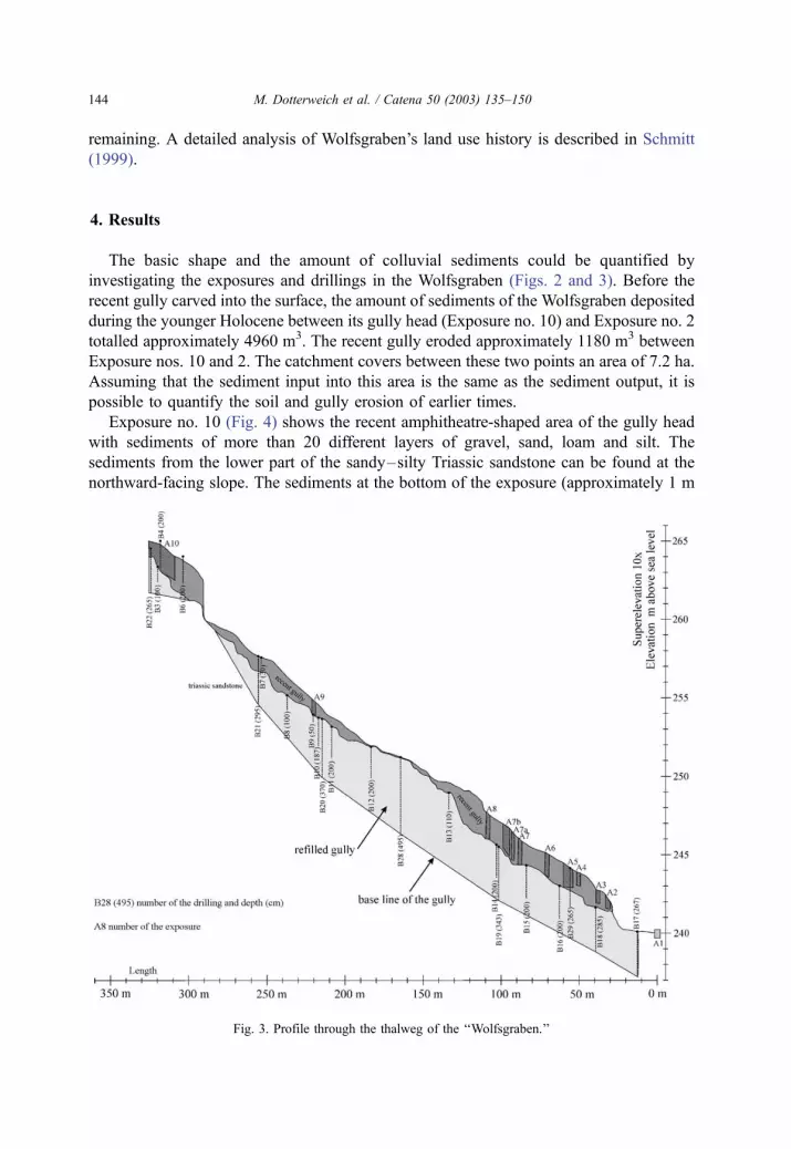
The basic shape and the amount of colluvial sediments could be quantified by
investigating the exposures and drillings in the Wolfsgraben (Figs. 2 and 3). Before the
recent gully carved into the surface, the amount of sediments of the Wolfsgraben deposited
during the younger Holocene between its gully head (Exposure no. 10) and Exposure no. 2
totalled approximately 4960 m3. The recent gully eroded approximately 1180 m3 between
Exposure nos. 10 and 2. The catchment covers between these two points an area of 7.2 ha.
Assuming that the sediment input into this area is the same as the sediment output, it is
possible to quantify the soil and gully erosion of earlier times.
Exposure no. 10 (Fig. 4) shows the recent amphitheatre-shaped area of the gully head
with sediments of more than 20 different layers of gravel, sand, loam and silt. The
sediments from the lower part of the sandy–silty Triassic sandstone can be found at the
northward-facing slope. The sediments at the bottom of the exposure (approximately 1 m
M. Dotterweich et al. / Catena 50 (2003) 135–150144
Fig. 3. Profile through the thalweg of the ‘‘Wolfsgraben.’’

above the basis of the origin sandstone) included some pieces of pottery which date back
to the latter half of the 15th century (archaeological dating: Dr. J. Haberstroh, Bavarian
State Department of Historical Monuments, May 27, 1999) and many hundred pieces of
charcoal. The first meter of sediment in the exposure is red silt originating from the lettic
southward-facing slopes.
Exposure no. 8 (Fig. 5) reveals a 2.5-m deep exposure at the southern wall of the recent
gully. The lowest part shows loamy–sandy sediments (layers 1–4). Inside of layer 4, two
pieces of pottery were found dated to the 17th/18th century (archaeological dating: Dr. J.
Haberstroh, Bavarian State Department of Historical Monuments, Sept. 27, 1999). Above
layer 4 follows a small silty black soil horizon containing 12% of organic matter. On top,
there is a very hard and stony layer (no. 6), possibly an old track to the quarries located at
the north facing slopes. The last 1.2 m contains gravel and sand rubble from the quarries.
The exposures of the lower part of the gully are mostly silty–sandy. In these sediments,
more than 15 pieces of pottery were found from the 17th/18th centuries. By means of a 25-
and 2-m large exposure SGA1 (Fig. 2) on the colluvial fan of the Wolfsgraben, the
sediments deposited from the recent gully were investigated. More than 20 pieces of
pottery from the 17th/18th centuries could be identified in the 13 sedimentation layers.
In the sediments of drilling No. 21, some pieces of charcoal were found approximately
20 cm above the Triassic sandstone basis. The 14C-dating revealed an age of 317F 29 B.P.
(two sigma cal A.D. 1480–1694; Leibniz Labor, University of Kiel, KIA 8550, according
to CALIB rev4.0, test version 6 (Datasets 1), Stuiver et al., 1998). The sediments in the
drilling No. 28 have a thickness of 495 cm. A piece of pine bark 407F 26 B.P. in age (two
M. Dotterweich et al. / Catena 50 (2003) 135–150 145
Fig. 4. Exposure no. 10.

sigma cal A.D. 1437–1510, 1600–1613; Leibniz Labor, University of Kiel, KIA 8549)
was discovered 1.75 m above the basis.
Nine main phases of landscape development of the Wolfsgraben were distinguished.
Phase 1: During the Pleistocene, the Wolfsgraben carved into the Triassic benchland
following the lowering of the river Main (Budel, 1957, p. 34).
Phase 2: At the end of the Pleistocene, a natural forest grew preserving the existing
topography. A Cambisol developed (Fig. 6, left above).
Phase 3: From approximately 1200 B.C. until Roman times, the settlements in the valley
of the river Main and on the hills were increasing in number (Abels et al., 1996, pp. 88–89).
The catchment area of the Wolfsgraben gives no evidence of the land use changes of Phase
3. At this time, a lot of loamy and silty sediments accumulated in the valleys of the river
Main, a result of soil erosion from the slopes (Schirmer, 1983, p. 40). After approximately
500 A.D., the population and settlements decreased rapidly in northern Bavaria (Abels
et al., 1996, p. 186).
M. Dotterweich et al. / Catena 50 (2003) 135–150146
Fig. 5. Exposure no. 8.

Phase 4: The land use intensity again rapidly increased after 700 A.D. Many villages
around the investigation area were founded. As the city of Bamberg increased in size, many
slopes were deforested (Schmitt, 1999). In the 14th or early 15th century, the first major
postglacial landform change occurred. Due to intensive land use and an extreme rainfall
event, a several meter deep gully carved into the surface removing the Pleistocene
sediments as well as the soil along the thalweg (Fig. 6, right above). The base line of
this gully is represented in Fig. 3.
Phase 5: After the significant event of Phase 4, some small landslides occurred at the
edge of the gully. The gully was then filled with sediments from the slopes. Exposure no. 10
(Fig. 4, front of the picture) shows these sediments.
Phase 6: Due to the German War between 1618 and 1648, the land use in the catchment
area was kept at a low level (Schmitt, 1999).
Phase 7: Until the first half of the 18th century, the land use intensity in the Wolfsgraben
area increased again. Soil erosion in the catchment area occurred. The sediments were
deposited along the thalweg (Fig. 5; Exposure no. 10, Fig. 4). On the northward-facing
slope, sandstone mines existed. At this time, a track (Exposure no. 8, layer no. 6) ran
through the thalweg of the Wolfsgraben (Fig. 6, left down).
Phase 8: During a large rainfall event, the recent gully, featuring an average depth of 1.6
m, cut through the medieval sediments along the track in the Wolfsgraben. Fig. 3 represents
the ‘‘recent gully’’ and Exposure no. 10 of Fig. 4 shows the active gully head.
M. Dotterweich et al. / Catena 50 (2003) 135–150 147
Fig. 6. Main phases of the landscape evolution of the ‘‘Wolfsgraben.’’

Phase 9: With the ongoing removal of the topsoil, the fertility of the slopes in the
catchment decreased dramatically. Together with the destruction of the track, the fields were
converted into pasture, and today, almost the entire catchment is covered by forest (Fig. 6,
right down).
From the volume of the colluvial material, we calculated the total hillslope erosion
between Exposure nos. 2 and 10 for interval in-between the 14th and the 17th centuries to
be approximately 70 mm (i.e. 2.8 t/(ha year) or 0.17 year� 1). The latest linear erosion event
eroded a volume of 1180 m3, most of which was deposited in the colluvial fan.
5. Conclusions
Today, over 5 m of late Holocene sediments cover the Triassic sandstone base of the
recent thalweg of the Wolfsgraben. The first major gullying took place in the late medieval
period (Phase 4). In the first half of the 14th century, a great pressure towards intensive
farming in Central Europe existed. In northern Bavaria, most of the hills were used as arable
land or pasture. The few remaining forests were intensively exploited for wood production
and grazing. This land use scheme could have had significant effects on the regional climate,
resulting in a higher number of weather extremes (Bork et al., 1998). Extreme rainfall events
M. Dotterweich et al. / Catena 50 (2003) 135–150148
Fig. 7. Memorial stone of the mega flood in 1342 (printed with friendly permission of the ‘‘Mainfrankisches
Museum Wurzburg’’ inventory no. 43087). ‘‘On the twelfth day before the calendars of August AD 1342, on the
Sunday before Jacobi, the river Main rose as high as never before. The water level reached the steps of the
cathedral of Wurzburg and flowed around the first stone statues. The bridge with the tower, the walls and many
stone houses in Wurzburg collapsed. In the same year there were similar floods all over Germany and in other
regions. And this house was built by master Michael of Wurzburg.’’

occurred in the first half of the 14th century and to a lesser extent during the latter half of the
18th century. With these heavily erosive events, the soil fertility on the slopes decreased
dramatically. Tracks and slopes were gullied and the lower slopes were covered with
sediments. Consequently, yields were then on a very low level. Presumably, this was the
cause for malnutrition, causing rapid spread of epidemics and resulted in a decline in
population density. As land use pressure on the environment ceased, the ecosystem regained
stability. We assume that the first gullying in the Wolfsgraben took place in the first half of
the 14th century, namely around July 21, 1342. This day witnessed the largest recorded flood
in Central Europe (Bork et al., 1998). It destroyed the bridges across the river Main in
Bamberg and Wurzburg (approximately 70 km downstream) as well as many others in
Germany. Medieval documents containing information on weather events are very rare. The
Mainfrankisches Museum Wurzburg exhibits a memorial stone of the flood (Fig. 7).
The Wolfsgraben scenario shows the complex interaction between land use, soil erosion
and climatic change. Without the intensive land use practices, the soil would have been
better protected against extreme rainfall and runoff events. Furthermore, it is difficult to
assess to what extent the massive deforestation influenced the climate and the increase in
extreme weather events on a regional scale. To broaden our understanding of these issues,
more research will be undertaken at a number of locations throughout the region.
Acknowledgements
The following persons are gratefully acknowledged:
� Dr. F. Schabitz, University of Bamberg, Department of Geography;� J. Haberstroh, Bavarian State Department of Historical Monuments, Schloß Seehof,
Bamberg;� Prof. Dr. M. Furst, Hallstadt;� H. Bork;� the students of the Universities of Potsdam and Bamberg;� Dr. F.K. Rupprecht and Dr. S. Noth, Staatsarchiv Bamberg;� E. Schreiber, Stadtarchiv Hallstadt;� E. Schmitt, G. Schmitt and M. Schmitt;� Cusanuswerk for financial assistance.
References
Abels, B.-U., Sage, W., Zuchner, Ch., 1996. Oberfranken in Vor- und Fruhgeschichtlicher Zeit. 2. Auflage.
Bayerische Verlagsanstalt, Bamberg. 304 pp.
Bork, H.-R., Bork, H., Dalchow, C., Faust, B., Piorr, H.-P., Schatz, T., 1998. Landschaftsentwicklung in Mitte-
leuropa. Wirkungen des Menschen auf die Landschaften. Klett–Perthes, Gotha. 328 pp.
Budel, J., 1957. Grundzuge der klimamorphologischen Entwicklung Frankens. In: Budel, J. (Ed.), Beitrage zur
Geographie Frankens. Festschrift zum 31. Deutschen Geographentag in Wurzburg 29. Juli bis 3. August 1957.
Wurzburger Geographische Arbeiten, vol. 4/5. Geographisches Institut, Wurzburg, pp. 5–46.
Climatic map of Bavaria (Klimakarte von Bayern) 1:2.500.000, 1995. Bodenkundliche Ubersichtskarte von
Bayern 1:500.000. Bayerischen Geologisches Landesamt, Munchen, Germany.
M. Dotterweich et al. / Catena 50 (2003) 135–150 149

Dotterweich, M., Schmitt, A., Bork, H.-R., 2002. Jungholozane Bodenerosion und Kerbenentwicklung im
Wolfsgraben bei Bamberg. In: Bork, H.-R., Schmidtchen, G., Dotterweich, M. (Eds.), Bodenbildung,
Bodenerosion und Reliefentwicklung im Mittel- und Jungholozan. Forschungen zur deutschen Lande-
skunde (in press).
Rohdenburg, H., 1971. Einfuhrung in die klimagenetische Geomorphologie. Lenz, Gießen. 350 pp.
Schirmer, W., 1983. Die Talentwicklung an Main und Regnitz seit dem Hochwurm. In: Schirmer, W. (Ed.), Holo-
zane Talentwicklung-Methoden und Ergebnisse. Geologisches Jahrbuch, vol. A 71. Bundesanstalt fur Geo-
wissenschaften und Rohshoffe, Hannover, pp. 11–43.
Schmitt, A., 1999. Jungholozane Landschaftsentwicklung: der Wolfsgraben in Oberfranken. Master Thesis at the
Institute of Geoecology, University of Potsdam, Germany.
Stuiver, M., Reimer, P.J., Bard, E., Beck, J.W., Burr, G.S., Hughen, K.A., Kromer, B., Mccormac, F.G., Plicht,
J.U.M. Spurk (1998): INTCAL98, Radiocarbon age calibration 24,000–0 cal BP, Radiocarbon, Volume 40:
1041–1083.
Zuchner, Ch., 1996. Die Steinzeit in Oberfranken. In: Abels, B.-U., Sage, W., Zuchner, Ch. (Eds.), Oberfranken
in vor- und fruhgeschichtlicher Zeit: 2. Auflage. Bayerische Verlagsanstalt GmbH, Bamberg, pp. 25–64.
M. Dotterweich et al. / Catena 50 (2003) 135–150150


