Embed Size (px)
Citation preview
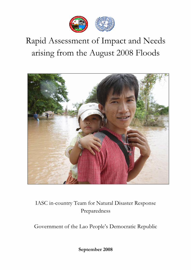
Rapid Assessment of Impact and Needs arising from the August 2008 Floods
IASC in-country Team for Natural Disaster Response
Preparedness
Government of the Lao People’s Democratic Republic
September 2008

Preface
The floods which swept large parts of Lao PDR in August 2008 pose a serious challenge to the country and its poor people. Beyond the need to provide immediate relief assistance to the affected people, extensive damage was caused to agriculture, livelihoods and infrastructure, with the potential to negatively impact the health, nutrition and food security of many communities. The Rapid Assessment of Impact and Needs was jointly conducted by the Government of Lao PDR, the United Nations and other partners to determine the impact of the flood on families and communities, to identify critical humanitarian needs, and to ensure that the response of donors and other stakeholders is relevant, effective and timely. We express our gratitude to the National Disaster Management Office and the Inter-Agency Standing Committee in-country team on Natural Disaster Response Preparedness, who produced this report, as well as to those who conducted the assessment and analysed the data, thereby ensuring a comprehensive overview of the situation left by the worst floods to hit Lao PDR in a century.
Dr Thongloun Sisoulith
Deputy Prime Minister, Minister of Foreign Affairs, Lao PDR
Sonam Yangchen Rana
United Nations Resident Coordinator, Lao PDR
Table of contents
ACRONYMS ..........................................................................................................................................................5
EXECUTIVE SUMMARY....................................................................................................................................7
1. BACKGROUND.........................................................................................................................................14
1.1 OVERVIEW OF THE FLOOD SITUATION.......................................................................................................14 1.2 MITIGATION EFFORTS ...............................................................................................................................14
2. ASSESSMENT OBJECTIVES AND METHODOLOGY ......................................................................15
2.1 OBJECTIVES ..............................................................................................................................................15 2.2 PARTNERSHIPS..........................................................................................................................................15 2.3 SCOPE.......................................................................................................................................................15 2.4 TEAM COMPOSITION AND ORIENTATION ...................................................................................................16 2.5 TOOLS, DATA COLLECTION AND INTERVIEW METHODS .............................................................................16 2.6 DATA ANALYSIS AND REPORTING .............................................................................................................16 2.7 LIMITATIONS ............................................................................................................................................16
3. KEY FINDINGS...............................................................................................................................................17
3.1 EXTENT OF THE FLOOD IMPACT ................................................................................................................17 3.2 IMPACT ON ACCESS...................................................................................................................................18 3.3 IMPACT ON SHELTER.................................................................................................................................19 3.4 IMPACT ON WATER AND SANITATION........................................................................................................20 3.5 IMPACT ON HEALTH AND NUTRITION ........................................................................................................21 3.6 IMPACT ON AGRICULTURE, LIVESTOCK AND AQUACULTURE.....................................................................23 3.7 IMPACT ON LIVELIHOODS..........................................................................................................................23 3.8 IMPACT ON FOOD SECURITY......................................................................................................................24 3.9 IMPACT ON EDUCATION ............................................................................................................................28 3.10 IMPACT ON PROTECTION......................................................................................................................29
4. CONCLUSION AND PROPOSED ACTIONS........................................................................................30
4.1 CONCLUSION ................................................................................................................................................30 4.2 PROPOSED ACTIONS ..................................................................................................................................30
ANNEXES.............................................................................................................................................................35
5
Acronyms IASC Inter Agency Standing Committee
Lao PDR Lao People’s Democratic Republic
NDMO National Disaster Management Office
DOS Department of Statistics
UN United Nations
INGO International Non Governmental Organisation
JICA Japan International Cooperation Agency
PDMC Provincial Disaster Management Committee
DDMC District Disaster Management Committee
CFSVA Comprehensive Food Security and Vulnerability assessment
WFP World Food Programme
UNICEF United Nations Children's Fund
WHO World Health Organisation
MICS Multiple Indicator Cluster Survey
RA Rapid Assessment
UNFPA United Nations Population Fund
Ha Hectares
CPI-NSC Consumer Price Index – National Statistics Center (now DOS)
UNDP United Nations Development Programme
DH District Hospital
PH Public Hospital
NCLE National Centre for Laboratory and Epidemiology
USD United States Dollar
HIV/AIDS Human Immunodeficiency Virus/Acquired Immunodeficiency Syndrome
ORS Oral Rehydration Salts
MUAC Mid-Upper Arm Circumference
OPV Oral Polio Vaccine
SD Standard Deviation
SCA Save the Children Australia
WV World Vision
6
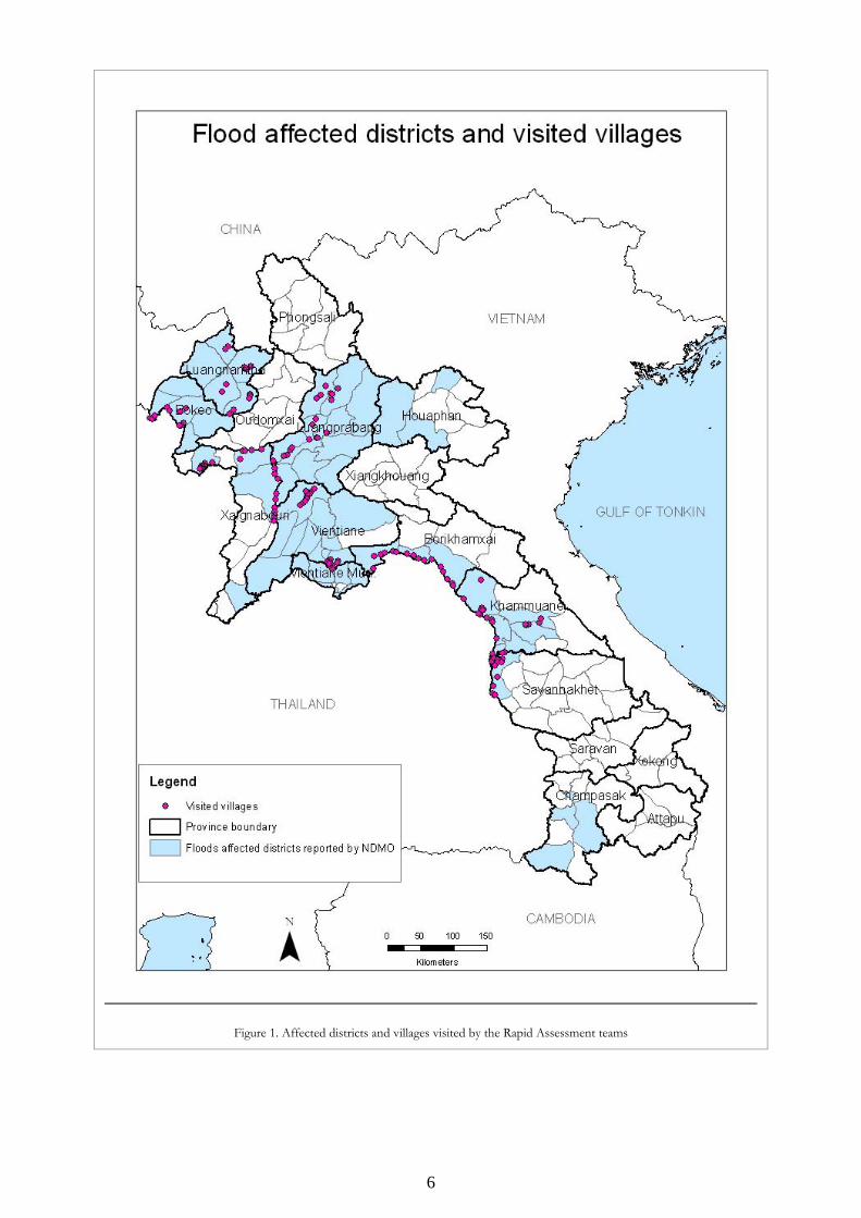
Figure 1. Affected districts and villages visited by the Rapid Assessment teams
7
Executive summary
Heavy rainfall in and around the Mekong watershed caused the most severe floods in living memory in Lao PDR between 12 and 18 August 2008. According to the Mekong River Commission Secretariat, the flooding was the result of localised severe rainfall associated with the tropical storm Kummari and higher- than-average monsoon rains from May to July, which had led to saturated catchment areas and very high surface run-off levels in the days preceding the storm.
Central and Northern Laos recorded the highest flood water levels in the whole basin: in the capital Vientiane for example, flood levels were more than a metre higher than during the 1966 flood.
Preliminary reports indicate that thousands of hectares of crops were inundated. Thousands of households have lost their assets, livelihoods and, in some cases, their dwellings. The exact magnitude of the damage is not fully quantified as yet, but this Rapid Impact and Needs Assessment gives a solid first impression of the impact of and needs arising from the disaster.
Floods in the Mekong watershed are common and part of the natural agricultural cycle. However, this year the Mekong water level measured at the peak of the flood near Vientiane was nearly two metres above the normal flood level for the time of year. The northern and central regions of Lao PDR were particularly severely affected, according to the Lao National Disaster Management Office (NDMO). Flash floods were also reported in the North and Central provinces, causing 11 deaths.
The recent global surge in food prices, which has also affected Lao PDR, had already strained household coping strategies, and access to food by many households has been limited. The loss of crops, livestock and other sources of livelihoods due to the August flood is likely to further compromise household food security in Lao PDR. While relief operations are necessary
to stave off hunger during the immediate aftermath of the floods, rehabilitation of livelihoods and enabling households to resume their productive activities are of paramount importance to ensure food security and avoid destitution.
Coverage and methodology
The Rapid Assessment was undertaken to provide an overview of the flood’s immediate impact. The purpose of this assessment was not to identify all the affected villages, or to estimate exact numbers of people in need of assistance, but to provide qualitative estimates of the magnitude of flood impact on the areas and population to better guide humanitarian response in the short-run. The assessment was led by the NDMO in close collaboration with the Department of Statistics (DOS) and with extensive support from the Inter-Agency Standing Committee in-country Team for Natural Disaster Response Preparedness (IASC) Rapid Assessment Taskforce.
The Rapid Assessment was conducted during 21-29 August 2008 with 19 assessment teams covering 29 districts in eight of the most affected provinces. The assessment teams visited 152 villages which were selected in consultation with the provincial authorities. Each team visited six heavily affected and two moderately affected villages, based on the information available in the province.
The methodology included: (i) primary data collection through household questionnaires in the affected areas, (ii) discussions with key informants in each of the selected villages, and (iii) direct observations.
The conclusions drawn in this report are based on both qualitative and quantitative information gathered in the field visits, which was triangulated with a substantial amount of secondary information. While the data presented should be considered as estimates rather than absolute figures, the IASC feels confident that
8
the analysis provides a good understanding of the impact of the August 2008 floods in Lao PDR.
Extent of the flood impact
The National Disaster Management Office (NDMO) collated the data provided by the Provincial Disaster Management Committees (PDMC) and District Disaster Management Committees (DDMC) on the extent and impact of the floods. Vientiane Municipality provided information on the extent of flooding in the city.
The Rapid Assessment indicates that Luangprabang, Luangnamtha, Bokeo, Khammuane, Vientiane and Borikamxay provinces and Vientiane Capital in the North and Centre of the country are the worst affected, which conforms with the data provided by the NDMO. Other areas affected by floods are Huaphanh, Xayabury, Savannakhet and Champasack provinces.
Number of affected people
The NDMO estimates that a total of 204,189 people were affected in some 866 villages of 53 districts across the country. These estimates have been used to guide the envisaged response plan.
Impact on access
Throughout the visited areas, damage to bridges, roads and footpaths was widespread. Landslides experienced in some locations in Luangnamtha and Luangprabang compounded the access problem. Communities are in need of technical and financial support to undertake the necessary repairs and reconstruction works. A number of
bridges and access roads, usually the main communication routes, have been heavily damaged. Reportedly bridges in some 15-20 percent of the villages visited were in need of repair and access roads in 50 percent of the villages visited had been damaged, with 20 percent severely damaged.
Impact on shelter
The flood had some impact on housing along the Mekong River, particularly in low-lying areas and houses of ethnic groups that are vulnerable to floods. During the height of the flood, most people whose houses were affected took shelter in other peoples’ homes. Thirty-three villages reported that people were given shelter in schools, in 16 villages people stayed in the open air and 127 villages reported movement to other places. At the time of the assessment most of those who had been temporarily displaced had returned to their homes.
Impact on water supply
In Lao PDR, an estimated 24 percent of households nationwide depend on unprotected water wells for drinking water (a higher proportion in the lowlands). This meant that many families in flood-affected areas who depend on gravity-fed water and boreholes in addition to the water wells lost their source of water. From the assessment data, it is estimated that up to 30 percent of the villages in the affected districts are in need of clean water supply.
9
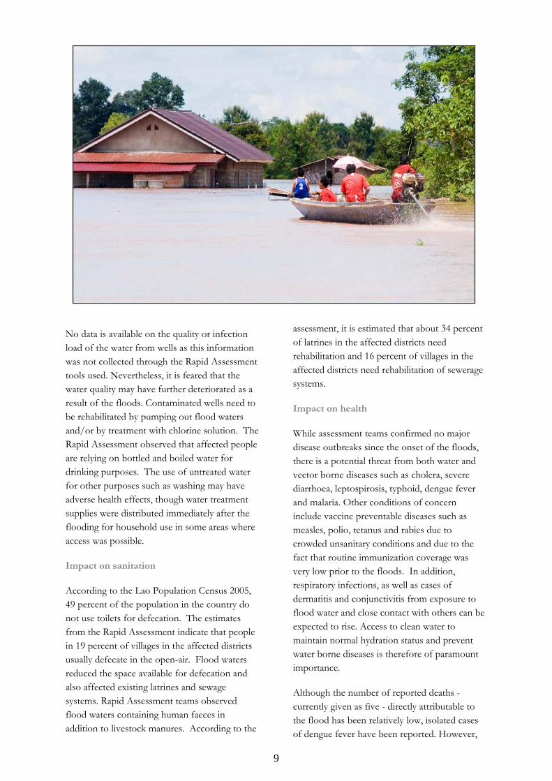
No data is available on the quality or infection load of the water from wells as this information was not collected through the Rapid Assessment tools used. Nevertheless, it is feared that the water quality may have further deteriorated as a result of the floods. Contaminated wells need to be rehabilitated by pumping out flood waters and/or by treatment with chlorine solution. The Rapid Assessment observed that affected people are relying on bottled and boiled water for drinking purposes. The use of untreated water for other purposes such as washing may have adverse health effects, though water treatment supplies were distributed immediately after the flooding for household use in some areas where access was possible.
Impact on sanitation
According to the Lao Population Census 2005, 49 percent of the population in the country do not use toilets for defecation. The estimates from the Rapid Assessment indicate that people in 19 percent of villages in the affected districts usually defecate in the open-air. Flood waters reduced the space available for defecation and also affected existing latrines and sewage systems. Rapid Assessment teams observed flood waters containing human faeces in addition to livestock manures. According to the
assessment, it is estimated that about 34 percent of latrines in the affected districts need rehabilitation and 16 percent of villages in the affected districts need rehabilitation of sewerage systems.
Impact on health
While assessment teams confirmed no major disease outbreaks since the onset of the floods, there is a potential threat from both water and vector borne diseases such as cholera, severe diarrhoea, leptospirosis, typhoid, dengue fever and malaria. Other conditions of concern include vaccine preventable diseases such as measles, polio, tetanus and rabies due to crowded unsanitary conditions and due to the fact that routine immunization coverage was very low prior to the floods. In addition, respiratory infections, as well as cases of dermatitis and conjunctivitis from exposure to flood water and close contact with others can be expected to rise. Access to clean water to maintain normal hydration status and prevent water borne diseases is therefore of paramount importance.
Although the number of reported deaths - currently given as five - directly attributable to the flood has been relatively low, isolated cases of dengue fever have been reported. However,
10
surveillance of all areas remains incomplete. Without this surveillance it will be difficult to detect outbreaks and treat cases arising from the situation. Immunization is required to prevent vulnerable groups from various infections.
The Rapid Assessment found that one health centre was completely destroyed by the floods, and two others suffered damage. Assuming that most existing health facilities do in fact remain functional, it is important to note that even in normal times, health services are generally considered inadequate, especially for rural communities whose needs, in a post-flooding scenario, are greater than ever.
Impact on nutrition
A significant number of children were considered malnourished prior to the flooding of the affected areas. Anthropometric measurement was not included in the Rapid Assessment. It is therefore difficult to know if there have been any changes in the nutritional status of children immediately after the flood. However, the damage to crops and livestock, disruption of water and sanitation system leading to possible increased diarrhoeal disease and loss of income may well result in increased rates of malnutrition. Loss of vegetable and fruit crops will lessen the amount of available micronutrients and increase susceptibility to infection in the affected population.
There was no indication from the assessment that breastfeeding practices were affected by the flooding. However, it can be expected that due to poor diet, sickness and stress, the amount and quality of breast milk of mothers will be affected over the short and medium term. Malnutrition may occur or increase among those already undernourished.
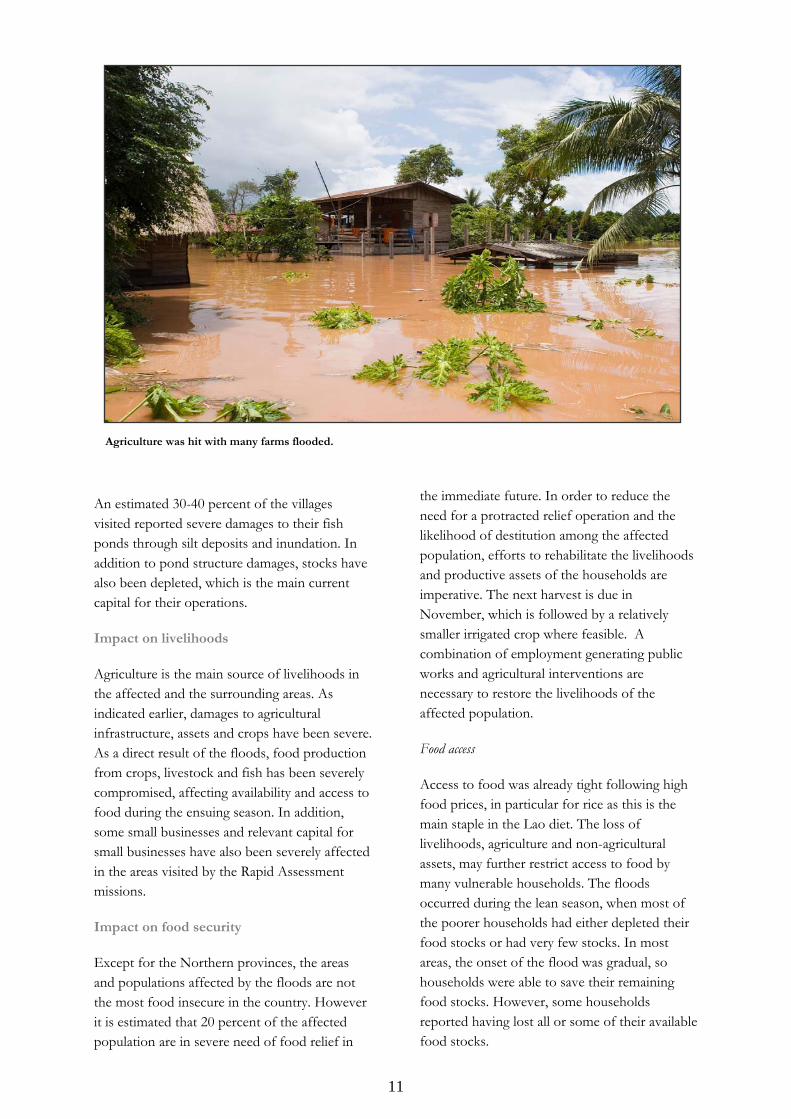
Impact on agriculture, livestock and aquaculture
Agriculture
Preliminary government estimates suggest that approximately 74,989 hectares of agricultural land was inundated at the peak of the floods. The government further estimates that in 57 districts, 40 percent of planted area was under water for several days. The Rapid Assessment found that over 70 percent of productive agricultural areas in the villages that teams visited were damaged. In some locations, crops and paddies were swept away, and the land rendered uncultivable for the remaining agriculture season.
The IASC Rapid Assessment estimates that irrigation infrastructure in 30-40 percent of the villages visited was damaged.
The flood-affected areas are the most productive and normally supply surplus rice for the rest of the country. The compound impact of rising food prices and drastic decline in production may have severe implications for national and household food security, with far reaching consequences if not addressed. The negative impact on the long-term livelihoods of many communities and expected drop in household income is likely to affect families’ investments in healthcare and education. Many households have already exhausted their coping mechanisms following rising food and agricultural input prices and there may not be much room to absorb this new shock.
Livestock and aquaculture
A large number of household livestock (cattle, buffalo, pigs and poultry) have been affected by lack of feeding, and muddy and wet conditions, which have made them susceptible to a number of diseases. Some of these diseases are pandemic and a grave cause for concern. Livestock is a significant source of household nutrition, livelihoods and an important store of value. If not addressed, household food security will be severely compromised and restocking would require major investment.
11
An estimated 30-40 percent of the villages visited reported severe damages to their fish ponds through silt deposits and inundation. In addition to pond structure damages, stocks have also been depleted, which is the main current capital for their operations.
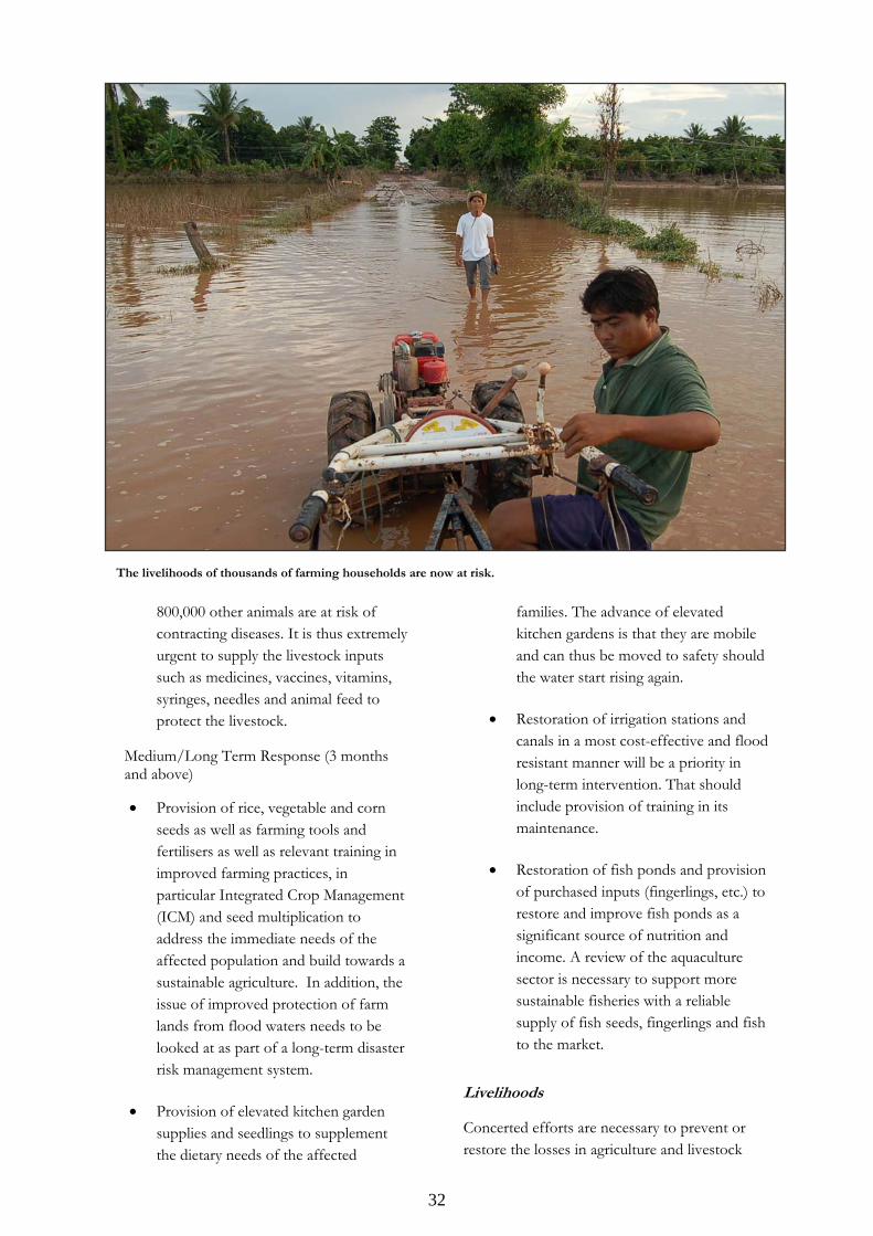
Impact on livelihoods
Agriculture is the main source of livelihoods in the affected and the surrounding areas. As indicated earlier, damages to agricultural infrastructure, assets and crops have been severe. As a direct result of the floods, food production from crops, livestock and fish has been severely compromised, affecting availability and access to food during the ensuing season. In addition, some small businesses and relevant capital for small businesses have also been severely affected in the areas visited by the Rapid Assessment missions.
Impact on food security
Except for the Northern provinces, the areas and populations affected by the floods are not the most food insecure in the country. However it is estimated that 20 percent of the affected population are in severe need of food relief in
the immediate future. In order to reduce the need for a protracted relief operation and the likelihood of destitution among the affected population, efforts to rehabilitate the livelihoods and productive assets of the households are imperative. The next harvest is due in November, which is followed by a relatively smaller irrigated crop where feasible. A combination of employment generating public works and agricultural interventions are necessary to restore the livelihoods of the affected population.
Food access
Access to food was already tight following high food prices, in particular for rice as this is the main staple in the Lao diet. The loss of livelihoods, agriculture and non-agricultural assets, may further restrict access to food by many vulnerable households. The floods occurred during the lean season, when most of the poorer households had either depleted their food stocks or had very few stocks. In most areas, the onset of the flood was gradual, so households were able to save their remaining food stocks. However, some households reported having lost all or some of their available food stocks.
Agriculture was hit with many farms flooded.
12
Food consumption
In a number of villages, the floods reduced the sources of food available for the households especially from domestic production, and wild foods. This may further reduce their already low dietary intake and render them more food insecure. The loss of wild food, in particular aquatic food, implies less diversified sources of food and nutrition, which may have severe consequences for some of the more vulnerable and malnourished population.
Household vulnerability and coping strategies
During the Rapid Assessment, current coping mechanisms were reported to include reduction or change of food consumption, borrowing from relatives and friends, consumption of wild foods, and use of credit. There were widespread reports that household and productive assets were sold as a result of the floods, in a manner that would deplete households’ asset base. Support to these communities is required to reduce the probability of their engaging in more harmful coping strategies.
Impact on education
Available data from the Ministry of Education identified 136 primary schools in 21 districts in six provinces that were seriously damaged by the storms and flooding. In the 45 villages that sustained severe damage to primary schools in Vientiane Capital, and Vientiane, Borikhamxay, and Khammuane provinces, the opening of the school year has been delayed until the schools can provide a safe and healthy environment protected from wind, rain and muddy floors.
Impact on protection
The Rapid Assessment results show that in the aftermath of the flood there were a number of cases of theft, domestic violence, separated or unaccompanied children, and children in need of emergency and special care reported. Eight villages in Khammuane and Savannaket provinces reported on the risk of human trafficking, and taking into account the loss of livelihoods and increased vulnerabilities of the most affected populations, it is recommended
that there be increased efforts to raise awareness of the risks of forced migration, exploitation and human trafficking for women and children. A total of 22 villages reported on special needs related to people with a disability and or the mentally ill.
Main conclusion
The floods in August 2008 have significantly compromised the main source of livelihoods in the agricultural sector, including crops, aquaculture, livestock and agro-forestry. In addition, damage to health, nutrition, housing and sanitation has also been severe. If not addressed, the impact of thefloods may be felt for years to come and may pose serious mid- to long-term threats to health, food security, welfare and livelihoods of the affected population, especially for the resource-poor and in vulnerable households.
Families who were already close to the poverty line risk dropping below it due to the loss of rice paddy, food stocks and other assets. Care-givers who already struggled to ensure their children received a sufficiently nutritious diet will find the task even harder. Health services that barely met their communities’ minimal care needs before the emergency now face having to deal with a range of disease outbreaks triggered by the floods, especially if food and clean water supplies are not made available as a matter of urgency. The damage to roads and other infrastructure has made poor communities even poorer. Even taking into account that flooding is a regular phenomenon in Lao PDR, and the resilience of the population, the consequences of this year’s floods have dealt a severe blow to the development prospects of a large part of the country.
13
Recommendations
MOST IMMEDIATE NEEDS (SEPTEMBER- NOVEMBER 2008)
Clean drinking water and sanitation
Food supplies
Essential medicines and primary health care
Immunization and surveillance for disease outbreaks and nutrition status
Emergency replacement seeds
MEDIUM TERM NEEDS (DECEMBER ONWARDS)
Credit and cash transfers for work
Food security and livelihoods
Early recovery for agriculture and livestock
Food availability
Micronutrient supplementation
Immunization
Infrastructure roads, schools and health facilities, shelter
Vulnerability and stress of affected people
14
1. Background
1.1 Overview of the flood situation
Heavy rainfall in and around the Mekong watershed caused the most severe floods in living memory in Lao PDR between 12 and 18 August 2008. According to the Mekong River Commission Secretariat, the flooding was the result of localised severe rainfall associated with the tropical storm Kummari and higher than average monsoon rains from May to July, which had led to saturated catchment areas and very high surface run-off levels in the days preceding the storm. Central and Northern Lao PDR recorded the highest flood water levels in the whole basin: in the capital Vientiane for example, flood levels were more than a metre higher than during the 1966 flood.
Preliminary reports indicate that thousands of hectares of crops have been inundated. Thousands of households have lost their assets, livelihoods and, in some cases, their dwellings. The exact magnitude of the damage is not, as yet, fully quantified, but this Rapid Assessment gives a solid first impression of the impact of and needs arising from the disaster. Floods in the Mekong watershed are common and part of the natural agricultural cycle in the area. However, this year the Mekong water level measured at the peak of the flood near Vientiane was nearly two metres above the normal flood level. The northern and central regions of Lao PDR were particularly severely affected, according to the Lao National Disaster Management Office (NDMO). Flash floods were also reported in the North and Central provinces, causing 11 deaths.
The recent global surge in food prices, which has also affected Lao PDR, had already strained
household coping strategies, and access to food by many households has been limited. The loss of crops, livestock and other sources of livelihoods due to the August flood is likely to further compromise household food security in Lao PDR. While relief operations are necessary to stave off hunger during the immediate aftermath of the floods, rehabilitation of livelihoods and enabling households to resume their productive activities are of paramount importance to ensure food security and avoid destitution.
1.2 Mitigation efforts
In response to the rising water levels, the government was instrumental in the timely evacuation of people living in areas at risk of flooding. The evacuees who were not sheltered by relatives were temporarily moved by the government to schools and other public institutions as water levels were monitored. This prevented loss of life and reduced the loss of household assets.
Surveillance teams comprising government officials, police and the military were established to monitor the floods and to identify risk areas. Government figures indicate that up to 4,171 government officials from different ministries/organisations and 54,162 volunteers joined such teams in Vientiane Capital. As a temporary measure to control the spread of flooding, some 15 km of sand bag walls were constructed along the Mekong River and roads in low-lying parts of Vientiane Capital. This helped to contain the flood waters and slowed the encroachment of water into villages.
15
2. Assessment objectives and methodology
2.1 Objectives
Following the floods, a Rapid Assessment was undertaken with the following specific objectives:
- To collect and verify available data on the extent and the severity of the flood impact.
- To assess the impact of the floods on affected areas and population, with particular emphasis on: water and sanitation; health and nutrition; agriculture; livelihoods and food security; shelter; education; and protection.
- To collect information on the immediate response, and identify capacity gaps and recommend types of intervention at 0-3 months (short term), 3-6 months (medium term) and over 6 months (long term).
- To identify the key information gaps, to be addressed in follow up surveys and/or qualitative assessments.
The results of this assessment are complementary to those of other assessments that line ministries conducted simultaneously - and independently - on the damage of the floods on agriculture, infrastructure and schools (Ministry of Agriculture and Forestry, Ministry of Public Works and Transport, Ministry of Education).
2.2 Partnerships
Under the framework of the Inter-Agency Standing Committee in-country Team for Natural Disaster Response Preparedness (IASC), this assessment was led by the NDMO in close collaboration with the Department of Statistics (DoS), the national focal points for disaster management representing the line ministries (including Ministry of Health, Agriculture and Forestry, Education, Labour and Social Welfare,
Public Works and Transport) as well as the Lao Red Cross.
2.3 Scope
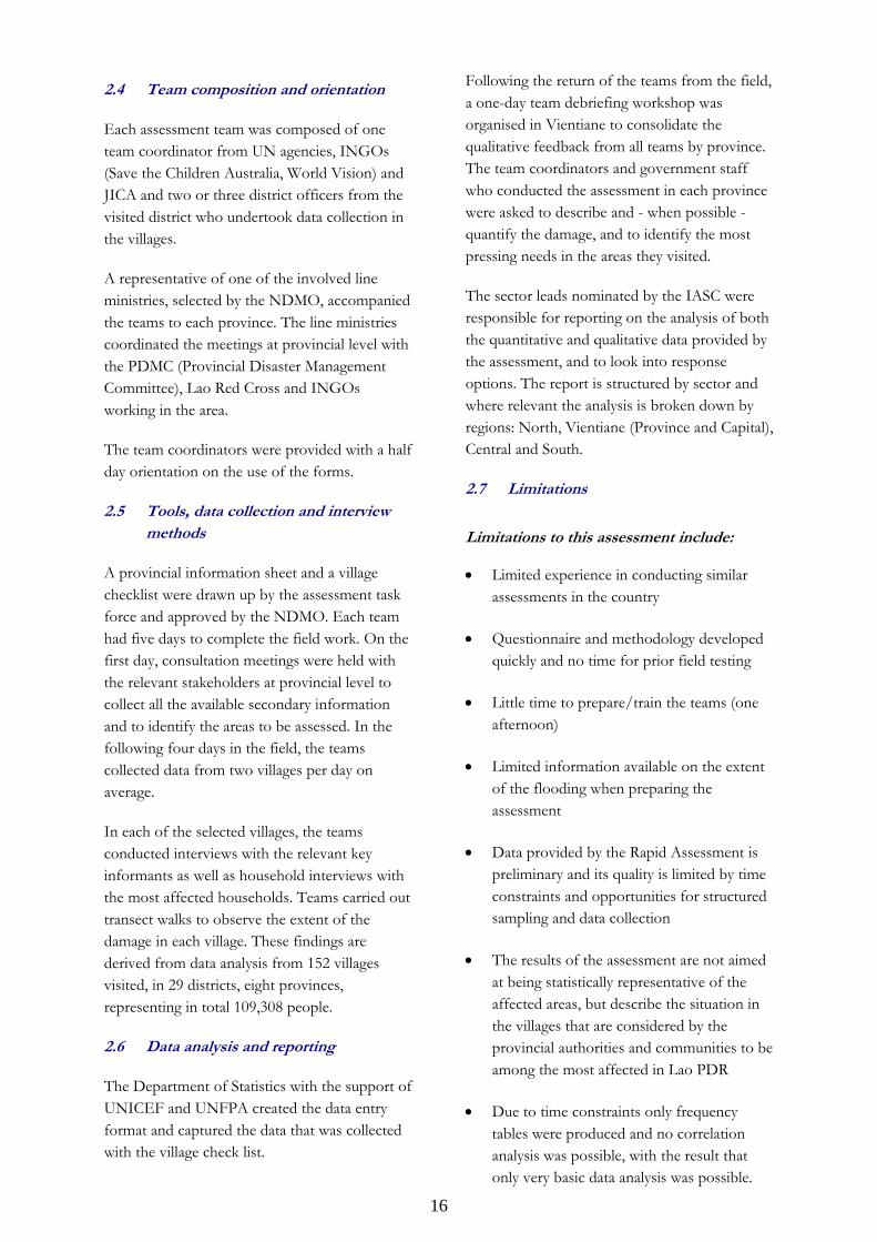
The assessment was conducted during 21-29 August 2008 with 19 assessment teams covering 29 districts in eight of the most affected provinces. In the three remaining provinces (including Vientiane Capital, the most affected but also most surveyed province), meetings were held with the local authorities to collect existing information on the extent and impact of the floods.
Based on information provided by the NDMO and by partners in the field, the provinces assessed were identified. The estimated damage in the provinces determined the number of teams sent to assess them.
The assessment teams visited about 152 villages, which were selected by the team leaders in consultation with provincial authorities. The villages were purposefully selected, based on the secondary information provided to them by local stakeholders.
Each team visited six highly affected and two moderately affected villages, based on the information available in the province.
Assessment teams travelled to 11 provinces.
16
2.4 Team composition and orientation
Each assessment team was composed of one team coordinator from UN agencies, INGOs (Save the Children Australia, World Vision) and JICA and two or three district officers from the visited district who undertook data collection in the villages.
A representative of one of the involved line ministries, selected by the NDMO, accompanied the teams to each province. The line ministries coordinated the meetings at provincial level with the PDMC (Provincial Disaster Management Committee), Lao Red Cross and INGOs working in the area.
The team coordinators were provided with a half day orientation on the use of the forms.
2.5 Tools, data collection and interview methods
A provincial information sheet and a village checklist were drawn up by the assessment task force and approved by the NDMO. Each team had five days to complete the field work. On the first day, consultation meetings were held with the relevant stakeholders at provincial level to collect all the available secondary information and to identify the areas to be assessed. In the following four days in the field, the teams collected data from two villages per day on average.
In each of the selected villages, the teams conducted interviews with the relevant key informants as well as household interviews with the most affected households. Teams carried out transect walks to observe the extent of the damage in each village. These findings are derived from data analysis from 152 villages visited, in 29 districts, eight provinces, representing in total 109,308 people.
2.6 Data analysis and reporting
The Department of Statistics with the support of UNICEF and UNFPA created the data entry format and captured the data that was collected with the village check list.
Following the return of the teams from the field, a one-day team debriefing workshop was organised in Vientiane to consolidate the qualitative feedback from all teams by province. The team coordinators and government staff who conducted the assessment in each province were asked to describe and - when possible - quantify the damage, and to identify the most pressing needs in the areas they visited.
The sector leads nominated by the IASC were responsible for reporting on the analysis of both the quantitative and qualitative data provided by the assessment, and to look into response options. The report is structured by sector and where relevant the analysis is broken down by regions: North, Vientiane (Province and Capital), Central and South.
2.7 Limitations
Limitations to this assessment include:
• Limited experience in conducting similar assessments in the country
• Questionnaire and methodology developed quickly and no time for prior field testing
• Little time to prepare/train the teams (one afternoon)
• Limited information available on the extent of the flooding when preparing the assessment
• Data provided by the Rapid Assessment is preliminary and its quality is limited by time constraints and opportunities for structured sampling and data collection
• The results of the assessment are not aimed at being statistically representative of the affected areas, but describe the situation in the villages that are considered by the provincial authorities and communities to be among the most affected in Lao PDR
• Due to time constraints only frequency tables were produced and no correlation analysis was possible, with the result that only very basic data analysis was possible.
17
3. Key findings
The information collected through observation, village level interviews, meetings with government and NGO staff, and from secondary sources for areas not visited by the teams is expected to provide an accurate if not precise image of the severity of the flood impact and the needed interventions.
The result of the assessment is limited to an approximation of damage and immediate needs, and does not provide comprehensive statistically sound or in-depth quantitative data. The Rapid Assessment is the first step in a continuous process and identifies the need for more comprehensive follow-up assessments.
3.1 Extent of the flood impact
Area Affected
Data on flood impact was collected by the Provincial Disaster Management Committees (PDMC) and District Disaster Management Committees (DDMC) and the preliminary estimates of the number of affected people were consolidated and reported by the NDMO on 18 August 2008.
Map 1 at the beginning of this report shows the areas affected as reported by the NDMO on 18 August 2008. The districts that were visited by the Rapid Assessment teams are marked by dots in Map 1. Vientiane Capital was not covered by the rapid assessment. The number of affected people in the Vientiane Capital was reported by Vientiane Municipality.
According to the Rapid Assessment, provinces in the North and Centre of the country - Luangprabang, Luangnamtha, Bokeo, Khammuane, Vientiane Capital, Vientiane Province and Borikhamxay - were the worst hit.
According to the Vientiane Municipality, 160 villages of eight districts in Vientiane Capital were affected. The affected areas in the city include 20,243 ha of agricultural land, of which 15,362 ha were damaged.
Number of affected people
Table 1 summarises the estimated total number of affected population according to NDMO. Disaggregated data for specific population groups is not available.
Table 1 Population Affected (Source: NDMO 03/09/08)
Number of affected Affected provinces Districts Villages People
Luangnamtha, Luangprabang, Bokeo, Xayabury, Vientiane Province, Vientiane Capital, Huaphanh, Borikhamxay, Khammuane, Savannakhet, Champasack
53 districts
866 villages
204,189 people
18
3.2 Impact on access
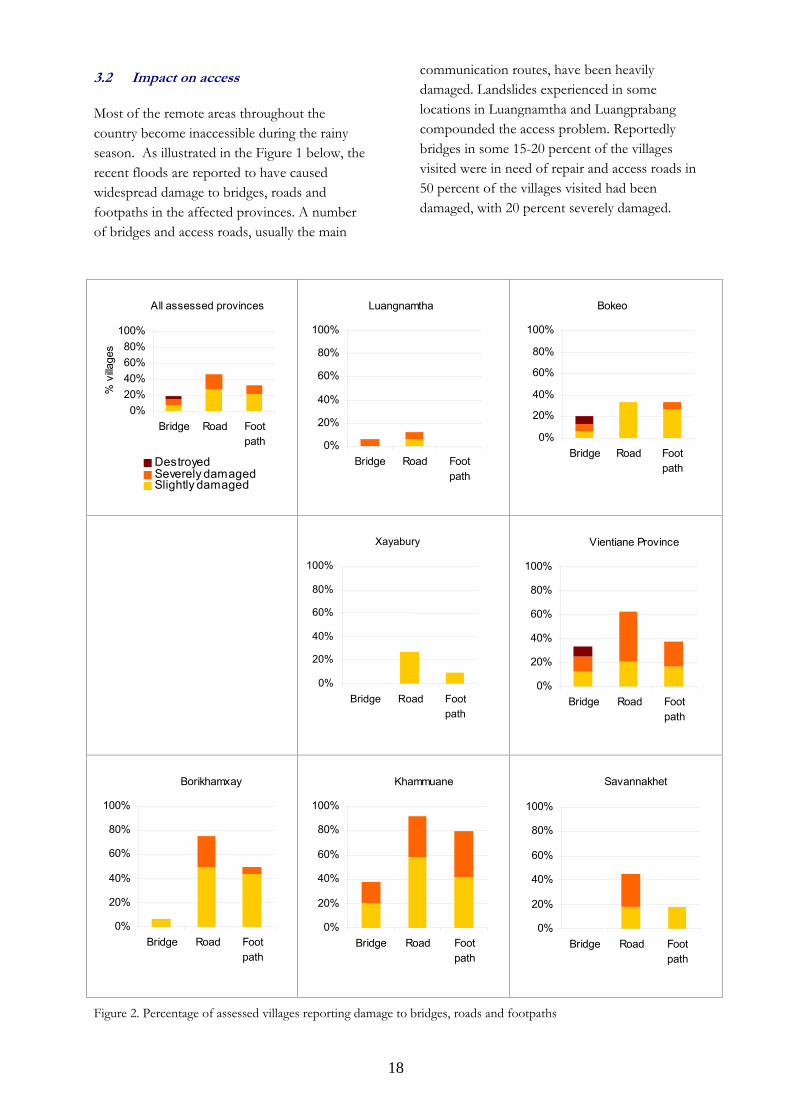
Most of the remote areas throughout the country become inaccessible during the rainy season. As illustrated in the Figure 1 below, the recent floods are reported to have caused widespread damage to bridges, roads and footpaths in the affected provinces. A number of bridges and access roads, usually the main
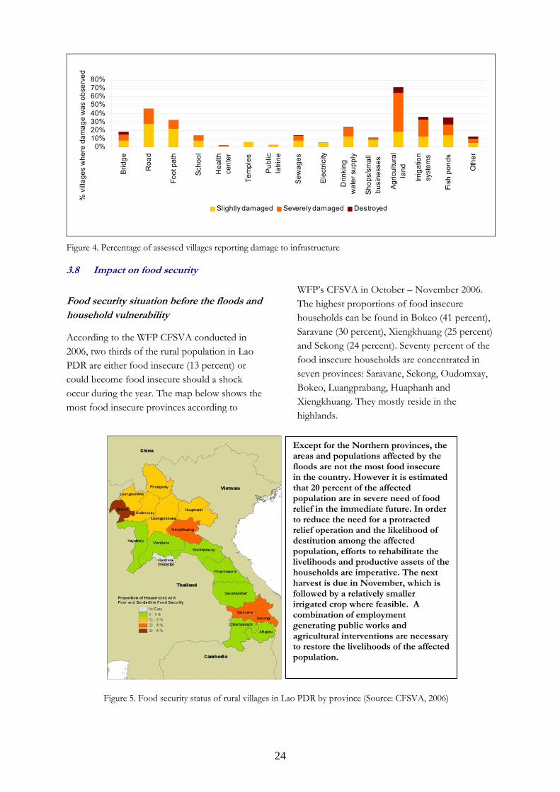
communication routes, have been heavily damaged. Landslides experienced in some locations in Luangnamtha and Luangprabang compounded the access problem. Reportedly bridges in some 15-20 percent of the villages visited were in need of repair and access roads in 50 percent of the villages visited had been damaged, with 20 percent severely damaged.
All assessed provinces
0%20%40%60%80%
100%
Bridge Road Footpath
% v
illage
s
DestroyedSeverely damagedSlightly damaged
Luangnamtha
0%
20%
40%
60%
80%
100%
Bridge Road Footpath
Bokeo
0%
20%
40%
60%
80%
100%
Bridge Road Footpath
Luangprabang
0%
20%
40%
60%
80%
100%
Bridge Road Footpath
Vientiane Province
0%
20%
40%
60%
80%
100%
Bridge Road Footpath
Borikhamxay
0%
20%
40%
60%
80%
100%
Bridge Road Footpath
Khammuane
0%
20%
40%
60%
80%
100%
Bridge Road Footpath
Savannakhet
0%
20%
40%
60%
80%
100%
Bridge Road Footpath
Figure 2. Percentage of assessed villages reporting damage to bridges, roads and footpaths
Xayabury
0%
20%
40%
60%
80%
100%
Bridge Road Footpath
19
Qualitative data obtained through the Rapid Assessment indicates that affected communities are in need of technical and financial support to undertake the necessary repairs and reconstruction works.
Emergency repair of damaged infrastructure and facilities is needed to ascertain that relief assistance is delivered in a timely manner. In the longer term, an accurate damage assessment will provide the necessary information on why infrastructure was damaged or destroyed, and determine the modality to include risk reduction considerations in rehabilitation and reconstruction.
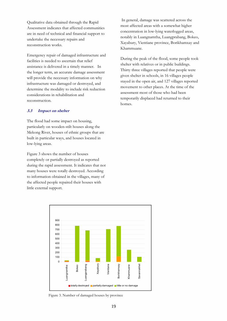
3.3 Impact on shelter
The flood had some impact on housing, particularly on wooden-stilt houses along the Mekong River, houses of ethnic groups that are built in particular ways, and houses located in low-lying areas.
Figure 3 shows the number of houses completely or partially destroyed as reported during the rapid assessment. It indicates that not many houses were totally destroyed. According to information obtained in the villages, many of the affected people repaired their houses with little external support.
In general, damage was scattered across the most affected areas with a somewhat higher concentration in low-lying waterlogged areas, notably in Luangnamtha, Luangprabang, Bokeo, Xayabury, Vientiane province, Borikhamxay and Khammuane.
During the peak of the flood, some people took shelter with relatives or in public buildings. Thirty three villages reported that people were given shelter in schools, in 16 villages people stayed in the open air, and 127 villages reported movement to other places. At the time of the assessment most of those who had been temporarily displaced had returned to their homes.
Figure 3. Number of damaged houses by province
0
100
200
300
400
500
600
700
800
900
Luan
gnam
tha
Bok
eo
Luan
gpra
bang
Xay
abur
y
Vie
ntia
ne
Bor
ikha
mxa
y
Kha
mm
uane
Sava
nnak
het
totally destroyed partially damaged little or no damage
20
3.4 Impact on water and sanitation
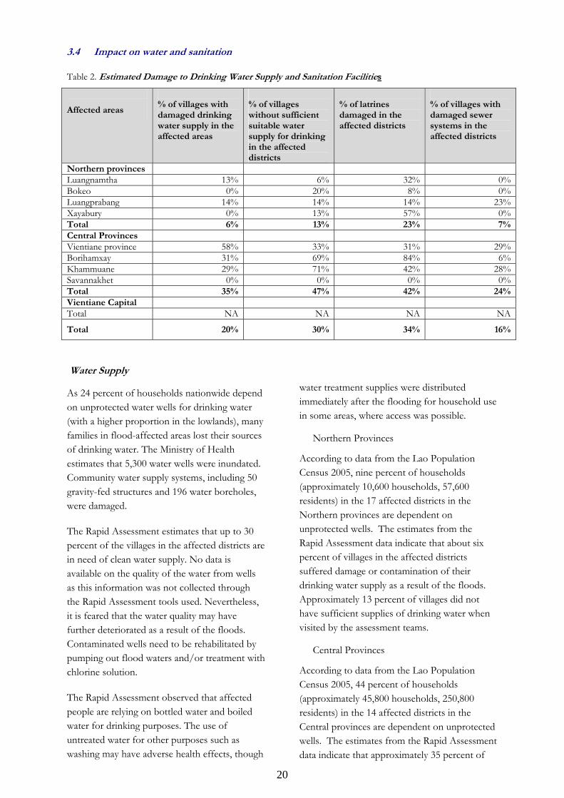
Table 2. Estimated Damage to Drinking Water Supply and Sanitation Facilities
Affected areas
% of villages with damaged drinking water supply in the affected areas
% of villages without sufficient suitable water supply for drinking in the affected districts
% of latrines damaged in the affected districts
% of villages with damaged sewer systems in the affected districts
Northern provinces Luangnamtha 13% 6% 32% 0%Bokeo 0% 20% 8% 0%Luangprabang 14% 14% 14% 23%Xayabury 0% 13% 57% 0%Total 6% 13% 23% 7%Central Provinces Vientiane province 58% 33% 31% 29%Borihamxay 31% 69% 84% 6%Khammuane 29% 71% 42% 28%Savannakhet 0% 0% 0% 0%Total 35% 47% 42% 24%Vientiane Capital Total NA NA NA NA
Total 20% 30% 34% 16%
Water Supply
As 24 percent of households nationwide depend on unprotected water wells for drinking water (with a higher proportion in the lowlands), many families in flood-affected areas lost their sources of drinking water. The Ministry of Health estimates that 5,300 water wells were inundated. Community water supply systems, including 50 gravity-fed structures and 196 water boreholes, were damaged.
The Rapid Assessment estimates that up to 30 percent of the villages in the affected districts are in need of clean water supply. No data is available on the quality of the water from wells as this information was not collected through the Rapid Assessment tools used. Nevertheless, it is feared that the water quality may have further deteriorated as a result of the floods. Contaminated wells need to be rehabilitated by pumping out flood waters and/or treatment with chlorine solution.
The Rapid Assessment observed that affected people are relying on bottled water and boiled water for drinking purposes. The use of untreated water for other purposes such as washing may have adverse health effects, though
water treatment supplies were distributed immediately after the flooding for household use in some areas, where access was possible.
Northern Provinces
According to data from the Lao Population Census 2005, nine percent of households (approximately 10,600 households, 57,600 residents) in the 17 affected districts in the Northern provinces are dependent on unprotected wells. The estimates from the Rapid Assessment data indicate that about six percent of villages in the affected districts suffered damage or contamination of their drinking water supply as a result of the floods. Approximately 13 percent of villages did not have sufficient supplies of drinking water when visited by the assessment teams.
Central Provinces
According to data from the Lao Population Census 2005, 44 percent of households (approximately 45,800 households, 250,800 residents) in the 14 affected districts in the Central provinces are dependent on unprotected wells. The estimates from the Rapid Assessment data indicate that approximately 35 percent of
21
villages in the affected districts incurred damage or contamination of their drinking water supply by the floods. 47 percent of villages did not have sufficient suitable supply of drinking water when visited by the Rapid Assessment teams.
Sanitation
According to the Lao Population Census 2005, 49 percent of the population in the country do not use toilets for defecation. The estimates from the Rapid Assessment indicate that people in 19 percent of villages in the affected districts usually defecate in open-air. Flood waters reduced the space available for defecation while latrines and sewage systems were water clogged. Rapid Assessment teams observed flood waters containing human faeces in addition to livestock manures. According to the assessment, it is estimated that about 34 percent of latrines in the affected districts need rehabilitation and 16 percent of villages in the affected districts need rehabilitation of sewerage system.
Northern Provinces
According to data from the Lao Population Census 2005, 51 percent of the households (approximately 61,500 households, 354,500 residents) in the 17 affected districts of the Northern region do not use toilets for defecation. The data from the Rapid Assessment indicates that 23 percent of latrines in the affected districts of the Northern provinces need rehabilitation. Similarly, sewer systems in seven percent of villages in the affected districts need rehabilitation.
Central Provinces
According to data from the Lao Population Census 2005, 46 percent of the households (approximately 47,900 households, 258,300 residents) in the 14 affected districts of the Central region do not use toilets for defecation. The data from the Rapid Assessment indicates that 42 percent of latrines in the affected districts of the Central provinces need rehabilitation. Similarly, sewer systems in 24 percent of villages in the affected districts need rehabilitation.
3.5 Impact on health and nutrition
Health
While assessment teams confirmed no major disease outbreaks since the onset of the floods, there is a potential threat from both water and vector borne diseases such as cholera, severe diarrhoea, leptospirosis, typhoid, dengue fever and malaria. Other conditions of concern include vaccine preventable diseases such as measles, polio, tetanus and rabies due to crowded unsanitary conditions and due to the fact that routine immunization coverage was very low prior to the floods. In addition, respiratory infections, as well as cases of dermatitis and conjunctivitis from exposure to flood water and close contact with others can be expected to rise. Access to clean water to maintain normal hydration status and prevent water borne diseases is therefore of paramount importance.
Isolated cases of dengue fever have been reported. Surveillance of all areas remains incomplete, without this surveillance it will be difficult to detect outbreaks and treat cases arising from the situation. Immunization is required to prevent vulnerable groups from various infections. The risk of measles outbreaks is somewhat mitigated by the successful national campaign in November 2007 that targeted children aged between 9 months and 15 years. However, for many children, this was their first dose and they require two to ensure complete immunization. There is now a higher risk for a polio outbreak than before the flood, because wild poliovirus is still considered to be
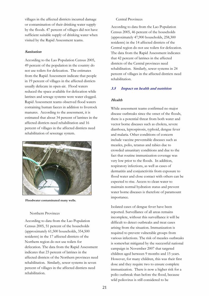
Floodwater contaminated many wells.
22
circulating in neighbouring Myanmar, and because sanitation systems have been damaged and routine immunization coverage is low.
At national level, only about 18 percent of the women deliver their babies at a health facility. Due to unhygienic conditions as a consequence of the flood, there is a need to encourage pregnant women in recently flooded areas to deliver their babies at a hospital. However, due to the damage of access roads and bridges caused by the flood and, critically, the adverse impact of the flood to households’ financial capacity, the percentage of home deliveries is likely to remain high. Promotion of delivery at a health facility by waiving fees for pregnant women from flood-affected areas, for example, should be considered. In the immediate term, distribution of clean delivery kits, which can be used at home or at under-equipped maternity units alike, would help secure clean conditions for safe delivery.
In terms of infrastructural damage, the Rapid Assessment found that one health centre was completely destroyed by the floods, and two others suffered damage in the visited villages. Assuming that most existing health facilities do in fact remain functional, it is important to note that even in normal times, health services are generally considered inadequate, especially for rural communities whose needs, in a post-flooding scenario, are greater than ever.
Northern Provinces
In the northern part of Lao PDR those provinces suffering flash floods and having gravity fed water systems have less health concerns than riverside areas of Bokeo province. People in Bokeo riverside communities rely on wells, which were inundated and contaminated.
Central and Southern Provinces
Like in the Northern provinces, those villages that are located on the river are most at risk of outbreaks because of the disruption of their water and sanitation systems. These are the areas that require the most vigilance for surveillance of possible outbreaks of water borne illnesses and dengue fever due to increased mosquito breeding.
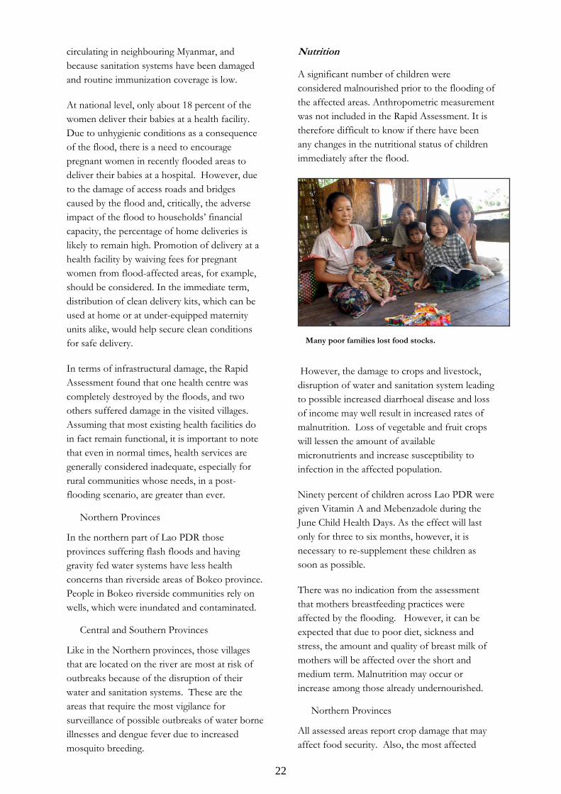
Nutrition
A significant number of children were considered malnourished prior to the flooding of the affected areas. Anthropometric measurement was not included in the Rapid Assessment. It is therefore difficult to know if there have been any changes in the nutritional status of children immediately after the flood.
However, the damage to crops and livestock, disruption of water and sanitation system leading to possible increased diarrhoeal disease and loss of income may well result in increased rates of malnutrition. Loss of vegetable and fruit crops will lessen the amount of available micronutrients and increase susceptibility to infection in the affected population.
Ninety percent of children across Lao PDR were given Vitamin A and Mebenzadole during the June Child Health Days. As the effect will last only for three to six months, however, it is necessary to re-supplement these children as soon as possible.
There was no indication from the assessment that mothers breastfeeding practices were affected by the flooding. However, it can be expected that due to poor diet, sickness and stress, the amount and quality of breast milk of mothers will be affected over the short and medium term. Malnutrition may occur or increase among those already undernourished.
Northern Provinces
All assessed areas report crop damage that may affect food security. Also, the most affected
Many poor families lost food stocks.
23
villages in all the Northern provinces told the assessment teams that they needed immediate food relief.
Central and Southern Provinces
Increase in malnutrition is not yet evident, but the situation needs to be reassessed in the next few months because crop damage was indicated in all the affected and assessed villages of the Centre and South regions. Further nutritional problems may arise in the riverside areas if outbreaks of diarrhoea and dengue develop.
3.6 Impact on agriculture, livestock and aquaculture
Agriculture
Preliminary government estimates suggest that approximately 152, 400 hectares of agricultural land was inundated at the peak of the floods. The government further estimates that in 57 districts, 40 percent of planted area was under water for several days.
The Rapid Assessment found that over 52 percent of productive agricultural areas in the villages that teams visited were damaged. In some locations, crops and paddies were swept away, and the land rendered uncultivable for the remaining agriculture season. The IASC Rapid Assessment estimates that irrigation infrastructure in 30-40 percent of the villages visited was damaged. If this is not urgently addressed, not only have farmers lost their forthcoming harvest, but many will be unable to grow rice in the coming season.
The flood-affected areas are the most productive and normally supply surplus rice for the rest of the country. The compound impact of rising
food prices and drastic decline in production may have severe implications for national and household food security, with far reaching consequences if not addressed. The negative impact on the long-term livelihoods of many communities and expected drop in household income is likely to affect families’ investments in healthcare and education. Many households have already exhausted their coping mechanisms following rising food and agricultural input prices and there may not be much room to absorb this new shock.
Livestock and aquaculture loss
A large number of household livestock (cattle, buffalo, pigs and poultry) have been affected by lack of feeding, and muddy and wet conditions, which have made them susceptible to a number of diseases. Some of these diseases are pandemic and a grave cause for concern. Livestock is a significant source of household nutrition, livelihoods and an important store of value. If not addressed, household food security will be severely compromised and restocking would require major investment.
An estimated 30-40 percent of the villages visited reported severe damage to their fish ponds through silt deposits and inundation. In addition to pond structure damage, stocks have also been depleted, which is the main current capital for their operations.
3.7 Impact on livelihoods
Agriculture is the main source of livelihoods in the affected and the surrounding areas. As indicated earlier, damages to agricultural infrastructure, assets and crops have been severe. As a direct result of the floods, food production from crops, livestock and fish has been severely compromised, affecting availability and access to food during the ensuing season. In addition, some small businesses and relevant capital for small businesses have also been severely affected in the areas visited by the Rapid Assessment missions. At the time of the assessment, all the markets were accessible again, but prices were reported to have increased as compared to the pre-flood period.
In mountainous areas flash floods washed away paddy fields.
24
0%10%20%30%40%50%60%70%80%
Brid
ge
Roa
d
Foot
pat
h
Scho
ol
Hea
lthce
nter
Tem
ples
Publ
icla
trine
Sew
ages
Elec
trici
ty
Drin
king
wat
er s
uppl
y
Shop
s/sm
all
busi
ness
es
Agric
ultu
ral
land
Irrig
atio
nsy
stem
s
Fish
pon
ds
Oth
er
% v
illag
es w
here
dam
age
was
obs
erve
d
Slightly damaged Severely damaged Destroyed
Figure 4. Percentage of assessed villages reporting damage to infrastructure
3.8 Impact on food security
Food security situation before the floods and household vulnerability
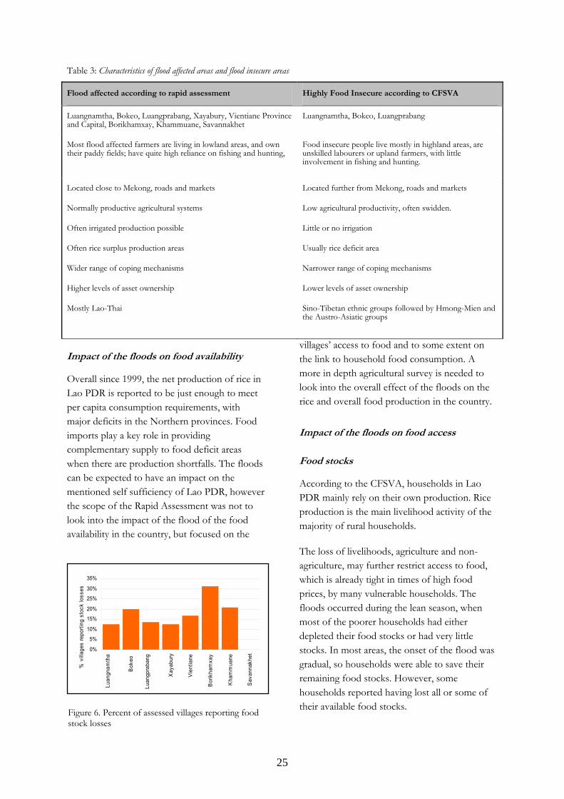
According to the WFP CFSVA conducted in 2006, two thirds of the rural population in Lao PDR are either food insecure (13 percent) or could become food insecure should a shock occur during the year. The map below shows the most food insecure provinces according to
WFP’s CFSVA in October – November 2006. The highest proportions of food insecure households can be found in Bokeo (41 percent), Saravane (30 percent), Xiengkhuang (25 percent) and Sekong (24 percent). Seventy percent of the food insecure households are concentrated in seven provinces: Saravane, Sekong, Oudomxay, Bokeo, Luangprabang, Huaphanh and Xiengkhuang. They mostly reside in the highlands.
Except for the Northern provinces, the areas and populations affected by the floods are not the most food insecure in the country. However it is estimated that 20 percent of the affected population are in severe need of food relief in the immediate future. In order to reduce the need for a protracted relief operation and the likelihood of destitution among the affected population, efforts to rehabilitate the livelihoods and productive assets of the households are imperative. The next harvest is due in November, which is followed by a relatively smaller irrigated crop where feasible. A combination of employment generating public works and agricultural interventions are necessary to restore the livelihoods of the affected population.
Figure 5. Food security status of rural villages in Lao PDR by province (Source: CFSVA, 2006)
25
0%
5%
10%
15%
20%
25%
30%
35%
Luan
gnam
tha
Bok
eo
Luan
gpra
bang
Xay
abur
y
Vie
ntia
ne
Bor
ikha
mxa
y
Kha
mm
uane
Sav
anna
khet
% v
illag
es re
porti
ng s
tock
loss
es
Table 3: Characteristics of flood affected areas and flood insecure areas
Flood affected according to rapid assessment Highly Food Insecure according to CFSVA
Luangnamtha, Bokeo, Luangprabang, Xayabury, Vientiane Province and Capital, Borikhamxay, Khammuane, Savannakhet
Luangnamtha, Bokeo, Luangprabang
Most flood affected farmers are living in lowland areas, and own their paddy fields; have quite high reliance on fishing and hunting,
Food insecure people live mostly in highland areas, are unskilled labourers or upland farmers, with little involvement in fishing and hunting.
Located close to Mekong, roads and markets
Normally productive agricultural systems
Often irrigated production possible
Often rice surplus production areas
Wider range of coping mechanisms
Higher levels of asset ownership
Mostly Lao-Thai
Located further from Mekong, roads and markets
Low agricultural productivity, often swidden.
Little or no irrigation
Usually rice deficit area
Narrower range of coping mechanisms
Lower levels of asset ownership
Sino-Tibetan ethnic groups followed by Hmong-Mien and the Austro-Asiatic groups
Impact of the floods on food availability
Overall since 1999, the net production of rice in Lao PDR is reported to be just enough to meet per capita consumption requirements, with major deficits in the Northern provinces. Food imports play a key role in providing complementary supply to food deficit areas when there are production shortfalls. The floods can be expected to have an impact on the mentioned self sufficiency of Lao PDR, however the scope of the Rapid Assessment was not to look into the impact of the flood of the food availability in the country, but focused on the
villages’ access to food and to some extent on the link to household food consumption. A more in depth agricultural survey is needed to look into the overall effect of the floods on the rice and overall food production in the country.
Impact of the floods on food access
Food stocks
According to the CFSVA, households in Lao PDR mainly rely on their own production. Rice production is the main livelihood activity of the majority of rural households.
The loss of livelihoods, agriculture and non-agriculture, may further restrict access to food, which is already tight in times of high food prices, by many vulnerable households. The floods occurred during the lean season, when most of the poorer households had either depleted their food stocks or had very little stocks. In most areas, the onset of the flood was gradual, so households were able to save their remaining food stocks. However, some households reported having lost all or some of their available food stocks.Figure 6. Percent of assessed villages reporting food
stock losses
26
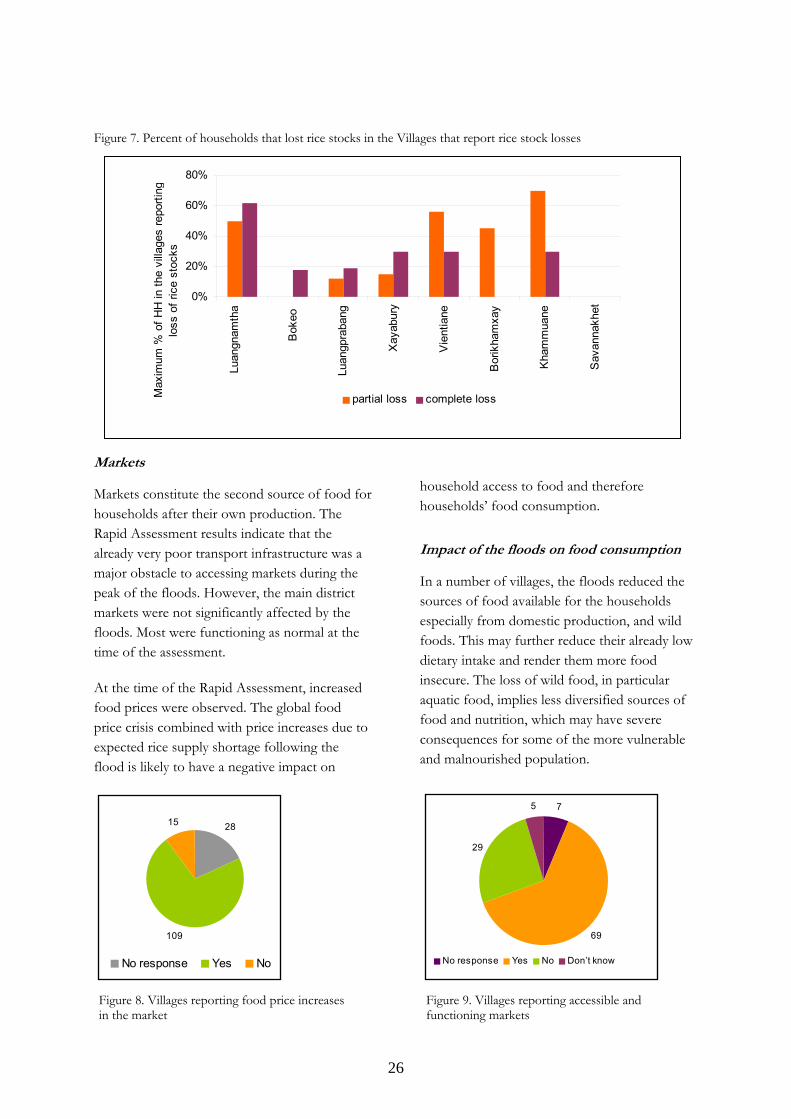
Figure 7. Percent of households that lost rice stocks in the Villages that report rice stock losses
Markets
Markets constitute the second source of food for households after their own production. The Rapid Assessment results indicate that the already very poor transport infrastructure was a major obstacle to accessing markets during the peak of the floods. However, the main district markets were not significantly affected by the floods. Most were functioning as normal at the time of the assessment.
At the time of the Rapid Assessment, increased food prices were observed. The global food price crisis combined with price increases due to expected rice supply shortage following the flood is likely to have a negative impact on
household access to food and therefore households’ food consumption.
Impact of the floods on food consumption
In a number of villages, the floods reduced the sources of food available for the households especially from domestic production, and wild foods. This may further reduce their already low dietary intake and render them more food insecure. The loss of wild food, in particular aquatic food, implies less diversified sources of food and nutrition, which may have severe consequences for some of the more vulnerable and malnourished population.
Figure 8. Villages reporting food price increases in the market
28
109
15
No response Yes No
7
69
29
5
No response Yes No Don’t know
Figure 9. Villages reporting accessible and functioning markets
0%
20%
40%
60%
80%
Luan
gnam
tha
Bok
eo
Luan
gpra
bang
Xay
abur
y
Vie
ntia
ne
Bor
ikha
mxa
y
Kha
mm
uane
Sav
anna
khet
Max
imum
% o
f HH
in th
e vi
llage
s re
porti
nglo
ss o
f ric
e st
ocks
partial loss complete loss
27
15
5345 46
24
44
712
20
0
10
20
30
40
50
60
Red
uce
num
ber
of m
eals
Red
uce
food
amou
nt p
erm
eal
Less
pref
erre
d/qu
ality
food
s
Incr
ease
borr
owin
g
Sel
l hou
seho
ldas
sets
Sel
l pro
duct
ive
asse
ts
Mig
rate
tose
cure
food
Rel
y on
emer
genc
ysu
ppor
t
No
prob
lem
Num
ber o
f res
pons
es
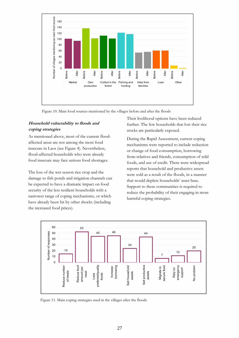
Household vulnerability to floods and coping strategies
As mentioned above, most of the current flood-affected areas are not among the most food insecure in Laos (see Figure 4). Nevertheless, flood-affected households who were already food insecure may face serious food shortages. The loss of the wet season rice crop and the damage to fish ponds and irrigation channels can be expected to have a dramatic impact on food security of the less resilient households with a narrower range of coping mechanisms, or which have already been hit by other shocks (including the increased food prices).
Their livelihood options have been reduced further. The few households that lost their rice stocks are particularly exposed.
During the Rapid Assessment, current coping mechanisms were reported to include reduction or change of food consumption, borrowing from relatives and friends, consumption of wild foods, and use of credit. There were widespread reports that household and productive assets were sold as a result of the floods, in a manner that would deplete households’ asset base. Support to these communities is required to reduce the probability of their engaging in more harmful coping strategies.
0
20
40
60
80
100
120
140
160
Bef
ore
Afte
r
Bef
ore
Afte
r
Bef
ore
Afte
r
Bef
ore
Afte
r
Bef
ore
Afte
r
Bef
ore
Afte
r
Bef
ore
Afte
r
Market Ownproduction
Collect in theforest
Fishing andhunting
Help fromfamilies
Loan Other
Num
ber o
f vill
ages
men
tioni
ng a
s m
ain
food
sou
rce
Figure 10. Main food sources mentioned by the villages before and after the floods
Figure 11. Main coping strategies used in the villages after the floods
28
3.9 Impact on education
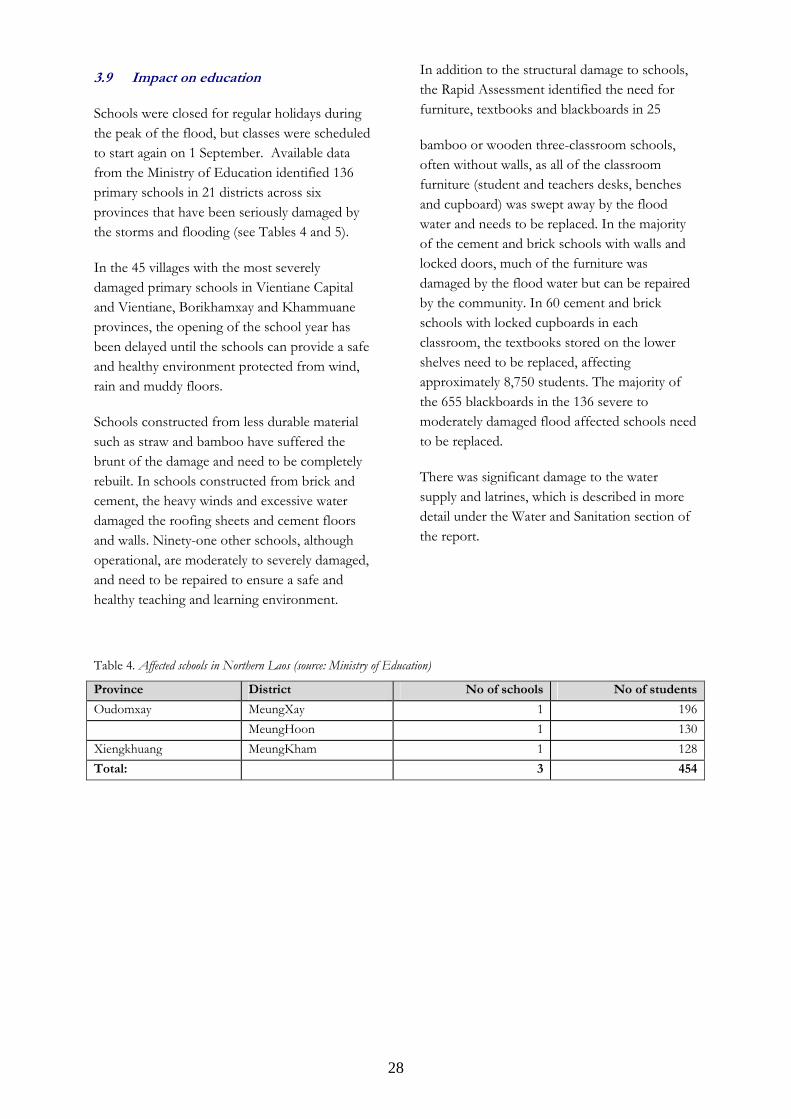
Schools were closed for regular holidays during the peak of the flood, but classes were scheduled to start again on 1 September. Available data from the Ministry of Education identified 136 primary schools in 21 districts across six provinces that have been seriously damaged by the storms and flooding (see Tables 4 and 5).
In the 45 villages with the most severely damaged primary schools in Vientiane Capital and Vientiane, Borikhamxay and Khammuane provinces, the opening of the school year has been delayed until the schools can provide a safe and healthy environment protected from wind, rain and muddy floors.
Schools constructed from less durable material such as straw and bamboo have suffered the brunt of the damage and need to be completely rebuilt. In schools constructed from brick and cement, the heavy winds and excessive water damaged the roofing sheets and cement floors and walls. Ninety-one other schools, although operational, are moderately to severely damaged, and need to be repaired to ensure a safe and healthy teaching and learning environment.
In addition to the structural damage to schools, the Rapid Assessment identified the need for furniture, textbooks and blackboards in 25
bamboo or wooden three-classroom schools, often without walls, as all of the classroom furniture (student and teachers desks, benches and cupboard) was swept away by the flood water and needs to be replaced. In the majority of the cement and brick schools with walls and locked doors, much of the furniture was damaged by the flood water but can be repaired by the community. In 60 cement and brick schools with locked cupboards in each classroom, the textbooks stored on the lower shelves need to be replaced, affecting approximately 8,750 students. The majority of the 655 blackboards in the 136 severe to moderately damaged flood affected schools need to be replaced.
There was significant damage to the water supply and latrines, which is described in more detail under the Water and Sanitation section of the report.
Table 4. Affected schools in Northern Laos (source: Ministry of Education)
Province District No of schools No of students
Oudomxay MeungXay 1 196 MeungHoon 1 130Xiengkhuang MeungKham 1 128Total: 3 454
29
Table 5. Affected schools in Central Laos (source: Ministry of Education)
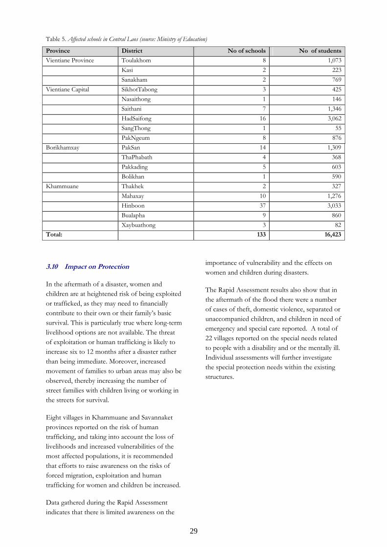
Province District No of schools No of students
Vientiane Province Toulakhom 8 1,073 Kasi 2 223 Sanakham 2 769Vientiane Capital SikhotTabong 3 425 Nasaithong 1 146 Saithani 7 1,346 HadSaifong 16 3,062 SangThong 1 55 PakNgeum 8 876Borikhamxay PakSan 14 1,309 ThaPhabath 4 368 Pakkading 5 603 Bolikhan 1 590Khammuane Thakhek 2 327 Mahaxay 10 1,276 Hinboon 37 3,033 Bualapha 9 860 Xaybuathong 3 82Total: 133 16,423
3.10 Impact on Protection
In the aftermath of a disaster, women and children are at heightened risk of being exploited or trafficked, as they may need to financially contribute to their own or their family’s basic survival. This is particularly true where long-term livelihood options are not available. The threat of exploitation or human trafficking is likely to increase six to 12 months after a disaster rather than being immediate. Moreover, increased movement of families to urban areas may also be observed, thereby increasing the number of street families with children living or working in the streets for survival.
Eight villages in Khammuane and Savannaket provinces reported on the risk of human trafficking, and taking into account the loss of livelihoods and increased vulnerabilities of the most affected populations, it is recommended that efforts to raise awareness on the risks of forced migration, exploitation and human trafficking for women and children be increased.
Data gathered during the Rapid Assessment indicates that there is limited awareness on the
importance of vulnerability and the effects on women and children during disasters.
The Rapid Assessment results also show that in the aftermath of the flood there were a number of cases of theft, domestic violence, separated or unaccompanied children, and children in need of emergency and special care reported. A total of 22 villages reported on the special needs related to people with a disability and or the mentally ill. Individual assessments will further investigate the special protection needs within the existing structures.
30
4. Conclusion and proposed actions
4.1 Conclusion
For affected communities, the floods in August 2008 have significantly compromised the main source of livelihoods, the agricultural sector, including crops, aquaculture, livestock and agro-forestry. In addition, damage to health, nutrition, housing and sanitation has been severe. If not addressed, the impact of the floods may be felt for years to come and may pose serious mid- to long-term threats to the health, food security, welfare and livelihoods of the affected population, especially the resource-poor and vulnerable households.
Families who were already close to the poverty line risk dropping below it due to the loss of rice paddy, food stocks and other assets. Care-givers who already struggled to ensure their children received a sufficiently nutritious diet will find the task even harder. Health services that barely ensured minimal care to a community’s needs before the emergency now face having to deal with a range of disease outbreaks triggered by the floods, especially if food and clean water supplies are not made available as a matter of urgency. The damage to roads and other infrastructure has made poor communities even poorer. Even taking into account that flooding is a regular phenomenon in Lao PDR, and the resilience of the population, the consequences of this year’s floods have dealt a severe blow to the development prospects of a large part of the country.
4.2 Proposed actions
Water, Sanitation and Hygiene
Short Term Response (next 3 months)
• At least 20 litres of safe drinking water needs to be secured for each affected family per day. Distribution of drinking water can be supplemented by provision of chlorine tablets.
• Hygiene supplies such as soap and IEC materials (flyers) are a critical requirement for affected households and villages.
Medium/Long Term Response (3 months and above)
• Provision of de-watering pumps and chlorine powder is required for restoration of water wells, in addition to the rehabilitation of damaged community water supply and sanitation facilities.
• Due to the low coverage of polio immunisation and threat of importation from other countries it is important to include the flood affected districts in the planned OPV campaign for high risk areas during the Child Health Days in December 2008 and January 2009.
Health
Short Term Response (next 3 months)
• It is essential to establish active surveillance and response teams for detection, treatment and prevention of diseases that may develop with the receding flood waters and disruption of water/sanitation systems, and possible spread of vaccine preventable diseases. Disease data must be analysed frequently to detect possible outbreaks and plan a response.
• Mobile teams should be employed to visit the flood-affected villages to provide preventive and curative care; provide health education on hygiene; promote the use of chlorine tablets and abate to control mosquitoes; provide vaccinations to children and women; distribute clean delivery kits and contraceptives; provide vitamin A and multiple micronutrient supplementation for children, pregnant and lactating
31
women; distribute insecticide treated bed nets to families in the most affected areas for prevention of malaria and dengue fever; provide treatment of diarrhoeal diseases with oral re-hydration salts (ORS); monitor the nutrition status of children under five; and gather disease information including taking necessary samples for laboratory analysis.
• ORS and essential medicines could be distributed through mobile health teams and existing village revolving drug funds. Ideally, few essential medicines could be stocked at the village level. Additional medical (including clean delivery kits and contraceptives) and vector control supplies will be necessary to equip the mobile teams visiting affected villages and in preparation of possible outbreaks.
• Provision of health information materials emphasizing basic hygiene and explaining the use of chlorine tablets, abate and other public health items is also critical. Organisation of life saving communication activities will be also required to ensure diffusion of health and nutrition messages (diarrhoea prevention and proper home treatment, promotion of breastfeeding and appropriate complementary feeding).
• Besides the provision of clean delivery kits and in order to promote delivery at health facilities, consideration should be given to waiving fees for delivery for pregnant women from flood-affected areas. Immunisation is needed as a preventative measure.
Nutrition
Short Term Response (next 3 months)
• Start nutritional surveillance using anthropometric measurement (weight for age, weight for height, MUAC –middle upper arm circumference) through village visits and/or at sentinel
sites. This data needs to be compared to the data from previous surveys. This can be conducted by the mobile health teams with cooperation of village volunteers.
• The mobile teams visiting villages should provide vitamin A supplements to all children between six and 59 months of age, and de-worming tablets to children aged one to five years. Multiple micro-nutrient sprinkles can also be provided if available to children between six and 59 months of age, pregnant and lactating women.
• Consider provision of supplementary food for children that are found to be malnourished according to anthropometric measurement (< 2 SD weight for height).
• Provide supplementary nutrients for pregnant/ lactating women, especially iron for both pregnant and lactating women, and vitamin A to post partum lactating women.
Medium/Long Term Response (3 months and above)
• Continue nutritional surveillance at health facilities and possibly with outreach teams on a routine basis.
• Ensure the vitamin A supplementation and de-worming continues through the Child Health Days and, if necessary, continue providing multiple micronutrient sprinkles.
Agriculture, Livestock and Aquaculture
Short Term Response (next 3 months)
• To increase the food availability of the vulnerable population in the affected areas, and to help reduce the need of protracted and much higher food prices, food aid assistance (rice) is needed.
• The Rapid Assessment also shows that over 100,000 cattle and buffalo and over
32
800,000 other animals are at risk of contracting diseases. It is thus extremely urgent to supply the livestock inputs such as medicines, vaccines, vitamins, syringes, needles and animal feed to protect the livestock.
Medium/Long Term Response (3 months and above)
• Provision of rice, vegetable and corn seeds as well as farming tools and fertilisers as well as relevant training in improved farming practices, in particular Integrated Crop Management (ICM) and seed multiplication to address the immediate needs of the affected population and build towards a sustainable agriculture. In addition, the issue of improved protection of farm lands from flood waters needs to be looked at as part of a long-term disaster risk management system.
• Provision of elevated kitchen garden supplies and seedlings to supplement the dietary needs of the affected
families. The advance of elevated kitchen gardens is that they are mobile and can thus be moved to safety should the water start rising again.
• Restoration of irrigation stations and canals in a most cost-effective and flood resistant manner will be a priority in long-term intervention. That should include provision of training in its maintenance.
• Restoration of fish ponds and provision of purchased inputs (fingerlings, etc.) to restore and improve fish ponds as a significant source of nutrition and income. A review of the aquaculture sector is necessary to support more sustainable fisheries with a reliable supply of fish seeds, fingerlings and fish to the market.
Livelihoods
Concerted efforts are necessary to prevent or restore the losses in agriculture and livestock
The livelihoods of thousands of farming households are now at risk.
33
assets and production through the emergency provision of seeds, tools, and micro-credits.
Short Term Response (next 3 months)
• Emergency repair of critical facilities is required to restore productive social and/or primary infrastructure such as roads, bridges, water supply, irrigation, sanitation systems, markets, etc. As much as possible, reconstruction of basic infrastructure should use local technologies, construction materials and know-how to ensure that construction activities will have a direct positive impact upon the local economy.
Medium/Long Term Response (3 months and above)
• Close monitoring of the commodity prices in the market is recommended, while a strategy and action plans need to be developed to deal with the anticipated mid-term/longer term impacts on livelihoods caused by the damage to livelihoods.
Household food security
Considering the many issues affecting households, interventions for household food security need to pursue the following objectives:
Short Term Response (next 3 months)
• Help prevent serious food shortages for households who have lost the capacity to provide sufficient food for their own consumption due to the floods, and prevent them from engaging in harmful coping strategies.
• The Rapid Assessment estimates that around 20 percent of the overall number of flood affected people reported by the government need emergency food assistance in the coming three months (40,000 people). In the provision of food assistance, priority should be given to the most food insecure provinces in the North and Central parts of the country (Bokeo, Luangnamtha and Luangprabang).
Medium/Long Term Response (3 months and above)
• The assessment estimates that 40 percent of the affected population (about 66,000 people) should be engaged in medium/long term recovery activities (e.g. through food-for-work activities to rehabilitate critical community infrastructure) until the next harvest in October/November 2009.
Education
• In addition to the structural damage to schools, which need to be addressed as a matter of urgency to enable the orderly resumption of classes, the Rapid Assessment identified the need for furniture, textbooks and blackboards.
Protection
• Structured activities need to be undertaken to provide psychological benefits to children to help them cope with their emotions, restore their well-being and allow their recovery from the disaster. These also allow parents the time to focus on re-establishing the family’s livelihood.
• Efforts to raise awareness on the risks of forced migration, exploitation and human trafficking for women and children need to be increased in flood-affected areas, with particular focus on the more food insecure provinces in the North and Central parts of the country (Bokeo, Luangnamtha and Luangprabang).
Early recovery
• Early recovery interventions are required to close the gap between relief and development and transform the disaster caused by the floods into opportunities for sustainable development and disaster risk reduction.
34
• Early recovery interventions should also focus on generating and/or reinforcing nationally owned processes for post-flood recovery that are sustainable and resilient any future disasters.
• Early recovery efforts should focus on emergency repair of critical facilities, support for income generation activities,
in-depth and comprehensive recovery oriented needs assessment and capacity building for community based sustainable recovery and disaster risk reduction.

35
Annexes
Annexe 1 – List of Province, Districts and villages visited
Annexe 2 – Village checklist
Annexe 3 – Province checklist
Annexe 4 – List of Personnel Involved in the Rapid Assessment
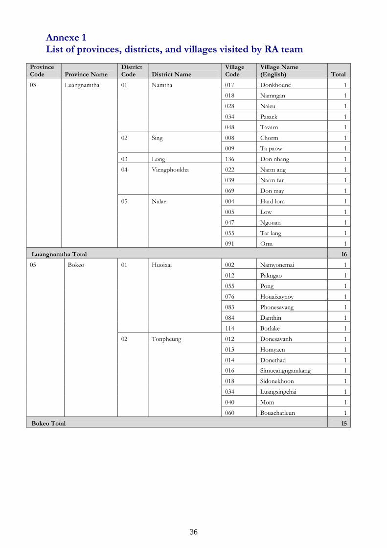
36
Annexe 1 List of provinces, districts, and villages visited by RA team
Province Code Province Name
District Code District Name
Village Code
Village Name (English) Total
03 Luangnamtha 01 Namtha 017 Donkhoune 1
018 Namngan 1
028 Naleu 1
034 Pasack 1
048 Tavarn 1
02 Sing 008 Chorm 1
009 Ta paow 1
03 Long 136 Don nhang 1
04 Viengphoukha 022 Narm ang 1
039 Narm far 1
069 Don may 1
05 Nalae 004 Hard lom 1
005 Low 1
047 Ngouan 1
055 Tar lang 1
091 Orm 1
Luangnamtha Total 16
05 Bokeo 01 Huoixai 002 Namyonemai 1
012 Pakngao 1
055 Pong 1
076 Houaixaynoy 1
083 Phonesavang 1
084 Danthin 1
114 Borlake 1
02 Tonpheung 012 Donesavanh 1
013 Homyaen 1
014 Donethad 1 016 Simueangngamkang 1
018 Sidonekhoon 1
034 Luangsingchai 1
040 Mom 1
060 Bouacharleun 1
Bokeo Total 15
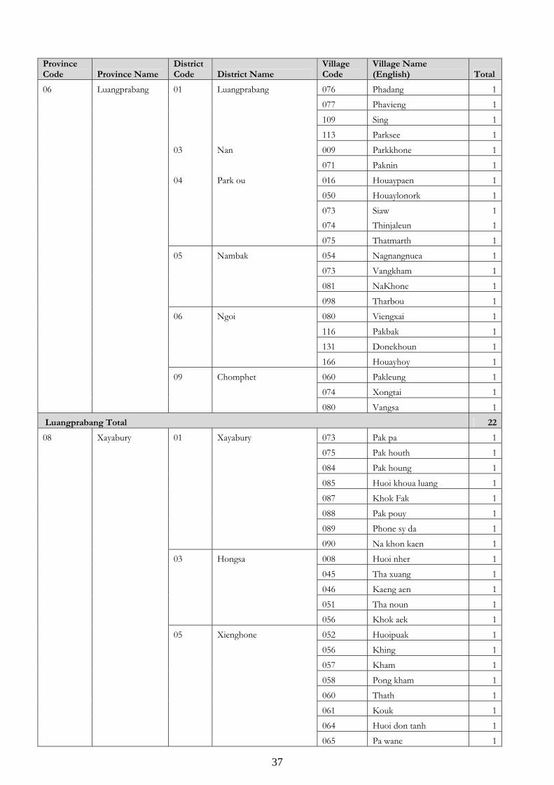
37
Province Code Province Name
District Code District Name
Village Code
Village Name (English) Total
06 Luangprabang 01 Luangprabang 076 Phadang 1
077 Phavieng 1
109 Sing 1
113 Parksee 1
03 Nan 009 Parkkhone 1
071 Paknin 1
04 Park ou 016 Houaypaen 1
050 Houaylonork 1
073 Siaw 1 074 Thinjaleun 1
075 Thatmarth 1
05 Nambak 054 Nagnangnuea 1
073 Vangkham 1
081 NaKhone 1
098 Tharbou 1
06 Ngoi 080 Viengxai 1
116 Pakbak 1
131 Donekhoun 1
166 Houayhoy 1
09 Chomphet 060 Pakleung 1
074 Xongtai 1
080 Vangsa 1
Luangprabang Total 22
08 Xayabury 01 Xayabury 073 Pak pa 1
075 Pak houth 1
084 Pak houng 1
085 Huoi khoua luang 1
087 Khok Fak 1
088 Pak pouy 1
089 Phone sy da 1
090 Na khon kaen 1
03 Hongsa 008 Huoi nher 1
045 Tha xuang 1
046 Kaeng aen 1
051 Tha noun 1
056 Khok aek 1
05 Xienghone 052 Huoipuak 1
056 Khing 1
057 Kham 1
058 Pong kham 1
060 Thath 1
061 Kouk 1
064 Huoi don tanh 1
065 Pa wane 1
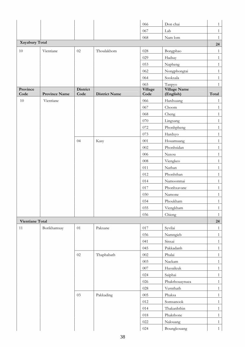
38
066 Don chai 1
067 Lab 1
068 Nam lom 1 Xayabury Total 24
10 Vientiane 02 Thoulakhom 028 Bongphao 1
029 Hadsay 1
053 Napheng 1
062 Nongphongtai 1
064 Sookxala 1
065 Tanpyo 1Province Code Province Name
District Code District Name
Village Code
Village Name (English) Total
10 Vientiane 066 Hardxuang 1
067 Choom 1
068 Cheng 1
070 Lingxang 1
072 Phonhpheng 1
073 Hardxyo 1
04 Kasy 001 Houamuang 1
002 Phonhsidan 1
006 Naxou 1
008 Viengkeo 1
011 Nathan 1
012 Phonhthan 1
014 Namoonmai 1
017 Phonhxavane 1
030 Namone 1
034 Phoukham 1
035 Viengkham 1
036 Chieng 1
Vientiane Total 24
11 Borikhamxay 01 Pakxane 017 Syvilai 1
036 Namngieb 1
041 Sinxai 1
045 Pakkadanh 1
02 Thaphabath 002 Phalai 1
003 Nackam 1
007 Huoaileuk 1
024 Saiphai 1
026 Phakthouaynuea 1
028 Vernthath 1
03 Pakkading 005 Phaksa 1
012 Somsanook 1
014 Thakanhthin 1
018 Phakthone 1
022 Nalouang 1
024 Boungkouang 1
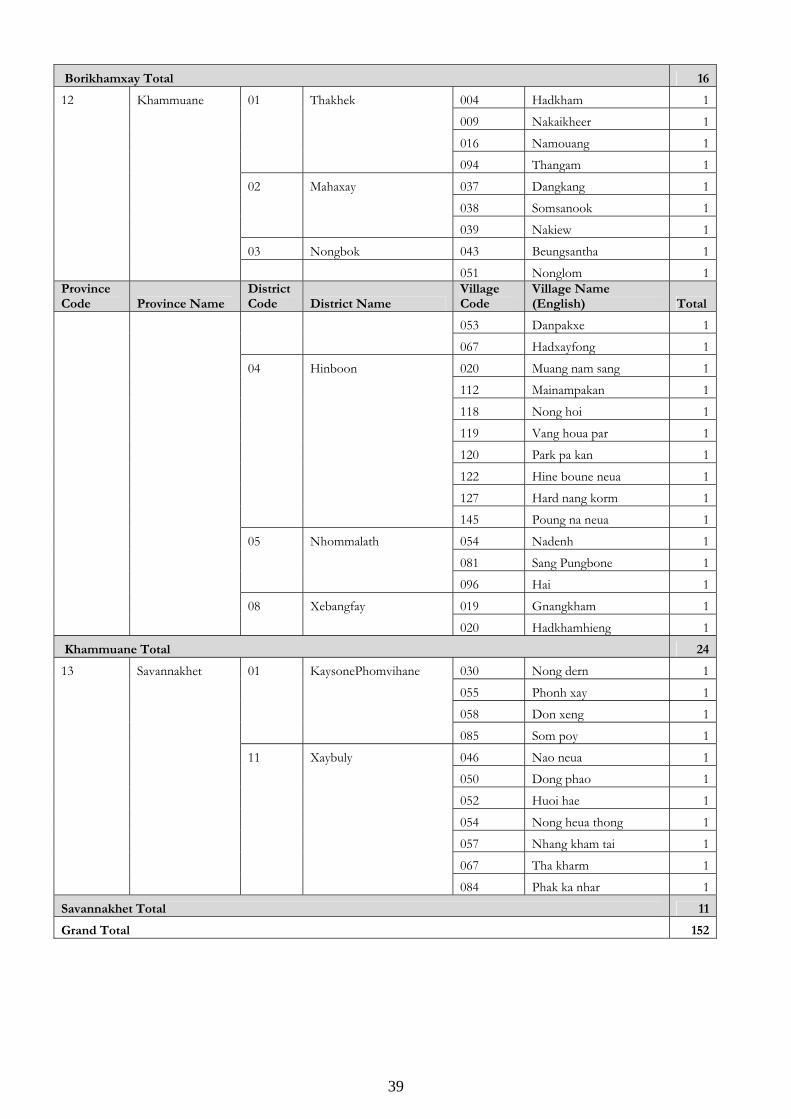
39
Borikhamxay Total 16
12 Khammuane 01 Thakhek 004 Hadkham 1
009 Nakaikheer 1
016 Namouang 1
094 Thangam 1
02 Mahaxay 037 Dangkang 1
038 Somsanook 1
039 Nakiew 1
03 Nongbok 043 Beungsantha 1
051 Nonglom 1Province Code Province Name
District Code District Name
Village Code
Village Name (English) Total
053 Danpakxe 1
067 Hadxayfong 1
04 Hinboon 020 Muang nam sang 1
112 Mainampakan 1
118 Nong hoi 1
119 Vang houa par 1
120 Park pa kan 1
122 Hine boune neua 1
127 Hard nang korm 1
145 Poung na neua 1
05 Nhommalath 054 Nadenh 1
081 Sang Pungbone 1
096 Hai 1
08 Xebangfay 019 Gnangkham 1
020 Hadkhamhieng 1
Khammuane Total 24
13 Savannakhet 01 KaysonePhomvihane 030 Nong dern 1
055 Phonh xay 1
058 Don xeng 1
085 Som poy 1
11 Xaybuly 046 Nao neua 1
050 Dong phao 1
052 Huoi hae 1
054 Nong heua thong 1
057 Nhang kham tai 1
067 Tha kharm 1
084 Phak ka nhar 1
Savannakhet Total 11
Grand Total 152
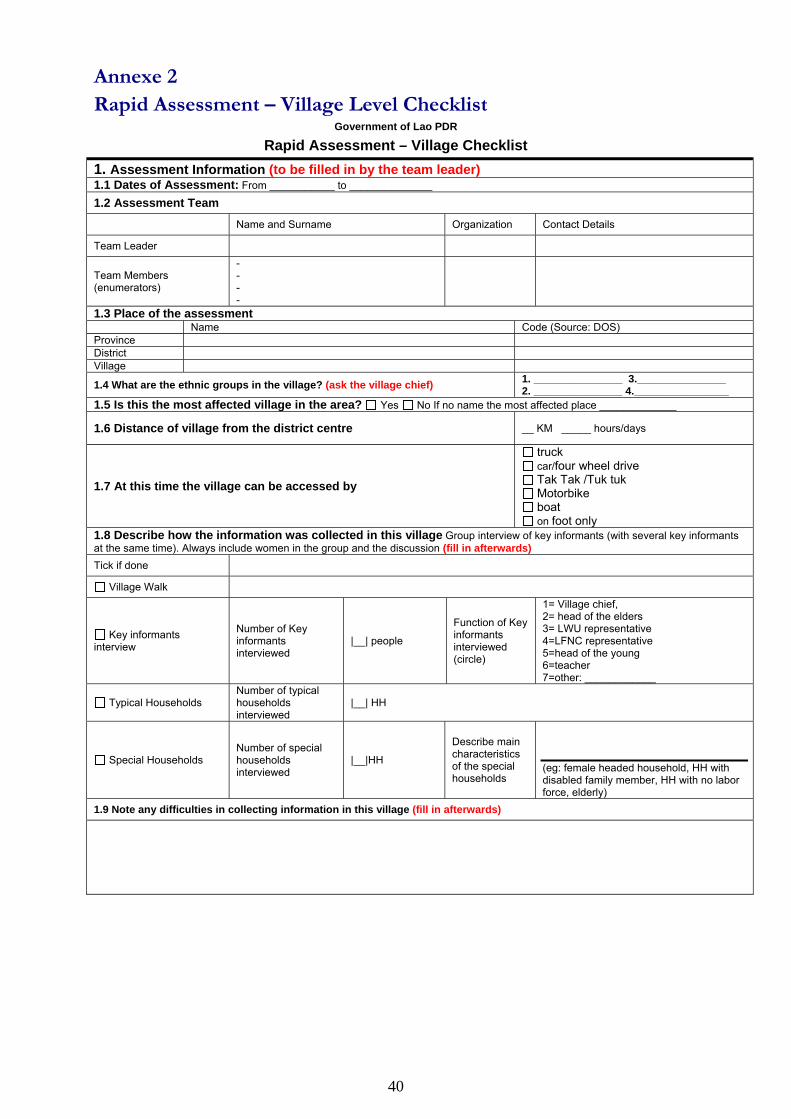
40
Annexe 2 Rapid Assessment – Village Level Checklist
Government of Lao PDR
Rapid Assessment – Village Checklist 1. Assessment Information (to be filled in by the team leader) 1.1 Dates of Assessment: From ___________ to ______________
1.2 Assessment Team
Name and Surname Organization Contact Details
Team Leader
Team Members (enumerators)
- - - -
1.3 Place of the assessment Name Code (Source: DOS) Province District Village
1.4 What are the ethnic groups in the village? (ask the village chief) 1. _______________ 3._______________ 2. _______________ 4.________________
1.5 Is this the most affected village in the area? Yes No If no name the most affected place _____________
1.6 Distance of village from the district centre __ KM _____ hours/days
1.7 At this time the village can be accessed by
truck car/four wheel drive Tak Tak /Tuk tuk Motorbike boat on foot only
1.8 Describe how the information was collected in this village Group interview of key informants (with several key informants at the same time). Always include women in the group and the discussion (fill in afterwards) Tick if done
Village Walk
Key informants interview
Number of Key informants interviewed
|__| people
Function of Key informants interviewed (circle)
1= Village chief, 2= head of the elders 3= LWU representative 4=LFNC representative 5=head of the young 6=teacher 7=other: ____________
Typical Households Number of typical households interviewed
|__| HH
Special Households Number of special households interviewed
|__|HH
Describe main characteristics of the special households
(eg: female headed household, HH with disabled family member, HH with no labor force, elderly)
1.9 Note any difficulties in collecting information in this village (fill in afterwards)
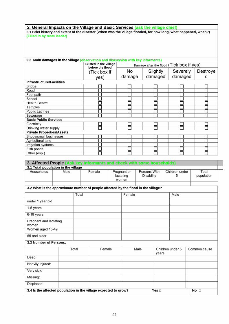
41
2. General Impacts on the Village and Basic Services (ask the village chief) 2.1 Brief history and extent of the disaster (When was the village flooded, for how long, what happened, when?) (Filled in by team leader) 2.2 Main damages in the village (observation and discussion with key informants)
Damage after the flood (Tick box if yes)
Existed in the village before the flood (Tick box if
yes) No
damage Slightly
damaged Severely damaged
Destroyed
Infrastructure/Facilities Bridge Road Foot path School Health Centre Temples Public Latrines Sewerage Basic Public Services Electricity Drinking water supply Private Properties/Assets Shops/small businesses Agricultural land Irrigation systems Fish ponds Other (esp.) 3. Affected People (Ask key informants and check with some households) 3.1 Total population in the village
Households Male Female Pregnant or lactating women
Persons With Disability
Children under 5
Total population
3.2 What is the approximate number of people affected by the flood in the village?
Total Female Male
under 1 year old
1-5 years
6-18 years
Pregnant and lactating women
Women aged 15-49
65 and older
3.3 Number of Persons:
Total Female Male Children under 5 years
Common cause
Dead:
Heavily Injured:
Very sick:
Missing:
Displaced:
3.4 Is the affected population in the village expected to grow? Yes No
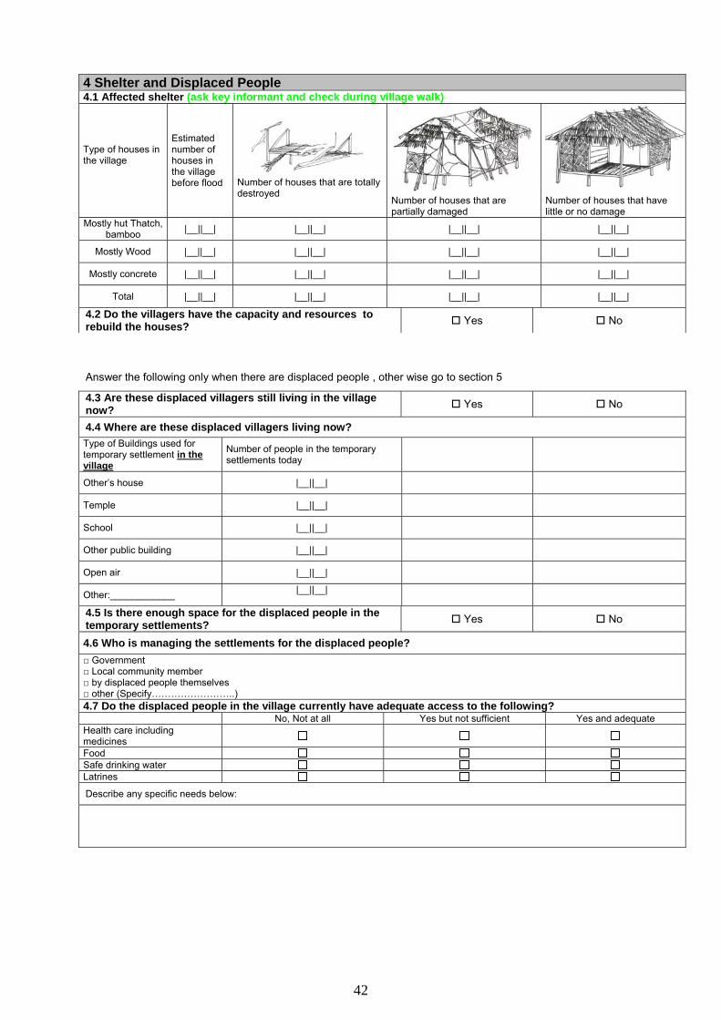
42
4 Shelter and Displaced People 4.1 Affected shelter (ask key informant and check during village walk)
Type of houses in the village
Estimated number of houses in the village before flood
Number of houses that are totally destroyed
Number of houses that are partially damaged
Number of houses that have little or no damage
Mostly hut Thatch, bamboo |__||__| |__||__| |__||__| |__||__|
Mostly Wood |__||__| |__||__| |__||__| |__||__|
Mostly concrete |__||__| |__||__| |__||__| |__||__|
Total |__||__| |__||__| |__||__| |__||__|
4.2 Do the villagers have the capacity and resources to rebuild the houses? Yes No Answer the following only when there are displaced people , other wise go to section 5
4.3 Are these displaced villagers still living in the village now? Yes No
4.4 Where are these displaced villagers living now? Type of Buildings used for temporary settlement in the village
Number of people in the temporary settlements today
Other’s house |__||__| Temple |__||__| School |__||__| Other public building |__||__| Open air |__||__| Other:____________ |__||__| 4.5 Is there enough space for the displaced people in the temporary settlements? Yes No
4.6 Who is managing the settlements for the displaced people? □ Government □ Local community member □ by displaced people themselves □ other (Specify……………………..) 4.7 Do the displaced people in the village currently have adequate access to the following? No, Not at all Yes but not sufficient Yes and adequate Health care including medicines
Food Safe drinking water Latrines
Describe any specific needs below:
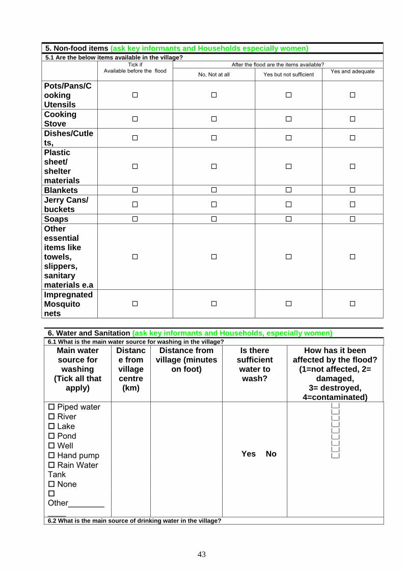
43
5. Non-food items (ask key informants and Households especially women) 5.1 Are the below items available in the village?
After the flood are the items available?
Tick if Available before the flood
No, Not at all Yes but not sufficient Yes and adequate
Pots/Pans/Cooking Utensils
Cooking Stove
Dishes/Cutlets,
Plastic sheet/ shelter materials
Blankets Jerry Cans/ buckets
Soaps Other essential items like towels, slippers, sanitary materials e.a
Impregnated Mosquito nets
6. Water and Sanitation (ask key informants and Households, especially women) 6.1 What is the main water source for washing in the village?
Main water source for washing
(Tick all that apply)
Distance from village centre (km)
Distance from village (minutes
on foot)
Is there sufficient water to wash?
How has it been affected by the flood?
(1=not affected, 2= damaged,
3= destroyed, 4=contaminated)
Piped water River Lake Pond Well Hand pump Rain Water
Tank
None
Other____________
� Yes � No
|__| |__| |__| |__| |__| |__| |__| |__| |__|
6.2 What is the main source of drinking water in the village?
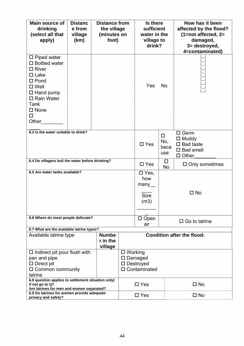
44
Main source of drinking
(select all that apply)
Distance from village (km)
Distance from the village
(minutes on foot)
Is there sufficient
water in the village to
drink?
How has it been affected by the flood?
(1=not affected, 2= damaged,
3= destroyed, 4=contaminated)
Piped water Bottled water River Lake Pond Well Hand pump Rain Water
Tank
None
Other____________
� Yes � No
|__| |__| |__| |__| |__| |__| |__| |__| |__| |__|
6.3 Is the water suitable to drink?
Yes
No, because
Germ Muddy Bad taste Bad smell Other________
6.4 Do villagers boil the water before drinking? Yes
No Only sometimes 6.5 Are water tanks available? Yes,
how many__
____ Size (m3)
________
No
6.6 Where do most people defecate? Open air Go to latrine
6.7 What are the available latrine types? Available latrine type Numbe
r in the village
Condition after the flood:
Indirect pit pour flush with pan and pipe
Direct pit Common community
latrine
Working Damaged Destroyed Contaminated
6.8 question applies to settlement situation only) if not go to Q7 Are latrines for men and women separated?
Yes No
6.9 Do latrines for women provide adequate privacy and safety? Yes No
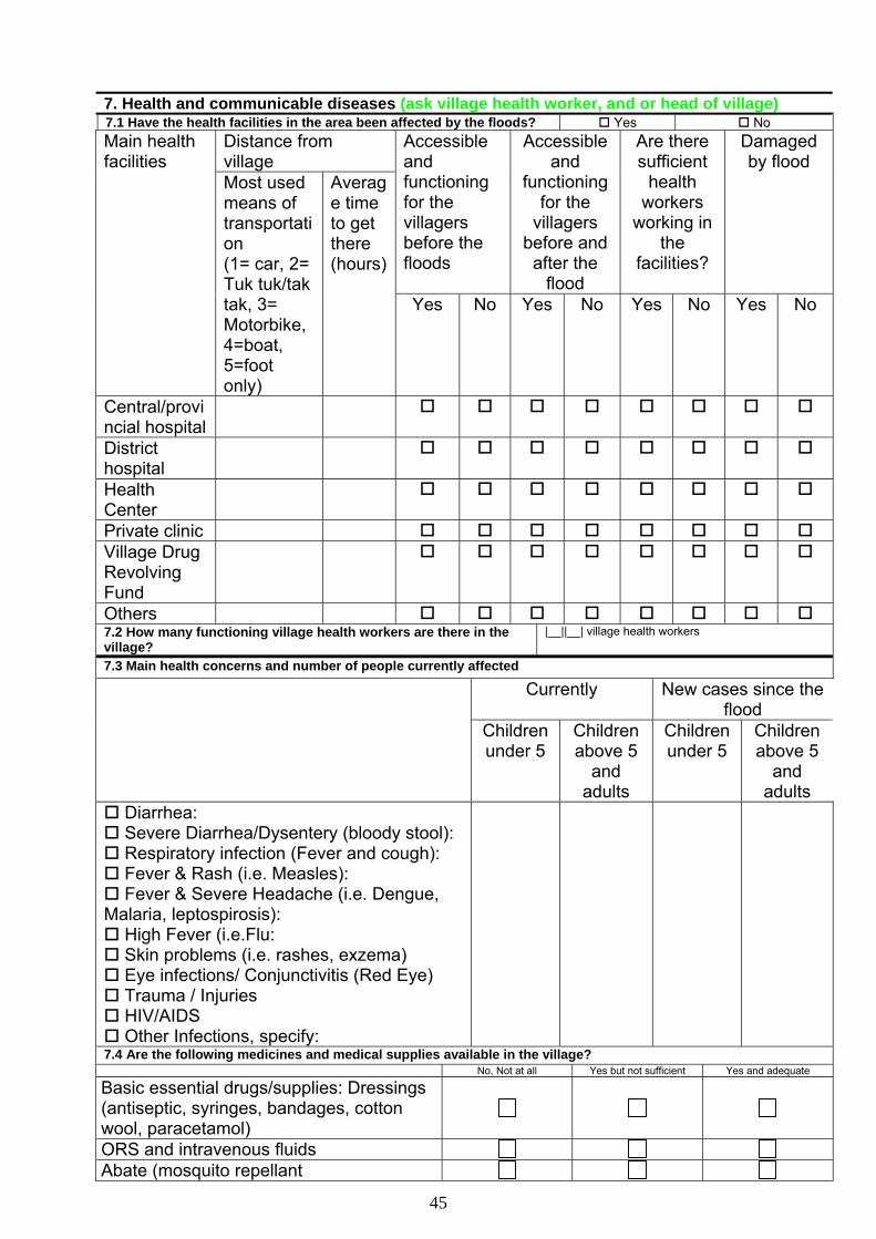
45
7. Health and communicable diseases (ask village health worker, and or head of village) 7.1 Have the health facilities in the area been affected by the floods? Yes No
Distance from village
Accessible and functioning for the villagers before the floods
Accessible and
functioning for the
villagers before and after the
flood
Are there sufficient
health workers
working in the
facilities?
Damaged by flood
Main health facilities
Most used means of transportation (1= car, 2= Tuk tuk/tak tak, 3= Motorbike, 4=boat, 5=foot only)
Average time to get there (hours)
Yes No Yes No Yes No Yes No
Central/provincial hospital
District hospital
Health Center
Private clinic Village Drug Revolving Fund
Others 7.2 How many functioning village health workers are there in the village?
|__||__| village health workers
7.3 Main health concerns and number of people currently affected Currently New cases since the
flood
Children under 5
Children above 5
and adults
Children under 5
Children above 5
and adults
Diarrhea: Severe Diarrhea/Dysentery (bloody stool): Respiratory infection (Fever and cough): Fever & Rash (i.e. Measles): Fever & Severe Headache (i.e. Dengue,
Malaria, leptospirosis): High Fever (i.e.Flu: Skin problems (i.e. rashes, exzema) Eye infections/ Conjunctivitis (Red Eye) Trauma / Injuries HIV/AIDS Other Infections, specify:
7.4 Are the following medicines and medical supplies available in the village? No, Not at all Yes but not sufficient Yes and adequate
Basic essential drugs/supplies: Dressings (antiseptic, syringes, bandages, cotton wool, paracetamol)
ORS and intravenous fluids Abate (mosquito repellant
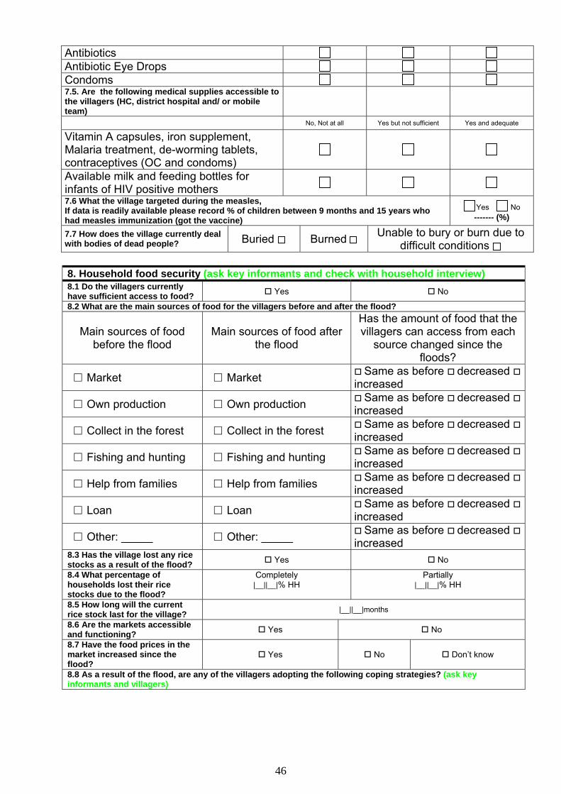
46
Antibiotics Antibiotic Eye Drops Condoms 7.5. Are the following medical supplies accessible to the villagers (HC, district hospital and/ or mobile team)
No, Not at all Yes but not sufficient Yes and adequate
Vitamin A capsules, iron supplement, Malaria treatment, de-worming tablets, contraceptives (OC and condoms)
Available milk and feeding bottles for infants of HIV positive mothers 7.6 What the village targeted during the measles, If data is readily available please record % of children between 9 months and 15 years who had measles immunization (got the vaccine)
Yes No ------- (%)
7.7 How does the village currently deal with bodies of dead people? Buried Burned Unable to bury or burn due to
difficult conditions 8. Household food security (ask key informants and check with household interview) 8.1 Do the villagers currently have sufficient access to food? Yes No
8.2 What are the main sources of food for the villagers before and after the flood?
Main sources of food before the flood
Main sources of food after the flood
Has the amount of food that the villagers can access from each
source changed since the floods?
□ Market □ Market Same as before decreased increased
□ Own production □ Own production Same as before decreased increased
□ Collect in the forest □ Collect in the forest Same as before decreased increased
□ Fishing and hunting □ Fishing and hunting Same as before decreased increased
□ Help from families □ Help from families Same as before decreased increased
□ Loan □ Loan Same as before decreased increased
□ Other: _____ □ Other: _____ Same as before decreased increased
8.3 Has the village lost any rice stocks as a result of the flood? Yes No
8.4 What percentage of households lost their rice stocks due to the flood?
Completely |__||__|% HH
Partially |__||__|% HH
8.5 How long will the current rice stock last for the village? |__||__|months
8.6 Are the markets accessible and functioning? Yes No
8.7 Have the food prices in the market increased since the flood?
Yes No Don’t know
8.8 As a result of the flood, are any of the villagers adopting the following coping strategies? (ask key informants and villagers)
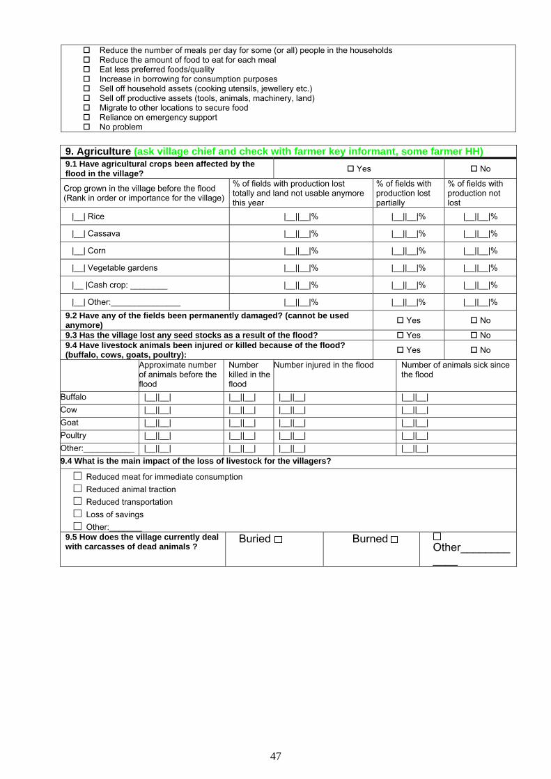
47
Reduce the number of meals per day for some (or all) people in the households Reduce the amount of food to eat for each meal Eat less preferred foods/quality Increase in borrowing for consumption purposes Sell off household assets (cooking utensils, jewellery etc.) Sell off productive assets (tools, animals, machinery, land) Migrate to other locations to secure food Reliance on emergency support No problem
9. Agriculture (ask village chief and check with farmer key informant, some farmer HH) 9.1 Have agricultural crops been affected by the flood in the village? Yes No
Crop grown in the village before the flood (Rank in order or importance for the village)
% of fields with production lost totally and land not usable anymore this year
% of fields with production lost partially
% of fields with production not lost
|__| Rice |__||__|% |__||__|% |__||__|%
|__| Cassava |__||__|% |__||__|% |__||__|%
|__| Corn |__||__|% |__||__|% |__||__|%
|__| Vegetable gardens |__||__|% |__||__|% |__||__|%
|__ |Cash crop: ________ |__||__|% |__||__|% |__||__|%
|__| Other:_______________ |__||__|% |__||__|% |__||__|% 9.2 Have any of the fields been permanently damaged? (cannot be used anymore) Yes No
9.3 Has the village lost any seed stocks as a result of the flood? Yes No 9.4 Have livestock animals been injured or killed because of the flood? (buffalo, cows, goats, poultry): Yes No
Approximate number of animals before the flood
Number killed in the flood
Number injured in the flood Number of animals sick since the flood
Buffalo |__||__| |__||__| |__||__| |__||__| Cow |__||__| |__||__| |__||__| |__||__| Goat |__||__| |__||__| |__||__| |__||__| Poultry |__||__| |__||__| |__||__| |__||__| Other:___________ |__||__| |__||__| |__||__| |__||__| 9.4 What is the main impact of the loss of livestock for the villagers?
□ Reduced meat for immediate consumption □ Reduced animal traction □ Reduced transportation □ Loss of savings □ Other:_______
9.5 How does the village currently deal with carcasses of dead animals ?
Buried Burned Other____________
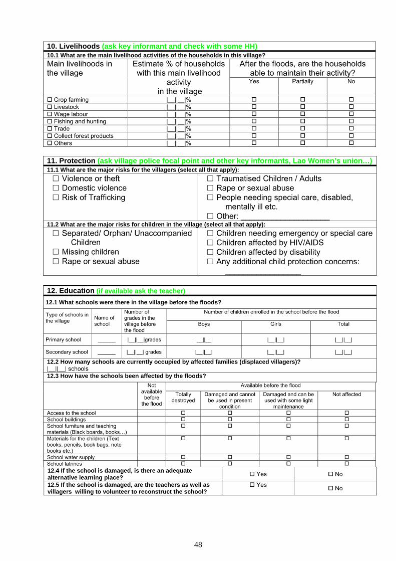
48
10. Livelihoods (ask key informant and check with some HH) 10.1 What are the main livelihood activities of the households in this village?
After the floods, are the households able to maintain their activity?
Main livelihoods in the village
Estimate % of households with this main livelihood
activity in the village
Yes Partially No
Crop farming |__||__|% Livestock |__||__|% Wage labour |__||__|% Fishing and hunting |__||__|% Trade |__||__|% Collect forest products |__||__|% Others |__||__|%
11. Protection (ask village police focal point and other key informants, Lao Women’s union…) 11.1 What are the major risks for the villagers (select all that apply): □ Violence or theft □ Domestic violence □ Risk of Trafficking
□ Traumatised Children / Adults □ Rape or sexual abuse □ People needing special care, disabled,
mentally ill etc. □ Other: ____________________
11.2 What are the major risks for children in the village (select all that apply): □ Separated/ Orphan/ Unaccompanied
Children □ Missing children □ Rape or sexual abuse
□ Children needing emergency or special care □ Children affected by HIV/AIDS □ Children affected by disability □ Any additional child protection concerns:
_________________ 12. Education (if available ask the teacher) 12.1 What schools were there in the village before the floods?
Number of children enrolled in the school before the flood Type of schools in the village
Name of school
Number of grades in the village before the flood
Boys Girls Total
Primary school ______ |__||__|grades |__||__| |__||__| |__||__|
Secondary school ______ |__||__| grades |__||__| |__||__| |__||__|
12.2 How many schools are currently occupied by affected families (displaced villagers)? |__||__| schools 12.3 How have the schools been affected by the floods?
Available before the flood Not available
before the flood
Totally destroyed
Damaged and cannot be used in present
condition
Damaged and can be used with some light
maintenance
Not affected
Access to the school School buildings School furniture and teaching materials (Black boards, books…)
Materials for the children (Text books, pencils, book bags, note books etc.)
School water supply School latrines 12.4 If the school is damaged, is there an adequate alternative learning place? Yes No
12.5 If the school is damaged, are the teachers as well as villagers willing to volunteer to reconstruct the school?
Yes No
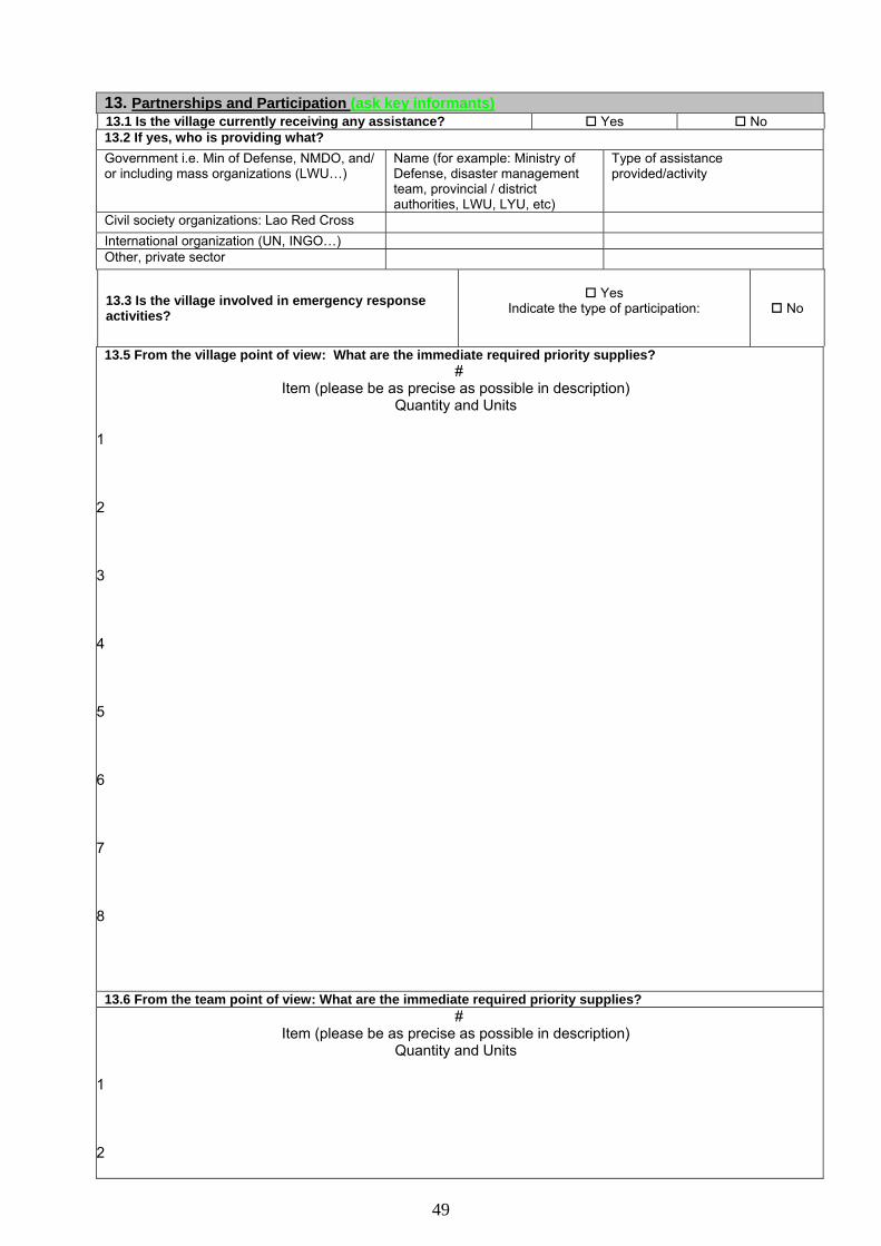
49
13. Partnerships and Participation (ask key informants) 13.1 Is the village currently receiving any assistance? Yes No 13.2 If yes, who is providing what? Government i.e. Min of Defense, NMDO, and/ or including mass organizations (LWU…)
Name (for example: Ministry of Defense, disaster management team, provincial / district authorities, LWU, LYU, etc)
Type of assistance provided/activity
Civil society organizations: Lao Red Cross International organization (UN, INGO…) Other, private sector
13.3 Is the village involved in emergency response activities?
Yes
Indicate the type of participation:
No
13.5 From the village point of view: What are the immediate required priority supplies? #
Item (please be as precise as possible in description) Quantity and Units
1
2
3
4
5
6
7
8
13.6 From the team point of view: What are the immediate required priority supplies?
# Item (please be as precise as possible in description)
Quantity and Units
1
2
50
3
4
5
6
7
8
13.7 Main area of concern not reflected by the questionnaire (if any) 13.8 Final general remarks
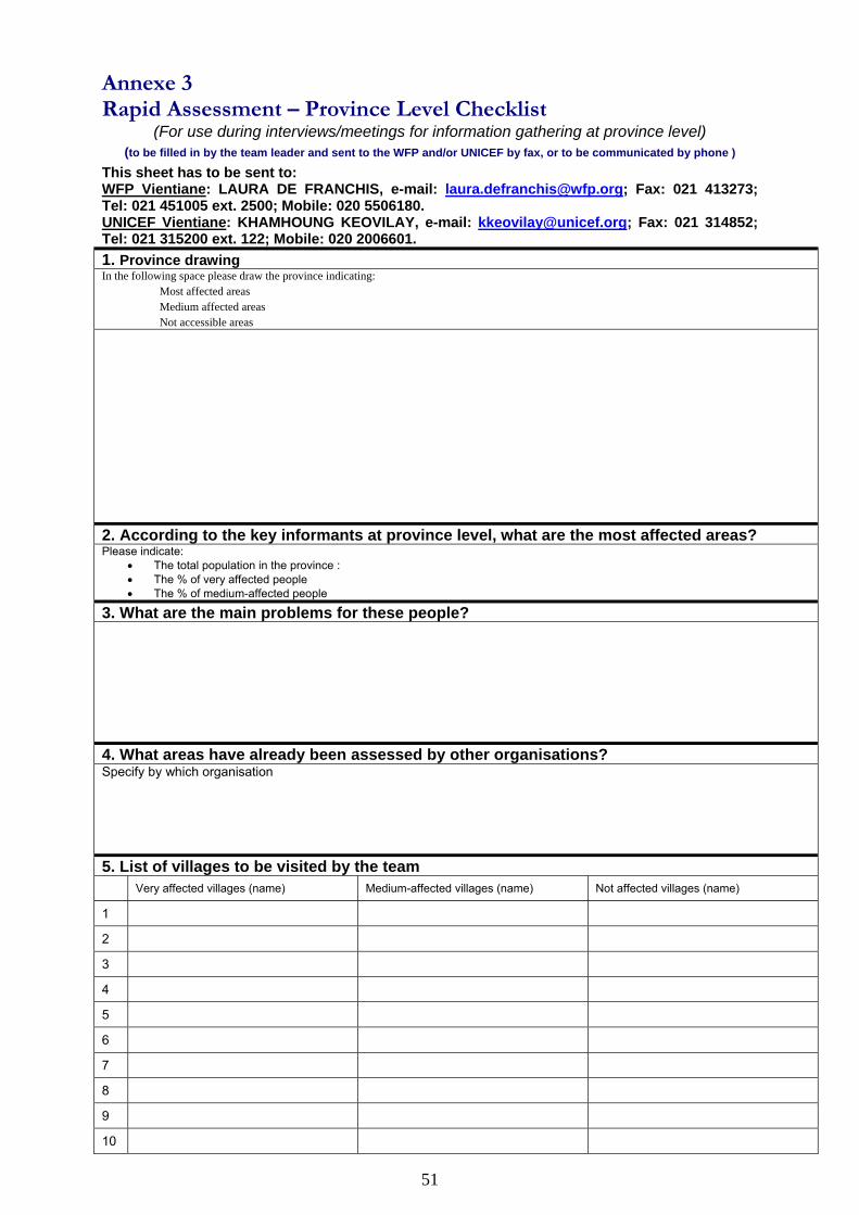
51
Annexe 3 Rapid Assessment – Province Level Checklist
(For use during interviews/meetings for information gathering at province level) (to be filled in by the team leader and sent to the WFP and/or UNICEF by fax, or to be communicated by phone )
This sheet has to be sent to: WFP Vientiane: LAURA DE FRANCHIS, e-mail: [email protected]; Fax: 021 413273; Tel: 021 451005 ext. 2500; Mobile: 020 5506180. UNICEF Vientiane: KHAMHOUNG KEOVILAY, e-mail: [email protected]; Fax: 021 314852; Tel: 021 315200 ext. 122; Mobile: 020 2006601. 1. Province drawing In the following space please draw the province indicating:
Most affected areas Medium affected areas Not accessible areas
2. According to the key informants at province level, what are the most affected areas? Please indicate:
• The total population in the province : • The % of very affected people • The % of medium-affected people
3. What are the main problems for these people? 4. What areas have already been assessed by other organisations? Specify by which organisation 5. List of villages to be visited by the team Very affected villages (name) Medium-affected villages (name) Not affected villages (name)
1
2
3
4
5
6
7
8
9
10
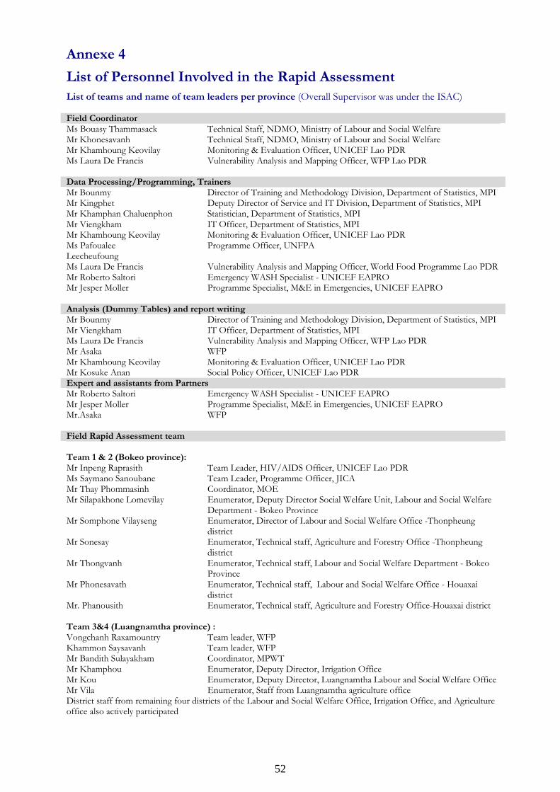
52
Annexe 4
List of Personnel Involved in the Rapid Assessment
List of teams and name of team leaders per province (Overall Supervisor was under the ISAC) Field Coordinator Ms Bouasy Thammasack Technical Staff, NDMO, Ministry of Labour and Social Welfare Mr Khonesavanh Technical Staff, NDMO, Ministry of Labour and Social Welfare Mr Khamhoung Keovilay Monitoring & Evaluation Officer, UNICEF Lao PDR Ms Laura De Francis Vulnerability Analysis and Mapping Officer, WFP Lao PDR Data Processing/Programming, Trainers Mr Bounmy Director of Training and Methodology Division, Department of Statistics, MPI Mr Kingphet Deputy Director of Service and IT Division, Department of Statistics, MPI Mr Khamphan Chaluenphon Statistician, Department of Statistics, MPI Mr Viengkham IT Officer, Department of Statistics, MPI Mr Khamhoung Keovilay Monitoring & Evaluation Officer, UNICEF Lao PDR Ms Pafoualee Leecheufoung
Programme Officer, UNFPA
Ms Laura De Francis Vulnerability Analysis and Mapping Officer, World Food Programme Lao PDR Mr Roberto Saltori Emergency WASH Specialist - UNICEF EAPRO Mr Jesper Moller Programme Specialist, M&E in Emergencies, UNICEF EAPRO
Analysis (Dummy Tables) and report writing Mr Bounmy Director of Training and Methodology Division, Department of Statistics, MPI Mr Viengkham IT Officer, Department of Statistics, MPI Ms Laura De Francis Vulnerability Analysis and Mapping Officer, WFP Lao PDR Mr Asaka WFP Mr Khamhoung Keovilay Monitoring & Evaluation Officer, UNICEF Lao PDR Mr Kosuke Anan Social Policy Officer, UNICEF Lao PDR Expert and assistants from Partners Mr Roberto Saltori Emergency WASH Specialist - UNICEF EAPRO Mr Jesper Moller Programme Specialist, M&E in Emergencies, UNICEF EAPRO Mr.Asaka WFP
Field Rapid Assessment team Team 1 & 2 (Bokeo province): Mr Inpeng Raprasith Team Leader, HIV/AIDS Officer, UNICEF Lao PDR Ms Saymano Sanoubane Team Leader, Programme Officer, JICA Mr Thay Phommasinh Coordinator, MOE Mr Silapakhone Lomevilay Enumerator, Deputy Director Social Welfare Unit, Labour and Social Welfare
Department - Bokeo Province Mr Somphone Vilayseng Enumerator, Director of Labour and Social Welfare Office -Thonpheung
district Mr Sonesay Enumerator, Technical staff, Agriculture and Forestry Office -Thonpheung
district Mr Thongvanh Enumerator, Technical staff, Labour and Social Welfare Department - Bokeo
Province Mr Phonesavath Enumerator, Technical staff, Labour and Social Welfare Office - Houaxai
district Mr. Phanousith Enumerator, Technical staff, Agriculture and Forestry Office-Houaxai district Team 3&4 (Luangnamtha province) : Vongchanh Raxamountry Team leader, WFP Khammon Saysavanh Team leader, WFP Mr Bandith Sulayakham Coordinator, MPWT Mr Khamphou Enumerator, Deputy Director, Irrigation Office Mr Kou Enumerator, Deputy Director, Luangnamtha Labour and Social Welfare Office Mr Vila Enumerator, Staff from Luangnamtha agriculture office District staff from remaining four districts of the Labour and Social Welfare Office, Irrigation Office, and Agriculture office also actively participated
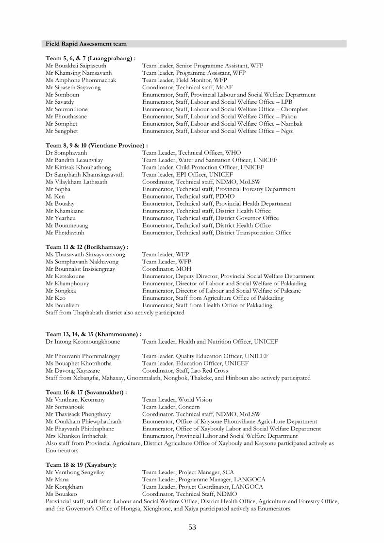
53
Field Rapid Assessment team Team 5, 6, & 7 (Luangprabang) : Mr Bouakhai Saipaseuth Team leader, Senior Programme Assistant, WFP Mr Khamsing Namsavanh Team leader, Programme Assistant, WFP Ms Amphone Phommachak Team leader, Field Monitor, WFP Mr Sipaseth Sayavong Coordinator, Technical staff, MoAF Mr Somboun Enumerator, Staff, Provincial Labour and Social Welfare Department Mr Savatdy Enumerator, Staff, Labour and Social Welfare Office – LPB Mr Souvanthone Enumerator, Staff, Labour and Social Welfare Office – Chomphet Mr Phouthasane Enumerator, Staff, Labour and Social Welfare Office – Pakou Mr Somphet Enumerator, Staff, Labour and Social Welfare Office – Nambak Mr Sengphet Enumerator, Staff, Labour and Social Welfare Office – Ngoi Team 8, 9 & 10 (Vientiane Province) : Dr Somphavanh Team Leader, Technical Officer, WHO Mr Bandith Leaunvilay Team Leader, Water and Sanitation Officer, UNICEF Mr Kittisak Khouhathong Team leader, Child Protection Officer, UNICEF Dr Samphanh Khamsingsavath Team leader, EPI Officer, UNICEF Ms Vilaykham Lathsaath Coordinator, Technical staff, NDMO, MoLSW Mr Sopha Enumerator, Technical staff, Provincial Forestry Department M. Ken Enumerator, Technical staff, PDMO Mr Boualay Enumerator, Technical staff, Provincial Health Department Mr Khamkiane Enumerator, Technical staff, District Health Office Mr Yearheu Enumerator, Technical staff, District Governor Office Mr Bounmeuang Enumerator, Technical staff, District Health Office Mr Phetdavanh Enumerator, Technical staff, District Transportation Office Team 11 & 12 (Borikhamxay) : Ms Thatsavanh Sinxayvoravong Team leader, WFP Ms Somphavanh Nakhavong Team Leader, WFP Mr Bounnalot Insisiengmay Coordinator, MOH Mr Ketsakoune Enumerator, Deputy Director, Provincial Social Welfare Department Mr Khamphouvy Enumerator, Director of Labour and Social Welfare of Pakkading Mr Songkxa Enumerator, Director of Labour and Social Welfare of Paksane Mr Keo Enumerator, Staff from Agriculture Office of Pakkading Ms Bounliem Enumerator, Staff from Health Office of Pakkading Staff from Thaphabath district also actively participated Team 13, 14, & 15 (Khammouane) : Dr Intong Keomoungkhoune
Team Leader, Health and Nutrition Officer, UNICEF
Mr Phouvanh Phommalangsy Team leader, Quality Education Officer, UNICEF Ms Bouaphet Khotnhotha Team leader, Education Officer, UNICEF Mr Davong Xayasane Coordinator, Staff, Lao Red Cross Staff from Xebangfai, Mahaxay, Gnommalath, Nongbok, Thakeke, and Hinboun also actively participated Team 16 & 17 (Savannakhet) : Mr Vanthana Keomany Team Leader, World Vision Mr Somsanouk Team Leader, Concern Mr Thavisack Phengthavy Coordinator, Technical staff, NDMO, MoLSW Mr Ounkham Phiewphachanh Enumerator, Office of Kaysone Phomvihane Agriculture Department Mr Phayvanh Phitthaphane Enumerator, Office of Xaybouly Labor and Social Welfare Department Mrs Khankeo Inthachak Enumerator, Provincial Labor and Social Welfare Department Also staff from Provincial Agriculture, District Agriculture Office of Xaybouly and Kaysone participated actively as Enumerators Team 18 & 19 (Xayabury): Mr Vanthong Sengvilay Team Leader, Project Manager, SCA Mr Mana Team Leader, Programme Manager, LANGOCA Mr Kongkham Team Leader, Project Coordinator, LANGOCA Ms Bouakeo Coordinator, Technical Staff, NDMO Provincial staff, staff from Labour and Social Welfare Office, District Health Office, Agriculture and Forestry Office, and the Governor’s Office of Hongsa, Xienghone, and Xaiya participated actively as Enumerators

54


![[Rapid airway access]](https://img.pdfslide.net/doc/110x75/6354cd1b765a645b3106d438/rapid-airway-access.jpg)


