Embed Size (px)
Citation preview

Eos, Vol. 87, No. 33, 15 August 2006
EOS. TRANSACTIONS, AMERICAN GEOPHYSICAL UNION
VOLUME 87 NUMBER 33
15 AUGUST 2006
PAGES 325-336
Recent Seismovolcanic Crisis in Northern Afar, Ethiopia
Geophysical Observatory at Ethiopia's Addis Ababa University recorded nearly continuous activity, including low-frequency tremors, between 24 and 26 September; the number of earthquakes recorded declined sharply
PAGES 3 2 5 , 3 2 9
A 60-kilometer-long rift segment ruptured in north central Afar, Ethiopia, in September 2005. This rupture followed a short but intensive period of volcanic and tectonic activity during which time more than 162 earthquakes (magnitudes 4 . 1 - 5 . 2 ) occurred and a 400-meter-long and 80-meter-wide volcanic vent opened (Figure 1) . For its spatial extent and amount of opening, this event ranks as the largest observed rifting sequence to have occurred on land, comparable to the 10-year-long Krafla (Iceland, 1975-1984) episode along a mid-ocean ridge.
The Afar depression is a triple rift junction where the Red Sea and Gulf of Aden spreading ridges emerge on land and meet the northern extension of the East African Rift (Figure 2a) .The junction lies above or near a mantle plume [e.g.,Courtillot et al, 1984; Montelli et al, 2004] .The floor of the depression is composed mostly of basalt lava emplaced during Plio-Quaternary times over the last three million years [e.g.,Kidane et al, 2003] . Huge and elongate basaltic shield volcanoes conspicuously rise above basalt fields and sand plains. The Afar depression is one of the hottest and driest places on Earth, yet its many pastoralists support large herds by distilling water from geothermal vents (known locally as boinas) .
In northern Afar, the African and Arabian plates, including the narrow Danakil micro-plate, are slowly pulling apart in a northeast direction, at a rate of one to two centimeters per year (Figure 2a) .This tectonic process is manifested by frequent and widespread earthquake activity. Volcanic processes also have been active over the past few million years and continue to the present date at Ethiopia's Erta'Ale volcano.
The axial part of Afar is characterized by discrete active magmatic segments (axial ranges) that are considered nascent ocean ic ridges in stretched continental lithosphere [Barberi and Varet, 1977; Hay ward and Ebin-
ger, 1996] . In northern and central Afar,these include the volcanic fields (areas comprised
of lava fields, volcanoes, and vent fields) of Erta'Ale, Tat'Ale, Alayta, and Manda Hararo (Figure 2a) .The latter probably comprises two 60-kilometer-long segments: the Dabbahu and Hararo subsegments.
The 2005 seismotectonic event occurred in the Dabbahu segment, which is marked by the Dabbahu stratovolcano (12.60°N,40.48°E; summit elevation, 1442 meters). As outlined below, this short but intensive period of activity ruptured the entire 60-kilometer-long rift segment, providing new insights into the rise and distribution of magma along rift segments.
Earthquake Swarm
Between 14 September and 4 October 2005, a swarm of 162 earthquakes 5.2 > mb > 4.1 occurred at Dabbahu volcano and the Dabbahu segment (Figure 2a and Table l ) . T h e
on 27 September. A seismic record at the FURI seismic station for 26 September 2005 is shown in Figure 2b.
Reconnaissance field studies by a team of geoscientists from Addis Ababa University on 26 September 2005 revealed a more than 500-meter-wide zone of newly formed tensional fissures and normal faults up to three kilometers in length. Significant discharge of fumarolic, pungent-smelling gases also was observed along the opened fissures and fault breaks.
The Da Vre Ash Eruption
According to local pastoralists, two very strong earthquakes shook the Da'Ure area on 26 September at about 12:30 PM. local time (0931 GMT, mb = 4.4; 0933 GMT, mb = 5.2) during which some scarps moved as much as one meter. These earthquakes were followed by an explosion of a black column of
BY G.YIRGU,A.AYELE,AND D.AYALEW
Fig. 1. A view of the newly opened Da'Ure volcanic vent, looking south. People in the photo provide scale. Part of the outer flank of Dabbahu volcano is visible on the right; Dabbahu s central area lies farther to the right, off the margin of the photo. (Photo by Anthony Philpotts.) Original color image appears at the back of this volume.

Eos, Vol. 87, No. 33, 15 August 2006
Fig. 2. (a) Satellite image of the northern part of the Afar depression. Inset shows the location of the northern Afar rift (box) relative to Global Climate Observing Station (GCOS) Surface Network (GSN) station FURL Elevations range from -200 to 4200 meters. To the northeast, the Afar depression is bounded by the NW-SE trending Danakil horst (an elongate block that has been raised by parallel normal faults on either sides) to the west by the Western escarpment. Dots are event locations relative to the main event indicated by the triangle [from Wright et al., 2006]. Gray stars indicate stratovolcanoes; D is Dabbahu, G is Gabho. The Alayta, ErtaAle and Tat Ale shield volcanoes are marked as white stars. Semera is the regional capital, (b) The FURI record for the major eruption of 26 September 2005. Instrument response is removed and the World Standards Services Network record is simulated. Amplitude is in microns.
smoke from the Da'Ure mountain.The eruption rose high into the atmosphere and spread out to form an umbrella-shaped cloud that darkened the area for three days.
Subsequent field observations on 5 October confirmed that a minor explosive eruption had, in fact, taken place on the southern flank of the Da'Ure volcanic dome (12°39'01.60"N, 40°31'09.05"E,~710 meter elevation) some five kilometers northeast of Dabbahu's summit area. The eruption occurred in a remote locality where no settlements are present.
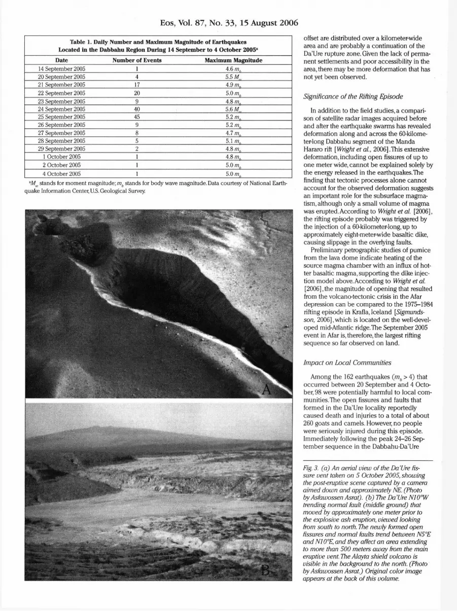
The eruption was centered on a fissure-vent trending N10°W,and broke through felsic lava flows and pyroclastics (Figures 1 and 3a) .The fissure-vent is about 400 meters long, 80 meters wide at its widest point, and up to 50 meters deep. Eruptive products consisted of pumice, fine ash, and lava. An ashfall deposit from this pit is 10-15 centimeters thick near the vent, and it drapes the area thinly for more than 500 meters on either side of the vent (Figure 3a) . According to pastoralists, very fine white ash fell sparsely over large areas in the surrounding region as far away as Teru village, 40 kilometers southwest of the eruption site. The Da'Ure ash cloud probably rose to a few kilometers above the fissure vent and was carried away by wind over long distances.
At the time of field investigations on 5 October, intense degassing was occurring along the length of the vent, from the lava dome, and through nearby fissures. Sulfur dioxide ( S 0 2 ) was a major component of the emitted gas. Furthermore, a boiling noise (similar to that of a helicopter engine) was heard continuously from beneath the pumice dome, which was indicative of the presence of magma at very shallow depth. On 15 October, 19 days after the eruption, temperatures up to 420°C were measured in the pumice dome, but no boiling sound was heard, implying that the magma had substantially cooled and the eruptive phenomenon had subsided.
Faulting and Fissuring
In the vicinity of the Da'Ure volcanic vent, a large number of newly formed fissures, second-order fractures, and reactivated normal faults were observed, most of which are located on the eastern side of the eruptive vent. Some fissures and faults extend discon-tinuously along strike for over 500 meters.
Perhaps the most spectacular tec tonic phenomenon in the area is the observed slip on a N5°E trending normal fault located some 500 meters east of the eruptive vent (Figure 3b) .This fault broke through felsic lavas and unwelded pyroclastic deposits. Displacement on the fault was up to a meter (down-thrown to the west) in places. This reactivated fault extends discontinuously for at least three kilometers.
Recent field campaigns, in March 2006, have revealed that intense deformation also occurred on the eastern flank of the Manda Hararo rift segment about 30 kilometers south-southeast of the Da'Ure vent site. Here, a large number of approximately one-meter-wide fissures and faults with greater than two-meter
Eos, Vol. 87, No. 33, 15 August 2006
Table 1. Daily Number and Maximum Magnitude of Earthquakes Located in the Dabbahu Region During 14 September to 4 October 2005 a
Date Number of Events Maximum Magnitude 14 September 2005 1 4.6 mh
20 September 2005 4 5.5 Mtn
21 September 2005 17 4.9 m. 22 September 2005 20 5.0 mb
23 September 2005 9 4.8 m, 24 September 2005 40 5.6 M, 25 September 2005 45 5.2 /77, 26 September 2005 9 5.2 /77, 27 September 2005 8 4.7 /77, 28 September 2005 5 5.1 /77, 29 September 2005 2 4.8 /77,
1 October 2005 1 4.8 /77,
2 October 2005 1 5.0 mh
4 October 2005 1 5.0 mh
aMw stands for moment magnitude; mb stands for body wave magnitude. Data courtesy of National Earthquake Information Center, U.S. Geological Survey.
offset are distributed over a kilometer-wide area and are probably a continuation of the Da'Ure rupture zone. Given the lack of permanent settlements and poor accessibility in the area, there may be more deformation that has not yet been observed.
Significance of the Rifting Episode
In addition to the field studies, a comparison of satellite radar images acquired before and after the earthquake swarms has revealed deformation along and across the 60-kilometer-long Dabbahu segment of the Manda Hararo rift [Wright et al, 2006].This extensive deformation, including open fissures of up to one meter wide, cannot be explained solely by the energy released in the earthquakes. The finding that tectonic processes alone cannot account for the observed deformation suggests an important role for the subsurface magma-tism, although only a small volume of magma was erupted. According to Wright et al [2006], the rifting episode probably was triggered by the injection of a 60-kilometer-long, up to approximately eight-meter-wide basaltic dike, causing slippage in the overlying faults.
Preliminary petrographic studies of pumice from the lava dome indicate heating of the source magma chamber with an influx of hotter basaltic magma, supporting the dike injection model above. According to Wright et al [2006], the magnitude of opening that resulted from the volcano-tectonic crisis in the Afar depression can be compared to the 1975-1984 rifting episode in Krafla, Iceland [Sigmunds-son, 2006] , which is located on the well-developed mid-Atlantic ridge. The September 2005 event in Afar is, therefore, the largest rifting sequence so far observed on land.
Impact on Local Communities
Among the 162 earthquakes (mb > 4 ) that occurred between 20 September and 4 October, 98 were potentially harmful to local communities. The open fissures and faults that formed in the Da'Ure locality reportedly caused death and injuries to a total of about 260 goats and camels. However, no people were seriously injured during this episode. Immediately following the peak 24 -26 September sequence in the Dabbahu-Da'Ure
Fig. 3. (a) An aerial view of the Da'Ure fissure vent taken on 5 October 2005, showing the post-eruptive scene captured by a camera aimed down and approximately NE. (Photo byAsfawossen Asrat). (b) The Da'Ure NI0°W trending normal fault (middle ground) that moved by approximately one meter prior to the explosive ash eruption, viewed looking from south to north. The newly formed open fissures and normal faults trend between N5°E and NI0°E, and they affect an area extending to more than 500 meters away from the main eruptive vent. The Alayta shield volcano is visible in the background to the north. (Photo byAsfawossen Asrat.) Original color image appears at the back of this volume.

Eos, Vol. 87, No. 33, 15 August 2006
area, nearly 6500 pastoralists were temporarily displaced and many of them permanently settled to relatively safer localities.
Ethiopian geoscientists and their foreign col leagues currently are monitoring earthquake activity, ground deformation, vent emissions, and satellite images to understand the ongoing rifting process along the Manda Hararo segment, as well as to detect any resurgence in potentially explosive volcan ic activity. In January 2006, a complete set of continuous global positioning system and seismometer instruments was deployed. A preliminary interpretation of the available data indicates that the Manda Hararo axial rift segment remained active five months after the major volcano-tectonic event.
References
Barberi,F,and J.Varet (1977),Volcanism of Afar: Small-scale plate tectonic implications, Geol. Soc. Am. Bull., 88, 1251-1266.
Courtillot,V, J. Achache, FLandre, N. Bonhommet, R. Montigny, and G.Feraud (1984), Episodic spreading and rift propagation: New paleomagnetic and geochronologic data from the Afar nascent passive margin,./ Geophys. Res., 89, 3315-3333.
Hayward,N.,and C.Ebinger (1996),Variations in the along-axis segmentation of the Afar rift system, Tectonics, 75(2),244-257.
Kidane,T.,et al. (2003), New paleomagnetic and geochronologic results from Ethiopian Afar: Block rotations linked to rift overlap and propagation and determination of ~2 Ma reference pole for stable Africa, J Geophys. Res., 108(B2), 2102, doi:10.1029/2001JB000645.
Montelli, R., G. Nolet, EDahlen, G. Masters, E. Engdahl, and S.-H.Hung (2004), Finite frequency tomogra
phy reveals a variety of plumes in the mantle, Science, 303, 338-343.
Sigmundsson, F (2006), Iceland Geodynamics: Crustal Deformation and Divergent Plate Tectonics, 228 pp., Springer, New York.
WrightJ., C. Ebinger, J. Biggs, A. Ayele, C.Yirgu, A. Stork, and D.Keir (2006), Dyke-maintained rift segmentation at continental rupture—The 2005 Dabbahu (Afar) rifting episode,Nature, 442(20), 291-294.
Author information
Gezahegn Yirgu, Department of Earth Sciences, Addis Ababa University, Addis Ababa, Ethiopia; E-mail: yirgu. [email protected]; Atalay Ayele, Geophysical Observatory, Addis Ababa University; and Dereje Ayalew, Department of Earth Sciences, Addis Ababa University.
Gas Hydrate Transect Across Northern Cascadia Margin PAGES 3 2 5 , 3 3 0 , 3 3 2
Gas hydrate is a solid compound mainly comprised of methane and water that is stable under low temperature and high pressure conditions. Usually found in offshore environments with water depths exceeding about 500 meters and in arctic regions associated with permafrost, gas hydrates form an efficient storage system for natural gas. Hence, they may represent an important future energy resource [e.g.,Kvenvolden, 1988].Gas hydrates also form a natural geo-hazard, and may play a significant role in global climate change [e.g.,Dillon etal, 2001] .
In the fall of 2005, the Integrated Ocean Drilling Program (IODP) Expedition 311 established a transect (consisting of four deep research core holes) on the northern Cascadia margin off the west coast of Canada, which extends across the entire region of gas hydrate occurrence (Figure l ) . I n addition to the transect, a fifth site was cored within an active cold vent located along the transect.
Among the most significant findings of the expedition was an increased understanding of how gas hydrate occurs in nature. Particularly, the occurrence at Sites U1326 and U1327 of up to 20-meter-thick sand-rich intervals with gas hydrate concentrations locally exceeding 50% of the pore space was unexpected (Figure 2 ) . Moreover, these anomalous gas hydrate intervals occur at unexpectedly shallow depths of 5 0 - 1 2 0 meters below seafloor (mbsf), which is the opposite of what was expected from existing
BY M. RIEDEL,T. COLLETT, M. MALONE, FAKIBA, M. BLANC-VALLERON, M. ELLIS, G. GUERIN,Y HASHIMOTO^ HEUER,Y HIGASHI, M. HOLLAND, PJACKSON, M. KANEKO, M. KASTNER, J.-H. KIM, H. KITAJIMA, PLONG, A. MAUNVERNO, G. MYERS L PALEKAR, J. BDHLMAN, PSCHULTHEISS, B.TEICHERT, M . TORRES, A . TKEHU, J.WANG, U.WORTMANN,AND H.YOSHIOKA
models of gas hydrate formation in accre-tionary complexes.
In these models, gas hydrate was predicted to be more concentrated near the base of the gas hydrate stability zone just above the bottom-simulating reflector (BSR) and was believed to be evenly distributed throughout the pore space of the sediments regardless of their specific grain sizes [e.g., Hyndman and Davis, 1992] . However, gas hydrate appears to be more concentrated in sand layers, as shown in Figure 3a. During Expedition 311, the visual correlation of gas hydrate with sand layers was clearly and repeatedly documented, strongly supporting the importance of grain size and associated sediment parameters in controlling the occur rence of gas hydrate.
Expedition 311 Background
Expedition 311 complements previous gas hydrate studies along the Cascadia accre-tionary complex, especially Ocean Drilling Program Legs 146 [Westbrook etal., 1994] and 204 [Trehu et al., 2003] ,by extending the aperture of the transect sampled and introducing new tools to systematically quantify the gas hydrate content of the sediments. The data from this effort have yielded a better understanding of the geologic controls, evolution, and ultimate fate of gas hydrate in an accretionary prism.The data also are providing new insight into the role of gas hydrate methane gas in slope stability and possibly in climate change. Expedition 311 was the first part of a multi-expedition study of the northern Cascadia gas hydrate system that will be complemented by future longtime borehole monitoring experiments tied to the NEPTUNE (Northeast Pacific Time-Series Undersea Networked Experiment) cable observatory.
Downhole logging while drilling and measurement while drilling (LWD/MWD), carried out prior to coring on Expedition 311 , pro
vided a set of measurements to guide subsequent coring and special tool deployments. Additional wireline logging at each site and two vertical seismic profiles (VSP) at Sites U1327 and U1328 were successfully completed. A total of 1217.76 meters of sediment core was recovered using the advanced piston corer and extended core barrel systems. Standard coring was interspersed with various special pressure core sampler tool runs, which were mainly used for onboard degassing and core logging experiments. Four of the recovered pressurized cores were stored under in situ pressure for subsequent shore-based studies.
Infrared (IR) imaging of the recovered core was used to identify gas hydrate in the core for direct subsampling and preservation in liquid nitrogen. Special care was taken to sample background and cold IR anomalies for interstitial water (IW) freshening to confirm the presence and concentration of gas hydrate as well as to col lect samples for shore-based microbiological analyses.
Coring Transect
Site U1326 is the westernmost site located on the first uplifted ridge of the accretionary wedge.The sediments are heavily faulted, showing linear outcrops on the seafloor. The presence of gas hydrate was suggested by the occurrence of a widespread BSR. LWD/MWD resistivity logs confirmed the general presence of gas hydrate between 72 and 240 mbsf. The data also yielded evidence of relatively shallow gas hydrate occurrences between approximately 50 and 100 mbsf, with concentrations locally as high as 80% of the pore space. The IW chlorinity profile showed an almost constant, near-seawater baseline trend with depth. Superimposed on this baseline, abundant low-chlorinity anomalies associated with gas hydrate extended to 270 mbsf.
The shallow and especially highly concentrated gas hydrate occur rence at Site U1326 combined with the lack of high gas hydrate concentrat ions near the BSR were unexpected, and they contradict the model of gas hydrate formation at an accret ionary margin by Hyndman and Davis [1992] . Combined drilling and seismic observations suggest

Eos, Vol. 87, No. 33, 15 August 2006
Page 325
Fig. 1. A view of the newly opened Da'Ure volcanic vent, looking south. People in the photo provide scale. Part of the outer flank of Dabbahu volcano is visible on the right; Dabbahu s central area lies farther to the right, off the margin of the photo. (Photo by Anthony Philpotts.)

Eos,Vol. 87, No. 33,15 August 2006
Fig. 3. (a) An aerial view of the DaVre fissure vent taken on 5 October 2005, showing the post-eruptive scene captured by a camera aimed down and approximately NE. (Photo by Asfawossen Asrat). (b) The DaVre N10°Wtrending normal fault (middle ground) that moved by approximately one meter prior to the explosive ash eruption, viewed looking from south to north. The newly formed open fissures and normal faults trend between N5°E and N10°E, and they affect an area extending to more than 500 meters away from the main eruptive vent. The Alayta shield volcano is visible in the background to the north. (Photo by Asfawossen Asrat.)


![Ethiopia Report[1] - Refworld](https://img.pdfslide.net/doc/110x75/631dca9a1aedb9cd850f7475/ethiopia-report1-refworld.jpg)


