Embed Size (px)
Citation preview
Response of sand dunes to variations in tidal flow: Fraser Estuary,
Canada
Ray KostaschukDepartment of Geography, University of Guelph, Guelph, Ontario, Canada
Jim BestEarth and Biosphere Institute, School of Earth and Environment, University of Leeds, Leeds, UK
Received 6 June 2004; revised 10 August 2005; accepted 29 August 2005; published 28 October 2005.
[1] The morphology of dunes in rivers and estuaries often lags behind changes in riverdischarge and neap-spring tides. This study extends previous research by examiningthe response of large subtidal dunes in the Fraser Estuary, Canada, to changing flowconditions over a semidiurnal tidal cycle. An acoustic Doppler current profiler(ADCP) is used to measure three-dimensional velocity profiles and estimate sedimenttransport and a digital echosounder to measure bed profiles and dune characteristics.Mean flow velocity accelerates from 0.60 to 1.99 m/s and mean flow depth decreasesfrom 15.1 to 12.2 m on the falling tide, followed by a decrease in mean velocity to0.25 m/s and an increase in depth to 15.25 m on the rising tide. Estimates based onADCP bottom-tracking and backscatter, and the sediment transport model of van Rijn(1984a, 1984b, 1984c), indicate that bed-material sediment transport generally followsthe pattern of mean velocity over the tidal cycle. Dune length does not changesignificantly over the survey period. Changes in dune height, steepness and leeside slopeangle precede changes in flow velocity, increasing early in the tidal fall because ofscour in dune troughs that is likely caused by increased turbulence resulting fromdevelopment and expansion of the flow separation/deceleration zone. Erosion of dunecrests increases as peak velocity is approached near low tide, resulting in a decrease indune height. Concentrations of sand in suspension also increase with mean velocity,leading to deposition in troughs and a further reduction in dune height and leeside slopeangle. Sand falls out of suspension and drapes the dunes as high tide approaches.Dune length is not in equilibrium with the flow whereas dune height is in equilibriumwith the strongest flows that occur around low tide. A comparison of bed-materialtransport based on dune migration and the model of van Rijn (1984a, 1984b, 1984c)suggests that the model provides reasonable estimates of bed load in the Estuary,although the model must be used with caution because deposition from suspension alsocontributes to dune migration.
Citation: Kostaschuk, R., and J. Best (2005), Response of sand dunes to variations in tidal flow: Fraser Estuary, Canada, J. Geophys.
Res., 110, F04S04, doi:10.1029/2004JF000176.
1. Introduction[2] Dunes are ubiquitous features in sand-bed rivers
and estuaries and play an integral role in the relation-ships between boundary layer flow structure and sedi-ment transport [American Society of Civil Engineers,2002; McLean et al., 1994, 1999; Nelson et al., 1995].Many of the relationships developed between dunes andtheir controlling environmental variables have beenestablished in laboratory flumes with unidirectional,steady, uniform currents [e.g., Bennett and Best, 1995;Best and Kostaschuk, 2002; McLean et al., 1994; Nelsonet al., 1999], which are conditions that rarely apply to
dunes in natural settings. This is particularly true inestuaries where dunes are affected by temporal andspatial variability in flow resulting from changing fluvialand tidal conditions. Several studies have shown thatlarge, subtidal dunes lag behind seasonal [e.g., Gabel,1993; Julien et al., 2002; Kostaschuk et al., 1989a;Wilbers, 2004; Wilbers and ten Brinke, 2003] and tidal[e.g., Kostaschuk and Ilersich, 1995] changes in flow,resulting in hysteresis in dune properties. However,instruments that lack the temporal and spatial resolutionrequired to examine detailed process-response relation-ships, including hysteresis, have limited studies of sub-tidal dunes over single tidal cycles. The present studyuses instruments that have this capability, namely anacoustic Doppler current profiler and digital echosounder,
JOURNAL OF GEOPHYSICAL RESEARCH, VOL. 110, F04S04, doi:10.1029/2004JF000176, 2005
Copyright 2005 by the American Geophysical Union.0148-0227/05/2004JF000176
F04S04 1 of 10

to study the changes in dune morphology that occurover a semidiurnal tidal cycle in the Main Channel ofthe Fraser River estuary, British Columbia, Canada(Figure 1).
2. Study Area
[3] Discharge in the Fraser River is characteristicallyhighest during the spring and early summer when warmertemperatures and spring rains result in the annual snow-melt freshet. Discharge at Hope (150 km upstream of thestudy reach) during the spring freshet ranges between6000 and 12,000 m3/s. The Fraser is a relatively largeriver and discharge does not vary significantly over dailytimescales. The Main Channel flows into the Strait ofGeorgia, a semi-enclosed, high-energy marine basin. Tidesare mixed, mainly semidiurnal with a mean range of 3 mnear the mouth of the Main Channel and 5 m duringspring tides. Over one semidiurnal tidal cycle (approxi-mately 13 hours), river discharge remains relatively con-stant and tidal movement controls the variation in flowwithin the estuary. A salt-wedge intrusion extends into thelower Main Channel, with its position being determinedby river discharge and tidal height [Kostaschuk andAtwood, 1990]. The salt-wedge is flushed downstreamduring falling semidiurnal tides and flow at low tide isunstratified throughout much of the estuary during highriver discharge.[4] Large dunes, 0.3–5 m in height and over 100 m in
length, develop during high river discharges [Kostaschuk etal., 1989a] and actively migrate [Villard and Kostaschuk,1998] during the 3–4 hour period around low tide when flowis unstratified and bed material is in transport [Kostaschukand Villard, 1996]. The planform shape of the dune crestvaries from slightly concave-downstream [Kostaschuk andMacDonald, 1988] to mildly sinuous [Kostaschuk et al.,2004]. Dune height and length lag behind seasonal changesin river discharge by up to 2–3 weeks [Allen, 1973;Kostaschuk et al., 1989a; Villard and Church, 2003].Kostaschuk and Ilersich [1995] found that dune height and
length also lagged behind changes in velocity associatedwith spring-neap tidal variations in the estuary.
3. Methods
[5] Surveys were conducted from a launch using anOcean Data Equipment Bathy1500 200 kHz digital surveyechosounder (DES) and a SonTek 1500 kHz 3-beam acous-tic Doppler current profiler (ADCP). The ADCP was usedto measure three-dimensional velocity profiles and estimatesediment transport as bed load and suspended load. Bothinstruments were tied to a Trimble AgGPS122 differentialglobal positioning system (DGPS), which uses a differen-tially corrected signal from a navigation beacon locatednearby, allowing for a measured spatial precision from themoving launch of around 0.1 m. Under the conditions ofthis study, the manufacturers estimate a precision of ±0.02 mfor the DES and ±0.01 m/s for the ADCP.[6] Velocity and depth data were collected along a survey
line in the center of the Main Channel line during 7–20June 2000 (Figure 1). Dune transects were made over tidalcycles (tidal fall and rise) on several days, but strong windsresulted in a reliable set of transects only on 20 June, andthese data are presented herein. A total of 17 transects weremeasured along the survey line between 0727 local time(LT) and 1951 LT on 20 June. River discharge was decliningin June (Figure 2) but was high on 20 June (8 050 m3/s).High tide (3.8 m) was at 0605 LT, low tide (1 m) at 1325 LTand the second high tide (4.5 m) at 2105 LT (Figure 2). Aseries of seven large dunes, located near the downstreamend of the survey line, were selected for analysis on thebasis of reliable identification of individual dunes betweensurveys. A post-survey analysis of transect positionsshowed that all transects were within a 60 m wide bandalong the centerline of the channel and most were within30 m.[7] The DES employs a bottom-finding algorithm for
flow depth that works well when suspended sediment
Figure 1. Study area in the lower Main Channel of theFraser Estuary, British Columbia, Canada, showing thelocation of the survey line. River flow is from the bottomright to the top left.
Figure 2. Tidal heights at Point Atkinson and Fraser Riverdischarge at Mission (40 km upstream of the study reach)for June 2000. Tidal data are from Fisheries and OceansCanada (2000) and discharge data are from EnvironmentCanada (2000).
F04S04 KOSTASCHUK AND BEST: SUBTIDAL ESTUARINE SAND DUNES
2 of 10
F04S04
concentrations are low but provides ‘‘false bottoms’’ whenconcentrations are high. Contaminated DES measurementsduring high sediment concentrations were thus replaced byestimates obtained from a ‘‘digital paper trace’’ record.[8] The ADCP utilizes an internal compass to define flow
direction and a tilt sensor to correct for vessel pitch and roll,while velocity measurements are corrected for vesselmotion using DGPS positions. The three transducers ofthe ADCP are set at 25� from the vertical axis and areequally spaced in the horizontal (120�), producing differentorientations relative to the flow. The static diameter of theADCP sampling area increases with depth to a maximum of0.93 of the depth at the bed, which means that the velocitymeasurements nearest the bed in the dune troughs areunreliable because the three ADCP beams will encounterthe bed at different depths. Kostaschuk et al. [2004] suggestthat a mean bed position from ADCP data can be deter-mined by a sharp increase in echo intensity. Since theinflection point above the maximum echo intensity repre-sents the transition between the bed and the water column,the ADCP bin above the inflection point can therefore beused to define the lower limit of uncontaminated velocitymeasurements. These procedures were followed in thisstudy. Kostaschuk et al. [2004] also found that a samplinginterval of 5 s and a vertical resolution of 0.25 m providedthe best combination of low signal:noise ratio, stablevelocity measurements, good spatial resolution over dunesand reliable positions from the DGPS. These settings werealso used in the present study.[9] The bottom tracking capability of an ADCP, which
involves measurement of the Doppler shift of an indepen-dent acoustic echo from the bed, can be used to estimate bedload transport [e.g., Kostaschuk et al., 2005; Rennie et al.,2002; Villard et al., 2005]. Bottom tracking is designed tomeasure boat velocity over an immobile bed, and thus incases where the bed is mobile, the bottom tracking Dopplershift is a function of both the velocity of the boat and thevelocity of the mobile bed. The velocity of the mobile bedis therefore related to the difference between (1) the‘‘apparent’’ boat velocity with respect to the bed measuredwith ADCP bottom tracking (Ubtk) and (2) the ‘‘actual’’boat velocity measured with a DGPS (UDGPS). Highsuspended sand concentrations can result in the bottom-track pulse ‘‘seeing’’ a false bed and registering sedimenttransport velocities that reflect sand transport in suspensionrather than sand transported as bed load [Kostaschuk et al.,2005].[10] The strength of an ADCP acoustic return from the
water column, or backscatter (B), is a function of bothinstrument and sediment properties and has been used toestimate the concentration of suspended sediment in awide range of flows [e.g., Alvarez and Jones, 2002;Kostaschuk et al., 2005; Reichel, 1998]. Instrument re-sponse is a function of ADCP frequency, transmit power,receiver sensitivity and distance to the measurement vol-ume, while the size, type and concentration of suspendedsediment are the most important sediment properties.Acoustic frequencies have different sensitivities dependenton particle size, and, at a single frequency, backscatterstrength is a function of particle size, type and concentra-tion. For a constant type and size of particle, scatteringstrength is thus theoretically directly proportional to con-
centration. However, it is important to note that, inpractice, it is not possible to distinguish between theeffects of suspended sediment concentration and particlesize on the acoustic backscatter [Reichel, 1998], andcalibration with known values of concentration is thereforerequired for absolute ADCP-based estimates of concentra-tion. However, since a particular calibration is only valid ifthe size distribution does not change, and direct measure-ments of concentration were not possible herein, theADCP backscatter cannot be calibrated in this study.[11] Sediment transport rates over the tidal cycle were
estimated using the ‘‘simplified’’ model of van Rijn [1984a,1984b, 1984c, 1993]. Although there is a wide range ofmodels that can be used to estimate sediment transport rates,the van Rijn model has been shown to provide reasonableresults in a variety of environments [e.g., Chandler andKostaschuk, 1994; van den Berg, 1987]. The simplifiedmodel uses mean velocity and does not require watersurface slope or shear stress measurements, and so it isapplicable to the tidal flows in the present study. Volumetric(per unit channel width: m2/s) bed load (qb) and suspendedbed-material load (qs) are predicted from
qb ¼ 0:005UhU � Ucr
s� 1ð Þgd50½ �1=2
" #2:4d50
h
� �1:2
; ð1Þ
qs ¼ 0:012UhU � Ucr
s� 1ð Þgd50½ �1=2
" #2:4d50
h
� �D*
� ��0:6; ð2Þ
Ucr ¼ 0:19 d50ð Þ0:1 log 4h
d90
� �0:1 � d50 � 0:5 mm; ð3Þ
Ucr ¼ 8:5 d50ð Þ0:6 log 4h
d90
� �0:5 < d50 � 2 mm; ð4Þ
D* ¼ d50g s� 1ð Þ
n2
� �1=3; ð5Þ
where U is mean depth-averaged flow velocity over thesurvey line, Ucr is the critical depth-averaged entrainmentvelocity, s is the density ratio rs/r, rs is sediment density(assumed = 2650 kg/m3), r is water density (assumed =1000 kg/m3), d50 is the median bed-material size (here =0.32 mm), h is mean flow depth over the survey line, d90 isthe coarsest ninetieth percentile of bed-material size (here =0.45 mm), g is the acceleration of gravity, and n is kinematicviscosity (assumed = 1 � 10�6 m2/s).
4. Results
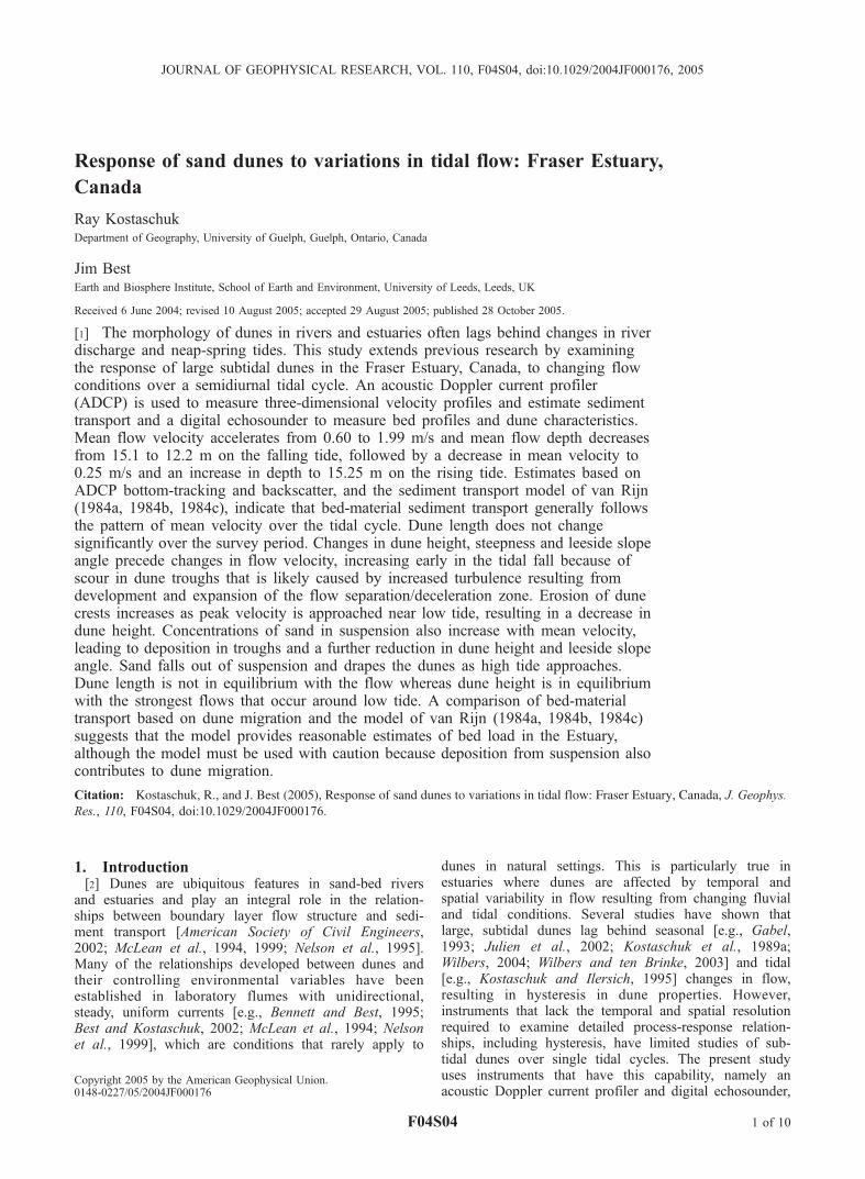
[12] Figure 3 provides examples of ADCP velocityrecords taken at the downstream end of the survey line(Figure 1) early in the falling tide (0727 LT; Figure 3a),around low tide (1347 LT; Figure 3b) and late in the risingtide (1930 LT; Figure 3c), while Figure 4 shows meanvelocity profiles for the same transects. The 0727 LT recordis the only transect with stratified flow, with velocities in theintrusion being weak and directed upstream. Upper layer
F04S04 KOSTASCHUK AND BEST: SUBTIDAL ESTUARINE SAND DUNES
3 of 10
F04S04

velocities in the river flow above the salt-wedge are higherand directed downstream, with a well-defined top to thesaline intrusion being visible (12 m, Figure 3a). Thesalinity intrusion has been flushed seaward of the mea-surement reach by 0815 LT and all flows were down-stream-directed throughout the remainder of the tidalcycle. Velocity at 1347 LT (Figure 3b) is high, reflecting
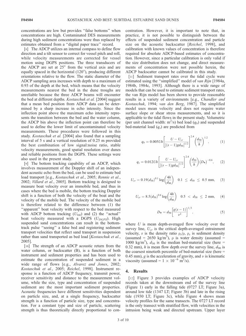
the dominance of the river flow and also showing thetopographic forcing of flow by the dunes with higher veloc-ities over crests than over troughs. Velocity at 1930 LT(Figure 3c) is low but still directed downstream.[13] Figure 5 shows mean flow depth and mean velocity
spatially averaged over each transect. Mean depth andvelocity display inverse patterns over the tidal cycle and
Figure 3. The ADCP records of velocity (u) with depth (h) along the survey line (Figure 1) at(a) 0727 LT, (b) 1347 LT, and (c) 1930 LT. Downstream flow is from right to left. In Figure 3a, flowbelow 12 m depth is upstream-directed flow within the salt-wedge intrusion. See color version of thisfigure at back of this issue.
F04S04 KOSTASCHUK AND BEST: SUBTIDAL ESTUARINE SAND DUNES
4 of 10
F04S04
both change more slowly on the falling tide (0727–1347 LT) than on the rising tide. The Froude number, Fr,is given by
Fr ¼ Uffiffiffiffiffigh
p� �
ð6Þ
and is plotted in Figure 6 over the tidal cycle, although the0727 LT transect was not used in these calculations becausethe flow was stratified. Values of Fr are all sub-critical andvery low, generally following the pattern of flow velocity.Values of Fr around low tide are comparable to other valuesreported from the Fraser Estuary by Kostaschuk and Villard[1996] and Best and Kostaschuk [2002]. Discharge per unitchannel width (Uh) shows a similar pattern to Fr, exceptthat Uh is relatively higher during the falling tide.[14] Mean bed load velocity (Ubed) and acoustic back-
scatter (B) measured with the ADCP vary in a similarfashion over the tidal cycle (Figure 7) and follow the patternof mean flow velocity. Bed load velocities are close to zeroat high tide but are very high and comparable with meanflow velocity (compare Figures 5 and 7) around low tide.Such grain velocities that are comparable with the flowvelocity are likely to represent sediment in suspension, andreflect the bias of bottom tracking to sand suspended in theflow. Indeed, the bed detection revealed by bottom trackingshows a bed position about 5 m from the flow surfacearound low tide (the actual mean depth from the DES is12.2–12.6 m), reflecting the high concentrations of sus-pended sand and bias of the bottom tracking towardsediment suspended within the flow. Values of backscatterintensity tend to increase more rapidly and decrease more
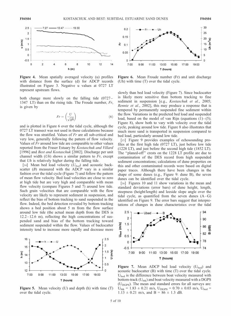
slowly than bed load velocity (Figure 7). Since backscatteris likely more sensitive than bottom tracking to finesediment in suspension [e.g., Kostaschuk et al., 2005;Rennie et al., 2002], this may produce a response that istempered by permanently suspended fine sediment withinthe flow. Variations in the predicted bed load and suspendedload, based on the model of van Rijn (equations (1)–(5);Figure 8), show both to vary with velocity over the tidalcycle, peaking around low tide. Figure 8 also illustrates thatmuch more sand is transported in suspension compared tobed load, particularly around low tide.[15] Figure 9 provides examples of echosounding pro-
files at the first high tide (0727 LT), just before low tide(1228 LT), and just before the second high tide (1852 LT).The ‘‘planed-off’’ crests on the 1228 LT profile are due tocontamination of the DES record from high suspendedsediment concentrations; calculations of dune properties onthis and other contaminated records were based on digitalpaper traces. Although there have been changes in theshape of some dunes (e.g., Figure 9: dune B), the sevendunes can be identified over the tidal cycle.[16] Figures 10 and 11 show variations in the mean and
standard deviations (error bars) of dune height, length,steepness (height/length) and leeside slope angle over thetidal cycle, as quantified from the seven dunes (A–G)identified on Figure 9. The error bars suggest that interpre-tations of changes in dune characteristics over the tidal
Figure 4. Mean spatially averaged velocity (u) profileswith distance from the surface (d) for ADCP recordsillustrated on Figure 3. Negative u values at 0727 LTrepresent upstream flows.
Figure 5. Mean velocity (U) and depth (h) with time (T)over the tidal cycle.
Figure 6. Mean Froude number (Fr) and unit discharge(Uh) with time (T) over the tidal cycle.
Figure 7. Mean ADCP bed load velocity (Ubed) andacoustic backscatter (B) with time (T) over the tidal cycle.Ubed is the difference between boat velocity measured withbottom-track (Ubtk) and boat velocity measured with a DGPS(UDGPS). The mean and standard errors for all surveys are:Ubtk = 1.83 ± 0.21 m/s, UDGPS = 0.70 ± 0.03 m/s, Ubed =1.13 ± 0.21 m/s, and B = 86 ± 1.3 dB.
F04S04 KOSTASCHUK AND BEST: SUBTIDAL ESTUARINE SAND DUNES
5 of 10
F04S04
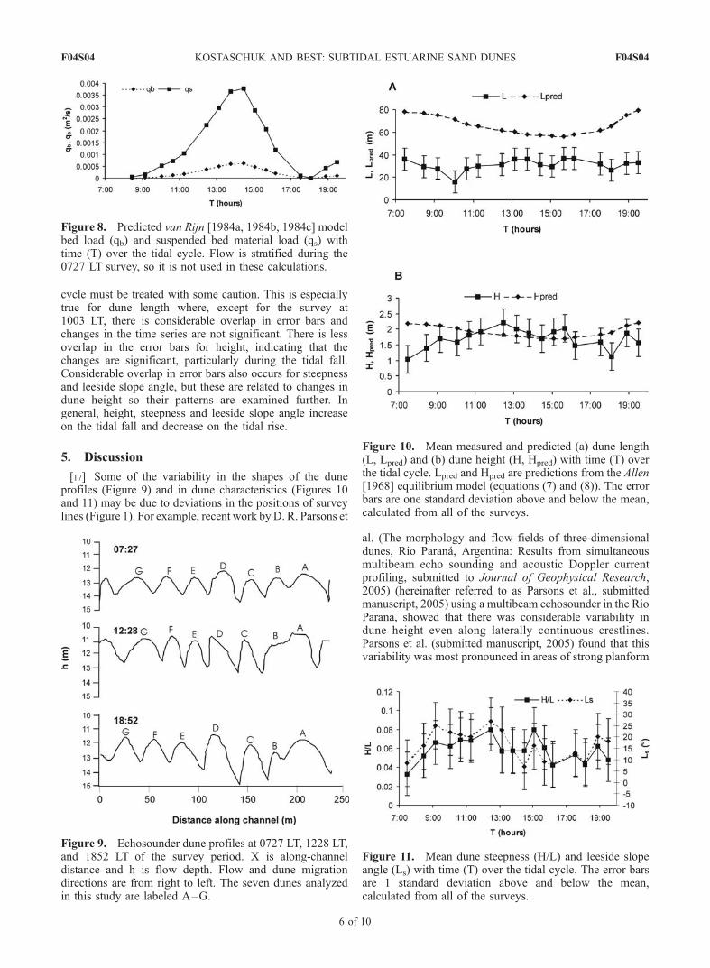
cycle must be treated with some caution. This is especiallytrue for dune length where, except for the survey at1003 LT, there is considerable overlap in error bars andchanges in the time series are not significant. There is lessoverlap in the error bars for height, indicating that thechanges are significant, particularly during the tidal fall.Considerable overlap in error bars also occurs for steepnessand leeside slope angle, but these are related to changes indune height so their patterns are examined further. Ingeneral, height, steepness and leeside slope angle increaseon the tidal fall and decrease on the tidal rise.
5. Discussion
[17] Some of the variability in the shapes of the duneprofiles (Figure 9) and in dune characteristics (Figures 10and 11) may be due to deviations in the positions of surveylines (Figure 1). For example, recent work byD. R. Parsons et
al. (The morphology and flow fields of three-dimensionaldunes, Rio Parana, Argentina: Results from simultaneousmultibeam echo sounding and acoustic Doppler currentprofiling, submitted to Journal of Geophysical Research,2005) (hereinafter referred to as Parsons et al., submittedmanuscript, 2005) using a multibeam echosounder in the RioParana, showed that there was considerable variability indune height even along laterally continuous crestlines.Parsons et al. (submitted manuscript, 2005) found that thisvariability was most pronounced in areas of strong planform
Figure 8. Predicted van Rijn [1984a, 1984b, 1984c] modelbed load (qb) and suspended bed material load (qs) withtime (T) over the tidal cycle. Flow is stratified during the0727 LT survey, so it is not used in these calculations.
Figure 9. Echosounder dune profiles at 0727 LT, 1228 LT,and 1852 LT of the survey period. X is along-channeldistance and h is flow depth. Flow and dune migrationdirections are from right to left. The seven dunes analyzedin this study are labeled A–G.
Figure 10. Mean measured and predicted (a) dune length(L, Lpred) and (b) dune height (H, Hpred) with time (T) overthe tidal cycle. Lpred and Hpred are predictions from the Allen[1968] equilibrium model (equations (7) and (8)). The errorbars are one standard deviation above and below the mean,calculated from all of the surveys.
Figure 11. Mean dune steepness (H/L) and leeside slopeangle (Ls) with time (T) over the tidal cycle. The error barsare 1 standard deviation above and below the mean,calculated from all of the surveys.
F04S04 KOSTASCHUK AND BEST: SUBTIDAL ESTUARINE SAND DUNES
6 of 10
F04S04
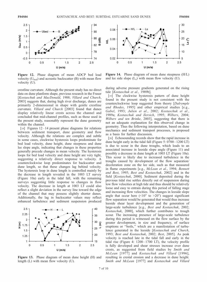
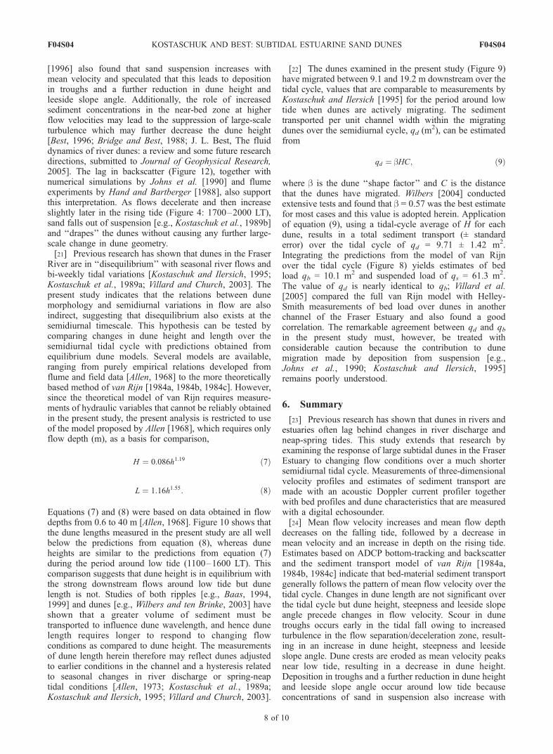
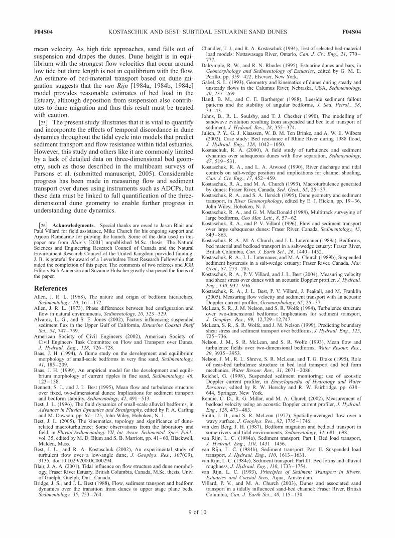
crestline curvature. Although the present study has no directdata on dune planform shape, previous research in the Fraser[Kostaschuk and MacDonald, 1988; Villard and Church,2003] suggests that, during high river discharge, dunes areprimarily 2-dimensional in shape with gentle crestlinecurvature. Villard and Church [2003] found that dunesdisplay relatively linear crests across the channel andconcluded that mid-channel profiles, such as those used inthe present study, reasonably represent the dune geometrywithin the channel.[18] Figures 12–14 present phase diagrams for relations
between sediment transport, dune geometry and flowvelocity. Although the relations are complex and subtlein some cases, clockwise hysteresis loops predominate forbed load velocity, dune height, dune steepness and dunelee slope angle, indicating that changes in these propertiesgenerally precede changes in mean velocity. The hysteresisloops for bed load velocity and dune height are very tight,suggesting a relatively direct response to velocity. Acounterclockwise loop predominates for backscatter anddune length, so that these changes lag behind velocity.The hysteresis loop in dune length is controlled mainly bythe decrease in length revealed in the 1003 LT survey(Figure 10a) early in the tidal fall, with the remainingsurveys suggesting little response to changes in flowvelocity. The decrease in length at 1003 LT could alsoreflect a slight deviation in the survey line toward the edgeof the channel that may possess slightly shorter dunes.Additionally, the lag in backscatter values may reflectenhanced turbulence and sediment suspension produced
during adverse pressure gradients generated on the risingtide [Kostaschuk et al., 1989b].[19] The clockwise hysteresis pattern of dune height
found in the present study is not consistent with thecounterclockwise loop suggested from theory [Dalrympleand Rhodes, 1995] and other empirical studies [e.g.,Gabel, 1993; Julien et al., 2002; Kostaschuk et al.,1989a; Kostaschuk and Ilersich, 1995; Wilbers, 2004;Wilbers and ten Brinke, 2003], suggesting that there isnot an adequate explanation for this observed change ingeometry. Thus the following interpretation, based on dunemechanics and sediment transport processes, is proposedas a basis for further discussion.[20] Echosounding records show that the rapid increase in
dune height early in the tidal fall (Figure 5: 0700–1200 LT)is due to scour in the dune troughs, which leads to anassociated increase in leeside slope angle (Figure 11) andpossibly a decrease in dune length at 1003 LT (Figure 10a).This scour is likely due to increased turbulence in thetroughs caused by development of the flow separation/deceleration zone on the lee side, such as that measuredin flume experiments [e.g., McLean et al., 1994; Bennettand Best, 1995; Best and Kostaschuk, 2002] and in thefield [Kostaschuk, 2000]. Sediment deposited during theprevious tidal rise settles directly out of suspension duringlow flow velocities at high tide and thus should be relativelyloose and easy to entrain during this period of falling stageand increasing flow velocities. The changes in leeside slopeangle that occur here (<10� to >20�) suggest significantflow separation would be generated that would thus increaseleeside shear layer development and the generation oflarge-scale turbulence [e.g., Best and Kostaschuk, 2002;Kostaschuk, 2000], which further contributes to troughscour. The increasing presence of large-scale turbulenceduring this period is witnessed on the flow surface by thegreater development, in size and frequency, of surfaceeruptions or ‘‘boils,’’ which are a manifestation of turbu-lence generated in the leeside [Kostaschuk and Church,1993; Best and Kostaschuk, 2002; Best, 2005]. As peakvelocity is reached late in the tidal fall and early in thetidal rise (Figure 4: 1200–1700 LT), the velocity profileis fully developed and shear stresses increase over dunecrests, as suggested from field studies by Smith andMcLean [1977] and Kostaschuk and Villard [1996],resulting in crestal erosion and a decrease in dune height.Smith and McLean [1977] and Kostaschuk and Villard
Figure 12. Phase diagram of mean ADCP bed loadvelocity (Ubed) and acoustic backscatter (B) with mean flowvelocity (U).
Figure 13. Phase diagram of mean dune height (H) andlength (L) with mean flow velocity (U).
Figure 14. Phase diagram of mean dune steepness (H/L)and lee side slope (Ls) with mean flow velocity (U).
F04S04 KOSTASCHUK AND BEST: SUBTIDAL ESTUARINE SAND DUNES
7 of 10
F04S04
[1996] also found that sand suspension increases withmean velocity and speculated that this leads to depositionin troughs and a further reduction in dune height andleeside slope angle. Additionally, the role of increasedsediment concentrations in the near-bed zone at higherflow velocities may lead to the suppression of large-scaleturbulence which may further decrease the dune height[Best, 1996; Bridge and Best, 1988; J. L. Best, The fluiddynamics of river dunes: a review and some future researchdirections, submitted to Journal of Geophysical Research,2005]. The lag in backscatter (Figure 12), together withnumerical simulations by Johns et al. [1990] and flumeexperiments by Hand and Bartberger [1988], also supportthis interpretation. As flows decelerate and then increaseslightly later in the rising tide (Figure 4: 1700–2000 LT),sand falls out of suspension [e.g., Kostaschuk et al., 1989b]and ‘‘drapes’’ the dunes without causing any further large-scale change in dune geometry.[21] Previous research has shown that dunes in the Fraser
River are in ‘‘disequilibrium’’ with seasonal river flows andbi-weekly tidal variations [Kostaschuk and Ilersich, 1995;Kostaschuk et al., 1989a; Villard and Church, 2003]. Thepresent study indicates that the relations between dunemorphology and semidiurnal variations in flow are alsoindirect, suggesting that disequilibrium also exists at thesemidiurnal timescale. This hypothesis can be tested bycomparing changes in dune height and length over thesemidiurnal tidal cycle with predictions obtained fromequilibrium dune models. Several models are available,ranging from purely empirical relations developed fromflume and field data [Allen, 1968] to the more theoreticallybased method of van Rijn [1984a, 1984b, 1984c]. However,since the theoretical model of van Rijn requires measure-ments of hydraulic variables that cannot be reliably obtainedin the present study, the present analysis is restricted to useof the model proposed by Allen [1968], which requires onlyflow depth (m), as a basis for comparison,
H ¼ 0:086h1:19 ð7Þ
L ¼ 1:16h1:55: ð8Þ
Equations (7) and (8) were based on data obtained in flowdepths from 0.6 to 40 m [Allen, 1968]. Figure 10 shows thatthe dune lengths measured in the present study are all wellbelow the predictions from equation (8), whereas duneheights are similar to the predictions from equation (7)during the period around low tide (1100–1600 LT). Thiscomparison suggests that dune height is in equilibrium withthe strong downstream flows around low tide but dunelength is not. Studies of both ripples [e.g., Baas, 1994,1999] and dunes [e.g., Wilbers and ten Brinke, 2003] haveshown that a greater volume of sediment must betransported to influence dune wavelength, and hence dunelength requires longer to respond to changing flowconditions as compared to dune height. The measurementsof dune length herein therefore may reflect dunes adjustedto earlier conditions in the channel and a hysteresis relatedto seasonal changes in river discharge or spring-neaptidal conditions [Allen, 1973; Kostaschuk et al., 1989a;Kostaschuk and Ilersich, 1995; Villard and Church, 2003].
[22] The dunes examined in the present study (Figure 9)have migrated between 9.1 and 19.2 m downstream over thetidal cycle, values that are comparable to measurements byKostaschuk and Ilersich [1995] for the period around lowtide when dunes are actively migrating. The sedimenttransported per unit channel width within the migratingdunes over the semidiurnal cycle, qd (m
2), can be estimatedfrom
qd ¼ bHC; ð9Þ
where b is the dune ‘‘shape factor’’ and C is the distancethat the dunes have migrated. Wilbers [2004] conductedextensive tests and found that b = 0.57 was the best estimatefor most cases and this value is adopted herein. Applicationof equation (9), using a tidal-cycle average of H for eachdune, results in a total sediment transport (± standarderror) over the tidal cycle of qd = 9.71 ± 1.42 m2.Integrating the predictions from the model of van Rijnover the tidal cycle (Figure 8) yields estimates of bedload qb = 10.1 m2 and suspended load of qs = 61.3 m2.The value of qd is nearly identical to qb; Villard et al.[2005] compared the full van Rijn model with Helley-Smith measurements of bed load over dunes in anotherchannel of the Fraser Estuary and also found a goodcorrelation. The remarkable agreement between qd and qbin the present study must, however, be treated withconsiderable caution because the contribution to dunemigration made by deposition from suspension [e.g.,Johns et al., 1990; Kostaschuk and Ilersich, 1995]remains poorly understood.
6. Summary
[23] Previous research has shown that dunes in rivers andestuaries often lag behind changes in river discharge andneap-spring tides. This study extends that research byexamining the response of large subtidal dunes in the FraserEstuary to changing flow conditions over a much shortersemidiurnal tidal cycle. Measurements of three-dimensionalvelocity profiles and estimates of sediment transport aremade with an acoustic Doppler current profiler togetherwith bed profiles and dune characteristics that are measuredwith a digital echosounder.[24] Mean flow velocity increases and mean flow depth
decreases on the falling tide, followed by a decrease inmean velocity and an increase in depth on the rising tide.Estimates based on ADCP bottom-tracking and backscatterand the sediment transport model of van Rijn [1984a,1984b, 1984c] indicate that bed-material sediment transportgenerally follows the pattern of mean flow velocity over thetidal cycle. Changes in dune length are not significant overthe tidal cycle but dune height, steepness and leeside slopeangle precede changes in flow velocity. Scour in dunetroughs occurs early in the tidal fall owing to increasedturbulence in the flow separation/deceleration zone, result-ing in an increase in dune height, steepness and leesideslope angle. Dune crests are eroded as mean velocity peaksnear low tide, resulting in a decrease in dune height.Deposition in troughs and a further reduction in dune heightand leeside slope angle occur around low tide becauseconcentrations of sand in suspension also increase with
F04S04 KOSTASCHUK AND BEST: SUBTIDAL ESTUARINE SAND DUNES
8 of 10
F04S04
mean velocity. As high tide approaches, sand falls out ofsuspension and drapes the dunes. Dune height is in equi-librium with the strongest flow velocities that occur aroundlow tide but dune length is not in equilibrium with the flow.An estimate of bed-material transport based on dune mi-gration suggests that the van Rijn [1984a, 1984b, 1984c]model provides reasonable estimates of bed load in theEstuary, although deposition from suspension also contrib-utes to dune migration and thus this result must be treatedwith caution.[25] The present study illustrates that it is vital to quantify
and incorporate the effects of temporal discordance in dunedynamics throughout the tidal cycle into models that predictsediment transport and flow resistance within tidal estuaries.However, this study and others like it are commonly limitedby a lack of detailed data on three-dimensional bed geom-etry, such as those described in the multibeam surveys ofParsons et al. (submitted manuscript, 2005). Considerableprogress has been made in measuring flow and sedimenttransport over dunes using instruments such as ADCPs, butthese data must be linked to full quantification of the three-dimensional dune geometry to enable further progress inunderstanding dune dynamics.
[26] Acknowledgments. Special thanks are owed to Jason Blair andPaul Villard for field assistance, Mike Church for his ongoing support andArjoon Ramnarine for piloting the launch. Some of the data used in thispaper are from Blair’s [2001] unpublished M.Sc. thesis. The NaturalSciences and Engineering Research Council of Canada and the NaturalEnvironment Research Council of the United Kingdom provided funding.J. B. is grateful for award of a Leverhulme Trust Research Fellowship thataided the completion of this paper. The comments of two referees and JGREditors Bob Anderson and Suzanne Hulscher greatly sharpened the focus ofthe paper.
ReferencesAllen, J. R. L. (1968), The nature and origin of bedform hierarchies,Sedimentology, 10, 161–172.
Allen, J. R. L. (1973), Phase differences between bed configuration andflow in natural environments, Sedimentology, 20, 323–329.
Alvarez, L. G., and S. E. Jones (2002), Factors influencing suspendedsediment flux in the Upper Gulf of California, Estuarine Coastal ShelfSci., 54, 747–759.
American Society of Civil Engineers (2002), American Society ofCivil Engineers Task Committee on Flow and Transport over Dunes,J. Hydraul. Eng., 128, 726–728.
Baas, J. H. (1994), A flume study on the development and equilibriummorphology of small-scale bedforms in very fine sand, Sedimentology,41, 185–209.
Baas, J. H. (1999), An empirical model for the development and equili-brium morphology of current ripples in fine sand, Sedimentology, 46,123–138.
Bennett, S. J., and J. L. Best (1995), Mean flow and turbulence structureover fixed, two-dimensional dunes: Implications for sediment transportand bedform stability, Sedimentology, 42, 491–513.
Best, J. L. (1996), The fluid dynamics of small-scale alluvial bedforms, inAdvances in Fluvial Dynamics and Stratigraphy, edited by P. A. Carlingand M. Dawson, pp. 67–125, John Wiley, Hoboken, N. J.
Best, J. L. (2005), The kinematics, topology and significance of dune-related macroturbulence: Some observations from the laboratory andfield, in Fluvial Sedimentology VII, Int. Assoc. Sedimentol. Spec. Publ.,vol. 35, edited by M. D. Blum and S. B. Marriott, pp. 41–60, Blackwell,Malden, Mass.
Best, J. L., and R. A. Kostaschuk (2002), An experimental study ofturbulent flow over a low-angle dune, J. Geophys. Res., 107(C9),3135, doi:10.1029/2000JC000294.
Blair, J. A. A. (2001), Tidal influence on flow structure and dune morphol-ogy, Fraser River Estuary, British Columbia, Canada, M.Sc. thesis, Univ.of Guelph, Guelph, Ont., Canada.
Bridge, J. S., and J. L. Best (1988), Flow, sediment transport and bedformdynamics over the transition from dunes to upper stage plane beds,Sedimentology, 35, 753–764.
Chandler, T. J., and R. A. Kostaschuk (1994), Test of selected bed-materialload models: Nottawasaga River, Ontario, Can. J. Civ. Eng., 21, 770–777.
Dalrymple, R. W., and R. N. Rhodes (1995), Estuarine dunes and bars, inGeomorphology and Sedimentology of Estuaries, edited by G. M. E.Perillo, pp. 359–422, Elsevier, New York.
Gabel, S. L. (1993), Geometry and kinematics of dunes during steady andunsteady flows in the Calumus River, Nebraska, USA, Sedimentology,40, 237–269.
Hand, B. M., and C. E. Bartberger (1988), Leeside sediment falloutpatterns and the stability of angular bedforms, J. Sed. Petrol., 58,33–43.
Johns, B., R. L. Soulsby, and T. J. Chesher (1990), The modelling ofsandwave evolution resulting from suspended and bed load transport ofsediment, J. Hydraul. Res., 28, 355–374.
Julien, P. Y., G. J. Klaassen, W. B. M. Ten Brinke, and A. W. E. Wilbers(2002), Case study: Bed resistance of Rhine River during 1988 flood,J. Hydraul. Eng., 128, 1042–1050.
Kostaschuk, R. A. (2000), A field study of turbulence and sedimentdynamics over subaqueous dunes with flow separation, Sedimentology,47, 519–531.
Kostaschuk, R. A., and L. A. Atwood (1990), River discharge and tidalcontrols on salt-wedge position and implications for channel shoaling,Can. J. Civ. Eng., 17, 452–459.
Kostaschuk, R. A., and M. A. Church (1993), Macroturbulence generatedby dunes: Fraser River, Canada, Sed. Geol., 85, 25–37.
Kostaschuk, R. A., and S. A. Ilersich (1995), Dune geometry and sedimenttransport, in River Geomorphology, edited by E. J. Hickin, pp. 19–36,John Wiley, Hoboken, N. J.
Kostaschuk, R. A., and G. M. MacDonald (1988), Multitrack surveying oflarge bedforms, Geo Mar. Lett., 8, 57–62.
Kostaschuk, R. A., and P. V. Villard (1996), Flow and sediment transportover large subaqueous dunes: Fraser River, Canada, Sedimentology, 43,849–863.
Kostaschuk, R. A., M. A. Church, and J. L. Luternauer (1989a), Bedforms,bed material and bedload transport in a salt-wedge estuary: Fraser River,British Columbia, Can. J. Earth Sci., 26, 1440–1452.
Kostaschuk, R. A., J. L. Luternauer, and M. A. Church (1989b), Suspendedsediment hysteresis in a salt-wedge estuary: Fraser River, Canada, Mar.Geol., 87, 273–285.
Kostaschuk, R. A., P. V. Villard, and J. L. Best (2004), Measuring velocityand shear stress over dunes with an acoustic Doppler profiler, J. Hydraul.Eng., 130, 932–936.
Kostaschuk, R. A., J. L. Best, P. V. Villard, J. Peakall, and M. Franklin(2005), Measuring flow velocity and sediment transport with an acousticDoppler current profiler, Geomorphology, 65, 25–37.
McLean, S. R., J. M. Nelson, and S. R. Wolfe (1994), Turbulence structureover two-dimensional bedforms: Implications for sediment transport,J. Geophys. Res., 99, 12,729–12,747.
McLean, S. R., S. R. Wolfe, and J. M. Nelson (1999), Predicting boundaryshear stress and sediment transport over bedforms, J. Hydraul. Eng., 125,725–736.
Nelson, J. M., S. R. McLean, and S. R. Wolfe (1993), Mean flow andturbulence fields over two-dimensional bedforms, Water Resour. Res.,29, 3935–3953.
Nelson, J. M., R. L. Shreve, S. R. McLean, and T. G. Drake (1995), Roleof near-bed turbulence structure in bed load transport and bed formmechanics, Water Resour. Res., 31, 2071–2086.
Reichel, G. (1998), Suspended sediment monitoring: use of acousticDoppler current profiler, in Encyclopaedia of Hydrology and WaterResource, edited by R. W. Herschy and R. W. Fairbridge, pp. 638–644, Springer, New York.
Rennie, C. D., R. G. Millar, and M. A. Church (2002), Measurement ofbedload velocity using an acoustic Doppler current profiler, J. Hydraul.Eng., 128, 473–483.
Smith, J. D., and S. R. McLean (1977), Spatially-averaged flow over awavy surface, J. Geophys. Res., 82, 1735–1746.
van den Berg, J. H. (1987), Bedform migration and bedload transport insome rivers and tidal environments, Sedimentology, 34, 681–698.
van Rijn, L. C. (1984a), Sediment transport: Part I. Bed load transport,J. Hydraul. Eng., 110, 1431–1456.
van Rijn, L. C. (1984b), Sediment transport: Part II. Suspended loadtransport, J. Hydraul. Eng., 110, 1613–1631.
van Rijn, L. C. (1984c), Sediment transport: Part III. Bed forms and alluvialroughness, J. Hydraul. Eng., 110, 1733–1754.
van Rijn, L. C. (1993), Principles of Sediment Transport in Rivers,Estuaries and Coastal Seas, Aqua, Amsterdam.
Villard, P. V., and M. A. Church (2003), Dunes and associated sandtransport in a tidally influenced sand-bed channel: Fraser River, BritishColumbia, Can. J. Earth Sci., 40, 115–130.
F04S04 KOSTASCHUK AND BEST: SUBTIDAL ESTUARINE SAND DUNES
9 of 10
F04S04

Villard, P. V., and R. A. Kostaschuk (1998), The relation between shearvelocity and suspended sediment concentration over dunes: FraserEstuary, Canada, Mar. Geol., 148, 71–81.
Villard, P. V., M. A. Church, and R. A. Kostaschuk (2005), Estimating bedload in sand-bed channels using bottom tracking from an acousticDoppler profiler, in Fluvial Sedimentology VII, Int. Assoc. Sedimentol.Spec. Publ., vol. 35, edited by M. D. Blum and S. B. Marriott, Black-well, Malden, Mass., in press.
Wilbers, A. W. E. (2004), Prediction of bedform characteristics and bed-form roughness in large rivers, Ph.D. thesis, Utrecht Univ., Utrecht,Netherlands.
Wilbers, A. W. E., and W. B. M. ten Brinke (2003), The response ofsubaqueous dunes to floods in sand and gravel bed reaches of the DutchRhine, Sedimentology, 50, 1013–1034.
�����������������������J. Best, Earth and Biosphere Institute, School of Earth and Environment,
University of Leeds, Leeds, West Yorkshire LS2 9JT, UK. ( [email protected])R. Kostaschuk, Department of Geography, University of Guelph, Guelph,
Ontario, Canada, N1G 2W1. ([email protected])
F04S04 KOSTASCHUK AND BEST: SUBTIDAL ESTUARINE SAND DUNES
10 of 10
F04S04
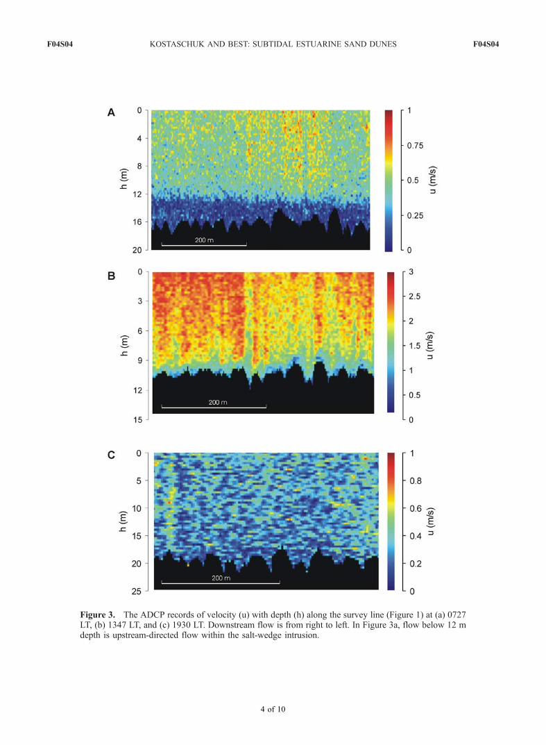
Figure 3. The ADCP records of velocity (u) with depth (h) along the survey line (Figure 1) at (a) 0727LT, (b) 1347 LT, and (c) 1930 LT. Downstream flow is from right to left. In Figure 3a, flow below 12 mdepth is upstream-directed flow within the salt-wedge intrusion.
F04S04 KOSTASCHUK AND BEST: SUBTIDAL ESTUARINE SAND DUNES F04S04
4 of 10


![Chapter 4 - Underdeterminism [I] - Simon Fraser University](https://img.pdfslide.net/doc/110x75/6311080fc3f2ab6a6805904e/chapter-4-underdeterminism-i-simon-fraser-university.jpg)
