Embed Size (px)
Citation preview

ministerie van verkeer en waterstaat rijkswaterstaat
riza rijksinstituut voor integraal zoetwaterbeheer en afvalwaterbehandeling tel. 026-3688911, fax. 026-3688678 doorkiesnummer 026-3688581
Towards an International Ecotope Classification System for the Winterbed of the River Meuse
Possibilities for international cooperation
Werkdocument auteur(s) datum
96.131X Marcel Tosserams & Stan Kerkhofs 27 november 1996

ri/.a
Table of contents
Preface 5 Summary 7
1 Introduction 9
1.1 Background 9 1.2 Objective and target group 9
1.3 Project phases, research questions and strategy 10
1.3.1 Phase 1 10
1.3.2 Phase 2 10
1.3.3 Phase 3 12 1.3.4 Phase 4 12
1.4 Outline of the report 12
2 The Meuse river basin 13 2.1 Brief description of the catchment area 13
2.2 Functions of the River Meuse 15
2.3 Nature 16 2.3.1 Introduction 16
2.3.2 The Netherlands 16
2.3.3 Belgium 17
2.3.4 France 18
3 Policies related to the ecological rehabilitation of the River Meuse 21
3.1 Introduction 21
3.2 International policy 21
3.2.1 Treaties and the Meuse Action Programme 21
3.2.2 Bilateral treaties and agreements 22
3.2.3 EU legislation and the fifth Environmental Action Programme 23
3.3 The Netherlands 23
3.3.1 The institutional framework of the Netherlands 23
3.3.2 Relevant policy plans and projects 24
3.4 Belgium 25
3.4.1 Introduction 25
3.4.2 The institutional framework and policy of Flanders 26
3.4.3 The institutional framework and policy of Wallonia 26
riza

riza
3.5 France 27 3.5.1 The institutional framework of France 27
3.5.2 Relevant policy plans and programmes 28
4 Description of ecotope classification systems 29
4.1 Introduction 29
4.2 The Netherlands 29
4.3 Belgium 30
4.4 France 31
4.5 Conclusion 32
5 Possibilities for international cooperation 35
5.1 Cooperating organizations 35 5.1.1 The Netherlands 35
5.1.2 Flanders 36 5.1.3 Wallonia 37
5.1.4 France 38
5.2 Conclusion 39
6 Recommendations 41 6.1 Recommendations related to the ecotope classification system 41 6.2 Recommendations related to the organization of a first meeting 42
References 43
Acknowledgements 47 Appendices

riza

riza
Preface
This report is written by Marcel Tosserams and Stan Kerkhofs. Marcel wrote the main part of the draft version of this report during his internship at RIZA. The internship was part of the European Postgraduate Course in Environmental Management (EPCEM). This full time, one year course is organized by:
the Interfaculty Department of Environmental Science (IVAM), University of Amsterdam
the Centre of Environmental Science (CML), Leiden University the Institute for Environmental Studies (IVM), Free University Amsterdam the Center for Environment and Climate Studies (CMKW), Wageningen Agricultural University
The internship started in May. The draft version was finished in June 1996. The internship was conducted at the Institute for Inland Water Management and Waste Water Treatment (RIZA) in Arnhem. The project was supervised by Stan Kerkhofs and Hero Prins (RIZA). The EPCEM supervisor was Yvonne Kleintjes.
Marcel Tosserams
Stan Kerkhofs

riza

riza
Summary
An ecotope classification system can be a useful instrument for integrated water
management, as it offers a base for future policy-oriented research and design projects. The
ecotopes that are distinguished by such a system can be defined as spatial ecological units
of which the composition and development are determined by their abiotic, biotic and
anthropogeneous factors. Based on an ecotope map, consequences and implications of
policy and management interventions can be foreseen. In addition, an ecotope map can be
used for ecological network studies in order to study the possibilities for the development
of sustainable populations of plant and animal species.
The riparian countries of the River Meuse characterize the ecological situation along the Meuse in different ways. An internationally applicable ecotope classification system for the Meuse, which can be used for trans-boundary ecological network studies and for international policy regarding integrated river management, is not available at this moment.
It is the objective of this research to study whether there are possibilities for international cooperation in order to draw up an international ecotope map for the whole winterbed of the River Meuse. In addition some recommendations on the ecotope classification system that could be used, are formulated.
After having contacted several organizations in all riparian countries it can be concluded that there is broad international interest for this project. All the organizations that were contacted, including governmental and non-governmental organizations, support the initiative to draw up an international ecotope map. This in combination with the large amount of ecological information that is available in all countries, leads to the conclusion that there are good opportunities to realize such a map.
However, the information that is available shows that a harmonization of the national ecotope classification systems is necessary. It is recommended to discuss a proposal for an internationally applicable ecotope classification system during a workshop. An international classification system should incorporate a limited number of ecotopes. With this simplified system, ecological network studies for a number of selected target species can be conducted. Based on the experience with this system it should be studied whether more ecotopes have to be specified and whether it is possible to create an ecotope map for the whole catchment area of the River Meuse.
riza
8

riza
1 Introduction
1.1 Background
The Meuse is a trans-boundary, rain-fed river. The catchment area covers parts of France, Belgium. Germany. Luxembourg and the Netherlands. The Meuse rises in the north of France and eventually reaches the North Sea in the Netherlands, some 850 kilometres further downstream.
The River Meuse fulfils many important functions. One of these functions is nature, as the winterbed of the river provides numerous habitats for plant and animal species. The ecological situation along a river can be characterized using an ecotope classification system. Within the framework of the research that is conducted to study the possibilities for nature development in the Dutch river area, for instance the programme for the ecological rehabilitation of the Rhine and Meuse (Anonymus 1992), a River Ecotope System (RES) has been developed (Rademakers & Wolfert 1994). Here, an ecotope is defined as a delineated ecological unit, of which the composition and development are determined by prevailing abiotic, biotic and anthropogenic factors.
An ecotope classification system can be used to make an inventory of the abiotic environment and the natural areas along the Meuse for the definition of spatial planning alternatives and to illustrate the consequences of policy choices. Furthermore, using such a system possibilities for the development of sustainable populations of plant and animal species which, are currently absent or rare, can be studied.
1.2 Objective and target group
In order to study the possibilities for the development of sustainable populations of plant and animal species throughout the whole Meuse basin, the development of an international
ecotope map would be very useful. However, at the moment it is unclear whether an
ecotope classification system is used in Belgium and France.
The RIZA would like to know whether an ecotope system, similar to the one used in the
Netherlands, is used in Belgium and France and if there are possibilities to realize an
ecotope map for the whole winterbed of the River Meuse.
In relation to this it is the objective of this EPCEM internship:
to write a proposal for the RIZA how to realize an ecotope map for the whole winterbed of the Meuse. In addition, recommendations regarding some features of an international ecotope classification system, are formulated.

riza
The primary target group of this research is the Department of WSR of the RIZA in Arnhem. However, organizations in Belgium and France, which are active in the development and/or policy regarding ecotopes and ecological networks, are an important target group too, as it is the intention of the RIZA to send a (slightly adapted) copy of this report to the organizations that agree to participate in the discussion to realize an ecotope map for the River Meuse.
1.3 Project phases, research questions and strategy
The activities during the internship period can be divided in the following four phases:
1. orientation on the subject and collecting information
2. analysis of the collected information 3. formulation of recommendations
4. evaluation
1.3.1 Phase 1
During the orientation phase, a literature study will give better insight in the ecotope classification systems used by the riparian countries (Fig. 1). In addition, an inventory of relevant organizations to contact will be prepared.
Information regarding ecotope systems and water management policy, will be requested during telephone calls. In addition, the possibilities and interest in international cooperation, in order to realize an ecotope map for the winterbed of the River Meuse, will be discussed. The research questions that are answered during this phase are:
1. What organizations deal with ecotopes and ecological networks in Belgium and France?
2. What is the policy of the riparian countries regarding the ecological rehabilitation of the Meuse?
3. What ecotope systems are used by the riparian countries of the Meuse?
1.3.2 Phase 2
In phase 2 the existing ecotope systems are described shortly and possibilities for the
adoption of an ecotope system for the whole winterbed of the Meuse will be assessed. In
addition, both the policy of all riparian countries and international initiatives important to
the ecological rehabilitation of the Meuse. are described.
The research questions during this phase are:
1. What are the similarities and differences between the different ecotope systems
10

riza
that are used at the moment? 2. Are there possibilities for international cooperation regarding the realization of an
ecotope map for the whole winterbed of the Meuse?
Literature studv Present situation:
Description of ihe catchment area
I inventory of organizations
to contact
- Interviews (telephone calls) - Literature
I Inventory of: - Organizations willing to cooperate - Eclope classification systems used
Policies regarding water management
I Assessment of differences
and similarities between the ecotope classification systems
i Form ulation -*
of recommenuauons ^
' r
Kia lu i i t ion
Figure 1: Research strategy and methods
11

riza
1.3.3 Phase 3
On the basis of the analysis, recommendations will be formulated. These recommendations
deal with the following items:
characteristics to be incorporated in an internationally applicable ecotope
classification system
actions that should be undertaken.
1.3.4 Phase 4
Whether the objective of the project was achieved is discussed during the evaluation phase.
The main question to be answered is: Will the formulated recommendations indeed lead to an ecotope system for the
whole winterbed of the River Meuse?
1.4 Outline of the report
Chapter 2 provides a short description of the Meuse catchment area and the functions of
the Meuse. This chapter is concluded by a description of the ecological situation of the
Meuse in all riparian countries. Chapter 3 describes the international initiatives and the
policy of the riparian countries, regarding water management and the ecological
rehabilitation of the River Meuse. Chapter 4 discusses the ecotope classification systems
that are used. In addition, it is assessed whether it is possible to realize an ecotope map for
the whole winterbed of the River meuse, using the existing information and ecotope
classification systems. Chapter 5 offers an overview of the organizations that were
contacted in Belgium and France and were interested to participate in an international
discussion. On the basis of this overview it is assessed whether there are possibilities for
the realization of an international ecotope map. Finally, chapter 6 presents some
recommendations concerning the nature of a trans-boundary ecotope classification system
and the actions that should be undertaken to start off an international discussion on this
subject.
12
r iza
2 The Meuse river basin
2.1 Brief description of the catchment area
The Meuse is a rain-fed river, which rises in the north of France at a height of 409 m
(above sea level) at the plateau of Langres. The Meuse reaches the North Sea some 850
kilometres further downstream, in the west of the Netherlands. The catchment area of the
river (Fig. 2) covers 33,000 km2 and is situated in France (9,000 km2), Belgium (13.500
km2). Germany (4.000 km2), Luxembourg (600 km2) and in the Netherlands (6,000 km2)
(Oterdoom, 1992).
In France the River Meuse has two important tributaries: the Chiers and the Semois.
Both tributaries also run through Belgium. The Meuse enters Belgium north of Givet at a
height of 98 m. From Namur it runs east towards Liege. The main tributaries in Wal Ionia
are: Viroin. Sambre. Mehaigne, Lesse, Bocq, Hoyoux. Ourthe. Ambleve and the Vesdre.
The main tributaries in Flanders are: Ziepbeek, Kikbeek. Kogbeek, Zanderdiepbeek,
Rozeboomgaard and Bosbeek. The Meuse crosses the border of the Netherlands at Eijsden
at a height of 45 m. For 47 kilometres, till the city of Stevensweert, the Meuse forms the
border between the Dutch province of Limburg and Flanders. This stretch of the river,
which is not navigable, is called the Grensmaas. In the navigable part of the Meuse. from
Sedan in France till Lith in the Netherlands, the current velocity is strongly regulated by
weirs.
In the Netherlands the Meuse flows through a broad valley. From Boxmeer till the
Haringvliet the river is bordered by dikes. The major tributaries to the Meuse in the
Netherlands, excluding the tributaries that rise in Germany, are the Geul, Jeker, Dieze,
Dommel and the Donge.
As is the case with Luxembourg, the main course of the Meuse does not cross the
border of Germany. Three tributaries rise in Germany. These are the Rur, the Niers and the
Swalm, all reaching the Meuse in the Netherlands. The Jeker and Dommel rise in Belgium.
From a geological point of view, the river can be divided into three parts: the Meuse
Lorraine, the Wallone Meuse and the Dutch Meuse.
The first part, the Meuse Lorraine, is the area from the source in Pouilly-en-Bassigny
until the confluence with the River Chiers. This part of the catchment area is relatively
narrow, although the winterbed of the river is very broad. The slope of the riverbed is not
very steep. In addition, the Meuse Lorraine has a limited number of tributaries and
therefore reacts only slowly to precipitation. Its peak discharge during floods is relatively
small. Because of the presence of a large floodplain, this part of the Meuse has a high
storage capacity for water (Berger, 1992).
The second part, from the junction with the Chiers until the Dutch border at Eijsden, is
13

riza
called the Wallone Meuse. This part of the river runs through a deep and narrow valley, consisting of non-porous rocks. Here, the slope of the river is relatively steep.
Figure 2: The catchment area of the Meuse. Source Berger, 1992.
14

riza
The precipitation in this part, especially in the Ardennes, is the highest of the whole catchment area. As a result, this part of the catchment area is responsible for large fluctuations in the discharge rate of the Meuse. Especially after heavy rains, the water level can rise very quickly, causing floods further downstream. Compared to the Meuse Lorraine, the Wallone Meuse has more tributaries. These tributaries are situated in hilly areas with low infiltration capacity. As a consequence, the storage capacity for water is low and a higher frequency of extreme discharges can be observed in this area (Berger. 1992). The capricious discharge behaviour of the Meuse is typical for a rain-fed river. There are low base flows in summer (30 m3/s or less ) and high peak flows in winter (till 3000 m3/s, measured in Eijsden).
The third part of the river is the Dutch part, from Eijsden till the end of the river in the Haringvliet. The stretch from Eijsden until Maasbracht. has still many characteristics of the Wallone Meuse, the slope is relatively steep and the riverbed consists of gravel. The part from Maasbracht until the Haringvliet is characterized as a broad lowland river with only a slight gradient in height and a riverbed that consists of sand or clay (Berger & Mugie, 1994). Downstream of Lith. tidal influence of the North Sea can be observed (Getijde Maas), which strongly regulates the current velocity in this part of the Meuse. The downstream part used to be the most sensitive to flooding because of ice drift and the connection with the river Waal. Nowadays, due to river improvement projects, the most flood sensitive areas are located in the south of the Netherlands, where villages are not protected by dikes (Berger, 1992).
2.2 Functions of the River Meuse
The Meuse river basin fulfils a number of important functions. The most important
functions that can be distinguished for the whole catchment area of the Meuse are :
transport of water, sediment and ice
nature and landscape
shipping
energy recovery
drinking, agricultural and industrial water supply
water supply for regional waters
mining
agriculture
recreation
fishery
urban and industrial development:
15

riza
2.3 Nature
2.3.1 Introduction
Apart from the transport of water, sediment and ice. nature is an important natural function of the River Meuse. The winterbed of the Meuse has a high potential regarding the provision of habitats for plant and animal species. However, due to anthropogenic interventions, the fulfilment of this function has been negatively affected. Especially the normalization and canalization as well as the ongoing urbanization along the Meuse. resulted in a loss of habitats. In addition, the bad water quality also contributes significantly to the deterioration of the nature function of the Meuse. As a consequence, several typical riverine and wetland plant and animal species have disappeared (Leusen et al., 1995).
The following sections will give a short overview of the ecological situation in the riparian countries of the River Meuse. Because it is not within the scope of this research to give a complete inventory, the focus will mainly be on plant, fish and bird species, supplemented by references that provide more detailed information regarding the natural values of the River Meuse.
2.3.2 The Netherlands
In the Netherlands the Meuse can be divided into four constituent systems: the Grensmaas.
the Gestuwde Maas (impounded section), the Maasplassen (gravel pits) and the Getijde
Maas (tidal section). Kerkhofs and Prins (1995) describe the ecology of these systems,
which is mainly based on biological monitoring data collected in 1992.
The Grensmaas is characterized by the ecotopes 'man-made grassland and arable land*.
Because of the lack of ecotopes in combination with the poor water quality and short-term
discharge fluctuations, caused by the hydroelectric power station at Lixhe, only
undifferentiated invertebrates, which are tolerant to pollution are observed (Klink & Bij de
Vaate. 1994). In addition, aquatic plant species are almost totally absent (De la Haye,
1994). Nevertheless, the Grensmaas does provide a habitat for 21 fish species and is the
only Dutch habitat for rheophilic fish species (e.g. Brook trout and Beaked carp; Vriese.
1992). However, because of the low biomass of these fish species, the Grensmaas is of
minor importance for fish-eating aquatic birds. The floodplain locally offers good
opportunities for singing birds. More detailed information with respect to this stretch of the
Dutch Meuse was published by Kurstjens et al. (1995).
The Gestuwde Maas. the section of the Meuse with a number of weirs to facilitate
16

riza
shipping, is characterized by the ecotopes 'deep-bed gravel river', 'man-made grassland and arable land' and 'stagnant water in the winter bed". In contrast to the Grensmaas the oxygen concentration does not hinder the settlement of most aquatic organisms. The area covered by aquatic plant species is limited because of the influence of shipping (Sips et al., 1995). Due to the stone paving of the river banks, species that are attached to hard substrate like Zebra mussels, caddice flies and mayflies, are common. In spite of the relatively slow flow rate in the Gestuwde Maas many fish species can be found here. As a consequence, the share of wintering fish-eating, aquatic birds is the greatest in Midden-Limburg.
Due to the excavation of sand and gravel in the province of Limburg (Roermond) and in the province of Noord-Brabant. the Maasplassen were created. These lakes are deep and have steep banks. The Maasplassen are characterized by the ecotopes 'deep stagnant water", 'man-made grassland and arable land". There is relatively little information available on the ecology of the Maasplassen. There is no data on the composition and density of fish species, invertebrates and zooplankton (De la Haye, 1995). The morphology of the lakes is not suitable for a high density of aquatic plants (Overmars et al., 1992). Aquatic plants only grow in the shallow parts. The Maasplassen are important for wintering aquatic birds. herbivorous waterfowl (Bewick's swan) and bentophagous animals (European pochard and Tufted duck). In addition, fish biomass in these lakes is relatively high which is underscored by the presence of piscivorous birds.
From Lith to Geertruidenberg there is tidal influence. Therefore, this part of the Dutch river Meuse is called the Getijde Maas. Because of the fact that the tidal influence is limited, the Getijde Maas resembles a sand river more than a tidal river. The characteristic ecotopes are 'deep-bed gravel river', "man-made grassland and arable land' and 'stagnant water in the winterbed". Because of the artificial stone banks, ecotopes characteristic to a tidal river are missing. Like for the Maasplassen, the knowledge concerning the ecology of the Getijde Maas is limited. Fish biomass in the Getijde Maas is four times lower than in the Gestuwde Maas. Most common are the European roach and the Bream. Marine species like the Thick-lipped grey mullet and Lavaret are only found in this part of the Dutch Meuse. The Getijde Maas is the most important section for wintering, mainly herbivorous aquatic birds.
2.3.3 Belgium
In Belgium the Meuse can be roughly divided in the Grensmaas. which forms the border
between the province of Limburg (the Netherlands) and Flanders, and the Walloon Meuse
from Vise till Givet in France .
Due to canalization and the construction of dykes, the natural diversity of ecotopes can
only partly develop. Nevertheless a rich variety of plant and animal life can still be found.
17

riza
Along the Belgian side of the Grensmaas a variety of ecotopes can be distinguished (Van Looy & De Blust, 1995): 'deep-bed gravel river', 'bank', "grassed floodplain", 'deep stagnant water", 'marshy herbaceous floodplain' and 'man-made grassland and arable land'. The vegetation of the main course and the fish stock are described in section 2.3.2. Traditional agricultural management and the presence of small landscape elements like dykes in the grassed floodplain resulted in various vegetation types and a well developed faunal diversity along the Grensmaas (Van Looy & De Blust, 1995). The variety of habitats contain a large number of insects, including a number of threatened and rare species. The steep banks provide breeding opportunities for bird species like the Sand Martin and the Kingfisher.
As on the Dutch side, gravel and sand excavation created artificial lakes. Due to their large depth and steep shores, these lakes are biologically less valuable. Furthermore, the quality of the sediment is often poor, although the lakes are important for fish and bird species (section 2.3.2).
The biological quality of the marshy side channels are negatively affected by the poor water and riverbed quality. As a result, the development of marsh vegetation is limited, although on some locations (e.g. het Vijverbroek) an interesting vegetation could develop due to seepage of clean water. The small excavation ponds that are found here are important habitats for amphibians including some rare species like the tree frog. "Kamsalamander* and "Meerkikker".
In Wallonia the Meuse has been canalized and the water level is regulated by a number of weirs to facilitate shipping. Furthermore, the narrow winterbed has been urbanized and industrialized to a large extent. The quality of the water is poor due to the lack of waste water treatment.
As a result of the river morphology in combination with the poor water quality, the ecological situation of the Meuse in Wallonia is in a rather bad shape. Due to the embankments along the river there is no contact between natural areas along the river and the river ecosystem. Therefore, most of the ecotopes found along a natural river are absent. Mostly undifferentiated invertebrates, which are tolerant to pollution, are observed. In addition, aquatic plant species are almost totally absent. The scarce stretches that still have some vegetation are also threatened by canalization. Nevertheless, there are some areas with a high ecological value along the Meuse, which might act as stepping stones for certain species. In addition, some of the islands situated in the Meuse have some ecological potential.
2.3.4 France
In France the Meuse valley contains a variety of ecosystems, associated to the natural
behaviour of the river (Paalvast, 1993). The relative good water quality in combination
18

riza
with the large diversity of ecotopes results in a rich flora and fauna. An overview of the most important ecotopes. their location, state of protection and their biological value can be found in a preliminary version of the Schema Directeur d'Amenagement et de Gestion des Eaux (SDAGE)(Comite de Bassin Rhin Meuse, 1995).
Cut-off meanders create so-called ox-bow lakes. In these stagnant waters, plant species belonging to the association of the Myriophylleto-Nyphareium can be found like pondweed and Yellow pondlilly. In the reet zone species belonging to the association of the Scirpeto-Phragmitetum are present, including the rare Gratiola officinalis. In the river and the streams of the alluvial plain, plant species belonging to the association of the Ranunculetum fluitans are found.
Due to differences in soil humidity and inundation frequency, a variety of grassland vegetation types is created in the extensively managed floodplain. Two vegetation types can be distinguished here: the alluvial grassland and the marshy grassland. A total number of 200 plant species can be found here, including a large number of rare species. Trees are relatively scarce and occur mainly along the river bank and on islands in the river. The plankton population is dominated by diatoms and green algae.
Because of the relatively good water quality and the variety of wet ecotopes, the French Meuse has a rich and healthy fish population. Alone in the Moyenne Meuse, between Saint Mihiel and Verdun, 29 fish species can be found. Species that are rare in the Belgian and Dutch Meuse, like the Brook lamprey and Wheaterfish, are common in this stretch of the Meuse (Paalvast. 1993 and references therein).
In the Valley of the Meuse in France 104 bird species are observed, including the Montague's harrier the Curlew and the threatened Corncrake. In addition, a large variety of macro-invertebrates is present (Paalvast, 1993 and references therein).
The Wallone Meuse is ecologically less interesting because it has been partly canalized for shipping. As a result, typical river ecotopes are no longer present in this part of the catchment area.
19

riza
20

riza
3 Policies related to the ecological rehabilitation of the River Meuse
3.1 Introduction
This chapter presents a short overview of the international policy important to the Meuse.
In addition, it offers a short description of the institutional framework of the riparian
countries of the Meuse and their policy regarding the ecological rehabilitation of the river.
As a result of the short research period, the overview that is given is far from complete
and the information that is presented is mainly focused on water management. The fact that
the nature policy of the EU and the riparian countries is not discussed in this report does
not imply that this policy is not considered as being important to this subject.
The objective of this chapter will not be to compare the policy of the riparian countries,
because the information that could be obtained was not sufficient for this purpose.
Therefore, the information that is presented in this chapter is merely intended as
background information to the subject. A more detailed description of the international and
national policies as well as the institutional frameworks of the riparian countries can be
found in a recent publication of Burger et al. (1996).
3.2 International policy
3.2.1 Treaties and the Meuse Action Programme
The complexity and scale of the environmental problems that occur in river systems require
an international and integrated approach in order to tackle them adequately. International
negotiations started in the seventies and led to some important agreements.
The Treaty of Paris (1974), on the prevention of sea pollution from land-based sources,
was a first step. In the Treaty of Helsinki (1992), it was agreed that the riparian countries
should make arrangements to protect trans-boundary river systems and lakes. International
cooperation and an active water quality policy are the two main targets of this Treaty,
which is based on the precautionary principle, the polluter pays principle and the
perception of sustainable development. Both Treaties were signed by all countries within
the Meuse catchment area.
Ongoing negotiations led to the framing of The Treaty concerning the Protection of the
Meuse. On 26 April 1994, this Treaty was signed by France, the Netherlands and two
Belgian Federal States: Wallonia and the Capital of Brussels. Flanders signed the Treaty on
17 January 1995. Work started soon after the Treaty was signed and an International
Committee for the Protection of the Meuse (ICPM) was installed.
21
riza
The main target of the Meuse Treaty is to improve the current environmental condition
of the Meuse, to prevent further pollution and to achieve a sustainable good quality of the
Meuse. After the floods of 1993 and 1995, it was agreed at the Ministerial Conference in
Aries, that the prevention of damage caused by floods would be an additional task of the
ICPM (Anglezi, 1995).
To realize the objectives stated in the Meuse Treaty, one of the first tasks of the ICPM
is to draw-up a Meuse Action Programme (MAP). Ideally, this MAP should tackle the
environmental problems by means of an integrated approach, in order to satisfy the
requirements for the major functions. In such an integrated approach, the ecological
rehabilitation of the Meuse should have a prominent position (Burger et al., 1996).
For the ecological rehabilitation of the River Meuse an international ecotope map might
prove to be an important instrument as it offers a base for future policy-oriented research
and design projects. Based on such a map an similar to a study that was conducted for the
Rhine (Reijnen et al., 1995). possibilities for the realization of a sustainable ecological
network can be studied. In addition, the effects and implications of management
interventions on nature development can be foreseen. Therefore, it might be worthwhile for
the ICPM to consider whether this initiative could be adopted.
3.2.2 Bilateral treaties and agreements
The Treaty concerning the discharge of the river Meuse, signed by the Netherlands and the
Federal State of Flanders on 17 January 1995, regulates a mutual interest in the supply of
water to the regional canals (Zuid-Willemsvaart and the Kempense canals). As far as nature
development along the Meuse is concerned this Treaty is important as it guarantees a
minimum discharge of 10 m3/s to the Grensmaas when the discharge of the Meuse
(upstream of the inlet to the canals) is above 30 m3/s. If the Discharge of the Meuse is
lower, there will be a gradual decrease of the water that is allocated to the Grensmaas.
However, the Netherlands strive to guarantee a discharge of 10 m3/s even when the
discharge of the Meuse drops below 30 m3/s (personal communication, RWS-Directie
Limburg).
Another important bilateral agreement was signed in May 1996. In this agreement Dutch
and Flemish nature conservation organizations agreed to cooperate in order to stimulate
nature development and nature conservation along the Grensmaas. Furthermore, in 1994 the
Netherlands and the Federal State of Flanders signed a document in which they stated their
intention to draw-up a mutual structural vision for the Grensmaas.
22

riza
3.2.3 EU legislation and the fifth Environmental Action Programme
Since the EU has accepted environmental care as a major issue, which was officially documented in the Treaty of Maastricht (1992), the EU environmental policy can now be considered to be a compulsory guideline for the policy of all member states. Thus far, most EU regulations important to the Meuse have been issued as directives, which means that they have to be incorporated in the national law of the member states. However, these directives have a sectoral character, are lacking an integrated river basin approach and are partly outdated (Zijlmans. 1995).
As a consequence, the quality of most of the European river systems did not improve sufficiently. Therefore, the European Commission proposed a directive on ecological water quality (Anonymus. 1995). The objective of this directive, which will replace older directives, is to strengthen effort to protect surface water in the individual member states and to support ecological goals, which are often lacking at the moment (Verheyen & Schneiders, 1995). Furthermore, this directive focuses on the rehabilitation of river ecosystems and the restoration of the corridor function of the river. This ecological directive will probably be an important legal framework for the development of the MAP.
The fifth European Environmental Policy and Action Programme, introduces an integrated approach to come to sustainable solutions for environmental problems. For surface and ground water the main targets are:
prevention of pollution, preferably at the source provision of a suitable source of drinking water, by the ecological rehabilitation of
surface and ground water
rationalization of the use of water resources to secure a balance between the
demand and natural supply of water. In the Programme specific measures with time tables and the optimal authority level for implementation are further elaborated.
3.3 The Netherlands
3.3.1 The institutional framework of the Netherlands
The national government, the provinces and the municipalities are all involved in surface
water management. In addition, so-called water boards form a fourth autonomous
administrative level.
The Directoraat-Generaal Rijkswaterstaat of the Ministerie van Verkeer en Waterstaat is
responsible for the water quality and quantity management of all main canals and rivers
(the so-called Rijkswateren), including the Meuse. The operational management and
23

riza
planning on a regional level is delegated to the Regionale Directies Rijkswaterstaat. The
RIZA is the research and consultancy organization of RWS.
The provinces and the municipalities are responsible for the implementation and
execution of laws. In addition, the municipalities issue licenses regarding industrial
discharges and maintain the local sewage system.
The waters that do not belong to the Rijkswateren. like the tributaries of the Meuse. are
divided into small units controlled by water boards. These water boards collect earmarked
charges to finance sewage treatment plants and. in some cases, facilities for quantity
control.
3.3.2 Relevant policy plans and projects
As a result of the Water Management Act (1989), the Ministry and the Provinces have to develop water policy plans every four years. In addition, the Water Boards draw up plans for the management of surface water in their territory.
The most important national plans on water management are:
Derde Nota Waterhuishouding (1989): targets for water and waterbed pollution are set. In addition, the Nota presents ecological targets that are in line with the Ecological Main Structure that is mentioned in the Nature Policy Plan. Evaluatienota Water (1993): this is an intermediate memorandum, which shows the progress of the Derde Nota Waterhuishouding and proposes new measures and adjustments.
Beheersplan Rijkswateren (1992-1996): integrates all acknowledged river functions
and their preconditions regarding the quality and quantity targets as they were set
in the Derde Nota Waterhuishouding. Furthermore, the reduction of industrial and
communal waste water discharges, as well as prevention of accidents and licensing
are being discussed.
An integrated approach as well as the principle of sustainable development, which are
also explicitly mentioned in the Meuse Treaty, were presented in the latest plans. In the
Vierde Nota Waterhuishouding (1998). which is being prepared at the moment, an
integration of water management with other policy fields will be further elaborated. The
ecological restoration of the rivers is important as the rivers are an important part of the
green main structure as was indicated in the Nature Policy Plan. Therefore, when the
current policy will be implemented, the area of nature along the Rhine and the Meuse will
increase from 10,000 hectare (present situation) to 28.000 hectare in the year 2010 (Postma
et al., 1996).
24

riza
In addition to these national plans there are a number of important regional plans and projects important to the ecological rehabilitation of the Meuse in the Netherlands. These projects are:
Waterhuishoudingsplan
Beheersplan Maas (Ministerie van Verkeer en Waterstaat, 1995), which is based on the national Beheersplan Rijkswateren
Nadere Uitwerking Rivierengebied. This plan also involves the Meuse but only the
part downstream of Limburg
Project Ecological rehabilitation of the River Meuse. The latter ecological project, which is a cooperation of the Directie Limburg and the RIZA, was set up to provide ecological knowledge concerning the preparation of nature development plans along the River Meuse. The project deals with the morphology, hydrology, ecology and ecotoxicology of the river. Furthermore, it deals with topics concerning the design of integrated nature development plans (Kerkhofs. 1993).
Projects that take advantage of the above mentioned initiative are the Grensmaas project (Offerein. 1995) and the Zandmaas project. An important objective of these projects is to integrate nature development with other functions like shipping.
For the Grensmaas project, three objectives are mentioned:
broadening of the riverbed to reduce the danger in case of extreme discharges reduction of the influence of gravel excavation
restoration of habitats for aquatic organisms The target for the restoration of a more natural ecological situation for the Grensmaas is derived from reference sites like the Moyenne Meuse in France and some stretches of the River Danube. At the moment the greatest restriction for nature development is the lack of biotopes for the organisms. Therefore, the creation of optimal conditions for the development of river ecotopes is one of the main objectives of this project.
3.4 Belgium
3.4.1 Introduction
As a result of the federalization, both the national government and the federal states are
responsible for the water policy in Belgium. The national government is responsible for
international agreements and the implementation of EU regulations. The federal states have
full responsibility regarding ground water and surface water management and also
ecological development and conservation. When the federalization process will be
completed, the federal states will have full autonomy regarding ground water and surface
water management. The national laws on surface and ground water protection are gradually
25

riza
being replaced by laws of the individual federal states.
3.4.2 The institutional framework and policy of Flanders
In 1990, three river basin institution, for the Uzer, the Scheldt and the Meuse were installed in Flanders. For each basin, river committees with working groups on water quality, quantity and ecology were established (Heylen, 1995). In these committees (10 in total) all involved parties are represented: the national government, the provinces and the municipalities as well as several organizations of the federal state (Milieu & NAtuurraad (MINA-raad). Vlaamse Landmaatschappij. Administratie voor Milieu-, NAtuur- Land- en waterbeheer (AMINAL)).
The AMINAL coordinates the activities of the different river committees. In this way an integrated river management for Flanders is achieved.
The environmental policy of Flanders is directed at the conservation, restoration and management of biodiversity and other natural values as a social heritage. A tentative ecological main structure for Flanders has been drawn-up (De Blust et al., 1995). in order to connect present and potential valuable areas to one organized ecological network. Within this policy nature conservation and nature development projects fit well, as they may compensate for natural values that have been lost elsewhere.
Within the green main structure the rivers have an important function. Especially along the Grensmaas their are possibilities for the realization of a large nature development project. The Instituut voor Natuurbehoud. the research institute of the Flemish government, comparable to the IBN-DLO in the Netherlands, recently presented a report to initiate this nature development project (Van Looy & De Blust, 1995).
Beside the green main structure there is a map with the policy plans ("ontwerp-beleidskaart") for all the rivers and streams in Flanders. On this map the River Meuse has a high priority for the development of a water management plan. Nature is one of the river functions in this plan. In the future nature can become the main function for the River Meuse (Schneiders & Wils. 1995). Many tributaries such as the Bosbeek and the Abeek have a high ecological value; nature is their main function.
Apart from the nature development programme, the General Programmes for Waste water Treatment (GPWT) coordinated by the Flemish Environment Agency (VMM), is also important for the ecological rehabilitation of the Meuse. This programme deals with the quality of surface water systems in Flanders (D'Hondt. 1994).
3.4.3 The institutional framework and policy of Wallonia
In Wallonia the water management of the Meuse catchment area is dealt with by the
Direction Generate des Ressources Naturelles et de 1'Environnement of the Ministere de la
26

riza
Region Wallonne. One of its sections, the Division de l'Eau. is responsible for the development and the execution of policy plans regarding surface water and drinking water.
Nature conservation is dealt with by the Direction de la Conservation de la Nature et des Espace Vert. This Division is important for nature development initiatives and is responsible for the realization of an inventory of important ecological areas for Wallonia. For as far as nature development along the Meuse is concerned, it can be stated that because of the rationalization and canalization of the Walloon Meuse. nature development projects along this section can not be realized on a big scale. On a small scale however there are many oppertunities for nature development projects. The initiatives to improve the water quality of the Meuse, will have beneficial effects on the aquatic life in the main course of the River Meuse.
Recently, regional and local initiatives for integrated water management are developing. Locally, integrated water management initiatives are presented in so-called river contracts, which are based on three objectives:
joining the force of all actors involved
defining common goals, protecting and improving the catchment area of the river assuring the biological and intrinsic value of the river system.
The participants in these river contracts are organized in local river committees (Bartholome & Jaucot, 1991).
As mentioned above, nature development along the Meuse meets political and economical problems. However, the Besluit van de Waalse Regering betreffende het meerjarige programma voor minder oppervlaktewatervervuiling en de uitvoering ervan (De Sadeleer, 1991; Belgisch Staatsblad, 1995), indicates that important initiatives are taken to improve the quality of the water through the construction of purification plants. A reduction of the discharge of non purified household waste will significantly contribute to an ecological restoration of the main course of the Meuse and will offer more possibilities for migrating organisms.
3.5 France
3.5.1 The institutional framework of France
In France six different institutional levels can be distinguished: the Etat, the Region, the
Departement, the Arrondissement. the Canton and the Commune. The first draws up laws
concerning water management. The authorities on a national and regional level are
responsible for the application of the laws. The authorities on a regional and municipality
level are responsible for the policy concerning the conservation of ecological valuable sites.
In France nine ministries are involved with water management. These ministries cooperate
in the Mission Interministerielle de l'Eau.
27

riza
Apart from the institutional division, a geographical division separates France into six river basin areas. The French part of the catchment area of the Rhine and the Meuse are joined to one area the Rhin-Meuse bassin. Within this area there are two important independent authorities: the Comite de Bassin and the Agence de L'Eau.
The Comite de Bassin is responsible for the policy and design of water management plans. In this Comite. the state, local authorities and users are represented. The Comite de Bassin recently presented a draft management plan, the Schema Directeur d'Amenagement et de Gestion des Eaux (SDAGE). which can be considered as a framework for an integral water management approach for the French part of the Rhine-Meuse catchment area.
The Agence de l'Eau can be considered as the executional body of the Comite. Together with the Direction Regional de l'Environnement (DIREN). they prepare and execute water management plans like the SDAGE. In addition, the Agence de l'Eau finances facilities to protect surface and groundwater resources. The fact that these water resources are considered as an important heritage to next generations, which should be protected carefully, is very well reflected in the environmental laws. Furthermore, the Agence supports local initiatives on ecological rehabilitation of surface waters and river banks. The tax they impose on water pollution and extraction helps them to finance these activities.
Besides the above mentioned organizations there are several other regional and local bodies involved in the water management of the Meuse (Burger et al., 1996), which will not be dealt with here.
In France, the Meuse is an important source for drinking water. Because most of the pollutants that reach the Meuse originate from diffuse sources dispersed over a considerable area, it is difficult and very costly to effectively reduce this type of pollution. As the quality of the water is still relatively good, the policy is therefore directed at a strengthening of the self-purification capacity of the River Meuse. Consequently, nature development and nature restoration projects are supported by the responsible authorities.
3.5.2 Relevant policy plans and projects
The most important policy plans relevant to the water management of the Meuse in France
are:
SDAGE: this plan presents the quality and ecological targets for surface and
ground water, in relation to the demands of users and the protection of the
environment against pollution, for the next 15 years. In addition, the measures
necessary to achieve these targets are described.
SAGE (Schema d'Amenagement et de Gestion des Eaux): These plans, which
should use the SDAGE as a directive, can be drawn-up by the local authorities of
the different departments within a river bassin area. This is on a voluntary basis
and these plans are mostly drawn-up as a result of a specific local problematic
28

riza
situation. Contrat de Riviere: these five year programmes aim at a integrated river management on a local level. One of the objectives is to enhance the public concern about the river. Local authorities are stimulated to involve the local
population to participate in the protection of the natural environment. As
mentioned in section 3.5.1, these initiatives are strongly supported by the river
basin authorities.
EPAMA: Etablissement Public d'Amenagement de la Meuse et de ses Afluents
ACNAT VANEF: Action Communuataire pour la Nature, Sauvegarde des Vallees
Alluviales du Nord et de l'Est de la France
29

riza
30

riza
4 Description of ecotope classification systems
4.1 Introduction
An ecotope classification systems offers a base for future policy-oriented research and design projects, and is therefore an important instruments that can be used for several purposes. On the basis of an ecotope map (appendix 5), spatial planning alternatives can be defined. In addition, the consequences of policy choices and the implications of management interventions can be foreseen and illustrated. More important to the ecological rehabilitation of the Meuse is that such a system can be used to study the possibilities for the development of sustainable populations of plant and animal species. Such a study has already been conducted for the Rhine (Reijnen et al.. 1995).
Most of the available ecotope classification systems were developed for national use. An international applicable ecotope classification system could be a valuable additional instrument in international cooperation regarding integrated river basin management.
This chapter gives an overview of the ecotope classification systems that are currently used by the riparian countries of the Meuse. In case no specific information on could be obtained (Wallonia and France), a summary of the available information is given. More detailed information concerning the ecotopes that are distinguished can be found in Appendix 3. At the end of this chapter, suggestions for the realization of an international ecotope system for the Meuse are formulated.
4.2 The Netherlands
In the Netherlands several ecotope classification systems have been developed. However
the results of these systems might differ considerable regarding the ecotopes classified and
the possibilities for application. Therefore, a new classification was developed, The River
Ecotope System (RES)(Rademakers & Wolfert, 1994). The RES, which is derived from the
existing ecotope classifications, offers a base for future policy-oriented research and design
projects within the project 'Ecological Rehabilitation of the Rivers Rhine and Meuse"
(Anonymus. 1992).
A tentative hierarchical classification for the River Meuse system resulted in four levels
that could be distinguished: the drainage basin zone, the river reach, the river ecotope and
the eco-element. The RES corresponds to the level of river ecotopes. An ecotope is defined
as a delineated ecological unit, of which the composition and development are determined
by prevailing abiotic, biotic and anthropogenic factors. On the ecotope level
morphodynamics, hydrodynamics and land use dynamics are considered as relevant criteria
31

riza
for classification. When necessary other differentiating criteria, like tidal influence, were used in case ecotopes could not be distinguished by means of these ecotope level criteria only.
The morphodynamics include the mechanical and physical influences of flowing water on substrate, vegetation and animals of ecotopes. The morphodynamics can best be described as the erosive power of the water. Four classes of morphodynamics were distinguished within the RES:
The hydrodynamics relate to the physiological or hydrological influence of water on site, vegetation and animals. The hydrodynamics are predominantly determined by the frequency and the period of inundation. Six classes of hydrodynamics have been distinguished within the RES.
The land use dynamics incorporates all anthropogenic influences on soil, vegetation and animal populations, aimed at development and management of land. Four classes are distinguished. A detailed description of the ecotopes and sub ecotopes can be found in appendix 3. The system incorporates 18 river-ecotopes and 65 sub-ecotopes, a classification that is based on the following criteria:
relevance for policy the number of ecotopes should be easy to handle
applicable for design and policy studies on an (inter)national and regional level
(scale 1:25,000 to 1:100.000)
possibilities to describe the effects of management measures ecotopes should have a specific ecological character
easy to be mapped for the whole area.
4.3 Belgium
In June 1978 the Ministry of Public Health and the Environment, started a national project:
The ecological map of Belgium. This project aimed at the realization of so-called
Biologische Waarderingskaarten for the whole of Belgium. These maps are largely based
on phyto-sociological information. The vegetation of a certain area was mapped using
existing maps of the National Geographical Institute and a uniform list of 120 ecotopes on
a scale of 1:25.000 (De Blust et al.. 1985). However, the main waterways (streams, rivers
and canals) were not mapped but are incorporated in the Map for the Biological Quality of
Waterways in Belgium, which was issued by the Ministerie van Volksgezondheid en het
Gezin in 1979.
The Algemene Verklarende Tekst (De Blust et al., 1985), presents the following
definition for an ecotope: a homogeneous spatial unit that existing of a biotic and an
abiotic component. The maps incorporate a total of 17 major ecotopes plus a large number
32

riza
of sub-ecotopes. Next to this inventory of ecotopes, a value was assigned to each ecotope. based on the
following criteria:
rareness (scale 1 to 4)
biological quality (scale 1 to 3) vulnerability (scale 1 to 3)
replaceability (scale 1 to 3). The following values for an ecotope are distinguished:
1. high biological value
2. biological value
3. less biological value
The advantage of these maps is that uniform documents are available for the whole country, which can be used at all levels. First of all, the maps can be used on a national and regional level for nature conservation and physical planning. Secondly, the maps can be used for environmental impact assessments. Thirdly, by municipalities for management plans and land use levies. Finally, the maps can be used by consultancy firms and by non governmental organizations for nature protection purposes etc..
In the Algemene Verklarende Tekst a detailed list of ecotopes and sub ecotopes is presented together with a list of characteristic plant species that can be found there.
For the Grensmaas a matrix for the potential distribution of ecotopes in the floodplain was presented by the Waterloopkundig Laboratorium (1994). Similar to the RES. this system also uses the morphodynamical and hydrodynamical characteristics (Van Looy & De Blust. 1995).
It is not known whether this system is also used to classify ecotopes for the winterbed of the Meuse in Wallonia. This has probably not been done yet because of the limited opportunities for nature development in this part of the catchment area (see section 3.4.3). However, information on the most interesting biological sites (SGIB) in Wallonia is available. This inventory is based on data from several databases (CORINE, ISIWAL. RESNAT. ZHIB and NATURA 2000). The SGIB provides an overview of all biologically interesting sites and gives short biological and physical descriptions of the sites. This information is readily available on the internet.
4.4 France
A map of important wetland and river stretches, located in the French part of the Meuse
catchment area, is presented in the SDAGE (Comite de Bassin Rhin-Meuse, 1995). This
map distinguishes sections of (international and regional ecological importance. Because of
the fact that this map was created to be incorporated in the European ecological network
33

riza
NATURA 2000. the scale of this map is rather large (1:100.000). However, more detailed maps, presenting interesting ecological areas at a scale of 1:25,000 are also available at the responsible authorities like the Agence de l'Eau Rhin-Meuse. The Direction Regional de L'Environnement de Bassin and the Conservatoires des Sites.
It was not possible to obtain these maps, because they were too large or there was only one copy available. Furthermore it remained unclear whether a specific ecotope system has been used to classify the different areas of interest. It was mentioned during the interview with the Agence de l'Eau that the maps that are available are based on phytosociological information.
The map that is presented in the SDAGE distinguishes so-called 'Grand Types de Milieux" (appendix 3). The following characteristics of these areas are mentioned in the SDAGE:
the name of the location
their biological value
their present state of protection In addition, the specific functions, for example flood prevention and self purification, of each Type de Milieux are indicated. The following Grand Types de Milieux are mentioned for the Meuse bassin:
floodplain
alluvial forests
low fen high moorland
ponds and lakes Each of these Grand Types the Milieux is further specified and divided into smaller compartments. Because the scale of the map is relatively large it is no use to specify the areas of interest in more detail. The maps that are available with the responsible authorities, will probably offer more opportunities to do so.
To summarize it can be stated that although the map that is presented in the SDAGE offers too little detailed information, it was indicated by the responsible organizations that a lot of information is available on the basis of which it should be possible to get a detailed overview of the ecotopes that are present along the French part of the River Meuse.
4.5 Conclusion
Only for the Netherlands and Flanders, detailed information concerning the ecotope
classification system was obtained. Because of practical reasons (only one copy available or
too large maps), specific information regarding the ecotope classification systems of
34

riza
Wallonia and France was not obtained during the research period. At the moment it is therefore not possible to give an assessment of the advantages and disadvantages of the systems used by all countries. Because part of the information necessary for a well-balanced assessment is missing, it is suggested to organize a meeting on this subject, in which all countries have the opportunity to present the ecotope classification method they currently use. On the basis of this information, possibilities for an internationally applicable ecotope system can be discussed. In spite of the lack of detailed information some general conclusions regarding the possibilities to realize an international ecotope map for the winterbed of the River Meuse can be drawn.
First of all. the river ecotope classification system that is used by the Netherlands, is similar to the one that is used in Flanders. Therefore, it should not be too difficult to obtain a detailed map of ecotopes for the Dutch and Flemish part of the River Meuse.
Secondly, although the exact nature of the ecotope classification system that is used in Wallonia is not known, a large database of information concerning important ecological sites along the Meuse in Wallonia is readily available (appendix 4). As for Wallonia the exact nature of the ecotope classification system in France is also not known. However, also for this part of the catchment area, detailed information and maps of important biological sites are available (appendix 3).
Summarizing, it can be stated that the available information seems to be sufficient to realize an ecotope map for the whole winterbed of the River Meuse. However, an international harmonization of ecotope classification systems is a requirement for the realization of a coherent international ecotope map. It is recommended to start of with a simplified ecotope classification system, which distinguishes a limited number of ecotopes. In this way it will be possible to perform network studies on a limited number of target species. Based on the experience with such a system it can be decided whether it is necessary to increase the number of ecotopes. Because of insufficient detailed information, it was not possible to propose a list of ecotopes that can be used for the whole winterbed of the River Meuse. Therefore, it is suggested that a proposal for an internationally applicable ecotope classification system could be discussed during a workshop. Considering the information that is available, in combination with the specific expertise of the cooperating organizations (chapter 5), such a harmonization of ecotope classification systems should not be too difficult to realize within a short period of time.
35

riza
5 Possibilities for international cooperation
5.1 Cooperating organizations
The following criteria were used to select the organizations that might be important for the
realization of an ecotope map for the River Meuse:
the organization should be involved with nature development along the Meuse,
either through policy making or research activities
the organization should be familiar to the use of ecotope classification systems
the organization should coordinate local and regional activities related to nature
development and ecotope classification the organization should be active internationally
In the case that an organization meets one or more of the above mentioned criteria they are considered as potentially important to this project. In addition, several organizations were contacted after being mentioned by other organizations as being important to this project. Furthermore, to obtain a well-balanced selection, governmental as well as non governmental organizations (NGOs). were contacted in all riparian countries. The involvement of internationally oriented NGOs at an early stage of the discussion is important, as the eventual success of a programme for ecological rehabilitation of the Meuse will also depend on their cooperation. Because of their local or regional activities and knowledge. NGOs play an important role during the implementation of concrete nature development plans.
For Belgium and France a total of 30 organizations were selected (appendix 1), of
which the 20 most important organizations were contacted. In addition, nine organizations
in the Netherlands were contacted (appendix 1). Of these organizations three organizations
were selected to participate in the initial discussion concerning the realization of an ecotope
map for the Meuse.
Table 1 provides an overview of the organizations that were contacted. A detailed
overview with addresses and names of contacted persons can be found in appendices 1 and
2. The following sections shortly describe the activities of the organizations in relation to
the ecological rehabilitation of the Meuse and ecotope classification.
5.1.1 The Netherlands
The Dutch participation in this project will, in first instance, be limited to the CML of the
University of Leiden. RIZA and the DLO-Staring Centrum. The CML initiated the work
on ecotope classification systems in the Netherlands. The RIZA and the DLO-Staring
Centrum coordinate and work-out most activities related to ecotope mapping
37

riza
36

riza
5.1.2 Flanders
There are six organizations in Flanders that are interested in a discussion regarding the
realization of an ecotope map for the winterbed of the River Meuse.
The Instituut voor Natuurbehoud (IN), which is the research institute of the federal
state of Flanders (comparable to IBN-DLO in the Netherlands), is very active and
interested in the development of an ecotope map for the River Meuse.
Table 1: Organizations contacted in Belgium and France. The organizations that are
mentioned in italics are willing to participate in a discussion on an ecotope
map for the River Meuse.
The Netherlands Belgium France
Flanders Wallonia
France
CML (University
of Leiden)
Bond Beter
Leefmilieu
AVES Agence de l'Eau
Rhin-Meuse
DLO-Staring
Centrum
Instituut voor
Natuurbehoud
Inter Environnement
Wallonie
( onservatoire de site
Lorraine
RIZA (RWS) LISEC Direction de la
Conservation de la
Natur et des Espace
Verte
Direction Regional
de I 'Environnement
Champugne-A rdenne
Natuurreservaten
VZW
Reserves Naturelles Direction Regional
de l'Environnement
Lorraine
Stichting Ark Universite Catholic
de Louvain-la-Neuve
Universite Claude
Bernard
Stichting Limhurgs
Landschap
Universite de Liege Universite de Metz
Universitaire
Intstelling
Antwerpen
Universite de
Namur
WWF Belgium
38

riza
This is illustrated by a recent publication, which is an initiative for a large scale nature development project for the Grensmaas (Van Looy & De Blust. 1995). The publication describes a research project investigating the ecological potentials of the Meuse system on the Flemish-Dutch border. The aim of the survey was to develop natural values in an international project, in order to incorporate an integrated river management and a comprehensive trans-boundary planning. A matrix of the potential distribution of ecotopes in the floodplain of the Grensmaas is presented. The IN is also reponsible for the development and maintenance of the "Biologische Waarderingskaart".
LISEC (will be contacted later).
Natuurreservaten VZW. is the Flemish equivalent of Natuurmonumenten in the Netherlands. This organization manages nature reserves in Flanders. Although they could not participate directly, a former employee (Mr. J. Rutten) has recent information on vegetation maps for Flanders which could be very useful for the realization of an up-to-date ecotope map for this part of Belgium since the maps that are presently used are based on the Biologische Waarderingskaart van Belgie of 1985.
The NGO Stichting Ark, has a lot of experience and contacts related to nature conservation along the Meuse. In addition, they participate in the project Meuse International and are therefore interested to participate in the discussion concerning an ecotope map for the Meuse.
As Stichting Ark. the NGO Stichting Limburgs Landschap. has a lot of contacts and knowledge concerning the ecotopes along the Grensmaas and their dynamics.
Although WWF Belgium has no specific knowledge regarding ecotopes, it partiocipates in a network uniting all organisations working alongside both sides of the Grensmaas (Flemish and Dutch organisations). In this context a LIFE-project was submitted for 1996. which awaits approval. The final decision will be made in November. The project also fits in the International River Meuse Program which aims at the ecological rehabilitation of the River Meuse, together with the promotion of the sustainable development of the Meuse basin. Thirdly, it follows up the activities of the International Commission for the Protection of the River Meuse (Treaty concerning the Protection of the Meuse, 1994).
5.1.3 Wallonia
In Wallonia there are six organizations that are willing to participate in a discussion
concerning the realization of an ecotope map for the River Meuse.
AVES. which is an NGO that is active in the biological monitoring of bird species
along the Meuse.
The Direction de la Conservation de la Natur et des Espace Vert of the Ministere de la Region Wallonne is willing to contribute to the preparation of an ecotope map of
the River Meuse. An important precondition is that all members in working group I of the
39

riza
International Committee for the Protection of the Meuse (ICPM) agree on this initiative. Reserves Naturelles. is the Walloon equivalent of Natuurreservaten. This organization
is in principle interested in a discussion, but indicated that there are no natural areas that are connected to the river ecosystem, due to canalization. In addition, the natural riverbed is narrow with steep banks offering little opportunities for nature development. Moreover, they mention that it will need at least ten years of intensive discussion with the Walloon government to get nature development along the Meuse on the political agenda.
There are also some important economical problems. Due to a lack of money for nature conservation, it is better to use the available money for areas that need protection. Nature development along the Meuse will be very costly and hardly efficient and will probably only have a symbolic value. Therefore, nature development along the Walloon Meuse has no priority.
The Unite d'Ecologie et de Biogeographie of the Universite Catholic de Louvain-la-Neuve is preparing an inventory of important natural areas along the Meuse in Wallonia (see appendix 4).
Several departments of the University of Liege, have knowledge and research experience concerning the fish population, invertebrates, bird species and plant species of the Meuse and its tributaries.
The Unit for Freshwater Ecology of the Universite of Nanuir conduct a lot of research projects related to the Meuse (appendix 4). Because of this, they can provide detailed information related to the ecological situation of the river Meuse in Wallonia.
5.1.4 France
In France a total of six organizations was contacted.
The Agence de l'Eau Rhin-Meuse. participates in research projects on the river Meuse.
Hence they have a lot of information on the ecological important areas of the Meuse basin
in France. There are detailed maps of ecological valuable areas along the Meuse. An
inventory of important ecological areas for the European NATURA 2000 programme has
also been made. This is outlined in the draft of the SDAGE.
The Conservatoire de site Lorraine applied for an extension of their LIFE fund
considering their Meuse programme and has interesting information.
The Direction Regional de I'Environnement Champagne-Ardenne. can provide
detailed information concerning terrestrial ecotopes.
The Direction Regional de l'Environnement Lorraine (will be contacted later)
The Institute d1 Analyse des Systeme Biologique et Socio-Economique of the
Universite Claude Bernard (will be contacted later)
The Centre for Ecological Research of the Universite de Metz (will be contacted
later)
40

riza
5.2 Conclusion
In all riparian countries, both governmental and non-governmental organizations are
interested in an international cooperation to draw up an ecotope map for the winterbed of
the River Meuse. The subject was received positively by all organizations that were
contacted and most of them agreed to participate in a discussion on this subject.
Although some of the organizations still have to be contacted (appendix 1), the broad
international support for the topic in combination with the fact that a lot of information
concerning ecotopes and natural areas along the Meuse is readily available, leads to the
conclusion that there is a good opportunity to realize an ecotope map for the winterbed of
the River Meuse. When a coherent, internationally applicable ecotope classification system
can be agreed upon the realization of such a map can be achieved relatively quickly.
41

riza
42

riza
6 Recommendations
This chapter presents some recommendations for action to start-off the international
discussion concerning the realization of an ecotope map for the winterbed of the River
Meuse. The recommendations primarily focus on the way the first meeting can best be
organized. In addition, some suggestions for an international ecotope classification system
are presented.
6.1 Recommendations related to the ecotope classification system
An international ecotope classification system for the winterbed of the River Meuse. should ideally incorporate the ecotope systems that are presently used by the riparian countries. This because of the fact that a lot of detailed information on the ecological situation along the main course of the Meuse is available and mapped already. Therefore it is recommended to discuss possibilities to harmonize the existing classification systems.
It is suggested to start-off with a simplified ecotope classification system (consisting of approximately 10 ecotopes). which is sufficient to execute ecological network studies for a small number of target species. On the basis of these studies it can be assessed whether it is necessary to elaborate the number of ecotopes.
The most detailed scale for an international ecotope map for the Meuse using the
information that is currently available will be 1:25.000. For a more detailed scale
new ecotope inventories will probably be necessary. When a simplified ecotope
classification system is agreed upon, a less detailed scale, for instance 1:100.000.
might also be considered.
Although it is the objective of this project to realize an ecotope map only for the
winterbed of the Meuse. it might be interesting to include areas outside the
winterbed too. This might be especially interesting for the canalized stretches of
the Meuse. In addition, it might be considered to draw up a map for the whole
catchment area, including the tributaries to the Meuse. because these parts of the
catchment area might be important for some of the target species (e.g. Salmon)
and should therefore also be included in ecological network studies.
43

riza
In order to finance this project, it might be interesting to study whether there are
opportunities to apply for EU funding.
6.2 Recommendations related to the organization of a first meeting
Because of the uncertainties related to the ecotope classification system that is
used in Wallonia and France it is suggested to organize the first meeting as a
workshop.
This meeting should for practical reasons (travel time) be organized in Belgium
(e.g. Namur).
The topics that should be dealt with during this workshop should include:
1) information concerning the activities of the invited organizations in relation to the Meuse.
2) the ecotope classification systems that are currently used in the riparian countries
3) information concerning the ecological situation of the Meuse in all riparian countries.
4) nature development plans and projects for the winterbed of the Meuse
The objectives of the meeting should be:
1) to get acquainted
2) to get a rough overview of the ecological situation along the main course of
the Meuse
3) to discuss possibilities for a coherent ecotope classification system for the
whole winterbed of the River Meuse River Meuse. on the basis of a proposal
4) to draw-up an action plan and time schedule
5) to agree on a date for the next meeting
44

riza
References
Anglezi. P. (1995). Declaration d'Arles-Less Ministres Europeans de l'Environnement
pronent da vantage de cooperation. Less Echos.
Anonymus (1992). Ecological rehabilitation of the rivers Rhine and Meuse; Netherlands
research programme 1992-1995. Publications and reports of the project 'Ecological
Rehabilitation of the Rivers Rhine and Meuse' Report No. 40-1992.
Anonymus (1995). De ecologische Waterkwaliteit in de Europese Unie. Water nr. 80. pp.
12-20.
Bartholome. R. & Jaucot, R. (1991). Le probleme de l'eau en Wallonie. Infor Initiatives
Wallonnes.
Belgisch Staatsblad 24237 (1995). 18 Mei 1995 - Besluit van de Waalse Regering betreffende het meerjarige programma voor minder oppervlaktewatervervuiling en de uitvoering ervan. N-95-2284.
Berger, H.E.J. (1992). Flow Forecasting for the River Meuse. Thesis Delft University of
Technology, ISBN 9036900727. pp. 356.
Berger. H.E.J. & Mugie. A.L. (1994). Hydrologische systeembeschrijving Maas. Rijkswaterstaat, RIZA nota nr. 94.022, pp. 141.
Burger. J., van Nieuwenhoven. M.H., Olszewska. Z., Szoke, S. & Tosserams, M. (1996).
Towards an action plan for the River Meuse: environmental issues and the perception
of actors in the Meuse catchment area. EPCEM study report No. 1996/4.
Comite de Bassin Rhin-Meuse (1995). Projet SDAGE: Cartographie et Annexes.
De Blust. G.. Froment. A.. Kuyken, E., Nef, L. & Verheyen, R. (1985). Biologische
waarderingskaart van Belgie: Algemene Verklarende Tekst. Ministerie van
Volksgezondheid en van het Gezin. pp. 98.
De Blust, G.. Paelinckx. D. & Kuijken. E. (1995). The green main structure for Flanders:
the development and implementation of an ecological network. Landschap 1995 12/3.
pp. 89-98.
45

r iza
De Sadeleer, N. (1991). De toepassing door het Waalse Gewest van de Internationale
Akkoorden inzake de Bescherming van Oppervlakte wateren. Rapport N/91/12.
C.E.D.R.E., University of Saint-Louis.
D'Hondt. Ph. (1994). Het waterzuiveringsbeleid van de Vlaamse Milieumaatschappij.
Water nr. 79. pp. 201-205.
Have. M.A.A. de la (1994). Heeft Vlottende Waterranonkel een toekomst in de
Grensmaas?. Aquasense in opdracht van RIZA. Reports of the project 'Ecological
Rehabilitation of the River Meuse'. EHM nr. 19-1994. Institute for Inland Water
Management and Waste Water Treatment (RIZA) and Directorate limburg.
Haye, M.A.A. de la (1995). De ecologie van de Limburgse Maasplassen. Een overzicht van uitgevoerd onderzoek. Aquasense in opdracht van RIZA. Reports of the project 'Ecological Rehabilitation of the River Meuse'. EHM nr. 28-1995. Institute for Inland Water Management and Waste Water Treatment (RIZA) and Directorate limburg.
Heylen. J. (1995). Een instrument voor een integraal waterbeheer in de Belgisch-
Nederlandse grensstreek: de grensoverschrijdende stroomgebiedcomites. In Dossier
95/1. Benelux.
Kerkhofs. M.J.J. (1993). Projectplan Ecologisch Herstel Maas 1994-1995. nr. 11-1993.
Ministerie van Verkeer en Waterstaat. RIZA-Directie Limburg.
Kerkhofs. M.J.J. & Prins, K.H. (1995). Biologische monitoring zoete rijkswateren:
watersysteemrapportage Maas 1992. RIZA nota nr. 95.001. ISBN 9036904447, pp.
85.
Klink, A. & Vaate. A. bij de (1994). De Grensmaas en haar problemen zoals blijkt uit
hydrobiologisch onderzoek aan makro-evertebraten. Hydrobiologisch Adviesbureau
Klink in opdracht van RIZA. Rapporten en mededelingen nr. 53.
Kurstjens. G.. Schepers. F. & bij de Vaate, A. (1995). Ontwikkeling van flora en fauna in
het zuidelijk Maasdal: jaaroverzicht 1994. Natuurhistorisch Maandblad, 84-6/7. pp.
135-166.
Leusen. S.M. van. Albering. H.J. & Kleinjans. J.C.S. (1995). The Environmental
Quality of the River Meuse. University of Maastricht.
46

riza
Ministerie van Verkeer en Waterstaat, Directoraat-Generaal Rijkswaterstaat. Directie
Limburg (1995). Beheersplan Maas. Fase 1: Masterplan. Hoofdrapport, versie 2.6.
Grontmij Ruimtelijke inrichting, Eindhoven, pp. 112.
Offerein, F.J. (1995). Vlaams-Nederlandse samenwerking langs de Grensmaas. In Dossier
95/1. Waterbeleid. Benelux.
Oterdoom, J.H. (1992). The river Meuse needs cleaning up. in: International Symposium
'Transboundary River Basin Management and Sustainable Development". Volume II.
RBA Centre, Thesis Delft University of Technology. 18-22 May 1992, pp. 55-66.
Overmars. W.. Paffen, B.G.P. & Avesaath. P. van (1992). Waterplanten in de
Maasplassen: inventarisatie 1990-1991. Bureau Stroming in opdract van RIZA. Reports
of the project 'Ecological Rehabilitation of the River Meuse'. EHM nr. 5-1992.
Institute for Inland Water Management and Waste Water Treatment (RIZA) and
Directorate limburg.
Paalvast, P. (1993). 'La Moyenne Meuse' als referentie voor de Grensmaas? Een
inventarisatie. Ecoconsult in opdracht van RIZA. Reports of the project 'Ecological
Rehabilitation of the River Meuse'. EHM nr. 16a-1993. Institute for Inland Water
Management and Waste Water Treatment (RIZA) and Directorate limburg.
Postma. R., Kerkhofs, M.J.J., Pedroli. G.B.M. & Rademakers. J.G.M. (1996). Een stroom
natuur: natuurstreefbeelden voor Rijn en Maas. In het kader van het project
Watersysteemverkenningen RWS. RIZA-nota 95.060.
Rademakers, J.G.M. & Wolfert H.P. (1994). Het Rivier-Ecotopen-Stelsel; een indeling van
ecologisch relevante ruimtelijke eenheden ten behoeve van ontwerp- en beleidsstudies
in het buitendijkse rivierengebied. Lelystad. RIZA. Publications and reports of the
project "Ecological Rehabilitation of the Rivers Rhine and Meuse' Report No. 61-1994.
pp. 77.
Reijnen. R., Harms, W.B., Foppen, R.P.B.. de Visser. R. & Wolfert, H.P. (1995). Rhine-
Econet. Ecological networks in river rehabilitation scenarios: a case study for the
Lower Rhine. Publications and reports of the project "Ecological Rehabilitation of the
Rivers Rhine and Meuse* Report No. 58-1995. pp. 172.
47

riza
Schneiders, A., Wils. C. and Verheyen. R.F. (1995). Finalisering onderzoek naar de
verspreiding en typologie van ecologisch waardevolle waterlopen in het Vlaamse
Gewest. Universitaire Instelling Antwerpen, Dep. Biologie i.o.v. Ministerie van de
Vlaamse Gemeenschap. Aminal. Afdeling Water. 74 pp.
Sips. H.J.J., Horst J. van der & Reitsma, J.M. (1995). Voorwaarden voor waterplanten in
de gestuwde Maas. Bureau Waardenburg in opdracht van Directie Limburg. Reports of
the project "Ecological Rehabilitation of the River Meuse'. EHM nr. 29-1995. Institute
for Inland Water Management and Waste Water Treatment (RIZA) and Directorate
limburg.
Treaty concerning the Protection of the Meuse (1994).
Van Looy. K. & De Blust. G. (1995). De Maas natuurlijk?! Aanzet tot een grootschalig
natuurontwikkelingsproject in de Grensmaasvallei. Wetenschappelijke Mededeling van
het Instituut voor Natuurbehoud 1995 (2). Brussel.
Verheyen. R.F. & Schneiders, A. (1995). Bespreking van het Commissievoorstel voor een
richtlijn betreffende de ecologische waterkwaliteit. Water nr. 80 jan/feb 1995. pp. 21-
25.
Vriese. F.T. (1992). De visstand in de Grensmaas. OVB in opdracht van Directie
Limburg.Reports of the project 'Ecological Rehabilitation of the River Meuse'. EHM
nr. 6-1992. Institute for Inland Water Management and Waste Water Treatment
(RIZA) and Directorate limburg.
Waterloopkundig Laboratorium (1994). Onderzoek Watersnood Maas. Hoofdrapport en 14
deelrapporten. In opdracht van het Ministerie van Verkeer en Waterstaat.
Zijlmans. R.F.G.M. (1995). Waarom is samenwerking nodig voor Maas en Schelde. In
Dossier 95/1, Waterbeleid. Benelux.
48
riza
Acknowledgements
After having concluded my EPCEM internship period at the RIZA in Arnhem. 1 would like to take this opportunity to thank some people, who contributed to the success of my internship. First of all, I would like to thank Stan Kerkhofs for his splendid supervision and for giving me the opportunity to conduct this internship project. Stan, thank you for the cooperation and for introducing me to the world of integrated river management. I am also grateful to Hero Prins, for his willingness to participate in the assessment meeting: I really liked our discussion and hope we can continue it in the near future. I also want to thank all the members of the RIZA-WSR team for the nice time. I would, especially like to thank my part-time room mates: Margreet, Katheleen. Suzanne, Mark, Claus (the barbeque was really great) and Andre: I hope you will now be able to concentrate on your work again and I apologize for all the interruptions, thank you for your patience. Finally, I would like to thank Lygia for her efforts to get all my travel costs refunded and for the very interesting discussions.
I would also like to thank Yvonne Kleintjes for her supervision on behalf of the EPCEM and the provision of a computer and a telephone at the CMKW in Wageningen: Yvonne, I am sure I will never forget the importance of evaluation in environmental management.
Thanks,
Marcel
49
Appendices
Appendix 1 List of organizations A 1
Appendix 2 List of organizations that agreed to participate in a discussion A13
Appendix 3 Information concerning ecotopes A16
Ecotopes distinguished by the RES A16
Potential ecotope distribution along the Grensmaas A18
Ecotopes distinguished by the Biologische
Waarderingskaarten van Belgie A19
Grand Type des milieux as presented in the SDAGE A20
Appendix 4 Internet homepages Wallonia A24
Appendix 5 Example of an ecotope map A42

Appendix 1 List of organizations
The following list of organizations was obtained during the internship period. Part of these organizations were contacted. Some of the remarks made during the telephone calls are also presented. In addition, this list contains the names and addresses of the organizations that still need to be contacted, as it was not possible to reach or contact these organizations during the internship.
Belgium
Flanders
Bond Beter Leefmilieu (BBL): Overwinningsstraat 26 B l l 1060 Brussel Contact person: Mrs. I. Pauwels Tel: 0032-2-5392217 Fax: 0032-2-5390921
Remark: they suggested to contact Natuurreservaten VZW (stichting), which is comparable to the Dutch Stichting Natuurmonumenten.
Instituut voor Natuurbehoud: Kliniekstraat 25 B-1070 Bruxelles Contact person: Mr. K. van Looy
Mr. G. De Blust Tel: 0032-2-5581811
0032-2-5581859 Fax: 0032-2-5581805 E-mail: instnat(S)vub.ac.be
Remark: they send the available information with respect to the Meuse and a list of addresses that could be important (also for Wallonia). The ecotope system they use is based on a biological evaluation map of Belgium that was designed in 1985. Although they are not too happy with this system, they indicate that it is an important document that can be used. They are interested in an international discussion on this subject.
LISEC: Bokrijk Contact person: Mr. B. Berten Tel: 0032-89362792
Remark: according to Mr. Gabriels this organization is busy preparing an ecotope map for the Dutch and the Belgian province of Limburg which should be almost finished. Could not reach Mr. Berten during the internship period.
A - l

Ministerie van de Vlaamse Gemeenschap: AMINAL. Dienst Waters en Bossen
Belliardstraat 14-18 B-1040 Brussel Contact person: P. Vandenabeele Tel: 0032-2-5139920
Remark: This Ministry was not contacted because the Stichting Natuurbehoud. the scientific institute of this Ministry is participating in the discussions.
Natuurreservaten VZW: Koninklijk Mariastraat 105 B-1030 Brussel Contact person: Mr. L. Schoenmakers
Mr. J. Rutten Tel: 0032-11232766 (Schoenmakers)
0032-2-2454300 Remark: Mr. Shoenmakers was interested in the subject but cannot participate himself. He gave the name of J. Gabriels (Ornithologist). Mr. J. Rutten he is interested in the subject and would like to cooperate in an international discussion. He used to work as a policy maker for natuurreservaten but now he works for the Ministry of Education. He has got more recent information concerning vegetation maps in Flanders. He suggested to contact F. Verstraeten van Stichting Limburgs Landschap.
Stichting Ark: Andreas Fesaliuslaan 8 3500 Hasselt Contact person: Mrs. M. Lejeune Tel: 0032-11225446 Fax: 0032-11225446
Remark: got name from W. Over mars of Stichting Ark. M. Lejeune mentioned that she would like lo participate in a discussion because of her activities in the project Meuse international.
Stichting Limburgs Landschap: Katarinaplein 10 Bus 27 3500 Hasselt Contact person: Mr. F. Verstraeten Tel: 0032-11242157
Remark: got the of Mr. Verstraeten from J. Rutten. Mr. Verstraeten is interested in a cooperation on the subject. He mentioned that it would be very helpful to read the algemene verklarende tekst that is included with the Biologische waarderingskaart van Belgie. In here the different ecotopes and methodology are described. He also mentioned that the nature areas of the maasvallei are very dynamic. Because of extensive grazing the ecotopes present might change rather rapidly.
A - 2

WWF Belgium: Chaussee de Waterloo 608 B-1050 Bruxelles Contact person: Mr. Jack van Handenhove
Mrs. Martine Lejeune Mr. Luc Dries
Tel: 0032-2-3400965 (Handenhove) 0032-2-3400968 (Dries) 0032-11225446 (Lejeune, see Stichting Ark)
Fax: 0032-2-3400965 Remark: WWF is interested to participate in the international initiative concerning an ecotope map for the Meuse, since WWF itself aims at contributing to the realisation of an ecological network along the Meuse.
Universitaire Instelling Antwerpen: Department Biologie Universiteitsplein 1 2610 Wilrijk Contact person: Mrs. A. Schneiders Tel: 0032-3-8202264 (Prof. Verheyen)
Remark: Mrs. Lejeune advised to get into contact with mrs. Schneiders because she works on ecotopes. The comments of Mrs Schneiders on the first draft were used to improve the final report
Wallonia
AVES: 7 Rue Janquart 5081 Meux Contact person: Mr. J.P. Jacob Tel: 0032-81569169
Remark: Got name from WWF Belgium. This organization does the biological monitoring of ecosystems also along the Meuse (Wallonia), like winter counting of water birds etc.. Mr. Jacob is willing lo cooperate in a discussion on an ecotope map for the Meuse and mentioned the name of Prof. Micha (University of Namur) for more information about the ecology along the Walloon Meuse. In addition, he mentioned the name of Mr. R. Lebois of the institute of zoology in Liege
Conseil Superieur Wallon de la Conservation de la nature, de la Chasse et des Forets: Rue J. Saint Raint IB
5000 Namur Tel: 0032-81227081
Remark: This organization has not been contacted. No contact person has been mentioned and nobody mentioned this organization during the telephone calls.
A-3

Contrat de Riviere de la Flaute Meuse (secretariat): Rue Godefroid 18
5000 Namur Contact person: Mrs. A. Pochet Tel: 0032-81229886
Remark: Although the Contra! is an interesting initiative to deal with the problems in the Meuse in an integrated way (most actors involved with the Meuse participate in this Contrat), it is not a very important actor for this project and was therefore not contacted during the internship period.
Inter Environnement Wallonie: Rue de la Victoire 26 B-1060 Bruxelles Contact person: Mile M.C. Lahaye
Mile B. Monnoye Mr. J.-L. Roland
Tel: 0032-2-5390978 Remark: The work of Mile Lahaye is taken over by Mile. Monnoye. She suggested to write a letter to the director ofIEW, Mr. Roland for the cooperation. They are considered to be an important actor for this topic because they coordinate the activities of local organizations and have a lot of experience concerning issues connected to the Meuse.
Ministere de la Region Wallonne: Division de la Nature et des forets Direction de la Conservation de la Natur et des E space vert Avenue Prince de Liege 15 B-5100 Namur (Jambes) Contact person: Mr. Van den Bossche Tel: 0032-81325827 Fax: 0032-81325950
Remark: Mr Van den Bossche is willing to participate in the preparation of an ecotope map of the River Meuse. An important precondition is that all members in working group I of the International Committee for the protection of the Meuse (ICPM) agree on this initiative.
Reserves Naturelles Koninklijk Mariastraat 105 B-1030 Brussel Contact person: Mr. J.-P Hermans Tel: 0032-2-2455500 Fax: 0032-2-2453933
Remark: Mr. Ronnes passed me to the General-Secretary Mr. Hermans. He mentioned that there are some valuable nature reserves along the Meuse in Wallonia but they are not in contact with the river ecosystem. There are also some islands in the river with ecological value but these are managed by the Ministry of the Walloon region. The Meuse in Wallonia is the worst part of the catchment area. Due to urbanization, industrialization and canalization the river ecosystem has been largely destroyed. Therefore, the possibilities for nature development along the Walloon Meuse are rather small. In addition, the riverbed is very narrow
A-4

in Wallonia with very steep shores. Internationally the Walloon Meuse is ecologically of minor importance. Perhaps in some small areas possibilities exist but it will only be a symbolic effort. The last vegetation that is left along the Walloon Meuse will probably also disappear as the banks will also be paved in these areas. Nature development is not a priority of the government. From a practical point of view there are also some problems. There is not a lot of money available for nature conservation because of the economical situation in Wallonia. therefore it is belter to use the available money for areas thai need protection than to try lo get some symbolic nature development along the Meuse, which is costly and hardly efficient. They already spoke to the WWF about this topic but because of the above mentioned reasons decided not to cooperate. In principle they are willing to discuss the topic but they stated that it will take at least ten years of negotiations with the government to get nature development going.
Universite Catholic de Louvain la Neuve: Unite d'Ecologie et de Biogeographie
Batiment Claude bernard Place Croix du Sud, 4/5 13-1348 Louvain-la-Neuve Contact person: Mr. M. Dufrene Tel: 0032-10473491 Fax: 0032-10473490 Email: Dufrenefa'ecol.ucl.ac.be
Remark: got name from Mr. Handenhove (WWF). Mr. Dufrene is making an inventory of nature areas along the Meuse in Wallonia. He is interested in cooperation and mentioned that he tried to coordinate the work of NGOs related to this subject in Wallonia. He promised to send the homepage of their internet address (see appendix).
Universite de Liege: Laboratoire de Demographie des Poissons et d'Aquaculture Quai van Beneden 22 B-4020 Liege Contact person: Dr. J.C. Phillipart Tel: 0032-85214869 Fax: 0032-19328300
Remark: received a fax of Air Phillipart in which he mentioned that he would be very interested to participate in this project. He is well known for his work on the Salmon 2000 project.
Institute of Zoology Quai van Beneden 22 B-4020 Liege Contact person: Mr. R. Lebois Tel: 0032-41665080 (general number)
0032-85712888 (private number) Remark: got name of Mr. Jacob ofAVES. Phoned Mr. Lebois 29.05, he would like to cooperate and join the discussion. Mr. Lebois has information on the breeding of the Kingfisher and did research on the invertebrates in the Meuse. He suggested the name of Mr. Lambinon, who is a botanist and probably interested in this
A-5

subject.
Institute of Botany Quai van Beneden 22 B-4020 Liege Contact person: Mr. J. Lambinon Tel: 0032-41663850 Fax: 0032-41663840
Remark: got name from Mr. Lebois. Phoned him 29.05 but Mr. Lambinon was not present. He will be contacted later.
Institute of Terrestrial Ecology Sart Tilman B-22 4000 Liege Contact person: Mr. A. Froment
Remark: got name from Mrs. Lejeune, she mentioned that Mr. Froment coordinated the activities for the Biologische Waarderingskaart. for the Walloon part of Belgium. He will be contacted later.
Universite de Namur: Unit for Freshwater Ecology Unite d'Ecologie des Eaux Douces (UNECED) Facultes Notre-Dame de la Paix Rue de Bruxelles 61 B-5000 Namur Contact person: Prof. Dr. J.-C. Micha
Dr. M. Evrard Tel: 0032-81-724361 (Micha)
0032-81-724111 Fax: 0032-81-724420
Remark: send Mr. Micha a fax, did not get a reply as yet. He will be contacted later.
A - 6

France
Agence de l'Eau Rhin-Meuse: Dept. Etudes et Conseils B.P. 19 57161 Moulins-les-Metz Cedex Contact Person: Mr. J.L. Salleron
Mr. P. Goetghebeur Mr. G. Demortier Mr. J.M. Pass
Tel: 0033-87344700 Fax: 0033-87604985
Remark: Mr. Salleron has a lot of information especially on the ecological important areas of the Meuse en Meuse in the Departement de la Meuse and some very detailed maps. They are interested in cooperation in an international discussion on the realization of an ecotope map for the whole winterbed of the Meuse. I also spoke to Mr Goetghebeur, who also likes to cooperate but mentioned that it would be important to ask also people from the Direction Regionale de l'Environnement Lorraine Mr. LeFranc. He also mentioned the name of Prof Mutter of the universite de Metz, who makes maps of the forests along the Meuse. In addition, he mentioned that the Meuse en Meuse is the most valuable ecological part, while the Ardennes Meuse has been significantly affected due to canalization etc. to facilitate navigation.
CEMAGREF: Centre national du machinisme agricole du genie rural des eaux et des forets (Groupement de Lyon) 3 bis, quai Chaveau. CP 220 69336 Lyon, Cedex 09 Tel: 0033-72208787 Fax: 0033-78477875
Remark: this organization was not contacted and not mentioned by other persons.
Conseil Superieure de la Peche: 18 rue de Nomeny F-57158 Montigny les Metz Contact person: Mr. Dr. Ph. Maire
Mr. Dr. P. Roche Tel: 0033-87623878 Fax: 0033-87656480
Remark: tried to contact them but did not succeed till now. They Mill be contacted later.
Conservatoire des sites Lorrains: Place Albert Schweitzer 7 57930 Fenetrange Contact person: Mr. A. Salvi Tel: 0033-87030090 Fax: 0033-87030097
Remark: they apply for an extension of their LIFE fund for the Meuse at the EU. according to Mr. Salleron it might be an important contact. Received an answer to
A-7

the fax 18.06 1996 in which Mr. Salvi indicated that he would be very interested to participate in the first discussion.
Conservatoire du Patrimoine Naturelles de Champagne-Ardenne: Boult aux Bois
08240 Buzancy Contact person: Mr. F. Chateau (Director) Tel: 0033-24300620
Remark: this organization was not contacted
Direction Regionale de L'Environnment (DIREN) Champagne-Ardenne: 44. rue Titon
51037 Chalons-sur-marne Contact person: Mr. L. Roy Tel: 0033-26646904 Fax: 0033-26215840
Remark: got name from the Instituut voor Natuurbehoud. Received fax 10.06 that Mr. Roy would be glad to cooperate. He mentioned that some data concerning terrestrial ecotopes are available at the DIREN (ZNIEFF: natural zones of ecological, flora and fauna special interest, Natura 2000 zones, VANEF: preservation of the north-eastern France alluvial valley and a LIFE project). He also send a list of other contacts, but these people were already contacted.
Direction Regionale de L'Environnment Lorrains: 19, avenue Foch
B.P. 223 57005 Metz Cedex 1 Contact person: Mr. LeFranc
M. Halm Tel: 0033-87399999
0033-87399960 (M.Hahn) Fax: 0033-87399950
Remark: got name from Mr. Goetghebeur. Send fax 30.05 1996. Mr. Roy, mentioned the name of M. Hahn. Did not get a reply yet. This organization will be contacted as they can provide useful information.
France Nature Environnement: Rue Cuvier 57 75005 Paris Contact person: C. Gamier Tel: 0033-1-44689000 Fax: 0033-1-44689001
Remark: according to Mr. Salleron this is a nature conservation organization that does not really deal with the Meuse scientifically. Therefore they were not contacted.
A-8

Institut Europeen d'Ecologie Contact person: M. Pihan Tel: 0033-87754198 Fax: 0033-87364198
Remark: got name of Mr. Roy. Possibly the same Pihan as for the Universite de Metz.
Laboratoire d'Evolution des Systemes Naturels et Modifies: 36, rue Geoffroy Saint-Hilaire
F-75005 Paris Contact person: Mile. G. Barnand Tel: could not get a phone number
Remark: got name from the Instituut voor Natuurbehoud. Mr. Salleron mentioned that Mrs. Barnand is probably integrating all the regional proposal to a national level. Therefore, it was decided that for this project this organization would be of minor importance.
Universite Claude Bernard: Institute D'analyse des systeme Biologique et socio-economique 43 Bddu 11 Novembre 1918 F-69622 Villeurbanne Cedex Contact Person: Prof. A.L. Roux
Dr. C. Amoros Tel: 0033-72448242 Fax: 0033-78894769
Remark: answering machine. Send fax to prof Rowx 30.05. Did not get a reply as yet. They will be contacted later.
Hydrobiologie et Ecologie Soutteraines 43 Bddu 11 Novembre 1918 F-69622 Villeurbanne Cedex Contact Person: Tel: 0033-72448259 (72448000) Fax: 0033-72440597
Universite de Metz: Centre for Ecological research Centre Reserche d'Ecologique B.P. 411657040 Metz Cedex 01 Contact person: Prof. Pihan
Dr. F. Guerold Dr. P. Usseglio-Polatera Prof. Muller
Tel: 0033-87315050 0033-87745739
Fax: 0033-87370461 Remark: got name of Prof. Muller from Mr. Goetghebeur. Send fax to Mr. Pihan 30.05. No reply yet. He will be contacted later.
A-9
Universite de Nancy I: Faculte Biologie Vegetale B.P. 239 54506 Vandeuvre les nancy Cedex Contact person: Mr. J.-F. Pierre Tel: 0033-83912253
Remark: Got name of mr. Ietswaart (RIVM). Mr. Pierre works on phytoplankton. This university was not contacted because it was not mentioned by other (french) persons or institutes.
WWF France: Bid. de la Reine 151 78000 Versailles Contact person: Mr. J.-F. Terrasse Tel: 0033-1-39242424 Fax: 0033-1-39530446
Remark: Because WWF Belgium is included, it was decided not to contact WWF France because they will probably be in the project Meuse international which was initiated by WWF Belgium.
A - 1 0

Other contacts
DLO-Staring Centrum: Postbus 125 6700 AC Wageningen Contact person: Mr. H.P. Wolfert Tel: 0317-474398
ECNC: European Centre for Nature Conservation PO Box 1352 5004 BJ Tilburg Contact person: Mr. R. Jongeman Tel: 013-4663416
0317-483713 Fax: 013-4663250
Remark: The Instituut voor Natuurbehoud is important in Belgium (G. den Blust). Also the other institutes that were already listed may be important. NATURA 2000 still in draft version, no detailed information available at the moment. It only gives an indication of the most important areas and then it is to the individual countries to decide whether they take over this priority list.
Grontmij: Arnhem Contact person: Mr. J. Rademakers Tel: 026-3558856
Remark: no information only that there is little done concerning this topic in Belgium. Phone W. Overmars Stichting Ark (WWF)
Insitute for European Environmental Policy: Jansbuitensingel 14
6811 AB Arnhem Contact person: Mr. G. Bennett Tel: 026-4422929
Remark: there is no additional information on the policy of Belgium and France. The information mentioned was already known. Only I have to ask about the ZNIEFF classification (see DIREN, France). In relation to EECONET it was mentioned that a lot has changed since the first publication in 1991. During their meeting in Zofia of October last year the European environmental ministers agreed that there should be a Pan European Ecological Network before 2005. This has evolved on the basis of the EECONET During the coming five years an Action Plan will be written which will give detailed guidelines for the realization of this Network. In relation to NATURA 2000 it was mentioned that the member states should have already finished their lists of priority sites and should have send them to the European Commission. However this has not been done yet because there are difficulties with the interpretation of the guidelines.
A - l l

RIVM: Afdeling LWD Postbus 1 3720 BA Bilthoven Contact person: Mrs. G. van Dijk
Mr. Ietswaart Tel: 030-2743794
Remark: Mrs. van dijk gave the name of mr. Ietswaart who gave the address of the Universite de Nancy.
RIZA: Postbus 17 Maerlant 16 8200 AA Lelystad Contact person: Mr. J.H. Oterdoom
Mr. H.K. Prins Mr. E. Marteijn Mr. A. bij de Vaate
Tel: 0320-298516 (Oterdoom) 0320-298401 (Prins) 0320-298434 (Marteijn) 0320-298701 (bij de Vaate)
Fax: 0320-298514 Remark: Mr. Oterdoom has information about the most important contacts. In Belgium: P. Desmeth (Mr. Handenhove mentioned that Mr. Desmeth no longer works for WWF Belgium) and Ministere de Region Wallonne. In France: Agence is the most important contact. Phoned Mr. bij de Vaate for phone numbers of universite de Metz, Lyon and Namur. Also mentioned electricity company that might be important for the Meuse.
Stichting Ark: Jan de Jagerlaan 2 6998 AN Laag Keppel Contact person: Mr. W. Overmars Tel: 0314-382190 Fax: 0314-382036
Remark: Stichting Ark is also busy setting up a network with organizations in Belgium. Phone Mrs. M. lejeune.
Univeriteit Utrecht: Remark: not contacted.
Contact person: Mr. Verhoeven
Limburgse Milieufederatie: Wilhelminastraat 36 6131 KR Sittard Contact person: Mr. A. Cleophas Tel: 046-4525992
Remark: Mr. Cleophas suggested to phone de Bond voor Beter Leefmilieu in Brussels for contacts.
A-12

Appendix 2 List of organizations that agreed to participate in a discussion
Belgium
Flanders
Mr. G. De Blust and Mr. K. van Looy (Instituut voor Natuurbehoud) Kliniekstraat 25
B-1070 Bruxelles Tel: 0032-2-5581811
0032-2-5581859 Fax: 0032-2-5581805
Mr. J. Gabriels (Natuurreservaten) Echellaan 12 3740 Bilzen Tel: 0032-89413409 (private)
0032-89362792 (work)
Mr. J. van Handenhove (WWF Belgium) Chaussee de Waterloo 608 B-1050 Bruxelles Tel: 0032-2-3400965 Fax: 0032-2-3400933
Mrs. M. Lejeune (Stichting Ark) Andreas Fesaliuslaan 8 3500 Hasselt Tel: 0032-11225446 Fax: 0032-11225446
Mr. J. Rutten (Natuurreservaten) Fonteinstraat 108 Bus 32 3050 Oud-Heverlee Tel: 0032-2-2272747 Fax: 0032-2-2272705
Mr. F. Verstraeten (Stichting Limburgs Landschap): Katarinaplein 10
Bus 27 3500 Hasselt Tel: 0032-11242157
A-13

Wallonia
Mr. M. Dufrene (Universite Catholic de Louvain la Neuve) Unite d'Ecologie et de Biogeographie
Batiment Claude Bernard Place Croix du Sud, 4/5 13-1348 Louvain-la-Neuve Tel: 0032-10473491 Fax: 0032-10473490
Mr. J.-P. Hermans (Generaal-Secretaris Reserves Naturelles) Koninklijke Mariastraat 105
B-1030 Brussels Tel: 0032-2-2455500 Fax: 0032-2-2453933
Mr. J. P. Jacob (AVES) 7 Rue Janquart 5081 Meux Tel: 0032-81569169
Mr. R. Lebois (Universite de Liege) Institute of Zoology Quai van Beneden 22 B-4020 Liege Tel: 0032-41665080
Mr. J.C. Phillipart (Universite de Liege) Laboratory of Fish Demographics and Aquaculture 10 chemin de la Justice B-4500 Tihange Tel: 0032-19324320 fax: 0032-19328300
Mr. Van den Bossche (Ministere de la Region Wallonne) Division de la Nature et des forets Direction de la Conservation de la Natur et des Espace vert Avenue Prince de Liege 15 B-5100 Namur (Jambes) Tel: 0032-81325827 Fax: 0032-81325950
A-14

France
Mr. J.L. Salleron and Mr. P. Goetghebeur (Agence de l'Eau Rhin-Meuse): Dept. Etudes et Conseils
B.P. 19 57161 Moulins-les-Metz Cedex Tel: 0033-87344700 Fax: 0033-87604985
Mr. L. Roy (DIREN Champagne-Ardenne) 44, rue Titon 51037 Chalons sur Marne Tel: 0033-26646904 Fax: 0033-26215840
Mr. A. Salvi (Conservatoire des Sites Lorrains) Place Albert Schweitzer 7 57930 Fenetrange Tel: 0033-87030090 Fax: 0033-87030097
A-15

Appendix 3 Information concerning ecotopes
Ecotopes distinguished by the RES
Ecotope Morpbodvaanaca Hydrodyaamici Laad me avaarrnta Oikcr JtfleauaUBg cntena
a b e d O I 2 j . i l 1 2 3b 3r la 4b 4r 1 | 4a la
Zd l l a | rrnt-aad • • 0 1 2 4r 4a raalacaaaael
1 2 > 1 2 3r
4r 4r
aaala r«aaail IB transport zoae only Zo-I ikallow gravel bod a 1
1 2 > 1 2 3r
4r 4r
aaala r«aaail IB transport zoae only
Zo-2 iaaUo» saad bad 1 1 2 3r ir U Zo-! anallow uda] bed b c 1 1 2 3r 4r 4a influenced bv ride*
Z> Bar/baaciVBBaa a b e d : ; 1 2 Jr 4r 4a abaataSa mala raaaarl
Zi-I p a v d tar a 1 2 3r in uaapon zone oaly Z*.2 u a d bansandv bcacb 1 2 3r laflucoced by snipraag aad wind Za-3 day taaricLayey beach c 1 2 3r influenced by tide* aad barrier* Zs-4 roian bajak c d
A b e a b c
2 J
: !
1 2 3r 1 2 3r
influenced by tides and barragea in traaapon zone maialy
Z*-6 iroviiHTvtrtmcRij,
c d A b e a b c
2 J
: !
1 2 3r 1 2 3r
4r 4a
influenced by tides and barragea in traaapon zone maialy
Ob Fwoted MWrmJ Inw 4 5 1 2 Ja 4b Ob-I natural levee hardwood lores. 4 5 1 2 3b natural dwnax vegetation or pan of
moaaic Ob-2 natural levee hardwood ibrubs 4 5 1 2 3b transition vegeuuon or pan of moaaic Ob-) aatural levee softwood forest i 1 2 3b traasicon vegeuuon or pan of rnoaaic
4 4 5
1 2 3b pioneer vegeuuon Ob-5 natural levee ptoUu;'joa fores!
4 4 5
1 2 3b 4b
pioneer vegeuuon
Of H M m M natural l*y« 4 S 1 2 > 4r 4a « Or-1 hertaiteou* nvcr dune 5 1 2 3r narural levees itroncjy influeaccd by
Mad Or-2 herbjucous natural levee 4 S 1 2 3r al ao itroag influence of wind OT-3 auhlc narural levee 4 5 4a Or-* bull up natural levee i .- 41
Of Greased wauftl lerea 4 5 - Jf • t Of-I natural levee pasturr 5 4 3» Og-2 natural levee hayf.dd 4 2 3g Of-3 tumnJ levee production meadow 4 5 4g
Uk Forestall floodplain c d 3 4 5 1 2 3b 4b Ub-I floodplain hardwood forest c d 4 S 1 2 3b natural climax vegeuuoa or pan of
moaaic Ub-2 OoodpUiB hardwood ihrub* c d 4 S 1 2 3b transioon vegeuuon or pan of moaaic Ub-3 BoodpUiB Boftwood forest c 3 1 2 3b uaasiuoo vegeuuon or pan of moaaic Ub-4 floodpi.ua softwood shruba c 3 1 2 3b raoaeer vegeuuon Ub-5 Hood plain hardwood production c d 4 5 • t.
forest Ub-6 Ooodplua softwood ptoduccon c 3 A
forai
Ur Havtacean floodprela c d 3 4 S 1 2 3r 4r 4a 4> Ur-I nch luuctured herbaccoui c d 5 2 3r
flood plain Ur-2 poor nrucwred hetbaceou* c 3 4 1 2 3r »i
floodplain Ur-3 arable floodpUin c d 4 S 4a Ur-4 btnli op QoodpUi« . .! 4 S 4a
Uf (.reanad Ooodplala C 3 4 5 1 H 4f Uf-I neb structured floodplain painirc c d 3 4 J 3 , Uf-2 floodplain hayfidd c d 5 2 3 ( UfO floodplain production meadow c d 4 5 " Mb Mmk< OoodplaW forw c d 3 4 5 * 1 2 3b 4b laOaeacad by aigb wa«er-<nbU» Mb-I marshy floodplain hardwood forest c d 4 5 1 2 3b natural cranai vegeuuon or pan of
moaaic Mb-2 manby floodplain lofrwood forest c d 1 1 2 3b traomooo vegeuuon or pan of moaaic Mb-3 manby floodplain ibrubt c d 3 1 2 3b pioneer or traasiooa vegeuuoa Nib-* floodplain seepage foresi i 5 6 : : lb penruocnllv cjga wateT-ublea
Mr Manav hwbaccaM floodplain c w 3 4 5 1 2 V • iBtaaaaoaa by Ugk arataTOlloi Mr-I herhsccous swamp c d 3 4 1 2 3r Mr-2 reed swamp c d 3 1 2 3r .' Mr-3 seepage swamp d 5 3r permanentiv higb water-table
Me Mnnby u — s d Oooaptala c d 3 4 5 H 4 | Mg-I nch structured manby floodplain c d 3 4 S J 3 ,
pasture Mf-2 marshy Qoodplain production c d 3 4 5 <• meadow < 1 5 1 Mg-3 manby floodplain icepafc pasture | 3( | permaaentlv njgb waier-ublra
A-16

Ecotope Morpbodyaanacs a b e d
Hydrodvaarrncs 0 1 2 3 4 3 6
Laad use dynamics 1 2 3b Jr Js 4b sr 4g 4a 4a
Other dilTeauauag cntcna
n d
d d
( 6
6 6
1 2 3b 4b 1 2 3b
1 2 3b l b
aatural climax vegeuooa or pan of mosaic traaaiDoo vegeuuon or pan of mosaic
Hb-I higb-waicr-frce forest
Ht>2 bifb-waier-free ihrobs Hb-3 bifb-waier-frte prodticDoa forest
n d
d d
( 6
6 6
1 2 3b 4b 1 2 3b
1 2 3b l b
aatural climax vegeuooa or pan of mosaic traaaiDoo vegeuuon or pan of mosaic
Hr Hartacaoaa Mfh mwtm fraa larraon Hr-I high-waier-tree hcrr*ccous rough Hr-2 airable higb-wuer-free temtx Hr-3 butll up high-water- free temvce
d d d
d
6 6 6 6
1 2 3r 4r 4a 4) 1 2 3r
4a 4s
d d d 4
a 6 o 6
2 3 , 4 , 2 3g 2 3f
4g
oa sutubic poor tods Ilg-I tugb-waier-free natural (suture Hg-2 hiebwster-lree hayfidd Hg-J bjgb-wsler-freje producuoo meadow
d d d 4
a 6 o 6
2 3 , 4 , 2 3g 2 3f
4g
oa sutubic poor tods
"'a "III lb 1 Wn-I saadv side caaaad Wo-2 clayey side chaead Wn-j nrul caaaad
k e
b
e
1 2 1 2 1 2 1 2
1 2 Jr 1 2 Jr 1 2 Jr 1 2 Jr
nerroaaentlv (lowing water
influenced bv tides
Wi noodalala osanaal Ws-I coaaeaed floodplain caaaad Ws-2 closed floodplain caaaad Wa-3 ilagaaat iloodplain cbaaad Ws-i teenage iloodplain caaaad Wt-S stream Iloodplain dtannd
e d c c
d d d
1 2 3 4 5 ' 1 2
3 4 5 5 6 S 6 5 6
1 2 Jr 1 2 3r 1 2 3r 1 2 Jr 1 2 3r 1 : Jr
taallow wnrer. periodically laolalad
influenced by seepage laaiognwfrl by a small lidealreajn
WpLaka Wp-I cooBcclcd lake Wp-2 dosed lake Wp-3 dike breach scour hole
> < d b
c d c d
0 1 2 3 4 5 b 0 1 2
1 4 5 4 J 6
1 2 Jr 4r 4a 1 2 3r If 4a 1 2 Jr 4r 4s
2 Jr If as
•valar daeaor na 1.5 m.
wide open water smalle open water
A-17

Potential ecotope distribution along the Grensmaas
morfodvnamtc-k
ovtrstromkigjduur (dagen/jaar)
a recr hoog dyiumisch
b hoogdynamisch
c bagdynamisch
d (eBOlwrd
1 pcrrruncni 100 % Rl 100 % Rl 25 SRI. 50 * WI, 25 * W3
6 0 S W2. 20 * W4. 2 0 * 0 6
2 150-363 20 SOI. 80 % GI
2 0 * 0 1 . 80 *G1
100 *G1 15 * 0 6 . 25 * GI. 3 0 * B 2 . 3 0 * B 3
3 50-150 50 %G1. 50 % Bi
10 % 03. 30 * GI. 60 % BI
10 * 03. 30 * GI. 60 XB1
15 S G I . 6 0 * B 1 . 15 * B 2 . 10 *B3
4 20-50 100* G2 10 * 03, 40 *G2. 10*B4. 40 * B5
10 * 03. 30 * G2. 10 X B4. 50 X B5
30 *G2. 10 *B4. 60 * B5
5 2-20 100 *G3 35 * 0 3 . 20 * G3. 5 *B4.
40 *B5
35 S 0 3 . 5 *G3.
20 SB4. 40 S B5
5 *G3. 10«B4. 85 * B5
< <2 100 *G3 40 * 03. 40 *G3. 10*B4. 10 *B5
40 * 0 3 , 45 * G3. 5 * B4, 10 *B5
40 *G3. 5 *B4.
55 *B5
Legenda morfodynimiek: a: zeer-hoogd.vnamtsch. zeer snel slrornende onbekade sandpLaatsen waarbij ook transport van rijn en grof
grind plaatsvindt (> 100 cm/s bij hoogwater) b: liw>gdyivirnisch. snel meesromende standplaalsen (20-100 cm/s bij hoogwater). transport van lijn tot
grof zand c: lugdynamisch. langzaam nxesttoiiwnde tot siagnerende sundplaatsen (<20 cm/s bij hoogwater).
transport en sedimentatie van vooral klei leem en fijn zand d: geisoleerd. permanent stroomluwe standplaatsen. sedirnentalie van fijn zand en klei (< 5 cm/s bij gemid
deld hoogwater)
Verklaring van de gebruikte afkortingen: R: ondiep stromend water (7omerbed) Rl: bedding grindrtvier R2: Bedding zandrivier
W: stagnante wateren in het wimerbed WI: groot open water (ondiep) W2: groot gesloten water (ondiep) W3: klein open water (ondiep) W4: klein gesloten water (ondiep)
O: oevers en moerassen 01 oevers en hoogwatergeul grindrivier 02 oevers en hoogwatergeul zandrivier 03 rivierduin en oeverwalruigtes 04/05 niet van toepassing
06 slikplalen en slikoevers 07 rietland en moerassige ruigtes
G: graslanden GI laag uherwaardgrisland G2 echt uiterwaardgrasland G3 overstromingsgevoelig grasland
B: bossen en struwelen Bl zachuioutstruweel en ooibos B2 wilgenbroekstruweel B3 elzenbroekstruweel B4 doornstruweel B5 hardhouiooibos
A-18

Ecotopes distinguished by the Biologische Waarderingskaarten van Belgie
Klassen van de karteringseenheden (Source: De Blust et al., 1985)
A. Stilstaande waters ( 6 sub units) M. Moerassen ( 8 sub units) H. Graslanden (18 sub units) C. Heiden ( 5 sub units) T. Hoogveen ( 2 sub units) D. Duinen, slikken en schorren ( 6 sub units) S. Struwelen (10 sub units) F./Q. Mesofiele bossen (15 sub units) E. Ravijnbossen ( 2 sub units) V. Vallei- moeras- en veenbossen ( 8 sub units) R. Ruderale bossen ( 1 sub unit ) P. Naaldhoutaanplanten ( 2 sub units) L. Populierenaanplanten ( 2 sub units) N. Andere loofhoutaanplanten B. Akkers K. Andere gekarteerde elementen
(puntvormige-, lijnvormige elementen, enz.) U. Urbane gebieden
Part of the sub units are further separated into smaller units.
A-19

Grand Type des Milieux as presented in the SDAGE
A-20

A-21

A-22

-z --
IHI >-
•< M j - a g i
3 3 5 y
- 3 at 9 -̂ - > - — t: u c v:
^ 0 - -< - i .
r. £ Sa 3 _ 2
< .̂ ^ -a -• < X
s -B. z -S J .
'EA
U -
-2:
a < 71 -S — - = 0 1
ET
C
< " . S U r j C - i
| s 2 s. 3 2. Z 7. Q r. N < r. r - t f l
a ---
9 1/5 M
.a S e E
P .2 — J3
£ J.
1 B
-*J w
Ii to _
•a u i o =
5 3 a «
• 3 3 — -=
= 5 i_
° — 3
5 •=
If B
o z
= 1 2 .— u —
Ilia -§ g 8 -2 0 " s s S §.2 I. 2>~ §•
-< s E .2
IL ? R
— o. S 2
T3 ta
— = ° I 8 z\ s 1 I S V u = 0 oa 3 wi ro o a c
J ? » < uj 5
. s 93
ii 3? 3 —
73 -3
= ? CO v i
5. .a
U 0 f- — CO u 1
0
-~ a _2 ;; - z: 9
0 •J
z •J -: gf
> = s •-> 1 1
rem
arqu
* Scr u
•a = V -2 ^ .2 B
T: B
0 r
« = _J i>
— _ ~— 5 • B 4* - g ** u g § > = B c = - —
•a £
h c ^ C en y.
'— u -i O . -JJ —»
fl >
"-» 0 S c < g
. QO -O • •
2
JS It: — '^
-
,;, •<
c «i « ^ "^ j -
£ ju _i m n 3
S 5 3 g J 1
J= =
i i > = -J 1
lis in
M
i rS ^
I £ -e = -3
x *" Si "
a 3 ' J =
I.I
— _ ^ ^ > SH 5. .2" 15. •-2 E .§ 5
A-23

Appendix 4 Internet homepages Wallonia
This appendix consists of three parts: information concerning the Systeme d'Informations sur la Biodiversite en Wallonie (SIBW) and the Systeme d'Informations sur les sites de grand interet Biologique (SGIB) a chronological overview of the legislation that was issued by the Direction de la Conservation de la Nature et des Espace verts information about de Universite de Namur and the most important research projects.
A-24
UCL/ECOL - Le Systeme d'lnformations sur la Biodiversite en Wallonie http://Viww.biol.ucl.ac.be/ecol/htrnl/Organis/SIBW/SIBW.html
La Cellule Systeme d'lnformations sur la Biodiversite en Wallonie (SIBW) 1. But:
Organisation de la recolte, la gestion, ('analyse de donnees biologiques de maniere a produire des informations sur I'etat de la biodiversite.
2. Programmes d'activites et de recherches :
a A. Programme "Inventaire et Surveillance de la Biodiversite"
Missions generates
• Soutien et developpement des activites de recoltes de donnees biologiques et d'expertises scientifiques (reseau de naturalistes de la F.B.D.B., Services exterieurs de la D.N.F.,
Coordination et standardisation de la recolte de donnees biologiques dans le cadre de projets lances ou finances par la Region wallonne; Archivage et mise en valeur des donnees biologiques dont la Region wallonne est proprietaire (constitution d'une base de donnees detaillees).
Programme 1996
Coordination et responsabilite de la convention "Inventaire et surveillance de la biodiversity". Ce programme est la colonne vertebrate des projets d'inventaire (ponctuel) et de surveillance (continue) de la biodiversite. II doit permettre de d'etablir des bilans periodiques de I'etat de la distribution de groupes d'especes juges prioritaires et definir les actions a prendre. Identification des ressources d'informations (organisations, personnes, base de donnees) concernant d'autres pans de la biodiversite; definition des protocoles de gestion des flux d'echangcs d'informations (code de deontologie, retour aux collaborateurs,...) et mise en place du reseau de collaborateurs. Developpement des methodologies d'analyse de la dynamique de la distribution regionale des populations.
B. Programme "Inventaire des Sites de Grand Interet Biologiques"
Missions generates
i Continuation de la compilation, de la standardisation et de l'encodage des nombreux inventaires de sites importants pour la conservation de la biodiversite. Constitution d'une base de donnees integree permettant la production de rapports synthetiques detailles (base de donnees SGIB). Developpement des methodologies devaluation biologique (etat, monitoring des mesures de gestion,...) et etablissement de procedures pour etablir les bilans periodiques et l'identification des sites prioritaires.
Programme 1996
Mise en place des flux d'informations pour realiser les validations et les mises a jour des informations (reseaux de collaborateurs : ONG naturalistes, conservateurs de reserve, ...). Validation et mise a jour continue du systeme d'inlormation sur les sites de grand interet biologique. Integration des donnees et informations resultant de la convention "Reseau ecologique"
1of3 05/23/96 12:02:01
UCL/ECOL - Le Systeme d'informations sur la Biodiversite en Wallonie http://www.biol.ucl.ac.be/ecol/html/Organis/SIBW/SIBW.html
dans la structure de gestion (zones "habitats sensibles" des ZPS). Mise en place des liens avec les bases de donnees detaillees. Cartographie : liens avec les couches existantes a la D.N.F., definition des couches manquantes et des procedures de digitalisation.
C. Programme "Serveur d'informations sur la biodiversite (Internet)"
Missions generates
• Support et developpement de l'usage d'lNTERNET pour valoriser et diffuser les activites de I'administration. Compilation et synthese des informations disponibles concernant la distribution et I'etat de la faune, de la flore, des habitats et des sites de grand interet biologiques. Presentation et synthese des textes legaux qui concernent la biodiversite en Region wallonne.
Programme 1996
etat de l'Environnement Wallon virtue!: mise en forme du dernier EEW (chapitres consacres a la Biodiversite) sur INTERNET, avec liens dynamiques sur des bases de donnees eventuellement disponibles. Presentation des versions coordonnees officieuses des lois sur la Conservation de la Nature, de la Chasse, de la Peche et du Code forestier et mise en place des procedures de validation et de mise a jour; mise en place d'un serveur D.N.F. Mise en forme des informations relatives aux groupes biologiques etudies dans le cadre de la convention "Inventaire et Surveillance de la Biodiversite"" et autres conventions concernant la biodiversite. Synthese des informations relatives aux SGIB, RESNAT. sites ISIWAL. sites CORINE. et ZHIB (statistiques, formulaire de recherches de donnees, cartes,...).
• Base de donnees interactive des organisations et services concernes par 1'etude, la gestion ou la protection de la biodiversite et gestion d'une liste interactive "Le forum wg-biodiv" sur INTERNET (reseaux de collaborateurs "on-line").
3. L'equipe :
Marc Dufrene: responsable du projet.
Coordination generate des trois programmes principaux. Etablissement de la structure generate du systeme d'information (integration des bases de donnees relationnelles, structure des protocoles d'echantillonnage, procedures de mise-a-jour, analyses de donnees,...). Developpement informatique (analyse, conception, realisation),
i Expertise des informations produites par la Cellule SIBW. Representation exterieure du systeme (integration a la RW, dans les reseaux scientifiques nationaux et internationaux). [email protected]
Philippe Goffart: assistant de recherches.
] Coordination du programme "Inventaire et Surveillance de la Biodiversite", partie "Odonates" et "Papillons diurnes" [GT GOMPHUS et LEP1D0PTERES]. Evaluation de l'impact des mesures de gestion des habitats naturels et semi-naturels sur les populations de papillons menaces ou proteges.
• Contribution a la mise-a-jour et a la validation des bases de donnees detaillees du programme SGIB. Diffusion d'informations sur le serveur INTERNET concernant les Libellules et les Papillons. Expertise des informations produites par la Cellule SIBW. [email protected]
2 of 3 05/23/96 12:02:01

UCL/ECOL - Le Systeme d'informations sur la Biodiversite en Wallonie http://www.biol.ucl.ac.be/ecol/html/Organis/SIBW/SIBW.html
Jean-Pol Jacob: assistant de recherches (50%).
] Coordination du programme "Inventaire et Surveillance de la Biodiversite", partie "Oiseaux" et "Amphibiens-Reptiles" [GT AVES et RAINNE].
• Contribution a la mise-a-jour et a la validation des bases de donnees detaillees du programme SGIB (donnees Oiseaux et Amphibiens-Reptiles). Diffusion d'informations sur le serveur INTERNET concernant les Oiseaux et les Amphibiens-Reptiles. Expertise des informations produites par la Cellule SIBW.
Laurent Warge : technicien.
Recherche, collecte et encodage des donnees necessaires au systeme d'informations. Validation et mise-a-jour des contours geographiques des SGIB.
: i Validation et correction des bases de donnees, des procedures et des documents publies. i Extraction des informations demandees et compilation de rapports.
Mise en forme des informations diffusees sur te reseau INTERNET. [email protected]
Adresse de contact:
MRW/DGRNE/SIBW c/o Unite d'Ecologie et de Biogeographie Place Croix du Sud, 5 B-1348 Louvain-la-Neuve Fax:(010)47 34 90
[Index] [New] [Find] [Homcl [Especcs] [Habitats] [Sites] [Legis.] [Org.| [Outils]
Pour tout renseignement sur ce document: Dufrene(q)ecol.ucl.ac.be
3 of 3 05/23/96 12:02:01
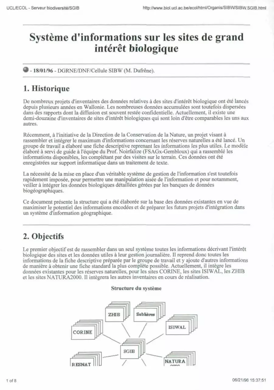
UCL/ECOL - Serveur biodiversite/SGIB http://www.biol.ucl.ac.be/ecol/html/Organis/SIBW/SIBW.SGIB.html
Systeme d'informations sur les sites de grand interet biologique
- 18/01/96 - DGRNE/DNF/Cellule SIBW (M. Dufrene).
1. Historique
De nombreux projets d'inventaires des donnees relatives a des sites d'interet biologique ont ete lances depuis plusieurs annees en Wallonie. Les nombreuses donnees accumulees sont toutefois dispersees dans des rapports dont la diffusion est souvent restee confidentielle. Actuellement, il existe une demi-douzaine d'inventaires de sites d'interet biologiques qui sont loin d'etre comparables les uns aux autres.
Recemment, a l'initiative de la Direction de la Conservation de la Nature, un projet visant a rassembler et integrer le maximum d'informations concernant les reserves naturelles a ete lance. Un groupe de travail a elabore une fiche descriptive reprenant les informations les plus utiles. Le modele elabore a servi de guide a l'equipe du Prof. Noirfalize (FSAGx-Gembloux) qui a rassemble les informations disponibles, les completant par des visites sur le terrain. Ces donnees ont ete enregistrees sur support informatique dans un traitement de texte.
La necessite de la mise en place d'un veritable systeme de gestion de l'information s'est toutefois rapidement imposee, pour permettre une manipulation aisee de l'information et pour notamment, veil ter a integrer les donnees biologiques detaillees gerees par les banques de donnees biogeographiques.
Ce document presente la structure qui a ete elaboree sur la base des donnees existantes en vue de maximiser le potentiel des informations encodees et de preparer les futurs projets d'integration dans un systeme d'information geographique.
2. Objectifs
Le premier objectif est de rassembler dans un seul systeme toutes les informations decrivant l'interet biologique des sites et les donnees utiles a leur gestion journaliere. II reprend done toutes les informations de la fiche descriptive preparee par le groupe de travail et y ajoute d'autres informations de maniere a obtenir une fiche standard la plus complete possible. Actuellement, il integre les donnees existantes pour les reserves naturelles, pour les sites CORTNE, les sites ISIWAL, les ZHIB et les sites NATURA2000. II integrera les autres inventaires en cours de realisation.
Structure du systeme
1 of 8 06/21/96 15:37:51

UCL/ECOL - Serveur biodiversite/SGIB http://www.biol.ucl.ac.be/ecol/html/Organis/SIBW/SIBW.SGIB.html
jF / \
XUJU J ^
r1 1 ^ = T T 1 Biblio SGIBDes
Le second objectif est de gerer les informations de la maniere la plus efficiente en vue de l'integration d'une partie de ces donnees dans des systemes d'informations geographiques et de pouvoir integrer les donnees resultant de l'analyse des banques de donnees biogeographiques. II s'agit de mettre en place un veritable systeme d'informations dont la mise-a-jour et la validation doivent etre rendues tres aisees
Flux des donnees
Base de donnees detaillees
Groupes de travail naturalistes Universites —
Conventions exterieures Administration
(Services exterieurs)
Etablissement
(inventaire s) 1 ANALYSE
Mise-a-jour I (surveillance)
Base de donnees synthetrjues (infocentre)
Projet SGIB
DIFFUSION
Serve or INTERNET
(ex. : le reseau de fe FBDB)
(Station de recteiclies de Gembloux)
Le troisieme objectif est d'arriver a la mise au point d'un systeme de gestion de l'information qui soit simple et souple tout en etant suffisamment complet, autorisant la recherche sur n'importe quel champ, la mise au point de rapports specifiques et le transfer! d'informations vers n'importe quel autre logiciel.
3. Structure de l'information 3.1. Principe general
Les differentes tutelles qui s'exercent sur un site se superposent geographiquement: une reserve naturelle peut etre situee sur deux zones differentes du plan de secteur, correspondre partiellement a un site NATURA2000 ou a une ZHIB. De plus, les tutelles visant a la protection du site peuvent ne couvrir que partiellement la zone biologiquement interessante. II est done necessaire de definir une unite geographique qui est independante de toute tutelle existante.
La solution proposee est axee sur la definition de sites de grand interet biologique (SGIB) qui correspondent a des unites geographiques homogenes (de 0.1 a 10 hectares), generalement bien identifiables sur le terrain, qui ont un quelconque interet biologique. Cet interet biologique est motive par la presence d'especes ou d'habitats proteges, d'especes ou d'habitats menaces ou meme d'especes ou d'habitats que les naturalistes jugent interessants.
Ces sites de grand interet biologique forment une couche du systeme d'information qui est uniquement caracterisee par des donnees biologiques (especes, habitats, description du site). Les autres couches du systeme d'informations correspondent aux tutelles de protection comme les
2 of 8 06/21/96 15:37:53

UCL/ECOL - Serveur biodiversite/SGIB http://www.biol.ucl.ac.be/ecol/html/Organis/SIBW/SIBW.SGIB.html
reserves naturelles, les ZHIB ou les sites NATURA2000. Le site d'interet biologique (S.G.I.B.) est done l'unite geographique qui est commune a l'ensemble des classications existantes. Les reserves naturelles, les zones humides d'interet biologique et les sites CORINE integrent en effet souvent plusieurs sites de grand interet biologique. Mais un S.G.I.B. ne peut appartenir qu'a une seule reserve naturelle, une seule Z.H.I.B. ou un seul site CORINE.
A chacune des couches d'informations ou entires correspond un fichier de donnees qui comprend toutes les donnees qui les concernent exclusivement et sont leur done specifiques. Le fichier RESNAT rassemble toutes les informations propres au statut de reserve naturelle (date de location, surface protegee, statut de protection, proprietaire,...). Chacune des lignes ou des fiches de ce fichier est une reserve naturelle differente. Le fichier CORINE comprend toutes les informations sur les sites beiges existants dans la base de donnees CORINE. Chaque ligne ou fiche de ce fichier correspond a un site CORINE. De meme pour le fichier ZHIB ou te fichier NATURA2000.
Comme une reserve naturelle ou un site CORINE peut correspondre a plusieurs SGIB, des codes sont prevus dans chacun des fichiers pour etablir les liens necessaires avec les autres. Ce sont ces codes qui permettent d'etablir des relations d'un fichier a I'autre et qui representent la maniere dont les differents fichiers se surperposent geographiquement. Comme les relations sont uniquement geographiques, ces donnees pourront etre integrees facilement dans n'importe quel systeme d'information geographique puisque toutes les entites sont des elements surfaciques.
Relations entre les fichiers
une fiche RESNAT n' i
une fiche RESNAT tf 1 A
6 Codes SGIB
Codes CORINE
Codes ZHIB
1,2
A
6 Codes SGIB
Codes CORINE
Codes ZHIB
6,8
A
6 Codes SGIB
Codes CORINE
Codes ZHIB
A
6 Codes SGIB
Codes CORINE
Codes ZHIB i . i .
une fiche CORINE n"8
une fiche CORINE
une fiche SGIB tiA
*>- une fiche SGIB n'2
une fiche SGIB n"l
CodeRESNAT[T~|
Code CORINE [ T |
Codes ZHIB [_ D
n
n'6
Codes SGIB 1.4
Code3 RESNAT 1,2
Codes ZHIB
Dans l'exemple presente ci-dessus, une reserve naturelle comprend deux S.G.I.B., qui sont repertories dans deux sites CORINE differents. Cette maniere de proceder permet de "voyager" d'un fichier a I'autre, sans jamais perdre le fil des relations geographiques entre les differents fichiers. Par la simple existence de coordonnees geographiques pour chaque fiche de chacun des fichiers, les donnees pourront ensuite etre tres facilement integrees dans un systeme d'informations geographiques.
3.2. Structure de l'information
3.2.1. La fiche SGIB
Les donnees necessaires a la gestion des sites de grand interet biologique (SGIB) sont tres diversifiees : elles incluent les references cartographiques, les differentes tutelles de protection ou de gestion qui peuvent s'y exercer, les motivations de sa designation comme SGIB, les differents types d'habitat et les especes interessantes qui y sont presentes, ainsi que les donnees eventuelles relatives a 1'interet culturel ou historique et les nombreuses references bibliographiques.
A : Localisation geographique
Nom de reference du site et les synonymes les plus courants.
3 of 8 06/21/96 15:37:54

UCL/ECOL - Serveur biodiversite/SGIB http://www.biol.ucl.ac.be/ecol/html/Organis/SIBW/SIBW.SGIB.html
Norn de reference du site et les synonymes les plus courants. Ancienne et nouvelle communes, province.
D Cantonnement. Altitudes minimale, moyenne et maximale. Coordonnees geographiques LAMBERT (x, y en km). Numeros de la carte IGN, de la carte des sols, de la carte geologique, de la carte de la vegetation, de la carte Ferraris, de la carte IHE (evaluation biologique).
• Coordonnees geographiques IFBL et UTM. • Region naturelle [Flandre sablo-limoneuse, Region limoneuse hennuyere, Brabant
limoneux, Hesbaye, Sillon sambro-mosan, Condroz, Fagne, Famenne, Calestienne, Ardenne, Lorraine beige,...]. Coordonnees cadastrales. References bibliographiques d'autres mentions cartographiqucs.
D Surface et evolution significative de la surface du SGIB.
i B : Tutelles exercees sur le site
Nom, adresse et numero de telephone du ou des proprietaires. Nom, adresse et numero de telephone du ou des gestionnaires ou des personnes connaissant tres bien le site.
a Date de l'arrete de classement comme monument naturel. Nom du plan de secteur, avec la date de l'arrete et le detail des differentes zones. Tutelles internationales [Reserve biogenetique, Diplome europeen, RAMSAR,...].
• Nom de la zone de protection speciale de l'avifaune [Ardenne meridionale et Haute-Sure, Bassin de la Haine, Cote bajocienne, Daverdisse, Entre Sambre-et-Meuse, Haute-Meuse, Hautes-Fagnes-Eiffel, La Croix-Scaille, Les Deux-Ourthes, Lesse et Lomme, Malchamps, Marche-en-Famenne, Ochamps-Freux, Plateau des Tailles, Saint-Hubert, Sinemurienne, Valtee de la Dyle, Vallee de la Lienne, Wanne-Logbierme]
n Liens avec les autres fichiers : Reserve naturelle, site CORINE, ZHIB, site ISI WAL, site NATURA2000,...
C : Especes protegees, menacees ou interessantes
Noms latins des especes protegees ou menacees, minis latins de reference, groupes taxonomiques. statut de protection en Wallonie, liste rouge et representative regionale. La representativite regionale est definie par 3 niveaux :
• A = une des 10 dernieres populations wallonnes, • B = une des populations jouant un role significatif pour la survie de l'espece en
Wallonie, • C = une population presentant un interet biogeographique (en dehors ou en marge
de l'aire principale en Wallonie).
Flore : liste des especes interessantes (ni protegees - ni menacees) ou commentaires. Faune : liste des especes interessantes (ni protegees - ni menacees) ou commentaires.
D : Habitats proteges, menaces ou interessants
Code CORINE des habitats, noms latins et noms franca is des habitats, couverture relative (%) du site pour chaque habitat et representativite regionale. La representativite regionale est definie par 3 niveaux :
• A = un des derniers sites representatifs en Wallonie, • B = un des sites sub-representatifs (partiellement degrade, en cours de restauration,
surface trop petite,...), • C = un site presentant un interet biogeographique (en dehors ou en marge de l'aire
principale en Wallonie).
• Autres habitats non-codes ou commentaires.
D E : Conservation et menaces
4 of 8 06/21/96 15:37:54

UCL/ECOL - Serveur biodiversite/SGIB http://www.biol.ucl.ac.be/ecol/html/Organis/SlBW/SIBW.SGIB.html
Objectifs de la conservation. Dispositifs de surveillance. Acces au public et information.
rj Plan de gestion. • Menaces.
Recommendations.
D F : Description
Breve description du site. Description du milieu physique*. Description du milieu biologique, comprenant une description de la vegetation et des commentaires sur les especes interessantes*. Monument naturel*.
a Monument historique*. Histoire du site*.
* de maniere a gagner de la place dans le fichier principal, ces donnees sont rassemblees dans un fichier jumeau appele SGIBDES.
3.2.2. La fiche RESNAT
A. Identification
i Code et nom de la reserve n Categorie : [Ancienne reserve, Reserve agreee, Reserve forestiere, Reserve naturelle,
Site classe, Site d'interet scientifique,...] a Promoteur : [Region wallonne, Ardenne & Gaume, R.N.O.B, AVES-Ostkantone,
Cercles des Naturalistes de Belgique, La Trientale (C.N.B.), L.R.B.P.O., Espaces pour Demain, Les Amis de la Fagne,...]
a Agrement: [Oui, Non, En cours], surface actuelle agreee, evolution de la surface. a Date de la creation, surface actuelle, evolution de la surface.
Arrete(s) pour les reserves domaniales et agreees. Type de contrats pour les reserves privees. Historique de l'acquisition.
• Nom, adresse et numero de telephone du ou des proprietaires. i Nom, adresse et numero de telephone du ou des conservateurs.
B. Localisation geographique
Ancienne et nouvelle communes, province. Cantonnement. Coordonnees cadastrales. Coordonnees geographiques LAMBERT (x, y en km).
a Identification des SGIB correspondants.
C. Conservation
Buts de la conservation. Dispositifs de surveillance. Tolerances d'utilisation. Acces au public et information. Plan de gestion. Menaces. Recommendations.
D. Description
Breve description de la reserve.
3.2.3. La fiche CORINE
5 of 8 06/21/96 15:37:54

UCL/ECOL - Serveur biodiversite/SGIB http://www.biol.ucl.ac.be/ecol/html/Organis/SIBW/SIBW.SGIB.html
3.2.3. La fiche CORINE
L'inventaire des sites CORINE est un inventaire europeen de sites grand interet biologique.
A. Identification
Code et nom du site CORINE. G Code et nom du complexe.
Surface, coordonnees geographiques (longitude, latitude), altitudes minimale, moyenne et maximale.
] Code region, region, code province, province, code arrondissement, arrondissement. • Identification des SGIB correspondants.
B. Description
Description du site. Habitats principaux et couverture relative. Interet biologique. Menaces. Motivations. Activites.
• Designation (differents statuts des differentes zones) et couverture relative. Liste des especes. Habitats detailles.
Toutes les donnees accessibles par le logiciel BIOFIND (DBASE IV Cox & Moss, 1992) ont fait ete reparties en trois fichiers, le premier decrivant les sites (CORINE_S.fm), le second detaillant la liste des habitats dans chaque site (CORINEH.fm) et le troisieme avec la liste des especes dans les sites (CORINE_E.fm). Les informations contenues dans ces deux derniers fichiers ont toutefois ete ajoutees sous forme resumee dans la fiche CORINE_S.fm
Fichier CORINEH.fm (une fiche = un habitat dans un site)
Code et nom du site CORINE.
• Code CORINE et nom anglais de ('habitat.
• Fichier CORINE_S.fm (une fiche = un site CORINE)
Code et nom du site CORINE. Nom de I'espece, groupe taxonomique, niveau d'interet du site pour I'espece.
3.2.4. La fiche ZHIB
Les zones humides d'interet biologique sont toutes des sites de grand interet biologique. La seule specificite actuelle est leur designation officielle au Moniteur beige.
Code et nom du ZHIB. Date de l'arrete de designation. Identification des SGIB correspondants.
3.2.5. La fiche ISIWAL
Le premier inventaire ISIWAL date de la fin des annees 1980; une remise a jour partielle a ete realisee en 1992. II compte actuellement plus de 770 sites.
A. Description
Code et nom du site ISIWAL, code du premier inventaire. Numero de la planche IGN. Ancienne et nouvelle communes. Breve description du site.
• Autres commentaires.
6 of 8 06/21/96 15:37:55

UCL/ECOL - Serveur biodiversite/SGIB http://www.biol.ucl.ac.be/ecol/html/Organis/SIBW/SIBW.SGIB.html
i Identification des SGIB correspondants.
z B. Tutelles
Plan de secteur Classement ZPS avifaune ZHIB
3.2.6. La fiche NATURA2000
Mise en oeuvre dans le cadre de l'application de la directive europeenne "Faune-Flore-Habitats", l'inventaire NATURA2000 identifie les sites d'importance qui recelent des populations d'especes mentionnees a 1'Annexe 2 ou des habitats mentionnes a l'Annexe 1 de cette directive.
Un grand nombre de variables sont prevues; elles seront detaillees ulterieurement.
3.2.7. La fiche SABLIERES
En cours de developpement.
3.2.7. La fiche ESCARPEMENTS
En cours de developpement.
3.3. Autres informations gerees
D'autres informations completant les inventaires de sites sont aussi en cours d'integration. II s'agit de rassembler les donnees synthetiques existantes sur les especes menacees ou protegees, les descriptions des habitats et l'ensemble des references bibliographiques repertoriees.
3.3.1. La liste des especes menacees ou protegees en Wallonie
Ce fichier, qui compte deja pres de 1000 taxons, donne lorsque l'information existe des details sur 1'ecologie et la repartition de I'espece, sur les tendances de sa repartition et la maniere dont elle est effectivement protegee sur le terrain. II s'agit de veritables fiches signaletiques qui devront encore etre completers et verifiees par les experts des groupes de travail.
3.3.2. La liste des habitats presents en Wallonie
Ce fichier sert actuellement essentiellement a traduire les codes de la typologie europeenne CORINE. II devrait etre complete par des informations tres detaillees sur les criteres d'identification des habitats et leur repartition en Wallonie.
3.3.3. Les references bibliographiques
Enfin, un fichier rassemble de tres nombreuses references bibliographiques (> 3.500 !) qui donnent des renseignements sur les sites de grand interet biologique. II est done possible d'obtenir immediatement un aper9u rapide de ce qui a ete ecrit sur un site particulier et ses environs.
[Index] [New] [Find] [Home] [Especes] [Habitats] [Sites] [Legis.] [Org.] [Outils] [SIBW]
7 of 8 06/21/96 15:37:55

UCL/ECOL - Serveur biodiversite/SGIB http://www.biol.ucl.ac.be/ecol/html/Organis/SIBW/SIBW.SGIB.html
Pour tout renseignement sur ce document: [email protected]
c/o Unite d'Ecologie et de Biogeographie Universite catholique de Louvain Place Croix du Sud, 5 B-1348 Louvain-la-Neuve Fax:(010)47 34 90
8 of 8 06/21/9615:37:55

UCL/ECOL - Serveur Biodiversite/Legislations/ConsNat/lntroduction http://www.biol.ucl.ac.be/ecol/html/Legis/ConsNat/LegCNat.html
Liste des legislations mise en oeuvre par la Direction de la Conservation de la Nature et des Espaces verts
- 24/04/96 - DGRNE/DNF (F. Materne & P. De Wolf).
A. Generalites
Decision du
28.12.1931
12.07.1973
Titre Date de parution
Loi relative a la protection des bois et des forets appartenant aux particuiiers
Loi sur la conservation de la nature [modifieepar les decrets du J_L avril 1984 (MB du 17.04.85), du 16 juillet 1985 relatifaux pares nature Is (MB du 12.12.85), du 7 octobre 1985 sur la protection des eaux de surface contre la pollution (MB du 10.01.86), du 7 septembre 1989 et du 21 avril 1994 completant la loi par des dispositions particulieres a la R. W. en ce qui concerne la circulation sur et dans les cours d'eau (MB du 06.04.95)]
30.12.1931; err.
31.12.1931
11.09.1973
16.11.1984 Arrete de l'Executif regional wallon portant execution des articles 59. 60. 61 et 65 de la loi du 12 juillet 1973 sur la conservation de la nature 17.04.1985
14.12.1989
Decret permettant a l'Executif regional wallon de prendre toutes les mesures que requiert 1'application ou la mise en oeuvre des traites et conventions internationaux en matiere de chasse, peche, protection des oiseaux et conservation de la nature
14.02.1990
18.10.1990
Arrete de l'Executif regional wallon relatif a la composition et au fonctionnement du Conseil superieur wallon de la conservation de la nature fmodifte par l'arrete de l'Executif regional wallon du 29 octobre 1992 (MB du 17.12.92)]
24.01.1991
30.06.1994 Arrete du Gouvernement wallon reglementant la circulation des embarcations et des plongeurs sur et dans les cours d'eau
09.08.1994
19.01.1995
Arrete du Gouvernement wallon portant le reglement des autorisations de faire circuler des vehicules autres que de navigation sur les berges, les digues ainsi que dans le lit des cours d'eau et les passages a gue, en 18.03.1995 execution de l'article SSbis de la loi du 12 juillet 1973 sur la conservation de la nature
06.04.1995 Decret octroyant aux autorites communales le droit dedicter des mesures eomplcmentaires en matiere de conservation de la nature
09.02.1995 Arrete du Gouvernement wallon relatif a 1'octroi d'une subvention pour la plantation de haies
10.06.1995
23.05.1995
B. Protection du milieu
1of4 05/23/96 12:08:38

UCL/ECOL - Serveur Biodiversite/Legislations/ConsNat/lntroduction http://www.biol.ucl.ac.be/ecol/html/Legis/ConsNat/LegCNat.html
23.10.1975
Arrete ministeriel etablissant le reglement relatif a la surveillance, la police et la circulation dans les reserves naturelles domaniales en dehors des chemins ouverts a la circulation publique [modifie par l'arrete de l'Executif regional wallon du 18 juillet 1991 (MB du 11.10.91)]
31.12.1975
02.04.1979 Arrete roval Etablissant te reglement de gestion des reserves forestieres 09.06.1979
23.07.1979 Circulaire sur les reserves forestieres -
27.01.1984 Arrete de l'Executif regional wallon portant interdiction de l'emploi d'herbicides sur certains biens publics [modifie par l'arrete de l'Executif regional wallon du 24 avril 1986 (MB du 31.07.86)]
17.02.1984
27.09.1984 Arrete' royal portant designation des zones humides d'importance 31.10.1984 27.09.1984 internationale 31.10.1984 27.09.1984 31.10.1984
17.07.1986
Arrete de l'Executif regional wallon concernant l'agrement des reserves naturelles et le subventionnement des achats de terrains a eriger en reserves naturelles agreetes par les associations privees [modifie par l'arrete de l'Executif regional wallon du 18 juillet 1991 (MB du 11.10.91)]
11.10.1986
02.11.1987
06.04.1989
19.09.1989
Actes de l'Executif regional wallon portant designation de zones de protection speciale en application de la directive 79/409/CEE concernant la conservation des oiseaux sauvages 02.11.1987 - 06.04.1989 - 19.09.1989
-
02.11.1987
06.04.1989
19.09.1989 _ _ _ _ _ _ _ _ _ :
-
12.11.1987
Arrete de l'Executif regional wallon portant organisation des commissions consultatives de gestion des reserves naturelles domaniale [abroge par l'arrete du Gouvernement wallon du 20 octobre 1994 (MB du 29.11.94)]
14.01.1988
23.12.1987 Circulaire relative a l'arrete de l'Executif regional wallon du 12 novembre 1987 portant organisation des commissions consultatives de gestion des reserves naturelles domaniales
| 1
08.06.1989 Arrete de l'Executif regional wallon relatif a la protection des zones humides d'interet biologique 12.09.1989 08.06.1989 12.09.1989
12.12.1991 Arrete de l'Executif regional wallon portant sur l'execution de Particle 11, alinea 2, de la loi, du 12 juillet 1973 sur la conservation de la nature 30.01.1992
12.03.1992 Arrete de l'Executif regional wallon deTinissant une zone ou temporairement, .'article 56, paragraphe 3, de la loi du 12 juillet 1973 sur la conservation de la nature n'est pas d'application
08.04.1992
16.12.1993 Arrete du Gouvernement wallon relatif a la fouille de la vase en vue du prelevement de tubifex (Tubifex tubifex) et de vers de vase (Chironomus spp)
26.01.1994
20.10.1994 Arrete du Gouvernement wallon portant organisation des commissions consultatives de gestion des reserves naturelles domaniales 29.11.1994
26.01.1995 Arrete du Gouvernement wallon organisant la protection des cavites souterraines d'interet scientifique 18.03.1995
C. Protection des especes vegetales
16 0? 1076 1 Arrete' royal relatif aux mesures de protection en faveur de certaines | especes vegetales croissant a I'etat sauvage 24.03.1976
14.05.1984 Code wallon de I'amenagement du territoire et de rurbanisme : articles 41 a 52, 195/1 a 195/5, 210 a 217 (arbres et haies remarquables + procedure applicable) [modifie par le decret du 30 juillet 1992]
19.11.1987
2 of 4 05/23/9612:08:39

UCL/ECOL - Serveur Biodiversite/Legislations/ConsNat/lntroduction http://www.biol.ucl.ac.be/ecol/html/Legis/ConsNat/LegCNat.html
23.07.1979
Arrete royal relatif a la lutte contre les organismes nuisibles aux vegetaux et aux produits vegetaux [modifie par les arretes royaux des 9 mai 1989, 14 aout 1989, Sjuin 1990 et par l'arrete du Gouvernement wallon du 14 juillet 1994); abroge par l'arrete royal du 3 mai 1994 a I'exception des articles 9 a 53 et 58 a 84 relatifs aux mesures particulieres de lutte contre les organismes nuisibles]
08.01.1988
20.11.1987 Arrete ministeriel relatif a la lutte contre les organismes nuisibles aux vegetaux et aux produits vegetaux 08.01.1988
03.05.1994 Arrete royal relatif a la lutte contre les organismes nuisibles aux vegetaux et aux produits vegetaux
16.07.1994
D. Protection des especes animates
30.03.1983 Arrete de l'Executif regional wallon relatif a la protection de certaines especes d'animaux vertebres vivant a I'etat sauvage [modifie par 21.06.1983 30.03.1983 l'arrete de l'Executif regional wallon du 16fevrier 1984]
21.06.1983
16.02.1984
Arrete ministeriel fixant les conditions auxquelles les dispositions de l'arrete de l'Executif regional wallon du 30 mars 1983 relatif a la protection de certaines especes d'animaux vertebres indigenes vivant a I'etat sauvage nc sont pas d'application
16.05.1984
21.02.1984 Arrete de l'Executif regional wallon relatif a la protection des escargots comestibles indigenes
28.04.1984
09.07.1987 Arrete de l'Executif regional wallon relatif a la protection de .'entomofaune 28.10.1987
29.11.1990 Arrete de l'Executif regional wallon reglant la mise en liberie dans la nature des especes animates non indigenes et leur introduction dans les pares a gibier en Region wallonne
1
26.04.1991
29.11.1990 Arrete de l'Executif regional wallon determinant les conditions et la procedure d'agrement des centres de revalidation des especes animates vivant a I'etat sauvage
26.04.1991
14.07.1994 Arrete du Gouvernement wallon sur la protection des oiseaux [modifie provisoirement par l'arrete du Conseil d'Etat numero 49506 du 7 octobre 1994]
21.09.1994
E. Pares naturels
16.07.1985 Decret relatif aux pares naturels j 12.12.1985
10.09.1987
Arrete de l'Executif regional wallon portant le reglement relatif a I'enquete publique sur les projets de pares naturels
10.12.1987 10.09.1987
Arrete de l'Executif regional wallon determinant le contenu du dossier dc la demande d'approbation en execution de 1'article 5 du decret du 10.12.1987 10.09.1987 16 juillet 1985 relatif aux pares naturels
Arrete de l'Executif regional wallon fixant la procedure relative aux
10.12.1987 10.09.1987
demandes d'avis ou d'accords des commissions de gestion de pares
10.12.1987 10.09.1987
naturels
10.12.1987
05.11.1987 Arrete de l'Executif regional wallon portant execution de Particle 13 paragraphe ler. 4°. du decret du 16 juillet 1985 relatif aux pares 06.01.1988 05.11.1987 naturels
06.01.1988
3 Of 4 05/23/96 12:08:39

UCL/ECOL - Serveur Biodiversite/Legislations/ConsNat/lntroduction http://www.biol.ucl.ac.be/ecol/html/Legis/ConsNat/LegCNat.html
F. Espaces verts
02.07.1949
Arrete du Regent relatif a l'intervention de l'Etat en matiere de subsides pour l'execution de travaux par les provinces, communes, associations de communes, commissions d'assistance publique, fabriques d'eglises et associations des polders ou de wateringues - Extraits
22.07.1949
10.12.1975 Arrete royal determinant pour la Region wallonne les conditions d'octroi et les taux de subsides pour l'acquisition de terrain en vue de la conservation, de la creation ou de I'amenagement d'espaces verts
31.12.1975
10.12.1975 Circulaire ministerielle relative a l'arrete royal du 10 decembre 1975 precite -
25.04.1980 Arrete royal reglant en ce qui concerne la Region wallonne, la procedure d'octroi des subsides prevus a l'arrete du Regent du 2 juillet 1949 precite
23.05.1980
08.05.1980 Circulaire relative a l'application de l'arrete royal du 25 avril 1980 reglant, en ce qui concerne la Region wallonne, la procedure d'octroi de subsides prevus a l'arrete du Regent du 2 juillet 1949
14.06.1980
[Index] [New] [Home] [Especes| [Habitats] [Sites] [Legis.] [Org.] [Outih
Pour tous renseignements sur le serveur : [email protected]
4 of 4 05/23/96 12:08:39

CREF file : ECOLOGIE.html http://www.physique.fundp.ac.be/unites_htntl/EC0LOGIE.html
FUNDP NAMUR
Unite d'Ecologie des Eaux Douces (UNECED) Unit of Freshwater Ecology
Faculte : SCIENCES
l)e parte mint : BIOLOGIE
Code discipline : 1 (Sciences exactes et naturelles)
Adresse :
Ruede Bruxelles, 61 B-5000 Namur Telephone:+32 S\ 72.43.60 Telecopie:+32 %\ 72.44.20
Responsable(s):
MICHA Jean-Claude DESCY Jean-Pierre
Presentation francaise :
Qualite des eaux de surface : evaluations integrant les caracteristiques physico-chimiques et biologiques, amenagement et rehabilitation de milieux aquatiques. - Etude approfondie de communautes vegetales et animates (structure, dynamique, relations trophiques, effets des pollutions, rehabilitation : phytoplancton, zooplancton, invertebres benthiques, poissons). - Ecophysiologie de la reproduction des poissons et mise au point de l'elevage d'especes nouvelles en pisciculture. -Evaluation et exploitation des ressources piscicoles.
Themes des recherches :
11 projet(s)
Services offerts aux tiers :
- Techniques courantes d'echantillonnage et d'analyse de l'eau (sur te terrain et en laboratoire), analyseur carbone-azote, HPLC, utilisation de radiotraceurs. - Materiel d'echantillonnage des communautes piscicoles (peche eiectrique, filets). - Utilisation de logiciels de dynamique de populations de poissons. - Equipements d'aquaculture experimentale, en particulier pour l'elevage larvaire.
Chercheurs : 18,5 ETP Personnel ATO : 6,0 ETP
Date de creation : 05/03/1993 Date de mise a jour : 01/04/1996 Date de transmission : 15/04/1996 Numero d'unite : 2753
FUNDP / Recherches aux FUNDP
^ atricia Lonnoy Conseil de Recherche des FUNDP
1 of 1 05/23/96 12:44:37

Unite d'Ecologie des Eaux Douces (UNECED): projets http//www.physique.fundp.ac.be/unites_html/p2753.html
FUNDP NAMUR
Unite d'Ecologie des Eaux Douces (UNECED): projets
Utilisation des exuvies nvmphales de Chironomidae ("Dipteral en tant qu'indicateurs biologiques de la qualite des eaux de surface
Bilan d'oxygene et processus biologiques des cours d'eau amenages Moselle et Sarre
a Etude des relations trophiqucs au sein du plancton en milieu nuvial
PEGASE: Planification et Gestion de rAssainisscmcnt des Eaux
Amenagement ecologique des cours d'eau navigables et non navigables
Etude paysagere de eours d'eau
Rehabilitation du saumon atlantique (Salmo salar) dans le bassin de la Meuse
Indice biotique d'integrite piscicole (1BIP, pour evalucr la qualite ecologique des ecosvstemes aquatiques
D Etude comparative des strategies de reproduction chez les poissons a ovogenese synchrone et asynchrone. Approche pluridisciplinaire des mceanismcs de reproduction
Structure, organisation spatio-temporelle et dynamique de population des communautes piscicoles des lacs de Robertville et Biitgenbach
Diversification de la pisciculture en Wallonie - Mise au point de l'elevage intensif d'especes nouvelles pour la consommation et le repeuplement: percides
FUNDP / Recherches aux FUNDP
Conseil de Recherche des FUNDP
1 of 1 05/23/96 12:44:29

Appendix 5 Example of an ecotope map
I I I 9
* 3 s j .5
| I | I 5 •= M ei) •* ^ s - •§ = -9 a 5 1 3 2 § 3 S3 | _, y 5 o M & <3 « - s -_. H e > « a. a <s
S
8 1
11 II a. I
E u
43
-' J .
< N
(-. cs:
A-42