Embed Size (px)
Citation preview
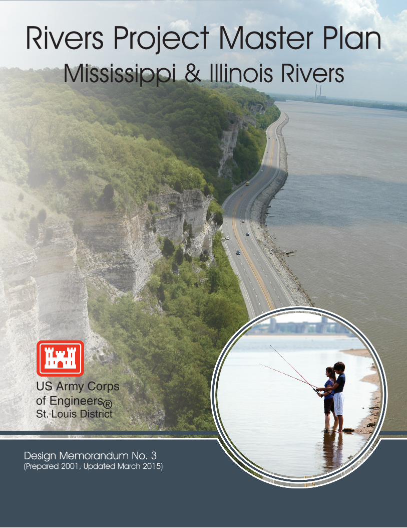
Rivers Project Master PlanMississippi & Illinois Rivers
Design Memorandum No. 3(Prepared 2001, Updated March 2015)
US Army Corpsof Engineers®St. Louis District
THE MASTER PLAN
Rivers Project
Design Memorandum No. 3
(Prepared 2001, Updated 2015)
Prepared by
U.S. Army Corps of Engineers, St. Louis District
1222 Spruce Street
St. Louis, Missouri 63101-2833
RIVERS PROJECT MASTER PLAN
ii
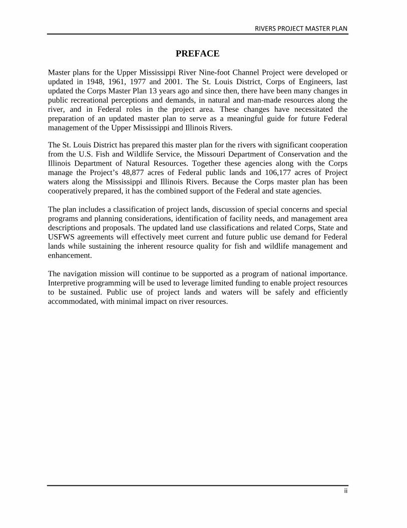
PREFACE Master plans for the Upper Mississippi River Nine-foot Channel Project were developed or updated in 1948, 1961, 1977 and 2001. The St. Louis District, Corps of Engineers, last updated the Corps Master Plan 13 years ago and since then, there have been many changes in public recreational perceptions and demands, in natural and man-made resources along the river, and in Federal roles in the project area. These changes have necessitated the preparation of an updated master plan to serve as a meaningful guide for future Federal management of the Upper Mississippi and Illinois Rivers.
The St. Louis District has prepared this master plan for the rivers with significant cooperation from the U.S. Fish and Wildlife Service, the Missouri Department of Conservation and the Illinois Department of Natural Resources. Together these agencies along with the Corps manage the Project’s 48,877 acres of Federal public lands and 106,177 acres of Project waters along the Mississippi and Illinois Rivers. Because the Corps master plan has been cooperatively prepared, it has the combined support of the Federal and state agencies. The plan includes a classification of project lands, discussion of special concerns and special programs and planning considerations, identification of facility needs, and management area descriptions and proposals. The updated land use classifications and related Corps, State and USFWS agreements will effectively meet current and future public use demand for Federal lands while sustaining the inherent resource quality for fish and wildlife management and enhancement. The navigation mission will continue to be supported as a program of national importance. Interpretive programming will be used to leverage limited funding to enable project resources to be sustained. Public use of project lands and waters will be safely and efficiently accommodated, with minimal impact on river resources.
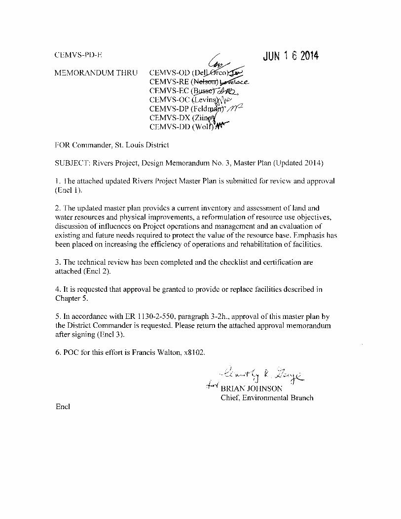
CEMVS-PD-E
MEMORANDUM THRU ~
CEMVS-OD (De~~ CEMVS-RE (Nel!5onJ ~e~ CEMVS-EC (~~ CEMVS-OC ~Levin~tvJ» CEMVS-DP (Feli://t2 CEMVS-DX (Zii CEMVS-DD (Wol Nr
JUN 1 6 2014
FOR Commander, St. Louis District
SUBJECT: Rivers Project, Design Memorandum No.3, Master Plan (Updated 2014)
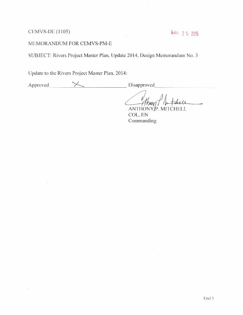
1. The attached updated Rivers Project Master Plan is submitted for review and approval (Encl 1).
2. The updated master plan provides a current inventory and assessment of land and water resources and physical improvements, a reformulation of resource use objectives, discussion of influences on Project operations and management and an evaluation of existing and future needs required to protect the value ofthe resource base. Emphasis has been placed on increasing the efficiency of operations and rehabilitation of facilities.
3. The technical review has been completed and the checklist and certification are attached (Encl 2 ).
4. It is requested that approval be granted to provide or replace facilities described in Chapter 5.
5. In accordance withER 1130-2-550, paragraph 3-2h., approval of this master plan by the District Commander is requested. Please return the attached approval memorandum after signing (Encl 3).
6. POC for this effort is Francis Walton, x81 02.
) ,/ '', '...J....,. C.<.: ~-t-~( .. 't ~. :.::/vA.'J L;; - IJ - . ·,J"'-
J..ri BRIAN JOHNSON . Chief, Environmental Branch
Encl
CEMVS-PD-E Date: cJ 11\.V\ e_ I() 1 2014
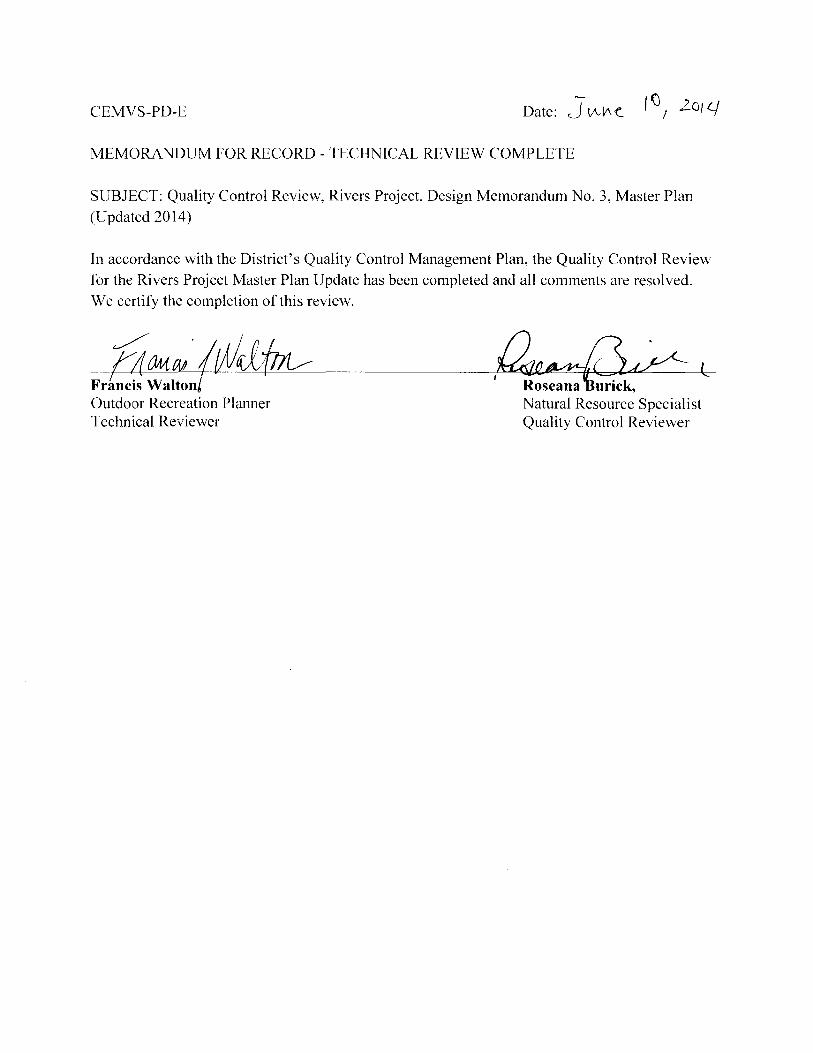
MEMORANDUM FOR RECORD - TECHNICAL REVIEW COMPLETE
SUBJECT: Quality Control Review, Rivers Project, Design Memorandum No. 3, Master Plan (Updated 2014)
In accordance with the District's Quality Control Management Plan, the Quality Control Review for the Rivers Project Master Plan Update has been completed and all comments are resolved. We certify the completion ofthis review.
&auPJ·;w~ Fr~ncis Waltoni Outdoor Recreation Planner Technical Reviewer
~~1/-1 riel
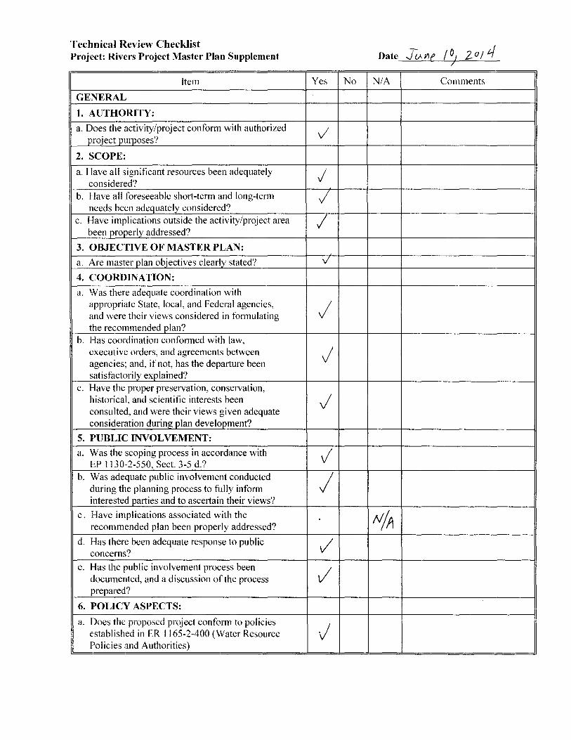
Technical Review Checklist Project: Rivers Project Master Plan Supplement
Item
GENERAL
1. AUTHORITY:
a. Does the activity/project conform with authorized project purposes?
2. SCOPE:
a. Have all significant resources been adequately considered?
b. Have all foreseeable short-term and long-term needs been adequately considered?
c. Have implications outside the activity/project area been properly addressed?
3. OBJECTIVE OF MASTER PLAN:
a. Are master plan objectives clearly stated?
4. COORDINATION:
a. Was there adequate coordination with appropriate State, local, and Federal agencies, and were their views considered in formulating the recommended plan?
b. Has coordination conformed with law, executive orders, and agreements between agencies; and, if not, has the departure been satisfactorily explained?
c. Have the proper preservation, conservation, historical, and scientific interests been consulted, and were their views given adequate consideration during plan development?
5. PUBLIC I~"'VOLVEMENT:
a. Was the scoping process in accordance with EP 1130-2-550, Sect. 3-5 d.?
b. Was adequate public involvement conducted during the planning process to fully infonn interested parties and to ascertain their views?
c. Have implications associated with the recommended plan been properly addressed?
d. Has there been adequate response to public concerns?
e. Has the public involvement process been documented, and a discussion of the process prepared?
6. POLICY ASPECTS:
a. Does the proposed project confom1 to policies established in ER 1165-2-400 (Water Resource Policies and Authorities)
----· -- --- --
Yes
v I
j
I /
v'
j
j
J
v j
/
vi
J
No
I I
Date JcM'If I o, zo 1 tf 7
N/A Comments
I
N/A
I
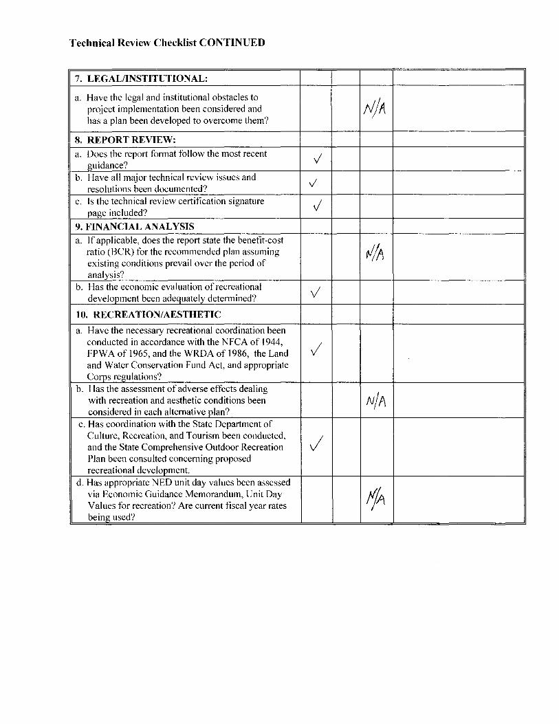
Technical Review Checklist CONTINUED
7. LEGAL/INSTITUTIONAL:
a. Have the legal and institutional obstacles to
tJjA project implementation been considered and has a plan been developed to overcome them?
8. REPORTREVIEW: I I I I
a. Does the report fonnat follow the most recent v guidance? b. Have all major technical review issues and v resolutions been documented? c. Is the technical review certification signature J
page included?
9. FINANCIAL ANALYSIS
a. If applicable, does the report state the benefit-cost
tl/A ratio (BCR) for the recommended plan assuming existing conditions prevail over the period of analysis?
b. Has the economic evaluation of recreational v development been adequately determined?
10. RECREATION/AESTHETIC
a. Have the necessary recreational coordination been conducted in accordance with the NFCA of 1944, / FPW A of 1965, and the WRDA of 1986, the Land and Water Conservation Fund Act, and appropriate Corps regulations?
b. Has the assessment of adverse effects dealing
N/A with recreation and aesthetic conditions been considered in each alternative plan?
c. Has coordination with the State Department of Culture, Recreation, and Tourism been conducted, J and the State Comprehensive Outdoor Recreation Plan been consulted concerning proposed recreational development.
d. Has appropriate NED unit day values been assessed
fjA via Economic Guidance Memorandum, Unit Day Values for recreation? Are current fiscal year rates being used?
RIVERS PROJECT MASTER PLAN
viii
LIST OF PREPARERS
This document was prepared by the Rivers Project Natural Resource Management Section of the St. Louis District, Corps of Engineers, and is the result of a team effort involving the cooperation and close coordination of many disciplines and agencies. Special thanks to the following staff members of the various state and federal agencies that participated in the writing of the Master Plan. CORPS OF ENGINEERS Rivers Project Office Sarah Miller, Master Plan PDT Leader Andrew Schimpf, Operations Manager Karen Watwood, Assistant Operations Manager Charlie Deutsch, Wildlife Biologist/Supv ES Kimberly Rea, Natural Res Spec/Supv Rec Adam Ramseyer, Engineer/Supv Facilities Katy Fechter, Biologist Chris Garcia, Natural Resource Specialist Mike Quinn, Southern Area Nav Manager Danny Lunsford, Northern Area Nav Manager Operations Division Roseana Burick, Natural Resource Specialist Project Management, Environmental Francis Walton, Outdoor Recreation Planner Real Estate Division Tim Kennedy, Realty Specialist Office of Counsel Heather Asunskis, Assistant District Counsel Public Affairs Romanda Walker, Public Affairs Specialist
RIVERS PROJECT MASTER PLAN
ix
TABLE OF CONTENTS
Preface ........................................................................................................ ii Approval Memos ...................................................................................... iii List of Preparers ...................................................................................... viii Chapter 1 - Introduction 1.1. PROJECT AUTHORIZATIONS........................................................................ 1-2
Nine Foot Navigation Channel Cache River Diversion Channel
1.2. PROJECT PURPOSES ....................................................................................... 1-3 Navigation Natural Resources Flood Risk Management Electric Generation/Hydropower
1.3. PURPOSE AND SCOPE OF THE MASTER PLAN ........................................ 1-6 1.4. UPPPER MISSISSIPPI RIVER SYSTEM WATERSHED DESCRIPTION .... 1-7
The Mississippi River Basin The Illinois River Basin
1.5. Rivers Project Description ................................................................................ 1-10 1.6. PRIOR DESIGN MEMORANDA ................................................................... 1-11 1.7. PERTINENT PROJECT INFORMATION ...................................................... 1-12 1.8. POLICY CONSIDERATIONS ........................................................................ 1-12 1.9. ENGINEERING REGULATIONS & ENGINEERING PAMPHLETS .......... 1-13 Chapter 2 - Project Setting, Factors Influencing Management, & Development 2.1. INTRODUCTION .............................................................................................. 2-1
Public Lands Public Waters Shoreline
2.2. DESCRIPTION OF NAVIGATION POOLS .................................................... 2-2 Pool 24 Pool 25 Pool 26 and Illinois River Chain of Rocks and Locks 27
2.3. RIVER HYDROLOGICAL CHARACTERISTICS .......................................... 2-5 Channel Diversions Annual River Discharge Middle Mississippi River Pooled River Navigation Pool Regulation
RIVERS PROJECT MASTER PLAN
x
2.4. REGULATING STRUCTURES (CHANNEL MAINTENANCE) ................. 2-13 Navigation Pools Environmentally Sound Navigation Structures River Training Structures Biological Impact Dredging and Dredged Material Uses
2.5. SEDIMENTATION & SHORELINE EROSION ............................................ 2-23 Erosion and Sediment Management Strategies Erosion Control Sediment Management
2.6. WATER QUALITY.......................................................................................... 2-30 Non-Point Source Pollution Point Source Pollution Environmental Spills
2.7. PROJECT ACCESS.......................................................................................... 2-31 2.8. CLIMATE AND WEATHER ........................................................................... 2-32 2.9. TOPOGRAPHY, GEOLOGY, & SOILS ......................................................... 2-33
Physiography Structural Geology Historical Geology Geomorphology Mineral Resources Soils
2.10. RESOURCE ANALYSIS (Level I and II Inventories) .................................. 2-40 Fish and Wildlife Resources Threatened & Endangered Species ESA Section 7 Consultation Covering O&M of the Nine-Foot Navigation Channel Federal Threatened and Endangered Species Illinois and Missouri Rare, Threatened, and Endangered Species Invasive Species Ecological Setting
2.11. CULTURAL RESOURCES ........................................................................... 2-73 Prehistoric Overview Historical Overview Archaeological Resources in the Rivers Project Area
2.12. DEMOGRAPHICS ......................................................................................... 2-75 Summary of Entire Region St. Louis Metropolitan Statistical Area (MSA) Populations Rivers Corridor Populations St. Louis Metropolitan Area Educational Resources Rural County School Statistics
2.13. ECONOMICS ................................................................................................. 2-82 Recreational Uses and Economic Significance on Rivers Project Lands Water Transportation Inland Waterways and the St. Louis Metropolitan Statistical Area (MSA)
RIVERS PROJECT MASTER PLAN
xi
2.14. RECREATION FACILITIES, ACTIVITIES, & NEEDS .............................. 2-89 Zone of Influence Visitation Profile Recreation Analysis Recreation Carrying Capacity Recreation Activities
2.15. REAL ESTATE ............................................................................................ 2-109 Acquisition Policy Outgrants on Public Lands Easements
2.16. PERTINENT PUBLIC LAWS ..................................................................... 2-113 Navigation Recreation Fish & Wildlife Environmental Stewardship Cultural and Historical Considerations.
Chapter 3 – Resource Objectives 3.1. GENERAL MANAGEMENT & ADMINISTRATION .................................... 3-1 3.2. ENVIRONMENTAL STEWARDSHIP ............................................................. 3-2 3.3. ENVIRONMENTAL COMPLIANCE ............................................................. 3-14 3.4. RECREATION ................................................................................................. 3-18 3.5. VISITOR ASSISTANCE.................................................................................. 3-21 3.6. INTERPRETATIVE SERVICES AND OUTREACH PROGRAM ................ 3-22 3.7. FLOOD RISK MANAGEMENT ..................................................................... 3-24 3.8. SHORELINE MANAGEMENT ...................................................................... 3-32 3.9. NAVIGATION MANAGEMENT ................................................................... 3-33 3.10. HISTORIC RESOURCES .............................................................................. 3-34 Chapter 4 - Land Allocation, Land Classification, Water Surface, and Project Easement Lands 4.1. LAND ALLOCATION ....................................................................................... 4-1 4.2. LAND USE CLASSIFICATION ....................................................................... 4-1 4.3. LAND USE CLASSIFICATION SUMMARY .................................................. 4-3 4.4. LAND AND WATER USE CHARACTERISTICS........................................... 4-7 Chapter 5 – Resource Plan 5.1. INTRODUCTION .............................................................................................. 5-1 5.2. SELECTED LAND AND WATER USE POLICIES ........................................ 5-1
RIVERS PROJECT MASTER PLAN
xii
5.3. MANAGEMENT AREA DESCRIPTIONS, ZONING & PLANS BY POOL, COMPARTMENTS & UNITS .................................................................................. 5-3
Compartment 1. Chain of Rocks Canal ......................................................... 5-3 Compartment 2. Pool 26 – Riverbend Management Area ........................... 5-21 Compartment 3. Pool 26 – Lower Alton Lake Management Area ............... 5-41 Compartment 4. Pool 26 – Upper Alton Lake Management Area ............... 5-59 Compartment 5. Pool 26 – IL & MO Confluence Area ............................... 5-66 Compartment 6. Pool 26 – Lower IL River Management Area ................... 5-70 Compartment 7. Pool 26 – Upper IL River Management Area ................... 5-85 Compartment 8. Pool 25 – IL Management Area ........................................ 5-92 Compartment 9. Pool 25 – MO Management Area ................................... 5-100 Compartment 10. Pool 24 – IL Management Area .................................... 5-109 Compartment 11. Pool 24 – MO Management Area ................................. 5-116 Compartment 12. (Reserved) Compartment 13. Open Mississippi River ................................................. 5-126 Compartment 14. Cache River Division Cannel........................................ 5-128
5.4. FACILITY AND INFRASTRUCTURE DESIGN CRITERIA ..................... 5-129 5.5. RECREATIONAL BOATING USE OF THE NAVIGATION CHANNEL AND LOCKS & DAMS .................................................................................................. 5-134 Chapter 6 - Special Topics, Planning Considerations, and Special Concerns 6.1. PARTNERSHIPS AND COORDINATION ...................................................... 6-2
Partnering Strategies and Basin-wide Coordination and Planning General Plans and Cooperative Agreements Governmental Agency Partnerships Regional Entities Partnership Roles Partnerships/Coordination with Public and Private Schools
6.2. SPECIAL TOPICS & PLANNING CONSIDERATIONS .............................. 6-11 Navigation Interface Avoid & Minimize Fleeting Project Boundary Watchable Wildlife Program
6.3. SPECIAL CONCERNS .................................................................................... 6-17 Access to Public Lands and Waters Primitive Camping Public Safety Concerns Public Confusion about Inter-Jurisdictional Management Private Exclusive Use Drainage Conflicts with Adjacent Private Lands Shoreline Protection Needs Regional Habitat Losses Middle Mississippi River Issues
RIVERS PROJECT MASTER PLAN
xiii
Inter-Jurisdictional Watershed and Ecosystem Planning Needs
Chapter 7- Agency and Public Coordination 7.1. PUBLIC OPEN HOUSE SUMMARY ............................................................... 7-1 7.2. CORPS COORDINATION & INVOLVEMENT .............................................. 7-2 7.3. FEDERAL, STATE AND LOCAL GOVERNMENT & PRIVATE SPECIAL INTEREST PARTICIPANTS ................................................................................... 7-2 7.4. SUMMARIZATION OF PUBLIC COMMENTS RECEIVED ......................... 7-4 Chapter 8 - Summary of Recommendations 8.1. GENERAL BACKGROUND ............................................................................. 8-1 8.2. IMPLEMENTATION OF THE MASTER PLAN: OPERATIONAL MANAGEMENT PLANS ....................................................................................................................... 8-1 8.3. RECOMMENDATIONS .................................................................................... 8-2 8.4. CONCLUSION ................................................................................................... 8-3 Chapter 9 - Bibliography ..................................................................... 9-1 Appendices ............................................................................................ A-1
Public Comments Received Plates (Project Maps/Conceptual Site Plans) Shoreline Management Plan & Plates National Great Rivers Museum Interpretive Master Plan
RIVERS PROJECT MASTER PLAN
xiv
LIST OF FIGURES Figure 1-1. Stairway of water created by the dams on the Upper Mississippi River and associated Corps district management (MVR website). Figure 1-2. The Upper Mississippi River System showing Lock & Dam locations (MVR website). Figure 1-3. The Mississippi River Basin shown on a United States Map (MVD website). Figure 1-4. Corps of Engineers, St. Louis District jurisdiction, with land ownership shown in red. Figure 2-1. Preglacial map of primary river systems in the Upper Midwestern United States (Source: Simons et al. 1975). Figure 2-2. Mean discharge for water years 1939 to 2012 on the Illinois River at Valley City, Illinois (USGS, 2013a). Figure 2-3. Mean discharge for water years 1987 to 2012 on the Mississippi River at Grafton, Illinois (USGS, 2013b). Figure 2-4. Mean discharge for water years 1933 to 2012 on the Mississippi River at Thebes, Illinois (USGS, 2013c). Figure 2-5. Hinge Point Control Operations during Low Flow Periods. Figure 2-6. Hinge Point Control Operations during Increasing Flow Periods. Figure 2-7. Hinge Point Control Operations during Open River Periods Caused by High Flows. Figure 2-8. Hinge Point Control Operations during Extremely High Flow Periods. Figure 2-9. Annual Sediment Yield for 100 sq. mi. Drainage Area in Tons per Sq. Mile (USACE, 2006). Figure 2-10. Estimated average annual per-acre sediment loss (MUSLE) (USDA-NRCS, 2006). Figure 2-11. Average Monthly Temperatures for St. Charles County, Missouri from January 1, 1893 to March 31, 2013 (High Plains Regional Climate Center, 2013). Figure 2-12. Schematic Cross Section of the St. Louis Area Figure 2-13. Four Common River Categories in the Upper Mississippi River (Upper Mississippi River Basin Commission, 1982). Figure 2-14. Basic Soil Position on the Floodplain. Figure 2-15. Hypothetical Floodplain Cross Section Illustration of Habitat Types Likely to Occur on the Upper Mississippi River System (Nelson, 2001). Figure 2-16. Species of Fish Found in Specific Aquatic Habitats. Figure 2-17. Comparison of the Peak abundance estimates for Mallards, dabbling ducks, diving duck total, and total ducks during falls 2010 and 2011, the average for 2006-2010 and the percent change between 2011 and periods of interest (Yetter, et al, 2012). Figure 2-18. Comparison of the peak abundance estimates for Canada Geese during falls 2010 and 2011, the average for 2006-2010 and the percent change between 2011 and periods of interest (Yetter, et al, 2012). Figure 2-19. Riverlands Migratory Bird Sanctuary. Figure 2-20. Total waterfowl species recorded during weekly waterfowl surveys taken from October to March per year at the Riverlands Migratory Bird Sanctuary.
RIVERS PROJECT MASTER PLAN
xv
Figure 2-21. Average species abundance per survey (weekly from October to March) completed 2003 to 2013 at the Riverlands Migratory Bird Sanctuary. Figure 2-22. Shorebirds in the Mid-Eastern Missouri Area. Figure 2-23. Total number of shorebird species per year at the Riverlands Migratory Bird Sanctuary from 2010 to 2012. Figure 2-24. Age Distribution as percentage of total St. Louis population in 2010 (St. Louis Commerce Magazine, 2012). Figure 2-25. Comparative Population Growth, St. Louis MSA (Rivers Project Master Plan, 2001; U.S. Census Bureau, 2010). Figure 2-26. St. Louis Population by County in 2010 (St. Louis Commerce Magazine, 2012). Figure 2-27. Educational Attainment of Persons Age 25 and Older in 2009 (St. Louis Commerce Magazine, 2011). Figure 2-28. Comparison between Public and Private Schools in 2009 (St. Louis Commerce Magazine, 2011). Figure 2-29. Percentage of Recreational Use of the Project Broken Out by Upper River, Lower River, and Illinois River Areas (Value to the Nation, 2010). Figure 2-30. St. Louis District Locks and Dams Tonnage Statistics. Figure 2-31. Number of Recreational Boats Locked Through at Each Location from 1983 to 2012. Figure 2-32. Number of Recreational Boats Locked through During each Month in 2013. Figure 2-33. Frequency of Participation (Missouri SCORP, 2013-2017). Figure 3-1. Recreation Area Use on the Mississippi and Illinois Rivers in the St. Louis District. (Value to the Nation, 2010, www.CorpsResults.us) Figure 3-2. Illinois River Levees from LaGrange, Illinois to Kampsville, Illinois. Figure 3-3. Mississippi River Levees from Ashburn, Missouri to Winfield, Missouri Area. Figure 3-4. Mississippi & Missouri River Levees – St. Louis Area. Figure 3-5. Mississippi River Levees – South St. Louis Area to Kaskaskia River Area. Figure 3-6. Mississippi River Levees – Kaskaskia River Area to Cape Girardeau Area. Figure 4-1. Percentages of Land Use Classification for Pools 24-26, Lower River (Chain of Rocks), Illinois River, and Cache River Diversion Channel. Figure 4-2. Percentages of Pool 24 Land Use Classification. Figure 4-3. Percentages of Pool 25 Land Use Classification. Figure 4-4. Percentages of Pool 26 Land Use Classification. Figure 4-5. Percentages of Illinois River Land Use Classification. Figure 4-6. Percentages of Lower River (Chain of Rocks) Land Use Classification. Figure 6-1. General Plan and Cooperative Agreement land acreages managed by USFWS, MDC, and IDNR. Figure 6-2. Cross section of the Middle Mississippi River Floodplain at MRM 46. In the presettlement era (Part A), the floodplain was covered with bottomland hardwood forests. Presently (Part B), levees and dikes restrict river meandering and most of the bottomland hardwood forests have been cleared for agriculture. Figure 6-3. Cross section of the Pooled River Floodplain at MRM 218. In the presettlement era (Part A), the floodplain was dominated by prairie wetlands. Presently

RIVERS PROJECT MASTER PLAN
xvi
(Part B), agriculture has replaced the prairies but many of the floodplain forests still remain, although less diverse in structure and number of species.
RIVERS PROJECT MASTER PLAN
xvii
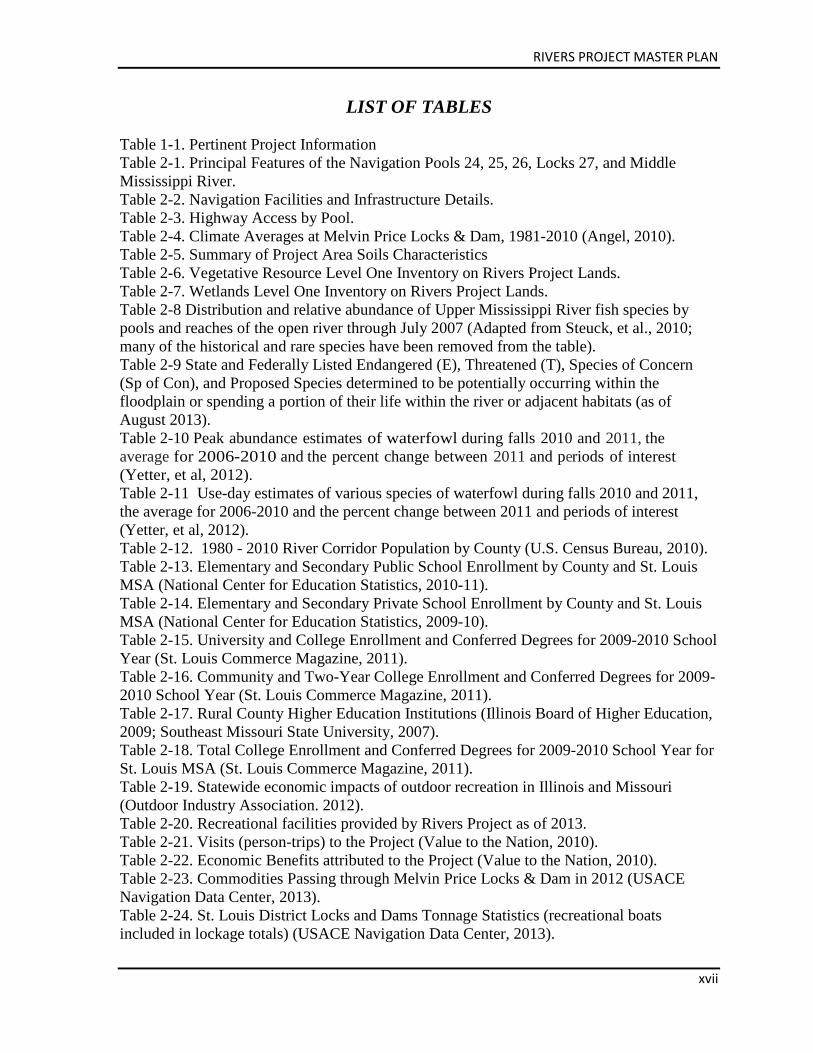
LIST OF TABLES Table 1-1. Pertinent Project Information Table 2-1. Principal Features of the Navigation Pools 24, 25, 26, Locks 27, and Middle Mississippi River. Table 2-2. Navigation Facilities and Infrastructure Details. Table 2-3. Highway Access by Pool. Table 2-4. Climate Averages at Melvin Price Locks & Dam, 1981-2010 (Angel, 2010). Table 2-5. Summary of Project Area Soils Characteristics Table 2-6. Vegetative Resource Level One Inventory on Rivers Project Lands. Table 2-7. Wetlands Level One Inventory on Rivers Project Lands. Table 2-8 Distribution and relative abundance of Upper Mississippi River fish species by pools and reaches of the open river through July 2007 (Adapted from Steuck, et al., 2010; many of the historical and rare species have been removed from the table). Table 2-9 State and Federally Listed Endangered (E), Threatened (T), Species of Concern (Sp of Con), and Proposed Species determined to be potentially occurring within the floodplain or spending a portion of their life within the river or adjacent habitats (as of August 2013). Table 2-10 Peak abundance estimates of waterfowl during falls 2010 and 2011, the average for 2006-2010 and the percent change between 2011 and periods of interest (Yetter, et al, 2012). Table 2-11 Use-day estimates of various species of waterfowl during falls 2010 and 2011, the average for 2006-2010 and the percent change between 2011 and periods of interest (Yetter, et al, 2012). Table 2-12. 1980 - 2010 River Corridor Population by County (U.S. Census Bureau, 2010). Table 2-13. Elementary and Secondary Public School Enrollment by County and St. Louis MSA (National Center for Education Statistics, 2010-11). Table 2-14. Elementary and Secondary Private School Enrollment by County and St. Louis MSA (National Center for Education Statistics, 2009-10). Table 2-15. University and College Enrollment and Conferred Degrees for 2009-2010 School Year (St. Louis Commerce Magazine, 2011). Table 2-16. Community and Two-Year College Enrollment and Conferred Degrees for 2009-2010 School Year (St. Louis Commerce Magazine, 2011). Table 2-17. Rural County Higher Education Institutions (Illinois Board of Higher Education, 2009; Southeast Missouri State University, 2007). Table 2-18. Total College Enrollment and Conferred Degrees for 2009-2010 School Year for St. Louis MSA (St. Louis Commerce Magazine, 2011). Table 2-19. Statewide economic impacts of outdoor recreation in Illinois and Missouri (Outdoor Industry Association. 2012). Table 2-20. Recreational facilities provided by Rivers Project as of 2013. Table 2-21. Visits (person-trips) to the Project (Value to the Nation, 2010). Table 2-22. Economic Benefits attributed to the Project (Value to the Nation, 2010). Table 2-23. Commodities Passing through Melvin Price Locks & Dam in 2012 (USACE Navigation Data Center, 2013). Table 2-24. St. Louis District Locks and Dams Tonnage Statistics (recreational boats included in lockage totals) (USACE Navigation Data Center, 2013).
RIVERS PROJECT MASTER PLAN
xviii
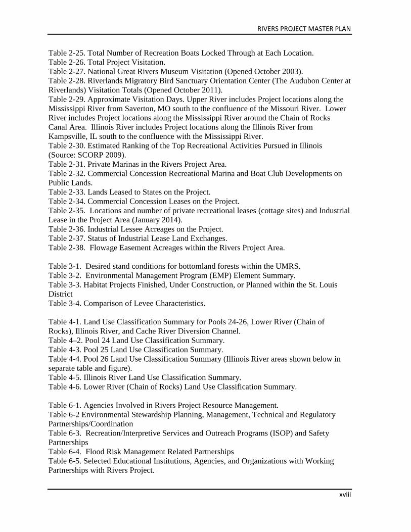
Table 2-25. Total Number of Recreation Boats Locked Through at Each Location. Table 2-26. Total Project Visitation. Table 2-27. National Great Rivers Museum Visitation (Opened October 2003). Table 2-28. Riverlands Migratory Bird Sanctuary Orientation Center (The Audubon Center at Riverlands) Visitation Totals (Opened October 2011). Table 2-29. Approximate Visitation Days. Upper River includes Project locations along the Mississippi River from Saverton, MO south to the confluence of the Missouri River. Lower River includes Project locations along the Mississippi River around the Chain of Rocks Canal Area. Illinois River includes Project locations along the Illinois River from Kampsville, IL south to the confluence with the Mississippi River. Table 2-30. Estimated Ranking of the Top Recreational Activities Pursued in Illinois (Source: SCORP 2009). Table 2-31. Private Marinas in the Rivers Project Area. Table 2-32. Commercial Concession Recreational Marina and Boat Club Developments on Public Lands. Table 2-33. Lands Leased to States on the Project. Table 2-34. Commercial Concession Leases on the Project. Table 2-35. Locations and number of private recreational leases (cottage sites) and Industrial Lease in the Project Area (January 2014). Table 2-36. Industrial Lessee Acreages on the Project. Table 2-37. Status of Industrial Lease Land Exchanges. Table 2-38. Flowage Easement Acreages within the Rivers Project Area. Table 3-1. Desired stand conditions for bottomland forests within the UMRS. Table 3-2. Environmental Management Program (EMP) Element Summary. Table 3-3. Habitat Projects Finished, Under Construction, or Planned within the St. Louis District Table 3-4. Comparison of Levee Characteristics. Table 4-1. Land Use Classification Summary for Pools 24-26, Lower River (Chain of Rocks), Illinois River, and Cache River Diversion Channel. Table 4–2. Pool 24 Land Use Classification Summary. Table 4-3. Pool 25 Land Use Classification Summary. Table 4-4. Pool 26 Land Use Classification Summary (Illinois River areas shown below in separate table and figure). Table 4-5. Illinois River Land Use Classification Summary. Table 4-6. Lower River (Chain of Rocks) Land Use Classification Summary. Table 6-1. Agencies Involved in Rivers Project Resource Management. Table 6-2 Environmental Stewardship Planning, Management, Technical and Regulatory Partnerships/Coordination Table 6-3. Recreation/Interpretive Services and Outreach Programs (ISOP) and Safety Partnerships Table 6-4. Flood Risk Management Related Partnerships Table 6-5. Selected Educational Institutions, Agencies, and Organizations with Working Partnerships with Rivers Project.
RIVERS PROJECT MASTER PLAN
xix
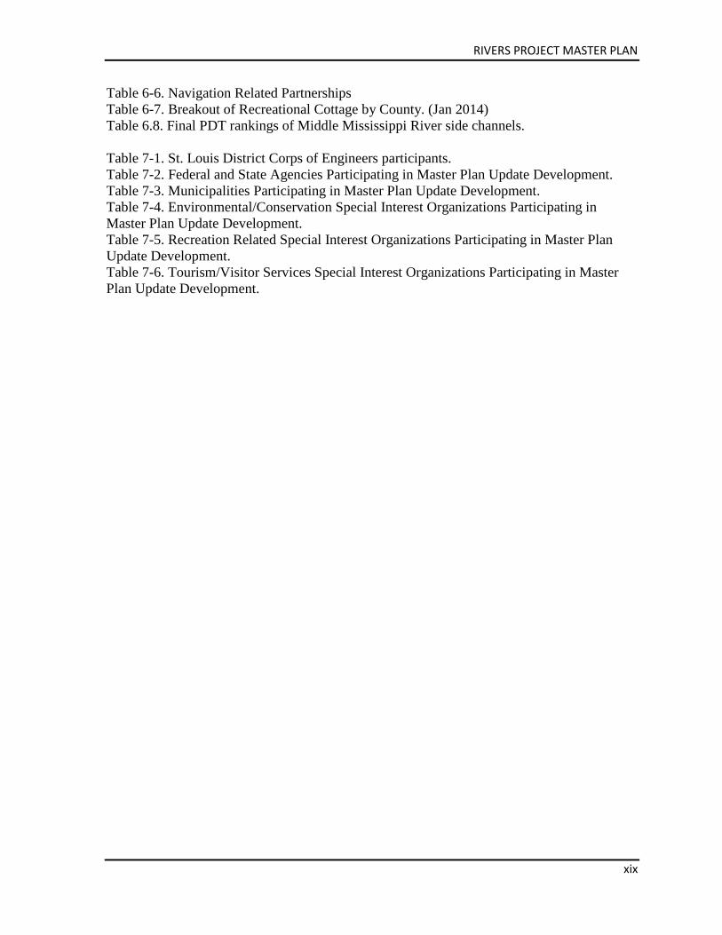
Table 6-6. Navigation Related Partnerships Table 6-7. Breakout of Recreational Cottage by County. (Jan 2014) Table 6.8. Final PDT rankings of Middle Mississippi River side channels. Table 7-1. St. Louis District Corps of Engineers participants. Table 7-2. Federal and State Agencies Participating in Master Plan Update Development. Table 7-3. Municipalities Participating in Master Plan Update Development. Table 7-4. Environmental/Conservation Special Interest Organizations Participating in Master Plan Update Development. Table 7-5. Recreation Related Special Interest Organizations Participating in Master Plan Update Development. Table 7-6. Tourism/Visitor Services Special Interest Organizations Participating in Master Plan Update Development.
RIVERS PROJECT MASTER PLAN
xx
LIST OF COMMON ACRONYMS
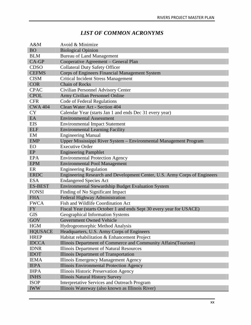
A&M Avoid & Minimize BO Biological Opinion BLM Bureau of Land Management CA-GP Cooperative Agreement – General Plan CDSO Collateral Duty Safety Officer CEFMS Corps of Engineers Financial Management System CISM Critical Incident Stress Management COR Chain of Rocks CPAC Civilian Personnel Advisory Center CPOL Army Civilian Personnel Online CFR Code of Federal Regulations CWA 404 Clean Water Act - Section 404 CY Calendar Year (starts Jan 1 and ends Dec 31 every year) EA Environmental Assessment EIS Environmental Impact Statement ELF Environmental Learning Facility EM Engineering Manual EMP Upper Mississippi River System – Environmental Management Program EO Executive Order EP Engineering Pamphlet EPA Environmental Protection Agency EPM Environmental Pool Management ER Engineering Regulation ERDC Engineering Research and Development Center, U.S. Army Corps of Engineers ESA Endangered Species Act ES-BEST Environmental Stewardship Budget Evaluation System FONSI Finding of No Significant Impact FHA Federal Highway Administration FWCA Fish and Wildlife Coordination Act FY Fiscal Year (starts October 1 and ends Sept 30 every year for USACE) GIS Geographical Information Systems GOV Government Owned Vehicle HGM Hydrogeomorphic Method Analysis HQUSACE Headquarters, U.S. Army Corps of Engineers HREP Habitat rehabilitation & Enhancement Project IDCCA Illinois Department of Commerce and Community Affairs(Tourism) IDNR Illinois Department of Natural Resources IDOT Illinois Department of Transportation IEMA Illinois Emergency Management Agency IEPA Illinois Environmental Protection Agency IHPA Illinois Historic Preservation Agency INHS Illinois Natural History Survey ISOP Interpretative Services and Outreach Program IWW Illinois Waterway (also known as Illinois River)
RIVERS PROJECT MASTER PLAN
xxi
LCCC Lewis and Clark Community College L&D or LD Lock and Dam LMRCC Lower Mississippi River Conservation Committee LTRM Long Term Resource Monitoring MDC Missouri Department of Conservation MDNR Missouri Department of Natural Resources MDOT Missouri Department of Transportation MDT Missouri Department of Tourism MESD Metro East Sanitation District (formerly the Chouteau, Nameoki and Venice
Drainage and Levee District) MMRP Middle Mississippi River Partnership MOA Memorandum of Agreement MOBOT Missouri Botanical Garden MOU Memorandum of Understanding MP Master Plan MRM Mississippi River Mile MTRF Meeting of the Rivers Foundation MVD Mississippi Valley Division, U.S. Army Corps of Engineers MVP St. Paul District, U.S. Army Corps of Engineers MVR Rock Island District, U.S. Army Corps of Engineers MVS St. Louis District, U.S. Army Corps of Engineers MWP Missouri Water Patrol NEPA National Environmental Policy Act NESP Navigation & Ecosystem Sustainability Program NGRM National Great Rivers Museum NGRREC National Great Rivers Research & Education Center NGVD National Geodetic Vertical Datum (used for elevations) NMFS National Marine Fisheries Services NPS National Park Service NRAP National Recreation Adjustment Plan NRCS Natural Resource Conservation Service NRM Natural Resource Management O&M Operations & Maintenance OMB Office of Management and Budget OMBIL Operations & Maintenance Business Information Link OMP Operational Management Plan OMRR&R Operation, Maintenance, Repair, Replacement, and Rehabilitation PDT Project Delivery Team PIR Project Implementation Report PMP Project Management Plan RAMP Recreation Area Moderation Program RIAC River Industry Action Committee REC-BEST Recreation Budget Evaluation System RHA 10 Rivers and Harbors Act - Section 10 RLAT Recreation Leadership Advisory Team RM River Mile
RIVERS PROJECT MASTER PLAN
xxii
RMBS Riverlands Migratory Bird Sanctuary (formerly Environmental Demonstration Area)
RMBSOC Riverlands Migratory Bird Sanctuary Orientation Center RPM Root Production Method (a type of nursery grown tree) RPO Rivers Project Office SAT Stewardship Advisory Team SCORP State Comprehensive Outdoor Recreation Plan SEMA State (Missouri) Emergency Management Agency SHPO State Historic Preservation Officer SOP Standard Operating Procedure TEA21 Transportation Equity Act for the 21st Century T&E Threatened & Endangered Species TAPES Total Army Performance Evaluation System TW Tailwater (refers to the waters immediately downstream from a lock & dam) UMESC Upper Midwest Environmental Science Center UMR-IWW Upper Mississippi River-Illinois Waterway UMRCC Upper Mississippi River Conservation Committee UMRS Upper Mississippi River System USACE U.S. Army Corps of Engineers USCG U.S. Coast Guard USFWS U.S. Fish & Wildlife Service, U.S. Department of Interior USGS U.S. Geological Survey, U.S. Department of Interior VERS Visitation Estimation & Reporting System WGNSS Webster Groves Nature Study Society WMA Wildlife Management Area WRDA Water Resource Development Act
RIVERS PROJECT MASTER PLAN
CHAPTER 1 - INTRODUCTION 1-1
Chapter 1 Introduction
The Rivers Project is a multi-use project within the St. Louis District of the US Army Corps of Engineers; encompassing multiple business lines and authorizations to include navigation, recreation, flood risk management and environmental stewardship. The project consists of over 380 miles of Mississippi and Illinois River navigation channel, 4 locks and dam facilities, a service base, almost 50,000 acres of public lands, over 100,000 acres of public waters and a central project office. The project office is the Rivers Project Office and the staff of the Rivers Project are responsible for prioritizing and accomplishing the operations, maintenance, and repairs of all of these project features. This Master Plan is a long-term planning document for the Rivers Project that is focused on operation and maintenance of those lands and waters as it relates to public use and natural resource management. This document does not specifically address operation and maintenance of the locks and dams, service base or the navigation channel. Although, various features of the navigation program are discussed as they relate to public use and management of natural resources. The intent of this Master Plan is to understand how historical management and decision making has led us to the current time, develop a series of goals and objectives that will address the future needs of the American public and their desire to utilize the resources of the Mississippi and Illinois rivers and layout a path forward that allows us to achieve those goals and objectives in a manner that is sustainable and sensitive to the multiple uses of these great rivers. The navigable portion of the Mississippi River is divided into three segments based on Congressional authority and the current operations of obtaining and maintaining the navigation channel: the Upper Mississippi River (from the confluence of the Missouri River to St. Anthony Falls in Minneapolis, Minnesota – sometimes also referred to herein as the pooled river), the Middle Mississippi River (from the confluence of the Ohio River to the confluence of the Missouri River), and the Lower Mississippi River (from the Gulf of Mexico to the confluence of the Ohio River). For the purposes of this plan, as it relates to the Rivers Project management, the rivers will primarily be referred to as the Upper Mississippi River and Middle Mississippi River. As those are the two primary segments that fall under the responsibility of the Rivers Project. The lower 80 miles of the Illinois River that the Rivers Project is responsible for will be referred to as the Illinois River. Further, when this document refers to the Nine-Foot Navigation Channel Project, it is using this single term to describe those portions of the projects for obtaining and maintaining a navigation channel within the St. Louis District, which includes the entire Middle Mississippi River, the lower 80 miles of the Illinois River, and the Upper Mississippi River from the confluence of the Missouri River to Locks and Dam 22.
RIVERS PROJECT MASTER PLAN
1-2 CHAPTER 1 - INTRODUCTION
1.1. PROJECT AUTHORIZATIONS Nine-Foot Navigation Channel Congress originally authorized the Corps of Engineers to start obtaining a navigation channel in the Mississippi River in 1824. Through a series of Rivers and Harbors Acts, based upon reports and surveys provided by the Chief of Engineers, Congress eventually authorized various projects to provide a nine (9) foot deep navigation channel in the Mississippi River from the Gulf of Mexico to St. Anthony Falls in Minneapolis, MN to adequately support the navigation needs of the country. For the Middle Mississippi River, in 1910 (with modifications in 1927 and 1930), Congress authorized the Corps of Engineers to use a combination of regulating works and dredging, with a goal of minimizing dredging, to obtain and maintain a navigation channel of nine feet deep. The Chain of Rocks Canal, Locks 27, and the low water rock dam at Chain of Rocks just below the Missouri River confluence were all later authorized as modifications to the Middle Mississippi River navigation channel project to address specific problem areas for navigation. For the Upper Mississippi River in the early and mid-1930’s, Congress authorized a series of pools to be created through the construction of locks and dams, and provided the Chief of Engineers the discretion to use other means in these areas to maintain the navigation channel if necessary, e.g., dredging and regulating works. Cache River Diversion Channel The Cache River Diversion Channel Project was authorized by the Flood Control Act of 1938. The project included construction of a 5,260-foot diversion channel from the point where the former channel of the Cache River intersected the Mounds and Mound City Levee to the new outlet into the Mississippi River at MRM 13. Three new railroad and highway bridges were also constructed. Land acquired for the project included 89.14 acres in fee simple and 3.63 acres in easements. The project purpose was to divert the Cache River to avoid intersecting a Corps of Engineers Memphis District levee which provided protection for the Mound City area. Construction on the $2,837,100 project was initiated in June 1940, and was ready for use in December 1950.
RIVERS PROJECT MASTER PLAN
CHAPTER 1 - INTRODUCTION 1-3
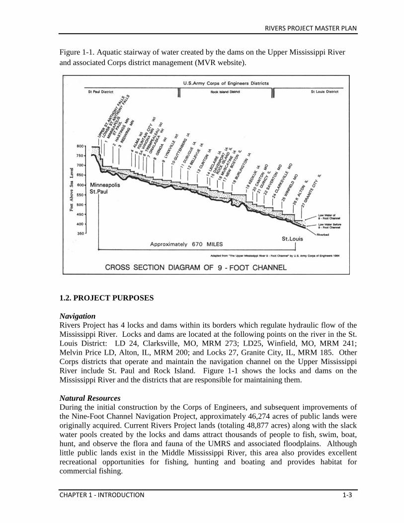
Figure 1-1. Aquatic stairway of water created by the dams on the Upper Mississippi River and associated Corps district management (MVR website).
1.2. PROJECT PURPOSES Navigation Rivers Project has 4 locks and dams within its borders which regulate hydraulic flow of the Mississippi River. Locks and dams are located at the following points on the river in the St. Louis District: LD 24, Clarksville, MO, MRM 273; LD25, Winfield, MO, MRM 241; Melvin Price LD, Alton, IL, MRM 200; and Locks 27, Granite City, IL, MRM 185. Other Corps districts that operate and maintain the navigation channel on the Upper Mississippi River include St. Paul and Rock Island. Figure 1-1 shows the locks and dams on the Mississippi River and the districts that are responsible for maintaining them. Natural Resources During the initial construction by the Corps of Engineers, and subsequent improvements of the Nine-Foot Channel Navigation Project, approximately 46,274 acres of public lands were originally acquired. Current Rivers Project lands (totaling 48,877 acres) along with the slack water pools created by the locks and dams attract thousands of people to fish, swim, boat, hunt, and observe the flora and fauna of the UMRS and associated floodplains. Although little public lands exist in the Middle Mississippi River, this area also provides excellent recreational opportunities for fishing, hunting and boating and provides habitat for commercial fishing.
RIVERS PROJECT MASTER PLAN
1-4 CHAPTER 1 - INTRODUCTION
Congress has authorized the Corps to develop recreational facilities and requires the consideration of fish and wildlife conservation at all Corps water resource projects. The Flood Control Act of 1944, as amended, authorized the Corps to construct recreational developments at its water resource projects. In 1958, the Fish and Wildlife Coordination Act (FWCA) stated that fish and wildlife conservation should receive consideration equal to that of other project purposes and should be coordinated with other features of water resource development. In accordance with these laws, environmental stewardship and recreation are now major features of the Nine-Foot Channel Navigation Project for lands along the Mississippi and Illinois Rivers. The intent of the Corps is to provide optimal sustained use and public enjoyment while protecting the Project’s natural resources. The Corps operates and maintains recreation areas and provides stewardship of the natural resources on Project lands and waters. Other federal, state, public and private institutions and individuals also provide recreation facilities and services and natural resources management outside of the Project property. In cooperation with the U.S. Fish & Wildlife Service (USFWS), Illinois Department of Natural Resources (IDNR), and Missouri Department of Conservation (MDC), 36,276 acres are made available for fish and wildlife management by General Plan and Cooperative Agreements. See Chapter 6 for additional information. The Fish and Wildlife Coordination Act of 1958 also requires that planning and project development is coordinated with the USFWS. Flood Risk Management Flooding is a natural occurrence on every river. Historically, floodwaters have enriched bottomlands and provided spawning habitats for native fish. The ecological value of maintaining connectivity between the river and its floodplain, and the flood-pulse are some of the benefits of flooding. However, human developments in the floodplains of the Midwest over the last three centuries have placed people and property at risk. Local and federal flood risk management projects, such as levee and drainage projects have been constructed to minimize the annual risk. Historically, structural programs such as levees, floodwalls, drainage, and retention reservoir projects were primarily funded, built, and operated to reduce flood damages. In recent years, federal projects have included non-structural approaches as well, like levee setbacks on Upper Mississippi River Restoration projects that increase flood storage capacity and improve habitat. Many states and local governments have developed and carried out floodplain management efforts that both reduced flood damages and enhanced the natural functions of the floodplains. Other agency efforts, such as watershed projects by the Natural Resource Conservation Service (NRCS), and land-use controls required by the National Flood Insurance Program
RIVERS PROJECT MASTER PLAN
CHAPTER 1 - INTRODUCTION 1-5
(NFIP) and state floodplain management programs, have reduced flood damages throughout the basin as well. Flood risk management is accomplished by use of levees, floodwalls and reservoirs. Levees are built and maintained by the federal government, local governments, or private sector. There are 89 levees in the St. Louis District that fall into two categories, with 47 Federal and 42 non-federal levees comprising more than 700 miles of structures. Together they protect over 578,000 acres. There are also numerous private levees within the district. Levees are categorized by their height and ability to resist flood conditions. Floodwalls are built in urban areas where there is not room for levee structures, such as in the City of St. Louis and Cape Girardeau. The Rivers Project Flood Risk Management section specifically manages: • Chain of Rocks Canal East and West Levees and sub levees with mowing, invasive plant
intrusion, animal intrusion, turf establishment, rip rap rehabilitation, repairing levees back to original specs, etc. to ensure levees maintain structural sound and stable condition during a flood event.
• Chain of Rocks Interior Drainage (ditch that runs along the interior of the East Levee), maintain five gate well/sluice gate structures through cleaning, repairing, removing debris and silt, rehabilitating the rip rap linings, etc. along the drainage ditches.
• Additional levees managed by private entities, typically in the form of levee districts, are found adjacent to or in some cases on Corps property. These levees are operated and maintained by the levee districts and in the cases where the levee is on Corps property there is real estate easement in place for that operation and maintenance. These levees are categorized as federal, non-federal and private as defined in Public Law (PL) 84-99.
Five flood control reservoirs are located on tributaries to the Mississippi River within the St. Louis District: Carlyle Lake (Kaskaskia River), Lake Shelbyville (Kaskaskia River), Rend Lake (Big Muddy), Mark Twain Lake (Salt River), and Wappapello Lake (St. Francis River). These reservoirs retain large amounts of water during flood conditions to assist in reducing flooding in the Mississippi River. Electric Generation/Hydropower
The Mississippi River is a working river that has long been used to generate power. There are currently 20 conventional hydropower projects on the Mississippi River. Eight of these dams are managed by the Corps, while the remaining twelve are owned and operated by private companies or municipalities. Recently there has been a surge in interest in new hydropower development on the Mississippi River. Some developers want to add hydropower to the river’s existing non-powered dams, while others are proposing to build projects that use new hydrokinetic technologies, typically not connected to dams (in the middle and lower portions of the Mississippi River). In 2011, the Federal Energy Regulation Commission (FERC) received 19 pre-application documents for projects on the UMRS (dam retrofits) and 74 hydrokinetic projects on the Lower Mississippi River) to assess the feasibility of developing at proposed sites (Jossi, 2011). The lock and dam projects alone are anticipated to more than double the
RIVERS PROJECT MASTER PLAN
1-6 CHAPTER 1 - INTRODUCTION
current hydropower generation, if they are actually constructed. After FERC issues a permit to a company (after review of the pre-application), the company has 36 months to investigate the project and file for a license. The permits do not authorize any construction to take place. At this time, there are proposals for hydropower development at Lock & Dam 24, Lock & Dam 25, Melvin Price Locks & Dam, as well as within the Middle Mississippi River. As of November 21, 2013, FERC has issued preliminary permits for LD 24, LD 25, and Chain of Rocks. A FERC license was issued at Mel Price in July 2005 (for additional information visit: http://www.ferc.gov/for-citizens/projectsearch/SearchProjects.aspx). The Rivers Project is responsible for full management of the Corps owned facilities and lands along the river. Any proposal to include hydropower at one of the navigation dams would require full review and concurrence from project staff. This review, at a minimum, will look at impacts and mitigation for impacts to environmental, recreation, navigation and flood risk facilities and assets. 1.3. PURPOSE AND SCOPE OF THE MASTER PLAN The primary objective of the Rivers Project Master Plan is to provide a clear, practical and balanced plan that guides future Corps personnel and partner agencies with land use decisions as well as public use development actions on the Project’s portion of the UMRS. The intent of the Master Plan is to provide a guide for effective management of the federal lands natural and cultural resources while preserving habitat and accommodating public recreational demands within the framework of a multi-use navigation project. This Master Plan, which is a comprehensive meaningful guide for future management of federal lands and waters of the Mississippi and Illinois Rivers within the St. Louis District, incorporates all of Rivers Project management areas and addresses current and future programmatic management needs. It also addresses Corps and partner agency responsibilities on the Middle Mississippi River between Locks 27 and Cairo, IL. The general objectives, scope, and format of this document follows regulations and guidelines as cited in ER 1130-2-550 and EP 1130-2-550. This Master Plan cannot resolve many broad based and long-term challenges associated with the UMRS. Examples of such challenges include artificially high amounts of sedimentation, water quality issues, balancing the growth of commercial activities, developments that are not on federal lands, and many others. However, the Corps has integrated a watershed perspective into opportunities and actions within its authority to operate and maintain the natural resource components of the UMRS. Opportunities have been explored and identified where joint-use watershed resource management efforts can be pursued to improve the efficiency and effectiveness of the Corps Civil Works Programs. Participation from federal, state and local agencies, organizations, and the local communities has been solicited to ensure that their interests are incorporated into the formulation and implementation of the effort. The Corps and other appropriate agencies may address other actions as well, in separate future studies.
RIVERS PROJECT MASTER PLAN
CHAPTER 1 - INTRODUCTION 1-7
1.4. UPPPER MISSISSIPPI RIVER SYSTEM WATERSHED DESCRIPTION The Upper Mississippi River System (UMRS), includes all the commercially navigable waterways on the Mississippi River and tributaries above Cairo, IL (Figure 1-2), with the exception of the Missouri River and its tributaries. The St. Louis District is responsible for the southern portion of the UMRS between Saverton, MO, and Cairo, IL (300 river miles); the Illinois River from LaGrange, IL to Grafton, IL (lower 80 miles); and the Kaskaskia River from Fayetteville, IL to its mouth (lower 36 miles). Commercially and ecologically, the Mississippi is one of the world’s most important rivers. On this portion of the UMRS, the Rivers Project Office manages 48,877 acres of public operational lands and maintains navigation through a series of four locks and dams, numerous channel regulating structures and by managing dredging operations on 380 miles of navigable waterway. In addition to the primary navigation purpose, the pools behind the dams provide opportunities for a broad spectrum of outdoor recreation. Each pool area and the Middle Mississippi River possess varied natural and recreation resources, often with high scenic, educational, scientific, environmental and cultural values. Protection and stewardship of these resources are major challenges for the Corps and its partners. The Mississippi River Basin The Mississippi River is one of the world’s major river systems in size, habitat diversity, and biological productivity. It is the largest and second longest river in North America, flowing 2,340 miles from its source at Lake Itasca in the Minnesota North Woods, through the mid-continental United States, the Gulf of Mexico Coastal Plain, to its subtropical Louisiana Delta (Kammerer, 1990). “Mississippi” is an Ojibwa (Chippewa) Indian word meaning ‘great river’ or ‘gathering of waters’ – an appropriate name because the river basin, or watershed, extends from the Allegheny Mountains in the eastern United States to the Rocky Mountains, including all or parts of 31 states (Figure 1-3) and two Canadian provinces. The river basin measures 1,857,840 square miles, covering about 40 percent of the United States and about one-eighth of North America. Of the world’s rivers, the Mississippi River System (which includes the Missouri River) ranks third in length, third in watershed area, and seventh in average discharge. The Mississippi River and its adjacent forests and wetlands provide important habitat for fish and wildlife and include the largest continuous system of wetland in North America. The river supports a diverse array of wetland, open-water, and floodplain habitats. Most of the river and its floodplain (defined as the adjacent, generally flat surface that is periodically inundated by floodwaters overflowing the river’s natural banks) have been altered by human development. Much of the watershed is intensively cultivated, and many tributaries deliver substantial amounts of sediment, nutrients, and pesticides into the river. Pollutants also enter the river from metropolitan and industrial areas. The navigable portion of the Mississippi River can be divided into three segments based upon Congressional authority and the current operations of obtaining and maintaining the navigation channel: the Upper Mississippi River (from the confluence of the Missouri River to St. Anthony Falls in Minneapolis, Minnesota – sometimes also referred to herein as the
RIVERS PROJECT MASTER PLAN
1-8 CHAPTER 1 - INTRODUCTION
pooled river), the Middle Mississippi River (from the confluence of the Ohio River to the confluence of the Missouri River), and the Lower Mississippi River (from the Gulf of Mexico to the confluence of the Ohio River). Figure 1-2. The Upper Mississippi River System showing Lock & Dam locations (MVR website).
Location along the main channel of the river is denoted by Mississippi River Mile (MRM), starting with MRM 0.0 at Head-of-Passes in Louisiana and proceeding 953.8 river miles upstream to the mouth of the Ohio River. Numbering of river miles starts at 0.0 again at the mouth of the Ohio and continues up the Mississippi to Lake Itasca.
RIVERS PROJECT MASTER PLAN
CHAPTER 1 - INTRODUCTION 1-9
Figure 1-3. The Mississippi River Basin shown on a United States Map (MVD website).
The Mississippi River is a major source of surface water supplies for communities along the river. The water resources serve many needs. According to Upper Mississippi River Basin Association (http://www.umrba.org/facts.htm):
• Over 7 billion gallons of water are withdrawn from surface water sources each day in the 60 counties that border the navigable Upper Mississippi River. Over 80 percent of this water is used as cooling water for energy production and thus returned to rivers and streams.
• There are 29 power plants that use water from the 1,300 mile long Upper Mississippi River.
• From St. Cloud, Minnesota in the north to Cape Girardeau, Missouri in the south, the Upper Mississippi River provides water to 23 public water suppliers serving a combined population of approximately 2.8 million people.
• Approximately 278 facilities discharge wastewater to the Upper Mississippi River, including industrial facilities and municipal sewage treatment plants.
The Illinois River Basin The Illinois River Basin is a part of the Upper Mississippi River Basin. It is of vital importance to the State of Illinois. It covers 44 percent of the state and is home to 90 percent of the population. The Illinois River is the link between the Mississippi River and the Great Lakes. The total drainage area of the watershed is 28,906 square miles. “The Illinois River watershed recently has become a focus of state and federal agencies and other organizations interested in integrated watershed management. As a result, issues being discussed at the watershed scale are related to habitat restoration, floodplain management, erosion and
RIVERS PROJECT MASTER PLAN
1-10 CHAPTER 1 - INTRODUCTION
sedimentation, and water quality...” (http://www.isws.illinois.edu/iswsdocs/maps/ISWSMS2003-01.pdf) Figure 1-4. Corps of Engineers, St. Louis District jurisdiction, with land ownership shown in red.
1.5. RIVERS PROJECT OFFICE MANAGEMENT DESCRIPTION In 1988, the St. Louis District established the Riverlands Area Office to manage the natural resources on the federal lands and waters associated with Mississippi River Navigation Pools 24, 25, 26 and Locks 27. The establishment of Rivers Project in 1994 expanded responsibility to include navigation and flood risk management. Today, Rivers Project manages the multi-purpose use of these federal lands and waters. Overall, Rivers Project manages 380 miles of navigation channels on the Mississippi and Illinois Rivers and provides environmental stewardship, recreation, interpretive services, education and outreach, and visitor assistance for 48,877 acres of Project lands. The Rivers Project Office is the administrative office for Rivers Project and is located at West Alton, MO. Project-specific administration and maintenance facilities are located at each navigation facility. The Project also owns and operates the National Great Rivers
RIVERS PROJECT MASTER PLAN
CHAPTER 1 - INTRODUCTION 1-11
Museum, which is located adjacent to the Melvin Price Locks & Dam in Alton, IL. The Project Service Base is located at the foot of Arsenal Street in downtown St. Louis, MO within the Port of St. Louis. The Project manager and staff are responsible for all aspects of operations, maintenance and administration of all river navigation and water resource development projects and their natural, cultural, and recreational resources. The natural resource staff is responsible for natural resource management, outdoor recreation, administering service contracts, health and safety of visitors, visitor assistance, boundary surveys and marking, working with other federal and state and local agencies and informing the public of Corps activities. Navigation personnel are responsible for locking through of river vessels and maintenance/repairs of locks and dams structures. Navigation maintenance staff and contract personnel are responsible for maintaining and servicing all hydraulic structures, painting, repair of facilities, and maintenance of trails and recreation facilities. 1.6. PRIOR DESIGN MEMORANDA The original Rivers Project Master Plan, Design Memorandum No. 3, was approved July 2001. Prior to the development of the Rivers Project Office in 1994 previous master plans had been separately developed for each navigation pool under the header of Design Memorandum No. 3. The first master plan for Pool 26 was completed in September 1961, Pool 25 was completed in January 1962 and Pool 24 was completed in October 1961. All three Pool master plans were updated simultaneously in 1977 and then combined as one complete Rivers Project Master Plan in July 2001. Since 2001, there have been a total of three supplements and one revised supplement submitted requesting changes or additions to the original document. The following paragraphs present a chronological listing of supplements approved subsequent to the original Master Plan. Supplement No. 1 was approved on 2 February 2004. This supplement proposed the sitting and development by others of a National Great Rivers Research and Education Center (NGRREC) and Center for American Archeology (CAMM) on the Illinois Esplanade; an Administration and Maintenance Facility for the MDNR at the former resident office site on the Missouri spur dike; designation of the Maple Island Ecological Area as an environmental research area associated with the NGRREC; and relocation and replacement of the lock overlook and visitor restrooms to meet UFAS and ADA requirements in the Lock and Dam 24 Operations Area. Supplement No. 2 was approved on 19 August 2005. This supplement changed the name of the Riverlands Environmental Demonstration Area (REDA) to the Riverlands Migratory Bird Sanctuary (RMBS). The purpose was to establish a name that would be easily identified by the public and partners as well as signifies the regional importance of the area to migratory birds. Supplement No. 3 was approved on 30 June 2009. This supplement clarified and detailed the proposal for an orientation center at the Riverlands Migratory Bird Sanctuary (RMBS) as
RIVERS PROJECT MASTER PLAN
1-12 CHAPTER 1 - INTRODUCTION
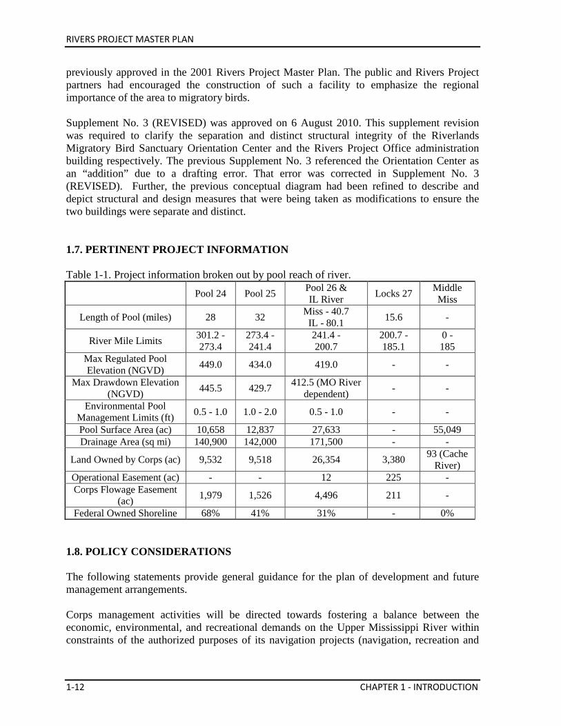
previously approved in the 2001 Rivers Project Master Plan. The public and Rivers Project partners had encouraged the construction of such a facility to emphasize the regional importance of the area to migratory birds. Supplement No. 3 (REVISED) was approved on 6 August 2010. This supplement revision was required to clarify the separation and distinct structural integrity of the Riverlands Migratory Bird Sanctuary Orientation Center and the Rivers Project Office administration building respectively. The previous Supplement No. 3 referenced the Orientation Center as an “addition” due to a drafting error. That error was corrected in Supplement No. 3 (REVISED). Further, the previous conceptual diagram had been refined to describe and depict structural and design measures that were being taken as modifications to ensure the two buildings were separate and distinct. 1.7. PERTINENT PROJECT INFORMATION Table 1-1. Project information broken out by pool reach of river.
Pool 24 Pool 25 Pool 26 & IL River Locks 27 Middle
Miss
Length of Pool (miles) 28 32 Miss - 40.7 IL - 80.1 15.6 -
River Mile Limits 301.2 - 273.4
273.4 - 241.4
241.4 - 200.7
200.7 - 185.1
0 - 185
Max Regulated Pool Elevation (NGVD) 449.0 434.0 419.0 - -
Max Drawdown Elevation (NGVD) 445.5 429.7 412.5 (MO River
dependent) - -
Environmental Pool Management Limits (ft) 0.5 - 1.0 1.0 - 2.0 0.5 - 1.0 - -
Pool Surface Area (ac) 10,658 12,837 27,633 - 55,049 Drainage Area (sq mi) 140,900 142,000 171,500 - -
Land Owned by Corps (ac) 9,532 9,518 26,354 3,380 93 (Cache River)
Operational Easement (ac) - - 12 225 - Corps Flowage Easement
(ac) 1,979 1,526 4,496 211 -
Federal Owned Shoreline 68% 41% 31% - 0% 1.8. POLICY CONSIDERATIONS The following statements provide general guidance for the plan of development and future management arrangements. Corps management activities will be directed towards fostering a balance between the economic, environmental, and recreational demands on the Upper Mississippi River within constraints of the authorized purposes of its navigation projects (navigation, recreation and
RIVERS PROJECT MASTER PLAN
CHAPTER 1 - INTRODUCTION 1-13
fish and wildlife). These activities also recognize the multi-use, multi-purpose character of the resource as well as the national importance of the river for its ecological value. A portion of the land parcels purchased by the federal government along the river are submerged (below normal pool levels) as a result of construction and operation of the navigation project. To the degree possible, these submerged lands will be treated in a manner consistent with adjacent land-use classification designations. Private exclusive use, the use and occupancy, over an extended period of time of individually owned permanent structures, is prohibited at the navigational pools in this region, because the project resources are required for the benefit of the general public in the foreseeable future. Use and development of project lands will be in accordance with the MVD Regional Plan concerning Private Exclusive Use and Navigational Pool Projects. The Corps and USFWS recognize the need for jointly planned and fully coordinated actions on federal lands covered under the long term Cooperative Agreement. This Master Plan will outline further joint action. The resource plan (Chapter 5), in accordance with the Cooperative Agreement, promotes more efficient operation of the project. Management programs established by the St. Louis District for lands and waters under its jurisdiction will be consistent with the following established environmental objectives for the Corps: (1) To preserve unique and important ecological, aesthetic, and cultural aspects of our national heritage; (2) to conserve and use wisely the natural resources of our Nation for the benefit of present and future generations; (3) to enhance, maintain, and restore the natural and constructed environment in terms of its productivity, variety, spaciousness, beauty, and other measures of quality; and (4) to create new opportunities for Project visitors to use and enjoy their environment. 1.9. ENGINEERING REGULATIONS AND ENGINEERING PAMPHLETS The following Corps engineering regulations (ERs) and pamphlets (EPs) govern activities on Rivers Project lands: ER 405-1-12, 20 November 1985, Change 15 May 2000 - Real Estate Handbook ER 1105-2-100, 22 April 2000, updated 20 November 2007 - Policy and Planning: Planning Guidance This regulation describes the types of Army Civil Works planning programs and studies, the various purposes served by water resource projects, principle guidelines and procedures for formulating and evaluating water resource plans, and the Washington-level review process. ER 1110-2-400, 1988 - Design of Recreation Sites, Areas, and Facilities This regulation provides information and criteria related to planning and design of recreation facilities at water resource projects.
RIVERS PROJECT MASTER PLAN
1-14 CHAPTER 1 - INTRODUCTION
EM 1110-1-400, 01 November 2004 - Engineering and Design - Recreation Facility and Customer Services Standards This regulation provides guidance compiled from experience and research for use in the planning and design of recreation areas, sites and facilities. ER 1110-2-400, 31 May 1988 - Engineering and Design, Design of Recreation Sites, Areas, and Facilities This regulation establishes policy and guidance for the design of recreation sites, areas and facilities. ER 1130-2-406, 31 October 1990 - Shoreline Management at Civil Works Projects The purpose of this regulation is to provide policy and guidance on management of shorelines of Civil Works projects where 36 CFR Part 327 is applicable. ER 1130-2-500, 27 December 1996, Change 01 June 2006 - Partners and Support (Work Management Policies) This regulation establishes the policy for the management of operations and maintenance (O&M) activities of Corps personnel performing civil works functions related to navigation, dredging, environmental stewardship, and recreation services at water resource projects. Programs described include Cooperating Associations, Volunteer, Contributions and Challenge Cost-sharing among others. EP 1130-2-500, 27 December 1996 - Partners and Support (Work Management Guidance and Procedures) This Operations and Maintenance (O&M) pamphlet establishes guidance and procedures for the management of activities at Corps water resource development projects and supplements ER 1130-2-500. ER 1130-2-520, 29 November 1996 - Navigation and Dredging Operations and Maintenance Policies This regulation establishes the policy for District Commanders to “operate and maintain jetties, groins, and breakwaters for their functions as navigation aids and shoreline protection structures in a manner that does not enhance or encourage recreational or other public use unless a non-Federal entity has sponsored recreation.” ER 1130-2-530, 30 October 1996 - Flood Control Operations and Maintenance Policies This regulation, in addition to ER 1130-2-500, established the policy for O&M of Corps flood control and related structures at civil works water resource projects and of Corps-built flood protection projects operated and maintained by non-federal sponsors.
RIVERS PROJECT MASTER PLAN
CHAPTER 1 - INTRODUCTION 1-15
ER 1130-2-540, 15 November 1996, updated 11 August 2008 - Environmental Stewardship Operations and Maintenance Policies This regulation establishes the policy for the management of O&M activities of the Corps personnel performing civil works functions related to flood control, navigation, dredging, hydroelectric power generation, environmental stewardship, and recreation services at water resource, waterway, and other Corps projects. EP 1130-2-540, 15 November 1996, revised 11 August 2008 - Environmental Stewardship Operations and Maintenance Guidance Procedures This pamphlet establishes guidance for the management of environmental stewardship related O&M activities at Corps civil works water resource projects and supplements ER 1130-2-540, Environmental Stewardship Operations and Maintenance Policies. ER 1130-2-550, 15 November 1996, revised 30 Jan 2013 - Recreation Operating and Maintenance Policies This regulation establishes the policy for the management of recreation programs and activities, and for the operation and maintenance of Corps recreation facilities and related structures and civil works resource projects. EP 1130-2-550, 15 November 1996, revised 30 Jan 2013 - Recreation Operations and Maintenance Guidance and Procedures This pamphlet establishes guidance for the management of recreation programs and activities and for O&M of Corps recreation facilities and related structures, at civil works water resource projects and supplements ER 1130-2-510, Recreation Operations and Maintenance Policies. EP 1165-2-1, 30 July 1999 - Digest of Water Resources Policies and Authorities This pamphlet establishes guidance for the management of Flood Risk Management (formerly known as Flood Damage Reduction). ER 1165-2-27, 18 August 1989 - Establishment of Wetlands Areas in Connection with Dredging This regulation provides guidance for the establishment of wetlands areas in connection with dredging required as part of water resource development projects.
RIVERS PROJECT MASTER PLAN
1-16 CHAPTER 1 - INTRODUCTION
ER 1165-2-400, 9 August 1985 - Water Resource Policies and Authorities: Recreation Planning, Development and Management Policies This regulation defines objectives and policies governing planning, development and management of outdoor recreational resources, plus enhancement of fish and wildlife at Corps water resource projects. ER 200-2-3, Environmental Quality - Environmental Compliance Policies, 30 October 1996, revised 29 October 2010 This regulation established the policy for the management of environmental compliance related O&M activities at Corps civil works and military projects and facilities.
RIVERS PROJECT MASTER PLAN
CHAPTER 2 - PROJECT SETTING, FACTORS INFLUENCING MANAGEMENT, & DEVELOPMENT 2-1
Chapter 2 Project Setting, Factors Influencing Management, & Development
2.1. INTRODUCTION Public Lands The St. Louis District within the navigation impoundments of the Mississippi and Illinois Rivers administers 48,877 acres of public owned lands. These are primarily confined to the low-lying areas of the floodplain along the banks of the pools and some islands. The U.S. Fish & Wildlife Service (USFWS), Illinois Department of Natural Resources (IDNR), and Missouri Department of Conservation (MDC) partner with the Corps to manage significant portions of these lands for conservation, maintenance and management of fish and wildlife under a General Plan and Cooperative Agreement. Except for the Cache River Diversion Channel, there is no Rivers Project managed public lands on the Middle Mississippi River below Locks 27, although the water in this area is considered project waters. Public Waters Navigational Servitude is defined by 33 CFR Ch. II, Part 329 as the “constitutional power given to the federal government to regulate navigable waters” for the purposes of improving and regulating navigation. It includes submerged lands and water flowing over them and also pertains to all lands below the ordinary high water mark of a navigable river. Servitude is a concept of power, not of property and expresses the notion that the right of the public to use a waterway supersedes any claim of private ownership. The Rivers Project within the navigation impoundments of the Mississippi and Illinois Rivers has jurisdiction over 51,128 acres of Project waters. The Middle Mississippi River (Open River) contributes an additional 55,049 acres of jurisdictional Project waters. Shoreline Shoreline areas and islands under federal fee ownership provide numerous recreational opportunities available on the navigation pools and open river. Public use areas exist at present locations because they adjoin a public road network making access feasible and economical. Other Project shoreline lands with characteristics desirable for the development of public access cannot be utilized because of privately owned land that intervenes between the Project shoreline and the public road system. In some cases, shoreline lands are so far removed from the existing public road network that the provision of access roads to the Project lands would be costly to build, operate and maintain. Some of the shoreline acres have only flowage easement rights purchased by the Government during the original acquisition, which restrict certain private use and development activities. Federal ownership of shoreline on the navigation pools varies between 31 percent (Pool 26) and 68 percent (Pool 24).
RIVERS PROJECT MASTER PLAN
2-2 CHAPTER 2 - PROJECT SETTING, FACTORS INFLUENCING MANAGEMENT, & DEVELOPMENT
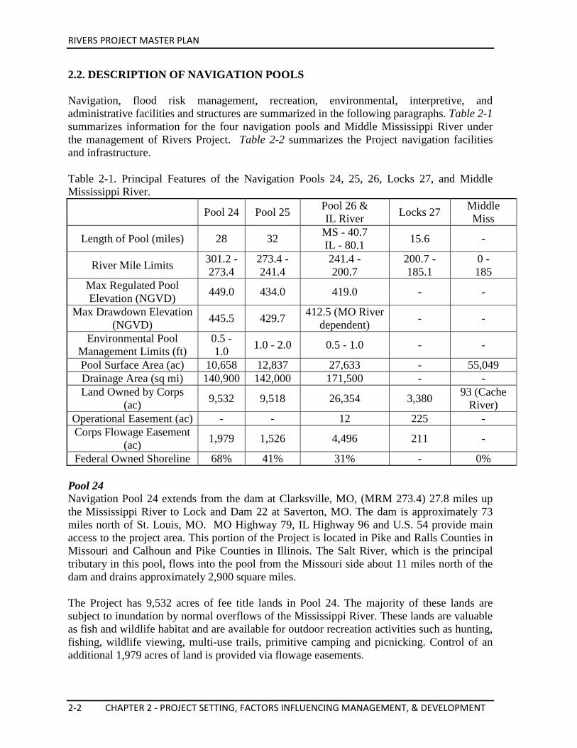
2.2. DESCRIPTION OF NAVIGATION POOLS Navigation, flood risk management, recreation, environmental, interpretive, and administrative facilities and structures are summarized in the following paragraphs. Table 2-1 summarizes information for the four navigation pools and Middle Mississippi River under the management of Rivers Project. Table 2-2 summarizes the Project navigation facilities and infrastructure. Table 2-1. Principal Features of the Navigation Pools 24, 25, 26, Locks 27, and Middle Mississippi River.
Pool 24 Pool 25 Pool 26 & IL River Locks 27 Middle
Miss
Length of Pool (miles) 28 32 MS - 40.7 IL - 80.1 15.6 -
River Mile Limits 301.2 - 273.4
273.4 - 241.4
241.4 - 200.7
200.7 - 185.1
0 - 185
Max Regulated Pool Elevation (NGVD) 449.0 434.0 419.0 - -
Max Drawdown Elevation (NGVD) 445.5 429.7 412.5 (MO River
dependent) - -
Environmental Pool Management Limits (ft)
0.5 - 1.0 1.0 - 2.0 0.5 - 1.0 - -
Pool Surface Area (ac) 10,658 12,837 27,633 - 55,049 Drainage Area (sq mi) 140,900 142,000 171,500 - - Land Owned by Corps
(ac) 9,532 9,518 26,354 3,380 93 (Cache River)
Operational Easement (ac) - - 12 225 - Corps Flowage Easement
(ac) 1,979 1,526 4,496 211 -
Federal Owned Shoreline 68% 41% 31% - 0% Pool 24 Navigation Pool 24 extends from the dam at Clarksville, MO, (MRM 273.4) 27.8 miles up the Mississippi River to Lock and Dam 22 at Saverton, MO. The dam is approximately 73 miles north of St. Louis, MO. MO Highway 79, IL Highway 96 and U.S. 54 provide main access to the project area. This portion of the Project is located in Pike and Ralls Counties in Missouri and Calhoun and Pike Counties in Illinois. The Salt River, which is the principal tributary in this pool, flows into the pool from the Missouri side about 11 miles north of the dam and drains approximately 2,900 square miles. The Project has 9,532 acres of fee title lands in Pool 24. The majority of these lands are subject to inundation by normal overflows of the Mississippi River. These lands are valuable as fish and wildlife habitat and are available for outdoor recreation activities such as hunting, fishing, wildlife viewing, multi-use trails, primitive camping and picnicking. Control of an additional 1,979 acres of land is provided via flowage easements.
RIVERS PROJECT MASTER PLAN
CHAPTER 2 - PROJECT SETTING, FACTORS INFLUENCING MANAGEMENT, & DEVELOPMENT 2-3
The pool has a water surface area of 10,658 acres and a maximum regulated pool elevation 449.0 NGVD (National Geodetic Vertical Datum). There are 146 shoreline miles (including island shorelines) along the pool, of which 100 miles (including island shorelines) or 68 percent is in Corps fee ownership. Pool 25 Pool 25 extends from the dam at Winfield, MO, (MRM 241.4) 32 miles up the Mississippi River to Lock and Dam 24 at Clarksville, MO. The dam is approximately 45 miles north of St. Louis, MO. MO Highway 79 and IL Highway 100 provides main access to the project area. This portion of the Project is located in Pike and Lincoln Counties in Missouri, and Calhoun County in Illinois. The Sny River, which drains about 750 square miles, is the principal tributary. It flows into the pool from the Illinois side about 20 miles north of the dam. The Project has 9,518 acres of fee title lands in Navigation Pool 25. The majority of these lands are subject to inundation by normal overflows of the Mississippi River. These lands are valuable as fish and wildlife habitat and are available for outdoor recreation activities such as hunting, fishing, wildlife viewing, multi-trail use, primitive camping and picnicking. Control of an additional 1,526 acres of land is provided via flowage easements. The pool has a water surface area of 12,837 acres and a maximum regulated pool elevation 434.0 NGVD. There are 181 shoreline miles (including island shorelines) along the pool, of which 74 miles (including island shorelines) or 41 percent is in Corps fee ownership. Pool 26 and Illinois River Pool 26 extends from Melvin Price Locks and Dam (replacement for Locks and Dam 26) at Alton, IL (MRM 200.5), 40.6 miles up the Mississippi River to Lock and Dam 25 at Winfield, MO, and up the Illinois River from its mouth at Grafton, IL to the LaGrange Lock and Dam, 80.1 miles upstream. The Melvin Price Locks and Dam is approximately 17 miles north of St. Louis, MO. Interstates 70, 270 and 255; US 67 (MO); MO Highways 79 and 94, and IL Highways 3, 111, 140, 143, and 100 provides main access to the project area. This portion of the Project is located in St. Charles and Lincoln Counties in Missouri, and Madison, Jersey, Calhoun, Green, Pike and Scott Counties in Illinois. The principal tributary on the Mississippi River section of the pool is the Cuivre River, which enters the river from the Missouri side about 38 miles north of the dam and drains an area of about 1,230 square miles. Macoupin Creek is the main tributary on the Illinois River segment of the pool. It enters the river from the Jersey County side about 23 miles north of Grafton, IL. Macoupin Creek has a drainage area of about 947 square miles. The Project has 15,875 acres of fee title land along the Illinois River and 10,479 acres along the Mississippi River in Pool 26. Of those lands, 621 acres are mitigation lands at Horseshoe Lake in Madison County, IL, and 950 acres are mitigation lands on Cuivre Island in St. Charles and Lincoln Counties, MO (MRM 233-239). The majority of these lands are subject
RIVERS PROJECT MASTER PLAN
2-4 CHAPTER 2 - PROJECT SETTING, FACTORS INFLUENCING MANAGEMENT, & DEVELOPMENT
to inundation by normal overflows of the Mississippi and Illinois Rivers. These lands are valuable as fish and wildlife habitat and are available for outdoor recreation activities such as hunting, fishing, wildlife viewing, multi-trail use, primitive camping and picnicking. Control of an additional 4,496 acres of land is provided by easements. Pool 26 has a water surface area of approximately 27,633 acres (18,776 acres on Mississippi River water and 8,857 acres on the Illinois River). The pool has a maximum regulated elevation of 419.0 feet. There are 238 shoreline miles (including island shorelines) along the Mississippi River from the Missouri River Confluence to Lock & Dam 25 of which 73 miles (including island shorelines) or about 31 percent is in Corps fee ownership. There are 193 shoreline miles (including island shorelines) along the Illinois River from the Mississippi River Confluence to the La Grange Lock & Dam of which 56 miles (including island shorelines) or about 29 percent in Corps fee ownership. Additional areas have flowage easement rights purchased by the Corps during the original acquisition, which restricts certain private use and development activities. Chain of Rocks Canal and Locks 27 The Chain of Rocks Canal includes a lateral canal on the left bank (Illinois side) of the Mississippi River between MRM 185.1 and MRM 194.5 with a 1,200-foot main and a 600-foot auxiliary lock at the downstream end of the canal, due west of Granite City, IL. Included as part of the Mississippi River Nine-Foot Channel Project, this project was designed to bypass a dangerous reach of the Mississippi River in which rock ledges, excessive velocities, and shallow navigation depths constituted hazards to navigation. Project lands total 3,380 acres. The majority of these lands are protected from the Mississippi River flood waters by levee systems. These lands are valuable as wildlife habitat and are available for outdoor recreation activities such as hunting, fishing, wildlife viewing, multi-trail use, primitive camping and picnicking. Control of an additional 211 acres is provided by flowage easements. Upon completion of the Chain of Rocks Canal and Locks 27, the problem of the rock ledge in the river at MRM 190.3 on the Mississippi River was eliminated. However, occasional low flows resulted in less than nine-foot project depth over the lower concrete sills at the locks at Alton. To alleviate this problem, a low water rock-fill dam was constructed across the river. Dam construction started in fiscal year 1959. The dam is located at MRM 190.3 and is built to an elevation which ensured a minimum of ten feet of water over the lower sills at Locks and Dam 26, thus eliminating the low flow navigation difficulties at that location. The project was placed in operation in November 1962 and is still required today for Melvin Price Locks and Dam operation. Levees were constructed on each side of the canal, the west canal levee affording protection to the Chouteau Island Drainage and Levee District, and the east canal levee forming a component part of the riverfront levee system of the Metro East Levee Protection system which protects the valuable industrial area adjacent to East St. Louis, IL. Federal operations
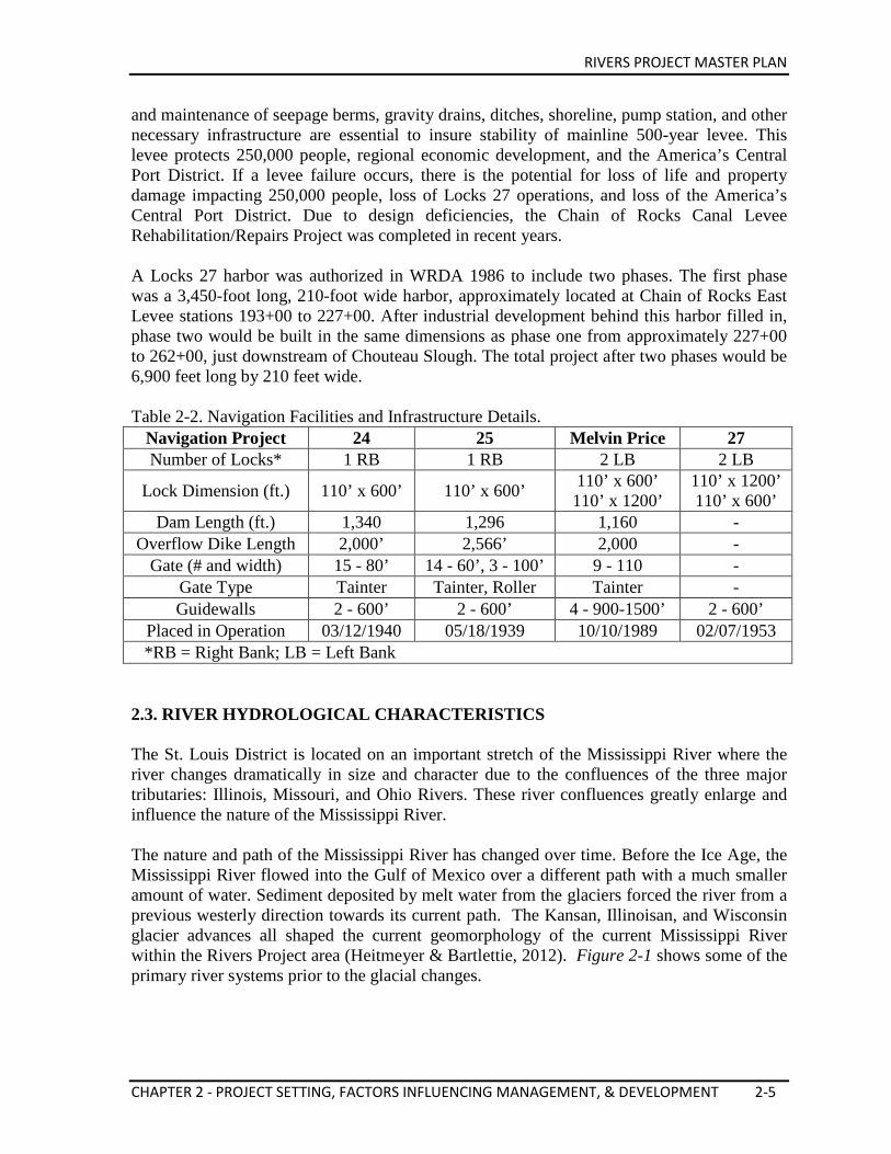
RIVERS PROJECT MASTER PLAN
CHAPTER 2 - PROJECT SETTING, FACTORS INFLUENCING MANAGEMENT, & DEVELOPMENT 2-5
and maintenance of seepage berms, gravity drains, ditches, shoreline, pump station, and other necessary infrastructure are essential to insure stability of mainline 500-year levee. This levee protects 250,000 people, regional economic development, and the America’s Central Port District. If a levee failure occurs, there is the potential for loss of life and property damage impacting 250,000 people, loss of Locks 27 operations, and loss of the America’s Central Port District. Due to design deficiencies, the Chain of Rocks Canal Levee Rehabilitation/Repairs Project was completed in recent years. A Locks 27 harbor was authorized in WRDA 1986 to include two phases. The first phase was a 3,450-foot long, 210-foot wide harbor, approximately located at Chain of Rocks East Levee stations 193+00 to 227+00. After industrial development behind this harbor filled in, phase two would be built in the same dimensions as phase one from approximately 227+00 to 262+00, just downstream of Chouteau Slough. The total project after two phases would be 6,900 feet long by 210 feet wide. Table 2-2. Navigation Facilities and Infrastructure Details.
Navigation Project 24 25 Melvin Price 27 Number of Locks* 1 RB 1 RB 2 LB 2 LB
Lock Dimension (ft.) 110’ x 600’ 110’ x 600’ 110’ x 600’ 110’ x 1200’
110’ x 1200’ 110’ x 600’
Dam Length (ft.) 1,340 1,296 1,160 - Overflow Dike Length 2,000’ 2,566’ 2,000 -
Gate (# and width) 15 - 80’ 14 - 60’, 3 - 100’ 9 - 110 - Gate Type Tainter Tainter, Roller Tainter - Guidewalls 2 - 600’ 2 - 600’ 4 - 900-1500’ 2 - 600’
Placed in Operation 03/12/1940 05/18/1939 10/10/1989 02/07/1953 *RB = Right Bank; LB = Left Bank 2.3. RIVER HYDROLOGICAL CHARACTERISTICS The St. Louis District is located on an important stretch of the Mississippi River where the river changes dramatically in size and character due to the confluences of the three major tributaries: Illinois, Missouri, and Ohio Rivers. These river confluences greatly enlarge and influence the nature of the Mississippi River. The nature and path of the Mississippi River has changed over time. Before the Ice Age, the Mississippi River flowed into the Gulf of Mexico over a different path with a much smaller amount of water. Sediment deposited by melt water from the glaciers forced the river from a previous westerly direction towards its current path. The Kansan, Illinoisan, and Wisconsin glacier advances all shaped the current geomorphology of the current Mississippi River within the Rivers Project area (Heitmeyer & Bartlettie, 2012). Figure 2-1 shows some of the primary river systems prior to the glacial changes.
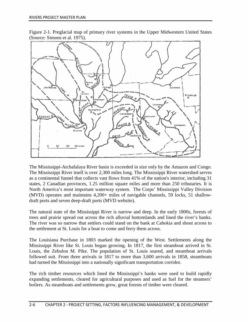
RIVERS PROJECT MASTER PLAN
2-6 CHAPTER 2 - PROJECT SETTING, FACTORS INFLUENCING MANAGEMENT, & DEVELOPMENT
Figure 2-1. Preglacial map of primary river systems in the Upper Midwestern United States (Source: Simons et al. 1975).
The Mississippi-Atchafalaya River basin is exceeded in size only by the Amazon and Congo. The Mississippi River itself is over 2,300 miles long. The Mississippi River watershed serves as a continental funnel that collects vast flows from 41% of the nation's interior, including 31 states, 2 Canadian provinces, 1.25 million square miles and more than 250 tributaries. It is North America’s most important waterway system. The Corps’ Mississippi Valley Division (MVD) operates and maintains 4,200+ miles of navigable channels, 59 locks, 51 shallow-draft ports and seven deep-draft ports (MVD website). The natural state of the Mississippi River is narrow and deep. In the early 1800s, forests of trees and prairie spread out across the rich alluvial bottomlands and lined the river’s banks. The river was so narrow that settlers could stand on the bank at Cahokia and shout across to the settlement at St. Louis for a boat to come and ferry them across. The Louisiana Purchase in 1803 marked the opening of the West. Settlements along the Mississippi River like St. Louis began growing. In 1817, the first steamboat arrived in St. Louis, the Zebulon M. Pike. The population of St. Louis soared, and steamboat arrivals followed suit. From three arrivals in 1817 to more than 3,600 arrivals in 1858, steamboats had turned the Mississippi into a nationally significant transportation corridor. The rich timber resources which lined the Mississippi’s banks were used to build rapidly expanding settlements, cleared for agricultural purposes and used as fuel for the steamers’ boilers. As steamboats and settlements grew, great forests of timber were cleared.
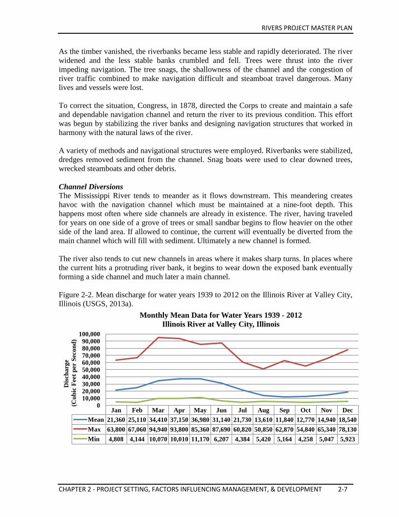
RIVERS PROJECT MASTER PLAN
CHAPTER 2 - PROJECT SETTING, FACTORS INFLUENCING MANAGEMENT, & DEVELOPMENT 2-7
As the timber vanished, the riverbanks became less stable and rapidly deteriorated. The river widened and the less stable banks crumbled and fell. Trees were thrust into the river impeding navigation. The tree snags, the shallowness of the channel and the congestion of river traffic combined to make navigation difficult and steamboat travel dangerous. Many lives and vessels were lost. To correct the situation, Congress, in 1878, directed the Corps to create and maintain a safe and dependable navigation channel and return the river to its previous condition. This effort was begun by stabilizing the river banks and designing navigation structures that worked in harmony with the natural laws of the river. A variety of methods and navigational structures were employed. Riverbanks were stabilized, dredges removed sediment from the channel. Snag boats were used to clear downed trees, wrecked steamboats and other debris. Channel Diversions The Mississippi River tends to meander as it flows downstream. This meandering creates havoc with the navigation channel which must be maintained at a nine-foot depth. This happens most often where side channels are already in existence. The river, having traveled for years on one side of a grove of trees or small sandbar begins to flow heavier on the other side of the land area. If allowed to continue, the current will eventually be diverted from the main channel which will fill with sediment. Ultimately a new channel is formed. The river also tends to cut new channels in areas where it makes sharp turns. In places where the current hits a protruding river bank, it begins to wear down the exposed bank eventually forming a side channel and much later a main channel. Figure 2-2. Mean discharge for water years 1939 to 2012 on the Illinois River at Valley City, Illinois (USGS, 2013a).
Jan Feb Mar Apr May Jun Jul Aug Sep Oct Nov Dec Mean 21,360 25,110 34,410 37,150 36,980 31,140 21,730 13,610 11,840 12,770 14,940 18,540 Max 63,800 67,060 94,940 93,800 85,360 87,690 60,820 50,850 62,870 54,840 65,340 78,130 Min 4,808 4,144 10,070 10,010 11,170 6,207 4,384 5,420 5,164 4,258 5,047 5,923
0 10,000 20,000 30,000 40,000 50,000 60,000 70,000 80,000 90,000
100,000
Disc
harg
e (C
ubic
Fee
t per
Sec
ond)
Monthly Mean Data for Water Years 1939 - 2012 Illinois River at Valley City, Illinois
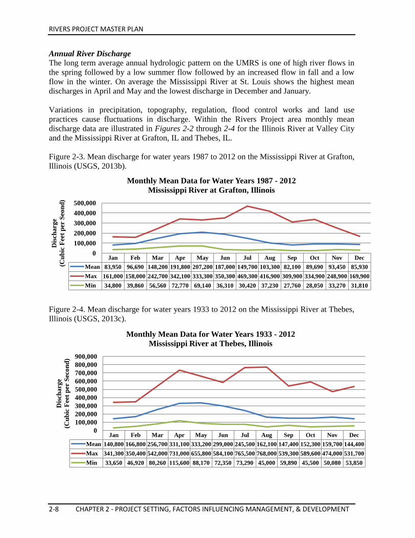
RIVERS PROJECT MASTER PLAN
2-8 CHAPTER 2 - PROJECT SETTING, FACTORS INFLUENCING MANAGEMENT, & DEVELOPMENT
Annual River Discharge The long term average annual hydrologic pattern on the UMRS is one of high river flows in the spring followed by a low summer flow followed by an increased flow in fall and a low flow in the winter. On average the Mississippi River at St. Louis shows the highest mean discharges in April and May and the lowest discharge in December and January. Variations in precipitation, topography, regulation, flood control works and land use practices cause fluctuations in discharge. Within the Rivers Project area monthly mean discharge data are illustrated in Figures 2-2 through 2-4 for the Illinois River at Valley City and the Mississippi River at Grafton, IL and Thebes, IL. Figure 2-3. Mean discharge for water years 1987 to 2012 on the Mississippi River at Grafton, Illinois (USGS, 2013b).
Figure 2-4. Mean discharge for water years 1933 to 2012 on the Mississippi River at Thebes, Illinois (USGS, 2013c).
Jan Feb Mar Apr May Jun Jul Aug Sep Oct Nov Dec Mean 83,950 96,690 148,200 191,800 207,200 187,000 149,700 103,300 82,100 89,690 93,450 85,930 Max 161,000 158,000 242,700 342,100 333,300 350,300 469,300 416,900 309,900 334,900 248,900 169,900 Min 34,800 39,860 56,560 72,770 69,140 36,310 30,420 37,230 27,760 28,050 33,270 31,810
0 100,000 200,000 300,000 400,000 500,000
Disc
harg
e (C
ubic
Fee
t per
Seo
nd)
Monthly Mean Data for Water Years 1987 - 2012 Mississippi River at Grafton, Illinois
Jan Feb Mar Apr May Jun Jul Aug Sep Oct Nov Dec Mean 140,800 166,800 256,700 331,100 333,200 299,000 245,500 162,100 147,400 152,300 159,700 144,400 Max 341,300 350,400 542,000 731,000 655,800 584,100 765,500 768,000 539,300 589,600 474,000 531,700 Min 33,650 46,920 80,260 115,600 88,170 72,350 73,290 45,000 59,890 45,500 50,080 53,850
0 100,000 200,000 300,000 400,000 500,000 600,000 700,000 800,000 900,000
Dis
char
ge
(Cub
ic F
eet p
er S
econ
d)
Monthly Mean Data for Water Years 1933 - 2012 Mississippi River at Thebes, Illinois
RIVERS PROJECT MASTER PLAN
CHAPTER 2 - PROJECT SETTING, FACTORS INFLUENCING MANAGEMENT, & DEVELOPMENT 2-9
Middle Mississippi River The Middle Mississippi River (also referred to as Open River in this document) is defined as the reach of river between the Missouri River and Ohio River confluences. Below St. Louis, the river shows a marked tendency to meander in the alluvial valley and is seldom found in the middle of the floodplain. From St. Louis, the river continues along the Missouri Bluff to St. Genevieve, crosses the valley to Fort Gage, IL, flows adjacent to the Illinois bluffs for about 14 miles, and returns to the Missouri bluffs at Red Rock. It follows this bluff line to Cape Girardeau. Continuing past the natural flood outlet into the St. Francis Basin, the river flows through the 7-mile rocky gorge, Grays Point, to Commerce, MO. It then sweeps on through the lower wide alluvial valley (coastal plain), which is characteristic of the Lower Mississippi River. Between St. Louis and Cairo, IL, bank full widths vary from 2,500 to 4,800 feet and low-water widths from 1,500 to 1,900 feet. The floodplain of the Middle Mississippi River is widest just north of St. Louis, where the distance is approximately 12 miles, and from St. Louis to Grays Point, approximately 135 river miles downstream, the alluvial plain has an average width of 4 to 5 miles. The 7-mile long Grays Point-Commerce Gorge is narrow with a minimum width of about one-half mile. Just below Commerce, MO, the bluffs diverge sharply and mark the beginning of the very wide delta region of the alluvial valley of the Lower Mississippi River. The Middle Mississippi River drops in elevation at an average of 0.57 feet/mile. The maximum observed slope, a fall of 2.0 feet/mile, during low water, occurs just below Chain of Rocks opposite north St. Louis. In the gorge between Grays Point and Commerce, the flood of 1844 had a mean fall of 1.7 feet/mile and at the low stage of 24 December 1904, a mean fall of 0.18 feet/mile. Even flatter low water slopes have been observed in the St. Louis Harbor. Historical accounts indicate that, at about 1820, the Middle Mississippi River passed from its natural state into a state where human activity had a significant effect on the morphological processes. European settlement, the advent of steam powered boats and the river current itself all contributed to excessive timber removal from the banklines creating deteriorating and unstable riverbanks. In the 1880s, the Federal Government began the task of maintaining a navigation channel. The physical characteristics of the river have changed over the years. The navigation project has greatly influenced these geomorphic changes. Pooled River Early in the twentieth century, it became apparent that the residents of the Upper Mississippi Valley could benefit from long haul, low-cost water transportation. However, nature did not provide the proper conditions for people to fully utilize the Upper Mississippi River. In the 1930s, Congress turned to the Corps to design and construct a series of Locks and Dams to provide a safe and dependable navigation channel. Before the Corps built the lock and dam system on the Mississippi, navigation on the river was intermittent. During low-flow periods, the river had many shallow reaches which limited
RIVERS PROJECT MASTER PLAN
2-10 CHAPTER 2 - PROJECT SETTING, FACTORS INFLUENCING MANAGEMENT, & DEVELOPMENT
or curtailed water transportation on the Upper Mississippi River. The low river depths not only limited river navigation, but also limited recreational development. Extensive work by the Corps since the 1930s has allowed for the integrated system which utilizes the resources of the Mississippi, Illinois, and Ohio Rivers for transportation. For over 60 years, this river transportation system has had the desired result of providing a safe and dependable navigation system and has also provided various other benefits as well. The Corps has examined opportunities, within its current authority, to respond to recreational and environmental concerns. The Corps works closely with the USFWS and with state departments of conservation on habitat improvement projects within the river pools. The Corps also works closely with recreational interest groups to accommodate boating, fishing, hunting, nature study, sightseeing, etc. The locks and dam system has been operated successfully for over 70 years. From St. Anthony Falls, MN, to St. Louis, the Mississippi resembles a downward staircase with each of the steps represented by a navigation pool. The locks which accompany the dams allow river traffic to “step” from pool to pool. Regulation of the pool levels is a major responsibility of the Corps. Navigation Pool Regulation A dam, to the average person, is a huge solid structure used to block the flow in a river and form a lake. This conception is not true of navigation dams, such as those on the Upper Mississippi. These dams are not solid but are a series of concrete piers across the river with movable gates between the piers. A dam is formed when the gates are lowered, causing the water level upstream of the dam to rise and to form a slack-water pool which provides adequate navigation depth. In order to operate the slack-water pool system, it was necessary for the federal government to acquire all real estate which would be inundated by the use of the dam gates. Much of this land is now serving the public for recreational and environmental purposes and is the focus of this Master Plan. Some land is owned outright and some is covered by “flowage easements” allowing artificial flooding of privately owned land (if necessary). Operation of each dam makes control of the depth of water possible for commercial navigation purposes. Each dam is operated in response to the river flow conditions which exist. During mid-range flows, all gates are partially opened with water flowing beneath them. As the flow increases or decreases, the gate openings are increased or decreased accordingly. Each pool within the St. Louis District has a control or “hinge point” located near the middle of each pool, with established maximum and minimum water levels. In Pool 26, this control point is located at Grafton, IL. In order to maintain a nine-foot depth throughout the pool, the water level must be maintained at or above the established minimum elevation at the control point.
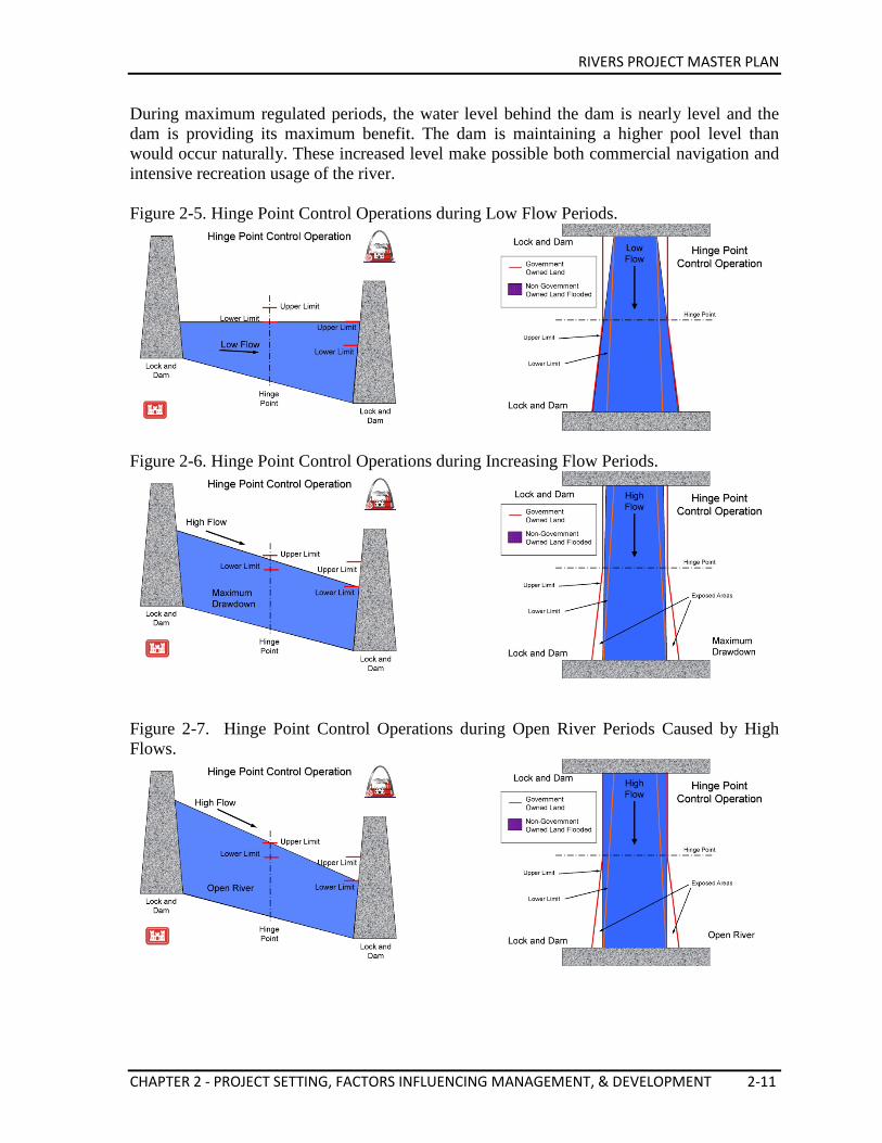
RIVERS PROJECT MASTER PLAN
CHAPTER 2 - PROJECT SETTING, FACTORS INFLUENCING MANAGEMENT, & DEVELOPMENT 2-11
During maximum regulated periods, the water level behind the dam is nearly level and the dam is providing its maximum benefit. The dam is maintaining a higher pool level than would occur naturally. These increased level make possible both commercial navigation and intensive recreation usage of the river. Figure 2-5. Hinge Point Control Operations during Low Flow Periods.
Figure 2-6. Hinge Point Control Operations during Increasing Flow Periods.
Figure 2-7. Hinge Point Control Operations during Open River Periods Caused by High Flows.
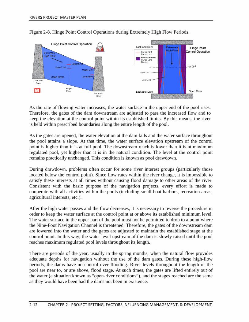
RIVERS PROJECT MASTER PLAN
2-12 CHAPTER 2 - PROJECT SETTING, FACTORS INFLUENCING MANAGEMENT, & DEVELOPMENT
Figure 2-8. Hinge Point Control Operations during Extremely High Flow Periods.
As the rate of flowing water increases, the water surface in the upper end of the pool rises. Therefore, the gates of the dam downstream are adjusted to pass the increased flow and to keep the elevation at the control point within its established limits. By this means, the river is held within prescribed boundaries along the entire length of the pool. As the gates are opened, the water elevation at the dam falls and the water surface throughout the pool attains a slope. At that time, the water surface elevation upstream of the control point is higher than it is at full pool. The downstream reach is lower than it is at maximum regulated pool, yet higher than it is in the natural condition. The level at the control point remains practically unchanged. This condition is known as pool drawdown. During drawdown, problems often occur for some river interest groups (particularly those located below the control point). Since flow rates within the river change, it is impossible to satisfy these interests at all times without causing flood damage to other areas of the river. Consistent with the basic purpose of the navigation projects, every effort is made to cooperate with all activities within the pools (including small boat harbors, recreation areas, agricultural interests, etc.). After the high water passes and the flow decreases, it is necessary to reverse the procedure in order to keep the water surface at the control point at or above its established minimum level. The water surface in the upper part of the pool must not be permitted to drop to a point where the Nine-Foot Navigation Channel is threatened. Therefore, the gates of the downstream dam are lowered into the water and the gates are adjusted to maintain the established stage at the control point. In this way, the water level upstream of the dam is slowly raised until the pool reaches maximum regulated pool levels throughout its length. There are periods of the year, usually in the spring months, when the natural flow provides adequate depths for navigation without the use of the dam gates. During these high-flow periods, the dams have no control over flooding. River levels throughout the length of the pool are near to, or are above, flood stage. At such times, the gates are lifted entirely out of the water (a situation known as “open-river conditions”), and the stages reached are the same as they would have been had the dams not been in existence.
RIVERS PROJECT MASTER PLAN
CHAPTER 2 - PROJECT SETTING, FACTORS INFLUENCING MANAGEMENT, & DEVELOPMENT 2-13
In the early 1990s, the district began to use the seasonal drawdowns to stimulate wetland vegetation growth and improve river habitat conditions on the pools. Referred to as Environmental Pool Management (EPM), this practice was fully implemented in 1994 as a way to create thousands of acres of critical wetland vegetation for wildlife in the navigation pools, while still providing for the needs of navigation. Several factors contribute to a successful EPM year. First the pool must be drawn down 0.5-2.0 feet for approximately 30 days. This pool drawdown occurs during May 1 through July 30, with the May-June period being the most desirable for vegetative growth and seed production. Secondly, after the initial drawdown, the goal is to allow the pool to rise at a rate not greater than 0.2 foot per day. EPM benefits the entire river ecosystem by simulating the pre-dam annual hydrograph (i.e. spring flood followed by summer low flow, followed by a small flood in late fall/early winter and winter low flow) which was mostly lost with dam operation. The growth of moist soil vegetation benefits fish and migratory waterfowl by providing attachment sites for food organisms (macroinvertebrates). It also benefits fishes by providing both protective cover for small fishes and ambush cover for predators. EPM continues to be successful each year in providing a safe and dependable navigation channel and creation of thousands of acres of vegetation for wildlife and erosion control. 2.4. RIVER REGULATING STRUCTURES (CHANNEL MAINTENANCE) Various types of regulating structures are used in the District’s effort to maintain the navigation channel. These include spur and trail dikes, chevrons, multiple roundpoint structures, and W-dikes. Structures in the pools are generally not visible during pool conditions except for some that have been newly constructed or restored. Structures in the open river are generally constructed to midbank height which equates to 15-ft on the St. Louis Gage. Some structures are called bendway weirs and are underwater structures often angled upstream that are in the navigation channel but do not impede navigation traffic. The Illinois River does not have any Corps maintained regulating structures. Navigation Pools During the latter part of the 19th century, the pooled portion of the Mississippi River above the confluence with the Missouri River was wide and generally shallow, with numerous islands and emerging sandbars during periods of low flow. Since 1824, the federal government has been involved in improving river conditions for navigation. Dikes made of wood and stone were used to confine the low flows to the main channel and temporarily increase stream velocities within the contracted reach, thereby increasing the stream’s sediment transport capacity, thus deepening the navigation channel by scouring the riverbed. The sandbars between adjacent dikes soon became vegetated, with subsequent inundations depositing layers of finer-grained sediments such as silts and clays.
RIVERS PROJECT MASTER PLAN
2-14 CHAPTER 2 - PROJECT SETTING, FACTORS INFLUENCING MANAGEMENT, & DEVELOPMENT
To alleviate the increased scouring action on the opposite bank due to the confinement of low flows, the lower portion of the riverbank was first usually protected with woven wooden mats placed against the bank and sunk with stone before the upper portion of the bank was revetted. Current methods to revet banklines utilize stone riprap. Stabilization of the riverbanks reduced the amount of lateral channel migration, thus reducing the number of new side channels that were being formed. Prior to the establishment of Pools 24, 25 and 26, approximately 300 dikes and 65 miles of revetments were built. Due to their general deterioration and heavy ice-pack damage, a substantial portion of these structures was severely damaged or completely destroyed, thus significantly reducing their effectiveness. Environmentally Sound Navigation Structures The St. Louis District has been cooperating with concerned agencies since 1969, in an effort to make the Nine-Foot Navigation Channel Project more compatible with aquatic and terrestrial habitats. This coordination process has resulted in the elimination of some proposed dikes, lowering the crown elevation on numerous other dikes, and construction of approximately 150 notched stone-fill dikes. Model and prototype studies indicate that not constructing some stone-fill dikes may eventually have an adverse impact upon the authorized channel dimensions and may result in some increased dredging in the future. A complete evaluation of notched dikes has been made as to their effectiveness for the enhancement of aquatic and terrestrial habitat. Other environmental enhancement features built into the project include stepped-up dikes, hard points and chevrons. In 1989, the District introduced another channel improvement structure known as the bendway weir. Several of these structures have been built between St. Louis, MO, and Cairo, IL. Submerged year-round, these structures add channel width in bends while stabilizing banklines on the outside of the bends thus significantly reducing maintenance dredging and barge accidents. River Training Structures River training structures are a primary tool for river engineers to influence changes in a river to improve navigation and enhance or create habitat diversity. The decision to build river training structures begins with an area for possible work, identified through conversations with navigation industry and environmental partners or a review of dredging and accident data. Depending on the need identified and the sensitivity of the reach, a study may be undertaken to further examine the reach and identify possible solutions, including different river training structure alignments. Partners and concerned parties are brought in to find the best solution for meeting the need while being sensitive to other concerns. Once a recommendation is identified, plans and specifications are drawn up, a contract is developed, and a contractor builds the structures in coordination with the Corps. Once constructed, structures are then monitored by Corps personnel to make sure that the original purposes are met and environmental goals are being achieved. In the past, river engineers focused almost exclusively on the creation of a safe and dependable navigation channel. As time progressed and an understanding of environmental
RIVERS PROJECT MASTER PLAN
CHAPTER 2 - PROJECT SETTING, FACTORS INFLUENCING MANAGEMENT, & DEVELOPMENT 2-15
impact grew, river engineers began to move away from older methods of developing a navigation channel. Designs have now been more focused on improving the navigation channel and enhancing or creating habitat diversity. The four primary habitats important to the river ecosystem that are enhanced through innovative river training structures include:
• Fast Water: Water moving quickly, usually the current in the main river channel. • Slow Water/Quiet Water: Water outside of the main river channel moving slower
than the primary river current. • Wetted Edge: Land which is constantly getting wet and then dry again as the river
rises and falls. This area is in a continual state of change. This habitat is very important, as there is a constant exchange of nutrients from the land to the aquatic environment.
• Terrestrial: Land above the ordinary high water or top of riverbank.
Previously, the primary river training structure constructed was the perpendicular dike (constructed in the past with wooden piles, then later stone). This type of structure constricts the river and conversely deepens the channel. But through innovation, this basic structure has been modified by a toolbox of smaller, more variable shaped structures that improve navigation but also provide added considerations toward habitat diversity. These structures include: Bendway Weirs The Bendway Weir is a low level, totally submerged rock structure that is positioned from the outside bankline of the riverbend and angled upstream toward the flow. These underwater structures extend directly into the navigation channel underneath passing tows. Their unique position and alignment alter the river’s spiraling, secondary currents in a manner which shifts the currents away from the outside bankline. This controls excessive channel deepening and reduces adjacent riverbank erosion on the outside bendway. Because excessive river depths are controlled, the opposite side of the riverbank is widened naturally. This results in a wider and safer navigation channel through the bend without the need for periodic maintenance dredging. The Bendway Weir also eliminates the need for dikes to be constructed on the inside of the bendway, protecting bend interior sandbar habitat. There had been concern that bendway weir construction was leading to increased bend-interior slopes; analysis of pre- to post-construction data found that slope changes were largely within the expected natural deviation (Lauth et. al., 2011).
RIVERS PROJECT MASTER PLAN
2-16 CHAPTER 2 - PROJECT SETTING, FACTORS INFLUENCING MANAGEMENT, & DEVELOPMENT
Bullnoses Bullnoses redirect flows around islands, protecting the islands from erosion. Without the rounded upstream rock structures, island heads can be exposed to high-velocity flows that hit head-on and mobilize sediment, eroding an island away. The bullnose locks in the island’s upstream geometry, rendering the island, and the aquatic and terrestrial habitat it forms, largely permanent. Chevrons Chevrons are “U”- or “V”-shaped rock structures with their apexes oriented upstream that divide flow smoothly so that a portion of the flow can be redirected without a significant undesired scour area forming. Dividing the flow in this manner can increase energy and decrease sedimentation in both side channels and the main channel. Besides redirecting flow along the front of the chevron, chevrons are designed with intent of periodic overtopping of the apex occurring. This overtopping results in the formation of a plunge
pool within the chevron. The lower-velocity flow exiting the plunge pool can no longer maintain its sediment load and deposits sediment downstream of the chevron. This deposition can lead to the development of ephemeral or permanent islands downstream of chevrons. The bathymetric diversity presented by a plunge pool and downstream depositional area have been found to be favorable habitat for a variety of fish species. In the case of two or more chevrons, deposition behind the chevrons and side channel depth both increased with the number of chevrons. Use of multiple chevrons in a field can be used
to either maintain a split flow situation or direct a split flow to a particular location (such as an area prone to a lower energy level). The disadvantage to the construction of chevrons is that they obstruct far less flow than a typical dike of equivalent length. Chevrons can be constructed with rootless trails extending the effective length of the chevron legs with regards to splitting flow while allowing for some flow behind the chevron. They can also be constructed with notches, with the intent of decreasing the depth of the plunge pool; these effects are still being studied. A third option for chevron construction is the shortening of one leg and the extension of the other. This J-shape can be used to further maintain a split flow.
Hard Points Hard points are very short rock dikes that are used to stabilize side channel river banks. The structures extend from the bank into the side channel and do not cause a significant buildup of sediment. Their contribution to habitat improvement is the creation of scour holes behind the hard points. These plunge holes attract fish that flourish in this environment. Effective hardpoint placement requires a relatively active side channel with little ongoing sedimentation.
RIVERS PROJECT MASTER PLAN
CHAPTER 2 - PROJECT SETTING, FACTORS INFLUENCING MANAGEMENT, & DEVELOPMENT 2-17
J-Hooks J-Hook Rock Vanes are structures designed to re-direct velocity distribution and high velocity gradient in the near-bank region, stabilize stream-banks, dissipate energy in deep, wide, and long pools created below the structure, and create holding cover for fish and spawning habitat in the tail-out of the structure. The basic function of the structure utilizes the principle that water will flow over immoveable objects at right angles (90° angles). The device is constructed of large stone that is tied into the streambank. The stone is trenched into two rows at an upstream angle of 20° to 30° at a distance of 1/3 stream width. The stone is then formed into a hook shape to cover a distance of 1/3 stream width. The downstream row of rock is trenched into the stream bottom so that the top of the rock is approximately level with the stream bottom. The second row of rock is then placed just upstream of that row of rock slightly overlapping it so that as the water flows over the top of the upstream line of rock it will flow onto the downstream line of rock. This creates a stable surface on which the energy of the stream can be dissipated without completely scouring the stream bottom. As the stream dissipates its energy, it will scour the stream bottom slightly, creating a small scour pool immediately downstream of the device that serves as a source of aquatic habitat. L-Dike L-Dikes consist of a normal dike that has a trail dike constructed parallel to the flow from the tip. The constructed trail dike continues the constriction of the channel further along the main channel to increase main channel energy and decrease deposition. The area behind the L-Dike becomes a slack water area with beneficial habitat characteristics. This area can be prone to deposition due to the low energy level within the dikes, but such deposition can be reduced by notching the trail dike so that periodic sediment flushing occurs. Some disadvantages of L-Dikes are that they isolate the bankline from the river channel and that they don’t promote new bathymetric diversity. Multiple Roundpoint Structures (MRS) Multiple Roundpoint Structures induce scouring off the tips of the structures and create depositional areas with the increased roughness generated by the structures. The MRS can also act as a primitive bank stabilization technique by creating depositional zones near the banks of the structures. The structures are generally built to 2/3 bankfull and the grade of stone needed is channel dependent. The spacing of the MRS is dependent of the
RIVERS PROJECT MASTER PLAN
2-18 CHAPTER 2 - PROJECT SETTING, FACTORS INFLUENCING MANAGEMENT, & DEVELOPMENT
height of the structure and natural angle of repose of the rock used. A rule of thumb with the spacing between the structures is to space them no less than 2/3 of the height. MRSs can be designed as a single row or in multiple rows. Preliminary data shows that incorporating more rows generates increased bathymetric changes. MRSs are not recommended as a bank stabilization technique but can be incorporated with other forms of bank stabilization such as revetment. The data collected suggest that MRS are providing useful and valuable habitat for a variety of riverine fishes. Collection of blue suckers may indicate these structures are providing a unique habitat type, once more common in the river. Notched Dikes Many rock dikes with notches in them can continue to have the same effect on navigation dimensions as un-notched dikes while also promoting increased bathymetric variation. Notches in the center or bank side of dikes achieve this variation by promoting scour
downstream of the notch leading to a diversity of habitat. Varying notch depth is one factor that can be used to alter the depth of scour and thus the diversity. Low energy areas behind the un-notched portions of dikes can lead to deposition, supporting the creation of islands or side channels when used in a series. Notching is not always recommended; notching does remove a portion of the dike that may be necessary for the dike to have its intended effect, and a notch may have little effect without the proper flow depth and frequency through the notch.
Off-Bankline Revetment Off-Bankline Revetment reduces erosion on the shallow side of a river. By constructing a stone structure parallel to the bankline, a small side channel area is formed that is largely cut off from the energy of the main channel, producing a slow water habitat area. There is little critical bathymetric effect as the revetment is placed in shallow areas. However, the use of off-bankline revetment does not guarantee the same level of protection as normal revetment and leaves the bankline exposed at higher flow events.
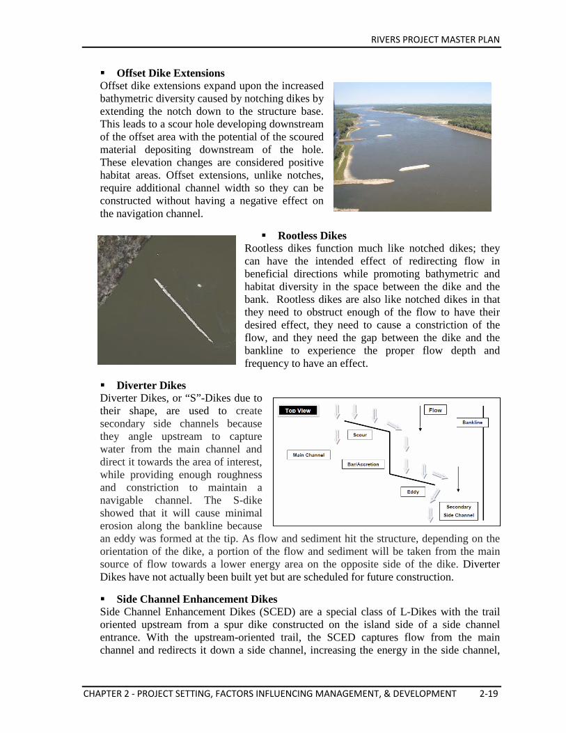
RIVERS PROJECT MASTER PLAN
CHAPTER 2 - PROJECT SETTING, FACTORS INFLUENCING MANAGEMENT, & DEVELOPMENT 2-19
Offset Dike Extensions Offset dike extensions expand upon the increased bathymetric diversity caused by notching dikes by extending the notch down to the structure base. This leads to a scour hole developing downstream of the offset area with the potential of the scoured material depositing downstream of the hole. These elevation changes are considered positive habitat areas. Offset extensions, unlike notches, require additional channel width so they can be constructed without having a negative effect on the navigation channel.
Rootless Dikes Rootless dikes function much like notched dikes; they can have the intended effect of redirecting flow in beneficial directions while promoting bathymetric and habitat diversity in the space between the dike and the bank. Rootless dikes are also like notched dikes in that they need to obstruct enough of the flow to have their desired effect, they need to cause a constriction of the flow, and they need the gap between the dike and the bankline to experience the proper flow depth and frequency to have an effect.
Diverter Dikes Diverter Dikes, or “S”-Dikes due to their shape, are used to create secondary side channels because they angle upstream to capture water from the main channel and direct it towards the area of interest, while providing enough roughness and constriction to maintain a navigable channel. The S-dike showed that it will cause minimal erosion along the bankline because an eddy was formed at the tip. As flow and sediment hit the structure, depending on the orientation of the dike, a portion of the flow and sediment will be taken from the main source of flow towards a lower energy area on the opposite side of the dike. Diverter Dikes have not actually been built yet but are scheduled for future construction.
Side Channel Enhancement Dikes Side Channel Enhancement Dikes (SCED) are a special class of L-Dikes with the trail oriented upstream from a spur dike constructed on the island side of a side channel entrance. With the upstream-oriented trail, the SCED captures flow from the main channel and redirects it down a side channel, increasing the energy in the side channel,
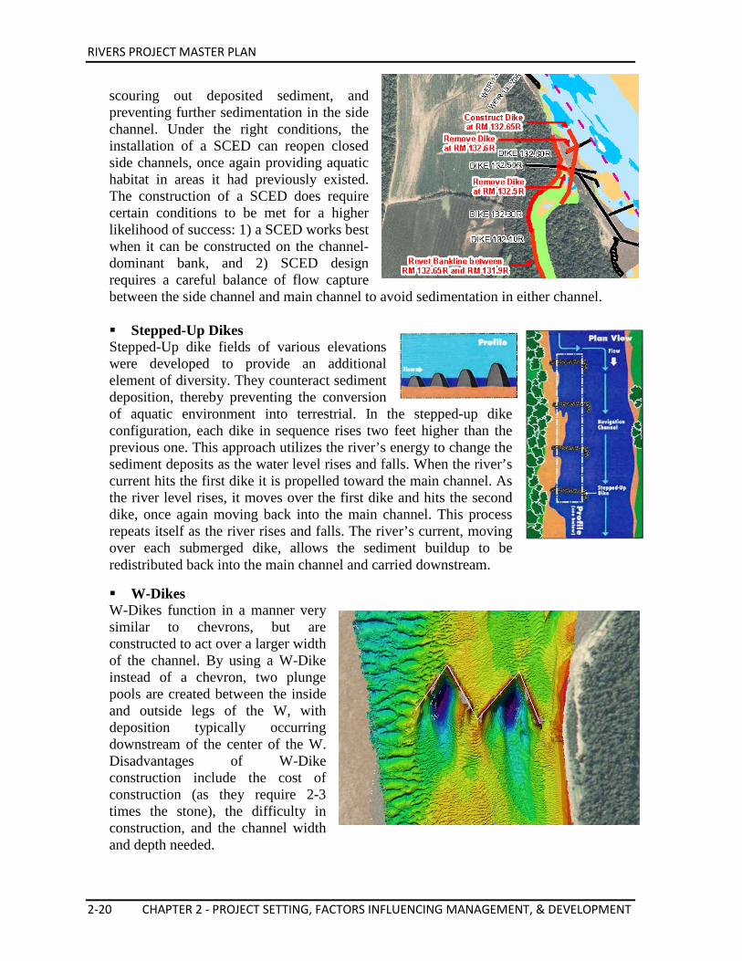
RIVERS PROJECT MASTER PLAN
2-20 CHAPTER 2 - PROJECT SETTING, FACTORS INFLUENCING MANAGEMENT, & DEVELOPMENT
scouring out deposited sediment, and preventing further sedimentation in the side channel. Under the right conditions, the installation of a SCED can reopen closed side channels, once again providing aquatic habitat in areas it had previously existed. The construction of a SCED does require certain conditions to be met for a higher likelihood of success: 1) a SCED works best when it can be constructed on the channel-dominant bank, and 2) SCED design requires a careful balance of flow capture between the side channel and main channel to avoid sedimentation in either channel. Stepped-Up Dikes Stepped-Up dike fields of various elevations were developed to provide an additional element of diversity. They counteract sediment deposition, thereby preventing the conversion of aquatic environment into terrestrial. In the stepped-up dike configuration, each dike in sequence rises two feet higher than the previous one. This approach utilizes the river’s energy to change the sediment deposits as the water level rises and falls. When the river’s current hits the first dike it is propelled toward the main channel. As the river level rises, it moves over the first dike and hits the second dike, once again moving back into the main channel. This process repeats itself as the river rises and falls. The river’s current, moving over each submerged dike, allows the sediment buildup to be redistributed back into the main channel and carried downstream.
W-Dikes W-Dikes function in a manner very similar to chevrons, but are constructed to act over a larger width of the channel. By using a W-Dike instead of a chevron, two plunge pools are created between the inside and outside legs of the W, with deposition typically occurring downstream of the center of the W. Disadvantages of W-Dike construction include the cost of construction (as they require 2-3 times the stone), the difficulty in construction, and the channel width and depth needed.
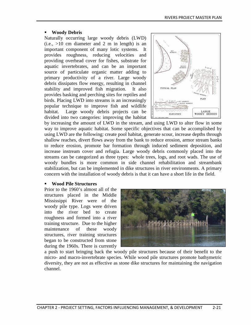
RIVERS PROJECT MASTER PLAN
CHAPTER 2 - PROJECT SETTING, FACTORS INFLUENCING MANAGEMENT, & DEVELOPMENT 2-21
Woody Debris Naturally occurring large woody debris (LWD) (i.e., >10 cm diameter and 2 m in length) is an important component of many lotic systems. It provides roughness, reducing velocities and providing overhead cover for fishes, substrate for aquatic invertebrates, and can be an important source of particulate organic matter adding to primary productivity of a river. Large woody debris dissipates flow energy, resulting in channel stability and improved fish migration. It also provides basking and perching sites for reptiles and birds. Placing LWD into streams is an increasingly popular technique to improve fish and wildlife habitat. Large woody debris projects can be divided into two categories: improving the habitat by increasing the amount of LWD in the stream, and using LWD to alter flow in some way to improve aquatic habitat. Some specific objectives that can be accomplished by using LWD are the following: create pool habitat, generate scour, increase depths through shallow reaches, divert flows away from the bank to reduce erosion, armor stream banks to reduce erosion, promote bar formation through induced sediment deposition, and increase instream cover and refugia. Large woody debris commonly placed into the streams can be categorized as three types: whole trees, logs, and root wads. The use of woody bundles is more common in side channel rehabilitation and streambank stabilization, but can be implemented in dike structures in river environments. A primary concern with the installation of woody debris is that it can have a short life in the field.
Wood Pile Structures Prior to the 1960’s almost all of the structures placed in the Middle Mississippi River were of the woody pile type. Logs were driven into the river bed to create roughness and formed into a river training structure. Due to the higher maintenance of these woody structures, river training structures began to be constructed from stone during the 1960s. There is currently a push to start bringing back the woody pile structures because of their benefit to the micro- and macro-invertebrate species. While wood pile structures promote bathymetric diversity, they are not as effective as stone dike structures for maintaining the navigation channel.
RIVERS PROJECT MASTER PLAN
2-22 CHAPTER 2 - PROJECT SETTING, FACTORS INFLUENCING MANAGEMENT, & DEVELOPMENT
Biological Impact The use of navigation structures to maintain the channel in itself has a biological impact by not allowing the river act as a natural system. However, since the Mississippi and Illinois Rivers are multiuse rivers and structures are needed to maintain the system, manipulating them based on specific site and biological conditions can lessen their impact on the biological resources and improve habitat above what a normal river navigation structure will do. Biological studies on the various river navigation structures described above have found an increase in diversity and numbers of micro-invertebrates. To a lesser degree, fish communities are also found to have greater diversity. In addition, the larger problem of aquatic environment becoming terrestrial is reduced and the river channel is maintained. Structures are basically self-maintained and biological diversity is increased. Isolated sandbars created by the various navigational structures provide suitable nesting sites for the endangered Interior Least Tern. These sandbars are usually away from human encroachment which helps aid their development. In addition, the easy access from slow water to fast water is important for fisheries habitat. Dredging and Dredged Material Uses Dredging occurs in all the navigable rivers of the District. Dredging in the St. Louis District is mostly accomplished by using hydraulic pipeline dredges. A hydraulic dredge mixes large quantities of water with the excavated material (usually sand) to create a slurry which is then pumped out of the navigable channel. Mechanical dredging is used infrequently for small and unexpected shoals. All dredging activities comply with applicable federal and state regulations. The two types of hydraulic pipeline dredges used by St. Louis are the "Dustpan" and the "Cutterhead." The Corps maintains a dustpan dredge (the Potter) at the St. Louis District Service Base and the cutterhead dredge is used under contract. The St. Louis District coordinates with various federal, state, and other pertinent agencies regarding locations that may require dredging and the proposed disposal sites. Yearly inspection trips are conducted with the River Resource Action Team (RRAT), composed of USFWS, USACE, IDNR, MDC, and others to discuss navigation and environmental issues on the river at which time dredge sites are evaluated and mutually agreed upon locations are identified. In addition, operations plans are developed for environmentally sensitive areas. Dredge and disposal locations identified after annual coordination meetings are coordinated prior to work using various means of communications, with meetings conducted as needed. When maintenance dredging occurs, excavated material is placed along the shore or between the channel and the bank. When possible, beneficial use of dredged material occurs. The beneficial uses generally include beach creation for recreation, Least Tern island habitat and sandy island habitat behind chevron dikes. Numerous river conditions are considered before placement of dredged material occurs including river stage; hydrologic, geomorphologic, and geometric properties of a particular reach of the river; volume of material to be dredged; capability of the equipment used; river structures in a reach such as dikes, revetments, and
RIVERS PROJECT MASTER PLAN
CHAPTER 2 - PROJECT SETTING, FACTORS INFLUENCING MANAGEMENT, & DEVELOPMENT 2-23
locks and dams; the volume of river traffic; and recommendations received from state conservation and federal fish and wildlife agencies. When agency representatives recommend alternative disposal sites, all attempts are made to use them if feasible. Some of these are accepted wherever and whenever feasible. At other times it is not possible because of insufficient equipment capability, namely, a lack of enough pipeline to reach an alternate site or not enough pumping capacity to dispose dredge materials onshore. The dredging season is typically July through December; however dredging requirements can occur during any month of the year based on river levels and survey results. Approximately 150 sites in the Rivers Project area have been dredged at one time or another. Between 30 and 50 river locations are dredged regularly in the St. Louis District. Some of these have to be dredged very infrequently, others annually, and some multiple times during the dredging season. All practical attempts are made to perform dredging without interrupting navigation traffic. Occasionally, emergency dredging takes place making the navigation channel impassable and the river is closed to perform dredging until a pilot channel can be completed. The annual amount of material dredged can vary from 4M to 10M cubic yards. This material is temporarily resuspended during dredging operations, carried through the pipeline, and placed in an approved off channel area. While sizeable, this amounts to only a small percentage of the suspended material passing St. Louis annually. Ninety-five percent of the material dredged in the St. Louis District is sand.
2.5. SEDIMENTATION AND SHORELINE EROSION “The Lower Mississippi River receives a disproportionately large influx of sediment from the Missouri River and a disproportionately large contribution of its flow from the Ohio River” (Meade, 1995; Knox, 2007). According to Meade & Moody (2010), “From only 16% of the total drainage area, the Ohio River contributes nearly half the total water discharged at the mouth of the Mississippi. By contrast, Missouri River drains 43% of the total area, but contributes only 12% of the total water”. Banklines on both sides of the river are exposed to erosion. Erosion and sedimentation are natural processes; however human interferences (e.g. land use changes, river engineering) can alter them. The bankline along the fast moving side of the river is exposed to the current, scouring and eroding the bank. The river bank running along the slow side of the river can also be exposed to a more gradual form of erosion. Wind, rain, the impact of humans and the river itself all contribute to the loss of bankline stability. According to Meade & Moody (2010), “Before 1900, the Missouri – Mississippi River system transported an estimated 400 million metric tons per year of sediment from the interior of the United States to coastal Louisiana. During the last two decades (1987-2006), this transport has averaged 145 million metric tons per year”. Many reports have attributed this significant decrease in sediment to the implementation of the dams on the Missouri River (1933-1966), changes in agricultural practices, soil erosion
RIVERS PROJECT MASTER PLAN
2-24 CHAPTER 2 - PROJECT SETTING, FACTORS INFLUENCING MANAGEMENT, & DEVELOPMENT
controls, shoreline revetment, and river training structures have also contributed to the large reduction in sedimentation over the years. Annual suspended sediment transport at St. Louis, Missouri, ranges from about 100 million tons to 150 million tons (USACE, 2006). In more recent years (1998-2009), most of the stations within the Mississippi River Basin (MRB) have continued to show downward changes in suspended sediment loads, concentrations, and stream flows, although not statistically significant (Heimann et al, 2011). According to Scientific Investigations Report 2011–5200 by USGS, the Missouri River was the primary contributor of the greatest median suspended-sediment load from 1976-2009. The second highest contributor was the Ohio River. Of those 34 years of analysis, the Missouri River had the biggest annual suspended-sediment loads for 26 years and the Ohio River had the biggest for the remaining 8 years (Heimann et al, 2011). “Studies have shown that approximately 75% to 95% of the suspended sediment load that passes St. Louis on an annual basis is supplied from the Missouri River” (USACE, 2006). Within the UMRB above the Missouri River, the Illinois River contributed the highest sediments. According to Demissie et al. (2004), “On average, it was estimated that 12.1 million tons of sediment were delivered to the Illinois River valley annually during the period 1981-2000, and the average annual outflow of sediment from the Illinois River at Valley City was 5.4 million tons. This resulted in an estimated average annual deposition of 6.7 million tons of sediment delivered from tributary streams to the Illinois River valley”. Navigation-related control activities have slowed the natural migration of the river. The pools in the Upper River have inundated many of the previous river courses. In the Middle Mississippi River, shifting of the channel has been minimized by regulating works (dikes and rip-rap) which have significantly reduced the caving of banks and levees. The alluvial riverbed, however, continues to erode and fill. Some tributaries to areas controlled by pools are aggrading in lower reaches. Historically, the use of dikes to maintain a navigational channel and the resulting sediment build up assisted in narrowing the channel. Today, river engineering techniques are employed to achieve navigation objectives without the buildup of sediment through modification of the navigation structures. However, even without the use of various river training structures, sedimentation is a naturally occurring phenomenon and is primarily managed through the use of dredging in many stretches of the river. According to a USDA-NRCS study conducted from 2003-2006, agriculture covers 52% of the UMRB with most of it being in corn or soybean production. Approximately 2.8 million acres of cropland in the UMRB is in CRP (Conservation Reserve Program; 69% of which is highly erodible land). Within this program participants are required to plant grasses, trees, or wildlife habitat on the previously cultivated area. Within the basin 96% of all cropped acres apply management and/or structural practices to reduce erosion. Forty-five percent of all agriculture within the basin control water erosion with structural practices and 28% use no till practices (USDA-NRCS, 2012).
RIVERS PROJECT MASTER PLAN
CHAPTER 2 - PROJECT SETTING, FACTORS INFLUENCING MANAGEMENT, & DEVELOPMENT 2-25
Erosion and Sediment Management Strategies The management of erosion and sedimentation in the UMR watershed will remain a major environmental issue for many years to come due in part to the size of the watershed. It is widely acknowledged that erosion and sedimentation is the number one environmental problem in the watershed, as it leads to degraded water quality and aquatic habitat. However, there is no comprehensive management plan to deal with the problem. There have been numerous activities by various state and federal agencies to control erosion in different parts of the watershed over the years (such as various NRCS programs). However, these activities are not coordinated between states or well documented. Monitoring of erosion, sediment transport and sedimentation are scarce and intermittent making it difficult to evaluate the effect of different activities and the trend in the overall problem. The need for a coordinated and comprehensive approach to deal with the problem of erosion and sedimentation is well known. Because of the size of the watershed and the different causes of erosion, many different types of erosion control measures have to be implemented. Similarly different sediment management alternatives have to be developed for different river and backwater areas depending on the source of sediment and the planned use of the area. The different management strategies can be grouped into two main categories: erosion control and sediment management. Erosion Control For the UMR watershed, there are three major types of erosion that contribute significant amounts of sediment. These are watershed erosion, streambank erosion, and bluff erosion. The relative significance of these three major sources cannot be accurately quantified based on available data. Depending on the location along the river, any one of the three sources could be the primary source of sediment to an area. Watershed Erosion
Watershed erosion is used here to refer to erosion in the watershed primarily consisting of sheet, rill, and gully erosion in agricultural and non-agricultural areas. More than 50 percent of the watershed is used for agriculture. Erosion from construction sites also contributes significant amounts of sediment. Section 402 of the Clean Water Act now requires land disturbance permits for any construction site greater than 5 acres. This process requires an erosion control plan.
With respect to watershed erosion it is well known that most of the erosion takes place within a small portion of the watershed defined as critical erosion areas that generate significant amounts of sediment. It is therefore important that these areas are identified throughout the watershed so that limited resources could be allocated where they can be most effective.
In most of the watershed, erosion control activities are carried out by the Department of Agriculture through the NRCS.

RIVERS PROJECT MASTER PLAN
2-26 CHAPTER 2 - PROJECT SETTING, FACTORS INFLUENCING MANAGEMENT, & DEVELOPMENT
Streambank Erosion Most streams experience some form of bank erosion (including wind and wave erosion). In cases where vegetation has been removed from the streambank leaving them unpro-tected, bank erosion is excessive. Many channelization projects and river crossing structures such as bridges tend to increase the streambank erosion potential. There have been some studies which attempted to quantify the percent of a stream’s sediment load that originates from bank erosion. Percentages ranging from 20 to 80 have been reported by different investigators. The actual value will depend on the local conditions of a particular stream. Streambank erosion is believed to be a major contributor of sediment in streams in the UMRB (Upper Mississippi River Basin). Placement of rip rap on highly erodible banks is one method used to prevent this. However, there is no basin wide program to control streambank erosion. Realizing the significance of the problem and the fact that sedimentation problems will not be solved unless control of excessive streambank erosion occurs there is a need for a comprehensive streambank erosion control program. Along with identification of the erosion sites, the types of streambank failures and the suspected causes need to be documented.
Bluff Erosion
Because of its geological formation, the UMR valley is much larger than the present day river. The width of the river valley ranges from a mile to nearly ten miles. The edge of this large valley with relief from 100 to 300 feet is defined as the bluff area. The slope of the bluff areas is extremely steep reaching up to 30 percent resulting in excessive erosion. There are also significant amounts of land dislodging or washing along the steep slopes. Small streams draining the bluff areas generally carry significantly higher amounts of sediment than streams in other settings. The cumulative significance of the bluff areas as sediment sources become important when one considers the total length of the valley. Two erosion control studies have been completed and erosion control measures are being implemented by the NRCS in conjunction with the Swan Lake and Batchtown EMP projects. After the identification of the major causes of erosion in bluff and hillside areas, there is a need for developing bluff erosion-control strategies.
Sediment Management The major issues related to sediment management in the UMRB can be grouped into four main problem areas: sedimentation in backwater lakes and side channels, sediment in the navigation channel, a decline in suspended sediment loads in the Middle Mississippi River, and sediment quality. The areas most significantly affected by sedimentation are the backwater lakes, many of which have, on the average, lost approximately 70 percent of their capacity to sedimentation to date. Their physical characteristics and ecological and habitat values are continuously changing. If appropriate rehabilitation projects are not implemented these important habitats and recreational areas could be lost forever. It is important that these backwater lakes are managed to provide essential habitat diversity and connectivity to the main channel. Sedimentation in the navigation channel is not as environmentally degrading as that of the
RIVERS PROJECT MASTER PLAN
CHAPTER 2 - PROJECT SETTING, FACTORS INFLUENCING MANAGEMENT, & DEVELOPMENT 2-27
backwater lakes. The higher flow velocities in the navigation channel tend to keep the sediment moving in the channel except at shallow areas or crossings. Some deposition can occur at or downstream of the mouth of tributary streams that carry coarse sediment into the navigation channel. A second major difference between the sedimentation problem in backwater lakes and the navigation channel is the existence of the Nine–Foot Navigation Channel. The majority of the material dredged for channel maintenance is clean sands. The sedimentation problem in the navigation channel is being managed by the Corps through dredging. The Corps also reduces the impacts of sediment through river structures placed in the Dike and Revetment Program and the Avoid and Minimize Program. Through these efforts, dredging has been reduced significantly in the last 30 years. The Corps continually evaluates alternatives for sediment management and is attempting to balance the impact of these alternatives to the dredging operations and do what least impacts the environment on a site by site basis. Every dredge and disposal location in the St. Louis District is fully coordinated with the state and federal environmental agencies. These agencies comment and approve all of the dredging that takes place on a case by case basis prior to dredging being performed. In addition, the agencies put together dredging guidelines that outline both site specific and general rules to help enhance habitat using dredge disposal (i.e. construction of islands, moist soil units, disposal into chevrons, and much more). Sedimentation in Backwater Areas
Studies have documented that sedimentation in backwater lakes has accelerated in the last 50 years. Many backwater lakes have lost over half of their storage capacity and some of them have completely filled in with sediment. It is therefore essential that appropriate management strategies are developed to manage the sediment in some of the backwater lakes if these lakes are to be retained and used for fishing, recreation, and fish and wildlife habitat. Future soil erosion control measures in the upland watershed will not remove all the sediment that has already accumulated in the lake over the years. If appropriate sediment management is not developed and implemented, all the bottomland backwater areas will eventually fill-in with sediment and transform to mudflats and herbaceous marshes even under the most optimistic soil erosion rates.
To save some of these deepwater habitats from elimination, the following actions are being implemented:
• Identify the most important and valuable lakes. • Conduct sedimentation surveys of these lakes. • Develop techniques to control sediment inflow from the river. • Develop techniques to control sediment inflow from local tributaries. • Develop appropriate sediment removal techniques. • Develop appropriate sediment disposal techniques including the creation of
islands. • Develop shoreline management technology, especially wetland restoration, as a
component of an overall lake management plan. • Work closely with NRCS to solve problems on targeted areas.
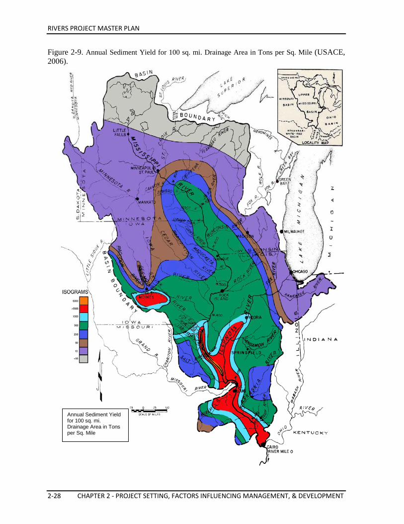
RIVERS PROJECT MASTER PLAN
2-28 CHAPTER 2 - PROJECT SETTING, FACTORS INFLUENCING MANAGEMENT, & DEVELOPMENT
Figure 2-9. Annual Sediment Yield for 100 sq. mi. Drainage Area in Tons per Sq. Mile (USACE, 2006).
Annual Sediment Yield for 100 sq. mi. Drainage Area in Tons per Sq. Mile
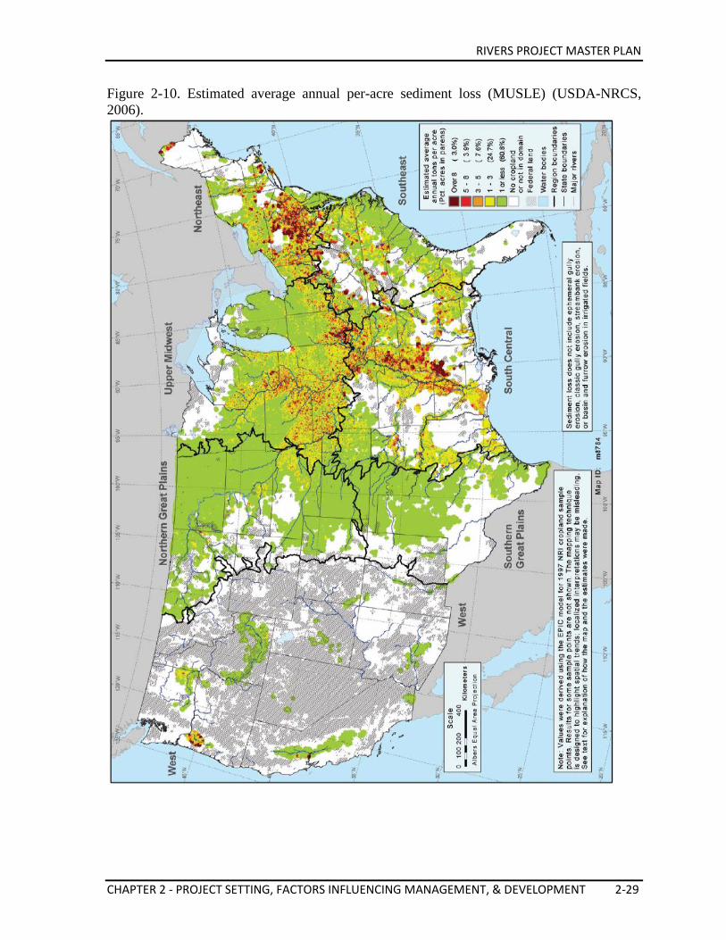
RIVERS PROJECT MASTER PLAN
CHAPTER 2 - PROJECT SETTING, FACTORS INFLUENCING MANAGEMENT, & DEVELOPMENT 2-29
Figure 2-10. Estimated average annual per-acre sediment loss (MUSLE) (USDA-NRCS, 2006).
RIVERS PROJECT MASTER PLAN
2-30 CHAPTER 2 - PROJECT SETTING, FACTORS INFLUENCING MANAGEMENT, & DEVELOPMENT
Sedimentation in the Main Channel As previously mentioned there is also a sedimentation problem at various locations within the navigation channel. The problem is not as severe as those found in the backwater lakes. The Corps is required to maintain the navigation channel at a nine-foot depth or deeper at all times and accomplish this by routinely dredging problem areas. Dredge disposal is closely coordinated with state and federal environmental agencies to get the most environmentally sound, least cost disposal alternative. Currently, exact aquatic impacts are still unknown, but through the Avoid and Minimize (A&M) program and efforts of the district, environmental monitoring is taking place in areas prioritized by the A&M team. In addition, sediment management techniques like the use of chevron dikes and off bankline revetment have been proven to both benefit navigation and increase habitat. The Corps is evaluating alternative techniques to reduce the amount and frequency of dredging.
Sediment Quality Whenever there is potential for dredging sediment, there is the necessity and legal requirement to evaluate the quality of the sediment. Fine grained sediment can potentially be contaminated by various pollutants. The contamination amount can vary from place to place. The Inland Testing Manual provides guidelines for dealing with contaminants associated with fine grained sediment.
Since the passing of the Clean Water Acts and the implementation of the Conservation Reserve Programs in the Farm Bill, the presence of contaminants associated with fine grained sediments has been greatly reduced.
2.6. WATER QUALITY Non-Point Source Pollution Erosion of the streambanks and islands is a natural process within the river system. Due to human development within the floodplain over the last 200 years, the erosion process has accelerated, increasing the sediment load of the river and the turbidity of the water. Over the last 60 years, the NRCS, the Corps and other agency partners have been working to reduce these processes to tolerable levels. Some success in sediment reduction has become apparent, particularly in the past 25 years but more effort is needed to further control this problem. Agricultural runoff is a difficult problem to solve and the source is off Project lands. Agricultural runoff can introduce tremendous amounts of sediment into the river system. The runoff from livestock feedlots add nitrates and other nutrients to the system, which effects dissolved oxygen and other water quality parameters which in turn affect the aquatic habitat and other uses of the water. Agricultural field runoff also introduces additional agricultural chemicals into the system, such as inorganic fertilizers. Some of these chemicals settle out and are incorporated into the bottom substrate. Other chemicals join the water column and course down the Mississippi to the Gulf of Mexico. The high concentration of nitrates within the water column is a primary cause of the hypoxia phenomenon, the so called “Dead Zone”, in the Gulf of Mexico. This Dead Zone is increasing in size and is the object of intense study.
RIVERS PROJECT MASTER PLAN
CHAPTER 2 - PROJECT SETTING, FACTORS INFLUENCING MANAGEMENT, & DEVELOPMENT 2-31
In rural settings, septic system run off used to be a significant problem. With improved systems, more stringent local and state regulations, and improved enforcement, this problem is being corrected and significant improvement has been achieved. By continuing to enforce current legislation and government actions and with continued improvement in technology, this problem should be significantly reduced within the near future. In recent years, Illinois Department of Public Health, Division of Public Health has increased enforcement of noncompliant septic tanks within the floodplain to help address this issue. Point Source Pollution Point source pollution discharges are not as prevalent as they were forty years ago. The development of the National Pollution Discharge Elimination System (NPDES) was a major advancement. The Clean Water Acts created the NPDES permit system which regulated industrial and municipal discharges. This did not totally eliminate point source problems but did greatly reduce the impacts to the quality of the water and sediment within the river system. Environmental Spills Many potential sources of spills exist throughout the river system, including highway and railroad crossings, pipelines, municipal and industrial plants, barge traffic, and terminals. Potential spill sources are discussed in detail in the Upper Mississippi River Spill Response Plan and Resource Manual (UMRBA, 2006). In addition, it describes resources available for responding to a spill. Hazardous material with the highest bulk movement and thus highest probability for a spill are chemicals, chemical products, fertilizer, petroleum products and coke petroleum pitches. 2.7. PROJECT ACCESS Rivers Project areas are accessible primarily by state and local roads. Traffic crossing the Mississippi River in the upper pools of 24 and 25 is limited to the Highway 54 Bridge in Louisiana, MO. The Winfield Ferry (linking Winfield, MO to Calhoun County, IL) has been in operation in the past but is not currently. Traffic can cross the Mississippi River in Pool 26 Golden Eagle Ferry (linking St. Charles County, MO to Calhoun County, IL), the Grafton Ferry (linking Grafton, IL to St. Charles County, MO), and the U.S. Highway 67 Bridge in Alton, IL. Illinois River crossings on Pool 26 are provided by the Brussels Ferry near Grafton, the Kampsville Ferry, and the bridge at Hardin. Mississippi River crossing in the St. Louis area is provided by the Chouteau Island, Interstate 270, McKinley, Eads, Martin Luther King, Popular Street (Interstates 55/70/64), and the new Mississippi River Bridges.
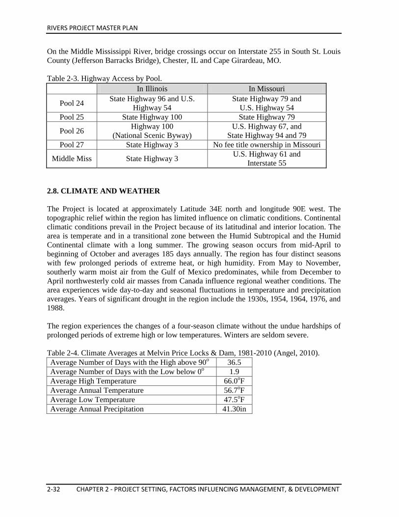
RIVERS PROJECT MASTER PLAN
2-32 CHAPTER 2 - PROJECT SETTING, FACTORS INFLUENCING MANAGEMENT, & DEVELOPMENT
On the Middle Mississippi River, bridge crossings occur on Interstate 255 in South St. Louis County (Jefferson Barracks Bridge), Chester, IL and Cape Girardeau, MO. Table 2-3. Highway Access by Pool.
In Illinois In Missouri
Pool 24 State Highway 96 and U.S. Highway 54
State Highway 79 and U.S. Highway 54
Pool 25 State Highway 100 State Highway 79
Pool 26 Highway 100 (National Scenic Byway)
U.S. Highway 67, and State Highway 94 and 79
Pool 27 State Highway 3 No fee title ownership in Missouri
Middle Miss State Highway 3 U.S. Highway 61 and Interstate 55
2.8. CLIMATE AND WEATHER The Project is located at approximately Latitude 34E north and longitude 90E west. The topographic relief within the region has limited influence on climatic conditions. Continental climatic conditions prevail in the Project because of its latitudinal and interior location. The area is temperate and in a transitional zone between the Humid Subtropical and the Humid Continental climate with a long summer. The growing season occurs from mid-April to beginning of October and averages 185 days annually. The region has four distinct seasons with few prolonged periods of extreme heat, or high humidity. From May to November, southerly warm moist air from the Gulf of Mexico predominates, while from December to April northwesterly cold air masses from Canada influence regional weather conditions. The area experiences wide day-to-day and seasonal fluctuations in temperature and precipitation averages. Years of significant drought in the region include the 1930s, 1954, 1964, 1976, and 1988. The region experiences the changes of a four-season climate without the undue hardships of prolonged periods of extreme high or low temperatures. Winters are seldom severe. Table 2-4. Climate Averages at Melvin Price Locks & Dam, 1981-2010 (Angel, 2010). Average Number of Days with the High above 90o 36.5 Average Number of Days with the Low below 0o 1.9 Average High Temperature 66.0oF Average Annual Temperature 56.7oF Average Low Temperature 47.5oF Average Annual Precipitation 41.30in
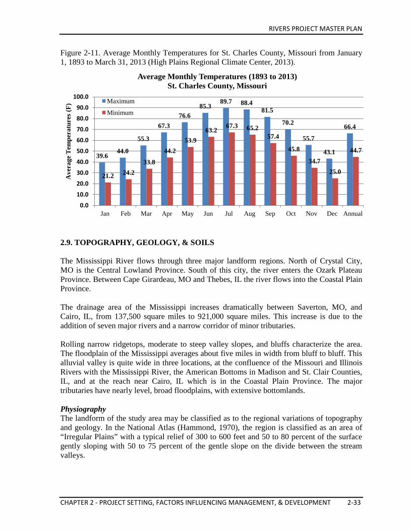
RIVERS PROJECT MASTER PLAN
CHAPTER 2 - PROJECT SETTING, FACTORS INFLUENCING MANAGEMENT, & DEVELOPMENT 2-33
Figure 2-11. Average Monthly Temperatures for St. Charles County, Missouri from January 1, 1893 to March 31, 2013 (High Plains Regional Climate Center, 2013).
2.9. TOPOGRAPHY, GEOLOGY, & SOILS The Mississippi River flows through three major landform regions. North of Crystal City, MO is the Central Lowland Province. South of this city, the river enters the Ozark Plateau Province. Between Cape Girardeau, MO and Thebes, IL the river flows into the Coastal Plain Province. The drainage area of the Mississippi increases dramatically between Saverton, MO, and Cairo, IL, from 137,500 square miles to 921,000 square miles. This increase is due to the addition of seven major rivers and a narrow corridor of minor tributaries. Rolling narrow ridgetops, moderate to steep valley slopes, and bluffs characterize the area. The floodplain of the Mississippi averages about five miles in width from bluff to bluff. This alluvial valley is quite wide in three locations, at the confluence of the Missouri and Illinois Rivers with the Mississippi River, the American Bottoms in Madison and St. Clair Counties, IL, and at the reach near Cairo, IL which is in the Coastal Plain Province. The major tributaries have nearly level, broad floodplains, with extensive bottomlands. Physiography The landform of the study area may be classified as to the regional variations of topography and geology. In the National Atlas (Hammond, 1970), the region is classified as an area of “Irregular Plains” with a typical relief of 300 to 600 feet and 50 to 80 percent of the surface gently sloping with 50 to 75 percent of the gentle slope on the divide between the stream valleys.
39.6 44.0
55.3
67.3 76.6
85.3 89.7 88.4
81.5
70.2
55.7
43.1
66.4
21.2 24.2 33.8
44.2 53.9
63.2 67.3 65.2
57.4
45.8
34.7 25.0
44.7
0.0
10.0
20.0
30.0
40.0
50.0
60.0
70.0
80.0
90.0
100.0
Jan Feb Mar Apr May Jun Jul Aug Sep Oct Nov Dec Annual
Ave
rage
Tem
pera
ture
s (F
) Average Monthly Temperatures (1893 to 2013)
St. Charles County, Missouri
Maximum
Minimum
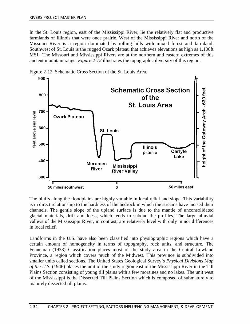
RIVERS PROJECT MASTER PLAN
2-34 CHAPTER 2 - PROJECT SETTING, FACTORS INFLUENCING MANAGEMENT, & DEVELOPMENT
In the St. Louis region, east of the Mississippi River, lie the relatively flat and productive farmlands of Illinois that were once prairie. West of the Mississippi River and north of the Missouri River is a region dominated by rolling hills with mixed forest and farmland. Southwest of St. Louis is the rugged Ozark plateau that achieves elevations as high as 1,100ft MSL. The Missouri and Mississippi Rivers are at the northern and eastern extremes of this ancient mountain range. Figure 2-12 illustrates the topographic diversity of this region. Figure 2-12. Schematic Cross Section of the St. Louis Area.
The bluffs along the floodplains are highly variable in local relief and slope. This variability is in direct relationship to the hardness of the bedrock in which the streams have incised their channels. The gentle slope of the upland surface is due to the mantle of unconsolidated glacial materials, drift and loess, which tends to subdue the profiles. The large alluvial valleys of the Mississippi River, in contrast, are relatively level with only minor differences in local relief. Landforms in the U.S. have also been classified into physiographic regions which have a certain amount of homogeneity in terms of topography, rock units, and structure. The Fenneman (1938) Classification places most of the study area in the Central Lowland Province, a region which covers much of the Midwest. This province is subdivided into smaller units called sections. The United States Geological Survey’s Physical Divisions Map of the U.S. (1946) places the unit of the study region east of the Mississippi River in the Till Plains Section consisting of young till plains with a few moraines and no lakes. The unit west of the Mississippi is the Dissected Till Plains Section which is composed of submaturely to maturely dissected till plains.
RIVERS PROJECT MASTER PLAN
CHAPTER 2 - PROJECT SETTING, FACTORS INFLUENCING MANAGEMENT, & DEVELOPMENT 2-35
Most of the area between the Mississippi and Illinois Rivers in Calhoun and Pike Counties, IL, and Lincoln, St. Charles, and Pike Counties, MO, are within the Lincoln Hills Section of the Ozark Plateaus Province. The Lincoln Hills Section is an upland which developed along the Lincoln fold, a secondary structure of the larger Ozark dome to the south. The Mississippi River cuts through this structure. Most of the section has not been glaciated, in contrast to areas to the east and west. The southern boundary in Calhoun County is along the Cap au Gris faulted flexure. Structural Geology The broad tectonic framework of the study area includes the Illinois Basin east of the study area and the Ozark dome to the south of the area. Important minor structures within the Project area are the Lincoln Fold and the Cap au Gris faulted flexure. The Lincoln Fold forms part of a divide which separates the Illinois Basin to the east from the Forest City Basin to the west. The length of the fold in Missouri is approximately 165 miles and the width varies, but may measure as much as 15 miles. The Lincoln Fold is more than a simple anticline. The structure is a regional uplift with anticlines, domes, inclines, and faults superimposed on it. Detailed geologic history of the Lincoln Fold is not complete because a detailed geological survey has not been made. Available information indicates that possibly during the late Silurian or the early part of the Devonian period the Lincoln Fold began to develop. Continued development occurred as repeated stages of erosion and deposition took place during the Devonian and Mississippian time. At the end of the Mississippian period, rocks were stripped from the fold. The fold was then buried under Pennsylvanian deposits. The remainder of the fold’s geologic history has been obscured by the removal of most of the Pennsylvanian rocks. Geologists assume that the area was not inundated by a marine environment again and that the fold has remained essentially unchanged since that time. The fold can be followed southward from the Iowa state line to its point of termination against the Cap au Gris Fault in Lincoln County, MO. The Cap au Gris faulted flexture, which derives its name from Cap au Gris Landing just east of Winfield, MO, on the Mississippi River is located in west central Illinois and east central Missouri. The fault zone crosses the Mississippi River about one mile south of Cap au Gris, MO, and the Illinois River near Meppen, IL. The generally east-west trending fault is described as a narrow band of steeply dipping rocks and discontinuous faults. The throw along the fault is approximately 1,000 to 1,100 feet. On the north, the upthrown side of the fault beds gently dip downward into the fault. South of the fault zone, rocks of Upper Middle Paleozoic Age are steeply upturned. The Cap au Gris fault is probably a left lateral fault that has moved approximately 30 miles. Geologists believe that recent movement has not occurred along the fault zone because Pleistocene terraces crossing the fault have not been warped or displaced. Historical Geology There were four main events in the geologic history of the study area, which account for the bedrock distribution, structural features, and the surficial materials of the uplands and alluvial valleys.
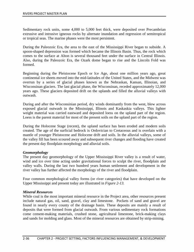
RIVERS PROJECT MASTER PLAN
2-36 CHAPTER 2 - PROJECT SETTING, FACTORS INFLUENCING MANAGEMENT, & DEVELOPMENT
Sedimentary rock units, some 4,000 to 5,000 feet thick, were deposited over Precambrian extrusive and intrusive igneous rocks by alternate inundation and regression of semitropical or tropical seas. The marine phases were the most persistent. During the Paleozoic Era, the area to the east of the Mississippi River began to subside. A spoon-shaped depression was formed which became the Illinois Basin. Thus, the rock which comes to the surface at Alton is several thousand feet under the surface in Central Illinois. Also, during the Paleozoic Era, the Ozark dome began to rise and the Lincoln Fold was formed. Beginning during the Pleistocene Epoch or Ice Age, about one million years ago, great continental ice sheets moved into the mid-latitudes of the United States, and the Midwest was overrun by a series of glacial phases known as the Nebraskan, Kansan, Illinoian, and Wisconsinan glaciers. The last glacial phase, the Wisconsinan, receded approximately 12,000 years ago. These glaciers deposited drift on the uplands and filled the alluvial valleys with outwash. During and after the Wisconsinian period, dry winds dominantly from the west, blew across exposed glacial outwash in the Mississippi, Illinois and Kaskaskia valleys. This lighter weight material was carried eastward and deposited loess on the upland part of the region. Loess is the parent material for most of the present soils on the upland part of the region. During the Holocene Stage (recent), the upland surface has been eroded and modern soils created. The age of the surficial bedrock is Ordovician to Cretaceous and is overlain with a mantle of younger Pleistocene and Holocene drift and soils. In the alluvial valleys, some of the valley fill has been scoured away and subsequent river changes and flooding have created the present day floodplain morphology and alluvial soils. Geomorphology The present day geomorphology of the Upper Mississippi River valley is a result of water, wind and ice over time acting under gravitational forces to sculpt the river, floodplain and valley walls. During the last two hundred years human settlement and development in the river valley has further affected the morphology of the river and floodplain. Four common morphological valley forms (or river categories) that have developed on the Upper Mississippi and present today are illustrated in Figure 2-13. Mineral Resources While coal is the most important mineral resource in the Project area, other resources present include natural gas, oil, sand, gravel, clay and limestone. Pockets of sand and gravel are found in nearly every county of the drainage basin. These deposits are mainly a result of deposits that were formed from glacial outwash. From various sedimentary rock formations come cement-making materials, crushed stone, agricultural limestone, brick-making clays and sands for molding and glass. Most of the mineral resources are obtained by strip-mining.
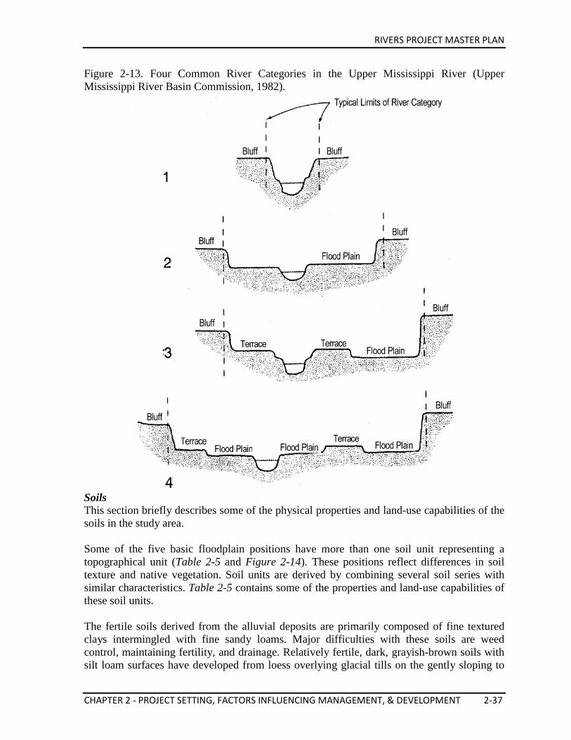
RIVERS PROJECT MASTER PLAN
CHAPTER 2 - PROJECT SETTING, FACTORS INFLUENCING MANAGEMENT, & DEVELOPMENT 2-37
Figure 2-13. Four Common River Categories in the Upper Mississippi River (Upper Mississippi River Basin Commission, 1982).
Soils This section briefly describes some of the physical properties and land-use capabilities of the soils in the study area. Some of the five basic floodplain positions have more than one soil unit representing a topographical unit (Table 2-5 and Figure 2-14). These positions reflect differences in soil texture and native vegetation. Soil units are derived by combining several soil series with similar characteristics. Table 2-5 contains some of the properties and land-use capabilities of these soil units. The fertile soils derived from the alluvial deposits are primarily composed of fine textured clays intermingled with fine sandy loams. Major difficulties with these soils are weed control, maintaining fertility, and drainage. Relatively fertile, dark, grayish-brown soils with silt loam surfaces have developed from loess overlying glacial tills on the gently sloping to
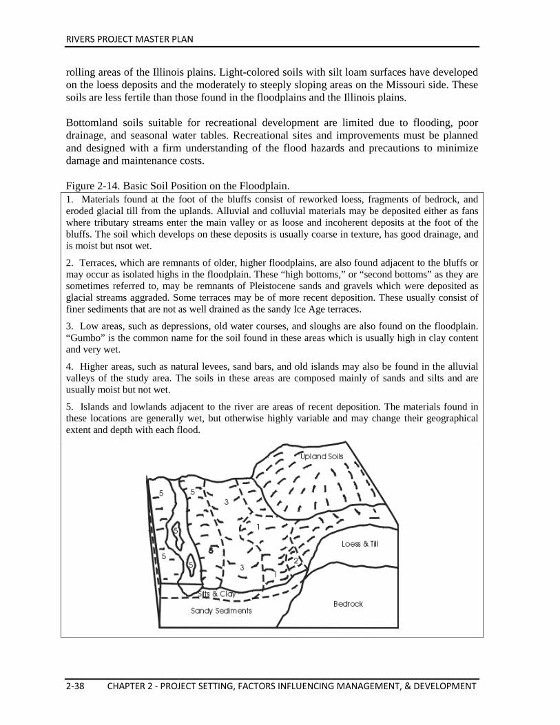
RIVERS PROJECT MASTER PLAN
2-38 CHAPTER 2 - PROJECT SETTING, FACTORS INFLUENCING MANAGEMENT, & DEVELOPMENT
rolling areas of the Illinois plains. Light-colored soils with silt loam surfaces have developed on the loess deposits and the moderately to steeply sloping areas on the Missouri side. These soils are less fertile than those found in the floodplains and the Illinois plains. Bottomland soils suitable for recreational development are limited due to flooding, poor drainage, and seasonal water tables. Recreational sites and improvements must be planned and designed with a firm understanding of the flood hazards and precautions to minimize damage and maintenance costs. Figure 2-14. Basic Soil Position on the Floodplain. 1. Materials found at the foot of the bluffs consist of reworked loess, fragments of bedrock, and eroded glacial till from the uplands. Alluvial and colluvial materials may be deposited either as fans where tributary streams enter the main valley or as loose and incoherent deposits at the foot of the bluffs. The soil which develops on these deposits is usually coarse in texture, has good drainage, and is moist but nsot wet.
2. Terraces, which are remnants of older, higher floodplains, are also found adjacent to the bluffs or may occur as isolated highs in the floodplain. These “high bottoms,” or “second bottoms” as they are sometimes referred to, may be remnants of Pleistocene sands and gravels which were deposited as glacial streams aggraded. Some terraces may be of more recent deposition. These usually consist of finer sediments that are not as well drained as the sandy Ice Age terraces.
3. Low areas, such as depressions, old water courses, and sloughs are also found on the floodplain. “Gumbo” is the common name for the soil found in these areas which is usually high in clay content and very wet.
4. Higher areas, such as natural levees, sand bars, and old islands may also be found in the alluvial valleys of the study area. The soils in these areas are composed mainly of sands and silts and are usually moist but not wet.
5. Islands and lowlands adjacent to the river are areas of recent deposition. The materials found in these locations are generally wet, but otherwise highly variable and may change their geographical extent and depth with each flood.
RIVERS PROJECT MASTER PLAN
CHAPTER 2 - PROJECT SETTING, FACTORS INFLUENCING MANAGEMENT, & DEVELOPMENT 2-39
Tabl
e 2
-5.
Sum
mar
y of
Pro
ject
Are
a So
ils C
hara
cter
istic
s.
Sl
ope
Ran
ge
(%)
0-18
<3
<2
0-2
<2
<2
0-2
0-3
1) R
oads
and
pic
nick
ing.
2)
Slig
ht -
min
or li
mita
tions
or l
imita
tions
are
eas
ily o
verc
ome.
M
oder
ate
- lim
itatio
ns n
eed
to b
e re
cogn
ized
; but
can
be
over
com
e w
ith p
rope
r pla
nnin
g Se
vere
lim
itatio
ns a
re d
iffic
ult t
o ov
erco
me
and
requ
ire c
aref
ul p
lann
ing
* Sl
ight
on
gent
le sl
opes
to se
vere
on
stee
p slo
pes
# D
epen
ds o
n dr
aina
ge
Suita
bilit
y fo
r R
ecre
atio
n U
ses1)
2)
*
Mod
erat
e to
seve
re
Seve
re
Mod
erat
e to
Sev
ere
Mod
erat
e to
Ser
eve
Mod
erat
e to
Sev
ere
Seve
re
Mod
erat
e to
seve
re
Suita
bilit
y fo
r W
ildlif
e
Wet
land
No
Yes
Yes
# Yes
No
Yes
Woo
d-la
nd
Yes
Yes
Yes
Yes
Yes
Yes
Yes
Yes
Ope
n la
nd
Yes
Yes
Yes
Yes
Yes
Yes
Yes
Yes
Floo
d H
azar
d
No
No
No
Yes
Yes
Yes
Yes
No
Inte
rnal
D
rain
age
Wel
l-Dra
ined
to
mod
erat
ely
wel
l-dra
ined
So
mew
hat
poor
ly to
poo
rly
drai
ned
Poor
ly to
ver
y po
orly
dra
ined
Wel
l-dra
ined
and
so
mew
hat p
oorly
dr
aine
d
Poor
ly to
som
e-w
hat p
oorly
dr
aine
d
Mod
erat
ely
wel
l-dr
aine
d
Poor
ly to
ver
y po
orly
dra
ined
Poor
ly a
nd
som
ewha
t poo
rly
drai
ned
Dep
th to
Wat
er
Tabl
e
As s
hallo
w a
s 3-
4’ in
sprin
g
As s
hallo
w a
s 1-
3’ in
sprin
g
Less
than
poo
rly
drai
ned
1-3’
in sp
ring
0-3’
in sp
ring
Fluc
tuat
es w
ith
adja
cent
stre
ams
0-2’
in sp
ring
Less
than
3’ i
n sp
ring
Rat
e of
Sur
face
R
unof
f
Slow
to m
ediu
m
Slow
to m
ediu
m
poor
ly d
rain
ed
Slow
to 2
’ in
sprin
g
Slow
Slow
Slow
Slow
to p
onde
d
Slow
to p
onde
d
Surf
ace
Text
ure
Silt
loam
and
fine
, sa
ndy
loam
Silt
loam
and
loam
sp
ring
Silt
loam
pon
ded
Silt
loam
Silt
loam
Silt
loam
Silty
cla
y
Silt
loam
and
Silt
y cl
ay lo
am
Land
scap
e Po
sitio
n
Upl
ands
and
te
rrac
es
Upl
ands
, ter
race
s, an
d ou
twas
h pl
ains
Upl
ands
and
te
rrac
es
Bot
tom
land
s
Bot
tom
land
s
Bot
tom
land
s
Bot
tom
land
s
Upl
ands
and
te
rrac
es
Soil
Uni
t
I (H
aplu
dalfa
)
II
(Och
raqu
alfa
)
III
(Alb
aqua
lfs)
IV
(Udi
fluve
nts)
V
(Flu
vaqu
ents
)
VI
(Hap
ludo
lls)
VII
(H
apla
quol
ls)
VII
I (A
rgiu
dolls
)
RIVERS PROJECT MASTER PLAN
2-40 CHAPTER 2 - PROJECT SETTING, FACTORS INFLUENCING MANAGEMENT, & DEVELOPMENT
2.10. RESOURCE ANALYSIS (Level I and II Inventories) The Corps environmental stewardship responsibility is to manage, conserve, and protect this natural resource for sustained use by future generations. Natural Resource inventories are required on Project lands and waters to provide quantitative and qualitative data for use in determining resource management needs. There are two types of inventories: Level One and Level Two. The Level One inventories are general in nature and are conducted to provide baseline general plant and animal information. Inventories are conducted to determine acreage of dominant vegetative types (Table 2-6), wetlands (Table 2-7), soil types, land use capabilities, and presence of special status species and their critical habitat occurring on Project lands and waters. A Level One inventory was completed using available information from a variety of sources, such as USGS maps (LTRM), county soil surveys, USFWS information, aerial photography, Corps real estate maps, project planning and design memorandums, and state DNR resource information in 2011. The Level Two inventories are prepared in support of the resource objectives and/or land use classifications and are generally more detailed or specific. These inventories are required for the effective development, execution and evaluation of specific natural resources management prescriptions. Rivers Project has conducted inventories for forest habitat, prairie habitat, wetland habitat, and some endangered species, Level Two inventories for aquatic habitats an additional endangered species still require completion. Completion of these inventories are a funding priority of Rivers Project as they are critically needed to protect and sustain habitats, fish, wildlife and endangered species and other stewardship opportunities. Fish and Wildlife Resources The Mississippi River is one of the world’s great rivers and one of its most complex ecosystems. It is a critical migration corridor for millions of birds and is essential to the ecological health of North America. The river environment is home to an incredible array of fish, wildlife and plants. In turn, millions of people use and enjoy these diverse resources. The river, its floodplain, and its adjacent upland corridor are essential to the survival and dispersal of a great portion of the vertebrate species (particularly birds, amphibians, and fish) and aquatic invertebrate species that inhabit this continent. The Mississippi River, more than any other natural feature, is a globally recognized symbol of this nation. The Mississippi River tributaries spread throughout the central U.S., comprising a drainage basin encompassing 40 percent of the lower 48 states-an area totaling 1.2 million square miles. The drainage basin, the fourth largest in the world, is defined on the east by the Appalachian Mountains and on the west by the Rocky Mountains. The bottomlands for the entire Mississippi River make up the largest wetland area in the U.S., and its bottomland hardwood forests are the most extensive in North America. More than half of the wetlands existing at the time of European colonization have been lost. The annual net loss of wetlands from the mid 1950s to the mid 1970s was mostly due to conversion to agriculture. In the following decade, there was a rapid decline in agricultural conversion and between 1982 and
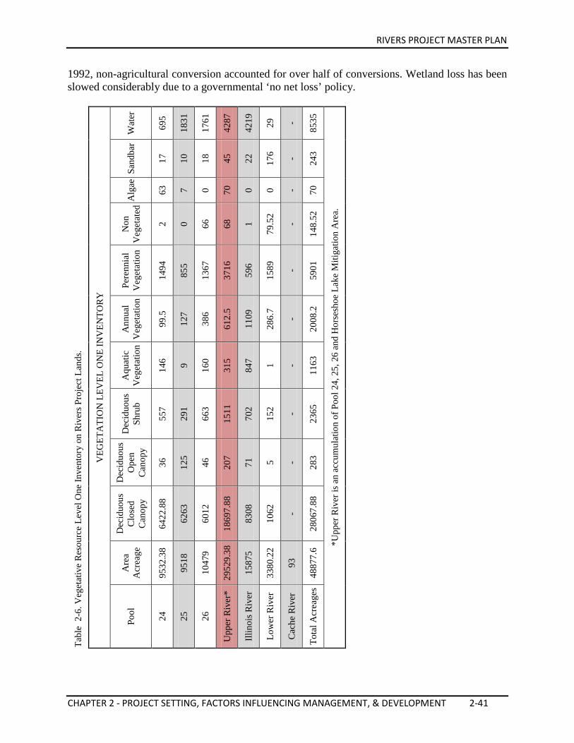
RIVERS PROJECT MASTER PLAN
CHAPTER 2 - PROJECT SETTING, FACTORS INFLUENCING MANAGEMENT, & DEVELOPMENT 2-41
1992, non-agricultural conversion accounted for over half of conversions. Wetland loss has been slowed considerably due to a governmental ‘no net loss’ policy.
Tabl
e 2
-6. V
eget
ativ
e R
esou
rce
Leve
l One
Inve
ntor
y on
Riv
ers P
roje
ct L
ands
.
VEG
ETA
TIO
N L
EVEL
ON
E IN
VEN
TOR
Y
Wat
er
695
1831
1761
4287
4219
29
-
8535
*Upp
er R
iver
is a
n ac
cum
ulat
ion
of P
ool 2
4, 2
5, 2
6 an
d H
orse
shoe
Lak
e M
itiga
tion
Are
a.
Sand
bar
17
10
18
45
22
176 - 243
Alg
ae
63
7 0 70
0 0 - 70
Non
V
eget
ated
2 0 66
68
1
79.5
2
-
148.
52
Pere
nnia
l V
eget
atio
n
1494
855
1367
3716
596
1589
-
5901
Ann
ual
Veg
etat
ion
99.5
127
386
612.
5
1109
286.
7
-
2008
.2
Aqu
atic
V
eget
atio
n
146 9 160
315
847 1 -
1163
Dec
iduo
us
Shru
b
557
291
663
1511
702
152 -
2365
Dec
iduo
us
Ope
n C
anop
y
36
125
46
207
71
5 - 283
Dec
iduo
us
Clo
sed
Can
opy
6422
.88
6263
6012
1869
7.88
8308
1062
-
2806
7.88
Are
a A
crea
ge
9532
.38
9518
1047
9
2952
9.38
1587
5
3380
.22
93
4887
7.6
Pool
24
25
26
Upp
er R
iver
*
Illin
ois R
iver
Low
er R
iver
Cac
he R
iver
Tota
l Acr
eage
s
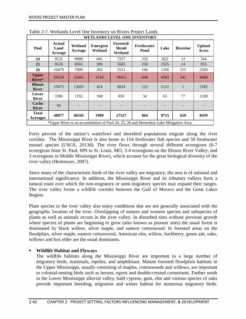
RIVERS PROJECT MASTER PLAN
2-42 CHAPTER 2 - PROJECT SETTING, FACTORS INFLUENCING MANAGEMENT, & DEVELOPMENT
Table 2-7. Wetlands Level One Inventory on Rivers Project Lands. WETLANDS LEVEL ONE INVENTORY
Pool Actual Land
Acreage
Wetland Acreage
Emergent Wetland
Forested/ Shrub
Wetland
Freshwater Pond Lake Riverine Upland
Acres
24 9532 8988 665 7257 232 822 12 544 25 9518 8563 289 5685 250 2325 14 955 26 10479 7909 362 5511 166 1356 515 2569
Upper River* 29529 25461 1316 18453 648 4503 541 4068
Illinois River 15875 13693 424 8024 122 5122 1 2182
Lower River 3380 1192 168 850 34 63 77 2188
Cache River 93 - - - - - - -
Total Acreages 48877 40345 1908 27327 804 9715 620 8439
*Upper River is an accumulation of Pool 24, 25, 26 and Horseshoe Lake Mitigation Area. Forty percent of the nation’s waterfowl and shorebird populations migrate along the river corridor. The Mississippi River is also home to 154 freshwater fish species and 50 freshwater mussel species (USGS, 2013d). The river flows through several different ecoregions (6-7 ecoregions from St. Paul, MN to St. Louis, MO, 3-4 ecoregions on the Illinois River Valley, and 3 ecoregions in Middle Mississippi River), which account for the great biological diversity of the river valley (Heitmeyer, 2007). Since many of the characteristic birds of the river valley are migratory, the area is of national and international significance. In addition, the Mississippi River and its tributary valleys form a natural route over which the non-migratory or semi-migratory species may expand their ranges. The river valley forms a wildlife corridor between the Gulf of Mexico and the Great Lakes Region. Plant species in the river valley also enjoy conditions that are not generally associated with the geographic location of the river. Overlapping of eastern and western species and subspecies of plants as well as animals occurs in the river valley. In disturbed sites without previous growth where species of plants are beginning to grow (also known as pioneer sites) the usual forest is dominated by black willow, silver maple, and eastern cottonwood. In forested areas on the floodplain, silver maple, eastern cottonwood, American elm, willow, hackberry, green ash, oaks, willows and box elder are the usual dominants. Wildlife Habitat and Flyways
The wildlife habitats along the Mississippi River are important to a large number of migratory birds, mammals, reptiles, and amphibians. Mature forested floodplain habitats in the Upper Mississippi, usually consisting of maples, cottonwoods and willows, are important to colonial-nesting birds such as herons, egrets and double-crested cormorants. Farther south in the Lower Mississippi alluvial valley, bald cypress, gum, elm and various species of oaks provide important breeding, migration and winter habitat for numerous migratory birds.
RIVERS PROJECT MASTER PLAN
CHAPTER 2 - PROJECT SETTING, FACTORS INFLUENCING MANAGEMENT, & DEVELOPMENT 2-43
Neotropical migratory birds depend on these forests and brushy habitats for migration and breeding; studies have demonstrated the importance of this migration corridor to the species of migrants whose numbers are declining. The Mississippi River floodplain forest is also important to the bald eagle both for nesting and wintering habitat. Most of the area within the floodplain of the river is wetland or converted wetland; this type of habitat is vital to many species of dabbling ducks for both migration and breeding. Both blue-winged teal and mallards nest on islands or in grasslands adjacent to the river, while wood ducks use tree cavities in the forests. Most importantly, the large, deep open pools of the river created by dams are vital to diving ducks, chiefly canvasback, redhead, lesser scaup and ring-necked ducks. Chief species using the Mississippi alluvial valley, which extends from southern Illinois to the coastal marshes of Louisiana, are the Mississippi valley and eastern prairie populations of Canada geese, snow geese, lesser white-fronted geese, and ducks such as gadwall, mallard, green-winged teal, American wigeon, American black duck, and northern pintail. Many other species of ducks use the river wetlands in lesser numbers. Terrestrial mammals such as the white-tailed deer, red fox (Vulpes vulpes), gray fox (Urocyon cinereoargenteus), coyote (Canis latrans), squirrels, raccoon, and opossum (Didelphis virginiana) are found in abundance, primarily inhabiting the river’s floodplain and islands. Aquatic mammals, such as the river otter (Lontra canadensis), beaver, and muskrat, are commonly observed along the riverbanks and/or backwaters. A few species of bats rely on cavities in the floodplain forests for shelter and the flying insects that are produced in and along the river for food. Overall, mammal populations within the river corridor are considered abundant and healthy (UMR Systemic Forest Stewardship Plan). A study documenting the amphibian use of the floodplain on the Upper Mississippi River was conducted by the USGS UMESC, in conjunction with the Amphibian Research and Monitoring Initiative (ARMI). This study documented ten species of frogs, one species of toad, and two species of salamanders in the Upper Mississippi River floodplain. These observed species of amphibians breed in wetlands among all habitat types in the floodplain, but most of the breeding sites studied were within the wet forest land cover type. In general, small, closed-canopy sites with less emergent vegetation and primary productivity are probably less productive for amphibians than more open canopy, often larger, wetlands (UMR Systemic Forest Stewardship Plan).
Fisheries
The Mississippi River supports a wide diversity of fish. Approximately 154 freshwater fish species and 50 freshwater mussel species live in the Mississippi River (USGS, 2013d). The diversity of the species generally increases from north to south. This diverse abundance of fish depends on many different aquatic habitat types including tailwaters, main channel, main channel border, side channel and backwater habitat. In three of the four pools in the study area (Pool 24, Pool 25 and Pool 26), three aquatic zones occur. The upper end of each pool most closely mirrors the river’s water level. In these areas, impoundment has the least effect on the water levels. In this portion of the pools, marsh development is limited, and the pre-impoundment condition of deep sloughs and
RIVERS PROJECT MASTER PLAN
2-44 CHAPTER 2 - PROJECT SETTING, FACTORS INFLUENCING MANAGEMENT, & DEVELOPMENT
wooded islands are most common. As flows increase, the upper end of the pool becomes deeper until open river conditions exist. In the middle of each pool, impounded water is backed up over islands and floodplain wetland, spreading the river out over a large area. Water level remains relatively stable until open river conditions exist. Marsh development has occurred in the middle portion of the pools. The lower pool portion is located immediately above each dam. Water was impounded to a depth that precluded most marsh development. At present, most of the lower pools’ area is deep, open water except when flows increase and water level decreases. As noted for each zone of the pool, water levels change when pool operation is manipulated by use of a hinge point. Upland erosion and the sedimentation in downstream areas are major causes of reduced water quality and habitat destruction in most mid-western rivers and streams. Sedimentation in the backwaters of the Upper Mississippi River is a significant environmental problem. Impounding the river has slowed the river current and increased silt deposition. Impounding the river originally created backwaters and side channel habitat which benefit species like the largemouth bass, bluegill, and crappie that prefer still water. These areas have now become silted in and would no longer be considered ideal habitat for the above mentioned species. However, there is a focus on improving backwater habitat through improved depth and aquatic vegetation (continued work of EMP-HREP). There also needs to be improved deep slackwater habitat, both for the true riverine species and backwater species. Riverine and sediment-tolerant species like the channel catfish, buffalo, drum and sturgeon still predominate in areas with current such as the main channel and main channel border. The freshwater mussel fishery was once a valuable commodity of the Mississippi and Illinois Rivers. Over harvesting and habitat decline has pushed many mussel species to the brink of extinction. There have been 51 different species of mussel historically identified as being native to the UMRS. These different species are adapted to different aquatic habitats. Because they are filter feeders, mussels are commonly used as indicators of aquatic ecosystem health. Navigation structures have the potential to impact existing mussel beds by creating scours, increasing sedimentation, stranding due to rapid river level fluctuations, or interrupting mussel life history. Current management planning includes evaluating the impact of new projects on the riverine mussel communities. Table 2-9 shows mussel species collected from 1997-2005 within the Project area.
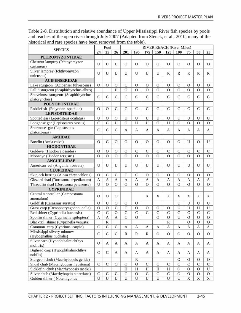
RIVERS PROJECT MASTER PLAN
CHAPTER 2 - PROJECT SETTING, FACTORS INFLUENCING MANAGEMENT, & DEVELOPMENT 2-45
Table 2-8. Distribution and relative abundance of Upper Mississippi River fish species by pools and reaches of the open river through July 2007 (Adapted from Steuck, et al., 2010; many of the historical and rare species have been removed from the table).
SPECIES Pool RIVER REACH (River Miles) 24 25 26 201 195 175 150 125 100 75 50 25
PETROMYZONTIDAE Chestnut lamprey (Ichthyomyzon castaneus) U U U O O O O O O O O O
Silver lamprey (Ichthyomyzon unicuspis) U U U U U U U R R R R R
ACIPENSERIDAE Lake sturgeon (Acipenser fulvescens) O O O C O O O O O O O O Pallid sturgeon (Scaphirhynchus albus) H O O O O O O O O O Shovelnose sturgeon (Scaphirhynchus platorynchus) C C C C C C C C C C C C
POLYODONTIDAE Paddlefish (Polyodon spathula) O O C C C C C C C C C C
LEPISOSTEIDAE Spotted gar (Lepisosteus oculatus) U O O U U U U U U U U U Longnose gar (Lepisosteus osseus) C C U O U U O U O O O O Shortnose gar (Lepisosteus platostomus) C C C A A A A A A A A A
AMIIDAE Bowfin (Amia calva) O C O O O O O O O U O U
HIODONTIDAE Goldeye (Hiodon alosoides) O O O O C C C C C C C C Mooneye (Hiodon tergisus) O O O O O O O O O O O O
ANGUILLIDAE American eel (Anguilla rostrata) U U U U U U U U U U U U
CLUPEIDAE Skipjack herring (Alosa chrysochloris) O C C C C O O O O O O O Gizzard shad (Dorosoma cepedianum) A A A A A A A A A A A A Threadfin shad (Dorosoma petenense) U O O O O O O O O O O O
CYPRINIDAE Central stoneroller (Campostoma anomalum) O O O X X X X X X X
Goldfish (Carassius auratus) O U O O O U U U U Grass carp (Ctenopharyngodon idella) O O C C O O O O U U U U Red shiner (Cyprinella lutrensis) C C O C C C C C C C C C Spotfin shiner (Cyprinella spiloptera) A A A C O O O U O O O Blacktail shiner (Cyprinella venusta) R R O O O Common carp (Cyprinus carpio) C C C A A A A A A A A A Mississippi silvery minnow (Hybognathus nuchalis) C C C R R R O O O O O O
Silver carp (Hypophthalmichthys molitrix) O A A A A A A A A A A A
Bighead carp (Hypophthalmichthys nobilis) C C A A A A A A A A A A
Sturgeon chub (Macrhybopsis gelida) R O O O O Shoal chub (Macrhybopsis hyostoma) C C O O O C C C C C C C Sicklefin chub (Macrhybopsis meeki) H H H H H O O O U Silver chub (Macrhybopsis storeriana) C C C C O C C C O O O O Golden shiner ( Notemigonus U U U U U U U U U X X X
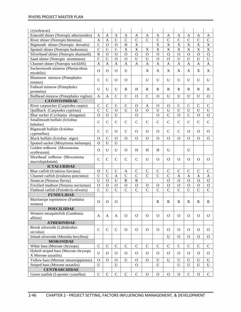
RIVERS PROJECT MASTER PLAN
2-46 CHAPTER 2 - PROJECT SETTING, FACTORS INFLUENCING MANAGEMENT, & DEVELOPMENT
crysoleucas) Emerald shiner (Notropis atherinoides) A A A A A A A A A A A A River shiner (Notropis blennius) A A C C C C C C C C C C Bigmouth shiner (Notropis dorsalis) C O O H X X X X X X X Spottail shiner (Notropis hudsonius) C C C X X X X X X X X X Silverband shiner (Notropis shumardi) R O O O O O O O O O O O Sand shiner (Notropis stramineus) C C O O U U O O U U U U Channel shiner (Notropis wickliffi) A A A A A A A A A A A A Suckermouth minnow (Phenacobius mirabilis) O O O U X X X X X X X
Bluntnose minnow (Pimephales notatus) C C O O U U U U U U U
Fathead minnow (Pimephales promelas) U U U R H R R R R R R R
Bullhead minnow (Pimephales vigilax) A A C C O C O U U U U O CATOSTOMIDAE
River carpsucker (Carpiodes carpio) C C C C O A O O C C C C Quillback (Carpiodes cyprinus) C C O U O O U U U U U U Blue sucker (Cycleptus elongatus) O O U O O C O C O O Smallmouth buffalo (Ictiobus bubalus) C C C C C C C C C C C C
Bigmouth buffalo (Ictiobus cyprinellus) C C O C O O O C C O O O
Black buffalo (Ictiobus niger) O C O O O O O O O O O O Spotted sucker (Minytrema melanops) O U U Golden redhorse (Moxostoma erythrurum) O U U O H H H U U
Shorthead redhorse (Moxostoma macrolepidotum) C C C C C U O O O O O O
ICTALURIDAE Blue catfish (Ictalurus furcatus) O C C A C C C C C C C C Channel catfish (Ictalurus punctatus) C C A C C C C C A A A A Stonecat (Noturus flavus) U O U R R O O O O O Freckled madtom (Noturus nocturnus) O O O O O O O O O O O O Flathead catfish (Pylodictis olivaris) C C C C C C C C C C C C
FUNDULIDAE Blackstripe topminnow (Fundulus notatus) O O O R R R R R R
POECILIIDAE Western mosquitofish (Gambusia affinis) A A A O O O O O O O O O
ATHERINIDAE Brook silverside (Labidesthes sicculus) C C C O O O O O O O O O
Inland silverside (Menidia beryllina) U O O O O MORONIDAE
White bass (Morone chrysops) C C C C C C C C C C C C Hybrid striped bass (Morone chrysops X Morone saxatilis) U O O O O O O O O O O O
Yellow bass (Morone mississippiensis) O O O U O O U U U U U U Striped bass (Morone saxatilis) U U O U U U U U
CENTRARCHIDAE Green sunfish (Lepomis cyanellus) C C C C C O O O O C O C
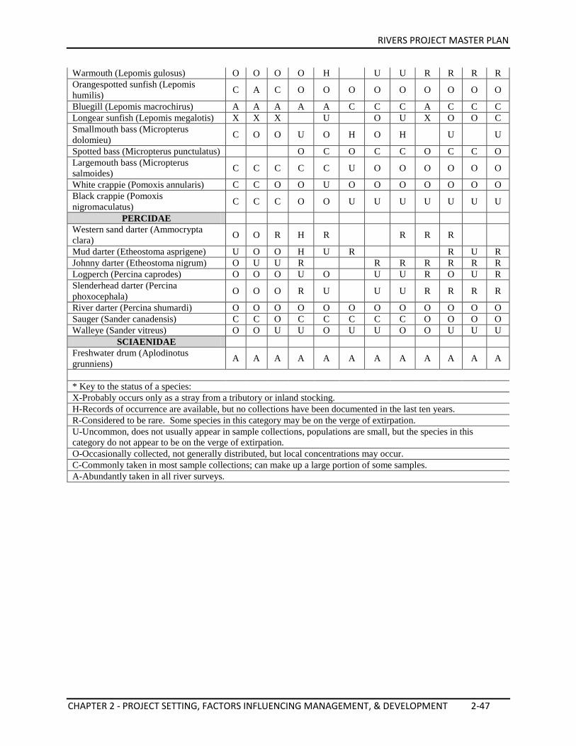
RIVERS PROJECT MASTER PLAN
CHAPTER 2 - PROJECT SETTING, FACTORS INFLUENCING MANAGEMENT, & DEVELOPMENT 2-47
Warmouth (Lepomis gulosus) O O O O H U U R R R R Orangespotted sunfish (Lepomis humilis) C A C O O O O O O O O O
Bluegill (Lepomis macrochirus) A A A A A C C C A C C C Longear sunfish (Lepomis megalotis) X X X U O U X O O C Smallmouth bass (Micropterus dolomieu) C O O U O H O H U U
Spotted bass (Micropterus punctulatus) O C O C C O C C O Largemouth bass (Micropterus salmoides) C C C C C U O O O O O O
White crappie (Pomoxis annularis) C C O O U O O O O O O O Black crappie (Pomoxis nigromaculatus) C C C O O U U U U U U U
PERCIDAE Western sand darter (Ammocrypta clara) O O R H R R R R
Mud darter (Etheostoma asprigene) U O O H U R R U R Johnny darter (Etheostoma nigrum) O U U R R R R R R R Logperch (Percina caprodes) O O O U O U U R O U R Slenderhead darter (Percina phoxocephala) O O O R U U U R R R R
River darter (Percina shumardi) O O O O O O O O O O O O Sauger (Sander canadensis) C C O C C C C C O O O O Walleye (Sander vitreus) O O U U O U U O O U U U
SCIAENIDAE Freshwater drum (Aplodinotus grunniens) A A A A A A A A A A A A
* Key to the status of a species: X-Probably occurs only as a stray from a tributory or inland stocking. H-Records of occurrence are available, but no collections have been documented in the last ten years. R-Considered to be rare. Some species in this category may be on the verge of extirpation. U-Uncommon, does not usually appear in sample collections, populations are small, but the species in this category do not appear to be on the verge of extirpation. O-Occasionally collected, not generally distributed, but local concentrations may occur. C-Commonly taken in most sample collections; can make up a large portion of some samples. A-Abundantly taken in all river surveys.
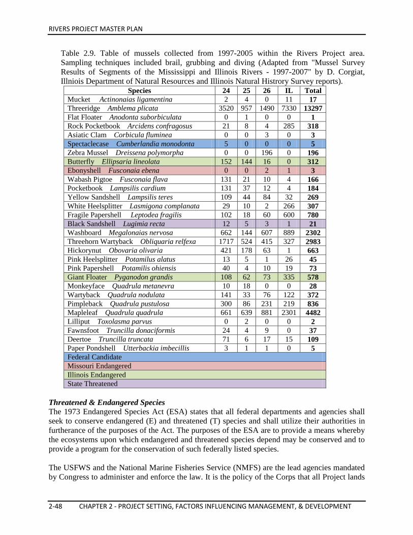
RIVERS PROJECT MASTER PLAN
2-48 CHAPTER 2 - PROJECT SETTING, FACTORS INFLUENCING MANAGEMENT, & DEVELOPMENT
Table 2.9. Table of mussels collected from 1997-2005 within the Rivers Project area. Sampling techniques included brail, grubbing and diving (Adapted from "Mussel Survey Results of Segments of the Mississippi and Illinois Rivers - 1997-2007" by D. Corgiat, Illniois Department of Natural Resources and Illinois Natural Histrory Survey reports).
Species 24 25 26 IL Total Mucket Actinonaias ligamentina 2 4 0 11 17 Threeridge Amblema plicata 3520 957 1490 7330 13297 Flat Floater Anodonta suborbiculata 0 1 0 0 1 Rock Pocketbook Arcidens confragosus 21 8 4 285 318 Asiatic Clam Corbicula fluminea 0 0 3 0 3 Spectaclecase Cumberlandia monodonta 5 0 0 0 5 Zebra Mussel Dreissena polymorpha 0 0 196 0 196 Butterfly Ellipsaria lineolata 152 144 16 0 312 Ebonyshell Fusconaia ebena 0 0 2 1 3 Wabash Pigtoe Fusconaia flava 131 21 10 4 166 Pocketbook Lampsilis cardium 131 37 12 4 184 Yellow Sandshell Lampsilis teres 109 44 84 32 269 White Heelsplitter Lasmigona complanata 29 10 2 266 307 Fragile Papershell Leptodea fragilis 102 18 60 600 780 Black Sandshell Lugimia recta 12 5 3 1 21 Washboard Megalonaias nervosa 662 144 607 889 2302 Threehorn Wartyback Obliquaria relfexa 1717 524 415 327 2983 Hickorynut Obovaria olivaria 421 178 63 1 663 Pink Heelsplitter Potamilus alatus 13 5 1 26 45 Pink Papershell Potamilis ohiensis 40 4 10 19 73 Giant Floater Pyganodon grandis 108 62 73 335 578 Monkeyface Quadrula metanevra 10 18 0 0 28 Wartyback Quadrula nodulata 141 33 76 122 372 Pimpleback Quadrula pustulosa 300 86 231 219 836 Mapleleaf Quadrula quadrula 661 639 881 2301 4482 Lilliput Toxolasma parvus 0 2 0 0 2 Fawnsfoot Truncilla donaciformis 24 4 9 0 37 Deertoe Truncilla truncata 71 6 17 15 109 Paper Pondshell Utterbackia imbecillis 3 1 1 0 5 Federal Candidate Missouri Endangered Illinois Endangered State Threatened
Threatened & Endangered Species The 1973 Endangered Species Act (ESA) states that all federal departments and agencies shall seek to conserve endangered (E) and threatened (T) species and shall utilize their authorities in furtherance of the purposes of the Act. The purposes of the ESA are to provide a means whereby the ecosystems upon which endangered and threatened species depend may be conserved and to provide a program for the conservation of such federally listed species. The USFWS and the National Marine Fisheries Service (NMFS) are the lead agencies mandated by Congress to administer and enforce the law. It is the policy of the Corps that all Project lands
RIVERS PROJECT MASTER PLAN
CHAPTER 2 - PROJECT SETTING, FACTORS INFLUENCING MANAGEMENT, & DEVELOPMENT 2-49
and waters will be managed in a manner which assists in the overall conservation of federally-listed endangered and threatened species, and the ecosystems upon which they depend. Species which are candidates for listing will also be given consideration. Conservation methods and procedures will be utilized which will enable the inventory and protection of these species of special concern and their habitat, as well as the participation in their recovery. Special Status Species include endangered and threatened species and proposed for listing species by the USFWS under the provisions of the ESA; candidate and sensitive species designated by the USFWS; species designated under the Migratory Bird Treaty Act; and potential endangered or extirpated species protected by state statute. Special status species and/or their critical habitats that occur on water resources development projects shall be protected and/or conserved in accordance with the ESA, as amended, and with existing statutes. Endangered Species Recovery Plans prepared by the USFWS and/or NMFS shall be followed to protect and conserve federally listed species or their critical habitat on Project administered lands and waters. Corps personnel will cooperate in the management of state-listed and protected species where feasible. Detailed, Level 2, inventories will include information conducted at frequencies necessary to determine presence, abundance and significant changes of existing population levels, the presence of new populations, type of occurrence and critical habitat of Special Status Species. Inventory measures and procedures will be utilized which will enable the protection of these Special Status species and their critical habitats, and participation in their recovery. Recovery plans will be reviewed and assessments made of potential Project natural resource management actions identified in each recovery plan, including a determination of reasonableness for each action and incorporation into Operational Management Plans. ESA Section 7 Consultation Covering O&M of the Nine-Foot Navigation Channel The Mississippi Valley Division and Region 3 of the USFWS entered into formal Section 7 Consultation under the Endangered Species Act in April 1998. This consultation was concluded in August 2000. The consultation was based on the operation and maintenance of the Nine-Foot Navigation Channel effect on the river. The consultation resulted in the following Biological Opinion for the St. Louis District: • Adverse affect resulting in Incidental Take with no significant Reasonable and Prudent
Measures (RPM) statement for Decurrent false aster, Bald eagle, and Indiana bat (predicated on increasing ongoing management efforts.)
• Adverse affect resulting in Incidental Take with a RPM statement for the Least tern. • Jeopardy decision with a Reasonable and Prudent Actions (RPA) statement and Incidental
Take with a RPM statement for the Pallid sturgeon. • Implementation of the Biological Opinion covers a fifty-year time frame; however, the
decisions for the Least tern and Pallid sturgeon include much shorter and definite time frames for specified actions.
RIVERS PROJECT MASTER PLAN
2-50 CHAPTER 2 - PROJECT SETTING, FACTORS INFLUENCING MANAGEMENT, & DEVELOPMENT
Federal Threatened and Endangered Species Fifteen species (plant and animal) determined to be potentially occurring within the floodplain or spending a portion of their life within the river or adjacent habitats are designated as endangered or threatened under the authority of the 1973 Federal Endangered Species Act. These species are listed in the table above. Special status species and habitats are of scientific interest due to their spatial distribution. The resource provides an excellent opportunity for study of migratory waterfowl and shorebirds; rare and endangered species; relict populations and habitats; and species at the borders of their ranges. Areas peripheral to the Project provide study opportunities such as the unique hill prairie communities in Illinois. The Project is currently assisting in the recovery and/or monitoring of the Interior least tern, Indiana bat, and gray bat. In the past, the Project has also assisted in the recovery of the Pallid sturgeon, Decurrent false aster, smooth softshell turtle, and Fat pocketbook and Higgins’ eye pearly mussels and will continue to do so when the need arises. Illinois and Missouri Rare, Threatened, and Endangered Species There are 286 state listed or candidate species and 36 federal listed or candidate species of rare, threatened, or endangered plants and animals endemic to the Upper Mississippi River Basin. The States of Illinois and Missouri have developed lists of species that they consider scarce within their respective states. Illinois designates species on the list as either “Endangered” or “Threatened”, while Missouri designates their species as “Endangered” or “Rare”. At a state level, a species is considered “endangered” if the species is threatened with extinction throughout all, or a significant portion of, its range within the state. A species is considered “threatened” or “rare” if it is likely to become endangered within the foreseeable future throughout all, or a significant portion of, its range within the state. These designations have similar definitions as the federal definitions, except that the status is at a state level. Many of the state-listed species are common over a much larger geographical area and are considered rare within a particular state because the area lies on the periphery of the species range and have smaller populations. There are some species, however, where the population decline occurs over the entire range of the species. In addition to the endangered, threatened and rare designations, each state has another category called “Special Concern” (or “Watch List” for Missouri), which is an advisory category. Special concern species are those species that are not rare, threatened, or endangered, but are extremely uncommon in an area or have unique or highly specific habitat requirements and deserve careful monitoring. Species on the periphery of their range, that are not listed as endangered or threatened, may be included in this category along with those species that were once listed as endangered or threatened but now have increasing protected or stable populations. In addition, the states include a category called “Extirpated”. These species formerly occurred as a regular breeding species, but no longer reproduce within the state. Extirpated species still occur somewhere within their natural range but outside the listed state.
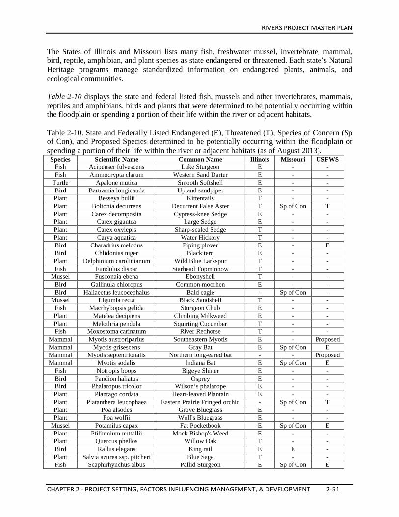
RIVERS PROJECT MASTER PLAN
CHAPTER 2 - PROJECT SETTING, FACTORS INFLUENCING MANAGEMENT, & DEVELOPMENT 2-51
The States of Illinois and Missouri lists many fish, freshwater mussel, invertebrate, mammal, bird, reptile, amphibian, and plant species as state endangered or threatened. Each state’s Natural Heritage programs manage standardized information on endangered plants, animals, and ecological communities. Table 2-10 displays the state and federal listed fish, mussels and other invertebrates, mammals, reptiles and amphibians, birds and plants that were determined to be potentially occurring within the floodplain or spending a portion of their life within the river or adjacent habitats. Table 2-10. State and Federally Listed Endangered (E), Threatened (T), Species of Concern (Sp of Con), and Proposed Species determined to be potentially occurring within the floodplain or spending a portion of their life within the river or adjacent habitats (as of August 2013).
Species Scientific Name Common Name Illinois Missouri USFWS Fish Acipenser fulvescens Lake Sturgeon E - - Fish Ammocrypta clarum Western Sand Darter E - -
Turtle Apalone mutica Smooth Softshell E - - Bird Bartramia longicauda Upland sandpiper E - - Plant Besseya bullii Kittentails T - - Plant Boltonia decurrens Decurrent False Aster T Sp of Con T Plant Carex decomposita Cypress-knee Sedge E - - Plant Carex gigantea Large Sedge E - - Plant Carex oxylepis Sharp-scaled Sedge T - - Plant Carya aquatica Water Hickory T - - Bird Charadrius melodus Piping plover E - E Bird Chlidonias niger Black tern E - - Plant Delphinium carolinianum Wild Blue Larkspur T - - Fish Fundulus dispar Starhead Topminnow T - -
Mussel Fusconaia ebena Ebonyshell T - - Bird Gallinula chloropus Common moorhen E - - Bird Haliaeetus leucocephalus Bald eagle - Sp of Con -
Mussel Ligumia recta Black Sandshell T - - Fish Macrhybopsis gelida Sturgeon Chub E - - Plant Matelea decipiens Climbing Milkweed E - - Plant Melothria pendula Squirting Cucumber T - - Fish Moxostoma carinatum River Redhorse T - -
Mammal Myotis austroriparius Southeastern Myotis E - Proposed Mammal Myotis grisescens Gray Bat E Sp of Con E Mammal Myotis septentrionalis Northern long-eared bat - - Proposed Mammal Myotis sodalis Indiana Bat E Sp of Con E
Fish Notropis boops Bigeye Shiner E - - Bird Pandion haliatus Osprey E - - Bird Phalaropus tricolor Wilson’s phalarope E - - Plant Plantago cordata Heart-leaved Plantain E - - Plant Platanthera leucophaea Eastern Prairie Fringed orchid - Sp of Con T Plant Poa alsodes Grove Bluegrass E - - Plant Poa wolfii Wolf's Bluegrass E - -
Mussel Potamilus capax Fat Pocketbook E Sp of Con E Plant Ptilimnium nuttallii Mock Bishop's Weed E - - Plant Quercus phellos Willow Oak T - - Bird Rallus elegans King rail E E - Plant Salvia azurea ssp. pitcheri Blue Sage T - - Fish Scaphirhynchus albus Pallid Sturgeon E Sp of Con E
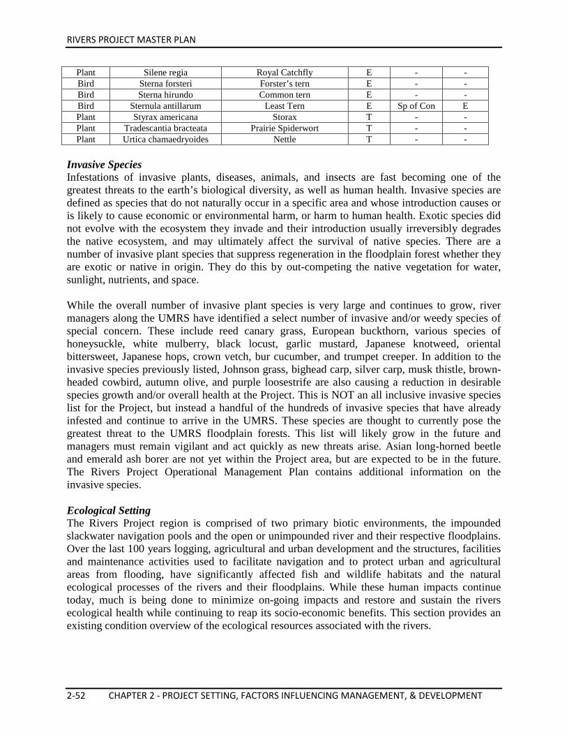
RIVERS PROJECT MASTER PLAN
2-52 CHAPTER 2 - PROJECT SETTING, FACTORS INFLUENCING MANAGEMENT, & DEVELOPMENT
Plant Silene regia Royal Catchfly E - - Bird Sterna forsteri Forster’s tern E - - Bird Sterna hirundo Common tern E - - Bird Sternula antillarum Least Tern E Sp of Con E Plant Styrax americana Storax T - - Plant Tradescantia bracteata Prairie Spiderwort T - - Plant Urtica chamaedryoides Nettle T - -
Invasive Species Infestations of invasive plants, diseases, animals, and insects are fast becoming one of the greatest threats to the earth’s biological diversity, as well as human health. Invasive species are defined as species that do not naturally occur in a specific area and whose introduction causes or is likely to cause economic or environmental harm, or harm to human health. Exotic species did not evolve with the ecosystem they invade and their introduction usually irreversibly degrades the native ecosystem, and may ultimately affect the survival of native species. There are a number of invasive plant species that suppress regeneration in the floodplain forest whether they are exotic or native in origin. They do this by out-competing the native vegetation for water, sunlight, nutrients, and space. While the overall number of invasive plant species is very large and continues to grow, river managers along the UMRS have identified a select number of invasive and/or weedy species of special concern. These include reed canary grass, European buckthorn, various species of honeysuckle, white mulberry, black locust, garlic mustard, Japanese knotweed, oriental bittersweet, Japanese hops, crown vetch, bur cucumber, and trumpet creeper. In addition to the invasive species previously listed, Johnson grass, bighead carp, silver carp, musk thistle, brown-headed cowbird, autumn olive, and purple loosestrife are also causing a reduction in desirable species growth and/or overall health at the Project. This is NOT an all inclusive invasive species list for the Project, but instead a handful of the hundreds of invasive species that have already infested and continue to arrive in the UMRS. These species are thought to currently pose the greatest threat to the UMRS floodplain forests. This list will likely grow in the future and managers must remain vigilant and act quickly as new threats arise. Asian long-horned beetle and emerald ash borer are not yet within the Project area, but are expected to be in the future. The Rivers Project Operational Management Plan contains additional information on the invasive species. Ecological Setting The Rivers Project region is comprised of two primary biotic environments, the impounded slackwater navigation pools and the open or unimpounded river and their respective floodplains. Over the last 100 years logging, agricultural and urban development and the structures, facilities and maintenance activities used to facilitate navigation and to protect urban and agricultural areas from flooding, have significantly affected fish and wildlife habitats and the natural ecological processes of the rivers and their floodplains. While these human impacts continue today, much is being done to minimize on-going impacts and restore and sustain the rivers ecological health while continuing to reap its socio-economic benefits. This section provides an existing condition overview of the ecological resources associated with the rivers.
RIVERS PROJECT MASTER PLAN
CHAPTER 2 - PROJECT SETTING, FACTORS INFLUENCING MANAGEMENT, & DEVELOPMENT 2-53
Large River and Floodplain Ecology Overview Today’s gently rolling agricultural landscape of the Upper Mississippi River basin is the result of intricate sculpting by massive glaciers during the Ice Ages. Blocks of ice scoured and filled the consolidated and semi-consolidated sedimentary bedrock of the valley, which consisted mostly of limestone, sandstone, and shale. Precambrian rocks underlie much of the present surface material, forming a basin in which many types of sediment occur. A drier climatic period with strong winds followed the retreat of the glaciers, depositing fertile silt (loess) on top of the glacial drift that the sliding ice islands dropped as they melted. These silt deposits gave rise to the hilly prairies through which the Mississippi cuts its course. The river flows within a floodplain averaging from one to ten miles wide bordered by wooded hills and bluffs. In the Upper River, steep bluffs constrict the watercourse in many areas and the elevation drop from upstream to downstream is significant. Like many large rivers, the Mississippi’s lower portion is prone to meandering slowly and aimlessly through a broad and worn-down floodplain with little elevation drop. The streambed material is composed of reworked glacial deposits, modern sands, and gravel. In many areas, bedrock lies deep beneath the alluvial streambeds and the river drifts over as much as 200 feet of sand and gravel. In other areas, the bedrock is shallow and/or exposed. The river molded the physiography and land forms which form the morphological setting for the ecosystem. Broad floodplains with gravel terraces, oxbow lakes, backwater areas, and periodically flooded bottom-land forests characterizes the valley ecosystem of this large alluvial river. The river affects and directs the dynamics of the ecosystem. A river’s floodpulse or natural river hydrograph, refers to the entire annual cycle of the water level, from low flow to flood crest and back to the low elevation (Junk et al. 1989). The annual flood pulse in the river valley controls the composition of the floral and faunal communities and recharges the floodplain with water, nutrients and sediments. In return, riparian communities donate nutrients to the river in the form of organic matter. There may be more than one flood per year. During great floods, the floodplains do not merely store water, they become part of the flowing river itself, conveying water slowly downstream through the forests and Marshes. Over millennia, plant and animal species have adapted to exploit, tolerate or escape seasonal floodpulses. Exceptional great floods and droughts further create habitat and species diversity as well. Riparian ecosystems are those natural associations of soil, flora, and fauna existing within the 100-year floodplain of a river and dependent for their survival on sufficiently high water tables and/or periodic flooding. The riparian vegetation zones or types are directly related to elevations from the river, and to the frequency, duration, and depth of flooding. Riparian communities are among the most diverse and productive on earth. Riparian ecosystems also provide habitat for animal species that use uplands; riparian zones depend on and fortify riverine environments. Therefore, they are inextricably linked to their neighboring ecosystems,
RIVERS PROJECT MASTER PLAN
2-54 CHAPTER 2 - PROJECT SETTING, FACTORS INFLUENCING MANAGEMENT, & DEVELOPMENT
and, because life on earth is one web of energy and matter exchanges, they are linked to all ecosystems. The process of sediment deposition makes it possible for most riparian communities to include a primary succession component. The new soil is colonized by plants such as silver maple, cottonwood, willow, and, depending on location, other species that can survive in unstable substrates, stabilizing them for species characteristic of more mature seral or successional stages. Seedlings of cottonwood and willow need direct sunlight and then face intense competition with other willow and cottonwoods that germinate at the same time. The silver maple, green ash, river birch, box elder, mulberry, and elm which are more shade tolerant and slower growing eventually catch up to the cottonwood and willows in size. Underneath the forest canopy dense webs of poison ivy, trumpet vine, grape, bur cucumber, and wood nettle take the place of their shade-intolerant predecessors. On low, excessively moist sites, succession often stops at the silver maple or willow stage. In areas of the floodplain where sediment accumulation has raised the site, thus improving drainage and providing a drier, terrace with stable substrate, American elm, sycamore, white ash, hickory, pin oak, black walnut, river birch, box elder, bur oak, and pecan prevail. Here the understory may contain persimmon, red-osier dogwood, flowering dogwood, redbud, hackberry, black cherry, mulberry and tall paw-paw in an intermediate canopy that is usually absent in pioneer communities. The ground cover typically contains such species as poison ivy, bur cucumber and wood nettle to name a few. The fauna of the riparian ecosystem are also related to water levels and floodpulsing and to water surface area losses due to natural and human-induced sedimentation. A wide variety of wildlife thrive in the unique ecological conditions of riverine forests and wetlands. Riparian ecosystems in their natural state provide many basic wildlife needs, such as early seral vegetation for foraging, water for drinking, and lush growth for hiding and nesting cover. Amphibians require a land-water interface to pass from larval to adult form. Aquatic furbearers, such as beavers, river otters, minks, and muskrats, require a healthy bank habitat to survive. Many unique floodplain habitat types harbor rare animal species that are highly dependent on one specific type of habitat. Bottomland hardwood forests, for example, provide irreplaceable habitat for gars, bowfins, and several turtle species that have changed little since prehistoric times. There is also abundant and variable birdlife. Several species may be found at the extremes of their ranges, due to the mid-continental location, the climatic conditions of the sheltered valley, the merging of life zones, and overlapping species ranges. In summary, the flood-adapted animals and plants, the seasonal floodpulses and infrequent great floods and droughts, the river and its channel, and the complex patchwork of floodplain habitats, together, constitute the dynamic and phenomenally productive river/floodplain ecosystem (Junk et al. 1989, Sparks 1995).
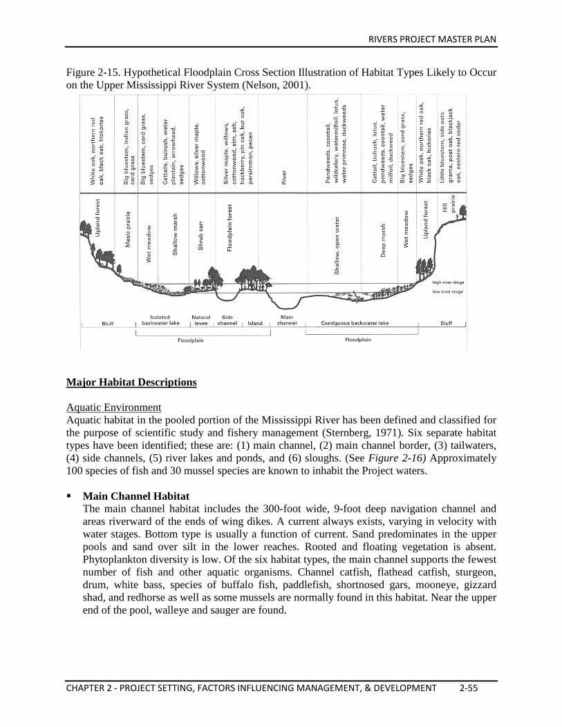
RIVERS PROJECT MASTER PLAN
CHAPTER 2 - PROJECT SETTING, FACTORS INFLUENCING MANAGEMENT, & DEVELOPMENT 2-55
Figure 2-15. Hypothetical Floodplain Cross Section Illustration of Habitat Types Likely to Occur on the Upper Mississippi River System (Nelson, 2001).
Major Habitat Descriptions Aquatic Environment Aquatic habitat in the pooled portion of the Mississippi River has been defined and classified for the purpose of scientific study and fishery management (Sternberg, 1971). Six separate habitat types have been identified; these are: (1) main channel, (2) main channel border, (3) tailwaters, (4) side channels, (5) river lakes and ponds, and (6) sloughs. (See Figure 2-16) Approximately 100 species of fish and 30 mussel species are known to inhabit the Project waters. Main Channel Habitat
The main channel habitat includes the 300-foot wide, 9-foot deep navigation channel and areas riverward of the ends of wing dikes. A current always exists, varying in velocity with water stages. Bottom type is usually a function of current. Sand predominates in the upper pools and sand over silt in the lower reaches. Rooted and floating vegetation is absent. Phytoplankton diversity is low. Of the six habitat types, the main channel supports the fewest number of fish and other aquatic organisms. Channel catfish, flathead catfish, sturgeon, drum, white bass, species of buffalo fish, paddlefish, shortnosed gars, mooneye, gizzard shad, and redhorse as well as some mussels are normally found in this habitat. Near the upper end of the pool, walleye and sauger are found.
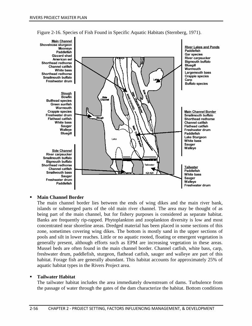
RIVERS PROJECT MASTER PLAN
2-56 CHAPTER 2 - PROJECT SETTING, FACTORS INFLUENCING MANAGEMENT, & DEVELOPMENT
Figure 2-16. Species of Fish Found in Specific Aquatic Habitats (Sternberg, 1971).
Main Channel Border
The main channel border lies between the ends of wing dikes and the main river bank, islands or submerged parts of the old main river channel. The area may be thought of as being part of the main channel, but for fishery purposes is considered as separate habitat. Banks are frequently rip-rapped. Phytoplankton and zooplankton diversity is low and most concentrated near shoreline areas. Dredged material has been placed in some sections of this zone, sometimes covering wing dikes. The bottom is mostly sand in the upper sections of pools and silt in lower reaches. Little or no aquatic rooted, floating or emergent vegetation is generally present, although efforts such as EPM are increasing vegetation in these areas. Mussel beds are often found in the main channel border. Channel catfish, white bass, carp, freshwater drum, paddlefish, sturgeon, flathead catfish, sauger and walleye are part of this habitat. Forage fish are generally abundant. This habitat accounts for approximately 25% of aquatic habitat types in the Rivers Project area.
Tailwater Habitat
The tailwater habitat includes the area immediately downstream of dams. Turbulence from the passage of water through the gates of the dam characterize the habitat. Bottom conditions
RIVERS PROJECT MASTER PLAN
CHAPTER 2 - PROJECT SETTING, FACTORS INFLUENCING MANAGEMENT, & DEVELOPMENT 2-57
are rocky and devoid of rooted or attached aquatic vegetation. This highly aerated water attracts an abundance of forage fish and such predatory species as walleye, sauger, white bass, and catfish. The downstream boundaries for defining the tailwater fishery habitat have been set a distance of one-half mile below the dam.
Side Channels
The side channels are off the main channel and main channel border and have a sustained current during normal river stages. These habitats vary in length from a few hundred yards to several miles, and in width as well as volume of flow. They are also sometimes called sloughs, running sloughs, chutes, cuts, cutoffs, and canals. Unless they are former main channel, the banks are usually unprotected. Undercut or eroded banks are common near their departure from the main channel. Closing structures or diversion dams are frequently present. The bottom type usually varies from sand at the upper reaches to silt in the lower. Rooted aquatic vegetation is absent in the swifter current, but may be common in shallower areas with silty bottoms. The habitat supports a diverse number of species such as channel catfish, sauger, drum, black bass, crappie, sunfish, carp, paddlefish, whitefish and buffalo species. This diminishing habitat has been identified as one of the highest value fisheries in the study area.
River Lakes and Ponds
River lakes and ponds are expanses of shallow water, normally having little or no flow. These habitats may or may not be connected with other water bodies. Bottoms are composed of muck or silt. Heavy growths of aquatic vegetation are normally present. Bullheads, carp, crappie and bowfin are a few of the many species of fish generally associated with this habitat. This habitat is heavily used by aquatic furbearers, waterfowl, and other aquatic dependent waterbirds.
Sloughs Sloughs are similar to lake or pond habitat, except that they are relatively narrow branches or offshoots of other water bodies. They are characterized by their lack of current at normal water stages, muck bottoms, and abundance of submerged and emergent vegetation. Sloughs, and some of the ponds and smaller lakes in the floodplain, are representative of ecological succession taking place in the river bottoms. Catfish, buffalo, carp, and members of the sunfish family inhabit these areas. They are also heavily used by waterfowl, aquatic furbearers, reptiles and amphibians. In general, backwater habitats, including river lakes, ponds, and sloughs, are characterized by having no current at normal water stage and muck bottoms. Sloughs generally have an abundance of aquatic vegetation. The species diversity and density of aquatic macrophytes, phytoplankton, zooplankton, benthic fauna, and fish are usually higher in backwater areas than in main channel habitats. These habitats are critical for fish because they provide favorable spawning and nursery conditions which are scarce on the main channel areas.
Middle Mississippi River The Middle Mississippi River is lined with revetments, dikes and bendway weirs to provide the navigation channel. This reach is characterized by existing side channels and other non-
RIVERS PROJECT MASTER PLAN
2-58 CHAPTER 2 - PROJECT SETTING, FACTORS INFLUENCING MANAGEMENT, & DEVELOPMENT
channel areas. These off-channel areas of high biological productivity constitute a small percent of the total area today. This area of Open River differs substantially from the pooled segment of the river primarily because of: (1) higher currents, (2) greater water level fluctuations, (3) increased turbidity and (4) different methods are used to maintain the navigation channel. The Middle Mississippi River supports a diverse fish fauna. Over 100 species of fishes in this segment of Open River have been documented. Approximately 20 fish species may be classified as sport fish and 25 species are classified as commercial fish. Twenty species are cited as common to moderately common near the mouth of the Ohio River but relatively rare upstream from there. Eleven species are considered rare to extremely rare throughout the Open Mississippi River. The majority of the fish (Approximately 45 species) are of widespread or sporadic distribution with intermediate levels of abundance. In general, however, most species found in the Middle Mississippi River are found in the pooled river. Unique Middle Mississippi River species include sturgeon chub, sicklefin chub and pallid sturgeon.
Terrestrial Environment Bottomland forest cover is the most typical habitat type of the riparian borders and islands of the rivers. Scattered permanent, seasonal, and ephemeral wetlands are also found on the floodplain. Many of these habitats provide highly productive food and cover vegetation used by a variety of wildlife species. More than 400 species of vertebrate animals (other than fish), have been recorded utilizing the river and floodplain related habitats. The species and sub-species are composed of approximately 50 mammals, 300 birds and 80 reptiles and amphibians. Sandbars and Mud Flats
Sandbars and mud flats are found along shores where receding water levels have left flat exposed areas. They are also found behind dikes where deposition results in sandbars, downstream of locks and dams, and in the river where deposition has resulted in semi-permanent or permanent islands. Vegetation cover is generally herbaceous consisting of annual grasses, composites, and sedges. Willow, cottonwood, sycamore, and silver maple seedlings may be found. This habitat is subject to frequent inundation which often limits vegetation. Sandbars and mud flats comprise a very important habitat. It provides food and resting areas for shorebirds, several species of reptiles and amphibians and mammals such as opossum, raccoon, muskrat, beaver, mink, otter and deer.
Open Wetlands
Open wetland areas include drainage ditches, lakes, ponds, marshes, hydric prairies and sloughs found in the Project area. Water levels fluctuate in these areas, causing the presence of water-tolerant vegetation. Abundant edge habitat is available because backwater areas characteristically interrupt other types of habitat. Vegetation cover is primarily a herbaceous layer comprised of arrowheads, millets, smart-weeds, lotus, rushes and other hydric and semi-aquatic plants; the drier backwater areas support grasses, sedges, and shrub and tree seedlings. Seasonal floods frequently control vegetation types and abundances. Mammals
RIVERS PROJECT MASTER PLAN
CHAPTER 2 - PROJECT SETTING, FACTORS INFLUENCING MANAGEMENT, & DEVELOPMENT 2-59
present include muskrat, mink, raccoon, white-tail deer, otter and beaver. More than 140 species of birds, predominantly waterfowl, swimming, diving, wading, and shore birds use this habitat. A large variety of amphibians and reptiles, including salamanders, toads, frogs, turtles and snakes, thrive in these areas as well.
Old Field and Disturbed Areas
Old Fields are generally abandoned, cultivated fields. Disturbed areas include similar habitats resulting from disruption including levees, roadsides, and other natural and constructed disturbances. The vegetation, such as weedy herbs, grasses, woody vines, shrubs, and tree saplings, is generally herbaceous. This habit is well-suited for small mammals, including eastern cottontail rabbit, skunk, opossum, fox squirrel, raccoon, and deer. Numerous birds, including several rare species, utilize the food and nesting resources of the old fields. Game birds include quail, ring-necked pheasant, woodcock, turkey and mourning dove. Reptiles and amphibians also use this habitat for food and cover.
Cultivated Fields
Cultivated fields have little vegetation diversity. They consist predominantly of corn, soybeans, or wheat on the floodplain. Mammals that utilize this habitat include mice, pocket gophers, woodchucks, Norway rats, coyotes, red foxes, deer and skunks. Numerous shorebirds and waterfowl species forage in these areas.
Marsh Community
Marsh is the most tolerant of high soil moisture and most commonly thought of when describing floodplain grasslands or wetlands. These communities are exposed to annual flooding in the spring and a high water table year-round. However, key to the survival of this community is lowered water levels during the growing season. Drought conditions periodically occurred allowing fire to sweep through removing invading shrubs and trees. Dominants included many species of sedges and bulrushes, rice cutgrass, arrowhead, cattail, and wild rice. Although many of the dominant marsh species are still common on the UMRS and natural river processes (silting) are allowing these communities to migrate into backwaters, there has been a shift in species composition. Annual grasses (i.e. wild millet) and several species of smartweeds are the dominant species in modern marsh communities. These species have a greater ability to tolerate/avoid rapid changes in hydrology from modern land management, produce large quantities of seed and survive recent large scale flooding events.
Wet Prairie
With a slight increase in elevation, wet prairies became more prominent. Like marshes, wet prairies experienced annual flooding events. The prominence of a high water table and lack of drainage would have reduced the presence of drier floodplain grass communities and the presence of fire and summer drought would have eliminated competition with mesic forest and marsh species. Dominants included prairie cordgrass (slough grass), reed canarygrass, switch grass, bluejoint, and great ragweed.
RIVERS PROJECT MASTER PLAN
2-60 CHAPTER 2 - PROJECT SETTING, FACTORS INFLUENCING MANAGEMENT, & DEVELOPMENT
Mixed Prairie A transitional community existed between the wet and dry prairies and was described as being dominated by a combination of both wet and dry prairie species. Due to the wet nature of the soil, tussocks or hummocks were likely common creating drier microclimates for the establishment of small, dry prairie islands in the midst of wet prairie. Frequent fluctuations in species composition would have likely occurred with changes in local annual precipitation, intensity and frequency of annual flooding and the intensity and frequency of fire. This community was dominated by species of both the wet and dry prairies. With the advent of tiling, like the wet prairie, mixed prairie soon fell to the settlers plow.
Dry Prairie
Although the wet prairie was very extensive, the largest grassland of the UMRS floodplain was likely that of the dry prairie. Dry prairies occupied higher terraces that experienced flooding for short durations or that rarely flooded. Dry prairie communities were dominated by big bluestem, indiangrass, sideoats grama, Canada wildrye, Canada goldenrod, compassplant, and sawtooth sunflower. Fire maintained these communities and rapid tree invasion occurred with fire suppression. With the advent of the steel bladed plow, dry prairies were rapidly converted to cropland and only remnants remain.
Sand Prairie
This prairie type was found on sand deposits left by glacial outwash. These sites were the most xeric and supported many species that are found in the mixed and short grass prairies of the western United States. Dominants included hairy grama, prairie Junegrass, porcupinegrass, sand dropseed, little bluestem, and several species of cacti (Thomson, 1940; Curtis and Greene, 1949). Like the other grassland communities, maintenance was procured through frequent fires. Drainage was not a problem in sand prairies, however, lack of soil moisture was. Floodplain sand prairies still exist on the UMRS and IRS where their importance as habitat for several species of threatened and endangered species is being realized. Many of these sites are being invaded by forests species, including quaking aspen (Populus tremuloides) and jack pine (Pinus banksiana) in the northern UMRS and eastern cottonwood (Populus deltoides) in the southern UMRS (Thomson, 1940).
Floodplain Forests
Common floodplain forests are a predominant habitat type in the river-associated ecosystem. They are generally confined to unprotected areas outside levees and low and poorly drained areas behind levees. Bottomland forest associations often lack abundant ground cover, due to frequent flooding and deposition of alluvial material and debris. Therefore, small mammal ground dwellers are not encountered frequently in this habitat. Mammals found in the floodplain forest include opossum, fox squirrel, white-footed mouse, raccoon, coyote, gray squirrel, and white-tailed deer. More than 140 species of birds can potentially be found in the floodplain forest throughout the year. These areas are important for wood duck nesting. Numerous species of reptiles and amphibians also utilize floodplain forests. Floodplain forest communities that occur within the Rivers Project area are described briefly below:
RIVERS PROJECT MASTER PLAN
CHAPTER 2 - PROJECT SETTING, FACTORS INFLUENCING MANAGEMENT, & DEVELOPMENT 2-61
Willow Community Willow communities are generally considered a pioneer community and establish on newly created, terrestrial landforms (i.e. island sand deposits, silted-in backwaters) or aquatic transition zones. Willow will establish in dense stands and enhance sediment deposition and land building. The primary species include sandbar willow (Salix interior), black willow (Salix nigra) and peachleaf willow (Salix amygdaloides). Willow is not a long lived species and as landform deposition continues, these communities will transition to a maple-ash-elm or wet shrubland community. This community is tolerant of flooding and anaerobic soil conditions. Eastern Cottonwood Community Eastern cottonwood (Populus deltoides) is a quick growing pioneer species that will readily establish on bare soil. Under natural river-floodplain dynamics, this would be on newly formed sandbars or downstream ends of islands and will commonly establish in conjunction with sandbar willow communities. This species will also be one of the first trees to inhabit abandoned agricultural fields. This community type is a relatively short-lived (80-120 years) and will transition to a maple-ash-elm community. Usually the latter species germinate and establish at the same time as or soon after the eastern cottonwood, but take longer to reach the upper canopy. This community type is tolerant of annual flooding, but not as tolerant as black willow or wet shrubland communities of anaerobic soil conditions. With modern river management in the pooled river reaches, sandbar formation has been reduced and this community type is declining in dominance. It is readily establishing on the river side of levees in the Middle Mississippi River. Efforts are being undertaken to re-establish this important community through planting efforts and monitor and preserve areas with natural regeneration. Wet Shrubland Community This community type is indicative of poor drainage and persistent flooding throughout much of the growing season. It is commonly found occupying silted in backwaters or areas where water is trapped due to natural or man-made levees. Dominant species include black willow, swamp privet (Forestiera acuminata), buttonbush (Cephalanthus occidentalis), and stunted green ash (Fraxinus pennsylvanica). Longevity of this community depends upon on the continued rate of sedimentation and duration of flooding. Eventually, this community will transition to a maple-ash-elm community. Silver Maple-Cottonwood Community This community type is more indicative of a transition from an eastern cottonwood community to a maple-ash-elm community type. However, since these species generally established at the same time and much of the forest communities within the management areas of the Rivers Project Office are in this current state, we will separate it from the other two community types. The dominance of this community type is directly related to historic forest management and species dominance at the time that the USACE acquired the land (1940s). At that time, much of the forest was in a state of early regeneration following harvest or abandonment of agriculture. This is a natural process, but likely was not as historically dominant of a community as it is today. Currently, the eastern cottonwood is becoming decadent and species of the maple-ash-elm community are
RIVERS PROJECT MASTER PLAN
2-62 CHAPTER 2 - PROJECT SETTING, FACTORS INFLUENCING MANAGEMENT, & DEVELOPMENT
replacing them as dominant. Although less flood tolerant than the willow community, it can withstand annual flooding. Silver maple (Acer saccharinum) and green ash (Fraxinus pennsylvanica) are the dominant species in this community type with sporadic, large eastern cottonwoods. Other species include American elm (Ulmus americana), willow species, pecan (Carya illinoensis), and boxelder (Acer negundo). Maple-Ash-Elm Community With the lack of floodplain disturbance and moderate flooding, forest communities will transition to a maple-ash-elm community. This community is dominated by large silver maple and green ash and American elm. Most of the floodplain forests are in the process of transitioning to this community type. Historically this community type was not as dominant as it is becoming in modern times. Oak-Hickory Community Pin oak (Quercus palustris) is the dominant species in this community type. However, the more defining characteristic is the high species diversity. Other dominants include bur oak (Quercus macrocarpa), overcup oak (Quercus lyrata), swamp white oak (Quercus bicolor), pecan, shellbark hickory (Carya laciniosa), hackberry (Celtis occidentalis), silver maple, American elm, hawthorn species (Crataegus spp.), deciduous holly (Illex decidua), and American plum (Prunus americana). The oak-hickory community is found in several different hydrologic regimes within the RPO Management Areas. On the poorer drained sites, dominance will generally shift to overcup oak, swamp white oak and pecan dominance with scattered pin oak. On the drier sites, dominance may include pin oak, bur oak and shellbark hickory. Prior to European settlement, oak-hickory was more predominant than it is today. Very little natural regeneration is occurring on these sites and that is prompting extensive planting efforts in order to regenerate these important communities. Cypress-Tupelo-Ash Community The Cypress-Tupelo-Ash community is a rare plant association, within the Project area, that occurs in remnant oxbow lakes only in deep southwestern Illinois and southeastern Missouri. The trees are adapted to grow inundated in shallow water throughout most or all of the growing season. The dominant species are bald cypress (Taxodium distichum), water tupelo (Nyssa aquatica), green ash, and sweet gum (Liquidambar styraciflua).
Waterfowl and Other Migratory Birds Waterfowl Management
The key purpose for the General Plan-Cooperative Agreement lands and waters addressed in this Master Plan update is to sustain migratory bird populations. These lands and waters are also North American Waterfowl Management Plan (NAWMP) designated areas. The Mississippi River is a migratory flight corridor for approximately 40 percent of all North American waterfowl and other migratory bird species. Common dabbling ducks using the flyway include mallard, wood ducks, green and blue-winged teal, pintail, gadwall, widgeon and shoveler. Common diving ducks include the lesser scaup, ringneck, bufflehead,
RIVERS PROJECT MASTER PLAN
CHAPTER 2 - PROJECT SETTING, FACTORS INFLUENCING MANAGEMENT, & DEVELOPMENT 2-63
goldeneye, canvasback, redhead and merganser. Canadian, snow and blue geese winter in the area as well. The importance of this area is highlighted by the NAWMP’s designation of the Upper Mississippi River as one of the waterfowl habitat areas of major concern in the U.S. Since 1970, trend analysis data shows a decreasing trend nationwide for waterfowl populations in general, and also specifically for mallards, the most abundant duck in the Mississippi Flyway. The Upper Mississippi River is one of the most important areas for this species. The major factor attributed to this decline is deterioration of northern breeding grounds. However, habitat loss is also a concern in areas used by waterfowl for resting and feeding during migration and for wintering. Waterfowl are physically stressed during migration periods, and the effects of habitat loss and degradation or disease outbreaks in migration corridors is significant. Many areas, historically used by migrating waterfowl have been lost to agriculture, and other land and water uses and the quality of much of the remaining habitat has decreased substantially. The aim of the NAWMP is to ensure the preservation of enough high quality waterfowl habitat to sustain waterfowl populations at levels for a fall flight of more than 100 million ducks (i.e., the 1970 level). For the mallard, the goal is to return to 1970-1979 population levels (or approximately 15 million birds in the fall flight). During the fall, moist soil plants provide a significant portion of the diet for many species of migrating and residential waterfowl in the region. These plants start from seed (artificially or naturally) on exposed mud flats during the summer, but must become subsequently inundated by 0.5 to 1.5 feet of water in the fall, which enables waterfowl to feed upon the seeds produced. Moist soil plants are especially sensitive to water levels during early growth when inundation can drown them. When water levels are dropped in the fall, as a result of navigation pool operations, the moist soil plants may be left stranded on mud flats. These plants then become inaccessible to waterfowl. To avoid this problem, many private hunting clubs and public agencies such as the Corps, USFWS, and state conservation agencies have built low levees adjacent to the pools to artificially control water levels to produce river conditions that are favorable for waterfowl use. These areas are not affected by normal fluctuations in river stage unless the levee is overtopped by flooding. Other important foods for migrating waterfowl include submerged aquatic plants, numerous species of aquatic invertebrates and fingernail clams (which are an important food source for diving ducks). Animal food sources are especially important to waterfowl during spring migration. The spatial arrangement of Project lands and their habitat conditions exert a strong influence on waterfowl numbers and distribution within the region. A large number of waterfowl use federal lands and waters administered by the Corps and the USFWS as wintering grounds or for resting and feeding during migration. In Pools 24-26 there are a number of Illinois and Missouri managed public hunting areas, as well as many well-managed private clubs that provide hunting opportunities and protect excellent waterfowl habitat that might otherwise be destroyed.
RIVERS PROJECT MASTER PLAN
2-64 CHAPTER 2 - PROJECT SETTING, FACTORS INFLUENCING MANAGEMENT, & DEVELOPMENT
Waterfowl Use The numbers and distribution of waterfowl passing through the region each fall vary among years and are influenced by weather conditions on the staging areas to the north as well as locally and the food and water conditions in traditional migration areas. The ability to monitor populations and habitat conditions on the breeding, migration and wintering areas is essential to the management of the waterfowl resource. Monitoring populations and their distribution along the Mississippi and Illinois Rivers is important for identifying critical areas of waterfowl concentrations and the habitats that support them. A loss of approximately 90 percent of the natural wetlands in Illinois and Missouri requires that intense and flexible management strategies be implemented to sustain the waterfowl resource. All data in Tables 2-11 to 2-12, and Figures 2-17 to 2-18 were gathered from 30 August 2010 to 4 January 2011 by the Illinois Natural History Survey (INHS) aerial surveys along the Illinois and Mississippi Rivers. The INHS has been conducting these surveys since 1948. Twenty-three locations along the Illinois River Valley (IRV) from Hennepin south to Grafton, IL. Sixteen locations along the Central Mississippi River Valley (CMRV) from Grafton north to New Boston, IL. Trumpeter swans have made a significant comeback in the Mississippi Flyway. During the winter of 1991-1992, five reintroduced trumpeter swans from Wisconsin migrated to the Riverlands Migratory Bird Sanctuary (RMBS). The reintroduction effort was being led by a collaborative of agencies, organizations and individuals that make up The Trumpeter Swan Society. In the early years birds were being raised in captivity and released in northern states in hopes that they would migrate and find safe overwintering grounds to the south. RMBS has become such a location and in 2011 The Trumpeter Swan Society declared that RMBS “is the single most important wintering site of the southern states” for trumpeter swans. In 2013 the National Audubon Society declared RMBS and the Confluence Important Bird Area as a Globally Important Bird Area due to the wintering population of trumpeter swans and its importance overall to the Mississippi Flyway trumpeter swan flock. In 2014, 960 trumpeter swans were recorded roosting in Ellis Bay. This is the largest flock of individuals ever recorded at the RMBS. The return of the trumpeter swan has not come without its issues. Many birds have been found dead or injured as a result of striking large overhead power lines in the RMBS. This has and will continue to require extensive coordination with the USFWS and utility companies to install diverters and avoid new line placement in their flight areas. Numerous swans have also been found dead or incapacitated due to lead poisoning from toxic shot and sinkers and have also been accidentally or purposefully shot by hunters and poachers. All of these actions have required extensive management efforts and coordination with partners to reduce mortality of wintering birds. To help better understand the birds while here The Audubon Center at Riverlands has partnered with local Audubon groups, The Trumpeter Swan Society and the Corps to monitor the flock using trained citizen scientists during the 3-4 month timeframe that the birds are here. This has resulted in a pool of new knowledge
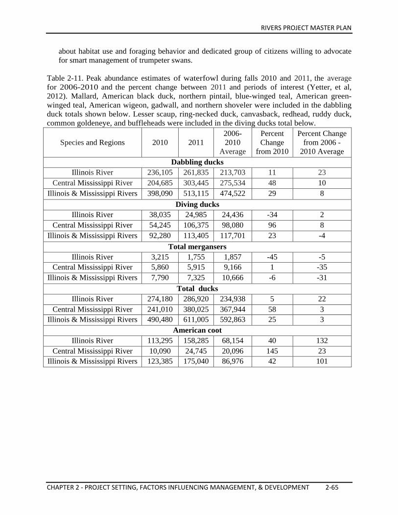
RIVERS PROJECT MASTER PLAN
CHAPTER 2 - PROJECT SETTING, FACTORS INFLUENCING MANAGEMENT, & DEVELOPMENT 2-65
about habitat use and foraging behavior and dedicated group of citizens willing to advocate for smart management of trumpeter swans.
Table 2-11. Peak abundance estimates of waterfowl during falls 2010 and 2011, the average for 2006-2010 and the percent change between 2011 and periods of interest (Yetter, et al, 2012). Mallard, American black duck, northern pintail, blue-winged teal, American green-winged teal, American wigeon, gadwall, and northern shoveler were included in the dabbling duck totals shown below. Lesser scaup, ring-necked duck, canvasback, redhead, ruddy duck, common goldeneye, and buffleheads were included in the diving ducks total below.
Species and Regions 2010 2011 2006-2010
Average
Percent Change
from 2010
Percent Change from 2006 -
2010 Average Dabbling ducks
Illinois River 236,105 261,835 213,703 11 23 Central Mississippi River 204,685 303,445 275,534 48 10
Illinois & Mississippi Rivers 398,090 513,115 474,522 29 8 Diving ducks
Illinois River 38,035 24,985 24,436 -34 2 Central Mississippi River 54,245 106,375 98,080 96 8
Illinois & Mississippi Rivers 92,280 113,405 117,701 23 -4 Total mergansers
Illinois River 3,215 1,755 1,857 -45 -5 Central Mississippi River 5,860 5,915 9,166 1 -35
Illinois & Mississippi Rivers 7,790 7,325 10,666 -6 -31 Total ducks
Illinois River 274,180 286,920 234,938 5 22 Central Mississippi River 241,010 380,025 367,944 58 3
Illinois & Mississippi Rivers 490,480 611,005 592,863 25 3 American coot
Illinois River 113,295 158,285 68,154 40 132 Central Mississippi River 10,090 24,745 20,096 145 23
Illinois & Mississippi Rivers 123,385 175,040 86,976 42 101
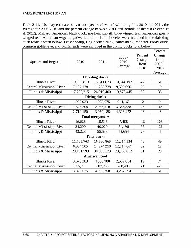
RIVERS PROJECT MASTER PLAN
2-66 CHAPTER 2 - PROJECT SETTING, FACTORS INFLUENCING MANAGEMENT, & DEVELOPMENT
Table 2-11. Use-day estimates of various species of waterfowl during falls 2010 and 2011, the average for 2006-2010 and the percent change between 2011 and periods of interest (Yetter, et al, 2012). Mallard, American black duck, northern pintail, blue-winged teal, American green-winged teal, American wigeon, gadwall, and northern shoveler were included in the dabbling duck totals shown below. Lesser scaup, ring-necked duck, canvasback, redhead, ruddy duck, common goldeneye, and buffleheads were included in the diving ducks total below.
Species and Regions 2010 2011 2006 - 2010
Average
Percent Change
from 2010
Percent Change
from 2006 - 2010
Average Dabbling ducks
Illinois River 10,650,813 15,611,673 10,344,197 47 51 Central Mississippi River 7,107,178 11,298,728 9,509,096 59 19
Illinois & Mississippi
17,729,215 26,910,400 19,873,445 52 35 Diving ducks
Illinois River 1,055,923 1,033,675 944,165 -2 9 Central Mississippi River 1,673,208 2,935,510 3,366,838 75 -13
Illinois & Mississippi
2,719,150 3,969,185 4,323,472 46 -8 Total mergansers
Illinois River 19,028 15,518 7,458 -18 108 Central Mississippi River 24,200 40,020 51,196 65 -22
Illinois & Mississippi
43,228 55,538 58,654 28 -5 Total ducks
Illinois River 11,725,763 16,660,865 11,217,524 42 49 Central Mississippi River 8,804,585 14,274,258 12,714,867 62 12
Illinois & Mississippi
20,491,593 30,935,123 23,965,012 51 29 American coot
Illinois River 3,678,383 4,358,988 2,502,054 19 74 Central Mississippi River 355,278 607,763 788,405 71 -23
Illinois & Mississippi
3,878,525 4,966,750 3,287,794 28 51
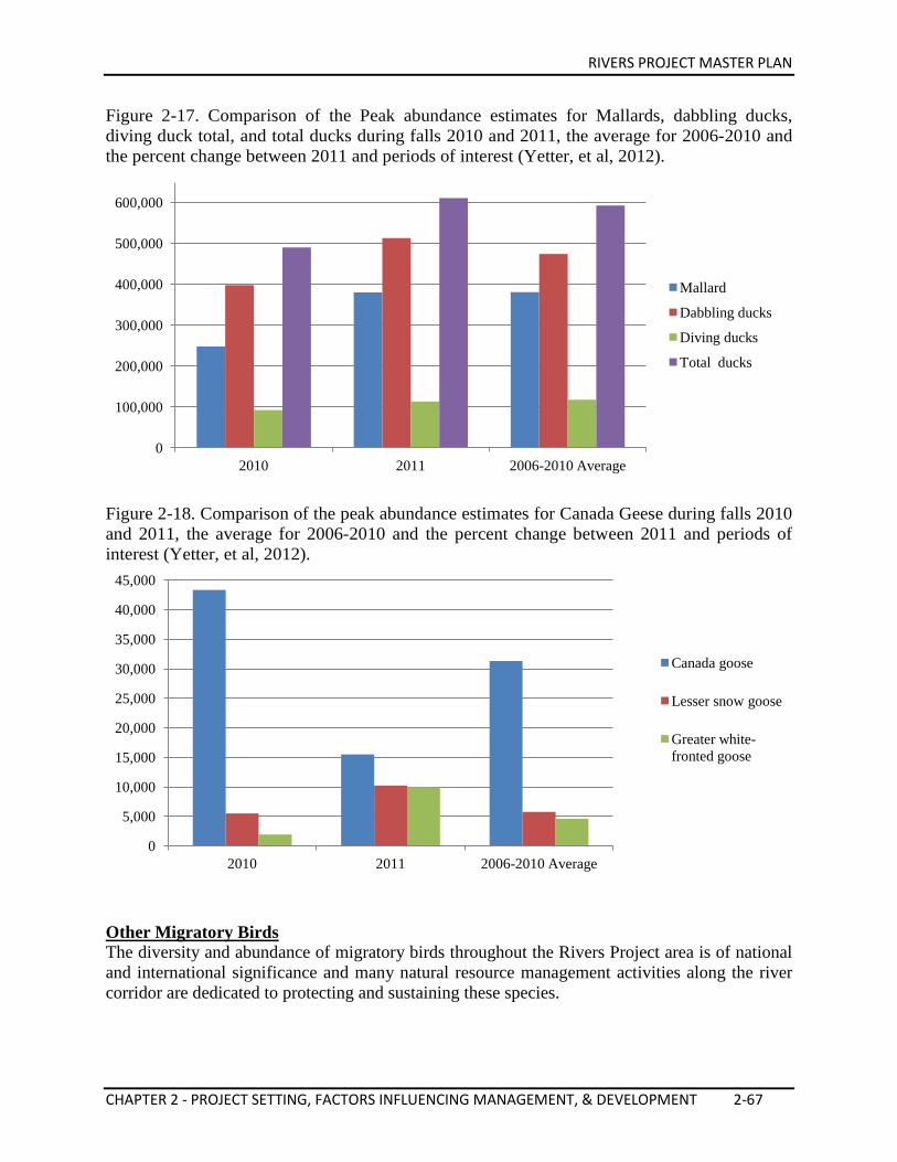
RIVERS PROJECT MASTER PLAN
CHAPTER 2 - PROJECT SETTING, FACTORS INFLUENCING MANAGEMENT, & DEVELOPMENT 2-67
Figure 2-17. Comparison of the Peak abundance estimates for Mallards, dabbling ducks, diving duck total, and total ducks during falls 2010 and 2011, the average for 2006-2010 and the percent change between 2011 and periods of interest (Yetter, et al, 2012).
Figure 2-18. Comparison of the peak abundance estimates for Canada Geese during falls 2010 and 2011, the average for 2006-2010 and the percent change between 2011 and periods of interest (Yetter, et al, 2012).
Other Migratory Birds The diversity and abundance of migratory birds throughout the Rivers Project area is of national and international significance and many natural resource management activities along the river corridor are dedicated to protecting and sustaining these species.
0
100,000
200,000
300,000
400,000
500,000
600,000
2010 2011 2006-2010 Average
Mallard
Dabbling ducks
Diving ducks
Total ducks
0
5,000
10,000
15,000
20,000
25,000
30,000
35,000
40,000
45,000
2010 2011 2006-2010 Average
Canada goose
Lesser snow goose
Greater white-fronted goose
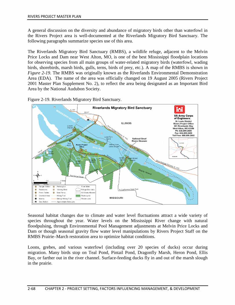
RIVERS PROJECT MASTER PLAN
2-68 CHAPTER 2 - PROJECT SETTING, FACTORS INFLUENCING MANAGEMENT, & DEVELOPMENT
A general discussion on the diversity and abundance of migratory birds other than waterfowl in the Rivers Project area is well-documented at the Riverlands Migratory Bird Sanctuary. The following paragraphs summarize species use of this area. The Riverlands Migratory Bird Sanctuary (RMBS), a wildlife refuge, adjacent to the Melvin Price Locks and Dam near West Alton, MO, is one of the best Mississippi floodplain locations for observing species from all main groups of water-related migratory birds (waterfowl, wading birds, shorebirds, marsh birds, gulls, terns, birds of prey, etc.). A map of the RMBS is shown in Figure 2-19. The RMBS was originally known as the Riverlands Environmental Demonstration Area (EDA). The name of the area was officially changed on 19 August 2005 (Rivers Project 2001 Master Plan Supplement No. 2), to reflect the area being designated as an Important Bird Area by the National Audubon Society. Figure 2-19. Riverlands Migratory Bird Sanctuary.
Seasonal habitat changes due to climate and water level fluctuations attract a wide variety of species throughout the year. Water levels on the Mississippi River change with natural floodpulsing, through Environmental Pool Management adjustments at Melvin Price Locks and Dam or though seasonal gravity flow water level manipulations by Rivers Project Staff on the RMBS Prairie–March restoration area to optimize habitat conditions. Loons, grebes, and various waterfowl (including over 20 species of ducks) occur during migration. Many birds stop on Teal Pond, Pintail Pond, Dragonfly Marsh, Heron Pond, Ellis Bay, or farther out in the river channel. Surface-feeding ducks fly in and out of the marsh slough in the prairie.
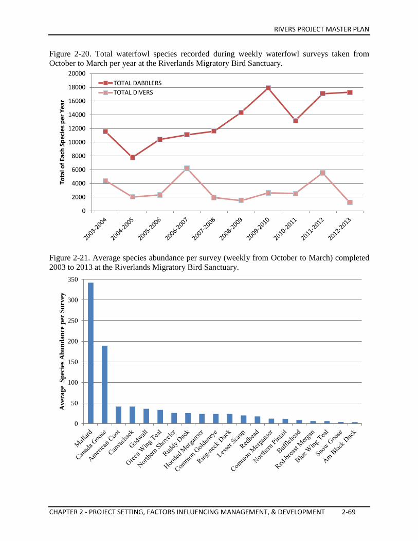
RIVERS PROJECT MASTER PLAN
CHAPTER 2 - PROJECT SETTING, FACTORS INFLUENCING MANAGEMENT, & DEVELOPMENT 2-69
Figure 2-20. Total waterfowl species recorded during weekly waterfowl surveys taken from October to March per year at the Riverlands Migratory Bird Sanctuary.
Figure 2-21. Average species abundance per survey (weekly from October to March) completed 2003 to 2013 at the Riverlands Migratory Bird Sanctuary.
0
2000
4000
6000
8000
10000
12000
14000
16000
18000
20000
Tota
l of E
ach
Spec
ies p
er Y
ear
TOTAL DABBLERS TOTAL DIVERS
0
50
100
150
200
250
300
350
Ave
rage
Spe
cies
Abu
ndan
ce p
er S
urve
y
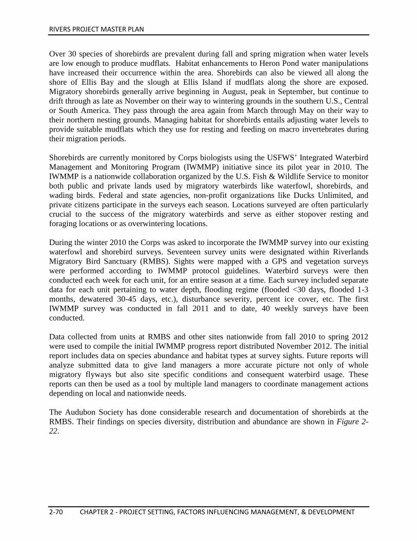
RIVERS PROJECT MASTER PLAN
2-70 CHAPTER 2 - PROJECT SETTING, FACTORS INFLUENCING MANAGEMENT, & DEVELOPMENT
Over 30 species of shorebirds are prevalent during fall and spring migration when water levels are low enough to produce mudflats. Habitat enhancements to Heron Pond water manipulations have increased their occurrence within the area. Shorebirds can also be viewed all along the shore of Ellis Bay and the slough at Ellis Island if mudflats along the shore are exposed. Migratory shorebirds generally arrive beginning in August, peak in September, but continue to drift through as late as November on their way to wintering grounds in the southern U.S., Central or South America. They pass through the area again from March through May on their way to their northern nesting grounds. Managing habitat for shorebirds entails adjusting water levels to provide suitable mudflats which they use for resting and feeding on macro invertebrates during their migration periods. Shorebirds are currently monitored by Corps biologists using the USFWS’ Integrated Waterbird Management and Monitoring Program (IWMMP) initiative since its pilot year in 2010. The IWMMP is a nationwide collaboration organized by the U.S. Fish & Wildlife Service to monitor both public and private lands used by migratory waterbirds like waterfowl, shorebirds, and wading birds. Federal and state agencies, non-profit organizations like Ducks Unlimited, and private citizens participate in the surveys each season. Locations surveyed are often particularly crucial to the success of the migratory waterbirds and serve as either stopover resting and foraging locations or as overwintering locations. During the winter 2010 the Corps was asked to incorporate the IWMMP survey into our existing waterfowl and shorebird surveys. Seventeen survey units were designated within Riverlands Migratory Bird Sanctuary (RMBS). Sights were mapped with a GPS and vegetation surveys were performed according to IWMMP protocol guidelines. Waterbird surveys were then conducted each week for each unit, for an entire season at a time. Each survey included separate data for each unit pertaining to water depth, flooding regime (flooded <30 days, flooded 1-3 months, dewatered 30-45 days, etc.), disturbance severity, percent ice cover, etc. The first IWMMP survey was conducted in fall 2011 and to date, 40 weekly surveys have been conducted. Data collected from units at RMBS and other sites nationwide from fall 2010 to spring 2012 were used to compile the initial IWMMP progress report distributed November 2012. The initial report includes data on species abundance and habitat types at survey sights. Future reports will analyze submitted data to give land managers a more accurate picture not only of whole migratory flyways but also site specific conditions and consequent waterbird usage. These reports can then be used as a tool by multiple land managers to coordinate management actions depending on local and nationwide needs. The Audubon Society has done considerable research and documentation of shorebirds at the RMBS. Their findings on species diversity, distribution and abundance are shown in Figure 2-22.
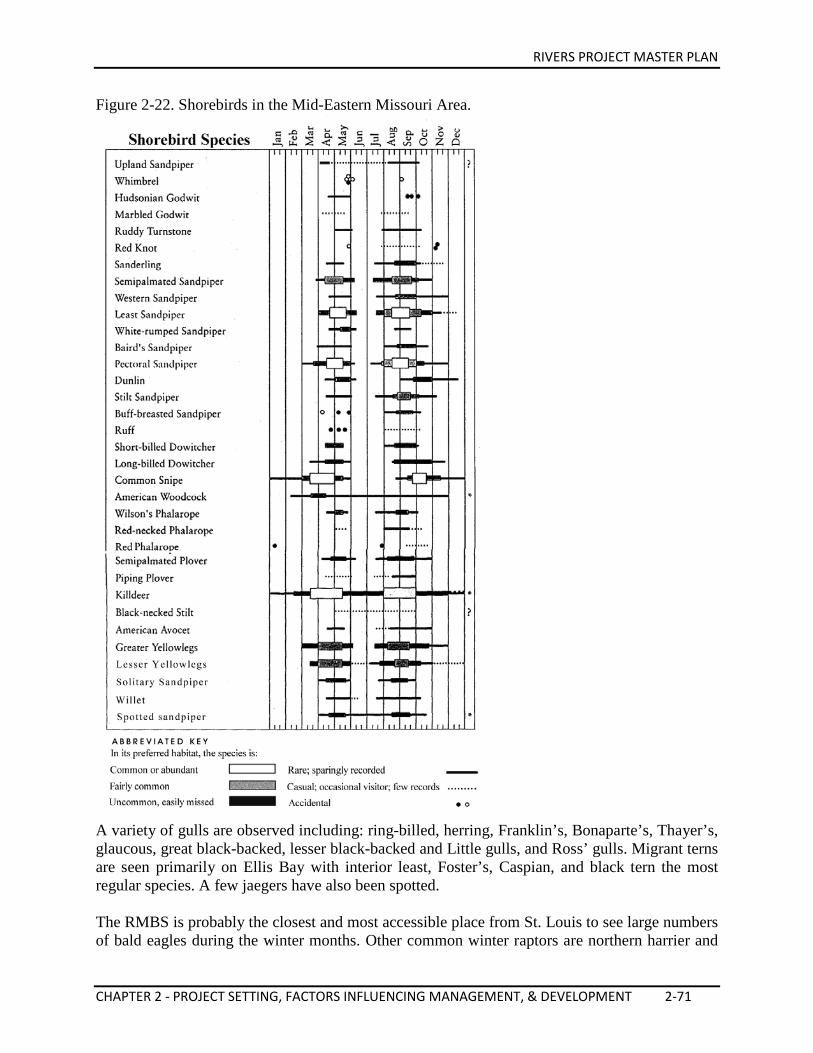
RIVERS PROJECT MASTER PLAN
CHAPTER 2 - PROJECT SETTING, FACTORS INFLUENCING MANAGEMENT, & DEVELOPMENT 2-71
Figure 2-22. Shorebirds in the Mid-Eastern Missouri Area.
A variety of gulls are observed including: ring-billed, herring, Franklin’s, Bonaparte’s, Thayer’s, glaucous, great black-backed, lesser black-backed and Little gulls, and Ross’ gulls. Migrant terns are seen primarily on Ellis Bay with interior least, Foster’s, Caspian, and black tern the most regular species. A few jaegers have also been spotted. The RMBS is probably the closest and most accessible place from St. Louis to see large numbers of bald eagles during the winter months. Other common winter raptors are northern harrier and
RIVERS PROJECT MASTER PLAN
2-72 CHAPTER 2 - PROJECT SETTING, FACTORS INFLUENCING MANAGEMENT, & DEVELOPMENT
red-tailed hawks. Rough-legged hawks appear sporadically, and short eared owls can be seen flying over the prairie area, usually after sundown. During migration osprey and peregrine falcons are seen. Neotropical migrants travel through the surrounding floodplain forests from late August to late October. Perching birds are less obvious, but many species are noted. Horned larks are common along the access road, sometimes accompanied by Lapland longspurs and snow buntings in winter. All swallows, especially Tree, are seen during migration. Large populations of crows are best observed in spring and fall. Sedge wrens are common in prairie grasses in August, and common yellowthroat, dickcissel and grasshopper sparrows are breeding species on the RMBS. In 2012 the Corps and The Audubon Center at Riverlands partnership developed a long-term neotropical forest bird monitoring program as part of the Corps’ Level II inventory mandate. The program is being accomplished using trained citizen scientists and biologists to monitor breeding bird activity on project forested lands. Full implementation of the program will occur in 2014/2015 and will carry on indefinitely according to the developed protocol to assist with understanding long-term trends in forest bird use, which will help make better informed management prescriptions. Figure 2-23. Total number of shorebird species per year at the Riverlands Migratory Bird Sanctuary from 2010 to 2012.
0
50
100
150
200
250
300
350
Tota
ls o
f Eac
h Sp
ecie
s per
Yea
r
2010 2011 2012
RIVERS PROJECT MASTER PLAN
CHAPTER 2 - PROJECT SETTING, FACTORS INFLUENCING MANAGEMENT, & DEVELOPMENT 2-73
2.11. CULTURAL RESOURCES Prehistoric Overview Four major prehistoric cultural periods are recognized in the Upper Mississippi River Valley: Paleo-Indian, Archaic period, Woodland culture, and Mississippi culture. Each succeeding period exhibits increased cultural sophistication. Twelve thousand years ago, small bands of Paleo-Indians, were hunters and gatherers that lived in small and temporary camps along the margins of retreating glaciers. Archaeological evidence of this period is sparse, limited primarily to surface finds of projectile points (Moffat & Ahler, 2001). The next cultural era, the Archaic period, lasted from 8000 BC to 1000 BC. Hunting and gathering continues with this era and towards the end they had even developed some cultivating of native plants for seeds. Larger communities could be found closer to major stream valleys, which were suspected to be bases for which hunting parties would depart (Moffat & Ahler, 2001). The subsequent Woodland culture, 1000 BC to 900 AD, developed long distance trade networks, long term settlements, practiced horticulture, made pottery, and built numerous mortuary mounds. Bow and arrows became more prominent and corn became a food staple towards the end of this era (Moffat & Ahler, 2001). The Mississippian culture was in existence approximately 900 AD to 1400 AD. Intensive horticulture (especially corn and squash) and large population centers are noteworthy elements of the Mississippian culture. The Cahokia Mounds city and culture, near present day Collinsville, IL, originated, prospered and ultimately disappeared during this period. European settlement in the region began during the later part of this period (Moffat & Ahler, 2001). The Cahokia Mounds World Heritage Site is the largest Mississippian site as well as the most sophisticated prehistoric civilization north of Mexico. At its zenith, around 800 years ago, the site covered more than five square miles and contained more than 120 temple mounds. The base of Monks Mound, the largest surviving mound at the site, is larger than the pyramid of Cheops in Egypt. From 1050 to 1200 A.D., Cahokia is estimated to have contained between 10,000 and 20,000 residents. “Houses were arranged in rows and around open plazas, and vast agricultural fields lay outside the city” (Cahokia Mounds State Historic Site, 2008). Historical Overview The region’s prehistoric and historic development is primarily linked to the river floodplain and adjacent uplands. The rivers provided water, fish and wildlife, and trade-route corridors for prehistoric peoples and early explorers. In addition, people used the river corridors for settlement, trade, and political boundaries for pioneers and settlers. Present uses of the river and their floodplains consist of industrial activities, commercial fishing, navigation, recreation, and educational opportunities. Numerous historic locations through-out the area represent the various river-oriented historical phases.
RIVERS PROJECT MASTER PLAN
2-74 CHAPTER 2 - PROJECT SETTING, FACTORS INFLUENCING MANAGEMENT, & DEVELOPMENT
Pere (Father) Jacques Marquette and Louis Joliet were the first Europeans to record explorations in the region in 1673. A large stone cross, located on Route 100 near Grafton, IL commemorates this event as the first entrance of European explorers into Illinois. They traveled with Native American guides in canoes, and repeatedly encountered Native American groups camped along the Mississippi River. The legendary Piasa monsters, painted on bluffs between Alton and Grafton, IL, were first recorded by Marquette (Pere Marquette Lodge, 2013). Lewis and Clark left on their historic exploration of the Missouri River from Camp River Dubois in Wood River, IL in May 1804. Today, several memorials and markers commemorate this event. The Mississippi River became increasingly important for trade and transportation as settlers from the east began to converge on the Mississippi Valley following the return of the explorers in September1806 (Lewis & Clark State Historic Site, 2006). The well-known frontiersman, Daniel Boone, and the explorer, Zebulon Pike, influenced settlement of the area. Pike County, MO, is named for Zebulon Pike, and several historic sites in western St. Charles County are associated with the Boone family. Trade, agriculture, and migration to the area continued to increase in the 19th century. European immigrants, particularly German and Irish, settled here. In the 1840s, great numbers of farmer immigrants traveled into the region by wagon and boat. Ferries were established at several river crossings, and St. Louis became a center for navigation, trade, industry, education, and politics throughout the nineteenth century. During the 18th and early 19th century, a thriving fur trade was the dominant commercial activity on the Mississippi, Illinois and Missouri Rivers. Canoes and dugouts were vessels of choice for the fur trade. River craft were designed with minimum draw to avoid the problems of changes in river depth, shifting sandbars, rapids, and hidden snags. Keelboats, flatboats, Mackinaws, and pirogues were used in conjunction with the canoes and dugouts during the later part of the period. The first steamboat arrived in St. Louis on August 21, 1815 and the second didn’t come until 1817. By 1920 steamboats were more common in the St. Louis. The small river towns became agricultural trade centers and steamboat landings (Moore, 1909). The Mississippi River Commission (MRC) was established in 1879 with headquarters in St. Louis, MO. The MRC was authorized to “make surveys and investigations necessary to prepare plans to improve the river channel, protect the banks, improve navigation, prevent destructive floods, and promote commerce.” The 1905 Rivers and Harbors Act “stipulated that dredging be the primary means of maintain a navigation channel on the Middle Mississippi River, as was done on the river south of Cairo.” A six-foot channel was authorized on the Upper Mississippi River in 1907 through use of open river regulation (MVD website). With the authorization of locks and dams, and the nine-foot channel in the 1930s, river commerce on the Upper Mississippi River became more economical than land traffic. Welded steel barges and powerful diesel towboats were introduced in the 1940s to transport coal, raw materials, manufactured goods, grains and raw materials used in food processing.
RIVERS PROJECT MASTER PLAN
CHAPTER 2 - PROJECT SETTING, FACTORS INFLUENCING MANAGEMENT, & DEVELOPMENT 2-75
Archaeological Resources in the Rivers Project Area In Missouri and Illinois, the greatest concentrations of archaeological sites are found in the river corridors which are the most fertile and accessible areas. The Mississippi River Valley and its tributaries constitute an area of great archaeological potential, based on a large number of physiographic and ecological features. Following the adoption of horticulture around 1,600 years ago, the region experienced a significant population increase. Professional surveys conducted along the Mississippi and Illinois Rivers has identified thousands of prehistoric archaeological sites. Evidence of prehistoric cemeteries, burial mounds, temporary camps, farmsteads and village sites are found in significant numbers throughout the Rivers Project area. A significant number of prehistoric and historic sites are known to exist in the Rivers Project area, including many archaeological and historic districts on the National Register of Historic Places. Major concentrations of archaeological sites have been identified near three types of land features: (1) the confluences of the Mississippi with major tributaries such as the Illinois, Salt, Missouri, Meramec and Kaskaskia Rivers; (2) sand ridges and terraces in the Mississippi floodplain; and (3) blufftops and their slopes. Since the early 1970s, with the passage of NEPA, full-time archaeological research has been conducted in the Project area. During this period researchers have uncovered literally thousands of archaeological sites with the location of thousands of others presently unknown. All sites are believed to have originated during the previous 13,000 years. Thousands of studies and reports exist in academic and agency files which document the existing state of knowledge of cultural resources in the Project area. All Project development and management plans have to be sensitive to the fragility of these cultural resources and should incorporate measures to protect and conserve them. 2.12. DEMOGRAPHICS This section provides an overview of the demographic, economic, recreational and environmental resources of the Project area. The topics covered are population characteristics, distribution and trends, economic conditions, educational opportunities, transportation systems, climatic conditions, hydrological conditions, land-use, ecological resources, aesthetic qualities, geology and soil characteristics, archaeological and historical resources and recreation characteristics. Summary of Entire Region The Rivers Project area extends from Saverton, MO, to Cairo, IL, on the Mississippi River; from La Grange, IL, to Grafton, IL, on the Illinois River. A total of 27 counties in Missouri and Illinois are within the Project area corridors. The St. Louis Metropolitan Area, with 16 counties, is the population and economic hub of the region and has, by far, the most influence on Project operations. The St. Louis area accounts for approximately 89 percent of the Project area population. The rural counties both upstream (six counties) and downstream (nine counties) of

RIVERS PROJECT MASTER PLAN
2-76 CHAPTER 2 - PROJECT SETTING, FACTORS INFLUENCING MANAGEMENT, & DEVELOPMENT
the St. Louis Metropolitan Area account for only 11 percent of the regions’ population and are primarily agricultural areas that are either losing population or growing slowly. The Cape Girardeau, MO, area is the only significant and growing population center on the river corridor outside of the St. Louis area (U.S. Census Bureau, 2010). Table 2-12. St. Louis Metropolitan Statistical Area Facts (St. Louis Commerce Magazine, 2012). Population (July 2010) 2,814,820 Media Market (Estimated TV Homes 2012) 1,253,920 US Population Within 500 Miles (2010) 30.2% Households (2010) 1,112,442 Area (square miles) 8,884 Total Labor Force (Nov 2011) 1,446,442 Unemployment Rate - St. Louis, MO-IL (2010) 8.1% Total Personal Income - St. Louis, MO-IL (2010) $117.4 billion Colleges and Universities 45 Cost of Living Index (2011 Average), (US Average = 100) 91.1
St. Louis Metropolitan Statistical Area (MSA) Populations The St. Louis Metropolitan Statistical Area (MSA) is a bi-state region comprising 16 counties, eight each in IL and MO. It is the 18th most populous metropolitan area in the U.S. The St. Louis MSA has a stable, slow-growing population. From 1930 to 2000, the St. Louis MSA had gained more than a million people. The St. Louis MSA population had over 2.4 million people in 1980 and has continued to grow from over 2.5 million in 1997 to 2.8 million in 2010 (Rivers Project Master Plan, 2001; St. Louis Commerce Magazine, 2011). In the 2012 in the St. Louis area population estimates, there has only been an increase of 0.2 percent since the 2010 U.S. Census. St. Louis County is now below one million people. The City of St. Louis has continued a 60 year decrease in population. St. Charles County has continued a half century growth with a 27 percent increase between the 2000 and 2010 censuses. (Moore, 2012). The outlying MSA counties in Missouri show significant, and at times spectacular, growth patterns which began in approximately 1970, with St. Charles County being one of the fastest growing counties in the United States with a growth rate of over 229 percent since 1970. Warren and Lincoln Counties have also become increasingly urbanized, growing in population by about 22 percent and 27 percent respectively (U.S. Census Bureau, 2010). The Illinois portion of the St. Louis MSA had 703,358 inhabitants in 2011, or about 25 percent of the total MSA. The eight Illinois counties included in the St. Louis MSA are estimated to have gained 10,964 residents between 2006 and 2011. Monroe County, with an estimated increase of 2.5 percent, is the fastest growing part of the MSA in Illinois (U.S. Census Bureau, 2012).
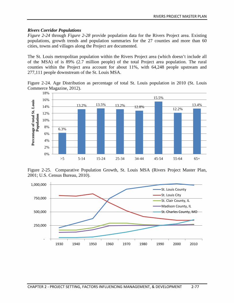
RIVERS PROJECT MASTER PLAN
CHAPTER 2 - PROJECT SETTING, FACTORS INFLUENCING MANAGEMENT, & DEVELOPMENT 2-77
Rivers Corridor Populations Figure 2-24 through Figure 2-28 provide population data for the Rivers Project area. Existing populations, growth trends and population summaries for the 27 counties and more than 60 cities, towns and villages along the Project are documented. The St. Louis metropolitan population within the Rivers Project area (which doesn’t include all of the MSA) of is 89% (2.7 million people) of the total Project area population. The rural counties within the Project area account for about 11%, with 64,248 people upstream and 277,111 people downstream of the St. Louis MSA. Figure 2-24. Age Distribution as percentage of total St. Louis population in 2010 (St. Louis Commerce Magazine, 2012).
Figure 2-25. Comparative Population Growth, St. Louis MSA (Rivers Project Master Plan, 2001; U.S. Census Bureau, 2010).
6.3%
13.2% 13.5% 13.2% 12.8%
15.5%
12.2% 13.4%
0%
2%
4%
6%
8%
10%
12%
14%
16%
18%
>5 5-14 15-24 25-34 34-44 45-54 55-64 65+
Perc
enta
ge o
f tot
al S
t. L
ouis
Po
pula
tion
-
250,000
500,000
750,000
1,000,000
1930 1940 1950 1960 1970 1980 1990 2000 2010
St. Louis County St. Louis City St. Clair County, IL Madison County, IL St. Charles County, MO
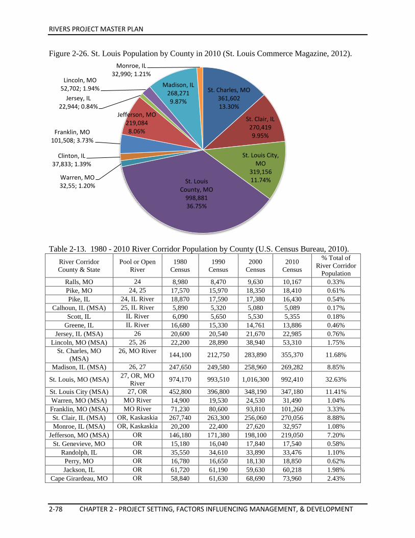
RIVERS PROJECT MASTER PLAN
2-78 CHAPTER 2 - PROJECT SETTING, FACTORS INFLUENCING MANAGEMENT, & DEVELOPMENT
Figure 2-26. St. Louis Population by County in 2010 (St. Louis Commerce Magazine, 2012).
Table 2-13. 1980 - 2010 River Corridor Population by County (U.S. Census Bureau, 2010).
River Corridor County & State
Pool or Open River
1980 Census
1990 Census
2000 Census
2010 Census
% Total of River Corridor
Population Ralls, MO 24 8,980 8,470 9,630 10,167 0.33% Pike, MO 24, 25 17,570 15,970 18,350 18,410 0.61% Pike, IL 24, IL River 18,870 17,590 17,380 16,430 0.54%
Calhoun, IL (MSA) 25, IL River 5,890 5,320 5,080 5,089 0.17% Scott, IL IL River 6,090 5,650 5,530 5,355 0.18%
Greene, IL IL River 16,680 15,330 14,761 13,886 0.46% Jersey, IL (MSA) 26 20,600 20,540 21,670 22,985 0.76%
Lincoln, MO (MSA) 25, 26 22,200 28,890 38,940 53,310 1.75% St. Charles, MO
(MSA) 26, MO River 144,100 212,750 283,890 355,370 11.68%
Madison, IL (MSA) 26, 27 247,650 249,580 258,960 269,282 8.85%
St. Louis, MO (MSA) 27, OR, MO River 974,170 993,510 1,016,300 992,410 32.63%
St. Louis City (MSA) 27, OR 452,800 396,800 348,190 347,180 11.41% Warren, MO (MSA) MO River 14,900 19,530 24,530 31,490 1.04% Franklin, MO (MSA) MO River 71,230 80,600 93,810 101,260 3.33% St. Clair, IL (MSA) OR, Kaskaskia 267,740 263,300 256,060 270,056 8.88% Monroe, IL (MSA) OR, Kaskaskia 20,200 22,400 27,620 32,957 1.08%
Jefferson, MO (MSA) OR 146,180 171,380 198,100 219,050 7.20% St. Genevieve, MO OR 15,180 16,040 17,840 17,540 0.58%
Randolph, IL OR 35,550 34,610 33,890 33,476 1.10% Perry, MO OR 16,780 16,650 18,130 18,850 0.62% Jackson, IL OR 61,720 61,190 59,630 60,218 1.98%
Cape Girardeau, MO OR 58,840 61,630 68,690 73,960 2.43%
St. Charles, MO 361,602 13.30%
St. Clair, IL 270,419 9.95%
St. Louis City, MO
319,156 11.74% St. Louis
County, MO 998,881 36.75%
Warren, MO 32,55; 1.20%
Clinton, IL 37,833; 1.39%
Franklin, MO 101,508; 3.73%
Jefferson, MO 219,084 8.06%
Jersey, IL 22,944; 0.84%
Lincoln, MO 52,702; 1.94% Madison, IL
268,271 9.87%
Monroe, IL 32,990; 1.21%

RIVERS PROJECT MASTER PLAN
CHAPTER 2 - PROJECT SETTING, FACTORS INFLUENCING MANAGEMENT, & DEVELOPMENT 2-79
Union, IL OR 17,780 17,630 18,290 17,808 0.59% Scott, MO OR 39,650 39,370 40,420 40,860 1.34%
Alexander, IL OR 12,280 10,640 9,590 8,238 0.27%
Pulaski, IL Cache, Ohio River 8,790 7,530 7,350 6,161 0.20%
Total 2,722,420 2,792,900 2,912,631 3,041,798 100.00% Educational Institutions Statistics and Trends Interpretive services, educational outreach and school partnerships with educational institutions are important missions for Rivers Project. The following summary of schools and universities throughout the Rivers Project area is provided to assist in identifying the regional scope of opportunities for program development and execution. St. Louis Metropolitan Area Educational Resources Elementary and Secondary Schools
The St. Louis MSA offers public education to 422,747 elementary and secondary students, in 165 districts and 889 schools. There are an additional 345 private elementary and secondary schools with 77,514 students (St. Louis Commerce Magazine, 2012). Elementary is defined as grades K-6 and Secondary 7-12 for the purposes of this document.
Figure 2-27. Educational Attainment of Persons Age 25 and Older in 2009 (St. Louis Commerce Magazine, 2011).
Figure 2-28. Comparison between Public and Private Schools in 2009 (St. Louis Commerce Magazine, 2011).
51.4
17.8 11.6
49.8
17.6 10.3
0
10
20
30
40
50
60
High School Graduate Bachelor's Degree Graduate/Professional Degree
Perc
ent
St. Louis Region U.S.
Public School
Enrollment 85%
Private School
Enrollment 15%
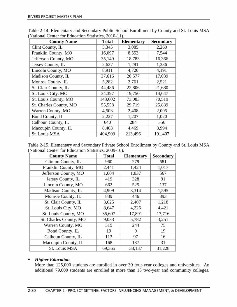
RIVERS PROJECT MASTER PLAN
2-80 CHAPTER 2 - PROJECT SETTING, FACTORS INFLUENCING MANAGEMENT, & DEVELOPMENT
Table 2-14. Elementary and Secondary Public School Enrollment by County and St. Louis MSA (National Center for Education Statistics, 2010-11).
County Name Total Elementary Secondary Clint County, IL 5,345 3,085 2,260 Franklin County, MO 16,097 8,553 7,544 Jefferson County, MO 35,149 18,783 16,366 Jersey County, IL 2,627 1,291 1,336 Lincoln County, MO 8,911 4,720 4,191 Madison County, IL 37,616 20,577 17,039 Monroe County, IL 5,282 2,761 2,521 St. Clair County, IL 44,486 22,806 21,680 St. Louis City, MO 34,397 19,750 14,647 St. Louis County, MO 143,602 73,083 70,519 St. Charles County, MO 55,558 29,719 25,839 Warren County, MO 4,503 2,408 2,095 Bond County, IL 2,227 1,207 1,020 Calhoun County, IL 640 284 356 Macoupin County, IL 8,463 4,469 3,994 St. Louis MSA 404,903 213,496 191,407
Table 2-15. Elementary and Secondary Private School Enrollment by County and St. Louis MSA (National Center for Education Statistics, 2009-10).
County Name Total Elementary Secondary Clinton County, IL 960 279 681
Franklin County, MO 2,441 1,424 1,017 Jefferson County, MO 1,604 1,037 567
Jersey County, IL 419 328 91 Lincoln County, MO 662 525 137 Madison County, IL 4,909 3,314 1,595 Monroe County, IL 839 446 393 St. Clair County, IL 3,625 2,407 1,218 St. Louis City, MO 8,647 4,226 4,421
St. Louis County, MO 35,607 17,891 17,716 St. Charles County, MO 9,033 5,782 3,251
Warren County, MO 319 244 75 Bond County, IL 19 0 19
Calhoun County, IL 113 97 16 Macoupin County, IL 168 137 31
St. Louis MSA 69,365 38,137 31,228 Higher Education
More than 125,000 students are enrolled in over 30 four-year colleges and universities. An additional 79,000 students are enrolled at more than 15 two-year and community colleges.
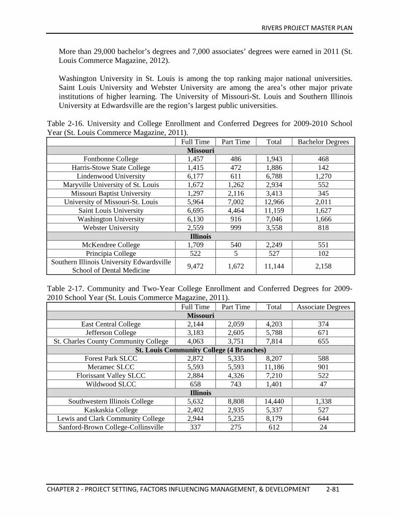
RIVERS PROJECT MASTER PLAN
CHAPTER 2 - PROJECT SETTING, FACTORS INFLUENCING MANAGEMENT, & DEVELOPMENT 2-81
More than 29,000 bachelor’s degrees and 7,000 associates’ degrees were earned in 2011 (St. Louis Commerce Magazine, 2012). Washington University in St. Louis is among the top ranking major national universities. Saint Louis University and Webster University are among the area’s other major private institutions of higher learning. The University of Missouri-St. Louis and Southern Illinois University at Edwardsville are the region’s largest public universities.
Table 2-16. University and College Enrollment and Conferred Degrees for 2009-2010 School Year (St. Louis Commerce Magazine, 2011).
Full Time Part Time Total Bachelor Degrees Missouri
Fontbonne College 1,457 486 1,943 468 Harris-Stowe State College 1,415 472 1,886 142
Lindenwood University 6,177 611 6,788 1,270 Maryville University of St. Louis 1,672 1,262 2,934 552
Missouri Baptist University 1,297 2,116 3,413 345 University of Missouri-St. Louis 5,964 7,002 12,966 2,011
Saint Louis University 6,695 4,464 11,159 1,627 Washington University 6,130 916 7,046 1,666
Webster University 2,559 999 3,558 818 Illinois
McKendree College 1,709 540 2,249 551 Principia College 522 5 527 102
Southern Illinois University Edwardsville School of Dental Medicine 9,472 1,672 11,144 2,158
Table 2-17. Community and Two-Year College Enrollment and Conferred Degrees for 2009-2010 School Year (St. Louis Commerce Magazine, 2011).
Full Time Part Time Total Associate Degrees
Missouri East Central College 2,144 2,059 4,203 374
Jefferson College 3,183 2,605 5,788 671 St. Charles County Community College 4,063 3,751 7,814 655
St. Louis Community College (4 Branches) Forest Park SLCC 2,872 5,335 8,207 588 Meramec SLCC 5,593 5,593 11,186 901
Florissant Valley SLCC 2,884 4,326 7,210 522 Wildwood SLCC 658 743 1,401 47
Illinois Southwestern Illinois College 5,632 8,808 14,440 1,338
Kaskaskia College 2,402 2,935 5,337 527 Lewis and Clark Community College 2,944 5,235 8,179 644 Sanford-Brown College-Collinsville 337 275 612 24
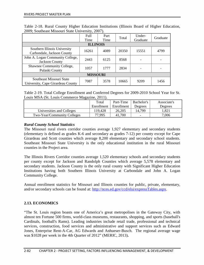
RIVERS PROJECT MASTER PLAN
2-82 CHAPTER 2 - PROJECT SETTING, FACTORS INFLUENCING MANAGEMENT, & DEVELOPMENT
Table 2-18. Rural County Higher Education Institutions (Illinois Board of Higher Education, 2009; Southeast Missouri State University, 2007).
Full Time
Part Time Total Under-
Graduate Graduate
ILLINOIS Southern Illinois University Carbondale, Jackson County 16261 4089 20350 15551 4799
John A. Logan Community College, Jackson County 2443 6125 8568 - -
Shawnee Community College, Pulaski County 1057 1777 2834 - -
MISSOURI Southeast Missouri State
University, Cape Girardeau County 7087 3578 10665 9209 1456
Table 2-19. Total College Enrollment and Conferred Degrees for 2009-2010 School Year for St. Louis MSA (St. Louis Commerce Magazine, 2011).
Total
Enrollment Part-Time Enrollment
Bachelor's Degrees
Associate's Degrees
Universities and Colleges 119,428 26,205 14,799 1,821 Two-Year/Community Colleges 77,995 41,700 - 7,006
Rural County School Statistics The Missouri rural rivers corridor counties average 1,927 elementary and secondary students (elementary is defined as grades K-6 and secondary as grades 7-12) per county except for Cape Girardeau and Scott counties which average 8,200 elementary and secondary school students. Southeast Missouri State University is the only educational institution in the rural Missouri counties in the Project area. The Illinois Rivers Corridor counties average 1,520 elementary schools and secondary students per county except for Jackson and Randolph Counties which average 5,578 elementary and secondary students. Jackson County is the only rural county with Significant Higher Education Institutions having both Southern Illinois University at Carbondale and John A. Logan Community College. Annual enrollment statistics for Missouri and Illinois counties for public, private, elementary, and/or secondary schools can be found at: http://nces.ed.gov/ccd/elsi/expressTables.aspx. 2.13. ECONOMICS “The St. Louis region boasts one of America’s great metropolises in the Gateway City, with almost ten Fortune 500 firms, world-class museums, restaurants, shopping, and sports (baseball's Cardinals, football's Rams). Leading industries include retail trade, professional and technical services, construction, food services and administrative and support services such as Edward Jones, Enterprise Rent-A-Car, AG Edwards and Anhueser-Busch. The regional average wage was $1028 per week in the 4th Quarter of 2012” (MERIC, 2013).
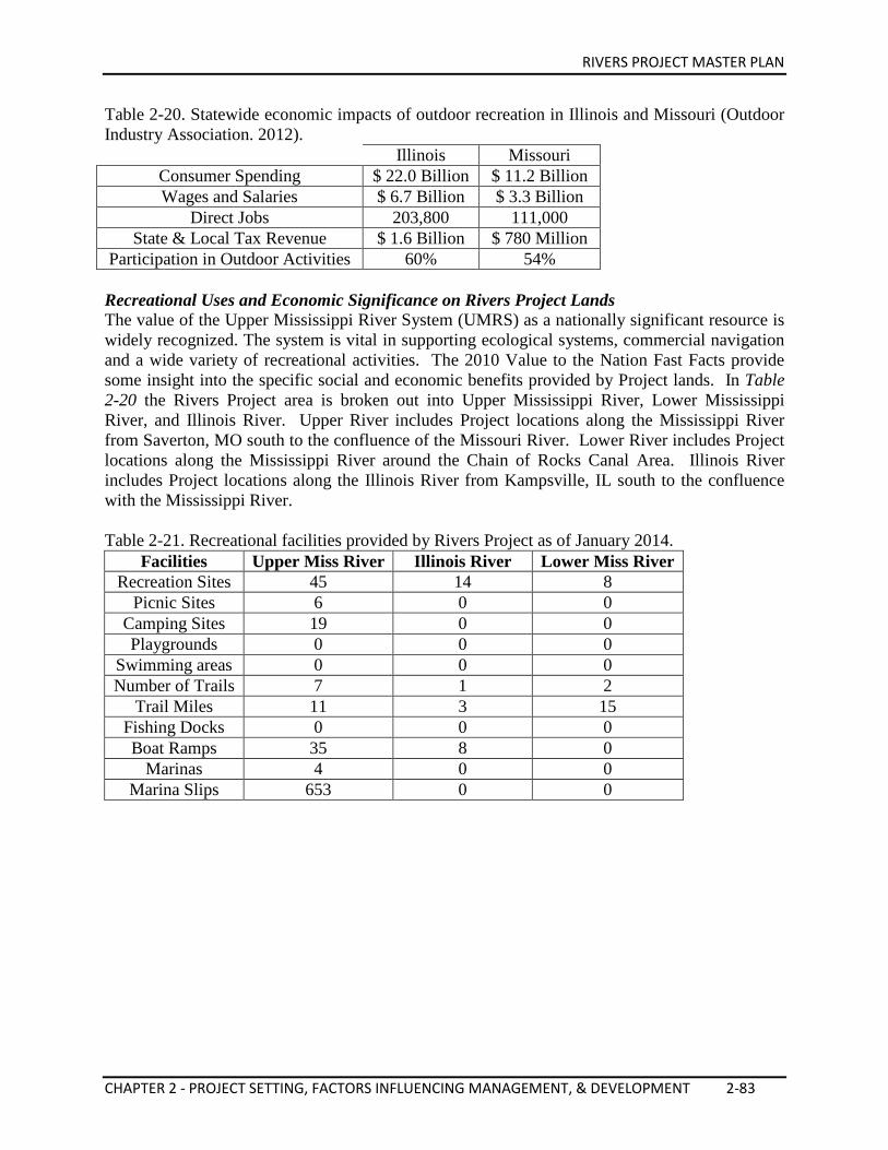
RIVERS PROJECT MASTER PLAN
CHAPTER 2 - PROJECT SETTING, FACTORS INFLUENCING MANAGEMENT, & DEVELOPMENT 2-83
Table 2-20. Statewide economic impacts of outdoor recreation in Illinois and Missouri (Outdoor Industry Association. 2012).
Illinois Missouri Consumer Spending $ 22.0 Billion $ 11.2 Billion Wages and Salaries $ 6.7 Billion $ 3.3 Billion
Direct Jobs 203,800 111,000 State & Local Tax Revenue $ 1.6 Billion $ 780 Million
Participation in Outdoor Activities 60% 54% Recreational Uses and Economic Significance on Rivers Project Lands The value of the Upper Mississippi River System (UMRS) as a nationally significant resource is widely recognized. The system is vital in supporting ecological systems, commercial navigation and a wide variety of recreational activities. The 2010 Value to the Nation Fast Facts provide some insight into the specific social and economic benefits provided by Project lands. In Table 2-20 the Rivers Project area is broken out into Upper Mississippi River, Lower Mississippi River, and Illinois River. Upper River includes Project locations along the Mississippi River from Saverton, MO south to the confluence of the Missouri River. Lower River includes Project locations along the Mississippi River around the Chain of Rocks Canal Area. Illinois River includes Project locations along the Illinois River from Kampsville, IL south to the confluence with the Mississippi River. Table 2-21. Recreational facilities provided by Rivers Project as of January 2014.
Facilities Upper Miss River Illinois River Lower Miss River Recreation Sites 45 14 8
Picnic Sites 6 0 0 Camping Sites 19 0 0 Playgrounds 0 0 0
Swimming areas 0 0 0 Number of Trails 7 1 2
Trail Miles 11 3 15 Fishing Docks 0 0 0 Boat Ramps 35 8 0
Marinas 4 0 0 Marina Slips 653 0 0
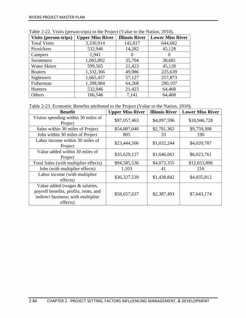
RIVERS PROJECT MASTER PLAN
2-84 CHAPTER 2 - PROJECT SETTING, FACTORS INFLUENCING MANAGEMENT, & DEVELOPMENT
Table 2-22. Visits (person-trips) to the Project (Value to the Nation, 2010). Visits (person-trips) Upper Miss River Illinois River Lower Miss River Total Visits 3,330,914 142,817 644,682 Picnickers 532,946 14,282 45,128 Campers 1,941 0 0 Swimmers 1,065,892 35,704 38,681 Water Skiers 599,565 21,423 45,128 Boaters 1,332,366 49,986 225,639 Sightseers 1,665,457 57,127 257,873 Fisherman 1,398,984 64,268 290,107 Hunters 532,946 21,423 64,468 Others 166,546 7,141 64,468
Table 2-23. Economic Benefits attributed to the Project (Value to the Nation, 2010).
Benefit Upper Miss River Illinois River Lower Miss River Visitor spending within 30 miles of
Project $97,057,463 $4,097,596 $18,946,728
Sales within 30 miles of Project $54,887,040 $2,781,362 $9,759,308 Jobs within 30 miles of Project 805 33 190
Labor income within 30 miles of Project $23,444,506 $1,032,244 $4,020,787
Value added within 30 miles of Project $35,629,127 $1,646,061 $6,023,761
Total Sales (with multiplier effects) $94,585,536 $4,073,355 $12,653,896 Jobs (with multiplier effects) 1,103 41 216
Labor income (with multiplier effects) $36,327,539 $1,438,842 $4,835,812
Value added (wages & salaries, payroll benefits, profits, rents, and indirect business; with multiplier
effects)
$58,657,637 $2,387,493 $7,643,174
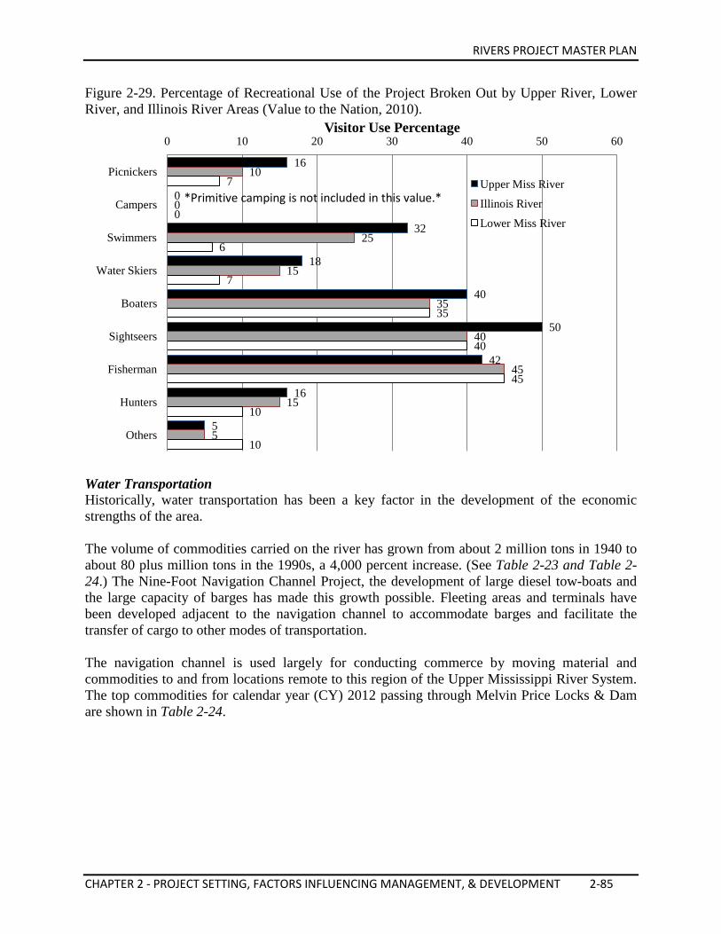
RIVERS PROJECT MASTER PLAN
CHAPTER 2 - PROJECT SETTING, FACTORS INFLUENCING MANAGEMENT, & DEVELOPMENT 2-85
Figure 2-29. Percentage of Recreational Use of the Project Broken Out by Upper River, Lower River, and Illinois River Areas (Value to the Nation, 2010).
Water Transportation Historically, water transportation has been a key factor in the development of the economic strengths of the area. The volume of commodities carried on the river has grown from about 2 million tons in 1940 to about 80 plus million tons in the 1990s, a 4,000 percent increase. (See Table 2-23 and Table 2-24.) The Nine-Foot Navigation Channel Project, the development of large diesel tow-boats and the large capacity of barges has made this growth possible. Fleeting areas and terminals have been developed adjacent to the navigation channel to accommodate barges and facilitate the transfer of cargo to other modes of transportation. The navigation channel is used largely for conducting commerce by moving material and commodities to and from locations remote to this region of the Upper Mississippi River System. The top commodities for calendar year (CY) 2012 passing through Melvin Price Locks & Dam are shown in Table 2-24.
16
0
32
18
40
50
42
16
5
10
0
25
15
35
40
45
15
5
7
0
6
7
35
40
45
10
10
0 10 20 30 40 50 60
Picnickers
Campers
Swimmers
Water Skiers
Boaters
Sightseers
Fisherman
Hunters
Others
Visitor Use Percentage
Upper Miss River
Illinois River
Lower Miss River
*Primitive camping is not included in this value.*
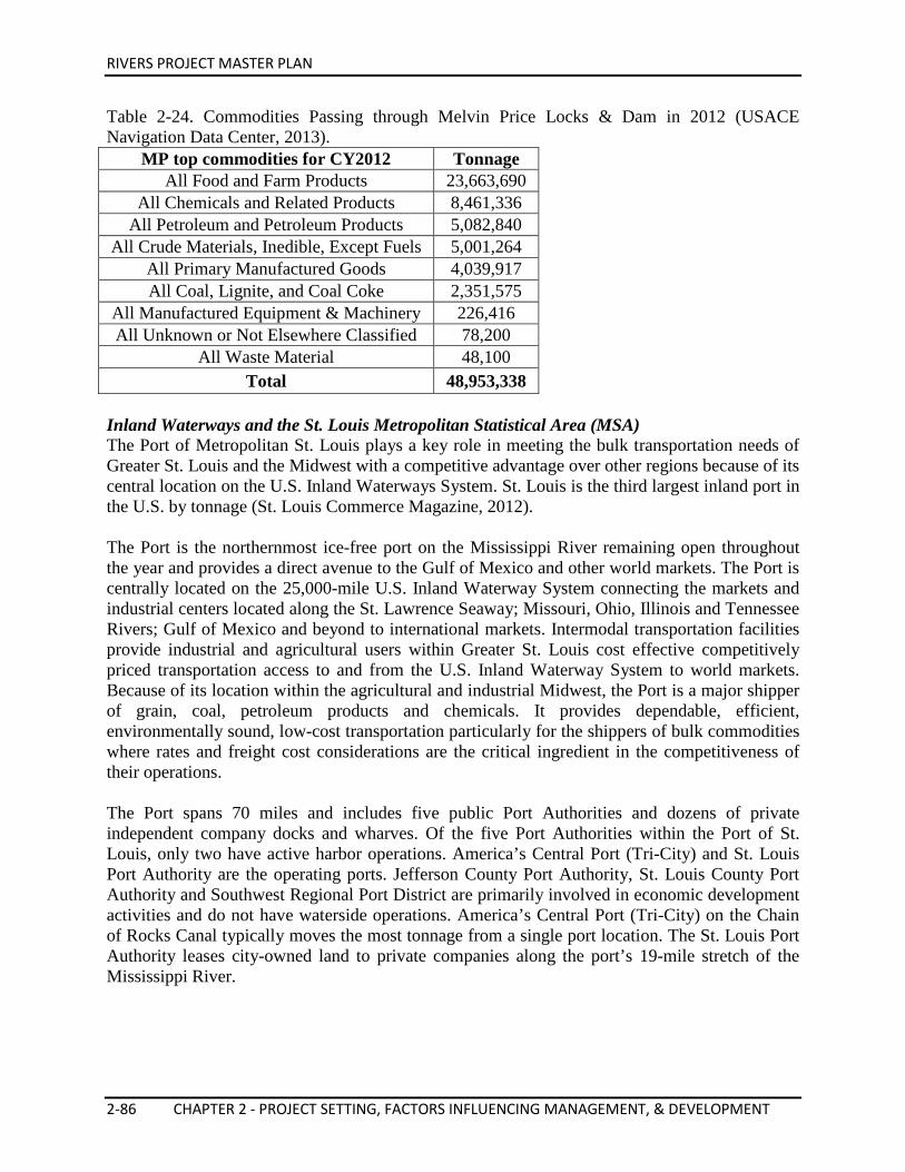
RIVERS PROJECT MASTER PLAN
2-86 CHAPTER 2 - PROJECT SETTING, FACTORS INFLUENCING MANAGEMENT, & DEVELOPMENT
Table 2-24. Commodities Passing through Melvin Price Locks & Dam in 2012 (USACE Navigation Data Center, 2013).
MP top commodities for CY2012 Tonnage All Food and Farm Products 23,663,690
All Chemicals and Related Products 8,461,336 All Petroleum and Petroleum Products 5,082,840
All Crude Materials, Inedible, Except Fuels 5,001,264 All Primary Manufactured Goods 4,039,917 All Coal, Lignite, and Coal Coke 2,351,575
All Manufactured Equipment & Machinery 226,416 All Unknown or Not Elsewhere Classified 78,200
All Waste Material 48,100 Total 48,953,338
Inland Waterways and the St. Louis Metropolitan Statistical Area (MSA) The Port of Metropolitan St. Louis plays a key role in meeting the bulk transportation needs of Greater St. Louis and the Midwest with a competitive advantage over other regions because of its central location on the U.S. Inland Waterways System. St. Louis is the third largest inland port in the U.S. by tonnage (St. Louis Commerce Magazine, 2012). The Port is the northernmost ice-free port on the Mississippi River remaining open throughout the year and provides a direct avenue to the Gulf of Mexico and other world markets. The Port is centrally located on the 25,000-mile U.S. Inland Waterway System connecting the markets and industrial centers located along the St. Lawrence Seaway; Missouri, Ohio, Illinois and Tennessee Rivers; Gulf of Mexico and beyond to international markets. Intermodal transportation facilities provide industrial and agricultural users within Greater St. Louis cost effective competitively priced transportation access to and from the U.S. Inland Waterway System to world markets. Because of its location within the agricultural and industrial Midwest, the Port is a major shipper of grain, coal, petroleum products and chemicals. It provides dependable, efficient, environmentally sound, low-cost transportation particularly for the shippers of bulk commodities where rates and freight cost considerations are the critical ingredient in the competitiveness of their operations. The Port spans 70 miles and includes five public Port Authorities and dozens of private independent company docks and wharves. Of the five Port Authorities within the Port of St. Louis, only two have active harbor operations. America’s Central Port (Tri-City) and St. Louis Port Authority are the operating ports. Jefferson County Port Authority, St. Louis County Port Authority and Southwest Regional Port District are primarily involved in economic development activities and do not have waterside operations. America’s Central Port (Tri-City) on the Chain of Rocks Canal typically moves the most tonnage from a single port location. The St. Louis Port Authority leases city-owned land to private companies along the port’s 19-mile stretch of the Mississippi River.
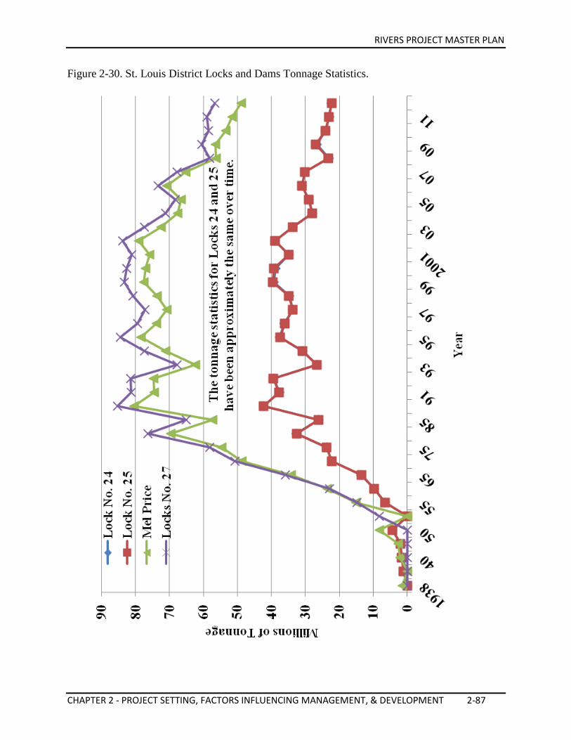
RIVERS PROJECT MASTER PLAN
CHAPTER 2 - PROJECT SETTING, FACTORS INFLUENCING MANAGEMENT, & DEVELOPMENT 2-87
Figure 2-30. St. Louis District Locks and Dams Tonnage Statistics.
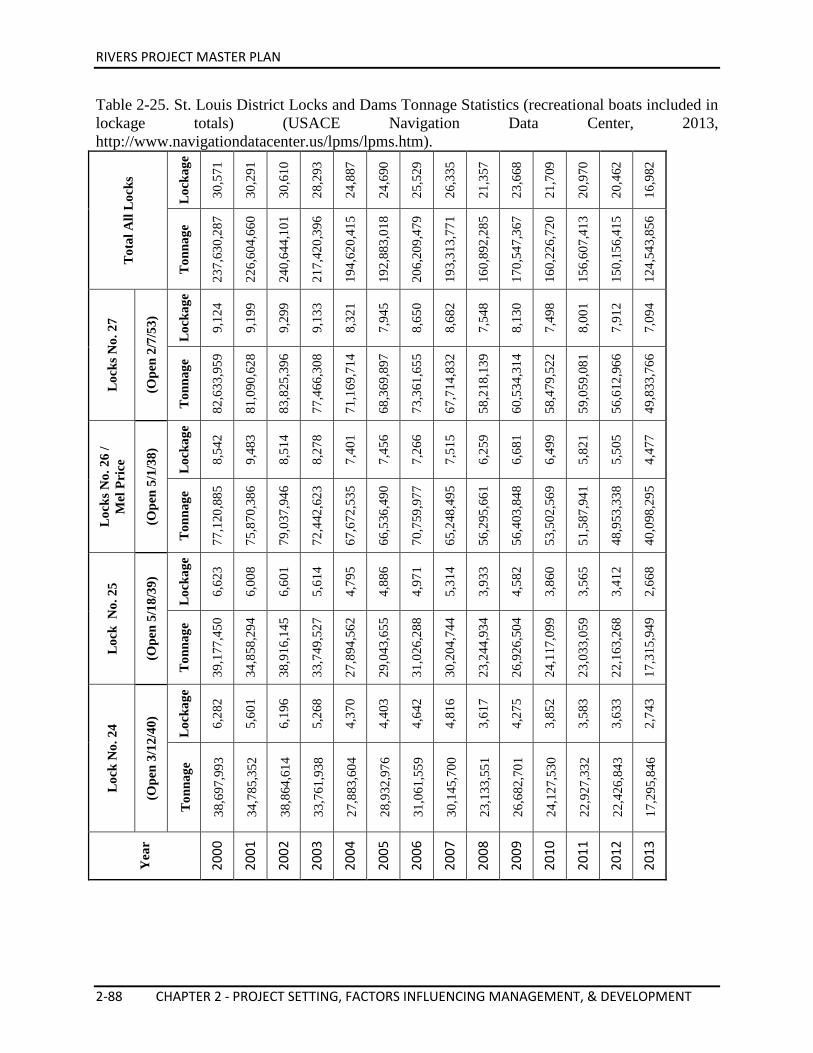
RIVERS PROJECT MASTER PLAN
2-88 CHAPTER 2 - PROJECT SETTING, FACTORS INFLUENCING MANAGEMENT, & DEVELOPMENT
Table 2-25. St. Louis District Locks and Dams Tonnage Statistics (recreational boats included in lockage totals) (USACE Navigation Data Center, 2013, http://www.navigationdatacenter.us/lpms/lpms.htm).
Tot
al A
ll L
ocks
Loc
kage
30,5
71
30,2
91
30,6
10
28,2
93
24,8
87
24,6
90
25,5
29
26,3
35
21,3
57
23,6
68
21,7
09
20,9
70
20,4
62
16,9
82
Ton
nage
237,
630,
287
226,
604,
660
240,
644,
101
217,
420,
396
194,
620,
415
192,
883,
018
206,
209,
479
193,
313,
771
160,
892,
285
170,
547,
367
160,
226,
720
156,
607,
413
150,
156,
415
124,
543,
856
Loc
ks N
o. 2
7
(Ope
n 2/
7/53
)
Loc
kage
9,12
4
9,19
9
9,29
9
9,13
3
8,32
1
7,94
5
8,65
0
8,68
2
7,54
8
8,13
0
7,49
8
8,00
1
7,91
2
7,09
4
Ton
nage
82,6
33,9
59
81,0
90,6
28
83,8
25,3
96
77,4
66,3
08
71,1
69,7
14
68,3
69,8
97
73,3
61,6
55
67,7
14,8
32
58,2
18,1
39
60,5
34,3
14
58,4
79,5
22
59,0
59,0
81
56,6
12,9
66
49,8
33,7
66
Loc
ks N
o. 2
6 /
Mel
Pri
ce
(Ope
n 5/
1/38
)
Loc
kage
8,54
2
9,48
3
8,51
4
8,27
8
7,40
1
7,45
6
7,26
6
7,51
5
6,25
9
6,68
1
6,49
9
5,82
1
5,50
5
4,47
7
Ton
nage
77,1
20,8
85
75,8
70,3
86
79,0
37,9
46
72,4
42,6
23
67,6
72,5
35
66,5
36,4
90
70,7
59,9
77
65,2
48,4
95
56,2
95,6
61
56,4
03,8
48
53,5
02,5
69
51,5
87,9
41
48,9
53,3
38
40,0
98,2
95
Loc
k N
o. 2
5
(Ope
n 5/
18/3
9)
Loc
kage
6,62
3
6,00
8
6,60
1
5,61
4
4,79
5
4,88
6
4,97
1
5,31
4
3,93
3
4,58
2
3,86
0
3,56
5
3,41
2
2,66
8
Ton
nage
39,1
77,4
50
34,8
58,2
94
38,9
16,1
45
33,7
49,5
27
27,8
94,5
62
29,0
43,6
55
31,0
26,2
88
30,2
04,7
44
23,2
44,9
34
26,9
26,5
04
24,1
17,0
99
23,0
33,0
59
22,1
63,2
68
17,3
15,9
49
Loc
k N
o. 2
4
(Ope
n 3/
12/4
0)
Loc
kage
6,28
2
5,60
1
6,19
6
5,26
8
4,37
0
4,40
3
4,64
2
4,81
6
3,61
7
4,27
5
3,85
2
3,58
3
3,63
3
2,74
3
Ton
nage
38,6
97,9
93
34,7
85,3
52
38,8
64,6
14
33,7
61,9
38
27,8
83,6
04
28,9
32,9
76
31,0
61,5
59
30,1
45,7
00
23,1
33,5
51
26,6
82,7
01
24,1
27,5
30
22,9
27,3
32
22,4
26,8
43
17,2
95,8
46
Yea
r
2000
2001
2002
2003
2004
2005
2006
2007
2008
2009
2010
2011
2012
2013
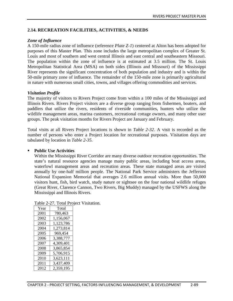
RIVERS PROJECT MASTER PLAN
CHAPTER 2 - PROJECT SETTING, FACTORS INFLUENCING MANAGEMENT, & DEVELOPMENT 2-89
2.14. RECREATION FACILITIES, ACTIVITIES, & NEEDS Zone of Influence A 150-mile radius zone of influence (reference Plate Z-1) centered at Alton has been adopted for purposes of this Master Plan. This zone includes the large metropolitan complex of Greater St. Louis and most of southern and west central Illinois and east central and southeastern Missouri. The population within the zone of influence is at estimated at 3.5 million. The St. Louis Metropolitan Statistical Area (MSA) on both sides (Illinois and Missouri) of the Mississippi River represents the significant concentration of both population and industry and is within the 50-mile primary zone of influence. The remainder of the 150-mile zone is primarily agricultural in nature with numerous small cities, towns, and villages offering commodities and services. Visitation Profile The majority of visitors to Rivers Project come from within a 100 miles of the Mississippi and Illinois Rivers. Rivers Project visitors are a diverse group ranging from fishermen, boaters, and paddlers that utilize the rivers, residents of riverside communities, hunters who utilize the wildlife management areas, marina customers, recreational cottage owners, and many other user groups. The peak visitation months for Rivers Project are January and February. Total visits at all Rivers Project locations is shown in Table 2-32. A visit is recorded as the number of persons who enter a Project location for recreational purposes. Visitation days are tabulated by location in Table 2-35. Public Use Activities
Within the Mississippi River Corridor are many diverse outdoor recreation opportunities. The state’s natural resource agencies manage many public areas, including boat access areas, waterfowl management areas and recreation areas. These state managed areas are visited annually by one-half million people. The National Park Service administers the Jefferson National Expansion Memorial that averages 2.6 million annual visits. More than 50,000 visitors hunt, fish, bird watch, study nature or sightsee on the four national wildlife refuges (Great River, Clarence Cannon, Two Rivers, Big Muddy) managed by the USFWS along the Mississippi and Illinois Rivers. Table 2-27. Total Project Visitation.
Year Total 2001 780,463 2002 1,156,067 2003 1,123,786 2004 1,273,814 2005 969,454 2006 3,388,777 2007 4,309,401 2008 3,865,854 2009 5,706,915 2010 3,623,111 2011 3,437,409 2012 2,359,195
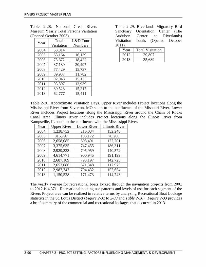
RIVERS PROJECT MASTER PLAN
2-90 CHAPTER 2 - PROJECT SETTING, FACTORS INFLUENCING MANAGEMENT, & DEVELOPMENT
Table 2-28. National Great Rivers Museum Yearly Total Persons Visitation (Opened October 2003).
Year Total Visitation
L&D Tour Numbers
2004 53,814 - 2005 63,164 16,139 2006 75,672 18,422 2007 87,180 20,497 2008 77,429 15,737 2009 89,937 11,782 2010 92,043 15,135 2011 93,897 13,939 2012 80,523 15,217 2013 62,777 15,411
Table 2-29. Riverlands Migratory Bird Sanctuary Orientation Center (The Audubon Center at Riverlands) Visitation Totals (Opened October 2011).
Year Total Visitation 2012 29,807 2013 35,689
Table 2-30. Approximate Visitation Days. Upper River includes Project locations along the Mississippi River from Saverton, MO south to the confluence of the Missouri River. Lower River includes Project locations along the Mississippi River around the Chain of Rocks Canal Area. Illinois River includes Project locations along the Illinois River from Kampsville, IL south to the confluence with the Mississippi River.
Year Upper River Lower River Illinois River 2004 1,238,752 216,034 152,248 2005 815,797 103,172 76,260 2006 2,658,085 608,491 122,201 2007 3,375,635 747,455 186,311 2008 2,929,323 795,959 140,572 2009 4,614,771 900,945 191,199 2010 2,687,189 793,197 142,725 2011 2,653,086 671,348 112,975 2012 2,987,747 704,432 152,654 2013 1,150,528 171,473 114,743
The yearly average for recreational boats locked through the navigation projects from 2001 to 2012 is 4,371. Recreational boating use patterns and levels of use for each segment of the Rivers Project area can be realized in relative terms by analyzing Recreational Boat Lockage statistics in the St. Louis District (Figure 2-32 to 2-33 and Table 2-26). Figure 2-33 provides a brief summary of the commercial and recreational lockages that occurred in 2013.
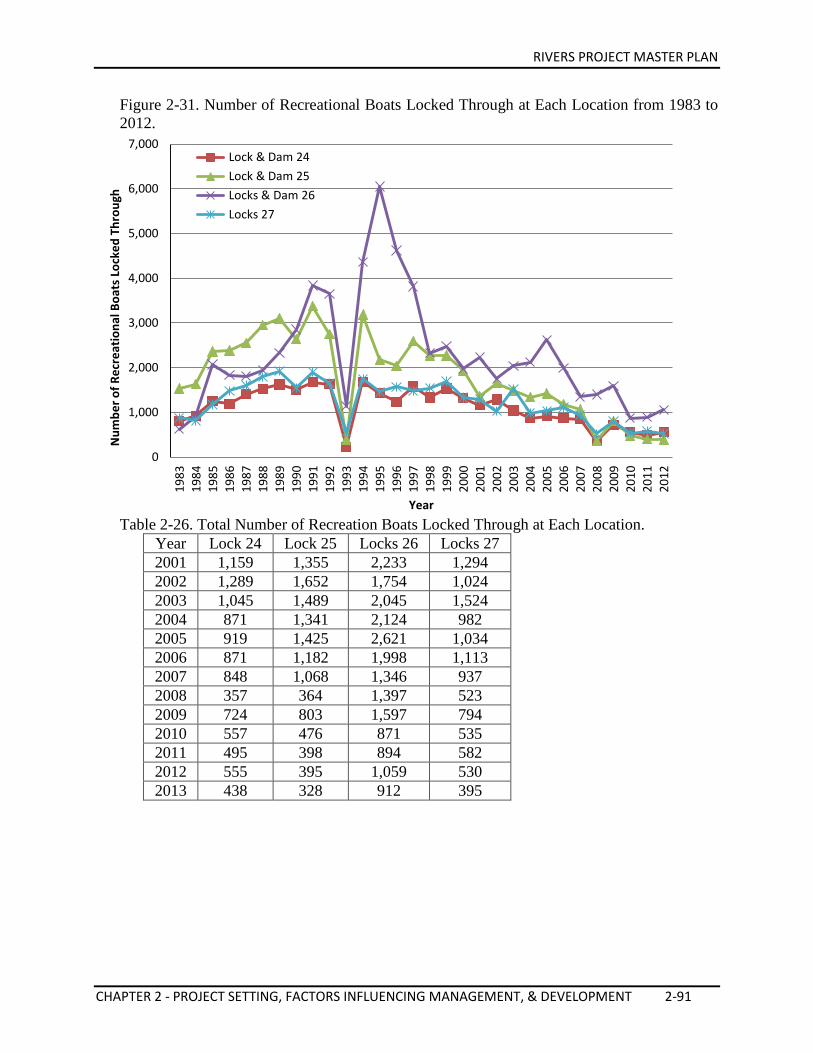
RIVERS PROJECT MASTER PLAN
CHAPTER 2 - PROJECT SETTING, FACTORS INFLUENCING MANAGEMENT, & DEVELOPMENT 2-91
Figure 2-31. Number of Recreational Boats Locked Through at Each Location from 1983 to 2012.
Table 2-26. Total Number of Recreation Boats Locked Through at Each Location.
Year Lock 24 Lock 25 Locks 26 Locks 27 2001 1,159 1,355 2,233 1,294 2002 1,289 1,652 1,754 1,024 2003 1,045 1,489 2,045 1,524 2004 871 1,341 2,124 982 2005 919 1,425 2,621 1,034 2006 871 1,182 1,998 1,113 2007 848 1,068 1,346 937 2008 357 364 1,397 523 2009 724 803 1,597 794 2010 557 476 871 535 2011 495 398 894 582 2012 555 395 1,059 530 2013 438 328 912 395
0
1,000
2,000
3,000
4,000
5,000
6,000
7,000
1983
19
84
1985
19
86
1987
19
88
1989
19
90
1991
19
92
1993
19
94
1995
19
96
1997
19
98
1999
20
00
2001
20
02
2003
20
04
2005
20
06
2007
20
08
2009
20
10
2011
20
12
Num
ber o
f Rec
reat
iona
l Boa
ts L
ocke
d Th
roug
h
Year
Lock & Dam 24 Lock & Dam 25 Locks & Dam 26 Locks 27
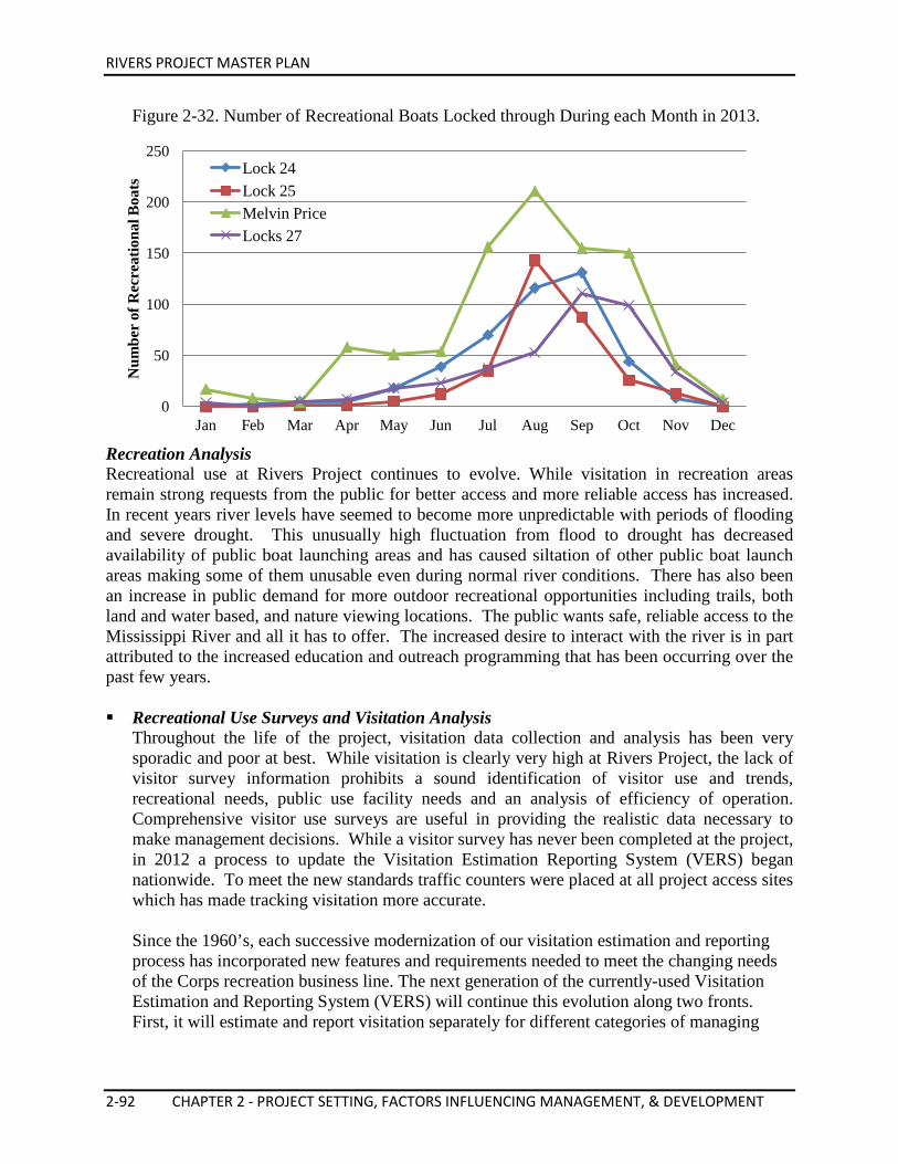
RIVERS PROJECT MASTER PLAN
2-92 CHAPTER 2 - PROJECT SETTING, FACTORS INFLUENCING MANAGEMENT, & DEVELOPMENT
Figure 2-32. Number of Recreational Boats Locked through During each Month in 2013.
Recreation Analysis Recreational use at Rivers Project continues to evolve. While visitation in recreation areas remain strong requests from the public for better access and more reliable access has increased. In recent years river levels have seemed to become more unpredictable with periods of flooding and severe drought. This unusually high fluctuation from flood to drought has decreased availability of public boat launching areas and has caused siltation of other public boat launch areas making some of them unusable even during normal river conditions. There has also been an increase in public demand for more outdoor recreational opportunities including trails, both land and water based, and nature viewing locations. The public wants safe, reliable access to the Mississippi River and all it has to offer. The increased desire to interact with the river is in part attributed to the increased education and outreach programming that has been occurring over the past few years. Recreational Use Surveys and Visitation Analysis
Throughout the life of the project, visitation data collection and analysis has been very sporadic and poor at best. While visitation is clearly very high at Rivers Project, the lack of visitor survey information prohibits a sound identification of visitor use and trends, recreational needs, public use facility needs and an analysis of efficiency of operation. Comprehensive visitor use surveys are useful in providing the realistic data necessary to make management decisions. While a visitor survey has never been completed at the project, in 2012 a process to update the Visitation Estimation Reporting System (VERS) began nationwide. To meet the new standards traffic counters were placed at all project access sites which has made tracking visitation more accurate. Since the 1960’s, each successive modernization of our visitation estimation and reporting process has incorporated new features and requirements needed to meet the changing needs of the Corps recreation business line. The next generation of the currently-used Visitation Estimation and Reporting System (VERS) will continue this evolution along two fronts. First, it will estimate and report visitation separately for different categories of managing
0
50
100
150
200
250
Jan Feb Mar Apr May Jun Jul Aug Sep Oct Nov Dec
Num
ber
of R
ecre
atio
nal B
oats
Lock 24 Lock 25 Melvin Price Locks 27
RIVERS PROJECT MASTER PLAN
CHAPTER 2 - PROJECT SETTING, FACTORS INFLUENCING MANAGEMENT, & DEVELOPMENT 2-93
agency (CE, concessions, Federal non-Corps, State gov, Local gov, and Quasi-public entities). Second, it will employ a new approach to estimating fee camping visitation, incorporating business data from CEFMS and the NRRS. The newest modernization effort will also build on groundwork laid by VERS in the early 1990’s to increase consistency of visitation estimates across projects, by improving the level of standardization and transparency in the application of procedures used for visitation use estimation and reporting. While new field surveys are certainly needed to update load-factors that have changed over time, improvements in basic procedures and processes, such as better alignment of traffic meter locations with best practices, automated tools for survey planning and implementation, and more rigorous methods of assigning load-factors to recreation areas that will not be surveyed, will likely have a greater impact on achieving more consistent visitation estimates then will the updated load-factors produced from a new round of surveys.
Recreation Carrying Capacity Some portions of the Rivers Project service area are more heavily used than others. This is related to location of the locks and dams and the varying uses of the different stretches of the river. Pool 26 has the largest number of recreational boats registered on the entire Mississippi River. The St. Louis Harbor area makes it difficult to recreate along that 70 mile stretch of river. Recreation Activities The Mississippi and Illinois River segments in the St. Louis District provide major opportunities for water based recreation in the region. Natural vegetation, variable topography, accessibility to water and the proximity of the river to a large population are significant features that enhance its attractiveness for recreational purposes. The demand for outdoor recreation is continually increasing. Some popular forms of outdoor recreation activities are shown below in Table 2-31 and Figure 2-33. Table 2-31. Estimated Ranking of the Top Recreational Activities Pursued in Illinois (Illinois SCORP, 2009). 1. Pleasure walking* 16. Canoeing/Kayaking* 2. Picnicking* 17. Outdoor Basketball 3. Observing Wildlife/Bird Watching* 18. Tennis 4. Swimming-Outdoor Pool 19. Hunting* 5. Use a Playground 20. Soccer 6. Hiking* 21. Equestrian (Horseback Riding)* 7. Bicycling-Roads* 22. Vehicle Camping 8. Fishing* 23. Off-Road Vehicle Use 9. Swimming-Outdoor Other* 24. Ice Skating 10. Bicycling-Trails* 25. Water Skiing* 11. Golfing 26. In-Line Skating 12. Running/Jogging* 27. Sailing* 13. Softball/Baseball 28. Cross-Country Skiing* 14. Motor Boating* 29. Snowmobiling 15. Tent Camping* 30. Trapping* *Activities that are accommodated on Rivers Project lands and waters.
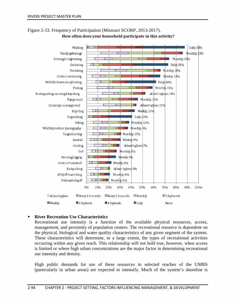
RIVERS PROJECT MASTER PLAN
2-94 CHAPTER 2 - PROJECT SETTING, FACTORS INFLUENCING MANAGEMENT, & DEVELOPMENT
Figure 2-33. Frequency of Participation (Missouri SCORP, 2013-2017).
River Recreation Use Characteristics
Recreational use intensity is a function of the available physical resources, access, management, and proximity of population centers. The recreational resource is dependent on the physical, biological and water quality characteristics of any given segment of the system. These characteristics will determine, to a large extent, the types of recreational activities occurring within any given reach. This relationship will not hold true, however, when access is limited or where high urban concentrations are the major factor in determining recreational use intensity and density. High public demands for use of these resources in selected reaches of the UMRS (particularly in urban areas) are expected to intensify. Much of the system’s shoreline is
RIVERS PROJECT MASTER PLAN
CHAPTER 2 - PROJECT SETTING, FACTORS INFLUENCING MANAGEMENT, & DEVELOPMENT 2-95
presently privately owned and large sections of the rivers are paralleled by railroad tracks. Further-more, the majority of public lands along the rivers are managed for fish and wildlife purposes which may be incompatible with some recreation uses. Towns and metropolitan areas exert a high demand on the recreation resource. The St. Louis metropolitan area continues to project deficiencies in the availability of access for water-based recreation. This high demand produces intensive use of the resource, especially during weekends and holidays. Conflicts between river users periodically occur during high activity periods, primarily in Pool 26. Major motor boating, sailing, water skiing and jet skiing activity occurs in the navigation channel and the main channel border. Major fishing activity occurs along the main channel border, side channels and backwaters. Camping, hunting, picnicking, hiking and nature studies occur primarily on islands, sandbars and along the shoreline. The expanse of water created by the locks and dams of the navigation project provide additional opportunities for recreation use and enjoyment of the UMRS corridor. Conflicts periodically exist between recreation use and maintenance of the channel and commercial navigation use. Portions of the navigation pools have very shallow areas and stump fields. While these areas provide good fish nursery and waterfowl areas, they are hazards to the boater unfamiliar with the river. Channel structures, such as dikes and dams, used to help maintain the navigation channel, also present a hazard to the novice or inexperienced boater. Beaches created with dredged material and by natural deposition receive intensive public use. These beaches are used for camping, swimming, sunbathing, picnicking, partying, and for paddlers using the water trail. They form base locations for water skiing, hunting and fishing groups and provide important destination points for recreation visits. Public access to Pools 24-27 is generally limited to the dispersed federally owned shoreline lands, located predominantly in the lower reaches of the pools. The Corps, USFWS, IDNR and MDC manage most of the public access areas and facilities adjacent to the navigation pools. There are also numerous commercial marinas offering river access and other recreational services, most of which are privately owned and on private shoreline lands. Opportunities for public access in the Middle Mississippi River reach is limited due to private ownership of the shoreline and intervening lands between the highways, railroad tracks, and the river. The most visual identification with the river downstream of St. Louis occurs at bridge crossings and river communities. Most of the public land that is available in this reach is located in state parks, state conservation areas, USFWS refuges, and Forest Service lands. Roadside parks, points of interest, and city parks comprise a minor amount of the total acreage. Fuel stops for recreational boaters along this reach are very limited, forcing most boaters to carry extra fuel and provisions. Regardless of the constraints on the use of the river and related land resources, the existing recreational resources and the cooperative efforts among governmental agencies and private enterprise combine to provide numerous opportunities to experience the diversity of the river’s recreational, natural, cultural, and historic values.
RIVERS PROJECT MASTER PLAN
2-96 CHAPTER 2 - PROJECT SETTING, FACTORS INFLUENCING MANAGEMENT, & DEVELOPMENT
Some specific examples of areas with high recreation potential are:
• Confluences with major tributaries – the Illinois, Missouri, Meramec and Kaskaskia Rivers
• Major islands • Scenic bluff or river hills areas, e.g. Alton to Grafton Bluffs, Fountain Bluff, and
Grand Tower in Illinois and the river hills at Clarksville and Louisiana in Missouri • Pere Marquette State Park area along the Lower Illinois River • Melvin Price Locks and Dam, National Great Rivers Museum, and Alton Riverfront
area None of the federal or state agencies dealing with outdoor recreation have more than a partial authority for planning and management of the recreational resources. Coordination of planning for public recreation purposes needs to be improved. A standardized system of collecting recreation use data for the river corridor is non-existent, which impedes the coordination of activities for enhanced recreation opportunities.
Interpretive Services and Outreach Program (ISOP)
The Project ISOP strategy is to achieve the goals outlined in ER 1130-2-550 and to conduct these efforts in an efficient and effective manner at the field level to enhance understanding of both the Corps and the public’s roles and responsibilities. The overall goal of the ISOP is to enhance the visitors’ understanding and appreciation of public lands and waters, instilling visitors with a sense of proprietorship and promoting environmental stewardship to preserve the natural and cultural resources of the region for future generations. The ISOP also includes public relations, marketing, tourism, and visitor center management. The ISOP efforts create linkages with river communities that are relevant and serve the entire Project area. The ISOP focuses on several major subject areas to include, but not limited to: environmental education, cultural and natural resources interpretation, navigation support, and community outreach. The primary objectives of these components are to foster a local and global understanding of our planet’s resources interdependence and to reduce management issues on public lands and waters. Project Visitor Centers The Corps is responsible for providing information to the visiting public at every project it operates as outlined in ER 1130-2-550. These centers educate and inform the public with regard to the history and mission of the Corps, its role in water resources development, the project, its purpose, benefits and costs. The primary purpose of the Visitor Center program is to provide interpretive information to the visiting public about the Corps, its mission, the project and its facilities, visitor safety, and the geographic area where the project is located. The interpretive objectives of Visitor Centers are to (as defined in ER 1130-2-550):
• Enhance the public’s understanding of the multi-dimensional role of the Army and the Corps and their value to the Nation.
• Enhance the public’s understanding of the purpose and operation of the project, its
RIVERS PROJECT MASTER PLAN
CHAPTER 2 - PROJECT SETTING, FACTORS INFLUENCING MANAGEMENT, & DEVELOPMENT 2-97
archaeological, historic, man-made, natural, and cultural features. • Develop public appreciation for the proper and safe use of project resources. • Foster the spirit of personal stewardship of public lands. • Orient the visitor to the project and its recreational opportunities. • Aid project personnel in accomplishing management objectives. • Reduce overall project operation and maintenance costs.
The Rivers Project Office currently operates two Visitor Centers: Type A Regional Visitor Center – National Great Rivers Museum, and a Type B Project Visitor Center – Riverlands Sanctuary Orientation Center (The Audubon Center at Riverlands). National Great Rivers Museum The National Great Rivers Museum is an important educational resource and serves as the Rivers Project’s ISOP hub. The 12,000 square foot museum opened in October 2003. It represents a major tourism attraction for the Midwest and visitation is accumulated through school groups, local community visitors, and national and international tourists. Visitation to the site is a reflection of the magnitude of the Project, its location along the Great River Road (a designated National Scenic Byway), its position in the Middle Mississippi River, and its proximity to the Greater St. Louis Metropolitan region. The National Great Rivers Museum is the only regional Corps visitor center on the Upper Mississippi River and the only one of five existing facilities in the nation to concentrate on the Mississippi River. The museum is located within the Illinois Esplanade Recreation Area, immediately adjacent to the Melvin Price Locks and Dam. The museum was congressionally authorized in the Water Resource Development Act of 1992 as a Type A Regional Visitor Center. Developed with comments, support and guidance through a citizen’s advisory group and peer review group, this facility is used to tell the Corps’ story, river story, and navigation story. The cultural, historical, ecological and biological responses are interpreted at this major learning center. Visitors to the museum are able to view exhibits and tour the Melvin Price Locks and Dam. The museum is unique to the region in its primary focus on the Mississippi River and provides the opportunity to teach the public to respect this invaluable natural resource and help sustain it for future generations. The facilities within the museum include an information desk, ADA compliant restrooms, a drinking fountain, multi-purpose room, main exhibit hall, theater, and gift shop. Hours of operation are 9:00 a.m. to 5:00 p.m. daily. The Meeting of the Rivers Foundation, the museum’s cooperating association, suggested naming the Regional Visitor Center at Melvin Price Locks and Dam the “National Great Rivers Museum.” The title, “National Great Rivers Museum,” was subsequently approved at the District and Division levels. The name ties back to the designation of the Meeting of the Great Rivers Scenic Byway, a 33-mile stretch of the Great River Road, running from Pere Marquette State Park in Grafton, IL to Hartford, IL. The Byway passes the confluence of the Mississippi and Illinois Rivers and the National Great Rivers Museum.
RIVERS PROJECT MASTER PLAN
2-98 CHAPTER 2 - PROJECT SETTING, FACTORS INFLUENCING MANAGEMENT, & DEVELOPMENT
• Authorization and Development at the National Great Rivers Museum On 21 October 1978, PL 95-502 authorized the Melvin Price Project, substantially in accordance with the recommendation of the Chief of Engineers in his report dated 31 July 1976. In the report, the Chief of Engineers recommended that the project include “...a major visitor center…” thus committing through legislation, construction of a visitor center as part of the project. Congress authorized in the Water Resource Development Act of 1992, a Regional Visitor Center of at least 24,000 square-feet, to be constructed at the Melvin Price Locks and Dam. The justification materials submitted in support of the Fiscal Year 1995 Civil Works budget of the US Army Corps of Engineers stated that the Corps would initiate construction of a 6,000 square-foot visitor center. A letter from Dr. John Zirschky, Acting Assistant Secretary of the Army (for Civil Works) to the Honorable J. Bennett Johnson, Chair of the Subcommittee on Energy and Water Development changed the scope for the visitor center from 6,000 square-feet to 12,000 square-feet. Funds for the construction were appropriated in 1995 and construction began of the Regional Visitor Center at Melvin Price Locks and Dam in April 1997. An additional 12,000 square-feet is authorized to expand the Visitor Center, but has not yet been appropriated. A citizens’ advisory committee was formed to assist the architectural and interpretive development of the Regional Visitor Center at Melvin Price Locks and Dam. A peer review group of museum directors were brought together to guide the Corps and the community in the design of the regional visitor center. The community challenged the Corps to build a facility comparable to those in the St. Louis museum market. A feasibility study was conducted to evaluate the potential for raising public and private donations to fund the exhibits. A capital development goal of $5.3 million was determined through the feasibility study.
• Partnership Development at the National Great Rivers Museum Many opportunities exist for developing partnerships specific to the National Great Rivers Museum. These partnerships may be used for interpretive and outreach programs, temporary exhibits, space renovations, and permanent exhibit upgrades. A Challenge Cost-Share Agreement was signed with the Meeting of the Rivers Foundation in 2001 to raise $3.2 million for the initial design, fabrication and installation for the exhibits. The museum exhibits are evaluated for relevance every three to five years and should be upgraded every six to ten years based on these evaluations. Federal and state partners were also approached to participate in the Museum development. Agreements were developed with the USFWS, USGS, and the EPA.
• Visitor Experience at the National Great Rivers Museum The National Great Rivers Museum, as the regional hub for education, interpretation and outreach programs, is dedicated to telling the story of the Mississippi River, its cultural and natural history, the socio-economic significance and evolving role as a transportation corridor, and how the Corps of Engineers has aided the river’s evolution.
RIVERS PROJECT MASTER PLAN
CHAPTER 2 - PROJECT SETTING, FACTORS INFLUENCING MANAGEMENT, & DEVELOPMENT 2-99
Visitor Experience Objectives: Visitor experience objectives are addressed in terms of cognitive (learning) and affective (emotional and behavioral) outcomes. Doing so will help visitors appreciate and retain key messages and promote sustainable behaviors. Learning Objectives:
1. Understand the formation, function, and diversity of large river systems in general and the Mississippi River Watershed in particular.
2. Understand and identify habitats and ecosystems associated with the Mississippi River and its floodplain.
3. Describe historic and contemporary uses of the river, including migration, transportation, and commerce and identify predominant navigation features encountered along the river.
4. Understand the role of the river in historical and contemporary fine arts. 5. Identify major river issues, how those issues affect river sustainability, and
personal actions individuals can take to improve the river. 6. Identify the Corps of Engineers’ role in managing water resources along the river
system. Emotional Objectives:
1. Restore an emotional connection with “our” river and inspire its expression through art.
2. Foster stewardship of natural and cultural resources and promote sustainable behaviors.
3. Encourage safe and sustainable outdoor recreation and physical activity. 4. Generate interest in science, technology, engineering, and math and related
careers. Behavioral Objectives:
1. Motivate visitors to make changes that advance the health of the Mississippi River and its habitats in their everyday behavior.
2. Motivate visitors to actively seek out activities that help restore the Mississippi River and its habitats.
3. Encourage visitors to recreate safely and sustainably at the Mississippi River and its habitats.
4. Motivate visitors to share their knowledge and enthusiasm with others. 5. Visitors will get involved in their local communities to promote changes within
their environments that will positively impact the Mississippi River and its watershed.
Millions of visitors each year travel to the Mississippi River to recreate and learn about its history and impact on our nation. With the Mississippi River and Melvin Price Locks and Dam providing the framework, the National Great Rivers Museum provides a unique opportunity to tell the river’s story in a comprehensive, meaningful, and relevant way. This interconnected area of the National Great Rivers Museum and the Riverlands
RIVERS PROJECT MASTER PLAN
2-100 CHAPTER 2 - PROJECT SETTING, FACTORS INFLUENCING MANAGEMENT, & DEVELOPMENT
Migratory Bird Sanctuary has been given the name “The Water Campus” by many of the Corps’ partners in the area. In addition to the exhibits, the National Great Rivers Museum will also: • Serve as the outreach center for the water campus, which includes the museum, the
Illinois Esplanade Recreation Area, the National Great Rivers Research and Education Center, the Riverlands Migratory Bird Sanctuary and The Audubon Center at Riverlands.
• Serve as an area where visitors, teachers, and students have the opportunity to explore and learn in an indoor and outdoor classroom environment where real world applications of engineering, science and technology are clearly explained.
• Provide a 110-seat theater where visitors can experience the river through innovative audio-visual techniques.
• Provide a multi-purpose room for community agencies and organizations to use for meetings, conferences, and other regional events.
• Provide a space for rotating or traveling exhibits and relevant topics. • Enable access to a resource library of river related materials. • Provide access and public and group tours to the Melvin Price Locks and Dam. • Offer new recreational activities through 3,738-acres of open space and a connecting
bike trail. • Provide the facility as a community resource for public meetings and workshops.
Riverlands Migratory Bird Sanctuary The Riverlands Migratory Bird Sanctuary (RMBS) was previously known as the Riverlands Environmental Demonstration Area (EDA). The area includes a native prairie and marsh restoration project, located on the Missouri shore adjacent to the Melvin Price Locks and Dam, along Riverlands Way in West Alton, MO. Long-term management goals include nesting and protection of habitat. Environmentally, the RMBS exemplifies a balanced management approach between sustaining the river as a nationally significant transportation corridor and recognizing the environmental attributes and recreation potential of the area. The project utilizes the rivers continuing influence through water control management to create a bottomland wet prairie and marsh, akin to that which existed prior to settlement of the area. The educational programming conducted in the RMBS allows for hands-on learning activities, focusing on wetland and prairie habitats and wildlife management. Nature trails provide the public with the chance for a closer look at the natural landscape of bottomland prairie and wetlands within an urban environment. The RMBS offers visitors the opportunity to view large numbers of resident and migratory waterfowl and shorebirds, as well as other wildlife that live in the wetlands. The Audubon Center at Riverlands (Riverlands Sanctuary Orientation Center) The Audubon Center at Riverlands serves as a Type B Project Visitor Center and opened in October 2011. The Center provides visitors an overview of the Riverlands Migratory Bird Sanctuary and the Mississippi Flyway. Visitors can learn about the birds and other wildlife of the area, and discover the outdoor recreation opportunities the area has to offer. It is located
RIVERS PROJECT MASTER PLAN
CHAPTER 2 - PROJECT SETTING, FACTORS INFLUENCING MANAGEMENT, & DEVELOPMENT 2-101
adjacent to the Rivers Project Administrative Building and is operated and maintained through a lease agreement with National Audubon Society, with assistance from volunteers and contract employees. The Center is ADA accessible and has an information desk, two offices, a multi-purpose room, main exhibit hall, outdoor classroom area, and outdoor viewing deck. Immediately adjacent to the Center are ADA compliant public restrooms. The Center is open seven days a week from 8:00 a.m. to 4:00 p.m. year-round and there is no admission fee. The Audubon Center at Riverlands is operated in partnership with the National Audubon Society through a not for profit lease. Audubon provides full time staff to operate the facility in the way of a Center Director, Center Manager, Avian Ecologist, Environmental Educator and other staff. They focus their efforts on public outreach, recreation and education as well as bird conservation, science and monitoring efforts. The Center is also the administrative home to the Audubon Missouri State Office. Rivers Project Environmental Learning Facility The Rivers Project Environmental Learning Facility (ELF), formerly known as the Access and Tour Control Facility, was originally authorized by letter report in 1992 and then re-approved in Supplement No. 4, Design Memorandum No. 3 (Authorization document prior to the 2001 Rivers Project Master Plan). The facility is located adjacent to the Rivers Project Administration Building and overlooks Ellis Bay. The facility consists of a one-room building and adjacent perimeter and connecting sidewalks to the parking lot. The facility is used primarily to conduct interpretive and educational programs. No formal exhibits are located in the facility due to minimal available space. The facility is not adequately climate controlled and not large enough to accommodate large school groups or bus tours. It provides an excellent way to conduct an activity indoors, due to inclement weather or when additional classroom facilities are needed. The ELF can hold up to 75 people and is equipped for showing videos or slide presentations. The National Audubon Society regularly utilizes the ELF for environmental programs and currently maintains a license agreement with Rivers Project for use of this facility. It is proposed that this facility be enhanced to include efficient climate control, water, sewer, additional teaching and classroom space, storage and administrative space and greenhouse facilities for education, research and propagation. The Audubon Center at Riverlands and the National Great Rivers Research and Education Center would like to be a partner in this enhancement through a Challenge Partnership Agreement. John Madson Memorial Library at the Rivers Project Administrative Building The John Madson Memorial Library, located in the Rivers Project Administrative Building, is an excellent resource for environmental learning. The library is dedicated to John Madson, a local nature writer who wrote many books and magazine articles, including published work in Smithsonian, Audubon, and National Geographic magazines. As part of the library’s collection, books and reference materials were donated to the Rivers Project by John Madson’s wife, Dycie Madson.
RIVERS PROJECT MASTER PLAN
2-102 CHAPTER 2 - PROJECT SETTING, FACTORS INFLUENCING MANAGEMENT, & DEVELOPMENT
Educators and the general public can take advantage of the many publications on wetlands, nature guides, and habitats, along with engineering and navigation publications. A herbarium is available to give a hands-on look at the plants from the Riverlands Migratory Bird Sanctuary, including prairie grasses and forbs, and endangered species. Video resources on habitat, wetlands, migratory birds, eagles and more, are available for viewing on-site or can be checked out from the library for classroom presentations. The library was remodeled in 2009 with floor to ceiling solid wood bookshelves to accommodate more books and reference materials. It is proposed this library move to the National Great Rivers Museum if future facility expansion occurs. Visitor Experience at Locks 27 The Floyd Wade Memorial Visitor Center once served as a Class C Visitor Information Center, located at Locks 27 in Granite City, IL. The facility was universally accessible but did not include restroom facilities. The Visitor Center previously showed how the lock operates, explained the concept of the Nine-Foot Channel Navigation Project, and offered the opportunity to tie together the interpretive information presented at various locations along the Chain of Rocks Canal. The area was closed to public access following the September 11, 2001 attacks. The Visitor Center has now been replaced with office space for Locks 27. It is proposed the visitor experience at Locks 27 include a public access walkway to a visitor overlook, made to the standards required by the Americans with Disabilities Act (ADA); expand interpretive panels to further the Mississippi River story in the region; and provide access to restroom facilities. The potential exists to create a visitor overlook similar to what exists currently at Lock & Dam 24 and bike trail extension across the lock structure from Eagle Point Bike Trail (on Chouteau Island) to current bike trail on 7th Street in Granite City, IL. Lock & Dam 24 Lock and Dam 24 is located on the Upper Mississippi River at MRM 273.4, adjacent to Clarksville, MO. In the past, tours were conducted at this facility on weekends and holidays form Memorial Day through Labor Day. Group tours are made available by reservation through the Rivers Project ISOP or the Lock 24 staff. Visitor facilities include a parking lot, overlook, interpretive panels, and public restrooms. The general public is not allowed to access the dam due to safety concerns. Lock & Dam 25 Lock and Dam 25 is located on the Upper Mississippi River at MRM 241.4, adjacent to Winfield, MO. In the past, tours were conducted at this facility on weekends and holidays from Memorial Day through Labor Day. Group tours are made available by reservation through the Rivers Project ISOP or the Lock 25 staff. Visitor facilities include parking, picnic area, public restrooms, and walking trail. A lock chamber visitor overlook previously existed, however it now lies within the secure area. An upgraded wildlife viewing platform is proposed to replace the one previously at this site. It is also proposed to relocate the visitor overlook.
RIVERS PROJECT MASTER PLAN
CHAPTER 2 - PROJECT SETTING, FACTORS INFLUENCING MANAGEMENT, & DEVELOPMENT 2-103
Education, Interpretation and Outreach Tools Cooperating Association for the National Great Rivers Museum A cooperative agreement was established between the Riverlands Area Office and the Riverlands Association in 1991, one of the first cooperating associations within the Corps. The Riverlands Association terminated their agreement with the Corps after five years, at the time of its renewal. A new cooperative agreement was established between Rivers Project and the Meeting of the Rivers Foundation. This agreement is to support visitor services throughout the Project area, and in particular to improve exhibits at the National Great Rivers Museum. The Rivers Project and Meeting of the Rivers Foundation mutually recognize the nationally significant benefits of a comprehensive interpretive program on the river for the perpetuation of national pride and preservation of river heritage. The foundation has as its primary purpose to support and benefit the acquisition, maintenance, and replacement of exhibits at the National Great Rivers Museum. Through a cooperative agreement, the foundation also intends to assist the Corps in its presentation to the public of the natural, cultural, historical, economic, environmental, recreational, and constructed features of the Rivers Project area through programs, exhibits and materials. As part of its charitable, educational, and auxiliary general purposes, the association intends to assist the Corps in natural resource management programs, activities, and interpretive functions to benefit and educate the general public. The Meeting of the Rivers Foundation, through a cooperative agreement, will also accomplish the following: • Provide educational and interpretive services that support the Corps and Rivers Project
mission. This includes assisting, planning, designing, implementing and conducting interpretive and educational programs, special events and interpretive exhibits.
• Produce and make available to visitors by sale or free distribution, suitable interpretive and educational literature and aids to increase the visitor’s understanding and appreciation for the natural history, cultural, historical and constructed features of the Rivers Project area and the Corps of Engineers.
• Acquire specimens and/or objects pertaining to the history, cultures, environment or recreational activities of the Rivers Project area for the purpose of adding them to the exhibits or programs at the National Great Rivers Museum.
• Assist in the development and improvement of interpretive devices and educational materials including signs, exhibits, publications, and audio-visual aids.
• Assist in sponsorship and coordination of professional workshops, training opportunities and special events.
• Assist in all practical ways the interpretive, educational and community programs of the Corps and the Rivers Project area for the benefit of the American people.
Non-profit Lease Agreements with Partners The Audubon Center at Riverlands and the National Great Rivers Research & Education Center are examples of utilizing real estate agreements to help the Project meet its education and outreach goals. These partners lease government lands and/or facilities in a way that is mutually beneficial to the Corps and the partners. Their facilities provide a venue for the public to interact with the partner and the Corps through a shared public outreach mission.
RIVERS PROJECT MASTER PLAN
2-104 CHAPTER 2 - PROJECT SETTING, FACTORS INFLUENCING MANAGEMENT, & DEVELOPMENT
Volunteer Program The Volunteer Program through the National Great Rivers Museum primarily consists of individuals who assist the Project staff with locks and dam tours, outreach programs, and special events. See the Rivers Project Operational Management Plan for additional information. Educational Resources and Curriculum Development Rivers Project, working in collaboration with the educational institutions, participates in the development and presentation of in context hands-on curriculum that expose students and teachers to real life applications of science and technology. These programs provide much needed opportunities to expose area students to new learning experiences in the sciences and to insure high levels of educational achievement for all students. Rivers Project, through its ISOP, has built a reputation with regional school administrators as an organization interested in the future of the children throughout the project’s area of operations.
Rivers Project through its ISOP has and continues to develop networks, form alliances and enter into partnerships with the purpose of working together to educate students, teachers and private citizens on the importance of promoting responsible and progressive stewardship of public lands and waters. Rivers Project has identified numerous opportunities for community involvement and continuously improves its education and outreach partnerships. The Rivers Project ISOP participates in developing curricula for environmental and water resources and their management through a variety of education programs. These programs are offered and supplemented with professional development workshops and training. Some of the professional development opportunities include: Our Mississippi, Project Wild, and Project Wet. These workshops provide supplemental K-12 curricula emphasizing environmental education and the interconnected nature of cultural and natural resources. These curricula may be used to teach most major subject areas within both the formal and informal education system. Rivers Project staff in partnership with other agency and organization personnel conducts these training programs for formal educators, pre-service teachers, and other informal educators throughout the region. One-day workshops are typically held at either the National Great Rivers Museum or the Riverlands Migratory Bird Sanctuary Orientation Center (The Audubon Center at Riverlands) and often times use the Riverlands Migratory Bird Sanctuary as a “living classroom.” Through its ISOP, Rivers Project staff incorporates public land issues into formalized educational programs, increases the availability of public lands for use as “outdoor classrooms,” and fosters a sense of proprietorship towards public lands and waters by the general public. The Rivers Project ISOP demonstrates the Corps’ ability to improve science, technology, engineering and math literacy and to enhance the visitors’ experience and enjoyment by anticipating their needs and providing interpretive resources to meet those needs.
RIVERS PROJECT MASTER PLAN
CHAPTER 2 - PROJECT SETTING, FACTORS INFLUENCING MANAGEMENT, & DEVELOPMENT 2-105
Water Safety Programs The U.S. Army Corps of Engineers is the leading provider of water-based recreation nationwide and the second leading provider of recreation on all Federally managed public lands. There is no doubt that the popularity of our lakes, rivers and waterways, which attract nearly a half billion visitors each year, requires us to conduct effective educational programs and campaigns to teach the public safe and responsible ways to enjoy the waters. The intent of the USACE Water Safety Program is to identify life-threatening concerns associated with water-based recreation and increase public awareness of safe practices through educational media. The Water Safety Program also serves to improve the Corps image, promote good will, and further basic understanding of the agency and national safety concerns.
Greenways and Urban Recreation
The St. Louis region was founded and developed around the confluence of five rivers: the Mississippi, Missouri, Meramec, Illinois and Kaskaskia. Over the last 100 years, many river communities in the region have disregarded their riverfront areas as areas of growth. That has changed, however, particularly since the late 1980s as cities are rediscovering their riverfronts for economic and quality of life purposes as leisure time and recreation demand continues to grow. These river corridors are excellent areas to develop Greenways. Greenway corridors (linear open spaces connecting recreational, cultural, and natural areas) are traditionally recognized for their environmental protection, recreation value and aesthetic appearance. Often, trails and bikeways are the center or core of a greenway and usually represent the first use, with additional acreage added to solve environmental problems or to enhance the aesthetic qualities, natural habitat and recreation opportunities. Greenway users typically think of biking, hiking, canoeing or fishing, but there are other benefits. By prevention floodplain development, greenways reduce the damage caused by flooding. They provide natural filters that help trap and break down pollutants. They also provide places for plants and animals to live and travel through. Trees along greenways can shield unsightly land use, repair past land abuses or act as barriers from the sound of traffic on highways. These linear corridors can link parks, natural reserves, cultural features and historic sites so that people can enjoy the synergistic effect of these links. Since the early 1990s, a concerted multi-partnered initiative to develop a St. Louis regional greenway and trail system has been developing. The centerpiece of the many cooperating greenway projects in the region is a large complex or mosaic of independent, yet coordinated greenway projects. Great Rivers Greenway is working to connect St. Louis City, St. Louis County and St. Charles County with a 600 mile-web of greenways, parks and trails known as the River Ring. The long-term vision of Great Rivers Greenway is The River Ring. This interconnected system of trails in greenways, on-street bicycle routes, and parks will encircle the St. Louis region, encompassing a 600-mile web of more than 45 greenways that will crisscross the
RIVERS PROJECT MASTER PLAN
2-106 CHAPTER 2 - PROJECT SETTING, FACTORS INFLUENCING MANAGEMENT, & DEVELOPMENT
region and provide access to trail and greenway projects developed by the Metro East Park and Recreation District in Madison and St. Clair Counties, Illinois. The concept of The River Ring was the outcome of a 10-month citizen-driven planning process completed in September 2003. The Mississippi River, together with the Meramec and Cuivre rivers, forms a three-quarter ring around Great Rivers Greenway District. By linking these rivers with the Missouri River through a series of interconnected greenways, parks and trails, the circle is completed, providing access to The River Ring throughout the St. Louis region. When complete, The River Ring will link three counties, join two states, and cover an area of 1,216 square miles. Great Rivers Greenway currently is working on 17 greenways, which are part of The River Ring (http://www.greatriversgreenway.org/, 2013). Greenway and trail corridor projects in the region include:
• Katy Trail, a 240-mile trail that parallels the Missouri River through the region and is part of the coast-to-coast American Discovery Trail.
• Old Chain of Rocks Bridge, this renovated historic (Route 66) River Bridge is a bicycle and pedestrian crossing that connects with trails on both sides of the Mississippi River.
• Confluence Bikeway, a 24-mile trail from Alton to Locks 27 that connects with the Chain of Rocks Bridge Bike/Hike Crossing to the Missouri Trails as well as wetlands along the Mississippi River.
• Riverfront Trail, a 12-mile trail in Missouri from the Gateway Arch north to the Chain of Rocks Bridge Crossing.
• Levee Trail, an 11-miles along the Illinois levees from the Eads Bridge through Cahokia and on toward Belleville.
• Grant’s Trail, an 8-mile trail and greenway near Grant’s Farm and the Ulysses S. Grant National Historic Site.
• Meeting of the Great Rivers National Scenic Byway, includes the 30-mile Vadalabene Bikeway and adjacent viewsheds being preserved by the Great Rivers Land Trust.
• Columbia Bottom Conservation Area, a large 4,300 acre portion of floodplain previously owned by the City of St. Louis transferred to Missouri Department of Conservation as part of a large greenway along the river in 1997.
• Meramec River Greenway, a 38 year old effort to protect the green corridor and its adjacent floodplains along the Meramec River.
• River Des Peres, winding through south St Louis. The Flood of 1993 destroyed many homes along this corridor and those properties are being returned to open green spaces.
• Limestone Bluffline, a scenic corridor from Alton to Chester on the American Bottoms along the rivers bluffs.
Plans to protect additional greenways in the region are being pursued through partnering by various federal, state, county and municipal agencies and non-profit organizations such as the
RIVERS PROJECT MASTER PLAN
CHAPTER 2 - PROJECT SETTING, FACTORS INFLUENCING MANAGEMENT, & DEVELOPMENT 2-107
St. Louis based trail advocacy group. The St. Louis District is involved in several of these greenway efforts associated with existing Corps projects, lands, and waters.
Marina Developments
Private and commercially owned and operated marinas located on private lands are listed in Table 2-31. Pool 26, because of its location in the metropolitan area, has the greatest number of large marinas in the bi-state region. Boating is a principle recreational activity on Pool 26. Sailing is more popular near the Alton area where the river pool is wide and deep rather than on the upstream end of the pool where there is a five mile per hour current and, with the exception of the channel, is shallow. Most boaters on Pool 26 are from the St. Louis Metropolitan area. There are 26 full service marinas on Pool 26 which collectively provide more than 3,000 wet boat slips. These marinas range in size from as few as 40 slips to as many as 300 slips. Houseboats and larger cruisers are the most common boats using the marinas and, consequently, several of the marinas on the pool have covered docks, lifts, storage yards and repair facilities necessary for larger boats. The predominance of the large boats and cruisers on Pool 26 is not evident on other lakes and rivers in the region with the exception of the Lake of the Ozarks. Development of additional marina facilities both on and in the vicinity of Pool 26 is expected to occur in the future. Only a few leased marina services are located on public lands. All marinas and boat clubs identified in Tables 2-32 and 2-33 are also identified on the appropriate Management Area plates.
Table 2-32. Private Marinas in the Rivers Project Area.
Map ID Number
Marina or Other Facility Name State, County, City River Mile
and Bank No. of
Boat Slips
Other Services and
Features POOL 24
24-2 Louisiana Boat Club MO, Pike, Louisiana 283 R N/A Launching 24-3 Clarksville Boat Club MO, Pike, Clarksville 273.2 R N/A Launching
POOL 25
25-1 Timberlake Marina MO, Lincoln, Elsberry 257.7 R 50 Slips 40 Camping
sites 11 Cabins
25-2 Pirys Marina MO, Lincoln, Winfield 241.5 R N/A Launching
25-3 Port of Winfield MO, Lincoln, Winfield 240.2 R N/A Launching
POOL 26 26-1 Johns Boat Harbor MO, St. Charles 231.5 R 100 Slips 26-2 Two Branch Marina MO, St. Charles 231.3 R – 25-3 Riverside Harbor MO, St. Charles 227.0 R – 25-4 Gooses Landing MO, St. Charles 226.5 R – 26-5 South Shore Marina MO, St. Charles,
Kampville 226.0 R 80 Slips
RIVERS PROJECT MASTER PLAN
2-108 CHAPTER 2 - PROJECT SETTING, FACTORS INFLUENCING MANAGEMENT, & DEVELOPMENT
26-6 Yacht Club of St. Louis MO, St. Charles 225.2 R 200 Slips
26-7 Lake Center Marina MO, St. Charles, 224.4 R 272 Slips 26-8 Heartland Marina MO, St. Charles, 223.0 R – 26-9 Woodland Marina MO, St. Charles, St.
Charles 222.2 R 300 Slips
26-10 North Shore Yacht Club
MO, St. Charles, St. Charles
222.0 Rat Hinge Point 185 Slips
26-11 Viking Boat Harbor MO, St. Charles 221.7 R – 26-12 Anchor Marine MO, St. Charles 221.5 R 110 Slips 26-13 Duck Club Yacht Club MO, St. Charles 221.0 R 114 Slips 26-16 Venetian Harbor MO, St. Charles,
Portage Des Sioux 213.0 R 160 Slips
26-17 Sioux Yacht Club MO, St. Charles, Portage Des Sioux 212.8 R –
26-18 Palisades Yacht Club MO, St. Charles, Portage Des Sioux 212.3 R 200 Slips
26-19 My River Home Boat Harbor Inc.
MO, St. Charles, Portage Des Sioux 212.4 R 195 Slips
26-20 Valley Sailing Association MO, St. Charles 211.5 R –
26-21 St. Louis Sailing Club MO, St. Charles 211.6 R – 26-24 Harbor Point Yacht
Club MO, St. Charles, West
Alton 204.5 R 226 Slips
26-25 Pilot House Yacht Club
MO, St. Charles, West Alton 204.2 R 225 Slips
OPEN MISSISSIPPI RIVER
O-1 Hoppies Marina MO, Jefferson, Kimmswick 158.5 R –
O-2 Plattin Rock Boat Club
MO, Jefferson, Crystal City 149.8 R N/A Launching
O-2 Marina De Gabouri MO, Ste. Genevieve, Ste. Genevieve 122.5 R – Restaurant,
Fuel, Shipstore Table 2-33. Commercial Concession Recreational Marina and Boat Club Developments on Public Lands.
Map ID Number
Marina or Other Facility Name State, County, City River Mile
and Bank No. of
Boat Slips Other Services and Features
POOL 24 24-1 Two Rivers Marina IL, Pike 283.0 L 200 Slips POOL 26 (Including Illinois River)
26-22 Alton Boat Club IL, Jersey 209.5 L 65 Slips Located on Piasa Creek
26-23 Great Rivers Land Trust / Piasa Marina IL, Jersey 209.5 L 108 Slips
26-26 The Alton Marina IL, Madison 202.0 L 280 Slips
RIVERS PROJECT MASTER PLAN
CHAPTER 2 - PROJECT SETTING, FACTORS INFLUENCING MANAGEMENT, & DEVELOPMENT 2-109
2.15 REAL ESTATE Acquisition Policy Project lands were acquired primarily in the 1930’s with the authorization and construction of the lock and dam projects and the 1950’s at the Chain of Rocks Canal, during its construction and development. These lands were acquired so that navigation infrastructure could be placed on them or to allow for flooding either directly from pool water or indirectly by raising the water table. Additional lands may only be acquired as deemed necessary to support those original project purposes for the navigation features or as deemed necessary for mitigation of loss of statutory wetland habitat on current fee title lands. Additional lands may also be added by leases as a requirement for land mitigation as a result of non recreation lease impacts, in accordance with the 2009 HQ Non-Recreational Lease Policy or congressionally authorized land exchanges. Navigational servitude water laws also allow for accreted riparian lands to be included as Project land. Outgrants on Public Lands Outgrants of Corps land to agencies, organizations, businesses or individuals have been made for the purpose of providing access to recreation opportunities, marina services, utilities, and assisting riverine related industry. See Chapter 6 for discussion of General Plan lands and how they are managed. Public Recreational Leases
Recreation opportunities in the form of accesses and parks have been developed by state or local governments. The Corps real estate instrument for public recreational areas is the park and recreation lease. Table 2-34 presents recreation areas leased to the States of Illinois and Missouri. State recreation areas range from small access areas to large state parks. Since the 2001 Master Plan, several areas that were under IDNR or MDC park and recreation lease have now been included as simply a minimal access within the General Plan
lands or in Corps areas as stated in the management area descriptions in Chapter 5. For some areas, the park and recreation lease acreage may be reduced. Table 2-34. Lands Leased to State on the Project. POOL Description
Illinois Historic Preservation Agency 27 Lewis and Clark Memorial Park
Missouri Department of Natural Resources 27 Confluence State Park Administrative Area
Commercial Concession Leases
Commercial concessions on public ground offer marina services for the public. Each marina concession is established with a commercial concession lease. Table 2-35 shows commercial concession and non-state recreational areas.
Table 2-35. Commercial Concession Leases on the Project.
POOL Description Commercial Concessions
26 Alton Motorboat Club, Inc. 26 Great Rivers Land Trust 24 Two Rivers Marina
Non-State Public Park and Recreation Area 26 Alton Riverfront (City of Alton)
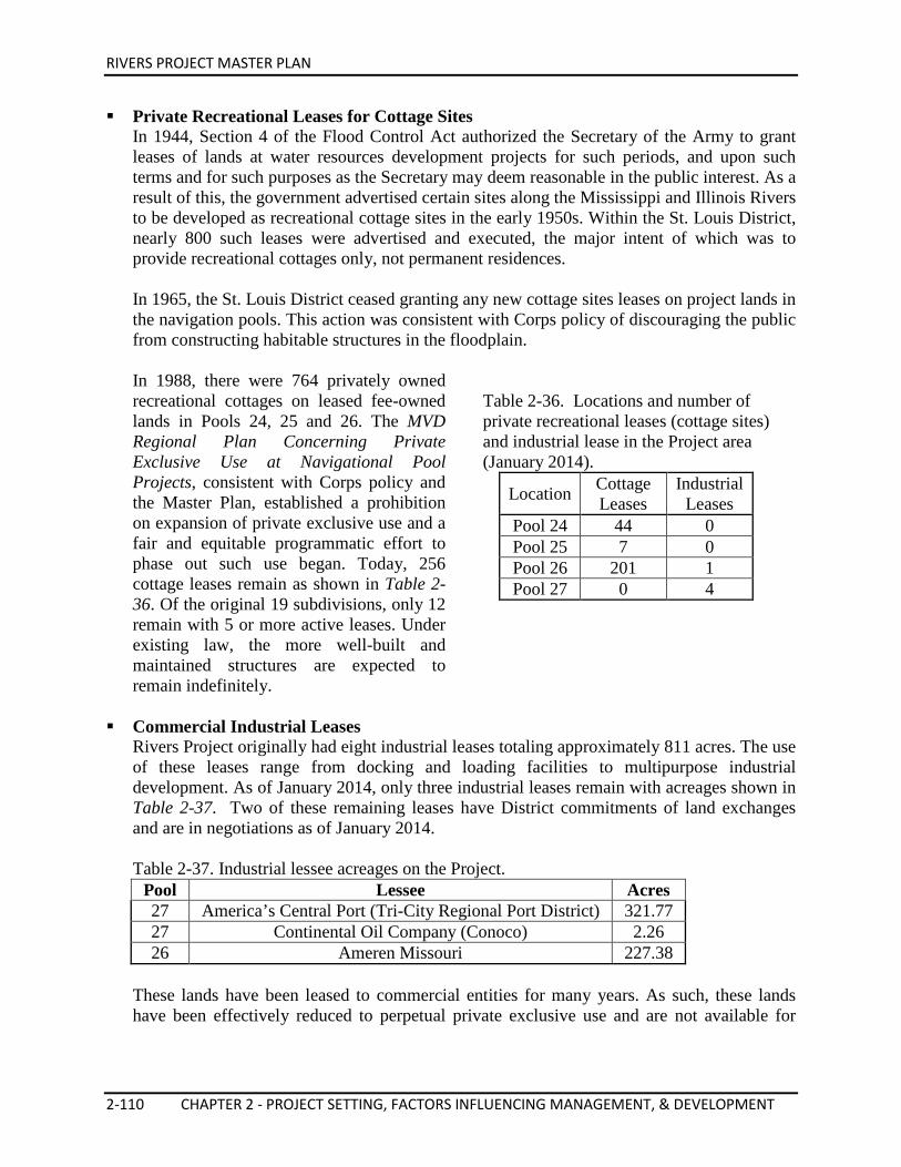
RIVERS PROJECT MASTER PLAN
2-110 CHAPTER 2 - PROJECT SETTING, FACTORS INFLUENCING MANAGEMENT, & DEVELOPMENT
Private Recreational Leases for Cottage Sites In 1944, Section 4 of the Flood Control Act authorized the Secretary of the Army to grant leases of lands at water resources development projects for such periods, and upon such terms and for such purposes as the Secretary may deem reasonable in the public interest. As a result of this, the government advertised certain sites along the Mississippi and Illinois Rivers to be developed as recreational cottage sites in the early 1950s. Within the St. Louis District, nearly 800 such leases were advertised and executed, the major intent of which was to provide recreational cottages only, not permanent residences. In 1965, the St. Louis District ceased granting any new cottage sites leases on project lands in the navigation pools. This action was consistent with Corps policy of discouraging the public from constructing habitable structures in the floodplain. In 1988, there were 764 privately owned recreational cottages on leased fee-owned lands in Pools 24, 25 and 26. The MVD Regional Plan Concerning Private Exclusive Use at Navigational Pool Projects, consistent with Corps policy and the Master Plan, established a prohibition on expansion of private exclusive use and a fair and equitable programmatic effort to phase out such use began. Today, 256 cottage leases remain as shown in Table 2-36. Of the original 19 subdivisions, only 12 remain with 5 or more active leases. Under existing law, the more well-built and maintained structures are expected to remain indefinitely.
Table 2-36. Locations and number of private recreational leases (cottage sites) and industrial lease in the Project area (January 2014).
Location Cottage Leases
Industrial Leases
Pool 24 44 0 Pool 25 7 0 Pool 26 201 1 Pool 27 0 4
Commercial Industrial Leases Rivers Project originally had eight industrial leases totaling approximately 811 acres. The use of these leases range from docking and loading facilities to multipurpose industrial development. As of January 2014, only three industrial leases remain with acreages shown in Table 2-37. Two of these remaining leases have District commitments of land exchanges and are in negotiations as of January 2014. Table 2-37. Industrial lessee acreages on the Project.
Pool Lessee Acres 27 America’s Central Port (Tri-City Regional Port District) 321.77 27 Continental Oil Company (Conoco) 2.26 26 Ameren Missouri 227.38
These lands have been leased to commercial entities for many years. As such, these lands have been effectively reduced to perpetual private exclusive use and are not available for
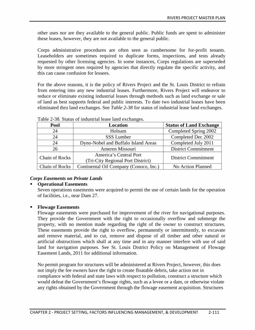
RIVERS PROJECT MASTER PLAN
CHAPTER 2 - PROJECT SETTING, FACTORS INFLUENCING MANAGEMENT, & DEVELOPMENT 2-111
other uses nor are they available to the general public. Public funds are spent to administer these leases, however, they are not available to the general public. Corps administrative procedures are often seen as cumbersome for for-profit tenants. Leaseholders are sometimes required to duplicate forms, inspections, and tests already requested by other licensing agencies. In some instances, Corps regulations are superseded by more stringent ones required by agencies that directly regulate the specific activity, and this can cause confusion for lessees. For the above reasons, it is the policy of Rivers Project and the St. Louis District to refrain from entering into any new industrial leases. Furthermore, Rivers Project will endeavor to reduce or eliminate existing industrial leases through methods such as land exchange or sale of land as best supports federal and public interests. To date two industrial leases have been eliminated thru land exchanges. See Table 2-38 for status of industrial lease land exchanges. Table 2-38. Status of industrial lease land exchanges.
Pool Location Status of Land Exchange 24 Holnam Completed Spring 2002 24 SSS Lumber Completed Dec 2002 24 Dyno-Nobel and Buffalo Island Areas Completed July 2011 26 Ameren Missouri District Commitment
Chain of Rocks America’s Central Port (Tri-City Regional Port District) District Commitment
Chain of Rocks Continental Oil Company (Conoco, Inc.) No Action Planned Corps Easements on Private Lands Operational Easements
Seven operations easements were acquired to permit the use of certain lands for the operation of facilities, i.e., near Dam 27.
Flowage Easements
Flowage easements were purchased for improvement of the river for navigational purposes. They provide the Government with the right to occasionally overflow and submerge the property, with no mention made regarding the right of the owner to construct structures. These easements provide the right to overflow, permanently or intermittently, to excavate and remove material, and to cut, remove and dispose of all timber and other natural or artificial obstructions which shall at any time and in any manner interfere with use of said land for navigation purposes. See St. Louis District Policy on Management of Flowage Easement Lands, 2011 for additional information. No permit program for structures will be administered at Rivers Project, however, this does not imply the fee owners have the right to create floatable debris, take action not in compliance with federal and state laws with respect to pollution, construct a structure which would defeat the Government’s flowage rights, such as a levee or a dam, or otherwise violate any rights obtained by the Government through the flowage easement acquisition. Structures
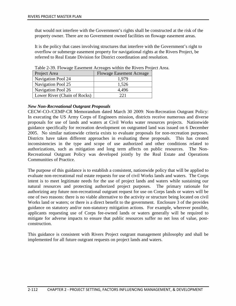
RIVERS PROJECT MASTER PLAN
2-112 CHAPTER 2 - PROJECT SETTING, FACTORS INFLUENCING MANAGEMENT, & DEVELOPMENT
that would not interfere with the Government’s rights shall be constructed at the risk of the property owner. There are no Government owned facilities on flowage easement areas. It is the policy that cases involving structures that interfere with the Government’s right to overflow or submerge easement property for navigational rights at the Rivers Project, be referred to Real Estate Division for District coordination and resolution. Table 2-39. Flowage Easement Acreages within the Rivers Project Area. Project Area Flowage Easement Acreage Navigation Pool 24 1,979 Navigation Pool 25 1,526 Navigation Pool 26 4,496 Lower River (Chain of Rocks) 221
New Non-Recreational Outgrant Proposals CECW-CO-/CEMP-CR Memorandum dated March 30 2009: Non-Recreation Outgrant Policy: In executing the US Army Corps of Engineers mission, districts receive numerous and diverse proposals for use of lands and waters at Civil Works water resources projects. Nationwide guidance specifically for recreation development on outgranted land was issued on 6 December 2005. No similar nationwide criteria exists to evaluate proposals for non-recreation purposes. Districts have taken different approaches in evaluating these proposals. This has created inconsistencies in the type and scope of use authorized and other conditions related to authorizations, such as mitigation and long term affects on public resources. The Non-Recreational Outgrant Policy was developed jointly by the Real Estate and Operations Communities of Practice. The purpose of this guidance is to establish a consistent, nationwide policy that will be applied to evaluate non-recreational real estate requests for use of civil Works lands and waters. The Corps intent is to meet legitimate needs for the use of project lands and waters while sustaining our natural resources and protecting authorized project purposes. The primary rationale for authorizing any future non-recreational outgrant request for use on Corps lands or waters will be one of two reasons: there is no viable alternative to the activity or structure being located on civil Works land or waters; or there is a direct benefit to the government. Enclosure 3 of the provides guidance on statutory and/or non-statutory mitigation actions. For example, wherever possible, applicants requesting use of Corps fee-owned lands or waters generally will be required to mitigate for adverse impacts to ensure that public resources suffer no net loss of value, post-construction. This guidance is consistent with Rivers Project outgrant management philosophy and shall be implemented for all future outgrant requests on project lands and waters.
RIVERS PROJECT MASTER PLAN
CHAPTER 2 - PROJECT SETTING, FACTORS INFLUENCING MANAGEMENT, & DEVELOPMENT 2-113
2.16. PERTINENT PUBLIC LAWS With the development of navigation structures and the purchase of Project lands through the River and Harbor Acts, the opportunity for the multi-use purposes of Project lands was soon recognized. Recreation interest was established by Congress in 1944 and in subsequent legislation. Interest in the fish and wildlife resources pre-dated the construction of the locks and dams with the passage of the Fish and Wildlife Coordination Act of 1934 and the Migratory Bird Treaty Act of 1918. The Forest Cover Act of 1960, National Environmental Policy Act of 1969, Endangered Species Act of 1973 and Clean Water Act of 1977 provided a background for the protection, conservation and preservation of public lands. Cultural considerations on public lands were first addressed in the Archeological and Historic Preservation Act of 1960. These and other additional authorities are organized by project purpose below. Navigation Mississippi River – Modifications to the Mississippi River for navigation began in 1824 when the government authorized removal of snags, shoals and sandbars; excavation of rock at several rapids; and the closing off of meandering sloughs and side channels to maintain flow in the main channel. The first comprehensive modification of the river was authorized by the River and Harbor Act of 18 June 1878. A four and one half-foot channel was maintained from the mouth of the Mississippi River to St. Paul, Minnesota, by construction of dams at the headwaters of the Mississippi River. The dams served to impound water for low flow supplementation, bank revetments, closing dams, and longitudinal dikes. The increase to a six-foot channel was authorized by the River and Harbor Act of 2 March 1907. The additional depth was obtained primarily by the construction of rock and brush wing dams which were designed to constrict low water flows into a narrower channel. On 3 July 1930, Congress passed legislation (PL 71-520) authorizing a nine-foot channel project. The project consisted of a series of low-head navigation locks and dams to be constructed to provide a minimum nine-foot deep and 300-foot wide navigation channel on the Mississippi River from Alton, IL to Minneapolis, Minnesota. Later congressional actions provided for improvements to ensure consistent navigation around the Chain of Rocks section of the Mississippi River at Granite City, IL. Illinois River – The River and Harbor Act of 3 July 1930 authorized the Corps to finish the 75 percent complete State of Illinois Nine-Foot Navigation Project on the Illinois River and assigned responsibility for facilities operation to the federal government. The St. Louis District is responsible for the lower 80-mile reach of the Illinois River from LaGrange Lock to Grafton, IL, which is the Illinois Waterway portion of the Melvin Price Locks and Dam pool. The River and Harbor Act of 1935 (PL 74-409), approved 30 August 1935, determined that non-navigable types of dams would be used for the Nine-Foot Channel Navigation Project. Non-navigable dams are those which will not pass vessels without the use of locks. It also identified the improvements that were to be made on the Illinois River, which included dredging and the construction of modern locks and dams at Peoria and La Grange and the removal of the earlier navigation structures at La Grange and Kampsville. The construction of Lock and Dam 26 on the Mississippi at Alton, IL made the Illinois River navigable from its mouth to Illinois river mile 80.
RIVERS PROJECT MASTER PLAN
2-114 CHAPTER 2 - PROJECT SETTING, FACTORS INFLUENCING MANAGEMENT, & DEVELOPMENT
The River and Harbor Act of 1945 (PL 79-14), approved 2 March 1945, authorized the construction of Locks 27 and the Chain of Rocks Canal (59 Stat. 10). The River and Harbor Act of 3 July 1958 (PL 85-500) authorized the construction of Dam 27, a low-water, rock-filled dam, and other bank improvements to support navigation below old Locks and Dam 26. The UMRS Comprehensive Plan (Inland Waterways Revenue Act of 1978; Titles I & II) (PL 95-502) was approved 21 October 1978 (92 Stat. 1693). Title I, Section 101 authorized the replacement of Locks and Dam 26 with a new dam and a single lock. Section 102 required the preparation of a comprehensive master plan of the UMRS and evaluation of the need for a second lock. Title II -Established the Inland Waterways Revenue Act of 1978 to place a tax on fuel used in commercial transportation on inland waterways as well as a trust fund for navigational construction on inland waters. The Supplemental Appropriation Act of 1985 (PL 99-88), approved 15 August 1985, and the Water Resources Development Act (WRDA) of 1986 (PL 99-662), approved 17 November 1986, authorized the construction of a 600-foot by 110-foot auxiliary lock at Lock and Dam 26 (Replacement), now known as Melvin Price Locks and Dam. The Water Resources Development Act of 1996, was approved 12 October 1996. Section 415, Chain of Rocks Canal, Illinois, authorized completion of a limited re-evaluation of the authorized St. Louis Harbor Project to include evacuation of water collecting on the land side of the Chain of Rocks Canal, East Levee. The Water Resources Reform and Development Act of 2014, was approved 10 June 2014. Section 415, Land Conveyances, Authorized conveyance by Ameren Corporation to the United States of all right, title, and interest in and to the non-Federal land, the Secretary shall convey to Ameren Corporation all right, title, and interest of the United States in and to the Federal land (lease for Portage Des Sioux Power Plant, St. Charles Co.). Recreation The Flood Control Act of 1944 (PL 78-534) was approved 22 December 1944. Section 4, as amended, authorized the Chief of Engineers to construct, operate and maintain public park and recreational facilities in reservoir areas. It also required that water areas of all such projects are open to boating, fishing, and other recreation and that ready access to such areas are maintained for general public use when in the public interest (48 Stat. 887). The Flood Control Act of 1946 (PL 79-526) was approved 24 July 1946. Section 4 (60 Stat. 641) amended PL 78-534 to include authority to grant leases of lands in reservoir areas and licensing of lands to federal, state and local government agencies when in the public interest. The Flood Control Act of 1954 (PL 83-780) was approved 3 September 1954.
RIVERS PROJECT MASTER PLAN
CHAPTER 2 - PROJECT SETTING, FACTORS INFLUENCING MANAGEMENT, & DEVELOPMENT 2-115
Section 209 amended the Flood Control Act of 1944. It authorized the Secretary to grant leases to federal, state or local government agencies without monetary considerations for use and occupation of land and water areas under the jurisdiction of the Department of the Army for park and recreation purposes when in the public interest (68 Stat 1256). The Flood Control Act of 1962 (PL 87-874) was approved 23 October 1962. Section 207 amended Section 4 of the Flood Control Act of 1944, permitting recreational developments at non-reservoir projects (76 Stat. 1195). The Land and Water Conservation Fund Act of 1965 (PL 88-578), approved 1 September 1964, amended by PL 94-422. This act established a fund from which Congress can make appropriations for outdoor recreation. The fund derives revenue from entrance and user fees, sale of surplus federal property, and the federal motorboat fuel tax. The Federal Water Project Recreation Act of 1965 (PL 89-72), approved 9 July 1965 as amended, established recreation at federal water resource projects as a full project purpose. This act requires consideration of recreation opportunities and of fish and wildlife enhancement in planning water resources projects. Section 9 limited the maximum allocation for recreation and fish and wildlife enhancement to 50 percent of the total project cost. This act further required beneficiaries to bear part of the costs of operating and maintaining recreation developments at federal water resources projects (79 Stat. 213). Public Law 97-140, was approved December 29, 1981. Section 6 imposed a moratorium through 30 December 1989 on enforced removal of certain private-use facilities from any Corps reservoir or lake project. Subsequently, by Section 1134, Public Law 99-662, the moratorium was extended indefinitely. The Water Resources Development Act of 1990 (PL 101-640) was approved 28 November 1990. Section 102 (1) of the Water Resources Development Act of 1990 provided authorization for project related recreational development in the State of Illinois in conjunction with the Lock and Dam 26 Replacement Project (now Melvin Price Locks and Dam). As specified therein, the work includes site preparations and infrastructure for a marina and docking facilities, access roads and parking, a boat launching ramp, hiking trails and picnicking facilities. This authorization was furthered by WRDA 1992, which extended to “other non-federal interests” the opportunity to serve as the non-federal sponsor for recreation development in conjunction with the Melvin Price project. Subsequently, on 7 December 1992, the City of Alton submitted a letter of intent in this regard to the St. Louis District Engineer. The Water Resources Development Act of 1992, (PL 102-580) was approved 31 October 1992.
RIVERS PROJECT MASTER PLAN
2-116 CHAPTER 2 - PROJECT SETTING, FACTORS INFLUENCING MANAGEMENT, & DEVELOPMENT
Section 103 of the Water Resources Development Act of 1992, authorized the development of a Regional Visitor Center of at least 24,000 square feet at the Melvin Price Locks and Dam site. The purpose of the visitor center is to inform the public of the role of the U. S. Army Corps of Engineers in inland navigation along the Mississippi River and its tributaries. In addition, it includes the role of the Melvin Price Locks and Dam in inland navigation, the socioeconomic development of the surrounding area, and events of historical, archaeological, cultural, and natural significance in the area. Section 225 authorized the Challenge Cost Sharing Program that permits the Secretary to develop and implement a program to accept contributions of funds, materials and services from non-federal public and private entities to be used in managing recreation facilities and natural resources. The Water Resources Development Act of 1996 (PL 104-303) was approved 12 October 1996. Section 208 – RECREATION POLICY AND USER FEES directed the Secretary to put increased emphasis on recreation opportunities at Corps projects and specifies that recreation fees collected at Corps projects remain for use at the project where they are collected. Section 322 – LOCKS AND DAM 26, ALTON, ILLINOIS AND MISSOURI modified the project to allow recreation development on contiguous non-project lands, including the Alton Commons. Section 519 – RECREATION PARTNERSHIP INITIATIVE directed that, in general, the Secretary is to promote federal, non-federal, and private sector cooperation in creating public recreation opportunities at Corps projects. Fish & Wildlife Fish and wildlife resources are maintained and protected in compliance with the following public laws: The Fish and Wildlife Coordination Act (FWCA) was enacted 10 March 1934, and amended 14 August 1946 (PL 76-732) and 12 August 1958 (PL 85-624). The FWCA 1946, Section 3 provided for the use of water resources projects for conservation, maintenance, and management of wildlife resources and wildlife habitat, to be administered by state agencies or the Secretary of the Interior. In accordance with this act, General Plans for the use of lands and waters of the navigation channel project for wildlife conservation and management were formulated and approved by the Secretary of the Army, the Secretary of the Interior, and the heads of pertinent state agencies. The FWCA of 1958 required that fish and wildlife conservation receive equal consideration with other project purposes and that they be coordinated with other features of water resource development programs. All planning and project development must be coordinated with the USFWS.
RIVERS PROJECT MASTER PLAN
CHAPTER 2 - PROJECT SETTING, FACTORS INFLUENCING MANAGEMENT, & DEVELOPMENT 2-117
General Plans (land use maps) and Cooperative Agreements are the instruments used to establish a structured arrangement between the USFWS and Corps, and the USFWS and the states, for managing public lands. The Forest Conservation Act (Reservoir Area–Forest Cover) (PL 86-717) (74 Stat. 817) was approved 6 September 1960. PL 86-717 and applicable implementing regulations declared the policy of the United States to provide that areas owned in fee and under the jurisdiction of the Secretary of the Army and the Chief of Engineers shall provide for the protection and development of forest and other vegetative cover and the establishment and maintenance of other conservation measures. The basic Corps environmental stewardship mission is carried out by identifying and implementing management practices that insure the conservation, preservation and protection of resources for present and future generations. The Corps will continue to promote the establishment, maintenance, and protection of vegetative cover, to include forest cover, grasses and other herbaceous communities, in order to sustain the potential for forest production, to sustain wildlife populations, and to provide for basic erosion control during the life of the project. Corps natural resource management strategies are identified in this Project Master Plan and further detailed and specifically explained and scheduled in the Project Operational Management Plan (to be developed subsequent to the Master Plan). The development of plans or other vegetative management activities are fully coordinated with the USFWS. The USFWS provides their comments, and reviews the compatibility of proposed actions on the wildlife enhancement uses of the project. Under the terms of this agreement, the USFWS on Designated Refuge lands, or the appropriate states on General Plan/Coordination lands, will manage resources for enhancement of fish and wildlife. The Endangered Species Act (ESA) of 1973 (PL 93-205) (87 Stat. 884), amended by PL 95-632 and PL 97-3040, stated the policy of Congress that all federal departments and agencies must seek to conserve endangered and threatened species. Section 7(a)(1) stated that all federal agencies shall, in consultation with and with the assistance of the USFWS, utilize their authorities in furtherance of the purposes of the ESA by carrying out programs for the conservation of endangered species and threatened species. Section 7(a)(2) required each federal agency to consult with the Secretary of the Interior to insure that authorized actions neither jeopardize the continued existence of any endangered or threatened species nor results in adverse modification of critical habitat. Unless previously completed and included in the project environmental impact statement, a biological assessment must identify any endangered species that, in the opinion of the USFWS, may be affected by the project. This requirement applies to all civil works studies, projects, or programs and includes the operation and maintenance of completed projects. A 1982 amendment made the act a more effective and efficient tool for the conservation of the species affected. The Water Resources Development Act of 1974 (PL 93-251) (88 Stat. 33) was approved 7 March 1974, and provided for 25 percent/75 percent cost-sharing between federal, state, and local governments to enhance fish and wildlife on project lands.
RIVERS PROJECT MASTER PLAN
2-118 CHAPTER 2 - PROJECT SETTING, FACTORS INFLUENCING MANAGEMENT, & DEVELOPMENT
The Fish and Wildlife Conservation Act of 1980 (PL 96-366), approved 16 September 1980, provided funds to states to conduct inventories and conservation plans for conservation of non-game wildlife. It also encouraged federal departments and agencies to use their statutory and administrative authority to conserve and promote conservation in accordance with this act. The Water Resources Development Act of 1986 (PL 99-662) was approved 17 October 1986. The Environmental Management Program, the second lock at Melvin Price Locks and Dam, and Navigation Impact Studies are the major activities authorized by this Act. Section 1103 of the same law is cited as the UMRS Management Act of 1986 and authorized a number of plans and actions for improving coordinated development and enhancement of the UMRS, due to its national significance as an ecosystem and commercial navigation system. Section 906 provided that necessary mitigation measures for new projects be undertaken before or concurrently with project construction. It provided general authority to undertake mitigation measures for projects, whether completed, underway or not started. This includes acquisition of any needed related lands, excluding condemnation in connection with projects already completed or well underway. Under this section, mitigation costs shall be allocated to the project purposes and cost-shared accordingly. It required that feasibility reports contain a specific plan to mitigate fish and wildlife losses, unless a determination is made that there would be negligible adverse impact. Such plans shall provide that impacts on bottomland hardwood forests are mitigated in-kind to the extent possible. Section 906 also provided that, for any project measures recommended to enhance fish and wildlife, costs will be entirely federal when the benefits have a national character and, where they do not, non-federal interests shall reimburse 25 percent of the costs. The non-federal share of operations, maintenance and rehabilitation costs will, in all cases, be 25 percent. To date, the Corps has not funded activities covered under Section 906. The Water Resources Development Act of 1996 (PL 104-303) was approved 12 October 1996. Section 201 – COST SHARING FOR DREDGED MATERIAL DISPOSAL AREAS designated that land based and aquatic dredged material disposal (DMD) areas built for construction and O&M shall be considered a General Navigation Feature and cost shared in accordance with Title I of WRDA 1986. Section 201 also provided that dredging funds must be considered on an equitable regional basis prior to constructing new DMD facilities. Use of private DMD facilities are permitted if least cost alternative. Non-federal interests may request amendment of Project Cooperation Agreements (PCA) executed before the date of enactment of this act. No increases to the non-federal interest’s cost share are to result from this provision. Section 204 – RESTORATION OF ENVIRONMENTAL QUALITY authorized small environmental restoration projects, either at the project site or off the project site, when it is found that the Corps project has contributed to the degradation of the environment. This section clarified that the $5 million limit is for the federal share of the project only and specifies that the
RIVERS PROJECT MASTER PLAN
CHAPTER 2 - PROJECT SETTING, FACTORS INFLUENCING MANAGEMENT, & DEVELOPMENT 2-119
non-federal cost share is 25 percent and that not more than 80 percent of the non-federal share may be in-kind. The section also defined water resources projects constructed by the Secretary to include projects constructed or funded jointly by the Corps and some other federal agency. Section 206 – AQUATIC ECOSYSTEM RESTORATION authorized small aquatic ecosystem restoration projects ($5 million federal cost) to improve the quality of the environment, if they are in the public interest and cost effective; The projects are to be cost-shared 35 percent non-federal with 100 percent non-federal O&M. Under this section, there is a $25 million per year authorization of appropriations. Section 207 – BENEFICIAL USES OF DREDGED MATERIALS directed that, in carrying out navigation projects, the Secretary may select a disposal method that is not the least-cost-option if the incremental costs are reasonable in relation to the environmental benefits, including creation of wetlands and shoreline erosion control. Section 210 – COST SHARING FOR ENVIRONMENTAL PROJECTS amended Section 103 of WRDA 1986 by specifying that the non-federal share of environmental restoration and protection projects shall be 35 percent. Section 212 – ENGINEERING AND ENVIRONMENTAL INNOVATIONS OF NATIONAL SIGNIFICANCE authorized the Secretary to undertake studies and prepare reports that may lead to work under current civil works authorities or to make recommendations for authorizations. This section authorized $1 million annually for fiscal years 1997-2000. The Corps may accept funds from other agencies, states, or non-federal interests. Environmental Stewardship The National Environmental Policy Act (NEPA) of 1969 (PL 91-190) (83 Stat. 852), approved 1 January 1970, declared a national environmental policy for protection and enhancement of the environment and established a Council on Environmental Quality (CEQ). NEPA set forth the requirement for an environmental impact statement on any major federal action significantly affecting the quality of the human environment. The Forest Conservation (Reservoir Areas-Forest Cover) Act of 1960 (PL 86-717) (74 Stat. 817), approved 6 September 1960, required that projects be developed and maintained to encourage adequate forest resources. Forest management programs must be administered to increase the value of project lands for recreation and wildlife and to promote natural ecological conditions by following accepted conservation practices The Federal Water Pollution Control Act Amendments of 1961 (PL 87-88), approved 20 July 1961, provided for a more effective program of water pollution control. Amended by PL 92-500, Section 404, approved 18 October 1972, regulates the placement of dredged or fill material into jurisdictional waters. The Clean Water Act of 1977 (PL 95-217), approved 27 December 1977, amended the Federal Water Pollution Control Act and extends the appropriations authorization.
RIVERS PROJECT MASTER PLAN
2-120 CHAPTER 2 - PROJECT SETTING, FACTORS INFLUENCING MANAGEMENT, & DEVELOPMENT
The Farmland Protection Policy Act (PL 97-98), approved 22 December 1981, minimized the extent to which federal programs contribute to the unnecessary and irreversible conversion of farmland to nonagricultural uses. The Water Resources Development Act of 1986 (PL 99-662) was approved 17 October 1986. Section 1135 – PROJECT MODIFICATIONS FOR IMPROVEMENT OF ENVIRONMENT stated that the Corps, under the auspices of the Secretary, is authorized to review the operation of water resources projects constructed by the Secretary before the date of enactment of this Act to determine the need for modifications in the structures and operations of the projects for the purpose of improving the quality of the environment in the public interest. The Secretary is authorized to review the operation of water resources projects constructed by the Secretary to determine the need for modifications in the structures and operations of such projects for the purpose of improving the quality of the environment in the public interest. The Secretary is authorized to carry out a program for the purpose of making such modifications in the structures and operations of water resources projects constructed by the Secretary which the Secretary determines are both feasible and consistent with the authorized project purposes, and will improve the equality of the environment in the public interest. The non-federal share of the cost of any modifications carried out under this section shall be 25 percent. The Secretary shall coordinate any actions taken pursuant to this section with appropriate federal, state and local agencies. Beginning in 1992 and every two years thereafter, the Secretary shall transmit to Congress a report on the results of reviews conducted under Subsection (a), and on the program conducted under Subsection (b). The report shall contain any recommendations of the Secretary concerning modifications and extension of the program. The Water Resource Development Act of 1990 (PL 101-640) was approved 28 November 1990. Section 306 stated that environmental protection was one of the primary considerations of the Corps in the planning, design, construction, operation, and maintenance of water resource projects. Section 307 stated two goals for the Corps water resource development program: (1) An interim goal of no overall net loss of the nation’s remaining wetlands base, as defined by acreage and function, and (2) a long-term goal to increase the quality and quantity of the nation’s wetlands as defined by acreage and function. Section 509 of the Water Resources Development Act of 1999 reauthorized the EMP program as a continuing authority type program. Section 514 authorized development of a project to enhance fish and wildlife habitat on the Missouri River and the middle Mississippi River.
RIVERS PROJECT MASTER PLAN
CHAPTER 2 - PROJECT SETTING, FACTORS INFLUENCING MANAGEMENT, & DEVELOPMENT 2-121
The Water Resource Development Act of 2007 (PL 110-114) was approved 8 November 2007, authorized the Upper Mississippi River - Illinois Waterway System Navigation and Ecosystem Sustainability Program (NESP). Cultural and Historical Considerations A number of laws mandating the protection of cultural resources on public lands have been passed. These laws and Executive Orders are summarized in Appendix A of ER 1130-2-540. The following laws subsume, clarify, or supersede all previous cultural resources law: On public lands leased (outgranted) for recreation or industrial purposes, the lessee is responsible for achieving cultural resource compliance as specified by the SHPO prior to implementing any proposed development. In accordance with the authorities listed below, archaeological investigations are undertaken for projects that have the potential of disturbing the ground surface. The operation and maintenance of navigation on the rivers creates a number of potential concerns in preserving cultural resources. These concerns pertain to development induced by the presence of the waterway, and to channel maintenance activities. Continued transformation of existing private shoreline land uses to industrial uses can be expected. Exact locations for development cannot be predicted, but any substantial land-use change may affect unknown cultural resources. Prior to developing shorelines, a 404 and/or Section 10 permit from the Corps must be obtained. The Corps can require an archaeological survey to be performed by the applicant as a prerequisite to obtain a permit in areas where ground disturbance has the potential to damage significant archaeological remains. Channel maintenance activities such as dredging and bank stabilization operations also have the potential of damaging important archaeological sites. The construction of dikes and placement of riprap along the shoreline can adversely affect cultural resources. An established procedure is in place to perform archaeological surveys in areas prior to construction. If sites are located, appropriate testing, evaluation, and compliance procedures will be followed before construction will occur. Any prehistoric or historic district, site, building, structure, or object included in, or eligible for inclusion on the National Register, inadvertently discovered in the course of routine management, surveillance or development of public lands will not be disturbed or removed. The Corps District Engineer or his or her representative will be immediately notified to ascertain the appropriate protection and compliance requirements. Proposed management of development activities that may impact historic or pre-historic cultural resources on Cooperative Agreement lands requires that the managing agency (USFWS, IDNR or MDC) conduct appropriate compliance actions and/or procedures in consultation with the Corps and the State Historic Preservation Officer (SHPO) to ensure proper compliance and/or approvals prior to implementation.
RIVERS PROJECT MASTER PLAN
2-122 CHAPTER 2 - PROJECT SETTING, FACTORS INFLUENCING MANAGEMENT, & DEVELOPMENT
The Archaeological Resources Protection Act of 1979 (16 USC 470 et seq.) (PL 96-95), approved 31 October 1979, revised and updated the 1906 Antiquities Act. It protects archaeological resources and sites that are on public lands and Indian land, and fosters increased cooperation and exchange of information between governmental authorities, the professional community, and private individuals. The Act required and provided for permits to conduct scientific archeological excavations by qualified individuals and also specifies criminal acts and provides for criminal and civil penalties. The National Historic Preservation Act Amendments of 2006 to the National Historic Preservation Act of 1966, (PL 96-515) stated a policy of preserving, restoring, and maintaining cultural resources. It also required that federal agencies take into account the effect of any undertaking on any site on or eligible for the National Register of Historic Places. The Archaeological and Historic Preservation Act (Reservoir Salvage Act) (PL 86-523) (16 USC 469 et seq.), approved 27 June 1960 as amended, provided for the preservation of historical and archaeological data which might otherwise be lost or destroyed as the result of flooding or any alteration of the terrain caused as a result of any federal construction projects. The Native American Graves Protection and Repatriation Act (NAGPRA; PL 101-601) 16 November 1990, provides a process for museums and Federal agencies to return certain Native American cultural items -- human remains, funerary objects, sacred objects, or objects of cultural patrimony -- to lineal descendants, and culturally affiliated Indian tribes and Native Hawaiian organizations. NAGPRA includes provisions for unclaimed and culturally unidentifiable Native American cultural items, intentional and inadvertent discovery of Native American cultural items on Federal and tribal lands, and penalties for noncompliance and illegal trafficking. In addition, NAGPRA authorizes Federal grants to Indian tribes, Native Hawaiian organizations, and museums to assist with the documentation and repatriation of Native American cultural items, and establishes the Native American Graves Protection and Repatriation Review Committee to monitor the NAGPRA process and facilitate the resolution of disputes that may arise concerning repatriation under NAGPRA. The Antiquities Act of 1906 (16 U.S.C. 431-433) 8 June 1906, most basic legislation to protect cultural resources by defining offenses if not obtaining permits to remove materials. The Historic Sites Act of 1935 (16 U.S.C. 461-467) 21 August 1935, "...that it is a national policy to preserve for public use historic sites, buildings, and objects of national significance..." The Reservoir Salvage Act of 1960 (PL 86-523) 27 June 1960, to provide for the preservation of historical and archeological data (including relics and specimens) which might otherwise be lost as the result of the construction of a dam. Executive Order 11593, 13 May 1971, Protection and Enhancement of the Cultural Environment required Federal agencies to administer cultural properties under their control and direct their policies, plans, and programs in such a way that federally owned sites, structures, and objects of historical, architectural, or archeological significance were preserved, restored, and maintained.
RIVERS PROJECT MASTER PLAN
CHAPTER 2 - PROJECT SETTING, FACTORS INFLUENCING MANAGEMENT, & DEVELOPMENT 2-123
Executive Order 13007, 24 May 1996. This Executive Order directs Federal land-managing agencies to accommodate Native Americans' use of sacred sites for religious purposes and to avoid adversely affecting the physical integrity of sacred sites. The American Indian Religious Freedom Act (AIRFA) of 1978 (42 U.S.C. 1996) 11 August 1978. The policy of the United States to protect and preserve for American Indians their inherent right of freedom to believe, express, and exercise the traditional religions of the American Indian, Eskimo, Aleut, and Native Hawaiians, including but not limited to acess to sites, use and possession of sacred objects, and freedom to worship through ceremonial and traditional rites. The Abandoned Shipwreck Act, 28 April 1988 (PL100-298), asserts U.S. Government title to three categories of abandoned shipwrecks: those embedded in a state's submerged lands; those embedded in coralline formations protected by a state on its submerged lands, and those located on a state's lands that are included or determined eligible for inclusion in the National Register of Historic Places. The law then transfers title for a majority of those shipwrecks to the respective states, and provides that states develop policies for management of the wrecks so as to protect natural resources, permit reasonable public access, and allow for recovery of shipwrecks consistent with the protection of historical values and environmental integrity of wrecks and sites.

RIVERS PROJECT MASTER PLAN
THIS PAGE INTENTIONALLY LEFT BLANK.
RIVERS PROJECT MASTER PLAN
CHAPTER 3 - RESOURCE OBJECTIVES 3-1
Chapter 3 Resource Objectives
PROJECT GOAL The goal of the Rivers Project Master Plan is to provide Rivers Project area with a master planning document that will authorize and/or facilitate existing and future management activities for the benefit and protection of all natural and constructed resources under Project jurisdiction. Sustainable plans within a river basin context responsive to customer and partner needs will be developed. These plans are based on the Corps’ Environmental Operating Principles (EOPs). Natural Resource Management Program Objective areas within the Rivers Project are:
1. General Management 2. Environmental Stewardship 3. Environmental Compliance 4. Recreation 5. Visitor Assistance 6. Interpretation Services and Outreach Program 7. Flood Risk Management 8. Shoreline Management 9. Navigation 10. Historical Resources
Natural Resource Management Program Objectives The objectives described in this section are to identified issues and specify the desirable and attainable options for resource development and/or management for the lands and waters under the jurisdiction of the Corps’ Rivers Project Office. These objectives are consistent with authorized Project purposes, Federal laws and directives, regional needs, resource capabilities and expressed public desires. 3.1. GENERAL MANAGEMENT AND ADMINISTRATION The process used to develop planning issues and management objectives for the Master Plan is described in Chapter 7 — Agency and Public Involvement and Coordination on Master Plan Development. Two public open houses were conducted during January 2013 at Alton, IL and Clarksville, MO, to solicit comments on the Rivers Project Master Plan update. Some of these issues are outside of Corps authority but are still documented because of their importance to the public and the overall health of the rivers. Resource use management objectives are identified and listed in random order and are within the existing authorities of the Rivers Project Office. Management and Administration Using a system or watershed approach ensures quality administration and management of Project lands, waters, and other associated natural resources is consistent and thorough.
RIVERS PROJECT MASTER PLAN
3-2 CHAPTER 3 - RESOURCE OBJECTIVES
While continuing to achieve goals of sound, sustainable stewardship and safe, enjoyable public use; find effective ways to increase efficiency and cost effective management and administration. All Project administrative and management decisions/actions will adhere to all applicable laws regulations, policies, and agreements. Consistent coordination, both internally and with other applicable federal, state and local government agencies, private organizations and individuals, will be maintained. All actions and/or plans will be implemented in a manner compatible with authorized Project purposes and applicable social, economic and environmental factors, to insure minimum conflicts in project uses and development. General Resource Management and Administration Objectives • Ensure that quality administration and management of all Project lands, waters and other
associated constructed and natural resources are consistent and thorough. • Seek to continually increase efficiency, cost effectiveness and innovation in projects
while keeping public use and enjoyment a goal of achievement. • Evaluate and minimize safety concerns when planning and implementing all activities. • Ensure that all Project administration and management decisions and actions adhere to all
applicable laws, regulations, policies, and agreements. • Participate in multi-agency overview or steering committee to address river related
concerns in the region. • Develop consistent coordination and partnership efforts, internally and with other
applicable federal, state and local government agencies, private organizations and individuals.
• Implement all actions and plans in a manner compatible with authorized Project purposes and all applicable social and environmental and safety factors, to ensure maximum benefits. Compromise will be considered when appropriate to minimize conflicts in Project uses and developments.
• Provide facilities that ensure public health and safety as well as ADA accessibility. • Maintain a strong public environmental education program. • Provide sound environmental stewardship of public lands and waters. • Maintain the integrity of the natural resource management infrastructures. • Accommodate hydropower if feasible and compatible with other Project purposes. 3.2. ENVIRONMENTAL STEWARDSHIP ER 1130-2-540 states that programs and activities related to environmental stewardship and the management of natural resources shall implement and be consistent with the Corps’ Environmental Stewardship mission statement.
"The Army Corps of Engineers is the steward of the lands and waters at Corps water resources projects. Its Natural Resources Management Mission is to manage and conserve those natural resources, consistent with ecosystem management principles, while providing quality public outdoor recreation experiences to serve the needs of present and future generations.
RIVERS PROJECT MASTER PLAN
CHAPTER 3 - RESOURCE OBJECTIVES 3-3
In all aspects of natural and cultural resources management, the Corps promotes awareness of environmental values and adheres to sound environmental stewardship, protection, compliance and restoration practices. The Corps manages for long-term public access to, and use of, the natural resources in cooperation with other Federal, State, and local agencies as well as the private sector. The Corps integrates the management of diverse natural resource components such as fish, wildlife, forests, wetlands, grasslands, soil, air, and water with the provision of public recreation opportunities. The Corps conserves natural resources and provides public recreation opportunities that contribute to the quality of American life."
The national environmental stewardship program objectives are: (a) To manage natural resources on Corps of Engineers administered land and water in accordance with ecosystem management principles, to ensure their continued availability and (b) To provide a safe and healthful environment for project visitors. The USFWS, IDNR and MDC have extensive wildlife management programs on public lands. Management programs on Corps land will be carefully coordinated with the existing programs so that the most good can be achieved. The Corps is chartered through laws and regulations to manage public lands under its jurisdiction in such a manner which “conserves fish and wildlife,” “benefits wetlands,” and “provides a safe and healthy environment for visitors." The stewardship authorities afforded the Corps through the National Environmental Policy Act of 1969 (PL 91-190), Water Resource Development Acts, Forest Cover Act, and numerous engineering regulations within the Corps, offer the natural resource managers several methods to accomplish their role. Forest Management The Forest Cover Act of 1960 (Public Law 86-717) provides the Corps a statutory mandate for multiple use forest management and other vegetative cover management such as wetlands and grasslands on Project lands and waters. Forest habitat management will be applied to develop/restore, sustain, protect, and/or improve vegetation conditions for timber, fish, wildlife, soils, recreation, water quality and other beneficial uses. Regional Habitat Losses documents some of the primary floodplain/riparian forest concerns in the Rivers Project area. a. Upper Mississippi River (UMRS) Systemic Forest Stewardship Plan (Guyon et al., 2012).
A Systemic Forest Management plan that is based upon a set of ecologically and socially desired future UMRS ecosystem conditions. This plan is a coordinated effort to develop a systemic management plan by forest managers of the UMRS. The recommendations from this plan will be utilized to assist staff in making ecologically sound forest management decisions. 1) Goals include the following:
RIVERS PROJECT MASTER PLAN
3-4 CHAPTER 3 - RESOURCE OBJECTIVES
• A functional, sustainable floodplain ecosystem that includes a mosaic of native vegetation communities sufficient to support important wildlife habitat.
• Restore and maintain forest diversity, health, and sustainability on Federal lands. • Provide support for the restoration and maintenance of forest diversity, health and
sustainability on non-Federal lands. • Adaptive management: science-based decision-making.
2) Table of desired stand conditions (taken from the UMR Systemic Forest Stewardship Plan).
Table 3-1. Desired stand conditions for bottomland forests within the UMRS.
Forest Variables1 Desired UMRS Stand
Structure Conditions that may warrant
active management Overstory canopy cover 70 – 80% >80%
Overstory Species 2 species or more large blocks of single species
Basal area 90-160 ft2 / acre with ≥25% in older age classes2 >160 ft2 / acre
Tree stocking NA < 50% or > 90% Emergent trees3 > 2 / acre < 1 / acre Understory cover > 10 % < 10%
Regeneration4 > 10% of area < 10% of area Coarse woody debris --- ---
Small cavities (< 10 inch diameter) ≥ 2 visible holes/acre < 2 visible holes/acre
Den trees/large cavities (> 10 inch diameter)
≥ 1 visible hole / 10 acres mature timber < 1 visible holes / 10 acres
Standing dead and/or stressed trees ≥ 2 large trees / acre < 2 large trees / acre
Invasive herbaceous < 10% > 10% of herbaceous layer
Invasive woody < 10% > 10% of any canopy layer 1Promotion of species and structural diversity within stands is the underlying principle of management 2 “Older age class” stems are those approaching biological maturity (i.e., senescence) 3 Emergent trees make good perch/nesting sites and should have stronger consideration on diverse sites. 4 Advanced regeneration of trees in sufficient numbers (e.g., 400/acre) to ensure their succession to forest canopy
b. Forest Monitoring and Inventorying. The Project currently utilizes Level 1 and 2
Inventories (See Chapter 2 for additional information). Analysis of these inventories provide the information that directs management decisions. 1) Level 1 inventories are of a general nature and will be conducted to provide baseline
information and to support the resource objectives and land use classifications for this Master Plan. The Project has compiled Level 1 data for all of the forested portions of the management areas with a site established every 2.5 acres. Information collected includes species composition, density, basal area, stand age, canopy coverage, tree health, den cavity density, and invasive species and species of
RIVERS PROJECT MASTER PLAN
CHAPTER 3 - RESOURCE OBJECTIVES 3-5
concern demographics. A more detailed Level 1 survey is conducted every 350 acres of floodplain forest. This project monitors changes in the seedling banks, sapling cohorts and forest canopy. The two projects provide the information utilized to produce the management recommendations and will be re-sampled every 10 years.
2) Level 2 inventories are carried out prior to the implementation of a management treatment and following to monitor the success of the project. It also includes detailed inventories for special status species. Examples of current Level 2 inventories included pre- and post monitoring of the exotic Japanese hops, bush honeysuckle and smallflower salt cedar mechanical/chemical treatment projects and the bat monitoring surveys.
c. General Management Techniques. As an agency entrusted with stewardship of public lands, a key management objective is to promote and maintain a healthy, diverse forest resource which will produce and support a variety of sustainable benefits such as wildlife and fish habitat, watershed protection, public outdoor recreation opportunities, scenic values, and pest control. Wherever the opportunity exists to improve or sustain conditions in support of these benefits, proper management techniques will be applied. 1) Forest Harvest. Forests will be managed with a goal of sustaining multiple forest
communities and forest structure. In order to do so, an uneven-aged management protocol will be followed in most management areas. Even-aged management will be used when there is a goal to use parent trees for reforestation or adjust the micro-climate for more shade intolerant species. Prior to the Flood of 1993, most forests were in a state of transition to an even-aged maple-ash-elm forest community. The Flood of 1993 caused small and large canopy gap formation and effectively disrupted the transition to even-aged maple-ash-elm communities on many of the Project managed areas. However, many sites dominated by silver maple and green ash did not experience sufficient canopy disturbance. Likewise, much of the forest that did experience forest mortality is currently being reforested with silver maple and green ash. An objective to improve the quantity/quality of oak-hickory and eastern cottonwood forest may require some timber stand improvements to facilitate this need. • Even-aged system. Even-aged harvest methods regenerate and maintain a stand
in a single age class. There are two primary types, seed tree and shelterwood. - Seed Tree Method. This method involves cutting of all trees except for a
small number of widely dispersed trees (10-30 BA/acre) retained for seed production and to establish a new age class. The seed trees method can be spaced either uniform or non-uniform depending on existing stand structure.
- Shelterwood Method. This method includes the cutting of most trees, leaving those needed to produce sufficient shade to produce a new age class in a moderated microenvironment.
• Uneven-aged System. Uneven-aged methods regenerate and maintain a multi-aged structure by removing some trees in all size classes either singly or in small groups. The two major types are group selection and single tree selection. - Group Selection Method. Group selection harvest systems create small
openings in which trees are removed and new age classes are established. The width of groups is commonly twice the height of the mature trees with
RIVERS PROJECT MASTER PLAN
3-6 CHAPTER 3 - RESOURCE OBJECTIVES
smaller openings providing microenvironments suitable for shade tolerant regeneration and larger openings providing conditions suitable for more shade intolerant regeneration.
- Single Tree Selection Method. This method removes individual trees of all size classes, uniformly throughout the stand, to promote growth of remaining trees and to provide space for regeneration.
• Release. Release is a treatment to free young trees from undesirable competition and can be used to improve the composition, structure, condition, health, and growth of a stand.
• Thinning. A treatment made to reduce stand density of trees. Utilized primarily to increase growth, enhance forest health or reduce potential mortality.
• Harvest Process. The operations element will prepare the determination of availability for forest products to be sold on project lands. The sale of forest products will be administered by the real estate element, in accordance with ER 405-1-12. Minor sales may be accomplished by the operations project manager on water resources development projects under the general guidance (ER 405-1-12) issued by the real estate element.
• Determinations of availability will contain as a minimum: - A statement of the purpose of the proposed sale. - An estimate of the volume of the various products made available and the
basis for the estimate. - A statement on the accuracy of the estimate to serve as the basis for a lump
sum sale (if forest products are intended to be sold on lump sum basis). - A listing of voluntary Best Management Practices (BMPS) published by state
forestry agencies will be included in the sales contract. Examples of BMPS include seasonal harvesting requirements, riparian protection zones, maximum log lengths, and allowable equipment size.
- Provisions for a final joint operations element-real estate element compliance inspection before release of the contractor at completion of the contract, as required.
2) Salvage Harvest. Damaged forest resources will be salvaged, if permissible, to
recover lost wood products. This includes forests damaged by wildfire, wind throw, flood events, disease, and insect damage. As outlined in the Emerald Ash Borer Response Plan, salvage harvest may include harvesting species of concern prior to tree mortality or damage if the expected outcome is tree mortality. Process for harvest will follow protocol outlined in ER 405-1-12 and any USDA APHIS restrictions on the handling and processing of contaminated forest products.
3) Reforestation. Reforestation includes planting of trees in abandoned agricultural fields, cabin sites, and other abandoned man-made features as well as in areas where timber stand improvements and harvests have been conducted. Generally, the end objective is the establishment of a diverse forest resource that is adapted to the specific site edaphic and hydrologic conditions and historic forest community. However, other objectives could include the establishment of dense stands of willow, cottonwood and sycamore to reduce bank erosion and increase sediment
RIVERS PROJECT MASTER PLAN
CHAPTER 3 - RESOURCE OBJECTIVES 3-7
trapment. It also could include the establishment of fast growing willow, cottonwood and sycamore in canopy gaps where invasive species (i.e. Japanese hops and reed canarygrass) are a concern and canopy closure is desirable. With reforestation efforts come several years of maintenance to ensure long-term survivorship for the tree planting project. This includes mowing, herbicide application and supplemental plantings.
4) Fire Management. Prescribed fire will be utilized to reduce undesirable woody
vegetation in grassland systems. It will also be used to maintain or improve forest structure and understory species diversity/richness. A prescribed burn proposal and fire management plan will be produced and followed to ensure that the objectives for each burn are met. The fire management plan will at a minimum include the following: • Prescribed burn objectives • Acceptable weather and fuel moisture parameters • Required personnel, protective equipment, and equipment resources • Prescribed burn area map • Smoke management plan • Risk assessment and safety plan • Pre-burn authorization/notification checklist
5) Invasive species control. The USACE is mandated by the Federal National Invasive
Species Act (1996) and the USACE Invasive Species Policy (2009) to contain and reduce the spread and populations of established invasive species to minimize their harmful impacts. Acceptable control techniques include chemical, mechanical, biological, fire, and flooding. All of these alternatives should be evaluated prior to the implementation of a control technique. The control technique chosen should be based upon potential ecological impact, susceptibility of targeted species, cultural acceptability, and cost benefit analysis. A Pesticide Use Proposal (PUP) evaluating each control technique and justifying the use of chemical pesticides should be produced prior to the large scale use of a pesticide. Monitoring prior to and after the treatment should be conducted to determine the success of the treatment and adjustments made based upon this analysis.
Fish & Wildlife Management The Corps will conduct fish and wildlife management activities which seek to maintain populations of targeted wildlife species through the manipulation and management of habitat. The Corps will coordinate and conduct its program in conjunction with other federal, state and local agencies having fish and wildlife management responsibilities using a Systemic Forest Management approach. See Chapter 2 for details on fish and wildlife resources in Project area. • Fish & Wildlife Monitoring and Inventory The Project currently utilizes Level I and II Inventories (See Chapter 2 for additional information). Federally listed species are monitored on Project lands to ensure their future
RIVERS PROJECT MASTER PLAN
3-8 CHAPTER 3 - RESOURCE OBJECTIVES
conservation and ensure that Project operations and maintenance are not negatively impacting such species. Monitoring efforts have been conducted in house and by contract for avian species and T&E species such as bat, interior least tern, and decurrent false aster.
Bat Monitoring: Efforts began in 2010 to gather baseline survey data on the presence of Indiana bat, as well as other bat species. These surveys will be conducted on a regular basis in order to gain a better understanding of species needs for roosting habitat, flight routes and feeding areas. The Project will utilize this knowledge to improve the overall habitat for bats and integrate into overall forest management plan. Avian Monitoring: Conducting avian monitoring on Project area would allow for improved natural resource management of the Project. To better manage shorebird and wading bird habitat and observe long and short-term species specific population trends in the region, a survey at RMBS is conducted to estimate the number of species using exposed mudflats on the Mississippi River and within the RMBS during spring and fall migrations. UMRS Stewardship Plan outlines efforts to conserve, restore, and maintain the ecological structure and function of the UMRS. One function of the UMRS is to “support characteristic terrestrial vertebrate populations”. Data on avian species use of floodplain forests along the UMRS will provide the necessary information to better manage the avian community and to manage for this ecosystem goal. Although a significant number of species use the Mississippi flyway each year, there is little information on avian use of floodplain forests in the region, and BBS does not adequately cover floodplain forests and forested wetlands. The Citizen Science Landbird Monitoring Program for Floodplain Forests was designed to assess avian species diversity and abundance in floodplain forests on the USACE St. Louis District’s lands, but can be extended to floodplain forests along large-river ecosystems or other forested habitats. A coordinated effort could help to better understand avian community changes. This project aims to fill the gap in this knowledge so that we can then better understand avian population changes in floodplain forests over time.
• North American Waterfowl Management Plan (NAWMP) The 2012 North American Waterfowl Management Plan – People Conserving Waterfowl and Wetlands was signed by United States, Canada, and Mexico. The original NAWMP was signed in 1986 by the U.S. and Canada, as an outgrowth of concerns over the dramatic loss of wetlands and declines in, waterfowl populations. Updates to this plan occurred in 1994, 1998, and 2004. The NAWMP identifies habitat loss and degradation as the major factors limiting waterfowl populations in North America. To address these problems, the NAWMP is a strategic plan that presents a framework for protecting, restoring, creating, and enhancing critical waterfowl habitat in the U.S., Canada, and Mexico. The overall goal of the NAWMP is to restore continental waterfowl populations the levels that existed in the 1970s. This goal is to be achieved primarily through the strategies of protections, restoration, and enhancement of wetlands and their associated habitats throughout the U.S., Canada, and Mexico.
RIVERS PROJECT MASTER PLAN
CHAPTER 3 - RESOURCE OBJECTIVES 3-9
However, society, funding, and competition for land and water have changed dramatically over the years and therefore the 2012 revised plan adapted new goals. “Conservation programs must become more adaptable, efficient and relevant to a society that is increasingly disconnected from the natural world. In order to achieve the NAWMP vision in today’s environment, this Plan sets forth three overarching goals for waterfowl conservation”. The first two goals remain focused on the populations and habitats for waterfowl. The third goal focuses on waterfowl enthusiasts: hunters, as well as conservationists and general waterfowl observers. The revised plan also recommends relating the environmental benefits of wetlands to the public based on “attenuation of floods, enhanced water quality, groundwater recharge, and numerous other ecological goods and services.” The NAWMP recognizes that a diversity of other wetland-dependent wildlife species will also benefit from implementation of the plan. In addition significant wetland values, including water quality, ground-water recharge, flood control, and recreational opportunities, will be realized. The recommended strategy for implementation of the plan is to formulate a partnership within a joint venture area. This partnership is to be made up of representatives from governments, private organizations and individuals who are to cooperate in the planning, funding, and implementation of projects to conserve and enhance wetland habitat within their joint venture area. The St. Louis District is a member of the Partners for Wetlands group within the Upper Mississippi River and Great Lakes Region Joint Venture Area. Meetings of this group are regularly scheduled in order to explore new opportunities, update on going proposals, and to evaluate the performance of completed projects. Hydrogeomorphic (HGM) Analysis Hydrogeomorphic (HGM) Analysis can provide a solid science-based approach to identifying ecosystem restoration options and providing recommendations for sustainable management of large river floodplain systems such as the UMRS. The HGM approach includes three stages: 1) determining historical condition and ecological processes of an area from a variety of historical information such as geological, hydrological, and botanical maps and data, 2) determining ecosystem alterations by comparing historic versus current landscapes, and 3) identifying options and approaches to restore specific habitats and ecological conditions. The foundation of ecological history coupled with assessment of current conditions helps to determine which system processes and habitats can be restored or enhanced, and where this is possible, if it is at all. For example, in the Mississippi-Missouri River Confluence Area, wet bottomland prairie that was dominated by prairie cordgrass historically occurred at elevations greater than 417 feet, on relict alluvial floodplain terrace surfaces, on Beaucoup silt loam soils, and between two- and five-year flood frequency zones. Contemporary areas that offer these conditions now offer the best potential sites for restoring wet bottomland prairie communities. Hydrogeomorphic analysis is the critical first step in developing a landscape-scale restoration plan for the UMRS floodplain. The UMRS would be separated into ecological units, called ecoregions, with a unique HGM “matrix” developed for each ecoregion. A final HGM
RIVERS PROJECT MASTER PLAN
3-10 CHAPTER 3 - RESOURCE OBJECTIVES
analysis would integrate these ecoregions into a comprehensive systemic framework for understanding the entire UMRS system and would provide recommendations and guidance for restoration and conservation at a truly systemic level based on ecology of the region, not political boundaries. The USACE St. Louis District together with the Middle Mississippi River Partnership has already supported an extensive HGM analysis of the unimpounded reach between St. Louis, MO and Cairo, IL in order to identify ecosystem restoration options and provide recommendations for development and sustainable management of the reach (Heitmeyer 2008). Site-specific HGM analyses will be beneficial in developing detailed restoration plans for complex areas that include a diversity of potential habitat types. Such site-specific analyses have already been conducted on the Gilbert and Calhoun Divisions of Two Rivers National Wildlife Refuge in Pool 26 (Heitmeyer and Westphall 2007) and Ted Shanks Conservation Area in Pool 24 (Heitmeyer 2008b). These studies provide an important foundation for successful management of the UMRS. HGM is expected to be completed in FY2012 for ecosystem restoration and management options for the remaining eco-regions within the Mississippi River floodplain within the Project. The results of which may alter the natural resource management objects and compartment prescriptions set forth in this Operational Management Plan. Ecosystem Restoration • Environmental Management Program In WRDA 1986, (PL 99-662), Congress clearly recognized the uniqueness of the UMRS by declaring it to be “a nationally significant ecosystem and a nationally significant commercial navigation system.” Section 1103 of that document included provisions authorizing both construction of a second lock chamber at Melvin Price Locks & Dam and a variety of environmental initiatives designed to protect, restore and balance the resources on the UMRS. The Upper Mississippi River Management Act of 1986 is the statutory basis for the Environmental Management Program (EMP) and authorized its major programmatic elements (Table 3-2). The EMP is a unique multi-partnered program dedicated to the study and restoration of the natural resources of the UMRS. All EMP habitat projects within the St. Louis District involve the USFWS, MDC, and/or IDNR as the proponent and partner for each individual project. On each project an Operations, Maintenance, Repair and Rehabilitation Agreement (OMR&R) is negotiated with the USFWS and the non-federal partners. Within the context of this agreement, the partner stipulates how the project will be operated and maintained and pledges resources to this end. Also covered in the agreement is the partners’ level of commitment to repair costs. Beyond this level, rehabilitation is initiated and is the responsibility of Rivers Project.
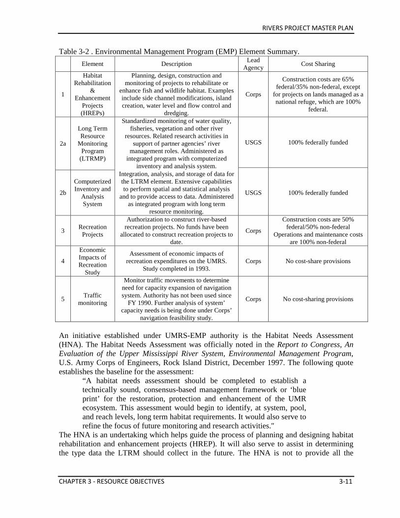
RIVERS PROJECT MASTER PLAN
CHAPTER 3 - RESOURCE OBJECTIVES 3-11
Table 3-2 . Environmental Management Program (EMP) Element Summary.
Element Description Lead
Agency Cost Sharing
1
Habitat Rehabilitation
& Enhancement
Projects (HREPs)
Planning, design, construction and monitoring of projects to rehabilitate or
enhance fish and wildlife habitat. Examples include side channel modifications, island creation, water level and flow control and
dredging.
Corps
Construction costs are 65% federal/35% non-federal, except
for projects on lands managed as a national refuge, which are 100%
federal.
2a
Long Term Resource
Monitoring Program
(LTRMP)
Standardized monitoring of water quality, fisheries, vegetation and other river
resources. Related research activities in support of partner agencies’ river
management roles. Administered as integrated program with computerized
inventory and analysis system.
USGS 100% federally funded
2b
Computerized Inventory and
Analysis System
Integration, analysis, and storage of data for the LTRM element. Extensive capabilities to perform spatial and statistical analysis
and to provide access to data. Administered as integrated program with long term
resource monitoring.
USGS 100% federally funded
3 Recreation Projects
Authorization to construct river-based recreation projects. No funds have been
allocated to construct recreation projects to date.
Corps
Construction costs are 50% federal/50% non-federal
Operations and maintenance costs are 100% non-federal
4
Economic Impacts of Recreation
Study
Assessment of economic impacts of recreation expenditures on the UMRS.
Study completed in 1993. Corps No cost-share provisions
5 Traffic monitoring
Monitor traffic movements to determine need for capacity expansion of navigation system. Authority has not been used since
FY 1990. Further analysis of system’ capacity needs is being done under Corps’
navigation feasibility study.
Corps No cost-sharing provisions
An initiative established under UMRS-EMP authority is the Habitat Needs Assessment (HNA). The Habitat Needs Assessment was officially noted in the Report to Congress, An Evaluation of the Upper Mississippi River System, Environmental Management Program, U.S. Army Corps of Engineers, Rock Island District, December 1997. The following quote establishes the baseline for the assessment:
“A habitat needs assessment should be completed to establish a technically sound, consensus-based management framework or ‘blue print’ for the restoration, protection and enhancement of the UMR ecosystem. This assessment would begin to identify, at system, pool, and reach levels, long term habitat requirements. It would also serve to refine the focus of future monitoring and research activities."
The HNA is an undertaking which helps guide the process of planning and designing habitat rehabilitation and enhancement projects (HREP). It will also serve to assist in determining the type data the LTRM should collect in the future. The HNA is not to provide all the
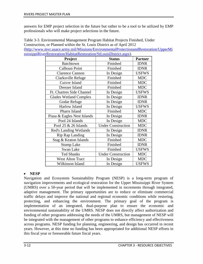
RIVERS PROJECT MASTER PLAN
3-12 CHAPTER 3 - RESOURCE OBJECTIVES
answers for EMP project selection in the future but rather to be a tool to be utilized by EMP professionals who will make project selections in the future. Table 3-3. Environmental Management Program Habitat Projects Finished, Under Construction, or Planned within the St. Louis District as of April 2012 (http://www.mvr.usace.army.mil/Missions/EnvironmentalProtectionandRestoration/UpperMississippiRiverRestoration/HabitatRestoration/StLouisDistrict.aspx).
Project Status Partner Batchtown Finished IDNR
Calhoun Point Finished IDNR Clarence Cannon In Design USFWS
Clarksville Refuge Finished MDC Cuivre Island Finished MDC Dresser Island Finished MDC
Ft. Chartres Side Channel In Design USFWS Glades Wetland Complex In Design IDNR
Godar Refuge In Design IDNR Harlow Island In Design USFWS Pharrs Island Finished MDC
Piasa & Eagles Nest Islands In Design IDNR Pool 24 Islands In Design MDC
Pool 25 & 26 Islands Under Construction MDC Red's Landing Wetlands In Design IDNR
Rip Rap Landing In Design IDNR Stag & Keaton Islands Finished MDC
Stump Lake Finished IDNR Swan Lake Finished USFWS Ted Shanks Under Construction MDC
West Alton Tract In Design MDC Wilkinson Island In Design USFWS
• NESP Navigation and Ecosystem Sustainability Program (NESP) is a long-term program of navigation improvements and ecological restoration for the Upper Mississippi River System (UMRS) over a 50-year period that will be implemented in increments through integrated, adaptive management. The primary opportunities are to reduce or eliminate commercial traffic delays and improve the national and regional economic conditions while restoring, protecting, and enhancing the environment. The primary goal of the program is implementation of an integrated, dual-purpose plan to ensure the economic and environmental sustainability of the UMRS. NESP does not directly affect authorization and funding of other programs addressing the needs of the UMRS, but management of NESP will be integrated with the management of other programs to enhance efficiency and effectiveness across programs. NESP funding for planning, engineering, and design has occurred in recent years. However, at this time no funding has been appropriated for additional NESP efforts in this fiscal year or foreseeable future fiscal years.
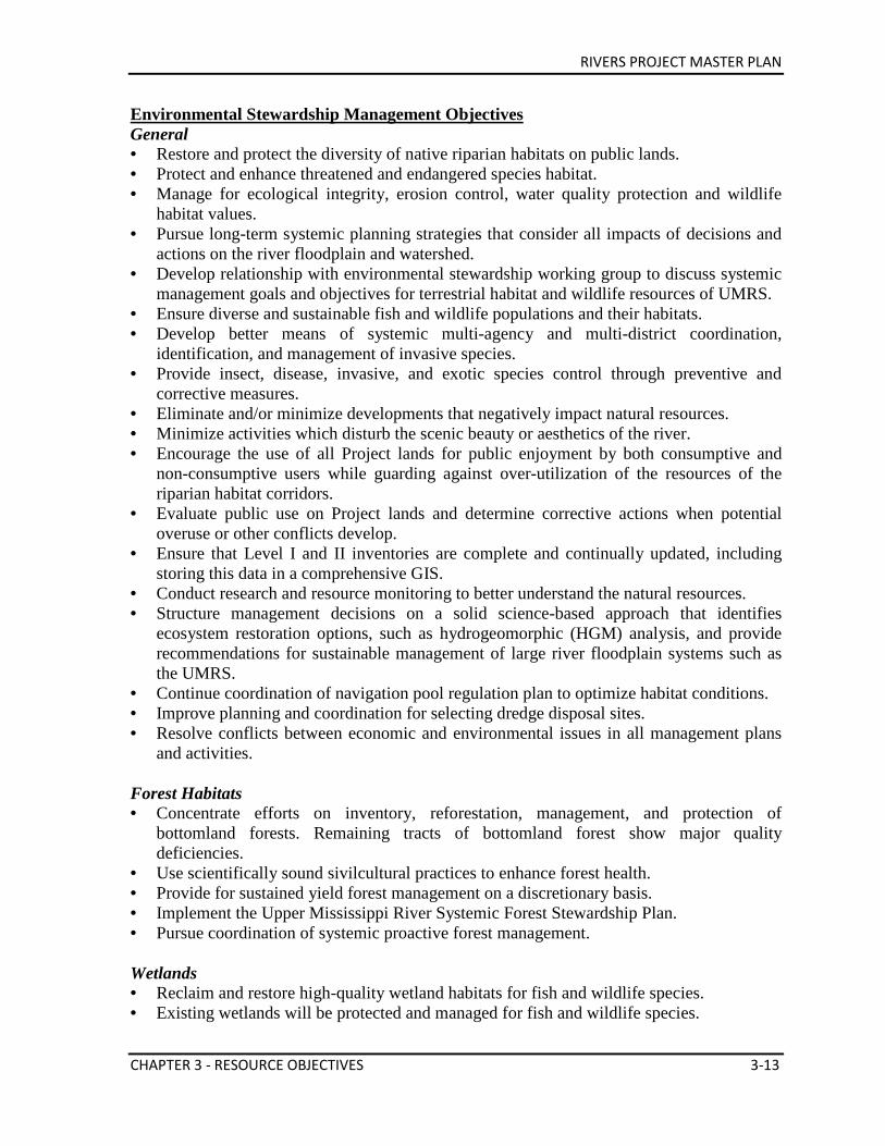
RIVERS PROJECT MASTER PLAN
CHAPTER 3 - RESOURCE OBJECTIVES 3-13
Environmental Stewardship Management Objectives General • Restore and protect the diversity of native riparian habitats on public lands. • Protect and enhance threatened and endangered species habitat. • Manage for ecological integrity, erosion control, water quality protection and wildlife
habitat values. • Pursue long-term systemic planning strategies that consider all impacts of decisions and
actions on the river floodplain and watershed. • Develop relationship with environmental stewardship working group to discuss systemic
management goals and objectives for terrestrial habitat and wildlife resources of UMRS. • Ensure diverse and sustainable fish and wildlife populations and their habitats. • Develop better means of systemic multi-agency and multi-district coordination,
identification, and management of invasive species. • Provide insect, disease, invasive, and exotic species control through preventive and
corrective measures. • Eliminate and/or minimize developments that negatively impact natural resources. • Minimize activities which disturb the scenic beauty or aesthetics of the river. • Encourage the use of all Project lands for public enjoyment by both consumptive and
non-consumptive users while guarding against over-utilization of the resources of the riparian habitat corridors.
• Evaluate public use on Project lands and determine corrective actions when potential overuse or other conflicts develop.
• Ensure that Level I and II inventories are complete and continually updated, including storing this data in a comprehensive GIS.
• Conduct research and resource monitoring to better understand the natural resources. • Structure management decisions on a solid science-based approach that identifies
ecosystem restoration options, such as hydrogeomorphic (HGM) analysis, and provide recommendations for sustainable management of large river floodplain systems such as the UMRS.
• Continue coordination of navigation pool regulation plan to optimize habitat conditions. • Improve planning and coordination for selecting dredge disposal sites. • Resolve conflicts between economic and environmental issues in all management plans
and activities. Forest Habitats • Concentrate efforts on inventory, reforestation, management, and protection of
bottomland forests. Remaining tracts of bottomland forest show major quality deficiencies.
• Use scientifically sound sivilcultural practices to enhance forest health. • Provide for sustained yield forest management on a discretionary basis. • Implement the Upper Mississippi River Systemic Forest Stewardship Plan. • Pursue coordination of systemic proactive forest management.
Wetlands • Reclaim and restore high-quality wetland habitats for fish and wildlife species. • Existing wetlands will be protected and managed for fish and wildlife species.
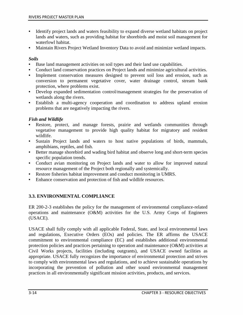
RIVERS PROJECT MASTER PLAN
3-14 CHAPTER 3 - RESOURCE OBJECTIVES
• Identify project lands and waters feasibility to expand diverse wetland habitats on project lands and waters, such as providing habitat for shorebirds and moist soil management for waterfowl habitat.
• Maintain Rivers Project Wetland Inventory Data to avoid and minimize wetland impacts. Soils • Base land management activities on soil types and their land use capabilities. • Conduct land conservation practices on Project lands and minimize agricultural activities. • Implement conservation measures designed to prevent soil loss and erosion, such as
conversion to permanent vegetative cover, water drainage control, stream bank protection, where problems exist.
• Develop expanded sedimentation control/management strategies for the preservation of wetlands along the rivers.
• Establish a multi-agency cooperation and coordination to address upland erosion problems that are negatively impacting the rivers.
Fish and Wildlife • Restore, protect, and manage forests, prairie and wetlands communities through
vegetative management to provide high quality habitat for migratory and resident wildlife.
• Sustain Project lands and waters to host native populations of birds, mammals, amphibians, reptiles, and fish.
• Better manage shorebird and wading bird habitat and observe long and short-term species specific population trends.
• Conduct avian monitoring on Project lands and water to allow for improved natural resource management of the Project both regionally and systemically.
• Restore fisheries habitat improvement and conduct monitoring in UMRS. • Enhance conservation and protection of fish and wildlife resources. 3.3. ENVIRONMENTAL COMPLIANCE ER 200-2-3 establishes the policy for the management of environmental compliance-related operations and maintenance (O&M) activities for the U.S. Army Corps of Engineers (USACE). USACE shall fully comply with all applicable Federal, State, and local environmental laws and regulations, Executive Orders (EOs) and policies. The ER affirms the USACE commitment to environmental compliance (EC) and establishes additional environmental protection policies and practices pertaining to operation and maintenance (O&M) activities at Civil Works projects, facilities (including outgrants), and USACE owned facilities as appropriate. USACE fully recognizes the importance of environmental protection and strives to comply with environmental laws and regulations, and to achieve sustainable operations by incorporating the prevention of pollution and other sound environmental management practices in all environmentally significant mission activities, products, and services.
RIVERS PROJECT MASTER PLAN
CHAPTER 3 - RESOURCE OBJECTIVES 3-15
USACE Real Estate shall execute acquisition, outgrant and disposal transactions at Civil Works projects in compliance with applicable Federal, state, and local environmental laws and regulations, including performance of environmental due diligence. This regulation establishes USACE requirements for compliance with CERCLA in the acquisition, outgrant and disposal of real property in support of O&M activities at Civil Works projects and facilities.
33 CFR Parts 335-338 are incorporated by reference into the ER as the source for practices and procedures to be followed by the Corps of Engineers to ensure compliance with the specific statutes governing Army Civil Works operations and maintenance projects involving the discharge of dredged or fill material into waters of the U.S. USACE Environmental Operating Principles (EOPs), as specified in ER 200-1-5, are incorporated by reference into this ER. The EOPs shall be incorporated in all environmentally significant USACE business. USACE shall ensure that this policy is communicated to, and implemented by, all affected staff, contractors and grantees, and that all relevant activities are overseen by qualified USACE personnel at all USACE facilities, projects, and associated lands and waters. This policy will be implemented at outgranted facilities and in all contract actions for work on the water resources projects to the extent provided by law, regulation, and executive order.
All contracts and contract modifications shall specify that contractors and grantees are required to comply fully with applicable Federal, state, and local environmental laws and regulations, Executive Orders, DoD and Army, regulations, policies, and guidance and that contractors and grantees are responsible for any enforcement actions, fines, penalties, and cleanup costs, to the extent provided for by law and policy, resulting from their failure to comply with applicable environmental requirements.
ER 1110-2-8154, Water Quality and Environmental Management for Corps Civil Works Projects is incorporated by reference into this ER as the source for practices and procedures to be followed by the Corps of Engineers to ensure compliance with the specific statutes governing Army Civil Works operations and maintenance. Water quality management shall be achieved via the management of water resources by the Corps of Engineers to improve, restore, conserve, and protect the physical, chemical and biological quality of the water for natural and human use. Many of these laws are overlapping, that is to say that by complying with one law you will be directed to other related laws. In some cases, compliance with two or more laws may take place at the same time with minimal outlay of additional time and effort. Under NEPA, for example, in the course of gathering public comment and preparing the necessary documents, it is very easy to initiate compliance activities for the Endangered Species Act and Fish and Wildlife Coordination Act at the same time. In relation to NEPA documentation, actions directed at replacing or rehabilitating existing facilities or adding new facilities in developed areas are categorically exempt from NEPA. On the other hand, actions which will have a substantial environmental effect will require the preparation and circulation of an Environmental Assessment. Examples of these would be expansion of a recreation area,
RIVERS PROJECT MASTER PLAN
3-16 CHAPTER 3 - RESOURCE OBJECTIVES
designation of a fleeting area where none existed before, and placement of new water control structures for wildlife habitat restoration. The Corps audits its operations and work place through an Environmental Review of Government Operations (ERGO). This is a comprehensive internal inspection of our facilities and management practices aimed at assuring compliance with all applicable laws and regulations. These inspections result in an ERGO Assessment report that details deficiencies found and lists actions necessary to achieve compliance. This audit is applicable not only to Corps operated and maintained facilities and lands, but also to those that are operated and maintained through outgrant (lease, license, easement, etc.). Real Estate Division will review the final report for these areas and will transmit the findings to the appropriate representative for development of a Corrective Action Plan. Those ERGO reports that pertain to Corps operated facilities and lands will be approved by the Chief of Operations Division and forwarded to the Rivers Project Operations Manager for creation of a Corrective Action Plan. The Rivers Project Operations Manager, through data call and subsequent to inspection, assures that the required corrective actions have been completed in a proper and timely fashion. These ERGO inspections are also performed on the lease areas and the same type of report is given to the lessee. It is the responsibility of the lessee to take the necessary corrective actions. Again, the Rivers Project Operations Manager assures that the proper actions have been completed. The formal ERGO inspection is performed every 5 years with an internal audit accomplished on an annual basis. Any Corps maintenance activities performed on or near the water must comply with the same regulatory permit process as the general public or private enterprise requiring the proper Section 404 permit and Section 10 permit, if applicable, from the St. Louis District Corps of Engineers Regulatory Division. In addition, if applicable, the Corps must secure the proper Section 401 Water Quality Certification from EPA. If Corps maintenance activities involve burning, such as prescribed burning of prairies, a clean air permit must be obtained from the appropriate county or state (currently only Illinois EPA requires permitting). Environmental Compliance Objectives General • Maintain an overall quality environment on and along the river corridor. • Give equal consideration to economic, environmental and social impacts associated with
all plans. • Improve cooperation between city, state and federal agencies to resolve and mitigate
environmental problems. • Stop unauthorized uses of public lands, such as agricultural trespass, timber theft,
unpermitted docks and other structures, clearing of vegetation, unauthorized roadways, off-road vehicle (ORV) use, trash dumping, poaching, and placement of advertising signs that create negative environmental impacts.
• Assess and manage all human activities on Project managed lands and waters along the river and on the floodplain.
• Protect and/or restore unstable, disappearing or deteriorating riparian habitat on the river
RIVERS PROJECT MASTER PLAN
CHAPTER 3 - RESOURCE OBJECTIVES 3-17
corridor. • Evaluate traditional motor vehicle access roads and trails leading to or on public lands. • Continue to monitor and evaluate the impacts on riverine aquatic habitat by the various
regulatory works structures (dikes, etc.) that are constructed to maintain the navigation channel.
• Ensure that all activities, developments and other management actions comply with National Environmental Policy Act requirements.
• Ensure all activities occurring on Project lands in the floodplain fully comply with federal, state and local laws, regulations, ordinances and other environmental protection requirements.
Water Quality • Improve the river’s water quality to sustain healthy fish and wildlife populations, habitat
conditions, recreation opportunities, and avoid negative affects to public water supply. • Seek to improve the general water quality of the river system in cooperation with the
USFWS, IDNR, MDC, NRCS and EPA, and the MDNR and Illinois EPA. • Strive to eliminate the need for contaminated fish and water warnings within the Project
area. • Aggressively seek ways to work with the NRCS and other relevant agencies to reduce
erosion along the river corridor, which will, in turn, reduce the silt and chemical load of the river.
• Work with local units of government to find ways to improve sewage and sanitation standards for public and private developments along the river corridor.
Rare and Endangered Species • Complete inventories and identify existing populations of federal and state endangered
and threatened plant and animal species and develop and implement recovery actions in cooperation with the USFWS and state agencies.
• Aggressively seek and/or develop management techniques and strategies where populations of endangered species exist to enhance these populations while permitting other compatible management activities to occur.
Unique or Endangered Habitats • Inventory Project lands and waters to identify and protect unique or endangered habitats
in cooperation with the USFWS and state agencies. • Implement techniques to protect and maintain unique or endangered habitats wherever
they are found. (Examples of habitats types of concern are limestone bluffs, hill prairies, unique bottomland forest communities, and deep backwater fisheries.)
Environmentally Sound Public Use Areas • Provide a quality experience for visitors and enhance ecological integrity by continually
monitoring, maintaining and improving the aesthetic and environmental quality of Project resources.
• Monitor site deterioration and take actions through the ERGO process to prevent or rehabilitate areas before site impacts have any negative affects on visitor’s experiences, public health and safety, or the environment.
RIVERS PROJECT MASTER PLAN
3-18 CHAPTER 3 - RESOURCE OBJECTIVES
• Upgrade existing public use facilities that do not meet required minimum health and safety standards.
• Evaluate existing, and future public use needs to develop strategies to avoid resource degradation, and sustain and/or increase current levels of recreation/open space opportunities.
• Develop Project facilities and opportunities utilizing sound environmental standards. Use aesthetic site designs, site impact hardening, vegetative buffers, natural landscaping and other practices to accomplish this objective.
• Monitor site deterioration and take actions through the ERGO process to prevent or rehabilitate areas before site impacts have any negative effects on visitor’s experiences, public health and safety, or the environment.
Outgrants • Phase out private exclusive use recreational cottages, industrial leases, and certain
commercial services that could be provided on private lands and waters. • Only outgrants that are compatible with the Project missions should be pursued in the
future. • Conduct periodic inspections of outgrants to ensure full environmental, safety, and
administrative compliance with all applicable leases, licenses, permits, regulations and federal, state and local laws. Changes in existing uses of outgranted areas may be warranted when the general public’s needs are not being met, and the land is needed for higher public purposes.
3.4. RECREATION ER 1130-2-550 states that programs and activities related to outdoor recreation have as their design base the following mission statement:
"The Army Corps of Engineers is the steward of the lands and waters at Corps water resources projects. Its Natural Resources Management Mission is to manage and conserve those natural resources, consistent with ecosystem management principles, while providing quality public outdoor recreation experiences to serve the needs of present and future generations. In all aspects of natural and cultural resources management, the Corps promotes awareness of environmental values and adheres to sound environmental stewardship, protection, compliance and restoration practices. The Corps manages for long-term public access to, and use of, the natural resources in cooperation with other Federal, State, and local agencies as well as the private sector. The Corps integrates the management of diverse natural resource components such as fish, wildlife, forests, wetlands, grasslands, soil, air, and water with the provision of public recreation opportunities. The Corps conserves natural
RIVERS PROJECT MASTER PLAN
CHAPTER 3 - RESOURCE OBJECTIVES 3-19
resources and provides public recreation opportunities that contribute to the quality of American life."
The national recreation program objectives are: (a) To provide a quality outdoor recreation experience which includes an accessible, safe and healthful environment for a diverse population, (b) To increase the level of self sufficiency for the Corps recreation program, (c) To provide outdoor recreation opportunities on Corps of Engineers administered land and water on a sustained basis, and (d) To optimize the use of leveraged resources to maintain and provide quality public experiences at Corps water resources projects. The St. Louis District has responsibility for four developed recreation areas, 60 access sites, and four commercial concession marina leases. Twenty-one recreational cabin subdivision lease areas (276 recreational cottage leases are still active) dot the riverbanks. The IDNR, MDC, and USFWS operate many of these recreation and access areas on Corps owned land (see Master Plan Maps for additional information). The rivers of the St. Louis District are a major recreational resource for the people who live in the bi-state area. Recreational points of interest include the Meeting of the Great Rivers National Scenic Byway, a portion of the Great River Road, from the National Great Rivers Museum to the Village of Kampsville, IL. This stretch of road and river was designated a National Scenic Byway in June 1997. Also included are the Mark Twain National Wildlife Refuge Complex, Lewis and Clark State Historic Site, Confluence Tower, Riverlands Migratory Bird Sanctuary, Confluence Point State Park (Mississippi and Missouri Rivers), Columbia Bottom Conservation Area, and a regional bike trail system. Popular uses of the Project are shown in Figure 3-1.
Figure 3-1. Recreation Area Use on the Mississippi and Illinois Rivers in the St. Louis District (Value to the Nation, 2010).
Recreation Objectives General • Work with river communities to promote eco-tourism and recreational use of the river to
favorably impact socioeconomic conditions along the river. • Contribute to developing partnerships with agencies, groups, and individuals with the
common goal of quality river region eco-tourism and sustainable economic development with effective environmental protection.
• Provide a setting for schools to safely utilize Project lands and facilities for environmental education.
Picnickers 7% Campers
0%
Swimmers 13%
Water Skiers
8%
Boaters 19% Sightseers
23%
Fisherman 20%
Hunters 7%
Others 3%
RIVERS PROJECT MASTER PLAN
3-20 CHAPTER 3 - RESOURCE OBJECTIVES
• Increase the level of self-sufficiency for the Corps recreation program. • Provide outdoor recreation opportunities on Corps administered land and water on a
sustained basis. • Optimize the use of leveraged resources to maintain and provide quality public
experiences. • Accomplish the program objectives in cooperation with other federal, state and local
agencies, quasi-public organizations and the private sector supplemented by volunteers, contributions and challenge cost-sharing programs.
• Evaluate the extent to which the Corps is competing with the private sector by offering fleeting areas, marinas, other commercial services or private exclusive use activities.
Quality Recreational Experiences • Provide a quality outdoor recreation experience which includes an accessible, safe and
healthy environment for a diverse population of Project visitors/users. • Seek to increase the quality of visitor’s experience by maintaining and developing
purposeful, functional recreation facilities and services that meet the needs of visitors, while maintaining the aesthetic and ecological integrity of Project lands and waters.
• Maintain as a top priority rehabilitation efforts designed to stop environmental degradation and facility deterioration.
• Provide additional minimum public health and safety support facilities and services such as sanitary toilets, drinking water, trash collection, law enforcement, directional-regulatory signage and vehicle parking and turnarounds.
Facilities Management • Maintain, develop and/or modify cost effective facilities in order to meet the changing
and diverse use patterns of Project visitors. • Provide Project visitors with the necessary facilities or services to support a diverse range
of outdoor recreation activities, such as boating, picnicking, swimming, hunting, fishing, wildlife viewing and environmental education.
• Evaluate and provide facilities that meet the needs of the visitors to the Project. • Evaluate demand for equipment storage on public lands and waters. Barrier-Free Access • Increase outdoor recreational opportunities for disabled visitors by providing barrier free
access by building, modifying, and redesigning areas to promote accessibility required by law. Development and modifications can/will occur while protecting environmental quality.
Public Access Areas and Trails • Provide facilities that will enhance the visitor’s experience such as picnic areas,
observation areas, and adequate resting areas for visitors. • Evaluate and implement a plan of action to satisfy demand for improved public access to
and on, Project managed lands and water for walking, hiking, biking, boating/paddling, hunting, fishing, wildlife viewing, etc.
• Evaluate and implement a plan of action to satisfy demand for traditional public recreation facilities (campsites, picnic facilities, overlooks, all types of trails, boat ramps,
RIVERS PROJECT MASTER PLAN
CHAPTER 3 - RESOURCE OBJECTIVES 3-21
courtesy day harbors, interpretive signs/exhibits, and parking lots). • Conduct comprehensive Project-wide evaluation of public access to lands and waters and
correct deficiencies in a manner that is responsive to public and agency needs while protecting and enhancing ecological values of the Rivers Project service area.
• Expand partnerships with others to pursue additional trail and greenway initiatives. User Conflicts • Measure current public visitation levels and evaluate impacts from overuse and crowding
on recreational use and environmental quality. Implement a plan of action to reduce any identified impacts.
• Evaluate and implement a plan of action to improve recreational use zoning and regulations for both consumptive and non-consumptive activities, such as hunting, trapping, fishing, camping, boating (including mooring), and wildlife viewing.
• Evaluate and implement a plan of action for recreational use zoning and regulations for designated quiet water or no-wake areas with more emphasis on natural resource protection, quality recreational opportunities, and public safety concerns.
• Consider the physical and biological changes/impacts known to be associated with commercial navigation and recreational use of waterways for all water based management activities and plans.
• Reduce conflicts between navigation craft and recreation boats to improve public safety. 3.5. VISITOR ASSISTANCE Visitor assistance is a management program designed to protect natural resources and government property while assisting Project visitors. Park rangers serve as a regulation enforcer with full citation authority of petty offenses contained in Title 36, Part 327. Available use-of-force options include visual presence, verbal persuasion, and unarmed self-defense. States, counties, and other political subdivisions retain the statutory authority and inherent responsibility to enforce appropriate state and local laws. Rivers Project contracts with appropriate local (county or city) law enforcement agencies to provide these necessary services on public lands. The development of visitor services for information and recreation purposes facilitates a safe, expedient, and enjoyable experience in relation to the Project resources and the river. Visitor Assistance Objectives • Provide more opportunities for communication between agencies, special interest groups
and the general public. • Provide the stimulus for cooperation with local communities to develop strong linkages
between them and the Project. • Provide necessary directional information to enable visitors to easily find the Project
facilities. • Assist visitors with an understanding of other tourism facilities and attractions in the area. • Establish uniform, clearly written fishing, hunting and boating regulations throughout the
Project service area. • More effectively inform recreational users about special concerns and regulations
RIVERS PROJECT MASTER PLAN
3-22 CHAPTER 3 - RESOURCE OBJECTIVES
regarding the use of Project lands and waters. • Increase public awareness that special use permits or other authorizations are required for
bass tournaments and other organized special events and commercial activities on Project lands and waters.
• Establish a well coordinated process for collecting/utilizing data concerning boating accidents and other mishaps to improve visitor safety on Project lands and waters.
• Inform the visiting public and adjacent landowners about navigational servitude, as related to public recreational use of waters.
3.6. INTERPRETATIVE SERVICES AND OUTREACH PROGRAM (ISOP) ER 1130-2-550 states that an Interpretive Services and Outreach Program (ISOP) shall be implemented at each Corps-operated project. The type and magnitude of this program shall be determined by the District Commander and shall be commensurate with the type and size of the project, project visitation, funding, and personnel resources. In addition, all ISOP efforts shall provide for universal accessibility where practical. All activities under this program shall be designed to accomplish one or more of the following goals:
(1) Achieve management objectives using interpretive techniques. (2) Provide environmental education to foster voluntary stewardship of natural, cultural,
and created resources. (3) Incorporate Corps civil works and military missions and accomplishments into
interpretive programming. (4) Improve visitor and employee safety using interpretive techniques. (5) Use outreach to accomplish ISOP goals, including interpreting Corps missions,
promoting stewardship, saving lives, and solving management problems. The interpretive process should also encourage interest in math and science, including career interest.
(6) Enhance the visitors' experience and enjoyment by anticipating their needs and providing interpretive resources to meet those needs.
The Corps recognizes the ISOP as an important tool to achieve success in fulfilling the Corps missions. The value of outreach is to not only obtain the public’s understanding of the resources managed, but to incorporate the Corps stakeholders and partners in managing those resources. The Rivers Project ISOP strategy is to achieve the goals outlined in ER 1130-2-550 and to conduct these efforts in an efficient and effective manner at the field level to enhance understanding of both the Corps and the public’s roles and responsibilities. The overall goal of the ISOP is to enhance the visitors’ understanding and appreciation of public lands and waters, instilling visitors with a sense of proprietorship and promoting environmental stewardship to preserve the natural and cultural resources of the region for future generations. The ISOP also includes public relations, marketing, tourism, and visitor center management. The Corps’ interpretive services stems from Freeman Tilden’s basic principles of effective interpretation. The dictionary definition of interpretation is “an educational activity which
RIVERS PROJECT MASTER PLAN
CHAPTER 3 - RESOURCE OBJECTIVES 3-23
aims to reveal meanings and relationships through the use of original objects, by firsthand experience, and by illustrative media, rather than simply to communicate factual information.” Tilden further defined interpretation as “the revelation of a larger truth that lies behind any statement of fact,” and noted it “should capitalize mere curiosity for the enrichment of the human mind and spirit.” The Corps defines interpretive services as communication and education processes provided to internal and external audiences, which support the accomplishment of Corps missions, tell the Corps story, and reveal the meanings of, and relationships between, natural and cultural environments. The Corps further defines outreach activities as communication efforts involving interpretive programs that reach diverse populations such as students, teachers, organized groups (such as Girl Scouts, Boy Scouts, and other civic organizations) and the general public beyond the physical boundaries of Corps projects and facilities. The outreach programs are becoming ever-increasingly important with financial constraints of school and community groups. The National Environmental Policy Act encourages federal agencies to “enrich the understanding of the ecological systems and natural resources important to the Nation.” By virtue of the land and water resources under its administration, the Corps has a responsibility to take an active part in the process of creating a more knowledgeable public and educating the next generation about environmental matters. This is central to sustaining project resources particularly where visitor use levels are significant and present a challenge to resource protection. The Rivers Project ISOP staff serves as the regional “face of the Corps.” The Rangers are the front-line leaders responsible for the day to day interaction with the general public, media personnel, and national and international tourists. Other public affairs associated tasks include writing media releases and conducting media interviews, maintaining social media sites, and updating internet content for accuracy and relevance. Other community involvement includes an active role in the regional tourism industry to provide visitors an interactive experience and enhance their connection to the river and its resources. Serving as a destination point, the museum stimulates local economy, generates tourism, and provides educational and recreational opportunities to hundreds of thousands of visitors each year. The Rivers Project ISOP meets the below goals and objectives through several forms of unique programming. Project staff develops curriculum, including the Our Mississippi: Educational Activities about the Upper Mississippi River. This program, based out of the St. Louis District Rivers Project Office focuses on 5th and 6th grade education for the five Upper Mississippi River states. Future extensions of the curriculum will highlight the Lower Mississippi River and its primary tributaries, as well as reach audiences above and below the 5th and 6th grade level. Staff also conducts school outreach programs which include, but are not limited to: Bonkers for Birds, and River Runts. Each of these programs entails a Riverlands Ranger traveling to educate area students on the various natural and cultural resources abundant throughout the Mississippi River watershed. Special events, including the Masters of the Sky, and Great Rivers Festival, highlight the multiple river uses and how these
RIVERS PROJECT MASTER PLAN
3-24 CHAPTER 3 - RESOURCE OBJECTIVES
are managed for everyone. All of these programs are designed to engage citizens in the stewardship and sustainability of the river’s many resources for future generations. Interpretive Services & Outreach Program Objectives • To raise awareness and increase public stewardship of natural and cultural resources
through community education and outreach opportunities. o Develop a conceptual plan and model of the entire river basin. o Expand public environmental education programs and facilities throughout the
entire Project to enhance and protect the natural resources of the Mississippi and Illinois River Valley.
• To improve availability of public lands for use as an outdoor classroom and provide educational opportunities that help develop science, technology, engineering, and math skills.
o Implement more educational and research programs on the river. Topics should include water quality and quantity, history, culture, safety, recreation, nature and ecology.
• To partner with multiple agencies and organizations to leverage financial and staff resources.
o Encourage partnerships and sponsorships that will promote the interpretation of river values and a sense of proprietorship by local communities.
o Establish a network among local, state and federal conservation agencies concerning exchange of river-related information for public education and management purposes.
• To improve public awareness of the Corps’ missions through effective, proactive communication.
3.7. FLOOD RISK MANAGEMENT EP 1165-2-1 states that “Congress, in the Flood Control Act of 1936, established as a nationwide policy that flood control [Flood Risk Management] on navigable waters or their tributaries is in the interest of the general public welfare and is therefore a proper activity of the Federal Government in cooperation with the states and local entities. The 1936 Act, as amended, and more recently the Water Resources Development Act (WRDA) of 1986, specify the details of Federal participation. They have established the scope of the Federal interest to include consideration of all alternatives in controlling flood waters, reducing the susceptibility of property to flood damage, and relieving human and financial losses.” The Mississippi and Illinois Rivers fluctuate throughout each year, depending on rainfall, snow melt, drought and water control operations. Often the rivers reach flood stage, commonly from one time to four times per year. During these periods, public use of many of the river’s existing recreation facilities including boat ramps, parking lots, courtesy docks and day use facilities is severely restricted or closed entirely. With the loss of these recreational facilities for an extended time, a significant negative impact may be experienced. Future design/sighting of access infrastructures that are rehabilitated or replaced needs to better address water level constraints to minimize impacts to use.
RIVERS PROJECT MASTER PLAN
CHAPTER 3 - RESOURCE OBJECTIVES 3-25
The Mississippi River has an extensive system of flood control levees in place. These levees are a combination of private and federally sponsored. The levees vary in the levels of protection they provide. They range from the low end which offer protection from a 10-year flood event, to the top end urban type levee which offer protection from a 500-year flood event, and any level of protection in between. Almost all of Rivers Project access areas and facilities are located within the floodplain and outside of the protection of levees.
The rehabilitation and replacement of outdated facilities will look at innovative ways to modify/enhance traditional structure design to eliminate high operation and maintenance costs. When looking at the rehabilitation of facilities, the main concern will be to eliminate the high costs for maintenance due to seasonal high river stages.
Major Mississippi River floods occurred in 1944, 1945, 1947, 1951, 1973, 1993, 1995, 2008, 2011, and 2013. The Flood of 1993 is the historic flood of record and was notable for its duration. It exceeded the previous record (1973) by over six feet and remained over flood stage 148 days as compared to 77 days in 1973. The flood control system has provided the citizens of the valley a great deal of protection. (The 2001 Master Plan contains additional information on historical “Floods and Flood Damage Reduction” starting on page 4-33). Today, the Corps oversees a vast engineering flood risk management system. The two main elements are levees and reservoirs. The St. Louis District flood control system includes 89 levees protecting approximately 578,000 acres in the district, and five major reservoirs to reduce flood levels on the rivers. Levees Levees are built to protect people, crops and transportation/utility, residential, industrial and business infrastructure from flooding. In the St. Louis District portion of the Mississippi River valley approximately 50 percent of the pooled river floodplain is protected by levees and about 80 percent of the Middle Mississippi River floodplain is protected by levees. On the Illinois River, from Kampsville to LaGrange, approximately 80 percent of the floodplain is protected by levees. There are three kinds of levees as described in Table 3-4. Levees in the St. Louis District are identified in Figure 3-2 through Figure 3-6. Floodwalls Floodwalls serve the same purpose as levees and are built when levees are not physically or economically feasible for a given area. They are high narrow concrete and steel structures, founded beneath the ground surface, with closures structures or gates that can be closed during floods. St. Louis, MO, and Cape Girardeau, MO, have riverfront floodwalls built by the St. Louis District.
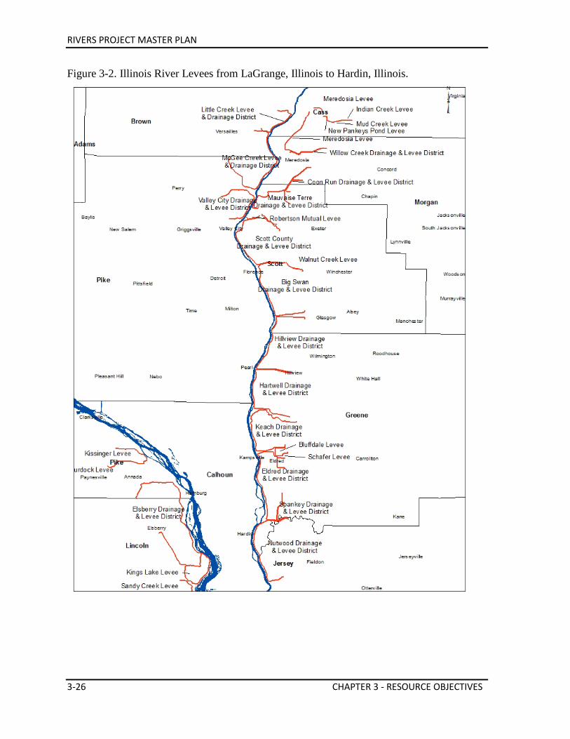
RIVERS PROJECT MASTER PLAN
3-26 CHAPTER 3 - RESOURCE OBJECTIVES
Figure 3-2. Illinois River Levees from LaGrange, Illinois to Hardin, Illinois.
RIVERS PROJECT MASTER PLAN
CHAPTER 3 - RESOURCE OBJECTIVES 3-27
Figure 3-3. Mississippi River Levees from Ashburn, Missouri to Winfield, Missouri Area.
RIVERS PROJECT MASTER PLAN
3-28 CHAPTER 3 - RESOURCE OBJECTIVES
Figure 3-4. Mississippi & Missouri River Levees – St. Louis Area.
Table 3-4. Comparison of Levee Characteristics. Federal Levees - Built by Corps of Engineers Made of a tightly compacted clay core with berms extending out at the base on both sides May stand on a base over 200 feet wide, with a crest 20 feet wide Size depends on the degree of protection required for adjacent property Federal agricultural levees built to withstand normal seasonal flooding and constructed with a height about 10 feet above flood stage Federal urban levees built to provide greater protection Local or Non-federal Levees - Constructed by local agencies Often made of more permeable material capped with compacted clay Generally have steeper sides than federal levees Private Levees - Construction specifications left to the builder Made of a wide variety of materials Generally the first to fail in a flood
RIVERS PROJECT MASTER PLAN
CHAPTER 3 - RESOURCE OBJECTIVES 3-29
Figure 3-5. Mississippi River Levees – South St. Louis Area to Kaskaskia River Area.
RIVERS PROJECT MASTER PLAN
3-30 CHAPTER 3 - RESOURCE OBJECTIVES
Figure 3-6. Mississippi River Levees – Kaskaskia River Area to Cape Girardeau Area.
RIVERS PROJECT MASTER PLAN
CHAPTER 3 - RESOURCE OBJECTIVES 3-31
Flood Level Frequency Estimates Based on historic data, flood level frequency estimates have been developed to determine flood protection project levels. A “50-year flood” has a 2 percent chance of occurring in any given year. Most agricultural levees are designed to withstand a flood of this magnitude. A “100-year flood” has a 1 percent chance of occurring in any given year. The Federal Emergency Management Agency requires 100-year flood protection for building in the floodplain. A “500-year flood” has a 0.2 percent chance of occurring in any given year. Five hundred-year flood protection is provided to some urban areas, such as St. Louis, East St. Louis, Wood River, Prairie Du Pont and Cape Girardeau. Flood Control Reservoirs The Corps has constructed a system of over 40 flood-control reservoirs in the entire Mississippi River Basin. The reservoirs store excess water during floods, and after the crest passes, the stored water can be released slowly. Four major flood control reservoirs exist within the St. Louis District that affects Rivers Project. They are: Mark Twain Lake on the Salt River, MO; Lake Shelbyville on the Kaskaskia River, IL; Carlyle Lake on the Kaskaskia River, IL; and Rend Lake on the Big Muddy River, IL. Initially authorized in 1936, this system of reservoirs became fully operational by the early 1980s. These giant holding basins can hold back vast quantities of water from the river systems and reduce flooding downstream. In addition to flood control functions, other benefits provided by the reservoir system include: hydro-electric power generation, drinking and irrigation water supply, water quality improvement, navigation control, recreation opportunities, and fish and wildlife habitat improvement. Flood Risk Management Objectives • Enhance capability to reduce flood risk on Project lands, ensuring that efforts are
sustainable and resilient for the region and communities. • Improve collaboration with partners in the region to improve effectiveness and efficiency
in collaboratively managing flood risk efforts. • Enhance interagency disaster preparation and mitigation capabilities where feasible. Be
fully prepared to support the mitigation of disaster within the Rivers Project community using the specific authorities and programs within its jurisdiction and the doctrine outlined in the National Mitigation Framework and the Interagency Operational Plan documents.
• Improve coordination with local levee organizations. • Maintain levees per defined operation and maintenance guidelines directly managed by
RIVERS PROJECT MASTER PLAN
3-32 CHAPTER 3 - RESOURCE OBJECTIVES
the Project up to required specifications. • All contracts and contract modifications shall specify that contractors and grantees are
required to comply fully with applicable Federal, state, and local environmental laws and regulations, Executive Orders, DoD and Army, regulations, policies, and guidance.
3.8. SHORELINE MANGEMENT It is the policy of the Chief of Engineers to protect and manage shorelines of all Civil Works water resource development projects under Corps jurisdiction in the manner which will promote the safe and healthful use of these shorelines by the public. This policy also includes maintaining environmental safeguards to ensure a quality resource for use by the public. The objectives of all management actions will be to achieve a balance between permitted private uses and resource protection for general public use. Public pedestrian access to these shorelines shall be preserved. For projects or portions of projects where federal real estate interest is limited to easement title only, management actions will be appropriate within the limits of the estate acquired. Project lands on the river pools encompass only a portion of the shoreline areas on the Mississippi and Illinois Rivers. This large amount of private ownership provides ample unrestricted opportunity for private development thus increasing public pressure and demand for recreational use on the existing Project shoreline areas. This thereby increases the value of these areas for open space, public access and habitat protection. Pressures for development and environmental protection are extreme and usually conflicting. There are numerous competing and conflicting shoreline uses associated with these privately owned shoreline areas. Due to the importance of the rivers for recreation, commercial navigation, water supply, industrial ports and facilities and fish and wildlife habitats, there has been and will continue to be demand for shoreline uses. Given the limited amount of federally owned shoreline areas managed by the Corps, care will be taken to safeguard remaining underdeveloped public open space. A Shoreline Management Plan for the Rivers Project provides sufficient detail to ensure that it is clear to the public what uses will or will not be allowed on the shoreline of the Project. Permanently placed private boat docks, ramps, landings, and unauthorized waterfowl blinds on Project lands/shoreline areas restrict general public access and use and in some cases threaten natural resources, degrade shoreline stability, and increase sedimentation. Shoreline Management Objectives • Implement the Rivers Project Shoreline Management Plan outlining regulations and
permitted activities on Project shoreline areas. • Pursue the removal of unnecessary and unauthorized structures on Project lands and
waters. • Evaluate the impacts of fleeting on Project land shoreline areas in terms of public use,
shoreline stability, habitat conditions, and sedimentation and develop a plan of action to
RIVERS PROJECT MASTER PLAN
CHAPTER 3 - RESOURCE OBJECTIVES 3-33
regulate it. • Allow permanent waterfowl blinds only on state (MDC and IDNR) managed areas,
which are regulated, inspected, and permitted by the individual states. • Allow only temporary daily waterfowl blinds outside of the state managed areas. Environmental Stability • Promote environmental stability in shoreline development activities. Private Exclusive Use • Regulate existing private exclusive use structures, such as boat docks, ramps and landings
on Project lands and waters to maximize public access on Project lands and waters and minimize shoreline/habitat degradation.
• Continue phasing out existing private exclusive use of shoreline areas, concurrent with Corps and national policies, to ensure equal public access to Project lands and waters and to protect ecologically sensitive areas.
Land Use Classification • Use Project land use classification plan to guide management for all public lands as
required by federal regulation and this approved Master Plan. • Solicit full public and interagency participation to ensure a relevant, well-balanced land
use classification plan. 3.9. NAVIGATION MANAGEMENT Navigation is a section of the Rivers Project, although not a responsibility of the Natural Resource Section. The Natural Resource staff does however, realize the relevance of the navigation system, its impacts on the natural resources, and their duties to interpret and educate the public on such an important system. ISOP plays a key role in promoting public understanding of river navigation and the Corps’ mission on the Mississippi and Illinois Rivers. Navigation Management Objectives • Maintain the reliability and integrity of the inland waterways transportation system. • Reevaluate navigation operation and maintenance practices to minimize negative
environmental affects. • Reevaluate dredged material disposal practices to maximize beneficial uses of this
material for fish and wildlife habitat, recreation site stabilization, and ensure it is being performed in a manner that minimizes negative impacts to the resource.
• Better communicate to partners and to the public the justification for the current dredging effort to maintain the navigation channel.
• Improve communication about existing navigation pool water level regulation requirements and methodology to the public.
• Provide outreach and education programs to promote public understanding of river navigation and the Corps’ mission on the Mississippi and Illinois Rivers.
• Promote facilities, conditions, O&M activities and best management practices required to
RIVERS PROJECT MASTER PLAN
3-34 CHAPTER 3 - RESOURCE OBJECTIVES
ensure efficient commercial navigation in a manner that avoids or minimizes negative impacts to environmental and recreational concerns.
3.10. HISTORIC RESOURCES MANAGEMENT Historic Properties Management Plan Policy directing the protection and management of Project cultural resources is contained in ER 1130-2-540. Guidance for the management of collecting, preserving and curating Project archeological and historical materials and establishment of a Historic Preservation Program for construction, operations and maintenance activities is contained in EP 1130-2-540. There are also numerous laws that mandate the protection of cultural resources (See 4.01 and 1.03.a.(5)). Sites and artifact materials are the tangible cultural resource base of an area, and are significant to public use development in two major ways. First, the Corps is explicitly responsible to protect, preserve, manage, and/or mitigate damages to historic properties located within the Project jurisdictional and impact area. Second, cultural resources are a resource with development potential. Attending to the first responsibility is often the first step toward realizing the development potential of the Project cultural resource base. Prior to any project public use development, a cultural resource investigation, including review of documents, sites surveys and test excavations are completed to locate potential cultural resources and if present, assess their significance to present and future generations. The abundance and diversity of historic properties, and the fact that some may be appropriately developed while others must be preserved and protected, are considerations which are addressed in a Historic Properties Management Plan (HPMP). This plan also includes both short and long-term policies and procedures needed to accomplish the objectives of preservation and enhancement of the resources. Within the region there are prehistoric and historic sites which have the potential to contribute to our understanding of regional and local cultural history. In order to comply with applicable laws and regulations, a comprehensive inventory of potential properties eligible for the inclusion in the National Register of Historic Places as well as a complete inventory of all project historic resources is needed to provide an adequate database for future resource management. In 1990, the Native American Graves Protection and Repatriation Act (NAGPRA) was signed into law (PL101-601) and became the most sweeping law regarding the treatment and disposition of Native American human remains and certain kinds of artifacts. NAGPRA acknowledges the right of Native Americans to claim certain types of artifacts if Native Americans (individuals or group) can demonstrate direct lineal descendancy or cultural affiliation with the material in question. The Corps is responsible for the management of archaeological and historic resources that are removed from Corps managed federal properties. The St. Louis District has completed all inventories required for collections generated prior to 1990. Additionally, the St. Louis District has prepared guidelines for
RIVERS PROJECT MASTER PLAN
CHAPTER 3 - RESOURCE OBJECTIVES 3-35
handling human remains removed or disturbed during intentional excavations or inadvertent discoveries. Historic Resources Protection Needs In Missouri and Illinois, the greatest concentrations of archaeological sites are found in the river corridors, which are the most fertile and accessible areas. The Illinois and Mississippi River valleys are major areas to find prehistoric remains. The river floodplain constitutes an area of great archaeological potential based on a large number of physiographic and ecological features. These non–renewable and non-replaceable sites occur from the bluffline to the shoreline and are distributed throughout the floodplain. On frequently flooded portions of the floodplain, cultural materials are often found out of context due to the frequent disturbance caused by flooding and erosion. As a result, the value of the information gained from these sites is often diminished. Regardless, development and management plans have to be sensitive to the fragility of these cultural resources and should incorporate measures to protect and conserve them.
The river valley is rich in historic sites, old river towns, and buildings of historical and architectural interest. Most river towns, which once served as steamboat landings, still retain historic aspects of their association with the rivers.
The operation and maintenance of a navigation project creates a number of indirect problems in preserving cultural resources. These problems pertain to secondary development induced by the presence of the waterway, and to channel maintenance activities. Any substantial land–use change may affect unknown cultural resources.
Dredging operations have the potential to bury unknown archaeological sites. The construction of dikes and placement of riprap along the shoreline can adversely affect cultural resources. If sites are located, appropriate testing, evaluation, and compliance procedures will be followed before construction will occur. All efforts will be made to avoid any adverse effects to cultural resources. Erosion also represents a problem in managing archaeological and historical resources.
A Historic Properties Management Plan was created in 2002 to enhance identification, evaluation, and management of these resources. In part, the plan was designed to address and provide for solutions to this resource management challenge.
Pursuant to various federal legislation, particularly the National Historic Preservation Act of 1966 as amended, the St. Louis District Rivers Project will implement a program to identify, evaluate, and manage archaeological sites on operational lands within the Project area. Data synthesis will be completed which summarizes all known archaeological information, including descriptions of each site, and identifies existing gaps in our knowledge about the river’s archaeology. Components of future investigations shall include: (1) Landform sediment analysis to predict locations of burial archaeological sites; (2) Bank erosion analysis to identify locations subject to destruction; (3) Comprehensive archaeological surveys of the ground surface; and (4) Shipwreck inventories and surveys.
RIVERS PROJECT MASTER PLAN
3-36 CHAPTER 3 - RESOURCE OBJECTIVES
Historic Resources Management Issues There is a need to: • Conduct a systematic inventory of historic resources. • Create a mechanism to increase the coordination of river development and the protection
of both the natural and historic resources. • Conduct a study/assessment of erosion rates and their effect on significant historic sites.
This study should also include a proposed program of shoreline stabilization to protect important sites.
• Increase attention to the educational value of the waterways historical resources and the 10,000 year history of importance they have played in the region.
Historic Resources Management Objectives • Complete a historic resource database. • Enforce Project Historic Properties Management Plan (HPMP) to ensure:
o Encourage open space land use in order to protect significant archeological resources.
o Provide adequate identification, evaluation, and site planning to preserve these resources.
o Preserve historic structures and cultural landscapes in their present condition if that condition allows for satisfactory protection, maintenance, use and interpretation.
• Work closely with the MDNR, IHPA, and other applicable agencies/organizations to identify historic properties and develop a management plan for historic properties that is in full compliance with all pertinent federal and state laws and regulations.
• Maintain full compliance with the National Historic Preservation Act, Sections 106 and 110, Archaeological Resources Protection Act, Native American Graves Protection, and Repatriation Act, and relevant Illinois and Missouri Historic Resources Acts on Project lands.
RIVERS PROJECT MASTER PLAN
CHAPTER 4 - LAND ALLOCATION, LAND CLASSIFICATION, WATER SURFACE, & PROJECT EASEMENT LANDS 4-1
Chapter 4 Land Allocation, Land Classification, Water Surface,
& Project Easement Lands All of the following information regarding Land Allocation and Land Classification was derived from EP 1130-2-550 (30 Jan 2013). 4.1. LAND ALLOCATION The congressionally authorized purpose for which the Project lands were acquired. A project map delineating land according to the following allocations will be included in this Master Plan. There are only four land allocations categories applicable to Corps projects: Operations (i.e. flood control, hydropower, etc.) Lands acquired for the congressionally authorized purpose of constructing and operating the project. Most Project lands are included in this allocation. Recreation Lands acquired specifically for the congressionally authorized purpose of recreation. These are referred to as separable recreation lands. Recreation lands in this allocation can only be given a land classification (see below) of “Recreation”. Fish and Wildlife Lands acquired specifically for the congressionally authorized purpose of fish and wildlife management. These are referred to as separable fish and wildlife lands. Lands under this allocation can only be given a land classification (see below) of “Wildlife Management”. Mitigation Land acquired or designated specifically for the congressionally authorized purpose of offsetting losses associated with development of the project. These are referred to as (see below) of “Mitigation”. 4.2. LAND USE CLASSIFICATION Land Use Classifications corresponds to the primary use for which Project lands are managed. Project lands are zoned for development and resource management consistent with authorized project purposes and the provisions of the National Environmental Policy Act and other Federal laws. A project map delineating land according to the following classifications is part of this Master Plan. (Agriculture or grazing use of project lands is not a land classification but may be an interim use to meet management objectives.) Project Operations This category includes those lands required for the dam, spillway, switchyard, levees, dikes, offices, maintenance facilities, and other areas that are used solely for the operation of the Project.
RIVERS PROJECT MASTER PLAN
4-2 CHAPTER 4 - LAND ALLOCATION, LAND CLASSIFICATION, WATER SURFACE, & PROJECT EASEMENT LANDS
High Density Recreation Land developed for intensive recreational activities for the visiting public including day use areas and/or campgrounds. These could include areas for commercial concessions (marinas, comprehensive resorts, etc), and quasi-public development. Mitigation This classification will only be used for lands with an allocation of Mitigation and that were acquired specifically for the purposes of offsetting losses associated with development of the Project. Environmentally Sensitive Areas Areas where scientific, ecological, cultural or aesthetic features have been identified. Designation of these lands is not limited to just lands that are otherwise protected by laws such as the Endangered Species Act, the National Historic Preservation Act or applicable State statues. These areas must be considered by management to ensure they are not adversely impacted. Typically, limited or no development of public use is allowed on these lands. No agricultural or grazing uses are permitted on these lands unless necessary for a specific resource management benefit, such as prairie restoration. These areas are typically distinct parcels located within another, and perhaps larger, land classification, area. A brief narrative should be provided describing the association resource analysis and/or inventory used in making the classification. Multiple Resource Management Lands This classification allows for the designation of a predominate use as described below, with the understanding that other compatible uses described below may also occur on these lands (e.g. a trail through an area designated as Wildlife Management). Land classification maps must reflect the predominant sub-classification, rather than just Multiple Resource Management.
• Low Density Recreation. Lands with minimal development or infrastructure that support passive public recreational use (e.g. primitive camping, fishing, hunting, trails, wildlife viewing, etc.).
• Wildlife Management. Lands designated for stewardship of fish and wildlife resources.
• Vegetative Management. Lands designated for stewardship of forest, prairie, and other native vegetative cover.
• Future or Inactive Recreation Areas. Areas with site characteristics compatible with potential future recreational development or recreation areas that are closed. Until there is an opportunity to develop or reopen these areas, they will be managed for multiple resources.
Water Surface If the project administers a surface water zoning program, then it should be included in the Master Plan.
• Restricted. Water areas restricted for project operations, safety, and security purposes.
• Designated No-Wake. To protect environmentally sensitive shoreline areas,
RIVERS PROJECT MASTER PLAN
CHAPTER 4 - LAND ALLOCATION, LAND CLASSIFICATION, WATER SURFACE, & PROJECT EASEMENT LANDS 4-3
recreational water access areas from disturbance, and for public safety. • Fish and Wildlife Sanctuary. Annual or seasonal restrictions on areas to protect fish
and wildlife species during periods of migration, resting, feeding, nesting, and/or spawning.
• Open Recreation. Those waters available for year round or seasonal water-based recreational use.
Project Easement Lands All lands for which the Corps holds an easement interest, but not a fee title. Planned use and management of easement lands will be in strict accordance with the terms and conditions of the easement estate acquired for the project. Easements were acquired for specific purposes and do not convey the same rights or ownership to the Corps as other lands.
• Operations Easement. Corps retains rights to these lands necessary for project operations (access, etc.)
• Flowage Easement. Corps retains the right to inundate these lands for project operations.
• Conservation Easement. Corps retains rights to lands for aesthetic, recreation and environmental benefits.
4.3. LAND USE CLASSIFICATION SUMMARY The acreage in the following tables was based upon digital mapping according to Bureau of Land Management Certified Land Surveys. Erosion and accretion along the Mississippi River shoreline has changed the acreage managed and therefore does not correspond to the totals for the acreage that was originally purchased. Recreation Areas include Corps recreation areas, marinas, and state recreation areas. All 93 acres of the Cache River Division Cannel is classified as project operations. Table 4-1. Land Use Classification Summary for Pools 24-26, Lower River (Chain of Rocks), Illinois River, and Cache River Diversion Channel.
Land Use Classification No. of Areas Acres Project Operations 9 2,662 High Density Recreation Areas 9 441 Low Density Recreation Areas 36 427 Environmentally Sensitive Areas 3 648 Fish & Wildlife Sanctuary 2 537 Vegetative Management Areas 28 7,227 Wildlife Management (GP Lands) 26 34,662 Mitigation Areas 5 1,879 Easements 7 234 Industrial Lease Areas 1 160 Total Management Areas 125 48,877
RIVERS PROJECT MASTER PLAN
4-4 CHAPTER 4 - LAND ALLOCATION, LAND CLASSIFICATION, WATER SURFACE, & PROJECT EASEMENT LANDS
Figure 4-1. Percentages of Land Use Classification for Pools 24-26, Lower River (Chain of Rocks), Illinois River, and Cache River Diversion Channel.
Table 4–2. Pool 24 Land Use Classification Summary.
Land Use Classification No. of Areas Acres Project Operations 1 95 High Density Recreation Areas 2 178 Low Density Recreation Areas 8 69 Vegetative Management Areas 3 2,871 Wildlife Management Areas (GP Lands) 5 6,319 Total Management Areas 19 9,532
Figure 4-2. Percentages of Pool 24 Land Use Classification.
Veg Manag; 15%
Project Ops; 5%
Mitigation; 4%
Environ Sensitive; 1%
Fish & Wildlife Sanctuary; 1%
High Density Rec; 1%
Low Density Rec; 1%
Wildlife Manag (GP Lands)
71%
Easements 1%
Industrial Lease ; 0%
Project Operations 1%
Recreation Areas 2%
Wildlife Management
Areas (GP Lands) 66%
Vegetative Management
Areas 30%
Low Density Recreation Areas 1%
RIVERS PROJECT MASTER PLAN
CHAPTER 4 - LAND ALLOCATION, LAND CLASSIFICATION, WATER SURFACE, & PROJECT EASEMENT LANDS 4-5
Table 4-3. Pool 25 Land Use Classification Summary. Land Use Classification No. of Areas Acres
Project Operations 2 313 Low Density Recreation Areas 5 25 Vegetative Management Areas 2 48 Wildlife Management Areas (GP Lands) 6 9,132 Total Management Areas 15 9,518
Figure 4-3. Percentages of Pool 25 Land Use Classification.
Table 4-4. Pool 26 Land Use Classification Summary (Illinois River areas shown below in separate table and figure).
Land Use Classification No. of Areas Acres Project Operations 3 235 High Density Recreation Areas 6 262 Low Density Recreation Areas 12 177 Environmentally Sensitive Areas 3 648 Fish & Wildlife Sanctuary 2 537 Mitigation Areas 3 1,645 Vegetative Management Areas 9 2,583 Wildlife Management Areas (GP Lands) 7 4,220 Industrial Lease Areas 1 160 Operations Easements 2 12 Total Management Areas 47 10,479
Project Operations
3%
Wildlife Management
Areas (GP Lands) 96%
Vegetative Management
Areas 1%
Low Density Recreation Areas 0%
RIVERS PROJECT MASTER PLAN
4-6 CHAPTER 4 - LAND ALLOCATION, LAND CLASSIFICATION, WATER SURFACE, & PROJECT EASEMENT LANDS
Figure 4-4. Percentages of Pool 26 Land Use Classification.
Table 4-5 Illinois River Land Use Classification Summary.
Land Use Classification No. of Areas Acres High Density Recreation Area 1 1 Low Density Recreation Areas 7 148 Vegetative Management Areas 2 735 Wildlife Management Areas (GP Lands) 8 14,991 Total Management Areas 18 15,875 Figure 4-5. Percentages of Illinois River Land Use Classification.
Project Ops; 2%
High Density Rec; 2%
Low Dens Rec; 2%
Environ Sensitive;
6%
Fish & Wildlife Sanctuary;
5% Mitigation; 15%
Veg Manag; 25%
Wildlife Manag (GP Lands);
41%
Industrial Lease; 2%
High Density Rec; 0%
Wildlife Manag (GP Lands);
94%
Veg Manag; 5%
Low Density Rec; 1%
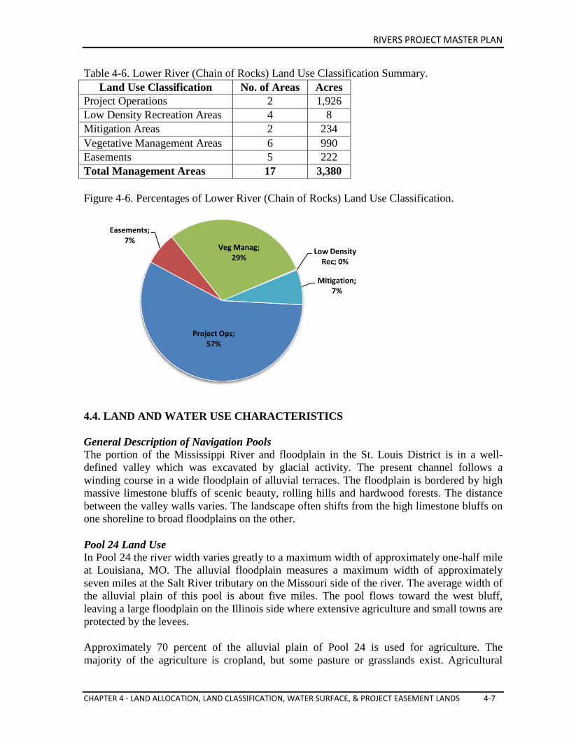
RIVERS PROJECT MASTER PLAN
CHAPTER 4 - LAND ALLOCATION, LAND CLASSIFICATION, WATER SURFACE, & PROJECT EASEMENT LANDS 4-7
Table 4-6. Lower River (Chain of Rocks) Land Use Classification Summary. Land Use Classification No. of Areas Acres
Project Operations 2 1,926 Low Density Recreation Areas 4 8 Mitigation Areas 2 234 Vegetative Management Areas 6 990 Easements 5 222 Total Management Areas 17 3,380 Figure 4-6. Percentages of Lower River (Chain of Rocks) Land Use Classification.
4.4. LAND AND WATER USE CHARACTERISTICS General Description of Navigation Pools The portion of the Mississippi River and floodplain in the St. Louis District is in a well-defined valley which was excavated by glacial activity. The present channel follows a winding course in a wide floodplain of alluvial terraces. The floodplain is bordered by high massive limestone bluffs of scenic beauty, rolling hills and hardwood forests. The distance between the valley walls varies. The landscape often shifts from the high limestone bluffs on one shoreline to broad floodplains on the other. Pool 24 Land Use In Pool 24 the river width varies greatly to a maximum width of approximately one-half mile at Louisiana, MO. The alluvial floodplain measures a maximum width of approximately seven miles at the Salt River tributary on the Missouri side of the river. The average width of the alluvial plain of this pool is about five miles. The pool flows toward the west bluff, leaving a large floodplain on the Illinois side where extensive agriculture and small towns are protected by the levees. Approximately 70 percent of the alluvial plain of Pool 24 is used for agriculture. The majority of the agriculture is cropland, but some pasture or grasslands exist. Agricultural
Project Ops; 57%
Easements; 7%
Veg Manag; 29%
Low Density Rec; 0%
Mitigation; 7%
RIVERS PROJECT MASTER PLAN
4-8 CHAPTER 4 - LAND ALLOCATION, LAND CLASSIFICATION, WATER SURFACE, & PROJECT EASEMENT LANDS
activities probably could not be practiced in its present magnitude without the flood protection afforded by the existing levee systems. Forest conditions occupy most of the remaining portion of the floodplain. Bottomland forests are found along the riverbanks, on the islands, along streams, around lakes and sloughs, and in low-lying areas. In general, forests exist in areas too wet to farm. The largest wooded area, a high-quality pin oak stand, now under stress from repeated flooding, is found on the southern half of the oval-shaped bottoms at the mouth of the Salt River and in managed by the MDC as the Ted Shanks Conservation Area. Some lakes and wetlands occur on the floodplain in Pool 24. Lakes include the permanent water bodies that collect drainage, have restricted exits, or are land locked. Lakes frequently occur along the base of the levees on the riverward side. Many of these lakes are formed from borrow pits resulting from levee construction. Others occupy abandoned river meanders and side channels. Ownership and management of public lands is significant in Pool 24. The USFWS operates the Delair Division of the Great River National Wildlife Refuge. The Ted Shanks Conservation Area and the Upper Mississippi Conservation Area, managed by MDC, encompasses approximately 5,500 acres of land. MDC manages most of the Rivers Project lands on the Missouri side in Pool 24 for fish and wildlife purposes as authorized by the General Plan. The Project conducts stewardship management on most of the federal lands acquired for Pool 24 on the Illinois side. Public access areas along this pool are developed and operated by either the Project or MDC. Small farming communities along the floodplain include the communities of Louisiana, Clarksville and Ashburn, MO, and Pleasant Hill, Rockport, New Canton, and Kinderhook, IL. The Missouri towns are located on the banks of the river, while the Illinois towns are several miles from the river usually along the edge of the floodplain. State Highway 79 in Missouri and State Highway 96 in Illinois extend the length of Pool 24 on both sides. A rail line runs the length of the pool on the Missouri side as well. US Highway 54 and a railroad bridge cross the river at Louisiana, MO. Industries in the area are primarily agriculture, cement, industrial chemicals, nurseries and retail services. Industrial land-use consists of four major barge terminals. Pool 25 Land Use The river in Pool 25 contains numerous islands and varies in width from 0.5 miles to 1.5 miles. Upstream from Lock and Dam 25, the floodplain, measured bluff to bluff, gradually widens from a width of 3.5 miles to 5.0 miles at Clarksville, MO. The western (Missouri) portion of the floodplain is the widest side in the Pool 25 and is leveed almost the entire length. The eastern (Illinois) side of the alluvial plain is narrow and only the northern one-third is leveed. Approximately 60 percent of the floodplain of Pool 25 is used for agriculture; most of the remaining 40 percent is in bottomland forest or other wetlands. The broad Missouri side of
RIVERS PROJECT MASTER PLAN
CHAPTER 4 - LAND ALLOCATION, LAND CLASSIFICATION, WATER SURFACE, & PROJECT EASEMENT LANDS 4-9
the floodplain comprises the bulk of the area’s agriculture. A relatively small amount of agriculture is found on the narrow eastern floodplain in Illinois. Forests occur along the riverbanks, on the numerous islands, along stream and riverside channels, and around lakes. Large areas of forest occur on the eastern floodplain, particularly in the areas from Batchtown to Hamburg, IL, in Calhoun County. Most of this land is in public ownership as a part of the navigation Pool 25 project and is jointly managed by the Project, USFWS and IDNR. The riverbanks are forested nearly the entire length of Pool 25. Public lands acquired for the navigation project are primarily confined to low-lying areas on the alluvial plain, adjacent to the river. Approximately 9,100 acres of Project lands and waters are managed by the USFWS, IDNR, or MDC. The areas managed by these agencies are for fish and wildlife purposes in accordance with the General Plan and Cooperative Agreement. Urban development consists of the farming communities of Winfield, Foley, Elsberry, Annada, and Clarksville in MO, and Belleview, Pleasant Hill, Mosier, Hamburg and Batchtown in IL. A rail line parallels the river along the foot of the western bluff on the Missouri side of Pool 25. State Highway 79 borders the Pool on the Missouri side and Calhoun County roads and a portion of State Highway 96 borders the Pool on the Illinois side. Pool 26 Land Use In Pool 26 the floodplain widens to approximately 5.5 miles near O’Fallon, MO. The river is widest near Alton, IL, where it is just over one mile wide between vegetated banks. The width is due to the addition of the Illinois River, which measures about one-half mile across at the confluence of the two rivers at Grafton, IL. In comparison, the floodplain produced by the joining of the Mississippi, Illinois, and Missouri Rivers, measures over twelve miles across from bluff to bluff. In Pool 26, the alluvial floodplain and bordering uplands feature extensive forest and wetland areas. Major land-uses include recreation, agriculture, residential, commercial/industrial, transportation, extractive, and combined urban. Approximately 60 percent of the alluvial plain of Pool 26 is used for agriculture. The main stem Mississippi River portion of Pool 26 is not leveed except for the very lower end of the pool. Wood River Levee District near Alton, IL, provides urban flood protection. Consolidated North County Levee District is a large agricultural levee that provides protection from the Mississippi and Missouri Rivers confluence area to the West Alton, MO area. Forest conditions occupy most of the remaining portion of the floodplain. Bottomland forests are found along the riverbanks, on the islands, along streams, around lakes, and in low-lying areas. In general, forest exists in areas too wet to farm. Lakes and wetlands are present on the floodplain and islands; however, many have been ditched and drained over the years primarily for agricultural use.
RIVERS PROJECT MASTER PLAN
4-10 CHAPTER 4 - LAND ALLOCATION, LAND CLASSIFICATION, WATER SURFACE, & PROJECT EASEMENT LANDS
Corps public lands acquired for the navigation project are primarily confined to low-lying areas on the alluvial plain adjacent to the river and some of the islands in the river. Most of these lands are managed for recreation and stewardship. In Pool 26, including the lower 15 miles of the Illinois River, there are approximately 19,100 acres of Project lands and waters managed by USFWS, IDNR, and MDC. The areas managed by these agencies are for fish and wildlife purposes in accordance with the General Plan and Cooperative Agreement. Urban development on the floodplain consists of the Missouri farming communities of West Alton, Portage des Sioux, Orchard Farm, Old Monroe, and Winfield. Metropolitan areas partially on or adjacent to the floodplain in St. Charles Co, MO, include St. Charles, St. Peters and O’Fallon. Communities on the Illinois side include Alton, East Alton, Godfrey, Elsah, Chautauqua, and Grafton. Numerous private recreational cottages and private and commercial marinas are located along the Missouri shoreline between Melvin Price Locks and Dam and the upper reaches of the pool near O’Fallon, MO. The Illinois side of the river also has numerous public and private marinas. Route 100 along the river is designated a national scenic byway and features bike trails, scenic views, and quaint towns that are popular with tourists. Two rail lines, MO Highways 79 and 94, and several county roads parallel the pool on the west. State Highway 143 and State Highway 100 (National Scenic Byway) follow the river on the Illinois shore. US Highway 67 (Clark Bridge) crosses the river at Alton, IL. The Golden Eagle Ferry and Grafton Ferry currently exist. The Winfield Ferry has been shut down for a few years, with no current anticipation of reopening. The Ameren Missouri generating plant, located about two miles east of Portage des Sioux, MO, is the only industrial lease. Lower Illinois River Land Use The Lower Illinois River portion of Pool 26 flows through an alluvial floodplain averaging 4 miles in width. The river width between vegetated banks is narrow, averaging about one-fourth mile across. This width is not constant where islands exist. The river widens to three-fourths mile across in several places. Pool 26 influences the lower 80 miles of the Illinois River from Grafton to LaGrange, IL. Land use in the Illinois River floodplain (north of Nutwood) is approximately 80 percent agricultural, consisting primarily of cropland. The southern reach of the river (downstream of Kampsville) features a complex system of lakes, wetlands, and forest that are primarily Project lands. Thus very little agriculture occurs on this southern reach of the floodplain. Bottomland forests and lakes account for more than one-half of the floodplain area south of Nutwood. North of Nutwood, forest is found in narrow corridors along riverbanks, streams, and on the few islands. Large forested tracts occur around Meredosia Lake where the land is
RIVERS PROJECT MASTER PLAN
CHAPTER 4 - LAND ALLOCATION, LAND CLASSIFICATION, WATER SURFACE, & PROJECT EASEMENT LANDS 4-11
low-lying, tends to flood, and is risky to farm. Lakes and wetlands, like forests, are relatively scarce on the floodplain; relatively sizeable lakes and other wetlands occur only from Grafton to the Kampsville area and in the Meredosia area. Pere Marquette State Park, the largest state park in Illinois, is located on the lower Illinois River, just upstream from Grafton. Numerous river and lake public access sites are located on Project lands. Numerous private recreational cottage sites leased on Project lands are also present. Development along the Illinois River consists of regularly spaced and moderately sized farming communities and regional centers near the bluff and on the floodplain. Communities at the base of the bluffs include Grafton, Nutwood, Hardin, Spanky, Michael, Eldred, Kampsville, Bluffdale, Hillview, Pearl, Montezuma, Florence, Oxville, Valley City, Chambersburg, and LaGrange. Floodplain communities consist of Hardin, Naples, and Meredosia. Three rail lines serve the floodplain area. State Highway 100 follows the river from Grafton to Meredosia. River ferries exist near Grafton and Kampsville. River bridges are located in Hardin and near Florence, Valley City and Meredosia. Lower River (Chain of Rocks) Land Use Rivers Project operates and maintains approximately 3,400 acres of land along the Chain of Rocks Canal Project. Locks 27 and the canal project were authorized by Congress in 1945 and construction was completed in 1953. The Project is located entirely on the Illinois side of the river adjacent to Granite City, IL and across the river from the City of St. Louis, MO. The canal extends adjacent to the Mississippi River from MRM 184 to MRM 194.5. The locks facility includes one 1,200-foot main lock chamber and one 600-foot auxiliary lock chamber. This project is part of the Nine-Foot Channel Project and was designed to bypass a dangerous reach of the Mississippi River in which rock ledges, excessive velocities, and shallow navigation depths constituted hazards to navigation. Levees are located on each side of the canal, the west canal levee affording protection to the Chouteau Island Drainage and Levee District and the east canal levee forming a component part of the riverfront levee system of the Metro East Sanitation District which protects the valuable industrial/residential urban areas on the floodplain in the Illinois Metropolitan area. The east side of the canal includes the America’s Central Port (Tri-City Regional Port District). Granite City, the Melvin Price Support Center Army Base and other industrial sites are immediately adjacent to Project lands. The west side of the canal includes Chouteau and Gabaret Islands which are primarily agricultural areas that are protected by levees. The “green space” afforded by the Project is a popular area with residents from the surrounding Metropolitan area. Madison County Transit sponsored bike trails are developed on the east and west canal levees. Rivers Project provides public access sites on both sides of the canal and on the Mississippi shoreline for sightseeing
RIVERS PROJECT MASTER PLAN
4-12 CHAPTER 4 - LAND ALLOCATION, LAND CLASSIFICATION, WATER SURFACE, & PROJECT EASEMENT LANDS
and fishing. The State of Illinois operates a Lewis and Clark memorial on Project lands on the upstream end of the area. Illinois Historic Preservation Agency (IHPA) developed a Lewis and Clark State Historic Site with museum and park on adjacent lands near the monument site. Illinois State Highway 3 runs along the east side of the Project area. The Interstate 270 Bridge crosses the Mississippi River and the canal over the Project at MRM 191. Middle Mississippi River Land Use The Middle Mississippi River portion of the Mississippi River in the St. Louis District starts below Locks 27 in the St. Louis Metropolitan area (MRM 183.2) and is also referred to as the open river. The open river generally divides the States of Illinois and Missouri, with isolated pockets of Illinois located adjacent to and contiguous with the State of Missouri and with isolated pockets of Missouri located adjacent to and contiguous with the State of Illinois. This is a result of the rivers’ propensity to meander and the choice of the 1839 thalweg (or river channel) to delineate the boundary between the states. The development of the surrounding land can be generally characterized as rural and agrarian in nature with isolated areas of highly developed industrialized urban pockets. The largest of these is the St. Louis Metropolitan area and the second largest is the Cape Girardeau-Scott City area. The St. Louis area places a great deal of localized pressure on the Mississippi River due to intensive industrial and urban development and subsequent pollution. The deforestation and subsequent agricultural use of the surrounding lands has had and continues to have a dramatic impact on the river. Approximately 70 percent of the floodplain is in agricultural use. All of these areas are protected by a very extensive levee and drainage system. Erosion from the agricultural fields is the largest contributor to the silt and sediment carried by the river. Navigation, one of the first uses of the river by humans, continues to increase and to be of extreme importance. The increase in commercial navigation can be directly linked to industrial activities and agricultural development of the basin. After a well-organized commercial transportation system was in place, industrial development began to flourish and add to the increase in commercial navigation. The flood control levee and drainage system have had a dramatic effect by restricting annual flooding (frequency and severity) which, in turn, allows further development of the floodplain. State Highway 3 in Illinois runs along the length of the Middle Mississippi River. U.S. Highway 61 and Interstate 55 run along the Missouri side. Bridge crossings occur between South County, MO and Columbia, IL (Jefferson Barracks) and at Chester, IL and Cape Girardeau, MO. The Ohio River, which doubles the volume of water in the Mississippi River, is the major tributary on the lower end of this stretch.
RIVERS PROJECT MASTER PLAN
CHAPTER 4 - LAND ALLOCATION, LAND CLASSIFICATION, WATER SURFACE, & PROJECT EASEMENT LANDS 4-13
Other regionally important tributaries within the lower river of the St. Louis District include the Meramec River, Kaskaskia River, and the Big Muddy River with numerous smaller important rivers and creeks. The major tributaries upstream of this stretch of the river include the Illinois and Missouri Rivers. Lower Missouri River Land Use The general development of the lands surrounding the lower Missouri River in St. Charles and St. Louis Counties can be characterized as agricultural in nature, with the exception of the middle third of this reach. The middle third is a highly developed urbanized setting with subdivisions, factories, and commercial landings. The river is used for commercial navigation including gambling boats, tows, and tour boats, recreational boating, fishing, hunting, hiking the shoreline, bluffs and islands, and sightseeing. In addition, a portion of the Katy Trail follows along the river in St. Charles County. Within in the Missouri and Mississippi Rivers confluence area, the Missouri Department of Natural Resources operates the Edward “Ted” and Pat Jones Confluence State Park and USFWS Big Muddy Refuge complex, Cora Island. St. Louis County continues to increase in population and St. Charles County ranks among the fastest growing counties in the United States. This continued population growth is placing tremendous pressure on the Missouri River floodplain. In both counties, the issue of green ways and green belts has surfaced as a major initiative to protect and enjoy the river. St. Charles County is better organized in this effort and appears to have the backing of the general public, business and the political establishment.

RIVERS PROJECT MASTER PLAN
THIS PAGE INTENTIONALLY LEFT BLANK.
RIVERS PROJECT MASTER PLAN
CHAPTER 5 - RESOURCE PLAN 5-1
Chapter 5 Resource Plan
5.1. INTRODUCTION The Rivers Project Master Plan provides guidance for the orderly development, use and management of Project resources. Resource planning takes into consideration authorized Project purposes, public interests, regional needs, and opportunities and constraints that influence development and management. All proposed development is designed to be compatible with the project’s natural and cultural resources. Project planning and land classification deals with several factors: seasonal flooding, soils, ecological conditions, existing and projected recreation demand, state and local participation and interest, and applicable laws, regulations and policies. Each area description includes a listing of existing facilities, and proposed future actions. Proposed future actions are intended to be completed within ten years or by the next scheduled update. 5.2. SELECTED LAND AND WATER USE POLICIES Environmental Compliance St. Louis District Operations Division Policy, dated 11 August 2003, requires that all Operations projects complete the Environmental Checklist (EC) for all new construction projects. The EC was created to ensure that proper and adequate environmental review and documentation is conducted prior to new construction on Project lands. The EC will be used for all actions in this plan to determine the degree of necessary review and documentation needed to comply with NEPA, Endangered Species Act, Section 404 of the Clean Water Act, National Historic Preservation Act, and CERCLA/RCRA. Projects will be completed as funding becomes available. Environmental Assessments will be initiated as part of this process as determined necessary in accordance with NEPA. Shoreline Management The following excerpt is taken from the Corps regulation on Shoreline Management (ER 1130-2-406) dated 31 Oct 1990:
“It is the policy of the Chief of Engineers, Corps, to protect and manage shorelines of all civil works water resource development projects under Corps jurisdiction in a manner which will promote the safe and healthful use of these shorelines by the public while maintaining environmental safeguards to ensure a quality resource for use by the public. The objectives of all management actions will be to achieve a balance between permitted private uses and resource protection for general public use. Public pedestrian access to and exit from these shorelines shall be preserved.”
RIVERS PROJECT MASTER PLAN
5-2 CHAPTER 5 - RESOURCE PLAN
The Rivers Project Shoreline Management Plan is being developed concurrently to this plan and is included as an appendix in this document. Off Road Vehicles and Seaplane Use The operation of off-road vehicles on Project lands will be in accordance with the policies, procedures and criteria set forth in ER 1130-2-550, Chapter 10; EP 1130-2-550, Chapter 10 and Executive Order 11644. In addition, ER 1130-2-550, Chapter 11 and EP 1130-2-550, Chapter 11 set forth rules and regulations governing seaplane operations at civil works projects. Forest Resources All lands in USACE fee title ownership are being managed to maintain their forest resources for recreation, wildlife and scenic values. The Land and Water Use Plan plates show these lands as Recreation, Low Density Recreation, Environmentally Sensitive, Vegetative Management, and Wildlife Management. The OMP for each compartment describes the general practices and techniques that are used to conduct a program for developing the forest resources of the area, such as tree planting and vegetation manipulation, to support management objectives. When necessary, timber will be harvested to achieve management objectives for wildlife habitat improvement. Forest management is a secondary purpose for areas zoned for recreation or low density recreation. The OMP details specific objectives and management practices for all specific compartments. Agricultural Use Portions of those lands managed by other agencies may be placed under a share crop agricultural program. The plan contains provisions for agriculture as a corollary use to obtain food for wildlife, to prevent encroachment of undesirable vegetation and to provide succession control. Those agricultural activities shall be in accordance with the appropriate General Plan and Cooperative Agreement for the specific area.
RIVERS PROJECT MASTER PLAN
CHAPTER 5 - RESOURCE PLAN 5-3
5.3. MANAGEMENT AREA DESCRIPTIONS, ZONING AND PLANS BY POOL, COMPARTMENTS AND UNITS
Pool 27 - Compartment 1 Chain of Rocks Management Area
Unit 1- American Bottoms
Chain of Rocks Canal Area Project Operations (27-O-1)
Madison County, IL Mississippi River Mile: 183.2 - 195.0 L
Acres: 1,911 Plates: 27-1, 27-2, SP-3
General Description: Most of these areas within the Chain of Rocks Canal Area are for Project Operations with a smaller percentage of areas requiring natural resource management. This includes blocks of forest along the East Levee and linear prairie along the West Levee, immediately off the interior toe of each levee. This area consists of a mixture of a natural riparian bottomland forest (80-120 yrs) and young forest regeneration on sandy dredge spoil along the eastern levees. Eighty-five percent of this management area is forested and 15% is water or grassland, with levee areas excluded (2009-10 forest inventory). Bottomland forest is composed of eastern cottonwood, silver maple and black willow. The average basal area is 30 feet2/acre and tree density of 57 trees/acre. This forest community is composed of declining cottonwood being replaced with silver maple. Natural regeneration (~10- 25 yrs) of Eastern cottonwood, black locust, Siberian elm, and red mulberry is occurring on dredge spoil between the eastern levee along Chain of Rocks Canal and Chouteau Slough. Forest community along Chouteau Slough consists of decadent cottonwood with young green ash establishing in canopy gaps. Much of these gaps are experiencing reduction in stand replacement due to high concentrations of exotics and native invasive species including: Japanese hops, Amur honeysuckle, winter grape, trumpet creeper, and green briar. Some habitat does exist for bald eagle resting and nesting. Forest birds exist in this area but have not been quantified. This area is known to have deer, wild turkey, and other small game in the habitat areas. No hunting is allowed in the grass strip along the toe of the levee. The Chain of Rocks Canal Area includes a total of 8 areas, which are described as follows: (1) The Locks 27 Area is located approximately one mile above the mouth of the Chain of Rocks Canal. Locks 27 is the last navigation lock on the Mississippi River and was authorized as part of the modifications to the existing Mississippi River Nine-Foot Navigation Channel project. The modifications provided for an eight-mile long canal to bypass the Chain of Rocks Reach along the northeastern boundary of St. Louis and St. Louis County, MO, between MRM 184 and MRM 194.5. The Chain of Rocks Reach is a series of
RIVERS PROJECT MASTER PLAN
5-4 CHAPTER 5 - RESOURCE PLAN
rock ledges, which extend from the east bank under the river channel and act as a hazard to river navigation. Locks 27 and the Chain of Rocks Canal provide for navigation around the natural rock barriers, which during low water have a fall of 11 feet. Construction began on the Chain of Rocks Canal project in 1946 and the locks were opened to river traffic on 7 February 1953. Facilities include one 110-foot by 1,200-foot main lock and one 110-foot by 600-foot auxiliary lock. Facilities in addition to the lock structure include an access road, parking lots, administration building and control house, maintenance building, generator building and other appurtenant facilities, including fuel tanks, waterborne comfort stations, visitor overlook (closed), and Floyd Wade Memorial Visitor Center (closed). This area previously contained a public access area, but was closed to all visitor access due to security protocols following the September 11, 2001 Terrorist Attacks. The previous visitor center has been replaced with office space. Proposed Future Development: Additional maintenance building, removal of temporary storage facilities, relocation of one set of fuel tanks, installation of additional perimeter fencing, and installation of a bike trail. Rehabilitate and reopen the Floyd Wade Memorial Visitor Center, waterborne comfort station, and visitor overlook to the standards required by the Americans with Disabilities Act (ADA); provide a public access walkway to the visitor center and overlook, and expand the “Type C” visitor center into old lock control room. Potential exists to create a visitor overlook similar to what exists currently at Lock & Dam 24. Bike trail extension across the lock structure from Eagle Point Bike Trail (on Chouteau Island) to current bike trail on 7th Street in Granite City, IL. See appendices for conceptual site plan. (2) The Chain of Rocks Canal is located immediately downstream of the confluence of the Missouri and Mississippi Rivers below the Melvin Price Locks and Dam. The eight-mile canal is managed as a navigation structure to provide a navigation bypass of the obstructive Chain of Rocks reach of the Mississippi River. Facilities include the canal, shoreline revetment and appurtenant facilities. The canal is eight miles in length with a bottom width of 300 feet at elevation 378.0 NGVD. The shoreline revetment (riprap) along the canal requires maintenance on average 5-10 years. Most recently in 2009 through 2010, riprap was placed the entire length of the canal. Proposed Future Development: Initiate/Continue discussions with America’s Central Port (formerly Tri-City Regional Port District) about potential for land exchange (within this compartment). Expansion and development by Tri-City Regional Port District of the existing America’s Central Port (St. Louis Harbor). (3) The Canal Access Area is located at the north end of the canal’s eastern shoreline and is managed for public access purposes. Facilities include a crushed stone, 45-car parking lot with waterside guardrail, shoreline revetment, entrance roadway, and access control gate. The area is popular for shoreline fishing.
RIVERS PROJECT MASTER PLAN
CHAPTER 5 - RESOURCE PLAN 5-5
In 2009, a water control structure was placed under the entrance roadway. This structure provides the capability to increase interior water storage in existing ponding areas within the Lewis and Clark Forest Area for wetland management, as well as increase forest wetland habitat. Proposed Future Development: Add picnic tables and interpretative trails for visitor use and a service gate to access forest area adjacent to the area. Design and construct a boat ramp and associated amenities for operational and safety purposes at the most feasible of the following locations: Canal Access Area, Low Water Dam Access Area, and South Gabaret Island Area. These facilities, including expanded parking and security lights, will provide emergency and operations boat access to the Mississippi and Missouri Rivers. No boat access to the Mississippi and Missouri Rivers exist on the Illinois shoreline of the Mississippi River between Melvin Price Locks and Dam and Locks 27. Incidental public use of the river access would be allowed. (4) The East Chain of Rocks Canal Levee & Road Area is located along the east side of the Chain of Rocks Canal. The East and West Chain of Rocks Levees were authorized by the River and Harbor Act of 2 March 1945. These levees were required as modifications to the existing levee systems due to the construction of the canal. The levee is managed both as a flood reduction and navigation structure. The nine-mile levee provides the navigation channel of the Chain of Rocks Canal and a 500-year flood protection for the agricultural, industrial and residential areas bordering the canal. It is an integral part of the Alton to Gale Levee System with crown elevation of 442.5 NGVD. The levee is dredged sand fill with one foot of topsoil to support ground cover. It has a 20-foot crown width and 4 on 4 side slopes to a canal side berm elevation of 421.5 NGVD. The road is managed for operations service access and portions remain open to serve as public viewing area of the Chain of Rocks Canal project. The two-way road is a 20-foot wide and 6-mile long oil and chip surface road connecting the public Lewis & Clark Trail road on the north and the public West 20th Street to the south. The roadway has five connecting spurs with controlled access gates, which include three spurs to the public Chouteau Place Road, one spur to the public Old Rock Road, and one spur to the public Bauer Road. The road provides service access to multiple piezometers, relief wells, drainage ditches and pipes, gated culverts, and three tri-lateration stations. The road area also serves as part of the Confluence bikeway and provides public viewing opportunities of the Chain of Rocks Canal project. Currently Illinois Department of Transportation is replacing the I-270 Chain of Rocks Canal Bridge. Portions of the existing and proposed interstate are on Project lands under easement. Expected completion date is Fall of 2014. Proposed Future Development: Expansion of the existing America’s Central Port (Tri-City Regional Port District) Harbor development, and facilities necessary for the East Chain of Rocks Levee Final Repairs. Bike trail and interpretive facilities will be developed to provide a connection with the confluence bikeway. (5) The East Levee Access Area is located adjacent to the East Chain of Rocks Levee at the north end of Chouteau Place Road and is managed for public access purposes. This area is
RIVERS PROJECT MASTER PLAN
5-6 CHAPTER 5 - RESOURCE PLAN
adjacent to a private in-holding and the Chouteau Slough Area. The area is popular parking area for hunters, bicyclists, and tourists viewing the Chain of Rocks Canal. Facilities include a crushed stone parking lot, guardrail, and an access control gate. Proposed Future Development: Bike trail and interpretive facilities to provide a connection with the confluence bikeway. This area may be relocated and/or expanded as a result of the I-270 Chain of Rocks Canal Bridge. (6) The West Chain of Rocks Canal Levee & Road Area is located on the west side of the Chain of Rocks Canal and is managed as both a navigation and flood reduction control structure. The levee maintains the navigation channel of the Chain of Rocks Canal and the eastern line of flood protection for the agricultural areas of Chouteau Island and the Gabaret Island Drainage and Levee Districts. Project facilities include the levee and associated piezometers, drainage ditches, and levee road. The levee is dredged sand fill with one foot of topsoil to support ground cover and has a crown elevation of 439.5 NGVD. It has a 14-foot crown width and IV on 4H side slopes to a canal-side berm elevation of 421.5. The road is managed for operations service access to the project and as a public viewing facility of the Chain of Rocks Canal project. The roadway is 14-foot wide 6-mile long crushed stone surface road connecting to the public Old US 66/Chain of Rocks Road. The roadway has 3 connecting spurs (Roman Lane loop and private lane); 2 to the south, and 2 spurs (Waterworks Road & Cooper Lane) to the north. No vehicle access is allowed on south end of West Levee and serves as Eagle Point Bike Trail. In 2010 IDNR constructed an access roadway on west levee berm near Gabaret Slough to link Roman Road south to a private lane in order to provide private landowner access. Facilities include: Eagle Point Bike Trail, two access control gates connecting to north and south service access roads, and three trilateration stations. Proposed Future Development: No proposed development is currently planned. (7) The West Levee Access Area is located adjacent to the Chain of Rocks Canal at the intersection of the West Canal Levee Road entrance spur and roadways at the West Chain of Rocks Levee. The area is managed for public access purposes. The previous Earth Day Access Area facilities were removed during the East Chain of Rocks Canal Levee Final Repairs and relocated to this new area. The area is popular with hunters, bicyclists, and tourists viewing the Chain of Rocks Canal. Facilities include a crushed stone parking lot, guardrail, and one access control gate. Proposed Future Development: Proposed facilities include guardrail, security lighting, comfort station, refuse receptacles and bike trail. (8) The Tri-City Regional Port District Area is located on 321.77 acres adjacent to the Chain of Rocks Canal immediately upstream of Locks 27 along the East Levee. The facilities are managed as an inland river port (America’s Central Port) requiring a multimodal interface of rail, trucking and water transportation for commercial and industrial purposes under industrial lease with Tri-City Regional Port District. The lease areas include a variety
RIVERS PROJECT MASTER PLAN
CHAPTER 5 - RESOURCE PLAN 5-7
of industries and facilities including liquid and bulk products, steel terminals, a steel processing plant; rail, truck, terminal and fleeting operations, and immediate environs. In 2009, easement was granted to Abengoa Bioenergy for a water discharge pipe from newly constructed ethanol plant on private property to Mississippi River. The Rivers Edge South Harbor Project entails the development of a public, commercial, inland harbor adjacent to Rivers Edge, the former Charles Melvin Price Support Center (CMPSC). The project will include an off-channel harbor, barge loading and unloading facilities, barge mooring facilities and access roads. The approximate size of the harbor lease area is 45.64 acres (between levee and Mississippi River). Additionally a license was issued for the levee road and access roads to the wharf, which includes 12.6 acres. Under Section 10 Rivers and Harbors Act of 1899 and Section 404 of CWA (Permit -2697 dated April 25, 2011) required statutory compensatory mitigation for unavoidable losses to Waters of the United Stated. Environmental impacts totaled 1,600LF of Mississippi River, 5.50 acres of emergent wetland, and 14.63 acres of forested wetlands. It was determined that the Harbor Project required 43.89 acres of forested wetland mitigation and 8.25 acres of emergent wetland mitigation, as well as 6.45 acres of stream mitigation that will fulfill approximately 5,655 stream mitigation credits. Additionally, per the 404/10 Special Condition 23, USACE required the non-statuatory mitigation to compensate for the loss of public land. The South Harbor Project non-statuatory mitigation requires that the mitigation area(s) be adjacent to land currently owned by the USACE. Construction of South Harbor Project is currently underway. Statutory 404 mitigation and required non-recreational outgrant mitigation are being completed in the Piasa Creek area. TCRPD was granted a 61.47 acre operational easement for the operation and maintenance of East Chain of Rocks Canal Levee, relief wells, and drainage structures related to the flood protection system. This area was formerly within the Melvin Price Support Center but is now operated by TCRPD as America’s Central Port. The Port also has a small 10" pump station located behind Robinson Steel. The station is O&M by them, as part of their lease. Proposed Future Development: Initiate/Continue discussions with Tri-City Regional Port District about potential for land exchange (within this compartment). (9) The Metro East Sanitation District (MESD) Pump Station Area is located adjacent and riverside to the East Chain of Rocks Levee and a portion of the Old Chouteau Slough that serves as an interior storm water retention area. The pump station and immediate environs are managed for flood reduction purposes under an easement with the MESD (formerly Chouteau, Nameoki and Venice Drainage and Levee District). Facilities include the pump station and appurtenances. Proposed Future Development: No proposed development is currently planned.
RIVERS PROJECT MASTER PLAN
5-8 CHAPTER 5 - RESOURCE PLAN
(10) The Chain of Rocks (COR) Pump Station Area is located adjacent and riverside to the East Chain of Rocks Levee and a portion of the Old Chouteau Slough that serves as an interior storm water retention area. The pump station and immediate environs are managed for flood reduction purposes. Facilities include the pump station and appurtenances. Proposed Future Development: The Corps intends to coordinate with MESD to suggest agreements for ownership and operation of the Chain of Rocks Pump Station by MESD. If pump station is to be kept and managed by the Corps, acquisition strategies will be taken to develop and award a contract for Operation and Maintenance of the COR Pump Station. (11) The Continental Oil Dock Area is located on 2.26 acres immediately downstream of the Lewis and Clark Memorial Park Access Area and the Cahokia Diversion Canal. This facility is managed as a barge loading facility for petroleum products under an industrial lease and easement with Conoco, Inc. Facilities include a petroleum products pipeline, access roadway and control gate, and a docking facilities for loading and unloading petroleum products. Proposed Future Development: No proposed development is currently planned.
South Sub-Levees Area Operations Easement (27-E-1)
Corps of Engineers Madison County, IL
Mississippi River Mile: 186.5 - 190.5 L Acres: 131.7 Plates: 27-2
General Description: The South Sub-Levees Area is an operations easement located landside of the Chain of Rocks Canal along the now abandoned pre-project East St. Louis and Chouteau, Nameoki, and Venice mainline levees. The area is managed for flood reduction operations under perpetual easement to control underseepage of the East Chain of Rocks Levee and impound relief well underseepage and interior drainage waters in two isolated ponding areas. Facilities include the levees, gated culverts, service roadway, and access control gates and guardrail. Proposed Future Development: No proposed development is currently planned.
RIVERS PROJECT MASTER PLAN
CHAPTER 5 - RESOURCE PLAN 5-9
North Sub-Levees Area Operations Easement (27-E-2)
Corps of Engineers Madison County, IL
Mississippi River Mile: 192 - 194.3 L Acres: 66
Plate: 27-1
General Description: The North Sub-Levees Area is an operations easement located landside of the Chain of Rocks Canal along the now abandoned pre-project Chouteau, Nameoki, and Venice mainline levee. The area is managed for flood reduction operations under perpetual easement to control underseepage of the East Chain of Rocks Levee and impound relief well underseepage and interior drainage waters in two isolated ponding areas. Facilities include the levees, gated culverts, service roadway, and access control gates and guardrail. Proposed Future Development: No proposed development is currently planned.
Chouteau Slough Area Mitigation (27-M-1) Corps of Engineers Madison County, IL
Mississippi River Mile: 191 - 192.5 L Acres: 128 Plate: 27-1
General Description: The Chouteau Slough Area is located landside of the East Chain of Rocks Canal Levee, south of Interstate 270. The area consists of abandoned agricultural fields, riparian bottomland forest remnants, and disturbed areas. The area is primarily managed to sustain and restore natural riparian forest, prairie and wetland communities through natural succession and restoration plantings, silviculture techniques, succession control and native plant introduction for old fields. This area provides ideal habitat for resident (deer, wild turkey, and small game) and migratory species (warblers, tanagers, etc), and federal species of concern, such as the Indiana Bat and Gray Bat. The area offers excellent educational opportunities to the public as a riparian habitats restoration demonstration area. The natural hydrology has been altered by the Alton to Gale Levee System with groundwater levels near 405.0 NGVD. The natural ridge and swale topography and soils have not been altered. Natural succession during seepage inundation caused by the Flood of 1993 has naturally restored native wetland plant communities in the lower swale elevations. This area consists of a mixture of a natural riparian bottomland forest (50 yrs), which are composed of mature eastern cottonwood and understory species consisting of hackberry, American elm, gray dogwood, black walnut, common persimmon, and red mulberry. The average basal area is 68 ft2/acre and tree density of 60 stems/acre. High basal area is
RIVERS PROJECT MASTER PLAN
5-10 CHAPTER 5 - RESOURCE PLAN
attributed to the larger cottonwoods. Tree plantings (multiple plantings 1991-2003) include: pin oak, swamp white oak, pecan, and sycamore. Currently, 86% of this site is considered forested, where as 14% is non-forested. The majority of this area was restored as partial fulfillment of compensatory wetland and non-wetland forest and emergent wetland mitigation requirements for the Remedial Measures to Control Underseepage along Chain of Rocks East Levee Project. Improvements included landscape excavation and fill for ditch and swale construction, surface water control structure installation, road easement relocations and / or improvements, and native forest and herbaceous species plantings. Hunting regulations in this area are managed in accordance with IDNR statewide regulations and in cooperation with IDNR Horseshoe Lake State Park Regulations. Proposed Future Development: Design and installation of a walking/hiking trail.
American Bottoms Restoration Area Vegetative Management (27-V-1)
Corps of Engineers Madison County, IL
Mississippi River Mile: 193.0 - 194.3 L Acres: 289 Plate: 27-1
General Description: The American Bottoms Restoration Area is located landside of the East Chain of Rocks Canal Levee, north of Interstate 270. The management goal is to restore and/or maintain permanent vegetative cover for native plant community restoration and wildlife habitat. This area consists of diverse prairie-marsh and riparian bottomland forest communities. Primary species within this area include: pin oak, bur oak, green ash, and American elm (80-100 yrs). The entire area offers excellent educational opportunities regarding the significance of environmental management and restoration. The management area west of the large overhead utility lines is 21% forested (large burr and pin oaks, persimmon, and small diameter silver maple) and 79% prairie (switchgrass, Indiangrass, and big bluestem), with an average stem density of 88 trees/acre and average basal area of 66 feet2/acre. Transitional savanna is developing between the mature forest and prairie communities. The management area east of the large overhead utility lines is 99% forested and 1% is non-forested, with an average stem density of 318 trees/acre (260 of which are silver maple and green ash saplings) and a basal area of 84 feet2/acre. Dominants in that area include large burr and pin oaks. The natural hydrology has been altered by the Alton to Gale Levee System with groundwater levels near 405.0 NGVD. The natural ridge and swale topography and soils have not been altered. In 1990 and 1991, 320 acres of native flood tolerant warm season grasses and forbs were planted to restore a native plant community and wildlife habitat to the area. Natural
RIVERS PROJECT MASTER PLAN
CHAPTER 5 - RESOURCE PLAN 5-11
succession during seepage inundation due to the Flood of 1993 has naturally restored native wetland plant communities in the lower swale elevations. The area is managed to control succession and restore native plant communities through prescribed burning, disturbance, and forage plantings for firebreaks. In 2005, a portion of this area existed as mature floodplain forest and had to be removed due to North Berm extensions as part of the Remedial Measures to Control Underseepage along Chain of Rocks East Levee Project. The berm expansion caused the relocation of 2 utility pipelines. The impacts caused by this action required statutory mitigation. A portion of the mitigation was fulfilled by enhancing existing Corps property (See Chouteau Slough Area 27-M-1). Another portion of mitigation was fulfilled by the acquisition of the land now known as Chouteau Island Mitigation Site (Epping Property) 27-M-2 and Timber Ridge Mitigation Area (Compartment 3, Unit 2; along Piasa Creek, Madison County, IL). In 2010, hydrology was improved by excavating the drainage ditch (old farm ditch) to properly drain from Franko Lane CMP Culvert to Sub Levee Gated CMP culvert. Two 12" culverts were installed to improve hydrology on the site. Hunting regulations in this area are managed in accordance with IDNR statewide regulations and in cooperation with IDNR Horseshoe Lake State Park Regulations. Proposed Future Development: Interpretive trails and interpretive signage.
American Bottoms Access Area Low Density Recreation (27-L-1)
Corps of Engineers Madison County, IL
Mississippi River Mile: 192 L Acres: 2
Plate: 27-1 General Description: The American Bottoms Access Area is located landside of the East Chain of Rocks Canal Levee, at the corner of IL Route 3 and Franko Lane. The area is managed for public access purposes. Facilities include a parking lot with guardrail, entrance road, and access control gate. Proposed Future Development: Redesign and implement changes to parking area and guardrail to better facilitate visitor parking and turn around. Update interpretive signage to serve as trail head parking for the American Bottoms Restoration Area walking/hiking trail.
RIVERS PROJECT MASTER PLAN
5-12 CHAPTER 5 - RESOURCE PLAN
Lewis & Clark Forest Area Vegetative Management (27-V-2)
Corps of Engineers Madison County, IL
Mississippi River Mile: 194.3 - 195.3 L Acres: 179 Plate: 27-1
General Description: The Lewis and Clark Forest Area is located riverside of the East Chain of Rocks Canal Levee and immediately downstream from the Cahokia Diversion Canal. The area is managed to sustain the existing riparian forest components, limit development, protect existing hydrology and restore disturbed lands through protection, restoration and preservation. The area is 100% forested with natural riparian bottomland forest (50-80 yrs). Dominant species include large silver maple, green ash and mature eastern cottonwood. The average stem density is 68 trees/acre and a basal area of 88 feet2/acre. The forest suffered high mortality following the Flood of 1993. Most canopy gaps experienced natural regeneration of green ash and silver maple. However, a significant amount of these gaps have had Japanese hops, reed canarygrass and common reed invasions. This area offers excellent educational and research opportunities for studies of natural riparian bottomland forest communities. In 2009, a water control structure was placed under the entrance road to Canal Access Parking Lot. This structure provides the capability to increase interior water storage for wetland management in existing ponding areas as well as increase forested wetland habitat. Hunting regulations in this area are managed in accordance with IDNR statewide regulations and in cooperation with IDNR Horseshoe Lake State Park regulation. Proposed Future Development: Kiosk and trail connection to the Lewis and Clark Historical Site Interpretive Center located landside of the East Chain of Rocks Canal Levee. This could be done through a challenge partnership project.
Lewis & Clark Memorial Park Access Area Low Density Recreation (27-L-2)
Illinois Historic Preservation Agency Madison County, IL
Mississippi River Mile: 195.0 L Acres: 2
Plate: 27-1 General Description: The Lewis and Clark Memorial Park Access Area is located on the east side of the Chain of Rocks Canal at its northernmost point, adjacent to the Cahokia Diversion Canal. The area is managed for public access purposes under a park and recreation lease with the Illinois Historic Preservation Agency. A monument was erected at the confluence of the Missouri and Mississippi rivers to memorialize the Lewis and Clark
RIVERS PROJECT MASTER PLAN
CHAPTER 5 - RESOURCE PLAN 5-13
Expedition encampment, Camp DuBois. The monument has an engraved plaque commemorating the expedition. Facilities include a memorial monument, asphalt parking lot and entrance roadway, flag pole, and shoreline revetment. This is a water trail site. Proposed Future Development: Trail connection to the adjacent Lewis and Clark State Historic Site Interpretive Center located landside of the East Chain of Rocks Canal Levee. This could be done through a challenge partnership project.
Lewis & Clark Prairie Area Conservation Easement (27-E-3)
Illinois Historic Preservation Agency Madison County, IL
Mississippi River Mile: 194.5 L Acres: 14
Plate: 27-1 General Description: The Lewis & Clark Prairie Area is located adjacent to the Lewis & Clark State Historic Site Interpretive Center and IL Route 3. The Illinois Historic Preservation Agency (IHPA) granted a 14.3-acre conservation easement for management of the Lewis and Clark Mitigation Area (Mitigation Area 4) designated in the approved mitigation plan for the Chain of Rocks East Levee Rehabilitation Project. A perpetual easement, to include all necessary covenants required to construct, operate and maintain the mitigation lands and facilities, was acquired from the State of Illinois (IHPA) as partial fulfillment of the Remedial Measures to Control Underseepage along Chain of Rocks East Levee Project mitigation requirements. This area consisted of an old agricultural field converted to prairie and wetland in the late 1990’s. The wet - wet/mesic prairie mitigation area was planted with native candidate prairie grass and forb species seed. Planting seed mixtures of 60:40 grass:forb mixture was used. The mitigation area south border was planted with a cool season grass seed mix to form a firebreak along adjacent private property. The mitigation area dike was planted with a cool season grass seed mix for erosion control. The area has a 24 inch corrugated metal pipe and water control structure at the southwest end, which allows for wetland management. Proposed Future Development: Proposed development includes a trail connection to the adjacent Lewis and Clark State Historic Site Interpretive Center located landside of the East Chain of Rocks Canal Levee.
RIVERS PROJECT MASTER PLAN
5-14 CHAPTER 5 - RESOURCE PLAN
Unit 2 – Chouteau and Gabaret Island
Dam 27 Area & Low Water Dam Access Area Project Operations (27-O-2)
Corps of Engineers Madison County, IL
Mississippi River Mile: 190.3 L Acres: 15
Plate: 27-1, 27-2 General Description: The Dam 27 Area is located immediately downstream of the Old US 66 Mississippi River Bridge (Chain of Rocks Bridge). The dam was originally managed as a navigation structure to ensure adequate river depth at low water over the lower miter sill at the old Lock & Dam 26 by creation of a slack water pool created by the dam during low flow periods. The dam is a 3,100 foot structure and consists of rock fill, sheet pile and cutoff wall sections. The Low Water Dam Access Area is located adjacent to the Dam 27 Illinois abutment. The area is managed for public access purposes and is popular for bank fishing, sightseeing, and wildlife viewing. The vista provides excellent viewing of the historic Old US 66 Bridge, two historic St. Louis waterworks intake structures, Dam 27, and the Chain of Rocks reach of the Mississippi River. Facilities include a crushed stone parking lot with waterside and southern parking lot barrier guardrail, shoreline revetment, crushed stone entrance roadway, and two access control gates. Proposed Future Development: Design and construct a boat ramp and associated amenities for operational and safety purposes at the most feasible of the following locations: Canal Access Area, Low Water Dam Access Area, and South Gabaret Island Area. Amenities would include road improvements, parking lot expansion and improvement, sidewalk access to upper lots, safe portage for canoes/kayaks, rehabilitation of coffer cells for ADA compliant accessible fishing pier, solar lighting, entryway gate, and signage. Minimum facility portable toilets are also proposed due to public use of the area that cannot be redirected. An off-site bike trail will be developed linking the Old US 66 Bridge, the Chain of Rocks Road, the Confluence Bikeway and the new West Levee Access Area to this area. This area was submitted as a National Recreation Adjustment Plan (NRAP) package during the FY15 budget process.
RIVERS PROJECT MASTER PLAN
CHAPTER 5 - RESOURCE PLAN 5-15
Dam 27 South Revetment Area Operations Easement (27-E-4)
Corps of Engineers Madison County, IL
Mississippi River Mile: 189.9 - 190.3 L Acres: 1.92 Plate: 27-1
General Description: The Dam 27 South Revetment Area is an operations easement located adjacent to the Mississippi River shoreline immediately downstream of the Dam 27 Access area. The area is managed for navigation purposes under perpetual easement to control bank erosion as a result of the Dam 27 project. The shoreline is revetted in this area. Proposed Future Development: No proposed development is currently planned.
Dam 27 North Revetment Area Operations Easement (27-E-4)
Corps of Engineers Madison County, IL
Mississippi River Mile: 190.3 - 191.3 L Acres: 8.60 Plate: 27-1
General Description: The Dam 27 North Revetment Area is an operations easement located adjacent to the Mississippi River shoreline immediately upstream of Dam 27 Access Area. The area is managed for navigation purposes under perpetual easement to control bank erosion as a result of the Dam 27 project. The shoreline is revetted in this area. Proposed Future Development: No proposed development is currently planned.
North Chouteau Island Area Vegetative Management (27-V-3)
Corps of Engineers Madison County, IL
Mississippi River Miles: 193.2 - 194.0 L Acres: 94
Plate: 27-1 General Description: The North Chouteau Island Area is located west of the West Chain of Rocks Canal Levee at the northern tip of the island. This area consists primarily of a riparian forest community (99%) dominated by mature eastern cottonwood and silver maple (100-120 yrs). The stem density is 52 trees/acre and has a basal area of 90 feet2/acre. The high basal area is attributed to the large number of mature eastern cottonwoods on this site. The eastern cottonwood is becoming decadent and is being replaced by the silver maple. In
RIVERS PROJECT MASTER PLAN
5-16 CHAPTER 5 - RESOURCE PLAN
areas where silver maple has not established itself in the understory, canopy gaps are currently occupied by Japanese hops, reed canarygrass, winter grape, and trumpet creeper. The natural hydrology of this area has not been altered, with the exception of a small portion of the area within the Chouteau Island Levee District. Levee and project construction has altered the natural resources. The area is primarily managed to sustain natural riparian forest community through protection. Hunting regulations in this area are managed in accordance with IDNR statewide regulations and in coordination with IDNR Horseshoe Lake State Park regulations. Proposed Future Development: A parking lot for hunter access to this area and the adjacent IDNR fee title lands.
South Chouteau Island Area Vegetative Management (27-V-4)
Corps of Engineers Madison County, IL
Mississippi River Miles: 191.1 - 191.8 L Acres: 84
Plate: 27-1 General Description: The South Chouteau Island Area is located south of Interstate 270 and west of the West Chain of Rocks Canal Levee. The area is bisected by West Chain of Rocks Road. A mixture of successional and mature growth riparian forest (80-120 yrs) and herbaceous wetland communities provide limited wildlife habitats. This area is 92% forested. Average tree density is 37 trees/acre and basal area is 37 feet2/acre. The portion of the area east of the road is dominated by large eastern cottonwood, whereas the portion of the area west of the road is a buttonbush swamp with high density Amur honeysuckle on higher elevations. Hunting regulations in this area are managed in accordance with IDNR statewide regulations and in coordination with IDNR Horseshoe Lake State Park regulations. Proposed Future Development: Interpretative trails and signage.
RIVERS PROJECT MASTER PLAN
CHAPTER 5 - RESOURCE PLAN 5-17
Gabaret Chute Area Vegetative Management (27-V-5)
Corps of Engineers Madison County, IL
Mississippi River Miles: 189.0 - 189.7 L Acres: 171 Plate: 27-2
General Description: The Gabaret Chute Area is located west of the West Chain of Rocks Canal Levee at the southernmost end of Chouteau Island and includes the remaining portion of Gabaret Chute. This area was once a biologically productive side channel of the Mississippi River now transitioned to a semi permanent marsh. It is currently a mixture of old fields, riparian forest and herbaceous wetland communities. The riparian forest is composed primarily of silver maple, eastern cottonwood, and green ash, and herbaceous wetland communities. Sedimentation has filled in Gabaret Chute over time. The area is primarily managed to sustain and restore natural riparian forest communities through natural succession and restoration plantings. Forest management is accomplished through silviculture techniques, succession control and native plant introduction. Hunting regulations in this area are managed in accordance with IDNR statewide regulations and in coordination with IDNR Horseshoe Lake State Park regulations. A 50’ roadway easement was granted to IDNR in 2010 to construct a road to provide access IDNR lands adjacent to USACE fee title lands (also described in Chain of Rocks Area). Proposed Future Development: Reconnect Gabaret Chute to the Mississippi River to include possible dredging to deepen it for spawning and overwintering fish habitat.
Roman Road Access Area Low Density Recreation (27-L-3)
Corps of Engineers Madison County, IL
Mississippi River Miles: 189 L Acres: 1
Plate: 27-2 General Description: The Roman Road Access Area is located at the south end of Roman/Chouteau Slough Road on Chouteau Island. The area is managed for public access purposes and is popular with hunters. Facilities include a crushed stone parking lot, guardrail, and access control gate. Proposed Future Development: Trailhead and investigating the feasibility of incorporating this area into the IDNR road access easement.
RIVERS PROJECT MASTER PLAN
5-18 CHAPTER 5 - RESOURCE PLAN
South Gabaret Island Area Vegetative Management (27-V-6)
Corps of Engineers Madison County, IL
Mississippi River Miles: 184.3 - 185.5 L Acres: 173 Plate: 27-2
General Description: The South Gabaret Island Area is located west of the West Chain of Rocks Canal Levee in the southernmost portion of Gabaret Island. A mixture of riparian bottomland forest (97%; 80-120 yrs) which is composed of silver maple, and eastern cottonwood, and herbaceous wetland communities. Average tree density is 45 trees/acre and basal area is 80 feet2/acre. The high basal area is attributed to the large eastern cottonwoods on this site. The eastern cottonwood is becoming decadent and is being replaced by silver maple. The area is primarily managed to sustain and restore natural riparian forest communities through natural succession and restoration plantings. This area is designated as a Bald Eagle Sanctuary, as it provides ideal conditions for bald eagle resting and/or nesting. Therefore, there is no hunting in this area. Proposed Future Development: Design and construct a boat ramp and associated amenities for operational and safety purposes at the most feasible of the following locations: Canal Access Area, Low Water Dam Access Area, and South Gabaret Island Area. Determine management responsibilities for the pipe through the levee.
Chouteau Island Mitigation Site Mitigation (27-M-2) Corps of Engineers Madison County, IL
Mississippi River Miles: 191.5 - 192.3 L Acres: 98.39 Plate: 27-1
General Description: The Chouteau Island Mitigation Site (Epping property) is located on the northwest side of Chouteau Island, along Waterworks Road. The area was acquired in late 2007 to partially fulfill the remaining Remedial Measures to Control Underseepage along Chain of Rocks East Levee Project mitigation requirements. At the time of acquisition it consisted of about 90 acres of cropland and seven acres of bottomland forest. About 88 acres are protected by the island’s private agricultural levee system, which runs along the western portion. The site’s ridge and swale topography is typical of lands bordering the river. In 2010, construction began to implement the Mitigation Plan for the site. Swales on site were expanded laterally by minor excavation to maximize the area of herbaceous wetlands.
RIVERS PROJECT MASTER PLAN
CHAPTER 5 - RESOURCE PLAN 5-19
Small earthen berms along the perimeter of the site are expected to contain surface runoff and make the site wetter, especially in the swales. The remainder of the site was reforested by planting RPM of native wetland tree species. Species composition consisted of pin oak, overcup oak, swamp white oak, bald cypress, persimmon, American plum, and black walnut. Proposed Future Development: Evaluate opening the area to hunting within the next 10 years. Develop hiking trails through the area.
Waterworks Road Access Area Low Density Recreation (27-L-4)
Corps of Engineers Madison County, IL
Mississippi River Miles: 184.3 - 185.5 L Acres: 3
Plate: 27-1 General Description: The Waterworks Road Access Area is located at the north end of the Chouteau Island Mitigation Site, along Waterworks Road. The area is managed for public access purposes. Facilities include a crushed stone parking lot and access control gate. Proposed Future Development: Public recreational improvements an informational kiosk, trailhead, and parking lot improvements.
RIVERS PROJECT MASTER PLAN
5-20 CHAPTER 5 - RESOURCE PLAN
Potential Development That May Affect Future Management Plans for all Compartment 1, Unit 2 Management Areas In 1999, an effort to develop a multi-partnered Chouteau Island Recreation Area concept plan was initiated. The Chouteau Island Coordination Team (CICT) was comprised of key partners including IDNR, Confluence Greenway (dissolved in 2013), Illinois Historic Preservation Agency, City of Madison, National Park Service, Southwestern Illinois Resource Conservation and Development Inc. (now Heartlands Conservancy), Trailnet, and the Trust for Public Lands. The CICT developed the Chouteau Island Project Masterplan that was finalized in 2003. The effort, was intended to expand upon and complement the existing bi-state Confluence Greenway Development project in the area and include or affect portions of the Corps managed public lands on the west side of the Chain of Rocks Canal. Potential developments identified for this area include bike/hike/equestrian trails, ORV (Off Road Vehicle) area, camping (primarily for recreational vehicles), picnic areas, habitat restoration projects (wetlands/prairie/forest), outdoor education facilities/areas, golf course, amphitheater, Route 66 and Mississippi River Interpretive Center, Sports Complex and necessary roads, parking, utilities, etc. Plan features that may occur on Corps managed public lands include: • Hike/Bike Trails • Equestrian Trails • Habitat restoration projects • Picnic areas • Outdoor education facilities/areas Current land use in the area is primarily agricultural with some bottomland forests, wetlands and flood risk management structures (i.e. levees). Federal lands in the area are dedicated to flood risk management, operation of the Chain of Rocks Canal and Locks 27 for commercial navigation purposes, habitat management, and public use. While most of the partners have abandoned the development plan the Chouteau Island Masterplan is still being used by Rivers Project as a guideline for recreation development at Chouteau Island.
RIVERS PROJECT MASTER PLAN
CHAPTER 5 - RESOURCE PLAN 5-21
Pool 26 - Compartment 2 Riverbend Management Area
Unit 1 – Riverlands Migratory Bird Sanctuary
Spur Dike Area Project Operations (26-O-1)
Corps of Engineers St. Charles County, MO
Mississippi River Mile: 200.6 - 203 R Acres: 139
Plates: 26-5, SP-2 General Description: The Spur Dike Area includes land in both the States of Illinois and Missouri adjacent and upstream of the Melvin Price Locks & Dam. The area is closed to hunting and trapping for wildlife refuge purposes in accordance with the Riverlands Migratory Bird Sanctuary (also recognized as the Melvin Price Locks and Dam Waterfowl Refuge). This area is a designated a Nationally and Globally Important Bird Area by the National Audubon Society. The area includes a total of five areas which are described below: (1) The Melvin Price Locks and Dam Overflow Dike Area (Spillway) is located adjacent to the locks and is designed to span the area between the abutment closure cells at Pier D-11 and the Spur Dike/Riverlands Way. Consisting of a 2,000-foot structure of compacted clay embankment and seepage berm with rip rap and soil cement protected slopes, concrete roadway and a sheet pile cut off wall, the dike provides a navigation pool above Melvin Price Locks & Dam. Facilities include an 18-foot wide concrete service access roadway and a vehicle turnaround. The undeveloped area consists of disturbed and filled clays, sands and dredge spoil from construction of the Melvin Price Locks & Dam and a few remaining large trees. This area’s only forest tract (56% forested) is an isolated area just east of the Maple Island Access Area Road. This forest consists of a mixture of a natural riparian bottomland forest species, including black willow, silver maple and red mulberry (60-100yrs), and herbaceous wetland communities. The average basal area is 86 feet2/acre and stem density is 396 trees/acre. The high stem density is attributed to the large number of black willow and red mulberry saplings. This tract provides suitable habitat for bald eagle resting and nesting. Proposed Future Development: Provide safety barriers for public access and project security. Allow pedestrian access on the overflow dike for activities such as shoreline fishing, walking, biking, and wildlife viewing. Design and construct a safe portage for canoes/kayaks. (2) The Maple Island Access Area is located adjacent to the Melvin Price Locks & Dam tailwater on the left bank of the Mississippi River. This access appears to be in Missouri,
RIVERS PROJECT MASTER PLAN
5-22 CHAPTER 5 - RESOURCE PLAN
however, the state boundary line is not in the river in this area and the access area actually is entirely in Illinois. The facilities are managed for public access and operations purposes. The area offers recreational opportunities for wildlife viewing, shoreline fishing, and boat access. The vista offers excellent viewing of bald eagles, migrating waterfowl, and the Melvin Price Locks and Dam. Facilities include a chip and seal parking lot with waterside guardrail, shoreline revetment, rock fill deflection dike, entrance roadway, concrete service boat ramp, portable toilets (seasonal), control barrier, refuse receptacles and solar powered security lighting. Proposed Future Development: Bike lanes, safe portage for canoes/kayaks, solar lighting, accessable fishing area, rehabilitation/relocation of boat ramp for low and high water access and public safety, improved road access and parking lot, and additional parking area. A cost-share partner is being sought for bike lane development. This area may need to be relocated if a hydropower operation is ever installed at Melvin Price Locks & Dam. This area was submitted as a National Recreation Adjustment Plan (NRAP) package during the FY15 budget process. (3) The Melvin Price Locks & Dam Spur Dike Area and Riverlands Way run from the overflow dike approximately two miles upstream to the abandoned railroad embankment north of US67. The structure is managed as a navigation pool spur dike and flood control structure and provides limited public access and recreational opportunities for shoreline fishing. The portion of the dike between US67 and the abandoned railroad embankment is known as the Spur Dike Extension. Consisting of a 12,672 foot clay and sand filled embankment with a top elevation 430.0 NGVD and a 40-foot crown width, the dike provides minimum navigation pool and is the eastern line of flood protection for the Consolidated North County Levee District. The guardrail along Riverlands Way has been notched to provide wildlife and visitors easier access to and from Ellis Bay. In 2010 Riverlands Way was resurfaced to restore the designed 430.0 NGVD elevation. Side slopes are IV on 3H and IV on 4H with landside clay filled seepage berms from 0 to 330 foot widths, with riverside revetment to elevation 425.0 NGVD. There is one upstream gravity drain with bottom elevation 416.5 NGVD and one downstream gravity drain with bottom elevation 410.0 NGVD. Each gravity drain has twin 60 inch corrugated metal drainage pipes and manually operated sluice gates. In 2009 a third gravity drain was installed at Heron Pond. This structure includes one 36 inch pipe with manual sluice gate, specifically constructed for enhanced wetland management capabilities in Heron Pond. Riverlands Way is managed for public access to the Riverlands Migratory Bird Sanctuary (RMBS) and provides service access to Melvin Price Locks and Dam, Rivers Project Administrative Building and the Rivers Project Storage Complex. The roadway vista offers excellent viewing of the resident, migratory, and threatened/endangered species that visit the RMBS. The roadway is a 40 foot wide, 2 mile asphaltic concrete road with two 12 foot vehicle lanes and two 8 foot bike lanes. The roadway has two connecting spurs: one spur to US 67 to the west and one spur to St. Charles County Wise Road to the south. Several access
RIVERS PROJECT MASTER PLAN
CHAPTER 5 - RESOURCE PLAN 5-23
control gates are located along Riverlands Way to allow service access to the RMBS. There is one trilateration station adjacent to the Overflow Dike (Spillway). Proposed Future Development: Install a high water boat ramp for access to the river when other boat ramps are unusable in this area or the Ellis Bay Access Area. Improvements to Riverlands Way to reflect entry into the Riverlands Migratory Bird Sanctuary following The Audubon Center at Riverlands Concept Master Plan, including but not limited to river side walkways, interpretive information, guardrail enhancement, redesigned entrance from US67, including signage and roadway realignment and boat through access into Teal Pond. Proposed improvements following The Audubon Center at Riverlands Concept Master Plan will be funded through Audubon partnership. All projects developed through the Audubon partnership shall be reviewed and approved by the Corps to ensure that they fully meet the intent of this master plan. Real property improvements, on project lands, shall become the property of the Government unless specifically stated through the partnership agreement or real estate instrument. (4) The Rivers Project Storage Complex Area (Warehouse) is located at the Missouri abutment of the Overflow Dike, along Riverlands Way. There are two fenced complexes within this area. The Project complex is managed as a storage facility for Project equipment, vehicles, parts and supplies. Facilities include a warehouse with concrete floor, facilities office trailers, security fencing and lighting, chip and seal parking lot for the warehouse and vehicle compound. The additional (smaller) storage complex area located west of the Project complex is leased to the Missouri Department of Natural Resources (MDNR: Confluence Point State Park). This complex is used as an office and storage facility for MDNR equipment, vehicles, parts and supplies. Facilities include a warehouse with concrete floor, office trailers, security fencing and lighting, chip and seal parking lot for the warehouse and vehicle compound. Proposed Future Development: No proposed development is currently planned. (5) The Rivers Project Administration Building Area is located along Riverlands Way and includes administration office facilities and a visitor information center. Facilities include an office building, asphalt parking lot, asphaltic concrete entrance road, well house, native species landscaping, and appurtenances. A portion of the facility is designated as a Type C Visitor Information Center that includes disabled accessible public restrooms, an information desk, drinking water and open space at the adjacent Environmental Learning Facility. The Riverlands Migratory Bird Sanctuary Orientation Center (The Audubon Center at Riverlands) opened in October 2011 and is located adjacent to the Rivers Project Administration Building along Riverlands Way. This facility serves as the primary contact point for visitors to the Riverlands Migratory Bird Sanctuary. The Center is open year round and provides visitors an opportunity to get an overview of the Riverlands Migratory Bird Sanctuary and the Mississippi Flyway. The Center has administration offices, exhibit gallery, indoor and outdoor classrooms, outdoor viewing area and visitor information center.
RIVERS PROJECT MASTER PLAN
5-24 CHAPTER 5 - RESOURCE PLAN
Facilities include the center, brick paver parking lot, concrete sidewalks, constructed pond/marsh for education and water retention basins. This facility is currently under non-profit lease with the National Audubon Society. The Environmental Learning Facility (ELF) is located adjacent to the Rivers Project Administration Building. It is used to carry out interpretation and educational programming. No formal exhibits are located in the facility due to funding and limited available space. The facility is managed as a visitor access and tour control facility. Facilities include a one-room building and adjacent perimeter and connecting sidewalks to the Rivers Project Administration Building parking lot. Proposed Future Development: Expand parking lot and add additional entrances for increased visitor usage. Construct greenhouse for environmental learning and habitat restoration programs. Expand the orientation center to include additional offices, storage areas, meeting rooms, kitchen facilities, and restrooms. Develop outdoor exhibits, which could include water features, “nature” playgrounds, landscaping, signage, and various natural gardens following The Audubon Center at Riverlands Concept Master Plan. See appendices for a Conceptual Site Plan. Proposed improvements following The Audubon Center at Riverlands Concept Master Plan will be funded through Audubon partnership. Any expansion of the Audubon Center building to include additional offices, storage areas, meeting rooms, kitchen facilities and restrooms will be solely funded by Audubon. All projects developed through the Audubon partnership shall be reviewed and approved by the Corps to ensure that they fully meet the intent of this master plan. Real property improvements, on project lands, shall become the property of the Government unless specifically stated through the partnership agreement or real estate instrument. Public partners, including Audubon, encourage the Corps to rehabilitate/enhance/expand the ELF building to better accommodate environmental education programs and visitor use, as it is over-utilized in its current capacity and deteriorating condition. Visitation trends are consistently increasing for Rivers Project, along with tourism increases to the entire region. Develop trails. Investigate the feasibility of creating a rooftop viewing area on the ELF.
Ellis Bay Access Area Low Density Recreation (26-L-1)
Corps of Engineers St. Charles County, MO
Mississippi River Mile: 201.5 - 202.3 R Acres: 43
Plates: 26-5 General Description: The Ellis Bay Access Area is located between the Ellis Bay Aquatic Area and Riverlands Way and surrounds the Rivers Project Administration Building. The area is open to public access and is popular for fishing, wildlife viewing, and trail usage. The
RIVERS PROJECT MASTER PLAN
CHAPTER 5 - RESOURCE PLAN 5-25
area vista offers excellent viewing of waterbirds and bald eagles in the Ellis Bay Aquatic Area. The area is sands soil texture with small pockets of silt-loam and clay-loam and is fill material from the construction of the Melvin Price Locks and Dam. Vegetation (95% sand prairie) consists of invasive black and sandbar willows, eastern cottonwood, and black locust. Tree density is 5 trees/acre and a basal area of 10 feet2/acre. It is an early successional stage or a sand/shortgrass prairie dominated by native sand dropseed and buffalo grass. This area has been previously identified as a significant nesting ground for many species of river turtles, including the smooth softshell turtle. Facilities include a 20-car asphalt parking lot, two-lane asphalt entrance roadway; crushed stone trailhead (across from Two Pecan Pond); two bulletin boards; 24’ X 36’ pavilion with outdoor fireplace, two 1,000 gallon pit toilets and storage room (constructed in 2010); two access control gates; kiosk; concrete ADA accessible pedestrian trail, Watchable Wildlife viewing platform, and water trail access. For public safety, the area is closed to hunting and trapping. This area is part of the Riverlands Migratory Bird Sanctuary and is a designated Important Bird Area by National Audubon Society. Proposed Future Development: Additional picnic sites, interpretive trail and trailhead shelter (installed from current trailhead to existing concrete walkway and connect to Prairie Marsh Restoration Area interpretive trails), security lighting, canoe/kayak launch facilities, and refuse receptacles. Enlarge the asphalt parking lot adjacent to the pavilion. Develop trails and viewing areas. Develop outdoor exhibits, which could include water features, “nature” playgrounds, landscaping, pedestrian bridge, and various natural gardens. Rehabilitate, replace, or enhance the Watchable Wildlife viewing platform following The Audubon Center at Riverlands Concept Master Plan. Investigate the feasibility of installing a boardwalk/bridge across Ellis Bay to Ellis Island following The Audubon Center at Rivers Concept Master Plan. Establish a landing area for a floating observation barge following The Audubon Center at Riverlands Concept Master Plan. Proposed improvements following The Audubon Center at Riverlands Concept Master Plan will be funded through Audubon partnership. All projects developed through the Audubon partnership shall be reviewed and approved by the Corps to ensure that they fully meet the intent of this master plan. Real property improvements, on project lands, shall become the property of the Government unless specifically stated through the partnership agreement or real estate instrument. Proposed installation of a high water boat ramp in this area or elsewhere along Riverlands Way/Spur Dike for access to the river when other ramps are unusable due to rising waters. Enhance the sand prairie ecosystem and keep woody species encroachment (sandbar willow, black willow, eastern cottonwood, and black locust) to a reduced number.
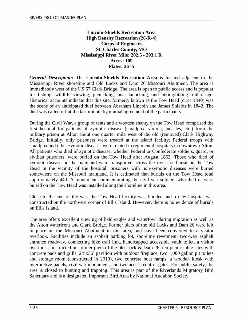
RIVERS PROJECT MASTER PLAN
5-26 CHAPTER 5 - RESOURCE PLAN
Lincoln-Shields Recreation Area High Density Recreation (26-R-4)
Corps of Engineers St. Charles County, MO
Mississippi River Mile: 202.5 - 203.1 R Acres: 109
Plates: 26 -5 General Description: The Lincoln-Shields Recreation Area is located adjacent to the Mississippi River shoreline and Old Locks and Dam 26 Missouri Abutment. The area is immediately west of the US 67 Clark Bridge. The area is open to public access and is popular for fishing, wildlife viewing, picnicking, boat launching, and hiking/biking trail usage. Historical accounts indicate that this site, formerly known as the Tow Head (circa 1840) was the scene of an anticipated duel between Abraham Lincoln and James Shields in 1842. The duel was called off at the last minute by mutual agreement of the participants. During the Civil War, a group of tents and a wooden shanty on the Tow Head comprised the first hospital for patients of zymotic disease (smallpox, variola, measles, etc.) from the military prison at Alton about one quarter mile west of the old (removed) Clark Highway Bridge. Initially, only prisoners were treated at the island facility; Federal troops with smallpox and other zymotic diseases were treated in regimental hospitals in downtown Alton. All patients who died of zymotic disease, whether Federal or Confederate soldiers, guard, or civilian prisoners, were buried on the Tow Head after August 1863. Those who died of zymotic disease on the mainland were transported across the river for burial on the Tow Head in the vicinity of the hospital; prisoners with non-zymotic diseases were buried somewhere on the Missouri mainland. It is estimated that burials on the Tow Head total approximately 440. A monument commemorating the civil war soldiers who died or were buried on the Tow Head was installed along the shoreline in this area. Close to the end of the war, the Tow Head facility was flooded and a new hospital was constructed on the northwest corner of Ellis Island. However, there is no evidence of burials on Ellis Island. The area offers excellent viewing of bald eagles and waterfowl during migration as well as the Alton waterfront and Clark Bridge. Former piers of the old Locks and Dam 26 were left in place on the Missouri Abutment in this area, and have been converted to a visitor overlook. Facilities include an asphalt parking lot, shoreline revetment, two-way asphalt entrance roadway, connecting bike trail link, handicapped accessible vault toilet, a visitor overlook constructed on former piers of the old Lock & Dam 26, ten picnic table sites with concrete pads and grills, 24’x36’ pavilion with outdoor fireplace, two 1,000 gallon pit toilets and storage room (constructed in 2010), two concrete boat ramps, a wooden kiosk with interpretive panels, civil war monument, and two access control gates. For public safety, the area is closed to hunting and trapping. This area is part of the Riverlands Migratory Bird Sanctuary and is a designated Important Bird Area by National Audubon Society.
RIVERS PROJECT MASTER PLAN
CHAPTER 5 - RESOURCE PLAN 5-27
Proposed Future Development: Relocation/Replacement of boat ramps to include construction of high and low water boat ramps and shoreline sidewalks to ADA standards, installation of boat ramp courtesy docks, resurface existing parking area and install courtesy docks w/ accessible loading ramp, shoreline protection, repairs to civil war memorial, add solar security lighting, barrier and sign installation, additional park benches, additional picnic tables and grills, interpretive signage, create green islands or bio swales in the parking lot, and rehabilitation of the visitor overlook to include ADA accessibility. An interpretive prospective will be completed for the area to improve visitor use. Investigate feasibility of relocating and relocate the Civil War Monument. If a land exchange with Missouri Department of Transportation were to occur relating to the Clark Bridge construction lease, the boat accesses in this area may be relocated to that new area.
Lincoln-Shields South Access Area Low Density Recreation (26-L-2)
Corps of Engineers St. Charles County, MO
Mississippi River Mile: 203 R Acres: 2
Plates: 26-5 General Description: The Lincoln-Shields South Access Area (formerly known as the Ellis Lake or Jack & Jill Access Area) is located adjacent to the Mississippi River and Ellis Lake shorelines. The area is west of the US 67 Clark Bridge. Recreational opportunities in the area include wildlife viewing, fishing, boat ramp, and bike trail access. The area offers excellent viewing of bald eagles and waterfowl during migration. For public safety, the area is closed to hunting and trapping. Facilities include a crushed stone parking lot and entrance roadway, bike trail bollards, access control gate, asphalt service road/bike trail, crushed stone bike trail, two bulletin boards, crushed stone service boat ramp, and three park benches. Proposed Future Development: Investigate the feasibility of and implement a proposed land exchange with Missouri Department of Transportation (MODOT) relating to the Clark Bridge construction lease. Potential development then may include improved parking lot, rehabilitated boat ramp, security lighting, portable toilets, and refuse receptacles at the heavily used boat ramp at the east end of Ellis Lake. Encourage MODOT’s long term goal of raising southbound lanes of HWY 367 to provide safe and reliable access to the Project. Such construction could lead to relocation of public access features, such as boat ramps. Installation of highway pedestrian crossing facility following The Audubon Center at Riverlands Concept Master Plan (to be funded through an outside source such as: Audubon, MoDOT or Great Rivers Greenway). All projects developed through the Audubon partnership shall be reviewed and approved by the Corps to ensure that they fully meet the intent of this master plan. Real property improvements, on project lands, shall become the property of the Government unless specifically stated through the partnership agreement or real estate instrument.
RIVERS PROJECT MASTER PLAN
5-28 CHAPTER 5 - RESOURCE PLAN
Ellis Island Vegetative Management (26-V-1)
Corps of Engineers St. Charles County, MO
Mississippi River Miles 201.4 – 202.5 R Acres: 98
Plates: 26-5 General Description: Ellis Island is surrounded by the Mississippi River and Ellis Bay and is located immediately downstream of the US 67 Clark Bridge. The area is closed to hunting and trapping for public and navigation safety and in accordance with the Riverlands Migratory Bird Sanctuary (formerly known as the Melvin Price Locks and Dam waterfowl refuge). This area is a designated Important Bird Area by National Audubon Society. Ellis Island is about 59% forested. Most of the forest consists of silver maple, eastern cottonwood, and black willow and has an average basal area of 48 feet2/acre and tree density of 439 trees/acre. High stem density is due to the large number of black and sandbar willow seedlings/saplings. Dense sandbar willow has established along the shoreline of Ellis Island and may be impacting the nesting capabilities of softshell turtles. The non-forested component (41%) is mostly sand prairie that is dominated by native sand dropseed, buffalograss, western wheatgrass, hairy-golden aster, and twist-spine prickly pear cactus. Exotic and native invasive species include salt cedar, cheatgrass brome, Japanese brome, Amur honeysuckle, Japanese hops, Johnson grass, giant reed, willow species, and eastern cottonwood. In 2002, the Ellis Island Least Tern Habitat Project was constructed at the western tip of Ellis Island. This project created an isolated, island sandbar habitat suitable for the interior least tern and other shorebirds to nest, with an adjacent foraging area. This area was created to provide protection from unpredictable hydrology. However, frequent inundation degraded the constructed island habitat. A bird blind and trail were constructed in cooperation with St. Louis Audubon for the initial monitoring of Least Tern Island. Although several terns were observed around the area, none had attempted nesting on the island. Several other birds use this island for resting, such as American white pelicans and double crested cormorants. Ellis Island is used frequently for environmental education and interpretive programs. The island has a primitive camping site for the Mississippi River Water Trail on the downstream end. Ellis Island has approximately 2 miles of hiking trails, which meander through forest and prairie areas. Proposed Future Development: Water control structures for wetland restoration and expansion. Removal of remaining sheet pile from the Melvin Price Locks and Dam construction and barges; once removed the site will only be used for habitat management and recreation purposes. Investigate the feasibility of constructing and install if deemed feasible a boardwalk/bridge across Ellis Bay to Ellis Island following The Audubon Center at Rivers Concept Master Plan.
RIVERS PROJECT MASTER PLAN
CHAPTER 5 - RESOURCE PLAN 5-29
Ellis Island Access Area
Low Density Recreation (26-L-3) Corps of Engineers
St. Charles County, MO Mississippi River Mile: 202.5 R
Acres: 9 Plates: 26-5
General Description: The Ellis Island Access Area is located adjacent to the Ellis Bay shorelines and immediately east of US 67. The area is managed for public access purposes and offers recreational opportunities for wildlife viewing, fishing, and pedestrian trail access. Visitors are plentiful when Bald eagles are present and waterfowl are migrating. Facilities include a crushed stone entrance roadway and parking lot with waterside guardrail, shoreline revetment, bulletin board, benches, and access control gate. The area is restricted during refuge seasons in association with the Riverlands Migratory Bird Sanctuary. Proposed Future Development: Concrete overlay of parking lot, security lighting, refuse receptacles and minimum facility portable toilets.
Ellis Bay Aquatic Habitat Area Fish & Wildlife Sanctuary (26-S-1)
Corps of Engineers St. Charles County, MO/Madison County, IL
Mississippi River Mile: 200.8 – 202.6 R Acres: 481 Plates: 26-5
General Description: The Ellis Bay Aquatic Area is a backwater of the Mississippi River and is located contained by Ellis Island and the Spur Dike Area (Riverlands Way). During non-refuge periods it provides a quiet water recreation area. The area is closed to boats during refuge seasons, restricted to no-wake boating during non-refuge seasons, and closed to hunting and trapping in accordance with the Riverlands Migratory Bird Sanctuary. This area is a designated Important Bird Area by the National Audubon Society. This backwater area has a hydrologic connection to the Mississippi River through the old Alton Slough side channel that was originally cut off with the construction of the abandoned railroad and highway embankments immediately upstream. The area is impounded and regulated with the navigation pool since 1991 due to the creation of an additional two miles of navigation pool associated with the Melvin Price Locks and Dam. Average water depths are approximately five feet, a combination of the deeper remnant slough channel and submerged islands of less than two feet scattered throughout the area. This type of backwater river environment has been lost within our major river systems due to sedimentation and these losses continue to be a major concern of river managers.
RIVERS PROJECT MASTER PLAN
5-30 CHAPTER 5 - RESOURCE PLAN
Although mostly aquatic habitat, there is some forested areas (21% forested). These forests are dominated by silver maple, green ash, hackberry, and red mulberry and have a stem density of 461 trees/acre and a basal area of 57 feet2/acre. The area is managed for limited and experimental submersed aquatic planting, invertebrate introduction, creation and succession control of shorebird habitat dredged sand islands, and restricted public boat access. In addition to the opportunity to view water birds, the area’s exceptional water quality offers educational and research possibilities for backwater habitat studies. In May 2009, the Interior Least Tern Floating Habitat Project was initiated. The project consists of two floating pontoon barges anchored in Ellis Bay. Call boxes and decoys are used on the barges to interest the birds in this particular site. Proposed Future Development: Establishment of aquatic vegetation to improve water quality and habitat, shoreline protection alterations/improvements, woody structure installation, and continuation of the Interior Least Tern Floating Habitat Project. Investigate feasibility of and implement developing a permanent island for interior least tern nesting. Investigate feasibility and implement dredging to establish deep water habitat entry into at the mouth of Ellis Bay and creating new islands within the bay with the dredged materials. Investigate the feasibility of installing and install a boardwalk/bridge across Ellis Bay to Ellis Island following The Audubon Center at Rivers Concept Master Plan.
Prairie-Marsh Restoration Area Vegetative Management (26-V-2)
Corps of Engineers St. Charles County, MO
Mississippi River Mile: 200.5 R – 203 R Acres: 1,121 Plates: 26-5
General Description: The Prairie-Marsh Restoration Area is located landside and south of Riverlands Way/Spur Dike and is part of the Riverlands Migratory Bird Sanctuary (formerly known as the Environmental Demonstration Area). The area consists of a diverse prairie-marsh community and includes resident plant and animal populations, migratory waterbird habitats, and protection of endangered and threatened species. The area is closed to all public use during refuge seasons, restricted to developed trails access during non-refuge seasons, and closed to hunting, trapping and fishing year round, in accordance with the Riverlands Migratory Bird Sanctuary (also known as the Melvin Price Locks and Dam Waterfowl Refuge). These lands were purchased for project construction requirements and damages due to raised groundwater levels (seepage lands). The Melvin Price navigation pool raised groundwater and surface water levels approximately 16 feet for 2 additional miles of navigation pool along the Spur Dike, to near 419.0 NGVD. These raised water levels created approximately 300 acres of freshwater marshes dispersed throughout the area initially (additional alterations
RIVERS PROJECT MASTER PLAN
CHAPTER 5 - RESOURCE PLAN 5-31
to the wetlands have created larger marshes in recent years). The marshes range in size from 60 acres in size to small potholes and flooded drainage ditches with an average water depth of 18 inches. Water management of the marshes is accomplished by gravity flow with gated and stop-log water control structures utilizing the navigation pool as the water source and the tailwater area for drainage. Prairie grasses and forbs establishment plantings, debris clearing, site renovations, drainage ditches and water control structures were completed in 1989. The Flood of 1993 inundation destroyed approximately 90 percent of the new established prairie vegetation. Surviving prairie plants were primarily limited to those flood tolerant species that were inundated less than 60 days during the growing season. Re-establishment prairie planting began after the Flood of 1995 again inundated the entire area. In 2010 an additional gravity drain was installed in the Spur Dike that allow water to flow in from Ellis Bay. This control structure allow for better wetland management of the Heron Pond area, and increasing the wetland habitat from 18 acres to over 60 acres. Heron Pond’s primary management goal is to improve habitat for shorebirds. Development of non-native food plots and cool season grass areas occur in overhead power line and pipeline right-of-ways and along boarder property areas adjacent to private land holdings. The area is managed to provide, establish, and protect permanent vegetative cover for native plant community restoration and wildlife habitat. The permanent and semi-permanent marsh habitats area managed for shorebird and dabbling duck habitats by gravity flow water management. Prairie and wetland habitats are managed by prescribed burning, disturbance, and forage plantings. The area is currently 22% forested and 78% non-forested. The scattered forest pockets are almost entirely eastern cottonwood and black willow. The tree density in these pockets is 572 trees/acre and a basal area of 50 feet2/acre. The high density is due to the dense stands of sapling black willow and eastern cottonwood that have developed along the southern and western edges of the management area and around ponds/backwaters. Management will include thinning these areas to improve and increase marsh/wet prairie habitat. The area also provides public educational opportunities that demonstrate the significance of environmental management, public access with pedestrian trails, and educational and research opportunities of wetland and marsh habitats. Facilities include crushed stone and unimproved service roads, pedestrian access trails and trail heads, viewing blinds, parking areas, drainage ditches and various water control structures. Proposed Future Development: Expanding existing interpretive trails, signage, trailheads, boardwalks, pedestrian bridges, viewing structures, shelters and an outdoor classroom following The Audubon Center at Rivers Concept Master Plan. Opportunistically expand existing wetlands and marsh habitats. The Heron Pond Access Area is located along Riverlands Way within the Riverlands Migratory Bird Sanctuary. The area is managed for public access purposes and offers
RIVERS PROJECT MASTER PLAN
5-32 CHAPTER 5 - RESOURCE PLAN
recreational opportunities for wildlife viewing and pedestrian trail access. Facilities include a crushed stone parking lot, access to service roadway, and one access control gate. Proposed Future Development: Parking lot improvements, asphaltic concrete overlay, viewing platform/blind, refuse receptacles, and interpretative panels.
Orton Road Access Area Low Density Recreation (26-L-4)
Corps of Engineers St. Charles County, MO
Mississippi River Mile: 201 R Acres: 1
Plates: 26-5 General Description: The Orton Road Access Area is located at the north end of Orton Road, within the Riverlands Migratory Bird Sanctuary. The area is managed for public access purposes and offers recreational opportunities for wildlife viewing and pedestrian trail access. Facilities include a crushed stone parking lot (relocated in 2013), trail, access to service roadway, one access control gate, kiosk, and wildlife viewing blind. In 2013, an avian observatory was built in collaboration with Washington University’s Sam Fox School of Design & Visual Arts and The Audubon Center at Riverlands. More than two dozen architecture students from the university used cutting-edge digital fabrication technology to design and build the observatory. It was formally dedicated August 28, 2013. Creation of the observatory was funded by the Sam Fox School, The Audubon Center, and Rivers Project, with additional support from WUSTL’s Gephardt Institute for Public Service. The area represents an important habitat for trumpeter swans, great blue herons, bald eagles, gulls, geese, pelicans and other wildlife that, each spring and fall, migrate along the Mississippi flyway. Students' design research focused on camouflage for enhanced bird viewing as well as innovative, earth-friendly building concepts. It is an incredibly unique structure for viewing birds and will become an attraction on its own to those who appreciate innovative design. The viewing blind is open to the public year round and provides outstanding opportunities to view the birds and other wildlife as they enjoy the Sanctuary. As part of this project, Heron Pond Wildlife Viewing Trail was relocated to adjoin the new blind and parking lot was relocated to avoid noise disturbance to migratory waterfowl. Proposed Future Development: Parking lot, trail, visitor use improvements, and refuse receptacles.
RIVERS PROJECT MASTER PLAN
CHAPTER 5 - RESOURCE PLAN 5-33
Teal Pond Aquatic Habitat Area Fish & Wildlife Sanctuary (26-S-2)
Corps of Engineers St. Charles County, MO/Madison County, IL
Mississippi River Mile: 202 – 203 R Acres: 56
Plates: 26-5 General Description: The Teal Pond Aquatic Area is located within the perimeters of US 67, Riverlands Way, and Wise Road embankments. The area provides waterfowl habitat, recreational fisheries and educational and research opportunities for lake habitat studies. The area is closed to public boating during refuge seasons, restricted to trolling motor boats during non-refuge seasons, and closed year-round to hunting and trapping in accordance with the operation of the Riverlands Migratory Bird Sanctuary. This area is a designated Important Bird Area by National Audubon Society. There is no surface hydrologic connection to the Mississippi River, only groundwater interaction that creates a clear water inland lake, protected from flooding by the Spur Dike. Groundwater impounded the area as a result of the creation of the additional two miles of navigation pool associated with the Melvin Price Locks and Dam. Floods inundated the area in 1993 and 1995 when the Spur Dike was overtopped. Water level fluctuations are directly tied to groundwater elevations and fluctuate usually no more than 1 to 2 feet in any year. Average water depth is approximately 4 feet with some holes up to 8 feet deep, for over-wintering fish habitats. Some constructed submerged and emergent islands are scattered throughout the area, but have suffered major erosion from wind-wave action. The area is managed for waterfowl refuge habitat, fisheries habitat, and limited public access purposes. Proposed Future Development: Remove portions of the revetment in order to increase public accessibility. Create a paddle landing, hiking trail, chaotic fishing piers, boat dock, hopscotch stepping stones, patio stone crossings, large tree crossings, reestablish aquatic vegetation, improving sport fishing, reestablishing islands, establishment of woody vegetation as buffer and shade on the shore, and potential water control structure to manage water levels in Teal Pond to improve water quality, rehabilitate boat ramp, as shown in Appendix Proposed Site Plans. Create vegetated treatment cells to filter runoff from adjacent parking lot. Relocate the Least Tern Floating Habitat Project to within Teal Pond. See appendices for conceptual site plan.
RIVERS PROJECT MASTER PLAN
5-34 CHAPTER 5 - RESOURCE PLAN
Teal Pond Access Area Low Density Recreation (26-L-5)
Corps of Engineers St. Charles County, MO/Madison County, IL
Mississippi River Mile: 202 R Acres: 2
Plates: 26-5 General Description: The Teal Pond Access Area is located adjacent to the Teal Pond shoreline and Wise Road on the Teal Pond Impoundment Levee. The facilities are managed for public access and operations purposes and offer recreational opportunities for wildlife viewing, fishing, and boat access. The vista offers excellent viewing of waterfowl during migration. Facilities include a crushed stone parking lot with guardrail, shoreline revetment, three rip rap and crushed stone fishing dikes, crushed stone entrance roadway, crushed stone boat ramp, bulletin board, picnic table, and access control gate. The boat ramp is closed to public boat access during refuge seasons in accordance with the Riverlands Migratory Bird Sanctuary. Proposed Future Development: Replacing boat ramp with concrete ramp, constructing an ADA compliant fishing pier (approved in Supplement 3, DM No. 3), providing refuse receptacles, rehabilitation of boat ramp, installation of courtesy dock, installing security lighting, and create a paddling access.
Maple Island Ecologic Area Environmentally Sensitive (26-ES-1)
Corps of Engineers St. Charles County, MO/Madison County, IL
Mississippi River Mile: 197.5 - 200.7 R Acres: 467 Plates: 26-5
General Description: The Maple Island Ecological Area is a series of four natural islands located within the Mississippi River immediately downstream of the Melvin Price Locks & Dam. Public access is by boat only. The head island has portions in both Illinois and Missouri; however the three smaller downstream islands lie entirely in Missouri. This area is a designated Important Bird Area by National Audubon Society. The eastern small island contains a primitive camping site for the Mississippi River Water Trail. The area is dominated by silver maple, black willow and swamp privet (98% forested). The stem density is 182 trees/acre and basal area is 123 feet2/acre. The high basal area is due to the large silver maple and black willows at this site. Canopy gaps exist on Maple Island due to decadent cottonwood and high mortality following the Flood of 1993. Natural regeneration in these gaps is being slowed by the presence of Japanese hops. Management includes protection and limited succession management to conserve the area as a natural area for ecological and environmental resources. It provides excellent bald eagle day roost habitat
RIVERS PROJECT MASTER PLAN
CHAPTER 5 - RESOURCE PLAN 5-35
with mature cottonwood trees bordering the shoreline. The riparian forest complex offers excellent opportunities for research. This area has great habitat for neotropical migrants (e.g. warblers). The area is closed to public use and all hunting and trapping in accordance with the Riverlands Migratory Bird Sanctuary. The National Great Rivers Research and Education Center (NGRREC) has a license to use Maple Island as an educational research forest. NGRREC conducts various research and monitoring projects in the area, including forest and invasive species monitoring. Proposed Future Development: Development of a bridge and tree top canopy walk following The Audubon Center at Riverlands Concept Master Plan will be funded through Audubon partnership. Investigate the feasibility of and implement relocating the Maple Island Access Area boat ramp. Investigate function of wing dikes present in this area and possibilities of notching them. All projects developed through the Audubon partnership shall be reviewed and approved by the Corps to ensure that they fully meet the intent of this master plan. Real property improvements, on project lands, shall become the property of the Government unless specifically stated through the partnership agreement or real estate instrument. Potential projects as proposed in Middle Mississippi River Side Channels: A Habitat Rehabilitation and Conservation Initiative (1999): • Investigate feasibility of rehabilitation of the side channel accomplished by placement of
hard points (wood, rock, or both) to diversify the existing channel within the chute. The addition of woody structure and selective dredging to remove large sand deposits.
• Investigate feasibility of dredging side channel/chute. Dredge material could be placed at the downstream end of the island to increase sandbar habitat.
• Secondary channels, as well as wetland areas on the interior of Maple Island should be addressed to provide additional off channel habitats. The advisability of modification of existing stone structures will be closely examined with micro model analysis.
RIVERS PROJECT MASTER PLAN
5-36 CHAPTER 5 - RESOURCE PLAN
Unit 2 – Illinois Esplanade
Melvin Price Locks & Dam Area Project Operations (26-O-2)
Corps of Engineers Madison County, IL
Mississippi River Mile: 200.5 – 202 L Acres: 93
Plates: 26-5 General Description: The Melvin Price Locks & Dam Area includes the locks and dam, administration area, and Wood River Levee Area. The City of Alton has annexed the property. The area is closed to hunting and trapping for public safety and in accordance with the Riverlands Migratory Bird Sanctuary. (1) The Melvin Price Locks and Dam Area is located approximately 2 miles downstream from the decommissioned Locks & Dam 26. The 1,200 foot lock and dam was authorized by Public Law 95-502, Title I Replacement of Locks and Dam No. 26, Upper Mississippi River System Comprehensive Master Plan, 21 October 1978. Public Law 99-88, supplemental Appropriations Act for 1985, 15 August 1985, authorized the addition of a 600 foot auxiliary lock. Melvin Price Locks and Dam was designed and constructed as a replacement for Locks and Dam No. 26 as part of the Mississippi River Nine-Foot Navigation Project. The locks and dam provide the portion of the continuous Mississippi Nine-Foot Navigation Project to Lock & Dam 25 on the Mississippi River, and LaGrange Lock & Dam on the Illinois River. Facilities include one 110 foot by 1,200 foot main lock, one 110 foot by 600 foot auxiliary lock, and dam with nine tainter gates. Public access is provided on top of the Illinois side of the structure and to a visitor outlook inside the auxiliary control house that overlooks the 1,200 foot lock chamber. (2) The Melvin Price Locks and Dam Administration Complex Area is located immediately adjacent to the Illinois abutment of the Melvin Price Locks and Dam. The complex is managed to provide facilities for the operation and maintenance of Melvin Price Locks & Dam. Facilities include an asphalt access road, asphalt parking lot, administration and maintenance building, storage building, generator building, and appurtenant facilities including fuel tanks. (3) The Wood River Levee Area is located landside and adjacent to the Illinois Esplanade Recreation Area and along the Illinois shoreline. The area is managed for public access, flood reduction, and operations purposes. The levee portion is under easement with the Alton-Wood River Levee and Drainage District. Facilities include the levee, a crushed stone service access roadway, and access control gate and guardrail. Four trilateration stations are located in this area. Proposed Future Development: Design and build a rock climbing wall on the first pier of the lock and dam (partner/concessionaire funded). No USACE funds will be used in the
RIVERS PROJECT MASTER PLAN
CHAPTER 5 - RESOURCE PLAN 5-37
construction, operations, or maintenance of the rock climbing wall activity. See appendices for conceptual site plan.
Illinois Route 143 Intersection Area Operational Easement (26-E-1)
Corps of Engineers Madison County, IL
Mississippi River Mile: 200.4 - 200.7 L Acres: 8
Plate: 26-5 General Description: The Illinois Route 143 Traffic Light Area is an operational easement located at the intersection of Lock & Dam Way and Illinois Route 143. The area is managed under perpetual easement for the construction, operation and maintenance of a traffic control signal. Facilities include the traffic signal, Illinois Esplanade entrance road spur, and the Alton Wood River Levee and Drainage Pump District pump station entrance road spur. Proposed Future Development: The National Great Rivers Research and Education Center may rehabilitate the area to improve access to their lease area and the Jerry F. Costello Confluence Field Station. Investigate the feasibility of returning these easement lands to the Illinois Department of Transportation.
Illinois Esplanade Recreation Area High Density Recreation (26-R-1)
Corps of Engineers Madison County, IL
Mississippi River Mile: 199.9 - 200.7 L Acres: 29
Plate: 26-5 General Description: The Illinois Esplanade Recreation Area also includes the National Great Rivers Museum. The area is located adjacent to the Melvin Price Locks & Dam tailwater on the Illinois shoreline, along IL Highway 143. The area is managed for recreation and education activities. It is very popular for fishing, sightseeing, picnicking, and wildlife viewing including viewing bald eagles. The area is closed to hunting and trapping for public safety in accordance with the Riverlands Migratory Bird Sanctuary. The Illinois Esplanade Recreation Area is popular for wildlife viewing, picnicking, fishing and educational activities. Facilities include asphalt parking lots, shoreline revetment, two-lane asphalt entrance roadway, access control gate, picnic shelter, waterborne comfort station, interpretive trails and signage, and docking facilities. In 2012, 2 acres of the exotic and very invasive salt cedar was identified and treated.

RIVERS PROJECT MASTER PLAN
5-38 CHAPTER 5 - RESOURCE PLAN
Proposed Future Development: Widening/reconfiguring the entrance road, installation of native landscaping, interpretative trails and panels, nature/playscapes, as well as the redesign and installing of a water feature. Acquire a retired working vessel for public tours and interpretive programming that can be docked at the Illinois Esplanade. See appendicies for exhibit update and conceptual plan for the NGRM and Illinois Esplanade. The National Great Rivers Museum (NGRM) is a 12,000 sq. ft. Regional (Type A) Visitor Center located adjacent to the Melvin Price Locks and Dam Illinois abutment. The Visitor Center and surrounding area is managed as a recreation and education facility. Facilities include the visitor center building and a surrounding outdoor plaza. The NGRM interior space includes a kitchenette, two offices, a bookstore, 6,000 square foot gallery space, multi-purpose room, 110-seat theater, and two ADA accessible restrooms. Proposed Future Development: The NGRM is authorized by Congress to be 24,000 square feet. Currently the building is approximately 12,000 square feet. This master plan authorizes a reconfiguration of the office space to provide adequate personnel space, exhibit updates, kitchen installation, reconfiguring theater space to make it multi-functional, and expanded classroom. Additional exhibit space and full expansion to the authorized 24,000 square feet will require an outside funding partnership and a future supplement/update to this master plan for authorization. Future expansion to the full authorized limit shall require consideration of long-term operation and maintenance costs associated with full expansion. Design and construct a step-like access to river shoreline. See appendices for exhibit update and conceptual plan for the NGRM and Illinois Esplanade.
National Great Rivers Research & Education Center High Density Recreation (26-R-2)
Corps of Engineers Madison County, IL
Mississippi River Mile: 199.9 - 200.7 L Acres: 12.87 Plate: 26-5
General Description: The National Great Rivers Research & Education Center (Jerry F. Costello Confluence Field Station) was constructed on the 12.87 acres lease site in 2010. The facilities “serve as an international center for science, education, and public outreach with a goal to improve the sustainable management of large rivers. The Center construction process, and the building itself, incorporates many “green” elements with a goal to attain LEED (Leadership in Energy and Environmental Design) certification at the highest level. The first phase of construction on the 35,000 square-foot Center began in 2008 and was completed in July 2010. The Center features use of solar power, water recycling systems, permeable pavers, and native plantings” (NGRREC website). The site has been landscaped with native plants. Phase II of the Center, which features in-river pump capable of delivering 1.8 million gallons of water daily to provide continuous river water flow through the mesocosms (large concrete
RIVERS PROJECT MASTER PLAN
CHAPTER 5 - RESOURCE PLAN 5-39
channels containing water and plankton to be used as artificial environments for experiments), additional lab space and offices was completed in 2014. Proposed Future Development: Installation of a service boat ramp for use by NGRREC staff and Corps, Phase III to include additional lab, storage and research space, expansion of parking areas and additional lease area.
Alton Riverfront Recreation Area High Density Recreation (26-R-3)
City of Alton Madison County, IL
Mississippi River Mile: 202.5 - 203 L Acres: 16
Plate: 26-5 General Description: The Alton Riverfront Recreation Area is located immediately upstream of the US 67 Clark Bridge adjacent to its Illinois abutment. The area is managed for public access in conjunction with the City of Alton Marina/Riverfront District Master Plan under a park and recreation lease with the City of Alton. This lease area and adjacent City of Alton common area accommodates the Alton Marina and Riverfront Park. Facilities include a river walk, boat slips, a floating convenience store/administration building, fuel dock, pool, and restrooms; access roadways, parking lots, boat ramp, restroom, picnic shelter, playground, bicycle trail, and surrounding park area. The area is closed to hunting and trapping for public safety and in accordance with the Riverlands Migratory Bird Sanctuary. Adjacent nonfederal lands have been developed to include an outdoor amphitheater and pedestrian bridge across US 67 into downtown Alton. Proposed Future Development: Work with the leasee to improve the public river access. The following items are to be completed with a partner: additional parking lots and roadways, extension of the riverwalk, pedestrian plaza, picnic area and landscaping.
RIVERS PROJECT MASTER PLAN
5-40 CHAPTER 5 - RESOURCE PLAN
Unit 3 – Horseshoe Lake
Horseshoe Lake Mitigation Area Mitigation (26-M-1)
Illinois Department of Natural Resources Madison County, IL
Acres: 621 Plate: 26-6
General Description: The Horseshoe Lake Mitigation Area is located three miles east of Locks 27 and is part of the Horseshoe Lake State Park. The area is managed exclusively for mitigation of lost terrestrial habitat and wildlife protection due to construction of the Melvin Price Locks and Dam. The area is managed for fish and wildlife enhancement purposes under a license with the IDNR. The mitigation requirements are the sole responsibility of the Corps. This area is 16% forested with an average stem density is 163 stems/acre and basal area is 100 feet2/acre. Silver maple is the dominate species. Archeological investigations of the area have resulted in the identification of significant, dense and widespread historic resources. Due to the unique nature, large number of sites, and the relationship of these sites with the World Heritage Site of Cahokia Mounds, these archaeological remains will be collectively listed as the Horseshoe Lake Archaeological District with the U.S. Department of the Interiors National Register of Historic Places. The area is managed to be compatible with the long-term archaeological management goals of the Horseshoe Lake Archaeological District. Proposed Future Development: No proposed development is currently planned.
RIVERS PROJECT MASTER PLAN
CHAPTER 5 - RESOURCE PLAN 5-41
Pool 26 - Compartment 3 Lower Alton Lake Management Area
Unit 1 – Missouri Bottoms
West Alton Conservation Area Wildlife Management (26-W-1)
Missouri Department of Conservation St. Charles County, MO
Mississippi River Mile: 203 - 206 R Acres: 1,005 Plate: 26-4
General Description: The West Alton Conservation Area is located on the right descending bank, approximately two miles upstream from Melvin Price Locks & Dam. The area is managed for fish and wildlife enhancement purposes under a General Plan and Cooperative Agreement by MDC. This area is designated as part of an Important Bird Area by National Audubon Society. Waterfowl hunting blinds are present, but no water control or enhancement management program is presently being implemented. Siltation has severely degraded this area many of the waterfowl hunting blind sites are inaccessible for public use during periods of low water (i.e. pool drawdown). No infrastructure, other than duck blind sites (managed by MDC) are contained within this area. Hunting, fishing and other public use in this area are managed in accordance with the Missouri Wildlife Code and MDC's area specific regulations for the Upper Mississippi Conservation Area. Besides the aquatic areas, this area consists of a mixture of a natural riparian bottomland forest (89% forested, 20-60 years), which is composed of American plum, pecan, American elm, bald cypress, green ash, black willow, silver maple, eastern cottonwood, and herbaceous wetland communities. The average stem density is 547 trees/acre and the basal area is 75 feet2/acre. High density is attributed large numbers of silver maple, green ash and eastern cottonwood in numerous canopy gaps. The gaps were caused by high mortality in the canopy from the 1993 and 1995 flood events. There are several old tree plantings located near Brickhouse Slough and Alton Lake Recreational Cottage Subdivisions that will need thinning within the next ten years. Close proximity to the old Lock & Dam 26 and consequently raised water table promoted the establishment of green ash about 70 years ago. Bald eagles rest in the mature cottonwood trees that exist in this area, which also provides suitable nesting habitat. Suitable habitat conditions exist, but are not actively managed, for Boltonia decurrens. An open water bay and old slough (upper end of Alton Slough) exist in this area. The upper end of the slough has been cut off from the Mississippi River during normal pool conditions. This slough was isolated by the construction of a very large wing dam. The water depth is approximately 3ft and almost entirely a mudflat when the navigation pool is on drawdown.
RIVERS PROJECT MASTER PLAN
5-42 CHAPTER 5 - RESOURCE PLAN
Proposed Future Development: A low-profile earthen dike with a water-control structure to impound approximately 400 acres. A gravity flow system utilizing stoplog water control structures would probably be used. This structure would be large enough to allow small-boat access through the dike for fishing. Dike and water-control structures will vary depending on physical requirements. Prior to development, a detailed site analysis will be necessary to determine biological and economic feasibility. A portion of the impoundment adjacent to the southeastern shore could be established as a refuge for dabbling ducks and diving ducks with the remainder open to public hunting. Public access to the area should be upgraded when the West Alton area is rehabilitated. Proposed potential features under the West Alton Missouri Islands Rehabilitation EMP-HREP as outlined in the 2010 MVD approved Fact Sheet: • Dredging channel to restore off-channel aquatic habitat and reconnect the upper end of
bay to the river • Notch existing dike at river mile 204.4 to help maintain Alton Slough • Construct 5 small rock chevrons needed to restore bathymetric diversity • Use dredged material to create an outer barrier island • Construct 3 large chevrons
West Alton Levee Area Project Operations (26-O-3)
Corps of Engineers St. Charles County, MO
Mississippi River Mile: 204 R Acres: 3
Plate: 26-4 General Description: The West Alton Levee Area is located west from the intersection of Highway 94 and government boundary and intersecting with the Consolidated North County Levee District (CNCLD). The levee is managed as a flood control structure; the southern line of flood protection for the Consolidated North County Levee District. Maintenance responsibilities of the levee in this area are described further in CNCLD Operations and Maintenance Manual. The dike consists of a clay filled embankment, top elevation near 432.0 NGVD with a 10 foot crown width with 1V on 3H side slopes. Facilities include a flap gate gravity culvert and an access control gate. The area is open to hunting and trapping in cooperation with the Missouri Wildlife Code and MDC's area specific regulations for the Upper Mississippi Conservation Area. Proposed Future Development: No proposed development is currently planned.
RIVERS PROJECT MASTER PLAN
CHAPTER 5 - RESOURCE PLAN 5-43
Dresser Island Conservation Area Wildlife Management (26-W-2)
Missouri Department of Conservation St. Charles County, MO
Mississippi River Mile: 205 - 209 R Acres: 1,069 Plate: 26-4
General Description: The Dresser Island Conservation Area is approximately four miles upstream from the Melvin Price Locks & Dam and immediately downstream from the Ameren Missouri Portage Des Sioux Power Plant Area. The area is managed for fish and wildlife management purposes under a General Plan and Cooperative Agreements by MDC. This area is designated as part of an Important Bird Area by National Audubon Society. Brickhouse Slough separates the 823 acre island from the 246 acre Missouri shore portions of this area. Historically, Dresser Island was a prime wetland/backwater area used extensively by migratory waterfowl, wintering bald eagles and other wetland wildlife species. The wetlands also provided important spawning and nursery areas for river fishes. An EMP-HREP was completed in 1991. The project was designed to rehabilitate the once prime wetland/backwater habitat by construction of a low profile levee along the entire riverside and enclosure of the lower one-half of the island shoreline along Brickhouse Slough in order to control deposition of silt during the more frequent flood events. It also included installation of five gated drainage structures to allow control of the water levels on the interior wetlands independent of river stages. Preliminary results indicate that the desired water temperature control is being achieved. In addition, interior water levels were maintained independent of river stage, with only a 1 foot variance, which could allow for the development of moist-soil plant production during future growing seasons. Over the years, sediment has partially filled the interior wetlands. Brickhouse Slough is isolated by a closing structure near the Ameren Missouri Power Plant. This closing structure was constructed in a way that only allows flow to flush these backwaters during high water. This structure is no longer functioning as intended. Therefore, the backwater has experienced significant sedimentation over the years. The backwaters were historically an important habitat for largemouth bass, bluegill, and black/white crappie. Loss of aquatic vegetation and sedimentation has virtually eliminated this fishery. Interior water levels are difficult to control due in part to the lack of a core in the rock closing structures. This has hampered attempts to manage habitat for wildlife. The forested area consists of a mixture of a natural riparian bottomland forest (30-60 years), which is composed of silver maple, cottonwood, boxelder, black willow, American elm, green ash, sporadic bur oak and herbaceous wetland communities (94% forested). The forests of Dresser Island suffered very high mortality following the Flood of 1993 and have many large canopy caps. These gaps are currently being filled by silver maple, American elm, black willow, and green ash. The average stem density is 492 trees/acre and the basal area is 86 feet2/acre. Extensive vines and Japanese hops have also developed in the canopy gaps.
RIVERS PROJECT MASTER PLAN
5-44 CHAPTER 5 - RESOURCE PLAN
This area has multiple bald eagles nests and neotropical migrants frequent this forested area. Suitable habitat conditions exist but are not currently managed for Boltonia decurrens. Hunting, fishing and other public use in this area are managed in accordance with the Missouri Wildlife Code and MDC's area specific regulations for the Upper Mississippi Conservation Area. Proposed Future Development: Increasing the flow of warm water from the Portage Des Sioux Power Plant (Ameren Missouri) located immediately upstream from the area into the Dresser EMP-HREP to improve water control capabilities for wetland wildlife enhancement and overwintering habitat for fish and waterfowl. Explore the feasibility of a multi-use trail on Dresser Island. Reforest a portion of the forested areas on the island. Dredge the interior wetlands to increase overwintering, spawning and brood fisheries habitat. Control encroaching undesirable woody vegetation on the open wetlands. Proposed potential features under the West Alton Missouri Islands Rehabilitation EMP-HREP (Brickhouse Slough) as outlined in the 2010 MVD approved Fact Sheet: • Dredge channel • Redirect flow from power plant towards Brickhouse Slough to provide more flow needed
to maintain slough alignment • Use dredged material to create an island The Dresser Island Access Area provides access to Brickhouse Slough, Dresser Island, and the river. The area and facilities are included under the General Plan and Cooperative Agreements by MDC. Development at this area is limited to the two one-lane gravel small boat launching ramps and a small parking lot for approximately 15 cars and trailers. One ramp is located upstream of the causeway water control structure and the other downstream. Proposed Future Development: Improve the parking lot and entrance road. Investigate the feasibility of and implement dredging a small area around the boat ramp to improve accessibility.
Alton Lake Access Area & Recreational Cottages Low Density Recreation (26-L-6)
Corps of Engineers St. Charles County, MO
Mississippi River Mile: 203 – 204 R Acres: 18
Plate: 26-4 General Description: The Alton Lake Access Area is located adjacent to the Alton Lake backwater, approximately two miles upstream of the Melvin Price Locks & Dam. The area is managed for public and private access purposes and includes the Alton Lake Recreational
RIVERS PROJECT MASTER PLAN
CHAPTER 5 - RESOURCE PLAN 5-45
Cottages Subdivision, platted with forty-nine lots, and adjacent shoreline. Several cottages are present and those lots are excluded from public access under private recreation leases to cabin owners. Most of the lots have no structures and are managed for public access to the Alton Lake backwater and Mississippi River shorelines. One lot at the termination of Old Hwy 94 is managed for public access purposes. Facilities include a crushed stone entrance road, parking lot, and boat ramp. The boat ramp and channel are silted in and are only usable by small shallow draft boats during maximum regulated pool stages. This site has some forests, which area dominated by black walnut, hackberry and green ash. The average stem density is 123 trees/acre and basal area is 52 feet2/acre. For public safety, the area is closed to hunting and trapping. Proposed Future Development: Expand the parking lot, install a gate with post and cable around parking lot. Dredge a small area around the boat ramp to improve accessibility. Continue to phase out private recreational cottage leases in accordance with Regional Land Use Plan.
Alta Villa & Spatterdock Lake Access Area & Brickhouse Slough Recreational Cottages
Low Density Recreation (26-L-7) Corps of Engineers
St. Charles County, MO Mississippi River Mile: 205 - 207 R
Acres: 51 Plate: 26-4
General Description: The Alta Villa Access Area is located adjacent to Brickhouse Slough shoreline and provides access to the Mississippi River. Two lots and the 5.70-acre adjoining land parcel are managed for public access purposes. This area is the former Alta Villa commercial concession area and is now known as the Alta Villa Access Area. Facilities include a crushed stone parking lot and boat ramp. Spatterdock Lake Access Area provides access to Spatterdock Lake, just off of the Mississippi River. Facilities include a crushed stone entrance roadway, parking lot, and boat ramp. The Brickhouse Slough Recreational Cottages Subdivision is platted with 125 lots, a 5.70-acre adjoining land parcel, and adjacent shoreline. Many cottages are present within the Brickhouse Slough Subdivision and those lots are excluded from public access under private recreation leases to cottage owners. Several additional lots have no structures and those lots are managed for public access purposes to the Brickhouse Slough and Spatterdock Lake shorelines.
RIVERS PROJECT MASTER PLAN
5-46 CHAPTER 5 - RESOURCE PLAN
This area has some forests, which are dominated by silver maple, hackberry and green ash. The average stem density is 203 trees/acre and basal area is 55 feet2/acre. The entire area is managed for public and private access purposes. For public safety, the area is closed to hunting and trapping. Proposed Future Development: Create a shoreline fishing area, boat ramp and parking lot improvements, and re-routing of the Alta Villa County Road for public safety, as currently the road ends in water at the boat ramp. Investigate the feasibility of and implement dredging Brickhouse Slough, which would benefit the Alta Villa boat ramp. Continue to phase out private recreational cottage leases in accordance with Regional Land Use Plan.
Ameren Missouri Portage Des Sioux Power Plant Area Industrial (26-X-1) Corps of Engineers
St. Charles County, MO Mississippi River Mile: 208.6 - 209.8 R
Acres: 160 Plate: 26-4
General Description: The Ameren Missouri Portage Des Sioux Power Plant Area (formerly Ameren-Union Electric) is located immediately upstream of Dresser Island. This area includes a facility managed as a coal fired electric generating plant and terminal and staging area under an industrial/commercial lease. A 21.45 acre operations easement has also been granted to Ameren Missouri. The facility requires a multi-modal interface of rail, trucking and water transportation. Facilities in the lease and easement areas include channels and a water intake and outlet structure, as well as a fleeting area for barges located along the shoreline. Although the lease is for a large area only 65 acres are developed. The undeveloped areas consist of river forest, backwater marshes and wetlands, a portion of which are part of the Dresser Island EMP-HREP project. The forests in the undeveloped area of the lease are dominated by eastern cottonwood, green ash, silver maple, and boxelder. The average stem density is 440 trees/acre and basal area is 108 feet2/acre. The undeveloped area is designated as part of an Important Bird Area by National Audubon Society. For public safety, the area is closed to hunting and trapping. Proposed Future Development: Continue discussions with Ameren Missouri about a land exchange within this compartment. Reduce the acreage of the industrial lease to the minimum amount needed for Ameren Missouri operations to obtain more open public lands. The reduced acreage will be incorporated within the Dresser Island Conservation Area and Mile 210 Areas. Investigate feasibility of easement across this area to access Mile 210 Area if land exchange occurs.
RIVERS PROJECT MASTER PLAN
CHAPTER 5 - RESOURCE PLAN 5-47
Mile 210 Area Vegetative Management (26-V-3)
Corps of Engineers St. Charles County, MO
Mississippi River Mile: 209.8 - 211 R Acres: 242 Plate: 26-4
General Description: The Mile 210 Area is located immediately upstream of the Ameren Missouri Portage Des Sioux Power Plant, and adjacent to Eagle’s Nest Island. The area includes created wetlands constructed as part of the adjacent Consolidated North County Levee District construction and natural backwaters. Management includes protection and vegetative management practices to sustain and restore the natural riparian forest communities and water control management of the constructed wetlands. This area is designated as part of an Important Bird Area by National Audubon Society. This area consists of a mixture of a natural riparian bottomland forest, which is composed of silver maple, bur oak, river birch, green ash, American elm, and eastern cottonwood, and herbaceous wetland communities (93% forested). Stem density is 175 trees/acre and basal area is 105 feet2/acre. The depth in the two primary parallel sloughs has been reduced since impoundment due to sediment deposition during high flow events. At times deposition cuts off the upper end of the northern slough from the main channel and the only water connection and access is through an artificial connection ditch on the adjacent Ameren Missouri lease area. There is some rooted floating (i.e. American lotus and primrose) within this area. Most of the sloughs are ephemeral and support good emergent vegetation, mainly Amazon sprangletop, arrowleaf, river bulrush, and millets. The area is open to regulated hunting and trapping in accordance with the Missouri Wildlife Code. Proposed Future Development: Address the unauthorized duck blind structures within the area. Investigate the feasibility of an easement across adjacent property to access this area if a land exchange is completed for the Ameren Missouri Portage Des Sioux Power Plant Area. Investigate feasibility of deepening backwater slough areas for aquatic habitat communities.
RIVERS PROJECT MASTER PLAN
5-48 CHAPTER 5 - RESOURCE PLAN
Unit 2 – Piasa
Piasa Creek Vegetative Management Area Vegetative Management (26-V-4)
Corps of Engineers Jersey County, IL
Mississippi River Mile: 208.5 - 209 L Acres: 38
Plate: 26-4 General Description: The Piasa Creek Vegetative Management Area is located along Route 100 and adjacent to the Piasa Creek Recreation Area. This bottomland forest area will be managed for vegetative management purposes. This area is 93% forested and dominated by silver maple and green ash. The average stem density is 132 trees/acre and basal area is 123 feet2/acre. The area is closed to hunting. Proposed Future Development: Add trails and boardwalk in this area.
Piasa Creek Recreation Area High Density Recreation (26-R-5)
Corps of Engineers Jersey County, IL
Mississippi River Mile: 209 - 209.4 L Acres: 26
Plate: 26-4 General Description: The Piasa Creek Recreation Area is located at the east side of the mouth of Piasa Creek along Route 100 and adjacent to the Piasa Creek Vegetation Area. The area is managed for public recreation purposes. The area was previously under a park and recreation lease with the IDNR. The area was improved in 1991 as a cost share project under the Federal Aid in Fish Restoration funding authority. This area is one of the most heavily used recreational boater access on the Illinois side of Pool 26. Facilities at this area include an entrance road, a paved parking lot for 200 cars with trailers, four lane concrete boat ramps, four picnic sites, a vault toilet building, and dusk to dawn security lights. The restrooms were closed due to changes in Jersey County code dealing with waste containment in the floodplain. For public safety, the area is closed to hunting and trapping. Proposed Future Development: Rehabilitate the floating docks and restrooms, and conduct dredging along the mouth of the creek to allow for better boat access.
RIVERS PROJECT MASTER PLAN
CHAPTER 5 - RESOURCE PLAN 5-49
Piasa Harbor Area High Density Recreation (26-R-6)
Corps of Engineers Jersey County, IL
Mississippi River Mile: 209 - 210 L Acres: 61
Plate: 26-4 General Description: The Piasa Harbor Area is located at the west side of the mouth of Piasa Creek along Route 100. The area is managed for commercial concession purposes under lease with Great Rivers Land Trust since 2009. The area is popular for boating, fishing, sightseeing, and access to waterfowl hunting. Facilities include wet slips, dry storage area, administration/showroom building, fuel dock, restrooms, access roadways and parking lots, disc golf course, picnic shelter, and boat ramp. The forests on this site are dominated by green ash and silver maple. Average stem density is 415 trees/acre and basal area is 107 feet2/acre. For public safety, the area is closed to hunting and trapping. Proposed Future Development: Add hiking trails and boardwalks through the area.
Lockhaven Harbor Area High Density Recreation (26-R-7)
Corps of Engineers Jersey County, IL
Mississippi River Mile: 209.4 L Acres: 8
Plate: 26-4 General Description: The Lockhaven Harbor Area is located adjacent to the Piasa Creek western shoreline immediately upstream of the Highway 100 Piasa Creek Bridge. This area is under a commercial concession lease with the Alton Motor Boat Club, Inc. The area is very popular for boating, fishing, and as access to waterfowl hunting. Facilities include wet slips, dry storage area, fuel dock, boat service and repair facility, access roadways and parking lot, and boat ramp. Adjacent to the lease area, on private property, the Alton Motor Boat Club owns and operates a convenience store/administration building and restrooms. For public safety, the area is closed to hunting and trapping. Proposed Future Development: No proposed development is currently planned.
RIVERS PROJECT MASTER PLAN
5-50 CHAPTER 5 - RESOURCE PLAN
Piasa Creek Ecological Area Environmentally Sensitive (26-ES-2)
Corps of Engineers Jersey County, IL
Mississippi River Mile: 209 - 210 L Acres: 127 Plate: 26-4
General Description: The Piasa Creek Ecological Area is located on both sides of the Piasa Creek shoreline, upstream of the Highway 100 Piasa Creek Bridge. This area consists of both riparian and upland forest communities. The area is open to regulated hunting and trapping in cooperation with the Illinois Wildlife Code. The area is managed to limit development, and sustain and restore the natural riparian forest communities through protection and natural succession. Currently 99% of the site is forested and dominated by silver maple, boxelder, green ash, and mature eastern cottonwood. This area has high species diversity with 28 different forest species being identified. Average stem density is 151 trees/acre and basal area is 123 feet2/acre. Following all lease terminations within the Upper Piasa Creek Access Area and Recreational Cottages, acreage previously zoned as Low Density Recreation was rezoned to be included in this adjacent area and will remain as such to reduce impacts to potentially sensitive areas. Proposed Future Development: No proposed development is currently planned.
Upper Piasa Creek Mitigation Area (Parcel to be acquired no later than 2018)
Mitigation (26-M-2) America’s Central Port / Corps of Engineers
Jersey County, IL Mississippi River Mile: 208 – 209 L
Acres: 70 Plate: 26-4
General Description: The Upper Piasa Creek Mitigation Area is located along the left and right banks of Piasa Creek, upstream of the Highway 100 Piasa Creek Bridge. This area consists of both riparian and upland forest communities. The area is currently owned by America’s Central Port (Tri-City) as mitigation requirement for building their South Harbor. This property will be transferred to USACE fee title lands no later than 2018 after the mitigation requirements have been completed. Improvements will include landscape excavation and fill for ditch and swale construction, surface water control structure installation, and native forest and herbaceous species plantings.
RIVERS PROJECT MASTER PLAN
CHAPTER 5 - RESOURCE PLAN 5-51
Once USACE acquisition is completed no later than 2018, the primarily natural resource management will be to sustain and restore natural forest communities through protection, natural succession and restoration plantings, silviculture techniques, and succession control. The area is currently closed to hunting and trapping. Proposed Future Development: Upon USACE acquisition, develop and implement a mitigation monitoring plan, evaluate recreational opportunities such as hunting and hiking trails.
Timber Ridge Mitigation Area
Mitigation (26-M-3) Corps of Engineers Jersey County, IL
Mississippi River Mile: 208 – 209 L Acres: 74
Plate: 26-4 General Description: The Timber Ridge Mitigation Area is located along the west side of Piasa Creek, upstream of the Highway 100 Piasa Creek Bridge. This area consists of both riparian and upland forest communities. The area is primarily managed to sustain and restore natural forest communities through protection, natural succession and restoration plantings, silviculture techniques, succession control and native plant introduction for old fields. The area is currently closed to hunting and trapping. Currently 45% of the site is forested and the remaining 55% consists of grassland or abandoned field. The forested portion is dominated by silver maple, boxelder, and eastern cottonwood. Average stem density is 226 trees/acre and basal area is 118 feet2/acre in forested area. This area was acquired in March 2014 as partial fulfillment of compensatory wetland and non-wetland forest mitigation requirements for the Remedial Measures to Control Underseepage along Chain of Rocks East Levee Project. Improvements include landscape excavation and fill for ditch and swale construction, surface water control structure installation, native forest and herbaceous species plantings, and parking lot/turnaround. Proposed Future Development: Development and implementation of a mitigation plan and post monitoring plan. Evaluate opening the area to hunting within the next 10 years. Develop hiking trails through the area.

RIVERS PROJECT MASTER PLAN
5-52 CHAPTER 5 - RESOURCE PLAN
Lower Piasa Creek Access Area & Recreational Cottages Low Density Recreation (26-L-8)
Corps of Engineers Jersey County, IL
Mississippi River Mile: 209.4 L Acres: 3
Plate: 26-4 General Description: The Lower Piasa Creek Access Area is located adjacent to eastern shoreline of Piasa Creek, immediately upstream of the Highway 100 Piasa Creek Bridge. The area is managed for public and private access purposes and includes the Lower Piasa Creek Recreational Cottages Subdivision, platted with 11 lots, and adjacent shoreline. No public access facilities are developed at this time. Several lots are excluded from public access under private recreation lease to cottage owners. A few lots are undeveloped and provide public access to the Piasa Creek shoreline for fishing and wildlife viewing. The forests on this site are dominated by red oak and persimmon. Stem density is 79 trees/acre and basal area is 60 feet2/acre. For public safety, the area is closed to hunting and trapping. Proposed Future Development: A minimum facility turnaround at the end of the public road is proposed for public safety. Potential for public access along creek as cabin lots are vacated. Continue to phase out private recreational cottage leases in accordance with Regional Land Use Plan.
Mill Creek Access Area & Recreational Cottages Low Density Recreation (26-L-9)
Corps of Engineers Jersey County, IL
Mississippi River Mile: 210 L Acres: 13
Plate: 26-4 General Description: The Mill Creek Access Area is located adjacent to the western shoreline of Piasa Creek and Mill Creek southern shorelines. The area is managed for public and private access purposes and includes the Mill Creek Recreational Cottages Subdivision platted with 37 lots, a single 10.14 acre adjacent tract, and adjacent shoreline. No public access facilities are developed at this time. Several cottage lots are excluded from public access under private recreation lease to cottage owners. Many lots are undeveloped and provide public access to the Piasa and Mill Creek shorelines for fishing and wildlife viewing. The forests on this site are dominated by silver maple, burr oak and green ash. Stem density is 123 trees/acre and basal area is 95 feet2/acre. For public safety, the area is closed to hunting and trapping.
RIVERS PROJECT MASTER PLAN
CHAPTER 5 - RESOURCE PLAN 5-53
Proposed Future Development: A minimum facility turnaround at the end of the public road is proposed for public safety. Continue to phase out private recreational cottage leases in accordance with Regional Land Use Plan.
Piasa Island Area Vegetative Management (26-V-5)
Corps of Engineers Jersey and Madison County, IL
Mississippi River Mile: 208 - 209.5 L Acres: 170 Plate: 26-4
General Description: The Piasa Island Area is located near the mouth of Piasa Creek in the Mississippi River, adjacent to Eagles Nest Island. This area consists primarily of a riparian forest community providing habitat for resident, migratory, endangered and threatened species. Management includes protection and vegetative management practices to sustain and restore the natural riparian forest communities. This island contains some of the largest American elms (up to 40” DBH) in St. Louis District that have been able to survive Dutch elm disease. The island consists of a mixture of a natural riparian bottomland forest (96% forested; 40-80 years), which is composed of silver maple, green ash, cottonwood, American elm, Kentucky coffeetree, swamp white oak, pin oak, pecan, and herbaceous wetland communities. Average stem density is 101 trees/acre and basal area is 84 feet2/acre. This type of habitat provides suitable resting and nesting conditions for bald eagle and other migratory bird species. The area is open to regulated hunting and trapping in accordance with Illinois Wildlife Code and IDNR Mississippi River Area duck blind management program. Proposed Future Development: Develop measures to increase depth and habitat suitability for fisheries in the Piasa Chute through an Environmental Management Program – Habitat Rehabilitation and Enhancement Project (EMP-HREP). An EMP-HREP project has already been proposed and has an approved fact sheet. All proposed features for this project will be aquatic features and will be operated and maintained by IDNR, USFWS or a Not-For-Profit Organization at 100% cost, in accordance with the EMP-HREP sponsor guidelines. Proposed potential features under the Piasa - Eagles Nest Islands EMP-HREP as approved in the 2010 MVD Fact Sheet: • Dredging of interior backwaters of Piasa Island to a depth of 10 feet. • Restore island/sand bar habitat by using the dredge material. The dredge material would
be placed behind constructed chevrons on the riverside of Piasa Island and between Eagles Nest and Piasa Islands.
• Dike notching is proposed for each dike on the riverside to create a new side channel and maintain the islands.
RIVERS PROJECT MASTER PLAN
5-54 CHAPTER 5 - RESOURCE PLAN
• Dike notching is proposed for each dike in the side channel to improve flow and help maintain the side channel.
• Three chevrons and two trail dikes are proposed. These structures would redirect flow along the islands rather than between the islands. The chevrons would create flow diversity and protect the created dredge disposal islands.
• Off-bank rock structures are proposed at the head of Eagles Nest and Piasa Islands to prevent erosion and create habitat.
Piasa Island Access Area & Recreational Cottages Low Density Recreation (26-L-10)
Corps of Engineers Jersey and Madison County, IL
Mississippi River Mile: 208.4 – 208.8 L Acres: 2
Plate: 26-4 General Description: The Piasa Island Access Area is located on the northern shoreline of Piasa Island adjacent to the Mississippi River. The area is managed for public and private access purposes and includes the Piasa Island Recreation Cottages Subdivision, platted with 35 lots and adjacent shoreline. No public access facilities are developed at this time. A few lots are excluded from public access under private recreation leases to cottage owners. The majority of the area has been re-zoned to be included in the Piasa Island Area (see above). Piasa Island contains a primitive camping site on the Mississippi River Water Trail. Proposed Future Development: A minimum facility landing along the northern shoreline is proposed for public safety and operations. Continue to phase out private recreational cottage leases in accordance with Regional Land Use Plan.
Eagles Nest Island Area Vegetative Management (26-V-6)
Corps of Engineers Jersey County, IL
Mississippi River Mile: 209.7 - 210.7 L Acres: 70
Plate: 26-4 General Description: The Eagles Nest Island Area is located in the Mississippi River, adjacent to Piasa Island and the Ameren Missouri Portage Des Sioux Power Plant Area. This area consists primarily of natural riparian forest communities. Management includes protection and vegetative management practices to sustain and restore the natural riparian forest communities. This area consists of a mixture of a natural riparian bottomland forest (40-60 years), which is composed of silver maple, black willow, and eastern cottonwood, and herbaceous wetland
RIVERS PROJECT MASTER PLAN
CHAPTER 5 - RESOURCE PLAN 5-55
communities (100% forested). Average stem density is 140 trees/acre and basal area is 116 feet2/acre. A great blue heron rookery currently exists within this area. The area is open to regulated hunting and trapping in accordance with the Illinois Wildlife Code and IDNR Mississippi River Area duck blind management program. Proposed Future Development: Proposed potential features under the Piasa - Eagles Nest Islands EMP-HREP as approved in the 2010 MVD Fact Sheet: • Restore island/sand bar habitat by using the dredge material. The dredge material would
be placed behind constructed chevrons on the riverside of Piasa Island and between Eagles Nest and Piasa Islands
• Dike notching is proposed for each dike on the riverside to create a new side channel and maintain the islands
• Dike notching is proposed for each dike in the side channel to improve flow and help maintain the side channel
• Three chevrons and two trail dikes are proposed. These structures would redirect flow along the islands rather than between the islands. The chevrons would create flow diversity and protect the created dredge disposal islands
• Off-bank rock structures are proposed at the head of Eagles Nest and Piasa Islands to prevent erosion and create habitat.
RIVERS PROJECT MASTER PLAN
5-56 CHAPTER 5 - RESOURCE PLAN
Unit 3 - Portage
Portage Islands Group Refuge - Two Rivers National Wildlife Refuge Wildlife Management (26-W-3) U.S. Fish and Wildlife Service
St. Charles County, MO Mississippi River Mile: 212.5 – 214.4 R
Acres: 126 Plate: 26-3
General Description: The Portage Islands Group Refuge is located in the Mississippi River near Portage Des Sioux, Missouri. The Portage Islands Group consists of Portage Island, Elsah Bar, and two small surrounding islands. The area is managed for fish and wildlife enhancement purposes under a General Plan and Cooperative Agreement by the USFWS. This area is designated as part of an Important Bird Area as part of the Great Rivers Confluence IBA by National Audubon Society. There is an open backwater on the large island. In 2005, a bullnose was created at the head of Portage Island with 25,064 tons of stone to reduce shoreline erosion. Also in 2005, revetment was placed on head of Elsah Bar, using 6,368 tons of stone. This area consists of a mixture of natural riparian bottomland forest (40-90 years), which is composed of green ash, silver maple, American elm and eastern cottonwood, and herbaceous wetland communities (99% forested). Average stem density is 116 trees/acre and basal area is 141 feet2/acre. Significant infestation of Japanese hops and considerable infestation of winter creeper is occurring within this area. Bald eagles use the island perimeter trees for resting and perching. The habitat favors the use of the area by waterfowl, great blue herons, great egrets, neotropical migrants, and wintering gull and tern species. Backwater and ephemeral wetlands on the big island are used by waterfowl, wading birds, and other migrants. The three islands experience public use of the beaches by boaters during summer months (USFWS 2004). Public use of this area is limited to day use only. No hunting or camping is allowed on any of the islands. Proposed Future Development: Proposed potential features under the West Alton Missouri Islands EMP-HREP as outlined in the 2010 MVD approved Fact Sheet: • Dredge to reconnect interior channel to river • Construct 2 scouring structures to maintain channel diversity • Install woody structure in backwaters
RIVERS PROJECT MASTER PLAN
CHAPTER 5 - RESOURCE PLAN 5-57
Mile 215 Conservation Area Wildlife Management (26-W-4)
Missouri Department of Conservation St. Charles County, MO
Mississippi River Mile: 214 - 216 R Acres: 298 Plate: 26-3
General Description: The Mile 215 Conservation Area is located on the right bank approximately two miles upstream from Portage Des Sioux, MO. The area is managed for fish and wildlife enhancement purposes under a General Plan and Cooperative Agreement by MDC. This area is designated as part of an Important Bird Area as part of the Great Rivers Confluence IBA by National Audubon Society. The Mile 215 Area is primarily a backwater habitat area and mixture of a natural riparian bottomland forest, composed of silver maple, pin oak, green ash, and American elm, and aquatic vegetation (non aquatic areas are 96% forested). Average stem density is 134 trees/acre and basal area is 96 feet2/acre. Luesse Lake (the main aquatic area within the area) supports a small population of submersed (sago pondweed, leafy pond weed, southern naijad, and coontail), rooted floating (American lotus and primrose), and emergent (Amazon sprangletop, arrowhead, and millets) aquatic vegetation. Like a number of backwaters on the Mississippi River, the depth has been reduced by sediment deposits since impoundment. Resource potential and hunting opportunities could be enhanced by a habitat improvement program. Public access in the area is limited. Detailed site analysis and survey information are required to assess the feasibility of developing any wildlife management enhancements for this area. No facilities or infrastructure have been developed in this area. Hunting, fishing and other public use in this area are managed in accordance with the Missouri Wildlife Code and MDC's area specific regulations for the Upper Mississippi Conservation Area. Proposed Future Development: An access road right-of-way would be required to legally enter this area from land and would include construction of a road and gravel turn around. Preparation of a Real Estate Design Memorandum by the Corps will be required to initiate this. Proposed developments include deepening selected backwater slough areas to a depth of 8 to 10 feet by dredging to restore suitable slackwater habitat for overwintering fish and enhance resting and roosting habitat for wetland migratory birds. Proposed potential features under the West Alton Missouri Islands EMP-HREP as outlined in the 2010 MVD approved Fact Sheet: • Dredge channel • Construct 3 scouring structures to maintain channel diversity • Use dredged material to create an island
RIVERS PROJECT MASTER PLAN
5-58 CHAPTER 5 - RESOURCE PLAN
Slim Island Area Vegetative Management (26-V-7)
Corps of Engineers St. Charles County, MO
Mississippi River Mile: 215 - 216 R Acres: 38
Plate: 26-3 General Description: The Slim Island Area is located just downstream of the confluence of the Mississippi and Illinois Rivers. This area is designated as part of an Important Bird Area as part of the Great Rivers Confluence IBA by National Audubon Society. The area is open to regulated hunting and trapping during non-refuge seasons in accordance with the Missouri Wildlife Code. This area contains a primitive camping site on the Mississippi River Water Trail. Management includes methods to sustain and restore the natural riparian forest communities. This area consists of a mixture of natural riparian bottomland forest community, which is composed of silver maple and eastern cottonwood, and herbaceous wetland communities (97% forested). The average stem density is 160 trees/acre and basal area is 125 feet2/acre. There is a large number of American elm in the subcanopy cohort (25% of tree density is American elm, normal is 5-10 trees/acre). Proposed Future Development: No proposed development is currently planned.
RIVERS PROJECT MASTER PLAN
CHAPTER 5 - RESOURCE PLAN 5-59
Pool 26 - Compartment 4 Upper Alton Lake Management Area
Unit 1 – Confluence Islands
Sherwood Access Area & Recreational Cottages Low Density Recreation (26-L-11)
Corps of Engineers St. Charles County, MO
Mississippi River Mile: 218.5 - 219.5 R Acres: 32
Plate: 26-3, SP-1 General Description: The Sherwood Access Area is located across from the confluence of the Mississippi and Illinois Rivers, immediately upstream of the Grafton Ferry location. The area is managed for public and private access purposes. The Sherwood Access Area was previously managed for commercial concession purposes under a lease with Club Sherwood Marina, Inc. Due to noncompliance the lease was terminated in 2009 and existing facilities were removed. The area is popular for boating and fishing. Facilities currently include a parking lot and boat ramp. The Sherwood Recreation Cottages Subdivision is platted with 64 lots, a single adjacent tract, and adjacent shoreline. Many cottages are present and excluded from public access under private recreation leases to cottage owners. Several lots and a single 32.50-acre tract to the south are undeveloped and provide excellent public access to the Sherwood Lake and Mississippi River shorelines. The forests in the area are dominated by eastern cottonwood, pin oak, green ash and silver maple. Average stem density is 110 trees/acre and basal area is 53 feet2/acre. For safety purposes, the area is closed to hunting and trapping. Proposed Future Development: Picnic tables, construct pavilion, courtesy dock, fishing pier, green space along water’s edge, tree plantings, aquatic vegetation plantings, sitting benches, hiking trail, hopscotch stepping stones, interpretive panels, riprap or vegetate shoreline of harbor area for erosion control. A minimum facility parking lot at the end of the road is proposed for public safety. Continue to phase out private recreational cottage leases in accordance with Regional Land Use Plan. See appendices for conceptual site plan.
RIVERS PROJECT MASTER PLAN
5-60 CHAPTER 5 - RESOURCE PLAN
Perry Island Area Vegetative Management (26-V-8)
Corps of Engineers St. Charles County, MO
Mississippi River Mile: 218.5 - 221 R Acres: 266
Plate: 26-3, SP-1 General Description: The Perry Island Area is located on Perry Island and adjacent shorelines, across from the confluence of the Mississippi and Illinois Rivers. Bald eagles historically nested within this area and the natural resources present still provide suitable habitat for eagle resting and nesting. The area is managed to sustain and restore the natural riparian forest communities. This area is designated as part of an Important Bird Area as part of the Great Rivers Confluence IBA by National Audubon Society. Sherwood Lake is an open backwater with possibility of supporting small fishery. However, it is currently silting in. Perry Island side channel maintains good flow and depth, but is also slowly silting in. This area consists of a mixture of a natural riparian bottomland forest (60-90 years), which is composed of silver maple, green ash, box elder, American elm, pin oak, and eastern cottonwood, and herbaceous wetland communities (99% forested). Average tree density is 167 trees/acre and basal area is 134 feet2/acre. The area is open to regulated hunting and trapping in accordance with the Missouri Wildlife Code. No hunting and/or trapping are to occur inside the Sherwood Lake Access and Recreational Cottage Subdivision buffer area. This area contains a primitive camping site on the Mississippi River Water Trail. Proposed Future Development: Improving the backwater habitat for submerged aquatic vegetation and fisheries habitat.
Mason Island & Island 526 Conservation Area Wildlife Management (26-W-5)
Missouri Department of Conservation St. Charles County, MO
Mississippi River Mile: 218.2 - 220.5 R Acres: 344
Plate: 26-3, SP-1 General Description: The Mason Island and Island 526 Conservation Area is located at the confluence of the Mississippi and Illinois Rivers. Mason Island (277 acres), Island No. 526 (62 acres), and adjacent island (5 acres) comprise this management area. The area is managed for fish and wildlife enhancement purposes under a General Plan and Cooperative Agreement by MDC. This area is designated as part of an Important Bird Area as part of the Great Rivers Confluence IBA by National Audubon Society.
RIVERS PROJECT MASTER PLAN
CHAPTER 5 - RESOURCE PLAN 5-61
This area consists of a mixture of a natural riparian bottomland forest (50-80 years), which is composed of silver maple, cottonwood, American elm, and boxelder, and herbaceous wetland communities (99% forested). Average stem density is 157 trees/acre and basal area is 149 feet2/acre. A heron and egret rookery are known to occur on Mason Island. Hunting, fishing and other public use in this area are managed in accordance with the Missouri Wildlife Code and MDC's area specific regulations for the Upper Mississippi Conservation Area. Proposed Future Development: Proposed potential features under the West Alton Missouri Islands EMP-HREP as outlined in the 2010 MVD approved Fact Sheet: • Dredge to reconnect interior channel to river • Construct 4 scouring structures to maintain channel diversity • Install woody structure in backwaters
Island No. 525 Area Environmentally Sensitive (26-ES-4)
Illinois Department of Natural Resources Calhoun County, IL
Mississippi River Mile: 219.5 - 220.4 L Illinois River Mile: 1.5 - 2.3 R
Acres: 54 Plate: 26-3, SP-1
General Description: Island No. 525 Area is located at the confluence of the Illinois and Mississippi Rivers, on the Illinois side of the navigation channel. The area is managed for fish and wildlife enhancement purposes under a General Plan and Cooperative Agreement by IDNR. The island is covered by bottomland forest and is the location of a large heron rookery. The IDNR conducts annual surveys to locate heron rookeries, and to determine the health of previously identified rookeries. The area is periodically checked to prevent any disturbances to the rookeries. The area is designated an environmentally sensitive area because of the important heron rookery and the importance of the site for interior forest birds. The island consists of a mixture of a natural riparian bottomland forest (60-90 years), which is composed of silver maple, American elm, eastern cottonwood, and herbaceous wetland communities (97% forested). Average stem density is 85 trees/acre and basal area is 145 feet2/acre. The area is open to regulated hunting and trapping in accordance with the Illinois Wildlife Code. Proposed Future Development: No proposed development is currently planned.
RIVERS PROJECT MASTER PLAN
5-62 CHAPTER 5 - RESOURCE PLAN
Unit 2 – Golden Eagle
Dardenne & Bolter Islands Conservation Area Wildlife Management (26-W-6)
Missouri Department of Conservation St. Charles County, MO
Mississippi River Mile: 224.5 - 228.3 R Acres: 1,340 Plate: 26-2
General Description: The Dardenne & Bolter Island Conservation Area is located upstream of the confluence of the Mississippi and Illinois Rivers, just upstream of the Iowa/Enterprise Island Area. A 10-acre adjacent island is also included in this area. The area is managed for fish and wildlife enhancement purposes under a General Plan and Cooperative Agreement by MDC. This area is designated as part of an Important Bird Area as part of the Great Rivers Confluence IBA by National Audubon Society. Both islands support large expanses of continuous timber with highly variable ridge and swale topography. The high variation in topography and hydrology supports a diverse group of forest communities. Both islands have extensive populations of Japanese hops invading canopy gaps. The islands are 98% forested and dominated by silver maple, green ash, boxelder, and American elm. Average stem density is 223 trees/acre and basal area is 122 feet2/acre. Bolter Island (509 acres) is located between MRM 224.5 and MRM 226. Sedimentation has greatly diminished the quality and quantity of interior wetlands on this island, which has now become heavily forested through natural succession. Bolter Island consists of a mixture of a natural riparian bottomland forest (60-100 years), which is composed of silver maple, eastern cottonwood, boxelder, green ash, Kentucky coffeetree, sycamore, American elm, and herbaceous wetland communities. Bolter Island also hosts a heron rookery. Dardenne Island (821 acres) is located between MRM 226 and MRM 228. Due to sedimentation, the interior wetland/sloughs on the lower half of this 790-acre island have largely disappeared. Dardenne Island consists of a mixture of a natural riparian bottomland forest (60-90 years), which is composed of silver maple, eastern cottonwood, boxelder, green ash, Kentucky coffeetree, and herbaceous wetland communities. The Pools 25 and 26 Islands (Westport, Howard, Dardenne, and Bolter Islands) EMP-HREP is currently under construction phase for this area. EMP tree planting efforts were completed in 2011. Removal of sediment from island interior channel has also been completed on Bolter Island. Hunting, fishing and other public use in this area are managed in accordance with the Missouri Wildlife Code and MDC's area specific regulations for the Upper Mississippi Conservation Area.
RIVERS PROJECT MASTER PLAN
CHAPTER 5 - RESOURCE PLAN 5-63
Proposed Future Development: Remove accumulating sediment in the managed wetland complex on Dardenne Island. Evaluate feasibility of developing public river access on the Missouri shore in the Dardenne Island-Apple Island vicinity. The Pools 25 and 26 Islands (Westport, Howard, Dardenne, and Bolter Islands) EMP-HREP is currently under construction for this area. The Fact Sheet for the project was approved by MVD and a DPR has been completed in June 2008. Proposed potential features for the HREP: Construction of rock dike structure and excavation of deep hole in island slough on Bolter Island.
Oriole Island Area Vegetative Management (26-V-9)
Corps of Engineers St. Charles County, MO
Mississippi River Mile: 228 - 229 R Acres: 73
Plate: 26-2 General Description: The Oriole Island Area is located on right bank, immediately upstream of Dardenne Island. The area is managed for wildlife habitat purposes except for a 0.75-acre roadway and river ferry landing site managed for operation of the Golden Eagle Ferry under an easement with the Calhoun-St. Charles Ferry Company, Inc. For public safety and due to its close proximity to the Golden Eagle Ferry Landing, the area is closed to hunting and trapping. This area consists of a mixture of a natural riparian bottomland forest, which is composed of silver maple, eastern cottonwood, and herbaceous wetland communities. The area is managed to sustain and restore the natural riparian forest communities. This area is designated as part of an Important Bird Area as part of the Great Rivers Confluence IBA by National Audubon Society. Prior to the 2001 Rivers Project Master Plan, this area was under a General Plan and Cooperative Agreement with MDC, at which time it returned to a directly managed Corps area. Proposed Future Development: In response to public concerns expressed about lack of public river access in this section of the river in Missouri, the area will be evaluated as a potential cost-shared or leased public access development for use by the general public. Resolve possible riparian boundary issues of Apple/Oriole Island.
RIVERS PROJECT MASTER PLAN
5-64 CHAPTER 5 - RESOURCE PLAN
Unit 3 – Cuivre Island
Cuivre Island Mitigation Area Mitigation (26-M-3)
Missouri Department of Conservation St. Charles / Lincoln County, MO
Mississippi River Mile: 235.5 - 238 R Acres: 950 Plate: 26-1
General Description: The Cuivre Island Mitigation Area is located about four miles downstream of Lock & Dam 25 Area. This area is managed exclusively for mitigation of lost terrestrial wildlife habitat and wildlife protection due to construction of the Melvin Price Locks & Dam under a Fish and Wildlife License with MDC. The mitigation requirements are the sole responsibility of the Corps. This mitigation area is managed along with other adjacent MDC lands as the Cuivre Island Conservation Area. This area is designated as part of an Important Bird Area as part of the Great Rivers Confluence IBA by National Audubon Society. The Cuivre Island Conservation Area consists of Cuivre Island, Turkey Island, the western bank of the Mississippi River adjacent to the island, Cuivre Slough, and Turkey Island-Phelans Island Chute; Turkey Island Chute and approximately 100 mainland acres of Cuivre River wetland are included. This area consists of a mixture of a natural riparian bottomland forest, which is composed of silver maple, boxelder, green ash, American elm, and eastern cottonwood, and herbaceous wetland communities (the natural terrestrial area is 98% forested). Average stem density is 205 trees/acre and basal area is 81 feet2/acre. This Island suffered high mortality during the 1993 and 1995 flood events and consequently has large canopy gaps. Many of these gaps have become infested with Japanese hops. The island has several tree planting sites, several of which need TSI to thin natural regeneration around the more desirable planted species. An EMP-HREP to alleviate the sedimentation and declining size, depth and quality of the chutes, sloughs, backwater areas, and wetlands was completed in 1999. The project included removal of an existing closure structure, construction of new gated drains, cleaning out of some drainage ditches, installation of wells, clearing of high elevation sites, and reforesting to hard-mast-producing trees. Facilities include sluice, gated and/or stop-log water control structures at seven sites and three wells to provide for water level management. The EMP project also included deepening the slough between Cuivre Island and Turkey Island (Turkey Slough) by an experimental towboat prop wash method. Hunting, fishing and other public use in this area are managed in accordance with the Missouri Wildlife Code and MDC's area specific regulations for the Cuivre Island Conservation Area.
RIVERS PROJECT MASTER PLAN
CHAPTER 5 - RESOURCE PLAN 5-65
Proposed Future Development: Investigate feasibility of incorporating this area into the GP Agreements. Construct additional hard points in Cuivre slough to create scour holes to restore fisheries habitat and remove sediments. Supplement tree plantings of bottomland hardwoods on the island. Maintain interior wetlands as needed by dredging to increase longevity of valuable wetland habitat. Dredge Turkey Slough to a depth of 12 feet approximately one-half mile in length for overwintering fisheries habitat.
Cuivre Island Access Road Area Operations Easement (26-E-2)
Corps of Engineers Lincoln County, MO
Mississippi River Mile: 238 R Acres: 4
Plate: 26-1 General Description: The Cuivre Island Access Road Area is located on the western shore of Cuivre Slough. A public road provides access to the area. The area is managed for operations access under perpetual easement to assure land based access to the island. No facilities are developed at this time. Proposed Future Development: Investigate the purpose/need to retain this operations easement.
RIVERS PROJECT MASTER PLAN
5-66 CHAPTER 5 - RESOURCE PLAN
Pool 26 - Compartment 5 Illinois & Missouri Confluence Area
Unit 1 – Calhoun Point
Calhoun Point Wildlife Management Area Wildlife Management (26-W-7)
Illinois Department of Natural Resources Calhoun County, IL
Mississippi River Mile: 220 – 223 L Illinois River Mile: 2.0 – 5.0 R
Acres: 2,093 Plates: 26-3, SP-1
General Description: The Calhoun Point Wildlife Management Area is located at the confluence of the Mississippi and Illinois Rivers in the state of Illinois. The area is managed for fish and wildlife enhancement purposes under a General Plan and Cooperative Agreement by IDNR. This site contains interconnected lakes and sloughs, bottomland forest and agricultural fields. Facilities include earthen dikes, service access roads, two pump sites (one for discharge and one for input) and several gated tube water control structures. The area consists of a mixture of a natural riparian bottomland forest, which is composed of silver maple, green ash, swamp privet, American elm, and eastern cottonwood, and herbaceous wetland communities (the natural terrestrial area is 94% forested). Average stem density is 263 trees/acre and basal area is 101 feet2/acre. Multiple tree planting sites exist in abandoned agriculture fields, including a site where trees were planted on dredge spoil. Ridge and swale topography still exists. Pin oak is decreasing in abundance due to oak decline. This area is a designated Important Bird Area as part of the Great Rivers Confluence IBA by National Audubon Society. Management activities at the site include planting of crops through a lease tenant agreement that provides a food base for resident and migratory species. The largest agricultural field has three pit blinds available for public goose hunting. There is a series of terrace levees within this agricultural field that are flooded annually to enhance waterfowl use and improve harvest opportunity. Annually, in June or July, the 400-plus acres of lakes and sloughs are drained to river levels and then pumps are used to de-water until approximately 75 percent of the lake bottoms are exposed. The exposed substrate promotes moist soil plant production. In the fall, water is pumped into the lakes, flooding the developing plants, making them available for migratory birds and enhancing public boat access. An EMP-HREP was completed in 2006 for this area and turned over to the IDNR for operation and maintenance in November 2011. The objectives of the project were to restore wetland habitat lost due to sedimentation, restore spawning and overwintering habitat for riverine fishes, restore dabbling duck feeding habitat, restore wood duck brood rearing habitat, restore habitat for Canada Geese, and restore forested wetland habitat diversity for a broad spectrum of wildlife species. Features of the EMP were to:
RIVERS PROJECT MASTER PLAN
CHAPTER 5 - RESOURCE PLAN 5-67
• Provide a low elevation perimeter berm to substantially reduce sediment deposits from future flood events.
• Construct low elevation interior berms. • Construct connecting water conveyance channels, swale blockages and selected deep
water dredging. • Install gated water control structures to form four independent management units (i.e., a
riverine fish unit, two wildlife units, and a combination fish/wildlife management unit). Suitable habitat exists for bald eagles and Indiana bat roosting and nesting. Salt meadow grass, the western sand darter, northern harrier, osprey, river otter, and bobcats either use the area now or were present historically (PMP for Calhoun Point EMP, 2000). Hunting regulations in this area are managed in accordance with the Illinois Wildlife Code and IDNR Mississippi River State Fish & Wildlife Area regulations. The Silver Lake Access, Pohlman Slough Access, and Royal Landing Access have been historically managed by IDNR under a park and recreation lease. These areas are now included with the Calhoun Point WMA and are managed by IDNR as part of the General Plans / Cooperative Agreement management for this area. The Silver Lake Access Area provides access to several small lakes and sloughs in the southeast portion of the management area. Fishing and hunting are the principal uses of the area. The site is a minimally developed. Facilities include an access road which is leased from adjacent private property owners, 30-car and trailer crushed stone parking lot, temporary hunter check station, one-lane concrete boat ramp, 40-car crushed stone gravel parking lot, and vault toilet. The Pohlman Slough Access Area provides boat access to Pohlman Slough and Royal Lake. The site is principally utilized for hunting, boat fishing and bank fishing. This access also serves as the parking and access point to three field pits, which are available for public goose hunting. Facilities include an access road, a one-lane concrete boat ramp to Pohlman Slough, a crushed stone parking lot at this ramp, one-lane crushed stone boat ramp and parking lot at Royal Lake, and one pumping ramp. The Royal Landing Access Area provides boat access to the Mississippi River. Across from the area is a dredge material placement site on Enterprise Island, which is heavily utilized as a beach. Facilities at this site include an access road, 40 car and trailer crushed stone parking lot, and one-lane concrete boat ramp. Proposed Future Development: Open the service access road along the eastern point of the area to the public. Relocate the Royal Landing Access facilities to a more suitable location, due to the sedimentation deposition from upstream river training structures. Rehabilitate/Remove restroom facilities. The USFWS has proposed investigating the feasibility of switching this area and the Gilbert Lake Division Refuge management responsibilities between USFWS and IDNR in the future.
RIVERS PROJECT MASTER PLAN
5-68 CHAPTER 5 - RESOURCE PLAN
Deer Plain Access Area & Recreational Cottages Low Density Recreation (26-L-12)
Corps of Engineers Calhoun County, IL
Illinois River Mile: 3.2 - 4.4 R Acres: 37
Plate: 26-3, SP-1 General Description: The Deer Plain Access Area is located adjacent to the Pohlman Slough western shoreline and Illinois River southern shoreline. The area is managed for public and private access purposes and includes the Deer Plain Recreational Cottages Subdivision, platted with 129 lots, and adjacent shorelines. No public access area is developed at this time. Many of the cottage lots are excluded from public access under private recreation leases to cottage owners. Most of the lots are undeveloped and provide excellent public access to the Pohlman Slough and Illinois River shorelines. The area has silver maple and hackberry dominated forest. Average stem density is 61 trees/acre and basal area is 78 feet2/acre. For safety purposes, the area is closed to hunting and trapping. Proposed Future Development: A minimum facility turnaround on the public access road for safety. Continue to phase out private recreational cottage leases in accordance with Regional Land Use Plan.
RIVERS PROJECT MASTER PLAN
CHAPTER 5 - RESOURCE PLAN 5-69
Unit 2 – Four Islands
Iowa & Enterprise Islands Area Vegetative Management (26-V-10)
Corps of Engineers Calhoun County, IL
Mississippi River Mile: 221.7 – 225 R Acres: 505 Plate: 26-2
General Description: The Iowa/Enterprise Islands Area is located upstream of the confluence of the Mississippi and Illinois Rivers. The area includes Iowa Island (225 acres), Enterprise Island and Island #518 (197 acres), and Island #521 (83 acres). This area primarily consists of natural riparian forest and succession communities providing habitat for resident, migratory, endangered, and threatened species. Enterprise Island has a dredge material placement site on the western side of the island, which is heavily utilized as a beach. This area consists of a mixture of a natural riparian bottomland forest, which is composed of silver maple, green ash, American elm, boxelder, and eastern cottonwood, and herbaceous wetland communities (99% forested). Average stem density is 192 trees/acre and basal area is 155 feet2/acre. Management includes protection and natural succession to sustain and restore the natural riparian forest communities. Prior to the 2001 Master Plan, this area was under a General Plan and Cooperative Agreement with the IDNR, at which time it returned to a directly managed Corps area. In 2009, 5,546 tons of revetment was added downstream of Dike 222.4 R just off Island #521. The area is open to regulated hunting and trapping in accordance with the Illinois Wildlife Code. Proposed Future Development: No proposed development is currently planned.
RIVERS PROJECT MASTER PLAN
5-70 CHAPTER 5 - RESOURCE PLAN
POOL 26 - Compartment 6 Lower Illinois River Management Area
Unit 1 – Swan Lake Refuge Calhoun Division Refuge (Includes Swan Lake) - Two Rivers National Wildlife Refuge
Wildlife Management (IL-W-1) U.S. Fish and Wildlife Service
Calhoun County, IL Illinois River Mile: 5.0 - 10.8 R
Acres: 3,820 Plates: IL-8
General Description: The Calhoun Division Refuge is located along the right shoreline of the Lower Illinois River, just upstream of the IDOT Brussels Ferry. USFWS has approximately 850 acres of additional fee title lands adjacent to this area. The area is managed for fish and wildlife enhancement purposes under a General Plan and Cooperative Agreement by USFWS. The Division consists of bottomland forest, water management units, lakes, marshes, sloughs, established grasslands, agricultural lands, and buffer strips. This area is a designated Important Bird Area as part of the Great Rivers Confluence IBA by National Audubon Society. Past management activities have long centered on moist soil units and croplands. Limited grass seedlings and bottomland hardwood tree plantings have taken place in the past 10 years, which have added to the diversity of the corridor. Wetlands of the Calhoun Division consist of narrow, shallow sloughs (some of which are managed as moist soil units) on the floodplain between the Illinois and Mississippi Rivers; constructed moist soil units with varying degrees of water control; and Swan Lake. The 2,600-acre Swan Lake provides a resting and feeding area for ducks (mostly dabblers), geese and other water birds. Silt deposition from upland erosion and flooding is a chronic problem, slowly filling in the lake. The Refuge currently manages seven moist soil units and wetlands, totaling 213 acres, which provide food to migratory birds. Historically submersed aquatic vegetation (SAV; Sago Pondweed and Southern Niad) was substantial in the southern end of Swan Lake. Part of the water control management of Swan Lake is to improve conditions for SAV. Several studies have been conducted looking at exclosures and herbivory to try to reestablish the SAV populations. Yorkinut and Duck Pocket are shallow, natural sloughs associated with the Illinois River. All have limited, or no, water management capabilities and are primarily dependent on spring flooding or precipitation to fill them.
RIVERS PROJECT MASTER PLAN
CHAPTER 5 - RESOURCE PLAN 5-71
The natural terrestrial areas are about 81% forested, composed of early successional tree species occupying narrow riparian zones, which border Swan Lake and the Illinois River. Species are predominantly silver maple, green ash, box elder, eastern cottonwood and black willow. Average stem density is 248 trees/acre and basal area is 117 feet2/acre. The USFWS Management Office and Maintenance Complex are located on the western side of Lower Swan Lake on USFWS property. This area has a 25-acre area of native prairie grasses and forbs. Numerous ditches, low level dikes, gated culverts and stop log structures are maintained throughout the refuge to service the moist soil compartments. One sheet pile diesel pump station is used to flood many of the moist soil units from Swan Lake waters. An EMP-HREP was completed in 2001 at Swan Lake to improve habitat management capabilities. Project infrastructure includes eight miles of sediment deflection dike between Swan Lake and the Illinois River. A large stop-log structure with service bridge was installed at the lower end of the lake to allow water transfer between the Illinois River and the lake. One permanent 30,000 GPM concrete diesel pump station is in the middle section of the Lake as well as a stop log structure and one 50,000 GPM concrete diesel pump station in the lower section. The lake has been compartmentalized into two units through the construction of a cross dike using dredge fill material. A series of islands were constructed in both lake units to reduce wind fetch and provide habitat diversity. Illinois Natural History Survey has utilized Swan Lake extensively to study and describe the life history of red-eared sliders and western painted turtles. In 2006, the Survey found that there was a small mussel population at the mouth of Swan Lake (within the lake itself) consisting of the three-ridge, maple leaf, pimple and warty back mussel species. Hunting and fishing regulations in this area are managed in accordance with the Illinois Wildlife Code and USFWS Calhoun Division regulations. Proposed Future Development: The USFWS will conduct extensive testing and monitoring of the EMP-HREP project performance and effectiveness, and make any necessary adjustments to optimize habitat conditions. One or more overlooks will be installed at key location(s) for Watchable Wildlife purposes. Opportunistically expand moist soil and other wetland management areas. Conduct moist soil field leveling work to compensate for sedimentation losses and improve water delivery. Expand fishing opportunities. The Swan Lake Access Area includes a 12-foot wide boat ramp, 1,200-foot long crushed stone entrance road, and 5 car parking lot along the west shore of lower Swan Lake constructed as part of the Swan Lake EMP-HREP. The area was developed as mitigation for closing off lake access via the Illinois River. The ramp is open to the public year round, except during peak fall migration (October 15 – December 15) and during flood events.
RIVERS PROJECT MASTER PLAN
5-72 CHAPTER 5 - RESOURCE PLAN
Proposed Future Development: The USFWS proposes to include a handicapped-accessible recreational fishing pier. Concept plans include expanding the vehicle/trailer parking, adding interpretive and environmental education panels, adding an ADA compliant transfer dock by the boat ramp, and a bank fishing platform. The Blooms Landing Access Area includes a 12-foot wide boat ramp, 1,250-foot long crushed stone entrance road, and 5 car parking lot along the west shore of Swan Lake constructed as part of the Swan Lake HREP. The area was developed as mitigation for closing off access via the Illinois River. The ramp is open to the public year round, except during peak fall migration (October 15 -December 15) and during flood events. Proposed Future Development: The USFWS proposes to include: a handicapped-accessible recreational fishing pier, interpretive panels, and other public use improvements. Concept plans include expanding the vehicle/trailer parking, adding interpretive and environmental education panels, adding an ADA compliant transfer dock by the boat ramp, and a bank fishing platform. Construct elevated boardwalks/trails.
RIVERS PROJECT MASTER PLAN
CHAPTER 5 - RESOURCE PLAN 5-73
Unit 2 – Gilbert Lake Refuge
Gilbert Lake Division Refuge - Two Rivers National Wildlife Refuge Wildlife Management (IL-W-2) U. S. Fish and Wildlife Service
Jersey County, IL Illinois River Mile: 3.7 – 7.0 L
Acres: 586 Plate: IL-8, SP-1
General Description: The Gilbert Lake Division Refuge is located along the left shoreline of the Illinois River, adjacent to Pere Marquette State Park. This area is managed for fish and wildlife enhancement purposes under a General Plan and Cooperative Agreement by the USFWS. The area consists of about 85 acres of additional lands outgranted to the USFWS from the State of Illinois. The wetlands of this refuge consist primarily of the 250-acre Gilbert Lake, bottomland forest, and grassland. Gilbert Lake is a shallow, abandoned channel of the Illinois River. There are also two seasonal wetlands with dike and/or water control structures that were originally constructed as sediment basins. This forest consists of a mixture of a natural riparian bottomland forest, which is composed of silver maple, green ash, and cottonwood, and herbaceous wetland communities (the natural terrestrial area is 91% forested). Approximately 250 acres of bottomland forests on the Division are dominated by mature silver maple, green ash, black willow, eastern cottonwood, and sycamore. Average stem density is 168 trees/acre and basal area is 101 feet2/acre. Shrub swamps are abundant in this management area and are dominated by buttonbush. A variety of lowland shrubs and woody vines also are present. Division woodlands are still affected by the Flood of 1993 and subsequent floods. Mortality rates among bottomland hardwood species such as oak, hackberry, box elder, sycamore and elm have been averaging 45 percent to 50 percent. The pecan, silver maple and cottonwood trees have fared better. There are no longer any agricultural activities on the USACE fee title portion of the Division. Much of the original cropland was eliminated to protect the Duncan Farm Archaeological Site. Annual tilling encouraged archaeological violations. This site was identified due to the presence of a Native American mound. The retired agricultural acreage is seeded to native warm-season grasses to discourage vandalism and looting. The re-established prairie may be used by mallards for nesting, due to its proximity to Gilbert Lake. A variety of migrating sparrows and other upland birds and mammals also take advantage of the grassland habitat. Large cottonwood trees bordering the Illinois River provide excellent perches for wintering bald eagles. Eagle numbers are larger than would be expected due to the operation of the Brussels Ferry adjacent to the refuge, which churns up the water stunning fish and preventing a hard ice cover. An active eagle nest is present on site.
RIVERS PROJECT MASTER PLAN
5-74 CHAPTER 5 - RESOURCE PLAN
Boltonia decurrens, a federally listed threatened plant species is found at Gilbert Lake and is being studied and protected. The only vehicle access is along the overlook, parallel to Route 100 and a parking lot on the east end of the area. The 3-mile service road that runs between the Illinois River and Gilbert Lake is a designated hiking trail. Shoreline fishing is the most popular activity at Gilbert Lake, particularly in the early summer. The lake normally receives consistent fishing pressure on the east end, where access is easiest. Bullhead, drum, carp and an occasional catfish constitute the bulk of the catch. Boats are not allowed on Gilbert Lake. Facilities includes three miles of gated service road that also serves as a water control levee, permanently installed electric water pumping station, and one gated water control structure. After the Flood of 1993, the roadway and spillway underwent major rehabilitation and repair. Some limited dredging near the proposed pump location was also done at that time. In 2010, the water control structure and drainage ditch at the outlet of Gilbert Lake (east end) were moved west. The east end of the lake was silting in causing difficulties with water management. The Gilbert Lake Access Area is located at the east end of the Gilbert Lake Division Refuge and is accessible from Route 100. The area is the main access point for the Gilbert Lake Division Refuge. The site is used for bank fishing, wildlife observation, and hiking. Facilities include an access road, a gravel parking lot for 20 cars and a 3 mile hiking trail. Proposed Future Development: Chronic lack of adequate water control has severely limited management capability at the site. The existing pump system will be replaced. Moist soil management areas will be developed where feasible. A service road through the Pere Marquette State Park lease area will remain gated, but walk-in public access to the refuge will be permitted from this location. Investigate the feasibility of switching this area and the Calhoun Point WMA management responsibilities between USFWS and IDNR in future Master Plan Updates.
RIVERS PROJECT MASTER PLAN
CHAPTER 5 - RESOURCE PLAN 5-75
Pere Marquette State Access Area High Density Recreation (IL-R-1)
Illinois Department of Natural Resources Jersey County, IL
Illinois River Mile: 7.0 L Acres: 1
Plate: IL-8 General Description: This one acre area is located at Illinois RM 6.9 and was formerly used as a Pere Marquette State Park Access Area. The site is located on the north tip of the Gilbert Lake Division of the Two Rivers National Wildlife Refuge managed by the USFWS. This area is now included with the Gilbert Lake Refuge Unit and is managed by the USFWS as part of the Cooperative Agreement management for this area. Proposed Future Development: No proposed future development for this site.
RIVERS PROJECT MASTER PLAN
5-76 CHAPTER 5 - RESOURCE PLAN
Unit 3 – Stump Lake
Stump Lake Wildlife Management Area Wildlife Management (IL-W-3)
Illinois Department of Natural Resources Jersey County, IL
Illinois River Mile: 7.3 – 13.2 L Acres: 2,891 Plate: IL-8
General Description: The Stump Lake Wildlife Management Area is located along the left shoreline of the Illinois River, adjacent to Pere Marquette State Park. The area is managed for fish and wildlife enhancement purposes under a General Plan and Cooperative Agreement by IDNR. The Stump Lake WMA is part of a total managed acreage of 3,513, of which 2,891 acres are owned by the Corps and 622 acres are owned by the IDNR. This site contains 603 acres of water, 427 acres of aquatic vegetation, and 1,451 acres of bottomland forest. The water acreage is made up of six different lakes: Upper Stump, Lower Stump, Long Lake, Flat Lake, Deep Lake and Fowler Lake. The site is very popular for fishing, hunting and wildlife observation, with access from Long Lake, Dabbs Road and from Pere Marquette Harbor parking lot. An EMP-HREP was completed in 1999. The project included a perimeter levee to deflect river borne silt, a series of interior levees to compartmentalize the various water bodies, installation and construction of gated tube and stop log water control structures, dredging to improve fisheries habitat and a large two-way pump station for optimum water control capabilities. Areas on the riverside of the levee are rapidly accreting while the interior elevations are remaining almost static. The ability to stabilize water levels and improve water clarity has also improved. The reestablishment of the macrophyte communities are a major objective for the project and represent the return of a habitat type which has been lost in many Illinois River backwaters for decades. The bottomland forest on this site is diverse. On the north end, there are still good numbers of hardmast trees with evidence of regeneration, however mortality has been high. The forest communities on the east side of the Management Area are a diverse oak forest community (mostly overcup oak) and contain several overcup oaks that age to presettlement (1802). On the south end, the majority of the timber stand is comprised of silver maple, green ash and black willow with scattered remnants of oak forest. The average stem density is 344 stems/acre and basal area is 94 feet2/acre. These forests experienced high mortality rates following the Flood of 1993. Pin oak continues to decline as elevated water levels in Stump and Fowler Lake allow the flooding of these forests throughout much of the year. Shrub swamps are increasing in abundance with buttonbush, swamp privet and willow species being common. The increase is attributed to high mortality in mature forest from a higher water table and the continued siltation of the aquatic habitats. Management activities are conducted by compartment and response of the biotic communities from manipulation of the abiotic elements. The return of the macrophyte
RIVERS PROJECT MASTER PLAN
CHAPTER 5 - RESOURCE PLAN 5-77
communities will dictate a modification of the drawdowns. Flat Lake, which received the dredge spoil for Long Lake, will be intensively de-watered and managed for moist soil plants until such time the substrate can be solidified and is able to promote return of the macrophytes. Some observations indicate however, that there has been a decline in the quantity and biodiversity of SAV within these backwaters. Fowler Lake will be treated the same as Flat Lake, while Long Lake and Deep Lake will be held to full pool, to benefit the fisheries resource. Part of the management efforts at Stump Lake, is Crull Refuge. The refuge is approximately 130 acres, which include 40 acres of flooded green timber, 65 acres of flooded crops and 25 acres of small grains and green forage. In 2006 the Hudgins Rest Area was constructed just north of Dabbs Road Access. This area has a containment berm and stoplog structures to control and hold runoff water from adjacent uplands. The area is about 65 acres in size and provides emergent wetland vegetation with adjacent upland prairie plantings as refuge for migrating birds. Facilities at the Stump Lake WMA include a perimeter levee for silt deflection and summer flood protection, interior earthen dikes for compartmentalizing the various water bodies, a 53,000 GPM two-way pump station, numerous gated tube water control structures, a concrete fish passage structure and two concrete stoplog/boat passage structures. Public access facilities are provided at Long Lake and Dabbs Road Access Areas and from Pere Marquette Harbor parking lot. The Stump Lake access area has been historically managed by IDNR under a park and recreation lease. This area is now included with the Stump Lake WMA and is managed by IDNR as part of the General Plans / Cooperative Agreement management for this area. Proposed Future Development: Investigate expanding the Crull Refuge. This would include the construction of low level dikes around some of the existing agricultural fields and incorporating water control and pumping ability. The Dabbs Road Access Area provides boat access to Lower Stump Lake, and foot traffic to the AT&T underground cable levee which divides Stump Lake into upper and lower compartments. The completion of the EMP-HREP has provided for access from Long Lake via a water control structure between the two. The boat access is generally used for waterfowl hunting and fishing. However, the AT&T levee is very popular for shoreline fishing and wildlife observation. This site is minimally developed. Facilities include an access road, gravel parking lot for 30 cars with trailers, and one-lane concrete boat ramp. Proposed Future Development: No proposed development is currently planned. The Stump Lake Access Area is also commonly known as Long Lake Access Area and is accessible from Route 100. The area is the main access point for the Stump Lake WMA. The site is heavily used for boating, shoreline fishing and waterfowl hunting. The access road lies
RIVERS PROJECT MASTER PLAN
5-78 CHAPTER 5 - RESOURCE PLAN
parallel to the Crull Impoundment which serves as a waterfowl refuge. This makes it a popular stop for wildlife observation. Facilities include an access road, asphalt surface parking lot for 70 cars with trailers, two-lane concrete boat ramp providing access to Long Lake, gravel parking lot for 12 cars, one-lane gravel ramp for access to Fowler Lake, hunter check station, concrete block vault toilet and gravel overflow parking lot. Proposed Future Development: Expanding the parking area and rehabilitate/remove restroom. The Southern Stump Lake Access Area is located at the southern end of Stump Lake WMA, adjacent to the Pere Marquette State boat launch area. Heavily used by waterfowl hunters accessing the Lower Stump Lake area. Facilities include a gravel access road and a concrete boat ramp that provide access to Stump Lake. Proposed Future Development: No proposed development currently planned.
Powerline Access Area & Recreational Cottages Low Density Recreation (IL-L-1)
Corps of Engineers Jersey County, IL
Illinois River Mile: 10.1 - 11.3 L Acres: 27
Plate: IL-8 General Description: The Powerline Access Area is located along the Illinois River left shoreline, adjacent to the Stump Lake Wildlife Management Area. The area is managed for public and private access purposes and offers recreational opportunities for wildlife viewing and shoreline fishing. This area includes the Powerline Recreational Cottages Subdivision, platted with eighty lots, and adjacent shorelines. No public access facilities are developed at this time. Many of the cottage lots are excluded from public access under private recreation leases to cottage owners. Some are undeveloped and provide public access to the Illinois River shoreline. The forest is dominated by mature eastern cottonwood and silver maple. Average stem density is 16 trees/acre and basal area is 59 feet2/acre. For safety purposes, the area is closed to hunting and trapping. Proposed Future Development: Minimum facility turnaround on the public road for safety. Opportunistically restore vacant cabin lots. Potential to restore vacant cabin lots to boat/canoe/kayak access. Continue to phase out private recreational cottage leases in accordance with Regional Land Use Plan.
RIVERS PROJECT MASTER PLAN
CHAPTER 5 - RESOURCE PLAN 5-79
Coon Creek Access Area & Recreational Cottages Low Density Recreation (IL-L-2)
Corps of Engineers Jersey County, IL
Illinois River Mile: 11.3 – 13.2 L Acres: 46
Plate: IL-8 General Description: The Coon Creek Access Area is located along the Illinois River left shoreline, adjacent to the Stump Lake Wildlife Management Area. The area is managed for public and private access purposes and offers recreational opportunities for wildlife viewing and shoreline fishing. This area includes the Coon Creek Recreational Cottages Subdivision, platted with 128 lots, and adjacent shorelines. No facilities are developed at this time. Many of the cottage lots are excluded from public access under private lease. Some of the lots are undeveloped and provide public access to the Illinois River shoreline. The forests are dominated by mature eastern cottonwood and silver maple. Average stem density is 23 trees/acre and basal area is 91 feet2/acre. For safety purposes, the area is closed to hunting and trapping. Proposed Future Development: Minimum facility turnaround on the public road for safety. Opportunistically restore vacant cabin lots. Potential to restore vacant cabin lots to boat/canoe/kayak access. Continue to phase out private recreational cottage leases in accordance with Regional Land Use Plan.
RIVERS PROJECT MASTER PLAN
5-80 CHAPTER 5 - RESOURCE PLAN
Unit 4 – Fuller Lake
Fuller Lake Wildlife Management Area Wildlife Management (IL-W-4)
Illinois Department of Natural Resources Calhoun County, IL
Illinois River Mile: 10.8 - 13.7 R Acres: 1,010 Plates: IL-8
General Description: The Fuller Lake Wildlife Management Area is located along the right descending shoreline of the Illinois River, adjacent the Calhoun Division Refuge. The area is managed for fish and wildlife enhancement purposes under a General Plan and Cooperative Agreement by IDNR. The area contains 141 acres of water, 144 acres of aquatic vegetation, and 554 acres of bottomland forest. The water acreage is made up of three water bodies: Upper Swan Lake, Fuller Lake and Beaver Pond. This area consists of a mixture of a natural riparian bottomland forest, which is composed of silver maple, green ash, black willow, and eastern cottonwood, and herbaceous wetland communities (the natural terrestrial area is 91% forested). The average stem density is 282 trees/acre and basal area is 110 feet2/acre. Shrub swamps are abundant in this management area, dominated by swamp privet, buttonbush and willow species. This area provides suitable habitat for bald eagle and Indiana bat resting, roosting, and/or nesting. Part of the Swan Lake EMP-HREP (completed July 2001) included construction of a silt defection dike around the Fuller Lake area and a two-way pump station for Fuller Lake. The deflection levees success is apparent. It is visually obvious that the rate of accretion is much higher on the river side of the levee, than on the interior. Management activities include the planting of crops to provide food and cover for both resident and migratory species. This includes several acres of sunflower and small grains, which are then manipulated for dove hunting. Annually in June or July, the 347 acres of water is drained to river levels and then pumped to de-water until approximately 75% of the lake bottom is exposed. This activity promotes moist soil plant production. In some years, aerial seeding of Japanese Millet provides additional food resources. In the fall, water is pumped into the lakes, flooding the developing plants, making them available for migratory birds and accommodating public boat access. Facilities include earthen dikes, service access roads, gated tube water control structures and a pump station. Hunting regulations in this area are managed in accordance with the Illinois Wildlife Code and IDNR Mississippi River State Fish & Wildlife Area regulations. The Fuller Lake Access Area provides boat access to Fuller Lake WMA. The site is used primarily for hunting and fishing. Facilities include a one-lane concrete boat ramp and gravel
RIVERS PROJECT MASTER PLAN
CHAPTER 5 - RESOURCE PLAN 5-81
parking lot for approximately 30 cars with trailers. This access is a minimally developed access with no future development plans. The North Fuller Lake Access Area provides boat access to Helmbold Island Area. This access is a minimally developed access with no future development plans. The Hadley Landing Access Area is located on the Illinois River shoreline. The area is managed for public access purposes and offers recreation opportunities for wildlife observation and shoreline fishing. Facilities include a crushed stone parking lot, crushed stone entrance roadway, and concrete boat ramp. The Hadley Landing Access area has been historically managed by IDNR under a park and recreation lease. This area is now included with the Fuller Lake WMA and is managed by IDNR as part of the General Plans / Cooperative Agreement management for this area. Proposed Future Development: Construction of the EMP-HREP silt deflection dike created three borrow areas. These borrows pits have approximately six inches of water in them when the lake is pumped full. The installation of a stop log structure in each of the borrow pits will allow an increase in water depth and surface acres through pumping. It is proposed to plant small grains in the borrow pits and pump an additional 18 inches of water into them. These areas will provide wetland habitat and serve as rest areas for waterfowl. Annually dense stands of milo and pearl millet are strip-planted along the site entrance road and on the river side of the deflection levee. These plantings serve as filter strips to accumulate silt when the river is flooding. The filter strip plantings along the largest agricultural field increase the accretion along the riverbank, creating a natural swale, between the ridge and the deflection levee. The natural swale will be managed as a seasonal wetland in the future. The location of the Hadley Landing boat ramp will be reassessed and may be relocated to a more suitable location on the site that is out of the destructive current of the river where it is currently located.
RIVERS PROJECT MASTER PLAN
5-82 CHAPTER 5 - RESOURCE PLAN
Unit 5 – The Glades
The Glades Wildlife Management Area, Twelve Mile Island, & Helmbold Island Wildlife Management (IL-W-5)
Illinois Department of Natural Resources Jersey County, IL
Illinois River Mile: 12.4 - 16.3 R/L Acres: 2,162 Plate: IL-7
General Description: The Glades Wildlife Management Area (WMA) is bisected by the Illinois River. The eastside of the Illinois River land totals 1,169 acres. Twelve Mile Island is 245 acres in size. Helmbold Island is 748 acres and includes a 50 acre bottomland/lake area. The area is managed for fish and wildlife enhancement purposes under a General Plan and Cooperative Agreements by IDNR. The area contains water, bottomland forest, and about 65 acres of agricultural lease. Twelve Mile Island has a small earthen levee, a gated culvert water control structure and a pump site, where a 12,000 GPM portable pump is utilized for fall pumping. The island is principally used for hunting and the six-acre lake has two blind sites. The bottomland forest mix (the natural terrestrial area is 97% forested) is diverse but silver maple, green ash and eastern cottonwood mix are dominant, typical of the younger successional forest stands along the river. The average stem density is 220 trees/acre and basal area is 111 feet2/acre. Shrub swamps are abundant and are dominated by swamp privet, buttonbush and willow species. The six-acre lake is perched and goes dry when the river is at pool level for extended periods. Management activities at the site include pumping the island each fall to create seasonal wetland habitat. The Glades WMA is primarily used for hunting, with some fishing activity during periods of floods. The bottomland forest is a cottonwood/silver maple composition, with a few mast trees in the mix. The lake is interspersed with islands of button bush and large areas of a monoculture of marsh smartweed. At the Glades, the lake is drained annually in June or July to promote moist soil plant production. Some years the exposed lake bottom is aerially seeded with Japanese Millet to enhance food plant production. Annually, the areas of marsh smartweed are treated chemically and/or mechanically, to promote annual plant communities. Each fall the lake is refilled providing excellent herbaceous wetland habitat. An agricultural lease tenant program also provides wildlife food for resident and migratory species. Infrastructure and facilities include a 25,000 GPM pump, portable power unit and fuel tank, gated tube water control structures, service roads, boat access channels and drainage ditches. Hunting regulations in this area are managed in accordance with the Illinois Wildlife Code and IDNR Mississippi River State Fish & Wildlife Area regulations. The Glades Access Area provides boat access to Twelve Mile Island and the Glades WMA. It is popular for hunting, boating and bank fishing and wildlife observation. Facilities at this
RIVERS PROJECT MASTER PLAN
CHAPTER 5 - RESOURCE PLAN 5-83
location include an access road, two-lane concrete boat ramp for access to the Twelve Mile Island WMA, a gravel parking lot at the river ramp for 30 cars with trailers, a one-lane concrete boat ramp for access to the Glades WMA, a gravel parking lot at the Glades ramp for 45 cars, a hunter check station, two water control structures and a 25,000 GPM pump station with distribution system to provide water control on the Glades WMA and Stump Lake WMA. This access area has been historically managed by IDNR under a park and recreation lease. This area is now included with the Glades WMA and is managed by IDNR as part of the General Plans / Cooperative Agreement management for this area. Proposed Future Development: Replacement of vault toilets. Proposed potential features under the Glades Wetland Complex EMP-HREP as outlined in the 2010 MVD approved Fact Sheet: Twelve Mile and Mortland Islands: • Chevrons could be used to enhance the flow and scouring through the side channels
around the islands. • Multiple structures could be placed in the side channels to provide fishery habitat Glades Management Area: • Water control structures • Spillway • Pump Station • Excavation of primary and secondary channels • Excavation of backwater areas (pothole wetlands) • Construction of a low berm that creates a separate management unit, deflects sediment,
and improves water level management Helmbold Island: • Dredging of side channel • Excavation of backwater areas • Construction of a low berm to improve water level management and to deflect sediment • Water control structures
RIVERS PROJECT MASTER PLAN
5-84 CHAPTER 5 - RESOURCE PLAN
Otter Creek Access Area and Recreational Cottages Low Density Recreation (IL-L-3)
Corps of Engineers Jersey County, IL
Illinois River Mile: 15 L Acres: 11
Plate: IL-7 General Description: The Otter Creek Access Area is located along the Illinois River left bank, immediately upstream of the Glades Wildlife Management Area. The area is managed for public and private access purposes and offers recreational opportunities for wildlife viewing and shoreline fishing. The area includes the Otter Creek Recreational Cottages Subdivision, platted with 33 lots, and adjacent shorelines. Several cottage lots are excluded from public access under private recreation leases to cottage owners. Many lots are undeveloped and provide public access to the Illinois River shoreline. For safety purposes, the area is closed to hunting and trapping. A concrete boat ramp was constructed and is maintained by the subdivision association. A cable is kept across the ramp and only members of the subdivision are allowed to use this access. Proposed Future Development: A minimum facility turnaround on the public road is proposed for public safety. Continue to phase out private recreational cottage leases in accordance with Regional Land Use Plan. Once cabins are completely removed from this site the private boat ramp will be reassessed to determine if it should be made available as a public boat launch.
RIVERS PROJECT MASTER PLAN
CHAPTER 5 - RESOURCE PLAN 5-85
Pool 26 - Compartment 7 Upper Illinois River Management Area
Unit 1 – Mortland Island Complex
Mortland Island Area Vegetative Management (IL-V-1)
Corps of Engineers Calhoun County, IL
Illinois River Mile: 17.7 – 20.1 R Acres: 462 Plate: IL-7
General Description: The Mortland Island Area is located on Mortland Island (232ac) and adjacent shorelines of the Illinois River, downstream of Hardin, IL. This area consists of a mixture of a natural riparian bottomland forest, which is composed of silver maple, green ash, swamp privet, and eastern cottonwood, and herbaceous wetland communities (99% forested). The average stem density is 202 trees/acre and basal area is 90 feet2/acre. Management includes protection to sustain and restore the natural riparian forest communities. This area was previously managed by IDNR and turned back over to USACE management in 2001. The area is open to hunting and trapping in accordance with the Illinois Wildlife Code. Proposed Future Development: Addition of parking area for environmental management purposes. Addition of primitive camping areas, trails and overlook once recreation funding becomes available on the Illinois River. Proposed potential features under the Glades Wetland Complex EMP-HREP as outlined in the 2010 MVD approved Fact Sheet: A chevron may be used to enhance the flow and scouring through the side channels around Mortland Island. Multiple structures may be placed in the side channels to provide fishery habitat.
RIVERS PROJECT MASTER PLAN
5-86 CHAPTER 5 - RESOURCE PLAN
Unit 2 – Godar – Diamond – Hurricane Complex
Godar - Diamond - Hurricane Island Wildlife Management Area Wildlife Management (IL-W-6)
Illinois Department of Natural Resources Calhoun County, IL
Illinois River Mile: 22.8 - 28.3 R Acres: 2,094 Plates: IL-6
General Description: The Godar – Diamond – Hurricane Island Wildlife Management Area is located along the Illinois River between Hardin, IL and Kampsville, IL. The area consists of three wildlife management areas: Diamond Island (677ac), Hurricane Island (421ac) and Godar Refuge (996ac). The area is managed for fish and wildlife enhancement purposes under a General Plan and Cooperative Agreements by IDNR. Diamond Island infrastructure includes earthen dikes, a 34,000 GPM, two-way pump station (one pump for discharge and one for filling the lake) with portable power unit and fuel tank, gated tube water control structure and boat pullover. This area consists of a mixture of natural riparian bottomland forest, which is composed of silver maple, green ash, and cottonwood, and herbaceous wetland communities. Diamond Island has some agricultural fields. Hurricane Island infrastructure includes a 9,000 GPM one-way pump station with portable power unit and fuel tank for filling the lake, gated tube water control structure and boat pullover. This area consists of a mixture of natural riparian bottomland forest, which is composed of silver maple, green ash, and cottonwood, and herbaceous wetland communities. Hurricane Island has some agricultural fields. The Godar Refuge consists of a mixture of natural riparian bottomland forest, which is composed of silver maple, green ash, and cottonwood, and herbaceous wetland communities. No hunting is allowed in this refuge zone. Existing infrastructure at the Godar Refuge include earthen levees, 30,000 GPM two-way, hydraulic pump station with portable power unit and fuel tank, two ton stationery jib crane for pump removal, six gated tube water control structures and pump site to facilitate pumping above the contour terrace levee. This area has some agricultural fields. Hunting is allowed according to regular seasons on Diamond and Hurricane Islands. Deer hunting is allowed on Godar Refuge 15 days prior to the start of duck season and again at the end of duck season. Hunting regulations are managed in accordance with the Illinois Wildlife Code and IDNR Mississippi River State Fish & Wildlife Area regulations. The Godar-Diamond Access Area offers boat access to the Illinois River. The site is a popular access for hunting, fishing and summer time recreational boating. This access area has been historically managed by IDNR under a park and recreation lease. This area is now included with the Godar Diamond Hurricane Island WMA and is managed by IDNR as part
RIVERS PROJECT MASTER PLAN
CHAPTER 5 - RESOURCE PLAN 5-87
of the General Plans / Cooperative Agreement management for this area. The shade afforded by the large cottonwood, maple and pecan trees makes this area popular for shoreline fishing. Facilities at this site include an access road, gravel parking lot for 75 cars with trailers, hunter check station, two-lane concrete boat ramp, concrete block vault toilet, dusk to dawn security lights and two-way pump station to provide water control on Godar Refuge. Proposed Future Development: Removal or rehabilitation of restroom facilities. Proposed action under the Godar Wetland Complex EMP-HREP as outlined in the 2010 MVD approved Fact Sheet:
Diamond Island: • Woody structure in side channel for fishery habitat • Spillway Godar Management Area: • Excavation of channel to improve water conveyance • Construction of low elevation berms to create separate management units and reduce
river-borne sedimentation • Water control structures • Pump Station • Tree planting Hurricane Island: • Woody structure in side channel for fishery habitat • Tree planting
RIVERS PROJECT MASTER PLAN
5-88 CHAPTER 5 - RESOURCE PLAN
Unit 3 - Kampsville
Michael Wildlife Management Area (Tarpey Bottoms) Wildlife Management (IL-W-7)
Illinois Department of Natural Resources Calhoun County, IL
Illinois River Mile: 27 - 28.8 R Acres: 335 Plate: IL-6
General Description: The Michael Wildlife Management Area is located along the Illinois River right bank, immediately upstream of Godar Refuge and across from Hurricane Island. The area is managed for fish and wildlife enhancement purposes under a General Plan and Cooperative Agreement by the IDNR. The Michael Wildlife Management Area contains a small amount of agricultural fields. This site shares the same management objective as Diamond and Hurricane Islands (see previous). Infrastructure at Michael WMA include an 8,000 GPM one-way pump station, with portable power unit and fuel tank and stoplog overflow water control structure. This area consists of a mixture of a natural riparian bottomland forest, which is composed of silver maple, green ash, and eastern cottonwood, and herbaceous wetland communities (the natural terrestrial area is 99% forested). Average stem density is 782 trees/acre and basal area is 117 feet2/acre. Hunting regulations in this area are managed in accordance with the Illinois Wildlife Code and IDNR Mississippi River State Fish & Wildlife Area regulations. The Michael Landing Access Area offers boat access to the wetlands of Michael WMA. The site is a popular access for hunting. This access area has been historically managed by IDNR under a park and recreation lease. This area is now included with the Michael WMA and is managed by IDNR as part of the General Plans / Cooperative Agreement management for this area. Facilities include an access road, 20 car and trailer gravel parking lot, single-lane concrete boat ramp, and dusk to dawn security light. Proposed Future Development: No proposed development currently planned.
RIVERS PROJECT MASTER PLAN
CHAPTER 5 - RESOURCE PLAN 5-89
Michael Access Area & Recreational Cottages Low Density Recreation (IL-L-4)
Corps of Engineers Calhoun County, IL
Illinois River Mile: 27.2 – 27.4 R Acres: 9
Plate: IL-6 General Description: The Michael Access Area is located on the right bank of the Illinois River adjacent the Michael Wildlife Management Area. The area is managed for public and private access purposes and offers recreational opportunities for wildlife viewing and shoreline fishing. This area includes the Michael Landing Recreational Cottage Subdivision, platted with 28 lots, and adjacent shorelines. Several lots are excluded from public access under private recreation lease to cottage owners. For public safety, the area is closed to hunting and trapping. Proposed Future Development: Minimum facility developments will be evaluated for public health and safety, and project operations. Continue to phase out private recreational cottage leases in accordance with Regional Land Use Plan.
Willow Island Area Vegetative Management (IL-V-2)
Corps of Engineers Calhoun and Green Counties, IL
Illinois River Mile: 28.8 - 31.5 R/L Acres: 273 Plate: IL-6
General Description: The Willow Island Area includes Willow (21 acres) and Crater (12 acres) Islands and adjacent shoreline lands (240 acres) just downstream of Kampsville, IL. This area consists of a mixture of a natural riparian bottomland forest, which is composed of silver maple, green ash, and eastern cottonwood, and herbaceous wetland communities (the natural terrestrial area is 94% forested). Average stem density is 166 trees/acre and basal area is 90 feet2/acre. Management includes protection to sustain and restore the natural riparian forest communities and wetlands restoration. The area is open to regulated hunting and trapping in accordance with the Illinois Wildlife Code. Prior to the 2001 Master Plan, this area was under a General Plan and Cooperative Agreement with IDNR. In 2010, approximately 60 acres of trees were planted in abandoned agricultural fields to reduce forest fragmentation. Proposed Future Development: Improve wetland habitat through construction of managed wetland units adjacent to Crawford Creek. An interpretive trail and panels in partnership with the Center for American Archeology and/or the City of Kampsville may be developed in the area once recreation funding becomes available on the Illinois River.
RIVERS PROJECT MASTER PLAN
5-90 CHAPTER 5 - RESOURCE PLAN
Proposed potential features under the Godar Wetland Complex EMP-HREP as outlined in the 2010 MVD approved Fact Sheet:
• Chevrons to enhance flow and scour through the side channels. • Woody structure in the side channels.
Kampsville Lock & Dam Access Area Low Density Recreation (IL-L-5)
Corps of Engineers Calhoun and Green Counties, IL
Illinois River Mile: 31.5 - 31.7 R/L Acres: 15
Plate: IL-6 General Description: The Kampsville Lock and Dam Access Area is bisected by the Illinois River, immediately downstream of Kampsville, IL. The area includes the Kampsville Lock & Dam abutment site. The area is managed for public access purposes and offers recreational opportunities for wildlife observation, shoreline fishing and historic properties interpretation. No public access is developed at this time. For public safety, the area is closed to hunting and trapping. Proposed Future Development: An interpretive trail and panels in partnership with the Center for American Archeology and/or the City of Kampsville may be developed in the area once recreation funding becomes available on the Illinois River. The site will be evaluated for its historical significance and possible inclusion on the National Register of Historic Places. Work with the CAA to develop a companion exhibit at their museum in Kampsville on the history of the Locks & Dam. Conduct sub-surface archeological testing of the area in partnership with CAA.
Craters Landing Access Area & Recreational Cottages Low Density Recreation (IL-L-6)
Corps of Engineers Calhoun County, IL
Illinois River Mile: 28.9 - 29.1 R Acres: 3
Plate: IL-6 General Description: The Crater Landing Access Area is located along the Illinois River left bank downstream of Kampsville, IL. The area is managed for public and private access purposes and offers recreational opportunities for wildlife observation and shoreline fishing. This area includes the Craters Landing Recreational Cottage Subdivision, platted with fourteen lots, and adjacent shorelines. A couple of cottage lots are excluded from public access under private recreation leases to cottage owners. Most of the lots are undeveloped

RIVERS PROJECT MASTER PLAN
CHAPTER 5 - RESOURCE PLAN 5-91
and provide excellent public access to the Illinois River shoreline. No public access facilities are developed at this time. For safety purposes, the area is closed to hunting and trapping. Proposed Future Development: A minimum facility turnaround on the public road for public safety. A public/service road easement for this access will be requested through the Real Estate Division. Continue to phase out private recreational cottage leases in accordance with Regional Land Use Plan.
RIVERS PROJECT MASTER PLAN
5-92 CHAPTER 5 - RESOURCE PLAN
Pool 25 - Compartment 8 Illinois Management Area
Unit 1 – Lower Pool 25
Batchtown Wildlife Management Area Wildlife Management (25-W-1)
Illinois Department of Natural Resources Calhoun County, IL
Mississippi River Mile: 242 - 246 L Acres: 2,208 Plate: 25-3
General Description: The Batchtown Wildlife Management Area is located immediately above Lock & Dam 25 and is bordered on the north by the USFWS Batchtown Division Refuge and also includes Turner Island (134 acres). The area is managed for fish and wildlife enhancement purposes under a General Plan and Cooperative Agreement by IDNR. The area is heavily used for waterfowl hunting (over sixty blind sites). Hunting and fishing regulations in this area are managed in accordance with the Illinois Wildlife Code and IDNR Mississippi River State Fish & Wildlife Area regulations. This area consists of a mixture of a natural riparian bottomland forest, which is composed of silver maple, green ash, eastern cottonwood, willow, and herbaceous wetland communities (the natural terrestrial area is 94% forested). Average stem density is 142 trees/acre and basal area is 80 feet2/acre. When impounded in 1940, the area was a large open water bay. Years of sediment deposition have filled over 30 percent of the open water converting it to terrestrial habitat. Batchtown has a rich waterfowl history, well known and used by waterfowl hunters from the 1940s through the 1970s. Since then, a steadily declining pattern in harvest, hunter use and habitats has occurred. Environmental Pool Management (EPM) has been implemented in Pool 25 since 1994. EPM centers on providing a one to two foot drawdown at the dam, for a period of at least 30 days, during the early summer (ideally May to June). This manipulation of levels exposes the substrate, allowing the germination of natural food producing plants valued as waterfowl feed. EPM has been successful from 2001-2007 and 2009. EPM was unsuccessful in 2008 and 2010 due to rapid falling river and channel conditions and we were not able to complete the full drawdown process. Pool 25 is one of the three pools on this end of the UMRS that are managed by a hinge point water control method. When flows begin to increase, the downstream gates are adjusted to maintain a given water level at the hinge point that is located mid-pool. Lock & Dam 25 - Pool Limits: 429.7 - 434.0 - Hinge Point Limits, Mosier Landing: 434.0 - 437.0 (May be exceeded if at maximum drawdown). What this meant to Batchtown is that the normal high/low wetland hydrology is reversed at the site. In addition, increased runoff in the

RIVERS PROJECT MASTER PLAN
CHAPTER 5 - RESOURCE PLAN 5-93
upstream watershed, fluctuating pool levels, numerous flood events and extended durations of high flows have been detrimental. The Batchtown EMP-HREP began construction in 1999. Project features include the construction of a perimeter dike, various stop-log and gated water control structures, pump station and dredging for water control and fish overwintering habitat. The overall objective is to reduce the amount of silt entering the area and to provide water level management capabilities independent of the river pool. In 2011 over 7,000 ducks were harvested from the Batchtown WMA, making it one of the top 10 harvest years for the area. The Mississippi River Access Area includes a gravel boat ramp and gravel parking lot. The ramp is open to the public year round. This access is included under the General Plans agreement for the Batchtown WMA. The Titus Hollow Access Area is an access for forest game hunting and wildlife observation access. Facilities include an access road and unimproved 10 car parking lot. This access area has been historically managed by IDNR under a park and recreation lease. This area is now included with the Batchtown WMA and is managed by IDNR as part of the General Plans / Cooperative Agreement management for this area. Proposed Future Development: No proposed development is currently planned.
Cockrell Hollow Access Area & Recreational Cottages Low Density Recreation (25-L-1)
Corps of Engineers Calhoun County, IL
Mississippi River Mile: 243.5 L Acres: 7
Plate: 25-3 General Description: The Cockrell Hollow Access Area is located on the left bank of the Mississippi River and provides access to the Batchtown Wildlife Management Area. The area is managed for public and private access purposes and offers recreational opportunities for wildlife observation, hunting and fishing. This area includes the Cockrell Hollow Recreational Cottage Subdivision, platted with six lots and adjacent shoreline. A few lots are excluded from public access under private recreation lease to cottage owners. A few additional lots are undeveloped and provide public access to the Mississippi River shorelines. Part of this area is leased to the Village of Batchtown under a park and recreation lease primarily for hunting and fishing access to the Batchtown WMA. Facilities include a 10 car and trailer crushed stone parking lot, boat tie-downs during waterfowl season only, one crushed stone single-lane boat ramp, one security light and seasonal portable toilets. A
RIVERS PROJECT MASTER PLAN
5-94 CHAPTER 5 - RESOURCE PLAN
trilateration station for monitoring Lock & Dam 25 structural movement is located along the shoreline. For safety purposes, the area is closed to hunting and trapping. Proposed Future Development: The Village of Batchtown, through a boat access grant from IDNR, will be performing rehabilitation to the lease area. Lease area rehabilitation includes construction of three new gravel parking areas and a gravel roadway, seal coat surfacing of the access road, construction of a new concrete boat ramp, improvement to security lighting, removal of silt from the harbor through dredging, construction of silt deflection berms, construction of shoreline protection, the installation of native trees and construction of uniform boat tie-downs. Remove or rehabilitate current posts/tie-downs, accessible boat loading pier, and stairs due to health and safety concerns.
RIVERS PROJECT MASTER PLAN
CHAPTER 5 - RESOURCE PLAN 5-95
Unit 2 – Middle Pool 25
Batchtown Division Refuge - Two Rivers National Wildlife Refuge Wildlife Management (25-W-2) U.S. Fish and Wildlife Service
Calhoun County, IL Mississippi River Mile: 246 - 253 L
Acres: 2,149 Plate: 25-3
General Description: The Batchtown Division Refuge is located along the left bank of the Mississippi River, between the Red’s Landing and Batchtown Wildlife Management Area. The area is managed for fish and wildlife enhancement purposes under a General Plan and Cooperative Agreement by USFWS. The area is composed of bottomland forests, narrow sloughs and backwaters, and water management units. This area is a designated Important Bird Area by National Audubon Society. Most of the unit is subject to annual flooding due to ground surface elevations from 430 to 437 NGVD. The area provides a strategically located waterfowl sanctuary amidst other Pool 25 units that are heavily used for waterfowl hunting. This area is closed to waterfowl hunting, but day use is allowed outside of refuge season. The refuge is open to fishing, wildlife observation, photography, and conservation education purposes each year from December 16 through October 14. The area is closed to all public uses from October 15 through December 15 to preserve the sanctuary benefits to migratory birds during fall migration and hunting season. Since the impoundment, this agriculturally developed area was subject to water level fluctuations resulting from Pool 25 water level management and would either flood or be too low depending on pool levels. In 1963, the USFWS constructed a low levee around the unit that was usually overtopped annually, but held water above the river during non flood years. At the time of construction, the unit’s water surface area was about 400 to 550 acres during non-flood periods. Most of this area was 2 inches or less in depth except for the above mentioned ponds that created deeper water and year-round fisheries habitat. A reversible pumping station was installed that permits inflow or outflow at the rate of 20,000 GPM, enabling water management that cannot be accomplished with gravity flow. The Gilead Unit is a series of small islands and associated backwaters. Since this unit is open to the river, water levels are controlled by navigation pool regulation. At pool level 434ft, 417 acres are inundated; at elevation 432ft, approximately 266 acres inundated. During high water events the river flows into the Prairie Pond Unit over spillways located along the levee and passes into the IDNR Batchtown Wildlife Management Area through a spillway in Turner Road. The majority of the area, approximately 1,600 acres, contains bottomland forest habitat (the natural terrestrial area is 98% forested). Much of the forest is dominated by silver maple, green ash and eastern cottonwood and willow communities. Average stem density is 180 trees/acre and basal area is 81 feet2/acre. The unit also contains two historical agriculture areas, which are not protected from flooding by levees. These areas were planted
RIVERS PROJECT MASTER PLAN
5-96 CHAPTER 5 - RESOURCE PLAN
to trees in 2008. The field around Nelson Pond was also planted with hard mast trees. Low berms were created with a rice plow to elevate the seedlings. A portion of this management area is part of the Batchtown EMP-HREP that began construction in 1999. Most of this project was constructed on IDNR management areas. However the HREP provided a water control structure along the Mississippi River, updates to a pump station that controls water movement into the Prairie Pond area, dredged deep hole areas in Prairie Pond, and enhancement of the exterior berm and access road. The overall objective is to reduce the amount of silt entering the area and to provide water level management capabilities independent of the river pool. The Gilead Access Area is located adjacent to Gilead, IL and is within the Batchtown Refuge Maple Island Unit. The area is managed for public access purposes for fishing, hunting and wildlife observation. Facilities include a gravel boat launch and a large gravel parking lot. The access area is closed from 15 October through 15 December annually for purpose of providing wildlife sanctuary during waterfowl hunting season. The Prairie Pond Access Area is located on the north side of Turner Hollow Road. The area is managed for public access purposes for fishing, hunting and wildlife observation. Facilities include a 10-foot wide gravel boat ramp, 5,000 square foot gravel parking lot, and courtesy dock. The access area is closed from 15 October through 15 December annually for the purpose of providing wildlife sanctuary during waterfowl hunting season. Proposed Future Development: A public road easement for Gilead Access Area will be requested through the Real Estate Division. Resolve boundary line issue with adjacent private lands levee. Moving and rehabbing the current pump station to a location just north of the Mississippi River water control structure (currently just south of it).
RIVERS PROJECT MASTER PLAN
CHAPTER 5 - RESOURCE PLAN 5-97
Unit 3 – Upper Pool 25
Red’s Landing Wildlife Management Area Wildlife Management (25-W-3)
Illinois Department of Natural Resources Calhoun County, IL
Mississippi River Mile: 252 - 257 L Acres: 1,499 Plate: 25-2
General Description: The Red’s Landing Wildlife Management Area is located along the left bank of the Mississippi River, adjacent to the USFWS Batchtown Division Refuge. The area is managed for fish and wildlife enhancement purposes under a General Plan and Cooperative Agreement by IDNR. The area offers recreational opportunities including boating, fishing, hunting and wildlife observation. The site consists of small backwater lakes and sloughs, agricultural fields and bottomland forest. This area is a designated Important Bird Area by National Audubon Society. Facilities include water control structures (both stop log and screw gate type), earthen dikes, two 22,000 GPM pumps (one for flooding and one for discharge), a portable fuel tank and power plant for pump support. The bottomland forest at this site is more diverse and indicative of the forest composition prior to impoundment (the natural terrestrial area is 98% forested). The forests are dominated by silver maple, green ash and eastern cottonwood. Average stem density is 126 trees/acre and basal area is 100 feet2/acre. . There is still a good mix of mast producing hardwoods such as pin oak, swamp white oak, hickory and pecan. The area around Red’s Landing had a good population of pin oak, but has been declining due to oak decline. A partnering effort with the Corps, Ducks Unlimited, Migratory Waterfowl Hunters Inc., USFWS-North American Wetlands Conservation Fund, IDNR-Heavy Equipment Crew and Partners for Wetlands, funded the construction of facilities to develop a flooded green tree area. The area provides water control for the north end of the site, which had been lost as viable wetland habitat due to siltation. The area is designated for walk-in waterfowl hunting. Management as a green tree reservoir has placed these forests under a considerable amount of stress with many of the mature oaks succumbing. The overall productivity of this site is evident from the presence of a large Heron rookery and active Bald Eagle nest. About 50 acres of abandoned agricultural fields in this area were planted to trees with native grass cover crop, as part of the Batchtown EMP-HREP. In 2013, the IDNR removed 120 acres from its agriculture lease program and allowing the Project to develop a reforestation program. This included allowing 60 acres of lower elevation field to naturally regenerate to eastern cottonwood and maple-ash-elm forest communities. The other 60 acres were higher elevation sites and were planted with hard mast species. A one acre low elevation site was planted with bald cypress. Approximately 10,000 trees were planted in the fall of 2013.
RIVERS PROJECT MASTER PLAN
5-98 CHAPTER 5 - RESOURCE PLAN
The Red’s Landing Access Area offers two boat accesses, one to the Mississippi River and one to the interior sloughs. The area is popular for fishing, hunting, and wildlife observation. This also serves as the parking area for the walk-in waterfowl hunting area. Facilities for the Sand Slough gravel parking area for 40 cars, single-lane concrete boat ramp, and concrete block vault toilet. Facilities for the river access include an access road, gravel parking area for 30 cars, two-lane concrete boat ramp, and water control structures. This access area had been historically managed by IDNR under a park and recreation lease. This area is now included with the Reds Landing WMA and is managed by IDNR as part of the General Plans / Cooperative Agreement management for this area. Proposed Future Development: The excavation of some shallow ditches to connect some of the smaller sloughs in the flooded timber area. These ditches will improve water control and encourage the development of moist soil plants. In addition, the de-watering capability will allow the substrate to become firm, facilitating succession control against woody encroachment. Improve water level management (i.e. re-assess and provide targeted management of green tree reservoirs) to reduce negative impact on mature hardmast trees. Proposals for the access area include restroom repairs or removal and adding shoreline fishing area surrounding the river boat access area. Proposed potential features under the Red’s Landing Wetlands EMP-HREP as outlined in the 2010 MVD Approved Fact Sheet:
Gilead Slough • Raise existing east end berm • Fish friendly water control structures • Raise west end berm • Construct an overflow spillway • Tree planting Red's Landing Property • Riverside berm • Water control structures • Discharge channel stilling basin and water control structures • Tree planting
RIVERS PROJECT MASTER PLAN
CHAPTER 5 - RESOURCE PLAN 5-99
Dog Island (Rip Rap Landing WMA) Wildlife Management (25-W-4)
Illinois Department of Natural Resources Calhoun County, IL
Mississippi River Mile: 260.7 - 262.5 L Acres: 290 Plate: 25-1
General Description: The Dog Island area is located at the mouth of the old Sny Creek. It is managed for fish and wildlife enhancement purposes under a General Plan and Cooperative Agreement by IDNR, as part of their Rip Rap Landing Wildlife Management Area (WMA). The island is not actively managed at this time; however, it is available for public walk-in hunting. Hunting regulations in this area are managed in accordance with the Illinois Wildlife Code and IDNR Mississippi River State Fish & Wildlife Area regulations. The island is entirely forested and consists primarily of silver maple, cottonwood and willow. The bottomland forest is more representative of the diverse bottomland hardwood forests, which were present prior to impoundment by the navigation dams. The bottomland forest is composed of silver maple, green ash, and eastern cottonwood, and herbaceous wetland communities (the natural terrestrial area is 100% forested). Average stem density is 60 trees/acre and basal area is 135 feet2/acre. Due to the quality of this forest community, the northwest portion of the site is designated a State of Illinois Natural Area. An EMP-HREP is planned for this area and Rip Rap Landing WMA. The main objective that that project is to maintain, enhance, and restore wetland and aquatic habitat to benefit fisheries and wetland communities. Proposed Future Development: The Flood of 1993 deposited large quantities of sand on privately owned land between IDNR Lands and the Corps owned Dog Island Area. The IDNR is negotiating with the landowner to acquire this parcel and thus connect the Rip Rap WMA lands with the Dog Island WMA lands as one continuous unit. Pending successful land acquisition negotiations, the IDNR will develop a management plan that addresses management of the entire area. Proposed features under the Rip Rap Landing EMP-HREP as outlined in the 2007 MVD approved Fact Sheet:
• Supplemental pump • Excavating Sny Creek • Reconnecting Roadside Lake to Mississippi River via Sny Creek • Water control structures to improve water conveyance throughout the project area • Pump Station • Spillway • Revetment along low spots within natural river levee • Tree planting • Well
RIVERS PROJECT MASTER PLAN
5-100 CHAPTER 5 - RESOURCE PLAN
Pool 25 - Compartment 9 Missouri Management Area
Unit 1 – Lower Pool 25
Lock and Dam 25 Area Project Operations (25-O-1)
Corps of Engineers Lincoln County, MO/Calhoun County, IL
Mississippi River Mile: 241 - 242 R/L Acres: 143 Plate: 25-3
General Description: The Lock and Dam 25 Area includes the lock and dam structure, storage and maintenance areas, administration building, overflow spillway, visitor overlook and the Winfield Access. The Lock & Dam 25 Area and Winfield Access provide excellent viewing of the bald eagle, great blue heron, waterfowl, American white pelican and other Watchable Wildlife. This area is adjacent to a Nature Conservancy Eagle Sanctuary. Through partnering with the Nature Conservancy, these Corps’ areas are being maintained as eagle sanctuaries and Watchable Wildlife areas. The area is closed to hunting. A portion of this area is forested (the natural terrestrial area is 99% forested) with silver maple, eastern cottonwood, and black willow being dominant in the overstory and boxelder dominating the sapling cohort. Average stem density is 184 trees/acre and basal area is 113 feet2/acre. The lock and dam has been going through major rehabilitation since 1994 that includes replacement of the Sandy Slough access bridge, the lock gates, and the lock culvert valves; rehabilitation of the lock electrical system and operating equipment, Illinois abutment, and auxiliary lock closure area; and installation of a new lock dewatering system. The storage and maintenance buildings are being consolidated into one new storage building for efficiency of operations. The Winfield Access Area is located adjacent to Lock & Dam 25, and includes Bradley Island and Sandy Slough. The area is managed for public access purposes and offers recreational opportunities for picnicking, bank fishing, walking, sightseeing and wildlife observation. An eagle viewing tower, constructed in cooperation with Nature Conservancy, Ameren-UE and the Corps, previously offered viewing of bald eagles; however it was closed due to safety concerns. Partner funding matches have not been available to help correct the safety issues. The overlook adjacent to the lock and dam administration building is closed to the public due to it being within the lock security (fenced) area. Winfield Access facilities include a security gate, pedestrian walkway access along the entrance road bridge to the parking lot, nature trail, multiple picnic sites, waterborne comfort station, chip and seal and crushed stone parking lot, two benches, vehicular bridge, accessible walkway and information board.
RIVERS PROJECT MASTER PLAN
CHAPTER 5 - RESOURCE PLAN 5-101
Proposed Future Development: Upgrade the nature trail adjacent the lock security fencing to improve visitor safety and make ADA complaint; creating additional green space and picnic areas around the parking lot for better viewing of the lock and picnic area (may raise grade of the area); add solar security lighting; construct picnic shelter; develop signage for sites and trails; add parking lot adjacent to the entrance to the bridge; construct a boat ramp downstream of the vehicular bridge; and construct a paddling access. These recreational additions may involve raising the grade of the area. Redesign, rehabilitate, and secure the former maintenance building into a new visitor overlook and outdoor classroom. See appendices for a Conceptual Site Plan. Rehabilitate the eagle viewing tower. Coordination is on-going with the Nature Conservancy and the MDC to develop and maintain elevated viewing and a Watchable Wildlife Program. Pursue Partnerships with the Nature Conservancy and MDC and other agency and private sector partners to provide a quality Watchable Wildlife area and bike trail. Future developments include a plan to obtain an easement from Lincoln County for operation and maintenance of County Road 957 from Hwy N to the Corps boundary to meet operational needs of the area.
Lock 25 Spur Dike Area Project Operations (25-O-2)
Corps of Engineers Lincoln County, MO/Calhoun County, IL
Mississippi River Mile: 241.6 – 246.3 R Acres: 170 Plate: 25-3
General Description: The Lock 25 Spur Dike Area is located adjacent to Lock & Dam 25, which starts at MRM 241.5 and continues five miles upstream from the lock on the Missouri shoreline. The spur dike maintains the navigation pool and provides flood protection along with the Cap Au Gris secondary levee located behind it. The spur dike consists of compacted earthen fill with riverside revetment protection and has a crest of 444.0 NGVD. The area is used for walking, running, horseback riding, wildlife observation, fishing, and biking. The area is 70% forested and dominated by silver maple. Average stem density is 23 trees/acre and basal area is 34 feet2/acre. There are currently eight privately owned boat docks from MRM 245.3 to MRM 245.8. These are addressed under Special Use Permits and in the Rivers Project Shoreline Management Plan. Facilities include one trilateration station, four access control barriers, five miles of crushed stone service road, eight private boat docks and five miles of revetment on the riverside slope of the spur dike.
RIVERS PROJECT MASTER PLAN
5-102 CHAPTER 5 - RESOURCE PLAN
Proposed Future Development: Install a gate at the upstream end of the spur dike and construct a parking lot at the Foley Access Area crossing. The private boat docks will be removed as they become vacant, in accordance with the Rivers Project Shoreline Management Policy. The MDC has proposed enhancement for the Sandy Chute area to improve fish habitat to include restoring flow through the chute by constructing a water-control structure through the spur dike at the upstream end at approximately MRM 245.0, and dredging the lower reaches of the chute. A tailwater fishery effect would be created in the vicinity of the upstream water structure.
Foley Access Area Low Density Recreation (25-L-2)
Corps of Engineers Lincoln County, MO
Mississippi River Mile: 245 R Acres: 3
Plate: 25-3 General Description: The Foley Access Area is located on the riverside of the Lock & Dam 25 Spur Dike. The area is managed for public access purposes and provides recreational opportunities for fishing, hunting, boating, sightseeing, and wildlife observation. Facilities include a crushed stone parking lot and single lane boat ramp. This boat ramp is only accessible by small boats and is subject to seasonal flooding. For public safety, the area is closed to hunting and trapping. A submerged navigation structure is across the opening of the chute at the downstream end of the access. This structure prevents the siltation in the chute from being deposited in the main channel. The structure is causing reduced flow, and sedimentation problems within the chute that are detrimental to the fisheries and boat access. This chronic siltation problem restricts boat access to the river during low pool elevations. Proposed Future Development: Relocation of this boat ramp and parking lot is proposed to allow for year-round use. This would reduce annual operation maintenance costs associated with silt removal from the boat ramp, channel and parking lot. Due to the increased use of the Lock 25 spur dike for walking, bicycling, horseback riding, hunting and fishing it is proposed to build a 20-car gravel surface parking lot landside of the spur dike adjacent to the entrance road for the area. Reconfigure parking area, chip and seal overlay of parking lots and roadways, shoreline erosion control and barrier maintenance.
RIVERS PROJECT MASTER PLAN
CHAPTER 5 - RESOURCE PLAN 5-103
Unit 2 – Middle Pool 25
Stag Islands Group Conservation Area Wildlife Management (25-W-5)
Missouri Department of Conservation Lincoln County, MO
Mississippi River Mile: 245.5 - 250 R Acres: 367 Plate: 25-3
General Description: The Stag Island Group Conservation Area is located in the lower quarter of Pool 25, across from the Batchtown Division Refuge. The area consists of six islands: Stag Island (188ac), Hausgen Island (29ac), Jim Crow Island (66ac), Keeton Island (15ac), and Little Stag Island (69ac), and surrounding off channel aquatic habitats located on the inside bend of the river. The six islands are mainly forested and low elevation. Aquatic areas include main channel border, side channel, chute, main channel, and island slough habitats. The area is managed for fish and wildlife enhancement purposes under a General Plan and Cooperative Agreement by MDC. This area consists of a mixture of a natural riparian bottomland forest, which is composed of silver maple, boxelder, and eastern cottonwood, and herbaceous wetland communities (the natural terrestrial area is 100% forested). Average stem density is 70 trees/acre and basal area is 98 feet2/acre. Suitable habitat exists in this area for bald eagle and Indiana bat resting, roosting and/or nesting. Sediment plugs have formed over time in the opening of two sloughs on Stag Island, thereby rendering the Pool 25 Environmental Pool Management (EPM) ineffective. This off-channel backwater habitat is valuable spawning, rearing, and overwintering areas for riverine fish, as well as suitable habitat for migratory waterfowl. No public access facilities or infrastructure are developed in this area, but access is available at the Norton Woods and Hurricane accesses. Hunting, fishing and other public use in this area are managed in accordance with the Missouri Wildlife Code and MDC's area specific regulations for the Upper Mississippi Conservation Area. An EMP-HREP project was completed in 2000. The project features a 1,300-foot long emergent stone dike extending from the Missouri shoreline to the upstream tip of Ross and Stag Islands crossing the upper end of the side channel and upper chute. It has a crown elevation of 438 feet NGVD, or four feet above normal pool (434 feet NGVD.) and creates about 127 acres of slackwater habitat from the 99-acre side channel and 28-acre upper chute. The dike is expected to reduce sediment and turbidity, improve water clarity, and allow the accumulation of woody debris as well as establishment of some submergent aquatic vegetation in the protected area. This slackwater area is useful as spawning, rearing, and overwintering habitat for many riverine fishes, and as resting and feeding habitat for migrating diving ducks. The dike is designed to retard the accumulation of sediments in
RIVERS PROJECT MASTER PLAN
5-104 CHAPTER 5 - RESOURCE PLAN
sloughs on Stag Island, and delay the encroachment of woody vegetation in these productive units. Proposed Future Development: Deepen two backwater slough areas on Stag Island for fisheries habitat. Create deep water habitat on both sides of Little Stag Island by dredging and filling the existing sandbar developing adjacent to Little Stag. Extend the existing sandbar to the upstream tip of Hausgen Island to create a mosaic of slackwater habitat for fisheries and waterfowl and maintain a diverse wetland complex that would otherwise convert to terrestrial forest cover.
Sterling Harbor Area Vegetative Management (25-V-1)
Corps of Engineers Lincoln County, MO
Mississippi River Mile: 250 R Acres: 3
Plate: 25-3 General Description: The Sterling Harbor Area is located riverside of the Elsberry Drainage District Levee and adjacent to the B.K. Leach Wildlife Management Area. This area was a commercial concession recreational lease that was relinquished to the Corps in 1994. The shoreline is revetted. Management of the area will be consistent with the adjacent MDC’s management area. Hunting, fishing and other public use in this area are managed in accordance with the Missouri Wildlife Code and MDC's area specific regulations for the B.K. Leach Wildlife Management Area. The area is being minimally maintained until a proposed access study is completed. Proposed Future Development: No proposed development is currently planned.
Hurricane Access Area
Low Density Recreation (25-L-3) Corps of Engineers
Lincoln County, MO Mississippi River Mile: 251 R
Acres: 3 Plate: 25-3
General Description: The Hurricane Access Area is located riverside of Elsberry Drainage District Levee and is adjacent to the B. K. Leach Wildlife Management Area. The north area has historically been known as R&J Landing and was previously a commercial concession lease with a campground, boat ramp, parking area, small store, and comfort station. The lease was relinquished and the area was turned back to the Project in November 1997.
RIVERS PROJECT MASTER PLAN
CHAPTER 5 - RESOURCE PLAN 5-105
The area includes a single lane concrete boat ramp, crushed stone parking lot and concrete bridge over the slough. The area is closed from 1 October through the end of waterfowl season for refuge purposes in cooperation with the MDC B. K. Leach WMA. For public safety, the area is closed to hunting and trapping. This area contains a primitive camping site on the Mississippi River Water Trail. Proposed Future Development: Hurricane Access will be relocated downstream to provide a safer river access. It is proposed that the parking area be enlarged to accommodate larger boats. Shoreline revetment will be placed around the boat ramp to protect the integrity of the shoreline. Five primitive campsites will be maintained with a grill, table and designated area.
RIVERS PROJECT MASTER PLAN
5-106 CHAPTER 5 - RESOURCE PLAN
Unit 3 – Upper Pool 25
Norton Woods Conservation Area Wildlife Management (25-W-6)
Missouri Department of Conservation Lincoln County, MO
Mississippi River Mile: 251 - 261 R Acres: 2,619 Plates: 25-2
General Description: The Norton Woods Conservation Area is located on the right side of the navigation channel of the Mississippi River, across from Red’s Wildlife Management Area. Sterling (156ac), Westport (1,133ac), Mosier (431ac), Kickapoo (228ac), Eagle (117ac), Schwanigan (117ac), Four Acre (16ac), and Howard Islands (43ac) are included within this management area. The area is managed for fish and wildlife enhancement purposes under a General Plan and Cooperative Agreement by MDC. The area contains a diversity of forest, backwater slough, and interior open wetland habitats (the natural terrestrial area is 99% forested). The forests of this area are dominated by silver maple and eastern cottonwood in the overstory and American elm in the subcanopy. Average stem density is 86 trees/acre and basal area is 110 feet2/acre. Suitable habitat exists in this area for bald eagle and Indiana bat resting, roosting and/or nesting. This area is designated as part of an Important Bird Area as part of the Great Rivers Confluence IBA by National Audubon Society. Westport Island contains an extensive system of interior backwaters and diverse lowland habitats with excellent potential for waterfowl management enhancements. Westport Island consists of a mixture of a natural riparian bottomland forest, which is composed of silver maple, green ash, and cottonwood, and herbaceous wetland communities. The lower third of Westport Island is a designated Natural Area by the MDC because of oak forest communities and heron rookeries. Sterling, Kickapoo, Eagle, Mosier and Schwanigan Islands and small surrounding islands are primarily forested with some small open slough areas rapidly succeeding to forest due to sedimentation. No active management or infrastructure currently exists on these islands. These islands consist of a mixture of a natural riparian bottomland forest, which is composed of silver maple, green ash, and cottonwood, and herbaceous wetland communities. Schwanigan, Eagle, and Sterling Islands will be allowed to continue their development through natural succession. The Norton Woods shoreline forested areas will also continue to be allowed to develop through natural succession. The backwater slough areas will be managed for fish spawning and nursery habitat due to its connection to the river and midpoint location on the Navigation Pool. The Norton Woods Access Area is used for hunting, fishing, boating, camping, and wildlife observation. Facilities include a crushed stone entrance road from M Highway, crushed
RIVERS PROJECT MASTER PLAN
CHAPTER 5 - RESOURCE PLAN 5-107
stone parking lot, crushed stone two-lane ramp and two vault comfort stations. This area is included with the Norton Wood CA under the General Plans agreement. The non-developed area is 100% forested and dominated by eastern cottonwood and silver maple. Average stem density is 65 trees/acre and basal area is 153 feet2/acre. Proposed Future Development: Dredging of the backwaters within the area. The Pools 25 and 26 Islands (Westport, Howard, Dardenne, and Bolter Islands) EMP-HREP is currently under construction for this area. The Fact Sheet for the project was approved by MVD and a DPR has been completed in June 2008. Proposed potential features for the HREP on Westport Island, the planting of native tree and shrub seedlings.
Hausgen Access Area & Recreational Cottages Low Density Recreation (25-L-4)
Corps of Engineers Lincoln County, MO
Mississippi River Mile: 252.5 R Acres: 6
Plate: 25-2 General Description: The Hausgen Access Area is located north of the Norton Woods Access, along the right bank of the Mississippi River. The area is managed for public and private access and includes the Hausgen Recreational Cottages Subdivision, platted with eight lots, and adjacent shorelines. A couple of cottage lots are excluded from public access under private recreation lease to cottage owners. Most of the lots are undeveloped and provide public access to the river. No public access facilities are developed at this time. For safety purposes, the area is closed to hunting and trapping. Proposed Future Development: A minimum facility landing along the western shoreline would enhance public safety and operations. Additional minimum facility developments will be evaluated for public health, safety, and project operations. Continue to phase out private recreational cottage leases in accordance with Regional Land Use Plan.
L-40 Access Area & Recreational Cottages Low Density Recreation (25-L-5)
Corps of Engineers Lincoln County, MO
Mississippi River Mile: 251.5 R Acres: 6
Plate: 25-2 General Description: The L-40 Access Area is located south of the Norton Woods Access Area, along the right bank of the Mississippi River. The area is managed for public and private access purposes and includes the L-40 Recreational Cottages Subdivision, platted
RIVERS PROJECT MASTER PLAN
5-108 CHAPTER 5 - RESOURCE PLAN
with 13 lots, and adjacent shorelines. A couple of the cottage lots are excluded from public access under private recreation lease to cottage owners. Most of the lots are undeveloped and provide public access to the river. No public access facilities are developed at this time. For safety purposes, the area is closed to hunting and trapping. Proposed Future Development: A minimum facility turnaround on the public road is proposed for public safety. Resolve issues associated with private vehicular access leading to cottage sites. Continue to phase out private recreational cottage leases in accordance with Regional Land Use Plan.
Little Slim Island Area Vegetation Management (25-V-2)
Corps of Engineers Lincoln County, MO
Mississippi River Mile: 265.5 - 266 R Acres: 45
Plate: 25-1 General Description: The Little Slim Island Area is located adjacent Grimes Island and Slim Island and across from Rip Rap Landing Wildlife Management Area. Under Section 3182(e) of Public Law 110-114, authorized on November 8, 2007, authorized and directed the Secretary of the Army to convey all right, title and interest in a parcel of property consisting of approximately 42 acres (actual land area is 44.4 acres) situated in Pike County, MO, a portion of Government Tract Numbers MIS-7 and a portion of FM-46 (Buffalo Island and Dyno-Noble Area), subject to the USACE, St. Louis retention of any necessary real property interest, to SSS at such time as SSS conveys all right, title and interest in and to approximately 42 (actual land area is 44.4 acres) acre of land, subject to any existing flowage easements, upstream and northwest, about 200 feet from Drake Island (aka Grimes Island), to the United States. The land exchange was completed in July 2011. This area consists of a mixture of a natural riparian bottomland forest, which is composed of silver maple, green ash, and cottonwood, and herbaceous wetland communities as well. The area is open to regulated hunting and trapping in accordance with the Illinois Wildlife Code. Proposed Future Development: No proposed development is currently planned.
RIVERS PROJECT MASTER PLAN
CHAPTER 5 - RESOURCE PLAN 5-109
POOL 24 - Compartment 10 Illinois Management Area
Unit 1 – Lower Pool 24
Lower Pool 24 Illinois Lands/Islands Area
Vegetative Management (24-V-1) Corps of Engineers
Pike County, IL Mississippi River Mile: 273.5 – 283 L
Acres: 720 Plates: 24-3
General Description: The Lower Pool 24 Illinois Lands / Islands Area is made up of the lands forming a narrow strip on the left bank from the dam to MRM 283 (454ac) and Middleton (59ac), Cash (69ac), Crider (78ac) and Gosline (60ac) Islands. The area is managed for protection and development of forest and vegetative cover as well as wetland restoration. The only exception is shoreline land between MRM 278 and MRM 280.5 that is managed by USFWS. The Sny Levee and Drainage District manages the federal levee that is constructed on these lands extending parallel to the river which includes about three miles of revetted river shoreline. The Corps will provide basic stewardship services on the remaining lands. The islands of this area contain several primitive camping areas as part of the Mississippi River Water Trail. This area consists of a mixture of a natural riparian bottomland forest, which is composed of mixed eastern cottonwood, silver maple and willow bottomland forest and a boxelder sapling cohort with a slough cutting through the area (the natural terrestrial area is 99% forested). The average stem density is 162 trees/acre and basal area is 108 feet2/acre. The American Bald Eagle is known to roost in the area during the winter. Proposed Future Development: No proposed development is currently planned.
Delair Division Refuge - Great River National Wildlife Refuge Wildlife Management (24-W-1) U.S. Fish and Wildlife Service
Pike County, IL Mississippi River Mile: 278 - 281 L
Acres: 42 Plate: 24-3
General Description: This area is made up of the lands on the left bank of the Mississippi River (MRM 278-280.5) adjacent to the Delair Division Refuge of the Great River National Wildlife Refuge. The area is managed for protection and development of forest and vegetative cover and for wetland restoration under a General Plan and Cooperative Agreement by USFWS. The site is dominated by silver maple and eastern cottonwood in the
RIVERS PROJECT MASTER PLAN
5-110 CHAPTER 5 - RESOURCE PLAN
overstory (the natural terrestrial area is 100% forested) and boxelder, American elm, and black willow in the understory. The average stem density is 71 trees/acre and basal area is 67 feet2/acre. The Sny Levee and Drainage District manages the federal levee that is constructed on these lands extending parallel to the river. Proposed Future Development: No proposed development is currently planned.
Gosline Access Area & FI-10 Recreational Cottage Low Density Recreation (24-L-1)
Corps of Engineers Pike County, IL
Mississippi River Mile: 280.5 L Acres: 3
Plate: 24-2 General Description: The Gosline Access Area is located on the riverside of the Sny Federal Levee and adjacent to the Delair Division of the Great River National Wildlife Refuge. The area is managed for public access and provides recreational opportunities for boating, fishing, primitive camping, and sightseeing. The IDNR manages waterfowl hunting blinds in backwaters adjacent to the access. Facilities include a crushed stone parking lot with single lane boat ramp and four primitive camping sites. The siltation from seasonal flooding is causing decreased access to the river. The FI-10 Recreational Cottage Lease is located adjacent to the Delair Division of the Great River National Wildlife Refuge and south of the Gosline Access Area. No public access is developed at this time. The cottage lot is excluded from public access under private recreation lease to the cottage owner. For public safety, the area is closed to hunting and trapping. Proposed Future Development: Gosline developments include widening of the parking lot/boat ramp, installation of designated primitive camping area, and refuse receptacles to improve public health and safety conditions. At FI-10, a minimum facility turnaround on the access road is proposed for public safety. The boat ramp channel to the river will be dredged. Resolve trespass issues with road leading to cottage site lease lot.
RIVERS PROJECT MASTER PLAN
CHAPTER 5 - RESOURCE PLAN 5-111
Unit 2 – Upper Pool 24
Two Rivers Recreation Area High Density Recreation (24-R-1)
Corps of Engineers Pike County, IL
Mississippi River Mile: 283 - 284 L Acres: 175 Plate: 24-2
General Description: The Two Rivers Recreation Area is located directly across the river from Louisiana, MO and adjacent the Champ-Clark Bridge Illinois abutment. The area is managed for public access purposes. The area is used for fishing, boating, sightseeing, wildlife observation, fishing tournaments, camping, swimming, and general day use activities at the marina and restaurant area. The area also provides excellent viewing of the overwintering bald eagles. For public safety, the area is closed to hunting and trapping. This area consists of a mixture of a natural riparian bottomland forest, which is composed of silver maple, green ash, and eastern cottonwood, and herbaceous wetland communities (the natural terrestrial area is 99% forested). Red mulberry dominates the sapling cohort. Average stem density is 93 trees/acre and basal area is 120 feet2/acre. The area provides excellent viewing of the over-wintering bald eagles. In 2005 there was an accidental oil release at the valve site on the northeast corner of this area. A thin sheen of oil covered all vegetation and the water south of the valve site. The site was cleaned up by the pipeline company and no long-term impacts have been detected. The Two Rivers South Recreation Area (1.5 acre) is operated and maintained by the Project. Facilities include a crushed stone parking lot and entrance road, concrete boat ramp, and courtesy dock. The boat channel to the river is silting-in, reducing the width of the navigable channel from the river to the boat ramp to a narrow single lane. The past use of this area has been for small draft boats while the current average recreational boat ranges from 20 feet to greater than 40 feet in length. The boat ramp and parking area are inadequate for the current demand of recreational boating use. Two Rivers Marina, LLC owns and manages the Two Rivers Marina facility under a commercial concession lease. Facilities include wet slips, dry storage area, convenience store/administration building, fuel dock, restroom and shower facility, boat service and repair facility, swimming pool, picnic shelter, service boat ramp, access roadways, parking lots, hiking/walking trail, and full hookup campsites. The marina facilities sit on approximately 10.0 acres and the remainder of the area is forested. Two Rivers Marina, LLC owns and manages the Lighthouse Restaurant facility under a commercial concession lease. The facility is currently closed. Facilities include restaurant, bar, asphalt parking lot, and handicap accessible ramp and outdoor patio. Currently Two Rivers Marina, LLC is developing a plan to re-opening the restaurant.
RIVERS PROJECT MASTER PLAN
5-112 CHAPTER 5 - RESOURCE PLAN
Proposed Future Development: Rehabilitate/Replace the Two Rivers South boat ramp to accommodate larger boats and fluctuating river pools. This will include silt removal, placement of shoreline protection, and replace the courtesy dock with slips and handicap accessible. Pave the upper and lower portions of the parking lot and dredge the boat channel from the boat ramp to the river. Monitor the recreational usage at Two Rivers South Access to evaluate possible expansion of parking lot. Replace/rehab courtesy dock and/or create a courtesy dock.
Upper Pool 24 Illinois Lands/Islands Area Vegetative Management (24-V-2)
Corps of Engineers Pike County, IL
Mississippi River Mile: 284 – 296.5 L Acres: 2,017
Plate: 24-1, 24-2 General Description: The Upper Pool 24 Illinois Lands/Islands Area is made up of the Illinois shoreline lands between MRM 283.5 and 296.8 (1,197ac) and Mississippi River islands: Cottonwood (51ac), Willow and Willow Bar (98ac), Denmark (549ac), Bay (83ac), Sand Bar (6ac), and other (36ac) Islands. Shoreline lands vary from 200 feet to 2,000 feet wide, forming a strip along the Illinois shoreline and consist of bottomland hardwoods and backwater sloughs with small ponds dispersed throughout the area. Due to limited public roadways only a portion of these lands are accessible by vehicle while other lands are accessible from the river or walk-in access. This area is unique due to its diversity of habitats and natural vegetation characteristics that are beneficial to wildlife. The area is primarily composed of silver maple, green ash, and eastern cottonwood, willow communities and herbaceous wetland communities (the natural terrestrial area is 99% forested). Red mulberry dominates the sapling cohort. Average stem density is 195 trees/acre and basal area is 199 feet2/acre. Several public access areas and recreational cottage sites are dispersed throughout this area. Cottonwood Island has a primitive camping site on the Mississippi River Water Trail. The area is open to regulated hunting and trapping in accordance with the Illinois Wildlife Code. Proposed Future Development: No proposed development is currently planned.

RIVERS PROJECT MASTER PLAN
CHAPTER 5 - RESOURCE PLAN 5-113
Two Rivers North Access Area Low Density Recreation (24-L-2)
Corps of Engineers Pike County, IL
Mississippi River Mile: 284.0 L Acres: 7
Plate: 24-2 General Description: The Two Rivers North Access Area (formerly known as Pike Station) is located immediately upstream of the Two Rivers Recreation Area (Marina). The area is managed for public access purposes and is popular for fishing, boating, sightseeing, hiking, hunting and primitive camping. Facilities include a concrete two-lane boat ramp, chip and seal parking lot, chip and seal entrance road, sandy shoreline and native grasses. The boat ramp has deteriorated and is only usable by small fishing boats. For public safety, the area is closed to hunting and trapping. Proposed Future Development: The shoreline will be maintained to protect the parking lot and for use as a day use area with picnic tables and grills. A challenge cost-share partnership will be pursued with the township to improve access to the area. Replace current boat ramp, reconfigure parking area, add picnic shelters, create multi-use trails, and reseal parking lot.
Willow North & Willow South Access Areas Low Density Recreation (24-L-3)
Corps of Engineers Pike County, IL
Willow South - Mississippi River Mile: 288.2 L Willow North - Mississippi River Mile: 288.5 L
Acres: 6 Plate: 24-2
General Description: The Willow North and Willow South Access Areas are located just downstream of Willow Island along the left bank of the Mississippi River. The area is managed for public access purposes and provides recreational opportunities for fishing, boating, and wildlife observation. The Willow South access area includes a crushed stone entrance road, crushed stone parking lot and concrete boat ramp. The Willow North access area includes a crushed stone entrance road, crushed stone parking lot and crushed stone boat ramp. For public safety, the areas are closed to hunting and trapping. The boat ramps at both locations have deteriorated and are only usable during normal or above normal river conditions. The channel from the river to the Willow North boat ramp is silting in and no longer allows boat access to the river. The Willow South Access Area has a primitive camping site for the Mississippi River Water Trail. Proposed Future Development: Make determination to repair/replace/relocate/remove current unusable concrete ramp at Willow South Access Area and potential to add primitive
RIVERS PROJECT MASTER PLAN
5-114 CHAPTER 5 - RESOURCE PLAN
camping site. At Willow North Access Area, add one way road w/small parking lot 5-8 cars, handicap fishing area, and create riverfront fishing access. Create a trail between Willow North, Willow South, and Two Rivers North. Public use patterns in the Turkey Lake Access indicate that there is a demand for improved river access. It is proposed to close the Willow South Access area and relocate the concrete boat ramp and crushed stone parking lot to the Turkey Lake Access area to provide public access to the river. The Willow South Access facilities will be removed and the area will be reforested and reclassified as Vegetative Management. It is proposed to replace the gravel boat ramp at Willow North with a concrete boat ramp and increase the parking lot. Periodic dredging of the channel from the boat ramp to the river will allow for access during all pool elevations. This area will be included in an access study to evaluate future public use developments for primitive camping, biking and hiking opportunities.
Murphy’s Bay Access Area and Recreational Cottage Low Density Recreation (24-L-4)
Corps of Engineers Pike County, IL
Mississippi River Mile: 290 L Acres: 0.38 Plate: 24-2
General Description: The Murphy’s Bay Access Area is located along the left bank of the Mississippi River, upstream of Turkey Lake Access Area and Recreational Cottages. The area is managed for public and private access purposes and includes the Murphy’s Bay Recreational Cottage Subdivision, plated with one lot. The cottage lot is excluded from public access under private recreation lease to cabin owner. There is a boat ramp at this site. For public safety, the area is closed to hunting and trapping. Proposed Future Development: A minimum facility turnaround on the public road is proposed for public safety. Continue to phase out private recreational cottage leases in accordance with Regional Land Use Plan.
Turkey Lake Access Area and Recreational Cottages Low Density Recreation (24-L-5)
Corps of Engineers Pike County, IL
Mississippi River Mile: 289.5 - 290 L Acres: 6
Plate: 24-2 General Description: The Turkey Lake Access Area is located along the left bank of the Mississippi River, south of the Murphy’s Bay Access Area. The area is managed for public and private access purposes and includes the Turkey Lake Recreational Cottages
RIVERS PROJECT MASTER PLAN
CHAPTER 5 - RESOURCE PLAN 5-115
Subdivision, plated with twenty-six lots, and adjacent shoreline. Some of the cottage lots are excluded from public access under private recreation lease to cottage owners. Many of the lots are undeveloped and provide public access to the river. No public access facilities are developed at this time. For public safety, the area is closed to hunting and trapping. Proposed Future Development: Public use patterns in the Turkey Lake Access indicate that there is a demand for improved river access. It is proposed to close the Willow South Access and relocate the concrete boat ramp and crushed stone parking lot to the Turkey Lake Access (MRM 289.8) to provide public access to the river for larger boats. A minimum facility turnaround on the access road is proposed for public safety. Continue to phase out private recreational cottage leases in accordance with Regional Land Use Plan.
Cincinnati Landing Access Area and Recreational Cottages Low Density Recreation (24-L-6)
Corps of Engineers Pike County, IL
Mississippi River Mile: 295 – 296.5 L Acres: 40
Plate: 24-1 General Description: The Cincinnati Landing Access Area is located along the left bank of the Mississippi River, across from Gilbert Island. The area is managed for public and private access purposes and includes the Cincinnati Landing Recreational Cottage Subdivision, plated with seventy-one lots and adjacent shoreline. Many of the cottage lots are excluded from public access under private recreation leases to cabin owners. Some of the lots are undeveloped and provide public access to the river. For public safety, the area is closed to hunting and trapping. This access was removed from IDNR park and recreation lease in the 2001 Master Plan and is managed by USACE. Three acres are developed as a public access area. This area is popular for fishing, boating, sightseeing, bank fishing and as a barge crew change area. Facilities include a crushed stone parking lot with single lane concrete boat ramp and crushed stone entrance road. At low elevations, the boat ramp is unusable due to the inadequate length of the ramp. Proposed Future Development: Add signage to the area. Continue to phase out private recreational cottage leases in accordance with Regional Land Use Plan.
RIVERS PROJECT MASTER PLAN
5-116 CHAPTER 5 - RESOURCE PLAN
Pool 24 - Compartment 11 Missouri Management Area
Unit 1 – Lower Pool 24
Lock and Dam 24 Area
Project Operations (24-O-1) Corps of Engineers
Pike County, MO/Calhoun County, IL Mississippi River Mile: 273 - 274 R/L
Acres: 95 Plates: 24-3
General Description: The Lock & Dam 24 Area includes the lock and dam and administration complex. Facilities include: storage area, maintenance area, administration office, trilateration stations, overflow spillway, visitor restrooms, and visitor overlook. The structure consists of 110-foot by 600-foot lock located adjacent to the right bank and a 1,340 foot long gated dam, extending across the river to an overflow dike. Spillway is open for pedestrian access. There are three chutes dividing Maxi Island below the spillway that provide a flushing effect for the overflow dike where debris and silt are taken across the dike and deposited downstream. The natural terrestrial area is 99% forested with dominants including silver maple and eastern cottonwood. Average stem density is 143 trees/acre and basal area is 92 feet2/acre. For public safety, the area is closed to hunting and trapping. Proposed Future Development: Portage development potentially located on the spillway. See appendices for conceptual site plan. The Pleasant Hill Access Area is located along the left bank of the Mississippi River, upstream of Lock & Dam 24 and the overflow spillway. The area is managed for public access purposes and offers recreational opportunities for fishing, boating, sightseeing, camping, and bank fishing. The access and turnaround are part of the project operations of the Lock & Dam 24 overflow spillway. A trilateration station is located on top of the Sny Levee just downstream from the entrance road. Facilities include a crushed stone single lane boat ramp, crushed stone parking lots, crushed stone turnaround located at the control barrier to the overflow spillway, one mile crushed stone entrance road, control barrier, three primitive campsites, and trilateration station. The boat ramp is only accessible by small boats (16-foot or less) and due to normal pool conditions and siltation, the boat ramp is only accessible six months of the year. This access was removed from IDNR park and recreation lease in the 2001 Master Plan and is managed by USACE. Proposed Future Development: Dredging the boat ramp channel. Potential for developing a pull off area for fishing and other activities between the boat ramp and turn around at the end of the road. Potential for trail development.
RIVERS PROJECT MASTER PLAN
CHAPTER 5 - RESOURCE PLAN 5-117
Clarksville Riverfront Area High Density Recreation (24-R-2)
Corps of Engineers Pike County, MO
Mississippi River Mile: 273.4 R Acres: 3
Plates: 24-3 General Description: The Clarksville Riverfront Area is located immediately downstream of Lock & Dam 24 and adjacent to Clarksville, MO. The area is managed for public access purposes. The area is open to public access and is popular for fishing, sightseeing, walking, eagle viewing and picnicking. The area includes a chip and seal walking trail, gazebo, a concrete-and-stone flood monument, a crushed stone walk, a ramp for visitor loading and unloading during special events, bank anchors, shoreline revetment, asphalt parking lots, a concrete emergency boat ramp, an information kiosk and security lighting along the road to the lock and dam. For public safety, the area is closed to hunting and trapping. The Burlington Northern Railroad track is located parallel to the access area. The gazebo was constructed by the Clompton High School Industrial Arts class and is popular for special events. The City of Clarksville provides a public recreation facility on the city owned land adjacent to the downstream side of the Corps owned land. The Clarksville Boat Club is located on this land and provides a boat ramp, docks and parking. The City lands contain picnic shelters, a comfort station, a parking lot and playgrounds and provide access to water and electricity. Proposed Future Development: Install underground electricity and water to the gazebo for special events, provide connection from park to Lock and Dam 24 with trail, replace and/or rehabilitate landscaping at the site, overlay asphalt on service road and parking lots, place benches along trail and shoreline for viewing, and install Great Flood of 1993 elevation marker on flood monument.
Clarksville Refuge Area
Wildlife Management (24-W-2) Missouri Department of Conservation
Pike County, MO Mississippi River Mile: 274 - 276.2 R
Acres: 410 Plate: 24-3
General Description: The Clarksville Refuge Area is located immediately upstream of Lock & Dam 24 and adjoins the Silo Access Area. The area is managed for fish and wildlife enhancement purposes under a General Plan and Cooperative Agreement by MDC. This area consists of a mixture of a natural riparian bottomland forest, which is composed of silver maple, eastern cottonwood, willow communities and herbaceous wetland communities
RIVERS PROJECT MASTER PLAN
5-118 CHAPTER 5 - RESOURCE PLAN
(the natural terrestrial area is 94% forested). Boxelder, green ash and American elm dominate the sapling cohort. Average stem density is 174 trees/acre and basal area is 88 feet2/acre. Suitable habitat exists in this area for bald eagle and Indiana bat resting, roosting and/or nesting. No hunting is allowed on this refuge. The first wetland rehabilitation project in Missouri under PL 99-88, EMP-HREP authority was constructed here and was completed in April 1990. Enhancements included a 20-year exceedence flood frequency levee was constructed with two 48-inch diameter drains with screw gates placed at the southern end of the area. A portable 16-inch pump and motor system was once used to control interior water levels when the pool is below the desired elevation needed. In more recent years, water level management has been completing using the natural river changes. These conditions have encouraged plant production that has drawn increasing numbers of waterfowl to the area. Documentation has shown that the project has contributed to an increase in the overall habitat suitability indices. Project outputs have included increased food production, increased longevity of the wetlands, and an overall major increase in migratory waterfowl use of the area. Based on seven years of operation, the project appears to be very successful. Proposed Future Development: Develop an observation tower and blind for nature photography and undisturbed waterfowl viewing by the public. An access trail from the Silo Park Access Area will be developed through partnering. Dredge out the drainage channel to maintain water control functions. Continue to manage the area as a waterfowl refuge through the year.
Pharrs Island Conservation Area Wildlife Management (24-W-3)
Missouri Department of Conservation Pike County, MO
Mississippi River Mile: 275.5 - 277.3 R Acres: 382 Plate: 24-3
General Description: The Pharrs Island Conservation Area is located 2.6 miles upstream of Lock & Dam 24. The area includes Pharrs Island, Island No. 461, and lands on the right bank above Pharrs Island and waters. This area is managed for fish and wildlife enhancement purposes under a General Plan and Cooperative Agreement by MDC. This area consists of a mixture of a natural riparian bottomland forest, which is composed of silver maple, boxelder, green ash, and eastern cottonwood, and herbaceous wetland communities (the natural terrestrial area is 98% forested). Average stem density is 164 trees/acre and basal area is 77 feet2/acre. Suitable habitat exists in this area for bald eagle and Indiana bat resting, roosting and/or nesting. The area includes an EMP-HREP project constructed in 1992. Existing infrastructure includes a bullnose rock dike 6,750-foot long, crown elevation (453 NGVD) 4 feet above
RIVERS PROJECT MASTER PLAN
CHAPTER 5 - RESOURCE PLAN 5-119
normal pool that was constructed with Grade A stone. Six fish attractors were placed inside the Island complex and held in place with 1500 lb. concrete anchors (2-3, 40-60-foot long trees were anchored to the bottom in 8 feet of water). The area also has 15-20 hunting blind sites. Hunting, fishing and other public use in this area are managed in accordance with the Missouri Wildlife Code and MDC's area specific regulations for the Upper Mississippi Conservation Area. Proposed Future Development: Dredge the interior sloughs to provide more deep water habitat for overwintering fish. Maintain bullnose rock dike and monitor sedimentation rates and fish use of the large rock habitat. Investigate feasibility of EMP-HREP creating a notch or similar alteration to the bullnose rock dike to improve sedimentation issues and overall aquatic habitat of Pharrs Island Complex.
Silo Access Area Low Density Recreation (24-L-7)
Corps of Engineers Pike County, IL
Mississippi River Mile: 276 R Acres: 6
Plate: 24-3 General Description: The Silo Access Area is located adjacent MO Highway 79 and adjacent to the Clarksville Refuge. The area is managed for public access purposes and offers recreational opportunities for fishing, boating, wildlife observation, and camping. After the Flood of 1993, a concession (know as Silo Park) service lease for the area was relinquished to the Corps. The area is required to access the Clarksville Refuge and Pharrs Island for management purposes. The area includes a double lane concrete boat ramp, a crushed stone service access road, crushed stone parking lot and primitive camping sites. For public safety, the area is closed to hunting and trapping. In 2011, additional camping sites were added to the area. The entrance road was elevated by 2 feet and repositioned to provide safer access to the river. The boat ramp was replaced, additional parking was created, crushed stone camping pads were extended, paddling access, paddling access parking lot, improvements to boat trailer parking lot, and hiking trails were added to create connections with the adjacent Clarksville Refuge. Proposed Future Development: Work in partnership with the MDC and the City of Clarksville to develop wildlife observation blind and hiking trail from parking lot to Clarksville Refuge.
RIVERS PROJECT MASTER PLAN
5-120 CHAPTER 5 - RESOURCE PLAN
Calumet Creek Natural Area Vegetative Management (24-V-3)
Corps of Engineers Pike County, MO
Mississippi River Mile: 274 R Acres: 134 Plate: 24-3
General Description: The Calumet Natural Area is adjacent to the intersection of MO Highway 79 and Highway N. Contained within the Calumet Natural Area is an intermittent creek (Calumet Creek), which flows through the property and empties into the downstream portion of the Clarksville Refuge. Securing this property enabled the Project to concentrate on management techniques that will conserve the wildlife habitat of this area, improve the vegetative complex which will result in improved water quality by reducing sediment and pollution entering the Clarksville Refuge. For public safety, the area is closed to hunting and trapping. Recreation facilities include a parking lot, kiosk, overlook, ADA trails, trails, primitive camping area, and a pedestrian hiking bridge over Calumet Creek. A water trail destination is located in this area and the pooled portion of Calumet Creek provides unique paddling experiences. A mountain bike organization called Gateway Off-road Cyclists (GORC) has partnered with the Corps to develop a few miles of sustainable mountain bike trails in this area. Section 578(a) of WRDA 1999, Land Conveyance, Pike County, MO, directed the Corps to complete a land exchange with Holnam, Inc. The land acquired by the Corps in 200X replaced wildlife habitat that has been gradually lost over the years due to the industrial nature of the lessee’s development. Acreage acquired by the Corps in this exchange totaled 152.45 and is located adjacent to the Clarksville Refuge Area. Of the original 293 acres at the Holcim Area, approximately 170 were returned to the Corps for management and Holcim, Inc. received 123.12 acres in the Quit Claim Deed. An EA was completed and FONSI signed. The land acquired by the Corps replaces wildlife habitat that has been gradually lost over the years due to the industrial nature of the lessee’s development. While the wildlife habitat being replaced is not the same type lost due to development, it is beneficial to the value of the existing Clarksville Refuge, which is comprised of federal property acquired for the navigation project. The conveyance also eliminated any unnecessary conflict between private entrepreneurial economic development and public land management, and offset the loss of ecosystem values. This site is a mix of upland and bottomland forest, willow communities and abandoned agricultural fields (the natural terrestrial area is 92% forested). Dominants include eastern cottonwood, silver maple and boxelder and boxelder in the sapling cohort. Average stem density is 284 trees/acre and basal area is 75 feet2/acre. In November 2004, RPM trees were planted in 4.5 acre abandoned agricultural field west of Calumet Creek. In November 2006, approximately 35 acres of abandoned agricultural fields
RIVERS PROJECT MASTER PLAN
CHAPTER 5 - RESOURCE PLAN 5-121
were planted with RPM trees. In 2013, 700 American chestnuts were planted in old agriculture fields in an effort to establish a largely extirpated species. Proposed Future Development: Investigate feasibility of removing and remove the telephone line through this area. Continue developing trails throughout the area with partner groups.
RIVERS PROJECT MASTER PLAN
5-122 CHAPTER 5 - RESOURCE PLAN
Unit 2 – Upper Pool 24
MIS-19 Access Area & MIS-19 Recreational Cottage Low Density Recreation (24-L-8)
Corps of Engineers Pike County, MO
Mississippi River Mile: 289 R Acres: 1
Plate: 24-2
General Description: The MIS-19 Access Area is located on North Fritz Island and is only accessible by boat. The area is managed for public and private access purposes and includes the MIS-19 Recreational Cottage lot. No public access facilities are developed at this time. One lot, 0.9 acres, is excluded from public access under private recreation lease to cottage owner. Proposed Future Development: Continue to phase out the one remaining private recreational cottage lease in accordance with Regional Land Use Plan.
Ted Shanks Conservation Area Wildlife Management (24-W-4)
Missouri Department of Conservation Pike County, MO
Mississippi River Mile: 284.5 – 293.4 R Acres: 2,902
Plates: 24-1, 24-2 General Description: The Ted Shanks Conservation Area is located near Ashburn, Missouri, and lies at the confluence of the Mississippi and Salt Rivers. The area is approximately 6,777 acres in size, of which 2,902 acres owned by USACE and the remaining acreage is owned by MDC. The USACE fee title lands are managed for fish and wildlife enhancement purposes under a General Plan and Cooperative Agreement by MDC. This area is designated as part of an Important Bird Area as part of the Great Rivers Confluence IBA by National Audubon Society. This area contains bottomland hardwood timber, open marsh, mixed shrub/scrub/emergent wetlands, row crop, oxbow lakes and sloughs, old fields, and upland woods (the natural terrestrial area is 94% forested). This area is dominated by silver maple and eastern cottonwood. Shrub swamps are frequent and dominated by buttonbush and willow species. Average stem density is 123 trees/acre and basal area is 66 feet2/acre. Hunting, fishing and other public use in this area are managed in accordance with the Missouri Wildlife Code and MDC's area specific regulations for the MDC Ted Shanks Conservation Area. MDC first began purchase of the area in 1970. Development of Shanks began in 1974 and was completed in 1983. The area was developed as an intensively managed wetland

RIVERS PROJECT MASTER PLAN
CHAPTER 5 - RESOURCE PLAN 5-123
complex. There are two pump stations: Goose Pond has two 20-inch pumps with 50-hp diesel power units capable of pumping 11,000 GPM, and Long Lake has two 36-inch pumps with 175-hp diesel power units delivering 23,000 GPM. There are 9 miles of water supply ditches, 36 water control structures, 39 miles of levees (14 miles of river protection levee and 25 miles of interior levee), and 24 management units. In addition, there is an 8,090 square foot office/passive visitor center and 7,098 square foot maintenance shop on the area. Other public use developments include a concrete boat ramp on Horseshoe Lake, a concrete boat ramp on the Salt River, 13 miles of graveled roads that are open to the public (some seasonal) and 22 parking lots. The Shanks Area is managed to provide a diversity of wetland habitats throughout the year. To accomplish management objectives on the area, approximately 4000 acres are flooded annually to provide habitat for migratory waterfowl and wetland wildlife .The flooded acres include moist soil, emergent march, shrub/scrub, row crop, and bottomland timber. The moist soil and row crops are used to provide high energy food, primarily for migrating waterfowl, and also to set back plant succession. A Section 206 habitat restoration project was completed in October 2002, which consisted of planting 300 acres of open land to 10,500 RPM trees, in an area of relatively higher ground elevations. The plantings were to provide a contiguous block of timber that would likely have a high rate of survival due to higher/drier conditions and would restore forested wetland ecosystem structure and functions lost as a result of impacts from the 1993 and 1995 floods. In 2008, flood waters breeched/overtopped the levee that separates Shanks from the Mississippi River. There was no way to rapidly drain the water from this area. The stagnant water stayed on the planted area for an extended period of time during the growing season, resulting in almost total mortality. Following the 2008 flood all berms were removed from the planting area (except areas that had tree survival). Since 2008 another 15 acres of trees have been replanted in the fields near the visitor center with good survival and growth to date. These were planted with seedlings provided by the MDC nursery. Proposed Future Development: Loss of trees had been noted in the woodland portions of Shanks even prior to 1993. Since these woodlands are located on some of the lowest elevations, it is planned to re-establish a hardwood forest complex comprised largely of oak and pecan on some 300 acres of the existing open lands with higher elevations. Coupled with existing oak regeneration in adjacent wooded units, over 800 acres of good bottomland hardwood habitat will be available in the future. The Flood of 1993 developed conditions for the spread of reed canary grass over much of the area. Treatment of this invasive plant will continue. The Ted Shanks Conservation Area EMP-HREP is currently under construction. The Definite Project Report was approved May 2011. Project features include:
• Create three management units and setback the exterior berm along the Salt River at two locations
• Enlarge the external water drainage capacity
RIVERS PROJECT MASTER PLAN
5-124 CHAPTER 5 - RESOURCE PLAN
• Increase the capacity to drain water from Nose Slough • Plant hard mast producing trees • Plant floodplain forest • Diesel pump station along Mississippi River • Construct rock riffles and hard points and relocate the mouth of Deadman's Slough
Upper Pool 24 Missouri Lands/Islands Area Wildlife Management (24-W-5)
Missouri Department of Conservation Pike County, MO
Mississippi River Mile: 284 – 298.3 R Acres: 2,583
Plates: 24-1, 24-2 General Description: The Upper Pool 24 Missouri Lands/Islands Area consists of a complex of islands: Gilbert (1,125ac); Blackbird and adjacent island (135ac); North/South Fritz and Ducher (766ac); Angle and Blackburn (389ac) Islands; adjacent right ascending bank shoreline (not including Ted Shanks Conservation Area; 168ac); and surrounding off-channel aquatic habitats located on the inside bend of the river. The area is managed for fish and wildlife enhancement purposes under a General Plan and Cooperative Agreement by MDC. This area is designated as part of an Important Bird Area by National Audubon Society. This area consists of a mixture of a natural riparian bottomland forest which is composed of silver maple, green ash, and eastern cottonwood, and herbaceous wetland communities (the natural terrestrial area is 100% forested). Boxelder, green ash and American elm are common in the sapling cohort. Average stem density is 197 trees/acre and basal area is 119 feet2/acre. Aquatic areas include main channel border, side channel, chute, main channel, and island slough habitats. Suitable habitat exists in this area for bald eagle and Indiana bat resting, roosting and/or nesting. In 2008/2009, Rockies Express Pipeline Company began construction for a new 42" pipeline located at the southern tip of Blackburn Island at the confluence of the Salt River near river mile 284.5. Blackburn Island was the site for the horizontal directional drill (HDD) operation that was used to install the pipe below the two rivers. The HDD equipment and construction process required that approximately 5.8 acres of the island was cleared during construction. Due to the environmental impacts, mitigation was necessary and a "Restoration Plan for Blackburn Island" was developed for Rockies Express Pipeline – East Project (Rex- East) for the site-specific conditions. The purpose of this plan was to describe and prescribe methods for re-seeding, planting, and monitoring reclamation success. In 2010, several previously abandoned agricultural fields that had naturally regenerated to silver maple and green ash were cleared and planted into more desirable species. Regular tree maintenance will occur.
RIVERS PROJECT MASTER PLAN
CHAPTER 5 - RESOURCE PLAN 5-125
Proposed Future Actions: Proposed potential features under the Pool 24 Islands EMP-HREP as outlined in the 2010 MVD approved Fact Sheet:
• Dredging of interior channels on all four islands to restore depth and provide deep aquatic habitat.
• Use of dredged material to build low elevation ridges within the interior of each islands which will then be planted with bottomland hardwood trees
• Installation of river training structures along the banks in the interior channels of all four islands to create habitat diversity, flow sinuosity, and deep holes for fish habitat.
• Construct a submerged closing structure in the upstream end of each interior channel to reduce influx of heavy sediments and create a deep hole for fish habitat.
• Notch the upstream end of the submerged closing structure in the Gilbert Island Western Side Channel to increase flow.
• Construct 5 hard point structures or chevrons within the Gilbert Island Western Side Channel to increase flow and depth diversity.
• Placement of bullnose type structure at head of each small island within the Gilbert Island Western Side Channel.
RIVERS PROJECT MASTER PLAN
5-126 CHAPTER 5 - RESOURCE PLAN
OPEN MISSISSIPPI RIVER (From St. Louis, MO to Cairo IL)
Compartment 13
Water Acreage: 55,049 Thompson Bend Easement Acreage: 1,153.34
General Description: The Open Mississippi River includes the river channel itself and floodplain lands and waters from the St. Louis area to the southern jurisdictional boundary of the St. Louis District Corps of Engineers at the confluence of the Ohio River at Cairo, IL. The Corps does not administer any federally owned public lands along this section of the Mississippi River other than the Kaskaskia River Navigation Project and the Cache River Diversion. The Corps’ sole authority in this reach is to develop and manage the Nine-Foot Navigation Channel through construction, operation and maintenance of regulating works and through dredging. However, in accomplishing this mission, opportunities are often identified to achieve environmental stewardship benefits and, in some cases, recreational benefits on the river incidental to or as a product of work conducted to operate and maintain sound commercial navigation conditions on the river. Chapter 2 of this plan describes some of the environmental and recreation improvements that can be realized through the construction, operation and maintenance of regulating works and through dredging. A fairly innovative approach currently underway for maintenance of the navigation project is the Thompson Bend Riparian Corridor Project (TBRCP). This project extends for approximately 13 miles, between river miles 32 and 19, on the right descending bank of the Mississippi River. The overall authorized project consists of a 300 foot wide continuous permanent easement adjacent to the Mississippi River, isolated blocks and strips of perpetual easement land off the main river corridor, river training structures, blew holes, and revetments. All land acquisition associated with this project are necessary to maintain top bank control and to minimize over bank scour, which could lead to a channel cut-off, which would effectively close this reach of river to navigation, threaten the integrity of the Birds Point to Commerce MR&T levee, and effect thousands of acres of valuable agricultural land. The purpose of the TBRCP is to provide for bank stabilization, control overbank scour and reduce overbank flows that could cause side draft currents or result in a bendway cut-off. The centerpiece of this project is the establishment and maintenance of a tree screen along the top bank of the river. The tree screen is a minimum of 300 feet wide and approximately 11 miles long. In addition, some areas which were previously planted by private landowners are included in this project. This results in a total project size of approximately 1153.34 acres, to be reforested and maintained by the St. Louis District. This land was secured by the St. Louis District through purchasing restrictive easement from the individual landowners. The primary purpose of this planting is to control flows, reduce flow velocity and abate erosive effects. As such, the characteristics of the majority of the tree species selected concentrate on water tolerance and fast growth. Secondary benefits of the TBRCP are to increase the number of acres of bottomland forest, to increase the diversity of the ecosystem and to secure the maximum wildlife habitat value
RIVERS PROJECT MASTER PLAN
CHAPTER 5 - RESOURCE PLAN 5-127
consistent with the primary purpose of the project. In order to promote the secondary benefits, where appropriate, tree species are selected which supply greater wildlife benefit, are water tolerant and are species historically associated with the Mississippi River bottomland forests. (Refer to the Thompson Bend Riparian Corridor Project Management Plan located at the Rivers Project Office for additional information) Proposed Future Development: No proposed development is currently planned.
RIVERS PROJECT MASTER PLAN
5-128 CHAPTER 5 - RESOURCE PLAN
CACHE RIVER DIVERSION CHANNEL Compartment 14
Cache River Diversion Channel Project
Operations (C-O-1) Corps of Engineers
Pulaski and Alexander Counties, IL Mississippi River Mile: 13.0 L
Acres: 93 Plate: O-2
General Description: The Cache River Diversion Channel is an 89.14 acre diversion channel with 3.63 acre easement area located at MRM 13.0. The project was authorized by the Flood Control Act of 28 June 1938. The project provided for construction of a diversion channel from the point where former channel of Cache River intersected the Mounds and Mound City Levee to the new outlet into the Mississippi River. Construction of the project was initiated in June 1940, and the project was ready for beneficial use in December 1950. Two railroad and one highway bridge was constructed. The Cypress Creek National Wildlife Refuge managed by the USFWS and the Cache River State Natural Area managed by the IDNR borders the upper portion of the diversion channel. The Cache River Diversion Channel is 5,260 feet in length and 400 feet in width. The diversion channel slopes are covered with concrete and the mouth of the channel has rip rap protection. Operational maintenance of the area has not been accomplished during the past 25 years. On June 17, 2003 MVD Acting Chief, Construction-Operations Readiness Division determined that there was no need to include this area in the project Master Plan or Operational Management Plans and did not foresee spending any O&M funding on this project other than maintenance of the boundary to prevent encroachments. Since the current Master Plan was already in place before this guidance it was decided to include this as reference. There will be no expenditure of O&M funds for this site except for minor boundary maintenance that is required. Proposed Future Development: No proposed development is currently planned.
RIVERS PROJECT MASTER PLAN
CHAPTER 5 - RESOURCE PLAN 5-129
5.4. FACILITY AND INFRASTRUCTURE DESIGN CRITERIA This section describes design criteria applied during the site planning process for new and redesign of existing Project facilities. The Corps recognizes from experience that site characteristics have to be considered in each project area for its ability to support the proposed future development Site characteristics are the beginning point for making physical site development decisions. Further design phases will require topographic surveys and localized borings to understand fully the site characteristics and provide the information needed for good design and sound construction. Existing Project recreational sites are adjacent to the main channel, backwater sloughs, and lakes within the River flood plain. Development may include enhancement of existing areas and their facilities or creation of new recreational facilities. The majority of existing developments and proposed improvements are subject to flooding. Basic design considerations for the proposed developments at Rivers Project are discussed in the following paragraphs. These guidelines are presented in order to avoid confusion, eliminate duplication of design effort, and to provide a general guide to design, construction, and implementation of the facilities proposed. Design guidance is also addressed by EM-1110-1-400, EM 1110-2-410, ER 1165-2-400, ER/EP 1130-2-550 and ER/EP 1130-2-540. The guidance provided herein addresses the concern for functional use, creative design, environmental harmony, and economical construction and operation. The following design parameters provide for the health, safety, security, and accommodation of visitors in all aspects of development. Design Parameters Recreation
Designs for all modifications to existing facilities and all proposed and future site facilities at Rivers Project should be compatible with existing natural and constructed features and a detailed analysis completed prior to design implementation. Generally, development of areas along the river should be sited in a manner to minimize disturbance of the natural site features. However, certain site features such as soil characteristics and frequent flooding can present serious constraints to optimum facility development. Prior to preparation of detailed facility designs, a preliminary analysis and surveys should be made of site-specific conditions.
Buildings The architectural character and design of/future project buildings should be in accordance with the following criteria: • All buildings should be designed and sited to blend with the natural surroundings.
The design and materials, as well as the architectural details of future structures,
RIVERS PROJECT MASTER PLAN
5-130 CHAPTER 5 - RESOURCE PLAN
should be standardized throughout the recreational areas. Initial construction, structural revisions of existing facilities, and future structures should match existing structures insofar as practical.
• All buildings should be designed to withstand heavy public usage, vandalism, and flooding.
• The design and construction of all buildings and facilities should allow use by people with physical disabilities.
• In recent years, USACE has updated buildings design standards to improve efficiency, reduce energy consumption, improve air quality and generate energy independence. In same manner, existing facilities are undergoing energy audits and modifications to facilities should be completed to improve energy efficiency as funding is available.
Utilities
Water systems, sewage collection, and electrical distribution should be given special consideration during the planning stage and throughout the design, construction, and operating stages of all buildings, facilities and areas in order to provide a healthy, safe and secure environment for the public and natural resources. All federal and state utility codes will be met and maintained.
Parking
Parking areas are proposed where needed to support public recreation use. Adequate parking spaces provided to satisfy projected demands during peak recreation periods. In developed, heavily used recreation areas, parking area should be paved with asphalt over a crushed gravel base, graded so that direct runoff will occur, and curbed or lined to control vehicle use. Screening may be required to reduce visual impact. Parking spaces for vehicles with trailers should be pull-through type, 10 feet wide and 42 feet long. Turning radii for car-trailer parking should be a minimum of 15 feet. However, the angle of the parking and ultimate alignment may vary to suite existing conditions. Parking and access to restrooms should be designed in accordance with Uniform Federal Accessibility Standards (49 FR 31528) to allow equal access to, and utilization of facilities by all visitors. Approximately 5 percent or parking spaces should accommodate people in wheelchair or with other disabilities.
Boat Launching Ramps
The design of boat launching ramps is determined by many factors: the size and characteristics of the boats, trailers and vehicles; the topography and physical conditions such as soil type, river level fluctuations and currents, relation to the navigation channel or structures, and prevailing winds; as well as safety features and provisions for people with physical disabilities. Concrete ramps will be surfaced with 6 inches reinforced concrete over an aggregate base. Launching lanes will be 12 feet wide and striped for efficient use. Parking will be provided at a rate of 15-20 spaces per lane.
RIVERS PROJECT MASTER PLAN
CHAPTER 5 - RESOURCE PLAN 5-131
Ramps should serve for launching boats into annual high and low water conditions, if feasible. Many existing launching facilities require upgrading to reflect safety and unrestrictive access guidelines.
Roads
Road design within the project should provide functional auto circulation that is minimally disruptive to other project activities. Project ecology should be preserved as much as possible with only minor earth grading or cut-and-fill operations required. Developed Recreation Area roads will be designed according to the parameters established in EM 1110-2-410 Developed area roads should be constructed of asphalt paving on an aggregate base with transverse slopes used to drain the surface. Underdrains should be installed where curbs are present or where needed for proper drainage, otherwise collector trenches on the low sides of the roads will be utilized to collect runoff water and transport it to disposal areas. Specification of roadways should comply with American Association of State Highway Testing Officials (AASHTO) standards. Many of the rural roads on public lands along the River are gravel surfaced. Road widths to safely accommodate, two lanes of traffic with necessary drainage features or structures will be maintained. Fresh gravel will be applied to roads as needed or roads with heavy use will be chipped and sealed or receive some other hardened (bituminous) surface application.
Picnic Areas The design of picnic areas should provide for public use while protecting the natural resources at the chosen site. Picnic sites should be located in a manner to provide a diverse user experience while minimizing undesirable elements or conflicting activities. Support facilities such as roads, parking, water, and sanitation should be provided in a manner that will serve the requirements of the public, but not detract from the natural features that make the site inviting. Individual picnic units will consist of one table and one grill. Individual trash receptacles have been replaced in favor of garbage dumpsters located at the edge of parking areas. Group shelters may be provided to protect the visiting public from inclement weather or where tree cover is minimal and to provide an assembly area for visitor group activities such as picnics, meetings, and/or interpretive programs. Group shelters should be made accessible to people with physical disabilities and sized to accommodate 4-12 six-person picnic tables with adequate space between tables. Approximately 10 percent of all picnic tables should be available to accommodate the physically disabled.
RIVERS PROJECT MASTER PLAN
5-132 CHAPTER 5 - RESOURCE PLAN
Trails There is demand for walking/hiking, equestrian, bicycle, and water trails at Rivers Project. • Bicycling
Bicycle trails, while much in demand, are normally fairly expensive usually requiring participation/provision of a non-federal entity. As interest is bicycling is sustained and grows, local interests should be encouraged to provide appropriate facilities through partnering in areas that could be provided through a lease or license or other arrangement. It should be noted, however, that the increased use of all terrain “mountain bikes” provides a less expensive option for construction of bike trails.
• Walking/Hiking
These kinds of trails should be constructed of compacted or otherwise stabilized soil to a width of 42 inches. They should generally be primitive in character, although adequate drainage ditches and culverts should be provided to assure a dry surface as frequently as possible. When slopes become excessive, steps of treated wood timbers should be used. Walks and trails for people with disabilities have considerably more stringent requirements. In most cases, at least bituminous pavement should be provided to a minimum width of four feet or optimally five feet. Running slopes should not exceed five percent and cross slopes should not exceed two percent. A level rest area should be provided every 200 feet. Curbs should be provided at all drop-offs and should be augmented by railings where a drop-off will be more than 30 inches.
• Equestrian All equestrian trails should have under-brush cleared to a width of six feet with an overhead clearance of eight feet. Proper drainage and other measures to prevent erosion and/or to promote harmless collection of silt should be provided
• Water Water Trails are located on recreational waterways, such as a lake or river between specific points, containing access locations and day use and/or camping sites for the boating public. Recognizing the increasing demands of local water based recreation, Rivers Project has developed a Mississippi River Water Trail within the extent of the St. Louis District. As of 2011, 120 miles of trail have been established covering 3 navigational pools from Saverton, MO to Alton, IL and a portion of Open River from Alton, IL to St. Louis, MO. The idea of the water trail is to encourage low-impact use of public lands and promote stewardship of the natural resources. The water trail promotes the Mississippi & Illinois Rivers in a safe and environmentally friendly way by educating the public on leave no trace concepts and promoting safety on the river. The Mississippi & Illinois Rivers are a patchwork of many federal and state public lands and private property. The visitor wants to be able to get out on the water and enjoy the public green space.
RIVERS PROJECT MASTER PLAN
CHAPTER 5 - RESOURCE PLAN 5-133
Signs All signage throughout the project should be consistent and uniform and meet the USACE sign standards. Wherever feasible, federal recreation and international symbols should be used. The sizes, configuration and placement of signs should conform to the latest approved version of USACE Sign Standards Manual (EP 310-1-6, a. and b.)
Minimum Facilities
Minimum facilities are those minimum cost facilities or minimal project modifications or developments that serve other purposes and are necessary for public health and safety. Under Section 3(a) (2) of PL 89-72, these minimum facilities are in the national interest and may be provided by the Corps at existing public access locations in the absence of a non-federal sponsor. These facilities may only serve incidental recreation or fish and wildlife benefits where these benefits are not vendible, are not predominantly local, and are strictly inherent to Rivers Project lands or waters. Examples of minimum facilities are turnarounds at roadends, guardrails, gates, barriers, vault toilets, trash receptacles, service boat access, etc. Public use patterns may indicate that certain minimum facilities be provided for public health and safety if access by the public cannot be directed to other safe locations or otherwise controlled. These types of minimum facilities exist or will be provided with existing routine authorized operations and maintenance activities and are not required to be included in the management area descriptions of this Master Plan. Significant minimum facility developments such as operational or emergency boat launching facilities are included with the management area descriptions under proposed development.
Environmental Stewardship Fish and wildlife enhancement and vegetative management activities are a primary focus on the majority of public land and water acres administered by Rivers Project. The USFWS, IDNR and MDC are responsible for providing fish and wildlife enhancements on some of Rivers Project lands through the General Plan and Cooperative Agreements with the Corps. Rivers Project provides environmental stewardship activities on public lands and waters in areas classified as vegetative management and in cooperation with the USFWS, IDNR and MDC on areas classified wildlife management. Site selection for fish and wildlife enhancement measures are based on physical characteristics and potential for habitat improvement, primarily through vegetation manipulations, water control, and decreasing sedimentation through shoreline and floodplain erosion control. Numerous structural and non-structural management techniques are employed to provide habitat enhancements. Planning to develop and implement habitat management techniques generally requires detailed habitat evaluations and inventories, topographic surveys, water depth soundings, wildlife and forest inventories, and hydraulic analysis.
RIVERS PROJECT MASTER PLAN
5-134 CHAPTER 5 - RESOURCE PLAN
Many of the fish and wildlife enhancement activities conducted by the natural resource management agencies on Rivers Project administered lands and waters requires the construction and operation and maintenance of facilities and infrastructure designed to manipulate water levels on the back water lakes, sloughs and other floodplain habitats to optimize conditions for migratory birds and other wetland wildlife. Low-level containment dikes, ditches for conveying water, concrete or CMP gravity drain, culverts or pipes with sluice gates, stoplog of sliding gates and permanently installed or portable water pumping systems are the primary facilities and infrastructure used to manage water for habitat enhancement. The primary function of these wildlife management area facilities and infrastructure is to allow the wildlife manager to have water control capability independent of normal river stage fluctuations. One example would be to have the capability to drawdown or remove water from a management unit during the growing season to allow natural plant germination and growth of native food plants that are valuable to migratory birds, or to artificially plant desirable wildlife food plants. During the early fall and spring, these vegetated areas are then flooded with shallow water to provide accessible and optimum feeding and resting areas for migratory birds during the fall and spring migration. Water control facilities and infrastructure can be also used to enhance fish spawning and rearing, aquatic vegetation enhancement and to promote viable and accessible aquatic invertebrate populations utilized by many fish and wildlife species for food. Since the early 1990s, many water control facilities, as well as other types of habitat structures, such as specialized rock dikes and revetments, islands, dredged channels, and fish spawning and rearing structures, have been constructed on Rivers Project administered lands and waters through the Environmental Management Program authority and funding. Design criteria and design typicals for fish and wildlife management facilities and infrastructure are best described in the Definite Project Reports (DPR) prepared for each of the Environmental Management Program -Habitat Rehabilitation and Enhancement Projects (EMP-HREP) completed in the St. Louis District to date. Subsection 8.5 of this Master Plan provides a listing of EMP-HREPs completed or under development in the district. 5.5. RECREATIONAL BOATING USE OF THE NAVIGATION CHANNEL AND LOCKS AND DAMS A number of recreational boat access points have been built and are maintained at frequent intervals along the rivers. Visitors use the access points and the Mississippi River at their own risk. Navigation aids are placed in the River to assist boaters. The River is frequently patrolled by Federal and state authorities. Civil law enforcement authorities have jurisdiction for rescue and recovery operations. Several small-boat navigation aids are available to individual boaters and these can be separated into two general categories: rules and regulations, and visual aids.
RIVERS PROJECT MASTER PLAN
CHAPTER 5 - RESOURCE PLAN 5-135
Visual Aids Markers are aids to commercial navigation watercraft and consist of post lights, lighted buoys, buoys, and markers established along the River channels and banks. Recreational boaters should understand and observe these aids as well. Buoys of different sizes, shapes, and colors are provided as aids. Red nun buoys, conical in shape, are located on the left edge of the navigation channel proceeding downstream. Black can buoys, cylindrical in shape, are located on the right edge of the navigation channel proceeding downstream. Striped buoys indicate junctions or obstructions; the top band is red or black, indicating the preferred channel to the right or left, respectively. All buoys should be given berth of at least 50 feet. Special-purpose buoys can be studied from a publication that will be listed later. Charts are also published for the convenience and guidance of small-boat operators and can be secured from the District Engineer. Details shown on these charts are: Channels The navigation channel of the River is established at a minimum width of 300 feet, with additional width in the bends. In the channel, a minimum depth of nine feet is maintained. Outside the channel, stable depths are not maintained and may be expected to change from time to time. Boat operators are advised to use caution when operating outside the limits of the regularly designated navigation channel.
• Hazards The navigation charts indicate only the known underwater hazards. Boat operators should be continually on the alert for hazards of this type because it is impossible to chart hazards such as water-logged timber and similar objects. • Locks and Dams The locks and dams shown on the charts are navigational structures. They are not intended, and do not serve any function as flood-control structures. Small-boat owners are privileged to receive lockage services free of charge. Precedence at locks as established by law is:
First priority – Government-owned vessels Second priority – Commercial craft Third priority – Pleasure craft
The Lockmaster has absolute authority over all functions at locks and dams. The public will follow his instructions in all matters while within his jurisdiction. • Safety A definite hazard to small boats exists immediately upstream and downstream of each dam. On the upstream side of the dam, a strong undertow exist. On the down stream side of the dam, turbulent water exist. Large danger signs are painted on each of the structures to warn boat operators about the anger areas.
RIVERS PROJECT MASTER PLAN
5-136 CHAPTER 5 - RESOURCE PLAN
• Fishing For fishing purposes, vessels are not permitted mooring to any part of the lock and dam structure. Mooring is permitted only while locking through or while awaiting lockage.
U.S. Coast Guard Jurisdiction The U.S. Coast Guard has jurisdiction over aids to navigation, safety on the River, and the inspection of craft. The Coast Guard offers inspection service free of charge to recreational boat owners. Boat owners should acquaint themselves with the Coast Guard rules and regulations on the rivers. Any menace to navigation or a marine casualty should be reported immediately to the Office of the Commander, U.S. Coast Guard.
RIVERS PROJECT MASTER PLAN
CHAPTER 6 - SPECIAL TOPICS, PLANNING CONSIDERATIONS, & SPECIAL CONCERNS 6-1
Chapter 6 Special Topics, Planning Considerations, & Special Concerns
INTRODUCTION Partnerships and Coordination No one agency has control over or oversight of stewardship activities on the public lands and waters along the Upper Mississippi River. For example, the Rivers Project lands and waters are situated in an inter-jurisdictional corridor and Project service area crossing state and local political boundaries involving two states, twenty-seven counties and seven Congressional Districts. The responsibilities of natural resource and recreation management fall to several agencies that own or have jurisdiction over these public lands and waters. The existing management authorities affecting the river consist of federal and state agencies, cities, counties, and other regional and local entities. The most geographically extensive efforts are those of the Corps and the USFWS. State management efforts of Missouri and Illinois are directed toward the natural resources of the river corridor. Some of the most effective activity is occurring through regional, local or voluntary efforts. Therefore, the Rivers Project must maintain a variety of partnerships with state, federal, regional, and local agencies and organizations. See Section 6.1 for additional information on these various partnerships and coordination efforts. Special Topics and Planning Considerations A diverse range of special topics and planning considerations need to be addressed by the Project to effectively do the job mandated by the federal government. The special topics and planning considerations discussed in Section 6.2 include: Navigation Interface Avoid & Minimize Fleeting Project Boundary Watchable Wildlife Program
Special Concerns There is a variety of special concerns within the Rivers Project area. The inability to effectively address and resolve these concerns will result in continued inefficiencies, lack of legal and regulatory compliance in some cases, and a failure to respond to public needs and concerns. The special concerns discussed in Section 6.3 include: Access to Public Lands and Waters Primitive Camping Public Safety Concerns Public Confusion about Inter-Jurisdictional Management Private Exclusive Use Drainage Conflicts with Adjacent Private Lands Shoreline Protection Needs Regional Habitat Losses Middle Mississippi River Issues Inter-Jurisdictional Watershed and Ecosystem Planning Needs
RIVERS PROJECT MASTER PLAN
6-2 CHAPTER 6 - SPECIAL TOPICS, PLANNING CONSIDERATIONS, & SPECIAL CONCERNS
6.1. PARTNERSHIPS AND COORDINATION A diverse range of management plans and programs are employed by Rivers Project to effectively meet the objectives mandated by the federal government. While many programs and planning requirements are not necessarily failing to meet plan or program objectives at this time, they all need further work to improve, accomplish and sustain them. Successful implementation of these programs and plans will ensure efficient Project operation and maintenance, improve the management of Rivers Project service area for commercial, recreational and stewardship purposes and increase public satisfaction. Increasingly, competition for the use of these lands and waters and their natural resources can create conflicts and concerns among stakeholders. The need to coordinate a cooperative approach to protect and sustain these resources is compelling. Many opportunities exist to increase the effectiveness of federal programs through collaboration among agencies and to facilitate the process of partnering between government and non-government organizations. To sustain healthy and productive public lands and waters with the most efficient approach requires that individuals and organizations recognize their unique ability to contribute to commonly held goals. The key to progress is building on the strengths of each sector, achieving goals collectively that could not be reasonably achieved individually. Given the inter-jurisdictional nature of the Mississippi River corridor, partnering opportunities exist and can promote the leveraging of limited financial and human resources. Partnering and the identification of innovative approaches to deliver justified levels of service, defuse polarization among interest groups and lead to a common understanding and appreciation of individual roles, priorities and responsibilities. To the extent practicable, this Master Plan and a proactive approach to partnering will position Rivers Project to aggressively leverage Corps financial and human resources in order to identify and satisfy customer expectations, and sustain natural and cultural resources and recreational infrastructure, and programmatically bring Corps management efforts and outputs up to a justified level of service. Memorandums of Agreement, Legislative Authorities for Partnering and Coordination, or both are established to define partnering arrangements with other agencies or organizations. These partnerships have become vital in providing the levels of service that users of river related resources demand. Partnering Strategies and Basin-wide Coordination and Planning Although large blocks of Project lands and waters provide significant opportunity for management and protection, the ownership pattern of Project fee title lands is very fragmented. This fragmentation drives the need to craft resource objectives that fit well with a broader, watershed based regional planning framework. From a planning perspective, regional resource management objectives have not been clearly defined, and yet a number of regional resource issues are well documented. Heavy sedimentation loads, riverbank and sheet erosion, and the presence of streambed
RIVERS PROJECT MASTER PLAN
CHAPTER 6 - SPECIAL TOPICS, PLANNING CONSIDERATIONS, & SPECIAL CONCERNS 6-3
contaminants warrant consideration of measurable efforts to improve water quality. Losses of native habitats and losses in diversity of plant and animal communities are well known and create the need to look thoughtfully for opportunities to protect existing habitats, enrich degraded habitats, and replace, where feasible, lost habitats. Addressing systemic resource and recreation issues will require collaboration among governmental agencies and non-governmental organizations to affect outcomes that are logically pursued given the inter-jurisdictional nature of the Project area and the mixture of private and public ownership. Successful stewardship of Project resources can only be affected as part of a larger successful programmed effort to plan for the whole corridor. Insuring that our management activities are “system compatible” and make a “value added” and relevant contribution to the overall resource needs and issues of the basin (region). This necessitates regular and thoughtful collaboration with a diverse array of basin interests and organizations. This collaboration also creates the opportunity to leverage Project resources toward mission attainment through partnerships with organizations with similar goals and objectives for the resource. Within authority, this plan and future planning efforts will strive to align itself with well thought out system approaches to management of the watershed. General Plans and Cooperative Agreements Under the terms of the General Plan/Cooperative Agreement, the USFWS or the appropriate State will manage resources for enhancement of fish and wildlife resources. The USFWS (6,722 ac), IDNR (15,281 ac), and MDC (14,283 ac) are authorized to manage a combined 36,286 acres of Corps lands for fish and wildlife enhancement. The acreage breakouts are displayed in Figure 6-1. General Plans and Cooperative Agreements were authorized in the Fish and Wildlife Coordination Act of 1934 and subsequent amendments. These agreements provided for federal and state cooperation in managing federal lands for wildlife resources and habitat. The first cooperative agreement between Corps and USFWS was signed on 15 May 1945. Further amendments to the Fish and Wildlife Agreements caused the General Plans and Cooperative Agreements to be renegotiated. The 1954 Cooperative Agreement and the 1953 General Agreement and Public Land Order 939 made USFWS authority over Corps lands within the Refuge depend exclusively on the Cooperative Agreement. The 1954 Cooperative Agreement and the 1953 General Plans provided a unified system of administration over Corps lands, and other refuge lands were transferred to the Corps as part of the Nine-Foot Navigation Channel project. Additional cooperative agreements were negotiated between the states and the USFWS. The 1961 General Plan and 1963 Cooperative Agreement further elaborated the rights and responsibilities of the Corps, USFWS and states to lands north of Cairo, IL, along the Mississippi River purchased by the Corps. It also provided the means for making minor adjustments at the district level in the lands transferred. (Additional information on the history of the GP-CA can be found in Section 8.3 of the 2001 Rivers Project Master Plan.)
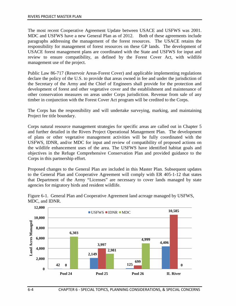
RIVERS PROJECT MASTER PLAN
6-4 CHAPTER 6 - SPECIAL TOPICS, PLANNING CONSIDERATIONS, & SPECIAL CONCERNS
The most recent Cooperative Agreement Update between USACE and USFWS was 2001. MDC and USFWS have a new General Plan as of 2012. Both of these agreements include paragraphs addressing the management of the forest resources. The USACE retains the responsibility for management of forest resources on these GP lands. The development of USACE forest management plans are coordinated with the State and USFWS for input and review to ensure compatibility, as defined by the Forest Cover Act, with wildlife management use of the project. Public Law 86-717 (Reservoir Areas-Forest Cover) and applicable implementing regulations declare the policy of the U.S. to provide that areas owned in fee and under the jurisdiction of the Secretary of the Army and the Chief of Engineers shall provide for the protection and development of forest and other vegetative cover and the establishment and maintenance of other conservation measures on areas under Corps jurisdiction. Revenue from sale of any timber in conjunction with the Forest Cover Act program will be credited to the Corps. The Corps has the responsibility and will undertake surveying, marking, and maintaining Project fee title boundary. Corps natural resource management strategies for specific areas are called out in Chapter 5 and further detailed in the Rivers Project Operational Management Plan. The development of plans or other vegetative management activities will be fully coordinated with the USFWS, IDNR, and/or MDC for input and review of compatibility of proposed actions on the wildlife enhancement uses of the area. The USFWS have identified habitat goals and objectives in the Refuge Comprehensive Conservation Plan and provided guidance to the Corps in this partnership effort. Proposed changes to the General Plan are included in this Master Plan. Subsequent updates to the General Plan and Cooperative Agreement will comply with ER 405-1-12 that states that Department of the Army “Licenses” are necessary to cover lands managed by state agencies for migratory birds and resident wildlife. Figure 6-1. General Plan and Cooperative Agreement land acreage managed by USFWS, MDC, and IDNR.
42
2,149
125
4,406
0
3,997
699
10,585
6,303
2,981
4,999
0 0
2,000
4,000
6,000
8,000
10,000
12,000
Pool 24 Pool 25 Pool 26 IL River
Lan
d A
cres
Man
aged
USFWS IDNR MDC
RIVERS PROJECT MASTER PLAN
CHAPTER 6 - SPECIAL TOPICS, PLANNING CONSIDERATIONS, & SPECIAL CONCERNS 6-5
Governmental Agency Partnerships Federal, state, and regional agencies and authorities, through enabling legislation, regulatory powers, established precedents, agency experience, or developed programs, act individually or in various partnerships to manage water and related land resources of the Rivers Project area. The governmental agencies that work closely with the Project are listed in Table 6-1. Table 6-1. Governmental Agencies Involved in Rivers Project Resource Management.
Federal Departments/Agencies U.S. Department of Defense: U.S. Army Corps of Engineers U.S. Department of Agriculture: Natural Resources Conservation Service U.S. Forest Service U.S. Department of the Interior:
Bureau of Land Management National Park Service U.S. Fish and Wildlife Service U.S. Geological Survey
U.S. Department of Transportation U.S. Environmental Protection Agency Federal Emergency Management Agency Department of Homeland Security: U.S. Coast Guard State Governments Illinois Department of Natural Resources Missouri Department of Conservation Missouri Department of Natural Resources
Regional Entities Upper Mississippi River Basin Association (UMRBA)
The UMRBA was formed by the Governors of the five states of the Upper Mississippi River Basin (Illinois, Iowa, Minnesota, Missouri, and Wisconsin), following the dissolution of the Upper Mississippi River Basin Commission, a federal-state regional planning body. The UMRBA provides a regional interstate forum for the discussion, study, and evaluation of river-related issues of common concern to the states and serves as an advocate of the states’ collective interests before Congress and the federal agencies.
Upper Mississippi River Conservation Committee (UMRCC)
This UMRCC was organized in 1943 as a result of an interagency meeting held for the general purpose of “securing recognition of wildlife and recreational use of the river, together with navigation and other public uses, in proportion to the related public benefits.” The UMRCC was sponsored by the States of Minnesota, Wisconsin, Illinois, Iowa, and Missouri with the encouragement of the USFWS and the Corps. The primary objective of the Committee is to coordinate the resource management activities of the five states bordering the Upper Mississippi River.
RIVERS PROJECT MASTER PLAN
6-6 CHAPTER 6 - SPECIAL TOPICS, PLANNING CONSIDERATIONS, & SPECIAL CONCERNS
Promote preservation & wise utilization of natural & recreational resources of the Upper Mississippi River.
Formulate policies, plans, & programs for carrying on cooperative surveys and studies.
Provide recommendations to governing State bodies in support of the objectives of the UMRCC.
Middle Mississippi River Partnership (MMRP)
The MMRP is a collaboration of 21 federal/state agencies and not-for-profit organizations that have a common goal of restoring and enhancing the natural resources of the river corridor from St. Louis, Missouri to Cairo, Illinois (195 miles), through public and private resource management, compatible economic development, private lands conservation, and education and outreach to citizens (http://www.heartlandsconservancy.org/mmrp/). A Memorandum of Understanding between the 21 federal/state agencies and not-for-profit organizations was signed in 2008.
Lower Mississippi Conservation Committee (LMRCC)
The LMRCC is “a coalition of 12 state natural resource conservation and environmental quality agencies in Arkansas, Kentucky, Louisiana, Mississippi, Missouri and Tennessee. It provides the only regional forum dedicated to conserving the natural resources of the Mississippi’s floodplain and focuses on habitat restoration, long-term conservation planning and nature-based economic development. LMRCC staff work out of the U.S. Fish and Wildlife Service’s Lower Mississippi River Fish and Wildlife Conservation Office in Vicksburg, Mississippi” (http://www.lmrcc.org/).
America’s Watershed Initiative
America’s Watershed Initiative is “a collaboration that seeks solutions for meeting the multiple demands placed on the vast and complex Mississippi watershed system by integrating issues, partners and ideas at the full watershed scale. It seeks to build and implement a vision based on collaboration and mutually beneficial outcomes in contrast to single purpose advocacy. It builds upon strong leadership present in many tributary watersheds. America's Watershed also seeks to link and augment these efforts, creating a broader partnership that can serve as a unified voice for the whole system, and support the effective resolution of issues that span multiple regions - issues such as energy, transportation, water quality and floodplain management” (http://www.greatriverspartnership.org/en-us/NorthAmerica/Mississippi/Pages/America's-Great-Watershed-Initiative.aspx).
Mississippi River Cities & Towns Initiative (MRCTI)
The MRCTI consists of mayors of the cities and towns adjacent to the Mississippi River. This effort is an effort to create an influential and coordinated voice for the Mississippi River and to demand effective river protection, restoration, and management in Washington, D.C (http://1mississippi.org/event/mn-mississippi-river-cities-and-towns-initiative-annual-meeting/).
RIVERS PROJECT MASTER PLAN
CHAPTER 6 - SPECIAL TOPICS, PLANNING CONSIDERATIONS, & SPECIAL CONCERNS 6-7
The following entities also provide coordination, planning, and guidance for portions of the Upper Mississippi Region. Mississippi River Parkway Commission (MRPC)
The membership of the MRPC includes all states of the Mississippi River main stem, plus various other agencies and interest groups. The MRPC is primarily a tourism-driven organization. Its major mission is directed toward improving opportunities for tourism growth along the Mississippi River corridor from New Orleans to St. Paul.
Alton Regional Convention & Visitors Bureau (CVB)
The Alton CVB is a destination marketing organization serving northern Madison, Jersey and Calhoun Counties. Founded in 1985, the bureau was established to educate visitors about the many attractions the region has to offer by providing information regarding the area's history, unique landmarks, recreational opportunities, leisure attractions, special events and scenic marvels. The Alton CVB is certified by the Illinois Bureau of Tourism (visitalton.com).
Great Rivers Land Trust (GRLT)
The GRLT is a local non-profit organization dedicated to preserving open spaces, scenic beauty, critical wildlife habitat, and the unique river landscape that is our special heritage. GRLT accomplishes this goal through a variety of conservation techniques including donations and acquisitions of key parcels of land.
Illinois River Coordinating Council
Governor Jim Edgar established the 12 member Illinois River Coordinating Council to coordinate the restoration and management of the Illinois River Watershed. The Council acts to reduce soil erosion and sedimentation, improve water quality and enhance wildlife habitats. The Illinois River Coordinating Council evolved from an Integrated Management Plan that was developed by the Illinois River Strategy Team. The plan consisted of 34 recommendations to improve and restore the watershed. The job of the Coordinating Council is to address those recommendations. The council is chaired by the Lt. Governor and includes seven citizen members, five state agency representatives and ex-officio representatives of six federal agencies. Members are appointed by the governor and serve two-year terms.
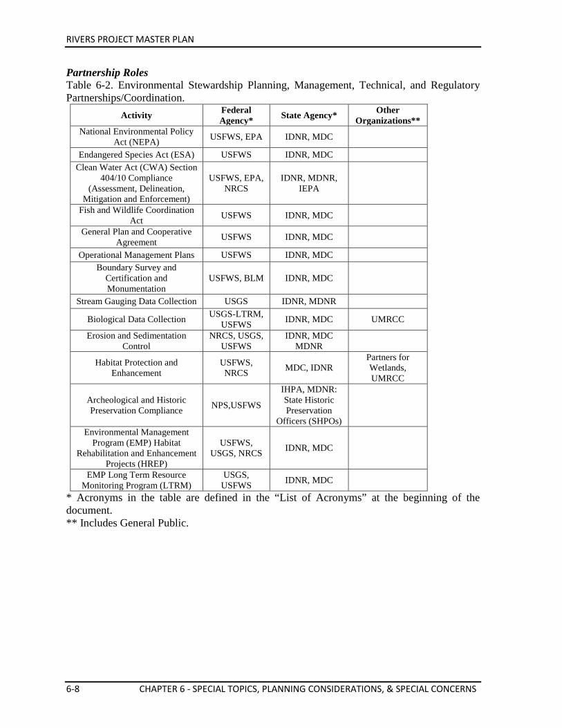
RIVERS PROJECT MASTER PLAN
6-8 CHAPTER 6 - SPECIAL TOPICS, PLANNING CONSIDERATIONS, & SPECIAL CONCERNS
Partnership Roles Table 6-2. Environmental Stewardship Planning, Management, Technical, and Regulatory Partnerships/Coordination.
Activity Federal Agency* State Agency* Other
Organizations** National Environmental Policy
Act (NEPA) USFWS, EPA IDNR, MDC
Endangered Species Act (ESA) USFWS IDNR, MDC
Clean Water Act (CWA) Section 404/10 Compliance
(Assessment, Delineation, Mitigation and Enforcement)
USFWS, EPA, NRCS
IDNR, MDNR, IEPA
Fish and Wildlife Coordination Act USFWS IDNR, MDC
General Plan and Cooperative
Agreement USFWS IDNR, MDC
Operational Management Plans USFWS IDNR, MDC
Boundary Survey and Certification and Monumentation
USFWS, BLM IDNR, MDC
Stream Gauging Data Collection USGS IDNR, MDNR
Biological Data Collection USGS-LTRM, USFWS IDNR, MDC UMRCC
Erosion and Sedimentation Control
NRCS, USGS, USFWS
IDNR, MDC MDNR
Habitat Protection and Enhancement
USFWS, NRCS MDC, IDNR
Partners for Wetlands, UMRCC
Archeological and Historic Preservation Compliance NPS,USFWS
IHPA, MDNR: State Historic Preservation
Officers (SHPOs)
Environmental Management Program (EMP) Habitat
Rehabilitation and Enhancement Projects (HREP)
USFWS, USGS, NRCS IDNR, MDC
EMP Long Term Resource Monitoring Program (LTRM)
USGS, USFWS IDNR, MDC
* Acronyms in the table are defined in the “List of Acronyms” at the beginning of the document. ** Includes General Public.
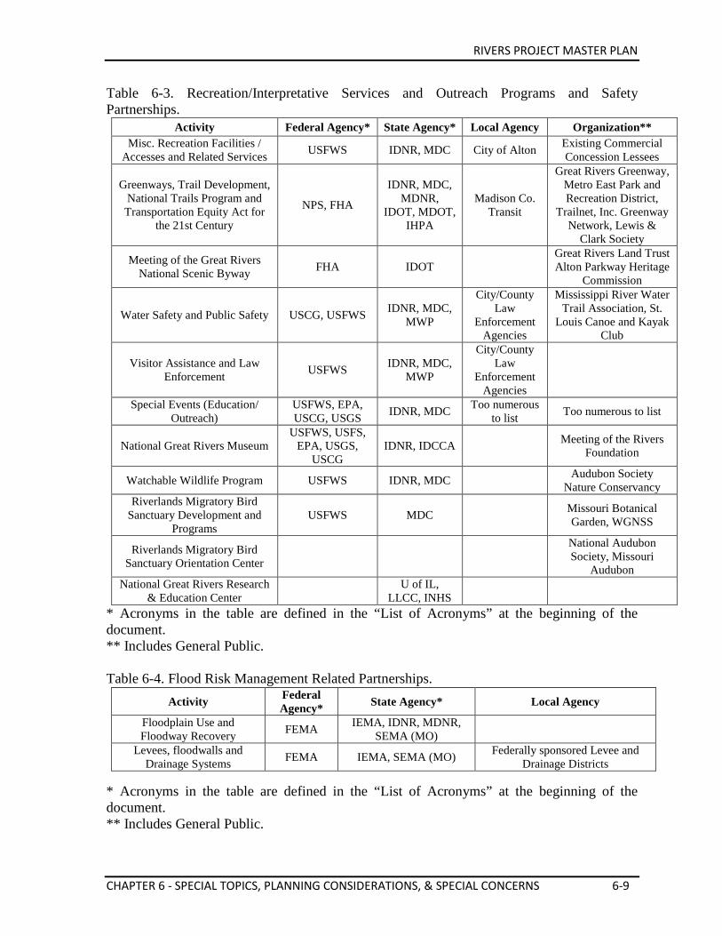
RIVERS PROJECT MASTER PLAN
CHAPTER 6 - SPECIAL TOPICS, PLANNING CONSIDERATIONS, & SPECIAL CONCERNS 6-9
Table 6-3. Recreation/Interpretative Services and Outreach Programs and Safety Partnerships.
Activity Federal Agency* State Agency* Local Agency Organization** Misc. Recreation Facilities /
Accesses and Related Services USFWS IDNR, MDC City of Alton Existing Commercial Concession Lessees
Greenways, Trail Development, National Trails Program and Transportation Equity Act for
the 21st Century
NPS, FHA
IDNR, MDC, MDNR,
IDOT, MDOT, IHPA
Madison Co. Transit
Great Rivers Greenway, Metro East Park and Recreation District,
Trailnet, Inc. Greenway Network, Lewis &
Clark Society
Meeting of the Great Rivers National Scenic Byway FHA IDOT
Great Rivers Land Trust Alton Parkway Heritage
Commission
Water Safety and Public Safety USCG, USFWS IDNR, MDC, MWP
City/County Law
Enforcement Agencies
Mississippi River Water Trail Association, St.
Louis Canoe and Kayak Club
Visitor Assistance and Law Enforcement USFWS IDNR, MDC,
MWP
City/County Law
Enforcement Agencies
Special Events (Education/ Outreach)
USFWS, EPA, USCG, USGS IDNR, MDC Too numerous
to list Too numerous to list
National Great Rivers Museum USFWS, USFS,
EPA, USGS, USCG
IDNR, IDCCA
Meeting of the Rivers Foundation
Watchable Wildlife Program USFWS IDNR, MDC
Audubon Society Nature Conservancy
Riverlands Migratory Bird Sanctuary Development and
Programs USFWS MDC
Missouri Botanical Garden, WGNSS
Riverlands Migratory Bird Sanctuary Orientation Center
National Audubon Society, Missouri
Audubon National Great Rivers Research
& Education Center U of IL, LLCC, INHS
* Acronyms in the table are defined in the “List of Acronyms” at the beginning of the document. ** Includes General Public. Table 6-4. Flood Risk Management Related Partnerships.
* Acronyms in the table are defined in the “List of Acronyms” at the beginning of the document. ** Includes General Public.
Activity Federal Agency* State Agency* Local Agency
Floodplain Use and Floodway Recovery FEMA IEMA, IDNR, MDNR,
SEMA (MO) Levees, floodwalls and
Drainage Systems FEMA IEMA, SEMA (MO) Federally sponsored Levee and Drainage Districts
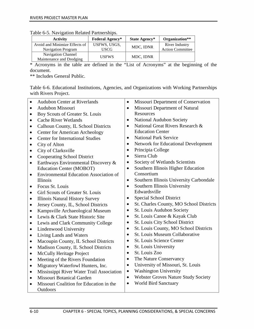
RIVERS PROJECT MASTER PLAN
6-10 CHAPTER 6 - SPECIAL TOPICS, PLANNING CONSIDERATIONS, & SPECIAL CONCERNS
Table 6-5. Navigation Related Partnerships. Activity Federal Agency* State Agency* Organization**
Avoid and Minimize Effects of Navigation Program
USFWS, USGS, USCG MDC, IDNR River Industry
Action Committee Navigation Channel
Maintenance and Dredging USFWS MDC, IDNR
* Acronyms in the table are defined in the “List of Acronyms” at the beginning of the document. ** Includes General Public. Table 6-6. Educational Institutions, Agencies, and Organizations with Working Partnerships with Rivers Project.
• Audubon Center at Riverlands • Audubon Missouri • Boy Scouts of Greater St. Louis • Cache River Wetlands • Calhoun County, IL School Districts • Center for American Archeology • Center for International Studies • City of Alton • City of Clarksville • Cooperating School District • Earthways Environmental Discovery &
Education Center (MOBOT) • Environmental Education Association of
Illinois • Focus St. Louis • Girl Scouts of Greater St. Louis • Illinois Natural History Survey • Jersey County, IL, School Districts • Kampsville Archaeological Museum • Lewis & Clark State Historic Site • Lewis and Clark Community College • Lindenwood University • Living Lands and Waters • Macoupin County, IL School Districts • Madison County, IL School Districts • McCully Heritage Project • Meeting of the Rivers Foundation • Migratory Waterfowl Hunters, Inc. • Mississippi River Water Trail Association • Missouri Botanical Garden • Missouri Coalition for Education in the
Outdoors
• Missouri Department of Conservation • Missouri Department of Natural
Resources • National Audubon Society • National Great Rivers Research &
Education Center • National Park Service • Network for Educational Development • Principia College • Sierra Club • Society of Wetlands Scientists • Southern Illinois Higher Education
Consortium • Southern Illinois University Carbondale • Southern Illinois University
Edwardsville • Special School District • St. Charles County, MO School Districts • St. Louis Audubon Society • St. Louis Canoe & Kayak Club • St. Louis City School District • St. Louis County, MO School Districts • St. Louis Museum Collaborative • St. Louis Science Center • St. Louis University • St. Louis Zoo • The Nature Conservancy • University of Missouri, St. Louis • Washington University • Webster Groves Nature Study Society • World Bird Sanctuary
RIVERS PROJECT MASTER PLAN
CHAPTER 6 - SPECIAL TOPICS, PLANNING CONSIDERATIONS, & SPECIAL CONCERNS 6-11
Partnerships/Coordination with Public and Private Schools Educational partnerships have been developed to address key issues relative to the natural resources of the Mississippi River watersheds. Rivers Project, working in collaboration with many educational institutions and other agencies and organizations, participates in the development and presentation of in-context hands-on curriculum. Interpretive programs and school curriculum have been developed by the Project staff centered around river themes to support needs identified by area educators. Through its educational facilities and public lands and waters, Rivers Project serves as a living laboratory, linking students with real life learning experiences in the fields of science and technology, to emphasize and improve math and science literacy of students in the U.S. Further descriptions of Educational Programs are contained in Chapter 2. 6.2. SPECIAL TOPICS AND PLANNING CONSIDERATIONS Navigation Interface Federal interest in navigation is established by the Commerce Clause of the Constitution, and subsequent court decisions, defining the right to regulate navigation and improvement of the navigable waterways. The navigable waters are important to the nation as a major means of commercial transportation and as a part of national defense. Navigation operations interface with other Project purposes in various ways. Manipulation of pool levels affects shoreline vegetation and recreation facilities such as marinas. An environmental pool management program (EPM) has been instituted to make pool level changes that enhance shoreline habitat when possible. Marinas located near the locks and dams may experience water level perturbations that require floating operations. Dredging to keep the main channel open for navigation can result in island creation. These islands can serve uses such as interior least tern habitat or as a location for recreational day use. Recreational boating use on the pools is significant in the summer months although recreational boat use of the Mississippi locks is minimal. Barges traveling the river require areas for temporary stops, i.e. fleeting areas. The industry is developing specially designed river buoys and land anchors for these fleeting areas. Several programs associated with navigation have been developed for environmental restoration: • The Avoid and Minimize (A&M) Program was implemented to reduce possible
environmental impacts of increased river navigation traffic due to the addition of the second lock at Melvin Price Locks and Dam;
• Section 1135 of WRDA 1986 recognizes the potential of modifying existing Corps project structures or their operations for the purposes of providing environmental benefits in the public interest;
• Section 205, WRDA 1996 is a continuing authorities program (CAP) that makes money
RIVERS PROJECT MASTER PLAN
6-12 CHAPTER 6 - SPECIAL TOPICS, PLANNING CONSIDERATIONS, & SPECIAL CONCERNS
available for environmental dredging as part of O&M for federal navigation projects; • Section 204, WRDA 1992 is another CAP that provides protection, restoration and
creation of aquatic and wetland habitats; and • The Environmental Management Program’s (EMP) Long Term Resource Monitoring
Program (LTRM) provides useful data on the environmental health of the Upper and Middle Mississippi River.
• Navigation and Ecosystem Sustainability Program (NESP) is a long-term program of navigation improvements and ecological restoration for the Upper Mississippi River System (UMRS) over a 50-year period that will be implemented in increments through integrated, adaptive management (NESP Website).
Navigational Servitude Navigational Servitude is defined by 33 CFR Ch. II, Part 329 as the “constitutional power given to the federal government to regulate navigable waters” for the purposes of improving and regulating navigation. It includes submerged lands and water flowing over them and also pertains to all lands below the ordinary high water mark of a navigable river. Servitude is a concept of power, not of property and expresses the notion that the right of the public to use a waterway supersedes any claim of private ownership.
Locks and Dams The Locks and Dams are operated by the Corps and regulated as described below. The Corps manages the projects to meet navigation needs in an environmentally responsible manner. Dams were authorized on the Mississippi River for the sole purpose of providing sufficient pool to allow navigation. This resulted in the creation of pools behind the dams and their exploitation for recreational activities. Dredging to maintain the navigation channel has resulted in the development of some islands for environmental and recreational purposes. Environmental restoration projects have been developed to mitigate for the impacts of navigation. The four navigation structures on the Mississippi River have permitted the transport of over 150 million tons of cargo annually for the benefit of commerce and regional economic development. Many agencies, organizations, and businesses participate in the development and management of the Mississippi River.
Pool Regulation The pools are regulated by means of ‘control points.’ These are points on which the pool level is tilted when the inflow increases above a certain amount. At the dam, the pool is fluctuated between regulated maximum and minimum elevations. For example, the maximum and minimum regulated pool elevations at Dam 24 are 449.0 feet and 445.5 feet NGVD, respectively. The ‘control point’ is at Louisiana (MRM 282.9), where the maximum and minimum regulated pool levels are elevations 449.5 and 448.8 feet NGVD respectively. As the inflow increases, the pool stage is lowered at the dam by gradually increasing the gate openings to maintain the level at Louisiana within the prescribed control limits until, at the dam, the pool is lowered to elevation 445.5 feet NGVD. As inflow continues to increase, the gates are opened further to pass the
RIVERS PROJECT MASTER PLAN
CHAPTER 6 - SPECIAL TOPICS, PLANNING CONSIDERATIONS, & SPECIAL CONCERNS 6-13
increased flow until the tailwater elevation equals pool elevation. When this occurs, at a flow of approximately 146,000 cubic feet per second (cfs), the gates are lifted entirely out of the water resulting in ‘open river’ conditions. After the crest has passed and the inflow decreases, the procedure is reversed; the gates are in operation again when the pool falls to elevation 445.5 feet NGVD. This elevation is held until the ‘control point’ returns to within the prescribed limits. Operating within the control point limits, ‘maximum pool’ elevation is regained when the flow is less than 75,000 cfs.
Channel Maintenance The UMRS within the St. Louis District is composed of commercially navigable portions of the Mississippi and Illinois Rivers. It is a major resource affecting both regional and national economies. In 1930, Congress authorized the Corps to maintain a nine-foot navigation channel. The channel and the locks and dams that were subsequently built to improve navigation between Saverton, IL, and Cairo, IL, have made large scale waterborne commerce possible on the river. The St. Louis District coordinates with affected agencies regarding dredging see Chapter 2 for further information on dredging operations.
Avoid & Minimize Program The term “Avoid and Minimize” (A&M) appears in the Council of Environmental Quality Guidelines for implementation of the National Environmental Policy Act of 1969. The Corps also uses the term in regulations in reference to mitigation. Mitigation includes: 1) avoiding the impact altogether by not taking a certain action or part of an action; 2) minimizing impacts by limiting the degree or magnitude of the action and its implementation; …avoiding and minimizing environmental impacts is the first level of mitigation in planning and developing Corps projects”. In the Draft Fish and Wildlife Coordination Report for the Second Lock-Melvin Price Locks and Dam, federal and state natural resource agencies recommended over seventy A&M items to be investigated. After conversations with Corps staff, a second draft of the Coordination Report was issued and the recommended items were reduced to around twenty. The Corps accepted the items and agreed to study them. In October 1992, the St. Louis District issued “Design Memorandum No. 24, Avoid and Minimize Measures, Melvin Price Locks and Dam, Upper Mississippi River - Missouri and Illinois”. The document was developed as a result of a commitment made in the 1988 Record of Decision associated with the Environmental Impact Statement for the Second Lock at Melvin Price Locks and Dam. The intent of the program was to reduce the possible environmental impacts of increased navigation traffic associated with construction of the second lock. Full-scale implementation of the program began in 1996. Direction of the program is coordinated through the River Resources Action Team (RRAT) which consists of state, federal, and private partners in both natural resources and river industry. Activities conducted under the A&M program include: • Development and monitoring of bendway weirs, chevron dikes, off bank revetment,
multiple roundpoint structures, and other innovative river training structures • Installation of barge mooring facilities • Implementation of thalweg disposal of dredge material • Monitoring of pallid sturgeon in relation to river training structures
RIVERS PROJECT MASTER PLAN
6-14 CHAPTER 6 - SPECIAL TOPICS, PLANNING CONSIDERATIONS, & SPECIAL CONCERNS
• Modification of river training structures for habitat enhancement • Restoration of side channel habitat • Creation of least tern habitat • Study of tow waiting times • Study of fish movement through a lock and dam • Study of benthic invertebrate use of river training structures • Placement and monitoring of woody debris/woody structures • Development of a “biologist on board” program • Coordination of dredging and other activities with natural resource agencies One of the efforts of this group is to preserve and enhance through structural or other modifications the 23 side channels in the Middle Mississippi River. These unique habitats are vital to the overall health of the aquatic communities of the river ecosystem. All the partners agree that minimum studies will be conducted, paper work kept to a minimum and only physical and biological monitoring of the measures will take place. Where navigation structures are to be constructed, planning, engineering, design and some physical modeling will be conducted. Both before, and after, physical and biological conditions are to be observed and monitored to test the effectiveness of the measure. The approval of the A&M DM allows the engineers and biologists to try “experiments” which may or may not work. A&M is an action program which uses common sense, field, laboratory and library research and then puts the measure on the ground. The team has the experience and by mixing the biological and engineering design arts, A&M projects make the river a more diverse ecosystem. For example, there is consensus that the river environment would be better if the tows could stay in the channel and not nose into the bank for mooring purposes when waiting to lock through. The river industry agreed that they could save fuel and locking time if they could do so. Thus, through the efforts of the A&M team, mooring buoys and bank anchor systems are being placed in the river that are acceptable from an environmental, industry, and operational efficiency viewpoint. Physical and biological monitoring of A&M measures is essential to the success of the program. For example, experimental chevron dikes have been monitored for macro-invertebrates and effects. What has been observed is that the addition of rock in a sandy point bar environment has improved the aquatic environment considerably. Dredging of the point bar has decreased, as more water is forced into the thalweg, the rock has attracted aquatic life forms, a threaded backwater environment has been created, and the chevron configuration has performed as the engineering model had predicted. Another initiative of the A&M program is to address the aquatic diversity of the remaining side channels in the Middle Mississippi River between the Missouri and Ohio Rivers. In recent years a number of dikes, multiple round point structures, hardpoints, and cherons have been constructed, as well as shoreline reventment, dike modification, biological monitoring, HSR modeling, and investigations have been conducted as per the design by the A&M partnership. Biological monitoring of the project’s effects is ongoing.
RIVERS PROJECT MASTER PLAN
CHAPTER 6 - SPECIAL TOPICS, PLANNING CONSIDERATIONS, & SPECIAL CONCERNS 6-15
Environmentally sound thalweg disposal of dredge material is yet another A&M effort. Dredging of a river crossing and placing the material in a downstream deep area is being experimented with as a feasible alternative to side casting. Prior to dredging, biological monitoring consisting of a hydro-acoustic survey and a mussel brail sweep through the deeper portion of the channel is done. From this information decisions are be made as to whether to utilize the thalweg method of dredge material placement. Another channel sweep is conducted after the dredging is complete to determine the success of the method. After a high hydrograph occurs another channel sweep is done to find out if the material moved and if anything unusual occurred. Through the cooperative partnerships and projects of the A&M program, smarter economic and ecologic management of the navigation project is being realized. Fleeting When barges are not in use for hauling commodities they are sometimes parked along the river shoreline. The temporary parking of barges along the river shoreline is known as fleeting. Fleeting areas are analogous to railroad yards where cars are temporarily stored and trains are assembled and disassembled. Fleeting occurs on private as well as public land. All fleeting that occurs is regulated by the Section 404 and Section 10 environmental laws. Project Boundary Project boundary monumentation and a clear, positive delineation of boundary lines on the ground are essential to protect the integrity and resources of the Project. Corps surveyors during Project acquisition completed the original Project boundary surveys. A compliance evaluation of the Project boundary in the late 1980s found much of the original Project boundary monumentation was unidentifiable or indefensible and a boundary resurvey was initiated in 1991. Boundary Survey
By 2009, all Project land boundaries had been resurveyed, monumented and approved by the U. S. Department of Interior, Bureau of Land Management (BLM). Through surveying, most of the original boundary had been recovered and re-monumented. All boundary lines are surveyed and monumented in accordance with BLM and Corps standards. Approximately 20% of the RPO boundary will be resurveyed and monumented every year as part of boundary maintenance, as funding allows.
Boundary Demarcation
After each segment of the re-surveyed boundary line was approved, the boundary lines were immediately delineated with posts and signs, and trespass and encroachments were recorded and resolved. Maintenance of Project boundary lines includes surveillance, and replacement and repair of monuments, posts and signs. Resolution of existing and future trespass and encroachment will continue in accordance with operational management plans and ER 405-1-12.
RIVERS PROJECT MASTER PLAN
6-16 CHAPTER 6 - SPECIAL TOPICS, PLANNING CONSIDERATIONS, & SPECIAL CONCERNS
Island Inventory In 2008, the Bureau of Land Management (BLM) utilized existing survey data including digital frame based near-infrared stereoscopic imagery and deed descriptions provided by the U.S. Army Corps of Engineers (USACE) and all other available cadastral survey data to produce an Investigative Report of the federally owned river islands on the Mississippi and Illinois Rivers under the jurisdiction of the USACE St. Louis District. The general purpose of the report is: • To determine if any new post-acquisition island fee title boundaries have
accreted to uplands above the ordinary high water mark, and to prioritize those new identified accreted upland boundaries for certified upland surveys.
• To identify any potentially questionable fee title ownership of islands that may potentially be under federal ownership after a cadastral riparian survey is completed, and to prioritize those identified questionable ownership islands for certified riparian surveys.
Island Ownership Defined
Identifying ownership of land formed by accretions, relictions or avulsions will handled on a case by case basis and will follow state laws. Law identifying ownership of newly formed lands (accretions and relictions) varies between Illinois and Missouri. Ownership in Illinois would be defined as whoever owns the adjacent land at the low water mark owns the bed of a navigable river to the thalweg and owns any accretions or relictions that occur within that bed. In Missouri, any accretions or relictions that are attached to USACE property, become property of USACE. Any accretions or relictions that occur within the bed of the river, become property of the state of Missouri. Project lands and riparian boundaries indicated on the mapping plates of this Master Plan do not necessarily represent legal surveyed boundaries, but rather show general ownership boundaries using the most accurate geospatial data available at the time. Legal Project boundary information is available at the Rivers Project Office.
Watchable Wildlife Program The Watchable Wildlife Program is a cooperative, nationwide effort to help meet a growing national interest in wildlife and the outdoors. The program provides opportunities for the public to enjoy wildlife on public and private lands; contribute to local economic development; promote learning about wildlife and habitat needs; and enhance active public support for resource conservation. The program’s main feature is an established nationwide network of quality viewing areas complemented by a companion series of state wildlife viewing guides known as the Watchable Wildlife Series. An annual conference is held and a quarterly newsletter, Nature Network, is published. Universal brown signs with a white binocular logo direct the public to viewing locations. The Corps supports and participates in the National Watchable Wildlife Program. The goals of the program fit well with the stewardship mission of the Corps. The Watchable Wildlife
RIVERS PROJECT MASTER PLAN
CHAPTER 6 - SPECIAL TOPICS, PLANNING CONSIDERATIONS, & SPECIAL CONCERNS 6-17
Program at Rivers Project encompasses a wide range of activities, facilities, and means by which the public is accommodated. Current program components consist of environmental education programming, bulletin boards, brochures, special events, viewing platforms, access points, utilization of tri-lateration stations as viewing platforms, signage, and trails. Partnerships have and will continue as a means to carry this program forward. Rivers Project currently cooperates with the USFWS, Missouri Audubon, St. Louis Audubon, Great River Audubon, Webster Groves Nature Study Society, and local organizations such as the Boy Scouts. A viewing platform, constructed by volunteers, and supplied by the USFWS is located within the Riverlands Migratory Bird Sanctuary to enhance wildlife viewing opportunities. Information kiosks and signage are also in place to enhance education and outreach. A Watchable Wildlife bulletin and exhibit series is being developed in cooperation with the USFWS and other partners for use throughout the Rivers Project area. This series serves as a learning tool on Riverlands habitat and wildlife viewing opportunities. Special events centered on the Watchable Wildlife initiative are conducted at Riverlands and includes Masters of the Sky event, focusing on the Mississippi Migration Corridor. Opportunities to participate in others special events and to create new and improved events will continue to be identified and evaluated. Special events are an effective tool to promote the Watchable Wildlife program. Future goals include establishment of other partnerships and continued use of volunteers. Through current and future collaborations better informational resources will be created, facilities expanded or added, exhibits developed, and services increased. Watchable Wildlife program functions will be expanded. Partnerships and private cooperative agreements will be the primary means by which this will be accomplished. The location of Project public lands, waters, and facilities in proximity to the St. Louis Metropolitan area and the number of high quality viewing sites for popular species result in high visitation to our areas. Resource managers acting as responsible stewards must carefully balance public demand with the carrying capacity of the resource. Current staff and facilities do not meet the needs of the visitors. In the urban setting of Pool 26 in particular, the number of visitors can overwhelm staff and facilities during peak migration periods and when unusual sightings of particular wildlife species occur. Partnerships and cooperative agreements will continue to be explored and used as a means to meet growing public demands and to utilize this program as a long term method to reduce overall operation and maintenance costs.
6.3. SPECIAL CONCERNS Access to Public Lands and Waters Access to Project lands is difficult in many areas due to the lack of a Project road system, patterns of private land ownership, remote locations, extensive levee systems and road jurisdiction and maintenance problems.
RIVERS PROJECT MASTER PLAN
6-18 CHAPTER 6 - SPECIAL TOPICS, PLANNING CONSIDERATIONS, & SPECIAL CONCERNS
Access to Rivers Project lands and waters can be grouped into four categories. A brief discussion of problems associated with each type of access and proposed solutions are listed below: Service Access
Numerous tracts of public land (excluding islands) are currently inaccessible or only seasonally accessible by land. Vehicle access by Project personnel to public lands is critical for resource management and protection activities and safety. Acquisition in fee or easement right-of-ways are necessary in several areas around the Project.
Public Access
Most roads providing access to existing Project public use areas are currently substandard in design, construction and maintenance. Public safety concerns and environmental degradation at these sites have increased as a result. There is a need to verify which governmental entities are responsible for which roads that provide primary or secondary access to public lands (federal, state, city, county or township), and to arrive at a mutually acceptable maintenance standard that insures continued public accessibility and safety.
Existing Unauthorized Accesses
Over the years, numerous unauthorized roads and vehicle accesses have been developed on public lands throughout the Project area. These illegal accesses are used by the public mainly for recreational purposes. However, destruction of real property, trash dumping and reduced public safety are some of the negative impacts of unauthorized and unregulated vehicle access on public lands. Title 36 Code of Federal Regulations prohibits unauthorized off road vehicle (ORV) operation on federal lands. Efforts to resolve these problems will likely result in closing some of the unauthorized accesses and authorizing and maintaining others for legitimate public use. Public islands, which are only accessible by boat, also need to be evaluated to determine public use patterns and needs.
Boater Access
The existing boat accesses along Rivers Project generally occupy the most suitable areas for river access. However, there are some existing access points that are becoming silted in and use is severely limited. Equitable distribution of boat accesses is an issue with many boaters. In some areas, there are many accesses available, in other areas, there are none. Many shoreline areas, including some where access facilities are needed, present severe obstacles to the development of additional accesses. Some accesses could be relocated just upstream or downstream to provide better access year round. Seasonal high-water and flooding are also factors which prohibits adequate access in some areas. Many boat ramps and parking areas are not usable during normal flood pulses. Only a limited number of private accesses are usable during these periods as well.
RIVERS PROJECT MASTER PLAN
CHAPTER 6 - SPECIAL TOPICS, PLANNING CONSIDERATIONS, & SPECIAL CONCERNS 6-19
New and improved boat access facilities need to be designed, distributed and managed to protect the natural resources and meet increasing public demand.
Rivers Project Comprehensive Public Access Plan To systematically and objectively resolve concerns associated with public access to and on Rivers Project managed public lands and waters, it is proposed to develop a Comprehensive Public Access Action Plan. This effort will require extensive public involvement and interagency and partner coordination and support. An access inventory has been complete, as an initial step to this process. Development and approval of this plan will provide a strategy to resolve public and agency access concerns and improve Project operational efficiency. This plan will be a supplement to the Rivers Project Master Plan and be reflected and further detailed in the Rivers Project Operational Management Plan for implementation. A Primitive Camping will be developed during this planning process as well.
Primitive Camping In accordance with Title 36 Rules and Regulations, camping on public lands is only permitted at sites or areas designated by the District Engineer. Designation of camping sites on Project lands can make camping safe and sanitary for visitors and minimize the impacts to the natural resources. Controlled and maintained camping areas also encourage safe and manageable use of Project lands. Currently there are NO developed camping areas on Rivers Project lands. Traditionally, visitors have used any Project lands along the Mississippi and Illinois Rivers for primitive camping sites for lack of more suitable managed areas. The majority of camping takes place on secluded areas such as islands and sandbars. To access these areas, campers boat in from public launch facilities. People often camp at or adjacent to public accesses and cottage areas, often over-crowding the area or engaging in activities inconsistent with its intended use. Historically, conflicts have arisen between compliant visitors such as cottage owners, people hunting, fishing, boating, etc., and visitors camping in non-camping areas. Primitive camping locations have been developed at Silo Access Area, Gosline Access Area, and select locations incorporated by the Mississippi River Water Trail. Some of these areas have grills/fire pits to prevent fires from being built in unauthorized areas; areas around fireplaces or grills shall be cleared in order to prevent spread of fire. These primitive sites have the following rules: maximum of one tent per boat, maximum of one night stay at camp sites, gathering of firewood on the ground is permitted, cutting firewood is PROHIBITED, all fires in containment grills only, NO ground fires, all fires should be completely extinguished prior to departure, all trash should be removed from the area upon departure. Leave no trace guidelines are to be followed for all types of waste including human waste. Coordination with other government agencies is necessary to ensure sites are managed for this use.
RIVERS PROJECT MASTER PLAN
6-20 CHAPTER 6 - SPECIAL TOPICS, PLANNING CONSIDERATIONS, & SPECIAL CONCERNS
Throughout the project area, many potential camping sites exist that will provide the visiting public with optimum camping opportunities. The identification and management of these sites will reduce user conflicts, negative impacts to the natural resources, and can provide safe camping opportunities, while providing the visiting public with a more enjoyable recreation experience. For example, where private exclusive use at cottage areas has been reduced, public lands traditionally used for cottage sites could be designated as camping areas. Many of these cottage sites currently have suitable public roads that can serve as accesses, and their locations are typically on or near the shoreline. Site locations, access, and primitive camping regulations will be addressed in a Rivers Project Public Use Access Action Plan as outlined in Section 6.3 Access to Public Lands and Waters, as well as the Shoreline Management Plan that is being developed concurrently. Public Safety Concerns Ensuring visitor safety is one of the highest priorities on Rivers Project public lands. Public lands provide opportunities for many activities ranging from boating on the river to strolling along trails in natural areas. Due to the diverse amount of activities, and the river and floodplains’ natural and constructed features, many different potential hazards exist. Recognizing and minimizing risks associated with these hazards presents a formidable challenge. Project safety plans are developed to monitor hazards and ensure public safety. Included are plans to remove the hazards if possible, to identify hazards with proper signs, to ensure that facilities are maintained, and to educate the public about potential hazards through programming, staff presence, public service announcements, and partnering. Many natural features, public facilities, and structures built and maintained by the Corps or leaseholders, require safety controls and hazard abatement. All facilities and areas are inspected on a regular schedule to ensure structural safety. However, hazards still exist. Rangers patrol public lands to assist visitors and enforce Title 36 Rules and Regulations to reduce hazards that occur from misuse. In areas of high visitation, it becomes difficult to put enough patrol rangers in the field to ensure a safe recreational environment. As an aid to ranger patrols, coordination with other federal, state, and local agencies provides an opportunity to leverage resources to ensure that these areas receive the effective and efficient patrols. To maintain public safety, cooperative law enforcement agreements have been executed to provide personnel and resources to assist visitors and aid rangers during high use times in high use zones. Currently agreements are in place with the City of Alton (IL) Police Department, City of Madison (IL) Police Department, Granite City (IL) Police Department, Jersey County (IL) Sheriff’s Department, Pike County (IL) Sheriff’s Department, and St. Charles County (MO) Sheriff’s Department. However, as usage rises or additional problems are documented, additional agreements with other counties/cities will be negotiated to assist with patrols on public lands. The river supports a large, diverse group of activities and users. Some of these activities include commercial navigation, recreational boating, hunting, fishing, wildlife viewing and sightseeing. Industrial uses occur in some of the same areas as heavy recreational use.
RIVERS PROJECT MASTER PLAN
CHAPTER 6 - SPECIAL TOPICS, PLANNING CONSIDERATIONS, & SPECIAL CONCERNS 6-21
Industrial activities include port areas, power plants, factories, treatment facilities, and a wide array of other activities. Along with the wide range of uses on the river and the potential for user conflicts that compromise safety, there are also the hazards created naturally by the river including undertows, fast currents, snags, changing water levels, and under water obstructions. With all of the activities the river provides, it is important to pay special attention to user safety and monitor it to ensure that hazards and hazardous use are kept to a minimum. Coordination with other agencies in managing the river for user safety is essential. The river falls under many jurisdictions of federal, state, and local agencies. The USCG holds primary responsibility for navigational safety on the river including channel boundaries, identifying hazards, and enforcement of maritime regulations. However, many other agencies have a responsibility to maintain a safe and healthful environment and help enforce safety rules and regulations. Traditionally, these agencies have lacked a structured approach to facilitate working together as a functioning unit that is both effective and efficient. We will continue to partner with local agencies and organizations to ensure public safety. On both public lands and waters, safety is of utmost importance. A diverse amount of activities and conditions can create hazards for Project visitors. Timely maintenance, coordination, visitor assistance, signage, and educational programming must be increased to ensure safety for the visiting public. Public Confusion about Inter-Jurisdictional Management The Corps maintains primary administrative authority over all fee title lands and waters acquired for construction and operation of the Mississippi River Project. The Corps has the responsibility and authority to manage the natural resources on Corps fee title lands, which includes forest, fish and wildlife, water, aesthetic and vegetative resources of the Project. The majority of lands acquired for the Nine-Foot Navigation Project are managed by the U.S. Fish & Wildlife Service (USFWS), for fish and wildlife management purposes under a General Plan and Cooperative Agreement (known as General Plan lands). Over the years there have been numerous points of confusion involving these interagency relationships, mainly as a result of subsequent legislation and policy changes within the involved agencies. Elements in the Agreement which were included for secondary economic use considerations have at times conflicted with other agency goals. Overall, antiquated language contained in the document does not convey the mutually desired outcome for river corridor management, which is shared by each partner agency. The primary purpose of areas released by the Secretary of the Army remains the navigation project. The Coordination Act permits the Corps to make “adequate provision consistent with the primary purposes of such impoundment, diversion, or control, shall be made for the use thereof...for conservation, maintenance and management of wildlife resources thereof...in accordance with general plans...for administration...by the Secretary of the Interior...in such manner as he may deem advisable...” Navigation purpose primacy is not subject to negotiation between the agencies. However, there are within the Agreement many elements that are discretionary under the law.
RIVERS PROJECT MASTER PLAN
6-22 CHAPTER 6 - SPECIAL TOPICS, PLANNING CONSIDERATIONS, & SPECIAL CONCERNS
Aside from updating interagency agreements to better reflect current conditions, and management to address confusion among federal and state managing partners, there needs to be concerted inter-jurisdictional effort undertaken to better inform the public. Increased public information programming, informational brochures, site bulletins, and special events are various venues for conveying an accurate message concerning the overlapping and separate roles each agency plays in the management of public lands and waters that make up the Nine-Foot Navigation Project. Increased attention to proper identification of Project boundary lines through adequate well maintained signage, well maintained directional signage at public access points, and well maintained bulletin boards with information addressing rules and policies governing public usage are each important and needs attention. Increasing the regularity of public forums beyond those designed to generate public comment during planning efforts would also be useful. Private Exclusive Use Engineering Pamphlet 1130-2-540 defines Private Exclusive Use as the use or occupancy of individually owned permanent structures for human habitation sited on public land and water areas at Corps civil works projects. Any action at a Corps project that precludes use of the land and waters by the general public is considered to be “private exclusive”. Lesser forms of private use, such as individual houseboats, private boat docks and piers, fencing, signing, landscaping, etc., are excluded from this definition, since they are the subject of concern under the Corps’ shoreline management program. Water and land areas at Corps projects are maintained for the benefit of the general public. After completion of the locks and dams in the late 30s, many cabin subdivisions were legally established on Corps lands along the rivers. Section 4 of the Flood Control Act of 1944, (later amended by PL 99-662, 17 November 1986) authorized the Secretary of the Army to grant leases of lands at water resources development projects for such periods, and upon such terms, and for such purposes as he may deem reasonable in the public interest. As a result of this the Government advertised certain sites along the Mississippi and Illinois Rivers to be developed as recreational cottage sites in the early 1950s. Within the St. Louis District, nearly 800 such leases were advertised and executed, the major intent of which was to provide recreational cottages only, not permanent residences. In 1965, the St. Louis District ceased granting any new cottage site leases on Project lands in the navigation pools to be consistent with Corps policy of discouraging the public from constructing habitable structures in the floodplain. To provide a reasonable phase-out period with minimum inconvenience to current lease holders, the Chief of Engineers established the policy that, when existing cottage and residential site leases expired, they would be extended to 30 November 1988, provided the land was not needed for priority use and the lessee continued to comply with the terms and conditions of the lease. Subsequently, Public Law 97-140 established a moratorium until 31 December 1989 on enforced removal of certain existing private exclusive use type structures, which had been previously authorized or permitted on Project areas under the jurisdiction of the Corps. Ultimately, Public Law 99-662 instructed the Corps to continue in effect any lease or assignment thereof until such time as such lease was either terminated by the leaseholder, terminated by the Corps for substantial
RIVERS PROJECT MASTER PLAN
CHAPTER 6 - SPECIAL TOPICS, PLANNING CONSIDERATIONS, & SPECIAL CONCERNS 6-23
lease violations, or the property covered by the lease was determined needed for immediate use for public park purposes or other higher public use or for navigation or flood control. In 1988, there were 764 privately owned recreational cottages on leased fee-owned lands on pools 24, 25, and 26. The Corps’ Regional Plan, consistent with Corps policy and the Master Plan established a prohibition on future private exclusive use and a programmatic effort to phase out such use began. As of January 2014, 255 cottage leases remain. Of the original 23 subdivisions, only 12 remain with 5 or more active leases. Two subdivisions have been completely eliminated (Foley and Upper Piasa) as recreational cottage leases no longer exists at these areas. The Regional Plan for the Upper Mississippi and Illinois Rivers Project lands and waters administered by the St. Louis District was revised to comply with requirements of Section 1134 of PL 99-662. The Regional plan was developed to determine whether private exclusive use would be prohibited in the UMR region and to formulate a program to phase out private exclusive use structures on Project lands. The revised Regional Plan was approved 1 December 1988 by the Mississippi River Valley Division. The plan prohibits private exclusive use on navigational pools 24, 25, and 26 because the Project resources are required for the benefit of the general public. This plan is in consonance with prohibiting private exclusive use on other navigational pools on the Upper Mississippi River administered by the Rock Island and St. Paul Districts. Following the Flood of 1993, 220 cottages were abandoned, destroyed, and/or revoked for non-compliance. Table 6-7 displays the current breakout of recreational cottages and subdivisions per county. Following lease termination, acreage previously leased is re-zoned vegetative management and will remain as such to reduce impacts to potentially sensitive areas. However, recognizing that most of the subdivisions enjoy adequate public road access and given their river front location some vacated lots will be assessed for their potential to serve as public access points to the river in accordance with Project authorities. In all instances, thoughtful consideration will be given to selection of sites to be utilized as vegetative areas or recreation areas insuring that minimal impact to lands and to operational expenditures is accomplished. Present policy stresses procedures for management of these private developments based on regional, project or site specific considerations in accordance with federal, state and local laws. These established procedures are applicable to all new, expanded or existing developments. A Mississippi Valley Division regional plan pertaining to private exclusive use is in effect for public lands and waters in the St. Louis District. In the future it will be the continued policy to phase out private exclusive use on public lands. Efforts will be made to include cabin leases in new initiatives that discourage floodplain development and encourage those individuals to utilize private lands outside of the floodplain. This continued momentum to phase out private exclusive use will inevitably lead to the reduction of these privately held cabin structures on public land that dot the banks of the Mississippi and Illinois Rivers.
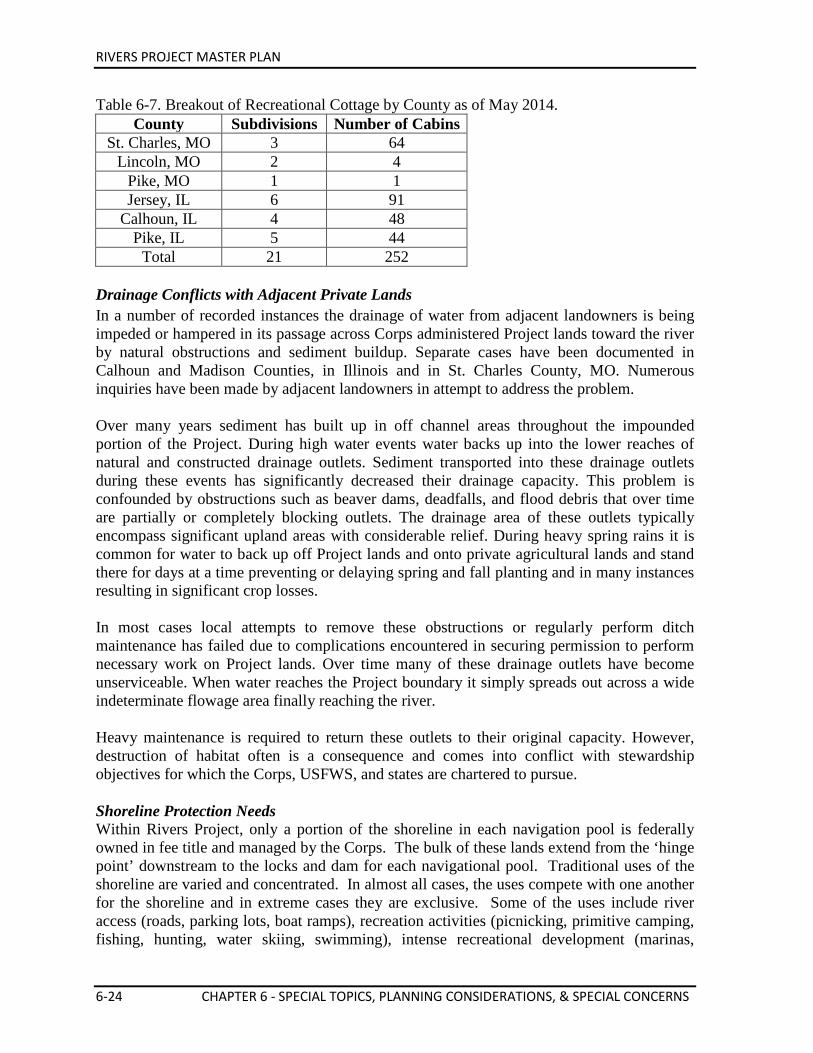
RIVERS PROJECT MASTER PLAN
6-24 CHAPTER 6 - SPECIAL TOPICS, PLANNING CONSIDERATIONS, & SPECIAL CONCERNS
Table 6-7. Breakout of Recreational Cottage by County as of May 2014. County Subdivisions Number of Cabins
St. Charles, MO 3 64 Lincoln, MO 2 4
Pike, MO 1 1 Jersey, IL 6 91
Calhoun, IL 4 48 Pike, IL 5 44
Total 21 252 Drainage Conflicts with Adjacent Private Lands In a number of recorded instances the drainage of water from adjacent landowners is being impeded or hampered in its passage across Corps administered Project lands toward the river by natural obstructions and sediment buildup. Separate cases have been documented in Calhoun and Madison Counties, in Illinois and in St. Charles County, MO. Numerous inquiries have been made by adjacent landowners in attempt to address the problem. Over many years sediment has built up in off channel areas throughout the impounded portion of the Project. During high water events water backs up into the lower reaches of natural and constructed drainage outlets. Sediment transported into these drainage outlets during these events has significantly decreased their drainage capacity. This problem is confounded by obstructions such as beaver dams, deadfalls, and flood debris that over time are partially or completely blocking outlets. The drainage area of these outlets typically encompass significant upland areas with considerable relief. During heavy spring rains it is common for water to back up off Project lands and onto private agricultural lands and stand there for days at a time preventing or delaying spring and fall planting and in many instances resulting in significant crop losses. In most cases local attempts to remove these obstructions or regularly perform ditch maintenance has failed due to complications encountered in securing permission to perform necessary work on Project lands. Over time many of these drainage outlets have become unserviceable. When water reaches the Project boundary it simply spreads out across a wide indeterminate flowage area finally reaching the river. Heavy maintenance is required to return these outlets to their original capacity. However, destruction of habitat often is a consequence and comes into conflict with stewardship objectives for which the Corps, USFWS, and states are chartered to pursue. Shoreline Protection Needs Within Rivers Project, only a portion of the shoreline in each navigation pool is federally owned in fee title and managed by the Corps. The bulk of these lands extend from the ‘hinge point’ downstream to the locks and dam for each navigational pool. Traditional uses of the shoreline are varied and concentrated. In almost all cases, the uses compete with one another for the shoreline and in extreme cases they are exclusive. Some of the uses include river access (roads, parking lots, boat ramps), recreation activities (picnicking, primitive camping, fishing, hunting, water skiing, swimming), intense recreational development (marinas,
RIVERS PROJECT MASTER PLAN
CHAPTER 6 - SPECIAL TOPICS, PLANNING CONSIDERATIONS, & SPECIAL CONCERNS 6-25
campgrounds, parks, lodges, casinos), aesthetics (Great River Road, sightseeing, eagle viewing) industrial development (docking, loading facilities), navigation support facilities (fleeting, waiting, dry dock), and wildlife (refuges, nesting areas). Placement of waterfowl blinds along public shorelines for recreational purposes is regulated. Each state administers a lottery system for allocation of these blinds. Numerous private docks also exist that were permitted in the past on a case-by-case basis. A Shoreline Management Plan has been developed for the Project. Regional Habitat Losses Before Euro-American settlement, many portions of the floodplain along the Upper Mississippi River (UMR) were comprised of vast marsh, prairie and forested wetlands (Finiels, 1797). The presettlement bottomland forests were diverse in age structure and high in species richness because the Mississippi River and its tributaries meandered freely within the floodplain environment. Bottomland hardwood forests, bottomland wet prairies and other wetland habitats along the Upper Mississippi River have been drastically reduced in acreage during the nineteenth and twentieth centuries. Conversion to agricultural land, timber harvesting, and river modifications for flood prevention and navigation and urban development are the primary factors that have caused habitat changes. Navigation structures and flood prevention levees have altered the fluvial geomorphic dynamics of the river and floodplain system. The Middle Mississippi River
The Nine-Foot Navigation Project resulted in much more extensive flow-constriction and bank stabilization structures. This is approximately 195-miles long and is referred to as the “open river” or “middle river” because locks and dams are not used along this stretch of river to maintain the navigation channel. During the 1990s, the USGS–EMTC (Environmental Management Technical Center) (Yin, Nelson, and Lubinski, 1997) studied bottomland forest changes along the UMRS. According to the General Land Office (GLO) records analyzed for an area near Cape Girardeau, MO, the 1809 presettlement floodplain landscape was dominated by forests (71.4 percent) with open water and prairie-marsh habitats occurring in the remaining areas. In 1809, GLO surveyors recorded 19 tree taxa along the Mississippi River as witness trees. Cottonwood (Populus deltoides Marshall) and sycamore (Platanus occidental L.) were the two most dominant species of these taxa. Farther away from the river in the floodplain which today is shielded by the mainline levee, GLO surveyors recorded a total of 31 tree taxa. Of these taxa, elm (Ulmus L.), sweetgum (Liquidambar styraciflua L.), and ash (Fraxinus pennsylvanica Marshall, F. spp.) were the most dominant species. Close associates included hickories (Carya spp), white oak (Quercus alba L.), American beech (Fagus grandifolia Ehrh), and yellow poplar (Liriodendron tulipifera L.).
From 1809 to 1989, the forested landscape decreased to 18.9 percent in the Cape Girardeau area floodplain. Agricultural lands increased from non-existent in 1809, to 62 percent of the landscape in 1989.
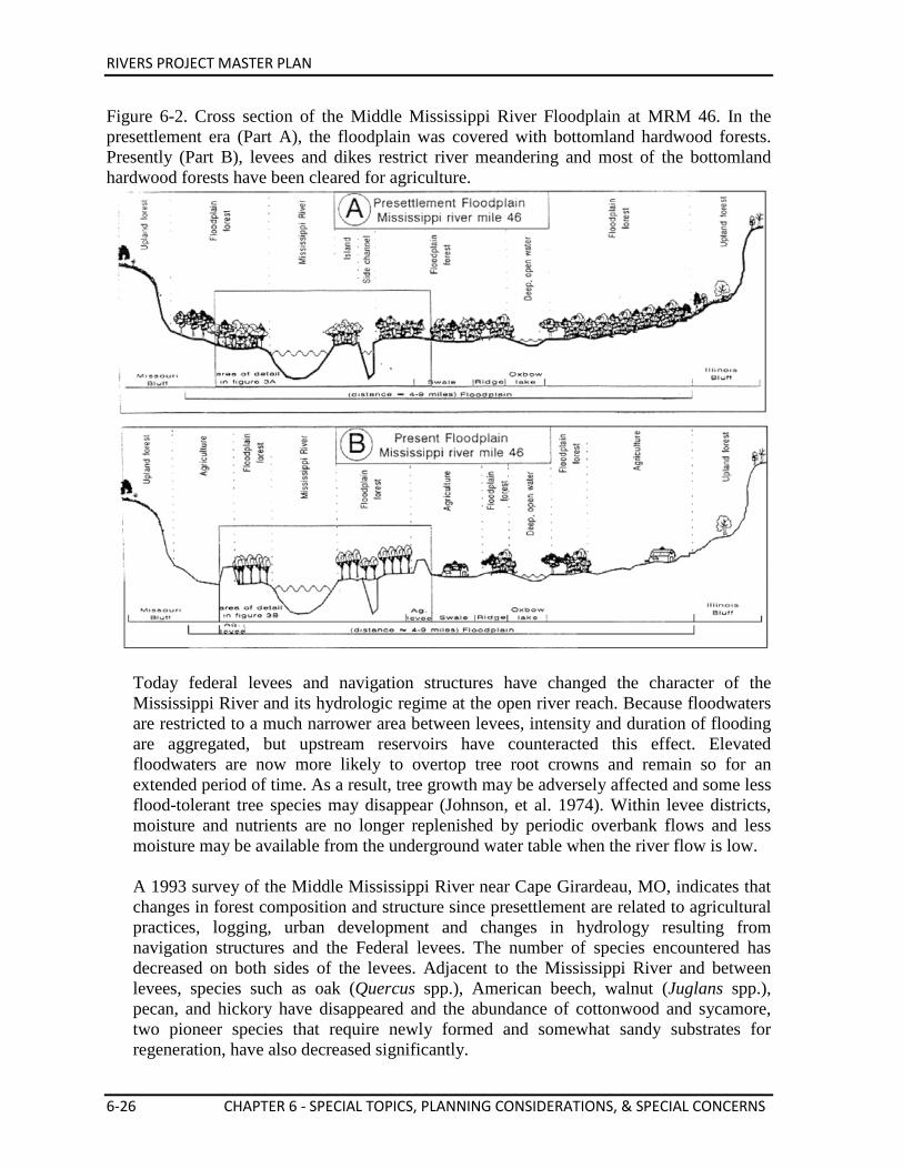
RIVERS PROJECT MASTER PLAN
6-26 CHAPTER 6 - SPECIAL TOPICS, PLANNING CONSIDERATIONS, & SPECIAL CONCERNS
Figure 6-2. Cross section of the Middle Mississippi River Floodplain at MRM 46. In the presettlement era (Part A), the floodplain was covered with bottomland hardwood forests. Presently (Part B), levees and dikes restrict river meandering and most of the bottomland hardwood forests have been cleared for agriculture.
Today federal levees and navigation structures have changed the character of the Mississippi River and its hydrologic regime at the open river reach. Because floodwaters are restricted to a much narrower area between levees, intensity and duration of flooding are aggregated, but upstream reservoirs have counteracted this effect. Elevated floodwaters are now more likely to overtop tree root crowns and remain so for an extended period of time. As a result, tree growth may be adversely affected and some less flood-tolerant tree species may disappear (Johnson, et al. 1974). Within levee districts, moisture and nutrients are no longer replenished by periodic overbank flows and less moisture may be available from the underground water table when the river flow is low. A 1993 survey of the Middle Mississippi River near Cape Girardeau, MO, indicates that changes in forest composition and structure since presettlement are related to agricultural practices, logging, urban development and changes in hydrology resulting from navigation structures and the Federal levees. The number of species encountered has decreased on both sides of the levees. Adjacent to the Mississippi River and between levees, species such as oak (Quercus spp.), American beech, walnut (Juglans spp.), pecan, and hickory have disappeared and the abundance of cottonwood and sycamore, two pioneer species that require newly formed and somewhat sandy substrates for regeneration, have also decreased significantly.
RIVERS PROJECT MASTER PLAN
CHAPTER 6 - SPECIAL TOPICS, PLANNING CONSIDERATIONS, & SPECIAL CONCERNS 6-27
Willow and silver maple have replaced cottonwoods and sycamores as the dominant species. Outside the mainline levee and within the levee districts, tree species typical of pioneer and transitional forests such as cottonwood, sycamore, elm and hackberry have decreased since presettlement. Pin oak has become the most dominate species because the floodplain has been drained for agriculture and flooding has been significantly reduced; pin oak prefers the resulting drier site conditions.
The Pooled River In 1930, Congress authorized the extension of the nine-foot channel between St. Louis, MO, and St. Paul, Minnesota. During the 1930s, a series of 27 locks and dams were constructed for this purpose. Each dam impounds water during the low river flows to maintain a minimum nine-foot deep navigation channel. In the impounded river near St. Louis, MO, prairies dominated the presettlement floodplain landscape. Forests were restricted to areas along the riverbanks, tributary systems, and isolated groves surrounded by floodplain prairies. In the early 1990s, the Illinois Natural History Survey (Nelson, Redmond and Sparks) conducted a study on historical changes in floodplain vegetation in the Calhoun Point area of Navigation Pool 26 on the Mississippi. Government Land Office (GLO) survey records were used to reconstruct the presettlement floodplain landscape at the confluence of the Illinois and Mississippi Rivers at Calhoun Point. Presettlement prairie and forest land covers were determined by digitizing GLO plat maps using a computerized geographic information system (GIS). A case history of land cover change was determined by comparing this presettlement map to GIS land cover maps for 1903, 1935, and 1975. Data from witness trees and current forest samples were used to compare presettlement and present day forest composition and structure. Results indicate that approximately 56 percent of the presettlement floodplain was forested, while 41 percent was prairie and open wetlands. The presettlement forests were generally open (86.8 stems/ha) and consisted of several dominant tree species.
GLO surveyors at the confluence of the Illinois and Mississippi Rivers in 1817 recorded 18 taxa of witness trees. These forests were dominated by hackberry, pecan (Carya illinoisensis [Wangenl] K. Koch), elm, willow (Salix spp.) and close associates including silver maple (Acer saccarinum L.), pin oak (Quercus palustris Muenchh), and ash. In contrast, the present forest is denser (489 stems/he) and is dominated by silver maples (Acer saccharinum L.). Early settlement had little effect on the spatial distribution of forest cover, but river impoundment in 1939 reduced forests to approximately 35 percent of the floodplain. Prairies were converted to agriculture during the middle 1800s and now occupy only 6 percent of the floodplain. The rivers flood regime has been altered due to human needs and development over the years. Forests species now bordering the river in impounded reaches must be well adapted to higher soil moisture content throughout the growing season. Silver maples and
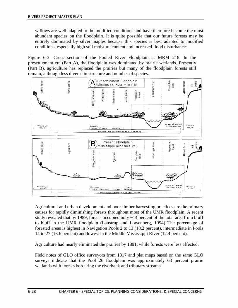
RIVERS PROJECT MASTER PLAN
6-28 CHAPTER 6 - SPECIAL TOPICS, PLANNING CONSIDERATIONS, & SPECIAL CONCERNS
willows are well adapted to the modified conditions and have therefore become the most abundant species on the floodplain. It is quite possible that our future forests may be entirely dominated by silver maples because this species is best adapted to modified conditions, especially high soil moisture content and increased flood disturbances.
Figure 6-3. Cross section of the Pooled River Floodplain at MRM 218. In the presettlement era (Part A), the floodplain was dominated by prairie wetlands. Presently (Part B), agriculture has replaced the prairies but many of the floodplain forests still remain, although less diverse in structure and number of species.
Agricultural and urban development and poor timber harvesting practices are the primary causes for rapidly diminishing forests throughout most of the UMR floodplain. A recent study revealed that by 1989, forests occupied only ~14 percent of the total area from bluff to bluff in the UMR floodplain (Laustrup and Lowenberg, 1994) The percentage of forested areas is highest in Navigation Pools 2 to 13 (18.2 percent), intermediate in Pools 14 to 27 (13.6 percent) and lowest in the Middle Mississippi River (12.4 percent). Agriculture had nearly eliminated the prairies by 1891, while forests were less affected. Field notes of GLO office surveyors from 1817 and plat maps based on the same GLO surveys indicate that the Pool 26 floodplain was approximately 63 percent prairie wetlands with forests bordering the riverbank and tributary streams.
RIVERS PROJECT MASTER PLAN
CHAPTER 6 - SPECIAL TOPICS, PLANNING CONSIDERATIONS, & SPECIAL CONCERNS 6-29
In summary, a significant loss of open native prairies, wetlands and bottomland forest cover, and less diversity within the remaining forests and in newer successional forests, are critical habitat problems on the UMRS.
Middle Mississippi River Issues The Mississippi River Nine-Foot Navigation Project is a project with a single purpose: navigation. This single purpose authorization provides no clearly defined mandate to manage the Mississippi River as a system and to address all of the resources and uses of the river. This limited authority is further restrictive on the Middle Mississippi River because the Corps does not own or operate fee title lands as it does on the pooled portion of the river. As the Corps pursues its channel maintenance activities on the Middle Mississippi River, opportunities to benefit wildlife or the vegetative community are often noted and, in some cases, habitat improvements are realized through innovative engineering techniques used to improve and maintain the navigation channel. However, with limited authority, many opportunities are generally not pursued except as required by the NEPA, FWCA and ESA. Habitat degradation concerns
The overall biological health of the Middle Mississippi River is a concern. The main channel, main channel border, side channel and terrestrial riparian corridor habitat types are is varying degrees of distress. Rehabilitation and protection efforts are needed in many locations. At least three endangered species, one threatened species and two candidate species are known to be present in the open river area. The degradation and loss of side channels habitat is of particular concern within the open Mississippi River. These habitats not only supply important nursery and over-wintering areas, they are an extremely important carbon energy generator for the entire river system. Due to the aquatic habitat losses, it is important to conserve and rehabilitate existing side channels in a manner that is compatible with, or complementary to channel improvement and maintenance activities. Since the late 1960s, an interagency team composed of Corps, USFWS, IDNR and MDC personnel have worked together to develop consensus on dredging activities and placement of river regulating works for navigation purposes. The scope of the team was generally confined to input on basic navigation channel O&M activities. Since the early 1990s, the scope of this team, now known as the River Resources Action Team, has expanded. A system-wide view of navigation and environmental concerns are now addressed with emphasis on non-traditional, innovative and environmentally sustainable methods for managing the river for navigation. This team identifies and, through the use of navigation O&M practices, various cost sharing authorities and partnering strategies, attempts to catalyze into action opportunities to protect, restore and enhance environmental conditions on the river in a manner that is harmonious with navigation purposes.
Side Channel Inventory and Restoration Priority Ratings Through field investigations and evaluations, the restoration potential of the existing major side channels are grouped by priority: High, Medium, Low, Further Investigation,
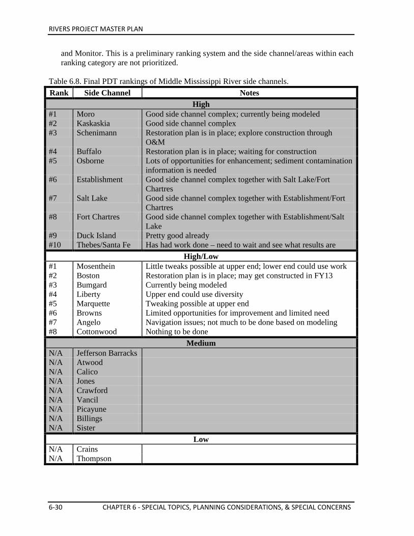
RIVERS PROJECT MASTER PLAN
6-30 CHAPTER 6 - SPECIAL TOPICS, PLANNING CONSIDERATIONS, & SPECIAL CONCERNS
and Monitor. This is a preliminary ranking system and the side channel/areas within each ranking category are not prioritized.
Table 6.8. Final PDT rankings of Middle Mississippi River side channels. Rank Side Channel Notes
High #1 Moro Good side channel complex; currently being modeled #2 Kaskaskia Good side channel complex #3 Schenimann Restoration plan is in place; explore construction through
O&M #4 Buffalo Restoration plan is in place; waiting for construction #5 Osborne Lots of opportunities for enhancement; sediment contamination
information is needed #6 Establishment Good side channel complex together with Salt Lake/Fort
Chartres #7 Salt Lake Good side channel complex together with Establishment/Fort
Chartres #8 Fort Chartres Good side channel complex together with Establishment/Salt
Lake #9 Duck Island Pretty good already #10 Thebes/Santa Fe Has had work done – need to wait and see what results are
High/Low #1 Mosenthein Little tweaks possible at upper end; lower end could use work #2 Boston Restoration plan is in place; may get constructed in FY13 #3 Bumgard Currently being modeled #4 Liberty Upper end could use diversity #5 Marquette Tweaking possible at upper end #6 Browns Limited opportunities for improvement and limited need #7 Angelo Navigation issues; not much to be done based on modeling #8 Cottonwood Nothing to be done
Medium N/A Jefferson Barracks N/A Atwood N/A Calico N/A Jones N/A Crawford N/A Vancil N/A Picayune N/A Billings N/A Sister
Low N/A Crains N/A Thompson
RIVERS PROJECT MASTER PLAN
CHAPTER 6 - SPECIAL TOPICS, PLANNING CONSIDERATIONS, & SPECIAL CONCERNS 6-31
Realizing implementation of the habitat restoration needs on the Middle Mississippi River will most likely require use of numerous authorities, approvals, funding mechanisms and partners over a number of years. It is unlikely that all features within a side channel will be built using just one authority. It is also probable that not every action will be completed within a side channel prior to moving on to other side channels. In essence, the requirements for any given side channel may be funded using different authorities for each feature and may be staged over several years. It is also possible that individual features within a side channel plan would be built solely under the authority of our partner agencies/organizations and be totally funded by them. Therefore, any comprehensive Middle Mississippi River habitat restoration effort should be considered a series of projects with numerous implementation processes, partners and inter-jurisdictional responsibilities.
Inter-Jurisdictional Watershed and Ecosystem Planning Needs The natural resources and recreational opportunities available within the Rivers Project area is fairly representative of those found throughout the Mississippi and Illinois River basin systems. These watershed systems offer unique sets of values, natural beauty and biological productivity which is worthy of conservation, management and interpretation. The diversity and extent of the land and water areas provide a valuable resource for fish and wildlife habitat, recreation, and scenery. The social and economic benefits of the rivers for humans are of extreme importance as well. The federally owned lands and waters managed by the Corps and other agency partners provide the nearest river oriented recreation areas for people in the St. Louis Metropolitan area and many other regional communities. The wetlands associated with the rivers are the most extensive in the region and are critical for the survival of hundreds of species of fish, wildlife and waterfowl. These areas must be protected wherever possible from development that would detract from their existing and potential values. This is the challenge faced by the numerous management and regulatory agencies, the scientific communities and the many concerned private organizations and individuals throughout the region. Today there still lacks a sound mechanism on the river that ensures the many concerned entities work together and coordinate activities for the general welfare of the public and the natural resource. Plans and actions are fragmented and focused generally on specific segments of the river watersheds, not on the entire basin. For example, this Master Plan can only address the river areas and issues within the jurisdictional boundaries of the St. Louis District from primarily an operations and maintenance viewpoint, on lands for which the Corps has administrative responsibility for management. Past basin-wide efforts have still not solidified primarily due to institutional and economic barriers that inhibit total support and achievement of watershed level objectives and goals. While attempts at watershed planning have achieved only limited successes to date, this effort should not be abandoned, but should be accelerated. Scientific and economic knowledge and technology today further reinforce the need to manage our rivers on the
RIVERS PROJECT MASTER PLAN
6-32 CHAPTER 6 - SPECIAL TOPICS, PLANNING CONSIDERATIONS, & SPECIAL CONCERNS
watershed level utilizing ecosystem management principles and sustainable development practices. It is not controversial to say that there needs to be biologically and economically viable rivers in the next century. The need is well understood, so how to do it is still being defined and established. Only through development of some kind of comprehensive regional watershed or basin plan that is acceptable and implementable can we truly sustain the health of our large river watersheds. Watershed Planning Strategy
Because of the size of the river’s watershed and the complexity and number of environmental, social and economic issues that would be addressed in a comprehensive management plan, it is logical to group issues into major categories. For the Upper Mississippi River (UMR) basin, the most appropriate categories may correspond to the physical characteristics of the basin and the nature of the issues. Discussion of the issues and management strategies may be facilitated more efficiently if the issues were organized as follows:
• River Channel Issues • Riparian Zone Issues • Watershed Issues • Institutional Issues
River Channel Issues
The main river channel issues are those that are related to the condition and management of the main river channel of the UMR. The major factor in the management of the main river channel is of course the requirements for navigation and its environmental impacts. Therefore the important issues may include the following:
• River regulation for navigation • Navigation impacts (Commercial and Recreational) • Sedimentation and dredging • Water quality • Accidental spills of hazardous materials
Riparian Zone Issues
The riparian issues are those that deal primarily with the backwater and floodplain habitats of the UMR valley. Because of the size of the UMR valley and the importance of the aquatic and terrestrial habitats there are a number of issues that are especially relevant. These issues include the following:
• Backwater lakes and side channels • Vegetative cover • Flood pulse and floodplain management • Levees • Wetlands • Stream bank and bluff erosion • Sedimentation • Water quality • Sediment quality
RIVERS PROJECT MASTER PLAN
CHAPTER 6 - SPECIAL TOPICS, PLANNING CONSIDERATIONS, & SPECIAL CONCERNS 6-33
• Recreation • Public Lands • Wildlife Usage • Refuges
Watershed Issues
Issues that are more pertinent with respect to the large watershed outside of the river channel and the valley would be addressed under watershed issues. These issues may include:
• Floodplain Development • Agriculture • Urban development • Watershed erosion types and sources • Point and Non-point source pollution • River corridor management • Inter-jurisdictional responsibilities • Greenway development
Institutional Issues
A comprehensive management plan for the watershed has to include guidelines on how the recommendations will be implemented. Two very important issues would be how the plan proposals would be financed and which agencies or organizations will be responsible for implementation. Because of the number of issues and the size of potential projects, many federal, state, and local agencies and private organizations will have to be involved. Therefore the mechanism for coordination and cooperation of the different agencies will be one of the most important issues that has to be dealt with in a comprehensive management plan. Implementation of most of the recommendations of a comprehensive management plan for a basin the size of the UMR will require significant financial outlay, which is unlikely to be available under existing programs. Therefore, new authorizations and funding mechanisms have to be developed and proposed as well.

RIVERS PROJECT MASTER PLAN
THIS PAGE INTENTIONALLY LEFT BLANK.
RIVERS PROJECT MASTER PLAN
CHAPTER 7 - AGENCY AND PUBLIC COORDINATION 7-1
Chapter 7 Agency and Public Coordination
Public involvement and extensive coordination within the Corps and with other affected agencies and organizations is a critical feature required in the updating of this Rivers Project Master Plan. The Master Plan update process was initiated during the spring of 2012. Numerous coordination and input meetings were held with other agencies, special interest groups, and the general public to identify Project issues and concerns to guide the master plan development. 7.1. PUBLIC OPEN HOUSE SUMMARY AND COMMENT PERIODS Two public open houses were conducted during January 2013 at Alton, IL and Clarksville, MO, to solicit comments on the Rivers Project Master Plan update. Written comments on the plan were received through 28 February 2013. Key agency partner meetings were held during the winter of 2013 to make plan revisions as well. The Draft Rivers Project Master Plan update was completed in March 2014. This updated plan was posted on the Rivers Project Master Plan website for 30 days to allow the public to once again provide comments. A press release was sent out, as well as letters were sent to various partners, stakeholders, political leaders, and public members that had previously provided comments, advising them of the documents release for public review period and how to access the document. A final open house was held on April 16, 2014 at the National Great Rivers Museum in Alton, IL to update our partners, stakeholders, and the public on the progress of the effort. This open house fell within the 30 day public review period and provided an opportunity for questions, answers and feedback on the proposed operations and maintenance projects. Based on this Draft Master Plan update review and comment phase, the plan was again revised, finalized and submitted for approval to the St. Louis District Corps of Engineers Commander (District Engineer) in June 2014. A mailing list was developed and added to throughout the master planning process. Informational Master Plan letters and newsletters were prepared and sent out during each major phase of the process. The Draft and Final Master Plans were placed on the St. Louis District Internet homepage for review purposes. Federal, state and local political office holders with jurisdiction within the Rivers Project service area were kept informed and given opportunities to comment throughout the master planning process.
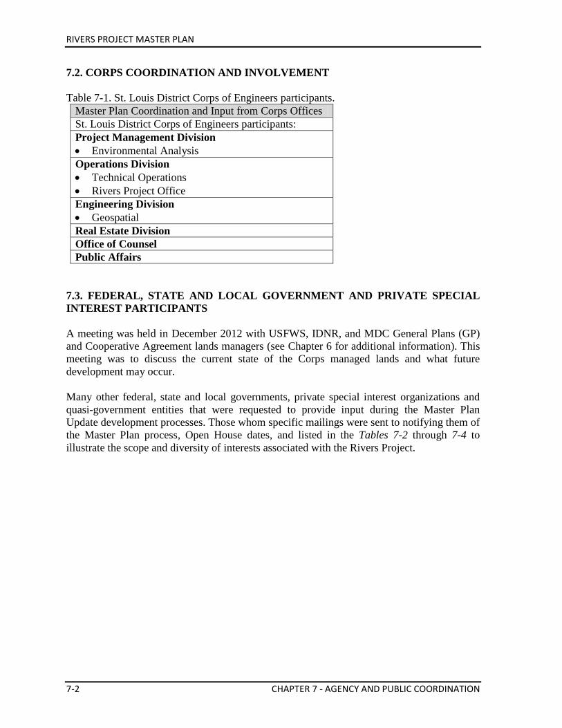
RIVERS PROJECT MASTER PLAN
7-2 CHAPTER 7 - AGENCY AND PUBLIC COORDINATION
7.2. CORPS COORDINATION AND INVOLVEMENT Table 7-1. St. Louis District Corps of Engineers participants.
Master Plan Coordination and Input from Corps Offices St. Louis District Corps of Engineers participants: Project Management Division • Environmental Analysis Operations Division • Technical Operations • Rivers Project Office Engineering Division • Geospatial Real Estate Division Office of Counsel Public Affairs
7.3. FEDERAL, STATE AND LOCAL GOVERNMENT AND PRIVATE SPECIAL INTEREST PARTICIPANTS A meeting was held in December 2012 with USFWS, IDNR, and MDC General Plans (GP) and Cooperative Agreement lands managers (see Chapter 6 for additional information). This meeting was to discuss the current state of the Corps managed lands and what future development may occur. Many other federal, state and local governments, private special interest organizations and quasi-government entities that were requested to provide input during the Master Plan Update development processes. Those whom specific mailings were sent to notifying them of the Master Plan process, Open House dates, and listed in the Tables 7-2 through 7-4 to illustrate the scope and diversity of interests associated with the Rivers Project.
RIVERS PROJECT MASTER PLAN
CHAPTER 7 - AGENCY AND PUBLIC COORDINATION 7-3
Table 7-2. Federal and State Agencies Federal State U.S. Fish and Wildlife Service – Region III • Two Rivers National Wildlife Refuge • Great Rivers National Wildlife Refuge • Middle Mississippi National Wildlife
Refuge • Ecological Services Division U.S. Environmental Protection Agency • Region V • Region VII U.S. Coast Guard – 2nd District Natural Resources Conservation Service (NRCS) • Illinois • Missouri U.S. Forest Service National Park Service
• Jefferson National Expansion Memorial
Illinois Department of Natural Resources Illinois Historic Preservation Agency Illinois Nature Preserves Commission Illinois Department of Transportation Illinois Department of Commerce and Economic Opportunity Missouri Department of Conservation Missouri Department of Natural Resources Missouri Department of Transportation
Table 7-3. Selected Municipalities
Mayor, Alton, IL Chairman, Annada, MO Mayor, Batchtown, IL Mayor, Brussels, IL Mayor, Clarksville, MO Mayor, East Alton, IL Mayor, Elsberry, MO Mayor, Evansville, IL Mayor, Fayetteville, IL Mayor, Foley, MO Mayor, Godfrey, IL Mayor, Grafton, IL Mayor, Granite City, IL
Mayor, Hardin, IL Mayor, Hartford, IL Mayor, Kampsville, IL Mayor, Louisiana, MO Mayor, Madison, IL Mayor, Meredosia, IL Mayor, New Athens, IL Mayor, New Canton, IL Mayor, Pleasant Hill, IL Mayor, St. Charles, MO Mayor, St. Louis, MO Mayor, Winfield, MO Mayor, Wood River, IL
RIVERS PROJECT MASTER PLAN
7-4 CHAPTER 7 - AGENCY AND PUBLIC COORDINATION
Table 7-4. Selected Organizations Alton Marina Alton Motor Boat Club Alton Motorboat Club, Inc Alton Regional Convention & Visitor Bureau Ameren Missouri American Canoe Association Audubon Center at Riverlands Audubon Missouri City of Alton Confluence Greenway Conoco Phillips Pipeline Company Ducks Unlimited Gateway Off Road Cyclists Great Rivers Greenway Great Rivers Land Trust Great Rivers Land Trust (Piasa Harbor) Greater Saint Charles Convention & Visitors Bureau Lewis & Clark Community College Living Lands & Waters Madison County Transit Main Street Clarksville Meeting of the Rivers Foundation Metro East Parks & Recreation
Metro East Sanitation District Middle Mississippi River Partnership Migratory Waterfowl Hunters Mississippi River Water Trail Association Missouri River Relief National Great Rivers Research & Education Center River Resource Action Committee Riverbend Growth Association Sierra Club Sny Levee District St. Charles County Parks Department St. Louis Audubon Society St. Louis Canoe & Kayak Club St. Louis Confluence Keeper St. Louis Convention & Visitors Commission Team Riverrunner The Nature Institute Trailnet Tri-City Regional Port District Two Rivers Marina Wood River Levee District
7.4. SUMMARIZATION OF PUBLIC COMMENTS RECEIVED Several written comments were collected from the public during the Open Houses in January 2013 and April 2014. Each dealt with a variety of topics such as: utilizing the Middle Mississippi River Partnership, creating a viewing platform along the Illinois River, improving Piasa Creek area recreational boating, Clarksville Riverfront and Refuge recreational improvements, expanding and updating the exhibits at the National Great Rivers Museum, and general support for the Rivers Project. All public comments received are attached as an appendix to this document. Public comments were also received throughout the Master Planning process via email. The overwhelming majority of these emails were related to the Piasa Creek area, requesting dredging of the area for better recreational boating opportunities. A few other comments were submitted in regards to: ensuring the Middle Mississippi River Partnership goals and objectives are aligned with this plan, reducing private exclusive use, and creating additional recreation opportunities in the American Bottoms (Chain of Rocks Canal area). Three letters were sent to the St. Louis District Colonel from local Alton, IL business owners, Village of Hartford, IL, and the Center for American Archeology, Kampsville Archeological
RIVERS PROJECT MASTER PLAN
CHAPTER 7 - AGENCY AND PUBLIC COORDINATION 7-5
Center. Each of these letters discussed the group’s interest, support, and expectations in service levels from the Rivers Project.

RIVERS PROJECT MASTER PLAN
THIS PAGE INTENTIONALLY LEFT BLANK.
RIVERS PROJECT MASTER PLAN
CHAPTER 8 - SUMMARY OF RECOMMENDATIONS 8-1
Chapter 8 Summary of Recommendations
8.1. GENERAL BACKGROUND Rivers Project makes important contributions to regional and national inland navigation, recreation, forest conservation, fish and wildlife habitat, environmental education, and tourism. Rivers Project natural resource management activities provide quality opportunities for education, hunting, fishing, sightseeing, boating and other activities for people throughout the Midwest. The Upper Mississippi River is recognized as a national treasure for its natural resources as well as its importance to the commerce of the nation. Providing for public use, establishing sound ecological treatment for 48,803 acres of public lands and instilling an appreciation for this national treasure is the intended outcome of this plan. This Master Plan focuses on three primary components:
• Regional and ecosystem needs • Project resource capabilities and suitability • Seeking public interest and meeting public demands
The combining of three water resource projects and Middle Mississippi River, between St. Louis, MO and Cairo, IL, into one comprehensive Master Plan has enabled the Project to function in a regional context. Many agencies, organizations and the public have been brought together to provide input to this plan. Alteration of the Master Plan may be necessary as conditions change. Updating of this plan will be scheduled when deemed necessary. 8.2. IMPLEMENTATION OF THE MASTER PLAN: OPERATIONAL MANAGEMENT PLANS Master Plans and Operational Management Plans are developed and implemented with a view to their working in tandem. The Master Plan covers all resources of the Project including, but not limited to, fish and wildlife, vegetation, cultural, aesthetic, interpretive, recreational, mineral, commercial and out-granted lands, easements and Project waters (submerged lands held in fee). The Master Plan ensures that environmental mandates and considerations are incorporated and that the economy and quality shall be given equal attention in the development of public facilities and support infrastructure. Usually, every ten years, the Master Plan is reviewed and updated and can be supplemented at any time when it becomes appropriate or necessary to do so. Based on the 2001 approved Master Plan, Rivers Project developed and implements an Operational Management Plan (OMP) to achieve the objectives stated in that Master Plan. The Master Plan serves as the planning document that establishes the authority to act and the OMP is the document that lays out the actual work, task schedules, costs and funding strategies for realization of the goals and direction set forth in the Master Plan.
RIVERS PROJECT MASTER PLAN
8-2 CHAPTER 8 - SUMMARY OF RECOMMENDATIONS
The OMP is dynamic in nature and includes funding, staffing and schedules required to implement management activities and strategies for the entire Project. Within the OMP, objectives and implementation strategies are established for each major area of emphasis: natural resource management, recreation management, flood risk management, and shoreline management. Concepts are refined into actual work items with schedules and cost estimates for completion. OMP management strategies must be consistent with authorized project purposes and approved resource use objectives and land use classifications established in this project Master Plan. The Rivers Project OMP was approved in November 2011. 8.3. RECOMMENDATIONS It is recommended that this Master Plan be approved as a guide for the use, management and enrichment of the ecological, cultural and aesthetic resources of Rivers Project, while developing new approaches for sustaining safe and healthful recreational facilities, and preserving and recognizing ecological values. This Master Plan recommends a broad range of resource objectives, and management and development concepts. Those recommendations can be summarized as follows:
• Fish and wildlife habitat enrichment • Safe public access • Cooperative planning and local participation • Monitoring and performance evaluation • Operational management strategies • Efficient management through changes to the General Plan and Cooperative Agreement
Fulfillment of fish and wildlife habitat development strategies will be possible only if ongoing programs such as EMP, Section 206 and Section 1135, and Avoid and Minimize and other environmental improvement authorities are supported. Recreation surveys and an access study will partner/public will guide development and management of recreation facilities in accordance with Corps guidelines and partner support. Continue cooperative planning and participation with other organizations and agencies in land use planning efforts. Conducting additional studies to monitor and evaluate project resources, management activities, and project objectives will insure the best identification, evaluation, analysis, and management of project resources. In particular the following studies or reports are recommended: • Public Access and Primitive Camping Analysis • Historic Properties Management Plan - It is important that an ongoing monitoring and
protection program be maintained for all Project lands and work activities. • Visitor Use Surveys - Collection of visitor use data is a continuing Project responsibility,
RIVERS PROJECT MASTER PLAN
CHAPTER 8 - SUMMARY OF RECOMMENDATIONS 8-3
to assist in evaluating existing project use, determining the adequacy of existing facilities, identifying future facilities requirements, justifying funding, and estimating budgets.
• Avoid and Minimize Measures • Endangered and Sensitive Species Protection and Recovery • Regional Land Use Plan - Phase out plan for private exclusive use of public lands. 8.4. CONCLUSION The formulation of a viable plan for development and management of Rivers Project has required extensive interaction and involvement of the general public as well as federal, state, and local offices, as well as the appraisal of natural and cultural resources of the Project and examination of various environmental, economic and political considerations. This plan will guide use, development, and management of the Project in a manner optimizing public benefits within resource potentials and the authorized functions of the Project for the future.

RIVERS PROJECT MASTER PLAN
THIS PAGE INTENTIONALLY LEFT BLANK.
RIVERS PROJECT MASTER PLAN
CHAPTER 9 - BIBLIOGRAPHY 9-1
CHAPTER 9 BIBLIOGRAPHY
AECOM Technical Services, Inc. (2013). St. Louis Regional Freight Study. Prepared for
East-West Gateway Council of Governments. Retrieved from http://www.ewgateway.org/pdffiles/library/trans/freight/freightstudyFinalRpt.pdf
Angel, J. (2010). Official 1981-2010 Climate Normals: Alton Melvin Price. Illinois State
Water Survey. Retrieved from http://www.isws.illinois.edu/atmos/statecli/newnormals/normals.USC00110137.txt
Cahokia Mounds State Historic Site. (2008). Retrieved from
http://www.cahokiamounds.org/learn/ Curtis, J.T., & Greene, H.C. (1949). A study of relict Wisconsin prairies by the species-
presence method. Ecology 30:83-92 Demissie, M., Xia, R., Keefer, L., & Bhowmik, N. (2004). The Sediment Budget of the
Illinois River. Retrieved from https://www.ideals.illinois.edu/bitstream/handle/2142/8945/ISWSCR2004-13.pdf?sequence=2
Finiels, N. (1797). An account of Upper Louisiana. Edited by Carl J. Ekberg and William E.
Foley. Univ. of Missouri Press, Columbia, MO. 153 pp Fenneman, N.M. (1938). Physiography of eastern United States, New York, McGraw-Hill
Book Co.
Guyon, L., Deutsch, C., Lundh, J., & Urich, R. (2012). Upper Mississippi River Systemic Forest Stewardship Plan.
Hammond, E. H. (1970). Classes of land-surface form. Map (scale 1:7,500,000). In The national atlas of the United States of America, pp. 62-63. Washington, D.C.: U.S. Geological Survey
Heimann, D.C., Sprague, L.A., & Blevins, D.W. (2011). Trends in suspended-sediment loads and concentrations in the Mississippi River Basin, 1950–2009: U.S. Geological Survey Scientific Investigations Report 2011–5200, 33 p. Retrieved from http://pubs.usgs.gov/sir/2011/5200/pdf/sir2011-5200.pdf
Heitmeyer, M. E. (2007). Feasibility Investigation: Hydrogeomorphic modeling and analyses: Upper Mississippi River System Floodplain. Greenbrier Wetland Services
RIVERS PROJECT MASTER PLAN
9-2 CHAPTER 9 - BIBLIOGRAPHY
High Plains Regional Climate Center. (2013). St Charles, Missouri (237397); Period of Record Monthly Climate Summary; Period of Record: 1/1/1893 to 3/31/2013. Retrieved from http://www.hprcc.unl.edu/cgi-bin/cli_perl_lib/cliMAIN.pl?mo7397
Illinois Statewide Comprehensive Outdoor Recreation Plan. 2009-2014. Retrieved from
http://dnr.state.il.us/publications/pdf/00000755.pdf Johnson, W.C., Burgess, R.L., & Keammerer, W.R. (1976). Forest overstory vegetation and
environment of the Missouri River floodplain in North Dakota. Ibid., 46:59-84. Jossi, F. (2011, June 22). Surge in Mississippi River Hydro Proposals Points to Coming
Boom. Inside Climate News. Retrieved from http://insideclimatenews.org/news/20110622/hydroelectric-power-mississippi-river-ferc-coming-boom
Junk, W.J., Bayley, P.B., & Sparks, R.E. (1989). The flood pulse concept in river-floodplain
systems, p. 110-127. In D.P. Dodge [ed.] Proceedings of the Internaional Large River Symposium. Can. Spec. Publ. Fish. Aquat. Sci. 106.
Kammerer, J.C. (1990). Largest Rivers in the United States. US Geological Survey Fact
Sheet OFR 87-242. Retrieved from http://ga.water.usgs.gov/edu/riversofworld.html Laustrup, M. S., & Lowenberg, C. D. (1994). Development of a systematic land cover/land
use database for the Upper Mississippi River System derived from Landsat thematic mapper satellite data. National Biological Survey, Environmental Management Technical Center, Onalaska WI. 90 pp.
Lauth et. al., 2011. “Analysis of the Effects of Bendway Weir Construction on Channel Cross
Sectional Geometry” Lewis & Clark State Historic Site. (2006). Retrieved from
http://campdubois.com/html/history.html Lindsey, A.A., Petty, R.O., Sterling, D.K., & Van Asdall, W. (1961). Vegetation and
environment along the Wabash and Tippecanoe rivers. Ecol. Monogr., 31:105-156. Meade, R.H., & Moody, J.A. (2010). Causes for the decline of suspended-sediment discharge
in the Mississippi River system, 1940-2007. Hydrol. Process. 24, 35-49. Retrieved from https://webspace.utexas.edu/hudsonpf/classes/watershed-management_spring_2010/readings_2010/meade_moody_mississippi-sediment-2010.pdf
Missouri Statewide Comprehensive Outdoor Recreation Plan. 2013-2017. Retrieved from
http://www.mostateparks.com/sites/default/files/Missouri%20SCORP%202013-2017_FINAL.pdf
RIVERS PROJECT MASTER PLAN
CHAPTER 9 - BIBLIOGRAPHY 9-3
Missouri Economic Research and Information Center (MERIC). 2013. St. Louis Region Data. Retrieved from http://www.missourieconomy.org/regional/profile/?ac=2915000014
Moffat, C.R., & Ahler, S.R. (2001). Illinois River Bluffs Assessment Area: Part III:
Archaeological Resources. Retrieved from http://dnr.state.il.us/publications/pdf/00000501.pdf
Moore, A.W. (1909, April 8). Meeting of Commercial Club of East St. Louis, Illinois: The
Steamboat Era. Illinois State Historical Library Manuscripts Collection. Retrieved from http://www.museum.state.il.us/RiverWeb/landings/Ambot/Archives/fwp/THE_20STEAMBOAT_20ERA.html
Moore, D. (2012, April 5). St. Louis region’s population growth lagging that of the nation. St.
Louis Post-Dispatch. Retrieved from http://www.stltoday.com/news/local/metro/st-louis-region-s-population-growth-lagging-that-of-nation/article_5d588480-a6fb-51d9-acf7-7d821cd8337b.html
National Center for Education Statistics. (2009-2010 & 2010-2011). Retrieved from
http://nces.ed.gov/ccd/elsi/expressTables.aspx Nelson, J.C. (2001) Illinois Natural History Survey, Great Rivers Field Station, Alton,
Illinois. Outdoor Industry Association. 2012. Outdoor Recreation Economy. Retrieved from
http://outdoorindustry.org/advocacy/recreation/economy.html Parrett, C., Melcher, N. B., & James, R. W. (1993). Flood discharges in the upper Mississippi
River basin, 1993. US Geological Survey Circular 1120-A, 14 pp. Pere Marquette Lodge. 2013. Retrieved from http://www.pmlodge.net/history/ Simons, D.B., Schumm, S.A., Stevens, M.A., Chen, Y.H., & Lagasse, P.F. (1975).
Environmental inventory and assessment of navigation pools 24, 25, and 26, Upper Mississippi and Lower Illinois Rivers: a geomorphic study. Final report, Contract No. DACW39-74-C-0148 for U.S. Army Corps of Engineers, St. Louis District.
Sparks, R.E. (1995). Need for ecosystem management of large rivers and their floodplains.
Bioscience 45:168-182. St. Louis Commerce Magazine. (2012, March/April). St. Louis Regional Chamber and
Growth Association Roster & Membership Service Directory. Retrieved from http://www.stlcommercemagazine.com/archives/2012/Issue2/pageflip.html
RIVERS PROJECT MASTER PLAN
9-4 CHAPTER 9 - BIBLIOGRAPHY
St. Louis Commerce Magazine. (2011, March/April). St. Louis Regional Chamber and Growth Association Roster & Membership Service Directory. Retrieved from http://www.stlcommercemagazine.com/archives/2011/issue2/pageflip.html
St. Louis: Economy. (2009). Retrieved from http://www.city-data.com/us-cities/The-
Midwest/St-Louis-Economy.html Sternberg, R.B. (1971). Upper Mississippi River Habitat Classification Survey, Hastings,
Minnesota to Alton, Illinois. Fish Technical Section. Upper Mississippi River Conservation Committee, Rock Island, Illinois.
Thomson, Jr., J.W. (1940). Relic prairie areas in central Wisconsin. Ecological Monographs.
10(4):685-717. USACE. (2006). Sedimentation in the Upper Mississippi River Basin. Retrieved from
http://mvs-wc.mvs.usace.army.mil/arec/Documents/Geomorphology/Sedimentation_Upper_Mississippi_River_Basin.pdf
USACE Navigation Data Center. (2013). Locks by Waterway: Lock Commodities, CY 1993-
2012. Retrieved from http://www.navigationdatacenter.us/lpms/data/lock2012web.htm
USDA-NRCS. (2012). Assessment of the Effects of Conservation Practices on Cultivated
Cropland in the Upper Mississippi River Basin. Retrieved from http://www.nrcs.usda.gov/Internet/FSE_DOCUMENTS/stelprdb1042093.pdf
USDA-NRCS. (2006). Model Simulation of Soil Loss, Nutrient Loss, and Change in Soil
Organic Carbon Associated with Crop Production. Retrieved from http://www.nrcs.usda.gov/Internet/FSE_DOCUMENTS/nrcs143_013359.pdf
USGS. (2013a). Water-resources data for the United States, Water Year 2012: U.S.
Geological Survey Water-Data Report WDR-US-2012, site 05586100. Retrieved from http://wdr.water.usgs.gov/wy2012/pdfs/05586100.2012.pdf
USGS. (2013b). Water-resources data for the United States, Water Year 2012: U.S.
Geological Survey Water-Data Report WDR-US-2012, site 05587450. Retrieved from http://wdr.water.usgs.gov/wy2012/pdfs/05587450.2012.pdf
USGS. (2013c). Water-resources data for the United States, Water Year 2012: U.S.
Geological Survey Water-Data Report WDR-US-2012, site 07022000. Retrieved from http://wdr.water.usgs.gov/wy2012/pdfs/07022000.2012.pdf
USGS. (2013d). About the Upper Mississippi River System. Retrieved from
http://www.umesc.usgs.gov/umesc_about/about_umrs.html
RIVERS PROJECT MASTER PLAN
CHAPTER 9 - BIBLIOGRAPHY 9-5
Upper Mississippi River Basin Association. (2006). Upper Mississippi River Spill Response Plan and Resource Manual. Retrieved from http://www.umrba.org/hazspills.htm
Upper Mississippi River Basin Commission. (1982). Comprehensive Master Plan for the
Management of the Upper Mississippi River System. Retrieved from http://www.umrba.org/masterplan/comprehensive-master-plan-umrs1982.pdf
Value to the Nation. 2010. Fast Facts. Retrieved from
http://www.corpsresults.us/recreation/recfastfacts.cfm Wahl, K. L., Vining, K. C. and Wiche, G. J. (1993). Precipitation in the upper Mississippi
River basin, January 1 through July 31, 1993. U.S. Geological Survey Circular 1120-B, 13 pp.
Wistendahl, W.A. (1958). The floodplain of the Raritan River, New Jersey. Ecol. Monogr.,
28: 129-153. Yetter, A.P., M.M. Horath, H.M. Hagy, R.V. Smith, C.S. Hine, and J.D. Stafford. (2012).
Illinois Waterfowl Surveys and Investigations Annual Report for W-43-R-59. INHS Technical Report 2012 (26).
Yin, Y., Nelson, J. C., and Lubinski, K. S. (1997). Bottomland hardwood forests along the
Upper Mississippi River. Natural Areas Journal, v. 17, no. 2, p. 164-173.

RIVERS PROJECT MASTER PLAN
THIS PAGE INTENTIONALLY LEFT BLANK.
RIVERS PROJECT MASTER PLAN
APPENDIX - PUBLIC COMMENTS A-1
Public Comments Received for Rivers Project Master Planning Utilize the Middle Mississippi Partnership as a partner to assist in projects either through education, technical expertise, or planning capabilities. The Corps has resources in conservation education. This capability should be used in the Middle Mississippi. Forest Service interpretation can be leveraged with Corps Con Ed to provide a better product being delivered to the public. Kameron Sam, US Forest Service _____________________________________________________________________ IL River Mile 26 along Highway 100 viewing platform to observe birds. Directly upstream from river access on IL River at Diamond Island. Anonymous _____________________________________________________________________ Recreation corridors are a growing public demand. Glad you are addressing access to the river and its environs. Will the current website at the existing master plan be updated to include these boards and allow for additional comments? Thanks Carey Bundy, Great Rivers Greenway _____________________________________________________________________ Would like to build crappie beds in and around the Piasa Creek area. Concerned as to Piasa Creek/River access due to persistent silting at s/ near mouth of Piasa Creek. Thanks for your time tonight. Mike _____________________________________________________________________ Very Informative Jerry Berning _____________________________________________________________________
First, thanks for coming to Clarksville! We feel the river is a wonderful resources and have invited everyone to “touch the Mississippi” at Clarksville. We are always grateful for any effort on our behalf. Erin Garrison, Clarksville Riverfront Park Chairman _____________________________________________________________________
More trash cans at the areas of Clarksville Riverfront. Open up a parking lot near the access located by the old bridge, which is new now
so individuals may fish. Please mail me a map that has the new projects or at least a list of the new projects
on it. Father who is 93 owns a home along the Calumet
Debra Shohe _____________________________________________________________________
As a long time resident of the area, first I want to thank you the USACE for all they have done.
As comments go - I would like to see a few improvements at the Calumet Creek Trails. You all are so close to finishing up details and would like to see that done.
We get inquiries of trails and such close by - at Clarksville Refuge you all need to get together with MDC and put a BOARDWALK MADE OF CYPRESS from the silo park area to the south end of the refuge where the deeper water is. (This is a long time wish).
RIVERS PROJECT MASTER PLAN
A-2 APPENDIX - PUBLIC COMMENTS
When you all did the chamber & overlook remodel - anyway at some point there was a chain link around the overlook area - 9/11 threat - do you think we could now take the chain link off - I think we are ok
The park in Clarksville is looking great where the new rip rap is - and I think it would be a great idea to put a walk that ties in with ours and yours that is already in the park north to the L&D so it would tie the whole riverfront area together - which by putting a walk along the top of the rip rap to the dam would probably save you money in the long run.
Next in the future would like to see more steps like on the south end of the park The ultimate thing would to have USACE take on actual role in the V.C. at
Clarksville. That’s what we talk about in the L&D & barges & river levels & all things corps related to most visitors & eagles which of course are here because of the L&D. Margie Greenwell, Clarksville (Pike County Tourism Commission) ______________________________________________________________________
Add fish attractors inside Harbor. Find out cost of opening a 30’ wide strip (in river) (1) to Alton Lake. Start a fund to finance same. When Alton Lake to Piasa Harbor had plenty of depth there was not enough space in parking lot for trucks & boat trailors. Were as parking spilled out onto edge of highway. Boaters preferred Piasa Boat Ramp because you didn’t launch your boat into current as in Grafton.
(1) Depth of 8 feet Idea - Possible to talk to sand company by mill and see if they could start taking sand
from that area. Anonymous
______________________________________________________________________ In regards to Section 3.4, I would like to see the St. Louis District Corps continue to
get rid of private leases that consume large tracts of public land. For example, the derelict cabins and industrial leases along the Rivers. How many acres are consumed by outgrants that the public cannot access? With little public open space currently available along the scenic Mississippi and Illinois Rivers, these lands do not need to be tied up by private individuals and corporations.
The Master Plan states there is a 1988 policy about ‘private exclusive use’. Does this 25 year old policy still exist? Also, you say in your Master Plan that you discourage habitable structures in the floodplain, but at the same time acknowledge and allow people live on Corps land. I would recommend that the Corps office that oversees these real estate issues update the 25 year old policy to include modern day issues that exist on Corps land. My tax dollars should be spent on managing the natural resources and not pushing paperwork as a real estate agent. Anonymous ________________________________________________________________________
Understand priorities, but at some point, would be good to see an effort (volunteer or otherwise) to clean up the flood plane on both sides of Piasa Creek above Mill Creek....remnanants of abandoned cabins, non-decomposing debris in the woods, etc.... Larry Brown ________________________________________________________________________
Expansion of the Museum to create a world class destination that supports the efforts of many others in this Confluence region. Anonymous _________________________________________________________________________
Our river is such a huge asset to our area that oftentimes, we take it for granted. We need to continue to educate others about the importance and magnificence of it, while encouraging them to appreciate, utilize and preserve it. The National Great Rivers Museum is a great asset to our destination area. It provides history of our region, along with a
RIVERS PROJECT MASTER PLAN
APPENDIX - PUBLIC COMMENTS A-3
learning component for all to expand their knowledge of the importance of the river and its impact on our area, as well as the country and economy. In addition, the lock and dam tours are an invaluable asset that attracts and allows visitors to go on top and view the mighty Mississippi from above and learn more about river itself. The interactive barge game is a fun and exciting way to get people interested in how the river flows, with other variables factored in that they may not normally consider (e.g. wind, etc). I do wish there were more exhibits for visitors to see, as that would continue to elevate its status as a world class destination. The more exhibits there are for people to enjoy, the more people will be talking about the NGRM and gaining enthusiasm among other groups to visit it. The bike trail right along the NGRM is awesome also!! One of my favorite assets we have in our area is the Riverlands Migratory Bird Sanctuary area. The USACE staff has done a remarkable job to make this a welcoming habitat area for so many birds and flora. And with the recent collaboration between the USACE and the Audubon Center, the area is gaining popularity of being a world-class birdwatching area. I hope they continue to expand their educational and sightseeing opportunities there for visitors to seek them out. I am intrigued by the new designation of the Mississippi Water Trail for this area, and am hopeful it will attract more interest in the river and our local offerings as well. We live in a full and diverse environment and have so much to offer - let’s get more people to visit us! Barbara Strack _____________________________________________________________________ Sarah,
I work part-time with HeartLands Conservancy on coordination, planning, and outreach for the Middle Mississippi River Parternship (MMRP). I strongly encourage you and your planning staff to incorporate appropriate goals and objectives from the Middle Mississippi River Partnership Regional Plan (a copy can be viewed or downloaded from the HeartLands Conservancy website under the Middle Missisippi River Partnership/MMRP Activities/MMRP Regional Plan) into your Rivers Master Plan where possible. Coordinated planning efforts involving all of the MMRP partners and the public in many River communities is incorporated in this Regional Plan. It was completed in 2009 and is still very relevant in 2013. I am sure you can find it useful in your current planning efforts. I expect Brian Johnson of your agency has directed you and your planning team to this plan. However, I believe it is important to hear this from folks outside your agency as well.
I am also currently working on the preparation of a request for the adoption of a bi-state (Illinois and Missouri) Conservation Opportunity Area (COA) for the entire MMRP boundary area for the partnership and am very familiar with the MMRP Regional plan and the MMRP in general. If you feel I can be of some assistance in your planning efforts related to the above, please contact me. Thank you for your consideration. Steve Widowski Special Projects HeartLands Conservancy ________________________________________________________________________
Our names are Edward and Lois Davis. We are members of the Alton Motorboat Club, the Alton-Wood River Sportsmen's Club, Ducks Unlimited and Migratory Waterfowl Hunters.
RIVERS PROJECT MASTER PLAN
A-4 APPENDIX - PUBLIC COMMENTS
We are concerned about the access to the Mississippi River, especially via Piasa Creek. It is almost impossible to launch our boat because of the siltage that has built up at the mouth of the creek.
We pay for hunting and fishing licenses, trailer license, boat registration and boat and trailer insurance yet we do not get to enjoy our beautiful river because of the siltage.
We would appreciate your influence in putting the dredging of Piasa Creek access at the top of your priority list as the funds have been alloted for a study by President Obame. Thank you for your consideration. Mr. and Mrs. Edward E. Davis Godfrey, IL 62035 _________________________________________________________________________ Ms Miller, I am emailing you as a boater and fisherman having concerns over the access to Piasa Creek and the siltation in the Mississippi River in the area of Piasa Creek. This situation is cutting off our access from the creek to the river. What can be done to clean up this siltation and blockage from the creek to the river and visa versa, from the river into the creek. Any assistance is very much appreciated. Mike Lawhon Alton Motor Boat Club Member ________________________________________________________________________ Sarah, My husband & I am a boat owner and have some concerns about the siltation in the Mississippi River at Piasa Creek in Jersey County. We already have limited access to the river via our public areas and with all the silt in the area, it will be extremely hard to access the river at all this Spring . Any attention you can give this you could give this issue, would be greatly appreciated. Anonymous _________________________________________________________________________ Hello, I am a boater and fisherman wanting to give my concerns regarding the siltation issues on the Mississippi River at the mouth of Piasa Creek. This issue needs to be addressed by the Corp as soon as possible. The situation is going to continue to get worse if something isn't done. We will not have access to the river for recreational purposes or to put food on our tables. We are trying to get folks to come to our area, not run them off. Regards, Karen M. Pearson Godfrey, IL 62035 _________________________________________________________________________
RIVERS PROJECT MASTER PLAN
APPENDIX - PUBLIC COMMENTS A-5
Good Morning I use the creek to gain access to the river 4 or 5 times a week during boating season for fishing in the Mississippi. I'm retired and love to catfish as often as possible. I know from past the corp builds models to study the effects of such actions and then takes it under advisement then nothing ever happens but here's hoping this time! Cordially John Brandt _________________________________________________________________________ Sarah Miller & whom also be concerned; I love to fish and have a couple different boats. I use the creek a lot. Access to the creek at low water is a growing fear that one day we would not be able to get up the creek or into the river. The shallow at the mouth of the creek could clog causing dramatic flooding up creek, it really wouldn't take much considering the amount of driftwood I witnessed flowing down the creek last year during a heavy rain. Silting at the mouth is a growing problem for boaters. Thanks for listening... Bobby Jenkins _________________________________________________________________________ being an active boater and fisherman I am very concerned about the Mississippi River access from the Piasa Creek area being cut off because of siltation, the island is moving down cutting off Piasa Creek I would appreciate anything the Army Corps of Engineers could do to insure river access. Thank you _________________________________________________________________________ Sarah, My wife & I are boat owners and have some concerns about the siltation in the Mississippi River at Piasa Creek in Jersey County. We already have limited access to the river via our public access areas and with all the silt in the area, it will be extremely hard to utilize the river at all this Spring. Any attention you could give this issue, would be greatly appreciated. Dan Cronin _________________________________________________________________________ Sarah, I am a boat owner and have some concerns about the siltation in the Mississippi River at Piasa Creek in Jersey County. We already have limited access to the river via our public access areas and with all the silt in the area, it will be extremely hard to utilize the river at all this Spring. Any attention you could give this issue, would be greatly appreciated. Linda Linda Johnson-Petterson Industry-Wide Supply _________________________________________________________________________ Good Morning Sarah, I am writing you in regards to a long standing issue that affects boaters trying to access the Mississippi River from Piasa Creek. We have battled the build-up of silt in this area while trying to make our way out on to the Mississippi for a number of years. When we are unable to get out onto the river it also has an affect on local businesses, whom we support by purchasing such things as fuel, groceries, stopping at restaurants in towns like Grafton, Hardin, Kampsville, etc. located on our beautiful scenic water ways.
RIVERS PROJECT MASTER PLAN
A-6 APPENDIX - PUBLIC COMMENTS
Please encourage the Corps of Engineers to appropriate funds to address this crucial area in Piasa Creek as well as the public access area nearby. Thank you in adavance for any assistance you may be able to provide. Jeff Davis Dow, IL _________________________________________________________________________ Hi Sarah, I feel compelled to write to you about the status of Piasa creek and the amount of silt that continues to build. If the situation worsens we will find ourselves unable to get our boat out of the creek. Please pass this along to the proper person who is taking a look at upcoming projects and ask them to take a serious look at our situation. Thanks, Tom Williams FINAL-Quest 90 _____________________________________________________________________________ I am concerned about the siltation in the Mississippi River in the area of Piasa Creek. This siltation is cutting off our access from the creek to the river. Anonymous _________________________________________________________________________ To whom it may concern, I am writing in regards to the continuing issue of silt build up in Piasa creek and the effect it will have on local boating and economy. Please review current projects being considered for the river and take a look at the issue we are facing. thanks, John Walters _________________________________________________________________________ Good morning Sarah. As a boater, I am concerned about the siltation in the Mississippi River, in the area of Piasa Creek. This siltation is cutting off our access to the river, from the creek. Please take this into consideration, when looking at future projects. Sincerely, Amy Williams _________________________________________________________________________ Dear Ms Miller, as a concerned fisherman and boater i would like to draw your attention to the silting problem at the mouth of Piasa Creek. the area outside the creek has gotten appreciably worse in recent years to the point where there are many times i am unable to make it over the power plant to fish. the area by piasa island seems to be getting more and more shallow.
RIVERS PROJECT MASTER PLAN
APPENDIX - PUBLIC COMMENTS A-7
i would like to appeal to the corps to help in addressing the river access from piasa creek. thank you mike ________________________________________________________________________ Sarah, As a long time boater, I have gradually noticed the increase of siltation at the location of Piasa Creek and the Mississippi River. The siltation continues to worsen as the years progress. There have been several weekends within the last 2-3 years where this location is impassable with my 22ft open bow ski boat while other locations have no issues (Marquette Park, Hardin, Grafton, Alton, ETC). This will require me to remove my boat from my lift and transport it to the nearest public ramp (Grafton, IL – 9 miles from Piasa Creek). Any help with this situation would be greatly appreciated by many. Thanks, Casey Stutz _________________________________________________________________________ To whom it may concern, I am a frequent boater of the Mississippi river near the Alton-Godfrey area. I gain access to the Mississippi river through the mouth of the Piasa creek. I am concerned about the land build up and low water levels of the Mississippi River in the area of Piasa Creek. This siltation is cutting off our access from the creek to the river. Please consider investing in correcting this ongoing issue in order to keep boat traffic active through this passage. Sincerely, Chad Stutz _________________________________________________________________________ As a boater , I am concerned about the siltation in the Mississippi River in the area of Piasa Creek. This siltation is cutting off our access from the creek to the river. Thanks for your help, Chris Beiser _____________________________________________________________________________ As a hunter, I am concerned about the siltation in the Mississippi River in the area of Piasa Creek. This siltation is cutting off our access from the creek to the river. Anonymous _________________________________________________________________________ Date: February 8, 2013 As a hunter, I am concerned about the siltation in the Mississippi River in the area of Piasa Creek. This siltation is cutting off our access from the creek to the river. Anonymous
RIVERS PROJECT MASTER PLAN
A-8 APPENDIX - PUBLIC COMMENTS
_________________________________________________________________________ Hello, Being a fisherman, I am concerned about the siltation in the Mississippi River in the area of Piasa Creek. This siltation is cutting off our access from the creek to the river. Is there anything the corp can do to keep the mouth of Piasa creek open? I and many of my friends would appreciate it. Thank you, Mark Manis Godfrey, IL _________________________________________________________________________ I am a boater out of pasia creek. I some times can not get out of the creek do to the silting in of mud and sand. I love the river. If there is anything you could do so we could have better excess I would be very thank full. _________________________________________________________________________ As a recreational boater, hunter, and fisherman, I am concerned about the siltation at the mouth of Piasa Creek where it joins the backwater at the Mississippi river. This has been occurring over many years and is close to closing the access to the river. There are two marinas and a State of Il leased ramp access at this location. It would be tragic if this were not available in the future. I am urging the Core look at this situation and see if anything can be done to rectify it. Thanks for your attention to this memo. Richard Boyer _________________________________________________________________________ Sarah, Our friends at Alton Motor Boat Club have asked us for our help in resolving an issue with silt build up in the Piasa Slough area! As fellow boaters and members of the IRBBA we feel it's our duty to help them with this issue. The River belongs to all of us! Our home port is Heritage Harbor in Ottawa. We are a new harbor and don't have a silt issue yet! Most of our members have been down river whether to the peoria pool or beyond we know there is a problem with silt build up! I hope just by letting you know that other clubs are aware of this issue and we care about the well being of our fellow boaters at Alton Motor Boat club that you will do everything in your power to resolve this matter! Joe Baller Commodore H2O Boat Club _________________________________________________________________________ As a boater fisherman and hunter, I am concerned about the siltation in the Mississippi River in the area of Piasa Creek. This siltation is cutting off our access from the creek to the river. I have been using this access for 40 years it is the worst I have seen in a long time. Any help would be appreciated. Thanks Kevin Gryzmala _________________________________________________________________________

RIVERS PROJECT MASTER PLAN
APPENDIX - PUBLIC COMMENTS A-9
I am a boater on the mississippi river. I berlong to the Alton Motor Boat Club. At this point we are having a big problem of getting in and out of the creek from the river. It is next to impossible at this point in time. Even at normal pool, it is still a big chance to get in and out. We would appreciate if this matter could be addressed. Thank You very much. Patrick Brogan ____________________________________________________________________________ As a family boater and duck hunter.I would like to see the sand bar be addressed at the mouth of Piasa Creek.It gets harder and harder every year to take the family out in the boat.Also it's an added danger in the dark going duck hunting early in the mornings.Thank you Steve Kelly _________________________________________________________________________ As a boater, I am concerned about the situation in the Mississippi River in the area of Piasa Creek. The situation is cutting off our access from the creek to the river. Anonymous _________________________________________________________________________As a boater, I am concerned about the situation in the Mississippi River in the area of Piasa Creek. The situation is cutting off our access from the creek to the river. Anonymous _________________________________________________________________________ As a boater, I am concerned about the situation in the Mississippi River in the area of Piasa Creek. The situation is cutting off our access from the creek to the river. Anonymous _________________________________________________________________________ Thanks Sarah for continuing to read. I have been a boater for nearly thirty years on the Mississippi river from Alton to Havana to Peoria, but primarily in the Alton pool. The concerns about the silt at Piasa creek are not new and would be greatly appreciated if this area could be dredged clear. The surrounding bussinesses in the area would benefit from the increased boating traffic and revenue created by us boaters if this area could be navigated but if boats can't get to the river, no boating could be done. Thanks much for your time Ken Hillier Average boating guy Granite City Illinois _________________________________________________________________________ As a boater, I am concerned about the situation in the Mississippi River in the area of Piasa Creek. This situation is cutting off our access from the creek to the river. _________________________________________________________________________ Sarah I am very concerned about the filling in of Piasa creek. This has been access for boaters to the mississippi for as long as I can remember. There are two marinas , two public boat ramps,and many cabins and houses on the filling in Piasa creek. boaters fisherman and hunters cant get to the river any more.
RIVERS PROJECT MASTER PLAN
A-10 APPENDIX - PUBLIC COMMENTS
Please restore our access to the great Mississippi river. sincerely JON MILLER _________________________________________________________________________ As a boater, I am concerned about the siltation in the Mississippi River in the area of Piasa Creek. This siltation is cutting off access from the creek to the river. I believe it’s the Corp. of Engineers duty to keep the waterways open, for all boats, including pleasure boats. We as tax payers, pay a great deal of money to the Federal Government every year for these services. Steven C. Jones _________________________________________________________________________ Concerned...pool 26 Piasa creek entrance and surrounding waterways are in grave danger Of closing off for pleasure boating..silt , logs, and sunken items are a major issue...Piasa harbor public ramp itself is almost unusable...these are tax dollars???? As a boater we pay the state for tags. We own a 33 ft cruiser harbored at Alton motor boat club...we need 2 ft of water under our boat...the only passage way to get out is Piasa creek...when you get to the access at river you best know the way to cross... Have seen many nice boats become beached at this point. PLEASE HELP Pool 26 is a very beautiful area PLEASE KEEP PIASA CREEK ACESS OPEN. Thank you _________________________________________________________________________ Sarah, I am an avid boater and fisherman that uses Piasa Creek to access the Mississippi River. I am concerned the active silt deposition at this access area and am hopeful this is something the Corps is interested in addressing. I know I am among many other boaters and fisherman that have strong feelings on this issue. Please let me know if there is anything citizens such as myself can do to help expedite action on this issue. Thanks, D. Tim Arnold Godfrey, IL _________________________________________________________________________Dear Sarah, As a boater, I am concerned about the siltation in the Mississippi River in the area of Piasa Creek. This siltation is cutting off our access from the creek to the river. Please help us to save Piasa Creek!! Thank you, Laura _________________________________________________________________________ As a boater I am very concerned about the condition at the mouth of Piasa Creek where it enters the Mississippi it needs to be dredged to allow entrance to the river every year it gets worse. Thank you for your attention to this issue. Judy NAUGHTON _________________________________________________________________________ As a boater, I am concerned about the siltation in the mississippi river in the area of piasa creek.This siltation is cutting off our access from the creek to the river.
RIVERS PROJECT MASTER PLAN
APPENDIX - PUBLIC COMMENTS A-11
Please address this issue to save PIASA CREEK and make boating on the Mississippi River enjoyable again. Thank you, Vicki Miller _________________________________________________________________________ As Commodore of the Illinois River Boating Association, it has come to my attention that on of our clubs, Alton Motor Boat Club is having trouble trying to keep there access to the Mississippi River. The silting in of the Piasa creek is becoming a concern. We would appreciate it if in your planning for future work on the waterway, you would address this problem. THANK YOU JOHN FUSINETTI COMMODORE I.R.B.B.A. _________________________________________________________________________ As a long time member of the Alton Motorboat Club, I am very concerned with the silt in the Mississippi River at Piasa Creek. It continues to build up and causes many problems for all boaters gaining access from the creek to the river. Piasa Creek also has a public boat ramp and there are the two marinas on the creek. If this problem is not resolved in the near future, all of those recreational boaters, fisherman and hunters would no longer have access to the river from the creek. Thank you for considering my plea to resolve the siltation at Piasa Creek. Susie Siatos Manager Community Title & Escrow, Ltd. _________________________________________________________________________ Good morning Sarah I am sending you this email in hopes that you can help to address the siltation build up where Piasa creek enters the Mississippi This area continues to get worse every year and as a boat owner it threatens to close the enter and exit to the creek and the harbors and public launches it this area it also created allot of maintance issues and wear on me boat. I would hate to see the harbors suffer and additional loss of revenue due to the decreasing access to the creek Thank you for your attention to this issue Greg Naughton _________________________________________________________________________Sarah, I have been an avid boater all my life and a member of the Alton Motorboat Club located in Jersey County IL on Piasa Creek. I would like to see the Corps continue to proceed with the Alton Pool/Piasa Creek Project to dredge the creek opening so that ALL BOATERS can continue to enjoy this scenic area of our river. It has become dangerous for boaters to proceed through this area due to the silting of the creek mouth and the head of the Alton Lake.
RIVERS PROJECT MASTER PLAN
A-12 APPENDIX - PUBLIC COMMENTS
Thank you for your time and efforts at keeping our river accessible to everyone. Patrick Wrischnik Godfrey, IL 62035 _________________________________________________________________________ Dear Ms. Miller, I have used Piasa Creek Public Launch area for 30+ years for access to the Mississippi River and the Alton Lake created by Lock and Dam 26. I have since moved from powerboats to a sailboat and even with a retractable keel I can no longer use Piasa Creek to access the launch, marinas, or fuel that is available. The situation at the mouth of the creek is inhibiting public access of all kinds to the river system. I would like to encourage you and the USACE to make improving the mouth of Piasa Creek a priority. Allowing access to the river systems allows sportsmen of all types (hunters, fishermen, boaters, etc.) to enjoy the wonderful natural resource we have from the Alton Dam to the confluence of the Mississippi and the Illinois Rivers. I am in the insurance business and I am sure there is an economic impact of increased boating (fuel, supplies, insurance cost, boat end equipment purchases) but I am contacting you as an individual boater, hunter, and fisherman. Thank you for your consideration. Jeff Luken, CPCU The Luken Agency, Inc. Alton, IL 62002 _________________________________________________________________________ As a boater, I am concerned about the siltation in the Mississippi River in the area of Piasa Creek. This siltation is cutting off our access from the creek to the river. Please help us who love the river and enjoy its beauty. Thanks Donna Fisher _________________________________________________________________________ As a user of the Piasa Creek public launch facility, I am deeply concerned about the silting at the mouth of the creek making it nearly impossible and somewhat dangerous to access the Mississippi. John Thompson Godfrey, Il _________________________________________________________________________ My husband and I were in hopes to attend your meeting however we both had work obligations. We have lived on the “river”side of Godfrey all of our lives and have enjoyed public access into the creek and now are active with the alton motor boat club. As an avid water family we are very upset about the situation of the Mississippi River especially in the area of Piasa Creek. With today’s technology and mass media tools, people just don’t get outside like they used to. We hate seeing this happen for our
RIVERS PROJECT MASTER PLAN
APPENDIX - PUBLIC COMMENTS A-13
grandchildren and others. We are in hopes that you take into consideration that area to resolve the issue as Corps Planning. In addition, I would ask that you look at the area of Clarksville Damn area where the island splits. We always fished that the corp had dikes to help the flow. It is not accessible anymore. My husband could pin point the area better if further assistance is needed in the area I am speaking about. Thank you for any and all considerations, RESPECTFULLY, Debbie K. Wedding Office Administrator Contract Services Group American Water Enterprises - EMC Godfrey, IL 62035 _________________________________________________________________________ As a family of boaters, we are concerned about the situation in the Mississippi River in the area of Piasa Creek. This situation is cutting off access from the creek to the river. Your consideration would be greatly appreciated in this matter. The Snyder Family Rebecca Snyder, QMRP/RSD _________________________________________________________________________ Sarah, As a boater I am concered about the situation in the Mississippi River in the area of Piasa Creek. The situation is cutting of our access from the creek to the river. WHAT ARE YOUR PLANS? Sincerely, Scott E Fowler _________________________________________________________________________ I (and my family) boat and fish on the Mississippi River. Due to siltation, my access to the River by way of Piasa Creek is hampered, and gets worse each year. This access is shallow at best and worse at other times. Any help you could provide with this situation would be appreciated. Noel "Butch" Rister _________________________________________________________________________Hi Sarah As a boater I am concerned about the situation in the Mississippi River in the Piasa Creek area. The access from the creek to the river is being endangered.
RIVERS PROJECT MASTER PLAN
A-14 APPENDIX - PUBLIC COMMENTS
I hope you can help! Thank you, Tom Spain _________________________________________________________________________ I have been boating out of Piasa Creek for over 30 years and over the past several years the mouth of the creek has been filling in to the point that we will be cut off from getting to the river. A few people have marked a very small channel which enabled us to get out last year! Please consider dredging the this area for the benefit of Piasa Harbor, Alton Motor Boat Club and all the people who use the public ramp. Anonymous _________________________________________________________________________Good morning Sarah My husband and I are boaters that thoroughly enjoy boating on the Mississippi River. We boat from March to November, we enjoy the relaxation of it all. I am however concerned about the siltation in the River in the area of Piasa Creek. This siltation is cutting off our access from the creek to the river. I seems to have gotten worse in the last few years. If funds come available to dredge this area of Piasa Creek, it would be appreciated not only by me & my husband but also by the hundreds of other boaters who use Piasa Creek to access the Mississippi River. If you have any questions please feel free to contact me. Thank you for your time. Sincerely Shelley Ragan _________________________________________________________________________ Ms. Miller...I have been accessing the Mississippi from Piasa Creek for over 50 years as a fisherman, hunter and pleasure boater. I am very concerned about the siltation cutting off access to the river and would appreciate Corps action in this regard. Cordially, Larry Brown _________________________________________________________________________ Dear Sarah The siltation that is building up in the area of Piasa Creek on the river is causing concern for me as a boater. This siltation is cutting off my access from the creek to the river. Not only does this effect me, it is worrisome to hundreds of other boaters who use the creek to get to the Mississippi River. I hope something can be done about removing this silt build up. Thank you for you time. Sincerely Nolan Ragan _________________________________________________________________________Please favorably consider and highly prioritize the Alton Pool/Piasa Creek Project to dredge so boaters (pleasure, fishermen, hunters) can enjoy this scenic area of our great Mississippi River. It has become dangerous to proceed through this area due to the siltation of the Piasa Creek's mouth and head of Alton Lake. Thank you
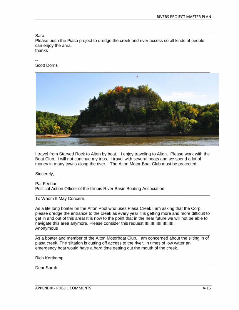
RIVERS PROJECT MASTER PLAN
APPENDIX - PUBLIC COMMENTS A-15
_________________________________________________________________________ Sara Please push the Piasa project to dredge the creek and river access so all kinds of people can enjoy the area. thanks -- Scott Dorris _________________________________________________________________________
I travel from Starved Rock to Alton by boat. I enjoy traveling to Alton. Please work with the Boat Club. I will not continue my trips. I travel with several boats and we spend a lot of money in many towns along the river. The Alton Motor Boat Club must be protected! Sincerely, Pat Feehan Political Action Officer of the Illinois River Basin Boating Association _________________________________________________________________________ To Whom It May Concern, As a life long boater on the Alton Pool who uses Piasa Creek I am asking that the Corp please dredge the entrance to the creek as every year it is getting more and more difficult to get in and out of this area! It is now to the point that in the near future we will not be able to navigate this area anymore. Please consider this request!!!!!!!!!!!!!!!!!!!!!!!!!! Anonymous _________________________________________________________________________ As a boater and member of the Alton Motorboat Club, I am concerned about the silting in of piasa creek. The siltation is cutting off access to the river. In times of low water an emergency boat would have a hard time getting out the mouth of the creek. Rich Kortkamp _________________________________________________________________________ Dear Sarah
RIVERS PROJECT MASTER PLAN
A-16 APPENDIX - PUBLIC COMMENTS
Our family is a third generation boater of the Alton pool and we are very concerned about the situation at the mouth of Pisistratus Anonymous _________________________________________________________________________ Dear Ms Miller, i am writing to draw your attention to the silting problems at teh mouth of piasa creek. there has been a progressive problem silting problem as you exit the creek. there have been numerous times when i have had to help unsuspecting boats off the sand and mud as they go straight out of the creek. this is a significant hazard and needs to be addressed before someone gets hurt seriously. thank you mike _________________________________________________________________________ Sarah - I just wanted to say I am concerned about the amount of siltration in the Mississippi River at Piasa Creek. The buildup is making it hard to access the river from the creek. Thanks, Jim Brown _________________________________________________________________________ Dear Ms. Miller, As a boater, fisherman, and hunter, I am concerned about the situation in the Mississippi River in the area of Piasa Creek and other areas. This siltation is cutting off our access from the creek to the river. I feel wrong placement of dredged material is the cause i.e. Grafton Ferry Crossing. Sincerely, Ed Amburg _________________________________________________________________________Sarah, I am an avid boater, fisherman and hunter and I am concerned with river access out of Piasa Creek. The siltation in the chute just outside the creek has limited access to the river. Any help in this concern would be appreciated. Sincerely, Michael Reese _________________________________________________________________________ Angie, Mayor Spann asked me to comment about the Village of Hartford's interest in collaborating with the Corps to bring more attention to the American Bottoms and further develop recreational opportunities on Corps lands along the Chain of Rocks Canal and we would like to connect the string of pearls developing in this region with additional recreation and nature based tourism with the educational opportunity the Corps' property lends to this region. The Mayor would like to ask that this concept be included in your Corps master planning comments.
RIVERS PROJECT MASTER PLAN
APPENDIX - PUBLIC COMMENTS A-17
Thank so much with your help and have a great meeting tomorrow. Deanna Barnes Projects Manager Village of Hartford Hartford, IL 62048 _________________________________________________________________________ Being a pleasure craft boater using the Illinois Waterway, I am asking you and the office of the Army Corp of Engineer's to consider keeping open the mouth of Piasa Creek. We have traveled to Alton Motor Boar Club and would like to be able to keep doing that in the future, via the Illinois waterways. I respect the time and concideration in this matter. Respectfully, William J. Parrott member of Starved Rock Yacht Club of Ottawa Ottawa, IL. 61350 _________________________________________________________________________ Hello Sarah, I live in Godfrey and work in Alton. My family and I enjoy getting outside for exercise and to view the area's landscapes and especially birds. As a Godfrey resident the best new feature is the Piasa Harbor project where we can enjoy views of the river and see a great variety of birds. I think the average citizen would most appreciate the Corps continuing these projects, working with local organizations and land trusts to establish and preserve our natural features for public use. I think if you asked the average citizen what the Corps does they would say you run the lock and dam and the river. While I enjoy the educational displays at the lock and dam and realize it is a great place for visitors to the area it is not a place I visit regularly like a park. The bike trails are also a wonderful feature of the area and are enjoyed by many. The new research center is also very promising. Please keep me posted on your Rivers Project! Jim _________________________________________________________________________ Hello Sarah My name is Darlene Seidler, and I am sending you this email because I am concerned about the Piasa Creek access. I have been a boater and fisherman my whole life, and would like to continue to access the river from Piasa Creek. Please help. Thank You Darlene _________________________________________________________________________ As a Mississippi River boater I would like to express my concern with the Piasa Creek entrance from the River. Watching the demise of Piasa Creek over the last several years is a little dissapointing being that it main cause is the silting in from the River. I am hoping to see something done by the Corp in the near future. I understand that money is tight in all areas of Government at this time. It is also tight in our family as with many others. We spend
RIVERS PROJECT MASTER PLAN
A-18 APPENDIX - PUBLIC COMMENTS
much of our vacation time on this part of the river during the summer months along with many of our friends. We would truly like to keep access to our club available for years to come along with the public access located in the creek. We do what we can to enjoy one of the most beautiful parts of the Mississippi and to help keep it clean. Please help us keep it useable. Thank you Cory, Vicki, Hallie, and Brady Schilling _________________________________________________________________________Good afternoon, As boaters, we are concerned about the situation in the MIssissippi River in the area of Piasa Creek. This situation is cutting off our access from the creek to the river. Looking forward to spring, when we can hopefully enjoy our beautiful Mississippi. Vic & Vicki Christian Alton, IL 62002 _________________________________________________________________________ I am concerned about the situation in the Mississippi River in the area of Piasa Creek. The situation is cutting off access from the creek to the river. I urge you to address this situation as funds become available. Thank you, Judy Boyd _________________________________________________________________________ Dear Ms. Miller, I understand that you are taking input on the river projects in and around the Alton pool. As a frequent user of the Alton pool I believe that the Piasa Creek/Piasa Slough area should be on the top of your list of projects. The underwater structures places upstream adjacent to the river road may have helped keep the channel clear, but they have significantly changed the flow and siltation in and near the mouth of Piasa Creek. I consider that the Corps fixing the Pisas Creek area only as an extension of the original project to build structures upstream to benefit the channel. Thank you, Bob Sullivan _________________________________________________________________________ In 2012 I logged more than 30 round trips through the Piasa Creek access in various boats from a canoe to a cruiser. I am very concerned with the contined silt build up in the middle of the slough near the mouth of Piasa Creek. In my cruiser which draws only ~32" of water, I frequently bumped the bottom when the pool was pulled down. Please put this project at the top of your list for the Alton Pool area. The Piasa Creek access is home to many boaters. The closure of the slough due to silt build up will deprive many people from using pool 26. The next decent access open to the public is at Marquette Park on the Illinois. Thanks you,
RIVERS PROJECT MASTER PLAN
APPENDIX - PUBLIC COMMENTS A-19
Bob Sullivan _________________________________________________________________________ Sarah, I am a member of the Alton Motorboat Club and the Alton Waterski Club so we regularly use piasa creek to access the Alton Pool. The build up of silt is causing problems not only to access the river but also in the ski area between Clifton Terrace and piasa creek. Please make this issue a priority for projects in the near future.Thank you. Brad Maher _________________________________________________________________________ As a sportsman utilizing Piasa Creek access I am very concerend that this area is silting in to the extent that is almost impossiabe to use the facalities at this location. In past years this area has seen considerable use by pleasure boaters, fisherman, and hunters but as time has past the silitation has continued and made access to the river near impossiable. If this continues I am concerned for the Alton Motor Boat Club which leases property from the Corps of Enginers and Piasa Marina and the public ramps at this location being viable recreation outlets for local residents and the many tourist that flock to this area to utilize the unique sights and amenities supported by the Sierria Club The Great Riverlands Land Trust The Alton Motor Boat Club The Illlinois American Water Co. just to name a few. I would hope that you would visit the Piasa Creek area the facailities there have expended considerable monies to make there facalities top notch it would be ashame to see this all go for not. Thank you for any support in this matter it would be greately appreciated by many. Cordialy Yours Art Tomerlin Past president East Side Industrial Rivermans Past Commodore Alton Motor Motor Boat Club _________________________________________________________________________ Love all the projects - Would like to see Lock & Dam 27 with more public access. Want to go see Sherwood Harbor - now and with new projects.
Anonymous ______________________________________________________________________ #1 Project > Piasa Ck. EMP #2 Audubon Center Master Plan Priority for implementation
Anonymous ______________________________________________________________________ Like to see a boat ramp at the north entrance of the Chain of Rocks Canal. Like to see nature/walking trails on Corps owned property located north of the Chain of Rocks Canal and explore expanding trails to the Lewis & Clark Confluence Tower, and the Lewis & Clark Historic Site, and the Corps property surrounding these facilities. Explore opportunities to do education programming with the Corps at the Lewis & Clark Confluence Tower. Explore some property swap with the Corps to make wetlands owned by the Village available to the
RIVERS PROJECT MASTER PLAN
A-20 APPENDIX - PUBLIC COMMENTS
Corps and help the Village of Hartford to purchase property around the tower for future development. Need larger pump to pump surface water from the drainage ditch through the levee at Hartford Avenue in Hartford, IL.
Mayor James Spann and Deanna Barnes, Hartford, IL ______________________________________________________________________ I am very pro Corps. I enthusiastically support your projects on the river in our area. I believe it will attract visitors from outside our area to visit the River Bend Growth Assoc. It will enhance our efforts to attack tourists and enhance our economy.
Mayor Tom Thompson, Grafton, IL ______________________________________________________________________
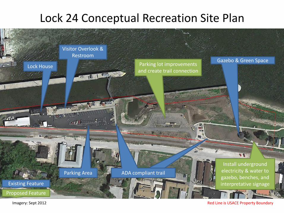
Lock 24 Conceptual Recreation Site Plan
Imagery: Sept 2012 Red Line is USACE Property Boundary
Gazebo & Green Space
Visitor Overlook & Restroom
Parking Area
Lock House
Existing Feature
Proposed Feature
ADA compliant trail
Parking lot improvements and create trail connection
ADA compliant trail
Install underground electricity & water to gazebo, benches, and interpretative signage
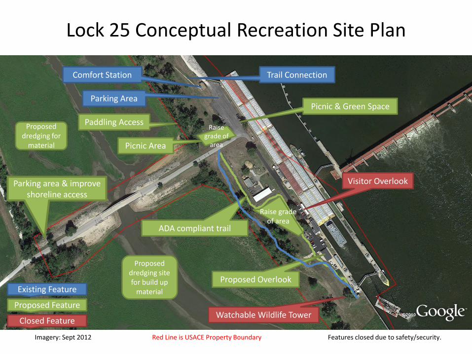
Lock 25 Conceptual Recreation Site Plan
Imagery: Sept 2012 Red Line is USACE Property Boundary Features closed due to safety/security.
Picnic & Green Space
Comfort Station
Parking area & improve shoreline access
Parking Area
Trail Connection
Watchable Wildlife Tower
Existing Feature
Proposed Feature
Closed Feature
Visitor Overlook
Picnic Area
Raise grade of
area
Proposed dredging for
material
Proposed dredging site for build up
material Proposed Overlook
ADA compliant trail
Raise grade of area
Paddling Access
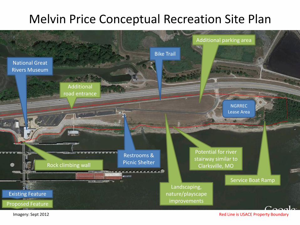
Melvin Price Conceptual Recreation Site Plan
Imagery: Sept 2012 Red Line is USACE Property Boundary
Additional road entrance
Restrooms & Picnic Shelter
Existing Feature
Proposed Feature
Landscaping, nature/playscape
improvements
NGRREC Lease Area
Service Boat Ramp
Rock climbing wall
National Great Rivers Museum
Additional parking area
Bike Trail
Potential for river stairway similar to
Clarksville, MO
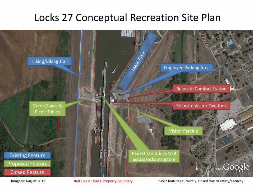
Imagery: August 2012 Red Line is USACE Property Boundary Public features currently closed due to safety/security.
Relocate Comfort Station
Employee Parking Area Hiking/Biking Trail
Existing Feature Proposed Feature
Closed Feature
Relocate Visitor Overlook Green Space & Picnic Tables
Pedestrian & bike trail across locks structure
Visitor Parking
Locks 27 Conceptual Recreation Site Plan
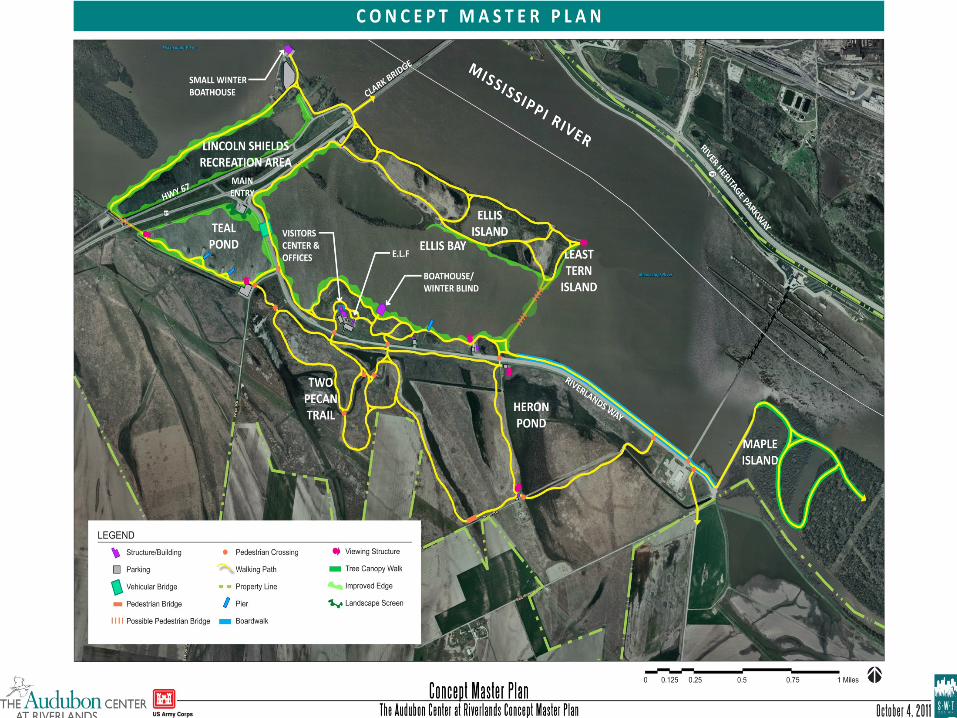
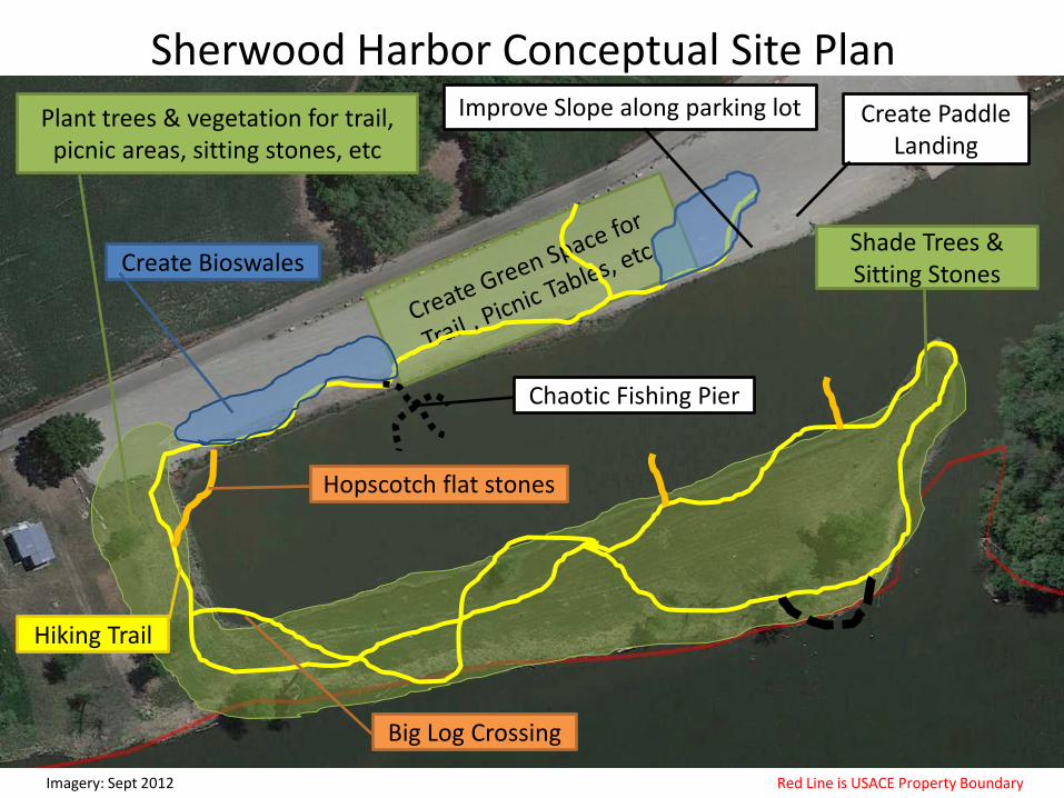
Sherwood Harbor Conceptual Site Plan
Imagery: Sept 2012 Red Line is USACE Property Boundary
Plant trees & vegetation for trail, picnic areas, sitting stones, etc
Create Bioswales
Improve Slope along parking lot
Hiking Trail
Hopscotch flat stones
Big Log Crossing
Shade Trees & Sitting Stones
Chaotic Fishing Pier
Create Paddle Landing
Imagery: Sept 2012 Red Line is USACE Property Boundary
Habitat Separator
New Hiking Trail
Create Fish Habitat
Hopscotch stones to create an island
Floating dock
Large Log Crossing
Treatment Cell
Chaotic Fishing Piers
Vegetate to Create Shade
Teal Pond Conceptual Site Plan
Paddle Access &/or Dock
RIVERS PROJECT MASTER PLAN
THIS PAGE INTENTIONALLY LEFT BLANK.
SHORELINE MANAGEMENT PLAN
Mississippi River
Nine-Foot Channel
Navigation Project
RIVERS PROJECT
Mississippi River from Pool 24 to Chain of Rocks Canal
& Illinois River from LaGrange Lock & Dam to Grafton, IL
March 2015
US Army Corps of Engineers
St. Louis District
RIVERS PROJECT SHORELINE MANAGEMENT PLAN
Page 2 of 17
TABLE OF CONTENTS
I. Introduction A. Purpose B. Scope C. References/Authorities D. Policy
II. Previous Plans III. Public and Agency Involvement IV. Definitions V. Shoreline Allocation
A. Limited Development Areas B. Public Recreational Areas C. Protected Shoreline Areas D. Prohibited Access Areas E. Exceptions
VI. Existing Shoreline Use on Project Lands VII. Shoreline Use Permit Requirements
A. Shoreline Use Permit B. Department of Army Permits C. State and Local Requirements
VIII. Applications IX. Permit Fees X. Conditions of Shoreline Use Permit
A. Density and Design Criteria B. Construction Standards C. Habitation D. Posting of Permits
XI. Duration and Renewal XII. Compliance and Termination
A. Compliance B. Facility Maintenance C. Termination D. Appeal Rights E. Emergency Termination F. Unauthorized Structures
XIII. Destruction of Government Property XIV. Enforcement XV. Other Shoreline Use Activities on Project Lands
A. Recreational Cottages B. Fleeting C. Waterfowl Hunting Blinds
RIVERS PROJECT SHORELINE MANAGEMENT PLAN
Page 3 of 17
I. Introduction This plan represents the St. Louis District's policy concerning use of Corps shoreline for Mississippi River from Saverton, Missouri to Chain of Rocks Canal, Granite City, Illinois and the Illinois River from LaGrange to Grafton, Illinois. This plan becomes effective upon approval by the Division Engineer, Mississippi Valley Division, U.S. Army Corps of Engineers. It is prepared in accordance with 36 CFR Part 327.30, Shoreline Management on Civil Works Projects, effective July 27, 1990.
A. Purpose. The purpose of this Shoreline Management Plan is to furnish guidance for the management, protection, and preservation of the natural resources of the U.S. Army Corps of Engineers fee title lands along the Mississippi and Illinois River while allowing a balanced use of the shoreline.
This plan discusses the conditions and restrictions of private shoreline use(s) along Corps lands. The term private shoreline use involves placing private structures or pursuing certain activities along Corps owned shorelines that are limited to the individual or small group and not available to the general public. Examples of such use include, but are not limited to: boat docks and piers, floating facilities, fencing, signing, landscaping, vegetation modification, etc.
B. Scope. This plan will establish and implement a policy governing the private shoreline use of fee title lands and adjacent waters of the St. Louis District, Rivers Project Office. The policy will cover the Project geographical area from Saverton, Missouri to the Chain of Rocks Canal, Granite City, Illinois on the Mississippi River and LaGrange, Illinois to Grafton, Illinois on the Illinois River.
This plan does not apply to existing Corps administered commercial marinas, industrial leases, or public access areas. Private shoreline use at leased recreational cottage sites will be allowed as part of the individual recreational cottage lease requirements. This plan will not nullify any provisions or guidelines of the individual recreational cottage lease. However, general guidelines that protect the public shoreline shall apply to recreational cottages and also navigation activities.
C. References/Authorities.
1. The Water Resources Development Act of 1986 [Public Law 99-662, Section 1134(d)].
2. U.S. Army Corps of Engineers, Mississippi Valley Division Regulation 405-3, Special Use Licenses, dated July 13, 1964.
3. U.S. Army Corps of Engineers, Lower Mississippi Valley Division, Private Exclusive Use at Corps of Engineers Civil Works Projects (Regional Plans), October 1989.
4. U.S. Army Corps of Engineers, St. Louis District, Rivers Project Master Plan, 2001 and 2014
5. U.S. Army Corps of Engineers, Engineering Regulation 405-1-12, Chapter 8, Real Estate Handbook, November 20, 1985 revised May 15, 2000.
RIVERS PROJECT SHORELINE MANAGEMENT PLAN
Page 4 of 17
6. U.S. Army Corps of Engineers, Engineering Regulation 1130-2-406, Project Operation - Shoreline Management at Civil Works Projects, dated October 31, 1990 revised May 28, 1999.
7. U.S. Army Corps of Engineers, Engineering Regulation 1130-2-550, Project Operations - Environmental Stewardship Operations and Maintenance Policies, dated November 15, 1996 revised August 11, 2008.
8. U.S. Army Corps of Engineers, Engineering Pamphlet 1130-2-550, Project Operations - Environmental Stewardship Operations and Maintenance Policies, dated November 15, 1996 revised August 11, 2008.
9. National Historic Preservation Act of 1966 (P.L. 89-665; 80 Stat. 915) as amended (16 U.S.C. 470 et seq.).
10. The National Environmental Policy Act of 1969 (42 U.S.C. 4321, et seq.). 11. Section 10, Rivers and Harbors Act of March 3, 1899. 12. Section 404, Clean Water Act (33 USC 1344, et seq.). 13. Title 36, Chapter III, Part 327, Code of Federal Regulations, Rules and
Regulations Governing Public Use of Corps of Engineers Water Resources Development Projects.
14. Title 36, Code of Federal Regulations, Part 327.30, Shoreline Management at Civil Works Projects.
15. Title 36, Code of Federal Regulations, Part 327.31, Shoreline Management Fee Schedule.
16. Engineering Manual 385-1-1, Safety and Health Requirements Manual.
D. Policy. It is the policy of the Chief of Engineers to protect and manage shorelines of all Civil Works water resource development projects under Corps jurisdiction in a manner which will promote the safe and healthful use of these shorelines by the public while maintaining environmental safeguards to ensure a quality resource for use by the public. The objectives of all management actions will be to achieve a balance between permitted private uses and resource protection for general public use. Public pedestrian access to and exit from these shorelines shall be preserved. For projects or portions of projects where Federal real estate interest is limited to easement title only, management actions will be appropriate within the limits of the estate acquired.
Currently the Rivers Project office only administers eight (8) individual private shoreline use permits on government lands. These are for private dock structures that were established before the St. Louis District 1990 Shoreline Management Plan. All eight of these are located in Pool 25 of the Mississippi River. No additional private shoreline use structures will be allowed in accordance with guidance currently in effect. Therefore it is the policy of this plan that:
1. Existing permits for authorized shoreline use and activities will be continued within certain limitations.
2. Modification or replacement of existing structures to a valid permit may be allowed within certain limitations. (Recreational cottage sites are limited to the 20% expansion policy as stated in the recreational cottage site lease agreement.)
RIVERS PROJECT SHORELINE MANAGEMENT PLAN
Page 5 of 17
3. No new permits for private shoreline use structures (where they did not previously exist) will be issued. New permits for recreational structures and activities will only be allowed if they serve the general public.
4. All unauthorized structures or activities will be removed from Corps administered lands.
Each of these four policy statements is subject to the provisions and intent of this plan.
II. Previous Plans
The St. Louis District developed a Shoreline Management Policy in 1990 that was approved by the St. Louis District Engineer. Previous policies to that included the St. Louis District Policy on Lake Shoreline Private Use Facilities, dated 20 February 1975; St. Louis District Policy on Special Use Mowing Permits, dated 4 October 1982, and related documents.
The 1990 policy stated private docks at the Rivers Project Area that were established prior to the 1990 policy were grand-fathered via an interim policy pending the development and approval of a specific Shoreline Management Plans.
The interim policy stated that: * Existing and new shoreline facilities for Cabin Lease holders will be covered under the lease instrument. * With the exception of cabin lease holders, no new facilities will be approved, permitted or constructed until a Shoreline Management Plan has been developed and approved for the Mississippi and Illinois Rivers. * All existing facilities will be "grandfathered" until a Shoreline Management Plan has been developed and approved.
The interim policy has been used to guide the Project’s management until this detailed plan could be formulated and approved.
III. Public and Agency Involvement
This plan was developed concurrent to the Rivers Project Master Plan update (2014), which included public and agency review at the same time. Project representatives worked with agency representatives of the U.S. Fish and Wildlife Service and the Illinois Department of Natural Resources and the Missouri Department of Conservation to coordinate their involvement. The public and agency involvement process included a public open house on April 16, 2014 and a 30 day public and agency final review period that began on March 25, 2014 and ended on April 25, 2014. All public and agency comments were considered, evaluated and included as part of this plan before finalization.
RIVERS PROJECT SHORELINE MANAGEMENT PLAN
Page 6 of 17
IV. Definitions
For the purposes of this plan, the following terms are explained:
A. Shoreline: A strip of Corps fee title land and water that extends 100 feet waterward from the ordinary high water mark, and from there 300 feet landward or to the Corps fee title boundary line, whichever is less.
B. Private Shoreline Use: Any use by an individual or group of individuals for more than 14 consecutive days that deters use of Corps fee title lands and waters by the general public. The use may be through a structure or an activity.
C. Private Recreational Structures: A privately owned and maintained recreational structure on Corps-owned shoreline intended primarily for individual or limited group use. This does not apply to structures intended for general public or commercial use.
D. Private Dock: One type of private recreational structure which has a pier-like platform, open and without sides , extending from Corps-owned shorelines in or over waters of the Mississippi or Illinois River, that is used to secure, protect, and provide private access.
E. Structure: Private recreational structures which may include boat docks, steps, or other structures which are discussed in this plan.
F. Shoreline Use Permit: An instrument issued by the Rivers Project Manager or his/her designee that authorizes certain private shoreline structures/activities on Corps fee title lands and waters to a single individual and their spouse.
G. Department of the Army Permit: An instrument used to authorize structures or work in or affecting navigable waters and/or the discharge of dredged or fill material into waters of the United States regardless of land ownership.
H. Fleeting: When barges are not in use for hauling commodities they are sometimes temporarily “parked” along the river shoreline, which is known as fleeting. Fleeting areas are analogous to railroad yards where cars are temporarily stored and trains are assembled and disassembled. Fleeting occurs on private as well as public land.
I. Unauthorized Structure: The construction, placement, or existence of any structure (including, but not limited to: roads, trails, signs, non-portable hunting blinds, buoys, docks, or landscape features) of any kind under, upon, in or over Project lands, or waters is prohibited unless a shoreline use permit has been issued. The design, construction, placement, existence or use of structures in violation of the terms of the issued permit is prohibited. The Corps shall not be liable for the loss of, or damage to, any private structures, whether authorized or not, placed on Project lands or waters. Unauthorized structures are subject to summary removal or impoundment by the District Commander, or delegated representative.
RIVERS PROJECT SHORELINE MANAGEMENT PLAN
Page 7 of 17
V. Shoreline Allocation
The entire Corps fee title shorelines of the Upper Mississippi River from Saverton, Missouri to Chain of Rocks Canal, Granite City, Illinois and the Illinois River from LaGrange to Grafton, Illinois, will be allocated within one of the four classifications listed below. Any action, within the context of this regulation, which gives a special privilege to an individual or group of individuals on land or water at a Corps project, that precludes use of those lands and waters by the general public, is considered to be private shoreline use. Shoreline allocations cover that land and/or water extending from the edge of the water and waterward with the exception of allocations for the purpose of vegetation modification which extends landward to the project boundary. These allocations compliment the land classifications in the Rivers Project Master Plan.
A. Limited Development Areas. Those areas in which private facilities and/or activities may be allowed. Modification of vegetation by individuals may be allowed only following the issuance of a shoreline use permit.
B. Public Recreational Areas. Those areas designated for commercial concessionaire facilities, Federal, state or other similar public use. No private shoreline use facilities and/or activities will be permitted within or near designated or developed public recreation areas. The term “near” depends on the terrain, road system, and other local conditions, so actual distances must be established on a case by case basis. No modification of land forms or vegetation by private individuals or groups of individuals is permitted in public recreation areas.
C. Protected Shoreline Areas. Those areas designated to maintain or restore aesthetic, fish and wildlife, cultural, or other environmental values. Shoreline may also be so designated to prevent development in areas that are subject to excessive siltation, erosion, rapid dewatering or exposure to high wind, wave, or current action and/or in areas in which development would interfere with navigation. No Shoreline Use Permits for floating or fixed recreation facilities will be allowed in protected areas.
D. Prohibited Access Areas. Those in which public access is not allowed or is restricted for health, safety or security reasons. These could include hazardous areas near dams, spillways, hydro-electric power stations, work areas, water intake structures, etc. No shoreline use permits will be issued in Prohibited Access Areas.
E. Exceptions.
In order to assure effective management of project resources and to be reasonable regarding adjacent property owners, the following are to be exceptions to this policy.
1. Roadway and Levee Mowing. Shoreline use permits may be issued to adjacent landowners or their lessees for mowing roadways and levee berms adjacent to private residences. Areas for consideration must be currently mowed by the Corps or other government entity for purposes relating to safety, erosion control or maintenance. In order to prevent soil erosion, no permits will be issued for mowing levee slopes for recreational purposes.
RIVERS PROJECT SHORELINE MANAGEMENT PLAN
Page 8 of 17
2. Mowing of Adjacent Lands. In order to alleviate problems associated with fire hazard to private homes located on adjacent lands and constructed prior to acquisition of federal property, shoreline use permits may be issued on an annual basis to adjacent landowners or their lessees for mowing public lands within 100 feet of the residences in question. Mowing will not encroach on a buffer extending 50 feet from the water's edge of the ordinary high water mark (OHW).
VI. Existing Shoreline Use on Project lands
Currently the Rivers Project office only administers eight (8) individual private shoreline use permits on government lands. These are for private dock structures that were established before the St. Louis District 1990 Shoreline Management Plan. All eight of these are located in Pool 25 of the Mississippi River. Permits for these existing structures will be renewed only to allow the continuation of those site-specific, individual cases of private shoreline use which are currently authorized and exist as of the date of the approval of this plan. No new permits will be issued nearby or in proximity to these specific cases. An existing permit authorizing specific structures/activities becomes null and void upon the sale of legal ownership. The new owner will not be allowed to continue this private exclusive shoreline use and all structures must be removed from Corps fee title lands and waters. Exempted Existing Structures. A few areas within Corps fee title lands and waters having private exclusive use structures or activities are exempt from Corps issued shoreline use permits. Any changes or additions to structures, vegetation maintenance (mowing, herbicide use, etc), shoreline revetment, etc will be assessed on a case by case basis. The areas exempt are listed below:
1. Commercial Leases. This includes commercial concession leases (e.g. marinas, ferry landings, etc.), which area covered under separate real estate instruments.
2. Industrial Lease Areas. These areas are covered under a separate real estate instrument. Rivers Project is currently phasing out industrial leases, through land exchanges which will eliminate all private exclusive use within this type of area and better support public interests.
3. Park & Recreational Leases. These lease areas are open to the general public. Examples of these leases include IL Department of Natural Resources lease for Piasa Creek Access Area and Village of Batchtown’s lease for Cockrell Hollow Access Area.
4. Minor Outgrants (i.e. Easements, Licenses, Leases, etc.). These include overhead power lines, buried lines, pipelines, etc. These areas are covered under separate real estate instruments.
RIVERS PROJECT SHORELINE MANAGEMENT PLAN
Page 9 of 17
5. Cooperative Agreement Lands. These lands are administered by the USFWS, IDNR or MDC through a cooperative agreement and general plan between the USFWS and the Corps. Structures and shoreline use within these areas will be considered on a case by case basis and will be coordinated amongst all the cooperative agreement agencies.
VII. Shoreline Use Permit Requirements
A. Shoreline Use Permit. Shoreline use permits will be required for private recreational structures (primarily boat docks and other water-based features). Vegetative modification activities on Project lands may be authorized under a shoreline use permit provided they do not disrupt or change the land form. Vegetative modifications that would create or exacerbate erosion or invasive species problems will not be allowed. Vegetative modification includes planting, trimming, cutting, or use of herbicides. Prior to vegetative modification, a shoreline use permit will be issued which outlines the conditions of any such work.
Ecological impacts need to be considered prior to shoreline rehabilitation/erosion control measures are taken. Alternatives to shoreline revetment should be explored prior to any work being completed and/or permit issuance.
B. Department of the Army Permits. Any structure (e.g. boat dock) or work in or affecting navigable waters of the United States requires a Section 10 permit under the authority of the Rivers and Harbors Act. Any discharge of dredged or fill material into waters or wetlands of the United States requires a permit authorized under Section 404 of the Clean Water Act. If a proposal involves work subject to both section 10 and Section 404 jurisdiction, a single Department of the Army Permit will be considered. Conditions of the Department of the Army Permit will be provided upon its issuance.
C. State and Local Requirements. In addition to the Corps issued permits mentioned above, it may be necessary to obtain additional permits as required by State and local law for the construction, operation, or maintenance of the allowed structures. Laws and regulations of State and local governments apply to actions taken along Corps shorelines. Compliance with these rules will be a condition of Corps issued permits. It is the permittees responsibility to ensure that they are in compliance with State and local laws.
VIII. Shoreline Use Permit Applications
The Corps must grant permission prior to the start of any construction and/or replacement or modification of any existing structures or any other actions as defined in this plan.
To request review of a proposal and approval, a written request must be submitted to the Rivers Project Office, ATTN: Shoreline Mangement Ranger, 301 Riverlands Way, West
RIVERS PROJECT SHORELINE MANAGEMENT PLAN
Page 10 of 17
Alton, MO 63386. The requestor may be required to complete an application packet and provide all information as requested to allow the Shoreline Management Ranger to make a comprehensive review. If this review determines that the request is compatible with the provisions of this plan, all necessary permits will be processed and provided to the applicant. Replacement or modification of any existing structures or the construction of any private structures will not be allowed until the applicant has been issued all the necessary Corps permits.
Obtaining Corps authorizations does not preclude the need for the applicant to obtain any or all other necessary Federal, State and local authorizations. If the Corps application is denied, copies of the denial will be furnished to the applicant and any other involved entities.
IX. Permit Fees
Fees associated with the Shoreline Use Permit shall be paid prior to issuing a new permit. Shoreline Use Permits will normally be issued for a five year term. Permits can be suspended or revoked by the Shoreline Manager at any time for failure to pay renewal fees. A non-refundable administrative fee may be charged for Shoreline Use Permits and Real Estate Outgrants. A schedule of current fees for activities mentioned in this plan can be made available by submitting a written request to the Rivers Project Office, ATTN: Shoreline Mangement Ranger, 301 Riverlands Way, West Alton, MO 63386 X. Conditions of Shoreline Use Permit
A. Density and Design Criteria. Size, spacing, and design criteria will be applicable to all replacement, or modified boat docks.
Replacement, or modified docks will be required to be no less than 3 feet nor more than 6 feet in width, no closer than 50 feet to the next dock, and will extend no more than 100 feet from the ordinary high water mark. Variably shaped docks are authorized; provided that no portion of the dock exceeds 16.5 feet in dimension and that the total dock surface area does not exceed 600 square feet. Variance from these criteria may be authorized after consideration of the site-specific circumstances by the Shoreline Manager or his/her designee. All existing structures which are authorized by a currently valid permit will be exempted from conforming to the density and design criteria until such time as the structure requires replacement or modification. To be allowed, all replacement or modified structures must conform to the density and design criteria. At the discretion of the District Engineer or his representative, docks that pose an obstruction or a hazard to navigation will not be allowed, regardless of size or spacing.
B. Construction Standards. The following construction standards apply to replacement and modified structures of any type:
1. Structures must be constructed in accordance with the plans and specifications approved by Rivers Project representative(s).
RIVERS PROJECT SHORELINE MANAGEMENT PLAN
Page 11 of 17
2. All docks must be securely anchored in place using posts, deadman, or other suitable means. Altering the natural terrain or vegetation, anchoring to trees, or obstructing general public use of the shoreline will not be allowed.
3. Electrical installations must be weatherproof and meet all current applicable electric codes and regulations. In addition, electrical installations must be certified in writing by a state registered electrician. The written certification must be submitted to the Corps upon request.
4. Boat mooring bouys and dock flotation units shall be constructed of materials that are clean and free of pollutants and will not become waterlogged or sink when punctured. Flotation units and devices must be composed of low density, closed cell, rigid plastic foam. Flotation units of any type will not be allowed unless filled with flotation foam. Pesticide and other harmful containers will not be allowed.
5. Only quick-disconnect temporary electric lines, waterlines, and telephone lines to the vessel will be allowed. No permanent utility hookups will be allowed.
6. Installation of structures conducive to human habitation such as sleeping accommodations, cooking facilities, heating facilities, toilet or shower facilities, refrigeration, television, etc., are prohibited.
C. Habitation. No structure shall be used for human habitation. The presence of facilities conducive to human habitation will be treated as presumptive evidence of such use and will be cause for termination of the permit.
D. Pesticide Use. If the permit authorizes the use of an “approved” pesticide, the permittee should submit a report to the Rivers Project Office by the end of October. The report must identify the type of pesticide used, quantity used, location used, targeted species, and mode of application. Issued permit will include a list of “approved” pesticides and mode of application. Pesticides used without authorization on permit or pesticides other than those listed on the “approved” list may result in the termination of the shoreline use permit.
E. Posting of Permits. The Rivers Project Office will provide each permittee with a printed permit tags of light metal or plastic for posting. The permit display tag shall be posted on the facility and/or on the land area covered by the permit, so that it can be visually checked, with ease in accordance with instructions provided by Shoreline Manager. Facilities or activities permitted under special provisions should be identified in a way that will set them apart from other facilities or activities.
XI. Duration and Renewal
All permits are nontransferable and become null and void upon the sale of legal ownership or the death of the permittee and his/her legal spouse.
Permits will be renewed for periods of 1 to 5 years. The Rivers Project Office will send existing permittees a renewal notice to their permanent address informing them of the
RIVERS PROJECT SHORELINE MANAGEMENT PLAN
Page 12 of 17
upcoming renewal. Prior to the expiration of the permit, the holder will be required to submit a renewal application to continue authorized use of the site.
XII. Compliance and Termination
A. Compliance. Corps representatives will periodically inspect structures/activities to ensure compliance with the terms of the permit during construction. In the event that the construction does not conform to approved plans or permit conditions, the work will be halted until such time as the terms are met.
Corps representatives will also periodically inspect structures/activities during the life of the shoreline use permit period to ensure compliance with the terms of the permit. If use is does not conform to the permit conditions, use will be halted until such time as the terms are met.
Noncompliance with the terms of the permit may result in termination.
B. Facility Maintenance. Authorized structures must be operated, used, and maintained in a safe, healthful condition at all times. If determined to be unsafe, the hazard will be corrected within 60 days or removed at the owner's expense. If the hazard is not corrected or removed within that timeframe, termination of the permit will result.
C. Termination. Permits may be terminated when it is determined that the public interest requires such termination or when the owner fails to comply with the terms and conditions of the permit. Failure to maintain a permitted structure is a violation of the terms.
The Rivers Project Manager or his representative may terminate a permit authorizing existing structures and/or activities if one of the following conditions occurs:
1. A structure is not in a usable and safe condition; 2. A structure poses a threat to life or property; 3. The holder of the permit violates the terms of the permit; or 4. The site of the structure/activity is needed for immediate use for public purposes
or higher public use.
Whenever a permit is terminated by the Corps for one of these four reasons, or the holder voluntarily relinquishes the permit, or the holder/spouse both die prior to sale, the continuation of authorized private use ceases and the permit will never be reissued. In addition, the holder of the permit is required, upon termination/relinquishing to remove the structures from the area.
Upon termination, the permittee must remove the structure(s) within 30 days at his/her expense and restore the shoreline to a condition acceptable to the Corps representative. If the permittee fails to comply with the satisfaction of the Corps representative, the structure may be removed by the Corps and the permittee held responsible for all costs incurred.
RIVERS PROJECT SHORELINE MANAGEMENT PLAN
Page 13 of 17
If a permit is revoked and the unsafe and dilapidated dock has to be removed by the government, the permittee must reimburse the government for all removal costs. If such case occurs, the permit will never be reinstated or reissued.
D. Appeal Rights. Upon notice of termination, the permittee will have thirty (30) days to make a written request for a hearing. The District Engineer will grant the request at the earliest possible convenience. After the hearing, a final decision will be rendered in writing and mailed to the permittee by certified mail.
E. Emergency Termination. If, in the opinion of the District Engineer, emergency circumstances dictate otherwise, the District Engineer may summarily terminate the permit.
F. Unauthorized Structures. Only structures authorized by a permit will be allowed to remain on Corps shorelines. Any unauthorized use or structures will be considered an encroachment on public property under the authority of Title 36 Chapter III, Part 327.20, Code of Federal Regulations. Violations may result in the issuance of a citation requiring the payment of a fine and/or appearance before the U.S. Magistrate and/or revocation of all or part of the Shoreline Use Permit.
All unauthorized structures and private items shall be removed from government property within thirty days of written notice. Trash, litter, and debris shall be removed immediately upon verbal or written notice. Prohibited items are subject to impoundment and removal by the Corps at the owner's expense. Prohibited items include, but are not limited to: a. Non-permitted structures including but not limited to: boat docks, patios, fences,
sidewalks, buildings, portable bathrooms, sheds, satellite dish antennas, playground equipment, planters, etc. that have not obtained a Corps shoreline use permit.
b. Gardens and orchards. c. The spreading of sand, gravel or any other material to construct a beach or private
access ramp. d. The storage of any object including but not limited to, hazardous waste, firewood,
boats, trailers, grills, trash cans, scrap material, pet houses and pens, etc. e. The disposal of litter, leaves, trash, or any other debris or waste. f. Waterfowl hunting blinds located outside of State authorized waterfowl hunting
areas. g. Privately owned buoys placed on public waters.
XIII. Destruction of Government Property
Restitution for damages to government property may be pursued in the form of replanting and/or monetary payments and/or the current Shoreline Use Permit may be revoked and all private facilities removed from public property at the owner’s expense. Additionally, the shoreline use permit will never be issued again for the affected area.
RIVERS PROJECT SHORELINE MANAGEMENT PLAN
Page 14 of 17
In instances where vegetation has been damaged, destroyed, altered or removed from public property without prior approval, the amount of restitution will be determined based on the International Society of Arboriculture’s (ISA) Guide for Plant Appraisal by applying the Trunk Formula and/or Replacement Cost Method to assess an appraisal to determine the dollar value as a result of the destruction of vegetation on public property. The permittee may have an independent appraisal conducted by an individual trained in the use of ISA’s Guide for Plant Appraisal if they choose.
Additional fines may occur as determined by other Federal, state or local authorities as guided by other Federal, state or local laws and statutes.
XIV. Enforcement
The provisions contained within this plan are supported by the authorities and statutes indicated in Section I.C. A violation of these mandates will be subject to enforcement under Title 36, Chapter III, Part 327, Code of Federal Regulations, or other civil laws, as necessary.
The U.S. Army Corps of Engineers has implemented a property protection program known as “CORPS WATCH”, which was developed to reduce vandalism, larceny, arson and environmental and cultural degradation of government property. This program utilizes a toll free hotline (1-866-413-7970) and provides cash rewards of $100 to $1,000 to individuals whose information leads to the arrest and prosecution of offenders. The call center is available 24 hours a day 7 days a week and callers can remain anonymous.
XV. Other Shoreline Use Activities on Project Lands Other shoreline use not regulated by this policy and administered under other legal policies, leases or arrangements include but are not limited to; recreational cottages and appurtenance docks, waterfowl hunting blinds, and fleeting.
These activities, although not specifically directed by this policy, shall seek to meet the goals of protecting the project shoreline under Corps jurisdiction in a manner which will promote the safe and healthful use of these shorelines by the public while maintaining environmental safeguards to ensure a quality resource for use by the public. The objectives of all management actions shall be to achieve a balance between private uses and resource protection for general public use.
A. Recreational Cottages. Private exclusive use will only be allowed to continue within the recreational cottage sites where it existed as of the date of the approval of the Rivers Project Master Plan. In most cases this is boat docks, shoreline revetment, and/or vegetation modification along Corps fee title shoreline.
The existing structure(s) will be exempted from conforming to the density and design criteria until such time as the structure requires replacement or modification. Any structure (boat docks included) on the recreational cottage sites are subject to the real estate issued 20% expansion policy as stated in the recreational cottage lease. Upon
RIVERS PROJECT SHORELINE MANAGEMENT PLAN
Page 15 of 17
these conditions, all replacement, modified, or new structures must conform to the density and design criteria (see Section X), as well as the expansion policy, to be allowed.
Upon sale of the private recreational cottage and associated structure(s), the new owners of existing structures will be allowed to continue the structures or activities designated use, as long as the lease guidelines for transfer are followed. If the new owner wishes to add structure(s) or replace or modify existing structures, permission must be granted prior to any work. As stated above, all replacement, modified, or new structures must meet the density and design criteria (see Section X), as well as the expansion policy, to be allowed.
Vegetation modification (including mowing) of recreational cottage lots outside of lease area is strictly prohibited. All requests for modifications to recreational site lease areas, including but not limited to boat docks, revetment, walkways, vegetation modification, etc. shall be made in writing to U.S. Army Corps of Engineers, ATTN: Chief, Real Estate Division, 1222 Spruce Street, St. Louis, MO 63103.
B. Fleeting
From 1983 to 1985, a shoreline fleeting study was conducted in an effort to identify private commercial navigation fleeting zones on the Mississippi River portion of Pool 26 only. The public was involved in formulating this fleeting plan. A final plan was submitted to Lower Mississippi Valley Division (LMVD) in 1985 for approval. However, this plan was never formally approved. This plan did not address issuance of permits for private exclusive use structures.
Currently the only authorized fleeting on Corps fee title shoreline is in areas where commercial real estate leases exist (i.e. Ameren Power Plant, St. Charles, Co., MO; America’s Central Port District, Madison Co., IL). All fleeting within lease areas shall comply with the terms of the real estate lease.
No fleeting, other than on approved lease areas, is permitted or shall occur along Corps fee title shorelines.
C. Waterfowl Blinds. Both the states of Illinois and Missouri allow for waterfowl blind construction on Corps lands within designated areas of conservation areas managed through a cooperative agreement with the Corps and the U.S. Fish and Wildlife Service. Permanent waterfowl blinds within these state managed hunting areas will not have shoreline use permits issued by the Rivers Projects, as they are permitted under separate arrangements. Permanent waterfowl blind structures are NOT allowed outside of the state managed waterfowl hunting areas and will be treated as unauthorized structures when located off of designated hunting areas. Waterfowl hunting is allowed from temporary blinds or boat blinds along some of the Corps fee title lands, outside of the U.S. Fish & Wildlife and state managed areas.
RIVERS PROJECT SHORELINE MANAGEMENT PLAN
Page 16 of 17
State managed waterfowl hunting regulations areas differ in Illinois and Missouri. It is the hunter’s responsibility to know the state and/or area regulations of the hunting area. States regulations at the time this plan was prepared are stated below:
1. Illinois Department of Natural Resource Waterfowl Blind Regulations. Waterfowl hunting is only allowed from allocated waterfowl blind sites, walk-in areas at specific managed areas, and open hunting from portable blinds or anchored boats west of Denmark Island within Pool 24. Waterfowl blind sites are allocated by public drawing for a three-year period within Pool 25 and 26 locations. Waterfowl blind sites are allocated by public drawing for a two-year period within Pool 24 locations. At Horseshoe Lake State Park (Madison County) all hunting will be from registered blinds only. Waterfowl blinds must be built to site specifications and maintained in a safe usable condition. Blind builders are re-registered annually and blinds not registered and/or not constructed are re-allocated. All waterfowl hunting within managed areas must be done from within a staked and registered waterfowl blind. Red’s Landing, RipRap Landing, Turner Island, Kelly Island, and 12 Mile Island have some designated walk-in hunting areas. No permanent waterfowl structures are allowed within these walk-in hunting areas. Other site restrictions apply. In Pool 24, west of Denmark Island (Mississippi River Mile 291.0-294.5), waterfowl hunting is allowed from portable blinds or anchored boats. This is allowed only in Illinois waters and if maintaining at least 200 yards intervals.
2. Missouri Department of Conservation Waterfowl Blind Regulations. Waterfowl hunting on the Upper Mississippi Conservation Area is by one of two designations: Open or Restricted.
i. Open Areas: Blinds may be constructed without site restrictions but they may not be locked. Blinds unoccupied at one-half hour before legal shooting time may be used by the first hunter to arrive. No structures other than blinds, boat concealments and decoy lockers are permitted.
Open areas include: Mason Island and the 215 Mile Group; Dardenne and Bolter Islands; Westport and Sterling Islands; Gilbert, Blackbird, North and South Fritz, Ducher, and Angle Island.
ii. In Restricted portions of Upper Mississippi Conservation Area waterfowl may be hunted only from blinds at designated blind sites during the regular duck and Canada goose seasons. During the late Canada goose season and light goose conservation order hunters may hunt from blinds at designated blind sites or from boat blinds within 10 yards of a blind site marker only if blinds and blind sites are

RIVERS PROJECT SHORELINE MANAGEMENT PLAN
Page 17 of 17
unoccupied at one-half hour before legal shooting time. These restrictions do not apply during early teal and early Canada goose seasons due to the fact that some blinds may not be completed by that time.
Restricted areas include: Dresser Island, river pool portion of West Alton, Stag Island Group, and Pharrs Island.