Embed Size (px)
Citation preview

.
Search and Rescue Satellite Aided Tracking (SARSAT) Program Plan Version 2.1 March 6, 2007

.
- Page Intentionally Left Blank –

.
Document History Version Revision Date Revised Pages Comments
1 0 October 1, 2000 All
2 0 April 1, 2005 All
Updated to include new NOAA program structure, transition of the U.S. Coast Guard to the Department of Homeland Security, and new mandates and drivers
2 1 March 6, 2007 All
Editorial changes. Introduction of 121.5/243 MHz phase out, and NASA’s role in operating ground stations. Cost benefit analysis and national space policy references included. Sections on NOAA and USAF organizations updated and included references to requirements process and risk management.

.
- Page Intentionally Left Blank –

Table of Contents
1.0 Introduction and Overview............................................................................................1 1.1 Purpose......................................................................................................................1 1.2 Mission Need ............................................................................................................1 1.3 Link to NOAA and Partner Agency Strategic Goals ................................................2 1.4 Outcome Desired.......................................................................................................2 1.5 Operational Concept .................................................................................................2
2.0 Program Overview ........................................................................................................6 3.0 Requirement Drivers .....................................................................................................8
3.1 First Tier....................................................................................................................9 3.2 Second Tier .............................................................................................................10 3.3 Information Technology (IT) Drivers .....................................................................12
4.0 Requirements...............................................................................................................13 5.0 Strategic Planning and Performance Management .....................................................15 6.0 Operational Program Activities...................................................................................15
6.1 International Cospas-Sarsat Program Management ................................................15 6.2 Satellite Coordination .............................................................................................16 6.3 Frequency Management..........................................................................................17 6.4 Local User Terminals (LUT) Management and Operation.....................................18 6.5 United States Mission Control Center (USMCC) Management and Operation .....18 6.6 Search and Rescue Services Coordination..............................................................19 6.7 Interagency Coordination........................................................................................20 6.8 Emergency Beacons / Users Coordination..............................................................20
7.0 Research and Development Activities ........................................................................21 8.0 Program Management .................................................................................................21
8.1 National Management .............................................................................................22 8.2 International Management ......................................................................................26 8.3 Reporting Requirements .........................................................................................27 8.4 Configuration Management ....................................................................................27 8.5 Risk Management ...................................................................................................28
9.0 Socio-Economic Benefits ............................................................................................29 Annex 1 – List of Acronyms .....................................................................................................a Figure 1: Cospas-Sarsat Operational Concept ..........................................................................3 Figure 2: U.S. SARSAT Operational Concept .........................................................................5 Figure 3: SARSAT Logic Model..............................................................................................8 Figure 4: Relationship Between Agreements .........................................................................10 Figure 5: Requirements Process .............................................................................................14 Figure 6: NOAA SARSAT Program Management ................................................................22 Figure 7: NOAA/SARSAT Matrix Structure ..........................................................................23 Figure 8: National SARSAT Program Management Structure ..............................................23 Figure 9: SARSAT Funding Sources .....................................................................................25 Figure 10: International Cospas-Sarsat Program Structure ....................................................27
i

- Page Intentionally Left Blank -
ii

Search and Rescue Satellite-Aided Tracking (SARSAT) Program Plan
1.0 Introduction and Overview The Search and Rescue Satellite-Aided Tracking (SARSAT) system relays distress signals from emergency beacons carried by aviators, mariners and land-based users to search and rescue (SAR) services. The mission of the National Oceanic and Atmospheric Administration’s (NOAA) SARSAT program is to:
Protect life and property by providing timely, accurate and reliable distress alerts to search and rescue services worldwide in an effective and efficient manner.
The mission of the SARSAT program is fulfilled by:
collecting and distributing reliable and accurate distress alert data in a timely fashion using satellite receiving stations and a mission control center;
coordinating with national and international organizations on frequency management, satellite, emergency beacon and search and rescue issues;
maintaining a national register for 406 MHz emergency beacons; and serving as the lead agency within the United States, and representing the United
States to the international Cospas-Sarsat Program.
1.1 Purpose The purpose of this document is to:
identify the drivers and mandates for the program and describe how the SARSAT program will meet its national and international obligations;
introduce the SARSAT program to individuals who require a detailed understanding of the program from an operational and programmatic perspective (e.g., senior management);
describe the management of the program; identify the capabilities, activities and outcomes of the program; and describe the operational concept for the program.
1.2 Mission Need The United States Government, specifically the Department of Commerce’s NOAA, the Department of Defense’s U.S. Air Force (USAF), and the Department of Homeland Security’s U.S. Coast Guard (USCG), requires an enduring space-based capability to detect, locate, and relay distress signals from emergency beacons carried by aviators, mariners, and land-based users to SAR services. The alerts include information about the user, as well as position information when available.
1

The Government needs the capability to 1) support the general public, 2) support civilian SAR efforts of the USAF and USCG, 3) support maritime security requirements, 4) support military SAR operations, and 5) meet international obligations under the Chicago Convention (under the auspices of the International Civil Aviation Organization, ICAO), the Safety of Life at Sea Convention and the Maritime Search and Rescue Convention (both under the auspices of the International Maritime Organization, IMO). The United States SARSAT program meets the needs of the Government in detecting and locating emergency beacons operating at 121.5 MHz, 243 MHz, and 406 MHz. The applications include emergency position-indicating radio beacons (EPIRBs) and Ship Security Alerting System (SSAS) transmitters for maritime users (collectively referred to as EPIRBs from here on), emergency locator transmitters (ELTs) for aviation users, and personal locator beacons (PLBs) for land-based users.
1.3 Link to NOAA and Partner Agency Strategic Goals The SARSAT program’s goals are consistent with NOAA’s goal to support the Nation’s commerce with information for safe, efficient and environmentally sound transportation. The program also supports the USCG’s goals of ensuring safe operation of the Marine Transportation System (MTS) and protect the lives and safety of those on the sea as well as responding to maritime disasters, natural or man made to protect lives and ensure safety in U.S. communities; and the National Aeronautics and Space Administration’s (NASA) goals of enabling a safer, more secure, efficient, and environmentally friendly air transportation system and creating a more secure world and improving the quality of life by investing in technologies and collaborating with other agencies, industry, and academia.
1.4 Outcome Desired The desired outcome of the SARSAT program is to reduce human risk and economic consequences as a result of natural or human-induced emergencies.
1.5 Operational Concept The SARSAT program is part of the international Cospas-Sarsat System. Cospas is a Russian acronym that stands for “Cosmicheskaya Systyema Poiska Aariynyich Sudov” which translates loosely into “Space System for the Search of Vessels in Distress.” The basic concept of the system involves the use of emergency beacons, satellites, and ground equipment to relay distress location and identification information (referred to as distress alerts) to SAR authorities. SAR instruments are flown on low-Earth polar orbiting (LEO) and geostationary-orbiting (GEO) satellites provided by the United States, Russia, India and the European Organization for the Exploitation of Meteorological Satellites (EUMETSAT). Canada and France provide the SAR instruments (the Search and Rescue Repeater and the Search and Rescue Processor) for the U.S. and European LEO satellites. These instruments are capable of detecting signals on the Earth’s surface transmitted from emergency beacons.
2

Emergency beacons (ELTs, EPIRBs and PLBs) may operate on the 121.5, 243 or 406 MHz frequencies. 121.5/243 MHz beacons transmit an analog signal that does not contain any information about the beacon or user. The satellite processing of 121.5/243 MHz emergency beacons will be terminated on February 1, 2009. Alternatively, the 406 MHz beacons transmit a digital code that contains information about the type of beacon and possibly the location of the beacon (derived from the Global Positioning System, GPS, or other navigational system). Each 406 MHz beacon in the world has a unique identifier. The unique identifier allows for additional information called registration data to be linked to each beacon. After receipt of ELT, EPIRB or PLB signals by the satellite, the satellite relays the signals to earth stations referred to as Local User Terminals (LUTs). The LUT, after computing the location of the emergency beacon using the Doppler Effect, transmits an alert message to its respective Mission Control Center (MCC) via a data communication network. The MCC performs matching and merging of alert messages with other received messages, geographically sorts the data, and transmits a distress message to an appropriate search and rescue authority such as a national Rescue Coordination Center (RCC) or a foreign SAR Point of Contact (SPOC). The distress message may also be sent to another MCC. Figure 1 describes the Cospas-Sarsat System.
GEO Satellites
LEO Satellites
Local User Terminal
Mission Control Center
Rescue Coordination
Center
Foreign Mission Control Center
SAR Point of Contact
Emergency Beacon
Figure 1: Cospas-Sarsat Operational Concept
3
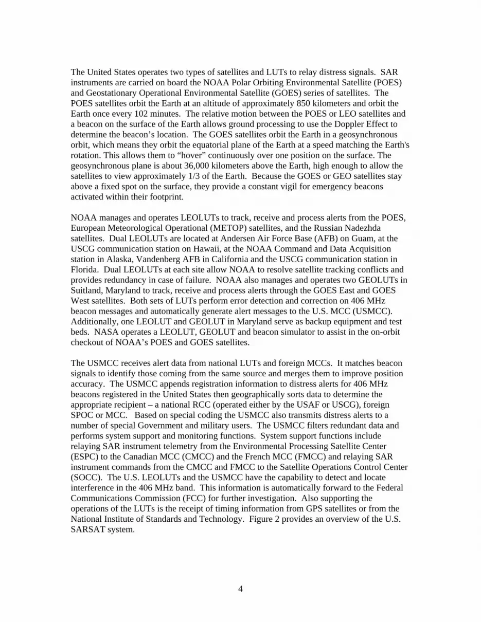
The United States operates two types of satellites and LUTs to relay distress signals. SAR instruments are carried on board the NOAA Polar Orbiting Environmental Satellite (POES) and Geostationary Operational Environmental Satellite (GOES) series of satellites. The POES satellites orbit the Earth at an altitude of approximately 850 kilometers and orbit the Earth once every 102 minutes. The relative motion between the POES or LEO satellites and a beacon on the surface of the Earth allows ground processing to use the Doppler Effect to determine the beacon’s location. The GOES satellites orbit the Earth in a geosynchronous orbit, which means they orbit the equatorial plane of the Earth at a speed matching the Earth's rotation. This allows them to “hover” continuously over one position on the surface. The geosynchronous plane is about 36,000 kilometers above the Earth, high enough to allow the satellites to view approximately 1/3 of the Earth. Because the GOES or GEO satellites stay above a fixed spot on the surface, they provide a constant vigil for emergency beacons activated within their footprint. NOAA manages and operates LEOLUTs to track, receive and process alerts from the POES, European Meteorological Operational (METOP) satellites, and the Russian Nadezhda satellites. Dual LEOLUTs are located at Andersen Air Force Base (AFB) on Guam, at the USCG communication station on Hawaii, at the NOAA Command and Data Acquisition station in Alaska, Vandenberg AFB in California and the USCG communication station in Florida. Dual LEOLUTs at each site allow NOAA to resolve satellite tracking conflicts and provides redundancy in case of failure. NOAA also manages and operates two GEOLUTs in Suitland, Maryland to track, receive and process alerts through the GOES East and GOES West satellites. Both sets of LUTs perform error detection and correction on 406 MHz beacon messages and automatically generate alert messages to the U.S. MCC (USMCC). Additionally, one LEOLUT and GEOLUT in Maryland serve as backup equipment and test beds. NASA operates a LEOLUT, GEOLUT and beacon simulator to assist in the on-orbit checkout of NOAA’s POES and GOES satellites. The USMCC receives alert data from national LUTs and foreign MCCs. It matches beacon signals to identify those coming from the same source and merges them to improve position accuracy. The USMCC appends registration information to distress alerts for 406 MHz beacons registered in the United States then geographically sorts data to determine the appropriate recipient – a national RCC (operated either by the USAF or USCG), foreign SPOC or MCC. Based on special coding the USMCC also transmits distress alerts to a number of special Government and military users. The USMCC filters redundant data and performs system support and monitoring functions. System support functions include relaying SAR instrument telemetry from the Environmental Processing Satellite Center (ESPC) to the Canadian MCC (CMCC) and the French MCC (FMCC) and relaying SAR instrument commands from the CMCC and FMCC to the Satellite Operations Control Center (SOCC). The U.S. LEOLUTs and the USMCC have the capability to detect and locate interference in the 406 MHz band. This information is automatically forward to the Federal Communications Commission (FCC) for further investigation. Also supporting the operations of the LUTs is the receipt of timing information from GPS satellites or from the National Institute of Standards and Technology. Figure 2 provides an overview of the U.S. SARSAT system.
4

SOCC
LEOLUT (12)
GEOLUT (2)
NIST
ESPC
USMCC
Naval Space Command
SPOC
RCC
MCC
Special Programs
CMCC FMCC
Position
Timing
Timing
GPS Satellites
GOES Satellites
POES, METOP
and Nadezhda Satellites
Com
manding
Telemetry
Orbit V
ectors
Telemetry
Alert Data
Support Data
FCC
Interference Locations
Registration Information
Emergency Beacon
Registration Database
Figure 2: U.S. SARSAT Operational Concept
5

2.0 Program Overview The SARSAT program provides direct services for the American public as defined in the Office of Management and Budget’s (OMB) Business Reference Model. Specifically, it helps supports the provision of the following services to the public:
disaster management (by supporting emergency response and search and rescue activities); and
homeland security (by supporting maritime transportation security). The customers (the agencies who pay for the services) for the SARSAT program include the USAF (the Air Force Rescue Coordination Center, AFRCC, under the Air Combat Command, ACC) and the USCG (the Office of Search and Rescue), and other Federal agencies as required. The consumer (who directly or indirectly benefits from the service) includes the AFRCC, the 11th RCC operated by the Air National Guard in Alaska, the USCG command centers and rescue sub-centers located throughout the country, other Federal agencies as required, foreign SAR services, and beacon owners and users. Stakeholders include Congress, OMB, other Federal agencies, industry, intergovernmental and non-governmental organizations, user advocates, and standards organizations. The SARSAT program partners with many national and international organizations to complete its mission. The key partners include the:
U.S. Air Force Auxiliary (Civil Air Patrol): Responsible for responding to distress signals and helping educate the aviation community on the phase out of 121.5 MHz ELTs and the advantages of 406 MHz ELTs.
U.S. Coast Guard Auxiliary: Partner on outreach and education for EPIRBs.
Federal Communications Commission: Coordination on emergency beacon
rulemaking and spectrum management issues.
National Telecommunications and Information Administration: Coordination on spectrum management issues.
Federal Aviation Administration: Partner on outreach and regulatory issues with
emergency locator transmitters.
U.S. Army Proving Grounds: Coordinate on emergency beacon type approval.
U.S. Air Force Space Command: Coordinate on search and rescue capability on the Navstar GPS satellites.
U.S. Air Force Secretary of the Air Force/International Affairs: Coordinate on search
and rescue capability on the Navstar GPS satellites (with respect to Canadian participation).
6

Department of State: Coordinate on international program agreement issues, Navstar GPS issues (including bi-lateral and multi-lateral cooperation with Russia and the European Union on medium-altitude Earth orbiting search and rescue (MEOSAR) systems), and on liaison with the United Nations Committee on Peaceful Uses of Outer Space.
National Association of Search and Rescue: Coordinate on implementation of PLBs
and partner on outreach and education.
State Governments: Partner on outreach and education for PLBs and coordinate on SAR policy.
Aircraft Owners and Pilots Association: Coordinate on outreach and termination of
121.5 MHz satellite alerting.
Radio Technical Commission for Maritime Services: Coordinate on standards for EPIRBs, SSAS, and PLBs.
Radio Technical Commission for Aviation Services: Coordinate on standards for
ELTs.
Boat/US Foundation for Boating Safety: Partner on emergency beacon rental program.
Equipment Manufacturers, Retailers and Service Facilities: Partner on educating the public and addressing deficiencies in beacon performance.
Airline Pilots Association: Coordinate on airline safety initiatives.
National Search and Rescue Secretariat (Canada) and Centre National d’Etudes
Spatiales (France): Coordinate on satellite instruments and management of the Cospas-Sarsat program.
Morviazsputnik (Russia): Coordinate on management of the Cospas-Sarsat program.
Department of National Defense (Canada): Coordinate on development of Search
and Rescue Repeaters for NOAA satellites and future GPS satellites.
Russian Space Agency (Russia): Coordinate on compatibility and interoperability requirements for a SAR capability on GPS and Glonass satellites.
Russian Institute for Space Device Engineering (Russia): Coordinate on development
of SAR ground segment for GPS and Glonass satellites. The inputs, activities, outputs, outcomes and desired impact of the SARSAT program are summarized below and in Figure 3. This section provides a systematic and visual overview of the SARSAT program to help the reader understand the relationship among the resources with which the program has to operate, the activities that are performed, and the outcomes that are desired. The SARSAT program requires four capabilities to complete its mission:
7

i. the capability to collect and distribute distress alert information; ii. the capability to coordinate on national and international issues related to frequency
management, satellites, emergency beacons, and SAR services; iii. the capability to maintain a national registry for 406 MHz emergency beacons; and iv. the capability to lead the national SARSAT and international Cospas-Sarsat
programs.
These capabilities and their associated activities (described further in section 6) produce the outputs and the outcomes described in Figure 3.
Reduced Human Risk
and Economic Consequences as a Result of Emergencies
Early and Accurate
Notification of Distress and
Reduced Search Times
People in Harms Way
Carrying Emergency
Beacons and Knowing How
to Use them
Sound Use of Satellite
Technology and
Information for SAR
Distress Alert and Location Information
Satellite Telemetry and
Commands
Interference Positions
Registration Information
Educational and Outreach
Material
International Program
Management
Satellite Coordination
Frequency Management
LUT Operations
USMCC Operations
SAR Services Coordination
Interagency Coordination
Emergency Beacon /
Users Coordination
Interagency Funding
Registration Information
Activities Outputs Outcomes Impact Inputs
Government and NOAA Corps Staff
Contracts
Operations and
Procurement Funding
Figure 3: SARSAT Logic Model
3.0 Requirement Drivers The following sections describe the agreements, relevant regulations and statutes that serve as the requirement drivers for the SARSAT program.
8

3.1 First Tier The first tier drivers are agreements that directly require NOAA to participate in the SARSAT program. These include:
International Cospas-Sarsat Programme Agreement: International, intergovernmental agreement that assures the long-term operation of the Cospas-Sarsat system on a non-discriminatory basis to support the objectives of the ICAO and the IMO. NOAA has been identified as the cooperating agency responsible for providing space segment, ground segment, and financing the operation of the Cospas-Sarsat Council and Secretariat activities.
Memorandum of Agreement Concerning the SARSAT Space Segment:
Intergovernmental agreement that address how the SARSAT space segment is to be implemented between Canada, France and the United States. The Agreement calls for a SARSAT Project Plan to coordinate development, delivery and operation of the SARSAT instrument on NOAA satellites. The Agreement also calls for the Telemetry and Command Procedures document which identifies telemetry information to be provided to, and commands to be received from Canada and France.
United States National Search and Rescue Plan: Interdepartmental agreement which
provides for a Federal-level committee to coordinate civil search and rescue, and which requires the Department of Commerce, through NOAA, to provide “…satellite services for detecting and locating aircraft, ships or individuals in potential or actual distress.”
Memorandum of Understanding Regarding Responsibilities for the United States
Cospas-Sarsat System (Interagency SARSAT Understanding): Interagency agreement addressing the management and operation of the U.S. Cospas-Sarsat System.
Memorandum of Agreement Regarding the Development and Demonstration of the
Global Positioning System-Based Distress Alerting Satellite System (Interagency DASS Agreement): Interagency agreement that defines the roles and responsibilities of the member agencies to develop, conduct a proof-of-concept demonstration and perform a demonstration and evaluation of the Global Positioning System-based search and rescue capability.
The relationship of the various agreements and supporting plans are summarized in Figure 4.
9

International Cospas-Sarsat
Programme Agreement
SARSAT Memorandum of
Agreement
SARSAT Project
Plan
Telemetry and
Command Procedures
Supports Supports
National SAR Plan
Interagency SARSAT
Understanding
Supports
Supports
Supports Objectives of ICAO and
IMO
Supports
Interagency DASS
Agreement
Supports
Supports
SARSAT Program Plan
Supports
Figure 4: Relationship Between Agreements
3.2 Second Tier Tier two mandates and regulations either explicitly or implicitly identify NOAA’s role in the SARSAT program, or identify a need for a space-based search and rescue capability. They include:
Public Law 91-596, 106-181: Federal Aviation Act requires general aviation aircraft to carry emergency locator transmitters. This constituency is one of the primary users of the SARSAT system. This legislation also helps provide NOAA an estimate of current and future users of the System and potential impact on registration capabilities.
Code of Federal Regulations Title 46 Subpart 25.26 and Title 14 Subpart 91.207:
Regulations that deal with carriage of emergency beacons. This constituency is one of the primary users of the SARSAT system. These regulations also help provide NOAA an estimate of current and future users of the System and potential impact on registration capabilities.
10

Code of Federal Regulations Titles 47 Parts 80, 87 and 95: Authorization by the FCC to use the 406 MHz frequency for emergency beacons and which requires “…radiobeacons must be certified by a test facility recognized by one of the Cospas-Sarsat Partners” and requires beacons to contain “An identification code, issued by the National Oceanic and Atmospheric Administration (NOAA), the United States Program Manager for the 406.025 MHz COSPAS/SARSAT satellite system, must be programmed in each EPIRB [ELT, PLB] unit to establish a unique identification for each EPIRB [ELT, PLB] station” Finally, the FCC requires owners in order “…To enhance protection of life and property it is mandatory that each 406.025 MHz EPIRB [ELT,PLB] be registered with NOAA before installation and that information be kept up-to-date.’ These regulations require NOAA to establish and provide oversight for beacon type approval laboratories, to manage identification of emergency beacons, and to register emergency beacons.
International Civil Aviation Organization and International Maritime Organization:
Annexes 6, 10 and 12 to the Convention on International Civil Aviation requires carriage and registration of 406 MHz emergency beacons. IMO Assembly Resolutions A.662(16), A.694(17), A.696(17), A.810(19), and A.887(21) deal with carriage requirements, standards, type approval and registration of emergency beacons used in the Global Maritime Distress and Safety System (GMDSS). U.S. aircraft and ships that fall under these conventions are required to carry and register emergency beacons.
SB No. 42 SD1 Enacted by State of Hawaii: Law requiring all vessels operating more
than a mile off-shore to carry either an EPIRB or a Very High Frequency (VHF) radio. This represents another group of users for the SARSAT system and helps provide NOAA an estimate of current and future users of the System and potential impact on registration capabilities.
Chapter X1-2 of the International Convention for the Safety of Life at Sea (SOLAS) –
Ship Security Alerting System: Chapter XI-2 requires all ships that fall under the SOLAS convention to be able to transmit a security alert in case of attack by terrorists.
Agreement on the Promotion, Provision and use of Galileo and GPS Satellite-Based
Navigation Systems and Related Applications [Between members of the European Union and the United States]: States that the Parties will cooperate as appropriate on matters related to global search and rescue services for Galileo and future generation of GPS satellites at the COSPAS-SARSAT Council or at any other mutually agreeable forum.
President’s U.S. Space-Based Positioning, Navigation, and Timing Policy: Requests
the Secretary of Defense, in cooperation with other Departments and Agencies, to assess the utility and feasibility of hosting secondary payloads on Global Positioning System satellites, including, but not limited to those intended to enhance global search and rescue capabilities for all users.
U.S. National Space Policy (August 31, 2006): Establishes overarching national
policy that governs the conduct of U.S. space activities. The policy states that the
11

“United States will seek to cooperate with other nations in the peaceful use of out space to extend the benefits of space.” The SARSAT program also supports the general guideline to increase interagency and international space cooperation to further peaceful uses of space.
3.3 Information Technology (IT) Drivers The SARSAT program relies on IT to complete its primary functions. IT is used extensively in LUTs and the USMCC to collect and distribute reliable and accurate alert data in a timely fashion. Additional IT capabilities are integrated into the USMCC in order to maintain a national register for 406 MHz emergency beacons. Two distinct systems are identified as IT; the LUTs, and the USMCC. The primary drivers for managing the SARSAT IT systems include:
Clinger-Cohen Reform Act of 1996: Requires capital planning and investment control for the SARSAT system.
E-Government Act of 2002: NOAA registration database uses Internet technology
which falls under the E-Government Act of 2002 Government Paperwork Elimination Act: Requires SARSAT to provide an electronic
option for the public to provide registration information, and for the U.S. Coast Guard and the U.S. Air Force to provide incident feedback.
Paperwork Reduction Act of 1995: Requires SARSAT to obtain Office of
Management and Budget (OMB) approval for collection registration information. Section 508 of the Rehabilitation Act of 1973: Requires SARSAT to make its online
registration database accessible to persons with disabilities. Federal Information Security Management Act: Requires SARSAT to integrate IT
security into capital planning, plan and implement IT security controls, reviews, and provide periodic reports.
Privacy Act of 1974: Requires SARSAT to protect information on emergency
beacon owners. DOC and NOAA Policies on IT: Requires SARSAT systems to implement IT
security, password management, internet use policy, use of cookies policy, remote access policy, certification and accreditation policies, training, and web policies.
The IT systems are comprised of personal computers, local area networks, data bases, proprietary and non-proprietary applications software, commercial off-the-shelf software, and interfaces to networks for data communications. Information Technology is documented in the SARSAT IT Architecture Plan. The SARSAT program secures its IT systems against physical and cyber attacks. The IT systems include the LUTs and the USMCC (considered
12

collectively as a "Major Application"). A security plan, meeting the requirements of OMB Circular No. A-130 and of the Department, is in place for the SARSAT system, and the SARSAT system is accredited in accordance with Departmental guidelines.
4.0 Requirements The operational requirements for the SARSAT program are contained in the “Search and Rescue Satellite-Aided Tracking (SARSAT) Operational Requirements” document. The requirements were developed by the Interagency SARSAT Joint Working Group (JWG) comprised of representatives from FAA, FCC, NASA, NOAA, USAF, and the USCG. The requirements were endorsed by the SARSAT Program Steering Group (PSG) and validated by the National Search and Rescue Committee (NSARC). The document identifies the basic capabilities required, key performance parameters, and a link to detailed requirements and specifications. The requirements process for the national SARSAT and international Cospas-Sarsat programs are summarized in Figure 5. Key terms used in the SARSAT requirements process include:
Requirement: high level abstract statement of a service, system constraints, detailed functional specification, usually written from the customer perspective.
Specification: structured, detailed description of requirement (usually functional)
written as a commitment between the customer and the service/product provider.
Functional Requirements: services a system should provide.
Non-functional Requirements: constraints (e.g., capacity, platforms) include product requirements, organizational requirements (e.g., policy, procedures) and external requirements (interoperability, legislative, international).
Rationale: helps the requirement implementer understand the context and application
domain Verifiability: determination if the requirement can be objectively verified.
Validation: determination if the requirements meet the expectations of the customer
(e.g., consistency, completeness, realism) As the requirements for the SARSAT program are generated from many different sources, there are several processes for approving and validating requirements. These are documented in Figure 5.
13

ICAO/IMO
Industry
SARSAT System
NSARC
Validate Requirements
JC
Recommend Requirements
JWG
Develop Requirements
Council
Approve Requirements
PSG
Approve Requirements
WG/TG
Develop Requirements
User Advocacy Groups
States (Participants)
SAR Services / Stakeholders
Generate Requirements
Generate Requirements
Forward Requirements
Impo
se
Req
uire
men
ts
Impose Requirements
Impo
se
Req
uire
men
ts
App
rove
R
equi
rem
ents
CM
Figure 5: Requirements Process
14

5.0 Strategic Planning and Performance Management The Search and Rescue Satellite Aided Tracking (SARSAT) Strategic Plan contains the high-level goals, objectives and tactics for the interagency SARSAT program. The strategic planning and implementation is managed by the SARSAT PSG which is the primary body for coordinating and managing the responsibilities of the member agencies as they related to the SARSAT program. The Search and Rescue Satellite Aided Tracking (SARSAT) Performance Management Plan describes the metrics that the program tracks. These metrics measure how well the SARSAT program is doing things that are important to the public and the SARSAT member agencies. Besides allowing the SARSAT management and agency leadership to monitor how well SARSAT is fulfilling its mission, the Performance Management Plan allows management to:
track progress towards Agency and SARSAT strategic goals; help resource managers make better decisions; and
identify situations that could impact the SARSAT mission and derail it from meeting
its goals and objectives. The goals and objectives of the Search and Rescue Satellite Aided Tracing (SARSAT) Strategic Plan are directly tracked and managed using the performance management plan and the Balanced Scorecard (BSC). The BSC is a framework for translating the SARSAT vision into a set of performance indicators viewed from four perspectives: customer, internal business process, learning and growth, and financial.
6.0 Operational Program Activities This section describes the roles and responsibilities of NOAA’s SARSAT program as they relate to the eight general groups of activities, and as extracted from national and international agreements. While NOAA has the lead and/or the responsibility for these activities, the USAF and USCG, as well as the other partner organizations, assist in the implementation of these activities through direct participation and/or funding. The activities are grouped logically but not necessarily in terms of functionality (e.g., although processing satellite telemetry is listed under Satellite Coordination, it is performed by the USMCC)
6.1 International Cospas-Sarsat Program Management Objective
Manage and coordinate activities of the International Cospas-Sarsat Program.
The SARSAT program provides management, and coordination for activities of the International Cospas-Sarsat Program by:
15

Sharing in the common costs associated with the organization, administration and
coordination of the Program.
Representing the United States as a Party to the agreement and to the Cospas-Sarsat Council.
Overseeing the implementation of the International Cospas-Sarsat Programme
Agreement. Coordinating the Space Segment contribution of the United States.
Coordinating the Ground Segment contribution of the United States.
Preparing, considering and adopting technical and operational specifications.
Coordinating with other Space Segment and Ground Segment Providers, as well as
Users States on Cospas-Sarsat issues. Directing the activities of the Cospas-Sarsat Secretariat.
Promoting the International Cospas-Sarsat Program.
Chairing and attending Council, Joint Committee, Working Group, or Task Group
meetings as appropriate. Heading United States delegations to Cospas-Sarsat meetings.
Accepting international Cospas-Sarsat actions on be-half of the United States.
Maintaining relationships with other international organizations as appropriate.
6.2 Satellite Coordination
Objective
Coordinate on NOAA and non-NOAA satellite, and SARSAT payload issues to
optimize satellite coverage.
The SARSAT program coordinates on satellite and payload issues by:
Coordinating on the implementation of the SARSAT Project Plan.
Submitting satellite and payload assessment and commissioning reports.
16

Coordinating the decommissioning of SARSAT payloads. Notifying Cospas-Sarsat partners and users on the status of satellites and payloads.
Coordinating with non-Cospas-Sarsat partners on satellite and payload issues.
Receiving, processing and providing satellite and payload telemetry to the respective
payload providers. Receiving and generating commands for SARSAT payloads.
Maintaining the required telemetry databases.
Generating and distributing satellite ephemeris to Cospas-Sarsat users and partners.
Distributing time calibration for SARSAT satellites.
Defining system performance requirements for new satellite technologies.
Cooperating with other States and organizations for the provision of new satellite
platforms and ensuring compatibility and interoperability.
Integrating new satellite platforms into operation.
6.3 Frequency Management Objective
Coordinate on frequency matters to protect,
and make efficient use of safety-of-life spectrum.
The SARSAT program coordinates on frequency management issues by:
Actively monitoring distress frequency bands using satellites.
Reporting on interfering transmitters to national and international organizations.
Developing frequency management plans as appropriate.
Promoting national and international efforts to protect frequency bands allocated to satellite search and rescue from harmful interference.
Supporting new space-based search and applications in protected bands.
17

6.4 Local User Terminals (LUT) Management and Operation Objective
Manage and operate United States Local User Terminals to published performance
standards.
The SARSAT program manages and operates LUTs by:
Procuring/developing the necessary equipment and software to track Cospas-Sarsat satellites, recover and process distress and interfering signals, and provide alert and location information to the United States Mission Control Center.
Ensuring that LUT(s) are sited to minimize waiting time and to provide real-time
coverage for the United States Areas of Responsibilities (AOR) concerning search and rescue.
Ensuring that adequate security and backup is provided to allow the LUTs to meet
their mission. Operating the LUT(s) on a 24-hour, 7-days-a-week basis.
Actively monitoring the LUT function and taking corrective action as appropriate.
Enhancing the LUT function to meet international standards or national requirements.
Defining performance requirements for new LUT technologies and capabilities and
integrating new systems into operation.
Defining key performance parameters and key system attributes for all ground segment equipment.
6.5 United States Mission Control Center (USMCC) Management and Operation
Objective
Manage and operate the United States Mission Control Center to published
performance standards.
The SARSAT program manages and operates the USMCC by:
Procuring and developing the necessary equipment and software to receive, process, filter, and distribute data for search and rescue purposes.
18

Coordinating LUT operations including the provision of satellite tracking schedules.
Ensuring that adequate security is provided to allow the USMCC to meet its mission.
Operating the USMCC on a 24-hour, 7-days-a-week basis.
Actively monitoring the USMCC function and associated networks, and taking
corrective action as appropriate.
Maintaining an off-site backup capability. Enhancing the USMCC function to meet international standards or national
requirements.
6.6 Search and Rescue Services Coordination
Objective
Coordinate with Search and Rescue services to improve effectiveness of the
system.
The SARSAT program coordinates on civil and military search and rescue activities by:
Providing distress alert data to internationally recognized, as well as special purpose, rescue coordination centers or points of contact.
Providing equipment necessary to receive distress alerts from the USMCC.
Coordinating and establishing procedures for the transmission of distress alert data.
Participating in tests and exercises.
Participating on the National Search and Rescue Committee.
Providing training and documentation necessary to allow search and rescue
authorities to complete their mission. Responding to requests for data and/or data analysis to support search and rescue
activities.
19

6.7 Interagency Coordination
Objective
Coordinate with national partners to improve effectiveness of the system and to
maximize its usefulness.
In addition to the provision of distress alert data to search and rescue authorities, the SARSAT program coordinates with national agencies on:
National and international positions on search and rescue.
Regulatory matters concerning carriage, registration, and use of emergency beacons. Accident investigations.
Provision of distress alert data to special military and government programs.
Implementation of the national Cospas-Sarsat program by managing the Program
Steering Group and its subsidiary organizations. Support planning and integration of new system capabilities in support of research
and development activities.
6.8 Emergency Beacons / Users Coordination
Objective
Coordinate with industry and the public to ensure proper use of emergency beacons.
The SARSAT program coordinates on issues related to emergency beacons and users by:
Registering 406 MHz emergency beacons in a national database.
Reviewing, and providing Cospas-Sarsat type approval for 406 MHz beacons. Coordinating with the Radio Technical Commission for Maritime Services (RTCM)
and the Radio Technical Commission for Aeronautics (RTCA) on national 406 MHz beacon specifications.
Educating users about the Cospas-Sarsat System.
20

Promoting the use of 406 MHz emergency beacons, and educating users on the
termination of 121.5/243 MHz satellite alerting services.
Educating users on proper handling and use of emergency beacons to minimize false alerts.
Developing modernization plans.
7.0 Research and Development Activities Under the terms of the Interagency SARSAT MOU, NASA is to “fund and perform R&D in accordance with the U.S. C-S Program Plan with the objective of applying aerospace technology to meet SAR needs” and “as capabilities permit, provide agency-specific R&D and technical support to the Parties on a cost-reimbursable basis.” NASA provides resources to support Cospas-Sarsat research needs in the area of beacon, satellite and ground station improvements. Specific issues that NASA is addressing include:
a new satellite system (include ground and space segments) to significantly reduce
the time to detect emergency beacons and meet the objective key performance parameters outlined in the document SARSAT Operational Requirements; and
enhanced beacon technology to improve survivability and performance.
The SARSAT program follows NOAA policy NAO 216-105, as well as the implementation procedures developed by the NOAA Transition Board for transitioning systems into operation. The SARSAT program has one project that is being tracked for transition to operations – a new ground station to track GPS satellites (Medium-altitude Earth Orbiting Search and Rescue System (MEOSAR) Local User Terminal (MEOLUT)). The transition of this project is documented in the NOAA Transition Plan for the Distress Alerting Satellite System, which was approved by the Assistant Administrator for Satellite Services.
8.0 Program Management The SARSAT program is managed by NOAA’s Satellite and Information Service (NESDIS) through the Office of Satellite Data Processing and Distribution’s (OSDPD) Satellite Services Division. The SARSAT program is staffed using a mix of government Full Time Equivalent (FTE) and contractor personnel. The use of government personnel is limited to those who perform work related to contract management, developing policy and procedures, and exercising control related to the disbursement of appropriated funds which significantly affect life and property of private persons – therefore, inherently governmental functions under the Federal Activities Inventory Reform Act of 1998. The current organizational structure for the SARSAT program, including primary responsibilities for staff, is described at Figure 5.
21

SARSAT Program Manager
SARSAT Operations
Lead
SARSAT Technical
Lead
Operations Support Officer*
Electronics Engineer
Program Support
USMCC Emergency
Beacons Satellites IT
LUTs IT New
Technology
International Program
Interagency Coordination
Program Management
Frequency Management
Satellites Beacons
Emergency Beacons
Search and Rescue
Interagency Coordination
* NOAA Corps Officer
Figure 6: NOAA SARSAT Program Management
8.1 National Management At a national level the SARSAT program is managed by NASA, NOAA, USAF, and USCG with NOAA maintaining the lead for the program. Within NOAA, the SARSAT program is part of the Emergency Response matrix program under the Commerce and Transportation Goal. The NOAA SARSAT Program Manager dual reports to OSDPD as well as to the Emergency Response Program Manager and the Assistant Administrator for Program, Planning and Integration (PPI). The matrix organization of the NOAA SARSAT program is shown in Figure 6. The PSG is responsible for the overall management of the program and is comprised of representatives from NOAA’s SARSAT program, the USAF Rescue Coordination Center, the USCG Office of Search and Rescue, and NASA’s Search and Rescue Mission Office. The management structure of the interagency program is described in Figure 7.
22

SARSAT
Emergency Response Program
OSDPD
NESDIS Commerce & Transportation
Goal
NOAA
Line Office C
hain
Program Structure C
hain
Figure 7: NOAA/SARSAT Matrix Structure
Program Steering Group
NOAA NASA USAF USCG
Joint Working Group
NOAA NASA USAF USCG FAA
FCC
Technical Working Group
Operations Working Group
Figure 8: National SARSAT Program Management Structure
23

The PSG is responsible for:
all policy aspects of the interagency program; management of the interagency program;
developing positions for Cospas-Sarsat Council meetings;
budgeting for the program; and
strategic planning for the program.
While the PSG decides what will be done, how much money will be spent, which agency will accomplish tasks, and why things are done, NOAA as the lead and implementing agency decides how things will be completed and who (personnel and contracts) will complete the tasks. This structure allows the PSG to steer the program while allowing NOAA the flexibility to achieve the desired results. The JWG supports the PSG and is comprised of representatives and contractors from each of the member agencies as well as the Federal Aviation Administration (FAA) and the FCC. The JWG is responsible for:
operational coordination include operational plans;
development of requirements and specifications;
outreach activities; and
development of international positions for the Joint Committee meeting.
The operations cost for the program (i.e., cost for maintaining and operating the ground segment; program, technical and operational services; data communications; and the U.S. contribution to the International Cospas-Sarsat Program) are shared equally among the USAF, USCG and NOAA. Cost for agency staff salaries, travel, training, and routine unit expenses are not shared. NOAA funds its participation through two accounts: the Operations, Research and Facilities (ORF) fund is used for operations and maintenance of the ground segment and associated support activity; and the Procurement, Acquisition and Construction (PAC) fund is used for developing new, or replacement systems and system refresh. Figure 8 describes how the SARSAT budget is tracked and reported. NOAA funds and coordinates the SAR capability on its POES and GOES satellites. NASA conducts search and rescue research and development under its own funding and provides support to the SARSAT and Cospas-Sarsat programs on a reimbursable basis. The USAF and USCG conduct and coordinate actual search and rescue activities under their own mandates and regulations.
24

o
USAF
USCG Operations and Support
Salaries and Overhead
PAC
NOAA Commerce and Transportation
(Emergency Response - SARSAT)
OMB Exhibit 300
PSG Interagency Budget
NASA (R&D)
Figure 9: SARSAT Funding Sources
The national SARSAT program supports the goals and objectives of the NSARC. The NSARC is a federal level committee formed to coordinate civil SAR matters of interagency interest. One of the responsibilities of the NSARC is to oversee the implementation of the National SAR Plan the objective of which is to:
Provide a national plan for coordinating SAR services to meet domestic needs and international commitments, and to document related basic national policies.
Support lifesaving provisions of the International Convention on Maritime Search
and Rescue of IMO, the Convention on International Civil Aviation of ICAO, certain international agreements to which the U.S. is Party, and similar international instruments.
Provide an overall plan for coordination of SAR operations, effective use of all
available resources, mutual assistance, and efforts to improve such cooperation and services.
Integrate available resources which can be used for SAR into a cooperative network
for greater protection of life and property and to ensure greater efficiency and economy.
25

8.2 International Management The International Cospas-Sarsat Programme was established by the Governments of Canada, France, the former Union of Soviet Socialists Republics, and the United States on July 1, 1988 under the International Cospas-Sarsat Programme Agreement (ICSPA). The Agreement is open for accession by other States wishing to provide space segment capabilities. It also allows for the use of the System by all States on a long-term non-discriminatory basis. The International Cospas-Sarsat Programme Agreement establishes a Council and a Secretariat. The Council oversees the implementation of the Agreement and coordinates the activities of the Parties. The Secretariat, the permanent administrative organ of the Programme, takes direction from the Council and assists the Council in the implementation of its functions. The Council meets in two separate sessions: an open session with all States associated with the international program and international organizations; and a closed session reserved for the parties to the ICSPA. Besides implementing the Agreement, the Council is responsible for:
providing administration of the Secretariat; overseeing and developing relations with States non-Party to the Agreement and
international organizations; and providing financial management and oversight for the program.
The Cospas-Sarsat Joint Committee is comprised of an Operations Working Group (OWG) and a Technical Working Group (TWG) and is open to all States associated with the international program, international organizations, and standards organizations. The Joint Committee is responsible for:
technical requirements and specifications; operational coordination;
developing system enhancements;
system monitoring and configuration; and
developing plans and procedures.
The management structure for the international program is depicted in Figure 9. Each Party to the ICSPA, in conformity with its domestic funding procedures, is responsible for financing all costs associated with its contribution to the space and ground segments, and to the common costs arising from the obligations of the Agreement. Common costs associated with the organization, administration and coordination of the Programme, including those incurred in financing the activities of the Council and the Secretariat is supposed to be shared equally by the Parties to the ICSPA. However, States associated with
26

the Programme have been invited to contribute towards the common costs under terms established by the Council. The NOAA SARSAT program manager serves as the U.S. Representative to the Cospas-Sarsat Council.
Cospas-Sarsat Council
Program Management
Joint Committee
System Operations
Technical Working Group
Operations Working Group
Secretariat
Administration
Figure 10: International Cospas-Sarsat Program Structure
8.3 Reporting Requirements The SARSAT program prepares many reports and briefings for senior management, customers, consumers, and partners. Table 1 lists required reports that have to be submitted to support the program and its goals.
8.4 Configuration Management Configuration management of the SARSAT system is guided by the “SARSAT Configuration Management Plan” which provides detailed guidance for the management of hardware, software, and associated documentation related to the USMCC and LUTs. The plan applies to all documentation, computer source code, executable programs, data files, software development tools, hardware, operating systems, and processes used operationally in support of the SARSAT mission. All authority for managing the USMCC and LUTs is vested in the Program Manager and the Contracting Officer’s Representative (COR) for the USMCC maintenance and operations contract, as well as the COR for the LUT maintenance contract.
27

Report Recipient Frequency System Status Cospas-Sarsat Annual
406 MHz Interference FCC, International Telecommunication Union Monthly
System Performance USCG, USAF, NASA Quarterly Beacon Activation
Summary Beacon Manufacturers Quarterly
Beacon Activation Summary RCCs Quarterly
Program Operating Plan
NOAA Office of Program, Planning and Integration and Office of Program Analysis
and Evaluation
Annual
Annual Operating Plan NOAA Office of Program, Planning and Integration Annual, Quarterly
Budget Forecast USAF, USCG, NASA Annual
Operating Plan Report NOAA Office of Program, Planning and Integration Quarterly
Operational Analysis Department of Commerce
Office of Chief Information Officer
Annual
Exhibit 300 Department of Commerce, OMB Annual or as necessary
IT Operational Plan NOAA Office of Chief Information Officer Annual
IT Baseline Architecture NOAA Office of Chief Information Officer Annual
IT Security Vulnerability NOAA Office of Chief Information Officer Quarterly
IT Security Plan of Actions and Milestones
NOAA Office of Chief Information Officer Monthly
Annual Report Senior Management of SARSAT Partner Agencies Annual
Certification and Accreditation
Department of Commerce Assistant Administrator for
Satellite Services
Three years or upon significant changes to the
system Table 1: Required Reports
8.5 Risk Management The SARSAT program and system risks are managed using the “SARSAT Risk Management Plan.” which provides the methodology for the interagency program to identify, rank, mitigate and track risk management activities. The JWG is responsible for identifying and cataloguing risks associated with the operational and performance aspects of the System and implementing associated risk mitigation actions. The PSG addresses programmatic risks and approves the SARSAT Risk Management Plan. A risk inventory is contained in the document which is reviewed annually by NOAA prior to the development of the OMB Exhibit 300 submission.
28

9.0 Socio-Economic Benefits An analysis of the socio-economic benefits, or the cost-benefit analysis, of the SARSAT program was completed in 2006. The analysis provides an economic perspective on the program and helps determine present and future impacts of SARSAT activities as well as help identify beneficiaries of the system. The cost-benefit analysis provides the documentation necessary to support future expenditures on the program. The total cost (including program operating costs and search and rescue response costs) for the year analyzed was $26.1M and the total benefit (measured in lives saved of individuals in immediate danger of losing life, limb or eyesight and property saved) was $285.6M – resulting in a net benefit of $259.5M to the U.S. government. This did not include the intangible benefits which include:
reduced search times; support to Government operations;
fostering goodwill and cooperation;
contributing to income, employment and output; and
protecting people – those whose lives may not have been in immediate danger but
were rescued as a result of the system.
29

Annex 1 – List of Acronyms AFB Air Force Base AFRCC Air Force Rescue Coordination Center ACC Air Force Air Combat Command AOR Area of Responsibility BSC Balanced Score Card COR Contracting Officer’s Representative COSPAS Cosmicheskaya Systyema Poiska Aariynyich Sudov
“Space System for the Search of Vessels in Distress” ELT Emergency Locator Transmitter EPIRB Emergency Position Indicating Radio Beacon ESPC Environmental Satellite Processing Center EUMETSAT European Organization for the Exploitation of Meteorological
Satellites FCC Federal Communications Commission FTE Full Time Equivalent GEO Geostationary Earth Orbiting GMDSS Global Maritime Distress and Safety System GOES Geostationary Operational Environmental Satellite GPS Global Positioning System ICAO International Civil Aviation Organization ICSPA International Cospas-Sarsat Programme Agreement IMO International Maritime Organization IT Information Technology JWG Joint Working Group LEO Low Earth Orbiting LEOLUT LEOSAR LUT LUT Local User Terminal MCC Mission Control Center MEOSAR Medium-altitude Earth Orbiting Search and Rescue METOP Meteorological Operational MHz Mega-Hertz MTS Marine Transportation System NASA National Aeronautics and Space Administration NASAR National Association for Search and Rescue NIST National Institute of Standards and Technology NOAA National Oceanic and Atmospheric Administration
a

NSARC National Search and Rescue Committee OMB Office of Management and Budget ORF Operations, Research and Facilities OSDPD Office of Satellite Data Processing and Distribution OWG Operations Working Group PAC Procurement, Acquisition and Construction PLB Personal Locator Beacon POES Polar Operational Environmental Satellite PSG Program Steering Group RCC Rescue Coordination Center RTCA Radio Technical Commission for Aeronautics RTCM Radio Technical Commission for Maritime Services SAR Search and Rescue SARR Search and Rescue Repeater SARSAT Search and Rescue Satellite Aided Tracking SOCC Satellite Operations Control Center SOLAS Safety of Life at Sea SPOC SAR Point of Contact SSD Satellite Services Division TWG Technical Working Group USAF U.S. Air Force USCG U.S. Coast Guard USMCC U.S. Mission Control Center VHF Very High Frequency
b