Embed Size (px)
Citation preview

!
!
!
!
!
!
!
!
!
!
!
!
!
!
!
!
!
!
!
!
!
!
!
!
!
!
!
!
!
!
This paper might be a pre-copy-editing or a post-print author-produced .pdf of an article accepted for publication. For the
definitive publisher-authenticated version, please refer directly to publishing house’s archive system.

SENSEable CITY GUIDE TO MOSCOW
M

M1 / Moscow in Motionby Anna Siprikova
M2 / RIOTAP Rio de Janeiro’stravel companionby Aristodimos Komninos
M3 / TripGINIby J. Ira Winder
M4 / Grassroutesby Travis Sheehan
M9 / InfrastructurelessParking Systemby Claudio Martani
M10 / Bike all the way!by Sunnie S. Lau
SENSEable CITY LAB, MIT
MOSCOWSENSEable CITY GUIDE
COPYRIGHT©2012 by SENSEable City Lab.All rights reserved.Cambridge, Massachusetts.
PRODUCED BYThe SENSEable City Lab, The Massachusetts Institute of Technology
WITH SUPPORT FROMThe Strelka Institute for Media, Architecture and Design
PRODUCTION MANAGERPrudence Robinson
EDITED BY Prudence Robinson Anthony Vanky
AUTHORS Anna SiprikovaCarlos MedellinEkaterina IzmestyevElena BykovaIrina RudnichenkoNatalia KopeikinaPhilipp KatsTatiana Mamaeva
INSTRUCTORS Dennis FrenchmanAssaf BidermanCarlo RattiDasha Paramonova
CONTRIBUTORSAlexander AusanBayram AnnakovVasily GatovYulia DobinaEduard HaimanAlex HawAnna IschencoEugeniya KuydaDmitriy LevinetsDina LunAnna MilitskayaNashid NabianFedor NovikovAnton PolskyAdam PrudenArthur PesaturoStefan SeerVadim SmakhtinPeter Sirgist Sergey ShpilkoAnna TrapkovaAnrnaud TroussetDietmar OffenhuberIlya TsentsiperDaniyar YusupovMaxim Yahontov
GRAPHIC DESIGNstudio FM milano
PRINTED BYPuritan Press, Inc.
PUBLISHED BYSA+P Press
ISBN9780983508236
SENSEable City LaboratoryMassachusetts Institute of TechnologyBuilding 9-209 | 77 Massachusetts Av.Cambridge, Massachusetts | 02139 USAT++ 1-617-2537926 | F++ 1
MOSCOW SENSEable City Guide

SCG
MO
SCO
W / IN
TRO
DU
CTIO
N
5
SCG
MO
SCO
W / IN
TRO
DU
CTIO
N
4
BM
M
ZT
VT
M
J
J
R
L
N
N
S
S
S
S
L
FR
B
B
B
B
C
R
C
MBP
Welcome to the SENSEable City Lab - a cutting-edge multidisciplinary research group that studies the interface between cities, people, and technologies and investigates how the ubiquity of digital devices and the various telecommunication networks that augment our cities, are impacting urban living. With an overall goal of anticipating future trends, we bring together researchers from over a dozen academic disciplines to work on groundbreaking ideas and innovative real-world demonstrations.
Each academic year, the SENSEable City Lab invites students at the Massachusetts Institute of Technology to participate in the Digital City Design Workshop. The workshop seeks to provide pragmatic, technological solutions that address a key concern of urban living. The SENSEable City Guide series showcases this research which is undertaken in partnership with cities from across the world.
SENSEable CITY GUIDEWORLD MAP
MOSCOW
M5 / Carma
M6 / TripBeat
M7 / ‘Kung-fu’-ting
on the RIO DE JANEIRO metro
M8 / Urban Crumbs
SENSEable CITY LAB - MIT - BOSTON
SCL1 / The SENSEable City Laboratory Fact Sheet
SCL2 / The SENSEable City as a Cybernetic Mechanism of Sensing, Analysis and Actuation
SCL3 / The SENSEable Cityand Mechanisms of [Crowd-]Sensing
SCL4 / The SENSEable City
and Mechanisms of Actuation: Networks and Neo-Cyborgs
SCL5 / The SENSEable Cityand Mechanisms of DataAnalysis and Computation
M9 / Infrastructurelessparking system
M10 / Bike all the way!
M

SCG
MO
SCO
W / IN
TRO
DU
CTIO
N
7
SCG
MO
SCO
W / IN
TRO
DU
CTIO
N
6
After the collapse of the USSR, a new state appeared. The socialist model was suddenly replaced with the capitalist one.
Moscow became the epicenter of change. The old system left behind a rigid structure of the modernist city, and social emptiness. This void immediately began being filled with new content, new values and new laws. Clear, organized, socialist urban life morphed into one that is complex, layered, sophisticated and uncontrolled. All the while, Moscow’s ten million population is expanding every day. This mass of people defines the life of this metropolis, as much as physical substance defines its appearance.
Today, with help of new tools, we can describe this fragmented, complex city, and create a consistent portrait of its intangible, and unknown aspects. User-generated content produced daily by the citizens is depicting Moscow’s complicated structure. New tools and services on the web are becoming indispensable from the image of a comfortable life in the city. This virtual embodiment of the physical city acts as a lens by which we can view the invisible system and structures of Moscow. By harnessing this data, we can gain insight into the inefficiencies and interconnections of the city’s physical artifice and networks: its traffic, pedestrian flow, economies, crime, politics, communication, environmental, health, and more.
But what is the real Moscow? And what is the virtual one?
The team of students at Strelka Institute of Media Architecture and Design, together with MIT Senseable City Lab are trying to analyze those virtual layers of Moscow. These layers presented in the students’ projects are of their own choices, made according to their own preferences, personal understanding of the city, and judgment of what is controversial and what aspects may be real or imagined. Having aggregated data from a variety of sources, students developed their project proposals, which in turn are an attempt to provide city with the new technological urban interventions you find in this book.
We would like to thank all people that supported us and gave their expertise.
By Nome Cognome
MOSCOWIntroduction
SCG
MO
SCO
W / IN
TRO
DU
CTIO
N
8
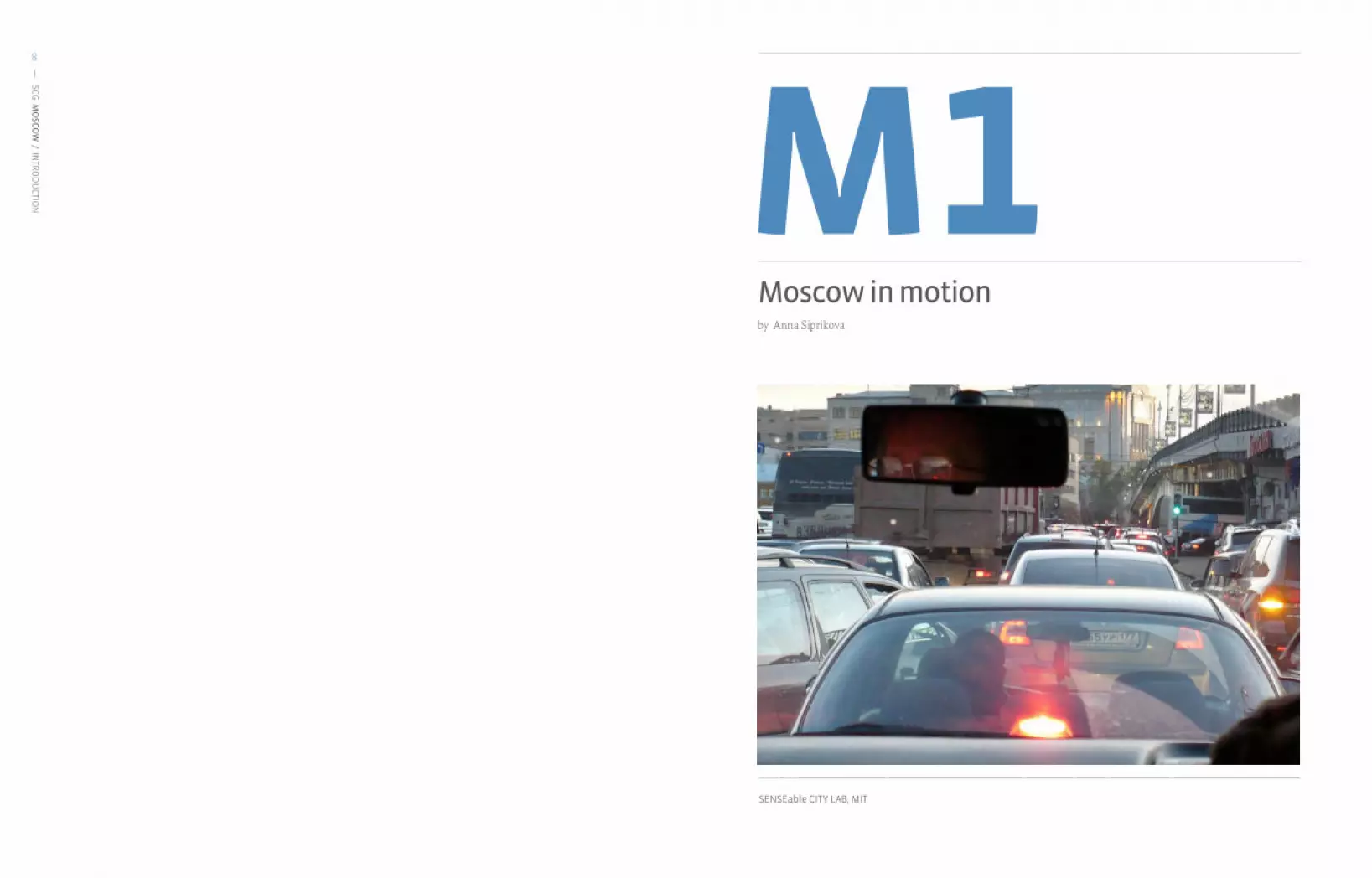
Moscow in motionby Anna Siprikova
SENSEable CITY LAB, MIT
M1

SCG
MO
SCO
W / M
1 / MO
SCO
W IN
MO
TION
11
SCG
MO
SCO
W / M
1 / MO
SCO
W IN
MO
TION
10 PROJECTDESCRIPTION
Moscow is the northernmost megacity, whose reputation is often associated with being desolate, cold, and dirty. Yet, the city is also a vibrant financial and economic center, where the wealth of its citizens is growing. This economic growth is also bringing increasingly difficult challenges with regard to transportation as Moscovites are opting to purchase more private cars. This increase is outpacing infrastructural change, leading to crippling traffic. And for some, having a car is a painful necessity. There needs to be a shift in mentality and in behavior with regard to this problematic growth.
Moscow is between Johannesburg and New Delhi on the IBM Commuter Pain Index. Even without an official ranking, one can intuit the problem from the regular complains from citizens about the issue. By expanding the road network, the government has encouraged citizens to drive even more, and in turn has had to allocate more money to road construction. The matter is further complicated as this growth, and challenges, are so closely tied to the oil and energy, construction, housing, transportation, and retail sectors. Furthermore, the car is a major item of consumption and status symbol. Thus, a cycle of demand, infrastructural change, and public perception change now perpetuates the increasing reliance on the automobile. According to the utility theory from economics, individuals compare alternatives, and choose the one with the highest benefit at the lowest cost to that person. Can we use this economic framework to understand automobile use in Moscow as a choice, or has it become more engrained through that vicious cycle?
I argue that habits are adaptive, and we may break from this trend if we changed the circumstances driving this issue.
With the rise in the number of cars on the roads, Moscow faces endemic traffic jams on its radial road system. The economy suffers losses in money, time and productivity with over 900 traffic jams a year. Legal parking spaces are lacking, as is an overall parking policy; sidewalks are often found with cars parked where people would otherwise be parking. Areas of the city are inaccessible to visitors, as traffic snarls and distance from the Metro leave areas remote. At the same time, people are becoming more interested in time, rather than distance to get from point A to point B. Traditional maps, however, are becoming obsolete as they remain static. Embedding traffic information, public transportation conditions, movements of people, one’s location, and services around them can create a dynamic, individualized, and perhaps more useful map.
Mobility and access are two important facets of a transportation system.But they are at a very low rank in Moscow.
This project aims to create a method by which to access this information, based on the time and place one is in, as a means of planning your transportation options. As such, this technology-enabled transportation is more flexible and dynamic as it is based on user-demand. Private automobiles maintain the convenience to the owner, while providing a service to friends, fellow citizens and visitors alike.

SCG
MO
SCO
W / M
1 / MO
SCO
W IN
MO
TION
13
SCG
MO
SCO
W / M
1 / MO
SCO
W IN
MO
TION
12 PERSONAL INTERACTION
Travelers wishing to explore Moscow’s hidden places can use this information to plan their trip with clear and up-to-date information. By highlighting and mapping these remote attractions, visitors will have a unique experience that is decentralized from the center city. The car-sharing ability helps not only get visitors and residents to these areas otherwise not served, or difficult to get to, it also facilitates interactions between individuals while alleviating some of the traffic problems through the reduction of vehicles. It also helps facilitate interactions with friends, as “Moscow in Motion” can also help people find great locations equidistant from your friends and you to meet.
INDIVIDUAL
COLLECTIVE
+ + + + + +
May, 11th, 20127.30 PM estimated travel time
3h 10min
Local train to Kaluga 8 PM estimated travel time
3h 10min

SCG
MO
SCO
W / M
1 / MO
SCO
W IN
MO
TION
15
SCG
MO
SCO
W / M
1 / MO
SCO
W IN
MO
TION
14
Map tile from StamenDesign, icons from the-nounproject.com
May, 11th, 20127.30 PM estimated travel time
3h 10min
Local train to Kaluga 8 PM
estimated travel time
3h 10min
PERSONAL INTERACTION
Travelers wishing to explore Moscow’s hidden places can use this information to plan their trip with clear and up-to-date information. By highlighting and mapping these remote attractions, visitors will have a unique experience that is decentralized from the center city. The car-sharing ability helps not
only get visitors and residents to these areas otherwise not served, or difficult to get to, it also facilitates interactions between individuals while alleviating some of the traffic problems through the reduction of vehicles. It also helps facilitate interactions with friends, as “Moscow in Motion” can also help people find great locations equidistant from your friends and you to meet.

SCG
MO
SCO
W / M
1 / MO
SCO
W IN
MO
TION
17
SCG
MO
SCO
W / M
1 / MO
SCO
W IN
MO
TION
16 URBANINTERACTIONS
TECHNOLOGY
The aim of the project is intended to create an awareness of the current traffic situation, which affects the economy, pedestrian comfort and environmental conditions (with CO2 emissions, for one). Data visualizations from this project on the urban scale may provoke behavioral change at large, as people may voluntarily choose to rideshare and carpool.
Existing online real-time traffic data is used by this interface. This information is collected from Yandex.Traffic, which provides the current traffic conditions mined from a variety of services, then each location is given a congestion score from 0 to 10.
Mockup made in balsamiq software Nodes with information boards
The project provides an application for car sharing, based on one’s social network and the degrees of connections between individuals. Aggregating this data, one can see the movement patterns of citizens and tourists, which can help planners with new transportation initiatives.

SENSEable CITY LAB, MIT
SCG
MO
SCO
W / M
1 / MO
SCO
W IN
MO
TION
18
PARA – CITIESPARA – SIGHTSby Carlos Medellín
M2ANNA SIPRIKOVA
Anna Siprikova was born in Moscow, Russia. She received a Bachelor of Architecture from the Moscow Institute of Architecture and graduated with a Specialist diploma from the Department of Reconstruction and Restoration in Architecture in 2011. While there, she participated in various workshops in Beijing, Istanbul, Jerusalem and Venice. For her graduation project, she earned a first prize commendation at the International Architectural Festival, and was granted membership in the Moscow Union of Architects. She is currently a research student at the Strelka Institute for Media, Architecture and Design. Anna’s research and academic passions reside in the investigation of new tools for urban planning, and ways of successful development both for issues related to sprawl and shrinking cities in Russia.
parasite parallel
SCG
MO
SCO
W / M
2 / PARA – C
ITIES / PARA – SIG
HTS
21
SCG
MO
SCO
W / M
2 / PARA – C
ITIES / PARA – SIG
HTS
20 PROJECTDESCRIPTION
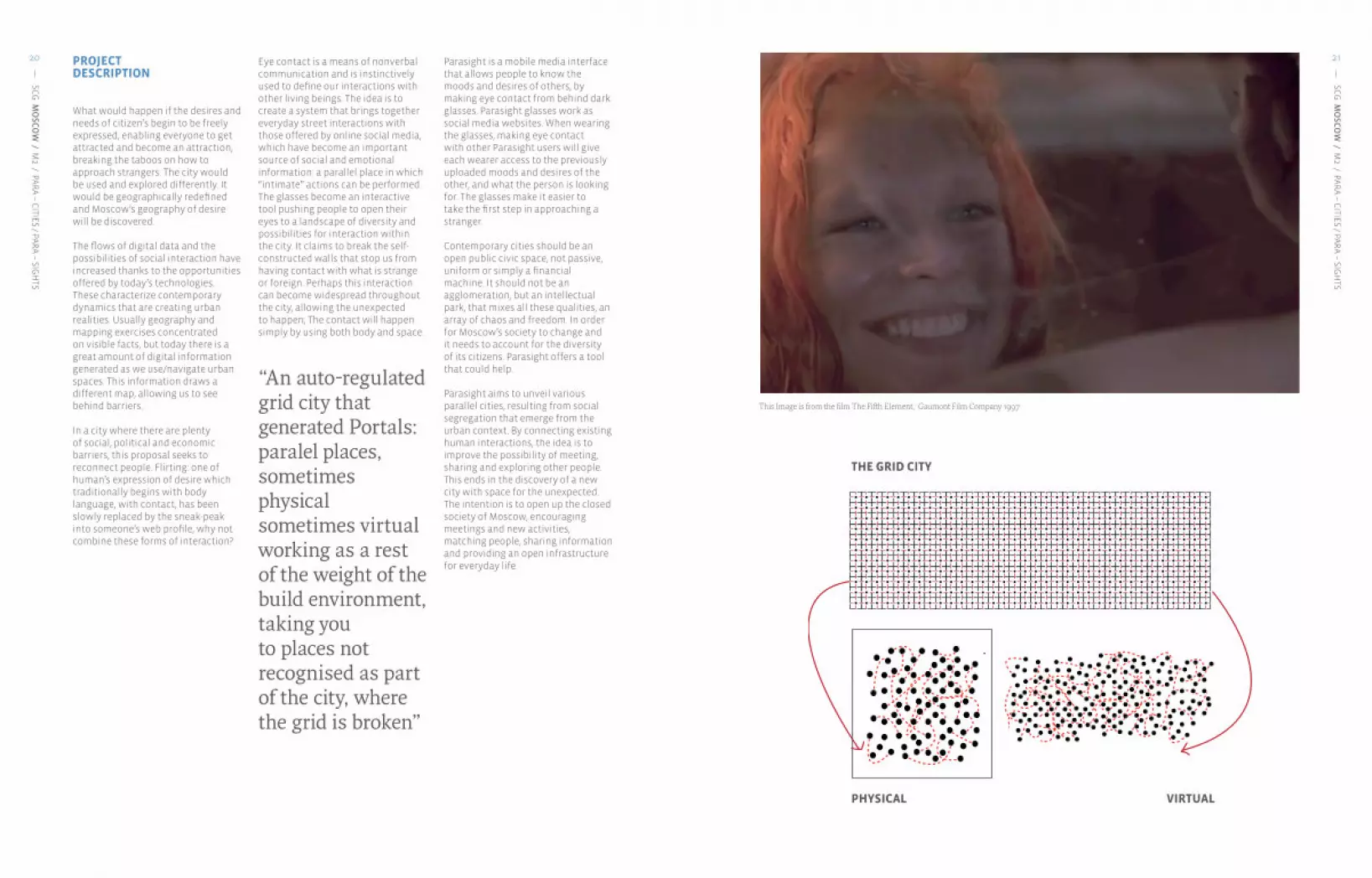
What would happen if the desires and needs of citizen’s begin to be freely expressed, enabling everyone to get attracted and become an attraction, breaking the taboos on how to approach strangers. The city would be used and explored differently. It would be geographically redefined and Moscow’s geography of desire will be discovered.
The flows of digital data and the possibilities of social interaction have increased thanks to the opportunities offered by today’s technologies. These characterize contemporary dynamics that are creating urban realities. Usually geography and mapping exercises concentrated on visible facts, but today there is a great amount of digital information generated as we use/navigate urban spaces. This information draws a different map, allowing us to see behind barriers.
In a city where there are plenty of social, political and economic barriers, this proposal seeks to reconnect people. Flirting: one of human’s expression of desire which traditionally begins with body language, with contact, has been slowly replaced by the sneak-peak into someone’s web profile, why not combine these forms of interaction?
Eye contact is a means of nonverbal communication and is instinctively used to define our interactions with other living beings. The idea is to create a system that brings together everyday street interactions with those offered by online social media, which have become an important source of social and emotional information: a parallel place in which “intimate” actions can be performed. The glasses become an interactive tool pushing people to open their eyes to a landscape of diversity and possibilities for interaction within the city. It claims to break the self-constructed walls that stop us from having contact with what is strange or foreign. Perhaps this interaction can become widespread throughout the city, allowing the unexpected to happen; The contact will happen simply by using both body and space.
“An auto-regulated grid city that generated Portals: paralel places, sometimes physical sometimes virtual working as a rest of the weight of the build environment, taking you to places not recognised as part of the city, where the grid is broken”
Parasight is a mobile media interface that allows people to know the moods and desires of others, by making eye contact from behind dark glasses. Parasight glasses work as social media websites. When wearing the glasses, making eye contact with other Parasight users will give each wearer access to the previously uploaded moods and desires of the other, and what the person is looking for. The glasses make it easier to take the first step in approaching a stranger.
Contemporary cities should be an open public civic space, not passive, uniform or simply a financial machine. It should not be an agglomeration, but an intellectual park, that mixes all these qualities, an array of chaos and freedom. In order for Moscow’s society to change and it needs to account for the diversity of its citizens. Parasight offers a tool that could help.
Parasight aims to unveil various parallel cities, resulting from social segregation that emerge from the urban context. By connecting existing human interactions, the idea is to improve the possibility of meeting, sharing and exploring other people. This ends in the discovery of a new city with space for the unexpected.The intention is to open up the closed society of Moscow, encouraging meetings and new activities, matching people, sharing information and providing an open infrastructure for everyday life.
PHYSICAL VIRTUAL
THE GRID CITY
This Image is from the film The Fifth Element, Gaumont Film Company 1997

SCG
MO
SCO
W / M
2 / PARA – C
ITIES / PARA – SIG
HTS
23
SCG
MO
SCO
W / M
2 / PARA – C
ITIES / PARA – SIG
HTS
22
Since 2006 theres been failed attempts to perform a gay parade always shouted down ending on with violets
The woman showed as an object to be posed
Lack of infrastructure for disabled people.
Strong face control on over the 70% of the clubs on the city.
An already diverse city full of people of different races, sexualities, classes, etc.
“The Love Bote” Diversity party celebrated at Solyanka, one of the most popular clubs in Moscow. It takes place once a month. Theres a strong face control for security issues.
Feminist protest regarding gender equality
No respect for pedestrian’s spaces. A city where the car in the No1 inhabitant
An homogenized landscape, consequence of the controls to access to places or services
“Russians for Russians, Muscovites for Muscovites” Ultra-nationalist group emerging as consequence of seeing the plurality as a problem
People have become accustomed to not have any contact and society in general is reserved.
HOMOPHOBIA
GENDER
INFRASTRUCTURE
FACE CONTROL
XENOPHOBIA
SOCIETY RULES
BUILT ENVIRONMENT
BODY
NO CONTACT

SCG
MO
SCO
W / M
2 / PARA – C
ITIES / PARA – SIG
HTS
25
SCG
MO
SCO
W / M
2 / PARA – C
ITIES / PARA – SIG
HTS
24
THE EYE CONTACT
Parasight is based on the idea of eye contact as a means to relate with one another. The user can decide with whom they make eye contact with and who can read what they are thinking of. It uses the virtual social networks, and amplifies the effect of those existing networks.
The glasses will look and may be used as any other glasses would be. In its lenses you could read what others have posted, only if they provide you with access. This approval occurs only after eye contact is made. If there is a common interest between them, the approach is facilitated.
+
name:sex:location:age:
interests:
PROFILE
I LOOK AWAY
SECONDS
+6STAR EG LANCE
THEY LOOK AWAY SMILE & LOOK MALE FEMALE
Physics
Cultural
Living conditions 8 km
Sexual preferences
Sexual desires
LONGINGS - OFFER CATALOG SAFE LOCATION
Today the internet and the wide variety of mobile applications provide the opportunity to meet, share and acquire knowledge. Given the option of anonymity this presents significant freedom. More recently mobile devices and smart phones have facilitated this contact, making it easier for individuals to connect.
PERSONALINTERACTIONS
SCG
MO
SCO
W / M
2 / PARA – C
ITIES / PARA – SIG
HTS
27
SCG
MO
SCO
W / M
2 / PARA – C
ITIES / PARA – SIG
HTS
26
looking for Chat:Love, Peace and Bubblegum!!!� �
looking for Date:Some one to teach me I've just come to Moscow.I do not know Russian language.�� �
looking for Date:SPICE IT UP! PUMP IT UP!� �� �
looking for Sex:Lady. Do not hesitate to contact me. :)�
� �
looking for Friends:The road of excess leads to the Palace of wisdom. In this profile you don't find some kind of sportiness or muscles, but maybe you can find another treasures.� �� �
looking for Sex:The road of excess leads to the Palace of wisdom.well-built russian guy, looking 4 fun.�
looking for Friends:Grrrrrrrrrrrrrrrrrrrrr �� �
looking for Relationship:I want to meet with a guy, 26-35 �� �
looking for Relationship:I want to meet with a guy, 26-35 �� �
looking for Chat:..., ¨fl¨Â ¨⁄¨›¨⁄ ¨·¨‡¨“¨‡¨›¨‰¨—¨‰¨Ó, ¨’¨›¨Ò ¨Ÿ¨fl¨—¨‹¨‡¨fi¨„¨‰¨”¨—... �� �
looking for Friends:ॷইॻॸॽ�ঀংॶং�ॸ�ॴএॵॳॸআ�#��� �� �looking for Chat:/QT[��0Q�M^MZaJWLa� � �� �
looking for Relationship: 6W�UWVMa�Q[�I\\ZIK\ML�\W�_WUMV��� �� �
looking for Relationship: 1�U�TWWSQVO�NWZ�OWWL�K]\M�O]a�NWZ�NZQMVL[PQX�IVL�ZMTI\QWV[PQX��
looking for Relationship: 1\�[�R][\�IVW\PMZ�LIa� �
looking for Sex:�� �
looking for Date:Let's drink champagne!�� �
looking for Date:Will be in moscow till middel of april! Give a note!�
� �
looking for Friends:So give it to me like I want it�
� �looking for Friend:not possible to discribe in a few words ..........� �
looking for Sex:sex sex sex, )))))))))))))))))))))))�
looking for Sex:�
looking for Relationship: I am looking for new friends, interesting people if possible!� ��
looking for Relationship:sex, smile, jazz!!! :)�� �
looking for Friends:sex, GRRR� �
looking for Friend:Devil wouldn't recognize you...�� �
looking for Date:hi:) Just looking for some friends....�� �
looking for Sex:Cute bottom for muscular top...�
looking for Date: Hello! I'm an interesting guy. I would be glad to get acquainted with interesting people.��
looking for Sex:)))))))))))))))))))))))))))))))))))))))))))))))))))))))))))))))))))))))�� �
looking for Sex:Hot RUSSIAN guy from MOSCOW! - Real fucking without complexes!� �
looking for Sex:Too horny cum pig�
looking for Chat:American football ,sport, dances, intercourse.....�� �
looking for Friends:Wants to share a bottle of wine with somebody, 24-50� �
looking for Relationship:Me gustaría encontrar un hombre de verdad� �
cool guy from moscow ) i am photographer ) �
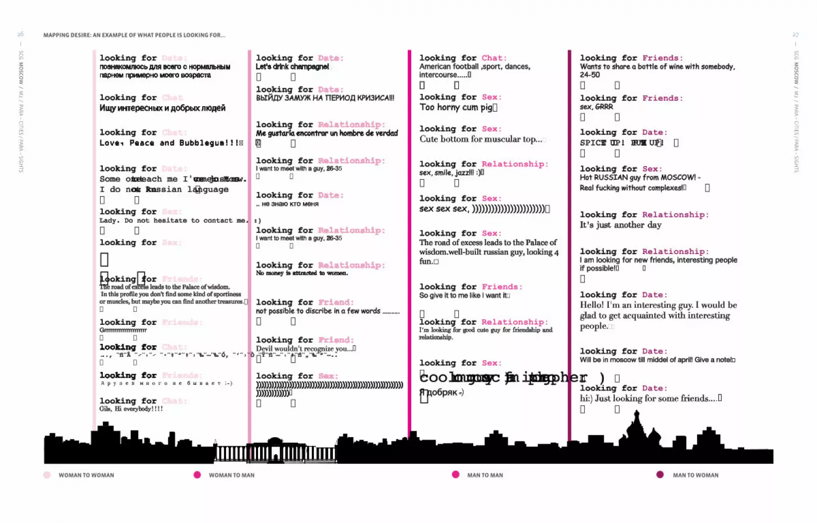
Mapping desires: examples of what the people is looking for ...WOMAN TO WOMAN
MAPPING DESIRE: AN EXAMPLE OF WHAT PEOPLE IS LOOKING FOR...
WOMAN TO MAN MAN TO MAN MAN TO WOMAN

SCG
MO
SCO
W / M
2 / PARA – C
ITIES / PARA – SIG
HTS
29
SCG
MO
SCO
W / M
2 / PARA – C
ITIES / PARA – SIG
HTS
28 VIRTUAL SPACE
Instant messaging already exists in many social networks such as Facebook, Twitter and in dating services such as Badoo, Match.com and Qguys. Messages posted reveal the need and/or wants of individuals trying to connect with others.
PHYSICALSPACE
In a metropolis meeting places can be hidden behind a common façade that do not awake suspicion. Behind these façades, many activities are conducted from adult entertainment to social gatherings. They include but are not limited to saunas, cruising
BREAKING TABOOS
Parasight pretends to open your eyes, to the opportunities that usually pass by. This is more common then we think and it is greater in cities like Moscow where personal expression is more repressed.
Tues Feb 1st1pm – 5pm
MAPPING
WOMAN TO WOMAN
WOMAN TO MAN
MAN TO MAN
MAN TO WOMAN
QGyusHomosexual siteGayRomeoHomosexual siteBadooHeterosexual siteBlenderHeterosexual site
Physics Physics
Height:BirthdayAppearanceGenderMaleWeight:HeightHeight, cmFemale
WeightWeight, kgDate of birthAll smoothAverageSlimCurrent CityBeardAthleticAverageHometown
Facial hair:Clean-shavenBodyMuscularBodytypeAthleticAbout meMustacheBelly
Body typeMuscular
5-o'clock shadowStockyA few extra poundsSideburnsBig and Beautiful
BrownTonsEyeColourGreyBlack Back
Eye ColourGreenBrown
Down belowBlueRed
Bodyhair:Naturally hairlessOtherHaircolorBlonde Body hair:Hands
Hair colorGrey
I don't shave down thereShavedWhiteChestHairShortShavedLegs
HairAverageBald
I shave everywhere!LongDyed
BodyartPunk
Body art andstuff:I have tattoo(s)Brown and stuff:
I have a piearcing(s)Black GreyBrownEye colorGreen
CasualColourRedblueSports Kit
ColourBlondeHazel
DragGreyOtherPunkWhiteAlternativeLight Brown
My attire:Suite and TieLeatherSmoothSkinBodyHairShavedTrendy
Body HairLittle
FormalVery hairyMilitaryAverageRubber
No Beard
BeardDesigner stubble BeardMoustacheGoateeFull Beard
TattosNo
TattosA fewA lot
PiercingsNo
PiercingsA fewA lot
QGyusHomosexual siteGayRomeoHomosexual siteBadooHeterosexual siteBlenderHeterosexual site
Living gconditions
Current City
Drugs:I’m a party animal!
SmokerNoWith ParentsHometown
Drugs:Never
SmokerSociallyLivingWith roomate
Socially and rareYesLiving
DormitoryYes I have With partnerChildrenNo but I like
OccasionallyI am singleAloneChildren
No but I wantAlcohol:OfthenRealtionshipI have a partnerNo I don’t have
NeverOpen realtionshipNo, neverNo I don’t wantSociallyMarriedChildrenSomeday
Night lifeAlready havePets
Yes I have petsRarelyTidinessEmpty nest
PetsNo but I like pets
Smoking:YesPlanningNo pets Smoking:NoCommunicationNo I’m quittingGoing out
SmokingNo and I don’t like smokersCivil UnionSociallyInterests
SmokingSocialComplicatedYesDating
I don’t have anyChain smoker - oxygen is overratedDivorced
Kids:I won’t have anyDomestic partnership Kids:I want to have kids laterNoRelationshipEngagedI live with my kidsDrinkingNo and I don’t like drinkersIn a relationshipI have kids living separatelyWith companyMarried
Yes, please!OpenWhat I do I workSeparatedwith my I'm just a lazy bumRelationship SingleSingle
time:I studystatusTakenWidowedI work and studyOpen
LookingEngagedDating a man and a womanMarried to a womanDivorced from straight marriage
Status:Meeting people Status:Dating a womanDating different peopleMarriage of convinienceLiving with a guyDating a manJust separatedLegally married
Cultural Cultural
EnglishCaucasianSchool onlyInterestsGermanAsianEducationTrade / TechnicalHigh schoolJapaneseLatinCollege / UniversityCollege / UniversityItalianEthnicsMediterraneanAdvanced degreeGraduate schoolRussianBlackOccupation
I can speak:SpanishMixedEnglishFacebookHebrewArabSpanishTwitterDutchIndianGermanLinked inFrenchLanguagesFrenchChineseItaliamPortugueseSocial LifeProfessionPortugueseUkrainianReligionRussian
Industry:Favorite FoodChineseCompany:MusicAfrikaansCompany
site:SportsLanguagesIndonesian
Position:TravelBosnianCatalan
CaucasianCzechHispanicCreole
Ethnicity:BlackWelshAsianDanishMiddle easternEstonianMixed raceEsperanto
BasqueThere is no GodFaroeseGod is thereChristianWorkProfession
Religious blif
MuslimIncomebeliefs:JewishMusic
BuddhistMovies & TV Shows
HinduFashion & BeautySports
RussianTravelBrazilianProfessionChineseGames
MMy mothersHobbies
My favourite
JapaneseBooksfavourite cuisine:KoreanFood & Drink cuisine:
FrenchI eat anythingItalianThaiI'm a vegetarian
Depends on my moodElectronicRock
My I listen to anything yfavourite Pop
music:Dance musicMetalHip-hop, R&BClassicalRadio
RunningSoccerRollerbladingSerfingFitness
Sport:BikingSkiing, snowbordingCombat sportsSwimmingSkatingDeep see diving
QGyusHomosexual siteGayRomeoHomosexual siteBadooHeterosexual siteBlenderHeterosexual site
Sexual preferences
StrightYour Masculine/Butch
OrientationgayStraightOrientationGay / Lesbian
manners:In the middleOrientation
bisexualOrientationOpen-mindedBisexualFemininetransgenderbisexual
LesbianGayBottom only
Orientation:BiSexually I am More bottom Orientation:StraightgenerallyVersatileTranssexual MTFMore TopTranssexual FtMTop only
I'm open about itSafersex
always
WhkParents/relatives
Safer sexNeeds discussion
Who knows aboutyourI can't hide it, I'm GAY!Never about your orientation:Co-workers orientation:
Close friendsBottom onlyNobody knows about me!More bottom
FuckingVersatileMore Top
Manners:Manly manTop only
Manners:In the middleNoFeminine
CanISandMNo
Can I sponsor?:Yes
S and MSoft SM only sponsor?:
NoYes
Top ActiveActive
HowIBottom PassiveFistingActive / Passive
How I preferit:VersatilePassive prefer it:
Top - versatileNoBottom - versatileI don’t do this kind of things!
DirtyNo
DirtyWS Only
Safesex:YesYes
Safe sex:NoSometimesS
DickM DickLXLXXL
CutUncut
Desires Desires
Sex dateLooking forManLooking forFriendsChatBi groupRelationshipDates
I'm searching
for:
Gay coupleLooking for users between
ages
Looking forFriends
for:Bi couple (M+F)NetworkingTransvestiteCityRelationshipGay groupSearchradiusRegionTranssexual
Search radiusCountryContinent
E-mail/ChatPlanerGym/sports buddyRegular sex partnerLeatherLoveRubber
I'mlookingFriendshipBoots
I'm looking herefor:Travel companionFormal dress here for:
Group sexJeansRelationshipSportsgearRoommateFetishesUnderwearOne-night stand
FetishesLycra
3-wayTechno & RaverBuilding a familyDrag
SkaterI would like Doesn’t matterSkins & Punksyour age to Younger than meUniform
be:About my ageSneakers & SocksOlder than meWorker
SkinnyAverage
I would like Thick builtyour body Slim
to be:AthleticLargeDefinedMuscled
I'mlooking I'm looking forsponsor:Yes for sponsor:
No
UnderwearPiercingSocksSwing dates
Fetishes:Smells Fetishes:JeansLeatherDressing upTattoosUniformsLatex/Rubber
KissingMasturbationRimmingExhibitionismDominationCumSex-toysMassage
WhatIlikeOral sex - to give
What I like inbed:Anal sex in bed:
WrestlingSubmissionFistingGolden showersPettingOral sex - to receiveGroup sexBondageRole games
lesb
ian
bar
male
str
ip c
lub
gay
saun
a
sex shops
gay cruising spots
gay bars
stri
p cl
ub
mass
age
salon
brot
hel
prostitutes
gay sex shop
Physics
Cultural
Living conditions
Sexual preferences
Sexual desires
spots, massage salons, sex shops, strip clubs, video booths, motels, gay bars, swing bars or a private party invitation only. They are spaces where visitors have a sense of community, where they can openly and securely express what they believe.
A sexual geography at the service of the men
Even men having a “forbidden” sexual orientation have a place to express their desires
No matter sexual orientation, women have no place on this geography place to express their desires
UNEVEN GEOGRAPHYOF DESIRE
Male
Female
Opportunities lay not only in the eyes of others but in the overall urban landscape that surrounds you. There is a great variety of happenings and options that because of social pressures and cultural regulations are hidden.

SCG
MO
SCO
W / M
2 / PARA – C
ITIES / PARA – SIG
HTS
31
SCG
MO
SCO
W / M
2 / PARA – C
ITIES / PARA – SIG
HTS
30 TECHNOLOGYDESCRIPTION
With the urge to preserve the anonymity of the user, the design is an app that can be installed on any type of glasses, whether sunglasses or regular ones. This brings the added element of suspense and surprise to the user, motivated by the risk to discover and understand what the other users desire. The glasses add a level of comfort and protection.
The Para-Sight Add is composed of five elements:
A special screen to be placed on the glass, it allows the projection of the message.
A positioning sensor. It indicates the moment in which the glasses are in contact for the message to be shared.
A bulb that projects the message and color of the mood.
An encoder that translates the message to light, so the bulb can project the message in the special screen added to the lens
A mini - Bluetooth device that allows connection to the computer or mobile phone so the message can be uploaded or upgraded.
THE COMPONENTS
THE SHARING
With eye contact, the app begins to work. The information, the desire, is shared through a positioning sensor, which detects when two pairs of glasses are in the correct positions. It works like a GPS, which receives information only if the lenses are a facing one another. Eye contact must be retained for more than 6 seconds, giving the user the opportunity to choose who they share information with.
THE PLATFORM
The glasses work with a platform that allows you to upload from your computer or mobile phone the mood or desire you have, What I Am Looking For. It can be changed as often as necessary. The device is connected with the mobile phone via bluetooth.
The platform allows you to choose:First, a color that is related to the mood of the message, which acts as an urban code. This color is defined by the group in which the desire belongs (in turn defined by the online group).
Finally there is space to write what an individual is looking for - the text must not be longer than 100 characters. The user has complete freedom to write whatever they want in the to achieve their desire.
Looking For:____________________________________________
PhysicsCulturalLiving conditionsSexual preferencesSexual desires
Looking For:__________________________
PhysicsCulturalLiving conditionsSexual preferencesSexual desires

SCG
MO
SCO
W / M
2 / PARA – C
ITIES / PARA – SIG
HTS
33
SCG
MO
SCO
W / M
2 / PARA – C
ITIES / PARA – SIG
HTS
32
LOOKING FOR:
barbie mom who pays my bills
�����
SENSE AND SUSTAINABILITY
The idea of Parasight is to spread throughout the city, so that as you walk through the city you begin to find other users that are wearing the glasses, and the possibility of interaction increases.
With time and as the glasses become more popular, the opportunities get more attractive. The device breaks down language barriers and breaks taboos. It is an open invitation for everyone, outsider or local, to communicate and share by means other than the traditional spoken words.

SENSEable CITY LAB, MIT
SCG
MO
SCO
W / M
2 / PARA – C
ITIES / PARA – SIG
HTS
34 CARLOS MEDELLÍN
Both on my personal as on my professional growth, I try to synthesize and materialize ideas and reflections through the particular codes and resources that the architectural language carries. Sensitive to the different cultural ways of expression, my work is able to perceive, contextualize and analyze in a critical sense, general human needs and behaves, specifically those referred to the lacking or the deficiency of city space, structuring them in design projects, both natural and urban, which goal is essentially to construct a consistent architecture with specific temporalities and social needs.
I am a Designer at Mazzanti Arquitectos, where I’m focus on the conceptualization and design of ideas for architectural and urban projects.
I am a Teacher at Los Andes University in Bogota, Colombia, where I graduate as Architect on 2009. For the last couple of years I was assisting there the final studio course on the architecture program.
I am a Researcher with background on urban studies, developing researches about the use of the city space and de “appropriation” of the public space by its citizens.
Currently I’m doing a postgraduate program at Strelka Institute for Media Architecture and Design, based on research. I’m developing a project with the SENSEable City Lab in Moscow. It is called ParaCities, and reach urban dynamics of segregation by looking for the place for diversity on this city, focusing on the relationship between sex taboos and the built environment.The previous Parasight exercise is part of my Paracities research at Strelka.
Dynamic interactive navigation systemby Ekaterina Izmestyeva
M3

SCG
MO
SCO
W / M
3 / DYN
AMIC
INTER
ACTIV
E NAV
IGATIO
N SYSTEM
37
SCG
MO
SCO
W / M
3 / DYN
AMIC
INTER
ACTIV
E NAV
IGATIO
N SYSTEM
36 INTRODUCTION
Dynamic Interactive Navigation System is a project that aims to create a helpful tool from existing and increasing flow of digital information. This project is an interactive, real-time, photographic map of Moscow that provides new modalities of discovering, making known, and highlighting new landmarks. It extends people’s sensing abilities, and become a tool for creating and augmenting points of intense activity in the city, through visual representation.
What is Moscow? Which places are landmarks in the city? Where do people go? What is going on there?If we try to answer these questions, we surely think of Red Square, Kremlin and Saint Basil’s Cathedral. But are there other sights in Moscow? Moscow is an extremely large and constantly growing city. It is impossible for such a city to have so few landmarks. There are many other interesting places that are not well known, and they certainly cannot be found in traditional guidebooks. There are not many ways for people to find them. Moreover, there are not many ways for people to perceive the city as a whole—to understand what disparate parts of the city are like, or what is going on and where in real time. My project is about creating a means of understanding the “pulse” of the city visually, as a digital dimension of the city, which reflects the physical space. The project emerged from research concerning the popularity of places as photographic sites in Moscow for both tourists and locals. The goal of this research was to understand where people in Moscow take photographs and the subject of those photographs, to reveal the attraction of the city. With this data, I could compare them with the usual landmarks that quickly come to mind when we think of the city.The research was based on user-
generated content from flickr.com, one of the most popular services for uploading and sharing photographs. To collect and filter the data, a custom program was written using the Python language. Using the site’s application programming interface (API). I collected more than 40,000 from almost 3,000 users. These users were sorted into three groups based on their location: people from Moscow, people from other Russian cities and people from other countries. The photographs were placed on the map of Moscow according to their geographic coordinates. After analyzing the map, it became clear that there are very few popular places for tourists in Moscow: Red Square, Kremlin, and Saint Basil’s Cathedral. But is there anything else in Moscow? It seems
that for most tourists the answer is ‘no’. Most of them, from their photographs, do not go beyond the Garden Ring; they generally stay in the center of the city. At the same time, as expected, Muscovites are distributed in the whole of the city. The map also revealed places that are quite popular for Muscovites, but not for tourists. We know there are other interesting places in the city, but tourists simply do not know about them (and sometimes Muscovites don’t know about them either!). Moscow is much more diverse than the usual three locations.
Dynamic Interactive Navigation System is the project aimed to explore the potential of visual information creates by individuals. Interactive visuals could be an interface between the city and its people. This project reveals surrounding space in the city and became a tool of interacting with the city. I can also make these places attractive for tourists as well as for Muscovites through this process. The project manifests itself as an interactive, photographic map of Moscow.
Today, people take photographs and share them more then ever, and the popularity and opportunities to do so are growing. New social technologies allow people to immediately share photographs, their location, and other information to let others know where he or she is, and what he or she is seeing at that moment. In my project, I want to use these data to share; to uncover the hidden facets of Moscow; to give people opportunities to look at the familiar places from another point of view; to discover new places; and to create and highlight new landmarks in the city.
The application’s map shows photographs taken in Moscow in real-time, and placed on the map according to their geo-location. Thus users can see what is going on, and where, in the city. The map is interactive, and there are different ways of using it. Users may view these photographs and at the locations where activities are taking place. It is possible to zoom in and out to look at particular locations in the city. The map will use the visual content being created to show the “living city” through time and space. At the same time people can also use the map as a tool to designate new landmarks in the city by providing photographs of these places. This could attract new visitors to them.
The project is an interactive real-time photo map of Moscow that provides new ways of making the city visible and highlighting new landmarks.
INTERACTIVE PHOTO MAP OF MOSCOW
VISUAL FLOW
The project will also have an impact on the city’s apparent scale. Sharing visual data about different places will uncover these locations for many people, and make these places attractive to some. . These places, in turn, become new landmarks in the public psyche due to the increase in visitors—local and tourist alike.

SCG
MO
SCO
W / M
3 / DYN
AMIC
INTER
ACTIV
E NAV
IGATIO
N SYSTEM
39
SCG
MO
SCO
W / M
3 / DYN
AMIC
INTER
ACTIV
E NAV
IGATIO
N SYSTEM
38
Photos are shown in real-time. They appear as soon as they are taken. It will help people understand what is going on in the city at this moment and it provides the relevant picture of city.
Because the photos shown on the map are made by other people it creates the very personal and the very diverse picture of the city.
The map could be used as a tool of looking what is going on near the person as they move through the city.
REAL TIME
OTHER PEOPLES VIEW
LOCATION
PERSONAL INTERACTIONS
The project will help people understand what is going on in the city at a specific moment in time, help orient themselves to their location and events in the city, and choose their paths through and destinations in the city. Visual information given in real-time creates new ways of interacting with the city and extends people’s sensing and perceiving abilities. The map shows photographs in real-time, thus providing a relevant image of city. One then can be aware of the state of the city in real time, and adjust one’s routes to avoid or be at certain places as a result.
The most important aspect of the project is the map itself, as the map gives a sense of the place while transforming abstract photographs of the city into objects that can inform one about specific locales in the city due to their connection to specific coordinates on the map. If the person already knows of these emerging places, then they can contribute to the knowledge of that space. Otherwise, they may go and explore those locales. The map could be used as a tool to understand what is going on near the person as they move through the city.
The user could use the map for different purposes. They could look at the map and observe what is going on in different parts of the city. They can discover places with special activities or places and decide to go there. They can be both consumers and producers of visual content while sharing the places they like with others. They could promote these places by uploading lots of photographs, or photographs that might become highly popular, to attract visitors to these locations. Additionally, they could simply look at friends’ photographs to get an idea where their friends are, and what they are doing.
It is also possible to filter the photographs by search; user will see only the photographs they are interested in. It could be some particular hash-tag phrase or some particular place. One can share the layers of the map, creating a community of photographers and explorers.
Because the photographs shown on the map are made by others, it creates the very personal and diverse picture of the city.

SCG
MO
SCO
W / M
3 / DYN
AMIC
INTER
ACTIV
E NAV
IGATIO
N SYSTEM
41
SCG
MO
SCO
W / M
3 / DYN
AMIC
INTER
ACTIV
E NAV
IGATIO
N SYSTEM
40
Visual layer creates the dimension which reveals what is going on in the city from people’s perspective.
The map provides information about the different areas in the city: which areas are more active in the city or more happy based on the content of the photos.
There could be social competition for the different places in the city. There could be reward for the most active and happy areas and it could stimulate people to make more photos and through this see and reflect on the surrounding space.
URBAN LAYER
ACTIVITY
COMPETITION
HAPPINESS
PERSONAL LAYER REVEALED LAYER
URBAN INTERACTIONS
The project allows people to explore and interact with the city through a visual language, which is constantly being created and recreated by people. This visual layer creates a dimension that reveals what is going on in the city from people’s perspective. Sharing visual data about different places will uncover these otherwise hidden locations for many, making these places attractive visit. As people can highlight points of attraction in the city, the project can create new places of attraction in the city. Photographs of these places will attract new visitors, and as a result, new forms of cultural, social and economical activities may appear.
Additionally, it is possible to understand which areas are more active, or happier based on the content of the photographs. It could reveal other reasons for choosing a certain place to go or route. It could be the basis for social competitions at different places in the city; there could be rewards for the most active and happy areas. The project could stimulate people to take more photographs that reflect upon the surrounding space.
On a personal level, it reflects one’s on engagement with the city. The aggregation of many people’s layers will, together, reflect the interactions on a more large scale. By analyzing these patterns and their density, we could understand more about the city, about different regions, and the various ways people interact with these places.
The scheme shows the logic of the working process: People upload photos, application collect these photos and they are shown on the map, people use the map. The could both just look at the map and discover places and acitivites or upload and share information by themselves. These activities lead to making places visible.
Uncover unknown places.
LOCATION

SCG
MO
SCO
W / M
3 / DYN
AMIC
INTER
ACTIV
E NAV
IGATIO
N SYSTEM
43
SCG
MO
SCO
W / M
3 / DYN
AMIC
INTER
ACTIV
E NAV
IGATIO
N SYSTEM
42
main, all photos are shown personal, photos from user suggested, photos with special tag are shown
friends, photos from friends are shown
shows photos taken in last n minutes, hours or days on the map
show activity or mood of the city
share layers with friendsshow locations on the map
by tag / by location / by user
LAYERS
PHOTOS
ACTIVITY / MOOD
SHARE MAP
SEARCH
The interface of the application.
TECHNOLOGY
With new technologies and new mobile devices, it becomes very easy to take a picture and immediately share it with friends. Photographs now include geo-located coordinates; it is possible to see where they were taken. By combining these aspects, the map, which shows photographs in real-time according to their geo-location, can be created. The map is an application for smartphones, and has several layers with which one can interact: the base map, a “suggested Moscow” layer, a personal map of one’s activity, and those of one’s friends. There are also layers showing the density of activity in the city, and the happiness of a place based on the content of photographs. One can search by using tags, location names and users. It is possible to share your map with others.
All the photographs are shown in real-time on the main layer. The “suggested Moscow” layer shows featured places in Moscow. There is a special predefined hash-tag that allows photographs tagged with that term to appear on this layer; this layer shows only the places that were suggested by users. The personal layer shows only that user’s photographs on the map. The friends’ layer shows only photographs from the user’s friends.
PHOTOS SMARTPHONES GEO LOCATION
There are lots of photos and the amount of them is growing.

SENSEable CITY LAB, MIT
SCG
MO
SCO
W / M
3 / DYN
AMIC
INTER
ACTIV
E NAV
IGATIO
N SYSTEM
44 EKATERINA IZMESTYEVA
Ekaterina Izmestyeva holds a Bachelor of Social Science in Sociology from State University - Higher School of Economics, Saint Petersburg, Russia.During that time she participated in several projects within the field of Urban Sociology.During the 2011 Ekaterina has been working as a project assistant for the project concerning urban heritage in Saint Petersburg at the University of Oxford.In 2011 Ekaterina entered Strelka Institute of Media, Architechture and Design.
DCITYSPY - Informational systemfor Moscow airportsby Elena Bykova
M4

SCG
MO
SCO
W / M
4 / CITYSPY
47
SCG
MO
SCO
W / M
4 / CITYSPY
46 PROJECTDESCRIPTION
The government of Moscow has initiated a program aimed at developing tourism in Moscow. Two main priorities were identified: increasing the number of tourists up to 6 million per year and to find new ways of providing tourist infrastructure. Other parts of this program focus on preparing Moscow for the 2018 FIFA World Cup and also making Moscow a modern tourist center.
Examining international ratings of the city, Moscow receives predominantly negative rates. For example Moscow is on the top 10 «Most expensive cities» rating, takes 3rd place as an «Unfriendly city» and holds the title for the city with the « worst dressed people». But at the same time Moscow has landed in the top-five, in a survey of tourist destinations that hold great potential for the future. TripAdvisor ranked it fourth out of the 15 most dynamic and developing tourist destinations.
Serge Shpilko, head of the Moscow Tourism Department noted that the city currently is undervalued on the world tourist marketplace and that it lacks it’s own brand. Visa issues, traffic problems and questions of navigation inside the city space are identified as key problems. One of the most important problems impacting tourist mobility is the price of transportation. Some of these problems are clearly interconnected and have a direct influence on the tourists’ experience of the city. Switching our attention from the issues of the urban scale to the human scale may open new solutions to the problems faced by toursits. That requires assessing the problem from the perspective of the tourist. Assuming a user orientated approach is of paramount importance as it provides a specific lens through which to focus.
Starting from the physical routes taken by tourists from the moment their flight lands to the paths they take through the city, until their eventual departure. The goal is to fully understand how tourists use the space of Moscow.
OBJECTIVE
Historically, the geographical position of Moscow gave the city many benefits. The city rapidly developed due to its strategic location on trade routes. Nowadays its geographical position between Europe and Asia still provides an opportunity to cultivate its position in terms of international flights.
Last years Moscow’s airports observed a increase in the volume of transit traffic through Moscow. Information on transit passengers was obtained from an official report of Sheremetyevo Airport and it clearly depicts the growth in tourists in the last two years. This proposal aims to promote Moscow as the international hub that it is and to maximize on the key position it has on the international transit routes.
Moscow’s Domodedovo and Sheremetievo airports rank 40th and 98th respectively on the World’s Best Airports ratings. At the same time in ACI ASQ (Airport Service Quality) Sheremetyevo received 4th position in terms of quality of service (for European airports with passenger traffic between15 - 25 million persons). As of yet Moscow airports have not been strongly promoted or advertised, but with the growing passengers there are significant opportunities to maximize on this trend. Although steps have been already taken to begin solving some of the cities problems and developing the tourist infrastructure- the airport has not been a priority despite it presenting an important component of Moscow’s tourism.
STRATEGY
In order to promote Moscow as an international flight hub, the first step is to focus on transit passengers and their needs- and look to introduce infrastructure within the airport space that serves them. Transit passengers are defined as persons who have multiples flights and have a point of interchange before reaching their final destination. If we imagine the number of people who pass through the airports all over the world we could view the number of hours that they spend there. To date airport infrastructure has served to encourage people to stay inside airport, with the space providing
almost everything that is necessary for a comfortable stay..Transit passengers through Moscow airports predominantly stay in the airport rather than exploring the city. The main reasons for this are difficulties with visas and the traffic jams which restrict quick access to the city. Moscow has become inaccessible to foreign touristsBoth underlying causes present formidable challenges so here we bring the city to the transit passenger. In a survey conducted at different times on transfer passengers, 80% of people stated that they would like to visit the city during long transfers. This proposal seeks to provide people who are staying in Moscow airports the opportunity to connect with the city in real time.From their arrival, passengers will be provided with the possibility of getting specific information about the city and other information during their time in the airport. Digital technologies give us opportunities to organize this through different virtual layers. As a result this could encourage passengers to return to Moscow at a later date as a tourists and to experience Moscow’s physical form. Project ProposalSpyCity will allow visitors at the airport to access real-time
information on the city and create a virtual experience that bridges the digital and physical divide. If you are transit tourist and are unable to leave an airport- special lounges will help you to get to know the city and its most popular places. If you have more time you could even visit the
city using special moving lounges within a free visa zone. This lounge will move around the city starting from the airport and visiting places of interest in Moscow. This new space that is embedded into the airport as well as the city environment, circumnavigates existing difficulties
with visas etc. and provides an opportunity for visitors to experience Moscow both physically and virtually.
We should focus our view on transit passengers and their needs
Interaction of people with a city
cityairport
city
SCG
MO
SCO
W / M
4 / CITYSPY
49
SCG
MO
SCO
W / M
4 / CITYSPY
48 TWINKLING MOSCOW
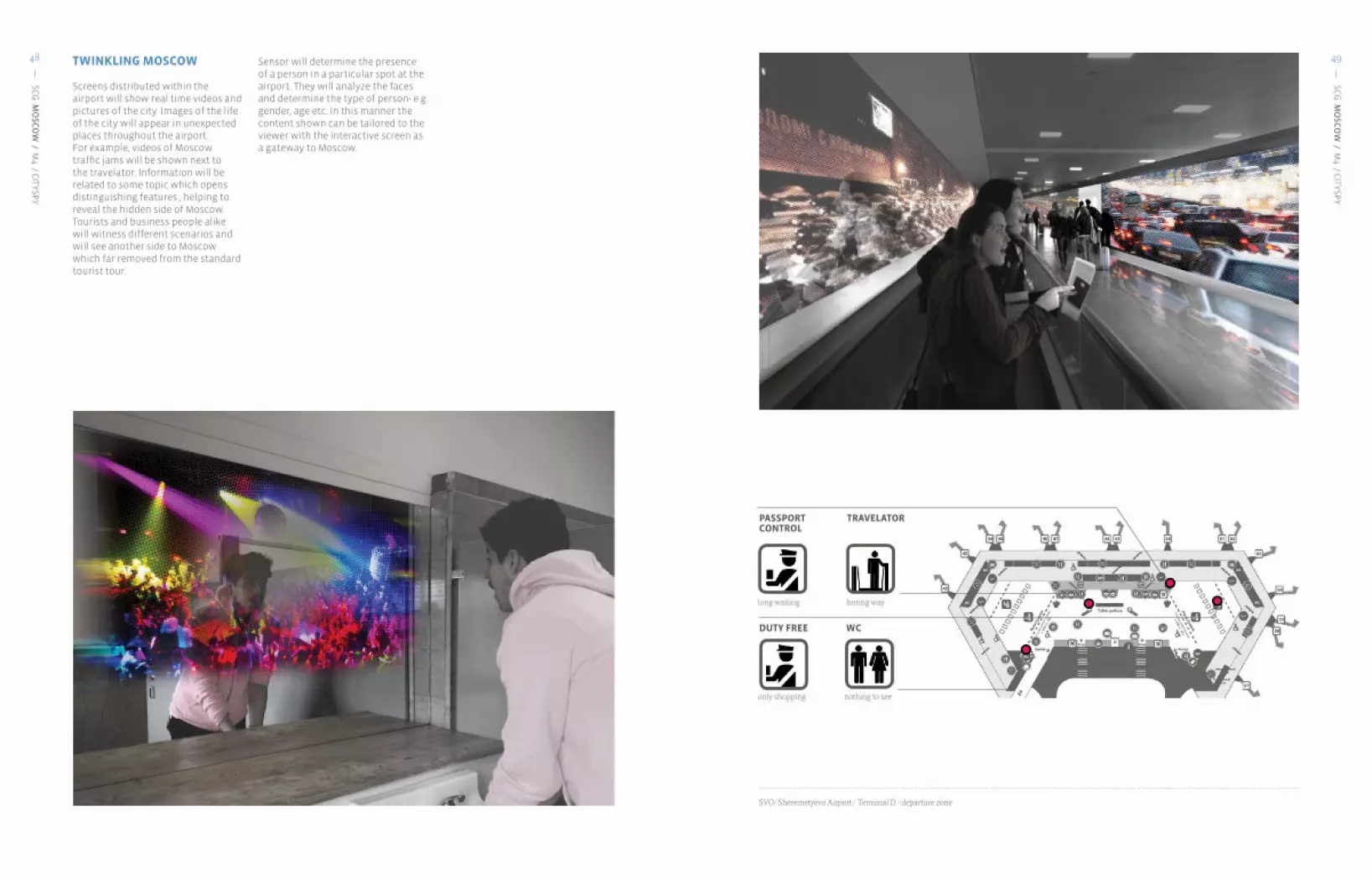
Screens distributed within the airport will show real time videos and pictures of the city. Images of the life of the city will appear in unexpected places throughout the airport. For example, videos of Moscow traffic jams will be shown next to the travelator. Information will be related to some topic which opens distinguishing features , helping to reveal the hidden side of Moscow. Tourists and business people alike will witness different scenarios and will see another side to Moscow which far removed from the standard tourist tour.
Sensor will determine the presence of a person in a particular spot at the airport. They will analyze the faces and determine the type of person- e.g. gender, age etc. In this manner the content shown can be tailored to the viewer with the interactive screen as a gateway to Moscow.
SVO/Sheremetyevo Airport/ Terminal D /departure zone
WC
nothing to see
TRAVELATOR
boring way
DUTY FREE
only shopping
PASSPORTCONTROL
long waiting

SCG
MO
SCO
W / M
4 / CITYSPY
51
SCG
MO
SCO
W / M
4 / CITYSPY
50 ACCESS POINTS
Access points will be located throughout the airport to help tourists navigate the space and to get information. The airport will be a virtual reality of Moscow. Glass touch screens situated in the lounge zone of the airport will link the airport and city. It will translate information gathered on the city from cameras, sensors and other devices embedded within the urban environment. Static cameras situated near main attractions and public spaces will show real time Moscow activities. Cameras on transport will gather information about on line tours around Moscow and city traffic. Finally a personal link will be provided using tourists visiting the city and translating their personal experience of the city.
The access points will be half circle glass touch screens, and will have three modes of operation. The first mode is an Independent Interface. The glass reacts to the surrounding space by scanning people as they pass it. When someone passes the
screen, it places that person onto Moscow the city space. A passerby could appear in the center of Red Square or on the dance floor of one of Moscow’s night club.
The second scenario is the Public Interface. It gives general information about the city to all. It uses a simple interface and selects information according to the needs.
The third scenario is the Private Interface. The shape of the screen changes and users get inside the glass circle which becomes opaque. The screen transforms into a closed lounge, where people can spend time and access information for leisure of even for business. In addition it is also possible to travel around the city, as it is shown in a 360 panoramic view.
Public Interface Private Interface

SCG
MO
SCO
W / M
4 / CITYSPY
53
SCG
MO
SCO
W / M
4 / CITYSPY
52 MOVING LOUNGE
COMPLEXITY AND ACCESSIBILITY
This is a visa free tour around the city. The moving lounges organize journeys around the city starting from the airport. The route taken passes some of Moscow’s most famous attractions, but also offers tours tailored to various themes such as «Unknown Moscow», or «Soviet Heritage» etc.
These lounges are connected with the city and with one another, and provide the opportunity for tourists to control their routes and vote for different destinations. The lounges are safe, secure and will arrive back at the airport for transit passengers to catch their connecting flights.
This proposal will focus on the tourist experience and how to improve the quality of their experience. Soultions for the city in terms of tourism, can only be found if the focus is shifted to the view of the tourists needs and provdes a system for them which could make their experience of exploring the city more streamlined.
CitySpy would also have applicability in other urban spaces apart from the airport. This system could be implemented in part of the city where there are difficulties accessing information. It would provide a bridge to connect individuals with other physical spaces. This system promotes a new type of connection and interaction. Furthermore as this project helps people to see the city, it may serve to boost tourism.
Route maps are available for tourists to view in transit zones of the airport. The system will organize a continuous experience for exploring Moscow- from airport to city.The lounges will act as a distributed mobile network across the city, creating a virtual reality.

SENSEable CITY LAB, MIT
SCG
MO
SCO
W / M
4 / CITYSPY
54 ELENA BYKOVA
Elena was born in Moscow, Russia and is a graduate of the Moscow Architectural Institute. Prior to Strelka she worked as a architect in a firm which focuses on urban planning, high-rise offices and dwelling, shopping centers. Currently she is studying at Strelka Institute of Media, Architecture and Design. She is interested in urban planning, housing and communication them through digital means to the real city.
THE OPEN SIGNby Irina Rudnichenko
M5

SCG
MO
SCO
W / M
5 / THE O
PEN SIG
N
SCG
MO
SCO
W / M
5 / THE O
PEN SIG
N
56 57PROJECTDESCRIPTION
Open Sign aims to show and translate the various digital layers of information that overlay the physical form of the city. The project proposes a new system of navigation in the city, which employs augmented reality technology and seeks to make digital information available for everyone. The focus of the project is to build a navigation system, which would always show up-to-date information and could adapt to users requests and needs. Open Sign gives users an opportunity to see and learn about the city from a unique perspective of different people and communities which inhabit it, not only through officially approved information. The approach of the system is comparable to that of an information market. At the same time the project gives its users an opportunity to participate in creating layers of information about the city to express themselves whilst also enhancing the system with new relevant information.
THE CITY AND ITS THREE INFORMATION LAYERS
The environment around human beings and the city consist of several layers of information. The idea of Open Sign is that in order to understand the city, one should have access to as many of these layers as possible.
The first layer is “the objective reality” or the reality, which Kant refers to as das Ding ansich (“the thing in itself”). This reality exists objectively, without correlation with human beings, therefore people can not explore it. The second layer is “the known reality” or “measurable” reality. This reality consists of a series of assumptions about “the objective reality”, regarding the time, matter, space; it is built on perceptions of the world through human physical receptors. Theoretically, a human being may see this reality. But in fact the ability to perceive “the known reality” can easily be shadowed by the next informational layer, which is the layer of society assumptions.
For instance, humans for a long period of time were not able to understand and agree with the heliocentric system not because they were blind and did not have physical ability to percept that fact. Even after several insights and experiments of Nicolaus Copernicus the society forced individual humans to continue to ignore some more relevant information. That last layer is the layer on which human beings interact with each other, build society and agree on common points of view and assumptions about “the known reality” in order to make communication inside the society easier. This layer is extremely important for effective communication between people.
Open Sign and the idea of navigation through the city focuses on the third information layer of the city: the Known Reality.
TRANSLATION AND NAVIGATION OF THE THIRD LAYER
As mentioned society establishes assumptions based on reality and in order to make communication easier between members of society. But the same action which makes interaction within society more effective can also be a problem for those who do not belong to the community.
However as new technologies emerge the process of establishing common assumptions about reality changes. Starting with gathering the community around the village well, and public and open discussions among all members of the community, with increasing of population of settlements, the process develops to sophisticated and hardly accessible systems.
The layer of societal assumptions become less visible to tourists and visitors. Firstly, society and the city become too large for a single layer of consistent assumptions. The city is fragmented into billions of different sub-cultures and communities, each of which establishes and represents their own view of reality. For a stranger it is almost impossible to navigate between all the different assumptions without getting lost. Secondly, with the introduction of new technologies, communication between people has altered, tourists increasingly require more than the physical reality to understand the city. To make cities more accessible, Open Sign addresses two specific problems for tourists: (1) it provides them with easy, understandable picture of interaction and intersection between different sub-communities of the place in order to navigate and (2) it provides access to
remote, invisible information about the third layer, or assumptions about the city.
SYSTEM DESCRIPTION
Open Sign uses augmented reality to reveal the city’s digital information layers. The system gathers different feeds of information that exist, such as geo-tagged media news, current cultural and historical events, official information and user-generated content from the likes of Twitter and Facebook.
The Open Sign project gives users an opportunity to explore city through unique perception of different people and communities
Moluptae solore nonsenem cum escia dipideria doloris exerum que sumet omnihil lestem. Vellit lati voluptatur?

SCG
MO
SCO
W / M
5 / THE O
PEN SIG
N
SCG
MO
SCO
W / M
5 / THE O
PEN SIG
N
58 59PERSONALINTERACTION
The users has access to two working modes of the system. The first mode provides users with an opportunity to get available information and understand the city. The second mode allows users to add new comments and news to the existing system and express personal opinions about the environment. Individuals can navigate within and across modes by using an easy system of filters.
The first mode consists of three parts that give access to different communities.
1 One of them consists of information gathered from the government of the city, and reflects the official view of the space. Entitled “Official Navigation (Basic)”, this feed includes alphabetic and language translation of street signs, information about bus schedules, opening hours and average prices for restaurants. This feed is not open and has moderators assigned to update information about the space.
2 The second component of the first modes is the “Mythology Feed” which shows users the phyco-geographical layer of the city. Inside this feed a user can filter myths and legends about the space using several parameters. This feed, as with the previous one, is not open, due to the need to filter irrelevant information and reflect established knowledge on the city.
3 The final part of the first mode is the “Media Feed”. It is an open feed that shows real-time news and places it within the space of the city. If the news is geo-tagged, they would be immediately placed in the pertinent location. The users can filter this information by source i.e. news only from the Moscow Times or thematically i.e. only cultural or political events.
The second mode of Open Sign gives users an opportunity to contribute. This mode allows users to place their own comments and also displays news and comments made by other users.
The public access to the system through new infrastructure in the city - transparent screens which could became new taksophones. The example of using filters in the system
The personal access to the system through smartphone which scans qr-codes in the city.

SCG
MO
SCO
W / M
5 / THE O
PEN SIG
N
SCG
MO
SCO
W / M
5 / THE O
PEN SIG
N
60 61URBANINTERACTION
Recent events in international affairs have revealed the significant changes that have occurred in the way in which we communicate. Digital information and communication can no longer remain only within the virtual reality, it pervades society and influences the physical reality of the city. For example, the political protests against the elections in Moscow (December 2011- Feb 2012), sprang from social networks before manifesting into real protests within the city.
Information and media created in the digital space increasingly influences the physical reality. In the near future, the boundaries between the virtual and physical realities will most likely disintegrate even further. A new age of media and communication starts with the development of a new form of reality, which exists in between these physical and virtual spaces: augmented reality.
Open Sign is inspired by the idea of enhancing physical spaces of the city with information from the digital world. Current media and geographical studies[1] propose - “geo-media” - for media that goes back to the locality. Augmenting the reality of the city with digital information will certainly change the urban landscape; transforming not only the perception of the city by providing additional knowledge, but also the physical form with the new infrastructure required to see the augmentation, such as screens and/ or lenses.
Political protest “For Fair Election” in Moscow, December 2011. Image by RiaNovosti
The graph shows growing number of paticipants of political protest in Moscow in December 2011 - February 2012. The green line shows information about number of participants provided by organizators of the riots, the blue line - by Russian officials. The differnce between two line shows the difference in the perception of reality by two communities in the city.
Images from the research “Empowerment. Political protests in Moscow, done by Irina Rudnichenko, SENSEable City Lab Moscow, Strelka Institute, MIT
The map is the part of research “Empowerment. Political protests in Moscow”. The map shows perception of the Russian news by official group of political protests on FaceBook. It shows that according this source there was five political protests in Moscow on 29 of December. In contrast, according Russian governmental newspaper Rossiiskaya Gazeta there was not any political protesta in Moscow on that date.
The figue shows part of semantic analisys about perception of the political protest in Moscow by different communities and groups in the city.
The graph shows different models of activity in Twitter during December protests in Moscow.

SCG
MO
SCO
W / M
5 / THE O
PEN SIG
N
SCG
MO
SCO
W / M
5 / THE O
PEN SIG
N
62 63TECHNOLOGYDESCRIPTION
The system provides users with a tool for navigation both through individual devices and through special public infrastructure. The provision of both publica and provate devices ensures that it is accessible by the widest possible audience and does not restrict access based on education or technological saviness. Furthermore, it will also serve to involve as many users as possible, in turn boosting the user generated content.
There are several challenges associated with augmented reality technology. One of them isdeveloping public devices that allow the viewer to see the reality through a large transparent screen. Using a device like this requires precise installation that accounts for the line of sight of the user. However in order to ensure that it can be experienced by the greatest number of users Open Sign proposes individual cabins with transparent walls and recognition cameras that track the position of the observers eyes. After recognition, the processor with 3D model of the surrounding is modeling the angle of viewer’s view and puts augmentation at the right place. On top of transparent screen there is a multi-touch screen that allows users to easily navigate and filter through the available information.
Personal devices work by scanning QR codes with user’s smartphones. QR codes allow rapid and easy access to information as they do not require GPRS and therefore can be used almost everywhere. User can scan QR codes placed throughout the city and can efficiently filter the system, in addition they have the opportunity to write personal comments.
The scheme shows system of possible filters of information in the Open Sign project.
Scheme shows the possible way to solve one of the problems of augmented reality. A camera with recognition and processor with 3D-model of surrounding can ajust augmentation to the position of spectator’s eyes.
Device for public usage. Cabin for one person, which could become the next generation of public pay-phones, gives the user an opportunity to experience augmented reality.Individual cabin fixes the position of the user which could help to solve the paralex problem of augmented reality. Another advantage of implementing such kind of devices is that it uses existing infrastructure of taksophones in the city

SENSEable CITY LAB, MIT
SCG
MO
SCO
W / M
5 / THE O
PEN SIG
N
64
Irina is a culturologist from Omsk. She is a graduate of Theology and World Cultures from Omsk State University and undertook Art Journalism at the Institute ProArte in Saint Petersburg. After completion she worked as a scientific employee at the museum “Art of Omsk” where she organised several exhibitions. During the work in the museum she specialized in the relationship between architecture and culture in the city; participating in different projects such as The Dictionary of Mythology of The City. In 2011 Irina joined the Strelka Institute for Media, Architecture and Design.
IRINA RUDNICHENKO
MOSCOW OPENERby Natalia Kopeikina
M6
66 67
SCG
MO
SCO
W / M
6 / MO
SCO
W O
PENER
67
SCG
MO
SCO
W / M
6 / MO
SCO
W O
PENER
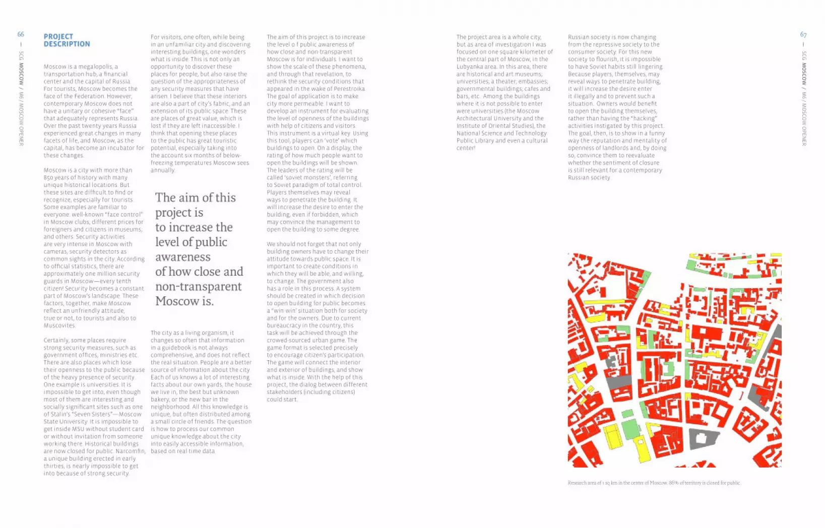
66 PROJECTDESCRIPTION
Moscow is a megalopolis, a transportation hub, a financial center and the capital of Russia. For tourists, Moscow becomes the face of the Federation. However, contemporary Moscow does not have a unitary or cohesive “face” that adequately represents Russia. Over the past twenty years Russia experienced great changes in many facets of life, and Moscow, as the capital, has become an incubator for these changes.
Moscow is a city with more than 850 years of history with many unique historical locations. But these sites are difficult to find or recognize, especially for tourists. Some examples are familiar to everyone: well-known “face control” in Moscow clubs; different prices for foreigners and citizens in museums; and others. Security activities are very intense in Moscow with cameras, security detectors as common sights in the city. According to official statistics, there are approximately one million security guards in Moscow—every tenth citizen! Security becomes a constant part of Moscow’s landscape. These factors, together, make Moscow reflect an unfriendly attitude, true or not, to tourists and also to Muscovites.
Certainly, some places require strong security measures, such as government offices, ministries etc. There are also places which lose their openness to the public because of the heavy presence of security. One example is universities. It is impossible to get into, even though most of them are interesting and socially significant sites such as one of Stalin’s “Seven Sisters”—Moscow State University. It is impossible to get inside MSU without student card or without invitation from someone working there. Historical buildings are now closed for public. Narcomfin, a unique building erected in early thirties, is nearly impossible to get into because of strong security.
For visitors, one often, while being in an unfamiliar city and discovering interesting buildings, one wonders what is inside. This is not only an opportunity to discover these places for people, but also raise the question of the appropriateness of any security measures that have arisen. I believe that these interiors are also a part of city’s fabric, and an extension of its public space. These are places of great value, which is lost if they are left inaccessible. I think that opening these places to the public has great touristic potential, especially taking into the account six months of below-freezing temperatures Moscow sees annually.
The city as a living organism, it changes so often that information in a guidebook is not always comprehensive, and does not reflect the real situation. People are a better source of information about the city. Each of us knows a lot of interesting facts about our own yards, the house we live in, the best but unknown bakery, or the new bar in the neighborhood. All this knowledge is unique, but often distributed among a small circle of friends. The question is how to process our common unique knowledge about the city into easily accessible information, based on real time data.
The aim of this project is to increase the level o f public awareness of how close and non-transparent Moscow is for individuals. I want to show the scale of these phenomena, and through that revelation, to rethink the security conditions that appeared in the wake of Perestroika. The goal of application is to make city more permeable. I want to develop an instrument for evaluating the level of openness of the buildings with help of citizens and visitors. This instrument is a virtual key. Using this tool, players can ‘vote’ which buildings to open. On a display, the rating of how much people want to open the buildings will be shown. The leaders of the rating will be called ‘soviet monsters’, referring to Soviet paradigm of total control. Players themselves may reveal ways to penetrate the building. It will increase the desire to enter the building, even if forbidden, which may convince the management to open the building to some degree.
We should not forget that not only building owners have to change their attitude towards public space. It is important to create conditions in which they will be able, and willing, to change. The government also has a role in this process. A system should be created in which decision to open building for public becomes a “win-win’ situation both for society and for the owners. Due to current bureaucracy in the country, this task will be achieved through the crowed-sourced urban game. The game format is selected precisely to encourage citizen’s participation. The game will connect the interior and exterior of buildings, and show what is inside. With the help of this project, the dialog between different stakeholders (including citizens) could start.
The project area is a whole city, but as area of investigation I was focused on one square kilometer of the central part of Moscow, in the Lubyanka area. In this area, there are historical and art museums; universities; a theater; embassies; governmental buildings; cafes and bars, etc. Among the buildings where it is not possible to enter were universities (the Moscow Architectural University and the Institute of Oriental Studies), the National Science and Technology Public Library and even a cultural center!
Russian society is now changing from the repressive society to the consumer society. For this new society to flourish, it is impossible to have Soviet habits still lingering. Because players, themselves, may reveal ways to penetrate building, it will increase the desire enter it illegally and to prevent such a situation. Owners would benefit to open the building themselves, rather than having the “hacking” activities instigated by this project. The goal, then, is to show in a funny way the reputation and mentality of openness of landlords and, by doing so, convince them to reevaluate whether the sentiment of closure is still relevant for a contemporary Russian society.
The aim of this project isto increase the level of public awarenessof how close and non-transparent Moscow is.
Research area of 1 sq km in the center of Moscow. 86% of territory is closed for public.

68 69
SCG
MO
SCO
W / M
6 / MO
SCO
W O
PENER
69
SCG
MO
SCO
W / M
6 / MO
SCO
W O
PENER
68 PERSONALINTERACTION
In each trip, one of the most important things about new destinations is gaining new experiences and interactions. The game will give users a possibility to interact with the city, using creative languages and will offer different types of experiences.
The project is a social urban game. It is geo-located and crowed-sourced. The application uses creative languages to talk with users, and colors buildings into different intuitively understandable colors. There are four types of buildings in this application. The status of each place can be changed by players according to varying the conditions of access. Users are able to comment or give recommendations about how to enter buildings. Each player receives points for opening of previously inaccessible buildings (which appears red or yellow on the map) as well as additional points for comments on how to get inside.
Each activity has its own color:
Dark greymost closed due to its function; entry is not possible.
Redclosed to the public by the management, but there is no available information on how to enter.
Yellowpartially open to the public, or there are known hints on how to get in.
Green open to the public.
This game is made for citizens of Moscow, both local and global. For tourists the game will give the option to have a quick overview on the level of accessibility of the places at one’s current position that will make the decision-making process faster. For Muscovites, this application helps to understand how closed the city is. Users logged in to the application receive map information on the availability of the building using an intuitive, visual interface.Language is not a barrier.This game allows people to interact with built environment in a richer way.
This game is made for citizens of Moscow both local and global. For tourists the game will give a possibility to have a quick overview on the level of accessibility of the places on current position and will make the decision making faster. For Muscovites this application helps to understand level of closure of the city. This game allows people to interact with built environment.
buildings priory constructed to be closed for public because of their function. Interaction with building is impossible
closed for public for some reasons by managing company, there is no information how to get in
partially open for public or there are known hints how to get in open
LAYERS
LOCATION
COMMENTS
COLOR SHOWS THE LEVELOF BUILDINGS ACCESSIBILITY

70 71
SCG
MO
SCO
W / M
6 / MO
SCO
W O
PENER
71
SCG
MO
SCO
W / M
6 / MO
SCO
W O
PENER
70 URBANINTERACTION
The reason for creation of this game lies in the effort to change the current “my home is my castle” mentality in Moscow. The main purpose of the game is to change existing urban fabric in Moscow. There are two main assignments of the game: 1) to highlight the problem of closed public spaces and 2) to create an environment in which landlords will be encouraged to open the space inside.
In my opinion, to solve the problem of transparency of the city, it is necessary to understand the reason why buildings were first closed. I believe that very often the reason for these places to be closed to the public is not security issue, but the unexplainable and irrational habit of keeping something restricted and inaccessible. With the help of this social urban game, I try to show that it is important to be more transparent. Thus the information about interesting buildings becomes more visible to the public, and governmental and public sectors. For this project, I want to develop an instrument for evaluating the level of openness of the buildings with help of citizens and visitors. This instrument is a virtual key—with this tool, players can open buildings.
A non-profit organization will be set up to handle the data, particularly that data related to the popularity of a building. The organization will connect with building owners and city administration to open buildings that are popular when possible and prudent. One a building is opened the next step is to create options of what to do inside. For example, the roof of the Institute of Oriental Studies, which offers great views, could be an observation deck, or the yard of the cultural center could be a space for picnics or art exhibitions.
With help of this applicationusers will:Get information about buildings nearby.Select places they want to visit, and facilitate the opening process through the non-profit. Change the openness status of buildings in real-time.Allow building owners to attract a diverse audience to their locations.Allow building owners to increase revenue through new shops and offerings.
Map of current buildings accessibility in Moscow
Possible map of buildings accessibility in Moscow with a help of ‘MOSCOW OPENER’ application.
POSSIBILITY TO VOTEFOR OPENING
RATING OF ACCESSIBILITY
VS

72 73
SCG
MO
SCO
W / M
6 / MO
SCO
W O
PENER
73
SCG
MO
SCO
W / M
6 / MO
SCO
W O
PENER
72 TECHNOLOGYDESCRIPTION
“Moscow Opener” is a crowd sourced and geo-located mobile application. It uses GPS and accelerometer technology from mobile phones, which gives location and basic activity information on the individual. Users will mark buildings according to the level of access and could leave their comment about it. The main objective of this application is bring focus to the problem of access and lack of transparency in the city. The practical application of the Opener game is to answer the question “what’s inside?” in real time.
AUTOMATICALLY DETECT THE LOCATION
INTUITIVE INTERFACE
TYPE A COMMENT
GEOLOCATED CROWD-SOURCED REAL TIME

74 75
SCG
MO
SCO
W / M
6 / MO
SCO
W O
PENER
75
SCG
MO
SCO
W / M
6 / MO
SCO
W O
PENER
74
The interiors of buildings in Moscow become more open and they will form new parcels of urban fabric. Image by Ilya Melikhov

76
SENSEable CITY LAB, MIT
SCG
MO
SCO
W / M
6 / MO
SCO
W O
PENER
76 NATALIA KOPEIKINA
Natalia Kopeikina is a 2012 Post-Grad-uated student in Strelka Institute of Media Architecture and Design. While at Strelka she was interested in creat-ing effective collaboration between local authorities, business community and the local community in Moscow.
Prior to attending Strelka Institute Natalia worked for spatial planning and development of urban territo-ries in Institute of Territorial devel-opment in Saint-Petersburg. Nata-lia is graduated as an Engineer of urban cadastre from Saint-Peters-burg State University of Architec-ture and Civil Engineering in 2007.
MOYA MOSCVAPARASights toolbox for urban activismby Philipp Kats
M7

78 79
SCG
MO
SCO
W / M
7 / MO
YA MO
SKVA
79
SCG
MO
SCO
W / M
7 / MO
YA MO
SKVA
78 PROJECTDESCRIPTION
The aim of this proposal, MoyaMoskva (My Moscow) is to increase activity within public spaces and, through this also promote interaction between people. The project simplifies the management of private and public events in public spaces, parks, squares and boulevards. Through publications and public discussion of events, it is educating a wide audience giving them access to a spread of ideas as to how they can utilize public spaces. In a similar way they can also publish and discuss ideas for improving public spaces. Collaboration and communication about public projects and space development will foster a sense of community. Moreover, an increase in the number of activities held in public spaces will provide a unique identity for the city, making the whole city`s cultural space more transparent and clear for tourists and new emigrants.
Russian society features both extreme segregation and low levels of trust. According to the LEVADA center in 1990 levels of trust within Russian society was at a similar level to that of Germany after World War II. In the last ten years the situation has improved, however Russian society still remains fragmented with communities divided according to income and social status.
This lack of trust strongly influences the physical space of the city, some of it resulting from the top-down approach of urban development, and bespredel (absence of rules, total illegality). Historical experience indicates that public activity can do more harm than a passive approach. Two types of space emerge: the private space which gives people the sense of overall freedom of action, and the public space which is repressed and there is limited expression.
This passivity results from a variety of reasons. In part from the bureaucracy and tradition of
top-down management. The current approach to urban management, gives little attention to the urban environment and public space development. However, this is not just a problem of current urban management, but rather reflects inactivity within society. Since the October Revolution, all kinds of citizen initiatives have systematically reduced. The situation worsened in the 1990s, during the crime wars. Several generations of Russians have lived without the experience of acting in the city.
This proposal is informed by an examination of data from foursquare that explores human perception of space. Data on about 10 different cities in Russia and from around the world was collected and each cities’ use of different public venues was explored. Three key trend were found in part reflecting the different socio-cultural behavior of each city.
Public activities are important for the city, because they give different social groups an opportunity to interact with each other. This allows people to communicate across society and permits societal union. This is exactly what Walter Benjamin termed the porosity of the urban space. This tie between social groups is extremely important for the development of social agreements and the development of a common cultural basis.
Obviously, people communicate a lot in Russia. But, generally speaking the largest levels of communication occur over the web. According to TNS Digital life research, Russia is only second to Israel in the greatest levels of activity on social networks. This high level of interaction creates a stark contrast with the lack of communication within the physical world. Where the web is transparent the city is opaque.
This opaqueness of the city has a real, tangible impact, not only affecting citizens but also tourists alike. Activities are hidden, and without any knowledge, people from outside cannot gain access nor be involved.
Over the last couple of years the situation has started to change. The number of civic initiatives, movements and events, including those targeting city improvements has risen. It is hard to realize these bottom-up initiatives, as it requires a wide culture of public activities that can not be developed overnight. Society can be enabled by new tools to boost the development public activities can play a key role in social development.
This project seeks to develop a platform, which helps people to act within the city in an easy and safe way, and gives them ideas
of how they could utilize public spaces. Practically, this project will give users an extremely easy way to design, manage and approve all kinds of events in public spaces. It includes any kind of event from private barbeque parties and picnics to public events like lectures, concerts or festivals. At the same time it is an open platform which allows users to vote for different public activities. It can also be used also for the promotion of bottom-up design solutions. The same tool can help activists to fundraise for their projects and find the right people to outsource some services for events to. This service will also draw curators and businessmen to participate in the activities. It will provide city parks with additional activities and help park supervisors to manage them, and connect activists with business people. It will also be open to tourists who will gain insight into Moscow’s social life.
This tool can help advocate the idea of public action, enable people to manage their activities and collaborate. Through this the platform will reinforce the links between different social groups, moreover as they are visualized it will add porosity to the city. Without revolutions and the removal of existing bureaucracy we can make city life better for everyone.
The whole society had no experienceof public activities for a long time.
Forsquare cities comparison

80 81
SCG
MO
SCO
W / M
7 / MO
YA MO
SKVA
81
SCG
MO
SCO
W / M
7 / MO
YA MO
SKVA
80 PERSONALINTERACTION
Each user has several options of how to use the service. After filling in a small form, the user is provided with the map of the city, with zones where they can hold their event. There is also a calendar and graph of occupation provided. The last step is to drag the event spot onto the desired zone. After submission the event application is sent automatically to the place manager.Depending on type of the event it will go to public vote and discussion. Additionally a navigation service will be incorporated. During the public vote, some additional services like fundraising through establishing new partnerships will be encouraged and facilitated.
Voting and public discussion of the projects forms the possibility of establishing a community. Through discussions and collaboration, local communities will start forming. The history of all projects and events, good and bad feedback will form reputations for all participants and the various parts of the process - activists, spaces, kinds of events, partners and sponsors, etc. This will improve the quality of the activities in the city and form unique character for different places in the city.
There are several ways to use the site, each with a different guideline through interface.
Basic ones are to create your own, public or private event, fill a form and select a place for it from oautomatically generated list.
Second way is to communicate on the pyblished project`s pages, voting on them.
Also service can be used for navigation, promoting design projects, etc.
Interface should be extreme simple and clear to be understandable for everybody.
Basic service will be in free access via Internet. It will be a web site with geographical informational engine and embedded real-time sensors data stream.
GUI elements made by MediaLoot.com

82 83
SCG
MO
SCO
W / M
7 / MO
YA MO
SKVA
83
SCG
MO
SCO
W / M
7 / MO
YA MO
SKVA
82 URBANINTERACTION
This project proposes to develop strong ties with Moscow’s parks and greenery management. Besides the direct benefit for users, it is also a powerful tool for optimization and automatization of management.
Additionally this platform is also serving to gather a multitude of data on public activities. Site usage and events history, feedbacks and other user generated content can be collected and visualized as a 4d map of human behavior. Both dataset, and the platform can be used by the city managers to understand real demands and opportunities within the city.
Collectig all the user generated data from service plus logging all the sensors, we will be able to map activities in the whole city and, through that, manage and develop public spaces in a better way.
Map tiles by StamenDesign, under CC BY 3.0Data by OpenStreetMaps, under CC BA SA

84 85
SCG
MO
SCO
W / M
7 / MO
YA MO
SKVA
85
SCG
MO
SCO
W / M
7 / MO
YA MO
SKVA
84 TECHNOLOGYDESCRIPTION
The base technology of the project is an online, real time GIS, which is overlaid with several layers of zoning and real time sensor feeds.
For flexible management, a set of sensors need to be employed in the most relevant places in the city. There should be noise and movement detectors, as far as light, temperature and humidity sensors, emergency and informational desks.
The most important part of this project is to link the online activity with the real physical space. It needs to be accessible to all- independent of technological background. There should be a way to involve them into the process. To solve this issues, special interactive installations will be placed in parks. Each of the installations use physical models, video mapping, computer visions, touch sensing technologies, special voting booths to provide in-place interface for the service. Through this, the project will transform from an online service into a more interactive tool that is embedded within the city space.
REFERENCES
1 Levada Center, Public opinion (Levada Center, 2011)
2 Walter Benjamin, Asja Lacis, ìthe Naplesî (Helen and Kurt Wolff book, Harcourt Brace Jovanovich,1925)
3 TNS Digital life, http://2010.tnsdigitallife.com/
4 for example OpenStreetMaps, http://www.openstreetmap.org/
PROJECTOR,CV CAMERA
SCREEN
PROJECTOR
SHADE
INTERACTIVE MAP
VOTE CABIN
Interactive pavilion provides people with information about all activities planned for the space around it.
The challenge of this progect is that all kinds of people from different sociological groups will participate. So we need to predesign interest of all paricipants and stakeholders to find a win-win solution
Data flow scheme represents all kind of data used to be collected, including rules and general info for GIS engine, real time data from sensors: weather, space occupancy, etc. As part of the project, user generated data will be collected and analyzed
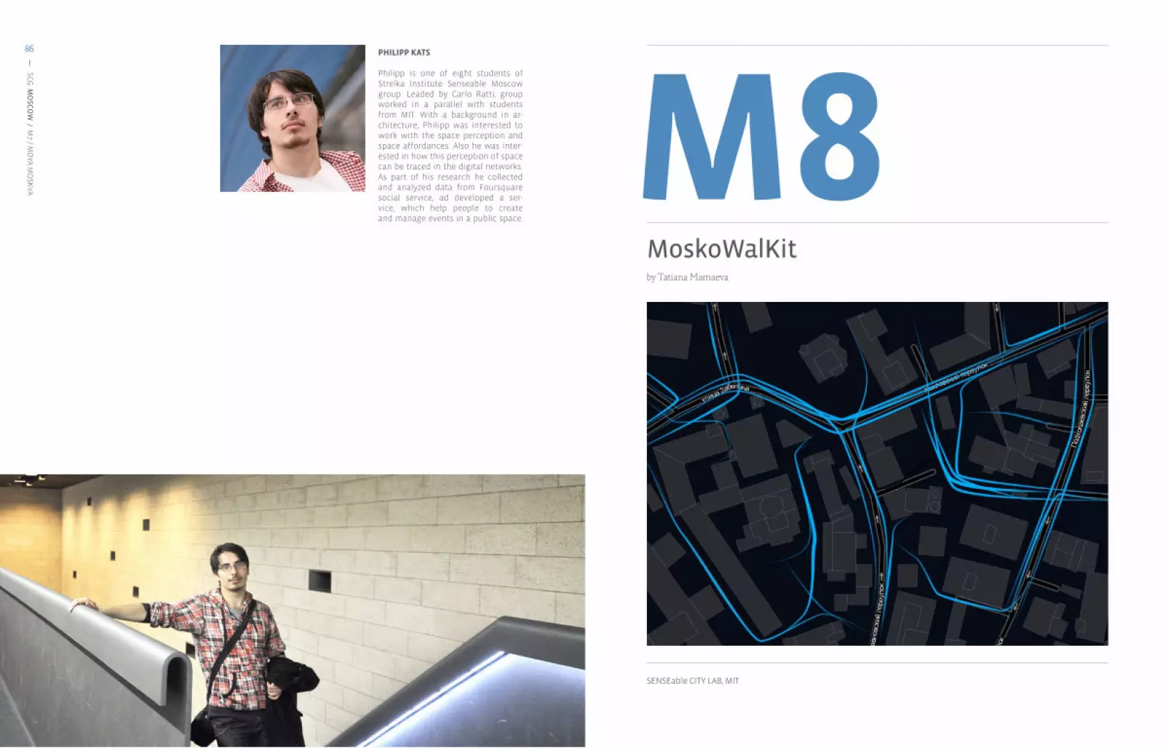
86
SENSEable CITY LAB, MIT
SCG
MO
SCO
W / M
7 / MO
YA MO
SKVA
86 PHILIPP KATS
Philipp is one of eight students of Strelka Institute Senseable Moscow group. Leaded by Carlo Ratti, group worked in a parallel with students from MIT. With a background in ar-chitecture, Philipp was interested to work with the space perception and space affordances. Also he was inter-ested in how this perception of space can be traced in the digital networks. As part of his research he collected and analyzed data from Foursquare social service, ad developed a ser-vice, which help people to create and manage events in a public space.
MoskoWalKitby Tatiana Mamaeva
M8

88 89
SCG
MO
SCO
W / M
8 / MO
SKO
WALK
IT
89
SCG
MO
SCO
W / M
8 / MO
SKO
WALK
IT
88 PROJECTDESCRIPTION
Moscow is one of the most car-oriented cities in the world. Although the number of cars is growing rapidly, the existing built infrastructure prevents authorities from building new roads to meet the demand. The percentage of new road construction is 8.7%, which is significantly lower than in most European capitals. Further, many solutions intended to solve the automobile traffic issues come at the expense of the pedestrian. Until recently, up to half of the space of some sidewalks was allowed to be used as parking spaces. The duration of pedestrian crosswalk lights at traffic lights is often reduced in order to extend the time for vehicle traffic. It is not unusual for pedestrians to have to wait for 10 minutes or longer in order to cross the street, and then not have sufficient time to get to the other side before the light changes. Giving pedestrian priority may never become commonplace for Moscow’s travelers, but in order to make this relationship more sustainable, pedestrians should at least be taken into account. While these problems have been, and may continue to be problems for the foreseeable future, we can bring up this issue and start talking about the pedestrian as an integral and worthy participant in a city’s life.This challenge of balancing the drivers’ and pedestrians’ needs is both a design and a policy issue; it can be achieved by making physical changes to a street and by changing regulations, which control street functions. It is important to evaluate how pedestrians and vehicles use the street, and where and when problems arise. Changes to the street can then be optimized to the type of crossing at which, tje location where, and the time of day when problems occur.
But before embarking on changing the social dynamics street space, it’s important to decide why such a step is necessary. To analyze whether pedestrian space for walking is adequate, it is necessary to know number of people on the sidewalk at different locations over a period of time. It is important to realize that pedestrian volumes vary by location in the city, as well as the time of the day and week.
Allowing people to cross the street as freely as possible is important because there are usually businesses and attractions on both sides of any commercial street. However, there are many inhibitions to this ethos. Often, the width of the street and the timings of the traffic signals are designed only with the needs of vehicles without the pedestrians in mind. The alignment of crosswalks frequently does not correspond with the routes people want to take; this increases conflicts between pedestrians and vehicles as people attempt to cross in undesignated areas.
On the other hand, Moscow’s urban fabric has a unique character that may provide a solution to the pedestrian challenge. The fabric is composed of a very sparse and mazelike curvilinear street system, with fairly wide housing blocks that together form a network of spacious courtyards. It is often more convenient to use these courtyards as shortcuts to cross a block, and more pleasurable to escape from the crowded streets. However, to
preserve a sense of secure and safe for residents, courtyards are often fenced-off or closed, and trespassing is prohibited.
This project explores the possibilities provided by new technologies, to consider the aforementioned condition and space in a new way: how can a shared, social, space that is comfortable for all its inhabitants, can be created? And just as importantly, how can we involve the inhabitants, and all interested parties, in this process? “MoscoWalKit” is a real-time information delivery platform that will promote a pedestrian experience and of trails in these otherwise hidden parts of the city.
SYSTEM RESPONSE TO THE COLLECTED INFORMATION
People’s behavior in a certain area will be measured and mapped in order to gain knowledge about their movements. It is yet unknown how pedestrians move through the city center of Moscow, what their routes and destinations are and how much time they spend on the streets. By tracking the movement of people throughout the city, this project creates knowledge about human mobility which may be of use to planners and citizens alike. Changes in behavior can be measured before, during and after investments in public space. The mapped research results may lead to a greater understanding and explaining of pedestrian behavior, and eventually, pedestrian models for urban environments can be made to predict behavior and guide them certain, desired, directions.Additionally, street signs serving this intervention can be located in the crowded downtown areas, at intersections with the courtyards, where it’s possible to use the shortcut. It will expose and promote the new paths in a constantly changing environment.
SOCIETAL RELEVANCE
If human behavior, and human mobility patterns, in this context could be better understood, then it is foreseeable that policymakers and planners could manage and design the city in a manner that enhances street life for visitors and inhabitants. This increases street vitality, quality of life for citizens and economic vitality of a street.. The planning and design of transportation networks, as well as streets can be reshaped to encourage economic vitality, civic engagement, public health, and environmental sustainability, in addition to serving peoples’ mobility needs.
In Jane Jacobs’s words, the potential is to see “street life [flourish]” with “city centers [becoming] more safe because there are more eyes on the street.”
People’s behavior in a certain area can be measured and mapped in order to gain knowledge about their movements.
The map will expose the most popular pedestrian routs, which frequently lay through hidden courtyards.

90 91
SCG
MO
SCO
W / M
8 / MO
SKO
WALK
IT
91
SCG
MO
SCO
W / M
8 / MO
SKO
WALK
IT
90 PERSONALINTERACTION
The platform provides users with comprehensive features including route planning; dashboard monitoring of the journey; recording and sharing favorite routes; itineraries via SMS, email and Facebook.
Using the app, pedestrians can reduce the travel time to their destination by taking shortcuts through the courtyard, as well as choosing less-crowded or most interesting routes.
Additionally, the application will work as a tool for pedestrians to “unlock” the physical fences around courtyards. In recent years, there has been an increasing trend of placing security desk checkpoints at the entrances to courtyards and buildings. The main function of these desks is to collect information about the people entering this territory and monitoring the space.
“Unlocking the fence” allows one to get the entrance code via one’s mobile phone, after allowing the system to get the information about the person entering. It can basically mirrors the process of checking the documents before entering the building. The information is deleted after you leave the courtyard.
YOU’RE IN A HURRY. YOUR FRIEND IS WAIT-ING FOR YOU. YOU KNOW YOU’RE NOT FAR AWAY FROM THIS PLACE, BUT YOU DON’T KNOW THE BEST WAY TO GET THERE
YOU’RE DRIVING A CAR, THE LEFT TURN IS 2 KM FURTHER
FIND YOUR OWN WAY BY USING THE APP
YOU’RE AN OUT-SIDER AND EA-GER TO EXPLORE THE INNER LIFE OF THE CITY, BUT YOU’RE NOT SURE IF IT’S SAFE AND APPROPRIATE TO ENTER THE YARD
IT’S AN OFFICIAL GOVERNMENT HOLIDAY, THERE ARE THOUSANDS OF PEOPLE ON THE STREETS. YOU WOULD LIKE TO AVOID THE HUSTLE
YOU’RE WALK-ING. THERE’S A TRAFFIC JAM. THE SIDEWALK IS OCCUPIED BY CARS
YOU’RE AN OUTSIDER AND EAGER TO EX-PLORE THE IN-NER LIFE OF THE CITY, BUT THE COURTYARDS ARE FENCED TAKE A LOOK AT
THE ALTERNA-TIVE ROUTE BY USING THE APP
OBSERVE THE POSSIBLE WAYS TO GET WHERE YOU NEED BY USING YOUR MOBILE
PARK YOUR CAR AND USE THE SIGNS TO MAKE A SHORTCUT
FOLLOW THE PHYSICAL SIGNS ON THE INTER-SECTIONS OF STREETS AND COURTYARDS
OBSERVE THE POSSIBLE WAYS TO GET WHERE YOU NEED BY USING YOUR MOBILE
TAKE A LOOK AT THE ALTERNA-TIVE ROUTE BY USING THE APP
GET THE CODE TO ENTER THE COURTYARD BY PROVIDING INFORMATION ABOUT YOU TO EXPLORE THE INNER LIFE OF THE CITIZENS
CHOOSE ONE OF THE OP-TIONS: AVOID THE CROWD OR MAKE THE SHORTCUT THROUGH THE YARD
THERE’S A HUGE PUDDLE IN FRONT OF YOU
AIM: create pedestrian experience in a radically car-oriented city
Sometimes the paths inside the courtyards are more lively and convenient than the sidewalks along the streets.
Additionally, there is a built-in option of getting the code for opening the fences by providing the app with your personal info (like physical pass control).

92 93
SCG
MO
SCO
W / M
8 / MO
SKO
WALK
IT
93
SCG
MO
SCO
W / M
8 / MO
SKO
WALK
IT
92 URBANINTERACTION
There are different constraints affecting the mobility of pedestrians within Moscow. The “MoscoWalKit“ attempts to develop a virtual urban environment, which considers pedestrian traffic and the interactions arising from his or her behavior. The instrument provides a comprehensive tool for authorities to observe the flows of people and design strategies based not only on vehicles’ movements, but also on the pedestrians.
By enabling people to access the inner spaces of the city, conflicts can arise between residents and pedestrians. The residents are striving for quiet and secure surroundings, while pedestrians for mobility and easy access. “MoscoWalKit” can mediate between the two.The impact of those conflicts is visible in the city and can be described by observing peoples behavior on the streets. This project’s outcome is intended to be a tool for citizens, businesses, developers and city employees who want to have a better understanding of the Moscow’s zoning process.
Benefits and opportunities for the urban environment
1 Convenient changes in the city’s infrastructure for pedestrians and residents.
2 Greater reliance on non-motorized for local travel
3 Possible reduction of vehicle travel
Collectig all the user generated data from service plus logging all the sensors, we will be able to map activities in the whole city and, through that, manage and develop public spaces in a better way. Image in courtesy of SENSEable City Lab, MIT
10min
BEFORE
AFTER
2min

94 95
SCG
MO
SCO
W / M
8 / MO
SKO
WALK
IT
95
SCG
MO
SCO
W / M
8 / MO
SKO
WALK
IT
94 TECHNOLOGYDESCRIPTION
To participate in the common effort of gathering pedestrian information, a user needs an internet-connected mobile device (cellphone, smartphone, PDA) with a GPS function (built in or using an external receiver). After downloading the mobile application and activating the “Send tracking information” option, the user can be sure that their device will be sending its geographic coordinates, direction and speed to automated analytical system every several seconds. All information is non-personal, which means that there is nothing that could possibly betray any specific information about the user. With statistical analysis of the geo-located data, the three pedestrian groups (visitors/tourists, city center inhabitants and neighborhood residents) can be analyzed to find similarities and differences in their patterns of movement.
Then, using all available data, the automated process creates a track, creating an integrated route for each mobile device. In addition to sending their coordinates, users can also signal to the service about newly-built fences, obstacles, road works etc.
GPS coordinates provided by the user are mapped to the city’s crowd-sourced electronic map, which accurately displays buildings, parks, roads with all markings and other urban facilities. This detailed mapping allows the system correct the route of a user based on the real physical layout.
ANALYSER MEASURES INACCURACYOF GPS LOCATION DATA
GATHERING IMPERSONAL DATA FROM PEDESTRIANS - MOBILE USERS
OVERLAY PEDESTRIAN TRAILS ON CITY INFRASTRUCTURE MAP
GENERATING PEDESTRIAN TRAILS CITY MAP
AGGREGATION OF PREVIOUSLY GATHERED DATA FROM DIFFERENT PART OF THE CITY
PEDESTRIAN TRAILS ARE GENERATED IN DIFFERENT PARTS OF THE CITY
ALGORITHM OF DATABASE CREATION

96 97
SCG
MO
SCO
W / M
8 / MO
SKO
WALK
IT
97
SCG
MO
SCO
W / M
8 / MO
SKO
WALK
IT
96
EXISTING INFRASTRUCTURE
fucked-up fences
REEVALUATION OF SPACE: DIVISION OF PRIVATE AND COMMON AREAS
CONFLICT: RESIDENTS <-> PEDESTRIANS PROVIDING ACCESS + VISUALIZATION
SENSE AND SUSTAINABILITYDESCRIPTION
Sustainable city development requires fundamental changes in our urban planning practices. It demands more comprehensive analysis of impacts and consideration of a broader range of solutions than usually occurs. It also requires that the public can be involved in determining alternatives to be considered because it often involves changes in community and residents’ behavior as well as reflects a community’s values.
98
SCG
MO
SCO
W / M
8 / MO
SKO
WALK
IT
98 TATIANA MAMAEVA
Tatiana Mamaeva holds a Bachelor of Science in electro-mechanics and elec-tronics from the State Polytechnic Uni-versity in Saint-Petersburg, Russia. In 2010, she received a Master of Art from the Advanced Design Visualization program at Umea Institute of Design, Sweden. During that time, she studied advanced visualization methods that are used in the design process in prod-uct development. She later worked on industrial product visualizations in the communication design department in Peschke Design OG in Vienna, Austria. During the summer of 2011, Tatiana developed visual content for United Colors of Benetton’s “Creative Win-dows” project. Her interest in technol-ogy and urban research brought her to Strelka Institute of Media, Architec-ture and Design where she is currently.


