Embed Size (px)
Citation preview
Sharp-based, tide-dominated deltas of the Sego Sandstone,Book Cliffs, Utah, USA
BRIAN J. WILLIS1 and SHARON GABEL2
Bureau of Economic Geology, The University of Texas at Austin, Austin, TX 78758 USA(E-mail: [email protected])
ABSTRACT
The lower part of the Cretaceous Sego Sandstone Member of the Mancos Shale
in east-central Utah contains three 10- to 20-m thick layers of tide-deposited
sandstone arranged in a forward- and then backward-stepping stacking pattern.
Each layer of tidal sandstone formed during an episode of shoreline regression
and transgression, and offshore wave-in¯uenced marine deposits separating
these layers formed after subsequent shoreline transgression and marine
ravinement. Detailed facies architecture studies of these deposits suggest
sandstone layers formed on broad tide-in¯uenced river deltas during a time of
¯uctuating relative sea-level. Shale-dominated offshore marine deposits
gradually shoal and become more sandstone-rich upward to the base of a
tidal sandstone layer. The tidal sandstones have sharp erosional bases that
formed as falling relative sea-level allowed tides to scour offshore marine
deposits. The tidal sandstones were deposited as ebb migrating tidal bars
aggraded on delta fronts. Most delta top deposits were stripped during
transgression. Where the distal edge of a deltaic sandstone is exposed, a sharp-
based stack of tidal bar deposits successively ®nes upward recording a
landward shift in deposition after maximum lowstand. Where more proximal
parts of a deltaic-sandstone are exposed, a sharp-based upward-coarsening
succession of late highstand tidal bar deposits is locally cut by ¯uvial valleys,
or tide-eroded estuaries, formed during relative sea-level lowstand or early
stages of a subsequent transgression. Estuary ®lls are highly variable, re¯ecting
local depositional processes and variable rates of sediment supply along the
coastline. Lateral juxtaposition of regressive deltaic deposits and incised
transgressive estuarine ®lls produced marked facies changes in sandstone
layers along strike. Estuarine ®lls cut into the forward-stepped deltaic
sandstone tend to be more deeply incised and richer in sandstone than those
cut into the backward-stepped deltaic sandstone. Tidal currents strongly
in¯uenced deposition during both forced regression and subsequent
transgression of shorelines. This contrasts with sandstones in similar basinal
settings elsewhere, which have been interpreted as tidally in¯uenced only in
transgressive parts of depositional successions.
Keywords Cretaceous, falling stage, incised valley, Sego Sandstone, tide-in¯uenced delta.
INTRODUCTION
Tidal deposits typically have complex faciesvariations related to signi®cant spatial variations
1Present address: BP Canada Energy Company, 2404th Avenue SW, Calgary, Alberta, T2P 2H8, Canada.2Present address: Department of Earth Sciences, StateUniversity of New York at Oswego, 13126, USA..
Sedimentology (2001) 48, 479±506
Ó 2001 International Association of Sedimentologists 479
in the relative strength of riverine and basinalcurrents. Although regressive deposits of tidaldeltas may have a similar suite of facies astransgressive deposits formed in tidal estuaries,their facies architecture is expected to be differ-ent (Dalrymple, 1992, 1999). Sedimentologistsincreasingly associate tidal estuary deposits withthe ®lls of valleys ¯ooded during periods ofrelative sea-level rise (Dalrymple et al., 1994);such estuarine deposits are ¯oored by an erosionsurface formed during valley incision. Faciestrends within estuarine ®lls vary depending onthe amount and distribution of sediment depos-ited by riverine-, wave- and tidal-currents, abalance that can vary over time as ratios ofaccommodation to sediment supply change dur-ing estuary ®lling (Allen & Posamentier, 1993;Thomas & Anderson, 1994; Zaitlin et al., 1994;Willis, 1997).
In contrast to estuary ®lls, tide-dominateddeltas are de®ned as progradational sedimentbodies that protrude from the shoreline wheretidal currents rework river-supplied sedimentsbasinward (Elliott, 1986; Bhattacharya & Walker,1992). Several students of ancient sandstonewedges have suggested that tide-in¯uenced faciesform only during transgression, when valleysincised into highstand shorelines begin to ®lland rising relative sea-levels ¯ood delta tops(Fisher & McGowen, 1967; Curtis, 1970; Gallo-way, 1975; Banerjee, 1991; Mellere & Steel, 1995).These studies predict that river- or wave-proces-ses will dominate deltaic deposition duringshoreline regression, and tidal deposits will berestricted to localized estuarine valley ®lls and toa thin veneer capping broader regressive deltadeposits. If tidal deposits comprise only the®nal ¯ooding and abandonment of ¯uvial- andwave-dominated deltas, however, there is somequestion as to whether tide-dominated deltasconstitute a distinct type of delta deposit in theancient record (compare Galloway, 1975; Walker,1992).
There are a few well-documented ancientexamples of tide-dominated deltaic sandstones.Most examples exposed in large outcrops occur inrift basins (Nio, 1976; Mutti et al., 1985; Nio &Yang, 1991; Mellere & Steel, 1996), or in broadembayments (Willis et al., 1999; Bhattacharya &Willis, 2001), where coastal restrictions are inter-preted to have accentuated tidal currents andperhaps tidal range. The Sego Member of theMancos was examined in this study because itcontains several 10- to 20-m thick shore-zonesandstones that are tidal in character throughout.
Because these sandstones extend along depos-itional strike for at least 100 km, it is unlikelythey formed in a narrow estuary. A detailed studyof facies architecture at two locations alongextensive exposures of the Sego Member in theBook Cliffs of central Utah was conducted toimprove depositional interpretations of thesesandstones.
REGIONAL STRATIGRAPHY
The Upper Cretaceous Mesaverde Group exposedin central Utah and western Colorado recordsepisodic progradation of a clastic wedge awayfrom the rising Sevier orogenic belt into theWestern Interior Seaway of North America. TheBook Cliffs contain exceptional exposures of thisclastic wedge along the north-east ¯anks of theSan Rafael Swell and the north-western edge ofthe Uncompahgre Uplift (Fig. 1a). In the lowerpart of this interval, forward-stepping successionsof the Blackhawk Member of the Mancos Shaleformed by episodic progradation of north-southoriented shorelines and intervening transgres-sions, which culminated in deposition of coarse-grained ¯uvial deposits of the Castlegate Member(Fig. 1b; Kamola & Van Wagoner, 1995; O'Byrne &Flint, 1995; Taylor & Lovell, 1995; Van Wagoner,1995; Young, 1955). The Buck Tongue of theMancos Shale formed subsequently during apronounced marine transgression. The over-lying Sego Sandstone Member prograded overthe shales of the Buck Tongue as shorelines
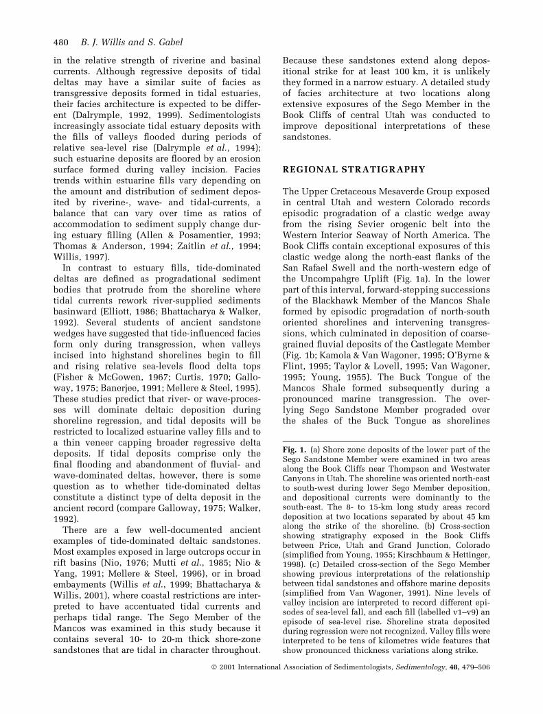
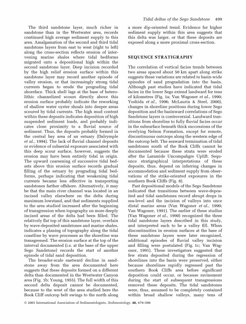
Fig. 1. (a) Shore zone deposits of the lower part of theSego Sandstone Member were examined in two areasalong the Book Cliffs near Thompson and WestwaterCanyons in Utah. The shoreline was oriented north-eastto south-west during lower Sego Member deposition,and depositional currents were dominantly to thesouth-east. The 8- to 15-km long study areas recorddeposition at two locations separated by about 45 kmalong the strike of the shoreline. (b) Cross-sectionshowing stratigraphy exposed in the Book Cliffsbetween Price, Utah and Grand Junction, Colorado(simpli®ed from Young, 1955; Kirschbaum & Hettinger,1998). (c) Detailed cross-section of the Sego Membershowing previous interpretations of the relationshipbetween tidal sandstones and offshore marine deposits(simpli®ed from Van Wagoner, 1991). Nine levels ofvalley incision are interpreted to record different epi-sodes of sea-level fall, and each ®ll (labelled v1±v9) anepisode of sea-level rise. Shoreline strata depositedduring regression were not recognized. Valley ®lls wereinterpreted to be tens of kilometres wide features thatshow pronounced thickness variations along strike.
480 B. J. Willis and S. Gabel
Ó 2001 International Association of Sedimentologists, Sedimentology, 48, 479±506
Tidal deltas of the Sego Sandstone 481
Ó 2001 International Association of Sedimentologists, Sedimentology, 48, 479±506
episodically regressed at least 50 km into thebasin along a south-east path. The Sego sand-stone, thus, records a change in the pattern ofbasin ®lling from the eastward progradation ofsediments directly away from the mountain beltin the Blackhawk±Castlegate successions tosouth-east sediment progradation obliquely downthe axis of the foreland basin.
The Sego Member has been divided into lowerand upper sandstones separated by the transgres-sive Anchor Mine Tongue of the Mancos Shale(Fisher, 1936; Erdmann, 1934; Young, 1955).Ammonites collected from the upper BuckTongue and the Anchor Mine Tongue suggestthe Sego Sandstone is Late Campanian in age(76á0±74á6 Ma) and was deposited over about1á4 Ma (Gill & Hail, 1975; Van Wagoner, 1991).The Neslen Formation, which overlies the SegoSandstone in eastern Utah, records aggradation ofcoal-bearing ¯uvial deposits behind verticallystacked, wave-dominated shoreline deposits ofthe Corcoran, Cozzette and Rollins Sandstones inthe Mount Gar®eld Formation of western Colo-rado (Kirschbaum & Hettinger, 1998).
The Sego Member is a 60- to 80-m thick, 50- to60-km wide, north-east-south-west orientedwedge of sandstone. Up depositional dip alongthe western edge of the San Rafael Swell extend-ing northward towards Price, Utah, the SegoSandstone gradually cuts out the underlyingBuck Tongue and then passes into ¯uvial succes-sions (Yoshida et al., 1996). Down depositionaldip along the north-east edge of the UncompahgreUplift south of Grand Junction, Colorado, theSego Sandstone passes into the Mancos Shale(Young, 1955; Fig. 1a). The outcrop belt along theBook Cliffs from Green River to the Utah±Color-ado border exposes a dominantly strike-orientedcross-section of the Sego Sandstone (Fig. 1a andb). Young (1955) showed pronounced variationsin the proportion of sandstone to mudstonewithin the Sego Member along this 100-km strikesection. Van Wagoner et al. (1990) and VanWagoner (1991) showed that the Sego Sandstonecontains multiple, high relief, internal erosionsurfaces, which they interpreted to record rapidfalls in sea-level that drained the seaway andallowed valleys to incise into wave-depositedshelf strata (Fig. 1c).
METHODS
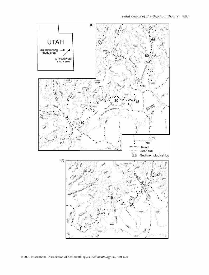
This study involved ®ne-scale mapping of strataexposed in two outcrop segments in the southern
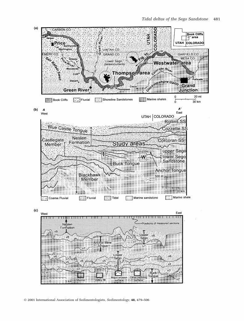
Book Cliffs outcrop belt (Figs 2 and 3). A 15-kmsegment near the Westwater exit of InterstateHighway 70 is separated by about 50 km alongdepositional strike from an 8-km segment fartherwest near the Thompson exit. In both areas theSego Sandstone is exposed in vertical cliffs oversteep slopes of the Buck Tongue Shale. Strata dipat 2±5° to the north and, other than being cut by afew minor vertical faults, are little deformed. TheBook Cliffs are oriented dominantly south-west tonorth-east in the areas studied, but canyonsprovide limited exposures normal to this orienta-tion. Detailed vertical logs, spaced every fewhundred metres along each outcrop segment, weremeasured to de®ne vertical facies trends. Anumerical database was compiled to record faciestype, grain-size, sandstone/mudstone ratio, andthe degree of bioturbation within each 2-dminterval of each log (Fig. 4). Lateral tracing of bedsbetween measured sections and high-resolutionphotomosaics shot from a helicopter were used toconstruct cross-sections showing stratal geometry.Larger-scale stratal units were de®ned by lateralfacies changes and relationships among a hier-archy of internal bedding surfaces. The tracing ofhigh-relief erosion surfaces and laterally extensivetransgressive marine shales were particularlyimportant in de®ning the stratal organization.
SEDIMENTOLOGY
Lower Sego deposits can be divided into threefacies associations: wave-deposited bedsets, largetidal inclined-bed sets and channel-form tidalbedsets (Fig. 5). The organization of facies anddepositional interpretations of these deposits arepresented ®rst. Subsequent sections address thearrangement of bedsets within stratigraphicallayers of the Sego Sandstone.
Facies association 1: wave-deposited bedsets
Description
These deposits comprise 3- to 6-m thick, upward-coarsening, sheet-like bedsets that extend
Fig. 2. Detailed maps of the (a) Westwater and (b)Thompson study areas showing the location of meas-ured sections. In both areas logs are oriented generallyalong strike, although logs 21±45 in the Westwater areaare more strike oblique. The areas shown are accessibleon Bureau of Land Management roads from the West-water and Thompson exits of Interstate Highway 70.
482 B. J. Willis and S. Gabel
Ó 2001 International Association of Sedimentologists, Sedimentology, 48, 479±506
Tidal deltas of the Sego Sandstone 483
Ó 2001 International Association of Sedimentologists, Sedimentology, 48, 479±506
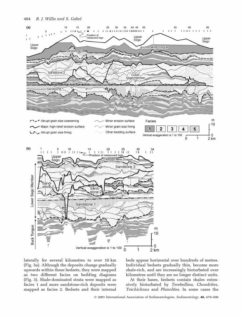
laterally for several kilometres to over 10 km(Fig. 5a). Although the deposits change graduallyupwards within these bedsets, they were mappedas two different facies on bedding diagrams(Fig. 3). Shale-dominated strata were mapped asfacies 1 and more sandstone-rich deposits weremapped as facies 2. Bedsets and their internal
beds appear horizontal over hundreds of metres.Individual bedsets gradually thin, become moreshale-rich, and are increasingly bioturbated overkilometres until they are no longer distinct units.
At their bases, bedsets contain shales exten-sively bioturbated by Terebellina, Chondrites,Teichichnus and Planolites. In some cases the
484 B. J. Willis and S. Gabel
Ó 2001 International Association of Sedimentologists, Sedimentology, 48, 479±506
lowest few decimetres of shale are nearly black,but most are medium dark grey. Very-®ne-grainedlinsen sandstones become increasingly commonupward. Upper parts of bedsets typically are bio-turbated, decimetre-thick, sandstones alternatingwith centimetre-thick beds of linsen sandstone inshale. Planolites, Thalassinoides, Asterosomaand Paleophycos are common in these sand-stones, and rare Cruziana were also observed.Where less bioturbated, sandstone beds havewave- and combined-¯ow-ripple cross-lamin-ation under symmetrical ripple marks or centi-metre-thick sets of hummocky cross-strati®cation.
Tops of thicker bedsets can comprise decime-tre-thick beds of amalgamated hummocky, andrarely low-angle offshore dipping cross-strata invery-®ne-grained sandstone. These thicker sand-stone beds commonly weather out as prominentbenches and are relatively unbioturbated exceptfor isolated Planolites and Skolithos. These bedscan have erosional bases with decimetre reliefgutter casts, and individual beds can end abruptlyalong strike. The top of a bedset is de®ned by anabrupt decrease in grain size to shale. Thus, thesebedsets gradually increase in sandstone to shaleproportion upward and then abruptly ®ne toshale.
Interpretation
These upward-coarsening bedsets record thegrowth of wave-reworked sand sheets in offshoreareas between fair-weather- and storm-wave base
(Swift et al., 1983, 1987; Craft & Bridge, 1987;Southard et al., 1990; Duke et al., 1991). Blackshale at the base of some bedsets indicatessediment starvation and concentration oforganic-rich clay. Individual beds record thereworking of sands during major storms and thesubsequent settling of clays during fair weatherperiods. Wave-ripple cross-lamination formedunder relatively weak oscillatory ¯ows, whereashummocky cross-strati®cation re¯ects strongeroscillatory currents. Extensive bioturbation by arich trace fossil assemblage suggests relativelyopen marine conditions.
Similar upward-coarsening bedsets have beeninterpreted to have formed on distal ends ofprograding, wave-dominated, shorefaces (Howard& Reineck, 1981; Elliott, 1986; Shanley & McCabe,1995). Gradual lateral thinning and ®ning ofbedsets over kilometres in these strike-orientedoutcrops (Fig. 3) suggest deposition was some-what localized on kilometre-wide lobes, or thatdistal shoreface sandstone sheets were locallytattered during their buildup and erosion overmany storm events. Unbioturbated, hummockycross-strati®ed beds that cap thicker bedsets mayrecord more complete wave reworking of sandsonce sediment supply had shifted to another areaof the sea ¯oor. Erosion at the base of these bedsand rare basinward-dipping cross-strata indicatesea ¯oor scour, perhaps by broad shallow chan-nels that bypassed sediment basinward duringmajor storms.
Facies association 2: large tidalinclined-bed sets
Description
These deposits comprise 6- to 12-m thick, 2- to6-km wide, at least several kilometre-long,upward-coarsening bedsets with internal metre-thick beds that dip up to 15° (2±6° dips aretypical) (Fig. 5b). Although deposits can varygradually both vertically and laterally acrossbedsets, and at a smaller scale upward withinindividual beds, they were mapped into threebroadly de®ned facies: Facies 3 is heterolithiccross-strati®ed sandstones; Facies 4 is relativelyhomogeneous cross-strati®ed sandstones; andFacies 5 is extensively bioturbated sandstones.
Bedsets generally have an erosional base withmetres of relief overlain by a lag of medium- tocoarse-grained sandstone with mud clasts, plantdebris and, less commonly, shelly fossils (e.g.oysters and rarely other pelecypods, gastropods
Fig. 3. Cross-sections showing stratal geometry andfacies in the lower part of the Sego Sandstone Memberexposed in the (a) Westwater Canyon and (b) Thomp-son Canyon areas of the Book Cliffs. In both cases thestratigraphical interval documented extends from theupper part of the Buck Tongue to the base of the upperSego Sandstone. The shale-rich interval near the top ofeach cross-section has been called the Anchor MineTongue. Logs used to construct cross-sections werealigned along a grey shale in the middle of the lowerSego Sandstone. The cross-section in the Thompsonarea was constructed by projecting logs onto a line ®t bylinear regression to mapped log positions. For theWestwater area cross-section, three line segments wereused for a similar projection (i.e. ®t to logs 1±20, 20±45and 45±66) and log map positions were projected ontotheir respective line segments. Mapped facies are: (1)marine shale with linsen wave-rippled sandstones; (2)thicker wave-rippled and hummocky cross-strati®edsandstones separated by thin marine shales; (3) relat-ively heterolithic cross-strati®ed tidal sandstones; (4)cross-strati®ed tidal sandstones with few mudstonedrapes; and (5) highly bioturbated tidal sandstones.
Tidal deltas of the Sego Sandstone 485
Ó 2001 International Association of Sedimentologists, Sedimentology, 48, 479±506
and shark teeth). Fine- to medium-grained sand-stones above this lag contain decimetre-thickcross-sets. In lower parts of bedsets, strata withincross-sets are inclined at less than the angle ofrepose, and contain abundant mudstone drapesand asymmetrical ripple marks superimposed onreactivation surfaces. In some cases cross-stratawithin adjacent sets, or cross-strata and superim-posed asymmetrical ripple marks, dip in oppositedirections. Cross-sets in the upper part of bedsetsare more sandstone-rich, and internal cross-stratadip nearer to the angle of repose and dominantlyto the south-east. Deposits capping these bedsetsare generally extensively bioturbated, mostnotably by Ophiomorpha that can have metre-long vertical shafts, but more commonly arehorizontal.
Decimetre to millimetre-thick beds within bed-sets can also have basal lags and commonly ®neupward to a centimetre-thick draping shale. Asbeds ®ne upward, internal cross-sets generallybecome thinner and more heterolithic, and ripplemarks become more common. Bed dips are
generally steepest in the sandier deposits nearthe top of a bedset and progressively decrease asbeds descend tangentially to the base of thebedset. Typically, beds dip in the same directionas the internal cross-strata, although in severalcases cross-strata near the base of a bedsetdominantly dip opposite to that of the enclosingbed.
Lateral facies changes along bedsets can bequite variable. In many cases beds become steeperand more sandstone-rich as the bedset thickens,and then decrease in dip and become moreheterolithic as the bedset gradually thins overkilometres. Where bedsets are thicker, there canbe an abrupt upward transition from more het-erolithic to more homogeneous cross-strati®edsandstones. Where bedsets abruptly coarsenupward there can be subtle discordance ininternal inclined beds de®ned by the downlapof steeper, sandier beds onto lower-angle inclinedheterolithic beds below. As these bedsets thin inthe direction beds dip, upward decreases in thedegree of heterogeneity become more gradual,
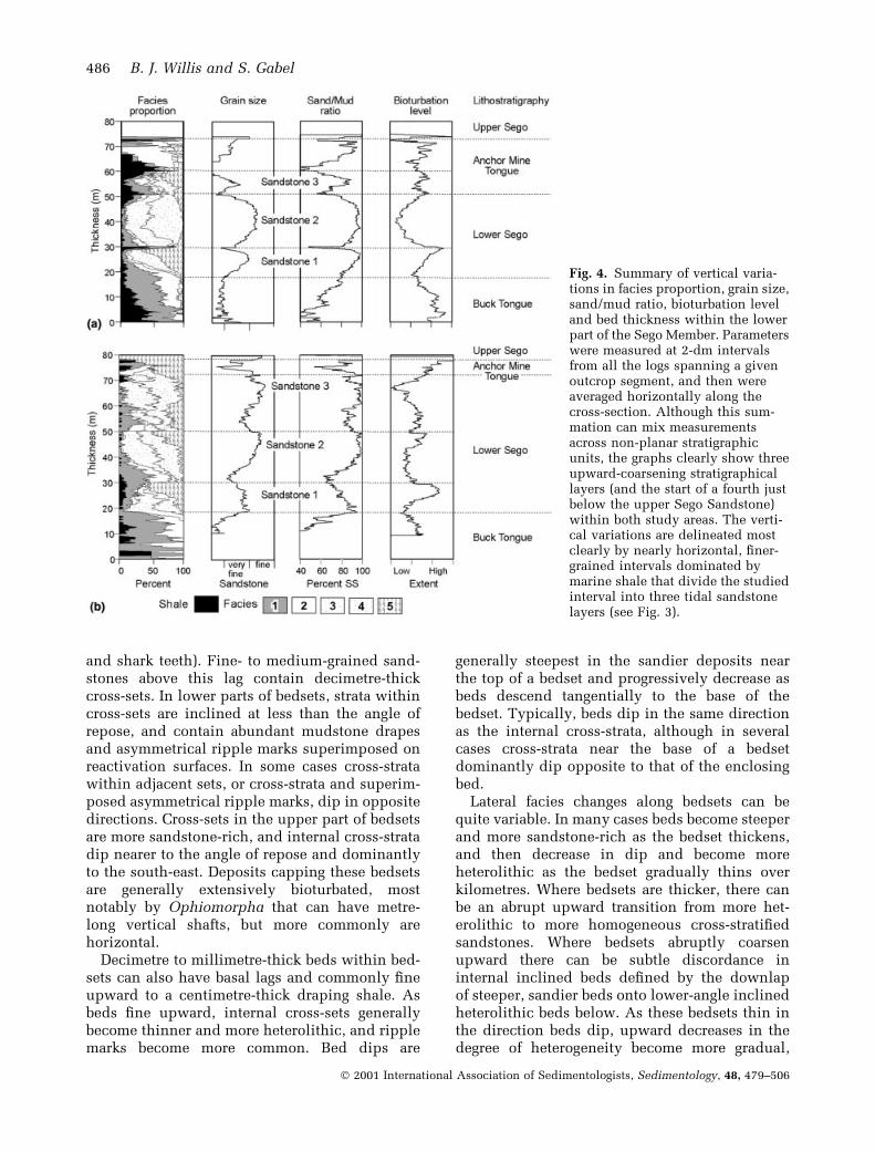
Fig. 4. Summary of vertical varia-tions in facies proportion, grain size,sand/mud ratio, bioturbation leveland bed thickness within the lowerpart of the Sego Member. Parameterswere measured at 2-dm intervalsfrom all the logs spanning a givenoutcrop segment, and then wereaveraged horizontally along thecross-section. Although this sum-mation can mix measurementsacross non-planar stratigraphicunits, the graphs clearly show threeupward-coarsening stratigraphicallayers (and the start of a fourth justbelow the upper Sego Sandstone)within both study areas. The verti-cal variations are delineated mostclearly by nearly horizontal, ®ner-grained intervals dominated bymarine shale that divide the studiedinterval into three tidal sandstonelayers (see Fig. 3).
486 B. J. Willis and S. Gabel
Ó 2001 International Association of Sedimentologists, Sedimentology, 48, 479±506
basal lags can become laterally discontinuous anddeposits typically become extensively bioturb-ated by Planolites and Ophiomorpha, and lesscommonly by Thalassinoides and Asterosoma.Similar lateral changes are observed in bothdepositional dip- and strike-oriented outcrops,although changes are generally greater in dip-oriented views. The degree of bioturbation withinbedsets is highly variable, ranging from near-complete disruption of primary sedimentarystructures to a near-absence of trace fossils. In afew cases, bedsets exposed in strike view end atan erosional margin de®ned by the stratigraphicalrise of its basal erosion surface. In rare casesbedsets grade laterally into sandstone-rich,hummocky cross-strati®ed, Facies Association 1deposits.
Interpretation
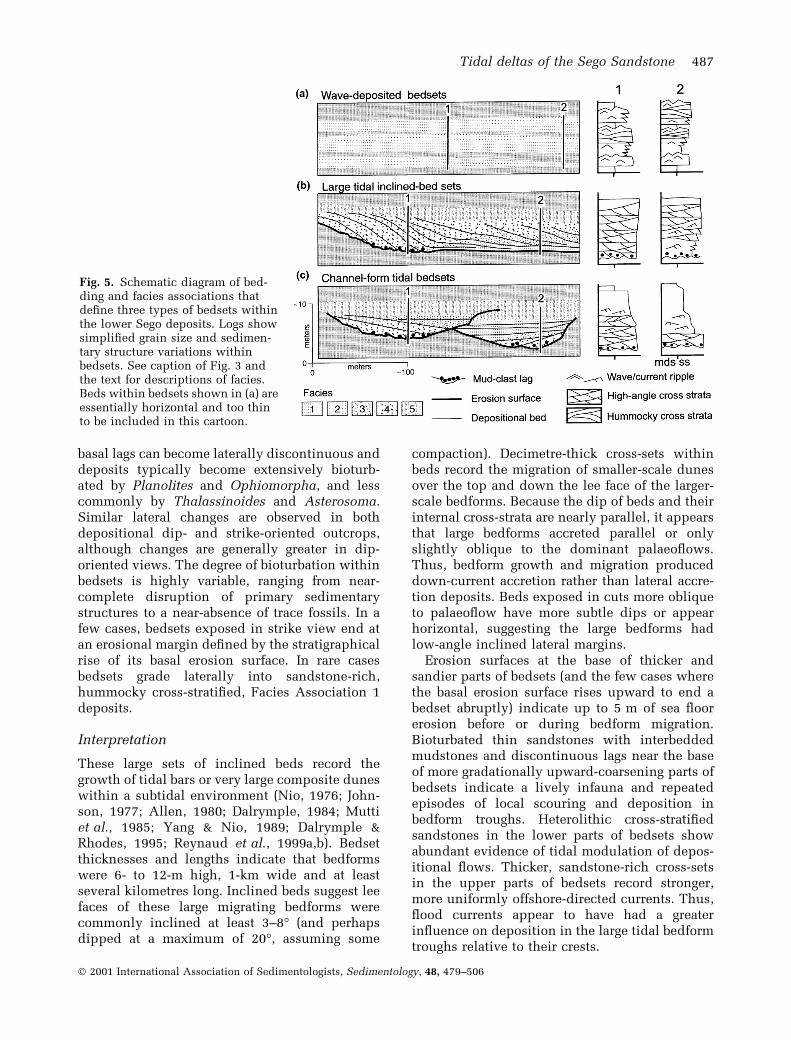
These large sets of inclined beds record thegrowth of tidal bars or very large composite duneswithin a subtidal environment (Nio, 1976; John-son, 1977; Allen, 1980; Dalrymple, 1984; Muttiet al., 1985; Yang & Nio, 1989; Dalrymple &Rhodes, 1995; Reynaud et al., 1999a,b). Bedsetthicknesses and lengths indicate that bedformswere 6- to 12-m high, 1-km wide and at leastseveral kilometres long. Inclined beds suggest leefaces of these large migrating bedforms werecommonly inclined at least 3±8° (and perhapsdipped at a maximum of 20°, assuming some
compaction). Decimetre-thick cross-sets withinbeds record the migration of smaller-scale dunesover the top and down the lee face of the larger-scale bedforms. Because the dip of beds and theirinternal cross-strata are nearly parallel, it appearsthat large bedforms accreted parallel or onlyslightly oblique to the dominant palaeo¯ows.Thus, bedform growth and migration produceddown-current accretion rather than lateral accre-tion deposits. Beds exposed in cuts more obliqueto palaeo¯ow have more subtle dips or appearhorizontal, suggesting the large bedforms hadlow-angle inclined lateral margins.
Erosion surfaces at the base of thicker andsandier parts of bedsets (and the few cases wherethe basal erosion surface rises upward to end abedset abruptly) indicate up to 5 m of sea ¯oorerosion before or during bedform migration.Bioturbated thin sandstones with interbeddedmudstones and discontinuous lags near the baseof more gradationally upward-coarsening parts ofbedsets indicate a lively infauna and repeatedepisodes of local scouring and deposition inbedform troughs. Heterolithic cross-strati®edsandstones in the lower parts of bedsets showabundant evidence of tidal modulation of depos-itional ¯ows. Thicker, sandstone-rich cross-setsin the upper parts of bedsets record stronger,more uniformly offshore-directed currents. Thus,¯ood currents appear to have had a greaterin¯uence on deposition in the large tidal bedformtroughs relative to their crests.
Fig. 5. Schematic diagram of bed-ding and facies associations thatde®ne three types of bedsets withinthe lower Sego deposits. Logs showsimpli®ed grain size and sedimen-tary structure variations withinbedsets. See caption of Fig. 3 andthe text for descriptions of facies.Beds within bedsets shown in (a) areessentially horizontal and too thinto be included in this cartoon.
Tidal deltas of the Sego Sandstone 487
Ó 2001 International Association of Sedimentologists, Sedimentology, 48, 479±506
Although mudstone drapes and ripple markssuperimposed on reactivation surfaces within themore heterolithic cross-strata probably re¯ect theeffects of daily tides, examples of double muddrapes that can be related speci®cally to diurnaltidal cycles are rare. The lack of double muddrapes is not surprising given the evidence forstrongly ebb-dominated currents. Because it isunlikely that daily tidal current ¯uctuationssigni®cantly change the shape and migration oflarge-scale bedforms (Dalrymple & Rhodes, 1995),variations de®ning beds within the inclined-bedsets probably record longer-term ¯ow unsteadi-ness associated with neap-spring cycles, changesin ¯uvial discharge into the basin, or major stormevents. Thicker shale drapes capping beds, andthe very heterolithic nature of the lower parts ofbedsets, record high suspended-sediment loadsdeposited during slack water periods, and suggestdeposition close to areas of ¯uvial sedimentinput. Local downlap of sandier onto moreheterolithic beds at some locations within bedsetsindicates that sediment prograded faster overcrests than in troughs as bedform fronts steep-ened. Decreased bed dips and more gradualupward-coarsening trends where bedsets thinalong strike suggest a gradual ®lling of troughsas the large tidal bedforms were abandoned.
Trace fossils indicate a fairly robust shallowmarine faunal assemblage. Given that there isextensive bioturbation of lags formed in bedformtroughs and the tops of bedsets, but not of themore steeply dipping beds deposited on the frontof the bedform, the degree of bioturbation prob-ably indicates relative deposition rates (Harriset al., 1992). Extensively bioturbated bedsets,thus, probably indicate either very slow bedformmigration, or deep bioturbation during a longpost-depositional hiatus. Anderson & Droser(1998) suggested that vertical Ophiomorpha inthe Sego Sandstone indicates more rapid depos-ition, whereas horizontal burrows formed wheredeposition was slower. Tidal bedsets that passlaterally into thin, extensively bioturbated sand-stone record a traverse into areas with weakcurrents and lower deposition rates; perhaps intodeeper waters or onto shoals away from activetidal currents and sediment supply. The fewexamples where inclined-bed sets can be tracedlaterally into hummocky cross-strati®ed bedsetsindicate a lateral change from tidally in¯uencedto wave-dominated deposition.
The classi®cation of these bedsets as deposits ofbars rather than large composite dunes is prob-lematic without an independent estimate of water
depth. Dunes form as a result of vertical turbu-lence from the sediment bed and scale to a fractionof ¯ow depth (commonly dune heights are ~20%of ¯ow depth; Yalin, 1964), whereas bars form as aresult of horizontal turbulence shed from lateralmargins of the ¯ow and scale to ¯ow width andfull ¯ow depths (i.e. commonly 80% of ¯owdepth; Yalin, 1977; Yalin & da Silva, 1992). Usingthis criterion to distinguish dunes from bars inmodern tidal settings, Dalrymple & Rhodes (1995)indicated that there is a wide overlap in the size oflarge dunes and bars formed by tidal currents indifferent water depths. Although bars are gener-ally expected to be larger than dunes at speci®clocations and they commonly have dunes super-imposed on them, it is also common to ®ndmultiple superimposed scales of dunes in moderntidal settings (Dalrymple, 1984; Dalrymple &Rhodes, 1995). The interpretation of the Segotidal inclined-bed sets as deposits of dunes or barsis not simply semantics, for if bedsets are dunedeposits their thicknesses suggest deposition in atleast 40- to 60-m deep waters, whereas if they arebar deposits they presumably formed in relativelyshallow nearshore waters.
Deposits of large, highly elongate tidal bars(sand ridges) observed at the distal end of manytide-in¯uenced shorefaces and on adjacent tide-in¯uenced marine shelves are not good analoguesfor the tidal inclined-bed sets observed in the SegoSandstone. Although modern sand ridges canhave similar widths as the tidal bedsets in theSego, their internal beds normally dip at very lowangles in a direction highly oblique to the offshoreelongation of the ridge and to dominate ¯owdirections recorded by superimposed dunes (Off,1963; Swift, 1975; Huthnance, 1982a,b; Strideet al., 1982; Berne et al., 1988). Because sedi-ments in sand ridges are transported somedistance offshore from areas of direct ¯uvial sedi-ment input, they tend to be fairly well sorted andcontain relatively few extensive mudstone drapes.
Allen (1980) and Dalrymple (1984) report thatthe migration of multiple superimposed scales ofdunes in ebb-dominated ¯ows can producedeposits similar in size and internal character asthe tidal bedsets described here. Like the Segoinclined-bed sets, variation of grain-size and thedimensions of superimposed smaller-scale dunesindicate more rapid ¯ows over the larger-scaledune crests than in adjacent troughs. The super-imposed dunes presumably scale to a sublayer inthe turbulent ¯ow on the back of the larger-scaledunes, or re¯ect changes in ¯ow velocity anddepth during tidal cycles (Dalrymple & Rhodes,
488 B. J. Willis and S. Gabel
Ó 2001 International Association of Sedimentologists, Sedimentology, 48, 479±506
1995). Reynaud et al. (1999b) showed cross-sets(identi®ed in high-resolution seismic cross-sec-tions of sand banks in the Celtic Sea) that were ofsimilar size and internal stratal geometry as theSego inclined-bed sets. They interpreted theseQuaternary cross-sets to have formed by themigration of 20-m high dunes up the back ofmuch larger shoreline-perpendicular bars (sandridges) in 60- to 80-m deep waters of the contin-ental shelf. Although the geometry and internalbedding of Sego inclined-bed sets are similar tothe dune deposits observed by Reynaud et al.(1999b), the internal character of these depositsprobably is not similar. Very large compositedunes in offshore areas are most probably com-posed of well-sorted sands, such as the depositsof the larger-scale sand ridges on which theymigrate. Dunes in 60- to 80-m water depthsshould be only a few hundred metres long (i.e.dune lengths are expected to be about seven times¯ow depth; Allen, 1980). The 2- to 3-km long dunecross-sets observed by Reynaud et al. (1999b)re¯ect rapid climb of smaller wavelength bed-forms up the stoss side of tidal ridges; however,there is no indication that the set boundaries ofthe Sego tidal bedsets climbed steeply in thedirection that the inclined beds dip. Therefore thelengths of Sego inclined-bed sets probably indi-cate kilometres-long bedforms (rather than thepreservation of cross-sets longer than the length ofthe migrating bedform due to sediment aggrada-tion); a dimension too long to be that of a dune inrealistic tide-in¯uenced water depths.
Deposits of nearshore tidal bars composed ofmarine sands built up at the mouth of estuaries,and bars located forward of river channels at thehead of estuaries, are also similar in scale to Segotidal inclined-bed sets (Dalrymple et al., 1990;Harris et al., 1992). Like the bedforms interpretedfrom the Sego bedsets, these bars tend to beasymmetric in the direction of the dominantcurrent. In contrast to the inferred Sego bedforms,however, these estuarine bars have lower-angledown-current bed dips, accrete mostly lateral tothe direction of the dominant ¯ows, and tend to®ne upward from bar fronts to overlying bar topdeposits. In these modern examples the fastestcurrents and coarsest grain-sizes are within thechannels separating the bars (Dalrymple et al.,1990; Dalrymple & Rhodes, 1995), rather thanover the bar crests as interpreted from the Segoinclined-bed sets. These estuarine bars are fairlyequant in shape (i.e. lengths only a few timesgreater than widths), a geometry more similar toriver bars than the very elongate tidal ridges
found on modern shelves. In river channels, rapidprogradation of sediment and more episodic¯ows lead to bars with avalanche faces on theirdownstream end; such bars produce upward-coarsening deposits as they migrate down stream(Collinson, 1970; McCabe, 1977; Ashmore, 1982;Bridge, 1993). More gradual and continuoussediment transport leads to bars without down-stream avalanche faces that grow mainly bylateral accretion, such as the familiar river pointbar. It may be that tidal bars are similar in thisrespect to river bars, having greater asymmetryand steeper down-current dipping facies wherehigh volumes of sediment are being transportedand deposited (e.g. rapidly prograding tidaldelta), and bars with lower bed dips in areaswith less rapid sediment supply rates (e.g. sedi-ment starved tidal estuaries).
The dif®culty in ®nding direct modern ana-logues for the Sego tidal inclined-bed sets may liewith the Quaternary rise in sea-level, which hasleft few rapidly prograding tidal shorelines.Prograding tidal deltas may have relatively steepfronts at transitions from tide-reworked delta topsto offshore areas with more isolated tidal sandridges. At the top edge of such delta fronts,aggrading tidal bars may resemble mouth barsformed in the equivalent zone of river-dominateddeltas (Wright, 1977), rather than estuary oroffshore tidal bars found in transgressive depos-itional systems. Unlike river-dominated deltas,however, these `mouth bars' need not growdirectly at the mouth of river distributaries cutinto subaerially exposed ¯oodplains. Instead thedelta front may occur offshore of a kilometres-wide inter- and subtidal delta top area wheresediment is reworked on shallow marine tidalbars and in intervening channels (Corner et al.,1990; Dalrymple, 1992; Harris, 1994). Dalrymple& Rhodes (1995) referred to bedforms foundwhere tidal, distributary, or inlet channels ter-minate or rapidly expand as `delta-like bodies'.Dalrymple & Rhodes (1995) indicated that thesetypes of sediment bodies have unpredictabledimensions and distribution in estuarine settings.Thus, they implied that these bodies are nothydraulically formed bars, but rather that theiroccurrence re¯ects relict sea ¯oor topography orthe dissection of previously deposited bedforms.In prograding tidal deltas, however, these sedi-ment bodies may have more predictable dimen-sions if they developed from the migration ofsuccessive shallow marine tidal bars down thedelta front. Although the steep prograding front ofa delta may be of limited aerial extent relative to
Tidal deltas of the Sego Sandstone 489
Ó 2001 International Association of Sedimentologists, Sedimentology, 48, 479±506
the scale of tide-reworked areas on the delta top,deposition rates on delta fronts are high andassociated deposits would have high preservationpotential. Prograding tidal deltas, thus, may leavemostly delta front deposits and comparativelyfew prodelta and delta plain strata.
Facies association 3: channel-form tidalbedsets
Description
These deposits comprise upward ®ning, 3- to 6-mthick, and a few hundred metre wide bedsets withupward-concave basal erosion surfaces (Fig. 5c).Internal facies are similar to those in the tidalinclined-bed set facies association describedabove, but their distribution within bedsets isdistinct. Basal erosion surfaces clearly incise intounderlying deposits to the full thickness of thebedset, and thus both sides of the bedset areclearly erosional. Basal mudstone chip lags typic-ally are rich in plant fragments, and rarely brokenoyster shells are also observed. Decimetre-thickcross-sets lower within bedsets are relatively richin sandstone and have abundant localized mudchip lags, whereas those higher within bedsetscontain more internal shale drapes, evidence ofreactivation and bioturbation by Planolites. Cross-strata low in bedsets are dominantly ebb-dipping(south-east), whereas higher in bedsets there ismore evidence for modulation of deposition by¯ood-directed currents. Extensive Ophiomorphaor Thalassinoides burrows are observed near thetop of some bedsets.
Decimetre- to metre-thick beds within bedsetsare de®ned by minor basal lags, and an upwarddecrease in grain-size and internal cross-setthickness. Current ripple cross-lamination, com-mon at the top of many beds, generally recordscurrent reversals. Beds typically are inclined at3±6° adjacent to one bedset margin and decreasein dip or become upward concave adjacent to theopposite margin. Steepest bed dip directions areat a high angle to that of the internal cross-strata,suggesting beds accreted lateral to palaeo¯ows.Inclined beds generally span horizontal distancesof only 30±75 m. Although bedsets are typicallydominated by cross-strati®ed sandstone, depositsgenerally are richer in sandstone near the bedsetmargin that is overlain by the inclined beds andbecome ®ner-grained and more heterolithictowards the opposite margin. Segments withinclined beds generally comprise less than halfof the bedset.
Interpretation
These bedsets record incision, migration and®lling of tide-in¯uenced channels (Allen, 1965;Bridges & Leeder, 1976; and many others).Upward-®ning trends record a decrease in ¯owvelocities from channel thalwegs onto adjacentchannel point bars. Rare shells within lagsprobably record the reworking of underlyingmarine deposits, but some may have been movedby tides landward into channels. Beds formedduring episodic channel migration and indicatethat channels were 3±6 m deep and on the orderof 50±100 m wide. Channel-shaped bedsets withmarkedly different dimensions indicate variouschannel sizes, perhaps indicating a distributivechannel system, or that these were minor tidalchannels draining more localized areas of a deltatop or estuary. The lateral change from inclinedbeds adjacent to one margin to upward-concavebeds adjacent to the other margin records ®rstgrowth and migration of the channel bar and then®lling of the channel as it was abandoned.Because ®lls are not simple clay plugs, channelsprobably were abandoned gradually or they con-tinued to be reworked by tides as they ®lled. Theconcave-upward shape of bedsets and the lowproportion of laterally accreted relative to chan-nel ®lling beds suggest short-lived, low-sinuositychannels. Bioturbation of the tops of some bedsetsby marine trace fossils probably re¯ects burrow-ing of organisms into the top of the deposits aftera marine transgression.
STRATAL ARCHITECTURE
Average vertical facies variations within thelower Sego Sandstone de®ne three stratigraphicallayers (Figs 3 and 4). Because the stratal archi-tecture within these layers differs between thetwo areas studied, bedding diagrams constructedfrom observations in each area are described andinterpreted separately below.
Westwater Canyon area
Description
The lower Sego interval is rich in tidal sandstonesalong the cross-section exposed near WestwaterCanyon, and tidal sandstones become thinner andless abundant over tens of kilometres alongdepositional strike both to the west and east ofthe area documented here (Fig. 1a and b; Young,
490 B. J. Willis and S. Gabel
Ó 2001 International Association of Sedimentologists, Sedimentology, 48, 479±506
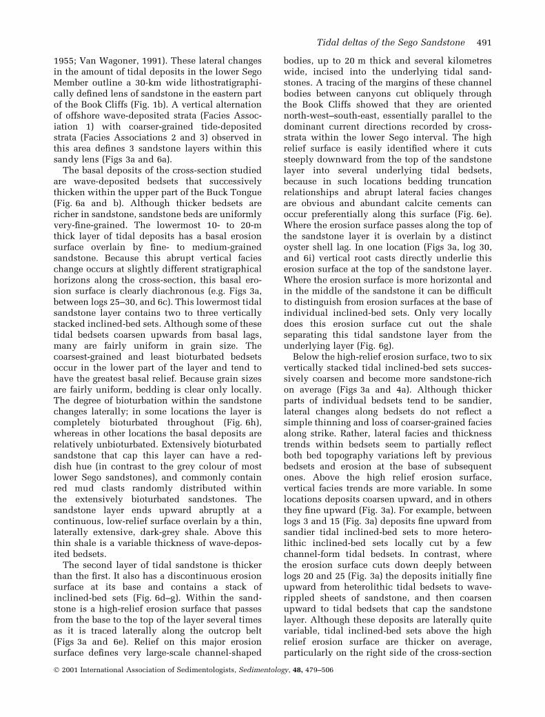
1955; Van Wagoner, 1991). These lateral changesin the amount of tidal deposits in the lower SegoMember outline a 30-km wide lithostratigraphi-cally de®ned lens of sandstone in the eastern partof the Book Cliffs (Fig. 1b). A vertical alternationof offshore wave-deposited strata (Facies Assoc-iation 1) with coarser-grained tide-depositedstrata (Facies Associations 2 and 3) observed inthis area de®nes 3 sandstone layers within thissandy lens (Figs 3a and 6a).
The basal deposits of the cross-section studiedare wave-deposited bedsets that successivelythicken within the upper part of the Buck Tongue(Fig. 6a and b). Although thicker bedsets arericher in sandstone, sandstone beds are uniformlyvery-®ne-grained. The lowermost 10- to 20-mthick layer of tidal deposits has a basal erosionsurface overlain by ®ne- to medium-grainedsandstone. Because this abrupt vertical facieschange occurs at slightly different stratigraphicalhorizons along the cross-section, this basal ero-sion surface is clearly diachronous (e.g. Figs 3a,between logs 25±30, and 6c). This lowermost tidalsandstone layer contains two to three verticallystacked inclined-bed sets. Although some of thesetidal bedsets coarsen upwards from basal lags,many are fairly uniform in grain size. Thecoarsest-grained and least bioturbated bedsetsoccur in the lower part of the layer and tend tohave the greatest basal relief. Because grain sizesare fairly uniform, bedding is clear only locally.The degree of bioturbation within the sandstonechanges laterally; in some locations the layer iscompletely bioturbated throughout (Fig. 6h),whereas in other locations the basal deposits arerelatively unbioturbated. Extensively bioturbatedsandstone that cap this layer can have a red-dish hue (in contrast to the grey colour of mostlower Sego sandstones), and commonly containred mud clasts randomly distributed withinthe extensively bioturbated sandstones. Thesandstone layer ends upward abruptly at acontinuous, low-relief surface overlain by a thin,laterally extensive, dark-grey shale. Above thisthin shale is a variable thickness of wave-depos-ited bedsets.
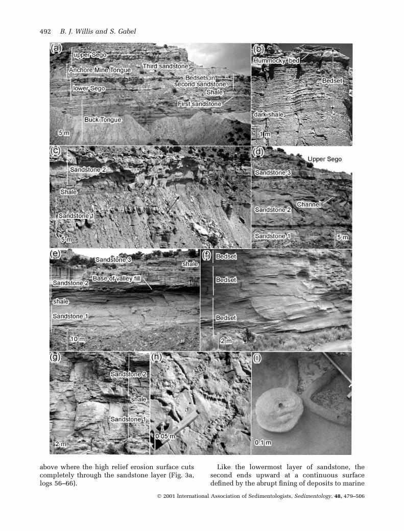
The second layer of tidal sandstone is thickerthan the ®rst. It also has a discontinuous erosionsurface at its base and contains a stack ofinclined-bed sets (Fig. 6d±g). Within the sand-stone is a high-relief erosion surface that passesfrom the base to the top of the layer several timesas it is traced laterally along the outcrop belt(Figs 3a and 6e). Relief on this major erosionsurface de®nes very large-scale channel-shaped
bodies, up to 20 m thick and several kilometreswide, incised into the underlying tidal sand-stones. A tracing of the margins of these channelbodies between canyons cut obliquely throughthe Book Cliffs showed that they are orientednorth-west±south-east, essentially parallel to thedominant current directions recorded by cross-strata within the lower Sego interval. The highrelief surface is easily identi®ed where it cutssteeply downward from the top of the sandstonelayer into several underlying tidal bedsets,because in such locations bedding truncationrelationships and abrupt lateral facies changesare obvious and abundant calcite cements canoccur preferentially along this surface (Fig. 6e).Where the erosion surface passes along the top ofthe sandstone layer it is overlain by a distinctoyster shell lag. In one location (Figs 3a, log 30,and 6i) vertical root casts directly underlie thiserosion surface at the top of the sandstone layer.Where the erosion surface is more horizontal andin the middle of the sandstone it can be dif®cultto distinguish from erosion surfaces at the base ofindividual inclined-bed sets. Only very locallydoes this erosion surface cut out the shaleseparating this tidal sandstone layer from theunderlying layer (Fig. 6g).
Below the high-relief erosion surface, two to sixvertically stacked tidal inclined-bed sets succes-sively coarsen and become more sandstone-richon average (Figs 3a and 4a). Although thickerparts of individual bedsets tend to be sandier,lateral changes along bedsets do not re¯ect asimple thinning and loss of coarser-grained faciesalong strike. Rather, lateral facies and thicknesstrends within bedsets seem to partially re¯ectboth bed topography variations left by previousbedsets and erosion at the base of subsequentones. Above the high relief erosion surface,vertical facies trends are more variable. In somelocations deposits coarsen upward, and in othersthey ®ne upward (Fig. 3a). For example, betweenlogs 3 and 15 (Fig. 3a) deposits ®ne upward fromsandier tidal inclined-bed sets to more hetero-lithic inclined-bed sets locally cut by a fewchannel-form tidal bedsets. In contrast, wherethe erosion surface cuts down deeply betweenlogs 20 and 25 (Fig. 3a) the deposits initially ®neupward from heterolithic tidal bedsets to wave-rippled sheets of sandstone, and then coarsenupward to tidal bedsets that cap the sandstonelayer. Although these deposits are laterally quitevariable, tidal inclined-bed sets above the highrelief erosion surface are thicker on average,particularly on the right side of the cross-section
Tidal deltas of the Sego Sandstone 491
Ó 2001 International Association of Sedimentologists, Sedimentology, 48, 479±506
above where the high relief erosion surface cutscompletely through the sandstone layer (Fig. 3a,logs 56±66).
Like the lowermost layer of sandstone, thesecond ends upward at a continuous surfacede®ned by the abrupt ®ning of deposits to marine
492 B. J. Willis and S. Gabel
Ó 2001 International Association of Sedimentologists, Sedimentology, 48, 479±506
shales with thin, very-®ne-grained, wave-depos-ited sandstones. Relief on this surface is quitesubdued, even though isolated lags and locallateral truncation of strata indicate some erosion.This abrupt ®ning de®nes the base of the AnchorMine Tongue Shale. The third layer of tidalsandstone is much thinner than the lower two,and it is discontinuous along the outcrop belt. Inmost places this layer appears to be a single tidalbedset thick, although extensive bioturbation byOphiomorpha obscures all internal sedimentary
structures at many locations. Like the otherlayers, marine shales abruptly overlie this sand-stone. The study interval ends with a ®nalupward-coarsening succession of marine shalesand wave-deposited very-®ne-grained sandstonesthat are cut out by the erosional base of the upperSego Sandstone.
Interpretation
The stratigraphical interlayering of shale-richwave-deposited strata with coarser-grained tidal-sandstone layers observed within the Westwatercross-section records dramatic alternations in thedepositional system. These abrupt vertical facieschanges may re¯ect rapid shifts in the position offacies tracts, and/or pronounced temporal chan-ges of depositional processes, within the basin.Depositional interpretations of these depositsdepend critically on inferred changes in waterdepth during the deposition of the different faciestypes, and the origin of erosion surfaces at thebase of and within the tidal sandstones.
The progressive upward coarsening of depositsfrom marine shales in the middle of the BuckTongue to sandier bedsets near its top recordsgradual depositional shoaling from deeper marineto distal shoreface environments. Thicker sand-stone beds with hummocky cross-strata near thetop of this upward-coarsening succession recordstronger wave- and storm-generated currents,whereas uniformly very-®ne-grained sandstonesthroughout this succession probably indicatesands were transported signi®cant distances intothe basin. Lateral changes in the thickness ofwave-deposited beds over kilometres along strikesuggest it might be dif®cult to use individualbedsets to de®ne `parasequences' that can becorrelated landward into speci®c progradationalshoreface successions.
Discontinuities in the erosion surface at thebase of the lower Sego Sandstone indicate thatthis facies change was not instantaneous, andthus this transition may simply record the pro-gradation of sediments into the basin. For exam-ple, many studies of wave-dominated shorefacedeposits have related similar abrupt verticalgrain-size changes to rapid progradation of shore-face sandstones onto offshore shale during a fallin sea-level (i.e. forced regression deposits ofPosamentier et al., 1992). Similarly, graduallyfalling relative sea-levels in this system couldhave allowed tidal currents to scour the sea ¯oorduring the downstepping of a tidal shoreface intoformerly offshore marine areas. Alternatively,
Fig. 6. Examples of deposits exposed in the Westwaterarea (Fig. 3a). (a) Lithostratigraphic units of the SegoSandstone Member are shown (near log 52, Fig. 3a).The Buck Tongue of the Mancos shale gradually coar-sens upward to the base of the lower Sego Sandstone.The lower Sego Sandstone has an erosional base, and asharp top with the overlying shales of the Anchor MineTongue of the Mancos Shale. The lower Sego is splitinto two layers by an internal regionally continuousshale, which separates sandstone layers 1 and 2 de®nedin this paper. A thin sandstone layer within the AnchorTongue shale is called sandstone layer 3 in this paper.The upper Sego Sandstone caps the hill. (b) Metre-thick, upward-coarsening bedsets of Facies Association1. The thin bedsets lower in the photograph are highlybioturbated, whereas the thicker bedset with a hum-mocky cross-strati®ed cap is relatively unbioturbated(near the base of log 21, Fig. 3a). (c) Details of the lowerSego Sandstone showing sandstone layers 1 and 2separated by a decimetre-thick shale. Sandstone layer1, a thin bioturbated deposit on the right, is joined at itsbase by additional, relatively unbioturbated, sandstoneon the left. Thus, at this location there is a clear breakin the erosion surface at the base of the lower SegoSandstone (arrow connects the offset in the basal ero-sion surface of this sandstone layer between logs 23±29,Fig. 3a). Second sandstone layer contains severalstacked tidal inclined-bed sets and is overlain by therecessive Anchor Mine Tongue Shale. (d) Vertical cliffexposing the three sandstone layers in the lower Segoand Anchor Mine Tongue (near log 9, Fig. 3a). Theinternal high relief erosion surface is at the base of thesecond sandstone in this location, and overlyingsandstone-rich tidal inclined-bed sets are capped bymore heterolithic channel-form bedsets. (e) Thick layerof calcite cement marks the high relief erosion surfaceincised part way through the second sandstone (nearlog 56, Fig. 3a). (f) Tidal inclined-bed sets verticallystacked within the lower Sego Sandstone (near log 66,Fig. 3a). Note the beds in the lowermost tidal bedsetdip to the left at about 10°. (g) Location where the highrelief erosion surface, originating at the top of the sec-ond sandstone, cuts out the shale that separates the ®rstand second sandstones in most other locations (near log65, Fig. 3a). (h). Horizontal Ophiomorpha burrows nearthe top of the lowermost sandstone layer (near log 37,Fig. 3a). (i) Calcite-encased root casts preserved at thetop of the lower Sego Sandstone (near log 23, Fig. 3a).
Tidal deltas of the Sego Sandstone 493
Ó 2001 International Association of Sedimentologists, Sedimentology, 48, 479±506
relatively minor changes in basin shape, causedby changes in local sea-level and/or shorelineposition, could have produced tidal resonancewithin the basin that abruptly changed thestrength of tidal currents along speci®c areas ofthe coastline (Belderson et al., 1986; Pugh, 1987;Reynaud et al., 1999b). In this case, the onset oftidal erosion and deposition of coarser-grainedsands could re¯ect an abrupt strengthening oftidal currents, rather than an abrupt lateral shiftof facies tracts within the basin. In either case, itappears that tidal scour produced more than 10 mof local relief on the basin ¯oor.
Erosion at the base of the tidal sandstonessuggests that strong tidal currents scoured the sea¯oor before and during sand progradation into thestudy area. Harris (1994) reported channels in60-m deep waters that were actively scoured bytidal currents in front of the modern Fly Riverdelta. Less bioturbated deposits directly above thebasal erosion surface of the ®rst tidal sandstonelayer may indicate that the most rapid sedimentprogradation occurred in such sea ¯oor channels.The stacking of several tidal inclined-bed setswithin this sandstone layer indicates verticalaggradation of several seaward-prograding tidalbedforms. Because marine currents tend to win-now muds from sediments transported longerdistances across the basin ¯oor, and environ-ments farther from shore are expected to havemore open marine salinities, high average biotur-bation in this fairly homogeneous tidal sandstonelayer probably indicates deposition on the distalend of a prograding tidal shoreface. Finer-grainedbioturbated bedsets higher in this sandstone layersuggest more gradual sediment aggradation astidal currents subsequently weakened and rates ofsand supply began to decline. The uniformlybioturbated sandstones capping this layer mayre¯ect colonization of a hiatal surface after tidalcurrents had stopped supplying sand to this area.Red coloured mud-chip clasts in these bioturb-ated sandstones may record the erosion andseaward transport of muds originally oxidizedin soils (as suggested by Van Wagoner, 1991);however, these clasts do not have textures dis-tinctive of pedogenesis, and thus they maysimply re¯ect the erosion of muds oxidizeddirectly on the shallow sea ¯oor.
Even though intense bioturbation left no evi-dence of wave reworking or ravinement lags, thissandstone layer's ¯at top contact with overlyingshales may indicate that sea ¯oor topography leftby the migrating tidal bedforms was planed off bywaves prior to the hiatus in sand deposition. The
abrupt transition to dark shale at the top of thissandstone layer indicates deposition restricted tomarine muds suspended and transported offshoreduring major storms. The termination of sandsupply may be related to a rise in relative sea-level that trapped sands farther landward, and/orthe cessation of strong ebb currents transportingsands basinward as the basin shape changed todepart from a tide resonance geometry.
Wave-deposited bedsets interbedded with thinbioturbated tidal bedsets at the base of the secondsandstone layer probably indicate renewed sedi-ment progradation after the hiatus in sand depos-ition. The dominance of tidal sandstones higherwithin this layer records a second transition fromwave- to tide-dominated deposition within thelower Sego interval. Vertical stacking of tidalinclined-bed sets below the high relief erosionsurface within this sandstone layer record theaggradation of successive, offshore-migrating,tidal bedforms. Upward coarsening of averagegrain sizes within successive bedsets and rootcasts extending down from the top of thissandstone layer at one location indicate theseaggrading sands shoaled to very shallow waterdepths, and the area was probably subaeriallyexposed. This upward-shoaling trend, and highsuspended sediment loads indicated by the veryheterolithic deposits in the lower parts of indi-vidual tidal bedsets, suggest that this sandstoneformed on a prograding tide-in¯uenced shorefaceor delta front close to an area directly supplied byrivers.
The high relief erosion surface that passes fromthe top to the base of this sandstone layer recordsdeep incision into the prograding tidal shoreface.Because the depth of incision along this continu-ous erosion surface is clearly much greater thanthe thickness of individual depositional bedsetswithin this sandstone, this surface may recorderosion of valleys into the shoreface during alowstand in relative sea-level. Alternatively, how-ever, the lack of ¯uvial deposits overlying thiserosion surface may indicate that the shorefacewas deeply incised by strong tidal currentsduring maximum tidal resonance. Because itseems unlikely that major rivers entered the basinevery few kilometres along the coastline, the threeseparate kilometre-wide incisions de®ned by thiserosion surface along this 15-km strike-orientedoutcrop seem unlikely to each record valleyincision by separate river channels.
Reynaud et al. (1999b) observed similar-scaletidal current incisions into late Quaternary sandridges deposited on the shelf of the Celtic sea
494 B. J. Willis and S. Gabel
Ó 2001 International Association of Sedimentologists, Sedimentology, 48, 479±506
during a fall in sea-level. High sediment supplyduring the last stages of a sea-level fall allowedthese shelf ridges to build high enough to restricttidal currents. Tidal currents then cut swatchwaychannels across the ridge crests during a period oftidal resonance. As sea-levels subsequently rose,tidal currents waned and wave-driven currentsgradually reworked the tide-formed topography,¯attening relief on the basin ¯oor. A similarevolution from tide- to wave-dominated proces-ses has been recorded in sediments underlyingother modern tidal banks (Chakhotin et al., 1972;Nelson et al., 1982; Davis & Balson, 1992). Closerto shore, restriction of tidal currents andenhanced sea ¯oor erosion would occur wherewaters rapidly shoaled up the shoreface or deltafront. This analogue suggests that normal tidalerosion during a period of maximum tidal reson-ance could have produced the high-relief erosionsurface in the second Sego tidal sandstone layer.If produced by tidal currents, the localized natureof erosion observed in the Sego Sandstone prob-ably re¯ects preferential tidal scouring of shore-line embayments or abandoned major distributarychannels.
The deposits above the high-relief erosionsurface record the ®lling of valleys or tide-carvedestuaries cut into the shoreface. The variablecharacter of these ®lls re¯ect differences insediment supply and the strength of tidal currentsalong the coastline. Because deposits above thishigh-relief erosion surface all record ebb-domin-ated palaeo¯ows, sediment must have been sup-plied mostly from more landward areas, ratherthan originating as marine sands reworked intoestuary mouths (cf. Dalrymple et al., 1990; Harriset al., 1992). The ®ll between logs 3 and 15(Fig. 3a) shows an upward-®ning trend thatre¯ects a gradual weakening of ebb tidal currentsover time and an increase in accommodationrelated to a widening of the estuary as theshoreface topography was ®lled. The ®ll betweenlogs 20±30 (Fig. 3a) re¯ects a gradual loss ofsediment supply and weakening of tidal currents,and then an increase in sediment supply as thetopographic high separating this ®ll from theadjacent one was overtopped by aggrading sedi-ments. Once this intervening high was buried, theestuary had sandier deposits near its centre andmore heterolithic deposits near its margin; inmany modern estuaries, similar grain-size pat-terns are produced by faster tidal ¯ows along anestuary's axis relative to its margins (Dalrympleet al., 1994). Because the unusually large tidalinclined-bed sets in the ®ll on the right side of the
cross-section (Fig. 3, logs 53±66) overlie thelargest and deepest shoreface incision, they mayrecord bayhead deltas supplied more directlyfrom the major river channel.
The low-relief top of the second sandstoneprobably records wave reworking once tidalcurrents had weakened. In this case, shell lagsand clear evidence for local erosion of tidalbedsets at the top of the sandstone layer supportravinement as the system returned to wave-dominated deposition. The ®nal tidal sandstonelayer, in the middle of the Anchor Mine Tongue,indicates another episode of increased tidalin¯uence and sand progradation into the basin.Extensive bioturbation and fairly uniform very®ne to ®ne grain sizes within this relatively thintidal sandstone layer suggest that it was depositedfarther from shore than the very heterolithicsecond sandstone layer. Like the top contact ofthe other sandstone layers, the abrupt ®ning ofdeposits to shale above this third tidal sandstonerecords a halt in sand supply and perhaps ahiatus in deposition. The gradual increase inwave-deposited sandstone in the upper part ofthe Anchor Mine Tongue ending at erosionallybased tidal sandstones of the upper Sego Sand-stone records gradual depositional shoaling sim-ilar to that observed at the top of the BuckTongue.
The broader-scale ®ning of tidal sandstoneswithin the lower Sego Member laterally awayfrom the Westwater area (Fig. 1b; Young, 1955)records increasing distance from the source ofsand. These lateral changes, de®ning a 30-kmwide lens of sandstone within this strike-orientedcross-section, probably re¯ect the limits of deltaicsand deposition supplied by a major river enter-ing the seaway. Reconnaissance of other areasalong this large-scale sandstone lens shows thatsandstone layers documented in this studychange in thickness laterally, which may re¯ectlobe-switching during episodic delta prograda-tion. Van Wagoner (1991) describes successivetidal inclined-bed sets in a thick segment of thesecond sandstone layer that shingle basinward,which probably record the larger-scale prograda-tion of the delta. A palaeosol (de®ned by verticalroot casts overlain by bioturbated coaly sand-stones) caps the ®rst tidal sandstone layer whereit is thickest near the Utah±Colorado border,indicating that some areas along the coast werealso subaerially exposed during this ®rst episodeof sandstone progradation. Several other deeperosional incisions into the second sandstonelayer were observed farther east of the study area,
Tidal deltas of the Sego Sandstone 495
Ó 2001 International Association of Sedimentologists, Sedimentology, 48, 479±506
suggesting that stratal patterns documented nearWestwater Canyon are representative of otherareas where these deltaic deposits are thick andrich in sandstone. Van Wagoner (1991) suggestedthat lateral changes in the proportion of tidalsandstone to ®ner-grained wave-deposited strataalong strike re¯ect locations of structural linea-tions or faults that cut obliquely across theforeland basin axis.
Thompson Canyon area
Description
The thickness of deposits from the base of thelower Sego Sandstone to the base of the upperSego Sandstone is similar in the ThompsonCanyon and Westwater Canyon areas (Fig. 4),but in the Thompson Canyon area this interval isricher in sandstone (Fig. 3b). East of ThompsonCanyon, Young (1955) shows three layers withinthe lower Sego Sandstone that become lesssandstone-rich east of Thompson Canyon(Fig. 1b). Young (1955) does not show the corre-lation of these layers west of the ThompsonCanyon area (Fig. 1a and b; see, however, con-trasting interpretations of the north-westwardcorrelation of these strata in Yoshida et al.,1996; and McLaurin & Steel, 2000).
As in the Westwater area, the basal part of theinterval documented in the area of ThompsonCanyon comprises the top of an upward-coar-sening succession of wave-deposited bedsets inthe Buck Tongue, and the lowermost layer oftidal sandstones has an erosional base (Fig. 7a).The lowermost tidal sandstone layer is thicker,and contains a more continuous interval ofrelatively unbioturbated bedsets in its basal part,than in the Westwater area (compare Fig. 3a andb). In the basal part of this lowermost tidalsandstone layer, bedsets successively coarsenupward from ®ne- to medium-grained sand-stones, whereas the extensively bioturbatedsandstones capping this layer are somewhat®ner grained. As in the Westwater area, cross-strata within beds and beds within bedsets dipmostly to the south-east. Locally there arechannel-form tidal bedsets with internal lateralaccretion bedding below the more bioturbatedsandstones capping this layer (Fig. 7b). Depositsabove the ¯at top of this tidal sandstone arelocally amalgamated, very-®ne-grained, hum-mocky cross-strati®ed bedsets overlain bymarine shales with thin wave-rippled sandstonebeds. Small, thin, channel-form sandstones with
ebb-dipping internal cross-strata locally cut intothese hummocky cross-strati®ed sandstone beds.
At the base of the second tidal sandstone, adiscontinuous erosion surface de®nes a verticallyabrupt, but laterally discontinuous, transitionfrom wave- to tide-dominated deposits. Althoughthis second tidal sandstone is thin on the eastside of the cross-section (right side of Fig. 3b), itthickens dramatically to the west where a highrelief erosion surface descends from the top of thesandstone to cut out not only the second sand-stone layer, but also all of the underlying lowerSego Sandstone (compare Fig. 7a and c). Wherethis erosion surface is most deeply incised, it isoverlain by relatively coarse-grained, complexlyamalgamated channel-form bedsets (Fig. 7d).These bedsets have plant-fragment-rich basalmud chip lags and uniformly ebb-dipping,angle-of-repose, decimetre-thick cross-strati®edsandstone with few shale drapes. Where the areaabove this erosional incision widens higher in thesandstone layer, deposits change to tidalinclined-bed sets with ¯atter erosional bases,lower-angle heterolithic offshore-dipping internalbeds and upward-coarsening internal facies.
Where the second tidal sandstone is thin (eastside of the cross-section, Fig. 3b), it is overlainby wave-rippled and hummocky cross-strati®edsandstones and richly bioturbated shales. A thirdtidal sandstone layer with a discontinuous ero-sional base, above these wave-dominated depos-its, amalgamates with the second tidal sandstonelayer towards the west. This third layer of tidal
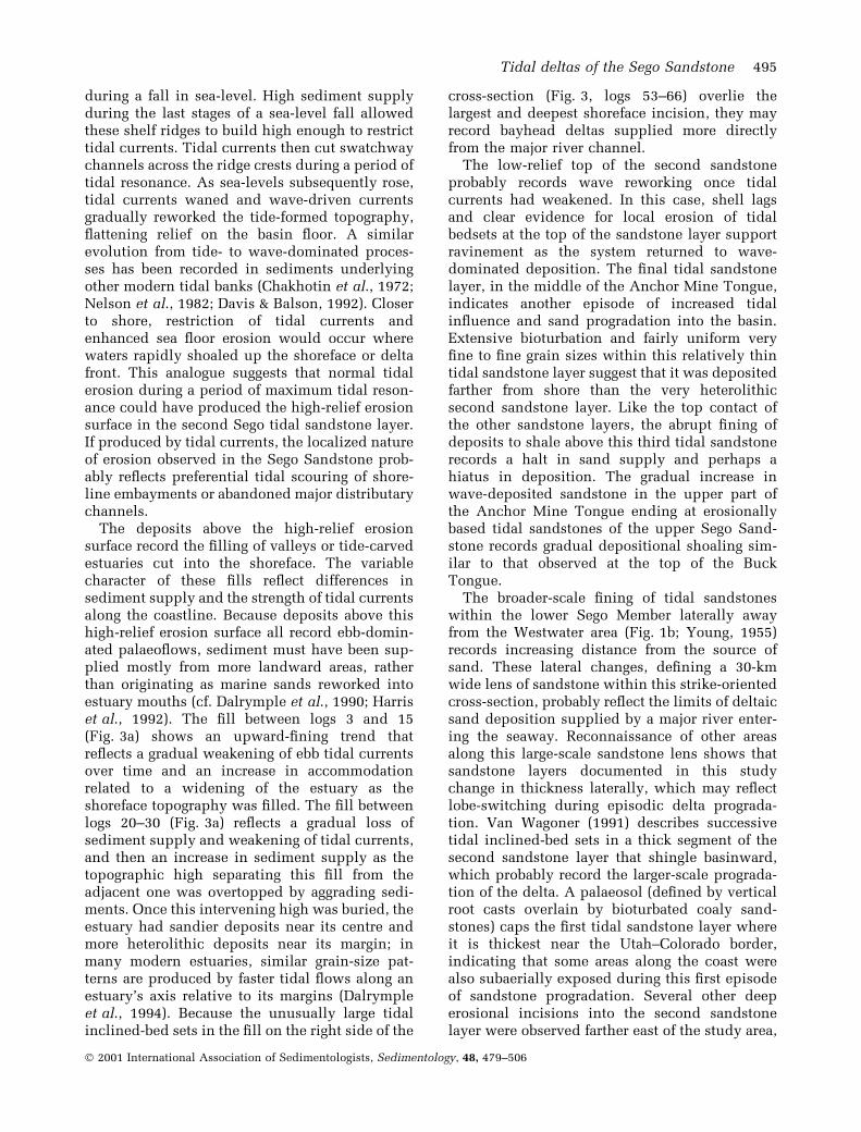
Fig. 7. (a) Examples of deposits exposed in theThompson Area (Fig. 3b). Lower Sego Member, expo-sed on the right side of the Thompson cross-section, iscomposed of a relatively heterolithic stack of tidalsandstones (near log 31, Fig. 3b). (b) Tidal channelswithin the lowermost tidal sandstone may mark maxi-mum regression of the shoreline (near log 1, Fig. 3b). (c)Lower Sego Member is very sandstone-rich where ahigh relief erosion surface cuts down from the top ofthe second into the lowermost tidal sandstone layer(near log 9, Fig. 3b). (d) Amalgamated ¯uvial channelsin the basal part of a coarse-grained valley ®ll incisedinto the second sandstone layer (near log 8, Fig. 3b).(e) Heterolithic deposits overlie the high relief erosionsurface that cuts down from the top of the third tidalsandstone layer. Locally this erosion surface also cutsout the second sandstone layer (see arrow; between logs19 and 20, Fig. 3b). (f) Valley ®ll incised down from thethird sandstone layer has an upward coarsening faciestrend (near log 4, Fig. 3b). (g) Close-up view of ero-sional shell-rich lag (arrow) observed in the heterolithicdeposits above the high relief erosion surface withinthe third tidal sandstone layer (near log 4, Fig. 3b).
496 B. J. Willis and S. Gabel
Ó 2001 International Association of Sedimentologists, Sedimentology, 48, 479±506
sandstones also contains a high-relief internalerosion surface. Deposits below this erosionsurface are mostly large tidal inclined-bedsets,
similar to those in the upper part of the secondtidal sandstone layer. Where the erosion surfacecuts deeply into the third tidal sandstone,
Tidal deltas of the Sego Sandstone 497
Ó 2001 International Association of Sedimentologists, Sedimentology, 48, 479±506
however, deposits directly above the erosionsurface are very heterolithic tidal bedsets withabundant decimetre- to rarely metre-thick oysterbreccia lags (Fig. 7e±g). Lag surfaces can havemetres of relief that de®ne metres to a few tens ofmetres wide channelized scours and ®lls. As thearea above the erosion surface widens upward,the deposits become thicker and sandier tidalinclined-bed sets. Thus, deposits above the highrelief erosion surface in the third tidal sandstonelayer become thicker bedded and more sand-stone-rich upwards. Only a thin layer of wave-deposited sandstones and shales separate thelow-relief top of the third tidal sandstone layerfrom the overlying upper Sego Sandstone.
Interpretation
The thickness of the documented internal nearThompson Canyon is similar to that observednear Westwater Canyon 50 km to the east (Figs 1and 4), which suggests similar average accommo-dation across this area of the basin. Comparablevertical rock property trends (i.e. Fig. 4) suggestdeposition in both areas was in¯uenced by thesame changes in basin accommodation and/ordepositional processes. The greater proportion ofsandstone in the Thompson Canyon area suggestsgreater coarse sediment supply.
Deposits in the upper part of the Buck Tongueshow an upward-shoaling succession from dee-per-water marine shales to wave-in¯uenced, dis-tal-shoreface bedsets similar to that observed inthe Westwater area. A thicker vertical stack ofrelatively unbioturbated tidal inclined-bed setsin the ®rst layer of the lower Sego Sandstoneindicates a greater aggradation of rapidly pro-grading tidal bedforms. Channel-form tidal bed-sets within this layer may indicate preservation ofnearshore distributaries during maximum shore-line regression, which also suggests greater shoal-ing than interpreted for the ®rst tidal sandstonelayer in the Westwater Canyon area. Like in theWestwater area, highly bioturbated sandstonescapping this layer suggest decreased depositionrates that allowed extensive burrowing. The ¯atcontact at the top of this tidal sandstone layerwith overlying hummocky cross-strati®ed sand-stones probably re¯ects ravinement as tidal cur-rents waned and the area was planed off bywaves. The sandstone-rich wave-deposited strataindicate sand supply continued after tidal cur-rents began to wane, in contrast to the Westwaterarea where deposits abruptly ®ned to shales atthis transition. This difference may record depos-
ition closer to the coastline or delta front edge,where waves could rework sands basinwardwithout the assistance of strong ebb-directedtidal currents. The ®ning of overlying depositsto marine shales indicates either a continueddecrease in the strength of offshore-directed tidalcurrents or a deepening of deposition fartherbelow fair weather wave base.
The second tidal sandstone is thin relative to itsoccurrence in the Westwater Canyon area, whichsuggests basin accommodation was mostly ®lled inthe area of Thompson Canyon before this nextepisode of tidal sand progradation began. Relief atthe base of this layer indicates up to 10 m oferosion, and discontinuities along this erosionsurface suggest that this relief is related to locali-zed tidal scouring. Between logs 5 and 10 (Fig. 3b)it is clear that strengthening tidal currents initiallyscoured a topographically raised stack of amalga-mated hummocky cross-strati®ed sandstones; thusit appears that areas of highest sandstone supplyduring periods of wave-dominated depositionwere also the ®rst areas to receive a renewed in¯uxof sands as tidal currents subsequently streng-thened. Incision from the top of this secondsandstone layer is far greater than that observedin the Westwater area. Where this erosion surfacecuts deepest into the underlying deposits, overly-ing channel-form bedsets are interpreted to be¯uvial channel deposits because grain sizes arecoarser, lags are rich in plant fragments andinternal cross-strata show no evidence of tidalin¯uence on deposition. It is dif®cult to estimatethe size of these ¯uvial channels because thebedsets are highly amalgamated; however, thedimensions of bedsets and the extent of internallaterally accreted beds indicate that these channelswere at least 6 m deep and a hundred metres wide.Fluvial channel deposits in the deepest part of thisincision suggest it is a valley cut into underlyingtidal shoreface deposits. Tidal inclined-bed setshigher within this sandstone record a ¯ooding ofthis valley and continued progradation of tidalbedforms into an estuary.
The thick stack of tidal bedsets overlying thevalley ®ll (relative to areas on the east side of thecross-section) indicates that sediment supplycontinued to be localized along a restricted areaof the coastline, and thus that the river probablyremained trapped in a more landward segment ofthe valley. Marine shales with thin hummockycross-strati®ed sandstones overlying these tidalsandstones on the east side of this cross-sectionrecord continued deepening of waters in this areaand weakening of tidal currents.
498 B. J. Willis and S. Gabel
Ó 2001 International Association of Sedimentologists, Sedimentology, 48, 479±506
The third sandstone layer, much richer insandstone than in the Westwater area, recordscontinued high average sediment supply to thisarea. Amalgamation of the second and third tidalsandstone layers from east to west (right to left)along the cross-section re¯ects erosion of inter-vening marine shales where tidal bedformsmigrated onto a depositional high within thesecond sandstone layer. Deep incision recordedby the high relief erosion surface within thissandstone layer may record another episode ofvalley erosion, or that increasingly strong tidalcurrents began to erode the prograding tidalshoreface. Thick shell lags at the base of hetero-lithic channelized scours directly above thiserosion surface probably indicate the reworkingof shallow water oyster shoals into deeper areasscoured by tidal currents. The high mud contentwithin these deposits indicates deposition of highsuspended sediment loads, and probably indi-cates close proximity to a ¯uvial source ofsediment. Thus, the deposits probably formed inthe central bay area of an estuary (Dalrympleet al., 1994). The lack of ¯uvial channel depositsor evidence of subaerial exposure associated withthis deep scour surface, however, suggests theerosion may have been entirely tidal in origin.The upward coarsening of successive tidal bed-sets above this erosion surface records gradual®lling of the estuary by prograding tidal bed-forms, perhaps indicating that weakening tidalcurrents became less effective in transportingsandstones farther offshore. Alternatively, it maybe that the main river channel was located in anincised valley elsewhere on the delta duringmaximum lowstand, and that sediments suppliedto the area studied increased after the beginningof transgression when topography on more deeplyincised areas of the delta had been ®lled. Therelatively ¯at top of this sandstone layer, overlainby wave-deposited sandstones and marine shales,indicates a planing of topography along the tidalcoastline by wave processes as the shoreline wastransgressed. The erosion surface at the top of theinterval documented (i.e. at the base of the upperSego Sandstone) records the start of anotherepisode of tidal sand deposition.
The broader-scale eastward decline in sand-stone away from the area documented heresuggests that these deposits formed on a differentdelta than documented in the Westwater Canyonarea (Fig. 1b; Young, 1955). The full width of thissecond delta deposit cannot be documented,because to the west of the area studied here theBook Cliff outcrop belt swings to the north along
a more dip-oriented trend. Evidence for highersediment supply within this area suggests thatthis delta was larger, or that these deposits areexposed along a more proximal cross-section.
SEQUENCE STRATIGRAPHY
The correlation of vertical facies trends betweentwo areas spaced about 50 km apart along strikesuggests these variations are related to basin-wideepisodes of sand progradation into the basin.Although past studies have indicated that tidalfacies in the lower Sego extend landward for tensof kilometres (Fig. 1a; Van Wagoner et al., 1990;Yoshida et al., 1996; McLaurin & Steel, 2000),changes in shoreline positions during lower Segodeposition and the basinward correlations of SegoSandstone layers is controversial. Landward tran-sitions from shoreline to fully ¯uvial facies occurin the subsurface beneath thick successions of theoverlying Nelson Formation, except for remote,discontinuous outcrops along the western edge ofthe outcrop belt. The seaward termination of tidalsandstones south of the Book Cliffs cannot bedocumented because these strata were erodedafter the Laramide Uncompahgre Uplift. Sequ-ence stratigraphical interpretations of thesedeposits, thus, depend on inferring changes inaccommodation and sediment supply from obser-vations of the strike-oriented exposures in thesouthern Book Cliffs (Fig. 8).
Past depositional models of the Sego Sandstoneindicated that transitions between wave-depos-ited and tidal sandstones record abrupt drops insea-level and the incision of valleys into oncedistal marine areas (Van Wagoner et al., 1990;Van Wagoner, 1991). The earlier of these studies(Van Wagoner et al., 1990) recognized the threetidal sandstone layers described in this study,and interpreted each to be a valley ®ll. Whendiscontinuities in erosion surfaces at the base ofthese sandstone layers were later recognized,additional episodes of ¯uvial valley incisionand ®lling were postulated (Fig. 1c; Van Wag-oner, 1991). These investigators suggested thatfew strata deposited during the regression ofshorelines into the basin were preserved, eitherbecause shorelines rapidly regressed past thesouthern Book Cliffs area before signi®cantdeposition could occur, or because ravinementduring the start of subsequent transgressionsremoved these deposits. The tidal sandstoneswere, thus, assumed to be completely containedwithin broad shallow valleys, many tens of
Tidal deltas of the Sego Sandstone 499
Ó 2001 International Association of Sedimentologists, Sedimentology, 48, 479±506
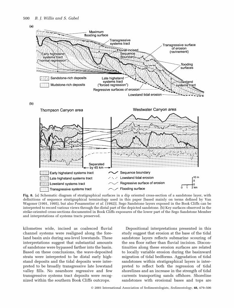
kilometres wide, incised as coalesced ¯uvialchannel systems were realigned along the fore-land basin axis during sea-level lowstands. Theseinterpretations suggest that substantial amountsof sandstone were bypassed farther into the basin.Based on these conclusions, the wave-depositedstrata were interpreted to be distal early high-stand deposits and the tidal deposits were inter-preted to be broadly transgressive late lowstandvalley ®lls. No nearshore regressive and fewtransgressive systems tract deposits were recog-nized within the southern Book Cliffs outcrops.
Depositional interpretations presented in thisstudy suggest that erosion at the base of the tidalsandstone layers re¯ects submarine scouring ofthe sea ¯oor rather than ¯uvial incision. Discon-tinuities along these erosion surfaces are relatedto locally variable erosion during the basinwardmigration of tidal bedforms. Aggradation of tidalsandstones within stratigraphical layers is inter-preted to re¯ect both the regression of tidalshorelines and an increase in the strength of tidalcurrents transporting sands offshore. Shorelinesandstones with erosional bases and tops are
Fig. 8. (a) Schematic diagram of stratigraphical surfaces in a dip oriented cross-section of a sandstone layer, withde®nitions of sequence stratigraphical terminology used in this paper [based mainly on terms de®ned by VanWagoner (1991, 1995), but also Posamentier et al. (1992)]. Sego Sandstone layers exposed in the Book Cliffs can beinterpreted to record various views through the distal part of the depicted sandstone. (b) Key surfaces observed in thestrike-oriented cross-sections documented in Book Cliffs exposures of the lower part of the Sego Sandstone Memberand interpretations of systems tracts preserved.
500 B. J. Willis and S. Gabel
Ó 2001 International Association of Sedimentologists, Sedimentology, 48, 479±506
most commonly reported where shorelines areinterpreted to have regressed as a result of fallingsea-level, because falls in sea-level allow shallowmarine currents to scour formerly offshore marineareas and downstepping shorefaces are moresusceptible to ravinement during subsequenttransgression (Plint, 1988; Posamentier et al.,1992; Walker & Plint, 1992; Helland-Hansen &Gjelberg, 1994).
During deposition of the Sego Member, fallingrelative sea-level may have both forced shorelinesto regress onto the ¯at bottom of the foreland axisand produced a basin geometry that enhancedtidal currents. Regression and transgression ofshorelines across the low-gradient basin ¯oorduring lowstands is likely to have producedchanges in the strength of tidal currents, becausein such situations minor changes in accommoda-tion or sediment supply can rapidly change basinshape and, thus, potentially the magnitude oftidal resonance and the position of amphidromicnodes. Although broad shallow lowstand seas arelikely to have wider areas susceptible to tidalreworking and perhaps faster tidal currents, thereis no direct link between the extent to which tidalrange is enhanced by resonance within the basinand relative sea-level ± i.e. tidal resonancedepends on basin width relative to tidal wave-length (Pugh, 1987), and is not directly related tosequence stratigraphical divisions.
Evidence for falling accommodation duringdeposition of the tidal sandstone layers suggestssands prograded in front of incised valleys cutinto highstand deposits in more proximal areas ofthe basin. Thus, layers of tidal sandstone com-prise late highstand to lowstand systems tracts(using the terminology of Van Wagoner, 1991,1995; and Mitchum et al., 1977; Fig. 8a). If thetidal sandstone layers are late highstand deposits,then erosion surfaces at their base would be`regressive surfaces of erosion' as de®ned byBhattacharya & Posamentier (1994) and Num-medal & Molenaar (1995). Similar late highstanddeposits formed after the start of a sea-level falland before subsequent sea-level rise, have beenlabelled `forced regression' or `falling stage' sys-tem tract deposits (Posamentier et al., 1992; Hunt& Tucker, 1992; Nummedal, 1992). Alternatively,if the tidal sandstone layers are part of thelowstand systems tract, tidal erosion surfaces attheir base would have formed during a maximumlowstand in relative sea-level, and the overlyingsandstones would record sediment aggradingduring the start of a relative sea-level rise. In thislatter case, the sandstone layer would be under-
lain by the `sequence boundary' of Van Wagoneret al. (1990) or its tidally eroded `correlativeconformity' surface (Fig. 8a).
Each tidal sandstone layer ends upward at asurface recording an increase in accommodationand the rapid landward shift in deposition; thesesurfaces are `initial ¯ooding surfaces' of VanWagoner et al. (1990) and Van Wagoner (1995).Transgressive ravinement lags are commonlyassociated with such ¯ooding surfaces, partic-ularly where shoreface sands previously down-stepped into the basin (Plint, 1988; Posamentieret al., 1992). Deposits between the ®rst ¯oodingsurface and the ®rst deposits formed during thenext episode of shoreline regression comprise atransgressive systems tract capped by a maximum¯ooding surface (sensu Van Wagoner et al., 1990).Both regressive surfaces of erosion at the base ofsandstone layers and initial ¯ooding surfaces attheir top can be diachronous along strike and dip,because they can vary with local changes inaccommodation and sediment supply along thecoastline, and with the of¯ap or onlap, respect-ively, of strata along depositional dip (Fig. 8a).Thus, the tidal sandstone layers documented inthis study are not strictly de®ned allostratigraph-ical units, but rather their boundaries may vary intime with changes in the balance between accom-modation and sediment supply in different areasof the basin.
Exposed parts of the lowermost tidal sandstonelayer lie basinward of the area of ¯uvial incision.As indicated earlier, relatively unbioturbateddeposits in the basal part of this sandstone layerprobably record shoreline regression, whereas thehighly bioturbated deposits in the upper part ofthis layer re¯ect decreased deposition rates dur-ing the last stages of regression or the start oftransgression. In the area of Thompson Canyon,tidal channels cutting down from just below thevertical transition to more bioturbated depositssupports that this horizon records maximumregression of sands into the basin. Becausetransitions from sediment regression to transgres-sion within the distal end of a prograding clasticwedge typically are younger than the base ofvalleys incised into highstand deposits (VanWagoner et al., 1990), it is likely that the corre-lative conformity to the sequence boundaryassociated with this episode of sandstone progra-dation lies at the base, or is within, this tidalsandstone layer. These tidal sandstones are, thus,at least partially in a lowstand systems tract thatonlaps into valleys located up dip to the north-west (Fig. 8). Where sediment supply was lower
Tidal deltas of the Sego Sandstone 501
Ó 2001 International Association of Sedimentologists, Sedimentology, 48, 479±506
(Westwater area) the initial and maximum¯ooding surfaces are both coincident with thetop of the sandstone layer, suggesting there was arapid landward shift in the locus of deposition asrelative sea-level continued to rise and tidalcurrents waned. In the area of Thompson Canyon,where sediment supply was higher, the 3- to 5-mthick succession of hummocky cross-strati®edbeds overlying this tidal sandstone layer is partof a transgressive systems tract separating initialand maximum ¯ooding surfaces.
Although the second tidal sandstone probablyhas a similar origin as the ®rst, the high-relieferosion surface within this sandstone indicatessomewhat different systems tracts were preservedwithin the Book Cliffs outcrop belt (Fig. 8b).Deposits below the high relief erosion surfaceare in the late highstand systems tract of VanWagoner et al. (1990) (the falling stage systemstract of Nummedal & Molenaar, 1995). Root castsbelow this high relief erosion surface in theWestwater area, and ¯uvial channel depositsdirectly above this surface in the ThompsonCanyon area suggest incision was at least partiallyrelated to lowstand ¯uvial downcutting. Evidencefor regionally signi®cant erosion marking anabrupt basinward shift in depositional faciesmatches the criteria used to de®ne a sequenceboundary (Van Wagoner et al., 1990), and thustidal deposits above this surface are lowstandestuarine valley ®lls. However, because both valleyincision and tidal erosion are expected to begreatest at abrupt breaks in slope, such as theshoreface or delta front edge, ¯uvial lowstanderosion and subsequent tidal erosion may both beresponsible for carving this surface. Therefore, thedivision between lowstand and transgressive sys-tems tracts is unclear. The maximum ¯oodingsurface, marking the start of the subsequent high-stand systems tract, is coincident with the top ofthis tidal sandstone layer in both areas studied.
In the Westwater area, the third tidal layerprobably lies in the lowstand systems tract, andthese thin bioturbated deposits represent depos-ition at the distal end of sand progradation intothe basin. Where sediment supply was higher, inthe Thompson Canyon area, the sandstones pro-graded farther into the basin (relative to theoutcrop belt) and, thus, deposits can be dividedin a similar way as those in sandstone layer 2;with late highstand (falling stage) systems tractdeposits below the high relief erosion surface andlowstand valley ®lls above. There is no evidenceof an abrupt basinward shift in facies or subaerialexposure associated with this erosion surface,
however, and an alternative is that this high reliefsurface formed by tidal erosion of the delta frontduring relative sea-level lowstand or subsequenttransgression. In this latter case, the high-relieferosion surface would have formed during tidalresonance maximum, and may not necessarilycorrelate landward with the ¯uvial incised sequ-ence boundary. This sandstone layer thus may bea combination of late highstand (falling stage) andlowstand systems tract deposits, depending onthe correlation of surfaces that extend landwardinto highstand-incised valleys.
In contrast to the terminology de®nition car-toon shown in Fig. 8a, (1) lowstand and trans-gressive surfaces of tidal erosion in the SegoSandstone may be superimposed directly on thesequence boundary and its correlative surface; (2)lowstand sandstones are restricted to the mostdistal end of the wedge and to areas where thedelta front was deeply incised; and (3) initial andmaximum ¯ooding surfaces are commonly coin-cident, and thus few strata deposited in thetransgressive systems tract are preserved (except,perhaps, directly in front of the maximum low-stand edge of the delta front). Depositionalinterpretations suggest that shorelines regressedfarthest into the basin during deposition of thesecond tidal sandstone layer. In the Westwaterarea, thickness differences between successivesandstone layers clearly de®ne this forward thenbackward stepping stacking pattern. In theThompson Canyon area, the second sandstonelayer is thinner than the ®rst, except where thevalley associated with this layer incises deeplyinto the deposits below. The relatively thinsecond sandstone layer re¯ects more complete®lling of accommodation by the ®rst layer, andpresumably the second tidal sandstone layerthickens in a shingled pattern as the ®rstlayer thins basinward. Major tidal scour andvalley ®lls are generally richer in sandstone inthe second layer than those cut into the thirdsandstone layer near Thompson Canyon. Thissuggests more rapid ¯ooding of shoreface topogra-phy in back-stepping stratigraphical layers; a pat-tern also observed in other low accommodationstratigraphical successions (e.g. Willis, 1997).
CONCLUSIONS
The lower part of the Sego Sandstone Memberexposed in the southern Book Cliffs recordsepisodic regressions and transgressions of river-fed tidal deltas during lowstands of the Creta-
502 B. J. Willis and S. Gabel
Ó 2001 International Association of Sedimentologists, Sedimentology, 48, 479±506
ceous Western Interior Seaway. Scouring of thesea ¯oor during falling relative sea-level super-imposed prograding delta foreset sandstonesdirectly above deeper-water wave-depositedfacies. Delta foreset deposits are composed ofvertically stacked, kilometre-wide tidal bardeposits. Although facies within these bar depos-its re¯ect a strong tidal in¯uence on sedimenttransport, their internal seaward-dipping beddingand grain-size trends are more similar to distrib-utary mouth bars in river-dominated deltas or ebb-tidal inlet deltas in front of wave-depositedcoastal barriers than they are to tidal bars foundat the mouth of modern estuaries or offshore tidalsand ridges found on modern tide-reworkedmarine shelves.
Several kilometres wide, tens of metres deep,channelized incisions cut deeply into thickerparts of prograding delta sands every 5±10 kmalong strike. While incised ¯uvial channels mayhave cut some of these very large channels duringmaximum relative sea-level lowstands, their fre-quency along the coastline suggests others may bewholly tidal in origin. Fills of these very largechannels re¯ect varying sediment supply to dif-ferent estuaries along the coastline during the startof transgression. Similar-scale erosion in morerecent tidal settings is known to occur duringepisodes of tidal resonance within the basin.Thus, as in ¯uvial deposits, it is dif®cult todistinguish `depositional' erosion within tidalsystems from `stratigraphical' erosion associatedwith periods of negative accommodation andsediment bypass farther into the basin. Althoughsome delta-top channel deposits and rooted hori-zons were preserved where sediments progradedfarthest into the basin, tidal reworking of deltatops and subsequent ravinement by waves duringtransgression has removed most paralic delta topfacies.
The three deltaic sandstones documented inthis study are arranged in a forward- and thenbackward-stepping stacking pattern. Where moredistal ends of prograding deltas are exposed inthe outcrop belt, sandstones decrease in grain sizeand become more bioturbated upwards, re¯ectingthe back stepping of sharp-based lowstand deltaslandward into previously incised estuaries.Where more proximal parts of prograding deltasare exposed in the outcrop belt, prograding sharp-based late highstand deltas coarsen upward untilthey are truncated by the lowstand to transgres-sive ®lls of tide-eroded embayments or valley®lls. Deposits formed during forward-steppedepisodes of delta progradation shingle basinward
off earlier delta deposits. Topography on forward-stepped deltas appears to have been ¯ooded moreslowly than that on backstepped deltas.
Although few other studies have reportederosionally based tide-dominated deltaic sand-stones formed during falling relative sea-levels,this scarcity of examples may in part re¯ect aninterpretation bias that tide-in¯uenced facies arelikely to form only during transgression. Simi-larly, these interpretations of the Sego Sandstonevariations may shed light on the question as towhether `true' tidal-delta deposits are preservedin the ancient record (Walker, 1992). If the onsetof strong tidal currents is likely to producesigni®cant erosion offshore, then most stronglytide-in¯uenced river deltas will be underlain byan erosion surface. Interpretations of valley inci-sion and ®lling based on the identi®cation oferosionally based tidal sandstones, without clearknowledge of the position of coeval shorelines,thus, should be viewed with scepticism.
ACKNOWLEDGEMENTS
This research was initiated as part of the Bureauof Economic Geology's Clastic Reservoirs Group,which included project scientists Shirley P.Dutton, Chris D. White and Lesli J. Wood. AmocoProduction Company, ARCO Oil and Gas Com-pany, British Petroleum International Limited,Chevron Petroleum Technology Company, ExxonProduction Company, Intevep S.A., JapanNational Oil Company, Maxus Exploration Com-pany, Oryx Energy Company, Saga Petroleum andStatoil funded the research. Matt Uliana andMulegheta Feseha assisted with data collectionin the ®eld, and Matt Uliana and Yugong Gaohelped process the ®eld data. John C. VanWagoner and Mark Kirschbaum generously pro-vided advice and insights into Sego depositionduring the initiation of this project. RobertDalrymple, Donatella Mellere and editor ChrisFielding provided insightful comments inreviews for Sedimentology that helped improvethe ®nal manuscript. Robert Dalrymple is alsothanked for an enlightening epistolary discussionon the dif®culty of relating ancient strata tomodern tidal processes and bedforms.
REFERENCES
Allen, J.R.L. (1965) Fining upward cycles in alluvial succes-
sions. Geol. J., 4, 229±246.
Tidal deltas of the Sego Sandstone 503
Ó 2001 International Association of Sedimentologists, Sedimentology, 48, 479±506
Allen, J.R.L. (1980) Sandwaves: a model of origin and internal
structure. Sed. Geol., 26, 281±328.
Allen, G.P. and Posamentier, H.W. (1993) Sequence strati-
graphy and facies model of an incised valley ®ll: GirondeEstuary, France. J. Sed. Petrol., 63, 378±391.
Anderson, B.G. and Droser, M.L.I. (1998) Ichnofabrics and
geometric con®gurations of Ophiomorpha within a
sequence stratigraphic framework: an example from theUpper Cretaceous US western interior. Sedimentology, 45,379±396.
Ashmore, P.E. (1982) Laboratory modelling of gravel braidedstream morphology. Earth Surf. Proc. Land., 7, 201±225.
Banerjee, I. (1991) Tidal sand sheets of the Late Albian Joli
Fou-Kiowa-Skull Creek Marine transgression, Western
Interior Seaway of North America. In: Clastic Tidal Sedi-mentology (Eds D.G. Smith, G.E. Reinson, B.A. Zaitlin and
R.A. Rahmani), Can. Soc. Petrol. Geol. Mem., 16, 335±348.
Belderson, R.H., Pingree, R.D. and Grif®ths. D.K. (1986) Low
sea-level tidal origin of Celtic sea sand banksÐevidencefrom numerical modelling of M2 tidal streams. Mar. Geol.,73, 99±108.
Berne, S., Auffret, J.P. and Walker. P. (1988) Internal structureof subtidal sandwaves revealed by high resolution seismic
re¯ection. Sedimentology, 35, 5±20.
Bhattacharya, J.P. and Walker, R.G. (1992) Deltas. In: FaciesModels: Response to Sea-Level Change (Eds R.G. Walkerand N.P. James), pp. 195±218. Geological Association of
Canada, St. John's, Canada.
Bhattacharya, J.P. and Posamentier, H.W. (1994) Sequence
stratigraphic and allostratigraphic applications in theAlberta Foreland Basin. In: Geological Atlas of the WesternCanada Sedimentary Basin (Eds G.D. Mossop and
I. Shetsen), pp. 407±412. Canadian Society of PetroleumGeologists and Alberta Research Council Calgary, Alberta,
Canada.
Bhattacharya, J.P. and Willis, B.J. (2001) Lowstand deltas
in the Frontier Formation. Powder River basin, Wyoming:Implications for sequence stratigraphic models. AAPG Bull.,85, 261±294.
Bridge, J.S. (1993) The interaction between channel geometry,
water ¯ow, sediment transport and deposition in braidedrivers. In: Braided Rivers (Eds J.L. Best and C.S. Bristow),
Geol. Soc. Spec. Publ., 75, 13±71.
Bridges, P.H. and Leeder, M.R. (1976) Sedimentary model for
intertidal mud¯at channels with examples from the SolwayFirth, Scotland. Sedimentology, 23, 533±552.
Chakhotin, P.S., Medvedev, V.S. and Longinov, V.V. (1972)
Sand ridges and waves on the shelf of tidal seas. Oceanol-ogy, 12, 386±394.
Collinson, J.D. (1970) Bedforms of the Tana River, Norway.
Geogr. Ann., 52A, 31±56.
Corner, G.D., Nordahl, E., Munch-Ellingsen, K. and Robert-son, K.R. (1990) Morphology and sedimentology of an
emergent fjord-head Gilbert-type delta: Alta delta, Norway.
In: Coarse Grained Deltas (Eds A. Collela and D.B. Prior),
Int. Assoc. Sedimentol. Spec. Publ., 10, 155±168.Craft, J.H. and Bridge, J.S. (1987) Shallow-marine sedimentary
processes in the Late Devonian Catskill Sea, New York.
Geol. Soc. Am. Bull., 98, 338±355.Curtis, D.M. (1970) Miocene deltaic sedimentation, Louisiana
Gulf Coast. In: Deltaic Sedimentation: Modern and Ancient(Ed. J.P. Morgan), SEPM Spec. Publ., 15, 293±308.
Dalrymple, R.W. (1984) Morphology and internal structureof sandwaves in the Bay of Fundy. Sedimentology, 31,365±382.
Dalrymple, R.W. (1992) Tidal depositional systems. In: FaciesModels: Response to Sea-Level Change (Eds R.G. Walker
and N.P. James), pp. 195±218. Geological Association of
Canada, St. John's, Canada.Dalrymple, R.W. (1999) Tide-dominated deltas: Do they exist
or are they all estuaries. Of®cial Program Abstracts. AAPG,
8, A29.
Dalrymple, R.W. and Rhodes, R.N. (1995) Estuarine Dunesand bars. In: Geomorphology and Sedimentology of Estu-aries (Ed. G.M.E. Perillo), pp. 359±422. Elsevier Science,
New York.Dalrymple, R.W., Knight, R.J., Zaitlin, B.A. and Middelton,
G.V. (1990) Dynamics and facies model of a macrotidal
sand-bar complex, Cobequid Bay-Salmon River Estuary
(Bay of Fundy). Sedimentology, 37, 577±612.Dalrymple, R.W., Boyd, R. and Zaitlin, B.A. (1994) Incised-
valley systems: origin and sedimentary sequences. SEPMSpec. Publ., 51, 391.
Davis, R.A. and Balson, P. (1992) Stratigraphy of a North Seatidal sand ridge. J. Sed. Petrol., 62, 116±121.
Duke, W.L., Arnott, R.W. and Cheel, R.J. (1991) Shelf sand-
stones and hummocky cross-strati®cation: New insights ona stormy debate. Geology, 19, 625±628.
Elliott, T. (1986) Deltas and Siliciclastic shorelines. In: Sedi-mentary Environments and Facies (Ed. H.G. Reading),
pp. 113±188. Blackwell Scienti®c Publications, Oxford, UK.Erdmann, C.E. (1934) The Book Cliffs coal ®eld in Gar®eld and
Mesa, Counties Colorado. US Geol. Surv. Bull., 851, 150.
Fisher, D.J. (1936) The Book Cliffs coal ®eld in Emery and
Grand Counties, Utah. US Geol. Surv. Bull., 852, 104.Fisher, W.L. and McGowen, J.H. (1967) Depositional systems
in the Wilcox Group (Eocene) of Texas and their relation-
ship to occurrence of oil and gas. AAPG Bull., 53, 30±54.Galloway, W.E. (1975) Process framework for describing the
morphologic and stratigraphic evolution of deltaic deposi-
tional systems. In: Deltas, Models for Exploration (Ed. M.L.
Broussard), pp. 87±98. Houston Geological Society, Hous-ton, TX.
Gill, J.R. and Hail, W.J. (1975) Stratigraphic Sections AcrossUpper Cretaceous Mancos Shale±Mesaverde Group Bound-ary Eastern Utah and Western Colorado. Chart OC-68, 1sheet. U.S. Geological Survey Oil and Gas Investigations,
Reston, VA.
Harris, P.T. (1994) Incised valleys and backstepping deltaic
deposits in a foreland-basin setting, Torres Strait and Gulf ofPapua, Australia. In: Incised-Valley Systems: Origin andSedimentary Sequences (Eds R.W. Dalrymple, R. Boyd and
B.A. Zaitlin). SEPM Spec. Publ., 51, 97±108.Harris, P.T., Pattiaratchi, C.B., Cole, A.R. and Keene, J.B.
(1992) Evolution of subtidal sandbanks in Moreton Bay,
eastern Australia. Mar. Geol., 103, 225±247.
Helland-Hansen, W. and Gjelberg, J.G. (1994) Conceptualbasis and variability in sequence stratigraphy: a different
perspective. Sed. Geol., 92, 31±52.
Howard, J.D. and Reineck, H.E. (1981) Depositional facies of
high-energy beach to offshore sequence: Comparison withlow-energy sequence. AAPG Bull., 65, 807±830.
Hunt, D. and Tucker, M.E. (1992) Stranded parasequences and
the forced regressive wedge systems tract: deposition duringbase-level fall. Sed. Geol., 81, 1±9.
Huthnance, J.M. (1982a) On one mechanism forming linear
sand banks. Estuar. Coast. Shelf. Sci., 14, 79±99.
Huthnance, J.M. (1982b) On the formation of sand banks of®nite extent. Estuar. Coast. Shelf. Sci., 15, 277±299.
504 B. J. Willis and S. Gabel
Ó 2001 International Association of Sedimentologists, Sedimentology, 48, 479±506
Johnson, H.D. (1977) Shallow marine sand bar sequences: An
example from the late Precambrian of north Norway. Sedi-mentology, 24, 245±270.
Kamola, D.L. and Van Wagoner, J.C. (1995) Stratigraphy andfacies architecture of parasequences with examples from the
spring Canyon Member, Blackhawk Formation, Utah. In:
Sequence Stratigraphy of Foreland Basins: Outcrop andSubsurface Examples from the Cretaceous of North America(Eds J.C. Van Wagoner and G.T. Bertram), AAPG Mem., 64,27±54.
Kirschbaum, M.A. and Hettinger, R.D. (1998) Stratigraphy anddepositional environments of the Late Cretaceous coal-
bearing Nelsen/Mount gar®eld Formations, eastern Book
Cliffs, Utah and Colorado. US Geol. Surv. Open File Rep.,98±43, 1 sheet.
McCabe, P.J. (1977) Deep distributary channels and giant
bedforms in the Upper Carboniferous of the Central Pen-
nines, northern England. Sedimentology, 24, 271±290.
McLaurin, B.T. and Steel, R.J. (2000) Fourth-order nonmarineto marine sequences, middle Castlegate Formation, Book
Cliffs, Utah. Geology, 28, 359±362.
Mellere, D. and Steel, R.J. (1995) Facies architecture andsequentiality of nearshore and shelf sandbodies; Haystack
Mountains Formation, Wyoming, USA. Sedimentology, 42,551±574.
Mellere, D. and Steel, R.J. (1996) Tidal sedimentation in InnerHebrides half grabens, Scotland: the Mid-Jurassic Bearreraig
Sandstone Formation. In: Geology of Siliciclastic Shelf Seas(Eds M. De Batist and P. Jacobs). Geol. Soc. Spec. Publ., 117,49±79.
Mitchum, P.R., Vail, P.R. and Thompson, S. (1977) Seismic
stratigraphy and global changes of sea level, part 2: The
depositional sequence as a basic unit for stratigraphic ana-lysis. In: Seismic Stratigraphy Applications to HydrocarbonExploration (Ed. C.E. Payton), AAPG Mem., 26, 53±62.
Mutti, E., Rosell, J., Allen, G.P., Fonnesu, F. and Sgavetti, M.(1985) The Eocene Baronia tide dominated delta-shelf sys-tem in the Ager Basin. In: Excursion Guide-Book, 6thEuropean Regional Meeting (Eds M.D. Miall and J. Rosell),
pp. 579±600. International Association of Sedimentolgists,
Lleida, Spain.Nelson, C.H., Dupre, W., Field, M. and Howard, J.D. (1982)
Variation in sand unit types on the eastern Bering Sea epi-
continental shelf. Geol. Mijnbouw, 61, 37±48.
Nio, S.D. (1976) Marine transgression as a factor in the for-mation of sand wave complexes. Geol. Mijnbouw, 55, 18±40.
Nio, S.D. and Yang, C. (1991) Diagnostic attributes of clastic
tidal deposits: A review. In: Clastic Tidal Sedimentology(Eds D. Smith, G.G.E. Reinson, B.A. Zaitlin and R.A.
Rahmani). Can. Soc. Petrol. Geol. Mem., 16, 3±27.
Nummedal, D. (1992) The falling sea level systems tract in
ramp settings (Abstract). In: Mesozoic of the Western Inter-ior. SEPM Theme Meeting. Fort Collins, CO.
Nummedal, D. and Molenaar, C.M. (1995) Sequence strati-
graphy of ramp-setting strand plain successions: the Gallup
Sandstone, New Mexico. In: Sequence Stratigraphy ofForeland Basin Deposits: Outcrop and Subsurface Exam-ples from the Cretaceous of North America (Eds J.C. Van
Wagoner and G.T. Bertram). AAPG Mem., 64, 277±310.O'Byrne, C.J. and Flint, S. (1995) Sequence, parasequence, and
interparasequence architecture of the grassy Member,
Blackhawk Formation, Book Cliffs, Utah, U.S.A. In:
Sequence Stratigraphy of Foreland Basins: Outcrop andSubsurface Examples from the Cretaceous of North America
(Eds J.C. Van Wagoner and G.T. Bertram). AAPG Mem., 64,225±255.
Off, T. (1963) Rhythmic linear sand units caused by tidal
currents. AAPG Bull., 47, 324±341.Plint, A.G. (1988) Sharp-based shoreface sequences and `off-
shore bars' in the Cardium Formation of Alberta: their
relationship to relative changes in sea level. In: Sea-LevelChanges: an Integrated Approach (Eds C.K. Wilgus, B.S.Hastings, C.G.St.C. Kendall, H.W. Posamentier, C.A. Ross
and J.C. Van Wagoner). SEPM Spec. Publ., 42, 357±370.
Posamentier, H.W., Allen, G.P., James, D.P. and Tesson, M.(1992) Forced regressions in a sequence stratigraphic
framework: concepts, examples, and exploration signi®-
cance. AAPG Bull., 76, 1687±1709.
Pugh, D.T. (1987) Tides, surges and mean-sea level. JohnWiley and Sons, Chichester, UK.
Reynaud, J.Y., Tessier, B., Proust, J.N., Dalrymple, R.,Bourillet, J.F., de Batist, M., Lericolais, G., Berne, S. and
Marsset, T. (1999a) Architecture and sequence stratigraphyof a late Neogene incised valley at the shelf margin, south-
ern Celtic Sea. J. Sed. Res., 69, 351±364.
Reynaud, J.Y., Tessier, B., Proust, J.N., Dalrymple, R.,Marsset, T., De Batist, M., Bourillet, J.F. and Lericolais, G.(1999b) Eustatic and hydrodynamic controls on the archi-
tecture of a deep shelf sand bank (Celtic Sea). Sedimentol-ogy, 46, 703±721.
Shanley, K.W. and McCabe, P.J. (1995) Sequence stratigraphy
of Turonian-Santonian strata, Karparowits Plateau, south-
ern Utah, USA: Implications for regional correlation and
foreland basin evolution. In: Sequence Stratigraphy ofForeland Basins: Outcrop and Subsurface Examples fromthe Cretaceous of North America (Eds J.C. Van Wagoner and
G.T. Bertram). AAPG Mem., 64, 137±223.Southard, J.B., Lambie, J.M., Federico, D.C., Pile, H.T. and
Weidman, C.R. (1990) Experiments on bed con®gurations in
®ne sands under bidirectional purely oscillatory ¯ow, and
the origin of hummocky cross-strati®cation. J. Sed. Petrol.,60, 1±17.
Stride, A.H., Belderson, R.H., Kenyon, N.H. and Johnson,M.A. (1982) Offshore tidal deposits: Sand sheet and sand
bank facies. In: Offshore Tidal Sands: Processes andDeposits (Ed. A.H. Stride), pp. 95±126. Chapman & Hall,
London.
Swift, D.J.P. (1975) Tidal sand ridges and shoal-retreat massifs.
Mar. Geol., 18, 105±134.Swift, D.J.P., Figueiredo, A.R., Freeland, G.L. and Oertel, G.F.
(1983) Hummocky cross strati®cation and megaripples:
a geologic double standard? J. Sed. Petrol., 53, 1295±1317.Swift, D.J.P., Hudelson, P.M., Brenner, R.L. and Thompson, P.
(1987) Shelf construction in a foreland basin: Storm beds,
shelf sandbodies, and shelf-slope depositional sequences in
Upper Cretaceous Mesaverde Group, Book Cliffs, Utah.Sedimentology, 34, 423±458.
Taylor, D.R. and Lovell, R.W.W. (1995) High-frequency
sequence stratigraphy and paleogeography of the Kenil-
worth Member, Blackhawk Formation, Book Cliffs, Utah,U.S.A. In: Sequence Stratigraphy of Foreland Basins: Out-crop and Subsurface Examples from the Cretaceous ofNorth America (Eds J.C. Van Wagoner and G.T. Bertram).AAPG Mem., 64, 257±275.
Thomas, M.A. and Anderson, J.B. (1994) Sea-level controls
on the facies architecture of the Trinity/Sabine incised-
valley system, Texas continental shelf. In: Incised-Valley Systems: Origin and Sedimentary Sequences (Eds
Tidal deltas of the Sego Sandstone 505
Ó 2001 International Association of Sedimentologists, Sedimentology, 48, 479±506
R.W. Dalrymple, R. Boyd and B.A. Zaitlin). SEPM Spec.Publ., 51, 225±240.
Van Wagoner, J.C. (1991) High-Frequency sequence stratigra-
phy and facies architecture of the Sego Sandstone in theBook Cliffs of western Colorado and eastern Utah. In:
Sequence Stratigraphy Applications to Shelf SandstoneReservoirs: Outcrop to Subsurface Examples (Eds J.C.
Van Wagoner, D. Nummedal, C.R. Jones, D.R. Taylor,D.C. Jennette and G.W. Riley), pp. 1±22. American Asso-
ciation of Petroleum Geologists, Tulsa, OK.
Van Wagoner, J.C. (1995) Sequence stratigraphy and marine tononmarine facies architecture of foreland basin strata, Book
Cliffs, Utah, U.S.A. In: Sequence Stratigraphy of ForelandBasins: Outcrop and Subsurface Examples from the Creta-ceous of North America (Eds J.C. Van Wagoner andG.T. Bertram). AAPG Mem., 64, 137±223.
Van Wagoner, J.C., Mitchum, R.M., Campion, K.M. and
Rahmanian, V.D. (1990) Siliciclastic Sequence Stratigraphy
in well logs, cores, and outcrops: Concepts for high-resolution correlation of time and facies. AAPG Methods inExploration Series, 7, 55.
Walker, R.G. (1992) Facies, facies models and modern strati-graphic concepts. In: Facies Models: Response to Sea LevelChange (Eds R.G. Walker and N.P. James), pp. 1±14. Geo-
logical Association of Canada, St. John's, Canada.
Walker, R.G. and Plint, A.G. (1992) Wave- and storm-dominated shallow marine systems. In: Facies Models:Response to Sea Level Change (Eds R.G. Walker and N.P.
James), pp. 219±238. Geological Association of Canada,
St. John's, Canada.Willis, B.J. (1997) Architecture of ¯uvial-dominated, valley-®ll
deposits in the Cretaceous Fall River Formation. Sedimen-tology, 44, 735±757.
Willis, B.J., Bhattacharya, J.P., Gabel, S.L. and White, C.D.(1999) Architecture of a tide-in¯uenced delta in the Frontier
Formation of central Wyoming, USA. Sedimentology, 46,667±688.
Wright, L.D. (1977) Sediment transport and deposition at river
mouths: a synthesis. Geol. Soc. Am. Bull., 88, 857±868.Yalin, M.S. (1964) Geometrical properties of sand waves. Proc.
Am. Soc. Civ. Eng., 90, 105±119.
Yalin, M.S. (1977) Mechanics of Sediment Transport. Perg-
amon Press, Toronto, Canada.Yalin, M.S. and da Silva, A.M.F. (1992) Horizontal turbulence
and alternate bars. J. Hydrosci. Hydraul. Eng., 9, 47±58.
Yang, C.S. and Nio, S.D. (1989) An ebb-tide delta depositionalmodel-A comparison between the modern Eastern Scheldt
tidal basin (southwest Netherlands) and the lower Eocene
Roda sandstone in the Southern Pyrenees (Spain). Sed.Geol., 64, 175±196.
Yoshida, S., Willis, A. and Miall, A.D. (1996) Tectonic control
of nested sequence architecture in the Castlegate Sandstone
(Upper Cretaceous), Book Cliffs, Utah. J. Sed. Res., 66,737±748.
Young, R.G. (1955) Sedimentary facies and intertonguing in
the Book Cliffs, Utah-Colorado. Geol. Soc. Am. Bull., 55,177±202.
Zaitlin, B.A., Dalrymple, R.W. and Boyd, R. (1994) The
stratigraphic organization of incised-valley systems associ-
ated with relative sea-level changes. In: Incised-ValleySystems: Origin and Sedimentary Sequences (Eds R.W.Dalrymple, R. Boyd and B.A. Zaitlin). SEPM Spec. Publ., 51,45±62.
Manuscript received 4 October 1999;revision accepted 11 July 2000.
506 B. J. Willis and S. Gabel
Ó 2001 International Association of Sedimentologists, Sedimentology, 48, 479±506


