Embed Size (px)
Citation preview
SHORELINE INVENTORY AND CHARACTERIZATION REPORT
San Juan County
Prepared for
San Juan County Community Development and Planning Department
2012April 2013


SHORELINE INVENTORY AND CHARACTERIZATION REPORT
San Juan County
Prepared for
San Juan County
Community Development and Planning Department
Courthouse Annex
135 Rhone Street
P.O. Box 947
Friday Harbor, Washington 98250
Prepared by
Herrera Environmental Consultants
2200 Sixth Avenue, Suite 1100
Seattle, Washington 98121
Telephone: 206.441.9080
ICF International
710 Second Avenue, Suite 550
Seattle, Washington 98104
and
The Watershed Company
750 Sixth Street South
Kirkland, Washington 98033
April 2013Final


i
Contents
Glossary .................................................................................................................................... xixiii
Executive Summary ............................................................................................................... xviixix
1.0 Introduction ..........................................................................................................................1
1.1 Purpose .....................................................................................................................1
1.2 Scope ........................................................................................................................2
2.0 Methods................................................................................................................................4
2.1 Inventory Data and Information Sources .................................................................4
2.2 Delineating Management Areas and Reaches..........................................................7
2.2.1 Management Area Delineation Methodology .......................................78
2.2.2 Reach Delineation .............................................................................1011
2.3 Method for Characterizing Ecosystem-Wide Processes and Shoreline
Functions ............................................................................................................1213
2.4 Method Used to Inventory and Characterize Management Areas .....................1314
2.5 GIS Methods ......................................................................................................3034
3.0 Ecosystem Profile ..........................................................................................................3337
3.1 Regional Overview ............................................................................................3337
3.1.1 Major Shoreline Description .............................................................3337
3.2 Key Physical Controls........................................................................................3438
3.2.1 Climate ..............................................................................................3438
3.2.2 Topography and Bathymetry.............................................................3539 3.2.3 Geology .............................................................................................3640
3.2.4 Soils ...................................................................................................3842
3.3 Key Processes Related To Shoreline Ecosystem Functions ..............................4044
3.3.1 Processes Affecting Marine Shorelines ............................................4044 3.3.2 Processes Affecting Lacustrine Shorelines .......................................4549
3.4 Land Use and Land Cover .................................................................................4549
3.4.1 Land Use Patterns and SMA Use Preferences ..................................4549
3.4.2 Current Land Use Patterns ................................................................4650 3.4.3 Comprehensive Plan Land Use Patterns ...........................................4852
3.5 Historic and Cultural Resources ........................................................................6064
3.6 Existing and Potential Public Access .................................................................6367
3.7 Marine Shoreline Types .....................................................................................6872
3.8 Marine Shoreline Alterations .............................................................................7781
3.8.1 Overwater Structures .........................................................................7781 3.8.2 Shoreline Armoring ...........................................................................7983 3.8.3 Flow-Control Structures ....................................................................8286 3.8.4 Stormwater Outfalls ..........................................................................8286 3.8.5 Other Shoreline Modifications ..........................................................8387
3.9 Lacustrine Shoreline Alterations........................................................................8488

ii
3.10 Nearshore Key Habitats and Species Usage ......................................................8488
3.10.1 Tidal and Freshwater Wetlands .........................................................8488 3.10.2 Streams and Nearshore Riparian Areas.............................................8691 3.10.3 Eelgrass and Kelp ..............................................................................8892 3.10.4 Shellfish Resources ...........................................................................8994
3.10.5 Fish and Fish Habitat ........................................................................9195 3.10.6 Priority Habitats and Species ..........................................................96100 3.10.7 Marine Mammals ............................................................................97101 3.10.8 Birds ................................................................................................99103 3.10.9 Federally Listed Species ...............................................................100105
3.11 Predicted Juvenile Fish Presence Based on Shoreline Type ..........................101105
3.12 Lakes ..............................................................................................................109113
4.0 Discussion of San Juan County Management Areas .................................................111115
4.1 Blakely Island Management Area ..................................................................117125
4.1.1 Physical and Biological Characterization .....................................118125
4.1.2 Shoreline Use Patterns ..................................................................121129 4.1.3 Restoration Opportunities .............................................................123131
4.2 Decatur Island Management Area .................................................................127139
4.2.1 Physical and Biological Characterization .....................................127139 4.2.2 Error! Bookmark not defined.142 4.2.3 Shoreline Use Patterns ..................................................................130144
4.2.4 Restoration Opportunities .............................................................132146
4.3 Doe Bay Management Area ...........................................................................135155
4.3.1 Physical and Biological Characterization .....................................135155 4.3.2 Error! Bookmark not defined.157 4.3.3 Shoreline Use Patterns ..................................................................138159
4.3.4 Restoration Opportunities .............................................................141161
4.4 East Sound Management Area .......................................................................145171
4.4.1 Physical and Biological Characterization .....................................145171
4.4.2 Shoreline Use Patterns ..................................................................148176 4.4.3 Restoration Opportunities .............................................................150178
4.5 Fisherman Bay Management Area .................................................................155187
4.5.1 Physical and Biological Characterization .....................................155187 4.5.2 Error! Bookmark not defined.190 4.5.3 Shoreline Use Patterns ..................................................................158192
4.5.4 Restoration Opportunities .............................................................161195
4.6 Friday Harbor Management Area ..................................................................165203
4.6.1 Physical and Biological Characterization .....................................165203 4.6.2 Shoreline Use Patterns ..................................................................168208 4.6.3 Restoration Opportunities .............................................................171211
4.7 Mud Bay Management Area ..........................................................................175221
4.7.1 Physical and Biological Characterization .....................................175221 4.7.2 Error! Bookmark not defined.223

iii
4.7.3 Shoreline Use Patterns ..................................................................178225 4.7.4 Restoration Opportunities .............................................................181227
4.8 North Coast Eastsound Management Area ....................................................185235
4.8.1 Physical and Biological Characterization .....................................185235 4.8.2 Error! Bookmark not defined.237 4.8.3 Shoreline Use Patterns ..................................................................188238 4.8.4 Restoration Opportunities .............................................................190241
4.9 Olga Management Area .................................................................................193247
4.9.1 Physical and Biological Characterization .....................................193247 4.9.2 Shoreline Use Patterns ..................................................................196251
4.9.3 Restoration Opportunities .............................................................198254
4.10 Roche Harbor Management Area ..................................................................201263
4.10.1 Physical and Biological Characterization .....................................201263 4.10.2 Shoreline Use Patterns ..................................................................204268 4.10.3 Restoration Opportunities .............................................................207271
4.11 San Juan Channel Management Area ............................................................213283
4.11.1 Physical and Biological Characterization .....................................213283 4.11.2 Error! Bookmark not defined.285 4.11.3 Shoreline Use Patterns ..................................................................216286 4.11.5 Restoration Opportunities .............................................................218289
4.12 Shaw Island Management Area .....................................................................221295
4.12.1 Physical and Biological Characterization .....................................221295
4.12.2 Error! Bookmark not defined.297
4.12.3 Shoreline Use Patterns ..................................................................224299 4.12.4 Restoration Opportunities .............................................................227302
4.13 Spencer Spit Management Area.....................................................................233311
4.13.1 Physical and Biological Characterization .....................................233311 4.13.2 Error! Bookmark not defined.313 4.13.3 Shoreline Use Patterns ..................................................................236314
4.13.4 Restoration Opportunities .............................................................238316
4.14 Strait of Juan de Fuca Management Area ......................................................243327
4.14.1 Physical and Biological Characterization .....................................246330
4.14.2 Shoreline Use Patterns ..................................................................249333 4.14.3 Restoration Opportunities .............................................................253338
4.15 Stuart Island Management Area.....................................................................259347
4.15.1 Physical and Biological Characterization .....................................261349
4.15.2 Shoreline Use Patterns ..................................................................262350 4.15.3 Restoration Opportunities .............................................................264352
4.16 Turtleback Management Area ........................................................................269363
4.16.1 Physical and Biological Characterization .....................................271365
4.16.2 Shoreline Use Patterns ..................................................................272366 4.16.3 Restoration Opportunities .............................................................274368
4.17 Waldron Island Management Area ................................................................279377
4.17.1 Physical and Biological Characterization .....................................281379

iv
4.17.2 Shoreline Use Patterns ..................................................................283381 4.17.3 Restoration Opportunities .............................................................285383
4.18 West Sound Management Area .....................................................................291393
4.18.1 Physical and Biological Characterization .....................................293395 4.18.2 Shoreline Use Patterns ..................................................................295397 4.18.3 Restoration Opportunities .............................................................298400
4.19 Private Lakes Management Area ...................................................................303409
4.19.1 Physical and Biological Characterization .....................................303409 4.19.2 Shoreline Use Patterns ..................................................................304410 4.19.3 Restoration Opportunities .............................................................306412
4.20 Public Lakes Management Area ....................................................................309417
4.20.1 Physical and Biological Characterization .....................................309417 4.20.2 Shoreline Use Patterns ..................................................................310418 4.20.3 Restoration Opportunities .............................................................311419
5.0 Use Analysis ..............................................................................................................313423
5.1 Shoreline Land Capacity Analysis – Methods ...............................................313423
5.2 Shoreline Land Capacity Analysis – Results By Management area ..............314424
5.2.1 Blakely Island................................................................................317427 5.2.2 Decatur Island ...............................................................................318428
5.2.3 Doe Bay .........................................................................................318428 5.2.4 East Sound .....................................................................................319429 5.2.5 Fisherman Bay ..............................................................................320430
5.2.6 Friday Harbor ................................................................................320430
5.2.7 Mud Bay ........................................................................................321431 5.2.8 North Coast Eastsound ..................................................................322432 5.2.9 Olga ...............................................................................................322432
5.2.10 Private Lakes .................................................................................323433 5.2.11 Public Lakes ..................................................................................324434
5.2.12 Roche Harbor ................................................................................324434
5.2.13 San Juan Channel ..........................................................................325435 5.2.14 Shaw Island ...................................................................................325435
5.2.15 Spencer Spit ..................................................................................326436 5.2.16 Strait of Juan de Fuca ....................................................................327437 5.2.17 Stuart Island ..................................................................................327438
5.2.18 Turtleback .....................................................................................328438 5.2.19 Waldron Island ..............................................................................328439
5.2.20 West Sound ...................................................................................329439
6.0 Public Access Analysis ..............................................................................................331441
6.1 Parks and Recreation Plans ............................................................................331441
6.2 Potential Gaps and Opportunities ..................................................................332442
6.2.1 Management Areas........................................................................333443
7.0 Data Gaps ...................................................................................................................339449
7.1 Development of 1:24,000 Geologic Maps For Entire County .......................339449

v
7.2 Lakeshore Modifications ...............................................................................339449
7.3 Tidal Flow Data .............................................................................................339449
7.4 Climate Change ..............................................................................................339449
7.4.1 Weather .........................................................................................339449
7.4.2 Sea Level Rise and Ocean Acidification .......................................340450
7.5 Water Quality Data For Certain Islands.........................................................340450
7.6 Nearshore Wrack Data ...................................................................................340450
In the County, there is significant diversity in terms of the shoreline to
store and generate wrack (i.e., driftwood and other sea-borne organic
detritus). Wrack has been shown to have an important ecological role in
the health of nearshore ecosystems (Herrera and The Watershed Company
2011). However, there is no County database of the presence and amount
of wrack on County shorelines. Being able to quantify this aspect of
nearshore health would improve the shoreline characterization and
nearshore inventory. .......................................................................................340450
7.7 Tidegates ........................................................................................................340450
8.0 Shoreline Management Recommendations................................................................341453
8.1 Environment Designations .............................................................................341453
8.1.1 Background ...................................................................................341453
8.1.2 Existing County Shoreline Designations ......................................344456 8.1.3 Methodology .................................................................................351463 8.1.4 Recommendations .........................................................................352464
8.2 General Policies and Regulations ..................................................................353465
8.2.1 Critical Areas ................................................................................353465
8.2.2 Flood Hazard Reduction ...............................................................353465 8.2.3 Public Access ................................................................................353465
8.2.4 Shoreline Vegetation Conservation ..............................................354466 8.2.5 Water Quality, Stormwater, and Nonpoint Pollution ....................354466
8.3 Shoreline Modification Provisions ................................................................354466
8.3.1 Shoreline Stabilization ..................................................................354466
8.3.2 Piers and Docks .............................................................................355467 8.3.3 Fill .................................................................................................356468
8.3.4 Breakwaters, Jetties, Groins and Weirs.........................................356468 8.3.5 Dredging and Dredge Material Disposal.......................................356468 8.3.6 Shoreline Habitat and Natural Systems Enhancement Projects ....356468
8.4 Shoreline Uses ...............................................................................................356468
8.4.1 Agriculture ....................................................................................356468 8.4.2 Aquaculture ...................................................................................357469 8.4.3 Boating Facilities ..........................................................................357469 8.4.4 Commercial Development ............................................................357469 8.4.5 Forest Practices .............................................................................357469
8.4.6 Industry .........................................................................................357469 8.4.7 Mining ...........................................................................................357469 8.4.8 Recreational Development ............................................................357469

vi
8.4.9 Residential Development ..............................................................358470 8.4.10 Transportation and Parking ...........................................................358470 8.4.11 Utilities ..........................................................................................358470
8.5 Restoration Plan .............................................................................................358470
9.0 References ..................................................................................................................361473
Appendix A Map Folio
Map 1: Context, Map Extents Key & Table of Contents
Map 2: Proposed Shoreline Jurisdiction
Map 3: Land Ownership
Map 4: Existing Land Use Districts & Environment Designations
Map 5: Current Land Use
Map 6: Marine Shoreline Public Access
Map 7: Priority Trail Corridors
Map 8: Surface Water System
Map 9: Shoreline Modifications
Map 10: Septic Systems
Map 11: Water Quality
Map 12: Floodplains & Wetlands
Map 13: Marine Net Shore Drift & Feeder Bluffs
Map 14: Shoreforms - PSNERP
Map 15: Geologic Units
Map 16: Soils
Map 17: Geologic Hazards
Map18: Liquefaction Susceptibility
Map 19: Land Cover
Map 20: Impervious Surfaces
Map 21: Ecology Permitted Sites
Map 22: Habitats & Species - Regions
Map 23: Habitats & Species - Aquatic Vegetation
Map 24: Habitats & Species - Birds & Mammals
Map 25: Habitats & Species - Fish
Map 26: Habitats & Species - Shellfish
Map 27: Fish Presence Probability - Juvenile Chinook Salmon
Map 28: Fish Presence Probability - Juvenile Chum
Map 29: Fish Presence Probability - Juvenile Pink Salmon
Map 30: Fish Presence Probability - Juvenile Lingcod and Greenling
Map 31: Fish Presence Probability - Juvenile Surf Smelt
Map 32: Fish Presence Probability - Juvenile Pacific Sand Lance
Map 33: Fish Presence Probability - Juvenile Pacific Herring
Map 34: Shoreline Types & Armoring
Map 35: "Vacant" Shoreline Parcels
Map 36: Parcels with Potential Nonconforming Shore Structures
Map 37: Management Areas & Reaches
Map 38: Ecological Function - Physical

vii
Map 39: Ecological Function - Habitat
Map 40: Streams - Wild Fish Conservancy
Map 41: Feeder Bluff, Pocket Beaches, & Armoring
Appendix B Priority Habitats and Species
Appendix C San Juan County Land Capacity Analysis Methodology
Appendix D Key Data Sources for Shoreline Inventory Maps
Appendix E GIS Methods for Ecological Function Scoring
Tables
Table 1. Required Shoreline Inventory Elements and Data Sources. ..................................... 4
Table 2. List of Management Areas .................................................................................. 1011
Table 3. Shoreline Processes and Stressors. ...................................................................... 1516
Table 4. Shoreline Functions. ............................................................................................ 1517
Table 5A. Ecological Function Scoring Criteria for Marine Shorelines. ............................. 1820
Table 5B. Ecological Function Scoring Criteria for Lacustrine Shorelines. ....................... 2529
Table 6. Landslide Activity Area Acreage within Each Management Area. .................... 4246
Table 7. Water-Oriented Uses Definitions and Examples. ............................................... 4751
Table 8. Sites and Structures on the Washington State Heritage Register. ....................... 6266
Table 9: Shoreline Parks, Open Space, and Trails. ........................................................... 6468
Table 10. Public Access Facilities. ...................................................................................... 6569
Table 11. Parks and Open Space Ownership within the Shoreline Jurisdiction. ................ 6771
Table 12. Marine Shoreline Armoring by Shore Type. ....................................................... 7276
Table 13. Summary of Overwater Structures within Each Management Area. .................. 7882
Table 14. Armored Shoreline Totals Within Each Management Area. .............................. 8084
Table 15. Other Shoreline Modification Totals Within Each Management Area. .............. 8387
Table 16. Tidal and Freshwater wetlands within Shoreline Jurisdiction of
Management Areas. ............................................................................................. 8589
Table 17. State and Federal Listing Status of Priority Salmonid Species Occurring in
San Juan County. ................................................................................................. 9196
Table 18. Probability of Juvenile Fish Presence by Shoreline Type. .............................. 103107
Table 19. Lake Sizes and Their Shoreline Management Areas. ..................................... 110114
Table 20. Summary Table for Each Management Area. ................................................. 112116
Table 21A. Blakely Island Management Area Reach Assessment – Physical Conditions. 125133

viii
Table 21B. Blakely Island Management Area Reach Assessment – Habitat Conditions. . 126135
Table 22A. Decatur Island Management Area Reach Assessment – Physical Conditions. 133147
Table 22B. Decatur Island Management Area Reach Assessment – Habitat Conditions. . 134148
Table 23A. Doe Bay Management Area Reach Assessment – Physical Conditions. ........ 142163
Table 23B. Doe Bay Management Area Reach Assessment – Habitat Conditions. .......... 143165
Table 24A. East Sound Management Area Reach Assessment – Physical Conditions. .... 151179
Table 24B. East Sound Management Area Reach Assessment – Habitat Conditions. ...... 153183
Table 25A. Fisherman Bay Management Area Reach Assessment – Physical
Conditions. ...................................................................................................... 162196
Table 25B. Fisherman Bay Management Area Reach Assessment – Habitat Conditions. 163199
Table 26A. Friday Harbor Management Area Reach Assessment – Physical Conditions. 172212
Table 26B. Friday Harbor Management Area Reach Assessment – Habitat Conditions. . 173213
Table 27A. Mud Bay Area Reach Assessment – Physical Conditions. ............................. 183228
Table 27B. Mud Bay Area Reach Assessment – Habitat Conditions. ............................... 184231
Table 28A. North Coast Eastsound management area Reach Assessment – Physical
Conditions. ...................................................................................................... 191243
Table 28B. North Coast Eastsound Management Area Reach Assessment – Habitat
Conditions. ...................................................................................................... 191243
Table 29A. Olga Management Area Reach Assessment – Physical Conditions. .............. 199255
Table 29B. Olga Management Area Reach Assessment – Habitat Conditions. ................ 200256
Table 30A. Roche Harbor Management Area Reach Assessment – Physical Conditions. 208272
Table 30B. Roche Harbor Management Area Reach Assessment – Habitat Conditions. . 210275
Table 31A. San Juan Channel Management Area Reach Assessment – Physical
Conditions. ...................................................................................................... 219290
Table 31B. San Juan Channel Management Area Reach Assessment – Habitat
Conditions. ...................................................................................................... 220291
Table 32A. Shaw Island Management Area Reach Assessment – Physical Conditions. ... 228303
Table 32B. Shaw Island Management Area Reach Assessment – Habitat Conditions. .... 231307
Table 33A. Spencer Spit Management Area Reach Assessment – Physical Conditions. .. 239319
Table 33B. Spencer Spit Management Area Reach Assessment – Habitat Conditions. .... 241323
Table 34A. Strait of Juan de Fuca Management Area Reach Assessment – Physical
Conditions. ...................................................................................................... 255339
Table 34B. Strait of Juan de Fuca Management Area Reach Assessment – Habitat
Conditions. ...................................................................................................... 257343
Table 35A. Stuart Island Management Area Reach Assessment – Physical Conditions. .. 265355

ix
Table 35B. Stuart Island Management Area Reach Assessment – Habitat Conditions. .... 267359
Table 36A. Turtleback Management Area Reach Assessment – Physical Conditions. ..... 275369
Table 36B. Turtleback Management Area Reach Assessment – Habitat Conditions. ....... 277373
Table 37A. Waldron Island Management Area Reach Assessment – Physical
Conditions. ...................................................................................................... 287385
Table 37B. Waldron Island Management Area Reach Assessment – Habitat Conditions. 289389
Table 38A. West Sound Management Area Reach Assessment – Physical Conditions. ... 299401
Table 38B. West Sound Management Area Reach Assessment – Habitat Conditions. ..... 301405
Table 39A. Private Lakes Management Area Reach Assessment – Physical Conditions. 307413
Table 39B. Private Lakes Management Area Reach Assessment – Habitat Conditions. .. 308415
Table 40A. Public Lakes Management Area Reach Assessment – Physical Conditions. . 312420
Table 40B. Public Lakes Management Area Reach Assessment – Habitat Conditions. ... 312420
Table 41. Estimated Residential Land Capacity – Parcels Within or Touching
Shoreline Jurisdiction. ..................................................................................... 315425
Table 42. Comparison of Existing County Shoreline Designations and Ecology’s
Recommended Classification System. ............................................................ 345457
Table 43. Relationship of Existing County Subarea Plan Shoreline Designations to
Ecology’s Recommended Classification System. ........................................... 351463
Figures
Figure 1. Marine and Lake Management Area Boundaries, San Juan County,
Washington. ........................................................................................................... 910
Figure 2. Coastal landforms typical of Puget Sound (Shipman 2008). .............................. 6873
Figure 3. Barrier beach along Spencer Spit, Lopez Island ................................................. 6973
Figure 4. Bluff backed beaches along Decatur and Waldron Islands ................................. 7074
Figure 5. Pocket estuary like shoreline along Third Beach, San Juan Island ..................... 7074
Figure 6. Rocky shorelines along San Juan and Orcas Islands ........................................... 7175
Figure 7. Feeder bluff along Waldron Island ...................................................................... 7175
Figure 8. Pocket beaches along Waldron and Blakely Islands ........................................... 7276
Figure 9. Examples of Overwater Structures in San Juan County. .................................... 7781
Figure 10. Comparison of Beach Profiles from Whidbey Island (Herrera 2009c). .............. 8185

x
Figure 11. Summary of Physical Conditions and Habitat Functions Found Within Each
Management Area (percent of possible score). ............................................... 116123
Figure 12. Blakely Island Management Area. .................................................................. 119126
Figure 13. Decatur Island Management Area. .................................................................. 128141
Figure 14. Doe Bay Management Area. ........................................................................... 136156
Figure 15. East Sound Management Area. ....................................................................... 146173
Figure 16. Fisherman Bay Management Area. ................................................................. 156189
Figure 17. Friday Harbor Management Area.................................................................... 166205
Figure 18. Mud Bay Management Area. .......................................................................... 176222
Figure 19. North Coast Eastsound Management Area. .................................................... 186236
Figure 20. Olga Management Area. ................................................................................. 194249
Figure 21. Roche Harbor Management Area. ................................................................... 202265
Figure 22. San Juan Channel Management Area. ............................................................. 214284
Figure 23. Shaw Island Management Area. ...................................................................... 222296
Figure 24. Spencer Spit Management Area. ..................................................................... 234312
Figure 25. Strait of Juan de Fuca Management Area. ...................................................... 244328
Figure 26. Stuart Island Management Area. ..................................................................... 260348
Figure 27. Turtleback Management Area. ........................................................................ 270364
Figure 28. Waldron Island Management Area.................................................................. 280378
Figure 29. West Sound Management Area. ...................................................................... 292394
Figure 30. Example of Urban-Designated Shoreline – San Juan Island. .......................... 348460
Figure 31. Example of Rural-Designated Shoreline – Orcas Island. ................................ 348460
Figure 32. Example of Rural Residential-Designated Shoreline – San Juan Island. ........ 349461
Figure 33. Example of Rural Farm-Forest Designated Shoreline – Shaw Island. ............ 349461
Figure 34. Example of Conservancy-Designated Shoreline – Lopez Island. ................... 350462
Figure 35. Example of Natural-Designated Shoreline – Blakely Island........................... 350462
xi
Glossary
Accretionary shoreform – Low-lying areas along the shoreline that consist of accumulated
drift.
Anthropogenic – Caused either directly or indirectly by human activity.
Archipelago – A group or cluster of islands. San Juan County is an archipelago.
Barrier beach – A shoreform typified by a beach berm backed (landward of) a flat low
backshore. Barrier beaches can be depositional or erosional, but are more typically a region of
active transport between erosional and depositional areas.
Beach profile – A profile of elevations perpendicular to the shoreline.
Bedrock – Bedrock is a general term that includes any of the generally indurated or crystalline
materials that make up the earth’s crust.
Breakwater – A fixed structure placed within or below intertidal areas to reduce the amount of
wave energy reaching the shoreline.
Ditch – An artificial channel that is designed to convey water and drain perennially or seasonally
wet areas.
Downdrift – In the direction of dominant along shore sediment transport.
(Glacial) Drift – Sediment deposited under (often marine) water during periods where the
islands were close the glacial front. Sediment can be highly variable in grain size, ranging from
muddy sediments to gravel.
(Glacial) Drift terrace – A prism of sediment emplaced when sea level was locally much higher
than it is now. These terraces are often flat and sandwiched between bedrock outcroppings. This
material from these terraces serves as the primary source for nearshore sediment in many areas in
the County.
Drumlin – A positive (elevated) glacial feature produced by glaciers that is aligned with the
direction of glacial motion.
Estuarine – Those areas that are partially protected from marine circulation and waves and
possess some of amount of freshwater input.
Everson Interstade – The time period immediately after the collapse of the Puget Lobe when
the terminus of the Cordilleran ice sheet was at or near the modern-day town of Coupeville
(approximately 10,000 to 13,000 years before present). The exact position of the ice front near
the County is largely unknown, but thought to be quite complicated.

xii
Feeder bluff – An eroding bluff that supplies a significant portion of the sediment transported
downdrift from it along the shoreline. Typically feeder bluffs in San Juan County are comprised
of glacially derived sediments.
Fetch – The distance over which the wind blows to generate a given wave field.
Foreshore – The steep part of the beach that is generally composed of gravel, although it can
contain sand or even boulders. The foreshore on the shoreline of the County typically extends
from approximately 1 to 3 feet above MLLW to MHHW. It is the most sedimentologically active
portion of the nearshore (Finlayson 2006).
Isthmus – A narrow strip of land connecting two larger land areas bounded by water. In the
County, isthmuses are often associated with tombolos.
Low-tide terrace – A broad, flat portion of the nearshore that extends from a few feet above to a
few feet below MLLW. The low-tide terrace is finer grained that the foreshore above it, although
there are places in the County where is the low-tide terrace is bedrock or glacial hardpay with a
very thin veneer of sediment.
Management Area – A management area is an area of shoreline typically distinguished by
similar characteristics relating to the relative intensity of land use, the physical landscape and/or
critical hydrogeomorphic or biological processes. Management areas are comprised of smaller
units called reaches.
Mean higher-high water (MHHW) – The average elevation of the two high tides in each day
over a tidal epoch (19 years).
Mean lower-low water (MLLW) – The average elevation of the two low tides in each day over
a tidal epoch (19 years).
Nearshore – The nearshore generally extends from the top of shoreline bank or bluff to the
depth offshore where light penetrating the water falls below a level supporting plant growth, and
upstream in estuaries to the head of tidal influence. It includes bluffs, beaches, mudflats, kelp
and eelgrass beds, salt marshes, gravel spits, and estuaries.
Ophiolite – Rock from oceanic crust. Ophiolites originate far below the surface of the earth,
sometimes in the mantle. They are often rich in minerals rarely found elsewhere on the earth’s
surface. While often being crystalline (hard), they are susceptible to chemical weathering.
Ordinary high water mark – On all lakes, streams, and tidal water is that mark that will be
found by examining the bed and banks and ascertaining where the presence and action of waters
are so common and usual, and so long continued in all ordinary years, as to mark upon the soil a
character distinct from that of the abutting upland, in respect to vegetation as that condition
exists on June 1, 1971, as it may naturally change thereafter, or as it may change thereafter in
accordance with permits issued by a local government or the department: provided, that in any
area where the ordinary high water mark cannot be found, the ordinary high water mark

xiii
adjoining salt water shall be the line of mean higher high tide and the ordinary high water mark
adjoining fresh water shall be the line of mean high water.
Pocket beach – A small beach that is contained between two bedrock headlands that exhibits
little to no net longshore transport (Shipman 2008). Transport can be significant in a cross-shore
sense.
Pocket estuary – Small estuaries within the Puget Sound that form behind spit or barrier beach
landforms at submerged, tectonically- or glacially-derived valleys or at small creek deltas.
Priority Fish Spawning Areas – priority fish spawning areas are large geographic regions
composed of numerous forage fish spawning sites.
Progradation rate – The rate at which a delta grows from sediment deposition into the sea.
Puget Lobe – The southernmost finger of the Cordilleran Ice Sheet that advanced into and fills
the Puget Lowland.
Puget Lowland – The low area between the Olympic and Cascade mountain ranges.
Reach – A segment of shoreline that has a similar geomorphic context used for assessment of
ecological conditions. Reaches are smaller units that comprise the management areas.
Salish Sea – All of the inland waters surrounding the islands, including Puget Sound, the Strait
of Georgia and the Strait of Juan de Fuca.
Shoreline Armoring – Placing a fixed, immobile structure along the shoreline to protect uplands
from current- and wave-induced erosion by marine circulation and waves. Armoring can include,
but is not limited to seawalls, bulkheads, and placed rock.
Southern Whidbey Island Fault Zone – A large fault complex that extends from Victoria,
British Columbia to Woodinville, Washington. It passes just south of San Juan County.
Surf – The area of the nearshore where waves have broken (collapsed). The surf zone is very
sedimentologically active area, often devoid of vegetation.
Swash – The up-and-back movement of the water surface on the beach. Considerable sediment
transport occurs in the swash zone. Swash also leads to the formation of the foreshore on mixed-
sediment and pocket beaches.
Swell – Long-period (10-second) waves originating in the open ocean. Swell is typically much
larger in amplitude and period than locally generated wind-waves.
Tombolo – A depositional landform in which an island, usually bedrock is attached to the
mainland by a narrow piece of land comprised primarily of beach sediments.
Updrift – In the direction opposite of dominant along shore sediment transport.

xiv
Vashon Stade – The time period between 20,000 and 13,000 years before present of
glacialinundation of the Puget Lowland at the end of the last ice age.

xv
Limitations
As with any report, there are limitations (inherent or otherwise) that must be acknowledged. This
report is limited to the subjects covered, materials reviewed, and data available at the time the
report was prepared. The authors and reviewers have made a sincere attempt to provide accurate
and thorough information using the most current and complete information available and their
own best professional judgment.

xvii
Executive Summary
This Inventory and Characterization Report was prepared for the San Juan County (County)
Community Development and Planning Department under a Washington State Department of
Ecology (Ecology) grant to help update the County’s Shoreline Master Program (SMP).
Washington’s Shoreline Management Act of 1971 and its implementing State Guidelines
adopted in 2003 require an update to the County’s SMP, which was last approved in 1998. Under
these Guidelines, the County must base the master program provisions on an analysis of the most
relevant and accurate scientific and technical information (WAC 173-26-201(3)(c)and(d)). This
includes meeting the mandate of “no net loss” of shoreline ecological functions as well as
providing mechanisms for restoration of impaired shoreline functions. The Inventory and
Characterization Report is not a binding regulatory document but rather provides guidance for
potential future updates to the SMP.
The County’s SMP update is a multi-year process, which begins with an inventory and
characterization of existing environmental and land use conditions, otherwise known as a
“baseline condition.” As part of developing a “baseline” condition, this Inventory and
Characterization Report contains an inventory of a variety of elements, including land use,
landscape processes, and ecological functions. These elements are spatially catalogued using a
Geographic Information System (GIS), where possible, and are presented as a Countywide Map
Folio. Together, these elements define what is understood to be the existing present day
condition and helps inform the review of current shoreline regulations and highlight areas where
changes may be necessary to meet shoreline management goals to provide for water dependent
uses, public access and the protection of natural resources.
Key information provided in this report include: characterization of existing ecological functions
through an analysis of both physical and biological processes; an analysis of existing land uses,
shoreline modifications, land capacity, public access, and areas under public ownership or
preservation holdings; preliminary identification of restoration opportunities; evaluation of
current shoreline environment designations, their purpose and criteria; and recommendations for
the SMP to help meet the Guidelines.


Shoreline Inventory and Characterization––San Juan County
April 24, 2013 1 Herrera Environmental Consultants
1.0 Introduction
San Juan County’s Shoreline Master Program (SMP) Update requires preparation of a shoreline
inventory and characterization report to be used as a foundation for the SMP update process
(WAC 173-26-201(3)(c)and(d)). This document was prepared to fulfill that requirement and
serves to:
Inform the review of current shoreline regulations required by the update
process
Highlight areas where shoreline resources protection measures and
shoreline use designations could be improved to meet shoreline
management goals
Information provided includes existing physical conditions as well as data and descriptions of
watershed and shoreline attributes that pertain to the shoreline jurisdiction of San Juan County.
In addition, existing ecosystem shoreline processes, land uses and development patterns are
characterized. Descriptions of, shoreline functions and opportunities for restoration, public
access and shoreline use are also provided.
1.1 Purpose
The San Juan County Shoreline Inventory and Characterization report accomplishes the
following:
Provides supporting information for determining updated environmental
designations. This includes an analysis of existing ecological functions
and a detailed inventory of existing physical and biological conditions per
WAC 173-26-201 (3)(c).
Establishes the baseline for “no net loss” of ecological conditions and
thereby informs current and future policy development, land use planning,
and regulatory effectiveness
Identifies opportunities for protection, improving public access, and
supporting water dependent uses
Identifies degraded areas and restoration opportunities for incorporation
into a separate comprehensive restoration plan.

Shoreline Inventory and Characterization––San Juan County
Herrera Environmental Consultants 2 April 24, 2013
1.2 Scope
The scope of this inventory and characterization includes all Shorelines of the State as defined by
RCW 90.58.30. For San Juan County (County), this includes all marine areas and freshwater
lakes greater than 20 acres (TWC 2011), excluding the shores of incorporated Town of Friday
Harbor.
The marine shoreline areas included in this report are defined as all waters waterward of the
ordinary high water mark and lands 200 feet upland of the edge of the shoreline, as defined by
the ordinary high-water mark (OHWM) or mean higher high water (MHHW) if the OHWM
cannot be determined, and associated tidelands and wetlands. All marine waters waterward of
the line of extreme low tide in the Strait of Juan de Fuca north to the Canadian line are also
designated as Shorelines of Statewide Significance. For Shorelines of Statewide Significance, the
Shoreline Management Act (SMA) sets specific preferences for uses and calls for a higher level
of effort in implementing its objectives.
Freshwater shoreline areas include the waterbody and all uplands within 200 feet from the
ordinary high water mark of lakes greater than 20 acres and associated wetlands. San Juan
County does not have any lakes that meet the 1,000-acre size threshold for classification as a
shoreline of statewide significance. There are no rivers or streams with mean annual flow over
20 cubic feet per second (cfs) mean annual flow in San Juan County, so streams are not included
in this report.
The extents of the shoreline jurisdiction covering both marine and fresh waters for the County
are shown on Map 2a, b. and c of Appendix A. In total, the County has approximately 481 miles
of shoreline in unincorporated parts of the County (i.e. excludes the Town of Friday Harbor).
Marine shorelines constitute approximately 455 miles while freshwater shorelines add another 26
miles, Freshwater resources included in this characterization comprise portions of 12 lakes that
were identified during the determination of shoreline jurisdiction (TWC 2011). For the purposes
of the analysis of shoreline functions (see Chapter 3), islets of 0.5 acres or less (both marine and
freshwater) were excluded. Therefore, the amount of shoreline analyzed in this report and
discussed from here forward totals approximately 464 miles (439 miles of marine and 25 miles
or freshwater).
This report provides information on the County’s ecosystems, specific discussions on individual
shoreline management areas (Chapter 4), including marine and lake shorelines, a use analysis
identifying existing uses and potential future uses (Chapter 5), recommendations for shoreline
management (Chapter 8), and data gaps that would be helpful to close for future planning
(Chapter 7). First a general overview profiles larger scale ecosystem processes observed in the
County including physical constraints such as climate, topography, geology, key processes
related to shoreline ecosystem functions, and the types of habitats and species present. The
general overview section is followed by detailed sections for each planning area (called
management areas) that characterize physical and biological conditions in nearshore reaches,
existing land uses, future uses based on the San Juan County Comprehensive Land Use Plan,
shoreline modifications, historic and cultural resources, and fishing and public access potential.

Shoreline Inventory and Characterization––San Juan County
April 24, 2013 3 Herrera Environmental Consultants
Included within these sections are tabular data used for analysis of shoreline reaches and
identification of potential restoration opportunities. Finally, shoreline management
recommendations are provided at the end of this report to guide future changes or additions to
the County’s existing Shoreline Master Program (SMP).

Shoreline Inventory and Characterization––San Juan County
Herrera Environmental Consultants 4 April 24, 2013
2.0 Methods
2.1 Inventory Data and Information Sources
Analysis and conclusions presented in this report were based on a review of existing
information including published studies, private and agency authored technical reports and
databases, GIS-based information and mapping, aerial and oblique photography of the
County’s shorelines, as well as the recently published Best Available Science for Marine Fish
and Wildlife Habitat Conservation Areas for San Juan County (Herrera and The Watershed
Company 2011).
Development of a shoreline inventory is intended to record the existing or baseline
conditions upon which the development of shoreline master program provisions will be
examined to ensure the adopted regulations provide no net loss of shoreline ecological
functions. Table 1 lists those inventory elements, as required by Ecology Guidelines, for
which data is available and used for mapping and information purposes for the County’s
shorelines per WAC 173-26-201 (3)(c). A complete listing of mapping data and their sources
is available in Appendix D: Key Data Sources for Shoreline Inventory Maps. Table 1 also
describes the information collected for each of the required inventory elements. Maps
depicting many of the inventory elements listed in Table 1 are provided in Appendix A: Map
Folio.
Table 1. Required Shoreline Inventory Elements and Data Sources.
Inventory Element Information Used Data Sources Map Location
Shoreline and adjacent land use patterns
Land ownership
County Maps 3A, B & C
Washington State Parks
Land use districts County Maps 4A, B & C
Exising shoreline environment designations
Current land use County Maps 5A, B & C
“Vacant” shoreline parcels County Maps 35A, B & C
Parcels with potential nonconforming shore structures
County Maps 36A, B & C
Transportation Roads County Maps 2 - 41
Surface water systems Water bodies County Maps 8A, B & C
Department of Ecology
Watercourses Department of Ecology
Culverts County
Ditches
Tidegates
Dams Puget Sound Nearshore Ecosystem Restoration Project

Shoreline Inventory and Characterization––San Juan County
April 24, 2013 5 Herrera Environmental Consultants
Inventory Element Information Used Data Sources Map Location
Streams Wild Fish Conservancy Maps 40A, B, & C
Soils
Soils Natural Resources Conservation Service
Maps 16A, B & C
Hydric soils
Geology and geologic hazards
Geologic units Department of Natural Resources Maps 15A, B & C
Unstable bluffs Department of Ecology
Maps 17A, B & C
Shoreline slope stability
Erosion-prone soils County
Slopes exceeding 40%
Liquefaction susceptibility Department of Natural Resources Map 18
Tsunami inundation Scientific literature analysis No map available
Land cover Land cover (including vegetation and estuarine habitats)
National Oceanic and Atmospheric Administration
Maps 19A, B & C
Percent impervious Maps 20A, B & C
Critical areas Tidal wetlands Adamus Resource Assessment, Inc and EarthDesign, Inc in collaboration with SJC
Maps 12A, B & C
Non-tidal wetlands
Floodplain Federal Emergency Management Agency
Critical aquifer recharge areas (CARAs)
County
No map available
Habitats and species
Habitats and species regions Department of Fish and Wildife Maps 22A, B & C
Outer line of eelgrass Friends of the San Juans
Maps 23A, B & C
Bull kelp
Non-floating kelp Department of Natural Resources
Species observations (points) Department of Fish and Wildife
Maps 24A, B & C
Species observations (areas)
Harbor seal haulout sites
Seabird colonies
Bald eagle buffers
Fish distribution Maps 25A, B & C
Pacific herring adult holding areas
Pacific herring spawning areas
Rocksole spawning areas

Shoreline Inventory and Characterization––San Juan County
Herrera Environmental Consultants 6 April 24, 2013
Inventory Element Information Used Data Sources Map Location
Sand lance intertidal spawning habitat
Surf smelt intertidal spawning habitat
Forage fish spawn beaches
Shellfish
Maps 26A, B & C
Fish presence probability - wild juvenile Chinook salmon
Beamer and Fresh 2012
Maps 27A, B & C
Fish presence probability - juvenile chum salmon
Maps 28A, B & C
Fish presence probability - juvenile pink salmon
Maps 29A, B & C
Fish presence probability - juvenile lingcod and greenling
Maps 30A, B & C
Fish presence probability - juvenile surf smelt
Maps 31A, B & C
Fish presence probability - juvenile Pacific sand lance
Maps 32A, B & C
Fish presence probability - juvenile Pacific herring
Maps 33A, B & C
Shoreline types and processes
Feeder bluffs Pulling It All Together project Maps 13A, B & C
Marine net shore drift Coastal Geologic Services
Current marine shoreform types
Puget Sound Nearshore Ecosystem Restoration Project
Maps 14A, B & C
Shoreline types (used for fish presence probability)
Beamer and Fresh 2012 Maps 34A, B & C
Pocket beaches Pulling It All Together project Maps 41A, B & C
Shoreline modifications
Marine overwater structures Department of Natural Resources Maps 9A, B & C
Armoring Friends of the San Juans
Marinas, jetties, breakwaters
Groins
Improved boat ramps
Moorings (buoys and floats)
Pilings
Dams Puget Sound Nearshore Ecosystem Restoration Project
Water quality Septic systems County Maps 10A, B & C
Category 4 and 5 waters Ecology Maps 11A, B & C
Public access Parks and open space with publicly accessible marine shoreline
County
Washington State Parks
Maps 6A, B & C

Shoreline Inventory and Characterization––San Juan County
April 24, 2013 7 Herrera Environmental Consultants
Inventory Element Information Used Data Sources Map Location
Road ends
Facilities (campgrounds, docks, floasts, ramps)
Trails and paths
Priority trail corridors Maps 7A, B, & C
Restoration opportunities
Potential restoration actions Scientific literature analysis No map available
Historical and cultural resources
Sites and structures on the Washington State Heritage Register
Washington State Department of Archaeology and Historic Preservation
No map available
Ecology permitted sites
Ecology permitted sites Department of Ecology Maps 21A, B & C
2.2 Delineating Management Areas and Reaches
Shorelines in the County were characterized using a nested system of reaches and
management areas, following Ecology guidance (Ecology 2011c). A management area is an
area of shoreline typically distinguished by similar characteristics relating to the relative
intensity of land use, the physical landscape and/or critical hydrogeomorphic or biological
processes. The use of management areas take the place of “hydrologic units” used in more
typical Puget Sound shoreline inventories and serve to divide the County into large units that
can be discussed in general narrative form to help organize the body of information as well as
make comparisons or note differences between the County’s islands or regional areas. The
management areas are also used to organize a restoration strategy. However, the delineation
of management areas are not intended to be used for regulating management areas differently
(shorelinedesignations are used for that purpose).
Reaches are smaller units that comprise the management areas and provide a means in which
to evaluate shoreline conditions that relate more closely to shoreline designations. A reach is
a segment of shoreline that has a similar geomorphic and land use context that can be used
for assessment of existing ecological and land use conditions.
Reaches were evaluated using a GIS-based scoring system for various physical and
ecological metrics. The reach scores are indicators of existing conditions but do not,
however, represent absolute metrics for a single parcel. The level of accuracy provided by
the GIS data in this report does not warrant a parcel by parcel analysis. Rather, the GIS data
is most appropriately assimilated at the reach and management area scale to provide
indicators of existing conditions. The scoring for each reach is summarized in a table found
within each management area discussion within Chapter 4. The specifics of how
management areas and reaches were delineated are described below.
2.2.1 Management Area Delineation Methodology
Following Ecology guidance (Ecology 2011c), the County was divided into a total of
20 management areas that were used to inventory, analyze, and characterize San Juan County
shorelines. These management areas are mapped in Figure 1 and listed in Table 2. The

Shoreline Inventory and Characterization––San Juan County
Herrera Environmental Consultants 8 April 24, 2013
management areas are also shown in more detail at the beginning of each management area
description in Chapter 4 and boundaries depicted on the Map Folio (Appendix A). Although
a shoreline inventory would typically be characterized at a watershed scale (called a
hydrologic unit), because there are no streams in the County that fall under shoreline
jurisdiction (used to define a hydrologic unit), management areas were defined based on
boundaries of land use, the physical landscape and/or critical hydrogeomorphic or biological
processes.
Overall, management areas were subdivided by island (e.g. Blakely, Decatur, Shaw) and
included small islands or islets within close proximity. For example, the Decatur
management area includes James, Center, and Trump Islands due to their proximity to
Decatur Island, similarities in geomorphic condition, and associated land use. However, the
three largest islands, San Juan, Orcas, and Lopez, are too large to fit within one management
area (i.e. they are very diverse in land uses and physical and biological processes).
Therefore, these three islands were further delineated to better characterize the wide range of
ecological and physical conditions found there. Where intra-island divisions were made,
management area boundary extents sought to lump those shorelines with similar
development patterns, and geological and physical environments. In the case of San Juan
Island, four distinct management areas have been delineated. These consist of Roche Harbor,
San Juan Channel, Friday Harbor, and Strait of Juan de Fuca management areas. The
management area boundaries are derived based on the combinations mentioned above. For
instance, the separation between Roche Harbor and Strait of Juan de Fuca management areas
occurs at the outer entrance to Mitchell Bay, which forms a natural geomorphic separation
between the primarily rocky shorelines of the strait from the protected bays within the Roche
Harbor area. Beyond the geomorphology, specific separation points are then derived based
on the types of land uses within these two management areas which are also variable (i.e. the
Strait of Juan de Fuca lacks significant protected bays which are more suitable for marinas
and other overwater structures). The selection of management area breaks were made on a
case-by-case basis. As mentioned above, these breaks are derived for organizational and
discussion purposes and do not represent or indicate that these management areas should be
regulated differently from one another.
Lakes were handled separately in two broad categories based upon ownership and use, and
were classified as public or private lakes.
Weaknesses in the Approach
By creating management areas for the organizational and descriptive purposes of this report,
it is enherently possible for a reader to incorrectly assume that these management areas are
being proposed for regulatory purposes.

Shoreline Inventory and Characterization––San Juan County
April 24, 2013 9 Herrera Environmental Consultants
Figure 1. Marine and Lake Management Area Boundaries, San Juan County,
Washington.

Shoreline Inventory and Characterization––San Juan County
Herrera Environmental Consultants 10 April 24, 2013
Table 2. List of Management Areas
Management Area Island or Portions of Island Found in Management Area
Blakely Island Blakely Island
Decatur Island Decatur Island
Doe Bay Orcas Island
East Sound Orcas Island
Fisherman Bay Lopez Island
Friday Harbor San Juan Island
Mud Bay Lopez Island
North Coast Eastsound Orcas Island
Olga Orcas Island
Roche Harbor San Juan Island
San Juan Channel San Juan Island
Shaw Island Shaw Island
Spencer Spit Lopez Island
Strait of Juan de Fuca San Juan Island and Lopez Island
Stuart Island Stuart Island
Turtleback Orcas Island
Waldron Island Waldron Island
West Sound Orcas Island
Private Lakes San Juan, Orcas, Blakely and Lopez islands
Public Lakes Orcas Island
2.2.2 Reach Delineation
The specifications for reach delineation by Ecology are more explicit than for management
area delineation. Here the guidance (Ecology 2011c) suggests the use of drift cells as a way
to delineate marine shorelines throughout Puget Sound where (glacial) sediment-rich soils
are common. However, a considerable portion of the County marine shoreline is bedrock,
and cannot be mapped into drift cells (MacLennan et al. 2010). Even where littoral sediment
exists, it exhibits different characteristics than in Puget Sound. In addition, several features
are found in the San Juans (such as tombolos and pocket beaches) that do not readily fall
within the drift cell model. These features and many others common in the County often
cross drift cells. Therefore, the shoreline was classified into geomorphic units described by
Shipman (2008), which allowed for a broader scope that better addressed the range of
shoreline conditions found in San Juan County than a traditional drift cell-based reach
delineation. In addition to these physical characteristics, other aspects of land use were used
to specify further the location of reach boundaries including: zoning, parcel density, and
existing riparian cover and structures along the shoreline, as recommended by Ecology
(2011c).
Finally, several rules were made to standardize the delineation of reaches that are unusual, if
not unique, to the County. They include:

Shoreline Inventory and Characterization––San Juan County
April 24, 2013 11 Herrera Environmental Consultants
Tombolos, a common geomorphic feature in the County, were grouped
into rocky headland and beach connectors, which sometimes span both
shorelines.
Marsh complexes were typically kept in a single reach, even though
this often spanned drift cells.
Large pocket beaches were typically kept in a single reach, even if this
spanned drift cells.
Small pocket beaches were often grouped into larger reaches where
they occurred frequently. These areas are typically mapped in the
available databases as bedrock despite the presence of sediment (sand,
gravel, and/or cobble).
Bedrock shorelines were grouped into those with small pocket beaches
(i.e., smaller than typical parcel size) and those with “plunging” (no
sediment whatsoever) shorelines, per Shipman (2008).
Nearshore small, undeveloped islets were grouped with protected or
public counterparts of similar geology and physical environment (e.g.
Barnes and Clark Islands off the northeast coast of Orcas Island).
Small developed islands with a relatively uniform parcel distribution
were typically grouped as a single island reach even though
environments on the island could be diverse (e.g. Center Island).
Islets, when grouped with a larger island, in all cases were physically
reflective of the larger island (i.e., they are always bedrock of the same
type of rock as the larger island, and the oceanographic conditions
were similar).
Nearly all reaches were delineated by parcel boundary. There were
only a handful of exceptions where shoreline types varied significantly
within a single large parcel (such as changing from marsh to bedrock).
An example is provided below for reaches 295 through 300 on Stuart Island to help
understand the reach delineation methodology. Each reach is identified by the
defining characteristics driving the reach delineation.
Reach 295: bedrock shoreline with one small pocket beach. This reach is
not within an area of appreciable drift. Primarily private ownership and
low-density residential use.
Reach 296: primarily bedrock shoreline but documented within drift cell
boundary and contains large pocket beach at west end of Reid Harbor.
Primarily public ownership (DNR and WA State Parks) but some private
low-density residential development along the south shoreline.

Shoreline Inventory and Characterization––San Juan County
Herrera Environmental Consultants 12 April 24, 2013
Reach 297: primarily bedrock shoreline with no appreciable drift.
Currently vacant privately owned parcels with potential residential use.
Reach 298: primarily bedrock shoreline with no appreciable drift. One
small pocket beach located along east end of reach but within area of
denser residential development. Most parcels currently developed with
single-family residential uses, including several overwater structures.
Reach 299: primarily bedrock shoreline with no appreciable drift.
However, several large pocket beaches are located within the reach on
either side of the point. The area contains some residential development
but consists of only four large parcels.
Reach 300: nearshore small undeveloped islets of Cemetary and Gossip
Islands
Weaknesses in the Approach
Reach delineations are inherently subject to debate regarding their precise location.
As presented in this reach methodology, several factors weigh in these decisions, all
of which can be argued to be the most important. In the case of this study, the use of
hydrogeomphology was the primary factor determining the reach break locations,
followed by land use changes and other physical and biological elements. One of the
main weaknesses of the reach creation approach is the lack of a distinct formula to
develop environment designations. While reach scale analysis of ecological functions
is one aspect of evaluating appropriate environment designations (see discussion in
section 2.4), several other inventory elements also play a significant role. As noted
throughout this report, ecological function scores at the reach level are intended to be
indicators of function and not an absolute metric.
2.3 Method for Characterizing Ecosystem-Wide Processes and
Shoreline Functions
The approach to characterizing ecosystem-wide processes and shoreline functions was
primarily process-based, involving an examination of existing conditions reported in the
literature as well as an assessment of documented human modifications that follows WAC
173-26-201 (3)(d)(i). This information is described in Chapter 3. The principal basis
followed is that physical processes lead to the formation of recognizable and classifiable
geomorphic features that are then colonized by biota. To obtain this information, scientific
literature involving all aspects of shoreline processes and ecology relevant to the San Juan
Archipelago were identified and examined. Literature were placed within the context of
human modifications identified in earlier investigations by comparing recent aerial
photographs with three pre-European-settlement topographic sheets (T-sheets, or shoreline
map) dating from the late nineteenth century (U.S. Coast and Geodetic Survey 1888a,b;
1889a,b,c,d; 1894a,b,c; 1895a,b,c). Finally, the effects on nearshore conditions from human
modifications were based on impacts from similar land-use practices found elsewhere in
western Washington (summarized in literature reviews by Herrera 2007a,b, 2008, Herrera
and The Watershed Company 2011).

Shoreline Inventory and Characterization––San Juan County
April 24, 2013 13 Herrera Environmental Consultants
2.4 Method Used to Inventory and Characterize Management
Areas
This characterization of ecological systems in San Juan County is supplemented by a variety
of existing and ongoing studies that are unique to the County’s shorelines (see discussions in
Chapter 3) and provide valuable data and insight into the existing physical and biological
conditions. As noted in WAC 173-26-201 (3)(d)(i)(A) and the SMP Handbook (Ecology
2011c), this characterization contains three main steps with a corresponding approach
detailed below:
1. Identification of ecosystem processes (provided in Ecology’s Guidelines) that
affect ecological functions with shoreline jurisdiction.
Approach: Tables 5a and 5b provide a list of the various ecological functions
to be addressed per WAC 173-26. In addition, this table includes analytical
methodology for assessing each function utilizing the most relevant and
reasonably available information for San Juan County. A rationale for each
quantitative breakdown is included in these tables. Additionally, shoreline
processes are discussed in greater detail in section 3.3.
2. Assess these processes to determine the relationship to shoreline functions and
identify which functions are healthy and which have been altered or eliminated.
Approach: Chapter 4 provides a detailed discussion by management area
which includes physical and biological processes (e.g.shoreline types, critical
areas, water quality concerns, etc.), existing land uses (e.g. land uses,
designations, shoreline modifications, and public access), and restoration
opportunities.
3. Identify measures to protect and/or restore ecological functions and ecosystem-
wide processes.
Approach: Shoreline management recommendations are included in Chapter
8 and follow the discussions and data analysis provided in Chapter 3 and 4.
Where measures to protect and/or restore ecological processes and functions
have been identified (e.g. limitations on new shoreline armoring and emphasis
on minimizing impacts from existing armoring), management
recommendations are provided.
Analysis and conclusions presented in this report for each management area were based on a
review of existing information detailed in the Inventory Data and Information Sources
section and a review of GIS data covering a wide variety of environmental data describing
the County. These materials were synthesized for each management area and are displayed in
a Map Folio found in Appendix A. The reach assessment of ecological functions and
shoreline use patterns provide the context for management area characterization of the
County’s marine shoreline. The assessment method follows Ecology’s Shoreline Master
Program Guidelines (173-26 WAC).
Conceptually, ecosystem functions are those aspects of the ecosystem that are beneficial
biologically, either economically, or aesthetically. Ecosystem functions are dependent on the
range of ecosystem processes present in a reach. Ecosystem processes are defined as “…the

Shoreline Inventory and Characterization––San Juan County
Herrera Environmental Consultants 14 April 24, 2013
suite of naturally occurring physical and geological processes of erosion, transport, and
deposition; and specific chemical processes that shape landforms within a specific shoreline
ecosystem and determine both the types of habitat and the associated ecological functions”
(WAC 173-26-020-12). Ecosystem processes are interrelated, with each process interacting
with the others.
Ecosystem processes are also dependent on natural and anthropogenic controlling factors or
ecosystem stressors. Ecosystem stressors refer to the physical, chemical, and biological
constraints on the productivity of species and habitats. In a properly functioning ecosystem,
the stressors are within a naturally occurring range under which the ecosystem evolved, and
the ecosystem in turn provides the suite of naturally occurring associated functions.
Effectively managing ecosystem stressors is necessary to maintain ecosystem processes that
allow nature to sustain a suite of beneficial functions.
Table 3 summarizes the primary ecosystem processes and stressors considered relevant to
management of both marine and lacustrine shorelines in the County. Ecological functions of
the County’s marine and lacustrine shoreline are summarized in Table 4. Tables 3 and 4 are
organized based upon the functions of marine systems described in Ecology’s
Comprehensive Process to Prepare or Amend Shoreline Master Programs (WAC
173-26-201). Note that the ecological functions of the County’s lacustrine shorelines are
identical to those of the marine shorelines with the exception of attenuating tidal energy.
The information provided in Table 4 includes a list of two major categories of functions:
1) physical, and 2) habitat. These are further broken down into more discrete functions,
which were in turn used as the criteria to score reach functional performance. Tables 5A
and 5B provide the physical and habitat function scoring criteria for marine and lacustrine
shorelines respectively. The basis of the scoring criteria vary depending on conditions typical
of San Juan County and, when available, scientific studies. Details are provided in the Notes
column for each function listed in the tables.
The scoring of physical and habitat functions are one means to help evaluate existing
conditions along the County’s shorelines. In addition to this scoring, several data sets
(shoreline type, juvenile fish presence probabilities, armoring, etc.) have been analyzed in a
direct comparative form using tables to compare management areas. This information is
presented in section 3.7 (Marine Shoreline Types) and 3.11 (Predicted Juvenile Fish Presence
Based on Shoreline Type).
Existing land uses are described within each management area discussion based on the
County’s Assessor’s data. The County’s future land use plans are contained in the County’s
Comprehensive Plan and give a specific picture of likely future activities on the shorelines.
The inventory of existing land uses and the understanding of potential future uses and
development lead to the evaluation of the shoreline’s land capacity. The evaluation of land
capacity is a gauge of the potential level of development that may occur in the future along
shorelines given adopted Comprehensive Plan land use designations and is intended to
provide an understanding of the future level of intensity that may occur given current plans
and regulations. Detailed methodology for land use analysis is provided in Chapter 5.

Shoreline Inventory and Characterization––San Juan County
April 24, 2013 15 Herrera Environmental Consultants
Restoration opportunities are described within each management area section. Restoration
opportunities were assembled from previous databases and grant efforts by the County, from
conversations with County staff and local residents, and from analysis of current aerial
photographs in light of predevelopment conditions seen in historic maps provided in the
T-sheets. However, the restoration sections are not comprehensive as a separate detailed
restoration plan will be prepared in addition to this report.
Table 3. Shoreline Processes and Stressors.
1. Physical Processes Physical Stressors
Bluff erosion
Beach erosion
Sediment transport
Sediment deposition
Sediment stabilization
Flow and movement of water including wave energy and tidal currents
Recruitment, redistribution and reduction of woody debris and other organic material
Nutrient cycling
Energy cycling
Toxic substance removal
Ground clearing
Excavation
Bank alteration
Bank hardening
Impervious surfaces
In-water structures
Shoreline filling
Point source pollution
Non-point source pollution
Riparian vegetation removal
Freshwater inputs
2. Habitat Processes Habitat Stressors
Physical space and conditions for naturally occurring species and their various life history stages
Access to spawning, rearing, and migration habitat for naturally occurring species
Temperature maintenance
Food production and delivery
In-water structures
Overwater structures
Riparian vegetation removal
Shoreline alterations
Seafood harvesting
Invasive species
Table 4. Shoreline Functions.
1. Physical Functions
Transporting and stabilizing sediment
Attenuating wave (and tidal) energy
Removing excess nutrients and toxic compounds
Recruitment, redistribution, and reduction of woody debris and other organic material
Maintaining temperature
2. Habitat Functions
Physical space and conditions for species and their various life history stages
Food production and delivery
Scoring of each function was based on both quantitative data results derived from the GIS
inventory information listed in Table 1, and, where GIS data were unavailable, a qualitative
assessment from aerial photography. As described previously, the shoreline was divided into
reaches based on sediment transport drift cells, geomorphic units, and land use or shoreline
condition factors. Each reach and group of reaches within each management area were scored
an overall (or aggregate) rating for ecological functions based on the available and relevant

Shoreline Inventory and Characterization––San Juan County
Herrera Environmental Consultants 16 April 24, 2013
GIS information and the corresponding quantitative and qualitative evaluation. As described
below, these scores should be considered as indicators of relative functions and not absolute
metrics.
Documented presence of priority species was taken as an additional function following
Ecology guidance on reach evaluation methods. Priority species were scored based on actual
presence or on presence of suitable habitat. For example, fish, birds, eelgrass, kelps, and
shellfish were scored based on observed species presence, whereas Pacific herring, sand
lance, rock sole and surf smelt were scored based on presence of documented spawning
habitat. Some species were grouped, such as bird species. Certain priority fish spawning
habitats were grouped and included sand lance, rock sole and surf smelt; however, Pacific
herring spawning habitat was scored separately.
Ratings ranged from “absent” or “low” to “high” function where:
0 = Absent
1 = Low
2 = Low/Moderate
3 = Moderate
4 = Moderate/High
5 = High
Weaknesses in the Approach
When data were available, but reported that a given parameter was not present, then a
score of “0” was used. However, some of the data sets used are based upon very few
observations such that absence could be an artifact of the number of observations. In
a few cases, this could mean that the habitat is so degraded that the species is no
longer present or has not been observed in the past, but in most cases, it simply means
that the species of interest has not been documented in the reach. In addition, because
many of the reaches throughout the County are in remote locations, the remoteness of
the site could have an influence on whether the species was observed there. While
unfortunate, this issue is problematic for all shoreline inventories and likely means
that presence and habitat for some species is underreported.
Scores were calculated for individual reaches as well as aggregated for each
management area. The aggregate ratings from the characterization should be viewed
skeptically as they are a simple summation of the best available data sets for each
species. With the limitations of the data used aside (and described in detail below), in
reality, the interrelationships of the species evaluated are often complex and
nonlinear. They are also often unknown. Therefore, it is appropriate to view the
characterization as an oversimplification of existing ecological conditions, and be
aware that it does not fully reflect the complex nature of the County’s ecosystem.
Future data collection and analysis is necessary to understand fully the complex
relationships between physical structure and habitat functions.
With this important caveat, the scores are informative about existing human caused
modifications on the nearshore ecosystem. Several checks were performed on the
scores to see if they matched generally known ecological conditions, and past

Shoreline Inventory and Characterization––San Juan County
April 24, 2013 17 Herrera Environmental Consultants
regulation of specific reaches. These analyses demonstrated that in a broad sense
(e.g., average values of given classes of shorelines, etc.), the overall health of the
ecosystem is well characterized by the scoring of each function. However, given the
necessary simplified approach, the comparison of the total scores of any given two
reaches is generally not appropriate, nor is the precise overall measure of any one
reach. The intent is rather that the scores be a general guide for future land use,
regulatory and restoration planning. Similarly, scores for management areas are
useful for obtaining an overall sense of how different areas of the County function
ecologically, however they do not necessarily reveal significant variations within
each management area.
Finally, in the case of fish species, existing datasets only cover fish use of County
streams and lakes (WDFW 2010b) so fish presence is only scored for the Private
Lakes and Public Lakes management areas. There is no comparable dataset covering
marine fish use of the County’s shorelines. Therefore, the use of County marine
shorelines by salmonids and other fish is based on data from a County sponsored
study of Chinook salmon, chum salmon, pink salmon, herring, sand lance, surf smelt,
lingcod, and greenling. These species were studied based on 1,350 beach seine sets
made at 80 different locations representing different shoreline types within the
County. The collected data were used to develop a statistical model that predicts
juvenile fish presence based on geomorphic shoreline types (Beamer and Fresh 2012).
The results of this study are discussed in the Ecosystem Profile Section 3.11 as well
as within the discussions of individual management areas in Section 4.0, but are not
included in the ecological functional scoring analysis.

Shoreline Inventory and Characterization––San Juan County
Herrera Environmental Consultants 18 April 24, 2013
Table 5A. Ecological Function Scoring Criteria for Marine Shorelines.
Functions
Score Criteria
Notes 0 1 2 3 4 5
Physical Conditions
Natural sediment
transport patterns
>2 jetties or groins 2 jetties or groins 1 jetty or groin No impediment
to sediment
transport
(no jetties or
groins)
Jetties and groins are well documented to
interrupt alongshore sediment transport on a
variety of shoreline types, partly because
that is their original design intention (Dean
and Dalrymple 1992). While other activities
not documented in County datasets could
influence these transport patterns (e.g.,
dredging), work in other locales has
demonstrated that structures like jetties are
the dominant disruption to alongshore
transport (Morang et al. 2011). Because of
this, even one jetty or groin in a reach can
exert a significant effect on reach sediment
transport, thus one jetty or groin is scored as
a 3. Following that, the distribution of scores
reflects the range of conditions present in the
County. For instance, there are many
reaches that have one or two groins, but only
a few have more than three. In this scoring,
bedrock shorelines without pocket beaches
are given a score of not applicable.
Source data: Jetties, groins - Friends of the
San Juans
Shoreline
sediment input
alterations –
Feeder bluffs
>50% of feeder
bluffs armored
31%-50% of feeder
bluffs armored
21%-30% of
feeder bluffs
armored
10%-20% of
feeder bluffs
armored
<10% of feeder
bluffs armored
No shoreline
alterations to
sediment input
from feeder
bluffs
Feeder bluffs are the primary source of
sediment to the nearshore in the County and
even small alterations to relatively short
lengths of these bluffs can have detrimental
impacts to sediment supply (MacLennan et
al. 2010). Therefore, even feeder bluffs
which have less than 10% armoring are still
considered impacted. The level of impact

Shoreline Inventory and Characterization––San Juan County
April 24, 2013 19 Herrera Environmental Consultants
Functions
Score Criteria
Notes 0 1 2 3 4 5
becomes incrementally more significant as
armoring increases and thus the percentage
range is linearly variable up to 50%. Drift
cells with armoring percentages greater than
50% are expected to have significant
geomorphic impacts (Herrera 2011).
Source data: Feeder bluffs - Pulling It All
Together project; Armoring - Friends of the
San Juans
Shoreline
sediment input
alterations – Pocket beaches
>50% of pocket
beaches armored
31%-50% of pocket
beaches armored
21%-30% of
pocket beaches
armored
10%-20% of
pocket beaches
armored
<10% of
pocket beaches
armored
No shoreline
alterations to
sediment input
from pocket
beaches
Pocket beaches are extremely important
sources of sediment locally, especially in
areas where sediment supply is extremely
limited. However, there is no scientific
literature that describes the incremental
ecological impact of armoring of pocket
beaches on western Washington nearshore
ecology, but small alterations to these areas
can have large impacts and the scoring
reflects this sensitivity in a similar manner
as feeder bluffs.
Source data: Pocket beaches - Pulling It All
Together project; Armoring - Friends of the
San Juans
Shoreline
sediment input
alterations –
Barrier beaches
100% of barrier
beaches armored
76%-99% of barrier
beaches armored
51%-75% of
barrier beaches
armored
25%-50% of
barrier beaches
armored
<25% of
barrier beaches
armored
No shoreline
alterations to
sediment input
from barrier
beaches
Barrier beaches contribute sediment to the
nearshore (Finlayson 2006), but to a lesser
degree than feeder bluffs and pocket
beaches. Therefore, the scoring is less
sensitive to prevention of sediment flow to
the shoreline. However, there is no
systematic, quantitative study documenting
the relative sensitivity of these shoreforms to
sediment loss and ultimately nearshore
habitat conditions. Because their reduced
importance and sensitivity as compared to

Shoreline Inventory and Characterization––San Juan County
Herrera Environmental Consultants 20 April 24, 2013
Functions
Score Criteria
Notes 0 1 2 3 4 5
pocket beaches and feeder bluffs, scoring is
linearly related to the extent of armoring.
Source data: Barrier beaches - Beamer and
Fresh 2012; Armoring - Friends of the San
Juans
Natural current
patterns
>3 outfalls 3 outfalls 2 outfalls 1 outfall No alteration of
current patterns
(no outfalls)
Available outfall data includes tide gates and
culverts. All tide gates are associated with a
reach, even if the tide gate is outside of
shoreline jurisdiction. In other Pacific
Northwest estuaries, tide gates and culverts
are shown to exert a strong influence on
both water circulation and access for key
fish species (Roegner et al. 2010), and this
influence continues overtime. Because of
this, even one outfall in a reach can exert a
significant effect on reach current patterns,
thus one outlet is scored as a 3. Every
additional outfall is assigned a score
indicating an incrementally and
cumulatively negative effect on current
patterns.
Source data: Outfalls - County
Wave/current
attenuation
100% armored
shoreline
76%-99% armored
shoreline
51%-75% armored
shoreline
25%-50%
armored shoreline
<25% armored
shoreline
Natural
shoreline (no
armoring)
Armored shorelines have been shown to
reflect more wave energy than unarmored
shorelines (e.g., Miles et al. 2001), but these
impacts are highly site specific. Detailed
analysis of wave energy along County
shorelines was beyond the scope of this
characterization. Therefore, scoring was
linearly related to the extent of armoring and
included all shoreline types.
Shoreline Inventory and Characterization––San Juan County
April 24, 2013 21 Herrera Environmental Consultants
Functions
Score Criteria
Notes 0 1 2 3 4 5
Source data: Armoring - Friends of the San
Juans
Nutrient and
toxics removal
303d Category 5 -
Impaired, requires
TMDL
305b Category 4 -
Impaired, does not
require TMDL
305b Category 2,
waters of concern
OR suspected
sources of water
quality concern
305b Category
1, no problems
The range corresponds to the same range
prescribed by Ecology for categorizing
water quality impairments.
Source data: Water quality categories -
Ecology
Shade No shade <10% shaded 10%-25% shaded 26%-50% shaded 51%-75%
shaded
>75% shaded Based on the presence of deciduous forest,
evergreen forest, mixed forest, palustrine
forested wetland, palustrine shrub/scrub
wetland, and scrub/shrub land cover classes
within 30 feet of the shoreline. The width of
30 feet is based on the ability to achieve 70
percent or greater effectiveness at providing
shade, microclimate moderation, large
woody debris, litterfall, and insect food
sources to the nearshore (Christensen 2000;
Bavins et al. 2000; Zhang et al. 2010).
However, there is no scientific literature that
describes the incremental ecological impact
of shoreline vegetation removal on western
Washington nearshore ecology, but small
alterations to these areas can have large
impacts and the scoring reflects this
sensitivity.
Source data: Shade (vegetation) - National
Oceanic and Atmospheric Administration C-
CAP
Habitat Conditions
Total vegetation No vegetation <10% 10%-25% 26%-50% 51%-75% 76%-100% Based on the presence of deciduous forest,
estuarine aquatic bed, estuarine emergent
wetland, evergreen forest, mixed forest,
palustrine aquatic bed, palustrine emergent

Shoreline Inventory and Characterization––San Juan County
Herrera Environmental Consultants 22 April 24, 2013
Functions
Score Criteria
Notes 0 1 2 3 4 5
wetland, palustrine forested wetland,
palustrine shrub/scrub wetland, and
scrub/shrub land cover classes within the
entire shoreline jurisdiction. Shoreline or
marine riparian vegetation is an important
component for maintaining critical
nearshore habitat functions throughout the
Puget Sound region and San Juan County
(Lemieux et al 2004, Levings and Jamieson
2001). MacLennan and Johannessen (2008)
conducted geographically focused research
in the San Juans and found an average 25
percent loss of marine riparian forest cover
on San Juan, Orcas, Lopez and Stuart islands
between 1977 and 2006. The degree of
impact to the aquatic environment depends
upon the magnitude of the vegetation
removal or alteration (such as size and
number of trees affected, and total area
cleared of vegetation). At more severe
levels, vegetation removal could have
implications for species survival and overall
habitat condition including altered shade and
temperature regime, reduced bank and
shoreline stability, altered organic material
contributions, as well as reduced habitat
complexity and increased habitat
fragmentation. Incremental removal of
vegetation on shorelines can have large
impacts and the scoring reflects this sensitivity.
Source data: Vegetation - National Oceanic and Atmospheric Administration C-CAP
Estuary habitat No estuary habitat <1 acre 1-2 acres 2-3 acres 3-5 acres >5 acres Based on the presence of estuarine emergent
wetland. Nearshore habitats including
estuaries and streams offer juvenile salmon

Shoreline Inventory and Characterization––San Juan County
April 24, 2013 23 Herrera Environmental Consultants
Functions
Score Criteria
Notes 0 1 2 3 4 5
and other aquatic species refuge from
predation, and increased food resources.
While quantitative studies remain limited,
recent surveys (Wyllie-Echeverria and Barsh
2007, Beamer et al. 2008) in combination
with historical and anecdotal reports
(Wyllie-Echeverria 2008a, 2008b) describe
salmonid use of multiple estuarine and
freshwater habitats in San Juan County.
There are no published studies that could be
used as a basis for the size range of scores,
therefore, the general presence and areas of
pocket estuaries found on the County’s
shorelines were used as the scoring basis.
Source data: Vegetation - National Oceanic
and Atmospheric Administration C-CAP
Birds No WDFW
documented
species present
Only a single
WDFW
documented species
present
Presence by two
WDFW
documented
species
Presence by three
WDFW
documented
species
Presence by
four WDFW
documented
species
Presence by
more than four
WDFW
documented
species
Presence. Includes alcids, cormorants,
seabird colonies, bald eagle, osprey, black
oystercatcher peregrine falcon, purple
martin, and wild turkey. Scoring reflects the
incremental value of greater species use of
habitats in reach.
Source data: Birds - WDFW PHS
Haul-outs Absent Present Presence.
Source data: Haul-outs - WDFW PHS
Eelgrass Absent Present Presence.
Source data: Eelgrass - Friends of the San
Juans
Floating kelp Absent Present Presence.

Shoreline Inventory and Characterization––San Juan County
Herrera Environmental Consultants 24 April 24, 2013
Functions
Score Criteria
Notes 0 1 2 3 4 5
Source data: Bull kelp - Friends of the San
Juans
Understory Kelp Absent Present Presence.
Source data: Non-floating kelp - DNR
Forage fish
priority spawning
habitat
No spawning of
priority species
documented
Documented
spawning by a
single priority
species
Documented
spawning by
multiple priority
species
Includes documented priority fish spawning
habitat for sand lance, surf smelt, and
rocksole. Scoring reflects the incremental
value of more species spawning within
reach.
Source data: Forage fish priority spawning
habitat - WDFW PHS
Herring spawning
habitat Absent Present Presence.
Source data: Herring spawning habitat -
WDFW
Shellfish No priority species
documented to be
present
Documented
presence by a single
priority species
Documented
presence by two
priority species
Documented
presence by three
priority species
Documented
presence by
four priority
species
Documented
presence by
more than four
priority species
Presence. Includes abalone, Dungeness crab,
geoduck, hardshell clam, oyster beds,
pandalid shrimp, and red sea urchin. Scoring
reflects the incremental value of greater
species use of habitats in reach.
Source data: Shellfish - WDFW PHS

Shoreline Inventory and Characterization––San Juan County
April 24, 2013 25 Herrera Environmental Consultants
Table 5B. Ecological Function Scoring Criteria for Lacustrine Shorelines.
Functions
Score Criteria
Notes 0 1 2 3 4 5
Physical Conditions
Shoreline modifications
100% armored 76%-99% armored 51%-75% armored 25%-50% armored
<25% armored No shoreline alterations
No shoreline modification data were available for lakes. Therefore, level of alteration was based on the range of conditions observed on County lake shorelines using aerial photographic analysis. Armored shorelines have been shown to reflect more wave energy than unarmored shorelines (e.g., Miles et al. 2001), but these impacts are highly site specific. Detailed analysis of wave energy along County shorelines was beyond the scope of this characterization. Therefore, scoring was linearly related to the extent of armoring and included all lake shoreline types.
Natural current patterns
>3 outfalls 3 outfalls 2 outfalls 1 outfall No alteration of current patterns (no outfalls)
Currents in lakes are responsible for the circulation and distribution of heat, dissolved substances, and some organisms. Outfalls can exert a strong influence on physical circulation, distribution, and access for key fish species (Reid 1961). Because of this, even one outfall in a reach can exert a significant effect on reach current patterns, thus one outlet is scored as a 3. Every additional outfall is assigned a score indicating an incrementally and cumulatively negative effect on current patterns.
Source data: Outfalls - County
Nutrient and toxics removal
303d Category 5 - Impaired, requires TMDL
305b Category 4 - Impaired, does not require TMDL
305b Category 2, waters of concern OR suspected sources of water quality concern
305b Category 1, no problems
Range used here corresponds to the same range prescribed by Ecology for categorizing water quality impairments.
Source data: Water quality categories - Ecology

Shoreline Inventory and Characterization––San Juan County
Herrera Environmental Consultants 26 April 24, 2013
Functions
Score Criteria
Notes 0 1 2 3 4 5
Shade No shade <10% shaded 10%-25% shaded 26%-50% shaded 51%-75% shaded
>75% shaded Based on the presence of deciduous forest, evergreen forest, mixed forest, palustrine forested wetland, palustrine shrub/scrub wetland, and scrub/shrub land cover classes within 30 feet of the shoreline. The width of 30 feet is based on the ability to achieve 70 percent or greater effectiveness at providing shade, microclimate moderation, large woody debris, litterfall and insect food sources to the nearshore (Christensen 2000; Bavins et al. 2000; Zhang et al. 2010). However, there is no scientific literature that describes the incremental ecological impact of shoreline vegetation removal on western Washington nearshore ecology, but small alterations to these areas can have large impacts and the scoring reflects this sensitivity.
Source data: Shade (vegetation) - National Oceanic and Atmospheric Administration C-CAP
Habitat Conditions
Total vegetation No vegetation <10% 10%-25% 26%-50% 51%-75% 76%-100% Based on the presence of deciduous forest, , evergreen forest, mixed forest, palustrine aquatic bed, palustrine emergent wetland, palustrine forested wetland, palustrine shrub/scrub wetland, and scrub/shrub land cover classes. Measurements are within the entire shoreline jurisdiction. Shoreline vegetation is an important component for maintaining critical nearshore habitat functions. The degree of impact to the aquatic environment from vegetation loss depends upon the magnitude of the removal (such as size and number of trees affected, and total area cleared of vegetation). At more severe levels, vegetation removal could have implications for species survival and overall habitat condition including altered shade and

Shoreline Inventory and Characterization––San Juan County
April 24, 2013 27 Herrera Environmental Consultants
Functions
Score Criteria
Notes 0 1 2 3 4 5
temperature regime, reduced bank and shoreline stability, altered organic material contributions, as well as reduced habitat complexity and increased habitat fragmentation. Incremental removal of vegetation on shorelines can have large impacts and the scoring reflects this sensitivity.
Source data: Vegetation - National Oceanic and Atmospheric Administration C-CAP
Wetland habitat No wetland habitat <5% wetland habitat 5%-9% wetland habitat
10%-20% wetland habitat
21%-50% wetland/ habitat
>50% wetland habitat
The range of scores was based on the general presence and areas of wetlands associated with lake shorelines in the County. Measurements are within the entire shoreline management area.
Source data: Tidal and non-tidal wetlands - Adamus Resource Assessment, Inc and EarthDesign, Inc in collaboration with San Juan County
Birds No WDFW documented species present
Only a single WDFW documented species present
Presence by two WDFW documented species
Presence by three WDFW documented species
Presence by four WDFW documented species
Presence by more than four WDFW documented species
Includes alcids, cormorants, seabird colonies, bald eagle, osprey, black oystercatcher peregrine falcon, purple martin, and wild turkey. Scoring reflects the incremental value of greater species use of habitats in reach.
Source data: Birds - WDFW PHS
Salmonids No priority species documented to be present
Documented presence of one priority species
Documented presence of multiple priority species
Includes coastal cutthroat trout, chum, kokanee and coho salmon, and rainbow trout. Chinook salmon, though present in the County, are not recorded in the existing County database. Note that fish use of streams and lakes in the County is limited by stream size, seasonal water flows, and accessibility. Use is predominantly by coho, chum, and coastal cutthroat trout. Scoring reflects the incremental value of greater species use of

Shoreline Inventory and Characterization––San Juan County
Herrera Environmental Consultants 28 April 24, 2013
Functions
Score Criteria
Notes 0 1 2 3 4 5
habitats in reach.
Source data: Fish distribution - WDFW PHS

Shoreline Inventory and Characterization––San Juan County
April 24, 2013 29 Herrera Environmental Consultants
Limitations
The use of GIS data for this report, even that which is the most relevant and reasonably
available, has certain limitations which can affect the analytical methods and limit the accuracy
of the resultant output. As noted throughout this report, the GIS analysis and corresponding
results and interpretations should be considered as indicators rather than absolute metrics.
Several data sets are known to be of relatively low resolution or contain incomplete information.
Such cases lend justification for a reach level analysis rather than a definitive parcel by parcel
analysis. For instance, the NOAA (2006) C-CAP land cover data is extremely thorough and
widely used, but has a 30-meter pixel size. This data set is extremely useful in evaluating reach
and management area characteristics for vegetation and impervious surface coverage, but quickly
loses resolution at the parcel level.
Other limitations in the GIS data are the result of potentially incomplete data sets. For example,
it has been noted that the County’s location data for tidegates is not complete (see data gaps
listed in Chapter 7) and the DNR overwater structures data does not include freshwater lakes in
San Juan County except for Cascade Lake. Furthermore, other data sets which represent the best
available inventories to date have not been field verified by the authors of this report. Such data
includes the County’s wetland inventory (Adamus Resource Assessment, Inc and EarthDesign,
Inc 2010) and shoreline armoring (PIAT 2012). As noted on the maps provided in Appendix A
and in comments throughout this report, GIS information which has been utilized for this study is
approximate and intended for planning purposes only. Site specific information will be
necessary at the parcel level at the time of an application.
The function elements in Tables 5A and 5B do not always translate directly to the scoring
categories in Table 3 because there are certain limitations imposed by the data available. For
instance, accumulation of wrack, while providing real habitat and physical benefits to the
shoreline, could not be quantified with the data available. As such, the proxy, total vegetation,
was used to provide a related measure to assess the ecological contribution of plant species. For
example, more vegetation in an area would likely mean larger volumes of accumulated wrack.
Note also that, the percentages and quantities associated with the criteria for each score are
different and were categorized to maximize the spread in the scores.
How to use the reach and management area information
As mentioned at the beginning of Chapter 2, development of a shoreline inventory and the
accompanying analysis of existing conditions is intended to record baseline conditions and
inform what shoreline master program provisions may be necessary to properly protect intact
shorelines or potentially offer improvements to impaired shorelines. While some of the
information provided in this report is admittedly complex in its composition (i.e. ecological
function scoring at the reach scale), the body of information provided within Chapters 4 and 5,
along with some of the management area summary tables within Chapter 3, offer the reader
detailed summaries on the physical and biological characteristics, existing land uses, potential
development, and current public access. Combined, these summaries can provide guidance on
potential environment designations (e.g. new designations or changes to existing designations),
management recommendations on potential key issues, areas of potential conflict, and restoration
opportunities, to name a few.

Shoreline Inventory and Characterization––San Juan County
Herrera Environmental Consultants 30 April 24, 2013
Environment designations are one of the main topic areas that benefit from the wealth of
information provided by the Inventory and Characterization of the County’s shorelines. One
mechanism in this evaluation utilizes the ecological function score directly. For instance, as a
result of the reach scoring, Reach 217 within Roche Harbor scores high for physical functions
yet it has a current designation that splits part of the reach between Rural Residential and Urban.
The area currently designated as Urban contains primarily if not entirely residential uses and thus
may fit within the Rural Residential designation more appropriately. The existing high physical
process functions would also be supported by a change in designation that may offer more
protection of those key functions.
In addition to ecological function scores, the inventory provides key pieces of information which
are also helpful in deriving appropriate environment designations. These include land use, land
ownership, shoreline type, and shoreline modifications to name a few. These data sources are
helpful in understanding the current, potential, or anticipated development occurring within a
given reach. This, along with information on the physical landscape (i.e. it is helpful to
understand where rocky shorelines, feeder bluffs, pocket esturaries, etc., occur along the
shoreline) can be helpful in deciding where a shoreline is more appropriately designated Rural
Residential instead of Conservancy and vice-versa.
The inventory also provides detailed information for local planners, land owners, and other
interested parties, regarding potential conflicts or areas of concern. For example, the information
provided in Table 12 (Marine Shoreline Armoring by Shore Type) summarizes the amount of
armoring within each management area as a percent of total shoreline, but also provides a similar
breakdown by individual shore type. Through this information, the inventory provides
information that suggests where armoring is most prevalent in the County (by percentage of
shoreline, North Coast Eastsound has the highest value of 25 percent) but also identifies the type
of shoreline in which it is most prevalent. By percentage, North Coast Eastsound armoring is
most prevalent along feeder bluffs (74 percent). As such, considerations may be made to
improve protection of feeder bluffs and minimize the future likelihood of new armoring while
also exploring mechanisms to incentivize changes to existing armoring to reduce impacts to
sediment delivery and transport (see management recommendations within Chapter 8).
2.5 GIS Methods
In developing this report, GIS was employed for two primary purposes. The first purpose was to
assemble, in accordance with WAC 173-26-201(3)(c), a map inventory of a wide range of
features relevant to planning for the County’s shorelines. The complete map inventory can be
seen in Appendix A: Map Folio. The key datasets used to develop the inventory maps can be
seen in Appendix D: Key Data Sources for Shoreline Inventory Maps.
The second purpose was to assist with the analysis of shoreline conditions. GIS was used to
analyze shoreline conditions at county-wide, management area and reach scales. The foremost
use of GIS in the analysis of shoreline conditions was in developing the reach-scale ecological
function scores presented in Chapter 4. Specific information detailing how GIS was used in

Shoreline Inventory and Characterization––San Juan County
April 24, 2013 31 Herrera Environmental Consultants
developing the ecological functions scores can be reviewed in Appendix E: GIS Methods for
Ecological Function Scoring.
Notably, GIS data used in the development of this report were limited, as directed by the SMP
Guidelines (WAC 173-26-201(3)(c)), to those that were “relevant and reasonably available.” The
Guidelines state that “adequate scientific information and methodology necessary for
development of a master program should be available” (WAC 173-26-201(2)(a)); moreover, the
SMP Handbook says that “existing data and information will likely be adequate but new
information may need to be compiled from existing data” (Ecology. 2011c.). Consistent with this
guidance, in developing this report, GIS efforts primarily consisted of working with existing
data, despite their limitations. Creating new data to address the limitations of existing data or to
fill known data gaps listed in Chapter 7 was beyond the scope of this report.
The GIS analysis of shoreline conditions was performed using typical GIS operations on
common GIS software. Typical GIS operations performed include buffering, clipping, and
intersecting. GIS work was mainly performed on computer with ArcGIS Desktop 9.3 equipped
with XTools Pro. Additionally, Spatial Analyst was used in a limited number of operations.
The limited number of new datasets that were created as part of the development of this report
includes the following:
Shoreline jurisdiction
Management areas
Reaches
Shoreline jurisdiction was created in accordance with Ecology guidance to portray the
approximate area of the County subject to the Shoreline Management Act. The management
areas and reaches datasets, both derived from the shoreline jurisdiction dataset, were created
according to the methods described in Section 2.2 of this report.


Shoreline Inventory and Characterization––San Juan County
April 24, 2013 33 Herrera Environmental Consultants
3.0 Ecosystem Profile
3.1 Regional Overview
The County is 621 square miles in size, but only 175 square miles (or about 112,000 acres) of
that is land (U.S. Census Bureau 2011). There are approximately 464 miles of marine and
lacustrine shoreline1. It is bounded to the south by the Strait of Juan de Fuca, to the west by Haro
Strait, to the north by the Strait of Georgia, and to the east by Rosario Strait. There are many
freshwater lakes in the County, but with only 12 larger than 20 acres: Spencer, Horseshoe,
Hummel, Mountain, Cascade, Martin, Briggs (aka Roche Harbor), Sportsman, Zylstra, Dream,
Woods, and Trout. There are no large streams.
3.1.1 Major Shoreline Description
The marine shoreline within the County is extremely diverse. The County is an archipelago, as
defined by the U.S. Geological Survey (U.S. Geological Survey 2011a). Shorelines vary from
low-bank, sandy to gravelly shorelines common in areas of thick glacial sediment to nearly
vertical bedrock cliffs (such as on Blakely Island and portions of Orcas and San Juan Island).
Due to the presence of bedrock on many of the shorelines, riparian vegetation is stunted along
shorelines with large amounts of deep crustal rocks. However, along shorelines with marine
sedimentary bedrock, vegetation can be lush. Where sediment is rich, vegetation is thick and
typical of Puget Sound (dense with coniferous vegetation completely down to the ordinary high
water mark), except where it has been cleared.
Development along the shoreline is also diverse, with portions of the shoreline intensely
developed and armored (such as in Eastsound or Friday Harbor) and other portions entirely
undeveloped (as found in many County Parks, San Juan County Land Bank Preserves (Land
Bank) or areas set aside in conservation easements). However, most development is low-density
and rural in character. A common development pattern along the County’s marine shorelines is
development on a pocket beach that is inset into a larger bedrock bowl.
There are limited areas of lacustrine shorelines in the County, along twelve lakes. Like the
marine shorelines, the lakes in the County are extremely diverse from a physical perspective.
Some are set in bedrock (such as Mountain Lake on Orcas), while others are features remaining
from deglaciation (like Hummel Lake on Lopez). Development is similar to the marine
shorelines – low-density and primarily rural in character, particularly in comparison to other
lakes typical of the Puget Lowland.
1 As noted in Section 1.2, the County has a total of approximately 481 miles of shoreline in unincorporated parts of the County (i.e. excludes the Town of Friday Harbor). However, for the purposes of the analysis of shoreline functions (see Chapter 3), islets of 0.5 acres or less (both marine and freshwater) were excluded. Therefore, the amount of shoreline analyzed in this report totals approximately 464 miles (439 miles of marine and 25 miles or freshwater).

Shoreline Inventory and Characterization––San Juan County
Herrera Environmental Consultants 34 April 24, 2013
3.2 Key Physical Controls
3.2.1 Climate
The climate of the County is maritime and characterized by cool dry summers and moderately
wet winters (Orr et al. 2002, Klinger et al. 2006). From nearly 120 years of observations, the
National Weather Service gage at Olga reports that temperature has averaged 57.1°F over that
time period, with an all-time record high of 93°F measured in July 2009 and a record low of -8°F
in January 1950 (Western Regional Climate Center 2010). Annual precipitation at Olga has
varied between 15 and 38 inches, with an average of 29 inches. Only 6.7 inches of snow falls on
average each year at Olga, one of the snowier places in the County (Western Regional Climate
Center 2010). Spatially, precipitation varies significantly throughout the County, with Mount
Constitution being by far the wettest area, receiving more than 48 inches of rain on average per
year (Orr et al. 2002). Southern areas on San Juan Island and Lopez Island are the driest areas,
averaging less than 20 inches per year in the vicinity of American Camp (Klinger et al . 2006,
San Juan County 2000). The variation in rainfall is indicative of geographic differences, which
can create microclimates of more or less precipitation depending on position in the landscape –
commonly referred to as the “rain shadow” effect.
Climate Change
There are a number of recent reports in the scientific literature concerning climate change and its
impact on the Pacific Northwest. Climate change has been shown to increase stream
temperatures (particularly in the summertime: Mantua et al. 2010), compromise habitat
restoration success (Battin et al. 2007), change the hydrology of stream basins (Elsner et al.
2010), increase wave energy (Allan and Komar 2006) and increase sea level (Canning 2005;
Mote et al. 2008). While some of the climatic responses discussed in these works are expected to
be negligible in San Juan County (i.e., the reduction in snowmelt: Elsner et al. 2010), others,
such as increased stream temperatures are likely to have significant effects (Mantua et al. 2010).
Alterations to basin hydrology cited by most of these works are dependent on changes to the
gradual transition from spring snowmelt to fall runoff typical of Cascadian rivers (Elsner et al.
2010). However, snowmelt is a small contributor to seasonal stream flow in San Juan County
(Western Regional Climate Center 2010), so these effects are likely to be inconsequential.
It is uncertain what influence climate change will have on local precipitation patterns, as this is a
current data gap. However, there are several oceanographic changes, which will affect some
areas of the County significantly. Changes in wave action are discussed in the next section on
waves and currents and sea level rise is discussed separately below.
Sea level change is produced by the combined effects of global sea level rise and local factors,
such as vertical land deformation (e.g., tectonic movements) as well as seasonal water surface
elevation changes due to atmospheric circulation effects (Mote et al. 2008). In the case of San
Juan County, there is net tectonic uplift (Verdonck 2006), which reduces the overall effect of
global sea level (Canning 2005; Mote et al. 2008), which should be factored into any assessment
of sea level rise (U.S. Army Corps of Engineers 2009). This explains the relatively modest sea
level rise observed at Friday Harbor in the twentieth century (1.13 mm/year: NOAA 2011). It is
important also to couch these changes in terms of interannual sea level variability associated with

Shoreline Inventory and Characterization––San Juan County
April 24, 2013 35 Herrera Environmental Consultants
El Niño. Mojfeld (1992) has shown that during El Niño years the average water level can be up
to 1 foot higher than in ordinary winters. It is unclear whether and if so, how this particular effect
will change in the future.
Locally other effects may play a role. For instance, heightened wave setup, a physical process by
which wave energy raises the mean level of the sea, can over time increase extreme wave heights
and thus average sea level during storm events in areas where swell is present (swell is the result
of large waves produced in the open ocean). Because these effects are dependent on large open-
ocean-derived waves, sea levels would only likely increase where swell is typically present (such
as in the Strait of Juan de Fuca management area.
The NOAA Sea Level Rise and Coastal Flooding Impacts Viewer
(http://csc.noaa.gov/digitalcoast/tools/slrviewer) provides a visual interactive on-line tool which
helps to identify potential areas of inundation due to rising sea level. This information will be
helpful in future evaluations of potential sea level change scenarios throughout the San Juan
Islands as new development or redevelopment proposals come forward. Any evaluations of sea
level change should be based on the best available science related to San Juan County, and
identify shoreline areas that are especially vulnerable to sea level change, noting where landward
migration of the shore would be both beneficial to the nearshore environment and feasible with
existing land uses while at the same time identifying areas of potential conflict with existing land
uses where protection may be necessary.
One of the main effects from any net rise in sea level in San Juan County would be an increase in
the frequency of marine flood events and subsequent storm-related damage that may affect
shoreline developments. Such a change would also affect high tide levels and could increase
shoreline erosion rates along beaches and bluffs (Shipman 2009). Increases in erosion rates
coupled with more frequent flooding would likely increase pressure to further armor shorelines.
Such armoring may directly impact the nearshore environment by cutting off sediment sources
and exacerbating erosion rates (Herrera and The Watershed Company 2011a). As noted by
Shipman (2009), the response to any potential sea level rise and corresponding damage to
property will likely be to favor rebuilding rather than relocating, and protecting rather than
allowing shorelines to retreat. In planning to address potential sea level change, the County
should prepare to allow appropriate engineering solutions that minimize impacts, while also
avoiding hazardous situations along currently undeveloped shorelines by requiring placement of
development in non-hazardous areas.
3.2.2 Topography and Bathymetry
The County is defined by the San Juan Archipelago. Topography is complex and diverse, and
about every kind of landform is found somewhere in the County. Steep bedrock shorelines are
common on portions of nearly every island. The bedrock is also diverse, varying from ultramafic
igneous rock, to marine sedimentary rocks and glacial hardpan. The diversity in the lithology of
the land creates innumerable landforms, including rare features such as tombolos and a large
number of pocket beaches, which are rare elsewhere on Puget Sound shores. Landslides, as
compared to similar areas in western Washington, are rare. Where recent glacially-derived
sediment is abundant (such as Lopez), beaches often take the form of mixed (coarse, poorly

Shoreline Inventory and Characterization––San Juan County
Herrera Environmental Consultants 36 April 24, 2013
sorted) sediment beaches typical of Puget Sound (Finlayson 2006). Even a classic wave cut shelf
exists on the southwest shoreline of Lopez because of the high wave energy in this locale.
The bathymetry surrounding the County is also diverse. The defining channels of the archipelago
(Haro Strait, Strait of Juan de Fuca, and Rosario Strait) are deep, often exceeding 300 feet in
places. Despite the depths along the boundaries of the County, there are numerous shoals and
hundreds of islets scattered within the County limits. There are also broad flats, like Lopez
Sound, that are only a few tens of feet deep. The shoreline itself exhibits this variability, with
shallow marshes and mudflats occurring in areas of relative protection from waves and currents
(such as Mud Bay on Lopez) to nearly vertical precipices on the north side of Orcas.
3.2.3 Geology
The geology of the County can be separated into bedrock and surficial (sedimentary)
components, as has been common practice in geologic mapping (Pessl et al. 1989, Whetten et al.
1988). Consequently, the geology discussion provided below is organized by bedrock geology
and sedimentary geology.
Bedrock Geology
The rocks of the San Juan Islands are structurally related to rocks found in the northwest
Cascades, west of the Straight Creek fault (Brown et al. 2007) but have been given their own
stratigraphic names such as the Fidalgo Complex, Constitution Formation, Turtleback Complex,
and Orcas Chert, to name a few. The San Juan Islands consist of a series of terranes that were
accreted to the North American continent approximately 150 million years ago during the late
Jurassic Period and then assembled into a series of overlapping thrust sheets 84 to 100 million
years ago during the late Cretaceous Period (Brandon et al. 1988). These thrust sheets include
early Paleozoic granites and volcanic rocks, late Paleozoic to Jurassic chert and limestone, a
clastic sequence of Jurassic sandstone, mudstone and pillow basalts, and early Cretaceous marine
sediments (Brandon et al. 1988). Most units in the San Juan Island sequence show evidence of
high-pressure, low-temperature metamorphism that occurred during the late Cretaceous thrusting
(Brown et al. 2007).
Repeated glaciations during the last ice age shaped the bedrock and developed the rugged
landscape of the islands. During the early to middle Pleistocene Epoch, climatic changes caused
the continental ice sheet to move south from British Columbia and over the San Juan archipelago
(Russell 1975). The region was scoured by a blanket of ice as much as one mile thick that carved
out marine channels. As the glaciers advanced from north to south, they created numerous bays
and waterways including San Juan Channel, West Sound, East Sound, and Lopez Sound. Higher
elevations of bedrock were carved, scraped, and rounded. When the glaciers began melting, the
resulting sediment was left behind, blanketing low-lying areas with unconsolidated glacial
deposits of clay, silt, sand, gravel, and boulders.
Paleo-sea level record is also much more complicated in San Juan County than elsewhere in
Puget Sound (Dethier et al. 1996). Following the collapse of the Puget Lobe, there was a period
of time when the ice sheet was near or covered the County, but marine exchange had been
restored to most of Puget Sound. This period is called the Everson Interstade. The proximity of

Shoreline Inventory and Characterization––San Juan County
April 24, 2013 37 Herrera Environmental Consultants
the ice sheet to the County suppressed the land surface, yielding local sea levels as much as
300 feet higher than today (Dethier et al. 1996). During this time, some of the islands of San
Juan County consisted of two or more islands, which were bridged together with glacial till
deposited by the advancing ice that filled inter-island waterways (e.g., the bridging of Orcas
Island at Eastsound [Russell 1975]).
The bedrock geology of the San Juan Islands described above is important for understanding the
physical controls on the occurrence and distribution of the County’s sensitive habitats and
priority species. The nature of the underlying bedrock geology is also important for
understanding the spatial variability in groundwater yield from the bedrock aquifers used by the
majority of private wells.
Sedimentary Geology
In the County, glacial and interglacial deposits are relatively thin compared to other areas in
Puget Sound, where this type of deposition may be several thousand feet thick. Contour maps of
sediment thickness generated from county well logs show most of the San Juans to have less than
20 feet of sediment cover, with some areas thicker than 300 feet on Lopez, Waldron, and Decatur
islands (Dethier et al. 1996; USGS 2002). This thickness, compared to the Quaternary sediment
layers in other parts of the Puget Lowland, is miniscule, and reflects the role that the bedrock
elevations played in the glacial history of the islands. Glacial sediment distribution in the County
varies greatly, with large pockets scattered throughout low-lying areas and little or no sediment
found elsewhere. The two largest accumulations of sediment are located on Lopez and Orcas
islands, where some sections extend below sea level.
Another aspect to the sedimentary geology of the County are those shoreline features generated
since sea level stabilized approximately 6,000 years ago (Finlayson 2006). The shore types found
in the County include spits and barriers, tombolos, sub-estuaries, bluffs, rocky platforms,
plunging rocky shores, pocket beaches, and eroding bluffs (MacLennan et al. 2010). Many of
these shoreline features are also expressed above modern sea level, owing to features placed
during the Everson Interstade, as they are in other portions of northern Puget Sound (Kovanen
and Slaymaker 2004).
Relative to much of Puget Sound, most of the San Juan County coastline is composed of exposed
bedrock; however, a considerable portion of the coast is also composed of unconsolidated
sediment and functions as feeder bluffs for beach substrate. Regardless, bluff recession rates are
fairly low at most sites, and episodic landslides have been noted as rare in San Juan County
(MacLennan et al. 2010). Most of the beaches throughout the County are composed of sand and
gravel derived from the erosion of coastal “feeder” bluffs (MacLennan et al. 2010). Sediment
size is a function of both the type of sediment eroding from coastal bluffs and the wave energy at
the given area. The morphology and composition of these beaches are influenced by sediment
input, wave climate, and shore orientation (MacLennan et al. 2010).
Wave climate is dictated by the open water distance over which winds blow unobstructed (fetch)
and the orientation of the shoreline relative to the incoming waves. Low wave energy beaches
are composed of poorly sorted sediment with a relatively narrow backshore and intermittent

Shoreline Inventory and Characterization––San Juan County
Herrera Environmental Consultants 38 April 24, 2013
vegetation. Higher wave energy beaches contain areas with well-sorted sediment, often
dominated by cobbles (MacLennan et al. 2010). Beaches serve to partially buffer against further
bluff erosion, particularly if they include nearshore vegetation or woody debris to attenuate wave
energy (Herrera 2007a). The integrity of a coastal bluff is directly linked to the relative “health”
of its beach below as well as the beaches located down-drift within a given drift cell. Drift cells
and important feeder bluffs in the County have recently been delineated by MacLennan et al.
(2010).
In general, the sedimentary geology of the San Juan Islands described above is important for
understanding the formation and characteristics of the County’s physical controls on nearshore
habitat.
3.2.4 Soils
The soil types present in San Juan County reflect the diversity in the climate, geology and
topography of the County. In fact, there are more than 50 soil series mapped in the county. In
light of diversity, it is worthwhile to characterize general trends in soil types as they relate to the
topographic and geologic setting of the region. All of the soil types present in San Juan County
can be aggregated into five generalized map units; soils in the valleys of glacial drift plains; soils
on glacial drift plains; soils on hills of glacial drift plains; soils on glacial drift plains and hills;
and soils formed on hills and mountains (NRCS 2006). The following paragraphs summarizing
the soil characteristics of these five map units are condensed descriptions of those provided in
NRCS (2006).
Soils in the valleys of glacial drift plains comprise slightly less than 20 percent of the land area in
San Juan County. The dominant soil series in these areas are Coveland, Deadmanbay, and Bazal.
All three of these soils are formed from a parent material of glacial drift over dense glaciomarine
deposits. Coveland and Deadmanbay share similar depth and drainage characteristics; both being
somewhat poorly drained with a dense, restrictive layer at 40 to 60 inches below the surface. The
Bazal soil series is poorly drained and has a shallower restrictive layer between 20 to 40 inches
below the surface. All three of these soils have very shallow, seasonal high water tables ranging
between 0 and 9 inches below the surface.
Soils on glacial drift plains comprise about 20 percent of the land area in San Juan County. The
dominant series in these areas are Mitchellbay, Whidbey, and Roche. The parent material of
these soils is glacial drift, glacial outwash and dense glaciomarine deposits. These soils are
slightly better drained than those formed in the valleys with drainage classes of somewhat poorly
drained, and moderately well drained, and moderately well drained, for Michellbay Whidbey and
Roche respectively. All three series have a depth to a restrictive layer between 20 and 40 inches
below the surface. The Mitchellbay series has the shallowest seasonal high water table of the
three series at 6 to 15 inches. Whidbey and Roche are substantially deeper with seasonal high
water depths of 34 to 39 inches and 15 to 23 inches respectively.
Soils on hills of glacial drift plains comprise about 7 percent of the land area in San Juan County.
The dominant series in these areas are, Everett Taxadjunct, Indianaola and San Juan. The parent
material for these soils is somewhat varied. Everett Taxadjunct and Indianola are formed on

Shoreline Inventory and Characterization––San Juan County
April 24, 2013 39 Herrera Environmental Consultants
glacial outwash, whereas San Juan is formed on eolian sand over glacial outwash. The sandy
texture of these soils causes them to be somewhat excessively drained. These soils are the
deepest in the county with no restrictive features within 60 inches from the surface. All three
soils, Everett, Taxadjunct, and Indianola have a depth to seasonal high water table of greater than
72 inches.
Soils on glacial drift plains and hills represent about 9 percent of the land area in San Juan
County. The dominant series in these areas are Roche, Rock Outcrop and Killebrew. Roche and
Killebrew series are formed on glacial drift over glaciomarine sediment deposits. The Rock
outcrop is metasedimentary. Roche series is moderately well drained and Killebrew is somewhat
poorly drained. Both soils are somewhat shallow with a depth of 20-40 inches to a restrictive
layer. Depth to the seasonal high water table for Roche and Killebrew series are 15 to 23 inches
and 5 to 9 inches, respectively.
Soils on Hills and mountains comprise about 45 percent of the land area of San Juan County. The
dominant soil types in these areas are Cady, Rock Outcrop, and Doebay. Both Cady and Doebay
series are formed on glacial drift material mixed with colluvium derived from metasedimentary
rock. Cady and Doebay soils are well drained. Cady is a very shallow soil with a depth of only
10 to 20 inches to lithic bedrock. Doebay is a slightly deeper soil with a depth of 20 to 40 inches
to lithic bedrock. The seasonal high water table for both Cady and Doebay soils is more than
72 inches from the surface.
The native vegetation supported by these soils is typical of the northwestern Puget Sound region
and consists of Western red cedar (Thuja plicata), Douglas-fir (Pseudotsuga menziesii), grand fir
(Abies grandis), lodgepole pine (Pinus contorta), red alder (Alnus rubra), common snowberry
(Symphoricarpos albus), trailing blackberry (Rubus ursinus), red elderberry (Sambucus
racemosa), salmonberry (Rubus parviflorus), stinging nettle (Urtica dioica), salal (Gaultheria
shallon), swordfern (Polystichum munitum), and licorice fern (Polypodium glycyrrhiza).
Limiting factors for vegetation growth are soil depth, excessive drainage or excessive wetness.
As described above, many of the soils have a lithic contact within 10 to 40 inches of the soil
surface. This restrictive layer can pose problems for deeply rooting plants, and also perch water
potentially resulting in saturated conditions for extended time periods. The deeper soils,
particularly those formed from glacial outwash, such as the Everett Taxadjunct or Indianola, are
somewhat excessively drained potentially resulting in limited water availability during
precipitation free periods. Lastly, many of the soils present in San Juan county have seasonally
high water tables; in particular, soils in the valleys of glacial drift plains and soils on drift plains
and hills (0 to 9 inches and 5 to 23 inches respectively). Seasonally high water extending into the
root zone can limit or prohibit the growth of terrestrial plants.

Shoreline Inventory and Characterization––San Juan County
Herrera Environmental Consultants 40 April 24, 2013
3.3 Key Processes Related To Shoreline Ecosystem Functions
3.3.1 Processes Affecting Marine Shorelines
General Circulation Patterns
Oceanographic circulation in the County is diverse. The County exists within the larger
oceanographic setting of the eastern Strait of Juan de Fuca and the southern Strait of Georgia.
The overall landscape was defined by earlier glaciation and subglacial erosion (see Geology
section for details). Boulder moraines deposited by glaciers formed sills that divide the region
into three submarine basins: the western Strait of Juan de Fuca, stretching from the Pacific Ocean
in the west to the Victoria-Green Point Sill in the east; the eastern Strait of Juan de Fuca and
Haro Strait, reaching from the Victoria-Green Point Sill to the Boundary Pass Sill; and the Strait
of Georgia, extending northward from the Boundary Pass Sill. The Victoria-Green-Point Sill has
a minimum depth of about 55 meters; the Boundary Pass Sill is somewhat deeper, with a
minimum depth of about 150 meters (Masson and Cummings 2000; Klinger et al. 2006). The
sills influence circulation within and between the three basins through hydraulic control on the
flows over the sills. The interior waters are connected to the coastal ocean via the western Strait
of Juan de Fuca.
Flow throughout the County’s shorelines is characterized by estuarine circulation driven
primarily by discharge from the Fraser River and the Strait of Georgia through Rosario Strait,
Haro Strait and a series of smaller passages to the Strait of Juan de Fuca (Masson and Cummings
2000). Discharge from the Skagit River drainage and Puget Sound provide secondary influences
to the system. The period of maximum discharge from the Fraser River occurs in May and June,
with minimal discharge from December through March (Klinger et al. 2006). The long-term
average near-surface flow through the region is seaward, with an estimated speed of 0.12 knots
through Juan de Fuca Strait (Pashinski and Charnell 1979; Klinger et al. 2006), producing about
8.8 million cubic feet per second of flow on average (Labrecque et al. 1994; Thomson et al.
2007). The seaward flow of surface water is opposed by a landward flow of oceanic water at
depth, some of which is mixed with surface water as it passes over the relatively shallow sills
that separate the basins.
Locally, flow is strongly modulated by mixed semi-diurnal tides that create swift tidal currents
that reach speeds of several knots. Intense tidal flows cause vigorous vertical mixing, especially
at constrictions, both lateral and vertical. Tidal motions tend to dominate circulation over periods
of less than 10 hours; other large-scale estuarine processes dominate on longer time scales
(Masson and Cummings 2000).
Wind Waves
Waves are the dominant mode of sediment transport alongshore for most of the County’s marine
shorelines (Finlayson 2006). It is likely that in areas where tidal currents are in excess of one
knot, tides may play a secondary role, if those areas are also protected from swell (Curtiss et al.
2009), which is true for all management areas except the Strait of Juan de Fuca management
area. The County is unusual in that the source of the waves changes depending on the geographic
position and aspect of the shoreline in question. For most of the County (all management areas
except the Strait of Juan de Fuca management area), waves are generated exclusively by local
Shoreline Inventory and Characterization––San Juan County
April 24, 2013 41 Herrera Environmental Consultants
winds, just as they generally are within the confines of Puget Sound (Finlayson 2006). As
discussed before, locally wind-generated waves are limited by fetch, the distance over which the
wind blows unobstructed. For most shorelines, particularly those within the center of the County,
fetch is very restricted, meaning that the waves that sculpt the shoreline are small (generally less
than 3 feet). Short-fetch waves also have short periods (the time interval between wave heights).
The short-period waves are steep and can generate significant local shear stress (the physical
process that strongly influences sediment transport), but these waves do not penetrate far down
into the water column. This is important, because any human-induced alteration of a shoreline’s
wave characteristics could potentially affect the way sediment is transported along the shoreline.
The Strait of Juan de Fuca management area is dominated by swell, which as previously stated,
is the result of large waves produced in the open ocean. Because these waves form in the largest
storms and fetch is effectively unlimited, the height and the period of these waves are large.
Observed evidence of waves on the southwest side of Lopez Island at Agate Beach indicates that
waves in excess of 6 feet are common during storms (Herrera 2009a). Swell has numerous
impacts to the physical processes relevant to the shoreline; the most pronounced being the
development of a surf zone. When wave height is large and the wave period is long, waves come
under the influence of the seabed far from the shoreline (typically hundreds of feet from where
the water surface meets the shoreline). This causes them to break far from the shoreline. Short-
period, fetch-limited waves generally do not break until within a few feet from the beach,
making the beaches dominated by swash (the rushing back and forth of water at the point where
the water surface meets the beach: Finlayson 2006). The presence of a surf zone changes the
overall geomorphology of the beach and the associated ecological communities. For example,
surf typically precludes the presence of most aquatic vegetation (while favoring energy tolerant
species such as Fucus) because of the energetic environment within the surf zone. Sediment
transport is also very intense within the surf zone, providing another natural stressor on the life
that can inhabit that zone, as it is a highly abrasive environment.
Bluff Erosion and Landslides
Steep slopes exist throughout the County, overlain with varying types and depths of sediment
and soils. Bedrock outcrops are also common (Maps 17A-C, Appendix A). When water
accumulates in shallow surficial soils underlain by impermeable bedrock, the steep slopes
become vulnerable to landslides (as described above). The number and state of landslide activity
areas within the County are shown in Table 6. More unusual block failures are possible in the
bedrock areas of the County, but these events are extremely rare.
Landslides are an important part of the nearshore ecosystem in locations where glacial sediment
is thick (such as at northern Lopez Island). This sediment provides the substrate necessary for
forage fish spawning, and macroalgae and eelgrass establishment. Where shoreline infrastructure
prevents sediment from being recruited (such as in areas where there are bulkheads or other
slope-protection structures), there is not sufficient sediment to compensate for the loss of
sediment offshore to maintain the historical shoreline. Consequently, the downdrift beaches
coarsen and denude (Herrera 2005).

Shoreline Inventory and Characterization––San Juan County
Herrera Environmental Consultants 42 April 24, 2013
Table 6. Landslide Activity Area Acreage within Each Management Area.
Location
Landslide Activity Areas (Number)1
Steep Slope Unstable Slopes Documented Slide Areas
Blakely 87 34 0
Decatur 67 19 12
Doe Bay 99 0 0
Eastsound 21 5 1
Fisherman Bay 2 54 0
Friday Harbor 3 6 0
Mud Bay 45 3 1
North Coast Eastsound 5 0 0
Olga 58 10 0
Roche Harbor 31 0 0
San Juan Channel 16 1 0
Shaw 21 0 0
Spencer Spit 23 32 2
Strait of Juan de Fuca 23 18 0
Stuart 58 6 0
Turtleback 70 2 0
Waldron 173 25 0
Westsound 15 0 0
Private Lakes 0 0 0
Public Lakes 0 0 0
Total 817 214 16
1 Derived from shoreline slope stability data from the Washington Department of Ecology (2004).
Marine Floods
Like any coastal area, the County is prone to anomalous marine flood (high water) events. These
events generally occur as a result of local and/or regional low atmospheric pressure (Mojfeld
1992). As described in Mojfeld (1992) and as occurred most recently in January 2010, these
events typically occur during spring tides near the winter solstice when El Niño conditions in the
Pacific Ocean are strong. The nearest source of long-term reliable marine water level is the
111-year record from Friday Harbor (NOAA 2011). The highest water level ever recorded in
Friday Harbor on December 16, 1982, was approximately 11 feet above mean lower-low water
(MLLW). Importantly, though these extreme events are being influenced by sea level change, the
variability associated with atmospheric pressure is much larger than the magnitude of sea level
rise. For instance, 6 of the 10 highest water levels observed in Friday Harbor occurred before
1990 (NOAA 2011).
Marine floods provide an important mechanism for delivery of sediment and marine detritus to
backshore areas, where they are present and still intact. Where the shoreline is bulkheaded or
otherwise artificially armored, these backshore communities cannot exist through exclusion (for

Shoreline Inventory and Characterization––San Juan County
April 24, 2013 43 Herrera Environmental Consultants
example if the backshore has been filled) and/or through water, sediment and detritus being
prevented from entering these areas.
Earthquakes and Liquefaction
Three primary types of earthquakes could affect the County: 1) the Cascadia subduction zone,
2) deep crustal, and 3) upper (or shallow) crustal earthquakes (Williams et al. 2005). A small
deep crustal earthquake event even occurred during the course of this shoreline inventory and
characterization (Seattle Times 2011). All three types of earthquakes have the potential to
produce strong ground motions in the County. The Cascadia subduction zone and upper crustal
earthquakes can also produce tsunamis, although only tsunamis originating from shallow crustal
earthquakes have the potential to inflict serious damage to the County. For a complete discussion
of tsunamis, see the next section.
DNR has developed a map of liquefaction in the County (DNR 2011) that is provided in
Appendix A, Map 18. Consistent with other areas in the state, liquefaction is generally most
pronounced in unconsolidated sandy to silty areas. Because these areas are somewhat rarer in the
County than in the Puget Lowland, liquefaction is generally less of a threat in San Juan County.
Tsunamis
One of the most significant natural hazards to the County shoreline areas is tsunamis. Tsunami
deposits have been found throughout the Salish Sea, including Discovery Bay (Williams et al.
2005). The most well documented upper-crustal-sourced tsunami in western Washington was
from a well-known slip in the Seattle Fault approximately 1,100 years ago (Hagstrum et al. 2004;
Bourgeois and Johnson 2001). While it is unlikely that event affected the County in a significant
way, tsunamis from other upper-crustal-earthquake sources are possible. The threat from a slip
along the Cascadia Subduction Zone is also significant and has been documented to produce
large tsunamis in shallow embayments within the Strait of Juan de Fuca (Williams et al. 2005).
Despite the lack of information about the size of these events in the County, it is known that a
tsunami generated by a slip along the Cascadia Subduction Zone would inflict the most damage
to areas currently under the influence of swell, such as the Strait of Juan de Fuca management
area, and less so in other protected areas. The threat of Pacific-basin-wide tsunamis from large
earthquakes around the Pacific Rim to the County is small, owing to small sills in the Strait of
Juan de Fuca. These sills break long period waves like tsunamis resulting in inundation less than
that of the more common marine flooding described above.
As described by Williams et al. (2005), a tsunami produced by a slip on the Southern Whidbey
Island Fault is the greatest threat to the County’s shorelines, in particular to the Strait of Juan de
Fuca management area, which is extremely close (within a few miles of) the fault. Very little is
known about the recurrence interval of slips on the Southern Whidbey Island Fault (Johnson
et al. 1996, Williams et al. 2005), so quantitative assessments of the probability of damage from
these events is not possible without further research. However, it is suspected that since there has
been no recorded slip on the fault system in historical times, there is a possibility that significant
stress has accumulated there (Johnson et al. 1996).

Shoreline Inventory and Characterization––San Juan County
Herrera Environmental Consultants 44 April 24, 2013
Large landslides within the County could also produce a tsunami hazard. While even more
unpredictable than seismic-induced tsunamis, landslides have been known to cause tsunamis in
the past within Puget Sound (e.g., the 1894 Tacoma tsunami: Pierce County 2004; Shipman
2001). This mode of tsunami production has also been associated with the Fraser River delta
(Mosher 2009), which would affect the north side of the County. In addition to delta-front-
landslide tsunamis, like the 1894 Tacoma tsunami, large-scale (bedrock) block landslides are
possible in the County. They have produced the largest tsunamis ever observed (such as the
Lituya Bay slide in Alaska), although their effects are usually highly localized (Mader 1999;
Parsons and Nittrouer 2004). While a probability of an event like this is extremely small, the
threat to shorelines would be vast, if such event were to occur.
Water Quality
Over the past 15 years, three major ambient water quality monitoring efforts have been
conducted in San Juan County. In addition, Ecology has conducted water quality, marine
sediment and aquatic species tissue sampling within the County (Ecology 2011d). Pertinent
discussions of water quality are provided within individual management area sections later in
this report. In general, the primary water quality issues in the County appear to be related to low
dissolved oxygen, high fecal coliform bacteria counts, and to a lesser degree elevated turbidity
and nutrients. Sources of these constituents of concern are likely derived primarily from
agricultural practices, residential development, and natural upwelling of nutrients in the
nearshore.
A water quality study completed by Western Washington Universities Huxley College of the
Environment identified several areas with impaired or marginal water quality when compared to
State standards (Wiseman et al. 2000). The study consisted of monthly sampling during 1999 in
fresh and marine waters. Samples were analyzed for temperature dissolved oxygen (DO),
conductivity, pH, turbidity, total phosphorus, ammonia, nitrate/nitrite, and fecal coliform
bacteria.
The San Juan County Watershed Management Action Plan and Characterization Report (SJC
2000) summarized water quality data collected from 1997 to 1998 on a bimonthly basis. Samples
were analyzed for fecal coliform bacteria, pH, temperature, and total suspended solids (TSS).
Typical water quality issues found from this study were high fecal coliform and high TSS.
More recently, the San Juan County Conservation District with a grant from Ecology conducted
a volunteer-based monitoring program from March 2002 to December 2005 (SJCD 2005). The
study consisted of data collection on an approximate 4- to 6-week interval from 24 sampling
locations (marine and freshwater). Samples were analyzed for temperature, pH, dissolved
oxygen, turbidity, and fecal coliform. Some waters test samples were found to have low DO,
high turbidity, and high fecal coliforms.
It should be noted that none of these sampling programs included targeted sampling during storm
events. Due to the fact that the majority of surface water constituents of concern are elevated in
storm flow relative to base flow (Ahearn et al 2004; Herrera 2009b), it is likely that the

Shoreline Inventory and Characterization––San Juan County
April 24, 2013 45 Herrera Environmental Consultants
monitoring that has been conducted in San Juan County to date has underestimated average
annual pollutant concentrations.
Analyses and maps delineating how groundwater and surface waters flow from the land to
various shoreline segments in San Juan County prepared by Pacific Groundwater Group (2011)
provide a useful tool for evaluating freshwater resources and contaminant pathways in the
county. In addition, they provide an increased understanding of the linkages between upland
areas and shoreline processes.
3.3.2 Processes Affecting Lacustrine Shorelines
As mentioned earlier in this document, lakes in the County are extremely diverse. Some of the
lakes are natural features formed due to the collection of runoff and groundwater in natural
depressions (e.g., Horseshoe Lake and Hummel Lake). Other lakes are formed by small dams
(e.g., Trout Lake and Roche Harbor Lake), while still others are natural lakes that have been
controlled by dams at their outlet (e.g., Cascade Lake, Mountain Lake, and Spencer Lake). With
the possible exception of Mountain Lake, most of the lakes are small enough that a true littoral
zone does not exist. The result is that overhanging riparian vegetation plays a key role in
maintaining the habitat quality of these lakes. Many of the lakes are deep given their size and
therefore could be stratified during portions of the year.
None of the lakes are intensely developed when compared to typical lakes in western
Washington, although there is recreational development adjacent to a number of lakes such as
Cascade Lake. However, most have some rural development around them and a few (such as
Hummel Lake) have roads around their periphery, which has a detrimental impact on the quality
and quantity of riparian vegetation, a key control on shoreline habitat. Two of the lake basins are
protected permanently as a part of Moran State Park, while still others are protected because they
are drinking water reservoirs.
3.4 Land Use and Land Cover
3.4.1 Land Use Patterns and SMA Use Preferences
This section reviews current and planned land use in shoreline jurisdiction to provide a basis to
establish a compatible use pattern over the 20-year planning period of the SMP and to identify
current or planned preferred uses in shoreline jurisdiction that should be protected or promoted to
meet SMA goals for water-oriented uses, shoreline access, and ecological protection. The SMA
promotes the following use preferences (RCW 90.58.020) for shorelines of statewide
significance in the stated order, which in San Juan County include marine waters, including
“those areas of Puget Sound and the Strait of Juan de Fuca and adjacent salt waters north to the
Canadian line and lying seaward from the line of extreme low tide” (RCW 90.58.030):
1. Recognize and protect the statewide interest over local interest
2. Preserve the natural character of the shoreline

Shoreline Inventory and Characterization––San Juan County
Herrera Environmental Consultants 46 April 24, 2013
3. Result in long term over short term benefit
4. Protect the resources and ecology of the shoreline
5. Increase public access to publicly owned areas of the shorelines
6. Increase recreational opportunities for the public in the shoreline
7. Provide for any other element as defined in RCW 90.58.100 deemed appropriate
or necessary
3.4.2 Current Land Use Patterns
Existing land use provides a baseline for types of land use and land cover found within shoreline
jurisdiction. Existing land use data for the area covered by San Juan County shoreline
jurisdiction was obtained from the San Juan County Assessor’s data2, which was overlaid on the
GIS inventory maps for current land use (Map 5, Appendix A), land ownership patterns, and
aerial images on Google Earth.
The predominant shoreline land use pattern across all shoreline jurisdictions in San Juan County
is low-density residential and natural preserves (including parks and various types of
conservation areas or other protected lands). Relatively more urban and intense development is
found in the County’s Urban Growth Areas (UGAs) (Friday Harbor, Eastsound, and Lopez
Village), and various smaller Activity Centers where areas of more intensive rural development
occur. These more intensive uses are found on the larger islands that are served by the State ferry
system.
According to Ecology’s SMP Guidelines (173-26-020 WAC), “water-oriented use means a use
that is water-dependent, water-related, or water-enjoyment, or a combination of such uses.” The
Shoreline Management Act promotes uses that are “unique to or dependent upon use of the
state's shoreline” as well as “ports, shoreline recreational uses including but not limited to parks,
marinas, piers, and other improvements facilitating public access to shorelines of the state,
industrial and commercial developments, which are particularly dependent on their location on
or use of the shorelines of the state and other development that will provide an opportunity for
substantial numbers of the people to enjoy the shorelines of the state.” (RCW 90.58.020)
Definitions and examples of water-oriented uses are included in Table 7 below.
2 As noted in subsequent sections of the report, the Assessor’s data was used to initially describe existing land uses. However, the percentages for the “Undeveloped Land” category listed in this and in other subsequent sections include lands that are in protective holdings such as the Nature Conservancy and the San Juan Preservation Trust. Therefore, not all of the land in the Assessor’s “Undeveloped Land” category should be considered developable. Please see Chapter 5 of this report for a detailed assessment of the development potential along San Juan County’s shorelines.

Shoreline Inventory and Characterization––San Juan County
April 24, 2013 47 Herrera Environmental Consultants
Table 7. Water-Oriented Uses Definitions and Examples.
Water-Oriented Use Definitions Water-Oriented Use Examples
"Water-dependent use" means a use or portion of a use that cannot exist in a location that is not adjacent to the water and which is dependent on the water by reason of the intrinsic nature of its operations. (WAC 173-26-020(36))
Examples of water-dependent uses may include ship cargo terminal loading areas, ferry and passenger terminals, barge loading facilities, ship building and dry docking, marinas, aquaculture, float plane facilities and sewer outfalls.
"Water-related use" means a use or portion of a use which is not intrinsically dependent on a waterfront location but whose economic viability is dependent upon a waterfront location because:
(a) The use has a functional requirement for a waterfront location such as the arrival or shipment of materials by water or the need for large quantities of water; or
(b) The use provides a necessary service supportive of the water-dependent uses and the proximity of the use to its customers makes its services less expensive and/or more convenient. (WAC 173-26-020 (40))
Examples of water-related uses may include warehousing of goods transported by water, seafood processing plants, hydroelectric generating plants, gravel storage when transported by barge, oil refineries where transport is by tanker, log storage, and potentially agriculture.
"Water-enjoyment use" means a recreational use or other use that facilitates public access to the shoreline as a primary characteristic of the use; or a use that provides for recreational use or aesthetic enjoyment of the shoreline for a substantial number of people as a general characteristic of the use and which through location, design, and operation ensures the public's ability to enjoy the physical and aesthetic qualities of the shoreline. In order to qualify as a water-enjoyment use, the use must be open to the general public and the shoreline-oriented space within the project must be devoted to the specific aspects of the use that fosters shoreline enjoyment. (WAC 173-26-020 (37))
Primary water-enjoyment uses may include, but are not limited to, parks, piers and other improvements facilitating public access to the shorelines of the state; and general water-enjoyment uses may include, but are not limited to restaurants, museums, aquariums, scientific/ecological reserves, and resorts/hotels.
Based on a review of County Assessor records, the current use categories that were considered
most likely to meet the definition of water-oriented uses were selected as follows:
Hotels/Motels
Marine Craft Transportation
Open Space
Parks
Cultural, Entertainment, and Recreational Activities
Resorts and Camps
Retail Trade-Eating/Drinking
Aquaculture
In the rural portions of the County, much of the potential water-oriented uses are parks, open
space, and cultural, entertainment, and recreational activities. Marine Craft Transportation, such
as Deer Harbor Boatworks and Islands Marine Center, also appears as a common water-oriented

Shoreline Inventory and Characterization––San Juan County
Herrera Environmental Consultants 48 April 24, 2013
use including marine cargo and passenger transportation facilities, barge landing, marine
railways, and marinas.
More urban examples of water-oriented uses, including hotels/motels and eating/drinking
establishments, are found in the urban growth areas, activity centers, and master plan resorts.
3.4.3 Comprehensive Plan Land Use Patterns
San Juan County adopted its current Comprehensive Plan on December 20, 1998, and
periodically updated it through April 2010. The Comprehensive Plan is guided by a vision and
land use concept for arrangement of existing and Comprehensive Plan land uses that protects
critical areas and property rights while accommodating future growth.
The land use concept of the San Juan County Comprehensive Plan shows how the County should
grow and develop while protecting its quality of life and natural environment and equitably
sharing the public and private costs and benefits of growth. The land use concept establishes the
overall direction and guidance for the location of future growth including residential,
commercial, and industrial growth in the County while protecting public health and safety and
private property rights, and preserving the rural character and unique island atmosphere of the
County. The land use concept further identifies the location of Comprehensive Plan land uses
and intensities, distinguishing between growth areas for urban levels of development, activity
centers, and other area of more intensive rural development, rural areas, and resource lands.
Emphasis for future growth is placed in areas where adequate public facilities can be provided in
an efficient manner. There are specific use environment overlays that apply in shoreline
jurisdiction. San Juan County includes its shoreline designations on the same map as its
Comprehensive Plan land use designations. This facilitates a review of use environment overlays
in the County’s shoreline jurisdiction, as well as applicable zoning districts.
The Comprehensive Plan does this, in part, through establishing land use designations that are
applied to property throughout the County that describe the types of uses that can occur on these
properties. The various land use districts and a general description of their purpose are outlined
below to provide context for future land discussion by management area.
Urban Growth Areas
San Juan County has three unincorporated Urban Growth Areas where urban level residential,
general commercial and general industrial uses, facilities, and services should be located. These
include:
Friday Harbor Urban Growth Area (Friday Harbor management area)
Eastsound Urban Growth Area (Eastsound and North Coast Eastsound
management areas)
Lopez Village Urban Growth Area (Fisherman Bay management area)

Shoreline Inventory and Characterization––San Juan County
April 24, 2013 49 Herrera Environmental Consultants
Each of these urban growth areas is located in part within shoreline jurisdiction.
Activity Centers
The Comprehensive Plan also recognizes existing centers of activity that offer diverse
employment opportunities, a variety of residential densities and housing types, general
commercial, general industrial, institutional, recreational, and community uses in a concentrated
development pattern. The following activity centers are found within shoreline jurisdiction:
Lopez Marine Center LAMIRD provides a limited variety of residential
options, and some intensive uses and services. It is expected to become
part of the Lopez Village UGA over time.
Village Activity Centers: These provide a limited variety of residential
densities, and are pedestrian-oriented with a compact village core. They
provide some intensive uses and services (including community sewage
treatment facilities and community water systems), but are not capable of
an appropriate urban-level development or expansion at this time. They
are only appropriate for infill.
Orcas Village is a Village Activity Center found in the West Sound
management area.
Hamlet Activity Centers: These are residential areas that have some non-
rural densities, and have small commercial centers that provide goods and
services to surrounding rural and resource land uses. Hamlets are served
by community water systems and may have community sewage treatment
facilities, but have only rural governmental services. Hamlet Activity
Centers include the following (listed with associated shoreline
management area):
Olga – Olga
Deer Harbor – West Sound
Doe Bay – Doe Bay
West Sound – West Sound
Residential Activity Centers are residential areas that have existing
development patterns more dense than one unit per 5 acres, some portion
of which is served by non-rural levels of capital facilities or services.
Residential Activity Centers include the following (listed with associated
shoreline management area):
North Roche Harbor – Roche Harbor
North Rosario Area – Olga

Shoreline Inventory and Characterization––San Juan County
Herrera Environmental Consultants 50 April 24, 2013
Master Planned Resorts are self-contained and fully integrated planned
unit developments, in a setting of significant natural amenities, with a
primary focus on destination resort facilities consisting of short-term
visitor accommodations associated with a range of developed on-site
indoor or outdoor recreational facilities. They may contain other
residential uses and commercial activities within their boundaries, but only
if these uses are integrated into and support the on-site recreation nature of
the resort. Master Planned Resorts may be within other activity centers.
Master Planned Resorts include the following (listed with associated
shoreline management area):
Roche Harbor Resort – Roche Harbor
Rosario Resort – Olga
West Beach Resort – Turtleback
Note: Island Centers are another type of existing center of activity. However, there are currently
no Island Centers in shoreline jurisdiction.
Rural Lands
Rural lands are intended to retain the agricultural, pastoral, forested, and natural landscape
qualities of the islands while providing people with choices of living environments at lower
densities or use intensities than those in Activity Centers. Rural lands also include the Special
Districts, which are discussed further below. The goal for each rural land designation is listed
below:
Rural General Use: To provide flexibility for a variety of small-scale, low-impact uses to locate
on rural lands.
Rural General designations are applied in areas where there is an existing mix of residential
development, scattered single-family residences, small farms, forestry activities, resource-based
commercial and industrial uses, cottage enterprises, rural commercial and rural industrial uses.
This designation is not common in shoreline jurisdiction. However, there are small areas found
in multiple management areas where this designation is applied. One example is at the Lopez
Island State Ferry Terminal in the Spencer Spit management area.
Rural Farm-Forest: To provide for rural living opportunities which are compatible with small-
scale farming and forestry activities.
The Rural Farm-Forest designation is applied to areas where predominant land use is farming
and forestry mixed with residential development, and parcels are generally 5 or more acres in
size. This land use designation is applied many places within shoreline jurisdiction across
multiple management areas.
Rural Residential: To protect the predominantly residential character of some rural areas and
provide for a variety of residential living opportunities at rural densities.

Shoreline Inventory and Characterization––San Juan County
April 24, 2013 51 Herrera Environmental Consultants
The Rural Residential designation is applied to areas where there are existing small acreage
platted areas generally with private covenants and restrictions, and some exclusively residential
developments are expected to continue to occur. Parcels in this designation are generally 2-5
acres in size, and may also include areas with lots less than two acres in size. This land use
designation is applied many places within shoreline jurisdiction across multiple management
areas.
Rural Industrial: To provide areas for rural oriented industrial uses that are not generally
compatible with activity center land uses, which compliment rural character and development,
and which can be served by rural governmental services.
The Rural Industrial designation is applied to land with existing or historical commitment to
rural industrial uses and with direct access to public roadways classified as minor or major
arterials. This land use designation is applied to few parcels within shoreline jurisdiction, but
occurs in multiple management areas.
Rural Commercial: To provide areas for rural oriented commercial uses which compliment
rural character and development, and which can be served by rural governmental services.
The Rural Commercial designation is applied to land with existing or historical commitment to
rural commercial uses and with direct access to public roadways classified as minor or major
arterials. This land use designation is applied to few parcels within shoreline jurisdiction, but
occurs in multiple management areas.
Resource Lands: To recognize and protect the physical conditions and characteristics of
agricultural and forest resource lands which are conducive to the use of such lands for long-term
commercial production. Resource lands are further subdivided into:
Agricultural Resource Lands: To ensure the conservation of agricultural resource lands
of long-term commercial significance for existing and future generations, and protect
these lands from interference by adjacent uses which may affect the continued use of
these lands for production of food and agricultural products.
Agricultural Resource Lands are found mostly on the larger, State-ferry served islands in
the County. This designation is found in the Strait of Juan de Fuca management area on
San Juan and Lopez islands, and small portions of the Friday Harbor, Mud Bay, Private
Lakes, and West Sound management areas.
Forest Resource Lands: To protect and conserve forest lands of long-term commercial
significance for sustainable forest productivity and provide for uses that are compatible
with forestry activities while maintaining water quality, water quantity, and fish and
wildlife habitat.
Forest Resource Lands are found mostly on the larger islands in the County. This
designation is found in large areas of the Blakely Island, Turtleback, Olga, and Doe Bay
management areas, as well as smaller portions of Private Lakes, Mud Bay, and Shaw
Island management areas.

Shoreline Inventory and Characterization––San Juan County
Herrera Environmental Consultants 52 April 24, 2013
Special Districts
The following special districts are Comprehensive Plan land use designations applied for
conservation of areas with unique or valuable natural features that warrant specific recognition
and protective measures to ensure their existing character is maintained. Although these districts
have the same name as shoreline use environments, they are Comprehensive Plan land use
districts applied to both areas within the County’s shoreline jurisdiction, as well as upland areas
outside of the County’s shoreline jurisdiction.
Conservancy: To protect, conserve, and manage existing natural conditions, resources, and
valuable historic, scenic, educational, or scientific research areas for the benefit of existing and
future generations without precluding compatible human uses.
Conservancy lands are applied to areas possessing valuable natural features or resources that will
tolerate only minimal disturbance of the existing terrestrial or freshwater environments; or to
areas possessing scenic, historical, or recreational qualities of considerable local, regional, state,
or national significance that would be adversely affected by extensive modification or intensive
use. This designation is applied to significant portions of all management areas. Uninhabited
smaller islands within San Juan County commonly carry a Conservancy or a Natural land use
designation.
Natural: To preserve indigenous plant and animal species and ecosystems in a natural state for
the benefit of existing and future generations.
Natural lands are applied to only to those areas that are characterized by the presence of intact
indigenous ecosystems or rare or unusual indigenous plant or animal species which are relatively
intolerant of human use. This designation is applied to significant portions of all management
areas. Uninhabited smaller islands within San Juan County commonly carry a Conservancy or a
Natural land use designation.
Shoreline Use Environments
San Juan County applies existing shoreline use environments to areas covered by the County’s
current SMP. Environment designations sometimes have similar names as the land use
designations, but they refer to separate regulations. For example, natural and conservancy
designations have been used for both land use and shoreline designations. Notably, they do not
have same regulatory implications even though the same names for designations have been used.
As described above, the County applies shoreline jurisdictions on a combined land use district
and Shoreline Master Program map. Existing use designations are classified as follows per the
current SMP:
Urban Environment
Purpose: The purpose of the Urban Environment is to ensure optimum use of shorelines within
areas characterized by medium and high-density residential, commercial, industrial, and
institutional uses by permitting continued intensive activities and managing development so that
it enhances and maintains shorelines for a multiplicity of urban types of uses. The Urban

Shoreline Inventory and Characterization––San Juan County
April 24, 2013 53 Herrera Environmental Consultants
environment is particularly suitable for those areas already developed intensively with mixed
uses. These areas may or may not be adjacent to an activity center.
Designation Criteria: Shoreline areas to be designated "Urban" should meet one or more of the
following criteria:
1. Areas characterized by intense land use, including recreational, residential,
commercial, industrial, and institutional development, and port activities;
2. Areas designated for the expansion of urban uses in the Land Use Element;
3. Areas which do not fall under a. or b., above, but which do not present major
biological or physical limitations for urban development and which can provide
the necessary capital facilities, utilities, and access required to accommodate such
development; or
4. Areas that are suitable for non-residential uses or that can be made compatible
with residential areas.
Rural Environment
Purpose: The Rural Environment is intended for residential development and other mixed-use
forms of development such as marinas, restaurants, resorts, and rural commercial and industrial
activities. The Rural Environment should be used where roads, utilities, and public services can
be or are provided to serve a mix of uses on the shoreline. The Rural Environment is an area
capable of accommodating residential and mixed-use development, but which is not suitable or
desirable for a more restrictive rural designation.
Designation Criteria: Shoreline areas to be designated Rural should meet one or more of the
following criteria:
1. Areas presently containing medium density residential development mixed with
nonresidential uses;
2. Areas designated for rural residential or non-residential uses in the Land Use
Element;
3. Areas which do not fall under criteria a. or b., above, but which do not present
major biological or physical limitations for medium density residential
development and which can provide the necessary capital facilities, utilities, and
access required to accommodate such development;
4. Areas which are suitable for non-residential uses or that can be made compatible
with residential areas; or
Shoreline Inventory and Characterization––San Juan County
Herrera Environmental Consultants 54 April 24, 2013
5. Areas that would make desirable transition zones between Urban and Rural Farm-
Forest, or between Urban and Conservancy environments.
Rural Residential Environment
Purpose: The Rural Residential Environment is intended primarily for residential shoreline
development only. This designation should be used where residential covenants and restrictions
are in effect and where roads, utilities, and public services can be or are provided. The Rural
Residential Environment is an area where extensive medium density residential development
already exists, but which is not suitable or desirable for mixed-use development.
Designation Criteria: Shoreline areas to be designated Rural Residential should meet one or
more of the following criteria:
1. Areas presently containing considerable medium density residential development
with few, if any, non-residential uses;
2. Areas designated for the continuation of residential development on existing
parcels of medium residential density in the Land Use Element; or
3. Areas which do not fall under criteria a. or b., above, but which do not present
major biological or physical limitations for residential development and which
can provide the necessary rural services (capital facilities, utilities, and access)
required to accommodate such development.
Rural Farm-Forest Environment
Purpose: The purpose of the Rural Farm-Forest Environment is to protect agricultural and
timber lands and to maintain and enhance the rural low density character of the County's
shoreline while providing protection from expansion of mixed use and urban types of land uses.
Open spaces and opportunities for recreational and other uses compatible with agricultural and
forestry activities should be maintained. Development related to the commercial fishing industry
and aquaculture would be permitted. Other forms of development that are not contrary to the
purpose of the Rural Farm-Forest Environment would be permitted only under certain
circumstances.
Designation Criteria: Areas to be designated Rural Farm-Forest should meet one or more of the
following criteria:
1. Areas dominated by agricultural, forestry, or recreational uses;
2. Areas possessing a high capacity to support agricultural and forestry uses and
compatible forms of development;
3. Areas modified from their natural vegetative cover and surface drainage patterns
but generally possessing low density development;

Shoreline Inventory and Characterization––San Juan County
April 24, 2013 55 Herrera Environmental Consultants
4. Areas where residential development is or should be low density because of
biological or physical limitations, utility capabilities, access problems, and/or
potential incompatibility with other uses;
5. Areas of undeveloped land not appropriate for Natural or Conservancy
Environment designations and not planned for significant mixed-use
development;
6. Areas which form buffer zones between Urban, Rural, or Rural Residential areas
and Natural or Conservancy areas; or
7. Areas possessing valuable sand, gravel, and mineral deposits.
Conservancy Environment
Purpose: The purpose of the Conservancy designation is to protect, conserve, and manage
existing natural resources and systems and/or valuable historic, educational, or scientific research
areas without precluding compatible human uses. It is the most suitable designation for shoreline
areas that possess a specific resource or value which can be protected without excluding or
severely restricting all other uses, and for areas where primarily non-consumptive uses of the
physical and biological resources are preferred. It should be applied to those areas that would
most benefit the public if their existing character is maintained, but which are also able to
tolerate limited or carefully planned development or resource use.
Designation Criteria: Areas to be designated Conservancy should meet one or more of the
following criteria:
1. Areas possessing valuable natural resources or features, the use of which
precludes activities or uses except those which would not degrade the area to be
conserved;
2. Areas possessing valuable natural resources which will tolerate only minimal
disturbance of the existing terrestrial or marine/freshwater environments;
3. Areas containing resources which lend themselves to management on a sustained-
yield basis;
4. Areas possessing scenic or recreational qualities of considerable local, regional, or
statewide significance which would be adversely affected by extensive
modification or use; or
5. Areas that are free of extensive development and can serve as needed open space
if their present character is maintained.

Shoreline Inventory and Characterization––San Juan County
Herrera Environmental Consultants 56 April 24, 2013
Natural Environment
Purpose: The purpose of the Natural Environment is to preserve rare or valuable natural
resource systems by regulating uses that are likely to degrade or alter such resources. The
primary determinant for designating an area as a Natural Environment is the presence of some
rare natural resource considered valuable in its natural or original condition and which is
relatively intolerant to human use.
Designation Criteria: Areas to be designated Natural should meet one or more of the following
criteria:
1. General:
(1) Areas where human influence and development are minimal;
(2) Areas which have been degraded but which are capable of easily
being restored to a natural condition or are capable of natural
regeneration if left undisturbed;
(3) Areas having a high scenic value in their natural states;
(4) Areas having a high value in their natural states for low intensity
recreational use;
(5) Class I accretion beaches;
(6) Salt marshes, bogs, and swamps;
2. Wildlife Habitats:
(1) Areas used by rare, diminished, or endangered species (as
identified in the federal/state list of threatened and endangered
species) from which they obtain food, water, cover, and/or
protection;
(2) Areas providing a seasonal haven for concentrations of aquatic or
terrestrial animals; e.g., migration routes, breeding or spawning
sites, etc.;
(3) Unusual and/or residual wildlife habitats remaining within
developed areas;
3. Areas of Scientific Value:
(1) Areas regarded as representing the county's basic ecosystem or
geologic types and valuable for scientific research and/or monitoring,

Shoreline Inventory and Characterization––San Juan County
April 24, 2013 57 Herrera Environmental Consultants
including established research and/or collection areas, or areas
identified by the Director of the University of Washington Friday
Harbor Laboratories;
(2) Areas which deviate from the ecological or geological norms, but
which are of particular scientific interest;
(3) Areas which best represent undisturbed natural conditions;
(4) Areas which contain rare and/or scientifically important features; or
4. Areas that Serve to Maintain Ecological Balances.
Aquatic Environment
Purpose: The purpose of the Aquatic Environment is to protect the quality and quantity of the
water, to preserve the water surfaces and foreshores for shoreline dependent uses, such as
navigation, commercial fishing, recreation, water-dependent industry, marinas and aquaculture,
and to preserve the Aquatic area's natural features and resources. The Aquatic Environment
consists of all water bodies under the jurisdiction of the SMA and within the boundaries of San
Juan County. It includes the water surface together with the underlying lands and the water
column, including but not limited to bays, straits, harbors, coves, estuaries, tidelands, and lakes.
Designation Criteria: Areas to be designated Aquatic are as follows:
1. All marine waters, including estuarine channels and wetlands, seaward of the line
of ordinary high tide except where those waters between the ordinary high water
mark and extreme low tide have been assigned a different environmental
designation;
2. All lakes subject to this Master Program, below the ordinary high water mark;
3. All wetlands (as defined in WAC 173–22) associated with waters described in
criteria a. and b., above.
Subarea Environments
The following subarea shoreline environments are in addition to the applicable subarea plans:
Eastsound Environments
Purpose: The purpose of the Eastsound Shoreline Environments is to ensure use and
development of Eastsound shorelines in a manner consistent with the goals, general policies,
land use districts and regulations of the Eastsound Subarea Plan and with the specific character
and resources of the shorelines within its boundaries.
Designation Criteria: The following environment designations apply as described below:
Shoreline Inventory and Characterization––San Juan County
Herrera Environmental Consultants 58 April 24, 2013
Eastsound Urban: that portion of the shoreline located on East Sound and within the
Village Commercial District boundaries established in the Eastsound Subarea Plan. Uses
in the Eastsound Urban shoreline should be consistent with management policies for the
Urban Environment. However, because few water-dependent or water-related uses are
appropriate in this location, to be consistent with the policy of the Act the shoreline
adjoining the commercial center of Eastsound should be used in ways that enhance
opportunities for the public use and enjoyment of this shoreline.
Eastsound Marina District: that portion of the shoreline located on Georgia Strait and
the marina waterway located within the Marina District boundaries established in the
Eastsound Subarea Plan.
1. Uses in the Eastsound Marina District shoreline should be consistent with the
management policies for the Urban Environment.
2. Public physical and visual access to the shoreline should be planned for and
provided wherever appropriate. Uses which are not water-dependent or water-
related, except single-family residential, should include appropriate public access
to the shoreline. Otherwise, allowable uses shall not be required to grant public
access as a condition of any permit approval.
Eastsound Conservancy District: that portion of the shoreline located along Crescent
Beach at Ship Bay and that portion of the shoreline located along the northwest corner of
Fishing Bay, as these boundaries are established in, the Eastsound Subarea Plan.
1. Uses in the Eastsound Conservancy District shoreline should be consistent with
the management policies for the Conservancy Environment.
2. Public physical and visual access to the shoreline should be planned for and
provided wherever appropriate. Uses that are not water-dependent or water-
related, except single-family residential uses, should include appropriate public
access to the shoreline.
Eastsound Natural District: that portion of the shoreline located at Madrona Point and
within the Eastsound Natural District boundaries established in the Eastsound Subarea
Plan.
Uses in the Eastsound Natural District shoreline should be consistent with the
management policies for the Natural Environment.
Eastsound Residential: that portion of the shoreline located on East Sound (Fishing and
Fish Bays), North Beach, and Terrill Beach within the boundaries established in the
Eastsound Subarea Plan, and not included within any of the above shoreline
environments.

Shoreline Inventory and Characterization––San Juan County
April 24, 2013 59 Herrera Environmental Consultants
Uses in the Eastsound Residential shoreline should be consistent with the management
policies for the adjoining upland land use districts.
Shaw Environments
Purpose: The purpose of Shaw Shoreline Environments is to ensure use and development of the
Shaw Island shorelines in a manner consistent with the goals, general policies, land use districts
and regulations of the Shaw Island Subarea Plan.
Designation Criteria and Management Policies: The following environment designation
criteria and management policies apply as described below. See the Unified Development Code
for regulations specific to Shaw environments.
1. Shaw Rural: Same as Rural
2. Shaw Rural Farm Forest: Same as Rural Farm Forest
3. Shaw Conservancy: Same as Conservancy
4. Shaw Natural: Same as Natural
Waldron Subarea
While there are no shoreline environments specific to the Waldron Island subarea planning area,
the Waldron Island Limited Development District Subarea Plan does include policies and
regulations that apply to land use and development on the shorelines.
Marine Habitat Management Area Environment
Purpose: The purpose of the Marine Habitat management area environment is to preserve and
restore critical marine habitat areas and may be applied as an overlay to another shoreline
environment designation. It is designed to be applied to specific water bodies only in concert
with designation of the associated watershed as provided for in the Land Use Element of the
Comprehensive Plan.
Designation Criteria: Areas to be designated a Marine Habitat management area should meet at
least three of the following criteria:
1. Areas currently designated Aquatic, Conservancy or Natural by this Master
Program;
2. Areas supporting recreational and/or commercial shellfish growing;
3. Areas representing enclosed embayments or having limited tidal flushing and
therefore more sensitive to sedimentation and nonpoint pollution sources than
open waters;
4. Marine spawning and nursery areas; and

Shoreline Inventory and Characterization––San Juan County
Herrera Environmental Consultants 60 April 24, 2013
5. Areas particularly vulnerable to probable, cumulative adverse impacts of the
forms of human use and development along and in the water that may otherwise
occur in accordance with this Master Program.
Marine Protected Area Environment
Purpose: The purpose of the Marine Protected Area environment is to preserve and restore
critical marine habitat areas and may be applied as an overlay to another shoreline environment
designation. It is designed to be applied to specific aquatic, intertidal and/or terrestrial shoreline
areas.
Designation Criteria: Areas to be designated a Marine Protected Area should meet at least two
of the following criteria:
1. Areas currently designated Aquatic, Conservancy or Natural by this Master
Program;
2. Spawning and nursery areas for invertebrates, fish, marine mammals, and/or
seabirds;
3. Areas that have been identified as capable of contributing significantly to the
long-term health of the marine ecosystem if appropriately managed to sustain or
restore living marine resources;
4. Areas particularly vulnerable to probable, cumulative adverse impacts of the
forms of human use and development along and in the water that may otherwise
occur in accordance with this Master Program; and
5. Areas supporting recreational and/or commercial shellfish growing where they
clearly support ecosystem health.
3.5 Historic and Cultural Resources
The islands of San Juan County have been inhabited for more than 9,000 years, first by Northern
Straits Salish including the Lummi, Samish, Saanich, and Songhees. The Northern Straits Salish
created cedar plank longhouses for shelter during winter periods, and during warmer periods
fished, hunted, and maintained shellfish beds as well as upland gardens. They also created
artificial reefs and stretched nets across them to capture salmon, a unique form of reef netting,
not used elsewhere in the world. (Oldham 2005)
In the 1700s, Spanish and British expeditions explored the islands. Spanish Captain Francisco
Eliza mapped the San Juan Islands in 1791 and 1792 naming channels and islands, and many
names are still in use today. British Captain George Vancouver also briefly explored the islands
in 1792 (Oldham 2005).

Shoreline Inventory and Characterization––San Juan County
April 24, 2013 61 Herrera Environmental Consultants
Eventually, the British and the United States agreed to joint occupation in 1818, and Spain laid
no claim. However, neither the Spanish, English, or Americans who staked claims showed
interest in settling the islands, and the 1846 Treaty of Oregon between the United States and
Great Britain did not address the San Juan Islands when it otherwise resolved the countries'
competing boundary claims. The Hudson Bay Company, in 1850, established the first non-Indian
presence on the San Juan Islands at Eagle Cove. By 1853, the islands were claimed as U.S.
possessions in the newly created Washington Territory. The lack of clarity over which country
owned the islands led to the Pig War (Oldham 2005; National Park Service 2011).
In the mid-1800s Great Britain and the United States settled ownership of the island through
arbitration, and this accord is recognized in the San Juan Island National Historical Park, which
has preserved American and British Camps (National Park Service 2011).
In 1870, the population of the County was 554 persons (San Juan County 2010). Friday Harbor
was incorporated in 1909; it is the only incorporated town in San Juan County. The port at Friday
Harbor as well as ports at Roche Harbor (also located on San Juan Island) and Richardson on the
southern end of Lopez grew rapidly in the late 1800s and early 1900s as island industry and
commerce expanded. Due to the abundant salmon catches, large canneries developed at Friday
Harbor and Richardson, and smaller ones elsewhere. Ship building businesses also flourished.
Forest practices supplied wood for ship building and produce crates, and sawmills also were
established at ports and elsewhere. The Mosquito Fleet transported citizens and goods back and
forth to the mainland; the first car ferry was established in the 1920s (Oldham 2005).
Another flourishing business revolved around tourism and travel, particularly on Orcas Island.
The first hotels opened in the 1880s. Also established were youth summer camps and beach
cabin resorts in the 1920s and 1930s (Oldham 2005). In addition to tourism and travel, the
islands have become popular to build second homes.
The 2005-2009 American Community Survey shows a current population of 15,295 and
11,228 housing units, 7,357 or 65.5 percent, which are occupied, reflecting a large number of
second homes. Most homes were built between 1970 and 2000 (American Community Survey
2005-2009). While much growth has occurred, historic properties have been recognized on the
Washington State Register, and many are located along the shoreline given the County’s
maritime heritage (see Table 8).A County Comprehensive Plan Goal states the County’s
aspirations to protect cultural resources: “To protect, preserve, and enhance the rich history and
cultural resources of San Juan County; more particularly its significant places, traditions,
artifacts, stories, family histories, and other important historical and archaeological items” (San
Juan County 2010).
Due to the wealth of cultural resources, the State of Washington Department of Archaeology and
Historic Preservation require cultural resources assessments when development or activities are
proposed that may affect archaeological or historic resources.

Shoreline Inventory and Characterization––San Juan County
Herrera Environmental Consultants 62 April 24, 2013
Table 8. Sites and Structures on the Washington State Heritage Register.
Register Status Location and Site (Year Established on Register)
WHR Deer Harbor; Deer Harbor Community Club; 4319 Deer Harbor Road (1/26/2001)
WHR/NR Doe Bay; Doe Bay General Store and Post Office; End of County Road (5/8/1986)
WHR/NR Eastsound; Emmanuel Episcopal Church; 242 Main Street (12/12/1994)
WHR Eastsound; West Sound Community Hall; Deer Harbor Road, 1/8 Mile East from Intersection With Crow Valley Road (9/24/1999)
WHR/NR Eastsound VICINITY; Crow Valley School; Crow Valley Road (8/27/1987)
WH-BARN Eastsound VICINITY; Jorgensen, James, Barn; 343 Buckhorn Road (11/2/2007)
WH-BARN Eastsound VICINITY; Nordstrom Barn; 285 Nordstrom's Land (11/2/2007)
WHR/NR Eastsound VICINITY; Patos Island Light Station; North of Eastsound on Patos Island (10/21/1977)
WHR Friday Harbor; Odd Fellows Hall; 62 First Street North (8/22/1980)
WHR/NR Friday Harbor; San Juan County Courthouse; 350 Court Street West (4/12/1984)
WH-BARN Friday Harbor VICINITY; Barn; 326 Barnswallow Way (1/25/2008)
WHR Friday Harbor VICINITY; Brann Cabin; 50 San Juan Park Drive, San Juan County Park (6/15/2007)
WHR Friday Harbor VICINITY; Emmanuel Church; 311 Madden Lane (7/30/1971)
WH-BARN Friday Harbor VICINITY; Lawson Barn; 2097 West Valley Road (1/25/2008)
NHL Friday Harbor VICINITY; San Juan Island National Historic Site; Between Haro Strait and San Juan Channel (10/15/1966)
WHR/NR Friday Harbor VICINITY; San Juan Island, Lime Kiln Light Station; West of Friday Harbor on Cr 1 (12/15/1978)
WHR/NR Friday Harbor VICINITY; San Juan Lime Company / Cowell's; 1567 West Side Road North (3/6/2007)
WH-BARN Friday Harbor VICINITY; Sweeney, John, Barn; 2602 San Juan Valley Road (1/25/2008)
WH-BARN Friday Harbor VICINITY; Valley View Barn; 3006 San Juan Valley Road (1/25/2008)
WH-BARN Lopez Island; Barn; 1005 Richardson Road (1/25/2008)
WH-BARN Lopez Island; Higgins, Owen, Barn; 294 Vista Road (11/2/2007)
WHR Lopez Island; Oscar Weeks Water Tower; 35 Tower Road (10/14/2003)
WHR/NR Lopez Island; Port Stanley School; Port Stanley Road (12/9/1994)
WHR Olga; Strawberry Barreling Plant; 11 Point Lawrence Road (10/8/2004)
WHR/NR Orcas Island; Alderbrook Farmhouse; Point Lawrence Road, Doe Bay Vicinity (11/21/1985)
WHR/NR Orcas Island; Orcas Hotel; Orcas (8/24/1982)
WHR/NR Orcas Island; Rosario; South of Eastsound on Orcas Island (11/2/1978)
WHR Orcas Island; Stone Tower on Mt. Constitution; Moran State Park, SE of Eastsound (5/31/1974)
REMOVED Richardson; Richardson General Store and Warehouse; Richardson Road (11/9/1990)
WHR Richardson VICINITY; Graham, Thomas and Hattie, House; 1790 Mud Bay Road (1/28/2005)

Shoreline Inventory and Characterization––San Juan County
April 24, 2013 63 Herrera Environmental Consultants
Register Status Location and Site (Year Established on Register)
WHR/NR San Juan Island; Roche Harbor; Northern San Juan Island (8/29/1977)
WH-BARN Shaw Island; Biendl, John, Barn; Ben Nevis Road (11/2/2007)
WHR/NR Shaw Island; Little Red Schoolhouse; Corner of Hoffman Cove and Neck Point Cove Road (6/19/1973)
WHR/NR Shaw Island; Tharald Homestead; Hoffman Cove Road (1/17/2002)
WHR/DOE Stuart Island; Turn Point Lighthouse Keepers' Quarters; Western end of Lighthouse Rd (8/22/1978)
WHR/NR Waldron Island; Krumdiack Homestead; North Coast, Between Fishery Point and Point Hammond (4/29/1993)
Legend:
DOE = Determination of Eligibility-National Register
NHL = National Historic Landmark
REMOVED = Removed from Listing
WH-BARN = WA Heritage Barn Register
WH-BARN/WHR = WA Heritage Barn Register and WHR
WH-BARN/WHR/NR = WA Heritage Barn Register, WHR, and NR
WHR = Washington Heritage Register
WHR/DOE = WHR and Det of Eligibility to NR
WHR/NR = WHR and National Register
Source: Washington State Department of Archaeology and Historic Preservation 2009
3.6 Existing and Potential Public Access
Public access means “the ability of the general public to reach, touch, and enjoy the water's edge,
to travel on the waters of the state, and to view the water and the shoreline from adjacent
locations” (WAC 173-26-221(4)(a)). Public access may be provided on public properties or
along with development that creates a demand for public access. Providing public access helps
fulfill the public trust doctrine that holds “that the waters of the state are a public resource owned
by and available to all citizens equally for the purposes of navigation, conducting commerce,
fishing, recreation and similar uses.” At the same time the public trust doctrine “does not allow
the public to trespass over privately owned uplands to access the tidelands.” This section
addresses existing public access opportunities as well as future public access opportunities.
Information about San Juan County public access was obtained from County GIS data, the San
Juan County Comprehensive Plan, the current San Juan County Parks, Trails, and Natural Areas
Plan: 2011-2016 (The Trust for Public Land et al. 2010) and other sources. San Juan County
owns and maintains a variety of parks, trails and natural areas, most of which are concentrated on
San Juan, Orcas, Lopez, and Shaw islands (Table 9).

Shoreline Inventory and Characterization––San Juan County
Herrera Environmental Consultants 64 April 24, 2013
Table 9: Shoreline Parks, Open Space, and Trails.
Management Area Shoreline Jurisdiction
(acres) Length (miles)
Dedicated Parks and
Open Space (acres)
Marine Access Parks (acres)
Trails and Paths
(linear feet)
Blakely 312.42 13.87 74.51
Decatur 413.17 19.63 58.66
Doe Bay 449.19 23.44 105.74
Eastsound 400.53 17.53 29.34 2.38 2490
Fisherman Bay 338.63 13.96 58.80 50.39 6424
Friday Harbor 493.64 24.21 82.79 51.23 4777
Mud Bay 596.70 28.39 59.35 26.70 4390
North Coast Eastsound 153.02 4.40 0.99
Olga 328.28 15.04 20.81 18.93 2324
Public Lakes 179.04 7.61 169.19 30781
Roche Harbor 850.37 33.74 75.93 41.26 5612
Private Lakes 728.58 17.76 242.99 8050
San Juan Channel 298.16 13.16 68.33 2.01 496
Shaw 758.59 38.17 168.63 39.40
Spencer Spit 345.46 12.74 40.75 20.93 1640
Strait of Juan de Fuca 1067.39 57.70 230.89 181.40 19952
Stuart 748.00 35.99 92.87 8349
Turtleback 338.27 15.52 96.95 8385
Waldron 852.22 45.64 534.56 83883
Westsound 526.66 25.48 51.66 1.92 1255

Shoreline Inventory and Characterization––San Juan County
April 24, 2013 65 Herrera Environmental Consultants
In addition to parks and trails, San Juan County has a variety of marine access facilities such as
docks, boat ramps, campgrounds and road ends (Table 10).
Table 10. Public Access Facilities.
Management Area Total
Facilities Campgrounds Docks Boat
Launch Leased Float Ramp Road Ends
Blakely
Decatur 1 1
Doe Bay 2
Eastsound 1 1 0
Fisherman Bay 4 1 1 1 1 2
Friday Harbor 2 1 1 5
Mud Bay 4 2 2 3
North Coast Eastsound 4
Olga 4 1 2 1 5
Public Lakes 1 1 2
Roche Harbor 2 1 1 2
Private Lakes
San Juan Channel
Shaw 2 1 1 3
Spencer Spit 1 1 2
Strait of Juan de Fuca 4 1 1 2 3
Stuart 2 1 1 2 1
Turtleback 1 1 2
Waldron 1 2 1 2
West Sound 4 3 1
The State Department of Parks website indicates additional campgrounds are located at the
following:
Matia Island
Clark Island
Blind Island
James Island
Griffin Bay State Park
The San Juan County Comprehensive Plan does not contain a separate parks and recreation
element. Instead, policies related to parks and open spaces are incorporated in the Land Use
Element. The following goals and policies from the Land Use Element of the Comprehensive
Plan are most relevant to the Shoreline Master Program update:

Shoreline Inventory and Characterization––San Juan County
Herrera Environmental Consultants 66 April 24, 2013
Goals:
To provide for recreational opportunities to meet the needs and interests of
County residents while ensuring that recreational uses are compatible with
the natural limitations of each specific site and surrounding uses (Goal
2.2.E)
To protect and conserve open space and scenic resources (Goal 2.2.I)
To provide safe and convenient access to public lands and facilities
without causing significant negative impacts on the quality of life or
property of island residents, or adversely affecting fragile natural features
(Goal 2.2.J)
To protect those significant open spaces and vistas which substantially
contribute to the rural character of the County (Goal 2.5.C)
Policies:
Public agencies should acquire or otherwise assure access to publicly
owned lands and facilities. Such access should not adversely affect the
public resource or adjacent properties.
Public access areas should be clearly and appropriately marked.
Greenways or buffer zones should be provided within public access areas
to protect adjacent private property.
A variety of departments and entities provide parks, trails, and natural areas throughout San Juan
County. Those providers include San Juan County Parks Department, San Juan County Land
Bank (land bank), and the Town of Friday Harbor as well as a mix of other providers such as
school districts, local recreation districts, Chambers of Commerce, etc. In addition to County
providers, State and Federal agencies also own and maintain parks and natural spaces in San
Juan County (Table 11).
In 2010, the Trust for Public Lands, San Juan County Land Trust and San Juan County Parks
Department collaborated on a Parks, Trails and Natural Areas Plan: 2011-2016 (abbreviated
“Parks Plan” for the purposes of this report) which established a shared vision, goals, strategies,
and a 6-year action plan for acquiring, developing, and renovating parks, trails, and natural areas
in the county. Findings and recommendations from the Parks Plan are referenced throughout this
document where relevant to the discussion of existing and potential public access. The most
relevant over-arching goals of the Parks Plan related to public access include:
Provide a quality, diversified parks, trails and natural areas system that
offers a wide range of active and passive recreation experiences and
conserves and respects natural resources and island character

Shoreline Inventory and Characterization––San Juan County
April 24, 2013 67 Herrera Environmental Consultants
Acquire high-priority lands that preserve open spaces, improve access to
water, conserve natural resources, maintain island character, and improve
and expand recreational opportunities for the public to enjoy
Large government land holdings and the quantity of shorelines make opportunities for public
access to parks, trails and natural areas are relatively abundant in San Juan County. However,
existing public access sites fall short of demand. During the peak tourist season, the County’s
population increases by approximately 60 percent and can overwhelm the capacity of existing
facilities. Fewer than 25 percent of community survey respondents from Lopez, Orcas, and Shaw
islands described current conditions as providing “enough” access (The Trust for Public Land
et al. 2010). Respondents to a community survey identified the need for more trails, more
shoreline access and better maintenance of existing facilities.
Table 11. Parks and Open Space Ownership within the Shoreline Jurisdiction.
Agency
Parks, Recreation and Open Space Ownership
(acres) Facility Examples
Federal
Bureau of Land Management 130.75 San Juan Islands National Historic Park and other land holdings
National Parks 147.94 San Juan Islands National Historic Park and other land holdings
Other Federal 258.11
State
Department of Natural Resources
472.23 Upright Head Reserve and others
Department of Fish and Wildlife
2.50
Parks Department 384.89 Lime Kiln Point State Park, Moran State Park, Spencer Spit State Park and others
County/Local
Land Bank 240.89 Dead Man Bay Preserve, Hummel Lake Preserve, Judd Cove Preserve, Lime Kiln Preserve, The Spit, Tombolo, Waterfront Park and others
Parks Department 78.39 Agate Beach County Park, Channel Vista Shore Access, Blackie Brady Park, East Olga Park Shore Access, Mud May Beach Odlin Park, Shark Reef Sanctuary, and others
Other County 14.24 Access off Port Stanley Road, Fish Creek Shore Access, Gravel Pit property, Obstruction Pass Marine Facility, Viewpoint Park, and others
Town of Friday Harbor 61.57
Other
Seattle Pacific University 101.56
University of Washington 190.44
The Nature Conservancy 84.69

Shoreline Inventory and Characterization––San Juan County
Herrera Environmental Consultants 68 April 24, 2013
3.7 Marine Shoreline Types
San Juan County shorelines are remarkably diverse. Several studies have attempted to
characterize the shoreline into shore types (Shipman 2008, MacLennan et al. 2010, Beamer and
Fresh 2012, as examples). Many of these characterizations have interrelated shore types, as
Appendix A of Beamer and Fresh (2012) illustrates. To summarize these data and to be as
consistent as possible with other data used in this characterization (e.g., the juvenile fish
presence data obtained by Beamer and Fresh [2012]), the Beamer and Fresh (2012) shore types
are supplemented by feeder bluffs and pocket beaches, two key shore types outside of their
characterization that are of particular importance in the County. Figure 2 below is provided by
Shipman (2008) to depict various shore types described below. Table 12 provides a summary of
the shore types and the levels of armoring in each. As can be seen in the table, shore types are
preferentially armored (e.g., barrier beaches are armored more than rocky shorelines). For each
management area, shore types which are either predominantly armored more than others (by
percentage) within the same management area or represent the highest amount (in linear length)
of armored shoreline are highlighted in the table.
Below, each shore type is described qualitatively, along with general attributes of that shore type
in the County, including armoring. Comments with regard to armoring below typically relate to
the relative amount of armoring in each shore type as compared to shorelines as a whole (i.e., the
percentage of armoring in that shore type compared to the Countywide armoring percentage).
For a full discussion of armoring, see the Marine Shoreline Alterations section below.
Figure 2. Coastal landforms typical of Puget Sound (Shipman 2008).

Shoreline Inventory and Characterization––San Juan County
April 24, 2013 69 Herrera Environmental Consultants
Barrier beaches – Barrier beaches are typified by a beach berm backed (landward of) a flat low
backshore. Barrier beaches can be depositional or erosional, but are more typically a region of
active transport between erosional and depositional areas. Their occurrence is sporadic
throughout the County because they require a transport corridor, which is rare in bedrock-
dominated areas. Where they occur, barrier beaches are armored more frequently than shorelines
as a whole, possibly because as transport corridors they are prone to variability (erosion) over
time. Figure 3 provides an example of a barrier beach along Spencer Spit on Lopez Island.
Photo courtesy of WA Department of Ecology
Figure 3. Barrier beach along Spencer Spit, Lopez Island
Bluff backed beach – Bluff backed beaches are those shorelines were a beach exists at the base of
a sediment-rich bluff. Bluff backed beaches can occur in front of feeder bluffs, but not
necessarily. Bluff backed beaches are most often found in areas with copious amounts of glacial
sediment, like Lopez Island. Bluff backed beaches are armored by approximately the same
amount as shorelines as a whole, with a few prominent exceptions such as the North Coast
Eastsound Management Area and on Shaw Island, where armoring is more extensive. Figure 4
provides examples of bluff backed beaches along Decatur and Waldron Islands.

Shoreline Inventory and Characterization––San Juan County
Herrera Environmental Consultants 70 April 24, 2013
Photos courtesy of WA Department of Ecology
Figure 4. Bluff backed beaches along Decatur and Waldron Islands
Pocket estuary like – This generic category refers to shorelines that are typically protected
embayments that have a source of freshwater and marshes associated with them. This shore type
is distributed throughout the County, though a few areas lack them entirely. Pocket estuary
shorelines are armored more often than shorelines as a whole, typically because they are often
developed as low-lying areas with easy access to the ocean. Figure 5 provides an example of a
pocket estuary like shoreline with a barrier beach along Third Beach on San Juan Island.
Photo courtesy of WA Department of Ecology
Figure 5. Pocket estuary like shoreline along Third Beach, San Juan Island
Rocky shoreline – Rocky shorelines are a broad category of shorelines referring to all of those
shorelines that are dominated (from a physical process perspective) by solid bedrock. Rocky
shorelines are by far the most common type of shoreline in the County. Rocky shorelines are
armored less often than the shoreline as a whole. However, some rocky shorelines are armored.
Figure 6 provides examples of rocky shorelines along San Juan and Orcas Islands.

Shoreline Inventory and Characterization––San Juan County
April 24, 2013 71 Herrera Environmental Consultants
Photos courtesy of WA Department of Ecology
Figure 6. Rocky shorelines along San Juan and Orcas Islands
Feeder bluff – A feeder bluff is an eroding bluff that supplies a significant portion of the
sediment transported downdrift from it along the shoreline. Typically feeder bluffs in San Juan
County are comprised of glacially derived sediments, and are most common on Lopez Island.
Feeder bluffs are armored approximately the same amount as shorelines as a whole, with a few
prominent exceptions such as the North Coast Eastsound Management Area, where armoring is
more extensive. Figure 7 provides an example of a feeder bluff along Waldron Island.
Photo: MacLennan et al. (2010)
Figure 7. Feeder bluff along Waldron Island
Pocket beach - A pocket beach is a small beach that is contained between two bedrock headlands
that exhibits little to no net longshore transport (Shipman 2008). Transport can be significant in a
cross-shore sense. Pocket beaches are typically found in association with rocky shorelines,
though not exclusively. They are armored slightly more frequently than shorelines as a whole.
Figure 8 provides examples of pocket beaches along Waldron and Blakely Islands.

Shoreline Inventory and Characterization––San Juan County
Herrera Environmental Consultants 72 April 24, 2013
Photos courtesy of WA Department of Ecology
Figure 8. Pocket beaches along Waldron and Blakely Islands
Table 12. Marine Shoreline Armoring by Shore Type.
Beamer and Fresh Shore Types
1 PIAT Project
Shore Types2
Barrier Beach
Bluff Backed Beach
Pocket Estuary
Like
Rocky Shoreline
Feeder Bluff
Pocket Beach
BLAKELY ISLAND
MANAGEMENT AREA
13.87 mi3
1% armored
Length (mi) of shore type
4
.55 5.59 .48 6.09 1.45 .72
(% of mgmt area)
5
(4%) (42%) (4%) (45%) (11%) (5%)
Length (ft) of coincident armoring
514 215 2,416 254 28 305
(% of shore type)
(18%) (<1%) (96%) (<1%) (<1%) (8%)
DECATUR ISLAND
MANAGEMENT AREA
19.63 mi3
3% armored
Length (mi) of shore type
4
1.59 4.65 .56 10.32 2.37 1.33
(% of mgmt area)
5
(9%) (25%) (3%) (56%) (13%) (7%)
Length (ft) of coincident armoring
1,724 1,076 0 159 100 41
(% of shore type)
(21%) (4%) (0%) (<1%) (<1%) (<1%)

Shoreline Inventory and Characterization––San Juan County
April 24, 2013 73 Herrera Environmental Consultants
Beamer and Fresh Shore Types
1 PIAT Project
Shore Types2
Barrier Beach
Bluff Backed Beach
Pocket Estuary
Like
Rocky Shoreline
Feeder Bluff
Pocket Beach
DOE BAY MANAGEMENT
AREA
23.44 mi3
1% armored
Length (mi) of shore type
4
0 2.31 .06 13.67 .74 4.29
(% of mgmt area)
5
(0%) (11%) (<1%) (67%) (4%) (21%)
Length (ft) of coincident armoring
0 96 0 596 0 1,038
(% of shore type)
(0%) (<1%) (0%) (<1%) (0%) (5%)
EAST SOUND MANAGEMENT
AREA
17.53 mi3
3% armored
Length (mi) of shore type
4
.44 2.76 .00 10.51 1.22 2.36
(% of mgmt area)
5
(3%) (17%) (<1%) (65%) (8%) (15%)
Length (ft) of coincident armoring
653 548 0 487 101 1,580
(% of shore type)
(28%) (4%) (0%) (<1%) (2%) (13%)
FISHERMAN BAY MANAGEMENT
AREA
13.96 mi3
20% armored
Length (mi) of shore type
4
3.01 8.28 3.13 0.51 2.92 .03
(% of mgmt area)
5
(20%) (55%) (21%) (3%) (19%) (<1%)
Length (ft) of coincident armoring
4,378 9,589 1,346 257 764 0
(% of shore type)
(28%) (22%) (8%) (10%) (5%) (0%)
FRIDAY HARBOR MANAGEMENT
AREA
24.21 mi3
7% armored
Length (mi) of shore type
4
1.76 4.67 1.09 11.55 1.32 2.75
(% of mgmt area)
5
(8%) (21%) (5%) (52%) (6%) (12%)
Length (ft) of coincident armoring
103 1,334 260 3,029 128 3,010
(% of shore type)
(1%) (5%) (5%) (5%) (2%) (21%)
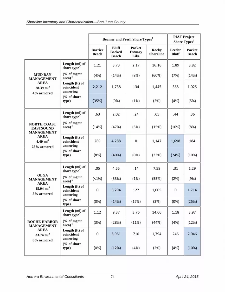
Shoreline Inventory and Characterization––San Juan County
Herrera Environmental Consultants 74 April 24, 2013
Beamer and Fresh Shore Types
1 PIAT Project
Shore Types2
Barrier Beach
Bluff Backed Beach
Pocket Estuary
Like
Rocky Shoreline
Feeder Bluff
Pocket Beach
MUD BAY MANAGEMENT
AREA
28.39 mi3
4% armored
Length (mi) of shore type
4
1.21 3.73 2.17 16.16 1.89 3.82
(% of mgmt area)
5
(4%) (14%) (8%) (60%) (7%) (14%)
Length (ft) of coincident armoring
2,212 1,738 134 1,445 368 1,025
(% of shore type)
(35%) (9%) (1%) (2%) (4%) (5%)
NORTH COAST EASTSOUND
MANAGEMENT AREA
4.40 mi3
25% armored
Length (mi) of shore type
4
.63 2.02 .24 .65 .44 .36
(% of mgmt area)
5
(14%) (47%) (5%) (15%) (10%) (8%)
Length (ft) of coincident armoring
269 4,288 0 1,147 1,698 184
(% of shore type)
(8%) (40%) (0%) (33%) (74%) (10%)
OLGA MANAGEMENT
AREA
15.04 mi3
5% armored
Length (mi) of shore type
4
.05 4.55 .14 7.58 .31 1.29
(% of mgmt area)
5
(<1%) (33%) (1%) (55%) (2%) (9%)
Length (ft) of coincident armoring
0 3,294 127 1,005 0 1,714
(% of shore type)
(0%) (14%) (17%) (3%) (0%) (25%)
ROCHE HARBOR MANAGEMENT
AREA
33.74 mi3
6% armored
Length (mi) of shore type
4
1.12 9.37 3.76 14.66 1.18 3.97
(% of mgmt area)
5
(3%) (28%) (11%) (44%) (4%) (12%)
Length (ft) of coincident armoring
0 5,961 710 1,794 246 2,046
(% of shore type)
(0%) (12%) (4%) (2%) (4%) (10%)

Shoreline Inventory and Characterization––San Juan County
April 24, 2013 75 Herrera Environmental Consultants
Beamer and Fresh Shore Types
1 PIAT Project
Shore Types2
Barrier Beach
Bluff Backed Beach
Pocket Estuary
Like
Rocky Shoreline
Feeder Bluff
Pocket Beach
SAN JUAN CHANNEL
MANAGEMENT AREA
13.16 mi3
2% armored
Length (mi) of shore type
4
0 0 .22 9.59 0 2.35
(% of mgmt area)
5 (0%) (0%)
(2%) (79%) (0%) (19%)
Length (ft) of coincident armoring
0 0 0 612 0 944
(% of shore type)
(0%) (0%) (0%) (1%) (0%) (8%)
SHAW MANAGEMENT
AREA
38.17 mi3
4% armored
Length (mi) of shore type
4
.49 2.48 1.34 25.58 .52 6.43
(% of mgmt area)
5
(1%) (7%) (4%) (71%) (1%) (18%)
Length (ft) of coincident armoring
651 4,105 571 871 236 3,663
(% of shore type)
(25%) (31%) (8%) (<1%) (9%) (11%)
SPENCER SPIT MANAGEMENT
AREA
12.74 mi3
8% armored
Length (mi) of shore type
4
1.90 4.34 1.00 5.80 2.50 .24
(% of mgmt area)
5
(14%) (33%) (8%) (44%) (19%) (2%)
Length (ft) of coincident armoring
1,788 4,755 0 667 611 215
(% of shore type)
(18%) (21%) (0%) (2%) (5%) (17%)
STRAIT OF JUAN DE FUCA
MANAGEMENT AREA
57.70 mi3
2% armored
Length (mi) of shore type
4
0 4.12 1.23 36.22 1.69 7.91
(% of mgmt area)
5
(0%) (8%) (2%) (74%) (3%) (16%)
Length (ft) of coincident armoring
0 1,175 157 368 29 4,493
(% of shore type)
(0%) (5%) (2%) (<1%) (<1%) (11%)

Shoreline Inventory and Characterization––San Juan County
Herrera Environmental Consultants 76 April 24, 2013
Beamer and Fresh Shore Types
1 PIAT Project
Shore Types2
Barrier Beach
Bluff Backed Beach
Pocket Estuary
Like
Rocky Shoreline
Feeder Bluff
Pocket Beach
STUART ISLAND MANAGEMENT
AREA
35.99 mi3
<1% armored
Length (mi) of shore type
4
.29 2.76 .27 27.67 .59 2.62
(% of mgmt area)
5
(<1%) (8%) (<1%) (82%) (2%) (8%)
Length (ft) of coincident armoring
80 208 22 931 0 522
(% of shore type)
(5%) (1%) (2%) (<1%) (0%) (4%)
TURTLEBACK MANAGEMENT
AREA
15.52 mi3
4% armored
Length (mi) of shore type
4
0 3.88 0.15 8.73 .69 1.67
(% of mgmt area)
5
(0%) (27%) (1%) (61%) (5%) (12%)
Length (ft) of coincident armoring
0 2,386 316 99 92 263
(% of shore type)
(0%) (12%) (39%) (<1%) (3%) (3%)
WALDRON MANAGEMENT
AREA
45.64 mi3
<1% armored
Length (mi) of shore type
4
.55 7.01 0 30.18 1.96 2.85
(% of mgmt area)
5
(1%) (17%) (0%) (74%) (5%) (7%)
Length (ft) of coincident armoring
0 633 0 653 0 421
(% of shore type)
(0%) (2%) (0%) (<1%) (0%) (3%)
WEST SOUND MANAGEMENT
AREA
25.48 mi3
7% armored
Length (mi) of shore type
4
.11 3.85 2.07 14.62 .79 3.13
(% of mgmt area)
5
(<1%) (16%) (9%) (62%) (3%) (13%)
Length (ft) of coincident armoring
350 3,539 638 2,015 355 3,182
(% of shore type)
(60%) (17%) (6%) (3%) (9%) (19%)
1 Shore types from Beamer and Fresh (2012). Shorelines which have been altered and thereby not classified by
Beamer and Fresh (2012) as one of these shore types are not reported.

Shoreline Inventory and Characterization––San Juan County
April 24, 2013 77 Herrera Environmental Consultants
2 Shore types from the Pulling It All Together project (PIAT 2012).
3 Islets of 0.5 acres or less excluded from calculation.
4 Length includes all Beamer and Fresh (2012) or PIAT (2012) shore type data within management unit.
5 Percentage of total length of all Beamer and Fresh (2012) or PIAT shore type data located within management unit.
3.8 Marine Shoreline Alterations
Marine shoreline alterations typically include overwater structures such as piers and boathouses,
shoreline armoring, flow control structures such as dams and tide gates and stormwater outfalls.
Other types of shoreline modifications found in San Juan County include groins, marine
railways, boat ramps, and residential development that affect nearshore and riparian vegetation.
These alterations and their common impacts are discussed in the following sections. Additional
information on common threats to priority habitats and species that are related to shoreline
development can be found in the literature review document Best Available Science for Marine
Fish and Wildlife Habitat Conservation Areas (Herrera and The Watershed Company 2011).
3.8.1 Overwater Structures
Overwater structures in the County include bridges, buildings, large floats, piers or docks (see
Figure 9) and an assortment of unusual features such as fill placed on a dock. There are a total of
655 structures per the available GIS inventory. Of the 655 structures, there are 6 bridges,
10 buildings, 51 floats, 544 piers/docks, and 44 unusual structures (Table 13).
Friends of the San Juans (2009)
Figure 9. Examples of Overwater Structures in San Juan County.
These structures have an impact on the nearshore environment and the habitat and the species
that use these habitats. Their impacts to the nearshore are detailed in Herrera and The Watershed
Company (2011), but some examples are discussed here.
Estuarine and shallow marine nearshore habitats provide passage for fish and shellfish, larvae,
and are important sources of prey resource production, refugia, and spawning substrates for the
region's Pacific salmon, groundfish, and forage fish. Overwater structures can pose alterations to
key controlling factors, such as light, wave energy and substrate regimes, that determine the

Shoreline Inventory and Characterization––San Juan County
Herrera Environmental Consultants 78 April 24, 2013
habitat characteristics that support these critical functions (Nightingale and Simenstad 2001).
The literature also reflects that fish migrating along the shoreline have consistently shown
behavioral responses upon encountering docks. These responses include pausing, school
dispersal, and migration directional changes (Nightingale and Simenstad 2001). Alarming
declines in plant and animal populations in Washington's inland marine waters highlight the need
to identify and avoid stressors to the region's marine resources (West 1997). Fish populations
suffering from significant anthropogenic stresses include Pacific salmon, Pacific herring, Pacific
cod, walleye pollock, Pacific hake, and three species of demersal rockfish (West 1997) many of
which use the rich nearshore/estuarine habitat along the County. At some point in their juvenile
rearing stage, each of the above-named species, and the forage fish that support them, rely on
nearshore vegetated, gravel, or mudflat habitats to meet critical rearing needs. This reliance upon
nearshore habitat for important rearing needs combined with the natural geomorphologic
limitations in habitat extent and the proximity of these habitats to human transportation corridors
magnifies the importance of protecting these habitats from further loss and degradation (Norris
1991).
Table 13. Summary of Overwater Structures within Each Management Area.
Management Area Bridges Buildings Floats Pier/Dock Other Total
Blakely 0 0 1 7 2 10
Decatur 0 0 1 33 3 37
Doe Bay 0 0 0 5 1 6
Eastsound 0 1 2 19 0 22
Fisherman Bay 0 2 2 20 7 31
Friday Harbor 0 2 8 69 3 82
Mud Bay 1 1 0 17 6 25
North Coast Eastsound 0 0 0 4 0 4
Olga 1 0 2 22 1 26
Roche Harbor 0 0 3 150 4 157
San Juan Channel 0 0 1 13 0 14
Shaw 0 1 7 45 2 55
Spencer Spit 0 1 1 17 6 25
Strait of Juan de Fuca 2 0 0 12 3 17
Stuart 0 0 10 20 1 31
Turtleback 0 0 0 10 0 10
Waldron 0 0 0 5 0 5
Westsound 2 2 13 76 5 98
Private Lakes NDA NDA NDA NDA NDA 14*
Public Lakes NDA NDA NDA NDA NDA 9*
Total 6 10 51 544 44 678
NDA = No data available.
*Total number of overwater structures determined from an examination of recent aerial photographs.
Source: Shoreline overwater structures data from WA Department of Natural Resources (2007)

Shoreline Inventory and Characterization––San Juan County
April 24, 2013 79 Herrera Environmental Consultants
3.8.2 Shoreline Armoring
Shoreline armoring occurs throughout the shorelines of the County (Table 14), even in some
areas that are mapped as bedrock. In total, just under 4 percent of the marine shoreline in the
County is armored in some way. Numerous documents have suggested a link between armoring
(particularly by bulkheads) accelerated beach erosion and the loss of nearshore habitat of
adjacent shorelines (Mulvihill et al. 1980; Thom and Shreffler 1994; MacDonald et al. 1994;
Sobocinski 2003; Williams and Thom 2001; Brennan and Culverwell 2004; Herrera and The
Watershed Company 2011). Of these documents, Thom and Shreffler (1994) summarize
biological impacts due to armoring; MacDonald et al. (1994) discuss impacts of shoreline
armoring on geological processes and physical features, and Williams and Thom (2001)
compiles and describes direct impacts, indirect permanent effects, and cumulative effects
resulting from shoreline armoring. The possible direct effects of shoreline armoring include the
following:
Encroachment. Encroachment involves the placement of armoring or
other structures on the upper or lower beach. If armoring is originally
constructed seaward of the upper limit of the beach below extreme high
water, it immediately narrows the beach causing a habitat loss. Fill and
encroachment can sometimes be identified from current or historical
photographs, or by the lack of wrack in front of it. Active encroachment
and placement of fill in intertidal lands is primarily historical in nature
because fill of intertidal lands is now prohibited by a series of local, state
and federal regulations.
Active erosion. Active erosion is a mechanism by which armoring,
particularly bulkheading, accelerates beach erosion by reflecting wave
energy and amplifying edge waves. This in turn increases sediment
suspension and subsequently the rate of sediment transport offshore. When
active erosion is present, the beach loss in front of armoring is greater than
background or the natural erosion rate and therefore the beach is lowered,
as in Figure 10.

Shoreline Inventory and Characterization––San Juan County
Herrera Environmental Consultants 80 April 24, 2013
Table 14. Armored Shoreline Totals Within Each Management Area.
Management Area Total Shoreline Length
(feet) Total Armored Shoreline Length
(feet) Percentage Armored
Blakely 73,215 878 1.20
Decatur 103,625 2,946 2.84
Doe Bay 123,772 1,740 1.41
Eastsound 92,573 3,147 3.40
Fisherman Bay 73,685 14,440 19.60
Friday Harbor 127,845 8,434 6.60
Mud Bay 149,919 6,277 4.19
North Coast Eastsound 23,249 5,818 25.02
Olga 79,431 3,892 4.90
Roche Harbor 178,174 10,257 5.76
San Juan Channel 69,498 1,594 2.29
Shaw 201,546 8,872 4.40
Spencer Spit 67,270 5,592 8.31
Strait of Juan de Fuca 304,647 6,014 1.97
Stuart 190,029 1,459 0.77
Turtleback 81,953 3,014 3.68
Waldron 240,977 1,899 0.79
Westsound 134,521 8,969 6.67
Private Lakes 93,772 NDA NDA
Public Lakes 40,181 NDA NDA
Total 2,449,887 95,242 3.89
NDA = No data available
Source: Shoreline armoring data from the Friends of the San Juans (2009)

Shoreline Inventory and Characterization––San Juan County
April 24, 2013 81 Herrera Environmental Consultants
Figure 10. Comparison of Beach Profiles from Whidbey Island (Herrera 2009c).
In addition to these direct effects of bulkheads, there are several indirect effects that often occur.
They are:
Passive erosion. Passive erosion describes the fact that, if armoring is
constructed and stabilizes a shoreline undergoing natural retreat (erosion),
the armoring precludes the formation of new upper beach habitat. Initial
construction of armoring structure leaves the upper beach intact, but over
time natural erosion removes beach substrate in front of the structure and
eventually the upper beach is lost. The loss of sediment causes the loss of
the upper beach, as shown in Figure 10.
Sediment impoundment. Sediment impoundment describes the
possibility that armoring cuts off the upland supply of sediment to a beach,
leading to beach loss. As a bluff erodes, it feeds sediment into the littoral
cell. If armoring stops this erosion from occurring, a corresponding
quantity of sediment would be missing from the littoral cell. This normally
affects the down-drift beaches, by affecting the overall littoral supply,
rather than the beach directly in front of the bulkhead.
Shoreline Inventory and Characterization––San Juan County
Herrera Environmental Consultants 82 April 24, 2013
Shoreline simplification. Armoring, particularly a bulkhead, can reduce
the physical complexity of the upper beach, such as the loss of wood
debris accumulations in the upper beach. The shoreline is effectively
shortened with considerable edge habitat lost. Armoring can also be
associated with a significant loss of overhanging shoreline vegetation and
wood debris accumulations, thereby reducing shade and the physical
complexity of the upper beach.
Not all of the bulkheads in the County are placed low enough to incur all of the effects described
above, particularly if the bulkheads are placed on exclusively bedrock shorelines. However, there
are many bulkheads that have been constructed well seaward of MHHW. For those bulkheads,
the net result of these effects is to eliminate the upper beach and the wrack commonly associated
with it. Because upper beach areas are critical for forage fish spawning, the loss of these areas
represents a significant impact to the productivity of the County’s nearshore. Also lost is the
quality of the migratory pathway for juvenile salmon, which is crucial to the recovery of both
Puget Sound and Strait of Georgia (Fraser) salmonid stocks. There are also numerous effects that
occur in association with bulkhead construction, such as deforestation, invasive species
infestation, and fill. These effects again have numerous compounding impacts on nearshore
wildlife including the loss of riparian cover, loss of macroinvertebrates, loss of large woody
debris to adjacent shorelines, concentration of runoff, etc.
3.8.3 Flow-Control Structures
Flow-control structures that affect shorelines in the County take two broad forms: dams and tide
gates. There are many dams throughout the county and several of the lakes are formed by small
dams, as discussed in detail in the Processes Affecting Lacustrine Shorelines section of this
report. Dams have numerous physical impacts, not the least of which is that they often serve as
fish barriers. In addition to fish passage, they alter the hydrology of the streams that they are
placed, depending on how they are managed. They also inhibit the transport of sediment
(particularly coarse sediment), which can cause erosion to downstream areas. Upstream they
impound water and cause the deposition of fine sediments, which may adversely affect habitat.
Tide gates are placed to allow for agriculture (the growing of salt intolerant vegetation) and
reduce marine flooding in salt marshes adjacent to marine waters. There are three tide gates in
the County, all of which are on Lopez (Maps 8C, Appendix A). Like dams, they often serve as
fish barriers, although new designs, such as side-hinged gates and self-regulating gates that
remain open a greater amount of time (and lessen velocities when open) can reduce or eliminate
fish passage issues. Regardless of whether of whether they are fish barriers, tide gates disrupt
natural geomorphic and hydrographic processes and can lead to water quality problems due to
the restriction of tidal exchange.
3.8.4 Stormwater Outfalls
There are at least 84 stormwater outfalls that discharge untreated stormwater from the County
into nearshore waters. Outfalls are summarized based on the number of cross culverts, storm
drain outfalls, and tidegates found in the San Juan County (2008) datasets titled Culverts (for
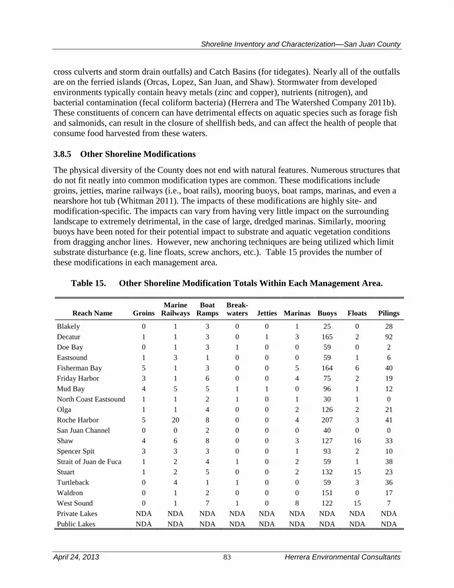
Shoreline Inventory and Characterization––San Juan County
April 24, 2013 83 Herrera Environmental Consultants
cross culverts and storm drain outfalls) and Catch Basins (for tidegates). Nearly all of the outfalls
are on the ferried islands (Orcas, Lopez, San Juan, and Shaw). Stormwater from developed
environments typically contain heavy metals (zinc and copper), nutrients (nitrogen), and
bacterial contamination (fecal coliform bacteria) (Herrera and The Watershed Company 2011b).
These constituents of concern can have detrimental effects on aquatic species such as forage fish
and salmonids, can result in the closure of shellfish beds, and can affect the health of people that
consume food harvested from these waters.
3.8.5 Other Shoreline Modifications
The physical diversity of the County does not end with natural features. Numerous structures that
do not fit neatly into common modification types are common. These modifications include
groins, jetties, marine railways (i.e., boat rails), mooring buoys, boat ramps, marinas, and even a
nearshore hot tub (Whitman 2011). The impacts of these modifications are highly site- and
modification-specific. The impacts can vary from having very little impact on the surrounding
landscape to extremely detrimental, in the case of large, dredged marinas. Similarly, mooring
buoys have been noted for their potential impact to substrate and aquatic vegetation conditions
from dragging anchor lines. However, new anchoring techniques are being utilized which limit
substrate disturbance (e.g. line floats, screw anchors, etc.). Table 15 provides the number of
these modifications in each management area.
Table 15. Other Shoreline Modification Totals Within Each Management Area.
Reach Name Groins
Marine Railways
Boat Ramps
Break-waters Jetties Marinas Buoys Floats Pilings
Blakely 0 1 3 0 0 1 25 0 28
Decatur 1 1 3 0 1 3 165 2 92
Doe Bay 0 1 3 1 0 0 59 0 2
Eastsound 1 3 1 0 0 0 59 1 6
Fisherman Bay 5 1 3 0 0 5 164 6 40
Friday Harbor 3 1 6 0 0 4 75 2 19
Mud Bay 4 5 5 1 1 0 96 1 12
North Coast Eastsound 1 1 2 1 0 1 30 1 0
Olga 1 1 4 0 0 2 126 2 21
Roche Harbor 5 20 8 0 0 4 207 3 41
San Juan Channel 0 0 2 0 0 0 40 0 0
Shaw 4 6 8 0 0 3 127 16 33
Spencer Spit 3 3 3 0 0 1 93 2 10
Strait of Juan de Fuca 1 2 4 1 0 2 59 1 38
Stuart 1 2 5 0 0 2 132 15 23
Turtleback 0 4 1 1 0 0 59 3 36
Waldron 0 1 2 0 0 0 151 0 17
West Sound 0 1 7 1 0 8 122 15 7
Private Lakes NDA NDA NDA NDA NDA NDA NDA NDA NDA
Public Lakes NDA NDA NDA NDA NDA NDA NDA NDA NDA

Shoreline Inventory and Characterization––San Juan County
Herrera Environmental Consultants 84 April 24, 2013
Reach Name Groins
Marine Railways
Boat Ramps
Break-waters Jetties Marinas Buoys Floats Pilings
Total 30 54 70 6 2 36 1789 70 425
NDA = No data available.
Source: Shoreline modification data from the Friends of the San Juans (2009)
3.9 Lacustrine Shoreline Alterations
The lakes in the County are relatively unaltered compared to similar lakes in the Puget Lowland.
A few of the lakes have small marina infrastructure on them, but these are not recorded in the
County’s GIS database. However, the most common alteration is the placement of roads,
sometimes with armoring, next to the lakeshore. This occurs on Hummel Lake, Dream Lake,
Sportsman Lake, Cascade Lake, and Martins Lake. In addition to the geomorphic disruption a
road can cause, the road can also preclude shoreline vegetation. It can also affect hydrologic
flows as they are concentrated through a culvert rather a natural channel. As mentioned before,
several of the lakes are reservoirs (e.g., Briggs Lake, Trout Lake), meaning that they are a result
(or partially a result) of the dams that made them. Most of these are used for drinking water
supply and are therefore relatively undeveloped, despite their constructed origin.
3.10 Nearshore Key Habitats and Species Usage
The supratidal, intertidal, and subtidal zones of the nearshore that extend throughout the county’s
marine shoreline areas provide unique conditions to support many species that are dependent on
the nearshore environment. Nearshore habitat is important to numerous sensitive, threatened and
endangered species, many with cultural and commercial importance. Supporting habitat for
salmon and other species includes kelp forests and eelgrass beds that extend throughout the
County, and vegetated nearshore riparian areas. The diverse shoreline types present throughout
the County are often suitable habitat for a variety of birds, forage fish, invertebrates, and
vegetation; many are key sensitive species, but also form the habitat structure and food base to
support upper trophic level species of birds, salmon, and marine mammals. Other San Juan
County wildlife that dependent on shoreline habitat include river otter, mink, deer, fox, and
raccoon. Freshwater nearshore areas, including many streams and 12 significant lakes provide
additional structure and function to support foraging, breeding, and refuge opportunities for key
species. Additional information regarding key nearshore species, and their occurrence and use of
habitats in San Juan County, can be found in the literature review document Best Available
Science for Marine Fish and Wildlife Habitat Conservation Areas (Herrera and The Watershed
Company 2011).
3.10.1 Tidal and Freshwater Wetlands
Most of the tidal and freshwater wetlands in Washington have been altered by changes including
channelization, dredging, diking, filling of wetlands and tidal areas, and degraded water quality.
The alteration and loss of tidal and freshwater wetland habitat by factors such as urbanization,
agriculture, forestry and water resource development has been extensive throughout the Puget
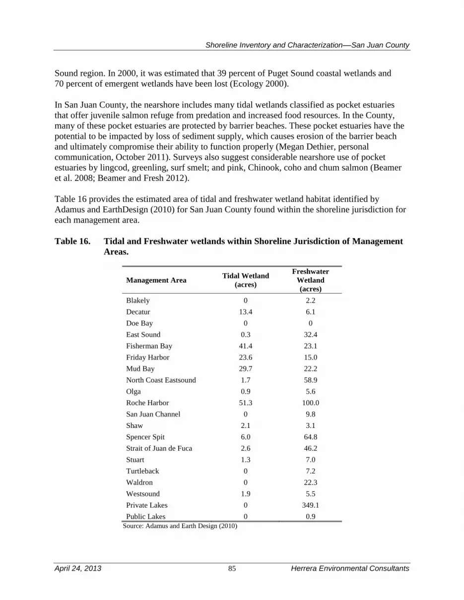
Shoreline Inventory and Characterization––San Juan County
April 24, 2013 85 Herrera Environmental Consultants
Sound region. In 2000, it was estimated that 39 percent of Puget Sound coastal wetlands and
70 percent of emergent wetlands have been lost (Ecology 2000).
In San Juan County, the nearshore includes many tidal wetlands classified as pocket estuaries
that offer juvenile salmon refuge from predation and increased food resources. In the County,
many of these pocket estuaries are protected by barrier beaches. These pocket estuaries have the
potential to be impacted by loss of sediment supply, which causes erosion of the barrier beach
and ultimately compromise their ability to function properly (Megan Dethier, personal
communication, October 2011). Surveys also suggest considerable nearshore use of pocket
estuaries by lingcod, greenling, surf smelt; and pink, Chinook, coho and chum salmon (Beamer
et al. 2008; Beamer and Fresh 2012).
Table 16 provides the estimated area of tidal and freshwater wetland habitat identified by
Adamus and EarthDesign (2010) for San Juan County found within the shoreline jurisdiction for
each management area.
Table 16. Tidal and Freshwater wetlands within Shoreline Jurisdiction of Management
Areas.
Management Area Tidal Wetland
(acres)
Freshwater
Wetland
(acres)
Blakely 0 2.2
Decatur 13.4 6.1
Doe Bay 0 0
East Sound 0.3 32.4
Fisherman Bay 41.4 23.1
Friday Harbor 23.6 15.0
Mud Bay 29.7 22.2
North Coast Eastsound 1.7 58.9
Olga 0.9 5.6
Roche Harbor 51.3 100.0
San Juan Channel 0 9.8
Shaw 2.1 3.1
Spencer Spit 6.0 64.8
Strait of Juan de Fuca 2.6 46.2
Stuart 1.3 7.0
Turtleback 0 7.2
Waldron 0 22.3
Westsound 1.9 5.5
Private Lakes 0 349.1
Public Lakes 0 0.9
Source: Adamus and Earth Design (2010)

Shoreline Inventory and Characterization––San Juan County
Herrera Environmental Consultants 86 April 24, 2013
Habitat modifications resulting from development tend to reduce the overall amount of habitat,
and reduces the general productivity of tidal and freshwater wetlands, which limits overall utility
of these areas for birds and aquatic organisms rearing, cover, foraging, and migration. Some of
the important functions affected (Adamus 2006) include:
Providing Habitat: Tidal and freshwater wetlands create a rich nursery
environment for aquatic and terrestrial species. Tens of thousands of birds,
mammals, fish, and other wildlife species rely on tidal and freshwater
wetland habitats to live, feed, and reproduce.
Primary Production: Acre for acre, estuaries and freshwater wetlands are
among the most biologically productive ecosystems on earth.
Erosion and Flood Control: Tidal and freshwater wetlands serve as
buffers, protecting shorelines from erosion and flooding.
Pollutant Filter: Tidal and freshwater wetlands filter pollutants, and
improve water quality.
Tidal wetlands occur throughout the county, primarily in the Roche Harbor, Fisherman Bay,
Mud Bay, and Friday Harbor management areas. Freshwater wetlands are most prevalent in the
Rural Lakes management area.
Wetlands are protected and their development is regulated on federal, state, and local levels.
However, wetland habitat may be threatened by historic and continued development if
protection, mitigation, and restoration do not adequately ensure no net loss of important
functions. Even development of non-regulated adjacent lands can adversely affect wetlands and
influence their functional quality. For example, in tidal embayments with little circulation, where
the less-dense fresh water floats on top of the seawater, increasing stormwater flows increase the
thickness of the freshwater layer, enhances stratification, and potentially reduces the oxygen in
deeper areas. Estuaries and wetlands are particularly sensitive to changes in the timing and
volume of freshwater discharges since plant community composition is determined by
sedimentation, water level, flood tolerance, and salinity gradients. Where shoreline wetlands
filter incoming runoff, increased and more frequent flows may not allow water to infiltrate, and
may cause wetlands to export rather than trap nutrients (Lee et al. 2006). Also, ground and
vegetation disturbance that may occur during the development of adjacent land areas, typically
create conditions for invasive non-native plant growth that can spread into wetlands and their
buffers.
3.10.2 Streams and Nearshore Riparian Areas
Most streams in San Juan County are small and many do not support anadromous or resident
salmonids (presence and habitat use in streams is described further in the section on Fish and
Fish Habitat in this report). Many streams in the San Juans no longer support anadromous fish
spawning, rearing, or migration because of extensive anthropogenic modification of stream
hydrology and geomorphology (dams, perched culverts, water withdrawal, channelization, and

Shoreline Inventory and Characterization––San Juan County
April 24, 2013 87 Herrera Environmental Consultants
sedimentation as examples). In many cases, withdrawals for potable water and irrigation exceed
the minimum instream flows needed to support anadromous fish. In addition to improving
hydrologic and geomorphologic stream conditions, the restoration of anadromous fish use of San
Juan Island streams would likely require establishing minimum instream flow reservations in
suitable habitat.
Often streams in San Juan County are also impacted by heavy sediment loading resulting from
unpaved roads, lack of buffers, and poor riparian management, including unrestricted livestock
access to stream corridors. During summer, some streams dry out and become choked with
invasive vegetation including reed canarygrass, particularly in agricultural areas. The numerous
dams and ponds inhibit instream flow, particularly during May to December.
Stream mouths are important habitat within the marine shoreline, bringing fresh water, food
sources, and nutrients to the marine environment. Anadromous fish feed and take cover at these
locations; areas that also allow fish to make the physiological transition from freshwater to
saltwater.
The value of the San Juan Islands for salmon lies mainly in the diverse nearshore habitats. All
twenty-two populations of Puget Sound Chinook salmon (as well as chum, pink, sockeye and
coho salmon, use San Juan County’s nearshore waters for feeding and migration as they move
from inland freshwaters to the Pacific ocean (SSPS 2007; Wyllie-Echeverria 2008a; Wyllie-
Echeverria and Barsh 2007; Beamer and Fresh 2012)). Typically cited nearshore habitat
requirements of juvenile salmonids include (Simenstad 2000):
Shallow-water, typically low-gradient habitats with fine, unconsolidated
substrates
The presence of aquatic vegetation, emergent marsh vegetation, and
shrub/scrub or forested riparian vegetation
Areas of low current and wave energy
Concentrations of small, non-evasive invertebrates
Muddy deltas at stream mouths are one of several important nearshore habitats used by juvenile
salmon in San Juan County (Wyllie-Echeverria and Barsh 2007). Nearshore riparian vegetation
is also important to salmon and forage fish. For example, juvenile chum and coho salmon
abundance is associated with terrestrial vegetation dominated by western red cedar and mosses
characteristic of mature coastal forests (Romanuk and Levings 2006). In addition, terrestrial
insects using riparian vegetation have recently been shown to be a large component of the diet of
juvenile salmonids (Romanuk and Levings 2010). Sobocinski (2003) documented the importance
of insect communities and benthic organisms that are either directly or indirectly associated with
riparian vegetation. These lower trophic organisms serve as the basis of the food web for
sensitive fish species that use the upper nearshore environment (Romanuk and Levings 2010;

Shoreline Inventory and Characterization––San Juan County
Herrera Environmental Consultants 88 April 24, 2013
Williams and Thom 2001). In addition, some fish and invertebrates feed directly on vegetative
detritus (Brennan and Fresh 2004).
Although not consistently occurring across all shorelines, San Juan County includes areas that
contain each of the habitat requirements listed above. For example, San Juan County beaches are
mainly comprised of unconsolidated gravel and sand with variable compositions depending on
position and wave energy. While parts of the county are exposed to high-energy waves from the
Strait of Georgia and the Strait of Juan de Fuca, other portions are more sheltered and are
characteristic of low wave energy conditions.
Nearshore riparian areas provide functions and important habitat for forage fish, birds, and other
species in addition to salmon. Nearshore riparian areas provide functions that can affect the
suitability of habitat for species including shellfish and marine mammals due to influences on
water quality and food availability. Fish, birds, shellfish, and marine mammals are each
discussed in corresponding sections of this report.
3.10.3 Eelgrass and Kelp
Intertidal and subtidal substrates along the shoreline support eelgrass including native (Zostera
marina) and introduced (Zosteria japonica) species, and at least 17 species of kelp. Native
eelgrass and kelp beds are a critical element of the nearshore zone because they form an
important habitat for many sensitive species including salmon, forage fish, crab, and shrimp.
Eelgrass provides both physical structure and trophic support for the biological community; it
forms habitat that provides shelter and food. Eelgrass is nursery habitat for many sensitive
species including salmon, and is an important spawning substrate for Pacific herring (Bostrom
et al. 2006; Murphy et al. 2000; Mumford 2007; Penttila 2007).
Eelgrass and kelp are also carbon fixers, making them important to nearshore primary
production. They provide a direct source of food for other species, contribute nutrients as they
break down during senescence, and provide a substrate that provides the base of the food chain
for other culturally and economically important species. The meadows provide refuge from
current and wave energy, protect juvenile salmon from predation, and attract organisms that
are important food sources for many species of fish, shellfish, and nearshore birds.
Eelgrass
Eelgrass commonly grows in low to moderately high‐energy intertidal and shallow subtidal areas
having a muddy or sandy substrate. Typically, eelgrass beds form near MLLW and extend to
depths from about 6.5 feet (2 meters) above MLLW to 30 feet (9 meters) below MLLW. Eelgrass
beds occur throughout the nearshore zone of San Juan County’s shorelines (Washington Coastal
Atlas 2010), usually as patches or narrow bands near the shore, or as solid meadows in the
subtidal zone (Nelson and Waaland 1997). Eelgrass is found along roughly 20 percent of San
Juan County Shoreline (SSPS 2007). However, the San Juan Archipelago has been experiencing
declines in native eelgrass. Significant losses occurred in Westcott-Garrison Bays between 2000
and 2004 (Pentilla 2007; SSPS 2007), and between 1995 and 2004 there has been a steady decline
in the abundance of eelgrass in the San Juan Archipelago. During this time, approximately
82 acres of eelgrass were lost from within 11 small embayments (Dowty et al. 2005; PSAT 2007).

Shoreline Inventory and Characterization––San Juan County
April 24, 2013 89 Herrera Environmental Consultants
Kelp
Kelps prefer high-energy environments with rocky substrate in lower intertidal or subtidal zones
where currents renew available nutrients and prevent sediment from covering the plants. Most
kelps occur in the shallow subtidal zone from MLLW to about 65 feet (20 meters) below MLLW
(Mumford 2007).
Kelp forests are comprised of both floating and non-floating or understory species and both types
occur in a patchy distribution throughout the subtidal zone of San Juan County’s shorelines
(Washington Coastal Atlas 2010). Floating kelp, otherwise known as bull kelp (Nereocystis
leutkeana), occur along approximately 31 percent of the county’s shoreline, while understory
kelps (such as Laminaria complanata, Costaria costata. Saccharina subsimplex, and Agarum
fimbriatum) occur along 63 percent (Mumford 2007). Of the 23 kelp species known to occur in
Puget Sound (Mumford 2007), at least 17 have been observed in San Juan County, and were
collected from subtidal sites at Cantilever Point, Reed Rock, Friday Harbor, Point George, Shady
Cove, McConnell Island, and Burrows Bay (Garbary et al. 1999).
Kelps drive primary ecosystem productivity, and provide important habitat for many commercial
and sports fish, invertebrates as well as marine mammals (Dayton 1985, Duggins et al. 1989,
Steneck et al. 2002). Growth rates of benthic suspension feeders have been found to increase in
the presence of organic detritus originating from kelps (Duggins et al. 1989) indicating the
important role of kelps in the marine food chain.
Understory kelps moderate fluid transport near bottom sediments and provide physical structure
that captures sediments and suspended particulates for transport to the seabed (Eckman et al.
1989). Kelp in general has been shown to dampen wave energy, which affects beach formation
in terms of grain size and sediment accumulation.
Kelp habitat is also used by many fish species. Murphy et al. (2000) found greater densities of
seven species of salmonids in habitat with kelp than without in Southeast Alaska. Research by
WDFW found that juvenile salmon and surf smelt preferentially used kelp bed habitats (Shaffer
2003). Simenstad et al. (1979) found Chinook, coho, and chum salmon utilizing kelp beds in the
Strait of Juan de Fuca. In addition, a similar study by Dean et al. (2000) found sculpin and
rockfish primarily associated with kelps.
3.10.4 Shellfish Resources
San Juan County marine shorelines and waters provide habitat for numerous shellfish species
including Pinto (or Northern) abalone (Haliotis kamtschatkana), sea urchins (Strongylocentrotus
spp.), crab, shrimp, and various clam species. In general, shellfish depend on specific sediment
compositions (such as grain size, amount of different grain and gravel sizes, and organic
content). For example, shellfish such as littleneck clam (Protothaca staminea) and butter clam
(Saxidomus gigantea) prefer sediment mixed with gravel and cobble (Dethier 2006).
Shoreline Inventory and Characterization––San Juan County
Herrera Environmental Consultants 90 April 24, 2013
Pinto Abalone
Pinto abalone occurs in San Juan County, although they are critically rare. Current population
abundance of the species is not well known, and overharvest is thought to be a significant
problem for this species (NMFS 2007; West 1997. Populations along the west coast of the
United States and Canada have experienced dramatic declines in the last few decades (NMFS
2007; PSRF 2010). The only part of the inside waters of Washington where they are currently
found is the San Juan Islands and the Strait of Juan de Fuca (Dethier 2006). Pinto abalone live in
shallow subtidal rocky areas with moderate to high wave energies. They typically occur in the
low intertidal zone in kelp beds along well-exposed coasts, and in depths up to 35 feet
(10.7 meters) (PSAT 2007).
Sea Urchin
WDFW data indicate sea urchin distribution throughout much of San Juan County’s shoreline,
and their distribution is likely associated with the availability of rocky substrates (Dethier 2006).
Sea urchins are herbivores that live in shallow to deep waters on rocky substrates, especially in
the northern inside waters and the more exposed waters of the state (Dethier 2006). Sea urchins
are critical agents of subtidal community structure in rocky areas due to their intensive grazing of
young and adult seaweeds. They also support an important roe fishery in San Juan County.
Dungeness Crab
There is limited published information on the distribution and habitat use of Dungeness crab
(Cancer magister) in San Juan County relative to other areas in the region. However, presence is
well documented throughout the County, and intertidal and shallow subtidal areas along the
shoreline provide suitable habitat for Dungeness crab. Dungeness crab distribution has been
documented in Lopez Sound, Roche Harbor, False Bay, most of West Sound, East Sound (Buck
Bay and Ship Bay), Reid Harbor, Cowlitz Bay, and surrounding Sucia Island. Juveniles are
closely associated with cover in the intertidal that can consist of bivalve shells, eelgrass (Zostera
spp.), gravel-sand substrates, and/or macroalgae (Thayer and Phillips 1977; Dinnel et al. 1986a;
Dinnel et al. 1986b; as cited in Fisher and Velasquez 2008). These forms of cover provide
juveniles a refuge from birds, fish, and many other predators (Eggleston and Armstrong 1995).
Juveniles progressively move to deeper water as they grow (Fisher and Velasquez 2008).
Intertidal habitats are critical for juvenile feeding as those areas can have prey densities higher
than subtidal habitats (Fisher and Velasquez 2008).
Pandalid Shrimp
Pandalid shrimp (pandalidae), including several species such as humpy shrimp (Pandalus
goniurus), are an arthropod that is considered a state priority species for recreational,
commercial, and tribal importance, and for having vulnerable aggregations that are susceptible to
population decline (WDFW 2008). Pandalid shrimp live mostly in the subtidal zone as adults
(NMFS 2010a), but can occupy depths ranging from intertidal tide pools to more than
1,300 meters (Cadrin et al. 2004). They are usually over muddy substrate (ADFG 2010), but can
occupy a range of habitats and substrates ranging from rocky to sand or mud (Cadrin et al. 2004).

Shoreline Inventory and Characterization––San Juan County
April 24, 2013 91 Herrera Environmental Consultants
Clams and Oysters
San Juan County shorelines provide relatively isolated patches of habitat for numerous oyster
and clam species. This includes non-native Pacific oyster (Crassostrea gigas); various clams
including native littleneck clam (Protothaca staminea), introduced manila clam (Venerupis
philippinarum), varnish clam (Nuttalia obscurata), butter clam (Saxidomus gigantea), and
geoduck clams, and mussels. Clams and oyster beds are documented in Westcott Bay and Ship
Bay. Clam distribution also includes Griffin Bay, Mud Bay, and Lopez Sound in the general
vicinity of Spencer Spit, and subtidal populations in isolated patches throughout the county’s
shorelines.
Shellfish growing areas in San Juan County include those at Buck Bay, East Sound, Hunter Bay,
MacKaye Harbor, Mud Bay, Shoal Bay, Upright Channel, and Westcott Bay. Recreational
shellfishing opportunities occur throughout much of San Juan County shorelines along public
clam and oyster beaches (WDFW 2010e).
Commercial geoduck clam (Panopea abrupta) fisheries are not designated in San Juan County
(WDFW 2010d). However, geoduck distribution is patchy throughout the Salish Sea. Commonly
found in subtidal areas, geoduck can also occur in low intertidal zones. In San Juan County, it is
likely precluded from most intertidal areas due to unsuitable habitat conditions, however small
isolated patches of suitable habitat have been documented by WDFW.
3.10.5 Fish and Fish Habitat
Salmonid
All species of salmonids that occur in the northwest occur in the nearshore and adjacent waters
of San Juan County. San Juan County shorelines and marine waters are an important habitat to
Chinook salmon (Oncorhynchous tshawytscha) but large numbers of chum (O. keta), pink
(O. gorbuscha), sockeye (O. nerka) and coho salmon (O. kisutch) are also found in the nearshore
from early spring through late summer (Kerwin 2002; Beamer et al. 2008; Beamer and Fresh
2012). Steelhead (O. mykiss) and coastal cutthroat trout (O. clarki clarki) are also known to
occur in the marine waters around the San Juan Islands (Kerwin 2002), and bull trout (Salvelinus
confluentus) may also be present in the nearshore waters of the County (WDFW 2010c).
Anadromous fish distribution in freshwater systems includes chum, coho, and kokanee salmon,
and rainbow and coastal cutthroat trout. Table 17 summarizes the ESA listing status of each
salmonid species and associated critical habitat designations.
Table 17. State and Federal Listing Status of Priority Salmonid Species Occurring in
San Juan County.
Species Washington State Status Federal Status
Bull Trout/ Dolly Varden Candidate Threatened
Chinook Salmon Candidate Threatened
Chum Salmon Candidate Threatened
Coastal Res./ Searun Cutthroat Not listed Species of Concern
Coho Candidate Species of Concern

Shoreline Inventory and Characterization––San Juan County
Herrera Environmental Consultants 92 April 24, 2013
Species Washington State Status Federal Status
Kokanee Not listed Not listed
Pink Salmon Not listed Not listed
Rainbow Trout Not listed Not listed
Sockeye Salmon Candidate Not listed
Steelhead Candidate Threatened
All salmonid species are important based on WDFW listing status as priority species. Although
there are no known natural Chinook spawning areas in the islands, all 22 populations of Puget
Sound Chinook salmon use San Juan County’s nearshore and marine waters for feeding and
migration, making these areas an essential part of salmon recovery in Puget Sound (SSPS 2007).
The nearshore zone also provides valuable direct or indirect habitat functions for other salmon
species known to move through the marine waters during their outmigration from the many
rivers and streams that enter the Strait of Georgia and Puget Sound.
In San Juan County, nearshore habitats important to salmonid species include kelp forests and
eelgrass meadows, forage fish spawning areas, estuaries and intertidal wetlands (SSPS 2007) and
nearshore riparian areas including stream mouths (Wyllie-Echeverria and Barsh 2007). Each of
these key habitats is discussed in corresponding sections of this report.
Juvenile salmon move along the shallows of nearshore habitat and may be found throughout the
year depending on species, stock, and life history stage. During their ocean phase, steelhead are
generally found within 10 and 25 miles of the shore (Wydoski and Whitney 2003). Chinook
salmon are highly dependent on estuarine habitats to complete their life history, and the timing of
migration to saltwater is highly variable for this species. Juvenile chum salmon migrate quickly
to saltwater as small fry and are therefore highly dependent on the nearshore environment. The
recent study by Beamer and Fresh (2012) found juvenile salmonid use throughout the County
shorelines, in a variety of shoreline types.
While quantitative studies remain limited, recent surveys (Wyllie-Echeverria and Barsh 2007;
Beamer et al. 2008) in combination with historical and anecdotal reports (Barsh and Murphy
2007; Wyllie-Echeverria 2008a, 2008b) describe salmonid use of multiple estuarine and
freshwater habitats in San Juan County. Surveys verified the presence of Chinook, chum, pink,
and coho salmon at different times of the year utilizing the intertidal beaches in San Juan
County, including those over course sediment (Barsh and Wyllie-Echeverria 2006; Wyllie-
Echeverria and Barsh 2007). The largest numbers of salmon in 2006 were found along the
beaches of Waldron Island and President Channel, the beaches of south Lopez, and the rocky
shorelines of north San Juan (Barsh and Murphy 2007).
Surveys suggest considerable nearshore use of pocket beaches and bluff backed beaches by
Chinook, coho and chum salmon (Beamer et al. 2008). Recent statistical modeling has shown
that every mile of nearshore habitat could be used by juvenile salmonids (Beamer and Fresh
2012).

Shoreline Inventory and Characterization––San Juan County
April 24, 2013 93 Herrera Environmental Consultants
In nearshore waters of Puget Sound (Brennan et al. 2009), terrestrial insects have been shown to
be a large component of the diet of juvenile salmonids (Romanuk and Levings 2010) and
typically include insects such as midges and ants that swarm in late summer (personal
communication with Russel Barsh, Kwiáht, December 29, 2010); comprising part of the coastal
food web of particular importance to Chinook and coho (Johnson and Schindler 2009). Juvenile
chum and coho salmon abundance is also associated with marine waters having shorelines with
terrestrial vegetation dominated by western red cedar (Thuja plicata) and mosses characteristic
of mature coastal forests (Romanuk and Levings 2006). In addition, juvenile use of coarser,
higher energy beaches distinguishes the San Juan Islands from most of Puget Sound, where
smolts tend to congregate in much more protected delta environments and pocket estuaries
(Barsh and Murphy 2007). Coastal cutthroat trout have also been shown to extensively use
nearshore areas in the County (Beamer and Fresh 2012).
Southern Pacific Eulachon
Southern DPS Pacific eulachon (Thaleichthys pacificus) are a small anadromous fish that use
estuarine, marine, and stream habitat in the Salish Sea. On March 18, 2010, NMFS announced
the listing of Pacific eulachon as a threatened species effective on May 17, 2010 (75 FR 13012).
The southern DPS includes populations spawning in rivers south of the Nass River in British
Columbia, Canada, to the Mad River in California including the major production area or core
population of eulachon associated with the Fraser River (74 FR 10857). Critical habitat has not
yet been designated but will be considered by NMFS in the future (75 FR 13012).
Details of their movement and habitat requirements in saltwater are largely unknown but surveys
have shown concentrations off Vancouver Island (Willson et al. 2006) and occurrences in the
Strait of Georgia (personal communication with Dan Penttila, WDFW biologist, May 7, 2010).
Migrations from saltwater to streams for spawning typically peaks between April and May in the
Fraser River (NMFS 2010b).
Available information indicates that eulachon may occur in along San Juan County shorelines
and marine waters because larvae and juveniles become widely distributed by marine currents
(74 FR 10857) The County shoreline is within an area that would be considered a migration
route for eulachon juvenile out-migrants and adults returning to natal streams such as the Fraser
River to spawn.
Forage Fish
Forage fish species play a critical role in the functioning of nearshore marine ecosystems in
Washington State. The San Juan County shoreline provides known spawning and rearing habitat
for important forage fish including Pacific herring (Clupea pallasi), Pacific sand lance
(Ammodytes hexapterus), and surf smelt (Hypomesus pretiosus). In general, forage fish require
specific substrate types (Pentilla 2007), clean water with low suspended sediment levels
(Levings and Jamieson 2001; Morgan and Levings 1989), and suitable spawning and refuge
habitat such as eelgrass beds.
Several studies in the San Juan Islands have documented the potential and actual use of
nearshore marine habitats by forage fish (Penttila 1999, 2001; Wyllie-Echeverria and Barsh

Shoreline Inventory and Characterization––San Juan County
Herrera Environmental Consultants 94 April 24, 2013
2007; Friends of the San Juans 2004a,b,c). In San Juan County, roughly 80 miles of potential
forage fish spawning beaches, and approximately 13 miles of documented spawning beaches,
have been identified by WDFW and Friends of the San Juans (Friends of the San Juans 2004a;
SSPS 2007).
Priority forage fish spawning regions were identified by Friends of the San Juans (2004b) in
consultation with WDFW. The regions share the following characteristics:
Spawn activity of multiple species of forage fish documented in region
Multiple spawning sites documented in close proximity
Spawn activity documented in multiple seasons
Spawn activity documented in region by historic WDFW surveys (1989-
1999) and by the San Juan County Forage Fish Spawning Habitat
Assessment Project (2000-2003)
The four priority forage fish nearshore habitat regions identified for San Juan County include:
Mud/Hunter Bay Region, Lopez Island
West Sound and Blind Bay Region, Orcas and Shaw islands
MacKaye Harbor Region, Lopez Island
Greater Westcott Bay Region, San Juan Island
Pacific Herring
Two spawning stocks of Pacific herring are identified in San Juan County. One occurs in the
Westcott Bay/Roche Harbor region (Northwest San Juan Island stock), and the second occurs in
the eastern region of the county including Mud and Hunter bays on Lopez Island, West Sound
and East Sound on Orcas Island, and Blind Bay on Shaw Island (Interior San Juan Island stock)
(Penttila 1999; Stick and Lindquist 2009).
WDFW describes the Northwest San Juan Island stock as “disappearance”, meaning it can no
longer be found in its formerly consistently utilized spawning ground (Stick and Lindquist 2009).
The Interior San Juan Island stock is considered “depressed”, meaning recent abundance is well
below the long-term mean, but not so low to expect recruitment failure (Stick and Lindquist
2009). The presence of Pacific herring has also been documented around stream mouths and
marine beaches on Orcas, Shaw, and Waldron islands (Barsh and Wyllie-Echeverria 2006;
Wyllie-Echeverria and Barsh 2007).
Pacific herring use the nearshore environment for all of their life-history stages. Herring
primarily use eelgrass and marine algal turf as a spawning substrate but may also use middle
intertidal boulder/cobble rock surfaces with little or no macroalgae (Penttila 2007). In San Juan
County, spawning generally occurs on eelgrass or a fibrous red alga known as Gracilariopsis
(Penttila 1999). Beamer and Fresh (2012) found juvenile herring to have the highest probability
of presence for pocket beaches.

Shoreline Inventory and Characterization––San Juan County
April 24, 2013 95 Herrera Environmental Consultants
Surf Smelt and Sand Lance
Like Pacific herring, surf smelt use nearshore habitat for all of their life-history stages. The
spawning habitat of this species resembles that of surf smelt; they typically spawn in the upper
third of the intertidal zone, in sand-sized substrate (Penttila 2007). As a result, these two species
often use the same beaches and co-occurrence of eggs is common during winter when spawning
seasons overlap. Depositional shore forms such as beaches at the far ends of drift cells and sandy
spits support sand lance spawning.
Moulton (2000) identified potential spawning habitat for surf smelt and sand lance on 24 islands
in the area, with Lopez Island having the greatest potential habitat areas, followed by San Juan
and Orcas Island. The presence of Pacific herring, surf smelt, and Pacific sand lance have also
been documented around stream mouths and marine beaches on Orcas, Shaw, and Waldron
islands (Barsh and Wyllie-Echeverria 2006; Wyllie-Echeverria and Barsh 2007). Currently, surf
smelt spawning has been documented at 59 sites in San Juan County, while Pacific sand lance
spawning has been documented at eight beaches (Friends of the San Juans 2004a; SSPS 2007).
Eelgrass is also important habitat for surf smelt and other forage fish species as it provides refuge
(Penttila 2007). The protection and enhancement of physical processes and conditions that
support and maintain this habitat are important considerations for shoreline management. As
with other species that depend on specific substrate types in the nearshore environment, the
recruitment and transport of substrate along the shoreline strongly influence the quality and
quantity of available spawning habitat. These processes influence the distribution of spawning
substrate, as well as submerged aquatic vegetation used by herring and other species. Beamer
and Fresh (2012) found surf smelt to have the highest probability of presence for barrier beaches
while sand lance probabilities were more varied across management units and shoreline type.
Rock fish
Rock sole (Lepidopsetta bilineata) are a species of flat fish preferring sand and mud bottom
substrates generally in waters less than 120 feet deep (JRB Associates 1984). Spawning has been
documented primarily in the extreme south of Puget Sound (Lowery 2012) and is much rarer,
although present. in the San Juan Islands. They spawn in the intertidal and subtidal zones
between mid-winter and summer (NMFS 2012). In the Puget Sound region including the San
Juan Islands, their specific spawning habitats and substrates are uncertain. However, eggs have
been observed in forage fish spawning beach surveys in Puget Sound, often where piers or
pilings are present. Their spawning areas may not overlap with forage fish. The eggs are non
self-adhesive (Lowery 2012) and may mix and settle into intertidal areas that are used by forage
fish for spawning. Rock sole larvae develop in the upper water column of shallow waters where
they consume small zooplankton. Adults feed on benthic invertebrates in deeper waters where
spawning may also occur (Horton 1989).
Other Fish
The presence of habitat features such as eelgrass beds and suitable substrates that support prey
resources is indicative of the importance of the shoreline for salmon as well as groundfish and
other species. Along with anadromous salmon that depend on the nearshore environment for
rearing and migration, over 200 species of fish have been identified in the Puget Sound region

Shoreline Inventory and Characterization––San Juan County
Herrera Environmental Consultants 96 April 24, 2013
(Gelfenbaum et al. 2006). Commercial marine fish species include Pacific hake (Merluccius
productus), Pacific cod (Gadus macrocephalus), walleye pollock (Theragra chalcogramma),
spiny dogfish (Squalus acanthias), lingcod (Ophiodon elongatus), English sole (Pleuronectes
vetulus), and various rockfish species (Sebastes spp.). Nineteen species of rockfish have been
observed in the San Juan Archipelago (Wyllie-Echeverria and Sato 2005). Of these, three species
are federally listed under the ESA, including Boccacio (Sebastis paucispinis), canary rockfish
(S. pinniger), and yelloweye rockfish (S. ruberrimus) (75 FR 22276).
Habitat features within the nearshore zone likely provide direct or indirect benefit to numerous
marine species. For example, although typically occurring at depths (more than 40 meters) that
are greater than the nearshore environment, Pacific hake depend on species including Pacific
herring, smelt, crabs, and shrimp for food. Areas containing kelp and eelgrass beds, and
providing adequate substrate and habitat structure for species in the nearshore, contribute to the
long term success and viability of other species such as Pacific hake. Similarly, kelp and eelgrass
habitats support rockfish species, particularly during their larval and juvenile stages. Hence, kelp
and eelgrass habitats are essential for the survival of these species. In general, rockfish species
rely on shallow surface waters (including those containing kelp and eelgrass) and distribution by
currents; and then are associated with deeper rocky habitats as they mature (Wyllie-Echeverria
and Sato 2005).
3.10.6 Priority Habitats and Species
The priority habitats and species (PHS) (WDFW 2010c) within the County occur along forested
bluffs, beaches, intertidal, subtidal, and marine waters, and throughout the nearshore waters.
Inland lakes and freshwater streams, and associated wetlands and uplands, also contain priority
habitats for wildlife and provide water quality maintenance, and flood control functions. These
habitats are crucial for a variety of mammals (including marine mammals), birds, and fish. San
Juan County has significant tracts of undeveloped shoreline with cliffs, mature second-growth
forest, shrub, and prairie habitats that, if protected, will continue to provide significant and
unique habitats that are now rare in the Puget Sound. The Best Available Science for Marine Fish
and Wildlife Habitat Conservation Areas (Chapter 3) (Herrera and The Watershed Company
2011) provides detailed information on the County’s priority habitats and species, both upland
and marine. In addition, management recommendations and limiting factors for priority habitats
and species can be found on WDFW’s web site:
http://wdfw.wa.gov/conservation/phs/mgmt_recommendations/.
Appendix B summarizes the priority species and habitats known to occur in San Juan County.
These include species that are also protected at the state and federal level and is not an
exhaustive list of species that may occur within the study area. Fish and shellfish species are
discussed under the Fish and Fish Habitat and Shellfish Resources sections of this report. The
remaining species on the list: mammals, birds, amphibians, and insects are briefly discussed
below if they are highly reliant on shoreline areas or have a significant presence in the shoreline
areas of San Juan County. Species that do not occur in the shoreline habitat are not discussed
further.

Shoreline Inventory and Characterization––San Juan County
April 24, 2013 97 Herrera Environmental Consultants
3.10.7 Marine Mammals
Priority marine mammals that are likely to occur in, or rely on, shoreline habitats in San Juan
County include the Southern Resident population of killer whale, grey whale, humpback whale,
Steller sea lion, sea otter, and harbor seal. Each is described in the following sections.
Southern Resident Killer Whale
The Southern Resident DPS of killer whales (Orcinus orca) was listed as endangered on
February 16, 2005 (70 FR 69903). Critical habitat was designated for this species on
November 29, 2006 (71 FR 69054). The Southern Resident population consists of three pods that
numbered 87 whales in 2007 (NMFS 2008a).
The Whale Museum in Friday Harbor keeps a database of verified sightings by location
quadrants or “quads.” Sightings may be of individual or multiple whales. Frequent sightings
occur in the San Juan Islands (Orca Network 2010a), and in 2009 the population using Puget
Sound and the waters of the San Juan Islands included 85 individual whales (PSP 2010).
The San Juan County shoreline lies within ESA-designated critical habitat for the Southern
Resident killer whale. There are three specific areas designated as critical habitat. In addition to
Haro Straight and the waters around San Juan Island, the other Summer Core Areas are in the
Strait of Juan de Fuca and Puget Sound. Areas with water less than 20 feet deep relative to the
extreme high water mark are not included in the critical habitat designation (71 FR 69054), a
demarcation that excludes some of the nearshore elements of the county’s shorelines.
Gray Whale
The Eastern North Pacific population of gray whales was delisted from endangered status under
the ESA in 1994 but is still considered “sensitive”. National Marine Fisheries Service (NMFS)
completed a status review in 1999 (Rugh et al. 1999) and retained the unlisted status of the
population based on population trends (NMFS 2010c). In October 2010, NMFS was petitioned to
conduct a status review of the Eastern North Pacific population to determine whether to list the
population as “depleted” under the Marine Mammal Protection Act (75 FR 68756). This petition
is currently under review.
Gray whales travel annually between feeding grounds in Alaska and breeding grounds in
Mexico. They migrate north along the Pacific coast typically between mid-February and May,
and return to their breeding grounds in the fall (NMFS 2010c). Summer feeding grounds are
primarily located offshore of Northern Alaska and the Bering Sea but there are indications that
the gray whale population may be expanding its summer range in search of alternative feeding
grounds. Gray whales are increasingly sighted in the inland waters of Washington and British
Columbia, usually during their migration north in the spring (Orca Network 2010b). Although
gray whale occurrences may be rare, they pass through San Juan County marine waters during
their migration and foraging forays into the inland waters.

Shoreline Inventory and Characterization––San Juan County
Herrera Environmental Consultants 98 April 24, 2013
Humpback Whale
Humpback whales were listed as endangered on June 2, 1970 (35 FR 8491). Critical habitat has
not been designated for this species. Humpback whales migrate to Alaska during the summer to
feed. The Washington coast is a corridor for their annual migration north to feeding grounds and
south to breeding grounds (Osborne et al. 1988).
Although rare in the inside waters of Washington and British Columbia, humpback whales have
been sighted with increasing frequency in recent years (Falcone et al. 2005). Since 2001,
sightings of humpback whales reported through the Orca Network have increased annually.
Thirteen unique individuals were identified in inside waters of Washington and British Columbia
in 2003 and 2004, of which one was a juvenile identified in the San Juan Islands (Falcone et al.
2005). Due to their migration pattern, humpback whales are most likely to occur in San Juan
County waters in late spring and early summer but have also been sighted in other seasons.
Steller Sea Lion
Steller sea lion (Eumetopias jubatus) was listed as threatened on April 10, 1990 (62 FR 30772).
Critical habitat was designated for Steller sea lions on March 23, 1999 (64 FR 14051); however,
all designated critical habitat lies outside Washington State. Although federally designated
critical habitat areas are all located outside San Juan County, habitat that is considered “essential
to the conservation of the Stellar sea lion” includes the “physical and biological habitat features
that support reproduction, foraging, rest, and refuge” (58 FR 45269).
In the fall, winter, and spring months an estimated 800 to 1,000 Stellar sea lions move through
the Strait of Juan de Fuca and Strait of Georgia to feed on Pacific hake and dense herring stocks
that spawn in British Columbia (PSAT 2007). Haul-outs and rookeries tend to be preferentially
located on exposed rocky shoreline, wave-cut platforms, ledges, or rocky reefs (NMFS 2010b).
In San Juan County Whale Rock, Bird Rocks, Peapod Rocks, Spieden Island, and Sucia Island
provide haul-out sites for relatively small numbers (PSAT 2007). Steller sea lions have also been
observed hauled out on rock reefs associated with outer islands, for example, the reefs at the
east-northeast end of Patos Island. Although these sites are not considered “major haul-outs”
which have been designated as critical habitat, these haul-out sites provide Stellar sea lions with
opportunities for rest, foraging, and refuge.
Sea Otter
Abundance of sea otters (Enhydra lutris) has increased overall since 1989, with an estimated
population of over 800 sea otters (PSAT 2007) that occur in large groups (50 to 100 individuals)
along the Olympic Peninsula coastline and western Strait of Juan de Fuca. The population range
is thought to extend from Kalaloch to the western Strait of Juan de Fuca. Although dispersion
from this “core range” is rare, distribution shifts have been noted (Lance et al. 2004), and sea
otters have been sighted in the eastern Strait of Juan de Fuca, San Juan Islands near Cattle Point,
and within southern Puget Sound (Lance et al. 2004). Systematic surveys have not been
conducted in the inland waters of Washington.

Shoreline Inventory and Characterization––San Juan County
April 24, 2013 99 Herrera Environmental Consultants
Throughout their range, sea otters use a variety of shallow coastal habitats. Sea otters are mostly
associated with rocky substrates supporting kelp beds, but they also frequent soft-sediment areas
where kelp is absent (Lance et al. 2004). Although sea otter occurrences in San Juan County are
rare, the presence of suitable habitat and foraging opportunities indicate that the county’s
shorelines may be an important area for sea otters.
Harbor Seals
Harbor seals (Phoca vitulina richardsi) are the most abundant marine mammal in Puget Sound.
Although curious, they are shy animals and prefer quiet, unpopulated areas.
Seals haul-out on protected beaches, spits, bars, rocks and log rafts to bask in the sun and sleep.
Harbor seals often haul-out at low tide to digest food, rest, give birth, or nurse young. Pupping
occurs in June and July along the Strait of Juan de Fuca and the San Juan Islands. Documented
haul-out sites are located throughout San Juan County, generally on small islands and rocks near
Stuart and Spieden islands, Henry Island, along the San Juan Channel, the Sucia archipelago, and
the exposed southern shoreline of Lopez Island.
3.10.8 Birds
Many species of sea birds, raptors, and waterfowl use the forested bluffs, beach, nearshore,
intertidal, estuarine wetlands, freshwater streams and lakes, and deeper marine waters within and
surrounding the County. Birds use these habitats for cover, perching, foraging, feeding, and
nesting.
Many shorebirds travel thousands of miles a year, flying between South America and Alaska or
Canada. During the spring and late summer, migrating shorebirds are usually seen resting and
feeding on Salish Sea beaches. The Puget Sound Nearshore Partnership (PSNP) has identified
three signature nearshore shorebird species: surf scoter (Melanitta perspicillata), black
oystercatcher (Haematopus bachmani), and dunlin (Calidris alpina). Surf scoters and dunlins
spend much of the nonbreeding period in the Salish Sea region and migrate to boreal or Arctic
areas to breed; the black oystercatcher is essentially a permanent resident. All of these species
use the nearshore habitat along the County shorelines. Other than use of agricultural fields by
dunlins, all three species are associated with the marine environment.
Bald eagles, great blue herons, or peregrine falcons may perch on trees on shoreline bluffs or
large woody debris in estuaries and feed in the marine waters along the County shoreline. Bird
species commonly associated with shorelines and listed by federal or state agencies as
endangered, threatened, or sensitive and which occur regularly in San Juan County include
marbled murrelet, bald eagle, and peregrine falcon. Each of these species is discussed in the
following sections.
Other bird species, and breeding or non-breeding concentrations, are also considered priority
species. Although they are not listed as endangered, threatened, or sensitive, these important
species are considered protected under state and local regulations. Common loon, for example, is
frequently observed in San Juan county marine waters where they feed on forage fish, an
important food source. Other protected species of birds that use the shoreline include great blue

Shoreline Inventory and Characterization––San Juan County
Herrera Environmental Consultants 100 April 24, 2013
heron, purple martin, concentrations of cormorants and terns, waterfowl, and cavity nesting
ducks.
Marbled Murrelet
The marbled murrelet was Federally listed as threatened under the Endangered Species Act in
Washington, Oregon and California on September 28, 1992 (57 FR 45328). Critical habitat was
established for these birds on September 12, 2006, and covers the entire marine shoreline along
the San Juan County and the other marine shorelines throughout Puget Sound. Critical habitat
was proposed to be revised in 2008, but no ruling has yet occurred. A recovery plan for
Washington, Oregon and California populations is in effect (USFWS 1997).
Adults commonly fly between the nest and sheltered marine waters where they feed on forage
fish and small marine invertebrates. No nests are confirmed in the County. However survey
efforts have been limited, and suitable habitat conditions (including mature forests and food
availability) suggest potential nesting. Also, marbled murrelet adults and young have been
observed along the shoreline during the breeding season.
The habitat along the County shoreline is excellent for providing prey species for marbled
murrelet and other seabirds. Marbled murrelets feed on herring, Pacific sand lance, and smelts,
all of which occur within the intertidal and nearshore habitat along the County shoreline. The
Seattle Audubon Society indicates areas of concentration along the south shore of Lopez Island
and Obstruction and Peavine Passes between Orcas and Blakely islands.
Bald Eagle
Bald eagles are commonly associated with marine or lake shorelines where they often attracted
by the presence of live or dead fish and other prey items. They nest in tall trees (generally greater
than 85 feet in height) usually within 0.25 miles of shorelines. While the bald eagle was delisted
from a federal ESA status of Threatened in 2008, it is still protected under the Bald Eagle
Management Act, and is a state Sensitive species that requires protection. Nest sites were
identified throughout San Juan County shorelines.
Peregrine Falcon
Similarly, peregrine falcon is a state listed sensitive species. At least 20 pairs of birds are known
to regularly nest in the County. Individuals from other areas commonly forage along the county’s
shorelines. Although they use a wide variety of open habitats, peregrine falcons are similar to
bald eagles in that they are associated with marine and lake shorelines where waterfowl
concentrate or nesting seabird colonies are present and provide foraging opportunities.
3.10.9 Federally Listed Species
The San Juan County shoreline and associated estuaries and wetlands provide excellent habitat
for marine mammals, shorebirds, seabirds, raptors, and other waterfowl. Endangered and
threatened mammals and bird species are addressed under the Marine Mammals and Birds
sections of this report. Listed fish species are addressed under the Fish and Fish Habitat section.

Shoreline Inventory and Characterization––San Juan County
April 24, 2013 101 Herrera Environmental Consultants
3.11 Predicted Juvenile Fish Presence Based on Shoreline Type
Knowledge of fish use in the marine waters of San Juan County is limited by the lack of
available datasets that cover the entire County. As discussed in Section 3.10.5 numerous authors
have reported on fish use of the County, however published Countywide datasets only cover fish
use of streams within the islands (WDFW 2010b). Reliance on documented observations in
published studies is helpful, but does not provide an adequate picture of the role of marine
shorelines in sustaining the County’s fisheries.
It is well known that the San Juan Islands offer diverse nearshore habitats that serve as nursery
grounds to migrating juvenile salmonids from other watersheds (Kerwin 2002). There are few
spawning streams in the County and most salmon using San Juan County shorelines originate
from outside the County. Nevertheless, the islands are an important refuge and resting area for
salmon migrating to and from other areas, such as the Fraser, Skagit, and Samish rivers.
In addition, as mentioned previously, the San Juans are a source of forage fish, which provides a
food source to sub-adult and adult salmon on return migrations (Kerwin 2002). Forage fish found
within or expected in the nearshore marine habitats of the County include Pacific herring, surf
smelt, and Pacific sand lance. There are also numerous known herring spawning areas and
documented surf smelt and sand lance spawning beaches. The identification of species and
habitats for fish are ongoing, and fisheries resources continue to be researched in the San Juans
to fill data gaps that are critical to successful fisheries recovery efforts.
A key data gap is a better understanding of fish use of the County’s shorelines. The attributes of
preferred shoreline types can be an important limiting factor in the recovery of populations
(Mortensen et al. 2000). In an effort to better understand what fish preferences are for shoreline
habitat types, Beamer and Fresh (2012) performed 1,375 beach seine sets at 82 different sites
throughout the San Juan Islands over a two-year period in 2008 and 2009. Then, Beamer and
Fresh (2012) used the beach seine data to develop a model that would predict juvenile fish use of
County shorelines. The beach seine sites were selected to represent different regions within the
San Juans and different geomorphic shoreline types. Heavily modified shorelines where
shoreline type could not be determined were not included as beach seine sites. The results of the
beach seines are the basis for predicting juvenile fish presence based on shoreline type; thus
indicating preferred habitats. All fish species included in the model were juvenile, unmarked
(therefore assumed to be wild) and included Chinook salmon, chum salmon, pink salmon,
herring, sand lance, surf smelt, lingcod, and greenling (Hexigramids).
Table 18 provides the length of shoreline type for each management area and the probability of
juvenile fish presence associated with that shoreline type for juvenile Chinook, chum, and pink
salmon; lingcod and greenling; and the forage fish surf smelt, sand lance, and herring. Note that
the reach extents included within each management area defined for this inventory and
characterization report do not always match the reach extents used by Beamer and Fresh (2012).
Consequently, there are differences between results for similar areas reported in Beamer and
Fresh (2012) and those in Table 16 that are attributable to differences in reach boundary extents.
For example, Beamer and Fresh report Chinook presence probability for the Waldron Island-

Shoreline Inventory and Characterization––San Juan County
Herrera Environmental Consultants 102 April 24, 2013
President Channel area as 25 percent for rocky shoreline. However, for the Waldron
Management Area as defined for this report, Chinook salmon has a presence probability on
rocky shoreline of 23 percent. In most cases, the differences are minor, but it is important to
understand the reason (i.e., differences in reach boundary extents).

Shoreline Inventory and Characterization––San Juan County
April 24, 2013 103 Herrera Environmental Consultants
Table 18. Probability of Juvenile Fish Presence by Shoreline Type.
Beamer and Fresh Shoreline Type1
Barrier Beach
Bluff Backed Beach
Pocket Beach
Pocket Estuary
Like
Rocky Shoreline
BL
AK
EL
Y I
SL
AN
D
MA
NA
GE
ME
NT
AR
EA
Length (mi) of shoreline type
2
(% of mgmt area)3
.55 5.59 .74 .48 6.09
(4%) (42%) (5%) (4%) (45%)
Juvenile Fish Presence Probability
Chinook 13% 18% 61% 5% 20%
Chum 22% 43% 94% 19% 62%
Pink 38% 55% 81% 23% 74%
Lingcod and Greenling
56% 64% 95% 30% 79%
Surf Smelt 42% 22% 33% 20% 8%
Sand Lance 25% 30% 59% 3% 50%
Herring 13% 20% 46% 8% 24%
DE
CA
TU
R I
SL
AN
D
MA
NA
GE
ME
NT
AR
EA
Length (mi) of shoreline type
2
(% of mgmt area)3
1.59 4.65 1.32 .56 10.32
(9%) (25%) (7%) (3%) (56%)
Juvenile Fish Presence Probability
Chinook 19% 28% 33% 14% 14%
Chum 28% 57% 61% 35% 49%
Pink 44% 67% 58% 35% 62%
Lingcod and Greenling
63% 73% 76% 39% 70%
Surf Smelt 47% 26% 26% 26% 7%
Sand Lance 33% 42% 35% 7% 37%
Herring 15% 24% 34% 12% 21%
DO
E B
AY
MA
NA
GE
ME
NT
AR
EA
Length (mi) of shoreline type
2
(% of mgmt area)3
0 2.31 4.27 .06 13.67
(0%) (11%) (21%) (<1%) (67%)
Juvenile Fish Presence Probability
Chinook NA 19% 31% 10% 13%
Chum NA 66% 96% 45% 75%
Pink NA 51% 55% 28% 57%
Lingcod and Greenling
NA 80% 96% 45% 87%
Surf Smelt NA 7% 7% 7% 2%
Sand Lance NA 33% 40% 7% 42%
Herring NA 24% 42% 13% 25%
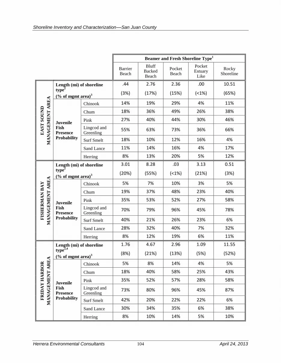
Shoreline Inventory and Characterization––San Juan County
Herrera Environmental Consultants 104 April 24, 2013
Beamer and Fresh Shoreline Type1
Barrier Beach
Bluff Backed Beach
Pocket Beach
Pocket Estuary
Like
Rocky Shoreline
EA
ST
SO
UN
D
MA
NA
GE
ME
NT
AR
EA
Length (mi) of shoreline type
2
(% of mgmt area)3
.44 2.76 2.36 .00 10.51
(3%) (17%) (15%) (<1%) (65%)
Juvenile Fish Presence Probability
Chinook 14% 19% 29% 4% 11%
Chum 18% 36% 49% 26% 38%
Pink 27% 40% 44% 30% 46%
Lingcod and Greenling
55% 63% 73% 36% 66%
Surf Smelt 18% 10% 12% 16% 4%
Sand Lance 11% 14% 16% 4% 17%
Herring 8% 13% 20% 5% 12%
FIS
HE
RM
AN
BA
Y
MA
NA
GE
ME
NT
AR
EA
Length (mi) of shoreline type
2
(% of mgmt area)3
3.01 8.28 .03 3.13 0.51
(20%) (55%) (<1%) (21%) (3%)
Juvenile Fish Presence Probability
Chinook 5% 7% 10% 3% 5%
Chum 19% 37% 48% 23% 40%
Pink 35% 53% 52% 27% 58%
Lingcod and Greenling
70% 79% 96% 45% 78%
Surf Smelt 40% 21% 26% 23% 6%
Sand Lance 28% 32% 40% 7% 32%
Herring 8% 12% 19% 6% 11%
FR
IDA
Y H
AR
BO
R
MA
NA
GE
ME
NT
AR
EA
Length (mi) of shoreline type
2,4
(% of mgmt area)3
1.76 4.67 2.96 1.09 11.55
(8%) (21%) (13%) (5%) (52%)
Juvenile Fish Presence Probability
Chinook 5% 8% 14% 4% 5%
Chum 18% 40% 58% 25% 43%
Pink 35% 52% 57% 28% 58%
Lingcod and Greenling
73% 80% 96% 45% 87%
Surf Smelt 42% 20% 22% 22% 6%
Sand Lance 30% 34% 35% 6% 38%
Herring 8% 10% 14% 5% 10%

Shoreline Inventory and Characterization––San Juan County
April 24, 2013 105 Herrera Environmental Consultants
Beamer and Fresh Shoreline Type1
Barrier Beach
Bluff Backed Beach
Pocket Beach
Pocket Estuary
Like
Rocky Shoreline
MU
D B
AY
MA
NA
GE
ME
NT
AR
EA
Length (mi) of shoreline type
2
(% of mgmt area)3
1.21 3.73 3.77 2.17 16.16
(4%) (14%) (14%) (8%) (60%)
Juvenile Fish Presence Probability
Chinook 13% 20% 20% 5% 8%
Chum 21% 44% 67% 19% 51%
Pink 37% 56% 67% 23% 69%
Lingcod and Greenling
56% 65% 62% 30% 55%
Surf Smelt 42% 23% 25% 20% 7%
Sand Lance 24% 31% 22% 3% 21%
Herring 13% 21% 28% 8% 16%
NO
RT
H C
OA
ST
EA
ST
SO
UN
D
MA
NA
GE
ME
NT
AR
EA
Length (mi) of shoreline type
2,5
(% of mgmt area)3
.63 2.02 .20 .24 .65
(14%) (47%) (5%) (5%) (15%)
Juvenile Fish Presence Probability
Chinook 24% 28% 38% 10% 17%
Chum 36% 72% 96% 45% 75%
Pink 50% 65% 61% 28% 66%
Lingcod and Greenling
73% 83% 96% 45% 88%
Surf Smelt 30% 12% 11% 7% 3%
Sand Lance 42% 45% 44% 7% 48%
Herring 23% 31% 46% 13% 29%
OL
GA
MA
NA
GE
ME
NT
AR
EA
Length (mi) of shoreline type
2
(% of mgmt area)3
.05 4.55 1.43 .14 7.58
(<1%) (33%) (10%) (1%) (55%)
Juvenile Fish Presence Probability
Chinook 14% 20% 34% 10% 12%
Chum 18% 40% 53% 23% 39%
Pink 27% 43% 45% 21% 46%
Lingcod and Greenling
55% 65% 74% 34% 66%
Surf Smelt 18% 11% 14% 10% 4%
Sand Lance 11% 17% 20% 3% 19%
Herring 8% 14% 24% 7% 14%

Shoreline Inventory and Characterization––San Juan County
Herrera Environmental Consultants 106 April 24, 2013
Beamer and Fresh Shoreline Type1
Barrier Beach
Bluff Backed Beach
Pocket Beach
Pocket Estuary
Like
Rocky Shoreline
RO
CH
E H
AR
BO
R
MA
NA
GE
ME
NT
AR
EA
Length (mi) of shoreline type
2,6
(% of mgmt area)3
1.12 9.37 3.83 3.76 14.66
(3%) (28%) (12%) (11%) (44%)
Juvenile Fish Presence Probability
Chinook 12% 17% 28% 8% 11%
Chum 21% 42% 54% 25% 42%
Pink 12% 19% 15% 8% 16%
Lingcod and Greenling
50% 58% 65% 30% 59%
Surf Smelt 31% 16% 19% 18% 5%
Sand Lance 15% 19% 20% 3% 21%
Herring 10% 16% 27% 9% 16%
SA
N J
UA
N C
HA
NN
EL
MA
NA
GE
ME
NT
AR
EA
Length (mi) of shoreline type
2
(% of mgmt area)3
0 0 2.37 .22 9.59
(0%) (0%) (19%) (2%) (79%)
Juvenile Fish Presence Probability
Chinook NA NA 23% 7% 9%
Chum NA NA 85% 40% 67%
Pink NA NA 72% 37% 75%
Lingcod and Greenling
NA NA 96% 45% 88%
Surf Smelt NA NA 10% 9% 3%
Sand Lance NA NA 20% 3% 21%
Herring NA NA 0% 0% 0%
SH
AW
MA
NA
GE
ME
NT
AR
EA
Length (mi) of shoreline type
2,7
(% of mgmt area)3
.49 2.48 5.88 1.34 25.58
(1%) (7%) (16%) (4%) (71%)
Juvenile Fish Presence Probability
Chinook 6% 9% 18% 5% 7%
Chum 21% 41% 70% 27% 54%
Pink 39% 57% 65% 31% 68%
Lingcod and Greenling
56% 64% 82% 37% 74%
Surf Smelt 31% 17% 15% 16% 4%
Sand Lance 15% 19% 18% 4% 19%
Herring 7% 11% 10% 5% 7%

Shoreline Inventory and Characterization––San Juan County
April 24, 2013 107 Herrera Environmental Consultants
Beamer and Fresh Shoreline Type1
Barrier Beach
Bluff Backed Beach
Pocket Beach
Pocket Estuary
Like
Rocky Shoreline
SP
EN
CE
R S
PIT
MA
NA
GE
ME
NT
AR
EA
Length (mi) of shoreline type
2
(% of mgmt area)3
1.90 4.34 .25 1.00 5.80
(14%) (33%) (2%) (8%) (44%)
Juvenile Fish Presence Probability
Chinook 7% 10% 16% 5% 6%
Chum 15% 30% 40% 19% 33%
Pink 30% 44% 45% 23% 49%
Lingcod and Greenling
48% 56% 64% 30% 60%
Surf Smelt 36% 19% 22% 20% 6%
Sand Lance 15% 19% 20% 3% 21%
Herring 10% 16% 26% 8% 15%
ST
RA
IT O
F J
UA
N D
E F
UC
A
MA
NA
GE
ME
NT
AR
EA
Length (mi) of shoreline type
2
(% of mgmt area)3
0 4.12 7.62 1.23 36.22
0% 8% 15% 2% 74%
Juvenile Fish Presence Probability
Chinook NA 17% 21% 7% 9%
Chum NA 48% 75% 31% 56%
Pink NA 40% 64% 22% 60%
Lingcod and Greenling
NA 28% 51% 26% 46%
Surf Smelt NA 7% 21% 17% 5%
Sand Lance NA 28% 20% 3% 22%
Herring NA 7% 23% 8% 13%
ST
UA
RT
IS
LA
ND
MA
NA
GE
ME
NT
AR
EA
Length (mi) of shoreline type
2
(% of mgmt area)3
.29 2.76 2.60 .27 27.67
(<1%) (8%) (8%) (<1%) (82%)
Juvenile Fish Presence Probability
Chinook 15% 21% 35% 11% 14%
Chum 30% 59% 78% 37% 61%
Pink 35% 51% 52% 27% 55%
Lingcod and Greenling
54% 61% 71% 33% 64%
Surf Smelt 33% 17% 20% 18% 6%
Sand Lance 25% 31% 33% 6% 35%
Herring 13% 20% 33% 11% 20%

Shoreline Inventory and Characterization––San Juan County
Herrera Environmental Consultants 108 April 24, 2013
Beamer and Fresh Shoreline Type1
Barrier Beach
Bluff Backed Beach
Pocket Beach
Pocket Estuary
Like
Rocky Shoreline
TU
RT
LE
BA
CK
MA
NA
GE
ME
NT
AR
EA
Length (mi) of shoreline type
2
(% of mgmt area)3
0 3.88 1.66 0.15 8.73
(0%) (27%) (11%) (1%) (61%)
Juvenile Fish Presence Probability
Chinook NA 39% 42% 19% 17%
Chum NA 72% 90% 45% 71%
Pink NA 80% 76% 42% 80%
Lingcod and Greenling
NA 83% 96% 45% 88%
Surf Smelt NA 19% 16% 20% 5%
Sand Lance NA 56% 39% 10% 42%
Herring NA 39% 30% 20% 19%
WA
LD
RO
N
MA
NA
GE
ME
NT
AR
EA
Length (mi) of shoreline type
2
(% of mgmt area)3
.55 7.01 2.92 0 30.18
(1%) (17%) (7%) (0%) (74%)
Juvenile Fish Presence Probability
Chinook 27% 39% 59% NA 23%
Chum 36% 72% 96% NA 75%
Pink 55% 80% 79% NA 82%
Lingcod and Greenling
73% 83% 96% NA 88%
Surf Smelt 36% 19% 20% NA 6%
Sand Lance 45% 56% 58% NA 60%
Herring 25% 39% 60% NA 36%
WE
ST
SO
UN
D
MA
NA
GE
ME
NT
AR
EA
Length (mi) of shoreline type
2
(% of mgmt area)3
.11 3.85 3.04 2.07 14.62
(<1%) (16%) (13%) (9%) (62%)
Juvenile Fish Presence Probability
Chinook 6% 6% 10% 3% 4%
Chum 21% 41% 55% 26% 44%
Pink 39% 57% 58% 30% 62%
Lingcod and Greenling
58% 51% 58% 28% 55%
Surf Smelt 30% 21% 24% 21% 7%
Sand Lance 17% 10% 11% 2% 12%
Herring 7% 15% 25% 8% 14% 1 Shoreline types from Beamer and Fresh (2012).
2 Length reflects all Beamer and Fresh (2012) shore type data located within management unit.
3 Percentage of total length of all Beamer and Fresh (2012) data located within management unit.

Shoreline Inventory and Characterization––San Juan County
April 24, 2013 109 Herrera Environmental Consultants
4 The Friday Harbor Management Area also includes a limited amount (0.38 mile) of shorelines classified as
“modified” by Beamer and Fresh (2012). Beamer and Fresh (2012) did not estimate juvenile fish presence
probability for these shorelines. 5 The North Coast Eastsound Management Area also includes a limited amount (0.60 mile) of shorelines classified
as “modified” by Beamer and Fresh (2012). Beamer and Fresh (2012) did not estimate juvenile fish presence
probability for these shorelines. 6 This Roche Harbor Management Area also includes a limited amount (0.27 mile) of shorelines classified as
“modified” by Beamer and Fresh (2012). Beamer and Fresh (2012) did not estimate juvenile fish presence
probability for these shorelines. 7 This Shaw Island Management Area also includes a limited amount (0.04 mile) of shorelines classified as
“modified” by Beamer and Fresh (2012). Beamer and Fresh (2012) did not estimate juvenile fish presence
probability for these shorelines.
The table indicates that pocket beaches score high as habitat for all the juvenile fish species
examined in the study and within all of the management areas. Pocket beaches followed by bluff
backed beaches are most preferred by Chinook and chum salmon, in all management areas.
Habitat preferences of pink salmon are more varied across management areas and also include
rocky shores. Lingcod and greenling have similar preferences to Chinook and chum and prefer
pocket beaches, flowed by bluff backed beaches and rocky shores. When present in the
management area, surf smelt are most frequently found near barrier beaches and least likely near
rock shores. Sand lance are more variable in habitat preferences with similar presence at pocket
beaches, bluff backed beaches, rocky shorelines and, less frequently, at pocket estuary habitats.
Herring are most likely to be present near pocket beaches, followed by bluff backed beaches and
rocky shores; least often at barrier beaches and pocket estuaries. In general pocket estuaries were
found used by all species where present but varied by species and management area.
Beamer and Fresh (2012) also examined fish abundance, timing of presence, and fish size. These
factors are not covered in this report.
3.12 Lakes
The County contains 12 lakes (Table 19) that were identified by the County in their
Comprehensive Land Use Plan (San Juan County 2011), and that meet the acreage criteria for
shoreline management. These lakes are important for wildlife habitat but also provide functions
for water quality management. The lakes range in size from nearly 200 acres (Mountain Lake) to
those that just meet the 20-acre requirement (e.g., Dream Lake). Some of these lakes, such as
Sportsman Lake and Hummel Lake also have potential associated wetlands. Lakes in San Juan
County include those designated as protected (Mountain Lake and Cascade Lake), and
10 additional lakes that are designated as rural residential (Table 19).
The largest lakes in the county, Mountain and Cascade Lakes, are on Orcas Island. In addition to
providing habitat for wildlife, many of the county’s lakes are used for domestic water supplies
irrigation, fishing, and recreation. Due to their large size and connection to streams, Mountain
and Cascade Lakes support fish species including coastal cutthroat trout, rainbow trout (in
Cascade Lake), and kokanee populations. Sportsman Lake and Zylstra Lake on San Juan Island
also have rainbow trout populations, as do Horseshoe and Spencer Lakes (Blakely Island) and
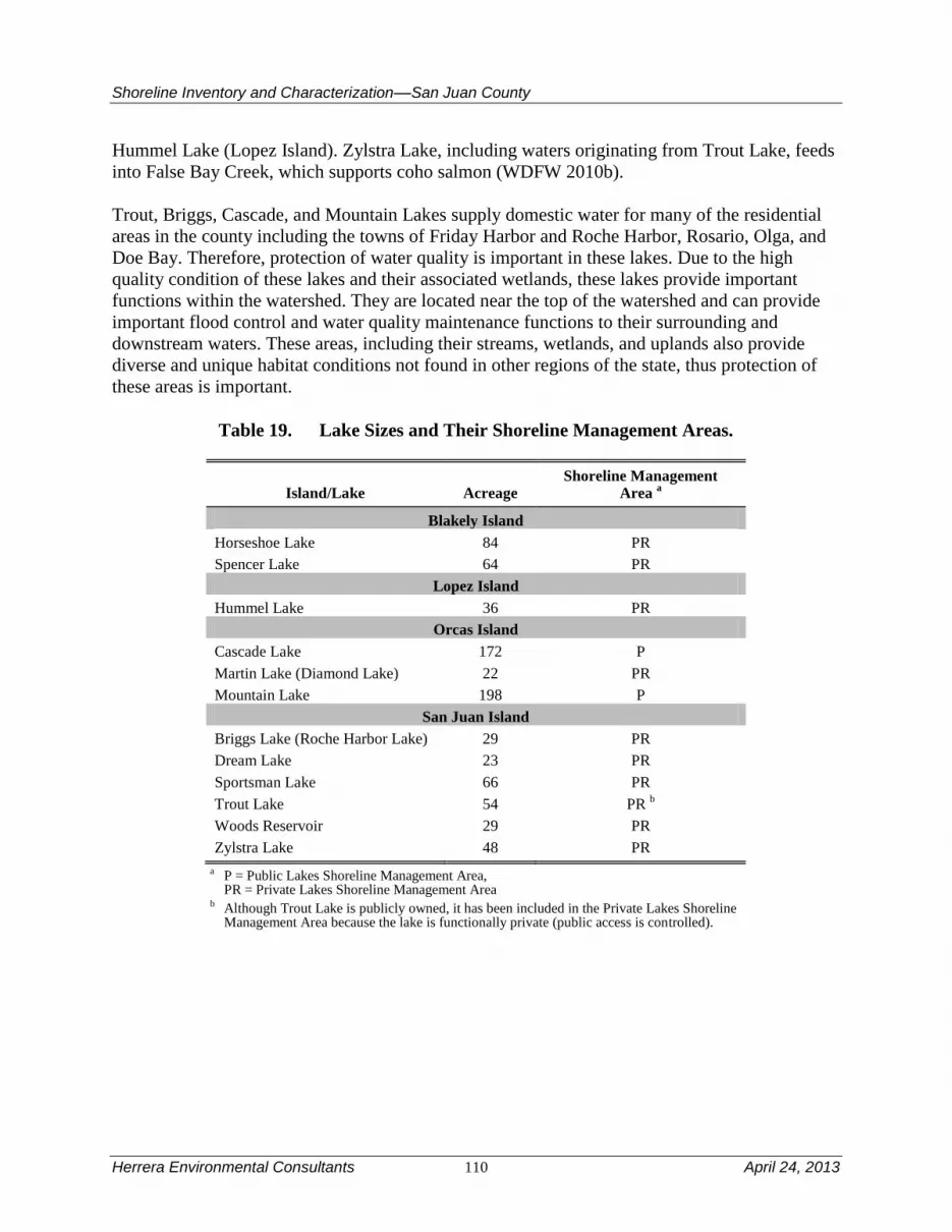
Shoreline Inventory and Characterization––San Juan County
Herrera Environmental Consultants 110 April 24, 2013
Hummel Lake (Lopez Island). Zylstra Lake, including waters originating from Trout Lake, feeds
into False Bay Creek, which supports coho salmon (WDFW 2010b).
Trout, Briggs, Cascade, and Mountain Lakes supply domestic water for many of the residential
areas in the county including the towns of Friday Harbor and Roche Harbor, Rosario, Olga, and
Doe Bay. Therefore, protection of water quality is important in these lakes. Due to the high
quality condition of these lakes and their associated wetlands, these lakes provide important
functions within the watershed. They are located near the top of the watershed and can provide
important flood control and water quality maintenance functions to their surrounding and
downstream waters. These areas, including their streams, wetlands, and uplands also provide
diverse and unique habitat conditions not found in other regions of the state, thus protection of
these areas is important.
Table 19. Lake Sizes and Their Shoreline Management Areas.
Island/Lake Acreage Shoreline Management
Area a
Blakely Island
Horseshoe Lake 84 PR
Spencer Lake 64 PR
Lopez Island
Hummel Lake 36 PR
Orcas Island
Cascade Lake 172 P
Martin Lake (Diamond Lake) 22 PR
Mountain Lake 198 P
San Juan Island
Briggs Lake (Roche Harbor Lake) 29 PR
Dream Lake 23 PR
Sportsman Lake 66 PR
Trout Lake 54 PR b
Woods Reservoir 29 PR
Zylstra Lake 48 PR
a P = Public Lakes Shoreline Management Area, PR = Private Lakes Shoreline Management Area
b Although Trout Lake is publicly owned, it has been included in the Private Lakes Shoreline Management Area because the lake is functionally private (public access is controlled).

Shoreline Inventory and Characterization––San Juan County
April 24, 2013 111 Herrera Environmental Consultants
4.0 Discussion of San Juan County Management
Areas
The following sections discuss conditions and characteristics of each shoreline area with respect
to nearshore physical processes, the presence of streams and wetlands, geologic hazards, habitats
and species use, marine riparian habitat, nearshore and estuarine habitats, water quality, marine
sediments and fish tissue samples if available, and shoreline use patterns including land use,
shoreline modifications and existing and potential public access. A reach assessment for each
management area is provided, and identification of general restoration opportunities. A more
comprehensive restoration plan for the County will be prepared as a separate document.
Table 20 provides a summary of conditions found within each management area. It shows the
shoreline length, percent of shoreline armoring, vegetation types, land use, number of overwater
structures, types of geologic hazards present and number of mapped streams found within each
management area. The table indicates there is a wide range of conditions reflecting development
types such as armoring and overwater structures as well as differences in types of geologic
hazards present and mapped streams. All of the management areas have priority species present.
The list of species provided in Table 20 is from existing County databases at the time of the
preparation of this document (2011/2012). Ongoing data collection efforts are continuing and
have documented use of many areas within the County by protected species. For instance, while
WDFW databases do not show Chinook salmon, a federally listed species, as present within San
Juan County, it is known that juvenile Chinook, could be present in any of the management areas
in the County although they are predicted to favor pocket beaches and bluff-back beaches
(Beamer and Fresh 2012).
The discussions of critical and priority habitat and species, including salmonids rely primarily on
available (WDFW 2010c) data on species presence that are included in the map folio (Appendix
A). To avoid cumbersome redundancy throughout the sections, these are not cited in each case.
However, where other sources are referenced, citations are provided.
The reach assessment for each management area used the shoreline inventory to specifically
evaluate the physical and biological conditions of individual shoreline segments. These data
were then analyzed and summarized for each management area in terms of the percent of the
highest score possible for physical functions and habitat functions (see Figure 11). The percent
of possible score was used to compare management area conditions because the possible score
depends on the number of reaches, which vary by management area. While a fully functioning
shoreline from a physical perspective is possible, and even likely for an ecologically rich reach,
owing to the diverse needs of the different priority species it is not possible for a reach to be
scored perfectly for habitat conditions. Figure 11 reflects this condition, as scores for physical
conditions are much higher relative to scores for habitat conditions.
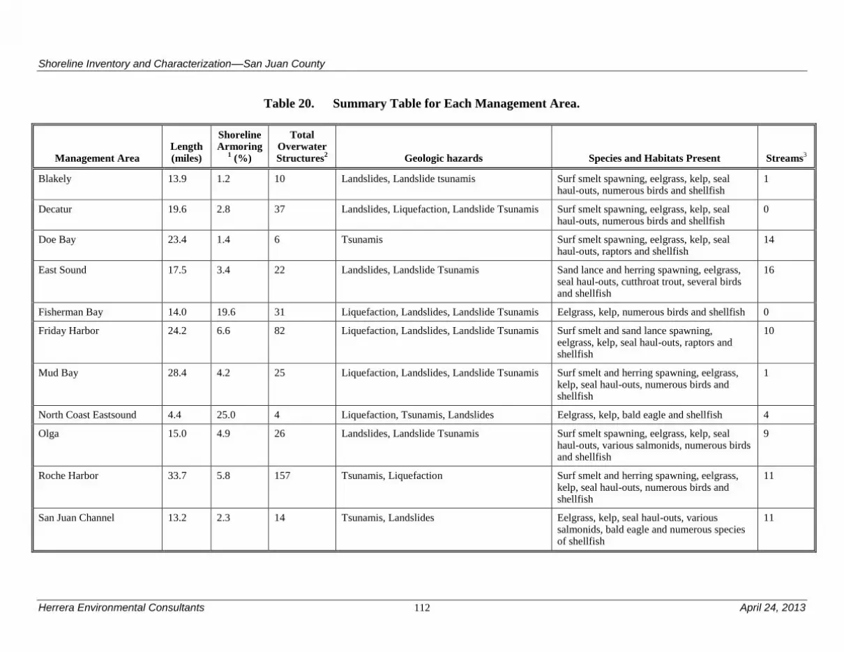
Shoreline Inventory and Characterization––San Juan County
Herrera Environmental Consultants 112 April 24, 2013
Table 20. Summary Table for Each Management Area.
Management Area Length (miles)
Shoreline Armoring
1 (%)
Total Overwater Structures
2 Geologic hazards Species and Habitats Present Streams
3
Blakely 13.9 1.2 10 Landslides, Landslide tsunamis Surf smelt spawning, eelgrass, kelp, seal haul-outs, numerous birds and shellfish
1
Decatur 19.6 2.8 37 Landslides, Liquefaction, Landslide Tsunamis Surf smelt spawning, eelgrass, kelp, seal haul-outs, numerous birds and shellfish
0
Doe Bay 23.4 1.4 6 Tsunamis Surf smelt spawning, eelgrass, kelp, seal haul-outs, raptors and shellfish
14
East Sound 17.5 3.4 22 Landslides, Landslide Tsunamis Sand lance and herring spawning, eelgrass, seal haul-outs, cutthroat trout, several birds and shellfish
16
Fisherman Bay 14.0 19.6 31 Liquefaction, Landslides, Landslide Tsunamis Eelgrass, kelp, numerous birds and shellfish 0
Friday Harbor 24.2 6.6 82 Liquefaction, Landslides, Landslide Tsunamis Surf smelt and sand lance spawning, eelgrass, kelp, seal haul-outs, raptors and shellfish
10
Mud Bay 28.4 4.2 25 Liquefaction, Landslides, Landslide Tsunamis Surf smelt and herring spawning, eelgrass, kelp, seal haul-outs, numerous birds and shellfish
1
North Coast Eastsound 4.4 25.0 4 Liquefaction, Tsunamis, Landslides Eelgrass, kelp, bald eagle and shellfish 4
Olga 15.0 4.9 26 Landslides, Landslide Tsunamis Surf smelt spawning, eelgrass, kelp, seal haul-outs, various salmonids, numerous birds and shellfish
9
Roche Harbor 33.7 5.8 157 Tsunamis, Liquefaction Surf smelt and herring spawning, eelgrass, kelp, seal haul-outs, numerous birds and shellfish
11
San Juan Channel 13.2 2.3 14 Tsunamis, Landslides Eelgrass, kelp, seal haul-outs, various salmonids, bald eagle and numerous species of shellfish
11

Shoreline Inventory and Characterization––San Juan County
April 24, 2013 113 Herrera Environmental Consultants
Management Area Length (miles)
Shoreline Armoring
1 (%)
Total Overwater Structures
2 Geologic hazards Species and Habitats Present Streams
3
Shaw 38.2 4.4 55 Liquefaction, Landslide Tsunamis Surf smelt and herring spawning, eelgrass, kelp, seal haul-outs, numerous birds and shellfish
3
Spencer Spit 12.7 8.3 25 Landslides, Liquefaction, Landslide Tsunamis Sand lance, herring and surf smelt spawning, eelgrass, kelp, big brown bats, numerous birds and shellfish
3
Strait of Juan de Fuca 57.7 2.0 17 Liquefaction, Tsunamis, Landslides Sand lance, surf smelt, and rocksole spawning, eelgrass, kelp, seal haul-outs, coho
13
Stuart 36.0 0.8 31 Landslides, Tsunamis, Liquefaction Surf smelt spawning, eelgrass, kelp, seal haul-outs, numerous birds and shellfish
0
Turtleback 15.5 3.7 10 Landslides, Tsunamis Surf smelt spawning, eelgrass, kelp, seal haul-outs, raptors, and shellfish
7
Waldron 45.6 0.8 5 Tsunamis, Landslides, Liquefaction Surf smelt spawning, eelgrass, kelp, seal haul-outs, numerous birds and shellfish
0
Westsound 25.5 6.7 98 Landslide Tsunamis Sand lance, herring and surf smelt spawning, eelgrass, kelp, various salmonids, numerous birds and shellfish
9
Public Lakes 7.6 NDA NDA None Various salmonids and bald eagle NDA
Private Lakes 17.8 NDA NDA None Various salmonids, numerous species of birds, and California myotis
NDA
NDA = No data available 1 Shoreline armoring data from the Friends of the San Juans (2009) 2 Overwater structures data from WA Department of Natural Resources (2007) 3 Based on watercourse layer provided by DOE (2000).

Shoreline Inventory and Characterization––San Juan County
Herrera Environmental Consultants 114 April 24, 2013
Figure 11 shows the highest scoring marine management areas, for physical conditions are Doe
Bay followed by Spencer Spit; Blakely Island and Turtleback also score comparatively high.
Both the Private lakes and Public Lakes management areas score high for physical conditions
and for habitat functions. The lowest ranking management areas for physical conditions are
Fisherman Bay and Olga management areas. Overall, physical conditions in the majority of
management areas score above 60 percent with only four out of the 20 scoring less than 60
percent of the possible score. This suggests that, although there are reaches with substantial
shoreline modifications, comparatively, the County as a whole provides important intact physical
conditions to support nearshore and marine functions.

Shoreline Inventory and Characterization––San Juan County
April 24, 2013 115 Herrera Environmental Consultants
0%
10%
20%
30%
40%
50%
60%
70%
80%
90%
100%
Pe
rce
nt
of
Po
ssib
le S
core
Management Area
Physical Conditions
Habitat Functions

Shoreline Inventory and Characterization––San Juan County
Herrera Environmental Consultants 116 April 24, 2013
Figure 11. Summary of Physical Conditions and Habitat Functions Found Within Each
Management Area (percent of possible score).
The highest scoring marine habitat conditions were found in the Waldron (51 percent), Mud Bay
(49 percent), and Shaw Island (48 percent) management areas. It is important to remind the
reader that some of the WDFW PHS data sets used are based upon very few observations.
Consequently, low species presence or habitat scores could be an artifact of the number of
observations. This likely means that presence and habitat for some species is underreported and
habitat functions for many management areas may, in reality, be higher than shown in the
assessment, especially in more remote areas and uninhabited islands. See Section 2.4 Method
Used to Inventory and Characterize Management Areas for additional information on this
important data limitation. The figure also indicates that more developed reaches (such as parts of
the Fisherman Bay and Olga management areas) generally have lower reach scores for habitat
conditions than less developed areas (such as the Waldron Island and Mud Bay management
areas).
0%
10%
20%
30%
40%
50%
60%
70%
80%
90%
100%
Pe
rce
nt
of
Po
ssib
le S
core
Management Area
Physical Conditions
Habitat Functions

Shoreline Inventory and Characterization––San Juan County
April 24, 2013 117 Herrera Environmental Consultants
Private and public lakes were 49 percent and 53 percent of the total possible score respectively
for freshwater systems. For freshwater shorelines, Public Lakes scored slightly higher than
Private Lakes for habitat conditions due primarily to the higher number of documented salmonid
species in the Public Lakes management area. Here again, WDFW data set limitations for PHS
species may have resulted in overall lower habitat function scores for the lake management
areas.
There is a moderate statistical correlation between scores for physical conditions and habitat
conditions amongst all the management areas (r = 0.61). This is likely less strong than it might
be because certain habitat condition features such as presence of associated wetlands, haul-out
habitat, and presence of some WDFW PHS species are not directly related to the criteria used to
score shoreline physical conditions.
Individual reach scores that comprise the summarized rankings in Figure 11 are found in the
Reach Analysis sections of the management areas discussions below. Within each individual
marine reach, 40 is the highest possible score for physical conditions, and 50 is the highest for
habitat functions. For marine shorelines, a total reach score for physical conditions that is 24 (60
percent of possible) or higher indicates the reach is functioning within the range of higher
performing reaches, while a score less than 24 suggests that there are impaired areas within the
reach. For marine habitat conditions, reach scores nearing 50 are virtually impossible because of
the wide variation in priority species requirements. In general, scores less than 20 (40 percent of
possible) represent the lowest third of marine reach habitat scores and may indicate there are
significant limitations on habitat functions within the reach.
For freshwater reaches, 20 is the highest score for both physical conditions and for habitat
functions (total scores are lower because fewer criteria are included in the scoring than for the
marine functional assessment). Both the Private and Public Lakes management areas score well
above 60 percent for physical conditions and both score relatively high for habitat conditions.
For the individual management area discussions, marine management areas are organized
alphabetically followed by the lake management areas (locations and boundaries are shown in
Figure 1).
4.1 Blakely Island Management Area
The Blakely Island management area consists primarily of Blakely Island and encompasses just
under 14 miles of shoreline. Two small named, but uninhabited, islands also occur in the
management area. Blakely Island itself is largely uninhabited with concentrated development at
the north and south end of the island. There is an airport at the north end of the island, which
extends into the shoreline management zone at its south end. There are no major ferry terminals
in the management area.
Table 21 is a summary of the reach assessment for the Blakely Island management area. The
table is in two parts, one covering general physical conditions, the other addressing those
conditions directly related to habitat functions. The following discussions cover both the

Shoreline Inventory and Characterization––San Juan County
Herrera Environmental Consultants 118 April 24, 2013
conditions scored in the reach assessment (Tables 21 A and B) and management area results
from the ecosystem-wide characterization.
4.1.1 Physical and Biological Characterization
Nearshore Physical Processes
The geology of Blakely Island is relatively simple by comparison to the rest of the County. Most
of the island is comprised of a large ophiolite (the Fidalgo ophiolite). This mineral-rich unit
severely limits the production of soil and vegetation. The shoreline in these areas is also
extremely steep, with limited portions of the shoreline being nearly vertical. However, the
composition of the rock (i.e., an ophiolite) restricts the formation of pocket beaches, even in
natural embayments like Thatcher Bay. At the north end of the island there is a relatively high,
inclined glacial drift terrace that is developed with an airport (the primary means of access to the
island). The glacial drift has been eroded over time and produced modest beaches that surround
the terrace. A geological map of the island is provided in Map 15C in Appendix A.
Four of the six reaches comprising Blakely Island contain feeder bluffs and two reaches contain
pocket beaches. Most (four) of Blakely Island’s drift cells are located adjacent to the glacial drift
terrace on the north side of the island (Map 13C, Appendix A). Two of these converge at an
accretionary shoreform at the west end of the terrace. The other two form a tombolo at the
northern tip of the island. There are also two small, convergent drift cells within Thatcher Bay
and a divergence zone on the southeast side of the island.
Wave energy is low to moderate along the management area shorelines due to protection of
adjacent islands in nearly direction. Tidal currents are significant (in excess of 2 knots) near
Peavine Pass in the north and Thatcher Pass in the south and along the east side of the island.
The west side of the island is much more quiescent (Canadian Hydrographic Service 2010).
Thatcher Pass is also the main ferry route into the County and therefore sees significant vessel
activity and wakes.
The Blakely Island shoreline remains relatively undisturbed in most reaches. Natural current
patterns are intact but there is some armoring in reaches 90 through 94 that can affect wave and
current attenuation. All reaches have some shoreline vegetation removed but vegetation within
the entire shoreline district is relatively dense.

Shoreline Inventory and Characterization––San Juan County
April 24, 2013 119 Herrera Environmental Consultants
Figure 12. Blakely Island Management Area.
Geologic Hazards
Much of the shoreline in the management area is extremely steep. As such, there is a potential
for landsliding around the entire island, but documented landslides are rare. The nature of the
landsliding on much of Blakely Island is quite different due to the composition of the bedrock.

Shoreline Inventory and Characterization––San Juan County
Herrera Environmental Consultants 120 April 24, 2013
Landsliding, where it occurs, is associated with chemical weathering and faulting of the rock.
This mode of landsliding results in toppling and small rockslides. The drift terrace at the north
end of the island is also susceptible to more traditional slumping, particularly at the southwest
end.
Because of the presence of bedrock, most of the management area is not susceptible to
liquefaction. There is active faulting on the northwest end of the island, but this area is
uninhabited. There is a moderate liquefaction threat to the drift terrace, particularly to marsh
areas that surround it. The only significant tsunami risk is from landslide-induced tsunamis
originating from surrounding islands (primarily from heavily-faulted portions of Orcas Island).
Streams and Associated Wetlands
There is a single unnamed stream on Blakely Island. The stream drains from Horseshoe Lake
into Spencer Lake. From Spencer Lake, the stream discharges into Thatcher Bay at a former mill
site. Small potential associated wetlands are present around Horseshoe Lake.
Critical or Priority Habitat and Species Use
The Blakely Island management area does not generally provide suitable habitat for clams or
crabs with some exceptions, due to the steep shorelines. However, except for the waters
southwest of the island, the area likely provides suitable habitat for pandalid shrimp. Marine
mammals and seabirds may use the small islands and rocks in the southern portion of the
management area. Bald eagles have also been observed along the forested shoreline of Blakely
Island, where significant trees likely provide nesting opportunities. Habitat with a high potential
for marbled murrelet nesting has been identified along the western shoreline from Peavine Pass
to the southern shoreline of Thatcher Bay (SJC 2009). Most of the island contains habitat
suitable for rockfish, with the possible exception of the area adjacent to the glacial drift terrace in
the north and Thatcher Bay. Blakely Island nearshore areas are characterized by narrow strips of
eelgrass, as well as both floating and understory kelps off most of its shoreline. The lack of
documented haul outs and spawning habitat limited the management area’s scores for habitat
functions.
Marine Riparian, Nearshore, and Estuarine Habitats
Estuarine habitat is found in all reaches of Blakely Island although the areas are small, with the
exception of reach 90, and therefore scored on the low end of the scale. Thatcher Bay on the
western shoreline provides estuarine habitat that may be an important rearing area for salmonids
due to the influence of freshwater from upstream Horseshoe and Spencer Lakes, and the
presence of pocket beaches. Thatcher Bay also contains known surf smelt spawning habitat. The
forested riparian zone is intact overall.
Water Quality, Sediment, and/or Tissue Sample Results
Although data have been collected northwest of Blakely Island near Obstruction Island (Ecology
2011d), no systematic analysis has been done with these data. As such, water quality is largely
unknown in this management area but likely, the area has relatively high water quality given the
extent of development in most reaches.

Shoreline Inventory and Characterization––San Juan County
April 24, 2013 121 Herrera Environmental Consultants
4.1.2 Shoreline Use Patterns3
Existing Land and Shoreline Use
Land Use
The Blakely Island management area consists of marine shorelines on Blakely Island (excluding
Blakely Island’s lakes large enough qualify as shorelines, which are treated under Private Lakes
below) and the smaller Armitage and Willow islands.
Current land uses in the Blakely Island management area are as follows:
Residential – 26 percent
Trade – 1 percent
Services – 10 percent
Cultural, Entertainment, Recreation – 4 percent
Undeveloped Land4 – 60 percent
Blakely Island has a mixture of resource, residential and vacant land uses with some smaller
areas of government, undeveloped – conservation easements, trade, and unclassified existing
land uses. The northwestern portion of Blakely Island, along Peavine Pass, is the most developed
portion of the island and is mostly characterized by existing residential uses. There is one parcel
classified as trade, which consists of a general store at the island’s marina. The eastern portion of
Blakely Island is mostly resource land uses with some small areas of vacant land separating the
resource land from the residential land described above, and government land in the central east
portion of the island where Washington State Department of Natural Resources owns property.
The southeastern portion of Blakely Island is mostly vacant with some interspersed residential
uses. The southern tip of Blakely Island, along Thatcher Pass, is vacant, while the pattern of
vacant with some residential interspersed continues on the southwestern side of the island to
Thatcher Bay. Thatcher Bay consists of a mixture of cultural/recreation, unclassified, resource,
and vacant lands – conservation easement uses. North of Thatcher Bay the western side of
Blakely Island is predominantly resource with a small area of vacant land separating the resource
from the residential land first described in this section on the north. The smaller Armitage Island
is entirely cultural/recreation, while Willow Island is entirely undeveloped Federal land.
Additional shoreline land use includes several DNR utility line easements and an existing log
booming and storage lease in Thatcher Bay. The majority of tidelands in this Management Area
are publicly owned and managed by DNR (state-owned aquatic lands).
3 Note: Folio maps call out an existing land use category called “cultural, entertainment, and recreational.” For purposes of this narrative, this category is described as cultural/recreation since most of these properties are parks and similar recreation uses. 4 The percentages for the “Undeveloped Land” category listed here and in other subsequent sections describing land use in the various management areas were derived from County assessor’s data. Not all of the land in the “Undeveloped Land” category should be considered developable. Please see Chapter 5 of this report for a detailed assessment of the development potential along San Juan County’s shorelines.

Shoreline Inventory and Characterization––San Juan County
Herrera Environmental Consultants 122 April 24, 2013
Water-dependent uses in the Blakely Island management area include the Blakely Island Marina
at the northern end of Blakely Island, a marine railway on the southern side of Blakely Island,
and private and community docks and piers along areas with existing residential development on
the northern and southern ends of Blakely Island, and one pier on Armitage Island.
Land Use Designations
Comprehensive Plan land use designations on Blakely Island are largely Forest Resource,
corresponding to the shoreline jurisdiction classified as resource and conservation uses. The
northern portion of the island characterized by residential uses is largely designated Rural
Residential, while a small number of shoreline parcels near the marina, including the general
store, are designated Rural General. The Washington State Department of Natural Resources
(DNR) parcel on the central east portion of Blakely Island is designated Conservancy, while the
areas of Blakely Island south of the Forest Resource designation are designated as Rural Farm
Forest with a small area of Conservancy located on the south portion of the Thatcher Bay in the
area with the existing cultural/recreation use. The smaller Armitage Island is designated
Conservancy, and Willow Island is designated Natural.
Shoreline Environment Designations
The majority of Blakely Island, including all of the Forest Resource designated shoreline
described above is designated with a Conservancy shoreline environment. The developed
northern portion of Blakely Island is in Rural Residential shoreline environment except for the
portion surrounding the Blakely Island Marina, which is designated with a rural shoreline
environment. The other exceptions to the largely Conservancy-designated Blakely Island,
include small areas of Rural Residential at the north end of Thatcher Bay and on portions of the
south end of Blakely Island characterized by low-density development, and a Natural
environment designation covering the Washington DNR parcel on the east-central part of the
island. Armitage Island is designated with a Conservancy environment, and Willow Island is
designated with a Natural shoreline environment designation.
Shoreline Modifications
Only slightly over 1 percent of shorelines in the Blakely Island management area are armored.
The armoring is interspersed throughout the island on several pocket beaches, some of which
have been previously mapped as being bedrock.
There are only seven docks and piers in the management area, one of lowest number in the
County’s management areas. However, there is a single large marina at the north end of Blakely
Island. There is also a minor amount of fill associated with former mill site and hydropower
plant in Thatcher Bay. The management area has fewer mooring buoys (25) than any other
management area in the County. They are primarily clustered at the north and south ends of
Blakely Island.
Existing and Potential Public Access Areas
The Blakely Island management area contains approximately 900 acres of land owned by Seattle
Pacific University and used as a wilderness environmental research campus. This management

Shoreline Inventory and Characterization––San Juan County
April 24, 2013 123 Herrera Environmental Consultants
area has approximately 312 acres within shoreline jurisdiction. However, there are no public
access opportunities on Blakely Island and the island is not served by ferry. The island is
accessed from outside via private ferry and boats at the private marina at the northern tip of the
island.
Neither the Parks Plan nor the Land Use Element of the Comprehensive Plan include
recommended actions specific to expanding or enhancing public access in the Blakely Island
management area.
4.1.3 Restoration Opportunities
A former mill site in Thatcher Bay has been the subject of active restoration for several years.
The primary aspect of this work is to remove thick deposits of fine-grained wood waste. This
work is currently underway. However, there is other infrastructure associated with the mill site
and past industrial activities that could be removed and build upon the restoration actions already
been undertaken.
In addition to the work at Thatcher Bay, it may be possible to restore the tombolo that defines the
northern tip of Blakely Island. Currently there is a marina adjacent to a large open meadow, with
associated shoreline that is armored (bulkheaded). It is clear from an analysis of historical maps
that there has been significant land alteration and fill, even though this does not appear in the
County database. Prior to development there was a marsh complex (U.S. Coast and Geodetic
Survey 1889a) in this area. Restoring marsh conditions to this area would have significant
benefits to fish and shorebird species.


Shoreline Inventory and Characterization––San Juan County
April 24, 2013 125 Herrera Environmental Consultants
Table 21A. Blakely Island Management Area Reach Assessment – Physical Conditions.
Reach
Natural
Sediment
Transport
Patterns
Shoreline
Sediment
Input
Alterations
- Feeder
Bluffs
Shoreline
Sediment
Input
Alterations
Beaches
Shoreline
Sediment
Input
Alterations
- Barrier
Beaches
Natural
Current
Patterns
Wave &
Current
Attenuation
Nutrient
and Toxics
Removal Shade Total
93 5 NP NP NP 5 5 5 3 23
89 5 NP NP 5 5 5 5 4 29
90 5 4 NP 3 5 4 5 3 29
91 5 5 NP NP 5 4 5 4 28
92 5 5 3 NP 5 4 5 3 30
94 5 5 5 NP 5 4 5 3 32
Median 5.00 5.00 4.00 4.00 5.00 4.00 5.00 3.00 29.00
Average 5.00 4.75 4.00 4.00 5.00 4.33 5.00 3.33 28.50
Percent of Highest Possible
Score 100% 95% 80% 80% 100% 87% 100% 67% 71%
NP = Not Present

Shoreline Inventory and Characterization––San Juan County
Herrera Environmental Consultants 126 April 24, 2013
Table 21B. Blakely Island Management Area Reach Assessment – Habitat Conditions.
Reach
Vegetation
Coverage
Estuary
Habitat Birds
Haul-out
Habitat Eelgrass
Floating
Kelp
Understory
Kelp
Spawning
Habitat1
Herring
Spawning
Habitat Shellfish Total
93 5 1 1 0 5 0 5 0 0 4 21
89 5 1 1 0 5 5 5 0 0 3 20
90 5 5 1 0 5 5 5 0 0 3 24
91 5 1 0 5 5 5 5 3 0 2 26
92 5 1 4 0 5 0 5 3 0 2 20
94 5 3 0 0 5 5 5 0 0 2 20
Median 5.00 1.00 1.00 0.00 5.00 5.00 5.00 0.00 0.00 2.50 20.50
Average 5.00 2.00 1.17 0.83 5.00 3.33 5.00 1.00 0.00 2.67 21.83
Percent of Highest Possible
Score 100% 40% 23% 17% 100% 67% 100% 20% 0% 53% 44% 1 Includes priority spawning habitat for sand lance, surf smelt, and rock sole.

Shoreline Inventory and Characterization––San Juan County
April 24, 2013 127 Herrera Environmental Consultants
4.2 Decatur Island Management Area
The Decatur Island management area includes all of Decatur Island and a collection of smaller
islands that form a mini-archipelago bounded by Rosario Strait to the east, Thatcher Pass to the
north and Lopez Sound to the south and west. The Decatur Island management area has three
large secondary islands: James Island, which is a Washington State Park; Center Island and
Trump Island, both of which are in private ownership and inhabited. The island does not have
major (WSDOT) ferry terminal, but does have many smaller industrial marine terminals.
Table 22 is a summary of the reach assessment for the Decatur Island management area. The
table is in two parts, one covering general physical conditions, the other addressing those
conditions directly related to habitat functions. The following discussions cover both the
conditions scored in the reach assessment (Tables 22A and B) and management area results from
the ecosystem-wide characterization. In general, the shoreline reaches of Decatur score high for
physical conditions with the exception of reach 107 at Reads Bay. Habitat conditions in reaches
102 and 103 at White Cliffs, and 106 through 109 on Reads Bay score low. This is because most
of these areas lack haul-out habitat, floating kelp, and priority fish spawning habitat.
4.2.1 Physical and Biological Characterization
Nearshore Physical Processes
The Decatur Island management area is extremely diverse from a geologic perspective, even by
County standards. At the south end of the island, including Rim Island, metal-rich bedrock is
common and sediment is rare. The central portion of Decatur Island, where most development
has occurred, consists of glacial sediments. Here beaches are common, with the glacial sediment
spread by waves to more rocky areas in the north and south. The northern portion of the island is
bedrock, but primarily different in composition (less mineral-rich) than the bedrock in the south.
Drift on Decatur is dominated by the two large tombolos that define Decatur Head and the
isthmus at Reads Bay. At Reads Bay, drift is convergent at the head of the bay. North of the bay
there is area of divergence (with significant feeder bluffs) that feed the bay and areas further
north. Likewise there is a large feeder bluff complex at White Cliffs that feed both of the large
tombolos. Some of these feeder bluffs have been armored. A small drift cell occurs in Davis Bay
and feeds the other side of the tombolo at Decatur Head. There is also a short unidirectional drift
cell on the southeast side of Center Island.
Most of the management area is relatively protected from waves. Only the White Cliffs portion
of Decatur Island (and the south end of James Island) is exposed, and then only to locally
produced waves in Rosario Strait. Tidal currents are generally modest on the west side of
management area (e.g., less than 1 knot: Canadian Hydrographic Service 2010), with the
exception of near Lopez Pass and Thatcher Pass. The east side of the island is regularly exposed
to significant tidal currents in excess of 2 knots (Canadian Hydrographic Service 2010). These
areas also have increased vessel traffic (particularly Thatcher Pass, which has significant ferry
traffic).
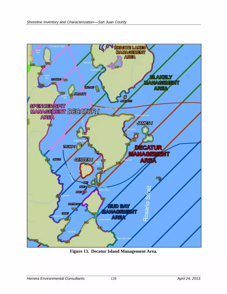
Shoreline Inventory and Characterization––San Juan County
Herrera Environmental Consultants 128 April 24, 2013
Figure 13. Decatur Island Management Area.

Shoreline Inventory and Characterization––San Juan County
April 24, 2013 129 Herrera Environmental Consultants
Geologic Hazards
The most significant geologic hazard in the management area is landsliding along White Cliffs.
In aggregate, this area has the most unstable shoreline in the County. These bluffs, comprised
primarily of a glacial-sediment sequence common in Puget Sound, have been mapped as active
landslide areas. These bluffs offer one of the best examples of “feeder bluffs” in the County.
These landslide areas serve an important function of maintain sediment supply to the tombolos at
either side of the island.
Other geologic hazards are minor in comparison. Liquefaction susceptibility is low to moderate
in areas where sediment exists. The tsunami threat is also low to moderate because of the
protection provided by Lopez Island from the Strait of Juan de Fuca, where most of the tsunamis
would arrive from. Like most of the rest of the County, there is a risk from landslide-induced
tsunamis generated from surrounding islands.
Streams and Associated Wetlands
There are no mapped streams or lakes in this management area. The two primary shoreline-
associated wetlands are formed in the tombolos that define Decatur Head and the isthmus on
Reads Bay. The wetland complex adjacent to Reads Bay has been extensively ditched, though it
is not currently in the County ditch database.
Critical or Priority Habitat and Species Use
There is one documented forage fish spawning beach in the management area along a pocket
beach at the southern end of Reads Bay (reaches 106 and 107). The area of Reads Bay, and
waters extending from the southern end of Decatur Island to Center Island and Trump Island
contains documented crab and shrimp habitat. Pandalid shrimp habitat extends throughout Lopez
Sound. Bald eagles and other important bird species are known to use forested habitat throughout
the management area, including forested shorelines of Decatur Island and James Island.
Although marbled murrelet nesting has not been documented in San Juan County, potential
nesting habitat has been identified along the northern shorelines of Decatur Island (SJC 2009).
The rocky north shoreline contains habitat suitable for rockfish, in addition to areas around
James and Center Island. Eelgrass extends primarily along the eastern and southern shorelines of
Decatur Island, but is also present in isolated location along the northern shoreline, Brigantine
Bay and small coves of James Island. Kelp is also documented around James Island and few
isolated areas of Decatur Island (such as Fauntleroy Point), but is generally limited in the
management area. Floating kelp is less common in this management area and documented only
sporadically along Thatcher Pass, James Island, Lopez Pass and Brigantine Bay. Understory kelp
is documented in virtually all the management area reaches except reaches 107 and 108 within
Reads Bay. No herring spawning habitat is documented in the management area; however,
reaches 104 and 106 in the southern part of Reads Bay have priority spawning habitat for other
fish species. Shellfish are documented to be present in all the management area reaches.
Marine Riparian, Nearshore, & Estuarine Habitats
Estuarine habitat occurs in Davis Bay and Sylvan Cove. The vast majority of the Decatur Island
management area has intact well-developed riparian vegetation along the shore. Some estuarine

Shoreline Inventory and Characterization––San Juan County
Herrera Environmental Consultants 130 April 24, 2013
habitat is present in nearly every reach within the management area although the areas are
generally less than two acres. Vegetation within the shoreline jurisdiction is generally dense,
although most of the reaches have had some vegetation removed from the nearshore.
Water Quality, Sediment, and/or Tissue Sample Results
Ambient water quality monitoring has been conducted in Lopez Sound by the Department of
Ecology that showed periodic exceedances of temperature and dissolved oxygen water quality
criteria; these exceedances were attributed to natural upwelling of low dissolved oxygen marine
water and were not influenced by anthropogenic activities (Ecology 2011e). One sediment
sample was also collected between Center Island and Lopez Island that exceeded the Sediment
Management Standards SQS bioassay criterion; sediment in this area is classified as Category 2
“Sediments of Concern” (Ecology 2011e).
4.2.2 Shoreline Use Patterns
Existing Land and Shoreline Use
Land Use
The Decatur Island management area includes Decatur Island along with the smaller Center,
James, Rim, and Trump islands. The shoreline jurisdiction on Decatur Island is primarily
characterized by vacant and residential existing land uses, with some smaller areas classified in
the cultural/recreation existing land use. Overall existing land uses in the Decatur Island
management area include:
Residential – 37 percent
Cultural, Entertainment, Recreation – 28 percent
Undeveloped Land – 35 percent
The north and western side of Decatur, from Brigantine Bay to Thatcher Pass is mostly vacant.
Residential and vacant parcels are interspersed between Thatcher Pass and Fauntleroy Point. The
eastern side of Decatur Island is largely developed in large lot residential development with a
small amount of vacant land interspersed. Decatur Head, an eastern promontory at the south side
of Davis Bay on the central eastern portion of Decatur Island is classified as a cultural,
entertainment and recreation land use. South of Decatur Head, existing land uses continue in a
pattern of mostly residential with some vacant land uses until the southern promontory of
Decatur Island, which is classified in the cultural/recreation land use category. Existing land use
on the west side of Decatur Island, along Reads Bay to Brigantine Bay, is mostly residential with
some areas of vacant interspersed, particularly near Brigantine Bay.
Additional shoreline use includes several DNR utility line easements. There are also privately
owned Oyster Tracts in Reads Bay. The tidelands are a mix of state-owned aquatic lands and
private ownership.
Of the other islands in this management area, Center Island’s shoreline jurisdiction is largely
developed as residential with small areas of undeveloped open space tracts (classified under the
Open Space Taxation Act) and in cultural/recreation use. James Island is a state park with some

Shoreline Inventory and Characterization––San Juan County
April 24, 2013 131 Herrera Environmental Consultants
campsites and trails predominantly in the center part of the island. The remainder of James Island
is undeveloped natural area. Trump Island is undeveloped land classified under the Open Space
Taxation Act.
Water-dependent uses in the Decatur Island management area include the Decatur Head public
marine facility, the pier at James Island State Park, as well as private and community piers and
docks found on Decatur, Center, and Trump islands, and a marine railway on Center Island.
Water-enjoyment uses include James Island State Park.
Land Use Designations
Comprehensive Plan land use designations in the Decatur Island management area offer a range
of uses, most of which correspond to existing land uses described above. The majority of the
Decatur Island shoreline jurisdiction is designated Rural General. The exceptions to this rule are
that the southern promontory of Decatur Island is designated Natural, a small area on the
southwestern shoreline jurisdiction along Reads Bay is designated Rural Industrial, and there are
two areas designated Rural Residential: one of which is on the northern side of Reads Bay, and
the other surrounds a peninsula on the western side of Decatur Island between Brigantine Bay
and Sylvan Cove. The Rural Industrial designated parcel contains a boat dock and storage for
multiple boats.
Shoreline Environment Designations
In terms of the other islands in this management area, Center Island’s shoreline jurisdiction is
almost entirely designated Rural Residential, with the exception of the cultural/recreation parcel
on the west side of the island which is designated Conservancy. James Island, as a state park, is
designated Conservancy and Trump Island is designated Natural.
The majority of Decatur Island is in the Conservancy shoreline environment designation, with
Rural Farm-Forest environment applied along most of Reads Bay and the southern portion of
Davis Bay. A very small part of the Decatur shoreline at the south end of Reads Bay is
designated in the Urban environment (parcel mentioned above with Rural Industrial land use
designation). Of the smaller islands in this management area, Center Island has Rural Farm-
Forest shoreline environment, James Island has a Conservancy shoreline environment
designation, and Trump Island is mostly Natural with a small area of Conservancy.
Shoreline Modifications
The Decatur Island management area has armoring along 2.8 percent of its shorelines. Most of
the armoring occurs on shoreline that possesses glacial sediment, with the exception of armoring
of Center Island, which is mapped as being entirely bedrock. If the percentage of armoring
would be expressed in terms of the glacial sediment areas only, the percentage of armoring
would be larger.
There are more mooring buoys (165) in the Decatur Island management area than any other
management area in the County. Nearly all of the mooring buoys are located in Davis Bay and
Reads Bay. The management area also has more pilings (92) than any other management area.

Shoreline Inventory and Characterization––San Juan County
Herrera Environmental Consultants 132 April 24, 2013
There are also 37 overwater structures, which are mostly docks and piers. In addition to the
docks and piers there are three boat ramps, a groin, a jetty and two marinas. There is a minor
amount of fill associated with residences on the tombolo of Decatur Head.
Existing and Potential Public Access Areas
Decatur Head boat ramp, located on Decatur Island provides public shoreline access. The
Decatur Island management area also includes James Island, a 113-acre marine camping and
moorage park owned by Washington State Parks Department. The moorage park is open year
round for camping and day use and includes over 12,000 feet of saltwater shoreline on Rosario
Strait. Portions of the island are closed to public access due to their designation as a natural
Forest Area; however, the island does contain approximately 1.5 miles of hiking trails. James
Island State Park offers western views of the San Juan Islands from a high bluff along the loop
trail (Washington State Parks and Recreation Commission, 2010 James Island).
Neither the Parks Plan nor the Land Use Element of the Comprehensive Plan include
recommended actions specific to expanding or enhancing public access in the Decatur Island
management area. GIS data indicates that this management area lacks trails within its shoreline.
Shoreline public access opportunities for trails, boat launches or docks exist on preserve lands
and land owned by community or homeowners groups (e.g., Decatur Community Association).
4.2.3 Restoration Opportunities
The wetland complex along Reads Bay is an excellent opportunity for restoration. Wetland
complexes of its size and connection to marine waters are rare in the County, despite their
ecological value (see Beamer et al. [2003, 2005] for discussion on ecological value of similar
wetland complexes). The wetland complex is large and undeveloped, but it has been extensively
ditched (though it is not currently recorded in County data). Ditches can simplify the landscape
and can lead to trapping of ESA-protected fish species. The ditches could be removed and
natural connection to marine waters restored. There may also be the opportunity to remove some
of the unused mooring buoys and pilings from Reads Bay and consolidate the use of the
remaining ones.
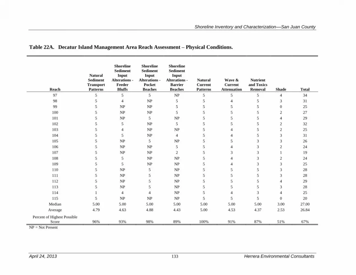
Shoreline Inventory and Characterization––San Juan County
April 24, 2013 133 Herrera Environmental Consultants
Table 22A. Decatur Island Management Area Reach Assessment – Physical Conditions.
Reach
Natural
Sediment
Transport
Patterns
Shoreline
Sediment
Input
Alterations -
Feeder
Bluffs
Shoreline
Sediment
Input
Alterations -
Beaches
Shoreline
Sediment
Input
Alterations -
Barrier
Beaches
Natural
Current
Patterns
Wave &
Current
Attenuation
Nutrient
and Toxics
Removal Shade Total
97 5 5 5 NP 5 5 5 4 34
98 5 4 NP 5 5 4 5 3 31
99 5 NP NP 5 5 5 5 0 25
100 5 NP NP 5 5 5 5 2 27
101 5 NP 5 NP 5 5 5 4 29
102 5 5 NP 5 5 5 5 2 32
103 5 4 NP NP 5 4 5 2 25
104 5 5 NP 4 5 4 5 3 31
105 5 NP 5 NP 5 5 3 3 26
106 5 NP NP 5 5 4 3 2 24
107 5 NP NP 2 5 3 3 1 19
108 5 5 NP NP 5 4 3 2 24
109 5 5 NP NP 5 4 3 3 25
110 5 NP 5 NP 5 5 5 3 28
111 5 NP 5 NP 5 5 5 3 28
112 5 NP 5 NP 5 5 5 4 29
113 5 NP 5 NP 5 5 5 3 28
114 1 4 4 NP 5 4 3 4 25
115 5 NP NP NP 5 5 5 0 20
Median 5.00 5.00 5.00 5.00 5.00 5.00 5.00 3.00 27.00
Average 4.79 4.63 4.88 4.43 5.00 4.53 4.37 2.53 26.84
Percent of Highest Possible
Score 96% 93% 98% 89% 100% 91% 87% 51% 67%
NP = Not Present
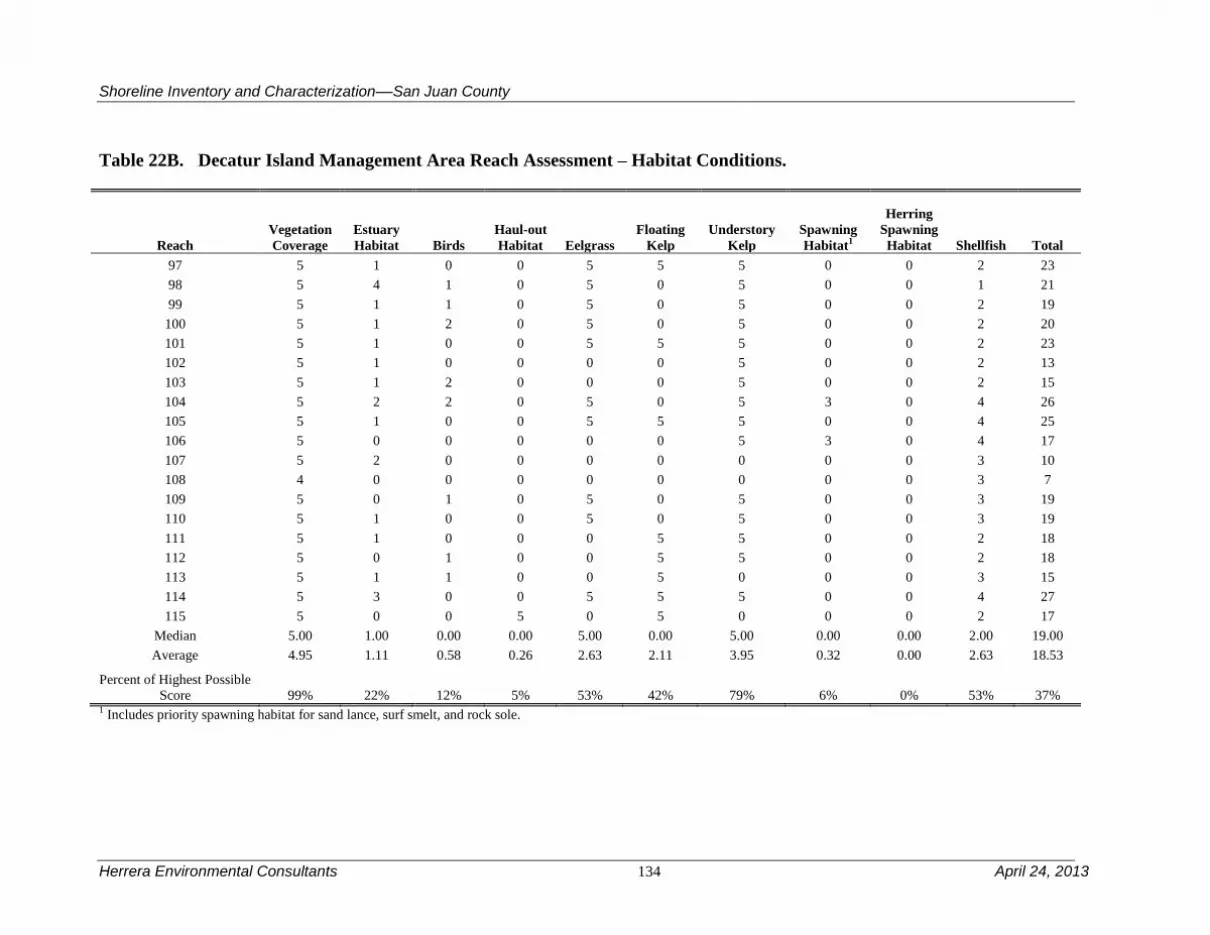
Shoreline Inventory and Characterization––San Juan County
Herrera Environmental Consultants 134 April 24, 2013
Table 22B. Decatur Island Management Area Reach Assessment – Habitat Conditions.
Reach
Vegetation
Coverage
Estuary
Habitat Birds
Haul-out
Habitat Eelgrass
Floating
Kelp
Understory
Kelp
Spawning
Habitat1
Herring
Spawning
Habitat Shellfish Total
97 5 1 0 0 5 5 5 0 0 2 23
98 5 4 1 0 5 0 5 0 0 1 21
99 5 1 1 0 5 0 5 0 0 2 19
100 5 1 2 0 5 0 5 0 0 2 20
101 5 1 0 0 5 5 5 0 0 2 23
102 5 1 0 0 0 0 5 0 0 2 13
103 5 1 2 0 0 0 5 0 0 2 15
104 5 2 2 0 5 0 5 3 0 4 26
105 5 1 0 0 5 5 5 0 0 4 25
106 5 0 0 0 0 0 5 3 0 4 17
107 5 2 0 0 0 0 0 0 0 3 10
108 4 0 0 0 0 0 0 0 0 3 7
109 5 0 1 0 5 0 5 0 0 3 19
110 5 1 0 0 5 0 5 0 0 3 19
111 5 1 0 0 0 5 5 0 0 2 18
112 5 0 1 0 0 5 5 0 0 2 18
113 5 1 1 0 0 5 0 0 0 3 15
114 5 3 0 0 5 5 5 0 0 4 27
115 5 0 0 5 0 5 0 0 0 2 17
Median 5.00 1.00 0.00 0.00 5.00 0.00 5.00 0.00 0.00 2.00 19.00
Average 4.95 1.11 0.58 0.26 2.63 2.11 3.95 0.32 0.00 2.63 18.53
Percent of Highest Possible
Score 99% 22% 12% 5% 53% 42% 79% 6% 0% 53% 37% 1 Includes priority spawning habitat for sand lance, surf smelt, and rock sole.

Shoreline Inventory and Characterization––San Juan County
April 24, 2013 135 Herrera Environmental Consultants
4.3 Doe Bay Management Area
The Doe Bay management area covers over 23 miles of shoreline along the sparsely populated
east end of Orcas Island. The management area has two distinct geographic areas; the northern
shore that is extremely steep and largely uninhabited and the southern shoreline that is less steep
(though steeper than most places) and sparsely populated. The management area includes an
uninhabited mini-archipelago of islands northeast of Orcas Island including Barnes Island, Clark
Island, Lone Tree Island, and the Sisters. The Peapod Rocks and Doe Island southeast of Orcas
Island are also included in this management area. There are no major transportation related uses
in this management area.
Table 23 is a summary of the reach assessment for the Doe Bay management area. The table is in
two parts, one covering general physical conditions, the other addressing those conditions
directly related to habitat functions. The following discussions cover both the conditions scored
in the reach assessment (Tables 23A and B) and management area results from the ecosystem-
wide characterization. The Doe Bay management area is the highest scoring for physical habitat
primarily because each of its reaches has intact feeder bluffs and few shoreline modifications to
interrupt sediment transport, natural current patterns or affect wave attenuation. Habitat functions
are lower than might be expected due to few documented priority bird species, and no
documented fish spawning habitat.
4.3.1 Physical and Biological Characterization
Nearshore Physical Processes
The geology of the Doe Bay management area is both complex and simple. With the exception
of thin layers of glacial drift its southern shoreline; nearly the entire management area is
comprised of extremely old (greater than 200 million years old) oceanic bedrock. Because this
bedrock has been uplifted several miles, the area has a number of mapped faults (Lapen 2000),
many of which are likely relict from the uplift. As a result, locally there can be large variations of
the strength and make-up of the bedrock, but the presence of near-surface bedrock dominates the
geomorphology of the shoreline everywhere. There are no mapped drift cells in this management
area.
Wave energy is fairly large, but locally sourced. The exposure of the north shore is significant as
there is open exposure to the Strait of Georgia, while the southern shore has exposure to the
south via Rosario Strait. Tidal currents are intense offshore (often exceeding 2.5 knots: Canadian
Hydrographic Service 2010), particularly near Point Lawrence, where Rosario Strait makes a
sharp turn from the Puget Lowland to the Strait of Georgia.

Shoreline Inventory and Characterization––San Juan County
Herrera Environmental Consultants 136 April 24, 2013
Figure 14. Doe Bay Management Area.

Shoreline Inventory and Characterization––San Juan County
April 24, 2013 137 Herrera Environmental Consultants
Geologic Hazards
Despite having some of the steepest shorelines in the County, there are no mapped recent slides
or unstable slopes in the Doe Bay management area. This has to do with the significant age of
the rocks that comprise the management area. The old age of the rocks and the lack of sediment
draping those rocks mean that only deep bedrock failures would occur on the island, which are
generally rare to non-existent. If a landslide or earthquake were to occur in the management area
it would occur catastrophically and would likely be very large. The presence of competent
bedrock also precludes liquefaction (DNR 2011).
The tsunami risk is moderate in this management area. Most of the risk is a result of tsunamis
generated in the Strait of Georgia, such as the Fraser delta (Mosher 2009), but there is some level
of protection afforded by the Sucia mini-archipelago and other nearby land masses. These
tsunamis would primarily affect the north shore only. Tsunamis from the Strait of Juan de Fuca
are also a threat, but they would also likely be attenuated owing to the complexity of the islands
in between the management area and the probable sources. These tsunamis would most likely
affect only the south shore. Habitat with a high potential for marbled murrelet nesting has been
identified along the northern shoreline Orcas Island within the Doe Bay management area (SJC
2009).
Streams and Associated Wetlands
There are 12 mapped, non-fish-bearing small streams in the management area (Wild Fish
Conservancy 2011). In addition there are two fish-bearing streams. One drains to Doe Bay, with
an extensive ditch network in its headwaters. The other is less altered and drains to embayment
between Point Lawrence and Kangaroo Point. Nearshore wetlands are rare, particularly on the
steep north shore of the management area.
Critical or Priority Habitat and Species Use
The rocky north shoreline contains habitat suitable for rockfish. An area long this shoreline near
Point Lawrence has been designated as a voluntary no-take bottom fish recovery area. Pandalid
shrimp likely use subtidal habitat off the northern shoreline of Orcas Island. The southern
shoreline and smaller islands within this management area provide suitable habitat for sea
urchins, Seabird and marine mammal haul-outs are common among the small islands. Eelgrass
has a patchy distribution along a narrow band that is close to the southern shoreline. Understory
kelp and floating kelp are found in virtually all the management areas. At least one shellfish
species is documented in each reach. No forage or other priority fish spawning habitat is
documented in the management area.
Marine Riparian, Nearshore, and Estuarine Habitats
Estuarine habitat, though generally less than two acres per reach is found within all reaches in
the Management area, with the exception of reach 4. Relatively undisturbed forest cover along
the shoreline provides habitat for bald eagles, which occur frequently near Deer point, between
Doe Bay and Point Lawrence, and along the northern shoreline of Orcas Island. A narrow band
of aspen dominated forest community, commonly associated with areas further inland, extends
Shoreline Inventory and Characterization––San Juan County
Herrera Environmental Consultants 138 April 24, 2013
along some portions of the northern shoreline (north of Eagle Lake to Point Lawrence) and
contributes to habitat diversity in the marine riparian zone.
Water Quality, Sediment, and/or Tissue Sample Results
In general, water quality is largely unknown in this management area. However, water quality
data have been collected from a stream that discharges to Doe Bay. On these data sets elevated
levels of fecal coliform bacteria, low dissolved oxygen concentrations, and elevated nutrient
levels were observed (Wiseman et al. 2000; SJCD 2005); however, no waters within the
management area are on Ecology’s 303d list.
4.3.2 Shoreline Use Patterns
Existing Land and Shoreline Use
Land Use
The Doe Bay management area extends from the north side of Obstruction Pass on Orcas Island,
up the southeast side of Orcas Island to Point Lawrence, and then northwest on the north side of
the island to a point east of Point Thompson east of the community of Eastsound. The Doe Bay
management area also includes smaller islands on the east side of Orcas Island, including Barnes,
Clark, Lone Tree, The Sisters, Little Sister, and Doe islands, as well as the Peapod Rocks.
Overall existing land use in the Doe Bay management area includes:
Residential – 54 percent
Cultural, Entertainment, Recreation – 28 percent
Undeveloped Land – 18 percent
From Obstruction Pass north to Point Lawrence, the majority of existing land uses are residential
with vacant land interspersed along with small amounts of cultural/recreation, the latter of which
is located at Doe Bay. Doe Island itself is cultural/recreation. Point Lawrence itself, and the land
to the southwest, is cultural/recreation. The northeastern side of Orcas Island is predominantly
characterized by residential land uses, with vacant land interspersed. Traveling northwest from
Point Lawrence, the existing land use pattern begins with cultural/recreation and vacant uses
with a small amount of residential. Moran State Park and other nearby recreational lands provide
an area entirely within the cultural/recreation land use category. Further northwest, the existing
land use pattern changes to largely residential land uses with vacant land uses interspersed to the
eastern end of North Coast Eastsound management area. The Peapods consist of conservation
areas. Barnes Island is residential, Clark Island is cultural/recreation use, and Lone Tree Island
and the Sisters are undeveloped Federal land.
Additional shoreline use includes several DNR utility line easements. There are also privately
owned Oyster Tracts between Obstruction Pass and Pt. Lawrence. The majority of tidelands are
state-owned aquatic lands
Water-dependent uses in this management area consist of private and community docks, piers,
and a marine railway. Most of these facilities are found on the southern part of the management

Shoreline Inventory and Characterization––San Juan County
April 24, 2013 139 Herrera Environmental Consultants
area between Obstruction Pass and Point Lawrence, and on the smaller islands of Doe and
Barnes. Doe Island is one of the Washington State Parks’ Marine Parks, providing water
enjoyment use as well. Clark Island, another Washington State Marine Park, also provides water
enjoyment use. Doe Bay Resort provides a restaurant, boat rental, and lodging; and Moran State
Park’s freshwater shorelines also provide additional water enjoyment uses in this management
area.
Land Use Designations
The Comprehensive Plan land use designations applied in the Doe Bay management area begin
with Rural Farm Forest in the northwestern end of the management area. Further southeast, land
designation transitions to Rural Residential, followed by Conservancy and Forest Resource. The
portion of Moran State Park within this management area is designated Conservancy. Land
southeast of Moran State Park to Point Lawrence is mostly Forest Resource with some Natural
land mixed in. Point Lawrence itself is Natural and land to the southwest is Conservancy and
Rural Farm Forest. The area around Kangaroo Point is designated Rural Residential, and then
Forest Resource further to the southwest. The Doe Bay area is designated an Activity Center
with Rural Farm Forest on either side of the bay. Further to the southwest, land is designated
Rural Residential to Buoy Bay, where designations change briefly to Forest Resource and then to
Rural Farm Forest to Obstruction Pass. Doe Island and two of the three Peapods are designated
Conservancy, while the North Peapod is designated Natural. Barnes and Clark islands are
designated Conservancy and the remaining smaller islands are designated Natural.
Shoreline Environment Designations
Shoreline environment designations in this management area are predominantly Rural Farm-
Forest with Conservancy making up the second largest shoreline environment, followed by small
areas of Rural, Rural Residential, and Natural environments. Rural Farm-Forest environment
designation characterizes the shoreline jurisdiction from Obstruction Pass to Doe Bay Resort.
Doe Bay Resort, in Doe Bay, has a shoreline environment of Rural. Northeast of Doe Bay
Resort, the shoreline environment designation changes to Rural Farm-Forest environment to an
area southwest of Kangaroo Point. Here the shoreline environment is Rural Residential, changing
to Conservancy north of Kangaroo Point. Point Lawrence itself is designated a Natural shoreline
environment designation. Northwest of Point Lawrence, the shoreline designation is Rural Farm-
Forest until Moran State Park, at which point the shoreline environment changes to Conservancy
for the remainder of this management area’s Orcas Island jurisdiction. The smaller islands in the
management area included Clark Island and Doe Island are Conservancy. Barnes Island is a mix
of Natural and Conservancy. The remainder of the smaller islands in this management area have
Natural environment designations.
Shoreline Modifications
Approximately 1.4 percent of the management area is armored. Most of the armoring occurs on
the pocket beaches that are common on the south shore. The bedrock that dominates the north
shore of the management area is not armored anywhere. If the percentage of armoring was
evaluated based on pocket beach area only, the percentage of armoring would be significantly
higher. There are only six docks and piers, a small number for the relatively long shoreline in

Shoreline Inventory and Characterization––San Juan County
Herrera Environmental Consultants 140 April 24, 2013
this management area, but these are also concentrated along small pocket beaches on the south
shore. In addition to the docks and piers there are three boat ramps and marine railway, all on the
south shore. Moorings are scattered throughout the small embayments along the south shore.
There is also a breakwater that protects a beach on private islet in one of these areas.
Existing and Potential Public Access Areas
The Doe Bay management area, along the east end of Orcas Island has over 23 miles of
shorelines. The Doe Bay management area also contains the Bluebells Springs conservation
easement. This 66-acre property and conservation easement protects a stretch of approximately
1,800 feet of scenic shoreline by reducing the total development potential of the property from
13 lots to 5 lots and reducing the number of potential shoreline lots from 8 to 2.
Existing Facilities
Doe Bay Road End. Located on the southeast shore of Orcas Island, this
road end provides public access to the shoreline near Doe Bay Resort. The
area is high bank, but access to the beach is possible. There are picnic
tables, a viewing bench and a parking area shared by resort visitors and the
public.
Sea Acres Road: This road end, on the eastern edge of Orcas and North of
Kangaroo Point, terminates on the side of private property with a steep
cliff to rocks and the water.
Clark/Barnes Islands and Doe Island. Doe Island has a campground and
dock.
Existing Facilities with Potential for Improvement
Currently no trails or pathways exist in this management area to provide shoreline public access.
In addition to general goals related to acquiring high-priority lands that enhance public access;
providing a quality parks system; developing trails that meet the recreation and transportation
needs of the community; securing funding for the development and maintenance of facilities; and
engaging the communities in planning and stewardship of the parks system, the Parks Plan
6-year action plan specifically calls for:
Refining and pursuing opportunities to improve public shoreline access on
Orcas Island
Holding a biennial forum of park and recreation service providers on
Orcas and San Juan islands to foster partnerships and collaboration to
improve the provision of services and programs
GIS data indicates no campgrounds, docks, ramps or floats in this management area. Limited
physical access exists on the north side of the management area due to steep slopes.

Shoreline Inventory and Characterization––San Juan County
April 24, 2013 141 Herrera Environmental Consultants
4.3.3 Restoration Opportunities
They are relatively limited restoration opportunities because most of the shoreline in its
predevelopment state. The north shore (half of the management area) has essentially no
development that interferes with natural shoreline processes. Development is sparse on the south
shore and rarely is close to the shoreline. Despite the lack of nearshore development,
bulkheading is quite intense given that most of the shoreline is bedrock. Bulkheading to protect
infrastructure is not necessary in most cases where it has been used. In many instances, the
bulkhead merely protects a large lawn. In these instances, there is an opportunity to remove these
bulkheads and restore predevelopment nearshore processes.

Shoreline Inventory and Characterization––San Juan County
Herrera Environmental Consultants 142 April 24, 2013
Table 23A. Doe Bay Management Area Reach Assessment – Physical Conditions.
Reach
Natural
Sediment
Transport
Patterns
Shoreline
Sediment
Input
Alterations
- Feeder
Bluffs
Shoreline
Sediment
Input
Alterations
Beaches
Shoreline
Sediment
Input
Alterations
- Barrier
Beaches
Natural
Current
Patterns
Wave &
Current
Attenuation
Nutrient
and
Toxics
Removal Shade Total
1 5 5 NP 5 5 5 5 4 34
2 5 5 NP 4 5 4 5 5 33
3 5 5 5 5 5 4 5 4 38
4 5 5 NP NP 5 5 5 4 29
5 5 5 NP 5 5 5 5 4 34
6 5 5 NP 5 5 5 5 4 34
7 5 5 5 5 5 4 5 4 38
70 5 3 5 4 3 4 5 3 32
71 5 5 NP 3 5 4 5 2 29
72 5 5 NP 4 5 4 5 3 31
73 5 5 NP 5 5 5 5 3 33
74 5 5 NP 4 5 4 5 3 31
Median 5.00 5.00 5.00 5.00 5.00 4.00 5.00 4.00 33.00
Average 5.00 4.83 5.00 4.45 4.83 4.42 5.00 3.58 33.00
Percent of Highest Possible
Score 100% 97% 100% 89% 97% 88% 100% 72% 83%
NP = Not Present

Shoreline Inventory and Characterization––San Juan County
April 24, 2013 143 Herrera Environmental Consultants
Table 23B. Doe Bay Management Area Reach Assessment – Habitat Conditions.
Reach
Vegetation
Coverage
Estuary
Habitat Birds
Haul-out
Habitat Eelgrass
Floating
Kelp
Understory
Kelp
Spawning
Habitat1
Herring
Spawning
Habitat Shellfish Total
1 5 2 2 0 5 5 5 0 0 2 26
2 5 1 0 0 0 5 5 0 0 1 17
3 5 4 0 5 5 5 5 0 0 2 31
4 5 0 0 0 0 5 5 0 0 1 16
5 5 1 0 0 0 5 5 0 0 1 17
6 5 1 0 0 0 5 5 0 0 1 17
7 5 2 0 0 0 5 5 0 0 1 18
70 5 2 0 0 5 5 5 0 0 2 24
71 5 2 0 0 5 0 5 0 0 2 19
72 5 2 1 0 5 5 5 0 0 2 25
73 5 1 1 5 5 5 5 0 0 2 29
74 5 1 0 0 5 5 5 0 0 2 23
Median 5.00 1.50 0.00 0.00 5.00 5.00 5.00 0.00 0.00 2.00 21.00
Average 5.00 1.58 0.33 0.83 2.92 4.58 5.00 0.00 0.00 1.58 21.83
Percent of
Highest
Possible Score 100% 32% 7% 17% 58% 92% 100% 0% 0% 32% 44% 1 Includes priority spawning habitat for sand lance, surf smelt, and rock sole.


Shoreline Inventory and Characterization––San Juan County
April 24, 2013 145 Herrera Environmental Consultants
4.4 East Sound Management Area
The East Sound management area extends from Grindstone Harbor to the east end of Ship Bay.
This management area includes the main waterfront of the town of Eastsound. It also includes
Indian Island and number of similar small, uninhabited rocky islets less than a few hundred feet
offshore of the mainland throughout East Sound. There are no major transportation related uses
in this management area.
Table 24 is a summary of the reach assessment for the East Sound management area. The table is
in two parts, one covering general physical conditions, the other addressing those conditions
directly related to habitat functions. The following discussions cover both the conditions scored
in the reach assessment (Tables 24A and B) and management area results from the ecosystem-
wide characterization. The East Sound management area includes important feeder bluffs
(reaches 51 and 52). There are also a number of pocket beaches in the management area. About
half of the reaches have shoreline modifications that can affect natural current patterns. The East
Sound management area is among the lower scoring for habitat functions primarily due to a lack
of documented priority bird species, haul-out habitat, and floating kelp.
4.4.1 Physical and Biological Characterization
Nearshore Physical Processes
The geology is reasonably complex and similar to other areas on the south side of Orcas Island.
Bedrock, generally of marine origin, is at or near the surface for much of the management area,
particularly in southern portions. The glacial sediments deposited near the town of Eastsound are
similar to the North Coast Eastsound management area, although bedrock is much closer to the
surface and exposed in places.
There are three drift cells in this management. The largest and most active is the drift cell (and
feeder bluffs) that feed Crescent Beach. There are also drift cells that feed barrier beaches in
Judd Cove and in the Eastsound Shores area.
Wave energy is generally modest and derived entirely from local wind-waves, though these can
be significant near the village of Eastsound owing to the significant southern fetch there. Tidal
currents are also modest (generally less than 1 knot).
Geologic Hazards
The risk of geologic hazards is low in the management area. While there are faults that dissect
East Sound, they are largely relic from the uplift of Orcas Island. The only unstable bluff in the
management area is the bluff on the east side of Ship Bay. This area, comprised primarily of
glacial drift, has documented recent slides. Tsunami risk is insignificant (aside from local
landslide-generated tsunamis), as is liquefaction (except the Crescent Beach marsh).
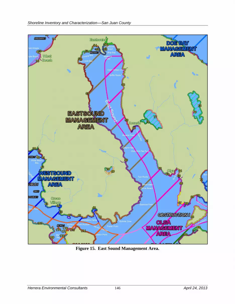
Shoreline Inventory and Characterization––San Juan County
Herrera Environmental Consultants 146 April 24, 2013
Figure 15. East Sound Management Area.
Shoreline Inventory and Characterization––San Juan County
April 24, 2013 147 Herrera Environmental Consultants
Streams and Associated Wetlands
Similar to the West Sound management area, there are a number of small streams within the
management area. These include a stream in Grindstone Harbor (in addition to the stream that
divides the West Sound and East Sound management areas), the stream outlet of Martins Lake
and a stream in Gutherie Cove, and stream that drains to Judd Cove. The large stream that feeds
Grindstone Harbor and the stream that drains to Judd Cove both have been documented to
sustain fish.
In addition to the stream mouths there are two lagoon/wetland systems at the head of East Sound
on the Eastsound waterfront. One of these areas has been largely filled and highly modified (the
wetland called the Eastsound Swale) associated with Fishing Bay and the heart of the Eastsound
commercial district: U.S. Coast and Geodetic Survey 1889c), while the other wetland complex
associated with Crescent Beach is largely intact, although this complex is also affected by the
construct of Crescent Beach Road.
Critical or Priority Habitat and Species Use
Ship Bay contains suitable habitat for various clam and crab species; all reaches within this
management area have at least one documented shellfish species. The small stream entering East
Sound from Martin Lake to the west supports coastal cutthroat trout. Crescent Beach is a known
forage fish spawning beach (reaches 55 through 57) with documented herring spawing ranging
beyond to reaches 53-57. Additional herring spawning is documented in reach 50. Nearshore
waters along the shoreline from Judd Cove to Coon Hollow (reaches 52 through 57) are critical
habitat for Pacific herring spawning as well as portions of reach 50 further to the south. The
rocky western shoreline of East Sound contains habitat suitable for rockfish. The management
area does not contain habitat that would be suitable for floating kelp species such as bull kelp
that require well circulated water and rock substrates; however, understory kelp is reported
intermittently present from Judd Cove to Crescent Beach (reaches 49 through 51, 55 and 57).
Documented eelgrass is present in a patchy distribution from Grindstone Harbor to Fishing Bay.
Herring spawning habitat is found in all but two reaches within the management area.
Marine Riparian, Nearshore, and Estuarine Habitats
Estuarine habitat is patchy throughout the management area. However, these patchy areas of
nearshore wetland and freshwater influences contribute to riparian habitat diversity and the high
biological productivity of East Sound. Such areas could provide suitable rearing areas for salmon
smolts potentially entering the area.
Water Quality, Sediment, and/or Tissue Sample Results
Several water quality problems have been documented in the East Sound management area. The
primary water quality problem is low dissolved oxygen concentrations; the East Sound was
303(d) listed for dissolved oxygen in 2008 (Ecology 2011e). Although the East Sound is located
in an area with physical characteristics or circulation patterns that may increase its susceptibility
to anthropogenic effects relative to other parts of the Puget Sound, the Department of Ecology’s
staff determined that the dissolved oxygen concentrations observed at this location may reflect
human influences and warrants further examination (Ecology 2011e). The East Sound is listed as

Shoreline Inventory and Characterization––San Juan County
Herrera Environmental Consultants 148 April 24, 2013
Category 2 “Waters of Concern” due to a small fraction of the pH samples that did not meet
water quality criteria (Ecology 2011e). The East Sound, however, did meet water quality criteria
for temperature and ammonia-nitrogen (Ecology 2011e).
Streams discharging to the East Sound have also been documented with water quality problems,
including high fecal coliform bacteria concentrations, low dissolved oxygen concentrations, and
high conductivity (Wiseman et al. 2000; SJCD 2005).
One sediment sample collected from East Sound exceeded the Sediment Management Standards
SQS bioassay criterion; sediment in this area is listed as a Category 2 “Sediments of Concern”
(Ecology 2011e).
4.4.2 Shoreline Use Patterns
Existing Land and Shoreline Use
Land Use
The East Sound management area extends from Grindstone Harbor to the eastern edge of Ship
Bay. Shoreline jurisdiction in this management area is predominantly residential.
Overall existing land use in the East Sound management area includes:
Residential – 62 percent
Trade – 1 percent
Cultural, Entertainment, Recreation – 10 percent
Undeveloped Land – 26 percent
The area between Grindstone Harbor and Guthrie Cove is mostly residential with some
unclassified, cultural/recreation, and vacant land interspersed. The area east of Guthrie Cove is
developed with rural residential uses. Beyond this development, existing land uses include a mix
of larger lot residential, conservation, vacant, resource, unclassified, and cultural/recreation uses.
Residential becomes a more predominant use, particularly north of Dolphin Bay. A large parcel
of cultural/recreation land use (Indralaya, a retreat center) exists south of Judd Cove. San Juan
County Land Bank’s preservation land is located to the north of this recreational use. Judd Cove
itself is largely residential, but with one manufacturing use located among the existing
residences. More dense residential uses exist further north and east in the Eastsound UGA,
particularly between Fishing Bay and Madrona Point. The area just west of Madrona Point also
includes a mix of existing uses consisting of service, trade, and cultural/recreation uses. Madrona
Point itself is a cultural/recreation use owned by the Lummi Nation. East of Madrona Point, in
Ship Bay, the existing uses along the marine shoreline consist of a small amount of residential,
cultural/recreation uses, and Crescent Beach area where a wetland extends shoreline jurisdiction
inland. The Crescent Beach area also includes a DNR lease for an aquaculture operation. The
east side of Ship Bay is characterized by suburban intensity residential development and a single
trade land use. There are also privately owned Oyster Tracts in the East Sound Area.

Shoreline Inventory and Characterization––San Juan County
April 24, 2013 149 Herrera Environmental Consultants
Additional shoreline use includes a DNR utility line easement. The tidelands are a mix of state-
owned aquatic lands and private ownership.
Water-dependent uses in this management area include docks, piers and marine railways, most of
which are private or community-owned. A public marine facility is located in the Eastsound area
on Madrona Point. Water enjoyment uses consist of several hotel/lodging facilities, particularly
close to and within Eastsound, and other retail trade-eating/drinking establishments in Eastsound
UGA. Another water enjoyment use is the Eastsound Waterfront County Park, located west of
Madrona Point.
Land Use Designations
Comprehensive Plan land use designations in this management area consist of Rural Farm Forest
from Grindstone Harbor to Guthrie Cove. The east side of Guthrie Cove provides a small area of
Rural Residential where an existing residential development exists. From Guthrie Cove to the
north side of Fishing Bay on the west side of Eastsound UGA, land in shoreline jurisdiction is
designated Rural Farm Forest.
Eastsound is the largest community on Orcas Island, serving as the focal point of existing and
future growth on Orcas Island. Between Fishing Bay and the east end of Ship Bay, a number of
different future land designations exist reflecting the more urban and suburban character of
Eastsound. These designations include Eastsound Rural Residential, a variety of Eastsound
Residential districts ranging from 2 dwelling units per acre to 12 dwelling units per acre, Rural
Commercial, Eastsound Natural (Madrona Point and Indian Island), and Eastsound Rural.
Shoreline Environment Designations
Shoreline environment designations are Rural Farm-Forest from Grindstone Harbor to a point
south of Dolphin Bay. From there the shoreline use environment designations alternate between
Conservancy and Rural Farm-Forest until the Eastsound UGA. The Eastsound UGA has a
variety of specific shoreline use designations for this more intensely developed area. Eastsound
Residential is applied from the western part of the UGA to the east side of Eastsound Waterfront
County Park. From there to the western edge of Madrona Point, the designation is Eastsound
Urban, reflecting the urban character of this segment of shoreline jurisdiction in the heart of
Eastsound. The northern part of Madrona Point is Eastsound Residential on both sides of the
point, with a Natural designation applied to both Indian Island and the south side of Madrona
Point. East of Madrona Point is a Conservancy designation followed by additional Eastsound
Residential to the eastern edge of the management area.
Shoreline Modifications
Approximately 3.3 percent of the management area is armored, near the average percentage for
the County. The armoring is strongly correlated to pocket beaches and areas of glacial sediment.
Considering much of the management area is bedrock, if the percentage of armoring would be
expressed in terms of pocket beach area only, the percentage of armoring would be significantly
larger. There is modest number of overwater structures (22) in the management area, most of
which are docks and piers and are concentrated in the village of Eastsound, and other protected

Shoreline Inventory and Characterization––San Juan County
Herrera Environmental Consultants 150 April 24, 2013
embayments near the village. There is only one boat ramp and three marine railways. There are
no marinas. Most of the mooring buoys are clustered in the small protective embayments in the
southwestern corner of the management area.
Existing and Potential Public Access Areas
Existing Facilities
The Eastsound management area contains over 17.5 miles of shoreline and has several
opportunities for public access, including the Eastsound Waterfront Park and Madrona Dock,
Crescent Beach, and Judd Cove Natural Area Preserves, and nearly 2,500 feet of trails and paths.
Crescent Beach Drive runs parallel to the shoreline offering public access to Crescent Beach.
Crescent Beach is a Natural Area Preserve of over 100 acres and more than 2,000 feet of
waterfront, together with space for walking trails and off-road parking. Judd Cove Preserve is
located in a secluded, well-protected inlet with scenic value and habitat for shorebirds, waterfowl
and marine life. Public access has been enhanced by improved trailhead parking.
Existing Facilities with Potential for Improvement
Eastsound Madrona Dock, a 150-foot fixed dock with a 40-foot seasonal floating dock, offers
opportunities for improved public access to the adjacent beach as well as parking and signage
improvements. The Parks Plan recommends installation of an interpretive panel/kiosk and bench.
Madrona Point is owned by the Lummi Nation where public access is prohibited. This
management area lacks campgrounds or boat launching facilities.
4.4.3 Restoration Opportunities
The village of Eastsound was one of the first places in the County to be settled. Because early
development was often made without regard to environmental consequences, most of the
restoration opportunities lie close to the village. Crescent Beach just east of the village center is
backed by a largely intact and protected wetland complex. However, there are a couple of
residential structures and Crescent Beach Drive that separate and disconnect this wetland
complex from East Sound. Restoring predevelopment-level nearshore processes to this area by
reconnecting the wetland to East Sound in a more natural way would provide enormous habitat
improvements and would restore the wetland’s historical estuarine features.

Shoreline Inventory and Characterization––San Juan County
April 24, 2013 151 Herrera Environmental Consultants
Table 24A. East Sound Management Area Reach Assessment – Physical Conditions.
Reach
Natural
Sediment
Transport
Patterns
Shoreline
Sediment Input
Alterations -
Feeder Bluffs
Shoreline
Sediment
Input
Alterations -
Beaches
Shoreline
Sediment
Input
Alterations -
Barrier
Beaches
Natural
Current
Patterns
Wave &
Current
Attenuation
Nutrient
and
Toxics
Remova
l Shade Total
49 5 NP 4 NP 5 4 5 3 26
50 3 NP 4 NP 5 4 2 4 22
51 5 5 5 NP 5 5 2 4 31
52 5 5 5 NP 5 4 2 4 30
53 5 NP 5 NP 3 4 2 3 22
54 5 NP 0 NP 0 2 2 2 11
55 5 NP 3 5 3 4 2 3 25
56 5 NP NP 3 3 3 2 0 16
57 5 4 NP NP 3 4 2 2 20
Median 5.00 5.00 4.00 4.00 3.00 4.00 2.00 3.00 22.00
Average 4.78 4.67 3.71 4.00 3.56 3.78 2.33 2.78 22.56
Percent of Highest
Possible Score 96% 93% 74% 80% 71% 76% 47% 56% 56%
NP = Not Present

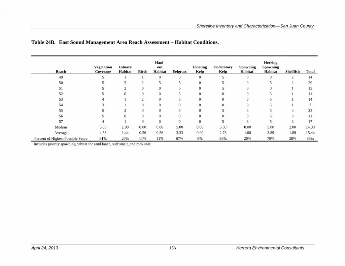
Shoreline Inventory and Characterization––San Juan County
April 24, 2013 153 Herrera Environmental Consultants
Table 24B. East Sound Management Area Reach Assessment – Habitat Conditions.
Reach
Vegetation
Coverage
Estuary
Habitat Birds
Haul-
out
Habitat Eelgrass
Floating
Kelp
Understory
Kelp
Spawning
Habitat1
Herring
Spawning
Habitat Shellfish Total
49 5 1 1 0 5 0 5 0 0 2 14
50 5 5 2 5 5 0 5 0 5 2 29
51 5 2 0 0 5 0 5 0 0 1 13
52 5 0 0 0 5 0 0 0 5 1 11
53 4 1 2 0 5 0 0 0 5 1 14
54 3 1 0 0 0 0 0 0 5 1 7
55 5 2 0 0 5 0 5 3 5 3 23
56 5 0 0 0 0 0 0 3 5 3 11
57 4 1 0 0 0 0 5 3 5 3 17
Median 5.00 1.00 0.00 0.00 5.00 0.00 5.00 0.00 5.00 2.00 14.00
Average 4.56 1.44 0.56 0.56 3.33 0.00 2.78 1.00 3.89 1.89 15.44
Percent of Highest Possible Score 91% 29% 11% 11% 67% 0% 56% 20% 78% 38% 39% 1 Includes priority spawning habitat for sand lance, surf smelt, and rock sole.


Shoreline Inventory and Characterization––San Juan County
April 24, 2013 155 Herrera Environmental Consultants
4.5 Fisherman Bay Management Area
Fisherman Bay management area extends from the transition of sediment to bedrock at Kings
Point in the south to Odlin County Park in the north. It includes Fisherman Bay, which borders
Lopez Village. There are no major transportation related uses in this management area.
Table 25 is a summary of the reach assessment for the Fisherman Bay management area. The
table is in two parts, one covering general physical conditions, the other addressing those
conditions directly related to habitat functions. The following discussions cover both the
conditions scored in the reach assessment (Tables 25A and B) and management area results from
the ecosystem-wide characterization. The Fisherman Bay management area is the lowest scoring
for both physical structure and for habitat functions. Physical conditions are scored low because
there are generally fewer pocket beaches and where there are feeder bluffs or barrier beaches,
they are often modified. There are also a number of outfalls, reaches in areas listed on Ecology’s
303d list of waters of concern, and much of the shoreline vegetation has been modified affecting
nearshore shade. From a habitat perspective, the management area is generally lacking in both
understory and floating kelp as well as priority fish spawning habitat.
4.5.1 Physical and Biological Characterization
Nearshore Physical Processes
The management area is comprised entirely of glacial sediment rather than bedrock, and is
therefore more similar to Puget Sound than the rest of the County from a physical process
perspective. The glacial sediments that comprise the management area also possess the same
sequence of bedding as in Puget Sound, with the possible exception that glacial drift is much
more common in the management area. The result is a series of drift cells. The largest drift cell
extends from the southern limit of the management area to the tip of the spit that protects
Fisherman Bay. The drift cell on the outer beach of the spit is an important salmon migration
corridor. A set of divergent drift cells define the shoreline between Fisherman Bay and Flat
Point. Another set of divergent drift cells are present between Flat Point and Odlin County Park.
Sediment transport within Fisherman Bay is minimal, but complex.
Wave energy is also typical of Puget Sound. Significant fetch is present to the south for the
southern half of the management area, but the shoreline is oriented nearly parallel to southerly
winds giving rise to significant alongshore transport. Tidal currents are significant, but not large
(i.e., generally less than 1 knot), increasing to the south (Canadian Hydrographic Service 2010).

Shoreline Inventory and Characterization––San Juan County
Herrera Environmental Consultants 156 April 24, 2013
Figure 16. Fisherman Bay Management Area.

Shoreline Inventory and Characterization––San Juan County
April 24, 2013 157 Herrera Environmental Consultants
Geologic Hazards
The most significant geologic hazard in the management area is landsliding from two feeder
bluff complexes north and south of Fisherman Bay. There is also a feeder bluff complex in
between Flat Point and Odlin County Park that could be unstable. Liquefaction risk is variable.
Liquefaction risk is moderate to high around the fringes of the Fisherman Bay and the wetland
complex at Flat Point. It is also moderate along the shoreline at the southern end of the
management area, but low to non-existent elsewhere. The management area lacks the surficial,
relict (and active) tectonism common in the rest of the County. There is also a minimal tsunami
risk, coming only from local landslide-generated tsunamis.
Streams and Associated Wetlands
Wetlands and fringing salt marshes are extensive along the margins of Fisherman Bay. The
northern portion of the stream network that drains to the bay is ditched. There is also a wetland
complex at Flat Point. There may have been also been a wetland complex in present-day Odlin
County Park, which is now ditched. There are no mapped streams in the management area.
Critical or Priority Habitat and Species Use
Clam habitat is somewhat limited. Conditions are most suitable for sea urchin along the
shorelines south of Fisherman Bay, and potentially suitable for geoduck clams off the outer
shoreline of the peninsula that forms Fisherman Bay. Pacific herring and other forage fish
spawning has not been documented in the management area, but a large portion of the
management area has suitable habitat for forage fish spawning, and two sites (near Fisherman
Bay Spit and Odlin Park) may have potential, indicated by one-egg counts during surveys
(Friends of the San Juans 2004b). Two eggs must be counted for protection under the
Washington Administrative Code. The shoreline vegetation is comprised partly by a narrow band
of eelgrass that appears continuous from the northern extent of the management area near Odlin
Park to White Cliffs at the southern extent. Floating kelp is limited in extent to the west side of
Fisherman Bay spit and from Rock Point to White Cliffs (reaches 148 and 150). Understory kelp
is documented at Flat Point (reach 136) and the tip of Fisherman Bay spit (reach 47). Bald eagles
have been observed along the shoreline from the Fisherman Bay Spit to White Cliffs at the
southern extent of the management area, likely in part due to significant trees on high bluffs that
provide perching and nesting opportunities.
Marine Riparian, Nearshore, and Estuarine Habitats
Fisherman Bay contains estuarine habitat in all but two reaches. The shoreline generally lacks
significant pocket beaches that would support fish rearing and migration. However, the extensive
eelgrass, beach wrack, and a relatively unbroken forested shoreline jurisdiction likely contribute
to suitable habitat conditions for important species and their prey.
Water Quality, Sediment, and/or Tissue Sample Results
Water quality samples collected from the south end of Fisherman Bay lagoon exhibited low fecal
coliform bacteria concentrations (SJC 2000). Fisherman Bay is also classified as Category 2
“Waters of Concern” due to periodic low dissolved oxygen concentrations (Ecology 2011e). The

Shoreline Inventory and Characterization––San Juan County
Herrera Environmental Consultants 158 April 24, 2013
water quality of several ditches and outfalls that discharge to Fisherman Bay have also been
monitored; elevated fecal coliform bacteria and low dissolved oxygen concentrations were
documented in several studies (SJC 2000; Wiseman et al. 2000; SJCD 2005).
Sediment samples have also been collected from Fisherman Bay that exceeded Sediment
Management Standards CSL chemistry criteria for 1,2,4-Trichlorobenzene, 1,2-Dichlorobenzene,
and Hexachlorobenzene; sediment in this area is classified as Category 2 “Sediments of
Concern” (Ecology 2011e).
4.5.2 Shoreline Use Patterns
Existing Land and Shoreline Use
Land Use
The Fisherman Bay management area extends from Kings Point on the southwest side of Lopez
Island to the northern tip of Lopez Island. Overall existing land use in the Fisherman Bay
management area includes:
Residential – 74 percent
Trade – 1 percent
Services – 1 percent
Cultural, Entertainment, Recreation – 8 percent
Undeveloped Land – 16 percent
Existing land uses between King Point and Rock Point consist largely of large lot residential
uses. From Rock Point to the north side of Lopez Village, including both sides of Fisherman
Bay, the area is characterized by smaller lot residential development with a wider mix of existing
land uses located near Lopez Village. The east side of Fisherman Bay south of Lopez Village
includes three trade, one government/education, and one manufacturing land use. There is a large
conservation parcel at the entrance to Fisherman Bay at the south end of Lopez Village. Lopez
Village itself includes a small number of trade land uses, such as restaurants and retail
establishments in amongst the small lot residential development that characterizes this part of
Lopez Island. The remainder of this management area, north to Flat Point, is characterized by
residential development with one large resource parcel located near Flat Point. Between Flat
Point and the end of the management area at the northern tip of Lopez Island the area is
predominantly residential with two large cultural/recreation parcels interspersed. Fisherman Bay
is an important transportation hub for Lopez Island residents, visitors, and commercial business.
In addition to private boats, it is served by seaplanes.
Additional shoreline use includes several DNR utility line easements. The tidelands are a mix of
state-owned aquatic lands and private ownership.
Water-dependent uses in this management area include marinas in and near Lopez Village, and
docks, piers, and marine railways, most of which are private. Among these, a public marine
facility exists at Odlin Park in the northern part of the management area. Water enjoyment uses
include eating and retail establishments in Lopez Village, hotel/lodging in and near Lopez
Village, and Odlin Park. The Fisherman Bay spit supports annual reef netting operations.

Shoreline Inventory and Characterization––San Juan County
April 24, 2013 159 Herrera Environmental Consultants
Land Use Designations
The Comprehensive Plan land use designation from Kings Point north to Fisherman Bay is Rural
Farm Forest. A small area in the southeast portion of Fisherman Bay is designated Rural
Residential where an existing small lot residential development exists. At the northern entrance
to Fisherman Bay, Lopez Village Urban Growth Area and Lopez Village Growth Reserve Area
are found on the eastern shore. These areas are characterized by more intense urban/suburban
development patterns with smaller lots than found in most other places in the County, with the
exception of Eastsound and Friday Harbor. They also have a wider mix of uses concentrated in a
small area. North of Lopez Village to the end of the management area at the northern tip of
Lopez Island, the majority of shoreline jurisdiction area is designated Rural Farm Forest
reflecting generally larger lot residential development. There are two exceptions that are
designated Conservancy where Washington State DNR and San Juan County Park property exist.
Shoreline Environment Designations
The southern part of the management area to the entrance to Fisherman Bay is characterized by a
Conservancy use environment. The west side of Fisherman Bay is in the Residential Rural-Farm
shoreline environment, with the southern portion in Rural Residential. The eastern side of
Fisherman Bay is characterized by alternating areas of Rural and Urban shoreline environments,
with Conservancy applied on the eastern entrance to Fisherman Bay. Further north, a Rural
Residential/Conservancy split environment is applied to the area near Lopez Village north of the
entrance to Fisherman Bay. Conservancy is applied to the shoreline environment further north to
the east side of Flat Point, with an area of Rural Farm-Forest east of that. Odlin Park at the
northern end of the management area is designated Conservancy.
Shoreline Modifications
Nearly 20 percent of the management area is armored, much higher than the average percentage
for the County and more than many rural areas of Puget Sound (USGS 2010). Because this
management area is comprised entirely of glacial sediments, the true percentage of armoring is
reflected appropriately here. This percentage is probably comparable to the actual percentage of
armoring of pocket beach shorelines elsewhere in the County.
Fisherman Bay is a great natural harbor and, as a result, the management area has the largest
number of mooring buoys (164) anywhere in the County, aside from the Decatur Island
management area, which has only one more. Nearly all of these mooring buoys are in the bay.
There are also four marinas in the bay. Fill is also common along the fringes of the bay. The
remainder of the management area is less developed and reflects conditions typical of rural
portions of the County. However, there are five groins in this management area, more than
anywhere else in the County. It is likely that this is because the sediment-rich shorelines and
large drift cells make groin placement much more effective than elsewhere in the County where
sediment supply and transport is much more confined.
Existing and Potential Public Access Areas
Fisherman Bay management area has nearly 14 miles of shorelines and over 6,400 feet of trails
and paths.

Shoreline Inventory and Characterization––San Juan County
Herrera Environmental Consultants 160 April 24, 2013
Existing Facilities
Fisherman Bay Preserve. This preserve area has three unique features: the
spit, the tombolo and Weeks Wetland. The sandy spit marks the entrance
to Fisherman Bay. The tombolo is a connection between the islands and
acts as a buffer between San Juan Channel and Fisherman Bay. The
24-acre Weeks Wetland is a unique saltwater wetland with a trail and
observation deck. All of the property in the Fisherman Bay preserves
provides habitat for wildlife.
Lopez Village Road end provides a public staircase to the beach and has
associated parking.
Weeks Point Road end is located in Lopez Village and provides access to
the water and views of the entrance to Fisherman Bay. Amenities at this
developed road end include: parking for six cars, a picnic table, a
launching area for hand-carried boats, and appropriate signage
differentiating between the public access and adjacent private properties.
The shoreline has 6,424 feet of trails, primarily located at the tombolo and
the spit area.
Existing Facilities with Potential for Improvement
This management area contains public access opportunities in the form of parks, trails, natural
area preserves, and road ends including, but not limited to:
Odlin County Park is a roughly 80-acre regional park that includes a
campground, picnic areas, boat launch, dock, ball fields, and a sandy
beach. The Parks Plan recommends exploring expansion opportunities,
renovating the park in accordance with the 2006 Master Plan, and
installing directional and way finding signage.
Otis Perkins Day Park provides views of Griffin Bay as well as bird and
wildlife viewing opportunities. The park contains approximately 220 feet
of gravel beach and an unpaved parking area that can accommodate ten
cars. The park also has one picnic table and a portable toilet. The Park
Plan recommendations include updating the park sign and installing a
portable toilet with an enclosure or concrete pad.
Shoreline Inventory and Characterization––San Juan County
April 24, 2013 161 Herrera Environmental Consultants
4.5.3 Restoration Opportunities
Fisherman Bay has numerous impairments to nearshore functions. These include ditched
(concentrated) upland freshwater sources to the bay, fill, armoring and bulkheading, overwater
structures and a very large number of mooring buoys and pilings, some of which are likely not in
current use. Because this all occurs within a confined area and a considerable amount of land is
collectively held, a feasibility study could be undertaken to identify opportunities to improve this
potentially great natural resource.
In addition to work at Fisherman Bay, Odlin County Park could also be a target for restoration.
Historic maps indicate that the meadow area and parking lot in the center of the park were once a
sloping marsh (U.S. Coast and Geodetic Survey 1889d). Restoration of this area would increase
shorebird populations in the area and provide rearing habitat for migrating salmonids.

Shoreline Inventory and Characterization––San Juan County
Herrera Environmental Consultants 162 April 24, 2013
Table 25A. Fisherman Bay Management Area Reach Assessment – Physical Conditions.
Reach
Natural
Sediment
Transport
Patterns
Shoreline
Sediment Input
Alterations -
Feeder Bluffs
Shoreline
Sediment
Input
Alterations -
Beaches
Shoreline
Sediment
Input
Alterations -
Barrier
Beaches
Natural
Current
Patterns
Wave &
Current
Attenuation
Nutrient
and
Toxics
Removal Shade Total
135 3 5 NP NP 2 4 5 4 23
136 5 3 NP 5 5 4 5 4 31
137 5 4 NP 5 5 4 5 3 31
138 5 3 NP NP 5 2 5 3 23
139 5 NP NP 5 2 2 3 1 18
140 5 NP NP 5 5 4 3 1 23
141 5 NP NP NP 0 2 3 2 12
142 5 NP NP NP 5 2 3 4 19
143 3 NP NP 4 0 3 3 2 15
144 5 NP NP NP 1 4 3 3 16
145 5 NP NP 1 3 3 3 1 16
146 1 0 NP 3 3 3 3 1 14
147 5 NP 5 5 5 4 3 1 28
148 5 NP NP NP 5 5 5 3 23
149 5 NP NP NP 5 4 5 0 19
150 3 4 NP 5 5 4 5 3 29
Median 5.00 3.50 5.00 5.00 5.00 4.00 3.00 2.50 21.00
Average 4.38 3.17 5.00 4.22 3.50 3.38 3.88 2.25 21.25
Percent of Highest
Possible Score 88% 63% 100% 84% 70% 68% 78% 45% 53%
NP = Not Present

Shoreline Inventory and Characterization––San Juan County
April 24, 2013 163 Herrera Environmental Consultants
Table 25B. Fisherman Bay Management Area Reach Assessment – Habitat Conditions.
Reach
Vegetation
Coverage
Estuary
Habitat Birds
Haul-out
Habitat Eelgrass
Floating
Kelp
Understory
Kelp
Spawning
Habitat1
Herring
Spawning
Habitat Shellfish Total
135 5 1 1 0 5 0 0 0 0 2 14
136 5 1 0 0 5 0 5 0 0 1 17
137 5 3 0 0 5 0 0 0 0 1 14
138 4 1 1 0 0 0 0 0 0 1 7
139 4 1 0 0 5 0 0 0 0 1 11
140 5 5 1 0 5 0 0 0 0 1 17
141 4 0 0 0 5 0 0 0 0 1 10
142 4 1 0 0 5 0 0 0 0 1 11
143 5 3 0 0 5 0 0 0 0 1 14
144 5 2 0 0 0 0 0 0 0 1 8
145 5 5 1 0 5 0 0 0 0 3 19
146 4 1 0 0 5 0 0 0 0 1 11
147 5 5 0 0 5 0 5 0 0 2 22
148 5 1 0 0 5 5 0 0 0 2 18
149 5 0 0 0 5 0 0 0 0 2 12
150 5 3 2 0 5 5 5 0 0 2 27
Median 5.00 1.00 0.00 0.00 5.00 0.00 0.00 0.00 0.00 1.00 14.00
Average 4.69 2.06 0.38 0.00 4.38 0.63 1.67 0.00 0.00 1.44 14.50
Percent of
Highest Possible
Score 94% 41% 8% 0% 88% 13% 33% 0% 0% 29% 29% 1 Includes priority spawning habitat for sand lance, surf smelt, and rock sole.

Shoreline Inventory and Characterization––San Juan County
April 24, 2013 165 Herrera Environmental Consultants
4.6 Friday Harbor Management Area
The Friday Harbor management area includes unincorporated portions of Friday Harbor and
Griffin Bay on San Juan Island, extending southwards to Cattle Point. The management area
includes Brown Island, Turn Island, and Dinner Island, as well as several small uninhabited
islets, primarily around Reef Point. There are no major transportation related uses in this
management area.
Table 26 is a summary of the reach assessment for the Friday Harbor management area. The
table is in two parts, one covering general physical conditions, the other addressing those
conditions directly related to habitat functions. The following discussions cover both the
conditions scored in the reach assessment (Tables 26A and B) and management area results from
the ecosystem-wide characterization. Physical conditions score about 65 percent of the possible
score primarily due to the large number of modifications of the shoreline including outfalls and
shoreline armoring. Habitat functions also score relatively low primarily from reduced vegetation
cover in some reaches, and few reaches with haul-out habitat, floating kelp and priority fish
spawning habitat. There is a general trend in the reach assessment, with those reaches closest to
the Town of Friday Harbor (in particular, reach 266) scoring lowest. Those reaches closer to
Cattle Point score much higher, and are more typical of other sparsely developed areas of the
County.
4.6.1 Physical and Biological Characterization
Nearshore Physical Processes
The geology of the Friday Harbor management area is diverse. While metal-rich bedrock is
common in some areas (i.e., the two primary promontories: Cattle Point and Reef Point), there
are thick layers of glacial outwash and drift in the isthmuses that connect these points of land to
the rest of San Juan Island. The presence of glacial sediments provides the nearshore with
sediment in places and gives rise to lagoons and tombolos, which are common in this
management area, particularly on the isthmuses.
Several drift cells have been mapped in this management area. The largest drift cell provides
sediment to a series of barrier lagoons on the isthmus associated with Cattle Point. Drift is from
east to west. There is a second smaller drift cell that originates from the same short, but
significant, feeder bluff that terminates in the bedrock of Cattle Point. In addition Cattle Point
also has a drift cell near Goose Island. There are a series of small drift cells associated with
pocket beaches between Turn Point and Argyle Lagoon. Brown and Turn Island also have small
drift cells on the southern shoreline.
Some of the largest tidal currents in the County are encountered through the San Juan Channel as
it passes between Lopez and San Juan islands. Currents in excess of 2.5 knots are common in
this area (Canadian Hydrographic Service 2010). The remainder of the management area has
lesser currents and the two primary embayments are relatively quiescent. Wave energy is modest
as most of the area has limited fetch due to the proximity of other islands.

Shoreline Inventory and Characterization––San Juan County
Herrera Environmental Consultants 166 April 24, 2013
Figure 17. Friday Harbor Management Area.

Shoreline Inventory and Characterization––San Juan County
April 24, 2013 167 Herrera Environmental Consultants
Geologic Hazards
The geologic hazards are relatively modest in comparison to other portions of the County.
Liquefaction is possible near the lagoons in glacial outwash within the San Juan Island National
Historic Park, but is unlikely elsewhere in the management area due to the presence of competent
bedrock. The glacial outwash in the Park is also subject to landsliding, and represents the only
significant landslide threat in the management area. Tsunamis are unlikely and would likely only
be a result of landslide-generated tsunamis generated on other adjacent islands.
Streams and Associated Wetlands
There are 10 very small streams in this management area. None of them are currently fish
bearing. These streams have numerous culverts in the shoreline management zone, particularly in
the northern portion of the management area, indicating significant modifications have occurred.
There are several natural lagoons at the south end of Griffin Bay. These are largely intact
features. Also included in this management area is Argyle Lagoon, which is adjacent to a large
gravel pit. It is uncertain to what extent it is a natural feature since the T-sheet for this area shows
existing development (U.S. Coast and Geodetic Survey 1897b).
Critical or Priority Habitat and Species Use
Griffin Bay contains pandalid shrimp habitat, as well as some nearshore areas suitable for clam
species (in the vicinity of barrier beaches at Jakles Lagoon and Fish Creek) including geoduck
(North Bay). Beaches near Argyle Lagoon, Jackson Beach, and Jensen Bay provide spawning
habitat for forage fish including sand lance and surf smelt. Juvenile Chinook, chum, and pink
salmon have been documented in Griffin Bay nearshore areas (Wyllie-Echeverria and Barsh
2007). Small islands including Dinner Island and Harbor Rock provide habitat for seabirds. The
shoreline also provides habitat for bald eagles, although use by this species may be limited
compared to other management areas due to current development or relative lack of suitable
trees. The rocky headlands and islets common throughout the management area contain habitat
suitable for rockfish. Eelgrass is documented in all but one reach of this management area and
understory kelp is found in all. Floating kelp is patchier in its distribution overall but clustered
near Danger Rock, Reef Point and Turn Island (reaches 259 through 263). Up to three species of
shellfish are found within every reach. Priority fish spawning habitat is documented in Jensen
Bay, Argyle Lagoon and Pear Point (reaches 2564, 256 and 257).
Marine Riparian, Nearshore, and Estuarine Habitats
Estuarine habitat is present within all reaches but generally two acres or less within each reach.
The northern portions of the management area including North Bay, Merrifield Cove, and Mulno
Cove shorelines are relatively developed compared to other locations, resulting in relatively
disturbed terrestrial riparian vegetation. Thus significant forested areas are generally lacking
from these areas, but are prominent along the San Juan Island National Historic Park shoreline.
Water Quality, Sediment, and/or Tissue Sample Results
Several water quality problems have been documented in the Friday Harbor management area.
The primary water quality problems include low dissolved oxygen and elevated fecal coliform

Shoreline Inventory and Characterization––San Juan County
Herrera Environmental Consultants 168 April 24, 2013
bacteria concentrations; Friday Harbor was 303(d) listed for dissolved oxygen in 2008 and was
also 303(d) listed for fecal coliform bacteria in 1996 and 1998 (Ecology 2011e). Friday Harbor is
currently classified as a Category 2 “Waters of Concern” for fecal coliform bacteria (Ecology
2011e). In contrast, water quality results from two sample locations at Friday Harbor exhibited
low levels of fecal coliform bacteria concentrations (Wiseman et al. 2000). Several other water
quality studies have evaluated the water quality of streams discharging to Friday Harbor with
mixed results; Wiseman et al. (2000) and SJCD (2000) showed elevated levels of fecal coliform
bacteria concentrations while no water quality problems were reported in SJCD (2005).
Sediment in Friday Harbor exceeded Sediment Management Standards CSL chemistry
criteria for 1,2,4-Trichlorobenzene, 1,2-Dichlorobenzene, 1,4-Dichlorobenzene, and
Hexachlorobutadiene; sediment in this area is classified as Category 2 “Sediments of Concern”
(Ecology 2011e).
4.6.2 Shoreline Use Patterns
Existing Land and Shoreline Use
Land Use
The Friday Harbor management area extends from north of Cattle Point to the southern limits of
the Town of Friday Harbor on San Juan Island. It also includes the nearby smaller islands of
Dinner, Brown, and Turn islands. Overall existing land use in the Friday Harbor management
area includes:
Residential – 70 percent
Services – 2 percent
Cultural, Entertainment, Recreation – 18 percent
Undeveloped Land – 10 percent
Existing land uses are almost entirely small lot residential between the southern end of the
management area near Cattle Point, to Fish Creek east of the American Camp, the exceptions
being two vacant lots and an undeveloped conservation easement. The area between Fish Creek
and Fourth of July Beach is in cultural/recreation use (National Park Service – American Camp).
Between Fourth of July Beach and approximately Merrifield Cove existing land use patterns in
shoreline jurisdiction consist of larger lot residential, vacant, cultural/recreation, and small
amounts of unclassified land uses. Between Merrifield Cove and Argyle Lagoon, the area
becomes more intensely residential with smaller lot development. Two government/education
land uses exist in between Argyle Lagoon and Pear Point, along with some cultural/recreation
land uses. Jackson Beach to the southern Friday Harbor town limits consists mostly of residential
land uses with a small amount of conservation, vacant, and cultural/recreation uses mixed in.
Brown and Dinner islands are residential, and Turn Island is a cultural/recreation use.
Additional shoreline uses includes several DNR utility line easements, at least one desalination
system and a barge landing. The tidelands are a mix of state-owned aquatic lands and private
ownership.

Shoreline Inventory and Characterization––San Juan County
April 24, 2013 169 Herrera Environmental Consultants
Water-dependent uses include docks, piers, and marine railways, most of which are private or
community facilities. Water enjoyment uses in this management area include the American
Camp National Park, Jackson Beach Park, and the marine state park campground at Turn Island.
Land Use Designations
The Comprehensive Plan land use designation from the beginning of the management area north
of Cattle Point to the eastern edge of American Camp, west of Fish Creek, is designated Rural
Residential. American Camp itself is largely designated Conservancy to reflect the national park
status of this area; however, there are also small areas designated as Natural in places, such as
Jackles Lagoon. North of American Camp’s Fourth of July Beach to Mulno Cove, shoreline
jurisdiction is mostly in Rural Farm Forest with a small area of Agricultural Resource and
Conservancy in the south part. The existing residential area between the north end of Mulno
Cove and the south side of North Bay is designated Rural Residential. Further north, land use
designations transition to Rural Farm Forest until Argyle Lagoon, where it changes to Rural
Residential to the south Friday Harbor town limits in the town’s UGA. The area within the Town
of Friday Harbor’s UGA and just south of it provide for more intensity of development than
found in most of the remainder of the County, with the exception of Eastsound and Lopez
Village. There is one Rural Industrial parcel south of the town limits separated by two larger lot
residential parcels designated Rural Residential. Of the smaller islands, Brown Island, near
Friday Harbor, is entirely designated Rural Residential, while Dinner and Turn islands are
designated Natural.
Shoreline Environment Designations
The southern part of this management area is in Rural Residential shoreline environment,
reflecting the developed state of the management area east of American Camp. The American
Camp portion of the San Juan Island National Park includes both Conservancy and Natural
environments along its shoreline jurisdiction in this management area. The shoreline
environment designation is mostly Rural Farm-Forest north to the south side of Merrifield Cove,
with the exception of a small area of Natural environment designation at Low Point, and a Rural
Residential environment designation at Jensen Bay. Further north, Merrifield Cove is Rural
Residential, and a split designation of Natural and Rural Residential occurs further to the north
followed by more Rural Residential. Beyond that, the shoreline environment is Rural Farm-
Forest until approximately Argyle Avenue. Shoreline designations at the Argyle Lagoon and
Jackson Beach areas are a mix of Rural Residential, Conservancy, Natural, and Rural Farm-
Forest. From the east end of Jackson Beach to the outskirts of Friday Harbor, shoreline
environment designations alternate between Conservancy and Rural Residential. The shoreline
environment designation becomes Urban at the south end of Friday Harbor near Black Street to
the end of the management area. Brown Island is Rural Residential, Dinner Island is a
combination of Conservancy and Natural, and Turn Island is Natural. Remaining smaller islands
are either Conservancy, Natural or a combination of the two.
Shoreline Modifications
Approximately 6.6 percent of the management area is armored, much higher than the average
percentage for the County. Armoring is primarily located in areas of glacial sediment. For

Shoreline Inventory and Characterization––San Juan County
Herrera Environmental Consultants 170 April 24, 2013
example, the entire shoreline of a pocket beach near Reef Point is armored. While bedrock
outcrops are not as common in this management area as others, if the percentage of armoring
would be expressed in terms of pocket beach area only, the percentage of armoring would be
significantly larger. There are relatively large number of dock and piers (69) and other overwater
structures (13). These features increase in prevalence as the Town of Friday Harbor is
approached. There are also six boat ramps and four marinas. Mooring buoys are the only
structure relatively rare in the management area, but there are 75 of them, mostly located in and
around Friday Harbor.
Existing and Potential Public Access Areas
Existing Facilities
The Friday Harbor management area has approximately 24.2 miles of shorelines, roughly
3,500 feet of trails, and the following public access opportunities:
Carter Beach Road end leads to a grassy area with low bank that provides
a good launching point for kayaks headed to Turn Island.
Mill Street ends at shoreline a little south of the Jackson Beach boat ramp.
It offers shoreline public access before it turns to connect with Wilks Way.
Third Lagoon Preserve is adjacent to American Camp National Historic
Park and Cattle Point Natural Resources Conservation Area. The site
contains a rare saltwater lagoon.
Jackson Beach boat ramp provides public access and launching facilities.
People are allowed to land, hike, and camp on parts of Turn Island
(Washington State Parks and Recreation Commission 2011).
Existing Facilities with Potential for Improvement
Halsey Road end stops 150 feet from high bank waterfront. The area has
potential for development as a view point looking across Griffin Bay to
San Juan Channel.
Jensen Bay Road end provides a beautiful view of Griffin Bay and a trail
down the medium bank waterfront to the beach. However, once at the
beach, public access is limited by signs on both sides of the road end
identifying the adjoining beach and tidelands as private and prohibit
trespassing.
Cameron Bay Road stops short of the water but the site provides a nice
view of bird nesting on one of the small outer islands. There is also a
picnic site accessible on foot.

Shoreline Inventory and Characterization––San Juan County
April 24, 2013 171 Herrera Environmental Consultants
Turn Point County Park – also identified as a road end in public works
documents – is located at the end of Turn Point Road, before it turns into
Pear Point Road. The park includes parking, a walking trail and benches at
a low-bank viewpoint. Beach access is available for launching hand-carry
boats. The Parks Plan identifies future improvements such as Americans
with Disability Act (ADA) accessibility, entry and way finding signage,
and installation of a portable toilet.
Mulno Cove Farm Conservation Easement contains 500 feet of Griffin
Bay shoreline and reduces development potential from 16 lots to 5 lots and
precludes development along the shoreline.
Public access and trail facilities are recommended in the Parks Plan. Generally, this management
area provides significant public access opportunities. The expansion, maintenance, and further
development of these opportunities will achieve the goals of the Comprehensive Plan and the
Parks Plan.
4.6.3 Restoration Opportunities
The largest and most obvious restoration opportunity in the Friday Harbor management area is
the restoration of Argyle Lagoon, which is owned by the University of Washington and is set
aside as marine preserve administered by WDFW, along with the adjacent LaFarge gravel pit.
The lagoon is a natural feature, as it is present in historic maps predating most development
(U.S. Coast and Geodetic Survey 1897b). However, there has been significant alteration to the
area near the gravel pit and associated marina. Restoration of the marsh shown in the T-sheet
should expand fish and bird use of the site and provide a good opportunity to showcase the
nearshore environment to residents and visitors of Friday Harbor.

Shoreline Inventory and Characterization––San Juan County
Herrera Environmental Consultants 172 April 24, 2013
Table 26A. Friday Harbor Management Area Reach Assessment – Physical Conditions
Reach
Natural
Sediment
Transport
Patterns
Shoreline
Sediment
Input
Alterations
- Feeder
Bluffs
Shoreline
Sediment
Input
Alterations
Beaches
Shoreline
Sediment
Input
Alterations
- Barrier
Beaches
Natural
Current
Patterns
Wave &
Current
Attenuation
Nutrient
and Toxics
Removal Shade Total
251 5 5 3 NP 5 4 5 3 30
252 5 NP 1 NP 5 4 5 3 23
253 5 5 NP 5 5 4 5 3 32
254 5 5 3 5 5 4 5 2 34
255 3 4 4 NP 0 4 5 3 23
256 5 NP NP 4 3 4 5 1 22
257 5 NP 5 NP 3 4 5 2 24
258 5 NP 5 NP 5 5 5 2 27
259 5 NP 1 NP 3 4 5 3 21
260 5 NP 5 NP 5 5 5 2 27
261 5 5 NP NP 5 5 5 3 28
262 5 5 0 NP 5 2 5 2 24
263 5 5 2 NP 3 4 5 4 28
264 3 4 5 NP 5 4 5 4 30
265 3 NP 1 NP 5 4 5 4 22
266 5 NP NP NP 5 4 5 1 20
Median 5.00 5.00 3.00 5.00 5.00 4.00 5.00 3.00 25.50
Average 4.63 4.75 2.92 4.67 4.19 4.06 5.00 2.63 25.94
Percent of Highest
Possible Score 93% 95% 58% 93% 84% 81% 100% 53% 65%
NP = Not Present
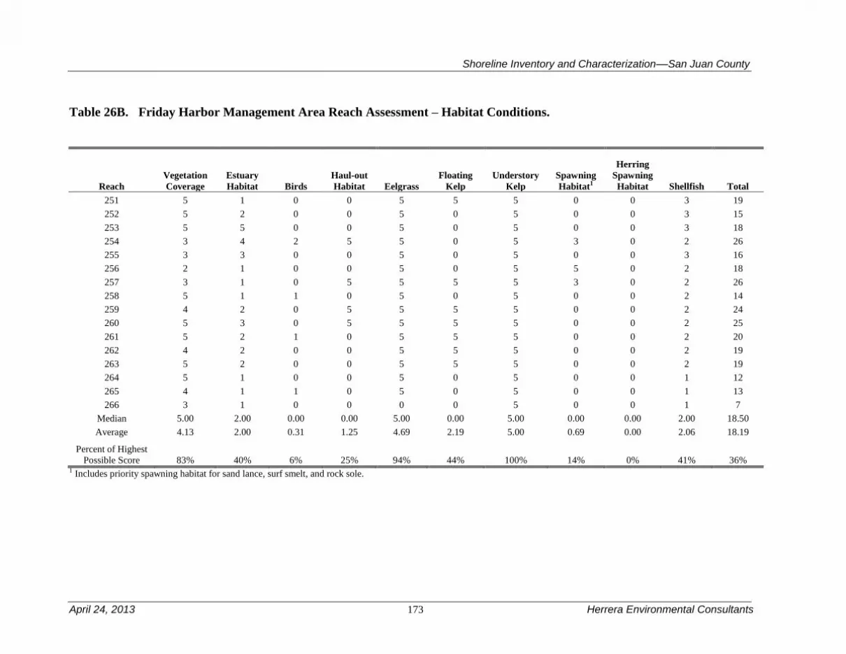
Shoreline Inventory and Characterization––San Juan County
April 24, 2013 173 Herrera Environmental Consultants
Table 26B. Friday Harbor Management Area Reach Assessment – Habitat Conditions.
Reach
Vegetation
Coverage
Estuary
Habitat Birds
Haul-out
Habitat Eelgrass
Floating
Kelp
Understory
Kelp
Spawning
Habitat1
Herring
Spawning
Habitat Shellfish Total
251 5 1 0 0 5 5 5 0 0 3 19
252 5 2 0 0 5 0 5 0 0 3 15
253 5 5 0 0 5 0 5 0 0 3 18
254 3 4 2 5 5 0 5 3 0 2 26
255 3 3 0 0 5 0 5 0 0 3 16
256 2 1 0 0 5 0 5 5 0 2 18
257 3 1 0 5 5 5 5 3 0 2 26
258 5 1 1 0 5 0 5 0 0 2 14
259 4 2 0 5 5 5 5 0 0 2 24
260 5 3 0 5 5 5 5 0 0 2 25
261 5 2 1 0 5 5 5 0 0 2 20
262 4 2 0 0 5 5 5 0 0 2 19
263 5 2 0 0 5 5 5 0 0 2 19
264 5 1 0 0 5 0 5 0 0 1 12
265 4 1 1 0 5 0 5 0 0 1 13
266 3 1 0 0 0 0 5 0 0 1 7
Median 5.00 2.00 0.00 0.00 5.00 0.00 5.00 0.00 0.00 2.00 18.50
Average 4.13 2.00 0.31 1.25 4.69 2.19 5.00 0.69 0.00 2.06 18.19
Percent of Highest
Possible Score 83% 40% 6% 25% 94% 44% 100% 14% 0% 41% 36% 1 Includes priority spawning habitat for sand lance, surf smelt, and rock sole.


Shoreline Inventory and Characterization––San Juan County
April 24, 2013 175 Herrera Environmental Consultants
4.7 Mud Bay Management Area
The Mud Bay management area is defined by the southeastern end of Lopez Island that is
comprised of bedrock (Figure 18). It extends from the transition from sediment bedrock at the
south end of Lopez Sound around numerous promontories and Mud Bay to Aleck Bay on the
south end of the island. The management area includes Boulder Island and Castle Island and
numerous small bedrock islets in Mud Bay. There are no major transportation related uses in this
management area.
Table 27 is a summary of the reach assessment for the Mud Bay management area. The table is
in two parts, one covering general physical conditions, the other addressing those conditions
directly related to habitat functions. The following discussions cover both the conditions scored
in the reach assessment (Tables 27A and B) and management area results from the ecosystem-
wide characterization. Mud Bay management area is among the higher scoring management
areas for both physical conditions and habitat functions. This is because the shoreline in general
has fewer modifications and there are a significant number of pocket beaches. From the habitat
perspective, there are many reaches with multiple shellfish species and priority fish spawning
sites, and a high percentage of vegetation coverage in the shoreline jurisdiction.
4.7.1 Physical and Biological Characterization
Nearshore Physical Processes
The Mud Bay management area is extremely diverse, even by County standards. The shoreline
varies from sediment-rich shorelines, similar to Puget Sound (such as at the southeast end of
Mud Bay) to steep, plunging bedrock shorelines comprised entirely of basalt. Much of the
shoreline is a mix of these shoreline types, where pocket beaches are common. Where sediment
exists, primarily in Mud Bay, there are several drift cells, two of which converge at the head of
Mud Bay and the large tombolo that connects Skull Island and Sperry Point to Lopez Island.
The physical forcing on the shorelines of the Mud Bay management area varies dramatically.
Promontories along the southern shoreline of Lopez Island (Point Colville, Castle Island) are
extremely exposed to high wave and tidal energy and are more similar to the Strait of Juan de
Fuca management area than any other area in the County. The embayments along the southern
and southeastern shoreline (Aleck Bay, Hughes Bay, and McArdle Bay, Watmough Bay and
Shoal Bight) are also extremely diverse with respect to wave energy depending on the aspect of
the shoreline of interest, with those shorelines facing south and west having the most energy.
Tidal energy is much lower than near promontories. Mud Bay itself is one of the quiescent areas
within the County, both with respect to waves and tides.
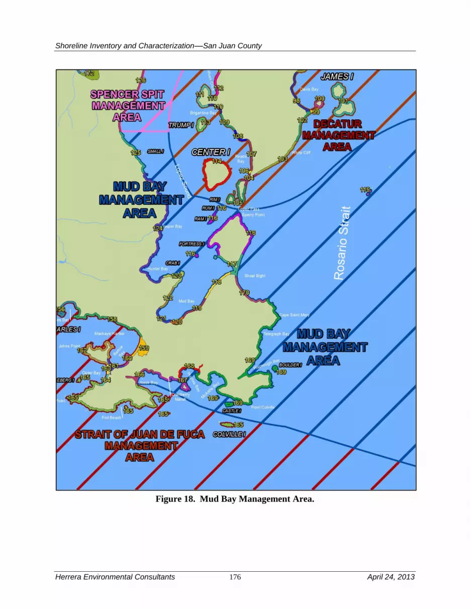
Shoreline Inventory and Characterization––San Juan County
Herrera Environmental Consultants 176 April 24, 2013
Figure 18. Mud Bay Management Area.

Shoreline Inventory and Characterization––San Juan County
April 24, 2013 177 Herrera Environmental Consultants
Geologic Hazards
There is also a large diversity of geologic hazards. The southern shoreline is exposed to some of
the same kind of tsunami risks as the Strait of Juan de Fuca management area (i.e., tsunamis
from the Northeast Pacific and from the Strait of Juan de Fuca). However, protected areas in the
northern portion of the management area are mostly sheltered from them. Landsliding could
occur across the management area everywhere glacial sediments are found on the shoreline, but
the only area that sees consistent bluff retreat and failure is along the south shoreline of Mud
Bay. Even here, erosion and bluff retreat is slow because of relatively quiescent wave and tidal
conditions. Liquefaction risk is relatively high in the marshes, but low to non-existent elsewhere.
Streams and Associated Wetlands
There are several large marsh complexes in this management area. The two largest are associated
the head of Mud Bay and the large tombolo associated with Skull Island and Sperry Point. Other
smaller marsh complexes occur at the head of Watmough Bay and Aleck Bay, and Hunter Bay,
and a small inlet on Skull Island. The smaller marsh complexes are relatively intact, while the
two larger marshes are developed at their periphery with a relatively small amount of hydrologic
alteration. There is only one mapped stream in the management area. It is unnamed and
discharges to Jasper Bay.
Critical or Priority Habitat and Species Use
Documented forage fish spawning extends along the bluff backed beaches of Hunter Bay and
Mud Bay, an area identified as one of four priority forage fish spawning habitats in the County
(Friends of the San Juans 2004a). Pacific herring spawning habitat is also present in much of this
management area from Jasper Bay to Sperry Point (reaches 117 through 124). Mud Bay
shoreline provides habitat for clams and crab, while suitable crab habitat extends north to Jasper
Bay and the general area of Hunter Bay. The Mud-Hunter Bay area also supports seabirds and
shorebirds, which are also common near Boulder Island and Castle Island off the outer shoreline
of Lopez Island. The rocky promontories and islets throughout the management area contains
habitat suitable for rockfish. Eelgrass is found in a patchy distribution throughout the
management area. Floating kelps are less common and only documented in reaches 116, 124,
167, and 169. Understory kelps are common and documented throughout Mud Bay, Sperry
Peninsula and Shoal Bight (reaches 116 through 118, and 122 through 170).
Marine Riparian, Nearshore, and Estuarine Habitats
Estuarine habitats occur in all reaches but two within the management area. These areas also
support eelgrass colonies. The outer shoreline is forested but steep and rocky. This provides
suitable habitat for a variety of birds, but potentially likely limits the suitability for many juvenile
fish that rely on shallow nearshore areas. Vegetation coverage is high in the shoreline
jurisdiction of all reaches.
Water Quality, Sediment, and/or Tissue Sample Results
Elevated fecal coliform bacteria concentrations were observed in water quality samples collected
from tidal areas of Mud Bay (SJCD 2005). Water quality samples collected from a stream that

Shoreline Inventory and Characterization––San Juan County
Herrera Environmental Consultants 178 April 24, 2013
discharges to Jasper Bay exhibited elevated fecal coliform bacteria concentrations, occasionally
low dissolved oxygen concentrations, and occasionally high nutrient concentrations (Wiseman
et al. 2000). High fecal coliform bacteria concentrations were also observed in a streams
discharging to Mud and Hunter Bays (SJC 2000; SJCD 2005).
One sediment sample was also collected between Center Island and Lopez Island that exceeded
the Sediment Management Standards SQS bioassay criterion; sediment in this area is classified
as Category 2 “Sediments of Concern” (Ecology 2011e).
4.7.2 Shoreline Use Patterns
Existing Land and Shoreline Use
Land Use
The Mud Bay management area extends from the mid-point of the east side of Lopez Island
south to Aleck Bay, and includes the smaller Ram, Fortress, Boulder, and Castle islands. Overall
existing land use in the Spencer Spit management area includes:
Residential – 63 percent
Services – 2 percent
Undeveloped Land – 34 percent
Existing land uses from the mid-point of the eastern side of Lopez Island south to Hunter Bay
consist predominantly of large-lot residential development interspersed with large parcels of
unclassified and conservation uses. From the south side of Hunter Bay to the east side of Mud
Bay, this management area is characterized by more intense, smaller lot residential development.
The northeastern corner of Mud Bay to the peninsula to Sperry Point consists of large lot
residential uses with some vacant interspersed. The peninsula with Sperry Point is mostly held in
conservation easement, with some large lot residential development on the western side. South
on Shoal Bight to Cape Saint Mary, existing land uses include a mix of small and large lot
residential and vacant parcels, with a government/education land use on Cape Saint Mary itself.
South of Cape Saint Mary, most of the shoreline jurisdiction to Point Colville is vacant with
smaller amounts of residential, conservation, and unclassified uses. Point Colville to the east side
of McArdle Bay consists of government/education and conservation uses on large lots. The
shoreline jurisdiction between McArdle Bay and the end of the management area at Aleck Bay is
predominantly residential, with a mix of large and small lots, and includes areas in conservation,
and vacant land uses. Boulder, Castle, and Fortress islands are all undeveloped or vacant Federal
lands. Ram Island is an unclassified existing land use.
Additional shoreline uses includes several DNR utility line easements, at least one desalination
system and an aquaculture operation. The tidelands are a mix of state-owned aquatic lands and
private ownership.
Water-dependent uses in this management area consist of a number of piers, docks, and marine
railways, many of which are privately owned. One public marine facility is identified at Hunter
Bay.

Shoreline Inventory and Characterization––San Juan County
April 24, 2013 179 Herrera Environmental Consultants
Land Use Designations
The northern portion of this management area has a small area designated Rural Residential
reflecting an area currently developed in small lot residential. South of this area, the management
area’s shoreline jurisdiction is designated Rural Farm Forest south through Mud Bay. This area
includes areas with both large lot and small lot residential development. The Sperry Point
peninsula is designated Forest Resource. South of this location, from Shoal Bight to Cape Saint
Mary is a mix of Rural Farm Forest and Rural Residential. Cape Saint Mary to the north side of
Watmough Bay is designated Forest Resource. The south side of Watmough Bay to the south
side of McArdle Bay is designated a combination of Rural Farm Forest, Conservancy, and
Natural designations. The remainder of the management area between McArdle Bay and Aleck
Bay is predominantly Rural Farm Forest with smaller area of Agricultural Resource and Forest
Resource.
Crab, Fortress, and Castle islands are designated Natural. Ram Island is designated Conservancy.
Shoreline Environment Designations
Shoreline environment designations are predominantly Rural Farm-Forest south to Hunter Bay,
with the exception of one small area designated Conservancy. From Hunter Bay to the east side
of Mud Bay, existing shoreline designations alternate from Rural Residential to Conservancy,
back to Rural Residential, and then to Rural Farm-Forest. Both sides of the neck of the peninsula
leading to Sperry Point are designated Conservancy, while the peninsula itself is designated
Rural Farm-Forest. A Rural Farm-Forest shoreline designation continues south from Shoal Bight
to Telegraph Bay. The shoreline environment from this point to the end of this management area
is mostly Conservancy with small area of Natural at Point Colville.
Shoreline Modifications
Approximately 4.1 percent of the management area is armored, higher than the average
percentage for the County. This management area has a significant amount of glacial sediments,
so this likely explains the greater than average amount of armoring, since most of the armoring is
correlated with sediment-rich regions. In particular, the tombolo associated with Skull Island and
Sperry Point has significant length of armoring and fill associated with the access roadway. Fill
occurs in other areas as well. Like Spencer Spit management area, there are a moderate number
of overwater structures (25), but here they are scattered throughout the management area. There
are four groins, a significant number for the County. There are also a relatively moderate number
of mooring buoys (96) and pilings (12). Mooring buoys are clustered in Hunter Bay near Crab
Island, Shoal Bay and in the middle of Mud Bay.
Existing and Potential Public Access Areas
The Mud Bay management area has over 28 miles of shorelines and 4,300 feet of trails and
paths.

Shoreline Inventory and Characterization––San Juan County
Herrera Environmental Consultants 180 April 24, 2013
Existing Facilities with Potential for Improvement
Cole Conservation Easement is a 245-acre property with 52 acres of
woodland waterfront on Aleck Bay, including more than 1,500 feet of
rocky shoreline and a protected beach.
Helwig Conservation Easement is a 10.7-acre property that also provides
protected shoreline on Aleck Bay. The easement provides guidance and
restrictions to minimize scenic impacts of development on this site.
Watmough Bay Preserve, together with past and planned donations and
easements property in the vicinity, protects the character of the bay and
the significant ecological features of the area while maintaining public
access.
Hunter Bay Dock and one dock near Roslyn Road end. The facility is the
primary dock used by residents of Decatur and Center Islands. A
reinforced concrete ramp is located to the east of the dock. The ramp
serves both recreational and light commercial needs.
Sperry Street Road end is a short walk from Sperry Road and provides
view of the mud flats and Lopez Island.
Public access opportunities in this management area include the following parks, easements,
preserves, and road ends:
Blackie Brady Park is a pocket park on a cove with a secluded beach. The
park has a picnic table, a wooden staircase and a gravel turnaround.
Opportunities for improvement include directional signage and repair of
storm damage on wooden steps.
Mud Bay Beach is a day use park primarily used for clam digging,
crabbing and dinghy access. Opportunities for improvement include the
development of amenities, parking, signage and a turnaround.
Roslyn Road end is an undeveloped easement to Mud Bay. The site is
currently unmarked and has limited area for turnaround.
The management area has 4,390 feet of trails in parks and conservation areas. To enhance public
access in this management area, the County should explore the recommendations in the Parks
Plan for improvements to Blackie Brady Park and conduct general review and analysis of
feasible improvements to undeveloped road ends.

Shoreline Inventory and Characterization––San Juan County
April 24, 2013 181 Herrera Environmental Consultants
4.7.3 Restoration Opportunities
The tombolo associated with Skull and Sperry Point is an excellent target for restoration.
Development is relatively sparse, but sizeable areas have been armored and filled. An
investigation could be undertaken to maintain access to Skull Island, while restoring
predevelopment-level natural processes and improving existing habitat. The Mud Bay Dock
Road could also be relocated away from the shoreline.


Shoreline Inventory and Characterization––San Juan County
April 24, 2013 183 Herrera Environmental Consultants
Table 27A. Mud Bay Area Reach Assessment – Physical Conditions.
Reach
Natural
Sediment
Transport
Patterns
Shoreline
Sediment
Input
Alterations
- Feeder
Bluffs
Shoreline
Sediment
Input
Alterations
Beaches
Shoreline
Sediment
Input
Alterations
- Barrier
Beaches
Natural
Current
Patterns
Wave &
Current
Attenuation
Nutrient
and
Toxics
Removal Shade Total
116 5 5 5 5 5 5 3 3 36
117 5 NP 3 2 5 3 3 1 22
118 0 3 NP 4 5 4 3 4 23
119 5 4 NP NP 3 4 3 4 23
120 5 NP NP 4 5 4 3 2 23
121 5 NP NP NP 5 4 3 3 20
122 5 4 NP NP 5 4 3 3 24
123 3 4 3 NP 5 4 3 4 26
124 5 NP 4 NP 5 4 3 4 25
125 3 5 4 NP 5 4 3 4 28
166 5 NP 4 NP 5 4 5 2 25
167 5 NP 4 NP 5 4 5 3 26
168 5 NP 4 NP 3 4 5 3 24
169 5 NP 4 NP 3 4 5 3 24
170 5 4 5 NP 5 4 5 4 32
Median 5.00 4.00 4.00 4.00 5.00 4.00 3.00 3.00 24.00
Average 4.40 4.14 4.00 3.75 4.60 4.00 3.67 3.13 25.40
Percent of
Highest Possible
Score 88% 83% 80% 75% 92% 80% 73% 63% 64%
NP = Not Present

Herrera Environmental Consultants 184 April 24, 2013
Table 27B. Mud Bay Area Reach Assessment – Habitat Conditions.
Reach Vegetation
Coverage
Estuary
Habitat Birds
Haul-out
Habitat Eelgrass
Floating
Kelp
Understory
Kelp
Spawning
Habitat1
Herring
Spawning
Habitat
Shellfish Total
116 5 2 0 5 5 5 5 0 0 4 31
117 5 5 1 0 5 0 5 0 5 4 30
118 5 1 2 0 5 0 5 3 5 3 29
119 5 1 0 0 5 0 0 3 5 3 22
120 5 5 3 0 5 0 0 3 5 3 29
121 5 4 0 0 0 0 0 0 5 2 16
122 5 1 0 0 5 0 5 0 5 3 24
123 5 1 0 5 5 0 5 3 5 2 31
124 5 2 0 0 5 5 5 3 5 3 33
125 5 2 3 0 5 0 5 0 0 3 23
166 5 0 0 0 5 0 5 0 0 2 17
167 5 1 0 0 0 5 5 0 0 2 18
168 4 0 1 0 5 0 5 0 0 2 17
169 5 1 0 5 5 5 5 0 0 2 28
170 5 2 1 0 0 0 5 0 0 3 16
Median 5.00 1.00 0.00 0.00 5.00 0.00 5.00 0.00 5.00 3.00 24.00
Average 4.93 1.87 0.73 1.00 4.00 1.33 4.00 1.00 2.67 2.73 24.27
Percent of
Highest Possible
Score
99% 37% 15% 20% 80% 27% 80% 20% 53% 55% 49%
1 Includes priority spawning habitat for sand lance, surf smelt, and rock sole.

Shoreline Inventory and Characterization––San Juan County
April 24, 2013 185 Herrera Environmental Consultants
4.8 North Coast Eastsound Management Area
The North Coast Eastsound Management Area is the smallest management area in the County. It
is a little more than four miles of highly developed shoreline in between the two other large,
sparsely developed management areas on the north shore of Orcas Island and within and adjacent
to the town of Eastsound.
Table 28 is a summary of the reach assessment for the North Coast Eastsound management area.
The table is in two parts, one covering general physical conditions, the other addressing those
conditions directly related to habitat functions. The following discussions cover both the
conditions scored in the reach assessment (Tables 28A and B) and management area results from
the ecosystem-wide characterization. The North Coast Eastsound Management area is
characterized by generally intact sediment transport patterns but some reaches are impacted by
outfalls and shoreline armoring, thus affecting current patterns and wave and current attenuation.
While vegetation coverage is high in the shoreline jurisdiction, nearshore vegetation coverage is
modified in most reaches. The management area lacks haul-out habitat as well as spawning
habitat for priority fish species.
4.8.1 Physical and Biological Characterization
Nearshore Physical Processes
The geology of the management area is dominated by glacial outwash, with small bedrock
outcrops near some of the promontories (e.g., Point Thompson). In this sense, this management
area is much more like Puget Sound than the rest of the County (and especially neighboring
management areas). The presence of outwash provides sediment for several beaches, including
North Beach and Terrill Beach. The presence of sediment gives rise to barrier beach that defines
several estuarine wetlands and lagoons, which were common prior to development (U.S. Coast
and Geodetic Survey 1888b).
Three relatively long drift cells have been delineated in this management area. Two of these
converge near the center of the management area, while the third begins at the east end of the
management area and transports sediment to near Point Thompson.
Wave energy is significant, but locally sourced, primarily from winds associated with the
outflow of the Fraser River valley and the Strait of Juan de Fuca (Finlayson 2006). Tidal currents
can be significant (on the order of 1 knot), but not as large those associated with other areas of
the County. Generally the management area is a place of convergence and divergence of flow
around Orcas Island (Canadian Hydrographic Service 2010).

Shoreline Inventory and Characterization––San Juan County
Herrera Environmental Consultants 186 April 24, 2013
Figure 19. North Coast Eastsound Management Area.

Shoreline Inventory and Characterization––San Juan County
April 24, 2013 187 Herrera Environmental Consultants
Geologic Hazards
The geologic hazards to this management area are numerous. In fact, this is probably the most
geologically hazardous intensely developed area in the County. The presence of sediment, and
potentially fill, near the airport is one of the few populated areas in the County that has been
mapped as highly susceptible to liquefaction. Areas on the periphery of the management area (at
the east and west ends) have a much lower risk of liquefaction. Increasing the risk and wholesale
instability of the glacial sediment is a fault that has been mapped through the outwash prism that
defines the management area (Lapen 2000). This fault may be relict from the uplift of the entire
island, but a risk remains that it could be reactivated, particularly if it is stressed by other
seismicity in the area.
Tsunami risk is similar to the north shore of the Doe Bay management area. The primary risk is
from tsunamis originating on the Fraser delta and other upper crustal faults that dissect the Strait
of Georgia. As everywhere in the County, there is a risk of landslide-generated tsunamis from
adjacent land masses (e.g., Gulf Islands, etc.).
Small landsliding is possible just east of the airport and near Rossel Lane at the east end of the
management area. In addition to this continuous, but minor slumping and erosion, large portions
of the outwash prism could also be mobilized catastrophically.
Streams and Associated Wetlands
There are four mapped streams in the management area. None of these streams are fish bearing.
These streams are often associated with ditches and culverts, indicating that they may be a result
of human activities. The nearshore freshwater runoff network is disturbed in many areas and
sometimes piped and thus concentrated.
There are several nearshore marshes in the management area, which are unusual in the County.
In particular a large marsh complex exists at the southeast end of Terrill Beach. This area meets
the definition of pocket estuary (Beamer et al. 2003, 2005), a key habitat type for juvenile
salmonids. There may have been a similar, but smaller and more subtle, feature just west of the
airport and Brandt’s Landing. This area is now extensively ditched and developed, with the
exception of the large wetland just west of the airport.
Critical or Priority Habitat and Species Use
The shoreline habitat supports clams, shrimp, and urchins. Eelgrass is documented near Point
Thompson and along North Beach and may support the success of these species in juvenile
stages. Floating kelp beds are documented in reaches 8, 9, and 10; and understory kelp is
reported in all reaches accept the North Beach area (reach 12). Pocket beaches, including those
along North Beach and those occurring intermittently from Terrill Beach to the eastern extent of
the management area, provide an important habitat type commonly used by juvenile Chinook
salmon. Chinook, as well as other salmonid species are likely to occur in this area that is along
an important migration route into President Channel. The rocky headlands common in the
management area are suitable habitat for rockfish. There is no documented priority fish spawning
habitat in the management area,

Shoreline Inventory and Characterization––San Juan County
Herrera Environmental Consultants 188 April 24, 2013
Marine Riparian, Nearshore, and Estuarine Habitats
Estuarine habitat exists primarily in association with Terrill Beach marsh but is present in all
reaches in the management area. Based on aerial imagery the shoreline vegetation in general has
experienced a higher level of disturbance relative to many other management areas. Wetlands in
close proximity to the marine shoreline contribute to habitat diversity in the marine riparian zone
and may be important areas for water quality management. However, their use by bird species
may be impacted by current human disturbances in the general vicinity.
Water Quality, Sediment, and/or Tissue Sample Results
Although data have been collected near the area (Ecology 2011e), the water quality is largely
unknown in this management area.
4.8.2 Shoreline Use Patterns
Existing Land and Shoreline Use
Land Use
From the eastern edge of the North Coast Eastsound management area to the Brandt’s Landing
private marina, existing land uses consist entirely of residential uses on small lots. The Brandt’s
Landing Marina is a cultural/recreation use. The associated wetland and inlet in this management
area is in an area largely made up of transportation/utility use with some residential, vacant, and
cultural/recreation uses. This includes the Orcas Island airport. West of the Brandt’s Landing
Marina, the marine shoreline is characterized as mostly small lot residential with some smaller
areas of cultural/recreation uses interspersed.
Overall existing land use in the North Coast Eastsound management area includes:
Residential – 80 percent
Transportation, Communication, Utility – 3 percent
Cultural, Entertainment, Recreation – 14 percent
Undeveloped Land – 3 percent
Additional shqreline uses include at least two DNR authorized outfalls, one a sanitary sewer
outfall and the other a stormwater outfall. The tidelands are a mix of state-owned aquatic lands
and private ownership.
Water-dependent uses in this management area consist of the Brandt’s Landing Marina and a few
private or community docks and piers located east of the Brandt’s Landing. Boat charter
businesses at the Brandt’s Landing Marina are also water-dependent uses. Water enjoyment uses
in shoreline jurisdiction in this management area consist of various lodging accommodations,
such as bed and breakfasts and cottage rentals.
Land Use Designations
East of Terrill Beach Road, the land designation is Rural Residential reflecting the larger lot
residential development in this area on the edge of the Eastsound urban area. Comprehensive
Plan land use designations between Terrill Beach Road and North Beach consist of Eastsound
Shoreline Inventory and Characterization––San Juan County
April 24, 2013 189 Herrera Environmental Consultants
Rural Residential, and a variety of Eastsound Residential land use districts reflecting the more
dense residential development that exists in this area. The inlet in which the Brandt’s Landing
Marina is located in this area is designated Natural with some small areas of Rural Commercial
mixed in. The associated wetland to the south is mostly contained on property that is designated
for Eastsound Airport District, along with portions on some of the surrounding Service Park and
Eastsound Residential districts.
Shoreline Environment Designations
The shoreline environment designation on the eastern part of the management area to Terrill
Beach Road is Rural Residential. Between Terrill Beach Road and the western end of the
management area, the shoreline environment designation is Eastsound Residential, with one
exception. The shoreline designation surrounding the Brandt’s Landing Marina is Eastsound
Marina.
Shoreline Modifications
The North Coast Eastsound management area is the most heavily armored management area in
the County. Over 25 percent of the shoreline is armored. This is nearly the overall Puget Sound
average of 27 percent (USGS 2010). The high degree of armoring is likely reflective of the
relatively high energy and easily erodible glacial drift that is common in this management area.
However, even areas that are mapped as bedrock possess armoring. The high energy deters the
placement of docks, piers, and mooring buoys. Only four docks and piers are present in this
heavily developed area. Thirty mooring buoys are scattered throughout the management area, but
there are less them here than anywhere else in the County, except in Blakely Island. There is also
a pair of jetties that protect the inlet to Brandt’s Landing.
Existing and Potential Public Access Areas
The North Coast Eastsound management area has roughly 4.4 miles of shoreline. There are four
road ends that provide public access opportunities in this management area:
North Beach Road end offers a view to Sucia Island and is adjacent to
public tidelands. The road end is currently developed with paved parking
for ten cars and a bench. However, there are no other amenities.
Blanchard Road end extends to the water, but steep topography currently
precludes public access to the shoreline.
Buckhorn Road end provides a view of the water and has potential access
to medium bank shoreline.
Terrill Beach Road end is a narrow, undeveloped access that has the
potential for medium bank water access to a beautiful beach area.

Shoreline Inventory and Characterization––San Juan County
Herrera Environmental Consultants 190 April 24, 2013
Currently no trails or pathways exist in this management area to provide shoreline public access.
Formalizing access opportunities at the road ends discussed above would be in keeping with the
Parks Plan goals.
4.8.3 Restoration Opportunities
The Terrill Beach marsh pocket estuary should be a focal point of restoration in this management
area. Pocket estuaries are key habitat elements in the life history of (threatened) Chinook salmon
(Beamer et al. 2003, 2005) and they are extremely rare in the County, mostly because of the
unusual geology of the islands. Therefore, protection and restoration of these marshes should be
a high priority County-wide. While the lowermost portions of the marsh is largely intact, riparian
vegetation and the transition to the upland vegetation is largely missing. The uppermost portions
of the stream channels that feed the marsh have also been heavily altered by human activities.
Anecdotal accounts also suggest that there are opportunistic alterations to the connection of the
marsh with the Strait (such as restoring beach dunes after large storm events to re-disconnect the
pocket estuary). There are also hydrologic disruptions to the upland hydrologic connection
extending to Mt Baker Road and beyond.
In addition to the Terrill Beach marsh, the large wetland west of the airport could also be
improved. Removal of ditches in the contiguous wetland west of the airport could improve the
hydrology, and thereby the ecological functions of the wetland.

Shoreline Inventory and Characterization––San Juan County
April 24, 2013 191 Herrera Environmental Consultants
Table 28A. North Coast Eastsound management area Reach Assessment – Physical Conditions.
Reach
Natural
Sediment
Transport
Patterns
Shoreline
Sediment
Input
Alterations
- Feeder
Bluffs
Shoreline
Sediment
Input
Alterations
Beaches
Shoreline
Sediment
Input
Alterations
- Barrier
Beaches
Natural
Current
Patterns
Wave &
Current
Attenuation
Nutrient
and
Toxics
Removal Shade Total
8 5 5 NP NP 5 4 5 3 27
9 3 NP 3 5 5 4 5 3 28
10 5 0 NP 3 2 2 5 4 21
11 5 NP NP 5 2 4 5 1 22
12 5 5 NP NP 5 5 5 3 28
Median 5.00 5.00 3.00 5.00 5.00 4.00 5.00 3.00 27.00
Average 4.60 3.33 3.00 4.33 3.80 3.80 5.00 2.80 25.20
Percent of Highest Possible Score 92% 67% 60% 87% 76% 76% 100% 56% 63%
NP = Not Present
Table 28B. North Coast Eastsound Management Area Reach Assessment – Habitat Conditions.
Reach
Vegetation
Coverage
Estuary
Habitat Birds
Haul-
out
Habitat Eelgrass
Floating
Kelp
Understory
Kelp
Spawning
Habitat1
Herring
Spawning
Habitat Shellfish Total
8 5 5 0 0 0 5 5 0 0 1 21
9 5 5 1 0 5 5 5 0 0 2 28
10 5 3 0 0 0 5 5 0 0 3 21
11 3 3 0 0 5 0 5 0 0 2 18
12 5 4 1 0 5 0 0 0 0 2 17
Median 5.00 4.00 0.00 0.00 5.00 5.00 5.00 0.00 0.00 2.00 26.00
Average 4.60 4.00 0.40 0.00 3.00 3.00 4.00 0.00 0.00 2.00 21.00
Percent of Highest Possible
Score 92% 80% 8% 0% 60% 60% 80% 0% 0% 40% 42% 1 Includes priority spawning habitat for sand lance, surf smelt, and rock sole.


Shoreline Inventory and Characterization––San Juan County
April 24, 2013 193 Herrera Environmental Consultants
4.9 Olga Management Area
The Olga management area covers most all of the east shore of East Sound from Ship Bay to
Obstruction Pass. The management area includes the town of Olga and Rosario and is dominated
by low-density residential development. The management area also includes Obstruction Island,
which is sparsely developed. There are no major transportation related uses in this management
area, but the Rosario marina is often used by Kenmore Air as seaplane terminal.
Table 29 is a summary of the reach assessment for the Olga management area. The table is in
two parts, one covering general physical conditions, the other addressing those conditions
directly related to habitat functions. The following discussions cover both the conditions scored
in the reach assessment (Tables 29A and B) and management area results from the ecosystem-
wide characterization. The Olga management area is one of the lower scoring both for physical
conditions and for habitat functions. It scores low for physical conditions because it generally
lacks feeder bluffs, pocket beaches and barrier beaches, many reaches have impaired water
quality, and reduced shoreline shading. Estuary habitat is lacking compared to many other
management areas as well as floating kelp and priority fish spawning habitat.
4.9.1 Physical and Biological Characterization
Nearshore Physical Processes
The geology of the Olga management area is similar to the rest of the southern shoreline of
Orcas Island, with portions comprised of metal-rich oceanic crust and basalt (such as near
Entrance Mountain) interspersed with more sandstone and a thin veneer of glacial sediments in
topographic troughs (such as found near the town of Olga). The geologic diversity leads to a
number of different shoreforms depending on the local lithology. Sediments are generally
confined to local pockets.
The Olga management area has three drift cells on the Orcas Island mainland. These are
relatively long drift cells, all of which terminate in Rosario Bay, Buck Bay and the center of
Obstruction Pass. Obstruction Island also has a divergence with two short drift cells emanating
from it on the northwest side of the island. There is another small drift cell on the northeast side
of the island.
Wave energy is relatively modest, and entirely locally sourced. Wave energy increases towards
the head of East Sound due to the long southern fetch. Tidal currents are generally slow by
County standards, with the exception of the flows through Obstruction Pass and Peavine Pass.
Glenwood Springs Chinook salmon hatchery is located within this management area. It uses
freshwater springs and ponds and nearshore stream habitat support Chinook salmon releases and
returns.

Shoreline Inventory and Characterization––San Juan County
Herrera Environmental Consultants 194 April 24, 2013
Figure 20. Olga Management Area.

Shoreline Inventory and Characterization––San Juan County
April 24, 2013 195 Herrera Environmental Consultants
Geologic Hazards
Like the rest of southern Orcas Island, the Olga management area is riddled with faults, which
are likely not active. The relatively competent bedrock means that very few areas are potentially
unstable, even though slopes can be incredibly steep. The only area of documented bluff
instability is just south of Buck Bay, where a thin veneer of glacial drift covers a steep bedrock
slope. Instability occurs at the contact between the drift and the bedrock. Tsunami risk is minor
due only to landslide-induced tsunamis and liquefaction is also insignificant.
Streams and Associated Wetlands
The Olga management area is home to Cascade Creek, the largest (by volumetric flow rate)
stream in the County. Cascade Creek outlets in two locations; one is at Cascade Lake, a large,
jurisdictional lake within Moran State Park that is controlled by a dam and discharges to Cascade
Bay in Rosario. The mainstem of Cascade Creek discharges just east of the town of Olga into
Buck Bay. The stream is habitat for many species of anadromous fish.
In addition to Cascade Creek, there are eight other small streams (Wild Fish Conservancy 2011).
One of the largest of these streams drains the northeast side of Olga to East Sound. Two of the
other streams are partially ditched. One is located near Griffin Rocks and the other drains to
Obstruction Pass.
The largest wetlands (both historic and existing) are located surrounding Buck Bay, associated
with Cascade Creek and the large stream that drains northeast Olga mentioned above. Wetland
complexes also exist in association with the ditched streams mentioned above.
Critical or Priority Habitat and Species Use
Shorelines near Coon Hollow and Griffin Rocks provide important crab habitat. Coho and chum
salmon have also been documented in the lower reach of the stream entering East Sound near
Griffin Rocks, and in Cascade Creek entering Buck Bay from Cascade Lake. Cascade Creek also
supports coastal cutthroat trout. Documented forage fish spawning is limited to a small pocket
beach adjacent to the town of Olga. Pacific herring spawning habitat is present on the east side of
East Sound in reach 58. Eelgrass presence is limited in the management area with documented
presence only near Coon Hollow, Buck Bay, and in a patchy distribution along the Obstruction
Pass shoreline. There are limited documented observations of floating kelp in this management
area however understory kelp is documented in all but Buck Bay (reach 64). Bald eagles have
been observed using shoreline habitat between the Town of Olga and Obstruction Pass. The
rocky headlands common in the management area are suitable habitat for rockfish.
Marine Riparian, Nearshore, and Estuarine Habitats
Estuarine habitat is sparse, patchy, and comprised of small areas (generally 1 acre or less).
Shoreline vegetation is patchy in coverage and some reaches offer very little shade to the
nearshore. In general, however, vegetation cover in the entire shoreline jurisdiction is relatively
continuous, but breaks occur near developed areas that are concentrated near pocket beaches.

Shoreline Inventory and Characterization––San Juan County
Herrera Environmental Consultants 196 April 24, 2013
Water Quality, Sediment, and/or Tissue Sample Results
In general, the water quality in the Olga management area is good with the exception of elevated
fecal coliform bacteria concentrations. Water quality monitoring conducted at Cascade Bay
exhibited high concentrations of fecal coliform bacteria (Wiseman et al. 2000). Wiseman et al.
(2000), however, noted that there were unusually low levels of nutrients (i.e., nitrate/nitrite and
soluble reactive phosphorus). Elevated fecal coliform bacteria concentrations were also observed
at the mouth of Cascade Creek, which discharges into Buck Bay (Wiseman et al. 2000). Other
streams that discharge to the Olga management area also exhibited elevated fecal coliform
bacteria and total suspended solids concentrations (SJC 2000).
One sediment sample collected from Cascade Bay exceeded the Sediment Management
Standards SQS bioassay criterion; sediment in this area is listed as Category 2 “Sediments of
Concern” (Ecology 2011e).
4.9.2 Shoreline Use Patterns
Existing Land and Shoreline Use
Land Use
The Olga management area extends from the east side of Ship Bay to the north side of
Obstruction Pass. Overall existing land use in the Olga management area includes:
Residential – 75 percent
Cultural, Entertainment, Recreation – 10 percent
Undeveloped Land – 14 percent
Existing land uses in the Olga management area south to Rosario Point consists of large lot
residential development with a few unclassified and vacant lots. The land around Rosario Point
is characterized by more intense residential development along with the cultural/recreation use of
the Rosario Resort itself, a water-oriented use located at Rosario Point and along Cascade Bay.
Continuing south to Olga, residential lots become larger, and residential uses are interspersed
with conservation land uses. Some large conservation parcels are located west of Olga Hamlet.
Olga itself provides more intense residential development on both sides of Buck Bay, with one
trade land use, and an undeveloped lot in the Open Space Taxation program in this area. Between
Buck Bay and Obstruction Pass, the remainder of the shoreline jurisdiction in this management
area is largely large lot residential with the notable exception of a Washington State Park
property (cultural/recreation use), and a small number of vacant, unclassified, and
cultural/recreation lots in the area.
Additional shoreline uses include a DNR authorized wastewater outfall (Rosario), at least one
desalination system (Obstruction Is.) and at least one utility easement. Tidelands are a mix of
state-owned aquatic lands and private ownership.
Water-dependent uses in this management area include marinas, docks, piers, and marine
railways, including the public marine facility at Obstruction Pass on the eastern edge of the
management area. Also included in this category is the marina at Rosario Resort. Water

Shoreline Inventory and Characterization––San Juan County
April 24, 2013 197 Herrera Environmental Consultants
enjoyment uses include Rosario Resort, other hotel/lodging uses in the management area, and the
state park property at the southeast corner of East Sound.
Land Use Designations
In terms of future land use designation, the area immediately south and east of Ship Bay is
designated Rural Farm Forest. Traveling south, approaching Rosario Point land designations
change to a pattern of Master Planned Resort at Rosario Point with small amounts of Rural
Residential on both sides of the Master Planned Resort area. Beyond that, land designations
become Forest Resource and Rural Farm Forest before reaching Olga, which is designated Olga
Hamlet on the west side of Buck Bay. Buck Bay itself is designated Rural Farm Forest. Further
to the south, land designation becomes Forest Resource, Conservancy at Lime Kiln Point State
Park, and Rural Farm Forest beyond that to the edge of the management area at Obstruction Pass.
Shoreline Environment Designations
Shoreline environment designations consist of Rural Residential south to Coon Hollow, where
the designation changes to Rural Farm-Forest south to Rosario Resort. The northern and southern
edges of Rosario Resort are designated Rural Residential, while the most developed portion of
Rosario Resort along the north side of Cascade Bay is designated Rural. South of Rosario
Resort’s Rural Residential environment, the shoreline environment changes to Conservancy until
the western edge of the Olga Activity Center. Most of Olga itself is designated Rural, except for
that which borders Buck Bay, which is designated Conservancy. South of Buck Bay, the
shoreline environment changes to Rural Farm Forest south to the state park. The East Sound side
of the state park is designated with a Conservancy environment, while the Obstruction Pass side
is designated Rural Farm-Forest. Beyond that shoreline use designation changes to Rural on the
north side of Obstruction Pass east to the end of the management area.
Shoreline Modifications
Approximately 4.9 percent of the management area is armored, much higher than the average
percentage for the County. While the armoring is preferentially located in areas of glacial
sediment, there are many revetments along shorelines mapped as containing bedrock. There are a
relatively large number of mooring buoys (126), which are clustered near the villages of Rosario
and Olga, and in Obstruction Pass. In addition to four boat ramps scattered throughout the
management area, there is also a large marina and seaport at Rosario.
Existing and Potential Public Access Areas
Existing Facilities
The Olga management area has over 15 miles of shorelines with a variety of public access
opportunities, including approximately 2,300 feet of trails and paths and the following
conservation easements, docks and road ends:
Obstruction Pass campground was transferred from DNR to Washington
State Parks in 2002. The campground offers 11 primitive, walk-in
campsites as well as parking and 3 boat moorings. The area also offers
trails in shoreline jurisdiction.

Shoreline Inventory and Characterization––San Juan County
Herrera Environmental Consultants 198 April 24, 2013
Buck Bay Conservation Easement is a relatively small site but has a
significant impact on the aesthetics of Buck Bay and the views from
Pt. Lawrence Road in Olga. The site has 343 feet of high bank waterfront.
Golithan Preserve Conservation Easement preserves 143 feet of forested
shoreline on the east side of Buck Bay. This preserve maintains the view
of the forested point from Pt. Lawrence Road in Olga.
Obstruction Pass Dock is adjacent to Lieber Haven Resort and provides
parking for 5 trailers and 11 cars, a 130-foot pier, 45-foot floating dock,
and a boat ramp. The drive-on pier is connected to the concrete float via a
36‟ gangway. West of the dock and float is the ramp. The ramp is
constructed of concrete logs. The facility provides primary commercial
and community linkage to Blakely and Obstruction Islands. All gasoline
and propane currently delivered to Orcas is offloaded at this ramp.
First Street Road end extends to the water; the site contains a public
stairway and trail to a small pocket beach.
East Olga Park shore access and the unopened Grays Avenue right-of-way
provide additional public access opportunities.
Existing Facilities with Potential for Improvement
Barnacle Lane Road end stops 100 feet before the water’s edge. The site
provides a good view of Obstruction Island but does not have a turnaround
or parking.
Mukosa Lane road end is a 10-foot public access easement to the rocky
beach. Opportunities for expanding this access are limited due to the width
of the easement and the proximity to the neighboring house.
There is approximately 2,324 feet of trail in this management area, predominantly located in the
Obstruction Pass campground area. Potential opportunities exist to expand or formalize some of
the public access points in this management area. However, physical conditions at some of the
sites may limit the potential for expanding access.
4.9.3 Restoration Opportunities
Cascade Creek is one of the only creeks in the County with documented salmonid use, yet it has
numerous physical impairments. Until recently, Point Lawrence Road constricted the channel
significantly at the mouth and the road prism blocked what were likely deltaic marshes prior to
development (significant development was apparent even in the historic T-sheet: U.S. Coast and
Geodetic Survey 1889a). The County has replaced this road section with a bridge, which should
substantially improve habitat conditions at the mouth of Cascade Creek. There are also
opportunities at the mouth of the two unnamed, unmapped streams (i.e., the ditch on Barnacle
Lane and the stream near Griffin Rocks) to restore the mouths of these streams to more closely
simulate predevelopment conditions.

Shoreline Inventory and Characterization––San Juan County
April 24, 2013 199 Herrera Environmental Consultants
Table 29A. Olga Management Area Reach Assessment – Physical Conditions.
Reach
Natural
Sediment
Transport
Patterns
Shoreline
Sediment
Input
Alterations -
Feeder Bluffs
Shoreline
Sediment
Input
Alterations -
Beaches
Shoreline
Sediment
Input
Alterations -
Barrier
Beaches
Natural
Current
Patterns
Wave &
Current
Attenuation
Nutrient
and Toxics
Removal
Shade Total
58 5 NP 3 NP 0 4 2 4 18
59 5 NP 5 NP 5 5 2 3 25
60 5 NP 0 NP 5 5 3 1 19
61 3 NP NP NP 5 4 3 4 19
62 5 NP 3 NP 5 4 2 3 22
63 5 NP 0 NP 2 4 2 3 16
64 5 NP NP NP 0 4 2 2 13
65 5 NP NP NP 3 4 2 4 18
66 5 5 NP 5 5 4 0 4 28
67 5 5 5 NP 5 5 2 5 32
68 5 NP 3 NP 5 4 5 3 25
69 5 NP NP NP 1 3 5 1 15
88 5 5 3 NP 5 4 5 4 31
Median 5.00 5.00 3.00 5.00 5.00 4.00 2.00 3.00 19.00
Average 4.85 5.00 2.75 5.00 3.54 4.15 2.69 3.15 21.62
Percent of Highest
Possible Score 97% 100% 55% 100% 71% 83% 54% 63% 54%
NP = Not Present

Shoreline Inventory and Characterization––San Juan County
Herrera Environmental Consultants 200 April 24, 2013
Table 29B. Olga Management Area Reach Assessment – Habitat Conditions.
Reach
Vegetation
Coverage
Estuary
Habitat Birds
Haul-out
Habitat Eelgrass
Floating
Kelp
Understory
Kelp
Spawning
Habitat1
Herring
Spawning
Habitat Shellfish Total
58 5 1 1 0 5 0 5 0 5 3 25
59 4 0 0 5 0 0 5 0 0 1 15
60 3 0 0 0 0 0 5 0 0 1 9
61 5 0 1 0 0 0 5 0 0 1 12
62 5 0 0 0 0 0 5 0 0 3 13
63 4 2 3 0 5 0 5 3 0 3 25
64 4 0 0 0 0 0 0 0 0 2 6
65 5 0 1 0 5 0 5 0 0 2 18
66 5 1 0 0 5 0 5 0 0 2 18
67 5 0 0 0 5 0 5 0 0 3 18
68 5 0 1 0 5 5 5 0 0 3 24
69 3 1 0 0 5 0 5 0 0 2 16
88 5 1 0 0 5 5 5 0 0 3 24
Median 5.00 0.00 0.00 0.00 5.00 0.00 5.00 0.00 0.00 2.00 18.00
Average 4.46 0.46 0.54 0.38 3.08 0.77 4.62 0.23 0.38 2.23 17.15
Percent of Highest
Possible Score 89% 9% 11% 8% 62% 15% 92% 5% 8% 45% 34% 1 Includes priority spawning habitat for sand lance, surf smelt, and rock sole.

Shoreline Inventory and Characterization––San Juan County
April 24, 2013 201 Herrera Environmental Consultants
4.10 Roche Harbor Management Area
The Roche Harbor management area includes the shoreline between Davison Head (including
the point) and Mitchell Bay. While the total spatial extent of the management area is somewhat
limited, the shoreline is extremely convoluted, including many large bays (Westcott, Mitchell,
Garrison, Open, etc.) and promontories (Bell Point, White Point, Bazalgette Point, etc.), making
the total shoreline length longer than most other management areas. The management area also
includes many islands (Henry Island, Posey Island, Guss Island, Pearl Island, Pole Island, Barren
Island, etc.) that are separated from the San Juan Island mainland and other islands by narrow
passages. There are no major transportation related uses in this management area, although
Roche Harbor marina is used by seaplanes and vessels.
Table 30 is a summary of the reach assessment for the Roche Harbor management area. The
table is in two parts, one covering general physical conditions, the other addressing those
conditions directly related to habitat functions. The following discussions cover both the
conditions scored in the reach assessment (Tables 30A and B) and management area results from
the ecosystem-wide characterization. The Roche Harbor management area contains a number of
poorly scoring reaches for both physical conditions as well as habitat functions along with a
number of high scoring reaches such as on Henry Island, White Point, and Davison Head. It also
includes some of the lowest scoring reaches for habitat among all management areas primarily in
and adjacent to Roche Harbor itself and within Mitchell Bay. Westcott Bay also scores relatively
low on physical conditions, and habitat functions follow suit.
4.10.1 Physical and Biological Characterization
Nearshore Physical Processes
The geology of the management area is essentially a mix of bedrock blocks separated by small
passages filled with glacial sediments. The bedrock lithology varies from oceanic crust (i.e.,
iron-rich basalt) to marine sedimentary rock. The interspersed glacial sediments create numerous
pocket beaches and harbors that are sedimentologically distinct from one another. Tombolos are
also common.
There are 28 mapped drift cells in this management area. Many are only a few hundred feet long.
They are most prevalent in the bays at the isthmuses associated the various tombolos in the
management area.
Tidal flows are extremely large (in excess of 2.5 knots) on the western periphery of the
management area for areas that abut Haro Strait (Canadian Hydrographic Service 2010).
However, within the confines of Roche Harbor, tidal energy is much smaller. Wave energy
follows a similar pattern, with significant wave energy occurring on Kellett Bluff on Henry
Island (with lesser amounts of swell), but protected areas (such as Roche Harbor) see almost no
wave energy. Wave energy can also be significant for exposed north aspect shorelines in the
northern reaches of the management area (although much less than Kellett Bluff).

Shoreline Inventory and Characterization––San Juan County
Herrera Environmental Consultants 202 April 24, 2013
Figure 21. Roche Harbor Management Area.

Shoreline Inventory and Characterization––San Juan County
April 24, 2013 203 Herrera Environmental Consultants
Geologic Hazards
The southern end of the management is bounded by the Rosario Thrust Fault, a fault associated
with the uplift of the entire island. While is possible that this fault, as well as splays of it, could
be reactivated at any time, it is more likely that they are relict features. The liquefaction threat is
non-existent with the exception of a moderate threat in the salt marshes and other fine-grained
embayments. Landsliding has also not been noted in this management area.
The tsunami threat is highly variable throughout the management area. The southern side of
Henry Island is susceptible to all tsunamis originating in or passing through the Strait of Juan de
Fuca, including a tsunami triggered by a slip of the Southern Whidbey Island Fault; however,
this area is largely unpopulated.
Streams and Associated Wetlands
Salt marshes are common in the management area. Significant intact salt marshes occur between
Nelson Bay and Open Bay on Henry Island, between Mitchell and Garrison Bay on San Juan
Island, the head of Garrison Bay and the base of Davison Head. The marsh between the bays on
Henry Island is one of the largest intact marsh complexes in the County. There are also
numerous other smaller salt marshes that fringe the larger bays, but these are often altered.
There are fish bearing streams in the management area. One, Doe Creek, drains Roche Harbor
Lake, and discharges to Westcott Bay while the other stream, Garrison Creek, drains to the head
of Garrison Bay. There are seven other streams that are very small and not fish bearing, although
one (that drains to Westcott Bay) could be if a barrier was removed.
Critical or Priority Habitat and Species Use
The Roche Harbor Management area provides important spawning habitat for Pacific herring
through Wescott Bay, Garrison Bay, and Mosquito Pass (reaches 217, and 219 through 228).
Westcott and Garrison Bays are priority fish spawning areas (Friends of the San Juans 2004a).
The area between Westcott and Garrison Bay around bell point, Horseshoe Bay, and small
pocket beaches to the south are documented forage fish spawning beaches. This area is also
important clam and Dungeness crab habitat. Crab habitat extends into Roche harbor as well; and
deeper waters surrounding the western and northern shorelines within the management area
provide suitable habitat for sea urchins. Westcott Bay also contains oyster beds, distinguishing
this area from many of the nearshore areas throughout the County.
Eelgrass distribution is relatively extensive throughout these nearshore areas. However,
significant losses have occurred in recent years, specifically in Westcott and Garrison Bays.
Although the precise relationships are uncertain, the disappearing Pacific herring stock in this
region (Stick and Lindquist 2009) may be related to the reduction of eelgrass beds or changing
water quality conditions. Both floating kelp and understory kelp have a patchy distribution
throughout the management area.
The shorelines and associated waters between Roche Harbor and Mosquito Pass provide seal
haul-outs, and likely provide foraging opportunities for this and other mammals as well as sea

Shoreline Inventory and Characterization––San Juan County
Herrera Environmental Consultants 204 April 24, 2013
birds. The western coast of Henry Island and other forested areas provide suitable habitat for
bald eagles, peregrine falcons and other important species. In combination, the complexity of
shoreline habitats within the management area provide opportunities for a diverse range of
priority species, and likely provide unique rearing and foraging opportunities for many important
species. The rocky headlands common in the management area are suitable habitat for rockfish.
Marine Riparian, Nearshore, and Estuarine Habitats
Estuarine habitat is present in almost all reaches although the majority have less than one acre.
The inside waters between Henry Island and San Juan Island, including Open Bay, and extending
from Davison Head, south to Mosquito Bay contain important estuarine habitats. Shoreline
vegetation is less dense overall than in many management areas but vegetation coverage within
the entire shoreline jurisdiction is relatively intact.
Water Quality, Sediment, and/or Tissue Sample Results
Water quality samples have been collected from Garrison Bay that exhibited low fecal coliform
bacteria and nutrient concentrations (Wiseman et al. 2000). In addition, Wiseman et al. (2000)
also collected water quality samples from two streams that discharge to Roche Harbor; both of
which were identified as possessing good water quality. However, water quality samples were
also collected from a stream that discharges to Garrison Bay where elevated fecal coliform
bacteria, low dissolved oxygen concentrations, and high temperatures were observed (Wiseman
et al. 2000). High fecal coliform bacteria and TSS concentrations have also been documented in
several streams and ditches discharging to Westcott Bay (SJC 2000; SJCD 2005).
Sediment sampled from the Roche Harbor exceeded the Sediment Management Standards SQS
bioassay criterion and the Sediment Management Standards CSL chemistry criterion for
1,2,4-Trichlorobenzene; sediment in this area was classified as Category 2 “Sediments of
Concern” (Ecology 2011e).
Development activities including logging, agriculture, and residential development have been
noted as potential or likely sources of impacts to water quality. This is due to altered filtration
capacity, altered stormwater runoff, and elevated nutrients and biocides (Klinger et al. 2006).
These water quality impacts may indirectly affect the growth and distribution of eelgrass.
4.10.2 Shoreline Use Patterns
Existing Land and Shoreline Use
Land Use
The Roche Harbor management area extends from the south side of Spieden Channel east of
Davison Head to the south side of Mosquito Bay on San Juan Island and includes the smaller
Henry, Pole (a very small, rocky island located in Mosquito Pass), Pearl, Posey, Barren, and
Battleship islands.
Overall existing land use in the Roche Harbor management area includes:
Residential – 69 percent

Shoreline Inventory and Characterization––San Juan County
April 24, 2013 205 Herrera Environmental Consultants
Cultural, Entertainment, Recreation – 11 percent
Undeveloped Land – 19 percent
The area around Davison Head and Roche Harbor is characterized by more intense, smaller lot
residential development. The cultural/recreation land uses associated with Roche Harbor exist on
the east side of Roche Harbor, surrounded by residential development. Farther south, White
Point and Westcott Bay are mostly residential with small amounts of vacant, conservation, and
commonly held vacant property located at the north end of Westcott Bay. The southern part of
Westcott Bay, including Bell Point and the east side of Garrison Bay consists of a small amount
of resource and a larger cultural/recreation property. The south side of Garrison Bay to the south
side of Mosquito Bay is almost completely residential with small areas of cultural/recreation
uses. The San Juan Preservation Trust holds the 21 acre Mosquito Pass Preserve and a joint
conservation easement between the Land Bank and the San Juan Preservation Trust holds
another 21 acres along Henry Isthmus.
Battleship, Barren, Posey, and Pole islands are cultural/recreational uses. Pearl Island is
completely residential. The north end of the western portion of Henry Island, and most of the
eastern portion, are characterized by residential development. The south end of the western
portion of Henry Island is largely vacant, with some cultural/recreational, resource, and
conservation land uses. The eastern portion of Henry Island, in addition to residential
development, also includes some conservation and cultural/recreational uses, and a few vacant
parcels.
Additional shoreline uses include a DNR authorized sanitary sewer outfall (Roche Harbor),
multiple desalination systems, multiple utility easements, an aquaculture operation and a barge
landing. There are also privately owned Oyster Tracts in Westcott Bay. The tidelands are a mix
of state-owned aquatic lands and private ownership.
Water-dependent uses in this management area consist mostly of marinas, piers, docks, and
marine railways. The major water-dependent use is the public marine facility at Roche Harbor.
Water enjoyment uses consist of the Roche Harbor Resort, and the English Camp part of the San
Juan National Park among others.
Land Use Designations
Comprehensive Plan land use from the beginning of the management area near Davison Head to
the north side of Roche Harbor is Rural Residential. Roche Harbor itself is designated Master
Planned Resort Comprehensive Plan land designation, a water-oriented use. The peninsula
containing Bazalgette and White Points is predominantly designated Rural Residential reflecting
the small lot residential development occurring near Roche Harbor. This designation continues
on the west side of Westcott Bay, but changes to Master Planned Resort where the Roche Harbor
resort abuts the northern end of Westcott Bay. The east side of Westcott Bay is Rural Farm
Residential to the National Park property at English Camp near Bell Point, where the
Comprehensive Plan land use designation changes to Conservancy. From there, the majority of
the shoreline to the north side of Mitchell Bay is Rural Residential with a small area of Rural

Shoreline Inventory and Characterization––San Juan County
Herrera Environmental Consultants 206 April 24, 2013
Farm Forest designation interspersed. The east and south side of Mitchell Bay is designated
Rural Farm Forest reflecting larger lot residential development.
Battleship, Barren, Posey, and Pole islands are designated Natural. Pearl Island is designated
Rural Residential reflecting the existing residential development there. The majority of the
western portion of Henry Island is designated Rural Farm Forest, except for the federal property
at the south end, which is designated Natural. The eastern portion of Henry Island is mostly
designated Rural Residential, with a small amount of Rural Farm Forest.
Shoreline Environment Designations
This management area starts with a predominantly Rural Residential shoreline designated area
on either side of Roche Harbor. The inner portion of Roche Harbor itself is designated with an
Urban shoreline environment. From Bazalgette Point to both sides of White Point shoreline
environment designation is mostly Conservancy with smaller areas of Natural. The majority of
Westcott Bay is in a split shoreline environment of Rural Residential/Conservancy, except at the
northern end of the Bay, which is split between Conservancy/Natural. The English Camp unit of
the San Juan National Park provides a Conservancy environment to the south side of Garrison
Bay. From there to the end of the management area, shoreline environment designations alternate
between Rural Residential and Rural Residential/Conservancy, with small amounts of
Conservancy applied to the southeast corner of Mitchell Bay.
Shoreline Modifications
Approximately 5.7 percent of the management area is armored, much higher than the average
percentage for the County, especially since this includes the large amount of undeveloped
bedrock shoreline on Henry Island. Armoring is preferentially located in areas of glacial
sediment and highly concentrated in a few embayments, but there are also revetments on
shorelines mapped as bedrock.
The convoluted shorelines of this management area make ideal harboring space. As a result, the
Roche Harbor management area has by far the largest number of overwater structures (157,
including 150 docks and piers) anywhere in the County (in excess of 50 percent more than the
second management area, West Sound). This is compounded by Roche Harbor marina, which is
one of the largest marinas in the County and comparable in overwater area to Friday Harbor
Marina. In terms of overwater area, about one-third of overwater area in the County outside of
the Town of Friday Harbor limits is located here. There are also more mooring buoys (207) and
boat ramps (eight) than anywhere else in the County. Exacerbating this development is its
concentration in the embayments on the San Juan Island mainland. The south and west side of
Henry Island is largely absent of overwater structures and other shoreline modifications. In
addition, Westcott Bay Sea Farms is located within this management area and extensively uses
shoreline and marine areas for growing oysters, clams, and mussels.
Existing and Potential Public Access Areas
Roche Harbor management area has approximately 33.75 miles of shorelines and over 5,600 feet
trails and paths. There are two road ends that provide public access in this management area.

Shoreline Inventory and Characterization––San Juan County
April 24, 2013 207 Herrera Environmental Consultants
Armadale Road ends A and B both end several hundred yards before the water’s edge. While
currently undeveloped, both road ends have the potential for two parking spaces and a walking
path to the water.
In addition to the road ends discussed above, the English Camp portion of San Juan Island
National Historic Park is also located within the Roche Harbor management area. There is one
campground on Posey Island. No other camping facilities or docks exist in this management
area.
The County currently leases float space from Roche Harbor Resort, namely the first two finger
piers, A1 and A2 on dock A. It is a short-term lease renewed at the first of each year and includes
parking for vehicles permitted annually by Public Works.
4.10.3 Restoration Opportunities
Nearshore habitat such as protected areas that maintain the conditions suitable for eelgrass
growth and forage fish spawning are becoming impaired throughout the management area. These
habitats have a high potential for adverse impacts from development. Identifying the specific
sources of elevated TSS in Westcott Bay, and implementation of actions to reduce TSS,
represent potential restoration opportunities due to the ecological significance of Westcott Bay as
a historically prominent forage fish spawning area
Garrison Creek is also a target for restoration. A significant impediment to restoration of
anadromous fish habitat in Garrison Creek is lack of instream flow, caused by upstream
impoundments and water withdrawal. The stream has also been deforested and ditched along its
periphery. A restoration feasibility analysis is underway. Ideally restoration will address in-
stream flow limitations and support spawning and rearing habitat for all life stages of cutthroat,
coho, and chum. Juvenile and sub-adult Chinook would also benefit from improved water quality
in the nearshore (Habitat Work Schedule 2011).
In addition to improvement of water quality, improvements can be made in the large number of
overwater structures and shoreline armoring present in this management area. The large number
of private landowners in a relatively small area provides the opportunity for outreach education
about the best available science concerning the maintenance of docks, piers, bulkheads and other
shoreline infrastructure.

Shoreline Inventory and Characterization––San Juan County
Herrera Environmental Consultants 208 April 24, 2013
Table 30A. Roche Harbor Management Area Reach Assessment – Physical Conditions.
Reach
Natural
Sediment
Transport
Patterns
Shoreline
Sediment
Input
Alterations -
Feeder Bluffs
Shoreline
Sediment
Input
Alterations -
Beaches
Shoreline
Sediment
Input
Alterations -
Barrier
Beaches
Natural
Current
Patterns
Wave &
Current
Attenuation
Nutrient
and
Toxics
Removal Shade Total
207 5 5 4 NP 5 4 5 5 33
208 5 5 NP 5 5 5 3 3 31
209 5 5 4 5 5 4 3 4 35
210 5 5 NP NP 5 2 3 4 24
211 5 NP 3 NP 5 4 3 4 24
212 5 NP 4 NP 5 4 3 3 24
213 5 NP 5 NP 5 5 3 0 23
214 5 NP 5 NP 5 5 3 2 25
215 5 NP NP NP 5 5 3 2 20
216 5 NP 5 NP 5 4 3 2 24
217 5 NP 4 NP 5 4 3 4 25
218 5 NP 3 NP 3 4 3 4 22
219 0 5 4 5 2 4 3 3 26
220 5 5 3 5 5 4 3 3 33
221 5 NP NP NP 5 5 3 2 20
222 5 3 NP NP 3 4 3 3 21
223 5 NP NP NP 5 4 3 1 18
224 5 5 NP NP 3 3 0 3 19
225 5 2 5 5 5 4 3 4 33
226 5 NP 4 NP 2 4 3 4 22
227 5 NP 1 NP 5 4 3 4 22
228 5 NP 5 5 5 5 3 3 31

Shoreline Inventory and Characterization––San Juan County
April 24, 2013 209 Herrera Environmental Consultants
229 5 5 NP 5 5 5 3 2 30
230 5 4 NP 5 5 4 3 4 30
231 5 NP 5 5 5 5 3 1 29
232 5 NP 4 5 5 4 3 3 29
233 5 5 5 NP 5 5 5 4 34
234 5 NP 5 NP 5 5 3 4 27
235 3 NP 2 NP 3 4 3 3 18
236 5 NP NP NP 5 5 3 3 21
237 5 5 NP NP 5 4 3 5 27
238 5 NP NP NP 5 4 3 4 21
Median 5.00 5.00 4.00 5.00 5.00 4.00 3.00 3.00 24.50
Average 4.78 4.54 4.00 5.00 4.56 4.25 3.03 3.13 25.66
Percent of Highest Possible Score 96% 91% 80% 100% 91% 85% 61% 63% 64%
NP = Not Present

Shoreline Inventory and Characterization––San Juan County
Herrera Environmental Consultants 210 April 24, 2013
Table 30B. Roche Harbor Management Area Reach Assessment – Habitat Conditions.
Reach Vegetation
Coverage
Estuary
Habitat Birds
Haul-
out
Habitat
Eelgrass Floating
Kelp
Understory
Kelp
Spawning
Habitat1
Herring
Spawning
Habitat
Shellfish Total
207 5 1 3 0 5 0 5 0 0 2 21
208 5 0 0 0 0 0 0 0 0 2 7
209 5 1 0 0 5 5 5 0 0 2 23
210 5 1 0 0 0 0 0 0 0 2 8
211 4 1 0 0 5 0 5 0 0 2 17
212 5 2 2 0 5 0 5 0 0 3 22
213 5 2 0 5 5 5 5 0 0 2 29
214 4 1 0 0 5 0 5 0 0 1 16
215 4 1 0 0 0 0 0 0 0 1 6
216 5 1 0 0 0 0 0 0 0 1 7
217 5 1 0 0 5 0 5 0 5 3 24
218 5 0 0 0 5 0 5 0 0 3 18
219 3 0 0 0 5 0 0 0 5 4 17
220 4 2 3 5 5 5 5 0 5 3 37
221 4 0 0 0 0 0 0 0 5 4 13
222 4 1 1 0 0 0 0 0 5 3 14
223 4 4 0 0 0 0 0 0 5 2 15
224 5 2 0 0 0 0 0 0 5 4 16
225 5 1 0 0 5 0 0 3 5 4 23
226 5 5 0 0 5 0 5 3 5 3 31
227 5 1 0 5 5 5 5 3 5 3 37
228 5 3 0 5 5 5 5 0 5 4 37
229 5 2 0 0 0 0 5 0 0 2 14
230 5 3 0 0 5 5 5 0 0 3 26
231 5 5 0 0 5 0 5 0 0 1 21
232 5 5 1 5 5 5 5 0 0 3 34

Shoreline Inventory and Characterization––San Juan County
April 24, 2013 211 Herrera Environmental Consultants
233 5 1 0 0 5 5 5 0 0 2 23
234 5 1 0 0 5 5 5 0 0 2 23
235 5 3 0 0 0 0 0 0 0 1 9
236 5 2 0 0 0 0 0 0 0 1 8
237 5 1 0 0 0 0 0 0 0 1 7
238 5 2 0 0 5 0 5 3 0 1 21
Median 5.00 1.00 0.00 0.00 5.00 0.00 2.50 0.00 0.00 2.00 19.50
Average 4.72 1.75 0.31 0.78 3.13 1.41 2.50 0.38 1.72 2.34 19.50
Percent of Highest Possible Score 94% 35% 6% 16% 63% 28% 50% 8% 34% 47% 39%
1 Includes priority spawning habitat for sand lance, surf smelt, and rock sole.


Shoreline Inventory and Characterization––San Juan County
April 24, 2013 213 Herrera Environmental Consultants
4.11 San Juan Channel Management Area
The San Juan Channel management area extends from Friday Harbor in the south to just east of
Davison Head on northeast side of San Juan Island, along the south edge of San Juan Channel.
The management area also includes O’Neal Island. There are no major transportation related
uses in this management area.
Table 31 is a summary of the reach assessment for the San Juan Channel management area. The
table is in two parts, one covering general physical conditions, the other addressing those
conditions directly related to habitat functions. The following discussions cover both the
conditions scored in the reach assessment (Tables 31A and B) and management area results from
the ecosystem-wide characterization. This management area scores high for maintaining natural
sediment and current patterns as well as wave and current attenuation. Most reaches have high
water quality and shoreline shading is relatively intact, This management area largely lacks
floating kelp, haul-out habitat, and spawning habitat for priority fish species.
4.11.1 Physical and Biological Characterization
Nearshore Physical Processes
The geology of this management is relatively uniform and consists of altered marine sedimentary
bedrock. Most of the shoreline is steep with very little sediment in transport alongshore. The
presence of sediment does increase to the north where thin deposits do intersect the shoreline in a
few places. There are no mapped drift cells in this management area.
Tidal currents in the middle of San Juan Channel are well in excess of 1 knot at times. Tidal
flows in the embayments of the management area are much less. Wave energy is very small
inside Friday Harbor and generally increases as one moves north in the management area. The
north shore of San Juan has fairly significant waves as there is indirect exposure to the Strait of
Georgia.
Geologic Hazards
Landsliding is possible in many locations throughout the management area due to the large
slopes present, but the resistant nature of the bedrock dictates that failures are rare and local. The
tsunami threat is small for the most of the shoreline that has an easterly aspect, while the
northern end of the management (that faces north) could experience some effects from a tsunami
generated anywhere in the Strait of Georgia, including tsunamis generated from a Fraser River
delta collapse. Liquefaction is non-existent.

Shoreline Inventory and Characterization––San Juan County
Herrera Environmental Consultants 214 April 24, 2013
Figure 22. San Juan Channel Management Area.

Shoreline Inventory and Characterization––San Juan County
April 24, 2013 215 Herrera Environmental Consultants
Streams and Associated Wetlands
There are many mapped streams in this management area. Salmon Creek drains Beaverton
Valley north and west of the Town of Friday Harbor. It empties into Friday Harbor at the Friday
Harbor Laboratories owned by the University of Washington. Another stream serves as an outlet
for Sportsman Lake, a jurisdictional lake in the middle of the management. Neva Lake also has
an outlet that drains to the southern side of Rocky Bay. There is a small mapped, unnamed
stream that drains to the head of Rocky Bay. There are five other small ephemeral streams in the
management area. There are very few shoreline wetlands in the management area. Only one is
mapped at the head of Rocky Bay.
Critical or Priority Habitat and Species Use
The shoreline generally lacks shallow nearshore habitat and beach formations that would support
a variety of clam and forage fish species, however all reaches have at least two documented
shellfish species, and the nearshore habitat is suitable for urchins along the entire shoreline, and
for pandalid shrimp in the vicinity of Rocky Bay and O’Neal Island. Floating kelp is present off
Point Caution (reaches 198 and 199) as well as Limestone Point and Lonesome Cove (reaches
205 and 206). Understory kelp and eelgrass are documented in all reaches except for O’Neal
Island. No spawning habitat for priority fish species is reported for any of the reaches.
Chinook salmon, as well as high densities of chum and pink salmon are known to use the
Lonesome Cove shoreline off of Spieden Channel (Wyllie-Echeverria and Barsh 2007), and are
likely present along other reaches in the management area as well. This general area, at the
convergence of Spieden, President, and San Juan Channels, is known to have relatively high
juvenile salmon densities in the nearshore areas compared to other nearshore locations sampled
in the County (Wyllie-Echeverria and Barsh 2007). Higher densities indicate that it is a key
migration route for juvenile salmon or that nearshore areas are more heavily used due to a variety
of potential geographic and environmental conditions. While the entire County is likely very
important for salmonids, nearshore areas in this region may therefore have even more
significance for juvenile salmon migration and success compared to other regions in County.
Otherwise significant small island habitats used by mammals and sea bird colonies are generally
lacking from the management area. Bald eagle perches and potential nesting areas are present
along the majority of the shoreline. Nearly the entire shoreline in this management area is
suitable habitat for rockfish.
Marine Riparian, Nearshore, and Estuarine Habitats
Estuarine habitat is reported in all reaches except two but areas are small (less than 2 acres in all
reaches). The shoreline is primarily forested, but steep and rocky. Vegetation coverage is dense
throughout the shoreline jurisdiction and there is good vegetation coverage in the immediate
shoreline area of most all the reaches.
Water Quality, Sediment, and/or Tissue Sample Results
Although data have been collected near the management area (Ecology 2011e), the water quality
within this management area is unknown.

Shoreline Inventory and Characterization––San Juan County
Herrera Environmental Consultants 216 April 24, 2013
4.11.2 Shoreline Use Patterns
Existing Land and Shoreline Use
Land Use
The San Juan Channel management area extends from the northern Friday Harbor city limits to
the south side of Spieden Channel on San Juan Island, and also includes the smaller O’Neal
Island.
Overall existing land use in the San Juan Channel management area includes:
Residential – 61 percent
Services – 25 percent
Cultural, Entertainment, Recreation – 2 percent
Undeveloped Land – 12 percent
North of Friday Harbor is a large government/education property, called Friday Harbor
Laboratories, owned by the University of Washington that extends to the north side of Point
Caution. Existing land uses in the remainder of the management area are mostly residential with
smaller lots and more intense residential development located at the southern and northern edges
of the management area. A small number of conservation, vacant, cultural/recreation, and trade
land uses are interspersed along the remainder of the management area. O’Neal Island is also
residential.
Additional shoreline uses include a DNR authorized water intake system at UW Friday Harbor
Labs and a desalination system. The majority of tidelands are state-owned aquatic lands.
Water-dependent uses in this management area include docks, piers, and marine railways, many
of which are private. Another water-dependent use is the University of Washington’s Friday
Harbor Laboratories Biological Preserve marine research located north of Friday Harbor city
limits. Hotel/lodging such as bed and breakfast establishments mixed in with existing residential
development provides for water enjoyment uses.
Land Use Designations
The University of Washington Laboratories property is designated Natural and Conservancy
(Conservancy at the developed portion of the site). West of the University of Washington
property at Point Caution is an area designated Rural Residential characterized by small lot
residential development. Further west and north, Comprehensive Plan land use designations
change to Rural Farm Forest to Rocky Bay, with the exception of a small area of Residential
Rural southeast of Rocky Bay. Future land designations change to Rural Residential between
north side of Rocky Bay and Limestone Point. West of Limestone Point to the end of the
management area, Comprehensive Plan land use designation is Rural Farm Forest, reflecting the
larger lot residential development in this area. O’Neal Island is designated Natural and
Conservancy.

Shoreline Inventory and Characterization––San Juan County
April 24, 2013 217 Herrera Environmental Consultants
Shoreline Environment Designations
The University of Washington Laboratories property north of Friday Harbor carries Natural and
Conservancy shoreline environment designations. Conservancy is applied at the developed
portion of the University of Washington Laboratories property. North and west of the University
of Washington Laboratories property to Rocky Bay, this management area is predominantly in
Conservancy shoreline environment, with small areas of Rural Residential or Rural
Residential/Conservancy split designations found in areas characterized by more intense existing
residential development. North of Rocky Bay, Rural Residential becomes the common shoreline
environment, with small areas of Conservancy applied in places, such as Reuben Tarte County
Park. This pattern continues to the end of the management area.
Shoreline Modifications
San Juan Channel is only 2.2 percent armored; one of the lowest values of armoring on the major
islands. This is largely attributable to the steep bedrock shorelines, which preclude nearshore
development and eliminate the need for erosion protection. The lack of nearshore development
limits the number of dock and piers (13). There are only 2 boat ramps and 40 mooring buoys,
some of the lowest values anywhere on the three major islands. There are also no unusual
modifications, such as groins and jetties.
Existing and Potential Public Access Areas
Existing Facilities
The San Juan Channel management area has just over 13 miles of shorelines and just under
500 feet of trails and paths mainly in the Rueben Park area. Reuben Tarte Day Park is located in
this management area and features two small beaches on either side of a rocky peninsula and
views across Rocky Bay to Jones, Yellow and Orcas islands.
Existing Facilities with Potential for Improvement
University of Washington owns approximately 475 acres area north of Friday Harbor. Although
the University Road has access to shoreline, it may not be publicly accessible.
The Parks Plan includes the following recommendations for improving public access at Rueben
Tarte Day Park:
Upgrade (gravel or pave) lower parking area and turn around
Upgrade/pave ADA parking stall and connection to portable toilet
Replace existing portable toilet with ADA accessible unit
Install interpretive signage
Replace deteriorating benches

Shoreline Inventory and Characterization––San Juan County
Herrera Environmental Consultants 218 April 24, 2013
4.11.4 Restoration Opportunities
The relatively small amount of shoreline development in the management area, both past and
present, limits restoration opportunities because most of the shoreline in its predevelopment
state. However, conservation can be a focus here since the development pressure in this
management area is more intense than elsewhere because of its proximity to Friday Harbor.
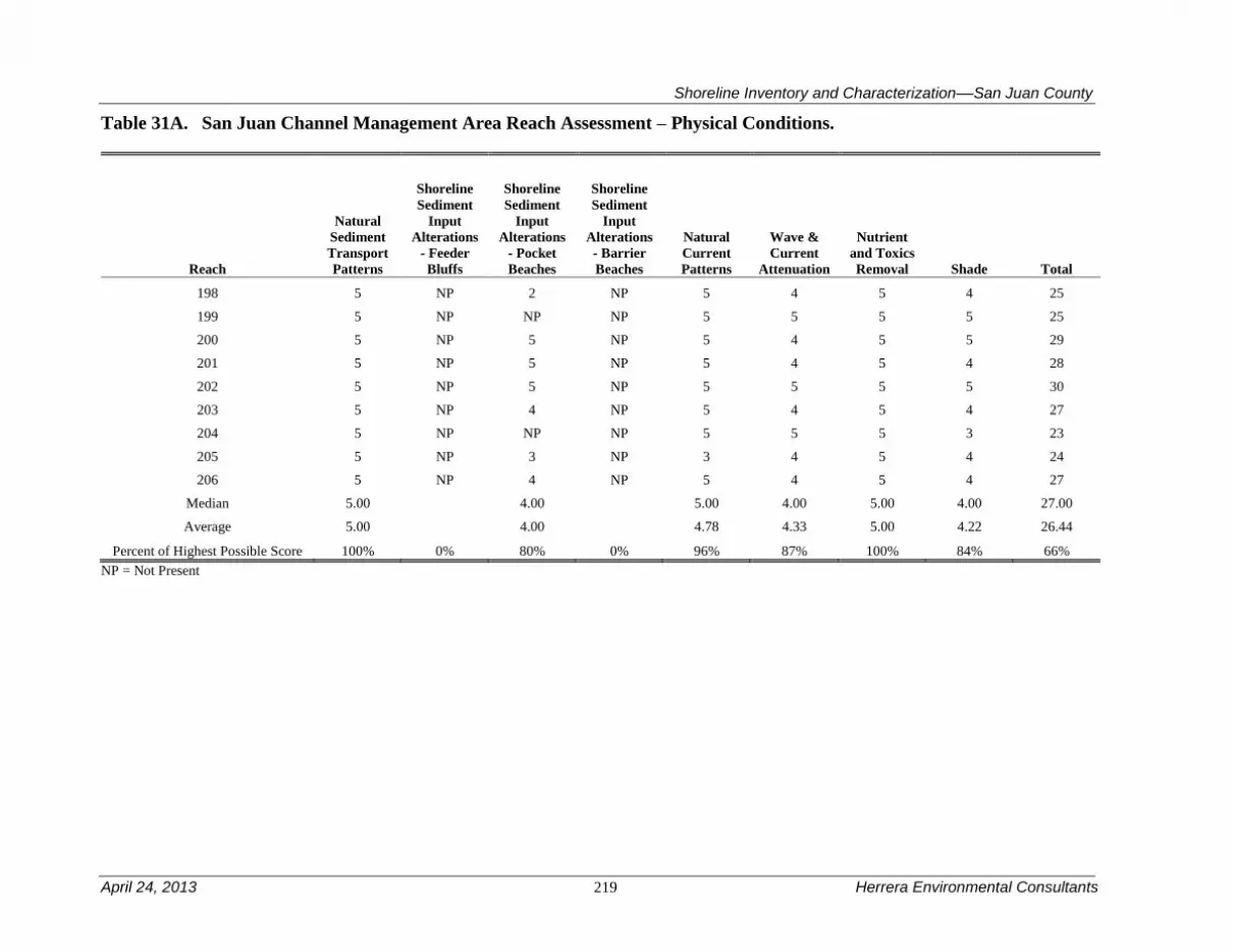
Shoreline Inventory and Characterization––San Juan County
April 24, 2013 219 Herrera Environmental Consultants
Table 31A. San Juan Channel Management Area Reach Assessment – Physical Conditions.
Reach
Natural
Sediment
Transport
Patterns
Shoreline
Sediment
Input
Alterations
- Feeder
Bluffs
Shoreline
Sediment
Input
Alterations
Beaches
Shoreline
Sediment
Input
Alterations
- Barrier
Beaches
Natural
Current
Patterns
Wave &
Current
Attenuation
Nutrient
and Toxics
Removal Shade Total
198 5 NP 2 NP 5 4 5 4 25
199 5 NP NP NP 5 5 5 5 25
200 5 NP 5 NP 5 4 5 5 29
201 5 NP 5 NP 5 4 5 4 28
202 5 NP 5 NP 5 5 5 5 30
203 5 NP 4 NP 5 4 5 4 27
204 5 NP NP NP 5 5 5 3 23
205 5 NP 3 NP 3 4 5 4 24
206 5 NP 4 NP 5 4 5 4 27
Median 5.00
4.00
5.00 4.00 5.00 4.00 27.00
Average 5.00
4.00
4.78 4.33 5.00 4.22 26.44
Percent of Highest Possible Score 100% 0% 80% 0% 96% 87% 100% 84% 66%
NP = Not Present

Shoreline Inventory and Characterization––San Juan County
Herrera Environmental Consultants 220 April 24, 2013
Table 31B. San Juan Channel Management Area Reach Assessment – Habitat Conditions.
Reach
Vegetation
Coverage
Estuary
Habitat Birds
Haul-
out
Habitat Eelgrass
Floating
Kelp
Understory
Kelp
Spawning
Habitat1
Herring
Spawning
Habitat Shellfish Total
198 5 1 0 0 5 5 5 0 0 2 23
199 5 0 0 0 5 5 5 0 0 2 22
200 5 1 1 0 5 0 5 0 0 2 19
201 5 1 0 0 5 0 5 0 0 3 19
202 5 1 0 0 5 0 5 0 0 3 19
203 5 2 0 0 5 0 5 0 0 3 20
204 4 0 0 5 0 0 0 0 0 2 11
205 5 1 0 0 5 5 5 0 0 2 23
206 5 2 0 0 5 5 5 0 0 2 24
Median 5.00 1.00 0.00 0.00 5.00 0.00 5.00 0.00 0.00 2.00 20.00
Average 4.89 1.00 0.11 0.56 4.44 2.22 4.44 0.00 0.00 2.33 20.00
Percent of Highest Possible Score 98% 20% 2% 11% 89% 44% 89% 0% 0% 47% 40% 1 Includes priority spawning habitat for sand lance, surf smelt, and rock sole.
Shoreline Inventory and Characterization––San Juan County
April 24, 2013 221 Herrera Environmental Consultants
4.12 Shaw Island Management Area
The Shaw Island management area includes all of Shaw Island and a collection of smaller islands
that form a mini-archipelago bounded by San Juan, Upright and Harney Channels, West Sound
and Deer Harbor. The largest of the secondary islands is Crane Island, which is inhabited. Other
inhabited islands include: Coon Island, Bell Island, Cliff Island, and McConnell Island. The
primary (WSDOT) ferry terminal for Shaw Island is at the east end of the mouth of Blind Bay.
Table 32 is a summary of the reach assessment for the Shaw Island management area. The table
is in two parts, one covering general physical conditions, the other addressing those conditions
directly related to habitat functions. The following discussions cover both the conditions scored
in the reach assessment (Tables 32A and B) and management area results from the ecosystem-
wide characterization. The reaches within the Shaw Island management area are diverse. Some
are lower than the rest of the County (generally those with development), while others are highly
functioning. Blind Bay (179) is the most physically impaired; reach 174 is one of the highest
scoring reaches in the county for habitat conditions.
4.12.1 Physical and Biological Characterization
Nearshore Physical Processes
Shaw Island is comprised primarily marine sedimentary rock. While still bedrock, the marine
sedimentary rock that comprises Shaw Island is much more erodible than its igneous
counterparts on the major islands in the County. The marine sedimentary rock is also interbedded
with layers of varying strength causing the shoreline to have numerous small pockets due to past
erosion of the shoreline. As a result, pocket beaches and tombolos are extremely common on
Shaw Island. The pocket beaches are primarily derived from eroded bedrock. This
compartmentalization of the shoreline means that sediment supply impacts to the shoreline are
localized, but pronounced.
There are five small drift cells mapped in this management area. Two are isolated drift cells,
which essentially are associated with large pocket beaches. One occurs along South Beach with
significant feeder bluffs at the west end, while the other small drift cell is associated with the
west side isthmus that connects Broken Point to the Shaw Island mainland. The other three drift
cells occur in Blind Bay. One isolated cell occurs in the northwest end of the bay and terminates
at a bedrock outcropping. The other two converge, as occurs in a classic pocket beach, at the
head of Blind Bay.

Shoreline Inventory and Characterization––San Juan County
Herrera Environmental Consultants 222 April 24, 2013
Figure 23. Shaw Island Management Area.

Shoreline Inventory and Characterization––San Juan County
April 24, 2013 223 Herrera Environmental Consultants
Most of the island is relatively protected from wave energy by other islands (because the wave
energy is reduced by short fetches), with the possible exception of the south end of Shaw Island
from Hoffman Cove to Picnic Point. Tidal flows are significant near local topographic
constrictions (i.e., passes), such as Pole Pass, and in San Juan Channel, but tidal flows are
generally less than flows within the major channels that ring the other islands. Even in San Juan
Channel, currents rarely exceed 2 knots (Canadian Hydrographic Service 2010). It is likely that
vessel wakes play a secondary role in sediment transport on the beaches near the ferry terminal
and heavily used narrow passes.
Geologic Hazards
The sedimentary rock on Shaw Island has the potential to be unstable due to sliding along
bedding contacts or where it is mantled with a thin veneer of glacial drift (such as at the west end
of Indian Cover), particularly in the wet season. Despite these areas of potential instability, most
landsliding on Shaw Island shorelines is muted and slow by comparison to other Western
Washington shorelines. Because of the proximity of bedrock throughout much of the island
liquefaction is insignificant with the exception of low lying area of glacial between Indian Cove
and Blind Bay. The Shaw Island management area is relatively protected from tsunamis
generated outside of the San Juan archipelago. The primary risk of tsunami in this management
area comes from large landslides on the other major San Juan Islands.
Streams and Associated Wetlands
Due to their lithology, Shaw Island and surrounding islands in the management area are
relatively permeable and therefore lack significant perennial streams. Wetlands are also rare.
There are three small unnamed drainage basins on Shaw Island. The largest is an unnamed
ephemeral stream that drains to Squaw Bay, while the other two discharge to Blind Bay and to
the embayment on the west side of Broken Point. One small (unmapped) stream on Neck Point is
dammed near the limits of the shoreline management area (close to within 200 feet of the marine
ordinary high water mark). There are no jurisdictional lakes on Shaw Island.
Critical or Priority Habitat and Species Use
Although there are no salmon bearing streams on Shaw Island, nearshore areas provide suitable
habitat for juvenile salmon and forage fish. Eelgrass beds occur in a patchy distribution
throughout most of the reaches, and provide habitat for fish, including suitable spawning habitat
for Pacific herring in Blind Bay and just east of there (reaches 174, and 177 through 181). Blind
Bay is a priority fish spawning habitat area for forage fish (Friends of the San Juans 2004a). Surf
smelt spawning habitat is present along the bluff backed beach of Blind Bay and in a patchy
distribution along Shaw Island’s northern shoreline between Broken Point and Point Hudson.
Both floating kelp and understory kelp have a patchy distribution throughout the management
area. Juvenile Chinook, chum, and pink salmon presence have been documented in nearshore
areas of Parks Bay and Hicks Cove (Wyllie-Echeverria and Barsh 2007), and are likely present
throughout other nearshore areas. The rocky headlands common in the management area are
suitable habitat for rockfish.

Shoreline Inventory and Characterization––San Juan County
Herrera Environmental Consultants 224 April 24, 2013
Blind Bay, Indian Cove, and Squaw Bay are important habitat for Dungeness crab. Shellfish
species are documented in virtually all reaches. Small islands in the San Juan Channel, such as
Yellow Island, Cliff Island, Low Island, and others along the western shoreline of Shaw Island
are known harbor seal haul-out sites. These areas, as well as McConnell Island also provide
suitable habitat for seabird colonies, and other birds commonly associated with shorelines.
Marine Riparian, Nearshore, and Estuarine Habitats
Estuarine habitat occurs in several embayments characterized by bluff backed and pocket beach
shoreforms. Estuarine habitat is present in Blind Bay, Parks Bay, and Indian Cove, and there are
a number of smaller pocket estuaries along the San Juan Channel shoreline. Forested areas,
primarily along the eastern and southern shorelines of Shaw Island provide suitable habitat for
bald eagles, and are used by bald eagles for nesting and perching. Vegetation coverage is dense
within the shoreline jurisdiction although shade to the nearshore is somewhat compromised in a
number of reaches.
Water Quality, Sediment, and/or Tissue Sample Results
Although data have been collected in the area (Ecology 2011d), no systematic analysis has been
done with this data. As such, water quality is largely unknown in this management area.
4.12.2 Shoreline Use Patterns
Existing Land and Shoreline Use
Land Use
The Shaw Island management area mostly contains residential land uses, with areas of
government and educational, vacant, and conservation parcels also found within shoreline
jurisdiction. Current land uses in the Shaw Island management area are as follows:
Residential – 52 percent
Services – 16 percent
Cultural, Entertainment, Recreation – 3 percent
Undeveloped Land – 29 percent
Shaw Island, the largest island within the Shaw Island management area, has its western and
northern shoreline dominated by existing residential uses, with small amounts of conservation,
resource, and vacant land. The Shaw Island Ferry Terminal at the northeast corner of Blind Bay
includes the existing marine facility use of the ferry terminal, as well as the Shaw General Store,
the only trade use in shoreline jurisdiction. The southwestern shoreline between Parks Bay and
Squaw Bay is largely in conservation, including properties owned by the University of
Washington for conservation purposes, along with some vacant and residential enclaves near
Hicks Bay. East of Squaw Bay, the Shaw Island shoreline jurisdiction includes a mix of County
parks, residential development, conservation land, and small amounts of vacant land. The most
intense residential development in this area occurs along South Beach and Picnic Cove. Between
Picnic Cove and Point Hudson, the shoreline jurisdiction is largely undeveloped (vacant and
conservation) with very little residential development. The point west of Squaw Bay supports an
annual reef net fishery.

Shoreline Inventory and Characterization––San Juan County
April 24, 2013 225 Herrera Environmental Consultants
Other islands within the Shaw Island management area include Canoe, Crane, Bell, Cliff, Reef,
McConnell, and Yellow islands, along with a number of smaller islands interspersed among
them. Most of these islands are either characterized by residential development or are vacant.
The largest of these islands, Crane Island, has a shoreline entirely in residential land use.
Similarly, Cliff, Bell, and Coon islands are also characterized by residential uses. Canoe Island is
a private island owned by an educational institution with an on-site camp facility and limited
shoreline development. McConnell Island has a mix of residential and vacant land uses, while
Yellow, Reef, and the smaller islands are vacant or have low levels of residential development
on them.
Additional shoreline uses include multiple DNR utility easements and at least one desalination
system. The tidelands are a mix of state-owned aquatic lands and private ownership with the
majority being state-owned aquatic lands.
Primary water-dependent uses in the Shaw Island management area consist of the Washington
State Ferry Terminal at the northeast corner of Blind Bay and the associated Shaw General Store,
and the public marine facility Shaw Island Park at Indian Cove in the southeastern portion of
Shaw Island. Other water dependent uses consist of barge landing locations and community and
private docks located along developed shorelines on Shaw and as well as private marine
railways, and community and private docks on Shaw, Crane, Bell, Cliff, Coon, Canoe, and
smaller inhabited islands. Water enjoyment uses include Shaw Island County Park on Indian
Cove, and an education camp on Canoe Island.
Land Use Designations
The County’s Comprehensive Plan land use designations in this management area generally
corresponds with existing land use patterns. Rural Residential designations dominate the
shoreline between the western side of Blind Bay on the northern side of Shaw Island and Parks
Bay and western side of Shaw Island. Rural Residential is also applied on the Crane Island
shoreline jurisdiction. Natural, Conservancy, and Rural Farm Forest designations predominate on
the southern side of Shaw Island with a small enclave of Rural Residential along South Beach to
Picnic Cove. Rural Farm Forest and Forest Resource designations dominate the eastern side of
the Shaw Island. Canoe, Cliff, McConnell, and Reef islands are all designated as Conservancy,
while Yellow Island is designated Natural.
Shoreline Environment Designations
The Rural Farm-Forest shoreline environment is the predominant shoreline environment applied
to Shaw Island. Rural Farm-Forest is applied to all but a few areas between Blind Bay on the
north side and Parks Bay on the west side of Shaw Island. Exceptions include four short areas of
Conservancy on Neck Point. The peninsula that includes Point George, one of the University of
Washington conservation properties, is designated with the Natural environment. A small area
between Hicks Bay and Hoffman Cove is in the Rural Farm-Forest environment, while another
University of Washington conservation property located between Hoffman Cove and Squaw Bay
is mostly designated Natural with areas of Rural Farm-Forest and Conservancy environment
mixed in on the west side of Squaw Bay. A split designation of Conservancy and Natural
environments is applied to the north side of Squaw Bay, while the San Juan County Park

Shoreline Inventory and Characterization––San Juan County
Herrera Environmental Consultants 226 April 24, 2013
property between the east side of Squaw Bay and South Beach is designated Conservancy. The
residential development east of the County Park and the remainder of the less developed east
side of Shaw Island to Point Hudson is designated Rural Farm-Forest environment. The area
between Point Hudson and the State Ferry Terminal on the northeast corner of Blind Bay
includes both Rural and Rural Farm-Forest environments. Of the smaller islands in this
management area, Crane Island’s shoreline carries a Rural Farm-Forest environment designation,
while the remainder of the smaller islands are either Conservancy, Natural, or a combination of
the two environments.
Shoreline Modifications
Approximately 4.4 percent of the management area is armored. Most of the armoring occurs on
the pocket beaches that fringe Shaw Island. The bedrock outcrops are rarely armored, although
this does occur near the transition to sandier areas. If the percentage of armoring would be
expressed in terms of pocket beach area only, the percentage of armoring would be significantly
higher. There are 55 overwater structures, a vast majority of which are docks and piers. In
addition to the docks and piers, there are four groins and eight boat ramps, more than any other
management area except the Roche Harbor management area (which also has eight). Most of the
mooring buoys are located in Blind Bay. There is also some amount of fill at the Ferry Terminal.
Existing and Potential Public Access Areas
The Shaw Island management area has approximately 759 acres of shoreline jurisdiction. Shaw
Island County Park is the most significant public access facility in this management area. The
park is approximately 60 acres and includes a campground with 11 primitive campsites, the
Indian Cove boat ramp for small vessels, and a day use area. The San Juan County Parks Plan
recommends renovating the park per the 2008 Master Plan (The Trust for Public Land et al.
2010).
In addition to the developed county/regional park, there are a few road ends managed by the
Public Works Department that provide shoreline access or the potential for access:
Existing Facilities
Blind Bay Road: This road end is located on the north side of the island
and provides 20 feet of right-of-way on the rocks south of the Washington
State Ferries dock.
Indian Cove Ramp: The ramp is located within Indian Cove County Park
at the end of Shaw Park Road. Since it is located on a very flat, shallow
beach, the wooden ramp can only be used at high tide to launch small
recreational boats. Commercial landing craft can often only access it 2 or
3 times per year.
Shaw Landing Dock: The small dock and stairway is located adjacent and
to the southwest of the state ferry loading area. There is currently no float
and no beach access from the facility

Shoreline Inventory and Characterization––San Juan County
April 24, 2013 227 Herrera Environmental Consultants
Existing Facilities with Potential for Improvement
Hoffman Cove Road: This road end is located at the entrance to the
University of Washington property on the south end of Shaw Island. This
is a popular spot for local residents to enjoy bird watching, beach combing
and hiking but there are no provisions for parking.
Neck Point Cove Road: this undeveloped road end on the northwestern
end of the island provides access to a beach area and tidelands in a small
bay that is used for small boat launching and landings. No parking is
available.
Currently there are only a limited amount of trails or pathways in this management area,
specifically located within the County Park. The University of Washington is a large land owner
in the Shaw Island management area. The Parks Plan calls for working with the University of
Washington to explore public access opportunities on Shaw Island.
4.12.3 Restoration Opportunities
Localized development including road construction and deforestation may have historical and
ongoing (current) impacts on water quality and beach formation. Where development like this
has occurred in close proximity to Blind Bay, impacts likely affect forage fish habitat. Because
Blind Bay is an important forage fish spawning area, re-establishment of vegetative and beach
structure along the shoreline via the removal or relocation of roadways may be a restoration
opportunity to improve forage fish habitat.
Bordering the Washington State Ferry landing on Shaw Island is a cove with a
private/community dock. This privately owned cove is populated by a thick eelgrass bed, feeding
great blue herons, mergansers, and river otters. The beach is flanked by rocky outcrops with a
steep (10-foot high) backshore. A creosote-timber bulkhead was installed on the adjacent
property to prevent erosion from ferry wakes and storm waves (Habitat Work Schedule 2011).
Because there are no structures protected by the bulkhead and the creosote continues to pollute
the cove, removing the bulkhead is a restoration opportunity.

Shoreline Inventory and Characterization––San Juan County
Herrera Environmental Consultants 228 April 24, 2013
Table 32A. Shaw Island Management Area Reach Assessment – Physical Conditions.
Reach
Natural
Sediment
Transport
Patterns
Shoreline
Sediment
Input
Alterations
- Feeder
Bluffs
Shoreline
Sediment
Input
Alterations
Beaches
Shoreline
Sediment
Input
Alterations
- Barrier
Beaches
Natural
Current
Patterns
Wave &
Current
Attenuation
Nutrient
and Toxics
Removal Shade Total
173 5 NP 5 NP 5 4 5 4 28
174 5 NP 4 5 5 4 5 4 32
175 5 NP 2 NP 5 4 5 4 25
176 5 NP 5 NP 3 5 5 3 26
177 5 NP 5 NP 3 5 5 4 27
178 5 5 0 NP 3 3 5 3 24
179 1 2 NP NP 0 2 5 2 12
180 5 5 5 NP 3 4 5 2 29
181 5 5 4 NP 5 4 5 5 33
182 5 NP 0 2 3 2 5 3 20
183 5 0 2 NP 5 4 5 4 25
184 1 NP 4 NP 5 4 5 4 23
185 5 NP NP NP 5 5 5 3 23
186 5 NP 4 NP 5 4 5 4 27
187 5 NP 4 NP 5 4 5 3 26
188 5 NP 4 NP 5 4 5 4 27
189 5 NP 2 NP 2 4 5 4 22
190 5 NP 5 NP 5 5 5 3 28
191 5 NP 3 NP 5 4 5 4 26
192 5 NP 4 NP 5 4 5 4 27
193 5 NP 4 NP 5 4 5 2 25

Shoreline Inventory and Characterization––San Juan County
April 24, 2013 229 Herrera Environmental Consultants
194 5 NP 5 NP 5 4 5 2 26
195 5 NP 2 NP 1 4 5 1 18
196 5 5 5 5 3 5 5 3 36
197 5 NP NP 3 5 4 5 0 22
Median 5.00 5.00 4.00 4.00 5.00 4.00 5.00 3.00 26.00
Average 4.68 3.67 3.55 3.75 4.04 4.00 5.00 3.16 25.48
Percent of Highest Possible Score 94% 73% 71% 75% 81% 80% 100% 63% 64%
NP = Not Present

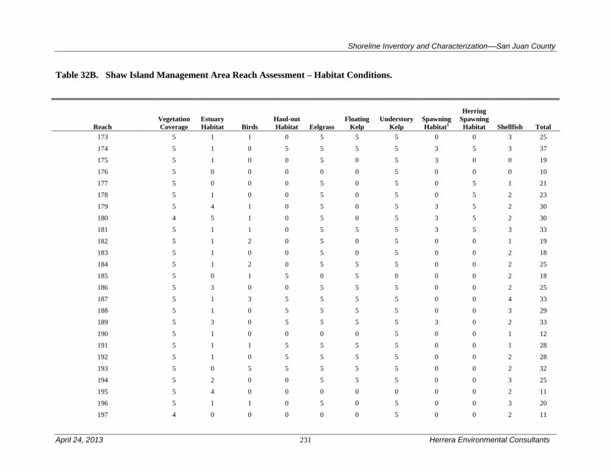
Shoreline Inventory and Characterization––San Juan County
April 24, 2013 231 Herrera Environmental Consultants
Table 32B. Shaw Island Management Area Reach Assessment – Habitat Conditions.
Reach
Vegetation
Coverage
Estuary
Habitat Birds
Haul-out
Habitat Eelgrass
Floating
Kelp
Understory
Kelp
Spawning
Habitat1
Herring
Spawning
Habitat Shellfish Total
173 5 1 1 0 5 5 5 0 0 3 25
174 5 1 0 5 5 5 5 3 5 3 37
175 5 1 0 0 5 0 5 3 0 0 19
176 5 0 0 0 0 0 5 0 0 0 10
177 5 0 0 0 5 0 5 0 5 1 21
178 5 1 0 0 5 0 5 0 5 2 23
179 5 4 1 0 5 0 5 3 5 2 30
180 4 5 1 0 5 0 5 3 5 2 30
181 5 1 1 0 5 5 5 3 5 3 33
182 5 1 2 0 5 0 5 0 0 1 19
183 5 1 0 0 5 0 5 0 0 2 18
184 5 1 2 0 5 5 5 0 0 2 25
185 5 0 1 5 0 5 0 0 0 2 18
186 5 3 0 0 5 5 5 0 0 2 25
187 5 1 3 5 5 5 5 0 0 4 33
188 5 1 0 5 5 5 5 0 0 3 29
189 5 3 0 5 5 5 5 3 0 2 33
190 5 1 0 0 0 0 5 0 0 1 12
191 5 1 1 5 5 5 5 0 0 1 28
192 5 1 0 5 5 5 5 0 0 2 28
193 5 0 5 5 5 5 5 0 0 2 32
194 5 2 0 0 5 5 5 0 0 3 25
195 5 4 0 0 0 0 0 0 0 2 11
196 5 1 1 0 5 0 5 0 0 3 20
197 4 0 0 0 0 0 5 0 0 2 11

Herrera Environmental Consultants 232 April 24, 2013
Median 5.00 1.00 0.00 0.00 5.00 5.00 5.00 0.00 0.00 2.00 25.00
Average 4.92 1.40 0.76 1.60 4.00 2.60 4.60 0.72 1.20 2.00 23.80
Percent of Highest Possible Score 98% 28% 15% 32% 80% 52% 92% 14% 24% 40% 48%
1 Includes priority spawning habitat for sand lance, surf smelt, and rock sole.

Shoreline Inventory and Characterization––San Juan County
April 24, 2013 233 Herrera Environmental Consultants
4.13 Spencer Spit Management Area
Spencer Spit management area includes all of Upright Head, Humphrey Head, Frost Island,
Flower Island, and the shorelines in between. It also includes the entire drift cell that supplies the
south side of Spencer Spit. The southern extent of the management area is defined by the
transition from sediment to bedrock in Lopez Sound. The primary ferry terminal for Lopez
Island is near the tip of Upright Head.
Table 33 is a summary of the reach assessment for the Spencer Spit management area. The table
is in two parts, one covering general physical conditions, the other addressing those conditions
directly related to habitat functions. The following discussions cover both the conditions scored
in the reach assessment (Tables 33A and B) and management area results from the ecosystem-
wide characterization. Spencer Spit management area is one of the highest scoring for physical
conditions particularly near Spencer Spit itself. Upright Head (reach 134) is by far the best
performing reach for providing habitat within the management area, despite containing the
island’s main ferry terminal.
4.13.1 Physical and Biological Characterization
Nearshore Physical Processes
The geology of the Spencer Spit management area is typified by sediment-rich shorelines
interspersed with bedrock outcroppings. Upright Head, Humphrey Head, Frost Island, and
Flower Island are all bedrock outcrops. There is a tombolo associated with Humphrey Head and
an incomplete tombolo associated with Frost Island (Spencer Spit). Like all tombolos, sediment
transport is convergent at the base of these features.
Tidal currents are generally weaker than in any other management area (much less than 1 knot:
Canadian Hydrographic Service 2010). Wave energy is also weaker than most other management
areas. Both tidal and wave energy increases from south to north.
Geologic Hazards
Much of the shoreline that is comprised of sediment in this management is to some degree
unstable. Extensive feeder bluffs exist to the south of Spencer Spit, though there is generally a
lack of active sliding, probably a result of the relatively lack of wave energy. The other major
feeder bluff, located at the promontory that separates Swift Bay from Spencer Spit is more
active, but still less active than White Cliffs on Decatur Island. Liquefaction risk is generally low
to non-existent, except in the marshes where it is moderate to high. Like the Fisherman Bay
management area, the surficial, relict (and active) tectonism common in the rest of the County is
not present in the Spencer Spit management area. Tsunami risk is limited to landslide-induced
tsunamis generated from the west side of Blakely and Decatur islands.

Shoreline Inventory and Characterization––San Juan County
Herrera Environmental Consultants 234 April 24, 2013
Figure 24. Spencer Spit Management Area.

Shoreline Inventory and Characterization––San Juan County
April 24, 2013 235 Herrera Environmental Consultants
Streams and Associated Wetlands
There are several large salt marsh complexes in this management area. There are marshes
associated with the two tombolos (the tombolo at Humphrey Head and Spencer Spit) and also a
large marsh complex at Port Stanley. These marshes vary in terms of alteration with Spencer Spit
being largely intact, while the marsh at Port Stanley is ditched and ringed by road fill. There are
three mapped streams in the management area, the largest of which drains to the marsh and tide
gate at Port Stanley. This stream also serves as the outlet for jurisdictional Hummel Lake. The
other two streams are much smaller and have both been altered to some extent.
Critical or Priority Habitat and Species Use
Spencer Spit management area contains a relatively contiguous habitat important for Dungeness
crabs, and for a variety of clam species from Spencer Spit and south along bluff backed beaches.
The entire area is also likely important for pandalid shrimp. Eelgrass is documented throughout
most of the management area shorelines. Floating kelp is only documented near Upright Head
but understory kelp are found in all management area reaches.
The unique habitats of Shoal Bay and near Upright Head provide beach and intertidal habitat for
priority fish spawning. Pacific herring spawning habitat is also present in Shoal Bay and near
Upright Head (reaches 131 through 134), along with extensive habitat for a variety of clams and
other shellfish. Outside of Shoal Bay, a large area that includes portions of this, and three
management areas (Blakely Island, Olga, and Eastsound) is documented as an important Pacific
herring adult holding area, the only such area identified within San Juan County. The two rocky
headlands (Upright and Humphrey) that form Shoal Bay are also suitable habitat for rockfish.
Haul-out habitat is not documented in the management area.
Habitat in this management area is likely important for numerous priority species including
salmon and birds that rely on crab and clams as prey species. Bald eagles, peregrine falcons and
seabird colonies have all been observed in the northern areas surrounding Shoal Bay and Spencer
Spit.
Marine Riparian, Nearshore, and Estuarine Habitats
Portions of Shoal Bay and Swifts Bay contain estuarine habitat, and eelgrass that is important to
numerous priority species. Lagoons at Spencer Spit, and in Shoal Bay and Swifts Bay, have
valuable riparian habitat that provides transitional areas between upland and marine areas that
benefits numerous birds, fish, and other species. Aerial photos indicate that riparian vegetation
has been substantially disturbed along segments of shoreline in Swifts and Shoal Bays, however,
forest cover remains intact throughout much of the management area shorelines. Preserved
conditions are most evident around Spencer Spit State Park.
Water Quality, Sediment, and/or Tissue Sample Results
Ambient water quality monitoring conducted by the Department of Ecology showed periodic
exceedances of temperature and dissolved oxygen criteria in Lopez Sound; these exceedances
were attributed to natural upwelling of low dissolved oxygen marine water and were not
determined to be influenced by anthropogenic activities (Ecology 2011e). Water quality

Shoreline Inventory and Characterization––San Juan County
Herrera Environmental Consultants 236 April 24, 2013
monitoring has also been conducted on streams that discharge to Shoal and Swifts Bays; elevated
fecal coliform bacteria concentrations, low dissolved oxygen concentrations, and high nutrient
levels were observed (SJC 2000; Wiseman et al. 2000; SJCD 2005).
4.13.2 Shoreline Use Patterns
Existing Land and Shoreline Use
Land Use
The Spencer Spit management area extends from the northern peninsula on Lopez Island to
approximately the mid-point on the east side of the island, and includes the smaller Frost Island.
Overall existing land use in the Spencer Spit management area includes:
Residential – 72 percent
Transportation, Communications – 1 percent
Trade – 2 percent
Cultural, Entertainment, Recreation – 10 percent
Undeveloped Land – 14 percent
The northern peninsula is largely residential with a small amount of vacant property. The
shoreline jurisdiction in Shoal Bay is characterized by small lot residential development with
several small cultural/recreation uses, and a large trade parcel located on the southwest side of
Humphrey Head. From Humphrey Head to Spencer Spit is a largely residential area with small
lot residential development characterizing this area. Spencer Spit, a state park, is classified as a
cultural/recreation use. Between Spencer Spit and the south end of the management area is a
largely large lot residential area with some vacant and unclassified parcels interspersed. Frost
Island is characterized by residential development.
Frost Island is residential, while Flower Island is undeveloped Federal land that is part of the San
Juan National Wilderness Area.
Additional shoreline uses include a DNR utility easement and an aquaculture operation (Shoal
Bay). The tidelands are a mix of state-owned aquatic lands and private ownership.
Water-dependent uses in this management area include the State Ferry Terminal at the northern
tip of Lopez Island, Spencer Marina, as well as several piers, docks, and marine railways, many
of which are private. Water enjoyment uses include Spencer Spit State Park.
Land Use Designations
Comprehensive Plan land use on the northern peninsula of Lopez Island is generally Rural Farm
Forest with the exception of the area surrounding the state ferry dock, which is designated Rural
General. Rural Farm Forest designation extends down the western side of Shoal Bay south of the
ferry terminal. The south side of Shoal Bay is designated Rural Residential reflecting smaller lot
residential development in this area. Both sides of the peninsula to Humphrey Head are
designated Rural Farm Forest while the majority of Humphrey Head is designated Rural

Shoreline Inventory and Characterization––San Juan County
April 24, 2013 237 Herrera Environmental Consultants
Residential. Swifts Bay, south of Humphrey Head to Spencer Spit State Park is designated Rural
Farm Forest. The state park itself is designated Conservancy. The remainder of the management
area south of Spencer Spit State Park is designated Rural Farm Forest.
Frost Island is designated Rural Residential and Flower Island is designated Natural.
Shoreline Environment Designations
The northern part of this management area is predominantly Rural Residential with a small area
of Conservancy applied around the State Ferry Terminal. Shorelines on both sides of the neck to
Humphrey Head are designated Conservancy, while Humphrey Head itself is mostly Rural
Residential with a small area of Rural. South of Humphrey Head, shoreline environment is
designated as Rural Residential to the north side of Spencer Spit, where the designation changes
to Conservancy for the remainder of the Lopez Island part of this management area. The smaller
Frost Island is designated Conservancy, while Flower Island is designated Natural.
Shoreline Modifications
About 8.3 percent of the management area is armored, much higher than the average percentage
for the County. This management area is comprised predominantly of glacial sediments, so this
alone likely explains the relative prevalence of armoring, despite the reduced wave energy here.
There are a moderate number of overwater structures (25), but many of these are located at
Spencer’s Landing in Shoal Bay, which also has series of breakwaters associated with it. This
makes the rest of the shoreline relatively undisturbed for a major island (aside from the Ferry
Terminal at the northern tip of Upright Head). There are also a relatively moderate number of
mooring buoys (93) and pilings (10). Like the overwater structures, these are concentrated in
Shoal Bay. Port Stanley and the mouth of the stream that drains Hummel Lake are significantly
altered and likely possess fill in places.
Existing and Potential Public Access Areas
The Spencer Spit management area has roughly 12.75 miles of shorelines with a variety of public
access opportunities, including approximately 1,600 feet of trails and paths and the following
parks, preserves, and road ends:
Spencer Spit State Park is a 138-acre marine and camping park with a
reputation for excellent crabbing and clamming. It is one of the few state
parks in the San Juan Islands that is accessible by automobile.
Upright Head Preserve is a 26-acre property adjacent to the Lopez ferry
landing. The preserve protects this property, which is highly visible from
the water, from development of the 13-lot subdivision for which
infrastructure has already been developed.
Shipley Shores Road ends (A and B) are located on Swifts Bay,
approximately 1/4 mile apart. Road end B has public access signs but no
parking. Road end A needs public access signs as well as other amenities.

Shoreline Inventory and Characterization––San Juan County
Herrera Environmental Consultants 238 April 24, 2013
Port Stanley Road end is also located on Swifts Bay. This site provides
access to the water and has public access signs maintained by the County.
4.13.3 Restoration Opportunities
One of the largest opportunities for habitat improvement in the County is the restoration of the
stream and wetland complex at Port Stanley. The recently removed tide gate on this stream had
restricted fish access to remaining portions of the salt marsh in this area5. Roads also confine and
divide the habitat in this area. Restoration of this stream, similar to what has already occurred at
Shoal Bay, would improve water quality and provide rearing habitat for migrating salmonid that
currently does not exist.
5 Current mapping provided on map 7 still depicts a tide gate at this location.

Shoreline Inventory and Characterization––San Juan County
April 24, 2013 239 Herrera Environmental Consultants
Table 33A. Spencer Spit Management Area Reach Assessment – Physical Conditions.
Reach
Natural
Sediment
Transport
Patterns
Shoreline
Sediment
Input
Alterations
- Feeder
Bluffs
Shoreline
Sediment
Input
Alterations
Beaches
Shoreline
Sediment
Input
Alterations
- Barrier
Beaches
Natural
Current
Patterns
Wave &
Current
Attenuation
Nutrient
and
Toxics
Removal Shade Total
126 3 4 NP NP 5 4 1 3 20
127 5 5 NP 5 5 5 5 1 31
128 5 5 NP NP 5 5 5 4 29
129 3 5 NP 4 0 4 3 2 21
130 5 0 NP 0 3 2 5 4 19
131 5 NP NP 2 5 2 5 2 21
132 3 3 1 3 5 4 5 3 27
133 5 4 NP 0 1 3 5 3 21
134 5 NP 3 NP 3 4 5 4 24
Median 5.00 4.00 2.00 2.50 5.00 4.00 5.00 3.00 21.00
Average 4.33 3.71 2.00 2.33 3.56 3.67 4.33 2.89 23.67
Percent of Highest Possible Score 87% 74% 40% 47% 71% 73% 87% 58% 79%
NP = Not Present


Shoreline Inventory and Characterization––San Juan County
April 24, 2013 241 Herrera Environmental Consultants
Table 33B. Spencer Spit Management Area Reach Assessment – Habitat Conditions.
Reach
Vegetation
Coverage
Estuary
Habitat Birds
Haul-out
Habitat Eelgrass
Floating
Kelp
Understory
Kelp
Spawning
Habitat1
Herring
Spawning
Habitat Shellfish Total
126 5 2 1 0 5 0 5 0 0 4 22
127 5 3 0 0 5 0 5 3 0 4 25
128 5 1 0 0 0 0 5 0 0 4 15
129 5 2 1 0 5 0 5 0 0 2 20
130 5 1 1 0 5 0 5 0 0 3 20
131 4 0 0 0 5 0 5 0 5 3 22
132 5 1 0 0 5 0 5 0 5 3 24
133 3 1 0 0 5 0 5 3 5 1 23
134 5 3 0 0 5 5 5 3 5 3 34
Median 5.00 1.00 0.00 0.00 5.00 0.00 5.00 0.00 0.00 3.00 22.00
Average 4.67 1.56 0.33 0.00 4.44 0.56 5.00 1.00 2.22 3.00 22.78
Percent of Highest Possible Score 93% 31% 7% 0% 89% 11% 100% 20% 44% 60% 46%
1 Includes priority spawning habitat for sand lance, surf smelt, and rock sole.


Shoreline Inventory and Characterization––San Juan County
April 24, 2013 243 Herrera Environmental Consultants
4.14 Strait of Juan de Fuca Management Area
The Strait of Juan de Fuca management area is by far the largest management area in the County.
It has over 57 miles of shoreline along the Strait of Juan de Fuca, primarily on southwest portion
of Lopez Island and the southern shore of San Juan Island. It includes many rocky islets close to
the San Juan and Lopez Island mainland, the largest of which are Charles Island and Long
Island. It is bounded in the northwest by those shorelines that are protected by the Saanich
Peninsula. To the southeast it is roughly divided where the shorelines become relatively
protected by swell at the southeast end of Lopez Island. The management area is truncated on the
southeast end of San Juan Island at Cattle Point, and it ends at the limit of bedrock on Lopez’s
western shore. There are no major transportation related uses in this management area, although
MacKaye Harbor Road does run adjacent to the shoreline for more than a mile on southwestern
Lopez Island.
Table 34 is a summary of the reach assessment for the Strait of Juan de Fuca management area.
The table is in two parts, one covering general physical conditions, the other addressing those
conditions directly related to habitat functions. The following discussions cover both the
conditions scored in the reach assessment (Tables 34A and B) and management area results from
the ecosystem-wide characterization. This management area is formed by the intense physical
environment (frequent high wave energy), which may also preclude the kinds of activities that
impair shorelines elsewhere in the County. Thus it is relatively free of structures that would
impair sediment transport but there are outfalls and shoreline armoring that affect current
patterns and wave and current attenuation. Habitat functions are highly variable within this
management area.

Shoreline Inventory and Characterization––San Juan County
Herrera Environmental Consultants 244 April 24, 2013
Figure 25. Strait of Juan de Fuca Management Area.

Shoreline Inventory and Characterization––San Juan County
April 24, 2013 245 Herrera Environmental Consultants
Straight of Juan de Fuca Management Area – Detail 1

Shoreline Inventory and Characterization––San Juan County
Herrera Environmental Consultants 246 April 24, 2013
Straight of Juan de Fuca Management Area – Detail 2
4.14.1 Physical and Biological Characterization
Nearshore Physical Processes
The geology of the west shore of San Juan Island is dominated by bedrock, with numerous
pocket beaches, where the bedrock is capable of producing beach sediment or where glacial
sediments are present. The management area is heavily faulted, but unlike southern Orcas Island,
where most faulting is likely relict from past geologic activity, it is unclear whether or not the
faults along the Strait of Juan de Fuca management area are active. The southwestern end of
Lopez Island is also heavily faulted, but possesses much more glacial drift than on San Juan
Island. The glacial drift forms several large pocket beaches (e.g., Agate Beach) that are isolated
from one another and which have formed tombolos in many places throughout the management
area. Because of the relatively high energy and isolated sediment sources, the beaches in the
management area do not fit neatly to standard conceptions of drift cells. Transport is influenced
much more by cross-shore processes, nearshore circulation and the interaction of surf with swash
typical of exposed coastal settings (Komar 1996). As a result, these shorelines have a tendency to
be sandier and shallowly sloped than shorelines elsewhere in Puget Sound (Finlayson 2006).
Given the size of the management area, there are only three mapped drift cells. Two of these
cells converge at the head of False Bay, along another separate long drift cell in the National
Park near Cattle Point on San Juan Island. There are no mapped drift cells in this management
area on Lopez Island.

Shoreline Inventory and Characterization––San Juan County
April 24, 2013 247 Herrera Environmental Consultants
The wave environment in this management area is fundamentally different than in the rest of the
County. This management area is exposed to swell (waves originating from the Northeast Pacific
Ocean, which makes it much more like the outer coast of Washington than Puget Sound and the
rest of the County, which is relatively protected from these waves. Because swell has much a
larger height and period than locally sourced wind-waves, a surf zone, albeit small, can be
formed in places (e.g., Agate Beach: Herrera [2009a]). Tidal currents are extremely intense
(greater than 2.5 knots) in places in the management area, but they are particularly strong along
the southern shore of San Juan Island and the promontories of southern Lopez Island.
Geologic Hazards
The Strait of Juan de Fuca management area is by far the most geologically hazardous area in the
County. The risk is so significant (and unique) to this management area, it is recommended that
the County assemble a plan to address these risks. The principal risk is that the management area
is only a few miles from the Southern Whidbey Island Fault, which has been documented to have
generated large earthquakes in the recent geologic past (Johnson et al. 1996; Williams et al.
2005). In addition to the destruction possible from the earthquake, a slip of this fault would likely
produce a large tsunami (many feet in height) and destroy of much of the infrastructure that sits
only slightly above MHHW in the management area. A slip of the Devils Mountain Fault would
induce similar damage to the south shore of Lopez Island, but its effects would likely be much
more localized. There are several smaller faults that have also been mapped throughout the
management area (Whetten et al. 1988; Schasse 2003) that could slip along with the Southern
Whidbey Island or Devils Mountain Fault, or move independently due to loading from other
ambient seismicity.
In addition to tsunamis generated locally, there is a significant risk of a large tsunami generated
by a slip of the Cascadia Subduction Zone. While most of the rest of the County would see
moderate-sized waves that would be scattered by the rest of the archipelago, the Strait of Juan de
Fuca management area would likely see significant wave heights (again, on the order of many
feet). It is nearly certain that the tsunamis that generated sand deposits observed in Discovery
Bay from the slips of the Cascadia Subduction Zone (Williams et al. 2005), similarly affected
this management area, which has many regions that are generally less protected from tsunamis
than Discovery Bay. In fact, water level variability, experienced in some places in this
management area from the 2011 Japan tsunami, was likely similar to what was observed in Neah
Bay (i.e., in excess of 2 feet: NOAA 2011). And, as everywhere in the County, there is a slight
risk of landslide-generated tsunami. In this case, this landslide could originate anywhere on the
northern shore of the Olympia Peninsula between the Elwha River delta to Admiralty Inlet, or
from the Saanich Peninsula on Vancouver island.
In addition to seismic and tsunami risks, there are also landslide and liquefaction risks, but these
are minor in comparison. Liquefaction is possible in the marshes associated with False Bay and
MacKaye Harbor and in the glacial sediments near Cattle Point. Landslides are possible in many
of the pocket beach settings throughout the management area. Landslides have been documented
in the glacial sediments near Cattle Point.

Shoreline Inventory and Characterization––San Juan County
Herrera Environmental Consultants 248 April 24, 2013
Streams and Associated Wetlands
There are many large streams in this management area. Two of the largest streams discharge to
False Bay. The largest stream, False Bay Creek, is extensively ditched in its lowest reaches. In
addition, instream flows in False Bay Creek are affected by water withdrawals from Trout Lake,
and by impoundments and water withdrawals by adjacent landowners. Impaired instream flows
exacerbate water quality issues in False Bay Creek. Aside from these two large streams, there are
seven other small streams that drain from San Juan Island in this management area. There are
also three small ditched streams that discharge to MacKaye Harbor and Barlow Bay. All of these
streams are controlled with tide gates.
In addition to the streams, there are two large, heavily altered, marsh complexes. False Bay is
fringed by land that has been ditched and drained. While some wetland areas remain, it was
likely a much larger marsh prior to development. At MacKaye Harbor, a large interconnected
marsh in glacial drift that connected Aleck Bay, Outer Bay, and MacKaye Harbor has been
ditched, drained, and filled. Intact marsh sections remain, but the system is largely fragmented
and much smaller than what was present prior to development.
Critical or Priority Habitat and Species Use
Documented priority fish spawning areas in this management area are in False Bay near the
mouth of False Bay Creek, where sand lance spawning has been documented, and north of Cattle
Point at the entrance to San Juan Channel. There are also several documented priority fish
spawning beaches between MacKaye Harbor and Outer Bay on Lopez Island. MacKaye Harbor
also contains the only documented rock sole spawning beach in San Juan County, making this a
unique area (although not yet documented, rock sole spawning also likely occurs at other County
beaches). Pacific herring spawning habitat is documented near Smuggler’s Cove on San Juan
Island (reach 239). The rocky headlands common in this management area are also suitable
habitat for rockfish.
Shellfish are documented in every reach and False Bay provides conditions suitable for
Dungeness crab. Eelgrass is found in virtually all reaches as is floating kelp and understory kelp.
in fact, the outer (western) coast of San Juan Island is mostly characterized by kelp forests.
Eelgrass distribution is mostly limited to areas at the entrance of False Bay (a documented
priority wetland), the shoreline from Eagle Cove to Cattle Point, and the vicinity of Sunset Point
and Andrews Bay. Small isolated patches also occur in areas along the shoreline between
Andrews Bay and False Bay, and in small embayments of Lopez Island.
Haul-out habitat is found at Kanaka Bay and near Cattle Point on San Juan, and near Davis Point
and Iceberg Point on Lopez Island. The small islands and rocks along the southern shoreline of
Lopez Island provide significant habitat for seabirds, likely due in part to the presence of fish and
the foraging opportunities they provide for birds and other species. Seabirds are common among
the small islands and rocks near David Bay and MacKaye Harbor off Lopez Island, as well as
isolated locations along the western shoreline of San Juan Island. Bald eagles are also attracted to
these areas. Along the San Juan Island shoreline, bald eagles are likely to use habitat associated
with plunging rock shorelines near Dead Man Bay and pocket beaches around False Bay.

Shoreline Inventory and Characterization––San Juan County
April 24, 2013 249 Herrera Environmental Consultants
Marine Riparian, Nearshore, and Estuarine Habitats
Estuarine habitat is somewhat patchy throughout the management area but is generally present in
Davis Bay, MacKaye Harbor, and Outer Bay of Lopez Island. Shoreline vegetation coverage is
generally poor throughout the management area but most reaches have fairly intact vegetation
coverage in the shoreline jurisdiction.
Water Quality, Sediment, and/or Tissue Sample Results
Ambient water quality monitoring conducted by the Department of Ecology (2011e) showed
regular exceedances of dissolved oxygen criteria in the Strait of Juan de Fuca management area.
These exceedances were attributed to natural upwelling of low dissolved oxygen marine water
and to anthropogenic activities. One water sample was collected from False Bay lagoon, which
exhibited elevated fecal coliform bacteria concentrations and elevated water temperatures (SJC
2000). In addition, water quality data have been collected at False Bay Creek near its confluence
with False Bay; chronically high fecal coliform bacteria concentrations, high temperatures,
chronically low dissolved oxygen concentrations, high nutrients, and high turbidity were
observed (Wiseman et al. 2000). Additional water quality studies have shown elevated fecal
coliform bacteria concentrations, high temperatures, and high turbidity in False Bay Creek (SJC
2000; SJCD 2005). Water quality samples were also collected from two streams at Lopez Island
that discharge to Davis Bay and Mya Cove, both of which contained high fecal coliform bacteria
and low dissolved oxygen concentrations (Wiseman et al. 2000).
One sediment sample was also collected from MacKaye Harbor that exceeded the Sediment
Management Standards SQS bioassay criterion; sediment in this area is classified as Category 2
“Sediments of Concern” (Ecology 2011e).
4.14.2 Shoreline Use Patterns
Existing Land and Shoreline Use
Land Use
The Strait of Juan de Fuca management area extends from the south side of Mitchell Bay to
Cattle Point on San Juan Island, and then extends from Kings Point to Aleck Bay on Lopez
Island. This management area also includes the smaller islands of Goose, Deadman, Buick,
Long, Charles, Hall, and Iceberg.
Overall existing land use in the Strait of Juan de Fuca management area includes:
Residential – 58 percent
Services – 8 percent
Cultural, Entertainment, Recreation – 13 percent
Undeveloped Land – 22 percent
Existing land uses on the San Juan Island portion of the management area are predominantly
residential to Deadman Bay, with the exceptions of cultural/recreation land uses at Smallpox and
Deadman Bay (County and State parks), and a resource use at Deadman Bay as well. Between
Deadman Bay and Pile Point is another predominantly residential area with some large vacant

Shoreline Inventory and Characterization––San Juan County
Herrera Environmental Consultants 250 April 24, 2013
lots mixed in. The area around Pile Point and the west side of False Bay includes some large
conservation properties with a small residential area located on the southwest corner of False
Bay. The remainder of False Bay includes residential, resource, government/education, and
vacant land uses. Approximately 200 acres of tidelands and uplands within False Bay are owned
by the University of Washington Friday Harbor Laboratories and managed as part of the False
Bay Marine Preserve. The southeast side of False Bay is owned by the Mar Vista Resort.
Between False Bay and Point Joe is an area with a large amount of cultural/recreation, resource,
and conservation uses. Between Point Joe and Eagle Cover is a largely residential area with some
conservation and cultural/recreation uses mixed in. Residential lots are larger near Point Joe, and
relatively smaller for the designated Residential Rural Farm land use district near Eagle Cove.
East of Eagle Cover to Cattle Point, the majority of the shoreline jurisdiction is
cultural/recreation, with a government/education land use at Cattle Point.
Kings Point south to Davis Point on Lopez Island consists of residential, government/education,
and conservation land uses. Most of the area between David Bay and Jones Bay consists of
smaller lot residential development, with some large vacant and resource parcels mixed in.
MacKaye Harbor to Outer Bay continues a pattern of largely residential land uses with small
amount of vacant, conservation, and cultural/recreation uses mixed in. A wetland at the east side
of MacKaye Harbor that could extend the shoreline jurisdiction in this location exists in a largely
developed residential area. A large government/education land use extends from the south side of
Outer Bay to the west side of Fint Beach. Existing uses between Fint Beach and Aleck Bay
consist of conservation and unclassified uses, while the south side of Aleck Bay is residential.
Goose, Long, and Charles islands are residential. Buck, Hall, Iceberg, and Deadman islands are
undeveloped Federal land.
Tidelands are a mix of state-owned aquatic lands and private ownership with the majority being
state-owned aquatic lands.
Water-dependent uses in this management area consist of marinas, docks, piers, and marine
railways, many of which are private. Two public marine facilities exist in this management area:
one at Smallpox Bay on San Juan Island, and one at MacKaye Harbor on Lopez Island. Another
water-dependent use is lighthouses. In this management area, these are located at Lime Kiln
State Park and Cattle Point on San Juan Island. Water enjoyment uses consist of Lime Kiln State
Park, American Camp unit of the San Juan National Park (south side), and County Parks, and
several hotel/lodging facilities, such as bed and breakfasts that are mixed in with existing
residential development in places along this management area.
Land Use Designations
Comprehensive Plan land use designations from the beginning of this management area on the
south side of Mosquito Bay to Smallpox Bay are Rural Residential. Smallpox Bay itself is
designated Conservancy (County Park). Between Smallpox Bay and Kanaka Bay, land use
designations include a mix of Rural Residential in areas with smaller lot residential development,
Rural Farm Forest and Conservancy (including Lime Kiln State Park) in areas with larger lot
residential and/or state park, conservation, or resource lands. There is a small area between
Shoreline Inventory and Characterization––San Juan County
April 24, 2013 251 Herrera Environmental Consultants
Kanaka Bay and the west side of False Bay designated Rural Residential with small lot
residential development. The remaining shoreline jurisdiction in False Bay is mostly Rural Farm
Forest with some Natural and Agricultural Resource on the north side of the bay. Between False
Bay and American Camp National Park land, Comprehensive Plan land use designations include
a mix of Rural Farm Forest, Agricultural Resource, and Residential Rural (at Eagle Cove). The
American Camp National Park shoreline jurisdiction is designated Conservancy and this
designation extends to the end of this management area on San Juan Island.
Comprehensive Plan land use designations from Kings Point to Davis Bay are Rural Farm Forest
with one large lot designated Natural where a San Juan County Park exists. Davis Bay from
Davis Point to Mya Cove is made up of Rural Farm Forest and Agricultural Resource
Comprehensive Plan land use designations. The south side of Mya Cove is designated Rural
Residential and extends part way to Jones Bay before changing to Rural Farm Forest. The north
side of Jones Bay also includes a small area of Agricultural Resource designation. Jones Bay to
the north side of MacKaye Harbor is Rural Farm Forest. The smaller lot residential areas on the
north and east sides of MacKaye Harbor are Rural Residential, as is the Johns Point peninsula on
the south. The remainder of MacKaye Harbor is designated Rural Farm Forest. The remainder of
this management area between south side of Jones Point peninsula and Aleck Bay includes a
mixture of Rural Farm Forest, Conservation, and Natural designations. The Federal property at
Iceberg Point is designated Natural.
Goose, Deadman, Buck, Iceberg, and some of the smaller islets near Long Island are designated
Natural, while Long and Charles islands are designated Conservancy.
Shoreline Environment Designations
This management area starts on the south side of Mosquito Bay on San Juan Island where a
small area of Conservancy/Natural environment is applied. The shoreline south of here to
Smallpox Bay is Rural Residential. Smallpox Bay itself is designated Rural, and south of it, the
shoreline environment designation changes to Conservancy until Lime Kiln State Park. Lime
Kiln is characterized by Conservancy/Natural, Conservancy, and Natural shoreline
environments. South of the park to about Pile Point, shoreline environment designations alternate
between Conservancy/Natural, Conservancy, Residential Rural, and Conservancy again.
Shoreline environment designations from Pile Point to Point Joe are generally Rural Farm-Forest
or Rural Farm-Forest/Natural. Exceptions to this rule include Rural Residential in a small
developed area between Kanaka Bay and False Bay, and a Natural-designated area on the north
side of False Bay. Point Joe to Eagle Point is designated Conservancy/Natural, and Eagle Cove is
designated Rural Residential. The remainder of the management area on San Juan Island consists
of Conservancy and Natural designated areas along government-owned shoreline. The Lopez
Island portion of this management area is predominantly designated with a Conservancy
environment designation with the following exceptions. The Shark Reef Sanctuary County Park
and the area around Iceberg Point area designated Natural, a small area on the north side of
Davis Bay is designated Rural Residential, areas on both sides of Jones Bay are designated Rural
Residential with two very small areas designated Urban and Rural west of Jones Bay, and areas
of Residential Farm-Forest at MacKaye Harbor and Outer Bay.

Shoreline Inventory and Characterization––San Juan County
Herrera Environmental Consultants 252 April 24, 2013
Shoreline Modifications
Only 1.9 percent of the Strait of Juan de Fuca management area has been armored. Armoring is
heavily concentrated in a few locales: False Bay, Outer Bay (Agate Beach), and MacKaye
Harbor. The armoring in MacKaye Harbor and Agate Beach is primarily associated with
roadways. There are also relatively few overwater structures (17) given the size of the
management area. It is likely that this is because of the large expense of engineering structures
capable (structurally) of sustaining large forces, in light of the more energetic wave environment.
Mooring buoys are also rare (only 59), considering the size of the management area. However,
there are two marine railways, four boat ramps, a marina, a groin and two breakwater/jetties.
Existing and Potential Public Access Areas
The Strait of Juan de Fuca management area has over 57 miles of shorelines.
Existing Facilities
Deadman Bay Preserve provides access to 1,600 feet of shoreline south of
Limekiln Point State Park as well as views across Puget Sound to
Vancouver Island and the Olympic Mountains.
Hunt Conservation Easement protects shoreline at Cattle Pass, which is
visible from griffin Bay and the south shore of Lopez Island. This property
has many unique characteristics that make it suitable for unique plants and
a variety of animals.
Johnson Conservation Easement property abuts Iceberg Point and protects
660 feet of shoreline on Outer Bay.
Limekiln Preserve and Westside Preserve property abuts Deadman Bay
and Limekiln Point State Park. This property has ecological, scenic and
public access values.
MacKaye Harbor dock includes a boat ramp, small dock head, and 60-foot
floating dinghy dock as well as the associated parking areas for the
facilities.
Richardson Street ends at an old fuel dock with storage tanks. The road
end provides a view of MacKay Harbor.
Existing Facilities with Potential for Improvement
A wide variety of public access opportunities, including nearly 20,000 feet of trails and paths and
the following parks, preserves, and road ends:
San Juan County Park is a 12-acre park on Smallpox Bay. The park and
campground are popular with kayakers and other boaters. There is a
concrete ramp, parking, flush toilets and day use picnic amenities. Parks

Shoreline Inventory and Characterization––San Juan County
April 24, 2013 253 Herrera Environmental Consultants
Plan contains several recommendations related to opportunities for
improvement at this park, including: development of a master plan;
preservation activities for the historic cabin on site; installation of
dumpster; renovation of shelter; acquisition of adjacent land; and
renovation of office and residence. The Plan also recommends
implementing an environmental education program to take advantage of
high visitor use.
Agate Beach County Park is a 4-acre day use park with nearly 600 feet of
wide, gravely beach. The Parks Plan recommends the following
improvements for this park: develop site master plan; add culvert or bridge
over southern trail entrance; replace toilet; upgrade parking; replace
staircase and signs; install ADA accessible picnic tables and associated
pathway.
Eagle Cove County Park is another day use park that provides water
access via a 250-yard walking trail as well as parking for 6 cars. The Parks
Plan includes the following recommendations for this park: install entry
and way finding signage; install stairs leading to beach; improve beach
access.
Shark Reef Sanctuary is a 40-acre site previously owned by DNR, but
transferred to the County in 2005. The site contains a trail through the
forest to a bluff with views of a large seal rookery. Currently, the site does
not provide ADA access. The Parks Plan recommends the following:
replace toilets for ADA compliance; conduct trail and shoreline
restoration; and install interpretive signs.
False Bay Road end provides access via an unimproved path to the
University of Washington Biological Preserve and False Bay Tidelands.
This management area has a diverse supply of public access options. Continued investment in
the maintenance and enhancement of the existing access sites will implement the goals and
policies of the Comprehensive Plan as well as the goals, strategies and action items in the Parks
Plan.
4.14.3 Restoration Opportunities
Because of the intensity of physical processes along the shoreline, there are not many restoration
opportunities. However, most of the shoreline modifications are concentrated in a few places and
these can be improved. Conceptual engineering design has been completed to replace the large
riprap bulkhead at Agate Beach Road with nourishment and engineered large wood debris. In
addition, restoration of the marsh complex at the head of False Bay and the mouth of False Bay
Creek would have significant habitat benefits. Currently False Bay Creek is ditched and the
water quality of the bay is severely impaired providing additional restoration opportunities that
would benefit habitat conditions. A series of interrelated restoration actions have also been
proposed and analyzed for MacKaye Harbor (Coastal Geologic Services 2009).


Shoreline Inventory and Characterization––San Juan County
April 24, 2013 255 Herrera Environmental Consultants
Table 34A. Strait of Juan de Fuca Management Area Reach Assessment – Physical Conditions.
Reach
Natural
Sediment
Transport
Patterns
Shoreline
Sediment
Input
Alterations
- Feeder
Bluffs
Shoreline
Sediment
Input
Alterations
Beaches
Shoreline
Sediment
Input
Alterations
- Barrier
Beaches
Natural
Current
Patterns
Wave &
Current
Attenuatio
n
Nutrient
and
Toxics
Removal Shade Total
151 5 5 5 NP 5 5 5 4 34
152 5 NP 5 NP 5 5 5 1 26
153 5 NP 4 NP 5 4 5 2 25
154 5 NP 5 NP 5 4 5 3 27
155 5 NP 5 NP 5 5 5 3 28
156 5 NP 3 NP 5 4 5 2 24
157 5 NP NP NP 5 5 5 0 20
158 3 NP 1 NP 3 4 3 3 17
159 5 NP 5 NP 1 4 3 1 19
160 5 NP 4 NP 5 4 3 4 25
161 5 NP 0 NP 0 2 3 1 11
162 5 NP 4 NP 5 4 3 3 24
163 5 NP 1 NP 3 3 5 0 17
164 5 NP 1 NP 2 3 5 3 19
165 5 NP 4 NP 5 4 5 2 25
239 5 NP 3 NP 5 4 5 4 26
240 5 NP 3 NP 3 4 5 3 23
241 5 NP 5 NP 5 4 5 2 26
242 5 NP 5 NP 5 5 5 4 29
243 5 NP 3 NP 2 4 5 4 23
244 5 NP 5 NP 5 5 5 4 29
245 5 NP 5 NP 2 5 5 3 25
246 5 5 4 NP 5 4 5 2 30

Shoreline Inventory and Characterization––San Juan County
Herrera Environmental Consultants 256 April 24, 2013
247 5 4 NP NP 2 4 0 2 17
248 5 NP 5 NP 5 5 5 1 26
249 5 NP 5 NP 5 5 5 0 25
250 5 5 5 NP 3 5 5 1 29
Median 5.00 5.00 4.00
5.00 4.00 5.00 2.00 25.00
Average 4.93 4.75 3.80
3.93 4.22 4.44 2.30 24.04
Percent of Highest Possible
Score 99% 95% 76% 0% 79% 84% 89% 46% 60%
NP = Not Present

Shoreline Inventory and Characterization––San Juan County
April 24, 2013 257 Herrera Environmental Consultants
Table 34B. Strait of Juan de Fuca Management Area Reach Assessment – Habitat Conditions.
Reach
Vegetation
Coverage
Estuary
Habitat Birds
Haul-out
Habitat Eelgrass
Floating
Kelp
Understory
Kelp
Spawning
Habitat1
Herring
Spawning
Habitat Shellfish Total
151 5 0 2 0 5 5 5 0 0 2 24
152 5 1 0 5 5 5 5 0 0 2 28
153 5 2 0 0 5 5 5 0 0 2 24
154 5 3 1 0 5 0 0 0 0 2 16
155 5 0 0 0 5 5 5 0 0 2 22
156 4 0 0 0 5 0 5 0 0 2 16
157 5 0 1 0 5 0 5 0 0 2 18
158 5 0 1 0 5 5 5 3 0 2 26
159 4 0 0 0 0 0 5 5 0 2 16
160 4 1 2 0 5 0 0 5 0 2 19
161 4 0 1 0 5 0 0 5 0 2 17
162 5 1 0 0 5 5 5 3 0 2 26
163 5 0 0 0 0 0 0 3 0 2 10
164 5 2 0 0 0 0 5 3 0 2 17
165 5 5 0 5 5 5 5 0 0 3 33
239 5 1 3 0 5 5 5 0 5 2 31
240 4 0 0 0 5 5 5 0 0 3 22
241 4 0 1 0 5 5 5 0 0 2 22
242 5 0 1 0 5 5 5 0 0 2 23
243 4 0 1 0 5 5 5 0 0 2 22
244 5 0 0 0 5 5 5 0 0 2 22
245 4 0 3 0 5 5 5 0 0 2 24
246 5 2 0 5 5 5 5 0 0 4 31
247 4 3 0 0 5 0 5 3 0 3 23
248 3 3 0 5 5 5 5 0 0 3 29

Herrera Environmental Consultants 258 April 24, 2013
249 1 0 0 0 5 5 5 0 0 2 18
250 3 1 0 5 5 5 5 5 0 2 31
Median 5.00 0.00 0.00 0.00 5.00 5.00 5.00 0.00 0.00 2.00 22.00
Average 4.37 0.93 0.63 0.93 4.44 3.33 4.26 1.30 0.19 2.22 22.59
Percent of Highest Possible Score 87% 19% 13% 19% 89% 67% 85% 26% 4% 44% 45%
1 Includes priority spawning habitat for sand lance, surf smelt, and rock sole.

Shoreline Inventory and Characterization––San Juan County
April 24, 2013 259 Herrera Environmental Consultants
4.15 Stuart Island Management Area
The Stuart Island management area includes all of Stuart Island and a collection of smaller
islands that form a mini-archipelago bounded by Haro Strait to the west and north and Spieden
Island to the south. The Stuart Island management area could be thought of as extension of the
Gulf Islands, as they have more similarity to them in terms of lithology, climate and physical
environment. Spieden Island, Johns Island, and Satellite Island are the three largest islands aside
from Stuart Island in this management area. Only Johns Island has permanent year-round
residents. There are numerous smaller, named islands in this management area, but they are
largely uninhabited. The airport on Stuart island is on former marshland that encroaches on the
shoreline both in Prevost Harbor and Johns Pass.
Table 35 is a summary of the reach assessment for the Stuart Island management area. The table
is in two parts, one covering general physical conditions, the other addressing those conditions
directly related to habitat functions. The following discussions cover both the conditions scored
in the reach assessment (Tables 35A and B) and management area results from the ecosystem-
wide characterization. Many reaches in this management area are undeveloped and these are
generally high functioning both physically and for providing habitat. A number of reaches are
short and thus one or two developments can substantially affect their score.
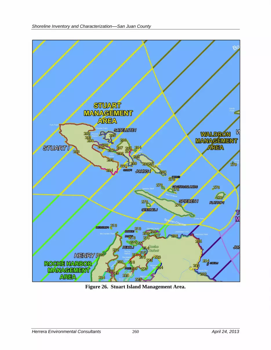
Shoreline Inventory and Characterization––San Juan County
Herrera Environmental Consultants 260 April 24, 2013
Figure 26. Stuart Island Management Area.

Shoreline Inventory and Characterization––San Juan County
April 24, 2013 261 Herrera Environmental Consultants
4.15.1 Physical and Biological Characterization
Nearshore Physical Processes
Stuart Island and the small islands are comprised primarily of marine sedimentary rock. This
rock is somewhat more lithified (hard, resistant to erosion) than elsewhere (such as found on
Shaw Island). As result the shoreline can be bare and steep in places. Bedrock walls dominate the
western end of Stuart Island near a sharp turn in Haro Strait. Beaches, where they occur, are
largely pocket beaches on the north sides of the islands, where wave energy is less than on the
more exposed, less developed southern side of the island. The beach material is eroded bedrock.
The mapped drift cells in the Stuart Island management area are mostly converging drift cells
associated with the heads of the major embayments (including Reid Harbor, Prevost Harbor, and
Johns Pass). There is also a drift along the south shore of Johns Island.
Wave energy is relatively significant throughout the management area owing to the presence of
Haro Strait. However, the management area is largely protected from swell (by the Saanich
Peninsula in British Columbia and by San Juan Island to the southeast), so the waves are
primarily locally sourced. The management area is exposed to significant tidal energy and it is
not uncommon for currents in excess of 2.5 knots to occur along any one of the more exposed
shorelines in the management area (Canadian Hydrographic Service 2010). Vessel wakes are
also significant because Haro Strait surrounds the management area and is the main shipping
channel for Vancouver and the Strait of Georgia.
Geologic Hazards
While steep slopes are common, there are no mapped landslides in this management area,
principally because the bedrock that defines these steep slopes is very competent. Liquefaction is
only an issue in flat wetland areas where sediment has accumulated, particularly near the airport.
While it is possible that tsunamis originating from the Strait of Juan de Fuca and the open ocean
could reach Stuart Island, it is likely that they would be greatly diminished owing to the
protection of surrounding land. Even tsunamis from the Strait of Georgia would be diminished
from protection by the Gulf Islands. The most significant tsunami threat is from large failures on
the large islands that surround the management area.
Streams and Associated Wetlands
There are no mapped streams or lakes in this management area. Wetlands, where they exist are
confined to steep valleys in the bedrock that define the islands. They are generally not associated
with marine shorelines, except for where they are separated from marine waters by a pocket
beach. The tombolo on the Stuart Island mainland at Johns Pass appears to have an associated
marsh complex that has been extensively ditched (based on aerial photographic interpretation,
although neither the wetland nor the ditch appears in County data.
Critical or Priority Habitat and Species Use
Bedrock walls that form the cliffs and bluffs are a priority habitat in this management area.
Diverse conditions allow for a mixture of eelgrass habitat (throughout Prevost Harbor, parts of
Reid Harbor, and across shorelines of Stuart and Johns islands), as well as floating kelp that
Shoreline Inventory and Characterization––San Juan County
Herrera Environmental Consultants 262 April 24, 2013
occur around Spieden, Sentinel, and Cactus islands, and intermittently around all of the main
islands. Understory kelp is fairly continuous in this management area and found within all
reaches. The only documented priority fish spawning area is located near the outlet to Reid
Harbor. Shellfish are documented in every reach, with many having three or four species present.
Haul-out habitat is documented on Spieden Island, the south shore of Prevost Harbor, and near
John’s Pass.
These habitats provide opportunities for nesting and foraging by bald eagles, peregrine falcons,
black oystercatchers, and seabird colonies that are common throughout the area. These species
also use the smaller islands in the southeast portion of the management area, such as Sentinel
Island, Cactus Islands, and Flattop Island, where harbor seal haul-outs are also common.
Relatively small patches of substrate throughout the area provide suitable habitat for subtidal
clams, while the larger estuarine-like habitat in Reid Harbor likely supports Dungeness crab and
clams. Most of this management area has suitable habitat for rockfish, with exception of some of
the marshy embayments.
Marine Riparian, Nearshore, and Estuarine Habitats
Estuarine habitat is patchy in distribution, and includes areas of Reid Harbor, Prevost Harbor,
and small pockets near Johns Pass, and the northern shoreline of Johns Island. Although the
uplands within the shoreline jurisdiction are generally well vegetated and largely undisturbed,
the shoreline in many reaches has significant areas lacking vegetation suitable for shading the
nearshore.
Water Quality, Sediment, and/or Tissue Sample Results
In general, water quality is largely unknown in this management area. One sediment sample was
collected in Prevost Harbor that exceeded the Sediment Management Standards SQS bioassay
criterion; sediment in this area is listed as a Category 2 “Sediments of Concern” (Ecology
2011e).
4.15.2 Shoreline Use Patterns
Existing Land and Shoreline Use
Land Use
The Stuart Island management area includes Stuart, Spieden, Satellite, Johns, Cactus, and Flattop
islands with several smaller islands interspersed. Stuart Island, the largest in this management
area, is characterized by a mix of resource, residential, vacant, and cultural/recreation land uses.
The northwestern portion of Stuart Island is dominated by a mix of resource, cultural/recreation,
and vacant land uses, while residential land uses dominate the remainder of the island’s shoreline
jurisdiction. Stuart Island State Park with locations on Prevost/Reid Harbors, and at Turn Point
makes up the cultural/recreation existing land use on Stuart Island. There are also two airstrips
on Stuart Island. Of the other islands in this management area, only Johns and the westernmost
of the two Cactus Islands also have residential land uses in shoreline jurisdiction. The remainder
of the islands in this management area are in recreation or conservation land uses.
Overall, current land uses in the Stuart Island management area are as follows:

Shoreline Inventory and Characterization––San Juan County
April 24, 2013 263 Herrera Environmental Consultants
Residential – 28 percent
Cultural, Entertainment, Recreation – 24 percent
Undeveloped Land – 48 percent
Additional shoreline uses include a DNR utility easement. The majority of tidelands are state-
owned aquatic lands.
Water-oriented uses in this management area consist of water-dependent marine facilities,
including public marine facilities at Prevost and Reid harbors associated with Stuart Island State
Park, private and community docks on the east side of Stuart Island, Johns Island, the Cactus
Islands, and Spieden Island. Another water-dependent use is the lighthouse facility at Turn Point
on Stuart Island. Water enjoyment uses consist of Stuart Island State Park, and Satellite Island,
which is used by a YMCA camp organization. The point southwest of Reid Harbor annually
supports a reef net fishery.
Land Use Designations
Similar to other management areas, Comprehensive Plan land use districts generally reflect
existing land use patterns. The eastern portion of Stuart Island is designated Rural Residential,
while the middle portion of Stuart Island, including nearby Satellite Island, is designated
Conservancy, and the western portion of the island is designated Rural Farm Forest (with the
exception of the western edge of Stuart Island, which is designated Natural). The small islands to
the southeast of Stuart Island, such as Gossip Island, are designated Natural. The western portion
of Johns Island is designated Rural Farm Forest, reflecting the larger lot residential and
conservation land uses that exist in that part of the island, and the eastern portion of Johns Island
is designated Rural Residential, reflecting its existing developed residential character. Of the
remaining islands in the Stuart Island management area, Spieden Island is designated
Conservancy, while the remainder of the smaller islands are designated Natural.
Shoreline Environment Designations
The majority of Stuart Island is in the Conservancy environment with smaller amounts of Rural
Farm-Forest and Natural shoreline environment designations. The Natural environment
designation is applied to Turn Point, part of the Stuart Island State Park owned by the Bureau of
Land Management (BLM). Rural Farm-Forest environment designation is applied on both sides
of Reid Harbor outside of the Stuart Island State Park land, and in a small are on the western side
of Prevost Harbor. Johns Island also has multiple shoreline environments applied to it. The
western portion of Johns Island is designated Conservancy, A small portion of the shoreline on
the north side of the island west of Reef Bay is designated Natural, the mostly developed middle
portion of Johns Island is designated Rural Farm-Forest, and the east side of the island is in
Conservancy. Of the smaller island, Satellite and Spieden islands are designated Conservancy
environment, and the remainder are designated Natural.
Shoreline Modifications
The Stuart Island management area is the least armored management area in the County when
expressed as a percentage total shoreline. Less than 1 percent of the management area is

Shoreline Inventory and Characterization––San Juan County
Herrera Environmental Consultants 264 April 24, 2013
armored. However, most of the armoring occurs on the pocket beaches that fringe Stuart Island.
The bedrock outcrops are extremely common and rarely armored, although this does
occasionally occur near the transition to sandier areas. If the percentage of armoring would be
expressed in terms of pocket beach area only, the percentage of armoring would be significantly
larger.
There are 31 overwater structures, which are mostly docks, piers and floats. In addition to the
docks and piers, there are five boat ramps, a groin and two marinas. The average footprint of
these overwater structures is larger than most other management areas. Most of the mooring
buoys are in Reid Harbor and in between Satellite Island and Stuart Island at the southeast end of
Prevost Harbor.
Existing and Potential Public Access Areas
Stuart Island management area has approximately 748 acres of shoreline jurisdiction. Public
access in the Stuart Island management area is limited to the boat ramp at the west end of Reid
Harbor and Stuart Dock located in Prevost Harbor. Stuart Island State Park is part of the
Cascadia Marine Trail and offers camping and moorage at Reed and Prevost harbors
(Washington State Parks and Recreation Commission 2010). Turn Point lighthouse is located on
federally owned land at the northwest edge of the management area. Portions of Stuart Island
shoreline are owned by the Washington State Parks Parks and Recreation Commission and some
of the smaller islands (such as Flattop and Sentinel) are USFWS National Wildlife Preserves and
contribute to shoreline views and aesthetics for the area. Currently trail boat launch and
campground facilities exist in shoreline jurisdiction.
Neither the San Juan County Parks, Trails, and Natural Areas Plan nor the Land Use Element of
the Comprehensive Plan include recommended actions specific to expanding or enhancing public
access in the Stuart Island management area.
4.15.3 Restoration Opportunities
The management area has large undeveloped areas, making restoration opportunities sparse.
However, the tombolo at Johns Pass on the Stuart Island mainland has a former marsh complex
that has been heavily disturbed by ditch installation and possibly fill. Because development is
sparse and is not constraining this area, it should be possible to restore natural function to these
marshes.

Shoreline Inventory and Characterization––San Juan County
April 24, 2013 265 Herrera Environmental Consultants
Table 35A. Stuart Island Management Area Reach Assessment – Physical Conditions.
Reach
Natural
Sediment
Transport
Patterns
Shoreline
Sediment
Input
Alterations
- Feeder
Bluffs
Shoreline
Sediment
Input
Alterations
Beaches
Shoreline
Sediment
Input
Alterations
- Barrier
Beaches
Natural
Current
Patterns
Wave &
Current
Attenuation
Nutrient
and
Toxics
Removal Shade Total
278 5 NP 5 NP 5 5 5 3 28
280 5 NP 5 NP 5 5 5 2 27
281 5 NP 4 NP 5 4 5 3 26
282 5 NP 5 NP 5 5 5 3 28
283 3 5 NP NP 5 4 5 2 24
284 5 NP 5 NP 5 4 5 3 27
285 5 NP 2 NP 5 3 5 2 22
286 5 NP 5 NP 5 5 3 4 27
287 5 5 NP NP 5 4 3 3 25
288 5 5 NP NP 5 5 3 5 28
289 5 NP 5 NP 5 5 3 3 26
290 5 5 NP NP 5 4 3 2 24
291 5 NP NP NP 5 5 3 5 23
292 5 5 NP NP 5 4 3 3 25
293 5 NP 5 NP 5 4 3 3 25
294 5 NP 5 NP 5 5 5 2 27
295 5 NP 5 NP 5 5 5 5 30
296 5 NP NP NP 5 5 5 4 24
297 5 NP NP NP 5 5 5 2 22
298 5 NP 0 NP 5 4 5 1 20
299 5 NP 3 5 5 4 5 3 30

Shoreline Inventory and Characterization––San Juan County
Herrera Environmental Consultants 266 April 24, 2013
300 5 NP NP NP 5 5 5 0 20
301 5 NP NP 4 5 4 5 1 24
Median 5.00 5.00 5.00 4.50 5.00 5.00 5.00 3.00 25.00
Average 4.91 5.00 4.15 4.50 5.00 4.48 4.30 2.78 25.30
Percent of Highest Possible Score 98% 100% 83% 90% 100% 90% 86% 56% 63%
NP = Not Present

Shoreline Inventory and Characterization––San Juan County
April 24, 2013 267 Herrera Environmental Consultants
Table 35B. Stuart Island Management Area Reach Assessment – Habitat Conditions.
Reach
Vegetation
Coverage
Estuary
Habitat Birds
Haul-out
Habitat Eelgrass
Floating
Kelp
Understory
Kelp
Spawning
Habitat1
Herring
Spawning
Habitat Shellfish Total
278 5 4 0 5 5 5 5 0 0 3 32
280 5 0 0 0 5 5 5 0 0 3 23
281 5 1 1 0 5 5 5 0 0 1 23
282 5 3 1 0 5 5 5 0 0 2 26
283 4 0 1 0 5 5 5 0 0 3 23
284 5 1 0 0 5 5 5 0 0 2 23
285 5 1 0 0 0 0 5 0 0 1 12
286 5 2 1 0 5 5 5 0 0 1 24
287 5 1 0 0 0 0 5 0 0 1 12
288 5 2 0 0 5 5 5 0 0 1 23
289 5 3 0 5 5 5 5 0 0 2 30
290 5 2 0 0 0 0 5 0 0 1 13
291 5 1 0 0 5 5 5 0 0 1 22
292 5 1 0 0 5 5 5 0 0 1 22
293 5 1 0 0 5 5 5 0 0 3 24
294 4 0 0 0 5 5 5 0 0 2 21
295 5 1 0 0 5 5 5 0 0 3 24
296 5 1 0 0 0 0 5 0 0 3 14
297 5 0 3 0 0 5 5 0 0 2 20
298 5 0 0 0 5 5 5 0 0 2 22
299 5 2 0 5 5 5 5 3 0 3 33
300 5 1 1 0 5 0 5 0 0 4 21
301 5 1 0 0 0 0 5 3 0 2 16
Median 5.00 1.00 0.00 0.00 5.00 5.00 5.00 0.00 0.00 2.00 23.00
Average 4.91 1.26 0.35 0.65 3.70 3.70 5.00 0.26 0.00 2.04 21.87

Herrera Environmental Consultants 268 April 24, 2013
Percent of Highest Possible Score 98% 25% 7% 13% 74% 74% 100% 5% 0% 41% 44%
1 Includes priority spawning habitat for sand lance, surf smelt, and rock sole.

Shoreline Inventory and Characterization––San Juan County
April 24, 2013 269 Herrera Environmental Consultants
4.16 Turtleback Management Area
The Turtleback management area covers over 15 miles of shoreline along the sparsely populated
northwest end of Orcas Island. The management area extends from the northeastern outskirts of
Eastsound to just north of Steep Point. The management area includes Jones Island and Freeman
Island, which are uninhabited state parks. It is bounded to the west by President Channel. There
are no major transportation related uses in this management area.
Table 36 is a summary of the reach assessment for the Turtleback management area. The table is
in two parts, one covering general physical conditions, the other addressing those conditions
directly related to habitat functions. The following discussions cover both the conditions scored
in the reach assessment (Tables 36A and B) and management area results from the ecosystem-
wide characterization. There is little variability between the reach scores for physical conditions
in the Turtleback management area. All score well score compared to the rest of the County.
Scores for habitat functions are more variable due to variability in presence of estuary habitat,
haul-out habitat and understory kelp.

Shoreline Inventory and Characterization––San Juan County
Herrera Environmental Consultants 270 April 24, 2013
Figure 27. Turtleback Management Area.

Shoreline Inventory and Characterization––San Juan County
April 24, 2013 271 Herrera Environmental Consultants
4.16.1 Physical and Biological Characterization
Nearshore Physical Processes
The management area exhibits a transition from glacial outwash sediments typical of Eastsound
area to purely bedrock shoreline on the west side of Turtleback Mountain. The transition in the
north begins as a series of pocket beaches, which diminish in size until they disappear into the
west slope of Turtleback Mountain at West Beach. Turtleback Mountain, including Orcas Knob,
is comprised of extremely ancient (more than 500 million years old) oceanic crust, with some
minor components of gabbro (rocks from the mantle). The mineralogy of these rocks is complex,
unusual and metallic, limiting vegetative growth to the point where natural rocky areas persist in
some areas.
There are three long drift cells in the northern portion of the management area. One is the
remnant of the drift cell also included in the North Coast Eastsound management area. The other
two have opposite orientation and constitute West Beach (in the south, with northward drift) and
another embayment to the north (with southward drift).
Wave energy also varies from north to south. Northern areas, particularly those east of Point
Doughty, have significant wave energy from the Strait of Georgia. Areas further south are in the
lee of the rest of the Orcas Island and have much more modest waves. Tidal currents are
variable, but significant (in excess of 2 knots at times), in President Channel.
Geologic Hazards
The Turtleback management area is riddled with faults (Lapen 2000). Most of these are likely
relict faults from the uplift of Turtleback Mountain and surrounding areas, but they could be
reactivated as zones of weakness in the presence of other ambient seismicity. Landsliding does
occur near the west end of West Beach and just east of Point Doughty. The tsunami risk in the
management area decays similar to the wave energy from north to south. The principal source of
tsunamis in the management area would be those originating from the Strait of Georgia and the
Fraser River delta (Mosher 2009). Liquefaction is negligible, particularly the further from
Eastsound.
Streams and Associated Wetlands
There are seven small streams and very few wetlands in this management area. Ditches are
extensive in the pocket beach areas of the north, where the few nearshore wetlands in the
management area exist currently and historically. The largest stream discharges at West Beach,
through a culvert. Further south, wetlands are local and small and runoff is more or less
unconfined due to the lack of upland development.
Critical or Priority Habitat and Species Use
The mostly rocky shoreline provides suitable conditions for sea urchin throughout the
management area. Shellfish are documented within every reach. One instance of priority fish
spawning habitat is documented between Point Doughty and Point Kimple. Eelgrass is present in
all but one reach. Understory kelp is present in all reaches. Floating kelp is more patchy in its

Shoreline Inventory and Characterization––San Juan County
Herrera Environmental Consultants 272 April 24, 2013
distribution and is present near the outer extents of Points Doughty and Kimple and occurs
sporadically along the rocky portion of shoreline farther south (reaches 13, 15, 17, 18, 19, 21,
and 22). No priority fish spawning habitat is documented in this management area.
This management area is along an important migration route for juvenile salmon as indicated by
high densities in nearshore areas around President Channel (Beamer et al. 2008, Wyllie-
Echeverria and Barsh 2007). Steep forested habitat suitable for bald eagles and having a high
potential to be suitable for marbled murrelet nesting occurs along the shoreline in the general
vicinity of Lovers Cove (SJC 2009). Most of this management area is also suitable habitat for
rockfish.
Marine Riparian, Nearshore, and Estuarine Habitats
Estuarine habitat is patchy and, where present, is small in size (less than 2 acres per reach).
However, there are a number of pocket beach formations and associated nearshore wetlands,
primarily along the northern half of the management area’s shoreline, that provide a key habitat
type for Chinook and other salmon during their outmigration. Unique forest communities
comprised of aspen stands occur along much of the rocky southern portion of the shoreline, an
area that also contains significant rocky cliffs, and is commonly used by bald eagles. Shoreline
shade and vegetation coverage within the shoreline jurisdiction are generally intact.
Water Quality, Sediment, and/or Tissue Sample Results
Although data have been collected near the area (Ecology 2011e), the water quality is largely
unknown in this management area.
4.16.2 Shoreline Use Patterns
Existing Land and Shoreline Use
Land Use
The Turtleback management area includes the area along the north and west side of Orcas Island
from North Beach to Point Doughty and follows along President Channel to approximately Fritz
Point. This management area also includes Freeman and Jones islands.
Overall existing land use in the Turtleback management area includes:
Residential – 46 percent
Cultural, Entertainment, Recreation – 13 percent
Undeveloped Land – 42 percent
Existing land uses between North Beach and Point Doughty include cultural/recreation,
residential, and vacant land uses. This pattern of existing land uses continues south to Point
Kimple with the addition of a small number of parcels in conservation easement in that area.
South of Point Kimple is a largely residential area with some cultural/recreation uses. Further
south, residential, unclassified, vacant, and conservation easement areas are located within
shoreline jurisdiction. The southernmost portion of this management area is a largely residential

Shoreline Inventory and Characterization––San Juan County
April 24, 2013 273 Herrera Environmental Consultants
area with few other existing use types extending to Fritz Point. Jones Island is natural marine
state park land use.
Tidelands are a mix of state-owned aquatic lands and private ownership.
Water-dependent uses in this management area consist of a small number of private docks and
piers, including those associated with Camp Orkila and West Beach Resort. A public dock on
Jones Island State Park is also a water-dependent use. Water enjoyment uses include Camp
Orkila, West Beach Resort, Jones Island State Park, and a small number of other lodging
establishments such as bed and breakfasts along developed portions of the Orcas Island portion
of this management area.
Land Use Designations
In terms of Comprehensive Plan land uses, from North Beach to Kimple Beach most of the
shoreline jurisdiction in this management area is designated Rural Farm Forest. Exceptions
include the Washington State DNR-owned parcel at Point Doughty, which is designated Natural,
and a small area of Activity Center at Kimple Beach. Further south, the land designation
transitions to Forest Resource. One large parcel is designated Conservancy, providing a
transition to an area exclusively designated Rural Farm Forest extending south to Fitz Point.
Jones Island is designated Natural.
Shoreline Environment Designations
Shoreline environment designations in this management area are a mix of Rural, Conservancy,
Rural Farm-Forest, and Natural. The North Beach portion of this management area is designated
Rural with one large parcel designated Conservancy east of the Washington DNR property at
Point Doughty. Point Doughty itself is designated with a Natural shoreline environment. A few
properties south of Point Doughty are Conservancy, followed by another Rural-designated area
that extends to Conservancy-designated Point Kimple. The Kimple Beach area south of Kimple
Point, including the West Beach Resort is designated Rural. South of there, the shoreline
environment changes to Conservancy following the Forest Resource and Conservancy land use
designated lands in this area. The remainder of this management area to Fitz Point is designated
with Rural Farm-Forest shoreline environment. Jones Island is designated with a Natural
Shoreline environment.
Shoreline Modifications
The Turtleback management area has 3.7 percent of its shoreline armored. Nearly all of the
armoring occurs on the large pocket beaches that are present in the northern portion of the
management area. The bedrock outcrops that abut Turtleback Mountain are not armored, and
only a few small pocket beaches are armored in the southern portion of the management area. If
the percentage of armoring would be expressed in terms of pocket beach area only, the
percentage of armoring would be significantly larger. There are only 10 docks and piers, but they
are on average quite large in comparison to others in the County. Moorings are scattered
throughout the management area, but are concentrated near West Beach. There are also a large
number of pilings (36 in total in the management area) concentrated at West Beach.
Shoreline Inventory and Characterization––San Juan County
Herrera Environmental Consultants 274 April 24, 2013
Existing and Potential Public Access Areas
Existing Facilities
Public access opportunities in the 15.5 miles of shoreline within the Turtleback management area
include a campground on Jones Island and the following road ends:
Cormorant Bay Road End is accessed by an unpaved road. The road end
has a steep bank that makes beach access difficult. However, there is a
small turn-around and enough space to park three cars.
Enchanted Forest Road end overlooks the President Channel. The road
ends at beach level and currently serves as a viewpoint and a good
location for launching kayaks. Additional development potential – for
parking, turn-around, etc. – is low due to space limitations and
environmental constraints from a nearby creek.
Existing Facilities with Potential for Improvement
Currently minimal trails or pathways exist in this management area to provide shoreline public
access. Due to topography and other physical restrictions, expanding access opportunities at the
road ends discussed above would likely prove difficult.
4.16.3 Restoration Opportunities
There is a relatively small amount of shoreline development due to the steep slopes common in
the central and southern portions of the management area. Despite the lack of nearshore
development, bulkheading is quite intense given that most of the shoreline is bedrock. In some
cases, though not all, the bulkheads merely protect a large lawn.
Also the stream mouth on West Beach has a culvert extremely near the shoreline. This has
locally modified transport of freshwater and sediment and potentially restricted fish use further
upstream. Because these resources are rare in the County, particularly on Orcas Island, removal
or replacement is an opportunity for restoration.

Shoreline Inventory and Characterization––San Juan County
April 24, 2013 275 Herrera Environmental Consultants
Table 36A. Turtleback Management Area Reach Assessment – Physical Conditions.
Reach
Natural
Sediment
Transport
Patterns
Shoreline
Sediment
Input
Alterations -
Feeder Bluffs
Shoreline
Sediment
Input
Alterations -
Beaches
Shoreline
Sediment
Input
Alterations -
Barrier
Beaches
Natural
Current
Patterns
Wave &
Current
Attenuation
Nutrient
and
Toxics
Removal Shade Total
13 5 5 5 NP 5 5 5 3 33
14 5 3 NP NP 5 4 5 4 26
15 5 NP 5 NP 5 5 5 4 29
16 5 4 0 NP 3 4 5 4 25
17 5 5 NP NP 5 5 5 4 29
18 5 NP 5 NP 5 5 5 4 29
19 5 NP 5 NP 5 4 5 4 28
20 5 NP 2 NP 3 4 5 5 24
21 5 NP 4 NP 3 4 5 5 26
22 5 NP 5 NP 5 5 5 4 29
Median 5.00 4.50 5.00
5.00 4.50 5.00 4.00 28.50
Average 5.00 4.25 3.88
4.40 4.50 5.00 4.10 27.80
Percent of Highest Possible Score 100% 85% 78% 0% 88% 90% 100% 82% 70%
NP = Not Present


Shoreline Inventory and Characterization––San Juan County
April 24, 2013 277 Herrera Environmental Consultants
Table 36B. Turtleback Management Area Reach Assessment – Habitat Conditions.
Reach
Vegetation
Coverage
Estuary
Habitat Birds
Haul-out
Habitat Eelgrass
Floating
Kelp
Understory
Kelp
Spawning
Habitat1
Herring
Spawning
Habitat Shellfish Total
13 5 1 0 5 5 5 5 0 0 2 28
14 5 2 1 0 5 0 0 3 0 2 18
15 5 1 0 0 5 5 5 0 0 2 23
16 5 0 2 0 0 0 5 0 0 2 14
17 5 0 0 0 5 5 5 0 0 2 22
18 5 1 0 0 5 5 5 0 0 2 23
19 5 2 0 0 5 5 5 0 0 2 24
20 5 0 0 0 5 0 5 0 0 2 17
21 5 0 0 0 5 5 5 0 0 3 23
22 5 1 0 5 5 5 5 0 0 3 29
Median 5.00 1.00 0.00 0.00 5.00 5.00 5.00 0.00 0.00 2.00 23.00
Average 5.00 0.80 0.30 1.00 4.50 3.50 4.50 0.30 0.00 2.20 22.10
Percent of Highest Possible Score 100% 16% 6% 20% 90% 70% 90% 6% 0% 44% 44%
1 Includes priority spawning habitat for sand lance, surf smelt, and rock sole.


Shoreline Inventory and Characterization––San Juan County
April 24, 2013 279 Herrera Environmental Consultants
4.17 Waldron Island Management Area
The Waldron Island management area includes Waldron Island, the Sucia archipelago (as
defined by the Sucia Islands, Patos Island, Matia Island, and Puffin Island) and assorted small
outcroppings north of Orcas Island. Like the Stuart Island management area, the physical
environment of the Waldron Island management area has more in common with the Gulf Islands
than the rest of the County. With the exception of a few (typically isolated and seasonal)
residences scattered on the outer islands, the only development in the management area is on
Waldron Island. There are no major transportation related uses in this management area. There is
a community dock at the south end of Cowlitz Bay, which serves local vessel traffic.
Table 37 is a summary of the reach assessment for the Waldron Island management area. The
table is in two parts, one covering general physical conditions, the other addressing those
conditions directly related to habitat functions. The following discussions cover both the
conditions scored in the reach assessment (Tables 37A and B) and management area results from
the ecosystem-wide characterization. The Waldron Island management area has intact sediment
transport current patterns and wave and current attenuation. Very little of the management area is
armored. Habitat scores are generally high with the exception of the reach between Limberry
Point and Point Hammond.

Shoreline Inventory and Characterization––San Juan County
Herrera Environmental Consultants 280 April 24, 2013
Figure 28. Waldron Island Management Area.

Shoreline Inventory and Characterization––San Juan County
April 24, 2013 281 Herrera Environmental Consultants
4.17.1 Physical and Biological Characterization
Nearshore Physical Processes
Like the Gulf Islands, the Waldron Island management area is comprised primarily of a mix of
deformed marine and continental sedimentary bedrock. This makes for steep, but stable,
shorelines in the many places where this is found. In addition to the bedrock outcroppings, a
large glacial drift terrace defines the northern two-thirds of Waldron Island. In this area, the
shoreline has sufficient sediment to form a bluffs and beaches, typical of Puget Sound.
There are four major drift cells in this management area. Two of these converge at Sandy Point.
The other two diverge at feeder bluff just south of Point Hammond.
Wave energy in the management area is higher than normal in the County at large, although the
area is protected from swell. This is a result of large fetches in nearly all directions. Tidal energy
is also large. It is not uncommon for currents to exceed 2.5 knots at various locations at various
times (Canadian Hydrographic Service 2010). Wave energy from vessel traffic is insignificant
because of the high ambient energy and open marine waters setting around the islands.
Geologic Hazards
The tsunami threat in the Waldron management area is likely greater than any management area
in the County, with the exception of the Strait of Juan de Fuca management area. The threat is
somewhat different from most of the rest of the County, in that the tsunamis of interest would
originate in the Strait of Georgia. In particular, considerable work has been done in Canada to
address the threat of delta-front-landslide tsunamis on the Fraser River delta (Mosher 2009).
However, there are numerous large faults that transverse the basin that could also generate a
tsunami. Finally, the management area is susceptible to landslide-generated tsunamis from the
surrounding Gulf Islands, the British Columbia mainland, and the heavily faulted northern
shoreline of Orcas Island.
Because of the presence of bedrock throughout much of the management area, liquefaction is
only an issue on the drift terrace. Landslides are thought to occur along the bluffs at the edge of
the drift terrace that defines the northern two-thirds of Waldron Island; however, these bluffs are
mature and the slopes are only marginally unstable; no active sliding has been reported.
Streams and Associated Wetlands
There are no mapped streams or lakes in this management area. There are several large wetland
complexes adjacent to the shoreline in Cowlitz Bay (Appendix A). They are typically (naturally)
separated from marine waters by a beach berm, and are therefore classified as lagoons, which are
relatively rare in the Salish Sea. These types of lagoons are used extensively by shorebirds.
Because of the high ecological value of these wetlands, they have been largely protected from
future development by The Nature Conservancy.
Critical or Priority Habitat and Species Use
Nearshore areas in Cowlitz Bay and Mail Bay of Waldron Island, as well as the bays and coves
surrounding the Sucia archipelago contain important habitats for Dungeness crab and sea

Shoreline Inventory and Characterization––San Juan County
Herrera Environmental Consultants 282 April 24, 2013
urchins. Other waters surrounding the islands provide habitat for sea urchins and pandalid
shrimp. Subtidal clam habitat is documented near Point Hammond along Waldron Island’s
northern shoreline. Most of the reaches have two or more shellfish species present. Eelgrass is
found in all reaches including within Cowlitz Bay, North Bay, and Mail Bay of Waldron Island,
as well as the bays and coves surrounding the Sucia archipelago. The rocky shoreline along
President Channel and portions of Sucia are characterized by kelp; both floating and understory.
Documented priority fish spawning habitat is found in Cowlitz Bay and the south shore of Point
Disney.
Juvenile salmonids use many of the nearshore areas surrounding Waldron Island including
Cowlitz Bay and Severson Bay where Chinook, coho, and high densities of pink and chum
salmon have been recorded (Wyllie-Echeverria and Barsh 2007). This management area is along
an important migration route for juvenile salmon as indicated by high densities in nearshore
areas around President Channel (Beamer et al. 2008; Wyllie-Echeverria and Barsh 2007). Bald
eagles are common along the shorelines of Waldron and Sucia islands. Smaller island including
Skipjack Island and the Sucia archipelago provide suitable habitat for seabirds, and marine
mammals, and are used by harbor seals and sea lions as haul-out sites. Black oystercatchers are
commonly observed. Most of this management area is also suitable habitat for rockfish, with the
possible exception of the west end of Waldron Island.
Marine Riparian, Nearshore, and Estuarine Habitats
Estuarine habitats are present in Cowlitz Bay and Mail Bay of Waldron Island, and portions of
the Sucia archipelago. Marine riparian vegetation on the bluffs and back beaches is relatively
intact overall on Waldron Island and throughout this management area, and provides habitat for
bald eagles and peregrine falcons. A unique characteristic of the southern shoreline of Waldron
Island is the presence of aspen stands from Point Disney to Mail Bay.
Water Quality, Sediment, and/or Tissue Sample Results
Ambient water quality monitoring has been conducted by the Department of Ecology north of
Patos Island; fecal coliform bacteria, dissolved oxygen, and ammonia-nitrogen all met water
quality criteria (Ecology 2011e). This location is currently classified as Category 2 “Waters of
Concern” due to a small fraction of pH samples that did not meet water quality criteria (Ecology
2011e).
One sediment sample was collected at Cowlitz Bay that exceeded the Sediment Management
Standards SQS bioassay criterion (Ecology 2011e). One sediment sample was collected next to
North Finger Island that also exceeded the Sediment Management Standards SQS bioassay
criterion (Ecology 2011e). Sediment in both areas is classified as Category 2 “Sediments of
Concern”.

Shoreline Inventory and Characterization––San Juan County
April 24, 2013 283 Herrera Environmental Consultants
4.17.2 Shoreline Use Patterns
Existing Land and Shoreline Use
Land Use
The Waldron management area consists of Waldron Island with the smaller Bare and Skipjack
islands associated nearby. This management area also includes Patos, Sucia, Little Sucia, Ewing,
North Finger, South Finger, Matia, and Puffin islands further to the northeast.
Overall existing land use in the Waldron management area includes:
Residential – 20 percent
Cultural, Entertainment, Recreation – 35 percent
Undeveloped Land – 45 percent
Waldron Island’s shoreline jurisdiction is a mixture of residential and undeveloped (vacant and
conservation) land uses. Existing land uses on the northern side of Waldron Island from Fishery
Point east consist of residential, with some smaller areas classified as conservation (Open Space
Taxation Act or conservation easement), and one resource parcel along Seversons Bay. East of
Severson Bay is a large unclassified parcel. Point Hammond on Waldron Island’s northeast
corner is surrounded by vacant conservation easement land use. South of the conservation
parcels, the eastern side of Waldron Island is developed in residential uses until Limberry Point,
which is vacant. From Mail Bay south, the eastern side of Waldron is characterized by a mix of
residential and vacant land. The southern portion of Waldron Island surrounding Point Disney is
vacant land owned by the San Juan Preservation Trust. Cowlitz Bay on the southwestern portion
of Waldron Island to Sandy Point contains residential uses to the west, but also contains several
large parcels owned by the Nature Conservancy. Sandy Point itself is a resource land use. From
Sandy Point to Fishery Point along North Bay, is a largely residential area with some small
amounts of vacant land, including a large undeveloped parcel in the Open Space Taxation
program. Skipjack and Bare islands to the north of Waldron are both undeveloped Federal
islands that are part of the Federal San Juan Wilderness managed by U.S. Fish and Wildlife
Service.
In the island group farther north, also included in this management area, Patos, Matia, and Puffin
islands are undeveloped Federal islands. Matia and Puffin islands are part of the Federal San
Juan Wilderness. However, Matia has a small marine campground administered through
Washington State Parks. Patos, owned by BLM, also has a lighthouse and a small Washington
State Park-administered marine campground. Sucia, Little Sucia, and Ewing islands are a
Washington State Park property, one of the park system’s marine parks only accessible by
private boat (cultural/recreation use). South Finger Island and another small island south of Sucia
Island are both residential, while North Finger Island is vacant.
Tidelands are a mix of state-owned aquatic lands and private ownership with the majority being
state-owned aquatic lands.
Water-dependent uses in this management area consist of two docks on Waldron Island (a public
access dock on Cowlitz Bay, and a private dock on Mail Bay), a public dock in Fossil Bay on

Shoreline Inventory and Characterization––San Juan County
Herrera Environmental Consultants 284 April 24, 2013
Sucia Island, public access landing areas on Patos and Matia islands, and private docks on North
and South Finger islands. Another important water-dependent use is the Patos Island lighthouse
on Alden Point. Water enjoyment uses include state park facilities at Matia, Patos, and Sucia
islands.
Land Use Designations
In terms of Comprehensive Plan land use designations, the shoreline jurisdiction on Waldron
Island are largely designated Rural Farm Forest. A small area near Point Hammond, and a larger
area on the south side of Waldron Island near Point Disney are designated Conservancy and
Natural. The central portion of Cowlitz Bay on the western side of Waldron Island is designated
Natural as well. Skipjack and Bare islands are both designated Natural.
Patos Island is designated a combination of Conservancy and Natural. Sucia, Ewing, North
Finger, South Finger, and Matia islands are all mostly designated Conservancy with small
amounts of Natural on their shorelines. Little Sucia and Puffin islands are both designated
Natural.
Shoreline Environment Designations
Shoreline use environments on Waldron Island are a mix of Conservancy and Natural with
smaller areas of Rural Farm-Forest mixed in. A Natural environment designation is applied from
the east side of Seversons Bay to south of Point Hammond. A split Conservancy and Natural
environment designation is applied to the shoreline jurisdiction further south side of Mail Bay,
with the exception of a smaller area of Rural Farm-Forest located in this area north of Limberry
Point. South from Mail Bay to the southern tip of Waldron Island at Point Disney and further
north to the south side of Cowlitz Bay is Natural environment shoreline designation. The portion
of Cowlitz Bay characterized by low-density development and including the public access dock
is designated Rural Farm-Forest. The remainder of the west side of Waldron Island is in Natural
environment designation to the west side of Seversons Bay with the exception of a small area
with a split designation of Conservancy/Natural on the north side of Cowlitz Bay, and a small
area of Rural Farm-Forest on North Bay. The south side of Seversons Bay itself is designated
Rural Farm-Forest shoreline environment. Of the remaining smaller islands in this management
area, Northern and Southern Finger islands are designated with the Conservancy environment.
Sucia Island has a mix of Conservancy and Natural shoreline environments along this state
park’s shoreline. The remaining small islands are designated with a Natural shoreline
environment.
Shoreline Modifications
The Waldron Island management area is less armored per shoreline mile than any other
management area in the County. Less than 1 percent of its shorelines are armored. This is biased
somewhat by the large amount of undeveloped shoreline in the Sucia Archipelago. Most of the
armoring that does exist occurs at the primary boat landings on Waldron Island and Sucia Island.
There are only five docks and piers, two boat ramps, and one marine railway. These are
concentrated near the primary boat landings. There are a large number of mooring buoys (151),
almost as many as much more developed areas in the County (such as North Coast Eastsound

Shoreline Inventory and Characterization––San Juan County
April 24, 2013 285 Herrera Environmental Consultants
and Fisherman Bay on Lopez). They are scattered throughout the islands, but they are also
clustered next to the primary boat landings. There are also 17 pilings – a considerable number
given the general lack of development in the management area.
Existing and Potential Public Access Areas
The Waldron Island management area has approximately 45 miles of shorelines, and
approximately 852 acres of area. The Waldron Dock on west side of Waldron Island in Cowlitz
Bay offers public shoreline access opportunity. The facility consists of a pier with a turning
apron leading to a gangway down to a float, also described as a hammerhead dock. There is no
parking on the road. The area south of the dock has road access and is popularly used as a ramp
for boat launching and small launch landing. While there is no structure formally built as a boat
ramp, the site is hard packed and serves the needs of the island for delivery of essential supplies
and materials. Approximately 184 acres of land in this management area is under conservation
easement (The Trust for Public Land et al. 2010. Table 3.6). This management area contains
campground and boat launches. Approximately 535 acres of total shore land is dedicated for
open space and preservation. This includes most of Sucia Island and Patos Island and portion of
Waldron Island. Neither the Parks Plan nor the Land Use Element of the Comprehensive Plan
recommended specific actions to expand or enhance public access in the Waldron Island
management area.
4.17.3 Restoration Opportunities
The small amount of development in the management area, both past and present, limits
restoration opportunities because most of the shoreline is already in a relatively pristine state.
What little development there is often is properly set back from the shoreline. However,
conservation could be used to add to the large reserves that already exist. Also there may be
opportunities to remove some of the large number of mooring buoys and pilings that are no
longer being used.


Shoreline Inventory and Characterization––San Juan County
April 24, 2013 287 Herrera Environmental Consultants
Table 37A. Waldron Island Management Area Reach Assessment – Physical Conditions.
Reach
Natural
Sediment
Transport
Patterns
Shoreline
Sediment
Input
Alterations -
Feeder Bluffs
Shoreline
Sediment
Input
Alterations -
Beaches
Shoreline
Sediment
Input
Alterations -
Barrier
Beaches
Natural
Current
Patterns
Wave &
Current
Attenuation
Nutrient
and
Toxics
Removal Shade Total
81 5 NP 4 NP 5 4 3 3 24
82 5 5 NP NP 5 5 5 3 28
83 5 5 NP NP 5 4 5 3 27
84 5 5 NP 5 5 4 3 2 29
85 5 NP NP NP 5 5 3 2 20
86 5 NP 4 NP 5 4 5 3 26
87 5 5 NP NP 5 5 5 3 28
279 5 NP NP NP 5 5 5 0 20
Median 5.00 5.00 4.00 5.00 5.00 4.00 5.00 3.00 27.00
Average 5.00 5.00 4.00 5.00 5.00 4.43 4.14 2.71 26.00
Percent of Highest
Possible Score 100% 50% 80% 100% 100% 89% 83% 54% 65%
NP = Not Present


Shoreline Inventory and Characterization––San Juan County
April 24, 2013 289 Herrera Environmental Consultants
Table 37B. Waldron Island Management Area Reach Assessment – Habitat Conditions.
Reach
Vegetation
Coverage
Estuary
Habitat Birds
Haul-out
Habitat Eelgrass
Floating
Kelp
Understory
Kelp
Spawning
Habitat1
Herring
Spawning
Habitat Shellfish Total
81 5 5 0 5 5 5 5 0 0 4 34
82 5 1 0 0 5 5 5 0 0 3 24
83 5 5 0 0 5 0 5 0 0 2 22
84 5 1 1 0 5 5 5 3 0 4 29
85 5 0 2 0 5 5 5 3 0 3 28
86 5 2 0 0 5 5 5 0 0 2 24
87 5 1 0 0 5 0 5 0 0 2 18
279 4 0 0 5 0 5 0 0 0 1 15
Median 5.00 1.00 0.00 0.00 5.00 5.00 5.00 0.00 0.00 3.00 24.00
Average 5.00 2.14 0.43 0.71 5.00 3.57 4.38 0.86 0.00 2.86 25.57
Percent of Highest Possible Score 100% 43% 9% 14% 100% 71% 83% 17% 0% 57% 51%
1 Includes priority spawning habitat for sand lance, surf smelt, and rock sole.


Shoreline Inventory and Characterization––San Juan County
April 24, 2013 291 Herrera Environmental Consultants
4.18 West Sound Management Area
The West Sound management area extends from just west of Steep Point to Grindstone Harbor.
The shoreline is extremely complex and long (more than 25 miles in extent) and includes all of
West Sound and Deer Harbor. The management area also includes numerous islets within West
Sound and Deer Harbor, including Fawn Island, Big Double Island, Little Double Island, Picnic
Island, Skull Rock, Victim Island, and Oak Island. Some of these islands are inhabited. The area
is bordered to the south by a network of passages, dominated by Harney Channel in the east. The
primary (WSDOT) ferry terminal for Orcas Island is located in Orcas Village. There is also a
large bridge across the mouth of the Deer Harbor estuary near the village of Deer Harbor.
Table 38 is a summary of the reach assessment for the West Sound management area. The table
is in two parts, one covering general physical conditions, the other addressing those conditions
directly related to habitat functions. The following discussions cover both the conditions scored
in the reach assessment (Tables 38A and B) and management area results from the ecosystem-
wide characterization. There is wide variability among both physical and habitat conditions
within the reaches in this management area, and overall, generally lower than the rest of the
County. Although sediment transport is generally intact, current patterns and wave and current
attenuation are generally more impaired. Some reaches have significant disturbance to shoreline
vegetation, which affects shading of the nearshore. The wide variation in the presence of
different habitat types generally lowers scores for habitat functions.

Shoreline Inventory and Characterization––San Juan County
Herrera Environmental Consultants 292 April 24, 2013
Figure 29. West Sound Management Area.

Shoreline Inventory and Characterization––San Juan County
April 24, 2013 293 Herrera Environmental Consultants
4.18.1 Physical and Biological Characterization
Nearshore Physical Processes
The West Sound management area is geologically complex, even by County standards. It reflects
the transition of deep crustal rocks typical of Turtleback Mountain to the marine sedimentary
rocks of Shaw Island. It also has geologically recent glacial sediments scattered throughout the
management area in topographic depressions (such as Deer Harbor). The complexity results in a
wide variety of shore types from steep bedrock shorelines in the west to low-gradient estuarine
embayments, like Deer Harbor.
There are several mapped drift cells in the management area, most of which are associated with
converging drift cells within embayments and at tombolos. Converging drift cells occur at a
tombolo in Harney Channel and in White Fish Bay. There are also isolated drift cells on the east
side of Deer Harbor, in Massacre Bay, and just east of Orcas Village.
The wave energy in the West Sound management area is relatively low. Waves are derived
exclusively from local winds blowing through the embayments that define the management area.
Currents are also generally small by comparison to the rest of the County, with the strongest
currents found near topographic constrictions, such as Harney Channel and Pole Pass.
Geologic Hazards
West Sound is probably the least geologically hazardous management area in the County. While
there are several east-west-oriented faults that dissect the management area, they are likely relict
from earlier tectonic activity. Slopes are highly variable, but where steep slopes occur, the
lithology is such that slope stability is generally not an issue. Areas with glacial sediment have
slopes that are generally mild by County standards. There are no areas of active landsliding.
Tsunami risk is insignificant (aside from local landslide-generated tsunamis), as is liquefaction.
Streams and Associated Wetlands
There are nine small, mostly ephemeral, streams that drain to the east side of West Sound. In
addition to these streams, there are number of other smaller ephemeral streams that generally
drain to embayments throughout the management area. The most notable of these smaller
tributary streams drains to Deer Harbor and forms a somewhat large pocket estuary there.
Similar but smaller features occur near the community of West Sound, an embayment about two-
thirds of mile north of Pole Pass, just west of Orcas Island, and in Grindstone Harbor. An
incomplete tombolo at Double Cove also has a marsh associated with it, but this is the extent of
estuarine marshes in this management area.
Critical or Priority Habitat and Species Use
West Sound is a high priority fish spawning habitat area for forage fish (Friends of the San Juans
2004a). Forage fish spawning beach habitat is documented in six small pocket beaches
throughout West Sound, from Evans Cove to White Beach Bay. Much of the nearshore area,
primarily in Massacre Bay but extending from Pole Pass in the south to White Beach Bay in the
northern portion of the management area, is also critical Pacific herring spawning habitat
(reaches 30 through 41). Eelgrass is found in all but two reaches within the management area.
Shoreline Inventory and Characterization––San Juan County
Herrera Environmental Consultants 294 April 24, 2013
Both floating kelp (in reaches 24, 30, 32, 34, 42, 43, 45 through 47) and understory kelp (in
reaches 23, 30 through 34, 37, 38, 42 through 45 and 47) occur sporadically throughout Deer
Harbor all the way east as far as Grindstone Harbor. Shellfish are documented in all reaches.
Waters within Deer Harbor are likely used by sea urchins. Haul-out habitat is not reported in any
reach.
Crow Valley Creek, the stream entering White Beach Bay, is used by coho and chum salmon,
and coastal cutthroat trout. Nearshore habitat near White Beach may be important transitional
areas for coho and chum salmon. Sea birds may feed on forage fish and are commonly observed
among the many small islands near the shorelines of West Sound and Deer Harbor. These areas
also provide important habitat for crab. Bald eagles have been observed along the forested rocky
cliffs along the western shoreline of West Sound. The rocky headlands common in this
management area are also suitable habitat for rockfish.
Marine Riparian, Nearshore, and Estuarine Habitats
Estuarine habitat is much more sporadic in extent than other management areas but is found in
generally small areas of reaches predominantly in West Sound and Deer Harbor. There is
considerable variation in the level of disturbance to shoreline vegetation throughout the
management area affecting shading of the nearshore marine environment. Conditions range from
undisturbed forest with overhanging vegetation, to landscaped lawns abutting many of the pocket
beaches. In general, vegetation coverage within the shoreline jurisdiction is contiguous and
dense.
Water Quality, Sediment, and/or Tissue Sample Results
Water quality samples collected from Deer Harbor and West Sound exhibited low levels of fecal
coliform bacteria in addition to dissolved oxygen and pH levels that met water quality criteria
(Wiseman et al. 2000). Water quality data were also collected from several streams that
discharge to the West Sound management area. Elevated levels of fecal coliform bacteria, low
dissolved oxygen, and high TSS concentrations were observed in a stream that drains Crow
Valley (Wiseman et al. 2000). Similar results were observed in other water quality studies that
studied locations in the West Sound management area (SJC 2000; SJCD 2005).
Sediment samples have also been collected in Deer Harbor and West Sound that exceeded the
Sediment Management Standards SQS bioassay criterion (Ecology 2011e). In addition, sediment
samples from West Sound also exceeded Sediment Management Standards CSL chemistry
criteria for 1,2,4-Trichlorobenzene, 1,2-Dichlorobenzene, 1,4-Dichlorobenzene,
Hexachlorobenzene, and Hexachlorobutadiene. Sediment in these areas is classified as Category 2
“Sediments of Concern” (Ecology 2011e).
Shoreline Inventory and Characterization––San Juan County
April 24, 2013 295 Herrera Environmental Consultants
4.18.2 Shoreline Use Patterns
Existing Land and Shoreline Use
Land Use
West Sound management area extends from Fritz Point to Grindstone Harbor on Orcas Island. It
also includes the small islands near the Orcas Island shore: Fawn, Little Double, Big Double,
Victim, Skull, Picnic, and Oak islands.
Overall existing land use in the West Sound management area includes:
Residential – 78 percent
Cultural, Entertainment, Recreation – 6 percent
Undeveloped Land – 16 percent
Existing land uses adjacent in shoreline jurisdiction from Fritz Point to Deer Harbor are
predominantly residential with a small amount of vacant land interspersed. The inner portion of
Deer Harbor is characterized by resource use but is in a land bank conservation easement, while
the southern part of Deer Harbor is mostly residential with a service (boatworks) and two
cultural/ recreation uses (boat marinas). The marina on the east side of Deer Harbor has a shop
on it, and the U.S. Post Office is located in the upland portion of the shoreline jurisdiction. The
predominantly residential existing land use continues south to Evans Cove. From there, the
existing land use pattern changes to include an even mix of conservation, residential, vacant,
cultural/recreation, and unclassified uses north to Indian Point. From Indian Point to Haida Point,
the shores of Massacre Bay are characterized by large lot residential, with some small amounts
of resource, vacant, and cultural/recreation uses. South and east of Haida Point to Orcas Village,
the shoreline jurisdiction is predominantly residential with two cultural/recreation uses (marinas)
and small areas of vacant uses. There is one existing trade land use (an inn) on the north side of
White Beach Bay, east of Haida Point in the West Sound Activity Center. At Orcas Village, the
shoreline jurisdiction includes a handful of trade (a store and hotel), cultural/recreation uses
(State Ferry Terminal and associated facilities), and one government use (U.S. Post Office). The
area between Orcas Village and Grindstone Harbor is predominantly residential with small
amounts of vacant and cultural/recreation uses.
Of the small islands within this management area, Fawn, Big Double, Little Double, and Picnic
islands are residential, and Oak, Skull, and Victim islands are undeveloped Federal lands.
Additional shoreline uses include multiple DNR utility easements, two desalination systems, a
sanitary sewer outfall, a non-water dependent overwater structure (private residence) and a
bridge easement. The tidelands are a mix of state-owned aquatic lands and private ownership.
Water-dependent uses in this management area consist of several public marine facilities,
including Deer Harbor, Westsound (Boddington), and Orcas Landing (including the Washington
State Ferry terminal). This category also includes a large number of private and community
docks, piers, and marine railways, and the boatworks at Deer Harbor. Water enjoyment uses
include several hotels/inns and bed and breakfast establishments, particularly in and near Deer

Shoreline Inventory and Characterization––San Juan County
Herrera Environmental Consultants 296 April 24, 2013
Harbor, West Sound, and Orcas Village. Other water enjoyment areas include Washington State
marine parks at Skull and Victim islands.
Land Use Designations
In terms of Comprehensive Plan land use designations, most of the area between Fritz Point and
Deer Harbor is designated Rural Farm Forest, with a Rural Residential designation
corresponding to a predominantly developed area on both side of Steep Point. Most of Deer
Harbor is designated Deer Harbor Hamlet Residential, with smaller areas of the shoreline
jurisdiction here designated Deer Harbor Hamlet Commercial, Deer Harbor Hamlet Industrial,
and Deer Harbor Hamlet Park. The variety of Comprehensive Plan land use designations here
represents the higher intensity activity center of the Deer Harbor Hamlet. Between Deer Harbor
and Orcas Village, the majority of the shoreline jurisdiction is designated Rural Farm Forest,
with large parts of this area, particularly on the west side of West Sound being designated Forest
Resource. The shoreline jurisdiction in Orcas Village itself is designated Activity Center. East of
Orcas Village to Grindstone Harbor, the shoreline jurisdiction is designated Rural Farm Forest.
Fawn, Big Double, and Little Double islands are designated Conservancy, and Oak, Skull, and
Victim islands are designated Natural.
Shoreline Environment Designations
This management area has a mix of shoreline environments applied, reflecting more varied land
uses than most of the other management areas. From south of Fritz Point to the southwest corner
of Deer Harbor, Rural Residential shoreline environment is applied. Further north, to the edge of
the Deer Harbor Activity Center, the shoreline environment designation is Conservancy. With
some exceptions the Deer Harbor Activity Center’s shoreline environment is Rural. Exceptions
include Conservancy applied to the northern or inner Deer Harbor area, which is surrounded by
land bank property, and the Deer Harbor Marina on the eastern shore with its store and upland
Post Office, which is designated Urban. Rural Residential is applied to the next several parcels
south of the Deer Harbor Activity Center. Beyond that, the shoreline is designated Rural Farm-
Forest until the West Sound Activity Center. The West Sound Activity Center south to White
Beach Bay is designated Rural. Beyond that is an area designated Rural Farm-Forest until
reaching Orcas Village. Orcas Village Activity Center is designated Rural except around the
Washington State Ferry Terminal and the nearby marina, which are designated Urban, reflecting
the more developed and built-up character of Orcas Village. The remainder of the management
area to Grindstone Harbor is predominately Rural Farm-Forest with small areas of Rural
Residential and Conservancy applied in this area.
Fawn, Big Double, and Little Double islands are designated Conservancy, and Oak, Skull, and
Victim islands are designated Natural.
Shoreline Modifications
Approximately 6.7 percent of the management area is armored, a relatively high percentage for
the County, particularly given the amount of bedrock shoreline in the area. While the armoring is
preferentially located in areas of glacial sediment, there are many revetments along shorelines

Shoreline Inventory and Characterization––San Juan County
April 24, 2013 297 Herrera Environmental Consultants
mapped as containing bedrock. There are 98 overwater structures in the management area, which
is second only to Fisherman Bay in terms of number. Most of these structures are docks and piers
(76), but there are a large number of overwater buildings and bridges. In addition to the docks
and piers, there are seven boat ramps and five marinas, more than any other management area
except the Fisherman Bay (which also has five). There are also a large number of mooring buoys
(122), which are clustered near the villages of Deer Harbor, West Sound, and Orcas Village.
Existing and Potential Public Access Areas
The Westsound management area contains over 25 miles of shoreline and several active and
passive shoreline access opportunities, including:
Existing Facilities
Westsound Dock – also referred to as Boddington’s Dock. This facility
includes a 165-foot pier attached to two 45-foot floating docks and is
available for day use.
Orcas Village Tidelands is a conservation easement that protects eelgrass
beds and marine habitat adjacent to the Orcas ferry landing.
Orcas Landing is a relatively recent acquisition by the Public Works
department. This public marine facility contains a drive-on pier with a
small building. To the east, a small float is reserved for the Sheriff’s boat.
To the east, three floats provide mooring for up to 4 hours. A gangway on
each side of the pier provides access to the floats. There is little public
parking available at the site. Adjacent to the pier are four spaces – 2 ADA,
one for the sheriff and one for the County. On the northern elevated
boundary are seven reserved parking spaces..
Deer Harbor Preserve is a 2-acre land bank property with 650 feet of low-
bank shoreline, associated tidelands, a walking path, and views to the
Wasp islands. Deer Harbor road provides access to shoreline.
The Land Bank owns shoreline public access in Massacre Bay linking
West Sound and the Turtleback Mt. Preserve.
Existing Facilities with Potential for Improvement
Clapp Conservation Easement is a 160-acre property on which the
development potential has been reduced from 58 to 16 units; the number
of shoreline lots cannot exceed 5. This protects the visual access and
aesthetics of an important stretch of shoreline in the Westsound
management area. The easement currently does not allow shoreline public
access. Opportunity can be explored to provide shoreline public access.

Shoreline Inventory and Characterization––San Juan County
Herrera Environmental Consultants 298 April 24, 2013
Deer Harbor Marina Float: Public Works leases float space from Deer
Harbor Marina in a 25 year lease. Mooring is by permit only. The facility
serves the private and commercial needs of outer island residents,
primarily those from Waldron Island. There is a 1000 lb. capacity loading
crane, owned and maintained by Public Works. Currently, there is no
dedicated parking that goes with the public mooring. Generally, parking at
Deer Harbor is a problem, especially during the summer months.
Acquisition of a suitable parking facility is an on-going challenge that has
not been resolved.
A trail in this management area connects with the Deer Harbor Loop Trail. The public access
opportunities available in the Westsound management area are generally consistent with the
goals and policies of the Comprehensive Plan and Parks Plan.
4.18.3 Restoration Opportunities
There are numerous opportunities to restore freshwater streams discharging to the nearshore
environment throughout the management area; however, probably the most significant
opportunity is related to the artificial constriction at the Channel Road Bridge in Deer Harbor.
Deer Harbor is a large, classic pocket estuary, which is relatively rare in the County. The bridge
also clearly restricts tidal and freshwater exchange. Opening the constriction will reinitiate
predevelopment-level physical processes expanding habitat opportunities for both fish and
shorebirds. Because of this opportunity, engineering plans have been prepared by others to
perform this restoration activity, but funding has not yet been secured to complete the project.

Shoreline Inventory and Characterization––San Juan County
April 24, 2013 299 Herrera Environmental Consultants
Table 38A. West Sound Management Area Reach Assessment – Physical Conditions.
Reach
Natural
Sediment
Transport
Patterns
Shoreline
Sediment
Input
Alterations
- Feeder
Bluffs
Shoreline
Sediment
Input
Alterations -
Beaches
Shoreline
Sediment
Input
Alterations
- Barrier
Beaches
Natural
Current
Patterns
Wave &
Current
Attenuation
Nutrient
and Toxics
Removal
Shade Total
23 5 NP 4 NP 5 4 5 4 27
24 5 NP 5 NP 5 5 3 4 27
25 5 NP NP NP 3 4 3 3 18
26 5 NP NP NP 5 4 3 1 18
27 5 NP NP NP 2 4 3 1 15
28 5 2 NP NP 3 3 3 5 21
29 5 4 NP NP 3 4 3 3 22
30 5 NP 2 NP 3 4 5 4 23
31 5 NP NP NP 5 5 3 5 23
32 5 NP 5 NP 5 5 3 4 27
33 5 NP NP NP 5 5 3 3 21
34 5 NP 3 NP 3 4 3 4 22
35 5 NP NP NP 5 5 3 0 18
36 5 NP NP NP 1 4 3 3 16
37 5 NP 4 NP 0 4 3 3 19
38 5 5 NP NP 0 4 3 2 19
39 5 NP 0 NP 2 3 3 3 16
40 5 NP NP NP 5 5 3 0 18
41 5 NP 0 NP 5 2 3 3 18
42 5 NP 3 NP 3 4 3 5 23
43 5 NP 5 NP 5 5 5 3 28
44 5 5 NP NP 0 4 5 3 22
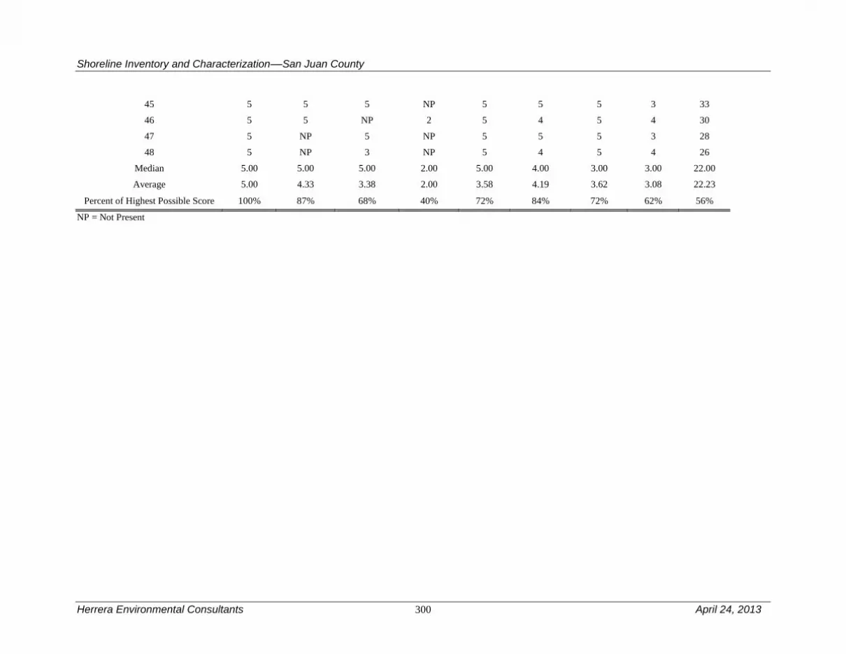
Shoreline Inventory and Characterization––San Juan County
Herrera Environmental Consultants 300 April 24, 2013
45 5 5 5 NP 5 5 5 3 33
46 5 5 NP 2 5 4 5 4 30
47 5 NP 5 NP 5 5 5 3 28
48 5 NP 3 NP 5 4 5 4 26
Median 5.00 5.00 5.00 2.00 5.00 4.00 3.00 3.00 22.00
Average 5.00 4.33 3.38 2.00 3.58 4.19 3.62 3.08 22.23
Percent of Highest Possible Score 100% 87% 68% 40% 72% 84% 72% 62% 56%
NP = Not Present

Shoreline Inventory and Characterization––San Juan County
April 24, 2013 301 Herrera Environmental Consultants
Table 38B. West Sound Management Area Reach Assessment – Habitat Conditions.
Reach Vegetation
Coverage
Estuary
Habitat Birds
Haul-out
Habitat Eelgrass
Floating
Kelp
Understory
Kelp
Spawning
Habitat1
Herring
Spawning
Habitat
Shellfish Total
23 5 0 0 0 5 0 5 0 0 4 19
24 5 0 1 0 5 5 0 0 0 3 19
25 5 2 0 0 5 0 0 0 0 2 14
26 5 3 0 0 5 0 0 0 0 2 15
27 4 2 0 0 5 0 0 0 0 2 13
28 4 0 0 0 5 0 0 0 0 2 11
29 4 0 0 0 5 0 0 0 0 2 11
30 5 0 0 0 5 5 5 3 5 3 31
31 5 1 0 0 5 0 5 0 5 1 22
32 5 1 1 0 5 5 5 0 5 2 29
33 5 0 1 0 0 0 5 0 5 1 17
34 5 4 0 0 5 5 5 3 5 1 33
35 5 0 5 0 0 0 0 0 5 1 16
36 4 0 0 0 5 0 0 0 5 1 15
37 4 1 0 0 5 0 5 0 5 1 21
38 4 1 1 0 0 0 5 3 5 1 20
39 5 1 0 0 5 0 0 0 5 1 17
40 5 1 0 0 5 0 0 0 5 1 17
41 4 1 0 0 5 0 0 0 5 1 16
42 5 1 0 0 5 5 5 0 0 2 23
43 4 0 0 0 5 5 5 3 0 1 23
44 3 0 0 0 5 0 5 3 0 1 17
45 5 0 1 0 5 5 5 0 0 1 22
46 5 0 0 0 5 5 0 0 0 1 16
47 5 1 0 0 5 5 5 0 0 1 22

Herrera Environmental Consultants 302 April 24, 2013
48 5 0 0 0 5 0 0 0 0 0 10
Median 5.00 0.50 0.00 0.00 5.00 0.00 5.00 0.00 0.00 1.00 17.00
Average 4.62 0.77 0.38 0.00 4.42 1.73 2.50 0.58 2.31 1.50 18.81
Percent of Highest Possible Score 92% 15% 8% 0% 88% 35% 50% 12% 46% 30% 38%
1 Includes priority spawning habitat for sand lance, surf smelt, and rock sole.

Shoreline Inventory and Characterization––San Juan County
April 24, 2013 303 Herrera Environmental Consultants
4.19 Private Lakes Management Area
The Private Lakes management area includes all of the privately held lakes in the County that are
greater than 20 acres in size. This includes: Sportsman Lake, Horseshoe Lake, Spencer Lake,
Zylstra Lake, Roche Harbor Lake (aka Briggs Pond), Hummel Lake, Martins Lake, Woods Lake,
and Dream Lake. The Private Lakes management area also includes Trout Lake, even though it
is publicly owned by the Town of Friday Harbor (for use as a water-supply reservoir), because
the lake is functionally private (public access is controlled). Per DNR, Trout Lake has state-
owned shorelands and bedlands. There are no major transportation related uses in this
management area, although several lakes have adjacent roads.
Table 39 is a summary of the reach assessment for the Private Lakes management area. The table
is in two parts, one covering general physical conditions, the other addressing those conditions
directly related to habitat functions. The following discussions cover both the conditions scored
in the reach assessment (Tables 39A and B) and management area results from the ecosystem-
wide characterization. In general, the private lakes score similar to their public counterparts with
the highest scoring reaches typically undeveloped lake reaches. Reaches with a road generally
score lower because of significant alterations to the physical environment from road construction
and maintenance (for example, the placement of rock, disconnection of shoreline sediment
sources) and lack of riparian vegetation. Other private lakes (such as Zylstra Lake and Woods
Lake) have been affected primarily by logging and recreational development.
4.19.1 Physical and Biological Characterization
Geologic Hazards
There are no known geologic hazards to the Private Lakes.
Drainage Basins, Tributary Streams, and Associated Wetlands
The drainage basins are diverse among the Private Lakes. Some of the lakes have stream
tributaries (such as Spencer Lake and Trout Lake), while others have none (like Horseshoe
Lake). There are several reservoirs (Trout Lake, Roche Harbor Lake, Dream Lake, Woods Lake
and Martins Lake). These lakes are natural; however, the dams that regulate their discharge also
affect sediment transport processes within the lakes. Many of the lakes have associated wetlands.
Most have no or a relatively low level of adjacent development. The Trout Lake drainage basin
is protected from future development to protect this water-supply reservoir for the Town of
Friday Harbor.
Critical or Priority Habitat and Species Use
Many Private Lakes provide habitat to support planted rainbow trout populations. These include
Sportsman Lake and Zylstra Lake on San Juan Island, Horseshoe, and Spencer lakes (Blakely
Island) and Hummel Lake (Lopez Island). WDFW also plants triploid trout in Hummel Lake.
Fish occurrence in Trout Lake is unknown. However, the water from this lake eventually drains
into False Bay Creek, which has high potential to provide habitat for native populations of
salmon.

Shoreline Inventory and Characterization––San Juan County
Herrera Environmental Consultants 304 April 24, 2013
Zylstra Lake contributes water to False Bay Creek, and is an important source of minimum flows
during drier seasons to support habitat conditions for coho fry that may be present at times.
Private lakes, which in general are not heavily developed, also provide suitable habitat for bird
species that are associated with freshwater habitats. This includes bald eagles, which have been
observed near Zylstra, Spencer, and Horseshoe Lakes and likely use habitat along the forested
shorelines of other lakes. Both shoreline vegetation providing nearshore shade, and vegetation
coverage within the shoreline jurisdiction score high in all reaches.
Water Quality, Sediment, and/or Tissue Sample Results
There is no known publically available water quality data for the private lakes with the exception
of Trout Lake, which is a water supply source for the Town of Friday Harbor. Trout Lake water
has routinely met drinking water standards with the exception of total Trihalomethanes (THMs),
which are a byproduct of the chlorination process (Town of Friday Harbor 2011). No fish tissue
data are available for Trout Lake.
4.19.2 Shoreline Use Patterns
Existing Land and Shoreline Use
Land Use
Overall existing land use in the Private Lakes management area includes:
Residential – 18 percent
Services – 17 percent
Cultural, Entertainment, Recreation – 4 percent
Undeveloped Land – 61 percent
Roche Harbor Lake’s shoreline jurisdiction on San Juan Island is entirely resource land uses.
Neva Lake has a mix of land uses, including residential, cultural/recreation, trade, and vacant.
There is a private resort (Lakedale) on the shores of this lake, providing for a wider mix of
existing land uses. Sportsman Lake is largely residential with small amounts of vacant and
cultural/recreation land uses. Egg Lake, a wetland area associated with Sportsman Lake, is
largely vacant with some large lot residential land uses on the edges of the lake’s shoreline
jurisdiction. Other wetlands associated with Sportsman Lake, found south and southeast of the
lake are in areas with vacant lands predominating, as well as some large lot residential
development. Zylstra Lake shoreline is almost entirely in resource land use. Associated wetlands
to the north, including Margos Lake, include a mix of residential, vacant, and conservation land
uses. While Zylstra Lake’s southern associated wetlands are mostly in resource land, Woods
Lake is in an area with large lot residential development and a small amount of resource and
vacant land uses interspersed. Trout Lake is completely surrounded by government/education
land use as the Town of Friday Harbor’s municipal water supply.
Martins Lake on Orcas Island is completely surrounded by resource land uses.
Lopez Island’s Hummel Lake shoreline jurisdiction is predominantly in resource use with
cultural/recreation and vacant parcels making up the second largest amount of existing land use.

Shoreline Inventory and Characterization––San Juan County
April 24, 2013 305 Herrera Environmental Consultants
There are also a handful of residential land uses on this lake’s shoreline. The stream and
associated wetland that travel north from Hummel Lake are flanked with existing resource land
use near the lake with large lot residential uses more predominant at the northern end of this
shoreline jurisdiction.
Blakely Island’s Horseshoe Lake is entirely surrounded by existing resource land uses. While
Spencer Lake is largely made up of resource land use, it also includes a large lot residential use
on its northern shore, and a government/education use on the southern shore.
Some of the larger lakes, such as Horseshoe Lake on Blakely Island, have water-dependent uses,
such as private piers or docks. In terms of water-related uses, dams exist at Briggs, Neva, Dream,
and Trout lakes on San Juan Island. Dams also exist on Martin Lake on Orcas Island and Spencer
Lake on Blakely Island. Water enjoyment uses, such as hotels/lodging and associated eating
establishments are found adjacent to Neva and Dream Lakes, which are in a more developed area
than other San Juan Island lakes with shoreline jurisdiction.
Land Use Designations
Roche Harbor Lake’s shoreline jurisdiction is designated Rural Farm Forest. Comprehensive
Plan land uses in Neva Lake’s shoreline include Rural General on the south side, and Rural Farm
Forest on the remaining shorelines. Dream Lake, Egg Lake, and Sportsman Lake are surrounded
by Rural Farm Forest designations. Zylstra Lake’s shoreline is designated Agricultural Resource,
while associated wetlands extending to Margos Lake include both Agricultural Resource and
Rural Farm Forest designations. Woods Lake is completely surrounded by Rural Farm Forest
designation. Trout Lake’s shorelines are designated Town of Friday Harbor as it is the Town’s
municipal water supply source.
Martins Lake’s shorelines on Orcas Island are designated Forest Resource. Comprehensive Plan
land use designations on Hummel Lake are predominantly Rural Farm Forest with the exception
of the northeast side and the associated wetland extending to the north, which are both in the
Agricultural Resource designation. Both Horseshoe Lake and Spencer Lake on Blakely Island
are designated Forest Resource.
Shoreline Environment Designations
Of the lakes with shoreline jurisdiction on San Juan Island, Roche Harbor Lake, Zylstra Lake,
and the Sportsman Lake group that includes Neva, Dream, and Egg lakes are in the Rural Farm-
Forest shoreline environment. Trout Lake is in the Natural shoreline environment.
Martins Lake on Orcas Island and Hummel Lake on Lopez Island are designated Rural Farm
Forest shoreline designation. Spencer Lake on Blakely Island is also in the Rural Farm Forest
shoreline designation, and Horseshoe Lake, also on Blakely Island, is in the Conservancy
shoreline designation.
Shoreline Modifications
No official County database exists for the shoreline modifications to lakes. Several of the Private
Lakes (Sportsman, Hummel, Dream, Martin’s, and Spencer lakes) have roads along their

Shoreline Inventory and Characterization––San Juan County
Herrera Environmental Consultants 306 April 24, 2013
shorelines. All of the lakes have at least one overwater structure within them, with the exception
of Martins Lake, Woods Lake and Zylstra Lake. Spencer Lake has four overwater structures.
Trout Lake is a reservoir and therefore has a dam at its outlet.
Existing and Potential Public Access Areas
The Private Lakes management area has roughly 17.7 miles of freshwater shorelines. There are
over 8,000 feet of trails in this management area. On San Juan Island, Roche Harbor Lake has
trails within the shoreline. Trout Lake also has trails, but public access to Trout Lake is
controlled. There is a locked gate on the road to the lake. There are no sanctioned recreational
opportunities allowed in the Trout Lake watershed (Town of Friday Harbor Water System Plan
2003). On Lopez Island, Hummel Lake Preserve offers public access and trails within the
shoreline.
4.19.3 Restoration Opportunities
Several of the private lakes (Sportsman, Hummel, Dream, Martin’s, and Spencer lakes) have
roads along their shorelines. In most cases, areas adjacent to the roadway have been cleared,
eliminating all riparian woody vegetation. In a few locations (e.g., Hummel and Dream lakes),
fill has also been placed, altering the shoreline geomorphology. Removing the fill would have
the largest habitat benefits, replacing lost shoreline habitat, but it would require costly relocation
of the roadway. Revegetation, while not as beneficial as fill removal, would restore lost riparian
habitat and would be relatively straightforward to implement considering that it could be done in
the road right of way, which is typically under County control.

Shoreline Inventory and Characterization––San Juan County
April 24, 2013 307 Herrera Environmental Consultants
Table 39A. Private Lakes Management Area Reach Assessment – Physical Conditions.
Reach Shoreline
Modifications
Natural
Current
Patterns
Toxics
Nutrient
and
Toxics
Removal
Shade Total
79 5 3 5 4 17
80 5 5 5 5 20
95 5 5 0 5 15
96 5 5 5 5 20
171 3 1 5 2 11
172 5 5 5 5 20
268 5 5 3 5 18
269 4 5 5 5 19
270 3 1 5 4 13
271 5 5 5 4 19
272 4 3 5 4 16
273 3 1 5 3 12
274 5 0 5 4 14
275 3 5 5 5 18
276 5 1 0 3 9
277 3 5 5 5 18
Median 5.00 5.00 5.00 4.50 17.50
Average 4.25 3.44 4.25 4.25 16.19
Percent of Highest Possible Score 85% 69% 85% 85% 81%

Shoreline Inventory and Characterization––San Juan County
Herrera Environmental Consultants 308 April 24, 2013
Table 39B. Private Lakes Management Area Reach Assessment – Habitat Conditions.
Reach Vegetation
Coverage
Wetland
Habitat Birds Salmonids Total
79 5 0 0 0 5
80 5 1 1 0 7
95 5 4 0 3 12
96 5 0 0 0 5
171 5 5 0 3 13
172 5 5 5 0 15
268 5 1 0 0 6
269 5 1 0 0 6
270 4 4 2 0 10
271 4 5 5 0 14
272 5 5 1 0 11
273 4 5 0 3 12
274 5 5 0 3 13
275 5 1 0 0 6
276 4 5 1 5 15
277 5 2 0 0 7
Median 5.00 4.00 0.00 0.00 10.50
Average 4.75 3.13 1.00 1.13 9.81
Percent of Highest Possible Score 95% 63% 20% 23% 49%

Shoreline Inventory and Characterization––San Juan County
April 24, 2013 309 Herrera Environmental Consultants
4.20 Public Lakes Management Area
The Public Lakes management area includes Cascade Lake and Mountain Lake on Orcas Island.
Cascade Lake and Mountain Lake are a part of Moran State Park (a small portion of Cascade
Lake is in private ownership). There are no major transportation related uses in this management
area, although Cascade Lake has a road adjacent to a significant length of its shoreline.
Table 40 is a summary of the reach assessment for the Public Lakes management area. The table
is in two parts, one covering general physical conditions, the other addressing those conditions
directly related to habitat functions. The following discussions cover both the conditions scored
in the reach assessment (Tables 40A and B) and management area results from the ecosystem-
wide characterization. The Public Lake management area scores very high for physical
conditions as well as habitat functions. Although there are shoreline modifications and
disruptions to natural current patterns on a number of reaches, in general the extent of
undeveloped shore and adjacent uplands provides high quality habitat. Where there are lower
scores, they are principally a result of the recreational infrastructure associated with the public
lakes. Cascade Lake scores particularly low because the shoreline is heavily modified to provide
recreational uses and public access to the shore in Moran State Park. By comparison, Mountain
Lake scores much higher as there is much less development-related infrastructure.
4.20.1 Physical and Biological Characterization
Geologic Hazards
There are no known geologic hazards to the Public Lakes management area.
Drainage Basins, Tributary Streams and Associated Wetlands
Mountain Lake does not have a mapped stream source but does have seasonal tributary streams.
At least two small streams (one a tributary from Cascade Creek) drain to Cascade Lake. The
public lakes drainage basins are mostly protected from future development because they are in
parks. There are no documented wetlands surrounding Cascade Lake; however, Cascade Lake
has an associated lagoon. Small fringing wetlands do occur around Mountain Lake. The public
lakes have dams and, for each, the dam construction and operation largely determines sediment
input and discharge.
Critical or Priority Habitat and Species Use
Mountain Lake and Cascade Lake each support cutthroat trout and kokanee populations. Cascade
Lake contains rainbow trout, and both lakes are also planted with sterile triploid trout to increase
recreational fishing opportunities. These lakes are generally undeveloped and likely provide
suitable habitat for numerous bird species that are associated with freshwater environments
although only one reach has a reported sighting of a priority species, the common loon. The
common loon, a state sensitive species is attracted to relatively undisturbed forest lakes that are
greater than 50 acres in size, and that have deep inlets or bays, good water quality, food sources,
and nesting sites. Mountain and Cascade lakes provide typical conditions to support this species.
Likely many other bird species are attracted to these conditions.

Shoreline Inventory and Characterization––San Juan County
Herrera Environmental Consultants 310 April 24, 2013
Water Quality, Sediment, and/or Tissue Sample Results
Fish tissue data have been collected from Mountain and Cascade Lakes. Mountain Lake was
303(d) listed in 2008 for elevated levels of PCBs in fish tissue samples (kokanee salmon)
(Ecology 2011e). In contrast, fish tissue samples (including largemouth bass, rainbow trout, and
kokanee salmon) collected from Cascade Lake met all associated fish tissue criteria (Ecology
2011e).
4.20.2 Shoreline Use Patterns
Existing Land and Shoreline Use
Land Use
Both Cascade and Mountain lakes are completely within Moran State Park. Existing land uses
around Mountain Lake consist of the cultural/recreation use of the state park, including
campsites near the lake. Cascade Lake has similar land uses along most of its shoreline
jurisdiction as Mountain Lake, but also includes a boat rental facility not present at Mountain
Lake. In addition, the Cascade Lake lagoon includes some large vacant parcels and a handful of
cultural/recreation uses on the far western end of the lake.
Overall existing land use in the Public Lakes management area includes:
Cultural, Entertainment, Recreation – 90 percent
Undeveloped Land – 10 percent
The boat rental facility and docks at Cascade Lake are considered a water-dependent use. Moran
State Park and the campground and hiking trails surrounding both lakes in this management area
are considered water enjoyment uses.
Cascade Lake and Mountain Lake on Orcas Island have state-owned shorelands and bedlands
that management authority appears to have been provided to the Washington State Parks and
Recreation Commission by Commissioner Order in 1932.
Land Use Designations
The portions of the two lakes found within Moran State Park are designated Conservancy,
reflecting their status within a state park. The Cascade Lake Lagoon is surrounded by Rural
Residential land designation on the north and south, and by Master Plan Resort on the far west
where it touches Rosario Resort.
Shoreline Environment Designations
Both Public Lakes are in the Conservancy shoreline environment.
Shoreline Modifications
No official County database exists for shoreline modifications to lakes. However, an analysis of
aerial photographs indicates that there are four overwater structures in Cascade Lake and a boat
ramp and dock at Mountain Lake. Cascade Lake has a road along its shoreline for more than one-

Shoreline Inventory and Characterization––San Juan County
April 24, 2013 311 Herrera Environmental Consultants
third of a mile. Mountain Lake also has road beside it, but only for a limited distance. Cascade
and Mountain Lakes (both natural lakes) are dammed.
Existing and Potential Public Access Areas
This management area has over 30,000 feet of trails and paths; the Moran State Park
campground has a dock and boating facilities. Both Cascade and Mountain Lakes have trails
around the shoreline. Mountain and Cascade Lakes each have a boat launch. Cascade Lake has
some campsites in shoreline jurisdiction.
4.20.3 Restoration Opportunities
Because these lakes are relatively undeveloped and high quality in both human and ecological
perspectives, restoration opportunities are limited. However, Cascade Lake, like some of the
Private Lakes, does have a road along a portion of its shoreline, some of which is on fill. The
riparian zone in this area is sparsely vegetated. Moving the road would be difficult due to the
adjacent steep slopes, but improving vegetation cover in the riparian corridor may be possible.
For the undisturbed portions of these lakes it is likely that protection and conservation measures
that sustain continuity across terrestrial and aquatic habitats will be important for species and for
protecting the long term water quality. Conservation of vegetated buffers and corridors between
the lakes and other habitats should be a priority for future management. Further investigation
should be undertaken to determine the origin of PCBs to Mountain Lake kokanee salmon.

Shoreline Inventory and Characterization––San Juan County
Herrera Environmental Consultants 312 April 24, 2013
Table 40A. Public Lakes Management Area Reach Assessment – Physical Conditions.
Reach Shoreline
Modifications
Wave
attenuation
Toxics
removal Shade Total
75 5 5 0 5 15
76 4 4 0 5 13
77 3 3 5 4 15
78 4 5 5 5 19
Median 4.00 4.50 2.50 5.00 15.00
Average 4.00 4.25 2.50 4.75 15.50
Percent of Highest Possible Score 80% 85% 50% 95% 78%
Table 40B. Public Lakes Management Area Reach Assessment – Habitat Conditions.
Reach Vegetation
Coverage
Wetland
Habitat Birds Salmonids Total
75 5 1 0 5 11
76 5 0 0 5 10
77 4 0 1 5 10
78 5 1 0 5 11
Median 5.00 0.50 0.00 5.00 10.50
Average 4.75 0.50 0.25 5.00 10.50
Percent of Highest Possible Score 95% 10% 5% 100% 53%

Shoreline Inventory and Characterization––San Juan County
April 24, 2013 313 Herrera Environmental Consultants
5.0 Use Analysis
This section presents a use analysis, identifying current and projected shoreline use patterns, as
well as estimating future demand for shoreline space, consistent with SMP guidelines. The use
analysis includes a shoreline land capacity analysis that estimates total amount of potential future
residential, commercial, and industrial development in the shoreline jurisdiction based upon an
assessment of buildable lands and zoning designations applied to the shoreline jurisdiction. In
addition, use analysis also includes an assessment, based in part on an assessment of existing and
planned land uses, of potential future land use conflicts, projected shoreline preferred uses, and
potential uses needed based upon economic needs of the community.
5.1 Shoreline Land Capacity Analysis – Methods
The purpose of the shoreline land capacity analysis is to gauge the potential level of development
that may occur in the future along shorelines given adopted Comprehensive Plan land use
designations. The information is intended to provide an understanding of the future level of
intensity that may occur given current plans and regulations.
San Juan County’s land use plans contained in the County’s Comprehensive Plan give a more
specific picture of likely future activities on the shorelines than the present SMP, which allows
more uses/activities in each of the shoreline environments compared to the County’s
Comprehensive Plan land use designations.
The method to determine shoreline land capacity is summarized below. A more detailed matrix
of assumptions is included in Appendix C.
Determine shoreline boundaries. The analysis includes parcels within or
intersecting the shoreline jurisdiction, which is 200 feet, measured
horizontally from the ordinary high water mark. The parcel was included
whether the entire parcel was within shoreline jurisdiction, or just a part of
the parcel was included in shoreline jurisdiction. However, if a parcel was
only within an associated wetland, then it was not included in the land
capacity analysis.
Determine Development Potential. The analysis estimates developable
acres by future land use category. Developable acres include: 1) vacant
land that can be subdivided (vacant land includes those lands with no
buildings but also includes land with buildings that have little to no value
per the assessor’s record); 2) vacant land on parcels too small to be
subdivided but with a potential legal right to develop; 3) partially used
(e.g., single-family properties containing one home but the land can be
further subdivided; or 4) underutilized (land value exceeds building value
on multifamily, commercial, or industrial properties). Constraints such as
wetlands, streams, and their buffers, as well as any land preserved for

Shoreline Inventory and Characterization––San Juan County
Herrera Environmental Consultants 314 April 24, 2013
habitat protection or land conservation were deducted from gross acres.
Other deductions were made for government or public ownership
properties, and private and public access roads and development
infrastructure. Market factor reductions, which account for land that may
not be available (e.g., owners does not wish to develop), are also included.
Densities are applied to the net buildable acres for residential development
to estimate total future dwellings.
Due to specific residential development patterns in San Juan County, a
factor based upon the U.S. Census data and the San Juan County Housing
Needs Assessment (Personal communication with Colin Maycock, Senior
Planner, San Juan County on April 2011) was applied to estimate the
number of the dwellings calculated above which are second homes and/or
guest lodging.
Because the vast majority of undeveloped and/or partially developed
shoreline is residential, the County Planning staff was able to provide an
assessment of potential commercial and industrial development and
redevelopment in shoreline jurisdiction by reviewing parcel-specific data.
The statistical results exclude the following lands:
Lands specifically identified as “public” on the San Juan County
Comprehensive Plan. Lands identified as “public” or “government” on
existing land use maps were excluded from statistical analysis of
additional residences and commercial/industrial development potential.
However, since public uses may result in shoreline development of
structures or facilities, designated public acres are described in each
subsection where applicable.
Lands designated for conservation whether publicly or privately owned
were excluded from the statistics since the likelihood is that these
conservation easements or ownership (e.g., Nature Conservancy) mean
that future development or redevelopment on these lands is unlikely.
It is important to note that this analysis is intended to give an overall picture of the potential for
development along shorelines, but is not an exact predictor of which parcels may develop or
redevelop. In addition, the analysis does not provide a “rate” of development.
5.2 Shoreline Land Capacity Analysis – Results By Management
area
The results of the shoreline jurisdiction land capacity analysis divided by management area are
summarized in Table 41 below. A summary discussion of the land capacity results by
management area follows Table 41.

Shoreline Inventory and Characterization––San Juan County
April 24, 2013 315 Herrera Environmental Consultants
Table 41. Estimated Residential Land Capacity – Parcels Within or Touching Shoreline Jurisdiction.
Management Area
Shoreline Length
(Miles)
Number of Parcels Within
Shoreline Jurisdiction
Vacant Parcels
1
Protected Lands Parcels
(approximate)
Parcels with Nonconforming
Structures2
Potential New
SFRs3 in
Vacant and
Partially Used Land
Potential New
SFRs in Lots
Unable to Subdivide
Potential New
Multi-Family
Dwelling Units
Total Dwelling
Units #
% of Total
# #
% of Total
# #
% of Total
#
Blakely 13.9 138 59 43% 9 7% 8 6% 62 38 0 100
Decatur 19.6 265 78 29% 5 2% 38 14% 128 66 0 194
Doe Bay 23.4 265 115 43% 8 3% 22 8% 31 90 0 121
East Sound 17.5 279 121 43% 20 7% 37 13% 120 67 66 253
Fisherman Bay 14.0 350 112 32% 14 4% 30 9% 42 86 0 128
Friday Harbor 24.2 450 122 27% 15 3% 109 24% 48 101 0 149
Mud Bay 28.4 323 145 45% 20 6% 25 8% 46 111 0 157
North Coast Eastsound 4.4 162 47 29% 0 0% 17 10% 3 43 0 46
Olga 15.0 328 116 35% 5 2% 34 10% 54 96 0 150
Private Lakes 17.8 103 64 62% 21 20% 4 4% 56 35 0 91
Public Lakes 7.6 12 6 50% 4 33% 1 8% 10 0 0 10
Roche Harbor 33.7 719 222 31% 11 2% 137 19% 121 198 0 319
San Juan Channel 13.2 228 62 27% 3 1% 54 24% 39 54 0 93
Shaw 38.2 323 129 40% 21 7% 67 21% 151 87 0 238
Spencer Spit 12.7 291 88 30% 16 5% 28 10% 3 74 0 77
Strait of Juan de Fuca 57.7 547 209 38% 34 6% 25 5% 73 154 0 227
Stuart 36.0 260 134 52% 9 3% 29 11% 158 99 0 257
Turtleback 15.5 122 43 35% 5 4% 30 25% 105 34 0 139
Waldron 45.6 149 68 46% 15 10% 12 8% 61 48 0 109
West Sound 25.5 383 119 31% 18 5% 65 17% 108 41 84 233
TOTAL 464.0 5,697 2,059 36% 253 4% 772 14% 1,419 1,522 150 3,091

Shoreline Inventory and Characterization––San Juan County
Herrera Environmental Consultants 316 April 24, 2013
1 Assessed building value of less than $10,000.
2 Presence of building within 50 feet of shoreline, which are non-conforming under the existing SMP.
3 Single-family residence.

Shoreline Inventory and Characterization––San Juan County
April 24, 2013 317 Herrera Environmental Consultants
Overall, the land capacity analysis shows that the vast majority of development capacity within
the County’s shoreline jurisdiction is residential development. Another large portion of the
County’s shorelines were excluded from the land capacity analysis because it is held in public
ownership and/or protected through conservation easements or other measures. A small fraction
of the County’s shoreline capacity is available for commercial development that could include
water-enjoyment uses such as restaurants. Although a small amount of the County’s shoreline
jurisdiction is in industrial uses, there is no measureable industrial land capacity in the County
shoreline jurisdiction. Much of the existing potential industrial capacity is taken up by essential
industrial uses, such as boat repair facilities, which in some cases represent the only location for
this type of development on the island on which the use is located. Because there is so little
commercial and industrial land capacity in the County, County staff assisted in providing a
qualitative assessment of parcels that have commercial or industrial development potential.
A review of Table 41 shows the disproportionate amount of residential development in shoreline
jurisdiction that can be attributed to development of existing lots too small to subdivide under the
San Juan County Code (SJCC). Almost half of the single-family residential development
capacity occurs on these lots. In addition, Table 41 also shows the very low capacity for
multifamily development in the San Juan County shoreline jurisdiction.
Although Table 41 indicates a potential residential land capacity of 3,091 dwelling units, County
permit data for waterfront residential development in the years 2000-2009 indicates that permit
activity averaged approximately 57 per year during this period. Applying the average permit data
indicates that the residential land capacity could last 50 years or more into the future. Based upon
2010 U.S. Census data and the San Juan County Planning Department’s analysis of housing
needs, approximately 40 percent of the overall housing capacity, or approximately
1,236 dwelling units of the 3,091 dwelling unit total would be second homes or guest housing.
5.2.1 Blakely Island
The Blakely Island management area includes 138 parcels. Of these parcels, 43 percent are
vacant and approximately 7 percent are protected from development by public or conservation
group ownership, conservation easements, or similar reasons. Six percent of parcels include at
least one non-conforming structure.
The Blakely Island management area’s shoreline is designated for rural uses with a combination
of residential, resource, and conservation uses. County land use districts in this management area
include Forest Resource, Residential Rural, Rural Farm Forest, and Conservancy. The most
intense uses of property would come from Rural Residential land uses at the northern portion of
the management area. Approximately 62 percent of the approximately 100 new dwelling units
that could occur in this management area would result from plat activity. Although large portions
of Blakely Island are in Forest Resource land use that could allow nonresidential resource-based
uses, much of the island is also owned by institutions and/or held in conservation easements.
Therefore, there is no measurable commercial or industrial development capacity in this
management area.

Shoreline Inventory and Characterization––San Juan County
Herrera Environmental Consultants 318 April 24, 2013
Although existing zoning allows some limited opportunity for non-priority uses in the shoreline
jurisdiction, future use conflicts in this management area are highly unlikely. Use conflicts are
particularly unlikely when accounting for the County’s existing shoreline regulations, which
would inhibit non-priority shoreline uses. This management area includes area for shoreline
residential and associated water-dependent uses of associated docks and piers. Residential use of
shorelines is a preferred use. However, the associated water-dependent uses such as piers and
docks are not necessarily a preferred use but rather an allowed use. There is little or no area in
the management area dedicated to water-oriented or shoreline preferred commercial and
industrial uses in this management area.
5.2.2 Decatur Island
The Decatur Island management area includes 265 parcels. Of these parcels, 29 percent are
vacant and approximately 2 percent are protected from development by public or conservation
group ownership, conservation easements, or similar reasons. Fourteen percent of parcels include
at least one non-conforming structure.
The Decatur Island shoreline is entirely designated for rural land uses. San Juan County land use
districts along the shoreline in this management area include Rural Residential, Rural General,
Rural Industrial, Conservancy, and Natural. Based on these designations, the most intense use of
property appears to be with Rural General and Rural Residential designated lands found on most
of the Decatur Island and Center Island shorelines. The majority of new residential development
capacity in shoreline jurisdiction exists in these two designations. Although approximately one-
third of the residential development capacity in this management area occurs on lots too small to
be subdivided under the SJCC, some larger subdivision opportunities exist in this management
area, particularly on Decatur Island. Although a small amount of Rural Industrial land exists in
shoreline jurisdiction on Decatur Island, there is no measurable additional commercial or
industrial development capacity in this management area.
Existing zoning allows some opportunity for non-priority uses in the shoreline jurisdiction,
particularly in the Rural General and Rural Industrial land use designations found on Decatur
Island in this management area. These zones allow a wide variety of uses, providing potential for
future use conflicts. However, when considering existing shoreline regulations that the County
applies in this management area, it appears that future use conflicts would be unlikely. This
management area includes area for shoreline uses of residential and associated water-dependent
uses, such as associated docks and piers and water-enjoyment uses associated with recreation at
state parks and other public lands within this management area. A small amount of Rural
Industrial land on the south side of Decatur Island allows industrial priority uses within the
shoreline jurisdiction, though the area is currently developed with little or no additional
development capacity.
5.2.3 Doe Bay
The Doe Bay management area includes 265 parcels. Of these parcels, 43 percent are vacant and
approximately 3 percent are protected from development by public or conservation group

Shoreline Inventory and Characterization––San Juan County
April 24, 2013 319 Herrera Environmental Consultants
ownership, conservation easements, or similar reasons. Eight percent of parcels include at least
one non-conforming structure.
The Doe Bay management area is designated for rural uses and has one rural Activity Center,
Doe Bay, in its boundaries. County land use districts in this management area include Rural
Residential, Rural Farm Forest, Forest Resources, Activity Center, Conservancy, and Natural.
Although the Doe Bay Activity Center allows for higher intensity land uses than the other land
use districts, there is little residential development capacity in that part of shoreline jurisdiction
since much of that area is built out. Most of the residential development capacity in this
management area comes from pre-existing lots that are too small for subdivision in the Rural
Residential and Rural Farm Forest land use districts. There is no measureable commercial or
industrial development capacity in this management area.
Although existing zoning allows some limited opportunity for non-priority uses in the shoreline
jurisdiction, particularly in the small area designated as Activity Center, where a wider variety of
uses are allowed, future use conflicts in this management area are unlikely. Use conflicts are
particularly unlikely when accounting for the County’s existing shoreline regulations, which
would inhibit non-priority shoreline uses. This management area includes area for shoreline uses
of residential and associated water-dependent uses of associated docks and piers. There is also
area dedicated to water enjoyment recreation uses. There is little or no area in the management
area dedicated to water-oriented or shoreline preferred commercial and industrial uses in this
management area.
5.2.4 East Sound
The East Sound management area includes 279 parcels. Of these parcels, 43 percent are vacant
and approximately 7 percent are protected from development by public or conservation group
ownership, conservation easements, or similar reasons. Thirteen percent of parcels include at
least one non-conforming structure.
The East Sound management area includes the south side of the Eastsound Urban Growth Area
as well as significant rural areas on the west side of East Sound. County land use districts in this
management area consist of Rural Farm Forest, Rural Residential, Eastsound Rural Residential,
Eastsound Residential 2/acre, Eastsound Natural, Village Commercial, Village Residential, and
Eastsound Rural. Approximately half of the residential development capacity in this management
area comes from development and redevelopment of single-family land that can be subdivided,
approximately one-quarter of residential capacity comes from development of single-family
housing on pre-existing lots too small to subdivide, and one-quarter comes from multifamily
development on vacant and partially used land. This management area is only one of two in the
County with multifamily development capacity in shoreline jurisdiction. According to County
Planning staff estimates, there are four partially developed parcels zoned Village Commercial in
this management area that present the possibility for commercial redevelopment (Maycock,
Colin. Personal communication, April 29, 2011). The area for potential commercial
redevelopment in this management area amounts to approximately 0.89 acres. According to
County Planning staff, there are no active land use applications for commercial development in

Shoreline Inventory and Characterization––San Juan County
Herrera Environmental Consultants 320 April 24, 2013
this management area. However, potential commercial redevelopment could include a wide
variety of land uses based upon uses allowed in the Village Commercial land use designation.
Although the wide variety of land uses allowed in the Village Commercial zone provides a
greater potential for future use conflicts, the existing shoreline use designations applied within
the management area would minimize the likelihood of use conflicts. This management area
includes area for shoreline uses of residential and associated water-dependent uses of associated
docks, piers, and marina. Although a portion of this management area would allow for water-
oriented commercial uses – such as water-enjoyment restaurants or lodging, much of this area is
already developed and there is little opportunity for redevelopment. There is no area in the
management area dedicated to shoreline preferred industrial uses.
5.2.5 Fisherman Bay
The Fisherman Bay management area includes 350 parcels. Of these parcels, 32 percent are
vacant and approximately 4 percent are protected from development by public or conservation
group ownership, conservation easements, or similar reasons. Nine percent of parcels include at
least one non-conforming structure.
The Fisherman Bay management area includes the Lopez Village Urban Growth Area, but is
predominantly made up of rural land use districts. Land use districts in this management area
include Rural Farm Forest, Rural Residential, Lopez Village Urban Growth Area, Lopez Village
Urban Growth Reserve, Marine Center LAMIRD, and Conservancy. The most intense land use
development in this management area would come from the Lopez Village Urban Growth Area.
However, the portion of the management area in this land use district is mostly built-out, and
only a small percentage of residential land capacity is estimated to result from development
there. Approximately 67 percent of residential land capacity in this management area is
estimated to come from vacant pre-existing lots too small to be subdivided, most of which are
located within the Rural Farm Forest land use district in this management area. In addition, the
Marine Center LAMIRD, which contains the Lopez Islander Resort property and marina, is
identified as partially used/redevelopable. According to County Planning staff, the approximately
13 acres of this designation in the Fisherman Bay management area could redevelop with
commercial uses and/or a combination of residential and commercial uses (Maycock, Colin.
Personal communication, April 29, 2011).
Although the wide variety of land uses allowed in the Lopez Village Urban Center and the
Marine Center LAMIRD land use designations provides a greater potential for future use
conflicts, the existing shoreline use designations applied within the management area would
minimize the likelihood of use conflicts.
5.2.6 Friday Harbor
The Friday Harbor management area includes 450 parcels. Of these parcels, 27 percent are
vacant and approximately 3 percent are protected from development by public or conservation
group ownership, conservation easements, or similar reasons. Twenty-four percent of parcels
include at least one non-conforming structure.

Shoreline Inventory and Characterization––San Juan County
April 24, 2013 321 Herrera Environmental Consultants
The Friday Harbor management area includes rural uses, including rural uses on the outskirts of
the Town of Friday Harbor. Land use districts in this management area include Rural Farm
Forest, Rural Residential, Rural Industrial, and Conservancy. The most intense land use
development in this management area would come from the Rural Residential land use district
and the small amount of Rural Industrial. Approximately 68 percent of the residential
development capacity in this management area is estimated to come from pre-existing lots too
small to be subdivided, most of which are located within the Rural Residential land use district.
Although this management area is on the outskirts of the Town of Friday Harbor, there is no
urban growth area within shoreline jurisdiction, and there is no measureable commercial or
industrial land development capacity estimated in the management area.
Although existing zoning allows some limited opportunity for non-priority uses in the shoreline
jurisdiction, future use conflicts in this management area are unlikely, particularly when
accounting for the County’s existing shoreline regulations, which would inhibit non-priority
shoreline uses. The zoning designation with the highest likelihood of allowing a non-priority use
would be the Rural Industrial zone. However, the small amount of Rural Industrial zone in this
management area is occupied by an essential boat repair yard, which is unlikely to redevelop
(Maycock, Colin. Personal communication, April 29, 2011). This management area includes area
for shoreline uses of residential and associated water-dependent uses of associated docks, piers,
and marina. In addition, space is dedicated to water-enjoyment public recreation uses in this area
as well. There is little or no area in the management area dedicated to water-oriented or shoreline
preferred commercial uses in this management area.
5.2.7 Mud Bay
The Mud Bay management area includes 323 parcels. Of these parcels, 45 percent are vacant and
approximately 6 percent are protected from development by public or conservation group
ownership, conservation easements, or similar reasons. Eight percent of parcels include at least
one non-conforming structure.
The Mud Bay management area is entirely made up of rural uses. Land use districts in this
management area include Rural Farm Forest, Rural Residential, Forest Resource, Conservancy,
and Natural. The most intense land use development in this management area would come from
the Rural Residential land use district. However, the portion of the management area in this
designation is largely built out. The majority of residential development capacity in this
management area comes from the Rural Farm Forest land use district. Approximately 71 percent
of the residential development capacity would occur on pre-existing lots too small to subdivide.
There is no measureable commercial or industrial land development capacity estimated in this
management area.
Although existing zoning allows some limited opportunity for non-priority uses in the shoreline
jurisdiction, future use conflicts in this management area are unlikely, particularly when
accounting for the County’s existing shoreline regulations, which would inhibit non-priority
shoreline uses. This management area includes large areas for shoreline residential uses which
may also be accompanied by associated water-dependent uses such as docks, piers, and marina.
In addition, space is dedicated to water-enjoyment public recreation uses in this management

Shoreline Inventory and Characterization––San Juan County
Herrera Environmental Consultants 322 April 24, 2013
area as well. There is little or no area in the management area dedicated to water-oriented or
shoreline preferred commercial or industrial uses.
5.2.8 North Coast Eastsound
The North Coast Eastsound management area includes 162 parcels. Of these parcels, 29 percent
are vacant and none are protected from development by public or conservation group ownership,
conservation easements, or similar reasons. Ten percent of parcels include at least one non-
conforming structure.
The North Coast Eastsound management area includes portions of the County’s Eastsound Urban
Growth Area as well as some rural areas on the fringe of that urban growth area located on Orcas
Island. This management area includes Rural Residential, Eastsound Rural Residential,
Eastsound Residential 1/acre, Eastsound 4/acre P, Eastsound Marina, and Service and Light
Industrial land use districts, Although this management area is largely urban with higher
intensity land use districts than most of the other management areas, much of the existing
shoreline is already developed. Most of the residential development capacity in this management
area comes from development on pre-existing lots that are too small for subdivision
(approximately 43 of 46 potential dwelling units). Although there is land in this management
area dedicated to commercial development, there is little or no redevelopment potential in this
management area (Maycock, Colin. Personal communication, April 29, 2011).
Although existing zoning allows some limited opportunity for non-priority uses in the shoreline
jurisdiction, future use conflicts in this management area are unlikely, particularly when
accounting for the County’s existing shoreline regulations, which would inhibit non-priority
shoreline uses. When not considering County shoreline regulations, the zones within this
management area allow a wider variety of land uses and intensities than found in other
management areas. This management area includes large areas for shoreline residential uses
which may also be accompanied by associated water-dependent uses such as docks, piers, and
marina. As described above, although there is area dedicated to commercial uses in this
management area that could allow shoreline preferred non-residential uses, there is little or no
commercial land capacity in this area.
5.2.9 Olga
The Olga management area includes 328 parcels. Of these parcels, 35 percent are vacant and
approximately 2 percent are protected from development by public or conservation group
ownership, conservation easements, or similar reasons. Ten percent of parcels include at least
one non-conforming structure.
The Olga management area is in rural uses with one Hamlet (Olga) and one Master Planned
Resort (Rosario) providing areas with more intense rural development. Other land use districts in
this management area include Rural Farm Forest, Rural Residential, Forest Resource, and
Conservancy. The majority of residential development capacity in this management area comes
from development on pre-existing lots too small to be subdivided. Several Master Plan Resort
parcels at Rosario Resort were identified as partially used/redevelopable in the land capacity

Shoreline Inventory and Characterization––San Juan County
April 24, 2013 323 Herrera Environmental Consultants
analysis. County Planning Staff indicated that although some commercial redevelopment could
occur as a result of the future redevelopment in the Master Planned Resort land use designation,
it would require a new Planned Unit Development (PUD) or an amendment to the existing PUD.
The Olga Store also is identified as a potential commercial redevelopment site. However, based
on County staff input this parcel is also unlikely to redevelop (Maycock, Colin. Personal
communication, April 29, 2011).
Although existing zoning allows some limited opportunity for non-priority uses in the shoreline
jurisdiction, future use conflicts in this management area are unlikely, particularly when
accounting for the County’s existing shoreline regulations, which would inhibit non-priority
shoreline uses. The Master Planned Resort and the Olga Hamlet land use designations provide
the greatest opportunity for future use conflicts based upon variety of uses allowed when not
accounting for the County’s shoreline jurisdiction. This management area includes large areas
for shoreline residential uses which may also be accompanied by associated water-dependent
uses such as docks, piers, and marina. In addition, space is dedicated to water-enjoyment public
recreation uses in this management area as well. There is limited area dedicated to water-oriented
or shoreline preferred commercial uses, and no area dedicated to industrial uses in this
management area.
5.2.10 Private Lakes
The Private Lakes management area includes 103 parcels. Of these parcels, 62 percent are vacant
and approximately 20 percent are protected from development by public or conservation group
ownership, conservation easements, or similar reasons. Four percent of parcels include at least
one non-conforming structure.
The Private Lakes management area is completely in rural land use districts on four of the
County’s islands. Land use districts in this management area include Rural Farm Forest,
Agricultural Resource, and Forest Resources. The most intense land use development in this
management area would come from the Rural Farm Forest land use district located on the shores
of Sportsman, and Dream Lakes on San Juan Island, and Hummel Lake on Lopez Island. The
majority of residential development capacity in this management area comes from development
and redevelopment occurring in the Rural Farm Forest land use district. About 38 percent of this
development occurs on pre-existing lots too small to subdivide. There is no measureable
commercial or industrial land development capacity estimated in this management area.
Although existing zoning allows some limited opportunity for non-priority uses in the shoreline
jurisdiction, future use conflicts in this management area are unlikely, particularly when
accounting for the County’s existing shoreline regulations, which would inhibit non-priority
shoreline uses. This management area includes large areas for shoreline residential uses which
may also be accompanied by associated water-dependent uses such as docks and piers. There is
little or no area in the management area dedicated to water-oriented or shoreline preferred
commercial or industrial uses.

Shoreline Inventory and Characterization––San Juan County
Herrera Environmental Consultants 324 April 24, 2013
5.2.11 Public Lakes
The Public Lakes management area includes 12 parcels. Of these parcels, 50 percent are vacant
and approximately 33 percent are protected from development by public or conservation group
ownership, conservation easements, or similar reasons. Eight percent of parcels include at least
one non-conforming structure.
The Public Lakes management area is almost entirely within Moran State Park, which is within
the County’s Conservancy land use district. However, a small portion of the management area
includes Rural Residential and Master Planned Resort (Rosario Resort) land use districts.
Because of the amount of area already protected in state park, this management area has the
lowest residential development capacity of all management areas in the County. Approximately
10 dwelling units are estimated to occur through redevelopment of underutilized parcels on the
west side of Cascade Lake.
There is little or no opportunity for future use conflicts in this management area. The shoreline
jurisdiction in Moran State Park offers water enjoyment recreation use opportunities. There is a
limited area available for preferred residential use in this management area and no opportunity
for industrial preferred uses in this management area.
5.2.12 Roche Harbor
The Roche Harbor management area includes 719 parcels. Of these parcels, 31 percent are
vacant and approximately 2 percent are protected from development by public or conservation
group ownership, conservation easements, or similar reasons. Nineteen percent of parcels include
at least one non-conforming structure.
The Roche Harbor management area is predominantly made up of rural uses, as well as the
Roche Harbor Master Planned Resort. Other land use districts in this management area include
Rural Farm Forest, Rural Residential, and Conservancy, and Natural. The most intense land use
development in this management area would come from the Master Planned Resort land use
district. However, the portion of the management area in Master Planned Resort is mostly built-
out, and only a small percentage of residential land capacity is estimated to result from
development in that land use district. As with many other management areas, the majority (more
than 60 percent) of residential land capacity in this management area is estimated to come from
vacant pre-existing lots too small to be subdivided, most of which are located within the Rural
Residential land use district. There is no measureable commercial or industrial land development
capacity estimated in the management area.
Although existing zoning allows some limited opportunity for non-priority uses in the shoreline
jurisdiction, future use conflicts in this management area are unlikely, particularly when
accounting for the County’s existing shoreline regulations, which would inhibit non-priority
shoreline uses. The land use designation offering the greatest opportunity for potential future use
conflicts is the Master Planned Resort at Roche Harbor. This land use designation allows a wider
variety of land uses than others within this management area. This management area includes
large areas for shoreline residential uses which may also be accompanied by associated water-

Shoreline Inventory and Characterization––San Juan County
April 24, 2013 325 Herrera Environmental Consultants
dependent uses such as docks, piers, and marina. In addition, space is dedicated to water-
enjoyment public recreation uses in this management area as well. There is little or no area in the
management area dedicated to water-oriented or shoreline preferred commercial or industrial
uses.
5.2.13 San Juan Channel
The San Juan Channel management area includes 228 parcels. Of these parcels, 27 percent are
vacant and approximately 1 percent are protected from development by public or conservation
group ownership, conservation easements, or similar reasons. Twenty-four percent of parcels
include at least one non-conforming structure.
The San Juan Channel management area is made up of rural uses and a large government/
institutional use on the northern outskirts of the Town of Friday Harbor. Land use districts in this
management area include Rural Farm Forest, Rural Residential, and Conservancy, and Natural.
The most intense land use development in this management area would come from the Rural
Residential land use district. Although there is little vacant land available for subdivision, more
than half of residential land capacity in this management area is estimated to come from vacant
pre-existing lots too small to be subdivided, most of which are located within the Rural
Residential and Rural Farm Forest land use districts. Most of the remainder of residential
development capacity comes from redevelopment on underutilized parcels. The outskirts of the
Town of Friday Harbor in this management area are made up of a government facility
(University of Washington research facility), which could result in some non-residential
shoreline development. However, there is otherwise no measureable commercial or industrial
land development capacity estimated in the management area.
Although existing zoning allows some limited opportunity for non-priority uses in the shoreline
jurisdiction, future use conflicts in this management area are unlikely, particularly when
accounting for the County’s existing shoreline regulations, which would inhibit non-priority
shoreline uses. This management area includes large areas for shoreline residential uses which
may also be accompanied by associated water-dependent uses such as docks, piers, and marina.
In addition, space is dedicated to water-enjoyment public recreation uses in this management
area as well. There is little or no area in the management area dedicated to water-oriented or
shoreline preferred commercial or industrial uses.
5.2.14 Shaw Island
The Shaw Island management area includes 323 parcels. Of these parcels, 40 percent are vacant
and approximately 7 percent are protected from development by public or conservation group
ownership, conservation easements, or similar reasons. Twenty-one percent of parcels include at
least one non-conforming structure.
The Shaw Island management area is entirely designated for rural land uses. San Juan County
land use districts along the shoreline include Rural Residential, Rural Farm Forest, Forest
Resource, Conservancy, and Natural. Based on these designations, the most intense use of
property appears to be within Rural Residential-designated lands found mostly on the north and

Shoreline Inventory and Characterization––San Juan County
Herrera Environmental Consultants 326 April 24, 2013
west shorelines of Shaw Island and throughout Crane Island. The majority of new residential
development capacity in shoreline jurisdiction exists in Rural Residential areas on Shaw and
Crane islands, with the Rural Farm Forest land use district on Shaw Island accommodating the
second largest amount of residential development capacity. Approximately 36 percent of the
residential development capacity in this management area occurs on lots too small to be
subdivided under the SJCC. Most of these lots are found in the Rural Residential land use
district. There is no measurable commercial or industrial development capacity in this
management area. There are small amounts of existing commercial development, and
government or other institutional owned properties in shoreline jurisdiction could result in some
non-residential development. However, there is little potential for non-residential development in
this management area.
Although existing zoning allows some limited opportunity for non-priority uses in the shoreline
jurisdiction, future use conflicts in this management area are unlikely, particularly when
accounting for the County’s existing shoreline regulations, which would inhibit non-priority
shoreline uses. This management area includes large areas for shoreline residential uses which
may also be accompanied by associated water-dependent uses such as docks, piers, and marina.
The management area also includes an area for the priority use of a ferry terminal at the north
end of Shaw Island. In addition, space is dedicated to water-enjoyment public recreation uses in
this management area as well. There is little or no area in the management area dedicated to
water-oriented or shoreline preferred commercial or industrial uses.
5.2.15 Spencer Spit
The Spencer Spit management area includes 291 parcels. Of these parcels, 30 percent are vacant
and approximately 5 percent are protected from development by public or conservation group
ownership, conservation easements, or similar reasons. Ten percent of parcels include at least
one non-conforming structure.
The Spencer Spit management area is entirely made up of rural uses. Land use districts in this
management area include Rural Farm Forest, Rural Residential, Rural General, and
Conservancy, and Natural. The most intense land use development in this management area
would come from the Rural General land use district applied near the State ferry terminal.
However, the portion of the management area in Rural General is largely built-out with only a
fraction of residential land capacity estimated to result from development in that land use district.
This management area has the largest percentage of its residential development capacity
resulting from development on vacant pre-existing lots too small to be subdivided.
Approximately 96 percent residential development capacity comes from this category of land.
Although non-residential uses could occur in the Rural General land use district, there is no
measureable commercial or industrial land development capacity estimated in the management
area.
Although existing zoning allows some limited opportunity for non-priority uses in the shoreline
jurisdiction, future use conflicts in this management area are unlikely, particularly when
accounting for the County’s existing shoreline regulations, which would inhibit non-priority
shoreline uses. This management area includes large areas for shoreline residential uses which

Shoreline Inventory and Characterization––San Juan County
April 24, 2013 327 Herrera Environmental Consultants
may also be accompanied by associated water-dependent uses such as docks, piers, and marina.
The management area also includes an area for the priority use of a ferry terminal at the north
end of Lopez Island. In addition, space is dedicated to water-enjoyment public recreation uses in
this management area as well. There is little or no area in the management area dedicated to
water-oriented or shoreline preferred commercial or industrial uses.
5.2.16 Strait of Juan de Fuca
The Strait of Juan de Fuca management area includes 547 parcels. Of these parcels, 38 percent
are vacant and approximately 6 percent are protected from development by public or
conservation group ownership, conservation easements, or similar reasons. Five percent of
parcels include at least one non-conforming structure.
The Strait of Juan de Fuca management area is completely in rural land use districts. Land use
districts in this management area include Rural Farm Forest, Rural Residential, Agricultural
Resource, Conservancy, and Natural. The most intense land use development in this
management area would come from the Rural Residential. The majority of residential
development capacity in this management area comes from Rural Residential and Rural Farm
Forest land use districts, and approximately 68 percent of the overall residential development
capacity in this management area would occur on pre-existing lots too small to subdivide. There
is no measureable commercial or industrial land development capacity estimated in this
management area.
Although existing zoning allows some limited opportunity for non-priority uses in the shoreline
jurisdiction, future use conflicts in this management area are unlikely, particularly when
accounting for the County’s existing shoreline regulations, which would inhibit non-priority
shoreline uses. This management area includes large areas for shoreline residential uses which
may also be accompanied by associated water-dependent uses such as docks, piers, and marina.
In addition, space is dedicated to water-enjoyment public recreation uses in this management
area as well. There is little or no area in the management area dedicated to water-oriented or
shoreline preferred commercial or industrial uses.
5.2.17 Stuart Island
The Stuart Island management area includes 260 parcels. Of these parcels, 52 percent are vacant
and approximately 3 percent are protected from development by public or conservation group
ownership, conservation easements, or similar reasons. Eleven percent of parcels include at least
one non-conforming structure.
The Stuart Island management area is entirely designated for rural land uses. San Juan County
land use districts along the shoreline in this management area include Rural Residential, Rural
Farm Forest, Conservancy, and Natural. Based on these designations, the most intense use of
property appears to be with Rural Residential-designated lands found mostly on the eastern
portion of Stuart Island and the eastern portion of Johns Island. The majority of new residential
development capacity in shoreline jurisdiction exists in Rural Residential areas on Stuart and
Johns Islands, with Rural Farm Forest on Stuart and Johns islands making up the second largest

Shoreline Inventory and Characterization––San Juan County
Herrera Environmental Consultants 328 April 24, 2013
amount of residential development capacity. Although subdivision development opportunities
exist in this management area, approximately 39 percent of the residential development capacity
in this management area occurs on lots too small to be subdivided under the SJCC, most of
which are found in the Rural Residential and Rural Farm Forest land use districts. There is no
measurable commercial or industrial development capacity in this management area.
Although existing zoning allows some limited opportunity for non-priority uses in the shoreline
jurisdiction, future use conflicts in this management area are unlikely, particularly when
accounting for the County’s existing shoreline regulations, which would inhibit non-priority
shoreline uses. This management area includes large areas for shoreline residential uses which
may also be accompanied by associated water-dependent uses such as docks, piers, and marina.
In addition, space is dedicated to water-enjoyment public recreation uses in this management
area. There is little or no area in the management area dedicated to water-oriented or shoreline
preferred commercial or industrial uses.
5.2.18 Turtleback
The Turtleback management area includes 122 parcels. Of these parcels, 25 percent are vacant
and approximately 4 percent are protected from development by public or conservation group
ownership, conservation easements, or similar reasons. Twenty-five percent of parcels include at
least one non-conforming structure.
The Turtleback management area is designated for rural uses with one master planned resort at
West Beach. The master planned resort provides the most intensive development pattern in this
management area but is considered fully developed in shoreline jurisdiction. Other land use
districts in this management area include Rural Farm Forest, Forest Resource, Conservancy, and
Natural. There is relatively little vacant land that can be subdivided in this management area’s
shoreline jurisdiction. However, redevelopment on Rural Farm Forest-designated land provides
the greatest amount of residential development capacity in this management area. There is no
measureable commercial or industrial development capacity in this management area.
Although existing zoning allows some limited opportunity for non-priority uses in the shoreline
jurisdiction, future use conflicts in this management area are unlikely, particularly when
accounting for the County’s existing shoreline regulations, which would inhibit non-priority
shoreline uses. The land use designation allowing the greatest variety of land uses and holding
the greatest potential for future use conflicts is the Master Planned Resort. This management area
includes large areas for shoreline residential uses which may also be accompanied by associated
water-dependent uses such as docks, piers, and marina. In addition, space is dedicated to water-
enjoyment public recreation uses in this management area. There is little or no area in the
management area dedicated to water-oriented or shoreline preferred commercial or industrial
uses.
5.2.19 Waldron Island
The Waldron Island management area includes 149 parcels. Of these parcels, 46 percent are
vacant and approximately 10 percent are protected from development by public or conservation

Shoreline Inventory and Characterization––San Juan County
April 24, 2013 329 Herrera Environmental Consultants
group ownership, conservation easements, or similar reasons. Eight percent of parcels include at
least one non-conforming structure.
The Waldron Island management area is designated for rural uses, with land held in conservation
or other park designations making up a large portion of the vacant property in this management
area. Land use districts in this management area consist of Rural Farm Forest, Conservancy, and
Natural. Most residential development capacity in this management area is located in the
Residential Farm Forest land use district. Almost 50 percent of potential residential development
capacity comes from pre-existing lots too small for subdivision. There is very little development
capacity on islands other than Waldron Island in this management area. Most of the northern
management area in and around Patos, Sucia, and Matos islands is owned by the government or
otherwise held for conservation purposes. There is no measureable commercial or industrial
development capacity in this management area.
Although existing zoning allows some limited opportunity for non-priority uses in the shoreline
jurisdiction, future use conflicts in this management area are unlikely, particularly when
accounting for the County’s existing shoreline regulations, which would inhibit non-priority
shoreline uses. This management area includes large areas for shoreline residential uses which
may also be accompanied by associated water-dependent uses such as docks, piers, and marina,
particularly on Waldron Island. In addition, the smaller islands in this management area provide
large areas dedicated to water-enjoyment public recreation uses in this management area. There
is little or no area in the management area dedicated to water-oriented or shoreline preferred
commercial or industrial uses.
5.2.20 West Sound
The West Sound management area includes 383 parcels. Of these parcels, 31 percent are vacant
and approximately 5 percent are protected from development by public or conservation group
ownership, conservation easements, or similar reasons. Seventeen percent of parcels include at
least one non-conforming structure.
The West Sound management area includes the Hamlet of Deer Harbor and two activity centers:
Westsound, and Orcas Village. Land use districts in this management area include Rural
Residential, Rural Farm Forest, Forest Resource, Conservancy, Natural, Deer Harbor Hamlet
Residential, Deer Harbor Hamlet Commercial, and Activity Center. The most intense
development in this management area could occur in the Deer Harbor Hamlet Residential and
Activity Center land use districts. Most of the residential development capacity in this
management area comes from vacant and partially used lots that can be developed in the Deer
Harbor Hamlet Residential land use district, including the largest amount of multifamily
development capacity in the County’s shoreline jurisdiction. The only vacant commercial parcel
in the County is found within the Orcas Village Activity Center in this management area. This
vacant parcel, located east of the state ferry terminal, would only provide a small amount of
commercial development due to the size of the parcel and the built-up environment surrounding
it (Maycock, Colin. Personal communication, April 29, 2011).

Shoreline Inventory and Characterization––San Juan County
Herrera Environmental Consultants 330 April 24, 2013
Although existing zoning allows some limited opportunity for non-priority uses in the shoreline
jurisdiction, future use conflicts in this management area are unlikely, particularly when
accounting for the County’s existing shoreline regulations, which would inhibit non-priority
shoreline uses. The land use designations allowing the widest variety of uses, and thus providing
the greatest opportunity for future use conflicts includes various Deer Harbor Hamlet land use
designations and the Activity Center land use designation. This management area includes large
areas for shoreline residential uses which may also be accompanied by associated water-
dependent uses such as docks, piers, and marina. The management area also includes an area for
the priority use of a ferry terminal at the Orcas Village Activity Center. In addition, space is
dedicated to water-enjoyment public recreation uses in this management area as well. There are
small areas dedicated to commercial and industrial development in this management area. The
management area includes the only identified vacant commercial parcel in the County’s
shoreline jurisdiction in the Orcas Village Activity Center. However, there is little additional
capacity for commercial development and none identified for preferred industrial uses in this
management area.

Shoreline Inventory and Characterization––San Juan County
April 24, 2013 331 Herrera Environmental Consultants
6.0 Public Access Analysis
6.1 Parks and Recreation Plans
Existing and potential public shoreline access has been discussed in the context of management
areas throughout this document. However, several of the goals, strategies and actions identified
in the Parks Plan are broader in scope than a particular management area.
The following action items and strategies have the most potential for improving shoreline public
access in San Juan County:
Protect lands valuable for shoreline access, views, and habitat. Protect
high-priority lands – including high-habitat-value lands – using a variety
of methods such as purchase of development rights or donation.
Develop new and improve existing water access opportunities. Develop
road ends as water access points where feasible. Enhance water access
opportunities on existing public lands. Invest in signage and basic
infrastructure at public access sites.
Provide for all users. Plan for meeting disability access standards in
upgrades and future development.
Provide connectivity between sites and facilities. Identify and prioritize
priority trail projects. Acquire the land and provide the resources required
to implement those projects.
Coordinate to maximize impact of resources. Improve coordination
between federal, state and local agencies and organizations with land
protection and park open/space interests to identify common opportunities
and leverage resources. Identify resource-sharing opportunities to improve
service and delivery.
Adequately fund development and maintenance efforts. Provide adequate
funding for acquisitions and maintenance by passing real estate excise tax,
maintaining current levels of county funding, and regularly assessing fee
structures to ensure revenue generation.
Educate and inform public of access opportunities. Develop trail map.
Implement environmental education programs at high use parks. Inform
pubic of project progress updates, events, and volunteer opportunities.

Shoreline Inventory and Characterization––San Juan County
Herrera Environmental Consultants 332 April 24, 2013
Public Private Partnership. Work with private and public landowners to
protect high-priority lands using a variety of tools such as land or
development right purchase, exchange, and private donation.
6.2 Potential Gaps and Opportunities
The public access analysis relies on GIS data, existing technical reports such as the current San
Juan County Comprehensive Plan, Parks Plan (The Trust for Public Land et al. 2010), and other
available information from existing community organizations.
San Juan County’s 2030 vision for parks, trails and natural areas is to have an “interconnected
integrated system of paths, trails, and natural areas that provides easy access to the water and
natural areas.” The Parks Plan identifies shoreline access as one of the highest priority needs.
Key community needs are: trails, land protection, water access and stewardship and
maintenance.
The San Juan County Land Bank and other local preservation groups such as San Juan
Preservation Trust are actively working towards land conservation for protecting sensitive
habitat.
Several citizen-driven trail groups have been active on the ferry-served islands (San Juan, Shaw,
Lopez, and Orcas). The Parks Plan maps (Maps 7A-C, Appendix A) propose priority corridors
providing connections to popular sites within the islands. Most of these will offer shoreline
access. The proposed trails properties are owned by public and private entities. Implementation
of these trails would largely depend on how public properties such as utility corridors are utilized
in coordination with existing shoreline public access. Working with private property owners has
been identified in the Parks Plan as a key to implementing the proposed trails (The Trust for
Public Land et al. 2010, pg xiv).
A survey conducted for the Parks Plan reveals that residents feel there is a greater need of
improvement for water or marine access opportunities. Fewer than 25 percent of survey
respondents from Lopez, Orcas, and Shaw believe there is “enough” access. Beach and tideland
access was identified as the most desired among other types of water access. Orcas Island has the
lowest percentage of publicly accessible shoreline with only 1.5 miles (2 percent) of the island’s
70 total miles of shoreline defined as publicly accessible; these areas are concentrated around
Eastsound, Obstruction Pass, and Deer Harbor. Orcas and Lopez have the most boat ramps and
docks; however, Orcas Island has only one public boat ramp while Shaw Island has no public
docks and San Juan Island only has public docks within the Town of Friday Harbor, although
several private docks within Roche Harbor do provide semi-public access. While shoreline
access road ends currently provide some level of public access to the water, half of them need to
be surveyed to delineate ownership boundaries, and many need to be enhanced to accommodate
parking and provide more controlled public access.
The Parks Plan assesses water access needs in terms of distribution of public access in residential
concentrations. Approximately 30 percent of residents live within 1 mile of a shoreline access

Shoreline Inventory and Characterization––San Juan County
April 24, 2013 333 Herrera Environmental Consultants
road end, while 24 percent live within a mile of publicly accessible shoreline. Water access on
Orcas Island is most limited, with only 17 percent of residential dwellings located within one
mile of publicly accessible shoreline. Access to public boat ramps and docks is most limited,
with no public docks on San Juan (outside of the Port of Friday Harbor facilities and the semi-
public facility in Roche Harbor) or Shaw and 66 percent of residents living more than 3 miles
from public boat ramps on all of the islands (with more than 90 percent of residents on Orcas
Island) (The Trust for Public Land et al. 2010, pg 45). This clearly identifies a strong need for
public access in the County’s shoreline. Shoreline public access opportunities vary depending on
land ownership, topography and land development patterns. Based on these factors, the Parks
Plan Map maps (Maps 7A-C, Appendix A) show opportunity areas for shoreline public access.
Most of the opportunity areas for water access are in Eastsound, Westsound, San Juan Channel,
North Coast Eastsound, and Mud Bay management areas. Opportunities to improve shoreline
access also include interisland transport of goods.
From expanding shoreline access through road ends and shoreline parks to acquiring new
waterfront lands, County Parks, Land Bank and Public Works can all play a role in improving
access to the shoreline. There is also opportunity to work with other public agencies such as the
Bureau of Land Management and Washington Department of Natural Resources to improve
access to existing public lands on the shore (The Trust for Public Land et al. 2010, pg 51).
Expanding funding options for parks, trails, and natural areas and continuing to improve
stewardship and maintenance of existing facilities also need to be explored.
6.2.1 Management Areas
Based on shoreline public access need and existing shoreline public access, this section describes
opportunities for improving public access in each management area. Opportunities include
marine and lake access in terms of trails, road ends, docks, floats, visual access, potential
acquisition of easements, and land trust activities.
Blakely Island Management Area
The Parks Plan and the County’s Comprehensive Plan do not indicate any expansion of public
access in this area. Although most of the island contains protected lands, there is no shoreline
public access such as public docks, marina or trails. There is need for marine access and trail
connection within shoreline. Physical shoreline access opportunity exists at lower elevations on
the northern and southern sides. Protected lands can offer trail connection and shoreline vistas
from higher elevations.
Decatur Island Management Area
The Parks Plan and the County’s Comprehensive Plan do not indicate any expansion of public
access in this area. The management area contains natural forest. James Island offers views of
the San Juan Islands from the high bluff along the loop trail that should be protected. Limited
physical shoreline public access opportunity exists on the north side of Decatur Island and the
southern tip of the Island under the San Juan Preservation Trust ownership due to topography.
Opportunity exists for visual shoreline access on the preserve lands at higher elevations and
physical shoreline access on land owned by community or homeowners groups and via road ends

Shoreline Inventory and Characterization––San Juan County
Herrera Environmental Consultants 334 April 24, 2013
and easements. Limited parking is available within the County ROW that provides potential
access to the concrete log ramp located at the end of Decatur Head Drive North.
Doe Bay Management Area
Views from the high bank viewpoint areas near Doe Bay Resort should continue to be protected.
Access easements or other opportunities could be considered to improve public shoreline access,
especially on the low bank areas. Opportunity to provide facilities such as campgrounds, docks,
ramps or floats can be explored on the eastern side of the management area in the preserve land
near Point Lawrence. Due to steep slopes, visual access will be more appropriate on the northern
part of the management area. The road ends on the southeast side of the Orcas Island can be
further explored to provide trail connections, docks, ramps or floats facilities.
Eastsound Management Area
Opportunities exist for public access improvements through expansion of open space protection
and road ends. The Parks Plan suggests development of more trails at Judd Cove. Opportunities
exist near road ends that need detailed survey. This can also offer other facilities such as ramps.
Fisherman Bay Management Area
Opportunities for improving public shoreline access in this management area are generally
addressed by the recommendations in the Parks Plan. Most opportunities consist of park
improvements such as expansion and renovation opportunities in Odlin County Park with
additional directional and wayfinding signage. There is no parking specifically dedicated to the
marine facilities. All parking is a part of the County Park complex. Opportunities also exist in the
improvement of the Otis Perkins Day Park with signage and additional park facilities.
All of the property in the Fisherman Bay Preserve provides habitat for wildlife. This offers
opportunities to preserve and maintain the character and ecological functions in this area.
Direct physical shoreline access may be difficult in many shoreline areas in the management area
because of the high bank. However, opportunities exist for visual access and some physical
access through road ends.
Friday Harbor Management Area
Generally, this management area provides significant public access opportunities.
Halsey Road end stops 150 feet from high bank waterfront. The area has
potential for development as a view point looking across Griffin Bay to
San Juan Channel.
Jensen Bay Road end provides view of Griffin Bay and a trail down the
medium bank waterfront to the beach. Public access can be improved in
this area by working with adjacent property owners as currently there are

Shoreline Inventory and Characterization––San Juan County
April 24, 2013 335 Herrera Environmental Consultants
signs on both sides of the road end identify the adjoining beach and
tidelands as private and prohibit trespassing.
Cameron Bay Road stops short of the water but the site provides view of
bird nesting on one of the small outer islands. Opportunity exists to
improve this road end with picnic site accessible on foot and connection
with water.
The Parks Plan identifies improvements for Turn Point County Park. This
includes American with Disability Act (ADA) accessibility, entry and way
finding signage, and installation of a portable toilet.
The expansion, maintenance, and further development of these opportunities will achieve the
goals of the Comprehensive Plan and the Parks Plan.
Mud Bay Management Area
Opportunities exist to improve Blackie Brady Park and Roslyn Road end, an undeveloped
easement to Mud Bay. These are:
Improvement in Blackie Brady with directional signage and repair of
storm damage on wooden steps.
Mud Bay Beach is a day use park primarily used for clam digging,
crabbing and dinghy access. Opportunities for improvement include the
development of amenities, parking, signage and a turnaround.
Roslyn Road end is an undeveloped easement to Mud Bay. The site is
currently unmarked and has limited area for turnaround. These can be
improved with proper way finding signage and turnaround area.
Limited opportunities exist for physical access due to high banks. Watmough Bay Preserve’s
public access could be maintained while preserving the significant ecological features.
North Coast Eastsound Management Area
Access can be improved in existing road ends at North Beach Road by adding public amenities,
such as benches and picnicking facilities. Buckhorn Road end provides a view of the water and
has opportunity to improve the shoreline access by signage, benches, and site amenities. Terrill
Beach Road end is a narrow, undeveloped access that has the potential for medium bank water
access to a beautiful beach area. New public access opportunities can be created via access
easements and connection with trails.

Shoreline Inventory and Characterization––San Juan County
Herrera Environmental Consultants 336 April 24, 2013
Olga Management Area
Potential opportunities exist to expand or formalize some of the public access points in this
management area. However, physical conditions at some of the sites may limit the potential for
expanding access. For example, Mukosa Lane road end offers public access to the rocky beach.
However, opportunities for expanding this access are limited due to the width of the easement
and the proximity to the neighboring house. Barnacle Lane road end provides a good view of
Obstruction Island. Opportunities exist to preserve this view and add turnaround or parking. The
Parks Plan recommends adding wayfinding signage and renovation of the beach staircase at East
Olga Park.
Private Lakes Management Area
Opportunities exist to improve access to lakes on San Juan Island. In particular, shoreline public
access and recreational uses at Trout Lake, where public access is currently restricted by the
Town of Friday Harbor, could be explored. On Lopez Island, Hummel Lake Preserve should be
maintained to preserve its character. On Blakely Island, physical access to Horseshoe and
Spencer Lakes shorelines is difficult due to high banks. The Parks Plan’s priority trails corridor
maps (Maps 7C, Appendix A) suggest connecting the lakes with trails.
Public Lakes Management Area
This management area is well preserved under Moran State Park boundaries. Adequate trail
connections exist in Mountain Lake and Cascade Lake shorelines. Opportunities exist for
additional water-access amenities such as ramps, floats, docks, as well as campground facilities.
Roche Harbor Management Area
The San Juan Island Trails Committee has been successfully working with private property
owners in opening up trail facilities for public access, such as trails in Roche Harbor.
Opportunities exist for road end improvements and additional public access in land conservation
areas. For example, Henry Island has preserved land on the west and south sides. The high bluff
area can offer viewing opportunities with lookout improvements. Armadale Road ends A and B
both end several hundred yards before the water’s edge. While currently undeveloped, both road
ends have the potential for shoreline public access improvement and two parking spaces and a
walking path to the water.
San Juan Channel Management Area
Opportunities exist to improve public access at Rueben Tarte Day Park as follows:
Upgrade (gravel or pave) lower parking area and turn around
Upgrade/pave ADA parking stall and connection to portable toilet
Replace existing portable toilet with ADA accessible unit, install
interpretive signage and replace deteriorating benches

Shoreline Inventory and Characterization––San Juan County
April 24, 2013 337 Herrera Environmental Consultants
Shaw Island Management Area
Currently there are only a limited amount of trails or pathways in this management area,
specifically located within the County Park. This management area is 36 percent in public
ownership, but only 5 percent is actually accessible since the University of Washington provides
very limited public access. Opportunities need to be explored to offer more public access in the
University of Washington’s property. Other opportunities include:
Improvement of Hoffman Cove Road and with Neck Point Cove Road
ends with parking facilities
Add trails and pathways in shoreline jurisdiction
At the Shaw Landing dock, there is currently no float and no beach access
from the facility.
Spencer Spit Management Area
Limited new opportunities exist for physical access due to high banks. Opportunities consist of
view protection on high-bank areas and trails connecting Hummel Lake to Spencer Spit State
Park. Other improvement opportunities include:
Shipley Shores Road ends (A and B) improvement near Swifts Bay.
Improve parking on Road end B and public access signs on Road end A.
Both can be improved with other amenities such as benches.
Strait of Juan de Fuca Management Area
This area has a diverse supply of public access options. These should be maintained and
adequately funded for further improvement. Improvement opportunities in this management area
are as follows:
San Juan County Park improvement. Parks Plan contains several
recommendations related to opportunities for improvement at this park,
including: development of a master plan; preservation activities for the
historic cabin on site; installation of dumpster; renovation of shelter;
acquisition of adjacent land; and renovation of office and residence. The
Plan also recommends implementing an environmental education program
to take advantage of high visitor use.
Agate Beach County Park improvement. The Parks Plan recommends the
following improvements for this park: develop site master plan; add
culvert or bridge over southern trail entrance; replace toilet; upgrade
parking; replace staircase and signs; install ADA accessible picnic tables
and associated pathway.

Shoreline Inventory and Characterization––San Juan County
Herrera Environmental Consultants 338 April 24, 2013
Eagle Cove County Park. The Parks Plan recommends installing entry and
way finding signage; installing stairs leading to beach; improving beach
access.
Shark Reef Sanctuary improvement. The Parks Plan recommends the
following: replace toilets for ADA compliance; conduct trail and shoreline
restoration; and install interpretive signs.
False Bay Road end improvement at University of Washington Biological
Preserve and False Bay Tidelands.
Stuart Island Management Area
The Parks Plan and the County’s Comprehensive Plan do not indicate any expansion of public
access in this area. Limited opportunity exists for trail improvement in this management area.
Turtleback Management Area
Shoreline public access is difficult in this management area due to steep banks and other physical
restrictions. Viewpoints should be protected at the Enchanted Forest Road end that overlooks
President Channel. The area provides a good location for launching kayaks, but additional
development potential is low in this area due to space limitations and environmental constraints
from a nearby creek.
Waldron Island Management Area
The Parks Plan and the County’s Comprehensive Plan do not indicate any expansion of public
access in this area. There may be opportunities to expand trail access through conservation
easements. The preserved land on the western low bank near Cowlitz Bay can offer additional
shoreline access with amenities. The high bluff area on the south owned by the Nature
Conservancy has opportunity to be improved with viewpoints.
West Sound Management Area
The Parks Plan indicates this management area as one of the Water Access Opportunity Areas
(The Trust for Public Land et al. 2010. Map 4.6). Opportunities exist for continued efforts of the
Land Bank to restore habitat functions in the Deer Harbor Preserve area.
Clapp Conservation Easement has opportunity to provide shoreline public access.
Currently, there is no dedicated parking that goes with the public mooring for the Deer Harbor
Marina Float. The facility serves the private and commercial needs of outer island residents,
primarily those from Waldron Island. Generally, parking at Deer Harbor is a problem, especially
during the summer months. Acquisition of a suitable parking facility is an on-going challenge
that needs resolved.

Shoreline Inventory and Characterization––San Juan County
April 24, 2013 339 Herrera Environmental Consultants
7.0 Data Gaps
7.1 Development of 1:24,000 Geologic Maps For Entire County
The County has generally poorly mapped geology. While there have been numerous geologic
maps created covering parts of the County (Whetten et al. 1988; Pessl et al. 1989; Dethier et al.
1996; Lapen 2000; Schasse 2003), these have only focused on small portions of the County, and
most of these were done several years ago. Updated geologic maps based on recent lidar data
would assist in identifying areas of past modifications as well as future restoration opportunities.
7.2 Lakeshore Modifications
The lakes in the County are large, vegetatively diverse, and nearly all are in high quality
condition and their protection is important. Therefore, the detailed information collected for
marine shorelines, including armoring and overwater structures (existing DNR data for lake
overwater structures is incomplete, including only structures on Cascade Lake), could be
collected and added to the shoreline database for the lakes. This information can then be used to
make informed decisions on protection and restoration opportunities along lacustrine shorelines.
7.3 Tidal Flow Data
The only reliable information for tidal current magnitude and direction within the County is
provided by the Canadian government (Canadian Hydrographic Service 2010). The information
is based upon numerical modeling of tidal flows. While this information was extremely useful in
the production of this characterization, the purposes of modeling were to inform Canadian
citizens and municipalities of flow in Canadian waters. The inclusion of the County in this effort
is incidental. As the body of knowledge grows on the ecological processes, it will be imperative
to understand the dynamics of the nearshore waters in greater detail than is resolved in the
Canadian work and previous investigations made by others. Therefore it is recommended that
observation data be sought that broadly characterizes tidal flow around the islands.
7.4 Climate Change
7.4.1 Weather
There has been an extensive amount written about expected weather related precipitation and
hydrologic changes in the Olympic and Cascade mountains, and the Puget Lowland due to
climate change. However, it is unclear the extent to which these predicted climate changes apply
to the County. There is also no information addressing potential changes associated with the
location and timing of the Olympic Mountain rain shadow, which dominates much of the
County’s weather.

Shoreline Inventory and Characterization––San Juan County
Herrera Environmental Consultants 340 April 24, 2013
7.4.2 Sea Level Rise and Ocean Acidification
Mote et al. (2008) completed a study that provided predictions of sea-level rise for Washington’s
Northwest Coast, Southern and Central Coasts, and Puget Sound. Predictions varied considerably
between those three regions due to varying rates of vertical land movement (VLM). VLM is
considered a basis for sea level rise predictions in Washington State. In the case of San Juan
County, there is net tectonic uplift (Verdonck 2006), which reduces the overall effect of global
sea level rise (Canning 2005, Mote et al. 2008). However, the rate and extent of VLM in the
future is uncertain. Identification of sea level rise impacts on San Juan County needs continued
study and remains a serious and significant data gap. Assessment tools, such as the NOAA Sea
Level Rise and Coastal Flooding Impacts Viewer (NOAA 2012) are helpful in understanding the
location of potential flooding and inundation areas, but the impacts of such an occurrence are
speculation given the potential VLM. In addition, significant and pressing effects may be from
changes in wave energy, storm surge potential, and threats to marine species from ocean
acidification.
7.5 Water Quality Data For Certain Islands
Some of the islands, for instance Shaw Island, have little to no water quality data available for
them. Considering these hard to reach places are likely to have a certain amount of development
associated with them in the coming years, it would be prudent to develop baseline conditions
upon which no net loss can be maintained.
7.6 Nearshore Wrack Data
In the County, there is significant diversity in terms of the shoreline to store and generate wrack
(i.e., driftwood and other sea-borne organic detritus). Wrack has been shown to have an
important ecological role in the health of nearshore ecosystems (Herrera and The Watershed
Company 2011). However, there is no County database of the presence and amount of wrack on
County shorelines. Being able to quantify this aspect of nearshore health would improve the
shoreline characterization and nearshore inventory.
7.7 Tidegates
As noted by several sources, the County lacks detailed inventory information on tidegate
locations. For instance, comments have noted that there are more tide gates along Lopez Island’s
MacKaye Harbor and Barlow Bay Roads than identified in this inventory for the entire county.
This has not been field verified by the authors of this report, but given the lack of tidegate data,
the assertion is likely accurate.

Shoreline Inventory and Characterization––San Juan County
April 24, 2013 341 Herrera Environmental Consultants
8.0 Shoreline Management Recommendations
The following are recommended actions for translating the inventory and characterization
findings into draft SMP policies, regulations, environment designations, and restoration
strategies for areas within shoreline jurisdiction. In addition to the following analysis-specific
recommendations, the updated SMP should incorporate all other requirements of the Shoreline
Management Act (RCW 90.58) and the Shoreline Master Program Guidelines (WAC 173-26).
8.1 Environment Designations
8.1.1 Background
As outlined in WAC 173-26-191(1)(d), “Shoreline management must address a wide range of
physical conditions and development settings along shoreline areas. Effective shoreline
management requires that the shoreline master program prescribe different sets of environmental
protection measures, allowable use provisions, and development standards for each of these
shoreline segments.” In WAC 173-26-211(2)(a), the Guidelines further direct development and
assignment of environment designations based on “existing use pattern, the biological and
physical character of the shoreline, and the goals and aspirations of the community as expressed
through comprehensive plans…” (Note: The methodology discussion in Section 8.1.3 below
describes how the function analysis scores presented earlier may be considered in assigning
preliminary designations).
Ecology Recommended Classification System
The Guidelines recommend the use of six basic environments: Natural, Rural Conservancy,
Aquatic, High-intensity, Urban Conservancy, and Shoreline Residential. The purpose and
designation criteria of these six environments are as follows:
Natural Environment
Purpose: The purpose of the "natural" environment is to protect those shoreline areas that are
relatively free of human influence or that include intact or minimally degraded shoreline
functions intolerant of human use. These systems require that only very low intensity uses be
allowed in order to maintain the ecological functions and ecosystem-wide processes. Consistent
with the policies of the designation, local government should include planning for restoration of
degraded shorelines within this environment.
Designation Criteria: A "natural" environment designation should be assigned to shoreline
areas if any of the following characteristics apply:
1. The shoreline is ecologically intact and therefore currently performing an
important, irreplaceable function or ecosystem-wide process that would be
damaged by human activity;

Shoreline Inventory and Characterization––San Juan County
Herrera Environmental Consultants 342 April 24, 2013
2. The shoreline is considered to represent ecosystems and geologic types that are of
particular scientific and educational interest; or
3. The shoreline is unable to support new development or uses without significant
adverse impacts to ecological functions or risk to human safety.
Rural Conservancy Environment
Purpose: The purpose of the "rural conservancy" environment is to protect ecological functions,
conserve existing natural resources and valuable historic and cultural areas in order to provide
for sustained resource use, achieve natural flood plain processes, and provide recreational
opportunities. Examples of uses that are appropriate in a "rural conservancy" environment
include low-impact outdoor recreation uses, timber harvesting on a sustained-yield basis,
agricultural uses, aquaculture, low-intensity residential development and other natural resource-
based low-intensity uses.
Designation Criteria: Assign a "rural conservancy" environment designation to shoreline areas
outside incorporated municipalities and outside urban growth areas, as defined by RCW
36.70A.110, if any of the following characteristics apply:
1. The shoreline is currently supporting lesser-intensity resource-based uses, such as
agriculture, forestry, or recreational uses, or is designated agricultural or forest
lands pursuant to RCW 36.70A.170;
2. The shoreline is currently accommodating residential uses outside urban growth
areas and incorporated cities or towns;
3. The shoreline is supporting human uses but subject to environmental limitations,
such as properties that include or are adjacent to steep banks, feeder bluffs, or
flood plains or other flood-prone areas;
4. The shoreline is of high recreational value or with unique historic or cultural
resources; or
5. The shoreline has low-intensity water-dependent uses.
Aquatic Environment
Purpose: The purpose of the "aquatic" environment is to protect, restore, and manage the unique
characteristics and resources of the areas waterward of the ordinary high-water mark.
Designation Criteria: Assign an "aquatic" environment designation to lands waterward of the
ordinary high-water mark. Local governments may designate submerged and intertidal lands
with shoreland designations (e.g., "high-intensity" or "rural conservancy") if the management
policies and objectives for aquatic areas are met. In this case, the designation system used must
provide regulations for managing submerged and intertidal lands that are clear and consistent

Shoreline Inventory and Characterization––San Juan County
April 24, 2013 343 Herrera Environmental Consultants
with the "aquatic" environment management policies in this chapter. Additionally, local
governments may assign an "aquatic" environment designation to wetlands.
High-intensity Environment
Purpose: The purpose of the "high-intensity" environment is to provide for high-intensity water-
oriented commercial, transportation, and industrial uses while protecting existing ecological
functions and restoring ecological functions in areas that have been previously degraded.
Designation Criteria: Assign a "high-intensity" environment designation to shoreline areas
within incorporated municipalities, urban growth areas, and industrial or commercial "limited
areas of more intensive rural development," as described by RCW 36.70A.070, if they currently
support high-intensity uses related to commerce, transportation or navigation; or are suitable and
planned for high-intensity water-oriented uses.
Urban Conservancy Environment
Purpose: The purpose of the "urban conservancy" environment is to protect and restore
ecological functions of open space, flood plain and other sensitive lands where they exist in
urban and developed settings, while allowing a variety of compatible uses.
Designation Criteria: Assign an "urban conservancy" environment designation to shoreline
areas appropriate and planned for development that is compatible with maintaining or restoring
of the ecological functions of the area, that are not generally suitable for water-dependent uses
and that lie in incorporated municipalities, urban growth areas, or commercial or industrial
"limited areas of more intensive rural development" if any of the following characteristics apply:
1. They are suitable for water-related or water-enjoyment uses;
2. They are open space, flood plain or other sensitive areas that should not be more
intensively developed;
3. They have potential for ecological restoration;
4. They retain important ecological functions, even though partially developed; or
5. They have the potential for development that is compatible with ecological
restoration.
Shoreline Residential Environment
Purpose: The purpose of the "shoreline residential" environment is to accommodate residential
development and appurtenant structures that are consistent with this chapter. An additional
purpose is to provide appropriate public access and recreational uses.
Designation Criteria: Assign a "shoreline residential" environment designation to shoreline
areas inside urban growth areas, as defined in RCW 36.70A.110, incorporated municipalities,

Shoreline Inventory and Characterization––San Juan County
Herrera Environmental Consultants 344 April 24, 2013
"rural areas of more intense development," or "master planned resorts," as described in RCW
36.70A.360, if they are predominantly single-family or multifamily residential development or
are planned and platted for residential development.
8.1.2 Existing County Shoreline Designations
As discussed previously in Chapter 2, the current County SMP utilizes a system of seven primary
environment designations: Urban, Rural, Rural Residential, Rural Farm-Forest, Conservancy,
Natural, and Aquatic (note that these environment designations are generally listed in order of
decreasing level of intensity and allowed uses). Photos illustrating County shorelines with these
designations are shown in Figures 30 through 35 below. The County shoreline environment
designations also include several designations specific to the Eastsound and Shaw subarea plans.
Finally, the County has two shoreline environment designation overlays (Marine Habitat
management area Environment, Marine Protected Area Environment) intended to “preserve and
restore critical marine habitat areas.”
Table 42 below illustrates how the County’s existing seven primary shoreline designations relate
to Ecology’s recommended classification system. Each of the County’s existing primary
shoreline designations is paired with the most comparable Ecology designation. A brief
comparison of the two designations is then provided. This comparison is intended to help
illustrate whether the County’s guidelines currently or could potentially comply with the
Guidelines. Note that the Guidelines stipulate that “local governments may establish a different
designation system or may retain their current environment designations, provided it is consistent
with the purposes and policies” of WAC 173-26-211.
The shoreline environment designations for the Eastsound and Shaw subarea plans generally
relate to one of the County’s primary shoreline environment designations (though several of the
subarea designations include their own unique provisions). Table 43, for each existing subarea
shoreline designation, shows the related County shoreline designation and the comparable
Ecology designation. See section 2.4 for a brief discussion on the review of existing
environment designations and methodology related to potential redesignations.

Shoreline Inventory and Characterization––San Juan County
April 24, 2013 345 Herrera Environmental Consultants
Table 42. Comparison of Existing County Shoreline Designations and Ecology’s Recommended Classification System.
Existing County
Shoreline Designation
Summary of County Shoreline Designation Purpose and Criteria
Comparable
Ecology Designation
Summary of Ecology Shoreline Designation Purpose and
Criteria (WAC 173-26-211) Comparison
Urban Purpose: “…to ensure optimum use of shorelines within areas characterized by medium and high density residential, commercial, industrial, and institutional uses by permitting continued intensive activities and managing development so that it enhances and maintains shorelines for a multiplicity of urban types of uses.”
Criteria: “one or more of the following criteria…areas characterized by intense land use, including recreational, residential, commercial, industrial, and institutional development, and port activities; …areas designated for the expansion of urban uses...”
High Intensity Purpose: “to provide for high-intensity water-oriented commercial, transportation, and industrial uses…”
Criteria: “shoreline areas within incorporated municipalities, urban growth areas, and industrial or commercial ‘limited areas of more intense rural development’…if they currently support high-intensity uses related to commerce, transportation or navigation; or are suitable and planned for high-intensity water-oriented uses.”
Compared to Ecology’s High Intensity designation, the County’s Urban designation includes a broader scope of uses (e.g. residential and institutional). The County’s Urban designation also includes less-intense uses (e.g. medium density residential).
Rural Purpose: “…intended for residential development and other mixed use forms of development such as marinas, restaurants, resorts, and rural commercial and industrial activities.”
Criteria: “one or more of the following…areas presently containing medium density residential development mixed with nonresidential uses; …areas designated for rural residential or non-residential uses...”
High Intensity Purpose: “to provide for high-intensity water-oriented commercial, transportation, and industrial uses…”
Criteria: “shoreline areas within incorporated municipalities, urban growth areas, and industrial or commercial ‘limited areas of more intense rural development’…if they currently support high-intensity uses related to commerce, transportation or navigation; or are suitable and planned for high-intensity water-oriented uses.”
Compared to Ecology’s High Intensity designation, the County’s Rural designation includes a broader scope of uses (e.g. restaurants and resorts). The County’s Rural designation also includes less-intense uses (e.g. medium density residential).
Rural Residential Purpose: “…primarily for residential shoreline development only…but which is not suitable or desirable for mixed use development.”
Criteria: “…one or more of the following…areas presently containing considerable medium density residential development with few, if any, non-residential uses; …areas designated for the continuation of residential development on existing parcels of medium residential density…”
Rural Conservancy
Purpose: “…to protect ecological functions, conserve existing natural resources and valuable historic and cultural areas in order to provide for sustained resource use…and provide recreational opportunities. Examples of uses that are appropriate…include low-impact outdoor recreation uses, timber harvesting on a sustained-yield basis, agricultural uses, aquaculture, low-intensity residential development and other natural resource-based low-intensity uses.”
Criteria: “…if any of the following characteristics apply…currently supporting lesser-intensity resource-based uses, such as agriculture, forestry, or recreational uses, or is designated agricultural or forest lands…; …currently accommodating residential uses outside urban growth areas and incorporated cities or towns; …supporting human uses but subject to environmental limitations, such as properties that include or are adjacent to steep banks, feeder bluffs, or flood plains or other flood-prone areas; …high recreational value or with unique historic or cultural resources…; …has low-intensity water-dependent uses.”
Compared to Ecology’s Rural Conservancy designation, the County’s Rural Residential designation has a narrower focus. Specifically, the County’s Rural designation particularly fits with the Ecology Rural Conservancy criterion that the shoreline is “currently accommodating residential uses outside urban growth areas and incorporated cities or towns.”
Note that the County’s Rural Residential designation also shares some commonalities with Ecology’s Shoreline Residential designation. In short, both designations are primarily intended to accommodate residential development. However, because Ecology’s Shoreline Residential designation is generally not intended for unincorporated areas, it was not used as the comparable Ecology designation in this table.

Shoreline Inventory and Characterization––San Juan County
Herrera Environmental Consultants 346 April 24, 2013
Table 42 (continued). Comparison of Existing County Shoreline Designations and Ecology’s Recommended Classification System.
Existing County
Shoreline Designation
Summary of County Shoreline Designation Purpose and Criteria
Comparable
Ecology Designation
Summary of Ecology Shoreline Designation Purpose and
Criteria (WAC 173-26-211) Comparison
Rural Farm-Forest Purpose: “…to protect agricultural and timber lands and to maintain and enhance the rural low density character…while providing protection from expansion of mixed use and urban types of land uses…Development related to the commercial fishing industry and aquaculture would be permitted.”
Criteria: “…one or more of the following…areas dominated by agricultural, forestry, or recreational uses; …areas possessing a high capacity to support agricultural and forestry uses…; …areas modified from their natural vegetative cover and surface drainage patterns but generally possessing low density development; …areas where residential development is or should be low density because of biological or physical limitations, utility capabilities, access problems, and/or potential incompatibility with other uses; …areas possessing valuable sand, gravel, and mineral deposits.”
Rural Conservancy
Purpose: “…to protect ecological functions, conserve existing natural resources and valuable historic and cultural areas in order to provide for sustained resource use…and provide recreational opportunities. Examples of uses that are appropriate…include low-impact outdoor recreation uses, timber harvesting on a sustained-yield basis, agricultural uses, aquaculture, low-intensity residential development and other natural resource-based low-intensity uses.”
Criteria: “…if any of the following characteristics apply…currently supporting lesser-intensity resource-based uses, such as agriculture, forestry, or recreational uses, or is designated agricultural or forest lands…; …currently accommodating residential uses outside urban growth areas and incorporated cities or towns; …supporting human uses but subject to environmental limitations, such as properties that include or are adjacent to steep banks, feeder bluffs, or flood plains or other flood-prone areas; …high recreational value or with unique historic or cultural resources…; …has low-intensity water-dependent uses.”
Compared to Ecology’s Rural Conservancy designation, the County’s Rural Farm-Forest designation has a narrower focus. Specifically, the County’s Rural Farm-Forest designation particularly fits with the Ecology Rural Conservancy criterion that the shoreline is “currently supporting lesser-intensity resource-based uses, such as agriculture, forestry, or recreational uses, or is designated agricultural or forest lands.”
Conservancy Purpose: “…to protect, conserve, and manage existing natural resources and systems and/or valuable historic, educational, or scientific research areas without precluding compatible human uses. It is the most suitable designation for shoreline areas which possess a specific resource or value which can be protected without excluding or severely restricting all other uses, and for areas where primarily non-consumptive uses of the physical and biological resources are preferred.”
Criteria: “…one or more of the following…areas possessing valuable natural resources or features, the use of which precludes activities or uses except those which would not degrade the area to be conserved; …areas possessing valuable natural resources which will tolerate only minimal disturbance…; …areas containing resources which lend themselves to management on a sustained-yield basis; …areas possessing scenic or recreational qualities of considerable local, regional, or statewide significance which would be adversely affected by extensive modification or use.”
Rural Conservancy
Purpose: “…to protect ecological functions, conserve existing natural resources and valuable historic and cultural areas in order to provide for sustained resource use…and provide recreational opportunities. Examples of uses that are appropriate…include low-impact outdoor recreation uses, timber harvesting on a sustained-yield basis, agricultural uses, aquaculture, low-intensity residential development and other natural resource-based low-intensity uses.”
Criteria: “…if any of the following characteristics apply…currently supporting lesser-intensity resource-based uses, such as agriculture, forestry, or recreational uses, or is designated agricultural or forest lands…; …currently accommodating residential uses outside urban growth areas and incorporated cities or towns; …supporting human uses but subject to environmental limitations, such as properties that include or are adjacent to steep banks, feeder bluffs, or flood plains or other flood-prone areas; …high recreational value or with unique historic or cultural resources…; …has low-intensity water-dependent uses.”
Compared to Ecology’s Rural Conservancy designation, the County’s Conservancy designation has a narrower focus. Specifically, the County’s Rural designation particularly fits with the Ecology Rural Conservancy criterion that the shoreline is “supporting human uses but subject to environmental limitations, such as properties that include or are adjacent to steep banks, feeder bluffs, or flood plains or other flood-prone areas.”

Shoreline Inventory and Characterization––San Juan County
April 24, 2013 347 Herrera Environmental Consultants
Table 42 (continued). Comparison of Existing County Shoreline Designations and Ecology’s Recommended Classification System.
Existing County
Shoreline Designation
Summary of County Shoreline Designation Purpose and Criteria
Comparable
Ecology Designation
Summary of Ecology Shoreline Designation Purpose and
Criteria (WAC 173-26-211) Comparison
Natural Purpose: “…to preserve rare or valuable natural resource systems by regulating uses which are likely to degrade or alter such resources. The primary determinant…is the presence of some rare natural resource considered valuable in its natural or original condition and which is relatively intolerant to human use.”
Criteria: “One or more of the following…areas where human influence and development are minimal; …areas which have been degraded but which are capable of easily being restored to a natural condition or are capable of natural regeneration if left undisturbed; …areas used by rare, diminished, or endangered species…; areas providing a seasonal haven for concentrations of aquatic or terrestrial animals…; …Areas of Scientific Value…Areas which Serve to Maintain Ecological Balances …”
Natural Purpose: "…to protect those shoreline areas that are relatively free of human influence or that include intact or minimally degraded shoreline functions intolerant of human use. These systems require that only very low intensity uses be allowed...”
Criteria: “…if any of the following characteristics apply…shoreline is ecologically intact and therefore currently performing an important, irreplaceable function or ecosystem-wide process that would be damaged by human activity; …considered to represent ecosystems and geologic types that are of particular scientific and educational interest; …unable to support new development or uses without significant adverse impacts to ecological functions or risk to human safety.”
The County’s and Ecology’s Natural designations are extremely similar.
Aquatic Purpose: “…to protect the quality and quantity of the water, to preserve the water surfaces and foreshores for shoreline dependent uses…and to preserve the Aquatic area’s natural features and resources.”
Criteria: “…all marine waters…seaward of the line of ordinary high tide…; …all lakes subject to this Master Program, below the ordinary high water mark; …all wetlands associated with waters described…above.”
Aquatic Purpose: “…to protect, restore, and manage the unique characteristics and resources of the areas waterward of the ordinary high-water mark.”
Criteria: “…lands waterward of the ordinary high-water mark…may assign…to wetlands.”
The County’s and Ecology’s Aquatic designations are extremely similar.

Shoreline Inventory and Characterization––San Juan County
Herrera Environmental Consultants 348 April 24, 2013
Photo courtesy Department of Ecology
Figure 30. Example of Urban-Designated Shoreline – San Juan Island.
Photo courtesy Department of Ecology
Figure 31. Example of Rural-Designated Shoreline – Orcas Island.

Shoreline Inventory and Characterization––San Juan County
April 24, 2013 349 Herrera Environmental Consultants
Photo courtesy Department of Ecology
Figure 32. Example of Rural Residential-Designated Shoreline – San Juan Island.
Photo courtesy Department of Ecology
Figure 33. Example of Rural Farm-Forest Designated Shoreline – Shaw Island.

Shoreline Inventory and Characterization––San Juan County
Herrera Environmental Consultants 350 April 24, 2013
Photo courtesy Department of Ecology
Figure 34. Example of Conservancy-Designated Shoreline – Lopez Island.
Photo courtesy Department of Ecology
Figure 35. Example of Natural-Designated Shoreline – Blakely Island.

Shoreline Inventory and Characterization––San Juan County
April 24, 2013 351 Herrera Environmental Consultants
Table 43. Relationship of Existing County Subarea Plan Shoreline Designations to
Ecology’s Recommended Classification System.
Subarea Shoreline Designation Related County Shoreline
Designation Comparable Ecology Designation
Eastsound Urban Urban High Intensity
Eastsound Marina District: Urban High Intensity
Eastsound Conservancy District Conservancy Rural Conservancy
Eastsound Natural District Natural Natural
Eastsound Residential See note* Shoreline Residential
Shaw Rural Rural High Intensity
Shaw Rural Farm Forest Rural Farm Forest Rural Conservancy
Shaw Conservancy Conservancy Rural Conservancy
Shaw Natural Natural Natural
*Existing SMP states that “uses in the Eastsound Residential shoreline should be consistent with the management policies for the adjoining upland use districts.”
The Guidelines do not contain explicit provisions related to environment designation overlays,
such as the County’s current Marine Habitat Management and Marine Habitat Protected Area
Environments. However, as stated above, the Guidelines state that “local governments may
establish a different designation system or may retain their current environment designations,
provided it is consistent with the purposes and policies” of WAC 173-26-211.
8.1.3 Methodology
It is difficult to describe a methodology for environment designation recommendations as there
are very few firm “rules.” In general, the Ecology Guidelines criteria will be used and further
informed by the following GIS data:
Current land use
Planned land use
Ownership
Wetlands
Floodplains
Vegetation
Impervious surface
Ecological function scores (provided in Chapter 3 of this report)
While current and future land use and ownership provide basic context for a given segment of
land, recommended environment designations do not always correlate strongly with those
parameters. County parcels are often quite large and extend well beyond shoreline jurisdiction.
For example, while the current land use may indicate a single-family residential use, the actual
development may not be in shoreline jurisdiction and would therefore not have necessarily
resulted in potential adverse impacts to shoreline condition. The vegetation and impervious
surface data are better gauges of alteration in shoreline jurisdiction, as well as the ecological

Shoreline Inventory and Characterization––San Juan County
Herrera Environmental Consultants 352 April 24, 2013
function scores. For this reason, parcels that have a current or planned land use of residential (or
other designation allowing alteration) may ultimately have a Conservancy or even Natural
environment designation within shoreline jurisdiction. The parcel can still accommodate the use,
perhaps even in shoreline jurisdiction, and satisfy the WAC requirements for consistency
between the environment designations and the Comprehensive Plan (see WAC 173-26-211(3)
for additional detail about consistency requirements). In areas with smaller parcel sizes, current
land use will be more strongly correlated with level of alteration and the resulting environment
designation because more often the entire parcel or a large portion of the parcel is in shoreline
jurisdiction.
In general, Natural will be the recommended designation when impervious surface percentages
are very low; when wetlands and/or floodplain percentages are high; when vegetation is
primarily forest, scrub-shrub or various types of wetlands; and when the function score is high.
Rural Conservancy may generally be applied to County lands consistent with the Ecology
criteria and when impervious surface percentages are low (often less than 10); when wetlands
and floodplain percentages are low to moderate (absence of these does not indicate alteration or
poor function); when vegetation is primarily forest, scrub-shrub or various types of wetlands; and
when function scores are typically above average.
High-intensity will be limited to some areas of more intensive rural development and master
planned resorts. Current land use, particularly in areas of more intensive rural development and
master planned resorts, and a low function score correlate strongly with appropriate assignment
of this designation.
The Shoreline Residential designation might be applied in portions of County areas of more
intensive rural development and master planned resorts that are designated for residential use
only. This designation is primarily driven by existing and planned land use, as outlined in the
Ecology criteria above.
Similar to Shoreline Residential, Urban Conservancy might be applied in portions of areas of
more intensive rural development and master planned resorts that are consistent with the Ecology
criteria and when impervious surface percentages are low (often less than 10); when wetlands
and floodplain percentages are low to moderate (absence of these does not indicate alteration or
poor function); when vegetation is primarily forest, scrub-shrub or various types of wetlands; and
when function scores are typically above average. For example, this designation might be
applied to a park in the Eastsound subarea.
8.1.4 Recommendations
Based on the Background and Methodology outlined above, the following specific
recommendations are provided for future development and assignment of environment
designations in the County and its subareas:

Shoreline Inventory and Characterization––San Juan County
April 24, 2013 353 Herrera Environmental Consultants
Consider utilizing the basic six-category environment designation scheme
in the SMP Guidelines, applying designations appropriately to County
lands.
Consider whether additional environment designations would be
appropriate to further delineate unique areas that might warrant
designation-specific use or modification regulations, such as waterfront
parks.
Substantively utilize inventory and characterization findings, such as GIS
information and/or function scores, in this report to inform assignment of
environment designations, as outlined in Methodology.
8.2 General Policies and Regulations
8.2.1 Critical Areas
Consider whether the County’s critical areas regulations should be
incorporated into the SMP by reference or through direct inclusion. Either
method of inclusion may require modification of the County’s critical
areas regulations to meet SMA criteria (e.g. exceptions and exemptions).
Consider the application of site-specific variable buffer widths along
marine shorelines within environment designations as needed to ensure no
net loss of ecological functions and as consistent with developed policies
and regulations under the County’s revised critical areas ordinance.
8.2.2 Flood Hazard Reduction
Consistent with the WAC provisions in the Guidelines, provide maximum
flexibility for developing and maintaining flood hazard reduction
measures as needed to continue protection of existing developed areas.
Consider whether statements regarding sea level change should be
included in order to ensure that development is designed and located to
avoid damage from sea level change within the lifetime of a structure (see
discussion in section 3.2.1).
8.2.3 Public Access
Recognize San Juan County’s 2030 vision for parks, trails and natural
areas as a shoreline public access plan (see section 6.2).
Recognize future planning efforts by the San Juan County Land Bank to
acquire additional shorelands, which may provide future public access.
Consider corresponding changes which may be necessary to the
Shoreline Inventory and Characterization––San Juan County
Herrera Environmental Consultants 354 April 24, 2013
environment designations for such shorelands, ensuring consistency with
Land Bank goals and policies.
8.2.4 Shoreline Vegetation Conservation
Build on the existing protections provided in the County’s critical areas
regulations and current SMP, paying special attention to measures that
will promote retention of shoreline vegetation and development of a well-
functioning shoreline, which provides both physical and habitat processes.
Ensure clear regulations for selective pruning of trees for safety and view
protection as may be allowed per WAC 173-26-221(5)(c).
8.2.5 Water Quality, Stormwater, and Nonpoint Pollution
Include policies and regulations that appropriately incorporate
recommendations of the County’s water quality-related studies,
particularly as related to impaired parameters listed by Ecology (see
Chapter 4 discussions for each managmenet area under Water Quality,
Sediment, and/or Tissue Sample Results).
Ensure that regulations allow for placement of any structures or facilities
in shoreline jurisdiction for the purpose of improving water quality, as
long as impacts are identified and mitigated, if necessary.
Consider adding clarifying statements noting that the policies of the SMP
are also policies of the County’s comprehensive plan and that the policies
also apply to activities outside shoreline jurisdiction that affect water
quality within shoreline jurisdiction. However, the regulations apply only
within shoreline jurisdiction.
Consider policies which seek to improve water quality, quantity (the
amount of water in a given system, with the objective of providing for
ecological functions and human use), and flow characteristics in order to
protect and restore ecological functions and ecosystem-wide processes of
shorelines within Shoreline Management Act jurisdiction. Statements may
refer to the implement Ecology’s 2005 Storm Water Management Manual,
for Western Washington.
8.3 Shoreline Modification Provisions
8.3.1 Shoreline Stabilization
Ensure “replacement” and “repair” definitions and standards are consistent
with WAC 173-26-231(3)(a). Repair activities should be defined to

Shoreline Inventory and Characterization––San Juan County
April 24, 2013 355 Herrera Environmental Consultants
include a replacement threshold so that applicants and staff will know
when “replacement” requirements need to be met.
Otherwise, fully implement the intent and principles of the WAC
Guidelines. Reference appropriate exemptions found in the WAC related
to “normal maintenance and repair” and “construction of the normal
bulkhead common to single-family residences.” These are not exemptions
from the regulations, however; they are exemptions from a Shoreline
Substantial Development Permit.
Give preference to those types of shoreline modifications that have a
lesser impact on ecological functions. Policies should promote "soft" over
"hard" shoreline modification measures. Preference should also be given
to those structures that exist and can be constructed entirely above
MHHW. As seen in the shoreline armoring comparative tables by
management area (Table 12), some areas have a higher percentage of
armoring and likewise some shoreline types are more armored than others.
Policies should also incorporate U.S. Army Corps of Engineers guidance
regarding sea level rise (U.S. Army Corps of Engineers 2009).
Incentives should be included in the SMP that would encourage
modification of existing armoring, where feasible, to improve habitat
while still maintaining any necessary site use and protection. Emphasis
should be placed on providing incentives to key shoreline types such as
feeder bluffs, pocket beaches, barrier beaches, etc.
8.3.2 Piers and Docks
Consider not allowing new docks in areas with eelgrass, except for public
docks and docks on non-ferry served islands when there is no alternate
form of moorage.
Provide clear “replacement” and “repair” definitions and standards. Repair
activities should be defined to include a replacement threshold so that
applicants and staff will know when “replacement” requirements need to
be met.
Assess dimensional and other standards for new piers and
replacement/modified piers contained in the existing SMP and update as
needed to provide clarity.
Consider standards that address materials such as grated decking for dock
and pier replacements/modifications that may be proposed in the future
along the shoreline.

Shoreline Inventory and Characterization––San Juan County
Herrera Environmental Consultants 356 April 24, 2013
Be consistent with Washington Department of Fish and Wildlife and
U.S. Army Corps of Engineers design standards, and recognize special
local issues or circumstances.
8.3.3 Fill
Restoration fills should be encouraged, including improvements to
shoreline habitats, material to anchor LWD placements, and as needed to
implement shoreline restoration. Recommend not requiring Conditional
Use Permit for restoration-related fills.
Fills waterward of the OHWM to create developable land should be
prohibited, and should only be allowed landward of OHWM if not
inconsistent with the requirement to protect shoreline ecological functions
and ecosystem-wide processes.
The potential for upland fill proposals, rather than aquatic, may increase in
the future if the sea level rise expectations are realized. Detailed
regulations governing upland fills should be developed.
8.3.4 Breakwaters, Jetties, Groins and Weirs
Consider prohibiting new breakwaters, jetties, groins, or weirs in the SMP
except where they are essential to restoration or maintenance of existing
water-dependent uses.
8.3.5 Dredging and Dredge Material Disposal
Except for purposes of shoreline restoration, flood hazard reduction, and maintenance of existing
legal moorage and navigation, consider prohibiting these modifications.
8.3.6 Shoreline Habitat and Natural Systems Enhancement Projects
The SMP should include incentives to encourage restoration projects,
particularly in areas identified as having lower function. For example,
allow modification of impervious surface coverage, density, height, or
setback requirements when paired with significant restoration. Emphasize
that certain fills, such as nearshore gravels or material to anchor logs, can
be an important component of some restoration projects.
8.4 Shoreline Uses
8.4.1 Agriculture
The County allows some agricultural uses in certain areas, and there may
be some agricultural activities in the shoreline jurisdiction. Ensure

Shoreline Inventory and Characterization––San Juan County
April 24, 2013 357 Herrera Environmental Consultants
appropriate provisions for agricultural uses continue while also protecting
critical areas from new agricultural development.
8.4.2 Aquaculture
The County allows some aquaculture uses in certain shoreline areas.
Ensure appropriate provisions for aquaculture uses continue.
8.4.3 Boating Facilities
Public and private, commercial boating facilities are prevalent and an
important part of the County’s economy and culture. Regulations should
be crafted that are consistent with the WAC, as well as accommodate any
known plans for modifications of any of these facilities. Incentives should
be used where appropriate to encourage site restoration.
8.4.4 Commercial Development
Recognize commercial uses and consider incentives to attract water-
oriented uses in appropriate locations along the shoreline.
8.4.5 Forest Practices
Provide general policies and regulations for forest practices according to
the WAC Guidelines.
8.4.6 Industry
Include provisions for industrial uses while ensuring no net loss of
shoreline ecological functions.
8.4.7 Mining
Provide general policies and regulations for mining according to the WAC
Guidelines.
8.4.8 Recreational Development
Policies and regulations related to parks management should provide clear
preferences for shoreline restoration consistent with public access needs
and uses. Existing natural parks should be protected and enhanced.
Include provisions for existing and potential recreational uses, including
boating, scuba diving, kayaking, swimming, and fishing.

Shoreline Inventory and Characterization––San Juan County
Herrera Environmental Consultants 358 April 24, 2013
8.4.9 Residential Development
Recognize current and planned shoreline residential uses with adequate
provision of services and utilities as appropriate to allow for shoreline
recreation and ecological protection.
Include a policy to continue education of waterfront homeowners about
the use of fertilizers and chemicals and encourage natural lawn care and
landscaping methods to reduce chemical output into surrounding
shorelines.
Continue to encourage low impact development techniques that reduce
impervious surface areas and increase use of eco-friendly stormwater
detention/transmission.
Consider adding statements which acknowledge the potential for sea level
change. This may include assuring that new residential structures and
associated facilities are located where shoreline modifications would not
be necessary to protect such a structure within the life of the structure
when accounting for potential sea level change.
8.4.10 Transportation and Parking
Allow for maintenance and improvements to existing roads and parking
areas and for necessary new roads and parking areas where other locations
outside of shoreline jurisdiction are not feasible.
Opportunities for armoring reduction may be available by removal or
relocating some roads in shoreline jurisdiction.
8.4.11 Utilities
Allow for utility maintenance and extension with criteria for location and
vegetation restoration as appropriate.
8.5 Restoration Plan
A Restoration Plan document will be prepared as a later phase of the Shoreline Master Program
update process, consistent with WAC 173-26-201(2)(f). The Shoreline Restoration Plan must
address the following six subjects (WAC 173-26-201(2)(f)(i-vi)) and incorporated findings from
this analysis report:
(i) Identify degraded areas, impaired ecological functions, and sites with potential for
ecological restoration;

Shoreline Inventory and Characterization––San Juan County
April 24, 2013 359 Herrera Environmental Consultants
(ii) Establish overall goals and priorities for restoration of degraded areas and impaired
ecological functions;
(iii) Identify existing and ongoing projects and programs that are currently being implemented,
or are reasonably assured of being implemented (based on an evaluation of funding likely in
the foreseeable future), which are designed to contribute to local restoration goals;
(iv) Identify additional projects and programs needed to achieve local restoration goals, and
implementation strategies including identifying prospective funding sources for those
projects and programs;
(v) Identify timelines and benchmarks for implementing restoration projects and programs and
achieving local restoration goals; and
(vi) Provide for mechanisms or strategies to ensure that restoration projects and programs will
be implemented according to plans and to appropriately review the effectiveness of the
projects and programs in meeting the overall restoration goals.
The Restoration Plan will “include goals, policies and actions for restoration of impaired
shoreline ecological functions. These master program provisions should be designed to achieve
overall improvements in shoreline ecological functions over time, when compared to the status
upon adoption of the master program.” The Restoration Plan will mesh potential projects
identified in this report with additional projects, regional or local efforts, and programs of each
jurisdiction, watershed groups, and environmental organizations that contribute or could
potentially contribute to improved ecological functions of the shoreline.


Shoreline Inventory and Characterization––San Juan County
April 24, 2013 361 Herrera Environmental Consultants
9.0 References
Adamus, P. 2006. Wetlands of Island County, Washington Profile of characteristics, Functions,
and Health. College of Oceanic and Atmospheric Sciences, Oregon State University. August
2006.
Adamus Resource Assessment, Inc. and EarthDesign, Inc. 2010. Characterization of Wetland
and Nearshore Landscapes of San Juan County. Corvallis, OR. December 2010.
ADFG. 2010. Shrimp Fact Sheet. Alaska Department of Fish and Game.
http://www.adfg.state.ak.us/pubs/notebook/shellfsh/shrimp.php (accessed November 17, 2010).
Ahearn, D.S., R.W. Sheibley, R.A. Dahlgren, and K.E. Keller. 2004. Temporal Dynamics of
Stream Water Chemistry in the Last Free-Flowing River Draining the Western Sierra Nevada,
California. Journal of Hydrology 295(1-4):47-63.
Allan, J. and P.D. Komar. 2006. Climate controls on U.S. West Coast erosion processes. Journal
of Coastal Research 22(3):511-529.
American Community Survey. 2005-2009. San Juan County, Washington, Selected Social
Characteristics in the United States: 2005-2009. 5-Year Estimates. Available:
http://factfinder.census.gov/. Accessed: April 18, 2011.
Barsh, R. and M. Murphy. 2007. Origins of juvenile Chinook in San Juan County. KWIAHT
Report to the San Juan County Marine Resources Committee. September 2007 (Revised).
Barsh, R. and T. Wyllie-Echeverria. 2006. Habitat and Fish Use of Stream Mouths and Beaches
on Orcas, Shaw, and Waldron Islands, 2003-2004, Part I.
Battin, J., M.W. Wiley, M.H. Ruckelshaus, R.N. Palmer, E. Korb, K.K. Bartz, and H. Imaki.
2007. Projected impacts of climate change on salmon habitat restoration. Proceedings of the
National Academy of Sciences of the United States of America 104(16):6720-6725.
Bavins, M., D. Couchman, and J. Beumer. 2000. Fisheries Guidelines for Fish Habitat Buffer
Zones. Department of Primary Industries, Queensland, Fish Habitat Guideline FHG 003.
Beamer, E. and K. Fresh. 2012. (Draft) Juvenile Salmon and Forage Fish Presence and
Abundance in Shoreline Habitats of the San Juan Islands, 2008-2009: Map Applications for
Selected Fish Species. Skagit River Systems Cooperative and NOAA Fisheries for the
Washington State Salmon Recovery Funding Board. April 2012.
Beamer, E., A. McBride, C. Greene, R. Henderson, G. Hood, K. Wolf, K. Larsen, C. Rice, and
K. Fresh. 2005. Delta and Nearshore Restoration for the Recovery of Wild Skagit River Chinook
Salmon: Linking Estuary Restoration to Wild Chinook Salmon Populations. Skagit Chinook
Recovery Plan. LaConner, Washington, Skagit River System Cooperative: 93.

Shoreline Inventory and Characterization––San Juan County
Herrera Environmental Consultants 362 April 24, 2013
Beamer, E., A. McBride, R. Henderson, and K. Wolf. 2003. The importance of non-natal pocket
estuaries in Skagit Bay to wild Chinook salmon: an emerging priority for restoration. Skagit
River System Cooperative, La Conner, Washington. Available at: www.skagitcoop.org/.
Beamer, E., K.L. Fresh, R. Henderson, T. Wyllie-Echeverria. 2008. WRIA 2 Shoreline:
Preliminary Habitat and Beach Seining Results.
Berry, H., J. Harper, T. Mumford, Jr.,B. Bookheim, A. Sewell, and L. Tamayo. 2001.
Washington State Shorezone Inventory. Nearshore Habitat Program Washington State
Department of Natural Resources, Olympia,WA.
Bostrom C, Jackson E, Simenstad C. 2006. Seagrass landscapes and their effects on associated
fauna: a review. Estuarine and Coastal Shelf Science 68(3-4):383-403.
Bourgeois, J. and S.Y. Johnson. 2001. Geologic evidence of earthquakes at the Snohomish delta,
Washington, in the past 1,200 years. GSA Bulletin 113:482-494.
Brandon, M.T., D.S. Cowan, and J.A. Vance. 1988. The Late Cretaceous San Juan thrust system,
San Juan Islands, Washington. Geological Society of America Special Paper Number 221.
Brennan, J. and H. Culverwell. 2004. Marine Riparian: An Assessment of Riparian Functions in
Marine Ecosystems. Unpublished draft.
Brown, E.H., B.A. Housen, and E.R. Schermer. 2007. Tectonic evolution of the San Juan Islands
thrust system, Washington. Geological Society of America Field Guide Number 9.
Cadrin, S.X., J.A. Boutillier, and J.S. Idoine. 2004. A Hierarchal Approach to Determining
Reference Points for Pandalid Shrimp. Can. J. Fish. Aquat. Sci. 61:1373-1391.
Canadian Hydrographic Service. 2010. Current Atlas Juan de Fuca to Strait of Georgia. Canadian
Hydrographic Service, Pacific Region, Department of Fisheries and Oceans, Institute of Ocean
Sciences, Sidney, British Columbia.
Canning, D.J. 2005. Sea Level Rise and Coastal Hazards in Washington State. Washington State
Department of Ecology. Presented at: The Future Ain’t What it Used to Be: Planning for Climate
Disruption, 2005 Regional Climate Change Conference, Seattle, Washington. October 27, 2005.
Christensen, D. 2000. Protection of Riparian Ecosystems: A Review of Best Available Science.
Jefferson County Environmental Health Division, Washington.
Coastal Geologic Services. 2009. MacKaye Harbor Community Shoreline Restoration Project—
Restoration Plan: Final Report. Prepared for: Friends of the San Juans. March 2009.
Curtiss, G.M., P.D. Osborne, and A.R. Horner-Devine. 2009. Seasonal patterns of coarse
sediment transport on a mixed sand and gravel beach due to vessel wakes, wind waves, and tidal
currents. Marine Geology 259(1-4):73-85.

Shoreline Inventory and Characterization––San Juan County
April 24, 2013 363 Herrera Environmental Consultants
Dayton, P.K. 1985. Ecology of Kelp Communities. Annual Review of Ecological Systems 16:
215-45.
Dean, R.G. and R.A. Dalrmple. 2002. Coastal Processes with Engineering Applications.
Cambridge, UK: Cambridge University Press.
Dean T.A,, L. Haldorson, D.R, Laura, S.C, Jewett and A. Blanchard. 2000. The distribution of
nearshore fishes in kelp and eelgrass communities in Prince William Sound, Alaska:
Associations with vegetation and physical habitat characteristics. Environmental Biology of
Fishes 57:271-287.
Dethier, D.P., D.P. White, and C.M. Brookfield. 1996. Maps of the surficial geology and depth
to bedrock of False Bay, Friday Harbor, Richardson, and Shaw Island 7.5-minute quadrangles,
San Juan County, Washington. Washington Division of Geology and Earth Resources. Open File
Report 96-7.
Dethier, M. 2006. Native Shellfish in Nearshore Ecosystems of Puget Sound. Puget Sound
Nearshore Partnership Report No. 2006-04. Seattle District, U.S. Army Corps of Engineers,
Seattle, Washington.
Dinnel, P.A., D.A. Armstrong, and R.O. McMillan. 1986a. Dungeness Crab, Cancer magister,
distribution, recruitment, growth and habitat use in Lummi Bay, Washington. University of
Washington, School of Fisheries Report Number FRI-UW-8612.
Dinnel, P.A., R.O. McMillan, D.A. Armstrong, T.C. Wainwright, A.J. Whiley, R. Burge, and
R. Bumgarner. 1986b. Padilla Bay Dungeness Crab, Cancer magister, habitat study. National
Estuarine Research Reserve Reprint Series Number 3.
DNR. 2011. Liquefaction map website. Obtained on website on March 15, 2011:
ftp://ww4.dnr.wa.gov/geology/pubs/ofr04-20/ofr04-20_sanjuan_liq.pdf.
Dowty, P., Reeves, B., Berry, H., Wyllie-Echeverria, S., Mumford, T., Sewell, A., Milos, P., and
R. Wright. 2005. Puget Sound submerged vegetation monitoring program 2003-2004 Monitoring
Report. Washington Department of Natural Resources, Puget Sound Ambient Monitoring
Program. Olympia, Washington.
Duggins, D.O., C.A. Simenstad and J.A. Estes. 1989. Magnification of secondary production by
kelp detritus in coastal marine ecosystems. Science 245(4914):170-173.
Ecology 2011d. Environmental Information Management (EIM) Database. Obtained on website
on April 4, 2011: http://apps.ecy.wa.gov/eimreporting/Downloads.htm.
Ecology 2011e. Water Quality Assessment for Washington (WQA). Obtained on website on
April 18, 2011: http://apps.ecy.wa.gov/wqawa2008/viewer.htm.

Shoreline Inventory and Characterization––San Juan County
Herrera Environmental Consultants 364 April 24, 2013
Ecology. 2000. Washington State Department of Ecology Alternative Bank Protection Methods
for Puget Sound Shorelines. Publication # 00-06-012.
Ecology. 2011a. Washington State Department of Ecology, Coastal Zone Atlas. Obtained on
website on March 15, 2011: https://fortress.wa.gov/ecy/coastalatlas/viewer.htm.
Ecology. 2011b. Washington State Department of Ecology, WRIA 2 documents.
Ecology. 2011c. Washington State Department of Ecology, Shoreline Management Plan
Handbook: Chapter 7: Shoreline Inventory and Characterization. Obtained on website on
March 15, 2011: http://www.ecy.wa.gov/programs/sea/shorelines/smp/handbook/Chapter7.pdf.
Eggleston, D. and D.A. Armstrong. 1995. Larval supply, active substrate selection, and post-
settlement survival as determinants of estuarine Dungeness crab recruitment. Ecological
Monographs 65:193-216.
Eckman J.E, Duggins D.O, Sewell A.T. 1989. Ecology of understory kelp environments. Effects
of kelps on flow and particle transport near the bottom. J. Exp. Mar. Biol. Ecol. 129:173-187.
Elsner, M.M., L. Cuo, N. Voisin, J.S. Deems, A.F. Hamlet, J.A. Vano, K.E.B. Mickelson, S-Y.
Lee, D.P. Lettenmaier. 2010. Implications of 21st century climate change for the hydrology of
Washington State. Climate Change doi:10.1007/s10584-010-9855-0.
Falcone, E., J. Calambokidis, G. Steiger, M. Malleson, J. Ford. 2005. Humpback whales in the
Puget Sound/Georgia Strait Region.
http://www.cascadiaresearch.org/Falconeetal2005humpbacks.pdf (accessed November 21,
2010).
Finlayson, D. 2006. The Geomorphology of Puget Sound Beaches. Oceanography. University of
Washington, Seattle, Washington. PhD thesis.
Fisher, W., and D. Velasquez. 2008. Management Recommendations for Washington’s Priority
Habitat and Species: Dungeness Crab. Washington Department of Fish and Wildlife. Olympia,
Washington. December, 2008.
Friends of the San Juans. 2004a. Documented Surf Smelt and Pacific Sand Lance Spawning
Beaches In San Juan County With a Summary of Protection and Restoration Priorities for Forage
Fish Habitat. Friends of the San Juans, Friday Harbor, Washington.
Friends of the San Juans. 2004b. Forage fish spawning habitat assessment and a summary of
protection and restoration priorities for San Juan County Washington. Final Project Report.
Friends of the San Juans, Friday Harbor, Washington.
Friends of the San Juans. 2004c. Exploratory Pacific herring spawning habitat surveys for San
Juan County, Washington. Friends of the San Juans, Friday Harbor, Washington.
Shoreline Inventory and Characterization––San Juan County
April 24, 2013 365 Herrera Environmental Consultants
Friends of the San Juans. 2009. San Juan County Shoreline Modification Inventory, GIS Geo-
referenced Database. Friends of the San Juans, Friday Harbor, Washington.
Garbary D.J., Kim K.Y., Klinger T. 1999. Red algae as hosts for endophytic kelp gametophytes.
Source: Marine Biology 135(1):35-40. October 1999.
Gelfenbaum, G., T. Mumford, J. Brennan, H. Case, M. Dethier, K. Fresh, F. Goetz, M. van
Heeswijk, T.M. Leschine, M. Logsdon, D. Myers, J. Newton, H. Shipman, C.A. Simenstad, C.
Tanner, and D. Woodson. 2006. Coastal Habitats in Puget Sound: A research plan in support of
the Puget Sound Nearshore Partnership. Puget Sound Nearshore Partnership Report No. 2006-1.
Published by the U.S. Geological Survey, Seattle, Washington.
Habitat Work Schedule. 2011. Habitat Work Schedule. Obtained April 1, 2011, from website:
http://hws.ekosystem.us.
Hagstrum, J.T., B.F. Atwater, and B.L. Sherrod. 2004. Paleomagnetic correlation of late
Holocene earthquakes among estuaries in Washington and Oregon. Geochemistry Geophysics
Geosystems 5(10):10.1029/2004GC000736.
Herrera and The Watershed Company. 2011a. Best Available Science for Marine Fish and
Wildlife Habitat Conservation Areas. Chapter 3. Prepared for San Juan County Community
Development and Planning Department. January 2011.
Herrera and The Watershed Company. 2011b. Best Available Science Stormwater Management
Alternatives. Chapter 7. Prepared for San Juan County Community Development and Planning
Department. January 2011.
Herrera. 2005. Marine shoreline sediment survey and assessment, Thurston County, Washington.
Thurston Regional Planning Council, Olympia, Washington. Prepared by Herrera Environmental
Consultants, Inc., Seattle, Washington.
Herrera. 2007a. Marinas and Shipping/Ferry Terminals White Paper. Washington Department of
Fish & Wildlife, Olympia, Washington. Prepared by Herrera Environmental Consultants, Inc.,
Seattle, Washington.
Herrera. 2007b. Shoreline Modification White Paper. Washington Department of Fish &
Wildlife, Olympia, Washington. Prepared by Herrera Environmental Consultants, Inc., Seattle,
Washington.
Herrera. 2008. Mooring Buoys White Paper. Washington Department of Fish & Wildlife,
Olympia, Washington. Prepared by Herrera Environmental Consultants, Inc., Seattle,
Washington.
Herrera. 2009a. Conceptual shoreline armoring design: MacKaye Harbor Road MP 1.5 to 1.7.
Prepared for: San Juan County Public Works Department.

Shoreline Inventory and Characterization––San Juan County
Herrera Environmental Consultants 366 April 24, 2013
Herrera. 2009b. Data Report: Portage Bay Shellfish Protection District Bacteria Monitoring
Study. Prepared for Whatcom County Department of Public Works, by Herrera, Inc., Seattle,
Washington.
Herrera. 2009c. Assessment and recommendations for habitat protection: Strawberry Point,
Whidbey Island. Prepared for Island County Planning and Community Development
Department. January 30, 2009.
Herrera. 2011. City of Bainbridge Island Addendum to the Summary of Science Report.
Prepared for City of Bainbridge Island Planning and Community Development Department.
January 26, 2011.
Horton H.F. 1989. Species profiles: life histories and environmental requirements of coastal
fishes and invertebrates (Pacific Northwest)–Dover and rock sole. U.S. Fish Wildl. Serv. Biol.
Rep. 82(11.123). U.S. Army Corps of Engineers, TR EL-82-4. 17 pp.
Johnson, S.P. and D.E. Schindler. 2009. Trophic Ecology of Pacific Salmon (Oncorhynchus
spp.) in the Ocean: A synthesis of stable isotope research. Ecol. Res. 24:855-863.Johnson, S.Y.,
C.J. Potter, J.M. Armentrout, J.J. Miller, C. Finn, and C.S. Weaver. 1996. The Southern
Whidbey Island Fault: An Active Structure in the Puget Lowland, Washington. Geological
Society of America Bulletin 108(3):334-354.
JRB Associates. 1984. Water Quality Dependant Uses in Puget Sound – Final Report. Prepared
for U.S. Environmental Protection Agency, Washington D.C., by JRB Associates, Bellevue,
Washington. March 30, 1984.
Kelsey, H.M., B. Sherrod, S.Y. Johnson, and S.V. Dadisman. 2004. Land-level changes from a
late Holocene earthquake in the northern Puget Lowland, Washington. Geology 32:469-472.
Kerwin, J. 2002. Salmon and Steelhead Habitat Limiting Factors Report for the San Juan Islands
(Water Resource Inventory Area 2). Washington Conservation Commission.
Klinger, T., D. Fluharty, K. Evans and C. Byron. 2006. Assessment of Coastal and Water
Resources and Watershed Conditions at San Juan Island National Historical Park. U.S.
Department of the Interior, Water Resources Division, Natural Resource Program Center.
Technical Report NPS/NRWRD/NRTR-2006/360.
Kovanen, D.J. and O. Slaymaker. 2004. Relict Shorelines and Ice Flow Patterns of the Northern
Puget Lowland from Lidar Data and Digital Terrain Modelling. Geografiska Annaler Series a-.
Physical Geography 86A(4):385-400.
Labrecque, A.J.M., R.E. Thomson, M.W. Stacey, and J.R. Buckley. 1994. Residual currents in
Juan de Fuca Strait. Atmosphere-Ocean 32(2):375-394.
Lance, M.M., S.A. Richardson and H.L. Allen. 2004. Washington state recovery plan for the sea
otter. Washington Department of Fish and Wildlife, Olympia. December, 2004. 91 pp.
Shoreline Inventory and Characterization––San Juan County
April 24, 2013 367 Herrera Environmental Consultants
Lapen, T.J. 2000. Geologic Map of the Bellingham 1:100,000 Quadrangle, Washington.
Prepared by Washington State Department of Natural Resources.
Lee, S.Y., R.J.K. Dunn, and R.A. Young. 2006. “Impact of Urbanization on Coastal Wetland
Structure and Function,” Austral Ecology 31.
Lemieux, J.P., Brennan, J.S., Farrell, M., Levings, C.D., and Myers, D. (Editors). 2004.
Proceedings of the DFO/PSAT sponsored Marine Riparian Experts Workshop, Tsawwassen, BC,
February 17-18, 2004. Can. Manuscr. Rep. Fish. Aquat. Sci. 2680: ix + 84 p.
Leschine, T.M. and A.W. Petersen. 2007. Valuing Puget Sound’s Valued Ecosystem
Components. Puget Sound Nearshore Partnership Report No. 2007-07. Published by Seattle
District, U.S. Army Corps of Engineers, Seattle, Washington.
Levings, C.D. and G. Jamieson. 2001. Marine and estuarine riparian habitats and their role in
coastal ecosystems, Pacific Region. Canadian Science Advisory Secretariat Research document
2001/109.
Lowery, D. Forage Fish Beach Survey Training (slide presentation). Washington Department of
Fish and Wildlife, Habitat Program, Science Division.
http://wdfw.wa.gov/conservation/research/projects/marine_beach_spawning/training/foragefish_
beach_survey_training_presenter_notes.pdf (accessed October 22, 2012).
MacDonald, K., D. Simpson, B. Paulsen, J. Cox, and J. Gendron. 1994. Shoreline Armoring
Effects on Physical Coastal Processes in Puget Sound, Washington. Coastal Erosion
Management Studies, Volume 5. Washington Department of Ecology, Shorelands and Water
Resources Program, Olympia, Washington.
MacLennan, A. and J. Johannessen. 2008. San Juan Initiative Protection Assessment Nearshore
Case Study Area Characterization. Prepared for: The San Juan Initiative; The Puget Sound
Partnership through The Surfrider Foundation.
MacLennan, A, J. Johannessen, and S. Williams. 2010. Draft Current Geomorphic Shoretype
(Feeder Bluff) Mapping of San Juan County, WA – Phase 2. Prepared for: San Juan County
Marine Resources Committee and the Northwest Straits Commission. Prepared by Coastal
Geological Services, Bellingham, Washington. March 31, 2010.
Mader, C.L. 1999. Modeling the 1958 Lituya Bay mega-tsunami. Science of Tsunami Hazards
17:57-67.
Mantua, N., I. Tohver and A. Hamlet. 2010. Climate change impacts on streamflow extremes
and summertime stream temperature and their possible consequences for freshwater salmon
habitat in Washington State. Climatic Change 102:187–223.
Marine Resources Committee (MRC). (2011). Marine Stewardship Area Monitoring Plan and
Strategy, San Juan County Marine Resources Committee (Draft). June 27, 2011

Shoreline Inventory and Characterization––San Juan County
Herrera Environmental Consultants 368 April 24, 2013
Masson, D. and P.F. Cummings. 2000. Fortnightly modulation of the estuarine circulation in
Juan de Fuca Strait. Journal of Marine Research 58(3):439-463.
Miles, J.R., P.E. Russell, and D.A. Huntley. 2001. Field measurements of sediment dynamics in
front of a seawall. Journal of Coastal Research 17(1):195-206.
Mojfeld, H.O. 1992. Subtidal sea level fluctuations in a large fjord system. Journal of
Geophysical Research 97(C12):20,191-20,199.
Morang, A., M.C. Mohr, and C.M. Forgette. 2011. Longshore Sediment Movement and Supply
along the US Shoreline of Lake Erie. Journal of Coastal Research 27(4):619-635.
Morgan, J.D. and C.D. Levings, 1989. Effects of Suspended Sediment on Eggs and Larvae of
Lingcod, Pacific Herring, and Surf Smelt. Canada Technical Report Fisheries Aquatic Science
1729: 31 p., 1989.
Mortensen, D, A Wertheimer, S Taylor, and J Landingham. 2000. The relationship between early
marine growth of pink salmon, Oncorhynchus gorbuscha, and marine water temperature,
secondary production, and survival to adulthood. Fishery Bulletin 98:319-335.
Mosher, 2009. Submarine landslides and consequent tsunamis in Canada. Geoscience Canada
36(4):179-190.
Mote, P., A. Petersen, S. Reeder, H. Shipman, and L.W. Binder. 2008. Sea Level Rise in the
Coastal Waters of Washington State. UW Climate Impacts Group and Washington State
Department of Ecology. January 2008.
Murphy M.L., S.W, Johnson, D.J., and Csepp. 2000. A comparison of fish assemblages in
eelgrass and adjacent subtidal habitats near Craig, Alaska. Alaska Fishery Research Bulletin
7:11-21.
Moulton, L.L. 2000. Distribution of Potential Surf Smelt and Pacific Sand Lance Spawning
Habitat in San Juan County, San Juan County Forage Fish Project. Prepared by MJM Research,
Lopez Island, Washington. July 2000.
Mulvihill, E.L., C.A. Francisco, J.B. Glad, K.B. Kaster, and R.E. Wilson. 1980. Biological
Impacts of Minor Shoreline Structures on the Coastal Environment: State of the Art Review.
FWS/OBS- 77/51, 2 vol. U.S. Fish and Wildlife Service, Biological Services Program.
Mumford, T.F. 2007. Kelp and Eelgrass in Puget Sound. Puget Sound Nearshore Partnership
Report No. 2007-05. Published by Seattle District, U.S. Army Corps of Engineers, Seattle,
Washington.
Murphy, M.L., S.W. Johnson, and D.J. Csepp. 2000. A comparison of fish assemblages in
eelgrass and adjacent subtidal habitats near Craig, Alaska. Alaska Fishery Research Bulletin
7:11-21
Shoreline Inventory and Characterization––San Juan County
April 24, 2013 369 Herrera Environmental Consultants
National Park Service. 2011. San Juan Island National Historical Park: The Pig War. Available:
http://www.nps.gov/sajh/historyculture/the-pig-war.htm. Accessed: April 18, 2011.
National Wildlife Federation. 2007. Sea-level Rise and Coastal Habitats in the Pacific
Northwest: An Analysis for Puget Sound, Southwestern Washington, and Northwestern Oregon.
Nelson T.A. and J.R. Waaland. 1997. Seasonality of eelgrass, epiphyte, and grazer biomass and
productivity in subtidal eelgrass meadows subjected to moderate tidal amplitude. Aquatic Botany
56(1):51-74. February 1997.
Nightingale, B. and C. Simenstad. 2001. Overwater structures: marine issues. White Paper
submitted to Washington State Department of Fish and Wildlife, Washington State Department
of Ecology, and Washington State Department of Transportation. University of Washington,
Wetland Ecosystem Team, School of Aquatic and Fishery Sciences, Seattle, Washington.
NMFS. 2007. Pinto abalone (Haliotis kamtschatkana) fact sheet. National Marine Fisheries
Service November 1, 2007. http://www.nmfs.noaa.gov/pr/pdfs/species/pintoabalone_detailed.pdf
(accessed November 17, 2010).
NMFS. 2008a. National Marine Fisheries Service. 2008. Recovery Plan for Southern Resident
Killer Whales (Orcinus orca). National Marine Fisheries Service, Northwest Region, Seattle,
Washington.
NMFS. 2010a. Pandalid Shrimp Species, Pandalidae. National Marine Fisheries Service, Alaska
Fisheries Science Center. http://www.afsc.noaa.gov/kodiak/photo/misshrimp.htm (accessed
November 17, 2010).
NMFS. 2010b. Status Review Update for Eulachon in Washington, Oregon, and California.
Prepared by the Eulachon Status Review Team. National Marine Fisheries Service. January 20,
2010.
NMFS. 2010c. Gray Whale (Eschrichtius robustus). National Marine Fisheries Service, Alaska
Fisheries Science Center. http://www.nmfs.noaa.gov/pr/species/mammals/cetaceans/
graywhale.htm (accessed November 17, 2010).NOAA. 2011. NOAA Tides and Currents
website. http://tidesandcurrents.noaa.gov/
geo.shtml?location=9449880 (accessed April 1, 2011).
NMFS. 2012. FBE Focal Species - Rock Sole. National Marine Fisheries Service, Alaska
Fisheries Science Center. http://www.afsc.noaa.gov/race/behavioral/rocksole_fbe.htm (accessed
October 22, 2012).
NOAA. 2012. Sea Level Rise and Coastal Flooding Impacts Viewer. NOAA Coastal Services
Center. http://csc.noaa.gov/digitalcoast/tools/slrviewer (accessed October 8, 2012).

Shoreline Inventory and Characterization––San Juan County
Herrera Environmental Consultants 370 April 24, 2013
Norris, J.E. 1991. Habitat Associations of Juvenile Rockfishes from Inland Marine Waters of
Washington State: An Annotated Bibliography and Review. Number 117, State of Washington
Department of Fisheries, Seattle, Washington.
NRCS. 2006. Soil Survey of San Juan County Washington. U.S. Department of Agriculture
Natural Resource Conservation Service. Obtained on website on March 25, 2010:
http://soildatamart.nrcs.usda.gov/manuscripts/wa055/0/SanJuanWA.pdf.
Oldham, Kit. 2005. San Juan County -- Thumbnail History HistoryLink.org Essay 7505.
Available: Historylink.org. Accessed: April 18, 2010. October 04, 2005.
Orca Network. 2010a. Orca Network sightings map. http://www.orcanetwork.org/
sightings/map.html (accessed November 27, 2010).
Orca Network. 2010b. Gray Whales Eschrichtius robustus. http://www.orcanetwork.org/
nathist/graywhales.html (accessed November 27, 2010).
Orr, L.A., H.H. Bauer, and J.A. Wayenberg. 2002. Estimates of ground-water recharge from
precipitation to glacial-deposit and bedrock aquifers on Lopez, San Juan, Orcas, and Shaw
Islands, San Juan County, Washington. U.S. Geological Survey Water Resources Investigation
Report 02-4114. Accessed at: http://pubs.usgs.gov/wri/wri024114/.
Osborne, R., J. Calambokidis & E.M. Dorsey, 1988, A guide to marine mammals of Greater
Puget Sound. Island Publishers, Anacortes, Washington. 191pp.
Pacific Groundwater Group. 2011. San Juan County Annual Groundwater Monitoring Report.
Prepared for: San Juan County Department of Health and Community Services. June 2011.
Parsons, J.D. and C.A. Nittrouer. 2004. Extreme events transporting sediment across continental
margins: The relative influence of climate and tectonics. In: The Sea, Vol. 13. eds.
A.R. Robinson, J. McCarthy, and B.J. Rothschild.
Pashinski, D.J. and R.L. Charnell. 1979. Recovery record for surface drift cards released in the
Puget Sound-Strait of Juan de Fuca system during calendar years 1976-1977. NOAA Technical
Memorandum ERL PMEL-14.
Penttila, D. 2007. Marine Forage Fishes in Puget Sound. Puget Sound Nearshore Partnership
Report No. 2007-03. Published by Seattle District, U.S. Army Corps of Engineers, Seattle,
Washington.
Penttila, D.E. 1999. Documented spawning areas of the Pacific herring (Clupea), surf smelt
(Hypomesus), and Pacific sand lance (Ammodytes) in San Juan County, Washington.
Washington Dept. of Fish and Wildlife, Marine Resources Division. Manuscript Report.
LaConner, Washington. 27p.

Shoreline Inventory and Characterization––San Juan County
April 24, 2013 371 Herrera Environmental Consultants
Penttila, D.E. 2001. Effects of Shading Upland Vegetation on Egg Survival for Summer-
Spawning Surf Smelt on Upper Intertidal Beaches in Puget Sound. Washington Department of
Fish and Wildlife, Marine Resources Division.
Pessl, F., D.P. Dethier, D.B. Booth, and J.P. Minard. 1989. Surficial Geologic Map of the Port
Townsend 30- by 60-Minute Quadrangle, Puget Sound Region, Washington. Scale 1:100,000.
Prepared by U.S. Geologic Survey.
Pierce County. 2004. Pierce County Natural Hazard Mitigation Plan. Obtained on August 4,
2010 from: http://www.co.pierce.wa.us/xml/abtus/ourorg/dem/EMDiv/MP/PC%20Cover-
Table%20of%20Contents.pdf.
PSAT. 2007. 2007 Puget Sound Update: Ninth Report of the Puget Sound Assessment and
Monitoring Program. Puget Sound Action Team, Office of the Governor Olympia, Washington.
PSP. 2010. 2009 State of the Sound Report. Puget Sound Partnership, Olympia, Washington.
January 2010.
PSRF. Puget Sound Restoration Fund. http://www.restorationfund.org/projects-abalone.php
(accessed November 17, 2010).
Pulling it All Together (PIAT). 2012. (Draft). Strategic Salmon Recovery Planning in San Juan
County Washington: The Pulling It All Together (PIAT) Project. Report to the San Juan County
Lead Entity for Salmon Recovery and the Washington State Salmon Recovery Funding Board.
Friends of the San Juans. July 17, 2012. 61p.
Reid, G.K. 1961. Ecology of inland waters and estuaries. New York, Reinhold Publishing
Corporation, 375 p.
Rice, C.A. 2006. Effects of shoreline modification on a northern Puget Sound beach:
microclimate and embryo mortality in surf smelt. Estuaries and Coasts 29(1):63-71.
Roegner, G.C., E.W. Dawley, M. Russell, A. Whiting, and D.J. Teel. 2011. Juvenile salmonid
use of reconnected tidal freshwater wetlands in Grays River, Lower Columbia River Basin.
Transactions of the American Fisheries Society 139(4):1211-1232.
Romanuk T.N. and C.D. Levings. 2010. Reciprocal Subsidies and Food Web Pathways Leading
to Chum Salmon Fry in a Temperate Marine-Terrestrial Ecotone. PLoS ONE 5(4): e10073.
doi:10.1371/journal.pone.0010073
Romanuk, T.N. and C.D. Levings. 2006. Relationships between fish and supralittoral vegetation
in nearshore marine habitats. Aquatic Conserv: Mar. Freshw. Ecosyst. 16:115–132.

Shoreline Inventory and Characterization––San Juan County
Herrera Environmental Consultants 372 April 24, 2013
Rugh, D. J., M. M. Muto, S. E. Moore, and D. P. DeMaster. 1999. Status Review of the Eastern
North Pacific Stock of Gray Whales. National Oceanographic and Atmospheric Administration,
National Marine Fisheries Service, Alaska Fisheries Science Center. Memorandum NMFS-
AFSC-103. August 1999.
Russell, R.H. 1975. Geology and water resources of the San Juan Islands, San Juan County,
Washington. Washington Department of Ecology Water Supply Bulletin No. 46.
San Juan County. 2010. San Juan County Comprehensive Plan. Last amended by Ordinance
18-2010. April 27, 2010.
San Juan County. 2011. San Juan County Community Development and Planning Department –
Comprehensive Plan. Available at: http://www.co.san-juan.wa.us/planning/compplan.aspx.
Shaffer, A. 2003. Preferential use of Nearshore Kelp Habitats by Juvenile Salmon ad Forage
Fish. Proceedings, Georgia Basin/Puget Sound Research Conference, Vancouver, BC.
Schasse, H.W. 2003. Geologic Map of the Washington Portion of the Port Angeles 1:100,000
Quadrangle. Prepared by Washington State Department of Natural Resources.
Seattle Times. 2011. 3.2 magnitude quake under San Juan Islands.
http://seattletimes.nwsource.com/html/localnews/2014162531_apwasanjuanislandsquake.html
(accessed February 9, 2011).
Sherrod, B.L., R.J. Blakely, C.S. Weaver, H.M. Kelsey, E. Barnett, L. Liberty, K.L. Meagher,
and K. Pape. 2008. Finding concealed active faults: Extending the southern Whidbey Island fault
across the Puget Lowland, Washington. Journal of Geophysical Research 112:B05313.
Shipman, H. 2001. The fall of Camano Head: A Snohomish account of a large landslide and
tsunami in Possession Sound during the early 1800s. TsuInfo Alert 3(6):13-14.
Shipman, H. 2008. A Geomorphic Classification of Puget Sound Nearshore Landforms. Puget
Sound Nearshore Partnership Report No. 2008-01. Published by the U.S. Army Corps of
Engineers.
Shipman, H. 2009. The Response of the Salish Sea to Rising Sea Level: A Geomorphic
Perspective, Puget Sound Georgia Basin Ecosystem Conference, February 8-11, 2009, Seattle,
WA, 8pp.
Shipman, H. 2010. The geomorphic setting of Puget Sound: Implications for shoreline erosion
and the impacts of erosion control structures. In: Puget Sound Shorelines and the Impacts of
Armoring: Proceedings of a State of the Science Workship, May 2009. USGS Scientific
Investigations Report 2010-5254. p. 19-33.

Shoreline Inventory and Characterization––San Juan County
April 24, 2013 373 Herrera Environmental Consultants
Simenstad, C.A. 2000. Commencement Bay aquatic ecosystem assessment: Ecosystem-scale
restoration for juvenile salmon recovery. Prepared for City of Tacoma, Washington State
Department of Natural Resources and the U.S. Environmental Protection Agency.Simenstad
C.A,, M.S. Miller, C.F. Nyblade, K, Thornburgh, and L.J. Bledsoe. 1979. Food web relationships
of northern Puget Sound and the Strait of Juan de Fuca: a synthesis of the available knowledge.
EPA DOC Research Report EPS-600/7-79-259.
SJC. 2000. San Juan County Watershed Management Action Plan and Characterization Report.
San Juan County Watershed Management Committee. August 24, 2000. < http://www.co.san-
juan.wa.us/health/wtrshdpln/part2toc.html >.
SJC. 2009. Marbled Murrelet Habitat Map. June, 2009. http://www.sanjuanco.com/cdp/
docs/CAO/MarbledMurrelet_v1.pdf (accessed May 3, 2011).
SJCD. 2005. San Juan Conservation District Monitoring: Final Report. Grant No: G020022, San
Juan Conservation District, Friday Harbor, Washington.
Sobocinski, K.L. 2003. The Impact of Shoreline Armoring on Supratidal Beach Fauna of Central
Puget Sound. M.S. thesis. University of Washington, Seattle, Washington. 83 pp.
SSPS. 2007. Puget Sound Salmon Recovery Plan. Shared Strategy for Puget Sound, Shared
Strategy Development Committee. Plan adopted by the National Marine Fisheries Service
January 19, 2007.
Stick, K.C. and A. Lindquist. 2009. 2008 Washington State Herring Stock Status Report.
Washington Department of Fish and Wildlife. November 2009.
Steneck, R.S., M.H. Graham, B.J. Bourque, D. Corbett, J.M. Erlandson, J.A. Estes, M.J. Tegner,
2002. Kelp forest ecosystems: biodiversity, stability, resilience and future. Environmental
Conservation 29(4):436-459.
Thayer, G. W., and R. C. Phillips. 1977. Importance of eelgrass beds in Puget Sound. Marine
Fisheries Review 39:18-22.
The Trust for Public Land, CORE GIS, Conservation Technix, Inc. 2010. San Juan County
Parks, Trails, and Natural Areas Plan 2011 – 2016. Prepared for San Juan County. December
2010.
The Watershed Company (TWC). 2011. Letter to Colin Maycock, San Juan County Community
Planning and Development. January 3, 2011.
Thom, R.M. and D.K. Shreffler. 1994. Shoreline Armoring Effects on Coastal Ecology and
Biological Resources in Puget Sound, Washington. Coastal Erosion Management Studies,
Volume 7. Washington Department of Ecology, Shorelands and Environmental Assistance
Program, Olympia, Washington.

Shoreline Inventory and Characterization––San Juan County
Herrera Environmental Consultants 374 April 24, 2013
Thomson, R.E., S.F. Mihaly, and E.A. Kulikov. 2007. Estuarine versus transient flow regimes in
Juan de Fuca Strait. Journal of Geophysical Research 112(C09022):doi:10.1029/2006JC003925.
Town of Friday Harbor. 2011. Web site accessed December 28, 2011.
http://www.fridayharbor.org/town%20documents/CCR/ccr2011b.pdf
U.S. Army Corps of Engineers. 2006. Coastal Engineering Manual. Document Number EM
1110-2-1100. U.S. Army Corps of Engineers.
U.S. Army Corps of Engineers. 2009. Water Resource Policies and Authorities Incorporating
Sea-Level Change Considerations in Civil Works Programs. Circular Number EC 1165-2-211.
U.S. Army Corps of Engineers.
U.S. Census Bureau. 2011. Factfinder website. .http://factfinder.census.gov/home/
saff/main.html?_lang=en (accessed April 1, 2011).
U.S. Coast and Geodetic Survey. 1888a. Topography of, Gulf of Georgia, Washington Territory,
North East Part of Orcas Island. Register No. 1869.
U.S. Coast and Geodetic Survey. 1888b. Topography of, Gulf of Georgia, Washington Territory,
Patos, Sucia and Matia Islands. Register No. 1870.
U.S. Coast and Geodetic Survey. 1889a. Topography of Washington Sound, Washington,
Thatcher Pass to Watmough Bight. Register No. 1952.
U.S. Coast and Geodetic Survey. 1889b. Topography of Washington Sound, Washington,
Thatcher Pass to Watmough Bight. Register No. 1953.
U.S. Coast and Geodetic Survey. 1889c. Topography of Washington Sound, Part of Orcas Island.
Register No. 1954.
U.S. Coast and Geodetic Survey. 1889d. Topography of Washington Sound, Washington, North
End of Lopez Island. Register No. 1955.
U.S. Coast and Geodetic Survey. 1894a. Topography of Washington Sound, Washington, Orcas
and Waldron Islands. Register No. 2192.
U.S. Coast and Geodetic Survey. 1894b. Topography of Washington Sound, Washington, Stuart,
Spieden and Other Islands. Register No. 2193.
U.S. Coast and Geodetic Survey. 1894c. Topography of Washington Sound, Washington, San
Juan and Henry Islands. Register No. 2194.
U.S. Coast and Geodetic Survey. 1895a. Topography of Washington Sound, Washington, Orcas,
Shaw and Other Islands. Register No. 2229.

Shoreline Inventory and Characterization––San Juan County
April 24, 2013 375 Herrera Environmental Consultants
U.S. Coast and Geodetic Survey. 1895b. Topography of Washington Sound, Washington, Orcas,
Shaw and San Juan Islands. Register No. 2230.
U.S. Coast and Geodetic Survey. 1895c. Topography of Washington Sound, Washington, Part of
San Juan Island. Register No. 2231.
U.S. Coast and Geodetic Survey. 1897a. Topography of Washington Sound, Washington, Part of
San Juan Island, Dead Mans Bay to Eagle Point. Register No. 2300.
U.S. Coast and Geodetic Survey. 1897b. Topography of Washington Sound, Washington, Part of
San Juan Island, Dead Mans Bay to Eagle Point. Register No. 2301.
U.S. Coast and Geodetic Survey. 1897c. Topography of Washington Sound, Washington, Part of
Lopez Island, Big Rock to Point Colville. Register No. 2302.
USFWS. 1997. Recovery Plan for the Marbled Murrelet (Brachyramphus marmoratus) in
Washington, Oregon and California populations. Region 1, U.S. Fish and Wildlife Service,
Portland, OR. 1997.
USGS. 2002. Estimates of Ground-Water Recharge from Precipitation to Glacial-Deposit and
Bedrock Aquifers on Lopez, San Juan, Orcas, and Shaw Islands, San Juan County, Washington.
U.S. Geological Survey (USGS) Water-Resources Investigations Report 02-4114.
USGS. 2010. Puget Sound Shorelines and the Impacts of Armoring: Proceedings of a State of the
Science Workshop, May 2009. Scientific Investigations Report 2010–5254.
USGS. 2011a. Geographic Names Information System (GNIS). U.S. Geological Survey.
Obtained from website on August 11, 2010: http://geonames.usgs.gov/pls/gnispublic/f?p=gnispq:
3:8457832217162589::NO::P3_FID:151068.
USGS. 2011b. Microsoft Research Maps. U.S. Geological Survey. Obtained from website on
April 4, 2011: http://msrmaps.com/.
Verdonck, D. 2006. Contemporary vertical crustal deformation in Cascadia. Tectonophysics
417:221-230.
Washington Coastal Atlas. 2010. https://fortress.wa.gov/ecy/coastalatlas/viewer.htm (accessed
November 12, 2010).
Washington State Department of Archaeology and Historic Preservation. 2009. Listed Historic
Places in Washington. Olympia, Washington. December 17, 2009. Available:
http://www.dahp.wa.gov. Accessed: April 18, 2011.
Washington State Parks and Recreation Commission. 2010. James Island. Available:
http://www.parks.wa.gov/parks/?selectedpark=James%20Island. Accessed April 18, 2011.

Shoreline Inventory and Characterization––San Juan County
Herrera Environmental Consultants 376 April 24, 2013
Washington State Parks and Recreation Commission. 2010. Stuart Island. Available:
http://www.parks.wa.gov/parks/?selectedpark=Stuart%20Island. Accessed April 18, 2011.
Washington State Parks and Recreation Commission. 2011. Turn Island. Available:
http://www.parks.wa.gov/parks/?selectedpark=Turn%20Island&subject=all. Accessed April 18,
2011).
WDFW. 2008. Priority habitat and species list summary sheet for Crustaceans (Crustacea).
August 2008. http://www.wdfw.wa.gov/conservation/phs/list/2008/2008-sept_crustaceans.pdf
(accessed November 20, 2010).
WDFW. 2010a. Washington Department of Fish and Wildlife, Aquatic Nuisance Species
website. Obtained from website on August 11, 2010: http://wdfw.wa.gov/fish/ans/identify/html/
index.php?species=nuttalia_obscurata#humanhealth.
WDFW. 2010b. Washington Department of Fish and Wildlife, Salmonscape digital maps of fish
distribution. Obtained from website on August 11, 2010: http://wdfw.wa.gov/mapping/
salmonscape/index.html.
WDFW. 2010c. Washington Department of Fish and Wildlife, Priority Habitats and Species
Map.
WDFW. 2010d. Washington Department of Fish and Wildlife Commercial geoduck tracts map.
Obtained from website on August 10, 2010: http://wdfw.wa.gov/fishing/shellfish/geoduck/
WDFW. 2010e. Recreational Shellfishing Public Clam and Oyster Beaches, Beach Map Area:
San Juan Islands. http://wdfw.wa.gov/fishing/shellfish/beaches/search.php?searchby=
MapArea&search=02&orderby=BeachName ASC (accessed November 17, 2010).
West, J.E. 1997. Protection and restoration of marine life in the inland waters of Washington
State. Puget Sound/Georgia Basin Environmental Report Series: Number 6. Puget Sound Water
Quality Action Team, Olympia, Washington. May 1997.
Western Regional Climate Center. 2010. Olga 2 SE, Washington (456096).
http://www.wrcc.dri.edu/cgi-bin/cliMAIN.pl?wa6096.
Whetten, J.T., P.I. Carroll, H.D. Grower, E.H. Brown, and F. Pessl. 1988. Bedrock Geologic
Map of the Port Townsend 30- by 60-Minute Quadrangle, Puget Sound Region, Washington.
Scale 1:100,000. Prepared by U.S. Geologic Survey.
Whitman, T. 2011. Shoreline Modification Results. From data to decision making: Using local
inventories and natural resource data effectively workshop. Friday Harbor. April 18, 2011.
Wild Fish Conservancy. 2011. Puget Sound Water Type Assessment: 2005-2007.
http://wildfishconservancy.org/maps (accessed April 20, 2011).

Shoreline Inventory and Characterization––San Juan County
April 24, 2013 377 Herrera Environmental Consultants
Williams, G. and R. Thom. 2001. Marine and Estuarine Shoreline Modification Issues. Prepared
for Washington Department of Fish and Wildlife, Washington Department of Ecology, and
Washington Department of Transportation, by Battelle Marine Sciences Laboratory, Pacific
Northwest National Laboratory, Sequim, Washington.
Williams, H.F.L., I. Hutchinson, and A.R. Nelson. 2005. Multiple sources for late-Holocene
tsunamis at Discovery Bay, Washington State, USA. The Holocene 15(1):60-73.
Willson, M.F., R.H. Armstrong, M.C. Hermans, and K. Koski. 2006. Eulachon: a review of
biology and an annotated bibliography. Alaska Fisheries Science Center Processed Report
2006-12. Auke Bay Laboratory, Alaska Fish. Sci. Cent., NOAA, Natl. Mar, Fish. Serv., Juneau,
Alaska.
Wisseman, C., R. Matthews, and J. Vandersypen. 2000. San Juan County Monitoring Project:
Final Report, Institute for Watershed Studies, Huxley College of Environmental Studies,
Western Washington University, Bellingham. Washington.
Wydoski, R.S., and R.R. Whitney. 2003. Inland Fishes of Washington, Second Edition.
American Fisheries Society and University of Washington Press.
Wyllie-Echeverria, T. and M. Sato. 2005. Rockfish in San Juan County-Recommendations for
Management and Research. Proceedings of the 2005 Puget Sound Georgia Basin Research
Conference.
Wyllie-Echeverria, T. and R. Barsh. 2007. Fish Use of Nearshore Habitat in San Juan County,
2005-2006 Final Report. Report to Salmon Recovery Funding Board. July 2, 2007.
Wyllie-Echeverria. 2008a. Best Available Science for Salmon and Salmon Habitat in San Juan
County – November 2008. Wyllie-Echeverria Associates. Report to San Juan County under
agreement 08-CD.022. 2008.
Wyllie-Echeverria. 2008b. Map of salmon sampled from San Juan County (unpublished).
Wyllie-Echeverria Associates.
Zhang, X, X. Liu, M. Zhang, R. Dahlgren, and M. Eitzel. 2010. A Review of Vegetated Buffers
and a Meta-analysis of their Mitigation Efficacy in Reducing Nonpoint Source Pollution. J.
Environ. Qual. 39:76-84.


APPENDIX A
Map Folio


APPENDIX B
Priority Habitats and Species


APPENDIX C
San Juan County Land Capacity Analysis
Methodology


APPENDIX D
Key Data Sources for Shoreline Inventory
Maps


APPENDIX E
GIS Methods for Ecological Function
Scoring


