Embed Size (px)
Citation preview
NUREG-0449
siteenvironmenta
statementrelated to the determination of the suitability of
SITE G
for eventual construction of the
BLUE HILLS STATIONUNIT NOS.1 AND 2
GULF STATES UTILITY COMPANY
July 1978
Docket Nos. 50-510 and 50-511
1723 007
U. S. Nuclear Regulatory Commission e Rea tor egu ton
71911130
Available from ,
National Technical Information ServiceSpringfield, Virginia 22161
Price: Printed Copy $10.75; Microfiche $3.00
The price of this document for requesters outsideof the North American Continent can be obtainedfrom the National Technical Information Service.
.
1723 008
NUREG-0449
FINAL SITE ENv'IRONMENTAL STATEMENT
related to determination of the suitability of
SITE G
for eventual construct!on of the
BLUE HILLS STATION, UNIT NOS. 1 AND 2GULF STATES UTILITIES COMPANY
Docket Nos. 50-510 and 50-511
July 1978
U.S. NUCLEAR REGULATORY COM4ISSIONOFFICE OF NUCLEAR REACTOR REGULATION
WASHINGTON, D.C.,
1723 009
SUMMARY AND CONCLUSIONS
This Environmental Statement was prtpared by the U.S. Nuclear Pegulatory Comission, Office ofNuclear Reactor Regulation.
1. This action is administrative.
2. The proposed action is the determination of the suitability of site G for eventualconstruction by Gulf States Utilities Company of the Blue Hills. Station Units 1 and 2which will utilize two nuclear power plants of the general size and type described inthis Environmental Statement. Site G is located in the northeastern portion of NewtonCounty in eastern Texas (Docket Nos. 50-510 and 50-511).
This site suitability analysis is based on the assumption thai, the Blue Hills Stationwill employ two pressurized water reactors to produce outputs of approximate 1v 2814 MWteach. Two steam turbine generators will use the heat produced to provide approximately957 MWe (gross) each. The exhaust steam will be cooled by four low-profile roundmechanical-draft cooling towers.
3. Assuming construction of a nuclear station at site G, a summary of environmental impacts-and adverse effects includes the following.
a. Approximately 50 ha (123 acres) of the 1221-ha (3016-acre) site will be committedto pennanent plant facilities. Site preparation will disturb approximately 12% or148 ha (366 acres) of the site. The 317 km (197 miles) of 500-kV transmission lineswill require clearing 1577 ha (3897 acres) of larfd that is currently 90% comercialforest. The applicant has evaluated alternatives to the proposed crossing of theBig Thicket National Presarve by transmission line B and has reached an agreementwith the National Park Service to mitigate the impact of that crossing (Sect.11.1.3.5and Appendix E). Including both onsite and offsite construction, the railroad spurwill require clearing 89.8 ha (222 acres); the intake / discharge pipelines will require67.2 ha (166 acres); and the two-lane, paved access road will require clearing 14.8 ha(36.5 a:res). Comi.tment of these land areas is not expected to significantly affectregional land use. However, because of the nature of the soils and the terrain,erosion is a potentially severe problem; therefore, the staff will require th applicantto submit a detailed erosion control program to minimize these effects (Sects. 4.1 and4.3).
b.''The red-cockaded woodpecker, an endangered species, is a permanent resident of easternTexas. Thirty-nine individuals were observed and 114 nesting / roosting trees wereidentified in the 4.8-km (3-mile) radius study area. No active nesting trees werereported within the site boundary although about 6 ha (14.8 acres) have been iden-tified as suitable habitat for roosting trees. The applicant is comitted to a con-struction plan that will not affect this habitat. In addition, at the time ofconstruction permit application, Gulf States Utilities will submit a forest managementplan for the site that inclmes consideration of the red-cockaded woodpecker (Sect.4. 3.1.1 ) ,
c. The influx of a large primary and secondary labor farce during plant constructionwill be likely to produce an adverse impact on several communities within the BlueHills region. Problems that will be encountered include inadequate housing, watersupplies, sewage treatment capacities, and health care delivery; overcrowded schoolsand increased traffic congestion. These impacts can be mitigated to some degreeby early planning negotiations among the applicant, various local officials, andregional planners (Sect. 4.4),
d. The plant will require a maximum water makeup of 1.86 m3/sec (65.7 cfs), and planktonentrained in this water during operation of the Blue Hills Station will die from thecombined e ffects of mechanical, thermal, and chemical shock. The proposed intakestructure would be located on the shoreline and would include a 76-m (250-ft) openchannel extending into the reservoir. Neither the phytoplankton nor the zooplankton
1723 010"i
comunities of Toledo Send Reservoir will receive a significant impact due toentrainment. The staff concludes that inadequate information is available for theassessment of entrainment and impingement losses of centrarchid and other sport andforage fish species which might be caused by the proposed fixed screen design andintake location (Sect. 5.5.2.1). Therefore, the staff recommends that the applicantevaluate the feasibility of an alternate deep-water intake design and conduct theappropriate sampling programs as outlined in Sect. 6.1.5.2 to assess entrainmentand impingement losses asso.iated with both the proposed and the alternate intake
|structures.
The thermal and chemical additions to Toledo Bend Reservoir will not result in anye.significant adverse impacts on the aquatic biota. Chlorine will be used as a biocide,and the applicant has stated that chlorination of the condenser cooling water willresult in a concentration of total residual chlorine (TRC) in the blowdown of approx-imately 0.2 mg/ liter, a level which will not adversely affect the blota in ToledoBend Reservoir. However, should a level of TRC greater than 0.2 mg/ liter be proposedin the future, either by the applicant or through a National Pollutant DischargeElimination System (NPDES) limit, another analysis of both the toxicity and dilutionmode of this new level should be perfomed.
f. Site preparation and construction may result in adverse impacts on the MiM Creekwatershed because of the increase in suspended solids and bed load sediments fromerosion. The erosion control measures proposed by the applicant should be modified,and a control program should be submitted prior to issuance of a construction pemit(Sect. 4.3.2). Since pesticide residues could enter the Mill Creek watershed inrunoff, and because poison baits are an indiscriminate method of controlling rats,the staff recomends that these agents not be used (Sect. 4.3.1.1).
g. A small population of Texas sunnybells, a proposed endangered species, is locatedadjacent to the borrow pit for landfill and could be affected by construction activity.This species and any others which might be given endangered species status will besubject to Federal regulations and any activities affecting them will require evalua-tion by the staff and appropriate Federal agencies (Sect. 2.7.1.2). A segment oftransmission corridor B could impact a stand of young pyramid magnolias, and the staffrecomends the transmission line be placed in the corridor to avoid this forest stand(Sect. 4.3.1.2) . Construction of both transmission line C and the adjacent newrailroad spur from the site to the Longview Branch of the Santa Fe Railroad couldimpact several pitcher plant bogs. The applicant will make an effort to minimize oravoid disturbance to these areas (Sect. 4.3.1.2), and the staff recommends that thefinal decision on the construction plan for this segment be included in the applicationfor the Construction Pemit.
h. The radiological effluents from the station will be required to comply with applicableregulations and, therefore, will not produce unacceptable impacts (Sect. 5.4).
4. Principal alternatives considered include: *
a. alternative sites,b. alternative energy sources,c. alternative heat dissipation methods.
The following Federal, State, and local agencies were asked to coment on the Drafts.
Environmental Statement:
Advisory Council on Historic Pr*servation-
Department of Agriculture-
Department of the Army Corps of Engineers-
Department of Comerce-
Department of Health, Education, and Welfare-
Department of Housing and Urban Development-
Department of the Interior-
Department of Transportation-
Environmental Protection Agency ,-
7 7 n1 1Federal Energy Administration / J UiI-
Federal Power Commission-
Office of the Governor, State of Texas-
County Judge, Newton County-
Deep East Texas Development Council-
Louisiana Board of Nuclear Energy-
Iv
Comments on the Draft Environmental Statement were received from:
Advisory Council on Historic Preservation-
Department of Agciculture-
Department of the Army, Corps of Engineers-
Energy Research and Development Administratie-
Environmental Protection Agency-
Federal Power Comission-
Department of Health, Education, and Welfare-
Department OT the Interior-
Department of Transportation-
Office of the Governor, State of Texas-
Deep East Texas Council of Governments-
Gulf States Utilities Company-
rapies of these coments are appended to this Final Site Environmental Statement asAppen11x A. The staff has considered these comments, and responses appear in Section 11.
6. The Draft Ens' tal Statement was made available to the public, to the Council onEnvironmental Quai. y, and to other specified agencies in May 1977.
7. On the basis of the analysis and evaluation set forth 5 this statement, including theconsideration of alternatives, it is concluded that the s'tters reviewed to date havedemonstrated that site G is a suitable location for a nuclear station of the general sizeand type described in the applicant's Environmental Report and in this EnvironmentalStatement, provided:
a. When the actual design of Blue Hills Station Units 1 and 2 is developed and theapplicant desires to proceed with his application for Construction Permits, theapplicant shall provide to the staff the information specified in Sect. 10.5.
b. The applicant shall take the necessary vt'uns, including those sumarized inSect. 4.5 of this Environmental Statewnt, to avoid unnecessary adverse environmental 'impacts from construction activitier.
c. The applicant shall establish a control program that shall include written proceduresand instructions to control all construction activities as prescribed in Sect. 4.5 andshall provide for periodic management audits to determine the adequacy of implementa-tion of environmental conditions. The applicant shall maintain sufficient records tofurnish evidence of compliance with all the environmental conditions herein,
d. Before engaging in additional construction activities which may result in a signifi-cant adverse environmental impact that was not evaluated or that is significantlygreater than that evaluated by the staff, the applicant shall provide written notiff-cation to the Director, Division of Site Safety and Environmental Analysis.
If unexpected hamful effects or evidence of irreversible damage are detected duringe.facility conctruction, the applicant shall provide to the staff an acceptable analysisof the problem and a plan of action to eliminate or significantly reduce the harmfuleffects or damage,
f. The applicant shall nonitor the total residual chlorine concentration in the dischargesto Toledo Bend Reservoir and shall design his system so that the concentrations can belimited to the value established by the Environmental Protection Agency in the NPDESpermit for the Blue Hills Station.
g. The applicant shall submit a plan to the Department of the Interior acceptable tothe National Park Service that describes the methods for mitigating the environmentalimpact in crossing the Big Thicket National Preserve along proposed transmissionline B.
8. The conclusion as to the suitability of site G is subject to further review when the actualdesign of the Blue Hills Station Units 1 and 2 is developed and the applicant proceedswith his application for construction permits. However, unless significant new informationis obtained that substantially offsets the conclusion reached, reevaluation of thisconclusion will not be required.
1723 012v
*
CONTENTS
P. age,
111SUMMARY AND CONCLUSIONS . . . . . . . . . . . . . . . . . . . . . . . . . . . . . . . . . .xii
LIST OF FIGURES . . . . . . . ..............................xivLIST OF TABLES ......................................xvii
FOREWORD ........................................
1-11. INTRODUCTION . . . . . . . . . . . . . . . . . . . . . . . . . . . . . . . . . . . . . 1 -11.1 THE PROPOSED PROJECT .............................. 1-11.2 REVIEWS AND APPROVALS . . . . . . . . . . . . . . . . . . . . . . . . . . . . . . 1-2REFERENCES FOR SECTION 1 . . . . . . . . . . . . . . . . . . . . . . . . . . . . . . .
2-12. THE SITE AND ENVIRONS ...,............................
2-12.1 LOCATION .............................. ...
2-12.2 LAND USE ................................
2-1.
2.2.1 Current land use . . . . . . . . . . . . . . . . . . . . . . . . . . . . . 2-32.2.2 Projected land use . . . . . . . . . . . . . . . . . . . . . . . . . . . .2-3
2.3 WA T E R U S E . . . . . . . . . . . . . . . . . . . . . . . . . . . . . . . . . . . . 2-32. 3.1 Surface water .............................. 2-42.3.2 Gro adwater ............................... 2-42.4 GE0 LOGY . ................................... 2-52.5 HYDROLOGY . . . . . . . . . . . . . . . . . . . . . . . . . . . . . . . . . . . . 2-52.5.1 Surface water flow . . . . . . . . . . . . . . . . . . . . . . . . . . . . 2-52.6 METEOROLOGY . . . . . . . . . . . . . . . . . . . . . . . . . . . . . . . . . . . 2-52.6.1 Regional climatology . . . . . . . . . . . . . . . . . . . . . . . . . . . 2-62.6.2 Local meteorology ............................
2-62.6.3 Severe weather . . . . . . . . . . . . . . . . . . . . . .
.......
2-72.7 ECOLOGY . . . . . . . . . . . . . . . . ....................
2-72.7.1 Terrestrial ........................ .....
2-112.7.2 Aquatic ....................... ... .....
2-242.8 OCIAL PROFILE ................................. 2-242.8.1 Regional demography ..........................2-272.8.2 Connunity characteristics ..... ........... ......
2-302.8.3 The regional economy . . . . . . . . . . . . . . . . . . ........2-302.8.4 Recreational resources . .......................
2.9 HISTORICAL AND ARCHAEOLOGICAL SITES AND NATURAL LANDMARKS . . . . . . . . . . . . 2-322.9.1 Historical sites . . . . . . . .
2-32............ . .....
2-32m
2.9.2 Archaeological sites . . . . . . . . . . . . . . . . . . . . . . . . . . .2-35>> 2.9.3 Natural landmarks ............................ 2-352.9.4 Transmission corridors . . .......................
. . . . . . . . . . . 2-36REFERENCES FOR SECTION 2 . ................
3-13. PLANT DESCRIPTION .................................
3-13.1 EXTERNAL APPEARANCE . . . . . . ................ .......
3.2 REACTOR AND STEAM-ELECTRIC SYSTEM . . . . . . . . . . . . . . . . . . . . . . . . 3-13-13.3 WATER REQUIREMENTS ............................... 3-13.4 HEAT DISSIPATION SYSTEM . . . . . . . . . . . . ............. ..
3.4.1 General description . . . . . . . . . . . . . . . . . . . . . . . . . . . '3-13-13.4.2 Nuclear service water system . . . . . . . . . . . . . . . . . . . ...
3-53.4.3 Circulating water system . . . . . . ..................3-53.4.4 Intake system ......... ....................3-53.4.5 Discharge system . . . . . . . . . . . . . . ... ..........3-10
3.5 RADWASTE SYSTEMS ..................... ... .....
3-113.6 NONRADI0 ACTIVE WASTE SYSTEMS .........................
3-113.6.1 Biocidal and other chemical effluents ..................3-123.6.2 Sanitary and other wastes .......... ... ........
vii
1723 013
Page
3.7 POWER TRANSMISSION SYSTEM . . . . . . . . . . . . . . . . . . . . . . . . . . . . 3-133.8 TRANSPORTATION CONNECTIONS ........................... 3-183.8.1 Railroad spur ............................ 3-183.8.2 Makeup and discharge pipeline .
...................... 3-183.8.3 Access road ...................... 3-18REFERENCES FOR SECTION 3 . . . . . . . . . . . . . . . . . . . . . . . . . . . . . . . 3-19.........
4. ENVIRONMENTAL IMPACTS OF CONSTRUCTION4.1 LAND USE ........................ 4-1
............................ 4-14.1.1 Onsite . . . . . . . . . . . . . . . . . . . . . . . . . . . . . . . . . . 4-14.1.2 Offsite ........
....................... 4-2.
4.1.3 Transmission lines . . . . . . . . . . . . . . . . . . . . . . . . . . . 4-34.1.4 Sumary of land use impacts .......
.................... 4-34.1.5 Radiation ex ..
WATER USE . . . . .posure to construction personnel . . . . . . . . . . . . . . . 4-34.2............................... 4-3
4.3 ECOLOGICAL IMPACTS ............................ 4-4..
4.3.1 Terrestrial .................. 4-4............4.3.2 Aquatic ................................. 4-114.4 COMMUNITY IMPACTS ............................. 4-144.4.1 Population increase and estimates of numbers moving into the area 4-14
.
4.4.2 Housing ....
.......................... 4-154.4.3 Sewerage and water . . . . . . . . . . . . . . . . . . . . . . . . . . . 4-164.4.4 Schools ......
...................... 4-164.4.5 Heal th ca re del ivery . . . . . . . . . . . . . . . . . . . . . . .
4 16..
4.4.6 Highway system . . . . . . . . . . . . . . . . . . . . . . . . . . . . . 4-17.
4.4.7 Physical impacts . . . . . . . . . . . . . . . . . . . . . . . . . . . . . 4-17.
4.4.8 Recrestion . . . . ...... .
........................... 4-174.4.9 Public protection ............................ 4 174.4.10 Stimulation of local and regional economies 4-17...............4.4.11 Inflationary effects of construction . . . . . . 4-194.4.12 Conclusions ...... .....
............................... 4-194.5 MEASURES AND CONTROLS TO LIMIT ADVERSE EFFECTS DURING CONSTRUCTION 4-204.5.1 Applicant's comitments ,,. ...
.............. 4-20..........4.5.2 Staff's evaluation . . . . . . . . . . 4-22REFERENCES FOR SECTION 4 . . . . . . . . . . . . .
. . ........... ..
..,.............. 4-23
5.ENVIRONMENTAL IMPACTS OF PLANT OPERATION . . . . . . . . . . . . . . . . 5-15.1 LAND USE .....
... .............................. . 5-15.1.1 Station operation5-1............... ... .... ...5.1.2 Transmission lines
5.2 WATER USE . . ................... 5-1............. 5-1............. ..... ......5.2.1 Surface water
5-1.......... .... .......... ...5.2.2 Groundwater ................ 5-2. ............5.3 HEAT DISSIPATION SYSTEM . . . . . . . . . . . . . ............... 5-25.3.1 Cooling tower effects ................ 5-2. .......
5.3.2 Plants effluents discharged to the Toledo Bend Reservoir . . . . . . . . . 5-55.3.3 Water quality standards ......................... 5-155.3.4 Sumary ........ .... .. ............... 5-165.4 RADIOLOGICAL IMPACTS ........................... 5-175.4.1 Radiological impacts on man .
............... 5-17.....5.4.2 Radiological impact on biota other than man .
5-175.4.3 Occupational radiation exposure ..... . . ....
..................... 5-175.4.4 Transportation of radioactive material . . . . . 5-185.5 NONRADIOLOGICAL IMPACTS ON ECOLOGICAL SYSTEMS
....... ...
............... 5-195.5.1 Terrestrial ............................... 5-195.5.2 Aquatic ..
............. 5-20.......... .
5.6 LNVIRONMENTAL EFFECTS OF THE URANIUM FUEL CYCLE . . . . . . . . . . . . . . . 5-31.
5.7 IMPACTS ON THE COMMUNITY....
. . . . . . . . . . 5-35........ .......5.7.1 Physical impacts . . ................. 5-35... ....
5.7.2 Social and economic effects of plant operation ............. 5-35REFERENCES FOR SECTION 5 ............. 5-38............. ..
6.ENVIRONMENTAL MEASUREMENTS AND MONITORING PROGRAMS . . . . . . . . . . . . . . . . . . 6-16.1 PREUPERATIONAL
6.1.1 Thermal ................................. 6-1.......................... 6-1......
viii
1723 014
Page
6-16.1.2 Ra d i ol o g i c al . . . . . . . . . . . . . . . . . . . . . . . . . . . . . . .
6-16.1.3 Hyd-ological . . . . . . . . . . . . . . . . . . . . . . . . . . . . . . . 6-16.. 4 Metearological . . . . . . . . . . . . . . . . . . . . . . . . . . . . . . 6-26.1.5 Ecoicgical . . . . . . . . . . . . . . . . . . . . . . . ........
6-86.1.6 Chemical . . . . . . . . . . . . . ........ .... .....-
6-96.2 OPERATIONAL PROGRAMS ............................. 6-96.2.1 Radiological . . . . . . . . . . . . . . . . . . . . . . . . . . . . . . . 6-96.2.2 Other programs . . . . . . . . . . . . ................. ,y
6-9~
6.3 RELATED PROGRAMS AND STUDIES .......................... 6-96.3.1 Terrestrial ............................... 6-96.3.2 Aquatic ........................ ........
6-10REFERENCES FOR SECTION 6 . . . . . .......... .. ......... .
7. ENVIRONMENTAL IMPACTS OF POSTULATID ACCIDENTS INVOLVING RADIOACTIVE MATERIALS7-1....
7-17.1 PLANT ACCIDENTS . . . . . . . . . . . . . . . . . . . .. . .. ....
7-27.2 TRANSPORTATION ACCIDENTS
............. .............7-4
REFERENCES FOR SECTION 7 . . . . . . ................... ....
8-18. NEED FOR THE SliE ............................. ....
8-18.1 CESCRIPTION OF THE POWER SYSTEM . . .
....................8-1
8.1.1 Service area . . . . ..........................8-1
8.1.2 Regional relationships . . . . . . . . . . . . . . . . . . . . . . . . . .8-1
8.2 POWER REQUIREMENTS.............................
8-18.2.1 Energy consumption . . . . . . . . . . . . . . 8-1.............
8.2.2 Conservation of energy . . .......... ...........8-6
8.3 POWER SUPPLY .... .......... ...... ... . ....
8-68.3.1 System capability .......... ... .............
8-68.3.2 Regional capability .. .......................8-78.3.3 Reserve requirement ................ .. .....8-7
8.4 STAFF'S ANALYSIS ...... ........ . ...... ......
8-88.5 CONCLUSION ............. . ...... ...... . ..
8-9REFERENCES FOR SECTION 8 . ............ ...... .... . ..
9-19. ALTERNATIVES ...... . ....... .. ... .. ... ...
9-19,1 ALTERNATIVE ENERGY SOURCES .. ........ ... ..........
9.1.1 Alternatives not requiring creation of new generating capacity . . . . . . 9-19.1.2 Alternatives requiring creation of new generating capacity . . . . . . . . 9-1
9-49.1. 3 Conclusion . . . . . . ..... ... ...... ....
. ..... . . ...... .... . 9-49.2 ALTERNATIVE SITES . . . . .9.2.1 Gulf States Utilities' methodology . . . . . 9-4. .. . . ...
9.2.2 Site area characteristics 9-4....... . .... ...... .
9-79.2.3 De:cription of sites . . .. ...... ... .. .... .
9.2.4 Gulf States Utilities' conclusion 9-8.. .... .... .......
9-89.2.5 Staff's conclusion .. ........ . . ..... ...
9-819.2.6 Nuclear energy centers . ..... . .......... ...
9-109.3 PLAkT SYSTEMS . . . . . . . . ..... . .. ... .. ... .
. . . . . . . . . 9 - 109.3.1 Cooling systems .... .. . .......9-149.3.2 Intake systems . . . . . . . . . ... .. ... ..... ..
9-179.3.3 Chchtrge syste: .. .. . ......... ..... . .
9.3.4 Transmission lines . . . . . . . . 9-17.. . . . ..
9-199.3.5 Railroad access ........ .... .. . . .... ..
9-209.3.6 Access road ..... .... ... .... .. ... ...
9.4 ALTERNATIVES TO NORMAL TRANSPORTATION PROCEDURES9-21... ... .
9-21REFERENCES FOR SECTION 9 . ............. .... .... ..
10-110. EVALUATION OF PROPOSED ACTION ........... .... ...........
10-110.1 UNAVOIDABLE ADVERSE ENVIRONMENTAL IMPACTS . . . . . . . . .. . . ....
10-110.1.1 Ab' otic .............. ....... .... ...
10-210.1.2 Bistic . . . . ............. ..... .........
10.2 RELATIONSHIP BETWEEN SHORT-TERM USES AND LONG-TERM PRODUCTIVITY . . . . . . . . . 10-210-210.2.1 Sumary ............. ... ... .. . ......
10-310.2.2 Decomissioning . ............ ........ ...
10-410.2.3 Enhancement of productivity ... ...... ......... .
10-410.2.4 Adverse impacts on productivity .. ..... ...........
1723 015,
Page
10.3 IRREVERSIBLE AND IRRETRIEVABLE C0ft1ITNENTS 0. 'O 10-4...........10.3.1 Scope . . . . . . . . . . . . . . . . 10-4.... ......10.3.2 Comitments considered 10-4....... ...........10.3.3 Biotic resources 10-4........... ........ ...
10.'3.4 Material resources 10-5........ . .........10.4 BENEFIT-COST BALANCE 10-5........... ... . ..........10.5 ADDITIONAL INFORMATION REQUIRfD . . . . . 10-6............. .....REFERENCES FOR SECTION 10 ............... 10-7............
11. DISCUSSION OF COPfiENTS RECEIVED ON THE DES . . . . . . 11-1... .........
11.1 RESPONSES TO COMMENTS . . . . . . . . . . . . . . . . 11-1.............11.1.1 introduction 11-1............. .. ............11.1.2 The site ano environs . . . . . . . . . . . . ... .. . 11-211.1.3 Plant description . . . . . . . . . . . . . . . . . . . . . . . . . . . 11-311.1.4 Environmental impacts of construction . . . . . . . . . . . . . . . . . . 11-4...
11.1.5 Environmental impacts of plant operation 11-7. .............11.1.6 Envirt,;.w ntal measurements and mc.11toring programs 11-12....... ...11.1.7 Environmental impacts of postulated accidents involvin
radioactive materials . . . . . . .*. . . . . . . . . g 11-14... ... ..11.1.8 Need for the plant ..... ..................... 11-1411.1.9 Alternatives ..................... 11-14........11.1.10 Evaluation of proposed action . .................... 11-1511.1.11 Miscellaneous coments ......................... 11-16
11.2 LOCATION OF PRINCIPAL CHANGES IN THE STATEMENT IN RESPONSE TO C0?t4ENTS 11-16....
Appendix A. COMMENTS ON THE DES ........................ A-1. ..
Appendix B. LET'ER FROM THE U.S. FISH AND WILDLIFE SERVICE . . . . B-1....... ...
Appendix C.LETTER FROM THE J.S. ENVIRONMENTAL PROTECTION AGENCY . . . . . . . . . . . . . C-1
Appendix D. LETTER FROM THE U.S. FISH AND WILDLIFE SERVICE . . . . . D-1..........
Appendix E.LETTERS FROM GULF STATES UTILITIES COMPANY AND THE U.S. DEPA1TMENTOF THE INTERIOR .................. E-1............
1723 016
.
x
LIST OF FIGURES
Page,Figure _
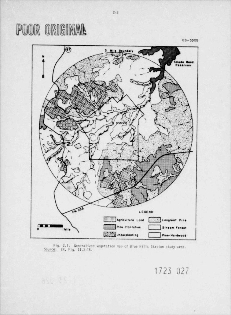
2.1 Generalized vegetation map of Blue Hills Station study area . . . . . . . . . . 2-2
2-72.2 Directional frequency of wind - Blue Hills site .................
2.3 A successional model for vegetation development on the Blue Hills 2-9Station study area . . . . . . . . . . . . ...................
2.4 Sampling sites of the Mill Creek Watershed, Toledo Bend Reservoir, 2-14and the Sabine River below Toledo Bend Dam . . . . . . . . . . . . . . . . . . . .
2.5 Temperature and dissolved oxygen. (DO) stratification at TB-1 on 2-19June 17,1974 .......................... . . . . . . . .
b
2.6 Temperature and dissolved ongen (DO) gradients at TB-2 on June 17, 1974 . . . . . 2-192-26
2.7 Population distribution in 1970,10 to 50 miles .................2-31........
2.8 Commutino routes . . . . . . .................
2-332.9 Recreation and game areas within 50 miles of the plant . ............
3-2.........3.1 Site plot plan . . ............. . . . . . ..
3-33.2 Quantitative water use diagram . . . . . . . . . . .. ............
3.3 Plan view of selected discharge location and preliminary diffuser 3-4nozzl e confi gurati on . . . . . . . . . . . . . . . . . . . . . . . . . . . . . . .
3-6..........................3.4 Heat dissipation system . . .
3.5 Conceptual sketch of circular mechanical-draft cooling tower proposed 3-7for Blue Hills Station . . . . . . . . . . .................
3-83.6 Makeup water intake channel and intake structure plan ,.... .........
3-93.7 Makeup water intake structure plan and section . . . ..............
3-143.8 Location of proposed transmission corridors .... ... .... .....
3-153.9 Single-circuit 500-kV - SA tower . . . . . . . . . . . . ... ........
is3-153.10 500-kV tower with two 230-kV underbuild provisions . ..............
4.1 Locations of the northern red-cockaded woodpecker in relation to 4-9. . . . .......... ......... ...proposed impact areas
4-124.2 e' Rat'Iroad plan-profile station 252+00 to 267+00 . . . . . . . . . . . . . . . . . .#
5.1 Offsite annual increase in ground level reduced visibility to 1000 m(0.62 miles) or less for one possible alternative configuration of themechanical-draft wet cooling tower system (based upon surface meteoro-
5-3logical data from Lake Charles, La.) hours per year ...............
5.2 Onsite and nearsite annual solids ground deposition for the mechanical-5-4draft wet cooling tower system (pounds per acre-year) ..............
5.3 Staff's estimate of salt deposition rates within a 3-mile radius of5-6...............
the towers . . . . . . . . .. .. ...
x1
1723 O!7
FigurePage
5.4 Staff's estimate of airborne salt concentration at 8 m above groundlevel .... .. ...... . .. . . . . . . . . . . . . . . . 5-75.5 Plant discharge temperature profile, winter, no thermal stratification 5-9. . .
5.6 Plant dischcrge TDS concentration profile, winter, no thermalstratification .......... 5-10.. ... .... ..
5.7 Plant discharge temperature profile, summer, thermal stratification .... . 5-11
5.8 Plant discharge TDS concentration profile, sunner, thermal stratification 5-12...
5.9 Sta f f's estimate of jet centerline trajectory for typical winterdischarge conditions . . .. . .. .. . . . . . ... 5-13
5.10 Staff's estimate ofconditions . . . . . jet trajectory for typical summer discharge. . ... .. . .. . . . . . . 5-14
5.11 Toxicity of chlorine to freshwater organisms5-27... . .. ... ..
8.1 Gulf States Utilities' service area 8-2.. . .. ... ....
8.2 Southwest Power Pool . . . ... . . .. . .. .. 8-3....
8.3 Load duration curve system total load: 1966-19718-5...... . .. . .
9.1Gulf States' interconnection with Southwest Power Pool . ... . . . 9-2
9.2 Location map . .. ...... .. . . . 9-5.......
9.3 Alternate r;-'a"p . eater conveyance routes and intake locations9-15... . ...
9.4 Alternate intake system: submerged inlet and pump structure, section 9-16....
~1723 018
,. ,..
-
xii
LIST OF TABLES
PageTable
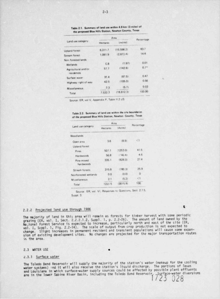
2.1 Sumary of land use within 4.8 km (3 miles) of the proposed Blue 2-3Hills Station, Newton County, Texas .. ..... ..............
2.2 Sumary of land use wit'ain the site boundaries of the preposed 2-3Blue Hills Station, Ne4 ton County, Texas . .. .. . . .....
2.3 Rare and endangered pl e ts occurring within the vicinity of the 2-10Blue Hills Station and its associated transmission corridors . . .. .....
2.4 Critical animal species observed or potentially occurring withinthe vicinity of the Blue Hills Station and its associated transmission 2-12
. ... . . .. ...... . . . .........corridors
2.5 Ranges and mean-concentration of water quality data for the Mill Creek 2-15.. . . . ...... ..... ..Watershed sampling stations
2.6 Sumary of macroinvertebrate data from the Mill Creek Watershed 2-15sampling stations .. . .. . ..... .. ...... ...
2.7 Fishes collected by electrofishing from the Mill Creek Watershed 2-17.. ...... ... . ... .........sampling stations
2-182.8 Physical characteristics of sampling sites of Toledo Bend Reservoir . .....
2.9 Estimated porulation, biomass, and production per hectare and averageweight of 0-age gizzard shad and threadfin shad in 1969 in Beaver
. . . . . . . . 2-22Reservoir, Arkansas .. .. . . ..
2-232.10 Sumary of cove rotenone samples, Toledo Bend Reservoir,1975 . . ...
2-242.11 Estimates of ichthyoplankton densities at statiors TB-2 and TB-4A,1975 . ...
2-252.12 Location of major regional population centers . . .. . ...
2-25. .... .. . ..... ..... . .
2.13 Regional demography2-252.14 Regional population characteristics . . . ... ... ..
2-272.15 Regional housing characteristics . . .........
2-272.16 Exis+1ng community sewarage capacities .. . ... .........
2-282.17 Existing comunity water supplies . .. . . . . .....
2-292.18 Regional health care manpower,1974 . . .. ... ........
2.19 Enrollment and capacity data for school districts in Jasper, Newton, 2-29and Sabine Counties and Vernon Parish,1976 . . .. ..... ......
2-3C2.20 Existing highway system of impact region . . .. . . ....
2-322.21 Industry of employed persons - 1970 . . . . ... ....
2-34_2.22 Recreational sites within 50 miles of the proposed plant .. .........
3-73.1 Turbine-generator-related heat dissipation system . . . .. . .
3.2 Monthly temperature difference of discharge flow vs Toledo Bend 3-10........ . .. ... ..........Reservoir tempera:. re
xiii
1723 019
TablePage
3.3 Blue Hills Station chemical and biocidal wastes concentration andef fluents ..... . . . .. . ...... ......... 3-11
3.4 Blue Hills Station transmiss an line rights-of-way reoutrements anddevelopment characteristics
. . . . 3-16... .... .... .....
4.1 Blue Hills Station land area affected by construction and restoration 4-1. ..
4 . ') 51 otic resources affected by Blue Hills Station construction 4-5. .. .....
4.3 Estimate 1 of population growth resulting from construction of the BlueHills Statica 4-15. . .. . .. .. ... .. ...
4.4 Estimate 2 of population growth resulting from construction of the BlueHills Station
........ . 4-15. ....... . ...
4.5 Estimated additional school enrollment . . 4-16.. . ... . ........
4.6 Projected tax revenues from Blue Hills Station 4-19... . ... .......
5.1 Size distributions of drift droplets .... . . ... . .. . 5-55.2 Appendix I Design Objectives
5-17. . ... .. . . .... .
5.3 Environmental impact of transportation of fuel and waste to and fromone light-water-cooled nuclear power reactor 5-18.. .... . .
5.4 Relative salt tolerance of trees and ornamentals . .. .. . . 5-195.5 Estimated dissolved solids concentrations (mg/ liter) occurring in
Toledo Bend Reservoir and in the plant effluent (concentrationsin mg/ liter)
5-26. . . . . . . ......
5.6 Dilution profile of 0.1 mg/ liter total residual chlorine (TRC) inthe Toledo Bend Reservoir during periods of circulation and stratification 5-26..
5.7 Sumary of toxicity of chlorine to freshwater organisms 5-28.. . . ....
5.8 Sumary of environcental considerations for uranium fuel cycle 5-32...
5.9 Estimated 100-year environmental dose corrinitment per year of operationof the model 1000 MWe LWR 5-34,
. . . .
5.10 Population increase resulting from station operation 5-35. . .
5.11 Operating personnel for a two-unit PWR station5-36.
. ..
5.12 Increases in regional incomes (in thousands of dollars) resultingfrom plant operation
5-36. . .
5.13 Retail sales increases during plant operatinn phase 5-36. . ....
6.1 Sumary of preconstruction terrestrial ecolosical measurements program . .. . 6-36.2 Sampling program for the Mill Creek Watershed, Stations S1-56 6-5.. .. .
6.3 Sampling program for Toledo Bend Reservoir . 6-6. . .. .. .
6.4 Sampling program of the Sabine River below Toledo Bend Reservoir. .... 6-7
6.5 Related aquatic environmental measurement and monitoring programswithin or near an 80.4-km (50-mile) radius of the proposed BlueHills Station
6-10. .. . .. ...
7.1 Classification of postulated accidents and occurrences. . . . . 7-1
7.2 Sumary of radiological consequences of postulated accidents .
023.070xiv

hge_Table
7.3' Environmental risks of accidents in transport nf fuel and waste7-4to and from a typical light-water-cooled r,aclear power reactor . . . . . . . . . .8-4
8.1 System yearly sixty-minute peaks . . . . . . . . . . . . . . . . . . . . . . . . .
8.2 Energy consumption by type of customer,1977 through 1990 (1000 MWhr) 8-5... ..
8.3 Peak load by type of customer,1977 through 1990 (MW) . . . . . . 8-6. . . . . .
8-68.4 Average price of electricity by customer class . . . . . . . . . . . . . . . . . .
8-78.5 Schedule of capacity installation . ......................
8.6 Total power capability (MW) of Gulf Utilities Company System, 1977-1990 8-7.....
,
8-88.7 Percentage change in population . . . . . ... ...............
8-88.8 Percentage change in per capita income . . . . . . . . . . . . . . . . . . . . . .
8-88.9 Forecasted peak load demand growth rates (percentage) for sumer . . . . . ...
8-98.10 System reserves .................................9-6
9.1 Population groups for the candidate site area . . . . . . . . . . .... ...
9-99.2 Engineering anJ environmental comparison of alternative sites . ... ....
9-119.3 Cooling system physical data and perfomance (per unit basis) . . .... ..
9.4 Environmental characteristics of the preferred and alternate 9-18electrical transmission routes . . . . . . . . . . . . . . . . . . . . . . . . .9.5 Environmental characteristics of the preferred and alternate railroad
9-20and acces2 roads for the Blue Hills Staticn . . . . . . . . . . ..... ..
1723 021
.
XV
FOREWORD
This environmental statement was prepared by the U.S. Nuclear Regulatory Connission (NRC), Office;f Nuclear Reactor Regulation (staff) in accordance with the Comission's regulation,10 CFC Part51, which implements the requirements of the National Enysronmental Policy Act of 1969 (NEPA).The NE!'A states, among other things, that it is the continuing responsibility of the FederalGovernment to use all practicable means, consistent with other essential considerations ofnational policy, to improve and coordinate Federal plans, functions, programs, and resourcesto the end that the Nation may:
Fulfill-the responsibilities of each generation as trustee of the environment for succeeding-
generations.
Ensure for all Americans safe, healthful, productive, and aesthetically and culturally-
pleasing surroundings.
Attain the widest range of beneficial uses of the environment .dithout degradation, risk tohealth or safety, or other undesirable and unintended consequences.
.
Preserve important historic, cultural, and natural aspects of our national heritage, andmaintain, wherever possible, an environment that supports diversity and variety of indi-
.
vidual choice.Achieve a balance between population and resource use which will permit high standards of
-
living and a wide sharing of life's amenities.
Enhance the quality of renewable resources and approach the maximum attainable recycling-
of depletable resources.
Further, with respect to major Federal actions significantly affecting the quality of the humanenvironment. Section 102(2)(C) of the NEPA calls for preparation of a detailed statement on:
(1) the enviro * mental impact of the proposed action,
any adverse environmental effects which cannot be avoided should the proposal be(ii)implemented.
(iii) alternatives to the proposed action,the relationship between local short-term uses of man's environment and the maintenance(iv) and enhancement of long-term productivity, and
any irreversible and irretrievable comitments of resources which would be ir,volved in(v) the proposed action should it be implemented.
An environmental report accompanied Gulf States Utilities' application for construction permitsA notice of the availability of the environmental report
for Blue Hills Station Units 1 and 2.Any coments on the report by interested persons have been considered l'y the staff.was made.
The applicant subsequently requested that the staff perform an early site review rather thanRecent amendments toa full review of the application for construction permits at this time.10 CFR Part 2 permit an applicant to obtain NRC staff and ACRS (Advisory Comittee on ReactorSafeguards) review and evaluation of selected site suitability issues and a partial decision onthose issues from the Atomic Safety and Licensing Board and the Atomic Safety and LicensingAppeal Board.
In conducting this review, the staff has met with the applicant to discuss items of informationin tne environmental report, to seek new infor.aation from the applicant that might be needed foran adequate assessment, and generally to ensure that the staff has a thorough understanding of
In addition, the staff has obtained information from other sources whichthe proposed project. Members ofassist in the evaluation and has visited the project site and surrounding vicinity.
xvii
1723 022
..
*
the staff have met with state and local officials who are charged with protecting state andlocal interests. On the basis of all the foregoing and other such activities or inquiries asare deemed useful and appropriate, the staff made an independent assessment of the variousimpacts on Site G.
This evaluation has led to the publication of a DES, prepared by the Office of Nuclear ReactorRegulation, which has been circulated to Federal, state, and local governmental agencies forcoment. Notices hve been published in the Federal Register of the availability of theapplicant's Envirort antal Report end the draf t environmental statement. Interested personswere invited to coment on the draft statement.
After receipt and consioeration of coments on the draft statement, the staff prepares thisFinal Site Environmental Statement, which ircludes a discussion of questions and objections raisedby the comments, and the disposition thereof.
This Final Environmental Site Statement and theSite Evaluation Report prepared by the staff will be submitted to the Atomic Safety and Licens-ing Board for its consideration in reaching a decision on the acceptability of the site.
Single copies of this statement may be obtained as indicated on the inside front cover.Dr. Phillip Ccta is the NRC Environmental Project Manager for this project. Should there bequestions regarding the content of this statement, Dr. Cota may be contacted by calling(301)492-8432 or at the following address:
Division of Site Safety and Environmental AnalysisOffice of Nuclear Reactor RegulationNuclear Regulatory ComissionWashington, D.C. 20555
*
*
The Blue Hills site safety evaluation report is entitled Early Site Revieu for BlueHille Site.
xviii
1723 023
1. INTRODUCTION
1.1 THE PROPOSED PROJECT
Pursuant to the Atomic Energy Act, as amended, and the Comission's regulations in Title 10Code of Federal Regulations, an application with an accompanying Environmental Report was filedin 1974 by Gulf States Utilities Company (hereinafter referred to as the applicant) for con-struction pemits for two generating units designated as the Blue Hills Station Units 1 and 2(Docket Nos. 50-510 and 50-511) to be powered by two pressurized water reactors (PWR) and desig-nated for initial operation at approximately 957 MWe (gross) each. Turbine steam condenser cool-ing will be accomplished through the use of mechanical-draft cooling towers. Integration of thepower from the Blue Hills Station into the applicant's system will be accomplished by about 317 km(197 miles) of transmission lines. The proposed facilities will be located on the applicant's1221-ha (3016-acre) site on the lower basin of Toledo Bend Reservoir in eastern Texas (NewtonCounty) approximately 14.5 km (9 miles) west of tne Texas-Louisiana border and 40.2 km (25 miles)east-northeast of the city of Jasper.'
1.2 REVIEWS AND APPROVALS
Regulation 10 CFR Part 51 requires that the Director of Nuclear Reactor Regulation, or hisdesignee, analyze the applicant's Environmental Report and prepare a detailed statement ofenvironmental considerations. The applicant has not identified the date when constructionpermits for the Blue Hills Station will be required or the expected date of commercial operation.However, the applicant has requested that a determination be made by the NRC that there isreasonable assurance that site G is a suitable location for a nuclear station of the generalsize and type described in the cpplicant's ER and PSAR. It is within this framework that thisEnvironmental Statement has been prepared by the Division of Site Safety and EnvironmentalAnalysis (staff) of the Nuclear Regulatory Commission.
In view of the uncertainties of when the Blue Hills Station will be constructed and operatedand of the specific design of the plant, this Environmental Statement is preliminary in manyareas. A number of chapters in this Statement are based on preliminary or general information.These chapters will be revised to reflect more definite information when that information isavailable.
Major doct mts usec in the preparation of this statement were the applicant's EnvironmentalReport (ER). ana the supplements thereto, and the applicant's Preliminary Safety AnalysisReport (PSAP.).2 in this Environmental Statement, the Environmental Report is cited extensivelyand the Preliminary Safety Analysis Report is cited a ...mber of times; however, their fulltitles and documentation are given only in the list of references for Sect.1. Elsewhere inthis statement, references to these two documents will appear as the abbreviations ER and PSAR,respectively, followed by the nunter of specific sections, pages, tables, figures, and appendices.
Independent calculations and other sources of information were used as a basis for the assess-nent of environmental impact. In addition, some of the information was gained from severalvisits by the staff to the site, to alternate sites, and to the surrounding areas. Members ofthe staff also had discussions with representatives of tha Texas Water Quality Board, TexasParks and Wildlife Departrent, the Big Thicket Association Sabine River Authority, TexasDepartment of Health Resources, Texas Radiation Control Agency. Texas Governor's Energy AdvisoryCouncil, Texas Attorney General's Office, Deep East Texas Council of Governments. LouisianaIntergovernmental Relations Louisiana Division of Radiation Control, Louisiana Stream ControlComission, Louisiana Air Control Comission Louisiana Governor's Council on EnvironmentalQuality, Louisiana Department of Conservation, Louisiana Wildlife and Fisheries Comission, andNewton County (Texas) officials.
Copies of this Environmental Statement and the applicant's Environmental Rt. port are availablefor public inspection at the Comission's Public Document Room,1717 H Street, Washington, D.C.,and at the local Public Document Room at the Newton County Library, Newton, Texas.
1723 024i-'
1-2
The applicant has provided a listing of environmentally related permits, approvals, and licensesrequired from Federal, state, and regional agencies in connection with the proposed project (ER,Sec t. 12) . These agencies are: U.S. Nuclear Regulatory Commission (NRC), U.S. EnvironmentalProtection Agency (EPA), U.S. Corps of Engineers, Interstate Commerce Commission (ICC). TexasHighway Department, Texas Railroad Commission. Sabine River Authority Texas Water Rights Com-mission, Texas Air Control Board, and Texas Water Quality Board.
The staff has reviewed this listing and has consulted witn some of the appropriate agencies inan effort to identify any significant environmental issues of concern to the reviewing agencies.No such issues have been identified.culties that would preclude construction of a nuclear station at site G.The staff is aware of no potential non-NRC licensing diffi-
The EPA has participated in the preparation of this Environmental Statement by providing commentson those parts of the Environmental Report that relate to the EPA's areas of responsibility (seeAppendix C).
As the lead agency under the Second Memorandum of Understanding Regarding Implemen-tation of Certain NRC and EPA Responsibilities provided for under the Federal Water PollutionControl Act and the National Environmental Policy Act of 1969, the NRC staff has incorporatedthe EPA's comments into the Environmental Statement.
.
REFERENCES FOR SECTION 1
1.Gu1f States Ut111 ties Company, Environmental Repert, Blue Hille b t.2 tion "ni:a 1 and :,Docket Nos. 50-510 and 50-511, June 27,1974, as amended.
Gulf States Utilities Company, Iwlimiury arf. O oulysis Scirre, h ; ni?la st.arier.;NUnits I ami r, June 27, 1974, as amended.7g7 q r
iLJ uL)
.
e
2. THE SITE AND ENVIRONS
2.1 LCCATION
The proposed site for the Blue Hills Station Units 1 and 2 is located in the northeastern cornerof Newton County, Texas, approximataly 14.5 km (9 miles) west of the Texas-Louisiana boundary(Fig.3.8). The site is approximately 40.2 km (25 miles) east-northeast of Jaspir and 16.1 km(10 miles) north of Wiergate and Burkeville, Texas. The geographical coordinate; of Unit I are31' 08' 39" N latitude and 93' 41' 32" W longitude. The geographical coordinates of Unit 2 are31* 08' 35" N latitude and 93' 41' 36" W longitude.
The facility itself will be situated on a 127.9-ha (316-acre) cleared area of land betweenCopperas and Mitchell creeks approximately 3.2 km (2 miles) southwest of Toledo Bend Reservoir,The terrainthe cooling water source, and 12.9 km (8 mi?es) west-southwest of Toledo Bend Dam.is low to moderately rolling, and the surfate elevation ranges from 61 to 88 m (200 to 290 f t)above mean sea level (MSL). The area 'ithin a 4.8-km (3-m11e) radius of the facility is primarilyupland forests consisting of pines and . xed hardwoods. These conriercial forests account for 98%uf the land use in this area.
2.2 LAND USE
2.2.1 Current land use
The area within a 4.8-km (3-mile) radius of the proposed facility includes the north-central partThe area is rural andof Newton County and the southeast corner of Sabine County (Fig. 2.1).
Commercial forest, which accounts for about 98% of the present land use, issparsely populated.primarily upland forests consisting of pines and mixed hardwoods (Table 2.1). Timber production
and processing are the main industries in the area. Lumber companies having major land holdingsinclude Southland Papermill, Inc., and Temple Industries. Less than 1% of the area is occupiedby farms and residerces. There are three farms, two residences, and two cemeteries within the4.8-km (3-mile) radius of the site. The small amount of agriculture includes the principal cropsof feed corn and hay; there are no dairies within the area.
Toledo Bend Reservoir, an impoundment covering approximately 75,476 ha (186,500 acres), liesabout 3.2 km (2 miles) northeast of the proposed site. Within 8.0 km (5 miles) of the sitethere are several recreation facilities: Beachwood I and Toledo Beach (boat ramps), Willcw Oaks(National Forest Service campground), and Carmichael's Marina. Parts of the Sabine NationalForest are also within this radius. Hunting is pemitted in the area and the major game speciesinclude deer, bobwhite quail, and waterfowl. The Scrappin' Valley Wildlife Management Area, aprivately owned 2185-ha (5400-acre) preserve, is located approximately 5.5 km (3.4 miles) westof the site. A number of rare and endangered species of animals and plants have been recordedfor the East Texas area (Sect. 2.7).
Transportation routes occupy about 1% of the land within the 4.8-km (3-mile) radius. Highwayroutes include Texas Farm-to-Market Road 255 running primarily east-west and Texas State Highway87 running north-south. The nearest railroad line, the Atchinson, Topeka and Santa Fe (freightonly), is about 27 km (17 miles) west of the site (ER, Sect. 2.2.2). The nearest public airportis near Newton, approximately 27 km (16.8 miles) south of the site.
Within the boundaries of the proposed 1221-ha (3016-acre) site, land is primarily forested,consisting largely of young, second-growth pines and mixed hardwoods. These forests are usedfor timber production and processing aM. to a lesser extent, for woodland grazing by cattle.Current timber rights permit logging on part of the site. Onsite vegetation is characterized
beech-magnolia and sweetbay-redbay forests in the lowlandby five major forest cover types:stream areas, and longleaf pine, loblolly and slash pine, and mixed pine-hardwcod forests inthe upland areas (Table 2.2). This forested land represents about 1% of the total commercialforest in Newton County. There are no agricultural activities (excluding timber harvest) orresidential structures within the site boundaries. Terrain is hilly with moderate to steepslopes. The site is part of the Mill Creek Watershed and includes Mill Creek and the tribu-taries of Copperas and Mitchell creeks.
2-1
1723 026
2-2
-- em m 'l
@W W - 3
ES-3305
h Mile Boundary
N * ..s" .- )h
.,:)pfh.. :;f *f.';-r ) ' A-7 Toledo Bend*. > ;: ..
.4,,. :?m ".
.4:. -fiM]v i-'j - [ (- Reeervoir~ "'
./
p(&NMg;p'<. .!:h i - .~
h :1. .
.. .
.
., i. , , I t j :-j r..c % .% ,
%:' . ::iw tNu.- 4 :"
.. . y' /(
':. - +..
.$:!.i:i. : :\ :- ._ .{ * fY''
. ;f.pcag..:x.. .: . , y.-< . , - -.. : .
'-- : .p 9.p.
'-
: .. .. ..
..:y:;. a e-p g... %.g.
' '.
\\;;;;... yt_ ' r2| % & ;gI '- -
.
h;- %- g ', .g^r<N %
1::.* 3,
'. s. t. ,
% /.
fj. r.
..g_.i
* e hy '. 'iH,, ' *..J:F.*. . . . . .
t_ .:\ ...
. . . G[
.
,-
_'*.
f m .s.
G: %,6 %h< n. ,: .: . g. .*
'w r. . . q +.1 -
, 8. s._ / \ - d'hi ,. 5 .!:Y . f_ ':$. 7I
.
i , .f.; - ~ *-
,
g', .
%. !' ~"~ .. ..= i
. . . .1.-,- ,_.t v._
_
,
:M::. . p --
\u .: %.-<n
s - -
,
. .: a .: . .a -
y | ,h .,. '*
g -
..,: ^., . . .-,
i:# .
9% LEGEND
Agriculture Land . Longleef Pine'
N Pine F'ontation Stroom ForestO I Mile
Underpie n tin g Pine Hardwood
Fig. 2.1. Generalized vegetatien nap of Blue Hills Station study area.Source: ER, Fig. 11.2:15.
1723 027
5
2-3
Table 2.1. Summary of land use within 4.8 km (3 miles) ofthe proposed Blue Hdis Station, Newton County, Temas
AreaLand use category
- Percentage
Upland forest 6.311.7 (15.596 2) 83 7
Stream forest 1.081.9 (2,673 4) 14 4
Non forested lands
Wetlands C.8 11 97) 0.01
Agricultural and/or 57.7 1142.6) 0.77
residences
Surface wa er 35 4 (87.5) 0.47
Highway r ght-of way 42 5 (105 o) 0.56
Miscellaneous 2.3 (5.7) 0.03
Total 7,532 3 (18.612.3) 100.00_._
Source: ER, vol V, Appendix F. Tabse II.2:/3.
Table 2.2. Summary of land use withm the sise boundariesof the proposed Blue Hdis Station, Newton County, Texas
AreaPercentageLand use catespry
Woodlands
Open area 3.6 (8 91 <1
Upland forest
Pines 507.1 ;125301 41.5
Hardwoods 56.8 U 40 4 7 46
Pine-mixed 335.1 (828 ol 27.4
hardwoods
Stream forests 315 8 (780 31 25 9
Nonforested wetlands oo (o o) o
M tceitaneous 2.1 (5.2) <1
Total 122G5 (3015 8) IF
Source: ER, vol. VI, Responses to Questions Sect. 2 7.5.
Suppt. 3.
O2.2.2 Projected land use through 1986
The majority of land in this area will remain as forests for timber harvest with some periodicgrazing (ER, vol. I, Sect. 2.2.2.1.2, Suppl .1, p. 2.2-26). The amount of land owned by theNa;ional Forest Service is expected to increase, particularly north and east of the site (ER,vol. I Suppl. 1. Fig. 2.2-14). The scale of output from crop production is not expected tochange. Slight increases in permanent resident and transient populations will cause some expan-sion of existing development sites. No changes are projected for the major transportation routesit the area.
2.3 WATER USE .
2.3.1 Surface water
The Toledo Bend Reservoir will supply the majority of the station's water (makeup for the coolingwater systems) *.nd it will also receive the station's liquid discharge. The portions of Texasand Louisiana in which surface-water supply sources could be affected by possible plant efflutntsare in the lower Sabine River Basin, including the Toledo Band Reservoir. St rface-water diversions
1/I3 028
2-4
in the lower Sabine River Basin are primarily used for industrial, municipal, and irrigationalpurposes. T'.! largest amount of industrial surface water used is in the Calcasieu Parish (E't,vol. I, Sup>1 1. Table 2.2-26), which is located approximately 96.5 km (60 miles) downstreamcf the Toledo Bend Reservoir.
The total amount of water a.thorized for J! version from tha lower Sabine River and its tribu-taries in 1975 was 7.83 x 10⁸ m3(635,079 acre-f t) in Texas and in 1974 was 8.59 x 10⁷ m3(69.665 acre-f t) in Louisiana. These totals do not incit.de (1) water diversions which are notrecorded by monitoring agencies in Teras and Louisiana and (2) water authorized for ti creationof the Toledo Bend Reservoir. Of the Texas total, about 57% was authorized for industrial pur-poses. The ,emainder was divided about equally for municipal and irrigational uses (ER, Table2.2-30). In Louisiana, nearly all of the water was diverted 'or irrigational purposes. Approx-imately 98% of the irrigated land is used for rice cultivation, but the large rice-producingareas extend beyond the 80.4-km (50-m11e) radius of the plant.
Recreational uses of surface waters include fishing, boating, sailing, and water skiing. Theloledo Bend and Sam Rayburn Reservoirs are the major bodies of water within an 80.4-km (50-mile)radius of the plant in which these activities are pursued. There are an estimated 11.242 boatsregistered within 8(.4 km (50 miles) of the site. Over 95% of the registered boats in tae Texasportion of the study area are used for pleasure (ER, TGle 2.2-34). Cornercial fishing is bannedon the Texas portion of the Toledo Bend Reservoir.
2.3.2 Groundwater
Grcandwater is heavily relied upon in the lower Sabine River Basin. The East Texas area isunderlain by both major and minor aquifiers that can supply large quantities of groundwater.The principal agricultural use of groundwater is for irrigation of rice, but the major rice-producing areas are located in Beauregard Parish beyond the 50-mile radius of the proposedplant site. However, the major uses of groundwater are for public supplies, domestic, andstock use. In Vernon Parish, a relatively large amount of water is used for industrial purposes.Approximately 30% of all river bank wells within the site area are used for stock, domestic, ormixed domestic stock ourposes (ER, Table 2 ?-27), b 1975 there were about 75 wells in thevicinity of the plant site.
2.4 GEOLOGY
The proposed Blue Hills site is situated in the eastern region of the West Gulf Coastal Plainand is underlain by cretaceous, tertiary, and pleistocene sedimen s. A major depositional andstructural characteristic of this region is the gulf coas*. geosyncline, a very large sedimentarybasin. Sedimentation in the basin began in the early Mesozoic Era (150 to 200 million ycars ago)and has continued, with relatively minor interruptio 1, to recent time. At the site, which isapproximately 161 km (100 miles) north of the Gulf of Mexico, coastal plain sediments are esti-mated to be at least 6096-m (20,000-f t) thick.
The gulf coastal plain is also noted for its aDundance of salt domes and production of oilfields. The salt dome nearest (known) to the site is the North Starks dome, approximately88.5 km (55 miles) to the south. The nearest oil field is the Columbus field about 22.5 km(14 miles) north-northeast of the site, and now covered by Toledo Bend Reservoir.
The site is located within the outcrop area of the Miocene Catahoula Formation and is charac-terized by cuesta-like low rolling ridges with broad tops and steep sides which paralleledthe regional s??ike of the beddig. The lithologic units (strata) underlying the plant siteand the thickness of each, begmning at the surface, are: (1) the upper sand stratum (4.6 m or15 f t), (2) thick clay (5.2 m or 17 f t), (3) middle sand of the Cataholla formation (35.7 m or117 ft), (4) lower clay (23.5 m or 77 ft), and (5) the lower clay stratum of indeterminate thick-ness. The water table is in the miodle sand stratum at an average elevation of 61.8 m (203 ft)above mm sea level (MSL) (Eerly Site Review, NUREG 0131, January 1977).
Additional information on site and regional geology is presentea in the applicant's EnvironmentalReport and the staff's Early Site Reviaw (ESR), which considers site safety factors. A compre-hensive discussion of seismology is also given in the ESR.
1723 029
2-5
2.5 HYDROLOGY
2.5.1 Surface water flow
2.5.1.1 Sabine River dra W ge basin
2 (9756 sq miles), of whichThe Sabine River drains an approximate total land area of 25,268 km2 (2330 sq miles) is in Louisiana. The drainage(7426 sq miles) is in Texas and f.,035 km219,233 km
basin is aLout 483-km (300-miles) long and 48-km (30 miles) wide. The river slopes from anelevation of about 730 f t mean sea level (MSL) at its headwaters to a few feet near the coast(0. '+6 m/km or 2.4 f t/ mile). The two largest tributaries are Lake fork Creek drainage basin(1774 km or 685 sq miles) in Texas and Bayou Anacoco drainage basin (1155 km2 or 446 sq miles)2
in Louisiana. The other numerous tributaries are each less than 50-km (30 miles) lora with2 (200 sq miles).individual drainage area of less than 500 km
There are 12 major reservoirs in the basin (ER, Fig. 2.5-1); Toledo Bend and Tawakoni Reservoirs I
are the two largest. There are also approximately 50 minor reservoirs and 26,000 farm ponde inthe basin (ER, Table 2.5-1).
2.5.1.2 Toledo Bend Reservoir
This reservoir was formed by an earthfill dam 3.43-km (?.1-miles) long at River Mile 156.5. At2 (7178 sq miles). Wate- from the reservoirthis point, the watershed drainage area is 18,591 km
is used for irrigation and municipal and industrial water supply; the reservoir itself is usedfor flood control, domestic and industrial liquid waste disposal, power generation, and recroa-tional purposes.
The reservoir is 105-km (65-miles) long with an average width of 8.0 km (5.0 miles). At water2 (182.000 acres), and aelevation of 172 ft MSL, the reservoir has a surface erta of 737 km
volume of 5.55 km3 (4.5 x 10⁶ acre-feet) (ER Table 2.5-2).
The reservoir's water level is usually maintained between 162.2 and 172.0 ft MSL. When practical,the reservoir's water level is maintained above 169.0 f t MSL. To ensure adequate water for down-stream water users, a minimum flow of 2.8 m /sec (100 cfs) is maintained imediately below the3
dam. In addition, an average monthly minimum of 42.5 m3/sec (1500 cfs) is maintair,?d at Ruliff,Texas, [187 km (116 miles) downstream of Toledo Bend Reservoir] from October through April, and85 m /sec (3000 cfs) from May through September. These flows may be reduced if lesser flows meet3
the water supply demand below the dam.
The reservoir's water level reached 169.15 ft MSL elevation in April 1968, about two years af terthe closing of the dam. Ine mean discharge, based upon the seven years (1966 to 1972) dischargedata from Burkeville, Texas, is calculated to be 109 m3/sec (3843 cfs). The retention time in the greservoir is calculated to be 1.5 years (ER, Sect. 2.5). Since April 1968, when the reservoir |filled to capacity, the minimum discharge (1.5 m3/sec or 54 cfs), when recorded in October 1969,occurred at a reservoir elevation of 167.3 ft MSL.
2.5.1.3 Mill Creek drainage basin
The plant site is located in the Mill Creek drainage basin on the drainage divide betwen CopperasCreek and an unnamed tributary of Mitchell Creek. The USGS topographic map (Fairdale, Tex., quad-rangle) shows Mill, Couperas, and Mitchell creeks as perennial and the unnamed tributary to Mitchell
2 (18 sqCreek as intennittent (ER, 2.5.1.4). Mill Creek has an estimated watershed area of 47 kmmiles). Copperas Creek at the downstream end of the site has a drainage area of 10 km2 (4 sq2 (0.5 sqmiles), while the drainage area for the unnamed tributary of Mitchell Creek is 1.3 kmmiles). The estimated mean discharge from Mill Creek has been 0.76 m /sec (27 cfs), ranging from3
0.18 m /sec (6.T cfs) to 4.20 m3/sec (150 cfs) (ER, Table IV.9:1.5).3
2.6 METEOROLOGY
2.6.1 Regional climatology
The region of east-central Texas and west-central Louisiana experiences a subtropical maritimeclimate, with occasional influences of polar air from the north. The semipermanent high-pressuresystem of the western Atlantic Ocean pushes into the region the predominant south to southeastwinds laden with warm, moist air from the Gulf of Mexico. Thus sumers are warm and humid, withaverage high temperatures near 32'C (90'F) and daytime humidities near 60%. Temperatures exceed32*C (90'F) about 90 days each year. Occasional intrusions of polar air in the winter are
i
1723 030
2-6
usually of short duration. Thus, winters are mild with low temperatures averaging near 4*CMO*F). Freezing tamperatures occur aoout 30 days annually.
The proximity to the Gulf clso accounts for the abundant rainfall in the area, with annualamounts averaging about 1270 m (50 in.). Rainfall varies slichtly from month to r9 nth;however, small peaks in the rainfall occur in late springdue to airmass showers, and in earlywinter due to frontal passages. Late summer-early fall generally has the least amount ofrainfall. Averaging less than 25 m (1 in.) per year, snowfall is a rarity in the region.3*7
f2.6.2 Local meteorology
The Blue Hills site is located in rolling, heavily wooded terrain. Within 8 km (5 mi.) of thesite, elevations range from 70 m (230 f t) above plant grade [about 6 5 km (4 mi.) southeast ofthe site] to about 30 m (100 ft) below plant grade (Toledo Bend Reservoir, northeast of thesite).
To assess the local meteorological characteristics of the Blue Hilh site, climatological datafrom Leesville, l.a. (40 km or 25 mi. east of the site), Alexandria, La. (120 km or 75 mi.east-northeast), and Bronson Tex. (32 km or 20 mi. northwest), and two years of data collectedonsite are available. Data from these locations are generally representative of the meteoro-logical conditions of the area.
At Leesville, average daily maximum and minimum temperatures range between 34'C (93"F) and21'C (70'F) in July, the warmest month, and between 16*C (61'F) and 3*C (38'F) in January,the coolest month. The extreme maximum temperature recorded at lessvile was 42*C (107'F);however, Cronson has recorded 46*C (ll4'F). The extreme minir:um temprature has been -18'C(O'F) at lessville.
Leesville receives about 1390 mm (54.5 in.) of rain annually; precipitation is usually abundanteach month of the year, ranging from '40 m (5.5 in.) in December, the wettest month, to 81 mm(3.2 in. ) in October, Me average driest month. The maximum 24-hour rainfall recorded atLeesville was 230 mm (11.0 in.) in February 1966; however, in June 1886, a location nearAlexandria received a torrential amount of 544 mm (21.4 in.) within a 24-hour period. Annualsnowfall averages 18 mm (0.7 in.) at both locations. The maximum 24-hour snowfalls have been2 4 m (10 in.) at Leesville (February 1960) and 208 mm (8.2 in.) at Alexandri6 (January 1940).Heavy fogs [ visibility of 0.4 km (1/4 mi.) or less) occur ab%t 40 days annually at Alexandria,with the majority occurring in the winter months.
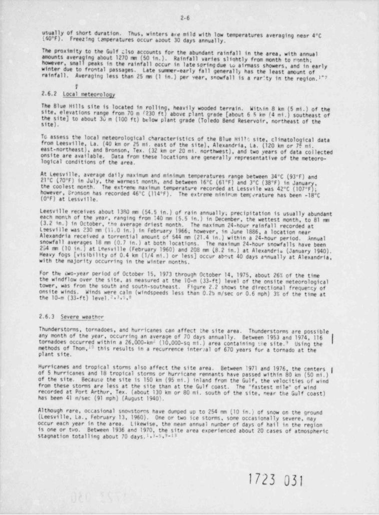
For the cwo-year period of October 15, 1973 through October 14,1975, about 26% of the timethe windflow over the site, as measured at the 10-m (33-ft) level of the onsite meteorologicaltower, was from the south and south-southeast. Figure 2.2 shows the directional frequency ofonsite winds. Winds were calm (windspeeds less than 0.25 m/sec or 0.6 mph) 3% of the time atthe 10-m (33-ft) level.2,3,5,e
2.6.3 Severe weath g
Thunderstorms, tornadoes, and hurricanes can affect the site area.Thunderstonns are possible |any month of the year, occurring an average of 70 days annually. Between 1953 and 1974,116
tornadoes occurred within a 26,000-km2 (10,000-sq mi.) area containing tee site.9 Using themethods of Thom,10 this results in a recurrence interval of 670 years for a tornado at theplant site.
Hurricanes and tropical storms also affect the site area. Between 1971 and 1976, the centersof 5 hurricanes and 18 tropical storms or hurricane remnants have passed within 80 km (50 mi.) |of the site. Because the site is 150 km (95 mi.) inland from the Gulf, the velocities of windfrom these storms are less at the site than at the Gulf coast. The " fastest mile" of windrecorded at Port Arthur, Tex. (about 130 km or 80 mi. south of the site, near the Gulf coast)has been 41 m/sec (91 mph) (August 1940).
Although rare, occasional snowstores have dumped up to 254 mm (10 in.) of snow on the ground(Leesville La., February 13,1960). One or two ice storms, some occasionally severe, mayoccur each year in the area. Likewise, the mean annual number of days of hail in the regionis one or two. Between 1936 and 1970, the site area experienced about 20 cases of atmosphericstagnation totalling about 70 days.l.3-5,3-13
1723 031
2-7
E S - 3596
N
| sg2
\ *
#/e'
q /\ .*\NN
, /y
'
\
I \'cALu* 3.0 %
'N-
/~~ <-
,
/ ~. -
'
\ - s- x
'/ s
/
N/ // s
' \l1-
S
Fig. 2.2 Directional frequency of wind - Blue Hills site. Onsite data at 10 m (33 ft)above grcund level, October 15, 1971 through October 14, 1975. Bars show the direction fromwhich the wind blows. Calms are those winds with hourly average speeds of less than 0.25 m/sec(0.6 mph).
2.7 LCOLOGY
In consideration of the Fish and Wildlife Coordination Act of 1958, as amended, the NRC staffhas consulted with the U.S. Fish and Wildlife Service, the Texas Parks and Wildlife Department,ano the Louisiana Wildlife and Fisheries Commission. A letter, dated October 7,1976, from theU.S. Fish and Wildlife Service is included in the Environmental Staterient as Appendix B. The
staff has c0nsidered the recomendations presented ac part of this early site review.
2.7.1 Terrestrial
2.7.1.1 Physical characteristicss
Geologically the site is part of the Kisatchie Escarpment and overlays a narrow, surface sedi-mentary outcrop called the Catahoula formation. This formation is comprised of mudstone andsandy sediments and, at high elevations, is partly capped by the less weather-resistant Willissandstone formation (ER, Appendix F. Sect.11.2:23). These sandy upland areas, where there iscontact between the two formations, create natural springs that provide unique wet-zona inprimarily xeric environments. Erosion processes have created alluvial areas along the drainagesystems, that is Mill Creek and its tributaries. Because of the erodibility of the geologicformation, the terrain is generally low to moderately rolling, with steep cuestas occurring onboth sides of Mill Creek. Elevations range from 52 to 146 m (171 to 479 f t) MSL, with the maxi-mum relief not exceeding 88 m (289 f t),
. . 1723 032-
2-8
Soils at the site are generally sandy with some silts and clays. They are characterized asstronqly acidic, being low in organic material and nutrients, and having a high water perva-bility. Erosion potential is high on t'.e steep, exposed slopes. Soils formed on the Willisformation (25%) are loamy sand, those on the Catahoula formation (53t) are loam and fit a sandyloam, and those on the alluvial areas (22%) are very fine sandy loam, loam, or loamy sand.Catahoula and Willis soils are usually well drained, while the soils developed in alluvialdeposits are generally poorly drained. In terms of productivity, upland soils are rated fairto medium and the more mesic alluvial v ils are good to excellent.
2.7.l.2 Vegetation
The Blue Hills site lies in an area of east Texas sometimes described as a biological cross-roads, that is, its blota reflect contributions from the prairies and f rom the deciduous andpine forests. Kuchlerb designates the general area as Southern Mixed Forests and ficleod !5
includes it as part of the Upper Pig Thicket Region of Texas. Historically, the originalforest was dominated by longleaf pine and its associated species. However, since settlementbegan in the early 1800s, the land has been extensively disturbed by lumbering, farming(including periodic burning), and grazing (ER, Appendix F, Sect. II.2:3.2). Excluding nationalforest lands, the regional trend in forest management has teen away from the earlier exploita-tion of long-leaf pine forests toward intensive managerent of even-aged pine stands which areperiodically harvested and replanted.
Presently, the site is dominated by young, second-growth stands of pines and hardwoods(Tatie 2.2). Recent selective cutting on the site has renoved many of the older pines,including ones which may have been used as nesting and roosting trees by the red-cockadedwoodpecker. A general vegetation map of the site and imediate area is shown in Figure 2.1.The site includes three major habitats containing five forest communities: (1) mesic streambottoms and ravines, accounting for about one-fourth of the lana use and including mixedhardwoods dominated by beech-magnolia and redbay-sweetbay; (2) mcsic middle and lower slopesincluding mixed pine-hardwoods; and (3) the more xeric uplends favored by longleaf pines, withscrub hardwoods and plantings of mixed pines. These upland forest types cover about 74% of thesite, with the most dominant species being pines such as shortleaf and loblolly. The beech-magnolia and sweetbay-redbay forests occupy about 26% of the site and exist as relict comuni-ties in the otherwise generally disturbed crea. These communities contain plant ass mblageswith limited distributtons or with sp .ial, restrictive habitat requirements.
G;t of an estimated 1913 plant species in east Texas, 615 have been recorded for tne site andvicinity [i.e., 4.8-im (3-mi.) radius). The applicant's Environmentai Report (ER) providesdetailed information on the species and structural characteristics of the various forest covertypes (ER, Appendix F, Sect. II). There is no active agricultural use of the site; however,because of open-range practices, livestock still use the area.
In general, the upla'Pi forests of the site represent a temporary stage of succession dominatedby pines (Figure 2.3). If lef t undisturbed, mMt of these forests would develop toward an oak-hickory climax. In the more mesic stream bottoms and ravines, white oak-laurel Oak and beech-magnolia forests represent the most stable plant communities. Past inaccessibility of the siteand reduction or absence of periodic ffres have allowed some of the forests to develop towardclimax communities. However, management favoring pine forests has supressed most developmentof climax vegetation. Southern pine bark beetle has infested some of the pines in the studyarea.
Seventy-five important plant species, including 25 co mercial tree species, were reported asoccurring in the site study area (ER, Tables 2.1-2 3nd 11.2:22). Within the plant boundarythere is one proposed endangered plan species (McenoZirion tcme)" and four nominatedthreatened p1 art species (Hremria f"ava, Pironphia drwrve a, M :nd a re w r? a,Liatris taois) .17 If adopted, these species and any others that might be added will besubject to Federal regulations and any activities affecting their status will require evalua-tion by the staff and appropriate Federal agencies. Of the 615 plant species recorded at thesite area,13 are listed in F2re and Embngered Planto 'icies o Twe.18 These species aregiven in Table 2.3. A number of scientifici11y important plant species are found in thesomewhat restricted beech-magnolia and sweetbay-redbay comunities. These stream bottomcommunities have been reduced by current land use practices and harbor many of the speciesconsidered rare and endangered in East Texas. In addition to these communities, within the4.8-km (3-mi.) radius of the site there are 8 seep bog areas, totalling 6.9 ha (17 acres) thatare unique habitat and contain a variety of scientifically important species, including thepitcher plant, sundew, bladderwort, small butterwort, and several species or crchids (ER,Sect. II.2:4.2; Figure 11.2:16; Staff Question 2.7.5-3). Because of their unusual flora and glimited occurrence, these habitats warrant special attention. '
i723 033.
ye*
7 SE G S9 N
~YIT E2 tu S
T I RII3 u S EA, MA E N S _p
- g lM R E pgS c M C ^ D PE O N "C I Y Y d
A A CB B I
T RL D DE E YW R NS
noi
t)D aE t
S SK I
K A F TI SK K A O E s
A A O T l
O O P K E N C iy Rm
M T R N E I o l
E L A U A O D S r i
I Rb ,
S 1 Y (I E H
T E W N 8 Nl
M NA eH l S R E uW A E R, R l
I H'H T BC SC e
ht
notne
E mN pI S oYA P D L lH I O L E eC L Y OE O L
L W H D N vI I eE N d
NL D S P dB G
A D RI A D
I nM B H oD E E :|
} iI N N t
I I aP P t
eY F gL A eL J vD t
TI
K B R rA D O o .O I H f5
S 4E F l :T Y a F A e2I R v A KH O v 2 A 2 ) d
1 E Y o1
C sE 1 C T N A r
u n1W Ku
I R EN f T - R I ID O P
( l .
CI
K H R P O N H agA A H I SO M S P ni
E E oFD N N i
I gs ,
E I I
R P P sReE
F F cA A c2 f. 4 u*
# T. se1 i
T G cSR N E Ar? O 0 R uH 1 O oK SA F .S
O F 3K F K DA )f K A AL Z E D N 2 .O C E O
\ G I A II N N A .aL -A f G E J
N P S P gre
T JS K N N ( U iaO C D I D
E FI PP A y
I dB uts
GN ,
E !R i G
o N NI 0 IF fI N 1 T
O T NA AIf L CS f P I
RfA R RE
V L F EN P D K :
)O N
~ C E Ts
NI EB
U K P N
_yoU Du4R A 1
C O PS n C
2-10
Table 2.3. Rare and endangered plants occurrms withm the vicmety
of the Blue Hills $tesion and its asuscuted transmession corridors_
_ _.__._. _ _ _
Species' Habitat"_ _ _ - _
Liliaceae
Great Solomon's seal Rah, rooist, wooded sirvesTr nas siennybell' Low ridges, open forest
AristolochiaceaeVirginia snakeroot Monst or dry upland woods
Magnoliaceae
Pyramid magnolia Rich woodlandsRosaceae
Red chokeberry Swampt bogs, pine bairensEuphorbiaceae
Sebastean bush Woodlands aiong strea nsLythraceae
Tropical waxweed Edge, of low, wet woods
Ericaceaeind.an p,pe Humus of moest pine hardwoods
Composetae
Stender g syfeather Open p ne woods on sandy soilTall rattles.1ake root mow, rich beech woodlandBarbed rattlesnake root Sandy, forested asasEared goldentod Woodea eavines, clofsBluestem goldenrod Rich woodsWillow goldenrod Moist loams
* Rare Plant studt Center, Rare and Endmgered Plots Natne toTexas, University of Texas Austin, Tex.,1974.
6D. S. Correll, and M. C. Johnston, Manual of the vascv/ar Plants ofTexas. Texas Research Foundation, Renner, Ten.1970.
' Fed. Regist., Part IV.411117124524 0976L
2.7.1.3 Consumers
East Texas has a diverse fauna, reflecting the variety of habitats available for both residentand transient species. These wildlife populations, however, have been greatly influenced byhuman activities such as Star! use practices (e.g., forest management and agriculture) and hunting.Species presently occe !ng to the site area are a mixture of both eastern and western elements.A total of 283 verteorate species were recorded for the site area, including several that estab-lished new county records (ER, Appendix F. Sect. III).
The site area includes the ranges of 82 species of amphibians and reptiles; 03 of these specieswere reported during the study period (ER, Table III.3:1). Lower slope and bottom habitats hada higher number of species and higher total densities than the midslope and ridge habitats,important species include the bullfrog (game animal) and American alligator.
The avifauna is primarfly representative of eastern Nortin American temperate regions, with onlya few species typical of the southern pine forests (e.g., red-cockaded woodpecker, brown-headednuthatch, and Bachmans sparrow). Of the 276 species expected in the area,184 were observed,including 85 species that breed there (ER, Table III.4:1). Upland forest types contained thegreater number of bird species, and uterfowl from both the Central and Mississippi Flywaysover-winter near the site. A total of 22 game species (of the expected 35) were recorded forthe area, including four resident species (wood duck, bobwhite quail, turkey, and mourning dove).Thirty of the expected 45 important species were observed in the study area (ER, Table III.4:1).
Approximately 53 species of mammals potentially occur in the site area; 36 species were actuallyreported (ER, Table 111.5:1). Seventeen of these species are considered important, includingmajor game animals such as the white-tailed deer, squirrels, rabbits, and feral hogs. Annualdeer harvest in Newton County for the period 1971 to 1974 ranged from 156 to 400 animals (ER,Table 2.2-7). Current density for the Blue Hills area is an estimated 1.2 deer /km2 (ER, TableIII.5:5). Sweetbay-magnolia ravines, in particular, provide important habitat for deer. Grayand fox squirrel populations have been negatively influenced by intensive timber management forpine forests. Common small mamals, most of which occur in shrubby areas with moderate to densecover.. include the eastern mole, pocket gopher, cotton mouse, wood mouse, and fulvous harvestmouse.
1723 035
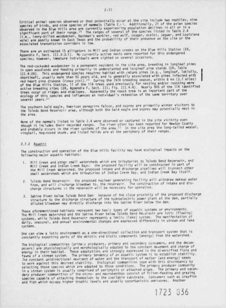
2 -11
Critical animal species observed or that potentially occur at the site include two reptiles, ninespecies of birds, and nine species of mamals (Table 2.1 Additionally, 21 of the avian speciesobserved in the Blue Hills area are currently experienring population declines in all or in asignificant part of their range.I' The ranges of several of the species listed in Table 2.4(i.e., ivory-billed woodpecker, Bachman's warbler, red wolf, cougar, ocelot, jaguar, and Louisianavole) are poorly known in East Texas and the probability of their presence on the site or theassociated transmission corridors is low.
There are an estimated 15 alligators in Mill and Indian creeks on the Blue Hills Station (ER,Appendix F Sect. III.3:3:1). No currently active nests were reported for this endangeredspecies; however, imature individuals were sighted on several occasions.
The red-cockaded woodpecker is a permanent resident in the site area, breeding in longleaf pinesin open woodlands and feeding primarily in underplanted and longleaf pine stands (ER, Table111.4:28). This endangered species requires habitat with rature pines (e.g., longleaf, loblolly,shortleaf), usually more than 50 years old, and is generally associated with pines infected withred heart pine disease (Fcnes pini).20 During the 1974 breeding season, within 6 km (3.7 miles)of the Blue Hills Station,11 of the 114 trees used previously for nesting and/or roosting wereactive breeding sites (ER, Appendix F Sect. III; Fig. III.4:4). Nearly 90% of the 114 identifiedtrees occur (,n ridges and midslopes. Apparently the roost tree is an important part of theecology of this species and influences an individual's retention of the same territory over
,
several years.21
The southern bald eagle, American peregrire falcon, and osprey are primarily winter visitors tothe Toledo Bend Reservoir area, although both the bald eagle and osprey may potentially nest inthe area.
None of the mammals listed in Table 2.4 were observed or captured in the site vicinity eventhough it includes their recorded ranges. The river otter has been reported for Newton Countyand probably c curs in the river systems of the area.22 In the site area the long-tailed weasel,ringtail, hog-nosed skunk, and listed felids are at the periphery of their ranges.
2.7.2 Aquatic
The construction and operation of the Blue Hills facility may have ecological impacts on thefollowing major aquatic habitats:
1. '1111 Creek and other small watersheds which are tributaries to Toledo Bend Reservoir, andMill Creek and Indian Creek Bays: the proposed facil1ty will be constructed in part ofthe Mill Creek Watershed; the proposed intake and discharge pipelines will transect othersmall watersheds which are tributcries of Indian Creek Bay, and Indian Creek Bay itself.
2. Toledo Bend Reservoir: the proposed nuclear generatirg facility will withdraw makeup waterfrom, and will & charge blowdown to, the reservoir. The construction of intake and dis-charge structures la the reservoir will be necessary for operation.
3. Sabine P.iver below Toledo Bend Dam: because of the close proximity of the proposed dischargestructure to the discharge structure of the hydroelectric power plant at the dam, partiallydiluted blowdown may directly discharge into the Sabine River below the dam.
These aforementioned habitats represent two basic types of aquatic systems or environments.The Mill Creek Watershed and the Sabine River below Toledo Bend Rearvoir are latic (flowing)systems, while Toledo Bend Reservoir represents a ler. tic (lake) system. The manifestation ofdaily, seasonal, and annual environmental changes are expressed differently in stream and lakesystems.
One can view a lotic environment as a one-directional collection and transport system that isconstantly exporting parts of the abiotic and biotic components (energy) from the watershed.
The biological communities (primacy producers, primary and secondary censumers, and the decom-p">sers) are physiologically and morphologically adapted to the constant movement and change ofenergy in their habitat. These adaptations are strongly expressed in the diversified flora andfauna of a stream system. The primary tendency of an aquatic system is to establish stability.The constant unidirectional movaent of water and the transport of matter (and energy) seemsto work against this desired stability. Biological comunities cope with this oiscrepancy byselecting those species which are adapted to these conditions. The primary producer comunityin a stream system is usually comprised of periphytic or attached algae. The primary and secon-dary producer communities of the micro- and macrobenthos consist of filter-feeding and grazingspecies capable of attaching themselves to the available substrate. Consumers such as crayfishand fish which occupy higher trophic levels are usually opportunistic omnivores. Another
1723 036
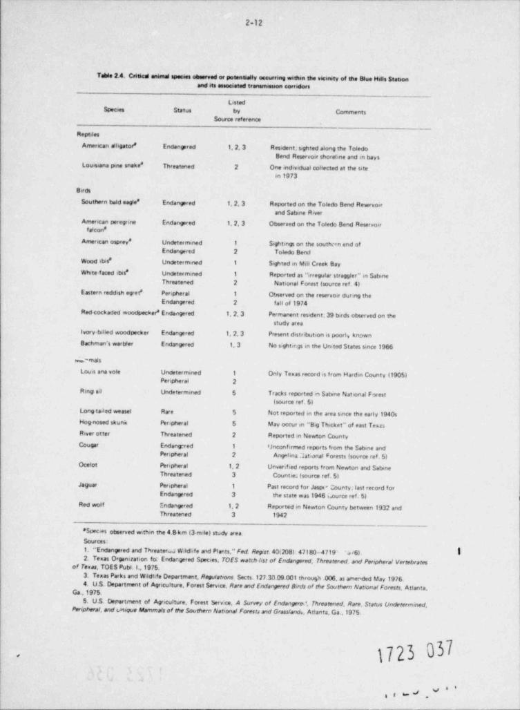
2-12
Table 2.4. Criticd animal species observed or potennally occurring withen the vicmety of the Blue Hills Stationand its associated transmission corridors
ListedSpecies Status by Comments
Source reference
Reptiles
Amencan alhgator* Endangered 1, 2, 3 Resident; seghted along the ToledoBend Reservoir shorehne and m bays
Louissana pme snake * Threatened 2 One individual collected at the sitem 1973
Berds
Southern beld eagle * Endangered 1,2,3 Reported on the Toledo Bend Reservoirand Sabine River
Amencan peregrine Endangered 1, 2, 3 Observed on the Toledo Bend Reservoirfalcon *
Amencan osprey * Undeter mmed 1 S.ghtings on the southern end ofEndangered 2 Toledo Bend
Wood ibit' Undetermined 1 Sighted m Mill Creek Bay
White-faced itns* Undetermmed 1 Reported as " irregular straggler"in SabmeThreatened 2 National Forest (source ref. 4)
Eastern reddish egret * Peripheral 1 Observed on the reservoir during theEndangered 2 fall of 1974
Red-cockaded woodpecker * Endangered 1, 2, 3 Permanent resident; 39 birds observed on thestudy area
Ivory billed woodpecker Endangered 1, 2, 3 Present distnbution is poort, knownBachman's warbier Endangered 1, 3 No sightm.gs m the United States since 1966
.'mais
Louis ana voie Undetermined 1 Only Texas record is from Harden County (1905)Peripheral 2
R mgi nel Undetermined 5 Tracks reported m Sabene National Forest
(source ref. 5)Long taded weasel Rare 5 Not reported m the area since the early 1940sHog-nosed skunk Peripheral 5 May occur m "B,g Thicket" of east TekasRiver otter Threatened 2 Reported m Newton CountyCougar Endangred 1 Unconfirmed reports from the Sabine and
Penpheral 2 Ang kna ht:onal Forests (source ref. 5)Ocelot Perepheral 1, 2 Unverified reports from Newton and Satene
Threatened 3 Counties (source ref. 5)Jaguar Penpheral 1 Past record for Jasov County;last record for
Endangered 3 the state was 1946 Lource ref. 5)Red wolf Endangered 1, 2 Reported m Newton County between 1932 and
Threatened 3 1942
' Species otmerved withm the 4 Skm (3 mile) study area.Sources:
1. " Endangered and ThreaterW Wildhfe and Plants," Fed. Regist. 40(208):47180-4719- V6). !2. Texas Organantson foc Endargered Species, TOES watch lost of Endangered, Threater.ed. and Penpheral Vertebrates
of Texas. TOES Publ. I.,1975.
3. Texas Parks and Wildhfe Department, Regulations Sects. 127.30.09.001 through .006, as amended May 1976.4. U.S. Department of Agnculture, Forest Service, Rare md Endangered Bsids of the Southern National Forests. Atlanta,
Ga ,1975.
5. U.S. Departenent of Agnculture, Forest Service A Survey of Endangere', Threatened, Rare, Status Undetermmed.Peripheral, and unique Manmals of the Southern National Forests and Grassland., Attanta, Ga.,1975.
1723 037.
g i b= #.
2-13
important characteristic that individual species of these comunities must possess is thecapability of withstanding adverse environmental conditions by having a rapid turnover rate(algae), high fecundity (macroinvertebrates), a resting stage of spore or capsulated egg (bacteriaand protozoa), or the abii *ty to migrate (fish).
In contrast to a stream :ystem, a ler'ic e Mnt such as Toledo Bend Reservoir can beconsidered a collection ut . in where avio .a 6 ic cc.nponents (energy) from the watershedare accumulated and stored for different -e pec a Although imported material and energy(in the form of organic matier) ) 1se a cert' N. de ee of influence on the lake, internals
limnological fwtors are the ma? r source of lake dynamics. Initially, a certain degree ofecological staulity is estab- ..a d tw the buffering effect of relatively stationary water.This is not to imply that limnol ' wmunities lose diversity and adaptability. The lake'smorphology ano imnology create ... lety of conditicns and habitats which are readily occupiedby biological compan.nts.
The primary producer cormunity 'n the limnetic or open-water zone of a lake system is always thephytoplankton. In the littoral (shore) zones where appropriate substrata is available and lightenergy can penetrate deeply enough, the comunity is composed of both phytoplankton and aquaticmac rophytes. Usually, attached algae (periphyton) will readily colonize the stems and leaves ofmacrophytes and thus increase the diversity of primary producers. Micro- and macroinvertebrateswill also colonize the stems and leaves of macrophytes. Although they do not consume the livingparts of these plants, tney will readily graze on the periphyton.
The bottom sediments of a lake represent an important habitat, since all dead organic matter pro-Twoduced in the water column and other detritus imported into the lake will fall to the bottom.
components of the benthic comunity take advantage of this food supply. The microbial comunityreceives its energy by decomposing this detritus, while the macroinvertebrates feed both on thedetritus and on the microbial community. Higher consumers such as fish utilize most availablefood sources.
2.7.2.1 Mill Creek and other small streams
Mill Creek and its tributaries, Copperas and Mitchell creeks, are small stream habitats withflows usually less than 0.5 m /sec (17 cfs). These small streams generally maintain habitats3
of alternating pools and riffles derived from characteristic small stream morphology. Poolshave slowly moving water with depths to about 1.5 m (4.9 f t) and are formed at bends, belowrock outcrops, and other obstructions such as fallen trees. In these puols, decreased watervelocity will aid the deposition of the lighter suspended load; the bottom composition reflectsthis activity, since bottom sediment composition is usually of sand, silt, and organic detritus.Riffles have faster moving shallow water with either bedrock or larger sand and/or gravel bottoms.
Water quality
In order to describe the ecological characteristics of this small watershed system, six permanentsampling sites (51 through 56) have been established (Fig. 2.4). At these locations, the appli-
cant compiled chemical water quality parameters including temperature, CO , conductivity, TOS,2
turbidity, colo.', pH, total alkalinity, calcium hardness, total hardness, NH , N0 , H0 , ortho-3 2 3
P0,, total inorganic P0.,, 50.,, and Cl .
The means and ranges of these water quality data are sumarized in Table 2.5 for the samplingperiod of hly 1973 to August 1974. These chemical data are typical of a soft water, low pro-ductivity, small, warm-water stream system.23
Phyto- and zooplankton
Mill Creek and its selected tributaries were sampled for phyto- and zooplankton at the designatedsampling locations (Fig. 2.4) at monthly intervals from July 1973 to August 1974. Ten liters ofstream water was filtered through a 20-mesh Wisconsin plankton net, which has a mesh opening of76 to 80 u.
The phytoplankton (net plankton) of the Mill Creek drainage area were characterized by low diver-sity and density. Pennate diatoms comprised the majority of the plankton flora (76%). Meandensities (cells per liter) were highest during spring ard sumer (81/ liter) and lowest during ,
fall and winter (17 cells / liter). The applicant's monitving program for phytoplankton in theMill Creek watershed actually sampled drif ting algal cells that, in a small stream community,cannot be considered true phytoplankton. This < ,mpling program is discussed in greater detailin Sect. 6.1.5.2 (Preconstruction Supplemental Monitoring Program, Periph c
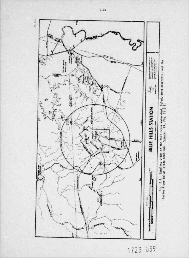
2-14
~
k. st
#
} j ;f ...
-; .....,,,( g, m...e*',,,
\gA.-.. ..; ,,
J,'i.Iy4on %r.. "% !$; % % :. 1.: / n;if '/ ,
.-- 1.-m. f -ng D di' / gg .c,
.
~f I {ll I'.
T spg, Sf
\ T,-
m/ kl i
i e
' # . -i s/
.i. . y ' 't t ! k/ '* ,
'/ ! Oks,1 -
i z 4"'
, i o at',>I 8 i
, -
Eb,
S % .:[up I '
i $ 1, gf' sc
El. isQ.ih .1 ,
i s =s.X, ;) -..
1,
.,4 ;; ,- *a' ....~1 N, m =j ,.
'e p 5.\, \,
<
i >; J y '55-- ~
b' ' L 1 Q-sg. *c .. .
o
.O' * * *
3e'. ..
i #'
;i t
t. < . ;
', I, $I / 3 , m
'
-_,
t ;
i / - ! ". .$*
\ -j ?",'
"E! b *g p
\. t I% i
s 4s
1 1, w,-
t): , * * * v%, s 'W.wfV MS , l
d,,\
L k
1723.039
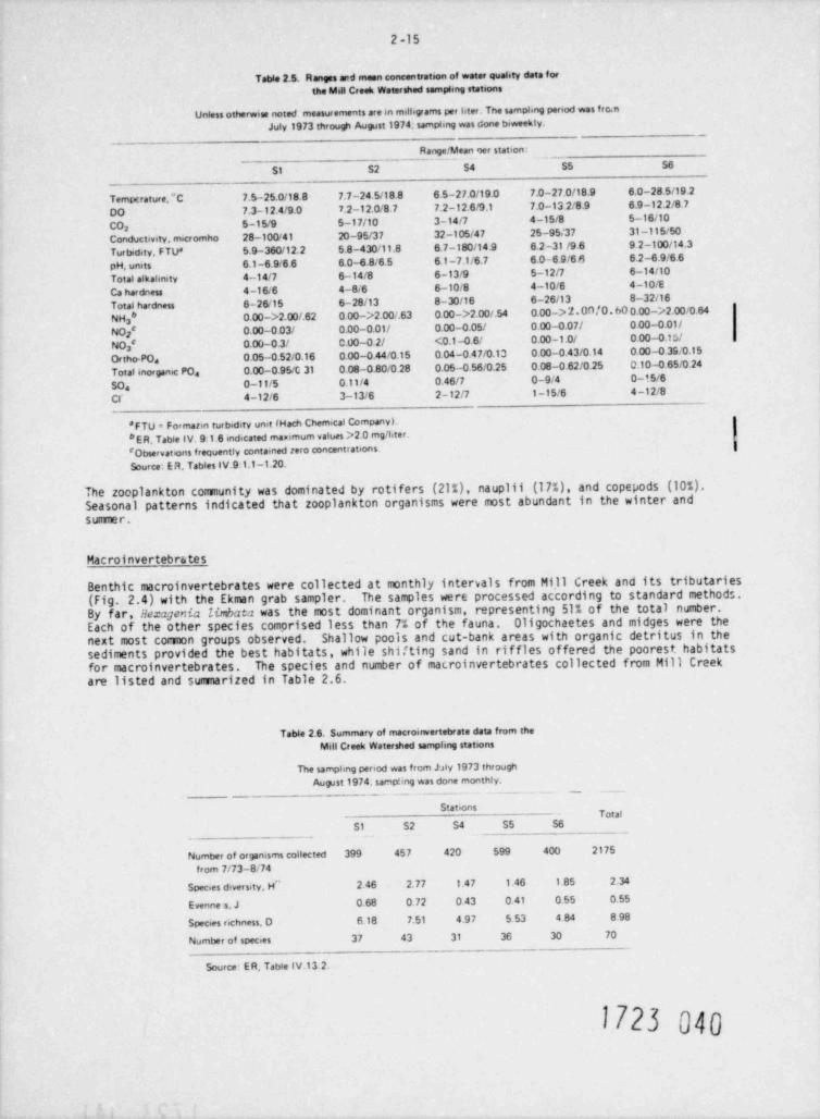
2-15
Table 2.5. Ranges arrd mean concentration of water quahty data forthe Mdl Creek Watershed sampimg stations
Unless otherwne noted measurements are in milligrams per Oter. Tne samphng penod was fro.nJuly 1973 through Aupest 1974; samphng was done biweekly.
Range /Mean oer station:
St S2 S4 SS S6
_
Temgrature,"C 7.5-25.0/18.8 7.7-24 5/18.8 6.5-27.0/19.0 7.0-27.0/18.9 6.0-28.5/19.2
DO 7.3-12.4/9.0 7.2-12.0/8.7 7.2-12.6/9.1 7.0-13 2/8.9 6.9-12.2/8.7
CO 5-15/9 5-17/10 3-14/7 4-15/8 5-16/102
Conductivity. micromho 28-100/41 20-95/37 32 -105/47 25-95/37 31-115/50
Turbidity, F TU* 5.9-360/12.2 5.8-430/11.8 6.7-180/14.9 6.2-31 /9.6 9 2-100/14.3
pH, units 6.1-6.9<6 6 6.0-4.8/6.5 6.1 -7.1/6.7 6.0-6.9/66 6.2-6.9/6.6
Total alkalmity 4-14/7 6-14/8 6-13/9 5-12/7 6-14/10
Ca hardness 4-16.6 4-8/6 6-10/8 4 -10/6 4-10/E
Total hardness 6-26/15 6- 28/13 8 -30/16 6-26/13 8-32/16
NHa* 0.00->2.00/.62 0.00->2.00/.63 0.00->2.00/.54 0.00-> 2.0n /0. 60 0.00->2.00/0.64
NO ' O.00-0.03/ 0.00-0.01/ 0.00-0.05/ 0.00-0.07/ 0 00-0.01/i
NO ' O.00-0.3/ C.00-0.2/ <0.1 -0.6/ 0.00 -1.0/ 0.00-0.15/3
Ortho-POa 0.05-0.52/0.16 0.00-0.44/0.15 0.04-0 47/0.13 0.00-0.43/0.14 0 00 -0.33/0.15
Total inorganic POa 0.00-0.95/C 31 0.08-0.80/0.28 0.05-0.56/0.25 0.08 -0.62/0.25 0.10-0.65/0 24
SOa 0-11/5 0.11/4 0.46/7 0-9/4 0-15/6
CI' 4-12/6 3-13/6 2-12/7 1-15/6 4-12/8
'FTU = Formarm turbidity unit (Hach Chemical CompanyL* E R. Table IV. 9.1.6 indicated mammum values >2 0 mg/ liter.'Obserwatens frequently contained zero concentrations.Source: E R, Tables IV.9.1.1-1.20.
The zooplankton community was dominated by r0tifers (21%), nauplii (17%), and copepods (10%).Seasonal patterns indicated that z00 plankton Organisms were most abundant in the winter andsummer.
Macr 0 invertebrates
Benthic macr 0 invertebrates were collected at monthly intervals from Mill Creek an0 its tributaries(Fig. 2.4) with the Ekman grab sampler. The samples were processed according to standard methods.By far, Hexagenia linbaca was the most dominant Organism, representing 51% of the total number.Each of the Other species comprised less than 7% of the fauna. Oligochaetes and midges were thenext most corw0n groups Observed. Shallow p0Ols and cut-bank areas with organic detritus in thesediments provided the best habitats, while shif ting sand in riffles Offered the p00 rest habitatsfor macr 0 invertebrates. The species and number Of macr 0 invertebrates collected from Mill Creekare listed and summarized in Table 2.6.
Table 2.6. Summary of macroinvertebrate data from theMill Creek Watershed samphng stations
The samphng period was from bly 1973 throughAupst 1974. sampung was done monthly.
Stations,
$1 S2 S4 SS S6
Number of organisms collected 399 457 420 599 400 2175
from 7/73-8/74Species diversity, H" 2.46 2.77 1.47 1.46 1.85 2.34
Evenne s. J 0.68 0 72 0.43 0.41 0 55 0.55
Species rechness. O 6.18 7.51 4 97 5 53 4 84 8 98
Number of species 37 43 31 36 30 70
Source: ER, Tabte IV.13.2.
1723 040
2-16
2Seasonal mean d!nsities were highest in summer (1957/m?) and lowest in spring (222/m ) (ER, Sect.2iIV.13:1.1). Aniual mean species diversity cale.ulated by the Shannon-Weaver formula , ranged from
1.46 at 55 to 2.77 at 52, generally increasing from upstream to downstream stations. The macro-invertebrate data of the Mill Creek watershed are typical of small stream habitats.25
Fishes
Fishes were collected quarterly (September and December,1973; and March and Jun.,1974) at2 2sta tions 51, 52, 54, 55, and $6. Stream segments of 60 to 160 m (646 to 1722 ft ) were blocked
off with bag seines, and the trapped fish were stunned with an AC-300 W back-pack electrofisher.
The Mill Creek drainage is characterized by a diverse population cf fishes which is adapted tosmall, clear, warm-water streams with sandy bottom habitat. The inundation of the lower sectionof Mill Creek by Toledo Bend Reservoir nas enhanced conditions for species such as bluegill ,wannouth, and largenouth bass. Representatives of these species move upstream from the res!rvoirinto larger pools in the vicinity of stations 51 and 52. Endemic species which are adapted tosmall stream habitats are the southern brook lamprey, blackspot shiner, creek chub, freckledmadtom, blockspotted topminnow, spotted bass, harlequin darter, and redfin darter. In gen':ral ,stations Si and 52 were similar in the total number of fish caught (837 and 735), number ofspecies (26 and 22), and species diversity (1.96 and 1.92) (ER, Toble IV.14:1.1 ) . The (therthree stations (S4, 55, and 56) did not have the full benefit of fish migration from the reser-voir; therefore, the total number of fishes caught was considerably lower (162,148, an j 226respectively). Although the nunter of species present at stations 54 and 56 was identical (21),there were only 14 species represented at station 55, which consequently reduced the speciesdiversity index as well (2.14,1.59, and 1.76 respectively). The species missing fra station5: were the black and yellow bullhead, mosquitofish, and the bluntnose, goldstripe, and redfindarters (Table 2./).
Seasonal diversity patterns in the upper drainage area indicated that stressful conditionsexisted during the winter and sumer. Usually densities increased downstream, indicatingbetter habitats and migration from the reservoir. Bluegill densities, especiall), increasedin the lower drainage area (ER, Sect. IV.14:1.1).
2.7.2.2 Toledo Bend Reservoir
Impoundment of Tolei Send Reservoir began in October 1966, and the reservoir reached fullcapacity by 1968. T. * purpose of the reservoir is primarily to er.sure adequate water supply forindustrial and agricultural water users. The reservoir also supports an excellent largemouth-bass sport fishery. Most of the tir.ber in the inundated Sabine River valley has been lef tstanding, except in the lower basin near the dam and in boat lanes which transversely and longi- |tudinally dissect the reservoir. The standing trees with theit upper branches above the water,and the great amount of organic mat *.er in the form of leaf litter and wo3d, provide a set ofecological parameters which play a special role in the limnology of Toledo Bend Reservoir.
Because the lake has a large surface area and the proposed intake and discharge structures wculdbe located in the extreme southernmost end of the reservoir, limnological investigations wereconducted only in the lower basin, specifically from Mill Creek Bay to the dam Strategicsampling sites were selected in the lower basin tr> establish base-line information for potentialimpacts. The locations of sampling sites (TB-1, TB-2, TB-3, TB-4-a,b, and TB-5-a,b c) are shownin Fig. 2.1; their physical characteristics, general location, description, and selectioncriteria tre s wriarized in Table 2.8.
Physicochemical liano'.oqy
The lower portion of the reservoir can be partitioned into two norphologit.sily different environ-ments. Stations designated TB-1. TB-2, and TB-3 represent the epen, rieep part of the reservoir,generally free of standing timber. Stations TB-4-a,b and TB-5-a,b,c represent Indlin and Millcreeb, bays which are sheltered, shallower bays with extensive standing-submerged or partiallysubmerged timber. Limnological characterization of the reservoir will follow this division.
The following paragraphs briefly describe the physicochemical parameters of the reservoir.
Temperature and dissolved oxyqen
Both the open section of the reservoir and the bay areas followed a renomictic circulation regime.Circulation (complete mixing) occurred from mid-December 1973 until mid-March 1974 in the openreservoir. The bay areas destratified a few weeks earlier, and mixing occurred until mid-April
17 M DA1
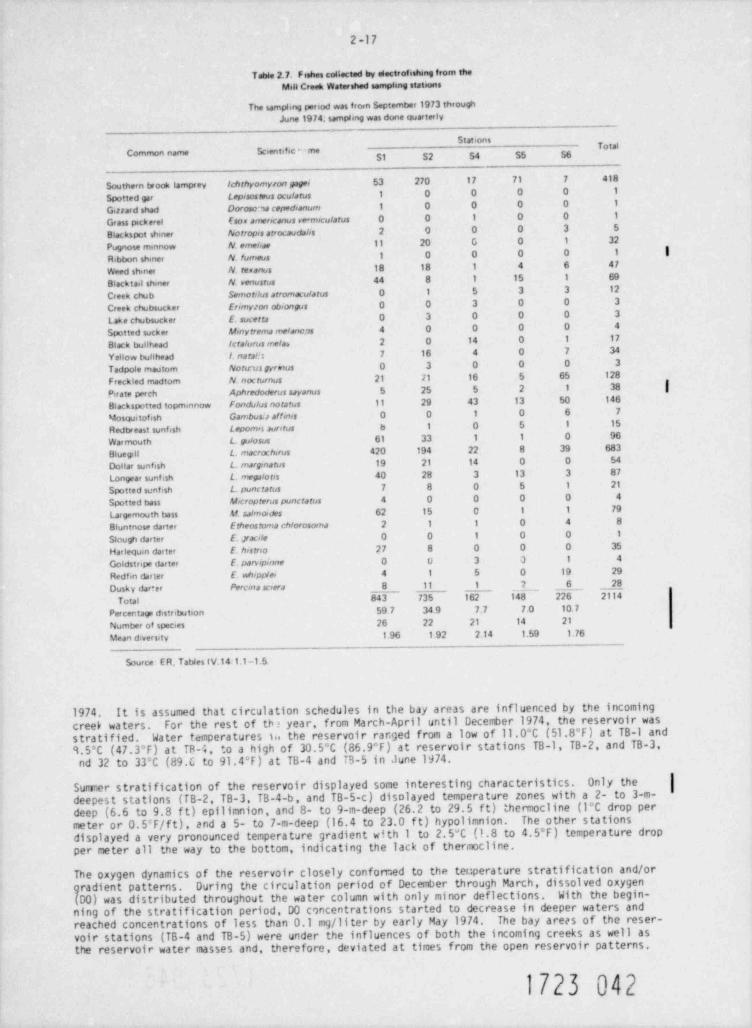
2-17
Table 2.7. Fishes collected by electrofashmg from theMill Creek Watershed sampimg stations
The sampling period was from September 1973 throughJune 19 74. sampling was done quarterly
Stat onsTotal
Common name Scientific -me
Southern twook tamprey /chthyomyron pgei 53 270 17 71 7 418
Spotted gar Lep, sos mus oculatus 1 0 0 0 0 1
Girrard shad Doroso,a cepedeanum 1 0 0 0 0 1
Grass pickerel Eson amerocanus ve micularus 0 0 1 0 0 1
Blackspot shiner Norrop,s atrocaudahs 2 0 0 0 3 5
Pugnose minnow N. emehne 11 20 G 0 1 32
Ribbon shiner N fumeus 1 0 0 0 0 1 |Weed shiner N.temanus 18 18 1 4 6 47
Blacktail shiner N. venustus 44 8 1 15 1 69
Creek chub Sirmordus arromaculatus 0 1 5 3 3 12
Creek chubsucker Erimyzon obiongos 0 0 3 0 0 3
Lake chubsucker E.sucerra 0 3 0 0 0 3
Spotted sucker M,nyrrema me/ancas 4 0 0 0 0 4
Black bullhead scra/urus me/a, 2 0 14 0 1 17
Yellow bullhead I. narata 7 16 4 0 7 34
Tadpole mautom Notrus gyrnus 0 3 0 0 0 3
Freckled madtom N nocturnus 21 11 16 5 65 128
P rate perch Aphredoderus sayanus 5 25 5 2 1 38 |i
Blackspetted topmannow fondu /us norarus 11 29 43 13 50 146
Mosquitofish Gambos.s affems 0 0 1 0 6 7
Redbreast sunfish Lepomes auretus b 1 0 5 1 15
Warmouth L. gulosus 61 33 1 1 0 96
Bluegill L. macrocherus 420 194 22 8 39 683
Dollar sunfish L. inarginatus 19 21 14 0 0 54
Longear sunf tsh L. mees / ores 40 28 3 13 3 87
Spotted sunfish L. punctatus 7 8 0 5 1 21
Spotted bass M*cropterus punctarus 4 0 0 0 0 4
Largemouth bass ef. salmordes 62 15 0 1 1 79
Bluntnose darter Erheostoma chlorosoma 2 1 1 0 4 8
Slough darter E. pacile 0 0 1 0 0 1
Harlequin darter E. hestrao 27 8 0 0 0 35
Goldstrepe darter E. parvepume 0 U 3 3 1 4
Redfin darter E. nh,pp/ei 4 1 5 0 19 29
Dusky dar+er Percina se, era 8 11 1 7 6 28
Total 843 735 1 62 148 226 2114
Percer tage distribution 59 7 34.9 7.7 7.0 10.7
Number of species 26 22 21 14 21
Mean diversity 1.96 1 92 2.14 1.59 1.76
Source E R, TatWes lV.141.1-1.5.
1974. It is assumed that circulation schedules in the bay areas are influenced by the incomingcreek waters. For the rest of tb ? year, from March-April until December 1974, the reservoir wasstratified. Water temperatures 1i the reservoir rar.ged from a low Of li,0*C (51.8 F) at TB-1 and9.5 C (47.3 F) at TR-4, to a high Of 30.5 C (86.9 F) at reservoir stations TB-1, TB-2, and TB-3,nd 32 to 33*C (89.C to 91.4 F) at TB-4 and T3-5 in June 1974.
Sumer stratification of the reservoir displayed some interesting characteristics. Only the |deepest stations (fB-2, TB-3, TB-4-b, and TB-5-c) disolayed temperature zones with a 2- to 3-m-deep (6.6 to 9.8 f t) epilimnion, and 8- to 9-m-deep (26.2 to 29.5 f t) thennocline (l*C drop permeter or 0.5'F/f t), and a 5- to 7-m-deep (16.4 to 23.0 f t) hypolimnion. The other stationsdisplayed a very pronounced temperature gradient with 1 to 2.5"C (1.8 to 4.5'F) temperature dropper meter all the way to the bottom, indicating the lack of thermocline.
The oxygen dynamics of the reservoir closely confomed to the teuperature stratification and/Orgradient patterns. During the circulation period of December through March, dissolved Oxygen(D0) was distributed throughout the water column with only minor deflections. With the begin-ning of the stratification period, D0 concentrations started to decrease in deeper waters andreached concentrations of less than 0.1 mg/ liter by early May 1974. The bay arees of the reser-voir stations (TB-4 and TB-5) were under the influences of both the incoming creeks as well asthe reservoir water masses and, therefore, deviated at times from the open reserv0ir patterns.
1723 042
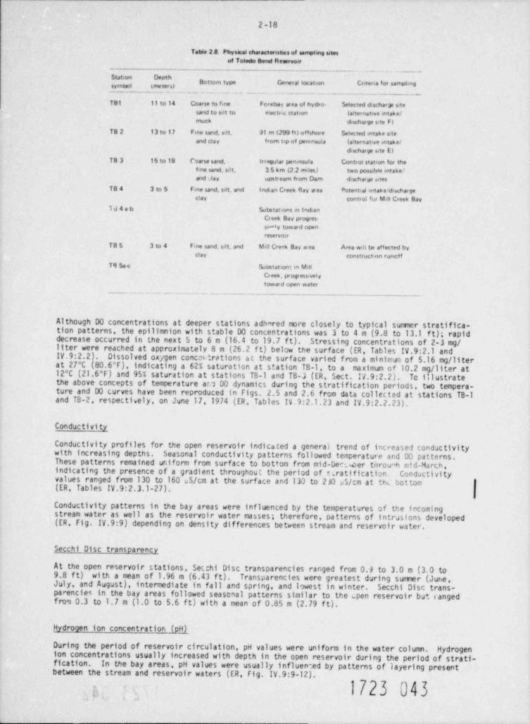
2-18
Table 2.8. Physical characteristics of sampimg sitesof Toledo Bend Reservoir
# "Bottom type Gener al location Cntena for sampleng
_ _ . . _ . _ _ . . . _ _. _ _ _ . _ _ . _ _ - _ _ _ _
TB1 11 to 14 Coarse to fine Forebas area of hydro- Selected discharge s:tesand to sdt to electoc station (af ternative mtake/muck discherge site F)
TB 2 13 to 17 Fme sand, sdt. 91 m (299 ft) offshore Sefected mtake siteand cla y from tip of perunsula (alternative mtake/
discharge site El
TB 3 15 to 18 Coarse sand, irregutar peninsula Control station for thefine sand. sa t. 3.5 hm (2.2 mdes) two possible mtakeland ufay upstream from Dam d:scharge utes
TB4 3 to 5 Fme sand, sdt, and Indian Creek Bay area Potential mtak etd%hargeclay contro! br Mdl Creek Bay
134ab Substations m indianCreek Bay progres-si-ly toward open
reservoir
TB5 3 to 4 Fme sand, sat. and Mill Cre-k Bay aeca Area wdl be affected byclay constructinn runctf
T 8154-c Substatiom in MalCreek, pr ogressivelytoward open water
_ ._.._ - . _ _ _ _ _ _ _ . _ . _ _ _ _ . - __
Although DO concentrations at deeper stations adhared more closely to typical sumer stratifica-tion patterns, the epilimnion with stable D0 concentrations was 3 to 4 m (9.8 to 13.1 ft); rapiddecrease occurred in the next 5 to 6 m (16.4 to 19.7 f t). Stressing concentrations of 2-3 mg/liter were reached at approximately 8 m (26.2 f t) below the surface (ER, Tables IV.9:2.1 andIV.9:2.2). Dissolved oxygen concatrations at the surface varied from a minimum of 5.16 mg/ literat 27'C (80.6'F), indicating a 62% saturation at station TB-1, to a maximum of 10.2 mg/ liter at12*C (21.6*F) and 95% saturation at stations TB-1 and TB-3 (ER, Sect. IV.9:2.2). Tc illustratethe above concepts of temperature ara D0 dynamics during the stratification periods, two tempera-ture and D0 curves have been reproduced in Figs. 2.5 and 2.6 from data collected at stations TB-1and TB-2, respecthely, on June 17,1974 (ER, Tables IV.9:2.1.23 and IV.9:2.2.23).
Conductivity
Conductivity profiles for the open reservoir indicated a generai trend of increased condactivitywith increasing depths. Seasonal conductivity patterns followed temperature and D0 patterns.These patterns remained uniform from surface to bottom from mid-Deuer throuah mid-March,indicating the presence of a gradient throughout the period of Eiratification. Conductivityvalues ranged from 130 to 160 uS/cm at the surface and 130 to 230 pS/cm at tht. bottom(ER, Tables IV.9:2.3.1-27).
Conductivity patterns in the bay areas were influenced by the temperatures of the incomingstream water as well as the reservoir water masses; therefore, patterns of intrusions developed(ER, Fig. IV.9:9) depending on density differences between stream and reservoir water.
Segchi Disc transparency
At the open reservoir stations, Secchi Disc transparencies ranged from 0.9 to 3.0 m (3.0 to9.8 ft) with a mean of 1.96 m (6.43 ft). Transparencies were greatest during summer (June,July, and August), intermediate in fall and spring, and lowest in winter. Secchi Disc trans-pa rencies in the bay areas followed seasonal patterns similar to the (. pen reservoir bu+. rangedfrva 0.3 to 1.7 m (1.0 to 5.6 f t) with a mean of 0.85 m (2.79 f t).
Hydrogen ion concentration (pHJ
During the period of reservoir circulation, pH values were uniform in the water column. Hydrogenion concentrations usually increased with depth in the open reservoir during the period of strati-fication. In the bay areas, pH values were usually influenced by patterns of layering presentbetween the stream and reservoir waters (ER, Fig. IV.9:9-12).
1723 043o
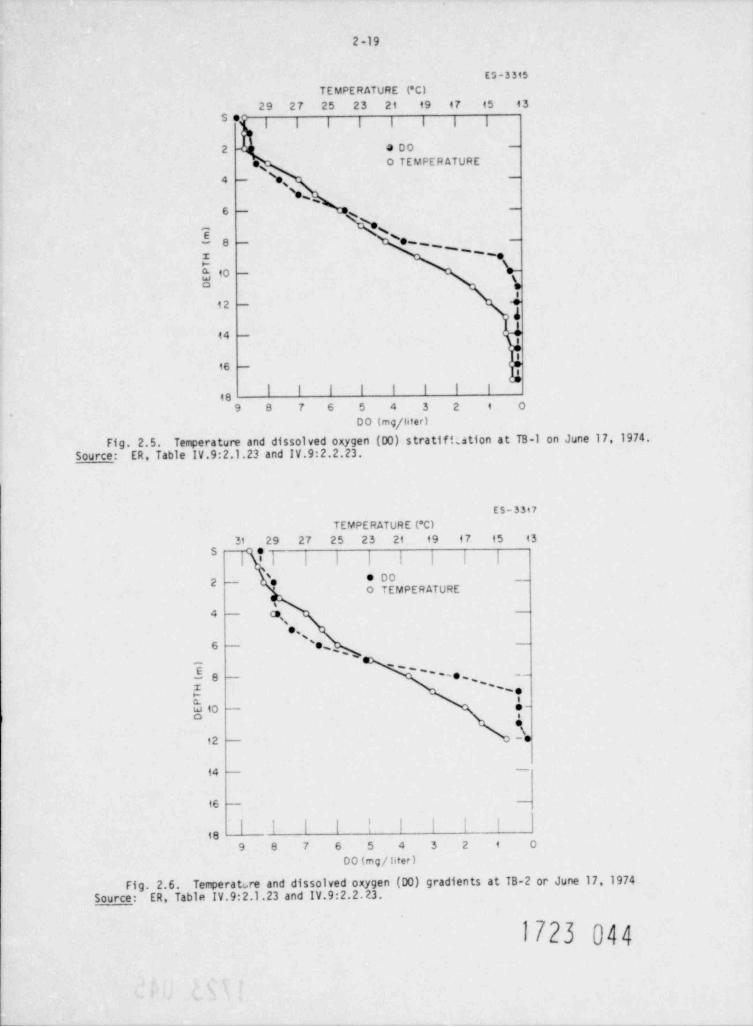
2-19
E G - 3 315
TEMPERATURE (*C)29 27 25 23 21 49 17 45 43
s er; ; ; ; ; ; ; ;
2- 3 00 -
e o TEMPERATUREs\e, -4
'e ,6 -
*N-
Ee - e . _ ' _, _z
kto - b'o
12 - E4
44 -
*'
16e
I I I I I I I I18
9 8 7 6 5 4 3 2 i O
DO (mg/ liter)
Fig. 2.5. Temperature and dissolved oxygen (00) stratificetion at TB-1 on June 17, 1974.Source: ER, Table IV.9:2.1.23 and IV.9:2.2.23.
ES-3347
TEMPERATURE ('C)31 29 27 25 23 21 19 47 15 43
| | |
2 - 'e e Doo TEMPERATURE
s
4 (3,
o,6 - 's ,, , ,
5 8 - '' ' -o ''--
1 ~~,,
f-w to*s
92 - -e
14-
16 -
| |3
| |' '
189 8 7 6 5 4 3 2 i O
DO (mg/ liter )
Fig. 2.6. Temperature and dissolved oxygen (D0) gradients at TB-2 or June 17, 1974Source: ER, Table IV.9:2.1.23 and IV.9:2.2.23.
1723 044
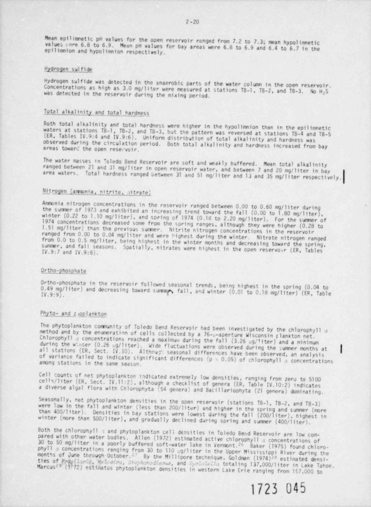
2 -20
Mean epilimnetic pH values for the open reservoir ranged from 7.2 to 7.3; mean hypolimneticvalues u re 6.8 to 6.9. Mean pH values for bay areas were 6.8 to 6.9 and 6.4 to 6.7 in theepflimnion and hypolimnion respectively.
Hydrogen sul fide _
Hydrogen sulfide was detected in the anaerobic parts of the water column in the open reservoir.Concentrations as high as 3.0 mg/ liter were measured at stations TB-1. TB-2, and TB-3. No H 5was detected in the reservoir during the mixing period. 2
Total alkalinity and total hardness
Both total alkalinity and total hardness were higher in the hypolimnion than in the epflimneticwaters at stations TB-1, TB-2, and TB-3, but the pattern was reversed at stations TB-4 and TB-5(ER, Tables IV.9:4 and IV.9:6). Uniform distribution of total alkalinity and hardness wasobserved during the circulation period. Both total alkalinity and hardness increased from bayareas toward the open resecvoir.
The water masses in Toledo Bend Reservoir are sof t and weakly buffered. Mean total alkalinityranged between 21 and 31 mg/ liter in open reservoir water, and between 7 and 20 mg/ liter in bayarea waters. Total hardness ranged between 31 and 51 mg/ liter and 13 and 35 mg/ liter respectively.
Fil_trogen (a rionia, nitrite, .litratel
Ammonia nitrogen concentrations in the reservoir ranged between 0.00 to 0.60 mg/ liter duringthe sumer of 1973 and exhibited an increasing trend toward the fall (0.00 to 1.80 mg/ liter),winter (0.22 to 1.10 mg/ liter), and spring of 1974 (0.18 to 2.20 mg/ liter). For the sumer of1974 concentrations decreased some from the spring ranges, although they were higher (0.28 to1.51 mg/ liter) than the previous sumer. Nitrite nitrogen concentrations in the reservoirranged from 0.00 to 0.04 mg/ liter and were highest during the winter. Nitrate nitrogen rangedfrom 0.0 to 0.5 mg/ liter, being highest in the winter months and decreasing toward the spring,summer, and fall seasons. Spatially, nitrates were highest in the open reservoir (ER, TablesIV.9: 7 and IV.9:8).
Ortho-phosphate
Ortho-phosphate in the reservoir followed seasonal trends, being highest in the spring (0.04 to0.49 m / liter) and decreasing toward sucry fall, and winter (0.01 to 0.18 mg/ liter) (ER, TableIV.9:9 .
Phyto- and z glankton
The phytoplankton comunity of Toledo Bend Reservoir had been investigated by the chlorophyll amethod and by the enumeration of cells collected by a 76 s-aperture Wisconsin glankton net.Chlorophyll a concentrations reached a maximum during the fall (3.26 ug/ liter) and a minimumduring the winter (0.26 t.g/ liter). Wide fluctuations were observed during the summer months at
|all stations (ER, Sect. IV.10). Althout seasonal differences have been observed, an analysisof variance failed to indicate significant differences (p < 0.05) of chlorophyll a concentrationsamong stations in the same season.
Cell counts of net phytoplankton indicated extremely low densities, ranging from zero to 5100cells / liter (ER, Sect. IV.ll:2), although a checklist of genera (ER, Table IV.10:2) indicatesa diverse algal flora with Chlorophyta (54 genera) and Bacillariophyta (21 genera) dominating.
Seasonally, net phytoplankton densities in the open reservoir (stations TB-1, TB-2, and TB-3)were low in the fall and winter (less than 200/ liter) and higher in the spring and sumer (morethan 400/ liter). Densities in bay stations were lowest during the fall (200/11ter), highest inwinter (more than 500/ liter), and gradually declined during spring and summer (400/ liter).
Both the chlorophyll 1 and phytoplankton cell densities in Toledo Bet.d Reservoir are low com-pared with other water bodies. Allen (1972) estimated active chlorophyll a concentrations of30 to 50 mg/ liter in a poorly buffered soft-water lake in Vermont." Baker (1975) found chloro-phyll a concentrations ranging from 30 to 110 ag/ liter in the Upper Mississippi River during themonths of June through OctoberP By the Millipcre technique, Goldman (1974)2'3 estimated densi-ties of Fnjilwia, Eaim, A mha, and E &Mla totaling 137,000/ liter in Lake Tahoe.Ma rcus29 (1072) estinatGs phytoplankton densities in western Lake Erie ranging from 157,000 to
1723 045
2 -21
6,500,000 cells / liter using the same methods. One explanation for the low primary productionexpressed by the chlorophyll a concentrations and the low phytoplankton densities is that themajority of peimary productivity in Toledo Bend Reservoir is accomplished by the macrophytes inthe littoral zone and by the periphyton on the submerged standing timber in the open reservoir(although much of the lower part of the reservoir is free of these habitats).
According to Dr. V.The checklist of algal genera also lists the macroscopic fom of Cham sp.Proctor of Texas Tech University, this organism may be a tropical / subtropical, sof t waterspecies which has invaded the southwestern U.S. from Mexico.
The zooplankton comunity of the reservoir was dominated by rotifers (69%).ine most comon
and Polyarthraspecies were Chrmogaster sp., Aeplanchna sp., Teat:dinella sp., Xemtella s' Minor components of the Zooplankton were ostracods, cladocerans, andsp. (ER, Table IV.11:1).copepods. The open reservoir produced ratifers (Asp 2mM2 sp.) in abundance; the bay areazooplankton community was dominated by nauplif (irrnature forms of copepods) (ER, Fig. IV.11:4).Seasonally, zooplankton densities increased from fall 197J R spring 1974, and then decreased
Mean zooplankton densities ranged between 20 to 130/ literin the summer (ER, Fig. IV.ll:3).in the open reservoir and 50 to 240/ liter in the bay areas (ER, Fig. IV.11:3).
Macroinvertebrates
The dominant groups of benthos in the reservoir were oligochaetes, larvae of phantom midgesDensities were higher in the bay area (a max-'Chacborus spp.), and the larvae of Chironomids. 2 at station2 at station TB-5) than in the open reservoir (a maximum of 1,596/m
Seasonally, macroinvertebrate densities at stations TB-1 and TB-3imum of 10,144/mTB-1) (ER, Fig. IV.13:8). 2 in June 1974 (ER,in August 19/3 to a mean of 1,433/m2
steadily increased from a mean of 459/mThe annual mean number of bentnic macroinvertebrates per m2
Tables IV.13:2.1 and IV.13:2.6).at stations TB-1. TB-2, and TB-3 were 901, 695, and 786 respectively (ER, Tables IV.13:2.1 toIV.13: 2. 6) . Isom (1971)30 compared the pre- and postimpoundment macroinvertebrates in theTennessee Valley Reservoir and found a shift of benthos from a rheotactic comunity (Diptera,Lepidcptera, Trichoptera, Ephemeroptera, and Unionid mussels) to a deep-water community ofAlthough pre-
oligochaetes and dipterah larvae in the families Chironomidae and Chaoboridae. impoundment studies are not available on Toledo Bend Reservoir, the present benthic communitystructure corresponds to that of Isom (1971).33
Sinclair and Ingram (1961)31 first reported the presence of Corbicula mnitensie, the AsiaticAlthough Isom (1971)30 suggested that the larvalclam, from the Tennessee Valley reservoirs.foms of the invading Ccrbinfa are utilized in the reservoir food chain, it is a pest in indus-
The spread of the species in the Ohio and Tennessee river valleys istrial water supplies.described by Sinclair and Isom (1963).32
Aldridge et al. (1976)33 haveThe Asiatic clam has also spread to the western United States.On the site visit in December 1976,reported on its population growth in Arlington Lake, Texas.the staff aquatic ecologist discovered numerous empty shells of Corbicula sp. ranging in sizeT'.is was afrom 25 to 30 m, indicating that the organism had invaded Toledo Bend Reservoir also.Although the appli-|the first recoro of their occurrence in Toledo Bend Reservoir (see p. A-34).dredged from all Toledo Bend samplingcant reported finding " numerous small (5 mm) clamsstations except TB-5" (ER, Sect. IV.12:2.2), further identification of these organisms by theapplicant was not made.
FishesThe gill-net
Forty-two species of fish were collected from the reservoir (ER, Table IV.14:1). data indicated that both abundance and diversity of fishes were greater in the bay areas thanin the open reservoir (ER, Tables IV.14:16 and IV.14:14). Densities of fishes in the littoral2 in the fall. The2 in winter to 0.76 fish /mzones of the open reservoir ranged from 0.23 fish /mdominant species were the black-tailed shiner at stations TB-1 and TB-3 (31 and 41% respectively)
Threadfin shad dominated the limnetic areas of the openand the threadfin snad at TB-2 (60%).reservoir (97%); however, gizzard shad were abundant in the bay areas and in the limnetic zonesThe abundance and hign productivity of shad areof the open reservoir (ER, Table IV.14:20).usual occurrences in southern reservoirs, as indicated by the data of Hauser and Netsch '' in
3
Table 2.9.
In Toledo Bend Reservoir, the centrarchid species of largemouth bass, sunfishes (especially blue-Norone saxatilis) aregills and black and white crappies), and the striped bass (Percichthyidae:The U.S. Fish and Wildlife Service estimated a mean standingithc most important sport fishes. A |crop of approximately 30 kg/ha (165 lb/ acre) in the reservoir by 'm7 (ER, Fig. IV.15:1).study by the Texas Department of Parks and Wildlife estimating a standing crop in a cove (IndianCreek Bay, station TB-4) also substantiated the high productivity of centrarchids in the reservoir.These data are shown in Table 2.10.
1723 046
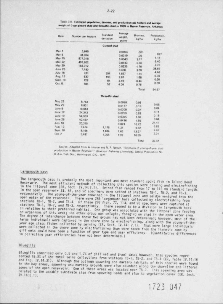
2-22
Table 2 9. E stimated population, tunmess, and production per hectare and averageweeght of o age gizzard shad and threadfin shed in 1969 m Beaver Reservoer, Arkansas
Date Number per hectare ' * "',
gramt
Gizzard shad
May 1 3.645 0 0004 .001.027May 8 34.054 0.0019 .06
M8May 15 877.018 0.0043 3.776.40May 22 402.802 0.0143 5.762.70May 29 183.012 o0235 4 lo
38 65June 26 7.180 0.430 3.094.46July 16 733 254 1.557 1.140.76Aug.13 630 193 2 67 1.68 gSect,10 128 81 3.46 0 44
Oct. 8 186 52 4 05 0.75
Total 54 57
Threadf m shed
May 22 8,763 0 0088 0 080 08May 29 8.801 0 0177 0.150.04June 5 18.043 0 0208 0.37
June 12 24.343 0.0259 0.63 08June 19 54.953 0 0305 1.68
0 64June 26 42.469 0 0436 1.85 ggJuly 16 20,315 0 823 16.726 82Aug.13 7.4 74 1.175 1.31 9 82248Sept.10 8.196 1.404 1 63 13.372 01Oct. P 5.481 1.056 1 92 10 55
Total 36 82
Source. Adapted from A. Houser and N. F. Netsch. '' Estimates of young of yea [ shadproduction m Beaver Reservoor." Reservoir Fisherres Lunnology Special Pubhcat;on No8. Am. Fish. Soc., WasNngton. D.C.,19 71.
Largemouth bass
The largemouth bass is probably the most important ana most abundant sport fish in Toledo BendReservoir. The most efficient methods of collecting this species were reining and electrofishingin the littoral zone (ER, Sect. IV.14:2.1). Seined fish ranged from 17 to 143 mm standard length.In the open reservoir 33, 66, and 52 specimens were seined at stations TB-1. TB-2, and TB-3,respectively. The young-of-the-year remained in the littoral zone and seldom ventured into theopen water of the reservoir.
There were 286 largemouth bass collected by electrofishing fromstations TB-1, TB-2, and TB-3 Of these 286 fish, 77,113, and 96 specimens were captured atstations TB-1, TB-2, and TB-3, respectively. There seemed to be a division in largemouth bassin relation to their preferred habitat. One group was associated with the littoral zone feedingon organisms of this area; the other group was pelagic, foraging on shad in the open water area.The degree of interchange between these two groups has not been determined; however, most of thelarge individuals were captured in the shore zone by electrofishing, along with the young-of-the-year age class fishes collected by seining (ER, Sect. IV.14: 2.1 ) . That more large individualswere collected in the shore zone by electroffshing than were taken from the limnetic zone bygill nets could have been a function of gear type and gear efficiency. (Quantitative dif ferencesin collecting gear efficiencies have not been determined.)
Bluegills
Bluegills comprised only 0.5 and 1.7% of gill net and trawl data; however, this species repre-sented 18.3% of the total seine collections from stations TB-l, TB-2, and TB-3 (ER Table IV.14:16and Fig. IV.14:31). Although the optimum spawning and nursery habitats of this species were foundin the bay areas, spawning and nursery grounds were also abundant along the shoreline and littoralzones of the open reservoir. One of these areas was located near TB-2. This spawning area wasrelated to the useable substrate size from spawning redds and also to vegetation cover (ER, Sect.IV.14:2.1).
, 1723 047
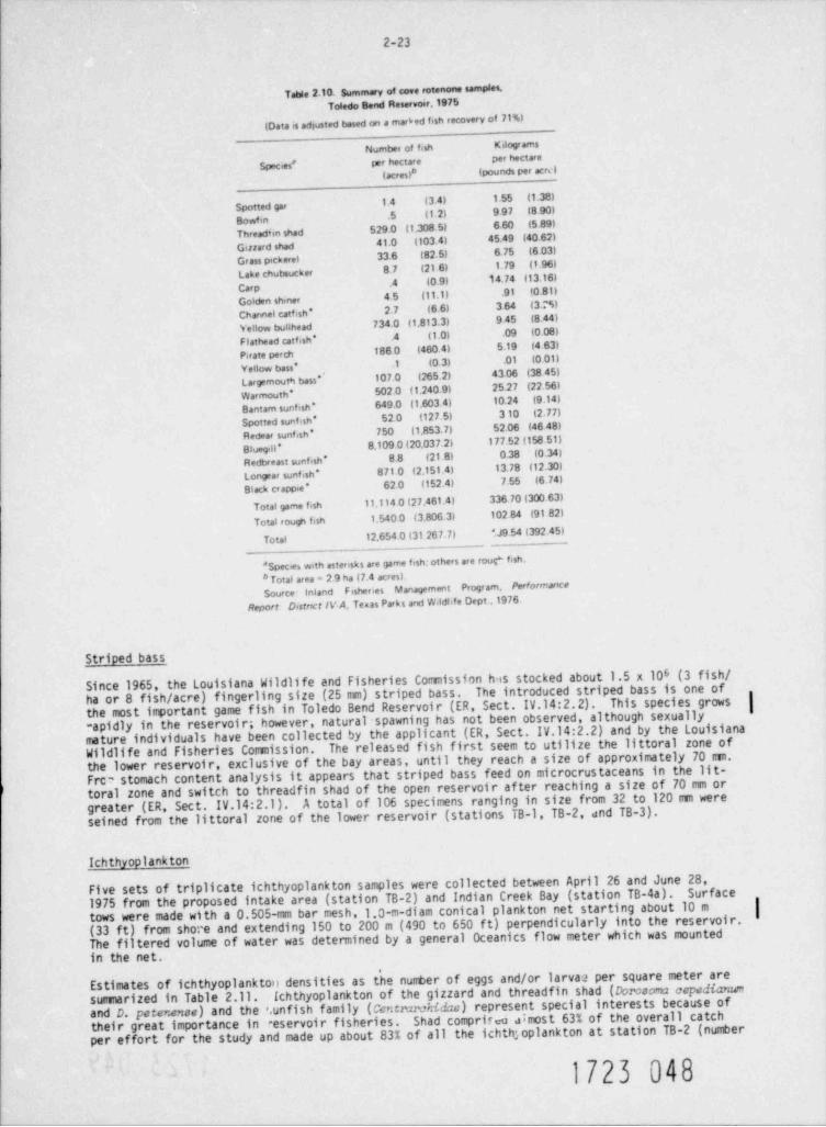
2-23
Table 2.10. summary of cove rotenone samples.Toledo Bend Reservoer.1975
IData is adjusted based on a rnar6ed fish recovery of 71%)
Number of fish Kilogr ams
Species' per hectare per hectare
(acres)e (pounds per acrs i
14 (3 4) 1.55 (1.38)Spotted gar
.5 11.2) 9 97 (8.90)BowfmThreadim shad 529.0 (1.308 5) 6.60 (5.89)
41.0 (103.4) 45.49 (40 62)Giriard shadGrass pickerel 33.6 (82.5) 6.75 (6 03)
8. 7 (21 6) 1.79 (1.96)Lake chubsucker
.4 (0.9) 14.74 (13.16)Carp
45 (11.1) .91 (0.81)Golden shmerChannel catf rsh* 2.7 (6 6) 3 64 (3MYellow bullhead 734.0 (1.813.3) 9.45 (8.44)
Flathead catfish * .4 (1.0) .o9 (0.08)
Pirate perch 188 0 (460 4) 5.19 (4 63)
Yellow bass * .1 (0.3) .01 (0.01)
Largemouth bass * 107.o (265.2) 43.06 (38 45)
Warmouth* 502.0 (1.240.9) 25.27 (22 56)
Bantam sunfish * 649.0 (1.603 4) 10.24 (9.14)
Spotted suntesh' 52.0 (127.5) 3 10 (2.77)
Redear sunfish * 750 (1.853.7) 52.06 (46 48)
Bluegill * 8.109 0(20.037.2) 177 52 (158 51)
Redbreast sunfish * 8.8 (21.8) 0.38 (0.34)
Longear sunfish * 871 0 (2.151 4) 13.78 (12.30)
62.0 (152.4) 7.55 (6. 74)*Black crappie
Total game fish 11.114 o (27.461.41 336 70 (300 63)
Total eough fish 1.540 0 (3.806 3) 102 84 (91 82)
Total 12.654 0 (31 267.7) SJ9.54 (392.45)
* Species with asterisks are garne fish; others are rour fish.
* Total area = 2 9 ha (7.4 acres).source Inland F isheries Management Progr am. Performance
Distnct IV A, Te=as Parki and W.ldlife Dept.,1976Report
Striped bass
Since 1965, the Louisiana Wildlife and Fisheries Commission has stocked about 1.5 x 10⁶ (3 fish /ha or 8 fish / acre) fingerling size (25 mm) striped bass. The introduced striped bass is one ofthe most important game fish in Toledo Bend Reservoir (ER, Sect. IV.14:2.2). This species grows |rapidly in the reservoir; however, natural spawning has not been observed, although sexuallymature individuals have been collected by the applicant (ER, Sect. IV.14:2.2) and by the LouisianaWildlife and Fisheries Commission. The released fish first seem to utilize the littoral zone ofthe lower reservoir, exclusive of the bay areas, until they reach a size of approximately 70 rrrn.Frc' stomach content analysis it appears that striped bass feed on microcrustaceans in the lit-toral zone and switch to threadfin shad of the open reservoir af ter reaching a size of 70 mm or
A total of 106 specimens ranging in size from 32 to 120 mm weregreater (ER, Sect. IV.14:2.1).seined from the littoral zone of the lower reservoir (stations TB-1, TB-2, and TB-3).
Ichthyoplankton
Five sets of triplicate ichthyoplankton samples were collected between April 26 and June 28,Surface1975 from the proposed intake area (station TB-2) and Indian Creek Bay (station TB-4a).tows were made with a 0.505-mm bar mesh,1.0-m-diam conical plankton net starting about 10 m |(33 ft) from shore and extending 150 to 200 m (490 to 650 ft) perpendicularly into the reservoir.The filtered volume of water was determined by a general Oceanics flow meter which was mountedin the net.
Estimates of ichthyoplanktoil densities as the nurrber of eggs and/or larva 2 per square meter aresurrrnarized in Table 2.11. Ichthyoplankton of the gizzard and threadfin shad (Dorosoma cepedianumand D. petenense) and the ',unfish family (Centmrchidae) represent special interests because oftheir great importance in aeservoir fisheries. Shad comprirea 6most 63% of the overall catchper effort for the study and made up about 83% of all the ichth;oplankton at station TB-2 (number
1723 048
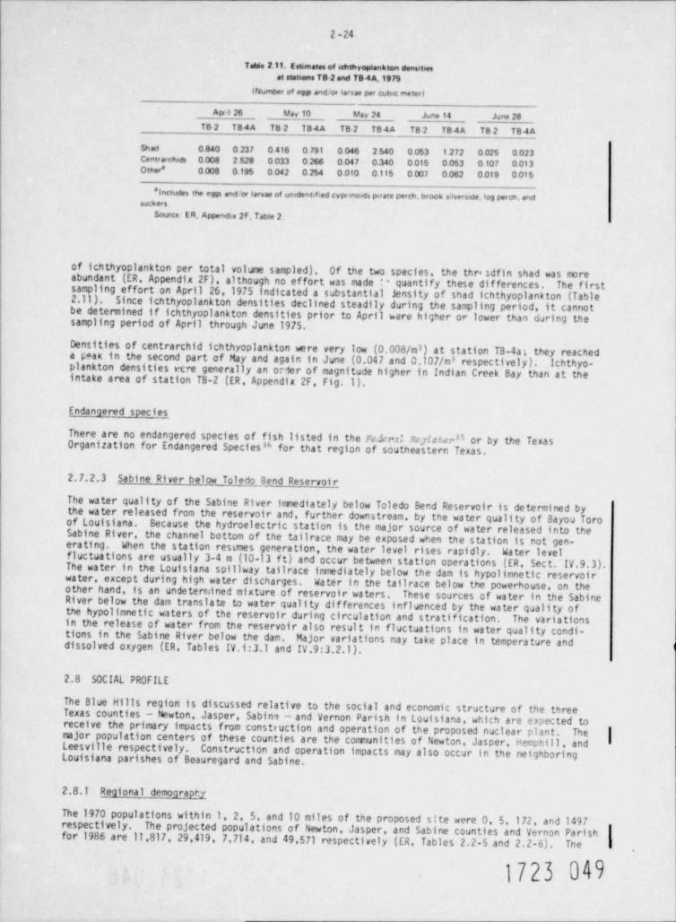
2 -24
Table 2.11. Est mates of ichthyoplankton densities
at stations TB 2 and TB4A.1975
(Number of eggs and'or larvae per cubic meteri
Apol 26 May10 May 24 June 14 June 28
TB 2 T84A TB 2 T84A TB 2 TB4A TB 2 TB4A TB 2 T84AShad 0.840 0237 o416 0.791 o 046 2 540 o 053 1.272 o 025 o 023Centrarchids o 008 2 528 o033 o266 0.047 o.340 0015 o053 o 107 o 013Other* o008 0.195 o 04 2 0.254 o olo o.115 o007 0.062 o 019 oof 5
*Inchides the eggs and 'or larvae of unident f ed cyponown pirate perch, brook sdverede, log perch, andSUCh er $.
Source: ER, Appenda 2F. Table 2.
of ichthyoplankton per total volume sampled). Of the two species, the thre 3dfin shad was moreabundant (ER, Appendix 2F), although no effort was made '' quantify these differences. The firstsampling effort on April 26, 1975 indicated a substantial jensity of shad ichthyoplankton (Table2.11 ) . Since ichthyoplankton densities declined steadily during the sampling period, it cannotbe determined if ichthyoplankton densities prior to April were higher or lower than during thesampling period of April through June 1975.
Densities of centrarchid ichthyoplankton were very low (0.003/m ) at station TB-4a; they reached3
a peak in the second part of May and again in June (0.047 and 0.107/m 3 respectively). Ichthyo-plankton densities rcre generally an o:~1er of magnitude higher in Indian Creek Bay than at theintake area of station TB-2 (ER, Appendix 2F Fig.1).
Endangered species
There are no endangered species of fish listed in the Feld Re,7(stec35 or by the TexasOrganization for Endangered Species % for that region of southeastern Texas.
2.7.2.3 Sabine River below Toledo Bend Reservoir
The water quality of the Sabine River imediately below Toledo Bend Reservoir is determined bythe water released from the reservoir and, further downstream, by the water quality of Bayou Toroof Louisiana. Because the hydroelectric station is the major source of water released into theSabine River, the channel bottom of the tailrace may be exposed when the station is not gen-era ti ng. When the station resemes generation, the water level rises rapidly. Water levelfluctuations are usually 3-4 m (10-13 f t) and occur between station operations (ER, Sect. IV.9.3).The water in the Louisiana spillway tailrace immediately below the dam is hypolimnetic reservoirwater, except during high water discharges. Water in the tailrace below the powerhouse, on theother hand, is an undetermined mixture of reservoir waters. These sources of water in the SabineRiver below the dam translate to water quality differences influenced by the water quality ofthe hypolimnetic waters of the reservoir during circulation and stratification. The variationsin the release of water from the reservoir also result in fluctuations in water quality condi-tions in the Sabine River below the dam. Major variations may take place in temperature anddissolved oxygen (ER, Tables IV.1:3.1 and IV.9:3.2.1).
2.8 SOCIAL PROFILE
The Blue Hills region is discussed relative to the social and economic structure of the threeTexas counties - Newton, Jasper, Sabin? - and Vernon Parish in Louisiana, which are expected toreceive the primary impacts from construction and operation of the proposed nuclear plant. Themajor population centers of these counties are the conmunities of Newton, Jasper, Perphill, and |Leesville respectively. Construction and operation impacts may also occur in the neighboringLouisiana parishes of Beauregard and Sabine.
2.8.1 Regional demography
The 1970 populations within 1, 2, 5, and 10 miles of the proposed site were 0, 5,172, and 1497respectively. The projected populations of Newton, Jasper, and Sabine counties and Vernon Parishfor 1986 are 11,817, 29,419, 7,714, and 49,571 respectively (ER, Tables 2.2-5 and 2.2-6) . The
1723 00
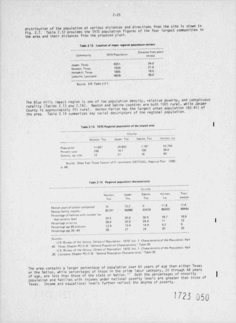
2-25
distribution of the population at various distances and directions from the site is shown inFig. 2.7. Table 2.12 provides the 1970 population figures of the four largest communities inthe area and their distances from the proposed plant.
Table 2.12. Location of maior reponal population centers_
' * " * '"'Community 1970 Population
-.
Jasper. Te mas 6251 24 0
Newton, Texas 1529 21.0
Hemphill. Te nas 1005 16.5
Leesville, Louisiana 8928 26 0
Source E R, Table 2 2-1.
The Blue Hills inpact region is one of low population density, relative poverty, and conspicuousrurality (Tables 2.13 and 2.14). Newton and Sabine counties are both 100% rural, while JasperCounty is approximately 75% rural. Vernon Parish has the largest urban population (60.4%) of
Table 2.14 sumarizes key social descriptors of the regional population.the area.
|Table 2.13.1970Reponal population of the impact area
County
Newton Ten Jasper. Tex Satune. Tex. Vernon La
Population 11,657 24.692 7.187 53.794
Percent rural 100 74.7 100 39 6
Density. sq ales 12 27 16 40- - . .
.
Source- Deep E ast Texas Counca of C vernments (DETCOG), Reg.ona/ Plan 1990
p.68.
Table 2.14. Regional population characteristics
-
Ccur.ty
Newton. Jasper Sab4ne Vernon. Text-
Tex. Ten Tex. La med,an
Median years of school completed 10 10.2 9 11.8 11 6
hoan famdy income $5797 $6888 $5438 $6450 $8490
Percentage of f amthes w th income 'essthan pcverty level 25 5 20 8 30 5 18.7 18 8
28 9 22.9 24 4 11 13 |Percentaga m.nor tvPercentage age 65 and ove- 12 9 12.4 14 9 4.2 9
Percentaga age 20-44 26 27 24 20 32
Sources:U S Bureau of the Census. Census of Population 1970. Vol.1 Charat ter st cs of the Population. Part
45- Te=as. Chapter PC(1) B * General Populaton Characteristics." Table 35U S. Bureau of the Census, Census of Pbpulation 1970. Vol.1 Characteristics of the Population, Part
20. Louisiana. Chapter PCit) B " General Populatson Characterist'es," Tabte 35
The area contains a larger percentage of population over 65 years of age than either Texasor the Nation, while percentages of those in the prime labur category, 20 through 44 yearsof age, are less than those of the state or Nation.37 Both the percentages of minority |populat. ion and families with incomes under national poverty levels are greater than those ofTexas. Income and educational levels further reflect the degree of poverty.
1723 050
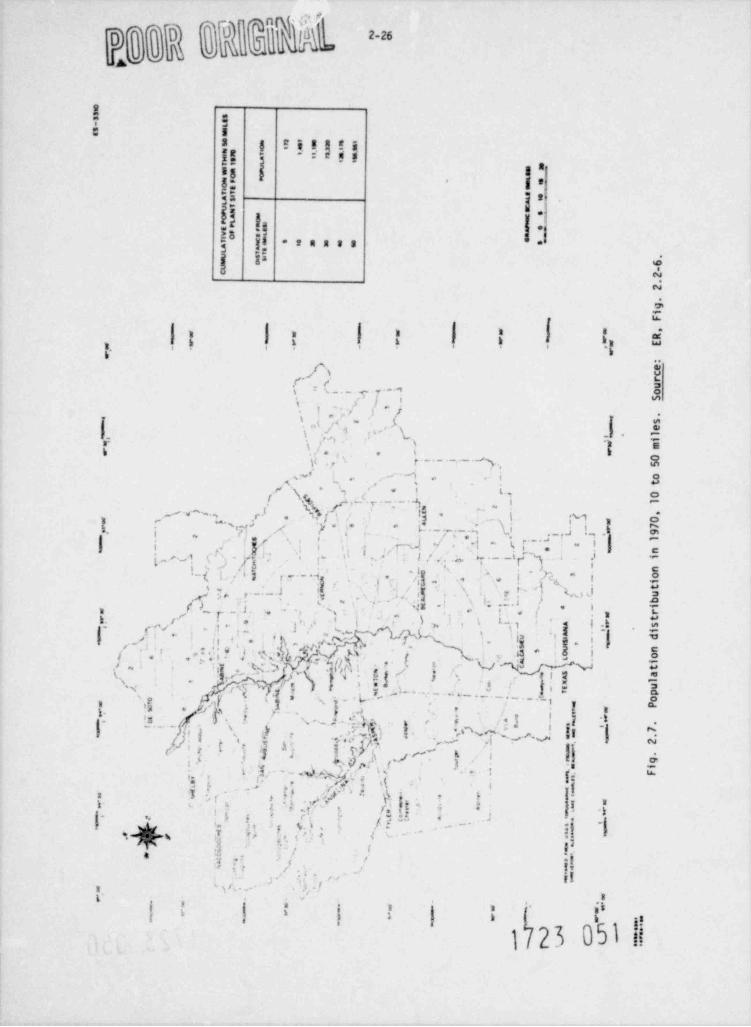
4 r
O
AU
h 5= 5
3 g E: aa!s* * *E**il1--
as [ 3a6: g,
:E .,
|;-
$: 1.r2 i:-g gf .I-eaa as :'| a s
4A4
t' .
|| fI | , i e d'I$ * ' "i. . . , '
6.-
.s
.s T 8r' < s
'g ._.c4.-a 8s
j' } ii m
'r v t -
I i ,/ j
-|- |01. g ''s '( ';", ./ 't ,-
,-,, s Ir i a
/.j,i , ,
oj,g r_._._._. % , m
si i 3,
! ]!q,, f . ,,y . ,'--+, . ~
,, - ','
, . t.., o'
- , , ~ , . . , c.I v !s - ! M i R.
,
j-
' , . , r. . )) g. N~ -1
-k _ , . ,J I-, *|"
" g( ,- 't ;* L* r; ,, $*
i ~
I- .
i. , -. . c
L < ,: .s i. Y s,.->
- 1 -f~) ;' ',, ,- '
i. .. (s L ., a , .-.$ ,,l[ _ n, - o! i. s1
., .. .. c 'j w. -
j- _ _ _ '$., ..t._., ; , ,
.r---, '. r t wo ;,,- - ,g >
s,;,,n, ,., r a
-
r. c.
s, . ,- 5 .- rt - i n
-
< g .s .tp .. i ,
|J( <' ./ - 1*,_ I, '.w if ! *, - -
j3,
)_*,'*.! .j!,I,* - '- -~ j * !!' ;i 3
I Vt
x.. $,,.'g.3]3g#~Y.'') \'.U NW" 3,
#'
,3# # 2,i
,l ,-
<;, h ) < g 3,-
~ ~ ^ ~ ~ - ' ' ~ * - - - | i :.-fs ., .-.k , }.1
. . . - -' , , '1 , i_. .g' . a* #~
'; &i
y f, . ?. , sl- ..i
.
*
is --- .,j 'f . , ,-. N . . t .T 4[,; f ''2 i j - Eg
'N , )* ,a:, g-
_*f
'r$\P w._,.A af dtoc lg
} ' i'hf, ,,
i \ ) 5}.s
A M p|f 'j-r ~'(. yL s 5I
g .5 f 3 ~8
1. [. - ~ ~. &sp&f(' ,. ' d. [\ %, * '3 |i''. 1. . . q i i.','s
. , (.[4 , 1.i | g , f,'
(, *
.{w .
1
.,
, ,,.. s 5 c '.<
/ *; * ' . , _.. * *
-.
.g
%*%ft 'y %. ,1
|*
|t? ' ' ' t \*' '' ' ~~4
R |I(r' -4 .i . :' i /
,i f,' '
||. ,,
L''', I' x i' . . .
g. g aI ' k Ig
'
s Bfa i a n 6 {t' ''
1 23 051 il
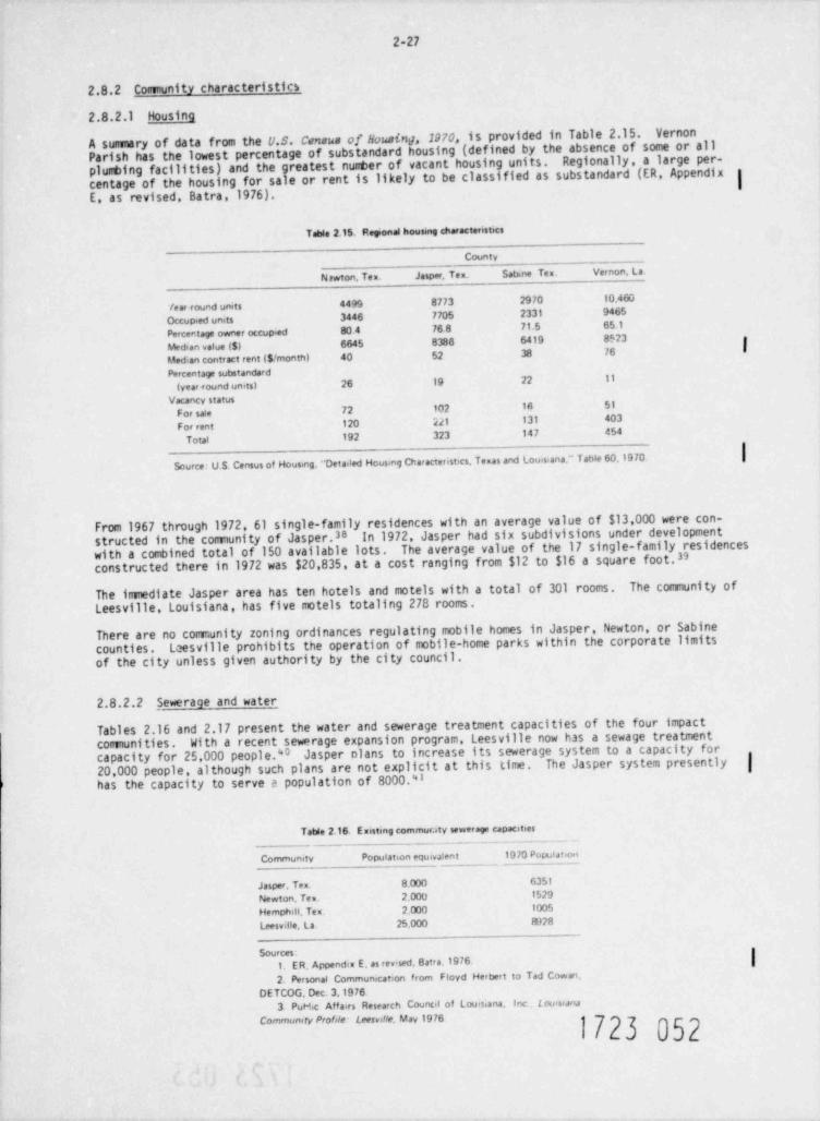
2-27
2.8.2 Comunity characteristics
2.8.2.1 Housing
A summary of data from the U.S. Census of Housing,1970, is provided in Table 2.15. Vernon
Parish has the lowest percentage of substandard housing (defined by the absence of some or allplumbing facilities) and the greatest nunter of vacant housing units. Regionally, a large per-centage of the housing for sale or rent is likely to be classified as substandard (ER, Appendix 3
IE, as revised, Batra,1976).
Table 2.15. Reponal housmg characteristics
County
Nawton, Tex. Jasper, Tex. Satane Tex. Vernon, La.
/ ear round units 4499 8773 2970 10.46o
Occupied units 3446 7705 2331 9465
Percentage owner occupied 80.4 76 8 71.5 65.1
Median value ($) 6645 8388 6419 8523|
Median contract rent ($/ month) 40 52 38 76
Percentage sutstandard(year <ound units) 26 19 22 11
Vacancy status
For see 72 102 1A 51
For rent 120 221 131 403
Toul 192 323 147 454
Source: U S. Census of Housing, ''Detaded Hous.ng Characteristics Texas and touisiana " Table 60,1970
From 1967 through 1972, 61 single-family residences with an average value of $13,000 were con-structed in the community of Jasper.38 In 1972, Jasper had six subdivisions under developmentwith a combined total of 150 available lots. The average value of the 17 single-family residencesconstructed there in 1972 was $20,835, at a cost ranging from $12 to $16 a square foot.33
The immediate Jasper area has ten hotels and motels with a total of 301 rooms. The community ofLeesville Louisiana, has five motels totaling 278 rooms.
There are no comunity zoning ordinances regulating mobile homes in Jasper, Newton, or Sabinecounties. Leesville prohibits the operation of mobile-home parks within the corporate limitsof the city unless given authority by the city council.
2.8.2.2 , Sewerage and water
Tables 2.16 and 2.17 present the water and sewerage treatment capacities of the four impactcomuni ties . With a recent sewerage expansion program Leesville now h3s a sewage treatmentcapacity for 25,000 people."0 Jasper olans to increase its sewerage system to a capacity for20,000 people, although such plans are not explicit at this time. The Jasper system presently |has the capacity to serve e population of 8000.43
Tatde 2.16. E mistmg commuenty sewerage capacitees
Comrnunity Population equivalent 1970 Populatnoei
Jasper, Ten 8.000 6351
Newton, Tex. 2,000 1529
Hemphill. Te x . 2.000 1005
Leesvdle, La. 25.000 1028
1. ER, Appendia E, as rev' sed, Batra.1976. |Sources:
2. Personal Communication from Floyd Herbert to Tad Cowei,DETCOG, Dec. 3,1976
3 PuH.c Affairs Research Council of Louisiana, Inc L omsumComewmty ProMe Leesudle, May 1976
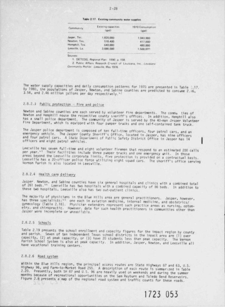
2 -28
Table 2.17. tostmg commumty wate, supplies *
E mistetig capac ties 19 70 Consumpt onWx1) Wwti
Jasper. Tet. 1.820,000 1 040.000Newton. Ten. 518.400 417.000Hemphin. Tes. 540.000 480,000Leesv.He, La. 3 690.000 1.500.om
Sources:_ _ _ _ _ _ . _
1. DE TCOG. Reponal Plan 1990,p.1582. Publ c Affairs Research Cwned of Lo#siana. Inc , t oms,ans
Community Proble Lees,olle. May 1976
The water supply capacities and daily consumption patterns for 1970 are presented in Table 2.17.By 1980, the populations of Jasper, Newton, and Sabine counties are predicted to consume 2.16,3.54, and 2.46 million plions per day respectively.V
2.8.2.3 Public protection - fire and p.olce
Newton and Sabine counties are each served by volunteer fire departments. The commu. ties ofNewton and Hemphill nouse the respective county sheriff's offices. In addition, Hemphill alsohas a small police department. The comunity of Jasper is served by the 40-man Jasper VolunteerFire Department, which is equipped with four pumper trucks and one self-contained tank truck.
The Jasper police department is composed of ten full-time officers, four patrol cars, and anemergency yehicle. The Jasper County Sheriff's Office, located in Jasper, has nine officersand four patrol cars. A State Dcpartme nl of Public Safety District Office in Jasper has 14 |officers and eight patrol vehicles. I
Lee:ville has seven full-time and eight volunteer firemen that respond to an estimated 200 callsper year." Their facilities include three pumper trucks and one emergency unit. In thoseareas beyond the Leesville corporate limits, fire protection is provided on a contractual basis.Leesville has a 20-officer police force utilizing eight squad cars. The sherif f's of fice servingVernon Parish is also located in Leesville.
2.8.2.4 Health care d elivery
Jasper, Newton, and Sabine counties have six general hospitals and clinics with a combined totalo f 261 b ed s . '''' Leesville has two hospitals with a combined capacity of 86 beds. In addition tothese two hospitals, Leesville also has two out-patient clinics.
The majority of physicians in the Blue Hills area are general practitioners. Jasper, however,has three specialists:" one each in aviation medicine, internal medicine, and obstetrics /gynecology (Table 2.18). Physician extenders represent such practice areas as nursing, optom-etry, and chiropractic. However, data for such health practitioners in communities other thanJasper were incomplete or unavailable.
2.8.2.5 Schools
Table 2.19 presents the school enrollment and capacity figures for the impact region by countyand parish. Seven of ten independent Texas school districts in the impact area are (1) overcapacity, (2) at peak capacity, or (3) have 20 students less than peak capacity. The VernonParish School System is also at peak capacity. In addition, Jasper, Newton, and Leesville allhave vocational training centers.
2.8.2.6 Road system
Within the Blue Hills region, the principal access routes are State Highways 87 and 63, U.S.Highway 96, and Fam-to-Market Road 255. A description of eacit route is sumarized in Table2.20. Presently, both SH 87 and U.S. 96 are heavily used on weekends and during the sumermonths because of recreational opportunities on the Sam Rayburn and Toledo Bend Reservoirs.Figure 2.8 presents a map of the regional road system and traffic counts for these roads.
1723 053
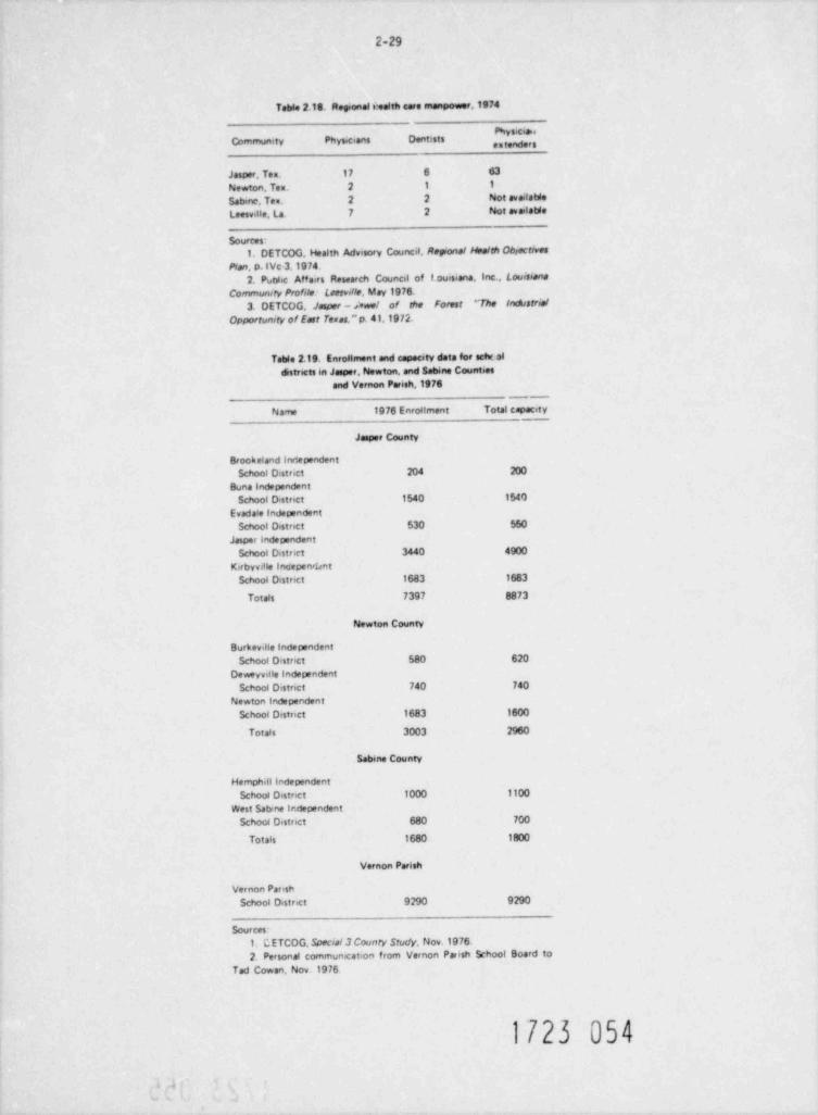
2-29
Table 2.18. Regional smalth care manpower,1974
''Communety Physicians Dentists
Jasper, Ten. 17 6 63
Newton, Tex. 2 1 1
Satnne, Ten. 2 2 Not availaWe
Leesville, La. 7 2 Not availatWe
Sources:1. DETCOG. Health Advisory Council, Reponal Health Colectives
Plan, p. (Vc 3,1974.2. PutWic Affairs Research Council of 1 ouisiana, Inc., Louisiana
Community Profile: Leesville, May 1976.
3. DETCOG. Jaseer - svari of the Forest ''The IndistrialOpportunity of East Temos."p. 41,1972.
Table 2.19. Enrollment and capacity data foe echt ofdistricts in Jasper, Newton, and Sabine Counties
and Vernon Parish,1976-
Name 1976 Enrollment Total capacety
Jasper County
Brookeland Irv'ependent,
School District 204 200
Buna independent
School Distnet 1540 1540
Evadale Independent
School Distnct 530 550
Jasper independent
School D.stnet 3440 4900
Kirbyville InoepervkntSchool Distnct 1683 1683
Totals 7397 8873
Newton County
Burkeville independent
School Distnct 580 620Deweyville Independent
School District 740 740
Newton Independent
School Disenct 1683 1600
Totals 3003 2960
Sabene County
Hemphill todependentSchool Distnct 1000 1100
West Sabine Ir.clependent
Schoc4 Distnct 680 70()
Totals 1680 1800
Vernon Parish
Vernon PanshSchool Distnct 9290 9290
Sources-1. CETCOG Special 3 County Study, Nov.1976
2. Personal communication from Vernon Paish School Board toTed Cowan, Nov.1976
1723 054
. .
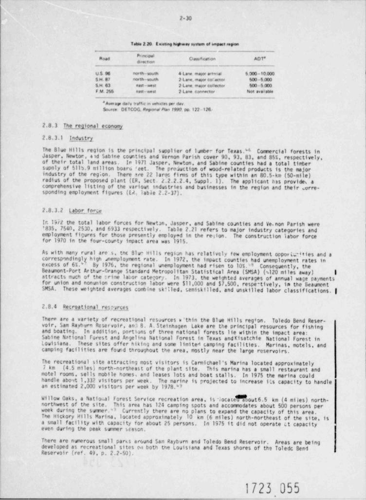
2-30
Table 2 20. E aisting highwev system of wnpact royan-
Road Classification A0T*
U S. 96 north-south a Lane maior aetwial 5.000 -10.000S H. 87 nor th-south 2 Lane. masoc co ..ctor 500 -5.000r
S.H. 63 east-west 2 Lane maior conector 500 -5.000FM.255 east- west 2 Lane connector Not avadable
' Averap dady traffic in vehicles per day.Source DETCOG. Reguonal Plan 1999. pp 122-126:
2.8.3 The regional economy
2.8.3.1 Inpustry
The Blue Hills region is the principal supplier of lumber for Texas." Comercial forests inJasper. Newtor, aid Sabine counties and Vernon Parish cover 90, 93, 83, and 85%, respectively,of their total land areas. In 1971 Jasper, Newton, and Sabine counties had a total timbersupoly of 5115.9 million board f eet. The production of wood-related products is the majorindustry of the reg;on. There are 22 laroc firms of this type within an 80.5-km (50-mile)radius of the proposed plant (ER, Sect. 2.2.2.2.4, Suppl.1). The applicant has provides acomprehensive listing of the various industries and businesses in the region and their orre-sponding employment figures (EA lable 2.2-37).
2.8.3.2 L abor, fp5e.
Ir.1972 the total labor forces for Newton, Jasper, and Sabine counties and Ve.non Parish were!835, 7540, 2530, and 6933 respectively. Table 2.21 refers to major industry categories andemployment figures for those presently employad in the reyton. The construction labor forcefor 1970 in the four-county impact area was 1915.
As with many rural are .s. tnc Blue Hills region has relatively few employment opportdies and acorrespondinglexcess of 65."y high snemployment rate. In 1972, the impact counties had unemployment rates inBy 1976, the regional unemployment had risen to 10%." Consequently, the
'
Beaumont-Port Arthur-Grange Standard Metropolitan Statistical Area (SMSA) (s120 miles away) Iattracts much of the trime labor category. In 1973, the weighted averages of annual wage paymentsfor union and nonunion construction labor were $11,000 and $7,500, respe-tively, in the BeaumontSMSA. These weighted averages combine skilled, semiskilled, and unskilled labor classifications. |
2.8.4 Recreational re m eces
There are a variety of recreational resources e ' thin the Blue Hills region. Toledo Bend Reser-voir, Sam Rayburn Reservoir, and B. A. Steinhagen Lake are the principal resources for fishingand boating. In addition, portions of three national forests lie within the impact area:Sabine National Forest and Angelina National Forest in Texas andKisatchie National Forest inLouisiana. These sites offer hiking and some limited camping facilities. Marinas, motels, andcamping facilities are found throughout the area, mostly near the large reservoirs.
The recreational site attracting most visitors is Carmichael's Marina located approximately7 km (4.5 miles) north-northeast of the plant site. This marina has a small restaurant andmotel rooms, sells mobile homes, and leases lots and boat stalls. In 1975 the marina couldhandle about 1,332 visitors per week. The marine is projected to increase (*.s capacity to handlean estimated 2,000 visitors per week by 1978.'*3
Willow Oaks, a Natio..al Forest Service recreation area, is -locateNoout6.5 km (4 miles) north-northwest of the site. This area has 124 camping spots and accomodates about 500 persons perweek during the sumer.'3 Currently there are no plans to expand the capacity of this area.The Hickory Hills Marina, located approximately 10 km (6 miles) north-northeast of the site, isa small facility with capacity for about 25 persons. In 1975 it did not operate c.t capacityeven during the peak strimer season.
There are numerous small paras around Sam Rayburn and Toledo Bend Reservoir. Areas are beingdeveloped as recreational sites en both the Louisiana and Texas shores of the Toledc BendReservoir (ref. 49, p. 2.2-50).
1723 055.
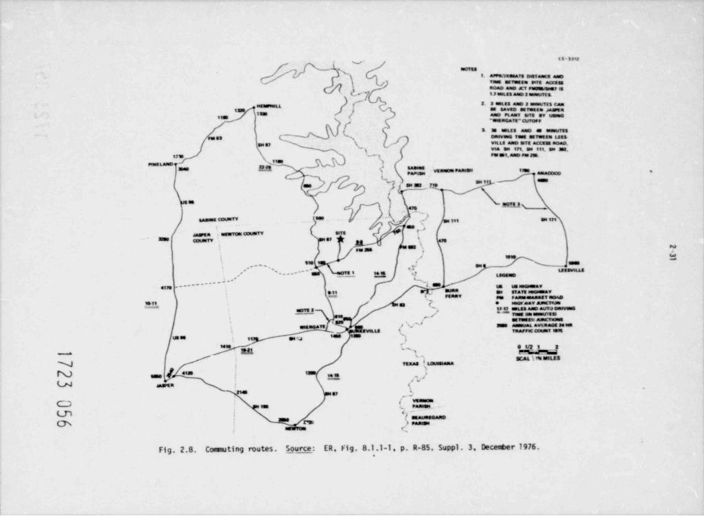
i.. as-am
morasg9. af*IONE8afE DISTAAsCE ANDi r== orvesse enn acces.
(} ""}Iacao ame x1 eurina,.1 m17 t#LE: assD 2 besmuff E
f' 3. s estas amo a esen:Tss cannaasre.uIIIS | M SAWED MTOWEEN daarte
'*" "8 L* * sersnas ( a"en'aar"e cum,av unuse
[- t u emus amo. . . . s om . .
urs.. u . ,
see gy \ VILLE aNO STE aCCiss NOAD.
]q ,=ses.a o su en. en sea.wa su inam.uw y- >,_
- e y ,: ,,, _ , . ,. _ a
NJ se nt _ L===i
h.=l'9ILh
.,.-- i
-(. . . ../
--. cou a . t ., n , - ,n
f =*r>
t
., . ., s.n / +. - wo nQ g ,ame c n
" '7, ?! l ru ns*!
- *|s ' " N J-=s=,,,. . . . ,
unsvius' .,__ -, , . . .,*-,- LEGeasp-
% " muaa~~~~~~~....e*
IUB MBGMu.a.fuS,
41 ,
m, s,v,a,,r.e aren rena,g-
u ur
,.,
P- . . av a-Crio=n ,," .us aan nuva Damme,, ors :-
,
, <_ , -- 1 se em e==uvem
'
.SETWEtSt AuguCTtDass
f'. EMS\, ' '' assuu,aL avt AaG8 M testagg meaTEi EEWILLE TaaF 0C CouMT 197E
= s'sus es t , u :
k'* * * e irr i a,,u r%r%.a'- seu im seusN nx , i. ...
ene [ '''' iN '" asa .
'*.U marin j <*'
'zm e,, . -
O /. v'a."sn*.ao
no en
m j < . -I samunaeanoass..
Ch !r= ) eaaan
"= C.,
Fig. 2.8. Comuting routes. Source: ER Fig. 8.1.1-1, p. R-85. Suppl . 3. Deced>er 1976.
2-32
Tatdo 2.21. Indust >y of employed persons - 1970-
County
Jasper Newton Sabine Vernon
Aariculture, forestry,and fishenes 191 112 263 246
%ning 77 52 5 63
Construction 721 405 182 607
Manufactunng 2375 1118 78 5 738
Trucking servicewarehousing 99 38 34 55
Wholessie 297 40 98 157
Retail trade 750 199 202 679
Business and repair
service 177 53 44 120
Personal and householdservices 603 101 99 442
Sources:U.S. Bureau of the Census. Censn.s of Population: 1970. Vol.1: Characteristics of the
Population, Part 45: Texas, cMpter PC(1|C "C.meral Social and EconornicCharacteristics," Table 123.
U.S. Bureau of the Census. Census of Population: 1970. Vol.1: Charactenstics of thePopulation, Part 20: Loursiana. Chapter *C(1|C: " General Socsal and EconornicCharacteristics," Table 123.
M:.ny visitors to the area own lots or l?ke homes that are used principally on weekends or duringthe summer. Near Carmichael's Marina are the Beechwood subdivisions. Three tracts of landmake up this division - Beechwood I, II, and III. in 1975 all but 23 lots in I and II wereoccupied. Toledo Beach subdivision, located north-northwcit of the site along the Toledo BendReservoir had 100 of its 870 lots vacant in 1975. Toledo Village, 6pproximately 10. km (6 miles)east of the site, had only 900 of its 1,600 lots occupied in 1975. Tall Timbers is anothersubdivision about 11 km (7 miles) east of the site. This area includes retirement homes andmore permanent residences than the other subdivisions mentioned (ref. 49, p. 2.2-16).
Existing and planned recreation sites and wildlife management areas within 50 miles of the plantsite are shown in Fig. 2.9. This figure is coded to a list of the existing recreational siteswithin 80 km (50 miles) of the r,ite provided in Table 2.22.
2.9 HISTORICAL AND ARCHAE 0 LOGICAL SITES AND NATURAL LANDMARKS
On July 30, 1973, the Texas State Historical Survey Comittee, in response to the applicant,50 thatindicated that there were no sites listed in the National Registar of t/istorical Places
would be affected by the proposed plant. However, a complete inventory for the county has notbeen made (ER, Appendix A). A review of historical and archoeological sites and natural land-marks in the vicinity of the proposed plant follows.
2.9.1 Historical sites
There are no historical sites listed in the N2ticr.al Re,,ister of liio.orical Places within fivemiles of the proposed site. However, the applicant has identified two sites of historicalinterest: four log structures last occupied in the 192C3 and 1930s and five stone grave markersof undetermined dates. The applicant has stated that tna 1reas will be reexamined should con-struction of the plant endanger them (ER, Table 2.3-2).
2.9.2 Archaeological sites
The proposed plant site has no known r"jor archaeological significance; hcwever, four archaeo-logical localities are identified in the ER (Fig. 2.3-2). The applicant has stated that anarchaeologist will be available for consultation throur)h the construction period should aayadditional archaeological discoveries be made (ER, Sect. 2.3.5). The staf f's recomendationfor preservation of the four localities and any futLre archaeological sites is presented inSect. 4.5.2.
1723 057
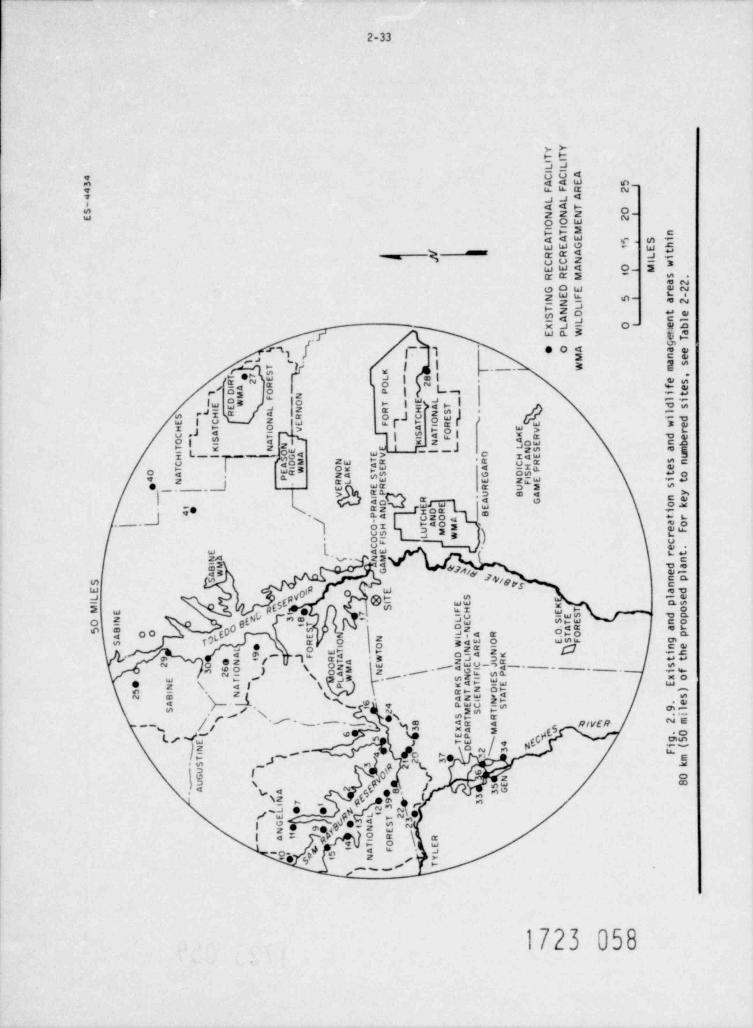
7d
Y Y
T TILI
LI I
" C C AAA E ?F F R 2LL A
~ A ATNNN P
2O OEI
I
T T M nA AEEE G ? S i
hE t/ R RA L/ CC N Ii
wE E A P MR R M ' S .
a2G DE e2r -N E F ? a2I NI LT N O t eSI A L nl
ebi X L I maE P W eT
%, -i J.
g. eOA a e%)
.
M n e
Q4Ea S
- '. ' W mTS K . ,
- . .L .
eS2 R O f e
3_ _]E-O P itM NF E L l iO T - d SA T
I L N R H
SslN
O1T I
1 H AS R C E idOE - C N E R E weFT O V A T E V rH
' A I
/ ~ I
NOF-S A KC R d eTS AO - I A DE nbK
- LT K N I||S NS amI -
A EV HAE u
H r||1|- T -M NE R C R S nC AOK E IHP eT T0 A NA S IE itS DS t op E4 N RL NFER U M S
e_|,
[I R G
EV RP B A y
- neAD okEe RN iH
- .{ ,/_PA CN a t r-
T aoOH M,
eFUCS L * r. OI CFC eAE rt,_
$ (, NM nA da
w G gp elg npS gg , n6E b E adL
-
@ST S l e
4g I EE pS
IM FH T oE s ILC S dpN 8 yE no0 I 3 E1T O fR arS N5 B oO ILA R yO pEA N E O F gS , R O WAOI
- NR I nea' ,. O ET N ihA DIA K.F R w~ ,
)L U ttTA N R
, ,- if
EC J S
[ NM GF SPA* gA I Ao
0 N a - P'
' SNI xoE ri 1 LW E
0 I / KAT IE ERTN DT )
\pa* AANE .S2 B
/ 4, 4 PEC ISI NT eA f 9ilS 2 MS T
g\ - 'f- . e'g,S T RAR A g<2 2m
gI
XA M
N3 7*o106 EP
\MES g5TE 4 i(N D 2 FI
G- [4
I
b) ," kg 2 mT
SiU 6- j N 0
5E 8U -
e**,%2A A 3G- 3/N 9 3
I7
/L 0 se 3
E T "3_ G A S 2N E9y I
ON
_ A O R- R
4 E
9 k51 F Lg0
1 s YTg|'
noa oec
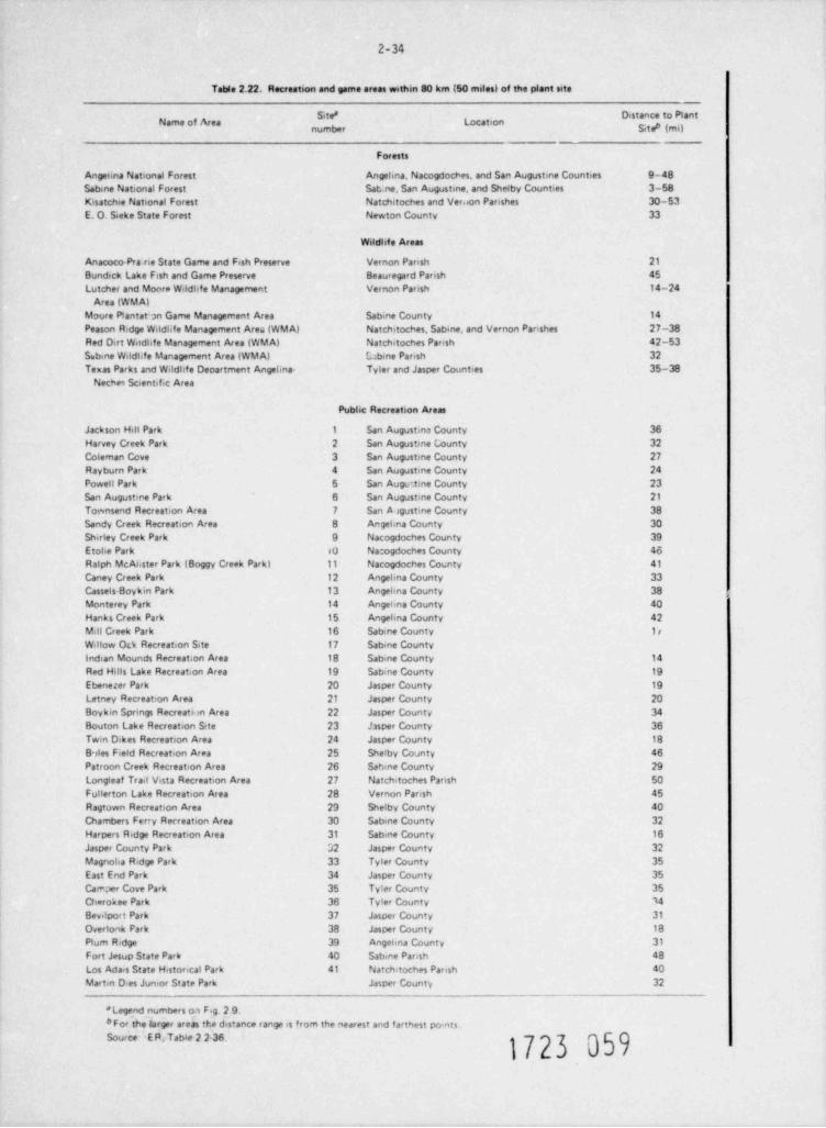
2-34
Table 2.22. Recreation and game areas within 80 km (50 miles) of the plant site_
Site 8 Distance to PlantName of Area Location gg g
____
Forests
Angelina National Forest Angelina, Nacogdoches, and San Augustine Counties 9-48Sabine National Forest Sab.ne, San Augustine, and Shelby Counties 3-58Kisatchie National Forest Natchitoches and Ver. ion Parishes 30-53E. O. Seeke State Forest Newton County 33
Wildhfe Areas
Anacoco-Pra rie State Game and Fish Preserve Vernon Parish 21
Bundick Lake Fish and Game Preserve Beauregard Parish 45Lutcher and Moora Wildhfe Management Vernon Parish 14-24
Area (WM A)Moure Plantatin Game Management Area Sabine County 14
Peason Ridge Wildl.fe Management Area (WM A) Natchitoches, Sabine, and Vernon Parishes 27-38Red Dirt Wildhfe Management Area (WMA) Natchitoches Parish 42-53Sabine Wildhfe Management Area (WMA) Obine Parish 32Texas Parks and Wildhfe Department Angelina- Tyler and Jasper Counties 35-38
Neches Scientific Area
Public Recreation Areas
Jackson Hill Park 1 San Augustina County 36Harvey Creek Park 2 San Augustme County 32Coleman Cove 3 San Augustine County 27Rayburn Park 4 San Augustine County 24Powell Park 5 San Auge, tine County 23San Augustme Park 6 San Augustine County 21
Townsend Recreation Area 7 San Augustine County 38Sandy Creek Recreation Area 8 Angehna County 30Shirley Creek Park 9 Nacogdoches County 39Etohe Park so Nacogdoches County 46Ralph McAbster Park (Boggy Creek Park) 11 Nacogdoches County 41
Caney Creek Park 12 Angehna County 33Cassels-Boykin Park 13 Angehna County 38 ,
Monterey Park 14 Angehna County 40Hanks Creek Park 15 Angehna County 42Mill Creek Park 16 Sabine County 1rWillow Otk Recreation Site 17 Sabine Countyindian Mounds Recreation Area 18 Sabine County 14
Red Hills Lake Recreation Area 19 Sabine County 19
Ebenezer Park 20 Jasper County 19Letney Recreation Area 21 Jasper County 20Boykin Springs Recreati m Area 22 Jasper County 34
Bouton Lake Recreation Site 23 hsper County 36Twin Dikes Recreation Area 24 Jasper County 18B,les Field Recreation Area 25 Shelby County 46Patroon Creek Recreation Area 26 Sabine County 29Longleaf Trail Vista Recreation Area 27 Natchitoches Parish 50Fullerton Lake Recreation Area 28 Vernon Parish 45Ragtown Recreation Area 23 Shelby County 40Chambers Ferry Recreation Area 30 Sabme County 32Harpers Ridge Recreation Area 31 Sabine County 16Jasper County Park 52 Jasper County 32Magnoha Ridge Park 33 Tyler County 35East End Park 34 Jasper County 35Camper Cove Park 35 Tyler County 35Cherokee Park 36 Tyler County 14Bevilport Park 37 Jasper County 31
Overtonk Park 38 Jasper County 18
Plum Ridge 39 Angehna County 31
Fort Jesup State Park 40 Sabine Parish 48Los Adais State Historical Park 41 Natchitoches Pansh 40
Martin D+es Junior State Park Jasper County 32_
* Legend numbers oa Fig. 2 9.#For the larger areas the distance range is from the nearest and farthest points.Source E R, Table 2 2-36.
2-35
2.9.3 Natural landmarks
No natural landmarks listed in the rulem! R.igister53 are taithin five miles of the proposed site.The applicant identified two fence-enclosed cemeteries east of the proposed access road as his-torical landmarks, but determined that there will be no need to excavate these sites (ER, Table2.3-2).
2.9.4 Transmission corridors
The FedemZ Register does not list any historical sites or natural landnarks in the rights-of-wayfor the proposed access road, pipeline, or railroad. The railroad right-of-way contains onearchaeological site and six localities (ER, Fig. 2.3-1).
The applicant's transmission line study area includes three proposed corridors (ER, Fig. 2.3-3).
1. Corridor A has no known archaeological materials and no historical sites or natural land-marks listed in the Fedemi Register.
2. Corridor B contains two archaeological sites (ER, Fig. 2.3-3). In addition, there are
12 Texas historical markers within a five- to seven-mile radius of the corridor.
3. Corridor C contains two archaeological sites and three localities (ER, Fig. 2.3-3). Tnereare 27 Texas historical markers within a five- to seven-mile radius of the proposed corridor.
The applicant has stated that none of the historical markers is endangered by transmission lineconstruction. Any archaeological site that is endangered by transmission line construction willbe reexamined and tested. The staff's recommendation for protection of archaeological sites andlocalities is presented in Sect. 4.5.2.
1723 060
2 -3G
REFERENCES FOR SECTION 2
1 J. L. B1adwin, climtes of the United States, U.S. Department of Connerce, EnvironmentalData Service Washington, D.C., 1973.
2. Gulf States Utilities Company, Blue Hills Station Units 1 and 2, Environmental Report -Construstion Phase, NRC Docket No. 50-510/511, 1974.
3. U.S. Department of Comnerce Environmental Data Service, Load Clinatological mta, AnnualSurrury with Comparative mta - Alexandria, Luuisiana, National Climatic Center, Ashev111e,N.C., 1974.
4. U.S. Department of Comerce, Environmental Data Service, Local climtological mea,Annual Surrury uith Cxparctive Data - Port Arthur, Texas, National Climatic Center,Asheville, N.C., 1974.
5. U.S. Department of Comerce Environmental Data Service, climtography of the UnitedStates, No. 20, climte of Leesville, Louisiana, National Climatic Center Asheville,N.C., 1975.
6. U.S. Department of Comerce. Weather Bureau, Climeography of the United States, No.86-14, Supplement for 19.51 throtgh 1960, Louisiana, Washington, D.C.,1964
7. U.S. Department of Commerce, Weather Bureau, Climatography of the United States, No.86-36, Supplemant for 19.51 through 1960, Texas, Washington, D.C.,1965.
8. Gulf States Utilities Company, Preliminary Safety Analysis Report, Blue Hills StationUnits 1 and ?, NRC Docket No. 50-510/511,1974.
9. Nationa1 Setsre Storms Forecast Center, Listing of Torna3ces for the Period 1953-1974,National Oceanic and Atmospheric Administration, Kansas City, Mo. (unpublished).
10. H. C. S. Thom, " Tornado Probabilities," Mon. Veather Rev., 730-737(1963).
11. G. W. Cry, Tropical Cyclones of the North Atlantic Wean, Technical Paper No. 55,U.S. Department of Cornerce, Weather Bureau, Washington, D.C.,1965.
12. U.S. Department of Comerce, Environmental Data Service, Articles from Monthly WeatherR n ic:J on Tropical Storm and Atlantic Hurricanes, through December 1975.
13. J. Korshover, Clinauology of Stagnating Anticyclones East of the Rocky Mountains, 1936-1970,NOAA Technical Memorandum ERL ARL-34, Silver Spring, Md.,1971.
T4. A. W. Kuch1er, Potential Natunt Vegetation of the Conterminous United States, AmericanGeographical Society, Special Publication No. 36, New York,1964.
15. C. A. McLeod, *he Big Micket of East Texas, Sam Houston Press, Huntsville, Tex.,1967.
16. " Endangered and Threatened Species: Plants ," Fed. Regist. Part IV 41(117): 24524 (1976).
17. " Threatened or Endangered Fauna or Flora: Review of Status of Vascular Plants and Deter-mination of ' Critical Habitat,'" Part V. 40(127): 27824 (1975).
18. Rare Plant Study Center, Rare and Endangered Plants Native to Texas, University ofTexas, Austin, Tex., 1974.
19. R. Arbib, "The Blue List for 1976," Am. Birds 29: 1067-1072 (1975).
20. D. Lay and D. Swepton, The Red-Cockaded goodpecker, Texas Parks and Wildlife Dept.,Austin, Tex., 1975.
21. J. D. Ligon, " Behavior and Breeding Biology of the Red-Cockaded Woodpecker," Auk 87:255-278 (1970).
22. W. B. Davis, 7.a Mrmle of Tc.ms (rev. ed. ), Texas Parks and Wildli fe Dept. , Bull . 41,Austin, Tex., 1966.
23. G. K. Reid. "The Ecology of Inland Waters and Estuaries," Reinhold New York,1961.
1723 061
2-37
24. C. E. Shannon and W. Weaver, "The Mathematical Theory of Comunication," University ofIllinois Press, Urbana (1949).
25. B. J. Mathis and T. C. Dorris, "Comunity Structure of Benthic Macroinvertebrates in anIntermittent Stream Receiving 011 Field Brines," Am. Midl. Nat. 80(2): 428-439 (1968).
26. H. L. Allen, "Phytoplankton Photosynthesis, Micronutrient Interactions, and InorganicCarbon Availabi11ty in a Sof t-Water Vermont Lake " Limnology and Oceanography SpecialSymosia, Vol.1, Nutrients and Eutmphication,1972.
27. A. L. Baker, Environmental Monitoring and Ecological studies Progmm, 197.5 Annual Reportfor the Pmirie Island Nuclear Genentir-g Plant, Red Wing, Minnesota, Northern StatesPower Company, 1975.
28. C. R. Goldman, Eutrophication of Lake Tahoe Eqhasizing Water (,%2tity, U.S. tnvnuraanta1Protection Agency, 6601-3-74-034, 1974.
29. M. D. Marcus, An Ecological Enzluation of a Thermal Discharge, Part II: The Distributionof Phytoplankton and Primry Productivity Near the Western Shores of Lake Erie, TechnicalReport No. 4. Institute of Water Research, Michigan State University,1972.
30. B. G. Isom, " f fects of Storage and Mainstream Reservoirs on Benthic Macroinvertebratesin the Tennes see Va11ey,*. Reservoir Fisheries Linnology Special Publication No. 8,American Fist eries Society, Washington, D.C.,1971.
31. R. M. Sincla1r and W. M. Ingram, "A New Record for the Asiatic Clam in the United States.Tennessee River," Nautilus 74: 114-118 (1961).
32. R. M. Sinclair and B. G. Isom, Further Studies on the Introduced Asiatic Clan (Corbicula)in Tennessee, Tennessee Stream Pollution Board, Tennessee Department of Public Health,1963.
33. D. W. Aldridge and k. F. McMahon, " Population Growth and Reproduction in the Life-Cycle ofCorbicula manilensis Philippi," presented at the 39th Annua 1 Meeting of the AmericanSociety of Limnology and Oceanography, 1976.
34. A. Houser and N. F. Netsch, " Estimates of Young-of-Year Shad Production in BeaverReservoir," Reservoir Fisheries Limnology Special P dlication No. 8, American FisheriesSociety, Washington, D.C., 1971.
35. Fed. Regist., Oct. 27, 1976.
36. Texas Organization of Endangered Species, mEs Watchlist of End2ngered and Peripacmlvertebmtes of Tczas, T0ES Publ.1,1975.
37. Deep East Texas Council of Governments, Regional P! ant 1930, p. 68.
38. Deep East Texas Counc11 of Governments, Jasper - Jevel of the Foreat. "The IndustrialOpportunity of East Texas," 1972, p.19.
39. Deep East Texas Counci1 of Governments, Jas;er - Jewel of the Fomst. "The IndustrialOpportunity of East Tex 2s," 1972.
40. Public Affairs Research Council of Louisiana, Inc., Louisiana Corr: unity Profile: Icessille,May 1976.
41. Personal communication between Tad Cowan, Oak Ridge Nationa1 Laboratory, Oak Ridge, Tenn.,and Floyd Herbert, Deep East Texas Council of Governments, Nov. 24, 1976.
42. Deep East Texas Council of Governments, Regional Plan: 1930, p. 171.
43. Personal communication between Tad Cowan, Oak Ridge National Laboratory, Oak Ridge, Tenn.,and Assistant Fire Chief of Leesville, La., Nov. 23, 1976.
44. Deep East Texas Counci1 of Governments Health Advisory Council, Regional Health objectivesPlan (rev.), p. IVd-5, 1974.
.
45. Deep East T2xas Council of Governments, Health Advisory Council, Regional Health objecticesPlan (rev. s, p. ivc-3,1974.
1723 062

2-38
46. Deep East Texas Council of Governments. Regional Plan: 1330, p. 25.
47. Deep East Texas Council of Governments. Hecith Advisory Council, Regional Realth objectivesPlan (rev. ), p. IVa-13,1974.
48. Personal communication between Tad Cowan, Oak Ridge National Laboratory, Oak Ridge Tenn.,and John Semetko, Deep East Texas Council of Governments, Aug. 30, 1976.
49. David S. Huff, Revised Land use Study - Blue Hilla Station Project, Harch 1976, p. 2.2-14.
50. " National Register of Historical Places," Fed. Regist., Part I. 41(189): 42687 (1976).
51 . Fed. Regist., Part I. 41(189): 42687 (1976).
1723 063
3. PLANT DESCRIPTION
3.1 EXTERNAL APPEARANCE
A site plot plan of the proposed Blue Hills Station is shown in Fig. 3.1. Prominent featuresare the power block complex and the low-profile round mechanical-draft towers. This early sitereview assumes that the Blue Hills Station Units 1 and 2 will be of the general size and typeas the design described in this section and in the ER. Design features dascribed in the ERhave been used to assess the impacts of building a nuclear station of this general size and typeat site G. The domed-roof containment vessels, which are the tallest structures, are approxi-mately 58 m (190 ft) high.
The site a;ea is densely vegetated with trees that range from 12 to 18 m (40 to 60 ft) high.There are several viewpoints along Highway 87. Farm-to-Market Road 255, and the Toledo BendReservoir (the nearest being 3,048 m or 10,000 ft) from which some portions of the plant will bevisible. However, because of the densely forested characteristics of the site area and the dis-tance from the plant to the typical view points, visual impact will be negligible.
3.2 REACTOR AND STEAM-ELECTRIC SYSTEM
The plant will utilize two light-water-moderated and -cooled reactors of up to approximately2814 MWt each. Details are given in the ER (see Fig. 3.1).
3.3 WATER REQUIREMENTS
The major water requirement for the Blue Hills Station will be for the plant cooling systems.Figure 3.2 is a schematic diagram showing the quantitative water uses. Makeap water will bewithdrawn from the Toledo Bend Reservoir at a maximum rate of 1.86 m /sec (29,470 gpm), based on3
the month of July and 100% load when evaporation from the cooling towers is maximum. During this3m /sec or 27,632 gpm) of the makeup water will be used toperiod, approximately 93.8% (1.74
replace cooling tower blowdown, drift, and evaporation from the circulating water system, and theremainder will be pretreated and used in the nuclear service water system, demineralized waterstorage system, and other plant systems (Fig. 3.2). Average plant water use (based on mcathlyaverage wet-bulb temperature and 78.2% load) will be 1.32 m*/sec (20,961 gpm). Cooling towerblowdown and other liquid wastes from the various plant systems will be returned to the ToledoBend Reservoir and are not expected to exceed 0.40 m /sec (6387 gpm).3
3.4 HEAT DISSIPATION SYSTEM
3.4.1 General description
The plant cooling systems will operate on closed cycles, utilizing cooling towers. At the ratedcore thermal power rating of 5628 MWt for both units, approximately 3832 MWt (13.08 x 10⁹ Btu /hr)of waste heat will be continuously removed from the main condensers and turbine components anddissipated through the cooling towers of the circulating water system. Heat dissipated from thenuclear service water system will consist of approximately 1% of the total heat dissipated fromthe station. Through buried pipelines, the Toledo Bend Reservoir will provide the source ofmakeup water and other water usage for plant operation. Similarly, buried pipelines will be usedto discharge all plant effluents to the Toledo Bend Reservoir (Fig. 3.3).
3.4.2 Nuclear service water system
The nuclear service water system is described in the ER, Sect. 3.4. |
1723 0643.,
.
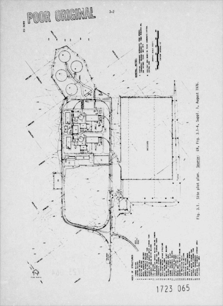
" 3 8 2 R B 2 q,. ,
! ||1(
!, !\* 1
11 I.*l l ig
1
n,,i y j- ., 5 $ 5 ''
i-
o, t5 '
. tyg ; I, 1
u *h,
',
e.'h I
\ ,- h .- : s. 1 i ,-
bj|3|- | .|,1!1'. y' . .
?-
i
/ ,\* ' ( ,, \ -r$, O'. ,,, s-
i
|r''< !'
* .-- - - -',
_. ps.-.
-xx; ,
, "
f 2y ,_ v .Jn ::, -' ..
{.y
~ . ,uf, > p 3.c . .
a. . . ~.? g,
~. wi*: |
y <jg, (I -,
x~ |a: q't d ' L |. :r
--
(; 8, ,- ,
, f. ~ ,jf
* _,y
.| :, g
, '1 . , ~
* g:i .'. .
|
;:\z
- :{d ,'ykr vy,f' - t
H,s . j. . IN.. *f .,;,, .~4..
.< '/Lp'| v,-
|,",
,s T /i
1 s p u;,''
u , e.,
Q',' '/ ,, >
v. ..; .- - ,, l' |. b1
.8, *
'.4g.: 4,- y<. '
n , | $ 2x ,. ' -
f |*,.
,,f7 '
h!'<
1, y %o *
, 8 $ , \ 5s . g:r L.s ^'I )~...) , a | |-
,A|-,
N ,
...m , -.
0(A5| ;' ,
,k , e,,|8 -,,cc
\ ; j>,
'* p.,~ -
:t :'
| " j/1*% ! '^^^- .
, >
j' i, e
* :, , ,;. ' a l __ :: $], 's .'~
$|htw|h.\
|, ,.. * g
1 I,
Q{':' '
,
-j ',,
,,,
| | s,
!!.'' . ' i .n < O,
; r /a,- p'k A N~ ' !*'-
~~t ,
',,f * ts.'~, T
\',. / ) w ~
*t j; mh'.
'. - v
>(, h.
a>.
.~%' i Ls.,
o, .
l '. . .,
~1_, _x ,
~1'
,'< NN~,
,
i
, e ,, *y,,
\ ns , ,i -.- A
~ . . let is ,y I-: 1I4y~
I' *
h'I!$~ ,
!?$ '\', -
i!!!.iiIff&,I.,
11, ,!i!]j.- .~
~,- = 'i
? 1;
'is.
k, ,$ f,
'
,
"& !: - . ... . :' '..
1723 og5
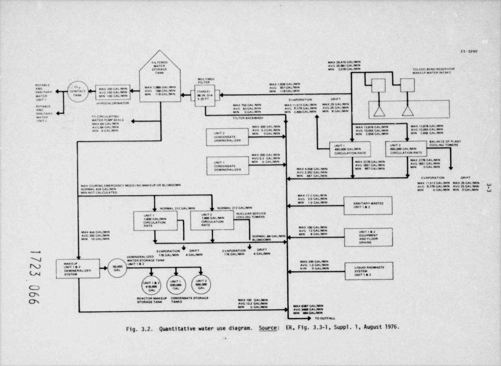
.
ES-3290
f etMRE D ,,g, yg ggg gggjeg,,,**II " AVG 20.965 GALJamse
men 3.04 GALJWN TOLE oD et NO RE st RVOsm1 Assa thAREUP MATER eNT As E
esvL T etE D
'UI AELI teas 1.333 GAL /eseN' c(I M*" I M O"WW avg 3et GAL %eseANO Man 200GAtatsete -I88 6"L *''' t TeeRE E eSaaseT ARv h Coset ACT avg 100 GAWees AVO ]( Mies ti3 GAL / esses
WM 1*GGAL/MNMATER I A8ek Meg, ggg caggeen ES tN D8A' E V APOR AYeON DRef f
g
POT ABL E MAN 790 GAL 1stN mag g 3 gt3 GALeasese team 25GALJhesesavg g3 GAtmose Ayg 33pg gagjgeves Avg 3g GALfMeN
AseDMese O GALfMete Mise 2.446 GAL #teste 9864 G GAL / Spen
SAN * I ARW Mwa f E R TO CeRCuLATveeG dk
' r sLTER SACawAsseusesT 3 WATER PUMP 5E ALS
' 1 F
MA E 64 G AL 'Me8eAVG 68 GAL /the6 MAu 300 GAL /esise mag g33eg gAynesg esAs 13 See GALMmMW S G AL /tseN AVG S 2 GAL / Meg avg 10.046 GAL /tstas AVG 10 044 GALM4
UNeT 2 eseN OGALJestN egge, 3 pgg gagfacess MM 2 999 GAL /tsees,
COpIDENSATE ,9P 9P
WEUe88LR ALl2ER gyvaseT t usesT 2 COOL essG TowEns
4s0.000 GAL /tesM ago.000 GALJM8ee
CeRCULAf tOce RATE CoRCULATeose RATEMAu 300 GAUMiNavg t 2 GA. AtatN
I'"" II OAWNUseef 1 tsess 9 GAL /essee MAN 2279 GALMINo "#O 100' OAL**AVG f461 GALinse4COseDE sot AT E r mg G GAWM ,,DE UeeeE R AkelE R teAE 4.56S GALinsges ese8e 4E P GAL /tseN
AVG 3.302 GAUesseeirMete 437 GA6/ Mess r, E V A80RATIOes DRef f
MAa 11.613 GALMIN MAR 26 GAL /tssteMaa EDueleteG EMERGEteCV MODEl NO MAutuP OR ALowoOwse AVG S.379 GALresses AVG 35 GAL desseeseORMAL 4J4 GAL / men Mese O GALitsees mes O GAUtseen yesees seOT CALCUL A TED
asAN 17 2 GAL /tD88AVG 2 9 GALMese88'" 10 0All'8''' SAheT ARV mA$f E3a
Us#1Y t a 2seORMAL 292 GAUtsese iseORMAL 292 GAL /tteN q ryr
yesey g uses? 3 eeuCLE AR SE nveCE
y 400 GALfessee 7.400 GAUtRg cont.easG TOWERS
CeRCULAveOme C*RLNLATIOesRATE RA T E
MAX 100 GAL /teeseAyg g3 gAgjgeseg
MAN eu0 GAL /tsees Mm G GAWm ,,NOpteAL 64 GAUtstNg g et Owoosene ,
,a Apeo FLOORir ir
EVAPORATIOse + +r DRAeest
DRe7 T [ v APOR Af sOg DRtFYM
I" OA # " 0 0AW" ' *97 DEMeNERAteZED
WATER STORAGE T A8es tsar 200 GAL /hes8eMast E up yessy g a 3 avg i.0 GAutemUtesi 1 & 2 50.000 wen O GAutseen LioueO RAOw&5TEDE Ms8eE R AL s25 R GAL ,
SYSTEMSYETE M
,
Uenf i . 2
useeY t UNeT 2uses? t & 2
' " " ' '"''"C~) * **.000 L
GAL
CheRE ACTOR tsAK EUP COceDEssSATE ETOR AGE MAu 100 GAL / temSTORAGE TA8est T hess $
AVG 13.2. GAL /tsese.em GAuMese MA= =?GAu-N,
AVG 3455 GAUtsm,
tesse ete GAL / men
7 70 0UTF ALL
Fig. 3.2. Quantitative water use diagram. Source: ER, Fig. 3.3-1, Suppl .1. August 1976.<,
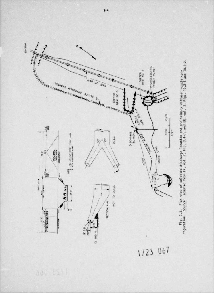
3-4
.-
n-y -
i ~'
c5s ., e' o ri'
h't
s\'s '
a [s.s ets o
s ( a* 3.vv0,
hp.'%'' 3013NNVH3
oSixv @
- F+5+ + H3v0-
+e:++&dy ,
3 n7s $$ ', ud ,
3 se'
+s+v.c 3 +,\
gv
c . :h .g .
* * ee*o 4 **
: c [,e_
4, gm 'e 'k'4
, '.
d'o 5,1 - E$
%
ds| ' k, $.- - - - #+
%-#
s jU.g-
x Ei,1 4 ? 5#g
'%. ;\
a \' /. 'x , %, %' a
-
\ d:s
1[4.
43 s ,
1 es x ,%, 's Ae
y 6 v.i ''
96g- ~
\% 4 p>.,
% 'a d 5gN., 'd.. -a s,
,*
4 .$ o%\ " p
1 $ 1,s @,D iS r
\ ( c ,ig s
es
1 th. -
\ E %s o
k /* 1. %\
\. ,
. . . , g.
2;
.
3,
' h'Y n , > g**
\ [hs, \ ,
6 I. &
3. ' . $D. ?
,
-
.
3-5
3.4.3 Circulating water system
The circulating water system will consist of low-profile mechanical-draf t towers, circulatingwater pumps, main condensers, and piping and control apparatus. As Fig 3.4 shows, the systemwill be c, rated on a closed cycle. Circu'ating water will be pumped at a maximum flow rateof 29.6 m /sec (470,000 gpm) through the main condensers of each unit where 6.46 x 10⁹ Btu /nr3
of heat will be removed from the condensers. This heat will cause a temperature increase of15.1 C* (27.2 F ) in the circulating water flow. Transit time for the circulating water throughthe condenser is 3pproximately 24 sec. The volumetric flow rate of the circulating water willbe increased to 30.9 m /sec (490,000 gpm) because of the addition of cooling water from the3
turbine heat erhac trs, and the temperature increase of the water will drcp to 14.7 C' or?6.4 F* (Fig 3.4).
The heat from both units will be dissipated to the atmosphere through a system of Icw-profilemechanical-draft towers. Each unit will use two towers. Figure 3.5 is a conceptual sketch ofthe proposed coo'ing tower, and Table 3.1 gives the tower design. The design is of a circularconfiguratica with clustered fan arrangement on the top deck. Each tower consists of 13 cellsand has a total might of !8.0 m (59 ft) and overall diameter of 86.9 m (285 f t). A crosscurrentair flow is induced by the overhead fans in each cell. This air flow causes surface cooling ofthe water droplets, whi;h contain excess heat from the main condensers as they fall through thetower.
A circulating water blowdown will be maintained at an average rate of 0.21 m /sec (3302 gpm) for3
both units to prevent excessive salt buildup and scaling in the circulating water systems.Concentration of impurities in the closed loop will be maintained at a level of about six timesthat of the makeup water, which will be added to the circulating water system at an average rate !of 1.27 m3/sec (20.110 gpm) to replace cooling tower blowdown, evaporation, and drif t losses. |Therefore, blowdown of the cooled circulating water is expected to have an average total dis-solved solids concentration of 610 ppm.
3.4.4 Intake system
The proposed intake site is on a point of sparsely vegetateri land ev cending into the Texas sideof the reservoir approximately 2.4 km (1.5 miles) upstream of the ioleda Bend Reservoir Dam(Fig. 3.3). Makeup water will be pumpect from this location to the plant site (approximately11.9 km or 7.4 miles) through one of two adjacent underground pipes 121.9 cn (48 in.) in diameter.Details of the makeup water intake system are given in Figs. 3.6 and 3.7.
The intake structure will be constructed of reinforced concrete and located near the shoreline.It will consist of three individual intake cells. A 1.89-m /sec (30,000-gpm) capacity pump will3
be installed in each of the outside cells, and the middle cell will be used as a spare cell.One pump will serve both units. Water will be delivered to the intake structure by an openchannel of trapezoidal shape (Fig. 3.6), which will be formed by dredging approximately 20,644 m3(27,000 yd3) of material. The channel will have a bottom elevation of 36.8 m (IT ft) MSL andwill extend approximately 76.2 m (250 f t) from the shoreline.
As Fig. 3.7 shows, water enters the intake cell through a trash rack, flows through one of twofixed screens and over an adjustable stoplog weir before entering the pump for transmission tothe plant site. The trash racks, which are designed with 7.6-cm (3-in.) openings, will preventlarge objects such as logs from enteriry the intake structure. The trash racks will be cleanedby manually raking the surface of the racks. The two fixed screens (0.95-cm or 3/8-in. mesh)will stop most of the small trash and fish. The screens will be removed and washed one at atime while the second screen provides protection for the pump. Debris from cleaning will becollected in the trash pit (Fig. 3.7).
The purpose of the stoplog weir is to draw water only from relatively sha low depths (epilimnion,l
during periods of stratification) to ensure better quality water than can be obtained at thelower levels. The elevation of the weir can be adjusted by adding or removing a section of thestoplog weir. The top of the weir should be a minimtri of 5.5 m (18 ft) below the reservoir watersurface in order to achieve an approach velocity of 15.2 cm/sec (0.5 fps) or less. For an ap-proach velocity of 15.2 cm/sec (0.5 fps) the water velocity will be accelerated to 29.9 cm/sec(0.98 fps)1 through the intake screens, provided that the screens are free of impinged material.
3.4.5 Discharge system
Cooling tower blowdown from the circulating water system and other plant systems will be dischargedinto a discharge system collection sump and then pumped to the Toledo Bend Reservoir through two61-cm (24-in.) underground pipelines. The discharge pipelines will be located beside the intakewater pipes as shown in Fig. 3.3. The proposed discharge structure consists of two submerged
1723 068
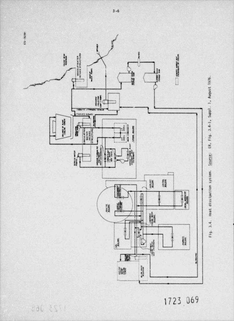
y,
1
923-
*SE ~
~ se a9 m s
4 m e
G-au
3rtP
eY amwo0 TC c
4 a v se0 s
D wa * Curc6
7 ie
aA pTus mesee er sn
ma #s { 2".se a
muam 8 imn mia
_r ^ las
uT i rr yafte
|e= a agsus* rnrn M *-
6
' Msa 7
| r. - - 9- -
),v r4 1
tsug
s u
=t'
.
r Aam
P 1
ma3
- u$ )i # A ' 1pp
a u {&S uS
m4
g .1
m " -ej
-a; 4" arg -
=w #
s e~-; o(. E3
ssg == .
W R *ME u 7,r, lAeK
ieY T *Ta C * a- . g,LU AT U a- _iCW$ R ' o ~ g,
rFN
* -R r *:' it
T -
'. S,
R,
.q=
en. =af
Ess ",
=s . _w4".,t ,s
u '*,
eurg a o
n..
e.t .r 'W=
. c
i
x _. cGi
=er rx aCs m ut. ie\re
Om0 oef m S
m,ets
mm C%* sc~ a
ya sm
La n)
h' 5 a
= of~i
2t*
I et.*e p,,.> $ .
g ia=g s.
W 'g.. stN i
= Ta f . %rM c da
lta'
x 8 er- a H
|> m'fmmea1 4s00, C
.n 3,,
i
.
g- i
n'
P ,..FL.
Q~ 's '
Q" o.n
*_ geo,.srm *
n e
_au- a
<ersa
>_cw
yJI {J-
ef L-
- .
T,ty ., s-,n'p- b.,v;
u u4" -
.jL
C4Bs N4
r
t*
4,.. ...
, 4 . W
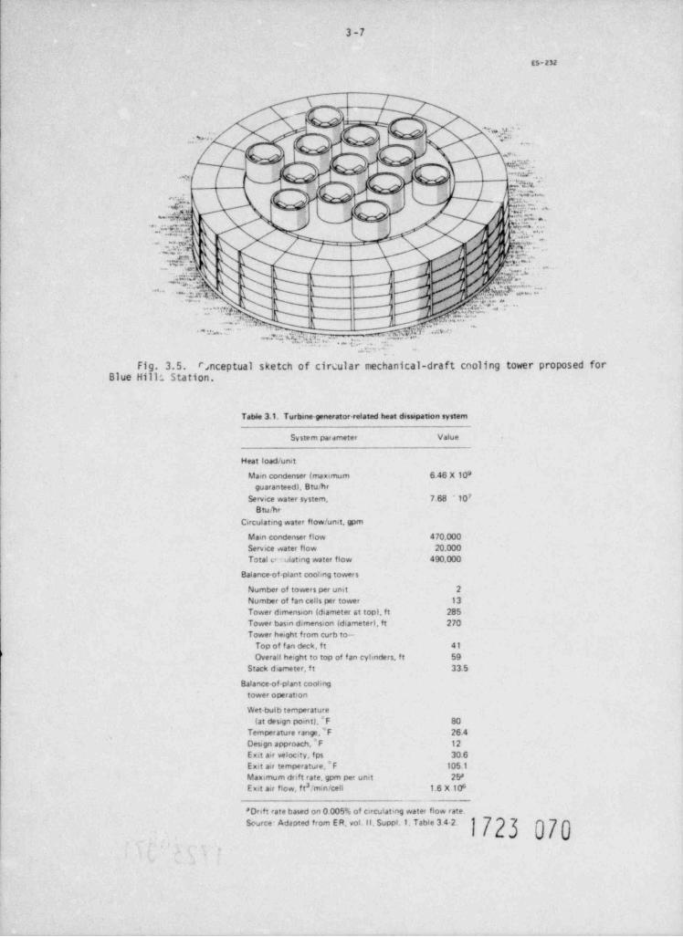
3-7
ES-232
_
- 3' '- :,,, y;
f .
, .. . . ,
+<
" V Ds [-i (,f'~. . . ,-
7) /tt$i -?{i; ''
NT D F,EE% *.* G4,9, ,\
Pg"",'.* ., ,>.. ---, t. j . .s .'
J
d..'@. n. ~-. .'.2. .. 5 '
..p. - d*Q,-** . .
s .,g,....-
Udhbi I k, ' .'
; . . . 9%--~ :sk, L".
='. \ L_ , . M *.,"'
. . . . . . .,, . L ,, pp: -
--.. u . (. . . . . s.a m ".,m ~' '~v ~
=?J". %;gj ,,, J~- +"
a. ;. -
Fig. 3.5. rsnceptual sketch Of circular mechanical-draft cooling tower proposed forBlue Hill; Station.
Table 3.1. Turbine-generator-related heat dissipation system
System parameter Value
Heat load / unit
Main condenser (maximum 6.46 X 10⁸guaranteed), Bru/hr
7Service water system, 7.68 ' 10B turhr
Circulating water flow / unit, gpm
Main condenser flow 470,000Service water flow 20.000Total e olating water flow 490,000
Balance-of-plant coohng tower s
Number of towers per unit 2
Number of fan cells per tower 13Tower dimension (diameter at top), ft 285Tower basin dimension (diameter), ft 270Tower height from curb to-
Top of f an deck, ft 41
Overall height to top of f an cyhnders, ft 59Stack d.ameter, f t 33.5
Balance of-plant coohngtower operation
Wet-bulb temperature(at design point}, F 80
Temperature range.*F 26.4Design approach, ' F 12Exit a.r velocity, fps 30.6
*Exit air temperature, F 105.1
Maximum drift rate, gpm per unit 25'3Eut air flow, f t / min /ceit 1.6 X 10⁸
-__
*Dnft rate based on 0.005% of circulating water flow rate.Source Adapted from E R. vol. II, Suppl.1. Table 3 4 2.
>
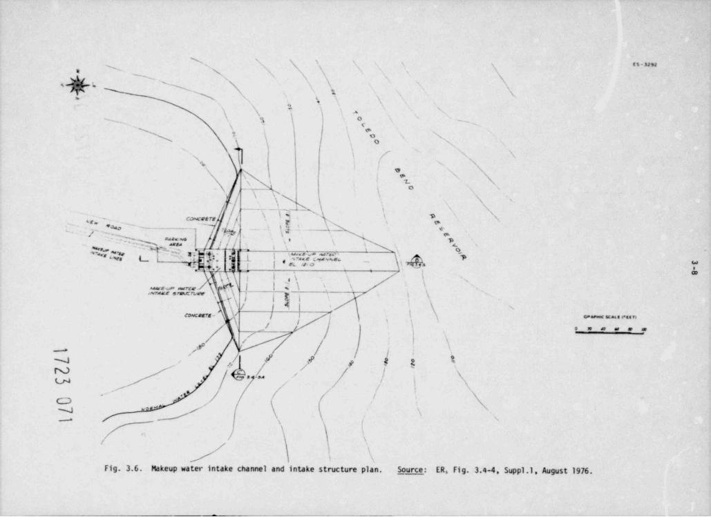
\ \ \ \ x 1 s n-unN \ \' '
a N s'x
s
\g N_sgh. 'x ' \, \xs
N
1 N,'N
4 -\ gE\ \ ; a 's
O '
~N ?, '
sy
?. \ o N 's
] \, ( '' , 'x +,-. s
t'
1*
\sv \
' 3x ; N s
'. N Ns
's, S, Nj - \T-N N\
_
caces rr
[_ .,;[. p..
o'' '
',) ''] '*g--
' '-Mih * "|,2* || \* \ *, e'
F"=it c r=: 1 |Tt, i . ' er:= n \'\ 4 's'
* IfJ,"a.p ,-_
_
_, --
'
j ''\ 'g'
,=r.=_ g 3 , ; - , , s s,
\ / l i I \\ '\comaca- \ / |
'
j /I \'
a== c acue enan'
,i7 . . . . ./ t
.' \f / /- - * / / |
j/' / 9 9 9 a 1m /
.- ..l 'y / / ) \'
-
;\,
.~/ . *' / i s
<
| \f /
N / \*
*N /
|
'.
\
/ \4
Fig. 3.6. Makeup water intake channel and intake structure plan. Source: ER. Fig. 3.4-4. Suppl.1, August 1976.
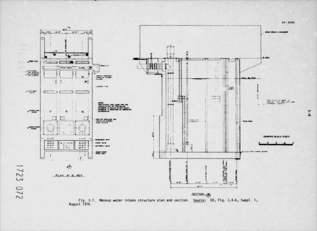
ES-3293_.
;<~< ~we' '.i ,,r..- < e r.1 , - * = * = * * * * * * *' j |
-
{ I
'- ,! e n,
". u IV~d - Jem - ,, .3 g==a-
'| gL
(-,,'''**ac= _e- 1mr -- i
f( j t-
g e-'
!'
j-. .,
! .i i:'E p.< .. i~ ,~.
J - g *' .i n
* .~. ,:.= a. ''.'I,se w
_
y -~ . 4 - .i .. '"..e-I
- j'-
~.- ~ 7 i i. ,-
>s s :|~t 7_
.
!j '';.y ;;r ..7
!. :) It.w ar ,< >
1 5e_,_ i. - -,
|| 5'
53.5'*In**^^, , , , , . _- ' ' '-.===.~:.~ -
| j--
, ,i
: : := - = r.=: .
s'. s, . r -
.
| .,.~~~;* o r,
'; , I - ? *, , r-3-l -@ ' **
| | r,.,;;;.. , . ,.- ! -w
h;'
P. . +, . , . .
e ~., ;"' ii,.j ai-) -,
-
,
i' - e. 's rzr '. -!~
' '
- . ' . . ' ' ' . . ' % j '| GRAPHAC SCAL E lf EETpg,- _ _ _
. - . . 5, - ii . * * * = **:- - -_- - . .
- r. u. ..
.b. j 3,
-
1,,-- - - ... ..i
-- -. ,
,' "
, , , , , , - -
, / ,k -& | 1/'
," " " " " *
- .ia
,
) {' * -..
6 | ! iij-
N 'g -
I 'I,
N puu ar et iss-o- 5IU W 3. ,- <> ~
- o,_ = . e. .< . - .e. .. <. e-#
, , . _ , .
CDN secrxw a
Fig. 3.7. Makeup water intake structure plan and section. Source: ER, Fig. 3.4-6 Suppl. 1August 1976.
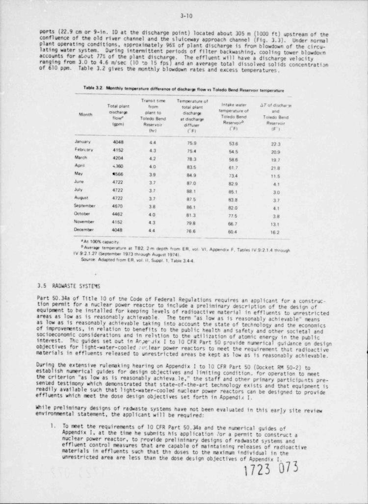
3-10
ports (22.9 cm or 9-in. ID at the discharge point) located about 305 m (1000 f t) upstream of theconfluence of the old river channel and the sluiceway approach channel (Fig. 3.3). Under normalplant operating conditions, approximately 96% of plant discharge is frorn blowdown of the circu-lating water system. During intermittent periods of filter backwashing, cooling tower blowdornaccounts for about 77% of the plant discharge. The effluent will have a discharge velocityranging from 3.0 to 4.6 m/sec (10 to 15 fps) and an average total dissolved solids concentrationof 610 ppm. Table 3.2 gives the monthly blowdown rates and excess temperatures.
Table 3.2. Monthly temperature difference of dischange flow vs Toledo 8end Reservoir temperature
Transit time Temperature ofintake water .1T of dischar jeTotal plant from total plant
temperature of andMonth oischarge plant to discharge
Toledo 8end Toledo Bend, , , , , Toledo Bend at dischargeReservoira Reservoir(gpm) Reservoir diffuser
p p, (p'sthr) (F)
January 4048 44 75.9 53 6 22 3Febrorv 4152 4.3 75 4 54.5 2o.9March 4204 4.2 78.3 58.6 19.7April 4360 4o 83.5 61.7 21.8May 4566 39 84.9 73.4 11.5June 4722 3.7 87.o 82 9 4.1July 4722 3. 7 88.1 85.1 3oAugust 4722 3. 7 87 5 83.8 37September 4670 38 86.1 82.0 4.1October 4462 40 81.3 77.5 3.8November 4152 4.3 79 8 66.7 13.1December 4048 44 76.6 60 4 16 2
- ___
*At 100% capacity._
6Average temperature at T82, 2 m depth from E R, vol. VI, Appendix F. Tables IV.9.2.1.4 through
IV.9 2.1.27 (September 1973 through August 1974LSource: Adapted from ER, vol.11. Suppl.1, Table 3 44.
d
3.5 RADWASTE SYSTEMS
Part 50.34a of Title 10 of tne Code of Federal Regulations requires an applicant for a construc-tion permit for a nuclear power reactor to include a preliminary description of the design ofequipment to be installed for keeping levels of radioactive material in effluents to unrestrictedareas as low as is reasonably achievable. The term "as low as is reasonably achievable" meansas low as is reasonably achievable taking into account the state of technology and the economicsof improvements, in relation to benefits to the public health and safety and other societal andsocioeconomic considerations and in relition to the utilization of atomic energy in the publici nte res t. The guides set out in Ar.peNix I to 10 CFR Part 50 provide numerical guidance on designobjectives for light-water-cooled nuclear power reactors to meet the requirement that radioactivematerials in effluents released to unrestricted areas be kept as low as is reasonably achievable.
During the extensive rulemaking hearing on Appendix I to 10 CFR Part 50 (Docket RM 50-2) toestablish numerical guides for design objectives and limiting condition. for operation to meetthe criterion "as low as is reasonably achieva.le," the staff and other primary participeits pre-sented testimony which demonstrated that state-of-the-art technology exists and that equipment isreadily available such that light-water-cooled nuclear power reactors can be designed to provideeffluents which meet the dose design objectives set forth in Appendi A I.
While preliminary designs of radwaste systems have not been evaluated in this earjy site reviewenvironmental statement, the applicant will be required:
1. To meet the requirements of 10 CFR Part 50.34a and the numerical guides ofAppendix I, at the time he submits his application lor a permit to construct anuclear power reactor, to Provide preliminary designs of radwaste systems andeffluent control measures that are capable of maintaining releases of radioactivematerials in effluents such that th? doses to the maximum individual in theunrestricted area are less than the dose design objectives of Appendix !.
1723 073
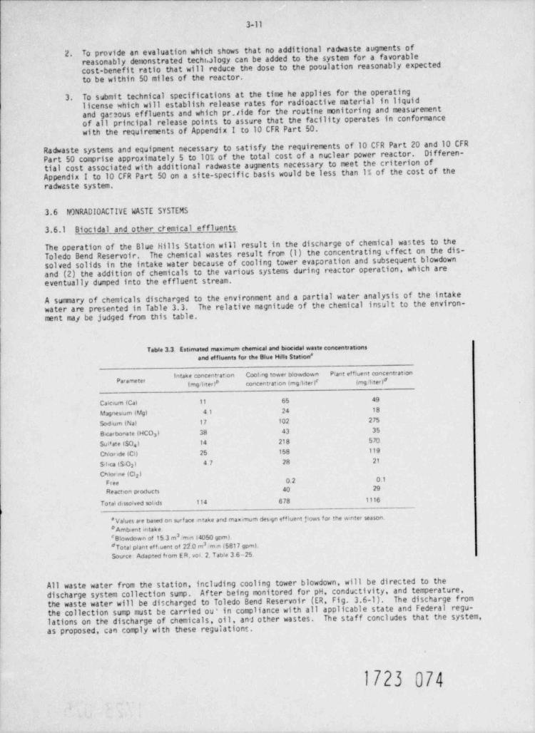
3-11
To provide an evaluation which shows that no additional radwaste augments of2.reasonably demonstrated techhalogy can be added to the system for a favorablecost-benefit ratio that will reduce the dose to the pooulation reasonably expectedto be within 50 miles of the reactor.To submit technical specifications at the time he applies for the operating3. license which will establish release rates for radioactive material in liquidand garsous effluents and which pr. tide for the routine monitoring and measurementof all principal release points to assure that the facility operates in conformancewith the requirements of Appendix I to 10 CFR Part 50.
Radwaste systems and equipment necessary to satisfy the requirements of 10 CFR Part 20 and 10 CFRDifferen-Part 50 comprise approximately 5 to 10% of the total cost of a nuclear power reactor.tial cost associated with additional radwaste augments necessary to meet the criterion ofAppendix I to 10 CFR Part 50 on a site-specific basis would be less than 1% of the cost of theradwaste system.
3.6 NONRADI0 ACTIVE WASTE SYSTEMS
3.6.1 Biocidal and other ctemical effluents
The operation of the Blue Hills Station will result in the discharge of chemical wastes to theThe chemical wastes result from (1) the concentrating effect on the dis-Toledo Bend Reservoir.
solved solids in the intake water because of cooling tower evaporation and subsequent blowdownand (2) the addition of chemicals to the various systems during reactor operation, which areeventually dumped into the ef fluent stream.
A summary of chemicals discharged to the environment and a partial water analysis of the intakewater are presented in Table 3.3. The relative magnitude of the chemical insult to the environ-ment may be judged from this table.
Table 3.3 Estimated maximum chemical and tuacidal waste concentrationsand effluents for the Blue Hdis Station *
intake concent atron Coohng tower blowdown Plant effluent concentrationp
| mg ' liter) concentration (mg ' liter)# (mg/lited
Caicium (Cal 11 65 49
Magnesium (Mg) 41 24 18
Sodrum (Nat 17 102 275
Bicarbonate IHCO ) 38 43 352
Sua te ISOa) 14 218 570a
Ch!onde (Cl) 25 158 119
S+ca (5,0 ) 47 28 212
Chlor ne (Cl )2
Free 0.2 0.1
Reaction products 4o 29
Total dissolved sobds 114 678 1116
'Vafues are based on surf ace intake and maximum des.gn effluent f!ows for the wmter season.# Ambient mtake.
3# Blowdown of 15 3 m ,m.n (4050 gom).2# Total plant etf. vent of 21.0 m .m>n (5817 gomL
Source: Adapted from E R, vol 2, Tabte 3 6-25.
All waste water from the station, including cooling tower blowdown, will be directed to thedischarge system collection sump. Af ter being monitored for pH, conductivity, and temperature,the waste water will be discharged to Toledo Bend Reservoir (ER, Fig. 3.6-1). The discharge fromthe collection sump must be carried ou' in compliance with all applicable state and Federal regu-lations on the discharge of chemicals, oil, and other wastes. The staff concludes that the system,as proposed, can comply with these regulations.
1723 074
3-12
3.6.1.1 Preoperatienal watte
Prior to startup, the condensate, feedwater, and main steam system will be cleaned of oil andThis operation, a one-time occurrence, will result in the discharge of 2268 kggrease.
(50,000 lb) of 1 wt % trisodium phosph5te,1134 kg (2500 lb) of 0.05 wt % wetting agent,1134 kg(2500 lb) of 0.05 wt % detergent, and 22.69 kg (50 lb) of 0.001 wt % antifoaming agent, all con-tained in 5678 m3 (sl.5 x 10' gal) of flush water. The cleaning solution flush will be dumpedinto a retention basin and released into the plant outfall at a controlled rate.
3.6.1.2 Condenser cooling system
Makeup water for the cooling towers will be supplied at a maximum rate of 1.74 m /sec (27,632 gpm).3
Evaporation and drif t will consume a maximum 1.46 m /sec (23.076 gpm) of this amount, and the3
blowdown will be a maximum of 0.29 m /sec (4556 gpm). Because of the concentration effect of the3
evaporation, the tower water and, consequently, the blowdown will have a dissolved solids concen-tration about six times that of the intake water.
Sulfuric acid is added to the circulating water to control bicarbonate alkalinity and preventscale formation. The maximum amount to be added is 3275 kg (s7218 lb) of 66* Be' sulfuric acid |per day.
To control biological growth in the circulating water system, chlorine will be added periodically.The applicant states that chlorine will be added for three 30-min periods each day during sumermonths at a maximum rate of 5.58 kg (12.3 lb min-1 unit-1) for a 3-ppm concen+. ration at the pointof injection. The addition of the chlorine will be controlled by a residual chlorine analyzerlocated in the effluent stream from the condenser. The chlorine will be controlled at approxi-mately 0.2 mg/ liter free chlorine at the outlet of the condenser during the chlorination period.The applicant estimates that a maximum of 1014 kg (2234 lb/ day) of chlorine will be used for both |units.
As stated previously the chlorine residual will be maintained at @.2 mg/ liter free chlorine atthe outlet of the condenser during the chlorination period. The free chlorine will decay toessentially zero in a short time in the cooling tower circuit, but because of the large ratiobetween the volume of water being chlorinated and the blowdown volume, the concentration ofthe added chlorine and its reaction products (chloride ion, chloramines, organic chloramines,etc.) will build up in the circulating water to an essentially steady state of 40 mg/ liter.The exact composition of this steady state cannot be accurately estimated although the staffagrees that a large fraction cf it will be chloride ion. Blowdown will not materially decreasethis steady state concentration between chlorinations; therefore, the blowdown from each unittill contain this average concentration at all times. For each chlorination (assuming sequentialorder) the resultant concentration in the circulating water effluent will initially consist of upto a maximum of 10.1 mg/ liter free residual chlorine and 40 mg/ liter of the reaction products ofchlorine. Af ter a short period (several hears), the free residual chlorine will have decayed toessentially zero, leaving only the reaction products, but the exact composition of these is |impossible to predict.
3.6.l.3 Plant makeup water
The plant makeup water system uses two demineralizer trains, each of 200 gpm (0.76 m / min)3capacity. Each train is regenerated by 451 kg/ day of sulfuric acid (993 lb) and 404 kg/ day ofsodium hydroxide (890 lb). The regeneration wastes are sent to a sump where the pH is monitoredprior to being discharged along with the cooling tower blowdown.
3.6.1.4 Condensate demineralizer system
This system consists of six deep-bed externally regenerable H-OH demineralizers arranged tooperate in parallel. The system will require 534 kg (1178 lb) of H,50 and 436 kg (960 lb) ofsodium hydroxide each day. This will be contained in 95,000 gal (170 m ) of regenerant waste.
4
3
The waste will be pumped through cartridge-type disposable filters to remove suspended solidsand then will flow to the discharge system collection sumps for discharge via the station outfall.
3.6.2 Sanitary and other wastes
3.6.2.1 Sanitary waste
A to-unit sewage treatment plant that is capable of treating 87.1 m / day (23,000 gpd) will be |3
instualed in the early construction stage. The maximum flow expected during construction will be
1723 075
3-13 -
93.5 m /ty (s24,700 gpd) at an average rate of 0.07 m / min (17.2 gpm). The basic treatment33
plan 6 will be supplemented with temporary facilities to handle the excess flow. The treatedeffluent from the plant will be discharged into a leach field during construction and startup ofBlue Hills Staticn Unit 1. During normal operation the treated effluent will be discharged intothe plant outfall. (The treated effluent from this plant must comply with EPA and Texas WaterQuality Board standards.)
3.6.2.2 Gaseous waste
Two diesel generators will provide a standby power source for each unit. The generators willbe run a minimum of 1 hr per month for testing. The generators are rated at less than 5000 kWand will operate on No. 2 diesel oil. The staff expects that the pollutant levels resultingfrom this source will meet applicable Federal and State standards (including the Texas Clean AirAct and the Rules and Regulations of the Texas Air Control Board).
3.6.2.3 Solid waste
Solid waste, other than radioactive, will be disposed of offsite by a comercial contractor oronsite by methods that must meet all local and state standards.
3.7 POWER TRANSMISSION SYSTEM
The electrical transmission system proposed for the Blue Hills Station includes approximately31'/ km (197 miles) of 500-kV lines (ER, Sect. 3.9). Detailed maps showing land use, vegetation,dnd terrain features along the proposed routes are provided in the applicant's ER (Appendix F.Sect. II, Figs. II.6:4-6.23). To provide power for construction, about 11 km (6.7 miles) of the500-kV line will have underbuilt provisions for two 138/230-kV lines. Three individual routesare proposed by the applicant to incorporate the Blue Hills Station power into the existingelectrical network (Fig. 3.8). Two of the routes will terminate at substations and the thirdwill tie in with an existing 500-kV transmission system. Most of the land (i.e., 90%) traversedby the transmission routes is currently commercial forest, and approximately 52% (165 km) ofthe proposed lines use existing rights-of-way. Most of the forested land is used seasonallyfor hunting and some grazing. Proposed routes will necessitate the relocation of three houses,one church, and a skeet range. All lines will originate at the station switchyard that occupiesapproximately 25 ha (61 acres) within the property boundaries.
The single-circuit 500-kV towers will be open-lattice galvanized steel structures (Fig. 3.9) andthe majority will have underbuilt provisions for two 230-kV lines (Fig. 3.10). Towers will beplaced on aboveground foundations at least 0.5 m (1.5 f t) high and will have a nominal heightof 36.6 to 38.0 m (120 to 124.5 f t). The conductor system has three 1024.5 MCM ACAR conductorsper phase and with the tower system is designed to meet National Electrical Safety Code mediumloading conditions or 161 km/hr (100 mph) winds, whichever is greater. The average span lengthbetween each of the 1086 required towers is approximately 300 m (1100 ft).
Information on the three individual routes is given in Table 3.4, and the vegetation, land use,and physical characteristics are further described in the applicant's Environmental Report(Sect. 3.9.6-8; Appendix F, Sect. II.6). Route A, the shortest line (10.8 km or 6.7 miles),passes entirely through comercial pine forest to connect with an existing 500-kV line (GulfStates Line 559) south?ast of the Blue Hills Station. This new 122-m-wide (400 ft) right-of-waywill have two 500-kV tower lines and will cross several small streams, a pipeline, and one pavedfarm-to-market road. There were no reported historic landmarks or archaeological sites alongthis proposed route.
Route B extends generally south-southwest for about 120 km (75.1 miles), terminating at theproposed Nona bulk substation near Nona in Hardin County, Texas. Land traversed by this singleline is primarily timberland (94.57,), with small amounts in pasture (1.9%) and cultivated land(2.0%). Two railroads, 22 highways and county roads, 68 small streams, and one river (Neches)are crossed and account for about 0.7% of the route. The proposed route parallels existingrights-of-way for 52.2 km (32.5 miles). Detailed description of route segments is provided inthe applicant's Environmental Report (Sect. 3.9.7; Appendix F, Sect. II.6.3). Af ter the first31.2 km (19.4 miles), the line, which initially passes about 1 km (0.8 mile) west of Wiergateand about 5.6 km (3.5 miles) west of Burkeville, joins and overlaps an existing transmissionline corridor for approximately 21.5 km (13.4 miles). This right-of-way and others used alongthe route will require additional width to accommodate the proposed line (ER, Tables II.6:1-3).A recreational development called Sawtown USA near the crossing of U.S. Highway 190 is avoidedby the proposed route. This development has gone out of business since the DES was written. |A population of young pyramid magnolias, an endangeres species in Texas, was located near |
1723 076
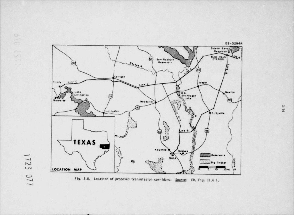
ES-3294R,'. Tot.d. 8."8 ''
o R e s .r y.it, ,
9 5.en R.y bern, BLUE HOLS t4,,
e > / ,,STATION I
1 R. s. t v.8 ' ,f - <fN.ch., ,8
\9'? ,.
5
q', L {C.tvi..n
Trenit y L C/ %J. s. . r
L'" C r,
t... gg N. ton<,........ s , .. . .
g..u.....e ~.
g .. .-
. . . . . . . . ,,,,,,u.;3,,,, -
4,;Q:'1/
';+g 5-e......,.. -
. . . . , , . .g
'].; *grk ,
yhd .z.
.
%. '.;s e; '. . . . 's HN.a. i .:
TEXAS t.n.
, ...... i.......,
3 . , , y......,.s..
4 ,. N.... ,! :I gg,g 7p,cg.t%Uft?f:f ~?'' o
& {@ %Q|*gLOCAtlON MAP ; ' ' ' ' "
_ a .: ^1g-1 Fig. 3.8. Location of proposed transmission corridors. Source: ER, Fig. 11.6:1.- -J
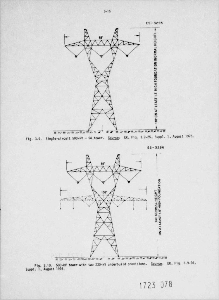
3-15
ES- 3295
*89'*
x- :*EE;9EE8u.
z
M !02U
kPA QE
'
b:i
e /// e si e m e s u rie. P e s e a n s e s/ e x e s e s e x eFig. 3.9. Single-circuit 500-kV - SA tower. Source: ER, Fig. 3.9-25. Suppl .1, August 1976.
ES-3296
j-i
~e- 89'
5i
peios-
f.TiCITUT'3df$[ '-1'. _ _ hIdYt.l'["GN gu,'
J|g, ''.-''
~ . , *.. .
$Ei ;'i i
M li~D/\
5.
NAAI
,
i
I'
e miesie:mexe sii?ZA Y i e sensasieresereseFig. 3.10. 500-kV tower with two 230-kV underbuild provisions. Source: ER, Fig. 3.9-26,
Suppl.1. August 1976.
1723 078
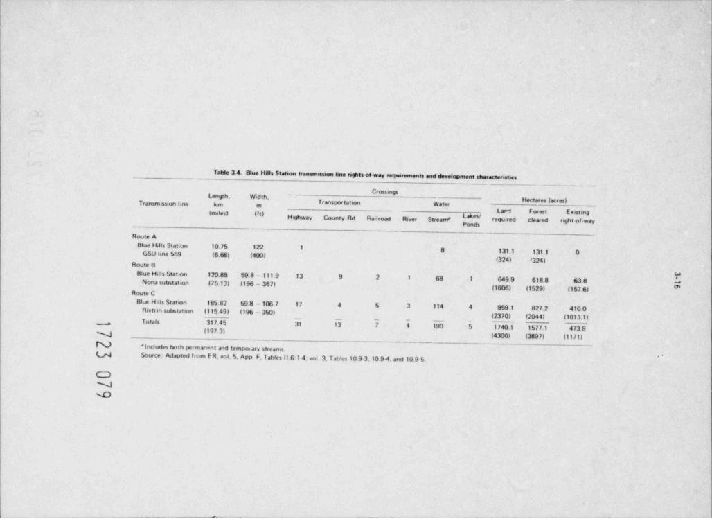
Table 3.4. Blue Hills Station transmission line rightsef way requirements and development characteristics_. _ _ _ _ _ _
Length. Width, -Crossings
Hectares (acres)Transportation WaterTransmission ime km mp g(mdes) (f t) La sH'9 way County Rd Railroad River Stream, required cleared right of-wayh
Route ABlue Hills Station 10.75 122 1 8 131.1 131.1 0GSU line 559 (6.68) (400)
(324) '324)Route B
Blue Hills Station 120 88 59 8 - 111.9 13 9 2 1 68 1 649.9 618 8 63 8 YNona substation (75.13) (196 - 367) g
(1606) (1529) (157.6)Route C
Blue Hdis Station 185 82 59 8 - 106.7 17 4 5 3 114 4 959.1 827.2 410 0Rivtrin substation (115.49) (196 - 350)(2370) (2044) (1013.1)
Totals 317.45 31 13 7 4 190 5 1740.1 1577.1 473 8(197.3)(4300) (3897) (1171)
N * Includes both permanent and temposary streams.__
U Source: Adapted from E R. vol. 5. App. F, Tables il 6:14. vol. 3. Tab'es 10.9 3.10.9 4. and 10.9 5. .
ON<
3-17
this segment of the route. A recent attempt to locate this population by the staff and applicantrevealed that the area has apparently been clear-cut within the past year. The route passesabout 3 km (2 miles) west of Newton, crosses an occupied homesite, and continues west-southwestfor about 9.6 km (5.95 miles), bypassing Kirbyville. After crossing U.S. Highway 96, it joins anexisting pipeline corridor (30.5 m or 100 f t wide) for 18.4 km (11.47 miles), crossing the NechesRiver and the Big Thicket National Preserve near the Jasper-Tyler County line. The line crossesthe narrow Upper Neches River Corridor Unit of the preserve, just north of the Neches Bottom andJack Gore Baygall Unit and approximately 2.8 ha (6.9 acres) of forested land will be clearedwithin the preserve to accommodate the right-of-way. From this point the corridor extends acrossMaple Slough, west and south for 27.9 km (17.34 miles), passing primarily through timberland anda small amount of farmland (approximately 3.2 km or 2 miles). This segment crosses the extremesouthern end of Potato Patch Lake and passes to the north and west sides of Silsbee. Pending
Forfinal placement of the line within the corridor, two residences may need to be relocated.the next 5.26 km (3.27 miles), the corridor joins an existing pipeline corridor (15.2 m or 50 f twide), which passes entirely through timberland, and continues southwest for approximately 3.2 km(2 miles) along an existing pipeline and transmission line corridor. This segment passes about1.6 km (1 mile) south of Kountze and crosses U.S. Highway 69. Fror here the final section of theroute follows an existing railroad right-of-way to the proposed Nona substation, about 3.9 km(2.4 miles) southeast of Kountze. Within this proposed route there are two archaeological sites(ER, Fig. 2.3-3) but no historic sites. Generally, the terrain along the proposed corridor isrolling sandhills, changing to flatwoods before the route crosses the Neches River floodplainIn the sandhilland finally extending back into flatwoods in the vicinity of the substation.area there are moderate-to-steep slopes, and the erosion hazard is slight to moderate.
Route C extends from the Blue Hills Station switchyard westerly for 186 km (115.5 miles) to theGulf States Rivtrin bulk substation at Riverside in Walker County, Texas. Most of the proposedsingle line route passes through timberland (87%). Pasture accounts for 11% of the land use andthe remaining amount includes crossings of roads (21), railroads (5), rivers (3), streams (114),and ponds (4). Existing right-of-way is paralleled for 60% of the route [111.5 km (69.3 miles)]but must be widened to accomodate the proposed line. After 1.3 km (0.8 mile) within the siteboundary, the proposed route extends 23.2 km (14.4 miles) northwest, west, and southwest,primarily through timberland, passing 1.6 km (1 mile) north of the Scrappin' Valley Hunting
Part o.f thisLodge and combining with a proposed railroad right-of-way for 21.6 km (13.4 miles).arallels the southern boundary of the Sabine National Forest and at places comes withinsegment
0.4 km 50.25 mile) of the northern property fence of the Scrappin' Valley Hunting Preserve. Theroute then runs mainly southwest, overlapping an existing pipeline corridor for about 29 km(18 miles), crossing U.S. Highway 96, the Atchison, Topeka and Santa Fe railroad and Gum Slough.The route passes about 4 km (2.5 miles) south of the Sam Rayburn Dam and Recreation Area andwithin 0.4 km (0.25 mile) of Rayburn Country, a housing development on the reservoir, and withinabout 0.5 km (0.31 mile) of the development's golf course. A skeet range will need to berelocated. To avoid a scientific area on the northern edge of B. A. Steinhagen Lake, the routedeparts the pipeline corridor and proceeds 43.3 km (26.9 miles) west and southwest, passingabout 4.0 km (2.5 miles) north of the lake and 4.4 km (2.7 miles) north of the Jasper State FishHatchery. The corridor crosses both the Angelina and Neches rivers, the Southern Pacific rail-road ard U.S. Highways 69 and 287. This section crosses scattered pastures (4%) but mostlytimbe rl and. Passing just north of Colmesneil (1.6 km or 1 mile) and south of Chester (0.8 km or0.5 mile), the route turns northwest for 18.3 km (11.4 miles) and overlaps an existing Gulf Statestransmission line corridor. The route crosses one railroad, and a church and two houses willneed to be relocated. About 12% of the segment passes through pastureland. Longleaf Pine Trail(Texas Forestry Association) is located about 0.4 km (0.25 mile) south of the corridor.
The route then passes south of Corrigan, crossing U.S. Highway 59 and a railroad, as it proceedsabout 8 km (5 miles) west and northwest to join an existing Gulf States transmission corridorfor an additional 29.2 km (18.2 miles). By following the existing corridor, this segmentcrosses the Bull Creek Woodlands Trail (Texas Forestry Association) and passes through about7.6 km (4.8 miles) of pasturelanJ. Turning west the corridor continues 20.1 km (12.51 miles),traversing a small corsnercial recreation area on White Rock Creek and avoiding a wooded, mobilehome park. About 0.8 km (0.5 mile) east of Trinity the route overlaps an existing Gulf Statestransmission line corridor and continues for about 12.2 km (7.6 miles) to the south, crossingthe Trinity River and the extreme west end of Lake Livingston.
The corridor then crosses the Missouri Pacific railroad and ends in 1.3 km (0.8 mile) at theRivtrin substation, imediately south of Riverside. The substation will require an additional12.1 ha (30 acres) to acccmodate the new line terminal and the construction of a railroad spurfrom the existing adjacent track. There are two archaeolugicai sii.es and C,ree Imlitieswithin the proposed corridor (ER, Fig. 2.3-J). Terrain along this proposed corridor includesgently sloping hills in the vicinity of the station, changing to flat bottomlands near theAngelina and Neches rivers, where there are numerous sloughs and swamps, then back to hilly
1723 080
3-18
topography until it reaches the flat floodplain of the Trinity River. There are some steepslopes into the stream bottoms, and some soils have slight-to-sevare erosion hazard. Streamforests are mostly hardwood species such as oaks and beech-ragnolia with high wood productioncapacities; the upland forests are mixed pine and hardwoods.
3.8 TRANSPORTATION CONNECTIONS
3.8.1 Railroad spur
The applicant proposes a 29.4-km (18.3 miles) railroad spur to connect the Blue Hills Stationwith the nearby Atchison, Topeka and Santa Fe railroad (ER, Fig. 2.1-3). This 30-m- (100-ft)wide corridor extends north then west from the site, across generally undulating terrain thatis primarily forest with only a small amount of pasture (2%). The proposed route crosses theCopperas Creek floodplain encountering some steep slopes, then passes north of the Scrappin'Valley Wildlife Management Area and connects with the existing railroad north of Browndell inJasper County, Texas. About 2.6 km (1.6 miles) of the route is within the Gulf States propertyand 21.6 km (13.4 miles) parallels proposed transmission line c, which extends from the site tothe Rivtrin substation. Construction of the railroad right-of-way requires clearing 89.8 he(222 arres) and a permanent comitment of about 22 ha (54.3 acres). The corridor crosses15 streams and has six high-point crossings. About 4.8 km (3 miles) northwest of the site itcrosses Texas Highway 87 and approximately 0.6 km (0.4 mile) east of this the route traversesa 1.2-ha (3.0-acre) pitcher plant bog (ER, Appendix F, Addendtra 1, Figs. 6 and 7). The corridoralso passes through potential habitat for the rare and endangered red-cockaded woodpecker. Twopower lines and a pipeline are crossed by the route, which also passes within 0.14 km (400 ft)of one residence. Within the railroad right-of-way there are no historic landmarks; however,archaeological features include six localities and one site (ER, Fig. 2.3-1). Upland forestsalong the route are mixed pines and hardwoods, and stream forests are mostly hardwoods withloblolly pine. Ravine areas have severe erosion potential.
3.8.2 Makeup and discharqe pipeline
The proposed makeup and discharge pipeline runs easterly from the site for 13.7 km (8.5 miles)to the intake and discharge locations on the Toledo Bend Reservoir (ER, Appendix F Fig. II.4:1).Including the laydown area, this right-of-way will be 49 m (160 f t) wide. Af ter the first0.8 km (0.5 mile) within the property boundary, the route continues east for 2.3 km (1.4 miles)then turns southeast for 3.3 km (2 miles) to a point slightly south of Farm-to-Ma-ket Road 255(FM 255). The pipeline then parallels FM 255 for the next 4.8 km (3 miles) at a distance ofapproximately 90 m (300 ft) from the road. At that point a single intake line extends north for0.5 km (0.2 mile) along an existing road to the intake location. The discharge line continueseast along FM 255 and north along Texas Highway 692 for 2.2 km (1.3 miles), then turns northeastfor the final distance (0.3 km or 0.2 mile) to the discharge location on the reservoir. The first6.3 km (3.9 miles) to FM 255 is through forestland and the last 7.4 km (4.5 miles) runs throughthe area of undeveloped residential homesites and comercial recreational facilities. An undevel-oped boat ramp, public ramp, and overlook occur along the route. The pipeline crosses MitchellCreek and two tributaries of an unnamed stream in addition to other small upper tributaries.There are no historic landmarks or archaeological sites within the proposed route. The corridorrequires 67.2 ha (166 acres) of land, includf r.g 6.1 ha (15 acres) within the property boundary.Forests are primarily upland types with a variable mixture of pines and hardwoods. Most of thearea has been disturbed or is scheduled for logging. The terrain has moderate to steep slopes.The area east of Indian Creek and along FM 255 has the potential 'or severe erosion because ofthe slope and shallow, erodible soils.
3.8.3 Access road
The proposed two-lane asphalt concrete access road extends north from FM 255, past the Mitchelland Toledo cemeteries, for 4.5 km (2.8 miles) to the site (ER, Appendix F, Fig.11.3:2). Aboutone-third of the road (1.4 km) is within Gulf State property. The proposed route follows anexisting dirt road along the ridge divide between the Copperas and Mitchell Creek drainages forabout 2.9 km (1.8 miles). Construction of the right-of-way will require 16.5 ha (40.7 acres)of land but only about 14.8 ha (36.5 acres) of construction clearing because of the overlapwith the existing road. Vegetation along the route is primarily pine plantation and pine-hardwood forest. There is potential for moderate erosion or, in cases of steep road cuts,severe erosion.
1723 081.

3-19
REFERENCE FOR SECTION 3
1. U.S. Environmental Protection Agency, Developnent Doewient for nvposed Best TechnologyAvailable for Minimisin] Ad:erse Envircnnental Impact of Cooling Water Intake Structures,report EPA 440/1-74/015 December 1973.
1723 082
m
4. EhVIRONMENTAL IMPACTS OF CONSTRUCTION
4.1 LAND USE
The site property includes about 1220 ha (3016 acres) of primarily forested land. Site prepara-tiin and onsite corridor construction (excluding transmission corridors) will affect about 148 ha(366 acres), including the permanent loss of 50 ha (123 acres). Land area affected by constructionis summarized in Table 4.1. Transmission facilities will reqJire an additional 1740 ha (4300 acres)of land, including 1577 ha (3897 acres) of forest land that will require clearing.
Table 4.1. Blue Hills Station land area affecteu by construction and restoration
Area given m hectares; f 6gure in parentheses is eqi eatent acres.(Figures are rounded off to the nearest whole number.)
Restoration,
Constructen,
Locaten Total Cleared and Buildings, pavmg. Seeded or ggrubbed and shell sodded
Blue Hills Station oropertySite proper 106 (261) 106 (261) So (123) 53 (130) 3 (8)
Adjacent waste area 11(26) 11 (26) o (o) 1 (3F 10 (26)
Adiacent borrow area 7 (17) 7 (17) o (o) 2 (6F 7 (17)
Batch plant area 5 (12) 5 r12) 2 (6f 2 (6) 2(6)Uncleared station 1o93(2700)property
'
Total 1221 (3016) 128 (316) 52 (129) 59 (145) 23 (57)
Construction corr:,.crs
Access roaas 16 (40) 15 (38) e c c
Within site property 6 (14) 6 (14) e. c c
Outside site property 11 (26) Io (24) c c c
Railroad 90 (222) 90 (222) c c c
Within site property 8 (21) 8 (21) c c c
Outside site property 81 (201) 81 (201) c c c
Makeup and blowdown 67(166) 67(166) <o.5 (o 5) 66 ('.64) 0.5 (1.5)
corridor, and lake-front structureWithin site property 6(15) 6(15) 6 (f 5)Outside site property 61 (151) 61 (151) <o 5 (o 5) 60 (149) o 5 (1.5)
'33(428) 172 (426)1Total. . _
* Seeded for immedeate erosion control.6 During construction only.(Paved, ballasted, and seeded slopes as required.Source: Modified from E R. vol. II, Table 4.1-1.
4.1.1 Onsite
Site preparation and construction for the physical plant will require the clearing of 127.9 ha(316 acres) within the 1220 ha (3016 ai:res) proposed for the Blue Hills site. The land ispresently forest with yot.ng second-growth pines and mixed hardwoods and is used for timber pro-duction. Clearing will be necessary for the construction of the power block, switchyard, tempo-rary construction facilities, and adjacent waste and borrow areas. Onsite access roads, a rail
and a makeup and blowdown corridor will require the clearing of an additional 20 haspurs(50 acres). An unnamed tributary of Mitchell Creek will be displaced by construction of the
4-1
1723 083
.
4-2
swi tchya rd. When onsite construction is completed, 78 ha (193 acres) will be restored(Table 4.1). Plant facilities ar.d restoration of cleared land to grass will permanently remove105 ha (259 acres) from fore!* production. Within the site boundaries, there are no historicor archaeological landmarks and no agricultural activities or residential structures.
Site preparation is expected to be completed within five months. Marketable timber will beremoved, and the remaining trees and brush will be used for erosion control or will be burnedin accordance with State and Federal regulatiens. Tree stumps and other organic material thatcannot be burned will be buried in designated waste areas.
Following clearing, approximately 994,500 m3 (1.3 x 10⁶ 3yd ) of soil will be excevated withoutthe use of explosives, and this material will be used for site fill. Additional fill will teteken from designated borrow areas, and unsuitable excavated matertal will be deposited in iden-tified waste sites (ER, Fig. 4.1-1). Some topsoil will be stockoiled to restore borrow areas.
Dust resulting from construction activities will be controlled by water trucks, sprinkler systems,or chemicals. Herbicides will be used to restrict the regrowth of vegetation on shelled and paved
Pesticides, if used, will meet appropriate State requirements. Noise resulting from siteareas.preparation, concrete placement, building construction, equipment installation and testing, andsite cleanup will be within the normally acceptable ranga according to Housing and Urban Develop-ment (HO) noise criteria (ER, Tables 4.1-3 and 4.1-6); therefore, noise impacts will beacceptable.
4.1.2 Offsite
4.1. 2.1 Railroad spur
The proposed railroad spur is described in Sect. 3.d.l. It extends from the Longview Branchof the Santa Fe Railroad, which is just north of Browndell, eastward for approximately 29 km(18 H les) to the site. The spur will occupy about 90 ha (222 acres) that is predominantlyforest (98%), of which about 91% lies outside Gulf State property. There ats 15 streau. and6 high-point crossings along the route. The railroad right-of-way will parallel one of theproposed transmission line corridors for 21.6 km (13.4 miles). Construction of the spur will |3 3cause a 456 m / year (16,117 ft / year) loss in timber production and a permanent commitment
3 3of 112 m / year or 3960 f t / year (ER, Sect.10.10.l .1.1).
4.1. 2. 2 Access roads
A permanent two-lane access road will be constructed using part of an existing dirt road, theaccess road will run from Farm-to-Market Road 255 to the site (Sect. 3.8.3). Ap a ximatelytwo-thirds of the distance [3.1 km (1.9 miles)] will be offsite. Total land requireo for theroad is 16.5 ha (40.8 ocres) including 14.8 ha (36.6 acres) of forest that must be cleared.Construction of the road will result in a timber production loss of 75 m / year (2656 ft ' year)3 3
and a permanent commitmen* ' about 20 m / year or 700 ft / year (ER, Sect. 10.10.2.1.2).3 3
Temporary roads will be disked, scarified, and seeded af ter construction.
4.1.2.3 Water intake and discharge structures and pipeline
A total of 67.2 ha (166 acres) of land will be required for the intake and discharge structuresand the pipeline (ER, Table 4.1-1). Construction of the structures will result in the disturbanceof 183 to 305 m (600 to 1000 ft) of shoreline on Toledo Bend Reservoir. This activity will rernove36,/01 ml (48,000 yd3) of material, of which 82% is dredgings. The pipeline, which extends13.7 km (8.5 miles) eastward from the site to the shoreline structures, includes 12.9 km(8.0 miles) of pipe offsite. About 46% of the route is through upland forests, and 54% isthrough undeveloped residential and recreational areas. During construction of the pipelinetrench, access to a public boat launch will be hampered temporarily, as will several roads into |developed areas and areas used for hunting. Procedures for clearing, debris disposal, anderosion and fire control are the same as those described for the site (Sect. 4.1.1). Theintake structure will require a 0.18-km (0.11-mile) access road.
}
a-3
4.1.3 Transmission lines
The transmission system proposed for the Blue Hills Station includes 317 km (197 miles) of 500-kVtransmission lines connecting the power plant with the Nona and Rivtrin substations and with the
Rists-of-way for these transmission lines will require about 1740 haGulf State Line 559. About 901 [287 km (178 miles)] of the total length is through forested(4300 acres) of land.land, 71 is through pasture land, and the remainder includes transportation and water crossings(Table 3.4) and residential and recreational land. About 92.5% of the requ' red land has an averagevalue of about $2470/ha ($1000/ acre), while the renuining 7.5*. has an average value of $1975/ha or$800/ acre (ER, Sect.10.9.1.3). Land currently used for grazing, farming, and recreation willonly be temporarily affected by construction activities and will remain available for such useClearedNo herbicides or pesticides will be used in clearing vegetation.after construction.forest will represent a loss in annual timber production of 9.905 to 11,320 m / year (350,000 to
3
ft / year) of pine wood.3400,000
Approximately 52; of the total length of proposed mutes parallel existing railroad, pipeline,Because of existing rural roads, no new access roads will beor transmission line mutes.Most areas along the proposed routes are used for hunting, and these areas willrequired. The Blue Hills Nona trans-probably have greater accessibility af ter right-of-way construction.
mission route crosses about 0.8 km (0.5 mile) of the Big Thicket National Preserve near the JackHowever, by paralleling an existing pipeline right-of-way, the impact willGore Baygall Unit.
be minimal. No historical or archaeological sites occur in the proposed rights-of-way.
4.1.4 Sumary of land use impacts
Total land required for construction of the Blue Hills Station and associated transmissionConstruwtion will require the clearing of approximatelysystems amounts to 3113 ha (7689 acres).
148 ha (366 acres) of forest ensite and 1729 ha (4272 acres) for transmission lincs and otherWhen construction is completed, about 78 ha (193 acres) of the onsite landoffsite facilities.will be restored by seeding or replanting. Transmission rights-of-way will be seeded and main-tained in a grass, hertiaceous, and wo)dy shrub stage by mowing. Pasture and fam land willremain available for use af ter construction. About 52% of the proposed transmission line system
Because forest land is the predominant type of land inwill parallel existing rights of-way.the region, the staff believes the use of the designated land for power generation andtransmission wiil not have a significant impact on the local or regional land-use pattern.
Dust and noise will have temporary effects on the area, but the applicant's prescribed controlmeasures will adequately minimize these impacts.
4.1.5 Radiation exposure to construction personnel
During the period between the startup of Unit 1 and the completion of Unit 2, the constructionpersonnel working on unit 2 will be exposed to sources of radir. tion from the operation of Unit 1.The applicant will be required to keep this radiation exposure "as now as is reasonably achievable"through administrative procedures, physical barriers, locked buildings, and radiation monitoring.
4.2 WATER USE
The principal impacts on surface water and groundwater will be those associated with constructionof the intake and discharge structures and with relocation of an unnamed tributary of MitchellCreek.
Construction of the makeup and discharge structures will necessitate the disturbance of 183 to(48,000 yd3) of3
305 m (600 to 1000 ft) of shoreline and the removal of an estimated 36,701 mmaterial, of which 82% will be dredgings.
Sheet piling will be installed in the reservoir to minimize disturbances resulting from construc-tion of the intake structure.Water used for construction of the main power plant will be provided by a well field consistingof three wells, each with a 0.01 m /sec (200 gpm) capacity. Only one well will be used to meet3
nomal construction requirements, and the other two wells will be available for the emergencyfire protection supply.
Dewatering of groundwater seepage during excavation will be minimal because the deepest pointof excavation will be approximately 4.6 m (15 ft) above the water table.
1723 085
4-4
The unnamed tributary of Mitchell Creek will be diverted from the east to the north (around theswitchyaro) to rejoin its natui'al course north of the switchyard (see Sect. 4.3.2.1).
4.3 ECOLOGICAL IMPACTS
4.3.1 Terrestrial
4.3.1.1 Onsite
Erosion
Construction of the plant and associated onsite facilities (excluding transmission corridors)will involve clearing about 148 ha (366 acres) of forested land and some erosion will be un-avoidable. Because of past land-use p actices, the nature of the soils, rough topography, andthe drainage pattern, strict control procedures will be necessary to minimize crosion. Bottom-land and ravine habitat in the Mill Creek drainage system contain sweet bay-red bay and beach-magnolia comunities that harbor a number of rare and endangared or scientifically importantspecies tnat warrant protection from sediments (Sect. 2.7.1). Likewise Mill Creek, a perennialstream free from industrial or domestic discharge contamination, represents an environmentallysensitive onsite area subject to impacts from ercsion.
Accordina to the applicant's plans, cleared areas will be graded and seeded or replanted as soonas possible af ter construction. Borrow areas will be covered by stockpiled topsoil and plantedin slash or loblolly pine. Temporary roads will be disked, scarified, and seeded, and the slopeswill be rounded for aesthetic reasons and to further reduce erosion potential. Other slopes willbe treated with nontoxic chemical soil binders (e.g., Aerospray 52) to protect germinating seedsand will then be mulched and seeded. Peripheral interception ditches located near the top edgesof cut-and-fill slopes will channel runoff to catch basins for release through drop pipes equippedwith energy dissipators (ER, Fig. 4.1-4). The earth berm used to enclose the waste area will begraded af ter completion of the plant. A moderate amount of slash will be placed in ravine areasto impede erosion and siltation. Disposal of other slash by burning will reduce the hazard ofwildfires. Outdoor burning shall be done in accordance with the Texas Clean Air Act and therules and regulations of the Texas Air Control Board. Natural reseeding and planting ofindigenous vegetation will promote a natural cover at the site boundary (ER, Sects. 4.1.1 ano4.1. 2 ) .
Because of the sensitivity and importance of the ravine and bottomland habitats and the potentialrepercussions of erosion and siltation in these areas (see following discussion and Sect. 4.3.2),the staff recommends that the applicant submit a detailed erosion control program prior to con-struction licensing. This program should ensure that control actions are adjusted to meet anychanges in erosion patterns and that the required water quality standards are met at all timesduring the construction period. (For additional discussion of water quality and siltationef fec ts, see Sect. 4.3.2. )
Vegetation
Much of the site was originally covered by longleaf pine forests; however, timber managementpractices have significantly reduced this forest type, and it has been replaced to a large extentby commercial species such as loblolly and shortleaf pine. Nonetheless, a large number of impor-tant plant species occur or potentially occur on the site (ER, Tab 7e 2.7-2), including speciesthat are rare and endangered or of scientific interest and species that serve as a food sourceor have comnercial value. Loblolly pine is presently the major forest type and accounts for thelargest area comitted to plant construction. Other forest types affected by plant constructionare given in Table 4.2. Of the 128 ha (316 acres) of land to be disturbed during plant construc-tion, 39% or 50 ha (123 acres), will be permanently lost, while 615, or 78 ha (193 acres), willbe rehabilitated by artificial and natural reseeding and by planting pines or indigenous vegeta-tion. Because of the wide distribution and availability of loblolly pine forest, the amount lostdue to plant construction will not be significant.
Stream bottom and ravine comunities including beech-magnolia, sweet bay-red bay, and white oak-laurel oak are less widely distributed. Because intensive forest mangagement in the area pro-motes an even-age pine monoculture, these comunities represent rapidly declining forest typesin the region. Beech-magnolia is an important part of the " Upper Big Thicket" vegetation 1 andis a relict comunity representative of more northern and eastern deciduous forests. It is foundon about 13% [162.8 ha (402.3 acres)] of the site and about 6% of the larger 7242-ha (17,894-acre)study area. Magnolia shows little reproduction in this comunity when the original forest ecologyhas been significantly altered.1 Onsite 4.6 ha (11.4 acres) or approximately 3% of the beech-magnolia forest will be disturbed by the construction. Sweet bay-red bay forests occupy about
1723 086
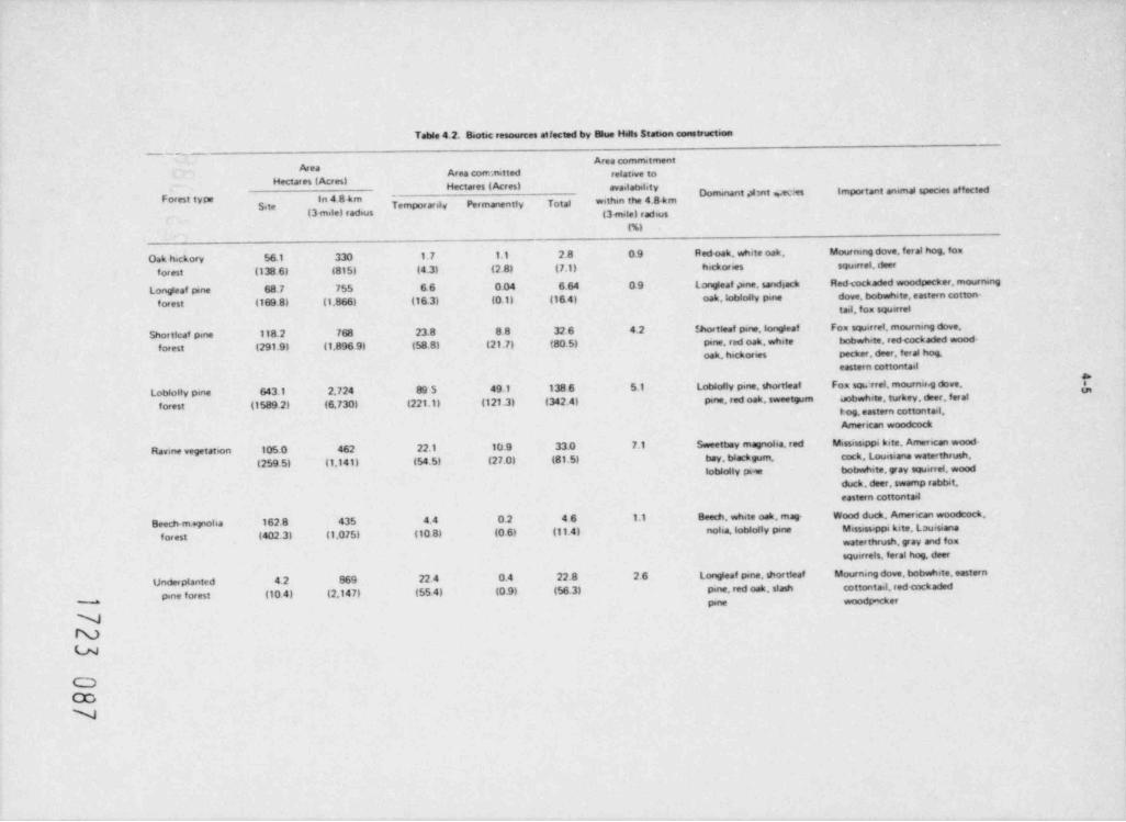
Table 4.2. Biotic resources atfected by Blue Hells Station construction
_ _ _ _ _
Area commitmentArea Area coerc,nitted relative to
Hectares (Acres) Hectares ( Acres) availatulityDominant #mt weaes importarit animal species affected
Forest type in 4.8 km-
Site Tempor ar4 Permanently Total within the 4.8 km(3 mile) radius (3mie) adaus
(%)
Oak hickory 56.1 330 1.7 1.1 28 09 Redoak, white oak, Mournmg dove, feral hog, fox
for est (138 6) (815) (4.3) (2.8) (7.1) hickories squirret. deer
Longleaf pne 68 7 755 66 0.04 6 64 09 Longleaf gane, sand ack Redcockaded woodpecker, mourningi
forest (169 8) (1,866) (16.3) (0.1) (16 4) oak, tobiolly pine dove, bobwhate, eastern cotton-taJ. fox squirrel
Shorticaf pine 118.2 768 23 8 88 32 6 4.2 thortteaf pine,longleaf Fox squirref, mourning dove,
forest (291.9) (1,896 9) (58.8) (21.7) (80 5) pine, red oak, white bobwhite, redcockaded wood-
oak, hickor ses pecker, daer, ferat hog,eastern cottontail
ILobiolly pine 643.1 2,724 89 5 49.1 138 6 5.1 Loblolly pine, shortleaf Fox sovrrel, mourna.g dove,
*
forest (1589 2) (6.730) (221.1) (121.3) (342.4) pine, red oak, sweetgum oobwhite, turkey, deer, for alt og. eastern cottantait.American woodcock
Ravme vegetaten 105.0 462 22.1 10.9 33 0 7.1 Sweetbay magnolia, red Mississsppi kite, American wood-
(259 5) (1,141) (54.5) (27.0) (81.5) bay, blackgum, cock, Louisiana waterthrush,
loblolly pise bobwhite, yav squirret, woodduck, deer, swamp rabbit,
eastern cottontad
Beech mplia 162 8 435 4.4 0.2 46 1.1 Beech, white oak, mag- Wood duck, American woodcock,
forest (402.3) (1,075) (10 B) (0.6) (11.4) nolia, loblolly pine Mississippi kite Louisianawaterthrush, yay and foxsquirrels, feral hog, deer
Underplanted 4.2 869 22.4 0.4 22.8 26 Longleaf pine, shortieaf Mourning dove, bobwhite, eastern
pine forest (10 4) (2,147) (55 4) (0 9) (56.3) pine, red oak. stash cottontail red <ockadedpine wood g er
NNLN
CDCDN
Table 4.2 (contmuod)_ _ _ _ _ _- _ . _ _ _ _ _ _ _ _ _ _ .. ___
Area commitmentArea A ca committed relative toHectares { Acresi Hectares ( Acres) awa. lab.ittyp
_ ,
*'th'n the 4 8 k mDom nant plant species impo' tant animal speces affected
Site Tempor arit v Permanent!y Totat(3 mine) :ackus (3 mael adius
(M. _ _ . __
P.ne plantation 80 630 16.0 1. 7 17.7 2.8 Slash pine, red oak, Mourrung dove, bobah.te, redforest (19.8) (1,556) (39 6) (4 2) (43 81 lobiolly pine cockaded woodpecker. eastern
cottontailScrub oak and 07 68 38 0.3 4.1 60 Blueiack oak, post oak, Feral hog, deer, fou squ tref,
hichorv (1.7) 1168) (9 4) (0 7) (10.1) beach ack oak. vara.es mourning doveiforest Nchores longleaf
pine
Other 53.7 202(132.7} (498)
Total 1220.5 7,242 190.2 72 6 262 8(30160) (17.894) (470.11 (179 41 4643 5)
_
Source Adapted from E R, vol. II, Tatde 412 and NRC Staff Question 2.7 5(1) 10,76
b
b
-
Nu
CD00CD
4-7
105 ha (259.5 acres) of the site, and 27 ha (66.7 acres), or 261, will be affected. Includingthe white oak-laurel oak bottomland (34.9 ha or 86.2 acres), the applicant will be takingapproximately 270 ha (666 acres) of hardwood bottomland on Gulf States' property out of inten-sive forestry rianagement (ER, Sect. 2.7.10; NRC Staff Question 2.7.5-(l), October 1976).Because a majority of the rare and endangered species occurring onsite are associated withthese corr: unities, conservation and protection of these species should likewise result fromthis action. Some species in these corrunities (e.g., hazel alder, broadleaf myrica, sweet gum)are capable of regenerating adventitious roots following some siltation; others, such as thered bay magnolia, appear extremely sensitive to silt deposition (ER, Sect. 4.1.3). Therefore,
strict adherence to erosion control is required to prevent possible cnanges in species composi-tion and alteration of successional patterns. Overall, the commitment of 33 ha (81.5 acres)of sweet bay-red bay and beech-magnolia forests for the plant site will not significantlyaffect the area inventories [i.e., within the 4.8-km (3-mi.) radius] of these communities.The applicant will submit a forest management plan with his application for a ConstructionPermit (Gulf States Utilities, Responses to Agency Comments on the Blue Hills DES, September 30,1977).
All rare and endangered species are available external to the site (ER, Appendix F. Sect. 11.3:4),and their populations are not expected to be significantly affected. It appears to the staffthat a small population of State-endangered Texas sunnybells (J +.ww w w.rv e ) located onthe rock outcrops adjacent to the borrow pit for landfill (ER, Appendix F, Fig. II.3:1) can beavoided by construction activity and equipment. A recent visit to the site indicate thatlogging operations (not under the control of the applicant) had used the rock outcrops for astaging area for their equipment, resulting in considerable disturbance to the habitat.
Dust from construction activity will be controlled by eater trucks, sprinkler systems, and non-toxic chemicals sucy as Soil Penetrant 400, EARTH-FAK, and C0HEREX. In addition, any effects ofdust on the vegetation should be temporary because of expected rainfall. The use of herbicides(e.g., Bromacil, Monuron) will be limited to that required to prevent regrowth of vegetation inshelled and paved areas; no large-scale applications are planned (ER, Sec. 4.1.2.4). Pesticideswill be used only when necessary to protect personnel or equipment.
Consumers
Important animal species found in the onsite forest types are given in Table 4.2. Animal popula-tions will be affected both directly and indirectly by construction. Equipment operation andtraffic will kill some of the less mobile and/or highly territorial species, such as inverte-brates, amphibians, reptiles, and some small marrals. However, these effects will tend to betemporary and recruitrent from surrounding populations should restore the losses. Noise fromconstruction activity will also temporarily affect some species and prevent their use of the
Other species may adjust to the noise and human activity or return to use the area duringarea.periods of inactivity (e.g., at night, on weekends, or during inclement weather) or when construc-tion is completed. No explosives will be used for excavations. The use of pesticides, if any,will follow State and Federal regulations. Powever, the Mill Creek drainage has not been pre-viously subjected to pesticides, and its sensitivity to pesticide introduction is unknown.Likewise, the effect on wildlife food supplies when insect populations are reduced by periodicpesticide application is unknown. Because of the potential distribution of pesticides in runoffand the unknown effects of reducing insect populaticns as a food resource, the staff reconrendsthe use of pesticides be avoided. If the need arises for limited and very local application ofpesticides to protect the health of construction personnel, strictly controlled use of low-persistent insecticide (malathion) by a licensed operator is reco-rended. The application hasalso proposed the use of poison baits to control rats and mice (ER, Sec. 4.1.2.4.2). If
required, these baits should be restricted to limited and controlled application only inside ofbuildings to avoid adverse impacts on non-target species. Outside of buildings problem indi-viduals may be controlled by strategic placerent of snap traps (e.g., Museum Specials). There
will probably be a small and insignificant amount of bird mcrtality from collisions with onsitestructures.
More substantial effects will result from the loss of suitable habitat for the species presentlyfound on the site. The general area is popular for huntina. Sore came species, such as white-tailed deer, fox, gray squirrel, rabbit, and turkey, will be affected, at least temporarily, bythe habitat alteration. For game species, the reduction in permanent populations is predictedby the applicant to be about 4; or less (ER, Appendix F. Table III.6:9). Natural bottomlandforests are particularly important to a number of wildlife species- their importance increasesas intensive forest management alters the original habitat and (in most cases) reduces the habi-tat diversity, the variety, and the abundance of rest animal species. The Mississippi kite andLouisiana water thrush, sensitive species in Texas, prefer the sweet bayred bay ravines.
1723 089
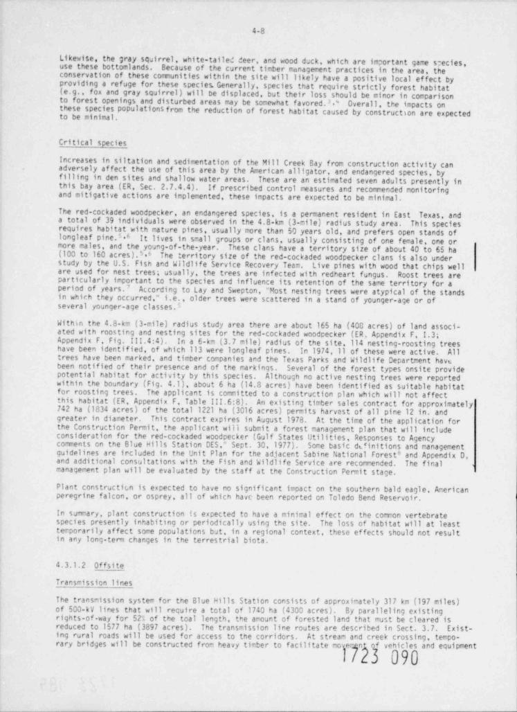
4-8
Likewise, the gray sqairrel, white-tailed deer, and wood duck, which are important game species,use these bottomlands. Because of the current timber management practices in the area, theconservation of these comunities within the site will likely have a positive local ef fect byproviding a refuge for these species. Generally, species that require strictly forest habitat(e.g., fox and gray squirrel) will be displaced, but their loss should be minor in comparisonto forest openings and disturbed areas may be somewhat favored.3 d Overall, the impacts onthese species populations from the reduction of forest habitat caused by construction are expectedto be minimal.
Critical species
Increases in siltation and sedimentation of the Mill Creek Bay from construction activity canadversely af fect the use of this area by the American alligator, and endangered species, byfilling in den sites and shallow water areas. These are an estimated seven adults presently inthis bay area (ER, Sec. 2.7.4.4). If prescribed control measures and recomended monitoringand mitigative actions are implemented, these impacts are expected to be minimal.
The red-cockaded woodpecker, an endangered species, is a permanent resident in East Texas, anda total of 39 individuals were observed in the 4.8-km (3-mile) radius study area. This speciesrequires habitat with mature pines, usually more than 50 years old, and prefers open stands oflongleaf pine.5.6 It lives in small groups or clans, usually consisting of one female, one ormore males, and the young-of-the-year. These clans have a territory size of about 40 to 65 ha(100 to 160 acres).M The territory size of the red-cockaded woodpecker clans is also understudy by the U.S. Fish and Wildlife Service Recovery Team. Live pines with wood that chips wellare used for nest trees; usually, the trees are infected with redheart fungus. Roost trees areparticularly important to the species and influence its retention of the same territory for aperiod of years.7 According to Lay and Swepton, "Most nesting trees were atypical of the standsin which they occurred," i.e., older trees were scattered in a stand of younger-age or ofseveral younger-age classes."
Within the 4.8-km (3-mile) radius study area there are about 165 ha (400 acres) of land associ-ated with roosting and nesting sites for the red. cockaded woodpecker (ER, Appendix F I.3;Appendix F Fig. III.4:4). In a 6-km (3.7 mile) radius of the site, 114 nesting-roosting treeshave been identified, of which 113 were longleaf pines. In 1974, 11 of these were active. Alltrees have been marked, and timber companies and the Texas Parks and Wildlife Department havebeen notified of their presence and of the markings. Several of the forest types onsite providepotential nabitat for activity by this species. Although no active nesting trees were reportedwithin the boundary (Fig. 4.1), about 6 ha (14.3 acres) have been identified as suitable habitatfor roosting trees. The applicant is comitted to a construction plan which will not affectthis habitat (ER, Appendix F. Table III.6:8). An existing timber sales contract for approximately742 ha (1834 acres) of the total 1221 ha (3016 acres) permits harvest of all pine 12 in. andgreater in diameter. This contract expires in August 1978. At the time of the application forthe Construction Permit, the applicant will submit a forest management plan that will includeconsideration for the red-cockaded woodpecker (Gulf States Utilities, Responses to Agencycomments on the Blue Hills Station DES ' Sept. 30,1977). Some basic di.finitions and managementguidelines are ircluded in the Unit Plan for the adjacent Sabine National Forest and Appendix D,8
and additional consultations with the Fish and Wildlife Service are recommended. The finalmanagement plan will be evaluated by the staff at the Construction Permit stage.
Plant constructicn is expected to have no significant impact on the southern bald eagle, Arericanperegrine falcon, or osprey, all of which have been reported on Toledo Bend Reservoir.
In summary, plant construction is expected to have a minimal effect on the common vertebratespecies presently inhabiting or periodically using the site. The loss of habitat will at leasttemporarily affect some populations but, in a regional context, these effects should not resultin any long-term changes in the terrestrial biota.
4.3.1.2 Offsite
Transmission lines
The transmission system for the Blue Hills Station consists of approximately 317 km (197 miles)of 500-kV lines that will require a total of 1740 ha (4300 acres). By paralleling existingrights-of-way for 52% of the toal length, the amount of forested land that must be cleared isreduced to 1577 ha (3897 acres). The transmission line routes are described in Sect. 3.7. Exist-ing rural roads will be used for access to the Corridors. At stream and creek crossing, tempo-
rary bridges will be constructed from heavy timber to facilitate moverMn090f vehicles and equipment
1
. . . . . . .
). ,
f\'"I ~,caggg g
& -f f (- b,
1. . . ,~
: *N\ |'
.},J M \ M jij| / fe- .
*wRJ-4g(. / $,f ~ ,
N m F.*'*
f [ 'l ( Q {/if ('2\ . .......-f
.s..... ,.
" -$_a.'j'y q2. -
,-. - . . . . . . - . - . . - . g- N ' '* / Qg
j_.g?. .-.
- y
'm.m. k9g.,
( , . , 's,.!s T'
'*Y R,.
,h __'
*,
/ $^'Jss-na
# b'' ~"5 '% |.,' .
l $I{, _
f \ ,I ,r 7 ,,Qa
3.. ' c v
'"W ...),j. d
{.
QJ ' W... / ,f.-|;
f - s,. ,; ,
i( ]% , 4sf t~ '
...,,/-
,
ff -
.-.yi
|
- ;
m ~-t- t n...~ I .. *' e,4.
u' "'
t-
8LUE HILLS STATION & ==,.?.?... , .,.,,. ==. -.
. . . - . . . . - --cm J---.
so --- -,: : ~ ... . g;,y,, ,,7.
- - . . . . - = ~ . . . . . _
-
Fig. 4.1. Locations of the northern red-cockaded woodpecker in relation to proposedimpact areas. Source: ER, Fig. 111.4:5.
4-10
and to mi.iimize damage to the water course. There may be some increase in the risk of tree mor-tality along drainage areas where there are permanent fill grades constructed 3 or where temporarywater impoundments restrict runoff. No herbicides or pesticides will be used in the right-of-wayclearing program. Slash will be burned in the center of the right-of-way in compliance withlocal fire laws and regulations. At the discretion of the land owner, woody debris may also bechipped or shredded and used for mulch. Noncombustible material (e.g., metal scraps or conduc-tors) will be buried, with pemission of the landowner, or disposed of with other wastes atapproved waste disposal sites. P.uts, stump-holes, and mounds created during construction willbe filled and leveled. Roadways and work areas will likewise be graded and filled to allow re-growth of vegetation and restoration of natural preconstruction conditions (ER, Sect. 4.2).
Erosion on denuded slopes will be retarded by treatment with 336 kg/ha (300 lb/ acre) of 8-8-8fertilizer, lightly disked and planted with 10 kg/ha (911 lb/ acre) of a 1:2 mixture of bermudaand carpet grass. This will be culti-packed and covered with straw. Af ter germination when thegrass is about 2.5 cm (1 in.) tall, the slopes will be top dressed with 112 kg/ha (100 lb/ acre)of annonia nitrate. Potential for erosion is moderate to severe during construction of thetransmission lines, and staff recomendations in Sect. 4.3.1.1 should be followed. Na tura lvegetation will be lef t to screen road and stream crossings. Where these crossings requireclearin , varieties of ' low-growing shrubs will be planted later to provide screening (ER, Sect.4.2.2.1 .
Soma gane species, such as the white-tailed deer and bobwhite quail, will probably benefit to anextent from the opening of the pine forest and the increase in diversity and availability offood.**13 Similarly. " edge" species will benefit from the increase in favorable habitat. Becauseof the extent Gf forest in the region, in general, the loss of this forest habitat should notsignificantly affect the area's biotic resources. It is recommended that the proposed transmis-sion corridors be surveyed at the time of the application for the Construction Permit, to deter-mine the presence of any proposed or nominated endangered or threatened plant species or ofhabitat critical to their existence. Any adverse impacts to such species should be avoided(Appendix D).
Near its crossing of U.S. Highway 190, proposed route B, which extends southwest from the site,passes near an area of young pyramid magnolias (M2pdi2 nmidat2). This species is listedas rare and endangered by the Rare Plant Study Center (Table 2.3). To preserve this population,the staff recomends that the transmission line be placed within the corridor to avoid thisforest stand. Route B also crosses a segment of the 34,217-ha (84,550-acre) Big Thicket NationalPreserve (Fig. 3.8). By paralleling an existing pipeline right-of-way, this segment is reducedto the addition of a 45.8-m (150-f t) width that will require clearing 2.79 ha (6.89 acres) offo res t . No significant impacts are expected. In wetland habitats (i.e., sloughs), carefulplacement of towers should keep environmental impacts to a minimum.
The range of the red-cockaded woodpecker includes a number of East Texas counties (ER, Appendix F,fig. 111.4:3). The actual amount and location of suitable habitat for this species within thismulticounty area is unknown; therefore, the transmission lines may intersect some potential habi-ta t. By using existing right-of-way as much as possible for locating new routes, the chances ofimpacts are reduced.
Route A, which extends about 10.8 km (6.7 miles) eastward to connect with an existing transmis-sion line, will require a new I?2-n- (400-f t-) wide right-of-way. This route passes throughhabitat that has a potential for use by the red-cockaded woodpecker (ER, Appendix F. Sect. II.6:3.1 ) . Construction activity on this right-of-way should be carefully monitored by a biologistto ensure that areas with nesting or roosting trees are not destroyed. Similarly, on otherproposed routes (B and C) careful investigation should be made for nest and roost trees and areaswith active red-cockaded woodpeckers colony use, and such areas should be avoided (see AppendixD).
Ra il r_oa d_sp ur
The new railroad spur connecting the site and the Longview Branch of the Santa Fe Railroad isdescribed in Sect. 3.8. This 29.4-km (18.3-nile) spur parallels proposed transmission corridor Cfor 21.6 km (13.4 miles) and will require clearing 89.3 ha (222 acres) of forest land. Of thistotal, about 22 ha (54.3 acres) will be permanently comitted. Because of the undulating terrain,there is a high potential for erosion, and staff recomendations (Sect. 4.3.1.1) should be fol-lowed. Procedures for clearing and debris disposal follow those outlined for transmission lines.
Impacts on terrestrial bioto will be similar to those discussed for transmission lines. An exception is that the applicant's selected corridor will directly and indirectly impact two of tfour identified pitcher plant bogs in the 4.d-km (3-mile) radius study area. Th ogQ Qaffected by the railroad spur and tne parallel transmission line corridor C ocdur t easVM
i
4-11
Texas Highway 87 (Fig. 4.2). The comunities in these bogs include an assemblage of a numberaf important species (ER, Sect. 2.7.5.1; Table 2.7-2). The location and establishment of suchcomunities depends on the seep areas formed on south-facing slopes at the interface of the Willis
With minor adjustments, the staff considers it feasible toand Catahoula geologic formations.relocate the railroad spur and its associated transmission line segment within the proposed
If thecorridor in such a way that the impact to these bog areas can be minimized or avoided.bogs exist at the time of the application for Construction Permits, the applicant will make aneffort to minimize the disturbance of the bog communities (Gulf States Utilities, '' Responses toAgency Comments on the Blue Hills Station DES." Sept. 30, 1977). This effort may incit.de, but isnot limited to, the following:
1. Hove the railroad to the northeast to avoid direct interference with the bog whileadjusting the tower placement and span lengths on the transmission line to avoidplacement of the towers within the bog.
2. Move both the railroad and the transmission lines to the northeast to avoid directinterference with the bogs.
The staff recomends that the final plans for minimizing the impact on these bogs be included inthe application for Construction Permits.
Makeup and discharge pipeline
The buried pipeline will require about 67 ha (166 acres) of primarily forested land to be clearedduring construction (Sect. 3.8.2). Clearing and disposal of debris follow procedures describedfor transmission lines. On e the pipeline is buried, the trench will be backfilled and allowedto revegetate with native s,sectes. Upland areas will be planted to pine. Erosion pot'ntial isInhigh, and strict control measures must be followed to minimize the impacts of construction.order to avoid dredging in Indian Creek and thus increase the possibility of contamination ofthe creek and bay by arosion, the pipeline will cross by trestle. Siltation and sedimentationin Indian Creek Bay will affect the alligator population in the same manner as described for thepopulations in Mill Creek Bay (Sect. 4.3.1.1). The route should avoid nest and roost trees ofthe red-cockaded woodpecker. Other terrestrial impacts will be similar to those described fortransmission lines.
4.3.2 Aquatic
The construction activities associated with the proposed nuclear power generating station mayhave adverse ecological impacts in the following areas:
1. Mitchell, Copperas, and Mill creeks, due to extreme sediment loading
2 Mill Creek Bay, an ecologically diverse arm of Toledo Bend Reservoir, due tosediment loading from the Mill Creek watershed
3. Indian Creek Bay, due to sediment loading
4. Toledo Bcnd Reservoir, due to dredged sediments
5. A 1.2 km (.74 mile) section of an unnamed tributary of Mitchell Creek which will be divertedfor construction of the switchyard.
4.3.2.1 Mill Creek Watershed and Mill Creek Bay
The preparation of the site will require the construction of an access road from Farm-to-fiarketRoad 255 to the site and the clearing and grading of the site (ER, Sect. 4.1.1.2). The MillCreek watershed will undergo coraplete disturbance, removal of vegetation, excavating activities,grading, and filling, all of which will result in the erosion of sediments into Mill, Copperas,and Mitchell creeks.
The turtidity of this stream system ranges from 6.9 to 430 FTU (Table 2.5), indicating that attimes of heavy rains the streams receive a large amount of sediments, resulting in high turbidity.Information on suspended solids and sediment bed load of the .tream system is lacking; therefore,an adequate estimate of the sediment load of the stream system during construction activitiescould not be made.
1723 093.
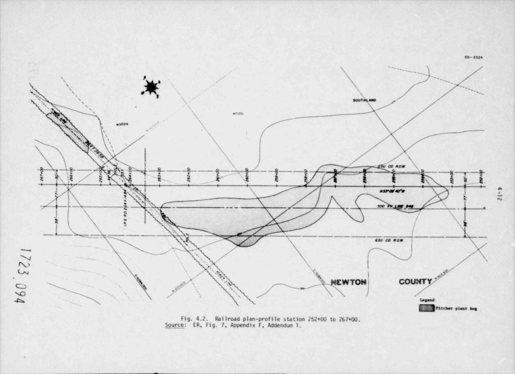
(5-5524
''....,,
' # / '' . ,.-
s v x \ ,,'-
's'
's, \s- /,Nssoutgano'
,.,
,% ys ._
'.... .e \
N \ .- \ -,
. N ,
, s
~
8) su ce now,
-Q
x i / $ pp%--8KM ' '''$x E l' ' \i E
8- s 4 -g- -8- -g-g/ I i a h4-
P- g -g-IE 3
| r_ __ _ **. .
, .
,
.t* g Ns
_1 % - ' ' x ___63V C0 R0W
G L' '_,'',/ %-
.
hy - '\ '
W_ ,.
'' '
' g,, 4'
,
7 N kO- %'
a .... . . . -Fig. 4.2. Railroad plan-profile station 252+00 to 267+00.
Source: ER, Fig. 7. Appendix F, Addendum 1.
.
4-13
Presently, the natural runoff system of the construction site dissipates runoff water accordingto the natural drainage system of the area. The applicant has presented an erosion control planof the construction site which would restrain excess erosion during construction activities andlater collect and channel off surface drainage into Copperas, !iitchell and Mill creeks (ER,Sect. 4.1.2) . It is the staff's position that this control plan is inadequate and may not be themost effective program to minimize the impacts of added sedimentation on the benthic and fish cor~munities in Copperas Mitchell, and Mill Creeks and :1111 Creek Bay in Toledo Bend Reservoir.
The above conclusions were based on the following factors:
1. The soils on the site environs are composed of easily erodible sand and clay particles.
2. For the site preparation, the entire ground cover will be removed, exposing the soil toerosion.
3. Presently, the streams may have a turbidity as high as 430 FTU, indicating high levelsof suspended solids and bed loadings at times of heavy rains.
Eventually, the added sediments from the Mill Creek watershed would be transported into liillCreek Bay where they could (1) increase turbidity and decrease primary production, (2) adverselyaf fect the benthic comunity, (3) adversely af fect the spawning grounds of centrarchids and otherfishes, and (4) decrease the water quality and storage volume of the bay area.
Therefore, the staff recommends that the erosion control program described in Sect. 4.1.2.2 ofthe Environtrental Report should be reviewed by the applicant in view of recognized good practiceat the time cf construction licensing. A revised program, which includes (1) graphic illustra-tions of the design and location of erosion control structures with appropriate topographic mapsand (2) a description of the temporal sequence of construction activities and the erosion controlmeasures associated with these activities shall be submitted to the staff at the ConstructionPermit stage of the licensing process.
A 1.2 km (0.74 mile) section of an unnamed tributary of |11tchell Creek will be rerouted as aresult of construction of the switchyard (ER, Vol. VI: Response to NRC Question 4.1.l(2),p. R-40). This tributary is an intermittent stream and does not maintain permanent aquaticfauaa. Atter the new course of this section has stabilized, similar fauna will develop. There-fare, it is the staff's opinion that the diversion of this stream section will represent ashort-term acceptable impact of construction.
4.3.2.2 Indian Creek Bay
The intake and discharge pipelines will cross Indian Creek Bay at the confluence of Indian Creekand Toledo Bend Reservoir. The construction activities associated with these structures will belocalized and short in duration (ER, Sec. 4.1.1.2) and will not create unacceptable environmentalimpacts on Indian Creek Bay.
4.3.2.3 Toledo Bend Reservoir
Dredging in Teledo Bend Reservoir will be required for the construction of the open water channeland the shoreline intake structure (ER, Fig. 3.4-2), and for the offshore discharge pipe anddiffuser ports. Dredging will be accomplished with a clam-shell or similar type dredge.Construction activities will disturb approximately 1B0 to 300 m (600 to 1000 ft) of shoreline.
l 3.n estimated total of 36,700 m (48,000 yd3) of naterial will be removed. Of this 36,700 m ,,,pproximately 82% or 30.127 m (39,400 yd') will be dredged from the reservoir (ER, Sect.3
4.1.1.2). Dredging associated with the construction of the intake channel and shoreline intakestructure will be accomplished between two rows of sheet pipings on either side of the dredgingarea, but open toward the reservoir. The dredge spoils from this activity will be removed to aspoil area located on the peninsula. Dredging associated with the construction of discharge pipeand diffuser ports will be accomplished without the protection of sheet piling or a cofferdam,and the dredged material will be deposited adjacent to the discharge pipe (ER, Sect. 4.1.1.2).
The applicant estimated that dredging and burial by submerged spoil deposition will result in2 (3.54 acres) of benthic habitat. with athe unavoidable destruction of approximately 14,326 m
mean number of 794 benthic organisms per m (Sec. 2.7.2.2 and ER, Table IV.13:2.1-IV.13:2.6),2
the staf f estimates that a total of 11.4 x 10⁶ benthic macroinvertebrates could be destroyed.The applicant has estimated that an additional 82.9 ha (205 acres) of benthic habitat couldpotential be affected by siltation from dredging. If 100% mortality of benthic organisms isassumed in this area, a total of 6.6 x 10⁹ benthic macroinvertebrates could be lost due todredging activities. If an area of 6.25 km2 (1544 acres) of the lower Toledo Bend Reservoir
1723 095
.
4 -14
is considered with a mean density of 794 organisms ;er m , the macroinvertebrate losses would2
constitute 13% of the organisms in the 6.25 km2 area. The majority of organisms which would belost are aquatic oligochaetes and dipteran larvae with some burrowing mayflies. Since thedredging operation and the associated siltation represent a one-time, short-term adverse environ-mental impact, and the benthic macroinvertebrate comunity would rapidly regenerate once construc-tion had ceased, these losses do not constitute an unacceptable impact.
The staff considers the environmental impacts resulting from the construction of the intake anddischarge structures acceptable due to thtiir localized effects and short-term duration. Thetemporary disturbance of benthic habitats and the one-time loss of benthic invertebrates fromthe dredged area do not constitute a significant loss.
4.3.2.4 Construction wastes
During site preparation and construction, a certain amount of solid and liquid waste will beproduced. The collection and disposal of these wastes are described in Sect. 4.1.2.3 of the ER.The staff reviewed these disposal methods and found them adequate and acceptable, providing allapplicable State and Federal standards are met.
4.4 COMMUNITY IMPACTS
In an Early Site Review, it is difficult to establish a fixed construction schedule. A favorablepartial initial decision would allow the applicant up to five years from the is:,uance date totender application for the Construction Permit. Accordingly, the analysis of comunity impactat this time is based on the assumption that construction of the twa units will take approximatelyeight years with the peak work force being required at some point in the mid-1980s. Because ofthe time sensitivity of some data, the applicant should update infomation as necessary whenapplying for the Construction Permits in order to allow evaluation of significant changes inthe area's social structure.
4.4.1 Population increase and estimates of numbers moving into the area
The size of the construction labor force, the number of workers moving to the region, and theirresidential distribution will be major deteminants of the magnitude of socioeconomic impact inthe Blue Hills region. The staff estimates that the likely range of regional population increasedue to the construction of the plant is between 6.013 and 10.585 persons. The major assumptionson which this estimata is based are: (1) a peak labor force of 3500 workers. (2) of this force651. or 2275 workers, will relocate in the region. (3) an average family size of 3.61 personsfor relocating construction workers and 3.22 persons for secondary workers, and (4) an employmentmultiplier of 0.8.
Recent estimates by the Tennessee Valley Authority indicate that construction forces in 1977 forsequentially constructed, two-unit pressurized water reactors of similar size as the proposedBlue Hills plant are peaking at approximately 2800 workers.ll This peak figure has been increas-ing at a rate of approximately 3% compounded annually over the past 8-10 years.ll If this trendcontinues and oeak construction occurs around 1985, the peak work force at that time will beabout 3500 construction workers.
The applicant has estiamted that 65% of the peak construction force will relocate in the BlueHills region. This estimate is a function of the number of workers presently residing in theregion to be hired for construction work and the ntnber who will comute on either a weekly o-daily basis from outside the region. The applicant has estimated on the basis of residence andcomuting patterns during construction of a steam-electric plant in Mt. Pleasant. Texas, andduring construction of the Toledo Bend Dam, that 25% of the total construction force will be com-posed of persons currently living in the region and that 10% will comute from outside the region.A study for the Old West Regional Commission 12 examined the numbers of relocating constructionworkers at 14 sites. The percentages rrnged from 2% to 90% with an average of 60% relocatingand 401 being hired locally. Given the results of the Old West study, the staff judges that theapplicant's estimate that 65% of the peak construction labor force will relocate is reasonable.
The Old West study also determined that the relocating construction workers with families hadfamily sizes of 3.61 persons.12 Construction worker families tend to be younger and larger thanthose for the population as a whole. The average family size for the secondary labor forceestimated by the applicant. 3.22. has been accepted by the staff in its calculations.
1723 096
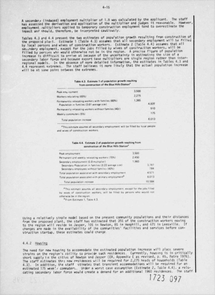
4-15
A secondary (induced) employment multiplier of 1.8 was calculated by the applicant. The staffhas assessed the derivation and application of the multiplier and judges it reasonable. However,employment nultipliers applied to temporary construction employment tend to overestimate theimpact anti should, therefore, be interpreted cautiously.
Tables 4.3 and 4.4 present the two estimates of population growth resulting from construction ofthe proposed plar.t. Estimate 1 (Table 4.3) assumes that all secondary employment will be filledby local persons and wives of construction workers. Estimate 2 (Table 4.4) assumes that allseundary employment, except for the jobs filled by wives of coristruction workers, will befilled by perscns w50 would otherwise not be in the region. A precise figure of populationincrease is difficult to arrive at because of the uncertainty in estimating the size of asecondary labor force and because export base multipliers are single region rather than inter-regional models, in the absence of more detailed information, the estimates in Tables 4.3 and4.4 represent extremes. The staff believes it more likely that the actual population increasewill be at some point between the extremes.
Table 4.3. E stimate 1 of populat:an growth resultmg
from construction of the Blue Hals Station *
Peak emo oyment 3,500
Workers retc.cating (65%) 2,275
Fermanentiv relocating worker, with families (60%) 1,365
Population m families (3.61 average size) 4,92f
Permar,ent:y ralocatmg workers without f amilies (40<) 910
175Weekly commuters 15%)
Total population increase 6,o13
*This estimate assumes all secondary employment wdl be fdled by local people
and wives of construction workers.
Table 4.4. Estimate 2 of population growth resultmg fromconstruction of the Blue Hills Station *
Peak employment 3JooPermanent and weekly reiocating workers (70%) 2,450
Secondary employment to.8 multipher) 1,960
Secondary Population m famil,es (3 22 average size) 3387Secondary employees without famihes (40%) 784
Total population associa ed with secondary employment 4.571hTotal population associated with primary employment 6 013
Total population increase 10.584
* This estimate assume, all secondary employment, except for the gobs f dledby wives of construction workers, wdl be felled by persons who wovId nototherwise be en the reg'on.
*From Estimate 1. Tabie 4 3.
Using a relatively simple model based on the present community populations and their distancesfrom the proposed plant, the staff has estimated that 35% of the construction workers movingto the region will reside in Jasper,10% in Newton, 8% in Hemphill, and 47% in Leesville. Ifchanges are made in the availability of the colmiunities' facilities and services before con-struction startup, these estimates could change.
4.4.2 Housing
The need for new housing to accommodate the estimated population increase will plact severestrains on the region's tbility to provide such residences. Currently, housing is in criticallyshort supply i n the cities of Newton snd Jasper (ER, Appendix E as revised, p. 65, Batra 1976).The staff eltimates thic new rasidences will be required for 2,275 heads of households (Table4.3). In addition, the staff stimates tnat transient accommodations will be required for anestimated 175 week', / commuters. Under a worst case assumption (Estimate 2, Table 4.4), a relo-cating secondary labor force would create a demand for an additional 1960 residences. The staff
1723 097
4-16
believes that this estimate represents an extreme case and that the secondary labor force willbe less than that estimated in Table 4.4 However, the staff judges that a demand for over2,275 residences will be created by construction of the proposed plant.
If construction of new housing lags behind the demand, it is likely that the contractor willpay wage incentives t o induce a larger nisnber of commuters. If this occurs, transient accommoda-tions in the recreational areas may be filled by weekly corinuters. This, in turn, would createan extreme shorta e of transient and recreational accocivadations (ER, Appendix E as revised,p. 65, Batra 1976 .
The staff believes that short-term housing needs will be met largely by mobile homes or otherprefabricated housing units, which will likely stimulate the development of trailee parks withinthe vicinity of the plant site. With few zoning ordinances relating to location of mobile homes(Sect. 2.8.2), it is possible that the wide spread, unplanned use of such housing may create anundesirable type of development in the area.
4.4.3 Sewe rage and water _
The applicant has stated that present sewage treatment capacities and water supplies for the com-munities of Jasper, Newton, and Hemphill are insufficient to accommor 3te projected populationincreases (ER, Sect. 8.2.2.1.5). The staff concurs with th7s assessmint but judges that becausemost relocating workers will reside in mobile homes, demands on public water and Jewerage willbe lessened. Private wells and septic tanks provide water and sewage creatment in many of thesubdivisions located along the Toledo Bend Reservoir (Sect. 2.8.4). ihe staff believes that theplanned expansion of these areas coupled with development of new trailer parks will attractworkers who otherwise would locate trailers along existing public water and sewerage lines.
4.4.4 Schools
Section 2.8.2 indicated that the majority of the School districts in the impact region are eitherat or near capacity. The applicant estimated that at peak construction there will be 1,011primary, 443 junior high, and 417 senior high students added to the schools' enrollments (ER,Appendix E as revised, Table 25, Batra 1976). Using these estimates, the staff calculated thenumber of school-age children under Estimates 1 and 2 (Tables 4.3 and 4.4) assuming that the sameratio of workers to school-aged children is maintained. Table 4.5 presents the staff's estimatednumber of additional school children. As indicated in Sect, a.4.1, the staff's estin.ates repre-sent extremes; the actual number of additional school children will probably fall somewherebetween these two extremes.
Table 4.5. Estimated additional school enrollment
Apphcant's Staff StaHEst. mate Estimate l' Estimate 118
Pnmary 1011 890 1567Juntor h,gh 443 390 687H<gh school 417 367 646
Total 1871 1647 2900
*See Table 4 3*See Table 4 4.
Jasper Independent School District is presently the only district in the area with significantcapacity for new enrollment. Any increased enrollment in the region's other school districtsmay result in either an exacerbation of presently overcrowded facilities or an increased likeli-hood of overcrowding those schools that a"e close to peak capacity.
4.4.5 Health care delivery
An increased population in the Blue Hills region will place greater demands on the regionalhealth care delivery system. The Deep East Texas Council of Governments Health Advisory Councilhas indicated that (1) there is a shortage of medical personnel; (2) the region's emergencymedical services are loosely coordinated systems with personnal and equipment that do not meetor only partially meet recocinended State standards; and (3) mental health services are presentlyinsufficient to meet the needs of the existing population.13
1723 098
4-17
The staff believes that the present health care delivery system in the Blue Hills region isinadequate to meet the expected population increase.
4.4.6 Highway system
Due to the heavy loads that will be carried by existing highways during construction, additionalcosts to the transportation system may accrue from structural damage - costs that may not beapparent for years ( ER, Appendix E, as revised, p. 84 Batra,1976). Commuters from Newton andHemphill will travel SH 87 exclusively. Commuters from Jasper and Leesville will travel SH 87,then will proceed east or west on SH 63. This comuting will increase congestion on these roadsand will cause bottlenecks fsr north-south traffic on SH 87 (ER, vol VI. Suppl. 3).
The Texas State Highway Department plans to improve SH 87 in the future. However, there arecurrently no plans to implement these improvements. Funds have been allocated for an extensionof Farm-to-Market 255 west from SH 87 to intersect US 96 about 17.6 km (11 miles) north ofJasper (ER, Suppl. 5). Completion of this new portion of FM 255 in 1980 could lessen the trafficon SH 87 by as much as one third.
4.4.7 Phpical impactsh
The construction of tha Blue Hills plant will necessitate the purchase of 1221 ha (3016 acres)for the site and 1741 ha (4300 acres) for the tr?nsmission corridors. Most of this land is inmarketable timber. The region will sustain a maxfmum loss of approximately $5 million over thelife of the plant by withholding this ti.2erland from production (ER, Appendix E).
Site preparatioa. increased traffic, and actual construction will produce a noise level thatpersons living in the vicinity might find objectionable. However, in 1970 there was no oneliving within a 1.6-km (1-mile) radius of the site and only 5 persons within a 3.2-km (2-mile)radius of the site (Sect. 2.8.1). Monitoring locations for site preparation- and excavation-related noise level within 3.2 km (2 miles) of the site fall within the HUD "normally acceptable"range (45-65 dBa) or below. Five of six monitoring points for intake structure constructionnoise fall within the "normally unacceptable" (65-75 dBa) or " unacceptable" (>75 dBa) ranges.This noise is produced by pile driving and dredging operations. At a distance of 1500 m(5000 f t), noise level from pipeline construction falls within the " acceptable" range (<45 dBa).At closer distances [30 to 100 m (100 to 350 ft)], this noise level falls into the "normallyunacceptable" or " unacceptable" ranges (ER, Tables 4.i-0, 4, 5, 6).
4.4.8 Recreation
Section 2.8.4 described recreational resources in the immt area. Although complete userstatistics for the various parks, marinas, boat ramps, motels, and camping facilities are notavailable, the staff believes that the numerous recreational sites presently available and thoseplanned for the area (Fig. 2.9) indicate that impact on recreadon resources will be minimal.However, as indicated in Sect. 4.4.2, should incentives be offere:i that induce more workers tocomute, transient accomodations along the Toledo Bend Reservoir my be filled by constructionworkers, creating a shortage for others using the area's recreationti resources during theconstruction period.
4.4.9 Public protection
The police and fire departments in the Blue Hills region will 111ely require expansion in per-sonnel as a result of the increased population. Based on a recommended 1.5 officers per 1000people," tha Jasper police and sheriff's departments will require expansion. If, as the appli-
cant has estimated, mobile-home parks are constructed in outlying areas near the plant site, thepolice and fire departments of Hemphill and Newton will likely require expansion as well.
4.4.10 Stimulation of local and regional economies
4.4.10.1 Increases in regional income
The applicant has estimated that an unskilled construction worker will earn $12,540 annually in1978 and skilled workers will average $22,240 per year in 1978. The applicant has furtherestimated that the average wage of all manual workers will be $15,500 annually, assuming that70% of the construction workers are unskilled or semi-skilled (ER, Appendix E as revised, p. 25,Batra1976).
1723 099,
4-18
Regional income will increase dramatically with peak construction employment and then dropsignificantly as construction of the plant is completed. The applicant estimated that regionalpopulation would increase by 6828 persons at peak construction, resulting in regional incomeincreases of $54,772,500. Using the population estimates derived in Tables 4.3 and 4.4, thestaff calculated that increase in regional income will ran3e from $48,234,775 to $84,910,210under Estimates 1 and 2 respectively. These amounts represent an increase of 341 and 59%,,espectively, over 1970 levels ($143 million). This substantial increase will fall to about$10.2 million annually for the entire 12-county East Texas region after construction is completed.The staff's estimates of increased regional income asswie that the ratio of increased populationto increased regional income is the same as that calculated by the applicant.
4.4.10.2 Local purchases of materials
With the exception of some tools, automotive parts, and office supplies, the applicant has statedthat construction of the proposed plant will not involve sigrificant expenditures for local mate- |rials (ER, Appendix E, as revised, p. 44. Batra, 1976). I
4.4.10.3 Retail sales increase
On the basis of the applicant's estimated population increase of 6,828, retail sales in theBlue Hills area were estimated to increase by $21 million at peak construction (ER, Appendix Eas revised, p. 31, Batra 1976). The staff has estimated that population increase in the areawill range from 6,013 persons to 10.585 persons (Tables 4.3 and 4.4). Assuming that the sameratio of population increase to retail sales is maintained, the staff estimates that retailsales increase will range from $18,493,409 to $32.554,920. For reasons presented in Sect. 4.4.1,the 5 taff believes the actual increase in retail sales will be at some point within this range.
4.4.10.4 Taxes
The construction of the Blue Hills plant will increase Newton County's gross property value. In1970, this county had an assessed valuation of $19,194,579. The undepreciated value of the BlueHills plant in 1986 will add about $1 billion to the county's gross property value (ER, AppendixE, as revised, p. 45, Batra 1976). Based on a 29% assessment ratio the Blue Hills plant couldbe assessed at $300 million. Taxing jurisdictions within Newton County will receive allproperty tax revenues generated by the proposed plant. The revenues to be derived from theplant under current tax rates will exceed total current county expenditures (ER, Appendix E,as revised, p. 45 Batra 1976).
Four types of taxes will be levied on the Blue Hills plant: (1) county ad valorem, (2) state advalorem, (3) special road tax, and (4) school tax. The county ad valorem, the state ad valorem,and the special road taxes are based on a 291 assessment ratio, with rates of $1.00, $0.12, and$0.30, respectively, per $100 assessed. The school tax rate is $1.69/$100 based on an assessmentratio of 45%. Table 4.6 presents the tax revenues that will be paid by the Blue Hills plant.
The distribution of tax revenues varies with the type of tax. County and state ad valorem taxesand the spe:ial road tax are collected on a county basis. State ad valorem revenues are earmarkedfor a college building fund, and no portion is returned to the county. The special road taxrevenues are divided evenly between county rights-of-way purchases and the County RoadCorr 11st toner.
The plant will be located in the Burkeville Independent School District and all school taxrevenues remain in that district.
The applicant has estimated that, if the 4% state sales tax on construction materials is leviedat the plant site, it will yield a total of $16.59 million. These revenues would go into' ageneral state fund and no portion would be returned to the county.
Other conmunities in the area will receive new revenues from the additional population residingor doing business in their jurisdictions; however, it appears that the revenues received maynot equal the costs that will likely accrue to these communities. Because of the large numberof relocating workers expected to live in mobile homes, property tax revenues from these workerswill be relatively small (mobile homes in the region are presently assessed at approximately$500). Increasing sewage treatment capacity, increasing water supplies, expansion of schools,and additions to police and fire departments will require capital outlays by the cormunities.The staff concurs with the applicant's assessment that demands for public services for the newpopulation may require tax rate increases in some areas for specific services (ER, Appendix E,as revised, p. 57 Batra 1976).
1723 M
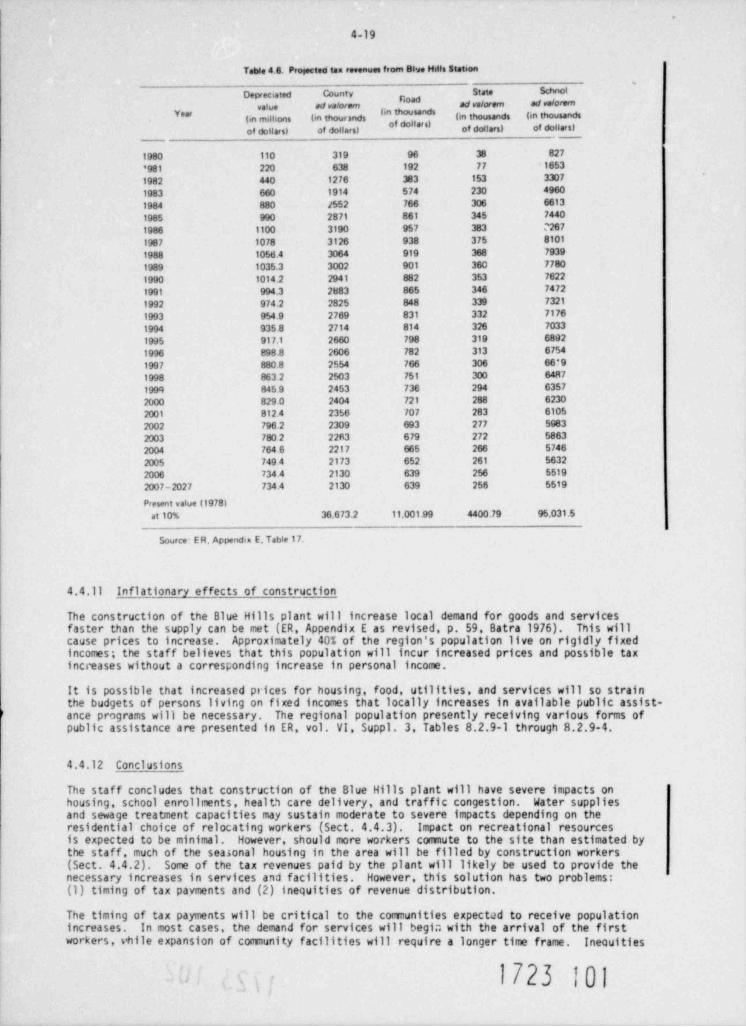
.
4 19
Table 4.6. Progected tan revenues from Blwe Hills stat 6on'
Depreciated County state Schnot
value ad valorem ad valorem ad valorem
(in milhons (in thourands (in thousands (in thousands
of dollars) of dollars) of dollars) of dollars)
1980 110 319 96 38 827
'981 220 638 192 77 1653
1982 440 1276 383 153 3307
1983 660 1914 574 230 4960
1984 880 /552 766 306 6613
1985 990 2871 861 345 7440
1986 1100 3190 957 383 M67
1987 1078 3126 938 375 8101
1988 1o56 4 3064 919 368 7939
1989 1035.3 3002 901 360 7780
1990 1014.2 2941 882 353 7622
1991 994.3 2883 865 346 7472
1992 974.2 2825 848 339 7321
1993 954.9 2769 831 332 7176
1994 935.8 2714 814 326 7033
1995 917.1 2660 798 319 6892
1996 898.8 2606 782 313 6754
1997 880 8 2554 766 306 66*9
1998 863 2 2503 751 300 64R7
1999 845.9 2453 736 294 6357
2000 8290 2404 721 288 6230
2001 812.4 2356 707 283 6105
2002 796.2 2309 693 277 5983
2003 780.2 22fi3 679 272 5863
2004 764 6 2217 665 266 5746
2005 749.4 2173 652 261 5632
2006 734.4 2130 639 256 5519
2007-2027 734.4 2130 639 256 5519
Present value (1978)at 10% 36.673.2 11.001.99 4400.79 95,031.5
Source E R. Appendix E. Table 17.
4.4.11 Inflationary effects of construction
The construction of the Blue Hills plant will increase local demand for goods and servicesfaster than the supply can be met (ER, Appendix E as revised, p. 59, Batra 1976). This willcause prices to increase. Approximately 40% of the region's population live on rigidly fixedincomes; the staff believes that this population will incur increased prices and possible taxincreases without a corresponding increase in personal income.
It is possible that increased ptices for housing, food, utilities, and services will so strainthe budgets of persons living on fixed incomes that locally increases in available public assist-ance programs will be necessary. The regional population presently receiving various forms ofpublic assistance are presented in ER, vol. VI, Suppl. 3. Tables 8.2.9-1 through 8.2.9-4.
4.4.12 Conclusions
The staff concludes that construction of the Blue Hills plant will have severe impacts onhousing, school enrollments, health care delivery, and traffic congestion. Water suppliesand sewage treatment capacities may sustain moderate to severe impacts depending on theresidential choice of relocating workers (Sect. 4.4.3). Impact on recreational resourcesis expected to be minimal. However, should more workers commute to the site than estimated bythe staff, much of the seasonal housing in the area will be filled by construction workers(Sect. 4.4.2). Some of the tax revenues paid by the plant will likely be used to provide thenecessary increases in services and facilities. However, this solution has two problems:(1) timing of tax payments and (2) inequities of revenue distribution.
The timing of tax payments will be critical to the communities expectJd to receive populationincreases. In most cases, the demand for services will begi;; with the arrival of the firstworkers, vhile expansion of community facilities will require a longer time frame. Inequities
1723 101. .
4-20
of revenue distribution will occur because Newton County will receive all property tax revenues |from the Blue Hills p lant, but other area comunities must bear the costs of providing servicesfor some of the increased population. Within Newton County, the Burkeville School Districtwill receive all the school tax revenues, even though students will attend schools 1n thecounty's other two school districts. These inequities . vill probably result in increased usercharges or tax rates for other areas.
Cessation of large construction projects can result in varying degrees of economic dislocationto an area, especially if a previously underdeveloped comercial and service structure is expandedto meet the requirements of a large, short-term population influx. The loss of constructionemployment in the Blue Hills region will induce a decline in demand for most regional services.There will be an excess supply of housing and public services, causing rental values and housingprices to decline for a few years (ER, Appendix E as revised, p. 89, Batra 1976). Unless newindustry is attrected to the area as construction is completed, the large number of workerswho relocated to the region will be unemployed and likely to leave the area.
The severity of socioeconomic impacts in the Blue Hills region may be mitigated to some degree byprior planning in the communities. Since an early site reviev provides an extended timeframebefore construction actually begins, early planning and negotiations among the local comunities,regional planning officials, and the applicant could lead to measures that would minimize muchof t he adverse ei'fect of cunstructing the plant. Because the four-county impact area involvesboth Louisiana and Texas, this planning will require considerable cooperative efforts.
4.5 MEASURES AND CONTROLS TO LIMIT ADVERSE EFFECTS DURING CONSTRUCTION
4.5.1 Applicant's cqmitments
The following is a summary of the commitments made by the applicant to limit adverse effectsduring construction of the proposed plant.
1. Marketable timber will be removed from the site, and remaining trees and brush will becleared and either used for erosion control or burned. All burning will be in accordancewith State and Federal regulations. Tree stumps and other organics not burned will beburied under adjacent waste areas (ER, Sect. 4.1.1.1, Fig. 4.1-1).
Along rights-of-way, tree stumps and organic material will be sold, burned on the right-of-way, or buried within the right-of-way (ER, Sect. 4.1.1.1).
2. Soil excavated from borrow areas that is unsuitable for fill will be deposited in designatedwaste areas, and sone topsoil will be set aside for restoration of the borrow areas af terconstruction is completed (ER, Sect. 4.1.1.2, Fig. 4.1-1). Tops of borrow areas will becovered with stored topsoil and then planted with slash and loblolly pines (ER, Sect.4.1.1.3).
3. Fordable streams will have shell or gravel placed in the stream bed; other streams willhave temporary bridges or culverts installed during construction (ER, Sect. 4.1.1.2).
4. The amount of spoil drif ting from the dredging for the makeup intake and discharge struc-tures will be limited to approximately 1% of the total spoil dug from the bottom. Shore-line vegetation will not be disturbed except where it is necessary to gain access to thereservoir (ER, Sect. 4.1.1.2).
5. To minimize disturbance to the reservoir, excavation and construction of the makeup intakestructure will take place behind a sheet piling wall. Excavated and dredged material fromconstruction of the makeup intake and makeup channel will be removed to a spoil area on thepeninsula; material dredged for the discharge pipe will be deposited adjacent to the dis-charge pipe (ER, Sect. 4.1.1.2, Fig. 4.1-1).
6. No explosives will be used in site excavations (ER, Sect. 4.1.1.2).
7. Temporary construction facilities will be removed when construction is completed and theseareas will be paved, seeded, sodded, and/or planted according to a prescribed plan (ER,Sect. 4.1.1. 3, Table 4.1-1, Fig. 4.1-1).
When no longer in use, temporary construction roads will be disked, scarified, and seeded,and the slope intersections will ba rounded to minimize erosion and provide a naturalappearance (side slopes in borrow and waste areas will receive similar treatment). Allrestored areas will be graded to prevent accumulation of standing water (ER, Sect. 4.1.1.3).
1723 W
4-21
8. Femanent lawn areas will be planted as soon as feasible (ER, Sect. 4.1.1.3).
9. A natural border along the periphery of the cleared plant site will be encouraged by allow-ing natural reseeding and by planting indigenous vegetation (ER, Sect. 4.1.1.3).
10. Dust will be controlled during site preparation and construction through the use of watertrucks, sprinkler systems, and chraicals such as Soil Penetrant 400, EARTH-PAK, and COHEREX(ER, Sect. 4.1.2.1).
11. Erosion control will include e,rading, placement of slash in draws and water courses adjacentto cleared areas, and protection of slopes using peripheral interception ditches, catchbasins, and drop pipes equipped with energy dissipators. Additionally, slopes will betreated using chemical soll binders (e.g., Aerospray 52 Binder or Curasol AE) and thenmulched and seeded (ER, Sect. 4.1.2.2, Fig. 4.1 4).
12. During construction, wastes from portable themical toilets will be transported offsite forproper disposal. Wastes 6 a permanent toilet and wash facilities will be processed in asewage treatment plant; ali treatment plant discharges will meet applicable State andFederal standards (ER, Sect. 4.1.2.3).
13. Floor drain effluent f rom shop facilities will be discharged into the storm drain system(ER, Sect.4.1.2.3).
14. Petroleum product wastes will be collected and removed from the site (ER, Sect. 4.1.2.3).Waste interceptors will be provided to remove construction wastes (e.g., oils, greases,paints, or solvents) and minimize the impact on neighboring surface waters (ER, Sect.4.1. 4.1 ) .
15. Wash water from the batch plant and from concrete trucks will be discharged into a speciallyconstructed ditch, where cement particles can settle out before the water spills into aberm-enclosed waste area that serves as an evaporation-absorption field. Af ter completionof the power plant, the earth berm will be graded to the elevation of the waste area. Wasteloads of concrete will be dumped at a designated waste area (ER, Sect. 4.1.2.3, Fig. 4.1-1).
16. Controlled spray of herbicides (e.g., Bromacil or Monuron) will be used to inhibit regrowthof vegetation on shelled and paved areas onsite (ER, Sect. 4.1.2.4.1). Application rates
of herbicides and pesticides will be such that concentrations in the stream systems willnot exceed Texas Water Quality Board requirements; aquatic concentrations will be monitoredat the U.S. Geological Survey Cauging Station on Mill Creek (ER, Sect. 4.1.4.3).
Pest control, when necessary, will include localized controlled application of a short-lived malathion class of compound (malathion, parathion. EPN) for insects and will alsoinclude poison baits (e.g., Pyralin or Fumasol) for rats and mice (ER, Sect. 4.1.2.4.2).
17. Combustible construction wastes will be burned, and noncombustible wastes will be disposedof within the borrow area by landfill methods; both operations will meet applicable Stateand Federal regulations (ER, Sect. 4.1.2.4.3).
18. Noise-reducing apparatus for construction equipment will comply with Federal and industrialstandards (ER, Sect. 4.1.2.4.4).
19. During construction, ef fluent f rom the sewage treatment plant will be discharged into aleaching field to prevent as many of the nutri,ents as possible from reaching the streams(ER, Sect. 4.1.4.2).
20. Effects of siltation upon the creek systems will be minimized through extensive erosioncontrol efforts (ER, Sect. 4.1.4.5).
21. No historical landnarks or archaeological sites within the plant site and within an 8-km(5-mile) radius of the plant site will be disturbed by construction of the station. Anyarchaeological site that is endangered by transmission line construction will be reexaminedand tested (ER, Sect. 4.1.5.1).
22. Where a residential or recreational area is serviced by a single ruau and this road isobstructed by construction activities, an alternate access route will be provided (ER,Sect.4.1.5.3).
23. Existing roads will be used for access to the transmission corridors (ER, Sect. 4.2.1.2).
1723 103
4-22
24. Onsite construction activities will not affect 6.1 ha (15.1 acres) of red-cockaded wood- Jpecker nesting (inactive) and roosting sites that occur on Gulf States Utilities property 3
(ER, Appendix F. Sect. !!!.6:2.1.2; Table III.6:8). A forest management plan that will linclude consideration of the red-cockaded woodpecker w1;l be submitted with the ConstruttionPennit application (Gulf States Utilities, " Responses to Agency Coninents on the Blue HillsStation, DES." September 30,1977).
25. An effort will be made to minimize or avoid disturbance of bog consnunities within theproposed corric*or for the railroad spur and transmission line C (Gulf States Utilities," Responses to Agency Consnents on the Blue Hills Station DES." September 30,1977). Thiseffort may include, but is not limited to, the procedures described in Sect. 4.3.1.2.
4.5,2 Staff's evaluation
Based on a review of the anticipated construction activities and their expected environmentaleffects, the staff concludes that the measures and controls proposed by the applicant as sum-marized above are not completely adequate to ensure that adverse environmental effects will beat a minimum practical level. The staff reconinends that the following additional responsibili-ties be included in the measures and controls program undertaken by the applicant. Certain ofthese will be re-reviewed during the Construction Pennit stage.
1. The applicant will submit a detailed erosion control program prior to construction licensing.This program should ensure that control actions are adjusted to meet any changes in erosionpatterns and that the required water quality standards are met at all times during theconstruction period.
2. If it becomes necessary to use pesticides (Sect. 4.3.1.1), the staff recorynends strictlycontrolled use of a low-persistence pesticide (e.g., malathion). Application should be Imade by a licensed operator; appropriate State and Federal regulations should be followed. I
3. If the applicant decides to use any pesticides or herbicides in right-of-way maintenanceprior to tt J issuance of the Construction Permit, a full description of the treatmentprogram must be submitted for staff review and approval.
4. The applicant should begin early planning negotiations with local officials and regionalplanners to discuss methods of limiting the adverse impacts that are likely to occur asa result of plant construction. Local items for discussion could include, for example,planning and mitigation funds, provisions for planning expertise, development of mobilehome zoning ordinances, prepayment of taxes, and incentives for workers to commute greaterdistances. In addition the staff believes that these negotiations should consider publicuse where possible of the open space used for this project. The applicant shall submita discussion of his, activities carried out under this item and the results of theseactivities for staff review at the time a Construction Permit epplication is filed.
5. Instead of the use of poison baits to control rats and mice, traps should be used tocontrol problem rodents.
6. The applicant shall not disturb any archaeological site or locality or any historical sitewithout prior approval from the staff. Should any additional archaeological discoveriesbe made either on the plant site or within the rights-of-way, the applicant shall notifythe staff inunediately. The staff recocunends that the four localities identified inSect. 2.9.2 be posted and that an onsite archaeologist be avilable when these sites are indanger of being disturbed unless the State Historic Preservation Officer determines thatthese localities do not meet the criteria in the National Register of Historic Places(Addendum 2) for inclusion in the Register.
7. To ensure continued and adequate protection of endangered species during additionaldevelopment phases of the proposed facility, the applicant should maintain consultationswith the U.S. Fish and Wildlife Service.
8. Outdoor bu ming, construction activity, and application for permits shall be accomplishedin accordance with the Texas Clean Air Act and the Rules and Regulations of the Texas AirControl Board.
9. Construction activity on the right-of-way for the proposed transmission line A should becarefully monitored by a biologist to ensure that areas with red-cockaded woodpeckernesting or roosting trees are not destroyed. Likewise, on proposed routes B and C, carefulinvestigation should be made for nest and roost trees and areas with active red-cockadedwoodpecker colony use, and these areas should be avoided (Sect. 4.3.1.2).
1723 1D4.
4 23
10. Should any land within the Gulf States Utilities boundary (Fig. 4.1) be deemed surplusand considered for sale by the applicant, a resurvey of these areas should be conductedto detemine the presence of any red-cockaded woodpecker roosting or nesting trees, and amanagement plan for the species should be submitted fc,r staf f evaluation and approval( Sec t . 4. 3.1.1 ) .
Interior a plan acceptable to the NationalThe opplicant shall submit to the Department ot11.Park Service that describes the rrethods of mitigating the environmental impact of crosstngthe Big Thicket National Preserve along transriission lir.e B.
REFERENCES FOR SECTION 4
1. C. A. McLeod, As Bly Micket of East Tcras, Sam Houston Press, Huntsville, Tex.,1967.
2. L. L. Glasgow and R. E. Noble, "The Importance of Bottomland Hardwoods to Wildlife,"pp. 30-43 in Prx. fyr. Scatheast Hardmods, USDA Forest Service. Atlanta, Ga. ,1971.
3. D. W. Lay and W. F. Taylor, " Wildlife Aspects of Cutover Pine Woodland in Eastern Texas,"J. For. 41: 446-448 (1943).
4 D. W. Lay, azil xznaput N2niock for East Texas, Bulletin 34. Texas Parks and WildlifeDept., Austin, Tex., 1954.
5. D. Lay and D. Swepton, ne Red-Cxk2ded voc4ceker, Texas Parks and Wildlife Dept., Austin,Tex., 1975.
6. D. Lay, Aed-cmkall W;oteaker study, Job No.10, Fed. A!d Proj. No. W-80-R-16, JobCompletion Report Texas Parks and Wildlife Dept., Austin, Tex.,1973.
7. J. D. Ligon, " Behavior and Breeding Biology of the Red-Cockaded Woodpecker," Auk 87:255-278 (1970).
8. U.S. Forest Service, Saline Unit Pl2n Pmft Enviramenta! Statement, USDA-fs-R8 DESADM 76-18, Lufkin Texas (June 1976).
9. J. H . Stoeckeler, " Drainage along Swamp Forest Roads: Lessons from Northern Euiope,".7. Ec e. 63: 772-776 (1965).
10. L. K. Halls and R. Alcaniz, " Browse Plant Yield Best in Forest Openings," J. uildl. Manaje.32: 125-186 (1968).
11. William R. Schriver, Coordinator, Federal Interagency Construction Task Force: EnergySector, personal communication with Tadlock Cowan, April 4, 1977.
12. Mountain West Research, Inc. , Re Constructien Worker Profile, Finzl Report, prepared forthe Old West Regional Commission, Denver, Colorado, December 1975.
13. Deep East Texas Council of Governments: Health Advisory Council, Rejianal Health ObjectivesF!an, 1974, p. III-I.
14. Joshua H. Vogul, lulice Stations: Planniny and Spe3ffications, University of Washington,Bureau of Governmental Research and Services, Seattle,1954. Cited in Directorate ofLicensing, U.S. , Mzrble Hill .% ?! car Genemtiy Station, Final En>iromental St ztement.
1723 105
4-24
REFERENCES FOR SECTION 4
1. C. A. McLeod, The Big Thioket of East Tczas, Sam Houston Press, Huntsville, Tex.,1967.
2. L. L. Glasgow and R. E. Noble, "The Importance of Bottomland Hardwoods to Wildlife,"pp. 30-43 in Proo. Syep. Southeast #2nd.vods, USDA Forest Service, Atlanta, Ga.,1971.
3. D. W. Lay and W. P. Taylor '' Wildlife Aspects of Cutover Pine Woodland in Eastern Texas "J. For. 41: 446-448(1943).
4. D. W. Lay, Q22il #2nagemnt Handbook for East Tex 2a, Bulletin 34. Texas Parks and WildlifeDept. , Aus tin, Tex. ,1954.
5. D. Lay and D. Swepton, The Red-cookahd voo4eaker, Texas Parks and Wildlife Dept., Austin,Tex., 1975.
6. D. Lay, Red-cockaded Foodpcoker Stub, Job No.10. Fed. Aid Proj. No. W-80-R-16 JobCompletion Report. Texas Parks and Wildlife Dept., Austin, Tex.,1973.
7. J. D. Li on, " Behavior and Breeding Biology of the Red-Cockaded Woodpecker," Auk 87:255-278 1970).
8. U.S. Forest Service, Sabine Unit Plan Draft Envircrv ental Statement, USDA-fs-R8 DES|ADM 76-18, Lufkin. Texas (June 1976).
9. J. H. Stoeckeler, " Drainage along Swamp Forest Roads: Lessons from Northarn Europe,"J. For. 63: 772-776 (1965).
10. L. K. Halls and R. Alcaniz, " Browse Plant Yield Best in Forest Openings," J. vildl. Manage.32: 125-186 (1968).
11. William R. Schriver, Coordinator, Federal Interagency Construction Task Force: EnergySector, personal communication with Tadlock Cowan, April 4,1977,
12. Mountain West Research, Inc. , The Construction vorkar Profile, Final Repor* Jrepared forthe Old West Regional Commission, Denver, Colorado December 1975
13. Deep East Texas Council of Governments: Health Advisory Council, Regional Health Ob.fectivesPlan, 1974, p. 111-1,
14. Joshua H. Vogul, Polias Stations: Planning 2nd speaffications, University of Washington,Bureau of Governmental Research and Services, Seattle,1954. Cited in Directorate ofLicensing, U.S., Marble Hill Nuclear Generating St2 tion, Final Environmental Statement.
1723 106
.
5. ENVIRONMENTAL IMPACTS OF PLANT OPERATION
5.1 LAND USE
5.1.1 Station operation
The Blue Hills Station will require the acquistion of approximately 1220 ha (3016 acres) ofmostly forested land. About 12% (148 ha or 366 acres) of this land will be altered from itspresent use (i.e., timber managenent), including about 50 ha (123 acres) that will be lostto other uses during the operational lifetime of the plant (Table 4.1). Land use is furtherdiscussed in Sects. 2.2.2 ans 4.1. It is the staff's opinion that the removal of this amountof land from present land use practices will not have a significant effect because it representsonly a small fraction of the available land of this type within Newton County and more generallywithin the larger surrounding multicounty area.
Drif t resulting from operation of the mechanical-draf t cooling towers contains dissolved andsuspended salts that will be deposited on the landscape in a pattern dependent upon the pre-vailing meteorological conditions (Sect. 5.3.1.2). Land use impacts from this drift depositionon vegetation are expected to be minimal (Sect. 5.5.1.1). The staff's analysis shows no addi-tional ground-level fogging or icing due to the cooling tower operation (Sect. 5.3.1.2). Duringcertain weather conditions, the cooling tower plume will be visible for several kilometers.The nearest airports, located at Newton (public) 27 km (17 miles) sou' ,, and at Scrappin' Valley(private) 16 km (10 miles) west-southwest of the site, are not expected to be adversely affectedby the plumes.
5.1. 2 Transmission lines
Operation of the proposed electrical transmission system will require the periodic maintenanceof 317 km (197 miles) of 500-kV transmission line rights-of-way. Existing rights-of-way willbe paralleled for 52% of the total length. The 1740 ha (4300 acres) of new land required ispresently about 911 forested and will be replaced and maintained in a grass, herbaceous, andwoody shrub stage by a three- to five-year mowing cycle. The amount and use of land is not |expected to affect overall land use in the area significantly. Grazing, farming, and |recreational land crossed by the transmission lines will remain available for their respective
Certain species of wildlife may benefit from the increase in forest openings, whileuses.habitat for forest-restricted species will be wghtly reduced.
The proposed transmission line Route B will cross one homesite west of Newton (ER, Fig. 3.9-3).By following existing pipeline or transmission line rights-of-way, proposed Route C will requirerelocation of a skeet range near State FM 255 and three improvements, including a church, anunoccupied house, and an occupied house (ER, Fig. 3.9-6,3.9-8). It also crosses a woodlandnature trail west of Corrigan. Near the Rivtrin substation this route traverses a recreationalor potential rcsidential area near White Rock Creek and passes near the Lake Livingston Recrea-tional Area and an adjacent small commercial development (ER, Fig. 3.9-9). To minimize visualimpacts no tower will be located within 30.5 m (100 f t) of a public road or stream. Screens ofnatural growth or plantings of low growing shrubs will be used to shield downline views of thetransmission line. These measures are expected to make visual impacts of the transmission linessmall and accept *le. However, land use is likely to change prior to final corridor alignmentand construction, and reassessment of the routes will be required at the time the ConstructionPermit application is submitted (Sect. 10.5(12)).
5.2 WATER USE
5.2.1 Surface water
Evaporation and drif t losses from the nuclear service and balance-of-plant cooling towers willconsume a maximum of 1.48 m /sec (23,436 gpm) of water from the Toledo Bend Reservoir (see Fig.3
3.2), which represents less than 1.5% of the average yearly discharge (2,424,000 acre-ft per year)through the reservoir dam during 1966-1972. In the staff's judgement, loss of reservoir water atthis rate is not expected to affect any other reservoir-water usage. Although there will be
5-1
1723 107
5-2
chemical discharges, the staff also does not expect the discharges from the station to thereservoir to significantly affect any recreational or consumptive uses of the Toledo BendReservoir or Icwer Sabina River Basin. Tha analyes supporting this conclusion are given inSect. 5.3.
5.2.2 Groundwater
Since the proposed Blue Hills Station is located in a remote area and there are no majorgroundwater users near the site, changes in groundwater quality and availability due toplant operation are not anticipated. Wells are not contemplated for use during plantoperation; therefore, the wells used for construction water supply will be capped. However,these wells could be used for potable water consumption and demineralized water makeup. Ifso, the maximum usage would be 0.04 m /sec (600 gpm). Usage at this rate is not expected to3
significantly affect other groundwater usage in the area.
5.3 HEAT DISSIFATION SYSTEM
The heat dissipation system, described in Sect. 3.4, will consist of a closed-loop coolingsystem with mechanical-draf t cooling towers. At full rated load, this system will be requiredto dissipate about 3832 MWt (1.31 x 10W Btu /hr) of waste heat, of which a maximum of 14 MWt(less than 1%) will be released to the Toledo Bend Reservoir as cooling tower blowdown, andthe remaining 99% of the waste heat will be dissipated to the atmosphere. The environmentaleffects of operation of this system will be those associated with cooling tower blowdown(thermal and chemical ef fluents discharged to the reservoir) and cooiing tower effects (suchas drift deposition and ground-level fogging and icing).
5.3.1 Cooling tower effects
Mechanical-draft cooling towers rely primarily on the evaporation of water to dissipate wasteheat. Approximately 80% of the heat is dissipated by evaporation and the remainder is dissi-psted by sensible heat transfer. Therefore, large quantities of water vapor and heat aredischarged to the atmosphere. Because of the momenttri and buoyancy of the exiting air (saturated,in most cases), the plume will rise and entrain the cooler ambient air. It may become supersatu-rated (depending upon meteoroglical conditions), and the excess moisture become condensed,forming a visible cloud-like plume. Propagation of the plume is dependent primarily on theprevailing meteorological conditions. Also, a strall fraction of the cooling tower water (0.005%in this case) containing concentrated salts will be carried into the plume as a mist of waterdroplets called "drif t." As the droplets evaporate, the salts of dissolved solids will concen-trate, and, if evaporation is complete, can remain airborne as dust-like residue. Some of thedrif t will fall to the ground within a few thousand feet of the towers, and the remaining drif tand residue will be dispersed by the wind and eventually returned to the ground.
5.3.1.1 Applicant's analysis
The applicant investigated the environmental impact of an earlier cooling tower design. Thesystem consisted of rectangular towers (ER, Appendix B. Table 4.1) with cells aligned alongthe length of the tower instead of round towers with clustered fan arrangements. The majordifference between the designs is that rectangular towers are sensitive to wind direction,whereas round towers are not. Whenever the rectangular towers are oriented perpendicularto the oncoming wind, a potential exists for recirculation (or downwash) of warm, moist airdischarged from the tower because of the low pressure zone in the wake of the towers. However,the round towers have more of an aerodynamic shape which tends to reduce the zone of separation(low pressure zone) that exists downstream of an object in the wind. This phenomenon improvesthe recirculation characteristics of the tower, thereby entraining less warm plume air thanthe rectangular tower and enhancing tower performance. Also, multiple round towers with theclustered cell arrangement have been found to give a much greater plume rise.1 Each towerreinforces the other, which, in turn, enhances the plume rise. This phenomenon can also occurin a system of rectangular towers, provided that the configuration is optimum with respect tothe direction of the oncoming winds. Therefore, the applicant's estimates of drif t depositionand ground-level fog occurrence for the earlier design (system of rectangular towers) Can beapplied to the final design, but the impact is expected to be less severe.
Figures 5.1 and 5.2 contain the results of the applicant's investigation (performed by NUSCorporation) of the cooling tower effects. These results were obtained from the meteorologicaldata recorded during the period January 1953 through January 1956 in the Lake Charles and
1723 108
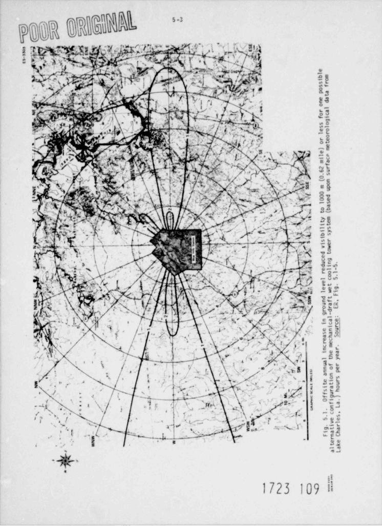
pggg Bhb"
'g:W9fg mgy ggg'n?@- Qg. cN d6 m.qw r o , r..w.
.
. . , . .-
| |. s;?,gy :. G m ,.n u
y ,fh f b h h )jp ,
h .h;h
.y _ . :.1 yM
i~I r 'r . . , ss ,. ,, A,5 <g;,,,m(m. r, ,,. w.n. e-
;,' s
- -
7. u .e' .7 E7 g. g+ .. - . -- . ,.,. .. . .
-.
- y ~
. .. ;9.- -
.t . . - . --
,
/. -
r',% y._ . ,
'geh ,cn ) T.' y -i--w4 m c .- w e
.$+A,
v :.' d4's(- r (.~D .. s
m,' ,
Y ' 'M _i ON . , uw. "g
aj *'-c .x. M,e
f' 8h m. .[ , ,( =>> .
:., ,. ; ,8*/''
. . . ., ,,
s'. c'*a +h-/r*.* e,1 b., <
p ;. -. , g , m. g+ g -: g ;: , se:. e,
,'
.s 5 .- s. OW.
y,. :y| , F.' .< > . ., - -
..-
. n A. . ,
,eL,Q| g .'
- V j' ' 'Q . ,, .> ;{,r 7 ' .:.,,' ,p
,.* v~ se.--n
.qr y -. .;. L j; g. N..)q ...
- ,' - M~. ~ :,i '2 3
' a; . tp.6'I 4:,y Y -
..
- ~*
i; .w n ,
,-
.e .( ,
r y 1, __. , .7.;ge.xa'? n.f 2 ,- -
.. , n,p .- ,3 3
3-; ,e c
4- . . , e. .,
,s -
.. . gg_, . . - p~,,u..ry ,. . . . .: ., < ..
< , . , . -.
.a ,eu- -.--
%.,-a..% _mp .Qm.f.. W. .%
~,.j~- . . - .- v.x-
.,
,,...y- Qy y,es,, ,,. ,..
,a- ~' .
' p.mx q: , ".::.x ni,. . r-p, , . .y - =
:s f, \ ;r x.
Ik-,(.". I., . tg'
. Y A ,['ih-
.[ . ' a .7M .v.[v.obJ N- @%,y ye ..- _
-- .-
s -
,eu.'
S,"[- ' n_.Ap,. s.; O. ;'fa, f .. ,,
'
wa, #.' (.Ry . see~s ..
c'-.
<j.- . .
,. . c- i s,j. - -''. ,,. g- , , - -
.
. , .- ty , y -
o%. ,
-g.
$,.( y, yvy ; := .p..,.,) ~; _g. y;h ,.~g ,;'5',r . ;_g
W c,, 8-,
-,. s en.
. .
< .,
/ )_ 4 ,. .
; . . . ,3 ,, .
m'W- b :A-.yi
. ./. q .. | }_ j V" #- //,' ,
g, u; ,,
,- a r,, xu g,. ,. r , , , .
~
.. r., . ,va3_, .,s .
, ,/.
, sa.s
. >- . +. t,* !-- ,. ee7 ., x ;. t
3 g ,oc' < ,, s , ). -- '
[ ' . '' ( 1 - 4 '.- Vg#g. ;,.,- ,_.w s gg-
1" ,;'''''s,,~, y g h; r, ; Q. --- " 'V, g . a, , ,
', j. ,
.
..
y.].,L.Q'',_
i w ;; e.. .,
- ~, e .,.- {j- 1 \ . .sv .,'), r.,
, .j d g,1., . % e,- N * - c -a.. . m- m ... - - e.
,. . . . n {<, ;e.. . . . , . ,, . . . . g ,. . . . - -,.,e ..,
,
. . #.. -
, - -
- . .,,& .
'''
j '' *,
--, ,, ( *
, r. tmi
gnw i v, ~ ; "- t E''.. --
-
n...
.. .
, . ;, . .
-, ea
. .a. < .m.
$ !..
1723 109 il
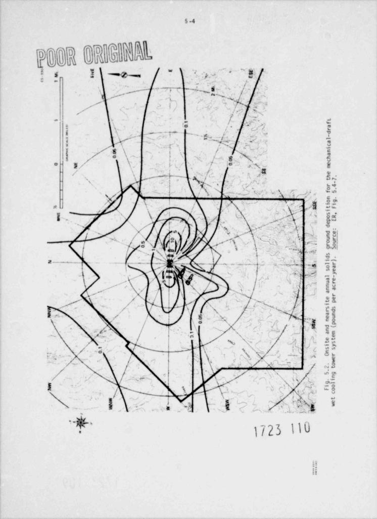
[
-
hDo QQ3Qb;~-
c
.
,- .:'
n ag g '' - l
?-e
u '
- M' ' , '
; ' \-s
s
_' r.
M? '~
# ; k s
.
.~. ' iE 5~ , '
'\, I . ' -
)~
,),s'
'
y~- ." -'
^;'
r',.
,
, v|/.'s
' t5 , ', 's.. f
' ,
fj ' ..
QQ, ,, b , a a, ra
?' , ( dm i
fjJ.'t -
sk s-- !
l.
~e
~ a|l ,' c
/', q v. ' ,i* ,
,
,g ._ i
5 n0 a,. > s h0 j ~
- ,/' ~ o. r
Q\ f '';._j,', * '
o ceo ,qg m;
* -s e
- .
h .' , t7;),, .
,
- -- ,
<l r4'
-o
,s- / '
.D ' y j> *fS).., .. ,.
N n .
N k ,,r4 i ,j'Wy[.og- \
< ~ .,x i - | ii'5 tFr ,<
,- , _ L'' i , s( [ ,\ r< oR?e , '
/ %zt pE
%t/ t e
g' .'v[Y; . f m/ ~ ?' r d/
N-
\' .
, z4 de- .
[\5/ / ,
j}f' v %. nc
h3 ur/#' ~
bci ou- }. . .
^,' 8 , .
4 ro8 -. gS\ > , , M 'fi
/ 8 o t:g
V , s,
/ - , <|j ='- s
l r
d,
. i)N ! ~ , fp; / ~ , < #A oa) se.
i~~ \ ~ c '
(y'4 ,l -
M\, ,# , / '- y
' :
'/ t, ' 'f.~% ,4-
. aeN * . ., , ' urnc
\ ' ~ - M i
\' 2' na
% eea/ r
' 4, s ,,r tp
~
,~ ,
, / ' ,/ ,e , i
ss\' f4 , !,<
,' rdN- . -N <,o ' ,
, v\ ' , s'c \ an,'- f- eu'o ;g no>
;I(,
,, , jo i p
'. ! . \. - .~~sS,, ,. d(/
/1' N amn
-,
a| ,- j er? et
'
t>,y f. -q
; f t s' . ,
i y'
. . ' ' / i. -/, " nss#j
7, ' ,i '. ' ,- )' Or, f
f.
, ' -;' f- . ^ ' ,
e(' ,
',n y( s ' .o,
.w
- 2t,.
i
- ', 5g
.1 i
"
(i. y
. ',s
- , n
%-,& , ) c
*'
*, &t,
.i- gl
,. io
g *' s;! , I k~F o. c' r, \ ' c
O' ,#
w ' r; r ,, ' -l'
* ' /\'
% / ,
t-
4fW et' s wsQi |(ra ,( r T [ .{$W \ - ...i",! '
o
rg,.,M,*s '
Q ~~Dy
., C.
,
:-.
7:.:
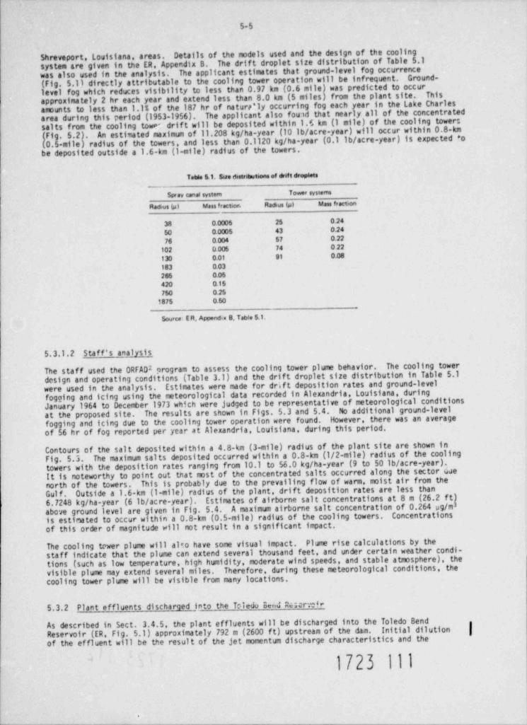
5-5
Shreveport, Louisiana, areas. Details of the models used and the design of the coolingsystem are given in the ER, Appendix B. The drift droplet size distribution of Table 5.1was also used in the analysis. The applicant estimates that ground-level fog occurrence
Ground-(Fig. 5.1) directly attributable to the cooling tower operation will be infrequent.level fog which reduces visibility to less than 0.97 km (0.6 mile) was predicted to occur Thisapproximately 2 hr each year and extend less than 8.0 km (5 miles) from the plant site.amounts to less than 1.1% of the 187 hr of naturr'ly occurring fog each year in the Lake Charlesarea during this period (1953-1956). The applicant also fou1d that nearly all of the concentratedsalts from the cooling tower drift will be deposited within 1.6 km (1 mile) of the cooling towers(Fig. 5.2). An estimated maximum of 11.208 kg/ha-year (10 lb/ acre-year) will occur within 0.8-km(0.5-mile) radius of the towers, and less than 0.1120 kg/ha-year (0.1 lb/ acre-year) is expected *obe deposited outside a 1.6-km (1-mile) radius of the towers.
Table 5.1. Sire distritmeteons of drift droplets__
$ pray canal system Tower systems
Radius (p) Mass fractior. Radius (p) Mass fraction
38 0.0005 25 0.24
50 0.o005 43 o.24
76 0.004 57 o.22
102 0.005 74 0 22
130 0.01 91 0.08
183 0.03
265 0.0542o 0.15750 0.25
1875 0.50
Source: ER, Appendia B, Table 5.1.
5.3.1.2 Staff's analysis
The staff used the ORFAD2 program to assess the cooling tower plume behavior. The cooling towerdesign and operating conditions (Table 3.1) and the drift droplet size distribution in Table 5.1were used in the analysis. Estimates were made for drif t deposition rates and ground-levelfogging and icing using the meteorological data recorded in Alexandria, Louisiana, duringJanuary 1964 to December 1973 which were judged to be representative of meteorological conditionsat the proposed site. The results are shown in Figs. 5.3 and 5.4. No additional ground-levelfogging and icing due to the cooling tower operation were found. However, there was an averageof 56 hr of fog reported per year at Alexandria, Louisiana, during this period.
Contours of the salt deposited within a 4.8-km (3-mile) radius of the plant site are shown inThe maximum salts deposited occurred within a 0.8-km (1/2-mile) radius of the coolingFig. 5.3.
towers with the deposition rates ranging from 10.1 to 56.0 kg/ha-year (9 to 50 lb/ acre-year).It is noteworthy to point out that most of the concentrated salts occurred along the sector duenorth of the towers. This is probably due to the prevailing flow of warm, moist air from theGul f . Outside a 1.6-km (1-m11e) radius of the plant, drift deposition rates are less than6.7248 kg/ha-year (6 lb/ acre-year). Estinates of airborne salt concentrations at 8 m (26.2 ft|above ground level are given in Fig. 5.4. A maximum airborne salt concentration of 0.264 ug/mis estimated to occur within a 0.8-km (0.5-mile) radius of the cooling towers. Concentrationsof this order of magnitude will not result in a significant impact.
The cooling tower plume will alto have some visual impact. Plume rise calculations by thestaff indicate that the plume can extend several thousand feet, and under certain weather condi-tions (such as low temperature, high humidity, moderate wind speeds, and stable atmosphere), thevisible plume may extend several miles. Therefore, during these meteorological conditions, thecooling tower plume will be visible from many locations.
5.3.2 Plant effluents discharged into the Toledu Bend Rmrd
As described in Sect. 3.4.5, the plant effluents will be discharged into the Toledo BendReservoir (ER, Fig. 5.1) approximately 792 m (2600 ft) upstream of the dam. Initial dilution fof the effluent will be the result of the jet momentum discharge characteristics and the
1723 111
.
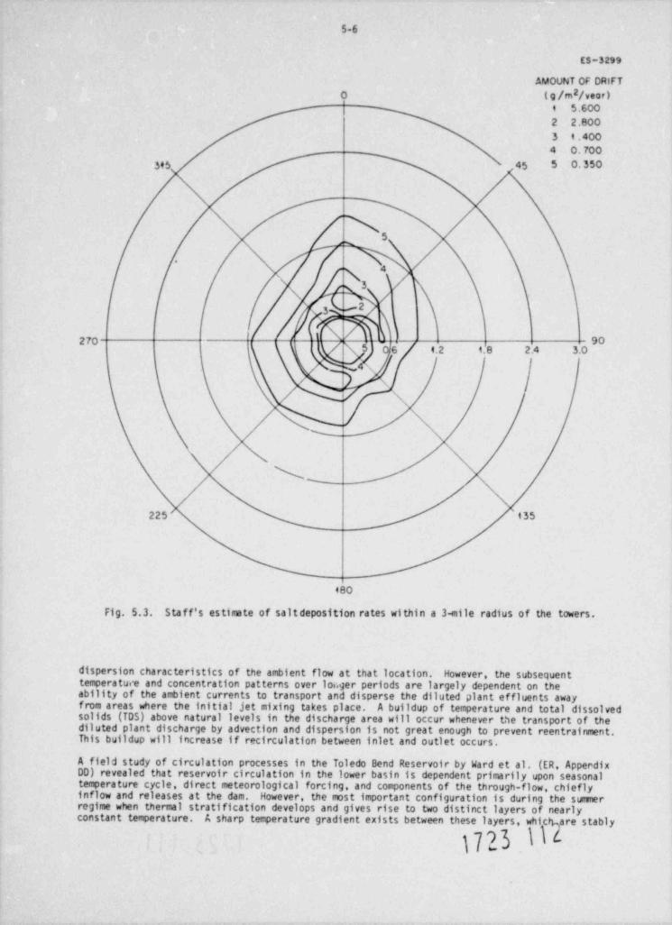
5-6
ES-3299
AMOUNT OF ORIFT2(9 /rn 7 ,,ar)0
4 5.6002 2.8003 9.4004 0.70 0
3,3 45 5 0.350
5
N |\\ /
/270 go5 '6 4.2 9.8 2.4 3.0
/ | \ |N'
w x
x%225 't35
480
Fig. 5.3. Staff's estimate of saltdeposition rates within a 3-mile radius of the towers.
dispersion characteristics of the ambient flow at that location. However, the subsequenttemperature and concentration patterns over loc.ger periods are largely dependent on theability of the ambient currents to transport and disperse the diluted plant effluents awayfrom areas where the initial jet mixing takes place. A buildup of temperature and total dissolvedsolids (TDS) above natural levels in the discharge area will occur whenever the transport of thediluted plant discharge by advection and dispersion is not great enough to prevent reentrainment.This buildup will increase if recirculation between inlet and outlet occurs.
A field study of circulation processes in the Toledo Bend Reservoir by Ward et al. (ER, ApperdixDD) revealed that reservoir circulation in the lower basin is dependent primarily upon seasonaltemperature cycle, direct meteorological forcing, and components of the through-flow, chieflyinflow and releases at the dam. However, the most important configuration is during the summerregime when thermal stratification develops and gives rise to two distinct layers of nearlyconstant temperature.
A sharp temperature gradient exists between these layers, whibcare stably
1723 I
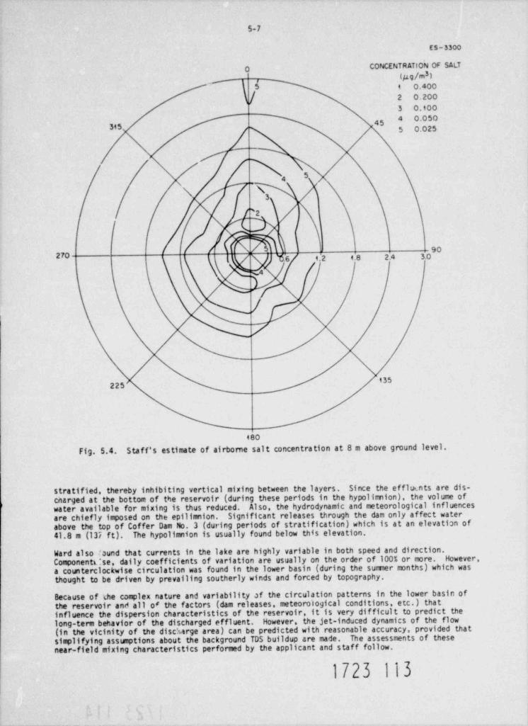
5-7
ES-330o
CONCENTRATION OF SALTO3(#g/m )
p ,
5 , o,4oo
[ 2 0.200
3 0.1004 0.05045315 5 0.025
54
/ 5 ', .
90270 ( 't$.6 9.2 4.8 2.4 3.0
s4
/
135225
480
Fig. S.4. Staf f's estimate of airborne salt concentration at 8 m above ground level.
stratified, thereby inhibiting vertical mixing between the layers. Since the efflu nts are dis-.
cnarged at the bottom of the reservoir (during these periods in the hypolimnion), the volume ofwater available for mixing is thus reduced. Also, the hydrodynamic and meteorological influencesare chiefly imposed on the epilimnion. Significant releases through the dam only affect waterabove the top of Coffer Dam No. 3 (during periods of stratification) which is at an elevation of41.8 m (137 f t). The hypolimnion is usually found below this elevation.
Ward also found that currents in the lake are highly variable in both speed and direction.Componentt:se, daily coefficients of variation are usually on the order of 100% or more. However,a counterclockwise circulation was found in the lower basin (during the sumer months) which wasthought to be driven by prevailing southerly winds and forced by topography.
Because of the complex nature and variability of the circulation patterns in the lower basin ofthe reservoir anti all o' the factors (dam releases, meteorological conditions, etc.) thatinfluence the dispersion characteristics of the reservoir, it is very difficult to predict thelong-term behavior of the discharged effluent. However, the jet-induced dynamics of the flow(in the vicinity of the disc't.arge area) can be predicted with reasonable accuracy, provided thatsimplifying assunptions about the background TDS buildup are made. The assessments of thesenear-field mixing characteristics performed by the applicant and staff follow.
1723 113
5-8,
5.3.2.1 Apolicant's analysis
The applicant's assessnent of the discharge effects was performed by the use of a computerizedmathematical model developed by Koh and Fan.3 This steady-state model treats only the jet-induceddynamics (near-field) of the flow before the momentum of the discharged effluent has decreasedto the point at which its dilution can be characterized by turbulence of the ambient flow. Theapplicant investigated the mixing characteristics of the blowdown for summer and winter dischargeconditions (Table 3.2) at reservoir water surface elevations 39 m (128 f t) mean sea level (MSL)(the maximum drawdown level for water supply) and 50.6 m (166 f t) MSL (the minimum level recordedsince its initial filling).
The results of cases involving normal rriervoir water surface elevations at approximately 50.6 m(166 f t) MSL are given in Figs. 5.5 through 5.8. For these analyses, the applicant assumed:(1) a dam release of 2.83 m /sec (100 cfs) through the low level spillway, (2) no background3
TDS buildup, and (3) that jets from the two subnerged ports do not merge. Therefore, theresults shown in Figs. 5.5 through 5.8 are for a single jet which contains one-half of theblowdown.
During winter discharge conditions (Fig. 5.5 and 5.6), the reservoir was assumed to be uniformin temperature at 8.3*C (47'F) and the jet discharge temperature was 27.8 C (82'F), which isslightly higher than design conditions (Table 3.2). There was also a slight TDS concentrationgradient in the reservoir. The results show that the jet obtains a high dilution factor verynear the discharge structure and that the plume achieves a centerline TDS concentration veryclose to the ambient concentration at an elevition of about 42.7 m (140 ft) (Figs. 5.5 and 5.6).The mixing zone, or portions of the plume for which the temperature and TDS concentration aresufficiently high above ambient values (>l.l *C or 2*F), is confined to about 113.3 m3 (4000 ft )3
for each jet. The total volume enclosed within both mixing zones, 226 m3 (8000 ft ), is3
insignificant compared with the reservoir volume, about 2.47 x 10⁹ 3 (2 x 10⁵ acre-f t) of themlower basin.
The results of the sunner discharge conditions are given in Fig. 5.7 and 5.8. The reservoir wasthermally stratified with features resembling a two-layered system in which each layer is ofuniform temperature. The discharged effluent penetrates the thermocline and, thereby, tendt toinduce mixing. In contrast to the winter case, the plume becomes neutrally buoyant and spreadshorizontally at an equilibrium level of about 9.1 m (30 f t) below the surface. This mixingphenomena takes place at greater reservoir depths than during periods for which the reservoir isnot stratified.
It is noteworthy to point out that the applicant assumed a bicxdown rate of 0.37 m /sec (5924 gpm)3
for the thermal plume (Fig. 5.5 and 5.7{/sec (5924 gpm) is not consistent with the plant discharge3and 0.28 m /sec (4445 gpm) for the TDS plume (Figs. 5.6
and 5.8). The high flow rate of 0.37 mdata given in Table 3.2, which has a maximum discharge */ low of 0.30 m /sec (4722 gpm). Because3
of the larger flow rates, the applicant's estimate of the volume required for dilution of theplume is conservative.
The results of the applicant's analyses of the discharged effluent for reservoir water surfaceelevation 39 m (128 ft) MSL are given in ER, Appendix SA. For these cases, background TDSconcentrations were taken to be significantly higher (about 320 ppm) than for the previouscases. Estimates of long-term background buildups of TDS were made from a mass balance whichtook into account the frequency and magnitude of releases through the dam and the inflows intothe lower basin, as well as from jet discharges. The applicant found that, although relativelysmall volumes of water are available for dilution, the plune's centerline trajectory and mixingcharacteristics are very similar to those for nomal reservoir water surface elevations.
5.3.2.2 Staff's analysis
The staff used the Hirst" model to investigate the effects of the plant discharge. This modelalso treats only the near-field effects of the jet. The cases solved were similar to thoseanalyzed by the applicant (Figs. 5.9 and 5.10). Ambient currents and background TDS buildupwere neglected, and the plumes from the two discharge ports were assumed not to merge. Also,the discharge velocity and TDS concentration were 3.5 m/sec (11.5 fps) and 610 ppm instead of4.6 m/sec (15.0 fps) and 565 ppm, respectively, which were used by the applicant. Thesedifferences did not yield significantly dif ferent red ts.
The centerline TDS concentration and temperature of the plume for winter discharge conditions aregiven in Fig. 5.3. These results are in general agreement with the applicant. There are about45.3 m3 (1600 ft ) of water volume enclosed within the 1.l*C (2'F) excess temperature isotherm.3
The plume is diluted to nearly ambient values at reservoir elevation 45.7 m (150 f t), but theplume momentum carries it to the surface where it spreads laterally. For the sumer discharceconditions, the plume does not reach the water surface because of the reservoir stratification.
1723 114
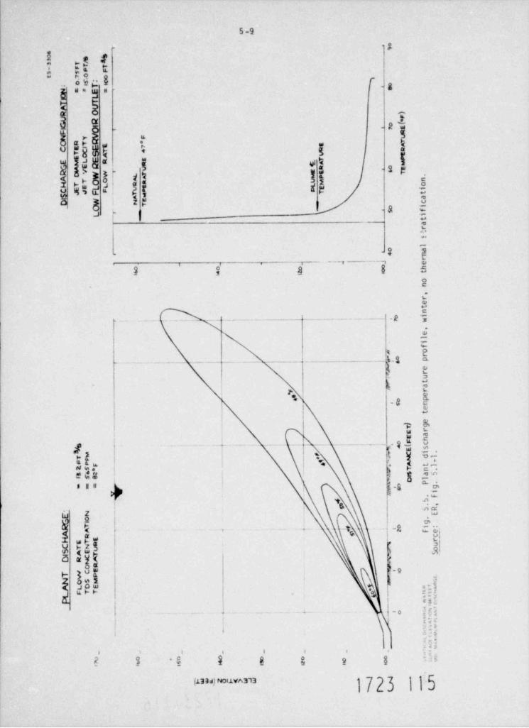
7eo
. Ss
4 %on yT T- p p Fs 5 o o7, r.e
o o T s 7, s
o;
oeN a=E =
)
mKTAR O )
FU RG I e f*
FI O ., 7 E
R/
N V \ F UO RT R * T
E AC EI E E 7
W RC T 4O S AT EE E .T P
E M L E RER R t A MG A U R 0 EV W r. r E 6R N T
TW O_. L T u PC AA . A u M
nmH T L S l oE E iEJR F U * pC ES A n
T tT eJ aI
WyE
N cD_ T io
aSf.
_ i
tar
!
l
a, =* m
r_ . |- i' b e
g m h0 0t4 2on,
retn
o i
, ' : t ' ii ' ,j f| ;f, I:' l w,
, el
ifo
Mo rp
, |s !| -I !' |. 'I !|ii1 ' ! \1 ,;gj eru,
t, a_ r
V* ep* ). m
_ e
._. t
_. e.
.)T g
rE_. aE_ _.
9 ,i' I
/|'\'
.dn
. E (F cS_
s/ E_I_ .
8 C id1uTe _ _ j A t1
' w N -F, P F _ .
_. a. tl
T n25*3nB S a621 O.
_ s P .= == = >. g.d
itu .F
4 S_
.
9 . ,.
E' N .
bRE
o .
R Ti _G go_ *
l i eA +
A ._ .,-
fR c
H ET n _t r
muC T Nu oS AE T _ ' S
A _ mI CD R N
O R _
h;eE
T WC_
P aN OSM " , * *A L OE ,
L FTT g 7, ,*P 7, s..
o
_ . ,o M. a..
0_
_. " 1, v.
%v._
.
;m_ - _ _ _ _ _ ^ .
0 o 0 o o o '
m 86 - S 4 si a w c.i 6
vw.a j F<> $w- %NV ~ w
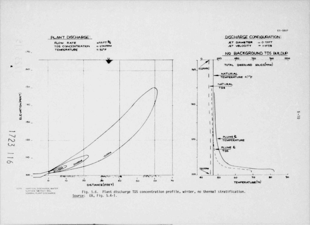
ES-3307
PLANT DISGIARGE: .DISCHARM CONClGl.BA,.Tjoh;_
FLOW R ATE =% FT k JET 0AusTER .= 075FT
T OS CONCENTR ATeoN = bi4 PPM JET VELOCITY = la FT/S''#'"'*" * * * * "m. No BACKGROUND TDS EULOUP
Y O .. ._.4[ _ 7,20 _ _ , _ ,p, , ,Jty.
V _ OTOTAL oissoLvso souoslPPw), ,
IO2 ppm |M- f f . _ _ . - . _. .-_ ibo.I
_. TEMPERATURE 47'FNATUR AL
i NATURAL
| --|15o _ TOS,
i
| |E I1.
t oo . 14 0 |I
I> \ m
I L$ ;W | | | \
O
j - |,iso
|~
N - PLUME DN t 2.0 _ . . _ , 12 o . g TEMPERATURE
l/ | ptvus t
gTos
| #-g
l- ._ s
& / I N'
! t '-~ _ _ _qq
# h, ~{~~~~&*~ u, % es - - M~p .n Fr es v .,, , go io ao M 4o so so m
DeSTANCE(FEET)'#1 Tt v t p f iC A L D8 5C'< AsaGE. W A TE R
'0".|JE'E%"cIJ2hc. Fi g. 5.6. Plant discharge TDS concentration profile, winter, no thermal stratification.Source: ER, Fig. 5.4-1.
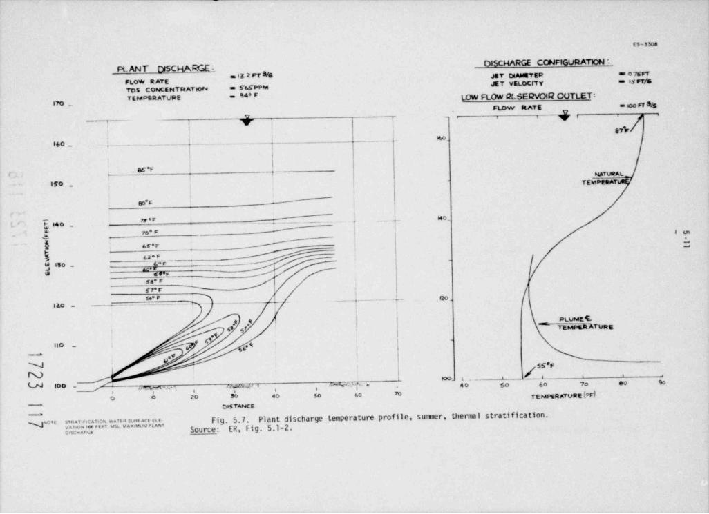
ES-330e
DISCHARGE CONFIGURATION *PL ANT DISCHA%EiJET CdAMETER == o 7sFT"
FLOW RATE JET VELOCITY == es rf/sTDS CONCE NTR ATeoN = 76fPPM
TEMRATURE - 94*F LOW FLOW QCSEENOIC2 OUTLET:70 _ = mo0 FT S/sFlow RATE UyrU - 1 i
y jJ 97hr
. _ _ _ _ _ _ _ _ __ . _ _ . _ _ _ _
16 0
860 _ q _. . __ _ _ _ _ _ _ _ _ _I
i
65 *F( NATWALI
ggo , TEMPERA|
'
so r
id o _M*F _,7, g4 o _ _ . . . _ _ _ _ _ _ . _ .*
To* F ;. }
h 6f'F *
62 * F_-
_>
Ac. Ete r'
U |So _j r
6T'F_
NF|
se* F.. _ . _ _ _ _ _ _ . _ _ . _
- _.-t- - --- -- -f20 ,
| o_
f PLUMEC.8 *M I TEMPERATURE.
',
f-
66*911 0 _ ,0
a
9' |'
9 ' i SS*FIN *0- t .- ' ' ' '
40 50 60 7o 60 90LN too _ oyssa i 4 %. . . ,% * ,/ on -, , ,
TEMPER ATURE (OF),
0 0 20 30 40 50 60 M
DISTANCE
E."r'o'0' Ied*u's['"2E"Ju^.;',3h Fig. 5.7. Plant discharge temperature profile, surrrner, thermal stratification.-
JM"Source: ER, Fig. 5.1-2.o.sc . ace
I;
,o os ois n d-se
P'U
L ED vot s ,* A Rr Us eRu v T d:
T SN ATF/ B )
O fT M A RI H ET 7. F P P
t S P MA 0i (D S E ER == T=
U T o,O Rn L U ,i
GI o O T ',F S t A ,\N N R ^r E -O Y u D a
u e -R T o EC V
'M .
sEl R L t E
-o o p TTC G e s
G EO , e [ML K nn
~/noR AE C OiI
L . tA DV A L AB A aH TT T R _ cC EE O U S _ * s i
JJ o T T D _ \f
$ M .
N Ts A i(D_
tt \g a
\~ r
- 1 .j l I i
tl | | l | 1 l l | | | s
oa lrp a
t mo. o ae
, rt s ' , e
h-o_ . _ _ . . - to o *n
1 c' r
4i
,
emmus,
_ _ e_ l, m i_ - f_ o_ ra p
ws n
o_ po_ i
t
a6a_ rt
_ n
_ er c
_ no
_ o c,s_ S_ D
_ T_
)
_ T e_ E g
E rF
S aS M
t .
s, o ( haE cTP' _ cP se N
4 p Ai ,_Fg1#6 oy a, T d3
S -t < t t4= = * = D n
_ a5lo
_ ,s P ,_ g
7NE_ I
.Fi
O
C T 8,_
, ,
R A 5RA R ,E_
T _ ,
H EN' i ,o g
C TE">\ ,' a i:
I RN"# 'e#FeAC -S c
. rD O tC" s_ u
oT
W 5" wS
N O _ ognAL DEL FTT
uP e .
_ E4R2E2T7_ A
,o W5_ /
,5E
RNG
_ _ A
AUMCS"iIDNL_ _ . _ _ . . - AI
m o 0. o o o o C'^~s
c
i s 5 4 ss n '
E $".T
8 6 ia ' R'
V
_kw[ .dET
ON
~NNLN - - m
\
ES-3304V
I I I I I I I',,
/ PLUME47.8 *F IMPINGES
160 - PLANT OISCHARGE:ON SURFACE
FLOW RATE = 5.08 cf sTDS CONCENTRATION = 640 ppm
TEMPERATURE = 82 *F
150 - AMBIENT CONDITIONS:TEMPERATURE = 47 *FTDS CONCENTRATION = 132 ppm
48.3 'F170 ppm _
_
d 140 --
2
5PLUME CENTER LINEg
g 430 - 49*F TRAJECTORY -4.n
474 ppm g3d
-
120 -
50.2 * F185 ppm
i10 -
54.9 *F 233 ppm~
N 79.8 *FN 589 ppm
| | | | |U #WO to 20 30 40 50 60 70 80
DISTANCF. (f t).
~
g Fig. 5.9. Staff's estimate of jet centerline trajectory for typical winter dischargecondi tions. Plant effinent is shown discharging from only one discharge port; plumes fromboth ports are assumed not to nerge.
;#
2 N3 )
O .s0I st
3 F T nrA oo*-S
( R)
i pTE t
R N mE ihU E p dtT C p noA N(
N R O obcE CO mE I P S eoR T M D gr
U A E T rfR TT aA TR N > 0 I 0 hs
4 ce9E - E - m:
7? C sm*P i uyM N dlS 1
E O pFN C* T rOI
7 S e;T 8( T 0 mtI
DrD 0N I i 7 f 2 uo
O ) , # spm nC p l e-p agT 5 crN 2
B I 4E 0 iaI t ph
M 0 0 yc
A| - - - i 5 I 0 ts
i1
rd0 0 0 0 o4 1 0, fe6
442
nyor
# 0 oy- 5 tl- - - cn- E eoF N- - I
j
L ampm
4 roR t rE fTY
i0 t
NR 4 eg;
7mFEO jn
- CT iC f g
- p* EE orp MJ a_ 4 UA eh620 LR t c_ 1 6 PT 0) as- * i
3 ft miNIT_ ( id
tm TN_ E sn
H E- mF C ewp p N o ,GM_
p pA she
I
N_E 0 TO O
1 ! 2 D f se
sg93 S 'f rt H
R_0 I6 g
EI V * aims - F M N tN* UE_fcO4 L Sto
E 8 I 9 PD_ nt.eG 0. T EMIA UF_ utR 2=A 5 R I
0l oT E MT_ o 1. f
fnH = NR A t
5 edS E E U XIC R_I T C T A T eD A N A MS_ .tmR O R p gnu
_ p,-T EC i asN W P. 8. Fl s
6 2,
y0,A OS M - 6 pa
_L L DE - - _ _ 5.
ee#P F T Th r0 0 o, Ta
9 4
. O g$
#NUsO
5-15
Figure 5.10 shows that the plume reaches a maximum elevation of ibout 36.0 m (118 ft) when itscenterline trajectory is nearly horizontal. At this point, the plume continues to propagatehorizontally because of its momentum which has decreased to about 8% of the discharge value.Thus, subsequent plume mixing will be the result of its horizontal momentum and negativebuoyancy since the plume density is greater than the local ambient density. For theseextreme sumer conditions, the staff assumed a linear temperature stratification which is unlikethe two-layered system found by Ward et al. (ER, Appendix D). This choice of stratificationtends to yield conservative results because the plume does not ascend to higher levels, as inthe case of a two-layered system; moreover, the volume of colder hypolimnetic water used in thestaff's analysis is consideably less than that which was found during the circulatica study.
Both analyses by the applicant and staff show the same general trends. The discharged effluentachieves *a high dilution factor at very short distances from the discharge structure. Also,whenever the reservoir is thermally stratified, the plume will be confined to smaller volumesof Gilution water. This mixing phenomena tends to keep the discharged effluent below thethermocline, which is usually found below the top of Coffer Dam No. 3. The blocking effect ofthe Coffer Dam (ER, Appendix SA) tends to prevent the flow of the diluted plant effluent throughthe hydroelectric plant. Therefore, during periods of reservoir stratification, a potentialwill exist for the buildup of TDS in the lower basin of the reservoir.
The staff analyzed the long-term TDS buildup which could occur during periods of reservoirstratification by considering the relative volumes of water involwd in the mixing processes.From the near-field models, it was shown that the discharged effluent attains a dilution ratioof about eight (that is, seven parts of ambient water are mixed with each part of the dischargedeffluent) and then spreads laterally at an elevation of about 39.6 m (130 ft). Therefore,assuming no recirculation of previously mixed effluent, for the same dilution ratio both jets
7 3 (11600 acre-ft) of ambient waters during a three-monthwill entrain approximately 1.44 x 10 mperiod of reservoir stratification. Generally, the staff has assumed that the reservoirstratification is only severe enough to prevent adequate mixing between the various strata ofwater (and hence insufficient for reservoir flushing through Coffer Dam No. 3) for a three-monthperiod. Therefore, for these conditions the diluted effluent will have a concentration of about120 ppm and it will be transported out of the discharge area by natural reservoir currents,hypolimnetic currents created by flow through the low-level spillway and, also, by epflimneticreleases through the hydroelectric plant, and density currents due to the higher density of themixed effluent. The retervoir content is about 5.5 x 10³ m (4.5 million acre-ft), but it is3
unlikely that the various transport mechanisms could cause the concentrated waters to bepropagated throughout its hypolimnion. However, it is conceivable that the diluted effluentcould be uixed with most regions of the hypolimnion in the study area of the circulation study
m (4200 acres) of surface area in this2(ER, Appendix D). There are approximately 5.2 x 10⁶region near the reservoir dam, and the entrained volume of dilution water for the three-monthperiod would be less than 8% of the water contained in the hypolimnion. If there is no recircu-lation between the intake and discharge or in the discharge area, then there is an ample supplyof unmixed water to be used for jet mixing in the lower basin of the reservoir. Ward et al.(ER, Appendix D) found a prevailing counterclockwise circulation in this region and currents ofvariable direction ranging from 3 to 6 cm/sec. These currents and other transport mechanismsall disperse the diluted effluent throughout the lower basin.
For the purpose of this assessment, the staff assumed that very little of the diluted effluentwould flow through the hydroelectric plant because of the blocking effect of Coffer Dam No. 3during periods of reservoir stratification. However, if a breach were made in the Coffer Dam,significant releases from the hypolimnion would be possible and the potential of a backgroundTDS buildup would not be as great. Although the staff feels that the relatively large volumeof the lower basin and the circulation processes in this region are adequate to prevent violationof applicable water quality standards (Sect. 5.3.3), large-scale mixing characteristics of thisnature are difficult to predict in reservoirs. Therefore, the staff recomends that the appli-cant consider the possibility of making a breach in Coffer Dam No. 3.
Aer quality Standards5.3.3 W
The plant effluents will be discharged in the vicinity of the old Sabine River channel approxi-mately 792 m (2600 f t) upstream of the Toledo Bend Reservoir Dam (Sect. 3.4), and it is likelythat the initial dilution and subsequent dispersion of the effluent by reservoir currents will
5affect waters on both sides of the channel. Therefore the Water Quality Standards of Texas aswell as those of Louisiana 6 should t,e taken into consideration.
1723 121
5-16
The Water Quality Criteria of each state governing the Toledo Bend Reservoir and waters of theSabine River within their jurisdiction are nearly identical. Notable in these standards arethe following criteria:
Toledo BendReservoir Sabine River
Chloride (mg/ liter) not to exceed 120 120
Sulphate (mg/ liter) not to exceed 60 60
Dissolved oxygen (mg/ liter) not less than 5 5
Total dissolved solids (mg/ liter) not to 500 500cxceed
pH range 6.0 to 8.5 6.0 to 8.5Maximum temperature ('F) not higher than 93 91
Maximum temperature differential ('F) 3 5not higher than
These water quality standards do not apply to treated effluents and to water in mixing zones.Normally, a mixing zone of unspecified extent is allowed. However, "the total areas and/orvolume assigned to. mixing zones will be limited to that which will not interfere with biologicalcomunities or population of important species to a degree which is damaging to the ecosystem."As a guideline, the mixing zone will be limited to no more than one-fourth of the cross sec-tional area and/or volume of flow of the stream, leaving at least three-fourths free as a zoneof passage or continuous water route "necessary to allos passage of free swimming and driftingorganisms with no significant effects on their populations " Both the staff and the applicant(Sect. 5.3.2) have shown that the effluents discharged into the Toledo Bend Reservoir will bediluted to required levels within relatively short distances (less than 30.5 m or 100 ft) of thedischarge ports. Also, a negligibly small volume and/or area of the reservoir would be affected.The ecological assessment of both the thermal and chemical discharge to Toledo Bend Reservoir isgiven in Sect. 5.5.2.2.
The staff also evaluated the chemical alteration resulting from the operation of the plant overextended periods of time and found that (with the present design) a potential exists for back-ground TDS buildup above required levels during periods when the reservoir is stratified becauseof insufficient reservoir c sculations and mixing between the hypolimnion and epilimnion.However, the staff concludes that with the proposed design of the discharge structure and forthe plant operating conditions (Table 3.2) the plant effluents will be discharged in a mannerthat will permit compliance with the above standards.
5.3.4 Sumary
The principal physical impact of the Blue Hills Station heat dissipation system is expectedfrom atmospheric effects of the mechanical-draft cooling towers. No additional ground-levelfogs or ice were predicted by the ORFAD model within an 8.05-km (5-mile) radius of the plant.Annual salt deposition rates within 1.6 km (1 mile) of the tower area will range from 10.0872to 58.2816 kg/ha-year (9 to 52 lb/ acre-year). Outside a 1.6-km (1-mile) radius of the plant,annual drif t deposition rates will be iess than 6.7248 kg/ha-year (6 lb/ acre-year). Saltdeposition rates falling within these limits will not have any significant environmental impact(see Sect. 5.5.1.1) . Also, elevated visible plumes will extend, at times, several thousandfeet from the site, particularly in the winter.
In addition to atmospheric effects, the cooling tower blowdown and other plant effluents willhave some impact on the Toledo Bend Reservoir and lower Sabine River Basin. The maximum
3expected plant discharge flow is 0.30 m /sec (4726 gpm) with an average TDS concentration lessthan 610 ppm. The discharged effluent will be diluted within very short distances from thedischarge point and, thus, will be in compliance with the Water Quality Standards of Texas andLouisiana. However, there will be a potential for a background TDS buildup in the lower basinof the Toledo Bend Reservoir during periods of stratification because of insufficient reservoirci rcula tions. Therefore .the staff recommends that the applicant consider the possibility ofmaking a breach in Coffer Dam No. 3 in order to obtain hypolimnetic releases through thehydroelectric plant and, thus, reduce the potential for a background TDS buildup.
1723 122
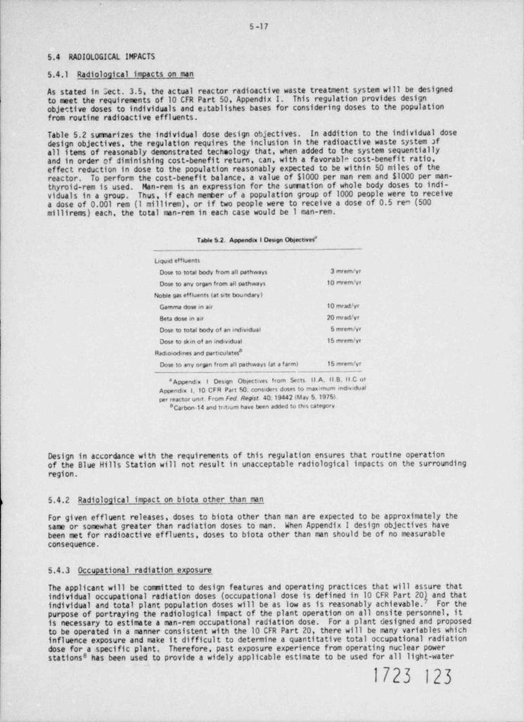
5-17
5.4 RADIOLOGICAL IMPACTS
5.4.1 Radiological impacts on man
As stated in Sect. 3.5. the actual reactor radioactive waste treatment system will be designedto meet the requirements of 10 CFR Part 50. Appendix I. This regulation provides designobjective doses to individuals and e;tablishes bases for considering doses to the populationfrom routine radioactive effluents.
Table 5.2 sumarizes the individual dose design objectives. In addition to the individual dosedesign objectives, the regulation requires the inclusion in the radioactive waste system afall items of reasonably demonstrated technology that, when added to the system sequentiallyand in order of diminishing cost-benefit return, can, with a favorable cost-benefit ratio,effect reduction in dose to the population reasonably expected to be within 50 miles of thereactor. To perform the cost-benefit balance, a value of $1000 per man rem and $1000 per man-thyroid-rem is used. Man-rem is an expression for the sumation of whole body doses to indi-viduals in a group. Thus, if each member of a population group of 1000 people were to receivea dose of 0.001 rem (1 millirem), or if two people were to receive a dose of 0.5 rem (500millirems) each, the total man-rem in each case would be 1 man-rem.
Table 5.2. Appendix 1 Design Obiectives'
Uguid effluents
Dose to total body from all pathways 3 mrem /yr
Dose to any organ from all pathways to rnrem/vr
Noble gas effluents (at site boundary)
Gamma dose in aer 10 mradlyr
Beta dose in air 20 mrad /yr
Dose to total body of an individual 5 mrem /yr
Dose to skin of an individual 15 mrem /yr
Rad.osodmes and particulates*
Dose to any organ from all pathways (at a f arm) 15 mrem /yr
' Append.x i Design Objectives from Sects. II.A. Il B. II.C ofAppendix 1,10 CFR Part 50. considers doses to maximum mdevidualper reactor unit. From fed. Regist. 40.19442 (May 5,1975L
" Carbon-14 and tritium have been added to this category.
Design in accordance with the requirements of this regulation ensures that routine operationof the Blue Hills Station will not result in unacceptable radiological impacts on the surroundingregion.
5.4.2 Radiological impact on biota other than man
For given effluent releases, doses to biota other than man are expected to be approximately thesame or somewhat greater than radiation doses to man. When Appendix I design objectives havebeen met for radioactive effluents, doses to biota other than man should be of no measurableconsequence.
5.4.3 Occupational radiation exposure
The applicant will be committed to design features and operating practices that will assure thatindividual occupational radiation doses (occupational dose is defined in 10 CFR Part 20) and thatindividual and total plant population doses will be as low as is reasonably achievable. For thepurpose of portraying the radiological impact of the plant operation on all onsite personnel, itis necessary to estimate a man-rem occupational radiation dose. For a plant designed and proposedto be operated in a manner consistent with the 10 CFR Part 20, there will be many variables whichinfluence exposure and make it difficult to determine a quantitative total occupational radiationdose for a specific plant. Therefore, past exposure experience from operating nuclear powerstationse has been used to provide a widely applicable estimate to be used for all light-water
1723 123
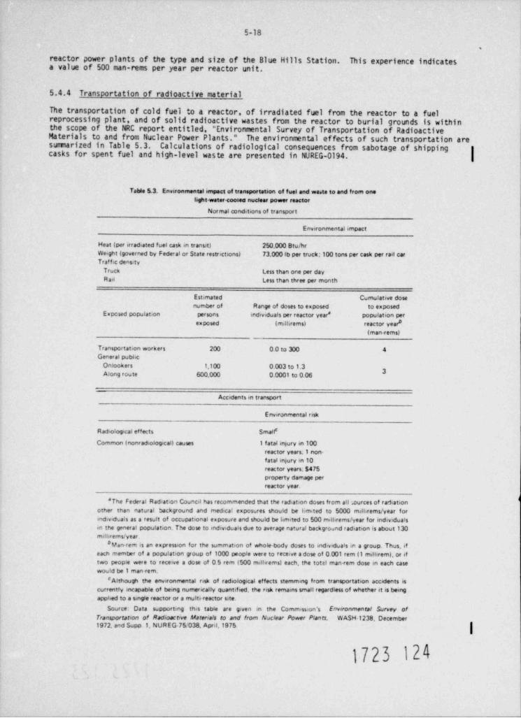
5-18
.
reactor power plants of the type and size of the Blue Hills Station. This experience indicatesa value of 500 man-rems per year per reactor unit.
5.4.4 Transportation of radioactive material
The transportation of cold fuel to a reactor, of irradiated fuel from the reactor to a fuelreprocessing plant, and of solid radioactive wastes from the reactor to burial grounds is withinthe scope of the NRC report entitled, " Environmental Survey of Transportation of RadioactiveMaterials to and from Nuclear Power Plants." The environmental effects of such transportation aresumiarized in Table 5.3. Calculations of radiological consequences from sabotage of shippingcasks for spent fuel and high-level waste are presented in NUREG-0194.
Table 5.3. Environmental impact of transportation of fuel and wa.te to and from onelight-water cooled nuclear power reactor
Normal conditions of transport
Environmental impact
Heat (per irradiated fuel cask in transit) 250.000 Bru/hrWeight (governed by Federal or State restrictions) 73.000 lb per truck: 100 tons per cask per rail carTraf f ac density
Truck Less than one per dayR ail Less than three per month
Estimated Cumulative dosenumber of Range of doses to exposed to exposed
Expcsed population persons individuals per reactor year * population perexposed (milbrems) reactor year *
(man-rems)
Transportation workers 200 0.0 to 300 4General pubhc
Onlookers 1.100 o.003 to 1.33Along route 600,000 0.0001 to 0.06
Accidents m transport
Environmental risk
Radiological effects Small'
Common (nonradiological) causes 1 f atal infury in 100reactor years. I non-f atal injury in 10reactor years; s475property damage perreactor year.
'The Federal Radiation Council has recommended that the radiation doses from all:.ources of radiationother than natural background and medical exposures should be limited to 5000 milbrems/ year formdividuals as a result of occupational exposure and should be limited to 500 millirems / year for individuaisin the general population. The dose to mdeviduals due to average natural background radiation is about 130milbrems/ year.
# Man-rem is an expression for the summation of whole body doses to individuals in a group. Thus, ifeacn member of a population group of 1000 people were to receive adose of 0.001 rem (1 milbremi, or iftwo people were to receive a dose of 0.5 rem (500 millwems) each, the totti man <em dose m each casewould be 1 man-rem.
'Although the environmental risk of radiological effects stemming from transportation accidents iscurrently incapable of being numerically quantified, the risk remams small regardless of whether it is bemgapphed to a smgle reactor or a multi-reactor site.
Source: Data supportmg this table are given en the Commission's Environmental Survey ofrransportation of Radioactive Materials to and from Nuclear Power Plants, WASH 1238 December1972, and Supp.1, NUREG-75/038, April,1975
1723 124
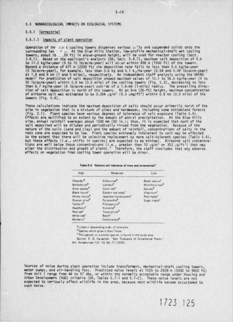
5-19
5.5 NONRADIOLOGICAL IMPACTS ON ECOLOGICAL SYSTEMS
5.5.1 Terrestrial
5.5.1.1 Impacts of plant operation
Operation of thi 3!al t cooling towers disperses various sdts and suspended solids onto thesurrounding lan a r. At the Blue Hills Station, low-profile mechanical-draft wet coolingtowers, about Ib _ 59 ft) in above-ground height, will be used for reactor cooling (Sect.3.4.1). Based on the applicant's analysis (ER, Sect. 5.4.7), maximum salt deposition of 5.6to 11.2 kg/ha-year (5 to 10 lb/ acre-year) will occur within 458 m (1500 ft) of the towers.Beyond a distance of 671 m (2200 ft) the deposition rate falls to less than 5.6 kg/ha-year(5 lb/ acre-year), for example, less than 0.6 kg and 0.1 kg/ha-year (0.54 and 0.09 lb/ acre-year)at 1.6 and 8 km (1 and 5 miles), respectively. An independent staff analysis using the ORFADmodela for prediction of salt deposition showed maximum values of 10.1 to 56.0 kg/ha-year (9 to50 lb/ acre-year) within 0.8 km (0.5 mile) of the cooling towers (Fig. 5.3), decreasing to lessthan 6.7 kg/ha-year (6 lb/ acre-year) outdde of a 1.6-km (1-mile) radius. The prevailing direc-tion of salt deposition is north of the towers. At an 8-m (26-ft) height, maximum concentration
3 (9.3 umg/ft ) within 0.8 km (0.5 mile) of the3of airborne salt was estimated to be 0.264 ug/mtowers (Fig. 5.4).
These calculations indicate the maximum deposition of salts should occur primarily north of thesite in vegetation that is a mixture of pines and hardwoods, including some bottomland forests(Fig. 2.1). Plant species have various degrees of tolerance of salt exposure (Table 5.4).Effects are mollified to an extent by the amount of annni precipitation. At the Blue Hillssite, annual rainfall averages about 1200 mm (50 in.); thus, it is expected that much of thesalt deposited will be diluted and periodically rinsed from the vegetation. Because of thenature of the soils (sand and clay) and the amount of rainfall, concentrations of salts in theroot zone are expe ted to be low. Plant species extremely intolerant to salt may be affectedto the extent that there will be selective replacement by more salt-tolerant species (Table 5.4),but these effects (i.e., shifts in species) are expected to be minimal. Airborne salt concentra-tions are well below those concentrations (i.e., greater than 10 ug/m3 or 353 pg/ft ) that may3
alter the distribution and growth of plants.9 Therefore, the staff concludes that any adverseeffects on vegetation from cooling tower operation will be minor.
Table 5.4. Relative salt tolerance of trees and ornamentals*
H,gh Moderate Low
Oleander * Arborv:tse* Black walnut'eBottlebrush Lantana * Multiflora rose *
Sdver poplar * Geen ash Spiraea# 6
Black locust' Eastern red cedar' Wburnum'Honey locust * Japanese honeysuckle' Red maple'Russian ohve* Pyracantha* Sugar maple'Tamanx* Pittosporum*
bHawthorn # xylosmaeRed oak' Texas pnvet
White oak' Beech'Mulberry' Cottonwood *
* Listed in descend:ng order of tolerance.* Species which grow in East Texas.'This species, or a simdar species, is found in the study area.Source: E. D. Caepenter, " Salt Tolerance of Ornamental Plants,''
Am. Nurseryman 131: 12, 54-71 (1970).
Sources of noise during plant operation include transformers, mechanical-draft cooling towers,water pumps, and air-handling fans. Predicted noise levels at 1525 to 2928 m (5000 to 9600 ft)from Unit I range from 46 to 57 dBa, or within the normally acceptable range under Housing andUrban Development (HUD) criteria (ER, Tables 5.7-1 and 5.7-2). These noise levels are notexpected to seriously affect wildlife in the area, because most wildlife become accustomed tosuch noise.
1723 125
5-20
Traffic connected with plant operation is likely to increase, to a small extent, the number ofanimal roadkills in the area. However, the number is expected to be small and should have nosignificant effect on total populations of animals in the area.10
Two diesel generators provide standby power for the reactor units, and a small diesel engineserves a backup fire pump. The estimated emissions for these diesel units are given in theapplicant's Environmental Report (ER, Tables 3.7-2 and 3.7-3). Air quality will not be signi-ficantly af fected by the periodic operation of this equipment.
Cooling towers and other site facilities are obstacles to the movements of birds in the area,and thus increase the potential for mortality due to collisions. Reports indicate collisionswith tall structures usually occur during periods of inclement weather when visibility isreduced, or when lighting may attract nocturnally migrating species.ll~13 However, the numberof collisions with the low cooling towers proposed by the applicant is expected to be small,and no major impact is expected for any of the affected species.
5.5.1.2 Impacts of transmission line operati_o_n_
Vegetation in the rights-of-way will be clipped on a three- to five-year cycle to maintain a lowgrass-shrub stage that will meet electrical clearance standards for 500-kV transmission lines.The applicant plans to use no pesticides or herbicides for maintenance (ER, Sect. 5.6). If thesechemicals are to be used at any tint, a full description of the treatment program must be sub-mitted for staff review and approval prior to issuance of the construction permit. Existingroads will be used to enter the rights-of-way for vegetation control or repairs; otherwise,overflights will be used for normal inspections. New rights-of-way may open i 'viouslyinaccessible land to hunting or recreational use.
During operation, the transmission lines will have some small amount of corona discharge. Recent
mission systems is indistinguishable from ambient concentrations at ground level.1ge {EHV) trans-studies have shown that ozone produced from corona discharge from extra-high volta
,1 Therefore,any ozone production will be minimal and will have no significant environmental effects. Inducedcurrent will be limited by design to 6 mA or less. Audible noise can be expected from the trans-mission lines and will be accented during foggy and/or rainy weather. However, the staff believesthe effects of this noise on wildlife will be insignificant.
The applicant states that proper transmission line design will limit the level of induced currentsto 6 mA or less and that Gulf States will comply with the National Electrical Safety Codes (NESC)16on this facet of transmission line operation (ER, Sect. 5.6 Suppl. 5 Dec.1977). This currentlevel represents the approximate threshold for safe "let-go" current. Design parameters whichaffect the induced current levels include line voltage, height of line, width of cor.idors, andgrounding of nearby structures. Since a steady state shock current magnitude of 5 mA is beingconsidered as the maximum "let-go" level in the proposed revision of Part 2 of the NESC (REABull . 62-4, p.1),17 the staff recomends that the applicant use this level in designing thetransmission lines and follow the other guidelines of the Rural Electrification Administrationfor minimizing electrostatic and electromagnetic effects of overhead transmission lines.
There is some evidence that transmission lines ccross wetland areas may affect the behavior ofwa te r fowl .18 Similarly, transmission lines may cause some increase in mortality in avian speciesdue to their collisions with the lines and tower structures.19,20 The numbers of most birds
killed from these collisions is unknown, but apparently quite small for waterfowl.20 It isthe staff's judgment that these impacts will not significantly affect bird populations in thevicinity of the Blue Hills Station.
5.5.2 A g tic _
5.5.2.1 Int _ake effects
Since the operation of the Blue Hills Station will require the withdrawal of makeup water fromToledo Bend Reservoir, the potential impacts associated with this withdrawal include: (1) theentrainment of phytoplankton, zooplankton and ichthyoplankton and (2) the impingement of fishon the intake screens.
.
Location and characteristics of the proposed intake system
The selected intake structure desigt. is intended to solve three basic problemg a4 c ted w4tpthe withdrawal of mkeup water from the reservoir: |[ [Q
.
I
5-21
1. ensure adequate water quality without additional treatment;
2. ensure adequate access to water down to a reservoir surface elevation of128 f t mean sea level (MSL) (ER, Sect. 10. 2. 3.1.1 ) ;
3. withdraw water from an "open water" milieu to reduce the rate of impingementand entrainment.
The proposed intake structure is described in detail in the ER, Sect. 3.4.3.4 and Sect. 3.4.4.The structure will be located at the point of a peninsula and will be flush with the shoreline(ER, Figs. 3.4-2 and 3.4-3). The applicant has proposed to dredge a 9-m-wide (30 ft) channelf rom tt.e intake structure extending 76 m (250 f t) into the reservoir. The channel's configura-tion is trapezoidal with a bottom elevation of 121 f t MSL (ER, Figs. 3.4-4, 3.4-5, and 3.4-5A).Water enters the intake structure through a trash rack with bar openings of 7.6 cm (3 in.) andflows through one of two fixed screens with openings of I cm (3/8 in.) before it is pumped away.The purpose of these fixed screens is to filter out debris, small fish, and other aquaticorganisms. These screens will be periodically cleaned, and the impinged debris and small fishwill be collected in the trash pit for disposal. An adjustable stoplog weir will ensure thewithdrawal of surface (epilimnetic) water, thus minimizing water treatment requirements, andwould keep approach velocities to 0.15 m/sec (0.5 f t/sec) or less. It was determined that theopening above the.stoplog weir should be a minimum of 5.5 m (18 ft) in order to meet the abovecriteria. This intake structure is " designed to take water even when the reservoir water sur-face is as low as (reservoir surface) elevation 128 ft MSL," because in the future, increasedwater demand and annual variations in precipitation may increase the annual fluctuation cf thereservoir's water level (ER, Sect. 10.2.3.1.1).
The proposed location and design of the intake structure as described in the ER, Sect. 3.4.3.4and outlined above will adequately solve the first two of the three problems listed above; how- ,
ever, the staff believes that this location and design, in conjunction with the anticipatedfluctuations of tha reservoir's water level, may create potentially severe entrainment andimpingement problems. Specifically, the following factors may contribute to entrainment and/orimpingement problems:
1. fixed screens an ? %.reased intake velocities,
2. proposed "open water" conditions for the makeup water intake,
3. critical periods of low reservoir level - low reservoir level together with futureincreases in reservoir water demand.
Fixed screens. Fixed-screen mechanisms, when clogged with debris, will respond to the decreasedface surface area by increased intake velocity.21
In the staff's opinion, the fixed-screen filtering structure would easily and frequently becomeclogged, thus resulting in an increase in the intake velocity. It has been documented by Gray(1957)22 and Clark and Brownell (1973)2 3 that few young-of-the-year fish can survive intakevelocities greater than 0.15 m/sec (0.5 f t/sec).
"Open water' conditions. The intake structure will be located in an open water area of thereservoir which, according to the applicant, "is characterized by comparatively low productivity,diversity, and species abundance" (ER, Sect. 5.1.4). The water depth in the channel at areservoir surface elevation of 172 ft MSL will be 15.54 m (51 f t). The concrete apron to the
2 (5074 ft ) at a2lef t and right of the intake structure represents a surface area of 471.4 msurface elevation of 172 ft MSL. The two triangular sides and the bottom of the intake channel
(34,040 f t ) (these figures are22represent an approximate water surface area of 3162.3 m2(5074-ft ) concrete2approximated from the ER, Fig. 3.4-4). Various portions of the 471.4-m
apron and the concrete structures associated with the intake channel will support an abundantflora of epilithic periphyton in all season > and will be a feeding ground equal or better foraquatic organisms than the natural substrate of sand and/or clay. The entire intake structure
2 (39,114 ft ). This represents such a small, integral2may have a water surface area of 3633.7 marea of the two small bays and island nearby (ER, Figs. 3.4-2 and 3.4-3) that the staff cannotassume that fish and other aquatic organisms will avoid the area simply because of the deepeningof a small section. The staff concludes that with the present design and location nf the intake
there may be considerable potential for the entrainment and iripingement of fish species occupying |the shore zones adjacent to the open water areas created by the dredging of a channel.
Critical periods of low reservoir level. Decreasing and low water levels in Toledo Bend Reser-voir occur in the months of August, September, and October (ER, Fig. IV.9:2). This time periodalso coincides with high surface-water temperatures which range from 30 C (86.0 F) in August to
1723 127
5-22
22'C (71.6'F) in October (ER, Fig. IV.9:3). These months represent an intensive feeding periodof the abundant young-of-the-year class of fishes.
With an anticipated reservoir water level drop of 3.7 m or 12 ft (from MSL 172 f t to 160 f t), theintake area of 3633 m2 2(39,114 ft ) would be reduced to 3361 m2 (36,164 f t ) which represents2
a decrease of 7.5%. At an anticipated level drop of 6.7 m or 22 f t (from MSL 172 ft to 150 f t),the area would decrease to 2967 m2 (31,925 f t ) or a reduction of 18.3%. Water depth in the2
channel would decrease from 15.5 m (51 f t) to 11.9 m (39 f t) and from 15.5 m (51 f t) to 8.8 m(29 ft) respectively. Under these circumstances, less and less of the proposed "open water"conditions would exist; on the contrary, a bay would be created with an intake channel thatwould ensure an access to adequate amount of makeup water from the reservoir, but would 61socreate a habitat favorable to aquatic organisms that are subject to entrainment and/orimpingement.
As indicated in the ER, Sect. 10.2.3.1.1., and comunicated to the staff by personnel of theSabine River Authority, an anticipated increased water demand on Toledo Bend Reservoir will mostlikely result in a 3- to 6-m (10- to 20-ft) drop in reservoir water level.
Impacts of proposed intake system
Entrainmen t. Makeup water requirements for Blue Hills Station Units 1 and 2 are listed below:
3 c gal / minm /sec 3Winter 1.62 57.2 25,639
Spring 1.73 61.1 27,400
Sumer 1.86 65.7 29,470
Fall 1.75 61.8 27,710
The staff's entrainment and impingement calculations are based on the worst case: maximum surtur3volume of 1.86 m /sec (65.7 cfs).
Phyto-_and zooplankton. From the data provided by the applicant (ER, Figs. IV.11:1 and IV.ll:2,and Tables IV.12:1 and IV.12:3), the trophic levels of the Toledo Bend Reservoir ecosystem seemto be driven by the organic matter generated by the periphytic component of the primary pro-ducers, and by the allochthonous organic material which enters the reservoir from the watershed.Although the applicant's phytoplankton data included only the numerical cell counts of netplankton and chlorophyll a deteminations and lacked the cell counts of nannoplankton, thecell counts of net plankton (an overall maximum of 1200 cells / liter at station TB-5 and a max-imum of 600 cells / liter at station TB-2) indicate a very low-standing crop of total phytoplankton.
The reported mean seasonal standing crop of zooplankton (ER, Fig. IV.ll:3) indicates a low produc-tivity of these primary consumers also. Maximum mean-standing crops of 180 and 230 organisms perliter were observed for the open reservoir and bay stations respectively. It is the opinion ofthe staff that neither the phytoplankton nor the Zooplankton communities of Toledo Bend Reservoirwill receive a significant impact due to an assumed 100% mortality through their entrainment in
31.86 m /sec makeup water. The regeneration time of these organisms ranges from a few hours to afew days, depending on the species and water temperatures.
The organic biomass of both the phyto- and zooplankters which are assumed to be killed throughthe entrainment process will re-enter the system through the decomposers.
Macroinve rtebra tes . The majority of macroinvertebrates associated with the area of the intakestructure and intake channel are truly benthic in nature and do not exhibit considerable lateralor vertical movement in the reservoir. Exceptions are the larvae of phantom midges (Chaoborussp.). However, due to the comparatively small area of the intake structure and intake channel,the Chaoboras larvae and other Denthic organisms which are assumed to be killed during entrain-ment will not constitute a significant loss to the benthic comunity of the lower section ofToledo Bend Reservoir.
The presence of the Asiatic clam (Corbicula sp.) in Toledo Bend Reservoir has not been establishedin the applicant's Environmental Report. During a visit to tha Blue Hills site in December 1976,the staff discovered and confirmed the presence and positive identification of this organismfrom the reservoir. This was the first record of their occurrence in Toledo Bend Reservoir(see p. A-34). The imigration and further development of the Corbicata sp. population inthe reservoir may represent a nuisance in plant operation by clogging intake structures andcondenser tubing. The staff recomends that the applicant review the available technology for
1723 128
5-23
control of this organism and include a proposed plan for control in the Construction PermitApplication.
Ichthyoplankton. Ichthyoplankton densities at the proposed intake site (station TB-2) are listedin Table 2.9. Entrainment losses based on these data have not been estimated because the den-sity information available for ichthyoplankton is insufficient for the following reasons:
31. Ichthyoplankton densities of shad at station TB-2 were highest (0.840/m ) on the firstsampling date (April 26) and gradually decreased toward the last date, June 6 (0.025/m3). Den-sities preceding April 26 are unksown; they could have been much higher or much lower as well.The staff's opinion is that they were probably higher. This opinion is supported by data fromthe ER, Sect. IV.14:2.2, which states that ripe, gravid gizzard shad were first collected onMarch 4, 1974. Netsch et al. (1971)2" also observed shad spawning in early March in BeaverRes2rvoir, Arkansas.
2. Ichthyoplankton tows at station TB-2 originated 10 m (33 ft) from shore and extended150 to 200 m (490 to 650 ft) into the reservoir. The 10-m distance from shore may representa water depth of 4.6 m (15 f t) at a reservoir surface elevation of 172 ft MSL. Centrarchidsas well as other species of fish (cyprinoids, pirate perch, logperch, etc.) spawn in shallowshone areas, depositing eggs on the bottom.25-27 The larval and post-larval forms also seek |shelter in shallow weedy shore areas in water less than 5 m (16.5 ft) deep. It is the staff'sopinion that tows starting 10 m from shore in 4 to 5 m (13 to 16 ft) of water have excludedthe majority of ichthyoplankton of centrarchid and other species. This opinion is supportedby information concerning the spawning habits of these fish species provided in Lagler (1956),2sScott (1967),26 and Eddy and Underhill27 (1974),
Data presented in the applicant's study (ER, Sect. IV.14:2.2) indicate that of the two speciesof shad present in the reserfoir, the gizzard shad utilize bay and littoral areas more than openwater habitats, while threadfin sk.ad are reasonably abundant in both littoral and open water orpelagic zones. The ichthyoplankton and young-of-the-year of both of these species were simi-larly distributed (ER, Sect. IV.14:2.2). Based m this information, the staff believes thatfor the ichthyoplankton of gizzard shad the proposed shoreline intake structure does not repre-sent a design to minimize the potential entrainment of this species. Since threadfin shad areseasonally distributed in both the littoral and pelagic zones, the entrainment losses of thread-fin shad ichthyoplankton due to the location of intake structure are considered an acceptableenvironmental impact.
Densities of centrarchid and other sport and forage species (Sect. 2.7.2.2 and Table 2.10) aremuch gntater in nearshore littoral zones than in the open water pelagic zones. Spawning ofthese species also takes place in the littoral zone, and schools of these species (post larvaland young-of-the-year stages) find shelter and feeding grounds in the littoral zone (Sect.2.7.2.2). Therefore, the potential entrainment of these species nay also be greater with theshoreline intake design.
Striped bass, which were introduced in Toledo Bend Reservoir by the Louisiana Wildlife and Fish: omission, inhabit the littoral zones and feed on microcrustaceans until they attain a size of70 mm. Af ter this period, they seek out threadfin shad in open water areas. Although ripegravid adults were collected from the lower part of Toledo Bend Reservoir, natural spawning has1ot been observed (ER, Sect. IV.14:2.2); however, as the density of sexually mature individualsincreases, successful spawning may develop in the reservoir, and the larvae and post-larvae ofthis species may become subject to impingement. It is the staff's recornendation that thelikelihood of successful spawning of striped bass in the reservoir be investigated as describedin Sect. 6.1.5.2.
The public freshwater reservoir fishing resource of Texas is the most extensive in the UnitedStates. Toledo Bend Reservoir maintains a good population of game fishes, primarily largemouthbass, black crappie, and bluegill.28 The primary habitats for these species and their forage !and food supply are shallow bay areas and shore or littoral zones. It would be difficult, ifnot impossible, to accurately estimate the losses of aquatic organisms from entrainment andimpingement relative to the biological production of the entire reservoir. However, one con-clusion is appropriate in this regard. For the operational life span of the plant, the selected |Iintake structure, even under the proposed "open water" conditions, would withdraw makeup waterfrom the shore zone which may be one of the biologically more productive and diverse components |of the reservoir (Sect. 2.7.2.2). In order to establish an cstimate of entrainment losses ofichthyoplankton associated with the proposed intake desigr. and in order to compare theseimpacts to the impacts of an alternate intake structure (nch as an offshore intake), the staffrecommends that the , applicant provide the additional information described in Sect. 6.1.5.2.
1723 129
5-24
Impingement. The loss of aquatic organisms due to impingement depends on the folicwing factors:
1. volume of makeup water pumped from the reservoir,
2. the approach v21ocity of water as it is pumped through the screens,
3. the abundance, size, and swiming ability of those aquatic species which occur inthe vicinity of the proposed intake site,
4. the physiological condition of organisms exposed to environmental stresses such asextreme temperatures or low concentrations of dissolved oxygen.
The rate of makeup water pumped from the reservoir will range from a low of 1.62 m /sec (57.23
cfs) during the winter to a high of 1.86 m /sec (65.7 cfs) during the sumer months. These3
3 (49.7 x 10⁷pumping rates represent a total annual water use of 13.9 x 10⁶ m 3ft)which,when3compared with the total volume of the reservoir of 5.5 x 10⁹ m (1.9 x 10¹³ 3ft ), is only 0.25t
(Sect. 2.5.1 ).
The staff has calculated the approach velocity for the proposed intake design to be 0.15 m/sec.(0.5 ft/sec). Previous experimental work of Clark and Brownell (1973)24, indicated that at an |approach velocity of 0.15 m/sec (0.5 ft/sec) or less, the impingement of fish is considerablyreduced. As described in " Location and characteristics of the proposed intake system" theclogging of the fixed screens may increase the approach velocity, thus increasing the potentialfor the impingement of fish. In a letter to the NRC's Environmental Project Manager of BlueHills Station Units 1 and 2 (Appendix C), the Regional EIS Coordinator of the U.S. EPA hasexpressed concern over the amount of impinged fish on the proposed fixed intake screens and hasrecommended that an alternative design be evaluated. The staff shares similar concern; there-fore, in concurrence with the U.S. EPA, the staff recommends that the applicant evaluate atechnology other than fixed screens to avoid increased fish impingement due to increased intakevelocities.
Although the magnitude of impingement and loss of fish biomass cannot be quantified, the staffbelieves that locating the intake structure near the shoreline of the reservoir will not mini-mize these losses. Af ter the eggs and larvae of centrarchids and other sport and forage fishesdevelop to post-larval and young-of-the-year stages, these organisms will be extremely suscep-tible to impingement until they reach a size and swiming ability which will enable them to avoidand/or escape the impinging forces of the water as it is pumped into the plant. With the possi-ble exception of a few species, the post-larval and young-of-the-year life stages of centrarchidsand other sport and forage species are abundant in the littoral zone because this area providesboth shelter and a plentiful supply of food.
The staff concludes that insufficient data are available for the evaluation of impingementlosses of post-larval and young-of-the-year stages of centrarchid and other sport and foragefishes species which may extensively utilize the littoral zone of the reservoir at the proposedintake location. The data are also insufficient to provide comparison of impingement lossesbetween the proposed intake location and the possible alternate location in the open reservoir.Therefore, the staff recomends that the applicant conduct a samplirs prcgram to provide compar-ative information for assessing impingement losses for the proposed as well as the alternateintake design as outlined in Sect. 6.1.5.2. The results of this program should be included inthe applicant's Construction Permit Application.
Environmental conditions such as extremely low (1.0 to 5.0 C or 33.8 to 41.0*F) or high (33 to35'C or 91.4 to 95.0'F) water temperatures or low oxygen concentrations in the water may reducethe mobility and avoidance mechanism of fish. Threadfin shad are especially susceptible tophysiological stress at temperatures in the range of 4 to 6*C (39.2 to 42.8'F). It is notanticipated that environmental conditions will trigger physiological stress in the fish popula-tions at Toledo Bend Reservoir because limnological data indicate that winter temperatures inthe reservoir only decrease to approximately 10*C (50'F) and observed dissolved oxygen concen-tration do not fall below 4 to 5 mg/ liter except in the hypolimnion during periods of stratifi-cation. Physiological stresses are not anticipated to hinder centrarchid and other sport andforage fishes in their avoidance of impingement.
Sumary of intake effects,
The staff concludes that the overall suitability of the site for water withdrawal is acceptable.However, tne proposed thoreline intake structure, which includes fixed screens and a 76-m(250-ft) open channel extending into the reservoir does not represent a design that wouldminimize entrainment and impingement. The entrainment of phyto- and zooplankton and macro-invertebrates will not constitute an unacceptable impact, but adequate infonnation is not
1723 130
.
5-25
presently available to assess quantitatively the entrainment and impingement losses of centrar-chid and other sport and forage fishes. The staff, therefore, recommends that the applicantevaluate the feasibility of an alternate intake structure located offshore in a deeper regionof the reservoir. The appropriate sampling programs outlined in Sect. 6.1.5.2 should also beconducted ir. order to assess entrainment and impingement losses associated with both the proposedshoreline and the alternate offshore intake structures.
Since the staff recognized the presence of the Asiatic clam (Corbicula sp), the applicantshould review the available technology for the control of this organism and submit a proposedplan for its control, since these control measures could affect the ecology of the reservoir.
5.5.2.2 Discharge effects
Potential adverse ecological effects associated with the pnoposed heat-dissipation system ofthe Blue Hills Station may result from the discharge of heated effluents, concentrated totaldissolved solids, and biocides.
Heated effluents
The staff has modeled the themal discharge from the Blue Hills Station Units 1 and 2 (Sect.5.3.2.2) and concludes that the 1.l*C (2*F) excess temperature isotherm will enclose approxi-
(1600 ft ) of water. The plume will be diluted to nearly ambient reservoirmately 45.3 m3 3
water temperatures below the 150-ft contour interval; however, during the circulation or mix-ing period (Sect. 2.7.2.2), the plume's moments will carry it to the surface where it willspread laterally (Fig. 5.9). During the period of reservoir stratification, the plume willspread laterally near the 128-ft contour line and will not break the hypolimnion (Fig. 5.10).During the stratification period, the plume to the 1.l*C (2'F) excess isotherm represents a
3small volume of water (54.3 m3 or 1917 ft ). Although the discharge temperature at this timeis 26.6*C (79.8'F), this temperature will decrease rapidly to within ambient reservoir temper-ature. The discharge nozzle velocity, which may range between 3.5 m/sec and 4.5 m/sec (11.5ft/see to 15.0 ft/sec), is great enough to prevent the presence of fish in this part of theplume; therefore, fish will not be subjected to discharge temperatures of 26.6*C (79.8'F).It is the staff's opinion that the themal discharges will not have an unacceptable impact onthe fish populations of Toledo Bend Reservoir.
As stated earlier, during the stratification period the plume will be restricted to the hypo-limnion. While stratified conditions prevail, the hypolimnion is void of, or extremely low in,dissolved oxygen (ER, Tables IV.9:2.2.1 through IV.9:2.2.9 and IV.9:2.2.20 through IV.9:2.2.26).Therefore, fishes in Toledo Bend Reservoir would naturally avoid this stratum.
Dissolved solids
Dissolved solids and their average daily concentrations in the plant effluent and in Toledo Bend |Reservoir are sunnarized in Table 5.5. This table also includes the water quality standards ofthe Texas Water Quality Board and the Louisiana Stream Control Commission. Although thechlorides (Cl-), sulfates (50.,~), and total dissolved solids in the plant effluent exceed thestandards of both states (Table 5.5), these standards do not apply to treated effluents and towater in mixing zones. Usually a mixing zone of unspecified extent is allowed (see Sect.5.3.3). The staff's analysis, as presented in Sect. 5.3.2.2, shows that the effluents dischargedinto Toledo Bend Reservoir will be diluted to required levels within relatively short distances(less than 30.5 m or 100 ft) of the discharge ports. With the proposed design of the dischargestructure and for the plant operating conditions (Table 3.2), therefore, the staff has concludedthat the discharge of plant effluents will comply with the water quality standards of both Texasand Louisiana (Sect. 5.3.3).
Average total dissolved solids concentrations were estimated to be 610 mg/ liter by the staff and |565 mg/ liter by the applicant (Sect. 5.3.2.2). The total dissolved solids entering the reservoirlwill follow the dilution patterns established for temperature (Figs. 5.9 and 5.10). Due to thesmall volume of water which will be affected by higher concentrations of total dissolved solids,the staff concludes that no adverse unacc6ptable impacts on the aquatic biota cf the reservoirwill result from the discharge of dissolved solids.
Biocides and sanitary wastes
Biological fouling in the condenser tubing and cooling towers is proposed to be controlled bythree 30-min chlorination periods par day. The applicant states that as the result of a 30-min
1723 131
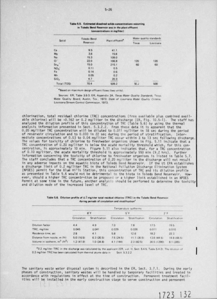
5-26
Table 5.5. Estimetad dissolved solids concentrations occurringin Toledo Bend Reservoir ano in the plant effluent
(concentrations in mg/ liter)
Toledo Bend * "*Sond Piant effluent *
Reservoir Texas Louisiana
Ca 9.5 41.1Mg 3.6 15.6Na 153 109.0C3 - 22.0 106.8 120 120
So." 15.0 215.1 60 60NO - o.11 0. 53Fe o.14 0.6Mn 0.05 o.2SiO 4. 7 20.32
Total (TDS) 70.4 509.2 SCJ 500
* Based on rnanimum design effluent flows (two units).
Sources: ER, Tatde 3 6-3, ER, Appendix 2A, Texas Water Quality Srmdarr/s. TexasWatet Quality Board, Austen, Ten .1973; State of Loumana Water Ou.tiry Cntena.Louisiana Stream Control Commisseon 1973.
chlorination, total residual chlorine (TRC) concentrations (free available plus combined avail-able chlorine) will be =0.162 or 0.2 mg/ liter in the discharge (ER, Fig.10.5-1). The staff hasanalyzed the dilution profile of this concentration of TRC (Table 5.6) by using the thermalanalysis information presented in Sect. 5.3.2.2. From these data it is apparent that the0.20 mg/ liter TRC concentration will be diluted to 0.011 mg/ liter in 18 sec during the periodof reservoir circulation and to 0.010 in 22 sec during the period of stratification. Inter-mediate concentrations of 0.03 to 0.04 mg/ liter TRC occur within 3 to 13 sec following discharge.The values for toxicity of chlorine to freshwater organisms shown in Fig. 5.11 indicate that aTRC concentration of 0.20 mg/ liter is below the acute mortality threshold which, for this con-centration, is approximately 10 min. Figure 5.11 also indicates that, for a TRC concentrationof 0.10 mg/ liter, the acute mortality threshold is approximately 550 min (9.2 hrs). Furtherinformation concerning the toxicity of chlorine to freshwater organisms is listed in Table 5.7.The staff concludes that a TRC concentration of 0.20 mg/ liter in the discharge will not resultin any adverse impacts on the aquatic biota of Toledo Bend Reservoir. If the US EPA establishesa discharge limit of 0.2 mg/ liter TRC in the National Pollution Discharge Elimination System(NPDES) permit for the Blue Hills Station, this concentration of TRC and its dilution profileas presented in Table 5.6 would not be detrimental to the biota in Toledo Bend Reservoir. How-ever, should a higher TRC concentrition be proposed or a higher limit established in an NPDESPermit at some time in the future, another analysis should be performed to determine the toxicityand dilution mode of the increased level of TRC.
Table 5.6. Dilution profile of 0.2 mgmter total residual chlorme (TRC) in the Toledo Bend Reservoirduring penods of circulation and stratsfication'
Temperature isotherms
8'F 5"F 2F
Circulation Stratification Circulation Str atificat>on Circulation Stratification
Delution factor 44 4.9 7.0 78 17.5 19 5
TRC, mg/hter o045 0.041 o029 o026 o all o olo IResidence time, sec 2. 8 4.1 58 12.6 18 2 22 3Distance from nonie, m (f t) 5.0 (1&5) 6.3 (20 5) 7.5 (24 5) 11.1 (36 5) 136(445) 148(485)Volume m *sotherm, m3 (f t') 1.2(41 9) 1.0 (34 8) 4 1(144) 2.3 (82.5) 36 5 (1290) 8 1(285)
*o 2 mg' titer TRC in the discharge was calculated by the appbcant (ER, v ol. II, Sect 5 4 5. Tatde 5 4 2) The dilution ofo 2 meSter TnC has been calculated from thermal plume data m Sect. 5 3 2.2.
The sanitary waste water disposal system is described in the ER, Sect. 3.7.1. During the earlyphases of construction, sanitary wastes will be handled by temporary facilities and treated inaccordance with regulations in effect at the time of construction. Permanent treatment facil-ities will be installed in the early construction stage to serve construction and permanent
i
1723 132
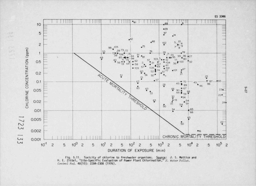
ES 3346
i l I I I I Iil I II Il '4i I i |lIll _ s,' I !6'l I Illll,g-
- -
-
_29 7
5 - 9754 -
- 42I 0
g _102 5s ,4
_.
*
~975 7''898.,105-*E 7 72 7633 @9 26 78$ 1 13*[O6-"/ 82 =0 71 -
85-e$ kh *1 '81 * f ',555
- M .*80-95 * -
*~
49- -
, ' 3) 3a l * +'1217, a ,,32 -
'Z 40 11 '7 9 62 37-
k *o 0.5* 56 *18 64- .". 5 8 to4 s* 352,
. o7 3s,, 61g g
c:1 - 109 108' -101Q' 60 52I74 77 *' ' *47
* 51 .r O.2 -
4 5t 56 92 't p3
**Z -
2I-
#
5' 57
E O.1 - C 63 = 70 - 43' t-87 -"93'
28 45~8-89 * 4s-
*-
%o -
Og#$ O.05 - {*' 63 67
4 46g[-59f4 ,7,.
23._88.
33Z
j ?g20'
? '54 1E3 0.02 %3 T'9 .:54
(g& z24 o
35 54 91I .O w
d| 66 _
o O 50.01 - 34
| _
65 -
0.005 > -
y * 22 -N So
_
uO.002 - *i6
~
| || | |||| CH RONIC . MORTALITY , T,HR.ESHOLDU O.0 010 1 2 3 4 5
10-' 2 5 10 2 5 10 2 5 10 2 5 10 2 5 10 2 5 10 2
DURATION OF EXPOSURE (min)
Fig. 5.11. Toxicity of chlorine to freshwater organisms. Source: J. S. Mattice andH. E. Zittel, " Site-Specific Evaluation of Power Plant Chlorination." .T. Vater PoIZut.Control Fed. 48(10): 2284-2308 (1976).
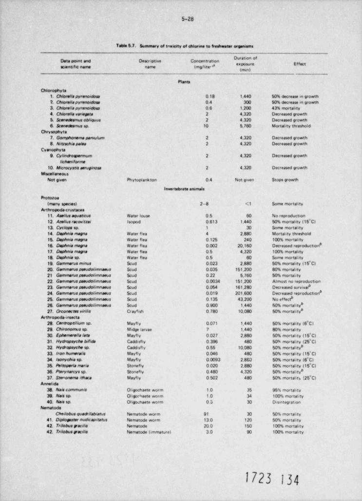
5-28
Table 5.7. Summary of tanicity of chlorme to freshwater organisms
" ' ' * * " 'Data poent and Descriptive Concentration* '' ***
scientific name name (mg/hted
Plants
Chlorophyts1. Olore//spyrenoidosa 0.18 1,440 50% decrease in growth2. Chlore//spyrenoidoss 0.4 300 50% decrease in growth3. Olore//apyrenoidos 0.6 1.200 43% mortahty4. Olore//a ranepers 2 4.320 Decreased growth
5. Scenedesmus obliovus 2 4,320 Decreased growth6. Scenedesmus sp. 10 5.760 Mortality threshold
Chrysophyta7. Gomphonemapervulum 2 4.320 Decreased growth8. Nittachiapales 2 4.320 Decreased growth
Cyanophyta9. Cylindovermum 2 4,320 Decreased growth
lichaniforme10. Microcystis aeruginosa 2 4.320 Decreased growth
MisceHaneousNot given Phytoplankton 0.4 Not given Stops growth
invertebrate arumals
Protosoa(many species) 2-8 <1 Some mortahty
Arthropoda <rustacas11. Ase/Ais aquaticus Water louse 0. 5 60 No reptoduction12. Are//usracoritisi Isopod 0.613 1.440 50% mortahty (15'C)13. Cyclops sp. 1 30 Some mortality14. Daphnia magna Water f!es 4 2.880 Mortahty threshold15. Daphnia magna Water flea 0.125 240 100% mortahty16. Daphnis mara Water flea 0.002 20.160 Decreased reproduction *
17. Daphnia mapa Water flea 0.5 4.320 100% mortahty18. Daphnia so. Water flea 0.5 60 Some mortahty19. Gamme.-us minus Scud 0.023 2.880 50% mortahty (15*C)20. Gammeruspseudo/imnaeus Scud 0.035 151,200 80% mortahty21 Gammarus pseudolimnaeus Scud 0.22 5.760 50% mortahty22. Gammarusaseudolimnaeus Scud 0.0034 151,200 Almost no reproduction23. Gammeruspseudolimnaeus Scud 0.054 161.280 Decreased survivai*24. Gammaruspseudolimnaeus Scud 0.019 201,600 Decreased reproduction *25. Gammaruspseudolimnaeus Scud 0.135 43.200 No ef fect*2& Gammaruspseudolimnaeus Scud 0.900 1.440 50% mortahty*27. Orconscres virilis Cravfish 0.780 10.080 50% mortahty*
Arthropoda-insecta28. Centroptilium sp. Mayfly 0.071 1.440 50% mortahty (6*C)29. Oironomus sp. Midge larvae 7 1.440 80% mortahty30. Ephemere//a / ara Mayfly 0.027 2.880 50% mortahty (15*C)31. Hydropsyche bifida Caddisfly 0.396 480 50% morratity (25*C)32. Hy*opsyche sp. Caddisfly 0.55 10.080 50% mortahtv*33. Ironhumeralis Mayfly 0.046 480 50% mortahty (15 C)34. Isonychia sp. Mayfly 0.0093 2.8E0 50% mortahty (6*C)35. /w/roperla maria Stonefly 0 020 2.880 50% mortahty (15*C)36. Prerynarcys sp. Stonefly 0.480 4.320 50% mortahty*37. Stenonemairhaca Mayfly 0.502 480 50% mortahti (25*C)
Annehda38. Nais communis Oligochaete worm 1.0 35 95% mortahty39. Nais sp. Ohgochaete worm 1.0 34 100% mortahty40. Nais sp. Ohgochaete worm 0.3 30 Disintegration
NematodaChei/obus quadi/ablarus Nematode warm 91 30 50% mortahty
41. Diptogssternudicapitatus Nematode worm 13 0 120 50% mortahty42. Trilobusgracilis Nematode 20 0 150 100% mortahty42. Trilobusgracilis Nematode (immature) 3.0 90 100% mortahty
1723 134
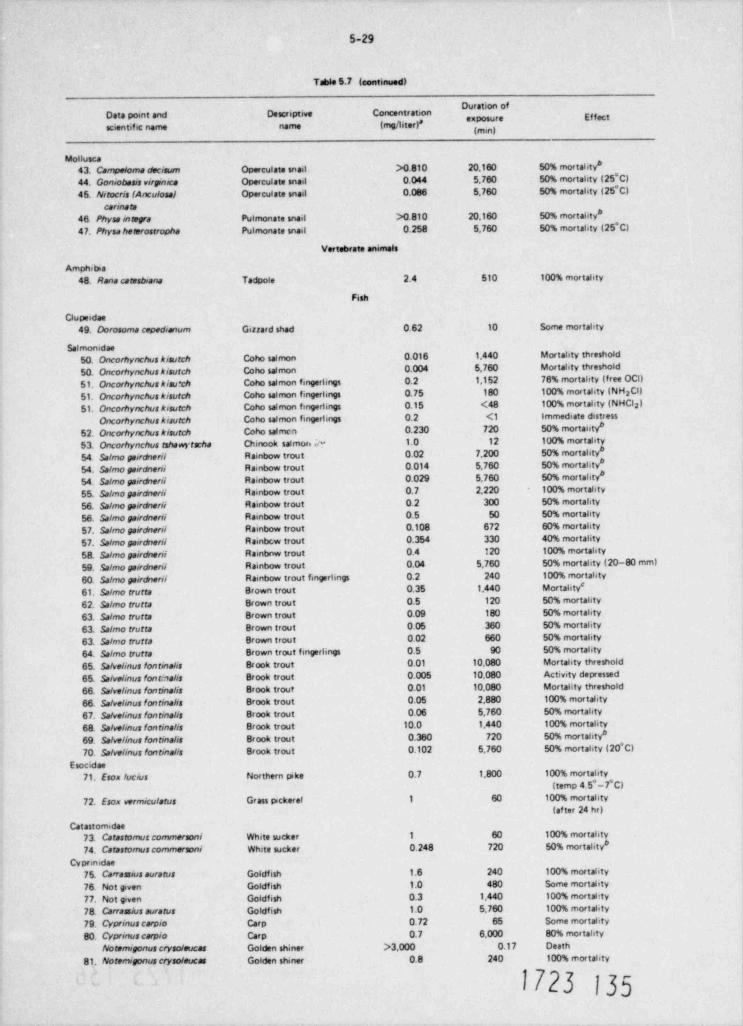
5-29
Table 5.7 (continued)
"'' "'Data point and Descriptive Concentration * * ***scientific name name (mg/hter)*
Motiusca43. Campeloma decisum Operculate snail >0.810 20,160 50% mortahty*
44. Goniobesis virpnica Operculate snail 0.044 5.760 50% mortahty (25*C)
45. Nirocris(Anculosal Operculate snail 0.086 5.760 50% mortahty (25*C)
carinate46. Physsintegre Pulmonate snail >0.810 20,160 50% mortahty*
47. Physaheatrostropha Pulmonate snail 0.258 5,760 50% mortahty (25*C)
Vertebrate animals
Amphitna48. Rana caresbiana Tadpole 2.4 510 100% mortahty
Fish
Clupendae
49. Dorosome cepedianum Gissard shad 0.62 10 Some mortahty
Salmonidae50. Oncorhynchus kisurch Coho salmon 0.016 1,440 Mortahty threshold
50. Oncorhynchus kisurch Coho salmon 0.004 5,760 Mortahty threshold
51. Oncorhynchus Aisu*ch Coho salmon fingerlings 0.2 1,152 76% mortahty (free OCI)
51. Oncorhynchus Aisurch Coho salmon fingerlings 0.75 180 100% mortshty (NH Cl)2
51. Oncorhynchus kisurch Coho salmon fingertings 0.15 <48 100% mortahty (NHCl )2
Oncorhynchus Aisulch Coho salmon fingertings 0.2 <1 Immediate distress
52. Oncorhynchus kisurch Coho salmcm 0.230 720 50% mortahty*
53. Oncorhynchus tshawyrscha Chinook saimm ;~ 1.0 12 100% mortahty
54. Salmo paircherii Rainbow trout 0.02 7,200 50% mortahty#
54. Salmo pairdnerii Rainbow trout 0.014 5,760 50% mortahty*
54. Salmopairdberii Rainbow trout 0.029 5,760 50% mortahty*
55. Salmo pa&dnerii Rainbow trout 0.7 2,220 100% mortahty
56. Salmo pairdnerii Rainbow trout 0.2 300 50% mortahty
56. Salmopairdnerii Rainbow trout 0.5 50 50% mortahty
57. Salmo pa&serii Rainbow trout 0.108 672 60% mortahty
57. Salmo pairdherii Rainbcw trout 0.354 330 40% mortality
58. Salmo pairdheril Rainbnw trout 0.4 120 100% rnortahty
59. Salmo pe&dnerii Rainbow trout 0.04 5,760 50% mortahty (20-80 mm)
60. Salmo pairseril Rainbow trout fingerlings 0.2 240 100% mortality
61. Salmo crurta Brown trout 0.35 1,440 Mortahty'
62. Salmo trutta Brown trout 0.5 120 50% mortahty
63. Salmo trutta Brown trout 0.09 180 50% mortahty
63. Salmo trutta Brown trout 0 05 360 50% mortahty
63. Salmo trutta Brown trout 0.02 660 50% mortahty
64. Salmo trutta Brown trout fingerlings 0.5 90 50% mortahty
65. Salvelinus /ontinalis Brook trout 0.01 10.080 Mortahty threshold
65. Salvelinus fontinalis Brook trout 0.005 10.080 Activity depressed
66. Sa/velinus fontinalis Brook trout 0.01 10,080 Mortahty threshold
66. Salvelinus fontinalis Brook trout 0.05 2,880 100% mortahty
67. Salve /inus fonrinalis Brook trout 0.06 5,760 50% rnortahty
68. Salvelinus fontina /is Brook trout 10.0 1,440 100% mortality
69. Salvelinus fontinalis Brook trout 0.360 720 50% mortahty*
70. Salvelinus fontinalis Brook trout 0.102 5,760 50% mortahty (20*C)
Esocidae71. Eson lucius Northern pike 0.7 1,800 100% mortahty
(temp 4 5*-7*C)
72. Esox vermiculatus Grass pickerel 1 60 100% mortahty
(af ter 24 hr)
Catastomidae73. Catastomuscommersoni White sucker 1 60 100% mortahty
74. Catastomuscommersoni White sucker 0.248 720 50% mortality *
Cyprin.dae75. Carrassius auratus Goldfish 1.6 240 100% mortahty
76. Not given Goldfish 1.0 480 Some mortahty
77. Not given Goldfish 0.3 1.440 100% mortahty
78. Carrassiusauratus Goldfish 1.0 5,760 100% mortahty
79. Cyprinuscarpio Carp 0.72 65 Some mortahty
80. Cyprinuscarpio Carp 0.7 6,000 80% mortahty
Noremigonus crysoleucas Golden shiner >3,000 0.17 Death
81. Noremigonus crysoleucas Golden shiner 0.8 240 100% mortahty
1723 135-
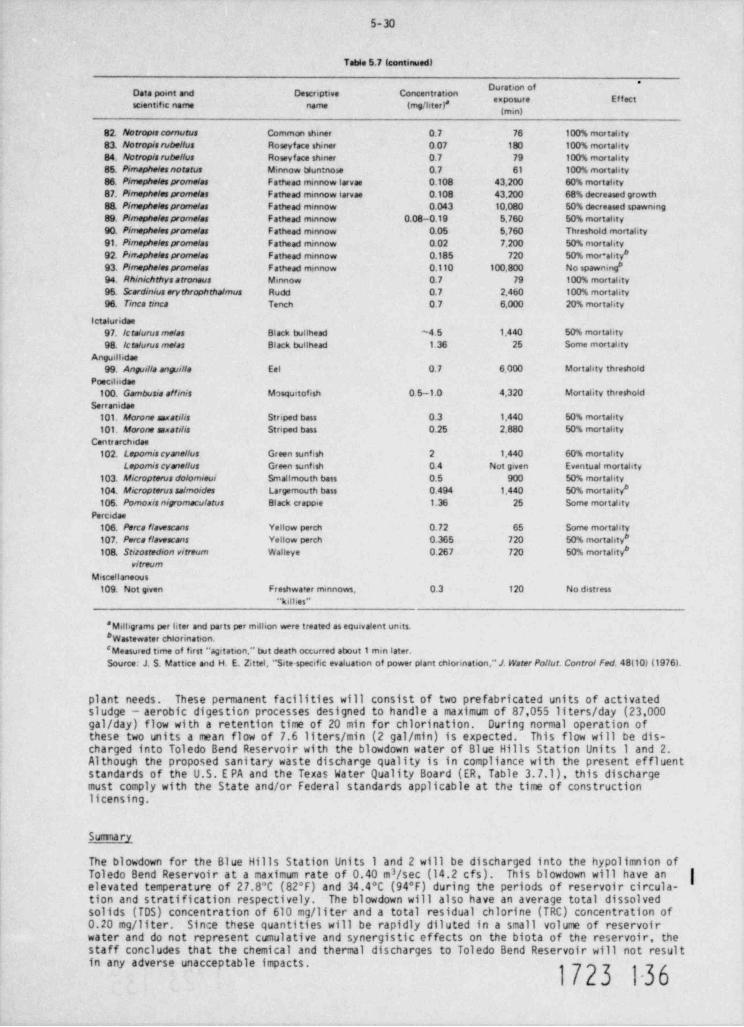
5-30
Table 5.7 (continued)
*Data point and Descriptive Concentrationscientific name name {mg/hter)*
82. Notropascornutus Common shiner 0.7 76 100% mortahty83. Norropisrube//us Roseyface shiner 0.07 180 100% mortahty84. Notropisrubel/us Roseyface shiner 0.7 79 100% mortality85. Pimaphelesnotatus Minnow bluntnose 0.7 61 100% mortahty86. Pimephelespromelas Fatheao mmnow larvae 0.108 43,200 60% mortahty87. Pimephelesprome/as Fathead minnow larvae 0.108 43,200 68% decreased orowth8& Pimephelespromelas Fathead mmnow 0.043 10.080 50% decreased spawnmg89. Pimephelesprome/as Fathead mmnow 0.08-0.19 5,760 50% mortahty90. Pimephelespromelas Fathead mmnow 0.05 5,760 Threshold mortahty91. Pimephelespromelas Fathead minnow 0.02 7,200 50% mortahty92. Pimephelespromelas Fathead minnow 0.185 720 50% mor+ahty*93. Pimephelespromelas Fathead minnow o.110 100.800 No spawning *94. Rhinichthysarronous Minnow 0.7 79 100% mortahty95. Scardiniuserythrtphtha/mus Rudd 0.7 2.460 100% mortahty96. Tinca tmca Tench 0.7 6.000 20% mortahty
letaluridae97. /craturusmelas Black butthead ~ 4. 5 1,440 50% mortahty
98. /cta/urusmelas Black bullhead 1.36 25 Some mortahty
Anguilbdae99. Anguills anguilla Eel 0.7 6.000 Mortahty threshold
Poecibidae100. Gambusia affinis Mosquitofish 0.5- 1.0 4.320 Mortality threshold
Serranidae101. Morone saxatilis Striped bass 0.3 1.440 50% mortahty
101. Morone senarilis Striped bass 0.25 2,880 50% mortahty
Centrarchidae102. Lepomis cyane//us Green sunfish 2 1,440 60% mortahty
Lepomis cyme //us Green sunfish 0.4 Not given Eventual mortahty103. Micropterus dolomieui Smallmouth bass o.5 900 50% mortahty104. Micropterussalmoides Largemouth bass 0.494 1,440 50% mortabty*105. Pomoxignigmaculatus Black crapoie 1.36 25 Some mortahty
Percidae
106. Perca flavescans Yellow perch 0.72 65 Some mortahty
107. Perca flavescans Yellow perch 0.365 720 50% mortahty*10& Stiiostedion vitraum Walleye 0.267 720 50% mortahty*
vitreumMescellaneous
109. Not given Freshwater mmnows, 0.3 120 No distress"kilhes"
*Milbgrams per hter and parts per million were treated as equivalent units.* Wastewater chlorination.' Measured time of first "aptation." but death occurred about 1 min later.Source: J. S. Mattice and H. E. Zittel, " Site-specific evaluation of power plant chlorination,"J. Water Po//ut. Contro/ red. 48(10) (1976L
plant needs. These permanent facilities will consist of two prefabricated units of activatedsludge - aerobic digesticn processes designed to handle a maximum of 87,055 liters / day (23,000gal / day) flow with a retention time of 20 min for chlorination. During normal operation ofthese two units a mean flow of 7.6 liters / min (2 gal / min) is expected. This flow will be dis-charged into Toledo Bend Reservoir with the blowdown water of Blue Hills Station Units 1 and 2.Although the proposed sanitary waste discharge quality is in compliance with the present effluentstandards of the U.S. E PA and the Texas Water Quality Board (ER, Table 3.7.1), this dischargemust comply with the State and/or Federal standards applicable at the time of constructionlicensing.
Suma ry
The blowdown for the Blue Hills Station Units 1 and 2 will be discharged into the hypolimnion ofToledo Bend Reservoir at a maximum rate of 0.40 m /sec (14.2 cfs). This blowdown will have an |
3
elevated temperature of 27.8*C (82*F) and 34.4*C (94*F) during the periods of reservoir circula-tion and stratification respectively. The blowdown will also have an average total dissolvedsolids (TDS) concentration of 610 mg/ liter and a total residual chlorine (TRC) concentration of0.20 mg/ liter. Since these quantities will be rapidly diluted in a small volume of reservoirwater and do not represent cumulative and synergistic effects on the biota of the reservoir, thestaff concludes that the chemical and thermal discharges to Toledo Bend Reservoir will not resultin any adverse unacceptable impacts.
1723 1-36
5-31
5.6 ENVIRONMENTAL EFFECTS OF THE URANIUM FUEL CYCLE
On March 14, 1977, the Comission presented in the rederal RcJ ster (42FR13803) an interim rulei
regarding the environmental considerations of the uranium fuel cycle. It is effective throughSeptembe r 13, 1978 and revises Table S-3 of 10 CFR Part 51. Final rulemaking proceedings will beconducted so as to allow for additional public comment and specific details with respect to time,place, and format of such proceedings shall be presented in a subsequent Fodcral Register notice.
The interim rule reflects new and updated information relative to reprocessing of spent fuel andradioactive waste management as discussed in NUREG-0116, Enviromental Levey of the Repr cessingand Waste Mrupment Porticns of the LFR FucI ep!s and NUREG-0216 which presents staff responsesto coments on NUREG-0116. The rule also considers other environmental factors of the uraniumfuel cycle including mining and milling, isotopic enrichment, fuel fabrication, and managementof low and high level wastes. These are described in the AEC report WASH-1248. EnviromentalGuzvey of the Uraniten Fuel Qnle.
An amendment of April 14, 1978, to 10 CFR Part 51 (43 FR 15613) further revises Table S-3 toclarify that the table does not cover estimates of radon released and its health effects.
Specific categories of natural resource use are included in Table S-3 of the interim rule and arereproduced in this Statement as Table 5.8. These categories relate to land use, water conseptionand thermal effluents, electrical energy use, fossil fuel combustion, chemical and radioactiveeffluents, burial of transuranic and high/ low level wastes, and radiation doses from transportationand occupational exposures. The cantributions in Table 5.8 f or reprocessing, waste management,and transportation of wastes are maximized for either of the two fuel cycles (uranium only and norecycle); that is, the cycle which resulted in the greater impact was used.
The following assessment of the environmental impacts of the fuel cycle as related to the operationof the Blue Hills Station is based upon the values given in Table 5.8 and the staff's analysis ofthe radiological impact from radon releases. For the sake of consistency, the analysis of fuelcycle impacts other than that due to land use has been cast in terms of a model 1000 MWe LWRoperating at an annual capacity factor of 80%. Our conclusions regarding the effects of theseimpacts would not be altered if the analysis was based on the proposed electrical power capacityof each Blue Hills unit (957 MWe).
The total annual land requirement for the fuel cycle supporting a model 1000 MWe LWR is about41 ha. Approximately 3 ha per year are pemanently committed land, and 38 ha per year aretemporarily committed. (A " temporary" land commitment is a commitment for the life of thespecific fuel-cycle plant, e.g. , mill, enrichment plant, or succeeding plants. On abandonmentor decomissioning, such land can be used for any purpose. " Permanent" comitments representland that may not be released for use af ter plant shutdown and/or decomissioning.) Of the38 ha per year of temporarily committed land, 29 ha are undisturbed and 9 ha are disturbed.Considering common classes of land use in the U.S.,* fuel-cycle land-use requirements to supportthe model 1000 MWe LWR do not represent a significant impact.
The principal water-use requirement for the fuel cycle supporting a model 1000 MWe LWR is thatrequired to remove waste heat from the power stations supplying electrical energy to the enrich-ment step of this cycle. Of the total annual requirement of 43 x 106 m 3 (11.373 x 10⁶ gal),
3about 42 x 106 m are required for this purpose, assuming that these plants use once-throughcooling. Other water uses involve the discharge to air (e.g., evaporation losses in processcooling) of about 0.6 x 10⁶ 3m per year and water discharged to ground (e.g. , mine drainage) of
3about 0.5 x 10⁶ m per year.
On a thermal effluent basis, annual discharges from the nuclear fuel cycle are about 4% of themodel 1000 MWe LWR using once-through cooling. the consumptive water use of 0.6 x 10⁶ m per3
year is about 2% of the mcdel 1000 MWe LWR using cooling towers. The maximum consumptive wateruse (assuming that all plants supplying electrical energy to the nuclear fuel cycle used coolingtowers) would be about 6% of the model 1000 MWe LWR using cooling towers. Under this condition,thermal effluents would be negligible. The staff finds that these combinations of themalloadings and water consumption are acceptable, relative to the water use and thermal dischargesof the proposed project.
Electrical energy aM process heat are required during various phases of the fuel cycle process.The electrical energy is usually produced by the combustion of fossil fuel at conventional powerplants. As indicated in Tabla 5.8, electrical energy associated with the fuel cycle representsless than 5% of the annual electrical power production of a typical 1000 MWe nuclear plant.Process heat is primarily generated by the combustion of natural gas. As noted in Table 5.8,
.
A coal-fired power plant of about 1000 MWe capacity using strip-mined coal required thedisturbance of about 81 hectares per year for fuel alone.
1723 137
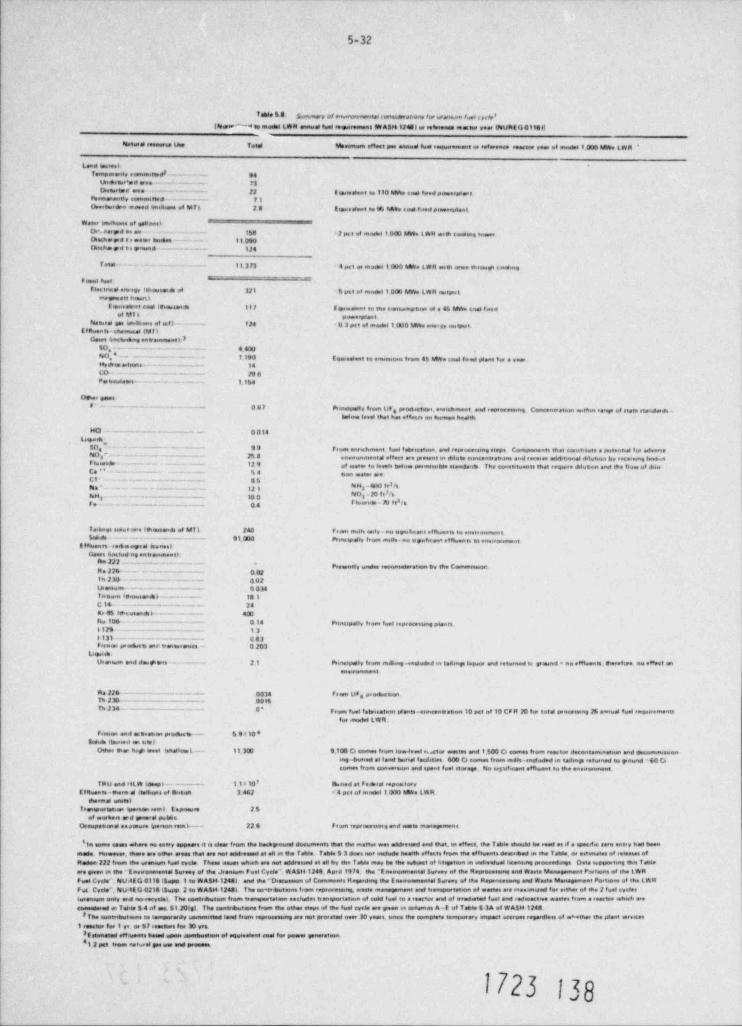
5-32
Yable S 8 gs,,,,,ny, er es,spomnaested(miserhrebers for earessem fued s.rs e8s
leeW to model LW R annwee fuel se M Alle 124Sl er solesense seeseus year INUR$ G 4 9141f
Natise teneures une Teod Memwmse eteset per ansied fwd teouwesene er seester yee of enedes 1.000 MWe LWR '
Lead tosses 6Tempeedy cessissieswdI- --- 94
taneamer'se aree -- - - . - - . F3Drotesend ese- - - ~ - . 22 8 seesselent se 1 to MWe sees feed passeepleis
ptsessenently commuttee - - ~ - F]Ueertusr6. . cored Imeneens of MT L 20 teseeesent se ub have see tieed paneeesdent
heet kneNeene of geNesselDs+. deed en ear - -- 16e * 2 pas et suieded i OGI Mh L WR esqh testing higeneDeshape t s sweee heems - ~~ -- 1I DgGhashe po t e passne ------ -- 124
f eed - - - - - - 113 F3 - 4 pet es snedre 1000 he%e LWR e m once she wp send =g
- _ - - _ _ _ _ _ ,
flectesse8 enregy Ishowsme of 321 6 pet et escalet 1000 MWs LWR outputmegueste hanerst
E eneelene feel itseisaane 117 6 geseelent to tsee eenessasimenen of a 45 MWe seal tseedet MT L pene.ptent.
Nee.ed goe omdhens of uf) . - - -- f24 0 3 put of model 1000 MWs enerav oogsutElbents-estemeses (Mil
Genes ipectueene ennewunentiI50, - - -- - - 4 400No,4 -. ~ . - . - - . . I 130 tqeeswns to em sme #,em 45 MWe caos feed s6 ant for e veer.Hydess estmens- - 14LD- - - - . . . _ . _ . . 23 3pe,emseeme_. - - _- _ -~ i 1g4
Deen paeseF - - - - - - - -- 06P Pronopen, feem UF prowm ennehment and soprocessme Conconcrepun oathm eene of stato utenderde -q
belee leed that hoe opsori ei homen hedth
MCI . - . . _ _. 0014Leone
50 -- - -- 99 pressi ene she ent. f.ses febs. set.en. and ressee.. ng eteps Ceaipenenn ehet sentitete e potented tw estwersesNo -- - - - - - - . - - 25 8 enewunmened eMeet are peient en dauen eenceneseens and eersees addeteenal shtetson by esseis ng beewsef tuerede - - - - -- - 12 9 ee oper se to.oes heese permneeMe nonderats The coewetween that regenee esilvean and she fece et dueCe ' ' - - - - 44 een esser eseC1 - - - - - - ~ . - - - - - - - 85Na - - - - - - - - - - - - - . - - --. 12 1 3
O - M WeNM - - - - - 10 0 saI br*'888m - 30 OSy,_ _ _. g4
Te.bnei seese as t f*eusene of MT k 240 Fram mdei eity- no wwwticant eIAenn te onegas,4 _. _ . . . - - . - - - - - 91.000 Prunespday from muses-no ogwhc.ent ef%enn se anweeermene
StNesse esemeyed ImeneelGenes awaraud og ente
Ass 222 ... - -. - -- -- - -pre,ense, e,nder essen by the C
Re 22tk - - - - - - - - - - 0 02t n 210. - - - - - - --~ 0 02Usannear - -- - 0 034f asem seieussieb - ----- 13 3C 14 - - . - - - - - . - - - - - 24Kr 86 feceannek- 400Res 106 -. - - - - . . - - - - 0 14 Prencipell, tsoen fuel opeacensne p4ents612S - - ----- - - t30131 -- - - 003f asen paeses one' erenesreiece - 0 203
Lagese
Uteseem and do.$ wee- - - - - - 21 Pomesposey tresse menweg -enehsded m tedsay Isquer and returned er yesad a no e8None. Doesfare ao eMost enone
Re 224 ---~--- 0014 Franse UFe P'*4'8 h""Th 236- 00 tt
th 234 -. - - _ ~ ~ O' peem fuel fataisatenn stana eretion 10 oct et 10 CF R 20 tw seed preceoung 28 anned fuse esisuwemennfor anodsf LWR.
fese en and e6teemos prochesm- - 5 9 a 10 eBakda (tmsesed en stop
Oeer me het see 4 inhelleek-- 11.3GI 9.100 C4 enmes frosis Ise4eest eute wentes and 1.500 Cs esmos from emestee decentemenessen and decanumswenmg4uned et land bureel fasdetses 400 Cs somes from edle-esidaded m tosen, returned to paend - 60 Cecomme freen senaereen end opent fuel stwege No sepsfacent eNhsent se the
TRU and HLW Ideepp -- 11 < 10' beed at Fedeses eseeestswvf thenen-poes d theshone of Srd sh 3 462 e 4 pet of meest 1.000 heNo LWR
messnel esmeelTeentportatien ipoetei sem) E mpneuse 25
el norheen er d passed pubens.Orespecesid enemisee Weseen-rosa k-- 22 8 f rom eepressmeng end nesee
'Ist essmo eseos ashore se entry appears d se einer from tlie hechyeund decermeens ehet the snettue een medressed and ehet, en eMeet. ehe Ioble theuld he read es d e speedie sore entry had been
made Memover. ehese are othee arose thee are sist addressed et se est the f ches. Tehde 5 3 does noe instude leasth e fecte frase the ettecents desceeed m the Tebas. ee semi een et reeeeses ofe
Reden 222 frame the torenown fuel eycae These seuse wheek are nos addressed at all by the IsMe mov be the endagest of htngstuen e endswedwal . proceedwige Does supesertog the Tebasare geen ai she Enveevamental Survey of the Jreasum Fees Cvele *. W A$tt 1248. Aped 19 74 the "E neeenmental Survey of the R _ and Weste " Partensof the LWRFuel Cyde''. NU4E G 01151&sspo 1 es WABM 124st asut me "D ecusesen of '' Regardag the E ne sel Servey of the Repensensweg and hete " Portene of the LWRFes' Code", Nu itG 0214 i5upp 2 to WAset 12483. The eemoventeens tsom repeaceae.at osene and teensportesson of eastes se enesismeed ter eether of she 2 twee eyesee
teseemum esdy and no-eeevesel. The seatedeutesileone openeporteten eachsdee sensparentsen et eeld fome to e coacter and et arendoved feet and rodeactsee ereseen eram o reactee which areennessered en f onde 3 4 af tea 5120(st The sentreutone trein she other necess of ifie fuet ovcie are yeen se assisensis A-t of Tahoe S 3A of WA$H 1240
IThe senteenstene to semperordy _ land frasen repreceessne are not prereted eeer 30 yeere, sence the sempleee tossiperary empact aserves regerifiees of =* eeher the plant entences1 eetator fee I ye se SI remetere See M yet
3f stimeted eMasonen based open een of seal for power generetsen0 12 pet tress > notural gee see and preseen
1723 139
5-33
this gas consumption if used to generate electricity would be less than 0.3% of the electricaloutput from a 1000 MWe plant. The staff finds therefore, both the direct and indirect con-sumption of electrical energy for fuel cycle operations to be small and acceptable relative tothe net power production of the power plant.
The quantities of chemical gaseous and particulate effluents associated with fuel cycle processesare given in Table 5.8. The principal species are 50x, NO and particulates. Based upon dataxin a CEQ Report (The Seventh Ann:al Report of the Comil on Environmental Cality, September 1976,Figs.11-27 and 11-28, pp. 238-239), the staff finds that these emissions constitute an extremelysmall additional atmospheric loading in comparison to the same emissions from the stationaryfuel combustion and transportation sectors in the U.S., i.e., approximately 0.02% of the annual(1974 base) national releases for each of these species. The staff believes such small increasesin releases of these pollutants are acceptable.
Liquid chemical effluents produced in fuel cycle processes are related to fuel e?.richment, fabri-cation and reprocessing operations and may be released to receiving waters. These effluents areusually present in dilute concentrations such that only small amounts of dilution water arerequired to reach levels of concentration that are within established standards. Table 5.8specifies the flow of dilution water required for specific constituents. Additionally, allliquid discharges into the navigable watds of the United States from plants as ociated with thefuel cycle operations will be subject to requirements and limitations set forth in an NPDES permitissued by an appropriate state or Federal regulatory agency.
Tailings solutions and solids are generated during the milling process. These solutions andsolids are not released in significant quantities to create an impact upon the environment.
Radioactive effluents estimated to be released to the environment from reprocessing and wastemanagement sctivities and certain other phases of the fuel-cycle process are set forth indose comitment*g these data, the staff has calculated the 100-year involuntary environmentalTable 5.8 Usin
to the U.S. population. These calculations estimate that the overall invol-untary total body gaseous dose comitment to the U.S. population from the fuel cycle (excludingreactor releases and the dose comitment due to radon-222) would be approximately 400 man-remsper year of operation of the model 1000 MWe LWR. The data in Table 5.8 indicate that the addi-tional involuntary total body dose commitment to the U.S. population from radioactive liquideffluents of all fuel-cycle operations other than reactor operation would be approximately100 man-rems per year of operation. Thus, the estimated involuntary 100-year enviror. mentaldose comitment to 6ne U.S. population from radioactive gaseous and liquid releases from theseportions of the fuel cycle is approximately 500 man-rems (whole body) per year of operation ofthe model 1000 MWe LWR.
At this time Table 5.8 does not address the radiological impacts associated with radon-222releases. Radon is released during mining and mill operations and is emitted from milltallings. The staff has determined that releases from these operations for each year ofoperation of the model 1000 MWe LWR are as follows:
Mining:29 4060 Ci30 780 CiMilling and Tallings:
(during active milling)30 350 CiInactive Tailings:
(prior to stabilization)
Stabilized Tailings:30 1 to 10 C1/yr(several hundred years)
Stabilized Tailings:d 110 Cl/yr(after several hundred years)
The staff has calculated population dose comitments for these sources of radon-222 using theRABGAD computer coda described in NUREG-0002, Section IV.J. Appendix A.31 The results of thesecalculations for mining and milling activities prior to tailings stabilization are as shown inTable 5.9. When added to the 500-man-rem total body dose comitment for the balance of thefuel cycle, the overall estimated total-body, involuntary,100-year, environmental dose commit-ment to the U.S. population from the fuel cycle for the model 1000 MWe LWR is approximately640 man rems. Over that period this dose is equivalent to 0.00002% of the natural backgrounddose of about 3,000,000,000 man-rems to the U.S. population.+
sThe environmental dose comitment (EDC) is the integrated population dose for 100 years -i.e., it represents the sum of the annual population doses for a total of 100 years. Thepopulation dose. varies with time, and it is not practical to calculate this dose for every year.
*0n the basis of an annual average natural background individual dose commitment of 100 mremand a stabilli d U.S. population of 300 million.
1723 |39
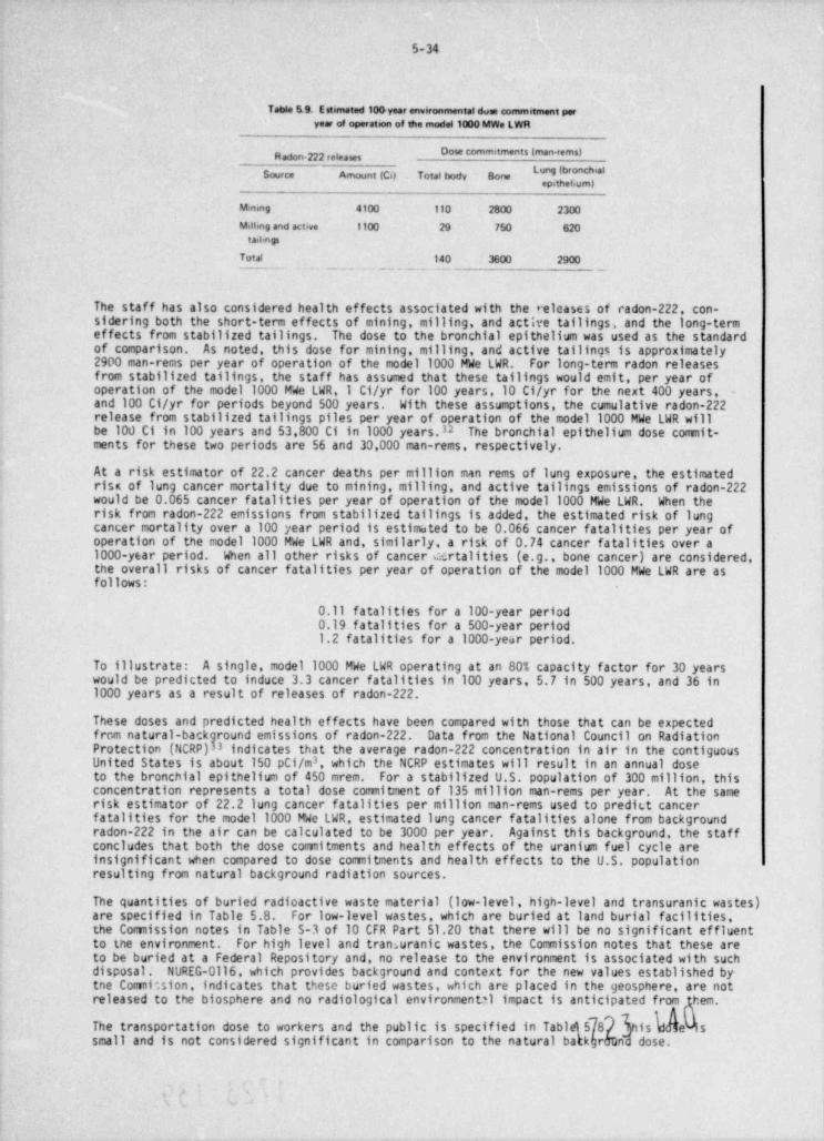
5-34
Table 5.9. Estimated 104 year environmental done commitment peryear of operation of the model 1000 MWe LWR
Dose commitments (man-rems)g ,
" "ISource Amount (Cd Total body Bone
Mening 4100 11o 2800 2300
Milbng and actave 1100 29 750 620tail.ngs
Total 140 3600 2900
The staff has also considered health effects associated with the releases of radon-222, con-sidering both the short-term effects of mining, milling, and acth'e tailings, and the long-termeffects from stabilized tailings. The dose to the bronchial epithelium was used as the standardof comparison. As noted, this dose for mining, milling, and active tailings is approximately2900 man-rems per year of operation of the model 1000 MWe LWR. For long-term radon releasesfrom stabilized tailings, the staff has assumed that these tailings would emit, per year ofoperation of the model 1000 MWe LWR,1 C1/yr for 100 years,10 C1/yr for the next 400 years,and 100 C1/yr for periods beyond 500 years. With these assumptions, the cumulative radon-222release from stabilized tailings piles per year of operation of the model 1000 MWe LWR willbe 100 Ci in 100 years and 53.800 Ci in 1000 years.32 The bronchial epithelium dose commit-ments for these two periods are 56 and 30,000 man-rems, respectively.
At a risk estimator of 22.2 cancer deaths per million man rems of lung exposure, the estimatedrisc of lung cancer mortality due to mining, milling, and active tailings emissions of radon-222would be 0.065 cancer fatalities per year of operation of the model 1000 MWe LWR. When therisk from radon-222 emissions from stabilized tailings is added, the estimated risk of lungcancer mortality over a 100 year period is estimated to be 0.066 cancer fatalities per year ofoperation of the model 1000 MWe LWR and, similarly, a risk of 0.74 cancer fatalities over a1000-year period. When all other risks of cancer certalities (e.g., bone cancer) are considered,the overall risks of cancer fatalities per year of operation of the model 1000 MWe LWR are asfollows:
0.11 fatalities for a 100-year period0.19 fatalities for a 500-year period1.2 fatalities for a 1000-year period.
To illustrate: A single, model 1000 MWe LWR operating at an 80% capacity factor for 30 yearswould be predicted to induce 3.3 cancer fatalities in 100 years, 5.7 in 500 years, and 36 in1000 years as a result of releases of radon-222.
These doses and predicted health effects have been compared with those that can be expectedfrom natural-back Data from the National Council on RadiationProtection (NCRP)groundemissionsofradon-222.3 indicates that the average radon-222 concentration in air in the contiguous
3United States is about 150 pC1/m , which the NCRP estimates will result in an annual doseto the bronchial epithelium of 450 mrem. For a stabilized U.S. population of 300 million, thisconcentration represents a total dose commitment of 135 million man-rems per year. At the samerisk estimator of 22.2 lung cancer fatalities per million man-rems used to predic.t cancerfatalities for the model 1000 MWe LWR, estimated lung cancer fatalities alone from backgroundradon-222 in the air can be calculated to be 3000 per year. Against this background, the staffconcludes that both the dose comitments and health effects of the uranium fuel cycle areinsignificant when compared to dose comitments and health effects to the U.S. populationresulting from natural background radiation sources.
The quantities of buried radioactive waste material (low-level, high-level and transuranic wastes)are specified in Table 5.8. For low-level wastes, which are buried at land burial facilities,the Comission notes in Table S-3 of 10 CFR Part 51.20 that there will be no significant effluentto the environment. For high level and tran, uranic wastes, the Commission notes that these areto be buried at a Federal Repository and, no release to the environment is associated with suchdisposal. NUREG-Oll6, which provides background and context for the new values established by-tne Comi;sion, indicates that these buried wastes, which are placed in the geosphere, are notreleased to the biosphere and no radiological environmental impact is anticipated from hem.
hisThe transportation dose to workers and the public is specified in Tabl 8 eVissmall and is not considered significant in comparison to the natural b kr nd dose.
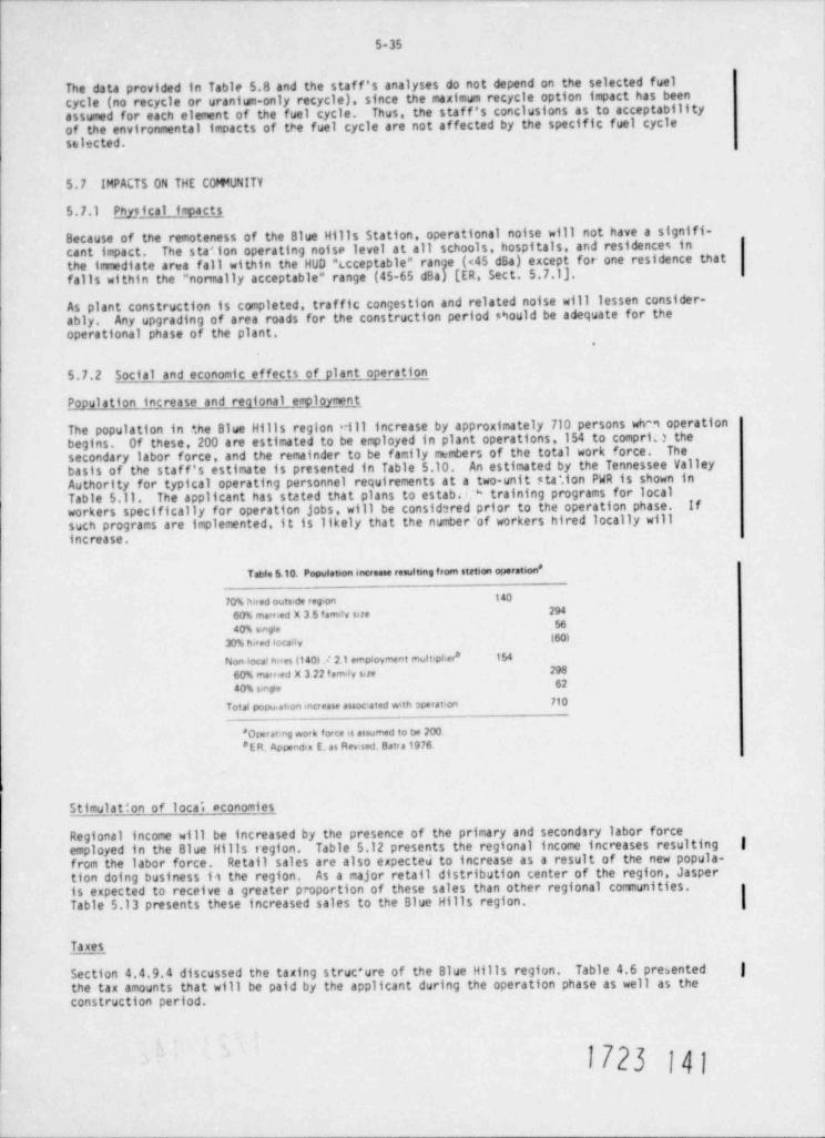
5-35
The data provided in Table 5.B and the staff's analyses do not depend on the selected fuelcycle (no recycle or uranium-only recycle), since the maximum recycle option impact has beenassumed for each element of the fuel cycle. Thus, the staff's conclusions as to acceptabilityof the environmental imoacts of the fuel cycle are not affected by the specific fuel cycleselected.
5.7 IMPACTS ON THE C0m VNITY
5.7.1 Physical impag
Because of the remoteness of the Blue Hills Station, operational noise will not have a signifi-cant impact. The station operating noise level at all schools, hospitals, and residences inthe immediate area fall within the HUD "Lcceptable" range (<45 dBa) except for one residence thatfalls within the "normally acceptable" range (45-65 dBa) [ER, Sect. 5.7.1].
As plant construction is completed, traffic congestion and related noise will lessen consider-ably. Any upgrading of area roads for the construction period Should be adequate for theoperational phase of the plant.
.
5.7.2 Social and economic effects of plant operation
P_opulation increase and reqional employment
The population in +.he Blue Hills region vill increase by approximately 710 persons whm operationbegins. Of these, 200 are estimated to be employed in plant operations,154 to compri.} thesecondary labor force, and the remainder to be family members of the total work force. Thebasis of the staf f's estimate is presented in Table 5.10. An estimated by the Tennessee ValleyAuthority for typical operating personnel requirements at a two-unit sta', ion PWR is shown inTable 5.11. The applicant has stated that plans to estabe * training programs for localworkers specifically for operation jobs, will be considered prior to the operation phase. ifsuch programs are implemented, it is likely that the number of workers hired locally willincrease.
Table 5.10. Population increase resultmg f rom station operation *
14070% hired outs.de reg.on60% married x 3 5 famay size 294
5640% smgie(60)30% hired locally
Non local hires (140) A 21 empiovment mult:pher* 15429860% marned x 3 22 fem ly site6240% smg+e
710Total popu,at.on mcrease assoc:ated wth operation
'Opemmg work force is assumed to be 2008E R. Appendta E, as Rev' sed. Batr a 1976.
Stimulation of local economies
Regional income will be increased by the presence of the primary and second1ry labor forceemployed in the Blue Hills region. Table 5.12 presents the regional income increases resulting |from the labor force. Retail sales are also expected to increase as a result of the new popula-tion doing business 11 the region. As a major retail distribution center of the region, Jasperis expected to receive a greater proportion of these sales than other regional communities.Table 5.13 presents these increased sales to the Blue Hills region.
Taxes
Section 4.4.9.4 discussed the taxing struc+ure of the Blue Hills region. Table 4.6 presented |the tax amounts that will be paid by the applicant during the operation phase as well as theconstruction period.
1723 141
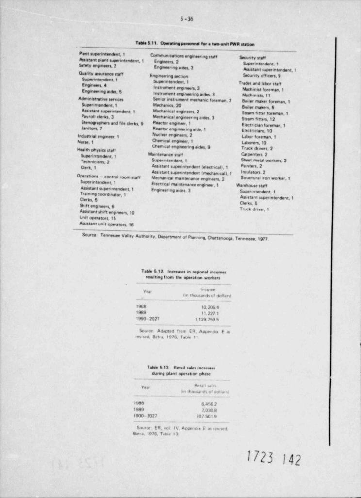
5-36
Table 5.11. Operating personnel for a two-unit PWR station
Plent superintendent,1 Communications engineering staf f Secunty staffAssistant plant superintendent,1 Entneers, 2 Superintendent,1Safety eneneers,2 Entneering sides,3 Assstant supenntendent,1Quality assurance staf f Enganunng section S'C""'Y '"'cas, 9
Superintendent,1 Superintendent,1Trades and labor staf fEnoneers, 4
Instrument eneneers. 3 Mach.nist foreman,1Enyneenng sides,5Instrument engineering aides 3 Machinists,11
Administrative services S'"5 ' instrument mechanic foreman,2 Boiler maker foreman,10
Supenntendent,1 Mechanics, 20 Bo.ler makers,5Assistant supenntendent,1 Mechanical entneers, 2 Steam fitter foreman,1Payroll clerks. 3 Mechamcal engineenng sides, 3 Steam fitters,12Stenographers and file clerks. 9 Rasctor engineer,1 Electncian foreman,1Janetors, 7 Reactor entneering side,1 Electricianc,10
"' ' ' ' " ' " " ' ' '"''"*"'Iindustnal entneer,1Nurse,1 ****''"*""'1 ubmers,10
Chemical entneering a. des,9 Truck drivers,2Health phys +cs staff
Supenntendent,1 Maintenance staff Carpenters, 2Supenntendent,1 Sheet metal workers,2
* * " ' ' ' ' " ' '* * ' Assistant superintendent (electrical),1 Pamters, 2
Assistant superintendent (mechanical),1 Insulators, 2Operations - conteof room staff Mechanical maintenance engineers, 2 Structural iron worker,1
Supenntendent,1 Electrical maintenance entneer,1 Warehouse staffAssistant supenntendent,1 Entnewing sides, 3 Superintendent,1Trarmng coord.nator,1Der ks, 5 Assistant superintendent,1
Derks. 5 'shif t engineers, 6
Truck dnver,1Assistant shif t entneers,10Unit operstors,15Assistant unit epwators,18
Source:Tennessee Valley Autnority, Department of Planning, Chattanooga, Tennessee,1977.
Table 5.12. Increases in reponal mcomesresultmg from the operation workers
.
locomey-
(in thousands of dollars)_ - _
1988 10.206 41989 11.227 11990-2027 1.129.759 5
_
Source. Adapted from E R, Appendix E asrevised, Batra,1976, Tal9e 11.
Table 5.13. Retail sales encreasesdunng plant operation phase
. - . _
Retri seesy(til th0usafid) of dulf di si
1988 6.456 21989 7,030 81900-2027 707.501 9
_ _ _ _ _ _ _ _
Source: E R. vol. I V, Appendi= E es r ev< sed.Batia,1976. Table 13
1723 J42
5-37
Housing
Operations workers and the secondary employment force will demand permanent, quality housing.The applicant e".timates that the comunity of Jasper will house 50% of these workers, Newton 14%,The staffHemphill 6%, Leest,ille 4%, and 26% will locate elsewhere in the Blue Hills region.It is likely that a portion ofbelieves that Leesville may attract more than 4% of the workers.These estimates could conceivablythese workers residing "elsewhere" will relocate in Leesville.change as a function of how services and facilities are expanded in the communities during the
Those communities in the region that develop their housing markets, sewerage
systems, and water supplies will likely attract the larger proportions of the relocating workers.However, the staf f believes that the present housing availability will need to expand in order toconstruction phase.
provide residences for the operations workers.er
Comunity services and facilities
The adequacy of regional services and facilities and the impacts on these services and facilitiesare discussed in Sect. 2.8 and 4.4 respectively.
The increased population due to plant operation will increase demands for comunity services suchas sewage treatment, water supplies, schools, health care delivery, and fire and police protect-
The staff believes that if community services and facility inadequacies are correctedtion.during the construction phase, they should be adequate for the operation phase.
1723 143
5-38
REFERENCES FOR SECTION 5
1. J. B. Dickey et al., " Debut of the Round Mechanical-Draft Cooling Towers," presented toAmerican Power Conference, Chicago, Ill., Apr. 23, 1975; The Marley Company.
2. M. E. LaVerne, The Oak Ridje Fo) and Drift Code (ORFAD) User's Manual, Report ORNL/TM-520), Oak Psid;: Stional Laboratory, Oak Ridge, Tenn., January,1977.
3. R. C. Y. Koh and L.-N. Fan, M2themtic2l Modela for the Prediction of TeTeratureDistributians Resultin] frcer the Discharje of Heated Water Into lazeje B:lica of W2ter,Tetra Tech, Inc. , Pasadena, Calif. ,1970.
4 E. A. Hirst, Analysis of Round, Turbulent, Buayant .Tets Dicehar]ed to Flavir-j Ste2tifielAmbisnts, Report ORNL-4685, Oak Ridge National Laboratory, Oak Ridge, Tenn., June 1971.
5. Texas Water Quality Board, W2ter Cu2tity St2nd2rds, Austin, Tex.,1973.
6. Louisiana Stream Control Cocnission, " State of Loulstana Water Quality Criteria," 1973.
7. 10 CFR Part 20. Standards for Protection Against Radiation.
8. NUREG 75/032, Oc upatioval Radiation Exposure to Lijht Water Coolel Eci: tors 13C3-1374(June.1975).
9. Program to Investigate Feasibility of Natural-Draf t Salt Water Cooling Towers,1972.Applicant's Environmental Report for Forked River Unit No.1. GUP Service Corp., Parsippany,N.J.
10. D. L. Leedy, 1975. Highway-wildlife relationships. Vol. I. A state-of-the-art report.Rept. No. FHWA-RD-76-4. 183 pp.
11. M. Avery and T. Clement. " Bird Mortality at Four Towers in Eastern North Dakota - Fall 1972."Pmirie Naturalist 4; 87-95 (1972).
12. R. Brewer and J. A. Ellis, "An Analysis of Migrating Birds Killed at a Television Towerin East-Central Illinois, Septerter 1955-May 1957," Auk 75: 400-414 (1957).
13. W. W. Cochran and R. R. Graber, " Attraction of Nocturnal Migrants by Lights on a TelevisionTower," Wilsen Bull. 70: 378-380 (1958).
14. S. A. Sebo, J. T. Heibel, M. Frydman, and r. H. Shih, " Examination of Ozone Emanating fromEHV Transmission Line Corona Discharges," IEEE Trans. Power Apparatus and Syst. PAS-95(2): 693-703 (1976).
15. M. Frydman, A. Levy, and S. E. Miller, "0xidant Measurements in the VicinMy of Energized765 kV Lines," IEEE PES Sumer Meeting, San Francisco, Calif. , July 9-14, 1972.
16. Institute of Electrical and Electronic Engineers, neiorul Electriazl c2fety Cole, IEEE,NY, 1977.
17. Rural Electrification Administration, Electmstatig and clczenmpetiz offets of wrheademnsmission tires, REA Bull. 62-4, 1976.
18. Central Illinois Light Company vs Portee et al., Appellate Court of Illinois, 3rd District,June 3,1968, 239 North Eastern Reporter, 2nd Series, pp. 298-301.
19. L. W. Walkinshaw "Sandhill Cranes Killed by Flying into Power Lines," Wilean Fall.68: 325-326 (1956).
20. l. J. Stout The Nature and Pattern of .bnhuntin) Martalitj in Flcijel N:rth Americ2n.
Facerfoul, M.S. Thesis, Virginia Polytechnic Institute, Blacksburg, Va., 1967.|
21. U.S. EPA, Development Document for Best Technology Available for the Location, Design,Construction and Capacity of Cooling Water Intake Structures for Minimizing Adverse Environ-mental Impact, Report EPA 440/l-76/Ol5a, Washington, D.C. 1976.
22. F. Gray, "How Fish Swim," Sai. Am. 197: 48-54 (1957).
23. F. C1 ark and W. Browne11, Electric Pauer Planta in the Cn ct2l ~- Em iran a tz' I: cues,American Littoral Society Special Publ. No. 7., October,1973.
1723 144
5-39
24. N. F. Netsch, G. M. Kersh, Jr., A. Housar, and R. V. Kilambi, " Distribution ofYoung Ginard and Threadfin Shad in Bwer Reservoir," Feservoir Fisheries LimnoZojyQ eri2Z Pdlication .W. 8, American Fisheries Society. Washington, D.C.,1971.
25. K. F. Lagler, Freshwater Fishery Biology, '4. C. Brown Co. , Dubuque. Iowa,1956,
26. W. B. Scott, Frech:nter Fishes of E2 stern canad2, University of Toronto Press, 1967.
27. S. Eddy and F. C. Underhill, Northern Fishes, University of Minnesota Press,1974.
28. Anonymous, Performance Report: District IV-A, Inland Fisheries Management Program, TexasParks and Wildlife Dept. ,1976.
29. U.S. Nuclear Regulatory Cr: mission, In the Matter of Duke Power Company (Perkins NuclearStation) Docket No. 50-468 Testimony of R. Wilde, filed April 17, 1978.
30. U.S. Nuclear Regulatory Comission In the Matter of Duke Power Company (Perkins NuclearStation) Docket No. 50-488. Testimony of P. Magno, filed April 17, 1978.
31 . U.S. Nuclear Regulatory Comission Final Generic Environmental Statement en the Use of!apie P:unniwn in Mixel Gride Fue: in Light-W2ter-cooled Reactors, Report NUREG-0002Washington, D.C., August 1976.
32. U.S. Nuclear Regulatory Comission, In the Matter of Duke Power Cnmpany (Perkins NuclearStation) Docket No. 50-488, Testimony of R. Gotchy, filed April 17, 1978.
33. National Council or. Radiation Protection and Measurements, Publicatien 46, (1975).
1723 145
.
6. ENVIRONMENTAL MEASUREMENTS AND MONITORING PROGRAMS
6.1 PREOPERATIONAL
6.1.1 Thermal
The applicant's thermal monitoring program was part of a much broader study to determine thecirculation processes in the lower basin of the Toledo Bend Reservoir. Details of the fieldstudy are given in the ER Appendix DD. The field program consisted of providing: (1) detaileddata on the bathymetry and physiographic features of the lower basin, (2) detailed currentprofiles at selected stations, (3) temperature structure during the late sumer regime andearly stages of full mixing, and (4) seasonal variation of temperature structures. Also, aspecial fleid stuay was implemented to determine the dispersion characteristics of the lowerreservoir basin by a long-term fluorescent dye release at the site of the proposed blowdowndischarge. These activities took place from August 1974 to September 1975.
6.1.2 Radiological
The applicant has proposed an offsite preoperational radiological monitoring program to providefor measurement of background radiation levels and radioactivity in the plant environs. T5epreoperational program, which provides a necessary basis for the operational radiologicalmonitoring program, will also permit the applicant to train personnel, evaluate procedures,equipment and techniques, as indicated in Regulatory Guide 4.1.
A detailed description of the applicant's proposed program is stomarized in the ER, Sect. 6.1,Fig. 6.1-?. Tables 6.1-6 and 6.1-7. The applicant proposes to initiate the program two yearsprior to operation of the facility. See Sect.11.1.6 for staff responses to coments on themonitoring program.
6.1.3 Hydrological
The results of the applicant's baseline studies of surface waters and groundwater are presentedin the ER, Appendix DD and Sect. 2.5. The surface water quality sampling program is sumarizedby the applicant in the ER, Table 6.1-1, and by the staff in Sect. 6.l.5.2. Data on thelevels, direction, and movement of groundwater were collected from various holes which hadbeen drilled during exploration of the site and were subsequently prepared as observationpoints for groundwater monitoring (ER, Sect. 6.1.2.1). Samples taken from these observationpoints and from wells in the vicinity of the site were analyzed for water quality. The loca-tions of the groundwater observation points and the wells are shown in the ER, Figs. 2.5-17and 2.5-18 respectively.
6.1.4 Meteorological
A 55-m (180-f t) high meteorological tower, erected about 2600 m (8500 ft) west-southwest of |the proposed reactor site, became fully operational on October 15, 1973. Wind speed anddirection, standard deviation of direction, and dewpoint temperature were measured at both the10- and 55-m (33- and 180-f t) levels of the tower. Vertical temperature difference measurementsare made between the 10- and 55-m (33- and 180-f t) levels. Ambient air temperature is takenat the 10-m (33-f t) level. Precipitation is measured at 3 m (10 f t) above ground level. InJanuary 1974, additional wind tensors were added at the 20- and 30-m (67- and 100-ft) levelsto provide intermediate data to describe the vertical wind profile. This meteorological |program has met the recomendnions of Regulatory Guide 1.23, Onsite Meteorological Programs.
Gulf States Utilities Company has provided joint frequency distributions of wind speed anddirection by atmospheric stability class, based on the vertical temperature gradient collectedonsite during the period October 15, 1973 to October 14, 1975. The distributions were forwind speed and direction measured at both the 10- and 55-m (33- and 180-f t) levels with thevertical temperature difference between the 10- and 55-m (33- and 180-f t) levels.
6 -1
1723 146
6-2
We have made reasonable estimates of average atmospheric dispersion conditions for the BlueHills site using our atmospheric dispersion model for long-term releases. This model is basedon the " Straight-Line Trajectory Model" described in Regulatory Guide 1.111. " Methods forEstimating Atmospheric Transport and Dispersion of Gaseous Effluents in Routine Releases fromLight-Water-Cooled Reactors." We assumed a ground level release only and considered the possiblespatial and temporal variations of the airflow as compared with the predicted airflow of thestraight-line model. Neglecting plume depletion and radioactive decay, the highest offsiteannual average relative concentration of 4.1 x 10⁻⁵ sec-1 m-3 (1.2 x 10⁻⁶ sec-2 ft-3) wouldoccur at the east boundary 1369 m (4500 f t) from the reactor complex described in the PreliminarySafety Analysis Report.1
-
6.1.5 Ecological
6.1.5.1 Terres t ri a_l,
Information on terrestrial biota has been obtained by the applicant during a 15-month baselinestudy (April 1973 to August 1974). A sumary of this ecological program is given in Table 6.1and details are provided in Sect. 2.7 and the ER, Appendix F. Sects. II and III.
Data for vegetation included frequency, density, abundance, dominance, crown cover, and basalcover of the individual species in the sample. Community similarity values and diversityindices were also calculated. Existing environmental stresses, trends of plant succession,and land management practices were considered and a relative index of importance for mostplant species is provided. Additional information acquired by literature reviews and consul-tation with knowledgeable authorities is presented.
Estimates of density for terrestrial vertebrates were correlated with plant comunities orhabitat types. Using the criteria of ecological significance, rarity, economic value,scientific importance, and aesthetic and/or recreational value, indices of species' importancewere calculated. A computer mapping scheme was employed to assist in identifying ecologicallysensitive areas and, with other data, provides a baseline for prediction, comparison, andassessment of the effect of preconstruction activities.
This baseline terrestrial monitoring program has been reviewed by the staff and is consideredadequa te. However, the preoperational monitoring program, which will be evaluated by the Staffat the Construction Pennit stage, should include monitoring of the endangered alligator. Thehabitat of this species potentially may be affected by siltation and sedimentation caused byconstruction-related erosion. On the basis of recomendations of the U.S. Fish and WildlifeService (Appendix D) and discussions with other experts (personal comunication. Ted Joanen.Louisiana Wildlife and Fisheries Comission:, Robert Chabreck, Louisiana State University),the staff recomends that single diurnal surveys for active nests be conducted during themiddle and late stages of the nesting season (June, July) and that a nocturnal survey (spot-lighting) for adults and newly hatched young be taken in early or mid-September.
6.1.5.2 Aga_t_i_c,
The existing and future environmental monitoring programs need to be evaluated in view of theavailable literature presented in the Environmental Report and the future requirements forconstruction and operation licensing. For this purpose, the staff has outlined the followingmonitoring sequence.
A. Baseline Monitoring Program: The program which was followed in generating the datapresented in the applicant's ER for an Early Site Review. These data were used bythe staff to assess the environmental impacts of the Blue Hills Station Units 1 and 2.
B. Preconstruction Supplemental Monitoring Program: A supplement to the existing programsdescribed in the ER. Data collected by this program should be included in the ConstructionPermit Application.
C. Preoperational Monitoring Program: A program required for operational licensing whichwill be described in the Construction Permit Application and evaluated by the staff atthat time.
In the following sections the staff will review and surinarize the Baseline Monitoring Program(A), and will make recomendations in the Preconstruction Supplemental Monitoring Program (B)in order to complement the existing ER for construction licensing. The Freoperational Moni-toring Program (C) should consist of selected monitoring components from A and B above.
1723 1 0
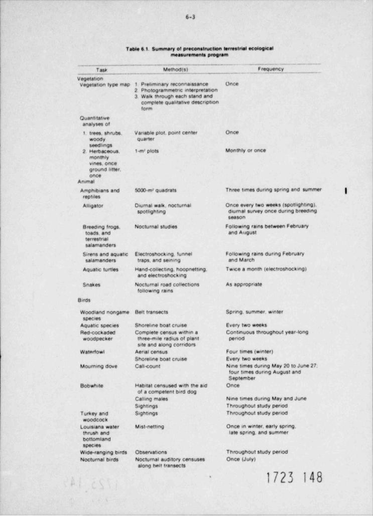
6-3
Table 6.1, Summary of preconstruction terrestrial ecologicalmeasurements program
~
Task Method (s) _ FrequencyVegetationVegetation type map 1 Preliminary reconnaissance Once
2 Photogrammetric enterpretation3. Walk through each stand and
complete qualitative desenptionform
Quantitativeanalyses of
1. trees, shrubs, Vanable plot, point center Oncewoody quarter
seedlings2. Herbaceous. 1-m' plots Monthly or once
monthlyvines, once
ground litter,once
Animal
Amphibians and 5000-m' quadrats Three times dunng spnng and summer |reptiles
Alligator Diurnal walk, nocturnal Once every two weeks (spotlighting),spotlighting diurnal survey once dunng breeding
season
Breeding frogs, Nocturnal studies Following rains between Februarytoads, and and AugustterrestnalSalamanders
Sirens and aquatic Electroshocking, funnel Following rains during Februarysalamanders traps, and seining and March
Aquatic turtles Hand <ollecting, hoopnetting. Twice a month (electro $ hocking)and electroshocking
Snakes Noctumal road collections As appropriatefollowing rains
Birds
Woodland nongame Belt transects Spnng, summer, winterspecies
Aquatic species Shoreline boat cruise Every two weeksRed-cockaded Complete census within a Continuous throughout year-longwoodpecker three-mile radius of plant penod
site and along corndorsWaterfowl Aenal census Four times (winter)
Shoreline boat cruise Every two weeksMourning dove Call <ount Nine times dunng May 20 to June 27;
four times dunng August andSeptember
Bobwhate Habitat censused with the aid Onceof a competent bird dog
Calling males Nine times during May and JuneSightings Throughout study penod
Turkey and Sightings Throughout study penodwoodcock
Louisiana water Mist-netting Once in winter, early spring,thrush and late spnng, and Summerbottomlandspecies
Wide-ranging birds Observations Throughout study penodNocturnal birds Noctumal auditory censuses Once (July)
along belt transects
1723 148-
..
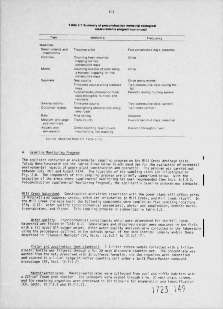
6-4
Table 6.1 Summary of preconstruction terrestrial ecologicalmeasurements program (continued)
Task Method (s) Frequency
MammalsSmall rodents and Trapping grids Five consecutive days, seasonalensectivores
Gophers Counting fresh mounds. Oncetrapping for fiveconsecutive days
Moles Counting number of runs along Oncea transect trapping for fiveconsecutive days
Squirrels Nest counts Once (early winter)Time-area counts along transect Two consecutive days during thehnes fall
Supplemental information from Periodic during hunting seasonstate biologists, hunters. andresidents
Swamp rabbits Time-area counts Two consecutive days (winter)Cottontail rabbits Headhghting observations along Two times (winter)
area roadsBats Mist netting SeasonalMedium- and large- Track counts Five consecutive days. seasonalsize mammals
Aquatic and Direct counting tract counts. Periodic throughout yearsemiaquatic headhghting. hve trapping
Source Modified from ER. Table 61-5
A. Baseline Monitoring Program
The applicant conducted an environmental sampling program on the Mill Creek drainage basin,Toledo Bend Reservoir and the Sabine River below Toledo Bend Dam for the evaluation of potentialenvironmental impacts of power plant construction and operation. The program was carried outbetween July 1973 and August 1974. The locations of the sampling sites are illustrated inFig. 2.6. The components of this sampling program are briefly sumarized below. With theexception of the areas where supplemental monitoring has been recomended (See Sect. 6.1.5.2,Preconstruction Supplemental Monitoring Program), the applicant's baseline program was adequate.
Mill Creek Watershed. Construction activities associate <1 with the power plant will affect partsof Mitchell a nd Copperas creeks, which are tributaries to Mill Creek, and Mill Creek itself. Inthe Mill Creek drainage basin the following co@onents were sampled at five sampling locations(Fig. 2.4): water quality (pt sicochemical parameters), phyto- and zooplankton, benthic macro-/invertebrates, and fishes. This sampling program is summarized in Table 6.2.
Water quality. Physicochemical constituents which were determined for the Mill CreekWatershed are listed in Table 6.2. Temperature and dissolved oxygen were measured in the fieldwi th a YSI model SI A ocygen meter. Other water quality analyses were conducted in the laboratoryusing the procedures outlined in the methods manual of the Hath Chemical Company and/or thosedescribed in " Standard Methods" (ER, Sects. IV.3:2.1 to IV.3:2.17).
Phyto- and zoopbnkton (net plankton). A 1-liter stream sample collected with a 1-literplastic bottle was filtered through a No. 20 mesh Wisconsin plankton net. The concentrate waswashed from the net, preserved with 3% buffered formalin, and the organisms were identifiedand counted in a 1.0-ml Sedgwith Rafter counting cell under a Swift Phase-Master compoundmicroscope (ER, Sect. IV.5:1.2).
Macroinvertebrates. Macroinvertebrates were collected from pool and riffle habitats witha 225-cmz Ekman grab sampler. The sediments were washed through a No. 33 mesh brass screen,and the remaining organisms were preserved in 107, formalin for enumeration and identification(ER, Sects. IV.7:1.1 and IV.7:1.2).
1723.I49
6-5
Table 6.2. Sampling program for the Mill Creek Watershed.Stalions St.ss' s
__.
Sample type Frequency Sampling gear
8Water quality * Twice per month 1-liter sample bottle YSI-51 A fortemperature and DO
Phyto- and Monthly 1-liter filtered through No 20Itoopiankton * Wisconsin plankton net
invertebrates * Monthly 225-cm' Ekman grab |sampler
Fishes * Quarteriy' Portable electro- gshocker
. . - ~ - . .
' Locations are shown in Fig 2 6.
Dhe following parameters were sampled. temperature. DO. CO,. conductivity.turbidity. pH total afkalinity. Ca-hardness. total hardness. NHA NO2. NOx ortho-PO.. totalinorganic P04. SO4 Cr
#Net plankton.#Samples washed through No 30 mesh brass wire cloth.
'Section of stream blocked with bsg saine and electro-shocked
' September 27 and December 11.1973. March 11 and June 13.1974
Fishes. Representative stream segments were blocked with 6.4-imi mesh seines. The fishesand crayfishes were stunned with a Cofflet Electronics model BP-IC back-pack shocker and col-le::ted with dip nets. Samples were preserved and transported to the laboratory for taxonomicidentification and weight / length measurements.
Toledo Bend Reservoir. Toledo Bend Reservoir will provide the necessary cooling water for thepower plant and wilt'also receive the blowdown discharge from the cooling towers. Limnologicalcomponents which were sampled in the reservoir are summarized in Table 6.3.
Water quality. Physicochemical constituents of Toledo Bend Reservoir are listed in Table6.3. _ Temperature, dissolved oxygen, and conductivity were measured in the field with a Hydrolabmodel 6D analyzer and sonde, and a Hach Chemical Kit was used to periodically measure hydrogensulfide (ER, Sect. IV.3:2). Other water quality analyses were conducted in the laboratoryusing the procedures outlined in the methods manual of the Hath Chemical Company and/or thosedescribed in " Standard Methods" (ER, Sects. IV.3:2.1 to iv.3:2.17).
Phytoplankton-chlorophyll q. Integrated duplicate samples were collected with 25-mm-IDrubber hoses. Sample depths were 3 m in the bogs and 5 m in open water. One sample was |preserved with a 3% buffered formalin; the other was alkalized with MgC0 . Chlorophyll a, b,3
e, and phaeophytin a was determined according to procedures described in SCOR UNESCO (1966)(CR, Sects. IV.4:1 and IV.4:2). Data were expressed as milligrams per liter of chlorophyll a.
htl yto- and zooplankton. A 5-m vertical tow at stations TB-1, -2 and -3, and a 3-mhvertical tow at TB-4 and 5 were made with a No. 20 mesh Wisconsin plankton net. The concentrateswere washed into sample vials and preserved with 3t buffered formalin. The organisms wereidentified and counted in a 1.0-ml Sedgwich-Rafter counting cell under a Swift Phase-Mastercompound microscope (ER, Sects. IV.5.1 and IV.S.2).
Epon (= periphyton1. Periphyton or Aufwuchs (called Epon in the ER) were collected by aningenious method in which a 1.6-mm-diam monofilament line was suspended from the water surfaceand anchored at the bottom. The line was left in the water for 4 to 5 weeks for colonization.Af ter this time, the organisms (algae) growing on the line were removed from specific sectionsof the line which represented different growing depths. Dry weights and organic weights weredetermined on the collected biomass, and production rates were expressed in grams of organicweight per square meter for station TB-2 of Toledo Bend Reservoir (ER, Sects. IV.6:1 and IV.6:2).
. ~
1723 150
6-6
Table 6.3. Sampling program for Toledo Bend Reservoir
Sample type Frequency Stations ' Sampling gear I
IWater quahty Twice per month TB-1 through TB-5 Kemmerer water sampler *(temperature) and DOwith YSI-51 Ameter),
Pnytoplankton - Twice per month T B 1. TB -2. T B-3. 5-m flexible rubber hosechlorophyll a TB-4 and TB-5 3-m flexible rubber hose
Net phyto- and Twice per month 7 0-1. T B-2. TB-3. 5 0-m vertical towsrooplankton TB-4. and TB-5 w No 20
and TB-5 Wisconsin Plankton net3 0-m vertical towswsNo. 20Wisconsin Plankton net
Epon Colonization penoo T B-2 16-mm-diam mono-of 4 to 5 weeks filament nylon line
from surface to bottom
Macroinvertebrates Bimonthly TB-1-3 Transect at 225-cm' Ekman Grab1. 5 ,10 . and samplerdepths. TB-4, 5:single samples
Fishes Twice per month TB-1 through TB-5 Gill nets
Twice per month T B-1. -2. ar 1 -3 seir.e * I
Twice per month T B-1. -2, and -3 Surface shad traw!
Twice per month TB-1, -2, and -3 Electro-shocker
ichthyoplank ton' Five times in three TB-2 and TB4 0.785-m'. 500- mesh Imonths net
* Stations TB 1 through TB-5 as described in Table 2 8.
Mater quahty measurements included temperature. DO conductivity, turbidity. pH. CO, alkalinity.Ca-hardness. total hardness. NH s NOi, NO x orthoPO4. total inorganic PO SO., Cr
' Seining was not done in December 1973 and January 1974 because of stormy waters.
# chthyoplankton was collected on Apnl 26. May 10. May 24. June 14, and June 28,1975.l
Hacroinvertebrates. At stations TB-1, -2, and -3 invertebrates were collected on a transectfrom shore at 1, 5 ,10 , and 15-m depths. Single sa@les were collected at stations TB-4 and-5. The collections were made with a 225-cm2 Ekman grab sampler and the sediments were washedthrough a No. 30 mesh brass screen. The collected organisms were preserved with 10% bufferedformalin, identified, and enumerated (ER, Sect IV.7:2).
Fishes. Fishes from Toledo Bend Reservoir were collected with four different types of gear.
1. Deeper, open-water habitats were sampled with experimental gill nets which were 2.4 m deepand 45.6 m long. Each net consisted of 7.6-m sections of 25 , 38 , 51 , 64 , 76 , and89-mm square mesh.
2. The littoral zones and shallow areas were samled with a bag seine which was 9.1 m longand 1.8 m deep and had 6.4-m mesh in the wings and 4.8-tml mesh in the bag.
3. For the collection of small pelagic fishes, especially threadfin and gizzard shad, a9-m-diam shad trawl was used in the open reservoir.
4. Since the above three methods usually excluded the larger specimens of largemouth bass andstriped bass, a gasoline-powered electro-shocker was used for their collection along theshoreline in water 1 to 2 m deep. Larger specimens were processed in the field; otherswere iced and transported to the laboratory for identificatfor, enumeration, and length /weight relationships (ER, Sect. IV.8:2).
I723 15i.
6-7
!chthyoplankton. Ichthyoplankton was collected from stations TB-2 and TB-4 on fiveopening. 0.505-m bar mesh conical2occasions in AprilDiay, and June 1975 with a 0.785-m
plankton net. The net was equipped with a flow meter to determine the voltrie of water filtered.At TB-2, tows were started 10 m (33 f t) from shore and continued 150 to 200 m (490 to 650 f t) |into the reservoir. At TB-4, tows were made on the centerline of the bay. Identifications ofeggs and larvae were categorized as shad, cyprinoids, pirate perch, brook silverside, centrachids,and log perch. Triplicate tows were obtained on each sampling date at each station. Data wereexpressed as total ichthyoplankton per tow (total volume) (ER, Appendix 2f).
Sabine River below Toledo Bend Dam. The sampling program of the Sabine River is summarized in g
Table 6.4. Procedures for water quality detenninations were similar to those for Toledo Bend |2
Reservoir. Bimonthly macroinvertebrate samples were collected only at station R5 with a 225-mEkman grab sampler. The organisms thus collected were processed as described previously for theToledo Bend Reservoir samples. Fishes were collected with a bag seine and trammel nets and werealso processed in a manner similar to that used with Toledo Bend Reservoir samples.
Table 6.4. Sampling program of the Sabine River below Toledo Bend Reservoir
ISample type F requenc y Stations ' Samphng gear
Water quabty* Twice per month R1 through R5 1-liter plastic bottle Itemperature and DOwith a Hydrolab model 60water analyzer andsonde
Invertet, rates C!montnly RS 225 -c m Ekman grab
(tsve samples sampleracross transects)
F ishes Twice per month R2. R4. and R5 Trammel nets
July 25.1973 6 March 1974 R3 and R5' Seine_ _ _ _ __
* Stations R1 through R5 as per ER Sect IV 2 2 3 Sabine River
bWater quahty measurements included temperature. DO. conductivity. turbidity. pH CO . alkannity
Ca-hardness, total hardness. NHi NO2. NO t ortho-PO.. total inorganic pot SO., Cl
B. Preconstruction Supplemental Monitoring ProJram
It is the staff's opinion that before the constructional and operational environmental impactsof Blue Hills Station Units 1 and 2 can be completed, supplemental ecological data are requiredf rom Mill Creek Watershed and Toledo Bend Reservoir. The staf f recomends that the samplingprogram used to collect these data should be reviewed by the staff before the program comences.
M_ill Creek Watershed. In Sects. 4.3.1 and 4.3.2 the staff expressed concern over the extentof erosion from the plant site durin@ construction and the subsequent potential increase insuspended solids and bed load sedimentation in Cnpperas, Mitchell, and Mill creeks. In orderto assess the impacts associated with the foreseen erosiori and sedimentation as a result ofsite preparation, the staf f reconnends the collection of the following information.
Suspendgi_ solids and_ bed load sedimen_ts. The applicant should conduct a sampling program,i t
subject to staff review, to estimate sedimentation of Mill Creek Bay via the transport ofsuspended solids and bed load sediments by Copperas, Mitchell, and Mill creeks.
[eriphy,t_ ort. The applicant attempted to describe toe primary producing community ofCopperas, Mitchell, and Mill creeks by collecting "phytoplankton" from these streams. Driftingalgal cells in a small stream comunity cannot be considered true phytoplankton, and they arenot representative of the community of primary producers. They may be present in extremelysmall numbers as they break loose from their attached habitat; however, their small number andrapid transport from the system makes them an insignificant component. In reality, the peri-phyton or Aufwuchs community represents the primary producers of a small stream such as MillCreek and its tributaries. The development of a periphyton comunity is rapid due to theability of algal cells to colonize and reproduce on any available substrate (ravern,1962).2Because of the rapid turnover rate of algal cells, the comunity dynami of eriphyton repre-
sent a good indicator of water quality changes (Szluha,1974).3
6-8
Tne staff, therefore, recomends that the applicant should conduct a periphyton sampling program,subject to staff review, which would establish baseline information on the primary producerconponents of those sections of Copperas, Mitchell, and Mill creeks which may be impacted. This.Information is necessary for assessing the impacts of sedimentation due to erosion during sitepreparation.
Toledo Bend Reservoir _. The supplemental infonnation requested for Toledo Bend Reservoir isnecessary to complete the analyses of entrainment and impingement losses associated with theproposed intake location, and to compare these losses with those for the alternate intakestructure describec in Sect. 9.3.2. These supplemental sampling programs should be subject to |staff review and evaluation
Ichthyoplankton. The applicant should conduct a sampling program to estimate the temporaldensities and the species composition of eggs and larvae in the ichthyopla an. The samplingshould be carried out in a time span long enough to establish the entire spe ning period inToledo Bend Reservoir. Sampling should include both the shore or littoral zone as close tothe shore as po^sible, as well as the open reservoir where the alternate intake structurecould be located.
Fishes. The applicant should conduct a sampling program to estimate temporal and spatialdensities, age class categories, and species composition of fishes in the specific area wherethe alternate intake structure could be located.
Skiped_b as_s_. Although striped bass have been stocked and gravid adults caught, naturalssspawning has not yet been observed to occur in Toledo Bend Reservoir. However, striped basshave been found to spawn in Texoma Reservoir, Oklahoma. In order to ascertain the spawningstatus of striped bass in Toledo Bend Reservoir, the applicant should document the spawningsuccess of striped bass in the lower portion of Toledo Bend Reservoir. In this respect,special attention should be given to studies conducted by the States of Texas and Louisiana.
Macroinvertebrates. Since it has been established that CorbicaZa sp., the Asiatic clam,may have invaded Toledo Bend Reservoir, it would be to the applicant's benefit to establishdensities and population dynamics of this organism in Taledo Bend Reservoir.
Suma ry
In order to complete the necessary environmental impact analysis for the coastruction andoperation of Blue Hills Station Units 1 and 2, the applicant should conduct sampling programs,subject to staff review, to evaluate (1) suspended solids and bed load sediments, (2) periphytoncommunity dynamics in Copperas Mitchell, and Mill creeks, (3) ichthyoplankton and fish densitiesand species composition, (4) striped bass spawning, and (5) Corbicula sp. densities in theopen reservoir at the proposed intake structure before a construction permit is granted.
C. Preoperational Monitoring Program for Operational Licensing
It is the staff's recommendation that the Preoperational Monitoring Program for OperationalLicensing should consist of selected monitoring components from the Baseline rionitoring Programand the Preconstruction Supplemental Monitoring Program. The Preoperational Program will beevaluated by the staff at the Construction Permit stage.
.
6.1.6 Chemical
The applicant has presented a summary of the physical and chemical parameters measured (ER.Table 6.1-1). The staff concludes that the program carried out by the applicant is sufficientand appropriate for the purposes of establishM haseline conditions.
1723 153.
6-9
6.2 OPERATIONAL PROGRAMS
6.2.1 Radiological
The operational offsite radiological monitoring program is conducted to measure radiation levelsand radioactivity ir the plant environs. It assists and provides backup support to the detailedeffluent monitoring (as recomer.;< Sy Regulatory Guide 1.21) which is needed to evaluate indi-vidual and population exposures and u 'ify projected or articipated radioactivity concentrations.
The applicant plans essentially to cont ue the preoperational program during the operatingperiod. However, refinements may be mad in the program to reflect changes in lard use orpreoperational monitoring experience.
6.2.2 Other programs
Detailed information on the thermal, meteorological, hydrological, ecological, and chemicaloperational monitoring programs will be provided in the Operating License application. At thetime of issuance of an Operating Permit, the staff will issue Environmental Technical Specifi-cations related to operational monitoring procedures.
6.3 RELATED PROGRAMS AND STUDIES
6.3.1 Terrestrial
There are few terrestrial monitoring programs ongoing in the vicinity of the Blue Hills Station.The Soil Conservation Service (USDA) has recently completed a study of the Toledo Bend Reservoirarea that includes soil maps and aerial photographs. No specific studics were made of erosion.The Texas Parks and Wildlife Department has recently coiapleted a study of the endangered red-cockaded woodpecker at the Scrappin' Valley Wildlife Management area. This agency also collectsinformation on some game animals in the Blue Hills area. The nearest air sampling stations areat Monroe and Lake Charles, Louisiana.
6.3.2 Aquatic
Several agencies are involved in measuring and monitoring water quality in the Toledo BendReservoir and Sabine River (Table 6.5) and these programs assist in establishing a broad base-line for use in assessing environmental changes resulting from plant construction and operation.In addition to the sampling for water quality, the Inland Fisheries Division of the Texas Parksand Wildlife Department takes fish samples on the Toledo Bend Reservoir to determine speciesdiversi ty.
1723 154
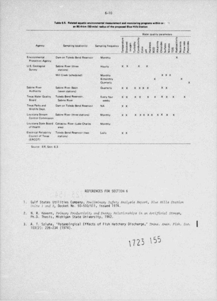
6-10
Table 6.5. Related aquatic environmental measurement and monetoring programs within ce r *7
an 80.4km (54 mile) redeus of the proposed Blue Hills Station
Water quality parameters
t C E
Tc E Ej.g f{$$j jgjg gggAgency Samplir'g location (s) Sampling frequency jg} g
4582 3122563383322Environmental Dam on Toledo Bend Reservoir Monthly X
Protectenn Agency
U.S. Geological Sabine River (three H ourly X X X XSurvey stations)
Mill Creek (scheduled) Monthly XXXBimonthly X XQuarterly X
Sabine Rever Sabene River Basin Quarterly X X X XX X X XAuthortry (seven stations)
Texas Water Quality Toledo Bend Reservoir. Every four X X X X X X X X X XBoard Sab ne River weeks
Texas Paeks and Dam on Toledo Bend Reservoer NA XXWildlife Dept.
Louis.ana Stream Sabine River (three stattons) Monthly XX X XX XX XX X XContro4 Commission
Louisiana State Board Calcasiou River (Lake Charles Monthlyof Health area)
Electrrcal Reliability Toledo Bend Reservoir (two (saely X XCounest of Temas stations)(E RCOT)
Source- E R. Sect 6 3.
REFERENCES FOR SECTION 6
1. Gulf States Uti11 ties Company, Preliminarj safety Analysis Report, Blue Hills Stationlxits 1 and 2, Docket No. 50-510/511, issued 1974.
2. N. R. Kevern, Prirsarj Prodrtivity and Enemy Relationships in an Artificial Stream,Ph.D. Thesis, Michigan State University,1962.
3. A. T. Szluha, "Potamological Effects of Fish Hatchery Discharge," Trans. Amer. Fish. Soc.103(2): 226-234 (1974).
1723 Nr-
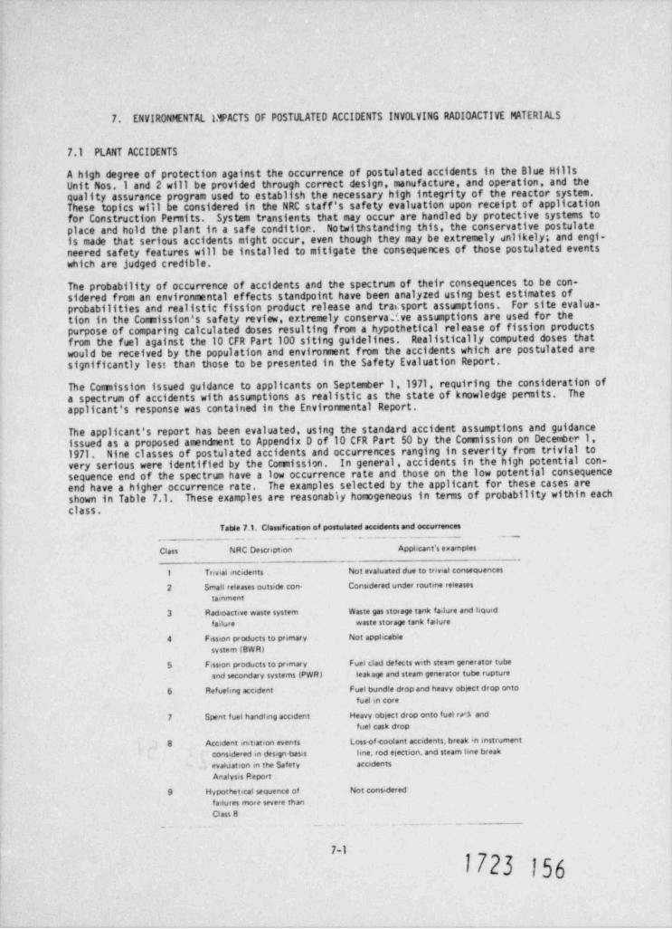
7. ENVIRONMENTAL IMPACTS OF POSTULATED ACCIDENTS INVOLVING RADI0 ACTIVE MATERIALS
7.1 PLANT ACCIDENTS
A high degree of protection against the occurrence of postulated accidents in the Blue HillsUnit Nos. I and 2 will be provided through correct design, manufacture, and operation, and thequality assurance program used to establish the necessary high integrity of the reactor system.These topics will be considered in the NRC staff's safety evaluation upon receipt of applicationfor Construction Pemits. System transients that may occur are handled by protective systems toplace and hold the plant in a safe condition. Notwithstanding this, the conservative postulateis made that serious accidents might occur, even though they may be extremely unlikely; and engi-neered safety features will be installed to mitigate the consequences of those postulated eventswhich are judged credible.
The probability of occurrence of accidents and the spectrum of their consequences to be con-sidered from an environmental effects standpoint have been analyzed using best estimates ofprobabilities and realistic fission product release and trac 5 port assumptions. For site evalua-tion in the Comission's safety review, extremely conserva?.ve assumptions are used for thepurpose of comparing calculated doses resulting from a hypothetical release of fission productsfrom the fuel against the 10 CFR Part 100 siting guidelines. Realistically computed doses thatwould be received by the population and environment from the accidents which are postulated aresignificantly lest than those to be presented in the Safety Evaluation Report.
The Comission issued guidance to applicants on September 1,1971, requiring the consideration ofa spectrum of accidents with assumptions as realistic as the state of knowledge permits. Theapplicant's response was contained in the Environmental Report.
The applicant's report has been evaluated, using the standard accident assumptions and guidanceissued as a proposed amendment to Appendix D of 10 CFR Part 50 by the Comission on December 1,1971. Nine classes of postulated accidents and occurrences ranging in severity from trivial tovery serious were identified by the Comission. In general, accidents in the high potential con-sequence end of the spectrisn have a low occurrence rate and those on the low potential consequenceend have a higher occurrence rate. The examples selected by the applicant for these cases areshown in Table 7.1. These examples are reasonably homogeneous in terms of probability within eachclass.
Table 7.1. Classification of postulated accidents and occurrences
Class NRC Description Appbcant's eumples
1 Trivial mcidents Not evaluated due to trivial consequences
2 Small releases outside con- Considered under routine releases
tainment
3 Radioactive waste system Waste gas storage tank failure and liquid
failure waste storage tank f ailure
4 Fission products to primary Not apphcable
system (BWR)
s Fission products to primary Fuel clad defects with steem generator tube
and secondary systems (PWR) leakage and steam generator tube rupture
6 Refuehng accident Fuel bundle drop and heavy ob}ect drop onto
fuel in core
7 Spent fuel handling accident Heavy object drop onto fuel trA andfuel cask drop
8 Accident initiatson events Lossof toolant accidents, break an instrument
considered in design-basis hne. rod ejection, and steam bne break
evaluation in the Safety accidents
Analysis Report
9 Hypothetical sequence of Not considered
failures more severe thanClass 8
_- . . - -
7-1
1723 156
7-2,
Comission estimates of the dose which might be received by an assumed individual standing atthe site boundary in the downwind direction, using the assumptions in the proposed Annex toAppendix D, are presented in Table 7.2. Estimates of the integrated exposure that might bedelivered to the population within 50 miles of the site are also presented in Table 7.2. Theman-rem estimate was based on the projected population within 50 miles of the site for theyear 2000. These doses are based on the assumption that the Station will be as described inSect. 3 of this Environmental Statement.
To rigorously establis a realistic annual risk, the calculated doses in Tat,a .2 would have tobe multiplied by estimated probabilities. The events in Classes 1 and 2 represent occurrenceswhich are anticipated during plant operations; and their consequences, which are very small, areconsidered within the framework of routine effluents from the plant. Except for a limited amountof fuel failures and some steam generator leakage, the events in Classes 3 through 5 are not an-ticipated during plant operation; but events of this type could occur sometime during the 40-yearplant li'etime. Acgidents in Classes 6 and 7 and small accidents in Class 8 are of similar orlower probability than accidents in Classes 3 through 5 but are still possible. The probabilityof occurrence of large Class 8 accidents is very small. Therefore, when the consequences indi-cated in Table 7.2 are weighted by probabilities, the environmental risk is very low.
The postulated occurrences in Class 9 involve sequences of successive failures more severe thanthose required to be considered in the design bases of protective systems and engineered safetyfeatures. Their consequences could be severe. However, the probability of their occurrence isjudged so small that their environmental risk is extremely low. Defense in depth (multiple phy-sical barriers), quality assurance for design, manufacture, and operation, continued surveillanceand testing, and conservative design are all applied to provide and maintain a high degree ofassurance that potential accidents in this class are, and will remain, sufficiently small inprobability that the environmntal risk is extremely low.
The NRC has performed a study to assess these risks more quantitatively. The initial resultsof these efforts were made available for comment in draf t form on August 20, 1974,1 and werereleasec in final form on October 30, 1975.2 This study, called the Reactor Safety Study, isan effort to develop realistic data on the probabilities and consequences of accidents in water-cooled power reactors, in order to improve the quantification of available knowledge related tonuclear reactor accident probabilities. The NRC organized a special group of about 50 specialistsunder the direction of Professor Norman Rasmussen of MIT to conduct the study. The scope of thestudy has been discussed with EPA and described in correspondence with EPA which has been placedin the NRC Public Document Room.3
As with all new information developed which might have an effect on the health and safety of thepublic, the results of these studies will be assessed on a timely basis within the Regulatoryprocess on generic or specific bases as may be warranted.
Table 7.2 indicates that the realistically estimated radiological consequences of the postulatedaccidents would result in exposures of an assumed individual at the site boundary which are lessthan those which would result from a year's exposure to the maximum permissible concentration(LIPC) of 10 CFR Part 20. The table also shows the estimated integrated exposure of the populationwithin 50 miles of the plant from each postulated accident. Any of these integrated exposureswould be much smaller than that from naturally occurring radioactivity. When considered with theprobability of occurrence, the annual potential radiation exposure of the population from all thepostulated accidents is an even smaller fraction of the exposure from natural background radiationand, in fact, is well within naturally occurring variations in the natural background. It is con-cluded from the results of the realistic analysis that the environmental risks due to postulatedradiological accidents are exceedingly small and need not be considered further.
7.2 TRANSPORTATION ACCIDENTS
The transportation of cold (unirradiated) fuel to the plant, of irradiated fuel from the reactorto a fuel-reprocessing plant, and of solid radioactive wastes from the reactor to burial groundsis within the scope of an AEC (now NRC) report." Table 7.3 summarizes the environmental risksof accidents during transportation."
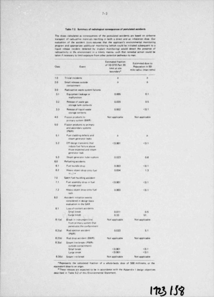
7-3
Table 7 2. Summa.i of rad.ological - , ___ of postulated accidents
The doses calcula'ed as consequences of the postulated accidents are based on aertmenetransport of rad.uatt ve materie:s resnfting in teth a direct and an enhalat.on dose. Ourevaluation of the accident loses assornes that the apphcant's enverenenental momformgprogreen and appropriate addet.onal monitoring (whedi could be initiated sutmequent to aliqunt release incident detected try inplent monitoring) would detect the presence ofradioactivity m tte environment m a ternaly mannu such that remedial action could betaken if necessary to limit esposure from other potenteel pathways to man.
"' " "Estireeted dose to
of 10 CF R Part 20Oass E vent Popuistion m 50-
'mile f edius (men vems)
__
10 Trevial mcidents b 6
2.0 Small roleases outside 6 6
containment
30 Radioactive weste system fsilures
3. I E cppment leakage or 0 005 0.1malfunction
3.2 Reteass of waste gas 0 020 05storage tank contents
33 Re6 ease of hquad waste 0 002 <01stor Age Contents
40 Fession products to Not appi.carde Not appbcablepeemary system (BWRI
50 Fession products to primaryand secondary systems
(PW R)
51 Fuel cladd ng detects and e esteam generator leakn
52 Off <ses,gn trans,ents that <0 001 <01induce fuel f a. lure abovethose espected and steam
generator leak
5.3 Steam generator tube rupture 0 023 06
6.0 Refuehne accidentn
61 Fuel bundle drup 0003 <0 1
6.2 Heavy obrect drop onto f uel 0 054 1.3en ce
7.0 Spent fues ha.wfhng accident
7.1 Fuel assembly drop en fuel <0 001 < 0.1.
storage pool
7.2 Heavy obgect drop onto fuel 0003 (0.1rack
80 Accident initiat.on eventsconsidered on darsign basis
evaluation m the SAR
8.1 Loss of coolant acc dentsSmail break 0 011 05Large break 0 33 51.
81(a) Break in instrument line Not apphcable Not apphcablefrom primary system thatpenetrates the conta.nment
8 2ta) Rod ert,on acc< dent 0.033 5.1iPWR)
8 2(bl Rod drop accident (BWR) Not apphcable Not applicable
8 3(a) Steem tene breaks (PW Rsoutside conta,nmenti
Srnait tweek <0 001 (0.1Large oresk <0.001 <0.1
8 3(b) Steam kne tweak Not appbcable Not applicable
* Represents the calculated fracteon of a whole. body dose of 500 mithrems. or theequivalent dose to an organ.
*These rs4 eases are expected to to m accordarte with the Appendes 1 dessgo objectivesdescribed m Table 5 2 of th>s Environmental Statement.
11t3 Ift
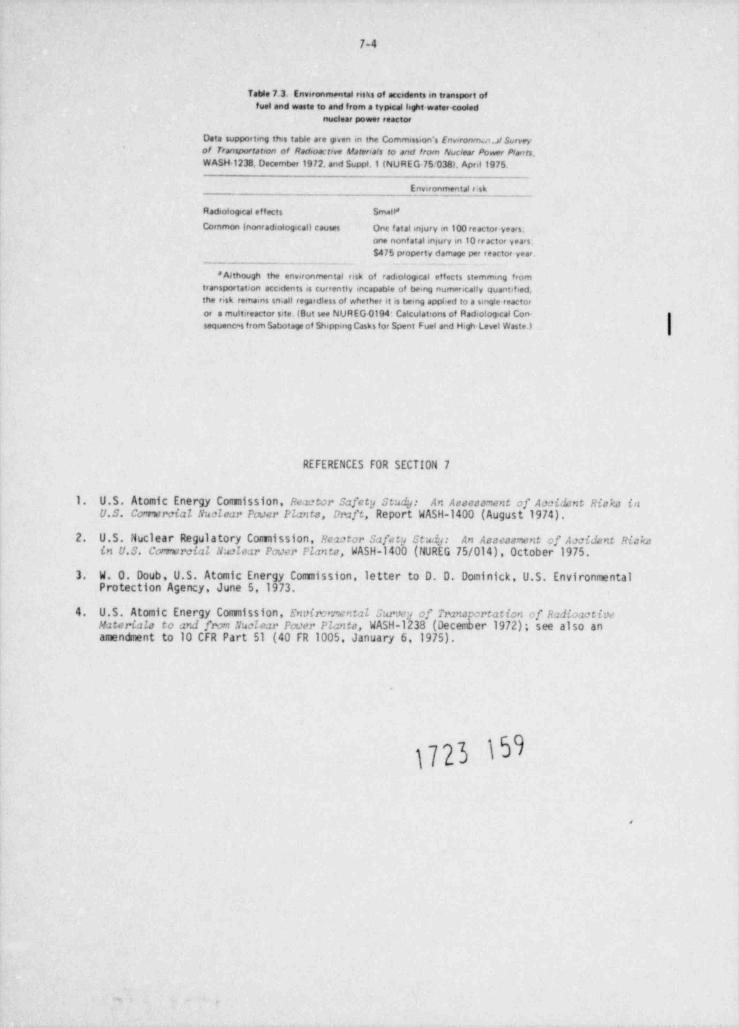
7-4
Table 7.3. Enveronmental risks of accedents in transport offuel and waste to and from a typecal light water <ooled
nuclear power reactor
Data supporting this table are given m the Commisseon's Env,ronm.v.a/ Surveyof riansportation of Rodooactive A9ateruals to and from Nuclear Powr Plants.WASH 1238. December 1972, and Suppl.1 (NUREG 75'o38). April 1975.
Environmental e:sk
Radiologecal effects Small*
Common (nonradiologicall causes One fatal injury m loo reactor years,one nonf atal snlury in 1o rractor years.$475 property damage per reactor year.
' Although the environmental risk of radiologecal effects stemmmg fromtransportation accedents is currently mcapable of bemg numerically quantified,the risk remams so,all regardless of whether et is bemg appl.ed to a single reactoror a multireactor s te. (But see NUREG 0194: Calculations of Radiological Con-sequenc-s from Sabotage of Sheppmg Casks for Spent Fuel and H,gh Level Waste.)
REFERENCES FOR SECTION 7
1. U.S. Atomic Energy Comission, Re zetor safety study: An Assesament of Axil:nt Riska inU.S. Conwrcial Nuclear Pouer Plants, Druft, Report WASH-1400 (August 1974).
2. U.S. Nuc1 ear Regulatory Com1ss1on, Reuter safety St@: An Asseaament of Anident Rickain U.S. Comercial Naalear Pouer P2 ants, WASH-1400 (NUREG 75/014), October 1975.
3. W. O. Doub, U.S. Atomic Energy Comission, letter to D. D. Dominick, U.S. EnvironmentalProtection Agency, June 5,1973.
4. U.S. Atomic Energy Commission, Envirrmental sarwy of nuna creation of R.2dioactiwMaterials to and from Suclear Pouer Plants, WASH-1233 (Deceder 1972); see also anamendment to 10 CFR Part 51 (40 FR 1005, January 6,1975).
1723 @
.
.
!8. NEED FOR Tile SITE
The purpose of this section is to assess, on a general basis, the need for the Blue HillsStation. This section will be revised when the applicant establishes a commercial operationdate and mcves forward with the Construction Pemit application.
8.1 DESCRIPTION OF THE POWER SYSTEM
8.1.1 Service area
Gulf States Utilities (GSU) is an investor-owned company whose principal business is concernedwith the generation, transmission, and distribution of electric energy. The company serves over417,000 electric customers in a 28,000-sq-mile area of southeast Texas and south central Louisi-ana.1 Figure 8.1 depicts the extent of the company's service area. For planning purposes, theservice area can be divided into three geographical areas: the east Texas area, the Lake Charlesarea, and the Baton Rouge area, representing the western, central, and eastern portions of thesystem rtspectively.
GSU supplies electricity to seven distinct customer types: residential, comercial, industrial,municipal, street lighting, the Rural Electrification Administration, and other public authorities.
8.1. 2 Region;l relationships
The GSU system is part of subregion A of the Southwest Power Pool. There are 32 member systemsof the Southwest Power Pool, representing a total of eight states. The geographical boundarydelineating the Fool's service area is depicted in Fig. 8.2.
8.2 POWER REQUIPEMENTS
8.2.1 Energy consumpti_on
Gulf States Utilities' system peak demand for the years 1933 through 1976 is presented inTable 8.1. Maximum peak demands on the system occur during the sumner. A load-duration curvefor the total system load from 1966 to 1971 is shown in Fig. 8.3.
The forecasted energy consumption for 1977 through 1990 is given in Tables 8.2 and 8.3. Table
8.2 presents the forecast of total energy consumption and Table 8.3 presents peak load demand.The estimates of energy consumption presented in the tables are based upon the utility's ownforecasting methodology. Factors that were taken into consideration in their forecasting in-clude future industrial load requirements for select business concerns, projected populationgrowth patterns, and household saturation of major appliances.
As evidenced by Tables 8.2 and 8.3, peak demand is forecasted to grow at approximately 4.4%from 1977 to 1990, while total energy demand is expected to have a 4.2% average annual growthrate.
8.2.2 Conservation of energy
As specified in Suppl. 4 to the Environmental Report Gulf States Utilities has undertaken orproposed several energy conservation activities which include: (1) insulation demonstration todemonstrate the proper way to purchase and install insulation; (2) heat ptop training to providedealer training in installing and servicing heat pumps; and (3) energy-efficient research homesto determine the effectiveness of energy-efficient materials, equipment, and construction tech-niques in the Gulf Coast climate. In developing the projected growth rate, conservation ofenergy was not explicitly considered by the staff. The impact of the conservation of energy willbe considered in preparing the need for power analysis at the Construction Permit stage,
1723 160e.i
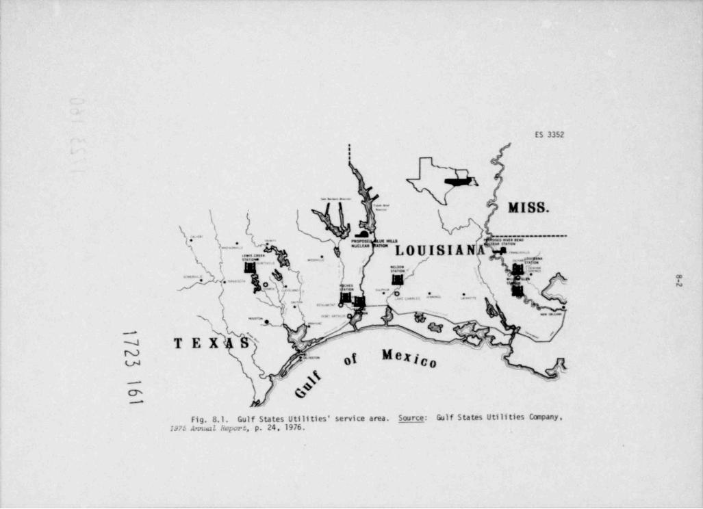
ES 3352
ie
__
\ r= MISS.-
*( ;
.!}
A ~~~~. . -
T' = ?.' ""'' ??:T"**_ ?., LOUISI ANl
_ _ ,. . . , _ . . .
f g.-Q''"%.,. - - - 'n
M-A\ _ . ,= _ o.li V = -( s'
'' :.. . . , :- .,-
-
..... **
. . . . . .,~ _
_ ,
- . ,, e ,
--
\ 'NA . <-\ "N TEX vc--N
00 k- &OS 0I/"~'
traz
;* ' ,_,-
Ch"
:
Fig. 8.1. Gulf States Utilities' service area. Sou rce: Gulf States Utilities Company,137.5 Ar:nxi Report, p. 24, 1976.
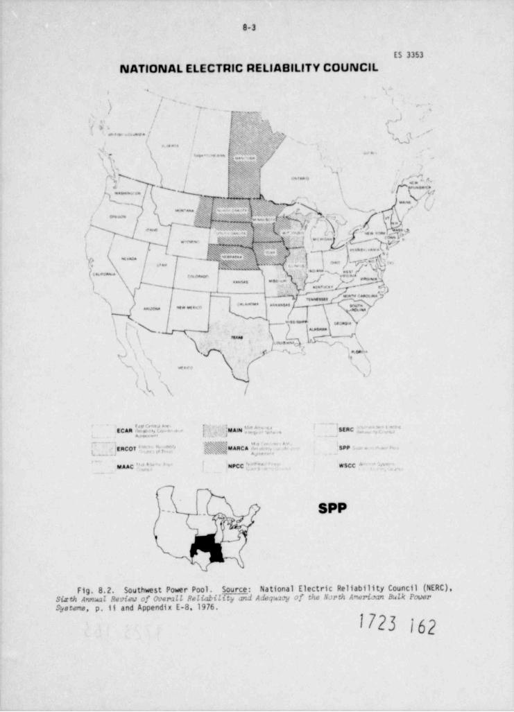
8-3
ES 3353
NATIONAL ELECTRIC RELIABILITY COUNCIL
, . S--.
i~. ,
) / <w- ,
j_ p , ,, :
, -- <. , ),,
1 > , cn .a,,......: W ~ c <u % , .-
9 .-:v''7, %z'/, , , , , ,
., [;i'h'k " * * ''i
,' 'a" .*a==
. .-
n:7 y
.t.\./
\.p y . jf7- ) / Cy .
,,4,, 4~a"
1 < ~% ! . .i . O - <.. v,.'s
e.t' ' '%%>'N5sM 'Ag.. _ .
N i: s ' < DN ' , 1 **'**%,/+ 1 e-*! >
\
r* / (j
. e <
x|-~- -. 3 s- :--o -
- ~ky
.- '5^s|~ ''
'%} Y'MW$A ,,'$' ,f 5
V' ' . ,(* * * * ' *| e
'y M. &. ., Ot" > . ~... f , s"
/V'N
f .)... ,y,,,',.,.
- , . cu,
! / I~~ ',,
- - g g<e a .=7. g.% ..
8_. ~ y_ ._
~*p p.. .
),, . . ' .x . . ' i,p
- ~ ~ -'r~ -ms3
. . . - - . . . . .,,,,, , , , , , , , , ,
--'
i .=-l *
m...! p, N .- ( r,
I
,\iss t
.
p s ..J )pe\....c fs
.p\ anz,,s a
3 s'3
.
N', im-% (
.e$
l'
A\ /
[. .. . .,:uam Y; .,*:; ;', . ]staC,,, |; 'j ;,", , , . < , . . . . . ..
eCan w e,m.. .<a.... .
"' h$N 'S 64 3 M .+ 1
,. . .. .' > E RCO T + "|, ' ; ["'j g assy 'MARCA. 'SPP : . - n.. , , . -
_ uaAc ?i', ''' NPCC f " ** WSCC ^' ' $,
, . , , ,
SPP-
.. y*
|
' ''N
Fig. 8.2. Southwest Power Pool. Source: National Electric Reliability Council (NERC).Sixth Annual Revieu of Over:1LL Peliability and Adeqwwg of the NJrth American Bulk PouerSystems, p.11 and Appendix E-8.1976.
1723 162
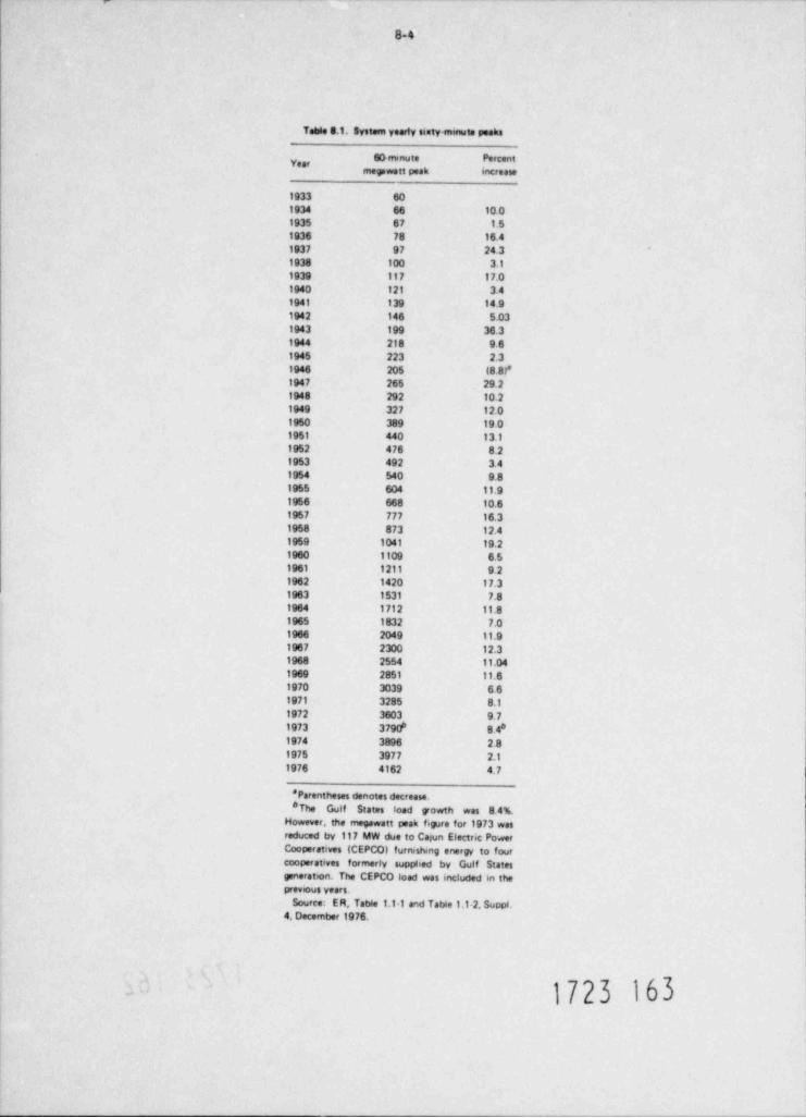
8-4
Table 8.1. System yearly samtyemuta peaks
60 rrunute Percenty,,,megawatt peak increase
1933 601934 66 10.01935 67 1.51936 78 16.41937 97 24.31938 100 3.11939 117 17.01940 121 3.41941 139 14 91942 146 5.031943 199 36.31944 218 961945 223 2.31946 205 (8 8f1947 265 29.21948 292 10.21949 327 12.01950 389 19 01951 440 13.11952 476 8.21953 492 3.41954 540 981955 604 11.91956 668 10.61957 777 16.31958 873 12.41959 1041 19.21960 1109 6.51961 1211 9.21962 1420 17.31963 1531 7.81964 1712 11.81965 1832 7.01966 2049 11.91967 2300 12.31968 2554 11.041969 2851 11.61970 3039 661971 3285 8.11972 3603 9.7
6 81973 3790 8.41974 3896 2.81975 3977 2.11976 4162 4.7
* Parentheses denotes decrease.*The Gulf States load growth was 8.4A
However, the megawatt peak figure for 1973 wasreduced by 117 MW due to Casun Electric PowerCooperatives (CEPCO) furnishmg energy to fourcooperatives formerly supplied by Gulf Statesgeneraton. The CEPCO load was included in theprevcus years.
Source: ER, Table 1.11 and TatWe 1.1-2, Suppl.4 December 1976.
- 1723 163
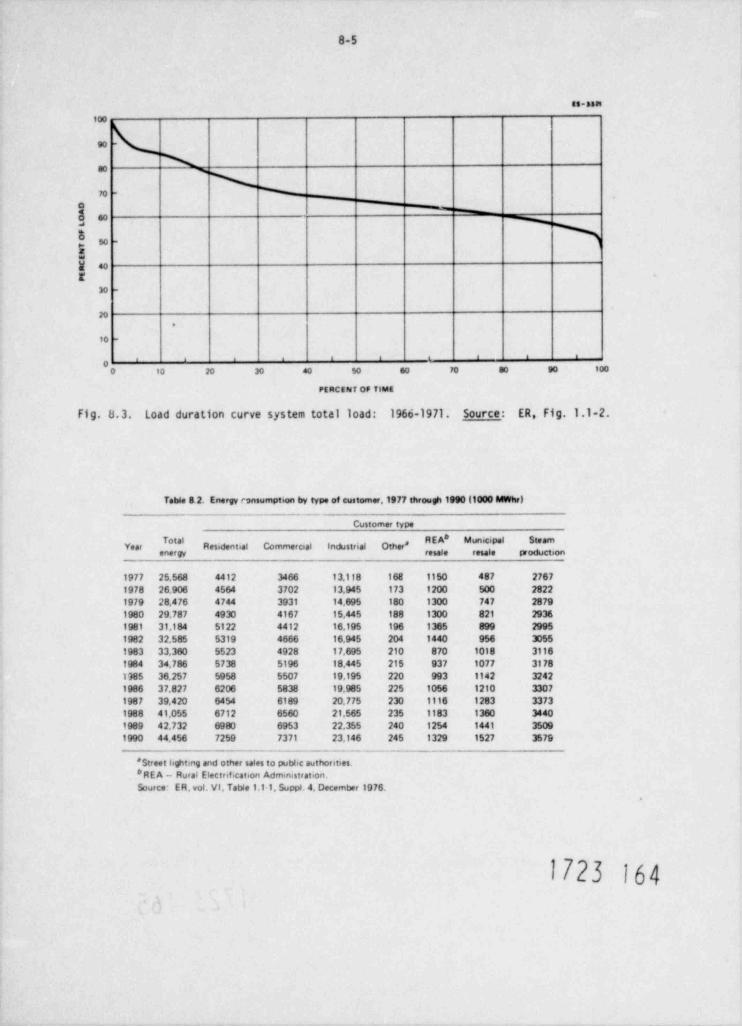
8-5
as-asn
100
e0 -
\a0 3
\n . W
o
! 88 %
$u -
5W 40t
30 -
20.
10 -
, , , , i i . i i -
,0 10 20 30 40 50 60 70 a0 90 100
PERCENT OF TIME
Fig. 8.3. L0ad duration curve Sy5 tem total load: 1960-1971. Source: ERs Fig. 1.1-2.
Table 8.2. Energy consumption by type of customer.1977 through 1990 (1000 MWhr)
Customer type
tal # P'' N'**Year Residential Comrnercial Industrial Other*
energy resale resale production
1977 25.568 4412 3466 13.118 168 1150 487 27671978 26.906 4564 3702 13.945 173 1200 500 28221979 28,476 4744 3931 14.695 180 1300 747 28791980 29.787 4930 4167 15,445 188 1300 821 29361981 31.184 5122 4412 16.195 196 1365 899 2995
1982 32.585 5319 4666 16.945 204 1440 956 3055
1983 33.360 5523 4928 17.695 210 870 1018 31161984 34.786 5738 5196 18.445 215 937 1077 31781785 36.257 5958 5507 19.195 220 993 1142 32421986 37.827 6206 5838 19.985 225 1056 1210 33071987 39.420 6454 6189 20.775 230 1116 1283 3373
1988 41.055 6712 6560 21,565 235 1183 1360 34401989 42.732 6980 6953 22.355 240 1254 1441 35091990 44.456 7259 7371 23.146 245 1329 1527 3579
* Street hghting and other sales to pubbe authorities.* RE A - Rural Electrif cation Administration.Source: E R. vol. VI, Table 1.1 1. Suppl. 4. December 1976.
.
1723 164.
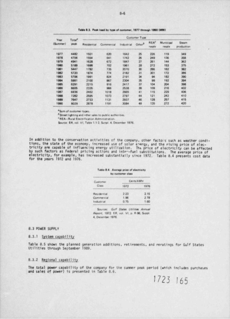
8-6
Table 8.3. Paak loed by type of customer,1977 througa 1990 (MW)
Customer Type
(Summer) peak Ressdential Commercial Industrial Other* , ' " ' ' '*
1977 4482 1501 620 1642 25 226 119 3491978 4706 1554 641 1742 26 249 136 3581979 4941 1628 672 1847 27 261 144 3621980 5189 1698 702 1961 28 272 153 3751981 5447 1782 735 2070 30 286 162 3821982 5720 1874 774 2182 31 301 172 3861983 5706 1991 824 2191 34 94 182 3901984 5991 2100 867 23o4 35 99 192 3941985 6291 2215 916 2417 31 104 204 3981986 6605 2335 966 2538 39 109 216 4021987 6936 2462 1018 2665 41 115 229 4061988 7282 2595 1o73 2797 44 121 242 4101989 7647 2733 1131 2937 46 128 257 4151990 8029 2878 1191 3084 49 135 272 420
' Sum of customer types.* Street lighting and ather sales to pubic authorities.'REA-Rural Electr.f. cation Administration.Source: ER, vol. VI, Table 1.1-2. Sunpl. 4. Decemtwa 1976.
In addition to the conservation activities of the company, other factor s'such as weather condi-tions, the state of the economy, increased use of solar e'ergy, and the rising price of elec-tricity are capable of influencing energy utilization. Th t: price of electricity can be affectedby such factors as Federal pricing actions and inte -fuel substitutions. The average price ofelectricity, for example, has increased substantially since 1972. Table 8.4 presents cost datafor the years 1972 and 1976.
Table 8 4. Average pnce of electretyby customer class
Custome, Cents / kwhr
Class 1972 1976
Residential 2 23 3.15Commercial 1.96 2.78Industrial o.75 1 60
Sources Gulf States Utilstres AnnualReport,1972. ER, vot VI, p. R 96. Suppl.4, December 1976
8.3 POWER SUPPLY
8.3.1 System capability
Table 8.5 shows the planned generation additions, retirements, and reratings for Gulf StatesUtilities through September 1989.
8.3.2 Regional capability
The total power capability of the company for the summer peak period (which includes purchasesand sales of power) is presented in Table 8.6.
1723 165
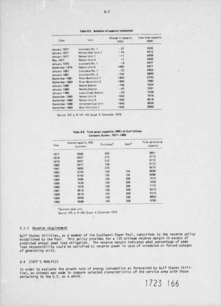
8-7
Table S 5. Schedule of capscity installation_
..
Chany m capacity f.ew totas capety .
Me Unit (MW) (VW)
January 1977 Louisiana No.1 -37 5526
January 1977 Willow Glen Un t 1 -16 5510
Januarv 1977 Nelson Unit 1 -11 5499
May 1977 Nelson Umt 4 +7 5506
January 1978 Louisiana No.1 -9 5407
September 1979 Sabine Unit 5 +480 5977
January 1981 Louisiana No.1 -23 5954 ,
January 1981 Louisiana No. 2 -1b4 5800
September 1981 River Bend Unit 1 +940 6740
September 1983 River Bend Unit 2 +940 7680
January 1985 Sabine Station -146 7534
January 1985 Neches Station -43 7491
January 1985 Lewis Creek Station -53 7438
September 1985 Nelson Unit 5 +540 7978
Septemter 1986 Nelson Unit 6 +540 8518
September 1988 Unnamed Coal Unet +540 9058
September 1989 Blue Hills Unit 1 4930 9988
Source ER, p. R *01-03, Suppi. 4. December 1976.
Table 8 6. Total power capability (MW) of Gulf UtilitiesCompany System.1977 -1990
# ""'''*" *"* #'Purchases * Sales *Year (summer) capacity
1977 5506 345 5851
1978 5497 215 5712
1979 5497 215 5712
1980 5977 158 6135
1981 5800 275 6075
1982 6740 100 154 6686
1983 6740 100 154 6686
1984 7680 100 308 7472
1985 7438 100 308 7230
1986 7978 100 308 7770
1987 8518 100 308 8310
1988 8518 100 308 8310
1989 9058 100 308 8850
1990 9988 100 308 9780
* Summer peak only.Source: ER, p. R-100. Suppi.,4. December 1976.
I
8.3.3 Reserve requirement
Gulf States Utilities, as a metter of the Southwest Power Pool, subscribes to the reserve policyestablished by the Pool. This policy provides for a 12% minimum reserve margin in excess ofpredicted annual peak load obligation. The reserve margin indicates what percentage of peakload responsibility could be satisfied by reserve power in case of scheduled or forced outagesof generating units.
8.4 STAFF'S ANALYSIS
In order to evaluate the growth rate of energy consumption as forecasted by Gulf States Utili-ties, an attempt was made to compare selected cnaracteristics of the service area with thosepertaining to the U.S. as a whole.
1723 166
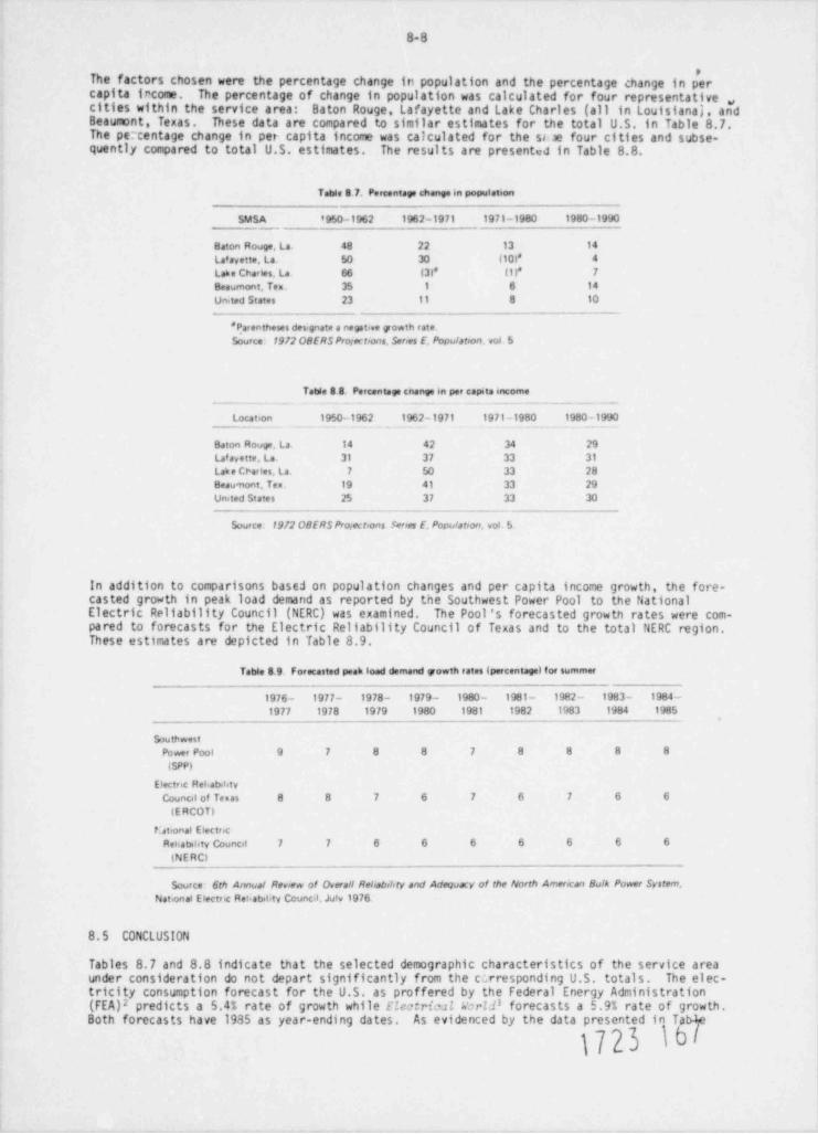
8-8
e
The factors chosen were the percentage change in population and the percentage change in percapita trcome. The percentage of change in population was calculated for four representative ,,cities within the service area: Baton Rouge, Lafayette and Lake Charles (all in Louisianaj, andBeaumont Texas. These data are compared to similar estimates for the total U.S. in Table 8.7.The percentage change in per capita income was calculated for the ss .ie four cities and subse-quently compared to total U.S. estimates. The results are presented in Table 8.8.
Table 8.7. Percentay change m population
SMSA '950-1962 1962-1971 1971-1980 1980-1990_
Baton Rouge, La. 48 22 13 14
Laf ayette. La. So 30 (10)* 4
Lake Charles, La. 66 ( 3 )* ( 1 )* 7
Beaumont, Ten. 35 1 6 14
Un.ted States 23 11 8 10
* Parentheses des <gnate a negative yowth rate.Source 1972 OBERS Projectrons, Serres E. Populatoon, vol. 5
Table 8 8. Percentage enange in per capita income
Location 1950-1962 1962-1971 1971-1980 1980 -1990
Baton Rouge. La 14 42 34 29Laf ayette, La. 31 37 33 31
Lak e Charles, La. 7 50 33 28Beau nont, Tex. 19 41 33 29United States 25 37 33 30
_ . _ _ _ _ _
$ource 1912 OBERS Protectrons Senes E, Populatoon, vot 5.
In addition to comparisons based on population changes and per capita income growth, the fore-casted growth in peak load demand as reported by the Southwest Power Pool to the NationalElectric Reliability Council (NERC) was examined. The Pool's forecasted growth rates were com-pared to forecasts for the Electric Reliability Council of Texas and to the total NERC region.These estimates are depicted in Table 8.9.
Table 8.9. Forecasted peak load demand powth rates (percentage) for summer
1976- 1977- 1978- 1979 - 1980- 1981- 1982 - 1983- 1984 -
1977 1978 1979 1980 1981 1982 1983 1984 1985
buthwestPower Pool 9 7 8 8 7 8 8 8 8
(SPP)
Electric Reliab.htyCouncil of Temas 8 8 7 6 7 6 7 6 6
(ERCOT)
P etronal ElectricRehabihty Council 7 7 6 6 6 6 6 6 6
(NE RCI
Source: 6th Annual Review of Overall Reliabriory and Adequacy of the North Amerocan Bulk Power System,National Electric Rehabstrty Council. Juiv 1976
8.5 CONCLUSION
Tables 8.7 and 8.8 indicate that the selected demographic characteristics of the service areaunder consideration do not depart significantly from the c;rresponding U.S. totals. The elec-tricity consumption forecast for the U.S. as proffered by the Federal Energy Administration(FEA)2 predicts a 5.4% rate of growth while Electrical Wor Zf forecasts a 5.9% rate of growth.Both forecasts have 1935 as year-ending dates. As evidenced by the data presented in TabAe
1723 W
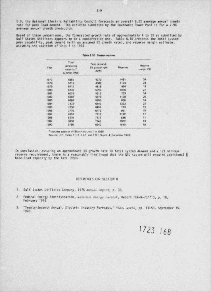
8-9
8.9, the Ntional Electric Reliability Council forecasts an overall 6.21 average annual srowtnrate for peak load demand. The estitrate submitted by the Southwest Power Pool is for a /.9%average annual growth prediction.
Based on these comparisons, the forecasted growth rate of approximately 4 to 51 as submitted byGulf States Utilities appears to be a conservative one. Table 8.10 presents the total systempeak capability, peak demand (with an asswied 5% growth rate), and reserve margin estimate,assuming the addition of Unit 1 in 1989.
Table 3.10. System reserves
_
' * 'Peak demand,
" *'Year f 5% g th rate Reserves y
summer (MW)
1977 5851 4370 1481 34
1978 5712 4589 1123 241979 5712 4818 894 19
1980 6135 5059 lo76 21
1981 6075 5312 763 14
1982 6686 5578 1108 201983 6686 5856 830 14
1984 1472 6149 1323 221985 723o 6457 773 12
1986 7770 6779 991 15
1987 8310 7118 1192 17
1988 831o 7474 836 11
1989 885o 7848 1002 13
1990 9780 8240 1540 19
* Includes addition of Blue Hdis Umt 1 in 1989.Source: E R, Tables 1.12,1.7-1, and 1.91. Suppt. 4. December 1976.
In conclusion, assuning an approximate 5% growth rate in total system demand and a 12% minimumreserve requirement, there is a reasonable likelihood that the GSU system will require additional |base-load capacity by the late 1980s.
REFERENCES FOR SECTION 8
1. Gulf States Utilities Company,1975 Amal Report, p. 33.
2. Federal Energy Administration, Nattor.at Ewergy outlook, Report FEA-N-75/713, p.18February 1976.
3. " Twenty-Seventh Annual, Electric Industry Forecast," Floo. vorld, pp. 43-58, September 15,1976.
1723 Igg
9. ALTERNATIVES
9.1 ALTERNATIVE ENERGY SOURCES
This section addresses the alternatives to building a nuclear power station at Blue Hills. Itis not intended to be an exhaustive study of alter.1ative energy so Jrces. This section will berevised after the applicant establishes a connercial operation date and moves forward with aConstruction Permit application.
9.1.1 Alternatives not requiring creation of new generating capacity
Alternative energy sources not requiring the creation of new generating capacity include reacti-vating or upgrading older plants, purchasing energy from other systems, and the baseload opera-tion of existing peaking units. Each of these alternatives is reviewed below.
9.1.1.1 Reactivating retired capacity or_ upgrading existing facilities
Gulf Statet Utilities (GSI)) does not have units which can be reactivated to produce a significantincrease in generating capacity. Furthermore, the utility operates its existing generating plantsnear their planned capacities (ER, p. 9.1-1). Consequently, these alternatives are not viable.
9.1.1.2 Purchase of energy
There are two ways in which a utility can obtain energy from outside its own system: oy purchaseof power and by exchange of power. Gulf States is involved in both of these activities. Asindicated in Sect. 8. GSU experiences its peak load during the suruner months. To meet a part ofits peak demand obligations, GSU obtainc from the Tennessee Valley Authority 215 MW of power inexchange for assistance during TVA's winter peaking period. Concerning the purchase of energy,GSU has in the past purchased power from other members of the Southwest Power Pool. Figure 9.1shows the 1972 transmission system for GSU and power pool interconnections (ER, p. 9.l-1, 9.1-2).
The purchase or exchange of power is usually viewed as a short-term alternative to tPe additionof peaking units. Since neither of these alternatives is capable of meeting base-load require-ments, they cannot be considered feasible alternatives to a base-load facility.
9.1.1.3 Base-load operation of peaking facilities
The conversion of peaking units to base-load units is usually practicabic under two conditions:if there cre peaking units in existence, and if the established reserve requirement can be metwithout : , af jition of new generating capacity. GSU has no peaking units, with the exceptionof a limited availability of hydroelectric units. Moreover, as indicated by Table 8.10 main-tenance of the appropriate reserve margin is becoming increasingly difficult with the growth indemand. As a result, conversion of peaking units to base-load units is not possible for thissystem (ER, p. 9.1-3).
9.1.2 Alternatives requiring creation of new generating capacity
It has been established that to meet the growing demand for power in the GSU service area, addi-tional base-load generating capacity will have to be created. This section discusses the variousalternative energy sources available to the utility.
The choice of a particular energy source depends on three major factors: technological feasibil-ity, economic feasibility, and environmental acceptability. The alte%MP energy sources whichgenerally meet these criteria are geothermal, hydroelectric, gas, of 3;ial. and nuclear. Each ofthese energy sources is discussed below and evaluated with respec* U; 'e ss+vice area.
ff23 )h}9-1
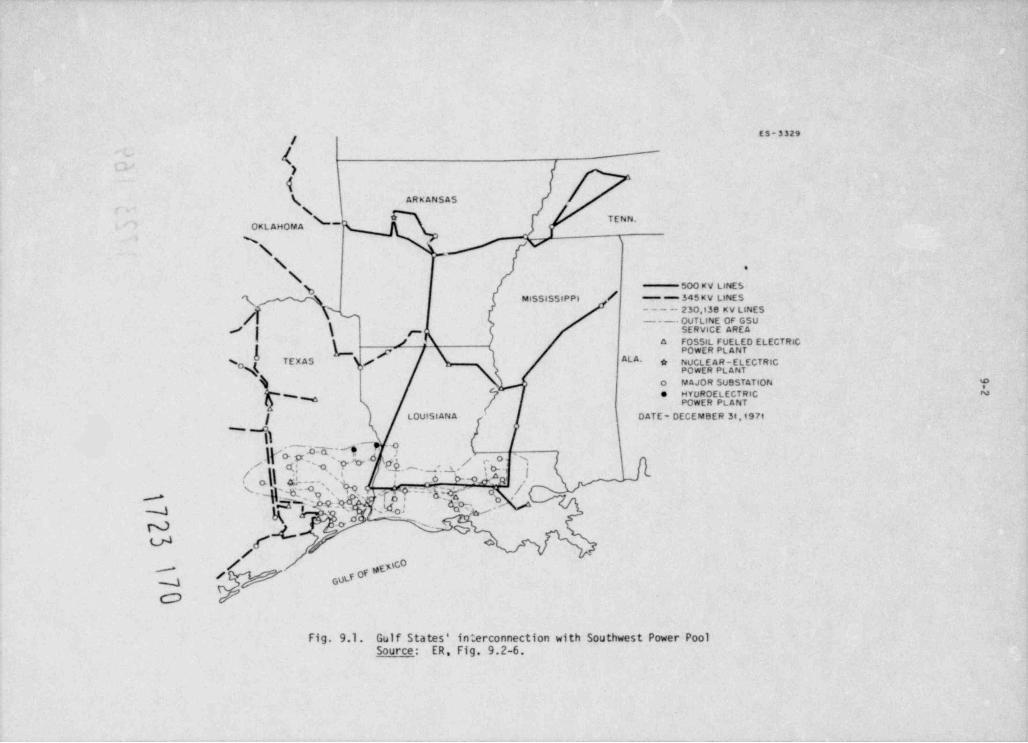
ES-3329
- #,' )
4( ARKANSASs
~OKLAHOPAA
N .T
\ W\ f
.
NSOO KV LINESg / -- 345 KV LINESMISSISSIPP4
- - - -- 2 30,138 KV LINES--- OUTLINE OF GSU
/ k SERVICE AREAg1 / . A FOSSIL FUELED ELECTRICQ 7 POWER PLANT
ALA.N TEXAS (/ * NUCL E A R - E L ECT RICo% POWER PLANT
o uAsoR SusSTATion ?* MYDROELECTRIC N
N POWER PLANT
f LOUISlANA ' OATE- DECEMBER 34,197t
M1, - - 9
( a\\ c(f'a.-.q 'U* j 'Eh._,;2/ f o_ . './ '
i3. . - , ' ~ ' : s 6--o Pa .I,
''\ 'h'|Tf,?~~&.,YQ _
N o s. gV f o
/ -
/ Of , toc 0_
/ cotf
Fig. 9.1. Gulf States' interconnection with Southwest Power PoolSource: ER Fig. 9.2-6.
9-3
In addition to the major energy sources already mentioned, there exist new and/or emerging fueltechnologies. These include fuel cells, solar erergy, magnetohydrodynamics, geostatic satellites,fusion power, tidal power, wind power, and biomass conversion. Most of these energy sources havenot yet been demonstrated to be as economically feasible as other technologies fur utilization in
As a result, thesebase-load power generation; others are still technologically undeveloped.technologies have been eliminated from this review of alternatives to nuclear power.
GeothermM energy
Geothermal energy utilization is possible where heated fluids can be economically extracted frombeneath the earth's surface. High-temperature steam or water can then be used for thermal or
Of the major forms of geothermal resources, only the geopressuredelectrical energy applications.reservoirs of the northern Gulf of Mexico coastal region are immediately available in the EastTexas region of the service area.
Geopressured zones are sedimentary basins where water is trapped at nigh pressures within or belowthick, nearly impermeable shale sequences. The confined water supports most or all of the weightof the overburden. This condition inhibits sediment compaction and causes formation pore pressureto exceed hydrostatic pressure. In sedimentary basins such as the Gulf Coast, upward thermalconduction from the mantle heats geopressured fluids and sediments to abnormally high temperatures,often in excess of 260'C (500'F). These waters are regarded as excellent reservoir fluids be-cause their salinities (less than 20,000 ppm) are relatively low compared to other geothermalreservoirs. In addition, dissolved methane content is high. Recoverable geopressured energy,therefore, exists in three major forms: water at high temperatures, water at high pressures,and dissolved natural gas.
NumerousIt is possible that such geopressured reservoirs exist beneath the Blue Hills region.exploratory gas and oil wells have been drilled in the general area, yielding pressures abovehydrostatic pressure. Halbouty et al.1 have reported on the Port Acres and Port Arthur gas-Pressurescondensate fields where bottom hole fluid pressure approached lithostatic pressure.ranged from 0.84 to 0.97 psi at a depth of 3230 m (10,600 ft).
However, site-specific ,eservoir characteristics which define marketable geothermal energy in theregion have yet to be detemined. Resource definition will be required to determine reservoirCurrentlytemperature, pressure, permeability, porosity, salinity, volume, and methane content.accessible pore fluids lie between the top of geopressure (1500 to 4500 m or 4922 to 14,765 f t)and the depth of well control (an estimated 6 to 7 km or 3.7 to 4.3 miles).2 In addition, poten-tial resenoirs are limited to those porous geopressured sand beds thicker than 91.5 m (300 ft)or to two or three closely spaced sand bodies with a combined thickness greater than 91.5 m.2
Technological parameters must also be defined prior to extensive development. Major problemswhich remain to be solved include: drilling and well-head control of high-pressured fluids;transportation of high-temperature, high-pressure fluids over long distances; rock mechanics andthe potential of extensive subsidence; and the elimination of extracted geothermal fluids.
Therefore, certain reservoir characteristics and technological questions remain to be solved priorto utilization. By the 1990s, however, when proposed electrical production would begin at thesite, geothermal resource definition and technological capabilities may be adequate for electricaland/or nonelectrical energy production. These and other aspects of development are currentlybeing pursued privately and by the Energy Research and Development Administration.
In comparison to other forms of electrical generation, a geothermal plant would take in and ex-haust more heat than an equivalent fossil-fuel or nuclear plant, because of a lower thermal
Power plant operation activities would include operation and maintenance of thee f fici eng .piping network and power plants as well as drilling, redrilling, and reworking geothermal well' tomaintain production capacity. An estimated min' mum of 4.4 km2 (2.73 sq miles) of land will berequired for each 25-MWe plant.2 However, all activities related to electrical generation at aNo offsitegeothemal plant would be localized in the geothermal resource area around the plant.support operations such as mining or fuel reprow.ang would be required.
The full potential for electrical generation from geopressured, high-temperature fluids is cur-While it remains a viable future alternative resource (in the 1990s) if reservoirrently unknown.
and technological questions are adequately solved, based on current information it is not a viablealternative to the Blue Hills Station.
Hydroelectric power plants and_ pumped storage
Hydroelectric generating plants use the energy of a water column to drive a hydraulic turbinewhich is coupled to an electric generatar. In most cases, the water column is created by building
1723 171
9 -4
a dam. Construction of a hydroelectric site in the service area capable of producing electricpower of a magnitude similar to that of the proposed plant would require the acquisition of vastamounts of land (ER, p. 9.2-6). This alternative is considered to be impractical with respect tothe environmental and economic costs that would be incurred.
O_i_1
The domestic supply of crude oil is dependent on the amount of reserves and the price, whereasthe availability of imported oil, as the recent oil embargo indicated, hinges on political andother considerations. Flexibility in end use makes oil a particularly valuable resource to anindustrialized country. In recent years, this fuel has been used as a base for medicinal drugs,clothing fibers, and other necessities such as motor gasoline. The use of oil as a fuel sourcefor a large base-load generating station has been eliminated on the basis of scarcity of domesticsupply and increasing dependence on unreliable foreign sources.
Natural gas
Natural gas has been temporarily eliminated from consideration as a fuel source for a base-loadgenerating station due to the diminishing supply of this fuel at the current (restricted) price.Moreover, GSU has been unable to obtain any new long-term contracts for natural gas extendingpast January 1985 (ER, p. R-57, Supplement 2, October 1976).
Coal
Coal is often considered to be the best alternative to nuclear power generation for base-loadplants. However, as a result of the combined ef fect of high transportation costs and the vastamounts of coal needed to fuel a base-load generating station, the coal alternative is usuallycostlier. This is true despite the lower capital costs associated with coal technology.According to the Federal Energy Administration (FEA),3 nuclear energy is the cheapest source ofbase-load electric power, although not much cheaper than coal. The similarity in costs betweenthe two fuels makes the utilization of coal-fired generating facilities a possible alternativeto the proposed nuclear station. A detailed comparison of the costs and the benefits of theproposed plant and a coal-fired alternative will be considered af ter the applicant proposes adate for commencement of operation of the Blue Hills Station Units 1 and 2.
9.1.3 Conclusion
The review of alternative energy sources has indicated that both nuclear and coal should beconsidered as possible fuels for the proposed generating station.
9.2 ALTERNATIVE SITES
9.2.1 Gulf States Utilities' methodology
As a first step in its site selection process, GSU considered area need. Because load demand isbeing met in both the east and central regions, the western part of the service area was selectedas the region for the plant site. Once the East Texas region was designated as the general sitearea, GSU employed a three-phase plan to select the optimal location within that region. Forty-nine sites were identified on the basis of the following factors: geology, flood protection,cooling water potential, access to available transportation, the absence of significant populace,and land development activities. As a result of the review, 35 of the 49 sites were eliminatedfrom further consideration (ER, p. 9.2-34). The second phase of the site analysis eliminatedeight additional sites based on proximity to existing 500-kV transmission lines, modes oftransportaticn, and in-depth geological and environmental analysis (ER, p. 9.2-34(a), Suppl.1August 1976). Finally, phase three of the site analysis consisted of a detailed investigation ofthe six remaining sites. It is important to note that GSU evaluated each of the six candidatesites with respect to three alternative fuel technologies: nuclear, oil, and coal .
9.2.2 Site area characteristics
The six candidate sites are located in approximately the same geographical area, as shown byFig. 9.2, and therefore share many of the same environmental and demographic characteris tics.The region in which the six sites are located was reviewed with respect to geological factors,population, power transmission proximity, land-use patterns, water availability, transportation,and air quality. This information is summarized below. Section 2 of this statmpe t containsa more detailed description of site-area characteristics. [
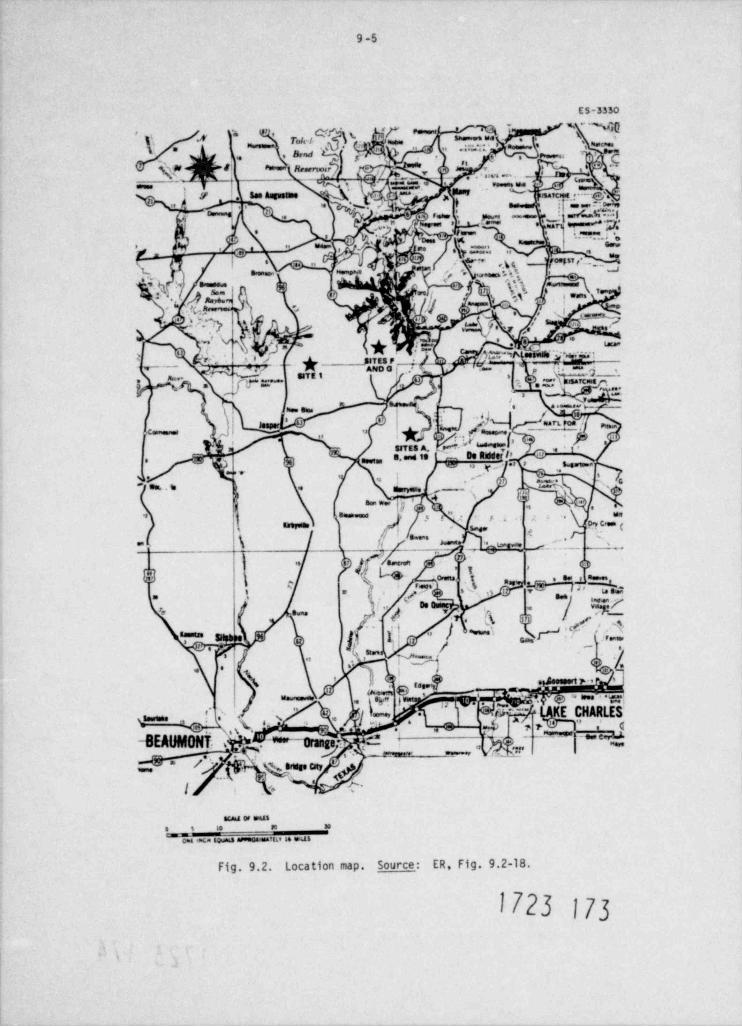
9-5
ES-3350
'f'
\\ .4 yg..g y. o,
' ,**y. ~ f.;;~ ';1' * a ma. .y 'M .
I * r. * .
5" - 3 * *> . e =u,
.
,
|
0 Re.erwur ' *** 2 ,',
QM- u'. , , ..
, _ _..m ._ <,,,,, ,
. '
, ' 10ser - %y see Augustine *,, , , , , , ( ,, ,
I ;' ' - c' . , : o. ,,' -
,,,/.C?.:|y, ~ 6 .4 . ,, - .' yr, ,. ,f.;'
e
a.e = *' ' - - = ' '
\, p. ;,7 **e
#;\ ,r
-',
d.}a:J: s\ :-., .e ,._ .y, '
. ka'
, ,<
a 4 .. ; j '' yg-
, .
3
p2, 8 :, .! ? $ ~.5 * w| r
50 ?~
d.'
3., .
;.,-gn=):- ~i. -.
. . . - . . -
D 4 -1 edy%x ip..
!- ''>
7r .,
..
> :._
, , m ..o. .,., .,
. - .., ..
re. .. s ---- ..
..
'O4 k4,,
. " , . >i'
~h# .
s, t.9,
s,
. \ o,c, -.. ,
L =-
. .c, .- :e .,
\ / .
s-
, .~w.% _
,
.-
,,'
$'
$.,);T ., r- m. 'ol> h.;'''"
!.e ,
s o. , . , - ~.
" ) Y, Y}:*'f'7'
/ ** .'- . .
'.. ,2ij
, )%i
'~~' w.sm ,, ,
/.:q ' /-
''
3.
\ ; s .e .m..siQ. .
M, s s ) +/ hEk.
.' '*i - w
-BEAUMONT. , @* +oran'.7'.e . ' c.* .- -
|~- w
. , - ~' . ' gres.cnr ';p,~
.
c.1 .
, . - .. _ ,, n ,_ . . a.
Fig. 9.2. Location map. Source: ER, Fig. 9.2-18.
1723 173
.
9 -6
'9.2.2.1 Ceology, tectonics, and seismicity
The soils supporting a nuclear station must be stable and of low compressibility because of theinterconnection of the various portions of a nuclear station. Another consideration is thepossibility of significant variations in strength of the soil under dynamic earthquake conditions.The southeastern Texas region has been identified as an area of low seismic activity. Specificsite alternatives in the East Texas region containing known faults were eliminated from furtherconsideration (ER, pp. 9.2-35,9.2-36).
9.2.2.2 Population
Criteria for proximity of nuclear power sites to population centers are specified by NRC regula-tions presented in 10 CFR 100. In GSU's evaluation of site suitability in the East Texas region,distance from a population center, population density factors, and the required exclusions radiuswere all considered. The population of the region was approximately 77,300 in 1970 and is ex-pected to decrease to about 74,600 by 2020. The region contains nine notable population centers,which are listed in Table 3.1 (ER, pp. 9.2-37, 9.2-45).
Table 91. Population youps for the candidata site area
#' ''''Population group 1970 Census'
Jasper, Tex. (cityl 6.251 12.468Kirbyville, Tex. (city) 1.869 3.728Leesville. La. (town) 8.928 3.826Merryville, La. (town) 1.286 1,292Newton, Tex. (city) 1,529 3.148Hornbeck, La (town) 525 225Rosepine, La (village) 587 252North Fort Polk, La. (umncorporated) 7,955 3.409South Fort Polk, La. (unincorporated) 15.600 6.685
*U S. Bureau of the Census Census of Population: 1970, Vol 1: Characteristics ofthe Population, Part 20. Lowsiana and Part 45: Texas, Chapter PC(1) A: " Number ofinhabitants," Department of Commerce, Washington, D.C.
* R. L. Burford and S. G. Murryn," Population Protections by Age. Race, and Sex forLouisiana and its Parishes- 1970-1985,* Division of Research College of BusinessAdministration, Louisiana State Un versity, Baton Rouge, June 1972.
'B. S. 8radshaw and D. L. Poston, Jr., '' Population Projections for Texas Counties:1975-1990."Populaton Research Center, University of Temas at Austin, May 1972.
Source ER. Table 9 2 9
9.2.2.3 Power transmission
The distance of a power plant from the system's power grid is a significant factor in the siteselection process, because of the relatively high cost associated with transmission lines. Forexample, GSU evaluated transmission costs at approximately $125,000 per mile per 500-kV circuitfrom a site to the extra-high voltage line junction (ER, p. 9.2-39). Five-hundred-kilovolt and138-kV electric power transmission lines run parallel to the Sabine River, approximately 20 milesto the west. The Nelson Generating Station, an existing fossil-fueled plant near Lake Charles,has 230-kV and 500-kV switchyards available (ER, p. 9.2-44).
9.2.2.4 Land use
The candidate site area contains no historic sites registered with the U.S. Department of theInterior. However, the area does house two historic locations: the Old Camp Ground Cemetery andthe Beauregard War Memorial Civic Center. Recreation areas adjoin the Sam Rayburn Reservoir,Steinhagen Lake, and Toledo Bend Reservoir. Land-use activities also include housing developmentand construction of reservoirs for water supply or flood control (ER, pp. 9.2-39, 9.2-46).
9.2.2.5 Water availability
Cooling ponds or towers would be required in the East Texas area to dissipate waste heat from theplant to the atmosphere.
Because both of these alternative cooling methods require in@ua ion of
1723
9 -7
land area with water or the clearing away of natural vegetation, GSU eliminated from further con-sideration areas which contained unique plant types or wildlife. In East Texas, the regulatedaverage flow of the Sabine River near Burkeville was ruled insufficient for use as a once-throughwater source. The same is true for the Neches and Angelina rivers. Flood prevention is ensuredby locating cooling tower sites at a higher elevation than the surrounding area. The selectivelocation of cooling ponds is to prevent flooding of the site from natural runoff and to ensurethat flooding of major rivers will not threaten a power plant built on the site (ER, pp. 9.2-38,9.2-39,9.2-46,9.2-47).
9.2.2.6 Transporta tion
U.S. highways 96,171, and 190 are the principal routes in the area. Local, state, and countyroutes supplement these major thoroughfares. The five airports within the region are the DeRidder Leesville, Kf rbyville, Jasper, and Newton airports. Rail transportation is provided bythe Kansas City Southern, Missouri Pacific. Soutnern Pacific, and Atchison, Topeka, and Santa FeRailroads. The Angelina, Neches, and Sabine rivers are the only major navigable waterways.(ER, p. 9.2-40)
9.2.2.7 Air quality
According to GSU, the U.S. Environmental Protection Agency, the Texas Air Control Board, and theLouisiana Air Control Comission have established ambient air quality standards that place amaximum limit on ground-level concentrations. The candidate site area is located within theboundaries of the Southern Louisiana-Southeast Texas Interstate Air Quality Control Region. Thelimits established by these agencies are not expected to be violated by the construction andoperation of a power station (ER, p. 9.2-48).
9.2.3 Description of sites
In the following descriptions of the sites (based on GSU's ER, Sect. 9.2), sites A, B, and 19have Leen gNuped together, as have been sites F and G, because of the similar ' locations ofthe sites within their respective groups. Site 1 is treated separately.
9.2.3.1 Sites A, 8, and 19
Sites A, B, and 19 lie within five miles of each other in Newton County, Texas. Their specificlocations are indicated in Fig. 9.2. A cooling pond could be used at site 19, but cooling towerswould be required at sites A and B. State Highway 87 and Farm-to-Market road 1414 are availabletransportation routes. The closest railroad of the Santa Fe Railway system is approximately24 km (15 miles) from the area at Bon Weir, Texas. No rare or endangered flora grow in theimediate area of the sites, but the rare red-cockaded woodpecker is an inhabitant of the region.Newton County is part of the East Texas Timber Region, one of the best timber producing areas inthe United States. Forest land comprises 92% of the land area in the county, 90% of which isowned by companies or nonresident land owners. Although there are no wildlife preserves orFederal or state parks in the county, there does exist a private wilderness park, the WildAzalea Canyon, which would require protection during construction and operation of a generatingplant. Agriculture and broiler chicken production are the largest contributors to the localeconomy. GSU has found that the foundation material at sites A and B would not be suitable fora nuclear power plant because there would be considerable settlement. A pile foundation couldbe used at site B where long piles, about 130 ft, would bear on a dense sand stratum. A com-parable stratum was not encountered at site A. Parts of site 19 are within a few miles of anidentified fault, making this a higher risk site for nuclear. Fossil-fueled plants which usedmat foundations, however, could be built at sites A, B, or 19. (ER, pp. 9.2-49 to 9.2-54).
9.2.3.2 Sites F and G
Sites F and G lie about 3.2 km (2 miles) apart in Newton County, Texas, as shown in Fig. 9.2.Both sites are near State Highway 87; a new access road 1 to 2 miles long would have to be builtto the highway. A secondary line of the Santa Fe Railroad is located about 27.4 km (17 miles)west of the sites. The Sabine River is not suitable for waterborne transportation. Ecologicalsurveys indicate that there are no rare or endangered species of flora that would be impacted byplant location at site G, although the possibility of such an impact does exist at site F. Therare red-cockaded woodpecker inhabits the forests of the area.
The sites are in a heavily forested area about 1.6 km (1 mile) south of the Sabine National Forest.Sabine County, which borders sites F and G on the north, is comprised almost entirely of recrea-tional land. The Toledo Bend Reservoir, which was created by daming the Sabine River, lies to
1723 175
9-8
the east of the F and G sites. Plans for the reservoir's development include the building ofparks and marinas. Visitor projections indicate that usage of the reservoir will grow toapproximately 6000 visit:rs per day by 1980. The Sam Rayburn Reservoir, located west of ToledoBend, accommodated 5480 visitors per day in 1975. Industrialization and residential developmentin the area are not expected to increase significantly. GSU's analysis of soil and foundationsravealed that both sites F and G appear to have acceptable foundation material for a nuclearp]wer plant using a mat and spread footings foundation. In addition, fossil-fueled plantsusing mat foundations could be built at the F and G sites (ER, pp. 9.2-54 to 9.2-57).
9.2.3.3 Site 1
Site 1 is located approximately 12.9 km (8 miles) east of the Sam Rayburn Reservoir on the Jasper-Newton County line (see Fig. 9.2). U.S. Highway 96 is within 8 km (5 miles) of the site; a newaccess road 3 to 4 miles long would have to be built to the highway. A secondary line of theSanta Fe Railroad passes about 6.4 km (4 miles) west of the site. The Neches and Angelina riversto the west of the site are unsuitable for waterborne transportation. The site is in an area of
comercial timberland about 6.4 km (4 miles) south of the Sabine National Forest. The rarered-cockaded woodpecker inhabits the region encompassing the site. No other rare or endangeredspecies have been found. Concerning commercial activity, broiler chicken production and beefcattle inventory are significant. Within Jasper County, there are recreational facilities asso-ciated with county lakes. The area adjacent to the site is primarily used for commercial timberland. Gulf States Utilities found the geological formations beneath site 1 to be similar to thoseat site F, i.e., site 1 is underlain by satisfactory foundation material for the siting of anuclear or a fossil-fueled plant (ER, pp. 9.2-57 to 9.2-60).
9.2.4 Gulf States Utilities' conclusion
Table 9.2 sumarizes GSU's engineering and environmental comparison of sites. Because sites 19and A were judged incapable of supporting a nuclear power station, they were eliminated. Theremaining four sites were very similar with respect to environmental characteristics. GSUselected site G as the "best" site based on the final criterion of lowest expected cost.
9.2.5 Staff's,sonclu.sion.
When the ER was submitted in June 1974, the staff reviewed the applicant's site-selectionprocess to determine whether the methodology was adequate and applied in a complete and objectivemanner. As a result of this review, the staff found that the site selection process was notadequately documented. The staff also requested additional reconnaissance-level infomationon the candidate sites.
Upon receipt of the applicant's submittal of the information requested, the staff requestedadditional infomation on the sites that the applicant rejected as cooling pond sites. Theapplicant was requested to consider these potential cooling tower sites and to include at leastone of them in the detailed comparison of candidate sites. All five candidate sites initiallychosen by the applicant were close together and were in the same watershed: that of theSabine River.
Upon receipt of the applicant's response to the staff's second request for additional infomationon alternative sites, the staff asked for more detailed information on sites 1, 3 and 4 (three ofthe sites the applicant had previously been requested te consider).
Upon receipt of the applicant's response to the staff's third request for additional siteinfomation, the staff requested: (1) more information about site 1, a site in the Neches Riverwatershed. (2) additional information about site B (one of the candidate sites), (3) sufficientinformation to rule out a Trinity River Basin site from serious consideration, and (4) clarifica-tion of the arguments in the ER for selecting the East Texas region for the site of the station.
After receiving the requested infomation, the staff accepted the ER in August 1976.Subsequently, the staff conducted a visual inspection of the six candidate sites (includingsite 1) and asked the applicant additional questions about the site selection process.Answers were subsequently received.
The staff is now satisfied that the applicant's site selection methodology, reconnaissance-level information, selection criteria, and selection process were adequate to identifycandidate sites that are among the best that could have been found for the proposed nuclearplant and to determine whether there are alternative sites that are obviously superior to theproposed site (site G).
1723 176
9-8a
On the basis of GSU's geological assessment, site 19, A, and B were eliminated by the staff.The only obvious advantai s pertaining to the use of site B, notwithstanding geological unsuit-ability, would result fru+ the relatively short makeup and blowdown pipelines which could beused at this site. The remaining three sites, 1, F, and G, are all quite similar from anenvironmental standpoint. The disadvantages pertaining to the use of any one of these siteswould include relatively greater erosion and more complex terrestrial biotic communities(atsitesFandG). Use of site I could also mean greater entrainment and impingement of fishdue to the increased water requirements. However, one advantage of site 1 would be that onlythe habitat of the red-cockaded woodpecker would require protection, whereas at sites F and G,the habitat of the American alligator would have to be safeguarded as well.
Although the applicant has already made an economic comparison of the sites and found site G tobe the most cost-effective, the staff's comparison of alternative energy sources must be completedbefore the proposed plant at the proposed site can be evaluated in relation to the other plant-site alternatives. A detailed cost-benefit comparison of plant-site alternatives will be madeat the Construction Permit stage. Assuming that a superior energy source is not found, there isno site obviously superior to site G, the applicant's proposed site.
9.2.6 Nuclear enerqy centers
Pursuant to Section 207 of the Energy Reorganization Act of 1974, the NRC conducted a surveyof possible sites and an evaluation of the feasibility and practicality of locating nuclearpower reactors and other elements of the nuclear fuel cycle on nuclear energy center sites.A report of the survey was submitted to the Congress on January 19, 1976.'' The cover lettertransmitting this report to the Congress contained the following general conclusions of theNRC derived from the report.
"In summary, the Nuclear Energy Center Site Survey concluded that, depending on location,it can be feasible and practical to construct power plant centers of up to 20 nuclear
1723 177
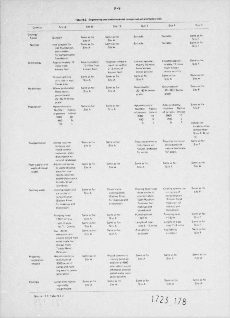
9 -9
Table 9.2. Engineenne and envercamental comparison of alternative sites
Criteria SteA Site B Site 19 Site 1 S,re F Site G
Geo6ogy
F ossil Suitable Same as for Same as for Suetable Suitable same as forS,te F
Site A Site A
fJuclear Not suivatWe for Same as for Same as for Suitable Suit able Same as forS>te F
met foundation. S te A Site A
but suitablefor compensatedfoundation
Seismology Approximately 12 Approx imately Reservoir embark- Located approxi- Located approxi- Same as for
miles from 10 miles from ment hes within mately 15 miles enately 15 miles Site F
known f ault known f ault 2-3 miles of frorn known from known
known fault mmor activity minor activity
Seismec activity Same as for Same as for Same as for Same as for Same as for
very low in east Sete A Site A Site A Site A Site A
Texas area
Hydrology Above postulated Same as for Same as for Groundwater Groundwater Same as for
flood levels. Site A Site A 20- 80 f t below 20- 80 f t below Site F
groundwater gr ade grade
20-50 ft belowgrade
Population Approximately: Same as for Same as for Approximately : Approximately: Same as for
Number Radius Site A Site A Number Radius Number Radius Site F
of persons (males) of persons (milesl of persons (meles)
3800 10 2000 10 2000 10
450 5 450 5 200 5
32 10 1 0 1 Actual site
location moreremote thanS tes A. 8. or19
Transportation Access esquires Same as for Same as for Requires mmimum Requires minimum Same as for
distu bance of d sturbance of S.te Fbrideng and S re A Site A r
flood control natural landscape natural landscape
for access 'or arressmeasur es; some
d.sturbance tonatural landscape
F uel supply and Additional access Same as for Dme as for Same as for Same as for Same as for
waste disposal to waste disposal Site A Site A Site A Site A S,te A
routes areas for coalpiants required,added disturbanceto natural sur-rounthogs
Cooteng water Cooimg towers use Same as for Closed cycle Cooling towers use Cooling towers use Same as for
six cycles of Site A cooling pond three cyc!es of six cycies of S te F
concentr ation (Sabine Rever concentration concentrat on
(Sabine River for makeup and (Sam Ravborn iToledo Bend
for makeup and blowdown) Reservoir for Reservoir for
blowdown) makeup and makeup and
blowdown) blowdown!
Pumpmg head Same as for Same as for Pumping head Pumping head Same as for
100 ft or less Site A Srte A -240 f t -130 f t S.te F
f agth of p4pe- Same as for kme as for Length of pipe Length of p<pe- Same as for
nes '6 -2 m.les S,te A Site A knes 8-13 m.les unes 7- 8 m.les S<te F
An Ahty %me as for Same as for Availability Ava. label.tv Same as br
arfequate. pro Site A Site A adequate e xcellent S.te F
vrsions would haveto be made forrelease fromToledu 8endReservo.1
Pro;ected Would commit a kme as for Would commit to Same as for Same as for kme as for
recreation mmimum of Site A coohng pond an S te A Site A S,te A
impact 3000 acres of additional 4500
camp and hunt acres which cou;d
ing area to power otherwise provide
generation added water recre-ation benefits
Ecology Local d sturbance. Same as for kme as for Same as for Same as for %me as for
regionally Site A Site A Site A S.te A S.te A
insignificant. _ _ _
-
_ _ _
Source E R. Table 9 3 7.
1723 179
.
9-10
power reactors, fuel cycle centers and combined centers. However, it does not indicateany great or unequivocal advantage or compelling need for such centers. The Surveyfurther concluded that dispersed siting of nuclear power facilities remains a feasibleand practical, and even desirable, option for many locations."
"In particular, the Survey found that a 15- to 20-unit power plant center could achieve,through the use of specialized on-site construction techniques, a reduction in unit costsof about 10% over those for sihs containing 4 units, the largest under development today.However, these estimated on-site economies of scale could be offset, to a degree that woulddepend on location, by higher capital costs for transmission. In addition, during the longbuildup time required to develop a power plant center, the developers would face capitalrisks arising from future uncertainties in a number of areas, including government policiesand actions. While existing private incentives may suffice to establish some power plantcenters, the development of a greater nurter of centers would require encouragement andfacilitating measures by the various levels of government. Furthermore, while the Surveyidentified no legal or other institutional factors that would prohibit the construction ofpower plant centers, realization of potential benefits would depend in large measure onwhether or not the population of a given location looked positively upon the constructionof such a center."
In this same letter to the Congress, the Comission makes the following recomendation:
"The Comission agrees that technical and social considerations analyzed in the Surveysupport a nuclear power system that accomodates both dispersed sites and nuclear energycenters. In addition, there are major technical, social, environmental, and economicuncertainties concerning the development of nuclear energy centers. Therefore, theComission recomends that nuclear energy centers neither be made mandatory nor beexcluded. Rather, the Comission believes the national interest would be served bestby appropriate federal and state energy authorities taking careful account of the naturaland social characteristics of each potential site to locate the number and kind of facil-ities most suited to that location. Each potential site would require careful cost-benefit balancing of both general and site-specific considerations."
In view or the findings in the NEC Site Survey report, it is concluded that, while energy centerscould have site specific advantages, they are complex undertakings involving elements of finan-cial risk and do not have any great or unequivocal advantage, and thus should not be mandated asthe site for all nuclear plants. The plans for meeting projected needs for new electric generatingfacilities in the areas covered by cooperating planning and reliability groups which include theapplicant's system do not involve development of a nuclear energy center. In the absence of anyreal plan for such a center and in consideration of the fact that the applicant's projected powerneeds are less than that which would be fornished by even a small energy center, the placement ofthe proposed nuclear facility in a nuclear energy center is not a reasonably achievable or desir-able alternative at the present time.
9.3 PLANT SYSTEMS
9.3.1 Cooling systems
The staff considered the following cooling systems as alternatives for the proposed roundmechanical-draf t towers: natural-draf t (hyperbolic) towers, fan-assisted natural-draf t towers,rectangular mechanical-draf t towers, wet-dry towers, dry cooling towers, offstream cooling ponds,spray ponds, and a once-through cooling system. Of these, the applicant found only systems usingnatural-draf t (hyperbolic) towers, fan-assisted natural-draft cooling towers, wet-dry towers, andrectangular mechanical-draf t towers to be viable alternatives. The remaining systems were re-jected because of environmental, economic, and/or engineering reasons.
The design of the alternate heat dissipation systems considered viable by the applicant are givenin Table 9.3. All of these alternatives are closed-loop systems and are similar in design.Therefore, the intake and discharge designs probably would not differ for each cooling system.The applicant found that these alternatives would have no significant environmental impact(ER, Appendix B).
9.3.1.1 Natural-draf t (hyperbolic) towers
The applicant calculates that two natural-draft towers 124 m (408 f t) high and 149 m (490 f t) indiameter would be required to dissipate the waste heat. The physical and performance character-istics of the natural-draf t towers are given in Table 9.3. These towers dissipate heat in th!
1723 179
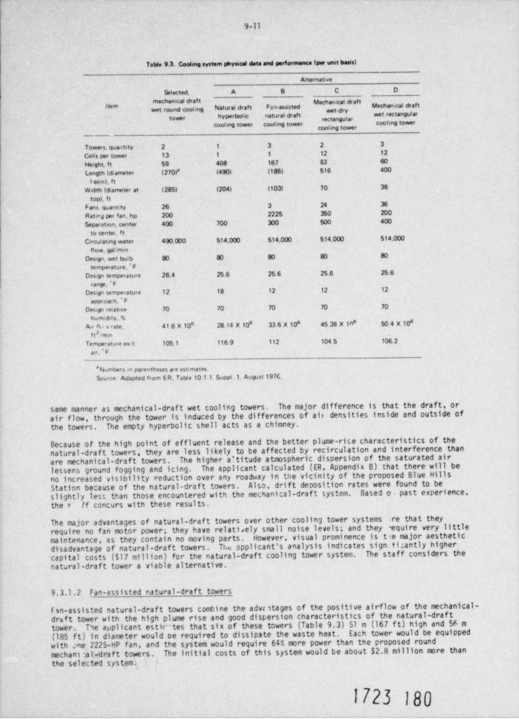
9-11
Tatde 9.3. Coolmg system physical data and performance (per unit basis)
Alternative
Selected. A B C D
ne hanical draft Mechanical draftwet round coohng Natural draf t Fan-assisted Mechanical draftitarn
tower hyperbohc natural draft wet rectangular
cooling tower cooling tower cochng tower
Tower s, quantity 2 1 3 2 3
Cells per tower 13 1 1 12 12
Height, ft 59 408 167 83 60
Length (diameter (270l* (490) (185) 516 400
t esin), f t
Width (diameter at (285) (204) (103) 70 36
topt ft
Fans quantity 26 3 24 36
Ratir,1 per f an, hp 200 2225 350 200
Separation, center 400 700 300 500 400
to center, f tCirculating water 490.000 514,000 514,000 514.000 514,000
flow, gal / minDesign, wet bulb 80 80 80 80 80
temperature,*FDesign temperature 26.4 25.6 25.6 25.6 25.6
range,*FDesign temperature 12 18 12 12 12
approach, * F
Design relative 70 70 70 70 70
humidity, %Air fle v rate. 41.6 X 10 28.14 X 10* 33.6 x IO* 45.38 X In 50.4 X 10s8 s
3f t / minTemperature enit 105 1 116.9 112 104.5 106 2
air, " F
* Numbers m parentheses are estimates.source Adapted from ER Table 101-1, Suppl.1, August 197C.
same manner as mechanical-draf t wet cooling towers. The major difference is that the draft, orair flow, through the tower is induced by the differences of ait densities inside and outside ofthe towers. The empty hyperbolic shell acts as a chimney.
Because of the high point of effluent release and the better plume-rise characteristics of thenatural-draft towers, they are less likely to be affected by recirculation and interference thanare mechanical-draft towers. The higher altitude atmospheric dispersion of the saturated airlessens ground fogging and icing. The applicant calculated (ER, Appendix B) that there will beno increased visibility reduction over any roadway in the vicinity of the proposed Blue HillsStation because of the natural-draf t towers. Also, drift deposition rates were found to beslightly less than those encountered with the mechanical-draft system. Based oi past experience,the e' ff concurs with these results.
The major advantages of natural-drdf t towers over other cooling tower systems ire that theyrequire no fan motor power; they have relati<ely small noise levels; and they equire very littlemaintenance, as they contain no moving parts. However, visual prominence is t ie major aestheticdisadvantage of natural-draf t towers. The applicant's analysis indicates sign.fi:antly highercapital costs ($17 million) for the natural-draft cooling tower system. The staff considers thenatural-draft tower a viable alternative.
9. 3.1. 2 Fan-assisted natural-draf t towers
Fan-assisted natural-draf t towers combine the advi1tages of the positive airflow of the mechanical-draft tower with the high plume rise and good dispersion characteristics of the natural-drafttower. The applicant estir'tes that six of these towers (Table 9.3) 51 m (167 f t) high and 56 m(185 f t) in diameter would be required to dissipate the waste heat. Each tower would be equippedwith one 2225-HP fan, and the system would require 64% more power than the proposed roundmechant :al-draf t towers. The initial costs of this system would be about $2.8 million more thanthe selected system.
1723 180
9-12
Because of tha shape and high effluent velocity of the fan-assisted natural-draft towers, thefrequency of downwash is lower than that of either a mechanical- or natural-draf t tower. There-fore, the ground-level effects (fogging and icing) are minimal. The anplicant's analysis indi-cates that drif t will be deposited at a maximum rate of 1.0 lb/ acre-year onsite, a value con-sistent with the other results. The staff considers the fan-assisted natural-draft tower anenvironmentally acceptable alternative to the round mechanical-draft tower.
9.3.1.3 Rectangular mechanical-draf t towers
The design and environmental impact of this system are discussed in Sect. 5.3. Envi ronmentally,the rectangular mechanical-draf t towers and the selected round mechanical-draft towers will havenearly the same impact. However, the round configuration design performance is less affected bywind direction. The applicant estimates that the initial capital costs of this alternative wouldbe about 20% ($4.3 million) lower than the proposed system. Moreover, the total generating costpresent value annualized is about $0.88 million lower than the round towers. The staff concludesthat the rectangular mechanical-draft towers would be a viable alternate heat dissipation system.
9.3.1.4 Dry cooling towers
Dry cooling towers remove heat from a circulating fluid through radiation and convection to airbeing circulated past the heaf. exchanger tubes. Because of the poor heat-transfer properties ofair, the tubes of dry towers are generally finned to increase the heat-transfer area. Thetheoretical lowest temperature that a dry cooling system can achieve is the dry-bulb temperatureof the air. The dry-bulb temperature is always higher than (or equal to) the wet-bulb temperature,which is the theoretical lowest temperature that a wet cooling tower can achieve. Turbine backpressures will be increased, as will the range of back pressures over which the turbines mustoperate, resulting in a reduced station capability for a given size reactor.
The advantage of a dry cooling tower system is its ability to function without large quantitiesof cooling water, thus allowing power plant siting without consideration of water availabilityand eliminating thermal-chemical pollution of the aguasphere. In practice, some amount of make-up water will always be required, so that power plant siting cannot be completely independentof water availability. From an environmental and cost-benefit standpoint, dry cooling towerscan permit optimum siting with respect to environmental, safety, and load distribution criteriawithout primary dependence on a supply of cooling water. When considered as a direct alternativeto wet cooling towers, the advantages of dry cooling towers include elimination of drif t,fogging, and icing problems, and blowdown disposal.
The principal disadvantages of dry cooling towers are economics and a lack of operating experbncefor large power stations. For the Blue Hills Station, the applicant has estimated turbine outputlosses of 53.6 MW, compared to the selected system. The land requirement would be 22.7 aa(56 acres), compared to only 6.9 ha (17 acres) for the mechanical-draft towers; and t*.e applicantestimated the initial construction costs to be seven times higher than the scieu co system.Af ter weighing the overall advantages and disadvantages of dry cooling *.cwers - particularly whencomparing their greater fuel use and the economic penalty associated w'th their use with theacceptable environmental impact of the proposed cooling system - the scaff has concluded thatdry cooling towers are not a reasonable alternative to the round mech.nical-draft cooling towers.
9.3.1.5 Wet-dry cooling towers
In wet-dry cooling towers, a dry cooling section is added 10 a conventional wet mechanical-draftcooling tower. The size. of the dry section can be varied; if it is small, it is called a plumeabatement tower. In taese towers, the warm air passing th ough the dry section mixes with thatof the wet section. The resulting mixture will contain le s water vapor in a layer volume of air,thus lowering but not eliminating the amount of fogging arj icing produced. In addition, about207,less water is consumed. If the dry section of the tuer is quite large, such a tower canoperate as a pure " dry cooling tower" durin; cool peri',ds and as a wet-dry tower for the balanceof the year.
Because water consumption is not considered to be a problem at the proposed Blue Hills site,justification for a dry section would be control of 'he visible plume. The staff's analysis ofthe mechanical-draft tower (Sect. 5.3.2) does not ina*cate a fog problem sufficient to justifythe cost of a dry section. The staff concludes, therefore, that the wet-dry alternative neednot be considered further.
0 2 3 .+1
9-13
9.3.1.6 Offstream cooling ponds
Offstream cooling ponds rely on surface heat transfer (evaporation, conduction, and long-waveradiation) to dissipate waste heat. The rate at which heat is lost from the surface is a functionof the pond surface temperature. Because there are no regulatory restrictions on temperatures inutility-owned ponds, they are normally sized with smaller surface area per megawatt than isavailable in natural lakes. The average size of existing installations varies from 0.405 to1.62 ha (1 to 4 acres) per MWe. The applicant estimates that a cooling pond area of 1400 ha(3,450 acres) would be needed for the Blue Hills Station, a pond area which in itself exceedsthe entire 1221 ha (3016 acres) contained within the current property line boundaries.
Systems using cooling ponds are economically attractive in areas where (1) low humidities whichpromote surface cooling by evaporation are prevalent, (2) good wind velocities exist over theclear expanse of the pond, and (3) large amounts of land are available at a low cost. Also, acooling pond is most useful where water storage is required in addition to the need to dissipateheat. The proposed Blue Hills site is located near an ample water supply (Toledo Bend Reservoir),and high ambient humidities and temperatures often prevail. Therefore, the logic of constructingsuch an artificial lake adjacent to a large body of water would be questionable in this case andthe cost would be high. This alternative is not considered viable.
9.3.1.7 Spray ponds
A spray pond cooling system is based on pumping water through nozzles to produce a coarse sprayrising to a height of about 6 m (20 ft). Heat is dissipated as the spray rises and falls backinto the pond. The pond itself acts largely as a collecting basin. Most of the spray and mistwill fall back within 61 m {200 ft) of the spray nozzle, and drift beyond 152 m (500 f t) of thespray nozzle is very small. Two varieties of power spray modules are commonly used. One typeconsists of floating individual pumps which take suction below the surface and spray the cir-culating water into the air. The second variety consists of a pump which distributes circulatingwater through submerged piping to floating spray headers.
Spray ponds require considerably less surface area than cooling ponds to dissipate an equivalentamount of waste heat. Spray ponds generally require surface areas of 0.04 to 0.12 ha (0.1 to 0.3acres) per MWe.6 The optimum pond shape is a long, narrow channel arranged 50 that the overallcooling effects of the spray pond are not reduced by air, which may become saturated over onesection of the canal and then flow over another section. This design can considerably increasethe required total land area over that required for cooling towers, depending on the local sitetopography and climatological condition.
The applicant estimated that the spray pond system would reduce the pond area to at least 698 ha(1725 acres). This value seems high by the staff's estimate. Furthermore, the staff is unawareof any spray pond closed-cycle cooling water system that has been built for a power station ofthis size and that has been completely successful in its operation. However, because of thelack of experience and the costs of large-size spray pond systems, the staff concludes that theother environmentally acceptable cooling systems would be a preferable alternative for theBlue Hills heat dissipation system.
9.3.1.8 Once-through cooling
Once-through cooling is the process in which water is drawn from a water body, circulated throughthe steam condenser where its temperature is raised about 5.6 to 16.7 C (10 to 30'F), and dis-charged directly into the same water body. The major advantage of a once-through cooling systemis the low condenser temperature, which results in a minimum turbine back pressure and a highthermodynamic ef ficiency. For the Blue Hills Station, the manner in which the heated effluentshould be mixed or discharged into the receiving waters requires careful consideration. Becauseof the small and intermittent releases through the Toledo Bend Reservoir Dam, vigorous near-fieldmixing probably would'not be the most efficient method to dilute the heated effluent. Largevolumes of water would be affected; however, the heat wnuld finally be dissipated by surfaceheat transfer to the atmosphere. The heat could be dissipated much rure efficiently by operatingthe reservoir as a cooling lake and thus taking advantage of surface heat dissipation.
Once-through cooling is usually the least expensive method. However, at the Blue Hills site, thecost of once-through cooling would be unusually high because the plant has been located about4.8 km (3 miles) from the Toledo Bend Reservoir. The applicant has estimated that installationof a once-through system would cost about $85 million more than the proposed system. Also, asubstantial amount of additional power would be required to circulate the required cooling water.The staff concludes that the loss of aquatic biota resulting from entrainment, impingement, andthernal effects from a once-through cooling system could affect the ecological balance of the
1723 182.
9-14
lower basin of the reservoir. However, the applicant would be required to establish that thisimpact would occur. The staff considers once-through cooling a possible alternative.
9.3.19 Conclusions
The staff concludes that closed-cycle natural-draf t (hyperbolic) towers, fan-assisted natural-draf t towers, and rectangular mechanical-draf t towers would be the most effective methods ofwaste heat dissipation of all the alternatives from an economical and environmental standpoint.Moreover, the staf f concurs with the applicant's conclusion that the differences in the environ-mental costs of these alternatives are not of sufficient magnitude to indicate a significantenvironmental advantage for either system.
9.3.2 Intake systems
The applicant has considered six intake locations and seven corresponding water conveyance routes(Fig. 9.3). Routes A, B, and C (and, hence, locations A B and C) were eliminated from detailedstudy because they have the disadvantage of being within the boundaries of the U.S. Forest Service,meaning that lease continuity cannot be guaranteed. The remaining intake locations were evaluatedto determine their suitability for either an open-channel (proposed design) or a siphon system.
Design details of the siphon system are given in Fig. 9.4. The system consists of an intake pumpstructure (located inland from the reservoir), an intake structure extending into the reservoirbelow the low-water level, and a burit.2 connecting siphon pipe. The siphon system is less expen-sive, and in general, the environmental impact of construction of this system would be less severethan that of the open-channel system. However, neither system has a clear environmental advantageover the othe The siphon intake would result in lower levels of fish and plankton entrainmentbecause (1) wa 3rs of the reservoir stratify about eight months of the year (April through Novem-ber) and (2) hypolimnetic water below the thermocline (in which the siphon intake muld be located)does not contain suitable concentrations of dissolved oxygen to support fish and other aquaticbiota as does the epilimnion. The use of makeup water withdrawn from hypolimnetic water, whichcontains higher concentrations of heavy metals and H 5 (ER, Appendix F) during periods of reservoir2stratification, would result in larger reservoir mixing zones and, perhaps, increases in the air-borne salt concentrations and salt deposition rates from the cooling towers.
Of the remaining intake locations, the applicant considered only location F and alternativeroute F to be environmentally acceptable. Location D is situated in the backwaters of thebiologically productive hay formed by Indian Creek. At this point, the reservoir banks have ashallow dropof f to deep water, which would require extension of the intake system, regardless ofthe intake facility selected, for about 1067 m (3500 ft) into the reservoir. Therefore, theseshallow waters of the bay would necessitate extensive dredging activities, which could adverselyaffect the ecosystem of the reservoir at that location.
Sites F and E are located in an opei reservoir area characterized by steep banks and deep water.The applicant estimates that the sit ion-intake system at site F would cost $1.5 million morethan the selected open-channel facil ty at site E. Also, the applicant states that, because ofthe close proximity of location F to a hydroelectric plant intake channel at the Toledo BendDam, it is suitable for only the siphon-intake systen; an open channel at this location coulddisrupt the present flow configuration into the hydroelectric plant. The staff concludes thatlocation F (Fig. 9.3) could be a viable site for the alternative intake.
When evaluating alternative intake systems, the applicant did not consider a deepwater siphonintake of multilevel design. Such a structure has several advantages over the shoreline or open-channel system described in Sect. 3.4.4. An evaluation of the potential problems associated withlow reservoir water level, the entrainment of ichthyoplankton, and the impingement of young-of-the-year sport and forage fishes with the proposed system is presented in Sect. 5.5.2. The staffconcludes that, in the case of lowered reservoir surface elevation, the proposed open-channelintake design would essent'. lly become an embayment, resulting in an intake approach velocitygreater than 0.15 m/sec (0.5 f t/sec). Furthermore, the staff concludes that the proposed shore-line intake location would coincide with one of the biologically more productive zones of ToledoBend Reservoir where the spawning and feeding of sport and forage fishes occur.
In concurrence with the U.S. epa (Appendix C), the staff believes that the proposed shorelineintake design for the Blue Hills Station does not iepresent the best technology available andrecomends, as does the EPA, that an offshore, deeptater, multilevel siphon intake structurereceive serious consideration. This type of intake structure would allow the withdrawal ofgood-quality epillmnetic water and would still ensure access to adequate water during periodsof low water levels in Toledo Bend Reservoir. Biological losses caused by entrainment and
O 23 0
*i9-15
to:2 1<
p.I
,a{l yi
O#
{
.~
--;g, + . f, b- mf 'S-~ ...3
, } m ' ,.<(y)s:;,r L .,W,f-QT,,
4- ^,,... r
,- y (,,; ,,.
u: >:* x . .<
d Q, , 1 P ,.uq , 2,3 pfe ,,, 9 - 6m ..
*d# b d I
s ,r # ''p, p ''
./h[ j'"
'
McFaq.h,,,|jh (m k
*$,
, . >
i..
ii g b.W.& phi~
5;;f
.x -g y. &y-# .
i-
- -y, # i3K 81Gs 3. +M . ,i ; 1
1&r' wg,\ sn* * * , *' . . '
35 .su
31 O. Jd . -
,=gg , , --) 2% A v - ' j ,1 y i:, $
~ t'.3,_,
<.L<S$ 19 *z
g}'i Uf i w o.g yrs
5', <
>"e .. - , ,>
,
-
_r 'a ;<* tys, {%. . Q ; %
g*/
g- n,,,
. i. y*.
.
#1 >~. Co,,t w o.. % . n4'*
. ,b liau 3 .
, -u: ';"4 WJ ! ,-
) - jQ> - .w.1 g.
II. !; 9, ~, s. *5
- ,
< t ''
' % $-^ ff.$},(- &.g'j \f -9 -
'
>! 53 * + :, )A -k . R| ',
'.
L,,s, 34 ,j'k)}., s%', f.
,t. 5' J
ff gy %p (-
:;<1 a:
u
e,i
A ; a 4 gwy ~# , 0 ,,x., . .,v. n4 *
'
fp'. g i .w ; ,, e e.
,
'g 2 ;&f -
.' Ij_Hfy f, . m.y 4 y,w ., , f*ap u --
>f5? $Q :jgi.kfrf '', g; ,
4' ,
,2 ,g. g t %; , x,...v % q i'v
v: ;'~ . 4ss
s,-a 4;7w -
C'na j ;-~
- .s:fg> h,S,>wg M-. ,
> z., y e.. .- 04 y -Y '? .% .
, Uk,,i$Q :n (';o <- Dk*i Sj. ~. !e'-( 4-
, Sg: ,1wp< .. J.<* t;|-r, ? .
+ i ~
% -
9 , . .
?' +M.Mf'JJ.93. - 4/4 2,:) * k G. !!,g , v ''d.g & &.< s' 2 '-
.s.- s sj s" =N,Yf,,
,, -
i
s. t,.
l6
tdf. ?1].p ?)'f)#,s|, 4(D, %g. , L=. .k-
.
.Lkh~~ h ' ,t h, h'),
? +9s #.< 3 - N% i,m ep>? - , >w/ i,y t
, ,o, e am/ (y[gmo,%,]r, xp&. qs .
2 .. - sseL .s-. of%i y . . e~eg c
.t,/ y, L'iig$ z'.me im7. , >.. nj:~k . . . g Q , r( , s,7 67- -
: ';.
^ p. )s , <[. ~ w .,,'
, f,,;19 /-& s -.
x . L,pj QyM-Q' 3 *-9. Af"%j'n ,.
-.t ,w .Kry :
hhi3h..fd\,.4.D,,k[Nh3K I'Y* N / e' t 7p .
' - ' x.. ] 4 * c"/ * . j,-.g 's cN. i .24Q :6,7 'gg. ' ' ,
c y"ff#'
,y
'' '
1723 184
e ,w @
s-e
s os n- -sn O
.
aJ nA ,
E .ff .B ,
0 o ,
V s .
oOR cDE - ,
o
-E S ngL 2o O27 .
7 T o .n1
LE
oLrvE n,L o
i
R tg * cr e(A !" sn
! ,g
E' eA rg c ug ton c
ue. r
t
- s-- E p
n- R 3 a
- iUr 2 p
c Q du / nR hg~aT
S 2e tD T / e
~ EA lR LG N l n
iI A4N d
O eti gst / r
E E eF P T mE
bt
U P uS
.
C s
NO NCL E :C b
t s '' mh Pi
S te
Q sN ~ yJ sKrD e
k
M at
o. no s im a a.t s et4.0 su p a -9
g n2y r : r
~ ,* w P e0t1M 1u 2l
- P A ,g
- E .iFK tr 4
- T ? , ,
n ,\m A s 9Rn
1
.EgI gt g
i'/'sE y FeD
~
ycrA 'R u
G - o~ S
GN -I 'TSt
af
T
@J05 w m g , , -
1*
a }%& . NQa00 r L2 t
tg
9-17
impingement would also be considerably reduced because the open-water habitat represents theleast diverse and least productive habitat in Toledo Bend Reservoir. The entrainment lossesof phyto- and zooplankton for the offshore intake would not differ substantially from the lossesencountered with a shoreline structure. However, with the possible exception of shad, theentrainment and impingement of fish would be much lower at an intake structure that is situatedoffshore in deeper water. Since striped bass spawning has not been observed in Toledo BendReservoir and because large adult fish are not subject to impingement, no substantial losses ofthis species are anticipated with this alternative open-water intake structure. The only speciesof fish that are anticipated to be subject to intake losses are the threadfin and gizzard shad.Quantitative estimates of these losses will be established from data collected in the samplingprogram (Sect. 6.1.2.2). These additional data, along with a comprehensive evaluation of thisalternative multilevel siphon intake system, should be included in the construction permitapplication.
9.3.3 Discharge system
The applicant has proposed a double-port submerged jet discharge located on the bottom of theToledo Bend Reservoir about 305 m (1000 ft) upstream of the confluence of the old Sabine Riverchannel and the sluiceway approach channel (location E, Fig. 9.3) for the plant blowdown system.An alternative design might be a surface discharge, which would, in general, not give as good adispersion of the discharged effluent as would a submerged jet. The staff considers the pro-posed submerged discharge to be basically a sound choice.
The applicant also considered location D (Fig. 9.3), which is 2.4 km (1.5 miles) closer to theBlue Hills Station, as an alternative discharge location. The diffuser would be located at themouth of Indian Creek, about 914 km (3000 ft) southwest of the old Sabine River channel. However,the applicant judged location D to be environmentally unacceptable because of the impacts asso-ciated with construction near the developed residential subdivisions in that area. The ecologicalconsequences on location D would be similar to, and probably more significant than, those on theselected location because Indian N eek Bay is more biologically productive.
The staff concludes that discharge location D would be less desirable ecologically than theselected discharge location.
9.3.4 Transmission lines
The applicant has considered alternative routes for each of the three proposed electrical trans-mission lines discussed in Sect. 3.7. These alternate routes were evaluated by the applicantusing information obtained from maps, aerial photographs, knowledgeable authorities, and a reviewof existing literature. The proposed and alternate routes are described in ER, Sects. 3.9 and10.9. Bec.ause the staff's Environmental Statement constitutes an early site review of a nuclearpower plant proposed for construction in the mid-to-late 1980s, these routes must be consideredprovisional since land use and development will undoubtedly change in the interim and may alterthe final route selection. The staff's evaluation is based on current information, and final
approval of the transmission line routes is subject to evaluation of any significant new infor-mation presented at the time of the applicatio.1 for the Construction Pennits.
The environmental characteristics of the proposed and alternate routes are sumarized in Table9.4. The predominar.t land use in the region is timberland and, in general, the alternateroutes differ from the proposed routes only slightly in the extent to which they traverse othertypes of land. Both the proposed and alternate routes for transmission lines B and C makeextensive' use of existing rights-of-way, in accordance with the guidelines issued in EnvironmentalCriteria for Electric Tmnmission Syster:s.7
Transmission line A from the switchyard to the existing GSU Line 559 will require a new right-of-way and, although alternate A-1 is slightly shorter, thus requiring less lard and forest clearing,it crosses an inlet of the Toledo Bend Reservoir where there is potential far additional erosionand visual impacts. This alternate route, extending southeast from the si;e, would also have anadditional highway crossing. Alternate A-2 would parallel proposed transmission line B southfor about 6.9 km (4.27 miles), but it would incur five additional stream crossings compared toeither the proposed or alternate A-1; because of the additional length, it would also requiremore land and forest clearing. The staff therefore concurs with the applicant's choice of theproposed route for line A.
Alternate B-1 extends 14.8 km (9.2 miles) south and east to intersect an existing right-of-way.The existing right-of-way is paralleled for 30.6 km (19.03 miles) south and west; the alternatethen follows the proposed route for 49.5 km (30.78 miles) to a point about 20.9 km (13 miles)
1723 186
Table 9.4. Environmental charactenstes of the preferred and alternate electrical transmission routes_
Number of CrossingsAmount land Amount forestLength in t.al cost
R oad Water requ. red to be clearedlim (md (1974 $6 Retroadha (mes) ha (mes)Highway Coun ty River Stream * Lake . pond
Transmession Lane APreferred soute 10.75 (6 68) 1.599.459 1 0 0 0 4 0 131 (324) 131 (324) |Af teenate A-1 10 56 (6 56) 1.803.726 2 0 0 8 1 129 7 (318) 117 (289)Alternate A-2 15.17 (9 43) 2.257.919 2 0 0 0 13 0 185 (457) 1832 (454)
Transmission Line 8 ePreferred 120 9 (75 13) 9.984.852 13 6 2 1 45 1 650.2(1606) 619 (15291 | LAlternate B 1 139.7 (86 85) 11.542,452 7 10 4 1 71 0 732 (1808) 570 (1408) WAlternate B 2 108.7 (67 58) 8.981.450 6 7 2 1 56 0 650 2 (1606) 524 (1294)
Teansmissen Line CPr efersed 185 8 (115 49) 15,348,736 17 4 5 3 114 4 959 (2370) 828 (2044)Alreenate C 1 167 0 (103 82) 13.973.782 10 6 4 5 99 2 999 (2467) 816 (2016)Alternate C 2 198 9 (123 59) 16.425.235 16 7 4 2 122 1 1032 (25491 898 (2219)Alternate C-3 202 6 (125 92) 16,734.894 14 10 5 3 139 1 1111 (2744) 968 (2302)
# includes both permanent and temporary streams.
Soue ce E R. Sect 3 9. Sect.10 9. Tables 10 91 to 10 912.
A
NNv4
-
M
.
9-19
north-northeast of Silsbee. A new right-of-way would be required for the next 40.9 km (25.4miles), as the route extends southwest then southeast to rejoin the proposed route the remainingdistance (3.86 km or 2.4 miles) to the Nona substation. By using existing rights-of-way, thisalternate requires less forest clearing and fewer road crossings tnan the proposed route.However, a major disadvantage is the crossing of the Jack Gore Baygdl Unit of the Big ThicketNational Preserve. Although the proposed and both alternate roates cross the Preserve at somepoint, alternate routes B-l and B-2 both have longer segments tnrough the Preserve [40.2 km (25miles) and 19.3 km (12 miles) respectively] than the proposed route (approximately I km or 0.6miles). Alternate B-l traverses a Boy Scout campground at the intersection of Village and Bearcreeks and would require relocation of some improvements in the Newton area. Alternate B-2 is adirect, straight-line route between the switchyard and the Nona substation, providing the shortestlength of corridor and requiring the least amount of forest clearing. It also has fewer roadand water crossings than either the proposed or other alternace route. Nevertheless, thissecond alternate requires a .1ew corridor and, in addition to traversing the Big Thicket NationalPreser m it also would affect residential areas near Jamestown, Roganville, and Silsbee. There-fore, r.either of the alternate routes is preferable to the proposed route B.
For transmission line C between the switchyard and the Rivtrin bulk substation, the applicant hasconsidered three alternate routes. The first alternate (C-1) is a direct westward route that isabout 18.8 km (11.7 miles) shorter than the proposed route and has fewer road and railroadcrossings. However, because this alternate route follows no existing rights-of-way, the totalamount of land required is slightly greater than that of the proposed route. In addition tofive river crossings, this alternate route also traverses parts of the Sam Rayburn Reservoir andLake Livingston. The latter crossing is approximately 2.25 km (1.4 miles) in length. The twolake crossings occur in areas of recreational and residential development ard would require somerelocation of improvements. A segment of the route crosses a part of the Angelina NationalForest. This alternate route does not parallel the proposed railroad right-of-way extendingwest from the site. The second alternate (C-2) extends south from the switchyard, followingproposed transmission line B for about 6.4 km (4 miles), then turns westward for 33.1 km (20.6miles) along a new corridor to join an existing right-of-way 1.6 km (1 mile) north of Jasper.The next 66.8 km (41.5 miles) of this alternate route parallel an existing transmission line and/or pipeline corridor; it then intersects and follows the proposed route C fur the next 55.7 km(34.6 miles). At that point, it diverges and follows an existing right-of-w3y to the south andwest for about 35.4 km (22 miles) before again joining and following the proposed route for theremaining 1.3 km (0.8 mile). This alternate has one fewer river crossing and fewer small-podcrossings than the proposed route. However, the crossing of Lake Livingston requires a newtower line 1.9 km (1.2 miles) long that may represent a potential hazard to waterfowl using thelake. This crossing would also affect the residential and recreation developments in that arei.In comparison to the proposed route, this longer alternate would require about 8t more land,including 70.8 ha (175 acres) of additional forest land clearing.
About 70% of the third alternate route (C-3) follows the proposed corridor, dit'ering from itonly in the first 25.3 km (15.7 miles) and last 36.1 km (22.5 miles). From the switchyard, thealternate route extends south for 1.3 km (0.8 mile), paralleling proposed transmission line B;it then continues to the west for 23.9 km (14.9 miles) to intersect the proposed route. Thenext 141.2 km (87.8 miles) follow the proposed route to a point north and east of the city ofTrinity. Here the alternate leaves the proposed corridor and continues west then south for27.6 km (17.1 miles) - crossing tne Trinity Hver and bypassing the Texas State Prison Farm -before it joins an existing right-of-way for the remaining 8.6 km (5.3 miles) east to the Rivtrinsubstation. This divergence from the proposed route bypasses Trinity and avoids crossing LakeLivingston. The disadvantages to this alternate, as currently proposed, include: the additionallength and the amount of new corridor required; a new river crossing; and the relocation of someimprovements. (See the applicant's coment on p. A-39. ) Furthermore, the beginning of the route |does not use the proposed railroad right-of-way, thus increasing the total land required.
9.3.5 Railroad access
The applicant has provided information on two alternate railroad access routes to connect the BlueHills Station with the Longview branch of the Santa Fe Railroad, located 25.7 km (16 miles) westof the site (ER, Sect.10.10.1, Fig.10.10-1). Description of the proposed route is given inSection 3.8.1 of the Environmental Statement, and information on the proposed and alternateroutes is summarized in Table 9.5. The three railroad access routes differ only slightly in
their lengths and total land requirements. The first alternate route, I-D, extends west fromthe Blue Hills Station through the south side of the Scrappin' Valley Hunting Reserve, sharingthe first part of the right-of-way (10.4 km or 6.5 miles) with the proposed transmission line Cand following the proposed route I-A for the last 14.6 km (9.1 miles). Although this alternateroute requires a few more changes of grade than the proposed route, the terrain, in general,is less severe and probably has less erosion potential. The apparent major disadvantage to this
1723 188
9-20
alternate railroad access is that construction may adversely affect six or core known nestingclusters of red-cockaded woodpeckers (ER, Sect. 10.10.1.2.2). In addition, right-of-way alignmentincludes a wildlife study area within Scrappin' Valley used by the Texas State Parks and WildlifeDepartment. For these reasons, this route was rejected by the applicant, and the staff concurswith this judgment. The second alternate route, V, would share a comon right-of-way with aproposed extension of Farm-to-Market road (FM) 255 for 26.5 km (16.5 miles), or for about 83%of the length of the access route. As with the proposed and the first alternate routes, thisaccess would be entirely through forest lands and would involve some forest clearing. Althoughjoint use of existing rights-of-way is encouraged,7 this alternate route would destroy the high-way frontage, and visual impacts could be significant. No information was provided on populationsof the red-cockaded vedpecker potentially occurring along this route. Based on the availableinformation, the staff soncurs with the applicant's choice of railroad access route I-A, withthe recommendations stated in Section 4.3.1.2. However, as indicated in the previous section,these conclusions are tentative, and updated information must be evaluated at the time ofapplication for the Construction Pemit.
9.3.6 Access road
To provide access for construction equipmen* ard personnel to the site from existing roads, aproposed and two alternate roads have been considered by the applicant (ER, Sect. 10.10.2.3).The proposed access route, which overlaps an existing dirt road to the site, is described inSect. 3.8.3. The proposed route 2 and alternate route 1 both extend from F:i 255 north to thesite and do not differ significantly in the amount of forest clearing that each requires
(Table 9.5). Alternate route l follows the proposed transmission line B for 1.9 km (1.2 miles),thus reducing total land requirements; however, it crosses fif tchell Creek, which requires abridge, and the route in general would require a greater number of hillside road cuts than theproposed route. Bridge construction and land alteration far alternate route I wuulu puse apctential erosion hazard for approximately 2.1 ha (5.3 acres) of stream and bottomland habitatsthat are important to a number of species (see Sect. 4.3.1). The other alternate access road,route 3, extends from Texas State Highway 87 east for 3.4 km (2.1 miles) to the Blue PillsStation. This is the shortest route of the three considered and requires the least aamunt offorest clearing and permanently committed land. However, this alternate route requires fourstream crossings and one crossing in a residential area. Because the route would parallel oneof the proposed alternate railroad routes (I-D), there is the previously mentioned problem ofdisrupting nesting clusters of the red-cockaded woodpecker in the area. Therefore, the stafffinds no significant advantage to either of the alternate access routes over the acceptableproposed route.
t.n , s s -,, e. . e, o en. .+ ..d a .it.ea .+ ae
.aa . s e e. as m, ...o
L ,,p F mest to Pe m.neev T ,% pes.x e on m
g ml,,,,em ne c'e ared emm oedemest. C'me gs CP.y o' m3
Nh[ 5u..n b c he #' p,.mdrn, ,,1 **s ) % e. $ : .r . .
romtext <r (omm.t ment
.Is e 29 4 89 9 22 0 1 '5 6 11 456 1 Ill I..
t18 36 4222i +54 31 <5 eor i t1611 h ( 3%C
A:ee .eiD 29 8 90 7 22 2 1 t6 5 14 461 9 111 2
0851 224i 154 91 ' 3 m.w i (16 322) e 4001 :
Aite % e V 32 0 96 4 23 6 1 14 14 NA 4% 8 120 0
199 9- t 238 658 25 . ." me l '17343 i42418
Access rows
Pre' e .ed 2 45 14 8 26 0 0 1 .' 5 2 2H 4
(2 tu i36 5' I139- s26 % ' 9 304a
A.ie n.te 3 34 12 4 42 0 4 0 62 5 21 3
42 1\ 130 6s 610 4 '22371 1151s
Ato%e1 40 14 7 50 0 1 6 74 3 25 4
(2 5) '36 4 + 12 4, 1262 h 46- . _ -
' E R T.tves 10131. u1101')2
1723 #
9-21
9.4 ALTERNATIVES TO NORMAL TRANSPORTATION. PROCEDURES
Alternatives such as special routing of shipments, providing escorts in separate vehicles,adding shielding to the containers, and constructing a fuel recovery and fabrication plant onthe site rather than shipping fuel to and from the plant, have been examined by the staff forthe general case. The impact on the environment of transportation under normal or postulatedaccident conditions is not considered to be sufficient to justify the additional effort requiredto implement any of these alternatives.
REFERENCES FOR SECTI0d 9
1. M. T. Halbouty, G. C. Hardin, Jr., and T. D. Barber, " Port Acres and Port Arthur Gas-Condensate Fields, Jefferson County, Texas, "Natw2Z G2ses of North derica - voZame one,ed. B. W. Beebe, American Association of Petroleum Geologists, Tulsa, Okla.,1968.
2. Energy Research and Uevelopttent Administrativn. Enviror. mental Assessment of the CcepressureSubprojmm of the Division of Geotherml Enenjy, 1976.
3. 1976 National Energy oatlook, Federal Energy Administration. Report FEA-N-75/713, p. 36.
4. NUREG-0001, January 1976.
5. Virginia Electric and Power Station, Surry Power Station Units J ar.d J, Enviror. mental Report,A en nent 1, Docket Nos. 50-434 and 50-435.i
6. DYNATECH R/D Company "A Survey of Alternate Methods for Cooling Condensers DischargeWater - Large-Scale Heat Rejection Equipment," EPA 16130 DHS, July 1969.
7. Environmental Criteria for Electric huns ~ission Systems, Serial No. 0-404-932, U.S.Government Printing Office, Washington, D.C.,1970.
1723 190
'w
10. EVALUATION OF PROPOSED ACTION
10.1 UNAVOIDABLE ADVERSE ENVIRONMENTAL IMPACTS
10.1.1 Abiotic
10.1.1.1 On land
The Blue Hills Station will be included in a site consisting of 1220 ha (3016 acres). Approxi-mately 12% or 148 ha (366 acres) of this primarily forested land will be disturbed by sitepreparation and construction activities, and 105 ha (259 acres) will be permanently lost fromuseful forest production during the approximately 30-year life span of the power pant.
The 317 km (197 mi) of 500-kV transnission line associated with the station will require about1740 ha (4300 acres) of land that is currently 90% comercial forest. These corridors will
3require clearing 1577 ha (3397 acres) of forest, resulting in the loss of 9905 to 11.320 m / yearf t / year) of pine wood production. One of the corridors will also affect3(350,000 to 400,000
2.8 ha (6.9 acres) of river bottomland along the Neches River in the Big Thicket NationalPreserve. Construction o' the 29.4-km (18.3-mi) railroad spur will require clearing 89 9 ha(222 acres) of forested land, including the permanent loss of 22 ha (54.3 acres). Clearing forthe water intake / discharge pipeline will require 67.2 ha (166 acres), and the two-lane pavedaccess road will require 14.8 ha (36.5 acres), including the permanent commitment of 3.9 ha(9.7 acres) of land during the operation of the station. Construction of this road will cause
i 3 3 3the loss of 75 m / year (2656 f t / year) of tirber and the permanent loss of 20 m / year (700 f t /year).
Approximately 3134 ha (7744 acres) of land will be required for the station and its associatedrights-of-way (Tables 3.4 and 4.1). Comitment of these land areas is not expected to signifi-cantly affect regional land use.
Because of the nature of the soils and terrain, some erosion is inevitable. To minimize theeffects of potentially severe problems that may occur during construction, a specific erosioncontrol program will be required. (Sect. 4.3.1.1).
Drif t from the operation of the mechanical-draft cooling towers will be deposited on thesurrounding land in a pattern dependent on the prevailing meteorological conditions and willpossibly cause some small but insignificant shifts in local plant species composition.
10.1.1.2 On water
During construction there will be an increase of suspended solids and sediment-bed load in theMill Creek Watershed and Mill Creek Bay, and an increased localized turbidity in Toledo BendReservoir due to dredging at the intake and discharge structure sites. During one year of
37 3 (2.07 x 109 ft ) of makeup water willplant operation, a maximum of approximately 5.86 x 10 mbe withdrawn from Toledo Bend Reservoir. A maximum of approximately 1.27 x 10⁷ m 3
3f t ) will be returned to the reservoir as blowdown and approximately 4.66 x 1073 m(4.49 x 10⁸f t ) will be lost from the cooling towers due to evaporation and drift.3(1.65 x 10³
10.1.1.3 On air
Smoke, dust, and gaseous emissions from equipment used during construction are not expected tosignificantly affect air quality. During operation, the emissions of cooling tower effluents,radioactive and nonradioactive materials, and waste heat will have no appreciab'.e effect on airquality or use.
1723 19110-1
10-2
10.1.2 Biotic
10.1.2.1 Terrestrial
Construction of the Blue Hills Station and its associated transportation lines and electricaltransmission systam Vil disturb about 1897 ha (4685 acres) of primarily forested land. Thisland-clearing anC Octendant erosion will have major adverse effects on the terrestrial eco-system. Some forest wildlife will be temporarily displaced during the construction phase,while others will sustain some reductions in populations due to the loss of suitable habitat.However, the newly created forest openings will temporarily increase habitat diversity byestablishing early successional stages of vegetation that benefit some of the wildlife speciesthat make preferential use of open habitat (e.g., deer, bobwhite quail, cottontails). Theextensive transmission line system is expected to cause some small increase in avian mortalitydue to collisions with towers and lines.
10.1.2.2 A_qua tic
Thermal
Waste heat discharged into Toledo Bend Reservoir with the blowdown water is not anticipated tohave an adverse ecological effect on the biotic and biological productivity of the reservoir.
Chemical
No significant adverse effects are anticipated as a result of the discharge of total dissolvedsolids (TDS) of 610 mg/ liter and total residual chlorine of 0.2 mg/ liter to Toledo Bend Reservoir.
Entrainment
The anticipated 100% mortality of phyto- and zooplankton entrained in the makeup water is notconsidered an unacceptable ecological impact of power plant operations. However, the locationand design of the proposed intake structure is not considered the best available to reduce thelosses of eggs and larvae of sport and forage fishes in Toledo Bend Reservoir.
Impingement
The location and detign of the proposed intake structure is not considered the best availableto reduce the losses of the young-of-the-year age class of sport and forage fishes in ToledoBend Reservoir.
10.2 RELATIONSHIP BETWEEN SHORT-TERM USES AND LONG-TERM PRODUCTIVITY
10.2.1 Suma ry
The National Environmental Policy Act (NEPA) requires the staff to consider specifically the" relationship between local short-term uses of man's environment and the maintenance andenhancement of long-term productivity." In this context, short-term is taken to mean the periodof construction and operation, and long-term to mean the period beyond the service life of theplant. In the case of nuclear power plants, there will be strong economic pressures to continueto use the chosen site (or adjacent ones) for power generation for several plant lifetimes. Inthis event, the later operational period may also be considered long-term.
The economic productivity of the site, while it is being used to generate electricity, will beextremely large compared with the productivity from forestry or other likely uses of the site.The resulting boost to the region's economy is expected to result in a correspondingly largeincrease in the long-term productivity, compared with a smaller long term effect for uses otherthan power generation. The principal effects of the Blue Hills units inimical to long-termproductivity are the consumption of depletable resources and the cost of decommissioning (seeSec t . 10. 2. 2 ) . The overall conclusion of the staff with regard to long-term productivity isthat the negative aspects of building and operating the Blue Hills units are overbalanced bythe positive long-term effects.
1723 d2
10-3
10.2.2 Decomissionim
No specific plan for the decomissioning of the proposed nuclear plant has been developed byGulf State Utilities. This policy is consistent wit 0 the NRC's current regulations that requiredetailed consideration of decomissioning near the end of the reactor's useful life. Thelicensee initiates such consideration by preparing a proposed decommissioning plan that is sub-mitted to the NRC for review. The licensee will be required to comply with Commission regulationsthen in effect, and decomissioning of the plant may not comence without authorization from theNRC. Under current regulations, the Comission generally requires that all quantities of source,special nuclear, and by-product naterials not exemt from licensing under Parts 30, 40, and 70of Title 10 Code of Federal Regulations, either be removed from the site or be secured andkept under surveillance.
Currently, experience has been gained with the decomissioning of six nuclear electric generatingstations that were operated as part of the Atomic Energy Comission's power reactor developmentprogram: Hallam Nuclear Power Facility, Piqua Nuclear Power Facility, Boiling Nuclear SuperheatPower Station, Elk River Reactor, Carolinas-Virginia Tube Reactor, and Pathfinder Atomic PowerPlant. The last two facilities were licensed under 10 CFR Part 50; the others were Comission-owned and operated under the provisions of 10 CFR Part 115.
Several alternative modes of decommissioning have been experienced in those cases. They maybe ganerally sumarized as four alternative levels of restoeation of the plant site, each witha distinct level of effort and cost.
1. Mothballing: upon completion of operation, the plant is put into a state of protectivestorage. In general, the plant will be left intact with the exception of the removal from thesite of all fuel, radioactive fluids, and waste. Adequate radiation monitoring, environmentalsurveillance, and security procedures will be established to provide assurance that the healthand safety of the public will not be endangered. Carolinas-Virginia Tube Reactor was decom-missioned in this fashion.
2. Conversion-Fossil Fuel or Nuclear: the conversion process consists of utilizing theturbine system with a new steam supply system. As in mothballing, all fuel, radioactive fluids,and waste will be removed from the site. The original nuclear steam supply system will be dis-posed of upon separation from the electric generating system. Pathfinder Atomic Power Plantwas decomissioned in this manner.
3. In-place Entombment: this consists of sealing most of the radioactive and contaminatedcomponents, for example, the pressure vessel and internals, within a structure integral with thebiological shield. The structure must be designed to provide integrity over the period of timein which significant quantities of radioactive material exist in the entombment. All fuels,fluids, and certain selected components will be disposed of offsite. Boiling Nuclear SuperheatPower Station, Piqua Nuclear Power Facility, and Hallam Nuclear Power Facility are examples ofthis type of decomissioning.
4. Complete Dismantling: all vestiges of the reactor plant (except subgrade foundations)will be removed and disposed of. All radioactive material above accepted levels will be removedfrom the site. Upon completion of the dismantling operation, the site will have been returned toapproximately the condition which existed prior to the installation of the reactor plant. Theareas free of structures are revegetated with a mixture of species indigenous to the area. Therevegetation process may also include the planting of various tree and shrub species to allow,as well as enhance, natural succession and revegetation of the area. This treatment will speedup the revegetation process, whereas a longer period of time would be needed for succession torevegetate the cleared areas. The Elk River Reactor is being completely dismantled in thisfashion.
Estimated costs (in 1975 dollars) of decomissioning at the lowest level effort are about$2.9 million plus an annual maintenance and security charge on the order of $200,000. Completerestoration, including regrading, has been estimated to cost about $70 million. Hence, thereis wide variation in costs arising from differing assumptions as to the level of restoration.At present land values, it is not likely that consideration of an economic balance alone wouldjustify a high level of restoration.
Nuclear Regulatory Commission regulations for licensing of production and utilization facilitiesstate in 10 CFR Part 50.33 (f): "If the application is for an operating license, such informa-tion shall show that the applicant possesses or has reasonable assurance of obtaining the fundsnecessary to cover the estimated costs of operation for the period of the license or for fiveyears, whichever is greater, plus the estimated costs of permanently shutting the facility downand maintaining it in a safe condition." This information is not required in an application fora construction permit, nor is it required at the early site review stage.
1723 193-
10-4
10.2.3 Enhancement of productivi_ty
The operation of Blue Hills Units 1 and 2 will supply about 2 billion kilowatt-hours ofelectrical energy annually during the 30- to 35-year operatins life of the plant. This energywill assist in neeting the projected needs of industrial, ccmecial, residential, and othercustomers throughout the service area of the ap;)licant.
During construction and operation of the plant, the resulting eco onic productivity will belarge cinpared with the productivity from agricultural, forestry o' other likely uses of thesite. Substantially increased payrolls and taxes will h3ve a benef;cial economic impact onthe region, which will enhance its ability to stinulate incre3 sed local productivity (Sect.
4. 4.10) .
10.2., Adverse impa c ts_on_producti vi ty
10.2.4.1 _Impac_ts on land use
During the lifetime of the Blue Hills Station (approxinately 30 years),103 ha (253 acres) ofthe site will be covered by structures and associated landscaped areas,172 ha (426 acres) byaccess roads, a railroad, and pipeline corridors, and 1740 ha (4300 acres) by transmissionline right-of-ways. Thus a total of 2015 ha (4979 acres) of land, most of which is presentlycommercial forest, will be removed from its present use for the lifetine of the station. Theapplicant anticipates that development of a forest nanagement program for the 1093 ha (27JOacres) of this property that will not be cleared for station construction and also permittinggrazing along the transmission line corridors will help mitigate the loss of conmercial timberproduction. An estimated 50 ha (123 acres) of the station propert/ will be permanently lostto future uses. Most of the land affected by construution and operation of the station canbe restored to its present uses when the plant is deconnissioned.
10.2.4.2 Irpacts on water use
Construction and operation of the Blue Hills Station is not expected to be detrimental tocomnercial and recreational uses of the Toledo Bend Reservoir.
10.3 IRREVER$1BLE AND IRRETRIEVAGLE COMMITMENTS OF RESOURCES
10.3.1 Scope
Irreversible commitments generally concern changes initiated by the proposed action that couldnot be altered at sone later time so as to restore the present order of environmental resources.Generally, irretrievable connitnents are the use or consumption of resources that are neitherrenewable nor recoverable for subsequent use Such comnitments are identified in this section.
10.3.2 Commitments considered
The types of resources of concern in this case can be identified as material resources (materialsof construction, renewable resource naterial consumed in operation, and depletable resources
consumed) and nonnaterial resources.
Resources that, generally, may be irreversibly committed by the operation are: (1) Diotadestroyed in the vicinity; (2) construction materials that cannot be recovered and recycled withpresent technology; (3) materials that are renJered radioactive but cannot be decontaninated;(4) materials consumed or reduced to recoverable forms of waste, including U-235 and U-238;(5) the atmosphere and water bodies used for disposal of heat and certain w3stes effluents, tothe extent that other beneficial uses are curtailed; and (6) land areas renoved from presentuses.
10.3.3 Biotic resourcfs_
10.3.3.1 Terres trial
It is reasonable to assume that the terrestrial habitats altered by the construction and operationof the Blue Hills facility will r.ot be restored to their original character in the near future.Therefore, it is the staf f's opinion that connitment of the designated land and its biota(Sect. 10.1.2.1) is irreversible. Durirg the operational life of the plant, about 50 ha (123acres) of land will be conmitted to permanent facilities (Table 4.1), and it is unlikely thisland will be returned to its original use following decrmissionin] of the station.
1723 194
10-5
10.3.3.2 Aqua tic
Approximately 14,326 m2 (1.43 ha or 3.54 acres) of benthic habli.at will be lost in Toledo BendReservoir from construction of the intake and discharge structures.
10.3.4 Material resources
10.3.4.1 Materinis of construction
Materials of construction are almost entirely of the depletable category of resources. Concreteand steel constitute the bulk of these materia?s, but numerous other mineral resources areincorporated in the physical plant. Some mater:als are of such value that economics clearlypromotes recycling. Plant operation will contar. rate only a portion of the plant to such adegree that radioactive decontamination would be needed to reclaim and recycle the constituents.Some parts of the plant will become radicactive by neutron activation. Radiation shieldingaround the reactor and around other components inside the primary neutron shield constitutethe major materials in this category for which separation of the activation products from thebase material is not feasible. Components that come in contact with the reactor coolant or withradioactive wastes will sustain various degrees of surface contamination, some of which could beremoved if recycling is desired. The quantities of materials that could not be decontaminatedfor unlimited recycling are probably very small fractions of the resources available in kindand in broad use in industry. Many materials on the List of Strategic and Critical Materialsl(e.g. , aluminum, antimony, asbestos, beryllium, cadmium, chromium, cobalt, copper, lead, man-ganese, mercury, nickel, platinum, silver, tin, tungsten, and zine) are used in nuclear plants.
Construction materials are generally expected to remain in use for the full life of the plant,in contrast to fuel and other replaceable components discussed later. A long period of timewill lapse before terminal disposition must be decided. At that time, quantities of materialsin the categories of precious metals, strategic and critical materials, or *esources having smallnatural reserves must be considered individually, and plans to recover and recycle as much ofthese valuabli depletable resources as is practicable will depend on need.
10.3.4.2 Replaceable compcnents and consumable materials
Uranium is the principal natural resource irretrievably consumed in plant operation. Forpractical purposes, other materials consumed are fuel-cladding materials, reactor controlelements, other replaceable reactor core components, chemicals used in processes such as watertreatment and ion exchanger regeneration, ion exchange resins, and minor quantities of materialsused in maintenance and operation. Except for the U-235 and U-238, the consumed resourcematerials have widespread usage; therefore, their use in the proposed operation must be reasonablewith respect to needs in other industries. The major use of the natural isotopes of uranium isto produce useful energy.2
Estimated nuclear fissile-fuel energy-equivalent resources exceed the reserves of fossil fuels,which also are useful raw materials for other industries. The estimates of energy resourcesand demands for the United States compiled by the Bureau of Mines show that the total recoverableresources, expressed as theoretically available equivalent energy, are 27 x 1021 J for all formsof fossil fuels, 62 x 1021 J for uranium, and 39 x 1021 J for thorium.3~5
The quantities of ore that will have to be produced and processed and the volume of space thatwill be required for storage and wastes can be inferred from the Comission's report. Environ-mental Carvey of the Nelear Fuel Cple 6 In the long term, the stock of depleted uranium maybe used as feed material in breeder reactor fuel cycles. In consideration of the reserves ofall depletable fuels, the staff feels that uranium consumption in the proposed operation is areasonably productive use of this resource.
10.4 BENEFIT-COST BALANCE
The staff's estimates of the environmental and economic benefits and costs expected from theconstruction and operation of the proposed power generating station will be prepared after theapplicant establishes a comercial operation date and moves forward with a Construction Permitapplication.
1723 195
10-6
10.5 AED'.TIONAL INFORMATION REQUIRED
When the actual design of the Blue Hills Station Units 1 and 2 is developed and the applicantdesires to proceed with his application for Construction Permits, the applicant will providethe following to the staff:
(1) Prov!de an evaluation, with necessary supporting information, of the similaritiesand differences between the actual station design and the station design evaluatedin this Environmental Statement. This evaluation will permit a determination thatthe impact of the actual station design will not be significantly greater than erdifferent from the impacts described in this Environmental Statement.
(2) If the actual plant design will produce an impact or an activity not previouslyer adequately evaluated in this Environmental Statement, the applicant will pre-pare and record an environmental evaluation of the design change or new activity.When the evaluation indicates that such design change or activity may result ina significant adverse environmental impact that was not previously or adequatelyevaluated or tnat is significantly greater than that evaluated in this Environ-mental Statement, the applicant shall provide a written evaluation of such designchange or activity to the Director, Division of Site Safety and EnvironmentalAnalysis for r eview.
(3) Sufficient information to permit a re-evaluation of the need-for-station andconsideration of alternatives, including alternative energy sources, based ona specific date for commencement of commercial operation and revised time sensi-tive information (e.g., load forecasts, cost estimates, etc.). Unless significantnew information is obtained that substantially affects the conclusions reached onalternate sites, no new evaluation of this subject will be required.
(4) A comprehensive evaluation of the multilevel siphon intake system (see Sect. 9.3.2)with fish-return facility, unless the state-of-the-art is such that it is inappro-priate to review this alternative.
(5) Evaluation of the possibility of making a breach in Coffer Dam No. 3 to reducethe potential for total dissolved solids (TDS) buildup in Toledo Bend Reservoir.
(6) Data on the distribution and seasonal abundance of ichthyopl6nkton, adult fish,and tM Asiatic clam (CorbiM2 sp.) in the open-water regions of Toledo BendR'. ervoir, and a proposed method for control of the latter.
(7) Data on the occurrence of striped bass spawning in Toledo Bend Reservoir.
(8) Quantitative data on the suspended solids, bed load sediments, and periphytoncommunities in Copperas, Mitchell, and Mill creeks.
(9) A detailed erosion control plan as discussed in Sects. 4.3.2 and 5.5.1.2.
(10) A complete description of the pesticide and herbicide treatment program shouldthe applicant decide that these chemicals are to be used for rights-of-waymaintenance.
(11) A detailed description of all preoperational monitoring programs (those which willbe implemented after the Construction Permit is issued, but before an OperatingLicense is gran;ed) and the preconstruction supplemental aquatic monitoring program.These programs should incorporate those suggestions offered by the staff inSect. 6.1.5.1.
(12) Detailed information and appropriate maps of any significant new changes in theenvironmental status (e.g. land'use, habitats cf rare, threatened, or endangeredspecies) of the proposed transmission line, pipeline, and railroad access routes.
(13) If the construction schedule described in Sect. 4.4 that provided the basis forthe staff's assessment o f community impacts is not achieved, then urfated infor-mation should be provided on the socioeconomic parameters discussed in this sectic1.
(14) Results of planning negotiations among the applicant, local officials, and regionalplanners (Sect. 4.4).
(15) Results obtained from surveys of the proposed transmission corridor route; todetermine the presence of any proposed or nominated endangered species or
threatened plant species or habitat critical to their existence (Sects. . .l.2).1723
10 1
(16) A forest management plan for the site that includes consideration of the red-cockaded woodpecker.
(17) Final plans for minimizing construction impacts or for avoiding the bog communitiesalong the proposed corridor for the railroad spur and transmission line C-
(18) Final destens for both the temporary and permanent sewage treatment facilities(Sect.11.1.4) and revised estiutes of water requirements (Sect.11.1.3).
(19) Information on the specific methods to be employed to control particulateemissions from the onsite concrete batch plant (Sect 11.1.3).
REFERENCES FOR SECTION 10
1. G. A. Lincoln, " List of Strategic and Critical Materials " Of fice of EmergencyPreparedness, Fed. Regist. 37(39): 4123 (1972).
2. U.S. Department of the Interior, Bureau of Mines, #inem! faats and Preblems,1970 ed. , p. 230.
3. U.S. Department of the Interior, Bureau of Mines, Mineral facts and Problems,1970 ed. , pp. 14-19.
4. U.S. Atomic Energy Consnission, statistical a2ta of the Uraniter Industry .ranuary 1,1972,Report GJ0-100, Grand Junction Of fice, Grand Junction, Colo.
5. R. L. Faulkne.'. "Outl ak for Uranium Production to Meet future Nuclear Fuel Needs in theUnited States," in F(urth United Nations International Conference on the Peaceful Usesof Atomic Energy, Geneva, Switzerland, September 6-16, 1971 Paper A/ Conf. 49/P/059.
6. U.S. A tomic Energy Commission, Enviromental Survey of the Nualear Fuel Cycle, Directorateof Licensing, Washington, D.C., November 1972.
I723 I97.
.
11. DISCUS $10N OF COMMENTS RECEIVED ON THE DES
Pursuant to 10 CFR Part 51.25 the Draf t Environmental Statement (DES), related to determinationof the suitability of Site G for eventual construction of the Blue Hills Station, Units 1 and 2,was transmitted, with a request for coments. to:
Advisory Council on Histcric Preservation*
Departrent of Agriculture*
Department of the Army, Corps of Ergineers*
Department of Comerce*
Department of Health, Education, and Welfare*
Department of Housing and Urban Development*
Department of the hterior*
Department of Transportation*
Environnental Protection Agency*
Federal Energy Administr ation*
* Federal Power CornissionOffice of the Governer, State of Texas*
County Judge, Newton County*
Deep East Texas Council of Governments*
Louisiana Board of Nuclear Energy*
In addition, the NRC requested coments on the DES from interested persons in a noticeO ater on June 9, 1977. In response to the above requests,ipublished in the fe . r* zi F
coments were received from:
Advisory Council on Historic Preservation (ACHP)*
Department of Agriculture, Forest Service (USDA FS)*
Department of the Army Corps of Engineers (DACE)*
Energy Pesearch and Development Administration (ERDA)*
Environmental Protection Agency (EPA)*
Federal Power Comission (FPC)*
Department cf Health, Education, and Welfare (USDHEW)*
Department of the Interior (USDI)*
Department af Transportation (USDOT)*
Office of the Governcr. State of Texas (TEX)*
Deep East Texas Council of Governments (DET)*
Gulf States Utilities Cc,pany (GSU)*
The coments are reproduced in this Statement as Ap,:andix A.
The staf f's consideration of the coments received and its disposition of the issues involvedare reflected in part by text revisions in the pertinent sections of this document and in partby the following discussion which will reference the connents by the abbreviations indicatedabove and by the appropriate numbers in Appendix A. All comments received have been includedin Appendix A of this document and are listed in the index to that appendix.
11.1 RESPONSES TO COMMENTS
11.1.1 Introduction (TEX, A-24)
On May 5,1977 the Nuclear Regulatory Ccmission published a new regulation in the Federal Register(42 FR 22882 - 22838) allowing applicants for nucleer plant construction permits to seek an earlyreview of site suitability issues prior to and separate from detailed review of the plant design.This procedure is in accord with the Comission's present statutory authority and is intended toincrease the effectiveness of the licensing process in resolving legitimate public concerns andalso to enhance the effectiveness of the nuclear facility planning process. Applicants mayrequest early review, hearing and partial decision on specific site suitability issues as much asfive years in advance of the submittal of the remaining portions of their construction permit
1723 198ii.,
11-2
applications. Partial decisions and staff site reports will be as detailed and explicit aspossible and the partial decision shall be incorporated in the decision regarding issuance of aconstruction permit to the extent that it serves as a basis for the decision on a specific siteissue. Where the Commission finds that there is significant new information that substantiallyaffects the earlier conclusions, the hearing record may be reopened. The Comission believesthat the standard enunciated in the rule will prove effective both in bringing significant newinformation to the attention of the Comission and in preserving to the fullest extent possiblethe advantages from the standpoint of certainty, which are expected to result from early review,hearing and partial decision on site suitability issues. The Early Site Review procedures canprovide early resolution of one or more issues relating to site acceptability and can assist inidentifying those site characteristics (both safety and environnental) whict must be consideredin designing a nuclear facility for the site. The procedures permit selection of areas of tech-nical review that may extend in scope from a single site consideration up to and including allsite considerations normally adriressed in a construction permit application. Certain issuesmust be discussed in detail sufficient to ensure that responsibilities for environmental protec-tion are not abridged. Findings made on site suitability issues will be based on analysessimilar to those performed for construction permit applications, except that detailed impactanalyses will be based on " envelope" as'umptions regarding plant design and operating character-istics. At the subsequent facility review stage, the actual plant design and operating char-acteristics will be considered in relation to the assumptions made for site review purposes.No construction permit may be issued without completion of the full review required by NEPA andPart 51 of the Ccmmission's rules.
11.1.2 The site and environs
11.1.2.1 Hydrolog (USDI A-16)
The correct spelling of the lake is Tawakoni; Sect. 2.5.1.1 has been revised.
11.1.2.2 Endangered and threatened species (USDI A-15. USDAFS A-4, A-5)
Section 2.7.1.2 and Tables 2.3 and 2.4 have been revised. The information on red-cockadedwoodpeckers has been included in the revision of Section 2.7.1.3.
11.1.2.3 Vegetation (USDAFS A-4)
Section 2.7.1.2 has been revised to include the information presented in this coment.
The sice is not described as a " biological crossroads;" this statement indicates only that itlies in an area of east Texas sometimes described as a bioloThe Big Thicket area of east Texas, as described by McLeod!"gical crossroads (see Sect. 2.7.1.2).includes the proposed Blue Hillssite. The five forest comunities on site include species connon to the Big Thicket.
the past, periodic frequent burning as practiced by local farmers; however, at the Blue Hillsatation such broad-scale " woods burning" was discontinued in the 1930's and, as a result,nardwood and loblolly pine have advanced onto the uplands (ER, Appendix F, Sect. II.2:3.2).The effect of fire and logging on these upland forests is indicated in Fig. 2.3.
11.1.2.4 Aquatic ecology (GSU A-34, A-35)
Section 2.7.2.2 has been revised.
A telephone conversation with Dr. V. Procter of Texas Tech University indicated that C b a sp.is indeed present in the Toledo Bend Reservoir. It is most likely a tropical / subtropical specieswhich has invaded the southwestern U.s. from Mexico.
11.1.2.5 Recreation inventon (USDI A-14)
This information, including a recreation map, has been added to the discussion of recreationalresources in Sect. 2.8.4.
11.1.2.6 Cultural resource studies (ACHP A-2)
Should additional studies identify cultural resources eligible for inclusion in the NationalRegister of Historic Places which will be affected by the proposed project, the AdvisoryCouncil on Historic Preservation will be afforded an opportunity to comment.
1723 199
-
11-3
11.1.2.7 Onsite archaeolojig (USDI A-14)
The staff recognizes the impracticability of having an onsite archaeologist throughout sitepreparation and construction. Although the proposed site has no known major archaeologicalsignificance, four localities of possible interest have been identified. The staff recommendsthat the applicant post these four localities carefully and have an archaeologist present atthe site when these localities are in danger of being disturbed, unless the State HistoricPreservation Officer deteruines that these localities do not meet the criteria in the NationalRegister of Historic P_ laces (addendum 2) for inclusion in the Register (See Sect. 4.5.2, item 6).
11.1.3 Plant description11.1.3.1-@gbW and saEt tary water use (TEX A-27)
The applicant has estimated that potable and sanitary water use for the Blue Hills Station,Units 1and2,wil1~ average 0.37m/ min (4.0gpm)foryardfacilities(ER, Table 3.3-4).l
Sanitary waste discharges will average 0.01 m / min (2.0 gon) (Fig. 3.2). This estimate isbased on a work force of 117 people required during operation of Units 1 and 2 and a productionrate of 0.09 m / day (25 gpd) of sanitary wastes (ER, Sect. 3.7.1). Although the applicant has3
probably underestimated the size of the operational work force required for this facility(Sect. 5.7.1), the staff, nevertheless, concurs with the Texas Water Development Board's state-ment that water requirements of approximately 0.38 m / min (100 gpm) for the potable and sanitary3
waste systems seem excessively high. Usually, nuclear plants of the size of the proposed BlueHills plant require about 37.8 m / day (10,000 qpd) for potable and sanitary purposes, with3
about 901 being ultimately discharged as sanitary wastes. The staff, therefore, recommendsthat the applicant reevaluate these sanitary and potable water requirements and submit therevised water use projections in the Construction Permit application.
11.1.3.2 Cooling towers (TEX A-24)
The quantity of water consumed by the Blue Hills plant cooling system is not considered to bean issue here because of the abundant rainfall [about 130 cm (50 in.) per year; refer to
Of the 111 m / min (29,470 gpm)3
Sect. 2.6.1) in this area as compared to other areas in Texas.of makeup water, approximately 84.5% will be consumed as cooling tower evaporation and drif tlosses. The use of a cooling lake will also induce evaporation of the plant cooling water,although at a smaller but significant rate (about one-third less). Although the logical choicefor a cooling lake for the proposed Blue Hills site would be the Toledo Bend Reservoir,Sect. 9.3.1.8 concludes that the economic costs of using the reservoir as such would beprohibitively high and such use could affect the ecological balance of the lower basin.
11.l.3.3 Discharje of radioactive materia _ls (TEX A-23)
The applicant will be require 1 to comply with all applicable regulations regarding discharge ofradioactive materials.
11.1.3.4 Chemical effluents ( @J A-35)
The staff used ER Table 3.6-25 as a source because the values inTable 3.3 has been revised.this table are based on (1) a surface intake, (2) maximum design effluent flows, and (3) ambient
Use of ERwater quality data for the winter when maximum concentrations usually occur.Table 3.6-2 as a source is inappropriote because the values given in that table are based onaverage design flows and the ambient water quality data are presented as annual average values.
The reference to ' chlorine ion' is inaccurate; no chemical species actually exhibits by thisThe staf f assures that this tem refers to chlorides (no chloride jons)froduggd by thename.
reaction of chlorine with the reducing ions present in the water (e.g., S , Fe , Mn ). This
source of chlorides was included in the staff's estimation of the concentration of reactionproducts.
11.l.3.5 Bij. Thicket National Preserve (USDI A-14)
The Department of the Interior objected to the crossing of the Big Thicket National Preserve byproposed transmission line B in their letter dated 2 August 1977. In response to a request byNRC, the applicant submitted an evaluation of alternatives to the line and to the crossingof the Preserve (Gulf States Utilities, Response to Agency Coments, dated 31 January 1978).The alternatives considered were (1) rerouting line B to avoid the Big Thicket National
1723 200
;
11-4
Preserve completely; (2) crossing the Preserve using special steel structures to permit anarrow right-of-way; (3) crossing the Preserve using long span steel lattice towers to avoidplacing any structures on the Preserve; (4) crossing the Preserve using high steel structures toallow a 75 ft minimum clearance over the Preserve; and (5) crossing the Preserve using an under-ground pipe type of circuit. The applicant concluded from this evaluation that line B asoriginally proposed was still the preferred route and crossing method. On 6 March 1978, theapplicant met with representatives of the National Park Service and NRC to discuss this problem.At this meeting an agreement was reached which will permit the applicant to construct trans-mission line B across the Big Thicket National Preserve as proposed in the ER with the conditionthat the applicant submit a plan to mitigate the environmental impact on the crossing to theDepartment of the Interior. Details of this agreement are contained in a letter from the appli-cant dated 17 March 1978 and a letter from the National Park Service dated 10 April 1978(Appendix E).
11.1.3.6 Transmission route B (GSU A-35)
Section 3.7 has been revised.
11.1.3.7 Makeup and discharge pipelines (GSU A-35)
Section 3.8.2 has been revised.
11.l.3.8 Auxiiiary boilers (EPA A-7)
The present plant design does not include auxiliary boilers (Gulf States Utilities, " Responses toAgency Comments on the Blue Hills Station DES," September 30,1977).
11.1.3.9 Onsite concrete batch plant (EPA A-7)
The applicant will be required to submit information on the specific methods to be employed tocontrol particulate emissions from the onsite concrete batch plant in his application for aConstruction Permit.
11.1.4 Environmental impacts of constructicn
11.1.4.1 Site preparation (GSU A-34)
The text on p. iii (item 3A) has been revised.
11.1.4.2 Railroad spur (GSU A-35)
Section 4.1.2.1 has been revised.
11.1.4.3 Intake / discharge pipeline _ (GSU A-36)
Section 4.4.8 has been revised,
11.l.4.4 Mineral resources (USDI A-15)
Detailed maps showing land use, vegetation and terrain features along the proposed routes areprovided in the applicant's Environmental Report (Appendix F. Sect. II, Figs. 11.6:4-6:23).
11.1.4.5 Big Thicket National Preserve (USDI A-14)
See Sect. 11.1.3.5.
11.1.4.6 Water use (TEX A-22)
A two-unit sewage treatment plant will be installed in the early construction stage to serve bothconstruction and permanent plant needs. During construction, the effluent from these plants willbe discharged into a leach field and will not be discharged directly into Toledo Bend Reservoir
1723 201

11-5
or directly into a stream discharging into Toledo Bend Reservoir (Gulf States Utilities," Responses to Agency Comments on the Blue Hills Station DES." September 30,1977). In order tohandle the excess flow during peak demand, however, the applicant proposes to supplement thebasic treatment plants with temporary or interim facilities. The staff has estimated that BlueHills Station Units 1 and 2, will require a peak labor force of approximately 3500 workers(Sect. 4.4.1). Since this estimate exceeds that used by the applicant in determining the anticip-ated sanitary waste flows, changes in the design of both the permanent sewage treatment plantsand the temporcry facilities may be necessary. The staff recommends that these facilities bedesigned in accordance with "A Policy for Effluent Standards for Domestic Wastewater TreatmentPlants" and that the final designs for both the temporary and permanent sewage treatment facilitiesbe submitted in the Construction Permit application.
11.1.4.7 Red-cockaded woodpecker (USDAFS A-5; GSU A-35)
The information presented in these comments has been included in the discussion of criticalspecies presented in Sect. 4.3.1.1. The data on territory size of red-cockaded woodpecker clanswhich are given in this section are based on studies of the species in east Texas (see Sect. 4,refs. 5,6). These . studies included sites at nearby Scrappin' Valley and Angelina NationalForest and reflect territory size for clans in the vicinity of the proposed Blue Hills site.
11.1.4.8 Erosion control program (GSU A-36)
It is the staff's position that the erosion control plan, as proposed, may nut be the most effec-tive program to minimize construction impacts on Copperas, Mitchell, and Mill creeks. The staffis not specifically recommending the use of settling basins; these were only mentioned as anexample of other erosion control methods. Presently, it is not known what the suspended and bedload sediment study will show; but without these data, quantitative assessments of erosioFTmpactscannot be made, and the best " professional opinion" remaiis just that: an opinion.
11.1.4.9 Land management program (GSU A-35)
Section 4.3.1.1 (Vegetation) has been revised.
11.1.4.10 Railroad spur impact on bogs (GSU A-35)
Section 4.3.1.2 (Railroad spur) has been revised.
11.1.4.11 Mill Creek (USDI A-15)
The applicant must submit a detailed erosion control plan in his application for a ConstructionPermit. The staff's evaluation of this program will be included in the Draft EnvironmentalStatement (DES), Construction Permit Stage. If one or more settling basins are included as partof this plan, then their long-term use to control storm runoff from the site after constructionand during plant operation would be more appropriately addressed in the DES for the ConstructionPermits.
11.1.4.12 Air quality (TEX A-20)
Construction and operation of the proposed facility is expected to have no significant impact onthe air quality of the area. Major sources of air pollutants, such as open burning and fugitivedust, are discussed in the appropriate sections of the environmental statement (see Sects. 3.6.2.2,4.3.1.1,4.5.1), and the proposed measures for their control are given in Sects. 4.5.1 and 4.5.2.
11.1.4.13 Population increase (DET A-30)
The staff agrees that increases in these services wili be necessary to meet the projected increasein population. The staff, however, estimates that the population in the Blue Hills region willincrease by approximately 954 persons and not 700 persons as projected previously. The basis forthis estimate is presented in Sect. 5.7.2.
1723 202
11-6
11.1.4.14 Schools (USDHEW A-13)
The staff agrees that the overcrowding of schools in the impact area is a problem requiringfurther study. However, by requiring the applicant to begin early planning negotiations withimpacted comunities and to report those activities (Sect. 4.5.2, item 4), the staff believesthat a viable framework for the consideration of comunity infrastructure impacts has beencreated,
11.1.4.15 Health care delivery (USDHEW A-13)
As was stated in the applicant's response to NRC Staff question 422.2 of the PSAR, preliminarycontacts have been made with Newton County Memorial Hospital and M.D. Anderson Hospital inHouston for the purpose of developing emergency plans. In addition, as the coments on the DESindicate (see p. A-25), contact has been made with the Texas Department of Health Resources,which has determined that an emergency plan for the plant can be developed. The applicant willbe required to implement an acceptable emergency plan for the station prior to its operation.
11.1.4.16 Traffic (DET A-30)
The staff agrees that such improvements may become necessary in order to accommodate an increasein vehicular traffic.
11.1.4.17 Change in pipeline location (GSU A-36)
Section 4.4.8 has been revised to reflect this change.
11.1.4.18 Population impact on recreation (USDI A-15)
Recreational facilities are abundant in this area (Fig. 2.9) and may be underutilized sincerecreational use of existing facilities within the Sabine Unit of the National Forest "is muchless than expected." 3 A cooperative " memorandum of understanding" bJtween the Sabine RiverAuthority (SRA) of Texas and the National Forests in Texas provides for recreation development onthe Texas side of Toledo Bend Reservoir. In January 1976, the SRA sub.nitted a revised recreationplan which deviates from the intensity of development as contemplated by the original plan forToledo Bend Reservoir. The proposed plan, as amended, emphasizes thtt (1) the public recreationneeds for the Texas share of the reservoir are not so great as were anticipated when the projectwas planned, (2) the U.S. Forest Service has no plans for development during the next ten yearsdue to the low percentage use of existing facilities and (3) both the SRA and the Forest Servicehave numerous sites available to meet future recreation requirements. The U.S. Forest Serviceconcurs with these observations of the SRA and will direct their ef forts at providing qualitycamping experiences at the existing facilities.3 This information further substantiates thestaff's belief that the impact on recreation resources will be minimal.
11.1.4.19 Sedimentation impacts on recreation (USDI A-14)
It is the staff's opinion that the erosion control measures proposed by the applicant will not beeffective in minimizing erosion at the plant site or in reducing sediment loading to Copperas,Mitchell, and Mill creeks and Mill Creek Bay. Therefore, the applicant will be required tosubmit a revised erosion control plan with the Construction Permit application. The staff'sevaluation of this revised program will be directed at ensuring that implementation of thosecontrol measures will effectively minimize both erosion and sediment loading in the Mill Creekwatershed. Minimizing erosion on the plant site will also minimize aesthetic impacts ofsedimentation.
The ecological impacts of effluent discharges (both thermal and chemical) are assessed in Sect.5.5.2.2. The staff has concluded that the discharge from the Blue Hills Station will have littleor no deleterious effects on the biota of the reservoir. Thus, recreational activities such assport fishing will not be adversely affected. The effects of the plant discharge on other recrea-tional activities are addressed in Sect.11.1.5.8.
11.1.4.20 Economic benefits (DET A-30)
The staff agrees with the statements made in this comment.
H23 203
11-7
11.1.4.21 Texas Clean Air Act etc. (TEX A-20)
This recommendation has been included in the statement (see Sects. 3.6.2.2, 4. 3.1.1, and 4. 5.2) .
11.1.4.22 Comitment regardinq red-cockaded woodpecker (GSU A-36)
Section 4.5.1 (item 24) has been revised.
11.1.4.23 Fish and Wildlife Service (USDI A-15)
The suggestion that the applicant continue consultations with the U.S. Fish and Wildlife Serviceis listed in Sect. 4.5.2.
11.1.4.24 Open space (OET A-30)
The staff has recomended that public use of open space be discussed during early planningnegotiations between the applicant and local officials and regional planners (see Sect. 4.5.2,item 4).
11.1.5 Environmental impacts of plant operation
11.1.5.1 Alternative route C (USDI A-15)
Section 5.1.2 has been revised in response to the comment. In addition, environmental charac-teristics of the preferred and alternate transmission line routes are given in Table 9.4 andfurther discussed in Sect. 9.3.4. Additional details of the routes are given in the applicant'sEnvironmental Report, Sects. 3.9 and 10.9. When the application for the Construction Permit issubmitted, the applicant will be required to provide additional information concerning the detailsof any new developments (e.g., residential, recreational) that exist at that time along or nearthe proposed routes.
11.1.5.2 State and federal permits (FPC A-ll)
The applicant will be required to obtain all necessary state and federal permits to use ToledoBend water.
11.l.5.3 Loss of hydroelectric generation (FPC A-12)
Toledo Bend Reservoir was designed for a number of water uses which include hydroelectric powergeneration. The hydroelectric plant is used mainly as a peaking unit, and releases through theturbines are restricted by terms set forth in the Power Sales Agreement with the SRA. The normaloperating rules for the months May through September allow releases for any reservoir stagesufficient to produce 75.000 kW prime power with a 20% load factor [the bottom of the power poolis at elevation 49.4 m (162.2 ft)]; for stages above 52.4 m (172 ft), any secondary power tomaintain normal pool elevation can be produced. For the months October through April, no powermay be generated for stages below 52.3 m (171.5 f t), but 100% of the inflow may be used forgeneration for stages above 57.3 m (188.0 ft).
A monthly (consumptive use of water through cooling evaporation and drif t loss at a rate of1.1 m /s 39.3 cfs) amounts to 2.88 x 10⁶ 3 (2339 acre-ft). With inflow and releases unchanged,3 mthis consumption would result in a monthly reduction in stage of about 0.0046 m (0.015 ft), anearly immeasurable change. Consumptive losses of this magnitude would be indeterminable in theseasonal variation of hydrometeorological parameters affecting reservoir stage. Only very slight(probably imperceptible) changes in releases would be necessary to compensate for this consumptiveloss of water, and annual average generation should not vary significantly for a normal hydro-meteorological year.
11.1.5.4 Average yearly discharge (FPC A-12)
The staff is of the opinion that using the average yearly discharge value for the 1966-1972period to assess the consumption of surface water due to cooling tower operation is a conserva-tive approach since the yearly discharge value for the 1955-1970 period is larger. A discussionof the hydrology of the Toledo Bend Reservoir is given in Sect. 2.5.1.2; however, flows prior to1966 are not considered.
1723 204
11-8
11.1.5.5 Ground level fog (TEX A-27)
To check the validity of the applicant's calculations, the staff used meteorological data recordedin Alexandria. Louisiana for the 1964-1973 period (Sect. 5.3.1.2). These data and the data usedby the applicant were judged to be representative of the meteorological conditions prevailing atthe Blue Hills site.
11.1.5.6 Increased fog (EPA A-7)
The accuracy of the applicant's calculations of induced fog attributable to cooling tower opera-tion (Fig. 5.1) cannot be inferred from Fig. 2.2, which is an annual average wind rose diagram,because fog resulting from cooling tower operation occurs most often during winter (or when thewater-vapor capacity of the atmosphere is lowest) and the prevailing winds during the cold winterdays may not be from the south. For these reasons, a seasonal wind rose diagram would be moreappropriate to test the validity of the increased fog calculations.
11.1.5.7 Buildup of dissolved solids (TEX A-23)
The NRC staff concurs that all reasonable practices be used to minimize the possibility of abackground TDS (total dissolved solids) buildup during periods of reservoir stratification. Forthis reason, it is recommended (Sect. 5.3.2.2 last paragraph, page 5-15) that the applicantconsider the possibility of making a breach in Coffer Dam No. 3. The complete or partial removalof Coffer Dam No. 3 would allow' for hypolimnetic as well as epilimentic releases through thehydroelectric plant, thus reducing the potential of a TDS buildup.
11.1.5.8 Impact on recreation areas (USDI A-14)
Plant effluents will be discharged through two submerged ports located in the vicinity of the oldSabine River channel approximately 380 m (1250 f t) offshore and 792 m (2600 f t) upstream of theToledo Bend Reservoir Dam (Fig. 3.3). According to the staff's analysis in Sect. 5.3.2.2, thedischarged effluent achieves a high dilution factor at very short distances (less than 30 m or100 f t) from the diffuser nozzle. During the period of reservoir stratification (approximatelyApril to December), the plume not only will be confined to smaller volumes of dilution water thanduring the winter months when the reservoir is not stratified but also will be confined to thatregion of the reservoir below the thermocline or approximately 15 m (50 ft) below the surface ata reservoir level of 52 m (172 f t) MSL (Fig. 5.10). During the winter months when utilization ofrecreational facilities is normally very low, mixing volumes will be increased, but any increasein temperature along adjacent shoreline areas of the reservoir should be negligible. The staffconcludes, therefore, that the release of heated water will not adversely affect recreationaluses of Toledo Bend Reservoir.
11.1.5.9 Water quality standards (EPA A-7)
Section 5.5.2.2 (Dissolved Solids) has been revised.
11.1.5.10 Discharge permit (EPA A-7)
Section 5.5.2.2 (Dissolved Solids) has been revised.
11.1.5.11 Radiological impach (USDHEW A-13)
The coment was made that an independent analysis should be made for the Blue Hills project.This analysis will be made when the design-specific aspects of the proposed project are reviewed.This later review wil' take place when the application for Construction Permits is reviewed.
11.1.5.12 Population dose comitments (EPA A-8)
The staff does not believe that presently available models are capable of making such projectionswith meaningful results. The staff has determined that present methods sufficiently representthe population exposure from operation of this plant. Since this plant is being given only anearly site review, it did not seem appropriate to evaluate population exposures in detail at thistime.
1723 205.
11-9
11.1.5.13 Transport of radioactive material (TEX A-21)
for the probably distant time of the beginning of Blue Hills cperation, the impact of spent fuelholdup on transport is best discussed by referring to the applicable regulations.
The regulations specific to storage of spent fuel at nuclear power plants are found in 10 CFRPart 50, Appendix A. " General Design Criteria for Nuclear Plants." Criteria 61 and 62, whichcontain general design considerations for spent fuel storage, are reprinted here.
CRITERION 61 - Fuel storage and handling and radioactivity control.The fuel storage and handling, radioactive waste, and other systems which may containradioactivity shall be designed to assure adequate safety under normal and postulatedaccident conditions. These systems shall be designed (1) with a capability to permitappropriate periodic inspection and testing of Components important to safety.(2) with suitable shielding for radiation protection, (3) with appropriate containment,confinement, and filtering systems, (4) with a residual heat removal capability havingreliability and testability that refiects the importance to safety of decay heat andother residual heat removal, and (5) to prevent significant reduction in fuel storagecoolant inventory under accident conditions.
CRITERION 62 - Prevention of criticality in fuel storage and handling.Criticality in the fuel storage and handling system shall be prevented by physical"ystems or processes, preferably by use of geometrically safe configurations.
J. o rfrx mal aw h tmn t cnIn March 1978 the Comission issued in draf t form a v er
* Im vo a . ; < u ' a<c!we- ;%e ac; (NUREG-0404)" which deals in depthdmdlig; r
with the movement of radioactive material.
The transportation of nuclear fuel and waste is regulated principally by the Department of Trans-portation (DOT) and by the NRC. The regulations of the NRC are found in Title 10 of the Code ofFederal Regulations, primarily in 10 CFR Part 71 " Packaging of Radioactive Material for Transportand Transportation of Radioactive Material Under Certain Conditions." The regulations of the DOTare found in the Code of Federal Regulations: Title 49 (for shippers, and road and rail carriers),Title 46 (for water carriers), and Title 14 (for air carriers). In addition, 49 CFR Parts 170-179" Transportation," 46 CFR Part 146 " Transportation or Storage of Explosives or Other DangerousArticles or Substances and Combustible Liquids on Board Vessels," and in 14 CFR Part 103 "Trans-portation of Dangerous Articles and Magnetized Materials" are applicable. These regulations areapplicable both to persons who ship radioactive materials as they package and offer such materialsfor transportation and to carriers of radioactive material as they load and transport such mate-rials in their vehicles. The regulations provide protection to transport workers and the generalpublic fr w the hazards of radiation and to undeveloped film from damage.
Primary reliance for safety in transportation of radioactive material is placed on the packaging.The DOT regulations prescribe general standards and requirements for all packages of radioactivematerial and for handling and storage of those packages by carriers. For packages which containno significant fissile radioactive rnaterial and only small quantities of other radioactive mate-rials, the DOT standards and requirements provide adequate assurance of containment and shieldingof the radioactive material. Although these small quantity packages, termed Type A packages, mayfail in an ascident situation, the radiological consequences would be limited because of thelimited package contents.
When the radioactive M tcnt cf a package exceeds the small Type A quantity, it may only betransported in a Type B package, one which will survive transportation accidents. A Type Bpackage must be designed to withstand specified impact, puncture and fire environments whichmight occur in transportation accidents. A Type B package design must be independently reviewedby the NRC engineering staff to verify the accident resistance of the design, and a certificatemust be issued by NRC before a Type B package can be used to transport radioactive material.
The standards which have been established in the regulations of the DOT and NRC provide that thepackaging shall prevent the loss of dispersion of tha radioactive contents, provide adequateshielding and heat dissipation, and prevent nuclear criticality under both normal and accidentconditions of transport, including safety factors to account for potential human error. Thenormal conditions of transport which must be considered are specified in the regulations in termsof hot and cold environments, pressure dif ferential, vibration, water spray, impact, puncture andcompression tests. Accident conditions are specified in terms of impact, puncture and fireconditions.
Procedures applicable to the shipment of packages of radioactive material require that the packagebe labeled with a unique radioactive raterials label. In transport, the carrier is required toexercise control over radioactive material packages, including loading and storage in areasseparated from persons, and to limit the aggregation of packages to limit 'he exposure of persors.
1723 206
11-10
The procedures the carrier must follow in case of accident include segregation of damaged andleaking packages and the notification of the shipper and the DOT. Radiological assistance teamsare available through an inter-gove nmental program to provide equipment and trained personnel,if necessary, in such emergencies.
Within the limitations of the regul. tory standards, radioactive materials may be safety trans-ported in routine commerce using conventional transportation equipment. No special restrictionson the speed of vehicle, routing, or ambient transport conditions are needed to assure safety.(Section 201 of the Energy Reorganization Act, as amended by Public Law 94-79, imposes specialrestrictions on the air transport of plutonium.) According to the DOT, the record of safety inthe transportation of radioactive materials exceeds that for any other type of hazardous commodity.The DOT estimates that approximately one million packages of radioactive materials are currentlybeing shipped in the United States each year. To date, there have been no known serious injuriesto the public or to transport workers due to radiation from a radioactive material shipment.Atomic Energy Commission Report WASH-1238, titled " Environmental Survey of Transportation ofRadioactive Me erials to and From Nuclear Power Plants," provides additional information on thistopic.
Sections 5.4.4 (Transportation of Radioactive Material) and 7.2 (Transportation Accidents) havebeen revised to refer to NUREG-Ol94 (Calculations of Radiological Consequences from Sabotage ofunipping Casks for Spent Fuel and High-level Waste).
11.1.5.14 Location of intake structure in oaen water area (GSU A-36)
Section 5.5.2.1 ("Open water" conditions, Ichtnyoplankton) has been revised,
11.1.5.15 Increased length of shoreline (GSU A-36)
Entrainment losses cannot be estimated for the proposed intake structure because adequate data onichthyoplankton densities in the shore zone and offshore areas at the intake site have not beenprovided. Although the applicant considers this site to have " comparatively low productivity,diversity, and species abundance" (ER, Sect. 5.l.4), the presence of fish larvae, includingcentrarchids, indicates that spawning does occur in this area (see Table 2.11). The extent andexact location of spawning, however, cannot be determined from the available data (ER, Appendix2F), since the sampling gear was towed along a transect beginning 10 m (33 ft) from shore andextending 150 to 200 m (490 to 650 ft) into the reservoir. Undoubtedly, the bays and areas withsubmerged standing timber are the most productive regions of the reservoir. Benthic spawners(e.g., catfishes, centrarchids, logperch) require substrates that are relatively free of aquaticmacrophytes. Since dense growths of CNm sp. and other vegetation block out light and preventwater movement, anaerobic conditions may puvail near the substrate under these macrophytes.Even though the shore zone at the proposed iitake site may be a windswept, high energy zoneundergoing active erosion, it may also provide some of the "open" substrates necessary for thespawning of certain fishes.
11.1.5.16 Effective channel length (GSU A-34 A-37)
Based only on hydrodynamic considerations, the effective channel length could be less than 76 m(250 f t) at a reservoir level of 47 n (155 f t) MSL. The conclusion that reservoir stratificationwould reduce the effective channel length, however, is questionable. The reservoir cannot beconsidered to have an effective bottom or " floor" simply because stratification exists. Althoughit is true that a high percentage of water entering the intake structure will come from theepilimnion, the flow of epilimnetic waters will induce flow in the hypolimnion through the actionof shear forces. Finally, it is the staff's opinion that an assessment of the potential ecologicalimpacts associated with an intake design that includes an intake channel must take into accountthe total length of that channel.
11.1.5.17 Discussion on corbia k (GSU A-37)
The information presented in Coment 5 has been included in the discussion of Corbimb sp. inSect. 5.5.2.1 (Macroinvertebrates).
11.1.5.18 Ichthyoplankton tows (GSU A-37)
The staff recognizes the existence of sampling difficulties. However, without the appropriateichthyoplankton data from the area in question, any impact assessment would be conjectural andsuperficial. This subject .is also addressed in Sect. 11.1.5.15.
1723 207
11-16
11.1.5.19 Entrainment losses of gizzard shad (GSU A-37)
The applicant has misinterpreted the statement in the text. In discussing the entrainment ofgizzard shad ichthyoplankton, the staff states that "the proposed shoreline intake structure doesnot represent a design to minimize the potential entrainment of this species." This statement islogically consistent with the conclusions reached elsewhere in the EIS. namely that the proposedintake structJre may not minimize the impacts from entrainment and impingement and that additionalichthyoplankton data are necessary to assess entrainment losses due to plant operation,
11.1.5.20 Striped bay (GSU A-37)
The staff concurs with the remote likelihood that striped bass will spawn in Toledo Bend Reser-voir and recommends only that the applicant update the status of this species in the reservoirfrom information collected by the Texas Parks and Wildlife Department and the Louisiana Wildlifeand Fisheries Commission as suggested in Sect. 6.1.5.2. Part B (Striped bass).
11.1.5.21 Littoral zone (GSU A-37)
Section 5.5.2.1 (Ichthyoplankton) has been revised,
11.l.5.22 Revision of staff's conclusions (GSU A-38)
No revisions to the staff's conclusions are necessary (see Sects. 11.1.5.18 through 11.1.5.21).
11.1.5.23 FR Table 5.4-1 (GSU A-38)
Table 5.5 has been revised (see Sect. 5.5.2.2).
11.1.5.24 Biocides and sanitary wastes (GSU A-38)
Section 5.5.2.2 (Biocides and sanitary wastes) has been revised.
11.1.5.25 Environmental effects of the uranium fuel cycle (USDHEW A-13)
The applicable portion of 40 CFR Part 190 (Environmental Radiation Protection Standards forNuclear Power Operations) appears below.
Subpart 8-Environmental standards foe g 190 t i Variance, for unusual opers.the Uranium FuelCycle unna.
$190.10 5tarnfards fac norreal apeen- The standard 3 spectned in 119010 maytions. be exceeded Lf:
Operations covered by this Subpart f ai The ragMatory arency has granted
shall be conducted in such a manner as to a vartance ba9ad upon its determ.natnonprovide reasonable assurance tha*,: that a temporary and unusual operating
aat TT.e annual dose equtvalent does condition extets and coa.ttraed operauonnot exceed 25 mtU1 rems to the whole is in the pubhc interest, andbody. 'iS milhrema to the thyrold and 25 abi Informatvin is promptly msae a
mchrems to any other organ of anF matter of pub;;c record dehneating themember of the pubDe as thP result of et. nature of unsmal crerating cond:tions.
penures to planned discharges of radio. the degree to which this operation Ls ex.act1re matertals. radon and its daugh. pected to result in levels in excess of the
standards the basis of the variance, andters excepted to the generalenvironment a h;esing conformancefrom uranium fael cycle opera'1ons and [hee nto radh. tion f rom these operations
i 100.12 Fff ecti.e date.(b) De total Quantity of radioactisematerials enterirg the gereral environ. (a) The stan'!ards in i 190 loran shall
be efective December 1. :979 except thatment from the entire urardam fuel cycle, In m aper gigawatt. ear of e:ectrical energy hd a. g y
produced by the fuel cycle. contains less efective date shnu be D?cember 1.1980.than 50.000 cur;*s of krypton.25 h mt:11 Op ne standards in i 19010 b) sha3curies of iodtne.129. and 0 5 minteuries be ef"ect:ve December 1.19"9 except thatecmbited of rh.tonium-239 and other the s'atdirds for krwto -85 and 1idine.a
alpha-emitting transJank radionuel: des 129 shall be e?ective Ja.nuary 1,1983. forwith half.hres g* eater than one year. nr.y such radioacttre materials generated
by the ftwon process af ter these dates
1723 208
11-12
11.1.5.26 Environmental ef fects of the uranium fuel cycle (TEX A-21)
In the report " Final Generic Environmental Statement on the Use of Recycle Plutonium in MixedOxide Fuel in 1 ight Water Cooled Reactors," NUREG-0002, five alternative fuel cycle opthns wereevaluated, and three were reviewed in detail: no-recycle, uranium-only recycle, and ura.,ium andplutonium recycle. The present environmental statement (for the Blue Hills site review) does notconsider the uranium-and-plutonium recycle option, and the environmental effects of the no-recycle option and the uranium-only option are considered together by conservatively assuming (inTable 5.8) that the environmental effect in each category is the maximum of the effacts for thetwo options. If the reader is interested in comparing the two options, he is referred toNUREG-0002 and hUREG-Oll6.
The impacts for surface storage (retrievable surface storage facility) and for geologic storage(federal repository), including accidents, are di. cussed in NUREG-Oll6.
11.1.6 Envirommntal measurements and monitorinjLpr<3 rams.
11.1.6.1 Water mlity (USDI A-16)
The applicant is required to submit a detailed description of all proposed preoperational moni-toring programs (thermal, radiological, hydrological, meteorological, and ecological) with hisapplication for a Construction Pernit (Sect. 10,5). These programs shall be implemented af terthe Construction Permit is issued but before an Operating License is granted. Any additionalgroundwater monitoring studies will be submitted as part of the preoperational hydrologicalprogram. The staff's review and evaluation of all of these programs will be presented in theEnv;ronmental Statenent issued at the Construction Permit stage of the licensing process.
The statement in Sect. 6.1.5.2 regarding the procedures usec the water quality analyses hasbeen revised. The only paraneters actually measured in the f a J were water temperature, dis-solved oxygen, and conductivity. Hydrogen sulfide was measured periodically in the field whenand where oxygen levels at the Toledo Eend Reservoir sampling stations indicated its possiblepresence. At the Mill Creek Watershed stations, field determinations of temperature and dis-solved oxygen were made with a YSI model SIA oxygen meter. The thermistor was checked against amercury therrometer, and the oxygen electrode was calibrated using the "in air" system reportedin the nanufacturer's. handbook on operation. Similar method were used at the Sabine River sampl-ing stations, but concurrent oxygen and temperature reasurenents were also taken periodicallywith a Hydrolab model 60 water analyzer and sonde to check instrunent reliability. The Hydrolabanalyzer was used to neasure temperature, dissolved oxygen, and conductivity at the reservoirstations. Checks were made on the thermistor, aid the oxygen probe was calibrated in the mannerdescribed previously. For comparatise purposes, readings were periodically taken with the YS!model El A oxygen neter and, in addition, laborato y determinations were periodically conductedusing the azide nodification of the Winkler methoi' Conductivity was also measured in the labora-tory using the method described in the ER, Sect. V.3:2.2, and the results were compared to thoseobtained with the Hydrolab analyzer in order to d-tect any discrepancies. A Hach Chemical Kitwas used periodically to neasure hydrogen sulfide in the field, but parallel laboratory checks ofthese results were not made. All other water qua,ity parameters listed in Sect. 6.1.5.2 wereactually measured in the laboratory using the percedures of the Hach Chemical Company and/orthose described in " Standard Methods" (ER, Sects. IV. 3: 2.1 to IV.3:2.17 ) . Tests of the precisionand accuracy of these methods were conducted p w ioJically.
The staff has reviewed the methods enployed Fy the applicant in collecting and analyzing thewater quality sa"ples and, except for hydrejen sulfide, judges them to be satisfactory. A recom-mendation that field test results obtained with the Hach Chemical Kit be verified by conductingappropriate laboratory tests, as in the case with the hydrogen sulfide analyses, can be made atthe Construction Permit stage. At this time the applicant will submit his proposed preoperationalmonitoring programs which will then be reviewed and evaluated by the staff.
,
11.1.6.2 Allicators (GSU A-38)
Section 6.l.5.1 has been revised.
11.1.6.3 Phytoplank to_n (GSU A-38)
Section 6.1.5.2 Phytoplankton-chlorophyll (:)] has been revised.
1723 209
11-13
11.1.6.4 Suspended solids and bed load sediments (GSU A-38)
The need for a suspenued and bed load sediment study is described in Sects. 4.3.2.1 and 11.1.4.8.
11.1.6.5 Periphyton (GSU A-38)
As discussed in Sect. 6.1.5.2. Part B (Periphyton) and acknowledged in this cocinent, the Periphy-ton or Aufwuchs community represents the primary producers in a small stream. The relativeimportance of autochthonous organic matter (which is produced within the system primarily byperiphyton) compared with allochthonous organic matter (which is produced outside the system,such as leaf fall from vegetation near the stream) can be used to classify streams as eitherautotrophic or heterotrophic systems. These conditions can be determined by measuring theproduction / respiration (P/R) ratio of the system.5 Measurements of periphyton growth rates canalso be used to determine the relative ihiportance of primary production in streams. Even thoughthe stream may not have abundant stable substrates for periphytic colonization, algal cells cancolonize s51f ting sand, mud. rocks, and submerged logs. Artificial substrates are frequentlyused to provide growing surfaces for periphyton, and estimates of growth rates on these sub-strates may represent the potential primary production in these systems.
Since the periphyton community can re-establish itself in a short period of time (3 to 5 days)bacause of the rapid colonization and turnover time of algal cells, it can be used as an indi-cator of short-term perturbations on the stream ecosystem.
Because no periphyton data were collected, the applicant's position that periphyton constitutean insignificant component of the Mill Creek ecosystem due to the presence of unstable substratesis untenable. It is the staff's opinion that data on the growth rates of periphyton would(1) establish the importance of this community with respect to stream bioenergetics and (2) pro-vide a useful tool for determining the effects of plant construction and operation on Mill Creek,especially since any perturbation would be likely to occur in relation to increased sedimentationin the stream.
The field collection methods and laboratory analyses of net plankton from Mill Creek are describedin the ER, Sects. IV.5:1.1 and IV.5:1.2 respectively. Sampling results and a discussion of" net knytoplankton" of the Mill Creek drainage are presented in the ER, Sect. IV.ll:1.1.Numerical counts of these phytoplankton are expressed as the number of cells per liter (standingcrop). Since no reference is made to invertebrate drift in the description of these samplingprocedures, the staff could only interpret these data as representing the standing crop of"phytoplankton."
11.1.6.6 Ichthjoplankton (GSU A-38)
The ichthyoplankton sampling program requested in Sect. 6.l.5.2 Part B (Ichthyoplankton), ifproperly conducted, will provide estimates of the density of fish eggs and larvae in the shorezone and open water areas. These data will enable the staff to estimate and compare entrainmentlosses for these two regions of the reservoir. The ichthyoplankton data provided by the appli-cant and presented in Table 2.11 are inadequate for the reasons given in Sect. 5.5.2.1(Ichthyoplankton).
11.1.6.7 Fishes (GSU A-39)
Section 6.1.5.2, Part B (Fishes) has been revised,
11.1.6.8 Striped bass (GSU A-39)
See Sect. 11.1.5.20.
11.1.6.9 Radiological monitoring program (USDHEW A-13)
The present staff position on miPt sampling is where doses exceed 1 mrem / year, sampling should beperformed semimonthly when animals are on pasture and monthly otherwise.
If dust loading is found to be high where air particulate samples are taken, the location of thesamples should be moved to where dust loading is acceptable.
.
1723 210
11-14
11.1.7 Environmental impacts of postulated accidents involving radioactive materials
11.1.7.1 Impact on groundwater (INT A-16)
There are no groundwater users downgradient from the proposed plant between the plant and ToledoBend Reservoir. For further discussion, see the Early Site Revieu for Blue Hills Site, January1977 (NUREG-0131)
11.1.7.2 NUREG-0140, "Draf t Liquid Pathway Generic Study" (TEX A-24)
NUREG-0140 was developed to aid in the NEPA review of applications to construct floating nuclearpower plants. That report evaluates principally liquid releases from floating nuclear powerplants, and only by comparison addresses risks associated with such releases at land-based plants.The DES (Section 7) addressed the staff's views with regard to releases to the liquid pathway atBlue Hills. The staff feels that the Blue Hills Nuclear Station is far enough away from ToledoBend Reservoir that there will be adequate time to prevent any significant quantity of activityfrom ever entering it as a result of any accident which is possible. Generic studies are under-way related to risks of releases to the liquid pathway at land based plants and when completed,the results will be reflected in discussions of accident risks in our NEPA statements.
11.1.8 Need for the plan _t_ (FPC A-ll)
The staff notes that the FPC's analysis of need for the Blue Hills Station corroborates thestaff's conclusion that there will probably be a need for additional generating capacity in thelate 1980's.
11.1.9 Alternatives
11.1.9.1 Geothermal energy (INT A-16)
Section 9.1.2 (Geothermal energy) has been revised.
11.1.9.2 Cost estimates of alternative sites (GSU A-39)
Section 9.2.5 has been revised.
11.1.9.3 Once-through cooling (TEX A-27)
As discussed in Sect.11.1.3.2. the availability of surface water for use in the plant coolingsystem is not considered to be of concern. Furthermore the environmental impacts due to opera-tion of the cooling tower system as related to fogging. icing, drift deposition and blowover ofconcentrated chemicals were found to be acceptable (Sect. E 3). For these reasons and the reasonsstated in Sect. 9.3.1.8. the staff did not see the need to consider further the use of once-through cooling as an alternative cooling system.
11.1.9.4 Striped bass (GSU A-39)
See Sect. 11.1.5.20.
11.1.9.5 Alternative intake system (GSU A-39)
See Sects, 11.1.5.16 and 11.1.5.21.
11.1.9.6 Shoreline and offshore habitats (GSU A-39)
Since the data on ichthyoplankton densities in the shore zone and in the open water areas areinadequate, no quantitative comparisons of these two habitats can be made.
.
11.1.9.7 Proposed vs alternative transmission routes (GSU A-39)
Section 9.3.4 has been revised.
11-15
ll.l.9.C r.rnative route C , '.GSU A-39)Section 9.3.4 has been revised in response to the additional information stated in this comment.
11.1.10 Evaluation of proposed action
11.1.10.1 Wording of first sentence of Sect. 10 (GSU A-39)
The first two sentences of Sect. 10 have been deleted.
11.1.10.2 Decomissioning (EPA A-10)
Section 10.2.2 considers the costs of decommissioning at four different levels of effort.Levels 1 (mothballing) and 3 (in-place entombment) would involve a continuation of the visualimpact of the plant. Some estimates of social impacts and resource commitments have been made bythe Atomic Industria1 Forum in An Dnineering Evaluation of Nuclear Pouer Peactor DecomissioningAlternatives, November 1976.
As Sect.10.2.2 indicates, no specific decomissioning plan is required by NRC. It :s impossibleto know at this time what decommissioning procedure will be most appropriate at the end of theplant's life some forty years from now,
11.1.10.3 Cost-benefit analysis (GSU A-40)
See revisions of Sects. 9.2.5 and 10.4.
11.1.10.4 Multilevel siphon intake (GSU A-40)
The staff believes that a study of a multilevel siphon intake structure is necessary for thereasons stated in Sect. 5.5.2.1. Both the Environmental Protection Agency and the Department ofthe Interior concur with this conclusion (coments by the EPA and USDI, pp. A-7 and A-15,respectively).
11.1.10.5 Big Thicket National Preserve (GSU A-40)
See Sects. 11.1.3.5 and 11.1.4.5.
11.1.10.6 Striped bass data (GSU A-40)
See Sect. 11.1.5.20.
11.i.10.7 Data on suspended solids, etc. (GSU A-40)
See Sects. 11.1.4.8 and 11.1.6.4.
11.1.10.8 Erosion control plan (GSU A-40)
See Sect.11.1.4.8.
11.1.10.9 Land use offsite (GSU A-40)
Section 10.5 (item 13) has been revised.
11.1.10.10 Intake / discharge line (GSU A-40)
Item 16 in Sect. 10.5 has been deleted to reflect the changes made in Sect. 4.4.8.
1723 212
11-16
11.1.11 Miscellaneous coments
11.1.11.1 The title of the environmental statement (TEX A-26)
The suggestion was made that the title of this environmental statement be modified to reflect thefact that a nuclear power plant is being proposed for construction in Newton County, in order toavoid the impression of an attempt to conceal information from the public. Note that this sug-gested information and more is presented in the first page after the title page (Summary andConclusions, pdragraph #2). The title of an environmental statement cannot describe a proposedproject and its impacts, even in sumary form, to suit all the various potential readers of thestaterent. The title identifies the subject of the statement. A brief description of the projectand its impacts inrnediately follows the title page.
11.1.11.2 State reviews (TEX A-24)
The Texas Department of Health Resources has reviewed the DES and forwarded their comments in aletter to the Governor's Budget and Planning Office on July 20, 1977. They found in part that:
"The radiological effects postulated in the report were found to be within currentlyacceptable limits. The applicant has been with the Division of Occupational Healthand Radiation Control of this Department and it has been determined that an emergencyplan for the plant can be developed." (See page A-25).
The Bureau of Economic Geology at the University of Texas has also reviewed the Draft Environ-mental Statement. The Agency Review Transmittal Sheet was forwarded with no comments to theGovernor's Budget and Planning Office. (See page A-19.)
,
11.2 LOCATION OF PRINCIPAL CHANGES IN THE STATEMENT IN RESPONSE TO COMMENTS
Top _ic comented upon Section where change is made
Endangered and threatened species (USDI A-15; USDAFS A-4, A-5) 2.7.1.3Vegetation (USDAFS A-4) 2.7.1.2Aquatic ecology (GSU A-34, A-35) 2.7.2.2Recreational inventory (USDI A-14) 2.8.4Chemical effluents (GSU A-35) 3.6.1Big Thicket National Preserve (USDI A-14) 3.7Transmission route B (GSU A-35) 3.7Makeup and discharge pipelines (GSU A-35) 3.8.2Railroad spur (GSU A-35) 4.1.2.1Intake / discharge pipeline (GSU A-36) 4.4.8Big Thicket National Preserve (USDI A-14) 4.1.3Red-cockaded woodpecker (USDAFS A-5. GSU A-35) 4.3.1.1Land management program (GSU A-35) 4.3.1.1Railroad spur impact on bogs (GSU A-35) 4.3.1.2Change in pipeline location (GSU A-36) 4.4.8Commitment regarding red-cockaded woodpecker (GSU A-36) 4.5.1Alternative route C (USDI A-15) 5.1.2Water quality standards (EPA A-7) 5.5.2.2Discharge permit (EPA A-7) 5.5.2.2Location of intake structure (GSU A-36) 5.5.2.1Discussion on Ccrbi M a (GSU A-37) 5.5.2.1Littoral zone (GSU A-37) 5.5.2.1ER Table 5.4-1 (GSU A-38) 5.5.2.2Biocides and sanitary wastes (GSU A-38) 5.5.2.2Alligators (GSU A-38) 6.1.5.1Phytoplankton (GSU A-38) 6.1.5.2Fishes (GSU A-39) 6.1.5.2Geothermal energy (USDI A-16) 9.1.2Cost estinates of alternative sites 9.2.5Proposed vs alternative transmission routes (GSU A-39) 9.3.4Alternative route C-3 (CSU A-39) 9.3.4Land use offsite (GSU A-40) 10.5Intake / discharge line (GSU A-40) 10.5
1723 20
s.
11-17
REFERENCES FOR SECTION 11
1. C. A. McLeod, The Big Thicket of East Texas: Its History, Location and Description.Sam Houston Press, Huntsville, Tx., 1967.
2. C. A. McLeod, The Big Thicket of East Texas. Tex. .r. SM. 23(2): 221-233 (1971).
3. U.S. Forest Service, " Sabine Unit Plan Draf t Environmental Statement." USDA-fs-R8 DESADM 76-18 Lufkin, Texas (June 1976), pp. 54-55.
4. Office of Nuclear Material Safety and Safeguards, U.S. Nuclear Regulatory Comission,Drs1[t Gerwric Fnviron:vntal In;,act Statement on Hmiling ard Ston13e of Spent Light W2terPowcr kutor rael, Report NUREC-0404, March 1978.
5. E. P. Odum, " Fundamentals of Ecology," W. B. Saunders, Philadelphia,1959.
1723 214
.
APPENDIX A
COMMENTS ON DRAFT ENVIRONMENTAL STATEMENT
Index to Appendix A
A en_c1_ Pagel
Advisory Council on Historic Preservation A-2... .... ...............
U.S. Department o' Agriculture, Agricultural Research Service A-3..............
U.S. Department of Agriculture, Soil Conservation Service A-3........ .... ..
U.S. Department of Agriculture Forest Service . . . . A-4......... ... .
U.S. Department of the Army, Corps of Engineers . . . . . . . . . . . A-6..... .
U.S. Energy Research and Development Administration A-6...... .. .... ...
U.S. Environmental Protection Agency, Dallas . . . . . A-7.... ........ .
Federal Power Commission . A-ll. ........ .......... .. ....
U.S. Department of Health, Education, and Welfare A-13. . ....... .......
U.S. Department of the Interior A-14... .. ..... .......... ....
U.S. Department of Transportation. Federal Hi ,hway Administration, Austin A-17. . ..
State of Texas, Office of the Governor . A-18...... . .. . .. ... .
Texas Air Control Board A-20. . .. .......... . .. ...
State of Texas. State Department of Highways and Public Transportation .. . . A-20
State of Texas, General Land Office A-21... . .. .. . .
State of Texas Governor's Energy Advisory Council . A-21....... . ......
Texas Water Quality Board A-22....... ....... .... ... .....
Texas Water Rights Commission A-24... .. .. ......... ... .. .
Texas Department of Heal *5 Resources . . . A-25.. . . .. .. .
Texas Water Development Board A-27. . .. . .. . . .. .....
Deep East Texas Council of Governments. Economic Development District A-28. ..
Gulf States Utilities Company A-33... . . . . .. .. ..
1723 215
A-1
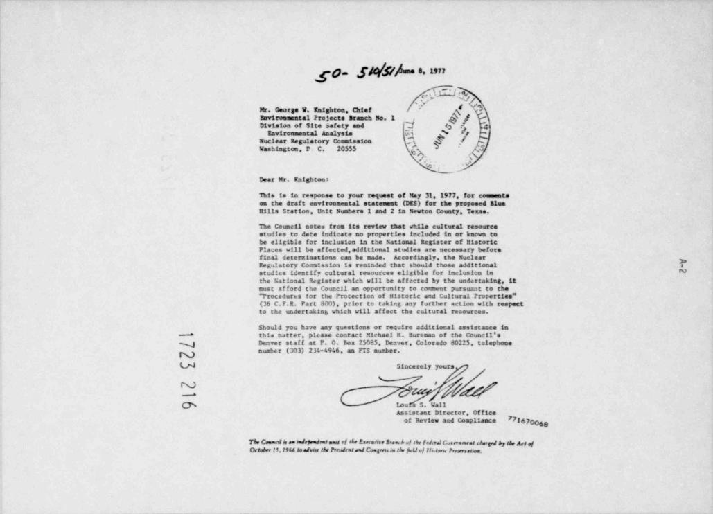
p [ / h une 8, 1977
. f*h & ,h/Mr. George W. Knighton Chief"v
I
Environmental Projects Branch No. 1 /Division of Site safety and d 4 43
Environmental Analysia Gi N 2Nuclear Regulatory Commission 3 /p
g S.Washington, P. C. 20555
;'~ , .\ -
. v'r4
Dear Mr. Knighton:
This is in response to your request of May 31, 1977 for commentson the draft environmental statement (DES) for the proposed BlueEllis Station Unit Numbers 1 and 2 in Newton County. Texas.
The Council notes from its review that while cultural resourcestudies to date indicate no properties included in or known tobe eligible for inclusion in the National Register of HistoricPlaces will be affected, additional studies are necessary beforefinal determinations can be made. Accordi.ngly, the NuclearRegulatory Coccaission is reminded that should those additional D
Nstudies identify cultural resources eligible for inclusion inthe National Register which will be affected by the undertaking, itmust afford the Council an opportunity to consent pursuant to the** Procedures for the Protection of Historic and Cultural Properties"(36 C.F.R. Part 800). prior to taking any further action with respectto the undertaking which will af fect the cultural resources.
Should you have any questions or require additional assistance inthis matter, please contact Michael H. Bureman of the Council's"
N Denver staf f at P. O. Box 25085. Denver, Colorado 80225, telephonenumber (303) 234-4946, an FTS number.
U Sincerely yours
@ 1eurs S. WallAssistant Director, Office
of Review and Compliance 7726700 g
The Coennt le se rolepred at meat of the Eserstist Bene.h .of the frJml C.,seremoet chergri by tir Act ofOctober 11. I944 se adorer the Prendres ned Ceegern on the fi.IJ ef liacorac Prewreatee.
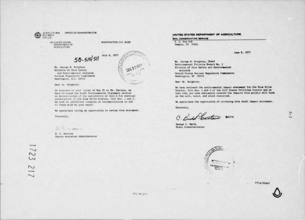
ACR G1T'JR AL OFFICf OF ADMINr5TRATOR.UpstTED STATES DEPAft7 MENT Ofr AGRICULTURE#fMARCH
- Ma.;ct- 909L CoorstRvav10N SEDFvtCE ,,
Of L%ITfD 5f ATf5 WASHINGTON. D C 20250 P. o. som usDEPaRTuf NT OF Temple. TX 76501AGR(ULTLRf
.,i.N.f June 8,1977*
July 6. 1977 -4s
50510|SIl c. ~
w , Mr. Coorge W. Entghtoa, ChiefD 4 Environmental Projects Braeth No.1
Q Gb ''bp.C( Divistas of Site Safety and EnvironmentalMr. George W. Entt tonh ,=#Division of Site Safety Analysis
and Environmental Analysis \ Q , , .,Nuclear Degulatory C.mmission
* , , , United States Nuclear segulatory CommissionWashtsstos. DC 20555
Washington, D.C. 20555 yN ., / Deac Mr. Entghtoe-
Dear ::r. KnigSton:We have reviewed the environmental tapact stateneet for the Blue 3111e
le response to your :etter of May 31 to Mr. Carlson, we Station, L* nit Nos.1 and 2 of the Gulf States Cttitties CoMaw and wehave reviewed the Draf t Environmental Statement related feel that you have adetaately covered the impacts this project will haveto detersir.ation of the suitability of Site C for eventual on the acil, water, and plant resources.constr action 9f the Blue Hills Station, l'ait Mos 1 and 2.
We have no additional comments or recommendations to add We appreciate the opportualty of reviewing this draf t impact stateneet.t3 those hde by your staf f.
Simcorely.We appreciate havlag an opportunity to review this statement.
$1ocerely, g ggng
Ceorge C. Marks~ State Comaervationist/,'.'.~f, e s #. .
E. L. BarrowsDeputy Assistant Administrator
w-
%
N e
LN'
n. r".~u .... :e- - .
AN , '' D,,7. . .,. -m
N
771670069= 3
771*4 M
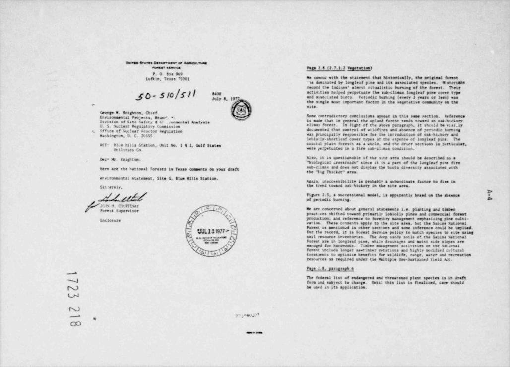
uswvue Stans Dee**'ane=v os aessecavusesNe' se8'v'cs Page 2. 8 (2.7.1.2 Vetef ation)P. O. Ssa 969
Lufkin. Teams 75901 to concur =tth the statement that historically. the original fmstns doeinated by leagleaf pane and its associated species. Mistertansrecord the Indisms' alaest ritualistic turning of the fonst. Beir
y /f 8400 activities helped perpetuate the sub-climas toestest pine rever tge[ ~ and asmaated baota. reriodic burning (every 3 years er less) wasy,gy g, g,
the sangle upst taportant faster in the vegetattwo coenunity en the"
site.
George w. Knighton. Chief ,
invironmental Projects. Branc'. *t Some contraJactory conclusions appear sa this same section. Referenceis made that la general the upland forest tends towarJ an oah.hackeryDivision of 5tte Safety g Er ..wnsental Analysis
U. 5. Nuclear Regalatory Cocaission clamas forest. In light of the above paragraph. it shcu1J be wasa;1yL Office of ?.uclear Peactor Regalation doceented that control of wildfires and absence of aertedte burning
Washintton. D. C. 205$5 "as principally responsable for the int roductaen of oak-hickory andloblolly.shortleaf cover types at the espense of longluf phre. De
PIF: tice ! tills Station, Unit No. I 4 2. Culf States coastal plain forest s as a whole. aaJ E%e draer sectioat la particular.Ut titties Co. were perpetuated in a fire sub-clamas coadataan,
Also. it is questionable if the sate area should be descr. bed as ah t FMghtm"baelogical crossroads" since it is a part of the longleaf pane firesu -C in3 8 and dMs not tisP ay C e blota dinnity anociated withHere are the hational Forests la Texas comments en your draft the " Sag Thicket" area.
erwironsestal statement. Site G. Blue Mills Station.Again. Anaccessibility is probably a subordinate factor to fire in
$ss erely. the trend toward oak. hickory in the site area.3>
d/g&/ 3'""n 't ':r ;"'*"" "' " '""""' ''"' " '" **"'" 6.#
9. i . O I e r.y - We are concerned about general statements i.e. planting a%I timberForest Supervisorpractaces shitted toward primarily lobiolly pines and comercial forest
Enclosun production; and nference to fonstry management erp>ast:ing pine culti-vatten. nese ecsments apply to the site eres, but the $abine MationalForest is mentioned la ether sections and some inference could be implied.
!M ,'n,'t.'L13197P 6 For th. record 1: si rorest service p.ticy se mates species to site estags e e am g soil resource inventories. he deep saady soils of the Sabine Mataenal
TC - Forest are in toegleaf pine. whale dratna es and maast sade slopes aremanaged for hardwoods. *iaber manageneat activities en t%e %2ticnal*
,
,* "M'Forest include longer santister rotations and hig%ty modified cultural7
treatwnts to optimize benefits for =aldlife, range. =ater and recnationresources as required under the hitsple Use-Sustained Vield Act.
Page 2.8, paratroph 6*
De federst list af endangered and threatened plant species is la draftN form anJ subject to change. that11 this list is finalized, care shouldN be used an its application.
LN
N-* 7PM,
- e.e
A-5
.
D
.1 xs: .
}O Ie .i .
"i..."a j3 U bh ::
15 ).i 2 .
50 f *
j' N8 -e2| Un
- ja:* E" 3* C wlf ~3 '
E 3C E 51,
e :1 g 79 9leo-
E1 5 Ia 'lE /
f ee - Ed~ 1.: :s~
t . , ~ - ."$ b $ f.
DEPARTMENT OF THE AftMY * N. esitte starts*
*6f| | .J **-Q.. f 4tR$Y St$f ARCM A40 OlytLOPwggi Afsittf1TRATIO4',g poet woorw oeste.cf ccam or emeses
84Weme. O t 2ms, recre v.e a te sea
e =:. . k. $11
S'=71>FR 19 July 1977So-Slo c ~
.
Mr. George W. Knighton, ChiefQ Enviromental Prefects Branch 40. I7 *k-.",,_Civisten Of $tte Safety:tr. Ceerse U. Enightoa, Chief g
,
Nucleae 2egulatory Cornission
_
aad Enviremental AnalysisEawironamatal Projects Branch . y
g g% ygseclur Ras 41 story Comisstaa i Washirston, D.C. 20555,N.Wassir,stos, DC 20553% AO 4 Cear Pr. Knighton: ,% g
F' This is in rescanse to your transmittal dated Pay 31,1977, in, which you invited the Energy Research and Ceveloreent Administratton
Dear *.r. Knightos: (ERCA) to review and covent en the Nuclear Regulatory CptsstorsCopies of your draf t environmental impact statement f ar site C, Blue Billa draf t eavirematal statereat related to deteminatten of the
chia saltability of Site G for eventaal constructlen of the Elve Mttisstattes,1; nit see.1 & 2, sewton County, reaas have been forwarded tw Station, Unit Mos. I and 2.of fice by the Cf fice of the Chief of Engineers, Washington, D.C., throgi >the OS Arry Car;s of Engiseers, Southwestern Dirisica, Dallas, Texas. We have reviewf the statrvat and have detemired t*at the proposed bta accori.sce with the require 3rets of Section 102(2)C of the National action mill net cceflict utt4 currect or known fsture EKA prograas.In rirecrastal Policy Act (Public Law 91-170), we have reviewed the state- he have no CC/ rents to of fer on the state e9t itself,
ment and concladed that the propceed f acillry will act af fect ary existinger authorised Carpe of Engineers prefects. Thank you for the opportunity to review e4 co-ment on the draft
s ta te"ent.A;211 cation for permits under Sectica 10 of the River and Barber Act ofarch 3,1399, and under Section 40a of Felic Lm 92-500 for the water I CMw
in ase asd discharge structures to be constructed im Talede Bend Reservoir ,has tot ' dees received.
T- . assThar.h yw for the opportanity to present our comments.
V. M. Pennington, Cirector$1m etely yours. Cffice of hEPA Cocedination
cc: Council on Envirementals Quality (5)N Arma D. DertsN Chief. Engineering Divisies
U
NNCD merw< .,3-caa
,
2
7g -
/ O 'e UNtTED STATES ENvtpONMENT AL PROTECTION AGENCY
k *d ,'t9e.es t e= *e me.a t c=a t suit o..e 5. In Sectfon 5.3.3 Water Cualf ty 5taada ds, last seatence, the staf fN Concludes that *...the plant ef flue 9ts will te discharged to a mammerises eue stees?
oauas, vasas reste %' that mill perwit compliance with the 43ove standards.* 19 Sectte9[ ~;'. , \
$.5.2.2 Discharge ef fects (Dissalved soltos). last sentence, t*e staf fS' states that * ..tSe applicant 590uld arply for a variance from tre ..~' ' . '
O,, aspecpriate state in orde* to cortly eith the established standard.'' Awgast 2,1977 g $f These statecats are contradictory conclusicas tmat need resoluttcg isk sj/, the final statement.?r. "corae W. UnightM .'* e4
I'r Jac' Na*41er *($ f, . The discharge gemit tfiat will te written fCr the Elwe htlIn pleMtEnvieweetal 9rojects BraeCh 1 Qt % must ce certt fied t>y totts Teias and Loutstana that their resrective" t vi sirM Ct Li*e Safety and h #e ,O watee gaality standards are art by 19e permitted otKMar?e. %es 10urce!%1 rW'tal f eely sts
c *ar s Nietory C*pission. -W \7 Perf er=tarc2 5tsedards (WC(5) =111 he bsej ta devela ef f!weat limi tations
e V for $1ue Hills Det if pechis's are evoeteree otti state standarcs,as.9 9tM. L.C. 20 % 5 Itsitattees scre stringeet tnan ee. sour e stard3rCs P'Jy te rAesleey,s
At this tir'e =c cc eet 49t tOfJte a'y state ce'tt ficatite pi .Siv s.es* r, 8 9 t y t:;e: trerefere we agree wit % the co'iclesto*1 of Secitt;n 5.3.3 tsat cepliaeceet tM the standarcs will be achtewed. Fu tPemCre. =c are Act amare Cfr
., we ras tewed t*e Draf t tavt romriental !apact Statement for the deter- any crocedure to allow a ec= scuece to receive a artance frem statee stics cf 7e sa t 3111ty cf site G for tPe event at coastruction ofi
st4%srss as sugcested tn Section 5.2.2.2, . Mil:s %c ica- P wer Station, unit n mbers I and 2. the proposedu* c t i t tia , .111 ta IMated ca the a:plicart's site 09 the Twer basin of 7. The draf t stateneet sits detat ted cestgq featu es cf 19e easicacttee* ** Jerc3e.ern'r t e entern Ittas heetta Cob *ty) acDN*taatelf,
maste treatne t synti='s and certain other speci fic des 6 09 s d (creattaga a. .- Us -iltsi =*;t cf the Ieeas-toutsiaae border and a3.2 km (25 Pile %I details. tecaase tre plant cesign is in a greltmadry stue a-s sec9
*a. "'tNnt c' the city of Ja;per. The applicaat is the Gelf States details are eot yet availaD e. Consv%en tly . **e s:ecif *c estmatedi* i ties L ; t y. radialcgical feDacts c9 peculattoas and 1rcivicaals are ret lac 1 :ed 3
a
leste.!d. cces=t trents are made *c rea.1re t*e nslicact's cc.,1;as aaJ %a.e ''ee tne Mlle ci,r reits for ycur constceratf ort in cevelooteg the operattag lieits ta ,ett certs*3 requirt seats. INI.diaq cWemer t eil f a,1 ro +*t t! !mpact Stateeent; w t t't IJ D A Part W 3aa and Agendia I ta 10 (Fa Part W. 19 a :J1 ti on
to meettaa these redirets, t*e at:Itcaat =til te re:stred ta 1MInde% f t-al sisterect shculd provide trifomation concerning the type radwaste treatneet add-ors w'itc4 have f avcraale ccst-te efit ret.rg.
bcIlers tPat will be used wit!t tYS facility. It shculde . e 11 :4rr/1 tj pe. s al f ar cort-at. use rate and emissici estimates.*at ,?
he believe t'ils appro4Ji is reascadMe at t'its early site 54'tn111tys tage aed. if des qas a1J crerat toris d'e carr'ed cut 19 cea 8 ma g e .i ti2. _at e .it * swld De si vided conceering the ret *mes ecoloye1 to tec abe rewirt.acats, tren the rad 0lWcal 17 acts will te ac;cataMe.
" ;l petic A m *et ss u r- f rem the onsite cartrete I,atch plaat. EP4 mill revie. im Nre de tail the sLecittc ra waste syst**s. est! atedradichgical releases and cese Irpacts, cu*trg pre:aratten :f tPe east.'N. c* s trit t + M of t acreased fcg dae to t** cperet t om of t*e cool * ronrental statment f 3r 1915 faul t t
'
f at "e (mtru tum Pe *1t stage..rq . rs . ' t pe 5.11 atuars to t,e incaesistea* wi tti the preva t t t *9 when tse detailed desips sad crerattag gara-eters .111 te av atlet te. At_, .q .i nt sv.s 19 F t pure 2.2. The staf f's analysts (5ectici 5.3.1.2) that ti-e =e will eate cwr views knas on the s'e Kr cf ra3 astea;; eses t te valid and stcald t'e accepted. treatme9t systems and cesign op,eratta; ccn11ticas.
4 Sa %cles- 7tplatory Ceem ssic9 (VC) NJs teem resscestve to our 8. see t*e e closed ceneents on Ge9eric As;ects.c vc e ; .!t* ?* fcrelie.* t Mie * d%i pl. The VC prctcses to rewteed '; ; t * a3I $ *.a Lursva' *, t > a dir ten 94 tici of int he desIS9 *lI9 %C D Ihese CcNats Classify for Draf t (*=irc inental I pact 5 tate' ret as 0-2." c'; m t:c,''tu te 54.m tte j at the tt*e cf construction pemi t a; plication. !;ecifically. we have no cNections to the site; howe =er me arena ese e t t *t this 4%,MJCP
u reqwesting Nre 1Mmatice cm t*e ty;e of aatt!Iary boileeg, s aMtrol cfparticulate <,t suces. ,e ciartf tcatica of state-rats nace o, ate aad
NN
. 77. %*--
>h_
.47- 9t1
- -t ialv l ee C a . .t r a - . la y
imt
, aena - s 7s not et t tr e h n e .M t 2iuc t 'ie
dtf . gc n l or ocnra sa a e l
tnt ye h e4S rni5 et t v7 t a r( se .t
a o.c e ca1r at c mea eg h es i9 ueef f ct e.tse4 e - dar c .ec t n ATf s dt1(* h
- e ti sta oe .P ae n a tTfeaeena o* 1 gt4soec* - e 1 aeefloi= Ct a - h ~ oll t e rt o p sE sc at . re
y t N *yc* d en9 r st . o y dvi
uf .ldt enf C ntt aaet a r e:t
te pi u eat 5tt t *.tl rt n .eer a a #at ee a u e nf t ; owi i aecrp t n ti s uehnt Jt 5 uc y tf o a ct j stl
e$ttM l suci yr e se sca oflpyt sg f us n i ctnelsa asrt tt rAtreutt to t ana aq uyaaa otslut k etl a g1al
1 rv act e4 neer ,esr a r uit s gt ul rnst e deanl s eueqpt odlllapa
i c-1u;t aNstr ra a syas' nseeaoa rrAf a e
uit ou .J a t arl e a arl vte ao aorosupM n pl 3 r ,i reUaeetr s a aeeco uc1 e c t mnSt cct so e a - art t c e rcr scu9 Ct c O n nsperl vh er eis ert yi a t t cn tEI aa rtod ei>vr ae v as c* ay a e t t ev n anAre a uP a eef e e e. n orpnmS f1 ou f t ero c
e snt a a eail ttlidP of d yr otcf r re eacSntf
.t o alT o8 tral o d e f Jpw( t r t
t e rC a a al cS t oibt e raf aece! sev ai) c n c f soeees wi
P eh a tCt e rran aa cngscdn ikft lS tt ed rT s ,tht osngt ct uyo* ecn t a i i t. aei nsf w anntoc sA a eaE tT ait eet tys et . fCeaoas
atto s- t aiehtmf tt c( gsia mt rh m r n - enC cna t r cl ett e d oE dl tt e e sas ngw: it el asDa uu . e m. a t) t t ee h p tae s s e 9 i s
di rndiae1i s ssrh wt sncu t
e n c 5. t s s J (tcI* y onh dee
t t rl eta oas w4 aflegtt u eyh rcnl tat tl dl wt eoec5 n ayee
p0 s et - g a sbt aaie enoeacE et a1 msl ut nl y eo a tsth eod nG denc%ti aamet ao1fl t ssoe l snl rsa r ert cuituri ci r rr h ecr p%h aa d aeicpt o n - lfo%pt arc tag e ,si mse etC 't eh ,el so np uprtC lCp f
aP miv et Jt e =aem aoynaon f ep n enfta oth = oh es a( h y tl r
T t ehC .cT segt etllua eet ueut 'C eaaricf dqsmoai oi.t c l t f e euu eft5 a t ae ene seel n
9 e ec ct rosceh vfl ei ne r et eIu t ct; ne r1to t *. s c asoat - as5 oe 4t nf d ios* o steef r v sh t l R ds eec n t C c t. maf o .ff u es eeenT off t onh a do ut ee .e a eet ds oojdk stt rso rno ert et ecsCcgul 53 w st c* a ed t eae o c ero g d t et et ce7
C = el atll t el ntb sel tt o .ti s h et n enftti u h e
v al uirI or9tt our
,ctl rrt nasastf 3t esouaagaeat s aet) sa en t cosua anb p d 1
ds u d s e m 'C 1a 9
t en htih 1
r
eosoeuuuD eoid( c eiuiti) ctl n i nt pet sh .=trct= ,at% eercat g . imort =tnrvc t n t5o e nn i eet rI)3 d e
n ee tipe
tns chnt 5rf tavtC eoea . ar a t 9 a( th r ast rei' v sr es2( eet eaa t yf os1 co
= t l
raht P t enl oeece5 Co f sd ite e epS. .ditt ea dzm aa rh d a f rA
tef s
n f nato 2 AiP d a. t odus td r Ui p aoae aeaf en" eh cr)t sa ,f r)let rg
tc set etdes h eescceaA
v d enl i eao tt vE e a egD tt * mt e , eoe2 i sh ee en uhi wt u
scew* ed i ,(
o tj ,p acegts idnhdl ent v( r wtoen ewotl tl z- c* r ah auiel a t h st ot no
esectlee .fdget AhTlaiseny 2a .C .arl
us wt pc tTt as sinf o oa i z ol er s c - ,n msemo
sai aeusews)it arrrt tt ee rt y r Aa rpea e
omb ratn n r ssd od .f o P .
isaaowuei t E seeus u '-t
7 t E utv r p ;il d vcsa a g 9l sA)sscru t e1 t et , ett r h e eei l gc c k : ceoe 1 ut 0k os s e 0 s 'A d po en =cetdCc - oaca c sll recae a esgen rso h ecueocD ert t at aseeeh nt p e hi oh osh a neah4iP ne
P T ms n m pi E rK msrseA rrptI ss s Trttcit c I rbt1 reare
deh m
lfsr9 - to3 n C tf 3 o a a ,
b n cp o ul c lv.twyuin r t e
ueioi Oaa otlett t p yaab c n m ltMSGa tye . e. ilits t ntn9elilwie mrt f at
et tlr ech racab d 9 osmest n c ivf rt r et su ano
S ulI mtvnn t eee , t y u
msnp s aec arh a t
t ctoeo et wfareEu
C ri h nt th eerrc tdl r uruua noaboo ob iD ocn roes esifhl d nh s h sv1a
ot r eot o t urti e d p cE cewd sn e s n
t e ivt or imil uaef op e d ao3 dcpmdr v v nCnd n e eoieae aa rtF eh d s eo e h
t ro r cnt oyetop a ow t p*dc 3 ri ,
thf
pto* cr s ut /a t4 ap
nnnfeoce 1
e n *ag otr e a /oio otdt t se
it rs e r s e dtgt es t es
ae w t cot sstct e . a gp* Ml *
ra oi c
m c. e. ct it ct p t
i vc tp r c t aA eatse r h c eew
, * ts
oi rt
sD ur t ee h wt vat oi oh r t: s
A f ttt dst r /. nlcaf c e n. ut u etr os sf t tea a st oa ta 2,d w o ece r elt
wit o C ps* 4'.Ple : )/O p i# N
gNQy
%Nlil(tt
-
/pAA1eu
sa * st c! ea
t e fi %, e w i * a t
ly ee ef :
n *. s sa n
ar . r.e@e r e
rP prl
cee r C* sa ;r e c o ret t v a t' n can%f er e*. * t e n
a ! I' # E
(PA coripleted its review of the final Reactor Safety Study on June 11. 1976 N4h-level vaste Manegamentan1 issued a subitt report of f ts ff ndings. Most of our concerns havebeen resolved 19 our discussians alth the utC regarding the c:rewsts. Our The techntours and procedure used to manage hi h-level radioactivefcoacerns with the Reactor Safety Study my non be focused on two tech- "85t85 *ill have an 1* pact on the eestrorument. To a cercata entent. thesenical points--a f actor of 4 in latent cancer health ef fects and a mang. 1*P> acts can be directly related to the inetvidual projects because thes n f actor of 10 in the prcLability of Eat scran f atture. We also belteve F'PreC'SSin9 ef Spent fuel from eac4 oce f actitty will contribute to theu
that the **thodolcty of the Reactor Safety Study should be used as a tocy total maste. The AEC. on SeptmDer 10, 1974, issued for cmrent a draf tla tw teatuation of nuclear system th4t ,ary frce the models choseg for statancat entitled *The Panaorwet of Coseercial htg4-tev( and Traitte Wp and that a e,eneric auf sts sbvuld be meda ef tt.e acceptabtttty tranf un-Coatastnated Radioactive %aste* (inA5%15N1. In this rtwrd. EPAf
of tw pr%nt ri;ks end th : ne'.tmity for increased 12v:Is of safety. prowtJed e. tensive curwats on htsat.15J9 on Movmber 21,19's. Cur majorcrt tl(tsa was that tae draf t statree91 laded a program far arrivig at a
Fuel rycle and Leng.Yem Dos. Assestmentg satisf actory method of * ultimate * high-level waste disposal. At present,[CA intends to prepare a new draf t stattnent watch will discuss waste
[PA is reVonsible for establishing generally appilCadle enstronmental management and caphasize ultimate dispesaI in a etre Comprebensive manner,ra<t atten erotection stancards to liett unnecessary ractation erposures EPA concurs eith this decinton and util restem and conneet en tee newaad redi sective ntarials in the general environnent resulting from draf t statement seen it is available.Mcmel tcerattons of f act11ttes that are dart of the urantum fuel cycle.TPe DA P n cec!cred 19at envirocriental radiation standards f or nuclear IPA f s cocecratteg with 166th hRC and (CA to develop an enviro *raentaltypo.*r teuery operations shc.14 take into account the total radiation acceptable progras for radioactive easte ma,ageeent. In this regard,dcie to pcruietsen, tne Naivs !rdividual dosa, the rtst of health EPA will estabitsh environsaestal radiation protection cetteria foref f ects attributable to trese ecses (including tre future rists arising radtoactive waste Nnagement in 1977 and environmental raJtation pre-frvi *te ret.ne of Icaplivad redtonacitdes *o the ensf rorrent), and tection standards for hion-level maste in 1978, be have ccact cedtre ef fMtiveness ard costs F ef fluent control technoloo , EPA's that the continued development of the Batton's nuclear power industryGrantwi Fuel Cycle staMarcs are espressed in teras of do.e 1tatts to is acceptable frae an envirearental standpotat during the period1Miv1cual eerters of the g' cral public and itetts cm ou 'tttles of required to satisf actorfly resolve the waste manasement question.certaf g Icq-lived radioact e matertals released to tne entral environment. 3=Transpertation e
A decrent entitted "f aviro estal Survey of toe arantwa uel Cycle *(.M1-12 *d1 maa t swed by Al in ccnjunctica mita a regul. tion (10 CFR 50 In its eariter reviews of the environmental tapacts of transe tattenO ect s 01 f or anitcatica in corpleting the cost-benefit analysis for of radioactive mater 1at. EPA agreed with AEC that many aspects of thistectaital lignt-water reactor environme ntal restems (39 F.R.141881. program could best be treated on a generic basis. The stC has cod'fiedThis samat is used by MC in draf t enviro 9 mental stat:se9ts ta assess this oeneric approach (40 F.R.10C5) by adding a table to its regulationsthe incrvental envirorrental impacts that Can be attributed to fuel Cycle (10 Cf t Part 51) which surumarises tre enetro miental froacts resultingcro ponents which supocrt nuclese pcmer plants. This approach apnears to from the transportation of radioactive materials to and fran Itg'it-waterbe a1 equate for plants cu rently sacer consideratica, and estimates of reactors. This regulation permits the use of tPe trpact values Itstedr
t*e t-creental tepacts of the Blue Hills Station are reasonaole. However, in the table in Iteu of assessteg t$e transportattan 9 pact for 1961as sugested in our curr ats on the proposed rulemaking (Jar.vacy 19, 1973), vidual reactor Itcensing actions tf certata conetttons are ret. St aceif tnis a;proach is to t*e use J for future plants. It is trTortant for istC the 51de Mills Station appears to meet these conditions and since 174to pericoically review and odate the infore. tion and assessment tech, agrees that the transportation topact values in the table are reasonable.ntques uset. he are plea sed to note that tne draf t state ent includes the generic approach appears adequate for this plant.
" such upsated information (Table 5.8) and also include a much more detailed%,,j analysts of total fuel cycia impacts. The impact value for routine transoortation of radioactive materials has
been set at a level which revers 90 percent of the reactors currentlyN In repense to a 1976 court decf ston, the NRC tssued a supplement to operating er under construction. T*e basis far the tepact, or rist. ofu hA9t-12% (Ep!G-0116) which treated the impacts fcom reprocessing of transportation accidents is not as clearly defined. At present. E74,
spent fuel and impacts from radioactive weste canagement. EPA has commented ECA. and hRC are each albsucting to more fully assess the radiologicalon the supplement. 1spect of transportation rists.
NIN.)U
2 3
A-10
jf.ha
afliO!! f ,. I i35 1$a .h!j[;h33),
..
a} i i$$iiN. f3. i! nj qi 2 y0Ejfi hm|ill:$3lrdv s n
3 If,1Xa' j2 $ M!$ild ti
Tl ufg.f. jugi n
0a)11gnjlil } J.,i J a 3! .
30 di .' il,,ap3qd 4 .r,, 3po 3 r q"ly. E,
uRe fs n. a.
h aL s Ii 8 3.3 : a s
'
ge t. yj3 as.
.
al yii, "g h. s4 , j%aa
rt 3
atQ%.3ae
igsJ 31 3I. h libpg nq .. s irn ,;yc 0
u
. q u,s, h.t aac ,l s
t 15 S,1|1, .il o
q,.i n
., p. J ,k. ,. s- ..a ,4 .
,j 5 'l-r..
}s ; 1 o 'd .Qu b,
'
# U ''w |'!d '3,"* g 1s3ii'i ,
a y li U $ ij 1,{: p,p6 g.. p. .. u U1' h
,|j fgI
f ,. ln i '. .
'
5 V ,y ,'g'e|i ,}t3 ' , 3! Q']3 .3,fy '
$,v i g q;i* I q r is -
u( .k f il |[.
; 1]p g. gjjg
* ; ;lj "5 gj1,f ),3.;j
,$ ,'1| 9N.n-j9fgay
! L 3 c Ni ,J ,.,
gji 5 ( Jh.,3 g b a f,j
!!j u s,;,Cj, {j }3 a-nE(. jl:V b 5.,f 9 .
,3
3 'y !i Lb ad,
li ;,g:yr'j W c p i;Et
)[XJj;[ ilh tt j(i:u
4 2 da! 4*t 37; Q'
.$ 8.'l 6 d; li f U k' di i d u l.'
63E4hl 65 .I mbe ' ' .| s s -
S 5 D d O O
.
is .
j!? EsE$I5)!!!s!!!$$5i e $somans .essjina3;5st".34:s:s'[melli5. 5Eisse e 2 ssa f.-31 p:!;;s-
2.E s E.3.j ! s 55 5|'s hei .istesar"t' EME*:St323
si :hj$$5k.s s s!r ::1 e- e'~. t i $ ~ f,E E 2 . $ '.5E
Es EE E!y.5 r~ tE;* il.::E:ash 3-s r ur-x, :.:!ije8IritDiH31si:c8 e .-Ec -:::sr4. .-r.I.t>
.t=
s ?? B r % 5 : ? t il ?.~.:": h 5 3 ,. B.: : .e e e r ... 3,=
g5-: eare. .-tserr-h:r=3-iFtcliEfi* e s HEa
': 5 2 ije:5?ED3E*2.essei!5 : HE:3.H2y . :Hr
|~~6:5 I I' h ! .g . ..t . v 3 5. TO. .F. C. (.3: ! H.. ' s ". ---8-
.z- .- . ..
. . , f 3 [. f,Efh3hEfE
E5?! I fr$9355-i.ss-6bO.2E= :. s :: r. : s :: ,. r .. e ._ . - : :rt' * :: a 5 " i n i - ;" ? 1 t' '.: ; ;yLt
J'.' F $ 3 . E f $ $ $ $ $ 3 5" h '* P '. ' .! ':( $ $tt. e r. : t. s u s . . :. c a :. r : : n. n .
1723 224
FEDERAL power COMursseosew. w = o.c.acaas nr. seorge v. anignton 2-
De Toledo Bend hydroelectric project is licensed by the Fcderal PowerJUL 281977 Comission as Project No. 2305. Any use of this project for purposes
.-*'
other than those identtfled to the license would require prior writtenapproval of the Coruuission in accordance with Article 47 of the Itcense.
y ep, Such requtonents are not identified 94 the environmental 1spect statement../
/$ We suggest tnat the final statement indicate that use of the Toledo-
INMr. George W. tuttghton j .,/-*-*f'.' 8end Reservoir Project would require an amendment to FFC license w. 2305.
This information should be included in the Surinary and Conclusions. and onChief. Ervtromental Projects Branch No.1 2 7N- / - pages 1-2. 4-13. and other locations as appropriate.V . V/Division of Site Safety and 'T N'. $ Need for the Plant--
Invironmental Analysis '
FNclear Pegulatcry CorintssionWashingten. D.C. 20555
..N- s ' The Gulf States Ut111ttes Carvany (GU$t') projects the need of the firstDear Mr. Entpton: Blue Hill unit rated at 930 Mi for the 1990 sumer peak load. The sit.ation
for the year 1990 with and without the 8ive Hill Plant is as follows:
This is in response to your letter of May 31, 1977 addressed to the Lury C abilityCcenisstors Acting Advisor on Environmental Quality, requesting comentson the draf t environ-ental statement related to determination of thesuit 35111ty of Site G for construction cf the Blue Hills Station. Unit*Ms. I and 2. The proposed plant would be located in the northeastern Itemportion cf Newton County. Texas. - Blue tant Blue Plant 3wg g g a
- - -g
Accordtag to tne Environmental Impact Statement, the Blue Hills A. System Generation 9.0$8 9.058 9.058 9.953. *.
Statitn wculd e-cloy two pressurized water reactors to produce appront. 8. Ftra Sales 308 30 8 308 303rately 957 megawatts (gross) each. This power would be utilf red to meet C. Fire Purchatas 100 1C0 100 100the a:ptteant s electrical load requirements. D. Net Capability (ASB) 8.850 8.850 8.850 9.78J
E. Peak Load Oe'nand 7.848 8.240 7.848 8.240These ccrr'ents of the Federal Power Comission's Bureau of Power are F. Excess capacity (D-E) 1.002 610 1.002 1.540meet in accordance with the f:attonal Environmental Policy Act of 1969. G. Reserve Margin (100 F/t) 12.8% 7.4% 12.8% 18.7%Our principal concern with proposals affecting land and water resources is
t%e possible effect of such proposals on bulk electric power fact 11 ties. The GU5U. as a newber of the Southwest Power Pool (5WPP), subscribes toinclu:ing potential hydroelectric develeprents, and on natural gas pipeline the reserve policy established by the Pool. The current poIIcy of SWPP as%
factitties.N given in off tetal documents is that planning of capacity additions must
g FPC ticeased Pro $ect Infrincevntprovide that the total generating capacity available to each group in theSw?P shall be such that the capacity available shall exceed the predictedannual peak load obilgation by a margin of 15 percent. As an alternattve.U The envirnnmental statement indicates that the proposed power plant a loss of load probattitty study can be made so as to insure that the
would utiltre the Toledo tend Reservoir as a source of cooling water and probability of load exceeding capacity available to each group small not beas the recipient of thenna1. chemical and blocidal wastes. Intake and greater than one occurrence in ten years provided that in no case shall theN discharse facilities would be constructed within the Toledo Bend Reservoir. reserve be less than the peak load obilgation by 12 percent. T*'e above
N tabulation indicates that without the availattlity of the Blue Hill !;o 1W unit for the IMO predicted load. GU50's reserve would drop to 7.4 rercent
which is approximately one-half of the 15 percent reserve that 5'.PP uses asa general minimum. With the availability of the Blue Hill Plant by 1990. ay,gg reserve margin of about 18.7 percent may be espected which is over the minimum
,
j i
\ . 772 M%.-*
>a y
'o s st
ig o it
n er so td 0. ca r ee r fe y r e d ht y a h e 0sb6i e s d trt m 0tb 9r d w sl y s h r 'tof 9 9addn ofsag o grgo fpl e 9ft eeni pooor l uen nr oei ve1i o
1pca
sb s bal u ailctl ce o p i r. i o
r b. e t yt gaesr tf e he ht s w orh n hpn s n el r ri f n
ruf o t u teddorio em hl oti'r0e tsi c f e eh a it rr rodti rse6 y certi y ef gsse a ePp re w h ap9 erdnr fl g- nu y r wP mf ut ia rsi s a oSo ttird tcm1t lead oc t nWn e nn ee n a err p Puai 7r ee o nme no h ulsnq g 7 ohh c rsaal ei cailbee e
pp r fnd yeerrie srrea 19f tt e da e i1dt s fda p ow r y neo f0 rPts a tm son hnoh r 0 e0so e e upa tpes di rin oiTd t4 0,a c y e h aub apbee oh gs h a mv iT ti dit y n8 y welf t ent a .h e l4 rp - . ren t l r r l nd ear me r2r pe in s uGi sll e e .aen 8rord et a 4.i f ur r Bg diios p uce epae tf e,2 vooSc uhr e woe t nrr onaec .
tt rdr o y sfai a u o s .ta dt P r ennet dev yarum nI y heap ege l a st eseoen y ieo e tae tc e . longesy lao r reWll
l t tg
rpe a gasit oh awerai o ly eiSe s .i hn r e 6. t Whv s cst reg e Tinpi t u .Cer ot aa opa0 dr tt e2 p r.l i s e n v7 e Sie cnp t f r1lds eeasa 5e .ra hsorsp ed a9h eG m u n
b eslde rccth U v en t o o ui me 1t rS f y ki+ ir r nt Sf asvo l cohs ne .
t6cne3lp r cte- iU23 m sege Uo es f h t e acm apnm0 G e '0 wa oer- -n on h6et .
V . JAs eteu h i e9 eh5 oe h otet es 9neh h nh m 5tr9 ytt9Hr nTftt tyhot1ise u em
Tt eTi n2ai1 ba 1
s nit .f oe8 de tngt .b lto aa0 ntl an o ru ro swr 0 e hg h o bei oeqy d t e .i o.im st neb eh h e ahcl n nh n ra aP ztdtt n it rW iey laat 1irt t e ltP a . is er
i5g e we ao a e k 3. k gl n ud ad r i sW e a ol l orgdi rSsd s1l vb i
n e i nr 5dah ao ws ran t e en9 not f oo et e taa afara tgpioc n go3ot a if erl rs scy m Conel u mrt e e ifldl hae a oi s e c npi a et gi st f t abt osi l ou j G
llal ol en t rt pvmeh emn nn reiea tacdsoo t ee egtrv su rh srb oads cnen7
ic ut iro ea r gt0 nit ece wni a a n n t '0 p naemt r tns nesg 1
olm
r n g l p hge e snp aen esi ug4
r
tg e Prdt s eah e9t t a 0 a 7. t0r t a t p dR e i4 .caape aii r wc1 n c tn v l e on r e e e2e1 u cu e ued d rnE ir2a ahsyt faeeec le atat et src ana eoi om
g v o ti o tdlWaf o uee1h rtaf n vph rt e hsa dni t e o r u ub et r tevW. i et dntil aot1 p r eono t lco e sB
r n.lswe eorh a ei tP o a r d vbabdn eet t sdiop pre cth F nag t eosl . ld v1 o5 soioml oir gg ebi l e er1f ey aa al u ul a
ig uo ses W dhi f0 h vv et e er
e s n e o. s . rc eoe eT rd 7 nn ans h toii hasfth f hi
C tnsi ll s i o e t rdhd yu aItl ei*9 deee ie TdatHs Tcnont o T t'
-ldr c o . poa1T va- laud uuUee dcWct s nel cl ho f rsar5 a
t".a u obS uc e 5ra s a v ui u s e eai e5
inet haul x reUeh o li oho f e u h ehov9
f lpbs stGBe pb G p t t pdwww or S t ytt a1 f
g@sng 4rC
,
38 [=
e.? r d syt a n rli n a irs n e c
s eo, g o ir d f
em t pg n i to e f
he rmn i g a i Ad e rg dtl aoi.b ucl ea r en u l
so q pe bo n pi t arr anl l ttiod . s t
nep d ab d ac wa 7 ef ersa lt haedoe r
4mes l o t us t psnrr e nrt u yi ou maaca h
n drl u cd tie r t p od rse eeks n rnee r ,/ r iis hte ef eecovh u
b a vhe cree li rhniot f
Tr saWr p etit t n,
s Ep u o my t cnn e. u
y.gCal aneuii beq .m fst tihr d.h b ro1c res c S Ttts me l
e soi oeti ee s sll ep
2. h tpa t r et nuo l o r et eue ai hc.oso Ll e .*l cc
l. w seqt ld ti yc e h ce c9[* reia rfsSs rlci u rt rc rv i. .-(CDuhif(Ig a pd s ct nti e s pS Si s. c h yEn ema? i n atl e sn mci pan- t uo a w psi; ro tdp bh ei reo a o ac u amat ihbt ghl esc p ol ceb ta tl gni a o rof st r o no y rt dolfro tnS eff i tl i e ehl p ao
o lnih ab tcug g hinsfnln tts 9 e pa,t
i.h me n yo i ili u"1lt ameo l t oertid dll
i r6 s sm k ph a1 w w eoH o sa et te2 o ds
t .t kica el . s nstr ne ic lh wuh if ecc ed
et ityr cg orrer me"Sc M no Aii t o je msul
e sa/ fh Iy nov ooB "op e d f ttoro cp.i ai p eo- ts .onn .isr t r rr- e aDIa bdi
2 4rr 5oraee pe jelhh s
e dh ahutt itg at mtp r aa ei iofu thP rw aepof It
XJ .I' -
M|| n y g 1
o t n e 4"."7 s h i i i l 1
/ s eh t t l t c e 0Sj 3" e tt i cys i e y b 1'
$ .ah;= ~ i al w uce b ee C s r 2- t ta rnr a .etbm hinat 2~- ie se d tei p sCst s lc oei 70 * w
. 5 ,'0,"= ~ t ld ! se sgueea tRenedr eunil 7!
k. fsii . t yn.qshc nKsarl o usotcta alt v I ssal or eat e or uf r iiuaF , rlUo Et nnnCrrc e. m td po o otdnh'
L di r Dnoio E fh es shs mNad tq Pnp eid , note t elrl si u l arE
W ; (_0 e o emgrr.nti ,t araaa s i u od,
heio hneoosan t a t ne sa n . pl f no tutt Trro d eehtu Slollib r.ou sma8 e
pfN l a e ctrrdl gnq li cl s
e Ss o h y e d f c al md :it ui y a U5 eemA wBth:ve e a oibi e e
wanwl rsnoe. T p ae eeouicP R . ie i )Ctl mn cl ea )nursn.id hl l ee ad ai n t n 1CT .A . vhfw 5.f t s t t e aIai gcet tblaerT . etl v aa dE t 4.ictisoanto fTueiea 4 r ue 4. o a c o s e r vnCW hon nac .ssC C . 7 i 5e wunr o dbuwU E 4ltl e e
D t . 7 oo,t (i ottl ers (dd ep ni g5E 4 t2 . c d e d a n c t u' e nted sivo d4 s n yn s yner tau cls stahsno t it sn
Dm. 0 t o teda rutatSdnpcin ta geet cdd aHL O c i i mnx eoa a n ueco c h nih p e e n m 'AFT
A E . G e s s neae vCcshdeak np atoltit fzieP)U j i s ut T i iet et cdus p i dc fi eE8
t E. A o s i ta1 lsdc dtfal ee retrtne Erns 5H F . eanitnaobuCr Itaeaij aa f8' F r yy m5 rt ,:
NC P tl 5 oSsys Dxivne o alhh o lm do2l cutt nr amol R
( ea o5 p ttt e r A m e elh y yT l fn C0 ptinn eTsermhsasr w aipo Ap t atutrN na aA 2 ocnue r aspotac or cdo t ns oh2E ot S y aUor ath ic citse i npt r s e e w g4
mes i(ep Cs l ueh dnig gi ao.i .h m ,C mM tn l r o al aqrtneevr o r pshs nroslhe ea o.
R gm tt tc tIGnc hEice iircde l 3 o e pt t t oadi aT
a in in a e e t ci tw iI m otfcun n r hncP no Se3lD rl et g l pndde nec e i nsere ieaTiiE F. r 1 ruu, oat wn aeusnesat ch ddsc ror vs t
l aatl aatisefe ner Sae e o e a m 'R P uL i g ftieiev.fntooaen nS: w nrar r Eho.I rP d. 2EDC l a:
e i1i TfdEe.- o yl yW rracaagno rtPc -
rEf niS t r or,,l eycelPeeaei .l: pd u e u e D pd:yt cenl s cexeq;q . :c c n a o P. d e H do cv rg i yrnyl .h r t
al e 2 nret ece 3 rne de,hindan S ccno 1t i. eh ruGfcsI-e ci kriaf sgoiw0 cl r. ii irir ) r. s t elptua ut c o 6. -r. s t teni ti n r nit p ti<rr sancr eqs Cv9 e sc.iavdics a ava- e aa
# rhrinnua e hntch hdreaf eh eo reasP et 5 uroonMCCDaUIW C TESCt tAeppoPt alf arPi|dt (s pt pi:
I$L
i
jNg^ y) js p A s-% , sN %~- ( pI -~
-
4
,7% 1 United States Department of the Interior,
at 0 -2-. <% ;// Of TH:E OF lili. M LRETAkY.#
/ M Asill.WTf W, D C Nm north-south spur from line C west of the Neches River or a
4.? 77/561 -,- paralleling of line B in the line C corridor between the Blue. -
Hills Station and a point west of the Neches River.
IN Chapter 4 of the statement should be revised to indicate thatPr. George W. Knighton, Chief
.- /0, El . development of distribution line 8 across Big Thicket National.
Enviroraental Projects Branch 1 aaw. . Preserve would have an adverse impact upon the Preserve.Livision of Site Cafety and -[h (%.~,*a., '
Archeological Sites.
E.virornental Analysis. clear Pegulatcry Cc m ission [// on page 2- H , sectaon 2.9.2, it is indicated that an archeolo-
W sn4 4 ton, D. C. 20555 gist will te available for consultatica during the construction
*kar Mr. Kr.ighton:- period. If an archeologist is on call, but not actually present
curing conat:vetion, contractors and equipent operat2rs custdecide when the archeologist should be consulted. .?.s, con-
~ .c.x yc 2 for your letter of May 31, 1977, transmitting struction personnel are making decisiona abcut what s or is not:c, in of the helear Reg alatory Commission's draf t enviroa- an archerlogical site. freferably a qualified archealcgist:sn al statesnt on the Blue Hills Station, Units No. I and 2, should be on site during construction. If an on-site archeJ1o=h un County, Texas. gist is not practical, serious consideration shculJ be given to
institute procedares which will prevent icss of archeologicalL.r ec.,nments are presented acccrding to the format of the resources becaus e professional judg:nent voald not be svailable.statement or by subject.
Outdoor RecreationBig ~tinet :!ati m l Preserve In previous cen;nents on the applicant's environmental port,
the Bureau of Outdoor Recreation expressed concern abou : the >As ;rc;csed, the Blue Hills project will seriously impact the possible effects of the released heated water on a sma.. cbserva- e
3ig Thicket .1ational Preserve which is part of the National tion park and a swir.mirg beach. The envirormental repe.t showed yar ? Q:te a. It is noted from the discussion of power these areas to be located near the diffuser no::le for tetrant ission systems on page 3-14, rigure 3.8 and in the cooli.9g water system on Toledo Bend Reservoir. Impacts on theseut :n ;-17,e 3-17, thJt one of the three 500-kV distribution areas, if any, and measures to mitigate harm should te .iscussed.dec, line B, is proposed to cross Big Thicket National
'r*;erve. We are also concerned about the impacts en recreational activityresulting from sedientation during plant ecnstructica, as r.oted
TMs ne cf lands within the Preserve would be detrioental to on page 4 12, and effluent discharges, as noted on page 5-7the par;,sses for which the Preserve was established. Under fage 5-23 states that, "The public freshwater fishing resource
J.S.; 63ea (1975 Supp.), the Secretary of the Interior has of Texas is the most extensive in the United States." These.
the aatr. rity to acq2 ire existing easements for public utili- impacts may seriously compromise the recreational value ofties within the boundaries of the Preserve where such a threat Toledo Bend Reservoir and should te examined from that standpoint.arises. In view of these circumstances, we will give serious Additionally, the aesthetic impacts cf added sedimentati?n toc .ncideraticn to exercising that authority to protect the g Copperas, Mitchell, and Mill Creeks and Mill Creek Bay of ToledoPrew rve if the applicant pursues his plan to erect line B. Bend Reservoir have not been addressed.W as li:ensing this project in the face of our objection andur duty to preserve this area might jeopardize the investment The recreation inventory, discussed on page 2-30, is inadequate
N f -he utility company. Acccedingly, it is recommended that with regard to facilities in the impact area. It should includeN ithaar the site of the proposed substation at Nona should be a listing of recreation opportunities available in the surround.
< 1". ated to permit direct service f rom the Blue Hills Station ing communities and would be enhanced further by a recreation* hat the :tona substation should be served by a distribution map relating all nearby facilities to the project site.
l. tut does not cros: the Preserve, possibly through a
N.Y-
* .
W8. ne {Meffy eMk f0H hefY$ MeY le
an3" j o
f "n ,e d t d .ee d dee n c e rnye
sioee ls .l ntre o er ieags, ilis g, ls nnu d saiah . i o h il e o:mau hdtif nr i u- ieo n u s t stseng eev rn tl aw ie Mcm sch agch e si i run hk rllo.a t ineett so a s ni s yW o e v h T p = a taeaeftx n gW i k l s s nic bo sivil ties md tsrn ne an mibii idel tn bsretefr.nitrieeon
gnecntetlidrLalg roe c a whrce niRtanm
ptne T e ns rhsi ii po e t e n o tu i thaen cat lR casttnt rx t nvuty tls drdictgoda e .da i ' n ic cer eeim ahuaa renl rni ephdtnrl s ,fensu s uehmgmtmtfm ate hcir rms caea osf ciar enovte oc i ig gaEecppi eiitA dr *rea bt do i tgcetwtnn ew vamml g Fa see eittm s ptt nan jn aai r oioiio ns tserd tsnagn yuaaiticbash t ddtrn aneiei e di erno l hl s ei u c n t d s s e e c pf dedohbi ctT y e v C m gi c ested btsio ni nsl apono nitaces( a tiRi ol tt ret o lital cooda ah et hepe B atUdrtr ace rf si s pt s i pT o yc ch pst s rc epte u a t t e aiti pa e t r so rettSnatlS ae) k eaes et qpordr at;no u rf phi n
,a,ia lli6 e l h gsf emnoidadt l gaf l pc tl ewcda c7 e enten a di ps ceneuul c e i m
- lsd iecee9 r co vid a e e n ei r e h a s pd n e sh nb ng l a e n t r i h p1 C cihiree sWroht emtn e ohetiii. e t oientS , l cictni t 't ctage ,ooes ctc taatttcdt
b g si r g a n .l rnt csso rnsprynit cn td6 lf uweies ec anfeaat l op sf uil e t
al ce2 i or f nm mest ecddt nsaho oohecnnil a" d a e nnt t H tef ome ejene i nsee t r f' st vseusylancl er Jseemoh toeebnse mi e p f s ei e asil u Eift e d cnr ct arrm on tecWd atrwlsollse t eab n cogete tpgneierfte ir t c t
s anreireo a ncarnrm s oovtcoaap .oo. sayerearieihr rt a oe o dsraa rt s v s prkessxoccutcohc d loemmer. teeihrl eds eade Cmeataeefi q tTO e etw ihf f srv aau dc ei Riht aeiT f e ef n h x d ao n s pi q e l e i y t c N snwrcA g ,h d tdf rroodd , s t e fe erpeeeeciharvlse eii ceeeoi end r a n 2. bosffa fI o " yrentnerlip esf wnphs u y7 st a; e igea! a hr eoisi oo e p1 h e p p ur; .
s efnSc s t enhltoeqe na ? +. no r e a dh Jt- n .f s a ied t vot yhew3 a n l
pce- nodd,onr oipe , t t 4odsa s l tel si oaedefre c nd p hlsi
erO disuro n fnu n i hine a ihnfian e i a uf tlilp lnt s eN k fin a so W e t w c r d h n s t ei c e f oiafp lacueg e oson mrc v n t o ,o e d pa alett f tle wimn.i ecbn e aiosro d esdsea i E warn t eaesweSa a1, r e b ti e e t e n ientf dtrt ul she eiuodnmxee c idd4 C s ct rt sb a lsaniwece ni tr e ntti eaaebitirJl n ukeau- es el e s e v riW s h k onctltg
cnve uE l a e s d s gl o hbehmdiat eot nst a ceuapsrseardee l l ce nanos c ssalveowindae t trcubdo a pl enhhfo i erneeorl i esiciel rMronlir n eotoounF h s pS u t t c V MSCimmLt a rhafcwrppi pcapto IhpsLcsa
y .
se t t )ere n o is . c f s 6sid o n , r d . sle e i ot eo 7suu ai y ll 5felne r ni c n l if itd9o ql g e s e c h a l 1ohloneo ab r o fsp o c e1recnrsh: tii' - tiiohn , rau twnaae etncrnicit eit w 4 sowtiti ed tloesoogmcw pce ,
it em hWn t ct mesn ish lc ne set 6ed arset es ecesunh b aa daetdl raii pa1
dt gaheret e e nvr notcesv tsenldg nr , i c a pT g t miblrn aa gafo l nerei u li g a elout n r h r"< s e pn asew lco ln nliln arhnw oii t w e e e f .U m pnr lini seaold i a ui l Tu
ooelwis thrleldotf ph Jn hmd vlrf8. icagcf ei s nteavul eps tdods reneb e
en arwnnu- a n aoundln tin ,i n dahowararif g ooc l ridrwow eo nwa7s a t n gTi o t oe 4. c a d o e a s ii s pemng wcehi a 1s nae" ahp h
i se r u elt en e hsttti rt a s nr t tsd1mems r;ca oecxticaad el n de ,kcea ruesiet s: t : cnr ncheu dael wawsnne abn otr,nttct1naaoe oetrlf pruh c cnaira i paeoaiaan ie ih i o pf o e m c p g . pynoslcNadm mtgN
r l t p a 5.l rdtt ti n n w i e c. u t lYr f ,l r isnsi et iene ue a ,tismrn anae c ci ei y
o ueh eo h c : . hn vdor rct nrd1ie3ulct u ssntd* .eldes ta .nuiesewe oin4rae
- efhe aail c' o i 3 t aehe caelshds d eE3 w Tsipinl ee n mi n ? s a c t t t fi e cstl es sh .
- od rs vcarg irt oae2 loc a of rdni ewre ntfle n 1 m d ea rd eleet i anim,icot . o oop n . v y o t.a * du nt ed aer pr: nn e sofEdas it V
e edf 3 ej oreeng- exo cde snn irp scgh s c i.i e r e e t i g c :hi a n v e ml iiheraan.rcmrua sen ,
rl t t nest p: e a er w ulirap.rLco trtedt:tanet aoru e iiehn c oeoc cft -eaf
rrrol m-- ; el c yh n tl h ci utnsi entcae se: t
f tn xee *.!oa cas ! y r nsbtcaet uf roi retki h i ri sat : eoi eL m tn trh 2 seet d l1
nk o 7: n. o t o mleode ri w eT d if y r / 2 ;
,roeiaf y ,tdet crcebnh nfCaeil t cnk: urv c s. i - - . st oew et el el rhlmc 74 ePco ts curpeteft 9 .d:f ri e c w t r,dv- ?, neost oet!. c oe: caen ein e >u nrn noy 1 eolti uhf c i p n s ". d a i ;i e t y t gi c t w o di ai n r o t t : .tpautacs aoroa : ; v. '. x. i i e nil w m v v a r c r a n e l pl oai i 0 7.d r es nhaaen n n: e s eiestl 0
s'. s u :i n i t r p t c. m ierontpt nsla 4 pptR efidt - t i
rodnch" ; eL n;c ; s.s. i c. e m :a u
i l u ayI t r r ;:ec aa e1 r,p q a n Tvend p;i r1 e+ s:; l nnnidt < eil a1
y e .ii O y a r a r4_2 dr si f ; e:(eoc l a ? vliroe ,ml- a h , a
-
r e rp .duanfr r 2bet e csatt il siim;1 nc af o - : .ws c st iests l: - ; ;no i.hi;sriealtieL n. i r n u e e :. " n. e. 2. -
.d .-4 .:nas a r. l . .a" e l '. . t - : te n . e: - : al - t
, 1t atdp . el11rrct e :, . v. J
2 s. * t. e e l h r si - ti4a: e e"eeoes. r. rtt sese -. e e;n vd-
i
-
- av l c a
L. ~ 't
a e! pre h ic. s P. i c T s a ~ nnct?e
ihahtesen iff : ; xi e nhn;la' twt T;stLA: Tf t*
'ram + .as
N N (x.N N <.
5--s-
- Therefore, we believe that alternative intake designs(i.e.. submerged siphon intake, fish. bypass facilities, etc.) We hope these comments will be helpful to you.should be fully evaluated prior to issuance of a construc-tion permit and additional baseline sampling data should be Sincer'g
< b[-collected to help in evaluating these intake designs. 'j ,
t'or.itorine Prorram%. . w ater mur.itoring studies should indicate what, if any. Larry E. Meierottoatitional monitoring of ground water quality and levels omt,1ssistaan SECR ETARYwsuld te uncertaken tc detect any construction effects andto ;rsvide sieluste baseline data for cbservations aadecuring operation.
.
In . :ction 6.1. 5.2. it is noted that the Hack Chemical Kitwas use2 to make analytical field tests in the Mill Creek%*tershed. field test results obtained from the use of thekit shculd be checked at appropriate intervals by parallellateratory tests.
P.sialete? Accidents Involvina P Mioactive Materialsles.aa w r.. of irpac ts un grourd heater as a result ofpcsrulated accidents involving radioactive materials arecmit t ert 'rca section 7.1. However, the environmental >st ste .er.t shvald discuss the rate (s) of ground water move-r.e r.t . especially in the upper aquifers, to permit appraisal 1
mcf L ;act potential from such accidents. The environmentalre;crt, section 2.5.3.3. mentions the rate of ground waterscve. tent L t does not utilize the repcrted field testvalaes eitner to cLtain average velocities of ground water%ve t cr to pre 2ict actual velocities and distance ofLcve:ent of a contasinant introduced into the ground. Ifs:.il :haracteristics are to be relied u;on for mitigation,the final ;,t ate :nt abculd 2e.merize sorptive and ion-ex:hange pr:perties of the soils.
q C m ~ m i g y Alternatives.. ee..eev .w. m pacts per m2llion is not generallyN cor.:ih rej 4 relatively low salinity content but only
u relatively low as ccmpared to other geothermal reservoirs.n.e final statement should clarify this point.
N * or C = enton page 4-5. section 2.5.1.1. if the reservoir referredU to is the one located east of Dallas, the spelling is
Q ~;a'nMI rather than Tarvakoni.
s
~ U.S. DEPaRTestNT OF TAasesPo.mTAftON*ese.s .e., 6,. o.
I hene reeeen e,e*.ce emo.no
4wtese. Stas te*De
July 29, 1977'- ,,
50- 510SII~' . . , . .
KB-TI
Draf t Environmental Impact StatementU.S. Nuclear Regulatory Coatlaston
g Stua Hills Station, Unit Nos.1 and 2Culf States Utilities
As </*.e
og
s
U.S. Nuclear Regulatory Commission*
Of fice of Nuclear Reactor Regulation
Washington D. C. 20$55
Attentions Mr. Georle W. Kalghton
Dear Sir: >sWe appreciate the opportunity to review the draf t EIS for the Bl eN
at111s Station. Ilnit 1 and 2. Gulf Statee Ut111tf ee. We have ao
coements on the draft statement.
Sincerel yours,
[[In J. ConraJo
Division AdministratoraBy: John E. Inabinet
cesN secretary of TransportationU Office of Environmental Affaire (T15-72)
Council on Environmental Quality (5)Region (2)
U-
77216031e
,
ACLNCT REY 1tv TLutSMtITA1. SHIETb- s
t_ |(l70: The Honorable Reagan v. Brown, Temas Deparen'd,bt' Date: Seat 20e117/IP
Agriculture %' 'r,1 %OFFICE OF THE GOvtRNOR 1 Date: Due: 07/11/77
DotP*eearscct '
cove awa FROMs CitARLES D. TRAVIS, Bt'DCET AND PLANNING OFTICE . ( 'tefert Els: 7-006-001~
July 19, 1977 "%n %*$UBJECT: DRAFT ENVIRONMENTAL IMPACT STATEMEET RELATED 40 UITERMI1Af ton OF Tkt St'1TA31LITT* '[ .#, SITE C FOR EVENTt'AL CONSTRUCTION OF THE SLUE MILL 5 STATION. LXIT ktM!as 1 & 2' '' ' 4.! ." CULF STATES UTILITIES COMPANY.. %
Wf '3"" ** g|,g,,, % y We have reviewed the cited document and our cosmts as to the adequacy of treaccestof environmental ef fects of concera are shown t> Tow:
V $Mr. Coorge W. Kaighton, Director \,.
. . _.M
Dietsion,of Site Safety and Environmental'
Ch'ck f1) for each ttca,,,1,, , m. C-t e nc i e.e.
U.S. ::oclear Reg 41 story Commission*sashindton, D. D. 20555 1. Etional specific ef fects each muld h assessed: X
Dear Mr. Falghtoes'2. AJditional alternatives which should be considered: X
3e Dratt Environmental impact Stateneat related to deterataation of thesuttability of $tte C for even val constructice of the Blue Hille station,Cnit !ir bers 1 and 2, Culf states Utilities Company (Docket Nos. 50-510 3. Better er more appropriate measures and stanJ.arJs whichand % sil) has been reviewed by the Budget and Planning Of fice and should be used to evaluate environmental effects: X
int rested State agencies. 3s
The ca=c.eurs of the reviewing agencies are enclosed for your use in the 4. AJditional control eaasures which should be applied to "
preparation of the final enstronments1 tapact statement. If this of fice reduce adverse environmental ef fects or ta avoid or Ocan be sf f arther as.tstance, please contact us. einimise the irreversible or irretrievable cocusit:wnt X
of resourcesssinc * ely,
* 5. Our assesament of how serlaus the environmental Jaene.
M f rom thle pref ect alght be, using the best alt ernat ive XJ)Charles D. Travis, Director and control measures:twfeet and Flanning Of fice
6. We identify tenues which require further discussion erEnclosureresolutions X
This esency concurs with the implementation of this project.
This agency does not wish to comment on the subject Jacument because:s
NN0a eNA
11- / %N
_ Nase and Title et Reviewing of ficial< - ,
g Enclosure (s)Assistant to the ComissionerN
s,scutivt ossect eunoac e an west isroe stnear e austm.va sas sem
ACENCY O VffV TNA?.'.4tTTAI. (MEFT k. b 6 4 W n. ACElICT SI''TJ 3.WMtTTAL $nt!;
JH 28 0779' Mr. Ben McDon41J. Teses Department of Coaunuelty Af f aire 70: Dr. Wia11am Floher, Sureau of E;onuels Geology. UT Datet sent:6f917''
Budget /NEn'*f"' "'''"'';Date: Due: 07/11/77 Date: Due: ?!!!/77
TECM; OtAP.1ES D. TRAW!s, BL'DvET A.%D PLANN tNG OFFICE * Refer: IIS: I*006-004 * * ""
$75JEC* , RAFT ENVIIlU4"DITAL !MPACT ST ATEMthT RLL*Tle in DETLRMlMATIO:e OF Tiit SUITAltLITY $UBJECT: DRAFT ENVIRONMENTAL IMPACT STATEMLhr REl.ATED TJ DETFRM!1ATION 0F THE SUITAltLITY5171 C UA EvtM':sL Con 1MUCTluN OF Tite SLL E HILLS st Ai!0m. Llif NLNBER5 16 2. *GLLF SfisILS L'TILIT!!s COP'PATf
We have reviewed the cited documer t and our courr. ente 4s to the 4dequcy of treatment We have rewtewed the cited docsment .nJ our comments as ta t he adetvecy of treatmentof ewironeestal ef f ects of concern are shown below: et environmental ef fects of concern are eh.*wn hetow;
Check (1) for each tres Eh'fk III IOT e8ch iteSMone Cnew.e n t encleoed _._ De Cosete n t ene lseed
1. Additional specific ef f ects which should be assessed:1. AJJit13nal specif1C ettects whith Ghould tPe assessed: I %-
-
2. Ad.!!ttonal alternatives wnich should be considered: * * * * " " " * *
I
3. Setter or more appropriate measures and standarJa shich3. Better or more appropriate :sessures and staadarJs whichshoald be used to evaluate environmental ef fects: should be used to evalute environmental cifetts: N
I -.._
L>
4. Add!t ics.41 cune ral measures whi. h should be applied to * "# ' * " *** "* *' # * @red co aberse environmental ef fects or to avatJ or " ** "#" " "' * * " * * * " j(
" * " ' ' " . " * " "sininae the irrevere:ble or irretriev4hle cocenttment I * * * * "' # **
s' reeoarces: ' *
S. Our avseeement of how serious the environmental damage5. Nr assees er.t of how serioue tt.e envtraaimental damagef res this project alght be, urina the he.t alternative g f rom this project might be, malag the best alternative g
and control maaserts:and ccatral measures:
6. We identify issues which require furthcr Jiscussion or d6. We Ident if y is,,,e which requt re f. ort her .it .c .s.gon n,
resolutton: 3 resolution:
_ _ - . ..
* * * * *| t This agens y concurs with the impfssente*loe of thte tr..)c(t.-
| This igency does not wish to cuauernt an 'the noble e dew oment because: 0 I * # * ** ** ## ** *
NNu
$s l'C ,N Lar trump
Der,u y Director. TOCA June 27.1977U I**I***" I*I "d"* 'ad Title t untew ns dite taltaele+,re (e) '.i.m an.t Tir :~.a t.vtewing offscistU
/ d. TEXAS AIR CONTROL BOARD'#. e t pi
O. j ruout SWall.5Fil CmatLfl R. Saapte. P E. * *
_.-- Sile IM0ak CetfE 80ULiva89 SIECurivE DiefC70e9 ga
JCm1 L tLai. Clwe ne&l CMaRLE$ a Jayht!a tL t O. JaCE Eluag, H D.
g, L k uta. m e. ,t. We thesinenRECEIy5 Lj .. e . ..v=<- "un,t.ix .. os,,',o"~um ..c.~.~~-
,oa ~,=. ~~. . . . - "" = ~ c " ~=~nmio. . .. ,,,,, ;; ;;, ;- Aho
e . e .. . . . , . . . . . - ---
Jure 17, 1977 MI '
July 12,1977
Budget /th,. ,N EC EIVE D'
., s . .e .Mr. hero C. Gcessling, Jr. NNE **Natural Fesources Section
D8-t 45489dget and Planr.ing OfficebU d/ fjj|}g.,7**Office cf the Governor
411 West 13th Street Draft Emetremental StatementA.stin, Tczas 18701' O.S. Ihaclear Regulatory CommstastonNewton County
S.3)e c*. : Dra f t Environmental Impact Statement Related to Determina-ticn of the Sultability Site C for Eventual Construction Determinattee of Settability of Site Ccf the alue Halls Station, Unit Nuatbers 1 & 2 Culf StJteg Blue Kills $tatten Unit Nos. I and 2Ut111thes Ccmpany Culf States Utilities Company
caar Mr. ccesslinn 3=e
Mr. Ward C. Coesstims, Jr., Coordtaater yWe have reviewed the above cited document. Although there is s we Natural Resources sectiondiscussacn on air pollution ef fects during site preparation ar.d slant Covernor's Budget and Planning Officeo$eretten, air quality is not specifically discussed as an environ- 411 West 13th Streetrve.tal sub)ert an the report. Even though the adverse air quality Avetim, Teams 78701etfects of the project will be minimal, and for the constructionp r. -s h o , transitory, tney cculd be addressed an a more direct ranner. Dear straw recor.~.er.d t h a t the statement anclude the information that outdoor Reference is made to your memorandue dated June 17, 1977 transmitting thee
t.t.r n i n g , ccnstrxticn activity, and application for permits be accom- above captioned draft environnescal statement for review and comments.p11shed in accordance with the Texas Clean Air Act and the Rules and3+9alatAces o* the Texas Aar Control Board. The proposed project appears to be in agreement with transportation plans
for the area as outlined to the Traasportattee F1sn for Newton CountyTh ank yta fcr the opportunity to revat:w this document. If we can be prepared by the Department in cooperettee with the ettles and covetteecf farther assastance, please contact re. to the area.
Str.carely yw rs, ,, Stacerely yours,q , , , * y
A(1 B. L. DeBerryN Pcger R. Wallas, Deputy Director Engtaee r-Direc tor
y S*andards ar.4 Pegulations ProgramByt .
cc Mr. Iloward Baker, Degional Supervisor, BeaumontN 8. L. Lewis, Chief Engtseer
of Righway DestgaU-#=
. p Governor's Energy Advisory Council3 -> ~ .. m s - r.,, ,, .m
r +- l General.
4 -eta i=G ,a0GaAa =s- _-- _ ==.
. J,.jfM .4 1700 north congress = --gyc an ice Austin. re ai nmr. , E. w' .- - _ ._ ._(512-475-6902)
-
O=|=Z0" g{C[]y[h=
. ,,,,,,m,,,,,,I som aawm.4.=ct covinssosan T'.*'""'~~'""'"**,
L_ __ . _d * ' -
July 1.1977 M8-
July 8.1977OUda. SINC
Mr. Albert D. Schutr Omrles D. Travis *
8dget and Planning Office &siget and Planning OfficeOffice at the GovernorOf fite of the Gover90r 411 W.13th Street[secutive Office Building Austin 7bxas 78701411 ' est 13;h Street
Austin. Texas 78701 Dear Str. Travis: Re: EIS: 7-006 003RE: Craft Environ-=ntal !apact Statement Related to deter.
eMation of the suitability Site G for eventual con * We have noted the following entters which need to te further ad-
struction of the Blue Mills Station Unit Mureer I and dressed in the Draft hvirtruneetal Statment on Blue Hills the and ho(ra2E 0276):2 Gulf Stat ;s utilities Corgany5 4.4 Trangr.rt of Ldioactt e eterial
ya
The General tand ef fice has restewed the Draf Environsental bed 'un the current st .te of federal nuclear rnitcy, hble 5.3 ta- ruadequately descritra "rwarma' conditions of transport'*_ Realizing the "
5taterent for th6 construction of the Blue N1'.ls MucitarStation and we concur with the suitability of site G on ''' protably distant tua-fr:une .or the laguining of Blue Mills speration.basis of the informatton provided. the curient ctrtunstances of prolonged spent fuel hold-up at plant sites
should be discushut as should other fuel cycle modes atth respect totirar 1rpict cm transpurt to amt frun the pl.uit. Also ?GL 0194 m.tcht
Sincerely. be referred to f run standpoint of satutage (safeguards). Ditto Section7.2 (Table 7.3).
S.6 hvmwwwtal Ef fects of the l'rantsen b=1 (wie
[ h treatment of fuel cycle mode of creration needs to be diacretelyBob Armstrong introduc=4 (i.e. trenkuut hble 5.8 for en-recirle, plutoniten mLJ urantusCceissioner rec >wle, or uranian only recycle). With resiset to the no-recycle rode
puticularly both geologic and surface storage of spent fuel needs ihrtherdiaustun. '!hin should in:!udir wntributicos frimi prdubilittes of crt-11cality accadi.ets with apr. priate suppwting references. IVrtafe thiscrus 1d he expatist on in Osipter 7 an a mv "Switon 7.3: bte Storaf:e
N Accidents **e
Qwinusly the aham putters tuar on gserric national im amiU shuuld mit directly aff.wt the viability of trm. B1Le Hills Projwt.
Your agency rvview transmittal sheet is attactm4.
g Sincerely,
en ^r-b E. Parry! car Staitru
Fbrwastirs and Policy Analysis DittsiaJ2/sh
> ANNnoieth
' aT 2a ' n e'
o w e*= w- iru& e s
' 0"' mol so i h*. rm t. wa t rFB1 te r e o e
s c > ** * "T e f t 'o e- r r a f Sa- C nt t Ges ai h t vga neecT ** e h r rS t rndn ict h s tw tau ^C* DeTe d s aeaos hrnsd nio ' * t b fl yem l e t ui r e.i.in
MEno
w .a.% aed' hSou h i ct vt ut wst eJ l* eif m eolbl ee r . io sa u
CJ'T N t nHd uaansn aen f
a '
f n o eEt h aae d ah ya foOos dier s cem e t ot ET i t et uaf li a e t s l S
, yti wal potl f r t aadp sh- .,% dt cn enBe f iil a c emt e-'l 8 eiuU ii reawnot osd en i
7 tl r vmepcr grs l en e f
14 ait .ret sf t snl srctl cerh i d yi t veeu i
lbsn
C 2 p eano t af ei oa i e cif eBt oi sef Oh vyct sC sf p
1 ,/ i Ct adoy ,ti n n cr s| su a h t t ane "G t enL*
U i.# lSlt ennnhc on " aror h .u h i o c
M( J E aS dh ouot aei f
et stf i seu rtioii st on tht s a tCswd uur t i c h rf Tnl ogc s eal i it uv wia el Bnunisscl v sdt re ,orf vi i romro on nitl v
s rt DoEH yrtt n upt pe ne ,sltt eswr coo oB no t eb6 ivneOnrnet i sop n s2 s l ooW op hf t ouc a e
F, acc yc dt a cdh Al r57 R r u nr sl r ueTr P4 o Qt4.i ofi ufd rl oh h
gn1 tt ne tfhoi t o f t t cns t1
ce res2 aath e sT . i n ua. 2
e @o. S es eg emo.l t ssh n( rswe s
ta5 rd t ep1 ush mt o ec mt
gB : i i u at o g gt e crti et oDB war 1 eeuil n iat ca t
ro n. tos t p Rh o ,bi t owineni ,f ss s Th o av l a r sd Cf
a. utP so a err t srh h r gi d T er hiAC i t1 xth eaa
.lt pt t encr gra o vn e0 ectb e
r
01 ao e7 Ta ml n ayo dekf ce aac r siaor r
Co N F. 2 741 ri r8 pruco ,ptf ern ct h0tB3 . a
39 Ts t7 : emoNuit mi t it aa c0.
n.
.J . 1F .i S s hif Nt ail t oarn w s
W y* ' 7 . o = Dinhs v l yt sl tl us f mit dvg i t s ah ae n d ene i
SB Dit a a f ati eu aq eoct s=S t T s n3 x r oti nt gst s b i ada rah esn1 e T nl Uaennra st eew o
n. l 'r lT f ei t Roee d es rn faXa s * r t . f mb ,S imtd ll et gc
u o. aoPs ,M t ot odouowy omNestr anan rsna e ui ii A
A h n enCrdWi sriietl r o h d ges d
en t r i utt cciml se ad e n. va1 s a evsaianvrp vrw n aro 1 u e h n t neonem tioceoMG 4A D TeGSURcet e Iff sbD2
3 Y7 7 0 T <7 7 0 I2/ /
hTI &d
L7 3
B e *1 1A1 t e */ / n r e6 7
0 0 7 I$ e tt
t a: W
: UR e e la
n e: SE t h n yt :
S B a c e t
EM e at % ee u , fS D EI H r eTW f
r r f
FT f o i e o: s r v sOL o f se e e "t e u st t f eL y a aa a e 0 c )C cD D t
!TN, a 0 et
wu b
ie
A0 q k gNt e c e t vf d ya '
t n -
se
IMA a c rCLh e eRTLS e J
T h --
fe
! EE t rDU ~ -h e J et
~c L oF u TM d hi t t ge o i :
iT n uI t :
c o , , r s t
n ag h. tE o E s e : w J r e mr n t te TM C C DE a s J ieom ai
ts o nF I t D s e . d
oh.
J,
s t J n f.
ey F fI s: e r ngL r F AS t w s e lJi r_.. r t pt m latA e g
n O L no st _J o. c p omT
u. n e eE F. et a d e avo ctTI T
i ie n afo
Ia C R H nc ac na t. t
h n= nf
- ..oel na t c
M lvt
- t dt
t
Ni!' a%wT r a3 A N K F c n
t
cl
J. b oe r n
et. e. i
? N L o w dA y A M e uh u i. mR s L k i
r o l
b nt .ov irb e e te J a rT r P f 0 os o an n.-
-o e ve ee AI h d e - nh
t
lp .h ,iJ n D TTY d e s t n1t E N S LN nr ~
l s m st r et uu en c t t
ti
n.fW TR PA C A a a h o r. o h ee . n e
gs'r T CT M t n i
hc r cf r hs +i if r r t. nE AS b nr h v h ei
tii h
Ro G PN O e e w h e n w s u u t
esY n
N e BLMO mcD
U CS un s ime l r n , e *a
hc qC rsae o =E co t h ee et e rE v LLI oc c w tast r n e tr 'J it
l
G o w, AAT d e u el e h wA c $ tut f f s u s mb st c t
e,I I Ti d o f e irt ani ,h i
r nDNi s oV
i te e v pa eos e: hWETA s ov mr .Vl i t c
t
r e t r . tse cr s w uR
cc it
p l *e hu T oE e.-e
.
r e nt R S e f n po a- f t w e o on, IRE ef i r at tree oc w c t.e
v D VOT hf ct
r,. e.
e r e .NF A t e e
L T dl sl
ed as " t je s y yetS E T p
mn os c cE CS a e* e r
i
n nR F E F, ea u sh * mpl y: e ewt l t o f n t 4
)l v-
n a e "* e.A ATL en. a a r e ad sr
i ts s (
o a aR1U. HM C L$C iva
tt t r4
n r cb-r ei
n ' sh t tn t,1
t.
so ete. e u ''
nen st oa c
*
3: : :ro t e4 f m a.l 1 euro M T ei 'd
i
'e.% daNf o * rd
tt
rod s wT O C v v J d O 'r n ee si e
4.
j-R E an A A B s Ar sa a *. r eF J h e lB
U et , , , - , 5 4,
sY'Q NtCcaS W e 1 2 3 E
ahr
eUY1
T0
t'',
'0 !
-? 9 i& e e/ 0 lit t e s9 0 e r
t loT/ -
t0tc t
4 ? $ a c at h a i:
5E a c e ct *$ S in
|
e a
ttt N r e re !
f' M.t ! t t a X e Or e sf o =|
FT u gi r o fOI a ne * e M ea c
) C c if yt
* e NC e wtO a f b eD RI e. y iT
, t v gg kA i e c* t a e nN t J ! x x X x X c r R oC*
f
IN4 h e o
S e c ct La
_ 1, u1RT eT h e a .
d DL h lGE S t r J e
t ye r si a JI t : ic o
wir L o t.- iv e i rt t
t n t te Th or o TH d h nt B C e e w d re
a o h d mi C DE s. s ,J eo: m hnti y I E U s c 4 r
tpt elatl
s ih m
f u n E-
J a Jt r te o e at t
t T TL s e r.m.tA lF As ti rt e es
p es u n e eO L n s d 4uT a a va t c oeI a t dE E
hT u
eti ti Q W nW n nf ac a tR H u
m t r . n . _ ear ei. ,e b oes. eT
. d a nbr e t ensW v d tl d b6 m tl
m t um uN u b
e e r nta l r a rb e e tt l e wa uev h m ne u. t o e tve t
l maT W r T os o a e e
. A h h J sh ahh .i rst r t u p mD TTv d e sv a N E
t Pi h.
lea r f m ath nr
A A aa h o r o h eet kgi x i ct e TR c ur cf r a en T T 1 M t a si if r tt r e o
N5s O ns h a' h ei s i h tEa ,
muu t
r |Wi C
e e w h e* wG q hC J t I CS ua s i
m* l rmc cY. D M e h ssao
N S E cp t h e* et ie. r t
E LLI or c w t t rne rb i i w,AAT d e a2 uel h w
A t $. TDI ff
s i # s mb uti
r nG e c t
I N rL d of
e r ant h s ot gt h
Wle e v p' eosa V E wIt s i s w ue A MET r' mrro ae c syU it e t p' ivv r e n eWtT R ecc t a t
C.T p ene f t u e o oR S e i n
a L' r er ocs v c d. I R f. ef t rD V Of hf s e c r ea e
r os rt je o y y
h NFA t e e t e nei nom t c cg S E T p l
m ""o cree er n nu E CS dl o aeh e m pl ys e e- H L T ea
r.R FEF wt l l l = t c s a f n g g
A ATL ea a a r aJ r s sr i o a a )n n e nae u eit ti eH RIU imv o o e a o sh n nt s s (
M C D$C
: : :ro
i i r t et s st o eu i ient t e e c ae a c dl h h e
O M T ei d d tt * l et r m io T T rr i idd a rod s w
T C C vv d d e d etf urn ee e. 1 E an A A S * Arso Of a Wr e
lF J he X ciBU ef . . . .
. m
E vo 1 2. 3 4 1 6 E
see
- ziee e i t f
hoh r e . f hmi I
t st neerr oe ti vts ehbui l - inin
eafht so t scs wit e .pz ow snv a s i <e d mcm
yhet ae ti s ,eir
mt nrsc e t crR eh t i
ii ruiiss xA icna vi ot in ec t ue se .sla ph i s ti dcct chr e
mnnoI at rnt xnwt cao r e iiceo ct a
o cy pdh u ATcsuftt a . nt qs era d
r e .namnea elldectde el n raor bisd sweussib pi ira t n oosl i dt a u s rt t coe pnof i ind s d enss ach okpf tld ol d r t oaur t r
cxmpd peoeI onsir a 3
r soaua d m e e r mpd cebd n nTmd s e s
e .d r n a eo e nop itet ned aa t vift ap h eraovel t S it oi os tl
aeilil h s t a sraht of ac y ciesl p we
s asi uy t adti o d eseerst t st i caah r eu i al hti aa i l A Rt Tth t vezt ndrhfl n. d S nt n el
z e t t oa u as o e rp nof cf s u Q ra ,*s cf m o
inono nyq xs oe o ,o yot r f e enl i t e s
nscpli ir a oTt ol s p c iyn v
ot ul tl e t uiat n:t a i,c1i csd aait i eet t
e it Dsedl mdb a W gh aa
ufii rniw rtti nf e nsffl uees s a Sd ofb ui sf eobh : s s a hy aie t s nni s t moa x cbl Rt d r s ro
eid s a opx e s i i el ea t ts ud ac e Tid vfd s a g
i t oet eeT d eiodrc pr cav aivanrh e t C aeh oe er.
a h rlhi tf h oa l vw h reip
r t eot s o t nl dond et ,
T t s s' e uerI ay . h r s DOses 8i f ze f egst t s t u r
. el i r fi c obein min f u. ,e
D 7 t ed orann rvo . rl o e o gv7 od viti a )l eCseai tf y ni
s 9 n heosnn 7l tF et ut ao ot- qa i y Lae ( an ,rre 1 d b v ut u oit d ce l r
,hl f ei oreso)ft rrn eL u .tr nr , f thh eh
a 1 aa st oa I mf oee r r Cs
sar pn
Wot i
,t i
Vea( nlhth21 ti d 8 e a pa ynr r olC scaf r riey otf ed met 3i a wc ac y
aha e c rTh%t.gl esa aer e e e
ee e : t-
owh w. eathtvPJa u h sith r ww v EAt i" t4l atTar stf
. qNU NUN..
.
$
dqe. s r lu d- n f u i o te
l n fe - otst et o0 s
f a e s va oe taZ h rol h e n,
f r its e r yod-sn eh p b h eo e oah c et - 7
e e nt t aWtao w ndh sal vant uca ey s m 4,
i rrd n e mop r in r snt Tin a r d s f ro h b s ai o aa o p eie a yi l ts r 9 .oa er gd rb
ya s esf im r. detr c am. c sic e a t l b v a Tn ns2 tnD6v ),s o e a eot
i es ot l nc t u wveo e 7 isny a b r e eroa a s ynb hi nh oiwt m"0 1vi se c !ul c e r a et c o t C ).kc 9 tnfn r J j ge e aed t e a . n s 2 ta ta , g rmciyr e t h l oyTe a et og 2 oc . '. ntojoh a ,1 n . t n ta1 psg cl * ro qb gi h0 e e
r b h ei t e p- e e t ox -p rn A e' vr oor .m vc no rt - b re v pf se 3 i nn
tsGmds d bne nt iri
y e' el eir l
ef e e ol t l doeseh h e aT uiels liuai n n of
t n uhmeam't e e a w r s ou o o eEeir l h let r ot eh ede h oco om vr nt t e
nehlsvw wb aa o e e v f h
t
R tpsat e nf wt iah v o t h e ot f inh 'a t
t p h c afe ea s n 1 t os - eo va
mt aero c t h h rR fi
liS net tae e r t t igd n t ph n os ansas f - n er .S ea
i
hj rt e si r 3 e e n . hs o so e F
sml ios t eg c n i ut ',htr ef e
t ca s te s rb p oe ecb gt gn se ut 1 a fr rh e mn v oat i e y, n ti
g
a frio a mef yer a1 w a ad gs
>rmr s.t i ie c ieapd y gp e ic1 t n uuot rh op o ta luam l al l n o x ph t f"p h fint ecot,
t. atc a
cl o as eh wg s sot oslt ae f a a di n Shis in
s f o e r n t gti t i
ovci ent tl rent iof n e eeba as s r v ee l ch e
s, n s cla
t sr ee e o a lc tet nnt f at m o c .foiu eo i prhj o s r neiGne f t na
c e e i3 dJ o c
imn ee e n p )T ni h rnreph t ud o nood a n ehivt e s evwr ersgnl eii t o us dt re u r e a t necmlp a( inedopmat smt e i g m pfy s t s
e e trmii tpst og f t a n sl a
e r d i iuph h n nut an a s e tmvGatn ri i nd rua y" e I ht s ob ia veodewdch rt
e ne a si ieml ol a evc hocont d".d leyts ombntd i a e o osn h an
sh c c e Cta s , o r Ce as o e erf yah r eart ove asp r w sano i sDv p Eet axedort t apnoeeCa o e eisa nb ice l
n et r cf fe m ime coe ea rt ol rme h f ht veh ekb t f hv c n enma t s s cf ap ct Tapu t,ePlf l m. ieo ae pd mna no a ofT rmimn mtcai te r e e e o e r c n secfr e
o ex txa ue vet vt v r uui e e ogea
lyd eu xeeveh iercil i Cme ash r
ix m. l adbv nh
h t e shft les us uTeeul e p e l tst l
ei nsn e os rd o f ieei aneiaf a t leneeee h taoymp amuf
D.f c ees be r
Tdtohhl u u nrel fn qarapt s rit obesh rh asDl s (Ret oh .
FbLtat i ei7 bS cwag sts7
le91ra ,h1 2. .
4.2 3C2.e erngu aMJP
.
,~=,~".~. =
=,
*.
*s
,~ -- a
,G w* nE - g =oR e n n
l
e e.," ai' h o
,
ni t .r e s w," sI t C ,o. rr o w n t u e .s f ge c ,if n ct ti y r. ni (N f nC a uio hosl
mn ot aii o t timej mt te ic et
ol o leysl a aS ehedtmt as sn s n n o f wt aut e
o eint t cdnmf eor e ar e at a; f u he n miprhpt h sS ef rtN in1
Cmt eSh N a mh o ro ea as sv n t
't y poE env st .) oT s mn at ef nrsO mn El sd yt imrfl l' S.11 Cr a s oe! ac o a a i e olI V i d c h n h t
I et e0 htt. imneue roliint i l atost r i s I 5 s d !S t,
1| ewancJ amdo! e -S9t E , r
MieC
|/ lal tef ni r uipmtaa na a ge mit
l im o emst md t a l ht tto ut eGu t h 5 a pi
d *aMt n r6 gnD iS t dR Cc i nwase , e etg ee ef f u r e c c .ot f n nlr
d Rmto e
s E rci el o a e tcocserhPve n u ne oSh u r- U h t il at e u trOI R O ao erndCe e rt oft G
0 t d : Ttf e a ni
y i ncb a eh ayo . eyti t
eal nht e e s. l
Ssl ivlay o ,
t 51t t pWri ) rll il t out i bh nr 2 ,
l 0 s n a 1 fa
c te - at a c a t
uhs ner i e ei u nei n 7
t e ai r ef t ov
Hie 7 .NEI l ioAs 7 t 5 ai r oti ah-
Te t
i
! I' 1sx 1 nf t a b aWo . f n7 J
bt .e imed .n e r n r r r) wL o sA 1 J
.ft )c H. " . i l
a.9 r 8 a c
i3 s s
le "kut y oTl i pu a ele oS. ra t r na yNer n el
e s os e vGr e. UD0S sU11 a ,m
s n7 f ei) r.2 tut c end( tvig s .fcI s ,
i
n n t t 1 et
wi
RNI 2 fi
11 t h po 2 ad uf e o t i n w.
1 g sf cn a si e r A )l nee f n
ef f rT o l:
i m ren oa u nl ort o t p u S "(
t c a .o o t ct e(iod n .aRs e
b v s y p l' ns er n g s f o i a e jnt l dR r b Si uJ i o eot d r ce t miae l t leaiEa u n e R t uf d y rd ao =on n
t f
T A.s ca t
n c on G uDs e o ed n s cl a o la . e s.4Ar a cf S
i a np- l
.N l . q( e n si e a6il bt e nl pe
Wtia 0
i ei ,eh nc
eisP C rnh ed enmf mpt i ei t l
ez a
lsa
t
v 1 o t re co u o pi l
st c ma us m i e u t
P sSs r&t s s e s sl n r eh
Ai Te! e8 a t i mfe7 r h s ei r a ot o e a osur n d cCh a rr fydlnHoes r7 Wtymahf R e nmhX .dS
.is: omd ls a t seilr fgt apen eu e e r in va u l
e n e vDu vla ort e (f ot Tfo C g1n. A tE
3ir aht arh s
sB t x l eCodra r pT
l
e s 1 T m . nT rymeae
a 'o swr rt re s
.r eto toMin 1
CrWa. i MIh ne v en t la9 ermn
a : _, r. w 11 u t
D PJh c
s ets
t a gnsmr u ee
.~ . i e e,
.l 6 4 *i A uao.
.** .,
m
_..
.,,c.- a,.,
e
0.
- * tr. Cha rles D. Travis.
Texas Department of Health Resources_
.fune 21. 1s22Page 3
Fraus L Duff, M.D , Dr p.H. I100 Wess a ~nn Meest an ., in, e,,,,
Duertor A.msne.1<=e ?CM.,'
i V E fi ..=.".''Ee". *"* "Rawwd T. %ure. 4 D. 458 711l
. ;Depen Diessier L U n t e,-
in large meas.~e to the matter of Floating Nuclear _ s aew,Plants (FNP's), ti.1 report does contain vital information MHM 8" '4 a
- on the insidious entries of nuclear contamination into D E . ad? N~liquad pathways as a result of accidental releases. ****g g
Wa sppreci ted the ut.r,urtunity to review the captioned document. *7Md[,,The commeritt are furntahed with constructive intent. If you have any ,$'jj'.%Mr. ciaries D. Travis Director ,questtuns on .he ateve cornments, please nottfy Dr. Alfred of. D' A retto. Covemr's Budget and Planning ceaAnalyst for Envarenment and Interagency Coordination phone:(512) office *** * tha*+
" ' ' ' ' "475 2678. Executive of fice tutiding
411 West 13th streetVery truly yours, Austin, Texas 78701
"*'dC' C'"'II"8'Sec t"ica
"" I" J' C**'dI"'"**
-ITX3S WATEtt HIGilTS COMMISSION 'Estural Resourcesf f,
h $UBJECT: N eton County, Texas/ r/[.$)M// 5' to "G'' Blue Bills $tation N9 |[j // G
R ES- AJD :ll s . ./iffste is/C.- Schneide r Nuclear Power PlantExecutive Director Urtt Numbers 1 and 2
Fraf t Environmental $tatement
Dest Mr. Travis
The Draf t Eavironmental Statement for $1te ''C" Blue Mills Station NuclearPower Plant, Unit Numbers 1 and 2, to be located in Newton County, has beenreviewed by the Texas Department of Health Resources for its pubite andenvironmental health implications. The Statement was prepared by the U.S.Nuclear Regulatory Cossais61on; the project is proposed by Culf StatesUtilities Cowany.
The radiological ef fects postulated in the report were found to be withiscurrently ac6 pt.sble Itaits. The applicant has set with the Division of~
Occupational Health and Radiation Control of this Department and it hasN been detet sined that an emergency plan for the plant can be developed.
b
Nu4
nfNCD
* .*
V .7- 1
t 1h-/ n
,
1 0 A11 0 5 e *
te e *n/ + T ec,:
7 J I 5 e rl
ltmCR e
g: F E t h n
la
, e t B a c e yE * e a c, u l r g
TM te t
*:
fl
fLH og D E nfr
e i h g
e o O, : r FT f| o,
e es e no fOM ua h cg t f NL y ) C n
O e I c C e ia a ep D R
I %e Ta I ,h w
T u . |I' b. c e
ec rA e
q k i
T. vN l e . t
s I i !. e, e ' , * a. a t n eat
chp r a
_ c rR rt a kM s _ e o
j w * .s wee ecc
s Dlt
,)r I % e nst n f
T h o . oe s a ou r etst Et lE 5 i alo r J e
i E of,
huir c i
rd
i t t < v o i ec o ee r s t ovf set
t N;
h n . i h s rIHi av nf E 4 e . w d r e st n t t .tT ht
r't
li DE e s d c n u
E l s e 4 teom aa o h LA osdT l. s: e r f. :s iJit d r
le o s dd isd d
af e
ri aL a F A a t w s e r t pt m l e s iiinA e
T l O t. ao s Jt d a ava tl ci ht DFDiva
da. c pom at u n e v eT
f
EI f a ob et t. c. l a o al -R t me nf ac na sr sI f
bW o , b . _ eai e v i
ta no
c b oe et d
u.t
ML a ruh l
b
N 4. v r n c m tl n a t one w d _ l
.d
b. ee r nN m * o e _
.a . uovd r a rh e e t
m. nt _.l
t. g uT t 1
f
l Y J e s l
e n c teg i e
h m noi tve t e e
Pr a os o ea A fnr u _ st r et u lp a
h d c hW nh r mD T s ap N 1 fNe f m nD A A ia h o r o _ h e elV f L rR c h ur n e
nr h s vicf r h i
i h tRE s T l T e t n i s si
fei sr t r e oa E A s hx C P i C ee w h e n w su u tT. e D at C mc c ne l r u q h
L T u l CS u n s l
ee et i e. r t iss ao o e hs E c o t ht r ne rb i w
L L LI oc c w taa uel e h wC .
. T IAT d e
irl a r. i h i s e
f A|
I f 1 s u s mb st c tA f
I NTL d o f eS
uD V E. M I e e
i
r e i e h ae c s
v pa eos wg h r mA " F T t o ov mrr ol s w u. R N VU i t c tp l vv r s n eL T 0E t c i a
3 S a f n po one f t u e o oRE ef i r at r er oc s u c dt D ! OT hf c etnei t t je s y y
e .
V r ea st NFA t a e t eda S E T p r e os n om i c cr E CS dl s la os cr es er n nF L T ea mu eh e mpl y: e eR F EF wt l l l vt c s o f n g gA ATLI
; ea a a re ad r ssr i o a a )r. L R I l ir n n ob nae u eit ti sD C DSC ve o o o s o sh n nti
h es s (en i i rd i et s st o e u i
: : :ro t
i t u air m io T T rt el t c se a c dl hr i
O M T ei d d o idJ n rod s uT e C vv d d teh d eif a rn ee el E an A A B s Ar mo af a W r eF J h e l8
Wo 1. .
. .
c5'1 ef .
2 3 4, 5 6 te
latne
t mo n ntdoee ont em rsa rel rf t
i
vi ee ag natd nt n Efi rosi
soi e tt tlb fnt naa ae nI mt e rma rnl Del oet p .f mt ea ynnn h ,t rt i oa t tS en
l ooavirl nwul p na
olapCenr Pt cee tnrnn w areaooeo memet ch p m wnl w t m ooceo r oPr uNtf a ci n oe rv nt l danaipec ne
E ol u atrd et n e
t oet wff t tit a . eWa aa yrsc et t ivnDionh an eo
l ath u riel t o th aef t C oat sb oat t t
o h c n Sf pont a o yoot o f t t a
r id w tt
ih or e 8 rl
hle pd s ee e atest hN ui
t es est t i
t t ppgt 1 oeomgc p u
et ri u et plh ap sll oB f 'J.it h e feu eesl s
f"t t ibi rb hh ||
aa i t t
h et st oe f.7 t d nsitb ter f7i ao a u9 p .d o afd lp s =t i .
D1s e ei et 1 ct ly .
i o0, toce6 ifd envpu r uLrr ee w n 5 t b1 e
s e d pco p e e isw2rT y( u4 s
T e vt ep at c taret na imhn e c a
t riatr. s onu er et
MP J t ct v.l p WS 5 FDI
s NU
0,rN
der se s an ,lh sl aeat o guuh s c
at ncct itr yi sit rmeoe
etl litll odr e hf ua o at rcacn cspa e
i o a wwtnfi t s on
nef t f ,i st eoeip aeh s mi rd e rt t egts c c di l nassex l o iei re l at dl rmd a ae r utme a crhi oossl t h cr *Ct n ineat e
i et awo sty eu h r aaa ,
4rarp ch p wo ca egpyhtf st mual cd 3ao o e un
- r el dl oh et ma sjeueea tgs st lt vaisas ,
e u1i eA si md yR f r t nu ei l
hWM s
ee ,t a eoil e
rh e n .prb o r
Wsat td ram p os ee se n
l oin teoep r capd a ,. m
ct oe lt e e 1{at
u phNd wwm, aar eev $romtlr e e ne muae
.airl ad s n sS. gvab i anime eo ss o a1Url yr anecl4 ,a p ob l
r eane gc seh so hl oh a a t m gnt t i t 1 rh eyi w
a )t t 1 eat eh of1 af n oht sh dr o2 roe ot eytd w
t - e s cr s noo f5 pee ue ,al
a,f od r hfth e ,bae op g h grt gsi uet u ut r
t saard ov , r ri wonf ea
p el rie mpu h e 3. h e r o
r h ,o o t c t t. dtT t 1. Frgc - e1 - tn er er ,h
. h2 ig c 3 c ugtn t .rn nd nF ni
7 i5 ui ol9 o i wa9 w.sd g u
, .Ad7 c
3k g f oel1 r cdo ohcno e
unanl siod .tr , corac e t i gaah52 ni sect s niC oth n , ur earicye ccsah eS uego
g eaeg ew t wgs
p.l .ua eS rli h onioosJP W(t ch Tti stf a
= s'e =
m- e s . t
. .s s .
ss a n nse= . , e l t n y es ouo s' ac mg m a f a t o o n gii ,
e u l si rl w a t ess = ,t et u d et t po e r sar
c. '* c 9 ea tah nsC e wa oh sl eet o7
t el wl h pr a e sib vl sfv S vl .
i i us t l eTt mrrel t i e w h a ai e. aDm t o H vwos a yl r o e ee
fEi2o
g c anoe y rt d taw. p h 6. h hc r & , e siw ri aR o t t t
p of u1 n ns p s1f 0aA D n o mi l a na et u t e o g e;I tCB sp ell a - in n g2 nnwe .O E ,m a r m epi ee a ar e i a l a
H Vl tait hbC r s ph u inh sb tn l neeeo b mhk sl a6 t
t ea aamit m se8d a d c3 n m l d
I P nrS us a w e nes i r s lri
T E N e e f N e h oysh ahi nm esaal
N C Et/ mtf o t pl ot t d o t eh va
neo t t t epi e i r elCace oD nii nrt ow l t et e d i
g r yonl eaar b at cp < oed g
E E J d ivtl t1imenps tah s e h rt k r oot i ?
i t ali r t aS s g o aolI u n c ,U t cmee o w ni f yL co
S R B Edi unt nrTo n yil di er oa aoh w pg noh t er
eb r osI t t at i e S p t sir l y rlh eO , f at st t t p er ad al oiTf t
al naa t t a .g t et ege cb oe7 r e luot t c a s n ad it v ei m.eL ,os
3 .r.ve7DRSCSS a wd ai ci n a5i r s . s
E 9 p a exl 1 s at9 s i6 eg
bs!I s. 5
s1 mgt eo J nss s f v5d nV n : I eat o no f e o 9 aik 3ae 5, R l oe .y tf e .he s oc
s1 c ne mc ,c iCE - , m c= t., t1 ena 3 teit c e rd rl e
a x d e eia4l yt 2 , e oc ,d mD gee i uy r
o, a.e.,.
l
J n 9, tre ur h unb eeaatuc. J m1i od eu na pr ur en sC - . r nsir o nedtt ,
oe l r uimmat egavgs n rh enai
T og lit r oc o agme e h oJ erI erps tf sor av c t i v F r s epr h f
t n s n ,awnr e pa a ,l gh
A ci s Ed eae .p e s e 2 eut d
Wren e e6Nh s t r sip - v oio
n o t t1 c e ns und p 5ler wie 0, ineR e ngo a h ria g C fDl n al m oil r e- t ne
r p3 J mul fl oo gd op,p i ,
D m sf n cl a s an3id Csd oaaoe oa s g ,l p u5 t rs in li1 d d cf D s d gi na o9 a ev a u0A
-
Te e7ts rW eS nl ey ma
a B7r e t h oo ,r1 t g
a c nod s o e0t wir 1 g n,s. r t 8 W ne nid h0 oX t e ~ t yrl,t.. .d i r h ad a
g c .
ehses e t 1 1pt
ar eEc D u f s M
i e r o o f ell uw 3
T mv f cocT ogpns t urB f a a e .ad a oony 5 nod, s O x r rl el m 3 r e or ea ne
t. es e : T - e3ll o - epeca nmJ t e.
-net n ev2 oir 3 v g t
it aio
t l 'r o v o oi s m. .a r
" . , -c va e s t a eae s n el pd nv
v e.1Twf a5 ati t sr m' a aoii . i r,o. o e 1 r nnc . h nst a t M b'- yemg go1 eea cl f c.
". . u"., =. . u Cri ui naf s t ti p yaa S ueare.
. '**' T, = m._.*. e vct e r f ph e n at vr s ean e*
*" a-
roDx u e h t cf yo ns nopn nnis e" = s* MG EA At D Ts oost O uot aa I ag1 w
.*#pe =* , s a
t
mNUN-
[[/ DEEP E AST TEX AS trvtru AnD crwm evitt'attow toRM # n-m- n,.
Og COUNCIL OF GOVERNMENTS[ 1. Amiem ,winnerssrCm4CT msevre mt m~sn:
ECONOMIC DEVELOPMENT DISTRICT'
U. $. Nuclear Regulatory Commission# 1** *I * * ' I#3' L*' II'"I'' I**g se * n e os # e a v.=
m e.s.c bashington D. C.y e. ... e-%.N CX g a ra r . . .e . .s s.
n.,s . ..e.we.v noei
..
N .2d4 % .,.. n.4 .e . e %.v a ses eaa. . . , -
3. se mo
. .N-
' '% ''- 2. PROJECT DEsC1ttPTf 01 A!'D 09JECTfvis:Da! ;; July 29.19U *.
.NC g C Draf t Environmental Statement b. the U. 5. Nuclear Regulatory Commission. Of fice*
fw.; A-95 Coordinator.
e.g , p &7 ; ef Nuclear Reactor Regulation. lated to determination of the euttability ofa
e. - $tte C (see attached emp) for the .ventual constructice of the Blue Bills Stattee7g; Mr. Pht! Cota. Pro'ect Manaster *=e.s;4 % 7 E I & 2 by the Gulf States l'tilities Company.
U. S. Nuclear Regulatory Commission ,':Of fice of Nuclear Reactor Pegulation __sWashington. D. C. 20555 . j'
,
p [g 3. FWDINC er LOAM IN$CRI AGENCYa n. . a n n t # - .m
RE: n-DET-139 - U. $. Nuclear Regulatory CommisstenSy too or CRuf COST, rim.u. $ iT m .
LOCAL $ (CASM or 15-RIN ) TOTAL PROJECT COSTA $
MEM0RANDUM 4. PROJ!CT T'7ACT ARFAt >e
The Deep E.sst Texas Counc!! of Governments' A-95 Application Review Committee Newton, Jasper eaJ Sablae Counties r%)CX)
net Thursday. July 29.19F and made the followlag recommenda-
tion on the above-reference project,
Y tworable review unfavorable review tabled 5. Ev41Daffo's CRITERIA AND REVIEV DATA (Refer to attached page number)t PACT #
A consistent with Rettonal Planning goals and objectives a. Persons contacted for comuments/taformation/ issues 1
Peview and C.iment Evaluation Form attached b. Compatibility with state, regional. Local plans / objectives 1%
N The Executive C.semittee subsequently approved and adopted the recommendattoo c. Availability /use of energy, cosmouaication, water, disposal systees 1
of the A-95 Applications Review Committee. d. Design toplementation. complettom. lespection, evaluattoe 3
u If I can be of further assistance, please cuntact se at the above Jasper ad- e. Project beneficiaries / minority inclustoas/ employment i
dress of telephone number.
A 3. Natural resource and land use impacte 6Thank you.
N h. Traf fic and transportation impacts 4
777g g219 1. Open space and recreation impacts a*
j. Previous project ovateation (previews et coattaua'.tos project) 4
Df1CCC Co a es W aasense e Haus.en e Js.ss , . _ e e een e Poe e $sese e see A.euseas es .
PACE I of S FACE $. - es eet - evs tm - . _.1 os ACrEI. Ntv ScS1xTS$
4. grF ry-er .it A?:D Pfr0TF1DAT!045 # 77-DET-139
T'.e LETCrr; St4f f come14ers this Environmntal statement to be significantly complete 77-DET-139ed .. r.arate Saeed on rnyns(s frne wrces we feel are qualified in the vertousar :a ; c f con .ern. We anticipate that the economic benefit to the impact area willju * f y e4t-ver social a.1]ustaents thousing schools, services, etc.) that are Itee Set Honorable Marold E. Eennedy. Jasper County Judgere.ev.ary. ~4e reweenerd f avorn51e coemittee action on this Environmental statement. Ronorable tae Roy F111yev. Newton County Judge
Honorable W. T. love. Sabine County JudgeHonorable Oscar J. Bean, hyor. City of Etrbyv111e
7 ST> rF 'Fif W ST ATMTT AND TIG'4ATt'RF 7' RTV! EARS:. Honorable W. L. Neal. hyor. City of Jasper
'-Nrable J. A. Sartata, hyor City of Newtoeknorable Rhual W. Ellison, Lyor. City of Bronson
P!7! W EA3!3 keview criteria contained herein represent summaries of positive and/ Honorable Earl Culbertson, Mayor City of Fleslandoc m. < stive vievytnts and/or inforution data f rom those parties with interest. Honorable C. C. Rice, hyor. City of Resph1111. 2;w -nt or experttee is pro)=ct or ef fects of the project. St atements may la- Culf States Utilities Co., Beaumont. Texas
s i da st ilf co' cen's and recoms.end ttons Jor the constJeration of the Applications
'el nw co r at tee.
a n du' 6/shI ~IRANDY 8tXiKS
_
9 I?5' :G? ' ' PTVTrJ rt?N?v;Tt's crraar TI*. 01 P90;TCT:
Se App!!catlans Raylev Cormittee's co'. *a were favorable in regard to thei;. $. Lc t.ar Petulatory Castsalon's apo tc.;'an and recoassended approval with 3:nst.af f c 2-,wnts as being consistent with r tional pbm.ang goals and objectives.
@
7. *: ^7 - 's ACTfTr 01 AP?!.!!4Tf01:
Approval without cocument No actice takee
P Appr2Wal with comment Other (Esplain):
13. ""' ''T A!! ?: : The application described herete was reviewed by the Deep East Temas
.a. til et G>vermeents/ Economic Development District at its regular month meeting on
q gjE fulv 24 1927, at which me-ting the above-described action was taken eeP.e p ro;ect.
N5:cto: 51Cxto:
m . ./-, ,r P + %f.D* '. ?, LT!." *~ - Dy/*".M.G. P'C"Efr ICfCf GFICO - A-95 iCCd CQ C.CIEWU
.
FACE 2 of 1 FACESITEM N3 1 ON ALEGA, NUJ BUSINESS
m geg ;; O ' T tCT?n FOR CTP*'tNTS /f ?IFnp?* ATf 07/ISSt'ES : # 77-D'T-139 *
. . U '.0CICAL #3 JD'fMETTC COMCTR131 f ??*DET-139(see inst atta h-O
Texas Mistorical Corutselon shows a places on site that are listed la the National9,, ,, : tir. 6!ca Clay *on. Dean of Science and Nthmatics, Stephen F. Austin University. Register. The U. 5. Environmental Protection Aetency will maatter all areas of
. v111 H :ress q=stions f rom the connittee, relating to this review. environ =rntal concern and request noJ1(icatta ts (see Appendia C in " Statement") ifnecessary. An Archaeologist will stand-by during construction to advise in theevent of an unexpected archaeological f }nd.
%. 91,T!3ttf 7 WITH STATE. RFCf 71 AL LOCAL PLANS /0BJECTIVES:
This Environ = ental Statenent coes not project any significant conflicts with regionalor local planning objectives. A projected increase in services (housing, schools, The Blue E111s $tation will be included la a site consisting of 3016 acres. Approutestelyg3 g gut ili t ie s, ra.eds , etc ) in ,the impact arca would be necessary to accomodate enantielpated 700 person population increase. , g gg _ g
psoduction during the approminately 30 year life span of the power plant.
Apprantaatcly 7744 acres of lanJ will be required for the station and its associatedrights-of-way. Coanitment of these land areas is not expected to significantly af fectregional land use.
$c. AICIA"ilm/NE OF F;;TFGT. 00*f'NICATt01 WATER. DISPC$AL SYSTEMS:-- -
Sh. TWFIC AND TRA49PORTATY01 YMP ACTSsTais Envirmaental State:ent is a federally mandated prerequisite to the long termpre b.ction of relatively low cost energy; increasingly vital to our Region, Stateand 1.ation, A signift ant increase la traffic volumes are anticipated la the tapacs area, due
primar11* to construction activity and populattoa increases. Street, road, bridgeand hig%ay improvements would probably become necessary to aJequately accomodatethese vehicular increases.
3>, e
edO
5d. DC ifC:f. 1"PIC"NTAT!04. cow?LET?ON. INSPECTION. EV Att'ATION:51. OPE 1 SPACE AND RECRFAff01 f * FACTS:-
Deurn ly Culf States Utilities Co., with approval continaent upon certification by As shown in Sg. above, a significant amount of open space will be used for thisall cer.cerned Agencies; Federal, State, Regional and Local. !aptementation of proposed project. Public use of these open spaces, te the maalaua esteet possible,pro!rce is not scheduled until the "? tid-1980's" at the earliest. Plant is scheduled 14 be m1Med,., M is,,M N M m m1W dh m Wto be operational in 1988, as shown in "Statoment - ,
5e. P=PrC* EF':!FYCI ARTE5/M"10RITT I': Cit'5 TAN 5/EMP10TMF1TtSj. PREvtous PROJECT EVAtt!Af t0N forevious or e ntinuation protect):
The economic benefits shown in the "Statemet.t" will af fect most of the cittsens,
includi ut sincrity citizens. These benefits will be derived primarily throughin:reased esploynent and businesa activity. Not applicable
a
N.
Nv4
FACE 3of 8 PACES
N ITDt No .1-03 AGENDA, NEW BUSINESS ,ACZ4 et g FACES. rTEx mo. _L on ACEm, utv sUsmss
.s >5>
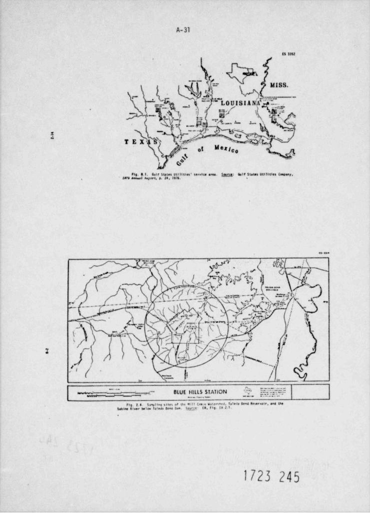
A-31
85 3352
.- L}|= MISS.
h..r- ..
_
~~~ ~ L O U I S I A NAD. ...' _ . ,.
*['
ie \
7- ._ j 4-
__ m_. m m
__.s E ___..__.
2 -- _ C2(Qjs ''TEX '' '
01 M e f,,--
s
. m.11Jt,J:",n "44"""' ""'" "" * ' ".'"'" '"""" ~~-.
. . . .
g'bl__l\'''f* " >-
.
/O#Y
1 .' 5'~{,.
'
i, *:|."* *"*
, k'~ '[ffn - .=r.js :'
.. m - -
{ /_._... - - * ~ ~~ ~L . h |~~ ~ "'
% vz > %~t, , ---- -. . - e
. |f . - . ~ * *_.
s. #. (N,} j iQ ''. |(. \ M. -
6 e n _.3 r9t - ur/ ,, x- -
'
/} ~:L '%\
/ f /1'' ~
=-_ .
~ ' ' ~-- .k'. =r rE55__ - . BLUE HILLS STATION = .. ---. - - . . _ , _
.J'LL'm'.:t';:.T'.; *J.P',;;;.5"i;.";;;"r/3.if"* *' '"""'' '" **.
1723 245
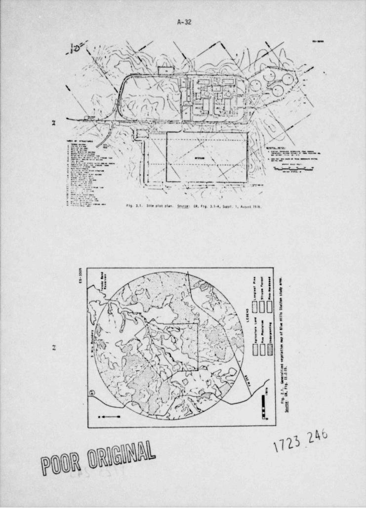
A-32
j'y~~ *
*| -'
.y _
vs4 s e\ w' D e v >,u[th ' ./~
,
, -
- C W f.5,' ''N
.. ET#(:k'l--b[@ ." j[\.,
,
i, :'sg:U; .Of w;Q;y- .,
\ / '~ A ' ,, y - m
% ) ' A t= . p.: 1 @f;g_% QN u . ' {C.yj, ('1 ) , rcv , a ~ ~.c.: .\-
.
/
% L,5; . N -%, |, .,, t ',;, . . . . ' ~ , . . W,':i a] p .A
,.ss .'q.-
. T&y;m||''r"WjQ(~"~M~TY {,
N - /, ./, - Aj.''
* - 2.''' .u , .'y _
' '''yh %\. I: 9 y '[ h ,
'-y ,Y"
y,, .y ,- - . . ........g..........,......, ,, i , g\_,
- . . -
l ,uw \, f. s . , |d ''\<
: . r. n% . .T i. 4| E' ?E:.-
\,'\ ,.'1'/: : . .:.c:
_'' j\s.4 E-mE ..=:..-- ' *'
j' -, . , . ~
\.N =..:. .,,_ - -a.g- d.'. ~.~ ~ ~ .. , % e- }.--.. s.c.... . . . . . . . ,. .N. . . . . . j./
;), )
.,,
;9- .-. - ' j.
j(' a.J / \ | ,y. ~ ' M'f ' ~t:aW.z- \\i kiS.'d.3 ~" ~ve= w .e_
i D'%=n--- ' . '% . ta::=r- .. :.- :- . t =r --' - - -
-\\-' .u .
'''s , , ('j =':.C ; ,,
.'' '
i ,q+ d:Is :. ,
*'"-P.E***** f eg 3.1. Site etet pia.. }ci.m: g8. fig. 3.1.a. Leet. I, a.mt te es.'
8Y ]! .g .sJ
-
= ,; . .;.w 1 s : ij g
~~ h#
4 h., -.,
. dO chP. |'#
3 ,,
|m|{;? i
,
ew ww,egs :=
. g''a )+MY'b.gq- ,
. x,.
M 'y
Q{\h'%' &'.l'.
: t 8:$ 3' V'?N n'~
1';';>.: f?|))f iEth y ,
il*
' " gT'
' %r /g g|Q; jG y' k .,, y, .ce .l .~
;|gt
se .
CC'Y ).Lrg,' , tq; % W"'
' *-
\\- ,e e
7g Q&h
,
UNITED STATES OF 4MDICAFJCLEAR REGLU1ORY CoptGSSION
CtJLF STATES UTILITICS COMPANYSTATE OF TEXAS |aee* oae.ee eee aee. . ee..===,. ,e... ,,,e.
I.... e... ... ese ....COLTTY OF JEFFERSON |
6In the matter of I Docket Boa. 50-510
1 50-511July 22.1977 CULF $*ATES UTILITIES CCW AY l
iBMG - ik99 (Blue Hills Station, 8
File No. 1.01.9 a Units 1 and 2) ih i , f * t)
p '/, ATFITAf!T
Mwr Oesrae W. Knighton, Chief '. S. L. ALANS betr.g duly swore, states that he is a Senior ViceI] ,
,
invircreental Pref ects Bras.ch 1% ~,'.). v' *y9 w President of Culf States Utilities Comrany; that he is authorized on1 v. s17. of Site Esfety as.d Environmental g
Arelysts s. ge' . M*ar Pegt",atory Ce,mmission the part of said Comparty to sign and file with the Duclear Seralatory.est.1 4t<. a. 3. C- 20555
Tg Cosmassion the documer.ts and eahlbits attached hereto; that he t.as
!etr *.r. Knighton: read all of the statements contained la such documents and the exhit!ts3=
Blue Mills Station attached thereto and made a part thereof; rV t%at all such statements a
Docket pas. 50-513 4 50-511 d% ,g , on m made and matters set forth thers's are true and correct to the test of
Eeloset please find twenty (20) copies of Gulf States. his knowled6e. Information and telief,
crer.ts -a FSIG . 0276. Blue Mills Station - Site G DraftZwircr.:estal S.atement. The e:rments are arran6e4 sequentiallyty ;ade ar.1 section number for your ecnvenience.
JXuVery truly yours. S. L. EAF.S
./ XM Subscribed and sworn to before me, a potary Public la and for theS. L. AdamsSr. Vice President State and County above named, this SA day of A o [. .
s7 .119TT.
& amfotary fut'11e in ard for'
N Jefferson County. Texas
NU
str Commisalon trptres:,
N -
0 uw / s9797720soorsy/
N
1. Fase 111 Site gveparettes does disturb 366 acres (ref.11 Tableitee 3a 4.14 Supplement 2) however tactedeJ 1a that number are
21 acres of railroad.15 acres of Sataka/ discharge pipe 11ae,and 14 acres of access read. Therefore. either the 364acrea should be reduced to 316 acres er the following reduc =tiens should be ende; railroad spurr 222 acree to 201 acres,intake / discharge pipelines: 166 acres to 131 acres, andauses road: 36.5 acres to 26 acres.
2. Page til Although 11 figure 3.4-4. Supplement I shows as intake chamaelites 3d apprestaately 250 f t. long; the ef fective channel leasth is
mach shorter. As was stated to the response to quest 10eappendia SA(3) la the september 17, 1976 request for taferne-
AFFLICANT'S COMMENTS ties. re411stic assumptions for water usage and reservoirog operation result la e projected 100-year low water level for
DRAFT ENVIRONMENTAL STATZMENT Toledo Send Reserve 1r of ISS fr. mal. Therefore, operationRELATED TO DETIEMINATION OF THE SUITA31LITT will moraally be at stop los elevattoes of 136 f t. est er
SITE C highe r . The length of the intake channel at 136 f t. ast is
FOR EYENTUAL CONSTR:|CTION OF TRE approstaately 165 f t. At the normal water level af 172 f t.BLUE MILLS STATICN UNIT NOS 1 AND 2 mal. there is ao channel. It should be also acted. that due
GULF STATES UTILITIES COMFANT to atratification of the reservoir during most of the yearthe ef fective bottaa of the laka is the thermocline whiseoccurs at a depth of S to e seters, reducing the ef fectivechannel length, f
ts4m
3. Fase 2-18 The " peculiar" characteristics of summer stratification occurseceed para. la bay saaptiss stations. They are a ressat of shallow water
. and e*% wing colder water caustag the pref tles shows and aretaus not peculiar as all.
4. Fase 2-21 The identification of Chere was confirmed with the perseas whoFirst para. ande it, and Dr. Elemer Cea. Phycologist to the Stology Depart.
DOCIIT Nos. 50-510 AND $0-511 ment at Texas A&M 1'atverstry ceafirms that she has cellectedp Chara te East Tsaae en saay occastees. Aquatic biology la the
Sout hwest is not well represented la the older literature, andM reliance en older references is risky.
&W 3. Page 2 21 Corbicula. Apparently the is. asion of the lower and of Telede
Mscro- Send asserweir coincided seh the f 2 eld work for the Envi 2e-tavertebrates sental study. No .! alt . -* testa we:e colluted at that time.
N though small forms which . .e not recogni:ed as leasture y
p Corticula were collected a.J reported. Adults were first
@July 22.1977 .g. ,
conservatten et hardwood bottaa land. Culf States hasnot yet developed a land management program for the Blue
collected during the site visit in December 1976, and Billa $1te.when their presence in Toledo Band wee reported to Dr.C. E. Nrphy of Texas Christles Calveretry, he stated thatthis wu the first record that he knew of for their occur- 12. Page 4-4 The Blue E111a Site presently lies approutmately 3000 feet freeence le Toledo send Reservoir. Critical the nearess approach of the sabine National Forest (EX figure
species 2.2-9) and by 19361e espected to be contiguous with it (12.
figure 2.2-14). The $abine Mattenal Forest has a Cait Plas III4. Fage 2-22 There is no stateneat la Et sectica !Y.14:2.1 er any other that tacludes the protection and enhancement of the red-cockaded
Largenouth 11 section clatains that oost larger specimens of largemouth wood pec ke r . .
bass bass occupied the littoral some along with the young-of-the-year age classee The f act that more large specimens were Therefore. Culf States does not feel that it is necessary to
collected la the littoral sone br electrofishing than were provida priar to a construction parait applicattaa plans for eseta'an f rom the 11anetic sone la 3111 nets is most protably or dispositten of red-coch.aded woodpecker habitat asd other sitea
a f unction of dif ferences in collecting gear and ef ficieseies. prape rttee outside the construction some.
Re f erenc e :7. Page 3-12 DES !able 3.3 1s adaptaJ f rom ga Table 1.6-26 which is based (1) sabtne t'nte Plan Draf t tavtronmental statement..able 3.3 on a botraa Antake. The botton 1stehe alternative was dis-
carded and water is selectively withdrawn f roe the top la f t. U$DA-F5-R8 CES ADrt 76-18. U.S. Forest Service. Lufhia,of the water column as usa stated in 12 paragraph 3.4.3.4. Teams June 1976. pp.100-101.Therefore. Table 3.3 requires revision. It is suggested thatER Table 3.6-2 he used as the source for Table 3.3. 13. Page 6-4 he tevenrery of the red-cockaded woodpecker nestieg trees to.
Critical dicated that more than 99% of them were toeglear pises. Com.The calculations that support the tables for sectica 3.6 opecies last struction activitaties planned for the Blue stils Site will dia-
include chlorine toa to the values givea for chlorida, para, turb less than 101 ef this potential habitat within the C53 pro-Therefore, the addition of reactica products shoula inclues petty and less thas !! of the potential habitat withis the 3-a11e *>the chlorise ion. Ia O!5 Table 1.3 the chlorise toe accounted for study area (which includes some land withis the Sabine Mattosal 8
EM19 ppa la the cooling tower blowdown and 14 ppa la the plaat Fore s t ) . A comprehensive forest sanagement program f or the siteef fluent concentration. will hate little to do with constructica tapacts and, therefere,
an evaluation of constructica tapacts could be made at this time.
8. Page 3-17 According to ER Table 3.9-4 and ER paragraph 10.9.1.3. touts Ccament number 12 also applies.Route B 5 parallets esisting right-of-way f or 32.47 miles. The dif fer-
ence bet eeen Table 3.9-4 and ER Appendia F Table !!.4:2 la 14 Page 4-10 Final engineering and right-of-way purchase han not beenexpiataed by the Statement on the bottom of page 2-488 of Railroad spur accomplished for the r tilroad spur. There is the prospect that
appendis F. these boss will have been pretapacted by ordinary landusepractices befsre the routing af the railroad spur has to beflas11aed . This may result la shif ting of the boundaries of
The makeup and discharge ple ltaes de not share the right-of- the bog or its destructice. Stace the values of the boss are9. Fase 3-18 eMakeup and way f ar Pt road 255 for a sigstricant distance. They run scientific and aesthet:e. the cost of < amitment is hara tedisc ha rge appronteately 300 f t. south of :M 255 as is stated la Et para- relate unequivocally ta the expenses a. Octated with chang 1agpipeline graph 10.2.3.4.2. the routing of the right-of **ay.
-Gulf sta e has tavestigated a slight adjustment of the route
N 10. Page 4-2 para. The ra11 row ur parallels the proposed transatssion line C within ti engineering canstralite to avoid direct impact of the
N 6.1.2.1 c6rridor : c 13.4 at: re, nor 10 miles. Rafer to ER paragraph bog as it .ow entsts. Fre11 sic-ry estimates inJ1cate that this
10.10.1.1.2 page 13.1;-3. ed). taent uo,id incur a cos; enalty et apprastaa+ aly 3:15.000b due to i gressed enc, vat. n 41 resents accessary to maletata
graJ a .
11. page .-7 The - i states "The ape 11 cant is comaltted to conserving about
N Top of page -" .a refers to it .ctica 2.7.10 and staff Que.riva 2.7.5-(1)of October 19'6. la a atton 2.7.11 the applicant's ecologicalyconsultants state that he ce tak1'd Gulf States' property
% out of intensive forestry management there is a set positive - 3-
-2-
It is their profeestenal opialee based spes their emperienceCulf States ocelegical consultants have stated "Is light of with the total program that all a suspeeded lead er bed leadthe fact .the bogs are a regional phenomenom occurring onprogree will de is enable the demonstration at the time ofnaay seeps where the forest cover is reduced and beg plaatsconstruction that the costributtoe el coestruction is trivialhave become established due to chance, the balance alght be compared te other sources. Das is a result which they
tipped toward teemitmenP if rerouting would estall a restcensider to be known at this tLae,
additional expense of easy thousands of dollars and the sele-tion of major engineertas problees."
IO* I*88 '*EI fR paragraph 4.1.5.3 was laadvertently art updated to reflectIf at the time of constructica permit applicattoe the bogs
pare. 4.4.8 the ch. sage la routing of the tataka/Jischarge pipe 11ae fromesist. an ef fort will be made to stalaise disturbance of the north s1Je of the Pt 255 right-of-way ta 3J0 feet souththe bogs, of the FM 255 right-of-way. This routtag. shows in 13 figures
3.*-2 aa4 4.1-4. reJaces the inconvesience that will be causedby the Lastallacun of the pipelines to the point that they13. Page 4-12 It La the professtoaal opiaton of Gulf States' ecologicalbecome Lastg11ticant. The baat ramp will not be ecupletaltpara. csasaltants that the erosion control progran presenred, ifII*'hed of f nor will the roaJe leading ta residential areas
4 . 3. 2.1 adequately carried out. will protect "111 Creek and its tri. ce the north side of Pt 255 be blocked.butaries. witchell and Capperas Creeks. f rom serious damagef rom constructies eros taa ef f ects. They feel that the request
for settling bastas wall cause more problems than it will cure II. Page 4*19 This comaltwent should ime restateJ: "Jesite construettanander the conditions of the soil type la question for the Sten M activities will nos ef f ect 4 % (101 acres) of reecedadedfollowing reasomu
woodpecker nesting and roost tag sites that occur en CultStates praperty (En AppeedLa F Table III.e:g)*.
1. The construct 1Mn of the settling bastas will itselfespese acre area to erosion. both during their constructiseand af ter their use is finished. 18. Page 4-20 Commest number 15 to applicabia here else.
I"** I2. The area to subject to occasional heavy rains and should 3=the basins be v4shed out the resultaat flash flood would 8
cause a:re harm than the . ore gradual entry of the sand 19. Page 4-20 As stated la the coment for Page 4-15 paragraph 4.4.0. The ywhich would occur without the basins. ites 7 change la the right-of-way locattom far the tataka and dischargepipeline has obviated the need for this requireaset,
3. The creek carries a large bed lead of send under presentcond i t ion s . They have observed specific sites over aperiod of time. and have found that a site which had eely 20. Page 3-21 The CES ataquetes the ER. Et section 5.1.4 states "The easta few Laches of water at one visit, alght be a pool up to "Cpee water, taportant considerarten to stataise the ef fects ef the 1 staketwo feet deep the east time. Thus, the ecosystem is now cond1Eless structure en the equatic environment le the locattoa of theauspeed to the movement of considerable sand. The suspended structure la na unproductive area of the reservoir. Theload is very sna11 most of the time as evidenced bv the opes water area selected h characterised by coeparativelyvery low turbidities. The only significant euerended load
# 10w PMuctivity, diveretty and species abundance" (esphestocomes during spac es. edded). The seleded site (T1-2) is a wave-swest. h16h esergy
q mone undergotas a.tive erostoa. It to ese of the few beaches4 They have observed sites where ferest practices have 1+ the lower reservoir where bottom sediseats of the littoralN caused local areas of ereston. T%e straan recovers quicklyacee are scoured to r ae subsand clays. gecause of subseste
af ter the actual sand Laput has stopped.conditions it ne'' r surparts the growth af e%serged'': :stion nor se. 4 as se appropriate nr.watas atte f arThey . tate that if the elas% from tiearing is put la the drawstap.rtant fish spe tes. It does act fit into a genericand small waterce les to a w down the sand, and if the areas produ6tive 11stor i saae" claestlicattaa.
bered are given soa treat. ~t to stab 111 e them as so-s se@ poet ble. tr.at the send enity f rst construction will be at a
O level tt.t t se system can aar fie wit hout serious detrimental 21. Page 5-21 In ecuseating ee % pes watet" conditions the staf f should keepe f f ec ts. T e are all past et Gulf States proposed erosion "Dpee water" la stad comment a sber 2. If the water level does f all ta;rogram, condittees 155 f t. eel thee .e lacreawa length of the siarellas ese to
the " channel * Se opprestaat..y an ed4Lttenal 3s0 f t. aJJing
* *to the more than hadreds of miles of shore 11se La the reserve 1r(1200 elles at elevation 172 f t. asth Any f Lah that are
.$.
3. Jester. 3. C. and 3. L. Jensen. Life nistory end feelee, ofCtraord She4. Dorosens cesedianus (tesveur) with Retenece
entrataed/impiased as a result of occupytag this addittamal to tiephant gutte take, seu Mexico State Latversity
habitat should be nogligible with respect to those la the Agricultural Esperiment Station Res. Reyst 218.1972. p. 56.reserve 1r as a whole.
6 Delquest. U. W. and L. J. Peters. A Lif e Bistsev Studv of 622. Pete 5-21 Comment number 2 to applicable here slee. It should be acted Problematic Fish in take Diversion. arc 5er 6 lavlor ovettes
Critical that the low water months occur when the reserve 1r le strat1* Tesse. Ieuas parks e Wildlif e Department. taland itahestesfled and thus has ' n ef f ective floor. *eport Series #61944, p. 87.periods of a
Low reservoirlevel Tolede Seed Reservoir. it would26. Page 5-23 should stripel base spawn g3 sad. es seasiderable current isFif th para, probably(g to May er Junerequired , spavates wedd most likely be restricted to the
23. Fase 5-22 Comsat number 5 size app 11.s bare.forebay of the hydroelectric staties. Most of the nest-benyant
Discussion en eggs would be disenarged through the hydroelectric stattaa ercarticula alak into the hypoliastee which is well devolered during these
anoths. Since considerable current is requisite for successfd
26 Page 5-23 Statt a T32 is one of the few arass %ere tchthyeplamhten towe spawales. chances at any reproduct&on of striped bass la the
Second para, ettginating as close as 10 meters f rom hore could be ande as reservoir would be remote aed little ef fected by the 1 stakeit is devoid of standing timber of submerged agostic vegetattee for the power plaat.
which characterise most littoral tone habitats of the reservoir.Without such structure. it does not provide a suitable spaunist poterew ee:
area nor does it provide good habitat for larval and post-larvel1. calhoum. M. J.. C. A. Woodhull and W. J. Johnson $tetredlife stages of important species. Bass Reproduction to the Sacramento River Systes te 19-8
Calif ormis fish and Game. Vol. 36 d2.1950, pp.135-le5.
25. Page 5-23 1 1s conceded by the Staf f that entratament losses of threadfla ysnad will not constitute an unacceptatie envitermental toes. 3. g ,y, 3. C.. The Life utstory o f Sertred Base, noccus e
but they state that the converse is true for gisaard enad. Fanat tite (Walbaus). 51agnas Oceanographac Callecties yThird para,
Sulletta vol. le-1,1952. pp. 5-97.
The intake area is a wLad-swept high energy some undergoing activeerostoa that does not fit the generic " productive littoral some"classification as comment sweer 20 states. GLazard shad have a 27. Page 5-23 The coactusion stated as "certata" la mot certata as 1: Lahigh satural marrality rate f rom 0 to 1 year, with a survival rate $1sth para. based os se erroneous premise i.e., that the shore tatake
of 0.00011 (Bodola 1H3 p. 391). Buf fetting by storsa er wave is sited in a productive and diverse 11tteral tone. Theaction, as well as rapid variations in water temperature which are littoral sene la that portion af a body of water estesitagetiaracteristics of shallew water. hav. been pointed out to be sa from the ahor9 se laseward to the limit of accupancy by
f actor contributing to the law survival of the young. rooted plaatst . The development of this sose is influencedimportant(Bodola 1965 p. 40E In addition, young are reported to prefer by factors which are limiting to plaat growth. Not the leastbeds of submergvJ vegetatica Otiller 1960). la spite of this. 3 s* of the.e factors La wave actica and substrate tenture which1
sard snad overpupulate to the detriment of etbar species (Miller La the case of site T32. have readered it devoid of plant
1%0 p. 344 Jester 6 Jensen 1972 p. 5. and others). Further sis- Browth. 51te T32 does not cor.stitute a productive latteralsard shed are a n.q sr probles in Tesas reservoirs (Dalquest 6 Peters habitat.
1966), so say les ses due ta entratamast/ taping. est would notReference:be detriaental.1. Asid. 4. E., kel3e of Island Waters and Estuartes.Re f. enr e s '. Reinho.4 Fub1131ag Coryumer 1 ra. 5.t. 1961. p. 3T5.-~s - - -
1, & 's. A. Life History of the Ctaast!J . Derosoesc. m M eso.m r . , in bestern take Er a U.S. Fish and
N Wi .. ate ad1HIn~E 1960, pp. 391M. -1w2. Piller R. t. Es- :tes and 91310- - of the Clarerd $had.
(Mr * .sma cepeitar a. sd selated F1 -s U.S. Tish and4
W11411te serv.co fish. , ; 841stta 17h60) 1960, pp. 371-392.
W-6---.
28. Page 5-24 The Staf f's coactua*.eas should be revised to reflect commentFowrth para, number 24 through 27. 33. Faye 6 d Colf states believes that such a program to not necessary for
Sust.eded the reasons stated ta r.he toement for page 4-12 paragraphsolida and 4.3.2.1."*d I'*#29. Page 5-25 N source of this table was ER Table 5.4.1. As stated ta
Table 5.5 the foreword to 11 secties 3.4.1: use not updated. Table **d A'"''
5.4-1 is obsolete. The sources for this table should be theappropriate tables la 12 sectica ).6.
34 Page 6-8 The DES comments se stream ecoerstem are valid as far as theyPeriphytes go. but they neglect te mention some addittenal basic poiste.
30. Page 3-26 The applicaat did not state that total residual chlorise Although the periphytoe is the major centributor to stresstiocides and would be 0.10 mg/l in the discharge. The applicant's statement primary productivity as is stated. It is met seettosed thatsaattery that residual calorise is the discharge has been calculated to primary proJuctivity is usually met the most important source
hr organic matewa st es be that shown la Et figure 10.5-1. Thee, the TEC is the dis-"I''' ''''''''''gt ta streams and that la many cases it is a
charge is calculated to be above 0.10 st/1 for approminately36 stnutes per la ection period. There are sin ta sction periodoa a
la t*e suser and two la the winter. The eastaum value of TRC Secause of the geolasy and soil type of the region. M11 Creekcalcatar.J ts 0.1% og/1. According to Di$ figure 5.11 even has very little sottJ substrate for periphyton ta grow on.this value for 1G-20 slautes would not cause problems. '''8''' "''''Fptags of saada!Jee, eSib laf e that M
yards lons."Other than this the solid subarrates consist ofespecially since salapa and trout are not reported la ToledoBend Reservoir. eccasional loss. roots and rocks (which are rare).
The DES states that "The applicant attempted to describe the31. Page 6-2 Gulf states' ecological consultants have stated that "Even if primary producing commualty of copperas, Mitche11 ace Mill
para. 6.1.5.1 the population of these antaals (alligators) tacreased signif t. Creeks by collecting 'phytoplankton*.* This is sa lacorrectcastly in the interie before construction, we do not perceive interpretation. Cerf States' ecelegical consultants recogstaed
.any poteuttality for significant cosmitaaet wf these species as that primary productivity of the streae was a almor component ofan outcome of power plaat construction." Ccentructica of the the organic taput and made se attesst te measure it. pplant will proba61y cause some siltation of Mill Creek. gut, yas the comment for page 4-12 paragraph 4.3.2.1 tedicates, the The met collections were made to survey invertebrates in the mecosystes is presently adapted to the movement of considerable drift. Algae were collected tecideetally, and were resorted,
Ead thvtoplaaktom collectices been deemed necessary, they wouldannunts of sar.d. It should also be noted that the populationeo' 4111dators _a the Gulf coast are increasing. and that hunts have been conducted uslag appropriate methods,are now allowed la some areas of Loutstana.
The des alsa potats out that periphytes populations recovergazed on the esperire of Culf states' ecological consultante quickly and any damage f rom spaces would not be of leeg standtag.
a anJ their consultJ(1 ts with Dr. James R. Diaon. Professor ofNerpetology. Texas - A University, the best t ime to f ind it is the professional concluaton of Dr. W1111ae J. Clark that
N alligator nests is la the . teep of wtater when the vegetation is 'h' periphytos causanalty costributes so little to the straes
flat on cae dro4nd. T5e rule of thune is that 107 of the popu- ''*eystem that any study of the periphyton would be misleadinglatian will be nestin:, females. They have stated that "There la documeertag ef fects of construction en the systes.
U are so few all .ators la chose bogs and lower creeks, theresults of summer surveys would probably not justif y the 9eferencerexpense of ading thee." to any event. a stagle careful winter
N survey would be more productive. 1. Bynes. E.8.5.. The teolory of Rue 91ae Weters. Universityof Toronto Press,1970. p. a13.
C32. Pe r. -5 The wordine 's af sleed:rg on the phytoplanktoa methods. The
35. Pm 6-4 Mt Statu' ecelegical couaultanta stata that the data gatheredFb - ,lankton- samples v. col.ect ec :th a rubber hose of 25mm 1asidef
chlorophyll a d iana * - i.e sa sie o nth was 5 meters la the open water tehthyopleak- La tre suggested progeam n111 he of little stility. Cener altonand 3 ..o rs la the bays. spaweiss times and habitat requirements h.re been provide;
Emphasis has been placed on siting ta se ras which aveldsoptimum spawatog habitats of importsat species.
-8-*
, -9-
additisaal informattee with respect to the mesi fetichthyeplaakten sampling has bus sepplied ta the respaese
y,g,,,,,,,,to Staff g#eettom 33.1. Sectica 2.7 dated October 3.1974and the resp 3ese to Staf f questtee 1(2.7) dated J ly 30. 1974.
1. Bodaea, tenald C.. a coe wisee of orterrence and mndene" * " ' " * " " * * * " " ' ' * *Therefere. Celf States does not feel that the additieaal taec naries. Dissertattom. Iemas salt weaveretty 197"3tchthyeplanates sampling requested la the *15 is necessary.
2. Cersaay. Ravesad D., Populat toe Nantes of t*e 91.e36 . Page 6-4 The Enfers.atise beir.g ree.ested has been supplied ta ER appendia filips and tre Effeces en r w f:.m P % c i-, e t
Fis5ee F. Call set and shad trawl data have been taken of fshore at Tr :n 14a4 Lane. !*ias . Dissertattoa. Iemas &Wt Latversity.1977both T32 and ill and seta callectices have been made onanore atboth siter. Therefore Colf States does not f eel that the ed41- 3. Sterne $teven L. ase. Geme% and Can. fit t >s af 31.es111
. .r tianal data reg.estad la the CES is necessary. Sunf isn. f en es s w .- a r .. Ia ,..yg r e ye .t e.Te.er . t r in v
e.... .;tesertat tom. T as asa ist, rsity,1972
37 Page 6-8 Consent numaar 26 7ppites here alse. Rosalts of stedtee betag g, y,g, ggg 7,, y,,,1,, g .e S r J '... a f 5el ee t e t 't * * es t * NeeStriped base performed by uuisians and Temas sh.n 14 he adequate to aJdresaReared tuervoirs in *...s J.eata. Iemas w iniverette.1972the potential coecerns relative to this asectes.
34. Page 9-4 The sentence "!m the final analysts where cost estimates have 42. Page 9-17 Celf States feels that a more e'sitive statement codd be maJepara. 9.2.5 evalented. ' laplies that tne work has not i+ees done anJ 1a para. 9.3.4 here e*cb t,4a the data supplies f ar ts a rm.e4 a J als.ca.te
fa;t it has been. The results of t.he cost estimates are First pera, routes are corrently oJewte f ar a fiadarg. Twa. fin n.33reported la ER Table 9.3-4 and site C was f auoJ ta he the apes would af cearse be sub;ect to the pr2viance af "sigulf teast a wcost effective. taf ormation* betag brJ66ht f Jrth in tne futare.
39. Page 9-14 It striped base de spawa successfully la Toleda lead Reserweir. 43. Page 9-19From the point tha,t prepcsed route C and alternettwo rawte C-3which is a reacte espectattoe. it wedd probably be te the aree
,,,,, 9, 3,4 ,,ggg,,,,,,,,,, ;,,,g ty ,,(g ,g ,he caut ee has the f alla= tagof tde hvdroelectric plant, near site F. as ested ta the comment fourth para. impac ts as it procuds to the Rivtria substattaa. fader 26. In addittaa threadfin sud concentrate la areaswith currents and would be acre susceptible to entral.nment and
, , , , 73,g g , ,, elapingement losses at locattoe F thaa at locatica E. M ath M EW Emiet broup Fu ut Land
f alles) fail u) ( ae res t (sil e s ) ( scree t40. Page 9-14 Caanent number 2 amt 27 apply here alse* Route C-3 22.47 17.13 511.90 11.76 349.48Fif th para.
Sante C 11.22 2.54 232.81 7.71 137.54
41. Page 9-1f. Gulf States' ecelagical coeseltants state that shore 11se addittoed51sth para. habitat at T32 does not dif fer substaatially from ef fshore tapact of
habitats at locations E er F wtch the eaception of wa ar depth. Route C-3 11.25 14.29 279.09 9.05 231.9.Biolsgital lesses would be mininst la either case and theaddittocal costs are set justified ta terme of biological
protect 13e for rus weir f . th populations. Not only is this portise of rewte C-3 looter them reste C. but
enot of rewte C-3 at this lanctere is new right-et way. Ca tesTexas cooling water reservoirs develop fish popdations wh1 the cost data of E1 f tSta 10.9-L the cost penalty incurred forare toeparable r i those la reservoirs not used for coeltag. this portion of route C 1 is apprestastely $1.3 m11114a.* **
These populations are sWected to stresses far la escess of anyhypothesised f or Toledo 24 'aservoir. C- :wlet taa time may be for environmental and ecocoale reasons Calf trates believes that. s short as atae dan.1 .ases do not have .r.tra tament and 1spinge. its proposed raete C La pteterreble to rawte C-3.set pre. . -ica and are is thes ad244 str.se of coast.orable'"*
he.ted wat.: disc h . 'rce the.e atreme conditions have metbe.m shown ti hav u los flects os fisa populattans. there 44 Page 10-1 Cdf Statas feels that the first sentence shadd be raised to
N does not se to 1. any a. - ntific bas;s for hypothesistas that Secties 10 reads "The bests of the easty .e la skis chapter la thatthe install. . m planned for Tolede Bend Reservetr wodd cause $1te C ta t:e preferred site., - *. Gdt States %as upended aa sigstlicant ef f ect.
.-11-
N -10-
LnU
9
<
great deal of resources (time sad money) 1meleseetlag ang and type of land traversed and the tacidence et areas of highdocumenting the alte selection process and has conciedad treatee perantial, that the sealysis of one aus several
Cimly parallel alternatives will s,f fice. T%e analysedthat site G to the preferred site for Stue Ellla Stattee.eerrider " transects" the country under cenalderaties to theThe Early Site Review process has documented the fact thatsame way that sampling trassects de. It is hig%27 Itkelysite C La e suitable locatise for e nuclear power plaatthat the statistical outcoes of the analysis et alternatives
(conclusion 7 page tv). would give essentially the same results. Their expe r tencewith the clos , stataartty of tse impacts and ceumairnests
associated with t3e alternative cart teors withaa ese e.$ am45. Page 10-5 Gulf states does not f eel that the cost-tenefit analveis toraJ Ne (reter ta g t a. peuat a r taste g gi,,; y ..g ;,,; g ,g
pe ra . 10.4 depen t-nt on ett e selection se the purpon t f this DE5 to gthe *dJeadwe to anenJia F) taJteated that this *n so. Theyto eva14 ate a site that has already been selected. S econdary
benefits are derendset os 1a-service date and plaat destge. discovered tur bid .17 sensitive cevJittans tie:'e6 RiverTheretare. Lif States reco.unends that the last se+atence of this crassing. *jgv11a -vr ast f ay standa, reJ-cukaJe g maaapeca.g
racge s) were Ncales.3 an.t could w ava14ed a, mis r entita laparagraph be revised to read: "Grrently, no cost estimates havebeen prepared by the staf f because specific secondary benefits the rout teg.
are dependen: on in-service date and plant design"Canateeraale eifert was e4Je ta ria;e transatastae carr1Jageem 11aes pretapacted tv previous papeltne or transasse14e
44. Page 10-3 la light of comment number 24 through 27 and 61, the requiresses e., g u , , pg, .,g, g
pe r s , 10. 5 for st.Jy of a mit tlevel siphoe latake erstee la conaldered routes betog better.
Stes e unc ec e s sa ry .Ze sesmary, the see1041 sal cons 41tasts felt that "Photogram-estric analysta of other alternatives would simple be a
47 Fase 10-5 Gelf !catu' e alagical consultants state that " Ecologically the statistical esercise and wou1J set add s1ggtf tcantly to thepara 10.5 projected ;oenitsents sad ispects have been redeced to mest a ele. information at hand . ,. his is coet tegent upos see of
*
itee $ laus, accepting the esed to c rase the preser se at this potat"- Civoscerradars caseely pe:alleitas the present selected one."
that the Preserve Locludes over 50 miles of the Mechas taser f ree theBesamunt Unit to the end of the upper Mechea River corridor trait (re-
la a4J1 tion reter te .he response te questices 2.7. 2. 2.7.3 ffor to f n fig sre 2.9.1) at seems reasonable that ettlittee mat pese and 10.9.2 of the se .est dateJ September 17, 1974 Athr> ugh at a few selected windawe. In addi ;os. t%e staf f to para, Ograph 4.1.3 of the M5 states that "by para teltog sa entseing pipe. For these reasons Ge.8 States dcas aos believe the Jetailed11r'* rig %t-of-way, the impact will be sista -" Therefore, an alter.native corridar around the ptaserve should not be required. Op t ini. taformattaa roguestes la the DN to necessary.
sattoe of the design of tre line se it passes through the preservewill be considered at the time of the constrt.c t12e permit application. 32. Page 10-4 Comment muster 16 applice here else.
pera.10-5
&4. Page 10-S Comment number 26 and 37 apply here also. Sten 16pa ra . 10.5itsa 8
49. Page 10-3 Cesenat su=>er 33 applied here stes.-.~ ) pa r a . 10.5
ites 9
30. Fase 10-4 Comment osamber 15 appites bare aise,pa ra .1b3
- 1res 10N
31. Fase 10-4 !afermation, of th type requested, hae *een provided for the.p> pa r a . 10.5 railroad opur 14 t e 22 appeedia P emb=eetles 17.S:3 and la
item 13 addendus 1 to t .v .ppendia.
Celf Statu' ecclev :a1 commultants han stated that for trase-elastos corriders la the broad sense.1.e. relative to the amoest
-12

Appendix B
LETTER FROM UNITED STATES DEPARTMENT OF liiE INTERIOR,FISH AND WILDLIFE SERVICE
1723 255
.
L*:"J.N.''.'.# ! isi%. . .
O..
United States Department of the Interior:
b FISH AND WILDLIFE SERVICE*
5, . .
''WASHINGTON, D.C. 20240
50-SIC8 5//in Reply Refer to:
''
-750 .- .,
N'- * Ji '
'|'f'[d ih':Mr. Daniel R. NullerAssistant Director for Environmental Projects
'#''.'Division of Reactor' Licensing - r. . -
Nuclear Regulatory Commission ic.] *d' h ,'
, .
gWashington, D.C. 20555 g .,
Dear Mr. Muller: y.
We wish to thank you for the opportunity to comment on Gulf StatesUtilities' Environmental Report for the Blue Hills St3 tion, Units Iand 2, Newton County, Texas. We also would like to express ourappreciation for t,he cooperation extended to our representativeduring the recent on-site environmental review conducted by youragency and the applicant.
In our opinion this environmental report adequately describes andassesses the proposed project's impacts upon existing fish andwildlife resources. Gulf States is to be commended on their alter-native plan selectlens and design changes in response to significantenvironmental conce s. We do, however, have several comments whichwe feel should be addressed to further impiove the quality of thereport. Specific comments are given as they pertain to the varioussections of the report-
General Comments
The project area contains important fish and wildlife habitat andresources which are presently utilized by the general public. Toassure maximum public benefit from the project, a fish and wildlifemanagement and public use plan, as well as proposed implementationschedule, should be prepared by the applicant in concert with Fed-eral, State, and local agencies. This plan should include thepreservation of natural areas, development of fish and wildlifehabitat, and the provision of adequate facilities for public use,including access for fishing, hunting, or related activitics. This
#% 10640kr k
E Let's Clean Up Amenca For Our 200th Birthday6-1
1723 256
B-2
2
plan and proposed implementation schedule should be developed as aproject feature and included as a supplement to the environmentalreport. Reference to this management plan should be incorporatedinto the draf t environmental statement.
Special consideration should also be given to the preservation ofunique or endangered biotic communities such as pitcher plant bogswhich have been identified as "the most unique plant community onthe Blue Hills Station." Relocation of the proposed railroad spurto a north facing slope between survey stations 253 and 264 shouldbe considered to avoid one of these rare bog communities.
Specific Comments
Section 3.4.3.4 - Makeup Water intake Structure. We note that theER (Fig. 3.4-6) provides for the installation of traveling screensif required by operating experience. In light of this, the ERshould briefly describe the fish handling or bypass facilitiesanticipated should impingement rates prove to be abnormally high andenvironmentally unacceptable. The ER should also justify, throughappropriate references, the lack of such facilities in the presentintake structure design.
Section 3.9 - Transmission Facilities. Statements that the clearingof rights-of-way for transmission facilities will be of benefit towildlife should be supported by specific references. Since thedesirability of open strips of land for wildlife is species-specific,it would appear that the evaluations of the impact of transmissioncorridors should be directed more toward unique or important speciesoccurring within the impacted areas rather than on wildlife ingeneral.
Section 4.1.4.6 - Dredging Effects. This section of the reportshould describe the anticipated method of dredging and the natureand location of spoil disposal. The preventive measures to be takento avoid spoil return to the watercourse should also be outlined anddiscussed.
Section 5 - Environmental Effects of Plant Operation. 'The potentialeffects of increased water consumption and evaporative losses on theoperational features of Toledo Bend Reservoir and the downstreamfishery through plant operations should be addressed in this sec-tion. This section should also include an analysis of the potentialeffects of plant operation, if any, upon the quantity, timing, andduration of freshwater flows into Sabine Lake Estuary and the resul-tant impact upon estuarine productivity.
]723 257
6-3
3
Effects of Cooling Tower Drift Fallout Salts.Section 5.4.7 -
Specific literature or operational monitoring studies shouldbe cited in this section to support the assumption that saltdamage to vegetation will not occur during plant operations.This should be followed by a discussion of the mitigativemeasures to be taken should the monitoring phase of the projectdetect detrimental levels of salt deposition.
Section 5.6 - Effects of Operation and Maintenance of theTransmission System. The ER should discuss the potentialfor avian mortality as a result of flight impacts or electro-cution at transmission facilities. A description of themonitoring program and/or mitigative measures to be takenshould this become a significant problem should also beaddressed. Also, the guidelines entitled, " EnvironmentalCriteria for Electric Transmission Systems," published onFebruary 10, 1970, by the Departments of Interior andAgriculture should be followed and referenced in the ERand subsequent environmental statement.
Section 8.1.2.4 - Recreational and Esthetic Values, andEnvironmental Enhancement. The rationale regarding theproject area's undesirability for recreational and environ-mental enhancements should be elaborated upon in this section.As mentioned previously, the p r'oj e c t area has the potentialfor providing abundant outdoor-oriented recreational activitiessuch as fishing, hunting, hiking, nature study, photography,etc. In our opinion, these activities should be includedas a project feature in order to partially mitigate recreationallosses resulting from project construction.
We hope the preceding comments will be of value in yourevaluation of the Blue Hills Station Environmental Reportand the preparation of the draft environmental statement.
Sincerely yours,
D. $A. .
Sv?4?!!Pa Ji
1723 258
4

.
Appendix C
LETTER FROM UNITED STATES ENVIRONMENTAL PROTECTION AGENCY,REGIONAL ENVIRONMENT IMPACT STATEMENT COORDINATOR
1723 259
UNITED STATES ENVIRONMENTAL PROTECTION AGENCY
SUBJ ECT: Blue Hills Early Site Review DATE: December 10, 1976
Clinton B. Spotts [ ,/FROM:
OICE TO'%gRegional EIS Coordina or
Myron 0. Knudson Af[gryd M Y[~,%XXX THRij:
Director, Surveillance PAnalysi[s Division'g "'673rn,re,u7$,,
,,
NI$Qf *
TO: Philip C. CotaProject Manager, Environmental Projects Branch 1 C'/Nuclear Regulatory Comission, Washington, D. C. Il N.- '
We have reviewed the Environmental Report for Blue Hills Station, Units1 and 2 and as agreed upon in our meeting on October 19, 1976, havewritten comments concerning Sections 316(a), 316(b) and 402 of Public
. Law 92-500. These comments are included as an attachment to this memo.
The Envircnmental Report contains adequate discussions on transmissionline impact, noise, cooling tower drift and air pollution and at thistime, we have no comments to offer on these subject areas.
If we may be of further assistance to you, please let us know.
Attachment
1723 260
EPA Form I320-6 (Rev. 6 72)
C-2
ATTACHMEriT
We have reviewed the subject report as it pertains to our interests in316(a), 316(b) and 402.
Although we have not yet made a f6rmal determination, the Blue Hillsfacility will undoubtedly be a new source. As such, the National Pollu-tant' Discharge Elimination System (NPDES) permit will be written inconformance with the " Standards of Performance for New Point Sources"
.for the Steam Electric Power Generating Point Source Category, datedOctober 8, 1974 (40 CFR, Part 423). There does not appear to be anyconflict between these requirements and the facility design as describedin the Environmental' Report (ER). We are not able to issue a permit atthis time. However, we will attempt to have an NPDES permit issuedprior to the Nuclear Regulatory Commission (NRC) construction permitstage.
It should be noted that we do not plan to designate a mixing zone in theNPDES permit. Limitations more stringent than those contained in thenew source performance standards may be imposed if necessary to meetstate water quality standards. If we choose to employ the mixing zoneconcept, we will utilize the diffision calculations in the EnvironmentalImpact Statement (EIS) to develop effluent limitations which will insurethat water quality is appropriately protected.
Since the Blue Hills facility will utilize closed cycle cooling towers,316(a) will not be applicable. Discharge of heat in cooling towerblowdown will be permitted in accordance with the New Source PerformanceStandards.
,
The following is our preliminary evaluation of the intake structureunder 316(b):
Three intake designs at three locations are dicussed in the ER with theconclusion that a fixed screen structure at a deep water location is themost feasible. The selected design is a shoreline intake with dredgedintake channel and stop logs to allow only epilimnion waters to bewithdrawn. Provisions are made for installation of moving screens ifneeded in the future. Fish losses of 190 lbs/ day are projected, but nospecies breakdown was given.
For approach intake velocity to be less than 0.5 fps there must be18 feet of water at the intake and this corresponds to a lake elevationof 139 msl, but the ER states that the intake is designed for lakelevels down to 128 msl. At the 128 msl elevation the intake velocitywould be 1.3 fps and the intake structure would be located on the end ofa 200 foot intake channel. Long intake channels and velocities inexcess of 0.5 fps are generally not considered best technology. Asiphon system was discussed and rejected because of low water quality atthe lake bottom where the intake would be located Water withdrawn atdifferent depths using the siphon method was not considered, although
1723 261
C-3
2
this method appears to be worthy of serious consideration because of lowlake problems that may be encountered with the open channel system. Asystem of withdrawal at different depths depending on stratificationconditions could alleviate the anticipated water quality problems.
The selected site appears to be the best of those studied, but it is ourjudgment at this stage of review that the intake structure, as presented,is not best technology available. With the projected 190 lbs/ day lossof fish, we believe traveling screens and fish return provisions will beneeded to qualify the proposed intake for best technology availableunder 40 Federal Register, Part 402, April 26,1976.
Additionally, the EIS should include a discussion of a siphon intakewith at least a two level withdrawal depth. Such a discussion should beat the same level of effort given the proposed shoreline intake andshould include an evaluation of traveling screens with fish returnprovisions. Clarification of fish species impinged will also be neededin the EIS.
1723 262

Appendix 0
LETTrR FROM U.S. FISH AND WILDLIFE SERVICE
1723 263
.
D-1
D-2
.
*Q IN RtPtY Remt 70:n:rr# ++g UNITED STATES7 J DEPARTMENT OF THE INTERIOR SE"4 --
FISH AND WILDLIFE SFRVICE%,,, ,f
_
POST Orrict sox 1306ALEUQJERQJC. New MOICO 87103 -
September 14, 1977,
-e~.
Q '-. .*u
50-SM ' " 12' ' i '-Mr. v'oss A. MooreAssistant Director for *
-
%,'Environmental Projects [Division of Site Safety andEnvironmental Analysis
U.S. Nuclear Regulatory Commission ''~~
Washington, D.C. 20555
Dear Mr. Moore:
This responds to your letter of May 3,1977, requesting initiation ofthe formal consultation procedures as referenced in Section 7 of theEr: dangered Species Act of 1973 (P.L. 93-205) and further defined in theles. r,.a.1 Regisitt of January 26, 1977.
ThJ region of the Fish and Wildlife Service has made a threshold determina-t ic of the probable impacts which the proposed Blue Hills Nuclear Plant mayhau on Federally listed endangered or threatened species. This determina-t ic- is based upon existing data regarding listed species which may occurin ne project area, including data from the project Draft EnvironmentalStateu nt and Environmental Report.
Based on this information, it is our biological opinion that the proposedBlue Hills Nuclear Plant will not jeopardize the continued existence of listedspecies nor adversely modify or destroy habitat critical to the survival ofany listed species. However, there may be some limited impacts and to reducethese, we suggast implementing the following recommendations:
American alli:tator (endangered): The Draft ER reports (pgs. 4-8) anestimated seven adult alligators presently utilize Mill Creek Bay and anadditional number use Indian Creek Bay (pgs. 4-12). Because project-causederosion leading to siltation and sedimentation in the bays could adverselyaffect the alligater by filling in den sites and shallow water areas, wesu;,est the control meatures and recommended monitoring and moderatingactions be implemented as described in the ER (Section 2.7.4.4).
CCNSERVEwenca s
1 tretFM3Y f/C7
yJ2-Save Energy and You Serve Americal
1723 264
&
0-3
=
Red-cockaded woodpecker (endangered): The Draft ER reports that althoughthere is no active red-cockaded woodpecker foraging, roosting, or nestingwithin the plant boundary, there are approximately fif teen acres of suitabletrees within the boundary. The applicant will not affect this fifteen acres,according to the ES. Should this area be deemed surplus and considered forsale by the applicant it should be resurveyed to determine the presence ofany red-tockaded woodpecker roosting or nesting trees and, if so, managedaccordingly for the protection of the species.
The construction of transmission lines off-site, however, appears more*likely to encounter use areas of active red-cockaded colonies. Although
approximately ;0% of the transmission line routes will parallel existingtransmission ltura, almost 4,000 acres will apparently need to be cleared.Construction plans should be closely eva? aated to insure that areas containingactive red-cockaded woodpecker colony use areas are avoided. Enclosed aresome basic definitions and management guidelines concerning the red-cockadedwoodpecker to help guidC your agency's planning in this regard.
We do wish to point out that this opinion is based on those speciescurrently listed under Section 4 of the Act and does not include specieswhich may currently be proposed or under consideration for Federal listing.In addition, it does not include our opinion regarding those specied whichthe State of Texas may consider endangered.
There are some nominated threatened (FR 7/1/75) and proposed endangered(FR 6/16/76) plant species found within the project area (ER Vol. II Table II.2:1.A.). Although no plants have yet been Federally listed as endangered orthreatened Federal agencies should recognize that all species in the listingprocess have the potential of becoming listed and thus should, for their ownand the species' best interest, consider them in their evaluation ofproposed project impacts. Based on the ER, the following nominated andproposed plant species occur within the plant boundary and we are providingthe following appropriate comments. It is also recommended that the trans-mission corridor be surveyed to determine the presence of any proposed ornominated plant species. We strongly recommend you evaluate and avoid anyadverse project impacts on these species.
Schoenolirion texanum (proposed endangered) (pgs. 2-245): This speciesshould be positively re-identified -- the only previous record ofSchoenolirion in Newton County is i. croceum. There is only a slight colordifference between the two species. It should be determined whether thespecies is indeed S. texanum.
Habenaria flava (nominated Threatened) (pgs. 2-246): Does this orchidoccur in any of the bog areas recommended for avoiding due to theirecological importance?
Paronychia drummondii (P.d. parviflora was nominated Threatened) (pgs. 2-243):This species was recently divided into two subspecies (ssp. drummondii andparviflora). It -hould be determined which subspecies is found on thesite and, if it is parviflora, appropriate evaluations should be made.
2
1723 265
D-4
Campanula reverchonii (nominated Threatened) (pgs. 2-237): Correll andJohnston list this species as occurring in the Edwards Plateau -- is thisa range extension?
Liatrie tenuis (nominated Threatened) (pgs. 2-259): This species isdescribed in Manual o_f Vascular Plants of Texas as " Infrequent or rare inopen pine woods in sandy soil; east Texas (Angelina, Jasper, Sabine, andTyler Cos.)."
Should any of these candidate species be listed, or further informationbecome available concerning the presence of listed species in the proposedproject area that may be impacted, then this threshold opinion will no longerbe valid and consultation should be reinitiated.
We appreciate your cocperation and continuing efforts to evaluate possibleproject effects on listed and proposed species. Your efforts regardingthe determination of impacts on candidate plant species will be appreciated.We will continue to work with you towards solv b. those problems, if any,which involve threatened or endangered species.
Sincerely yours,
Regional Director
Enclosure
1723 266
3
.
D-5,
RED-COCKADED WOODPECKER
GENERAL DEFINITIONS AND BRIEF MANAGEMENT GUIDELINES
1. Colony Area
A red-cockaded woodpecker colony is defined as: "the area prescribed
by an aggregation of start holes and ' roost, nest, and old cavitieshabitually used by a clan." There is a need to maintain the continuityof th6 trees (and holes) regularly utilized by an interacting groupof birds. The size of the colony should be determined by the outermostholes regularly used 'sy a clan, and may range f rom a f ew acres up to100 acres or more. The important point is that regularly used holesare not to be isolated from the main colony site.
Removal of understory vegetation in the colony and buffer areas isrecognifed as important to the species management. The woodpeckers willnot utilize cavities close to understory brush. Fire is the acceptedway to remove underbrush, and a recommended burning schedule is fiveyears or less depending upon local conditions.
2. Buffer Area
A 200-foot zone of trees should be lef t around each colony site to providephysical protection to the cavity trees from wind-throw and fallingharvested trees. This zone will also provide new cavity trees to replacethose that die or are removed within the colony area.
3. Support Area
The function of this tract is to provide expansion space for the speciesand assure forested stands in which the birds may forage. It should notbe confused with the home range or even foraging territory of a colony,although it will likely be a portion of both.
One hundred acres of 60 year old+ pines and hardwoods is a recommendedsize for a support area for each red-cockaded colony. These supportstands must be contiguous with the colonies and buf fers and shouldpreferably be in several stands totalling 100 acres or more rather thana single 100 acre tract. If trees of this age are not yet available, nostand cutting should occur in the general areas of the colony until100 acres of 60 year old+ trees are contiguous with the buf f er zone.
)
Appendix E
LETTERS FROM GULF STATES UTILITIES COMPANYAND THE U.S. DEPARTMENT OF THE INTERIOR
~
1/23 206, e
E-1
E-2
co_,8.
aan ---s u---,p sp & T OPPICE eOM east maAUMONT. 7 E at A a ?7704.
AREA CODE 783 e38-6430
.
March 17, 1978
BHG - 1513File No. N29.18
.
Mr. Thomas E. Lubbert, SuperintendentBig Thicket National. PreserveP.O. Box 7408Beaumont, Texas 77706
,
Dear Mr. Lubbert:
. Transmission Line Crossings of theBig Thicket National Preserve
This letter is id response to the request of the '
Department of Interior that.Culf States document the under-standings reached at our March 6,1978, meeting. Thismeeting was held to discuss the interrelationship betweenthe creation of the Big Thicket National Preserve (Preserve)and the ability of Culf States to provide efficient andreliable electric service within its service area whilemaintaining, to the extent practically possible, the en-vironmental goals for which the Preserve is being created.Specifically, we discussed the routing, construction, andmaintenance _of three 500 KV transmission line corridorswhich transect portions of the Preserve. One of t he threecorridors is associated with the construction of GulfStates' Blue Hills Station, Units 1. and 2. Representativesof the Nuclear Regulatory Commission (NRC) were in atten-dance at the meeting, inasmuch as an early site review for.the Blue Hills Station had been requested. -
Culf States would like to document the matters andconditions discussed at our meeting, upon which the Depart-ment of Interior's approval of the three transmission linecorridors was based:
1. Culf States will submit to the Department ofInterior (through the Beaumont Big Thicketoffice) n plan to mitigate the environmentalimpact of the three 500 KV transmission linecrossings.,
\ .
-
E-3
Nr. ihomas E. Lubbert BHC-1513March 17, 1978Page Two
2. Such a mitigation plan will include provisionsfor vegetation in the right-of-way within theboundaries of the Preserve. Details regardingpossible vegetation types, allowable heights,tower design and placement, and accessibilityfor maintenance will also be considered in the' mitigation plan.
3. Culf States will effect the rerouting of line.
531 as necessary to avoid crossing the con-' servation area northwest of Silsbee, Texas now
owned by Nature Conservatory. This commitment-
-is conditioned upon the acquisition of the areaby the Department of Interior.,
4. The three 230/500 KV electric trans,11ssion lines( (Line 531 - Upper Neches River Corridor, Line
547 - Lower Neches River Corridor, and Line 560 -Little Pine Island Bayou Corridor) as presently' proposed will meet the needs of Gulf States forthe foreseeable future. While it is impossibleto plan for the indefinite future and to antici-pate all future contingencies, Gulf States willestablish a planning criterion 'that future trans-
*
mission lines utilize existing corridors wherethey must cross the Preserve and that additionalcorridors crossing the Preserve should be avoided.Normal load growth requiring additional capa-bility will be satisfied by upgrading thesecrossings and others already transecting thePreserve. Upgrading would be accomplished byutilization of higher voltage, additional under-built circuits, or the construction of a newtransmission line parallel to and immediatelyadjacent to one of the existing transmission lines.Any such upgrading would probably require additionalright-of-way. In any evenc, Culf States will main-tain its contact with the Department of Interiorto assure early consultation and decisions re-garding any future actions involving the Preserve.
With our commitment to the above items, it is our under-standing that your questions concerning our proposed crossingsof the Preserve, including that associated with the Blue Hills
1723 270

E-4
Mr. Thomas E. Lubbert BHG-1513March 17, 1978Page Three
Station, are resolved. We would appreciate your confirmationof this understanding.
Very truly yours,
PhJ. E. BondurantSenior Vice President
1723 271
E-5
Sr United States Departmem of the ImenorNAT10NAt. PARK SERVICE
sta TuIcgrf NATIoNAI. FRESERVEP.O. 301 7406,% ,
READMONT, TEIAS 77706L 7619 April 10,1978
Mr. J. E. Bondurant, Senior Vice PresidentGulf States Utilities CoepanyP. O. Box 2951Bestanont, TX 77704
Dear Mr. Bondurant:
Your letter of March 17, 1978, dxumenting our imderstanding reachedMarch 6,1978, was clear and correct on all matters pertaining to thethree 500 KV transmission line routes and crossings of Big ThicketNational Preserve.
Mr. Cornelius of your office was in to see me shortly after our Washingtonmeeting, and discussed severs 1 of the detail items to be considered inyour sitigation plans. We look forward to reviewing these plans for thecorridor crossings and are available for help or information whenever -needed.
I want to extend my personal 'thanks with regard to your rerouting ofline 531 around the Roy E. Larson Sanctuary, and know I speak for allconcemed when I say this action was greatly appreciated.
Your hesitancy toward coenitting Gulf States Utilities to a policy ofno additional future crossings of Big Thicket National Preserve isimdarstood, and was brought out quito clearly at the March 6th meeting.However, the special planning criterion for the area should help con-siderably in avoiding future conflicts of interest.
I feel our questions and concems regarding the crossings have been '-answered, and assure you the National Park Service will be ready towork with you at the earliest possible stage of planning for futureactions.
Thank you for your efforts in resolving this probles.
Sincerely.
ddedwa
[% Thomas E. tabbert
f Superintendent
S N\ /
%g ,po
APR 131978
1723 272

UNITL D ST ATES FNOCLE A* AEGULATORY COMMIS$10NW ASHING TON. D. C. 205S5 j
U% NUC LE A N HE GUL A TON YOFF SCI AL BUSINESS COMM855 sonPt N ALTY F OR PRIVATE USE, $300 (J S M AH
L
73/u) v/ J-,
i L.
e


