Embed Size (px)
Citation preview

Stratigraphy and Lithology of Naokelekan Formation in Iraqi Kurdistan
Rzger A. Abdula
Petroleum Geoscience Department, Science Faculty, Soran University, Kurdistan Region, Iraq
ABSTRACT
The study depends on analyses of slabs, thin sections, and smear slides of 44 samples of 18
outcrops of Naokelekan Formation from Iraqi Kurdistan. The study revealed that the age of
Naokelekan Formation is Callovian-Upper Oxfordian. The Cyclagelosphaera margerelii sp.
indicates restricted marine environment while the Watznaueria barnesiae sp. point to high
latitude geographic location of depositional basin which was warm water that was characterized
by low-nutrient. The field observations and nannofossils revealed that the Middle and Upper
parts of Naokelekan Formation either eroded or were not deposited in uppermost northwestern
Iraq.
Keywords: Naokelekan, Upper Jurassic, Nannofossils, Coal bed, Mottled bed, Iraqi Kurdistan
1-Introduction
Naokelekan Formation crops out around Naokelekan Village, Rawanduz area from Balambo-
Tanjero (Imbricated) Zone in Iraqi Kurdistan (Bellen et al., 1959). The dark shaly inlayers in the
Cudi Group could be equivalent in Naokelekan Formation in southeastern Turkey (Altinli, 1966)
and can be included to Upper Jurassic succession (Al-Omari and Sadiq, 1977) that was deposited
in an euxinic environment in a slow subsiding basin (Buday, 1980). This interpretation was also
accepted by Al-Sayyab et al. (1982) but they have reversed the sequence from bottom to top. The
Callovian-Lower Kimmeridian age was indicated by ammonite species in Iraqi Kurdistan by
Bellen et al. (1959) and the same age was calculated by radiometric dating by Howarth and
Donovan, (1964). Accordingly, a Middle Callovian-Early Kimmeridgian age for the Naokelekan
Formation was proposed (Ibrahim, 1981). Ahmed (1997) assigned the age of Naokelekan
Formation to be the Oxfordian-Kimmeridgian. Salae (2001) interpreted the depositional
environments of Naokelekan Formation to be a brackish lagoon and shallow open marine
depositional environment (Salae (2001). The upper Jurassic Naokelekan Formation (Alsharhan
and Nairn, 2003; Jassim and Buday, 2006) is dominated by spores and pollen assemblages which
is a good indicator for terrestrial or continental paleodeposition environment (Ahmed and Al-
Gibouri, (2008). Aqrawi et al. (2010) gave general review about the formation which agreed with
the original description that was given by Bellen et al. (1959) and they stated that the formation
is highly condensed. Naokelekan Formation in Dearsh Valley and Banik area was studied by Al-
Badry (2012) who suggested that depositional setting for Naokelekan Formation was salty
swamps, marshes, and restricted tidal flat and lagoons under euxinic conditions. The organic
matter of Naokelekan Formation is mature and within the oil generation window in Sargelu
locality (Baban and Ahmed, 2014). The skeletal grains in Naokelekan Formation comprise
ammonites, thin planktonic gastropods, forams, pelecypods, and ostracods (Balaky, 2015).
In an effort to build on the previous work and add new interpretations, this study will try to
recognize the lithology and fossils of the outcrops. The study aims to determine the thickness of
formation and its parts (coal bed, mottled bed, and shaly). Finally, it tries to interpret the
depositional environment of Naokelekan Formation and determine its age.

1.1. Study Area
The study includes 18 different and remote outcrops sections (Fig. 1) which from southeast to
northwest are Barzinja, Sargelu, Hanjeera, Werte, Naokelekan, Dwawa, Bin Kealan, Barsarin,
Hawara Kawn, Zewe, Karak, Zrara, SE Gize, NW Gize, Gara, Bnavya, Banik, and Shiranish.
The outcrops are distributed on wide areas in the High Folded, Imbricated, and Northern Thrust
zones in Iraqi Kurdistan, northern Iraq.
Figure 1: Map of Iraqi Kurdistan showing the studied outcrops.
1.2. Methodology
After measuring sections, the samples were collected from most distinct layers of the outcrop
during summer 2015. The sketches were drawn and the formation thickness modified after
studying the samples under the microscope. The thin sections were prepared at Geology
Department at Salahadin University in Erbil, Iraq. The thin sections were analyzed by binocular
and polarized microscope and accordingly lithology and microfossils were described. Samples
were sent to the Faculty of Environmental Science, Babeş-Bolyai University, Romania for
calcareous nannofossils analysis. The standard smear slide technique for light microscope
observation was prepared. The fossils were identified under a light microscope (Axiolab Zeiss)
with a magnification of 1000x using parallel and crossed nicols.

2-Results
2.1. Thickness and Lithology
The thickness of the formation varies significantly throughout the region. The minimum
thickness of formation on surface is 7 m at Banik and reaches its maximum thickness of 34 m at
Ru Kuchuk (Fig. 2 and Table 1). In all the outcrop sites, Naokelekan Formation is underlain by
Sargelu Formation and overlain by Barsarin Formation. The formation shows approximately
similar lithological composition and arrangement in all recognized occurrences (Buday, 1980).
Based on field measurements and petrographic analysis the tripartite division of the formation is
recognizable in most sections (Figs. 3 and 4) (Bellen et al., 1959; Balaky, 2015),) and is as
follows (from bottom to top): (1) kerogenous limestone and dolomites, with intercalated
kerogenous shale; (2) dolomitic limestone or limestones; and (3) laminated shaly kerogenous
limestones. The following are the lithological description for each division:
2.1.1. Lower division (Fig. 5)
At type locality near Naokelekan Village, the lowermost part is 7 m thick and is composed of
thin-bedded, extremely kerogenous limestones and dolomites, with intercalated, black,
Figure 2: Isopach map for Naokelekan Formation in Iraqi Kurdistan. The data from Bellen et al.
(1959); Jassim and Buday (2006); Erbil Geological Survey (2015, pers. Comm.); North Oil
company (2015, pers. Comm.); and measured outcrops within this Study.
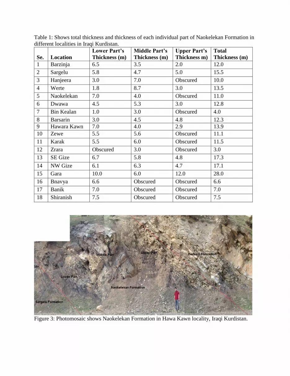
Table 1: Shows total thickness and thickness of each individual part of Naokelekan Formation in
different localities in Iraqi Kurdistan.
Se.
Location
Lower Part’s
Thickness (m)
Middle Part’s
Thickness (m)
Upper Part’s
Thickness m)
Total
Thickness (m)
1 Barzinja 6.5 3.5 2.0 12.0
2 Sargelu 5.8 4.7 5.0 15.5
3 Hanjeera 3.0 7.0 Obscured 10.0
4 Werte 1.8 8.7 3.0 13.5
5 Naokelekan 7.0 4.0 Obscured 11.0
6 Dwawa 4.5 5.3 3.0 12.8
7 Bin Kealan 1.0 3.0 Obscured 4.0
8 Barsarin 3.0 4.5 4.8 12.3
9 Hawara Kawn 7.0 4.0 2.9 13.9
10 Zewe 5.5 5.6 Obscured 11.1
11 Karak 5.5 6.0 Obscured 11.5
12 Zrara Obscured 3.0 Obscured 3.0
13 SE Gize 6.7 5.8 4.8 17.3
14 NW Gize 6.1 6.3 4.7 17.1
15 Gara 10.0 6.0 12.0 28.0
16 Bnavya 6.6 Obscured Obscured 6.6
17 Banik 7.0 Obscured Obscured 7.0
18 Shiranish 7.5 Obscured Obscured 7.5
Figure 3: Photomosaic shows Naokelekan Formation in Hawa Kawn locality, Iraqi Kurdistan.

Figure 4: Stratigraphic column of the Naokelekan Formation in Dwawa Village, Betwata Raniya
area, Iraqi Kurdistan.

kerogenous calcareous shales. The lower part in northwest of Gara Village is 10 m thick and
comprises of thin-bedded, highly kerogenous dolomites, with secondary dolomitic shales. This
part is exceptionally crumpled and distorted locally as a result of preconsolidation slumping, and
with a tendency to weather into large loaf-shaped masses.
Naokelekan Formation is best differentiated in the Chia Gara sections such as in the NW Gize
Village, SE Gize Village, Gali Derash, and in the northwest of Gara Village. At the northwest
and southeast of Gize Village, this part is 6.1 and 6.7 m thick, respectively. At both sections this
part has the same lithological composition.
At Banik this part is 7 m thick and from bottom to top composed of alternating calcareous shale,
coal and coaly, calcareous mudstone, and carbonaceous calcareous mudrock and dolosiltite. At
Galy Derash the thickness of this part is 10 m and from bottom to top composed of organic rich
siliceous calcareous, hard and brittle, and organic rich carbonaceous mud rocks.
At Bnavya this division is 6.6 m thick and composed of highly kerogenous limestone, black, soft.
At Zrara this part is obscured. The thickness of this unit is about 5.5 m in Zewe and 4.5 m in
Dwawa. In both sections the lower part is composed of thin-medium bedded, dark brown, fetid,
kerogenous limestone and dolomitic limestone, intercalated with soft, black, calcareous,
kerogenous shale. Disharmonic fold and some slump structures can be seen. At Werte this part
consists of kerogenous limestone 1.5 m thick, and shale 0.3 m thick. The same highly
kerogenous limestone 5.5 m thick can be observed at Karak (Darga) locality. At Bin Kealan this
part is 1 m thick and consists of black limestone, soft, kerogenous, and fetid but a few kilometers
to the south-west the thickness of this part increases to 7 m at Hawara Kawn.
At both Barsarin and Hanjeera villages, the lower unit is 3 m thick. At the former the section
consists of: dark grey, thin bedded limestone, with black shale intercalations in it and black,
medium to thin bedded carbonaceous limestone, alternating with medium to thin bedded black
shales. At the latter location, the lower 1 m is pink to white color, thin to medium bedded chalky
appearance and the upper 2 m is grey to pink colored, thinly bedded limestone, and thin
interbedded calcareous shales. At Sargelu village this part is 5.8 m thick and consists of
interbeded kerogenous shale and kerogenous limestone while at Barzinja this part is 6.5 m thick
and comprises of interbeded limestone, kerogenous limestone, calcareous organic shale, and has
one layer of kerogenous marly limestone 0.2 m thick.
Figure 5: Shows lower part of Naokelekan Formation in (a) Karak, and (b) Shiranish, Iraqi
Kurdistan.
2.1.2. Middle division (Fig. 6a)
At Naokelekan Village, the middle unit is located beneath Barsarin Formation and it is 4 m thick.
It is composed of fine-grained, hard, mostly thin bedded, fossiliferous, dolomitic limestone or

limestones, dark grey or bluish, with ammonite traces, calcite veined. The repetition of beds as a
result of the presence of thrust fault can be noticed. At NW Gara, the formation is extensively
covered by trees. The lower part is 6 m thick and has the same lithological pattern but rocks
appear lighter and weathering into a prominent scarp, slightly mottled.
At Barsarin this part is 4.5 m thick. It comprises of dark grey limestone, beige on weathering, the
lower 2 m is medium bedded, kerogenous limestones while the remaining upper 2.5 m is thick
bedded, limestones and dolomitic limestone mottled, where the mottled spots are somewhat
irregular, light grey on fresh surface, and up to several centimeters across; highly
ammonitiferous, yet badly conserved and particularly hard for sampling. In the same way, at
Hanjeera this part is 7 m thick and forms a prominent cliff, and is readily recognizable in the
field. It can be divided into two parts: (1) the lower 3.5 m thick is thin bedded limestone with
few argillaceous limestone interbedding; and (2) the upper 3.5 m thick is very thick bedded
limestone. Both parts are grey in color on fresh surface, and beige on weathering, highly
ammonitiferous, nevertheless fossils are badly conserved and hard for sampling.
At all other sections, the Naokelekan has the same lithological component with variety in
thickness. At Zrara only this part occurs and it is 3 m thick. The thickness of this part is 4.7, 3.5,
6.3, 5.8, 6.0, 3.0, 4.0, 8.7, 5.6, and 5.3 m in Sargelu, Barzinja, NW Gize, SE Gize, Karak
(Darga), Bin Kealan, Hawara Kawn, Werte, Zewe, and Dwawa, respectively. At Galy Derash,
Banik, Bnavya and Shiranish this part is obscured.
2.1.3. Upper division (Fig. 6b)
The upper part at type section, Hanjeera, Zewe, Karak (Darga), Bin Kealan, and Zrara is
obscured. In addition to the upper part as mentioned earlier, the middle part is also absent at
Banik, Shiranish, and Bnavya.
At supplementary type section, this part is 12 m thick and consists of laminated shaly kerogenous
limestones alternating with kerogenous shales and dark blue fine-grained limestones and no
fauna is noted (Bellen et al., 1959). It is 4.7 m thick at NW Gize and 4.8 m thick at SE Gize. At
Werte this part is 3 m thick and consists totally of shale and it is also about 3 m thick at
Figure 6: (a) Shows middle part, mottled bed of Naokelekan Formation in Sargelu Village, Iraqi
Kurdistan, and (b) shows upper part of Naokelekan Formation in Werte Village, Iraqi Kurdistan.
Hawara Kawn but consists of alternating shale and limestone. In the latter location some pillow
structures are seen close to Naokelekan’s upper boundary. At Dwawa this part is also 3 m thick
and can be divided into the lower 1.7 m which is dark brown, laminated, fetid, very soft shales
and the remaining upper part is 1.3 m which consists of dark grey, thin-medium bedded, hard,
limestone, argillaceous limestone and dolomitic limestones. Some pillow structures the same as
what was observed at Hawara kawn are present at the upper part of the section.
At Barsarin the upper part is 4.8 m thick and consists of black, thin-medium bedded
carbonaceous limestone, with thin intercalations of black argillaceous limestone, dolomitic
limestones, and black calcareous shale less indurted, no ammonites. At sargelu and Barzinja, this
part consists of shale and kerogenous limstone 5 m and 2 m thick, respectively.
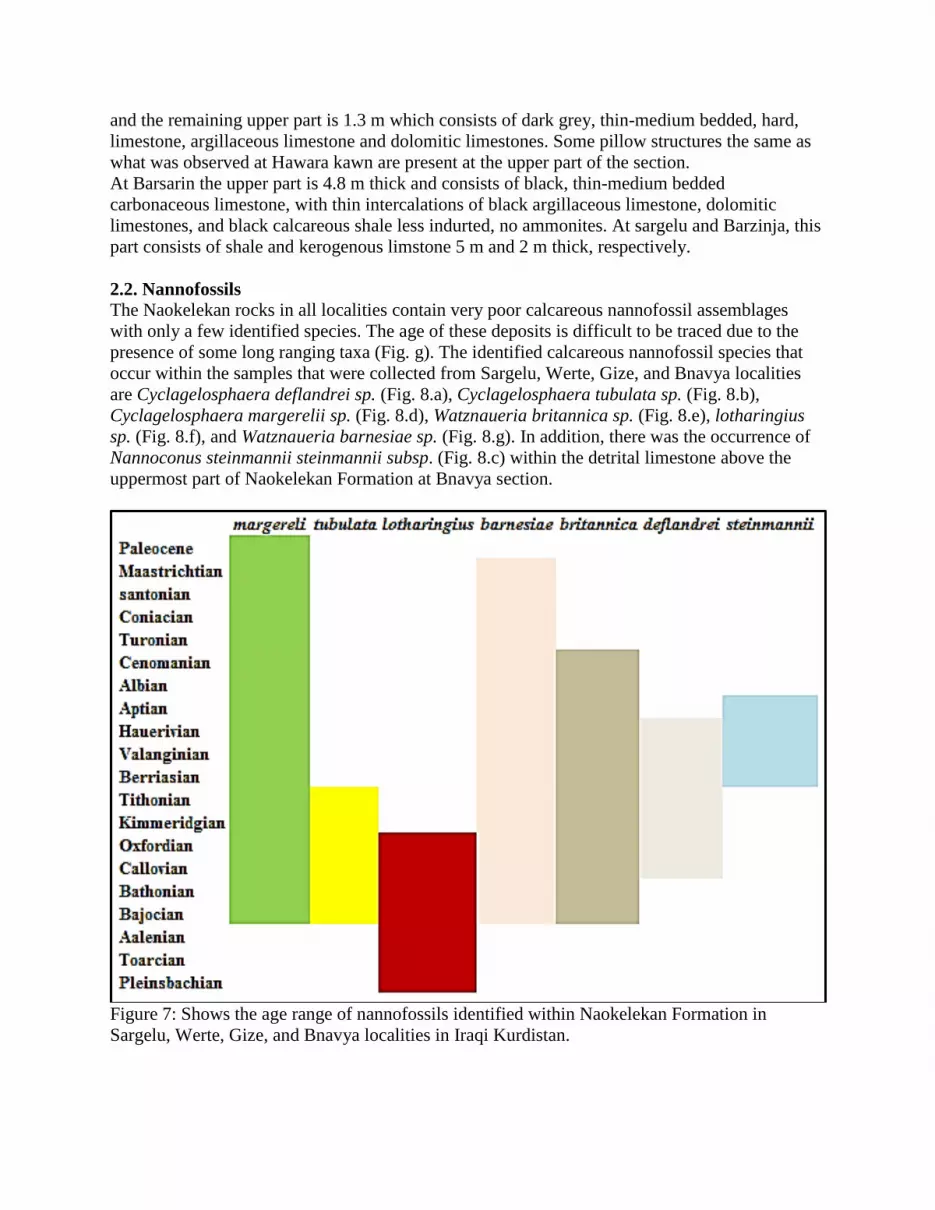
2.2. Nannofossils The Naokelekan rocks in all localities contain very poor calcareous nannofossil assemblages
with only a few identified species. The age of these deposits is difficult to be traced due to the
presence of some long ranging taxa (Fig. g). The identified calcareous nannofossil species that
occur within the samples that were collected from Sargelu, Werte, Gize, and Bnavya localities
are Cyclagelosphaera deflandrei sp. (Fig. 8.a), Cyclagelosphaera tubulata sp. (Fig. 8.b),
Cyclagelosphaera margerelii sp. (Fig. 8.d), Watznaueria britannica sp. (Fig. 8.e), lotharingius
sp. (Fig. 8.f), and Watznaueria barnesiae sp. (Fig. 8.g). In addition, there was the occurrence of
Nannoconus steinmannii steinmannii subsp. (Fig. 8.c) within the detrital limestone above the
uppermost part of Naokelekan Formation at Bnavya section.
Figure 7: Shows the age range of nannofossils identified within Naokelekan Formation in
Sargelu, Werte, Gize, and Bnavya localities in Iraqi Kurdistan.

Figure 8: Different nannofossils from Naokelekan Formation in Iraqi Kurdistan (a)
Cyclagelosphaera deflandrei sp., (b) Cyclagelosphaera tubulata sp., (c) Nannoconus steinmannii
steinmannii subsp., (d) Cyclagelosphaera margerelii sp., (e) Watznaueria britannica sp., (f)
lotharingius sp., and (g) Watznaueria barnesiae sp.
3-Discussion
3.1. Formation boundaries
In all the outcrop sites, Naokelekan Formation is underlain by Sargelu Formation and overlain by
Barsarin Formation (Fig. 3).
3.1.1. Lower boundary
In the studied outcrops, the recognition of the lower contact of the formation is more difficult.
This is due to similarities between the lower units of the Naokelekan and underlying shale of
Sargelu Formation; thus, the change is expected to be gradational (Buday, 1980). The lower
boundary of Naokelekan can be sited within a thin-bedded limestone sequence. The absence of
chert and abundant Bositra buchi sp. differentiate Naokelekan Formation from the underlying
Sargelu Formation. Likewise, the remarkably kerogenous and characteristically slanted nature of
the bed is recognizable from Sargelu Formation (Bellen et al., 1959). At the Gara section, a
resemblance is noticed between limestones from the upper part of Sargelu and lower part of
Naokelekan formations.

3.1.2. Upper boundary
The traditionally accepted boundary between Naokelekan and Barsarin formations was placed at
the top of the stratiform stromatolite bed (Bellen et al., 1959). But according to the cyclicity of
the beds, the blistered stromatolite should belong to the second cycle of the Barsarin Formation.
Therefore the proposed contact will be discrete and conformable between the argillaceous
limestone bed where the upper part is present or above the mottled bed where the upper part is
absent of Naokelekan Formation and at the base of the stratiform stromatolite bed (Salae, 2001).
3.2. Lithology
The chloroform treatment of selected samples of the different parts of the formation verified that
dark colored materials appear to be kerogenous material (Salae, 2001) rather than bituminous as
was reported earlier by Bellen et al. (1959). Only at Sargelu locality, this dark colored material
appears to be a mixture of kerogenous and bituminous and was used similar to what was used by
residents at Shiranish for heating.
A detrital ferruginous horizon was observed by Hamza and Isaac (1971, in Buday, 1980) above
the uppermost beds of Naokelekan Formation between Benavya and Hadiyna in the Northern
Thrust Zone. They included this horizon in Naokelekan Formation but this detrital rock was not
confirmed to be part of Naokelekan Formation based on occurring nannofossil Nannoconus
steinmannii steinmannii subsp. (Fig.8.3) which is the Berriasian key fossil within this horizon
(Bralower et al., 1989). The same detrital limestone occurs at Shiranish (Fig. 9a). The lower and
upper parts of Naokelekan Formation are obscured at Banik. Consequently Naokelekan
Formation is represented by only the lower part in Bnavya, Banik, and Shiranish localities. The
absence of both parts is possibly related to lateral facies change because the lower part is
reasonably thicker throughout this area, the northwestern region, than what appears at other
localities.
These two parts may not be deposited or eroded similar to what was observed in subsurface
sections in the north and west of Mosul where the whole Upper Jurassic sequence was not
deposited or eroded in Late Jurassic or Early Cretaceous. In the latter area, the Albian Sarmord
Formation overlies the Sargelu Formation directly (Bellen et al., 1959). The depositional
discontinuities above the "Mottled bed" that was suggested by Spath (1950 in Bellen et al., 1959)
might exist as noticed at type section, Hanjeera, Zewe, Karak (Darga), Bin Kealan, and Zrara
where the upper part is obscured. The Callovian break is a well-known break all over western
and southwestern Iraq where sufficient uplift occurred (Buday, 1980; Marouf, 1999). This break
is also noticed at western Khuzestan and Lurestan and at Emam Hasan and Masjed-e Suleyman
in Iran (James and Wynd, 1965).
At Hanjeera the lower part which is referred to as the Coal horizon of informal field
nomenclature at type locality (Bellen et al., 1959) is 3 m thick and different by not being
kerogenous. This part is characterized by pink to white color, thin to medium bedded of chalky
units, buff on weathering, highly porous and showing signs of dissolution (1 m) and the upper
beds within this part is represented by grey to pink colored, thinly bedded limestone, with few
lensoid structures, and including ammonites, large scale slumping, and thin interbedded
calcareous shales (2 m) (Salae, 2001).
Similar lithologic components can be noticed at Dwawa, Werte, Hawara kawn, and Barsarin
sections and they represent typical tripartite divisions of Naokelekan Formation. At Barsarin, the
lower unit is 3 m thick and consists of dark grey, thin bedded limestone, light grey on
weathering, with black shale intercalations in it both show slumping contortion structures and

black, medium to thin bedded carbonaceous limestone, yellowish on weathering, alternating with
medium to thin bedded black shales, with no macrofossils (Salae, 2001). On the contrary, at
Banik only lower part exists and it is 7 m thick and from bottom to top is composed of
alternating calcareous siltstone and shale which is 2 m thick and has dark grey to black brittle
coal and coaly calcareous mudstone 4 m thick which is black, brittle and hard and 1 m
carbonaceous calcareous mudrock and dolosiltite which is dark grey, thin massive bedding (Al-
Badri, 2012). The latter author added that at Galy Derash the thickness of this part is 10 m and
can be divided into siliceous calcareous siltstone and coal which is black, brittle, organic rich 1
m thick, calcareous siltstone and shale bedded with thin coal layers which is black, compacted,
hard and brittle 4 m thick, and organic calcareous, carbonaceous mud rocks 5 m thick which is
grey, hard, compacted organic rich.
The variation in total organic carbon of Naokelekan Formation can be noticed as a result of
environmental condition variability. It is noticed that the lower part is the richest part regarding
organic matter content. Therefore the average richness increases when the lower part is thick
such as in Banik, Gali Derash, Barsarin, and Karak, and vice versa (Abdula, 2015).
3.3. Thickness variation
The thickness throughout the studied area is not consistent and the increase or decrease doesn’t
follow any specific trend (Fig. 2 and Table 1). This inconsistency reflects the paleogeographic
condition during the deposition of Naokelekan Formation that was characterized by the existence
of isolated basins (Buday, 1980). The Upper Jurassic Period is characterized by the expansion of
comparatively widespread uplifts. Accordingly, basins were disconnected with diverse
sedimentary regimes (Ditmar et al., 1971 in Buday, 1980). These uplifts and basins are
commonly of NW-SE trend and originated as a result of Kimmerian orogenic movements during
Late Jurassic in the Turkish-Iranian geosynclinal area (Stocklin, 1968).
3.4. Age problem
The first occurrence of Cyclagelosphaera margerelii sp. (Fig. 8.d) takes place into NJ11 Biozone
(NJ = nannofossils Jurassic, Tethyan biozonesa after Mattioli and Erba, 1999) (Upper Bajocian).
The nannofloras Watznaueria britannica sp. (Fig. 8.e) and Watznaueria barnesiae sp. (Fig. 8.g)
have their first occurrence into NJ9 Biozone (Lower Bajocian) (Burnett, 1998; Bown and
Cooper, 1998). Thus, the age of these deposits is post-Bajocian. Based on the presence of
lotharingius sp. (Fig. 8.f) together with Cyclagelosphaera tubulata sp. (Fig. 8.b) at the upper part
of Naokelekan Formation in Werte locality and Cyclagelosphaera deflandrei sp. (Fig. 8.a) which
has a range given as Callovian/ Kimmeridgian to Hauterivian (Roth, 1973; Moshkovitz and
Ehrlich, 1987) at lower part of Naokelekan Formation in Bnavya section, the age of the deposits
can be placed between Callovian (NJ13 Biozone–first occurrence of Cyclagelosphaera
deflandrei sp.) and Upper Oxfordian (NJ15a–last occurrence of lotharingius) (Bown and Cooper,
1998).
The erosional unconformity or depositional break between Sargelu and Naokelekan formations
which has not been observed and confirmed by evidence in the studied outcrops in the field
supports the Callovian as an age for the base of coal bed (Bellen et al., 1959) because the
underlying “Posidonia bronni”, which has been re-classified as “Bositra buchi” (Fig. 9b) by
Steiner et al., (1998) and belong to Posidoniidae family of the Sargelu Formation, is definitely of
Middle Jurassic age. Additionally, the occurrence of choffatia sp. at Karak locality, Kurrek
Mountain suggests a Callovian age for the base of coal bed (Bellen et al., 1959). Regarding the

Upper Oxfordian as an age for the top part, it may be supported by the presence of the possible
earlier identifications of ammonite reineckia sp. at Naokelekan Village which proposes Late
Oxfordian for the top of coal horizon (Bellen et al., 1959).
The detrital limestone deposits (Fig. 9a) which were earlier included in Naokelekan Formation
(Hamza and Isaac, 1971 in Buday, 1980) are characterized by a very low abundance of
calcareous nannofossils. The age of this horizon has given by the presence of Nannoconus
steinmannii steinmannii subsp. (Fig. 8.c). The first occurrence of the genus Nannoconus is
almost synchronous with the Tithonian/ Berriasian boundary and thus the Jurassic/Cretaceous
boundary (Deres and Acheriteguy, 1980). The first occurrence of Nannoconus steinmannii
steinmannii subsp. is Lower Berriasian (145.01Ma) and the last occurrence of this subsp. takes
place in Lower Aptian NC6b (NC = nannofossils Cretaceous) Biozone (Bralower et al., 1989).
Thus the age of these deposits can be constrained between Lower Berriasian and Lower Aptian.
Therefore it may be possible to not include the detrital limestone deposits in Naokelekan
Formation.
3.5. Paleoecology
The Watznaueria barnesiae sp. (Fig. 8.g) is a good indicator of surface water fertility. Numerous
studies revealed that Watznaueria barnesiae sp. is predominantly a low-nutrient indicator
(Doeven, 1983; Watkins and Self-Trail, 2005; Watkins et al., 1996). Watznaueria barnesiae sp. is
a cosmopolitan species which is commonly dominant in humid latitudes and merely common in
high-latitude places. Thus, several authors used it as a warm-water indicator (Roth and
Krumbach, 1986; Fisher and Hay, 1999). Cyclagelosphaera margerelii sp. has been interpreted
as an element of extremely abundant low differentiated neritic nannofloral assembly from a
lagoonal environment with obvious salinity differences (Tremolada et al., 2006).
Figure 9: (a) Shows detrital limestone above Naokelekan Formation in Shiranish locality, Iraqi
Kurdistan, and (b) shows Bositra buchi sp. in upper part of Sargelu Formation in Sargelu
Village, Iraqi Kurdistan
3.6. Paleogeography
The paleogeography all over the Malm (Fig. 10) was controlled by the Kimmerian tectonic
activity. This orogeny led to episodic isolation of the basin as a result of discrepancy subsidence.
Therefore, different sedimentary regimes occurred (Buday, 1980; Jassim and Buday, 2006). The

area of the High Folded, Imbricated and Northern Thrust zones is characterized by a condensed
sedimentary succession of euxinic character in the lower part (Naokelekan Formation) and
lagoonal evaporitic character in the upper part (Barsarin Formation) (Buday, 1980; Jassim and
Buday, 2006). The trend of these basins and uplifts are generally northwest—southeast. The
northern part of the basin was isolated from the southern part by tectonic ridge. The northeastern
edge of the ridge is unidentified while the southwestern edge of the ridge area agrees with the
Dohuk—Chemchemal—Chia Surkh Uplift (Ditmar et al., 1971 in Buday, 1980). This ridge route
separated a basin of neritic sedimentation (Najmah) from the condensed shallow reducing
environment (Naokelekan).
Generally Naokelekan Formation characterizes two different environments: (1) Brackish lagoon
which is represented by the slumped and carbonaceous limestone and argillaceous limestone
lithofacies at the lower part and upper part, respectively; (2) Shallow marine which is
represented by the mottled beds (Salae, 2001). Algal mat (Fig. 11) develops in shallow marine
subtidal to supratidal environments (Fig. 12).
The formation was deposited in an euxinic environment in a very slightly subsiding or starved
basin (Jassim and Buday, 2006). The presences of calcareous fragments that represent thin-
shelled bivalve remains propose a highly restricted depositional environment. Furthermore the
occurrence of Cyclagelosphaera margerelii sp. in all localities supports the restricted
depositional setting as this nanofossil is characteristic of this type of environment (Keupp, 1976).
4. Conclusion
The main conclusions from this study are:
The thickness throughout the studied area is not consistent and the increase or decrease
doesn’t follow any specific trend. The change in thickness is due to the occurrence of
isolated basins as a result expanding uplifting during Late Jurassic.
An obscuring upper part and/or middle part at some localities. The obscuring is due to
facies change or erosion and/or non-deposition.
The detrital limestone horizon is proposed not to be included in Naokelekan Formation
based on nannofossil Nannoconus steinmannii steinmannii subsp.
The age of Naokelekan Formation can be placed between Callovian and Upper Oxfordian
based on the occurrence of Cyclagelosphaera deflandrei sp. and lotharingius sp.
The high latitude geographic location of depositional basin was warm water characterized
by low-nutrient according to the presence of Watznaueria barnesiae sp.
The occurrence of Cyclagelosphaera margerelii sp. in all localities indicates the
restricted marine depositional setting.
The shallow marine subtidal to supratidal environments can be confirmed by occurring
algal mat on surface rocks.
The organic-rich sediments designate an euxinic (anoxic) depositional condition.
ACKNOWLEDGMENTS My deepest thanks to K.H. Karim at Department of Geology, Faculty of Science at Sulaimani
University, Iraqi Kurdistan for his kind review and his offering of many suggestions.

Figure 10: Paleogeography during deposition of Naokelekan Formation (redrawn after Buday,
1980).
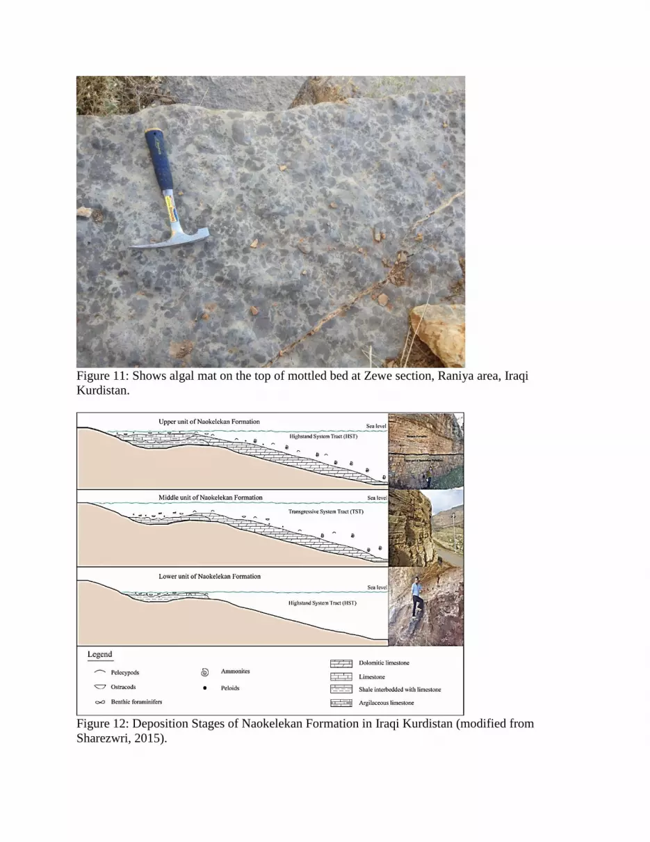
Figure 11: Shows algal mat on the top of mottled bed at Zewe section, Raniya area, Iraqi
Kurdistan.
Figure 12: Deposition Stages of Naokelekan Formation in Iraqi Kurdistan (modified from
Sharezwri, 2015).

REFERENCES
Abdula, R.A, 2015, Source rock assessment of Naokelekan Formation in Iraqi Kurdistan:
unpublished report, 20p.
Ahmed, M.A., 1997, Sedimentary facies and depositional environments of Jurassic rocks, NW
Iraq: Ph.D. dissertation (unpublished), Science College, University of Mosul, Mosul, Iraq, 170 p.
(in Arabic).
Ahmed, A.A. and A.S. Al-Gibouri, 2008, Geochemical and palynological analysis in assessing
hydrocarbon potential and palaeoenvironmental deposition, North Iraq: Journal of Petroleum
Research & Studies, no. 2, 2nd year, pp. 98-116.
Al-Badry, A.M.S., 2012, Stratigraphy and geochemistry of Jurassic formations in selected
sections – north Iraq: Ph.D. Dissertation (unpublished), Science College, University of Baghdad,
Baghdad, Iraq, 183 p.
Al-Omari, F.S. and A. Sadiq, 1977, Geology of northern Iraq: Mosul University Press, Mosul,
Iraq, 198 p. (in Arabic).
Al-Sayyab, A., N. Al-Ansari, D. Al-Rawi, J. Al-Jassim, F. Al-Omari, and Z. Al-Shaikh, 1982,
Geology of Iraq: Mosul University Press, Mosul, Iraq, 280 p. (in Arabic).
Alsharhan, A.S. and A.E.M. Nairn, 2003, Sedimentary basins and petroleum geology of the
Middle East: Elsevier Science B. V., Amsterdam, Netherlands, 843 p.
Altinli, I.E., 1966, Geology of eastern and southeastern Anatolia, Turkey: Bulletin of Mineral
Research Exploration Institute of Turkey, Foreign Edition, Ankara, no. 60, pp. 35-76.
Aqrawi, A.A.M., A.D. Horbury, J.C. Goff, and F.N. Sadooni, 2010, The petroleum geology of
Iraq: Scientific Press Ltd., UK, 604 p.
Baban, D.H. and S.M. Ahmed, 2014, Vitrinite reflectance as a tool for determining level of
thermal maturity for the Upper Jurassic Naokelekan and Barsarin formations in Sargelu location,
Kurdistan Region, NE Iraq: Arabian Journal of Geosciences, v. 7, issue 6, pp. 2269-2277.
Balaky, S. M., 2015, Sequence stratigraphic analyses of Naokelekan Formation (Late Jurassic),
Barsarin area, Kurdistan region—northeast Iraq: Arabian Journal of Geosciences, v. 8, issue 8,
pp. 5869-5878
Bellen, R.C. van, H.V. Dunnington, R. Wetzel, and D.M. Morton, eds., 1959, Lexique
stratigraphic international: Paris, v. III, Asie, Fascicule 10a Iraq, 333 p.
Bown, P.R. and Cooper, M.K.E., 1998. Jurassic, in Bown, P.R. (Ed.), Calcareous nannofossil
biostratigraphy: British Micropalaeontological Society Series. Kluwer Academic Press,
Dordrecht, pp. 34–85.

Bralower, T.J., S. Monechi, and H.R. Thierstein, 1989, Calcareous nannofossil zonation of the
Jurassic--Cretaceous boundary interval and correlation with the geomagnetic polarity timescale:
Marine Micropaleontology, v. 14, pp. 153-235.
Buday, T., 1980, The regional geology of Iraq, v. 1, stratigraphy and paleogeography: Dar Al-
Kutub Publishing House, University of Mosul, Mosul, Iraq, 445 p.
Burnett, J.A, 1998, Upper Cretaceous, in Bown, P.R. (Ed.), Calacreous nannofossils
biostratigraphy: British Micropalaeontological Society, Publications Series, Kluwer Academic,
London, pp. 132-199
Deres, F. and J. Acheriteguy, 1980, Biostratigraphie des Nannoconides: Bulletin des Centres de
Recherches Exploration-Production Elf-Aquitaine, v. 4, no. 1, pp. 1-53.
Doeven, P.H, 1983, Cretaceous nannofossil stratigraphy and paleocology of the Canadian
Atlantic Margin: Geological Survey of Canada, Vancouver, 69p.
Erbil Geological Survey (2015, pers. Comm.)
Fisher, C.G. and W.W. Hay, 1999, Calcareous nannofossils as indicators of Mid-Cretaceous
paleofertility along an ocean front, U.S. Western Interior, in Barrera, E. and Johnson, C.C.,
(Eds.): , Evolution of the Cretaceous Ocean-Climate System: Geological Society of America,
Boulder, pp. 161-180.
Howarth, M.K. and D.T. Donovan, 1964, Ammonites of the Lassic family Juraphy llitidae in
Britain: Palaeontology, v. 7, pp. 286-305.
Ibrahim, M.W., 1981, Chronometry of the Late Jurassic in the Middle East-A Review: Revue De
L’Institut Francais Du Petrole, v. 36, pp. 595–606.
James, G.A., and J.G. Wynd, 1965, Stratigraphic nomenclature of Iranian oil consortium
agreement area: AAPG Bulletin, v. 49, no. 12, pp. 2182-2245.
Jassim, S.Z., and T. Buday, 2006, Late Toarcian-Early Tithonian (Mid-Late Jurassic)
Megasequence AP7, chapter 10, in Jassim, S.Z., and J.C. Goff, eds., Geology of Iraq, first
edition: Brno, Czech Republic, Prague and Moravian Museum, pp. 117-123.
Keupp, H., 1976, Kalkiges nannoplankton aus den Solnhofener Schichten (Unter-Tithon,
Südliche Frankenalb), calcareous nannoplankton from the Solnhofen limestone (L. Tithonian,
Bavaria), Neues Jahrbuch für Geologie und Paläontologie, Monatshefte, pp. 361-381.
Marouf, N.Z., 1999, Dynamic evolution of the sedimentary basins in northern Iraq and
hydrocarbon formation, migration and entrapment: Ph.D. dissertation (unpublished), Science
College, University of Baghdad, Baghdad, Iraq, 236 p.

Moshkovitz, S. and A. Ehrlich, 1987, Watznaueria manivitae Bukry—taxonomic problems and
distribution in the Jurassic-Lower Cretaceous sediments of Israel and other Tethyan areas:
Newsletter of the International Nannoplankton Association, v. 9, no.3, pp.110-115.
Mattioli, E. and E. Erba, 1999, Synthesis of calcareous nannofossil events in the Tethyan Lower
and Middle Jurassic: Rivista Italiana di Paleontologiae Stratigrafia, v. 105, pp. 343-376.
North Oil company (2015, pers. Comm.)
Roth, P.H. and K.R. Krumbach, 1986, Middle Cretaceous nannofossil biogeography and
preservation in the Atlantic and Indian oceans-Implications for palaeoceanography: Marine
Micropaleontology, v. 10, no. 1-3, pp. 235-266, doi:10.1016/0377-8398(86)90031-9
Roth, P.H., 1973, Calcareous nannofossils—Leg 17 of the Deep Sea Drilling Project, in
Winterer, E.L. and J.I. Ewing (Eds.), Initial Reports of the Deep Sea Drilling Project: U.S.
Government Printing Office, Washington pp. 695–795.
Salae, A.T.S., 2001, Stratigraphy and sedimentology of the Upper Jurassic succession, northern
Iraq: Master’s thesis (unpublished), Science College, University of Baghdad, Baghdad, Iraq, 95
p.
Sharezwri, A.O.H., 2015, Stratigraphy, microfacies analysis and depositional environment of the
Upper Jurassic Naokelekan Formation from selected sections in Kurdistan Region, NE Iraq:
Bachelor’s project (unpublished), Science Faculty, Soran University, Soran, Iraqi Kurdistan, 61
p.
Steiner, C., A. Hobson, G.M. Stampfli, and J. Hernandez, 1998, Mesozoic sequence of
Fuerteventura (Canary Islands): Witness of Early Jurassic sea-floor spreading in the central
Atlantic: Geological Society of America Bulletin, v. 110, no. 1, pp. 1304–1317.
Stöcklin, J., 1968, Structural history and tectonics of Iran-a review: AAPG, Bulletin, v. 52, no. 7,
pp. 1229-1258.
Tremolada F., A. Bornemann, T.J. Bralower, C. Koeberl, and B. van de Schootbrugge, 2006,
Paleoceanographic changes across the Jurassic/Cretaceous boundary--the calcareous
phytoplankton response: Earth and Planetary Science Letters, v. 241, pp. 361-371.
Watkins, D.K. and J.M. Self-Trail, 2005, Calcareous nannofossil evidence for the existence of
the Gulf Stream during the Late Maastrichtian: Paleoceanography, v. 20, 9p. doi:
10.1029/2004PA001121
Watkins Jr., D. K., S.W. Wise, J.J. Pospichal, and J Crux, 1996, Upper Cretaceous calcareous
nannofossil biostratigraphy and paleoceanography of the Southern Ocean, in: Moguilevsky, A.
and Whatley, R. (Eds.), Microfossils and oceanic environments: University of Wales-
Aberstyweth Press, Aberystwyth, pp. 355-381.


