Embed Size (px)
Citation preview

Japan International Cooperation Agency The Republic of Cameroon Ministry of Mines, Water and Energy
Feasibility Study on Rural Electrification Project
in
The Republic of Cameroon
Summary Report
December 1999
Electric Power Development Co., Ltd.

- 1 -
Conclusions and Recommendations
The Republic of Cameroon (“Cameroon”) made a drastic revision of its Electric Power
Sector Law by Law No. 98/022 on December 24, 1998, and inaugurations of an Electric
Power Sector Regulating Agency and a Rural Electrification Agency as of June 15 and
September 8, 1999, respectively, were approved by President Paul Biya. This means that,
along with introduction of privatization of the electric enterprises, on the other hand,
financial and technical aid from the Cameroonian Government for promotion of rural
electrification is now ensured, indicating in essence that eliminating the chronic shortage in
supply of electric power to rural areas, thus improving the livelihood of the people is
considered indispensable for Cameroon to become economically self-sustaining.
The Survey Team, in view of such a situation and based on a total of six field investigation
trips and the results of discussions with various government agencies, conducted studies for a
program of rural electrification by means of small hydroelectric power stations.
The Survey Team carried out investigations in the field regarding Ngambe-Tikar, Ndokayo,
and Olamze which had been named by the Cameroonian Government as prospective sites for
small hydro-electric power generation projects. Hydroelectric power development plans
were formulated based on investigations of topographical and geological features of the
localities, and technical and economic studies were made. The resulting conclusions and
recommendations are as follows.
Conclusions
1. It is technically possible for an intake dam and power station to be constructed at
each of the proposed sites, while socio-economically, electrification of neighboring
rural communities through construction of a hydroelectric power station will
contribute extremely to improvement of the livelihood of local people. However,
as for the Ngambe-Tikar site, the civil structures are excessive due to 10 m3/s of
power station water discharge and about 1,000 m3/s of flood discharge to be
considered in design. As for the Olamze, the Woro river flows in gentle slope
through the flat lands, and an upstream road-bridge site was inundated in the recent
flood so that further inundation of the surrounding villages are feared by new
intake-dam implementation. The Ndokayo site, particularly, is favored with
optimum conditions for a power station of the scale contemplated, and is a superb
site for hydro power.

- 2 -
2. Peak demand (kW) is forecasted in the assumption that an annual increase of
population is 3 percent, and one half of house-holds receive the electricity, with 500
W each, in the environs, plus expected demand of local industries. In the meantime,
the maximum scale of installed capacity is found for the 3 sites based on the usual
way in the central Africa that a 180 days river discharge is set up as a standard
against which the max. discharge of the power station is selected, as follows:
Projected Installed Capacity Forecasted Demand in 2010
Ngambe-Tikar 530 kW (2 units) 560 kW
Ndokayo 4,530 kW (3 units) 4,620 kW
Olamze 400 kW (2 units 1,145 kW
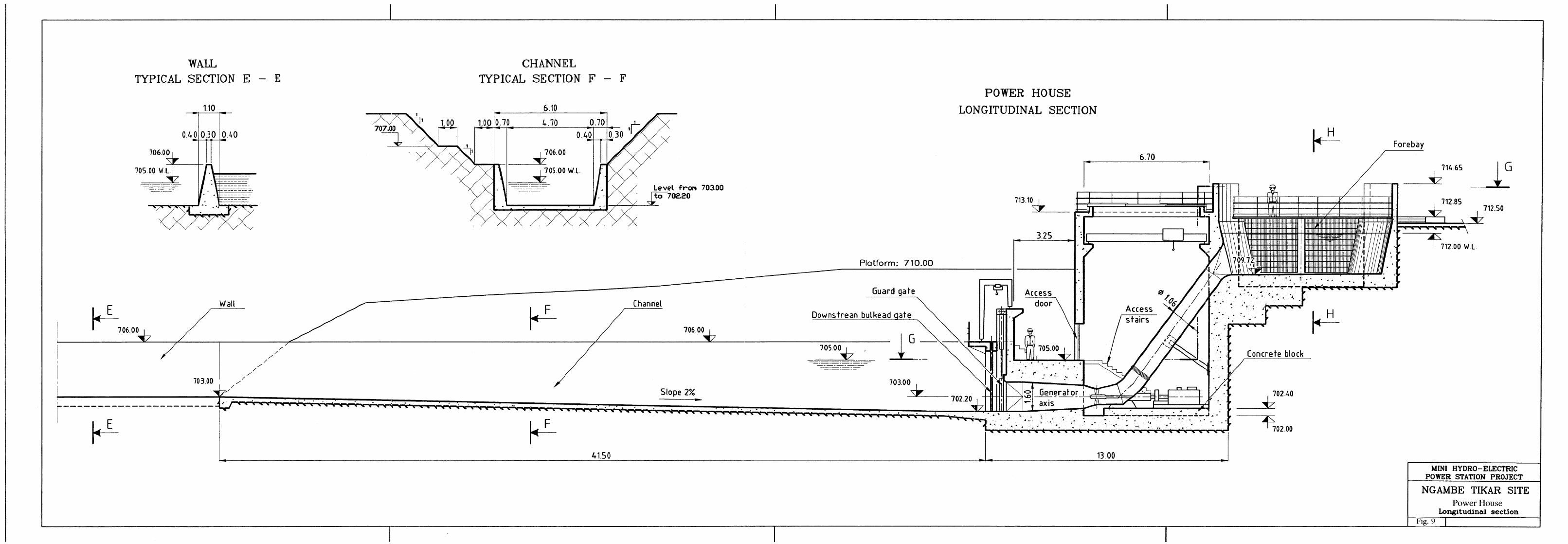
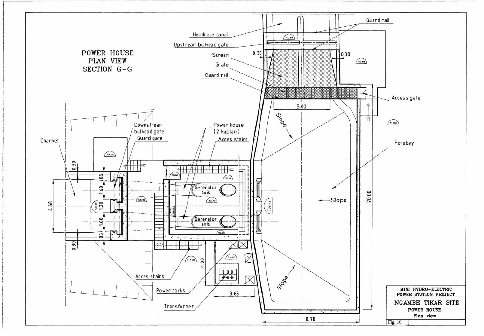
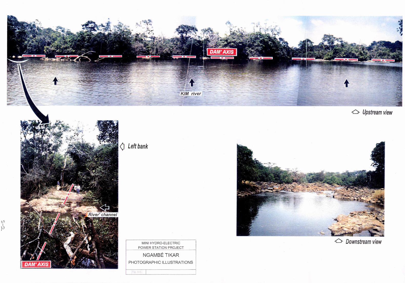
3. Ngambe-Tikar Hydro-Project
There is few suitable site for the mini-hydro project in the vicinity of Ngambe-Tikar
village. The present project is found on the Kim river six kilometres south from the
village. The headrace canal of 500 m long is constructed on the left bank, the
generators of 530 kW of installed capacity produce 3.92 GWh of energy per year by
the water head of 7 m and the max. water discharge of 10 m3/s. It will be sent to
the village of Ngambe-Tikar and its environs by the 30 kV transmission of 25 km
long. The intake dam could be made inexpensive by good use of the rock outcrops
in the riverbed, however, only a few head available, a large and long canal needed,
and the structure shall be built to withstand about 1,000 m3/s of flood discharge.
The project costs amount to 1,852 x 106 F.CFA for the civil works, 2,475 x 106
F.CFA for the electromechanical works, 335 x 106 F.CFA for the transmission lines,
and 5,203 x 106 F.CFA in total inclusive of the engineering costs. The project cost
per kWh and kW is, respectively, 138 F.CFA and 9.8 x 10⁶ F.CFA, and the
hydro-project could not be justified in comparison with the diesel power station if
based on such ordinary or commercial method of economic evaluation as so far
made. (100 F = 17.6 Japanese Yen for reference)
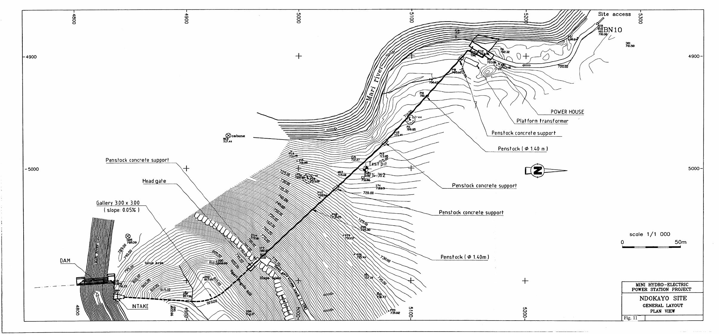
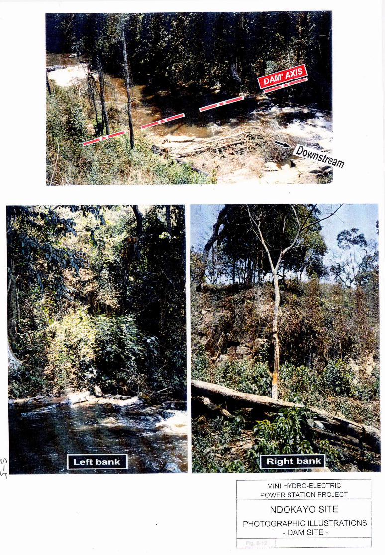
4. Ndokayo Hydro-Project
1) The Ndokayo Project, approximately 10 km from Betare Oya, is a
hydroelectric power development scheme which would make use of the
head of 91 m provided by the waterfalls of Mari. Intake of 4 m3/s of water
to be used would be done in the right bank with a wet masonry concrete
dam 4.5 m in height, with this water conducted to a power station by a
headrace tunnel (length 133 m) and a steel penstock (length 306 m, inside

- 3 -
diameter 1.4 m), with electric energy of 30.6 GWh produced annually using
three Francis turbines and generators (output 4,530 kW). The electric
power generated would be supplied by 30 kV transmission lines 152 km in
length to the Betare Oya and Ndokayo districts, of course, and to Garoua
Boulai District and the districts of Monbal, Borongo Garga, and Sarali as
well.
2) Construction of the Ndokayo Project would be carried out in two phases in
consideration of the power demand in the district. That is, two generators
(output 3,020 kW) would be installed by 2003 with the remaining one unit
installed by the end of September 2010. The construction period for the
first phase would be 18 months extending over two dry seasons. Materials
and equipment for civil works would be mostly procured inside Cameroon,
and electrical and mechanical equipment for the power station and
surroundings would be imported. However, with regard to transmission
lines, the system employed in Cameroon up to the present is to be preserved
in aiming for convenience of maintenance and control.
3) The construction cost of Ndokayo Hydroelectric Power Station would be as
given below.
(Unit: 106 F.CFA)
i) Hydro Power Project 1st Phase
Construction
(3,020 kW)
2nd Phase
Construction
(1,510 kW)
Total
Civil Construction Cost 2,540 16 2,556
Electrical Construction Cost 3,360 1,185 4,545
Engineering and
Administration Cost
738 150 888
Sub-total 6,638 1,351 7,989
ii) Transmission Line(152km)
Construction Cost 1,630 1,630
Engineering and
Administration Cost
432 432
Sub-total 2,062 2,062
Total 8,700 1,351 10,051
(100F = 17.6 Japanese Yen)

- 4 -
4) The generating cost of Ndokayo Hydroelectric Power Station, for ultimate
output of 4,530 kW, is extremely cheap at 39 F.CFA/kWh. When
compared with the alternative thermal (diesel plant), the economic internal
rate of return, for development in two phases, is 11.5%, and with
benefit/cost ratio and benefit-minus-cost 1.27 and 2.22 x 10⁶ francs CFA,
respectively, the economics is amply favorable.
5) Ndokayo Hydroelectric Power Station would make use of the waterfalls of
Mari having a head as much as approximately 90 m. With intake of 6 m3/s,
there is slight fear that the falls may be drained up temporarily in the dry
season, however, it could be prevented by the daily regulation of water in
the pond. The project site including the intake pond is in the state land,
not inhabited and no rare biota has been confirmed.
6) Today, in Cameroon, almost all of the meager existing facilities for rural
electrification have become antiquated and, because of shortage of funds,
repairs are not being made promptly. Work on new electrification projects
is faced with extreme trouble in getting started due to difficulties in
procurement of funds. However, with the new Electric Enterprise Law
enacted, it is necessary to start new rural electrification projects using hydro
power, and Ndokayo Hydroelectric Power Station would be an answer to
this demand.
Income from sales of electric power in operation after completion of
Ndokayo Hydroelectric Power Station will indicate a high rate of return,
and with repayment of all or part of the amount to the abovementioned
Rural Electrification Agency, it will be possible for funds to be furnished
other rural area hydro power projects. A considerable effect is expected of
the project in this way, while at the same time, since it will contribute to
improvement in the livelihood of local residents, implementation of this
project will have a tremendous significance.
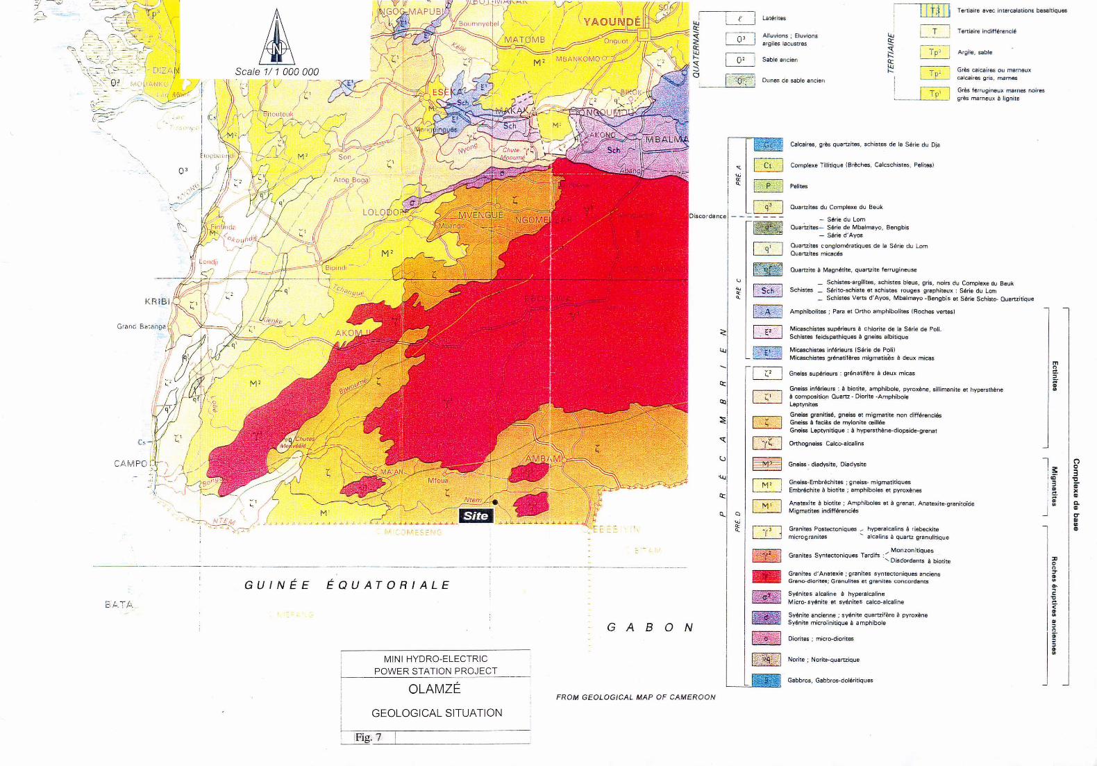
5. Olamze Hydro-Project
As in the case of Ngambe-Tikar, there is few suitable site for the mini-hydro project
on the Woro river near the village of Ata’antem. The present project is to build a
compact structure of so-called dam-type power station on the rock outcrop portion of
the Woro riverbed. It will produce 2.64 GWh of energy per year through the
generators of installed capacity of 400 kW, by the use of 6 m of water head created
and 9 m3/s of max. water discharge. The energy will be sent on the 30 kV

- 5 -
transmission line of 47 km long, and respond to the demand of Ambam and Olamze
area in close connection with the existing diesel power stations of 900 kVA.
The project costs amount to 1,409 x 106 F.CFA for the civil works, 2,535 x 106
F.CFA for the electromechanical works, 615 x 106 F.CFA for the transmission lines,
and 5,055 x 106 F.CFA in total inclusive of the engineering costs. The project cost
per kWh and kW is 197 F.CFA and 12.6 x 10⁶ F.CFA, respectively, and the
hydro-project could not be justified in comparison with the diesel power station if
based on such an ordinary or commercial method of economic evaluation as so far
made.
Recommendations
1. Ndokayo Hydro, according to this present investigation, is judged to be a technically
and economically feasible development project. It is desirable for this project to be
planned for completion of its first phase (power station output 3,020 kW) by 2003 in
consideration of the demand in this district. Taking into account preparations and
the construction period, it is recommended that preparations for realization such as
arrangements for development funds and execution of definite design work be
carried out promptly.
2. With regard to the two projects of Ngambe-Tikar and Olamze, if going by
conventional evaluation techniques, hydro will not be economically advantageous in
comparison with alternative thermal. However, when the calls for realization of
hydroelectric power stations from the local residents are considered, it is desirable
for studies concerning these projects to be continued. However, with respect to the
Olamze Project, it is first necessary to ascertain what effects will be brought about
by backwater upstream from the pond resulting from construction of the intake dam
on bridges and roads, residential areas and cultivated fields.
3. The Ndokayo hydro-project would be first rural electrification which is to be
implemented under the new Electric Power Sector Law. For this reason, prior to
the start of construction, the concrete set-up should have been made, by the
cooperation of the ministries concerned and SONEL, not only of the frame-work but
also of the definite plan, which will cover the details of management, organization
and operation of the power station.


Summary Report
Contents
1. Introduction.......................................................................................... 1
1.1 Background of Project ............................................................ 1
1.2 Objectives and Scope of Study ................................................ 1
1.3 Progress of Study.................................................................... 2
2. Outline of the Republic of Cameroon.................................................... 3
2.1 Geography and Climate ........................................................... 3
2.2 Government ............................................................................ 4
2.3 Economy................................................................................. 4
2.4 Energy Resources.................................................................... 5
3. Present Condition of Rural Electrification ............................................. 9
3.1 Present Condition.................................................................... 9
3.2 New Electric Power Sector Law.............................................. 10
4. Summary of the Area............................................................................ 15
4.1 Social Environment ................................................................. 15
4.2 Natural Environment ............................................................... 18
5. Hydrologic Analysis.............................................................................. 20
5.1 Meteorological and Hydrological Data .................................... 20
5.2 Runoff Analyses of Ngambe-Tikar Site.................................... 20
5.3 Runoff Analyses of Ndokayo Site............................................ 21
5.4 Runoff Analyses of Olamze Site .............................................. 22
6. Power Demand Forecast and Supply Plan ............................................. 22
6.1 Methodology........................................................................... 22
6.2 Future Load Pattern (kWh) ..................................................... 24
6.3 Power Supply Plan .................................................................. 27
7. Geology................................................................................................ 27
7.1 Ngambe-Tikar Site .................................................................. 27
7.2 Ndokayo Site .......................................................................... 28
7.3 Olamze Site............................................................................. 31

8. Power Generation Project ..................................................................... 31
8.1 Ngambe-Tikar Site .................................................................. 31
8.2 Ndokayo Site .......................................................................... 34
8.3 Olamze Site............................................................................. 37
9. Environmental Protection Measures...................................................... 44
9.1 Environmental Preservation Measures ..................................... 44
9.2 Monitoring Program................................................................ 46
9.3 Evaluation............................................................................... 48
10. Construction Program, Construction Schedule, and Construction Cost . 50
10.1 Construction Program, Construction Schedule ........................ 50
10.2 Construction Materials ............................................................ 51
10.3 Construction Cost ................................................................... 51
11. Economic Evaluation and Financial Analysis ......................................... 56
11.1 Generation Cost per kWh........................................................ 56
11.2 Economic Evaluation .............................................................. 57
11.3 Financial Analysis.................................................................... 60

-1-
Summary Report
1. Introduction
1.1 Background of Project
The Republic of Cameroon is providing approximately 98% of the electric power
generated within its boundaries by means of water power. The electric energy
production during one year in 1994-1995 was 2,735 GWh, while in 1995-1996 it
was 2,823 GWh.
The power transmission distribution structure of the country is divided into the
Southern System with its power sources Edea and Song-Loulou Hydro Stations, and
the Northern System with its source Lagdo Hydro. Areas not serviced by these
power transmission and distribution systems are supplied from independent diesel
power plants. As of 1994, the electrification ratio of the country as a whole was an
average of 24% of the total population of 12,900,000. Compared with the
electrification ratio in areas centered at large cities such as Yaounde and Douala, the
ratio of 46% in other areas is only 4%, so that electrification in regions other than
metropolitan areas lags far behind. Independent-system diesel power plants are
burdened with many problems such as rising fuel costs, difficulty in maintenance
and parts replacement, antiquation of the distribution network, uncollected electricity
bills, etc., and unless thoroughgoing remedial measures are set up, improvement of
the present situation cannot be expected.
It was with such a background that the Government of Cameroon requested the
Government of Japan to carry out a feasibility study on rural electrification through
development of small hydro power stations.
1.2 Objectives and Scope of Study
This Study, the “Study on Rural Electrification Project in the Republic of Cameroon
through Small Hydroelectric Development” has the objectives of formulating the
optimum plan for electrification through development of small hydro power stations
at three sites, namely, 1) Ngambe-Tikar, 2) Ndokayo, and 3) Olamze, sites which had
been conformed in the scope of work agreed upon between the Japan International
Cooperation Agency and the Government of the Republic of Cameroon on
December 19, 1997, to evaluate the technical, economic, and financial feasibilities
thereof.
-2-
In formulation of the plan, operation of the small hydros that would be done by local
people was kept in mind and, along with carrying out studies of the two aspects of
economics and finance, investigations were made under the principle of giving
consideration to impact on the environment also.
Meanwhile, technology transfer to engineers of government agencies concerned and
SONEL is considered as an important objective in carrying out the Study. As
methods for achieving this may be cited technical discussions and examinations at
work sites in Cameroon, including investigation sites, and joint operations carried
out on inviting engineers to Japan and France.
1.3 Progress of Study
The investigations proceeded divided into three stages: 1) Preliminary Study, 2)
Detailed Study, and 3) Feasibility Study. The Preliminary Study was carried out
from February to October 1998 with the objective of obtaining adequate information
for making the Detailed Study. In succession to the Preliminary Study, the Detailed
Study was carried out from November 1998 to March 1999. The results of the
Detailed Study were submitted by the end of March 1999 from the local firms
LANA CAMEROUN and GEOFOR S.A. regarding topographic surveying and
geological investigations, respectively.
Feasibility study work, the final stage of investigation, was commenced from April
1999. The ultimate objective of the feasibility study work was to make clear the
appropriateness of the abovementioned three small hydro power development
projects, and initial studies were completed by June 1999. The results of these
initial studies were submitted in July 1999 in the form of an Interim Report. The
comments ensuing from the explanations and discussions at the time of submission
of the Interim Report further examined in detail have resulted in this Final Report.
This Study, as previously described, was executed in the three stages of Preliminary
Study, Detailed Study, and Feasibility Study, each stage consisting of work in Japan
and France, and work in Cameroon. Survey team at the various stages were made
up with members of EPDC International Ltd. and those of Electricité de France.
During the study period, 3 counterpart engineers of the Ministry of Mines, Water and
Energy, and Société Nationale de Electricité du Cameroun participated in the
training program in Japan, they toured hydroelectric power stations including those

-3-
of EPDC and public institutions in addition to taking part in discussions concerning
the Project.
2. Outline of the Republic of Cameroon
2.1 Geography and Climate
The land has diverse features with tropical rain forests in the southern and western
regions, savanna in the central region, and semi-arid desert in the north. The terrain
is also varied with a coastal plain in the southwest, development of eroded canyons
on a central plateau, a high mountainland in the west, and a plateau gently sloping
down to Lake Chad in the north. As a consequence, vegetation and the living
environment are extremely varied, and the diverse features of the African continent
are all contained in this one country.
As the principal natural resources of the country may be cited petroleum, bauxite,
iron ore, lumber, and besides, hydroelectric potential. The land is made up of 13%
arable land, 2% agricultural land, 18% grassland and pasture, 54% forest, and 13%
other, and there is much possibility left for development, there being only about 280
km2 of agricultural land now under irrigation.
The climate in Cameroon, as described in detail in Chapter 5, is influenced by the
country’s topographical features, the generation and movement of hot, dry air from
the Sahara Desert and the humid air from the Gulf of Guinea. That is, from
November to March, high atmospheric pressure originating in the Sahara Desert to
the north cause fronts to move south, along with which, dry, hot winds called
“harmattan” blow into Cameroon to result in a dry atmosphere of high temperature.
On the other hand, from April to October, when these air masses from the Sahara
quiet down, Atlantic highs generated in the Gulf of Guinea become active, and
pushing up the fronts north, bring in extremely humid air, and Cameroon’s rainy
season sets in.
The climate of Cameroon may be broadly divided according to (1), a two-season
tropical climate zone north of a line connecting Bertoua and Bafia, and (2), a
four-season equatorial climate zone south of the line. To describe the climate of the
country in outline, the coastal area along the Gulf of Guinea in the southwest has
high temperatures, much rain, and high humidity, while there is a trend for this to
change to higher temperatures, less rain, and dryer air the farther inland on the
continent for a great degree of diversity.

-4-
2.2 Government
A president elected by direct vote to a seven-year term appoints a prime minister.
Other cabinet members are appointed upon being nominated by the prime minister.
The current president is Paul Biya, who has been in office for 17 years since 1982.
The legislature is bicameral with 180 members, and a plural political party system
was legalized in 1990.
Cameroon has 10 provinces, and local government consists of the 10 provinces
divided into 58 divisions, each of the divisions made up of subdivisions which are
further subdivided into districts. Under these districts are towns and villages. The
sites which are the objects of this Study, Ngambe-Tikar, Betare Oya, which is near
Ndokayo, and Olamze, are all centers of subdivisions.
The Government of Cameroon has set June 30 as the end of the fiscal year.
Accordingly, fiscal year is a period of one year from July 1 of a calendar year to June
30 of the following calendar year.
2.3 Economy
The economy is based on agriculture, but there are petroleum reserves along the
coast, and favored with a diverse terrain and climate, the Cameroonian economy
may be counted as that of one of the most favored primary resource producing
countries of Subsaharan Africa. With the development of oil production, the
country experienced a rapid economic growth from 1970 to 1985. However,
because of falling prices of the principal export products of coffee, cocoa, and
petroleum since 1986, one third of export income has been lost, and combined with
problems of financial management, there has been a rapid turnaround to minus
growth. In 1990, the country agreed to implementation of the reform program
prescribed by the IMF and the World Bank, and embarked on a structural
reorganization consisting of expedition of private investment, privatization of
state-run industries, and reforms in the banking system. However, due to the
political unsettlement following the general elections of 1992, the IMF-World Bank
drastically cut back aid and structural reorganization practically came to a stop. On
January 12, 1994, a 50% devaluation of the currency was carried out and inflation
occurred temporarily, but the international balance of exchange improved. During
the period from 1990 to 1996, both imports and exports indicated minus growth, and

-5-
the economy has remained stagnant. A drastic structural reorganization is presently
underway as required by the IMF and the World Bank.
Cameroon is a participant in Union Douanière et Economique de l’Afrique Centrale,
having a central bank and currency in common. The currency, the CFA franc, had
been linked to the French franc at a rate of 50 CFA to 1 since 1948, but with the
devaluation in 1994, it dropped to 100 to 1, where it is to date.
The estimated national revenue in the 1992/93 fiscal year was $1.6 billion and the
outgo $2.3 billion. The principal industries are petroleum extraction and refining,
and aluminum refining, while hardly any food processing, light industry, textile
manufacturing, or lumber milling is to be seen. Export items are crude oil and
petroleum products, lumber, aluminum, cocoa beans, coffee, and cotton. Countries
exported to are EU members headed by France, which take up 50%, followed by
African countries. Imports consist of machinery, electrical equipment, foodstuffs,
consumer goods, vehicles, and petroleum products, 38% coming from EU countries,
again headed by France, followed by African countries, while imports from the
United States and Japan are both 5%.
2.4 Energy Resources
Cameroon is an oil-producing country, and along with being rich in natural gas
reserves, it is favored with a hydroelectric potential which is the second greatest in
Africa. Consequently, the country is self-sufficient in energy.
In mid-1980’s, the economic situation abruptly worsened due to such circumstances
and equilibrium was lost. With the economic activity of Cameroon having
contracted in this way, the government has temporarily adopted a recovery program.
Although the economic outlook is gray, oil has continued to play an important role in
the country’s economy. Of primary energy products, 95% is oil and the remainder
is hydroelectric power generation. Approximately 80% of all energy consumption
comprises petroleum products. The amount of this energy consumption had
gradually increased since 1980, but with 1985 as the turning point, it has been
declining. On the other hand, electric power consumption continued to increase up
to 1989, and since then, it has been stable in the neighborhood of 2,300 GWh.
Cameroon is first in electric power production among franc-economy countries of
Africa. The electric power corporation, SONEL, established in 1974 carries out
power generation, transmission, and distribution of the entire country, and also is

-6-
responsible for street lighting and traffic lights. SONEL is capitalized at 30 billion
FCF francs, of which the Cameroonian government holds 93.1% and Agence
Francaise de Developpement most of the remaining 6.9%. Approximately 95% of
the country’s electric power since the 1980s has been hydroelectric power, and
imports of diesel thermal fuel amount to only 1% of all imports. Of new types of
energy, utilization of solar energy is barely managing to pay, a total of 50 kW being
used for lighting and air conditioning, and heating and cooling of water at medical
clinics in remote areas.
In the electric power energy sector, SONEL has been placing emphasis on
development of consumption or distribution rather than generation. At present 24%
of the population enjoys the benefits of electric power, but whereas the
electrification rate in urban areas is 46%, the rate in rural areas is only 4%. It was
targeted for the electrification rate of the rural population to be brought up to 30% in
the year 2000.
SONEL’s plans, up to 2005, are not to introduce any new hydro, but to continue to
extend power distribution lines. In 1983, a hydroelectric potential survey of entire
Cameroon was carried out aided by Electricite de France (EDF). A middle- and
long-term development program was formulated based on this, while a survey of
small hydroelectric sites in Adamaoua Department was also carried out. In 1996,
EDF, under the auspices of JICA, carried out a preliminary study of small and mini
hydro sites for rural electrification in four West Sub-saharan countries including
Cameroon.


-9-
3. Present Condition of Rural Electrification
3.1 Present Condition
The objective of the electrification policy of Cameroon had been to raise living
standards in rural areas, but today, using electric power for production has become
an additional major objective of rural electrification. In rural areas electrified
through small hydro and diesel generation, not only do people living there need to
have sufficient economic strength to be able to pay electricity charges, but they also
have to take part in management of the facilities through means such as by setting up
people’s cooperatives. In addition, from a technical point of view, it will be
necessary for guidance and management to be provided by SONEL.
Rural electrification in Cameroon proceeded with supply from two large power
systems, north and south, but as a result of review of the government’s national land
development policy, there has been a change to a dispersed electrification strategy by
which electrification of areas located geographically distant from the major power
transmission networks is being done. At present, consolidating the minimum bases
for electrification including power supply facilities at areas called secondary centers
has become one of the basic principles of rural electrification.
By secondary centers is meant centers of provincial government such as of provinces,
departments, and districts not interconnected with either the Southern or Northern
System. Many such secondary centers exist in the departments of Adamoua, Est,
and Sud which are blank areas of the two systems. Ordinary rural electrification
projects mainly consisting of diesel generation are chronically in the red, and
provision and operation of high-cost independent systems only serve to worsen
SONEL’s finances. SONEL considers promotion of rural electrification to be one
of its principal duties, while at the same time, since it must keep in mind the aspect
of income as an independent electric power corporation, new rural electrification
projects make resolution of the problem even more difficult.
The master plan for rural electrification set up by SONEL had been for expansion of
the distribution system from the existing interconnected system or independent
systems supplied from diesels and to raise the utilization rates of generators, along
with which, efficiency was to be improved in maintenance and operation of
facilities.
-10-
The Ministry of Mines, Water and Energy, which is responsible for water and energy
policy, had worked from an early time on realization of a management system in
supply of drinking water participated in by rural residents for which the residents
would be responsible. In this way, in rural areas where previously the state had
borne all costs, management systems of types participated in by local residents are
now functioning effectively. Both the Ministry of Mines, Water and Energy and
SONEL, to introduce this trend into the electricity sector, have begun to make
investigations in order to carry out studies on rural electrification cooperatives
managed by beneficiary residents.
When electrified, the manner in which the electric power is to be used will be 20%
to 50% for industries supplied with medium-voltage power, the remainder being for
low-voltage demands. Of low-voltage demands, 80% will be for lighting and
residential uses, 10% for equipment motive purposes, and 10% public purposes such
as street lighting.
Rural electrification where load density is low and the area is economically poor is
extremely disadvantageous costwise, and SONEL has been endeavoring to lower
various costs. In this respect, single-phase, medium-voltage distribution and
domestically-produced electric poles of wood have been adopted fairly
conspicuously in Cameroon. Fundamentally, however, it may be said that the
method of resolving the rural electrification problem most suited to the present
circumstances would be for amortization costs of facilities to be made zero through
grants from advanced nations with only operation and maintenance costs borne
locally, SONEL providing technical guidance and control.
3.2 New Electric Power Sector Law
(1) New Electric Power Sector Law
The legal framework for electric power sector in the Republic of Cameroon
has for a long time been based on Law 83/20 enacted on December 26, 1983,
this law being applied to power generation, transmission, and distribution,
sales, export-import, and supply of electric power carried out as public
utilities. However, a drastic revision was made with Law 98/022 of
December 24, 1998, and especially, with respect to furthering of rural
electrification, aid from the state came to be promoted in both technological
and financial aspects. With this new law, private commercial enterprise

-11-
techniques were taken up and what had been recognized as a monopolistic
concession to SONEL ceased to be such.
According to Article 1 of the law, all activities related to power generation,
transmission, and distribution, and sales export-import, and supply beginning
with hydroelectric power development, are subject to the statutory system
below.
• la concession
• la license
• l’autorisation
• la declaration
• la liberte
In order to be able to carry out power generation, transmission, and
distribution as a public utility, it is necessary to pay royalties. The rates,
and the system for levying and collection are as prescribed in separate
regulations.
This law also stipulates that an “Electric Power Sector Regulating Agency”
is to be established with its principal responsibilities to regulate, supervise,
and follow up regarding activities of operators and enterprisers of electric
power sector. The Electric Power Sector Regulating Agency is to be
concerned with promotion and development of electric energy enterprises in
a competitive environment which should come into being in the future, and
will be setting up the tariff system in light of the procedures prescribed by
the authority with jurisdiction over the electric power industry and
conforming with various statutory regulations.
The statutory regulations as prescribed by this law are as listed below.
− The “la license” regulation concerns independent power generation and
sales of medium-voltage electric power.
− The “l’autorisation” regulation concerns private power generation
facilities larger than 1 MW and electric power distribution and operation
facilities of output less than 100 kW.
− The “la declaration” regulation concerns private power generation
facilities of outputs from 100 kW to 1 MW.
and

-12-
− The “la liberte” regulation concerns hydroelectric power plants of outputs
less than 100 kW and distribution lines strung out on private land.
Particularly, with regard to rural electrification work, all activities are to be
subject to the “l’autorisation” regulation as prescribed in Article 62 of this
law.
This law also stipulates establishment of a “Rural Electrification Agency”
under the jurisdiction of the electric power administration authority. The
Rural Electrification Agency expedites and secures technological and
financial aid necessary for development of rural electrification. Such aid is
based on subsidies from the state, various royalties, or technical cooperation
and donations from friendly foreign countries.
(2) Management of Electric Power Facilities
Hereafter, management of electric power facilities is to be done
independently by rural communities, public initiative organizations, and
provincial autonomous bodies with technological and financial aid from the
Rural Electrification Agency.
Until the time that the Rural Electrification Agency is established,
technological aid concerning studies, construction, and management of small
hydroelectric power stations and their electric power networks will be
provided by the electric power administration authority.
A Small Hydroelectric Power Station Management Committee (CGMHE) is
to be established in accordance with the new law regulating the electric
power industry. This is composed of a group of economic beneficiaries
within the framework of the current regulations and corresponding statutory
system (GIE), common initiative group (CIG), and cooperatives.
Even in case of a facility given a concession, the ownership is retained by the
state.
The abovementioned Management Committee, which is a juridical person
and is financially self-sustaining, receives cooperation from provincial local
councils supplied with electric power, the electric power administration
authority providing technological assistance, various organizations

-13-
concerned with rural areas development such as the Agricultural Engineering
& Regional Development Bureau of MINAGRI (Ministry of Agriculture),
FEICOM, and small-scale financial institutions.
Details of the management agreement and related conditions are to be set up
with the electric power administration authority, Electric Power Enterprise
Regulation Bureau, Rural Electrification Bureau, and selected enterprises as
the parties concerned.
The hydroelectric projects presently being carried out as parts of technical
cooperation by JICA, namely, Ngambe-Tikar, Ndokayo, and Olamze, all
cover plural numbers of districts or departments, these projects are to be
carried out based on the “l’autorisation” regulation in accordance with Law
No. 98/022 of December 24, 1998 and its enforcement regulations which
regulate electric power sector.
Regarding the respective authorizations, the Cameroonian Government,
along with the administration authority, has examined the operating
conditions and forms.
(3) Rural Electrification Agency
Thus, based on the new Electric Power Sector Law enacted on December 24
of last year, establishment of the Rural Electrification Agency came to be
approved as of September 8, 1999 by President Paul Biya to break the
various bottlenecks to rural electrification. This electrification agency was
placed under the supervision of various government agencies concerned with
electric power that decide national policies in the electric power sector, and
together with promoting rural electrification works and providing technical
assistance to electric power enterprisers and utilizers, also can provide
financial aid. The principal items of the corporation’s business are
considered to be as follows:
− Based on approved criteria and standards, carry out investigations and
studies for technological and economic measures applicable to rural areas.
− On behalf of rural communities, join with government agencies
concerned and enterprisers in the electric power sector to study technical
problems in procurement of funds for rural electrification work.
− Joining with the supervising government agency, negotiate with investors
regarding procurement of funds required for rural electrification work.

-14-
− In the event necessary, provide aid in accordance with conditions
prescribed in current laws and regulations to rural electrification
enterprisers for generation, transmission, distribution, and sales of electric
power, beginning with small hydroelectric power stations.
− Provide financial aid to enterprisers and rural communities in accordance
with conditions set by the minister in charge of electric power and the
minister in charge of finance.
− Provide guidance regarding management and maintenance to rural
communities where rural electrification facilities are installed.
− Carry out all public service works entrusted the Electrification Bureau by
the government concerning rural electrification undertakings.
The earliest possible establishment of the Electrification Agency is presently
being called for in Cameroon, and probably, operation will be started in the
year 2000, with management of existing power generating facilities assumed
on being commissioned by the supervisory agency concerned with electric
power. The director general of the Rural Electrification Agency would be
appointed by the national President, while the board of directors would be
made up of representatives of ministers such as those concerned with electric
power, finance, and public investment and regional development,
representatives of provincial autonomous bodies, and users of electric power.
The source of funds for the Electrification Agency is public money, while it
is also possible for rural electrification funds to be set up separately. The
Electrification Agency, besides receiving national government subsidies and
grants, can collect royalties according to laws regulating the electric power
sector, and can be apportioned a share in the event the newly set up Electric
Power Sector Regulating Agency should turn a profit.
The Electric Power Sector Regulating Agency, as previously described, will
have the principal task of regulating and supervising activities of operators
and enterprisers concerned with electric power, and will be engaged in
promotion and development of the electric power industry in the competitive
environment coming into existence with future privatization of the electric
power industry.

-15-
4. Summary of the Area
4.1 Social Environment
(1) Demography
As mentioned before, the population in Republic of Cameroon is about 13
million in 1996 and the population growth rate is as high as 2.89%.
The Ngambe-Tikar as the first proposed site of this project is located near the
village named Ngambe-Tikar in Ngambe-Tikar sub-division belonged to
Mbam and Kim Division, Centre Province.
Even though detail demographic census has not been reported after 1987,
total population of the Ngambe-Tikar area, which will be covered by the
studied microhydro-project, is estimated about 6,000. There are 20 villages
belonging to this sub-division such as Gah, Kpaga, Mbeng-Mbeng.
The Ndokayo as the second proposed site is located near the Third degree
village, being about 12 km from Betare Oya city, in Betare-Oya sub-division
belonged to Bertoua Division, East Province. The population, which will be
covered by the studied micro-hydro-project except that of Garoua Boulai, is
about 18,000 and nearly 3,400 households are in the site area with average of
5.3 people in a household.
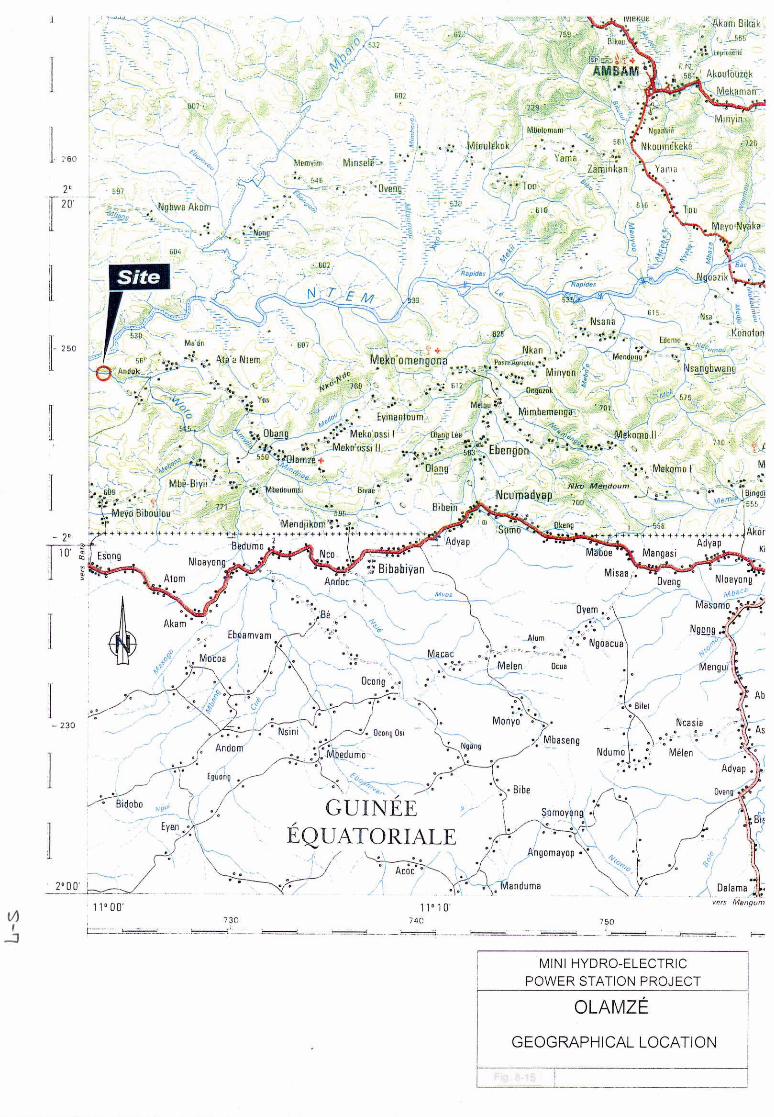
The third proposed site is located near the village of Andok which is
approximately 20km from Olamze village, the center of Olamze sub-division.
Olamze village, which will be covered by the studied micro-hydro-project,
has population about 5,000 and households about 1,000. About 50 villages
are scattered in this sub-division.
(2) Transportation
The transportation network in Republic of Cameroon is distributed centering
around Douala City at coastal area and Yaounde City at inland area.
The road between Douala City and Yaounde City, and Ngambe-Tikar point
has first class highway paved with asphalt until Foumban City, and most of
the part from Foumban to Ngambe-Tikar is second class all-weather road.

-16-
It takes about one hour drive from Foumban to Manki. Point kilometric
36km from Manki crossing Mbam river, and 25km more drive takes to
Ngambe-Tikar point. On the other hand, the another road via Yaounde
Bafoussam and Magba in Manki is used for transporting lumber, so that it
seems possible to transport some degree of heavy matters. The proposed dam
site is located 2km from concrete made bridge crossing the Kim river which
is 4km from Ngambe-Tikar village. The proposed site has good access from
existing road.
It takes about 10 hours to Ndokayo site from Yaounde City via Ayos, Abong
Mbang, Bertoua and Betare Oya. The road between Yaounde City and Ayos
is a first class highway paved by asphalt. The road after Ayos is all weather
first class road but it has problem with traffic jam during rainy season and its
road surface.
The road after Ndokaya village becomes second class, a foot path take to the
dam site. Private houses are scattered at the area before the foot path, but not
found at the proposed site.
For access to Olamze site, the following route has to be followed ; go to
Ambam via Ayos, take a ferryboat to go across a river Ntem to Olamze City,
go further 20km to Olamze site . The road until Yaounde and Ebolowa is first
class highway paved by asphalt. From Ebolowa to Olamze is a second
class road which has no problem for use in the dry season, but presents a
problem during the rainy season. The road from Olamze village to the
proposed dam site is existing on the left side of Woro river but not on the
right side.
(3) Land use
According to the land use draft regulation classified by agriculture & forest,
fishery and hunting rules examined with Canadian cooperation, Olamze
sub-division is mainly divided as a forestry section, an individual and
common forestry section, a living space and agriculture & forestry section,
an opening space and agricultural section. The proposed site belongs to an
opening space and agricultural section, but does not belong to the prohibited
district of forest cutting down, fishery and hunting.

-17-
Areas of Ngambe-Tikar and Ndokayo have no land use regulation, but
according to hearing survey with the forest bureau, it is given a priority to
local intention on land use. Especially, because Ndokayo village is in
Savanna zone, it is said that there will be no significant problem found on
developing project. Therefor, none of the 3 proposed site is in protection
district, and it is required to obtain necessary land space under deliberating
with local authorities and land owner.
(4) Inland water
Fishery in Republic of Cameroon is divided into 7 categories such as large
scale fishery, medium and small size fishery and traditional or domestic
consumption fishery and sports fishing. Inland water fishery is belonged to
type of traditional or domestic consumption fishery.
At the rivers of the three proposed sites, small scale fishery purposed to
residential consumption is conducted. Aquaculture, however, is not operated.
The rivers around the proposed sites are not used for transportation purpose,
because the river shape is not suitable for transportation. Drinking water is
supplied by underground water at all 3 proposed site, and direct river water
use for drinking purpose is not conducted.
(5) Landscape
The rainy season is from April to October, and dry season is from November
to March in this country. According to the survey conducted in June, the
proposed intake dam site at Ngambe-Tikar has relatively flat landscape, and
bottom of river is covered by rocks. The area is surrounded by forest and has
relatively mild stream. Landscape at the site is not different from that of
surroundings.
The proposed intake dam site at Ndokayo has steep geographical features
and a waterfall running among forest, but is hard to access from a nearest
village. The intake dam site at Olamze is in the dense forest, and no
significant difference in landscape is found.
There is no cultural asset found in any of 3 proposed sites.

-18-
4.2 Natural Environment
(1) Geosphere
Ngambe-Tikar site is located 6 km from Ngambe-Tikar village, and its
topology is very flat. Around 300 m of shallows are formed along a river
but with gentle slope to downstream. Base rocks belong to a migmatite
layer, which is dominant in Cameroon. The Mari River flows perpendicular
to hills at Ndokayo site, bedrock stands steep, and there are some places
relatively unstable on both sides of a fall. Riverbed is made of quarzite
with thin layers of quartz porphyry. No sediment can be recognized in
waterfall basin. Olamze site locates in a very flat area and there is little
inclination in the river.
(2) Aquasphere
The Kim River belongs to Sanaga river system. It originates in the southern
slope of Adamaoua Highland which extends east and west in Cameroon at
the altitude of 900 to 1,500 m, and it flows south to join the Mbam River.
The proposed site is at about 710 m in altitude and its catchment area is
around 5,830 km2.
Annual average of river flows at the proposed site is 59.3 m3/sec. Traces of
floods there suggest that during floods, water goes up around 2 m above its
level in dry season. Since the upstream is forests and the proposed site is
far apart from human settlements, it is assumed that water quality there is in
natural condition. Riverbed is made of bedrock, and no polluted mud is
found at all.
Ndokayo site locates at the downstream end of the Mari River, which is a
tributary of the Lom River of Sanaga river system. The Mari River
originates in the southern slope of Adamaoua Highland, and it flows
southwest to eventually join with the Sanaga River. Total length of the
Mari River is about 59 km, and its catchment area is 640 km2. The
proposed dam site locates between 700 to 790 m in altitude. Annual
average of river flows at the proposed dam site is 10 m3/sec. According to
the visual observation, water there containes inorganic mud but it appeared to
be clean. The upstream to this site occupies a savanna, and no situation of
organic pollution is recognized there.

-19-
Olamze site locates at the most downstream of the Woro River. The Woro
River originates in Guinea and it flows about 60 km to the north to join the
Ntem River. More than 90% of its basin is within Guinea. Water at the
proposed site is slightly brown in color, but no pollution is recognized.
Annual average of river flows at the proposed site is estimated to be 12.8
m3/sec.
(3) Atmosphere
Climate in Ngambe-Tikar area belongs to wet tropical climate, and annual
precipitation ranges from 1,600 to 1,700 mm. Average temperature is 23℃
and relatively low. Rainy season is from April to October, and dry season is
from November to March. Climate in Ndokayo area is also tropical climate
like in Ngambe-Tikar area, and precipitation and temperature there is similar
to those in Ngambe-Tikar area. Although the climate in Olamze area is
equatorial climate, it is hot and humid and it rains a lot since it is close to the
Atlantic Ocean and influenced by south coast-type of equatorial climate.
Annual average temperature is 24 to 25℃, and precipitation is 1,800 to 2,000
mm/year.
The three proposed sites are all far from human settlements, and they are in
forests or savannas where natural environment is almost preserved. There
is no problem of air pollution, odor, noise nor vibration.
(4) Biota
Vegetation in Cameroon is generally divided to savannas in the north which
Ndokayo area belongs to, semi-deciduous forests in the center which covers
Ngambe-Tikar area, succession forests in the south, and evergreen forests
along the west coast where Olamze area locates.
In Olamze area, mixed forests of semi-deciduous trees and Atlantic
coast-type evergreen trees and semi-deciduous forests are dominant.
Ngambe-Tikar area is covered by semi-deciduous-type development forests,
and Northern type semi-deciduous forests are also found there. Ndokayo
area is in savannas with small shrubs.
According to the distribution map of trees (Arbres des forêts Denses
d’afrique Central), there are 127 species in Olamze area, 107 species in

-20-
Ngambe-Tikar area, and 45 species in Ndokayo area. Number of species in
Ndokayo area in savannas is small.
As for mammals, according to general information prepared by WWF, 67
species were recognized in Ntem Drainage area where Olamze site is located,
and 15 of them are protected animals. In Tikar area, 58 species were
recognized, and 17 of these are protected. In Betare-Oye area, 51 species
were found, and 15 of them are protected.
Ngambe-Tikar site and Ndokayo site are in Sanaga basin, and Olamze site is
in the southern basin. In Sanaga basin, 185 species were recognized, while
additional 6 species are thought to be occurring although they were not found.
This makes the total number of species to 191. On the other hand, 211
species were found in the coastal basins in the south while 17 more species
are presumed to be occurring, which makes the total number to 228.
During the survey by WWF at a location along the Ntem River, which is
close to Olamze site, 7 species of freshwater anchovies, 6 species of
characins, 6 species of cichlids, 5 species of oryziatids, 3 species of spiny
eels, 2 species of gobies and 5 species of carps were recognized.
5. Hydrologic Analysis
5.1 Meteorological and Hydrological Data
Regarding the meteorology and hydrology of Cameroon, Institut Francais de
Recherche Scientifique pour le Developpement en Cooperation (ORSTOM) had in
1986 arranged and analyzed data obtained and accumulated up to that time, and the
results were published under the title “Fleuves et Rivieres du Cameroun”.
In the hydrologic analysis to be made in the present project survey, the data arranged
and analyzed in the abovementioned report and the precipitation and runoff data
obtained independently in the present survey will be used.
5.2 Runoff Analyses of Ngambe-Tikar Site
Data of runoff gauging stations existing in four neighboring basins can be used in
runoff analysis for this project site. Here, topographies, elevations, precipitation
characteristics in the surroundings of the project site, and catchment area are to be
taken into consideration, and analysis performed with data of Magba and Ngongon

-21-
Gauging Stations in the two basins adjacent at north and south of the project site’s
basin. The runoffs were calculated from water-level records gathered from July to
October 1998 by an automatic water gauge installed at the project site in this present
survey.
According to the correlations of these three groups of calculated values for the
observation period during this present survey, values calculated from observations in
the present survey are from 38.5% to 45.9% of values calculated from runoff data of
Magba Gauging Station and are more or less constant. On the other hand, the
values of Ngongon Gauging Station are scattered from 49.7% to 137% and the data
of Magba Gauging Station have better correlations with values calculated from
observations in the present survey. Accordingly, it is judged that the runoffs of this
project site, runoffs calculated from data of Magba Gauging Station are to be
adopted.
With regard to the probability flood at this project site, 898 m3/sec is obtained
converted by catchment area ratio from the 100 year return period flood of 620
m3/sec calculated according to analysis by ORSTOM.
As for 1000 year return period flood, it is 1,050 m3/sec. The figure for the 100 year
return period flood may be judged to be reasonable from the results of investigating
traces remaining from past floods at the project site.
5.3 Runoff Analyses of Ndokayo Site
Data of runoff gauging stations in three neighboring basins can be used in runoff
analyses for this project site. Of these gauging stations, Betare Oya Gauging
Station located at the upstreammost part of the Lom River has in its basin the Mari
River on which a power station is planned, and data of this gauging station are to be
used in runoff analyses for this site.
Monthly average runoffs and annual runoff characteristics covers a period from 1951
to 1981.
The values of runoff observations made during the three field surveys carried out up
till the present roughly coincide with the calculated values, and thus, these calculated
values will be adopted as the runoffs at this project site.

-22-
Regarding the probability flood at this project site, 45 m3/sec is obtained through
conversion by catchment area ratio from the 100 year return period flood of 760
m3/sec at Betare Oya Gauging Station calculated in analyses by ORSTOM. As for
the 1000 year return period flood, it is approximately 54 m3/sec.
5.4 Runoff Analyses of Olamze Site
Data from runoff gauging stations in two neighboring basins are available for use in
runoff analyses for this project site. On the other hand, according to the results of
runoff observations made in three field surveys carried out up till the present, the
monthly average runoffs of the project site calculated from data of the two gauging
stations of Ngoazik and Assosseng are more or less in agreement, but there are some
differences in the minor rainy season of July-August and in the low-water period.
Judging from results of field surveys, it may be said that the values calculated from
Ngoazik Gauging Station data in which droughty runoff comes out larger are in
better agreement with the discharge duration at the site.
As a consequence of the above considerations, the values calculated from data of
Ngoazik Gauging Station where droughty runoff is shown to be large are to be
adopted.
Regarding the probability flood at this project site, 69 m3/sec is obtained on
conversion by catchment area ratio from the 100 year return period flood at Ngoazik
Gauging Station of 1,480 m3/sec as calculated in analyses by ORSTOM. As for
1000 year probability flood, it is approximately 80 m3/sec.
6. Power Demand Forecast and Supply Plan
6.1 Methodology
In Cameroon, the principles of estimation of LV power demand in rural areas and
peak load demand have been, for each type of use, as follows:
Domestic Uses
The total power demand for a given year in kW is as follows, considering that the
consumption occurs mostly between 6 and 10 p.m.:
Capacity (in kW) = P D
T
× x
Cs
N
with P = estimated population at a given date
D = distribution rate
-23-
T = number of people per household
Cs = specific consumption per household and per year in kWh ( 600 to 1200
kWh)
N = number of equivalent operating hours per year during the peak period
(1500 to 2000 hours)
with a Cs
N ratio comprises between 250 W and 500 W.
For the study, a population growth rate of 3% per year from 1998 to 2010, 5.3 people
per household and a supply rate in rural areas of 50%, with 75% for the town of
Garoua Boulai were used.
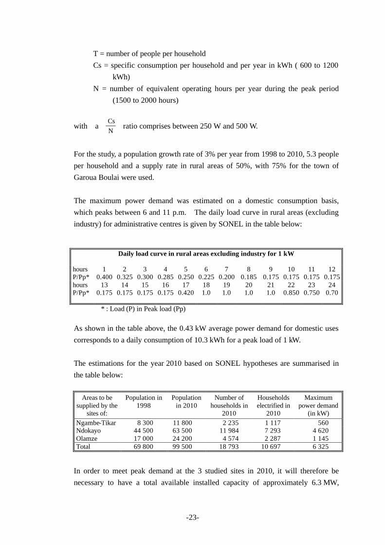
The maximum power demand was estimated on a domestic consumption basis,
which peaks between 6 and 11 p.m. The daily load curve in rural areas (excluding
industry) for administrative centres is given by SONEL in the table below:
Daily load curve in rural areas excluding industry for 1 kW
hours P/Pp*
1 0.400
2 0.325
3 0.300
4 0.285
5 0.250
6 0.225
7 0.200
8 0.185
9 0.175
10 0.175
11 0.175
12 0.175
hours P/Pp*
13 0.175
14 0.175
15 0.175
16 0.175
17 0.420
18 1.0
19 1.0
20 1.0
21 1.0
22 0.850
23 0.750
24 0.70
* : Load (P) in Peak load (Pp)
As shown in the table above, the 0.43 kW average power demand for domestic uses
corresponds to a daily consumption of 10.3 kWh for a peak load of 1 kW.
The estimations for the year 2010 based on SONEL hypotheses are summarised in
the table below:
Areas to be
supplied by the sites of:
Population in 1998
Population in 2010
Number of households in
2010
Households electrified in
2010
Maximum power demand
(in kW) Ngambe-Tikar 8 300 11 800 2 235 1 117 560 Ndokayo 44 500 63 500 11 984 7 293 4 620 Olamze 17 000 24 200 4 574 2 287 1 145 Total 69 800 99 500 18 793 10 697 6 325
In order to meet peak demand at the 3 studied sites in 2010, it will therefore be
necessary to have a total available installed capacity of approximately 6.3 MW,

-24-
including the existing production means (Diesel units) and the prospected
hydroelectric projects (5.5 MW).
6.2 Future Load Pattern (kWh)
(1) Ngambe-Tikar Network
The estimated maximum capacity to be installed in order to meet only
domestic and public lightning requirements of the main 30 kV network and
the extensions of the Ngambe-Tikar area is 560 kW. The total estimated
maximum capacity (not including extensions) is 350 kW.
For the main network, the estimated annual consumption for the year 2010 is
approximately 1300 MWh for domestic and public uses and approximately
3000 MWh for industrial uses corresponding to a demand of approximately
300 kW over 24 hours and 100 kW between 8 a.m. and 6 p.m or 2400 MWh
for industrial uses, which corresponds to a demand of approximately 300 kW
over 19 hours and 100 kW between 8 a.m. and 6 p.m
The 490 kW average power demand, excluding extensions, is corresponding
to a daily consumption of 12 MWh.
NGAMBE TIKAR AREA : Daily load Curve (Main network with and w/oextensions)
0100200300400500600700800900
1 5 9 13 17 21 25
Hours
Pea
k L
oad
(in
kW
)
SF Haz im Supply
The gross production available at the Ngambe-Tikar power station (530 kW),
which is estimated at 3.9 GWh, cannot be absorbed by the 30 kV main
network (Station-Ngambe-Mbam 25 km axis) whose needs in 2010 have
been estimated at 4.0 GWh, of which 2.6 GWh for the Société Forestière
Hazim (SFH) and at 0.3 GWh for other industries.

-25-
The SFH possesses two 800 kVA diesel generating sets that operate
alternatively at half-load at high costs (300 to 350 FCFA per gas oil litre)
with a base consumption of approximately 2 to 2.5 GWh per year. The
selling of power to the SFH during working hours at a lower price than diesel
would enable the use of the production excesses from Ngambe-Tikar.
Negotiations must be opened to supply 200 to 400 kVA during working
hours from 7.30 a.m. to 6 p.m. and possibly during night peak hours from the
Ngambe-Tikar power station and in return, to have available peak hour
power to ensure peak hour demand between 6 and 11 p.m. in low flow
periods. The SFH plans to extend its activities in the coming years.
The industrial, agricultural and forestry development on the Ngambe-Tikar
plain could also enable to absorb part of the production surplus (100 kWA).
The extension of the 30 kV main network (80 km) should be rapidly
undertaken, despite low profitability, in order to use the power surplus
provided by the Ngambe-Tikar power station.
(2) Ndokayo Network
The estimated maximum capacity to be installed in order to supply the main
30 kV network and the extensions of the Ndokayo – Garoua Boulai area is
4600 kW.
The estimated annual consumption for the year 2010 is approximately
17 400 MWh for domestic and public uses and approximately 8 100 MWh
for the industrial and craft sectors, corresponding to an approximate demand
of 2100 kW between 8 a.m. and 6 p.m. The 2900 kW average power
demand corresponds to a of 70 MWh daily consumption.
Ndokayo Area : Typical daily load curve
0.0
2.0
4.0
1 5 9 13 17 21 25
Hours
Pea
k L
oad
(in
kW)

-26-
The 30 GWh gross production available at the Ndokayo power station (4.5
MW) cannot be totally absorbed by the main 30 kV network (Site-Ndokayo
& Garoua Boulai 150 km axis) whose estimated needs for 2010 will be
approximately 20 GWh, for a peak load of 4.6 MW.
In the short term, it would therefore be possible to limit the construction of
the Ndokayo power station to 2 units for an installed capacity of 3.5 MVA.
The existing diesel generating sets at Garoua Boulai (400 kVA) and at Betare
Oya (156 kVA) will complete the production.
In 2010, the Ndokayo hydropower station, which could be equipped with
three 1.5 MW units, could supply 85 to 90% of the consumption, i.e.
30 GWh. The peak complement must be ensured by the diesel generating
sets.
The extension of the 30 kV main network by 45 km could therefore be
undertaken quite rapidly to use the additional production of the third unit.
(3) Olamze Network
The maximum capacity to be installed by the year 2010 in order to supply
the main 30 kV network and the Olamze site extensions is estimated at
1150 kW.
At that point in time, annual consumption is estimated at 4300 MWh for
domestic and public uses and approximately 1100 MWh for industrial uses,
which corresponds to a demand of about 300 kW between 71/2 a.m. and 6 p.m.
The 620 kW average power demand corresponds to a daily consumption of
15 MWh.
Olamze Area : Typical daily load curve
0200400600800
10001200
1 5 9 13 17 21 25
Hours
Pea
k L
oad
(in
kW
)
Almost all the gross production (2.6 GWh) from the Olamze power station
(400 kW) may be absorbed by the main 30 kV MV network (45 to 50 km

-27-
long Olamze-Ambam axis) whose estimated needs for 2010 are
approximately 4 GWh.
The existing capacity of the diesel generating sets being 855 kVA will
facilitate the meeting of demand in 2010, this especially after the 3 Ambam's
units rehabilitation.
Prior to undertaking the extension of the 30 kV main network by
approximately 60 km, it will of course be necessary to consider new
production means.
6.3 Power Supply Plan
Potential production has been calculated from the most unfavourable classified
discharge curves "Q3" (see Chapter 5 Hydrologic Analysis) for the 3 hydropower
plants, each one with a capacity sufficient to allow daily +or weekly modulations
during dry periods. Each power station’s output is that of Chapter 8. Power
Generation Project.
The storage capacities of the 3 reservoirs have been dimensioned so as to provide a
95% guarantee of maximum capacity over the 5 daily peak hours from 6 to 11 p.m.
However, the power stations guarantee about 70 to 80% of the production over the
19 off-peak and working hours.
The table below gives the corresponding potential production (excluding
unavailability) with the distribution over peak hours from 6 to 11 p.m.:
Generation per Power
Station Average potential
production in GWh and Load factor
Potential production: 19 off-peak and working hours
Potential production: 5 Peak
hours Ngambe-Tikar (530 kW) 3.92 (85%) 3.04 ( 80%) 0.88 (90%) Ndokayo (4.5 MW) 30.6 (78%) 22.4 (70%) 8.2 ( 95%) Olamze (400 kW) 2.64 (77%) 1.91 (70%) 0.73 (95%) Total (5.4 MW) 37.2 27.3 9.8
7. Geology
7.1 Ngambe-Tikar Site
The region of Ngambe Tikar belongs to the migmatite set that covers almost
two-thirds of Cameroon. This group of migmatite (commonly called granito-gneiss
by Anglo-Saxon authors) is very heterogeneous. It is a complex hybrid formation
-28-
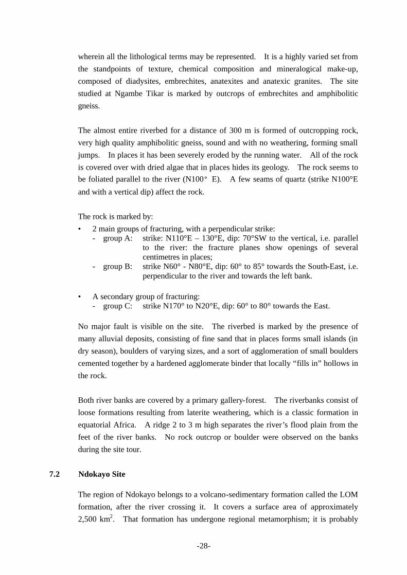
wherein all the lithological terms may be represented. It is a highly varied set from
the standpoints of texture, chemical composition and mineralogical make-up,
composed of diadysites, embrechites, anatexites and anatexic granites. The site
studied at Ngambe Tikar is marked by outcrops of embrechites and amphibolitic
gneiss.
The almost entire riverbed for a distance of 300 m is formed of outcropping rock,
very high quality amphibolitic gneiss, sound and with no weathering, forming small
jumps. In places it has been severely eroded by the running water. All of the rock
is covered over with dried algae that in places hides its geology. The rock seems to
be foliated parallel to the river (N100°E). A few seams of quartz (strike N100°E
and with a vertical dip) affect the rock.
The rock is marked by:
• 2 main groups of fracturing, with a perpendicular strike: - group A: strike: N110°E – 130°E, dip: 70°SW to the vertical, i.e. parallel
to the river: the fracture planes show openings of several centimetres in places;
- group B: strike N60° - N80°E, dip: 60° to 85° towards the South-East, i.e. perpendicular to the river and towards the left bank.
• A secondary group of fracturing: - group C: strike N170° to N20°E, dip: 60° to 80° towards the East.
No major fault is visible on the site. The riverbed is marked by the presence of
many alluvial deposits, consisting of fine sand that in places forms small islands (in
dry season), boulders of varying sizes, and a sort of agglomeration of small boulders
cemented together by a hardened agglomerate binder that locally “fills in” hollows in
the rock.
Both river banks are covered by a primary gallery-forest. The riverbanks consist of
loose formations resulting from laterite weathering, which is a classic formation in
equatorial Africa. A ridge 2 to 3 m high separates the river’s flood plain from the
feet of the river banks. No rock outcrop or boulder were observed on the banks
during the site tour.
7.2 Ndokayo Site
The region of Ndokayo belongs to a volcano-sedimentary formation called the LOM
formation, after the river crossing it. It covers a surface area of approximately
2,500 km2. That formation has undergone regional metamorphism; it is probably

-29-
structurally discordant on a granito-gneiss base that was rejuvenated in the
pan-African period. It is a set composed of schist, greywacke and quartzite.
The site studied at Ndokayo features the presence of quartzite outcrops in the form
of compact beds that are resistant to erosion and weathering, forming crests above
the surrounding schists.
In comparison to the Ngambe Tikar site, the Ndokayo site is essentially marked by
the hills that the Mari river must cross perpendicularly to the strike of the main crest,
via major falls the height of which ranges over 100 m. The river’s longitudinal
profile at the falls is very steep. The river banks also have steep slopes (45° to 50°)
and vertical cliffs in some places. These banks have reached their angle of natural
equilibrium.
The entire riverbed is very hard rock that has created a natural obstacle to the course
of the river: it is quartzite with seams of quartz. The quartzite is strongly
micaceous (muscovite) in places; the rock is white and powdery when weathered,
but at clean breaks it is dark blue with fine grains.
The quartzite zone forms the backbone of the hills overlooking the falls; the river has
formed a path through this barrier by hollowing out a miniature canyon in it.
The main strike of the fracturing in the quartzite is N30°E. That strike corresponds
to that of the crest line of the two hills overlooking the falls. It is perpendicular to
the river at the falls. This main fracturing has a subvertical dip. The “benches” of
quartz and quartzite are 20 to 50 cm thick. Spaces between “benches” are wide
open in places (20 cm or even more).
The N30°E strike is the main strike of the weakness in the rock. Two groups of
fracturing are associated with it:
• one group with strike parallel to the river in the area of the falls: strike N140°E
and dip 70° towards the West,
• a subhorizontal group.
The three fracture planes that affect the rock have perpendicular strikes and dips; the
combination of these planes has the effect of cutting the rock into large
parallelepipedal blocks.

-30-
No alluvial deposit is visible at the falls. On the other hand, downstream from
them the riverbed is cluttered with many boulders of varying sizes and with finer
deposits. The gold-mining activity is in these zones. In the downstream part, a
ridge several metres high separates the river’s flood plane from its banks.
The river banks above the falls are very steep and very rocky. the rocky skeleton is
formed by the lateral extension of the quartzite zone on either side of the falls.
The top of both banks shows many outcrops of severely (vertically) fractured
quartzite “benches” that form cliffs in places. On the other hand, the middle and
lower part of both banks are covered with quartzite and quartz debris mixed with
topsoil. In fact a certain number of quartzite and quartz “benches” at the top of the
hills have tipped over towards the foot of the slope under the effect of gravity and
imbalance (toppling), creating significant zones with a chaos of parallelipipedal
blocks. Those boulders are very large (often more than 1 m3). The thickness of
this talus seems variable; a rough estimation before investigations could be 4 to 8 m.
The thickness should be greater at the feet of the banks.
The top of the hill on the right bank, overlooking the falls, has a double crest; the
hollow between the two crests – which is continued in the subjacent cliff over the
falls – could correspond to a fault or more extensive fracture zone, with a N30° to
40°E strike or a level more erodible. Regarding that hill, a certain lack of
symmetry between the banks is noticeable; the southern bank, the one that is visible
as the visitor arrives at the site, has no plant cover and most notably has been
covered by rock falls, as noted above; the northern bank, on the other hand, has very
thick plant cover (forest) and the debris or boulders of quartz and quartzite are
relatively rare.
Another phenomenon – that is relatively rare in equatorial Africa – is the presence
on the southern slope of the hill on the right bank of a spring of clear water (with low
flow); that spring is located halfway up the slope, approximately 300 m from the
river’s centreline. The existence of a spring that does not dry up in low flow
periods proves that water flows within the rock via the fracture planes and also that
this source may be fed from the river.

-31-
7.3 Olamze Site
The Craton zone or NTEM group is caracterised by the different lithological
formations:
• intrusive rocks (granite, diorite, syenite, charnockite, gabbro),
• ribbon series (gneiss, migmatite, amphibolite),
• ribbon series (gneiss, migmatite, amphibolite),
• iron formations locally.
The region of Olamze belongs to the ribbon series of the Ntem’ unit, and the site
studied is marked by outcrops of ampnhibolitic gneiss.
At the sill location, the riverbed is rocky. The rock outcrops at the bottom of the
banks, in the middle of the river, and in the small branch located on the right bank.
It is an amphibolitic gneiss, slightly quartzitic, sound, with locally a soft weathering.
The strike of the rock foliation is N90°E, approximately perpendicular to the flow of
the river and the dip is subvertical. The planes are locally open, mm to cm. This
rock is marked by a main group of fractures: strike: N170°E, parallel to the river,
dip: 70°E, towards the right bank. No major fault is visible on the site.
Banks are covered by forest. The riverbanks consist of clayey formations resulting
from laterite weathering. The thickness of this formation is probably relatively
important, on the top of the bank. No rock outcrop or boulder were observed
during the site tour.
8. Power Generation Project
8.1 Ngambe-Tikar Project
(1) Project Outline
Ngambe-Tikar hydro-electric project, located in left abutment of the Kim
river, extends 500m long to create a head of 7m. As the dam cannot be very
high since the slope of the river is relatively low, the head can hardly be
higher than 7 m. The only parameter that can be modified is the design flow.
It must be chosen according to the (minimum available inflow) and the
future peak demand. The choice of 10 m3/s discharge is the most relevant
one because it enables the network to be supplied during peak hours, without
requiring a prohibitive amount of investment.

-32-
The profitability of the scheme depends on the possibility of supplying the
energy generated during off-peak hours. The Hazim sawmill represents an
interesting opportunity. It is equipped with several diesel generating sets that
it uses for its own needs and whose cost price is high. Negotiating an
agreement with them would ensure the profitability of the power station and
allow the sawmill to economise on diesel oil.
The project includes: a dam, a water intake, a headrace canal, a power house,
and a channel. The 6.9 m net head, 7 m minus 0.10 m of head loss, and the
10 m3/s flow rate generate a capacity of 530 kW. In order to optimise the
project and in consideration of the low head, all the works have been
dimensioned in order to reduce the head loss and the costs to the maximum.
For example, masonry being the least expensive way of building dams, it is
used whenever possible.
The dam is a masonry structure on a rocky weir creating a head.
As the net head is low, the scheme is designed so as to minimise head losses
as much as possible. To do this, we tried to reduce the length of the plant's
water supply system by building an open-air canal terminating at a starting
chamber and a discharge channel into the river.
Principal structures which constitute the project are:
- trapezoidal-shaped overflow dam, 517 m long and 2 m of max. height,
having 3 bottom outlets.
- an intake of 4 spans to flow 10 m3/s of nominal discharge
- an open canal of 17.4 m2 of section, 515 m long, leading to a water
chamber of 540 m3
- a powerhouse having 2 unit of Kaplan turbine of S-curve in upstream, 295
kW each
- a restitution canal of 41 m long to protect sedimentation of sand by the use
of wall deflector of 200 m long
- 30 kV main transmission line of 25 km
(2) Main Features
1) Location 6 km from Ngambe-Tikar village, 2 km
upstream of bridge on Kim river

-33-
2) Hydrology Catchment Area 5,820 km2 Average Discharge 59.3 m3/s Specific Average Discharge 10.2 l/s/km2 Low Discharge 1.6 m3/s Flood Discharge (100 years) 898 m3/s Flood Discharge (1000 years) 1,050 m3/s 3) Pond Surface Area 9 ha Effective Volume 45,000 m3 Normal Water Level EL. 712.00 Low Water Level EL.711.50 4) Dam Type Trapezoidal-shape Spillway Weir Crest EL. 712.00 Dam Crest EL. 712.85 Dam Length 517.5 m Dam Height from Riverbed 2 m 5) Intake Intake Area 4 spans of 4 m2 : 16 m2 Floor Level EL. 710.00 Intake Ceiling EL. 712.00 6) Headrace Canal Length 515 m Section 17.4 m2 7) Head Tank Dimension 20 x 8.7 m : 174 m2 Volume 540 m3 Floor Level EL. 709.72 8) Powerhouse Number of Unit 2 Net Head 6.9 m Installed Capacity 530 kW - 625 kVA Production (effective) 3.92 GWh/year Floor Level EL. 702.00 Dimension 13 m x 6.70 m
9) Turbine
Type Kaplan S-curved upstream
Normal Discharge 5 m3/s
Diameter 0.85 m
Unit Capacity 295 kW
Rotation Speed 600 r/mn
10) Generator
Type 3-phase alternative, synchronous
Number 2
Rotation Speed 1,000 r/mn, multiplicater
Nominal Capacity 267 kW - 315 kVA

-34-
Frequency 50 Hz
Voltage 400 V
Power Factor 0.85
11) Transformer
Type Indoor, 3-phase, oiled, air-cooled
Quantity 1
Nominal Capacity 630 kVA
Voltage 400 V / 30 kV
12) Transmission Line
Voltage 30 kV 3-phase
Length 25 km
13) Construction Cost (Engineering fee & Contingency included)
Civil Works 1,852 MF CFA
Equipment 2,475 MF CFA
Transmission Line 335 MF CFA
Engineering 541 MF CFA
Total 5,203 MF CFA
14) Economic Cost-price
Discount Rate 8%
Cost per kWh 138 F CFA/kWh
Cost per kW 9.8 MF CFA/kW
8.2 Ndokayo Project
(1) Project Outline
Ndokayo hydroelectric power station utilizes 91m of natural head on Mari
water fall, by which it produces an annual energy of 30.6 GWh with an
installed capacity of 4,530 kW. Such a dimensioning can meet power
demand 93% of the time (during peak hours) as of 2010, and will make the
best use of the hydrological capacities of the site, considering the dry period.
Given the site layout, the 91.20 m net head is the best that can be obtained.
A 34 m wide weir, a 15 m water intake upstream of the weir, a 133 m long
tunnel, a 306 m penstock and a power station comprising 3 turbines are
required to operate the site.
Francis turbines, using hydraulic power, will have a maximum capacity of
4,530 kW for a production capacity of 30 GWh.
Principal structures which compose it are:
- trapezoidal-shaped masonry dam, maximum height of 4.5 m, and a total
length of 36 m, of which 21 m is overflowed

-35-
- an intake of two spans in right abutment for a discharge of 6 m3/s
- a pressure tunnel of 8 m2 section in rock, 133 m long, 0.05% in slope,
concreted, inner dia. of 2.20m
- a steel penstock with expansion joints, 307 m long and 1.4 m in diameter
- a powerhouse having 3 units of Francis turbines, horizontal axis, 1,600 kW
each, resulting in a total powerhouse capacity of 4,530 kWe
- a short restitution canal with downstream weir of EL 697 crest which
guarantees non-cavitation
- 30 kV main transmission line of 152 km long
(2) Main Features
1) Location On cascade of 10 km from Betare Oya on
Mari river, which is affluent of Lom river
2) Hydrology
Catchment Area 640 km2
Average Discharge 10.1 m3/s
Specific Average Discharge 15.8 l/s/km2
Low Discharge 1 m3/s
Flood Discharge (100 years) 45 m3/s
Flood Discharge (1000 years) 54 m3/s
3) Pond
Surface Area 7.5 ha
Effective Volume 90,000 m3
Normal Water Level EL. 790.80
Low Water Level EL. 789.60
4) Dam
Type Trapezoidal-shape Spillway
Weir Crest EL. 790.80
Dam Crest EL. 792.10
Weir Length 21 m
Dam Height from Riverbed 4.50 m
5) Intake
Intake Area 9.12 m2
Floor Level EL. 787.20
6) Headrace Tunnel
Length 133 m
Section Concrete lined, Horse-shoe type,
3 x 3 m exterior D = 2.2 m interior
7) Penstock

-36-
Unit 1
Length 306 m
Diameter 1.40 m
Thickness 11 mm
8) Powerhouse
Number of Unit 3
Net Head 91 m
Installed Capacity 4,530 kW - 5,330 kVA
Production (effective) 26.3 GWh/year
Floor Level EL. 697.00
Dimension 22.80 m x 5.00 m
9) Turbine
Type Francis, axis horizontal
Normal Discharge 2 m3/s
Diameter 0.58 m
Unit Capacity 1,600 kW
Rotation Speed 1,000 r/mn
10) Generator
Type 3-phase alternative, synchronous
Number 3
Rotation Speed 1,000 r/mn
Nominal Capacity 1,535 kW - 1,805 kVA
Frequency 50 Hz
Voltage 5,500 V
Power Factor 0.85
11) Transformer
Type Indoor, 3-phase, oiled, air-cooled
Quantity 3
Nominal Power 1,800 kVA
Voltage 5.5 kV / 30 kV
12) Transmission Line
Voltage 30 kV 3-phase
Length 152 km
13) Construction Cost (Engineering fee & Contingency included)
Civil Works 2,556 MF CFA
Equipment 4,545 MF CFA
Transmission Line 2,062 MF CFA
Engineering 888 MF CFA
Total 10,051 MF CFA
14) Economic Cost-price
Discount Rate 8%

-37-
Cost per kWh 39 F CFA/kWh
Cost per kW 2.2 MF CFA/kW
8.3 Olamze Project
(1) Project Outline
Olamze project closes the Woro river, creating the head of 6m. The project
was designed to make the best use of the site capacities, at the lowest cost.
The choice of the design flow takes into account the existence of two diesel
power stations on the network. The flow cannot exceed 8.8 m3/s, which is the
minimum value obtained for 45% of the year. The thermal power stations,
which must be renovated, make it possible to take such a strong flow since
they can supply the missing energy during the periods of low flow. Larger
equipment would lead to higher costs and would rarely be in operation,
which would reduce the profitability of the project.
The 6 m net head is created solely by the weir and the cost of energy is
therefore directly linked to its height. Given the shape of the valley, a higher
dam would lead to an increased cost of energy and could cause problems at
the end of the reservoir.
This head creates a capacity of 400 kW for an annual power generation of
2.64 GWh that may be entirely consumed by the population and the
industries.
Principal structures are:
- a dam of 138 m long, 8.95 m max. high, having spillway of 46 m long and
6.3 m high in central portion
- in right abutment, next to spillway, a powerhouse of 12 m long houses 2
units of Kaplan turbine, horizontal axis, of a discharge of 4.5 m3/s
- 30 kV main transmission line of 47 km
(2) Main Features
1) Location 3 km upstream of Ata’antem on Woro river
2) Hydrology
Catchment Area 840 km2
Average Discharge 12.8 m3/s
Specific Average Discharge 15.2 l/s/km2
Low Discharge 0.7 m3/s

-38-
Flood Discharge (100 years) 69 m3/s
Flood Discharge (1000 years) 80 m3/s
3) Pond
Surface Area 18.3 ha
Effective Volume 110,000 m3
Normal Water Level EL. 553.90
Minimum Water Level EL. 555.35
4) Dam
Type Fill-Type in wing portion with spillway in Center
Weir Elevation EL. 553.90
Crest Elevation EL. 555.35
Total Length / Spillway 138.10 m / 46.10 m
Dam Height from Riverbed, Crest / Weir
8.75 m / 6.30 m
5) Intake
Intake Area 29.12 m2
Floor Level EL. 546.00
Intake Ceiling EL. 547.40
6) Powerhouse
Number of Unit 2
Net Head 6 m
Installed Capacity 400 kW
Production (effective) 2.4 GWh
Floor Level EL. 545.50
Dimension 22.80 x 5.00 m
7) Turbine
Type Kaplan horizontal with angle gear
Normal Discharge 4.5 m3/s
Diameter 0.9 m
Unit Capacity 225 kW
Rotation Speed 400 r/mn
8) Generator 3- phase synchronous
Number 2
Rotation Speed 750 r/mn, multiplicator
Nominal Capacity 204 kW - 240 kVA
Frequency 50 Hz
Voltage 400 V
Power Factor 0.85
9) Transformer
Type Indoor, 3-phase, oiled, air-cooled
Quantity 1

-39-
Nominal Capacity 500 kVA
Voltage 400 V / 30 kV
10) Transmission Line
Voltage 30 kV 3-phase
Length 47 km
11) Construction Cost (Engineering fee & Contingency included)
Civil Works 1,409 MF CFA
Equipment 2,538 MF CFA
Transmission Line 615 MF CFA
Engineering 493 MF CFA
Total 5,055 MF CFA
12) Economic Cost-price
Discount Rate 8%
Cost per kWh 197 F CFA/kWh
Cost per kW 12.6 MF CFA/kW

-40-
30 kV Network in Cameroon for power stations of Ngambe-Tikar, Ndokayo and Olamze
Axes et Centres Distance to the site in km Proposed main network in km
1. Ngambe-Tikar site (Kim river) Ngambe Tikar - Mbam axis
Ngambe-Tikar 7 7 Mansouh 15 8 Ga 20 5 Gwenze 25 5
Ngambe-Tikar Network 25
2. Ndokayo site (Mari river) Bétaré Oya - Garous Boulai axis
Mari Village 8 8 Lom 22 Bétaré Oya 16 8 Ndokayo 22 6 Bongo 31 9 Borongo 46 15 Mombal 61 Nadongwé 69 8 Botila 76 7 Badzéré 80 4 Badang 88 Yoko Sire 98 Ganko 101 Garaoua Boulai 106 60
Ndokayo - Tongo axis Oudou 29 7 Kongolo 42 13 Garga Sarali 49 7 Ngaoundéré 60 Tongo 66
Ndokayo Network 152 3. Olamze site Olamze - Ngoasik - Ambam axis
Olamze 15 15 Meko’Ossi 16 1 Eyinantoum 17 1 Meko’Omengona 19 2 Ebengon 24 Nsana 25 6 Ngoasik 35 10 Nkoumeké 44 9 Ambam 47 3
Olamze Network 47


-44-
9. Environmental Protection Measures
9.1 Environmental Preservation Measures
(1) During Operation
The three hydroelectric power stations of this Project are all to start power
generation by 2010, with power transmitted to villages neighboring the
respective power stations by 30 kV medium voltage transmission lines. As
socio-economic effects, although of small number, local residents will be
employed as unskilled technicians or laborers for rises in incomes, while also,
opportunities to experience elementary-level power generation and
transmission technologies will be increased. Further, the installation of
hydroelectric power stations will be useful for improvement of local
electrification rates, improvement in livelihood of residents, and promotion
of livelihood activities. Still further, since roads from the principal villages
to the dams and power stations will be maintained in good condition, the
situation will be far better than at present, and the benefit to the regional
society and economy will be great. Communications and medical services
will also be improved.
The three hydroelectric power stations of this Project are all small hydros and
there will be no fear of large amounts of discharge to threaten the safety of
residents, and neither will there be risk of slopes collapsing and
sedimentation occurring. During flood, however, there will be risk that the
surroundings will be inundated by backwater of Olamze Intake Pond, and it
is necessary for a separate investigation to be made in this regard for some
measure to be taken including changing of plans. Effects on public
sanitation and changing of stream water quality will be little since all of the
power stations will be small.
When the power stations are operated, stream water will be impounded by
the dams and, especially at the Ndokayo site, Mari Waterfalls located
between the intake dam and the power station will dry up temporarily.
However, this site is at a remote location and is not a place where tourists
would come, while local residents will not be affected at all.
Regarding impact on the ecosystem, at Ngambe-Tikar and Olamze, flow of
river water will be cut off temporarily due to construction of intake dams and
there will be a risk of obstructing migration of fish. However, the existence

-45-
of fishes with such a habit, especially in this season, has not been confirmed,
and it is believed there will be no harmful effect. Concerning land animals
also, the dams, power stations, and transmission lines will all have vast wild
plains around them and it is thought the animals will not be affected in
particular.
At all of the hydro sites, there may be benefits for the residents of the
surrounding areas, but it is not conceivable that there will be negative effects
with respect to safety and public sanitation. As for negative influences on
the ecosystem, there should be none when the existence of the surrounding
wilderness is considered. However, if there is to be any exception, it would
be the inundation of the surroundings by the backwater of Olamze Intake
Pond, and it is thought this is a matter which should be cleared up through
flood area surveys in an additional field investigation.
(2) During Construction
Each of the projects will require a period of approximately 2 years for
construction, and laborers will be hired from within and without the project
area to carry out works such as clearing, temporary facilities, permanent
facilities, access roads, etc. It is thought approximately 30% of these
laborers will be mobilized from outside, while the remainder is estimated
will be hired from within the project area and immediate surroundings, that is,
they will comprise the majority of unskilled workers.
It is estimated that the number of local residents who will be hired during the
construction period will be approximately 200 for the respective projects.
Thus, the execution of construction will provide employment opportunities
for many people living in the project area and surroundings, and bring about
increases in income.
As for the case of a laborer who is a carrier of a contagious disease being
mobilized from outside the project area, there would be the fear that the
disease would be spread among residents of the area, but a contagious
disease of a type communicated from person to person is not highly
infectious, and it is considered there will be no problem if sanitation of the
laborers’ quarters were to be maintained.

-46-
Regarding effects of transporting materials and equipment during the
construction period, carbon monoxide, nitrogen oxide, and particularly, dust
in the dry season, may temporarily increase when a vehicle passes by, but it
is thought normally regulated values, for example, dust approximately 250
mg/m3, carbon monoxide approximately 20 ppm, and nitrogen oxide
approximately 0.05 ppm will not be exceeded. However, regarding volume
of dust, people living along roads will be troubled so that in areas where
housing densities are high, measures such as sprinkling of water are to be
carried out as suited.
During construction, there is a possibility for traffic accidents to occur in
areas where there are many local residents. Measures such as traffic
regulation and speed regulation should be taken as necessary, and trouble
with local residents must be avoided. In the event trouble does occur, quick
medical service and compensation must be provided. Traffic noise will
affect wild animals living in forest areas along roads and transmission line
rights of way, but this will be in a narrow range, while not very many
animals inhabit these parts. Results of investigations indicate that protected
animal species do not exist in the project area. A vast wilderness makes up
the surroundings and it may said there will be hardly any impact felt.
9.2 Monitoring Program
The environmental monitoring program to be followed during construction and when
the power stations are in operation is as shown in the tables below.

(1) When Operating
Major Impact Cause Monitor Item Monitoring Purpose Data Collection Method
Data Analysis Method
Object Area Period & Frequency
Organization Concerned
1) Income increase · Employment · Electricity tariff · Industry, others
· Labor pool & wages · Industry
Monitoring item at left Government & local agency data
Data tabulation & trend analysis
Project area (incl. transmission line route)
Bimonthly Government & local agency
2) Public sanitation Electric power distribution
Sicknesses Monitoring sicknesses Government & local agency data
Data tabulation & trend analysis
Project area (incl. transmission line route)
Bimonthly Government & local agency
3) Impact of inundation (Olamze only)
Intake pond backwater · Complaints, disputes
· Compensation
· Inundation scale investigation · Monitoring complaints & compensation situation
· Improvement works execution
Field investigation, interview
· Data tabulation, illustration
· Analysis
Intake pond surroundings
Flood duration Government & local agency
(2) During Construction
Major Impact Cause Monitor Item Monitoring Purpose Data Collection Method
Data Analysis Method
Object Area Period & Frequency
Organization Concerned
1) Income increase Employment
Locally hired laborers number, wage level
Monitoring item at left Contractor’s data Data tabulation & trend analysis
Project area (incl. transmission line route)
Bimonthly · Government & local agency
· Contractor 2) Traffic
obstruction & traffic accident
· Equipment & materials delivery
· Road repair & access road construction
· Complaints · Disputes · Accidents
· Monitoring traffic accidents, number & frequency of interference to transportation traffic
· Monitoring complaints, disputes of residents
· Data from contractor and police
· Field investigations
· Data tabulation · Trend analysis
· Project site (incl. transmission line route)
· Roadside area
Monthly · Government & local agency
· Contractor
3) Noise, air pollution, public sanitation
· Equipment & materials delivery
· Road construction, materials collection works
· Laborers’ quarters
· Complaints · Disputes · Sicknesses · Dust quantity · Noise level
· Monitoring dust quantity, noise level
· Monitoring complaints, disputes of residents
· Monitoring sicknesses
· Field investigations
· Data tabulation · Trend analysis
· Project site (incl. transmission line route)
· Roadside area
Monthly · Government & local agency
· Contractor
4) Impact of inundation (Olamze only)
Inundation
· Compensation · Complaints, disputes
· Inundation scale investigation · Monitoring complaints and disputes situations
· Improvement works execution
· Field investigations
· Interviews of farmers, land owners
· Data tabulation, illustration, analysis
Intake pond surroundings
Flood period Government & local agency

- 48 -
9.3 Evaluation
The project sites of the three hydros are all only several kilometers away from their
respective neighboring villages and, since the power generation schemes are all of
extremely small scale, there will be hardly any effects on the present natural and
social environment. If there are any points in particular requiring attention to be
paid, they are (1) the negative effects from backwater of the intake pond at Olamze
must be eliminated at the time final plans are made, (2) the waterfalls of Mari at the
Ndokayo site may dry up temporarily during the dry season, if left as it is, but it
could be prevented by the daily regulation of water in the pond, (3) the works are of
small scale, but with regard to increased traffic volume during construction and the
resulting dust and noise, it will be necessary for the constructor to give appropriate
consideration in village areas with high concentrations of housing. The table below
is a summary of the overall assessment on the environmental impacts of the Project.

- 49 -
Environment Affected Content Impact Analysis and Degree of
Impact
1. Industry in power system area
Power generation Electric energy supply Society, economy A+
2. River water use When operating Maintenance and control of
dam and power station Downstream flow reduction when operating
Society, economy C
During construction Construction of structures Water pollution from muddy water
Society, ecosystem
B-
3. Land transportation When operating Access road Improvement of traffic Society, economy B+ During construction Traffic of vehicles
concerned Traffic safety and dust Society B-
4. Esthetics When opeating (Ngambe Tikar, Olamze) Loss of tourism resources Society, economy C When operating (Ndokayo) Loss of tourism resources Society, economy B-
5. Public sanitation When operating Pollution of water used Contamination of drinking
water Hygiene B-
During construction Pollution of water used Inflow of laborers, wastes
Contamination of drinking water Outbreak of sickness
Hygiene Hygiene
B- B-
6. Land animals When operating Influence of structures,
intake ponds Ecosystem C
During construction Clearing and construction Impacts of noise, air pollution
Ecosystem C
7. Aquatic animals When operating Change in downstream
water flow Ecosystem B-
During construction Construction Impact of contaminated water
Ecosystem B-
8. Ecosystem During construction Construction work Impact due to changes in
habitat and restriction of movement
Ecosystem C
9. Atmosphere When operating Society,
economy, ecosystem
C
During construction Construction work Pollution due to traffic volume and construction
Society, economy, ecosystem
B-
10. Employment When operating Operation and maintenance Employment in items at left Society, Economy A+ During construction Construction work Employment in item at left Society, economy A+
A: influential + : plus
B: slightly influential - : minus
C: non influential

- 50 -
10. Construction Program, Construction Schedule, and Construction Cost
10.1 Construction Program and Construction Schedule
The schedules of major civil works in the individual projects are as shown in Figs.
10-1, -2, and -3, respectively, and since each requires a construction period
straddling two dry seasons, power generation would be started after approximately
18 months from start of construction.
(1) Ngambe-Tikar Project
In construction, various preparatory works including access roads and
temporary works, and waterway work at the right bank are to be carried out
as much as possible before the rainy season arrives, while in the dry season
following the rainy season, main civil works and electrical works are to be
about completed, power generation to be started with the onset of the next
rainy season.
(2) Ndokayo Site
In construction, various preparatory works including access roads and
temporary facilities are to be completed before the rainy season of the first
year sets in, and part of the penstock route is also to be excavated. Even
during the rainy season, work on the headrace tunnel is to be continued and
is to be brought roughly to completion. Main works such as the dam,
penstock, and power generation facilities are to be started as soon as the
rainy season of the first year ends, and work in the open is to be finished by
the onset of the next rainy season. A part of equipment installation works
will extend into the rainy season, but similarly to Ngambe-Tikar, it will be
possible for power generation to be started within 18 months.
(3) Olamze Site
At this site, construction of access roads and temporary facilities would be
completed before onset of the rains from May to July. In December, when
the rainy season is over, works involving the river bed such as the dam and
power station are to be started, and the greater part of open work at the river
bed is to be completed before the onset of the rainy season in May. Indoor
works such as equipment installation would be done during the next rainy
season.

- 51 -
10.2 Construction Materials
The principal civil works materials required in construction of this project, namely,
concrete aggregates, cement, reinforcing bars and steel can be procured in Cameroon
except for a very small part. Especially, wet masonry concrete structures are
specified for facilities such as intake dams, and this, as can be seen in riparian civil
structures like Edea Hydroelectric Power Station (installed capacity 263.2 MW) on
the downstream part of the Sanaga River, is a technique which has been nurtured by
workers of Cameroon over a long period of time, with materials procured locally and,
moreover, being cheap.
Power station electro-mechanical equipment such as turbines and generators, and
gate equipment such as penstock gates, would be imported from overseas countries,
including Japan.
However, with regard to transmission lines, concerning both equipment and
installation, planning and estimating were done based on records of actual work
recently done by SONEL. Regarding main contractors to perform construction of
dams and power stations would be by foreign contractors, Japanese ones included,
but for transmission lines, it was considered that local contractors would do the work
supervised by SONEL. This is based on the thinking that it would be more
convenient to use locally marketable items as facilities required for transmission
lines after entering the maintenance stage.
10.3 Construction Cost
(1) Hydroelectric Power Stations
The construction costs of the hydroelectric power stations of Ngambe-Tikar,
Ndokayo, and Olamze, not including customs and VAT, in effect, the
amounts to be invested, are as given in detail in Tables 10-1 to -3.

- 52 -
Table 10-1 3 Hydro Construction Cost
M.CFA Franc (1999) Ngambe-Tikar Ndokayo Olamze Total
Installed Capacity 530 kW (2 units) 4,530 kW (3 units) 400 kW (2 units) 5,460 kW
Civil Works 1,852 2,556 1,409 5,817
Electromechanical Equipment
2,475 4,545 2,538 9,558
Engineering & Administrative
541 888 493 1,922
Total 4,868 7,989 4,440 17,297
Table 10-2 30 kV Line Construction Cost
M.CFA Franc (1999) Ngambe-Tikar Ndokayo Olamze Total
Total Length 25 km 152 km 47 km 224 km
Construction Cost 265 1,630 486 2,381
Engineering & Administrative
70 432 129 631
Total 335 2,062 615 3,012
Table 10-3 3 Hydro Construction Cost
M.CFA Franc (1999) Ngambe-Tikar Ndokayo Olamze Total
Hydro power Station
4,868 7,989 4,440 17,297
30 kV Transmission Line
335 2,062 615 3,012
Total 5,203 10,051 5,055 20,309
Installed Capacity 530 kW 4,530 kW 400 kW 5,460 kW
Construction Cost per kWh
9.8 2.2 12.6 3.7


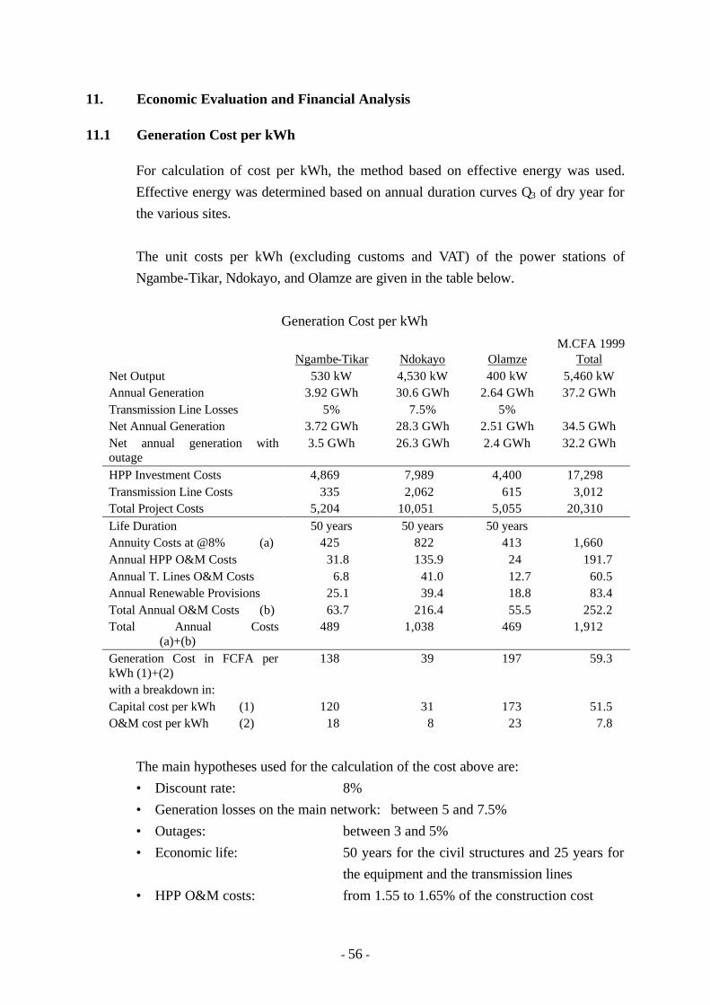
- 56 -
11. Economic Evaluation and Financial Analysis
11.1 Generation Cost per kWh
For calculation of cost per kWh, the method based on effective energy was used.
Effective energy was determined based on annual duration curves Q3 of dry year for
the various sites.
The unit costs per kWh (excluding customs and VAT) of the power stations of
Ngambe-Tikar, Ndokayo, and Olamze are given in the table below.
Generation Cost per kWh
M.CFA 1999 Ngambe-Tikar Ndokayo Olamze Total Net Output 530 kW 4,530 kW 400 kW 5,460 kW Annual Generation 3.92 GWh 30.6 GWh 2.64 GWh 37.2 GWh Transmission Line Losses 5% 7.5% 5% Net Annual Generation 3.72 GWh 28.3 GWh 2.51 GWh 34.5 GWh Net annual generation with outage
3.5 GWh 26.3 GWh 2.4 GWh 32.2 GWh
HPP Investment Costs 4,869 7,989 4,400 17,298 Transmission Line Costs 335 2,062 615 3,012 Total Project Costs 5,204 10,051 5,055 20,310 Life Duration 50 years 50 years 50 years Annuity Costs at @8% (a) 425 822 413 1,660 Annual HPP O&M Costs 31.8 135.9 24 191.7 Annual T. Lines O&M Costs 6.8 41.0 12.7 60.5 Annual Renewable Provisions 25.1 39.4 18.8 83.4 Total Annual O&M Costs (b) 63.7 216.4 55.5 252.2 Total Annual Costs (a)+(b)
489 1,038 469 1,912
Generation Cost in FCFA per kWh (1)+(2)
138 39 197 59.3
with a breakdown in: Capital cost per kWh (1)
120
31
173
51.5
O&M cost per kWh (2) 18 8 23 7.8
The main hypotheses used for the calculation of the cost above are:
• Discount rate: 8%
• Generation losses on the main network: between 5 and 7.5%
• Outages: between 3 and 5%
• Economic life: 50 years for the civil structures and 25 years for
the equipment and the transmission lines
• HPP O&M costs: from 1.55 to 1.65% of the construction cost

- 57 -
• Transmission Line O&M costs: 2% of the construction cost (260-270 CFA kF
per year)
11.2 Economic Evaluation
A rural electrification project in a remote area, along with being a public undertaking,
is for the purpose of contributing to improvement in the people’s livelihood, and
requires special attention to be paid in comparison with an ordinary project. That is,
it must be kept in mind that supplying electric power itself improves rural life and
energizes activities in various ways. Accordingly, it is extremely difficult to
quantitatively grasp the actual benefit brought about by an electrification project.
The price of a commercial item in a free market is decided by the balance of supply
and demand for that item, but especially, in rural electrification, it is quite unlikely
that the price can be set simply from the relation with supply and demand. That is,
setting of electric power prices will generally be something outside the bounds of
free market rules, and prices are normally decided by a government agency. In
many cases, prices are held down for political or socie-economic reasons.
In Cameroon, too, there exists latent demand for electric power which would be
awakened in response to reduction in the price of electric power, and it is not
appropriate to attribute the benefit of a power development project only to power
sales.
Accordingly, it is necessary for special consideration to be given in calculation of
benefit and evaluation of the economics of a power development project. For
hydroelectric power projects, a technique widely employed is the alternative facility
method, and the results of study by that method are described below.
In case of making an economic comparison between the project concerned and the
alternative project, the capacity and energy production of the alternative project
versus the capacity and energy production of the project concerned are adjusted so as
to satisfy the condition of “furnishing equal service”. Power transmission losses
are respectively taken to be zero.
Start of power generation is to be by the year 2003 for all the three hydros, but in
case of Ndokayo hydro, recommended plan is made in consideration of regional
demand, in which 2 units, 3,020 kW, would be started up by 2003, with the
remaining unit started up in 2010. According to the power demand forecast for a

- 58 -
period from 1998 to 2015, the peak of Ndokayo networks will be 3,560 kW in the
year 2002, and Ngambe-Tikar and Olamze will be respectively 680 kW and 910 kW
in the same year’s peak demand.
Service lives were taken to be 50 years for civil facilities and 25 years for electrical
and mechanical equipment and transmission lines. Construction periods are all 2
years, but since there would be matters such as engineering required before start of
construction, it was considered that expenditures for hydro would be over a period of
3 years.
(1) Ngambe-Tikar Hydropower Project
Alternative power plant: Diesel Power Plant: 602 kW
Installed capacity of Ngambe-Tikar Hydropower Plant: 530 kW (265 kW x 2
units)
EIRR Calculation, Installed Capacity (530 kW)
(103F.CFA) Ngambe-Tikar Hydro Power Project Alternative Thermal Discount
Rate Investment Cost
O/M Cost Total Investment Cost
O/M Cost Total Difference
12% 4,354,564 585,613 4,940,177 639,533 761,235 1,400,768 -3,539,409 11% 4,288,202 638,490 4,926,692 650,375 829,971 1,480,345 -3,446,347
10% 4,204,749 698,227 4,902,976 661,514 907,623 1,569,137 -3,333,839 9% 4,101,563 765,954 4,867,517 672,961 995,660 1,668,621 -3,198,896 8% 3,975,974 843,019 4,818,993 684,729 1,095,837 1,780,566 -3,038,427
7% 3,825,509 931,040 4,756,549 696,829 1,210,255 1,907,083 -2,849,466 6% 3,648,211 1,031,961 4,680,172 709,274 1,341,441 2,050,714 -2,629,458 5% 3,443,048 1,148,125 4,591,173 722,078 1,492,442 2,214,520 -2,376,653 4% 3,210,392 1,282,371 4,492,763 735,254 1,666,949 2,402,203 -2,090,560
3% 2,952,468 1,438,147 4,390,615 748,819 1,869,441 2,618,260 -1,772,355 2% 2,673,671 1,619,656 4,293,327 762,787 2,105,383 2,868,169 -1,425,158 1% 2,380,584 1,832,036 4,212,620 777,175 2,381,455 3,158,630 -1,053,990
In the case of Ngambe-Tikar hydro-project, investment cost of the alternative
thermal is about ten percent of the hydro, and, to make matters worse, annual
cost is lower in the alternative thermal than in the hydro, so that the
hydro-project would not be justified in consideration of the economy only.
(2) Ndokayo Hydropower Project (Stage-1)
Alternative power plant: Diesel Power Plant: 3,248 kW
Installed capacity of Ndokayo Hydropower Plant: 3,020 kW (1,510 kW x
2 units)

- 59 -
EIRR Calculation, Installed Capacity (3,020 kW)
(103F.CFA) Ndokayo Hydro Power Project Alternative Thermal Discount
Rate Investment Cost
O/M Cost Total Investment Cost
O/M Cost Total Difference
12% 6,477,795 979,022 7,456,817 2,730,203 3,752,886 6,483,088 -973,729
11% 6,437,386 1,067,422 7,504,808 2,776,482 4,091,752 6,868,234 -636,574 10% 6,370,489 1,167,290 7,537,779 2,824,030 4,474,575 7,298,605 -239,174
9% 6,272,313 1,280,514 7,552,827 2,872,894 4,908,598 7,781,492 228,665
8% 6,137,843 1,409,352 7,547,195 2,923,123 5,402,469 8,325,592 778,397 7% 5,962,174 1,556,505 7,518,679 2,974,770 5,966,549 8,941,320 1,422,641 6% 5,741,014 1,725,222 7,466,236 3,027,891 6,613,295 9,641,186 2,174,950 5% 5,471,373 1,919,425 7,390,798 3,082,543 7,357,732 10,440,275 3,049,477
As shown in the table above,
a) In the case Ndokayo hydro project is developed in two stages, the
EIRR of 1st stage of 2 units of 1,510 kW each is 9.5%, which
means that the 1st stage project could be justified in the social
discount rate of 8% in Cameroon.
b) The values of Benefit Cost ratio and Benefit minus Cost of the
Ndokayo are 1.10 and 778.4 MF.CFA respectively, which duly
supports the project economically, as well.
(3) Ndokayo Hydropower Project (Stage-I + Stage-II)
Alternative power plant: Diesel Power Plant: 3,428 kW + 1,714 kW
Installed capacity of Ndokayo Hydropower Plant: 4,530 kW (1,510 kW x
3 units)
Combined EIRR Calculation, Installed Capacity 4,530 kW
(103F.CFA) Ndokayo Hydro Power Project Alternative Thermal Discount
Rate 1st Stage 2nd Stage Total 1st Stage 2nd Stage Total
Difference
12% 7,457 516 7,973 6,483 1,263 7,746 -227 11% 7,505 554 8,059 6,868 1,429 8,298 239 10% 7,538 593 8,131 7,299 1,624 8,923 792
9% 7,553 635 8,188 7,781 1,853 9,634 1,446 8% 7,547 678 8,225 8,326 2,123 10,448 2,223 7% 7,519 721 8,240 8,941 2,442 11,384 3,144
6% 7,466 766 8,232 9,641 2,823 12,465 4,233 5% 7,391 811 8,202 10,440 3,280 13,720 5,518
As shown in the table above, in the case Ndokayo hydro project is developed
in two stages, the EIRR of the total project is 11.5, and the value of Benefit

- 60 -
cost ratio and Benefit minus Cost, in the case of 8% of the social discount
rate, are respectively, 1.27 and 2.223 MF.CFA, which duly supports the
project economically, as well.
(4) Olamze Hydropower Project
Alternative power plant: Diesel Power Plant: 454 kW
Installed capacity of Olamze Hydropower Plant: 400 kW (200 kW x 2 units)
EIRR Calculation, Installed Capacity (400 kW)
(103F.CFA) Olamze Hydro Power Project Alternative Thermal Discount
Rate Investment Cost
O/M Cost Total Investment Cost
O/M Cost Total Difference
12% 4,277,930 568,846 4,796,776 775,213 632,695 1,407,907 -3,388,869
11% 4,163,644 620,210 4,783,854 788,353 689,824 1,478,177 -3,305,677 10% 4,082,761 678,236 4,760,997 801,854 754,363 1,556,218 -3,204,779
9% 3,982,713 744,023 4,726,736 815,728 827,535 1,643,263 -3,083,473
8% 3,860,906 818,882 4,679,788 829,991 910,796 1,740,787 -2,939,001 7% 3,714,935 904,382 4,619,317 844,655 1,005,894 1,850,549 -2,768,768 6% 3,542,897 1,002,414 4,545,311 859,738 1,114,928 1,974,666 -2,570,645 5% 3,343,786 1,115,252 4,459,038 875,256 1,240,432 2,115,688 -2,343,350
4% 3,117,960 1,245,654 4,363,614 891,226 1,385,471 2,276,697 -2,086,917 3% 2,867,577 1,396,970 4,264,547 907,666 1,553,771 2,461,437 -1,803,110 2% 2,596,902 1,573,282 4,170,184 924,595 1,749,872 2,674,467 -1,495,717
1% 2,312,327 1,779,582 4,091,909 942,032 1,979,328 2,921,360 -1,170,549
In the case of Olamze hydro-project, investment cost of the alternative
thermal is about ten percent of the hydro, and, to make matters worse, annual
cost is lower in the alternative thermal than in the hydro, so that the
hydro-project would not be justified in consideration of the economy only.
11.3 Financial Analysis
Based on the discussion made in Yaounde between the JICA study team and the
Cameroonian counterparts taking into consideration the recent revision of the
electric enterprise law, the financial analysis is made to define generally the
appropriate financial and legal package within the framework of the Grant which the
government of Cameroon intends to request to the government concerned, for the
development of the 3 hydropower projects, and within the framework of the creation
of the future “Rural Electrification Agency” responsible for the totality of the
decentralised networks.

- 61 -
The objective here was to determine the percentage of capital to be repaid by the
Operator to the Agency in order to reach a relatively attractive profitability in the
order of 25% to 30% on the capital stock provided by the future concession holder.
Total or partial repayment of the capital to the Agency will make it possible to
re-finance other projects in rural areas of Cameroon.
The main parameters taken into account and the results of the simulations are
summarised in the table below.
Results of the Financial Simulation
in MF.CFA 1999 HPP Projects Ngambe-Tikar Ndokayo Olamze G. Total Net output 530 kW 4,530 kW 400 kW 5,460 kW Network Length 25 km 152 km 47 km 224 km Net annual generation with outage 3.5 GWh 26.3 GWh 2.4 GWh 32.2 GWh Total Project Costs 5,203 10,051 5,055 20,309 Annual HPP O&M costs (a) 31.8 135.9 24.0 191.7 Annual TL O&M costs (b) 6.8 41.0 12.7 60.5 Annual renewable provisions (c) 25.1 39.4 18.8 83.4 Total Annual Operation Costs (a + b + c)
63.7 216.4 55.5 335.8
in kF CFA/kW/yr. 120 47.7 138.7 61.5 “Concession” common basis Price: 40 FCFA/kWh plus connection fees
“Concession” Period: 20 years Discount rate: 8% interest rate: 0%
Part of Equity 5% 10% 5% Repayment Capital 20% 90 - 80% 10% - Results: IRR on Equity
25%
25 - 35%
30%
-
According to the hypotheses defined above, and to reach a rate of financial
profitability on capital stock in the order of 25% to 30% for a duration of concession
limited to 20 years, and for user acceptable prices, repayment of the capital loaned
by the concession holder to the Agency would be approximately.
• 20% for the Ngambe-Tikar HPP project with a 5% capital stock contribution by
the operator,
• 90% for the Ndokayo HPP project with a 10% capital stock contribution by the
operator,

- 62 -
• 10% for the Olamze HPP project with a 5% capital stock contribution by the
operator.
The amount unpaid is equivalent to a subsidy covering the deficits of the project.
On the other hand, the amount refunded will allow the Agency to constitute a reserve
to finance other development projects.
Financial internal rate of return in Ndokayo power station is calculated to be 6.5%,
with 40 F CFA/kWh and on the same assumption as in the economic internal rate of
return, of which the evaluation table is shown below.
FINANCIAL EVALUATION
(Unit: Thousand F CFA) Ndokayo Hydro Project Benefit
No. Construc- tion Cost
O & M Cost
(C) Total Cost
Annual Available Energy
(B) Power Sales
Revenue
(B)-(C)
(kWh) 1 1,116,000 1,116,000 -1,116,000 2 4,808,000 4,808,000 -4,808,000 3 2,776,000 2,776,000 -2,776,000 4 1 174,000 174,000 17,530,000 701,200 527,200 5 2 174,000 174,000 17,530,000 701,200 527,200 6 3 174,000 174,000 17,530,000 701,200 527,200 7 4 174,000 174,000 17,530,000 701,200 527,200 8 5 0 174,000 174,000 17,530,000 701,200 527,200 9 6 904,000 174,000 1,078,000 17,530,000 701,200 -376,800
10 7 447,000 174,000 621,000 17,530,000 701,200 80,200 11 8 201,020 201,020 26,300,000 1,052,000 850,980 12 9 201,020 201,020 26,300,000 1,052,000 850,980 13 10 201,020 201,020 26,300,000 1,052,000 850,980 14 11 201,020 201,020 26,300,000 1,052,000 850,980 15 12 201,020 201,020 26,300,000 1,052,000 850,980 16 13 201,020 201,020 26,300,000 1,052,000 850,980 17 14 201,020 201,020 26,300,000 1,052,000 850,980 18 15 201,020 201,020 26,300,000 1,052,000 850,980 19 16 201,020 201,020 26,300,000 1,052,000 850,980 20 17 201,020 201,020 26,300,000 1,052,000 850,980 21 18 201,020 201,020 26,300,000 1,052,000 850,980 22 19 201,020 201,020 26,300,000 1,052,000 850,980 23 20 201,020 201,020 26,300,000 1,052,000 850,980 24 21 201,020 201,020 26,300,000 1,052,000 850,980 25 22 201,020 201,020 26,300,000 1,052,000 850,980 26 23 201,020 201,020 26,300,000 1,052,000 850,980 27 24 1,808,000 201,020 2,009,020 26,300,000 1,052,000 -957,020 28 25 894,000 201,020 1,095,020 26,300,000 1,052,000 -43,020 29 26 201,020 201,020 26,300,000 1,052,000 850,980 30 27 201,020 201,020 26,300,000 1,052,000 850,980 31 28 201,020 201,020 26,300,000 1,052,000 850,980

- 63 -
Ndokayo Hydro Project Benefit
No. Construc- tion Cost
O & M Cost
(C) Total Cost
Annual Available Energy
(B) Power Sales
Revenue
(B)-(C)
32 29 201,020 201,020 26,300,000 1,052,000 850,980 33 30 201,020 201,020 26,300,000 1,052,000 850,980 34 31 201,020 201,020 26,300,000 1,052,000 850,980 35 32 201,020 201,020 26,300,000 1,052,000 850,980 36 33 201,020 201,020 26,300,000 1,052,000 850,980 37 34 904,000 201,020 1,105,020 26,300,000 1,052,000 -53,020 38 35 447,000 201,020 648,020 26,300,000 1,052,000 403,980 39 36 201,020 201,020 26,300,000 1,052,000 850,980 40 37 201,020 201,020 26,300,000 1,052,000 850,980 41 38 201,020 201,020 26,300,000 1,052,000 850,980 42 39 201,020 201,020 26,300,000 1,052,000 850,980 43 40 201,020 201,020 26,300,000 1,052,000 850,980 44 41 201,020 201,020 26,300,000 1,052,000 850,980 45 42 201,020 201,020 26,300,000 1,052,000 850,980 46 43 201,020 201,020 26,300,000 1,052,000 850,980 47 44 201,020 201,020 26,300,000 1,052,000 850,980 48 45 201,020 201,020 26,300,000 1,052,000 850,980 49 46 201,020 201,020 26,300,000 1,052,000 850,980 50 47 -540,400 201,020 201,020 26,300,000 1,052,000 850,980 51 48 201,020 201,020 26,300,000 1,052,000 850,980 52 49 201,020 201,020 26,300,000 1,052,000 850,980 53 50 201,020 -339,380 26,300,000 1,052,000 1,391,380
Total 13,563,600 9,861,860 23,425,460 1,253,610,000 1,230,184,540 F.I.R..R. 6.5%