Embed Size (px)
Citation preview
EnergyConnect(NSW – Western Section)
Technical paper 6Hydrology, flooding andwater quality

This document may contain confidential and legally privileged information, neither of which are intended to be waived, and must be used only for its intended purpose. Any unauthorised copying, dissemination or use in any form or by any means other than by the addressee, is strictly prohibited. If you have received this document in error or by any means other than as authorised addressee, please notify us immediately and we will arrange for its return to us.
Tech paper 6_Hydrology, flooding and water quality October 2020
EnergyConnect (NSW – Western Section) Technical paper 6 – Hydrology, flooding and water quality TransGrid WSP Level 3, 51-55 Bolton St Newcastle NSW 2300 PO Box 1162 Newcastle NSW 2300 Tel: +61 2 4929 8300 Fax: +61 2 4929 8382 wsp.com
REV DATE DETAILS
Final 21/10/2020 Final
NAME DATE SIGNATURE
Prepared by: Isabella See; Karen Brakell
21/10/2020
Reviewed by: Kate Stephens 21/10/2020
Approved by: Emma Taylor 21/10/2020

GLOSSARY ...................................................................................... V
EXECUTIVE SUMMARY ................................................................. X
1 INTRODUCTION ................................................................... 1
1.1 OVERVIEW OF ENERGYCONNECT ......................................... 1
1.2 THE PROPOSAL ........................................................................ 2
1.3 PURPOSE OF THIS TECHNICAL REPORT .............................. 4
1.4 STRUCTURE OF THIS REPORT ............................................... 5
1.5 REPORT TERMINOLOGY .......................................................... 5
1.6 LIMITATIONS .............................................................................. 5
2 LEGISLATIVE AND POLICY CONTEXT ........................... 6
2.1 COMMONWEALTH LEGISLATION ........................................... 6
2.2 STATE LEGISLATION ................................................................ 7
2.3 NSW WATER QUALITY OBJECTIVES ..................................... 8
2.4 BASIN PLAN 2012 ...................................................................... 8
2.5 OTHER POLICY AND GUIDELINES ........................................ 11
3 METHODOLOGY ................................................................ 13
3.1 OVERVIEW ............................................................................... 13
3.2 FLOODING ................................................................................ 13
3.3 GEOMORPHOLOGY ................................................................ 15
3.4 WATER SUPPLY AND WATER RESOURCES ....................... 15
3.5 WATER QUALITY ..................................................................... 16
4 EXISTING ENVIRONMENT ............................................... 18
4.1 CATCHMENT OVERVIEW ....................................................... 18
4.2 CLIMATE AND RAINFALL ....................................................... 22
4.3 TOPOGRAPHY ......................................................................... 25
4.4 FLOODING CONDITIONS ........................................................ 26
4.5 WATER SUPPLY AND WATER RESOURCES ....................... 29
4.6 LAND USES .............................................................................. 30
4.7 SOILS AND GEOLOGY ............................................................ 30
TABLE OF CONTENTS

CONTENTS (Continued) 4.8 CONTAMINATION .................................................................... 34
4.9 GROUNDWATER DEPENDENT ECOSYSTEMS .................... 35
4.10 WETLANDS .............................................................................. 36
4.11 GROUNDWATER INTERACTION ............................................ 36
4.12 GEOMORPHOLOGY ................................................................ 37
4.13 WATER QUALITY ..................................................................... 38
5 ASSESSMENT OF CONSTRUCTION IMPACTS ........... 42
5.1 FLOODING ................................................................................ 42
5.2 GEOMORPHOLOGY ................................................................ 43
5.3 WATER SUPPLY AND WATER RESOURCES ....................... 43
5.4 WATER QUALITY ..................................................................... 44
6 ASSESSMENT OF OPERATIONAL IMPACTS .............. 47
6.1 FLOODING ................................................................................ 47
6.2 GEOMORPHOLOGY ................................................................ 47
6.3 WATER SUPPLY AND WATER RESOURCES ....................... 48
6.4 WATER QUALITY ..................................................................... 48
7 CUMULATIVE IMPACT ..................................................... 49
7.1 COPI MINERAL SANDS MINE ................................................. 49
7.2 BURONGA SOLAR FARM ....................................................... 49
7.3 BURONGA – GOL GOL RESIDENTIAL EXPANSION ............ 50
7.4 SUMMARY ................................................................................ 50
8 MITIGATION MEASURES ................................................. 51
9 CONCLUSION ..................................................................... 53

CONTENTS (Continued)
10 LIMITATIONS ...................................................................... 54
10.1 PERMITTED PURPOSE ........................................................... 54
10.2 QUALIFICATIONS AND ASSUMPTIONS ................................ 54
10.3 USE AND RELIANCE ............................................................... 54
10.4 DISCLAIMER ............................................................................ 55
11 REFERENCES .................................................................... 56
LIST OF TABLES TABLE 1.1 SUMMARY OF KEY COMPONENTS OF THE
PROPOSAL ................................................................................... 4 TABLE 2.1 NSW MURRAY AND LOWER DARLING WATER
RESOURCE PLAN WATER QUALITY OBJECTIVES .................. 9 TABLE 2.2 WATER QUALITY TARGETS UNDER THE BASIN
PLAN 2012 FOR ‘OTHER WATER DEPENDENT ECOSYSTEMS’ ........................................................................... 10
TABLE 2.3 SALINITY (ELECTRICAL CONDUCTIVITY) END-OF-VALLEY TARGETS UNDER THE NEW SOUTH WALES MURRAY AND LOWER DARLING WATER RESOURCE PLAN ...................................................................... 11
TABLE 2.4 SUMMARY OF RELEVANT GUIDELINES .................................. 11 TABLE 4.1 IDENTIFIED AREAS OF CONTAMINATION CONCERN
WITHIN THE PROPOSAL STUDY AREA ................................... 34 TABLE 4.2 HIGH POTENTIAL FOR GROUNDWATER
INTERACTION GDES WITHIN THE PROPOSAL STUDY AREA (BOM 2020B) ....................................................... 36
TABLE 4.3 WATERCOURSES IN THE PROPOSAL STUDY AREA AND THE ASSOCIATED NSW RIVER STYLES MAPPING INFORMATION .......................................................... 37
TABLE 4.4 NATIONAL WATER QUALITY ASSESSMENT 2011 – WATER QUALITY CLASSIFICATIONS AGAINST ANZECC 2000 GUIDELINES ...................................................... 38
TABLE 8.1 MITIGATION MEASURES – DETAILED DESIGN, CONSTRUCTION AND OPERATION ......................................... 51

LIST OF FIGURES FIGURE 1.1 OVERVIEW OF ENERGYCONNECT ........................................... 1 FIGURE 1.2 OVERVIEW OF THE PROPOSAL ................................................ 3 FIGURE 4.1 CATCHMENTS FOR THE HYDROLOGY AND
FLOODING STUDY AREA .......................................................... 20 FIGURE 4.2 WATERWAYS RELEVANT TO THE PROPOSAL
STUDY AREA.............................................................................. 21 FIGURE 4.3 TOTAL ANNUAL RAINFALL FOR THE MURRAY–
DARLING BASIN REGION DURING THE 2015–16 YEAR ........................................................................................... 23
FIGURE 4.4 CHANGE IN ANNUAL MEAN RAINFALL – FAR WEST NSW (NSW OEH, 2014) .............................................................. 24
FIGURE 4.5 FAR WEST CHANGE IN MEAN SPRING RAINFALL (NSW OEH,2014) ........................................................................ 25
FIGURE 4.6 EXISTING FLOOD DEPTHS FOR 1% ANNUAL EXCEEDANCE PROBABILITY (AEP) (BECA, 2020) .................. 28
FIGURE 4.7 LAND USE WITHIN AND SURROUNDING THE PROPOSAL STUDY AREA (BASED ON NSW LAND USE CATEGORIES 2013) .......................................................... 32
FIGURE 4.8 ACID SULFATE SOIL RISK MAPPING ....................................... 33 FIGURE 4.9 PER CENT OF SAMPLES EXCEEDANCES FOR
NUTRIENT VALUES AS ASSESSED BY THE 2018 STATE OF THE ENVIRONMENT REPORT ............................... 39
FIGURE 4.10 WATER QUALITY RATINGS – DARLING WATER RESOURCE PLAN, DPI, 2018 .................................................... 40

Project No PS117658 EnergyConnect (NSW – Western Section) Technical paper 6 – Hydrology, flooding and water quality TransGrid
WSP October 2020
Page v
GLOSSARY AEP Annual Exceedance Probability. The probability that a design event (rainfall or flood) has of
occurring in any 1 year period.
Afflux With reference to flooding, afflux refers to the predicted change, usually in flood levels, between two scenarios. It is frequently used as a measure of the change in flood levels, between an existing scenario and a proposal scenario.
AHD Australian Height Datum
ANZECC Australian and New Zealand Environment Conservation Council
ARR Australian Rainfall and Runoff
AIDR Australian Institute for Disaster Resilience
Barrage A type of diversion dam that can be used to regulate river flows
The Blue Book The Managing Urban Stormwater – Soils and Construction (Landcom, 2004) series of handbooks, also known as the Blue Book, are an element of the NSW Government’s urban stormwater program specifically applicable to the construction phase of developments. These provide guidance for managing soils in a manner that protects the health, ecology and amenity of urban streams, rivers estuaries and beaches through better management of stormwater quality.
BoM Bureau of Meteorology
Catchment The area drainage by a stream or body of water or the area of land from which water is collected.
DCP Development Control Plan
DEM Digital Elevation Model
Disturbance area Refers to the area that would be directly impacted by both construction and operation (including the areas that would be impacted by maintenance activities) of the proposal including all proposal infrastructure elements (including the proposed transmission line alignment, substation site works and other ancillary works i.e. the operational footprint) as well as locations for currently proposed construction elements such as construction compounds, access tracks and site access points, laydown and staging areas, concrete batching plants, brake/winch sites, site offices and accommodation camps.
The disturbance area would have varying degrees of physical disturbance along the transmission line alignment to reflect construction and operational requirements – specifically:
— disturbance area A, in which ground disturbance would be required — disturbance area B, in which ground disturbance is not required except in limited
circumstances.
From time to time during operation, at risk trees may be removed from within the easement but outside the disturbance area.

Project No PS117658 EnergyConnect (NSW – Western Section) Technical paper 6 – Hydrology, flooding and water quality TransGrid
WSP October 2020
Page vi
Disturbance area A Refers to an area around transmission towers and between transmission towers in which vegetation would be removed during construction and subject to ongoing maintenance during operation (i.e. removal to ground level) for operational and safety requirements (including bushfire).
This zone is a subset to the disturbance area.
Disturbance area B Refers to an area between transmission towers in which trimming would only be required to meet the vegetation clearance heights, which would not require disturbance at ground level.
However, where trees within this area would or have the potential to exceed vegetation clearance heights, these trees would be removed and may result in temporary ground disturbance.
Vegetation clearance heights are set by TransGrid for operational and safety requirements, including bushfire risk management.
This zone is a subset to the disturbance area.
DO Dissolved Oxygen
EC Electrical Conductivity
EY Exceedances per year. Used to define the frequency of occurrence of more frequent rainfall or flood events. For example, a design event (rainfall or flood) that has a chance of occurring once during every 6 month period is expressed as having 2 Exceedances per Year (2EY).
Earthworks All operations involved in loosening, excavating, placing, shaping and compacting soil or rock.
EnergyConnect EnergyConnect is a proposed new electricity interconnector between Wagga Wagga in New South Wales and Robertstown in South Australia, with an added connection into north-west Victoria. EnergyConnect is a joint project between TransGrid and ElectraNet, who operate the transmission networks in New South Wales (NSW) and South Australia (SA), respectively.
Erosion A natural process where wind or water detaches a soil particle and provides energy to move the particle.
Flood prone land Land susceptible to flooding by the probable maximum flood. Note that the flood prone land is also known as flood liable land.
Flood storage area Those parts of the floodplain that are important for the temporary storage of floodwaters during the passage of a flood. The extent and behaviour of flood storage areas may change with flood severity, and loss of flood storage can increase the severity of flood impacts by reducing natural flood attenuation. It is necessary to investigate a range of flood sizes before defining flood storage areas.
Floodplain Area of land which is inundated by floods up to and including the probable maximum flood event (i.e. flood prone land).

Project No PS117658 EnergyConnect (NSW – Western Section) Technical paper 6 – Hydrology, flooding and water quality TransGrid
WSP October 2020
Page vii
Freeboard A factor of safety typically used in relation to the setting of floor levels, levee crest levels, etc. It is usually expressed as the difference in height between the adopted flood planning level and the peak height of the flood used to determine the flood planning level. Freeboard provides a factor of safety to compensate for uncertainties in the estimation of flood levels across the floodplain, such as wave action, localised hydraulic behaviour and impacts that are specific event related, such as levee and embankment settlement, and other effects such as ‘greenhouse’ and climate change. Freeboard is included in the Flood Planning Level.
GDE Groundwater Dependent Ecosystems (GDEs) are defined as ecosystems that require access to groundwater to meet all or some of their water requirements so as to maintain their communities of plants and animals, ecological processes and ecosystem services’.
GIS Geographic Information Systems
Groundwater Water found in the saturated zone below the water table or piezometric surface.
Hydrology Term given to the study of the rainfall and runoff process, including surface and groundwater interaction; with particular focus on the evaluation of peak flows, flow volumes and the derivation of hydrographs for a range of floods.
Impact Influence or effect exerted by a project or other activity on the natural, built and community environment.
Infiltration The downward movement of water into soil and rock. It is largely governed by the structural condition of the soil, the nature of the soil surface (including presence of vegetation) and the antecedent moisture content of the soil. The downward movement of water into soil and rock. It is largely governed by the structural condition of the soil, the nature of the soil surface (including presence of vegetation) and the antecedent moisture content of the soil.
km kilometres
LEP Local Environmental Plan
LGA Local government area
LiDAR Light Detecting and Ranging
NSW New South Wales
OEH Office of Environment and Heritage (NSW Government)
OSD On site detention
PMF Probable maximum flood. The flood that occurs as a result of the probable maximum precipitation on a study catchment. The probable maximum flood is the largest flood that could conceivably occur at a particular location, usually estimated from probable maximum precipitation coupled with the worst flood producing catchment conditions. Generally, it is not physically or economically possible to provide complete protection against this event. The probable maximum flood defines the extent of flood prone land (i.e. the floodplain).
PMP Probable Maximum Precipitation
ppm parts per million
Peak discharge The maximum discharge occurring during a flood event.
Peak flood level The maximum water level occurring during a flood event.

Project No PS117658 EnergyConnect (NSW – Western Section) Technical paper 6 – Hydrology, flooding and water quality TransGrid
WSP October 2020
Page viii
Pollutant Any measured concentration of solid or liquid matter that is not naturally present in the environment.
(the) proponent The proposal is proposed to be undertaken by NSW Electricity Networks Operations Pty Ltd as a trustee for NSW Electricity Operations Trust (referred to as TransGrid). TransGrid is the operator and manager of the main high voltage (HV) transmission network in NSW and the Australian Capital Territory (ACT) and is the Authorised Network Operator (ANO) for the purpose of an electricity transmission or distribution network under the provisions of the Electricity Network Assets (Authorised Transactions) Act 2015.
TransGrid’s network enables more than three million homes and businesses to access a safe, reliable and affordable supply of electricity. The network comprises more than 100 substations and more than 13,000 km of high voltage transmission lines, underground cables, and interconnections with Queensland and Victoria. As a result, the network is instrumental to the electricity system and, therefore, the economy and facilitates energy trading across the National Electricity Market (NEM). Further information on TransGrid can be found at www.transgrid.com.au.
(the) proposal The proposal is known as ‘EnergyConnect (NSW – Western Section)’
The proposal would involve the following key features:
— construction of new high voltage transmission lines and associated infrastructure between the SA/NSW border near Chowilla and the existing Buronga substation
— an upgrade to the existing transmission line between the Buronga substation and the NSW/Victoria border at Monak, near Red Cliffs
— an expansion and upgrade of the existing Buronga substation from an operating capacity of 220kV to 330kV
— establishment and upgrade of access tracks and roads, as required — other ancillary works required to facilitate the construction of the proposal e.g. laydown
and staging areas, concrete batching plants, brake/winch sites, site offices and accommodation camps.
The description of the proposal as presented in the EIS is indicative and based on the current level of design. The proposal would continue to be refined during detailed design.
Proposal study area The study area for this EIS, which comprises a one kilometre wide corridor between the SA/NSW border near Chowilla and Buronga substation and a 200 metre wide corridor between Buronga substation and the NSW/Victoria border at Monak, near Red Cliffs.
The proposal would be located within the proposal study area, however the full area would not be subject to direct impacts.
Some technical assessments will have an additional study area specific to the methodologies of the assessment (e.g. for database searches, or areas of influence due to nature of the impacts (e.g. area of social influence). In these instances, the specialist needs to clearly define this separately to the proposal study area.
Runoff The amount of rainfall that ends up as streamflow, also known as rainfall excess.
SA South Australia
SES State Emergency Services
Simple hazard Referring to flood hazard, the simple hazard is the product of the maximum depth of floodwaters and the maximum velocity of floodwaters.

Project No PS117658 EnergyConnect (NSW – Western Section) Technical paper 6 – Hydrology, flooding and water quality TransGrid
WSP October 2020
Page ix
Stream order A classification system which assigns an ‘order’ to waterways according to the number of additional tributaries associated with each waterway, to provide a measure of system complexity.
TDS Total dissolved solids
TN Total Nitrogen
TP Total Phosphorous
TSS Total Suspended Solids
VIC Victoria
WM Act Water Management Act 2000 (NSW)
Waterway Any flowing stream of water, whether natural or artificially regulated (not necessarily permanent).

Project No PS117658 EnergyConnect (NSW – Western Section) Technical paper 6 – Hydrology, flooding and water quality TransGrid
WSP October 2020
Page x
EXECUTIVE SUMMARY
ENERGYCONNECT (NSW – WESTERN SECTION) TransGrid (electricity transmission operator in New South Wales (NSW)) and ElectraNet (electricity transmission operator in South Australia (SA)) is seeking approval are seeking regulatory and environmental planning approval for the construction and operation of a new High Voltage (HV) interconnector between NSW and SA, with an added connection to north-west Victoria. Collectively, the proposed interconnector is known as EnergyConnect.
The proposal, focusing on the western section of EnergyConnect in NSW (and the subject of this technical paper), would involve the construction and operation of new 330kV transmission lines between the SA/NSW border and Buronga, an upgrade and expansion of the existing Buronga substation from an operating voltage of 220kV to 330kV and an upgrade of the existing 220kV transmission line between Buronga substation and the border of NSW and Victoria.
OVERVIEW This technical paper has been prepared to support the Environmental Impact Statement for the proposal, and assess the impacts to flooding and hydrology during construction and operation of the proposal. It considers impacts to:
— flooding — geomorphology — water quantity — water quality.
The hydrology and flooding assessment has considered the wider catchment area of the Lower Murray Darling including the Darling River, Darling Anabranch, Murray River, Gol Gol Lake and Swamp and Lake Victoria. These elements are subject to conditions of the Basin Plan 2012 which provides a coordinated approach to water use across the Murray–Darling Basin, and provides a framework to balance environmental, social and economic considerations for water use and water quality to an environmentally sustainable level.
HYDROLOGY AND FLOODING IMPACTS
CONSTRUCTION
For the construction phase, the proposal would have negligible impact on flood behaviour because the proposed works on the floodplain are insignificant compared to the extent of the floodplain and the construction program should be managed to minimise work within the floodplain. Access tracks across minor waterways would have localised impacts to peak flood levels which may in turn affect the geomorphic conditions of these minor waterways with creek realignments and erosion due to changes in velocity.
Water demands during construction would have a short term impact on local water supplies and would need to be managed in consultation with Wentworth Shire Council.
Water quality impacts from construction of the proposal are anticipated to be short-term and limited in extent. The major sensitive elements in the hydrology and flooding study area are the major waterways of the Darling River, Great Darling Anabranch, Lake Victoria and Murray River and the Gol Gol Lake and swamp. The remainder of the study area has no sensitive environmental receivers and is therefore not sensitive to potential change. Further, the progressive nature of construction would limit the work areas and duration within which impacts may occur.
Project No PS117658 EnergyConnect (NSW – Western Section) Technical paper 6 – Hydrology, flooding and water quality TransGrid
WSP October 2020
Page xi
OPERATION
The proposal would have minimal impact on flood behaviour due to the sparsely located transmission line structures and suspended transmission line. Access tracks through the floodplain may have minor localised impacts that would be managed through appropriate design of waterway crossings. The design of the access tracks across waterways would also consider the local geomorphic conditions such as size and shape of the waterways and result in minimal changes to minor waterways. There would be no impact to flood behaviour for the main waterway channels of the Darling River, Darling Anabranch and Murray Rivers. Lake Victoria is positioned away (about three kilometres away) from any proposed infrastructure. No impact to the flood affectation of existing structures and roads is expected.
Operational water demands would be confined to the Buronga substation and maintenance activities. These demands would be managed through consultation with Wentworth Shire Council to ensure minimal impact to town water supplies.
There is potential for operational water quality impacts from any the new impervious area at the Buronga substation. The new impervious areas have the potential to cause increased run off volumes and speeds, with potential for increased pollutant loads. There is potential for water quality impacts as a result of spills or litter generated from operation and maintenance activities along the transmission lines and at transmission line structures near waterways, however, these impacts would be minor and localised and provided correct operation procedures and safeguards are implemented the residual likelihood of impacts would be low. Water quality impacts as a result of the operation of the proposal in all other locations would be negligible.
MITIGATION AND MANAGEMENT Impacts from the proposal during the construction phase would be managed through a soil and water management sub-plan developed in line with Landcom’s The Managing Urban Stormwater – Soils and Construction (2004) guideline.
A key aspect of the mitigation and management of impacts would be the water quality monitoring program. This should begin before construction commences to provide baseline data and allow for target water quality values to be established for key water quality parameters. The program should continue through the construction phase to monitor the soil and water management measures and should the target values be exceeded then mitigation measures would be updated to ensure compliance.
Operational mitigation and management, including spill management procedures, would be developed and implemented as part of TransGrid’s HSE Guideline (TransGrid, 2016).
CONCLUSION The hydrology and flooding assessment has identified the key water resources for the proposal area with consideration of the wider hydrology and flooding study area of the Lower Murray Darling catchment and determined water supply and water quality as susceptible aspects that would need to be managed through the design.
The existing conditions of Lower Murray Darling catchment indicates that the existing water quality of the watercourses in the hydrology and flooding study area is generally not compliant with the Basin Plan values. Construction activities and operation of the proposal will need to manage water quality from the proposal to ensure the Basin Plan water quality objectives are met. Appropriate soil and erosion measures will result in minimal impact to water quality outside of the proposal study area.
Ongoing water quality management during operation of the Buronga substation and maintenance activities would result in minimal impacts to water quality of the Lower Murray Darling catchment. With low annual rainfall across the hydrology and flooding study area means water supply from town water sources would be relied upon and managed through consultation with Wentworth Shire Council to ensure minimal impacts to other demands during the construction and operation phases of the proposal.

Project No PS117658 EnergyConnect (NSW – Western Section) Technical paper 6 – Hydrology, flooding and water quality TransGrid
WSP October 2020
Page 1
1 INTRODUCTION
1.1 OVERVIEW OF ENERGYCONNECT TransGrid (electricity transmission operator in New South Wales (NSW)) and ElectraNet (electricity transmission operator in South Australia (SA)) are seeking regulatory and environmental planning approval for the construction and operation of a new High Voltage (HV) interconnector between NSW and SA, with an added connection to north-west Victoria. Collectively, the proposed interconnector is known as EnergyConnect.
EnergyConnect comprises several components or ‘sections’ (shown on Figure 1.1). The Western Section (referred to as ‘the proposal’) is the subject of this technical paper.
EnergyConnect aims to secure increased electricity transmission between SA, NSW and Victoria, while facilitating the longer-term transition of the energy sector across the National Electricity Market (NEM) to low emission energy sources.
EnergyConnect has been identified as a priority transmission project in the NSW Transmission Infrastructure Strategy (Department of Planning and Environment, 2018), linking the SA and NSW energy markets and would assist in transporting energy from the South-West Renewable Energy Zone to major demand centres.
Figure 1.1 Overview of EnergyConnect

Project No PS117658 EnergyConnect (NSW – Western Section) Technical paper 6 – Hydrology, flooding and water quality TransGrid
WSP October 2020
Page 2
1.2 THE PROPOSAL TransGrid is seeking approval under Division 5.2, Part 5 of the Environmental Planning and Assessment Act 1979 (the EP&A Act) to construct and operate the proposal. The proposal has been declared as Critical State significant infrastructure under Section 5.13 of the EP&A Act.
The proposal was also declared a controlled action on 26 June 2020 and requires a separate approval under the (Commonwealth) Environment Protection and Biodiversity Conservation Act 1999. The proposal is subject to the bilateral assessment process that has been established between the Australian and NSW governments.
The proposal is located in regional western NSW within the Wentworth Local Government Area (LGA), approximately 800 kilometres south west of Sydney at its nearest extent. The proposal spans between the SA/NSW border near Chowilla and Buronga and the NSW/Victoria border at Monak, near Red Cliffs. It traverses around 160 kilometres in total.
1.2.1 KEY PROPOSAL FEATURES
The key components of the proposal include (refer to Figure 1.2):
— a new 330 kilovolt (kV) double circuit transmission line and associated infrastructure, extending around 135 kilometres between the SA/NSW border near Chowilla and the existing Buronga substation
— an upgrade of the existing 24 kilometre long 220kV single circuit transmission line between the Buronga substation and the NSW/Victoria border at Monak (near Red Cliffs, Victoria) to a 220kV double circuit transmission line, and the decommissioning of the 220kV single circuit transmission line (known as Line 0X1)
— a significant upgrade and expansion of the existing Buronga substation to a combined operating voltage 220kV/330kV
— new and/or upgrade of access tracks as required
— a minor realignment of the existing X2 220kV transmission line, in proximity to the Darling River
— ancillary works required to facilitate the construction of the proposal (e.g. laydown and staging areas, concrete batching plants, brake/winch sites, site offices and accommodation camps).
An overview of the proposal is provided in Figure 1.2. The final alignment and easement of the transmission line would be confirmed during detailed design and would be located within the transmission line corridor as shown in Figure 1.2.
Subject to approval, construction of the proposal would commence in mid-2021. The construction of the transmission lines would take approximately 18 months. The Buronga substation upgrade and expansion would be delivered in two components and would be initially operational by the end of 2022, with site decommissioning and rehabilitation to be completed by mid-2024.
The final construction program would be confirmed during detailed design. The proposal is further described in Chapter 5 and Chapter 6 of the Environmental Impact Statement (EIS).

Project No PS117658 EnergyConnect (NSW – Western Section) Technical paper 6 – Hydrology, flooding and water quality TransGrid
WSP October 2020
Page 3
Figure 1.2 Overview of the Proposal

Project No PS117658 EnergyConnect (NSW – Western Section) Technical paper 6 – Hydrology, flooding and water quality TransGrid
WSP October 2020
Page 4
1.2.2 PROPOSAL NEED
The proposal is required to complete the missing transmission link between SA and NSW transmission networks. The upgrade to the existing transmission line between Buronga and Red Cliffs would also enhance the capacity of the network to provide electricity between NSW and Victoria.
This connection would relieve system constraints and allow for NSW, SA and Victorian consumers to benefit from significant amounts of low-cost, large-scale solar generation in south-west NSW. The proposal is an essential component of EnergyConnect.
1.3 PURPOSE OF THIS TECHNICAL REPORT This technical paper is one of a number of technical papers that form part of the EIS for the proposal. The NSW Department of Planning, Industry and Environment (DPIE) has provided the Secretary’s Environmental Assessment Requirements (SEARs) for the EIS. The purpose of this technical paper is to identify and assess the potential impacts of the proposal in relation to surface water including flooding, water quality, water supply and geomorphology. It responds directly to the Secretary’s environmental assessment requirements (SEARs) (refer to Section 1.3.1) and has been prepared with consideration of the Murray Darling Basin Plan 2012.
Further details on the methodology applied in this assessment are provided in Chapter 3 of this technical paper.
1.3.1 SECRETARY’S ENVIRONMENTAL ASSESSMENT REQUIREMENTS
The NSW Department of Planning, Industry and Environment (DPIE) has provided the SEARs for the EIS. The requirements specific to this assessment and where these aspects are addressed in this technical report are outlined in Table 1.1.
Table 1.1 Summary of key components of the proposal
REFERENCE SECRETARY’S ENVIRONMENTAL ASSESSMENT REQUIREMENTS SECTION OF REPORT WHERE REQUIREMENT ADDRESSED
Key issues – Water
An assessment of the impacts of the project on the quantity and quality of the region’s surface water resources, including the Murray River, the Darling, Great Darling Anabranch and Lake Victoria, having regard to NSW Water Quality Objectives.
Section 5.4 and 6.4
Details of water requirements, supply arrangements and wastewater disposal arrangements for construction and operation.
Section 5.3 and 6.3
An assessment of the potential flooding impacts and risks of the project. Section 5.1, 5.2, 6.1, 6.2

Project No PS117658 EnergyConnect (NSW – Western Section) Technical paper 6 – Hydrology, flooding and water quality TransGrid
WSP October 2020
Page 5
1.4 STRUCTURE OF THIS REPORT The structure and content of this report is as follows:
— Chapter 1 – Introduction: Outlines the background and need for the proposal, and the purpose of this report. — Chapter 2 – Legislative and policy context: Provides an outline of the key legislative requirements and policy
guidelines relating to the proposal. — Chapter 3 – Methodology: Provides an outline of the methodology used for the preparation of this technical paper. — Chapter 4 – Existing environment: Describes the existing surface water catchment, including surface water
resources, water quality and flooding environment. — Chapter 5 – Assessment of construction impacts: Describes the potential construction impacts associated with the
proposal. — Chapter 6 – Assessment of operational impacts: Describes the potential operational impacts associated with the
proposal. — Chapter 7 – Cumulative impacts: Outlines the potential cumulative impacts with respect to other known
developments within the vicinity of the proposal. — Chapter 8 – Mitigation measures: Outlines the proposed mitigation measures for the proposal. — Chapter 9 – Conclusion: Provides a conclusion of the potential impacts of the proposal on the surface water
environment. — Chapter 10 – References: Identifies the key reports and documents used to generate this report.
1.5 REPORT TERMINOLOGY The following terms are discussed throughout this report and are defined as:
— Proposal study area – the proposal, including transmission line corridor, Buronga substation upgrade and expansion, access tracks, and the main construction compounds and accommodation camps at Buronga and Anabranch South would be contained within the proposal study area. The proposal study area comprises of a one kilometre wide corridor between the SA/NSW border near Chowilla and Buronga and a 200 metre wide corridor between Buronga and the NSW/Victoria border at Monak, near Red Cliffs, and is used in the environmental assessment to provide a broader understanding of the constraints and conditions of the locality
— Transmission line corridor – the corridor in which the final easement and transmission line is expected to be contained within. It would consist of a 200 metre corridor along the transmission line component of the proposal. Transmission line construction activities would be contained within this area, but some access tracks may extend beyond this corridor.
— Hydrology and flooding study area – the hydrology and flooding study area includes the wider catchment areas of the Lower Murray River downstream of the Hume Dam, Darling River and Darling Anabranch and all minor watercourses within these catchments.
1.6 LIMITATIONS The preparation of this technical report has been a desktop exercise that has relied upon information from the proponent and freely available reports and existing investigations. The impact assessment is limited to a qualitative assessment which is based upon the concept design and proposed construction schedule at the time of preparation of this report.
The assessment undertaken to inform this technical report is adequate to assess typical environmental impacts and provide recommendations for mitigation measures. Recommendations would be subject to refinement as the proposal progresses through the detailed design stage and validation is undertaken during construction.

Project No PS117658 EnergyConnect (NSW – Western Section) Technical paper 6 – Hydrology, flooding and water quality TransGrid
WSP October 2020
Page 6
2 LEGISLATIVE AND POLICY CONTEXT
2.1 COMMONWEALTH LEGISLATION
2.1.1 ENVIRONMENT PROTECTION AND BIODIVERSITY CONSERVATION ACT 1999
The Environment Protection and Biodiversity Conservation Act 1999 (EPBC Act) is administered by the Australian Department of the Agriculture, Water and the Environment and provides a legal framework to protect and manage nationally important flora, fauna, ecological communities and heritage places defined as ‘matters of national environmental significance’ (MNES).
Under the EPBC Act, proposed actions (i.e. activities or proposals) with the potential to significantly impact matters protected by the EPBC Act must be referred to the Australian Minister for the Environment to determine whether they are controlled actions, requiring approval from the Minister. The following matters are defined as protected matters by Part 3 of the EPBC Act:
— matters of national environmental significance — the environment of Commonwealth land — the environment in general, if proposed actions are being carried out by an Australian Government agency.
This assessment considers surface water resources which would contribute to the health of communities as listed under the Act.
2.1.2 NATIONAL WATER QUALITY MANAGEMENT STRATEGY
The National Water Quality Management Strategy (ANZECC / ARMCANZ 2018) has been developed by the Australian and New Zealand governments in cooperation with state and territory governments. Endorsed by the Australian and New Zealand Environment and Conservation Council (ANZECC), the strategy establishes objectives to achieve sustainable use of the nation’s water resources by protecting and enhancing their quality while maintaining economic and social development.
The National Water Quality Management Strategy includes guidelines for protection of water resources across Australia. These guidelines have been used to determine the existing condition of rivers and water quality objectives for the proposal.
2.1.3 AUSTRALIAN AND NEW ZEALAND GUIDELINES FOR FRESH AND MARINE WATER QUALITY (ANZG 2018)
The Australian and New Zealand Guidelines for Fresh and Marine Water Quality (ANZG 2018) is a key guideline within the NWQMS that is used to identify catchment and waterway specific water quality management goals. These guidelines are an updated version of the previous guidelines referred to as the ANZECC 2000 guidelines.
The ANZG 2018 guidelines provide a process for assessing existing water quality conditions and developing water quality objectives to sustain current or likely future community values for water resources. Default guideline values for parameters are provided for different community values as generic starting points for assessing water quality where site specific information is not available. The default guideline values are used to evaluate the existing water quality conditions against long term water quality goals.
The ANZG guidelines provide the most up to date databases to derive guideline values for toxicants and sediments in aquaculture and aquatic foods, physical and chemical stressors and guideline values for agricultural water users. Where the ANZG does not provide a value, the values as used in the previous ANZECC 2000 guidelines still apply.

Project No PS117658 EnergyConnect (NSW – Western Section) Technical paper 6 – Hydrology, flooding and water quality TransGrid
WSP October 2020
Page 7
The default guideline values have not been designed for direct application in activities such as discharge licences, recycled water quality or stormwater quality. These values are provided for various levels of protection of waterways which are considered when describing the existing water quality and key indicators of concern. The level of protection applied in this assessment when assessing ambient water quality is for slightly disturbed to moderately disturbed ecosystems.
2.2 STATE LEGISLATION
2.2.1 ENVIRONMENTAL PLANNING AND ASSESSMENT ACT 1979
The NSW Environmental Planning and Assessment Act 1979 (EP&A Act) provides a framework for environmental planning and assessment in NSW. The proposal is State Significant Infrastructure (SSI) in accordance with Division 5.2, Part 5 of the EP&A Act and requires the approval of the NSW Minister of Planning and Public Spaces (or their delegate).
In accordance with Section 5.16 of the EP&A Act, the Secretary’s Environmental Assessment Requirements (SEARs) were issued for the proposal on 5 December 2019. The SEARs were re-issued on the 31 July 2020. The SEARs required that the proposal consider potential impacts to water quality associated with construction and operation of the proposal. The SEARs relevant to this assessment are included in Section 1.3.1.
2.2.2 WATER MANAGEMENT ACT 2000
The Water Management Act 2000 (WM Act) recognises the need to allocate and provide water for the environmental health of our rivers and groundwater systems, while also providing licence holders with access to water. The WM Act focuses on protecting, enhancing and restoring water resources and encouraging best practice management and use of water.
Section 89 of the WM Act relates to water use approvals and Section 90 relates to water management works approvals. There are three kinds of water management work approvals, namely, water supply work approvals, drainage work approvals and flood work approvals.
Under Section 91 of the WM Act a controlled activity approval is required for certain types of developments and activities that have the potential to affect water quality that are carried out at a specified location in, on or under waterfront land.
However, under Section 5.23 of the EP&A Act, a water use approval, water management works or an activity approval (including a controlled activity approval) under Sections 89, 90 and 91 of the WM Act are not required for State significant infrastructure. The design and construction of the proposal would consider the NSW DPIE – Water guidelines for controlled activities on waterfront land to enable the mitigation of potential impacts to water quality.
2.2.2.1 WATER SHARING PLANS
Water sharing plans are established under the Water Management Act 2000 and are the primary tool for defining water-sharing arrangements in NSW. The plans establish rules for sharing water between water users and the environment, and rules for water trading. Water sharing plans describe the annual surface and groundwater recharge volumes for each identified water source and the volumes of water that are available for sharing. Available water volumes are based on calculated long-term average annual extraction limit (LTAAEL). Provisions are made for environmental water allocation, basic landholder rights, domestic and stock rights and native title rights. Water sharing plans are typically in place for ten years, however they may be suspended in times of severe water shortages.

Project No PS117658 EnergyConnect (NSW – Western Section) Technical paper 6 – Hydrology, flooding and water quality TransGrid
WSP October 2020
Page 8
Due to the MDBA bilateral agreement (refer to Section 2.4.1) multiple new water sharing plans have commenced across NSW from 1 July 2020, even though the corresponding Basin Plan Water Resource Plans (WRPs) have not been accredited. Since the update to certain water sharing plans in July 2020, three water sharing plans, covering both surface water and groundwater, are in force within the proposal study area (NSW DPIE, 2020a). These plans are the NSW Murray and Lower Darling Regulated Rivers Water Sources 2020 plan, the Murray Unregulated River Water Sources 2011 plan and the Lower Murray-Darling Unregulated River Water Source 2011 plan.
All the plans are currently under review to ensure compliance with the Basin Plan (2012). Currently the plans are either awaiting assessment from the MDBA, final amendments or Australian Government accreditation. Summary and comments on the development and status of the water sharing plans that exist within the hydrology and flooding study area are provided in Table 2.4.
2.2.3 PROTECTION OF THE ENVIRONMENT OPERATIONS ACT 1997
The Protection of the Environment Operations Act 1997 (POEO Act) establishes, amongst other things, the procedures for issuing licences for environmental protection on aspects such as waste, air, water and noise pollution control. The proposal is not classified as a ‘scheduled activity’ based on the development type. There may be triggers for an environment protection licences (EPL) dependant on construction approaches (i.e. concrete batching if volumes are greater than 30,000 tonnes per year of concrete products) however these would be confirmed by the construction contractor based on their final methodology. Licensing requirements for the proposal would be considered in consultation with the Environment Protection Authority (EPA). If required this would be applied for by the construction contractor.
2.3 NSW WATER QUALITY OBJECTIVES The NSW Water Quality and River Flow Objectives (Office of Environment and Heritage, 2006) (NSW WQO) are the agreed community values and long-term goals for NSW's surface waters. The NSW WQO set out:
— the community's values and uses for rivers, creeks, estuaries and lakes (i.e. healthy aquatic life, water suitable for recreational activities like swimming and boating, and drinking water); and
— a range of water quality indicators to help assess the current condition of waterways and whether they support those values and uses.
The proposal is located in the Barwon-Darling and Far Western catchment under the NSW WQO classifications, however the NSW WQO state that the Murray-Darling Basin Commission (and now the Basin Plan 2012) supersedes the NSW WQO.
2.4 BASIN PLAN 2012 The Murray–Darling Basin Plan (the Basin Plan 2012) aims to provide a coordinated approach to water use across the Murray–Darling Basin’s four states and the ACT. It provides a framework to balance environmental, social and economic considerations for water use and water quality to an environmentally sustainable level. The Plan addresses both surface and groundwater use and water quality. Elements of the plan include:
— overall environmental management objectives and outcomes — sustainable diversion limits (SDL) – on how much surface water and groundwater can be taken from the Basin and a
mechanism for adjustments to these limits — an environmental watering plan – to protect and restore the Basin’s rivers and wetlands — a water quality and salinity management plan that sets objectives and targets — identifying the risks to continued water availability in the Basin, and strategies to manage them — a monitoring and evaluation program, including an annual report on the effectiveness of the Basin Plan.

Project No PS117658 EnergyConnect (NSW – Western Section) Technical paper 6 – Hydrology, flooding and water quality TransGrid
WSP October 2020
Page 9
The Basin Plan 2012 sets water quality targets and objectives to protect water quality in the Basin’s rivers for people and livestock as well as for wetlands and floodplains. The Basin Plan requires water managers to consider water quality targets when making decisions about environmental watering and running the river.
The State of the Environment (SoE) 2012 report demonstrated that there was little relationship between standard water quality targets and aquatic ecosystem health, due to the highly variable nature of natural water quality regionally (see the discussion under 'Water quality by river valley' in the Water quality section of SoE 2012). This highlighted a need for regional guidelines to be established, reflecting the natural regional variability noted.
The Basin Plan 2012 (Schedule 11) outlines water quality zones and provides water quality targets which are used to assess water quality at inland monitoring stations. These replace the previous default trigger values for slightly disturbed ecosystems listed in the National Water Quality Management Strategy and are reproduced in the water resource plans for each sub catchment of the Murray Darling Basin along with water quality objectives for each catchment. These sub catchment water quality objectives contribute to the overall water quality objective for the Murray-Darling Basin to maintain appropriate water quality, including salinity, for environmental, social, cultural, and economic activity and provide a context for the management of surface water quality from the proposal.
2.4.1 WATER RESOURCE PLANS
The Basin Plan 2012 requires the preparation of water resource plans (WRP). The water resource plans set rules on how much water can be taken from the Basin, ensuring that the sustainable diversion limit is not exceeded over time. The Murray-Darling Basin Authority (MDBA) is responsible for monitoring and enforcing compliance with water resource plans. In April 2020, NSW submitted its 11 WRPs to the MDBA for assessment, with the remaining nine surface water WRPs to be submitted by 30 June 2020 (MDBA, 2020a). The MDBA and NSW have agreed to a new bilateral agreement that will cover the 2020–21 water year as the NSW WRPs were not accredited before 1 July 2020. The proposal will be governed by the NSW Murray and Lower Darling surface water resource plan.
The water resource plan provides a water quality management plan to support water quality management within the catchments by providing a framework to protect, improve and restore water quality. The NSW Murray and Lower Darling surface water resource plan includes water quality objectives and associated targets for the relevant target application zones as shown in Table 2.1 and Table 2.2.
Table 2.1 NSW Murray and Lower Darling water resource plan water quality objectives
BASIN PLAN WATER QUALITY OBJECTIVE DESCRIPTION BASIN PLAN REFERENCE
Maintain water quality to protect First Nations people’s water dependent values and uses
The objective is to ensure water quality is sufficient to maintain the spiritual, social, customary and economic values and uses of water by First Nations people.
10.52
Maintain water quality to protect and restore water quality dependent ecosystems
The objective is to ensure water quality is sufficient to:
— protect and restore ecosystems and ecosystem functions
— ensure ecosystems are resilient to climate change — maintain the ecological character of Ramsar
wetlands.
9.04

Project No PS117658 EnergyConnect (NSW – Western Section) Technical paper 6 – Hydrology, flooding and water quality TransGrid
WSP October 2020
Page 10
BASIN PLAN WATER QUALITY OBJECTIVE DESCRIPTION BASIN PLAN REFERENCE
Maintain the quality of raw surface water for treatment for human consumption
The objective is to minimise the risk that the quality of raw water taken for human consumption results in:
— adverse human health effects — the odour of drinking water being offensive to
consumers.
The objective also aims to maintain the palatability of rating of drinking water at the level of good as set out in the Australian Drinking Water Guidelines.
9.05
Maintain the quality of surface water for irrigation use
The objective is to ensure the quality of surface water, when used in accordance with the best irrigation and crop management practices and principles of ecologically sustainable development, does not result in crop yield loss or soil degradation. This objective applies at sites where water is extracted by an irrigation infrastructure operator for the purpose of irrigation (see Section 5.4).
9.06
Maintain the quality of surface water for recreational use
The objective ensures a low risk to human health from water quality threats posed by exposure through ingestion, inhalation or contact during recreational use of NSW Murray and Lower Darling Water resources.
9.07
Maintain good levels of water quality The objective is to maintain the value of a water quality characteristic if it is at a level that is better than the target value set out in Chapter 6.
9.08
The Basin Plan 2012 and water resource plans provide values for Ramsar declared wetlands and ‘Other water dependent ecosystems’. Table 2.2 shows the targets for ‘Other water dependent ecosystems’.
Table 2.2 Water quality targets under the Basin Plan 2012 for ‘Other water dependent ecosystems’
WATER QUALITY ZONE
TURBIDITY (NTU)
(ANNUAL MEDIAN)
PH TOTAL NITROGEN
(ug/L)
TOTAL PHOSPHORUS
(ug/L)
DISSOLVED OXYGEN (mg/L; OR %
SATURATION) (ANNUAL MEDIAN)
PESTICIDES, HEAVY METALS AND OTHER TOXIC CONTAMINANTS1
Darling Valley, Middle lower (Dml)
50 6.5–8 500 50 85–110% The protection of 99% of species
Lower Murray (IM)
50 6.5–8 1000 100 85–110% The protection of 95% of species
(1) Refer to values in table 3.4.1 of the ANZECC Guidelines (Must not be exceeded)

Project No PS117658 EnergyConnect (NSW – Western Section) Technical paper 6 – Hydrology, flooding and water quality TransGrid
WSP October 2020
Page 11
Electrical conductivity targets are not described for each water quality zone of the Basin Plan. Instead, the Murray-Darling Basin End-of-Valley salinity targets are incorporated into the water quality targets. The NSW End-of-Valley targets are listed in Table 2.3.
Table 2.3 Salinity (electrical conductivity) End-of-Valley targets under the New South Wales Murray and Lower Darling water resource plan
WATER QUALITY ZONE SALT LOAD PER YEAR (t/yr)
END OF VALLEY TARGETS (ABSOLUTE VALUE)
Median (50%ile) Peak
Darling Valley, Middle lower (Dml) 576,400 389 453
Lower Murray (IM) – – 412
2.5 OTHER POLICY AND GUIDELINES The following table summarises guidelines relevant to the design, assessment and management of surface water resources for the proposal.
Table 2.4 Summary of relevant guidelines
AUTHORITY NAME DESCRIPTION
Commonwealth, Australian Institute for Disaster Resilience
Managing the Floodplain: A Guide to Best Practice in Flood Risk Management in Australia, Handbook 7, 2017
This guide prepared by the Australian Institute for Disaster Resilience (AIDR) has been developed to provide guidance on the national principles supporting disaster reliance in Australian through the management and publication of this Handbook and others for other types of hazards. This Handbook is supported by six additional guidelines that cover specific aspects of flood risk management and a practice note to assist with land use planning.
This Handbook has been considered when developing criteria for managing flood risk from the proposal and compliments the NSW Floodplain Development Manual (DIPNR 2005) by outlining current best practices for flood risk management.
NSW, Department of Natural Resources
NSW Government's Floodplain Development Manual, 2005
This is the NSW Government’s Manual relating to the management of flood liable land in accordance with Section 733 of the Local Government Act 1993. The manual supports the NSW Government’s Flood Prone Land Policy in providing for the development of sustainable strategies for managing human occupation and use of the floodplain. The manual applies to floodplains across NSW, in both urban and rural areas. It is also used to manage major drainage issues in local overland flooding areas.
NSW, Office of Environment and Heritage
Floodplain Risk Management Guide Incorporating 2016 ARR in studies, 2018
This guide provides advice on incorporating changes with recent updates to Australian Rainfall and Runoff (ARR) to flood risk management in NSW.

Project No PS117658 EnergyConnect (NSW – Western Section) Technical paper 6 – Hydrology, flooding and water quality TransGrid
WSP October 2020
Page 12
AUTHORITY NAME DESCRIPTION
NSW, Department of Primary Industries
Guidelines for controlled activities on waterfront land, 2012
Provide guidance on development and activities on waterfront land.
NSW, Office of Environment and Heritage
Guidelines for developments adjoining land and water, 2013
Managed by the Department of Environment, Climate Change and Water it provides guidance on development and activities on waterfront land.
Landcom The Managing Urban Stormwater – Soils and Construction, 2004
These are aimed at providing guidance for managing soils in a manner that protects the health, ecology and amenity of urban streams, rivers estuaries and beaches through better management of stormwater quality.
They provide best practice guidelines, principles, and recommended minimum design standards for good management practice in erosion and sediment control during construction works. Of particular relevance to the proposal is Volume 1, 4th Edition (commonly known as The Blue Book).
NSW State Emergency Service
Wentworth Shire Local Flood Plan, 2018
The plan sets out the flood emergency management arrangements for the LGA of Wentworth. The plan includes preparation, response and recovery procedures for managing a flood emergency for the Murray and Darling River floodplains. The plan also includes a brief understanding of the existing flood risk for the LGA.
Wentworth Shire Council Flood Prone Land Policy, 2017 The purpose of the policy is to guide all types of development on the floodplain with due regard to flood levels, flood scour damage, restriction to the floodplain, effect on flood flow and other socio-economic factors. Specific sections include:
5.1 Minor Structures, Building and Developments
(a) To reduce delays to approving development applications for minor developments, buildings and structures on the floodplain.
(b) To assist in setting down consistent criteria for assessing developments, building and structures on the floodplain.
5.3 Earthworks Landfill for Structures on the Floodplain
— To control the placement of structure support earth fill on the floodplain other than areas protected by a registered levee.

Project No PS117658 EnergyConnect (NSW – Western Section) Technical paper 6 – Hydrology, flooding and water quality TransGrid
WSP October 2020
Page 13
3 METHODOLOGY
3.1 OVERVIEW The hydrology and flooding study area associated with the proposal includes the wider catchment areas of the Lower Murray River downstream of the Hume Dam, Darling River and Darling Anabranch and all minor watercourses within these catchments in the proposal study area.
The proposed methodology for the hydrology and flooding impact assessment included considering all surface water resources such as permanent and intermittent; rivers, creeks, dams, lakes and any other features that either store, transport or use surface water. The proposed methodology has been separated into aspects that can be considered separately but as a whole inform the complete understanding of surface water resource. These separable aspects for assessment include:
— flooding impact assessment — geomorphologic impact assessment — water quantity – impact assessment including long term impacts to catchment health — water quality impact assessment.
A qualitative approach to the impact assessment has been adopted. This approach is deemed appropriate to assess typical environmental impacts from the numerous transmission structures in the proposal study area supporting the transmission line, the expanded existing Buronga Substation and associated typical construction activities. The associated infrastructure, such as the towers to support the transmission line is at preliminary design stage and will be subject to refinement as the proposal progresses through the detailed design stage. It is recommended validation is undertaken during construction to ensure the impact assessment is still valid.
The proposed methodology for each aspect of the surface water environment is presented in the following Sections 3.2 to 3.5.
3.2 FLOODING A qualitative assessment was carried out to understand existing flood behaviour in the proposal study area and to assess potential impacts to flooding, and flood risks to the proposal. This involved:
— a desktop review of historic flood information to understand the health of waterways and flood behaviour across the hydrology and flooding study area
— a review of the preliminary flood risk assessments for the hydrology and flooding study area. This was completed by BECA (BECA, 2020) and was carried out to quantify the flood risk for the proposal
— a qualitative assessment of potential impacts to or from flooding behaviour based on an understanding of the existing flooding environment, construction methodology and proposal design
— identifying mitigation and management measures to minimise changes to flood behaviour to or caused by the proposal. These may include design features, management plans and monitoring.
3.2.1 REVIEW EXISTING FLOOD INFORMATION
This task included a desktop review of existing flood studies, Bureau of Meteorology (BOM) flood gauge data, NSW Water stream flow data, Wentworth Shire Council flood information, historic flood event aerial photography and newspaper articles on flood events. In addition, the State Emergency Services (SES) flood data portal was accessed to gather flood intelligence for the flooding and hydrology study area.

Project No PS117658 EnergyConnect (NSW – Western Section) Technical paper 6 – Hydrology, flooding and water quality TransGrid
WSP October 2020
Page 14
The existing data has then been used to understand existing flooding behaviour across the proposal study area. This has included inferring flood extents based on historic flood photos and anecdotal information from newspaper articles. The flood information has been mapped where available but it is largely unavailable in a geospatial format so images and text has been the main approach to presenting the information.
3.2.2 PRELIMINARY FLOOD RISK ASSESSMENT
A preliminary flood risk assessment was completed for the proposal to understand the existing flood risk in the hydrology and flooding study area across the floodplains of the Darling River and Darling Anabranch (BECA 2020). The methodology for the flood risk assessment is as follows (Email correspondence, TransGrid to WSP, 10/07/2020):
— A 400 metre grid resolution was adopted for the topographic conditions, based upon Hydrologically Enforced Shuttle Radar Topography Mission (SRTM) data which forms the only project-wide dataset available (the 400 m by 400 m grid provides interpretation of the topography that can be used for the flood risk assessment).
— The hydrologic assessment converts the rainfall across the study area to flows across the study area and adopted the following parameters:
— the 400-metre grid data was used to define the Darling River and Darling Anabranch catchments — an 1% Annual Exceedance Probability (AEP) design rainfall (i.e. a single design flood) was assessed — the 24 hours storm duration was assessed using a single representative temporal pattern across the catchment.
— The hydraulic assessment converts the flows to flood depths and velocities across the study area and adopted the following method:
— a two dimensional hydraulic model was built using the 400 metre grid topographic data — the 1% AEP flows generated for the hydrologic assessment were input into the hydraulic model — the model was then checked against stream flow and water level gauge information of the Murray River, Darling
River and Murrumbidgee River, and relevant surrounding gauges, and designated (2012) CSIRO flood extents, to ensure that major flowpaths were defined by the model and therefore deemed the model fit for purpose
— outputs from the hydraulic flood risk assessment were: — values for the maximum depth, maximum velocity and maximum simple hazard in the 1% AEP — point values for the maximum depth, maximum velocity and maximum simple hazard in the 1% AEP event
at tower locations.
The limitations of the assessment were:
— the SRTM data is a global terrain dataset captured via the Space Shuttle Endeavour as part of an international effort to develop global digital elevation models. Random sampling of the SRTM data through spot tests conducted by BECA (2020) demonstrated that within the proposal study area this vertical accuracy is closer to ± seven to eight metres vertically, relative to Light Detection and Ranging (LiDAR) elevation information
— the 400 metre modelling grid may not capture actual terrain levels and other geographical features and a vertical buffer of ± three metres is recommended to be applied to the flood depths produced from the flood risk assessment
— the assessment was prepared for the purpose of a classification of the flood risk to the proposed transmission line corridor and associated towers.
Project No PS117658 EnergyConnect (NSW – Western Section) Technical paper 6 – Hydrology, flooding and water quality TransGrid
WSP October 2020
Page 15
3.2.3 IMPACT ASSESSMENT
A qualitative assessment for identifying the impact of the construction and operation of the proposal to flood behaviour has been completed. This has involved overlaying the proposal study area over available flood information and identifying qualitative changes to flood behaviour, including changes to flood extents and flood velocities. Changes to flood depths and flood duration could not be adequately assessed due to the preliminary design of the proposal. The assessment also considered potential changes to flood behaviour for structures, such as buildings and infrastructure (predominantly roads) in the floodplain. While the assessment is qualitative, the severity of the impact has been assessed based on potential changes to existing flood risks. For example, areas of the proposal with simple hazard values above 1m2/s, could cause changes to the flood risk.
3.2.4 FLOOD MITIGATION AND MANAGEMENT
Where the proposal is deemed to have an impact to flood behaviour, mitigation measures and long term management actions have been recommended. Management measures have included management of the flood risk to the proposal to minimise damage and recovery to the proposal infrastructure following a flood event and changes to flood risk as a result of the proposal.
3.3 GEOMORPHOLOGY Geomorphology relates to the form, shape, size and structure (slopes, presence of rocks, locations of ponds, soil types) of watercourses. The geomorphic condition of a watercourse is dependent on the flows, vegetation, soil types, aquatic biodiversity etc and these can be affected by human induced changes to catchments and watercourses. Watercourses in good geomorphic condition are important for overall catchment health.
The NSW River Styles mapping (NSW Department of Industry, 2019) has also been used for this assessment. The geomorphic assessment has focussed on locations where proposal study area crosses waterways. Waterways included in this assessment are noted in Section 4.1 and shown in Figure 4.2.
The geomorphology impact assessment has included:
— review of the existing fragility of the waterways — qualitative assessment of the potential changes to existing geomorphic dependent actions, including flows — identification of mitigation and management measures to minimise impacts to the surface water features.
3.4 WATER SUPPLY AND WATER RESOURCES The water supply, water storage and water demands of the existing environment as well as understanding the potential water demands of the proposal has been assessed. The understanding of the water quantity informs the validity of water for all demands such as agriculture, industry, potable and the environment. The assessment involved:
— a desktop review of existing water supply and water storages and water sharing plans — identification of existing environmental water requirements in the vicinity of the proposal study area — a review of proposed construction and operational water demands — qualitative assessment of potential impacts to water availability for the construction and operation of the proposal — identification of mitigation and management measures to minimise loss of available surface water.

Project No PS117658 EnergyConnect (NSW – Western Section) Technical paper 6 – Hydrology, flooding and water quality TransGrid
WSP October 2020
Page 16
3.5 WATER QUALITY Water quality refers to the chemical and physical quality of the water in all surface water features for the catchment and the proposal study area. Water quality affects all aspects of the environment and must be understood to protect the existing and future environments. The assessment involved:
— a desktop review of available previous water quality studies to determine the existing water quality baseline conditions
— identification of the water quality assessment criteria — a comparison of the baseline to the Basin Plan Water quality objectives and targets — a qualitative assessment of the potential pollutants and impacts to the water quality environment from construction
and operation activities — identification of mitigation and management measures to minimise impacts to water quality.
3.5.1 DESKTOP REVIEW
To inform an understanding of the existing environment a desktop review was carried out. The following documents and data sources were reviewed:
— State of the Catchment (Office of Environment and Heritage, 2010) — National Water Quality Assessment (Sinclair Knight Merz, 2011) — State of the Environment (EPA, 2018) — Darling Water Resource Plan (Department of Primary Industries (DPI), 2018) — Basin Plan 2012 Annual report 2018-2019 (MDBA, 2020).
3.5.2 WATER QUALITY ASSESSMENT CRITERIA
The NSW WQO and Basin Plan 2012 provides the community values and the ANZG guidelines provide the associated water quality indicators and default guideline values (refer to Section 2.3). The following water quality parameters are commonly used as indicators of waterway health and have been adopted as the basis of this assessment:
— pH is a measure of acidity or alkalinity. Although pH can naturally vary in aquatic ecosystems depending on site-specific factors, most natural freshwater systems range from 6.5 to 8.0 pH units (ANZG 2018). pH is an important parameter to monitor as it can significantly impact the physiological processes of aquatic biota when changes to the natural pH range occur (ANZG 2018). Furthermore, it can influence the solubility of nutrients and pollutants such as metals, thereby increasing the potential for toxicity, particularly where unnaturally low pH values are observed.
— Turbidity is a measure of water clarity and is usually measured in situ (in the field) using a water quality meter. Turbidity is highly variable in river systems across Australia, with some systems being naturally more turbid than others. Hence, water quality guidelines are tailored for the different regions of Australia. Elevated turbidity can impair respiratory processes of aquatic organisms and reduce light penetration, thus affecting growth of aquatic plants.
— Nutrients are important indicators of water quality and originate from a range of point and diffuse sources, particularly the discharge of sewage effluent and agricultural runoff (fertilisers, waste from livestock). Excessive nutrients can result in eutrophication and algal blooms, can significantly impact aquatic ecosystem health, and reduce ecological and recreational values of freshwater resources. Concentrations of total nitrogen (TN) and phosphorus (TP) were used to examine compliance with water quality guidelines.

Project No PS117658 EnergyConnect (NSW – Western Section) Technical paper 6 – Hydrology, flooding and water quality TransGrid
WSP October 2020
Page 17
— Electrical conductivity is a surrogate for total dissolved salts and was used in the National Water Quality Assessment 2011 as a measure of salinity. Reduction in the frequency of high flows resulting from river regulation and drought, combined with land clearing, have the potential to increase salinity in freshwater systems. Some systems are naturally saline, particularly where saline groundwater dominates, and geology and soils are high in salt content. Other factors affecting instream conductivity include evaporation and dilution during high flows arising from extensive rainfall. Evaporative losses, particularly in inland lakes, can result in concentration of salts, which is reflected in elevated conductivities. Flood events can flush salts from the landscape into waterways following prolonged drought, which can lead to an initial increase in conductivity, which may be followed by a reduction over time as a result of dilution. It is possible for levels to reach critical thresholds whereby the health of aquatic biota may be compromised.
3.5.3 IMPACT ASSESSMENT
The qualitative assessment of the potential water quality impacts considers:
— the existing water quality environment — the potential pollutants and impacts to the water quality environment from construction and operation activities — the effectiveness of the identified mitigation measures — any residual impacts post-mitigation and the likely performance against the water quality objectives.
The construction impact assessment aims to identify potential water quality impacts based on current understanding of the likely construction approach and construction methods.
The operational impact assessment identifies potential impacts to water quality during operation of the proposal.
3.5.4 WATER QUALITY MITIGATION MEASURES
In addition to design guidelines and requirements, other mitigation measures are identified to minimise and manage potential impacts to waterways. The mitigation measures focus on performance outcomes that should be used to inform future stages of the design.
3.5.5 WATER QUALITY MONITORING
Chapter 8 outlines a monitoring program to assess the performance of the proposed design and mitigation measures to meet the proposal specific criteria. The monitoring program was developed to focus on the common pollutants and complement existing historic data and monitoring programs.

Project No PS117658 EnergyConnect (NSW – Western Section) Technical paper 6 – Hydrology, flooding and water quality TransGrid
WSP October 2020
Page 18
4 EXISTING ENVIRONMENT
4.1 CATCHMENT OVERVIEW The proposal is located in the Murray-Darling Basin. The Murray-Darling Basin captures over one million square kilometres of land in QLD, NSW, ACT, VIC and SA. There are a number of sub-catchments within the Murray-Darling Basin and the proposal is located in the Lower Murray Darling catchment which is the defined as the confluence of the Murray and the Darling Rivers (Murray Darling Basin Authority, 2020). The Lower Murray Darling catchments can be further divided into subcatchments. Figure 4.1 shows the Lower Darling River catchment and the Murray River Catchment and Figure 4.2 shows the main watercourses for the hydrology and flooding hydrology and flooding study area.
The Lower Murray Darling region covers an area of 6.3 million hectares, incorporating the entire local government areas (LGA) of Wentworth and Broken Hill, the majority of the Balranald LGA, a section of the Central Darling LGA and the southern portion of the Unincorporated Area (administered by New South Wales Land and Property Management Authority).
There are three major river systems in the Lower Murray Darling regions. The Murray River from the Hume Dam, the Darling River and the Great Darling Anabranch. The Darling River and the Great Darling Anabranch supply water to a number of large lakes, some of which are used as water storages, including Lake Victoria and Gol Gol Swamp.
The Lower Murray Darling River systems have been modified with a weir system that is highly regulated, making it difficult to return flow to pre-development conditions. Threats to the river system include flow regulation, over extraction of water for consumptive purposes, and the construction of structures that impede flooding. These threats are leading to a decline in the health of floodplain, wetland, lake and riverine ecosystems.
4.1.1 WATERCOURSES AND WATERBODIES IN THE HYDROLOGY AND FLOODING STUDY AREA
Named waterways within the proposal study area in the Lower Murray Darling catchment are:
— Darling River — Great Darling Anabranch — Murray River.
The Darling River begins in northern New South Wales and continues to its confluence with the Murray River at Wentworth. Below the Menindee Lakes, the river travels as two main channels, the lower Darling River and the Darling Anabranch, an anabranch and ancestral channel of the Darling River. The Darling Anabranch is an ephemeral system but has a number of overflow lakes that can hold water for prolonged periods following a flood. It branches from the main channel of the river about 55 kilometres south of Menindee and joins the River Murray downstream of Wentworth.
The Murray River is the longest river in Australia with a length of 2,500 kilometres (Murray Darling Basin Authority, 2020). The hydrology and flooding study area includes the central portion of the Murray River upstream of its confluence with the Darling River and Darling Anabranch. In this location the river is wide and flows strongly and steadily and has an extensive floodplain on both side which is evidenced by billabongs and dry anabranches.
The Murray River is highly regulated, meaning flows within the river are controlled. These controls include four main storages, 16 weirs and five barrages (a type of diversion dam used to regulate river flows) with 13 of the weirs and two of the barrages have navigational locks. In the hydrology and flooding study area the river flows are predominantly controlled by releases from the Hume Dam storage over 600 kilometres east of Mildura. Releases from the Hume Dam storage maintain a minimum flow throughout the length of the Murray River. (Strudwick, 2020).
Project No PS117658 EnergyConnect (NSW – Western Section) Technical paper 6 – Hydrology, flooding and water quality TransGrid
WSP October 2020
Page 19
Lake Victoria is located approximately three kilometres beyond transmission line corridor. The lake is a naturally occurring shallow freshwater lake about 60 kilometres downstream of the junction of the Murray and Darling Rivers. In the 1920s, Lake Victoria was modified by the then River Murray Commission to its current state as a regulated off-river storage. The lake assists in regulating flow and salinity in the Murray River, by intercepting high flows from upstream or by releasing extra water when required. Lake Victoria is located in a flat, semi-arid region of the Basin and does not have a local catchment of any significance. Its inflows are dependent on diversions from the Murray River. Under natural conditions, the lake would likely only receive inflows during times of flooding along the Murray River or when sufficiently heavy rain fell at or close to the lake.
The existing Buronga substation is located about 1.5 kilometres north-east of the Gol Gol Swamp and Gol Gol Lake. These are large freshwater ephemeral systems. Gol Gol Lake is 494 hectares in size and is situated north-east of Gol Gol Swamp. Prior to the 1950s, the lake and swamp would have received water from the Murray River via Gol Gol Creek, however a number of flow control structures were installed in the 1950s and the waterbodies are now disconnected from the Murray River. The last significant flooding of Gol Gol Lake occurred during the 1974 and 1975 flood events. (Murray Darling Wetland Working Group, 2020).
There are other unnamed watercourses located in the hydrology and flooding study area, however these are minor and ephemeral watercourses and would not be considered sensitive receivers.

Project No PS117658 EnergyConnect (NSW – Western Section) Technical paper 6 – Hydrology, flooding and water quality TransGrid
WSP October 2020
Page 20
Figure 4.1 Catchments for the hydrology and flooding study area
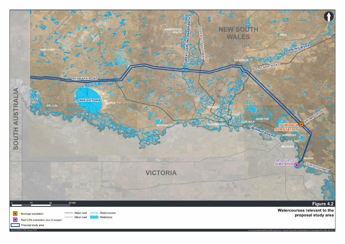
Project No PS117658 EnergyConnect (NSW – Western Section) Technical paper 6 – Hydrology, flooding and water quality TransGrid
WSP October 2020
Page 21
Figure 4.2 Waterways relevant to the proposal study area

Project No PS117658 EnergyConnect (NSW – Western Section) Technical paper 6 – Hydrology, flooding and water quality TransGrid
WSP October 2020
Page 22
4.2 CLIMATE AND RAINFALL The region has a semi-arid climate with hot summers and cool winters. The average temperature range is around 33–16°C in summer and around 15–4°C in winter.
The closest weather station to Buronga at the eastern end of the hydrology and flooding study area (Irymple, station number: 076015) records an average annual rainfall of 271 millimetres (1908–2020). Rainfall is typically fairly evenly spread across the year, with higher peak rainfall values from November to April. The Wentworth Post Office (Station number 047053) near the proposal has recorded rainfall data since 1868. The average rainfall at the Wentworth Post Office between 1868 and 2020 has been 286 millimetres per annum. There is a slight seasonal dominance from late autumn to late spring, with summer and early autumn being the driest period, on average.
The Lake Victoria Storage weather station (station number: 047016) records an annual average rainfall of 259.1 millimetres (1922–2020). The average monthly rainfall is slightly higher from May to November, however at Buronga, the recorded peak rain values are higher in the months from November to April.
Other average rainfall does not vary greatly across the proposal study area. The average annual rainfall at other recording stations near the proposal study area include 260 millimetres at Wentworth (Wamberra Station – 47040), 269 millimetres at Wentworth (Toora – 47099) and 259 millimetres at Lake Victoria Storage.
The hydrology and flooding study area has low average annual rainfall. For comparison, the long-term area-averaged rainfall for the Murray Darling Basin is 469 millimetres (based on the 1900–2016 period) (BOM, 2020). Figure 4.3 shows the proposal study area, between Mildura and Renmark, had the lowest total rainfall for the 2015-2016 period with the shading indicating a total of less than 200 millimetres. Mean daily evaporation averages 5.6 millimetres with a peak of 10.0 millimetres in January falling to 1.8 millimetres in June and 1.9 millimetres in July.

Project No PS117658 EnergyConnect (NSW – Western Section) Technical paper 6 – Hydrology, flooding and water quality TransGrid
WSP October 2020
Page 23
Source: BOM, accessed 10/08/2020 11:37 AM Figure 4.3 Total annual rainfall for the Murray–Darling Basin region during the 2015–16 year

Project No PS117658 EnergyConnect (NSW – Western Section) Technical paper 6 – Hydrology, flooding and water quality TransGrid
WSP October 2020
Page 24
4.2.1 CLIMATE CHANGE
NSW and ACT Regional Climate Modelling (NARCliM) project uses global climate model outputs and downscales these to provide finer, higher resolution climate projections for a range of meteorological variables across 12 different regions in NSW and ACT. The NARCliM far west model predicts an increase of up to five per cent in annual rainfall across the proposal area. However, the seasonal rainfall projections show a decrease in during winter and spring but an increase during summer and autumn. Figure 4.4 presents the NARCliM output for the annual rainfall change and Figure 4.5 presents the spring seasonal output.
Figure 4.4 Change in annual mean rainfall – Far West NSW (NSW OEH, 2014)

Project No PS117658 EnergyConnect (NSW – Western Section) Technical paper 6 – Hydrology, flooding and water quality TransGrid
WSP October 2020
Page 25
Figure 4.5 Far West Change in mean spring rainfall (NSW OEH,2014)
The projected increase in mean annual rainfall will impact the overall water availability in the hydrology and flooding study area but higher projected temperatures will also mean higher rates of evaporation which may negate the projected increase. The projected higher temperatures are estimated to result in increased rainfall intensities. This will change the behaviour of a flood event such that peak flood levels will occur faster but it is not likely to have a significant impact on the duration of flood events across the proposal study area because flooding is dominated by the upstream catchments. Refer to Section 4.4 for a description of flood behaviour.
4.3 TOPOGRAPHY The catchments of the proposal are largely flat but generally slope towards the existing large watercourses of the Darling River and the Darling Anabranch and then to the south to the Murray River. The catchment has a very shallow grade with the average grade is four to six centimetres per kilometre in the Darling River catchment. Additionally, there are large flat areas around the Darling River and Lake Victoria. The elevation across the proposal study area is about 35 to 80 metres above sea level.

Project No PS117658 EnergyConnect (NSW – Western Section) Technical paper 6 – Hydrology, flooding and water quality TransGrid
WSP October 2020
Page 26
4.4 FLOODING CONDITIONS As the average rainfall values are low and the surrounding topography has a low gradient, only small amounts of run off are generated from the catchment surrounding the proposal study area. River flows in the lower Darling River catchment are largely from seasonal rainfall and storms in the catchment and upper catchments. Most floods in the lower Darling River system occur in winter and spring after winter rainfall in central and north-eastern NSW. Floods also occur in autumn after summer monsoon rainfall in southern Queensland.
The pattern of flows, floods and drying events in the hydrology and flooding study area is influenced by the semi-arid climate and sporadic rainfall across most of the catchment. As a result, the historical flood pattern is highly variable. Rivers that flow through such regions are termed dryland rivers. In the lower Darling River system, the first half of last century was very dry with only a few small floods (1917, 1921, 1931 and 1941) (Jenkins 1999). In contrast, significant floods followed in the 1950s, 1970s, 1983 and 1990. The largest flood recorded in the lower Darling River system was in 1890. Two in every three years there has been a small flood in the upper reaches that flowed into the Menindee Lakes, northern anabranch lakes and Darling River billabongs (Irish 1993; Kingsford et al. 2002). In every one in 10 years there were moderate floods that spilled onto the floodplain and filled the southernmost lakes and wetlands for months to years (Irish 1993). (Murray Darling Basin Commission, The Living Murray Issues Paper No. 10, accessed 6/07/2020 12:16 PM).
In 1968, the naturally occurring chain of lakes near Menindee on the Darling River were modified by the NSW Government to improve its storage capacity for farming, recreation, mining, urban water supply and to manage Darling River floods. Consequently, the flows through the lower Darling River and the Great Darling Anabranch are highly regulated. Overall, the average annual flow in the Darling River has been reduced by more than 40 per cent as a result of water taken from the upper catchments of the Barwon–Darling river system. The timing of flows in the lower Darling has been changed, with the largest volume of water now flowing in summer to meet consumptive demand, rather than in autumn or spring when water flows from the north.
A high level flood risk assessment has been completed by BECA (2020) to understand the potential extent of flooding in the vicinity of the proposal. The assessment estimated the flood extent for the 1% Annual Exceedance Probability (AEP) event. Based on the risk assessment, the Darling Anabranch has a flood extent of over four kilometres wide and the Darling River of over 18 kilometres wide. Depths in the main river channels are estimated to be up to six metres and up to two metres across the floodplains for the proposal study area (BECA 2020). Refer to Figure 4.6.
The flood risk assessment indicates that peak velocities in the main channel of both the Darling River and Anabranch are less than one metre per second and the overbank areas have slower flows at less than 0.5 metres per second.
Flood data for the crossing of the Murray River is largely historic due to much of the flow being regulated through releases from the Hume Dam. Flood depths are not necessarily the issue, but flood extents are more the focus for flooding in the hydrology and flooding study area. A review of the aerial photographs for the hydrology and flooding study area and the flood risk assessment information would indicate the floodplain is up to four kilometres in width with the Sturt Highway being the limit of the flood extent on the NSW side of the river channel.
4.4.1 FLOOD AFFECTED FEATURES
The BECA flood risk assessment has been used to understand the flood affectation of features such as buildings and infrastructure across the proposal study area. It is noted that this affectation is limited to the information available and does not supersede any local information sourced from local studies or supplied by Wentworth Shire Council.
The Buronga Substation is located out of the floodplain with Gol Gol Lake some 1.5 kilometres to the south west the nearest flooded area.

Project No PS117658 EnergyConnect (NSW – Western Section) Technical paper 6 – Hydrology, flooding and water quality TransGrid
WSP October 2020
Page 27
For the proposal study area near the Darling River, Pooncarie Road, Low Darling Road and High Darling Road are predicted to be inundated at a number of locations. There are a number of buildings identified from the aerial photograph that are within the extent of the Darling River floodplain, but the floor levels for these structures is not available to determine the actual flood affectation of these structures.
Across the Darling Anabranch floodplain there are a number of structures near the proposal study area that are within the flood extent as defined by the BECA (2020) flood risk assessment. The actual flood affectation of these structures is not known due to no information on the floor levels of these structures being available. The Silver City Highway (considered critical infrastructure) appears to be on the edge of the Darling Anabranch floodplain and not inundated near the proposal study area.
Flood related infrastructure for floodplain harvesting such as flood levees or flood control banks have not been identified but it can be assumed to be within the floodplains of both the Darling River and Darling Anabranch. The intent of floodplain harvesting infrastructure is to opportunistically capture floodplain flows and store the floodwaters for later use.
4.4.2 FLOOD EMERGENCY MANAGEMENT ARRANGEMENTS
The Wentworth Shire Local Flood Plan, (SES, 2018) sets out the flood emergency management arrangements for the LGA of Wentworth. The plan covers the localities of Buronga, Ellerslie and Wentworth which are all located near the proposal study area. The plan relies upon the Bureau of Meteorology for notification of a flood event in the lower Darling River catchment. The gauges where flood event information is provided for upstream of the proposal study area include Pooncarie (gauge 425005) and Menindee (gauge 425001). The plan outlines that operations involving the area north and north west of the Darling Anabranch will be conducted by the NSW SES Broken Hill Unit when access from Wentworth is not possible.
The plan identifies Low Darling Road as being affected by floods but does not identify where or to what extent. No other roads in the proposal study area are listed. The plan indicates that the roads, Silver City Highway to Broken Hill and Silver City Highway to Mildura remain open during major floods. The plan does not list any flood evacuation routes but it can be assumed the Silver City Highway could serve as an evacuation route based on previous flood events.

Project No PS117658 EnergyConnect (NSW – Western Section) Technical paper 6 – Hydrology, flooding and water quality TransGrid
WSP October 2020
Page 28
Figure 4.6 Existing flood depths for 1% Annual Exceedance Probability (AEP) (BECA, 2020)

Project No PS117658 EnergyConnect (NSW – Western Section) Technical paper 6 – Hydrology, flooding and water quality TransGrid
WSP October 2020
Page 29
4.5 WATER SUPPLY AND WATER RESOURCES Existing water supplies to the urban area are from the Murray River, with raw water being supplied for outdoor use and filtered water for indoor use (Wentworth Shire Council, 2020). Rainwater collected from roofs is another source of domestic water supply for the urban area.
The Water Sharing Plan for the New South Wales Murray and Lower Darling Regulated Rivers Water Sources 2020 (draft) covers the Lower Darling River the Darling Anabranch and the Murray River from Hume Dam to the South Australian (SA) border. This plan covers the surface water in the water sources in the region. The plan includes the objectives for the water source which include:
— environmental — economic — Aboriginal cultural — social and cultural.
To achieve these objectives the water allocations are to be adjusted when any reduction in the availability of water is detected due to an increase in extraction above the long-term average annual extraction limit or the long term average sustainable diversion limit (NSW Department of Planning, Industry and Environment, 2020).
Environmental water is a large component of the water allocation. The Environmental Water Register maintained by the Department of Industry provides a record of licenced environmental water, as well as other water intended to be used for environmental purposes.
As at 1 July 2020, the licenced environmental water includes:
— two access licences with adaptive environmental water conditions in the Murray Water Source — no access licences with adaptive environmental water conditions in the Lower Darling Water Source.
As at 1 July 2020, there are other licences that are not identified as licenced environmental water but are intended to be used for environmental purposes, these include:
— 36 other access licences with share components in the Murray Water Source — 8 other access licences with share components in the Lower Darling Water Source.
The plan outlines the volumes of water allocation for the commencement of the plan in July 2020. The plan also includes other licence levels, general security and supplementary licences with their licences volumes measures as shares of the total water source. The top priority licence level is high security and as listed below they are limited, there are many general security and supplementary licences but these are not listed due to their numbers. The volumes of water for high security licences are summarised as follows:
— domestic and stock access licences:
— 17,102 megalitres per year in the Murray Water Source — 1,370 megalitres per year in the Lower Darling Water Source
— local Water Utility access licences:
— 38,217 megalitres per year in the Murray Water Source — 10,135 megalitres per year in the Lower Darling Water Source
— other high security access licences in the Murray River source:
— 0 megalitres per year for subcategory Aboriginal cultural — 47 megalitres per year for subcategory Community and education — 0 megalitres per year for subcategory Environmental — 1 megalitres per year for subcategory Research — 3,195 megalitres per year for subcategory Town water supply.

Project No PS117658 EnergyConnect (NSW – Western Section) Technical paper 6 – Hydrology, flooding and water quality TransGrid
WSP October 2020
Page 30
DPIE Water provide water allocation statements which announce allocations in line with the Water Sharing Plan for New South Wales Murray and Lower Darling Regulated Rivers Water Sources. The 3 August 2020 statement (DPIR Water 2020) also provides a summary of current allocations, outlook and possible future water availability scenarios. The 3 August 2020 statement indicates the NSW Murray River resource supply increased due to rain in July 2020 but the Lower Darling River did not change and both water sources are still considered to be in drought. The Lower Darling is fed by water from the Menindee Lakes some 170 kilometres north of the proposal study area. The Menindee Lakes are currently (August 2020) operated with minimum releases to maximise longevity of supply and is expected to slowly deplete without further inflows. Lower Darling general security entitlements received a 30 per cent opening allocation on 1 July 2020, but high security and water utility and stock and domestic have been allocated 100 per cent of their full entitlement. Further significant inflows are required before further improvements to general allocations can be announced. (DPIE Water, 2020)
4.6 LAND USES The region is sparsely populated with a few small towns, such as Menindee, Pooncarie and Wentworth, which provide a basic level of services to the community and the surrounding rural population. Most of the catchment is used for grazing, mainly sheep, or is native vegetation. Figure 4.7 provides overview of land uses.
The vast majority of the proposal study area and surrounding areas is used for grazing native vegetation and is classified as such by the former NSW Office of Environment and Heritage (OEH, 2013a). Grazing of goats, cattle and sheep (for wool and meat) is common.
Much smaller proportions are classified as cropping or grazing modified pastures by OEH (2013a). There are some relatively small areas with a recent history of dryland cropping and improved pastures at the south eastern end of the proposal study area around Buronga, however some other areas in the central part of the proposal study area do not appear to have been cropped or been improved pastures in recent years.
There are some irrigated grape vines on and adjacent to the proposal study area near the Darling River, and adjacent to the proposal study area near the Murray River.
4.7 SOILS AND GEOLOGY The soils along the proposal study area are expected to be generally comprised of calcarosols according to Australian Soil Classification (CSIRO, 2016) red dune fields, with some sand and vertisols found along the main watercourses alluvial plains in proximity to the Murrumbidgee, Darlings, and Darling – Anabranch Rivers.
4.7.1 SOIL TYPES
The soils along the proposal study area are expected to be generally comprised of red dune fields, with some sand and alluvial plains in proximity to the Murrumbidgee, Darlings, and Darling – Anabranch Rivers. Published soil mapping along the alignment indicates that the regional geology and soils are expected to be predominantly transported Quaternary-aged sediments deposited in alluvial flood plains, and dune. The predominant soil types are typically sand and clay or a mixture of the two.
Investigation results from (Douglas Partners, 2020) indicate that the Woorinen Formation typically comprises large proportions of very stiff to hard (calcareous) clays and dense to very dense sands with occasional bands of medium dense sands. The investigation also determined soils across the proposal study area are highly sensitive to moisture changes and the clayey silt, silty clay, or silty fine sand materials encountered across the proposal study area are known to be difficult to work with and susceptible to substantial strength loss if exposed to wet weather. Soil samples were also tested and the results indicating that the surface soils vary from being susceptible to some dispersion in water which means they can be eroded by surface water flows.

Project No PS117658 EnergyConnect (NSW – Western Section) Technical paper 6 – Hydrology, flooding and water quality TransGrid
WSP October 2020
Page 31
4.7.2 SOIL SALINITY
Most of the proposal study area is classified as having low salinity potential; however, an assessment of soil aggressivity was undertaken by (DP, 2020) with reference to AS2159-2009 and results indicated that the soils are highly alkaline, with high levels of sodicity.
Areas classified as having high salinity potential are not within the vicinity of the proposal study area.
4.7.3 ACID SULFATE SOILS
Acid sulfate soils and potential acid sulfate soils are naturally occurring soils containing iron sulphides. On exposure to air, iron sulphides oxidise and create sulfuric acid. This increase in acidity can result in the mobilisation of aluminium, iron and manganese from the soils. The CSIRO Australian Soil Resource Information System indicates that there is a low probability of acid sulfate soils within most of the proposal study area, except for low lying areas surrounding former lakes and river beds, which are mapped as potentially containing acid sulfate soils. Some small areas of potential acid sulfate soils are located near the Darling River. Figure 4.8 shows the acid sulfate soil risk classifications for land within and in the vicinity of the proposal study area.

Project No PS117658 EnergyConnect (NSW – Western Section) Technical paper 6 – Hydrology, flooding and water quality TransGrid
WSP October 2020
Page 32
Figure 4.7 Land use within and surrounding the proposal study area (based on NSW Land Use Categories 2013)

Project No PS117658 EnergyConnect (NSW – Western Section) Technical paper 6 – Hydrology, flooding and water quality TransGrid
WSP October 2020
Page 33
Figure 4.8 Acid sulfate soil risk mapping

Project No PS117658 EnergyConnect (NSW – Western Section) Technical paper 6 – Hydrology, flooding and water quality TransGrid
WSP October 2020
Page 34
4.7.4 GEOLOGY
Published geological mapping data from the Seamless Geology Project (Colquhoun, Hughes & Deyssing et al, 2019) indicates that Quaternary aged transported soils cover most of the proposal study area. This material includes alluvial flood plains, dune sands and swamp or lake deposits.
Approximately 70 per cent (about 108 kilometres) of the proposal study area is covered by a surficial layer of aeolian sediments of the Woorinen Formation. This dominant geology changes near surface water systems, which includes alluvial sediments near creeks, river tributaries and in areas surrounding the Darling River and Great Darling-Anabranch. In the proposal study area, the alluvium laterally extends up to 14 kilometres across the Darling River and five kilometres across Great Darling-Anabranch. There are also small, minor areas of other alluvial, fluvial and aeolian deposits in the proposal study area.
4.8 CONTAMINATION Table 4.1 provides an overview of the areas of contamination concern, and the associated contaminants, located in or within the vicinity of the proposal study area. The identification of areas of contamination concern are based on existing land uses and the potential for contamination to occur. Refer to the Technical Paper 12: Phase 1 Contamination Assessment (WSP, 2020) for more information.
Table 4.1 Identified areas of contamination concern within the proposal study area
AREAS OF CONTAMINATION CONCERN AND RATIONALE FOR CONCERN
LOCATION POTENTIAL CONTAMINANTS OF CONCERN
Buronga substation
Spills from maintenance activities on-site and leaks
34.103°S, 142.259°E — Poly chlorinated biphenyls (PCBs)
— Benzene, toluene, ethylbenzene, xylene and naphthalene (collectively referred to as BTEXN)
— Total recoverable hydrocarbons (TRH)
— Oils
Wentworth substation (off Pooncarie Road)
Spills from maintenance activities on-site and leaks
33.869°S, 142.021°E — PCBs — BTEXN — TRH — Oils
Existing transmission line infrastructure
Spills from maintenance activities on site Asbestos paints on tower infrastructure
Portions of proposal study area — BTEXN — TRH — Asbestos
Built-up areas and residences
Historical uncontrolled earthworks and building structures previously demolished/degraded
33.854°S, 141.991°E — Heavy metals — BTEX — Asbestos — PAH — Pesticides — TRH

Project No PS117658 EnergyConnect (NSW – Western Section) Technical paper 6 – Hydrology, flooding and water quality TransGrid
WSP October 2020
Page 35
AREAS OF CONTAMINATION CONCERN AND RATIONALE FOR CONCERN
LOCATION POTENTIAL CONTAMINANTS OF CONCERN
Cleared agricultural land
Historical use of pesticides, and foliants, large scale land use and the use of heavy machinery
— near 34.259°S, 142.283°E — near 33.866°S, 142.016°E — near 33.832°S,141.956°E
— Heavy metals — Organochlorine pesticides (OCP) — Organphosphorus pesticides
(OPP)
Farm dams Areas of potential fill — 34.259°S, 142.283°E — 33.853°S, 141.866°E — 33.831°S, 141.510°E — 33.883°S, 141.036°E
— Heavy metals — BTEXN — Asbestos — Poly aromatic hydrocarbons
(PAH) — OCP — OPP — TRH — Nutrients
Potential quarry Areas of potential fill — 33.883°S, 141.440°E — Heavy metals — BTEX — Asbestos — PAH — OCP — OPP — TRH
4.9 GROUNDWATER DEPENDENT ECOSYSTEMS Groundwater dependent ecosystems (GDEs) are communities of plants, animals and other organisms that depend on groundwater for survival (Department of Land and Water Conservation, 2002). A GDE may be either entirely dependent on groundwater for survival or may use groundwater opportunistically or for a supplementary source of water (Evans and Hatton, 1998).
GDEs include wetlands, vegetation, mound springs, river base flows, cave ecosystems, playa lakes and saline discharges, springs, mangroves, river pools, billabongs and hanging swamps and near-shore marine ecosystems.
No high priority GDEs were documented in either of the previous groundwater related water sharing plans that were superseded on 1 July 2020. Publicly available location (GIS) data, including information on high priority GDEs, is currently unavailable for the new water sharing plans that were enacted on 1 July 2020. Groundwater dependent ecosystems, particularly high priority GDEs, and the potential impacts will be reassessed following the release of the GIS data pertaining to GDEs in the Darling Alluvial Groundwater Sources 2020 and NSW Murray-Darling Basin Porous Rock Groundwater Sources 2020 water sharing plans. This will be undertaken during detailed design, or if available sooner, during the submission report. However, information obtained through the NGIS (BOM 2020b) identified six high potential for groundwater interaction GDEs within the proposal study area of NSW (Table 4.2).

Project No PS117658 EnergyConnect (NSW – Western Section) Technical paper 6 – Hydrology, flooding and water quality TransGrid
WSP October 2020
Page 36
Table 4.2 High potential for groundwater interaction GDEs within the proposal study area (BOM 2020b)
GDE TYPE NAME COVERAGE (HA)
Terrestrial (aquatic) Darling River –
Terrestrial (aquatic) Murray River –
Subterranean (vegetation) Eucalyptus Camaldulensis 6571
Subterranean (vegetation) Eucalyptus Largiflorens 7127
Subterranean (vegetation) Grassy Riverine Forest <1
Subterranean (vegetation) Mallee 75841
(1) Combined total area of Mallee vegetation communities listed as very sparse, sparse, and isolated.
Generally, all identified GDEs within NSW are in proximity to the Darling River and Great Darling-Anabranch, with larger GDE communities adjacent to the Darling River. Two non-connected populations of Mallee (vegetation) exist northeast of Lake Victoria; one at the edge of the proposal study area (approximately two kilometres from the proposal disturbance area) and the other within the proposals disturbance area and extends approximately five kilometres to the northwest. An additional grouping of Mallee and Eucalyptus Largiflorens exists proximal to the townships of Buronga and Wentworth, approximately one and a half kilometres from the proposal study area.
4.10 WETLANDS The Protect Matters Search Tool (NSW DAWE, 2020) identified no RAMSAR wetlands within the hydrology and flooding study area.
4.11 GROUNDWATER INTERACTION Permanent groundwater levels underlying the proposal study area vary locally due to influences from surface water features, climatic conditions and localised geological controls. However, across the majority of the proposal study area, groundwater levels are anticipated to be between 20 to 30 metres below ground level.
Elevated groundwater levels were encountered within a few kilometres of major surface water features of the Darling River and the Great Darling Anabranch, and close to irrigation land users. Generally, groundwater was within five metres of the ground level within 500 metres of these rivers.
Surface water and groundwater connectivity are limited across the region, however there are two primary locations within the proposal study area that have increased surface water and groundwater connectivity:
— a freshwater lens that has developed within the alluvial aquifer that is adjacent to the Darling River (NSW Office of Water 2012a). The freshwater lens extends approximately 500 metres from the Darling River into the associated alluvial sediments, where it is recharged primarily by the Darling River. Where this freshwater lens is present, the groundwater system has been classified as a ‘highly connected system’ in which ‘70 per cent or more of the groundwater extraction volume is derived from stream flow within a single irrigation season’ (NSW Office of Water 2012a). Outside of this freshwater lens, groundwater is considered to not be highly unconnected to the river.
— groundwater below and surrounding Lake Victoria. This is highly connected, particularly the shallow unconfined aquifers, and consistently shows strong groundwater level and water quality relationships to the surface water level in Lake Victoria (Parsons Brinckerhoff, 2013; MDBA, 2014; MDBA, 2019a).

Project No PS117658 EnergyConnect (NSW – Western Section) Technical paper 6 – Hydrology, flooding and water quality TransGrid
WSP October 2020
Page 37
4.12 GEOMORPHOLOGY Table 4.3 outlines the geomorphology of the watercourses intersected by the proposal study area. This assessment is based on the NSW River Styles Mapping (NSW Department of Industry, 2019a). There are many dry ephemeral watercourses and overland flow paths intersected by the proposal study area that are not identified as watercourses and therefore have not been assessed individually. Many of these watercourses would be first order streams (meaning there are no other streams flowing into it) and their size, shape and location is dependent on regular rainfall events. There are also many second and higher order streams that have not been officially identified and these streams are dependent on the first order streams for surface flows.
The geomorphic condition affects the aquatic biodiversity and physical habitats available in the stream. The riverine channel and bank shape and riparian vegetation is used to assess the local aquatic habitat and its potential to support aquatic biota and these physical features and stream order form the basis of the NSW River Styles Mapping. The lack of regular flow and no riparian vegetation mean the first and second order streams or overland flow paths would be in a poor geomorphic condition (no fixed channel shape or size) and high fragility because of the significant potential to change with each flow event.
In Table 4.3 recovery potential is a measure of the capacity of a river reach to return to good condition or to a realistic rehabilitated condition, given the limiting inputs of the reach. These inputs include the flow volumes and velocities and the type of vegetation and sediments that help maintain the stream style.
Table 4.3 Watercourses in the proposal study area and the associated NSW River Styles Mapping information
WATERCOURSE STREAM ORDER
NSW RIVER STYLE
EXISTING CONDITION
RECOVERY POTENTIAL
DESCRIPTION
Darling River Null (because of the numerous tributaries)
Meandering and find grained with anabranches
Moderate condition
High fragility
High The Darling River can be described as a series of connected pools along many sections. It is laterally unconfined which is evident from the significant meandering channel and many billabongs and dry anabranches particularly near the proposal study area.
Great Darling Anabranch
Null (because of the numerous tributaries)
Meandering and find grained with anabranches
Moderate condition
High fragility
High The Great Darling Anabranch is laterally unconfined and meanders significantly at the proposal crossing but it described as being in good geomorphic condition.
Murray River Null (because of the numerous tributaries)
Meandering and find grained with anabranches
Moderate condition
High fragility
High The Murray River has a permanent channel with flows controlled by releases from Hume Dam. It has riparian vegetation along it banks away from the towns.

Project No PS117658 EnergyConnect (NSW – Western Section) Technical paper 6 – Hydrology, flooding and water quality TransGrid
WSP October 2020
Page 38
4.13 WATER QUALITY A desktop review was undertaken of existing water quality conditions. Water quality data and documents (refer to Section 3.5) from the broader catchment areas was reviewed to provide an understanding of the general water quality of the hydrology and flooding study area.
4.13.1 STATE OF THE CATCHMENTS (2010)
The State of the Catchments report (NSW Government, 2010) used turbidity and total phosphorus (TP) as indicators of water quality performance in the Lower Murray Darling catchment. At the Darling River Burtundy monitoring site, the site closest to the proposal study area, data from the 2005–2008 period showed 39 per cent exceedance of the TP ANZECC 2000 guidelines and 17 per cent exceedance of ANZECC 2000 guideline values for turbidity. The overall macroinvertebrate condition, fish condition and hydrologic condition was rated as poor. ‘Overall, the flow regime had fewer high flows, and reduced annual volumes and variability, with little change to low and zero flows and flow seasonality. This pattern reflects the diversion of a significant volume of water from the system and the effect of differentially harvesting high flows’ (MDBC 2008).
4.13.2 NATIONAL WATER QUALITY ASSESSMENT (SINCLAIR KNIGHT MERZ, 2011)
The National Water Quality Assessment (Sinclair Knight Merz, 2011) was commissioned as a nationwide water quality assessment to provide a snapshot of water quality across inland waters of Australia. The assessment collated water quality data from a series of sources across Australia and compared them to the relevant ANZECC 2000 water quality objectives for the region. The water quality data examined in the assessment included turbidity, salinity, pH, nutrients and algal blooms (specifically cyanobacterial blooms), and faecal contamination (microbial quality). The report classified water quality for each of these parameters between ‘Very poor’ to ‘Good’ based on the percentage of samples that were compliant with the ANZECC 2000 objectives. These classifications are shown in Table 4.4.
Table 4.4 National Water Quality Assessment 2011 – Water quality classifications against ANZECC 2000 guidelines
CLASSIFICATION PERCENTAGE COMPLIANCE WITH ANZECC 2000 GUIDELINES VALUES
Good >75%
Fair 50–75%
Poor 25–50%
Very Poor <25%
The Darling River Basin received a score of ‘Very poor’ for both total nitrogen (TN) and TP, ‘Poor’ for turbidity and pH and ‘Fair’ for salinity. The report notes that turbidity levels exceeded the ANZECC 2000 trigger value of 50 NTU for 69 per cent of sample with median levels ranging from 12 to 167 NTU. 97 per cent and 98 percent of samples for TN and TP respectively exceeded the ANZECC 2000 guidelines. Median concentrations ranged from 735 to 110 µg/L for TN and 160 to 325 µg/L for TP.
4.13.3 STATE OF THE ENVIRONMENT 2018 (EPA, 2018)
Prepared every three years, the NSW State of the Environment reports on the status of key environmental issues facing New South Wales including waterway health. This report uses the same classifications for water quality samples as shown in Table 4.4.

Project No PS117658 EnergyConnect (NSW – Western Section) Technical paper 6 – Hydrology, flooding and water quality TransGrid
WSP October 2020
Page 39
Figure 4.9 shows that sampling sites on the Darling River have greater than 75 per cent exceedances for TN which corresponds to a ‘Very poor’ rating and 50–75 per cent exceedances for TP which corresponds to a ‘Poor’ rating. The site on the Murray past the Darling River’s confluence with the Murray, has a less than 25 per cent exceedance for TN and TP. Sites upstream of this location generally have less than 25 per cent exceedances for TN which corresponds to a ‘Good’ rating and ‘good to ‘Fair’ ratings for TP.
Figure 4.9 Per cent of samples exceedances for nutrient values as assessed by the 2018 State of the Environment
report
4.13.4 DARLING WATER RESOURCE PLAN, (DPI, 2018)
The Darling Water Resource Plan (DPI, 2018) rated the condition of the Lower Murray-Darling as poor to good using an integrated indicator of TN, TP, pH, turbidity and dissolved oxygen. The indicator was calculated using the frequency and amplitude of exceedances of the Basin Plan 2012 water quality targets during 2010–11 and 2014–15.
Both monitoring sites from the Darling River were rated as poor (refer to Figure 4.10). Nutrients (nitrogen and phosphorus) and suspended sediments are mostly low in the Murray River but frequently exceed the target values in the Darling River. In the Darling River fine clay particles remain suspended in the water column even during low flows, resulting in continually high turbidity levels (DPI Water 2017).

Project No PS117658 EnergyConnect (NSW – Western Section) Technical paper 6 – Hydrology, flooding and water quality TransGrid
WSP October 2020
Page 40
The report noted that dissolved oxygen levels within the western part of the water resources plan areas are frequently outside of the target range and can be unpredictable in the Darling River during periods of low flow. Releases from NSW Murray and Lower Menindee Lakes into the Darling River when it is not flowing can cause fish kills due to the low levels of dissolved oxygen. Harmful algal blooms occur in some years during the warmer months in the Menindee Lakes, the Lower Darling River and the lower part of the Murray River.
The pH level is sometimes elevated in the Darling River at Burtundy. Salinity is mostly low with occasional spikes of higher salt levels. Nutrients (nitrogen and phosphorus) and suspended sediments are mostly low in the Murray River but frequently exceed the target values in the Darling River. In the Darling River fine clay particles remain suspended in the water column even during low flows, resulting in continually high turbidity levels (DPI Water 2017). Harmful algal blooms occur in some years during the warmer months in the Menindee Lakes, the Lower Darling River and the lower part of the Murray River.
Figure 4.10 Water quality ratings – Darling Water Resource Plan, DPI, 2018
4.13.5 BASIN PLAN 2012 ANNUAL REPORT 2018-2019 (MDBA, 2020)
Across the Basin, water quality through the summer of 2018–19 was affected by high temperatures. The northern Basin was also affected by very low flows. Extensive blue-green algae outbreaks occurred. The outbreaks were monitored and managed where possible by the responsible Basin government authorities. Along stretches of the lower Darling River, low or no flows combined with extended hot and dry weather conditions resulted in poor water quality, including high levels of blue-green algae.

Project No PS117658 EnergyConnect (NSW – Western Section) Technical paper 6 – Hydrology, flooding and water quality TransGrid
WSP October 2020
Page 41
4.13.6 SUMMARY OF EXISTING WATER QUALITY
The State of the Catchments (Section 4.13.1 ) report in 2010 identified the TP and turbidity often exceeded the ANZECC 2000 guidelines which was confirmed again in 2011 with the National Water Quality Assessment (Section 4.13.2). The 2018 State of the Environment Report (Section 4.13.3) scored an overall rating of the Darling River as poor, particularly with regards to nutrient values but the Murray River as good. The Darling Water Resource plan in 2018 (Section 4.13.4) again scored the Darling River overall as poor, particularly with regard to nutrient values. The Basin Plan 2012 Annual Report (2019) indicated that poor water quality was likely due to low flows and therefore less flushing.
The water quality targets presented in the Murray and Lower Darling Surface Water Resource Plan – Water Quality Management Plan were developed following the methods outlined in the ANZECC 2000 guidelines, the previous water quality monitoring results provide an indication of the likely condition of the existing water quality environment of the proposal study area. Overall, it can therefore be deduced that the waterways near the proposal study area are unlikely to achieve the water quality targets identified for the proposal in Table 2.2, particularly for nutrients.

Project No PS117658 EnergyConnect (NSW – Western Section) Technical paper 6 – Hydrology, flooding and water quality TransGrid
WSP October 2020
Page 42
5 ASSESSMENT OF CONSTRUCTION IMPACTS
5.1 FLOODING During construction, the impacts to flood behaviour are likely to be temporary, localised and insignificant. The Darling River and Darling Anabranch floodplains as described in Section 4.4 above and the following construction activities are considered:
— construction of access tracks for construction machinery and materials to access each transmission line structure site — earthworks and establishment of construction pads for each transmission line structure — construction of footings and foundation works for the new transmission line structures including boring and/or
excavation, steel fabrication works and concrete pours — laydown and staging areas — concrete batching plants — brake/winch sites — Buronga Substation — site offices and accommodation camps.
Once the transmission line structures on either side of the rivers are constructed, the line would be strung between them using aerial technology such as drones so that vehicle crossings are not required for this activity. Some crossings may be needed at the smaller tributaries that have dry beds and would require long journeys to divert construction vehicles around the crossing. In wet weather events, these crossings would become unusable or if small embankments are placed in the waterway then they could result in minor increases in flood levels upstream of the crossing. These minor increases would be temporary but have the potential to cause redirection of the creek if suitable crossing infrastructure is not included.
The earthworks required for the transmission line structures would cause the temporary redistribution of flood flows which may have impacts on other nearby infrastructure, including structures and floodplain harvesting works. The construction planning during detailed design would consider how these temporary changes would be managed to prevent significant impacts occurring. This design will consider Section 5.3, Policy (a) of the Wentworth Shire Council Flood Liable Land Policy:
Earthworks mound fill placement for purposes of structure support shall be located and distributed in the floodplain in such a manner that the mounds do not collectively inhibit to a significant extent the flow of flood waters.
Large stockpiles and significant foundation works may result in changes to flood behaviour beyond the proposal footprint as it could redistribute and redirect floodwaters, and subsequently impact other land and infrastructure, including floodplain harvesting works. Construction planning during detailed design would consider how these temporary changes would be managed to prevent significant impacts occurring.
The Buronga substation is not affected by flooding and subsequently there would be no impact to flood behaviour from construction works at the site and no impact to flood behaviour beyond the construction works site.
All other facilities would be located away from flood prone area and therefore would have no impact on flood behaviour.
Section 4.1.1 identified existing flood affected roads. The flood affectation of these roads including critical infrastructure, such as the Silver City Highway, is unlikely to change due to the proposal construction activities because there will be no significant change to flood behaviour in the adjacent floodplain which affects flooding at the road.

Project No PS117658 EnergyConnect (NSW – Western Section) Technical paper 6 – Hydrology, flooding and water quality TransGrid
WSP October 2020
Page 43
Flood impacts at residential buildings and farm related buildings within the proposal study area are unlikely when appropriate soil and water management practices are followed. Site specific soil and water management practices would need to be considered during detailed design and construction planning. Potential changes include redistribution and redirection of floodwaters resulting in localised increases in flood depth.
5.2 GEOMORPHOLOGY There are three major waterway crossings as part of the proposal, at the Murray River, Darling River and Darling Anabranch. Transmission line structures would be constructed at least 50 metres from the edge of the major waterways and therefore will be out of the main river channels but are unlikely to be able to avoid all first and second order streams which are ephemeral. There would be no temporary or permanent crossings of the Murray River, Darling River or Darling Anabranch constructed as part of the proposal. However, there would be numerous crossings of minor streams and the potential impacts to geomorphic conditions of these waterways would include:
— changes in low flow channel shape due to temporary works changing local runoff behaviour — increased sediment load from runoff from construction areas.
Transmission line structures located within the flood prone area and potentially within first and second order streams may contribute to the above geomorphological impacts during flood events because the only time they will flow is during a flood event. These impacts would be minor but could result in local changes to channel shape and location which in turn causes erosion as the channel is moved from its original position. The high fragility of the minor waterways and low recovery potential means there could be permanent changes to the local overland flow paths. These changes would have to be discussed with landowners and managed during construction. Where transmission line structures are located out of the flood prone area, there would not be any geomorphological impacts.
5.3 WATER SUPPLY AND WATER RESOURCES Water would be required during construction for:
— dust suppression on substation construction sites and line structure construction sites, and on access tracks by the use of a water spray attached to a tanker vehicle and use of water reduction polymers
— concrete batching by mixing cement, aggregates and water for line structure and substation foundations — wetting backfill material, if it is too dry for effective compaction — general worker facilities at the three primary construction compound and camp sites, with accommodation and
amenities located at Anabranch South on the Silver City Highway, at Buronga (adjacent to the Buronga substation) and in proximity Wentworth (and surrounds).
It is estimated that 616 mega litres of water could be required for construction over the full construction period. This would be confirmed by the construction contractor and is potentially comprised of the following allocations:
— dust suppression: expecting this to be required at approximately four concurrent work sites, weekly suppression via water w/polymers
— concrete batching (assuming concrete line structure foundations are adopted): 200 cubic metres concrete per each of the approximate 330 line structures, plus concrete for the Buronga substation upgrade and expansion being approximately 100,000 cubic metres concrete in total
— construction camps: 200 litres of water per person per day for 400 construction personnel for 550 days.
The proposal would primarily rely upon surface water sources due to the poor water quality and availability of groundwater in this area and it would be:
— purchased from the existing water market or council facilities — accessed via existing, licensed water extraction infrastructure only.

Project No PS117658 EnergyConnect (NSW – Western Section) Technical paper 6 – Hydrology, flooding and water quality TransGrid
WSP October 2020
Page 44
Wastewater would be generated from staff facilities and construction activities. The major impact from release of wastewater would be elevated nutrient levels, however wastewater would be collected via tanker trucks and disposed of at approved disposal locations in accordance with the NSW EPA waste classification guidelines.
5.4 WATER QUALITY The construction of the proposal has the potential to further degrade the water quality of the waterways within the proposal study area and areas downstream of this area, if not properly managed. The construction activities assessed with regard to water quality impacts include but are not limited to:
— construction of access tracks for construction machinery and materials to access each transmission line structure site — earthworks and establishment of construction pads for each transmission line structure — construction of footings and foundation works for the new transmission line structures including boring and/or
excavation, steel fabrication works and concrete pours — laydown and staging areas — concrete batching plants — construction of the substation site — brake/winch sites — Buronga substation — site offices and accommodation camps.
Based on these activities, construction of the proposal may lead to increases of the following pollutants into waterways:
— nutrients (nitrogen and phosphorus) – commonly present in agricultural areas that may become mobilised from disturbance of agricultural land for construction work
— sediment from vegetation and top soil clearing, soil excavation, movement and storage and stormwater runoff through disturbed sites
— chemicals, fuels and hydrocarbons from use, refuelling and maintenance of equipment and construction machinery — concrete slurry and wastewater – from mobile concrete batching plants — contaminants of concern related to previous land uses - heavy metals, Total recoverable hydrocarbons (TRH), -
Benzene, Toluene, Ethylbenzene, and Xylenes (BTEX), Polycyclic aromatic hydrocarbon (PAH), organochlorine pesticides (OCP) and organophosphorus pesticides (OPP)
— heavy metals such as zinc, lead, copper, nickel, cadmium and chromium from disturbance of contamination and use and maintenance of vehicles and plants
— problem soils such as saline and acid sulfate soils — gross pollutants such as paper and plastic packaging and materials from material use on construction sites and
general construction staff litter.
While it has been noted that the quality of the hydrology and flooding study area is already degraded (refer to Section 4.13), the construction of the proposal may further degrade water quality if not properly managed which may subsequentially have impacts to surrounding ecology, sensitive receivers and other water uses. The likelihood and magnitude of risks would vary depending on the stage of construction, the area of disturbance, distance to watercourses, slope of land and presence of high rainfall or wind weather events. A Construction Environmental Management Plan (CEMP) and associated Soil and Water Management Plan (SWMP) would be prepared. The SWMP would identify the measures required to be implemented at construction work sites and this would limit the impact of the proposal (refer to Chapter 8). These measures are commonly applied and well understood. Potential construction water quality impacts associated with key construction activities are discussed below.

Project No PS117658 EnergyConnect (NSW – Western Section) Technical paper 6 – Hydrology, flooding and water quality TransGrid
WSP October 2020
Page 45
5.4.1 EARTHWORKS
Earthworks would be required for construction of transmission line structures, construction of the Buronga substation and for all general civil works required for permanent and temporary roads, site offices and ancillary facilities. The disturbance area at each transmission line structure for structure assembly and stringing would be about 60 metres by 90 metres and up to 50 metres deep (at the potential deepest locations). Land would also be required for construction compounds and accommodation camps to support construction. Vegetation clearing, top soil clearing and earthworks, as well as other activities like vehicle movements and changes to natural drainage lines may lead to increased erosion and export of sediment to waterways during construction. These risks would be ongoing throughout the life of the construction phase and would be highest at locations with a slope of greater than 2.5 per cent, that are near waterways and are frequently disturbed. Risks of sediment transport and erosion would also increase during high rainfall and wind weather events.
Earthworks would increase the amount of disturbed and exposed soil available, which may impact the surface water quality of the environment through:
— changes to surface water run-off or evaporation due to clearing vegetation coverage. This may increase run-off volumes at both the temporary or long-term time scale
— increased surface water run-off due to soil stabilisation earthworks. Soil stabilisation may result in change to the permeability of the natural soils
— mobilisation of saline soils that may affect salinity levels and potentially damage concrete and metal structures — mobilisation of contaminants or heavy metals that are present in soils — increased turbidity, lowered dissolved oxygen levels and increased nutrients in water ways — potential impacts to groundwater quality where there is interaction between the surface and groundwater (refer to
Section 4.11) — reduction in channel habitat from sediment transport and deposition.
These potential impacts would be accounted for in the CEMP. These would include requirements for progressive erosion and sediment control measures and on site management protocols. Implementation of appropriate soil and water construction management measures would be anticipated to minimise impacts to water quality impacts from construction of the proposal. Additionally, impacts would be limited to the duration of construction and would be short term. As such, the construction of the proposal would not cause significant changes to the water quality environment.
5.4.2 STOCKPILING AND SPOIL HANDLING
The construction of the proposal would generate spoil, vegetation waste and general construction and demolition waste that would be stored in stockpiles.
Stockpiling of earthwork materials poses a risk to water quality in receiving environments through the increased likelihood of movement of sediment. Stockpiling of mulched vegetation from clearing of trees and shrubs poses a risk of tannins leaching into watercourses, and increased loads of organics in watercourses. The discharge of water that is high in tannins may increase the biological oxygen demand of the receiving environment, which may in turn result in a decrease in available dissolved oxygen. Once discharged to the environment, tannins may also reduce visibility and light penetration, and change the pH of receiving waters. These impacts may affect aquatic ecosystems in receiving environments.
This material would be minimised and reused where practicable. Excess spoil stockpiled in locations that are open to rainfall or runoff would include appropriate management measures such as sediment fences and diversion drains to mitigate the impact of sediment movement offsite. Correct implementation of stockpile management protocols would mitigate and mange impacts to the receiving environments water quality.

Project No PS117658 EnergyConnect (NSW – Western Section) Technical paper 6 – Hydrology, flooding and water quality TransGrid
WSP October 2020
Page 46
5.4.3 POTENTIAL FOR SPILLS AND LITTER
The following activities have the potential to result in release of contaminants, oils, fuels, grease, chemicals and gross pollutants into the waterways in and surrounding the proposal:
— machinery and equipment operation, refuelling, maintenance and wash down — spills and failure of machinery — concrete batching, treatment and curing — disturbance of contaminated soils — inadequate management of chemicals, spoil, material stockpiles and litter from construction sites — wastewater generated during construction.
Pollutants from these activities may be picked up in runoff from the site and enter the waterways and be transported downstream of the disturbance area. Water quality and ecological impacts may result from release of these contaminants into the catchment. Mitigation and management measures such as bunding, silt fences and other physical measures, would be implemented as part of the construction of the proposal. This would reduce the potential for release of chemicals from construction sites and into waterways.
5.4.4 SUMMARY OF WATER QUALITY IMPACTS
The majority of the proposal study area has many ephemeral watercourses that are not identified as sensitive environmental receivers and is therefore not sensitive to potential change from water quality impacts.
For the main watercourses of the Darling River, Darling Anabranch, Lake Victoria, Lake Gol Gol and Murray River , water quality impacts from the construction of the proposal are anticipated to be short-term and limited in extent and the progressive nature of construction would limit the work areas and duration within which impacts may occur. A water quality monitoring program prior to and during construction would be developed to collect baseline data to characterise the existing water quality condition. The program would include water quality targets in line with the Basin Plan 2012, relevant water resource plan and the ANZG guidelines. Monitoring as part of this program would assist in identifying any issues arising as part of the construction of the proposal and therefore minimising impacts to water quality as a result of the proposal.
The key water quality objectives for the proposal, based on the Basin Plan 2012, is to appropriately manage water quality, including salinity, for environmental, social, cultural, and economic activity and therefore protect downstream environments from the potential impacts of surface runoff and discharge during construction and operation. The detailed water quality objectives for the proposal are defined in Section 2.4. It is anticipated that through correct implementation of the standard mitigation measures during construction as described in Chapter 8 that there would be minimal impacts to the existing water quality condition of the hydrology and flooding study area. As such construction of the proposal would not cause significant changes to the water quality environment against the identified water quality objectives.

Project No PS117658 EnergyConnect (NSW – Western Section) Technical paper 6 – Hydrology, flooding and water quality TransGrid
WSP October 2020
Page 47
6 ASSESSMENT OF OPERATIONAL IMPACTS
6.1 FLOODING The proposals operational features would consist of transmission line structures in the floodplain and the supported transmission line. The structures could be spaced every 300-metres (and potentially up to 600 metres) with a footing area of approximately 50-metres by 50-metres and the transmission line structure above. It is assumed the transmission line structure above the footing would consist of largely open space with connections to the footing. The footing connections at the base of each transmission structure would therefore be the only component of the structure within the floodplain and it is estimated that these components will be insignificant in area compared to the 18 kilometre wide Darling River and four kilometre wide Darling Anabranch floodplain. It is therefore estimated that there would be insignificant impacts to flood behaviour including flood levels, flood depths, flood velocities and no loss of flood storage, as a result of the structures and footings being located in flooded areas.
Permanent access tracks are not expected to impact flood behaviour, where they are located away from overland flow paths. Watercourse crossings are not proposed at the key watercourses and therefore there will be no impact to flood depths, flood velocities or flood extents.
The impact to flood levels from the proposal would only be localised and would not affect the large flood extents experienced on the Darling River and Darling Anabranch. The proposal is not predicted to have an impact on the flood affectation of structures (including buildings) and infrastructure (including roads) located near the proposal study area. As such there is not expected to be any change to use of the roads during a flood emergency or existing flood emergency management arrangements as outlined in the Wentworth Shire Local Flood Plan (SES 2018).
6.1.1 WENTWORTH SHIRE COUNCIL FLOOD LIABLE LAND POLICY, 2017
The transmission line structures would consist of largely open space and therefore will comply with the policy, Section 5.1 (a) (i) not likely to impede the flow of flood water on the land or adjoining land, and (iii) nor exacerbate the consequences of flood water on that land or adjoining land with regard to erosion, siltation and the destruction of vegetation.
6.2 GEOMORPHOLOGY Potential impacts to geomorphology would include:
— changes in low flow channel shape due to placement of structures in low flow points which changes low flow runoff behaviour
— increased sediment load from runoff from permanent access tracks.
Transmission line structures located within the flood prone area of the waterways may have minor, localised geomorphological impacts to the existing waterways during flood events. The placement of the structures may be within minor low flow paths which would then result in changes in the position of these flow paths and movement of sediment and therefore changes in size and shape of these waterways which can then propagate both upstream and downstream and affect the long term health of the watercourse. The long term health refers to the movement of sediment (including nutrients) and the presence of ponds or ripples that support aquatic fauna and flora. These changes are localised and affect the regular flood events but have no impact on large flood events, such as the 1% AEP. Where transmission line structures are located out of these minor waterways, there would not be any geomorphological impacts.

Project No PS117658 EnergyConnect (NSW – Western Section) Technical paper 6 – Hydrology, flooding and water quality TransGrid
WSP October 2020
Page 48
6.3 WATER SUPPLY AND WATER RESOURCES Water would be required during operation for maintenance activities and the operation of the Buronga substation. This is expected to result in an additional typical 20,000 litres of water per year compared to the existing requirements and would be sourced from the local water authority and rainwater tanks at the substation.
The long term impacts of this would be minor but potentially affected during dry periods where water availability in the Murray River and rain water tanks may be low.
6.4 WATER QUALITY There is potential for water quality impacts as a result of spills or litter generated from operation and maintenance activities along the transmission lines and at transmission line structures near waterways, however, these impacts would be minor and localised. Provided correct operation procedures and safeguards are implemented the residual likelihood of impacts would be low. There would not be any impacts to water quality expected as a result of the presence of the transmission lines in the landscape.
There is potential for operational water quality impacts from any the new impervious area at the Buronga substation. The new impervious areas have the potential to cause increased run off volumes and speeds, with potential for increased pollutants loads from general use areas outside of the bunded areas. Lake Gol Gol is approximately 2.5 kilometres to the south west and would receive stormwater runoff from the substation via overland flow paths and Arumpo Road drainage channel. The drainage system at the substation would collect and discharge surface and subsoil water. The drainage system would also separately drain oil and oil contaminated water to the appropriate containment structures. The oil containment system would be provided in accordance with TransGrid’s procedure GD AS G2 101 – Substation Oil Containment Design Principles, which defines TransGrid’s approach to meeting the requirements of the Protection of Environment Operations Act and would therefore minimise the potential for water quality impacts from oils.
Runoff within the switchyard shall be intercepted by roadside kerb and guttering, V drains and subsoil drains, and all associated pits and pipes, as appropriate would be diverted to natural watercourses using appropriate dispersion structures or drainage system.
Water quality impacts as a result of the operation of the proposal in all other locations would be negligible. As such, operation of the proposal would not cause significant changes to the water quality environment against the identified water quality objectives.

Project No PS117658 EnergyConnect (NSW – Western Section) Technical paper 6 – Hydrology, flooding and water quality TransGrid
WSP October 2020
Page 49
7 CUMULATIVE IMPACT Cumulative impact assessment means the consideration of other nearby development projects along with the proposal. Projects with the potential for cumulative impacts with the proposal were identified through a review of publicly available information and environmental impact assessments from the following databases:
— NSW Major Projects website (NSW Government, searched June 2020) — Wentworth Shire Council website (Wentworth Shire Council, searched June 2020) — Australian Government – Department of Environment and Energy, EPBC Public notices list (Australian
Government, searched June 2020).
Three proposed developments have been identified and these include:
— Copi Mineral Sands Mine — Buronga Solar Farm — Buronga – Gol Gol residential expansion.
7.1 COPI MINERAL SANDS MINE The Copi Mineral Sands development, located around 25 kilometres north of the proposed alignment, involves an open cut mineral sands mine and associated infrastructure to extract and process up to 1.5 million tonnes per annum (Mtpa) for up to six years, transporting the heavy mineral concentrate via road for off-site processing; and progressively rehabilitating the site.
This development is in the early stages of planning but the impacts of the project will largely be isolated from the proposal. No details are available on the water requirements for the project but the cumulative demand for water for this project may impact the local supplies. It is also anticipated that if suitable water quality treatment measures are not included in the design then the site may contribute to the Darling River poor water quality rating.
As the project is not located in the floodplain, no cumulative impacts are estimated for flooding. No geomorphic impacts are expected because the site is around 25 kilometres north of the proposal and not located near any common minor waterways.
7.2 BURONGA SOLAR FARM The Buronga Solar Farm development included a 400 MW solar farm with energy storage and associated infrastructure located adjacent to the proposal Buronga substation.
With appropriate soil and water control measures in place for both developments during construction and operation it is estimated that there would be no cumulative impacts to geomorphology, water supply or water quality as a result of this project and the proposal. The site is located out of the floodplain and therefore will not impact local flood risk.

Project No PS117658 EnergyConnect (NSW – Western Section) Technical paper 6 – Hydrology, flooding and water quality TransGrid
WSP October 2020
Page 50
7.3 BURONGA – GOL GOL RESIDENTIAL EXPANSION Wentworth Shire Council are planning new subdivisions to provide approximately 500 new large residential housing allotments in the Buronga – Gol Gol growth area, approximately 10 kilometres to the west of the proposal study area
It is not expected that would be a cumulative impact to flood risk and geomorphology because the development will need to comply with the Wentworth Shire Council Development Control Plan 2011 which outlines conditions for erosion and sediment control and flood liable land.
The proposed residential expansion is estimated to result is a cumulative demand for water especially during the construction phase. Long term water supplies may be impacted if water demand management strategies are not developed. The change in land use is also likely to impact local water quality and add to the already poor water quality ratings for the Darling River.
7.4 SUMMARY With appropriate water quality measures in place and the proposed development being located outside of the floodplain no substantial cumulative impacts would be expected during construction and operation. The demand for water for this proposal, the sands mine and the residential expansion would cumulatively put pressure on supply sources particularly during the construction phase of each proposal and potentially during the operational phases. Consultation with Wentworth Shire Council would need to occur in relation to the proposal’s water supply strategy to ensure there is effective management of these demands.

Project No PS117658 EnergyConnect (NSW – Western Section) Technical paper 6 – Hydrology, flooding and water quality TransGrid
WSP October 2020
Page 51
8 MITIGATION MEASURES Chapter 5 and 6 identified a range of impacts as a result of the proposal during construction and operation. The impacts are largely related to water quality.
A CEMP and associated soil and water management sub-plan will be developed. This soil and water management sub-plan would have the purpose of minimising and managing impacts on the soils and water environments during construction phase.
Construction and operation of the proposal would not cause significant changes to the flooding environment or to the water quality environment against the Basin Plan 2012 water quality objectives (refer to Section 2.4).
Mitigation measures which would be implemented for the proposal are outlined in Table 8.1.
Table 8.1 Mitigation measures – Detailed design, construction and operation
ID IDENTIFIED MITIGATION MEASURE TIMING APPLICABLE LOCATION(S)
HF1 The proposal will be designed, where feasible and reasonable, to mitigate potential alterations to local runoff conditions due to permanent operational infrastructure.
Detailed design All locations
HF2 Detailed construction planning will consider flood risk at construction areas. This will include identification of measures to not worsen flood impacts downstream and on other property and infrastructure during construction up to and including the 1% AEP flood event, and review of site layout and staging of construction works to avoid or minimise obstruction of overland flow paths and to limit the extent of flow diversion required.
Procedures as detailed in the flood emergency management procedures will be implemented in response to flood events, including the evacuation of personnel.
Pre-construction and construction
Transmission line and construction sites within flood prone land
HF3 A water quality monitoring program will be implemented to establish baseline water quality conditions in the Darling River, Darling Anabranch and Murray River prior to construction, and to observe any changes in water quality that may be attributable to the proposal during construction. The frequency, location and duration of sampling will be detailed in the monitoring program, but will include:
— at least two monitoring locations located downstream and upstream of the proposal on the Darling River, Darling Anabranch and, Murray River
— monitoring for total dissolved solids, total suspended solids, total nitrogen and total phosphorus.
Sampling will commence at least 6 months prior to the commencement of construction at each respective location, and then monthly during construction until completion of rehabilitation works.
Pre-construction and construction
Transmission line – Darling River, Darling Anabranch, and Murray River
HF4 Water supply options and management will be undertaken in accordance with agreements between the construction contractor and Wentworth Shire Council.
Construction All locations

Project No PS117658 EnergyConnect (NSW – Western Section) Technical paper 6 – Hydrology, flooding and water quality TransGrid
WSP October 2020
Page 52
ID IDENTIFIED MITIGATION MEASURE TIMING APPLICABLE LOCATION(S)
HF5 Erosion and sediment measures will be implemented in accordance with the principles and requirements in:
— Managing Urban Stormwater – Soils and Construction, Volume 1 (Landcom 2004), and Volumes 2A and 2C (NSW Department of Environment, Climate Change and Water 2008), commonly referred to as the ‘Blue Book’
— Best Practice Erosion and Sediment Control (IESCA – 2008) — TransGrid’s HSE Guideline (TransGrid, 2016).
Additionally, any water collected from construction areas will be appropriately treated and discharged to avoid any potential contamination.
Construction All locations
HF6 Maintenance works in the vicinity of waterways will be conducted in accordance with the TransGrid’s HSE Guideline (TransGrid, 2016).
Operation Transmission line

Project No PS117658 EnergyConnect (NSW – Western Section) Technical paper 6 – Hydrology, flooding and water quality TransGrid
WSP October 2020
Page 53
9 CONCLUSION The impacts of the proposal to flooding within the area are likely to be temporary, localised and minor. Impacts to flood behaviour during construction would be associated with works for the transmission line structures and construction compounds and stockpiles that are located within the flood extent. For all other facilities, it is anticipated that they would be located away from flood prone area and therefore would have no impact on flood behaviour.
The existing conditions of Lower Murray Darling catchment indicates that the existing water quality of the watercourses in the hydrology and flooding study area is generally not compliant with the Basin Plan values. Construction activities and operation of the proposal will need to manage water quality from the proposal to ensure the Basin Plan water quality objectives are met. Appropriate soil and erosion measures will result in minimal impact to water quality outside of the proposal study area.
During operation there may be small impacts to water quality from any changes to erosion as a result of the transmission line structures located within waterways, however these impacts are likely to be minor and infrequent. All other elements of the proposal are located away from waterways and as such would be unlikely to have any additional water quality impacts as a result of the operation of the proposal.
Mitigation and management measures have been identified for both construction and operation phases of the proposal. It is anticipated that correct implementation of appropriate soil and water construction management measures would mitigate and minimise the potential geomorphic and water quality impacts. These should be documented in the CEMP.

Project No PS117658 EnergyConnect (NSW – Western Section) Technical paper 6 – Hydrology, flooding and water quality TransGrid
WSP October 2020
Page 54
10 LIMITATIONS This Report is provided by WSP Australia Pty Limited (WSP) for TransGrid (Client) in response to specific instructions from the Client and in accordance with WSP’s proposal dated September 2019 and agreement with the Client dated 31 October 2020 (Agreement).
10.1 PERMITTED PURPOSE This Report is provided by WSP for the purpose described in the Agreement and no responsibility is accepted by WSP for the use of the Report in whole or in part, for any other purpose (Permitted Purpose).
10.2 QUALIFICATIONS AND ASSUMPTIONS The services undertaken by WSP in preparing this Report were limited to those specifically detailed in the Report and are subject to the scope, qualifications, assumptions and limitations set out in the Report or otherwise communicated to the Client.
Except as otherwise stated in the Report and to the extent that statements, opinions, facts, conclusion and/or recommendations in the Report (Conclusions) are based in whole or in part on information provided by the Client and other parties identified in the report (Information), those Conclusions are based on assumptions by WSP of the reliability, adequacy, accuracy and completeness of the Information and have not been verified. WSP accepts no responsibility for the Information.
WSP has prepared the Report without regard to any special interest of any person other than the Client when undertaking the services described in the Agreement or in preparing the Report.
10.3 USE AND RELIANCE This Report should be read in its entirety and must not be copied, distributed or referred to in part only. The Report must not be reproduced without the written approval of WSP. WSP will not be responsible for interpretations or conclusions drawn by the reader. This Report (or sections of the Report) should not be used as part of a specification for a project or for incorporation into any other document without the prior agreement of WSP.
WSP is not (and will not be) obliged to provide an update of this Report to include any event, circumstance, revised Information or any matter coming to WSP’s attention after the date of this Report. Data reported and Conclusions drawn are based solely on information made available to WSP at the time of preparing the Report. The passage of time; unexpected variations in ground conditions; manifestations of latent conditions; or the impact of future events (including (without limitation) changes in policy, legislation, guidelines, scientific knowledge; and changes in interpretation of policy by statutory authorities); may require further investigation or subsequent re-evaluation of the Conclusions.
This Report can only be relied upon for the Permitted Purpose and may not be relied upon for any other purpose. The Report does not purport to recommend or induce a decision to make (or not make) any purchase, disposal, investment, divestment, financial commitment or otherwise. It is the responsibility of the Client to accept (if the Client so chooses) any Conclusions contained within the Report and implement them in an appropriate, suitable and timely manner.
In the absence of express written consent of WSP, no responsibility is accepted by WSP for the use of the Report in whole or in part by any party other than the Client for any purpose whatsoever. Without the express written consent of WSP, any use which a third party makes of this Report or any reliance on (or decisions to be made) based on this Report is at the sole risk of those third parties without recourse to WSP. Third parties should make their own enquiries and obtain independent advice in relation to any matter dealt with or Conclusions expressed in the Report.

Project No PS117658 EnergyConnect (NSW – Western Section) Technical paper 6 – Hydrology, flooding and water quality TransGrid
WSP October 2020
Page 55
10.4 DISCLAIMER No warranty, undertaking or guarantee whether expressed or implied, is made with respect to the data reported or the Conclusions drawn. To the fullest extent permitted at law, WSP, its related bodies corporate and its officers, employees and agents assumes no responsibility and will not be liable to any third party for, or in relation to any losses, damages or expenses (including any indirect, consequential or punitive losses or damages or any amounts for loss of profit, loss of revenue, loss of opportunity to earn profit, loss of production, loss of contract, increased operational costs, loss of business opportunity, site depredation costs, business interruption or economic loss) of any kind whatsoever, suffered on incurred by a third party.

Project No PS117658 EnergyConnect (NSW – Western Section) Technical paper 6 – Hydrology, flooding and water quality TransGrid
WSP October 2020
Page 56
11 REFERENCES BECA, 2020, Project EnergyConnect – Hydrological Risk Assessment – Final Dataset.
Bureau of Meteorology, 2020b, National Groundwater Information System – Australian Groundwater Explorer, Australian Government, Canberra ACT, data downloaded 27 May 2020.
Bureau of Meteorology, Murray Darling Basin Climate and Water, data downloaded 13 July 2020.
Colquhoun, G. P., Hughes K. S., Deyssing L., Ballard J. C., Phillips G., Troedson A. L., Folkes C. B., and Fitzherbert J. A., 2019 New South Wales Seamless Geology dataset, version 1.1 [Digital Dataset], Geological Survey of New South Wales, NSW Department of Planning and Environment, Maitland.
Department of Infrastructure, Planning and Environment -Water, Water Allocation Statement Water availability and allocation update, 3 August 2020.
Douglas Partners, 2020, Report on Geotechnical Investigation Project Energy Connect South Australian Border to Balranald, project number 86737.02 Draft A, issued 8 May 2020.
Irish, J. 1993. Nearie Lake Nature Reserve: historical frequency of inflows. Report TS 92.017, Department of Water Resources, Paramatta.
Jenkins, K.M. 1999. Environmental Values of the Great Anabranch of the Darling River. Steering Committee of the DAMP.
Kingsford, R.T., Jenkins, K.M. and Porter, J.L. 2002. Waterbirds and effects of river regulation on Menindee Lakes of the Darling River. NSW NPWS, Sydney.
Murray-Darling Basin Authority, 2014, Lake Victoria Annual Compliance Report 2013-2014, Murray-Darling Basin Authority, Canberra, ACT, no. 04, vol. 14.
Murray-Darling Basin Authority, 2019a, Lake Victoria Annual Report 2018, Murray-Darling Basin Authority, Canberra, ACT.
Murray Darling Basin Authority, 2020, https://www.mdba.gov.au/, accessed: 12/06/20.
Murray Darling Basin Authority, 2020, Basin Plan 2012, Annual Report 2018-2019.
Murray Darling Basin Commission, date unknown, available at: https://www.mdba.gov.au/sites/default/files/archived/mdbc-tlm-reports/525_menindeelakesdarling.pdf.
Murray Darling Wetland Working Group, 2020, https://www.murraydarlingwetlands.com.au/what-we-do/projects/successful/environmental-watering/201322840294.asp, Accessed: 18/06/20.
NSW Department of Agriculture, Water and the Environment, Protected Matters Search Tool, accessed 18/06/2020, < http://www.environment.gov.au/webgis-framework/apps/pmst/pmst.jsf>.
NSW EPA, 2018, State of the Environment.
NSW Government Department of Planning, Industry and Environment, 2019a, NSW Murray-Darling Basin Porous Rock Water Resource Plan Fact Sheet, Department of Planning, Industry and Environment, Publication 19/94, dated July 2019.
NSW Department of Planning, Industry and Environment, 2019, River Styles Framework.
NSW Government, 2010, State of the Catchments.
NSW Office of Water, 2012a, Water Sharing Plan Lower Murray-Darling Basin Unregulated and Alluvial Water Sources Background Document, NSW Department of Primary Industries – Office of Water, dated January 2012, Sydney, NSW.
OEH, 2013a. NSW Landuse 2013. NSW Office of Environment and Heritage, Sydney.

Project No PS117658 EnergyConnect (NSW – Western Section) Technical paper 6 – Hydrology, flooding and water quality TransGrid
WSP October 2020
Page 57
Parsons Brinckerhoff, 2013, Groundwater Model Lake Victoria Consent Reporting, NSW Office of Water, document number 2114851A PR_7249 RevE, dated 2 August 2013.
Sinclair Knight Merz, 2011, National Water Quality Assessment.
Strudwick, S, Murrayriver.com.au, Home > About The Murray > The Murray River is a very regulated river system, Accessed 13/07/2020 3:22 PM.
Wentworth Shire Council, https://www.wentworth.nsw.gov.au/infrastructure/water-supply-sewerage.aspx, Accessed 16/06/2020 9:49.

Project No PS117658 EnergyConnect (NSW – Western Section) Technical paper 6 – Hydrology, flooding and water quality TransGrid
WSP October 2020
Page 58
ABOUT US WSP is one of the world’s leading engineering professional services consulting firms. We are dedicated to our local communities and propelled by international brainpower. We are technical experts and strategic advisors including engineers, technicians, scientists, planners, surveyors, environmental specialists, as well as other design, program and construction management professionals. We design lasting Property & Buildings, Transportation & Infrastructure, Resources (including Mining and Industry), Water, Power and Environmental solutions, as well as provide project delivery and strategic consulting services. With approximately 48,000 talented people globally, we engineer projects that will help societies grow for lifetimes to come.


![[5353] - 101 T.E. Civil HYDROLOGY AND WATER](https://img.pdfslide.net/doc/110x75/6320245094d995f22f074050/5353-101-te-civil-hydrology-and-water-.jpg)


