Embed Size (px)
Citation preview
City of Guelph
GGUUEELLPPHH NNAATTUURRAALL HHEERRIITTAAGGEE SSTTRRAATTEEGGYY
Phase 2: Terrestrial Inventory & Natural Heritage System
VOLUME 1 – REPORT
FINAL REPORT MARCH 2009
City of Guelph Natural Heritage Strategy Phase 2: Terrestrial Inventory & Natural Heritage System (Volume 1- Report)
DOUGAN & ASSOCIATES Ecological Consulting & Design FINAL REPORT (MARCH 2009) with Snell & Cecile Environmental Research
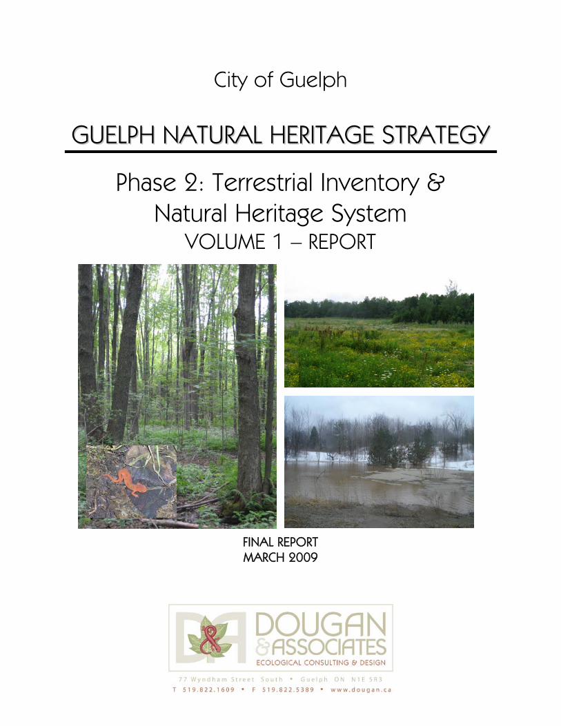
Cover photos
Mapping developed for this report is based on the most current available information (i.e., April 2006 air photos and data from the City and agencies last updated in the spring of 2008 and winter 2009) combined with scoped field verification undertaken in 2005 and 2008. These maps are intended to provide general guidance for planning purposes at the indicated map scale(s). However they may contain inconsistencies related to minor boundary inaccuracies, or changes in feature status or boundaries at the site scale, and should therefore be interpreted at the site specific scale in conjunction with a field review of conditions. Please note that the recommended Natural Heritage System is consistent with planning information available to February 2009.
: Left: Photo of a deciduous swamp forest) in the Grange Hill area on the east end of Guelph (June 2005). Inset: Red-spotted newt (Notophthalmus viridescens) photographed just east of Guelph (fall 2008, M. Cameron). Top right: A naturalized former gravel pit field with a swamp thicket and forest in the background in the Grange Hill area on the east end of Guelph (July 2008). Bottom right: Photo of a kettle wetland (closed depression) in the City’s south end after a winter rain (Feb. 2009, S. Denhoed). NOTE TO READERS A draft version of this report was released in August 2008 and circulated to the Technical Steering Committee (TSC), City Council, agencies, landowners, local naturalist groups, and also made available to all members of the community and the general public. Input received over the fall of 2008 and early 2009 was carefully considered in the finalization of this report. MAPPING DISCLAIMER
City of Guelph Natural Heritage Strategy Phase 2: Terrestrial Inventory & Natural Heritage System (Volume 1- Report)
DOUGAN & ASSOCIATES Ecological Consulting & Design FINAL REPORT (MARCH 2009) with Snell & Cecile Environmental Research Page i
ACKNOWLEDGEMENTS
Thanks are extended to the members of the Technical Steering Committee (TSC) who have provided input and guidance for this phase of the study. The TSC was structured to include representatives from a cross section of local organizations and City departments, as well as individuals with expertise in ecology and natural heritage planning. Individuals who have been part of the TSC over the course of this study are as follows (listed alphabetically):
Murray Cameron
– Manager of Parklands and Greenways (City of Guelph) Astrid Clos
– Planner (Guelph Development Association / Guelph and Area Homebuilder’s Association) Larry Halyk / Drew Cherry
– Stewardship Coordinator (Wellington County Stewardship Council, Ontario Ministry of Natural Resources (OMNR) Andrew Lambden
– Developer (Guelph Development Association / Guelph and Area Homebuilder’s Association) Glynis Logue
– Local Environmentalist (Green Plan Steering Committee / Guelph Environmental Leadership) Richard Henry / Don Kudo
– Infrastructure / Engineering Department (City of Guelph)
Terry Schwan
– Forester (OMNR – Guelph District) Jyoti Pathak / Helen White
– Park Planner (City of Guelph)
Val Wyatt
– Local Naturalist / Consulting Ecologist (Guelph Field Naturalists) Tony Zammit
Natural heritage data (i.e., mapping layers, species information) for use in this study has been provided by a variety of agencies and organizations. We would specifically like to thank Art Timmerman and J. C. Laurence at the OMNR (Guelph District), Mike Oldham and Colin Jones at the Natural Heritage Information Centre (NHIC), Sandy Dobbyn of the Ontario Mammal Atlas, Susan Woodward at the Royal Ontario Museum, Angela Darwin at the Forest Bird Monitoring Program, and Chris Earley at the University of Guelph Arboretum. Two important volunteer-based products developed through the course of this study have been lists for wildlife and plant species considered significant in Wellington County. Development and review of these lists was a laborious process that required input from a variety of individuals with knowledge of various species occurrences locally, regionally and provincially. Thanks to all those who contributed to both these lists; they are identified specifically in the Technical Appendix to this report where the lists themselves are provided. Thanks are also extended to the various City staff who have assisted with this study. Thanks firstly to the staff with the City of Guelph who provided initial direction and support, namely, Craig Manley, Manager of Policy Planning and Urban Design who provided overall direction until his departure in July 2007, Shannon Smith (2004 - 2005) and Helen Powers (2005 – 2006), both Environmental Planners. Michael Bartholomew provided various data layers and Mark Haennel has provided support for the various community consultations. Cheryl Coutts undertook the required landowner contact for this phase of the study, and Michelle Mercier compiled all stakeholder comments and also assisted with meeting coordination. Finally, thanks are extended to Marion Plaunt, Manager of Policy Planning and Urban Design (as of January 2008), Carrie Musselman, Robyn McMullen and Suzanne Young (Environmental Planners), Greg Atkinson (Policy Planner) and Jason Downham (GIS Technician) who have worked diligently to bring this phase of the study to completion over the past year.
– Ecologist (Grand River Conservation Authority (GRCA)
City of Guelph Natural Heritage Strategy Phase 2: Terrestrial Inventory & Natural Heritage System (Volume 1- Report)
DOUGAN & ASSOCIATES Ecological Consulting & Design FINAL REPORT (MARCH 2009) with Snell & Cecile Environmental Research Page ii
CONSULTANT STUDY TEAM & ROLES
DOUGAN & ASSOCIATES TITLE (ROLE)
Jim Dougan Senior Ecologist / Principal (Sr. Ecological Advisor)
Margot Ursic Planning Ecologist (Project Manager, primary report author)
Ken Ursic Senior Ecologist (field support)
Karl Konze Senior Wildlife Ecologist (wildlife surveys, input to report)
Sam Brinker* Ecologist (field support)
Melinda Black* Ecologist & GIS Analyst (ELC interpretation, GIS mapping)
Penny Hornick* Ecologist & GIS Analyst (ELC interpretation, GIS mapping, database development)
Lynn Wardle GIS Analyst (GIS mapping updates / revisions / analyses, database management)
SUB-CONSULTANTS
Charles Cecile
(Snell & Cecile Environmental)
Field Biologist (field support, technical review of the report)
Donna Havinga
(Ecological Outlook)
Senior Ecologist (field support - amphibians)
* no longer an employee at Dougan & Associates
City of Guelph Natural Heritage Strategy Phase 2: Terrestrial Inventory & Natural Heritage System (Volume 1- Report)
DOUGAN & ASSOCIATES Ecological Consulting & Design FINAL REPORT (MARCH 2009) with Snell & Cecile Environmental Research Page iii
EXECUTIVE SUMMARY
The City of Guelph, like so many other municipalities in southern Ontario, is faced with the challenge of accommodating ongoing growth and also protecting the City’s significant natural heritage. The three-phase Guelph Natural Heritage Strategy was intended to facilitate the protection of significant natural heritage by providing a framework for:
updating the City’s natural heritage mapping and data (Phase 1 and 2); identifying what is locally significant based on current provincial guidelines, status lists,
and other available information (Phase 2); recommending a Natural Heritage System based on current information and defensible
criteria (Phase 2); and using this information as the basis for updating the City’s natural heritage policies in a
manner that is consistent with current Provincial policies and supports the City’s vision (Phase 3).
The specific objectives of Phase 2 of the Natural Heritage Strategy were to: (1) move forward with natural heritage updates for the City of Guelph by collecting ecological field data for the City’s terrestrial natural areas (i.e., areas outside the floodplains and wetlands) and (2) use the available background and collected field data to apply defensible criteria (initially developed during Phase 1 and refined during the course of this study) in order to develop a recommended Natural Heritage System (NHS) for the City. Notably, the acronym “NHS” is used to refer to a Natural Heritage System for the City of Guelph, rather than the overall Natural Heritage Strategy which is the name for the three-phased study process of which this is Phase 2. The finalized Phase 2 report for the Natural Heritage Strategy contains:
natural heritage context for the City of Guelph;
updated terrestrial natural heritage assessments for the City, including scoped Ecological Land Classification (ELC), botanical, breeding bird and herpetofaunal surveys;
a discussion of the recommended criteria used to identify the NHS;
the results of applying the criteria, including mapping; and
recommendations for implementation.
Notably, Phase 2 of the Natural Heritage Strategy is divided into two documents; this report (Volume 1) and Volume 2, which contains the technical appendices. Phase 2 of the Natural Heritage Strategy is supported by current policy direction provided by the Province and the City which recognizes the importance of natural heritage protection to the sustainability of communities. However it is a real challenge in a growth-centered City like Guelph to identify the best possible NHS in the context of what remains, while still accommodating the mandated growth and intensification within the City’s boundaries. This study is intended to provide the technical background to guide these difficult decisions. The results of this work (and the subsequent Phase 3, which includes policy development) will feed into the overall Official Plan update underway over 2008 and 2009.
City of Guelph Natural Heritage Strategy Phase 2: Terrestrial Inventory & Natural Heritage System (Volume 1- Report)
DOUGAN & ASSOCIATES Ecological Consulting & Design FINAL REPORT (MARCH 2009) with Snell & Cecile Environmental Research Page iv
Over the course of Phase 2 of the Natural Heritage Strategy, a Significant Plant List and a Significant Wildlife List for Wellington County were developed (on a voluntary basis) with input from a variety of individuals with expertise in Ontario’s flora and fauna. These working lists have been used in this study to assist in the identification of habitats that are locally significant and can also be used by both the City and the County for ongoing and future environmental planning studies. The bulk of the original background research and field assessments for this study were undertaken over 2005 and updated with secondary source data (e.g., current air photos and agency mapping) and scoped field verification over 2007 and 2008. Habitat classification was completed according to the current standard for southern Ontario – the Ecological Land Classification (ELC) system. ELC assessments found that overall natural cover within the City is approximately 24%. This natural cover consists of 7% upland forest (including plantations and hedgerows); 8% successional habitats (i.e., cultural meadows, thickets and savannas); and 9% wetlands (i.e., swamps and marshes) and open water. The City currently has nearly 12.5% overall forest cover (1100 ha including swamps, which are forested wetlands). Plantations, cultural woodlands and hedgerows represent approximately 3.5% of this forest cover with the remaining cover being deciduous, coniferous and mixed forested uplands and wetlands. While some of the forested swamp habitats are relatively large for a city the size of Guelph (i.e., one coniferous swamp unit in the Hanlon Creek wetland is almost 88 ha), the upland forested areas primarily consist of relatively small fragments under 10 ha, with many less than 1 ha. Vegetation assessments confirmed one national and provincial Species at Risk (SAR) (i.e., Butternut which is designated as Endangered in Ontario and Canada) in several locations, and current records for 6 provincially rare (i.e., ranked S1, S2 or S3 by the Natural Heritage Information Center) and 37 locally significant (i.e., in Wellington County) plant species. One provincially rare and 14 locally rare species were confirmed by field surveys conducted for Phase 2 of the Natural Heritage Strategy; the remaining species were recorded in environmental impact studies completed in the City since1988. Wildlife surveys focused on amphibians and breeding birds. The 2004 and 2005 amphibian surveys yielded information on 84 unique locations with amphibians documented at 54 sites. In total, 9 species of amphibians were confirmed in the City, including 4 considered locally significant. Notably, the locally significant species include members of the Jefferson salamander complex identified as Ambystoma jeffersonianum x laterale polyploids. Only “pure” Jefferson salamander (Ambystoma jeffersonianum) is designated as provincially and federally Threatened, however the presence of some types of hybrids indicates that “pure” Jefferson salamanders may also present, and further studies are required in these locations. Several amphibian migration routes were also identified during field surveys, and several additional amphibian migration routes were identified through stakeholder and public consultations in the fall of 2008. Breeding bird studies conducted in 2005 recorded 28 breeding species considered significant in Wellington County, including 12 species considered area-sensitive. In general, these surveys captured a range of bird species with different habitat requirements reflecting the City’s current habitat diversity which includes a mix of wetlands, woodlands, thickets and open meadows / agricultural fields. Although the remaining natural heritage in the City includes a number of areas that are long and narrow (i.e., along the river corridors), as well as a number of small, isolated habitat patches with a lot of edge habitat, some areas of habitat are still large enough to provide breeding habitat for a range of area-sensitive bird species.
City of Guelph Natural Heritage Strategy Phase 2: Terrestrial Inventory & Natural Heritage System (Volume 1- Report)
DOUGAN & ASSOCIATES Ecological Consulting & Design FINAL REPORT (MARCH 2009) with Snell & Cecile Environmental Research Page v
Ecologically-based criteria were developed to identify a NHS for the City. These criteria were developed based on:
consideration for the working criteria developed during Phase 1 and subwatershed studies conducted within the City;
principles and research from current landscape and conservation ecology science;
natural heritage planning precedents from other municipalities in southern Ontario;
their ability to be applied to discrete habitat units or habitat types;
input from the Technical Steering Committee and City staff;
input from stakeholders (including agencies, the County of Wellington and Township of Puslinch, local landowners and residents) obtained over the fall of 2008; and
need for consistency with the categories of natural heritage protection identified in Provincial Policy as well as criteria identified in supporting guidelines.
Details of how the criteria were applied and a discussion for each criterion are provided in the study report. Key points with respect to the criteria application are summarized below.
Each criterion was applied independently as a stand-alone measure of significance so that any areas meeting any one criterion have been included in the recommended NHS.
Ecological linkages (criterion 8g) and naturalization/restoration areas (criterion 9a) were identified following the application of other criteria and in relation to these areas.
Minimum buffers are meant, as the name implies, to identify minimum vegetation protection zones around significant features in the NHS. Buffers could not be applied, in whole or in part, in some areas that have already undergone development. Conversely, in areas to be developed (or re-developed) site-specific studies may find that in some cases these minimums are not adequate and that wider buffers need to be applied.
Category 8 is not a comprehensive list of significant wildlife habitat (SWH) criteria, but rather a list of SWH criteria for which data was available at the time of the study. A complete list of all SWH criteria potentially applicable in the City of Guelph that should be considered at the site-specific level is provided in the study report.
Significant species locations are not comprehensive and are linked to the general habitat in which they were recorded (i.e., the ELC polygon) but are not geo-referenced to specific locations. Species that have been mapped only include those confirmed as part of this study or documented in environmental impact studies (EIS) completed in the City since 1988 and considered to be nationally, provincially or locally significant at the time of this study.
Notable changes to the criteria made from the draft report (July 2008) include:
elimination of the weighted criteria approach (i.e., whereby areas needed to meet either one primary or at least two secondary criteria to be included in the recommended NHS);
identification and application of minimum buffers within the NHS;
making significant landform and habitat for locally significant species stand-alone criteria, but revising them both to be more refined in their application; and
identification of naturalization/restoration areas associated with the NHS.
City of Guelph Natural Heritage Strategy Phase 2: Terrestrial Inventory & Natural Heritage System (Volume 1- Report)
DOUGAN & ASSOCIATES Ecological Consulting & Design FINAL REPORT (MARCH 2009) with Snell & Cecile Environmental Research Page vi
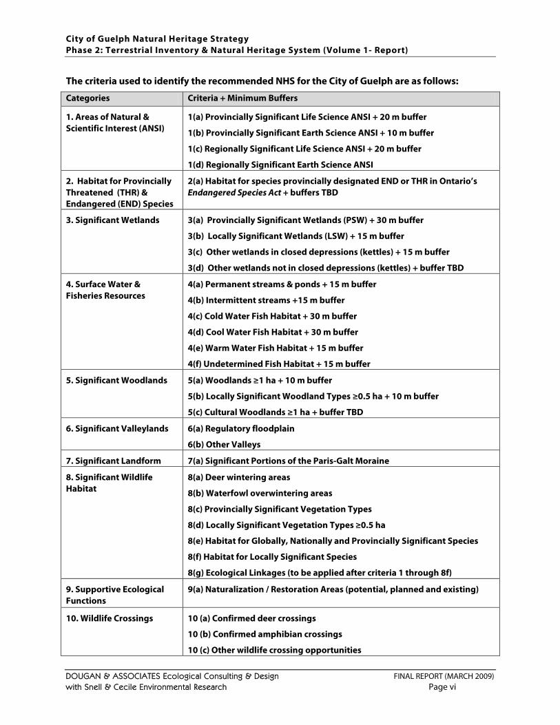
The criteria used to identify the recommended NHS for the City of Guelph are as follows:
Categories Criteria + Minimum Buffers
1. Areas of Natural & Scientific Interest (ANSI)
1(a) Provincially Significant Life Science ANSI + 20 m buffer
1(b) Provincially Significant Earth Science ANSI + 10 m buffer
1(c) Regionally Significant Life Science ANSI + 20 m buffer
1(d) Regionally Significant Earth Science ANSI
2. Habitat for Provincially Threatened (THR) & Endangered (END) Species
2(a) Habitat for species provincially designated END or THR in Ontario’s Endangered Species Act + buffers TBD
3. Significant Wetlands 3(a) Provincially Significant Wetlands (PSW) + 30 m buffer
3(b) Locally Significant Wetlands (LSW) + 15 m buffer
3(c) Other wetlands in closed depressions (kettles) + 15 m buffer
3(d) Other wetlands not in closed depressions (kettles) + buffer TBD
4. Surface Water & Fisheries Resources
4(a) Permanent streams & ponds + 15 m buffer
4(b) Intermittent streams +15 m buffer
4(c) Cold Water Fish Habitat + 30 m buffer
4(d) Cool Water Fish Habitat + 30 m buffer
4(e) Warm Water Fish Habitat + 15 m buffer
4(f) Undetermined Fish Habitat + 15 m buffer
5. Significant Woodlands 5(a) Woodlands ≥1 ha + 10 m buffer
5(b) Locally Significant Woodland Types ≥0.5 ha + 10 m buffer
5(c) Cultural Woodlands ≥1 ha + buffer TBD
6. Significant Valleylands 6(a) Regulatory floodplain
6(b) Other Valleys
7. Significant Landform 7(a) Significant Portions of the Paris-Galt Moraine
8. Significant Wildlife Habitat
8(a) Deer wintering areas
8(b) Waterfowl overwintering areas
8(c) Provincially Significant Vegetation Types
8(d) Locally Significant Vegetation Types ≥0.5 ha
8(e) Habitat for Globally, Nationally and Provincially Significant Species
8(f) Habitat for Locally Significant Species
8(g) Ecological Linkages (to be applied after criteria 1 through 8f)
9. Supportive Ecological Functions
9(a) Naturalization / Restoration Areas (potential, planned and existing)
10. Wildlife Crossings 10 (a) Confirmed deer crossings
10 (b) Confirmed amphibian crossings
10 (c) Other wildlife crossing opportunities
City of Guelph Natural Heritage Strategy Phase 2: Terrestrial Inventory & Natural Heritage System (Volume 1- Report)
DOUGAN & ASSOCIATES Ecological Consulting & Design FINAL REPORT (MARCH 2009) with Snell & Cecile Environmental Research Page vii
The criteria listed above were applied to the City of Guelph (see Figures 7 through 14) using the available information collected as part of this study through various background sources and field studies in order to identify a recommended NHS for the City. Based on the current mapping, the recommended NHS captures a total of 1961 ha (22.2% of the City’s land cover) including ecological linkages, minimum buffers and restoration areas. However, because of the scale at which some of the mapping was completed and some of the data gaps, the mapping may contain boundary inaccuracies and/or have missed some smaller or temporary features. Furthermore, the current mapping does not capture changes in feature status or boundaries that will occur over time. Therefore, the mapping is as complete and current as possible but needs to be subject to site-specific verification in conjunction with a field review of conditions. Mapping presented in this study is intended to be consistent with areas identified for protection through planning applications and the requisite site-specific environmental studies approved or very close to approval as of February 2009. Notably, minor refinements to the mapping may be incorporated by the City following completion of this study based on new information received since the end of February. There may also be additional revisions to the mapping in relation to areas that are currently going through the site plan approval process and that may be completed before this study is formally adopted. The recommendations of this study are that:
1. The recommended criteria (as laid out above) should be adopted by the City as the basis for implementing a city-wide Natural Heritage System (NHS) and developing related natural heritage policy.
2. The recommended NHS (and the supporting mapping and data) should be used as the basis for updating the City’s Greenlands System in the ongoing Official Plan review with the caveat that the mapping be subject to updates and refinements as new information is obtained.
3. Natural heritage policy updates should recognize the following principles:
a. In cases where natural heritage policy and NHS mapping conflict, the approved policy should be implemented.
b. The buffers identified in the recommended NHS are minimum buffers that could not be applied, in whole or in part, in some areas which are already urbanized, but should be applied wherever possible and may be determined to be inadequate in areas to be developed (or re-developed) through site-specific studies.
c. Natural areas and public open space outside the recommended NHS should be considered as opportunities for naturalization and / or restoration where feasible.
d. Ecological linkages are very constrained in the City, both in size and number, and should be given the highest degree of protection and enhancement possible.
e. Wildlife crossings over roads flag approximate locations where movement has been observed or is likely to occur, and measures to minimize wildlife-human conflict in these locations should be implemented as opportunities arise (e.g., road upgrades).
f. The recommended NHS has been identified based on ecological criteria but also has significant social value to residents of and visitors (e.g., provides local opportunities for nature appreciation) and economic value to the City as green infrastructure (e.g., helps control air and water pollution, contributes to storm water management).
City of Guelph Natural Heritage Strategy Phase 2: Terrestrial Inventory & Natural Heritage System (Volume 1- Report)
DOUGAN & ASSOCIATES Ecological Consulting & Design FINAL REPORT (MARCH 2009) with Snell & Cecile Environmental Research Page viii
4. City planners (and others as appropriate) should use the GIS-based mapping and data developed for this study as a resource for the review of land use planning applications, and should update this platform as more information is obtained from local agencies or site-specific environmental studies in the City.
5. NHS boundaries may be subject to refinement based on site-specific studies that should use a science-based approach to ecological assessment and make recommendations ensuring that:
a. boundary revisions or refinements are minor in scope and do not compromise the overall cohesiveness of the NHS, compromise native species biodiversity or negatively impact or reduce any interior habitat that may be present;
b. impacts of proposed development do not negatively impact the natural heritage features or ecological functions for which an area was originally included within the NHS; and
c. site-specific opportunities for ecological linkages and naturalization and/or restoration are explored.
6. A trail hierarchy (e.g., primary – paved trails of up to 3 m wide, secondary – gravel trails of up to 2 m wide, and tertiary – footpath type trails) that ties into the Guelph Trails Master Plan and is consistent with the Recreation, Parks and Culture Strategic Master Plan (in progress) should be implemented for planned and existing trails within the NHS to help balance provision of access to local natural areas and protection of these areas from use-related degradation. Key recommended guidelines include:
a. keeping the majority of primary trails along the edges of NHS features, within or adjacent to buffers if possible; and
b. carefully locating and designing secondary and tertiary trails to minimize negative impacts to sensitive ecological features and functions (e.g., boardwalks over seasonally wet areas, lookouts instead of crossings over permanently wet areas).
7. Where municipal infrastructure (i.e., water, sanitary sewers and storm water) is required to go through the NHS, the City shall work to: (a) minimize the extent of the NHS traversed and/or occupied by infrastructure, (b) mitigate impacts during the planning, design and construction of said infrastructure, and (c) undertake restoration using native plant materials following construction.
8. Where new roads must traverse the NHS or existing roads within or adjacent to the NHS are being improved, the City shall work to (or encourage the Ministry of Transportation to): (a) minimize the extent of the NHS traversed and/or occupied by infrastructure, (b) mitigate impacts during the planning, design and construction of said infrastructure, and (c) implement measures to minimize wildlife-human conflict in these locations and facilitate safe movement of wildlife.
9. The City of Guelph should work with the County of Wellington to ensure that the NHS and the County’s Greenlands System are appropriately integrated along the City/County boundary.
10. The City of Guelph should endorse the Significant Plant List for Wellington County (as provided in Appendix A) and the Significant Wildlife List for Wellington County (as provided in Appendix B) as resources to be used in ongoing environmental planning. It is further recommended that these lists be considered working lists and as such be:
City of Guelph Natural Heritage Strategy Phase 2: Terrestrial Inventory & Natural Heritage System (Volume 1- Report)
DOUGAN & ASSOCIATES Ecological Consulting & Design FINAL REPORT (MARCH 2009) with Snell & Cecile Environmental Research Page ix
a. updated by the City’s Environmental Planner on a quarterly basis to incorporate any changes in species status at the federal or provincial levels;
b. subject to an initial and annual peer review by a committee of experts including representatives for local agencies, naturalists clubs, the University of Guelph, the City and the County;
c. applied so that environmental studies in the City are required to flag locally significant species observations (in addition to provincially and federally significant species), but that the level and extent of associated habitat protection be determined on a case by case basis with consideration for each species’ needs.
11. The City of Guelph should request that the County of Wellington review the Significant Plant List and the Significant Wildlife List for Wellington County, and consider endorsing them as resources to be used in ongoing environmental planning.
12. The City should continue to require as part of environmental impact studies (EIS);
a. detailed ELC assessments (i.e., to Ecosite and Vegetative Type level) of natural areas in the City;
b. comprehensive vascular plant surveys, breeding bird, herpetofaunal (i.e., amphibian and reptile) surveys, and other wildlife surveys conducted according to established protocols and during the appropriate seasons that identify/document significant species according to the most current status lists;
c. identification of appropriate buffers for protected features; and
d. identification of site-specific opportunities for tree-preservation, local ecological linkages, and naturalization and/or restoration where appropriate.
13. The City should also require as part of environmental impact studies (EIS);
a. identification of species considered locally significant (as well as those with provincial and federal status) recorded within and adjacent to the study area, and consideration for providing adequate habitat for the full range of significant species;
b. demonstration that impacts of the proposed development do not negatively impact the natural heritage features or ecological functions for which an area was originally included within the NHS; and
c. protection of minimum buffers as identified through the recommended NHS with consideration for whether or buffers wider than the recommended minimum may be required.
14. The status of the NHS in the City should be tracked over time using clear and consistent measures (e.g., an annual NHS report card).
15. The OMNR (working with the City) should undertake a comprehensive survey of actual deer densities and movement corridors in the City followed by careful consideration of various non-lethal management options for minimizing persistent deer-human conflicts.
16. The City should undertake a comprehensive and consultative study to identify and prioritize all potential naturalization / restoration areas throughout the City, and not just those on public lands associated with the recommended NHS.

City of Guelph Natural Heritage Strategy Phase 2: Terrestrial Inventory & Natural Heritage System (Volume 1- Report)
DOUGAN & ASSOCIATES Ecological Consulting & Design FINAL REPORT (MARCH 2009) with Snell & Cecile Environmental Research Page x
Although not specifically within the scope of the Phase 2 work, it is also strongly recommended that the City undertake a management and monitoring plan in relation to the NHS that explores all available options for protecting and managing the City’s natural heritage in the long-term as part of Phase 3.
City of Guelph Natural Heritage Strategy Phase 2: Terrestrial Inventory & Natural Heritage System (Volume 1- Report)
DOUGAN & ASSOCIATES Ecological Consulting & Design FINAL REPORT (MARCH 2009) with Snell & Cecile Environmental Research Page xi
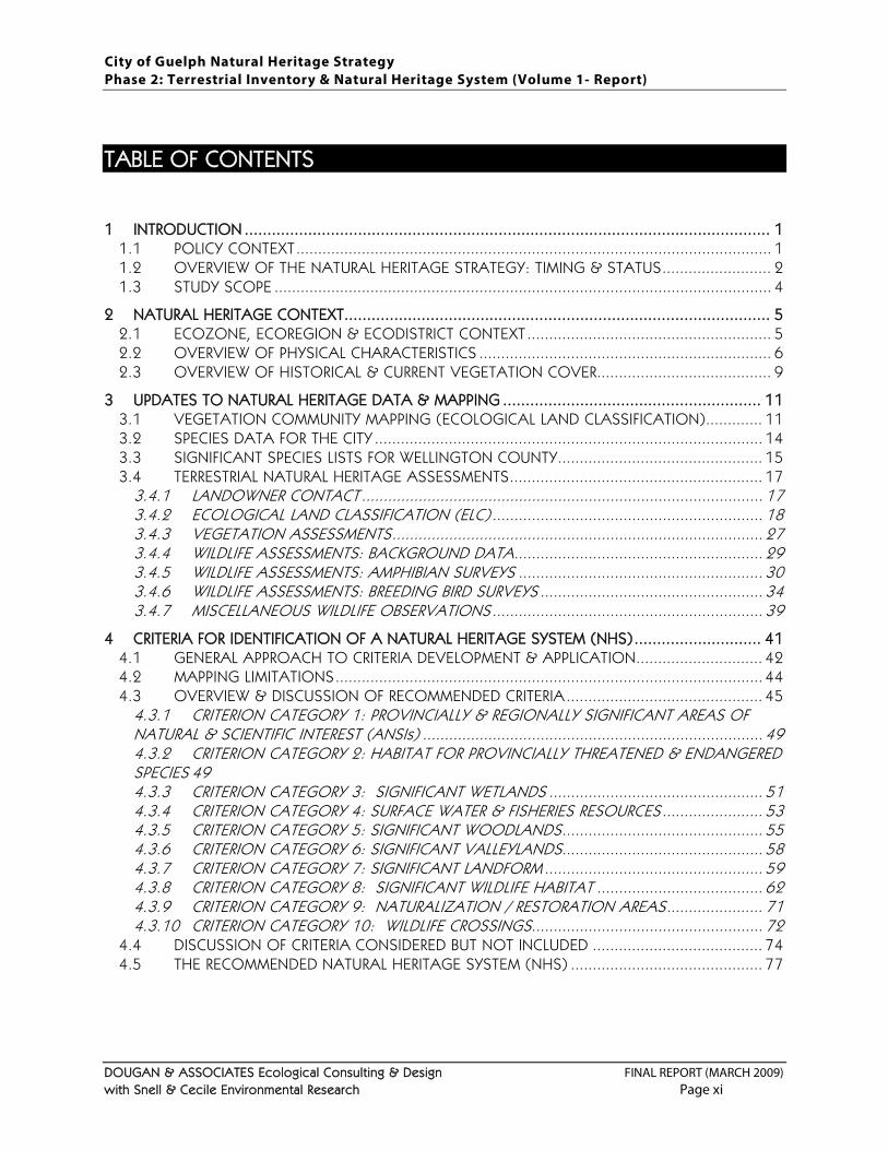
TABLE OF CONTENTS
1 INTRODUCTION .................................................................................................................... 1 1.1 POLICY CONTEXT ............................................................................................................. 1 1.2 OVERVIEW OF THE NATURAL HERITAGE STRATEGY: TIMING & STATUS ......................... 2 1.3 STUDY SCOPE .................................................................................................................. 4
2 NATURAL HERITAGE CONTEXT.............................................................................................. 5 2.1 ECOZONE, ECOREGION & ECODISTRICT CONTEXT ........................................................ 5 2.2 OVERVIEW OF PHYSICAL CHARACTERISTICS ................................................................... 6 2.3 OVERVIEW OF HISTORICAL & CURRENT VEGETATION COVER........................................ 9
3 UPDATES TO NATURAL HERITAGE DATA & MAPPING ......................................................... 11 3.1 VEGETATION COMMUNITY MAPPING (ECOLOGICAL LAND CLASSIFICATION) ............. 11 3.2 SPECIES DATA FOR THE CITY ......................................................................................... 14 3.3 SIGNIFICANT SPECIES LISTS FOR WELLINGTON COUNTY............................................... 15 3.4 TERRESTRIAL NATURAL HERITAGE ASSESSMENTS .......................................................... 17
3.4.1 LANDOWNER CONTACT ............................................................................................ 17 3.4.2 ECOLOGICAL LAND CLASSIFICATION (ELC) .............................................................. 18 3.4.3 VEGETATION ASSESSMENTS ..................................................................................... 27 3.4.4 WILDLIFE ASSESSMENTS: BACKGROUND DATA......................................................... 29 3.4.5 WILDLIFE ASSESSMENTS: AMPHIBIAN SURVEYS ........................................................ 30 3.4.6 WILDLIFE ASSESSMENTS: BREEDING BIRD SURVEYS ................................................... 34 3.4.7 MISCELLANEOUS WILDLIFE OBSERVATIONS .............................................................. 39
4 CRITERIA FOR IDENTIFICATION OF A NATURAL HERITAGE SYSTEM (NHS) ............................ 41 4.1 GENERAL APPROACH TO CRITERIA DEVELOPMENT & APPLICATION............................. 42 4.2 MAPPING LIMITATIONS .................................................................................................. 44 4.3 OVERVIEW & DISCUSSION OF RECOMMENDED CRITERIA ............................................. 45
4.3.1 CRITERION CATEGORY 1: PROVINCIALLY & REGIONALLY SIGNIFICANT AREAS OF NATURAL & SCIENTIFIC INTEREST (ANSIs) .............................................................................. 49 4.3.2 CRITERION CATEGORY 2: HABITAT FOR PROVINCIALLY THREATENED & ENDANGERED SPECIES 49 4.3.3 CRITERION CATEGORY 3: SIGNIFICANT WETLANDS ................................................. 51 4.3.4 CRITERION CATEGORY 4: SURFACE WATER & FISHERIES RESOURCES ....................... 53 4.3.5 CRITERION CATEGORY 5: SIGNIFICANT WOODLANDS .............................................. 55 4.3.6 CRITERION CATEGORY 6: SIGNIFICANT VALLEYLANDS.............................................. 58 4.3.7 CRITERION CATEGORY 7: SIGNIFICANT LANDFORM .................................................. 59 4.3.8 CRITERION CATEGORY 8: SIGNIFICANT WILDLIFE HABITAT ...................................... 62 4.3.9 CRITERION CATEGORY 9: NATURALIZATION / RESTORATION AREAS ...................... 71 4.3.10 CRITERION CATEGORY 10: WILDLIFE CROSSINGS ..................................................... 72
4.4 DISCUSSION OF CRITERIA CONSIDERED BUT NOT INCLUDED ....................................... 74 4.5 THE RECOMMENDED NATURAL HERITAGE SYSTEM (NHS) ............................................ 77
City of Guelph Natural Heritage Strategy Phase 2: Terrestrial Inventory & Natural Heritage System (Volume 1- Report)
DOUGAN & ASSOCIATES Ecological Consulting & Design FINAL REPORT (MARCH 2009) with Snell & Cecile Environmental Research Page xii
5 STAKEHOLDER & COMMUNITY CONSULTATIONS ............................................................... 81 5.1 REVISITING PHASE 1 STAKEHOLDER & COMMUNITY CONSULTATIONS ....................... 81 5.2 OVERVIEW OF PHASE 2 STAKEHOLDER & COMMUNITY CONSULTATIONS .................. 82
6 CONCLUDING REMARKS & RECOMMENDATIONS ................................................................ 85
7 GLOSSARY OF ACRONYMS & SIGNIFICANT SPECIES DEFINITIONS ....................................... 89
8 LITERATURE CITED ............................................................................................................... 91 TABLES
Table 1. Timing and status of the phases of the City of Guelph Natural Heritage Strategy p. 3
Table 2. Broad land cover and vegetation community types in the City of Guelph p. 20
Table 3. Coverage of Ecological Land Classification (ELC) Community Series, Ecosites and Vegetation Types in the City of Guelph
p. 21
Table 4. Summary of upland woodlands/ forests falling into different size classes p. 26
Table 5. Locally significant plant species confirmed within the City of Guelph in 2005 and 2006 p. 28
Table 6. Significant wildlife species records from the provincial databases p. 29
Table 7. List of birds observed from Forest Bird Monitoring Program Site #334 between 1994 and 2004 considered significant in Wellington County p. 30
Table 8. List of species detected during 2004 and 2005 amphibian surveys p. 31
Table 9. Significant breeding bird species documented in 2005 from within the City of Guelph
p. 36
Table 10. Bird species recorded by Dougan & Associates during a site visit in June 2008 p. 37
Table 11. Comparison of the original criteria for Locally Significant Natural Areas (LSNAs) and the revised recommended criteria for identification of a Natural Heritage System (NHS)
p. 43
Table 12. Criteria categories, criteria and associated minimum buffers used for identification of the recommended Natural Heritage System
p. 46
Table 13. Summary of confirmed and potential Significant Wildlife Habitat (SWH) in the City of Guelph
p. 63
Table 14. Forest habitat requirements for area-sensitive forest-interior breeding bird species recorded in the City of Guelph
p. 76
Table 15. Areas represented by the recommended Natural Heritage System (NHS) p. 77
City of Guelph Natural Heritage Strategy Phase 2: Terrestrial Inventory & Natural Heritage System (Volume 1- Report)
DOUGAN & ASSOCIATES Ecological Consulting & Design FINAL REPORT (MARCH 2009) with Snell & Cecile Environmental Research Page xiii
PHOTOS
Photo 1. Member of the Jefferson Salamander complex crossing Maltby Road (April 17, 2004)
p. 33
Photo 2. Spring Peeper crossing Maltby Road (April 17, 2004) p. 33
Photo 3. Wood Frog amplexus along Maltby Road (April 17, 2004) p. 33
Photo 4. Wood Frog egg mass adjacent to Maltby Road (April 17, 2004) p. 33
Photo 5. Member of the Jefferson Salamander complex crossing Maltby Road (April 5, 2005)
p. 33
Photo 6. Member of the Jefferson Salamander complex crossing Maltby Road (April 5, 2005)
p. 33
Photo 7. Amphibian crossing sign p. 73
Photo 8. Deer crossing sign p. 73 FIGURES*
Figure 1. Terrestrial Ecoregions of Ontario p. 5
Figure 2. Moraine complexes occurring in the Grand River Watershed p. 6
Figure 3. Physiography of the Grand River Watershed p. 7
Figure 4. City of Guelph Subwatersheds p. 8
Figure 5. Ecological Land Classification at back of document
Figure 6. 2004 & 2005 Amphibian Survey Results at back of document
Figure 7. Criteria Category 1: Areas of Natural and Scientific Interest (ANSIs) & Criteria Category 3: Significant Wetlands
at back of document
Figure 8. Criteria Category 4: Watercourses & Fisheries Resources at back of document
Figure 9. Criteria Category 5: Significant Woodlands at back of document
Figure 10. Criteria Category 6: Significant Valleylands
Criteria Category 7: Significant Landform
at back of document
Figure 11. Criteria Category 8: Significant Wildlife Habitat at back of document
Figure 12. Recommended Natural Heritage System (NHS) at back of document *Note: Figure 5 is best viewed in poster size (24 x36 in.); Figures 6 through 14 are best viewed at 11x17 in.
City of Guelph Natural Heritage Strategy Phase 2: Terrestrial Inventory & Natural Heritage System (Volume 1- Report)
DOUGAN & ASSOCIATES Ecological Consulting & Design FINAL REPORT (MARCH 2009) with Snell & Cecile Environmental Research Page xiv
APPENDICES (provided in a separate document - Volume 2)
APPENDIX A. SIGNIFICANT PLANT LIST FOR WELLINGTON COUNTY
SIGNIFICANT PLANT LIST DEVELOPMENT
SIGNIFICANT PLANT LIST FOR WELLINGTON COUNTY
APPENDIX B. SIGNIFICANT WILDLIFE LIST FOR WELLINGTON COUNTY
DEVELOPMENT OF SIGNIFICANT WILDLIFE LIST
LIST OF SIGNIFICANT WILDLIFE IN WELLINGTON COUNTY
APPENDIX C. NATURAL HERITAGE DATABASE SOURCES
DATA FROM ENVIRONMENTAL STUDIES
PROVINCIAL NATURAL HERITAGE DATABASES
FIELD SURVEY DATA (2004 & 2005)
APPENDIX D. DETAILS OF WILDLIFE SURVEY DATA COLLECTION (2004, 2005)
APPENDIX E. DETAILS OF SIGNIFICANT SPECIES MAPPING
APPENDIX F. EXAMPLES OF NATURAL HERITAGE SYSTEM CRITERIA USED BY OTHER SOUTHERN ONTARIO MUNICIPALITIES
APPENDIX G. 2004 & 2005 AMPHIBIAN SURVEY DATABASE
City of Guelph Natural Heritage Strategy Phase 2: Terrestrial Inventory & Natural Heritage System (Volume 1- Report)
DOUGAN & ASSOCIATES Ecological Consulting & Design FINAL REPORT (MARCH 2009) with Snell & Cecile Environmental Research Page 1
1 INTRODUCTION
The City of Guelph, like so many other municipalities in southern Ontario, is faced with the challenge of both accommodating growth and protecting the City’s remaining significant natural heritage. The primary purpose of the Guelph Natural Heritage Strategy is to identify the remaining natural heritage features and system to be protected in accordance with the Provincial Policy Statement (2005) and facilitate the protection of these resources by:
1. assessing the City’s natural heritage and identifying what is significant within the City;
2. developing a recommended Natural Heritage System (NHS) based on current information and defensible criteria; and
3. using this information as a basis for natural heritage policies that help implement the NHS in a manner that is consistent with current provincial policies and the City’s vision.
Phase 2 of the Natural Heritage Strategy fulfills the first and second objectives, as described in this report (Volume 1). Technical appendices are provided in support of Volume 1 as a separate document (Volume 2).
1.1 POLICY CONTEXT
Since 2004 a number of changes in provincial policy and legislation related both to growth management and natural heritage protection have come into effect in Ontario. Section 2.1 (Natural Heritage) of the Provincial Policy Statement (2005) states that:
2.1.1 Natural features and areas shall be protected for the long term. 2.1.2 The diversity and connectivity of natural features in an area, and the long-term ecological function and biodiversity of natural heritage systems, should be maintained, restored or, where possible, improved, recognizing linkages between and among natural heritage features and areas, surface water features and ground water features. 2.1.3 Development and site alteration shall not be permitted in:
significant habitat of endangered species and threatened species;
significant wetlands in Ecoregions 5E, 6E and 7E1; and
significant coastal wetlands. 2.1.4 Development and site alteration shall not be permitted in:
significant woodlands south and east of the Canadian Shield ;
significant valleylands south and east of the Canadian Shield;
significant wildlife habitat; and
significant areas of natural and scientific interest
unless it has been demonstrated that there will be no negative impacts on the natural features or their ecological functions.
City of Guelph Natural Heritage Strategy Phase 2: Terrestrial Inventory & Natural Heritage System (Volume 1- Report)
DOUGAN & ASSOCIATES Ecological Consulting & Design FINAL REPORT (MARCH 2009) with Snell & Cecile Environmental Research Page 2
Ontario’s Ministry of Public Infrastructure and Renewal (MPIR) enacted the Places to Grow Act in 2005. A key document coming out of this Act is the Growth Plan for the Greater Golden Horseshoe (MPIR 2006) which established specific density targets for different jurisdictions to ensure rational and strategic planning, and also provided for additional strengthening of the protection of remaining natural heritage. The Growth Plan for the Greater Golden Horseshoe (MPIR 2006) specifically states that: “Planning authorities are encouraged to identify natural heritage features and areas that compliment, link or enhance natural systems” and directs that “a balanced approach to wise management of all resources, including natural heritage …will be implemented.” The City of Guelph is required to conform to the Provincial Growth Plan (MPIR 2006) policies and be consistent with the Provincial Policy Statement (2005). However, the fact that the City has experienced unprecedented growth over the past two decades, and is expected to continue to experience comparable growth pressures over the next two decades1
1.2 OVERVIEW OF THE NATURAL HERITAGE STRATEGY: TIMING & STATUS
makes balancing growth and ecosystem sustainability a real challenge. City Council’s current position is that growth take place within its municipal boundaries in a sustainable manner on the basis of continued reliance on groundwater as its primary source of municipal water. Identification and protection of a Natural Heritage System (NHS) within the City is consistent with provincial policy, contributes to the protection of local groundwater resources and also supports the City’s ongoing commitment to “smart growth” principles and environmental protection. At the local level, this study is also strongly supported by direction provided in the City’s current Official Plan (adopted by City Council on November 1, 1994 and last consolidated in November 2006), the Environmental Action Plan (City of Guelph 2003), and is specifically identified as a step in the City’s Strategic Plan, Goal 2: “to support our natural, cultural and architectural heritage” (City of Guelph 2006). The results of this work (and the subsequent Phase 3 which includes policy development) will feed into the overall Official Plan update which will take place over 2008 and 2009.
In April of 2004, Dougan & Associates (D&A) was retained to undertake Phase 2 of a three-phase Natural Heritage Strategy2 for the City of Guelph intended to provide the technical basis for mapping and policy updates. The first two objectives of the three phase study, as laid out in the original Terms of Reference (see Appendix A in Dougan & Associates 2005), were to increase understanding of the City’s “terrestrial features”3
1 Between 1991 and 2001 Guelph’s population increased from 87,976 to 106,200 (a 20.5% increase). Current projections for
the City estimate the population to be 169,000 by 2031 (City of Guelph Growth Management Strategy June 23, 2008). 2 Although the acronym “NHS” is used in the Phase 1 report to refer to the overall Natural Heritage Strategy, in this report it
refers specifically to the recommended Natural Heritage System. 3 “Terrestrial features” sometimes includes wetlands, which are basically a transition between aquatic and upland habitats. In
this study, field studies were focused outside of wetlands and floodplains, but data on these features from other sources was incorporated for the purposes of assessment and NHS identification and mapping.
and to develop an integrated mapping and database platform. These objectives recognized that while wetland and floodplain areas were fairly well mapped and protected in the City, less data had been collected with respect to the City’s upland forests and successional areas making it difficult to define or develop policies for these features.
City of Guelph Natural Heritage Strategy Phase 2: Terrestrial Inventory & Natural Heritage System (Volume 1- Report)
DOUGAN & ASSOCIATES Ecological Consulting & Design FINAL REPORT (MARCH 2009) with Snell & Cecile Environmental Research Page 3
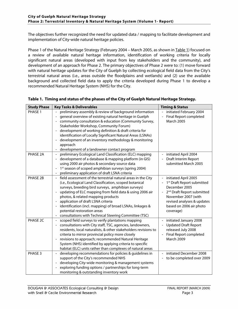
The objectives further recognized the need for updated data / mapping to facilitate development and implementation of City-wide natural heritage policies. Phase 1 of the Natural Heritage Strategy (February 2004 – March 2005, as shown in Table 1) focused on a review of available natural heritage information, identification of working criteria for locally significant natural areas (developed with input from key stakeholders and the community), and development of an approach for Phase 2. The primary objectives of Phase 2 were to: (1) move forward with natural heritage updates for the City of Guelph by collecting ecological field data from the City’s terrestrial natural areas (i.e., areas outside the floodplains and wetlands) and (2) use the available background and collected field data to apply the criteria developed during Phase 1 to develop a recommended Natural Heritage System (NHS) for the City.
Table 1. Timing and status of the phases of the City of Guelph Natural Heritage Strategy. Study Phase Key Tasks & Deliverables Timing & Status PHASE 1 - preliminary assembly & review of background information
- general overview of existing natural heritage in Guelph - community consultation & education (Community Survey,
Stakeholder Workshop, Community Forum) - development of working definition & draft criteria for
identification of Locally Significant Natural Areas (LSNAs) - development of an inventory methodology & monitoring
approach - development of a landowner contact program
- initiated February 2004 - Final Report completed
March 2005
PHASE 2A - preliminary Ecological Land Classification (ELC) mapping - development of a database & mapping platform (in GIS)
using 2000 air photos & secondary source data - 1st season of scoped amphibian surveys (spring 2004) - preliminary application of draft LSNA criteria
- initiated April 2004 - Draft Interim Report
submitted March 2005
PHASE 2B - field assessment of the terrestrial natural areas in the City (i.e., Ecological Land Classification, scoped botanical surveys, breeding bird surveys, amphibian surveys)
- updating of ELC mapping from field data & using 2006 air photos, & related mapping products
- application of draft LSNA criteria - identification (incl. mapping) of broad LSNAs, linkages &
potential restoration areas - consultations with Technical Steering Committee (TSC)
- initiated April 2005 - 1st Draft Report submitted
December 2005 - 2nd Draft Report submitted
November 2007 (with revised analyses & updates based on 2006 air photo coverage)
PHASE 2C - scoped field surveys to verify plantations mapping - consultations with City staff, TSC, agencies, landowners,
residents, local naturalists, & other stakeholders revisions to criteria to mirror provincial policy more closely
- revisions to approach; recommended Natural Heritage System (NHS) identified by applying criteria to specific habitat (ELC) units rather than complexes of natural areas
- initiated January 2008 - Updated Draft Report
released July 2008 - Final Report completed
March 2009
PHASE 3 - developing recommendations for policies & guidelines in support of the City’s recommended NHS
- developing City-wide monitoring & management systems - exploring funding options / partnerships for long-term
monitoring & outstanding inventory work
- initiated December 2008 - to be completed over 2009
City of Guelph Natural Heritage Strategy Phase 2: Terrestrial Inventory & Natural Heritage System (Volume 1- Report)
DOUGAN & ASSOCIATES Ecological Consulting & Design FINAL REPORT (MARCH 2009) with Snell & Cecile Environmental Research Page 4
While the general intent and direction of Phase 2 have remained consistent since the outset of the study in 2004, there have been a number of notable developments that have required revisions to the products and resulted in delays. These have included:
a revised Provincial Policy Statement (which came into effect March 1, 2005) and triggered re-consideration of the criteria to make them more closely related to established categories;
availability of more current air photos for the entire City, flown in April 2006 and made available in November 2007 requiring additional mapping revisions;
input from the Technical Steering Committee (TSC) and City staff in early 2008 resulting in a change in the approach to criteria application;
various changes in environmental planning staff and City project management over the course of this study; and
the need to incorporate new secondary source information (e.g., new data layers from agencies, data related to new planning approvals) during each round of revisions.
Under the direction of senior management and in response to input from the TSC, the main shift since completion of Phase 1 has been to identify a City-wide NHS that is more clearly consistent with the Provincial Policy Statement (2005), incorporates updated information (to the greatest extent possible), and is built on discrete criteria that are traceable and provide the basis for policy updates. The key components and current status of each phase of the Natural Heritage Strategy are summarized in Table 1 above. The refined criteria are summarized in Table 12
1.3 STUDY SCOPE
. Details about the Natural Heritage Strategy goals and objectives, discussion of the preliminary criteria for locally significant natural areas, summary of stakeholder and community input obtained during Phase 1, and the original Terms of Reference for the Natural Heritage Strategy are provided in the Phase 1 Final Report (Dougan & Associates 2005) available on the City’s website.
This report for Phase 2 of the Natural Heritage Strategy contains the following:
natural heritage context for the City of Guelph; updated terrestrial natural heritage assessments for the City, including:
− City-wide Ecological Land Classification (ELC) verified with scoped field studies in natural areas primarily outside the City’s designated wetlands and floodplains,
− scoped botanical, herpetofaunal (amphibian) and breeding bird surveys in natural areas primarily outside the City’s designated wetlands and floodplains,
a discussion of the criteria used to identify the recommended NHS; results of applying the criteria, including mapping; and recommendations for implementation.
Information presented in this report is based on primary and secondary sources of ecological data. The bulk of the primary data was collected over 2005 with updates based mainly on secondary source data completed over 2006, 2007 and 2008. In parts of the City adjacent to natural areas where planning has occurred over the course of this study, draft plan approved or finalized natural feature boundaries determined by site-specific studies to February 2009 were incorporated into NHS mapping.
City of Guelph Natural Heritage Strategy Phase 2: Terrestrial Inventory & Natural Heritage System (Volume 1- Report)
DOUGAN & ASSOCIATES Ecological Consulting & Design FINAL REPORT (MARCH 2009) with Snell & Cecile Environmental Research Page 5
2 NATURAL HERITAGE CONTEXT
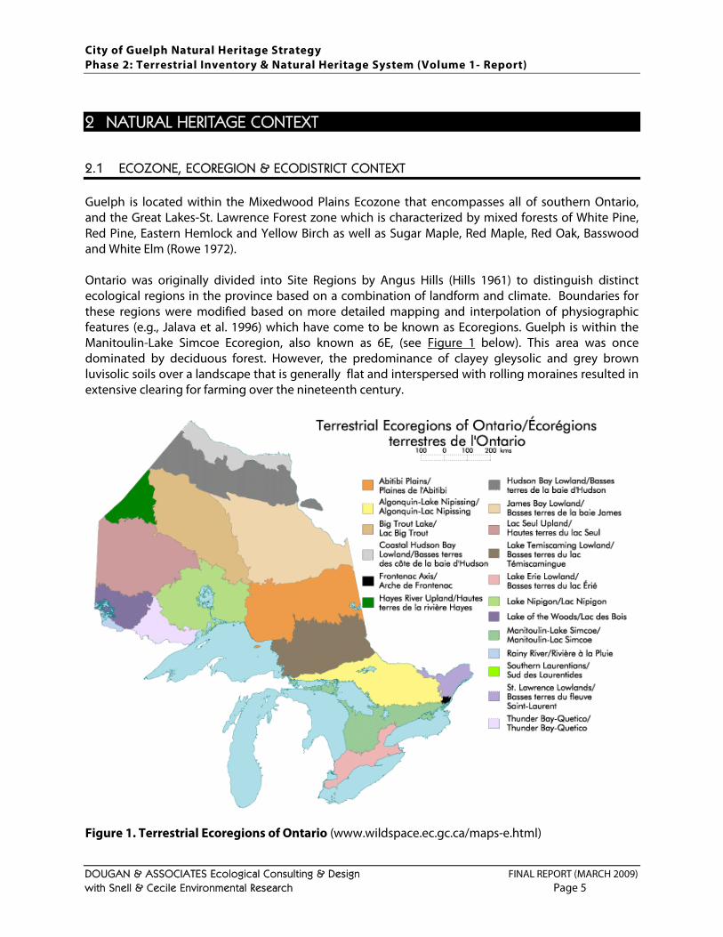
2.1 ECOZONE, ECOREGION & ECODISTRICT CONTEXT
Guelph is located within the Mixedwood Plains Ecozone that encompasses all of southern Ontario, and the Great Lakes-St. Lawrence Forest zone which is characterized by mixed forests of White Pine, Red Pine, Eastern Hemlock and Yellow Birch as well as Sugar Maple, Red Maple, Red Oak, Basswood and White Elm (Rowe 1972). Ontario was originally divided into Site Regions by Angus Hills (Hills 1961) to distinguish distinct ecological regions in the province based on a combination of landform and climate. Boundaries for these regions were modified based on more detailed mapping and interpolation of physiographic features (e.g., Jalava et al. 1996) which have come to be known as Ecoregions. Guelph is within the Manitoulin-Lake Simcoe Ecoregion, also known as 6E, (see Figure 1 below). This area was once dominated by deciduous forest. However, the predominance of clayey gleysolic and grey brown luvisolic soils over a landscape that is generally flat and interspersed with rolling moraines resulted in extensive clearing for farming over the nineteenth century.
Figure 1. Terrestrial Ecoregions of Ontario (www.wildspace.ec.gc.ca/maps-e.html)
City of Guelph Natural Heritage Strategy Phase 2: Terrestrial Inventory & Natural Heritage System (Volume 1- Report)
DOUGAN & ASSOCIATES Ecological Consulting & Design FINAL REPORT (MARCH 2009) with Snell & Cecile Environmental Research Page 6
Ecoregions provide a useful context for natural heritage planning in the Province, and have been further subdivided into Ecodistricts by the Ontario Ministry of Natural Resources (OMNR), as described in the Great Lakes Conservation Blueprint for Terrestrial Biodiversity (Henson and Brodribb 2005). The City of Guelph falls within the eastern end of one of the larger Ecodistricts (i.e., Ecodistrict 6E-1 – Stratford) whose physiography is described as smooth clay areas and gently rolling till moraines. The overall cover of wetlands and forests in Ecodistrict 6E-1 is currently estimated at 16%. This Ecodistrict includes 33 species (including 28 Species at Risk) and three vegetation communities targeted as priorities for conservation, including Fresh Sugar Maple Deciduous Forest Type, which is considered a high-quality representative community in this area (Henson and Brodribb 2005).
2.2 OVERVIEW OF PHYSICAL CHARACTERISTICS
Wellington County’s geology consists of granitic bedrock overlain with sedimentary rock (i.e., sandstone, limestone and shale) (Hoffman at el. 1963).
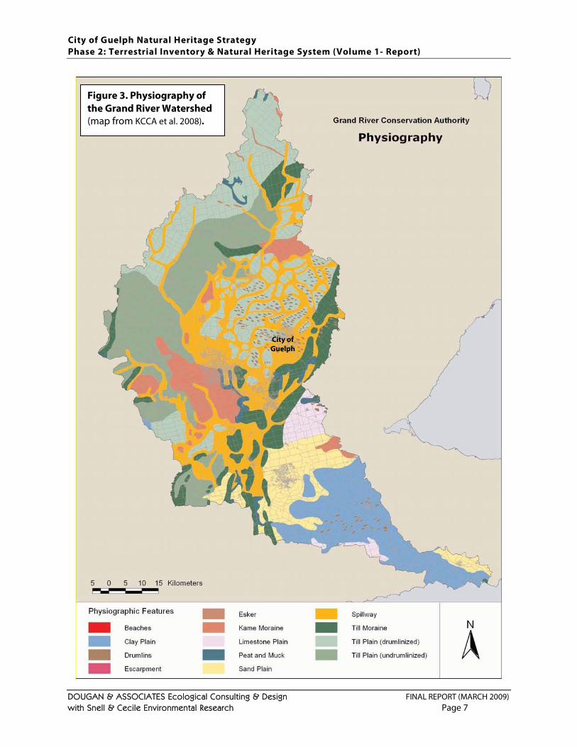
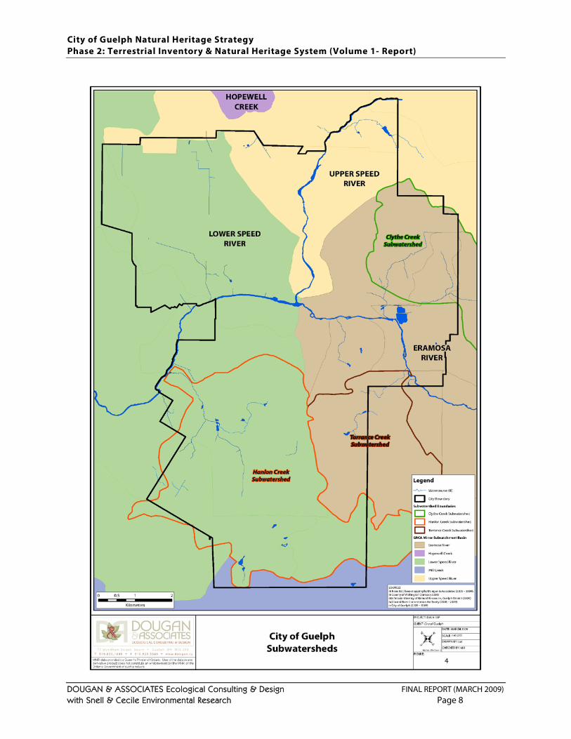
The local surficial geology is largely glacial in origin and in the City of Guelph consists of loam till, outwash gravels and sands. In the northern two-thirds of the City these till plains are drumlinized and contain many low broad oval hills in a landscape known as the Guelph drumlin fields (Hoffman at el. 1963; Chapman and Putnam 1984). These drumlins, combined with the river valleys associated with the Speed and Eramosa Rivers, are what give much of the City of Guelph its unique topography. The City’s topography has also been influenced by spillway and small esker, kame and kettle features. The watershed context for this physiography is shown in Figure 3 below. The Paris–Galt Moraine Complex is a large moraine feature (see the green area in Figure 2
City of Guelph
) of which Guelph contains a small portion. This moraine is covered in outwash gravels and sands. Figure 2. Moraine complexes occurring in the Grand River Watershed (map from KCCA et al. 2008). Note the City of Guelph boundaries are shown on the eastern edge of the map with portions of the Paris-Galt Moraine in the central and southern portions of the City.
City of Guelph Natural Heritage Strategy Phase 2: Terrestrial Inventory & Natural Heritage System (Volume 1- Report)
DOUGAN & ASSOCIATES Ecological Consulting & Design FINAL REPORT (MARCH 2009) with Snell & Cecile Environmental Research Page 7
Figure 3. Physiography of the Grand River Watershed (map from KCCA et al. 2008).
City of Guelph
City of Guelph Natural Heritage Strategy Phase 2: Terrestrial Inventory & Natural Heritage System (Volume 1- Report)
DOUGAN & ASSOCIATES Ecological Consulting & Design FINAL REPORT (MARCH 2009) with Snell & Cecile Environmental Research Page 8
City of Guelph Natural Heritage Strategy Phase 2: Terrestrial Inventory & Natural Heritage System (Volume 1- Report)
DOUGAN & ASSOCIATES Ecological Consulting & Design FINAL REPORT (MARCH 2009) with Snell & Cecile Environmental Research Page 9
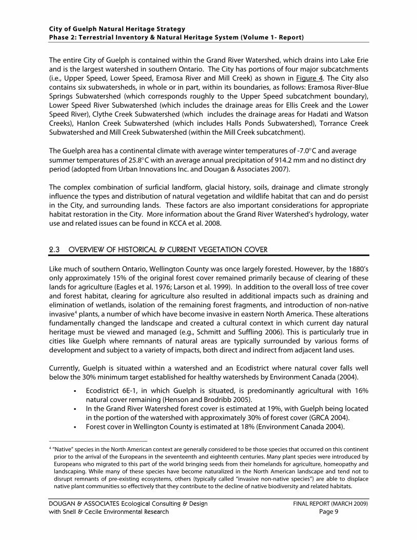
The entire City of Guelph is contained within the Grand River Watershed, which drains into Lake Erie and is the largest watershed in southern Ontario. The City has portions of four major subcatchments (i.e., Upper Speed, Lower Speed, Eramosa River and Mill Creek) as shown in Figure 4
2.3 OVERVIEW OF HISTORICAL & CURRENT VEGETATION COVER
. The City also contains six subwatersheds, in whole or in part, within its boundaries, as follows: Eramosa River-Blue Springs Subwatershed (which corresponds roughly to the Upper Speed subcatchment boundary), Lower Speed River Subwatershed (which includes the drainage areas for Ellis Creek and the Lower Speed River), Clythe Creek Subwatershed (which includes the drainage areas for Hadati and Watson Creeks), Hanlon Creek Subwatershed (which includes Halls Ponds Subwatershed), Torrance Creek Subwatershed and Mill Creek Subwatershed (within the Mill Creek subcatchment). The Guelph area has a continental climate with average winter temperatures of -7.0°C and average summer temperatures of 25.8°C with an average annual precipitation of 914.2 mm and no distinct dry period (adopted from Urban Innovations Inc. and Dougan & Associates 2007). The complex combination of surficial landform, glacial history, soils, drainage and climate strongly influence the types and distribution of natural vegetation and wildlife habitat that can and do persist in the City, and surrounding lands. These factors are also important considerations for appropriate habitat restoration in the City. More information about the Grand River Watershed’s hydrology, water use and related issues can be found in KCCA et al. 2008.
Like much of southern Ontario, Wellington County was once largely forested. However, by the 1880’s only approximately 15% of the original forest cover remained primarily because of clearing of these lands for agriculture (Eagles et al. 1976; Larson et al. 1999). In addition to the overall loss of tree cover and forest habitat, clearing for agriculture also resulted in additional impacts such as draining and elimination of wetlands, isolation of the remaining forest fragments, and introduction of non-native invasive4
Ecodistrict 6E-1, in which Guelph is situated, is predominantly agricultural with 16% natural cover remaining (Henson and Brodribb 2005).
plants, a number of which have become invasive in eastern North America. These alterations fundamentally changed the landscape and created a cultural context in which current day natural heritage must be viewed and managed (e.g., Schmitt and Suffling 2006). This is particularly true in cities like Guelph where remnants of natural areas are typically surrounded by various forms of development and subject to a variety of impacts, both direct and indirect from adjacent land uses. Currently, Guelph is situated within a watershed and an Ecodistrict where natural cover falls well below the 30% minimum target established for healthy watersheds by Environment Canada (2004).
In the Grand River Watershed forest cover is estimated at 19%, with Guelph being located in the portion of the watershed with approximately 30% of forest cover (GRCA 2004).
Forest cover in Wellington County is estimated at 18% (Environment Canada 2004).
4 “Native” species in the North American context are generally considered to be those species that occurred on this continent
prior to the arrival of the Europeans in the seventeenth and eighteenth centuries. Many plant species were introduced by Europeans who migrated to this part of the world bringing seeds from their homelands for agriculture, homeopathy and landscaping. While many of these species have become naturalized in the North American landscape and tend not to disrupt remnants of pre-existing ecosystems, others (typically called “invasive non-native species”) are able to displace native plant communities so effectively that they contribute to the decline of native biodiversity and related habitats.
City of Guelph Natural Heritage Strategy Phase 2: Terrestrial Inventory & Natural Heritage System (Volume 1- Report)
DOUGAN & ASSOCIATES Ecological Consulting & Design FINAL REPORT (MARCH 2009) with Snell & Cecile Environmental Research Page 10
As summarized in recent growth studies (e.g., Meridian Planning Consultants 2006), the City of Guelph was originally founded in 1827 and has grown from encompassing the current downtown core in 1840 to its current size through a series of land annexations between 1952 and 1993. However, the City has been fairly successful in protecting significant portions of the remaining natural heritage features and systems within its boundaries, particularly its wetlands. Forest clearing for agriculture throughout Wellington County, followed by urbanization of the City of Guelph and other towns in the County have resulted in a dramatic shifts in wildlife occurrences from pre-settlement times when species such as bobcat and lynx occurred in these areas and forest interior bird species were common. Over the past two centuries forest dependant species have become far less common, especially in the urbanized areas, and open-country species have increased in abundance in response to the dramatic changes in land use. Examples of open-country breeding bird species that currently occur in the County include American Kestrel, Horned Lark, Barn Swallow, Eastern Kingbird, Savannah Sparrow, Bobolink, and Eastern Meadowlark. These species rely on active and abandoned agricultural lands (often referred to as cultural meadows) for feeding and breeding. The fragmented forest, wetland and riparian cover that currently exists in the City favours common wildlife species such as squirrels, raccoons, skunks and deer, and limits opportunities for habitat specialists requiring larger natural areas. However, a number of wildlife species with somewhat specialized habitat requirements still persist in the City’s fragmented landscape. Examples include Pied-billed Grebe, Sharp-shinned Hawk, Winter Wren, Pine Warbler, Ovenbird, Clay-colored Sparrow, Orchard Oriole, Blue-spotted Salamander ‘hybrids’, Western Chorus Frog and Pickerel Frog. The intent of this study is to recommend an NHS that will have the capacity to continue to sustain these and other species into the future. Currently, overall natural cover in the City of Guelph (including old fields, plantations and hedgerows but excluding lands being used for agriculture and other managed open space areas) is 24.5% (see Section 3.3.2). A total of 1961 ha (22.2% of the City’s area) is captured within the Natural Heritage System recommended in this study, including ecological linkages, minimum buffers and restoration areas (see Section 4).
City of Guelph Natural Heritage Strategy Phase 2: Terrestrial Inventory & Natural Heritage System (Volume 1- Report)
DOUGAN & ASSOCIATES Ecological Consulting & Design FINAL REPORT (MARCH 2009) with Snell & Cecile Environmental Research Page 11
3 UPDATES TO NATURAL HERITAGE DATA & MAPPING
The City of Guelph has a Greenlands System and a Linked Open Space Concept (Schedule 7) in its current Official Plan (adopted by City Council on November 1, 1994 and last consolidated in November 2006). Both the mapping and the policies that define this system require review and updating. This section presents the approach and results of the desktop and field exercises undertaken to support the mapping updates, as well as the updates to related natural heritage data. The current Greenlands System is comprised of Core Greenlands (i.e., Provincially Significant Wetlands (PSWs), Areas of Natural and Scientific Interest (ANSIs), habitat for provincially Threatened or Endangered species, floodplains and natural hazard lands) and Non-Core Greenlands (i.e., fish habitat, Locally Significant Wetlands (LSWs), significant woodlands, Significant Wildlife Habitat (SWH) and other natural heritage features). Appendix F
3.1 VEGETATION COMMUNITY MAPPING (ECOLOGICAL LAND CLASSIFICATION)
provides a summary of Guelph’s Greenlands System categories in comparison to Natural Heritage System (NHS) criteria in other municipalities. The original mapping for this system was based on various environmental studies and agency mapping completed over the 1980’s and 1990’s. While the mapping for some of these features has been updated based on site-specific studies and revisions to layers provided by the Ontario Ministry of Natural Resources (OMNR) and Grand River Conservation Authority (GRCA), a City-wide update has not been undertaken since the original mapping was adopted in 1994. Over the past 30 years there have been a number of watershed and subwatershed studies in the City of Guelph (as described in Dougan & Associates 2005), as well as many smaller-scale environmental studies with natural heritage components. There has also been a tremendous amount of development and related changes in land use. This study has drawn on available background sources (including air photos), data from scoped field work conducted for this study, and current digital mapping provided by the OMNR and GRCA to update natural heritage data and mapping for the City.
Prior to identifying and mapping a recommended NHS for the City, it was necessary identify all the areas in the City to be considered for inclusion in the NHS. It was recognized from the outset of the study that the City of Guelph is already largely urbanized with the remaining tracts of open space already under review or study, and so the general approach was to map all remaining natural areas for consideration irrespective of ownership or current land use designations. In Guelph, as in most of southern Ontario, there are few (if any) areas that have not been impacted by some anthropogenic disturbances, whether direct (e.g., farming, logging, dumping, multiple trail creation) or indirect (e.g., invasion by exotic species from managed landscapes). Municipal planning in southern Ontario has recognized the importance of wetlands since 1992 when protection of Provincially Significant Wetlands was incorporated into the Planning Act. Over the past decade or so, the significance of upland forests in this landscape has also become recognized by municipalities in southern Ontario (e.g., GLL 2002; UTRCA 2003; City of Hamilton 2004; City of London 2006; North-South Environmental 2005). The most current and progressive municipal planning is further recognizing that in a landscape that is increasingly urbanized, successional lands (such as old fields and thickets), plantations and agricultural fields can also have significant ecological value in certain
City of Guelph Natural Heritage Strategy Phase 2: Terrestrial Inventory & Natural Heritage System (Volume 1- Report)
DOUGAN & ASSOCIATES Ecological Consulting & Design FINAL REPORT (MARCH 2009) with Snell & Cecile Environmental Research Page 12
contexts5. The values attributed to these lands include: providing habitat for wildlife species of conservation concern, or sometimes even Species at Risk (SAR); supporting natural hydrological regimes; and providing opportunities for connecting fragmented habitats (e.g., TRCA 2007; TSH et al. 2006a,b; OMNR 2007b,c; LSRCA and Beacon Environmental 2007; CVC 2008). Recognition of successional or “cultural” habitats as “natural” is also consistent with the revisions being made to ELC system for southern Ontario6
1. All wetlands, woodlands (including plantations), hedgerows and successional areas / cultural habitats (i.e., cultural meadows, cultural thickets, cultural savannas or cultural woodlands) were mapped for potential inclusion in the NHS and classified according the Ecological Land Classification (ELC) system for southern Ontario (Lee et al. 1998).
. For this study, areas mapped for potential inclusion in the NHS were wetlands, woodlands (including tree plantations), hedgerows, cultural vegetation communities, and actively farmed lands (identified as “agricultural”). All remaining lands in the City were mapped as “urban” (e.g., residential, commercial or industrial areas) including schoolyards and other open space areas intended and managed for intensive human use (e.g., actively used parks with baseball diamonds and soccer fields). The specific procedures adopted for mapping natural areas and other areas for potential inclusion in the NHS are summarized below:
2. Due to the scale at which mapping was undertaken, isolated natural areas smaller than 0.2 hectares (ha) were generally excluded, although some of these were picked up through more detailed mapping provided through site-specific studies.
3. Storm water management ponds and infiltration ditches7
5 It is increasingly being recognized by scientists, governments and other bodies that protection of biodiversity in settled
landscapes requires recognition of the ecological value of some of the ‘cultural’ areas associated with ‘core’ (or more pristine) natural areas (e.g., Harrison and Fahrig 1995; Hobbs 1997; McIntyre and Hobbs 1999; Azous and Horner 2000; Barnes 2000; CEC 2001; Anon 2004; Fischer et al. 2004; Environment Canada 2005; Milne and Bennett 2005).
6 The Ecological Land Classification (ELC) system for southern Ontario, which has become the standard in the province, was
initially based on the characterization of vegetation communities as they existed prior to European settlement (Lee et al. 1998). However, while this system is useful for categorizing vegetation communities that have not been extensively impacted by landscape changes over the past 200 years, it overlooks the wide range of habitats in southern Ontario that have been impacted by and are in various stages of recovery from anthropogenic activities. The original ELC manual (Lee et al. 1998) defines “pre-European settlement” habitats as ‘natural’ and other communities (not yet well-defined) as ‘cultural’ or ‘semi-natural’. However, as ecological science and planning have evolved, the ELC system is also evolving to recognize ‘semi-natural’ habitats (e.g., abandoned farm fields or plantations that have naturalized, naturally regenerating shrub communities) as ‘natural’ and restricts the term ‘cultural’ to (a) lands under active and ongoing management for human use (e.g., agricultural lands in use, sports fields) and (b) lands permanently transformed for human services or infrastructure (e.g., roads, buildings, active pits and quarries) (H. Lee, pers. comm. 2004 and 2005).
7 There is ongoing debate about whether or not stormwater management ponds provide safe habitat for wildlife (e.g., Bishop
at el. 2000; Aurora EAC 2007). Although they are a common feature in recently urbanized landscapes that provide open water habitat for most or all of the year, it is understood that their primary function is to serve as settling ponds for a wide range of pollutants (e.g., sand, road salt and oil from vehicles) and are periodically managed for their infrastructural function rather than their possible value as wildlife habitat. Nonetheless, stormwater facilities naturalized with native plants do provide some habitat for both flora and fauna, and contribute to local biodiversity in urban areas where greenspace is typically limited. Their ecological value should not, however, be compared to natural wetlands which provide a much wider range of ecological benefits (e.g., Gabor et al. 2001) and function primarily to support natural systems rather than deal with the by-products of human induced land use changes.
were included within the “urban” matrix but were ultimately identified as naturalization / restoration areas where they were in
City of Guelph Natural Heritage Strategy Phase 2: Terrestrial Inventory & Natural Heritage System (Volume 1- Report)
DOUGAN & ASSOCIATES Ecological Consulting & Design FINAL REPORT (MARCH 2009) with Snell & Cecile Environmental Research Page 13
close proximity to natural features determined to be significant through the criteria application (as described in Section 4
4. Open areas under active managed use such as golf courses, manicured parks, sports fields, plant / tree nurseries, cemeteries and landscaped lots were mapped as “urban” areas along with established industrial, commercial and residential areas. Notably, these areas were included within minimum buffers to some natural features meeting criteria where it was feasible to apply these buffers (e.g., large backyards, golf courses or public open spaces).
).
5. Mapped areas were classified as ELC Community Series polygons (as shown in Figure 5
6. ELC polygons of the same type were considered contiguous unless separated by (a) urban areas or (b) highways or arterial roads
), with some units classified to a more detailed level (e.g., ELC Ecosite or Vegetation Type) where more detailed data was collected or provided.
8
Mapping was originally undertaken using April 2000 air photos at a scale appropriate for the size of the overall study area (i.e., 1:10,000). This was followed by field verification and more detailed assessments in many areas outside the City’s designated wetlands and floodplains in 2005. Colour air photos (flown in April 2006) were provided to the consulting team in the fall of 2006 and were subsequently used to conduct additional mapping updates through air photo interpretation. Further air photo interpretation using on-line Google Earth imagery (May 2008) was undertaken in conjunction with some scoped field verification of plantation mapping in the spring of 2008. The Ecological Land Classification (ELC) system (Lee et al. 1998), which was used as the basis for vegetation community classification, has four nested levels for classification of ecosystems (i.e., from coarsest to finest: Community Class, Community Series, Ecosite and Vegetation Type). The more detailed information available for a vegetation community, the more finely that site can be classified. Vegetation types were identified to ELC Community Series across the City using air photo interpretation. Field assessments conducted over the 2005 season allowed for more refined ELC mapping identification of Ecosites in most units surveyed (i.e., primarily outside of designated wetlands and floodplains) and Vegetation Types in some cases. The results of this mapping are presented in
.
Figure 5 and Tables 2 and 3. All mapping has been digitized using GIS with ESRI’s ArcView 9.0 and 9.3™ software, which is fully compatible with the City’s current GIS systems. The final ELC map developed for this study (as shown in Figure 5) incorporates all land use changes and setbacks from identified natural heritage features (as per Draft Plan Approved site plans provided by the City) in the City to December 2007 and as such can be considered an “existing conditions” accurate to the end of 2007. Subsequent land use changes affecting areas outside the urban matrix that took place or were approved between January 2008 and February 2009 have been reflected in the recommended NHS (Figure 12) but not the ELC “base” map (Figure 5) or criteria application maps (Figures 7 though 11
8 Roads are a major source of habitat fragmentation. Roads cause a variety of impacts to habitats, with the extent and nature
of impacts into adjacent habitats varying with factors such as road width and traffic volumes (Forman et al. 2003; Gibbs and Shriver 2005). Many municipalities have had to grapple with the challenge of when to consider natural areas connected or not, and a commonly adopted approach has been considering roads of greater than 20 – 26 m wide, or more than two-lane, as breaks in connectivity (see review in Ontario Nature 2004, Appendix D). For this study, highways and arterial roads (as per mapping provided in June 2008) were considered breaks in natural areas.
).
City of Guelph Natural Heritage Strategy Phase 2: Terrestrial Inventory & Natural Heritage System (Volume 1- Report)
DOUGAN & ASSOCIATES Ecological Consulting & Design FINAL REPORT (MARCH 2009) with Snell & Cecile Environmental Research Page 14
3.2 SPECIES DATA FOR THE CITY
Species data for the City has been assembled in two different formats over the course of this study:
1. A natural heritage database of all recorded / observed plant and wildlife species within the current City of Guelph boundaries in MS Access.
2. Significant plant and wildlife species9
At the outset of this study, the City’s GIS capabilities were limited and there was a requirement for a stand-alone database in MS Access. The original intent was to have a database containing all relevant natural heritage data associated with the various Locally Significant Natural Areas (LSNAs). Species data originally collected from background sources and entered into the Access™ database was not linked to specific ELC polygons or data points within ELC polygons, but rather to broader subwatershed areas or natural areas identified throughout the City. All available plant and wildlife data was entered to this database along with key pieces of relevant metadata (e.g., the source of the information, dates of data collection or entry, and scale at which it was observed). Although it would have been more useful to City planners if all species data could have been linked to specific ELC polygons, this level of detail was not available in many of the background reports (e.g., general species lists were provided without specific locational information) or from the various wildlife natural heritage databases (e.g., some use 10 km2 squares as the basis for their observations). The Access database includes species data (vascular plant and wildlife records), as well as other natural heritage information, drawn from:
records from this study and Environmental Impact Studies (EIS) conducted in the City since 1988 as metadata associated with GIS files.
environmental studies conducted in and around the City of Guelph between 1970 and 2005 made available by the City;
existing and available natural heritage databases in the province (e.g., Ontario Herpetofaunal Summary, Ontario Mammal Atlas, etc.) last verified in 2005; and
primary data from field surveys conducted in 2004 and 200510
More details about the contents of this database and its sources are provided in
in support of this study.
Appendix C
9 Significant plant and wildlife species have been identified based on their inclusion in either the Significant Plant List or
Significant Wildlife List for Wellington County developed in support of this study, as provided in Appendices A and B. 10 Notably, botanical and wildlife field surveys in the City were not comprehensive either in their scope (i.e., the focus was on
natural areas outside of wetlands and floodplains) or in duration (i.e., botanical surveys were one season rather than two or three season surveys) and occurrences of significant species may have been missed.
. In total, 16,179 records of species observations were entered into the database from a total of 66 different sources. This consists of 12,261 vascular plant records; 2,772 bird records (breeding and non-breeding); 463 herpetofaunal records; 670 mammal records; and 13 invertebrate records. These records translate into a total of 1097 distinct species reported in the City of Guelph (i.e., 886 vascular plants, 143 birds, 30 amphibians/ reptiles, 29 mammals and 9 invertebrates). Species nomenclature for plants was updated to the Ontario Plant List standards (Newmaster et al. 1998). Wildlife records were also screened by Dougan & Associates who divided bird records into ‘breeding’ and ‘migrant’ categories.
City of Guelph Natural Heritage Strategy Phase 2: Terrestrial Inventory & Natural Heritage System (Volume 1- Report)
DOUGAN & ASSOCIATES Ecological Consulting & Design FINAL REPORT (MARCH 2009) with Snell & Cecile Environmental Research Page 15
However, the shift in study approach in early 2008 required species data to be linked to specific ELC polygons for the purposes of criteria application. In addition, the City’s GIS capabilities improved substantially between 2004 and 2007 so that species data could be provided as metadata associated GIS mapping layers rather than as a stand-alone database. Therefore the original MS Access database was abandoned and instead Environmental Impact Studies (EIS) conducted in the City since 1988 were re-reviewed (with more current EIS completed between 2006 and 2008 screened as well) and all significant species that could be associated with specific ELC polygons were captured and entered into a GIS mapping-database platform. Areas triggered by the criteria for significant species are show in Figure 11, however the list of specific species triggering the criteria has been provided to the City as a confidential document as it includes a few records for federally designated Species-at-Risk. Notably, the original Access database can still serve as a useful background resource when querying for the presence or absence of plant and/or wildlife species in various parts of the City, although it has not been updated since 2005. The contents of this database are further described in Appendix C
3.3 SIGNIFICANT SPECIES LISTS FOR WELLINGTON COUNTY
(Volume 2) and have been provided to the City in digital format as a deliverable for this study.
One of the information gaps identified at the outset of this study was the absence of significant species lists for Wellington County. Such lists have been developed for other municipalities in southern Ontario, typically at the Regional or County level (e.g., Region of Waterloo, City of Hamilton – formerly the Region of Hamilton-Wentworth, Region of Halton, Greater Toronto Area) and some conservation authorities also have or are developing these types of lists for their jurisdictions (e.g., Toronto Region Conservation, Credit Valley Conservation). Over the course of Phase 2 of the Natural Heritage Strategy, a Significant Plant List and a Significant Wildlife List for Wellington County were coordinated and developed by various study team members on a voluntary basis with input and peer review from a variety of individuals with expertise in Ontario’s flora and fauna. Details regarding contributors, the development of these lists and the lists themselves are provided in the appendices (Volume 2
Given that a flora for the County was near completion and available at the outset of this study, members of the study team elected to coordinate and assist in the development of a significant plant list for Wellington County on a volunteer basis. This list was first developed based on species identified as “rare” in the Wellington Flora (Anderson and Frank, unpublished) plus additional unique species
) of this report. These working lists have been used in this study to screen for the presence of habitats for species that are significant at all jurisdictional levels, and can also be used by both the City and the County for ongoing and future environmental planning studies. Significant species are identified and ranked at the federal and provincial level by government bodies consisting of scientists whose responsibility it is to develop and maintain such lists (i.e., the Committee on the Status of Endangered Wildlife in Canada (COSEWIC), the Committee on the Status of Species at Risk in Ontario (COSSARO), and the Natural Heritage Information Center (NHIC), a branch of the OMNR). However, it is the responsibility of each municipality to identify species which are significant at the scale of their jurisdiction (OMNR 2000). Typically it is upper tier rather than lower tier municipalities that develop these lists because urban areas are so impacted by human activities that analyses done within their boundaries would find most species to be “rare”.
City of Guelph Natural Heritage Strategy Phase 2: Terrestrial Inventory & Natural Heritage System (Volume 1- Report)
DOUGAN & ASSOCIATES Ecological Consulting & Design FINAL REPORT (MARCH 2009) with Snell & Cecile Environmental Research Page 16
observations collected through this study (from both background and field studies) and input from various botanists with knowledge of both local and provincial occurrences for many plant species. This list was compiled on a volunteer basis and coordinated by staff at Dougan & Associates and Snell & Cecile Environmental Research with extensive assistance from Allan Anderson (co-author of Wellington Flora, unpublished) between 2005 and 2007. In 2008 a draft list was sent to Mike Oldham (with the Natural Heritage Information Center, OMNR) as well as other botanists (as listed in Appendix A) for peer review. This Significant Plant List for Wellington County (as provided in Appendix A) was finalized over the winter of 2008 to the greatest extent possible with the available information and resources. This list, which currently includes a total of 282 species, should be considered a working list subject to review and revision as new information becomes available. At the outset of Phase 2, Karl Konze (Senior Wildlife Ecologist with Dougan & Associates) recognized the absence of a significant wildlife list for Wellington County as a data gap and decided to develop such a list on a voluntary basis. The determination of significance was largely based on data from the second Ontario Breeding Bird Atlas (published 2007), the Ontario Herpetofaunal Summary Atlas (ongoing), the Ontario Odonata Database (ongoing) and the Ontario Mammal Atlas (published 1994), as well as some professional judgment by various experts. More than 24 individuals with expertise in Ontario’s wildlife were consulted during the development of this list and many of them provided peer review on different groups of wildlife, depending on their area(s) of expertise. These individuals are too numerous to list here but are identified along with their contributions in Appendix B along with a detailed description of the methodology used to develop the Significant Wildlife List for Wellington County and the final working list itself. Notably, this list was first completed in 2005 but was revised in the early part of 2009 to reflect changes in the status of some species over the past few years and incorporate some additional peer review comments. Notably, these kinds of lists require regular updating in response to new information and species status changes, and should be applied with input from individuals with appropriate and local expertise. To this end, it is recommended that the City of Guelph endorse the Significant Plant List for Wellington County (as provided in Appendix A) and the Significant Wildlife List for Wellington County (as provided in Appendix B) as resources to be used in ongoing environmental planning. However these should be considered working lists and as such be: (a) updated by the City’s Environmental Planner on a quarterly basis to incorporate any changes in species status at the federal or provincial levels; and (b) subject to an initial and annual peer review by a committee of experts including representatives from local government agencies (e.g. Grand River Conservation Authority, Ministry of Natural Resources), naturalists clubs, the University of Guelph, the City and the County. The County of Wellington should also consider endorsing the Significant Plant List and the Significant Wildlife List for Wellington County as resources to be used in ongoing environmental planning in the County. The County could engage in a joint peer review process with the City and choose to implement the list as suggested below for the City, or consider alternative approaches. In terms of the application of these lists, environmental studies in the City (and the County) should be required to flag locally significant species observations in addition to provincially and federally significant species, and ensure that adequate habitat protection is provided for the full range of significant species in a given area. However, given the extreme variability in habitat requirements among species, the presence of a single locally significant species in a given vegetation unit should not necessarily trigger protection of the entire unit. The level and extent of habitat protection needs should be determined on a case by case basis with consideration for each species’ needs.
City of Guelph Natural Heritage Strategy Phase 2: Terrestrial Inventory & Natural Heritage System (Volume 1- Report)
DOUGAN & ASSOCIATES Ecological Consulting & Design FINAL REPORT (MARCH 2009) with Snell & Cecile Environmental Research Page 17
3.4 TERRESTRIAL NATURAL HERITAGE ASSESSMENTS
This section presents the methods and results of field surveys undertaken in support of this study (i.e., scoped field studies in the spring of 2004, more extensive field studies in 2005 and scoped field verification in spring of 2008), as well as the results of general terrestrial natural heritage analyses based on both primary (i.e., air photo interpretation and field studies) and secondary (i.e., information from EIS and natural heritage databases) sources examined as part of this study. The field assessments for 2004 were limited to herpetofaunal surveys in selected areas (see Figure 6) and identification of major landscape changes that had occurred since 2000 not shown on the original air photo base used for this project11. Amphibian surveys were identified during Phase 1 of the Natural Heritage Strategy as a high priority for 2004 because the presence of amphibians is considered a key indicator of ecosystem health that can help identify significant natural areas, and because this was considered one of the more understudied groups of wildlife in the City. The 2005 field assessments were more comprehensive and included Ecological Land Classification (ELC) data collection, vegetation assessments (conducted in conjunction with ELC assessments), breeding bird surveys and amphibian surveys for areas outside of the City’s urban matrix and outside of the designated wetlands and floodplains. Observations of the types and levels of evident management and/or disturbance were also collected. An overview of the methods and findings of these surveys is presented below (Sections 3.4.2 through 3.4.7
3.4.1 LANDOWNER CONTACT
). Further details on the field methodology and rationale for the approach are provided in the Phase 1 report (Dougan & Associates 2005). A few additional plant observations were made in 2006 and 2008 during informal field surveys were added to the database and incorporated into the analyses. In the spring of 2008, scoped field studies were undertaken (in part with Terry Schwann, District Forester, OMNR) to verify consistency in the classification of plantations in the City.
Landowner contact was undertaken by Dougan & Associates prior to the scoped field visits made in the spring of 2004, and by the City prior to the more broad-based field visits made over the 2005 season. The 2004 contact consisted of phone calls made to all landowners where surveys were planned, while the 2005 contact involved a landowner package being mailed to any landowner where surveys were anticipated. Content for a landowner information package was provided to the City by D&A as part of the Phase 1 of the Guelph NHS, and was used as the basis for these packages. Landowners with questions or concerns, or who did not wish to allow access to their lands, were instructed to contact the City.
11 The most current City-wide aerial photography originally available for this study was from April 2000. April 2006 air photos
were subsequently made available in the fall of 2006 and resulted in additional mapping updates based on air photo interpretation.
City of Guelph Natural Heritage Strategy Phase 2: Terrestrial Inventory & Natural Heritage System (Volume 1- Report)
DOUGAN & ASSOCIATES Ecological Consulting & Design FINAL REPORT (MARCH 2009) with Snell & Cecile Environmental Research Page 18
A total of 256 landowner packages were mailed out over March and April of 2005. Approximately thirty landowners contacted the City with questions or concerns over April and May 2005, and only five landowners refused access to their properties. Field staff carried these information packages with them while conducting surveys and contacted landowners prior to visiting their land in all cases in 2004 and where such requests were made in 2005. Follow-up communications with landowners who requested it regarding the findings of the field surveys on their properties, as well as the more general results of this study, still need to be undertaken by the City. For the scoped field surveys in spring 2008, all landowners with plantations mapped on their properties were contacted via mailings from the City. Visits were only made to properties where written permission was obtained or to plantations located on public lands. In the September of 2008 all landowners whose properties were affected by the draft recommended NHS were contacted through the mail and invited to an open forum where an overview of the study approach and results to date was presented, and where participants were given an opportunity to ask questions and make comments. A record of all the comments received from landowners, and others, on the Draft Phase 2 report between October 2008 and February 2009 have been compiled by the City and are available at the City’s Planning Department. More details of the results of the fall 2008 consultation process are provided in Section 5
3.4.2 ECOLOGICAL LAND CLASSIFICATION (ELC)
. Landowners whose properties were affected by the revised recommended NHS were contacted again in March of 2009 to attend one of two community forums where revised criteria and mapping were to be presented, and comments on the mapping and associated draft policies were to be solicited. A record of all the input and comments submitted in response to these consultations will also be compiled by the City and made available through the City’s Planning Department.
The main objectives of the ELC field assessments were, for each ELC polygon:
1. to verify/ confirm the ELC typing to Community Series level done via remote sensing and refine it to Ecosite or Vegetation Type level,
2. to collect general information on site substrate, topography, slope, drainage and vegetative cover,
3. to collect data on the vegetative structure and dominant species in each layer, and
4. to collect information on the type(s) and extent of any management activities and/or anthropogenic disturbances evident.
Notably, plant species were recorded in conjunction with the ELC assessments, but collection of comprehensive plant species lists for each field verified unit was outside the scope of this study and so some significant plants may have been missed. This underscores the fact that the data collected for this study does not negate the need for site–specific environmental studies in relation to proposed developments, including infrastructure projects, in the City.
City of Guelph Natural Heritage Strategy Phase 2: Terrestrial Inventory & Natural Heritage System (Volume 1- Report)
DOUGAN & ASSOCIATES Ecological Consulting & Design FINAL REPORT (MARCH 2009) with Snell & Cecile Environmental Research Page 19
The results of the ELC mapping are presented in Figure 5 and summarized in Tables 2 and 3
Preliminary ELC mapping was completed via air photo interpretation (which can be used to identify features to ELC Community Series
below. METHODS
12 level quite accurately when conducted by experienced interpreters) of April 2000 orthorectified aerial photography of the entire City, and then verified for habitats outside the wetlands and floodplains in the field. Field verification undertaken in 2004 was restricted to roadside assessments and focused on the areas of Guelph where recent land use changes were known to have occurred. Field verification in 2005 was conducted outside areas mapped as “urban” (as described in Section 3.1
12The ELC system has 4 nested community units for classification of ecosystems (i.e., Community Class, Community Series,
Ecosite and Vegetation Type). The more information one has about a site, the more finely that site can be classified. The best resolution that can be achieved with air photo interpretation is to Community Series.
) and outside the designated wetlands and floodplains in the City. Additional refinements to the ELC were undertaken over late 2006 and early 2007 using the April 2006 air photos. Further revisions to the ELC mapping were made in the spring of 2008 based on field verification of plantation mapping in the City, scoped verification of selected areas using current air photos on Google Earth (May 2008), and reconciliation of the ELC wetland mapping with current wetland mapping from the OMNR and GRCA. A final round of ELC revisions was conducted between October 2008 and January 2009 based on incorporation site specific ELC assessments provided by ecological consultants retained by some landowners and stakeholders. Mapping was screened and in all cases incorporated as it generally provided more current and finer scale mapping that what had been completed at the City-wide scale. Notably, recommendations with respect to the treatment of various natural features from other consultants were not adopted for specific sites, but were considered on a City-wide scale through the criteria revision process. In addition to designated wetlands and floodplains, natural areas not surveyed in the field were: (1) lands where access was denied by the landowner or (2) lands which were not yet developed at the time of the initial field work (i.e., 2005) but were already committed to concentrated urban development (i.e., subdivisions which were Draft Plan approved). Information for all these areas was derived exclusively from air photo interpretation, observations made from adjacent lands where possible, and other secondary sources (e.g., environmental impact studies and database records). Although every effort has been made to provide mapping that is as accurate and current as possible, there may be some inaccuracies to the classification of ELC types in the City’s wetlands and floodplains since these were not, for the most part, field verified. Furthermore, this mapping is based on a synthesis of air photo interpretation and field verification conducted over a period of four years (i.e., 2005 to 2008) and so some changes in land use over 2007 and 2008 may have been missed. In addition, the boundary delineation of ELC polygons was done at a scale suitable for City-wide natural heritage planning (i.e., 1:10,000) but not site-specific planning, and so it is understood that there will be a need for boundary refinement, and more detailed ELC assessments, when site specific developments are proposed within or adjacent to significant natural features.
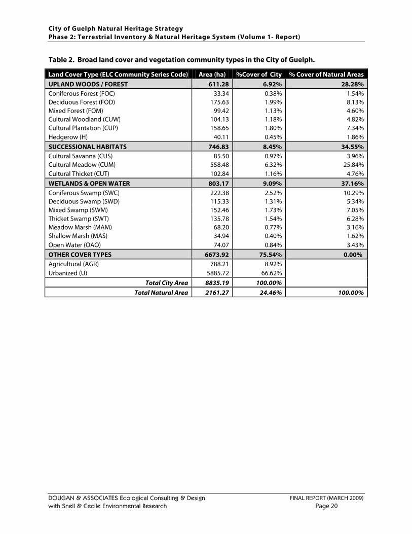
City of Guelph Natural Heritage Strategy Phase 2: Terrestrial Inventory & Natural Heritage System (Volume 1- Report)
DOUGAN & ASSOCIATES Ecological Consulting & Design FINAL REPORT (MARCH 2009) with Snell & Cecile Environmental Research Page 20
Table 2. Broad land cover and vegetation community types in the City of Guelph. Land Cover Type (ELC Community Series Code) Area (ha) %Cover of City % Cover of Natural Areas UPLAND WOODS / FOREST 611.28 6.92% 28.28% Coniferous Forest (FOC) 33.34 0.38% 1.54% Deciduous Forest (FOD) 175.63 1.99% 8.13% Mixed Forest (FOM) 99.42 1.13% 4.60% Cultural Woodland (CUW) 104.13 1.18% 4.82% Cultural Plantation (CUP) 158.65 1.80% 7.34% Hedgerow (H) 40.11 0.45% 1.86% SUCCESSIONAL HABITATS 746.83 8.45% 34.55% Cultural Savanna (CUS) 85.50 0.97% 3.96% Cultural Meadow (CUM) 558.48 6.32% 25.84% Cultural Thicket (CUT) 102.84 1.16% 4.76% WETLANDS & OPEN WATER 803.17 9.09% 37.16% Coniferous Swamp (SWC) 222.38 2.52% 10.29% Deciduous Swamp (SWD) 115.33 1.31% 5.34% Mixed Swamp (SWM) 152.46 1.73% 7.05% Thicket Swamp (SWT) 135.78 1.54% 6.28% Meadow Marsh (MAM) 68.20 0.77% 3.16% Shallow Marsh (MAS) 34.94 0.40% 1.62% Open Water (OAO) 74.07 0.84% 3.43% OTHER COVER TYPES 6673.92 75.54% 0.00% Agricultural (AGR) 788.21 8.92% Urbanized (U) 5885.72 66.62%
Total City Area 8835.19 100.00% Total Natural Area 2161.27 24.46% 100.00%
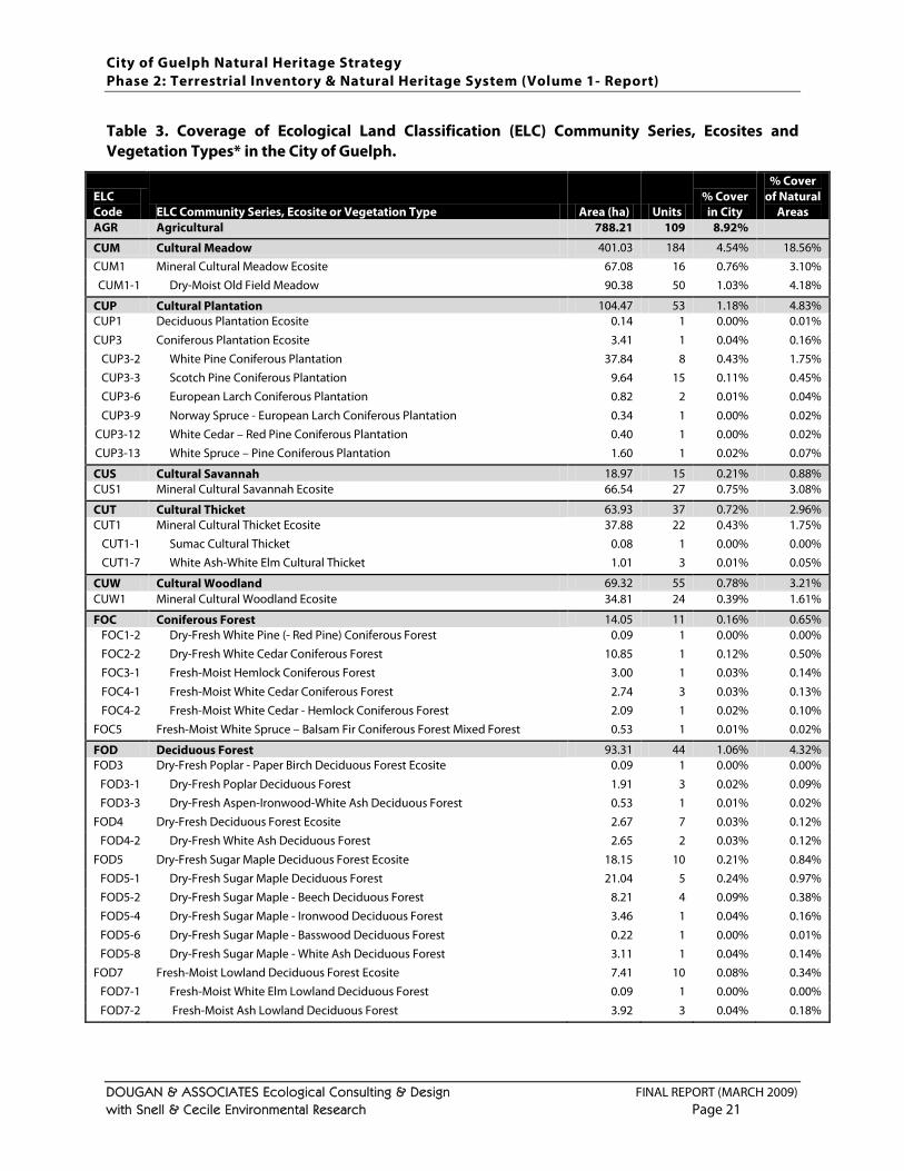
City of Guelph Natural Heritage Strategy Phase 2: Terrestrial Inventory & Natural Heritage System (Volume 1- Report)
DOUGAN & ASSOCIATES Ecological Consulting & Design FINAL REPORT (MARCH 2009) with Snell & Cecile Environmental Research Page 21
Table 3. Coverage of Ecological Land Classification (ELC) Community Series, Ecosites and Vegetation Types* in the City of Guelph.
ELC Code ELC Community Series, Ecosite or Vegetation Type Area (ha) Units
% Cover in City
% Cover of Natural
Areas AGR Agricultural 788.21 109 8.92%
CUM Cultural Meadow 401.03 184 4.54% 18.56% CUM1 Mineral Cultural Meadow Ecosite 67.08 16 0.76% 3.10% CUM1-1 Dry-Moist Old Field Meadow 90.38 50 1.03% 4.18%
CUP Cultural Plantation 104.47 53 1.18% 4.83% CUP1 Deciduous Plantation Ecosite 0.14 1 0.00% 0.01%
CUP3 Coniferous Plantation Ecosite 3.41 1 0.04% 0.16% CUP3-2 White Pine Coniferous Plantation 37.84 8 0.43% 1.75% CUP3-3 Scotch Pine Coniferous Plantation 9.64 15 0.11% 0.45% CUP3-6 European Larch Coniferous Plantation 0.82 2 0.01% 0.04%
CUP3-9 Norway Spruce - European Larch Coniferous Plantation 0.34 1 0.00% 0.02% CUP3-12 White Cedar – Red Pine Coniferous Plantation 0.40 1 0.00% 0.02% CUP3-13 White Spruce – Pine Coniferous Plantation 1.60 1 0.02% 0.07%
CUS Cultural Savannah 18.97 15 0.21% 0.88% CUS1 Mineral Cultural Savannah Ecosite 66.54 27 0.75% 3.08%
CUT Cultural Thicket 63.93 37 0.72% 2.96% CUT1 Mineral Cultural Thicket Ecosite 37.88 22 0.43% 1.75%
CUT1-1 Sumac Cultural Thicket 0.08 1 0.00% 0.00% CUT1-7 White Ash-White Elm Cultural Thicket 1.01 3 0.01% 0.05%
CUW Cultural Woodland 69.32 55 0.78% 3.21% CUW1 Mineral Cultural Woodland Ecosite 34.81 24 0.39% 1.61%
FOC Coniferous Forest 14.05 11 0.16% 0.65% FOC1-2 Dry-Fresh White Pine (- Red Pine) Coniferous Forest 0.09 1 0.00% 0.00% FOC2-2 Dry-Fresh White Cedar Coniferous Forest 10.85 1 0.12% 0.50% FOC3-1 Fresh-Moist Hemlock Coniferous Forest 3.00 1 0.03% 0.14%
FOC4-1 Fresh-Moist White Cedar Coniferous Forest 2.74 3 0.03% 0.13% FOC4-2 Fresh-Moist White Cedar - Hemlock Coniferous Forest 2.09 1 0.02% 0.10%
FOC5 Fresh-Moist White Spruce – Balsam Fir Coniferous Forest Mixed Forest 0.53 1 0.01% 0.02%
FOD Deciduous Forest 93.31 44 1.06% 4.32% FOD3 Dry-Fresh Poplar - Paper Birch Deciduous Forest Ecosite 0.09 1 0.00% 0.00%
FOD3-1 Dry-Fresh Poplar Deciduous Forest 1.91 3 0.02% 0.09% FOD3-3 Dry-Fresh Aspen-Ironwood-White Ash Deciduous Forest 0.53 1 0.01% 0.02%
FOD4 Dry-Fresh Deciduous Forest Ecosite 2.67 7 0.03% 0.12% FOD4-2 Dry-Fresh White Ash Deciduous Forest 2.65 2 0.03% 0.12%
FOD5 Dry-Fresh Sugar Maple Deciduous Forest Ecosite 18.15 10 0.21% 0.84% FOD5-1 Dry-Fresh Sugar Maple Deciduous Forest 21.04 5 0.24% 0.97% FOD5-2 Dry-Fresh Sugar Maple - Beech Deciduous Forest 8.21 4 0.09% 0.38% FOD5-4 Dry-Fresh Sugar Maple - Ironwood Deciduous Forest 3.46 1 0.04% 0.16%
FOD5-6 Dry-Fresh Sugar Maple - Basswood Deciduous Forest 0.22 1 0.00% 0.01% FOD5-8 Dry-Fresh Sugar Maple - White Ash Deciduous Forest 3.11 1 0.04% 0.14%
FOD7 Fresh-Moist Lowland Deciduous Forest Ecosite 7.41 10 0.08% 0.34% FOD7-1 Fresh-Moist White Elm Lowland Deciduous Forest 0.09 1 0.00% 0.00%
FOD7-2 Fresh-Moist Ash Lowland Deciduous Forest 3.92 3 0.04% 0.18%
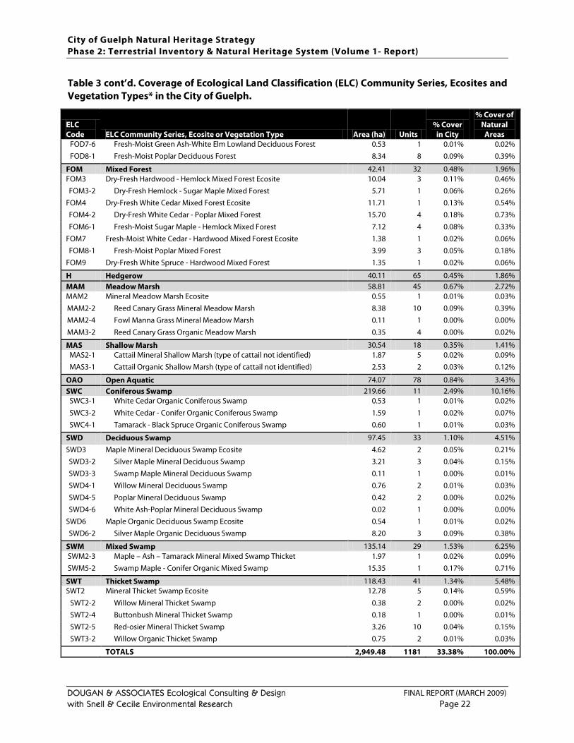
City of Guelph Natural Heritage Strategy Phase 2: Terrestrial Inventory & Natural Heritage System (Volume 1- Report)
DOUGAN & ASSOCIATES Ecological Consulting & Design FINAL REPORT (MARCH 2009) with Snell & Cecile Environmental Research Page 22
Table 3 cont’d. Coverage of Ecological Land Classification (ELC) Community Series, Ecosites and Vegetation Types* in the City of Guelph.
ELC Code ELC Community Series, Ecosite or Vegetation Type Area (ha) Units
% Cover in City
% Cover of Natural
Areas FOD7-6 Fresh-Moist Green Ash-White Elm Lowland Deciduous Forest 0.53 1 0.01% 0.02% FOD8-1 Fresh-Moist Poplar Deciduous Forest 8.34 8 0.09% 0.39%
FOM Mixed Forest 42.41 32 0.48% 1.96% FOM3 Dry-Fresh Hardwood - Hemlock Mixed Forest Ecosite 10.04 3 0.11% 0.46% FOM3-2 Dry-Fresh Hemlock - Sugar Maple Mixed Forest 5.71 1 0.06% 0.26%
FOM4 Dry-Fresh White Cedar Mixed Forest Ecosite 11.71 1 0.13% 0.54% FOM4-2 Dry-Fresh White Cedar - Poplar Mixed Forest 15.70 4 0.18% 0.73%
FOM6-1 Fresh-Moist Sugar Maple - Hemlock Mixed Forest 7.12 4 0.08% 0.33% FOM7 Fresh-Moist White Cedar - Hardwood Mixed Forest Ecosite 1.38 1 0.02% 0.06% FOM8-1 Fresh-Moist Poplar Mixed Forest 3.99 3 0.05% 0.18%
FOM9 Dry-Fresh White Spruce - Hardwood Mixed Forest 1.35 1 0.02% 0.06%
H Hedgerow 40.11 65 0.45% 1.86% MAM Meadow Marsh 58.81 45 0.67% 2.72% MAM2 Mineral Meadow Marsh Ecosite 0.55 1 0.01% 0.03% MAM2-2 Reed Canary Grass Mineral Meadow Marsh 8.38 10 0.09% 0.39% MAM2-4 Fowl Manna Grass Mineral Meadow Marsh 0.11 1 0.00% 0.00%
MAM3-2 Reed Canary Grass Organic Meadow Marsh 0.35 4 0.00% 0.02%
MAS Shallow Marsh 30.54 18 0.35% 1.41% MAS2-1 Cattail Mineral Shallow Marsh (type of cattail not identified) 1.87 5 0.02% 0.09% MAS3-1 Cattail Organic Shallow Marsh (type of cattail not identified) 2.53 2 0.03% 0.12%
OAO Open Aquatic 74.07 78 0.84% 3.43% SWC Coniferous Swamp 219.66 11 2.49% 10.16%
SWC3-1 White Cedar Organic Coniferous Swamp 0.53 1 0.01% 0.02%
SWC3-2 White Cedar - Conifer Organic Coniferous Swamp 1.59 1 0.02% 0.07% SWC4-1 Tamarack - Black Spruce Organic Coniferous Swamp 0.60 1 0.01% 0.03%
SWD Deciduous Swamp 97.45 33 1.10% 4.51%
SWD3 Maple Mineral Deciduous Swamp Ecosite 4.62 2 0.05% 0.21% SWD3-2 Silver Maple Mineral Deciduous Swamp 3.21 3 0.04% 0.15% SWD3-3 Swamp Maple Mineral Deciduous Swamp 0.11 1 0.00% 0.01% SWD4-1 Willow Mineral Deciduous Swamp 0.76 2 0.01% 0.03%
SWD4-5 Poplar Mineral Deciduous Swamp 0.42 2 0.00% 0.02% SWD4-6 White Ash-Poplar Mineral Deciduous Swamp 0.02 1 0.00% 0.00%
SWD6 Maple Organic Deciduous Swamp Ecosite 0.54 1 0.01% 0.02% SWD6-2 Silver Maple Organic Deciduous Swamp 8.20 3 0.09% 0.38%
SWM Mixed Swamp 135.14 29 1.53% 6.25% SWM2-3 Maple – Ash – Tamarack Mineral Mixed Swamp Thicket 1.97 1 0.02% 0.09% SWM5-2 Swamp Maple - Conifer Organic Mixed Swamp 15.35 1 0.17% 0.71%
SWT Thicket Swamp 118.43 41 1.34% 5.48% SWT2 Mineral Thicket Swamp Ecosite 12.78 5 0.14% 0.59%
SWT2-2 Willow Mineral Thicket Swamp 0.38 2 0.00% 0.02% SWT2-4 Buttonbush Mineral Thicket Swamp 0.18 1 0.00% 0.01% SWT2-5 Red-osier Mineral Thicket Swamp 3.26 10 0.04% 0.15% SWT3-2 Willow Organic Thicket Swamp 0.75 2 0.01% 0.03%
TOTALS 2,949.48 1181 33.38% 100.00%
City of Guelph Natural Heritage Strategy Phase 2: Terrestrial Inventory & Natural Heritage System (Volume 1- Report)
DOUGAN & ASSOCIATES Ecological Consulting & Design FINAL REPORT (MARCH 2009) with Snell & Cecile Environmental Research Page 23
In total, more than 125 person-hours were spent conducting ELC and vegetation assessments in various ELC polygons across the City over 2005. Some additional field time was spent ensuring that plantations had been classified in a consistent manner across the City and verifying the refined ELC mapping submitted by other consultants for some properties in the City in 2008. RESULTS & DISCUSSION A summary of the ELC mapping to the Community Series level is presented in Table 2. Table 3 provides a more detailed summary of ELC coverage of units mapped to Ecosite and Vegetation Type. As shown in Table 2, overall natural cover in the City, including plantations and all cultural habitat types, is 24.5%. Nearly half of this natural cover (i.e., 1050 ha of 2161ha; 11.9% of the 24.5% natural cover in the City) is comprised of lands that were cleared for human uses over the past two centuries, were abandoned, and have become naturalized (i.e., the cultural habitat types) or planted (i.e., plantations and hedgerows). This means that only12.6% of the City is covered by natural areas that are likely fragments of original natural areas. These areas consist primarily of wetlands (i.e., swamps and marshes, as well as open water) which represent the greatest natural land cover in the City, and fragments of coniferous / deciduous / mixed upland forest (further described in Table 4
Although cultural communities tend to have higher proportions of non-native and invasive species than the other natural areas, the natural cover provided by cultural habitat types contributes significantly to the City’s overall natural cover. Furthermore, although these cultural communities may not contain the highest quality plant communities, they still provide habitat for many locally significant wildlife species, as shown in
below). Of the City’s 24% natural cover, approximately 7% consists of upland forest (including plantations and hedgerows); 8% consists of successional habitats (i.e., cultural meadows, thickets and savannas); and 9% consists of wetlands (i.e., swamps and marshes) and open water. The City currently has nearly 12.5% overall forest cover which encompasses about 1100 ha (including swamps, which are forested wetlands). Plantations, cultural woodlands and hedgerows represent approximately 3.5% of this forest cover with the remaining cover being deciduous, coniferous and mixed forested uplands and wetlands. While some of the forested swamp habitats are relatively large for a City the size of Guelph (i.e., one coniferous swamp unit in the Hanlon Creek wetland is almost 88 ha), the upland forested areas primarily consist of relatively small fragments of which there are three units between 10 and 20 ha in area, 119 units between 1 and 10 ha, and 178 units smaller than 1 ha.
Figure 1113, and also represent areas which could become future forests in the City. Although, if left unmanaged, the cultural meadows and thickets will eventually succeed into forests, open meadows and thickets also have ecological value in their own right as habitat for wildlife such as grassland bird species, including some of conservation concern that have been recorded in Guelph (see Section 3.4.6
Part of Guelph’s uniqueness is its naturally “hilly” landscape, largely a result of drumlins scattered throughout the central and northern part of the City. In the southern portion of the City, the northern edge of the Paris-Galt Moraine complex extends across the landscape making this area visually, geologically and ecologically unique. As can be seen in
).
Figures 7 through 10
13 Notably, this mapping does not capture the presence of significant species in the City’s large wetland areas, which were
not surveyed as part of this study.
, the lands south of Clair Road contain complexes of wetlands, pockets of deciduous forests, expanses of cultural meadows / old fields that likely used to be grazed, swaths of coniferous tree plantations, and areas of cultural
City of Guelph Natural Heritage Strategy Phase 2: Terrestrial Inventory & Natural Heritage System (Volume 1- Report)
DOUGAN & ASSOCIATES Ecological Consulting & Design FINAL REPORT (MARCH 2009) with Snell & Cecile Environmental Research Page 24
thicket and woodland that have regenerated naturally. Although this landscape has been significantly impacted by agricultural activities in the past, it has regenerated into a mosaic of natural and semi-natural / cultural habitat types that provide habitat for species not found elsewhere in the City (e.g., amphibians of the Jefferson Salamander complex; grassland birds like Bobolink and Grasshopper Sparrow). Table 3 summarizes the diversity of habitat types in the City based on the existing data. Notably, habitats throughout the City were not all evaluated to the same level of detail and so this data does not provide a complete picture of the full diversity of habitat types. Therefore, the data should be interpreted with this in mind. The fact that there are a greater number of ELC Ecosites and Vegetation Types identified for the wooded (i.e., forest) than the wetland (i.e., marsh and swamp) communities is not a reflection of the greater diversity of wooded than wetland types, but rather a reflection of the fact that this study’s focus was on the terrestrial areas outside of most of the City’s wetlands, and so more detailed ELC typing was conducted in those habitats. The lack of habitat diversity in the meadows is, however, a reflection of the City’s rural past and the fact that almost all of the meadows consist of abandoned farm fields. Although Ecodistrict 6E-1, in which Guelph is located, is known to have had naturally occurring pockets of tallgrass prairie (Henson and Brodribb 2005), it is unknown if any of these open habitat types ever naturally occurred with the City limits. None of the ELC Vegetation Types listed in Table 3
Buttonbush Mineral Thicket Swamp Type (ELC Code: SWT2-4, Global rank: G4, NHIC rank: S3) occurring in the northwest portion of the Hanlon Creek Watershed;
are considered provincially rare (NHIC 2005). However a three provincially rare vegetation types are thought to occur within the City’s wetlands and floodplain areas. These were identified by S. Brinker (former Ecologist with D&A) based on his knowledge of the City are listed below with their general location.
Silky Dogwood Mineral Thicket Swamp Type (ELC Code: SWT2-8, Global rank: G5, NHIC rank: S3S4) occurring within the Guelph North-East Wetland complex; and
White Cedar Treed Carbonate Cliff Type (ELC Code: CLT1-1, Global rank: G2Q, NHIC rank: S3) located within the floodplains of the Guelph Correctional Centre lands.
These are already within protected wetland areas but their precise locations were not field verified and so these communities have not been specifically identified in mapping (i.e., Figure 7
Open Fen Ecosite (FEO1)
). In addition, a list of rare or uncommon Ecosite types known to occur in the City has been developed for this study as follows (with the ELC Ecosite code in brackets):
Carbonate Open Cliff Ecosite (CLO1) Carbonate Shrub Cliff Ecosite (CLS1) Carbonate Treed Talus Ecosite (TAT1)
Natural fen, cliff and talus14
14 Talus habitats are the rocky outcrops associated with the foot of natural cliffs that support unique vegetation communities.
habitats are very rare in the City of Guelph and also rare in Wellington County and most of southern Ontario. Although the presence of fen habitat was not confirmed in the City, it is possible that such habitats do occur. Presumably these would be captured within designated wetlands, but should a small, isolated be indentified in the future, it should be considered a locally rare habitat.
City of Guelph Natural Heritage Strategy Phase 2: Terrestrial Inventory & Natural Heritage System (Volume 1- Report)
DOUGAN & ASSOCIATES Ecological Consulting & Design FINAL REPORT (MARCH 2009) with Snell & Cecile Environmental Research Page 25
Natural cliffs and talus slopes are also rare outside of the Niagara Escarpment and in the City are known to be restricted to lands south of the Eramosa River corridor both west and east of Victoria Road. Although the Arkell-Victoria-Clair-Gordon Kettles do not correspond with one specific Ecosite type, these kettles and the kames associated with them, as described in the Torrance Creek Subwatershed Study (TSH et al. 1998), are unique areas that can be seasonally wet or inundated all year and provide unique habitats for plants and herpetofauna. Even with development in the surrounding lands, the continued presence of locally significant species associated with these kettles was observed during field work conducted for this study (as shown in Figure 11). The City has already identified a number of significant woodlands (currently defined as woodlands of at least 1.0 ha) through its current Official Plan (November 2006 consolidation). Upland woods were examined specifically in this study in order to better understand the size ranges (as shown in Table 4) and types of these habitats (shown in Table 3
In addition to the ELC surveys conducted in 2005, several areas containing plantations and cultural vegetation communities were visited on May 16 and June 27 in 2008 to confirm mapping of plantations
) in the City, and to be able to better define what constitutes significant woodlands.
15 and cultural woodlands16
In the plantations visited in 2008, Scots pine (Pinus sylvestris) was the dominant species in the canopy. Other species include red pine (Pinus resinosa), jack pine (Pinus banksiana) and white spruce (Picea glauca). Several deciduous species have colonized the plantations including black cherry (Prunus serotina), white ash (Fraxinus americana), apple (Malus pumila), hawthorn (Crataegus spp.) and Manitoba maple (Acer negundo). A dense understory of shrubs characterizes these areas. Species include Tartarian honeysuckle (Lonicera tatarica), blackberry (Rubus allegheniensis), black cherry (Prunus serotina), wild grape (Vitis riparia), common lilac (Syringa vulgaris), perfumed cherry (Prunus
. These included several areas in the vicinity of Watson Parkway and York Road, a property west of Victoria Road south of Stone Road, and a property on the west side of Brock Road just south of Clair Road. Only properties where written permission was obtained from the landowners were visited on foot; the remaining plantations in the City were verified through road side surveys where possible and close re-examination of current (i.e., 2007) colour air photos available on Google Earth.
15 For this study, plantations have been defined in manner consistent with the ELC system and as per the Carolinian Canada
draft guidelines for boundary delineation. The ELC manual (Lee et al. 1998, p. 30-31) defines plantations as habitats where "tree cover >60% and dominating canopy trees are planted” and a cultural plantation (p. 68) as a "community resulting from, or maintained by, cultural or anthropogenic-based disturbance." In the glossary on pg. 205, "plantation" is defined as: "a deciduous or coniferous treed community in which the majority of trees have been planted". This is consistent with the definition of plantations used in the Carolinian Canada Draft Boundary Delineation Guideline (available at www.carolinian.org/Publications/eis_D.pdf) which is: “a woodland where the dominant trees have been planted by humans as opposed to naturally regenerated. It includes treed communities dominated by non-native species in the main stratum”.
16 For this study, cultural woodlands are also defined in manner consistent with the ELC system and as per the Carolinian
Canada draft guidelines for boundary delineation. The ELC guide (Lee et al. 1998) and the Carolinian Canada Draft Boundary Delineation Guideline available at www.carolinian.org/Publications/eis_D.pdf) define cultural woodlands as areas that have been significantly altered by human disturbance (e.g., agriculture, grazing, gravel extraction) and may include some planted species but have undergone natural succession to the point where tree cover is between 35% and 60% with graminoid and forb ground covers, and possibly shrubs as well.
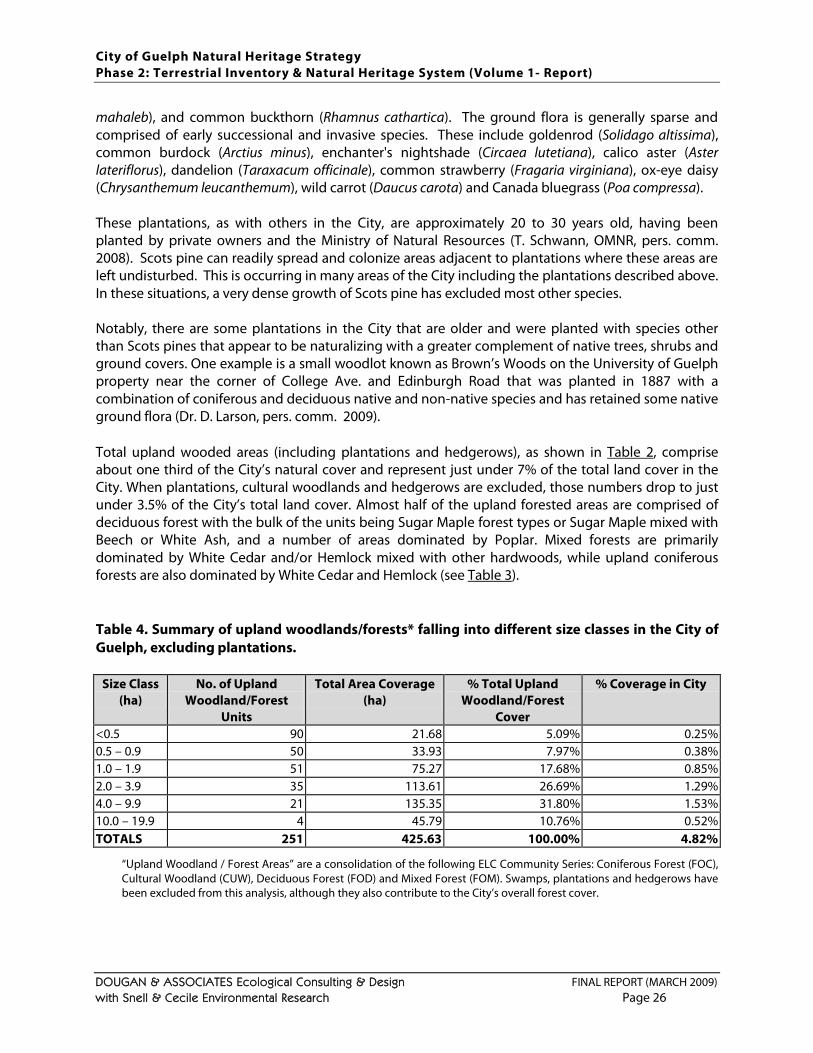
City of Guelph Natural Heritage Strategy Phase 2: Terrestrial Inventory & Natural Heritage System (Volume 1- Report)
DOUGAN & ASSOCIATES Ecological Consulting & Design FINAL REPORT (MARCH 2009) with Snell & Cecile Environmental Research Page 26
mahaleb), and common buckthorn (Rhamnus cathartica). The ground flora is generally sparse and comprised of early successional and invasive species. These include goldenrod (Solidago altissima), common burdock (Arctius minus), enchanter's nightshade (Circaea lutetiana), calico aster (Aster lateriflorus), dandelion (Taraxacum officinale), common strawberry (Fragaria virginiana), ox-eye daisy (Chrysanthemum leucanthemum), wild carrot (Daucus carota) and Canada bluegrass (Poa compressa). These plantations, as with others in the City, are approximately 20 to 30 years old, having been planted by private owners and the Ministry of Natural Resources (T. Schwann, OMNR, pers. comm. 2008). Scots pine can readily spread and colonize areas adjacent to plantations where these areas are left undisturbed. This is occurring in many areas of the City including the plantations described above. In these situations, a very dense growth of Scots pine has excluded most other species. Notably, there are some plantations in the City that are older and were planted with species other than Scots pines that appear to be naturalizing with a greater complement of native trees, shrubs and ground covers. One example is a small woodlot known as Brown’s Woods on the University of Guelph property near the corner of College Ave. and Edinburgh Road that was planted in 1887 with a combination of coniferous and deciduous native and non-native species and has retained some native ground flora (Dr. D. Larson, pers. comm. 2009). Total upland wooded areas (including plantations and hedgerows), as shown in Table 2, comprise about one third of the City’s natural cover and represent just under 7% of the total land cover in the City. When plantations, cultural woodlands and hedgerows are excluded, those numbers drop to just under 3.5% of the City’s total land cover. Almost half of the upland forested areas are comprised of deciduous forest with the bulk of the units being Sugar Maple forest types or Sugar Maple mixed with Beech or White Ash, and a number of areas dominated by Poplar. Mixed forests are primarily dominated by White Cedar and/or Hemlock mixed with other hardwoods, while upland coniferous forests are also dominated by White Cedar and Hemlock (see Table 3). Table 4. Summary of upland woodlands/forests* falling into different size classes in the City of Guelph, excluding plantations.
Size Class (ha)
No. of Upland Woodland/Forest
Units
Total Area Coverage (ha)
% Total Upland Woodland/Forest
Cover
% Coverage in City
<0.5 90 21.68 5.09% 0.25% 0.5 – 0.9 50 33.93 7.97% 0.38% 1.0 – 1.9 51 75.27 17.68% 0.85% 2.0 – 3.9 35 113.61 26.69% 1.29% 4.0 – 9.9 21 135.35 31.80% 1.53% 10.0 – 19.9 4 45.79 10.76% 0.52% TOTALS 251 425.63 100.00% 4.82% “Upland Woodland / Forest Areas” are a consolidation of the following ELC Community Series: Coniferous Forest (FOC),
Cultural Woodland (CUW), Deciduous Forest (FOD) and Mixed Forest (FOM). Swamps, plantations and hedgerows have been excluded from this analysis, although they also contribute to the City’s overall forest cover.
City of Guelph Natural Heritage Strategy Phase 2: Terrestrial Inventory & Natural Heritage System (Volume 1- Report)
DOUGAN & ASSOCIATES Ecological Consulting & Design FINAL REPORT (MARCH 2009) with Snell & Cecile Environmental Research Page 27
Size class distributions of Guelph’s upland forests, excluding plantations, are presented in Table 4. It is clear from this analysis (and from Figure 5
3.4.3 VEGETATION ASSESSMENTS
), that there are many relatively small units of upland forest scattered throughout the City with more than 50% of the units being smaller than 1 ha. The 140 units smaller than 1 ha cumulatively represent 0.63% of the remaining 4.82% upland forest cover in the City. The remaining 111 units range in size from 1 ha to less than 20 ha, but still reflect a highly fragmented landscape with only 4 units greater than 10 ha in the City and no upland forest patches larger than 20 ha. Given the fragmented nature and coverage of Guelph’s remaining upland woods, maintaining a threshold of 1 ha to determine significance seems appropriate. Although at the smaller end of the spectrum, 1 ha woodlands can provide habitat for edge tolerant bird species such as Blue Jays, Black-capped Chickadees and Eastern Wood-Pewee (Environment Canada 2004). From an ecological perspective, the majority of these woodlands are too small to sustain most forest interior bird species (e.g., Austen et al. 2001) or to provide for forest interior conditions which, if measured at 100 m from the forest edge, can only begin to occur in square-shaped or circular wooded areas of at least 4 ha. However, these features take on more significance in the context of other natural areas in the City since small woodlands adjacent to other natural areas will likely fulfill more ecological functions than small woodlands completely surrounded by built up areas. Small woodlands that are relatively close to other larger natural heritage features in urban settings can also serve as ecological linkages and provide supportive functions to larger areas (e.g., Friesen 1999; Friesen et al. 1999; Fraser and Stutchbury 2004).
Vegetation assessments focused exclusively on vascular plants and were conducted in conjunction with the ELC assessments between June and October of 2005, with a few incidental observations made in the summer of 2006. The emphasis of the vegetative survey work was on characterization of each ELC polygon through the identification of the dominant and most abundant species occurring in each vegetative layer. Although a thorough survey of each field verified unit for rare or unusual plants was not the focus of this study, a number of observations of common species as well as some determined to be provincially rare or locally significant were made during the course of these surveys. Data collected from vegetation field surveys undertaken in 2005 was entered into the species database (as described in Section 3.2) and was subsequently screened for significant species records which were then entered into the GIS mapping metadata (in 2008). Notably, because field surveys were outside of designated wetland and floodplain areas, many of the rare and significant species known to occur in the City were not captured as part of this field work. Examples include the 26 significant plant records for the Hanlon Creek subwatershed area (see Table B 4.5 in PEIL et al. 2004). The following discussion focuses on the provincially rare and locally significant plant species observed during the course of this study. Of the 282 plant species identified as significant in the working Significant Plant List for Wellington County (provided in Appendix A), 28 have were confirmed within the City of Guelph through a review of environmental impact studies conducted in the City since 1988, and 14 others were confirmed through field work conducted for this study, as listed in Table 5 below.
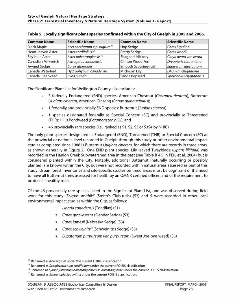
City of Guelph Natural Heritage Strategy Phase 2: Terrestrial Inventory & Natural Heritage System (Volume 1- Report)
DOUGAN & ASSOCIATES Ecological Consulting & Design FINAL REPORT (MARCH 2009) with Snell & Cecile Environmental Research Page 28
Table 5. Locally significant plant species confirmed within the City of Guelph in 2005 and 2006. Common Name Scientific Name Common Name Scientific Name Black Maple Acer saccharum ssp. nigrum17 Hop Sedge Carex lupulina Heart-leaved Aster Aster cordifolius18 Pretty Sedge Carex woodii Sky-blue Aster Aster oolentangiensis19 Shagbark Hickory Carya ovata var. ovata Canadian Milkvetch Astragalus canadensis Clinton Wood Fern Dryopteris clintoniana Awned Sedge Carex atherodes Smooth Scouring-rush Equisetum laevigatum Canada Waterleaf Hydrophyllum canadense Michigan Lily Lilium michiganense Canada Clearweed Pilea pumila Sand Dropseed Sporobolus cryptandrus The Significant Plant List for Wellington County also includes:
3 federally Endangered (END) species: American Chestnut (Castanea dentata), Butternut (Juglans cinerea), American Ginseng (Panax quinquefolius);
1 federally and provincially END species: Butternut (Juglans cinerea)
1 species designated federally as Special Concern (SC) and provincially as Threatened (THR): Hill's Pondweed (Potamogeton hillii); and
46 provincially rare species (i.e., ranked as S1, S2, S3 or S3S4 by NHIC) The only plant species designated as Endangered (END), Threatened (THR) or Special Concern (SC) at the provincial or national level recorded in Guelph through this study or other environmental impact studies completed since 1988 is Butternut (Juglans cinerea), for which there are records in three areas, as shown generally in Figure 7
Of the 46 provincially rare species listed in the Significant Plant List, one was observed during field work for this study (Scirpus smithii
. One END plant species, Lily leaved Twayblade (Liparis liliifolia) was recorded in the Hanlon Creek Subwatershed area in the past (see Table B 4.5 in PEIL et al. 2004) but is considered planted within the City. Notably, additional Butternut (naturally occurring or possibly planted) are known within the City, but were not recorded within natural areas assessed as part of this study. Urban forest inventories and site-specific studies on treed areas must be cognizant of the need to have all Butternut trees assessed for health by an OMNR certified officer, and of the requirement to protect all healthy trees.
20
1. Linaria canadensis (Toadflax) (S1)
(Smith's Club-rush) (S3) and 5 were recorded in other local environmental impact studies within the City, as follows:
2. Carex gracilescens (Slender Sedge) (S3)
3. Carex jamesii (Nebraska Sedge) (S3)
4. Carex schweinitzii (Schweinitz's Sedge) (S3)
5. Eupatorium purpureum var. purpureum (Sweet Joe-pye-weed) (S3)
17 Renamed as Acer nigrum under the current FOIBIS classification. 18 Renamed as Symphyotrichum cordifolium under the current FOIBIS classification. 19 Renamed as Symphyotrichum oolentangiense var. oolentangiense under the current FOIBIS classification. 20 Renamed as Schoenoplectus smithii under the current FOIBIS classification.
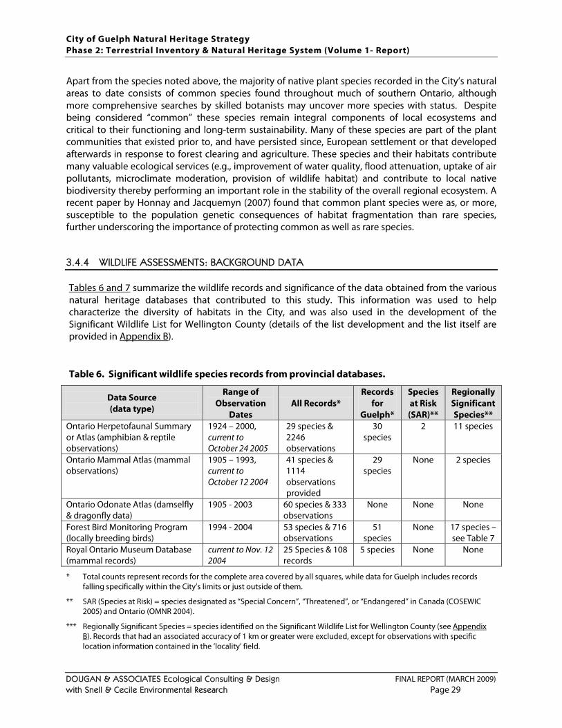
City of Guelph Natural Heritage Strategy Phase 2: Terrestrial Inventory & Natural Heritage System (Volume 1- Report)
DOUGAN & ASSOCIATES Ecological Consulting & Design FINAL REPORT (MARCH 2009) with Snell & Cecile Environmental Research Page 29
Apart from the species noted above, the majority of native plant species recorded in the City’s natural areas to date consists of common species found throughout much of southern Ontario, although more comprehensive searches by skilled botanists may uncover more species with status. Despite being considered “common” these species remain integral components of local ecosystems and critical to their functioning and long-term sustainability. Many of these species are part of the plant communities that existed prior to, and have persisted since, European settlement or that developed afterwards in response to forest clearing and agriculture. These species and their habitats contribute many valuable ecological services (e.g., improvement of water quality, flood attenuation, uptake of air pollutants, microclimate moderation, provision of wildlife habitat) and contribute to local native biodiversity thereby performing an important role in the stability of the overall regional ecosystem. A recent paper by Honnay and Jacquemyn (2007) found that common plant species were as, or more, susceptible to the population genetic consequences of habitat fragmentation than rare species, further underscoring the importance of protecting common as well as rare species.
3.4.4 WILDLIFE ASSESSMENTS: BACKGROUND DATA
Tables 6 and 7 summarize the wildlife records and significance of the data obtained from the various natural heritage databases that contributed to this study. This information was used to help characterize the diversity of habitats in the City, and was also used in the development of the Significant Wildlife List for Wellington County (details of the list development and the list itself are provided in Appendix B). Table 6. Significant wildlife species records from provincial databases.
Data Source (data type)
Range of Observation
Dates All Records*
Records for
Guelph*
Species at Risk (SAR)**
Regionally Significant Species**
Ontario Herpetofaunal Summary or Atlas (amphibian & reptile observations)
1924 – 2000, current to October 24 2005
29 species & 2246 observations
30 species
2 11 species
Ontario Mammal Atlas (mammal observations)
1905 – 1993, current to October 12 2004
41 species & 1114 observations provided
29 species
None 2 species
Ontario Odonate Atlas (damselfly & dragonfly data)
1905 - 2003 60 species & 333 observations
None None None
Forest Bird Monitoring Program (locally breeding birds)
1994 - 2004 53 species & 716 observations
51 species
None 17 species – see Table 7
Royal Ontario Museum Database (mammal records)
current to Nov. 12 2004
25 Species & 108 records
5 species None None
* Total counts represent records for the complete area covered by all squares, while data for Guelph includes records
falling specifically within the City’s limits or just outside of them. ** SAR (Species at Risk) = species designated as “Special Concern”, “Threatened”, or “Endangered” in Canada (COSEWIC
2005) and Ontario (OMNR 2004). *** Regionally Significant Species = species identified on the Significant Wildlife List for Wellington County (see Appendix
B). Records that had an associated accuracy of 1 km or greater were excluded, except for observations with specific location information contained in the ‘locality’ field.
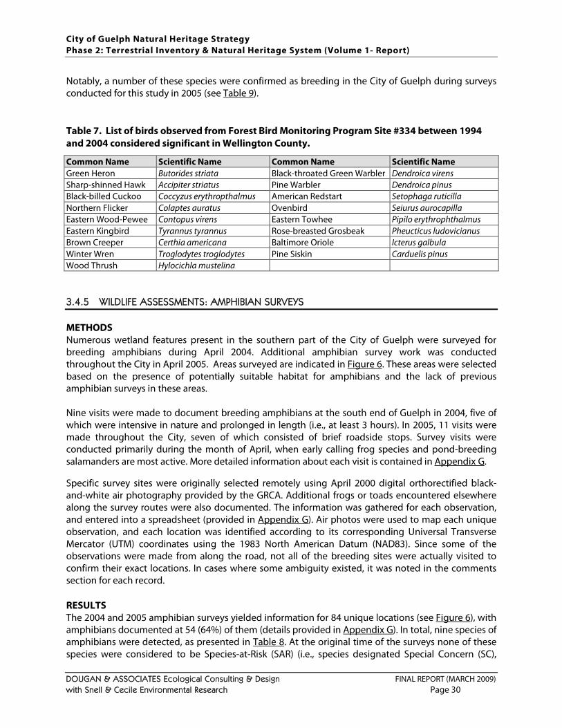
City of Guelph Natural Heritage Strategy Phase 2: Terrestrial Inventory & Natural Heritage System (Volume 1- Report)
DOUGAN & ASSOCIATES Ecological Consulting & Design FINAL REPORT (MARCH 2009) with Snell & Cecile Environmental Research Page 30
Notably, a number of these species were confirmed as breeding in the City of Guelph during surveys conducted for this study in 2005 (see Table 9). Table 7. List of birds observed from Forest Bird Monitoring Program Site #334 between 1994 and 2004 considered significant in Wellington County. Common Name Scientific Name Common Name Scientific Name Green Heron Butorides striata Black-throated Green Warbler Dendroica virens Sharp-shinned Hawk Accipiter striatus Pine Warbler Dendroica pinus Black-billed Cuckoo Coccyzus erythropthalmus American Redstart Setophaga ruticilla Northern Flicker Colaptes auratus Ovenbird Seiurus aurocapilla Eastern Wood-Pewee Contopus virens Eastern Towhee Pipilo erythrophthalmus Eastern Kingbird Tyrannus tyrannus Rose-breasted Grosbeak Pheucticus ludovicianus Brown Creeper Certhia americana Baltimore Oriole Icterus galbula Winter Wren Troglodytes troglodytes Pine Siskin Carduelis pinus Wood Thrush Hylocichla mustelina
3.4.5 WILDLIFE ASSESSMENTS: AMPHIBIAN SURVEYS
METHODS Numerous wetland features present in the southern part of the City of Guelph were surveyed for breeding amphibians during April 2004. Additional amphibian survey work was conducted throughout the City in April 2005. Areas surveyed are indicated in Figure 6. These areas were selected based on the presence of potentially suitable habitat for amphibians and the lack of previous amphibian surveys in these areas. Nine visits were made to document breeding amphibians at the south end of Guelph in 2004, five of which were intensive in nature and prolonged in length (i.e., at least 3 hours). In 2005, 11 visits were made throughout the City, seven of which consisted of brief roadside stops. Survey visits were conducted primarily during the month of April, when early calling frog species and pond-breeding salamanders are most active. More detailed information about each visit is contained in Appendix G
Specific survey sites were originally selected remotely using April 2000 digital orthorectified black-and-white air photography provided by the GRCA. Additional frogs or toads encountered elsewhere along the survey routes were also documented. The information was gathered for each observation, and entered into a spreadsheet (provided in
.
Appendix G
The 2004 and 2005 amphibian surveys yielded information for 84 unique locations (see
). Air photos were used to map each unique observation, and each location was identified according to its corresponding Universal Transverse Mercator (UTM) coordinates using the 1983 North American Datum (NAD83). Since some of the observations were made from along the road, not all of the breeding sites were actually visited to confirm their exact locations. In cases where some ambiguity existed, it was noted in the comments section for each record. RESULTS
Figure 6), with amphibians documented at 54 (64%) of them (details provided in Appendix G). In total, nine species of amphibians were detected, as presented in Table 8. At the original time of the surveys none of these species were considered to be Species-at-Risk (SAR) (i.e., species designated Special Concern (SC),
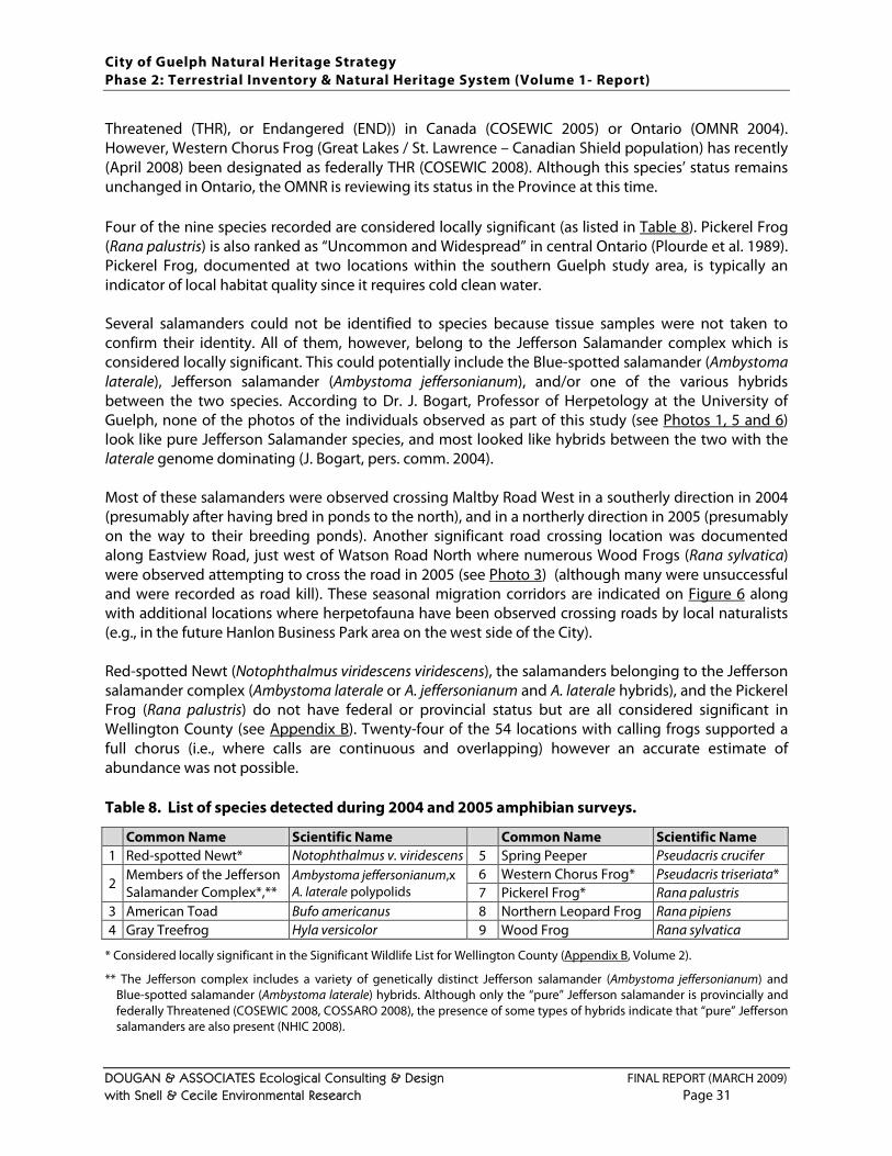
City of Guelph Natural Heritage Strategy Phase 2: Terrestrial Inventory & Natural Heritage System (Volume 1- Report)
DOUGAN & ASSOCIATES Ecological Consulting & Design FINAL REPORT (MARCH 2009) with Snell & Cecile Environmental Research Page 31
Threatened (THR), or Endangered (END)) in Canada (COSEWIC 2005) or Ontario (OMNR 2004). However, Western Chorus Frog (Great Lakes / St. Lawrence – Canadian Shield population) has recently (April 2008) been designated as federally THR (COSEWIC 2008). Although this species’ status remains unchanged in Ontario, the OMNR is reviewing its status in the Province at this time. Four of the nine species recorded are considered locally significant (as listed in Table 8). Pickerel Frog (Rana palustris) is also ranked as “Uncommon and Widespread” in central Ontario (Plourde et al. 1989). Pickerel Frog, documented at two locations within the southern Guelph study area, is typically an indicator of local habitat quality since it requires cold clean water. Several salamanders could not be identified to species because tissue samples were not taken to confirm their identity. All of them, however, belong to the Jefferson Salamander complex which is considered locally significant. This could potentially include the Blue-spotted salamander (Ambystoma laterale), Jefferson salamander (Ambystoma jeffersonianum), and/or one of the various hybrids between the two species. According to Dr. J. Bogart, Professor of Herpetology at the University of Guelph, none of the photos of the individuals observed as part of this study (see Photos 1, 5 and 6) look like pure Jefferson Salamander species, and most looked like hybrids between the two with the laterale genome dominating (J. Bogart, pers. comm. 2004). Most of these salamanders were observed crossing Maltby Road West in a southerly direction in 2004 (presumably after having bred in ponds to the north), and in a northerly direction in 2005 (presumably on the way to their breeding ponds). Another significant road crossing location was documented along Eastview Road, just west of Watson Road North where numerous Wood Frogs (Rana sylvatica) were observed attempting to cross the road in 2005 (see Photo 3) (although many were unsuccessful and were recorded as road kill). These seasonal migration corridors are indicated on Figure 6 along with additional locations where herpetofauna have been observed crossing roads by local naturalists (e.g., in the future Hanlon Business Park area on the west side of the City). Red-spotted Newt (Notophthalmus viridescens viridescens), the salamanders belonging to the Jefferson salamander complex (Ambystoma laterale or A. jeffersonianum and A. laterale hybrids), and the Pickerel Frog (Rana palustris) do not have federal or provincial status but are all considered significant in Wellington County (see Appendix B). Twenty-four of the 54 locations with calling frogs supported a full chorus (i.e., where calls are continuous and overlapping) however an accurate estimate of abundance was not possible. Table 8. List of species detected during 2004 and 2005 amphibian surveys. Common Name Scientific Name Common Name Scientific Name 1 Red-spotted Newt* Notophthalmus v. viridescens 5 Spring Peeper Pseudacris crucifer
2 Members of the Jefferson Salamander Complex*,**
Ambystoma jeffersonianum,x A. laterale polypolids
6 Western Chorus Frog* Pseudacris triseriata* 7 Pickerel Frog* Rana palustris
3 American Toad Bufo americanus 8 Northern Leopard Frog Rana pipiens 4 Gray Treefrog Hyla versicolor 9 Wood Frog Rana sylvatica
* Considered locally significant in the Significant Wildlife List for Wellington County (Appendix B, Volume 2). ** The Jefferson complex includes a variety of genetically distinct Jefferson salamander (Ambystoma jeffersonianum) and
Blue-spotted salamander (Ambystoma laterale) hybrids. Although only the “pure” Jefferson salamander is provincially and federally Threatened (COSEWIC 2008, COSSARO 2008), the presence of some types of hybrids indicate that “pure” Jefferson salamanders are also present (NHIC 2008).
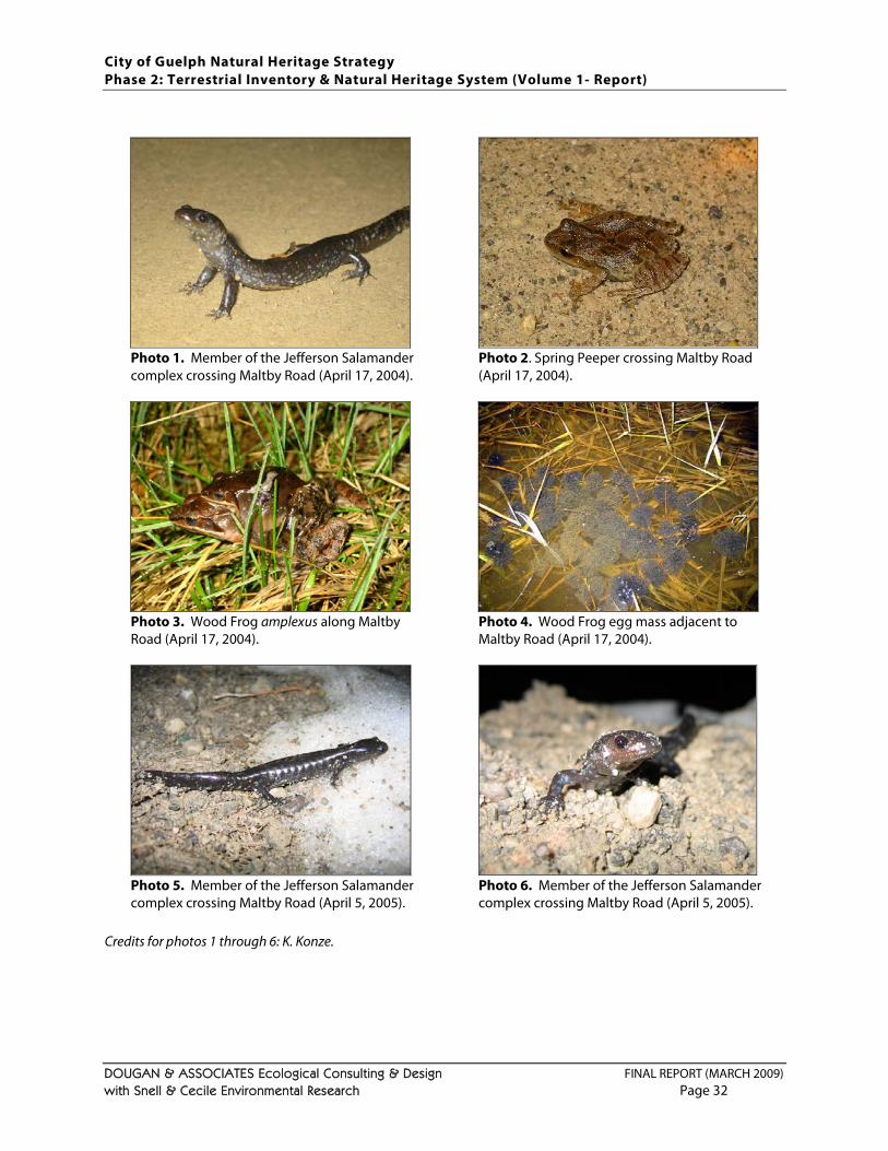
City of Guelph Natural Heritage Strategy Phase 2: Terrestrial Inventory & Natural Heritage System (Volume 1- Report)
DOUGAN & ASSOCIATES Ecological Consulting & Design FINAL REPORT (MARCH 2009) with Snell & Cecile Environmental Research Page 32
Photo 1. Member of the Jefferson Salamander complex crossing Maltby Road (April 17, 2004).
Photo 2. Spring Peeper crossing Maltby Road (April 17, 2004).
Photo 3. Wood Frog amplexus along Maltby Road (April 17, 2004).
Photo 4. Wood Frog egg mass adjacent to Maltby Road (April 17, 2004).
Photo 5. Member of the Jefferson Salamander complex crossing Maltby Road (April 5, 2005).
Photo 6. Member of the Jefferson Salamander complex crossing Maltby Road (April 5, 2005).
Credits for photos 1 through 6: K. Konze.
City of Guelph Natural Heritage Strategy Phase 2: Terrestrial Inventory & Natural Heritage System (Volume 1- Report)
DOUGAN & ASSOCIATES Ecological Consulting & Design FINAL REPORT (MARCH 2009) with Snell & Cecile Environmental Research Page 33
DISCUSSION The results of the 2004 and 2005 amphibian surveys should not be interpreted as comprehensive for the City because: (a) the majority of visits were made during of April and additional visits in May and June might have documented additional species, and (b) most designated wetlands in the City were not surveyed. As a result, these survey results do not provide a comprehensive description of the amphibian communities present in the City, but highlight the value of some of the terrestrial areas for amphibians and the need to more detailed studies in conjunction with any future subwatershed or environmental impact studies. In April 2008, Western Chorus Frog (Great Lakes / St. Lawrence – Canadian Shield population) was designated as a federally Threatened Species-at-Risk (COSEWIC 2008a). These were recorded in a number of locations in the City. Western Chorus Frogs are typically found in forest openings around woodland ponds and breed in almost any fishless pond with at least 10 cm of water (including ditches, gravel pits, flooded fields, beaver ponds, marshes, swamps and shallow lakes). Over the winter they hibernate under logs and rocks, or underground, and in the summer they tend to remain relatively close to wetlands, especially in urban environments where surrounding habitats may be limited (Hecnar 1995; Harding 1997; Houlahan and Findlay 2003). This species appears to be quite tolerant of human activities, and occurs in agricultural and suburban areas, but requires some “buffers” around its habitat. One study found that this species appears to decline in abundance when impacts occur within 500 m of its habitat, and that impacts are greatest within 200 m (Houlahan and Findlay 2003). According to the latest status report on the species (COSEWIC 2008b), Western Chorus Frog individuals’ home ranges include their breeding pond and the surrounding terrestrial habitat which vary from vary from 641 m² to 6024 m². However, they appear not to disperse too widely and studies have found that they tend to remain within 100 m to 200 m of their breeding pool. In the City of Guelph, site specific studies should be undertaken in consultation with experts at OMNR and the Western Chorus Frog Recovery Team to confirm critical habitat boundaries. In the interim, ELC polygons where Western Chorus Frog has been documented have been flagged as habitat for significant species in the recommended Natural Heritage System (see Figure 11) and details of which species are linked with which area(s) have been provided to the City. Surveys conducted for this study also provided data showing that the southern part of the City supports a relatively varied group of amphibians (Figure 6
The Jefferson complex comprises the Jefferson salamander (Ambystoma jeffersonianum) and the Blue-spotted Salamander (Ambystoma laterale), in addition to unisexual salamanders, which present various combinations of the nuclear genome of the two bisexual species and show different levels of ploidy. Although adults of A. jeffersonianum and A. laterale are usually easily differentiated morphologically, unisexuals can be difficult to identify visually because they may possess intermediate characters, or morphological traits from either of their bisexual counterparts, and can only be identified with certainty through genetic analyses of small tissue samples that can be obtained from live specimens (Noël et al. 2008). “Pure” Jefferson salamanders (A. jeffersonianum) were not confirmed in the City’s south end as part of this study, however there are records for this species just south of Maltby Road from 1990, and more comprehensive surveys for this species in Guelph’s south end should be undertaken with permits from the OMNR to trap to take tissue samples for accurate identification of
), including several species considered significant in Wellington County. This finding can likely be attributed to the relative abundance of breeding habitats (i.e., ponds) and non-breeding habitats (including upland woods) located in close proximity to each other in the lands south of Clair Road.
City of Guelph Natural Heritage Strategy Phase 2: Terrestrial Inventory & Natural Heritage System (Volume 1- Report)
DOUGAN & ASSOCIATES Ecological Consulting & Design FINAL REPORT (MARCH 2009) with Snell & Cecile Environmental Research Page 34
the salamanders in the area. A. jeffersonianum is currently designated as Threatened in Canada and Ontario (COSEWIC 2008; OMNR 2008). Hybrids can also be significant because presence of some types of hybrids (i.e., polyploid salamanders with the A. jeffersonianum genome dominating) indicate that pure A. jeffersonianum are almost certainly also present (NHIC 2008). A recent study in New York State found that herpetofaunal road-kill “hot spots” could be predicted wherever wetlands were located within 100 m of a road, with greater incidence of mortality where wetlands were located on both sides of the road (Langen et al. 2009). Maintenance of herpetofaunal populations is directly dependent on the protection of existing breeding habitats, non-breeding habitats (i.e., foraging and over-wintering habitat) and the seasonal migratory corridors between them. This means that linkages between ponds and uplands in these areas are critical for natural heritage protection, as is provision of safe passage across existing (and future) roads in the area. Three amphibian road crossing locations were documented over 2004 and 2005 (see Figure 6), and additional crossings were identified by local naturalists during the stakeholder / public consultations over the fall of 2008. Several other locations where wildlife crossings are likely have also been identified on Figures 6 and 12
3.4.6 WILDLIFE ASSESSMENTS: BREEDING BIRD SURVEYS
. The three crossings identified through this study correspond with seasonal migrations of salamanders across Maltby Road West and movements of Wood Frogs across Eastview Road. The salamanders observed crossing Maltby Road are considered significant in Wellington County, and an increase in road kill at this location if future traffic volumes increase could have serious negative impacts. Studies in Massachusetts found that annual mortality rates of more than 10% in adult salamanders can lead to local population extirpation (Gibbs and Shriver 2005). In these locations, any planned road improvements should incorporate mitigation measures such as culverts with dry benches to facilitate amphibian crossing and burying of services to reduce the width of the right-of way (for additional measures see TSH et al. 2006b). In the case of Wood Frogs, although they are not currently considered significant, numerous road kills have been observed and the long-term impacts on the local population may be significant. Amphibians are one of the most threatened taxa worldwide and yet they remain one of the most poorly studied in conservation science (Lawler et al. 2006), and so trying to ensure these species remain protected through natural heritage systems at all scales should remain a priority.
METHODS Breeding bird surveys were carried out between May 31st and July 6th 2005. An additional scoped survey took place during the breeding season (June 27, 2008) at a site in the south end. Appendix D
Breeding bird (and other incidental wildlife) information was documented using the Guelph Natural Heritage Strategy – Wildlife Data Collection Sheet prepared by Dougan & Associates. Breeding bird
provides additional site visit details for 2005. As with the other field studies, designated wetlands and floodplains were not visited. In addition, existing information was available for the University of Guelph Arboretum lands, provided by Chris Earley, Nature Interpreter at the Arboretum in 2005 and again in 2008. Therefore, primary data for breeding birds was not collected in the corresponding natural areas.
City of Guelph Natural Heritage Strategy Phase 2: Terrestrial Inventory & Natural Heritage System (Volume 1- Report)
DOUGAN & ASSOCIATES Ecological Consulting & Design FINAL REPORT (MARCH 2009) with Snell & Cecile Environmental Research Page 35
evidence information was noted according to the Ontario Breeding Bird Atlas (OBBA) data collection protocols (OBBA 2001). One additional site visit was made June 27th, 2008 for the purposes of verifying the plantation mapping and resulted in observations of a number of birds within the breeding season. Conditions were mostly sunny and hot (26 – 27 ˚C). Relative humidity was approximately 60%. These results are provided below. RESULTS In total, more than 45 hours were spent documenting breeding birds in the field and 65 species were documented. None of the species are currently considered Species-at-Risk at the federal or provincial levels (COSEWIC 2008, OMNR 2008) or rare in Ontario (i.e., assigned a rank of S1, S2 S3 or S3S4 by the Natural Heritage Information Centre (NHIC 2008)). The rarest species observed was the Orchard Oriole (Icterus spurious), but a specific rank has not been assigned to this species since it is considered irruptive in Ontario (i.e., it may be a relatively widespread and locally common breeder in some years, but rare and locally distributed in others). Twenty-eight of the breeding bird species documented (see Table 9) are considered significant in Wellington County (list provided in Appendix B, Volume 2). Notably, in response to some of the feedback from other consulting ecologists on the draft Phase 2 report, a distinction has now been made between birds considered to be of conservation concern (i.e., showing signs of being in decline on a regional scale but still relatively abundant) and those determined to be locally rare (i.e., documented in 7 or less Ontario Breeding Bird Atlas squares in Wellington County or thought to occur in low numbers). Both categories of species have been included in the Significant Wildlife List for Wellington County (see Appendix B) but bird species of conservation concern have not been used to trigger specific areas for habitat protection through the significant wildlife habitat criteria application for the Guelph NHS (as described in Section 4.3.8 These results should not be regarded as a comprehensive characterization of the relative abundance and distribution of significant breeding birds throughout the City. The results are based on visits to primarily upland natural areas in 2005, and many of the larger natural wetland areas such as Hanlon Creek were excluded from the scope of the surveys in this study. A review of background data sources revealed the presence of some additional significant species in other areas in Guelph (as shown in
).
Figure 11), but these records only include those that could be tied to specific ELC polygons and so records from larger scale studies have been excluded (e.g., Torrance and Hanlon Creek subwatershed studies). Details of specific species locations (i.e., which significant species have been linked to which ELC polygons) have been provided to the City as a separate confidential memo because of the sensitivity of some of the data. Fifteen of the 28 significant breeding bird species documented in Guelph during breeding bird surveys conducted for this study were found in closed forests, treed swamps or open woodlands (Table 9). Six other species were documented from successional areas dominated by varying degrees by shrubs, and another six species were associated with open habitats (i.e., old fields or agricultural lands). One species was directly associated with wetland and open aquatic habitats. The latter 13 species were observed predominantly in the south end of Guelph between Clair and Maltby Roads indicating the significance of this part of the City in providing habitat to a number of locally significant successional and grassland bird species.
City of Guelph Natural Heritage Strategy Phase 2: Terrestrial Inventory & Natural Heritage System (Volume 1- Report)
DOUGAN & ASSOCIATES Ecological Consulting & Design FINAL REPORT (MARCH 2009) with Snell & Cecile Environmental Research Page 36
Table 9. Significant breeding bird species documented in 2005 from within the City of Guelph. Common Name Scientific Name Habitat Association* Area Sensitive
1 Pied-billed Grebe** Podilymbus podiceps Wetland 2 Black-billed Cuckoo Coccyzus erythropthalmus Shrub & Early Succession 3 Red-bellied Woodpecker** Melanerpes carolinus Woods & Forest 4 Hairy Woodpecker Picoides villosus Woods & Forest Yes 5 Northern Flicker Colaptes auratus Woods & Forest 6 Eastern Wood-Pewee Contopus virens Woods & Forest 7 Least Flycatcher Empidonax minimus Woods & Forest Yes 8 Willow Flycatcher Empidonax traillii Shrub & Early Succession 9 Eastern Kingbird Tyrannus tyrannus Grassland, Agricultural, Open
10 Red-breasted Nuthatch Sitta canadensis Woods & Forest Yes 11 Brown Creeper Certhia americana Woods & Forest Yes 12 Winter Wren Troglodytes troglodytes Woods & Forest Yes 13 Wood Thrush Hylocichla mustelina Woods & Forest 14 Brown Thrasher Toxostoma rufum Shrub & Early Succession 15 Pine Warbler Dendroica pinus Woods & Forest Yes 16 American Redstart Setophaga ruticilla Woods & Forest Yes 17 Ovenbird Seiurus aurocapilla Woods & Forest Yes 18 Eastern Towhee Pipilo erythrophthalmus Shrub & Early Succession 19 Clay-colored Sparrow** Spizella pallida Shrub & Early Succession 20 Field Sparrow Spizella pusilla Shrub & Early Succession 21 Vesper Sparrow Pooecetes gramineus Grassland, Agricultural, Open 22 Savannah Sparrow Passerculus sandwichensis Grassland, Agricultural, Open Yes 23 Grasshopper Sparrow** Ammodramus savannarum Grassland, Agricultural, Open Yes 24 Rose-breasted Grosbeak Pheucticus ludovicianus Woods & Forest 25 Bobolink Dolichonyx oryzivorus Grassland, Agricultural, Open Yes 26 Eastern Meadowlark Sturnella magna Grassland, Agricultural, Open Yes 27 Orchard Oriole** Icterus spuriou Woods & Forest 28 Baltimore Oriole Icterus galbula Woods & Forest
* Habitat association information based on classifications used in the Ontario Breeding Bird Atlas (OBBA) (Cadman et al.
2007). ** Although all the species on this list are considered “significant” in Wellington County (see Appendix B for details) these
bird species are also considered “rare” based on their documented occurrence in 7 or less OBBA squares in the County. The remaining species are considered significant based on their being identified as of conservation concern by Partners’ in Flight (OPIF 2008). This means they are showing signs of being in decline on a regional scale, but are not currently documented as being locally rare. Species of conservation concern have been included in the Significant Wildlife List for Wellington County but have not been used to trigger specific areas for habitat protection through the criteria application for the Guelph NHS.
Twelve of the 28 species (Table 9) are also considered “area sensitive” (OMNR 2000) meaning they are thought to require large areas of suitable habitat in for breeding and foraging and tend to be more sensitive to disturbances (such as noise, pets, etc.) than urban adapted species such as Blue Jays. Because area-sensitive species are more susceptible to habitat loss and fragmentation, they are generally of greater conservation concern. During an additional site visit conducted in June of 2008 to a plantation with adjacent deciduous forest, cultural woodlands and wetlands, a total of 24 bird species were documented (see Table 10 below). This provides a good “snapshot” of the types and diversity of birds currently utilizing natural areas within the City, and the range of species the NHS aims to continue to provide habitat for.
City of Guelph Natural Heritage Strategy Phase 2: Terrestrial Inventory & Natural Heritage System (Volume 1- Report)
DOUGAN & ASSOCIATES Ecological Consulting & Design FINAL REPORT (MARCH 2009) with Snell & Cecile Environmental Research Page 37
Table 10. Bird species recorded by Dougan & Associates during a site visit in June 2008.
Common Name Scientific Name
Significance at Different Jurisdictional Levels Area
Sensitive† National* Provincial* Regional Local
COSEWIC MNR Srank BCR 13** Wellington County***
1 Wild Turkey Meleagris gallopavo - - S4 2 Northern Flicker Colaptes auratus - - S5B PLS 3 Eastern Wood-Pewee Contopus virens - - S5B PLS 4 Great Crested Flycatcher Myiarchus crinitus - - S5B 5 Red-eyed Vireo Vireo olivaceus - - S5B 6 Blue Jay Cyanocitta cristata - - S5 7 American Crow Corvus brachyrhynchos - - S5B 8 Black-capped Chickadee Poecile atricapilla - - S5 9 House Wren Troglodytes aedon - - S5B 10 American Robin Turdus migratorius - - S5B 11 Gray Catbird Dumetella carolinensis - - S5B 12 Yellow-rumped Warbler Dendroica coronata - - S5B 13 Pine Warbler Dendroica pinus - - S5B 14 Ovenbird Seiurus aurocapilla - - S5B 15 Eastern Towhee Pipilo erythrophthalmus - - S4B PLS 16 Chipping Sparrow Spizella passerina - - S5B 17 Field Sparrow Spizella pusilla - - S5B PLS 18 Song Sparrow Melospiza melodia - - S5B 19 Northern Cardinal Cardinalis cardinalis - - S5 20 Rose-breasted Grosbeak Pheucticus ludovicianus - - S5B PLS 21 Indigo Bunting Passerina cyanea - - S5B 22 Red-winged Blackbird Agelaius phoeniceus - - S5B 23 Common Grackle Quiscalus quiscula - - S5B 24 American Goldfinch Carduelis tristis - - S5B
* For a description of national and provincial species rankings see Section 7 of this report.
** Considered priority landbirds species for conservation by Ontario Partner’s in Flight (OPIF 2008) for Bird Conservation Region [BCR] 13, the Lower Great Lakes-St. Lawrence Plain.
*** Considered significant in Wellington County as per the Significant Wildlife List in Appendix B, Volume 2
Notably, Canada Warbler is another species recently designated as THR by COSEWIC (April 2008) for which there is a current summer record in the City of Guelph. This species was observed by LGL Environmental Ltd. while conducting an Environmental Impact Study of 211 Kortright Road (LGL Ltd. 2003). The exact date of the observation was not noted, although breeding bird surveys were conducted June 8, 2001, and June 13, 2003. Despite the fact that most migrants would be on their breeding grounds by those dates, the report questions whether it was a late migrant or wandering non-breeding bird. The 10 km2 Ontario Breeding Bird Atlas square that captures this area (i.e., 17NJ61)
.
† Considered area sensitive according to Significant Wildlife Habitat technical Guide (OMNR 2000)
None of the species are considered nationally or provincially rare, but seven are considered locally significant and all were recorded previously during 2005 surveys.
City of Guelph Natural Heritage Strategy Phase 2: Terrestrial Inventory & Natural Heritage System (Volume 1- Report)
DOUGAN & ASSOCIATES Ecological Consulting & Design FINAL REPORT (MARCH 2009) with Snell & Cecile Environmental Research Page 38
has a historical breeding record of this species (i.e., between 1981 and 1985) in this general area, but none since that survey period (Cadman et al. 2007). Given that this species is known to be one of the latest wood-warblers to arrive on its nesting ground (McLaren 2007), generally requires large amounts of undisturbed habitat (i.e., it is area-sensitive) (OMNR 2000) and that the urban habitat patch in which it was observed is partly surrounded by residential homes, it is a questionable breeding record and therefore is mentioned here but has not been included for application of criteria for habitat for significant species. DISCUSSION The results of the 2005 breeding bird surveys confirmed that 28 species considered significant in Wellington County are breeding within the City limits. Although designated wetland and floodplain areas in the City were not visited, the significant breeding bird species documented were well distributed in other natural areas across the City, with a slight concentration at the southern and eastern margins of the City limits where there are larger blocks of forested habitat interspersed with wetlands and open habitats, and adjacent lands that are still rural in character. These complexes of forests, wetlands, cultural meadows and thickets in some parts of the City provide habitat for locally significant birds, including a number of which are area-sensitive. Although much of the research and conservation efforts over the past decade have been focused on birds requiring forest interior habitat (e.g., Austen and Bradstreet 1996), some bird species requiring relatively large meadows or grassland areas are now also in decline in Ontario, and elsewhere in North America (e.g., Davis 2004). The hummocky terrain between Clair and Maltby Roads provides excellent habitat for these types of species, and as development proceeds southwards efforts should be made to conserve portions of the cultural meadows in this part of the City and elsewhere if possible. The Significant Wildlife Habitat Technical Guideline (OMNR 2000) points out that variably sized habitat patches are able to provide habitat for different species of area sensitive grassland birds (i.e., large grassland or meadow areas ranging from 1 ha to more than 30 ha required depending on the species in question). For example, the endangered Henslow’s Sparrow requires at least 30 ha, while Bobolink, Savanna Sparrow, Grasshopper Sparrow (all occurring in Guelph) require at least 10 ha. Therefore a few blocks of cultural meadow that are at least 10 ha in size should be protected through the recommended NHS to provide habitat for these types of species. The 2008 survey was restricted to a single property, but reflects the range of birds that can be observed in some natural areas in the City where plantations occur in conjunction with other wooded and wetland habitats on hummocky terrain. Two of the wildlife species documented, Pine Warbler and Ovenbird, are regarded as area-sensitive species that require larger areas of suitable habitat in order to sustain their populations (OMNR 2000). The fact that these species were recorded on this property is a reflection of the large size and natural character of the property. Although not considered significant in Wellington County, the Yellow-rumped Warbler observation is the second recently documented occurrence of this species in the City of Guelph and its occurrence is also likely related to the significant area of coniferous forest present on the property visited.
City of Guelph Natural Heritage Strategy Phase 2: Terrestrial Inventory & Natural Heritage System (Volume 1- Report)
DOUGAN & ASSOCIATES Ecological Consulting & Design FINAL REPORT (MARCH 2009) with Snell & Cecile Environmental Research Page 39
3.4.7 MISCELLANEOUS WILDLIFE OBSERVATIONS
Incidental observations of mammals, reptiles and amphibians were made during the spring amphibian surveys and summer breeding bird surveys in 2004 and 2005. Few species were noted, and none of those noted are considered significant in Wellington County. Most were habitat generalists such as Grey Squirrel (Sciurus carolinensis), White-tailed Deer (Odocoileus virginianus), Gray Treefrog (Hyla versicolor) and Eastern Gartersnake (Thamnophis sirtalis sirtalis). No insects (e.g., damselflies, dragonflies, or butterflies) were formally documented as part of this study, although two Monarch butterflies were observed in the southern portion of the City in June 2008, and additional insect records were provided by Chris Earley from the Arboretum in 2008. Monarch is designated “Special Concern” in Canada (COSEWIC 2007, 2008) and Ontario (OMNR 2008) and is known to use milkweeds as larval host plants, but is not considered at risk locally because of the abundance of milkweed plants in the County. LOCAL DEER POPULATIONS & MANAGEMENT CONSIDERATIONS No formal deer surveys in the City of Guelph were undertaken as part of this study, although deer were regularly observed in larger natural areas throughout the City and are known to be abundant in the Hanlon Creek wetlands and conservation area, as well as the Torrance Creek wetlands and associated habitats. Deer wintering areas in the City (as shown in Figure 11) were originally identified by the OMNR in 1984 by way of helicopter surveys and were mapped in a general way based on a combination of observed deer concentrations, deer trails and presence of vegetation types known to be used by deer (A. Timmerman, pers. comm. 2005). This mapping was updated by Art Timmerman, Management Biologist at the OMNR’s Guelph District, for this study in June 2008 based on a review of the original boundaries using current (i.e., April 2006) air photos. In addition, known deer crossing locations over arterial roads and the Hanlon Expressway have also been identified in this study through field observations, vehicle-deer accident locations known to City planning staff, and locations identified through the consultations undertaken as part of this study in the fall of 2008 (as shown in Figure 12). Given the apparent increase in issues around human-deer conflict over the past decade or so in the City, it is suggested that a more comprehensive survey of actual deer densities and movement corridors be undertaken in the City by the OMNR followed by careful consideration for various management options for minimizing such conflicts. Many urbanizing areas in northeastern America are dealing with this same issue and have undertaken research to evaluate various management options including: reduced speed limits and fencing around known crossings, modified overpasses or underpasses, public awareness programs, and various non-lethal and lethal population control measures (e.g., Danielson and Hubbard 1998; DeNicola et al. 2001Curtis and Sullivan 2001). However, as DeNicola et al. 2001 conclude: “It is rarely desirable or possible to eliminate all deer from an area. Instead, management programs strive to reduce deer numbers and related problems to a level that a community can tolerate. Conflicts with deer or other wildlife are socially defined and may include nuisance situations and actual or perceived threats to human health and safety. Managing deer problems may involve changing stakeholder attitudes or behavior, as well as modifying deer behavior or directly reducing herd size… Quick-fix solutions seldom reduce problems, and an integrated approach combining several techniques is usually the key to successful deer management programs”.
City of Guelph Natural Heritage Strategy Phase 2: Terrestrial Inventory & Natural Heritage System (Volume 1- Report)
DOUGAN & ASSOCIATES Ecological Consulting & Design FINAL REPORT (MARCH 2009) with Snell & Cecile Environmental Research Page 40
Although there are certainly issues surrounding deer in some parts of the City, lethal methods of reducing deer populations should be avoided even if they might be effective for both ethical and safety reasons within the City. Rather, it is suggested that various non-lethal options for managing the City’s deer populations be more fully explored and pursued. One important step to minimizing one of the most dangerous and costly sources of conflict (TransSafety Inc. 2005) is to implement measures that reduce the risk and occurrence of deer-vehicle collisions. Although such measures are already generally considered as part of the Class Environmental Assessment process, a few specific recommendations are provided here. One specific measure that should be considered for the Hanlon Expressway is provision of at least one oversized underpass at a known deer crossing location with animal-proof fencing and habitat restoration that funnels the deer into (and out of) the crossing (e.g., Ng et al. 2004). For arterial roads, like Gordon St., warning signs combined with speed reduction measures and fencing that at least funnel deer to the best available crossing locations may be adequate. These measures, and others like them, should be monitored in terms of their effectiveness and adjusted if required.
City of Guelph Natural Heritage Strategy Phase 2: Terrestrial Inventory & Natural Heritage System (Volume 1- Report)
DOUGAN & ASSOCIATES Ecological Consulting & Design FINAL REPORT (MARCH 2009) with Snell & Cecile Environmental Research Page 41
4 CRITERIA FOR IDENTIFICATION OF A NATURAL HERITAGE SYSTEM (NHS)
The City of Guelph has an Open Space and Greenlands System in its current Official Plan (adopted 1995). However, this system is in need of updating to reflect the current status of the natural heritage features and system in the City (as described in Section 3
Over the past two decades, the science and evolving practice of landscape and conservation ecology has built a growing body of evidence that protecting only the largest and best quality natural features in a fragmented landscape is not adequate to achieve ecological sustainability
) and to be consistent with the Provincial Policy Statement (2005).
21. This has led to a growing emphasis on natural heritage systems that maintain and support connectivity between key habitats in order to protect the various ecological features and functions, and conserve local biodiversity. Furthermore, given the rapid urbanization of this part of the Province, there is a need to proactively identify mosaics of connected natural areas to ensure that remaining natural heritage systems maintain ecological integrity and continue to support, at the very least, current levels of native biodiversity22
Core Greenlands (i.e., provincially significant wetlands (PSWs), provincially significant Areas of Natural and Scientific Interest (ANSIs), habitat for provincially Threatened and Endangered species, regulated floodplains and associated natural hazard lands); and
. This is very challenging in an urban or urbanizing area, however identification of a natural heritage system through a criteria-based process that recognizes significant natural heritage features (e.g., woodlands, wetlands) and associated ecological functions (e.g., contributions to water quantity and quality, provision of specialized habitat for wildlife) provides a more scientifically-sound approach than the past practice of protecting isolated ‘islands of green’. The City’s current Open Space and Greenlands System is comprised of:
Non-Core Greenlands (i.e., fish habitat, locally significant wetlands, significant woodlands, significant wildlife habitat and other natural features including corridors, linkages and buffers).
The primary objective of the present study is to update natural heritage mapping for all of these features, to better define the features captured by the current Non-Core Greenlands, and to ensure that the recommended Natural Heritage System (NHS) identified through this study clearly addresses all the requirements of the Provincial Policy Statement (as presented in Section 1.1
21 The key premise behind the current scientific thinking is that in the context of fragmented natural landscapes, the best
solution for a truly viable natural heritage system lies in increasing natural area coverage and improving connectivity between habitat fragments. There is also a growing recognition of the need to move away from exclusively ‘features-based’ planning and towards more ‘functions-based’ natural heritage planning (e.g., Wiens 1995; Haila 2002; Lee et al. 2002). This approach to natural heritage planning includes relatively large ‘high quality’ (or ‘core’) natural areas as well as incorporation of smaller (sometimes considered ‘lower quality’) natural areas and recognizes that together these lands can provide a greater quantity and diversity of habitat, thereby contributing to regional ecosystem resilience and local biodiversity conservation (McIntyre and Hobbs 1999; Barnes 2000; Fischer et al. 2004).
22 The term “native” biodiversity is used here because levels of plant biodiversity in fragmented landscapes can increase with
the introduction of invasive and exotic species, in addition to remaining native species. A key objective of this NHS is to support native species diversity, and not become more diverse based on the presence of invasive and exotic plants which present serious threats to remnant habitats.
) and is consistent with the City’s vision for environmental protection.
City of Guelph Natural Heritage Strategy Phase 2: Terrestrial Inventory & Natural Heritage System (Volume 1- Report)
DOUGAN & ASSOCIATES Ecological Consulting & Design FINAL REPORT (MARCH 2009) with Snell & Cecile Environmental Research Page 42
This section of the report presents:
1. a discussion of the general approach taken to criteria development and application;
2. an overview and detailed discussion of the recommended NHS criteria;
3. a discussion of the criteria considered but not applied ;
4. the results of the application of the criteria, including mapping; and
5. a recommended Natural Heritage System based on the above analysis.
4.1 GENERAL APPROACH TO CRITERIA DEVELOPMENT & APPLICATION
Criteria-based identification of significant natural heritage features and/or municipal natural heritage systems is increasingly recognized as defensible, transparent and a practical approach to natural heritage planning. This approach has been adopted in a number of municipalities (e.g., City of Hamilton, Town of Oakville, Town of Fort Erie, Region of Waterloo; see Appendix F) and is being applied in a number of others (e.g., Town of Caledon / Region of Peel, Town of Kincardine). The importance and value of a criteria-based approach to identifying significant natural areas in the City of Guelph was established at the outset of Phase 1 of the Natural Heritage Strategy in 2004 and remains a cornerstone of the approach used in Phase 2. However, since the completion of Phase 1 there has been a shift from identification of Locally Significant Natural Areas (LSNAs) towards identification of a Natural Heritage System (NHS). The previously utilized LSNA approach basically captured all habitat units considered to be contiguous (i.e., not bisected by major roads or built-up areas) throughout the City, in effect amalgamating different features and functions of varying significance into habitat blocks that were then identified as meeting broad criteria for local significance. While this approach had ecological value insofar as it allowed for identification of the largest possible habitat blocks within the City, it would have been difficult to translate into natural heritage policy and mapping since the various features and functions contributing to each area’s significance were not distinctly mapped or identified. In this earlier approach, linkages between LSNAs were identified separately. Furthermore, specific criteria (as described in Dougan & Associates 2005 and listed in Table 11 below) did not directly correspond to specific natural heritage features and functions identified in the Provincial Policy Statement (2005) that need to be addressed in the City’s Official Plan updates. On the basis of discussions with the City and the Technical Steering Committee over late 2007 and early 2008, it was recognized that it would be more practical for the City to have criteria and mapping that was traceable, transparent and could be more easily mapped and supported by natural heritage policy. It was also recognized that it would be important to ensure that the mapping could be refined and updated as more site specific information becomes available (e.g., through Environmental Impact Studies). It was therefore agreed that a revised approach would be adopted for Phase 2 whereby the end product would be a Natural Heritage System (NHS). Using the NHS approach, a longer list of more specific criteria, with minimum buffers, has been developed (see Table 12). These criteria have been applied to more discrete natural features and functions defined by agency mapping, City mapping, or Ecological Land Classification (ELC) polygons identified through this study (see Figure 5).
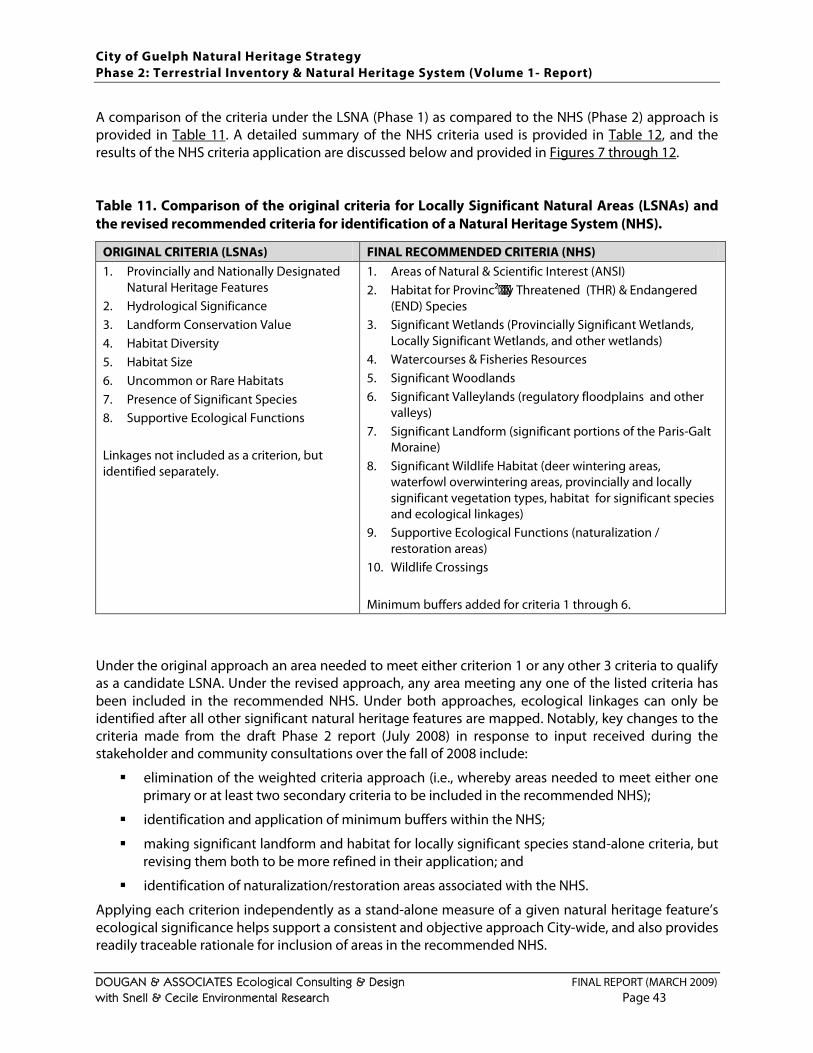
City of Guelph Natural Heritage Strategy Phase 2: Terrestrial Inventory & Natural Heritage System (Volume 1- Report)
DOUGAN & ASSOCIATES Ecological Consulting & Design FINAL REPORT (MARCH 2009) with Snell & Cecile Environmental Research Page 43
A comparison of the criteria under the LSNA (Phase 1) as compared to the NHS (Phase 2) approach is provided in Table 11. A detailed summary of the NHS criteria used is provided in Table 12, and the results of the NHS criteria application are discussed below and provided in Figures 7 through 12. Table 11. Comparison of the original criteria for Locally Significant Natural Areas (LSNAs) and the revised recommended criteria for identification of a Natural Heritage System (NHS).
ORIGINAL CRITERIA (LSNAs) FINAL RECOMMENDED CRITERIA (NHS) 1. Provincially and Nationally Designated
Natural Heritage Features 2. Hydrological Significance 3. Landform Conservation Value 4. Habitat Diversity 5. Habitat Size 6. Uncommon or Rare Habitats 7. Presence of Significant Species 8. Supportive Ecological Functions Linkages not included as a criterion, but identified separately.
1. Areas of Natural & Scientific Interest (ANSI) 2. Habitat for Provinc²y Threatened (THR) & Endangered
(END) Species 3. Significant Wetlands (Provincially Significant Wetlands,
Locally Significant Wetlands, and other wetlands) 4. Watercourses & Fisheries Resources 5. Significant Woodlands 6. Significant Valleylands (regulatory floodplains and other
valleys) 7. Significant Landform (significant portions of the Paris-Galt
Moraine) 8. Significant Wildlife Habitat (deer wintering areas,
waterfowl overwintering areas, provincially and locally significant vegetation types, habitat for significant species and ecological linkages)
9. Supportive Ecological Functions (naturalization / restoration areas)
10. Wildlife Crossings Minimum buffers added for criteria 1 through 6.
Under the original approach an area needed to meet either criterion 1 or any other 3 criteria to qualify as a candidate LSNA. Under the revised approach, any area meeting any one of the listed criteria has been included in the recommended NHS. Under both approaches, ecological linkages can only be identified after all other significant natural heritage features are mapped. Notably, key changes to the criteria made from the draft Phase 2 report (July 2008) in response to input received during the stakeholder and community consultations over the fall of 2008 include:
elimination of the weighted criteria approach (i.e., whereby areas needed to meet either one primary or at least two secondary criteria to be included in the recommended NHS);
identification and application of minimum buffers within the NHS;
making significant landform and habitat for locally significant species stand-alone criteria, but revising them both to be more refined in their application; and
identification of naturalization/restoration areas associated with the NHS.
Applying each criterion independently as a stand-alone measure of a given natural heritage feature’s ecological significance helps support a consistent and objective approach City-wide, and also provides readily traceable rationale for inclusion of areas in the recommended NHS.
City of Guelph Natural Heritage Strategy Phase 2: Terrestrial Inventory & Natural Heritage System (Volume 1- Report)
DOUGAN & ASSOCIATES Ecological Consulting & Design FINAL REPORT (MARCH 2009) with Snell & Cecile Environmental Research Page 44
The criteria have been carefully selected and defined to be independent measures, but in some cases ecological functions overlap and areas can meet more than one criterion. This should not be considered “double-counting” but rather illustrates where natural heritage features are providing multiple functions and/or meeting more than one measure of significance. Minimum buffers are meant, as the name implies, to identify minimum vegetation protection zones around significant features in the NHS. Buffers may include any natural areas (including cultural meadows or thickets), plantations, hedgerows, agricultural lands, City parklands or GRCA lands identified for open space uses, and current golf courses. In practice, buffers could not be applied, in whole or in part, in some areas that have already undergone development. However, for areas to be developed, site-specific studies may find that in some cases these minimums are not adequate and that wider buffers need to be identified. Some discussion of the rationale for minimum buffer widths applied is provided in the criteria discussion in Section 4.4
4.2 MAPPING LIMITATIONS
. As stated by Guelph’s Environmental Advisory Committee and confirmed by the existing science, buffers are one of the most important tools for protection of natural heritage features and associated ecological functions in urban areas (e.g., Wenger 1999; Durst and Ferguson 2000; Queen’s Printer for Ontario 2000; Semlitsch and Bodie 2003; Lee and Boutin 2004; ). In this study, minimum buffers have been identified based on available science, existing precedents and professional judgment. Naturalization and restoration areas have also been identified through this study. These areas have been identified primarily on City or GRCA-owned lands not identified for other uses where there are opportunities to support and enhance the City’s NHS through naturalization or restoration. These lands include areas adjacent to other NHS features where such activities have already taken place, are underway, have already been planned or are possible in the future. The largest of these are: (1) the former Eastview landfill site which has more than 40 ha targeted to be restored to meadow habitat for pollinators (which will also provide habitat for open country bird species), and (2) two agricultural fields on GRCA property by Guelph Lake. The focus for this study has been on lands closely associated with the NHS. In the future additional effort should be put towards identification of all potential naturalization and restoration opportunities in the City, on public and private lands, as time and resources permit.
From the outset of this study it was agreed that it was both feasible and desirable to develop mapping in conjunction with the recommended criteria. However, it is important to note that:
the mapping has been developed with information from different sources and collected at different scales, and that while every effort has been made to ensure that the mapping is as current and accurate as possible there may be some inaccuracies that need to be corrected at the site-specific scale;
only scoped field surveys were conducted in support of this study, primarily over 2005, and the mapping will likely need to be refined to reflect the applicable criteria more accurately at the site-specific scale based on more current and comprehensive field studies;
the mapping incorporates minimum buffers but these may be determined to be either (a) inapplicable in some locations, or (b) inadequate and may need to be increased;
City of Guelph Natural Heritage Strategy Phase 2: Terrestrial Inventory & Natural Heritage System (Volume 1- Report)
DOUGAN & ASSOCIATES Ecological Consulting & Design FINAL REPORT (MARCH 2009) with Snell & Cecile Environmental Research Page 45
there may be opportunities for ecological linkages, naturalization or restoration that may be identified as part of the site plan process that have not been identified in this mapping; and
every effort has been made to ensure that the recommended NHS is consistent with what has been approved through more detailed site-specific planning studies to mid-February 2009, but additional changes related to studies in progress may be required before mapping is developed for integration into the Official Plan this spring and summer.
The recommended criteria have all been mapped using GIS software (ESRI’s ArcView 9.3™), and shapefiles with the associated metadata have been provided to the City for use in ongoing and future planning studies.
4.3 OVERVIEW & DISCUSSION OF RECOMMENDED CRITERIA
The criteria used to identify the recommended NHS were developed based on:
consideration for the working criteria developed during Phase 1 and subwatershed studies undertaken within the City;
principles and scientific research from current landscape and conservation ecology, as discussed in this section;
the need for consistency with natural heritage protection under Provincial policies and related guidelines (e.g., OMNR 1999; OMNR 2000; Provincial Policy Statement 2005);
precedents from other municipalities in southern Ontario (see Appendix F
consideration for input from the Technical Steering Committee and City;
);
consideration for input from local agencies, adjacent municipalities (i.e., the County of Wellington and the Township of Puslinch), local landowners and residents, and other stakeholders (obtained through consultations over the fall of 2008); and
their ability to be applied in a traceable manner to discrete habitat units or habitat types. Additional considerations included:
Keeping the process for identifying significant natural areas through a criteria-based approach separate from policy development so that the areas would first be identified based on their relative ecological significance in the City.
Selecting criteria that are simple, objective and could be applied consistently across the City.
Defensibility of the criteria and related threshold(s) / measures based on current science, policy (and supporting documents related to natural heritage) and precedents.
Availability of data to map the criterion, or the ability to collect this data within a reasonable time frame in the future.
Ability of the criteria to be applied and refined at a site specific level to address the dynamic nature of the natural environment and to incorporate new information identified through site specific studies (e.g., the presence of a threatened species and changing policy).
The final recommended criteria are summarized in Table 12 below and discussed in the following sections of the report.
City of Guelph Natural Heritage Strategy Phase 2: Terrestrial Inventory & Natural Heritage System (Volume 1- Report)
DOUGAN & ASSOCIATES Ecological Consulting & Design FINAL REPORT (MARCH 2009) with Snell & Cecile Environmental Research Page 46
Table 12. Criteria categories, criteria and associated minimum buffers used for identification of the recommended Natural Heritage System.
Categories Criteria + Minimum Buffers1 Data Sources & Comments
1. Areas of Natural & Scientific Interest (ANSI)
1(a) Provincially Significant Life Science ANSI + 20 m buffer
1(b) Provincially Significant Earth Science ANSI + 10 m buffer
1(c) Regionally Significant Life Science ANSI + 20 m buffer
1(d) Regionally Significant Earth Science ANSI (no minimum buffer)
1(a) None currently designated within the City of Guelph.
1(b) As designated and mapped by OMNR.
1(c) None currently designated within the City of Guelph.
1(d) As identified and located by OMNR.
2. Habitat for Provincially Threatened (THR) & Endangered (END) Species
2(a) Habitat for species provincially designated END or THR in Ontario’s Endangered Species Act + buffers TBD
Records considered historical (i.e., more than 20 years old) have not been applied for this criterion. Notably, species surveys in the City were not comprehensive and some species meeting this criterion in the City may have been missed. Buffers to be determined on a case by case basis in consultation with OMNR and Recovery Team (if applicable).
3. Significant Wetlands2
3(a) Provincially Significant Wetlands (PSW) + 30 m buffer
3(b) Locally Significant Wetlands (LSW) + 15 m buffer
3(c) Other wetlands in closed depressions (kettles) + 15 m buffer
3(d) Other wetlands not in closed depressions (kettles) + buffer TBD
3(a) & 3(b) As defined and mapped by OMNR.
3(c) Unevaluated wetlands identified in OMNR or wetlands identified through ELC mapping completed for this study but not captured by 3(a) or 3(b) and located within closed depressions mapping provided by GRCA.
3(d) Unevaluated wetlands identified in OMNR or wetlands identified through ELC mapping completed for this study or by GRCA but not captured by 3(a) or 3(b). The status and boundaries of these needs to be field verified.
4. Surface Water & Fisheries Resources
STREAMS 4(a) Permanent (incl. ponds) + 15 m buffer 4(b) Intermittent +15 m buffer
FISH HABITAT 4(c) Cold Water + 30 m buffer 4(d) Cool + 30 m buffer 4(e) Warm Water + 15 m buffer 4(f) Undetermined + 15 m buffer
4(a) & (b) Combined OMNR and City mapping.
4 (c) – (f) Fish habitat mapping derived by digitizing data viewed on GRCA’s website but not readily available digitally, February 2009, developed based on the Grand River Fisheries Management Plan (OMNR and GRCA 1998). These classifications need to be field verified.
5. Significant Woodlands
5(a) Woodlands ≥1 ha + 10 m buffer
5(b) Locally Significant Woodland Types ≥0.5 ha + 10 m buffer
5(c) Cultural Woodlands ≥1 ha + buffer TBD
5(a) Woodland types included are: coniferous forest (FOC), deciduous forest (FOD), mixed forest (FOM), coniferous swamp (SWC), deciduous swamp (SWD), mixed swamp (SWM). NOTE: swamps also captured under criterion 3, significant wetlands.
5(b) Woodland types ranked as S1, S2 or S3 by the NHIC and Dry-Fresh Sugar Maple Deciduous Forest Ecosites (FOD5).
5(c) Cultural woodlands (CUW) defined as per the ELC system (Lee et al. 1998). Ecological significance and presence of heritage trees to be field verified.
City of Guelph Natural Heritage Strategy Phase 2: Terrestrial Inventory & Natural Heritage System (Volume 1- Report)
DOUGAN & ASSOCIATES Ecological Consulting & Design FINAL REPORT (MARCH 2009) with Snell & Cecile Environmental Research Page 47
Categories Criteria + Minimum Buffers1 Data Sources & Comments
6. Significant Valleylands
6(a) Regulatory floodplain
6(b) Other Valleys
6(a) Rivers and associated valleylands to top of bank as defined and mapped by GRCA excluding lands mapped as “anthropogenic / urban” in this study.
6(b) Combines GRCA “apparent valleylands / riverine erosion hazard” lands and “other valleylands” layers (which include steep slopes associated with Speed or Eramosa Rivers) and one additional valley identified by the City just north of Stone Rd. and east of Victoria Rd.
7. Significant Landform
7(a) Significant Portions of the Paris-Galt Moraine
7(a) Portions of the Paris Galt Moraine with concentrations of 20% slopes and greater (as mapped by the City) in combination with closed depressions (kettles) as mapped by the GRCA. No minimum buffer applied.
8. Significant Wildlife Habitat3
8(a) Deer wintering areas
8(b) Waterfowl overwintering areas
8(c) Provincially Significant Vegetation Types
8(d) Locally Significant Vegetation Types ≥0.5 ha (not already captured by Criteria 3 or 5)
8(e) Habitat for Globally, Nationally and Provincially Significant Species (not captured by Criterion 2) 4
8(f) Habitat for Locally Significant Wildlife Species (not captured by Criteria 2 or 8(e)) 4
8(g) Ecological Linkages5
8(a) As defined and mapped by OMNR. No minimum buffer applied.
8(b) As defined and mapped by OMNR. No minimum buffer applied.
8(c) ELC Vegetation Types Ranked as S1, S2, S3 or S3/S4 by NHIC (any size). None currently confirmed within the City. Buffers to be determined on a case by case basis.
8(d) Identified based on information collected for this study or through other local studies. Carbonate Open Cliff Ecosite (CLO1) Carbonate Shrub Cliff Ecosite (CLS1) Carbonate Treed Talus Ecosite (TAT1)
Buffers to be determined on a case by case basis.
8(e) Includes species designated as THR or END by COSEWIC, Special Concern (SC) by COSEWIC OR COSSARO, or identified as S1, S2, S3 or S3/S4 by NHIC and confirmed in this or other studies conducted in the City since 1988. Habitat for protection to be determined on a case by case basis.
8(f) Includes species not captured by 8(e) identified on the Significant Plant List for Wellington County or the Significant Wildlife List for Wellington County and confirmed in this or other studies conducted in the City since 1988 excluding bird species of conservation concern without any other status. Habitat for protection to be determined on a case by case basis.
8(g) Linkages between areas identified by Criteria 1 through 7 or between these areas and forested areas or designated Greenlands just outside the City’s boundary. Linkages are intended to facilitate movement of flora and fauna through the NHS and fill small gaps.
City of Guelph Natural Heritage Strategy Phase 2: Terrestrial Inventory & Natural Heritage System (Volume 1- Report)
DOUGAN & ASSOCIATES Ecological Consulting & Design FINAL REPORT (MARCH 2009) with Snell & Cecile Environmental Research Page 48
Categories Criteria + Minimum Buffers1 Data Sources & Comments
9. Supportive Ecological Functions
9(a) Naturalization / Restoration Areas (potential, planned and existing)
Lands next to or within areas captured by Criteria 1 through 7 where naturalization / restoration is being or could be applied.
Most naturalization / restoration areas are identified on GRCA or City-owned lands. Storm water management facilities (existing and planned) are included where they abut other significant features.
10. Wildlife Crossings
10 (a) Confirmed deer crossings
10 (b) Confirmed amphibian crossings
10 (c) Other wildlife crossing opportunities
10 (a) & (b) Only includes confirmed wildlife crossing locations identified through this study, other studies and local naturalists.
10 (c) Includes other locations where wildlife are likely to cross.
1 Minimum buffers are meant, as the name implies, to identify minimum vegetation protection zones around significant features in the NHS. Buffers may include any natural areas (including cultural meadows or thickets), plantations, hedgerows, agricultural lands, City parklands or GRCA lands identified for open space uses, and current golf courses. Buffers could not be applied, in whole or in part, in some areas that have already undergone development. However, for areas to be developed, site-specific studies may find that in some cases these minimums are not adequate and that wider buffers need to be identified.
2 Every effort has been made to reconcile ELC wetland mapping completed for this study with current OMNR and GRCA wetland mapping provided. However, wetland mapping was based almost entirely on secondary source data and for new development applications will need to be verified or refined in the field.
3 This is not a comprehensive list of significant wildlife habitat (SWH) criteria, but a list of criteria for which data was available at the time of the study. A complete list of all SWH criteria potentially applicable in the City of Guelph that should be considered at the site-specific level is provided in the study report (Table 13).
4 Significant species locations were linked to the general habitat in which they were recorded (i.e., the ELC polygon) but for the most part were not geo-referenced to specific locations (i.e., with UTM coordinates). Habitat identification was triggered by significant species confirmed as part of this study as well as those documented in environmental impact studies (EIS) completed in the City since 1988. Wildlife records within 20 m of a polygon were considered captured by that polygon. Species records dating back more than 20 years are not considered current and, unless verified with a more current record, have been excluded. 5 Linkages were identified following application of criteria categories 1 through 8(f), and do not necessarily include all linkage opportunities but those considered most critical to the functioning of the NHS. Ideally, linkages should be at least 50 m wide but closer to 100 m where possible with a target width to length ratio of 1:2. However, depending on the adjacent land uses and existing opportunities, narrower and longer linkages were included, and may be considered satisfactory in the future. Linkages may include any natural areas including cultural meadows or thickets, plantations, hedgerows, agricultural lands, City parklands or GRCA lands identified for open space uses, and current golf courses.
City of Guelph Natural Heritage Strategy Phase 2: Terrestrial Inventory & Natural Heritage System (Volume 1- Report)
DOUGAN & ASSOCIATES Ecological Consulting & Design FINAL REPORT (MARCH 2009) with Snell & Cecile Environmental Research Page 49
4.3.1 CRITERION CATEGORY 1: PROVINCIALLY & REGIONALLY SIGNIFICANT AREAS OF NATURAL & SCIENTIFIC INTEREST (ANSIs)
ANSIs are areas of land and water that represent significant geological (earth science) and biological (life science) features, as identified by the OMNR. Earth science ANSIs are representative examples of rock, fossil and landform features. Life science ANSIs are representative examples of the many natural landscapes, communities, plants and animals. OMNR identifies ANSIs that are “provincially significant” by surveying regions and evaluating sites to decide which have the highest value for conservation, scientific study and education in Ontario. Life Science ANSIs are those areas identified by the OMNR for their high quality representation of important provincial biotic attributes. Earth Science ANSIs are those areas identified by the OMNR for their high quality representation of important provincial geological attributes. There are no identified life science ANSIs identified within the City at this time. The City does, however, have two earth science ANSIs identified within its boundaries; the regionally significant Guelph Interstadial Site Earth Science ANSI and the provincially significant Guelph Correctional Center Earth Science ANSI (1.6 ha), both shown on Figure 7. The Guelph Interstadial Site Earth Science ANSI’s significance is related to the presence of a paleosol dated at the Port Talbot Interstadial or older. Interstadial paleosols are rare in southern Ontario and this site was uncovered during excavation for the Victoria Street railway underpass in the City (NHIC 2008). The former Guelph Correctional Center property (currently owned by the City) contains an Earth Science ANSI in an abandoned quarry. The ANSI shows a 9.2 m section of Guelph dolostones overlying Eramosa dolostones. This site clearly displays the contact between two Silurian bedrock formations - the Guelph and the Amabel (Eramosa) and fossils in the Eramosa Member (mostly gastropods) (NHIC 2008). Provincially significant ANSIs are specified in the Provincial Policy Statement (2005) as natural heritage areas to be protected (refer to Section 1.1). Any provincially designated features are, by default, significant at the local level as well and must be identified in municipal official plans. In this study, the regional ANSI in Guelph is considered of primary local significance as well. Mapping for this criterion was provided by OMNR and was applied directly (see Figure 7
4.3.2 CRITERION CATEGORY 2: HABITAT FOR PROVINCIALLY THREATENED & ENDANGERED SPECIES
). Minimum buffers of 10 m have been identified for Life Science ANSI and 10 m for Provincially Significant Earth Science ANSIs based on the rationale for these areas’ designation (as described above) and the accepted principle that development immediately adjacent to natural heritage features can result in a range of impacts to the edges of those features (e.g., Murcia 1995; Wenger 1999; Graham 2002; Durst and Ferguson 2000; Lee et al. 2004) and that buffers can be an effective tool for mitigating many of these impacts.
Species designated as Endangered (END) or Threatened (THR) (see Section 7 for definitions) in Ontario are now protected under the new Endangered Species Act. The Ontario Planning Act and Section 2.1.3 of the Provincial Policy Statement (2005) prohibits development within the significant habitat of THR and END species on all lands in Ontario. This policy applies to all species listed as such under the
City of Guelph Natural Heritage Strategy Phase 2: Terrestrial Inventory & Natural Heritage System (Volume 1- Report)
DOUGAN & ASSOCIATES Ecological Consulting & Design FINAL REPORT (MARCH 2009) with Snell & Cecile Environmental Research Page 50
Ontario Endangered Species Act. Ontario’s original Endangered Species Act was first proclaimed in 1971 and was recently repealed by Bill 184, the Endangered Species Act (2007). The Endangered Species Act received Royal Assent on May 17, 2007 (becoming law) and came into force on June 30, 2008. Although there are currently no records for any of the listed species within the City of Guelph over the past 20 years, this list is updated so that some species previously not considered at risk (NAR), or of Special Concern (SC) can become END or THR, or conversely the status of species currently listed as END or THR can be changed to SC or NAR. Designated species are noted on the Species at Risk in Ontario (SARO) list which corresponds with the list of species classified by the Committee on the Status of Species at Risk in Ontario (COSSARO), an independent scientific body. This list is amended on a regular basis (i.e., at least once a year) to accurately reflect new information. Habitat for species considered significant at the provincial or local scale but not provincially END or THR are covered by significant wildlife habitat (SWH) policy guidelines (OMNR 2000) and significant portions of their habitat should also be protected by official plans. In this study, these species are captured under criteria 8e (habitat for globally, nationally and provincially significant species) and 8f (habitat for locally significant wildlife species). Currently, the only confirmed and current records for provincially END or THR species within the City limits are for Butternut (Juglans cinerea), for which there are records in three areas, as shown generally in Figure 7. Butternut is designated as Endangered in both Canada and Ontario (COSEWIC 2008; OMNR 2008). This species is normally found scattered in forests and was never common in Ontario, however it has been designated largely because of increasing mortality caused by a serious fungal disease called Butternut Canker, which was first found in Ontario trees in 1991. The fungus enters through cracks or wounds in the bark and can kill a tree within a few years of infection. Notably, additional Butternut (naturally occurring or possibly planted) are known within the City, but were not recorded within natural areas assessed as part of this study. Urban forest inventories and site-specific studies on treed areas must be cognizant of the need to have all Butternut trees assessed for health by an OMNR certified officer, and of the requirement to protect all healthy trees. One provincially END plant species, Lily leaved Twayblade (Liparis liliifolia) was recorded in the Hanlon Creek Subwatershed area (see Table B 4.5 in PEIL et al. 2004) but is considered planted within the City. The Natural Heritage Information Center (NHIC) has two provincially Threatened species on record within the City of Guelph (i.e., Common Gray Fox (Urocyon cinereoargenteus) and Blanding's Turtle (Emydoidea blandingii)), however both of these records are more than 20 years old and are therefore considered historical. There are also several records for Jefferson salamander, which is considered Threatened in Ontario and Canada, (as discussed in Section 3.4.4) just outside the City limits. Both the federal and provincial governments are developing procedures and guidelines for the identification of the habitat of Endangered and Threatened species which will assist the City in addressing policy requirements under the Planning Act, should it be required. For the time being, habitat protection measures, including appropriate buffers, need to be identified for any proposed developments within or adjacent to habitat for provincially Threatened or Endangered species in consultation with OMNR and Recovery Team members, if they exist for the species in question. Normally species status is updated once or twice a year by COSEWIC and COSSARO, and so it is possible that some species identified within the City may become provincially Threatened or Endangered in the future, or that some species with this status now may become de-listed.
City of Guelph Natural Heritage Strategy Phase 2: Terrestrial Inventory & Natural Heritage System (Volume 1- Report)
DOUGAN & ASSOCIATES Ecological Consulting & Design FINAL REPORT (MARCH 2009) with Snell & Cecile Environmental Research Page 51
4.3.3 CRITERION CATEGORY 3: SIGNIFICANT WETLANDS
Wetlands are recognized as an essential natural resource that help moderate water flow (i.e., reduced flooding during peak flows and sustenance of stream flow during dry spells), contribute to groundwater recharge, improve water quality (by trapping sediments, soil-bound nutrients and contaminants), store carbon, and provide habitat for a broad range of species (e.g., fish, waterfowl, songbirds, shorebirds, raptors, amphibians, reptiles and insects) (e.g., Gabor et al. 2001; Environment Canada 2004; Lake Simcoe Region Conservation Authority and Beacon Environmental 2007). Wetlands, as defined under provincial policy (see box text) are also afforded a high level of protection under provincial and regional policies and regulations. Under Section 2.3.1 of the Provincial Policy Statement, no development is permitted in provincially significant wetlands (PSW) in Site Region 6E (which captures Guelph). At the local scale, PSWs and Locally Significant Wetlands (LSW), are currently designated in the City’s Official Plan. Both PSWs and LSWs are also afforded legal protection under Ontario Regulation 150/06 of the Conservation Authorities Act, and all wetlands are considered significant by the GRCA unless proven otherwise in accordance with their wetland policies (GRCA 2003, 2007).
“Wetlands: means lands that are seasonally or permanently covered by shallow water, as well as lands where the water table is close to or at the surface. In either case the presence of abundant water has caused the formation of hydric soils and has favoured the dominance of either hydrophytic plants or water tolerant plants. The four major types of wetlands are swamps, marshes, bogs and fens. Periodically soaked or wet lands being used for agricultural purposes which no longer exhibit wetland characteristics are not considered to be wetlands for the purposes of this definition”. - Provincial Policy Statement (2005), Section 6.0
The Ontario Wetland Evaluation System was developed by the OMNR in 1993 primarily to address the Province's planning requirements and to provide a standardized method of assessing wetlands relative to each other. The evaluation system often serves as a preliminary inventory of a wetland or wetland complex, and is based on a consideration of the following four components: biology, hydrology, social and economic values, and special features such as species at risk. Evaluated wetlands with a score of >600 points or 250 points in any single component are considered provincially significant, whereas wetlands with a score of <600 points are considered non-provincially or locally significant. Municipalities can (and typically do) elect to protect evaluated wetlands classified as locally significant because of their significance on a local scale. The Grand River Conservation Authority (GRCA), which has jurisdiction over Guelph, also currently regulates all wetlands plus a defined area of interference around the wetland, as follows:
wetlands < 0.5 ha;
wetlands ≥ 0.5 ha and < 2 ha plus a 30 m zone around them; and
wetlands ≥ 2 ha or PSWs and a 120 m zone around them.
Development is not permitted by the GRCA in any of these wetlands except in accordance with policies in Sections 8.4.2 through to 8.4.12 laid out in the GRCA Policy for the Administration of Ontario Regulation 150/06 (GRCA 2007). These policies are available on-line through the GRCA’s website and should be referred to directly for any proposed development in the vicinity of a wetland.
City of Guelph Natural Heritage Strategy Phase 2: Terrestrial Inventory & Natural Heritage System (Volume 1- Report)
DOUGAN & ASSOCIATES Ecological Consulting & Design FINAL REPORT (MARCH 2009) with Snell & Cecile Environmental Research Page 52
However, in general these policies prohibit development in all wetlands greater than or equal to 0.5 ha unless if they have no ecological or groundwater significance. Exceptions are provided, as in Provincial Policy, for public infrastructure. Notably, although 0.5 ha is the lower size threshold adopted by the GRCA at the watershed scale, wetlands as small as 0.2 ha may still be significant in the context of the City of Guelph. Wetlands smaller than 0.5 ha have been shown to provide a wide range of ecological functions, and can have significance in certain contexts even if isolated (e.g., Joyal et al. 2001; Semlitsch and Bodie 2003; Meyer et al. 2003; Comer et al. 2005) and therefore it has been recommended that the lower size threshold for evaluating whether or not a feature is a wetland or not in the City be 0.2 ha. Sections 8.4.2 and 8.4.3 of GRCA’s policies (GRCA 2007) list special attributes and functions that would warrant protection of a small wetland. The City contains, in whole or in part, a number of provincially significant wetlands that are designated as provincially significant (i.e., Clythe Creek Wetland, Ellis Creek Complex, Eramosa River - Blue Springs Creek Wetland, Guelph North-East Complex, Halls Pond Complex, Hanlon Creek Swamp, Marden South Complex, Mill Creek Wetland, Speed River Wetland Complex, and Torrance Creek Swamp) as well as a few locally significant wetlands, all identified by current OMNR mapping. Additional wetlands, or potential wetlands not captured as provincially or locally significant, have also been identified in the City of Guelph from:
unevaluated wetlands included in OMNR wetland mapping for the City (last provided in June 2008 and updated in some areas in December 2008 based on information from this study);
GRCA wetland mapping (last obtained in June 2008) that includes wetlands that have been confirmed but which may be subject to refinement based on additional site-specific data; and
habitat (i.e., ELC) mapping completed for this study by Dougan & Associates and supplemented by more refined ELC mapping provided in some areas by Natural Resources Solutions Inc. and Stantec.
“Other” wetlands overlapping with closed depressions (i.e., also referred to as “kettles”) mapped by GRCA are considered “confirmed” but still subject to field delineation. “Other” mapped wetlands that do not overlap with closed depressions are also generally confirmed, but still require field verification both in terms of their size and/or extent, and their ecological or hydrological significance. All “other” wetlands of at least 0.2 ha may be subject to formal evaluation in the future and potentially re-classified, or may be determined to be non-significant and allowed to be cleared for development. Based on this information and these precedents, the following have been identified for inclusion within the recommended NHS for the City with the caveat that wetlands falling into category (d) need to be subject to site-specific study and review:
Provincially Significant Wetlands (PSW) plus a 30 m minimum buffer
Locally Significant Wetlands (LSW) plus a 15 m minimum buffer
other wetlands in closed depressions plus a 15 m minimum buffer
other wetlands not overlapping with closed depressions (no buffer applied)
The wetlands with their minimum buffers are mapped in Figure 7.
City of Guelph Natural Heritage Strategy Phase 2: Terrestrial Inventory & Natural Heritage System (Volume 1- Report)
DOUGAN & ASSOCIATES Ecological Consulting & Design FINAL REPORT (MARCH 2009) with Snell & Cecile Environmental Research Page 53
It is difficult to establish a single buffer width that will adequately protect all significant wetlands in the City, irrespective of size or context, however a minimum of 30 m around PSWs and 15 m buffers around LSWs and other wetlands in closed depressions is conservative based on the current science and precedents. Current science has demonstrated that wetlands in fragmented landscapes are impacted both directly and indirectly by adjacent land uses in urban and urbanizing landscapes, and that adequate buffers, or vegetation protection zones, can mitigate these impacts (e.g., Azous and Horner 2000). Documented impacts include changes in hydrologic regime, increased contaminant and nutrient loads, and declines in flora and fauna species richness and or abundance (e.g., Findlay and Bourdages 2000; Environmental Law Institute 2003; Faulkner 2004). The GRCA advocates a minimum 30 m buffer on all confirmed wetlands (GRCA 2003) only where the potential for hydrologic and ecological impacts is considered negligible (T. Zammit, pers. comm. 2009), and current precedents for minimum buffers of 30 m around significant wetlands in other current municipal NHS include the City of Pickering (OMNR 2005b; North-South Environmental Inc. 2006), North Oakville (Totten Simms Hubicki et al. 2006), the City of Hamilton (City of Hamilton 2004) and the recently released draft guidelines for Ontario’s Greenbelt (OMNR 2008b). Notably, no minimum buffers have been identified for other wetlands that remain to be confirmed, however areas confirmed as wetlands through site-specific study should also have no less than a 15 m buffer placed on them.
4.3.4 CRITERION CATEGORY 4: SURFACE WATER & FISHERIES RESOURCES
The protection of surface water features (e.g., rivers, streams, creeks and ponds) is considered a critical component of natural heritage system functioning and sustainability, and the fisheries sustained by these types of features is strictly protected by the Fisheries Act which is enforced by the federal Department of Fisheries and Oceans (DFO) with support from conservation authorities. Both surface water and fisheries are identified clearly as components of a natural heritage system that need to be protected in provincial policy. Section 2.2.1(e) of the Provincial Policy Statement requires that: “Planning Authorities shall protect, improve or restore the quality and quantity of water by…maintaining linkages and related functions among surface water features, ground water features, hydrologic functions and natural heritage features”, while Section 2.1.5 states that: “Development and site alteration shall not be permitted in fish habitat except in accordance with provincial and federal requirements”. There are three general types of streams (Hewlett 1982; Gregory 2001):
Perennial streams: water flows in the stream at least 90% of the time in a well defined channel (captured under Criterion 3).
Intermittent streams: water flows only during wet periods (30 to 90% of the time) and flows in a continuous well-defined channel (captured under this criterion).
Ephemeral streams: water flows only during storms and may or may not have a well-defined channel.
Intermittent streams can contribute significantly to the ecological functioning of an area. Intermittent channels can be important to fish communities, permitting seasonal movement between available permanent habitats, and as seasonal sources of water, sediment, nutrients and wood debris delivered downstream. Intermittent streams with good riparian vegetation cover can also provide habitat for wildlife (e.g., food sources for mammals and birds, denning sites, nursery areas for amphibians) as well as movement corridors (Reid and Ziemer 1994).
City of Guelph Natural Heritage Strategy Phase 2: Terrestrial Inventory & Natural Heritage System (Volume 1- Report)
DOUGAN & ASSOCIATES Ecological Consulting & Design FINAL REPORT (MARCH 2009) with Snell & Cecile Environmental Research Page 54
Watercourses, ponds and the related fisheries resources in the City of Guelph were not assessed as part of this study. However, recognizing the importance of these features to a NHS, available mapping from secondary sources was obtained and integrated to the mapping for this study. Mapping for permanent streams and intermittent streams was obtained from the OMNR and City. This mapping appears to be updated in some areas where streams that have been culvertized are captured, however the mapping also appears to be incomplete or outdated in other areas. The mapping presented in Figure 8
Permanent streams and ponds plus a 15 m minimum buffer
represents an attempt to merge the most current stream mapping from both OMNR and City data. Notably, the identification of permanent and intermittent streams through the NHS should not preclude opportunities for improvements and and/or restoration of permanent streams that have been engineered. Some such opportunities are identified through the Grand River Fisheries Management Plan (OMNR and GRCA 1998). Primarily large ponds are captured through this mapping, but smaller ponds may be identified at the site level. In all cases it is suggested that any pond of at least 0.2 ha be evaluated to determine if it is either a wetland (as per GRCA criteria) or fish habitat, and if it is neither and provides no other hydrologic function of significance, may be excluded from the NHS. Fish habitat mapping could not be obtained digitally from the GRCA but was digitized from mapping generated from the GRCA’s website in February of 2009. The fisheries classifications in this mapping are according to OMNR standards and has been based on data from the Grand River Fisheries Management Plan (OMNR and GRCA 1998). Notably, this data is not complete and should be: (a) cross-referenced with recent subwatershed and Environmental Impact Studies that have studied the fish habitat in certain areas, and (b) field verified as time and resources permit. Despite its limitations, this data provides a general idea of where cold, cool and warm water fisheries occur in the City, and also identifies stream reaches that have yet to be classified. Like fish habitat, the intermittent stream mapping also requires site-specific verification and be considered for incorporation into the NHS if determined to have biological significance (e.g., contribute directly or indirectly to fish habitat), provide a linkage between natural heritage features and surface or ground water features, or contributes to another identified ecological function. They may also represent opportunities for restoration. The criteria identified for surface water and fisheries resources to be included in the NHS are:
Intermittent streams plus a 15 m minimum buffer
Cold Water Fish Habitat plus a 30 m minimum buffer
Cool Water Fish Habitat plus a 30 m minimum buffer
Warm Water Fish Habitat plus a 15 m minimum buffer
Undetermined Fish Habitat plus a 15 m minimum buffer
Available mapping for these areas is provided in Figure 8. The minimum buffers associated with these criteria are in the lower range, or below, recommended minimums in the science for provision of habitat to associated terrestrial species (e.g., Rudolph and Dickson 1990; Croonquist and Brooks 1993; Spackman and Hughes 1995; Mactans et al. 1996; Burbrink et al. 1998). They are however consistent with standards applied by the GRCA (S. Young, pers. comm. 2009), guidelines recommended by
City of Guelph Natural Heritage Strategy Phase 2: Terrestrial Inventory & Natural Heritage System (Volume 1- Report)
DOUGAN & ASSOCIATES Ecological Consulting & Design FINAL REPORT (MARCH 2009) with Snell & Cecile Environmental Research Page 55
Environment Canada (2004) and recommended minimum buffers for other current NHS in southern Ontario. The NHS for the Seaton Lands in the City of Pickering implemented a 30 m buffer around all streams (City of Pickering and Toronto Region Conservation Authority 2008), while the draft Greenbelt guidelines recommend minimum vegetation protection zones of 30 m on all key natural heritage features (OMNR 2008b).
4.3.5 CRITERION CATEGORY 5: SIGNIFICANT WOODLANDS
It is estimated that at the turn of the 20th century less than 6% of the original pre-European woodland cover remained in southern Ontario (Larson et al. 1999). Although woodland cover has increased over the past century through reforestation and natural regeneration, it is still estimated at less than 20% (Larson et al. 1999). As the analyses in Section 3.4.2 show, total wooded cover in the City of Guelph is 12.5% (just over 1100 ha). This cover is made up by swamps (5.56%), upland deciduous, coniferous and mixed forests (3.5%), plantations (1.8%), cultural woodlands (1.18%) and hedgerows (0.45%). When plantations, cultural meadows and hedgerows are excluded, overall forest cover is reduced to 9.06% (almost 800 ha). With increasing growth pressures in southern Ontario over the past decade, woodlands have become increasingly recognized as a conservation priority and significant woodlands studies have been undertaken by a number of municipalities including the Region of Halton (GLL 2002), Region of York (North-South Environmental 2005), City of London (City of London 2006), Region of Peel and Town of Caledon (North-South Environmental and Dougan & Associates 2008). Discussions of criteria used to determine woodland significance is provided in the reports cited above, all available on the internet. Although size is the most frequently used measure for determining significance, the guidelines for what is appropriate vary between sources, and ultimately each municipality must determine what is appropriate for its context. The somewhat dated Natural Heritage Reference Manual (OMNR 1999), currently under review, recommends as a guideline that woodlands of at least 4 ha in size be protected where the woodland cover is between 5% and 15%. More recent draft guidelines released by the Province for the Greenbelt continue to recommend 4 ha thresholds for significant woodlands north of the Niagara Escarpment and Oak Ridges Moraine, but 1 ha thresholds are recommended for municipalities south of these landforms or anywhere within the Greenbelt with less than 15% forest cover (OMNR 2008c). Some upper tier municipalities have used minimum size criteria ranging from 2 ha (e.g., Norfolk and Halton) to 10 ha (e.g., Middlesex), although these municipalities, unlike the City of Guelph, all contain large rural areas within them. Examples from more urban jurisdictions (as provided in Appendix F
at least 1ha in size
) include the City of Mississauga’s Landscape Scale Analysis (CVC 2008) which captured all woodlands of at least 2 ha, the Town of Aurora which captured all ‘natural’ woodlands within 30 m of a stream in its North-East Planning Area “2C” (North-South Environmental et al. 2006), and the City of Hamilton (2004) which (at least in its rural areas) protects woodlands meeting any two of the following criteria:
interior forest (100m from edge)
connectivity (within 50m of a wetland, PSW, ESA, ANSI)
City of Guelph Natural Heritage Strategy Phase 2: Terrestrial Inventory & Natural Heritage System (Volume 1- Report)
DOUGAN & ASSOCIATES Ecological Consulting & Design FINAL REPORT (MARCH 2009) with Snell & Cecile Environmental Research Page 56
within 30m of hydrological feature (e.g., stream, headwater area, wetland, lake)
presence of trees / communities +100 yrs
contains species that are provincially or locally rare Municipalities using tree by-laws to specify measures of woodland significance comparable in size to Guelph have identified 0.2 ha (Town of Oakville, City of Brampton, City of Barrie, Town of Whitby, Town of Markham) and 0.5 ha (Town of Caledon, Town of Fort Erie) as minimum sizes for protection. In the City of Guelph’s current Official Plan (2006 consolidation) woodlands of 1 ha and greater are considered significant. The definition of woodlands can also vary with different jurisdictions and studies. For the City of Guelph the recommended definition for “woodland” is a definition developed for the Oak Ridges Moraine Technical Paper #7: Identification and Protection of Significant Woodlands (OMNR 2007e)23
the extent and nature of the City’s current woodland cover, as described in
. This definition combines the ELC definition of woodland/forest with the definition under the Forestry Act (1998) (now rolled into the Municipal Act 2001). This definition captures young as well as mature forests and incorporates small gaps within these wooded areas. In this study, significant woodlands have been defined as all woodlands of at least 1 ha in the City excluding hedgerows and plantations plus locally significant woodland types of at least 0.5 ha. In the City of Guelph the 1 ha threshold can be justified on a number of grounds, including:
Section 3.4.2
the environmental services provided by these woodlands such as pollution filtration, temperature moderation and erosion control;
;
the contribution these woodlands make to local and regional habitat diversity, and their role in providing connectivity between other significant natural areas;
the importance of woodlands to the community; and
precedents in some other comparable urban municipalities (e.g., City of Hamilton).
Mapping for these woodlands based on current information is shown in Figure 9.
Locally significant woodland types include those ranked at S1, S2 or S3 by the NHIC plus Sugar Maple deciduous forests (FOD5). Currently there are no S1, S2 or S3 woodland types identified within the City. Fresh Sugar Maple deciduous forests are identified as a “target conservation community” for Ecosite 6E-1 (in which Guelph is located) in the Great Lakes Conservation Blueprint for Terrestrial Biodiversity (Henson and Brodribb 2005). Although this is a relatively abundant deciduous forest type in the City (see Table 3
23 The definition for woodlands on the Oak Ridges Moraine (OMNR 2007d) is a treed area with: (a) a tree crown cover of over 60% of the ground, determinable from aerial photography (“forest” of Lee et al. 1998), or (b) a tree crown cover of over 10% of the ground, determinable from aerial photography (treed community of Lee et al. 1998), together with on-ground stem estimates of:
) these forests are considered high-quality representative communities in this Ecosite and are therefore considered significant in the City of Guelph for the purposes of this study even if they occur in fragments as small as 0.5 ha.
1,000 trees of any size per hectare, or 750 trees measuring over five centimeters in diameter, per hectare, or 500 trees measuring over 12 centimeters in diameter, per hectare, or 250 trees measuring over 20 centimeters in diameter, per hectare (based on the Forestry Act of Ontario, 1998)
City of Guelph Natural Heritage Strategy Phase 2: Terrestrial Inventory & Natural Heritage System (Volume 1- Report)
DOUGAN & ASSOCIATES Ecological Consulting & Design FINAL REPORT (MARCH 2009) with Snell & Cecile Environmental Research Page 57
Cultural woodlands (CUW) have also been included within the criterion for significant woodlands in the City of Guelph based on the reasons cited above. However, it is recognized that cultural communities often have higher proportions of non-native and invasive species than other natural areas, and particularly in situations where they are isolated they may not have much ecological significance. Given this reality, it is suggested that a more flexible approach be taken towards protection of cultural woodlands than other significant woodlands whereby they may be developed in whole or in part if their canopy is dominated by invasive species (e.g., 70% or more) and if the woodland is shown not to fulfill any of the other recommended criteria (e.g., habitat for significant species). Notably, native trees in good condition within these woodlands should be protected through tree preservation plans to the greatest extent possible (or in the case of smaller trees salvaged) as part of the site plan approval process. Field verification of many of the plantations in the City confirmed them to be Scots Pine plantations with limited understorey regeneration dominated by non-native and invasive species, and recognizing that the City is required to strike a balance between protecting significant natural features and accommodating growth within its boundaries, plantations have been assigned a lower priority for conservation than other woodlands of more natural origin and have been excluded from being potential significant woodlands in this urban context as stand alone features. Although, plantations can still provide habitat and support ecological functions (e.g., Wegner and Merriam 1979; Merriam 1991; Hess and Bay 2000; Dettmers 2003; Milne and Bennett 2007), these feature types are generally considered of less ecological value than remnant natural coniferous, deciduous or mixed forests that tend to have higher proportions of native species and a structure more closely resembling that of a pre-settlement forest. For this study, plantations have been incorporated into the recommended NHS only where they provide linkages between other natural areas or are captured by other criteria or associated minimum buffers. A few, like Brown’s Woods, have also been identified as naturalization / restoration areas. In cases where development is approved in such features, the City should still protect portions of plantations dominated by native trees or individual trees within plantations that are native and in good condition to the greatest extent possible. Thickets and hedgerows, like plantations, are not captured by this criterion but may be captured in whole or in part where (a) they overlap with other criteria being met or (b) they provide ecological linkages or supporting functions. A minimum buffer of 10 m from the drip line of significant woodlands as is recommended here is consistent with current recommendations for the North Oakville NHS (TSH et al. 2006b) and is significantly less than the 30 m recommended buffers for significant woodlands in the Seaton Lands NHS (OMNR 2005b; City of Pickering and Toronto Region Conservation Authority 2008). This minimum is also strongly supported by research demonstrating the extent of encroachment impacts into woodlands in urban and suburban areas extends well beyond the forested edge (e.g., Matlack 1993; Murcia 1995; Friesen et al. 1999; Faulkner 2004; McWilliam 2007).
City of Guelph Natural Heritage Strategy Phase 2: Terrestrial Inventory & Natural Heritage System (Volume 1- Report)
DOUGAN & ASSOCIATES Ecological Consulting & Design FINAL REPORT (MARCH 2009) with Snell & Cecile Environmental Research Page 58
4.3.6 CRITERION CATEGORY 6: SIGNIFICANT VALLEYLANDS
A valleyland is a natural depression in the landscape that is often, but not always, associated with a river or stream. Valleylands vary in size from tiny headwater features (which results in debate about the definition of a “valley”) to wide valleys containing substantial rivers and expansive wetlands. Significant valleylands are another category of natural heritage feature identified in the Provincial Policy Statement (2005) requiring protection. Municipalities are required to ensure no negative impacts on natural features and ecological functions within valleylands. Larger valleylands are generally not developed because of the inherent hazards associated with them (e.g., flooding or bank instability), and in the highly urbanized or agricultural portions of southern Ontario this has resulted in valleylands being among the few remaining natural areas and ecological corridors. The Natural Heritage Reference Manual (OMNR 1999) refers to valleylands as the “backbone” of a watershed because of the many important ecological functions they perform. These include channeling water and wildlife, connecting natural heritage features, acting as migration corridors and natural drainage areas, transporting sediment and nutrients, maintaining water levels by acting as floodplains and seepage areas and maintaining water quality through riparian vegetation communities. Although this is a feature specified in Provincial Policy, few municipalities have tried to define or map it on a jurisdictional-wide basis to date. Consequently, at this time there are no known precedents in other municipalities that provide criteria for defining which valleylands are “significant”, although some municipalities are currently engaged in studies focused on this subject (i.e., Region of Waterloo, Region of Peel). Of all the criteria-based municipal NHS summarized in Appendix F
all streams with well defined valley morphology of 25 m or more;
, only the Oak Ridges Moraine Technical Papers (OMNR 2007a) provide specific criteria for identifying this feature, as:
all spillways and ravines with flowing or standing water for at least 2 months/yr; OR
as identified by OMNR.
In addition, municipalities are required to define and identify their regulatory floodplains in accordance with the local conservation authority definitions and mapping. In the City of Guelph, the best defined valleys are associated with the Speed and Eramosa River corridors, with much of the City’s topography outside these areas related to the presence of other landforms such as drumlins, eskers, kames / kettles and moraines. For this study a fairly conservative approach to the determination of valleyland significance has been adopted whereby floodplains and valleylands associated with rivers or streams, as mapped (and regulated) by the GRCA have been identified as significant. Strictly speaking, these features include areas defined and mapped by the GRCA as:
regulatory floodplains / riverine flooding hazards (i.e., rivers and associated valleylands to top of bank);
riverine erosion hazards (i.e., steep slopes closely associated with rivers or stream corridors where valley walls ≥ 3 m); and
apparent valleys / other valleylands (i.e., stable, gently sloping valley walls where the slope inclination is greater than or equal to 15% but less than 20% to the top of slope, and pockets of gently sloping land terraced between valley slopes) (GRCA 2007).
City of Guelph Natural Heritage Strategy Phase 2: Terrestrial Inventory & Natural Heritage System (Volume 1- Report)
DOUGAN & ASSOCIATES Ecological Consulting & Design FINAL REPORT (MARCH 2009) with Snell & Cecile Environmental Research Page 59
The City also considers valley systems associated with the Speed or Eramosa Rivers that are under represented within the City due to historic development, remain predominantly in a natural state and contribute to the quality and diversity of landform within the City as significant. To date, this has resulted in the identification of one additional area where valley mapping has been modified by the City to capture top of bank, based on a 15% slope just north of Stone Road and east of Victoria Road on what are currently known as the “York lands”. This is consistent with current GRCA policy which considers valley features identified on the basis of a 15% slope as significant if associated with a watercourse (Zammit 2008). Using these measures, the final recommended criteria for identifying significant valleylands are: (a) the regulatory floodplain, as defined by the GRCA, and (b) other valleys, which currently include GRCA’s riverine erosion hazard lands, GRCA’s apparent (or other) valleylands, and one other valley associated with the Eramosa River as identified by the City. These areas are mapped on Figure 10 with a 10 m minimum buffer. Notably, the GRCA’s regulatory floodplain mapping extends into a number of areas that were developed prior to the existence of this regulation (as shown on Figure 10), however for the identification of the recommended NHS, only significant valleylands overlapping with natural areas, as defined through this study, are included. As a result, regulatory floodplains mapped over lands considered “urban” were not captured in the recommended NHS (as shown in Figure 12
4.3.7 CRITERION CATEGORY 7: SIGNIFICANT LANDFORM
). No minimum buffer is recommended for significant valleylands because the floodplain mapping provided by GRCA may include a buffer already (e.g., between 5 m and 15 m) and would be subject to site review through the GRCA regulatory process if development within or adjacent to it were proposed. However, the City may wish to reserve the right to identify an additional 5 m or 10 m buffer in some locations through policy. Precedents for this exist in the Toronto area where the Toronto Region Conservation Authority typically seeks a minimum 10 m setback from valley slopes (as identified through the City’s Ravine By-law, Chapter 658 of the City’s Municipal Code). Credit Valley Conservation’s watercourse and valleyland protection policies (CVC 1996) require a minimum setback of 15 m from the channel bank of any watercourse, and 5 m from the top of bank or toe of a valley slope, and GRCA’s policies (2007) are comparable.
Landform conservation value has been recognized as contributing to local natural heritage and has been included in the Natural Heritage Reference Manual (OMNR 1999) (a key supporting document for implementation of provincial policy) as a criterion for inclusion in the development of natural heritage systems. Landforms play a significant role in contributing to a number of ecological “services” including contributing to surface and groundwater resources, providing wildlife habitat, providing important linkages, and contributing to biodiversity and aesthetic value in the landscape. Landform also contributes to an area’s local uniqueness and reflects its geologic history. Provincial policy also supports landform conservation in relation to natural heritage. Section 2.1.2 of the Provincial Policy Statement requires that planning authorities protect, restore and, where possible, improve biodiversity and connectivity, and recognize linkages and related functions among surface and groundwater features and natural heritage features and areas. In addition, provincial policy
City of Guelph Natural Heritage Strategy Phase 2: Terrestrial Inventory & Natural Heritage System (Volume 1- Report)
DOUGAN & ASSOCIATES Ecological Consulting & Design FINAL REPORT (MARCH 2009) with Snell & Cecile Environmental Research Page 60
requires that planning authorities implement necessary restrictions on development and site alteration to protect, improve or restore vulnerable24 surface and ground water, sensitive surface and groundwater features, and their hydrologic functions as well as maintain linkages and related functions among surface and groundwater features, hydrologic functions and natural heritage features and areas. Section 2.2.2 further restricts development and site alteration in or near sensitive surface and groundwater features25
Category 1: 50% or more of the area comprised of lands with slopes of at least10%; land with distinctive landform features such as ravines, kames and kettles; land with a high diversity of land slope classes.
such that these features and their related functions will be protected, improved or restored. The intent of the significant landform criteria is to reflect and implement the provisions of Sections 2.1 and 2.2 of the Provincial Policy Statement as described above through a systems approach, and to protect portions of the Paris-Galt Moraine landform in the City that contribute disproportionately to groundwater recharge as well as provide habitat for significant species and connectivity within the local NHS. Landform conservation is not new in municipal planning and has been adopted by a number of other jurisdictions in southern Ontario as part of natural heritage protection for some time. Large-scale examples include the Niagara Escarpment Plan, where the purpose of the Plan is to maintain the Niagara Escarpment and land in its vicinity substantially as a continuous natural environment (Part 2 Purpose of the Niagara Escarpment Planning and Development Act (1973)). The Oak Ridges Moraine Conservation Plan also identifies landform conservation as a key component for conservation (OMNR 2007d) and identifies two categories of landform conservation lands as follows:
Category 2: 20% to 50% of the area comprised of lands with slopes of at least10%; with distinctive landform features (e.g., ravines, kames and kettles); and/or land with a diversity of land slope classes.
At a somewhat smaller scale, North-East Aurora Planning Area “2C” includes slopes greater than 10% and streams within an unconfined valley system in their NHS (North-South Environmental et al. 2006). The Region of Waterloo also captures significant landforms (such as moraines, kettle lakes, kames, eskers and drumlins) within its Environmentally Sensitive Landscape (ESL) land use designations as part of their Greenlands Strategy26
24 Vulnerable means surface and groundwater that can be easily changed or impacted by activities or events, whether by
virtue of their vicinity to such activities or events or by permissive pathways between such activities and the surface and or groundwater (PPS 2005).
25 Sensitive in regard to surface water features and groundwater features, means areas that are particularly susceptible to
impacts from activities or events including, but not limited to, water withdrawals, and addition of pollutants (PPS 2005).
. Although some landforms in portions of the City have been altered by urbanization, there are still areas in the southern part of the City between Clair and Maltby Roads that exhibit the complex topography associated with the Paris-Galt Moraine. This terrain is currently predominantly covered by natural and semi-natural features, as well as some agriculture, and is characterized by a rolling, hummocky topography, numerous kettle depressions and associated wetlands.
26 By-law 06-031 and Amendment No. 22 available on the Regional website www.region.waterloo.on.ca
City of Guelph Natural Heritage Strategy Phase 2: Terrestrial Inventory & Natural Heritage System (Volume 1- Report)
DOUGAN & ASSOCIATES Ecological Consulting & Design FINAL REPORT (MARCH 2009) with Snell & Cecile Environmental Research Page 61
The Paris-Galt Moraine Complex that extends across the majority of the lands south of Clair Road is a portion of a large complex of moraine features that extend well beyond the City of Guelph (i.e., a 6.4 to 8 km belt wide crossing the eastern part of the Guelph as shown in Figure 2. The Paris and Galt Moraines were both deposited by the Ontario ice lobe during the Port Bruce Stadial (15,000 - 14,000 yr. B.P.) and are considered one of the best examples of moraine topography in the area. In the area east of Guelph, the moraines sometimes partially cover the drumlins indicating they were formed after the deposition of the drumlins (adapted from NHIC 2008). These moraine lands are considered topographically unique (NHIC 2008) and have also been shown to provide habitat for a number of provincially and locally significant species (see Figures 7 and 11). The relatively high biodiversity on the moraine lands in the City (as described in Section 3
After consultations with various groundwater experts (i.e., Dave Belanger with the City of Guelph, Dr. Beth Parker with the University of Guelph, and Bill Blackport, Consulting Hydrogeologist) and review of existing groundwater data (Golder Associates Ltd. 2006; KCCA et al. 2008; Aqua Resource 2008), it was determined the City’s approach of using slope analyses to define the hummocky terrain in conjunction with the closed depression mapping from the GRCA was an appropriate approach to defining the portions of the moraine where groundwater connectivity was most likely to be concentrated. This approach also captures the most dominant parts of the landform, as well as areas that both overlap with other identified significant natural features (e.g., significant woodlands and
) is likely related to the combination of wooded, wetland and open / successional features that cover most of the hummocky topography in the southern portion of the City. Protecting portions of the Paris-Galt Moraine in the south end associated with these various natural features will contribute to maintaining levels of biodiversity comparable to what is present even as some of the lands become urbanized. Another important function of the Paris-Galt Moraine is its role in recharging groundwater resources. The Paris and Galt Moraines are characterized by overburden materials that are relatively permeable and support high rates of infiltration (recharge). This recharge function is particularly important for the maintenance of baseflow to the Hanlon and Mill Creeks and other headwater streams in the area (PEIL et al. 2004). The Paris–Galt Moraine also supports numerous provincially significant wetlands and cold water streams that, in turn, support rich and diverse ecosystems (Golder Associates Ltd. 2006; KCCA et al. 2008). The protection of sensitive areas from development is one of the five primary mechanisms identified by Golder Associates Ltd. (2006) to protect groundwater resources in the long-term. In the Draft version of the Phase 2 Report (Fall 2008), the hummocky topography associated with the Paris Galt Moraine was identified as a secondary criterion and was identified on the basis of 15% or greater slope concentrations. Full protection of these portions of the moraine was applied where the hummocky terrain overlapped with natural areas having documented ecological value. For example, where the slope concentrations associated with the hummocky terrain overlapped with habitat for provincially or locally significant species, or the presence of other wetlands. However, based on comments received, the above cited provisions of provincial policy and Council’s direction that the matter of growing the Greenbelt be considered in the development of the Local Growth Management Strategy and the Natural Heritage Strategy it was determined that the landform component and its associated functions warranted recognition as a primary or “stand-alone” criterion. In addition, the criterion has been revised to focus on areas that make a disproportionate contribution to groundwater and surface water recharge, with the understanding that these areas also provide habitat for a wide range of significant and common species in the City.
City of Guelph Natural Heritage Strategy Phase 2: Terrestrial Inventory & Natural Heritage System (Volume 1- Report)
DOUGAN & ASSOCIATES Ecological Consulting & Design FINAL REPORT (MARCH 2009) with Snell & Cecile Environmental Research Page 62
significant wetlands) and contribute to the local connectivity of the NHS. To apply this criterion, the City identified slope concentrations of 20 % or greater on the Paris-Galt Moraine in association with the closed depression mapping from the GRCA27
The base information for the identification of slope concentrations was a GIS shapefile containing slopes (as polygons) that exceed 20% assessed from topographic data with a contour interval of 0.5 m. The slope concentration analysis included the lands within 40m of slopes of 20 % or greater and a minimum allowable void area
. These areas were mapped in relation to their proximity to natural heritage features identified through the other criteria (i.e., significant woodlands and significant wetlands).
28 of 1.0 ha. Closed depression mapping excluded features less than 1 m in depth. Mapping results are presented in Figure 10
4.3.8 CRITERION CATEGORY 8: SIGNIFICANT WILDLIFE HABITAT
.
Significant wildlife habitat (SWH) is another category of features listed in the Provincial Policy Statement (2005) as requiring identification and protection. Like significant valley lands, it is a category that few jurisdictions to date have addressed comprehensively in policy or mapping. SWH is a broad and complex category that is intended to capture outstanding areas of significance and is often associated with other natural features such as significant wetlands and significant woodlands. Provincial policy defines wildlife habitat as: “… areas where plants, animals, and other organisms live, and find adequate amounts of food, water, shelter, and space needed to sustain their populations. Specific wildlife habitats of concern may include areas where species concentrate at a vulnerable point in their annual or life cycle; and areas which are important to migratory or non-migratory species”. The Significant Wildlife Habitat Technical Guideline (OMNR 2000) further states (as does the Provincial Policy Statement) that: “Criteria for determining significance may be recommended by the Province, but municipal approaches that achieve the same objective may also be used” and provides four major categories of SWH that need to be considered, as summarized below:
A. Seasonal Concentration Areas: Places where animals occur in relatively high densities at specific periods in their life cycle and/or particular seasons when they are considered most vulnerable to disturbance.
B. Rare Vegetation Communities or Specialized Habitats for Wildlife: Important for maintaining biodiversity across the landscape.
C. Habitats for Species of Conservation Concern: Important because these species often live in declining or uncommon habitats and are very sensitive to additional habitat loss.
D. Animal Movement Corridors
27 GRCA closed depression mapping is based on 1 m contours created from the TIN produced from surface features captured
using Image Station Stereo Display (ISSD) and Virtual Mapping Software (VMS) in Microstation DGN format. The ARCINFO line coverage is created from the DGN using ARCINFO tools. The scale of the mapping is at 1:4,000 and the data layer used was last updated in July 2006.
28 Minimum void area = the minimum void size must be greater than or equal to 1.0 hectares for it to be ignored and shown
as a void in the final product.
: To enable wildlife to move to, and between, areas for significant wildlife habitat or core natural areas; provide critical links between shelter, feeding, watering, growing or nesting locations; facilitate dispersal of young.
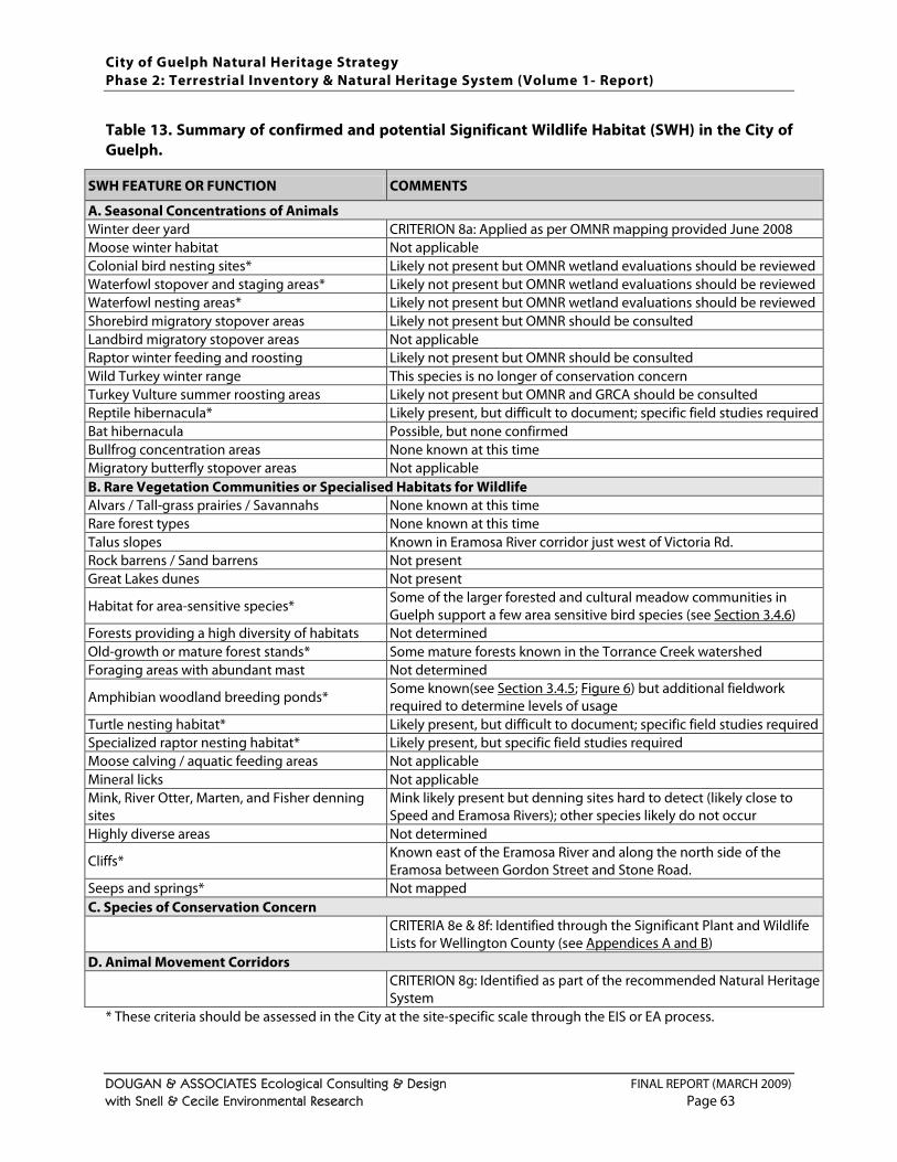
City of Guelph Natural Heritage Strategy Phase 2: Terrestrial Inventory & Natural Heritage System (Volume 1- Report)
DOUGAN & ASSOCIATES Ecological Consulting & Design FINAL REPORT (MARCH 2009) with Snell & Cecile Environmental Research Page 63
Table 13. Summary of confirmed and potential Significant Wildlife Habitat (SWH) in the City of Guelph.
SWH FEATURE OR FUNCTION COMMENTS
A. Seasonal Concentrations of Animals Winter deer yard CRITERION 8a: Applied as per OMNR mapping provided June 2008 Moose winter habitat Not applicable Colonial bird nesting sites* Likely not present but OMNR wetland evaluations should be reviewed Waterfowl stopover and staging areas* Likely not present but OMNR wetland evaluations should be reviewed Waterfowl nesting areas* Likely not present but OMNR wetland evaluations should be reviewed Shorebird migratory stopover areas Likely not present but OMNR should be consulted Landbird migratory stopover areas Not applicable Raptor winter feeding and roosting Likely not present but OMNR should be consulted Wild Turkey winter range This species is no longer of conservation concern Turkey Vulture summer roosting areas Likely not present but OMNR and GRCA should be consulted Reptile hibernacula* Likely present, but difficult to document; specific field studies required Bat hibernacula Possible, but none confirmed Bullfrog concentration areas None known at this time Migratory butterfly stopover areas Not applicable B. Rare Vegetation Communities or Specialised Habitats for Wildlife Alvars / Tall-grass prairies / Savannahs None known at this time Rare forest types None known at this time Talus slopes Known in Eramosa River corridor just west of Victoria Rd. Rock barrens / Sand barrens Not present Great Lakes dunes Not present
Habitat for area-sensitive species* Some of the larger forested and cultural meadow communities in Guelph support a few area sensitive bird species (see Section 3.4.6)
Forests providing a high diversity of habitats Not determined Old-growth or mature forest stands* Some mature forests known in the Torrance Creek watershed Foraging areas with abundant mast Not determined
Amphibian woodland breeding ponds* Some known(see Section 3.4.5; Figure 6) but additional fieldwork required to determine levels of usage
Turtle nesting habitat* Likely present, but difficult to document; specific field studies required Specialized raptor nesting habitat* Likely present, but specific field studies required Moose calving / aquatic feeding areas Not applicable Mineral licks Not applicable Mink, River Otter, Marten, and Fisher denning sites
Mink likely present but denning sites hard to detect (likely close to Speed and Eramosa Rivers); other species likely do not occur
Highly diverse areas Not determined
Cliffs* Known east of the Eramosa River and along the north side of the Eramosa between Gordon Street and Stone Road.
Seeps and springs* Not mapped C. Species of Conservation Concern
CRITERIA 8e & 8f: Identified through the Significant Plant and Wildlife Lists for Wellington County (see Appendices A and B)
D. Animal Movement Corridors
CRITERION 8g: Identified as part of the recommended Natural Heritage System
* These criteria should be assessed in the City at the site-specific scale through the EIS or EA process.
City of Guelph Natural Heritage Strategy Phase 2: Terrestrial Inventory & Natural Heritage System (Volume 1- Report)
DOUGAN & ASSOCIATES Ecological Consulting & Design FINAL REPORT (MARCH 2009) with Snell & Cecile Environmental Research Page 64
Within all of these categories there are more specific categories or criteria for different groups of species or specific habitat types that need to be considered. Although more specific guidance on appropriate criteria and thresholds for Site Region 6E and 7E are expected to be released by the OMNR before the end of 2008, the current guidelines tend to be somewhat generalized and difficult for municipalities to apply on a jurisdictional-wide basis. As a result, most municipalities deal with SWH on a case-by-case basis as individual development applications are proposed. However, this can result in SWH criteria being overlooked. To date, only four studies in southern Ontario have attempted to define SWH more specifically across their jurisdictions:
the Oak Ridges Moraine Conservation Plan Technical Paper #2 for Significant Wildlife Habitat (OMNR 2007b);
Norfolk County Lakeshore Special Policy Area Secondary Plan Natural Heritage System Strategy (Marshall Macklin Monaghan 2007);
Natural Heritage System for the Lake Simcoe Watershed, Phase 1: Components and Policy Templates (Lake Simcoe Region Conservation Authority and Beacon Environmental 2007);
Region of Peel and Town of Caledon Significant Woodlands and Significant Wildlife Habitat Study, Final Draft Report (North-South Environmental and Dougan & Associates 2008).
While the Oak Ridges Moraine and Region of Peel / Town of Caledon studies identify thresholds for the full range of applicable SWH criteria, the Norfolk County and Lake Simcoe studies identify the specific SWH criteria from the Significant Wildlife Habitat Technical Guidelines (OMNR 2000) they determined should or could be applied to their respective jurisdictions based on the available information in the context of either existing (in the case of Norfolk) or proposed (in the case of Lake Simcoe Watershed) natural heritage systems with criteria addressing other features and functions.
Recommended criteria for this study are based on the four major SWH categories cited above from the Significant Wildlife Habitat Technical Guide (OMNR 2000). Criteria used for identification of the recommended NHS are restricted to those for which data was available at the time of this study, and are discussed in the following text. A complete list of all SWH criteria potentially applicable in the City of Guelph that should be considered at the site-specific level is provided in Table 13
deer wintering areas
. The SWH criteria that have been mapped as part of the recommended NHS include:
waterfowl overwintering areas
significant vegetation types (not captured by criteria 3 or 5)
habitat for globally, nationally, provincially and locally significant species (not captured by criterion 2)
ecological linkages
The results of this mapping are presented on Figure 11 and the criteria, and how they were applied, are discussed in more detail below.
City of Guelph Natural Heritage Strategy Phase 2: Terrestrial Inventory & Natural Heritage System (Volume 1- Report)
DOUGAN & ASSOCIATES Ecological Consulting & Design FINAL REPORT (MARCH 2009) with Snell & Cecile Environmental Research Page 65
DEER WINTERING AREAS Deer wintering areas are sheltered places that White-tailed Deer seek during the winter months to avoid deep snow conditions. Sheltered areas allow deer to move more easily, avoid predators and provides them easier access to food sources under the snow. However, snow depths in the City of Guelph are not generally deep enough to force deer to yard in the traditional sense; nonetheless, deer are considered an important wild species that are part of the southern Ontario landscape that require both protection and management in an increasingly urbanized landscape (see Section 3.4.7). Mapping of deer wintering areas in the City of Guelph was updated and provided by the OMNR in June of 2008 (A. Timmerman, Guelph District Office) and applied as provided for this study. Given that this mapping is somewhat generalized and overlaps with provincially significant wetlands in many locations which already have minimum buffers, no additional minimum buffers have been applied to these areas. WATERFOWL OVERWINTERING AREAS The OMNR provided mapping for waterfowl overwintering areas (i.e., on the Speed and Eramosa Rivers) along with the deer winter yard mapping, however it does not specifically correspond to any of the SWH categories or criteria laid out by the OMNR (2000) (as listed in Table 13). These areas have, however, been included under the category for SWH to flag areas of known waterfowl use along Guelph’s major rivers. Notably, these areas are fully captured by stream and regulatory floodplain mapping in the City (under criteria 4 and 6). This mapping is also somewhat generalized and overlaps entirely with other regulated natural features which already have minimum buffers, no additional minimum buffers have been applied to these areas. SIGNIFICANT VEGETATION TYPES Significant vegetation types can include those that are considered rare as well as those that are considered representative. For criteria 8c and 8d, the focus has been placed on provincially and locally rare vegetation types to remain consistent with the intent of the Significant Wildlife Habitat Technical Guidelines (OMNR 2000) which specifies “rare” vegetation types. However, NHS can also include representative features (e.g., County of Oxford NHS, UTRCA 2006; TRCA 2007) and a locally representative vegetation type has been included under the criterion for significant woodlands (i.e., Sugar Maple deciduous forests (FOD5)). Rare vegetation communities are those natural communities that are the most uncommon in a given jurisdiction, and therefore are considered a high priority for protection. Although some species of plants and wildlife are able to migrate between and survive within a variety of habitat types, other species are very reliant on specific conditions and/or resources only available within certain habitat types. If already-scarce vegetation communities in the landscape are not protected and disappear, the species that rely specifically on these communities will become locally extirpated. The Significant Wildlife Habitat Technical Guidelines (OMNR 2000) include “rare vegetation communities” as a major category identified for protection and suggest that as a minimum all provincially rare vegetation communities (i.e., S1 to S3 ranking, as defined in Section 7) should be considered significant. This recommendation has been incorporated into criterion 8(c). Although no provincially rare ELC Vegetation Types were identified or mapped during this study (see Table 2), and none are listed for the City or Guelph or Wellington County on the NHIC on-line database (NHIC 2008), designated wetlands and floodplains were not field verified as part of this study, and it is possible that some provincially rare vegetation types do occur in the City.
City of Guelph Natural Heritage Strategy Phase 2: Terrestrial Inventory & Natural Heritage System (Volume 1- Report)
DOUGAN & ASSOCIATES Ecological Consulting & Design FINAL REPORT (MARCH 2009) with Snell & Cecile Environmental Research Page 66
Ecologists on the study team have identified a few such communities in the City’s wetlands and floodplains based on their local knowledge, as follows:
Buttonbush Mineral Thicket Swamp Type (ELC code SWT2-4, NHIC rank S3) within the Hanlon Creek Wetlands west of the Hanlon;
Silky Dogwood Mineral Thicket Swamp Type (ELC code SWT2-8, NHIC rank S3S4) within the Guelph Northeast Wetland Complex; and
White Cedar Treed Carbonate Cliff Type (ELC code CLT1-1, NHIC rank S3) in natural areas within the Guelph Correctional Centre.
However, precise classification and location for these communities should be field verified through site-specific studies. Should these (or other) provincially significant vegetation communities be confirmed in the City, appropriate buffers should be determined on a case by case basis. The Significant Wildlife Habitat Technical Guidelines (OMNR 2000) further state that additional potentially rare vegetation communities should be identified at the local level based on community representation in the area, presence of rare species, diversity of the site, quality of the community, size and location of the site and potential for protection. However, to determine this in a quantifiable manner, City-wide ELC to the Vegetation Type level, which was not possible within the scope of this study, would be required. In the absence of more detailed data, a preliminary list of rare Ecosites that do not have status through NHIC at the Ecosite level but include many rare vegetation types has been developed as part of this study. Notably, these areas have not been mapped but are all located within identified designated wetlands or regulated floodplain areas. In the City of Guelph, community types considered rare or uncommon not captured as significant wetlands or woodlands include the following ELC Ecosites types: Carbonate Open Cliff Ecosite (CLO1), Carbonate Shrub Cliff Ecosite (CLS1) and Carbonate Treed Talus Ecosite (TAT1).
At least one Open Fen Ecosite (FEO1) is thought to occur in the City, and is also considered locally significant, and although not a specific Ecosite per se, the Arkell-Victoria-Clair-Gordon Kettles, identified in the Torrance Creek Subwatershed Study (TSH et al. 1998), are considered communities of high local significance. However, these are captured through criterion 3, significant wetlands. No minimum size threshold is recommended for all the communities recommended above. Furthermore, additional communities may be added to the list should new information become available through site specific studies or changes in identified community status (i.e., NHIC). Should new communities outside the recommended NHS become identified in the future, appropriate buffers will need to be determined on a case by case basis. HABITAT FOR GLOBALLY, NATIONALLY, PROVINCIALLY AND LOCALLY SIGNIFICANT SPECIES The Significant Wildlife Habitat Technical Guidelines (OMNR 2000) identify a wide range of “Habitats for Species of Conservation Concern” that need to be considered, including:
Species identified as THR or END but not designated at the provincial level;
Species identified as Special Concern (SC) (defined in Section 7) based on Ontario’s Species at Risk list (periodically updated by OMNR);
City of Guelph Natural Heritage Strategy Phase 2: Terrestrial Inventory & Natural Heritage System (Volume 1- Report)
DOUGAN & ASSOCIATES Ecological Consulting & Design FINAL REPORT (MARCH 2009) with Snell & Cecile Environmental Research Page 67
Species that have a high percentage of their global population in Ontario and are considered regionally or locally rare or uncommon (i.e., in the Wellington County);
Species that are listed as rare (S1–S3 or S3S4) (defined in Section 7
Species that are rare within Wellington County, even though they may not be provincially rare.
) or historical in Ontario based on records kept by the Natural Heritage Information Centre (NHIC); and
The original approach used was revised in response to comments that some bird species still considered relatively abundant in Wellington County and the province had been used to trigger habitat protection, and that species requirements are so variable that there should be some flexibility in determining species requirements on a case-by-case basis. In the draft recommended NHS, all species considered significant in Wellington County (as per the lists provided in Appendices A and B) triggered protection of the habitat in which they were recorded as long as this overlapped with an area meeting another secondary criterion. In the revised recommended NHS, all species considered significant in Wellington County (as per the lists provided in Appendices A and B) have triggered identification of the habitat (i.e., ELC polygon) in which they were recorded as areas for which the level and amount of habitat protection needs to be determined at the site-specific level on a case-by-case basis. In addition, bird species included in the Significant Wildlife List for Wellington County because of their being of “conservation concern” by Ontario Partners-in-Flight (OPIF 2008) but not determined to be “rare” (i.e., occurring in 7 or less Ontario Breeding Bird Atlas squares in the County, Cadman et al. 2007) have been excluded from this criterion. These bird species are distinguished in italics in the Significant Wildlife List for Wellington County provided in Appendix B
habitat for any species identified to be nationally END or THR by COSEWIC not protected in regulation under Ontario’s Endangered Species Act (such as Western Chorus Frog, Great Lakes / St. Lawrence – Canadian Shield population, which was designated as THR in Canada in April 2008 (COSEWIC 2008))
. All other species listed are considered both “significant” and “rare” in the County based on the available information and consultation with various experts. Notably, the Significant Wildlife List for Wellington County put forward as part of the draft report in July 2008 was revised in early 2009 to incorporate some recent status changes of some species at the national and provincial levels since 2005, and to address some comments received over the fall of 2008 from stakeholders and additional peer reviewers.
Based on the guidelines and the considerations above, the specific measures used for this criterion were:
habitat for species designated as Special Concern (SC) by COSEWIC or COSSARO / OMNR
habitat for species ranked as S1, S2, S3 or S3/S4 by NHIC (as described in Section 7
habitat for species not captured by any of the above but considered locally rare (i.e., in Wellington County, as per the Significant Plant and Wildlife Lists for Wellington County) excluding birds listed as significant because of their being considered of “conservation concern” (OPIF 2008)
)
Species with national or provincial status have been distinguished in the mapping (i.e., criterion 8e) from species with strictly local status (i.e., criterion 8f) in recognition of the fact that species considered rare at higher jurisdictional levels may be considered more of a priority, or warrant a higher level of
City of Guelph Natural Heritage Strategy Phase 2: Terrestrial Inventory & Natural Heritage System (Volume 1- Report)
DOUGAN & ASSOCIATES Ecological Consulting & Design FINAL REPORT (MARCH 2009) with Snell & Cecile Environmental Research Page 68
habitat protection, than those considered locally rare. For this criterion, species presence has triggered identification of the ELC polygon in which it was observed or recorded. However, the intent is that (a) site-specific studies confirm the occurrence of this species in the identified area or adjacent lands, and that (b) recommendations be made for appropriate habitat protection (both in terms of the extent of habitat required, including site-level linkages where appropriate, and the types of habitats required) based on a knowledge of the species’ requirements. For some plant species fairly localized habitat protection may be adequate, while for some wildlife species broader habitat needs will need to be considered. In addition, protecting habitat for species with recognized significance also tends to capture areas used by common species (e.g., Larsen et al. 2007) thereby supporting the sustainability of the NHS as a whole. Habitats have been identified in the recommended NHS, as per Figure 11
More detailed mapping
, by species meeting any of the criteria listed above. Significant species include those confirmed in this or other studies conducted in the City since 1988, excluding bird species of “conservation concern” (as identified by OPIF 2008) without any other status. Records prior to 1988 have been considered historical and not included in this criterion.
29 showing which significant species have triggered which polygons has been provided to the City as an internal memo and as data for internal use due to the sensitivity of some of the information. A list of the species that triggered criteria application and their sources are provided in Appendix E
29Significant species locations were linked to the general habitat in which they were recorded (i.e., the ELC
polygon) but for the most part were not geo-referenced to specific locations (i.e., with UTM coordinates). Habitat identification was triggered by significant species confirmed as part of this study as well as those documented in environmental impact studies (EIS) completed in the City since 1988. Wildlife records within 20 m of a polygon were considered captured by that polygon.
without locational information. Species captured for this criterion do not represent a comprehensive identification of significant species in the City since many EIS, as well as the larger scale subwatershed studies, did not link observed species to specific ELC polygons and as a result these documented significant species could not be included in these analyses. Significance rankings change over time in response to new information (sometimes more than once per year), and so species lists and related mapping need to be revisited periodically, or reviewed through the EIS or EA process . Current national and provincial lists are available on-line, as are NHIC S-ranks (nhic.mnr.gov.on.ca). ECOLOGICAL LINKAGES Ecological linkages, formerly a stand-alone category, has now been included under SWH to correspond more closely the natural heritage categories identified in the Provincial Policy Statement, and to fulfill the SWH criterion for “animal movement corridors” (OMNR 2000). There is also a strong mandate for applying this principle under Section 2.1.2 of the Provincial Policy Statement which states that: “The diversity and connectivity of natural features in an area, and the long-term ecological function and biodiversity of natural heritage systems, should be maintained, restored or, where possible, improved, recognizing linkages between and among natural heritage features and areas, surface water features and ground water”.
City of Guelph Natural Heritage Strategy Phase 2: Terrestrial Inventory & Natural Heritage System (Volume 1- Report)
DOUGAN & ASSOCIATES Ecological Consulting & Design FINAL REPORT (MARCH 2009) with Snell & Cecile Environmental Research Page 69
One key reason for maintaining this connectivity is to facilitate movement of wildlife on various scales. Animal movement corridors are defined by the Significant Wildlife Habitat Technical Guidelines (OMNR 2000) as “elongated, naturally vegetated parts of the landscape areas used by animals to move from one habitat to another. They exist at different scales and frequently link or border natural areas. Animal movement corridors encompass a wide variety of landscape features including riparian zones and shorelines, wetland buffers, stream and river valleys, woodlands, and anthropogenic features such as hydro and pipeline corridors, abandoned road and rail allowances, and fencerows and windbreaks”. For more than 30 years, conservation biology research has supported the principle that maintaining connections between patches of remnant habitat is a sound conservation strategy. Research on this topic continues to demonstrate that well-connected habitats tend to support higher levels of biodiversity and to facilitate important longer term ecological functions such as:
the re-population of areas subject to local extinctions of particular species of flora or fauna (e.g., Honnay and Jacquemyn 2007);
the dispersal of animals and/or of plant seeds / propagules that are carried by animals to new habitats in the post-breeding season (e.g., Damschen et al. 2008); and
the provision of habitat critical to fulfill life cycle requirements. By increasing the dispersal and re-colonization ability of plant and animal species, habitat connectivity reduces some of the negative impacts of habitat fragmentation and supports long-term population viability (e.g., Saunders et al. 1991; Fahrig and Merriam 1994; Boulinier et al. 2001; Fahrig 2001). Ecological corridors, or linkages (as they are referred to in this report) are especially important for species that move between varied habitats for survival (e.g., forest-dwelling salamanders that spend three seasons in forest soils but breed and lay eggs in ponds in the spring) or species that migrate in response to seasonal changes (e.g., white tailed deer, migratory birds). Although habitat connectivity can also facilitate dispersal of undesirable (e.g., invasive) species and, depending on their structure and size, may create environments that make some species more vulnerable to predators, scientific research and practice continues to demonstrate that maintaining terrestrial linkages and connectivity between natural habitats ensures better ecosystem functioning than having a number of isolated natural areas (e.g., Noss 1993; Naiman et al. 1993; Forman 1995b; Fleury and Brown 1997; Beier and Noss 1998; Fahrig 2002). In terms of ideal sizes for ecological linkages there are no fixed standards. This is in part because optimal sizes, which have been examined for a number of wildlife species and groups, vary so much between and within taxonomic groups, and are unknown for many other species. Minimum widths and lengths of corridors also depend on habitat structure and quality within individual corridors, nature of the surrounding habitat, and human use patterns (Adams and Dove 1989). An additional challenge is that observation of wildlife species actually using individual linkages requires long term field research. Typically, linkages are assigned based on (a) a knowledge of the species present in a given landscape, (b) a review of the most current data of habitat needs and mobility of those species in the context of the landscape matrix (i.e., agricultural vs. urban landscapes which have significantly different opportunities and constraints in their ability to support biota), (c) an analysis of the most suitable linkage options available in a given landscape, and (d) with consideration for the minimum requirements of the selected species and/or those with the broadest needs.
City of Guelph Natural Heritage Strategy Phase 2: Terrestrial Inventory & Natural Heritage System (Volume 1- Report)
DOUGAN & ASSOCIATES Ecological Consulting & Design FINAL REPORT (MARCH 2009) with Snell & Cecile Environmental Research Page 70
There are, however, several strong precedents for establishing minimum linkage widths of at least 100 m in urban and urbanizing areas. Minimum 100 m linkages have been adopted in the Seaton Lands NHS, Region of Durham (City of Pickering and Toronto and Region Conservation Authority 2008). In the North Oakville NHS (TSH et al. 2006a,b) minimum linkage widths of at least 100 m were established between habitats without forest interior, while minimum linkage widths of at least 200 m were established between habitats with forest interior. Both of these studies have been subject to the OMB process and decisions made have supported these standards. Based on an analysis of current science, a corridor that is continuously at least 200 m wide but no less than 100 m wide generally allows for the movement of many species but not breeding or feeding (Environment Canada et al. 2004; Forman 1995a). However, there is also evidence that even narrow linkages, such as fencerows connecting woodlands, can help relieve the isolating effects of fragmented landscapes as well as provide temporary habitat for migrating birds and small mammals (Wegner and Merriam 1979; Merriam 1991; Hess and Bay 2000; Aude et al. 2004). The intent of this criterion is to ensure that the ecological features and functions identified by applying the primary criteria 1 through 8f are as well-linked and as connected as possible within the City, and with Greenlands identified in the County of Wellington (based on mapping last updated in January 2008). Ecological linkages are primarily linear linkages between other NHS features, but in some cases also include small holes or gaps that, if developed, would contribute to compromising the ecological sustainability of the system. The current approved Official Plan (2006 consolidation) identifies linkages intended to be achieved on Schedule 7. These linkages along with linkages identified in subwatershed studies (i.e., TSH et al. 1998; MMM and LGL Ltd. 1993) and some EIS were examined in the current context for linkage opportunities within the updated NHS. In addition, the County’s Greenlands mapping and mapping of forested areas outside the City boundary were also considered in this analysis in order to maintain connectivity between natural heritage features (and surface water features) within and outside the City. Based on input received on the draft study and mapping, accommodation was also made for studies that had already been draft plan approved as of February 2009. Given that the City of Guelph is already largely urbanized, opportunities for ecological linkages in a number of locations were limited, and were restricted to narrow linkages identified through previously approved EIS or narrow habitat fragments remaining in the landscape. While the optimal target width for linkages has been set at 100 m, some linkages closer to 50 m wide as well as some pre-existing linkages less than 50 m wide have been included. These linkages follow remnant natural features where possible (e.g., plantations and hedgerows), but also incorporate other lands (i.e., City park lands, agricultural lands, golf courses or areas zoned as urban but not built-up) to achieve widths between 50 m and 100 m where such opportunities remain in the City. Guidelines for mapping natural heritage systems typically have allowances for incorporating openings or gaps under a certain size to prevent further fragmentation of natural heritage systems, with the size of the gap depending on the scale of the study and mapping. For example, the Carolinian Canada Draft Boundary Delineation Guide (available at www.carolinian.org/Publications/eis_D.pdf) illustrates a number of approaches for dealing with gaps in natural habitat patches and use 1 ha as a minimum threshold for inclusion of gaps. In the City of Guelph gaps ranging from less than 0.1 ha to more than 1 ha in the NHS were captured, as shown in Figure 12, so as to limit fragmentation of the NHS.
City of Guelph Natural Heritage Strategy Phase 2: Terrestrial Inventory & Natural Heritage System (Volume 1- Report)
DOUGAN & ASSOCIATES Ecological Consulting & Design FINAL REPORT (MARCH 2009) with Snell & Cecile Environmental Research Page 71
Ecological linkages identified in the recommended NHS (as shown in Figure 12) do not necessarily include all linkage opportunities but those considered most critical to the functioning of the NHS. However, additional or alternative opportunities for linkages may be identified in the future. Two linkages have been identified across Gordon St. in locations where deer are known to cross (in addition to two other deer crossing locations). Although it is understood that this is a fairly busy road, it is also understood that the deer are using these areas as travel corridors irrespective of whether they are formally identified as linkages or not. Therefore, these linkage locations have been identified with the caveat that the City should implement measures in these locations (and elsewhere) to reduce the risk of deer-vehicle collisions (as discussed in Section 3.4.7
4.3.9 CRITERION CATEGORY 9: NATURALIZATION / RESTORATION AREAS
). Although not identified as “ecological linkages” per se, on a larger scale, portions of the recommended NHS itself (e.g., the river corridors) provide linkage functions in terms of habitat connectivity in the larger County-wide and Regional landscape.
Naturalization can be generally defined as a process whereby an area that has been disturbed by human (or even natural) activities regenerates naturally with input of seeds and other propagules from the remaining soil and/or adjacent natural areas. Restoration typically implies more active management is involved in the form of creating a suitable environment for re-vegetation (e.g., introducing top soil if required) and/or introducing native plant materials (e.g., seeds and/or seedlings and/or more mature plant stock) suited to that environment or intended to help support the development of the desired vegetation community. Types of restoration can include creation or re-creation of wetlands, woodlands or grasslands. In response to comments received on the draft recommended NHS, opportunities for habitat naturalization and restoration have been identified in relation to the final recommended NHS. These opportunities have primarily been identified on City park lands and GRCA lands not intended for active uses where various types of naturalization and/or restoration have already been undertaken or could be undertaken in the future. A few small areas have also been identified where there are holes or gaps in the NHS. The intent of these areas is that they are already providing or could provide additional habitat supportive to the overall sustainability of the recommended NHS. Although it is understood that storm water management areas are primarily intended to serve a flood control and water quality control function, and that they need to be maintained (e.g., in the case of ponds, dredged once every 10 to 20 years), these areas have also been included as naturalization / restoration areas since they are often adjacent to protected natural areas in the City, and typically are either landscaped or can become naturalized over time, and do tend to provide habitat for some species of plants and types of wildlife. Current mapping, as shown in Figure 12, includes both current storm water management areas and some that are planned as part of approved developments (e.g., the Hanlon Creek Business Park west of the Hanlon Expressway). It also includes both storm water management ponds and “low impact development (LID)” style storm water management, such as vegetated swales running through newer communities. Storm water management areas do not typically provide ideal habitat because in addition to their water quantity control function, they are meant to capture and filter a variety of contaminants found in urban runoff and thereby serve as a sink for various chemicals and pollutants. They also by no means replace the critical functions provided by
City of Guelph Natural Heritage Strategy Phase 2: Terrestrial Inventory & Natural Heritage System (Volume 1- Report)
DOUGAN & ASSOCIATES Ecological Consulting & Design FINAL REPORT (MARCH 2009) with Snell & Cecile Environmental Research Page 72
natural wetlands (Olewiler 2004). But in an urban landscape they can provide some supplementary habitat, particularly if they are vegetated by a diversity native species, and can also buffer adjacent natural areas from types of encroachments. The two largest restoration areas identified in the City at present are: (a) the former Eastview landfill site (on the east side of the City) where more than 40 ha has been identified for restoration to meadow habitat (in addition to some adjacent lands identified for active park uses), and (b) agricultural fields on GRCA lands by Guelph Lake. Both of these areas make ideal locations for provision of open habitat for grassland bird species known to breed within and in lands just outside the City. There are also some restoration areas identified “over” some areas of the recommended NHS where the need for management (e.g., removal of invasive species) has already been identified. In addition, some of the ecological linkages could also be the focus of future restoration efforts. It is important to recognize that the concept of restoration is a relatively new one, and ecosystems are so complex and still so poorly understood that it is rarely possible to simply re-create natural systems. It can also be a costly and time-consuming process. Therefore conservation of remaining habitat should always be the first priority in building and sustaining a NHS. Even for the “protected” areas in an urban environment monitoring and management is typically required to prevent or reduce invasive species spread and address other impacts related to encroachment (e.g., McWilliam 2007). Nonetheless, restored lands can contribute ecosystems services (e.g., Dodds et al. 2008) as well as supportive ecological functions. Restoration activities should always strive to understand and work with whatever natural driving forces (e.g., hydrology, topography, soils) exist on site to maximize their chances of success. The mapping of naturalization / restoration areas in Figure 12
4.3.10 CRITERION CATEGORY 10: WILDLIFE CROSSINGS
is not a comprehensive identification of such opportunities in the City. There may be other opportunities for tree planting and / or naturalization / restoration in the City on other public or private lands that could be explored through a consultative process in the City. Opportunities could include lands in the City’s business parks, and could even include discussions of opportunities for green roofs in the City.
This criterion is different from the others insofar as it is not intended to identify areas for protection, but rather to flag locations where wildlife have either been confirmed crossing a major road in the City, or where it is anticipated that wildlife are likely to cross based on the configuration of natural areas in that location. The two types of wildlife given the greatest consideration in the City of Guelph as part of this study were deer and herpetofauna (i.e., salamanders, frogs, toads, snakes and turtles). The deer are an important consideration because they are relatively numerous in parts of the City, relatively large and very mobile, resulting in a relatively high risk of conflicts, particularly in the form of deer-vehicular accidents. Some further discussion of deer in the City is provided in Section 3.4.7. Herpetofauna include many of the most at risk wildlife species in Ontario, and also include many species that must migrate between different habitat types (i.e., woodlands and wetlands) at certain times of the year in order to complete their life cycles. Therefore these species are also at high risk from vehicles (e.g., Gibbs and Shriver 2005; Langen et al. 2009), as discussed in Section 3.4.5.
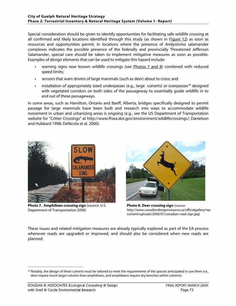
City of Guelph Natural Heritage Strategy Phase 2: Terrestrial Inventory & Natural Heritage System (Volume 1- Report)
DOUGAN & ASSOCIATES Ecological Consulting & Design FINAL REPORT (MARCH 2009) with Snell & Cecile Environmental Research Page 73
Special consideration should be given to identify opportunities for facilitating safe wildlife crossing at all confirmed and likely locations identified through this study (as shown in Figure 12
warning signs near known wildlife crossings (see
) as soon as resources and opportunities permit. In locations where the presence of Ambystoma salamander complexes indicates the possible presence of the federally and provincially Threatened Jefferson Salamander, special care should be taken to implement mitigative measures as soon as possible. Examples of design elements that can be used to mitigate this hazard include:
Photos 7 and 8
sensors that warn drivers of large mammals (such as deer) about to cross; and
) combined with reduced speed limits;
installation of appropriately sized underpasses (e.g., large culverts) or overpasses30
In some areas, such as Hamilton, Ontario and Banff, Alberta, bridges specifically designed to permit passage for large mammals have been built and research into ways to accommodate wildlife movement in urban and urbanizing areas is ongoing (e.g., see the US Department of Transportation website for “Critter Crossings” at
designed with vegetated corridors on both sides of the passageway to essentially guide wildlife in to and out of these passageways.
http://www.fhwa.dot.gov/environment/wildlifecrossings/; Danielson and Hubbard 1998; DeNicola et al. 2000).
Photo 7. Amphibian crossing sign (source: U.S. Department of Transportation 2000)
Photo 8. Deer crossing sign (source: http://www.canadiandesignresource.ca/officialgallery/wp-content/uploads/2008/07/canadian-road-sign.jpg)
These issues and related mitigation measures are already typically explored as part of the EA process whenever roads are upgraded or improved, and should also be considered when new roads are planned.
30 Notably, the design of these culverts must be tailored to meet the requirements of the species anticipated to use them (i.e.,
deer require much larger culverts than amphibians, and amphibians require dry benches within culverts).
City of Guelph Natural Heritage Strategy Phase 2: Terrestrial Inventory & Natural Heritage System (Volume 1- Report)
DOUGAN & ASSOCIATES Ecological Consulting & Design FINAL REPORT (MARCH 2009) with Snell & Cecile Environmental Research Page 74
4.4 DISCUSSION OF CRITERIA CONSIDERED BUT NOT INCLUDED
As part of Phase 1 of the Natural Heritage Strategy a long list of candidate criteria were considered by the study team, City, Technical Steering Committee, key stakeholders and the community. This information is summarized in the Phase 1 report (Dougan & Associates 2005) and will not be re-visited. The following text focuses on three criteria that were considered important for defining a NHS by the study team as well as some stakeholders, and explains why they have not been used. Areas of Significant Groundwater Discharge or Recharge A criterion to capture areas of groundwater sensitivity as it relates to natural heritage functioning was identified as a high priority by the community and stakeholders in Phase 1, and was also identified as a priority by a number of stakeholders as part of the more recent consultations for Phase 2 in the fall of 2008. However, after consultations with various groundwater experts (i.e., Dave Belanger with the City of Guelph, Dr. Beth Parker with the University of Guelph, and Bill Blackport, Consulting Hydrogeologist) and internal review of the available groundwater data (Golder Associates Ltd. 2006; KCCA et al. 2008; Aqua Resource 2008) over January 2009, it was determined that the current groundwater sensitivity analyses conducted for the watershed and the Guelph-Puslinch area could not be used to accurately identify areas of high groundwater sensitivity at a City-wide scale consistent with the scale at which the NHS was identified. Experts did, however, provide support for the City’s approach to identifying significant portions of the Paris-Galt Moraine based on 20% slope concentrations in conjunction with closed depression mapping from the GRCA. These areas are intended to capture areas where groundwater recharge is likely to be most concentrated on the Paris-Galt Moraine within the City (see Section 4.3.7), and thereby identifies areas of groundwater sensitivity in relation to the NHS for part of the City. Further study of groundwater sensitivity from a drinking water perspective will be identified through the City's Tier 3 Water Budget which is currently being developed by AquaResource Inc. as part of the Province's Source Protection Program. This will compare the available groundwater and surface water resources to the demand for water supply and define significant groundwater recharge areas for the Upper Speed River Watershed (including the Eramosa River), and may identify additional areas of groundwater sensitivity in the City, at least from a drinking water perspective. The hydrogeologic significance of the Paris-Galt Moraine is also currently under study by the Ministry of the Environment and this may further inform the significance of this feature from a hydrogeologic perspective. Habitat Diversity Habitat diversity was among the recommended working criteria for identification of LSNAs but has not been carried forward under the revised approach (as discussed under Section 4.1
Highly diverse habitats are recognized as important from an ecological perspective because of their ability to contribute to local and regional biodiversity (OMNR 2005). Preservation of habitat diversity on a variety of scales is recognized as a cornerstone in building sustainable natural heritage systems. Protecting combinations of different natural habitat types in contiguous blocks in an urban or rural landscape helps ensure protection of the range of natural ecological communities in a given area, thereby ensuring habitat for a broader range of species and providing a broader range of ecological functions (e.g., Hooper et al. 2005; Loreau et al. 2001). Preservation of a range of natural areas is also
) for the reasons described below.
City of Guelph Natural Heritage Strategy Phase 2: Terrestrial Inventory & Natural Heritage System (Volume 1- Report)
DOUGAN & ASSOCIATES Ecological Consulting & Design FINAL REPORT (MARCH 2009) with Snell & Cecile Environmental Research Page 75
considered important for enabling ecosystems to remain more resilient and adapt to climate change (e.g., Halpin 1997; Varrin et al. 2007). Despite the value of this concept to natural heritage planning, applying it as a criterion can be challenging. There are also no standards or widely used methods for measuring habitat diversity of a given planning area, although some jurisdictions have used the number of unique habitat types within a given patch or area (e.g., Fort Erie - Dougan and Associates 2003) and the Credit Valley Conservation Authority (CVC) has also used this measure for their watershed scale diversity analyses (A. Patel, CVC Terrestrial Ecologist, pers. comm., April 2008). For this study it was determined that because the City is already extensively developed and natural areas are already fragmented it would be difficult to effectively apply this criterion as a tool to help build the NHS in a discriminatory manner. However, the diversity of natural areas within the City has been quite effectively captured by the application of all the criteria used (as summarized in Table 12
1. All wetlands in the City greater than 0.5 ha, and even some smaller wetlands, are captured through Criterion 3 (Significant Wetlands).
). Habitat Size Habitat size is another criterion that is considered a useful tool in the identification of natural heritage systems (see review by the Environmental Law Institute 2003). In general, larger habitats can support a broader range of species and are more resilient to changes in the surrounding landscape. However, despite its value as a natural heritage criterion, it was not used as a stand-alone criterion because the criteria used for the NHS combined capture all the remaining large natural heritage features in the City, as well as some of the smaller ones, as follows:
2. All patches of woodland of at least 1 ha and Sugar Maple Woods of between 0.5 and 1.0 ha are captured by Criterion 5 (Significant Woodlands).
Guelph is a highly urbanized municipality required to accommodate additional growth and therefore large patches of tree plantations, cultural thickets and cultural meadows were not identified as significant in their own right because they typically have lower ecological value than natural wetlands or upland forests. They are, however, incorporated into the NHS where they meet any other criterion, including providing an ecological linkage, thereby making a significant ecological contribution to the sustainability of the NHS as a whole. In the final analysis, the recommended NHS (as shown in Figure 12) captures most large patches of habitat remaining in the City. Nonetheless, available information on some of the habitat requirements for area-sensitive species recorded in the City is provided below as reference material for ongoing or future site-specific studies as part of the adjacent lands analyses. In the City of Guelph, a number of area-sensitive forest interior bird species have been recorded (see Table 9). A summary of the known habitat requirements for a number of these species is provided in Table 14
. As the table shows, the ranges of minimum sizes differ depending on the species range and go from 0.48 ha to 200 ha of interior forest required per breeding pair.
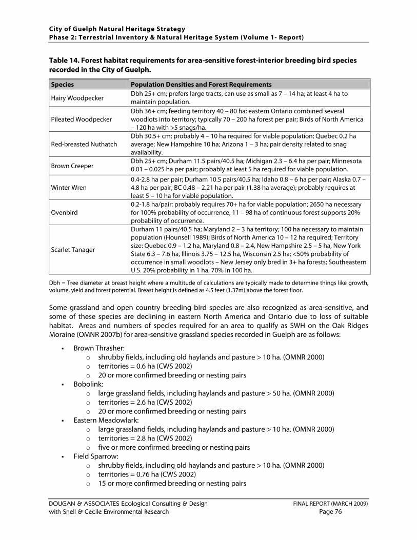
City of Guelph Natural Heritage Strategy Phase 2: Terrestrial Inventory & Natural Heritage System (Volume 1- Report)
DOUGAN & ASSOCIATES Ecological Consulting & Design FINAL REPORT (MARCH 2009) with Snell & Cecile Environmental Research Page 76
Table 14. Forest habitat requirements for area-sensitive forest-interior breeding bird species recorded in the City of Guelph. Species Population Densities and Forest Requirements
Hairy Woodpecker Dbh 25+ cm; prefers large tracts, can use as small as 7 – 14 ha; at least 4 ha to maintain population.
Pileated Woodpecker Dbh 36+ cm; feeding territory 40 – 80 ha; eastern Ontario combined several woodlots into territory; typically 70 – 200 ha forest per pair; Birds of North America – 120 ha with >5 snags/ha.
Red-breasted Nuthatch Dbh 30.5+ cm; probably 4 – 10 ha required for viable population; Quebec 0.2 ha average; New Hampshire 10 ha; Arizona 1 – 3 ha; pair density related to snag availability.
Brown Creeper Dbh 25+ cm; Durham 11.5 pairs/40.5 ha; Michigan 2.3 – 6.4 ha per pair; Minnesota 0.01 – 0.025 ha per pair; probably at least 5 ha required for viable population.
Winter Wren 0.4-2.8 ha per pair; Durham 10.5 pairs/40.5 ha; Idaho 0.8 – 6 ha per pair; Alaska 0.7 – 4.8 ha per pair; BC 0.48 – 2.21 ha per pair (1.38 ha average); probably requires at least 5 – 10 ha for viable population.
Ovenbird 0.2-1.8 ha/pair; probably requires 70+ ha for viable population; 2650 ha necessary for 100% probability of occurrence, 11 – 98 ha of continuous forest supports 20% probability of occurrence.
Scarlet Tanager
Durham 11 pairs/40.5 ha; Maryland 2 – 3 ha territory; 100 ha necessary to maintain population (Hounsell 1989); Birds of North America 10 – 12 ha required; Territory size: Quebec 0.9 – 1.2 ha, Maryland 0.8 – 2.4, New Hampshire 2.5 – 5 ha, New York State 6.3 – 7.6 ha, Illinois 3.75 – 12.5 ha, Wisconsin 2.5 ha; <50% probability of occurrence in small woodlots – New Jersey only bred in 3+ ha forests; Southeastern U.S. 20% probability in 1 ha, 70% in 100 ha.
Dbh = Tree diameter at breast height where a multitude of calculations are typically made to determine things like growth, volume, yield and forest potential. Breast height is defined as 4.5 feet (1.37m) above the forest floor. Some grassland and open country breeding bird species are also recognized as area-sensitive, and some of these species are declining in eastern North America and Ontario due to loss of suitable habitat. Areas and numbers of species required for an area to qualify as SWH on the Oak Ridges Moraine (OMNR 2007b) for area-sensitive grassland species recorded in Guelph are as follows:
Brown Thrasher: o shrubby fields, including old haylands and pasture > 10 ha. (OMNR 2000) o territories = 0.6 ha (CWS 2002) o 20 or more confirmed breeding or nesting pairs
Bobolink: o large grassland fields, including haylands and pasture > 50 ha. (OMNR 2000) o territories = 2.6 ha (CWS 2002) o 20 or more confirmed breeding or nesting pairs
Eastern Meadowlark: o large grassland fields, including haylands and pasture > 10 ha. (OMNR 2000) o territories = 2.8 ha (CWS 2002) o five or more confirmed breeding or nesting pairs
Field Sparrow: o shrubby fields, including old haylands and pasture > 10 ha. (OMNR 2000) o territories = 0.76 ha (CWS 2002) o 15 or more confirmed breeding or nesting pairs
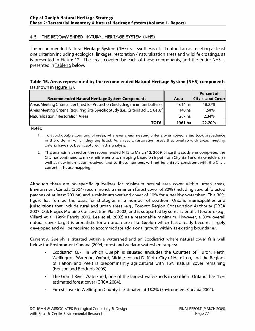
City of Guelph Natural Heritage Strategy Phase 2: Terrestrial Inventory & Natural Heritage System (Volume 1- Report)
DOUGAN & ASSOCIATES Ecological Consulting & Design FINAL REPORT (MARCH 2009) with Snell & Cecile Environmental Research Page 77
4.5 THE RECOMMENDED NATURAL HERITAGE SYSTEM (NHS)
The recommended Natural Heritage System (NHS) is a synthesis of all natural areas meeting at least one criterion including ecological linkages, restoration / naturalization areas and wildlife crossings, as is presented in Figure 12. The areas covered by each of these components, and the entire NHS is presented in Table 15 below. Table 15. Areas represented by the recommended Natural Heritage System (NHS) components (as shown in Figure 12).
Recommended Natural Heritage System Components Area Percent of
City’s Land Cover Areas Meeting Criteria Identified for Protection (including minimum buffers) 1614 ha 18.27% Areas Meeting Criteria Requiring Site Specific Study (i.e., Criteria 3d, 5c, 8e ,8f) 140 ha 1.58% Naturalization / Restoration Areas 207 ha 2.34%
TOTAL 1961 ha 22.20% Notes:
1. To avoid double counting of areas, wherever areas meeting criteria overlapped, areas took precedence in the order in which they are listed. As a result, restoration areas that overlap with areas meeting criteria have not been captured in this analysis.
2. This analysis is based on the recommended NHS to March 12, 2009. Since this study was completed the City has continued to make refinements to mapping based on input from City staff and stakeholders, as well as new information received, and so these numbers will not be entirely consistent with the City’s current in-house mapping.
Although there are no specific guidelines for minimum natural area cover within urban areas, Environment Canada (2004) recommends a minimum forest cover of 30% (including several forested patches of at least 200 ha) and a minimum wetland cover of 10% for a healthy watershed. This 30% figure has formed the basis for strategies in a number of southern Ontario municipalities and jurisdictions that include rural and urban areas (e.g., Toronto Region Conservation Authority (TRCA 2007, Oak Ridges Moraine Conservation Plan 2002) and is supported by some scientific literature (e.g., Villard et al. 1999; Fahrig 2002; Lee et al. 2002) as a reasonable minimum. However, a 30% overall natural cover target is unrealistic for an urban area like Guelph which has already become largely developed and will be required to accommodate additional growth within its existing boundaries. Currently, Guelph is situated within a watershed and an Ecodistrict where natural cover falls well below the Environment Canada (2004) forest and wetland watershed targets:
Ecodistrict 6E-1 in which Guelph is situated (includes the Counties of Huron, Perth, Wellington, Waterloo, Oxford, Middlesex and Dufferin, City of Hamilton, and the Regions of Halton and Peel) is predominantly agricultural with 16% natural cover remaining (Henson and Brodribb 2005).
The Grand River Watershed, one of the largest watersheds in southern Ontario, has 19% estimated forest cover (GRCA 2004).
Forest cover in Wellington County is estimated at 18.2% (Environment Canada 2004).
City of Guelph Natural Heritage Strategy Phase 2: Terrestrial Inventory & Natural Heritage System (Volume 1- Report)
DOUGAN & ASSOCIATES Ecological Consulting & Design FINAL REPORT (MARCH 2009) with Snell & Cecile Environmental Research Page 78
Based on the analyses conducted for this study, if all natural areas remaining in the City (as of February 2009) were protected, the cover would be almost 24.5%. This includes wetlands, woodlands (including plantations) and successional areas (e.g., old fields, thickets and savannas). The current recommended NHS captures 22.2% of the City’s natural heritage protecting all wetlands and almost all woodlands in the City, as well as the plantations and successional habitats that provide the most support to the sustainability of the NHS. Coming up with a specific target for a given jurisdiction can be a complex process (e.g., Hartig et al. 2007). However, based on the information above, the study team’s recommendation is for the City to establish an overall natural area cover target of approximately 22% (i.e., equivalent to the recommended NHS, including naturalization /restoration areas and minimum buffers) with the caveat that these natural areas should be well-managed (e.g., invasive species removal where required, monitoring and discouragement of encroachments, limited and ecologically-sensitive trails, etc.). This would essentially establish a “no net loss” target for the City. Notably, natural cover should not be confused with canopy cover. Natural cover is a term that applies to areas with natural groundcover and includes woodlands, wetlands and meadows. Canopy cover refers to the cover provided by a tree in any location when in leaf. Guelph’s current canopy cover is roughly estimated at 30% (Urban Forest Innovations and Dougan & Associates 2007). Although a canopy cover target has not yet been recommended for the City, it would be significantly higher than the natural area cover target. Although the recommended NHS identifies the top priorities for conservation in the City, other natural areas not captured also have the potential to provide natural heritage value. For example, even plantations of limited ecological significance contribute to the City’s overall tree cover and, even those filled with invasive species, have the potential to be managed (e.g., through invasive species removal and plantings of native species) so that they regenerate into mixed or deciduous forest. Opportunities to protect and restore these areas for provision of natural habitat as well as serve as canopied parklands should be considered when they arise. Although comprehensive identification of potential restoration areas was outside the scope of the present study, a number of restoration areas associated with the recommended NHS have been identified on primarily City and GRCA lands in consultation with the GRCA and City staff. A more comprehensive restoration strategy that prioritizes these areas and also identified additional restoration opportunities on private lands in consultation with private landowners should be undertaken in the future. Notably, this need has also been identified in the Framework for a Strategic Urban Forest Management Plan for the City (Urban Forest Innovations and Dougan & Associates 2007). Although a comprehensive discussion of trails and natural areas is outside the scope of this study, it is understood that the City will be required to balance access (via trails) to publicly owned natural areas with protection of these same areas. Existing trails in the urban matrix (pedestrian and/or bike) and the need for future trail connections (as identified through the City’s Trail Master Plan) were not taken into consideration as part of this study. However, these connections should be examined jointly through the City’s Parks Master Plan process since they overlap in a number of areas.
City of Guelph Natural Heritage Strategy Phase 2: Terrestrial Inventory & Natural Heritage System (Volume 1- Report)
DOUGAN & ASSOCIATES Ecological Consulting & Design FINAL REPORT (MARCH 2009) with Snell & Cecile Environmental Research Page 79
While it is possible to combine trails and natural area protection, trails can also contribute to natural area degradation from an ecological perspective. This is particularly true in urban areas where the remaining natural areas are already under a high level of stress. Careful planning in locating and implementing trails is required when they are proposed adjacent to natural areas, and trails should only be placed in sensitive natural areas if they are designed and located to minimize all potential impacts. Trail connections must try to balance access with ecological protection, and impacts can be mitigated to a certain extent. However, trails in protected natural areas can contribute to disturbances (e.g., Murcia et al. 1995) and minimizing trails in the NHS and locating them in Parks and Open Space is a more desirable approach that should be adopted where possible.

City of Guelph Natural Heritage Strategy Phase 2: Terrestrial Inventory & Natural Heritage System (Volume 1- Report)
DOUGAN & ASSOCIATES Ecological Consulting & Design FINAL REPORT (MARCH 2009) with Snell & Cecile Environmental Research Page 80
This page left intentionally blank to accommodate double-sided printing.
City of Guelph Natural Heritage Strategy Phase 2: Terrestrial Inventory & Natural Heritage System (Volume 1- Report)
DOUGAN & ASSOCIATES Ecological Consulting & Design FINAL REPORT (MARCH 2009) with Snell & Cecile Environmental Research Page 81
5 STAKEHOLDER & COMMUNITY CONSULTATIONS
The following section provides a brief summary of consultations undertaken with stakeholders and the community. These have been in addition to ongoing liaison with the City project staff as well as consultations with other City staff and periodic meetings with the Technical Steering Committee. Public consultation took place during Phase 1 of the Natural Heritage Strategy as described below, and as documented in the Phase 1 report (available on the City’s website). Phase 2 consultations took place in the fall of 2008 following release of the draft Phase 2 report in August 2008. These are briefly summarized below. A complete record of all comments and responses is available on request in the City’s Planning Department in City Hall. Notably, additional consultations focusing on finalization of Phase 2 and the development of natural heritage policies (Phase 3 of the Natural Heritage Strategy) will be taking place over the spring and fall of 2009 that are not documented here. The input from these consultations will also be documented and made available through the City’s Planning Department.
5.1 REVISITING PHASE 1 STAKEHOLDER & COMMUNITY CONSULTATIONS
As part of Phase 1 of the Natural Heritage Strategy both a Stakeholder’s Workshop (March 2004) and a Community Forum (April 2004) were undertaken. The key objectives of these consultations were to: (a) inform people about the Natural Heritage Strategy and (b) obtain input on the selection of criteria for identifying Locally Significant Natural Areas (LSNAs). Although the context for this study has shifted from identification of Locally Significant Natural Areas (LSNAs) to identification of a Natural Heritage System for the City, many of the same criteria that were supported through these consultations (Dougan & Associates 2005) have been incorporated into the recommended criteria, and many of the natural areas identified as having significance to the community have also been incorporated into the recommended Natural Heritage System (NHS). Areas identified as having importance to participants of the Community Forum31
31 The original map with locations noted by participants is on file with the City.
included: Ellis Creek Swamp, Eramosa River Corridor and the adjacent Boy Scout Camp, Goldie Mill / Homewood area along the Speed River, Guelph Correctional Center lands (i.e., York Secondary Plan area), Guelph Lake (and adjacent natural areas outside the City), Hall’s Pond (and adjacent natural area outside the City), Hanlon Creek / Preservation Park areas, Howitt Park and Waterloo West Woods (south of Howitt Park), Kortright Waterfowl Park area, Marden natural area (and adjacent natural area outside the City), Royal City Park / Speed River Corridor, Torrance Creek Wetlands, Norm Jarry Park, University of Guelph Arboretum and Willow West channel.
City of Guelph Natural Heritage Strategy Phase 2: Terrestrial Inventory & Natural Heritage System (Volume 1- Report)
DOUGAN & ASSOCIATES Ecological Consulting & Design FINAL REPORT (MARCH 2009) with Snell & Cecile Environmental Research Page 82
5.2 OVERVIEW OF PHASE 2 STAKEHOLDER & COMMUNITY CONSULTATIONS
Following release of the final draft Phase 2 report (July 2008) in August 2008, a series of meetings and presentations were organized to present the approach taken and key findings of this study, and solicit feedback from City staff, agencies (local, regional, provincial and national), local adjacent municipalities, landowners, residents, and other stakeholders. The first presentation was to the City’s Committee to Community Design and Environmental Services (CDES) on September 5th, 2008 where the report was received by Committee to Council. On September 29, 2008 there was a Stakeholder Open House followed by a Public Open House on October 7, 2008. For the Stakeholder Open House all landowners in the City who were potentially affected by the draft recommended NHS were sent an invitation in the mail along with some information about the study and a map of the recommended NHS. This mailing went out to approximately 1600 landowners. The Public Open House was advertised in the City newspaper two weeks in a row and advertised via email to some community groups on file with the City as wanting to be kept informed. Both events were posted on the City’s website. Approximately 75 participants attended each of these meetings. A broad range of comments were made at both meetings both expressing support for and concern over the City’s draft Natural Heritage System (NHS). Additional written comments were submitted by more than 60 parties (e.g., landowners, residents, community groups, agencies, consultants, etc.) between October 2008 and January 2009. A complete record of all written comments is available at the City’s Planning Department. Key comments and themes that emerged from the various consultations, in no particular order, included:
General support for identification of a NHS using of a criteria-based approach, and recognition of the need for such a system despite the City’s current level of urbanization.
Some comments regarding specifics of the criteria and their application:
o concern about the use of a weighted approach (i.e., primary + secondary criteria) and preference for all criteria being either primary or being removed if they are not strong enough to be stand-alone criteria;
o Significant Woodlands: some thought cultural woodlands should be excluded; some thought plantations (as well as cultural woodlands) should be included;
o Significant Landform: some felt this was a sound and important criterion; others felt there was little scientific basis or precedent for this criterion;
o Habitat for Significant Species: some felt this criterion included some species identified as significant at the local level that should be excluded; some felt this was a strong criterion needed to capture the full range of local biodiversity.
o Significant Wetlands: general support for protection of all wetlands within the City, but some discussion about an appropriate minimum size threshold.
Concern about the accuracy of the criteria application to certain properties and the need for more refined / accurate habitat mapping.
City of Guelph Natural Heritage Strategy Phase 2: Terrestrial Inventory & Natural Heritage System (Volume 1- Report)
DOUGAN & ASSOCIATES Ecological Consulting & Design FINAL REPORT (MARCH 2009) with Snell & Cecile Environmental Research Page 83
Concern about the absence of at least minimum buffers in the recommended NHS.
Concern about the absence of any restoration areas in the recommended NHS.
Concern about draft recommendations for excluding trails from sensitive natural areas.
Concern about draft recommendations for excluding any infrastructure (e.g., roads, stormwater management ponds, other utilities) from sensitive natural areas.
Questions about why some City and GRCA-owned natural areas, as well as some University of Guelph Arboretum lands, had been excluded.
Concern that the draft recommended NHS captured some lands that had already been (or were very close to being) identified for development through detailed studies recently completed or in progress, including linkages.
Concern about encouraging deer movement in the City, particularly across roads, when they are known to present a potential hazard, and some discussion about available options for managing deer in the City.
Additional known wildlife crossings (both deer and amphibian) overlooked in the draft provided by local residents / naturalists in some locations.
Concern about the potential implications of having a NHS designation on one’s property, and requests for some type of compensation for landowners who are required to maintain protected features on their property (e.g., tax rebates).
Concern about the amount of time it has taken to complete this study, and the natural features and functions degraded or lost within the City over this time.
Concern that if the City implements the recommended NHS that it will not be able to meet its growth targets, and may need to look at annexing additional lands.
Questions about how the recommended NHS would be implemented, and the timing for this implementation.
Careful consideration was given to these, and all comments received, in the finalization of this report. Additional input to the implementation of the recommended NHS will be provided as the policies for the various components, and the system as a whole, are developed over 2009.

City of Guelph Natural Heritage Strategy Phase 2: Terrestrial Inventory & Natural Heritage System (Volume 1- Report)
DOUGAN & ASSOCIATES Ecological Consulting & Design FINAL REPORT (MARCH 2009) with Snell & Cecile Environmental Research Page 84
This page left intentionally blank to accommodate double-sided printing.
City of Guelph Natural Heritage Strategy Phase 2: Terrestrial Inventory & Natural Heritage System (Volume 1- Report)
DOUGAN & ASSOCIATES Ecological Consulting & Design FINAL REPORT (MARCH 2009) with Snell & Cecile Environmental Research Page 85
6 CONCLUDING REMARKS & RECOMMENDATIONS
This study is intended to provide the technical background and basis for future environmental policy. Recommendations related to this study and next steps are provided below. However, the information and recommendations in this report do not constitute policy itself, which must be reviewed and refined with consideration for other related City studies and initiatives (e.g., Trail Master Plan, Local Growth Management Strategy, City of Guelph Strategic Plan, Development Priorities Plan, City of Guelph Strategic Urban Forest Management Plan) and in consultation with landowners and other key stakeholders. Beyond the need for the City to conform to the Provincial Policy Statement, and the desire of many residents to have natural heritage within their community, an often overlooked benefit of preserving natural heritage in urban and urbanizing areas lies in the ability of these areas to provide a wide range of “ecological services” not typically quantified or valued in conventional analyses. These services include groundwater protection, water treatment, flood control, and air quality improvement, and in some forums have begun to be considered as a vital component of a municipality’s infrastructure and given the specific label of “green infrastructure” or “natural capital” (e.g., Benedict and McMahon 2002; Oleweiler 2004; Wilkie and Roach 2004; Ewing and Kostyack 2005). The preservation of natural areas in urban areas is also known to contribute to community health and well-being (e.g., Kuo and Sullivan 2001), and also helps ensure that the City of Guelph is making its local contribution to biodiversity conservation. Irrespective of the rationale for protecting natural heritage in urban areas, the real challenge in cities like Guelph is to effectively protect (and manage) the remaining natural heritage while still accommodating ongoing growth and intensification within the City’s boundaries. This study provides some of the technical background and basis for future environmental policies by delineating all remaining natural areas within the City and identifying those which should be considered part of a protected Natural Heritage System (NHS) based on the available data. The recommendations that have evolved from this study are summarized below. The recommendations of this study are that:
1. The recommended criteria (as laid out above) should be adopted by the City as the basis for implementing a city-wide Natural Heritage System (NHS) and developing related natural heritage policy.
2. The recommended NHS (and the supporting mapping and data) should be used as the basis for updating the City’s Greenlands System in the ongoing Official Plan review with the caveat that the mapping be subject to updates and refinements as new information is obtained.
3. Natural heritage policy updates should recognize the following principles:
a. In cases where natural heritage policy and NHS mapping conflict, the approved policy should be implemented.
b. The buffers identified in the recommended NHS are minimum buffers that could not be applied, in whole or in part, in some areas which are already urbanized, but should be applied wherever possible and may be determined to be inadequate in areas to be developed (or re-developed) through site-specific studies.
City of Guelph Natural Heritage Strategy Phase 2: Terrestrial Inventory & Natural Heritage System (Volume 1- Report)
DOUGAN & ASSOCIATES Ecological Consulting & Design FINAL REPORT (MARCH 2009) with Snell & Cecile Environmental Research Page 86
c. Natural areas and public open space outside the recommended NHS should be considered as opportunities for naturalization and / or restoration where feasible.
d. Ecological linkages are very constrained in the City, both in size and number, and should be given the highest degree of protection and enhancement possible.
e. Wildlife crossings over roads flag approximate locations where movement has been observed or is likely to occur, and measures to minimize wildlife-human conflict in these locations should be implemented as opportunities arise (e.g., road upgrades).
f. The recommended NHS has been identified based on ecological criteria but also has significant social value to residents of and visitors (e.g., provides local opportunities for nature appreciation) and economic value to the City as green infrastructure (e.g., helps control air and water pollution, contributes to storm water management).
4. City planners (and others as appropriate) should use the GIS-based mapping and data developed for this study as a resource for the review of land use planning applications, and should update this platform as more information is obtained from local agencies or site-specific environmental studies in the City.
5. NHS boundaries may be subject to refinement based on site-specific studies that should use a science-based approach to ecological assessment and make recommendations ensuring that:
a. boundary revisions or refinements are minor in scope and do not compromise the overall cohesiveness of the NHS, compromise native species biodiversity or negatively impact or reduce any interior habitat that may be present;
b. impacts of proposed development do not negatively impact the natural heritage features or ecological functions for which an area was originally included within the NHS; and
c. site-specific opportunities for ecological linkages and naturalization and/or restoration are explored.
6. A trail hierarchy (e.g., primary – paved trails of up to 3 m wide, secondary – gravel trails of up to 2 m wide, and tertiary – footpath type trails) that ties into the Guelph Trails Master Plan and is consistent with the Recreation, Parks and Culture Strategic Master Plan (in progress) should be implemented for planned and existing trails within the NHS to help balance provision of access to local natural areas and protection of these areas from use-related degradation. Key recommended guidelines include:
a. keeping the majority of primary trails along the edges of NHS features, within or adjacent to buffers if possible; and
b. carefully locating and designing secondary and tertiary trails to minimize negative impacts to sensitive ecological features and functions (e.g., boardwalks over seasonally wet areas, lookouts instead of crossings over permanently wet areas).
7. Where municipal infrastructure (i.e., water, sanitary sewers and storm water) is required to go through the NHS, the City shall work to: (a) minimize the extent of the NHS traversed and/or occupied by infrastructure, (b) mitigate impacts during the planning, design and construction of said infrastructure, and (c) undertake restoration using native plant materials following construction.
8. Where new roads must traverse the NHS or existing roads within or adjacent to the NHS are being improved, the City shall work to (or encourage the Ministry of Transportation to): (a)
City of Guelph Natural Heritage Strategy Phase 2: Terrestrial Inventory & Natural Heritage System (Volume 1- Report)
DOUGAN & ASSOCIATES Ecological Consulting & Design FINAL REPORT (MARCH 2009) with Snell & Cecile Environmental Research Page 87
minimize the extent of the NHS traversed and/or occupied by infrastructure, (b) mitigate impacts during the planning, design and construction of said infrastructure, and (c) implement measures to minimize wildlife-human conflict in these locations and facilitate safe movement of wildlife.
9. The City of Guelph should work with the County of Wellington to ensure that the NHS and the County’s Greenlands System are appropriately integrated along the City/County boundary.
10. The City of Guelph should endorse the Significant Plant List for Wellington County (as provided in Appendix A) and the Significant Wildlife List for Wellington County (as provided in Appendix B
a. updated by the City’s Environmental Planner on a quarterly basis to incorporate any changes in species status at the federal or provincial levels;
) as resources to be used in ongoing environmental planning. It is further recommended that these lists be considered working lists and as such be:
b. subject to an initial and annual peer review by a committee of experts including representatives for local agencies, naturalists clubs, the University of Guelph, the City and the County;
c. applied so that environmental studies in the City are required to flag locally significant species observations (in addition to provincially and federally significant species), but that the level and extent of associated habitat protection be determined on a case by case basis with consideration for each species’ needs.
11. The City of Guelph should request that the County of Wellington review the Significant Plant List and the Significant Wildlife List for Wellington County, and consider endorsing them as resources to be used in ongoing environmental planning.
12. The City should continue to require as part of environmental impact studies (EIS);
a. detailed ELC assessments (i.e., to Ecosite and Vegetative Type level) of natural areas in the City;
b. comprehensive vascular plant surveys, breeding bird, herpetofaunal (i.e., amphibian and reptile) surveys, and other wildlife surveys conducted according to established protocols and during the appropriate seasons that identify/document significant species according to the most current status lists;
c. identification of appropriate buffers for protected features; and
d. identification of site-specific opportunities for tree-preservation, local ecological linkages, and naturalization and/or restoration where appropriate.
13. The City should also require as part of environmental impact studies (EIS);
a. identification of species considered locally significant (as well as those with provincial and federal status) recorded within and adjacent to the study area, and consideration for providing adequate habitat for the full range of significant species;
b. demonstration that impacts of the proposed development do not negatively impact the natural heritage features or ecological functions for which an area was originally included within the NHS; and
c. protection of minimum buffers as identified through the recommended NHS with consideration for whether or buffers wider than the recommended minimum may be required.
City of Guelph Natural Heritage Strategy Phase 2: Terrestrial Inventory & Natural Heritage System (Volume 1- Report)
DOUGAN & ASSOCIATES Ecological Consulting & Design FINAL REPORT (MARCH 2009) with Snell & Cecile Environmental Research Page 88
14. The status of the NHS in the City should be tracked over time using clear and consistent measures (e.g., an annual NHS report card).
15. The OMNR (working with the City) should undertake a comprehensive survey of actual deer densities and movement corridors in the City followed by careful consideration of various non-lethal management options for minimizing persistent deer-human conflicts.
16. The City should undertake a comprehensive and consultative study to identify and prioritize all potential naturalization / restoration areas throughout the City, and not just those on public lands associated with the recommended NHS.
Although not specifically within the scope of the Phase 2 work, it is also strongly recommended that the City undertake a management and monitoring plan in relation to the NHS that explores all available options for protecting and managing the City’s natural heritage in the long-term as part of Phase 3. Finally, some comments were made at recent consultations about the fact that relationships between natural heritage and climate change are not addressed in this study, and so a few closing remarks are provided on this subject. While there is no denying that climate change is indeed upon us, the science around how it will affect the planet’s already largely fragmented and impacted ecosystems is still very new. There is certainly a growing body of research around the potential impacts of anticipated climate change on natural systems and groups of species (e.g., Halpin 1997; Hansen et al. 2001; Varrin et al. 2007; Sekercioglu et al. 2008), however there are many variables and unknowns that make predictive modeling very challenging. Nonetheless, the science does generally support the notion that relatively healthy and well-connected natural heritage systems with good levels of native biodiversity will be more likely to be able to be resilient in the face of whatever impacts climate change may bring.
City of Guelph Natural Heritage Strategy Phase 2: Terrestrial Inventory & Natural Heritage System (Volume 1- Report)
DOUGAN & ASSOCIATES Ecological Consulting & Design FINAL REPORT (MARCH 2009) with Snell & Cecile Environmental Research Page 89
7 GLOSSARY OF ACRONYMS & SIGNIFICANT SPECIES DEFINITIONS
ANSI = Areas of Natural and Scientific Interest
COSEWIC = Committee on the Status of Endangered Wildlife in Canada
COSSARO = Committee on the Status of Species at Risk in Ontario
CVC = Credit Valley Conservation Authority
Dbh = Diameter at breast height (for trees)
ELC = Ecological Land Classification
ESA = Environmentally Sensitive Area
GIS = Geographic Information System
GRCA = Grand River Conservation Authority
LSNA = Locally Significant Natural Area
LSW = Locally Significant Wetland
NHIC = Natural Heritage Information Center
NHS = Natural Heritage System
OMB = Ontario Municipal Board
OMNR = Ontario Ministry of Natural Resources
PSW = Provincially Significant Wetland
SAR = Species at Risk
SWH = Significant Wildlife Habitat
TRCA = Toronto Region Conservation Authority Species at Risk (SAR) Definitions from COSEWIC (Canada) and COSSARO (Ontario)
Threatened (THR):
A wildlife species likely to become endangered if limiting factors are not reversed. Endangered (END):
A wildlife species facing imminent extirpation or extinction.
Special Concern (SC):
A wildlife species that may become a threatened or an endangered species because of a combination of biological characteristics and identified threats. Extirpated (XT):
A wildlife species no longer existing in the wild in Canada, but occurring elsewhere. Extinct (X):
A wildlife species that no longer exists.
Data Deficient (DD):
A wildlife species for which there is inadequate information to make a direct, or indirect, assessment of its risk of extinction. Not At Risk (NAR):
A wildlife species that has been evaluated and found to be not at risk of extinction given the current circumstances.
City of Guelph Natural Heritage Strategy Phase 2: Terrestrial Inventory & Natural Heritage System (Volume 1- Report)
DOUGAN & ASSOCIATES Ecological Consulting & Design FINAL REPORT (MARCH 2009) with Snell & Cecile Environmental Research Page 90
Natural Heritage Information Centre (NHIC) Ranking Definitions (OMNR) Provincial (or Subnational) ranks are used by the Natural Heritage Information Centre to set protection priorities for rare species and natural communities. These ranks are not legal designations. Provincial ranks are assigned in a manner similar to that described for global ranks, but consider only those factors within the political boundaries of Ontario. By comparing the global and provincial ranks, the status, rarity, and the urgency of conservation, needs can be ascertained. The NHIC evaluates provincial ranks on a continual basis and produces updated lists at least annually. The NHIC welcomes information which will assist in assigning accurate provincial ranks.
S1: Critically Imperiled
- Critically imperiled in the nation or province because of extreme rarity (often 5 or fewer occurrences) or because of some factor(s) such as very steep declines making it especially vulnerable to extirpation from the province.
S2: Imperiled
- Imperiled in the nation or state/province because of rarity due to very restricted range, very few populations (often 20 or fewer), steep declines, or other factors making it very vulnerable to extirpation from the nation or province.
S3: Vulnerable
- Vulnerable in the nation or province due to a restricted range, relatively few populations (often 80 or fewer), recent and widespread declines, or other factors making it vulnerable to extirpation.
S4: Apparently Secure
- Uncommon but not rare; some cause for long-term concern due to declines or other factors.
S5: Secure
- Common, widespread, and abundant in the nation or state/province.
SX: Presumed Extirpated
- Species or community is believed to be extirpated from the nation or province. Not located despite intensive searches of historical sites and other appropriate habitat, and virtually no likelihood that it will be rediscovered.
SH: Possibly Extirpated (Historical)
- Species or community occurred historically in the nation or province, and there is some possibility that it may be rediscovered. Its presence may not have been verified in the past 20 to 40 years.
SNR: Unranked
- Nation or province conservation status not yet assessed.
SU: Unrankable
- Currently unrankable due to lack of information or due to substantially conflicting information about status or trends.
SNA: Not Applicable
- A conservation status rank is not applicable because the species is not a suitable target for conservation activities.
S#S#: Range Rank - A numeric range rank (e.g., S2S3) is used to indicate any range of uncertainty about the status of the species or community. Ranges cannot skip more than one rank (e.g., SU is used rather than S1S4).
City of Guelph Natural Heritage Strategy Phase 2: Terrestrial Inventory & Natural Heritage System (Volume 1- Report)
DOUGAN & ASSOCIATES Ecological Consulting & Design FINAL REPORT (MARCH 2009) with Snell & Cecile Environmental Research Page 91
8 LITERATURE CITED
Adams, L. W., and L. E. Dove. 1989. Wildlife Reserves and Corridors in the Urban Environment: a Guide to Ecological Landscape Planning and Resource Conservation. National Institute for Urban Wildlife, Columbia, Maryland.
Anderson, A. and R. Frank. 2004. Flora of Wellington County. Contents provided digitally to study team for this project and updated over 2005 – 2006 with records from this study. To be published.
Anon. 2004. Parks, Heritage and Development: Cultural Landscapes. National Capital Commission, Ottawa, ON.
AquaResource Inc. 2008. Integrated Water Budget Report, Grand River Watershed. Prepared for the Grand River Conservation Authority, January 2008, 169 p.
Aude, E., K. Tybirk, A. Michelsen, R. Ejrneas, A. B. Hald, and S. Mark. 2004. Conservation value of herbaceous vegetation in hedgerows - does organic farming make a difference? Biological Conservation 118: 467 - 478.
Aurora EAC (Environmental Advisory Committee). 2007. Town of Aurora Stormwater Ponds Vegetation and Wildlife Study. October 2007, 59 p.
Austen, J. W., and M. S. W. Bradstreet. 1996. Report on the Effects of Forest Fragmentation on Woodland Biodiversity in southern Ontario and Recommendations for Woodland Conservation. Prepared for the Laidlaw Foundation, National Fish and Wildlife Foundation, Ontario Heritage Foundation, Ontario hydro, Ontario Ministry of Natural Resources, and The Richard Ivey Foundation.
Austen, M. J., C. M. Francis, D. M. Burke, and M. S. W. Bradstreet. 2001. Landscape context for fragmentation effects on forest birds in southern Ontario. Conservation Biology 103: 701 - 714.
Azous, A. L. and R. R. Horner, eds. 2000. Wetlands and Urbanization: Implications for the Future. Lewis Publishers, New York.
Babbitt, K. J. 2005. The relative importance of wetland size and hydroperiod for amphibians in southern New Hampshire, USA. Wetlands Ecology and Management 13: 269–279.
Barnes, T. G. 2000. Landscape ecology and ecosystems management. Pp. 1 - 8. URL: <www.ca.uky.edu/agc/pubs/for/for76/for76.pdf> (2003, September 16)
BBS (Breeding Bird Survey) 2005. BBS websites. http://www.mbrpwrc.usgs.gov/bbs/trend/guild03.html. and http://www.cwsscf.ec.gc.ca/birds/Trends/default_e.cfm
Beier, P., and R. Noss. 1998. Do habitat corridors provide connectivity? Conservation Biology 12: 1241 - 1252.
Bellamy, S., D. Boyd and J. Pitcher. 2002. Production of a Groundwater Recharge Layer. Unpublished paper from the Grand River Conservation Authority, June 20, 2002.
Bender, D. J., T. A. Contreras, and L. Fahrig. 1998. Habitat loss and population decline: a meta-analysis of the patch size effect. Ecology 79: 517-533.
Benedict M.A. and McMahon E.T. 2002. Green Infrastructure: Smart Conservation for the 21st Century. Sprawl Watch Clearinghouse Monograph Series. URL: www.sprawlwatch.org (verified June 2007).
Bergsma, B. 2004. City of London Process to Implement Policies and Develop Guidelines to Identify Ecologically Significant Woodlands. City of London Case Study, London, ON. 14 p.
Bishop, C. A., J. Struger, D. R. Barton, L. J. Shirose, L. Dunn, A. L. Lang, and D. Shepherd. 2000. Contamination and wildlife communities in stormwater detention ponds in Guelph and the Greater Toronto Area, Ontario, 1997 and 1998. Part I - Wildlife Communities. Water Qual. Res. J. Canada 35(3): 399 - 435.
City of Guelph Natural Heritage Strategy Phase 2: Terrestrial Inventory & Natural Heritage System (Volume 1- Report)
DOUGAN & ASSOCIATES Ecological Consulting & Design FINAL REPORT (MARCH 2009) with Snell & Cecile Environmental Research Page 92
Bogart, J. 2004. Communications with Dr. Bogart, Professor of Herpetology at the University of Guelph, fall 2004.
Boulinier, T., J. D. Nichols, J. E. Hines, J. R. Sauer, C. H. Flather, and K. H. Pollock. 2001. Forest fragmentation and bird community dynamics: inference at regional scales. Ecology 82: 1159 - 1169.
Brooks, R. T. and P.W.C. Paton. 2005. Introduction to the symposium: woodland vernal pools in northern temperate forests. Wetlands Ecology and Management 13: 211–212.
Burbrink, F. T., C. A. Phillips, and E. J. Heske. 1998. A riparian zone in southern Illinois as a potential dispersal corridor for reptiles and amphibians. Biological Conservation 86: 107-116.
BSC (Bird Studies Canada). 2003. Marsh Monitoring Program - Training Kit and Instructions for Surveying Marsh Birds, Amphibians and their Habitats. 2003 Edition. Published by Birds Studies Canada in cooperation with Environment Canada and the U.S. Environmental Protection Agency, March 2003, 40 p.
Cadman, M.D., D.A. Sutherland, G.G. Beck, D. Lepage, and A.R. Couturier (eds.) 2007. Atlas of the Breeding Birds of Ontario, 2001 – 2005. Bird Studies Canada, Environment Canada, Ontario Field Ornithologists, Ontario Ministry of Natural Resources, and Ontario Nature, Toronto. xxii + 706 pp.
CDGL. 1999. Natural Heritage Planning Policy in Ontario: A Review of County and Regional Official Plans. Prepared for WWF-Canada in partnership with OPPI, MOE, OMNR and MMAH by The Community Development Group Ltd. (CDGL). 47 p.
CEC. 2001. The North American Mosaic: A State of the Environment Report. Commission for Environmental Coorperation, Montreal, Quebec.
Chapman, L. J. and D.F. Putnam. 1984. The Physiography of Southern Ontario; Ontario Geological Survey. Special Volume 2, 270 pp.
City of Guelph. 2005. The City of Guelph Official Plan 2001, January 2005 Consolidation. 244 p.
City of Guelph. 2008. Strategic Urban Forest Management Plan Recommendations – Status Report. December 2008.
City of Hamilton, Planning and Development Department. 2004. Review of Significant Woodland Criteria. Technical Discussion Paper – Draft (Revision 1). City of Hamilton Official Plan Review 2004. 17 pp.
City of London. 2006. Guideline Document for the Evaluation of Ecologically Significant Woodlands.17 pp.
City of Mississauga. 2003. Mississauga Plan.
City of Pickering and the Toronto and Region Conservation Authority . 2008. Seaton Lands - Region of Durham. Steps for identifying the Natural Heritage System (NHS). Last accessed http://www.mah.gov.on.ca/Page1733.aspx May 19, 2008.
City of Waterloo. 1999. Laurel Creek Subwatershed Monitoring Program 1999 Progress Report.
Comer, P., K. Goodin, A. Tomaino, G. Hammerson, G. Kittel, S. Menard, C. Nordman, M. Pyne, M. Reid, L. Sneddon, and K. Snow. 2005. Biodiversity Values of Geographically Isolated Wetlands in the United States. NatureServe, Arlington, VA. 55 p.
COSEWIC (Committee on the Status of Endangered Wildlife in Canada). 2008a. Canadian Wildlife Species at Risk. Committee on the Status of Endangered Wildlife in Canada. Web site: http://www.cosewic.gc.ca/eng/sct0/rpt/rpt_csar_e.cfm [accessed 9 December 2008]. PDF available at http://www.cosewic.gc.ca/eng/sct0/rpt/rpt_csar_e.pdf
COSEWIC (Committee on the Status of Endangered Wildlife in Canada). 2008b. COSEWIC assessment and update status report on the Western Chorus Frog Pseudacris triseriata Carolinian population and Great Lakes/St. Lawrence – Canadian Shield population in Canada. Committee on the Status of Endangered Wildlife in Canada. Ottawa. vii + 47 pp. (www.sararegistry.gc.ca/status/status_e.cfm).
County of Wellington. 2004. Official Plan, May 6, 1999. Last revised January 2008.
City of Guelph Natural Heritage Strategy Phase 2: Terrestrial Inventory & Natural Heritage System (Volume 1- Report)
DOUGAN & ASSOCIATES Ecological Consulting & Design FINAL REPORT (MARCH 2009) with Snell & Cecile Environmental Research Page 93
Crother, B.I. (ed.). 2000 (2001). Scientific and Standard English Names of Amphibians and Reptiles of North America North of Mexico, with Comments Regarding Confidence in Our Understanding. Society for the Study of Amphibians and Reptiles Herpetological Circular 29. iii + 82 pp.
Croonquist, M. J., and R. P. Brooks. 1993. Effects of habitat disturbance on bird communities in riparian corridors. Journal of Soil and Water Conservation 48: 65-70.
Curtis, P. D. and K. L. Sullivan. 2001. White-tailed Deer. Wildlife Damage Management Fact Sheet Series. Cornell Cooperative Education Series. 6 p.
CVC (Credit Valley Conservation). 1996. Watercourse & Valleyland Protection Policies. Approved by Resolution No. 14/92; Amended by Resolution 45/92; Amended by Resolution 17/96.
CVC (Credit Valley Conservation). 2008. Landscape Scale Analysis of the City of Mississauga’s natural and cultural habitats. Credit Valley Conservation, Draft Technical Document, Feb. 26, 2008, 68 p. + appendices.
Damschen, E. I., L. A. Brudvog, N. M. Haddad, D. J. Levey, J. L. Orrock and J. J. Tewksbury. 2008. The movement ecology and dynamics of plant communities in fragmented landscapes. PNAS (December 9, 2008) 105(49):19078-19083.
Danielson, B. J. and M. W. Hubbard. 1998. A Literature Review for Assessing the Status of Current Methods of Reducing Deer-Vehicle Collisions. Prepared for the Task Force on Animal Vehicle Collisions, the Iowa Department of Transportation, and the Iowa Department of Natural Resources, July 1998, 25 p.
Davis, S. K. 2004. Area sensitivity in grassland passerines: Effects of patch size, patch shape, and vegetation structure on bird abundance and occurrence in southern Saskatchewan. The Auk 121: 1130 - 1145.
DeNicola, A. J., K. C. VerCauteren, P. D. Curtis, and S. E. Hygnstrom. 2000. Managing White-Tailed Deer in Suburban Environments: A Technical Guide. A publication of Cornell Cooperative Extension, the Wildlife Society–Wildlife Damage Management Working Group, and the Northeast Wildlife Damage Research and Outreach Cooperative, 52 p
Dettmers, R. 2003. Status and conservation of shrubland birds in northeastern US. Forest Ecology and Management 185: 81 - 93.
Diamond, M., J. Dougan, N. Helferty, E. Hodge, Niblett, P. , M. Rose, and S. Rowe. 2002. Natural Heritage Systems in Urbanizing Settings: Sustainable Practices for the Oak Ridges Moraine. 83 p. +appendices. Prepared on behalf of Save the Rouge Valley Systems Inc. and the City of Toronto.
Dodds, W. K., K. C. Wilson, R. L. Rehmeier, G. L. Knight, S. Wiggam, J. A. Falke, H. J., Dalgleigh and K. N. Bertrand. 2008. Comparing ecosystem goods and services provided by restored and native lands. BioScience 58(9): 837-845.
Dougan & Associates. 2005. Guelph Natural Heritage Strategy Phase 1: Terrestrial Inventory Design & Defining Locally Significant Natural Areas. Final Report submitted to the City of Guelph March 21, 2005.
Durst, J. D and J. M. Ferguson. 2000. Buffer Strip Function and Design: An Annotated Bibliography. Compiled for the Region Forest Practices Riparian Management Committee by the Alaska Department of Fish and Game, Habitat and Restoration Division. 17 p.
Eagles, P., W. Elrick, D. Foster, S. Muirhead, M. Stewart, J. van de Hulst, and C. Waterston. 1976. South Wellington Environmentally Sensitive Areas Study. Centre for Resources Development, Publication No. 79, 212 p, September 1976.
Environment Canada. 2004. How Much Habitat is Enough? A Framework for Guiding Habitat Rehabilitation in Great Lakes Areas of Concern (2nd edition). Published by the Minister of the Environment and Minister of Public Works and Government Services Canada, 80 p.
Environment Canada. 2005. Beyond Islands of Green: A Primer for Using Conservation Science to Select and Design Communitybased Nature Reserves. Environment Canada, Downsview, ON, 80 p.
City of Guelph Natural Heritage Strategy Phase 2: Terrestrial Inventory & Natural Heritage System (Volume 1- Report)
DOUGAN & ASSOCIATES Ecological Consulting & Design FINAL REPORT (MARCH 2009) with Snell & Cecile Environmental Research Page 94
Environmental Law Institute. 2003. Conservation Thresholds for Land Use Planners. Washington D.C., ISBN# 1-58576-085-7, ELI project code 003101, 64 p.
Ewing, R. and J. Kostyack. 2005. Endangered by Sprawl: How Runaway Development Threathens America’s Wildlife. Published by National Wildlife Federation, Smart Growth America and Nature Serve, Wahsington D.C., January 2005, 53 p.
Fahrig, L. 2001. How much habitat is enough? Biollogical Conservation 100:65-74.
Fahrig, L. 2002. Effect of habitat fragmentation on the extinction threshold: a synthesis. Ecological Applications 12: 346-353.
Fahrig, L. and, G. Merriam. 1994. Conservation of fragmented populations. Conservation Biology 8:50-59.
Faulkner, S. 2004. Urbanization impacts on the structure and function of forested wetlands. Urban Ecosystems 7: 89–106.
Findlay, C. S. and J. Bourdages. 2000. Response time of wetland biodiversity to road construction on adjacent lands. Conservation Biology 14(1): 86-94.
Fleury, A. M., and R. D. Brown. 1997. A framework for the design of wildlife conservation corridors with specific application to southwestern Ontario. Landscape and Urban Planning 37: 163 - 186.
Fischer, J., D. B. Lindenmayer and I. Fazey. 2004. Appreciating ecological complexity: habitat contours as a conceptual landscape model. Conservation Biology 18: 1245-1253.
FON. 2004. Suggested Guidelines for the Identification of Significant Woodlands in Southern Ontario, DRAFT. Federation of Ontario Naturalists.
Forman, R. T. T. 1995a. Land Mosaics: The Ecology of Landscapes and Regions. Cambridge University Press, Cambridge, Massachusetts.
Forman, R. T. T. 1995b. Some general principles of landscape and regional ecology. Landscape Ecology 10(3): 133 - 142.
Forman, R. T. T., D. Sperling, J.A. Bissonette, A. P. Clevenger, C. D. Cutshall, V. H. Dale, L. Fahrig, R. France, C. R. Goldman, K. Heanue, J. A. Jones, F. J. Swanson, T. Turrentine and T. C. Winter. 2003. Road Ecology: Science and Solutions. Island Press, Washington, 481 p.
Fraser, G. S., and B. J. M. Stutchbury. 2004. Area sensitive forest birds move extensively among forest patches. Biological Conservation 118: 377 - 387.
Friesen, L. 1994. A literature review on wildlife habitats in agricultural landscapes. COESA Report No. RES/MAN-009/94, Canada-Ontario Agriculture Green Plan, 60 p.
Friesen, L. 1999. Conserving Small Woodlots: For the birds? Page 23 in A. Kettle, ed. Southern Ontario Woodlands: The Conservation Challenge: Conference Casebook. The Federation of Ontario Naturalists.
Friesen, L., M. D. Cadman, and R. J. MacKay. 1999. Nesting success of neotropical migrant songbirds in a highly fragmented landscape. Conservation Biology 13: 338 - 346.
Gabor, T. S., A. K. North, L. C. M. Ross, H. R.Murkin, J. S. Anderson, and M. A. Turner. 2001. Beyond the pipe - the importance of wetlands and upland conservation practices in watershed management: Functions and values for water quality and quantity. Prepared for Ducks Unlimited Canada, March 2001, 53 p.
Gibbs, J. P. and W. G. Shriver. 2005. Can road mortality limit populations of pool-breeding amphibians? Wetlands Ecology and Management 13: 281–289.
GLL (Gartner Lee Limited). 2002. Final Report: Rationale and Methodology for Determining Significant Woodlands in the Regional Municipality of Halton. Prepared For: The Regional Municipality of Halton, April 2002.
City of Guelph Natural Heritage Strategy Phase 2: Terrestrial Inventory & Natural Heritage System (Volume 1- Report)
DOUGAN & ASSOCIATES Ecological Consulting & Design FINAL REPORT (MARCH 2009) with Snell & Cecile Environmental Research Page 95
Golder Associates Ltd. 2006. Final Report on Guelph-Puslinch Groundwater Protection Study, Ver. 4.0. Submitted to the Grand River Conservation Authority, May 2006, 11 p. + appendices.
Goodwin, B. J. 2003. Is landscape connectivity a dependent or independent variable? Landscape Ecology 18: 687 - 699.
Graham,K. L. 2002. Chapter 3: Human Influences on Forest Wildlife Habitat. In Wear, David N.; Greis, John G., eds. 2002. Southern forest resource assessment. Gen. Tech. Rep. SRS-53. Asheville, NC: U.S. Department of Agriculture, Forest Service, Southern Research Station. 635 p.
Gregory, J. D. 2001. How do you identify an intermittent stream? Water Resources Research Institute of the University of North Carolina, 2000-2001 Annual Program, The North Carolina Urban Water Consortium. Accessed at http://www.ncsu.edu/wrri/annual/01uwcintermittent.html, July 2008.
GRCA (Grand River Conservation Authority). 2004. The Grand Watershed Report. Fall 2004. URL: www.grandriver.ca (last verified June 2007).
GRCA (Grand River Conservation Authority). 2007. Grand River Conservation Authority Policies for the Administration of the Development, Interference with Wetlands and Alterations to Shorelines and Watercourses Regulation, Ontario Regulation 150/06. Approved November 30, 2007; Policies Effective January 1, 2008, 53 p.
Guerry, A. D., and M. L. Hunter Jr. 2002. Amphibian distributions in a landscape of forests and agriculture: an examination of landscape composition and configuration. Conservation Biology 16: 745 - 754.
Haila, Y. 2002. A conceptual genealogy of fragmentation research: from island biogeography to landscape ecology. Ecological Applications 12: 321-334.
Halpin, P. N. 1997. Global climate change and natural-area protection: management responses and research directions. Ecological Applications 7(3): 828-843.
Halton Region. 2002. Rationale and Methodology for Determining Significant Woodlands in the Regional Municipality of Halton. Halton Region 2002 Official Plan Review.
Hansen, A.J., R.P. Nielson, V.H. Dale, C.H. Flather, L.R. Iverson, D.J. Currie, S. Shafer, R. Cook, and P.J. Bartlein. 2001. Global change in forests: responses of species, communities, and biomes. BioScience 51:765-779
Harding, J.M. 1997. Amphibians and Reptiles of the Great Lakes Region. University of Michigan Press. Ann Arbor, Michigan. 378pp.
Hartig, J. H., M. A. Zarull, T. B. Reynoldson, G. Mikol, V. A. Harris, R. G. Randall, V. W. Cairns. 1997. Quantifying Targets for Rehabilitating Degraded Areas of the Great Lakes. Environmental Management 21(5): 713-723
Harrison, S., and L. Fahrig. 1995. Landscape pattern and population conservation. Pages 293 - 308 in L. Hansson and L. Fahrig, eds. Mosaic Landscapes and Ecological Processes. Chapman & Hall, New York.
Hecnar, S.J. 1995. Acute and chronic toxicity of ammonium nitrate fertilizer to amphibians from southern Ontario. Environmental Toxicology and Chemistry 14(12): 2131-2137.
Helferty, N. J. 2002. Natural Heritage Planning for Amphibians and their Habitats. Supplementary Report for Oak Ridges Moraine Richmond Hill Ontario Municipal Board Hearing. Save the Rouge Valley System Inc. and the City of Toronto, 71 p.
Henson, B. L. and Brodribb, K. E. 2005. Great Lakes Conservation Blueprint for Terrestrial Biodiversity. Volume 2: Ecodistrict Summaries. Nature Conservancy of Canada, Natural Heritage Information Centre and Ontario Ministry of Natural Resources, 344 p.
Hess, G. R., and J. M. Bay. 2000. A regional assessment of windbreak habitat suitability. Environmental Monitoring and Assessment 61: 237 - 254.
City of Guelph Natural Heritage Strategy Phase 2: Terrestrial Inventory & Natural Heritage System (Volume 1- Report)
DOUGAN & ASSOCIATES Ecological Consulting & Design FINAL REPORT (MARCH 2009) with Snell & Cecile Environmental Research Page 96
Hewlett, J.D. 1982. Principles of Forest Hydrology. Athens, Georgia: University of Georgia Press.
Hills, G.A. 1961. The Ecological Basis for Land-use Planning. Ontario Department of Lands and Forests, Toronto. Research Report 46. 204 pp.
Hobbs, R. 1997. Future landscapes and the future of landscape ecology. Landscape and Urban Planning 37: 1 - 9.
Hoffman, D.W., B. C. Matthews, R. E. Wicklund. 1963. Soil Survey of Wellington County Ontario. Report No. 35 of the Ontario Soil Survey, Research Branch Canada, Department of Agriculture and the Ontario Agricultural College.
Honnay, O. and H. Jacquemyn. 2007. Susceptibility of Common and Rare Plant Species to the Genetic Consequences of Habitat Fragmentation. Conservation Biology 21(3): 823–831.
Hooper, D.U., F.S. Chapin III, J.J. Ewel, A. Hector, P. Inchasuti, S. Lavorel, J.H. Lawton, D.M. Lodge, M. Loreau, S. Naeem, B. Schmid, H. Setala, A.J. Symstad, J. Vandermeer, and D.A. Wardle. 2005. Effects of biodiversity on ecosystem functioning: a consensus of current knowledge. Ecological Monographs. 75:3-35.
Houlahan, J.E. and C.S. Findlay. 2003. The effects of adjacent land use on wetland amphibian species richness and community composition. Canadian Journal of Fisheries and Aquatic Sciences 60(9): 1078-1094
Hounsell, S.W. 1989. Methods for assessing the sensitivity of forest birds and their habitats to transmission line disturbances. Ontario Hydro, Land Use and Environmental Planning Department, stations and Transmission Programs Group, Toronto, Ontario. 616pp.
Hounsell, S.W. 1999. Southern Ontario 2099. Planning with the end in sight. pp 74-91 in: A. Kettle and W. Bates (eds). 1999. Southern Ontario Woodlands The Conservation Challenge. Federation of Ontario Naturalists. 164 pp.
Jalava, J.V., J.L. Riley, D.G. Cuddy, and W.J. Crins. 1996. A Proposed Revision to Ecological Site District Boundaries in Site Regions 6 and 7 (Unpublished draft). Natural Heritage Information Centre, Peterborough, Ontario.
Joyal, L. A., M. McCollough, and M. L. Hunter Jr. 2001. Landscape ecology approaches to wetland species conservation: a case study of two turtles species in southern Maine. Conservation Biology 15: 1755 - 1762.
KCCA (Kettle Creek Conservation Authority), CCCA (Catfish Creek Conservation Authority), LPRCA (Long Point Region Conservation Authority), GRCA (Grand River Conservation Authority). 2008. Grand River Characterization – Executive Summary. January 2008. 44p. Available at http://www.sourcewater.ca/
Kirchner, F., J. Ferdy, C. Andalo, B. Molas, and J. Moret. 2003. The role of corridors in plant dispersal: an example with the endangered Ranunculus nodiflorus. The Journal of the Society for Conservation Biology 17: 401.
Kuo, F.E. and W.C. Sullivan 2001. Environment and Crime in the Inner City. Environment and Behavior 33:343-367.
Lake Simcoe Region Conservation Authority and Beacon Environmental. 2007. Natural Heritage System for the Lake Simcoe Watershed, Phase 1: Components and Policy Templates.
Langen, T. A., K. M. Ogden and L. L. Schwarting. 2009. Predicting hot spots of herpetofauna road mortality along highway networks. Journal of Wildlife Management 73(1): 104-114.
Larsen, F. W., J. Bladt and C. Rahbek. 2007. Improving the Performance of Indicator Groups for the Identification of Important Areas for Species Conservation. Conservation Biology 21(3): 731–740.
Larson, B. M., J. L. Riley, E. A. Snell, and H. G. Godschalk. 1999. The Woodland Heritage of Southern Ontario: A Study of Ecological Change, Distribution and Significance. Federation of Ontario Naturalists.
Larson, Doug. 2009. Email correspondence with Dr. Doug Larson, Professor of Ecology at the University of Guelph, regarding the history and current status of Brown’s Woods. February 2009.
City of Guelph Natural Heritage Strategy Phase 2: Terrestrial Inventory & Natural Heritage System (Volume 1- Report)
DOUGAN & ASSOCIATES Ecological Consulting & Design FINAL REPORT (MARCH 2009) with Snell & Cecile Environmental Research Page 97
Lawler, J. J., J. E. Aukema, J. B. Grant, B. S. Halpern, P. Kareiva, C.R. Nelson, K. Ohleth, J. D. Olden, M. A. Schlaepfer, B. R. Silliman, and P. Zaradic. 2006. Conservation science: a 20-year report card. Front Ecol Environ 4(9): 473–480.
Lee, H., W.D. Bakowsky, J. Riley, J. Bowles, M. Puddister, P. Uhlig and S. McMurray. 1998. Ecological Land Classification for Southern Ontario: First Approximation and Its Application. Ontario Ministry of Natural Resources, Southcentral Science Section, Science Development and Transfer Branch. SCSS Field Guide FG-02.
Lee, H. 2004 & 2005. Personnal communications with Harold Lee, Project Ecologist/Analyst with OMNR (London) via telephone & email verifying the status of the most current ELC System for southern Ontario approach, as of yet unpublished but due for completion over the summer of 2006.
Lee, M., L. Fahrig, K. Freemark, and D. J. Currie. 2002. Importance of patch scale vs landscape scale on selected forest birds. Oikos 96: 110 - 118.
Lee, P., C. Smyth and S. Boutin. 2004. Quantitative review of riparian buffer width guidelines from Canada and the United States. Journal of Environmental Management 70: 165–180.
LGL Ltd. 2003. 211 Kortright Road Scoped Environmental Impact Study. Prepared for Everest Homes, December 2003.
Loreau, M., S. Naeem, P. Inchausti, J. Bengtsson, J.P. Grime, A. Hector, D.U. Hooper, M.A. Huston, D. Raffaelli, B. Schmid, D. Tilman, D.A. Wardle. 2001. Biodiversity and ecosystem functioning: current knowledge and future challenges. Science. 294:804-808.
Luley, C. J. and J. Bond. 2002. A Plan to Integrate Management of Urban Trees into Air Quality Planning. A Report to North East State Foresters Association by the Davey Resource Group with support from the New York, State Department of Environmental Conservation, and the USDA Forest Service’s Northeastern Research Station (Syracuse, New York), March 2002.
McWilliam, W. J. 2007. Residential Encroachment within Suburban Forests: Are Ontario Municipal Policies Sufficient for Protecting Suburban Forested Natural Areas for the Long Term? Ph.D Thesis prepared for the Planning Department at the University of Waterloo, Ontario. 302 p.
Machtans, C. S., M. Villard, and S. J. Hannon. 1996. Use of riparian buffer strips as movement corridors by forest birds. Conservation Biology 10: 1366 - 1379.
Marshall Macklin Monaghan. 2007. Norfolk County Lakeshore Special Policy Area Secondary Plan Natural Heritage System Strategy.
Marzluff, J. M., and K. Ewing. 2001. Restoration of fragmented landscapes for the conservation of birds: A general framework and specific recommendations for urbanizing landscapes. Restoration Ecology 9: 280 - 292.
Matlack, G.R. 1993. Sociological edge effects: spatial distribution of human impact in suburban forest fragmentation. Environmental Management 17(6): 829-835.
McIntyre, S., and R. Hobbs. 1999. A framework for conceptualizing human effects on landscapes and its relevance to management and research models. Conservation Biology 13: 1282 - 1292.
McLaren, P.L. 2007. Canada Warbler. pp. 528 – 529. In Cadman, M.D., D.A. Sutherland, G.G. Beck, D. Lepage, and A.R. Couturier (eds.) 2007. Atlas of the Breeding Birds of Ontario, 2001 – 2005. Bird Studies Canada, Environment Canada, Ontario Field Ornithologists, Ontario Ministry of Natural Resources, and Ontario Nature, Toronto, xxii + 706 pp.
Meridian Planning Consultants. 2006. City of Guelph Local Growth Management Study. September 2006, 34 p. + appendices.
City of Guelph Natural Heritage Strategy Phase 2: Terrestrial Inventory & Natural Heritage System (Volume 1- Report)
DOUGAN & ASSOCIATES Ecological Consulting & Design FINAL REPORT (MARCH 2009) with Snell & Cecile Environmental Research Page 98
Merriam, G. 1991. Corridors and connectivity: animal populations in heterogeneous environments. Pages 133 - 142 in D. A. Saunders and R. J. Hobbs, eds. Nature Conservation 2: The Role of Corridors. Surrey, Beatty & Sons, New York.
Meyer, J. L., L. A. Kaplan, D. Newbold,D. L. Strayer, C. J. Woltemade, J. B. Zedler, R. Beilfuss, Q. Carpenter, R. Semlitsch, M. C. Watzin and P. H. Zedler. 2003. Where Rivers are Born: The Scientific Imperative for Defending Small Streams and Wetlands. Sponsored by American Rivers, the Sierra Club and the Turner Foundation. 24 p.
Milne, R.J. and L.P. Bennett. 2007. Biodiversity and ecological value of conservation lands in agricultural landscapes of southern Ontario, Canada. Landscape Ecology. 22:657-670.
MMAH (Ministry of Municipal Affairs and Housing). 2005. Provincial Policy Statement. Government of Ontario, Order in Council No. 140/2005. Effective March 1, 2005.
MMAH (Ministry of Municipal Affairs and Housing). 2008. Seaton Lands - Region of Durham, City of Pickering and the Toronto and Region Conservation Authority. Conservation biology principles. http://www.mah.gov.on.ca/Page1733.aspx, last accessed May 19, 2008.
MMM (Marshall Macklin Monaghan) and LGL Ltd. 1993. Hanlon Creek Subwatershed Plan, Final Report. October 1993.
MPIR (Ministry of Public Infrastructure Renewal). 2006. Places to Grow – Better Choices. Brighter Future. Growth Plan for the Greater Golden Horseshoe 2006. Approved by the Lieutenant Governor in Council, Order-in-Council No 1221/2006. Prepared and approved under the Places to Grow Act, 2005, to take effect on June 16, 2006.
Murcia, C. 1995. Edge effects in fragmented forests: implications for conservation. Tree 10: 58 - 62.
Naiman, R. J., H. DéCamps, and M. Pollock. 1993. The role of riparian corridors in maintaining regional biodiversity. Ecological Applications 3: 209 - 212.
Newmaster, S.G., A. Lehela, P.W.C. Uhlig, S. McMurray and M.J. Oldham. 1998. Ontario Plant List. Ontario Ministry of Natural Resources, Ontario Forest Research Institute, Sault Ste. Marie, Ontario, Forest Research Information Paper No. 123, 550 pp. + appendices.
Ng, S. J., J. W. Dolea, R. M. Sauvajotb, S. P.D. Riley and T. J. Valonec. 2004. Use of highway undercrossings by wildlife in southern California. Biological Conservation 115: 499–507.
Nickerson, C. J., and D. Hellerstein. 2003. Protecting rural amenities through farmland preservation programs. Agricultural and Resource Economics Review 32: 129 - 144.
NHIC (Natural Heritage Information Center) 2008. NHIC on-line data and summaries, available at: http://nhic.mnr.gov.on.ca/MNR/nhic/. Last accessed July 15, 2008.
Noël, S., J. Dumoulin, M. Ouellet, P. Galois and F.-J. Lapointe. 2008. Rapid Identification of Salamanders from the Jefferson Complex with Taxon-Specific Primers. Copeia (1):158-161.
North-South Environmental Inc. 2005. York Region Significant Woodlands Study. November 2005.
North-South Environmental Inc. 2006. City of Mississauga Natural Areas Survey 2006 Update. Prepared for the Planning and Building Department, 96 pp.
North-South Environmental, C. Wren & Associates, Norbert Woerns and Sorensen Gravely Lowes Planning Associates Inc. 2006. A Natural Heritage Evaluation for the North-East Aurora Planning Area “2C”. 86 p.
North-South Environmental and Dougan & Associates. 2008. Significant Woodlands and Significant Wildlife Habitat Study. Final Draft Study Report for the Region of Peel and the Town of Caledon. , available on the Region’s website, July 2008.

City of Guelph Natural Heritage Strategy Phase 2: Terrestrial Inventory & Natural Heritage System (Volume 1- Report)
DOUGAN & ASSOCIATES Ecological Consulting & Design FINAL REPORT (MARCH 2009) with Snell & Cecile Environmental Research Page 99
Noss, R.F. 1993. Wildlife Corridors. In Ecology of Greenways: Design and Functions of Linear Conservation Areas. Eds. D.S. Smith and P.C. Hellmund. Minneapolis, Minnesota, University of Minnesota Press, pp. 43-68.
OBBA (Ontario Breeding Bird Atlas). 2001. Guide for Participants. Atlas Management Board, Federation of Ontario Naturalists, Don Mills. 34pp. http://www.birdsontario.org/download/atlas_feb03.pdf
OBBA (Ontario Breeding Bird Atlas). 2004. Ontario Breeding Bird Atlas website and database. http://www.birdsontario.org/atlas/atlasmain.html
Olewiler, N. 2004. The Value of Natural Capital in Settled Areas of Canada. Published by Ducks Unlimited Canada and the Nature Conservancy of Canada, 36 pp.
OMMHA (Ministry of Municipal Affairs and Housing), 2005. 2005 Ontario Provincial Policy Statement. http://www.mah.gov.on.ca/userfiles/page_attachments/Library/1/789108_ppsenglish.pdf
OMNR (Ontario Ministry of Natural Resources) and GRCA (Grand River Conservation Authority). 1998. Grand River Fisheries Management Plan. 105p. Printed in Canada. MNR 51220 ISBN 0-7778-7914-X.
OMNR (Ontario Ministry of Natural Resources). 1999. Natural Heritage Reference Manual. For Policy 2.3 of the Provincial Policy Statement - Ontario Ministry of Natural Resources – June 1999. Available: http://www.mnr.gov.on.ca/MNR/pubs/nat_heritage_manual.pdf
OMNR (Ontario Ministry of Natural Resources). 2000. Significant Wildlife Habitat Technical Guide. 151pp.
OMNR (Ontario Ministry of Natural Resources). 2002. Natural Heritage Information Centre. An introduction to Community Ranks. http://www.mnr.gov.on.ca/MNR/nhic/communities/comm_intro.cfm
OMNR (Ontario Ministry of Natural Resources). 2004. Species at Risk in Ontario List. (Issued by Ontario Ministry of Resources’ Species at Risk Section on April 26, 2004)
OMNR (Ontario Ministry of Natural Resources). 2005. Seaton Lands/Duffins-Rouge Agricultural Preserve Natural Heritage System, City of Pickering. OMNR Aurora, May 2005.
OMNR (Ontario Ministry of Natural Resources). 2007a. Oak Ridges Moraine Conservation Plan Technical Paper 1 – Identification of Key Natural Heritage Features. Available: http://www.mah.gov.on.ca/AssetFactory.aspx?did=4887
OMNR (Ontario Ministry of Natural Resources). 2007b. Oak Ridges Moraine Conservation Plan Technical Paper 2 – Significant Wildlife Habitat. Available: http://www.mah.gov.on.ca/AssetFactory.aspx?did=4887
OMNR (Ontario Ministry of Natural Resources). 2007c. Oak Ridges Moraine Conservation Plan Technical Paper #3: Supporting Connectivity. Available: http://www.mah.gov.on.ca/AssetFactory.aspx?did=4887
OMNR (Ontario Ministry of Natural Resources). 2007d. Oak Ridges Moraine Conservation Plan Technical Paper #4: Landform Conservation. Available: http://www.mah.gov.on.ca/AssetFactory.aspx?did=4887
OMNR (Ontario Ministry of Natural Resources). 2007e. Oak Ridges Moraine Conservation Plan Technical Paper #7: Identification and Protection of Significant Woodlands. Available: http://www.mah.gov.on.ca/AssetFactory.aspx?did=4887
OMNR (Ontario Ministry of Natural Resources) 2008. Species at Risk in Ontario (SARO) List. Available at: http://www.mnr.gov.on.ca/en/Business/Species/2ColumnSubPage/246809.html and http://www.mnr.gov.on.ca/STEL02_163859.pdf
OMNR. 2008. Technical Paper 2: Technical Definitions and Criteria for Significant Woodlands in the Natural Heritage System of the Protected Countryside Area of the Greenbelt Plan (2005). Draft released Sept. 16, 2008.
Ontario Nature. 2004. Suggested Conservation Guidelines for the Identification of Significant Woodlands in Southern Ontario. Federation of Ontario Naturalists, August 2004. 12 p. + Appendices A – H.

City of Guelph Natural Heritage Strategy Phase 2: Terrestrial Inventory & Natural Heritage System (Volume 1- Report)
DOUGAN & ASSOCIATES Ecological Consulting & Design FINAL REPORT (MARCH 2009) with Snell & Cecile Environmental Research Page 100
OPIF (Ontario Partners in Flight). 2008. Ontario Landbird Conservation Plan: Lower Great Lakes/St. Lawrence Plain, North American Bird Conservation Region 13. Ontario Ministry of Natural Resources, Bird Studies Canada, Environment Canada. Draft. June 2008.
Patel, Aviva. 2008. Terrestrial Ecologist at Credit River Conservation. Personal communications April 2008.
PEIL (Planning and Engineering Initiatives Ltd.), C. Portt and Associates, Dougan & Associates, Naylor Engineering Associates and Prof. P. Chrisholm. 2004. Hanlon Creek State-of-the-Watershed Study. Spetember 2004.
Portt, C. 2004. Personal communication with Cam Portt, Fisheries Biologist, regarding the presence of significant fish habitat in the City of Guelph.
Queen’s Printer for Ontario. 2000. Buffers protect the environment. Landowner Extension Note, 6 p.
Reid, L. M. and R. R. Ziemer. 1994. Evaluating the biological significance of intermittent streams. Paper based on workshops at the Humboldt Interagency Watershed Analysis Center in McKinleyville, California on 4 May 1994. Accessed on-line at http://www.fs.fed.us/psw/publications/reid/2IntermitStr.htm July 2008.
USDA Forest Service, Pacific Southwest Research Station
Region of Peel. 2001. Official Plan, Brampton, ON.
Region of Waterloo. 1998. Regional Official Plan Policies, December 1998 Consolidation. Section 4.3 Environmentally Sensitive Policy Areas. Region of Waterloo.
Riley, J.L. and P Mohr. 1994. The natural heritage of southern Ontario’s settled landscapes. A review of conservation and restoration ecology for land use planning and landscape planning. Ontario Ministry of Natural Resources, Southern Region, Aurora, Science and Technology Transfer, Technical Report TR-001. 78 pp.
Rothermel, B. B., and R. D. Semlitsch. 2002. An experimental investigation of landscape resistance of forest versus old-field habitats to emigrating juvenile amphibians. Conservation Biology 16: 1324 - 1332.
Rowe, J.S. 1972. Forest Regions of Canada. Department of the Environment, Canadian Forestry Service, Publication No. 1300. 172 pp+ map.
Rudolph, D. C., and J. G. Dickson. 1990. Streamside zone width and amphibian and reptile abundance. The Southwestern Naturalist 35: 472 - 476.
Saunders, D. A., R. J. Hobbs, and C. R. Margules. 1991. Biological consequences of ecosystem fragmentation: a review. Conservation Biology 5: 18 - 32.
Schmitt, D. and R. Suffling 2006. Managing eastern North American woodlands in a cultural context. Landscape and Urban Planning 78(4): 457 - 464.
Sekercioglu, C. H. , S. H. Schneider, J. P. Fay, and S. R. Loarie. 2008. Climate Change, Elevational Range Shifts, and Bird Extinctions. Conservation Biology 22(1): 140–150.
Semlitsch, R. D., and J. R. Bodie. 1998. Are small, isolated wetlands expendable? Conservation Biology 12: 1129 - 1133.
Semlitsch, R.D. and J.R. Bodie. 2003. Biological Criteria for Buffer Zones around Wetlands and Riparian Habitats for Amphibians and Reptiles. Conservation Biology 17(5):1219-1228.
Soulé, M. E., and J. Terborgh. 1999. Conserving nature at regional and continental scales - a scientific program for North America. BioScience 49: 809 - 817.
Spackman, S. C., and J. W. Hughes. 1995. Assessment of minimum stream corridor width for biological conservation: Species richness and distribution along mid-order streams in Vermont, USA. Biological Conservation 71: 325 - 332.
TRC. 2001. Regional Watershed Monitoring Program 2001: Status Report. Toronto and Region Conservation.
City of Guelph Natural Heritage Strategy Phase 2: Terrestrial Inventory & Natural Heritage System (Volume 1- Report)
DOUGAN & ASSOCIATES Ecological Consulting & Design FINAL REPORT (MARCH 2009) with Snell & Cecile Environmental Research Page 101
TRC. 2004. DRAFT Toronto and Region Terrestrial Natural Heritage System Strategy. 57 p. +appendices. Toronto and Region Conservation.
TRCA. 1998. State of the Subwatershed Report: Etobicoke and Mimico Creek Subwatersheds. Toronto and Region Conservation Authority.
TRCA. 2007. Final Draft Terrestrial Natural Heritage Strategy. January 2007, 41 pp. Available on the Toronto Region Conservation Authority website.
Timmerman, A. 2004, 2005, 2008. Personnal communications with Art Timmerman, Biologist with the OMNR, Guelph District, regarding the status of deer yards and PSW mapping in the City of Guelph.
TSH (Totten Simms Hubicki), Parish Geomorphic, Natural Resource Solutions Inc., Donald G. Weatherbe Associates, Morrison Environmental Ltd. and Environmental Water Resources Ltd.. 2006a. North Oakville Creek Subwatershed Analysis Report. August 2006.
TSH (Totten Simms Hubicki), Parish Geomorphic, Natural Resource Solutions Inc., Donald G. Weatherbe Associates, Morrison Environmental Ltd. and Environmental Water Resources Ltd.. 2006b. North Oakville Creek Subwatershed Implementation Report. August 2006.
TranSafety Inc. 2005. Deer-Vehicle Collisions are Numerous and Costly. Do Countermeasures Work? Road Management & Engineering Journal, May 12, 1997.
Urban Forest Innovations Inc. and Dougan & Associates. 2007. Framework for the Strategic Urban Forest Management Plan, City of Guelph: 2008 - 2028. Prepared for Operation Department City of Guelph, Final Report, November 2007.
U.S. Department of Transportation. 2000. Critter Crossings: Linking Habitats and Reducing Roadkill. Federal Highway Adminstration, Office of Natural Environment, February 2000.
UTRCA (Upper Thames River Conservation Authority). 2003. Middlesex Natural Heritage Study. A Natural Heritage Study to Identify Significant Woodland Patches in Middlesex County. 41 pp + app. Downloadable from: http://www.thamesriver.org/MNHS/MNHS.htm
Varrin, R., J. Bowman, and P.A. Gray. 2007. The known and potential effects of climate change on biodiversity in Ontario’s terrestrial ecosystems: case studies and recommendations for adaptation. Ontario Ministry of Natural Resources. 47 p.
Villard, M. A., M. K. Trzcinski, and G. Merriam. 1999. Fragmentation effects on forest birds: relative importance of woodland cover and configuration on landscape occupancy. Conservation Biology 13: 774 - 783.
Wegner, J. F., and G. Merriam. 1979. Movements by birds and small mammals between a wood and adjoining farmland habitats. Journal of Applied Ecology 16: 349 - 357.
Wellington County. 2009. County Official Plan. May 6, 1999, last revised Jan. 19, 2009.
Wenger, S. 1999. A review of the scientific literature on riparian buffer width, extent and vegetation. Institute of Ecology, University of Georgia.
Weyrauch, S. L., and T. C. Grubb. 2004. Patch and landscape characteristics associated with the distribution of woodland amphibians in an agricultural fragmented landscape: and information-theoretic approach. Biological Conservation 115: 443 - 450.
Wiens, J. A. 1995. Landscape mosaics and ecological theory. Pages 1-10 in L. Hansson and L. Fahrig, eds. Mosaic Landscapes and Ecological Processes. Chapman & Hall, New York.
Wilkie, K. and R. Roach. 2004. The Benefits of Urban Natural Capital: A Natural Capital Project Discussion Paper - Green Among the Concrete. Published by the Canada West Foundation, Calgary AB, April 2004, 19 p.
City of Guelph Natural Heritage Strategy Phase 2: Terrestrial Inventory & Natural Heritage System (Volume 1- Report)
DOUGAN & ASSOCIATES Ecological Consulting & Design FINAL REPORT (MARCH 2009) with Snell & Cecile Environmental Research Page 102
Wright, T., J. Tomlinson, T. Schueler, K. Cappiella, A. Kitchell and D. Hirschman. 2006. Direct and Indirect Impacts of Urbanization on Wetland Quality: Wetlands & Watersheds Article #1. Center for Watershed Protection, Ellicott City, MD. Prepared for: Office of Wetlands, Oceans and Watersheds, U.S. Environmental Protection Agency, Washington, DC, December 2006, 93 p.
Young, Suzanne. 2009. Environmental Planner for the City of Guelph and former Planner with the GRCA. Personal communications February 2009.
Zammit, T. 2008. Technical Review Memo – Terrestrial Resources. City of Guelph Natural Heritage Strategy: Phase 2 – Final Draft Report (updated July 2008). Dated October 10, 2008, 3 p.
Zammit, T. 2009. Terrestrial Ecologist with the Grand River Conservation Authority. Personal communications March 2009.
City of Guelph
GGUUEELLPPHH NNAATTUURRAALL HHEERRIITTAAGGEE SSTTRRAATTEEGGYY
Phase 2: Terrestrial Inventory & Natural Heritage System
VOLUME 2: TECHNICAL APPENDICES
FINAL REPORT MARCH 2009
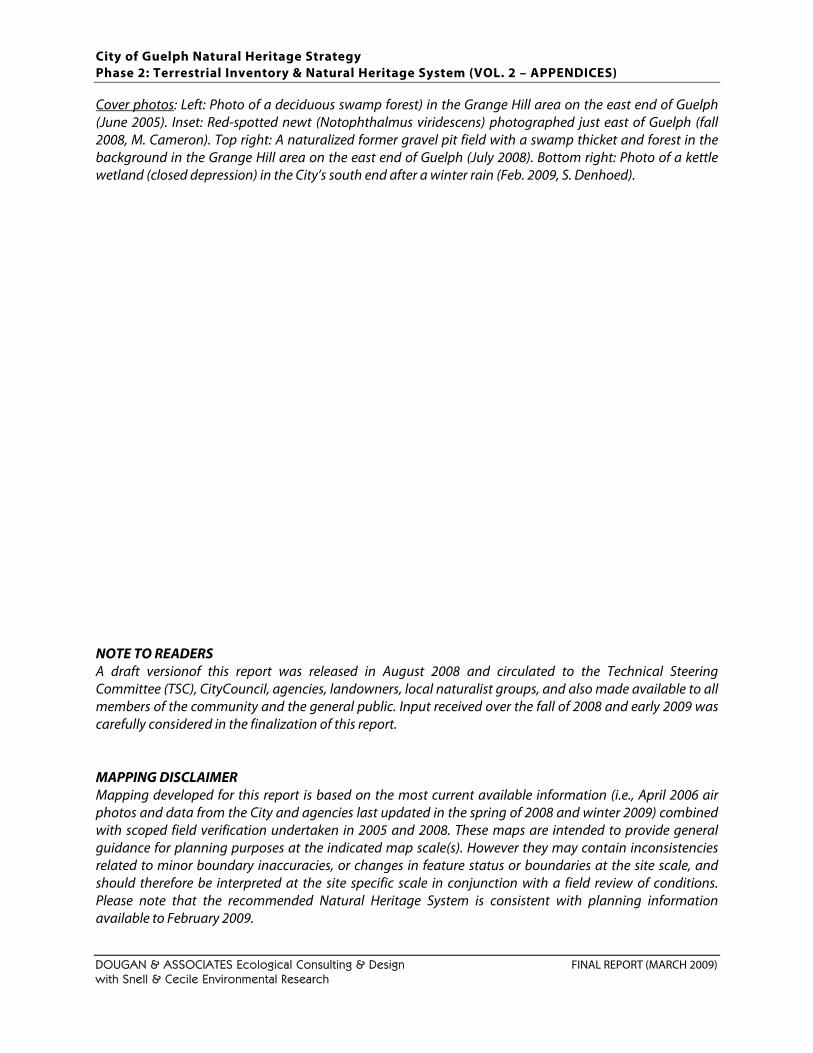
City of Guelph Natural Heritage Strategy Phase 2: Terrestrial Inventory & Natural Heritage System (VOL. 2 – APPENDICES)
DOUGAN & ASSOCIATES Ecological Consulting & Design FINAL REPORT (MARCH 2009) with Snell & Cecile Environmental Research
Cover photos: Left: Photo of a deciduous swamp forest) in the Grange Hill area on the east end of Guelph (June 2005). Inset: Red-spotted newt (Notophthalmus viridescens) photographed just east of Guelph (fall 2008, M. Cameron). Top right: A naturalized former gravel pit field with a swamp thicket and forest in the background in the Grange Hill area on the east end of Guelph (July 2008). Bottom right: Photo of a kettle wetland (closed depression) in the City’s south end after a winter rain (Feb. 2009, S. Denhoed). NOTE TO READERS A draft versionof this report was released in August 2008 and circulated to the Technical Steering Committee (TSC), CityCouncil, agencies, landowners, local naturalist groups, and also made available to all members of the community and the general public. Input received over the fall of 2008 and early 2009 was carefully considered in the finalization of this report. MAPPING DISCLAIMER Mapping developed for this report is based on the most current available information (i.e., April 2006 air photos and data from the City and agencies last updated in the spring of 2008 and winter 2009) combined with scoped field verification undertaken in 2005 and 2008. These maps are intended to provide general guidance for planning purposes at the indicated map scale(s). However they may contain inconsistencies related to minor boundary inaccuracies, or changes in feature status or boundaries at the site scale, and should therefore be interpreted at the site specific scale in conjunction with a field review of conditions. Please note that the recommended Natural Heritage System is consistent with planning information available to February 2009.
City of Guelph Natural Heritage Strategy Phase 2: Terrestrial Inventory & Natural Heritage System (VOL. 2 – APPENDICES)
DOUGAN & ASSOCIATES Ecological Consulting & Design FINAL REPORT (MARCH 2009) with Snell & Cecile Environmental Research
TABLE OF CONTENTS
APPENDIX A. SIGNIFICANT PLANT LIST FOR WELLINGTON COUNTY................................. 1 SIGNIFICANT PLANT LIST DEVELOPMENT ....................................................................................... 1 SIGNIFICANT PLANT LIST FOR WELLINGTON COUNTY.................................................................. 5
APPENDIX B: SIGNIFICANT WILDLIFE LIST FOR WELLINGTON COUNTY........................... 15 APPENDIX B1: DEVELOPMENT OF SIGNIFICANT WILDLIFE SPECIES LIST ...................................... 15 APPENDIX B2: LIST OF SIGNIFICANT WILDLIFE IN WELLINGTON COUNTY.................................. 41
APPENDIX C. NATURAL HERITAGE DATABASE SOURCES................................................... 47 DATA FROM ENVIRONMENTAL STUDIES...................................................................................... 47 PROVINCIAL NATURAL HERITAGE DATABASES ........................................................................... 50 FIELD SURVEY DATA (2004 & 2005).............................................................................................. 51
APPENDIX D. DETAILS OF WILDLIFE SURVEY DATA COLLECTION (2004, 2005) .............. 53
APPENDIX E. DETAILS OF SIGNIFICANT SPECIES MAPPING ................................................ 57
APPENDIX F. EXAMPLES OF NATURAL HERITAGE SYSTEM CRITERIA USED BY OTHER SOUTHERN ONTARIO MUNICIPALITIES............................................................................... 63
APPENDIX G. 2004 & 2005 AMPHIBIAN SURVEY DATABASE.............................................. 65

City of Guelph Natural Heritage Strategy Phase 2: Terrestrial Inventory & Natural Heritage System (VOL. 2 – APPENDICES)
DOUGAN & ASSOCIATES Ecological Consulting & Design FINAL REPORT (MARCH 2009) with Snell & Cecile Environmental Research
This page intentionally left blank to accommodate double-sided printing.
City of Guelph Natural Heritage Strategy Phase 2: Terrestrial Inventory & Natural Heritage System (VOL. 2 – APPENDICES)
DOUGAN & ASSOCIATES Ecological Consulting & Design FINAL REPORT (MARCH 2009) with Snell & Cecile Environmental Research Page 1
APPENDIX A. SIGNIFICANT PLANT LIST FOR WELLINGTON COUNTY
SIGNIFICANT PLANT LIST DEVELOPMENT
Background Species lists for locally1 significant plants have been developed for many municipalities or jurisdictions in southern Ontario (e.g., Region of Waterloo, City of Hamilton, Toronto Region Conservation jurisdiction, Credit Valley Conservation jurisdiction, Region of Halton, Region of Peel, City of Toronto, Region of York, Region of Durham). These lists are useful for natural heritage planning at the local scale because they typically capture species of conservation concern whose habitats require consideration as Significant Wildlife Habitat, as described in the Significant Wildlife Habitat Technical Guidelines (OMNR 2000). These lists typically include locally occurring species that are:
are identified as Special Concern based on Species at Risk in Ontario List; are listed as rare (S1–S3) or historical in Ontario (as per the Natural Heritage Information
Centre (NHIC)); have a high percentage of their global population in Ontario and are locally rare or
uncommon; and are locally rare, even though they may not be provincially rare.
The County of Wellington had no such list at the outset of this study, however, Allan Anderson and Richard Frank had recently completed a draft flora for Wellington County (2004) which they provided to our study team. This flora included 91 species identified as “rare” (i.e., observed at less than 10 sites in the County). However, it was recognized that this list was based on dated rankings and did not capture the full range of species that would be considered locally significant in the County. A volunteer-based ad-hoc committee for the develolopment of a Wellington County Significant Plant List was established, with the City’s endorsement, in the spring of 2005 to assist with the development of a Significant Plant List for the County. This list was intended for use as a screening tool for the City of Guelph’s Natural Heritage Strategy (i.e., specifically the application of the criterion for significant species), and also anticipated to be a useful tool for ongoing and future environmental studies in the City and the County. This committee was coordinated by Margot Ursic of D&A and thanks are extended to the various individuals who provided input to the development of a draft list over 2005: Allan Anderson (co-author of Wellington Flora and local botanist), Dr. John Ambrose (local botanist and Ecological Consultant with expertise in rare species and restoration), Sam Brinker (formerly an Ecologist with D&A, now a Botanist with NHIC), Charles Cecile (field Ecologist for this project and co-principal of Snell & Cecile Environmental Research Inc.), Ragu Subramanyam2 (plant taxonomist and representative for Dr. Steve Newmaster, Assistant Professor in Integrative Biology at the University of Guelph), Tim Zitnack (student of Dr. Steve Newmaster), Mark van Patter (Planner for Wellington County). 1 Locally significant = significant within a given region, watershed area or other jurisdiction defined at the sub-provincial level, such as a County. 2 Dr. Subramanyam and Dr. Newmaster have established and manage the on-line FLORA Ontario – Integrated Botanical Information System (FOIBIS) (http://www.uoguelph.ca/foibis/)
City of Guelph Natural Heritage Strategy Phase 2: Terrestrial Inventory & Natural Heritage System (VOL. 2 – APPENDICES)
DOUGAN & ASSOCIATES Ecological Consulting & Design FINAL REPORT (MARCH 2009) with Snell & Cecile Environmental Research Page 2
WELLINGTON COUNTY SIGNIFICANT PLANT LIST DEVELOPMENT COMMITTEE RESOLUTIONS The committee met two times over 2005 (April 14, 2005 and October 31, 2005) and resolved the following as a basis for development of a working significant plant list that would still need to be peer reviewed. Key points of agreement were as follows:
1. Alan Anderson and Richard Frank’s Flora of Wellington County (1st draft obtained from 2004, still unpublished) was considered the best starting point for determining local significance. The rarity rankings currently assigned to species in the flora are based on Argus et al. (1982-88) for Nationally and Provincially Rare Species, Riley (1989), MacMillan (1976 a,b) and Sutherland (1981) for Regionally Rare Species.
2. Given that the current flora has used 10 sites as a basis for ‘rarity’ and there is very little
likelihood of an updated ESA study being done in the County any time soon, it was decided to adopt this threshold (i.e., plant species being recorded at between 1 and 10 sites) as a basis for significance in the County with a “site” being an ESA or otherwise identified natural area.
3. Nomenclature should be consistent with the Ontario Plant List (Newmaster et al. 1998) and the
Flora of Ontario, currently available on-line through the University of Guelph.
4. Records for species never before recorded in the County identified through field data collected for the City of Guelph as part of Phase 2 of the Natural Heritage Strategy should be added to the list.
5. Any designated Species at Risk (i.e., nationally or provincially designated as Endangered,
Threatened or Special Concern), as well as provincially rare plants (i.e., S1 through S3 as defined by NHIC) not included in the original flora as “rare” but recorded in the City (or County) should be added to the list.
6. Ongoing consultations are required with Allan Anderson, main author of the local flora.
7. Additional data sources that could be consulted as part of a peer review and list finalization
process include: Draft Great Lakes Target Species List, ANSI Reports (obtain from OMNR), Tony Zammit at GRCA and local naturalists (e.g., Don Britton, Bill McIlveen, Carl Rothfels, Dan Kraus, Donald Kirk, Bill Crins and / or Mike Oldham, Anthony Goodban, Paul Eagles).
Over 2005 and 2006 records and additional input were provided by Mike Oldham (Botanist at NHIC with extensive knowledge of Ontario’s flora) and Dan Kraus (Nature Conservancy of Canada) who provided a draft list of target species for the Great Lakes.
City of Guelph Natural Heritage Strategy Phase 2: Terrestrial Inventory & Natural Heritage System (VOL. 2 – APPENDICES)
DOUGAN & ASSOCIATES Ecological Consulting & Design FINAL REPORT (MARCH 2009) with Snell & Cecile Environmental Research Page 3
SIGNIFICANT PLANT LIST DEVELOPMENT The Significant Plant List for Wellington County, as presented below, is a synthesis of the following:
Species identified in the Wellington County flora (Anderson and Frank, 2004 Draft, still unpublished) with a few subsequent revisions and additions by Allan Anderson (via email) between 2005 and 2007. In all cases “rare” refers to a population being known in 10 or less sites in the County3.
New records for the County from field work conducted for this study. Species ranked as Provincially Rare (i.e., S1, S2, S3 or S3-S4), as posted on the Natural Heritage
Information Center (as of December 2007) and recorded in the Guelph Natural Heritage Database from 2005 field studies, subsequent 2006 observations, or other background reports.4
Species known to occur in Wellington County and considered rare by Mike Oldham (Botanist, NHIC) with expertise in Ontario plant species distributions.
Exclusion of a few species from the Wellington County’s “rare” listing based on: (a) their being considered non-native invasives (i.e., Festura rubra ssp. rubra and Gleditsia triacanthos), or (b) species of questionable origin (e.g., very far removed outside their native range and considered to be either mis-identifications or introduced) (i.e., Hydrophyllum apendiculatum), hybrids, or species of uncertain subspecies distinctions.
This list was then circulated to Allan Anderson and Mike Oldham for screening and peer review (Nov. – Dec. 2007) and re-circulated to the members of the Wellington County Significant Plant List Committee, as well as the Guelph District OMNR (Don Kirk) and County of Wellington for comment (March 2008) before finalization of the list as provided below. This list currently contains 282 species. This list has been consolidated by Margot Ursic, Project Manager for the Guelph Natural Heritage Strategy with D&A, with assistance from Charles Cecile who has integrated changes and verified records where required. This list should be considered a working list to be reviewed and updated as new species records for the County are uncovered and as plant statuses (and nomenclature) change. Notably, the OMNR (Don Kirk, District Biologist), GRCA (Tony Zammit, Ecologist) and County of Wellington (Mark Van Patter, Senior Planner) have expressed their general support for and endorsement of this list.
3 The use of numbers of sites in a given jurisdiction with confirmed plant species records is a fairly common way, in the absence of current and broad-based inventory data, of assigning rarity. For example, in the Region of Waterloo the number of sites is 12 or less; in the former City of Toronto the number of sites is 6 while in the GTA the number of sites is 40. 4 Plant records for species identified in background studies that were questionable (e.g., hard to identify species never before recorded in the County or nearby jurisdictions) were not included.

City of Guelph Natural Heritage Strategy Phase 2: Terrestrial Inventory & Natural Heritage System (VOL. 2 – APPENDICES)
DOUGAN & ASSOCIATES Ecological Consulting & Design FINAL REPORT (MARCH 2009) with Snell & Cecile Environmental Research Page 4
This page intentionally left blank to accommodate double-sided printing.
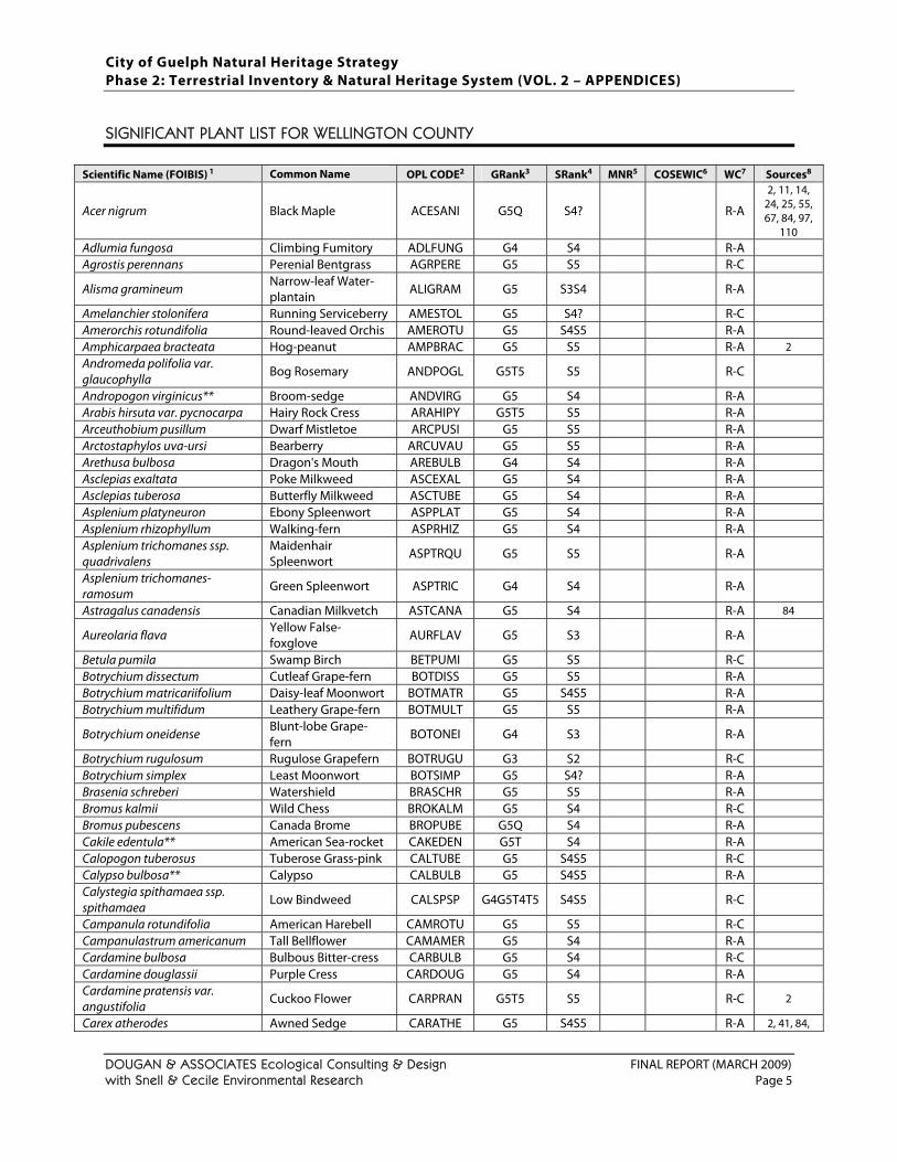
City of Guelph Natural Heritage Strategy Phase 2: Terrestrial Inventory & Natural Heritage System (VOL. 2 – APPENDICES)
DOUGAN & ASSOCIATES Ecological Consulting & Design FINAL REPORT (MARCH 2009) with Snell & Cecile Environmental Research Page 5
SIGNIFICANT PLANT LIST FOR WELLINGTON COUNTY
Scientific Name (FOIBIS) 1 Common Name OPL CODE2 GRank3 SRank4 MNR5 COSEWIC6 WC7 Sources8
Acer nigrum Black Maple ACESANI G5Q S4? R-A
2, 11, 14, 24, 25, 55, 67, 84, 97,
110 Adlumia fungosa Climbing Fumitory ADLFUNG G4 S4 R-A Agrostis perennans Perenial Bentgrass AGRPERE G5 S5 R-C
Alisma gramineum Narrow-leaf Water-plantain ALIGRAM G5 S3S4 R-A
Amelanchier stolonifera Running Serviceberry AMESTOL G5 S4? R-C Amerorchis rotundifolia Round-leaved Orchis AMEROTU G5 S4S5 R-A Amphicarpaea bracteata Hog-peanut AMPBRAC G5 S5 R-A 2 Andromeda polifolia var. glaucophylla
Bog Rosemary ANDPOGL G5T5 S5 R-C
Andropogon virginicus** Broom-sedge ANDVIRG G5 S4 R-A Arabis hirsuta var. pycnocarpa Hairy Rock Cress ARAHIPY G5T5 S5 R-A Arceuthobium pusillum Dwarf Mistletoe ARCPUSI G5 S5 R-A Arctostaphylos uva-ursi Bearberry ARCUVAU G5 S5 R-A Arethusa bulbosa Dragon's Mouth AREBULB G4 S4 R-A Asclepias exaltata Poke Milkweed ASCEXAL G5 S4 R-A Asclepias tuberosa Butterfly Milkweed ASCTUBE G5 S4 R-A Asplenium platyneuron Ebony Spleenwort ASPPLAT G5 S4 R-A Asplenium rhizophyllum Walking-fern ASPRHIZ G5 S4 R-A Asplenium trichomanes ssp. quadrivalens
Maidenhair Spleenwort ASPTRQU G5 S5 R-A
Asplenium trichomanes-ramosum Green Spleenwort ASPTRIC G4 S4 R-A
Astragalus canadensis Canadian Milkvetch ASTCANA G5 S4 R-A 84
Aureolaria flava Yellow False-foxglove AURFLAV G5 S3 R-A
Betula pumila Swamp Birch BETPUMI G5 S5 R-C Botrychium dissectum Cutleaf Grape-fern BOTDISS G5 S5 R-A Botrychium matricariifolium Daisy-leaf Moonwort BOTMATR G5 S4S5 R-A Botrychium multifidum Leathery Grape-fern BOTMULT G5 S5 R-A
Botrychium oneidense Blunt-lobe Grape-fern BOTONEI G4 S3 R-A
Botrychium rugulosum Rugulose Grapefern BOTRUGU G3 S2 R-C Botrychium simplex Least Moonwort BOTSIMP G5 S4? R-A Brasenia schreberi Watershield BRASCHR G5 S5 R-A Bromus kalmii Wild Chess BROKALM G5 S4 R-C Bromus pubescens Canada Brome BROPUBE G5Q S4 R-A Cakile edentula** American Sea-rocket CAKEDEN G5T S4 R-A Calopogon tuberosus Tuberose Grass-pink CALTUBE G5 S4S5 R-C Calypso bulbosa** Calypso CALBULB G5 S4S5 R-A Calystegia spithamaea ssp. spithamaea
Low Bindweed CALSPSP G4G5T4T5 S4S5 R-C
Campanula rotundifolia American Harebell CAMROTU G5 S5 R-C Campanulastrum americanum Tall Bellflower CAMAMER G5 S4 R-A Cardamine bulbosa Bulbous Bitter-cress CARBULB G5 S4 R-C Cardamine douglassii Purple Cress CARDOUG G5 S4 R-A Cardamine pratensis var. angustifolia
Cuckoo Flower CARPRAN G5T5 S5 R-C 2
Carex atherodes Awned Sedge CARATHE G5 S4S5 R-A 2, 41, 84,
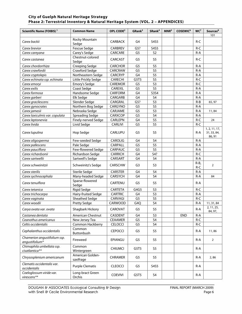
City of Guelph Natural Heritage Strategy Phase 2: Terrestrial Inventory & Natural Heritage System (VOL. 2 – APPENDICES)
DOUGAN & ASSOCIATES Ecological Consulting & Design FINAL REPORT (MARCH 2009) with Snell & Cecile Environmental Research Page 6
Scientific Name (FOIBIS) 1 Common Name OPL CODE2 GRank3 SRank4 MNR5 COSEWIC6 WC7 Sources8 101
Carex backii Rocky Mountain Sedge CARBACK G4 S4S5 R-C
Carex brevior Fescue Sedge CARBREV G5? S4S5 R-C Carex careyana Carey's Sedge CARCARE G5 S2 R-A
Carex castanea Chestnut-colored Sedge
CARCAST G5 S5 R-C
Carex chordorrhiza Creeping Sedge CARCHOR G5 S5 R-A Carex crawfordii Crawford Sedge CARCRAW G5 S5 R-A Carex cryptolepis Northeastern Sedge CARCRYP G4 S5 R-A Carex echinata ssp. echinata Little Prickly Sedge CARECHI G5T5 S5 R-C Carex emoryi Emory's Sedge CAREMOR G5 S3 R-C Carex exilis Coast Sedge CAREXIL G5 S5 R-A Carex formosa Handsome Sedge CARFORM G4 S3S4 R-A Carex garberi Elk Sedge CARGARB G4 S4 R-A Carex gracilescens Slender Sedge CARGRAL G5? S3 R-B 65, 97 Carex gynocrates Northern Bog Sedge CARGYNO G5 S5 R-A Carex jamesii Nebraska Sedge CARJAME G5 S3 R-A 11, 84 Carex laxiculmis var. copulata Spreading Sedge CARXCOP G5 S4 R-A Carex leptonervia Finely-nerved Sedge CARLEPN G4 S5 R-C 24 Carex livida Livid Sedge CARLIVI G5 S5 R-C
Carex lupulina Hop Sedge CARLUPU G5 S5 R-A 1, 2, 11, 17, 31, 33, 84,
86, 91 Carex oligosperma Few-seeded Sedge CAROLIG G4 S4 R-A Carex pallescens Pale Sedge CARPALL G5 S5 R-A Carex pauciflora Few-flowered Sedge CARPAUC G5 S5 R-A Carex richardsonii Richardson Sedge CARRICH G4 S4? R-C Carex sartwellii Sartwell's Sedge CARSART G4 S4 R-A
Carex schweinitzii Schweinitz's Sedge CARSCHW G3 S3 R-B, R-C
2
Carex sterilis Sterile Sedge CARSTER G4 S4 R-A Carex sychnocephala Many-headed Sedge CARSYCH G4 S4 R-A 84
Carex tenuiflora Sparse-flowered Sedge CARTENU G5 S5 R-A
Carex tetanica Rigid Sedge CARTETA G4G5 S3 R-C Carex trichocarpa Hairy-fruited Sedge CARTRIC G4 S3 R-A Carex vaginata Sheathed Sedge CARVAGI G5 S5 R-C Carex woodii Pretty Sedge CARWOOD G4Q S4 R-A 11, 31, 84
Carya ovata var. ovata Shagbark Hickory CAROVAT G5 S5 R-A 2, 11, 25, 84, 97,
Castanea dentata American Chestnut CASDENT G4 S3 END R-A Ceanothus americanus New Jersey Tea CEAAMER G5 S4 R-C Celtis occidentalis Common Hackberry CELOCCI G5 S4 R-C
Cephalanthus occidentalis Common Buttonbush CEPOCCI G5 S5 R-A 11, 86
Chamerion angustifolium ssp. angustifolium* Fireweed EPIANGU G5 S5 R-A 2
Chimaphila umbellata ssp. cisatlantica**
Common Wintergreen CHIUMCI G5T5 S5 R-A
Chrysosplenium americanum American Golden-saxifrage
CHRAMER G5 S5 R-A 2, 86
Clematis occidentalis var. occidentalis
Purple Clematis CLEOCCI G5 S4S5 R-A
Coeloglossum viride var. virescens**
Long-bract Green Orchis COEVIVI G5T5 S4 R-A
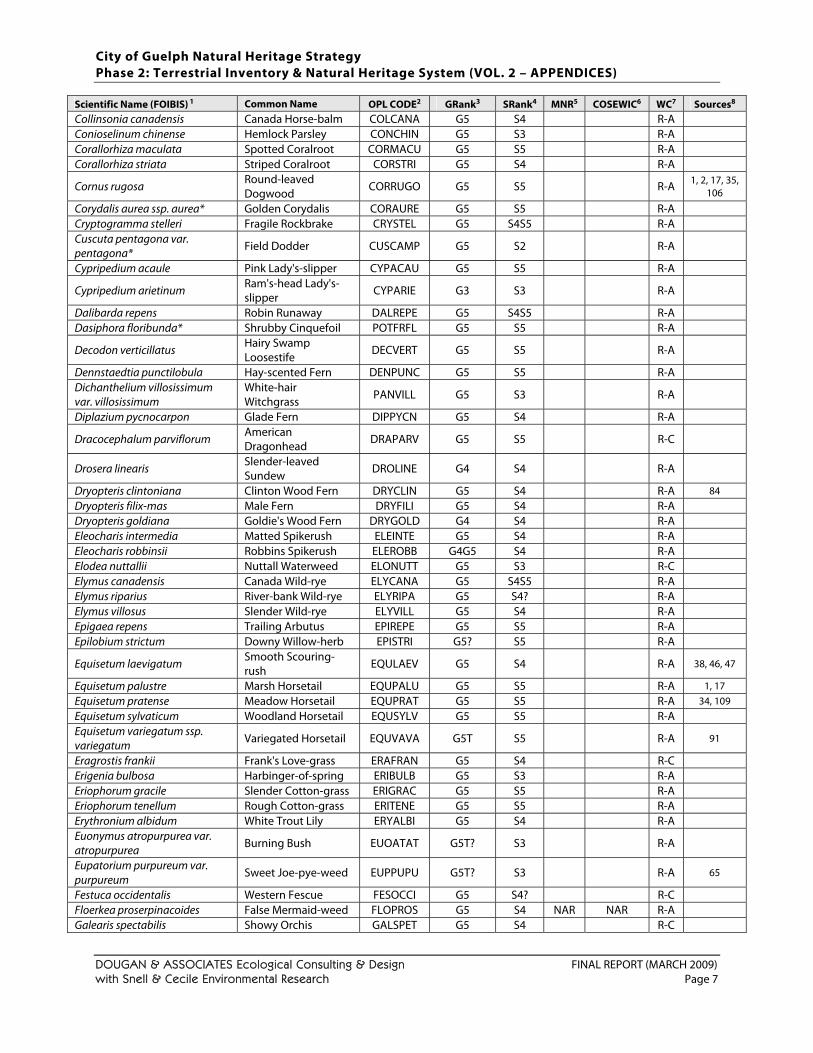
City of Guelph Natural Heritage Strategy Phase 2: Terrestrial Inventory & Natural Heritage System (VOL. 2 – APPENDICES)
DOUGAN & ASSOCIATES Ecological Consulting & Design FINAL REPORT (MARCH 2009) with Snell & Cecile Environmental Research Page 7
Scientific Name (FOIBIS) 1 Common Name OPL CODE2 GRank3 SRank4 MNR5 COSEWIC6 WC7 Sources8 Collinsonia canadensis Canada Horse-balm COLCANA G5 S4 R-A Conioselinum chinense Hemlock Parsley CONCHIN G5 S3 R-A Corallorhiza maculata Spotted Coralroot CORMACU G5 S5 R-A Corallorhiza striata Striped Coralroot CORSTRI G5 S4 R-A
Cornus rugosa Round-leaved Dogwood
CORRUGO G5 S5 R-A 1, 2, 17, 35, 106
Corydalis aurea ssp. aurea* Golden Corydalis CORAURE G5 S5 R-A Cryptogramma stelleri Fragile Rockbrake CRYSTEL G5 S4S5 R-A Cuscuta pentagona var. pentagona* Field Dodder CUSCAMP G5 S2 R-A
Cypripedium acaule Pink Lady's-slipper CYPACAU G5 S5 R-A
Cypripedium arietinum Ram's-head Lady's-slipper CYPARIE G3 S3 R-A
Dalibarda repens Robin Runaway DALREPE G5 S4S5 R-A Dasiphora floribunda* Shrubby Cinquefoil POTFRFL G5 S5 R-A
Decodon verticillatus Hairy Swamp Loosestife
DECVERT G5 S5 R-A
Dennstaedtia punctilobula Hay-scented Fern DENPUNC G5 S5 R-A Dichanthelium villosissimum var. villosissimum
White-hair Witchgrass PANVILL G5 S3 R-A
Diplazium pycnocarpon Glade Fern DIPPYCN G5 S4 R-A
Dracocephalum parviflorum American Dragonhead DRAPARV G5 S5 R-C
Drosera linearis Slender-leaved Sundew DROLINE G4 S4 R-A
Dryopteris clintoniana Clinton Wood Fern DRYCLIN G5 S4 R-A 84 Dryopteris filix-mas Male Fern DRYFILI G5 S4 R-A Dryopteris goldiana Goldie's Wood Fern DRYGOLD G4 S4 R-A Eleocharis intermedia Matted Spikerush ELEINTE G5 S4 R-A Eleocharis robbinsii Robbins Spikerush ELEROBB G4G5 S4 R-A Elodea nuttallii Nuttall Waterweed ELONUTT G5 S3 R-C Elymus canadensis Canada Wild-rye ELYCANA G5 S4S5 R-A Elymus riparius River-bank Wild-rye ELYRIPA G5 S4? R-A Elymus villosus Slender Wild-rye ELYVILL G5 S4 R-A Epigaea repens Trailing Arbutus EPIREPE G5 S5 R-A Epilobium strictum Downy Willow-herb EPISTRI G5? S5 R-A
Equisetum laevigatum Smooth Scouring-rush EQULAEV G5 S4 R-A 38, 46, 47
Equisetum palustre Marsh Horsetail EQUPALU G5 S5 R-A 1, 17 Equisetum pratense Meadow Horsetail EQUPRAT G5 S5 R-A 34, 109 Equisetum sylvaticum Woodland Horsetail EQUSYLV G5 S5 R-A Equisetum variegatum ssp. variegatum Variegated Horsetail EQUVAVA G5T S5 R-A 91
Eragrostis frankii Frank's Love-grass ERAFRAN G5 S4 R-C Erigenia bulbosa Harbinger-of-spring ERIBULB G5 S3 R-A Eriophorum gracile Slender Cotton-grass ERIGRAC G5 S5 R-A Eriophorum tenellum Rough Cotton-grass ERITENE G5 S5 R-A Erythronium albidum White Trout Lily ERYALBI G5 S4 R-A Euonymus atropurpurea var. atropurpurea Burning Bush EUOATAT G5T? S3 R-A
Eupatorium purpureum var. purpureum
Sweet Joe-pye-weed EUPPUPU G5T? S3 R-A 65
Festuca occidentalis Western Fescue FESOCCI G5 S4? R-C Floerkea proserpinacoides False Mermaid-weed FLOPROS G5 S4 NAR NAR R-A Galearis spectabilis Showy Orchis GALSPET G5 S4 R-C
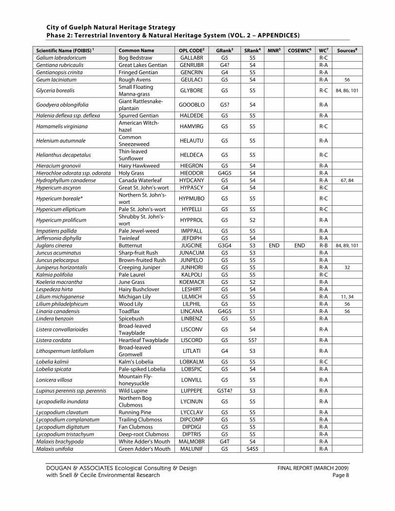
City of Guelph Natural Heritage Strategy Phase 2: Terrestrial Inventory & Natural Heritage System (VOL. 2 – APPENDICES)
DOUGAN & ASSOCIATES Ecological Consulting & Design FINAL REPORT (MARCH 2009) with Snell & Cecile Environmental Research Page 8
Scientific Name (FOIBIS) 1 Common Name OPL CODE2 GRank3 SRank4 MNR5 COSEWIC6 WC7 Sources8 Galium labradoricum Bog Bedstraw GALLABR G5 S5 R-C Gentiana rubricaulis Great Lakes Gentian GENRUBR G4? S4 R-A Gentianopsis crinita Fringed Gentian GENCRIN G4 S5 R-A Geum laciniatum Rough Avens GEULACI G5 S4 R-A 56
Glyceria borealis Small Floating Manna-grass
GLYBORE G5 S5 R-C 84, 86, 101
Goodyera oblongifolia Giant Rattlesnake-plantain
GOOOBLO G5? S4 R-A
Halenia deflexa ssp. deflexa Spurred Gentian HALDEDE G5 S5 R-A
Hamamelis virginiana American Witch-hazel HAMVIRG G5 S5 R-C
Helenium autumnale Common Sneezeweed HELAUTU G5 S5 R-A
Helianthus decapetalus Thin-leaved Sunflower HELDECA G5 S5 R-C
Hieracium gronovii Hairy Hawkweed HIEGRON G5 S4 R-A Hierochloe odorata ssp. odorata Holy Grass HIEODOR G4G5 S4 R-A Hydrophyllum canadense Canada Waterleaf HYDCANY G5 S4 R-A 67, 84 Hypericum ascyron Great St. John's-wort HYPASCY G4 S4 R-C
Hypericum boreale* Northern St. John's-wort HYPMUBO G5 S5 R-C
Hypericum ellipticum Pale St. John's-wort HYPELLI G5 S5 R-C
Hypericum prolificum Shrubby St. John's-wort HYPPROL G5 S2 R-A
Impatiens pallida Pale Jewel-weed IMPPALL G5 S5 R-A Jeffersonia diphylla Twinleaf JEFDIPH G5 S4 R-A Juglans cinerea Butternut JUGCINE G3G4 S3 END END R-B 84, 89, 101 Juncus acuminatus Sharp-fruit Rush JUNACUM G5 S3 R-A Juncus pelocarpus Brown-fruited Rush JUNPELO G5 S5 R-A Juniperus horizontalis Creeping Juniper JUNHORI G5 S5 R-A 32 Kalmia polifolia Pale Laurel KALPOLI G5 S5 R-C Koeleria macrantha June Grass KOEMACR G5 S2 R-A Lespedeza hirta Hairy Bushclover LESHIRT G5 S4 R-A Lilium michiganense Michigan Lily LILMICH G5 S5 R-A 11, 34 Lilium philadelphicum Wood Lily LILPHIL G5 S5 R-A 56 Linaria canadensis Toadflax LINCANA G4G5 S1 R-A 56 Lindera benzoin Spicebush LINBENZ G5 S5 R-A
Listera convallarioides Broad-leaved Twayblade LISCONV G5 S4 R-A
Listera cordata Heartleaf Twayblade LISCORD G5 S5? R-A
Lithospermum latifolium Broad-leaved Gromwell
LITLATI G4 S3 R-A
Lobelia kalmii Kalm's Lobelia LOBKALM G5 S5 R-C Lobelia spicata Pale-spiked Lobelia LOBSPIC G5 S4 R-A
Lonicera villosa Mountain Fly-honeysuckle LONVILL G5 S5 R-A
Lupinus perennis ssp. perennis Wild Lupine LUPPEPE G5T4? S3 R-A
Lycopodiella inundata Northern Bog Clubmoss LYCINUN G5 S5 R-A
Lycopodium clavatum Running Pine LYCCLAV G5 S5 R-A Lycopodium complanatum Trailing Clubmoss DIPCOMP G5 S5 R-A Lycopodium digitatum Fan Clubmoss DIPDIGI G5 S5 R-A Lycopodium tristachyum Deep-root Clubmoss DIPTRIS G5 S5 R-A Malaxis brachypoda White Adder's Mouth MALMOBR G4T S4 R-A Malaxis unifolia Green Adder's Mouth MALUNIF G5 S4S5 R-A
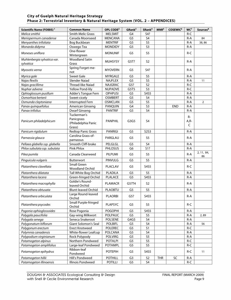
City of Guelph Natural Heritage Strategy Phase 2: Terrestrial Inventory & Natural Heritage System (VOL. 2 – APPENDICES)
DOUGAN & ASSOCIATES Ecological Consulting & Design FINAL REPORT (MARCH 2009) with Snell & Cecile Environmental Research Page 9
Scientific Name (FOIBIS) 1 Common Name OPL CODE2 GRank3 SRank4 MNR5 COSEWIC6 WC7 Sources8 Melica smithii Smith Melic Grass MELSMIT G4 S4? R-C Menispermum canadense Canada Moonseed MENCANA G5 S4 R-A 84 Menyanthes trifoliata Bog Buckbean MENTRIF G5 S5 R-A 38, 86 Monarda didyma Oswego Tea MONDIDY G5 S3 R-A
Moneses uniflora One-flower Wintergreen
MONUNIF G5 S5 R-C
Muhlenbergia sylvatica var. sylvatica
Woodland Satin Grass
MUHSYSY G5T? S2 R-A
Myosotis verna Spring Forget-me-not
MYOVERN G5 S4? R-A
Myrica gale Sweet Gale MYRGALE G5 S5 R-A Najas flexilis Slender Naiad NAJFLEX G5 S5 R-A 11 Najas gracillima Thread-like Naiad NAJGRAC G5? S2 R-C Nuphar advena Yellow Pond-lily NUPADVE G5T5 S3 R-C Ophioglossum pusillum Adder's Tongue Fern OPHPUSI G5 S4S5 R-A Osmorhiza berterii Sweet-cicely OSMBERT G5 S4 R-A Osmunda claytoniana Interrupted Fern OSMCLAN G5 S5 R-A 2 Panax quinquefolius American Ginseng PANQUIN G4 S3 END R-A Panax trifolius Dwarf Ginseng PANTRIF G5 S4 R-A
Panicum philadelphicum
Tuckerman's Panicgrass (Philadelphia Panic Grass)
PANPHIL G3G5 S4 R-
A,R-C
Panicum rigidulum Redtop Panic Grass PANRIGI G5 S2S3 R-A
Parnassia glauca Carolina Grass-of-parnassus PARGLAU G5 S5 R-A
Pellaea glabella ssp. glabella Smooth Cliff-brake PELGLGL G5 S4 R-A Phlox subulata ssp. subulata Pink Phlox PHLOSUS G6 S1? R-A
Pilea pumila Canada Clearweed PILPUMI G5 S5 R-A 2, 11, 84, 86
Pinguicula vulgaris Butterwort PINVULG G5 S5 R-A
Platanthera clavellata Small Green Woodland Orchid PLACLAV G5 S4S5 R-C
Platanthera dilatata Tall White Bog Orchid PLADILA G5 S5 R-A Platanthera lacera Green-fringed Orchid PLALACE G5 S4S5 R-A
Platanthera macrophylla Goldie's Round-leaved Orchid
PLAMACR G5?T4 S2 R-A
Platanthera obtusata Blunt-leaved Orchid PLAOBTU G5 S5 R-A
Platanthera orbiculata Large Round-leaved Orchid PLAORBI G5? S4S5 R-A
Platanthera psycodes Small Purple-fringed Orchid PLAPSYC G5 S5 R-C
Pogonia ophioglossoides Rose Pogonia POGOPHI G5 S4S5 R-A Polygala paucifolia Gay-wing Milkwort POLPAUC G5 S5 R-A 2, 89 Polygala senega Seneca Snakeroot POLSENE G4G5 S4 R-A Polygonatum biflorum Giant Solomon's Seal POLBIFL G5 S4 R-A 56 Polygonum erectum Erect Knotweed POLEREC G5 S1 R-C Polymnia canadensis White-flower Leafcup POLCANA G5 S4 R-A Polypodium virginianum Rock Polypody POLVIRG G5 S5 R-A Potamogeton alpinus Northern Pondweed POTALPI G5 S5 R-C Potamogeton amplifolius Large-leaf Pondweed POTAMPL G5 S5 R-C
Potamogeton epihydrus Ribbon-leaf Pondweed POTEPIH G5 S4S5 R-C 11
Potamogeton hillii Hill's Pondweed POTHILL G3 S2 THR SC R-A Potamogeton illinoensis Illinois Pondweed POTILLI G5 S4 R-C
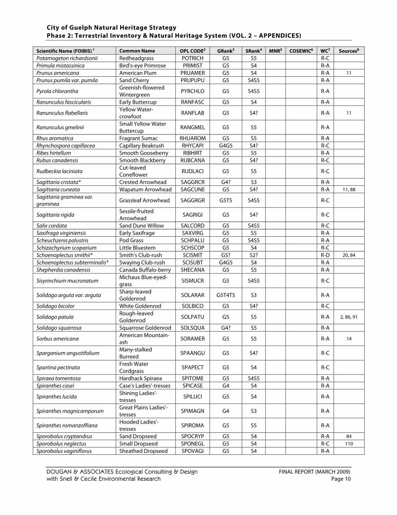
City of Guelph Natural Heritage Strategy Phase 2: Terrestrial Inventory & Natural Heritage System (VOL. 2 – APPENDICES)
DOUGAN & ASSOCIATES Ecological Consulting & Design FINAL REPORT (MARCH 2009) with Snell & Cecile Environmental Research Page 10
Scientific Name (FOIBIS) 1 Common Name OPL CODE2 GRank3 SRank4 MNR5 COSEWIC6 WC7 Sources8 Potamogeton richardsonii Redheadgrass POTRICH G5 S5 R-C Primula mistassinica Bird's-eye Primrose PRIMIST G5 S4 R-A Prunus americana American Plum PRUAMER G5 S4 R-A 11 Prunus pumila var. pumila Sand Cherry PRUPUPU G5 S4S5 R-A
Pyrola chlorantha Greenish-flowered Wintergreen
PYRCHLO G5 S4S5 R-A
Ranunculus fascicularis Early Buttercup RANFASC G5 S4 R-A
Ranunculus flabellaris Yellow Water-crowfoot RANFLAB G5 S4? R-A 11
Ranunculus gmelinii Small Yellow Water Buttercup RANGMEL G5 S5 R-A
Rhus aromatica Fragrant Sumac RHUAROM G5 S5 R-A Rhynchospora capillacea Capillary Beakrush RHYCAPI G4G5 S4? R-C Ribes hirtellum Smooth Gooseberry RIBHIRT G5 S5 R-A Rubus canadensis Smooth Blackberry RUBCANA G5 S4? R-C
Rudbeckia laciniata Cut-leaved Coneflower RUDLACI G5 S5 R-C
Sagittaria cristata* Crested Arrowhead SAGGRCR G4? S3 R-A Sagittaria cuneata Wapatum Arrowhead SAGCUNE G5 S4? R-A 11, 88 Sagittaria graminea var. graminea Grassleaf Arrowhead SAGGRGR G5T5 S4S5 R-C
Sagittaria rigida Sessile-fruited Arrowhead SAGRIGI G5 S4? R-C
Salix cordata Sand Dune Willow SALCORD G5 S4S5 R-C Saxifraga virginiensis Early Saxifrage SAXVIRG G5 S5 R-A Scheuchzeria palustris Pod Grass SCHPALU G5 S4S5 R-A Schizachyrium scoparium Little Bluestem SCHSCOP G5 S4 R-C Schoenoplectus smithii* Smith's Club-rush SCISMIT G5? S2? R-D 20, 84 Schoenoplectus subterminalis* Swaying Club-rush SCISUBT G4G5 S4 R-A Shepherdia canadensis Canada Buffalo-berry SHECANA G5 S5 R-A
Sisyrinchium mucronatum Michaux Blue-eyed-grass SISMUCR G5 S4S5 R-C
Solidago arguta var. arguta Sharp-leaved Goldenrod SOLARAR G5T4T5 S3 R-A
Solidago bicolor White Goldenrod SOLBICO G5 S4? R-C
Solidago patula Rough-leaved Goldenrod SOLPATU G5 S5 R-A 2, 86, 91
Solidago squarrosa Squarrose Goldenrod SOLSQUA G4? S5 R-A
Sorbus americana American Mountain-ash SORAMER G5 S5 R-A 14
Sparganium angustifolium Many-stalked Burreed
SPAANGU G5 S4? R-C
Spartina pectinata Fresh Water Cordgrass
SPAPECT G5 S4 R-C
Spiraea tomentosa Hardhack Spiraea SPITOME G5 S4S5 R-A Spiranthes casei Case's Ladies'-tresses SPICASE G4 S4 R-A
Spiranthes lucida Shining Ladies'-tresses SPILUCI G5 S4 R-A
Spiranthes magnicamporum Great Plains Ladies'-tresses SPIMAGN G4 S3 R-A
Spiranthes romanzoffiana Hooded Ladies'-tresses SPIROMA G5 S5 R-A
Sporobolus cryptandrus Sand Dropseed SPOCRYP G5 S4 R-A 84 Sporobolus neglectus Small Dropseed SPONEGL G5 S4 R-C 110 Sporobolus vaginiflorus Sheathed Dropseed SPOVAGI G5 S4 R-A
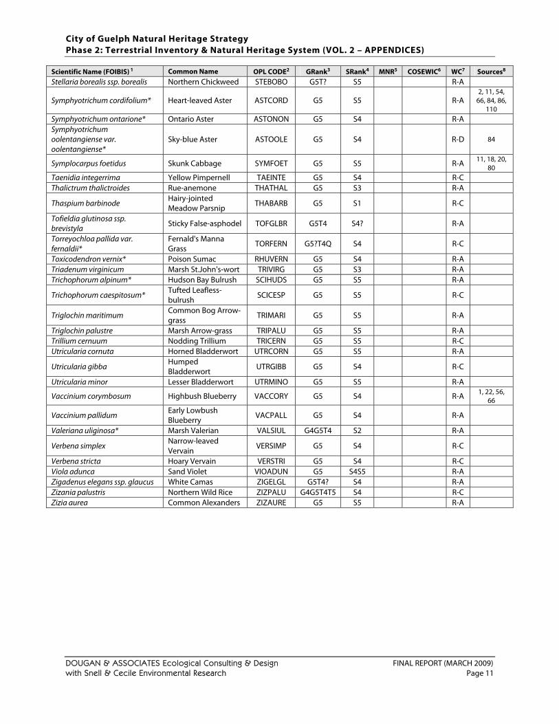
City of Guelph Natural Heritage Strategy Phase 2: Terrestrial Inventory & Natural Heritage System (VOL. 2 – APPENDICES)
DOUGAN & ASSOCIATES Ecological Consulting & Design FINAL REPORT (MARCH 2009) with Snell & Cecile Environmental Research Page 11
Scientific Name (FOIBIS) 1 Common Name OPL CODE2 GRank3 SRank4 MNR5 COSEWIC6 WC7 Sources8 Stellaria borealis ssp. borealis Northern Chickweed STEBOBO G5T? S5 R-A
Symphyotrichum cordifolium* Heart-leaved Aster ASTCORD G5 S5 R-A 2, 11, 54,
66, 84, 86, 110
Symphyotrichum ontarione* Ontario Aster ASTONON G5 S4 R-A Symphyotrichum oolentangiense var. oolentangiense*
Sky-blue Aster ASTOOLE G5 S4 R-D 84
Symplocarpus foetidus Skunk Cabbage SYMFOET G5 S5 R-A 11, 18, 20, 80
Taenidia integerrima Yellow Pimpernell TAEINTE G5 S4 R-C Thalictrum thalictroides Rue-anemone THATHAL G5 S3 R-A
Thaspium barbinode Hairy-jointed Meadow Parsnip THABARB G5 S1 R-C
Tofieldia glutinosa ssp. brevistyla Sticky False-asphodel TOFGLBR G5T4 S4? R-A
Torreyochloa pallida var. fernaldii*
Fernald's Manna Grass TORFERN G5?T4Q S4 R-C
Toxicodendron vernix* Poison Sumac RHUVERN G5 S4 R-A Triadenum virginicum Marsh St.John's-wort TRIVIRG G5 S3 R-A Trichophorum alpinum* Hudson Bay Bulrush SCIHUDS G5 S5 R-A
Trichophorum caespitosum* Tufted Leafless-bulrush SCICESP G5 S5 R-C
Triglochin maritimum Common Bog Arrow-grass TRIMARI G5 S5 R-A
Triglochin palustre Marsh Arrow-grass TRIPALU G5 S5 R-A Trillium cernuum Nodding Trillium TRICERN G5 S5 R-C Utricularia cornuta Horned Bladderwort UTRCORN G5 S5 R-A
Utricularia gibba Humped Bladderwort UTRGIBB G5 S4 R-C
Utricularia minor Lesser Bladderwort UTRMINO G5 S5 R-A
Vaccinium corymbosum Highbush Blueberry VACCORY G5 S4 R-A 1, 22, 56, 66
Vaccinium pallidum Early Lowbush Blueberry VACPALL G5 S4 R-A
Valeriana uliginosa* Marsh Valerian VALSIUL G4G5T4 S2 R-A
Verbena simplex Narrow-leaved Vervain
VERSIMP G5 S4 R-C
Verbena stricta Hoary Vervain VERSTRI G5 S4 R-C Viola adunca Sand Violet VIOADUN G5 S4S5 R-A Zigadenus elegans ssp. glaucus White Camas ZIGELGL G5T4? S4 R-A Zizania palustris Northern Wild Rice ZIZPALU G4G5T4T5 S4 R-C Zizia aurea Common Alexanders ZIZAURE G5 S5 R-A
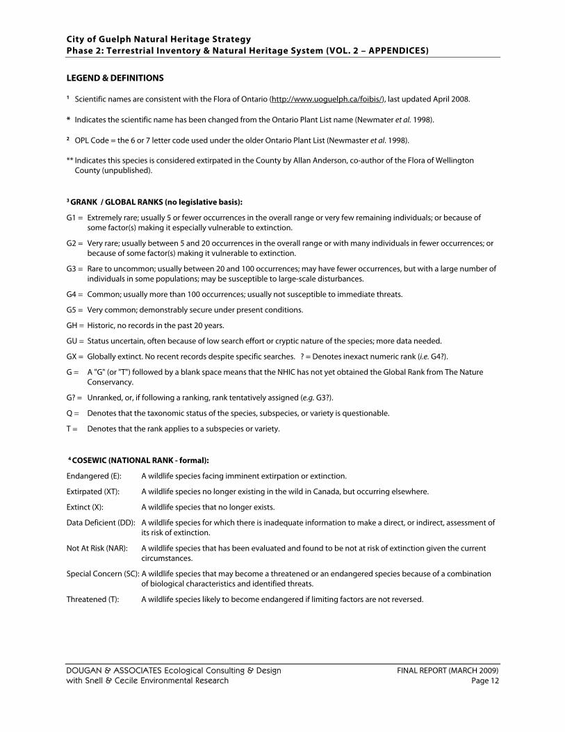
City of Guelph Natural Heritage Strategy Phase 2: Terrestrial Inventory & Natural Heritage System (VOL. 2 – APPENDICES)
DOUGAN & ASSOCIATES Ecological Consulting & Design FINAL REPORT (MARCH 2009) with Snell & Cecile Environmental Research Page 12
LEGEND & DEFINITIONS
1 Scientific names are consistent with the Flora of Ontario (http://www.uoguelph.ca/foibis/), last updated April 2008. * Indicates the scientific name has been changed from the Ontario Plant List name (Newmater et al. 1998).
2 OPL Code = the 6 or 7 letter code used under the older Ontario Plant List (Newmaster et al. 1998). ** Indicates this species is considered extirpated in the County by Allan Anderson, co-author of the Flora of Wellington
County (unpublished).
3 GRANK / GLOBAL RANKS (no legislative basis):
G1 = Extremely rare; usually 5 or fewer occurrences in the overall range or very few remaining individuals; or because of some factor(s) making it especially vulnerable to extinction.
G2 = Very rare; usually between 5 and 20 occurrences in the overall range or with many individuals in fewer occurrences; or because of some factor(s) making it vulnerable to extinction.
G3 = Rare to uncommon; usually between 20 and 100 occurrences; may have fewer occurrences, but with a large number of individuals in some populations; may be susceptible to large-scale disturbances.
G4 = Common; usually more than 100 occurrences; usually not susceptible to immediate threats.
G5 = Very common; demonstrably secure under present conditions.
GH = Historic, no records in the past 20 years.
GU = Status uncertain, often because of low search effort or cryptic nature of the species; more data needed.
GX = Globally extinct. No recent records despite specific searches. ? = Denotes inexact numeric rank (i.e. G4?).
G = A "G" (or "T") followed by a blank space means that the NHIC has not yet obtained the Global Rank from The Nature Conservancy.
G? = Unranked, or, if following a ranking, rank tentatively assigned (e.g. G3?).
Q = Denotes that the taxonomic status of the species, subspecies, or variety is questionable.
T = Denotes that the rank applies to a subspecies or variety.
4 COSEWIC (NATIONAL RANK - formal):
Endangered (E): A wildlife species facing imminent extirpation or extinction.
Extirpated (XT): A wildlife species no longer existing in the wild in Canada, but occurring elsewhere.
Extinct (X): A wildlife species that no longer exists.
Data Deficient (DD): A wildlife species for which there is inadequate information to make a direct, or indirect, assessment of its risk of extinction.
Not At Risk (NAR): A wildlife species that has been evaluated and found to be not at risk of extinction given the current circumstances.
Special Concern (SC): A wildlife species that may become a threatened or an endangered species because of a combination of biological characteristics and identified threats.
Threatened (T): A wildlife species likely to become endangered if limiting factors are not reversed.
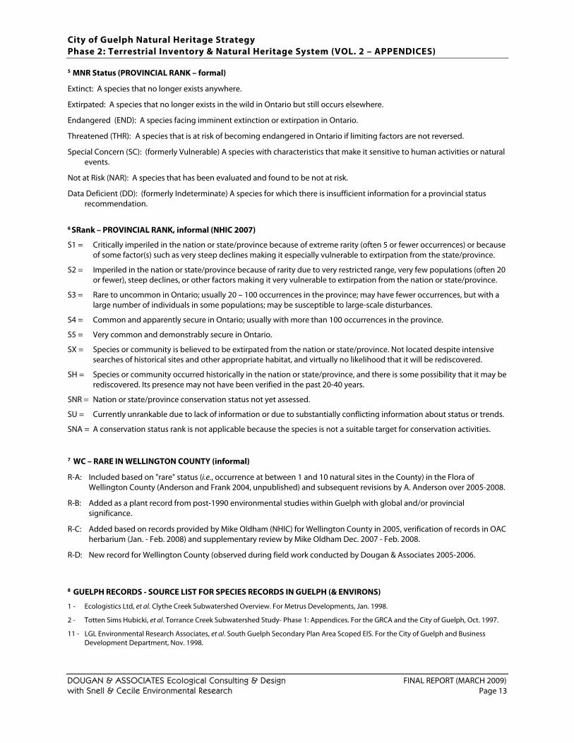
City of Guelph Natural Heritage Strategy Phase 2: Terrestrial Inventory & Natural Heritage System (VOL. 2 – APPENDICES)
DOUGAN & ASSOCIATES Ecological Consulting & Design FINAL REPORT (MARCH 2009) with Snell & Cecile Environmental Research Page 13
5 MNR Status (PROVINCIAL RANK – formal)
Extinct: A species that no longer exists anywhere.
Extirpated: A species that no longer exists in the wild in Ontario but still occurs elsewhere.
Endangered (END): A species facing imminent extinction or extirpation in Ontario.
Threatened (THR): A species that is at risk of becoming endangered in Ontario if limiting factors are not reversed.
Special Concern (SC): (formerly Vulnerable) A species with characteristics that make it sensitive to human activities or natural events.
Not at Risk (NAR): A species that has been evaluated and found to be not at risk.
Data Deficient (DD): (formerly Indeterminate) A species for which there is insufficient information for a provincial status recommendation.
6 SRank – PROVINCIAL RANK, informal (NHIC 2007)
S1 = Critically imperiled in the nation or state/province because of extreme rarity (often 5 or fewer occurrences) or because of some factor(s) such as very steep declines making it especially vulnerable to extirpation from the state/province.
S2 = Imperiled in the nation or state/province because of rarity due to very restricted range, very few populations (often 20 or fewer), steep declines, or other factors making it very vulnerable to extirpation from the nation or state/province.
S3 = Rare to uncommon in Ontario; usually 20 – 100 occurrences in the province; may have fewer occurrences, but with a large number of individuals in some populations; may be susceptible to large-scale disturbances.
S4 = Common and apparently secure in Ontario; usually with more than 100 occurrences in the province.
S5 = Very common and demonstrably secure in Ontario.
SX = Species or community is believed to be extirpated from the nation or state/province. Not located despite intensive searches of historical sites and other appropriate habitat, and virtually no likelihood that it will be rediscovered.
SH = Species or community occurred historically in the nation or state/province, and there is some possibility that it may be rediscovered. Its presence may not have been verified in the past 20-40 years.
SNR = Nation or state/province conservation status not yet assessed.
SU = Currently unrankable due to lack of information or due to substantially conflicting information about status or trends.
SNA = A conservation status rank is not applicable because the species is not a suitable target for conservation activities.
7 WC – RARE IN WELLINGTON COUNTY (informal)
R-A: Included based on "rare" status (i.e., occurrence at between 1 and 10 natural sites in the County) in the Flora of Wellington County (Anderson and Frank 2004, unpublished) and subsequent revisions by A. Anderson over 2005-2008.
R-B: Added as a plant record from post-1990 environmental studies within Guelph with global and/or provincial significance.
R-C: Added based on records provided by Mike Oldham (NHIC) for Wellington County in 2005, verification of records in OAC herbarium (Jan. - Feb. 2008) and supplementary review by Mike Oldham Dec. 2007 - Feb. 2008.
R-D: New record for Wellington County (observed during field work conducted by Dougan & Associates 2005-2006.
8 GUELPH RECORDS - SOURCE LIST FOR SPECIES RECORDS IN GUELPH (& ENVIRONS)
1 - Ecologistics Ltd, et al. Clythe Creek Subwatershed Overview. For Metrus Developments, Jan. 1998.
2 - Totten Sims Hubicki, et al. Torrance Creek Subwatershed Study- Phase 1: Appendices. For the GRCA and the City of Guelph, Oct. 1997.
11 - LGL Environmental Research Associates, et al. South Guelph Secondary Plan Area Scoped EIS. For the City of Guelph and Business Development Department, Nov. 1998.
City of Guelph Natural Heritage Strategy Phase 2: Terrestrial Inventory & Natural Heritage System (VOL. 2 – APPENDICES)
DOUGAN & ASSOCIATES Ecological Consulting & Design FINAL REPORT (MARCH 2009) with Snell & Cecile Environmental Research Page 14
14 - Black, Shoemaker, Robinson & Donaldson Ltd., et al. Victoria Road North Secondary Plan. Jun. 1999 as amended by enclosures Nov. 1999, Dec. 1999.
17 - Ecological Services for Planning Ltd. Cheltonwood School Site Scoped Environmental Impact Study. For Victoria Wood Development Corporation, Feb. 1996.
18 - Ecological Services for Planning Ltd. Environmental Impact Statement for Arkell Investments Inc. Subdivision, Part Lots 1, 2 and 3, Registered Plan 488, City of Guelph. May 1994.
20 - Ecologistics Limited. Grange Hill Developments Environmental Impact Study. For Metrus Development Inc., Jul. 1998.
24 - Geomatics International Inc., et al. Mitchell Farm Phase II Environmental Impact Study. For ARMEL Corporation, Dec. 1992.
25 - GWS Ecological & Forestry Services Inc. Environmental Impact Study for Proposed Edinburgh/Stone Road Development South of the Dairy Bush Guelph, Ontario. For Richmond Property Ltd., Apr. 2003.
31 - LGL Environmental Research Associates, et al. 211 Kortright Road Scoped Environmental Impact Study. For Everest Homes, December 2003.
32 - Stantec Consulting Inc., et al. Environmental Impact Study (Gordon Street and Arkell Road, City of Guelph). For The Salvation Army, May 2002.
33 - ESG International. Scoped Site Environmental Impact Study (1007 Gordon Street, City of Guelph). For The Woolwich Group, August 2000.
34 - Geomatics International Inc. Environmental Appraisal (Eastview Planning Area, Valeriote Lands). For Richard Valeriote, November 1998.
35 - Blackport & Associates, et al. Environmental Impact Study (Watson Industrial Subdivision, City of Guelph). July 2001.
38 - Paul F. J. Eagles Planning Limited. An Assessment of Environmental Impacts of the Springfield Golf Course on the Property of the Foundation for the Support of International Medical Training (Canada). 1993.
41 - Ecoplans Ltd. Additional Field Surveys in Pine Ridge East Development Area, Torrance Creek Subwatershed. March 4, 1997.
46 - Gamsby and Mannerow Limited, and Environmental Advisory Services Limited. 1996. Environmental Impact Study and Stormwater Management Plan, Draft Plan Approval, Coldpoint Properties Ltd. Part Lots 2 & 3, Concession 6, City of Guelph.
47 - Environmental Advisory Services Limited. Westside Joint Venture Property - City of Guelph Scoped Environmental Impact Statement. April 1994.
54 - Stantec Consulting Ltd. Pergola Drive-In Scoped Environmental Impact Study Report. September 2003.
55 - Gamsby and Mannerow Limited, Cumming Cockburn Limited and Code, MacKinnon Limited. Southcreek Residential Development City of Guelph Environmental Impact Study. June 1992.
56 - Weinstein Leeming + Associates et al. 1992 - City of Guelph River Systems Management Study - Technical Report #1: Inventory and Analysis of Terrestrial and Aquatic Ecology. August 1992. Appendices.
65 - Dougan & Associates, and Stantec Consulting Ltd. Environmental Impact Study: Former Misersky Property, 72 Watson Road N., Guelph. For Guelph Grange Hill Developments Limited, 2001
66 - Dougan & Associates, 2004. Environmental Impact Study: Revised Grange Hill Phase 4. Prepared for Guelph Grange Hill Developments.
67 - Mackinnon & Associates. Environmental Impact Study: Westminster Woods Ltd, Draft Plan of Subdivision, Lots 6 and 7, Concession 8.1998
80 - ESG International, 1999. Bathgate Drive Extension Scoped Impact Assessment.
84 - Dougan & Associates, species recorded during field surveys conducted over 2005 by various field staff.
86 - Paul F. J. Eagles Planning Ltd. 1989. Univ. of Guelph Arboretum south of Stone Road - Vegetation Description and Assessment
88 - Ecoplans Ltd. 2000. Environmental Implementation Report, Kortright Hills IV subdivision, City of Guelph.
89 - Paul F. J. Eagles Planning Ltd. 2001. An Evaluation of Environmental Impacts of the Springfield golf course on the Property of the Foundation for the Support of International Medical Training (Canada).
91 - ESG International Inc. 1999. 6 and 7 Developments Ltd. Environmental Impact Study for Development Adjacent to the Marden South Wetland Complex.
97 - Dougan & Assoc. 2007. Final Report, Scoped Environmental Impact Study Norm Jary Park - Master Plan.
101 - North-South Environmental Inc. 2001. Environmental Impact Study, Westminster Woods East (Adam's Farm).
106 - Dougan & Associates, 2006. Environmental Impact Study Guelph Grange Hill Phase 7
109 - Stantec, 2005. Impact Assessment for the Victoria Park Golf Course West Condominium Community.
110 - Stantec, 2007. Dallan Lands, Environmental Impact Statement.
City of Guelph Natural Heritage Strategy Phase 2: Terrestrial Inventory & Natural Heritage System (VOL. 2 – APPENDICES)
DOUGAN & ASSOCIATES Ecological Consulting & Design FINAL REPORT (MARCH 2009) with Snell & Cecile Environmental Research Page 15
APPENDIX B: SIGNIFICANT WILDLIFE LIST FOR WELLINGTON COUNTY
APPENDIX B1: DEVELOPMENT OF SIGNIFICANT WILDLIFE SPECIES LIST
INTRODUCTION With the initiation of the Guelph Natural Heritage Strategy, the absence of a list of locally significant species (note: “local” meaning within the County of Wellington) by which to help assess the relative significance of remaining natural areas within the City was identified as a key gap. Although upon first glance, it may seem that the development of a list of significant wildlife species should be based on an analysis of information restricted to the Guelph city limits, it was quickly acknowledged that a broader context would be necessary for the lists to be most useful. For example, if analysis was limited to those species known to be present only in the City of Guelph, the vast majority of species would have likely been considered significant. After all, and by definition, the City of Guelph is primarily an urban area. Furthermore, the City has periodically enlarged its boundaries to accommodate growth. Significant wildlife species lists must be flexible enough to handle these periodic changes should they occur in the future. By enlarging the area of interest to the broader County, a more stable and representative list could be developed. The County of Wellington was chosen as the logical area of interest. Not only is it consistent with what has been done in neighbouring jurisdictions and beyond (see Table 1), it also provides a potential resource for all jurisdixtions within the County and fopr the County itself. Significant species lists, or components therin, can also provide a ‘local’ context to the evaluation and re-evaluation of wetlands by the Ministry of Natural Resources. Table 1: Examples of jurisdictions across Southern Ontario that have or are developing lists of significant
wildlife species
Jurisdiction The Regional Municipality of Halton (Dwyer pers. comm., 2005) The City of Hamilton (Curry, 2003; Lamond and Duncan 2003; Vlasman 2003; Wormington and Lamond 2003) The Toronto Region Conservation Authority lands (TRCA 2008a, TRCA 2008b; and ongoing updates) The Town of Fort Erie (Dougan & Associates 2003) The Credit Valley Watershed (CVC 1997; update initiated in 2005) The City of London (Bowles, et al. 1994) The Regional Municipality of Waterloo (RMW 1985a; RMW 1985b; RMW 1996) The former Regional Municipality of Haldimand-Norfolk (Carson 1987; Gartshore 1987a,b; McCracken 1987)
Significant species lists typically encompass species considered significant at higher jurisdictional levels. For Guelph, these include: (a) nationally or provincially listed ‘Species at Risk’ wildlife (i.e. species designated “Special Concern”, “Threatened” and “Endangered”) and (b) species with a provincial conservation rank ranging from S1 to S3S4 (as defined by the Natural Heritage Information Centre). In addition, these lists are intended to identify locally “rare” or significant species. In particular, The presence of locally rare species is one criteria used to designate Significant Wildlife Habitat (OMNR 2000). Although there is a regional list of priority landbirds species for conservation (OPIF, 2008), it does not identify species according to regional rarity.
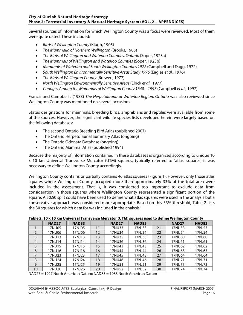
City of Guelph Natural Heritage Strategy Phase 2: Terrestrial Inventory & Natural Heritage System (VOL. 2 – APPENDICES)
DOUGAN & ASSOCIATES Ecological Consulting & Design FINAL REPORT (MARCH 2009) with Snell & Cecile Environmental Research Page 16
Several sources of information for which Wellington County was a focus were reviewed. Most of them were quite dated. These included:
• Birds of Wellington County (Klugh, 1905) • The Mammalia of Northern Wellington (Brooks, 1905) • The Birds of Wellington and Waterloo Counties, Ontario (Soper, 1923a) • The Mammals of Wellington and Waterloo Counties (Soper, 1923b) • Mammals of Waterloo and South Wellington Counties 1972 (Campbell and Dagg, 1972) • South Wellington Environmentally Sensitive Areas Study 1976 (Eagles et al., 1976) • The Birds of Wellington County (Brewer , 1977) • North Wellington Environmentally Sensitive Areas (Elrick et al., 1977) • Changes Among the Mammals of Wellington County 1640 – 1997 (Campbell et al., 1997)
Francis and Campbell’s (1983) The Herpetofauna of Waterloo Region, Ontario was also reviewed since Wellington County was mentioned on several occasions. Status designations for mammals, breeding birds, amphibians and reptiles were available from some of the sources. However, the significant wildlife species lists developed herein were largely based on the following databases:
• The second Ontario Breeding Bird Atlas (published 2007) • The Ontario Herpetofaunal Summary Atlas (ongoing) • The Ontario Odonata Database (ongoing) • The Ontario Mammal Atlas (published 1994)
Because the majority of information contained in these databases is organized according to unique 10 x 10 km Universal Transverse Mercator (UTM) squares, typically referred to ‘atlas’ squares, it was necessary to define Wellington County accordingly. Wellington County contains or partially contains 46 atlas squares (Figure 1). However, only those atlas squares where Wellington County occupied more than approximately 33% of the total area were included in the assessment. That is, it was considered too important to exclude data from consideration in those squares where Wellington County represented a significant portion of the square. A 50:50 split could have been used to define what atlas squares were used in the analysis but a conservative approach was considered more appropriate. Based on this 33% threshold, Table 2 lists the 30 squares for which data for was included in the analysis: Table 2: 10 x 10 km Universal Transverse Mercator (UTM) squares used to define Wellington County
NAD27 NAD83 NAD27 NAD83 NAD27 NAD831 17NU05 17NJ05 11 17NU33 17NJ33 21 17NU53 17NJ532 17NU06 17NJ06 12 17NU34 17NJ34 22 17NU54 17NJ543 17NU13 17NJ13 13 17NU35 17NJ35 23 17NU60 17NJ604 17NU14 17NJ14 14 17NU36 17NJ36 24 17NU61 17NJ615 17NU15 17NJ15 15 17NU43 17NJ43 25 17NU62 17NJ626 17NU16 17NJ16 16 17NU44 17NJ44 26 17NU63 17NJ637 17NU23 17NJ23 17 17NU45 17NJ45 27 17NU64 17NJ648 17NU24 17NJ24 18 17NU46 17NJ46 28 17NU71 17NJ719 17NU25 17NJ25 19 17NU51 17NJ51 29 17NU73 17NJ73
10 17NU26 17NJ26 20 17NU52 17NJ52 30 17NU74 17NJ74NAD27 = 1927 North American Datum; NAD83 = 1983 North American Datum
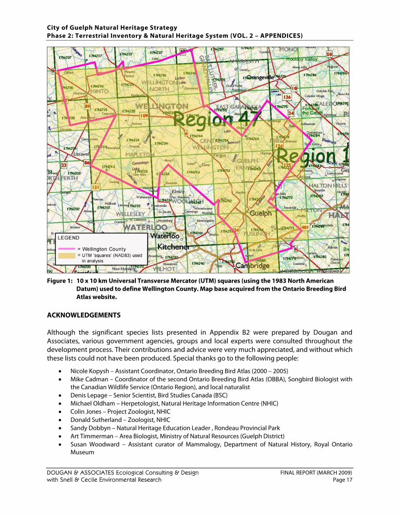
City of Guelph Natural Heritage Strategy Phase 2: Terrestrial Inventory & Natural Heritage System (VOL. 2 – APPENDICES)
DOUGAN & ASSOCIATES Ecological Consulting & Design FINAL REPORT (MARCH 2009) with Snell & Cecile Environmental Research Page 17
Figure 1: 10 x 10 km Universal Transverse Mercator (UTM) squares (using the 1983 North American Datum) used to define Wellington County. Map base acquired from the Ontario Breeding Bird Atlas website.
ACKNOWLEDGEMENTS Although the significant species lists presented in Appendix B2 were prepared by Dougan and Associates, various government agencies, groups and local experts were consulted throughout the development process. Their contributions and advice were very much appreciated, and without which these lists could not have been produced. Special thanks go to the following people:
• Nicole Kopysh – Assistant Coordinator, Ontario Breeding Bird Atlas (2000 – 2005) • Mike Cadman – Coordinator of the second Ontario Breeding Bird Atlas (OBBA), Songbird Biologist with
the Canadian Wildlife Service (Ontario Region), and local naturalist • Denis Lepage – Senior Scientist, Bird Studies Canada (BSC) • Michael Oldham – Herpetologist, Natural Heritage Information Centre (NHIC) • Colin Jones – Project Zoologist, NHIC • Donald Sutherland – Zoologist, NHIC • Sandy Dobbyn – Natural Heritage Education Leader , Rondeau Provincial Park • Art Timmerman – Area Biologist, Ministry of Natural Resources (Guelph District) • Susan Woodward – Assistant curator of Mammalogy, Department of Natural History, Royal Ontario
Museum
City of Guelph Natural Heritage Strategy Phase 2: Terrestrial Inventory & Natural Heritage System (VOL. 2 – APPENDICES)
DOUGAN & ASSOCIATES Ecological Consulting & Design FINAL REPORT (MARCH 2009) with Snell & Cecile Environmental Research Page 18
• Stuart Kenn – President, Ontario Puma Foundation • Dr. Brock Fenton – Professor and chair, Department of Biology, University of Western Ontario, and bat
expert • Carl Rothfels – Field Botanist and Herbarium Keeper at the Royal Botanical Gardens, and naturalist • Audrey Heagy – Canadian Migration Monitoring Network Development Coordinator at BSC • Lyle Friesen – Songbird Biologist with the Canadian Wildlife Service (Ontario Region) • Tony Zammit – Ecologist, Grand River Conservation Authority • Mark van Patter – Senior Planner, County of Wellington • Bernt (Bernie) Solymár – Ontario Barn Owl Recovery Team • Ron Gould – Chair, American Badger Recovery Team • Ken Cornelisse – Area Biologist, Ministry of Natural Resources (Guelph District) • Valerie Wyatt – Guelph Field Naturalists • Chris Earley – Interpretive Naturalist and Education Coordinator, University of Guelph • Craig Campbell – Local naturalists and author of source materials • Helen Powers – (Former) Environmental Planner, City of Guelph • Charlie Cecile – Local Naturalist • Ian Richards – Wildlife Ecologist, Dougan & Associates • Bryan Wyatt – OBBA Regional Coordinator for Atlas Administrative Region 47 – Wellington
Nicole Kopysh, Mike Cadman and Denis Lepage made available detailed breeding bird information for Wellington County on behalf of the Ontario Breeding Bird Atlas. Additional thanks should also be extended to the official sponsors of the Ontario Breeding Bird Atlas (Bird Studies Canada, Canadian Wildlife Service, Federation of Ontario Naturalists, Ontario Field Ornithologists, and Ontario Ministry of Natural Resources) for supplying the Atlas data, and to the thousands of volunteer participants who gathered data for the project. Mike Oldham and Colin Jones, made available all documented records of herpetofauna (amphibians and reptiles) and odonates (damselflies and dragonflies) respectively. Mike Oldham also provided helpful instruction and commentary, whereas Colin Jones was entirely responsible for preparing the list of significant odonates. He was also responsible for revising it in 2009. Sandy Dobbyn made available the Ontario Mammal Atlas database. Susan Woodward provided mammal data from the Department of Natural History database at the Royal Ontario Museum. Dr. Brock Fenton and Donald Sutherland provided commentary on the conservation status of bats. Art Timmerman reviewed MNR Natural Resources and Values Information System (NRVIS) data with respect to mammals and provided thought-provoking feedback on a later draft. Stuart Kenn reviewed Puma records for Wellington County. Carl Rothfels provided additional records of damselflies and dragonflies for Wellington County as well as helpful comments on structure of the list of significant odonates. Lyle Friesen and Audrey Heagy graciously made available a draft of the Ontario Landbird Conservation Plan for Bird Conservation Region (BCR) 13, including the most recent list of Priority Landbird Species. Mike Cadman’s careful review and suggestions greatly enhanced the structure and content of the breeding bird section. Tony Zammit also provided many helpful comments on the original draft. Mark Van Patter reviewed the draft methodology and species lists and provided helpful commentary. Bernie Solymár and Ron Gould provided occurrence information for Barn Owl and American Badger respectively. Ken Cornelisse was the source of information for the lone American Badger record. Valerie Wyatt solicited feedback and coordinated responses from the Guelph Field Naturalists. Chris Earley provided wildlife observation information for the University of Guelph Arboretum. Craig Campbell reviewed a later version of the draft and contributed historical herpetofaunal information. Helen Powers acted as a source of encouragement and support, and helped bring greater clarity to the methodology. Charlie Cecile helped identify deficiencies associated with the list of significant/locally rare breeding birds and provided much needed encouragement to
City of Guelph Natural Heritage Strategy Phase 2: Terrestrial Inventory & Natural Heritage System (VOL. 2 – APPENDICES)
DOUGAN & ASSOCIATES Ecological Consulting & Design FINAL REPORT (MARCH 2009) with Snell & Cecile Environmental Research Page 19
resolve the issues. Without a doubt, the final product has benefitted significantly from his review. Lastly, Ian Richards and Bryan Wyatt helped consider which species of breeding birds are locally rare. With help from all of these people and others, significant species lists were prepared for breeding birds, herpetofauna (amphibians and reptiles), mammals, odonates (damselflies and dragonflies) and butterflies for Wellington County (see Appendix B2). In all, 286 wildlife species were identified as significant in Wellington County. All except 36 (in italics) are also regarded as “rare” in Wellington County and their presence can be used to identify priority areas for protection. The following sections describe how the various significant species lists were developed, identifies where deviations from published lists were made, and highlights deficiencies where applicable. BREEDING BIRDS Step 1 Any Ontario breeding species officially designated ‘special concern’, ‘threatened’ or ‘endangered’ in Canada (COSEWIC, 2008), or Ontario (OMNR, 2008) were automatically considered significant in Wellington County. However, only those species known to have bred in or within 30 km (of the Wellington County boundary were included (Table 3). Step 2 Species with a sub-national (provincial) rarity rank between S1 and S3 were included (Table 3). Species with a multiple rank of S3S4 were also included as a precautionary measure since further study may indeed confirm these species’ status as S3. Sub-national rarity ranks are assigned by the Ontario Natural Heritage Information Centre, an arm of the Ontario Ministry of Natural Resources in Peterborough. A brief description of each category is provided below.
S1 Critically Imperiled— Critically imperiled in the nation or state/province because of extreme rarity (often 5 or fewer occurrences) or because of some factor(s) such as very steep declines making it especially vulnerable to extirpation from the state/province.
S2 Imperiled— Imperiled in the nation or state/province because of rarity due to very restricted range, very few populations (often 20 or fewer), steep declines, or other factors making it very vulnerable to extirpation from the nation or state/province.
S3 Vulnerable— Vulnerable in the nation or state/province due to a restricted range, relatively few populations (often 80 or fewer), recent and widespread declines, or other factors making it vulnerable to extirpation.
S3S4 Species whose status may be S3 or S4. Insufficient data exists to provide a definitive assessment. S4 Apparently Secure— Uncommon but not rare; some cause for long-term concern due to
declines or other factors. S5 Secure— Common, widespread, and abundant in the nation or state/province.
Some species with rarity ranks between S1 and S3 (and S3S4) were left off the list because there is little chance of them breeding within Wellington County. Most of these species would be out of their normal breeding range or suitable habitat conditions would not be present. Examples of species left off the list include Golden Eagle (Aquila chrysaetos), Rough-legged Hawk (Buteo lagopus), Marbled Godwit (Limosa fedoa), Northern Hawk Owl (Surnia ulula), and Western Kingbird (Tyrannus verticalis). Some of these species occur only in northern Ontario while others are usually only found in extreme north-western Ontario.
City of Guelph Natural Heritage Strategy Phase 2: Terrestrial Inventory & Natural Heritage System (VOL. 2 – APPENDICES)
DOUGAN & ASSOCIATES Ecological Consulting & Design FINAL REPORT (MARCH 2009) with Snell & Cecile Environmental Research Page 20
Step 3 All species tracked by the Ontario Ministry of Natural Resources’ Natural Heritage Information Centre were considered significant in Wellington County, unless their known breeding range isn’t remotely close to Wellington County (i.e. they normally breed in the northern latitudes of Ontario, extreme western portions of Ontario) or there is and will likely never be any suitable habitat in Wellington County (Table 3). Species actively tracked generally have fewer than 100 recent occurrences in Ontario, or are highly ranked globally. Step 4 The next source of information utilized was the draft “Ontario Landbird Conservation Plan: Lower Great Lakes/St. Lawrence Plain (North American Bird Conservation Region 13)” and its list of “Priority Landbird Species in ON BCR 13” (see Table 3) (Ontario Partners in Flight, 2008). As the title of the document describes, the list of Priority Landbird Species does not correspond with provincial or municipal boundaries, but rather Bird Conservation Regions (BCRs) (see Figure 2). Each BCR encompasses landscapes having similar bird communities, habitats, and resource issues. In this case, all of Wellington County falls within the boundaries of BCR 13 (Figure 3 & 4). Given the area BCR 13 covers, species included are regarded as regionally significant. The list of Priority Landbird Species was prepared by Ontario Partners in Flight, a member of the Partners in Flight family. “At its broadest level, Partners In Flight is a coalition of countries, government agencies, conservation groups, academic institutions, industry and concerned citizens who share a common vision: to maintain the health of landbird populations and their habitats” (Ontario Partners in Flight, 2008). More specifically, PIF’s mission embraces three related concepts (Rich et al. 2004):
• Helping species at risk, • Keeping common birds common, and • Voluntary partnerships for birds, habitat & people
Partners in Flight is also the landbird component of the North American Bird Conservation Initiative (NABCI) framework. NABCI is a coordinated effort between Canada, the United States and Mexico. The maintenance of the diversity and abundance of all North American birds is its primary goal. Other components of the NABCI framework address the conservation of waterfowl, waterbirds & shorebirds. In Ontario, the Partners in Flight initiative is being led by the Ontario Region of the Canadian Wildlife Service and the Ontario Ministry of Natural Resources, in partnership with Bird Studies Canada. Other participating groups have included:
• Ontario Field Ornithologists • Ontario Federation of Anglers and Hunters (OFAH) • Nature Conservancy of Canada (NCC) • Canadian Nature Federation (CNF) • Wildlife Habitat Canada (WHC) –
Wetland Habitat Fund • Ganaraska Region Conservation Authority
The conservation goals of Ontario Landbird Conservation Plan: Lower Great Lakes/St. Lawrence Plain (North American Bird Conservation Region 13) are (1) To sustain the distribution, diversity and abundance of native landbirds and their habitats in Ontario portions of BCR 13; and (2) To contribute to continent-wide efforts to sustain the distribution, diversity and abundance of all North American landbirds. This is a biological plan whose chief objectives are: identifying priority landbird species and habitats; setting measurable and attainable objectives for the conservation of these priority species; and recommending conservation actions to help achieve those objectives.
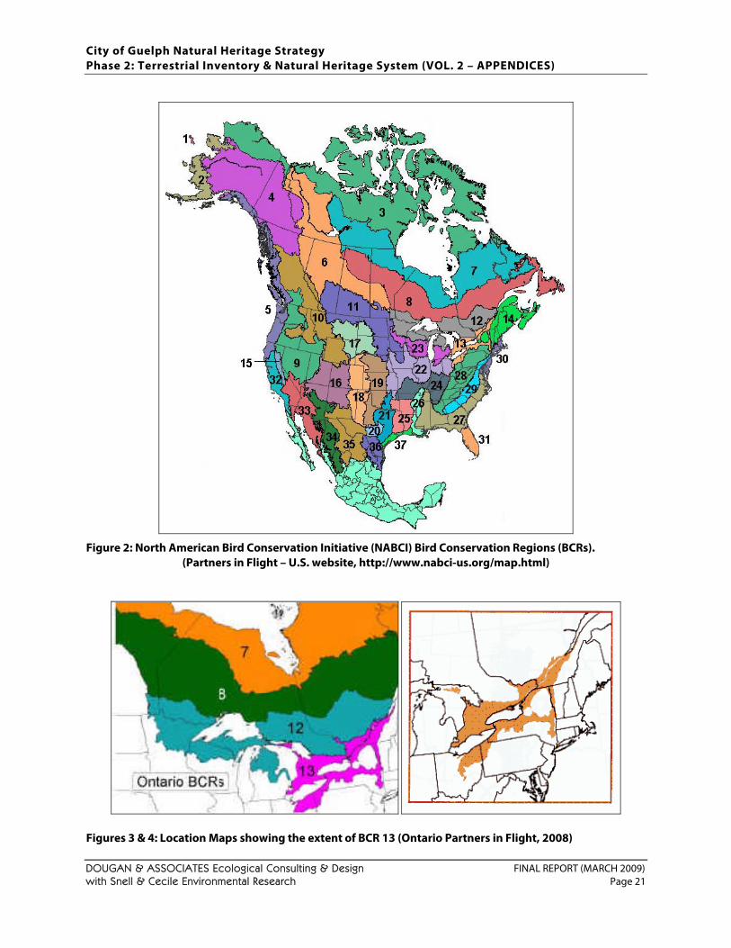
City of Guelph Natural Heritage Strategy Phase 2: Terrestrial Inventory & Natural Heritage System (VOL. 2 – APPENDICES)
DOUGAN & ASSOCIATES Ecological Consulting & Design FINAL REPORT (MARCH 2009) with Snell & Cecile Environmental Research Page 21
Figure 2: North American Bird Conservation Initiative (NABCI) Bird Conservation Regions (BCRs). (Partners in Flight – U.S. website, http://www.nabci-us.org/map.html)
Figures 3 & 4: Location Maps showing the extent of BCR 13 (Ontario Partners in Flight, 2008)
City of Guelph Natural Heritage Strategy Phase 2: Terrestrial Inventory & Natural Heritage System (VOL. 2 – APPENDICES)
DOUGAN & ASSOCIATES Ecological Consulting & Design FINAL REPORT (MARCH 2009) with Snell & Cecile Environmental Research Page 22
The list of Priority Landbirds Species (i.e., landbird species most in need of conservation attention) was developed using the PIF species assessment methodology (Rich et al. 2004). The PIF methodology uses a standardized approach that combines the best available data and expert knowledge for six biological factors to objectively assess the status and vulnerability of each species throughout its range and life cycle (Hunter et al. 1993, Carter et al. 2000, Panjabi et al. 2001). They are:
• Population Size • Threats to Breeding • Breeding Distribution • Threats to Non-breeding • Non-breeding Distribution • Population Trend (over the past 30 years)
Complete descriptions, justifications, scoring criteria, and definitions for each are contained in Panjabi et al. (2001), which is available at the Rocky Mountain Bird Observatory web site (www.rmbo.org/pif/pifdb.html). This assessment “process has been tested, reviewed, and updated, and its scientific credibility acknowledged by the American Ornithologists’ Union (Beissinger et al. 2000)” (Rich et al. 2004). The six scores were then combined to provide a single measure of a species’ relative conservation importance. Total scores can range from 4 for a widespread, relatively secure species to 20 for a species of the very highest concern (Rich et al. 2004). The following categories were used to include species in PIF Regional Priority Species Lists.
• Continental Concern Species: Species on the PIF Continental Watch List (Rich et al. 2004) for which the BCR has some conservation responsibility.
• Continental Stewardship Species: Species identified in Rich et al. 2004) as PIF Stewardship Species for which the BCR has high stewardship responsibility.
• Regional Concern: Species of regional concern in this BCR due to combination of regional population decline and high threat score.
• Regional Stewardship Responsibility: Species of regional stewardship responsibility in this BCR because of high regional density score and/or BCR contains a high proportion of the global population.
• National Species at Risk: Species at Risk as identify by COSEWIC and/or listed under the Canadian Species at Risk Act (SARA).
• Provincial Species at Risk: Species at Risk as identify by COSSARO and/or listed under Ontario’s Endangered Species Act (ESA) and also protected by other provincial legislation.
• Species (or subspecies/ populations) not included above that are of regional management interest or importance for any of a variety of reasons. Species were included in this category if there was evidence of substantial local (Ontario BCR 13) declines in abundance or distribution, combined with elevated threats to future conditions.
Step 6 Data from the 2nd Ontario Breeding Bird Atlas (2001 to 2005) were utilized to assess local rarity (Cadman et al., 2007). In particular, two things were considered, how widespread and how common each species was. Relative distribution information was readily assessed because atlas data were collected according to a standard 10 x 10 km grid, resulting in uniquely identified 10 x 10 km atlas squares (Figure 1). The data set was considered reliable since the five years of data were based on an impressive 2655 hours of time spent in the field. In addition, all 30 atlas squares were able to meet the minimum effort target for “adequate” coverage of 20 hours. In fact, the average number of hours spent in each square was 88.50 hours.
City of Guelph Natural Heritage Strategy Phase 2: Terrestrial Inventory & Natural Heritage System (VOL. 2 – APPENDICES)
DOUGAN & ASSOCIATES Ecological Consulting & Design FINAL REPORT (MARCH 2009) with Snell & Cecile Environmental Research Page 23
Those species (with “probable” or “confirmed” breeding evidence) found in 23.3% of the atlas squares or less (i.e. 7 squares or less) were considered to be rare in Wellington County and therefore also rare in the City of Guelph (Table 3). With the exception of Kentucky Warbler (Oporornis formosus) and Orchard Oriole (Icterus spurius), irruptive and irregularly occurring species such as Dickcissel (Spiza americana), Summer Tanager (Piranga rubra), Red Crossbill (Loxia curvirostra), White-winged Crossbill (Loxia leucoptera), Pine Siskin (Carduelis pinus), and Evening Grosbeak (Coccothraustes vespertinus) were excluded. Their occurrence is more closely tied to seasonal weather conditions, availability of food and other factors, rather than suitable habitat. The decision to use 23.3% was based on the objective of only including those species with the most restricted occurrence in the county. For comparison, Credit Valley Conservation used the ‘rarest’ 33% in the development of its list (CVC, 1997). Point Count data were utilized to assess a species’ relative abundance within Wellington County. As its name implies, point count data are data collected at a specific point. Most point count stations are randomly selected along roadsides. A smaller number of off-road sites are also incorporated into surveys. All birds observed or heard at each point count station over a five-minute period are recorded. In total, surveys were conducted at 234 point count stations across Wellington County. Five thousand eight hundred and twenty-eight (5828) birds representing 95 species were recorded. However, despite the availability of this data set, it was ultimately determined that it did not accurately reflect the breeding bird community within the county. The main flaw in attempting to utilize this data set is the fact that not all birds are equally detectable. For example, some bird species are nocturnal and do not call during daylight hours. Others simply do not “sing” and are therefore poorly detected. Still others call more commonly at other times of the year. The determination not to utilize the available point count data was supported by Mike Cadman, primary author of the Atlas of the Breeding Birds of Ontario (Cadman et al., 2007). The fact that the point count data could not be used to assess local rarity was considered a significant deficiency. In an attempt to resolve this problem it was necessary to review the list of potential breeding bird species and subjectively make decisions on which species were “rare” (i.e. least abundant) within Wellington County. The following decisions were based primarily on the personal experience and understanding of the author. Factors considered in the assessment included: the types of and availability of habitats within Wellington County, the breeding biology and ecology of the bird species present, recent trend information contained in the Atlas of the Breeding Birds of Ontario 2001 – 2005 (Cadman et al., 2007), historical perspective available in background documents (e.g. The Birds of Wellington County [Brewer, 1977]; Atlas of the Breeding Birds of Ontario [Cadman et al., 1987]), as well as the personal opinions of select naturalists. Based on this assessment the following species were added to the list of “rare”breeding birds in Wellington County. The two sets of numbers following each species refer to how many squares the species was recorded in within Wellington County (as defined in Figure 1) during the 2nd and 1st Ontario Breeding Bird Atlases respectively. The first number in each set refers specifically to how many squares (with “probable” or “confirmed” breeding evidence) the species was recorded in in Wellington County, whereas the second number in the set refers to the total number of squares (i.e. also includes observations with “Possible” breeding evidence) the species was recorded in within Wellington County.
1. Blue-winged Teal (Anas discors) 10/13 (22/24) 2. Hooded Merganser (Lophodytes cucullatus) 10/13 (7/10) 3. Northern Goshawk (Accipiter gentilis) 11/11 (1/5) 4. Pied-billed Grebe (Podilymbus podiceps) 8/17 (8/9)
5. Scarlet Tanager (Piranga olivacea) 8/21 (8/18) 6. Sora (Porzana carolina) 14/19 (10/20) 7. Turkey Vulture (Cathartes aura) 9/26 (5/19)
City of Guelph Natural Heritage Strategy Phase 2: Terrestrial Inventory & Natural Heritage System (VOL. 2 – APPENDICES)
DOUGAN & ASSOCIATES Ecological Consulting & Design FINAL REPORT (MARCH 2009) with Snell & Cecile Environmental Research Page 24
Some of the other species considered but not designated locally rare, at least at this time, were: • American Kestrel (Falco sparverius) 23/26 (26/30) • Bank Swallow (Riparia riparia) 21/28 (25/26) • Barn Swallow (Hirundo rustica) 30/30 (30/30) • Brown Creeper (Certhia americana) 14/23 (7/13) • Chimney Swift (Chaetura pelagic) 9/18 (14/23) • Cliff Swallow (Petrochelidon pyrrhonota) 29/29 (26/27) • Eastern Towhee (Pipilo erythrophthalmus) 12/19 (8/15) • Green Heron (Butorides virescens) 18/28 (9/30) • Northern Harrier (Circus cyaneus) 18/25 (25/28)
• Northern Rough-winged Swallow (Stelgidopteryx serripennis) 20/24 (25/29)
• Purple Finch (Carpodacus purpureus) 11/18 (4/11) • Virginia Rail (Rallus limicola) 12/18 (10/17) • Wilson’s Snipe (Gallinago delicata) 11/19 (13/24) • Winter Wren (Troglodytes troglodytes) 18/22 (16/26) • Yellow-bellied Sapsucker (Sphyrapicus varius) 9/17 (10/18) • Yellow-rumped Warbler (Dendroica coronata) 15/12 (4/8)
Step 7 Colonial nesting species (as designated in the 2nd OBBA) were added to the list of significant species due to their relative rarity in the landscape and their corresponding vulnerability (see Table 3). Step 8 Area sensitivity was used as the last criterion for significance since it is generally recognized that species identified as area sensitive are much more susceptible to population declines than generalist bird species (Table 3). Area sensitive species normally require larger, less disturbed habitats than do other species and as a result suffer the most from the effects of habitat loss and habitat fragmentation. Area sensitive species usually occupy either forest interior habitats or ‘grassland’ habitats. Although not peer reviewed, the “Significant Wildlife Technical Guide” produced by the Ontario Ministry of Natural Resources (2000) was the sole source for determining what species are considered area sensitive. This document was selected since it represents the most current information available, covers more than just forest birds, and was developed specifically in support of the 1996 Provincial Policy Statement (i.e., to assist in land use planning). As with other criteria described above, several area sensitive species were left off of the significant species list because (a) their breeding range does not normally occur in Wellington County, or (b) suitable breeding habitat is absent in the Wellington County. Species excluded from the significant species list include: Common Goldeneye (Bucephala clangula), Sharp-tailed Grouse (Tympanuchus phasianellus), Yellow Rail (Coturnicops noveboracensis), King Rail (Rallus elegans), Forster’s Tern (Sterna forsteri), Boreal Owl (Aegolius funereus) etc. In addition to the above, White-breasted Nuthatch (Sitta carolinensis) was also left off the list of significant species since it is known to occur in residential areas with abundant deciduous tree cover, especially those areas containing larger, more mature trees. Some such areas are present in the City of Guelph. It also readily takes advantage of feeders for food. Based on these reasons it was considered not to be of conservation concern. Miscellaneous Comments When new local, regional, provincial and /or national conservation status information becomes available it should be incorporated in to the list as soon as possible. Typically, provincial and national conservation status information is updated on an annual or semi-annual basis. Unless new information becomes available, changes to local and/or regional conservation status need only be considered every 5 years.
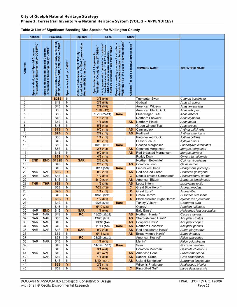
City of Guelph Natural Heritage Strategy Phase 2: Terrestrial Inventory & Natural Heritage System (VOL. 2 – APPENDICES)
DOUGAN & ASSOCIATES Ecological Consulting & Design FINAL REPORT (MARCH 2009) with Snell & Cecile Environmental Research Page 25
Table 3: List of Significant Breeding Bird Species for Wellington County
National Provincial Regional Local Other
Crit
erio
n
Spec
ies
desi
gnat
ed S
peci
al C
once
rn,
Thre
aten
ed o
r End
ange
red
by C
OSE
WIC
1
Spec
ies
desi
gnat
ed S
peci
al C
once
rn,
Thre
aten
ed o
r End
ange
red
by O
MN
R 2
Spec
ies
with
a P
rovi
ncia
l rar
ity ra
nk o
f S1,
S2
, S3,
S3S
4 or
S1B
, S2B
, S3B
, or S
3S4B
3
Spec
ies
trac
ked
by O
MN
R 3
Ont
ario
Par
tner
s in
Flig
ht “
Prio
rity
Land
bird
Spe
cies
” fo
r Bird
Con
serv
atio
n R
egio
n (B
CR
) 13
in O
ntar
io 4
Spec
ies
dete
cted
≤ 7
squ
ares
in
Wel
lingt
on C
ount
y du
ring
2nd O
BB
A 5
• O
nly
squa
res
with
"pr
obab
le"
or "
conf
irmed
" br
eedi
ng s
tatu
s ap
ply
(1st
#).
2nd #
indi
cate
s to
tal #
of s
quar
es s
peci
es re
port
ed in
. •
Num
bers
in b
rack
ets
= da
ta fr
om 1
st O
BB
A
Des
pite
exc
eedi
ng p
revi
ous
loca
l crit
eria
th
resh
old,
spe
cies
thou
ght t
o be
rare
in
Wel
lingt
on C
o. (i
.e o
ccur
in lo
w n
umbe
rs) 6
Col
onia
l 4 or A
rea
Sens
itive
bird
spe
cies
7
COMMON NAME SCIENTIFIC NAME
1 S2S3 N 3/3 (0/0) Trumpeter Swan Cygnus buccinator 2 S4B N 2/2 (5/5) Gadwall Anas strepera 3 S4B N 2/2 (5/6) American Wigeon Anas americana 4 S5B N 5/10 (5/8) American Black Duck Anas rubripes 5 S5B N 10/13 (22/24) Rare Blue-winged Teal Anas discors 6 S4B N 1/3 (1/1) Northern Shoveler Anas clypeata 7 S5B N 1/1 (2/2) AS Northern Pintail Anas acuta 8 S4B N 5/6 (4/5) Green-winged Teal Anas crecca 9 S1B Y 0/0 (1/1) AS Canvasback Aythya valisineria
10 S2B Y 2/2 (1/1) AS Redhead Aythya americana 11 S5B N 1/1 (1/1) Ring-necked Duck Aythya collaris 12 S4B N 0/0 (1/1) Lesser Scaup Aythya affinis 13 S5B N 10/13 (7/10) Rare Hooded Merganser Lophodytes cucullatus 14 S5B N 2/5 (1/3) AS Common Merganser Mergus merganser 15 S4B N 0/0 (0/1) AS Red-breasted Merganser Mergus serrator 16 S2B Y 4/5 (1/1) Ruddy Duck Oxyura jamaicensis 17 END END S1S2B Y SAR 2/3 (2/4) Northern Bobwhite‡ Colinus virginianus 18 S4B N 2/3 (1/2) AS Common Loon Gavia immer 19 S4B N 8/17 (8/9) Rare Pied-billed Grebe Podilymbus podiceps 20 NAR NAR S3B Y 0/0 (1/1) AS Red-necked Grebe Podiceps grisegena 21 NAR NAR S4B N 1/2 (0/1) C Double-crested Cormorant* Phalacrocorax auritus 22 S4B N 4/10 (6/14) AS American Bittern Botaurus lentiginosus 23 THR THR S3B Y 1/6 (3/5) AS Least Bittern Ixobrychus exilis 24 S5B N 7/22 (7/29) C Great Blue Heron* Ardea herodias 25 S2B Y 1/1 (1/1) C Great Egret* Ardea alba 26 S4B N 18/28 (9/30) C Green Heron* Butorides virescens 27 S3B Y 1/2 (0/1) C Black-crowned Night-Heron* Nycticorax nycticorax 28 S4B N 9/26 (5/19) Rare Turkey Vulture* Cathartes aura 29 S4B N 6/10 (3/5) Osprey* Pandion haliaetus 30 NAR END S4B Y SAR 1/1 (0/0) Bald Eagle* Haliaeetus leucocephalus 31 NAR NAR S4B N RC 18/25 (25/28) AS Northern Harrier* Circus cyaneus 32 NAR NAR S5B N 13/20 (8/12) AS Sharp-shinned Hawk* Accipiter striatus 33 NAR NAR S4B N 13/18 (2/4) AS Cooper's Hawk* Accipiter cooperi 34 NAR NAR S4B N 11/11 (1/5) Rare AS Northern Goshawk* Accipiter gentilis 35 NAR NAR S4B Y SAR 0/2 (1/3) AS Red-shouldered Hawk* Buteo platypterus 36 S5B N 6/11 (2/4) AS Broad-winged Hawk* Buteo lineatus 37 S5B N RC 23/26 (26/30) American Kestrel* Falco sparverius 38 NAR NAR S4B N 1/1 (0/1) Merlin* Falco columbarius 39 S4B N 14/19 (10/20) Rare Sora Porzana carolina 40 S4B N 3/4 (4/4) Common Moorhen Gallinula chloropus 41 NAR NAR S4B N 3/3 (4/7) AS American Coot Fulica americana 42 NAR S4B N 1/1 (0/0) AS Sandhill Crane Grus canadensis 43 S4B N 6/10 (15/19) AS Upland Sandpiper* Bartramia longicauda 44 S3B Y 2/2 (1/1) Wilson's Phalarope Phalaropus tricolor 45 S5B N 1/1 (0/0) C Ring-billed Gull* Larus delawarensis
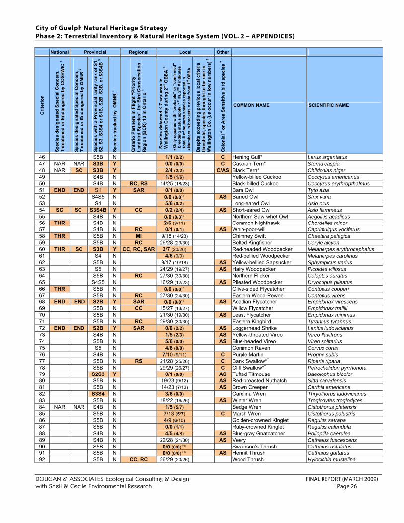
City of Guelph Natural Heritage Strategy Phase 2: Terrestrial Inventory & Natural Heritage System (VOL. 2 – APPENDICES)
DOUGAN & ASSOCIATES Ecological Consulting & Design FINAL REPORT (MARCH 2009) with Snell & Cecile Environmental Research Page 26
National Provincial Regional Local Other
Crit
erio
n
Spec
ies
desi
gnat
ed S
peci
al C
once
rn,
Thre
aten
ed o
r End
ange
red
by C
OSE
WIC
1
Spec
ies
desi
gnat
ed S
peci
al C
once
rn,
Thre
aten
ed o
r End
ange
red
by O
MN
R 2
Spec
ies
with
a P
rovi
ncia
l rar
ity ra
nk o
f S1,
S2
, S3,
S3S
4 or
S1B
, S2B
, S3B
, or S
3S4B
3
Spec
ies
trac
ked
by O
MN
R 3
Ont
ario
Par
tner
s in
Flig
ht “
Prio
rity
Land
bird
Spe
cies
” fo
r Bird
Con
serv
atio
n R
egio
n (B
CR
) 13
in O
ntar
io 4
Spec
ies
dete
cted
≤ 7
squ
ares
in
Wel
lingt
on C
ount
y du
ring
2nd O
BB
A 5
• O
nly
squa
res
with
"pr
obab
le"
or "
conf
irmed
" br
eedi
ng s
tatu
s ap
ply
(1st
#).
2nd #
indi
cate
s to
tal #
of s
quar
es s
peci
es re
port
ed in
. •
Num
bers
in b
rack
ets
= da
ta fr
om 1
st O
BB
A
Des
pite
exc
eedi
ng p
revi
ous
loca
l crit
eria
th
resh
old,
spe
cies
thou
ght t
o be
rare
in
Wel
lingt
on C
o. (i
.e o
ccur
in lo
w n
umbe
rs) 6
Col
onia
l 4 or A
rea
Sens
itive
bird
spe
cies
7
COMMON NAME SCIENTIFIC NAME
46 S5B N 1/1 (2/2) C Herring Gull* Larus argentatus 47 NAR NAR S3B Y 0/0 (0/0) C Caspian Tern* Sterna caspia 48 NAR SC S3B Y 2/4 (2/2) C/AS Black Tern* Chlidonias niger 49 S4B N 1/5 (1/6) Yellow-billed Cuckoo Coccyzus americanus 50 S4B N RC, RS 14/25 (18/23) Black-billed Cuckoo Coccyzus erythropthalmus 51 END END S1 Y SAR 0/1 (0/0) Barn Owl Tyto alba 52 S4S5 N 0/0 (0/0)° AS Barred Owl Strix varia 53 S4 N 5/6 (0/2) Long-eared Owl Asio otus 54 SC SC S3S4B Y CC 0/2 (2/4) AS Short-eared Owl Asio flammeus 55 S4B N 0/0 (0/3)° Northern Saw-whet Owl Aegolius acadicus 56 THR S4B N 2/6 (3/11) Common Nighthawk Chordeiles minor 57 S4B N RC 0/1 (0/1) AS Whip-poor-will Caprimulgus vociferus 58 THR S5B N MI 9/18 (14/23) Chimney Swift Chaetura pelagica 59 S5B N RC 26/28 (29/30) Belted Kingfisher Ceryle alcyon 60 THR SC S3B Y CC, RC, SAR 3/7 (20/26) Red-headed Woodpecker Melanerpes erythrocephalus 61 S4 N 4/6 (0/0) Red-bellied Woodpecker Melanerpes carolinus 62 S5B N 9/17 (10/18) AS Yellow-bellied Sapsucker Sphyrapicus varius 63 S5 N 24/29 (19/27) AS Hairy Woodpecker Picoides villosus 64 S5B N RC 27/30 (30/30) Northern Flicker Colaptes auratus 65 S4S5 N 16/29 (12/23) AS Pileated Woodpecker Dryocopus pileatus 66 THR S5B N 0/0 (0/0)° Olive-sided Flycatcher Contopus cooperi 67 S5B N RC 27/30 (24/30) Eastern Wood-Pewee Contopus virens 68 END END S2B Y SAR 0/0 (0/0)° AS Acadian Flycatcher Empidonax virescens 69 S5B N CC 15/27 (13/27) Willow Flycatcher Empidonax traillii 70 S5B N 21/30 (19/30) AS Least Flycatcher Empidonax minimus 71 S5B N RC 29/30 (30/30) Eastern Kingbird Tyrannus tyrannus 72 END END S2B Y SAR 0/0 (2/2) AS Loggerhead Shrike Lanius ludovicianus 73 S4B N 1/5 (2/3) AS Yellow-throated Vireo Vireo flavifrons 74 S5B N 5/6 (0/0) AS Blue-headed Vireo Vireo solitarius 75 S5 N 4/6 (0/0) Common Raven Corvus corax 76 S4B N 7/10 (9/11) C Purple Martin Progne subis 77 S5B N RS 21/28 (25/26) C Bank Swallow*† Riparia riparia 78 S5B N 29/29 (26/27) C Cliff Swallow*† Petrochelidon pyrrhonota 79 S2S3 Y 0/1 (0/0) AS Tufted Titmouse Baeolophus bicolor 80 S5B N 19/23 (9/12) AS Red-breasted Nuthatch Sitta canadensis 81 S5B N 14/23 (7/13) AS Brown Creeper Certhia americana 82 S3S4 N 3/6 (0/0) Carolina Wren Thryothorus ludovicianus 83 S5B N 18/22 (16/26) AS Winter Wren Troglodytes troglodytes 84 NAR NAR S4B N 1/5 (5/7) Sedge Wren Cistothorus platensis 85 S5B N 7/13 (5/7) C Marsh Wren Cistothorus palustris 86 S5B N 4/9 (6/10) Golden-crowned Kinglet Regulus satrapa 87 S5B N 0/0 (1/1) Ruby-crowned Kinglet Regulus calendula 88 S4B N 4/5 (4/8) AS Blue-gray Gnatcatcher Polioptila caerulea 89 S4B N 22/28 (21/30) AS Veery Catharus fuscescens 90 S5B N 0/0 (0/0) ° Swainson’s Thrush Catharus ustulatus 91 S5B N 0/0 (0/0) ° AS Hermit Thrush Catharus guttatus 92 S5B N CC, RC 26/29 (20/26) Wood Thrush Hylocichla mustelina
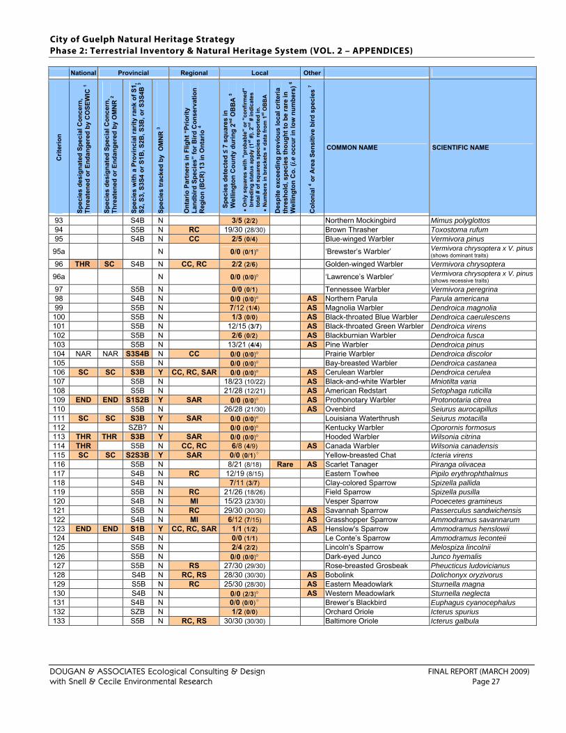
City of Guelph Natural Heritage Strategy Phase 2: Terrestrial Inventory & Natural Heritage System (VOL. 2 – APPENDICES)
DOUGAN & ASSOCIATES Ecological Consulting & Design FINAL REPORT (MARCH 2009) with Snell & Cecile Environmental Research Page 27
National Provincial Regional Local Other
Crit
erio
n
Spec
ies
desi
gnat
ed S
peci
al C
once
rn,
Thre
aten
ed o
r End
ange
red
by C
OSE
WIC
1
Spec
ies
desi
gnat
ed S
peci
al C
once
rn,
Thre
aten
ed o
r End
ange
red
by O
MN
R 2
Spec
ies
with
a P
rovi
ncia
l rar
ity ra
nk o
f S1,
S2
, S3,
S3S
4 or
S1B
, S2B
, S3B
, or S
3S4B
3
Spec
ies
trac
ked
by O
MN
R 3
Ont
ario
Par
tner
s in
Flig
ht “
Prio
rity
Land
bird
Spe
cies
” fo
r Bird
Con
serv
atio
n R
egio
n (B
CR
) 13
in O
ntar
io 4
Spec
ies
dete
cted
≤ 7
squ
ares
in
Wel
lingt
on C
ount
y du
ring
2nd O
BB
A 5
• O
nly
squa
res
with
"pr
obab
le"
or "
conf
irmed
" br
eedi
ng s
tatu
s ap
ply
(1st
#).
2nd #
indi
cate
s to
tal #
of s
quar
es s
peci
es re
port
ed in
. •
Num
bers
in b
rack
ets
= da
ta fr
om 1
st O
BB
A
Des
pite
exc
eedi
ng p
revi
ous
loca
l crit
eria
th
resh
old,
spe
cies
thou
ght t
o be
rare
in
Wel
lingt
on C
o. (i
.e o
ccur
in lo
w n
umbe
rs) 6
Col
onia
l 4 or A
rea
Sens
itive
bird
spe
cies
7
COMMON NAME SCIENTIFIC NAME
93 S4B N 3/5 (2/2) Northern Mockingbird Mimus polyglottos 94 S5B N RC 19/30 (28/30) Brown Thrasher Toxostoma rufum 95 S4B N CC 2/5 (0/4) Blue-winged Warbler Vermivora pinus
95a N 0/0 (0/1)° ‘Brewster’s Warbler’ Vermivora chrysoptera x V. pinus (shows dominant traits)
96 THR SC S4B N CC, RC 2/2 (2/6) Golden-winged Warbler Vermivora chrysoptera
96a N 0/0 (0/0)° ‘Lawrence’s Warbler’ Vermivora chrysoptera x V. pinus (shows recessive traits)
97 S5B N 0/0 (0/1) Tennessee Warbler Vermivora peregrina 98 S4B N 0/0 (0/0)° AS Northern Parula Parula americana 99 S5B N 7/12 (1/4) AS Magnolia Warbler Dendroica magnolia
100 S5B N 1/3 (0/0) AS Black-throated Blue Warbler Dendroica caerulescens 101 S5B N 12/15 (3/7) AS Black-throated Green Warbler Dendroica virens 102 S5B N 2/6 (0/2) AS Blackburnian Warbler Dendroica fusca 103 S5B N 13/21 (4/4) AS Pine Warbler Dendroica pinus 104 NAR NAR S3S4B N CC 0/0 (0/0)° Prairie Warbler Dendroica discolor 105 S5B N 0/0 (0/0)° Bay-breasted Warbler Dendroica castanea 106 SC SC S3B Y CC, RC, SAR 0/0 (0/0)° AS Cerulean Warbler Dendroica cerulea 107 S5B N 18/23 (10/22) AS Black-and-white Warbler Mniotilta varia 108 S5B N 21/28 (12/21) AS American Redstart Setophaga ruticilla 109 END END S1S2B Y SAR 0/0 (0/0)° AS Prothonotary Warbler Protonotaria citrea 110 S5B N 26/28 (21/30) AS Ovenbird Seiurus aurocapillus 111 SC SC S3B Y SAR 0/0 (0/0)° Louisiana Waterthrush Seiurus motacilla 112 SZB? N 0/0 (0/0)° Kentucky Warbler Oporornis formosus 113 THR THR S3B Y SAR 0/0 (0/0)° Hooded Warbler Wilsonia citrina 114 THR S5B N CC, RC 6/8 (4/9) AS Canada Warbler Wilsonia canadensis 115 SC SC S2S3B Y SAR 0/0 (0/1) Yellow-breasted Chat Icteria virens 116 S5B N 8/21 (8/18) Rare AS Scarlet Tanager Piranga olivacea 117 S4B N RC 12/19 (8/15) Eastern Towhee Pipilo erythrophthalmus 118 S4B N 7/11 (3/7) Clay-colored Sparrow Spizella pallida 119 S5B N RC 21/26 (18/26) Field Sparrow Spizella pusilla 120 S4B N MI 15/23 (23/30) Vesper Sparrow Pooecetes gramineus 121 S5B N RC 29/30 (30/30) AS Savannah Sparrow Passerculus sandwichensis 122 S4B N MI 6/12 (7/15) AS Grasshopper Sparrow Ammodramus savannarum 123 END END S1B Y CC, RC, SAR 1/1 (1/2) AS Henslow's Sparrow Ammodramus henslowii 124 S4B N 0/0 (1/1) Le Conte’s Sparrow Ammodramus leconteii 125 S5B N 2/4 (2/2) Lincoln's Sparrow Melospiza lincolnii 126 S5B N 0/0 (0/0)° Dark-eyed Junco Junco hyemalis 127 S5B N RS 27/30 (29/30) Rose-breasted Grosbeak Pheucticus ludovicianus 128 S4B N RC, RS 28/30 (30/30) AS Bobolink Dolichonyx oryzivorus 129 S5B N RC 25/30 (28/30) AS Eastern Meadowlark Sturnella magna 130 S4B N 0/0 (2/3)° AS Western Meadowlark Sturnella neglecta 131 S4B N 0/0 (0/0) Brewer’s Blackbird Euphagus cyanocephalus 132 SZB N 1/2 (0/0) Orchard Oriole Icterus spurius 133 S5B N RC, RS 30/30 (30/30) Baltimore Oriole Icterus galbula
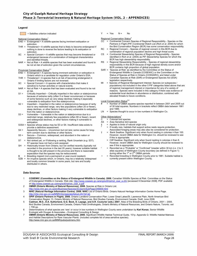
City of Guelph Natural Heritage Strategy Phase 2: Terrestrial Inventory & Natural Heritage System (VOL. 2 – APPENDICES)
DOUGAN & ASSOCIATES Ecological Consulting & Design FINAL REPORT (MARCH 2009) with Snell & Cecile Environmental Research Page 28
Legend
= Satisfies criterion indicated National Conservation Status1 END = Endangered = A wildlife species facing imminent extirpation or
extinction. THR = Threatened = A wildlife species that is likely to become endangered if
nothing is done to reverse the factors leading to its extirpation or extinction.
SC = Special Concern = A wildlife species that may become threatened or endangered because of a combination of biological characteristics and identified threats.
NAR = Not at Risk = A wildlife species that has been evaluated and found to be not at risk of extinction given the current circumstances.
Provincial Conservation Status2,3 END = Endangered = A species facing imminent extinction or extirpation in
Ontario which is a candidate for regulation under Ontario's ESA. THR = Threatened = A species that is at risk of becoming endangered in
Ontario if limiting factors are not reversed. SC = Special Concern = A species with characteristics that make it
sensitive to human activities or natural events. NAR = Not at Risk = A species that has been evaluated and found to be not
at risk. S1 = Critically Imperiled— Critically imperiled in the nation or state/province
because of extreme rarity (often 5 or fewer occurrences) or because of some factor(s) such as very steep declines making it especially vulnerable to extirpation from the state/province.
S2 = Imperiled— Imperiled in the nation or state/province because of rarity due to very restricted range, very few populations (often 20 or fewer), steep declines, or other factors making it very vulnerable to extirpation from the nation or state/province.
S3 = Vulnerable— Vulnerable in the nation or state/province due to a restricted range, relatively few populations (often 80 or fewer), recent and widespread declines, or other factors making it vulnerable to extirpation.
S3S4 = Species whose status may be S3 or S4. Insufficient data exists to provide a definitive assessment.
S4 = Apparently Secure— Uncommon but not rare; some cause for long-term concern due to declines or other factors.
S5 = Secure— Common, widespread, and abundant in the nation or state/province.
S? = Not ranked yet, or if following a ranking, Rank Uncertain (e.g. S3?). S? species have not had a rank assigned.
SH = Historically known from Ontario, but not verified recently (typically not recorded in the province in the last 20 years); however suitable habitat is thought to be still present in the province and there is reasonable expectation that the species may be rediscovered.
B = Breeding migrant (not a permanent or year-round resident) SZB = An irruptive species which, in Ontario, may be a relatively widespread
and locally common breeder in some years, but rare and locally distributed in others.
Y = Yes N = No Regional Conservation Status4 CC = Continental Concern Species of Regional Responsibility - Species on the
Partners in Flight (PIF) Continental Watch List (Rich et al. 2004) for which the Bird Conservation Region (BCR) has some conservation responsibility.
RC = Regional Concern – Species of regional concern in this BCR due to combination of regional population decline and high threat score.
CS = Continental Stewardship Species of Regional Responsibility - Species identified in Rich et al. (2004) as PIF Stewardship Species for which the BCR has high stewardship responsibility.
RS = Regional Stewardship Responsibility – Species of regional stewardship responsibility in this BCR because of high regional density score and/or BCR contains high proportion of global population.
SAR = ‘Species at Risk’ as identified by the Committee on the Status of Endangered Wildlife in Canada (COSEWIC) or the Committee on the Status of Species at Risk in Ontario (COSSARO), and listed under Canadian Species at Risk (SAR) or Endangered Species Act (ESA) legislation respectively.
MI = Species of Regional Management Interest: Species (or subspecies / populations) not included in the other 5 PIF categories listed above that are of regional management interest or importance for any of a variety of reasons. Species were included in this category if there was evidence of substantial local declines in abundance or distribution, combined with elevated threats to future conditions.
Local Conservation Status5,6 # = Number of OBBA squares species reported in between 2001 and 2005 out
of 30 total squares. Numbers in brackets reflect OBBA data between 1981 and 1985.
LN = Species thought to occur in low numbers in Wellington Co. Other Abbreviations7
C = Colonial bird species AS = Area Sensitive bird species ‡ = Applies to birds of natural origin only. * = If locally rare, habitats that support active nests require protection.
Associated foraging areas may also also be considered for protection. † = Bank Swallow: Significant only when found nesting in colonies ≥ than 100.
However, recent OBBA data for Wellington Co. should be reviewed to see if this is appropriate.
= Cliff Swallow: Significant only when found nesting in colonies ≥ than 8. However, recent OBBA data for Wellington County should be reviewed to see if this is appropriate.
° = Recorded as a “Probable” or “Confirmed” breeder within 30 km (i.e. 2 to 3 atlas squares) of Wellington County boundary (as defined in Figure 1) during either the 1st or 2nd OBBA periods
= Recorded breeding in Wellington County prior to 1981. Suitable habitat is currently present within Wellington County.
Data Sources 1 COSEWIC (Committee on the Status of Endangered Wildlife in Canada). 2008. Canadian Wildlife Species at Risk. Committee on the Status
of Endangered Wildlife in Canada. Web site: http://www.cosewic.gc.ca/eng/sct0/rpt/rpt_csar_e.cfm [accessed 9 December 2008]. PDF available at http://www.cosewic.gc.ca/eng/sct0/rpt/rpt_csar_e.pdf
2 OMNR (Ontario Ministry of Natural Resources). 2008. Species at Risk in Ontario List. http://www.mnr.gov.on.ca/en/Business/Species/2ColumnSubPage/246809.html
3 NHIC (Natural Heritage Information Centre). 2008. NHIC List of Ontario Birds. Ontario Natural Heritage Information Centre Home Page. http://nhic.mnr.gov.on.ca/MNR/nhic/species/listout.cfm?el=ab
4 OPIF (Ontario Partners in Flight). 2008. Ontario Landbird Conservation Plan: Lower Great Lakes/St. Lawrence Plain, North American Bird Conservation Region 13. Ontario Ministry of Natural Resources, Bird Studies Canada, Environment Canada. Draft. June 2008.
5 Cadman, M.D., D.A. Sutherland, G.G. Beck, D. Lepage, and A.R. Couturier (eds.) 2007. Atlas of the Breeding Birds of Ontario, 2001 – 2005. Bird Studies Canada, Environment Canada, Ontario Field Ornithologists, Ontario Ministry of Natural Resources, and Ontario Nature, Toronto. xxii + 706 pp.
6 Determinations of what species are ‘rare’ or occur in low numbers in Wellington County were undertaken by Karl Konze, Senior Wildlife Ecologist with Dougan & Associates – Ecological Consulting & Design
7 OMNR (Ontario Ministry of Natural Resources). 2000. Significant Wildlife Habitat Technical Guide. 151p. Appendix G: Wildlife Habitat Matrices and Habitat Descriptions for Rare Vascular Plants. (includes complete list of area sensitive species). http://www.mnr.gov.on.ca/MNR/pubs/pubmenu.htm
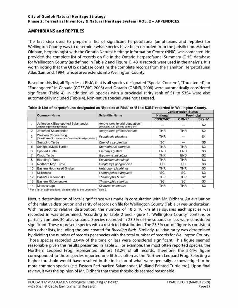
City of Guelph Natural Heritage Strategy Phase 2: Terrestrial Inventory & Natural Heritage System (VOL. 2 – APPENDICES)
DOUGAN & ASSOCIATES Ecological Consulting & Design FINAL REPORT (MARCH 2009) with Snell & Cecile Environmental Research Page 29
AMPHIBIANS and REPTILES The first step used to prepare a list of significant herpetofauna (amphibians and reptiles) for Wellington County was to determine what species have been recorded from the jurisdiction. Michael Oldham, herpetologist with the Ontario Natural Heritage Information Centre (NHIC) was contacted. He provided the complete list of records on file in the Ontario Herpetofaunal Summary (OHS) database for Wellington County (as defined in Table 2 and Figure 1). 4810 records were used in the analysis. It is worth noting that the OHS database contains the complete records from the Hamilton Herpetofaunal Atlas (Lamond, 1994) whose area extends into Wellington County. Based on this list, all ‘Species at Risk’, that is all species designated “Special Concern”, “Threatened”, or “Endangered” in Canada (COSEWIC, 2008) and Ontario (OMNR, 2008) were automatically considered significant (Table 4). In addition, all species with a provincial rarity rank of S1 to S3S4 were also automatically included (Table 4). Non-native species were not assessed. Table 4: List of herpetofauna designated as ‘Species at Risk’ or ‘S1 to S3S4’ recorded in Wellington County.
Conservation Status National Provincial Common Name Scientific Name
COSEWIC* OMNR* SRank*
1 Jefferson x Blue-spotted Salamander, Jefferson genome dominates
Ambystoma hybrid population 1 (jeffersonianum genome dominates) --- --- S2
2 Jefferson Salamander Ambystoma jeffersonianum THR THR S2
3 Western Chorus Frog (Great Lakes/St. Lawrence – Canadian Shield population) Pseudacris triseriata THR --- S4
4 Snapping Turtle Chelydra serpentina SC --- S5 5 Stinkpot (Musk Turtle) Sternotherus odoratus THR THR S3 6 Spotted Turtle Clemmys guttata END END S3 7 Wood Turtle Glyptemys insculpta THR END S2 8 Blanding's Turtle Emydoidea blandingii THR THR S3 9 Northern Map Turtle Graptemys geographica SC SC S3
10 Eastern Hog-nosed Snake Heterodon platirhinos THR THR S3 11 Milksnake Lampropeltis triangulum SC SC S3 12 Butler's Gartersnake Thamnophis butleri THR THR S2 13 Eastern Ribbonsnake Thamnophis sauritus SC SC S3 14 Massasauga Sistrurus catenatus THR THR S3
* For a list of abbreviations, please refer to the Legend in Table 3.
Next, a determination of local significance was made in consultation with Mr. Oldham. An evaluation of the relative distribution and rarity of records on file for Wellington County (Table 5) was undertaken. With respect to relative distribution, the number of 10 x 10 km atlas squares each species was recorded in was determined. According to Table 2 and Figure 1, ‘Wellington County’ contains or partially contains 30 atlas squares. Species recorded in 23.3% of the squares or less were considered significant. These represent species with a restricted distribution. The 23.3% cut-off figure is consistent with other lists, including the one created for Breeding Birds. Similarly, relative rarity was determined by dividing the number of records per species with the total number of records for Wellington County. Those species recorded 2.64% of the time or less were considered significant. This figure seemed reasonable given the results presented in Table 5. For example, the most often reported species, the Northern Leopard Frog, represented almost 13.2% of all records. Therefore, the 2.64% figure corresponded to those species reported one fifth as often as the Northern Leopard Frog. Selecting a higher threshold would have resulted in the inclusion of what were generally acknowledged to be more common species (e.g. Eastern Red-backed Salamander, Midland Painted Turtle etc.). Upon final review, it was the opinion of Mr. Oldham that these thresholds seemed reasonable.
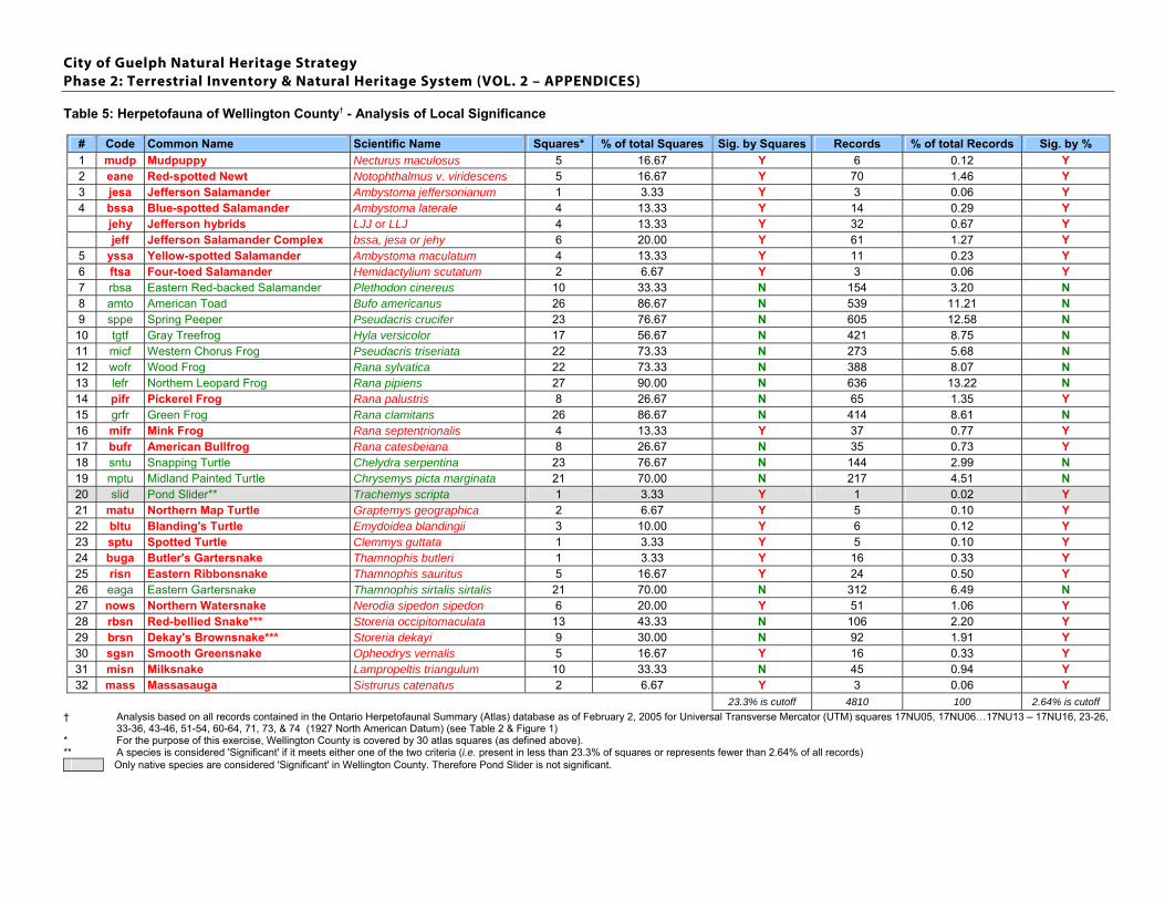
City of Guelph Natural Heritage Strategy Phase 2: Terrestrial Inventory & Natural Heritage System (VOL. 2 – APPENDICES)
Table 5: Herpetofauna of Wellington County† - Analysis of Local Significance
# Code Common Name Scientific Name Squares* % of total Squares Sig. by Squares Records % of total Records Sig. by % 1 mudp Mudpuppy Necturus maculosus 5 16.67 Y 6 0.12 Y 2 eane Red-spotted Newt Notophthalmus v. viridescens 5 16.67 Y 70 1.46 Y 3 jesa Jefferson Salamander Ambystoma jeffersonianum 1 3.33 Y 3 0.06 Y 4 bssa Blue-spotted Salamander Ambystoma laterale 4 13.33 Y 14 0.29 Y jehy Jefferson hybrids LJJ or LLJ 4 13.33 Y 32 0.67 Y jeff Jefferson Salamander Complex bssa, jesa or jehy 6 20.00 Y 61 1.27 Y 5 yssa Yellow-spotted Salamander Ambystoma maculatum 4 13.33 Y 11 0.23 Y 6 ftsa Four-toed Salamander Hemidactylium scutatum 2 6.67 Y 3 0.06 Y 7 rbsa Eastern Red-backed Salamander Plethodon cinereus 10 33.33 N 154 3.20 N 8 amto American Toad Bufo americanus 26 86.67 N 539 11.21 N 9 sppe Spring Peeper Pseudacris crucifer 23 76.67 N 605 12.58 N
10 tgtf Gray Treefrog Hyla versicolor 17 56.67 N 421 8.75 N 11 micf Western Chorus Frog Pseudacris triseriata 22 73.33 N 273 5.68 N 12 wofr Wood Frog Rana sylvatica 22 73.33 N 388 8.07 N 13 lefr Northern Leopard Frog Rana pipiens 27 90.00 N 636 13.22 N 14 pifr Pickerel Frog Rana palustris 8 26.67 N 65 1.35 Y 15 grfr Green Frog Rana clamitans 26 86.67 N 414 8.61 N 16 mifr Mink Frog Rana septentrionalis 4 13.33 Y 37 0.77 Y 17 bufr American Bullfrog Rana catesbeiana 8 26.67 N 35 0.73 Y 18 sntu Snapping Turtle Chelydra serpentina 23 76.67 N 144 2.99 N 19 mptu Midland Painted Turtle Chrysemys picta marginata 21 70.00 N 217 4.51 N 20 slid Pond Slider** Trachemys scripta 1 3.33 Y 1 0.02 Y 21 matu Northern Map Turtle Graptemys geographica 2 6.67 Y 5 0.10 Y 22 bltu Blanding's Turtle Emydoidea blandingii 3 10.00 Y 6 0.12 Y 23 sptu Spotted Turtle Clemmys guttata 1 3.33 Y 5 0.10 Y 24 buga Butler's Gartersnake Thamnophis butleri 1 3.33 Y 16 0.33 Y 25 risn Eastern Ribbonsnake Thamnophis sauritus 5 16.67 Y 24 0.50 Y 26 eaga Eastern Gartersnake Thamnophis sirtalis sirtalis 21 70.00 N 312 6.49 N 27 nows Northern Watersnake Nerodia sipedon sipedon 6 20.00 Y 51 1.06 Y 28 rbsn Red-bellied Snake*** Storeria occipitomaculata 13 43.33 N 106 2.20 Y 29 brsn Dekay's Brownsnake*** Storeria dekayi 9 30.00 N 92 1.91 Y 30 sgsn Smooth Greensnake Opheodrys vernalis 5 16.67 Y 16 0.33 Y 31 misn Milksnake Lampropeltis triangulum 10 33.33 N 45 0.94 Y 32 mass Massasauga Sistrurus catenatus 2 6.67 Y 3 0.06 Y
23.3% is cutoff 4810 100 2.64% is cutoff † Analysis based on all records contained in the Ontario Herpetofaunal Summary (Atlas) database as of February 2, 2005 for Universal Transverse Mercator (UTM) squares 17NU05, 17NU06…17NU13 – 17NU16, 23-26,
33-36, 43-46, 51-54, 60-64, 71, 73, & 74 (1927 North American Datum) (see Table 2 & Figure 1) * For the purpose of this exercise, Wellington County is covered by 30 atlas squares (as defined above). ** A species is considered 'Significant' if it meets either one of the two criteria (i.e. present in less than 23.3% of squares or represents fewer than 2.64% of all records)
Only native species are considered 'Significant' in Wellington County. Therefore Pond Slider is not significant.
City of Guelph Natural Heritage Strategy Phase 2: Terrestrial Inventory & Natural Heritage System (VOL. 2 – APPENDICES)
DOUGAN & ASSOCIATES Ecological Consulting & Design FINAL REPORT (MARCH 2009) with Snell & Cecile Environmental Research Page 31
Two additional species were added to the list of significant herpetofauna for Wellington County. A Ring-necked Snake (Diadophis punctatus) was observed by Alan Watson, Proffesor and Director of the University of Guelph, Arborteum, in the late 70s or early 80s (likely between 1979 & 1981). The observation was from the University of Guelph Arboretum “Nature Reserve”, south of Stone Road. The other observation pertained to a Common Five-lined Skink (Eumeces fasciatus). One juvenile individual was noted from the southwest side of Luther Marsh between June and August 1980 by Craig Campbell, local naturalist and co-author of “The Herpetofauna of Waterloo Region, Ontario”. MAMMALS Similar to the herpetofauna, the first step used to prepare a list of significant mammals for Wellington County was to determine what species have been recorded from ‘Wellington County’ (as defined in Table 2 and Figure 1). The Ontario Mammal Atlas and data on file at the Royal Ontario Museum (ROM) were the primary sources of information. In total, 3112 individual records were received representing 43 species. Based on this list, all ‘Species at Risk’, that is all species designated “Special Concern”, “Threatened”, or “Endangered” in Canada (COSEWIC, 2008) and Ontario (OMNR, 2008) were automatically considered significant in Wellington County. In addition to the Species at Risk, all species with a provincial rarity rank of S3S4 or lower (i.e. S1–S3 and S3S4) by the Ontario Natural Heritage Information Centre (NHIC) were also automatically included. Only four species were identified as being significant using these criteria (Table 6). However, since the distribution and occurrence of wildlife in the province is not static, the conservation status of all species should be checked regularly to ensure the list is accurate and up-to-date. Table 6: ‘Species at Risk’ and S1–S3, S3S4 mammal species documented from ‘Wellington County’ based
on Ontario Mammal Atlas, ROM, and NHIC databases
Conservation Status National Provincial Common Name Scientific Name COSEWIC OMNR SRank
1 Northern Long-eared Bat Myotis septentrionalis S3?2 Eastern Pipistrelle Pipistrellus subflavus S3?3 Southern Flying Squirrel Glaucomys volans SC NAR S44 Gray Fox Urocyon cinereoargenteus THR THR SZB?
* For a list of abbreviations, please refer to the Legend in Table 3. One other ‘Species at Risk’ has been confirmed from the County. Stuart Kenn, president of the Ontario Puma Foundation (http://www.ontariopuma.ca/contacts.htm) confirmed the presence of at least five resident populations of Puma (Puma concolor couguar) (recently referred to as Mountain Lion or Eastern Cougar) from within the County. In addition, there is one unconfirmed report of an American Badger (Taxidea taxus) from Wellington County. Ken Cornelisse, Area Biologist with the Ontario Ministry of Natural Resources provided information on a historic report from just west of Marden, north of Guelph. Apparently an individual of this species was resident under a building of a Township park campground about 20 years ago (Cornelisse, pers. comm., 2005). According to the American Badger Recovery Team, no other records exist for Wellington County (Gould, pers. comm., 2005). Two additional provincially rare species, Small-footed Bat (Myotis leibii) and Woodland Vole (Microtus pinetorum) have been documented within 15 km of the ‘Wellington County’ boundary (as defined in Table 2 and Figure 1) and due to their close proximity and availability of suitable habitat in Wellington
City of Guelph Natural Heritage Strategy Phase 2: Terrestrial Inventory & Natural Heritage System (VOL. 2 – APPENDICES)
DOUGAN & ASSOCIATES Ecological Consulting & Design FINAL REPORT (MARCH 2009) with Snell & Cecile Environmental Research Page 32
County, were also added to the list of significant mammals. The Woodland Vole is also considered to be of “Special Concern” in Canada (COSEWIC, 2008) and Ontario (OMNR, 2008). Next, an attempt at determining local significance was made by evaluating the relative distribution and rarity of records on file for ‘Wellington County’. The combined information from two databases was used in the evaluation; one from the Atlas of the Mammals of Ontario and the other from the Royal Ontario Museum. In total, the evaluation was based on 3112 individual records (Table 7). With respect to relative distribution, the number of 10 x 10 km atlas squares each species was recorded in was determined. Those species recorded in 10% of the squares or less were considered significant. With respect to relative abundance, those species that represent less than 1% of all records were considered significant. Similar to the breeding bird and herpetofaunal lists, the cut-off figures selected were considered restrictive. However, in this case, the figures selected were 2.3 times lower those used for breeding birds and herpetofauna. This was a necessary change since many mammal species, especially small mammals such as rodents and bats, are only rarely seen and documented, due to their secretive and retiring habits. That is, if the larger cut-off figures were applied in this exercise, many species of mammals would have appeared rarer than is realistically the case. Still, it was the opinion of various experts that the datasets used to analyse small mammals such as shrews, moles, bats, mice and voles, were almost certainly not comprehensive enough to provide a representative reflection of the county. It is not even clear how much trapping has taken place in the County. It is very likely that most places have had no inventory work conducted at all. Although the Ontario Mammal Atlas and ROM datasets were not used to identify small mammals for significance, other sources of information were used in this pursuit. The Hamilton Natural Areas Inventory (Vlasman, 2003; Heagy and Ross, 1995) and The Natural Areas Inventory of the Regional Municipality of Haldimand-Norfolk (Gartshore, 1987b) were used as the primary sources of information. Both initiatives conducted extensive trapping and therefore probably provided a reasonably accurate understanding of the status of this underrepresented group. It was also assumed that the types and extent of habitats present in these areas were not significantly different than what is present in Wellington County. Only those species considered Uncommon or Rare in either location and for which suitable habitat is also present in Wellington County were added to this list. This included: Water Shrew (Sorex palustris), Hairy-tailed Mole (Parascalops breweri), Southern Bog Lemming (Synaptomys cooperi) and Woodland Jumping Mouse (Napaeozapus insignis). Although Southern Bog Lemming was not included in the Ontario Mammal Atlas, ROM and NHIC datasets for Wellington County, one individual was trapped at the University of Guelph Nature Reserve in 1980 (C. Earley, pers.comm., 2005). Southern Bog Lemming is also known from the Campbelville area, immediately east of the eastern boundary. With respect to bats, it was the opinion of Dr. Brock Fenton that for most species of bats there was not enough information available to accurately assess conservation status (B. Fenton, pers. comm., 2004) at a local, regional, provincial or even national scale. While this may indeed be the case, it was decided that any species designated as provincially rare should still merit inclusion as significant in Wellington County. Apparently a more conservative approach is taken when determining provincial status. The number and significance of known hibernacula and maternity sites are key considerations used to help assess status (D. Sutherland, pers. comm., 2004).
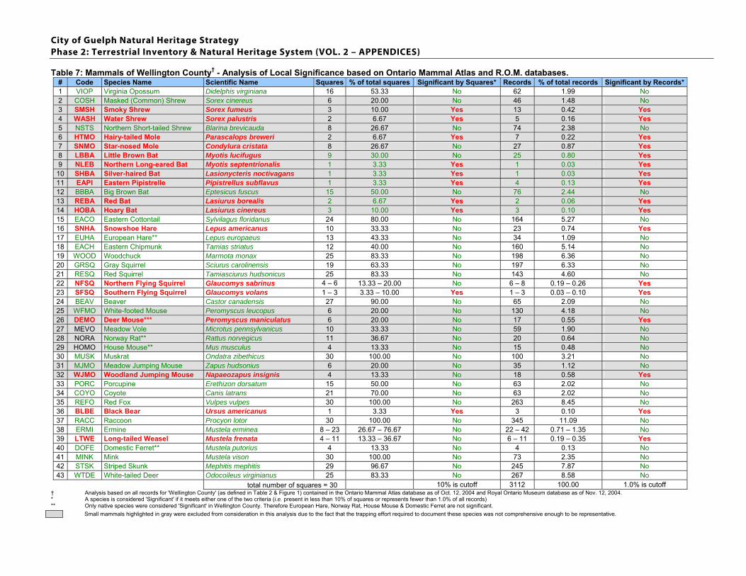
City of Guelph Natural Heritage Strategy Phase 2: Terrestrial Inventory & Natural Heritage System (VOL. 2 – APPENDICES)
Table 7: Mammals of Wellington County† - Analysis of Local Significance based on Ontario Mammal Atlas and R.O.M. databases. # Code Species Name Scientific Name Squares % of total squares Significant by Squares* Records % of total records Significant by Records*1 VIOP Virginia Opossum Didelphis virginiana 16 53.33 No 62 1.99 No 2 COSH Masked (Common) Shrew Sorex cinereus 6 20.00 No 46 1.48 No 3 SMSH Smoky Shrew Sorex fumeus 3 10.00 Yes 13 0.42 Yes 4 WASH Water Shrew Sorex palustris 2 6.67 Yes 5 0.16 Yes 5 NSTS Northern Short-tailed Shrew Blarina brevicauda 8 26.67 No 74 2.38 No 6 HTMO Hairy-tailed Mole Parascalops breweri 2 6.67 Yes 7 0.22 Yes 7 SNMO Star-nosed Mole Condylura cristata 8 26.67 No 27 0.87 Yes 8 LBBA Little Brown Bat Myotis lucifugus 9 30.00 No 25 0.80 Yes 9 NLEB Northern Long-eared Bat Myotis septentrionalis 1 3.33 Yes 1 0.03 Yes
10 SHBA Silver-haired Bat Lasionycteris noctivagans 1 3.33 Yes 1 0.03 Yes 11 EAPI Eastern Pipistrelle Pipistrellus subflavus 1 3.33 Yes 4 0.13 Yes 12 BBBA Big Brown Bat Eptesicus fuscus 15 50.00 No 76 2.44 No 13 REBA Red Bat Lasiurus borealis 2 6.67 Yes 2 0.06 Yes 14 HOBA Hoary Bat Lasiurus cinereus 3 10.00 Yes 3 0.10 Yes 15 EACO Eastern Cottontail Sylvilagus floridanus 24 80.00 No 164 5.27 No 16 SNHA Snowshoe Hare Lepus americanus 10 33.33 No 23 0.74 Yes 17 EUHA European Hare** Lepus europaeus 13 43.33 No 34 1.09 No 18 EACH Eastern Chipmunk Tamias striatus 12 40.00 No 160 5.14 No 19 WOOD Woodchuck Marmota monax 25 83.33 No 198 6.36 No 20 GRSQ Gray Squirrel Sciurus carolinensis 19 63.33 No 197 6.33 No 21 RESQ Red Squirrel Tamiasciurus hudsonicus 25 83.33 No 143 4.60 No 22 NFSQ Northern Flying Squirrel Glaucomys sabrinus 4 – 6 13.33 – 20.00 No 6 – 8 0.19 – 0.26 Yes 23 SFSQ Southern Flying Squirrel Glaucomys volans 1 – 3 3.33 – 10.00 Yes 1 – 3 0.03 – 0.10 Yes 24 BEAV Beaver Castor canadensis 27 90.00 No 65 2.09 No 25 WFMO White-footed Mouse Peromyscus leucopus 6 20.00 No 130 4.18 No 26 DEMO Deer Mouse*** Peromyscus maniculatus 6 20.00 No 17 0.55 Yes 27 MEVO Meadow Vole Microtus pennsylvanicus 10 33.33 No 59 1.90 No 28 NORA Norway Rat** Rattus norvegicus 11 36.67 No 20 0.64 No 29 HOMO House Mouse** Mus musculus 4 13.33 No 15 0.48 No 30 MUSK Muskrat Ondatra zibethicus 30 100.00 No 100 3.21 No 31 MJMO Meadow Jumping Mouse Zapus hudsonius 6 20.00 No 35 1.12 No 32 WJMO Woodland Jumping Mouse Napaeozapus insignis 4 13.33 No 18 0.58 Yes 33 PORC Porcupine Erethizon dorsatum 15 50.00 No 63 2.02 No 34 COYO Coyote Canis latrans 21 70.00 No 63 2.02 No 35 REFO Red Fox Vulpes vulpes 30 100.00 No 263 8.45 No 36 BLBE Black Bear Ursus americanus 1 3.33 Yes 3 0.10 Yes 37 RACC Raccoon Procyon lotor 30 100.00 No 345 11.09 No 38 ERMI Ermine Mustela erminea 8 – 23 26.67 – 76.67 No 22 – 42 0.71 – 1.35 No 39 LTWE Long-tailed Weasel Mustela frenata 4 – 11 13.33 – 36.67 No 6 – 11 0.19 – 0.35 Yes 40 DOFE Domestic Ferret** Mustela putorius 4 13.33 No 4 0.13 No 41 MINK Mink Mustela vison 30 100.00 No 73 2.35 No 42 STSK Striped Skunk Mephitis mephitis 29 96.67 No 245 7.87 No 43 WTDE White-tailed Deer Odocoileus virginianus 25 83.33 No 267 8.58 No
total number of squares = 30 10% is cutoff 3112 100.00 1.0% is cutoff † Analysis based on all records for 'Wellington County' (as defined in Table 2 & Figure 1) contained in the Ontario Mammal Atlas database as of Oct. 12, 2004 and Royal Ontario Museum database as of Nov. 12, 2004. * A species is considered 'Significant' if it meets either one of the two criteria (i.e. present in less than 10% of squares or represents fewer than 1.0% of all records) ** Only native species were considered 'Significant' in Wellington County. Therefore European Hare, Norway Rat, House Mouse & Domestic Ferret are not significant.
Small mammals highlighted in gray were excluded from consideration in this analysis due to the fact that the trapping effort required to document these species was not comprehensive enough to be representative.
City of Guelph Natural Heritage Strategy Phase 2: Terrestrial Inventory & Natural Heritage System (VOL. 2 – APPENDICES)
DOUGAN & ASSOCIATES Ecological Consulting & Design FINAL REPORT (MARCH 2009) with Snell & Cecile Environmental Research Page 34
Based on this approach, the following species are currently designated as provincially rare: Small-footed Bat (Myotis leibii), Northern Long-eared Bat (Myotis septentrionalis), and Eastern Pipistrelle (Pipistrellus subflavus). It should also be noted that most naturally occurring hibernacula and maternity sites would be considered as Significant Wildlife Habitat according to the Significant Wildlife Habitat Technical Guide (OMNR, 2000) and should be automatically afforded protection. A range of values was provided in Table 7 for both species of flying squirrel (Glaucomys sp.), as well as Ermine (Mustela erminea) and Long-tailed Weasel (Mustela frenata). This reflects the inclusion of data not specific to species. As an example, the database included two records of flying squirrel sp. Identification could not be confirmed. As a result, both Southern Flying Squirrel and Northern Flying Squirrel totals were bumped up by two to reflect the possibility that both records could have applied to either species. The 25 unconfirmed weasel records (excluding Mink) were considered differently than the flying squirrel records. Instead of adding 25 records to each species, they were divided up according to the relative percentage of existing records. Therefore, the Ermine received the bulk of the records (20) and the Long-tailed Weasel only 5. Even if all 25 were added to each species, it would not have affected the outcome for significance. Non-native species such as European Hare (Lepus americanus), Norway Rat (Rattus norvegicus), House Mouse (Mus musculus), and Domestic Ferret (Mustela putorius) were excluded from consideration for significance. The following sources were reviewed to see if any other species not already reported should be added to the list of mammalia for Wellington County and thus also be considered significant: The Mammalia of Northern Wellington (Brooks, 1905), The Mammals of Wellington and Waterloo Counties, Ontario (Soper, 1923b), Mammals of Waterloo and South Wellington Counties 1972 (Campbell and Dagg, 1972) and Changes Among the Mammals of Wellington County 1640 – 1997 (Campbell et al., 1997). Based on this review, five species were added. Recent evidence exists for four of the five species or their continued presence is considered possible. The four include: Pygmy Shrew (Sorex hoyi), River Otter (Lutra canadensis), Lynx (Lynx canadensis) and Bobcat (Lynx rufus). The fifth, Southern Red-backed Vole (Clethrionomys gapperi) has been documented historically from northern Wellington County. River Otter and Lynx were also confirmed in a conversation with Art Timmerman, Area Biologist with the Ontario Ministry of Natural Resources (A. Timmerman, pers. comm., 2004). He also mentioned recent observations of Black Bear (Ursus americanus) from the county, although they almost certainly pertain to individuals wandering through the county and not permanent residents. He was unaware of any recent observations of Marten (Martes americana) or Fisher (Martes pennanti). Lastly, Chris Earley, Interpretive Naturalist and Education Coordinator at the University of Guelph, brought to our attention two Least Weasel (Mustela nivalis) observations made at the University of Guelph since 1980 (one of which was live-trapped). Least Weasel has a status of SU in Ontario (ONHIC, 2005f), meaning it is unrankable due to a lack of data. Although it appears to be absent in southern Ontario according to the Ontario Mammal Atlas (Dobbyn, 1994), it is a habitat generalist and occurs most everywhere else in the Great Lakes region (Kurta, 1995). Based on its documented occurrence in Ontario, it has been accorded significant species status in Wellington County.
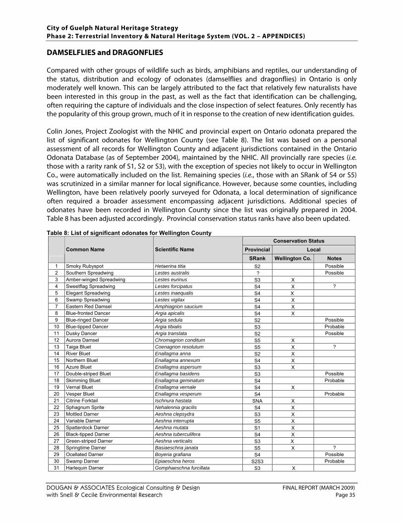
City of Guelph Natural Heritage Strategy Phase 2: Terrestrial Inventory & Natural Heritage System (VOL. 2 – APPENDICES)
DOUGAN & ASSOCIATES Ecological Consulting & Design FINAL REPORT (MARCH 2009) with Snell & Cecile Environmental Research Page 35
DAMSELFLIES and DRAGONFLIES Compared with other groups of wildlife such as birds, amphibians and reptiles, our understanding of the status, distribution and ecology of odonates (damselflies and dragonflies) in Ontario is only moderately well known. This can be largely attributed to the fact that relatively few naturalists have been interested in this group in the past, as well as the fact that identification can be challenging, often requiring the capture of individuals and the close inspection of select features. Only recently has the popularity of this group grown, much of it in response to the creation of new identification guides. Colin Jones, Project Zoologist with the NHIC and provincial expert on Ontario odonata prepared the list of significant odonates for Wellington County (see Table 8). The list was based on a personal assessment of all records for Wellington County and adjacent jurisdictions contained in the Ontario Odonata Database (as of September 2004), maintained by the NHIC. All provincially rare species (i.e. those with a rarity rank of S1, S2 or S3), with the exception of species not likely to occur in Wellington Co., were automatically included on the list. Remaining species (i.e., those with an SRank of S4 or S5) was scrutinized in a similar manner for local significance. However, because some counties, including Wellington, have been relatively poorly surveyed for Odonata, a local determination of significance often required a broader assessment encompassing adjacent jurisdictions. Additional species of odonates have been recorded in Wellington County since the list was originally prepared in 2004. Table 8 has been adjusted accordingly. Provincial conservation status ranks have also been updated. Table 8: List of significant odonates for Wellington County
Conservation Status Provincial Local
Common Name Scientific Name SRank Wellington Co. Notes
1 Smoky Rubyspot Hetaerina titia S2 Possible 2 Southern Spreadwing Lestes australis ? Possible 3 Amber-winged Spreadwing Lestes eurinus S3 X 4 Sweetflag Spreadwing Lestes forcipatus S4 X ? 5 Elegant Spreadwing Lestes inaequalis S4 X 6 Swamp Spreadwing Lestes vigilax S4 X 7 Eastern Red Damsel Amphiagrion saucium S4 X 8 Blue-fronted Dancer Argia apicalis S4 X 9 Blue-ringed Dancer Argia sedula S2 Possible
10 Blue-tipped Dancer Argia tibialis S3 Probable 11 Dusky Dancer Argia translata S2 Possible 12 Aurora Damsel Chromagrion conditum S5 X 13 Taiga Bluet Coenagrion resolutum S5 X ? 14 River Bluet Enallagma anna S2 X 15 Northern Bluet Enallagma annexum S4 X 16 Azure Bluet Enallagma aspersum S3 X 17 Double-striped Bluet Enallagma basidens S3 Possible 18 Skimming Bluet Enallagma geminatum S4 Probable 19 Vernal Bluet Enallagma vernale S4 X 20 Vesper Bluet Enallagma vesperum S4 Probable 21 Citrine Forktail Ischnura hastata SNA X 22 Sphagnum Sprite Nehalennia gracilis S4 X 23 Mottled Darner Aeshna clepsydra S3 X 24 Variable Darner Aeshna interrupta S5 X 25 Spatterdock Darner Aeshna mutata S1 X 26 Black-tipped Darner Aeshna tuberculifera S4 X 27 Green-striped Darner Aeshna verticalis S3 X 28 Springtime Darner Basiaeschna janata S5 X ? 29 Ocellated Darner Boyeria grafiana S4 Possible 30 Swamp Darner Epiaeschna heros S2S3 Probable 31 Harlequin Darner Gomphaeschna furcillata S3 X
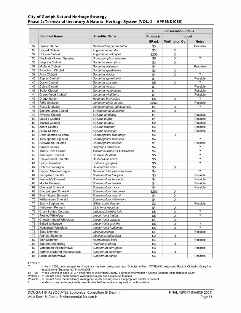
City of Guelph Natural Heritage Strategy Phase 2: Terrestrial Inventory & Natural Heritage System (VOL. 2 – APPENDICES)
DOUGAN & ASSOCIATES Ecological Consulting & Design FINAL REPORT (MARCH 2009) with Snell & Cecile Environmental Research Page 36
Conservation Status Provincial Local
Common Name Scientific Name SRank Wellington Co. Notes
32 Cyrano Darner Nasiaeschna pentacantha S3 Probable 33 Lilypad Clubtail Arigomphus furcifer S3 X 34 Unicorn Clubtail Arigomphus villosipes S2S3 X 35 Black-shouldered Spinyleg Dromogomphus spinosus S5 X ? 36 Harpoon Clubtail Gomphus descriptus S3 X 37 Midland Clubtail Gomphus fraternus S4 Probable 38 Pronghorn Clubtail Gomphus graslinellus S3 X 39 Ashy Clubtail Gomphus lividus S4 X ? 40 Rapids Clubtail** Gomphus quadricolor S1 Possible 41 Dusky Clubtail Gomphus spicatus S5 X ? 42 Cobra Clubtail Gomphus vastus S1 Possible 43 Skillet Clubtail Gomphus ventricosus S1 Possible 44 Green-faced Clubtail Gomphus viridifrons S1 Possible 45 Dragonhunter Hagenius brevistylus S5 X ? 46 Riffle Snaketail Ophiogomphus carolus S2S3 Possible 47 Rusty Snaketail Ophiogomphus rupinsulensis S4 X ? 48 Eastern Least Clubtail Stylogomphus albistylus S4 X 49 Riverine Clubtail Stylurus amnicola S1 Possible 50 Laura's Clubtail Stylurus laurae S1 Possible 51 Elusive Clubtail Stylurus notatus S2 Possible 52 Zebra Clubtail Stylurus scudderi S4 Possible 53 Arrow Clubtail Stylurus spiniceps S2 Possible 54 Delta-spotted Spiketail Cordulegaster diastatops S4 X 55 Twin-spotted Spiketail Cordulegaster maculata S4 ? 56 Arrowhead Spiketail Cordulegaster obliqua S1 Possible 57 Stream Cruiser Didymops transversa S4 ? 58 Illinois River Cruiser Macromia illinoiensis illinoiensis S4 ? 59 American Emerald Cordulia shurtleffi S5 ? 60 Racket-tailed Emerald Dorocordulia libera S5 ? 61 Spiny Baskettail Epitheca spinigera S5 ? 62 Uhler's Sundragon Helocordulia uhleri S3 X 63 Stygian Shadowdragon Neurocordulia yamaskanensis S4 ? 64 Forcipate Emerald Somatochlora forcipata S3 Possible 65 Kennedy's Emerald Somatochlora kennedyi S4 Possible 66 Mocha Emerald Somatochlora linearis S1 Possible 67 Ocellated Emerald Somatochlora minor S4 Possible 68 Clamp-tipped Emerald Somatochlora tenebrosa S2S3 X 69 Brush-tipped Emerald Somatochlora walshii S4 X 70 Williamson's Emerald Somatochlora williamsoni S4 X 71 Ebony Boghaunter Williamsonia fletcheri S2 Possible 72 Halloween Pennant Celithemis eponina S4 X 73 Chalk-fronted Corporal Ladona (Libellula) julia S5 X ? 74 Frosted Whiteface Leucorrhinia frigida S5 X ? 75 Crimson-ringed Whiteface Leucorrhinia glacialis S4 X 76 Belted Whiteface Leucorrhinia proxima S5 X ? 77 Hudsonian Whiteface Leucorrhinia hudsonica S5 X ? 78 Slaty Skimmer Libellula incesta S4 Possible 79 Painted Skimmer Libellula semifasciata S2 X 80 Elfin Skimmer Nannothemis bella S4 Possible 81 Eastern Amberwing Perithemis tenera S4 X 82 Variegated Meadowhawk Sympetrum corruptum S3 Possible 83 Saffron-bordered Meadowhawk Sympetrum costiferum S4 X 84 Black Meadowhawk Sympetrum danae S4 Possible
LEGEND ** = As of 2008, only one species of odonata has been designated as a ‘Species at Risk’. COSEWIC designated Rapid’s Clubtails (Gomphus
quadricolor) “Endangered” in April 2008. S1 – S5 = see Legend in Table 3; X = Recorded in Wellington County. Source of information = Ontario Odonata Atlas database (2004) Probable = Has not been recorded from Wellington County but is expected to occur Possible = Has not been recorded from Wellington County but may occur if appropriate habitat is present ? = May or may not be regionally rare - further field surveys are required to confirm status
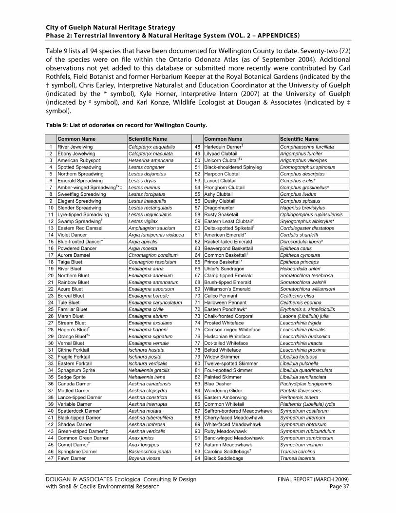
City of Guelph Natural Heritage Strategy Phase 2: Terrestrial Inventory & Natural Heritage System (VOL. 2 – APPENDICES)
DOUGAN & ASSOCIATES Ecological Consulting & Design FINAL REPORT (MARCH 2009) with Snell & Cecile Environmental Research Page 37
Table 9 lists all 94 species that have been documented for Wellington County to date. Seventy-two (72) of the species were on file within the Ontario Odonata Atlas (as of September 2004). Additional observations not yet added to this database or submitted more recently were contributed by Carl Rothfels, Field Botanist and former Herbarium Keeper at the Royal Botanical Gardens (indicated by the † symbol), Chris Earley, Interpretive Naturalist and Education Coordinator at the University of Guelph (indicated by the * symbol), Kyle Horner, Interpretive Intern (2007) at the University of Guelph (indicated by º symbol), and Karl Konze, Wildlife Ecologist at Dougan & Associates (indicated by ‡ symbol). Table 9: List of odonates on record for Wellington County. Common Name Scientific Name Common Name Scientific Name
1 River Jewelwing Calopteryx aequabilis 48 Harlequin Darner† Gomphaeschna furcillata 2 Ebony Jewelwing Calopteryx maculata 49 Lilypad Clubtail Arigomphus furcifer 3 American Rubyspot Hetaerina americana 50 Unicorn Clubtail†* Arigomphus villosipes 4 Spotted Spreadwing Lestes congener 51 Black-shouldered Spinyleg Dromogomphus spinosus 5 Northern Spreadwing Lestes disjunctus 52 Harpoon Clubtail Gomphus descriptus 6 Emerald Spreadwing Lestes dryas 53 Lancet Clubtail Gomphus exilis* 7 Amber-winged Spreadwing†*‡ Lestes eurinus 54 Pronghorn Clubtail Gomphus graslinellus* 8 Sweetflag Spreadwing Lestes forcipatus 55 Ashy Clubtail Gomphus lividus 9 Elegant Spreadwing† Lestes inaequalis 56 Dusky Clubtail Gomphus spicatus
10 Slender Spreadwing Lestes rectangularis 57 Dragonhunter Hagenius brevistylus 11 Lyre-tipped Spreadwing Lestes unguiculatus 58 Rusty Snaketail Ophiogomphus rupinsulensis 12 Swamp Spreadwing† Lestes vigilax 59 Eastern Least Clubtail* Stylogomphus albistylus* 13 Eastern Red Damsel Amphiagrion saucium 60 Delta-spotted Spiketail† Cordulegaster diastatops 14 Violet Dancer Argia fumipennis violacea 61 American Emerald* Cordulia shurtleffi 15 Blue-fronted Dancer* Argia apicalis 62 Racket-tailed Emerald Dorocordulia libera* 16 Powdered Dancer Argia moesta 63 Beaverpond Baskettail Epitheca canis 17 Aurora Damsel Chromagrion conditum 64 Common Baskettail† Epitheca cynosura 18 Taiga Bluet Coenagrion resolutum 65 Prince Baskettail* Epitheca princeps 19 River Bluet Enallagma anna 66 Uhler's Sundragon Helocordulia uhleri 20 Northern Bluet Enallagma annexum 67 Clamp-tipped Emerald Somatochlora tenebrosa 21 Rainbow Bluet Enallagma antennatum 68 Brush-tipped Emerald Somatochlora walshii 22 Azure Bluet Enallagma aspersum 69 Williamson's Emerald Somatochlora williamsoni 23 Boreal Bluet Enallagma boreale 70 Calico Pennant Celithemis elisa 24 Tule Bluet Enallagma carunculatum 71 Halloween Pennant Celithemis eponina 25 Familiar Bluet Enallagma civile 72 Eastern Pondhawk* Erythemis s. simplicicollis 26 Marsh Bluet Enallagma ebrium 73 Chalk-fronted Corporal Ladona (Libellula) julia 27 Stream Bluet Enallagma exsulans 74 Frosted Whiteface Leucorrhinia frigida 28 Hagen’s Bluet† Enallagma hageni 75 Crimson-ringed Whiteface Leucorrhinia glacialis 29 Orange Bluet†* Enallagma signatum 76 Hudsonian Whiteface Leucorrhinia hudsonica 30 Vernal Bluet Enallagma vernale 77 Dot-tailed Whiteface Leucorrhinia intacta 31 Citrine Forktail Ischnura hastata 78 Belted Whiteface Leucorrhinia proxima 32 Fragile Forktail Ischnura posita 79 Widow Skimmer Libellula luctuosa 33 Eastern Forktail Ischnura verticalis 80 Twelve-spotted Skimmer Libellula pulchella 34 Sphagnum Sprite Nehalennia gracilis 81 Four-spotted Skimmer Libellula quadrimaculata 35 Sedge Sprite Nehalennia irene 82 Painted Skimmer Libellula semifasciata 36 Canada Darner Aeshna canadensis 83 Blue Dasher Pachydiplax longipennis 37 Mottled Darner Aeshna clepsydra 84 Wandering Glider Pantala flavescens 38 Lance-tipped Darner Aeshna constricta 85 Eastern Amberwing Perithemis tenera 39 Variable Darner Aeshna interrupta 86 Common Whitetail Plathemis (Libellula) lydia 40 Spatterdock Darner* Aeshna mutata 87 Saffron-bordered Meadowhawk Sympetrum costiferum 41 Black-tipped Darner Aeshna tuberculifera 88 Cherry-faced Meadowhawk Sympetrum internum 42 Shadow Darner Aeshna umbrosa 89 White-faced Meadowhawk Sympetrum obtrusum 43 Green-striped Darner*‡ Aeshna verticalis 90 Ruby Meadowhawk Sympetrum rubicundulum 44 Common Green Darner Anax junius 91 Band-winged Meadowhawk Sympetrum semicinctum 45 Comet Darner† Anax longipes 92 Autumn Meadowhawk Sympetrum vicinum 46 Springtime Darner Basiaeschna janata 93 Carolina Saddlebags† Tramea carolina 47 Fawn Darner Boyeria vinosa 94 Black Saddlebags Tramea lacerata
City of Guelph Natural Heritage Strategy Phase 2: Terrestrial Inventory & Natural Heritage System (VOL. 2 – APPENDICES)
DOUGAN & ASSOCIATES Ecological Consulting & Design FINAL REPORT (MARCH 2009) with Snell & Cecile Environmental Research Page 38
BUTTERFLIES Among all of the groups of wildlife being considered for significance in Wellington County, the least is probably known about butterflies. Some information does exist in the Natural Heritage Information Centre database, but it was not considered comprehensive or complete enough to warrant an evaluation (Jones, pers. comm., 2004). Additional field visits across Wellington County are required to increase our understanding of the status and distribution of this group of wildlife. As a result of the inadequate number of observations on record, only those species currently designated as ‘Species at Risk’, (i.e. “Special Concern”, “Threatened”, or “Endangered” in Canada) (COSEWIC, 2008) and Ontario (OMNR, 2008) or provincially rare (i.e. those with a conservation status rank of S1, S2, S3 & S3S4) were automatically considered significant in Wellington County. However, those provincially significant species not likely to occur in Wellington County (e.g. Bog Elfin [Callophrys lanoraieensis], Dukes Skipper [Euphyes dukesi], Taiga Alpine [Erebia mancinus]) were excluded. REFERENCES Beissinger, S.R., J.M. Reed, J.M. Wunderle, Jr., S.K. Robinson, and D.M. Finch. 2000. Report of the AOU conservation
committee on the Partners in Flight species prioritization plan. Auk 117: 549 – 561. Bowles, J., W. Draper, A. Heagy, M. Kanter, and B. Larson. 1994. City of London Sub-Watershed Studies Life Science
Inventories. Submitted to Upper Thames River Conservation Authority October 1994. Updated in 2002. Brewer, A.D. 1977. The Birds of Wellington County. Guelph Field Naturalists Club Special Publication. 38pp. Brooks, A. 1905. The Mammalia of Northern Wellington. Ontario Natural Science Bulletin 1: 25 – 26. (reprinted from “Notes
from Thicket and Swamp” 28: 25 – 26.) Cadman, M.D., D.A. Sutherland, G.G. Beck, D. Lepage, and A.R. Couturier (eds.) 2007. Atlas of the Breeding Birds of
Ontario, 2001 – 2005. Bird Studies Canada, Environment Canada, Ontario Field Ornithologists, Ontario Ministry of Natural Resources, and Ontario Nature, Toronto. xxii + 706 pp.
Campbell, C.A. and I.A. Dagg. 1972. Mammals of Waterloo and South Wellington Counties. Waterloo, Ontario: privately printed. M. Dyer prepared the maps and skull drawings and M.E. Gartshore the illustrations 130 pp.
Campbell, C.A., K.A. Cowcill and T.E. Martens. 1997. Changes Among the Mammals of Wellington County 1640–1997. From: Wellington County History. Vol. X, 63–90.
Carson, P. 1987. The Butterflies of Haldimand-Norfolk. Part 2 In: The Norfolk Filed Naturalists The Natural Areas Inventory of the Regional Municipality of Haldimand-Norfolk. Volume II: Annotated Checklists.
Carter, M.F., W.C. Hunter, D.N. Pashley, and K.V. Rosenberg. 2000. Setting conservation priorities for landbirds in the United States: The Partners in Flight approach. Auk 117: 541 – 548.
COSEWIC (Committee on the Status of Endangered Wildlife in Canada). 2008. Canadian Wildlife Species at Risk. Committee on the Status of Endangered Wildlife in Canada. Web site: http://www.cosewic.gc.ca/eng/sct0/rpt/rpt_csar_e.cfm [accessed 9 December 2008]. PDF available at http://www.cosewic.gc.ca/eng/sct0/rpt/rpt_csar_e.pdf
Credit Valley Conservation (CVC). 1997. Credit Watershed Birds of Conservation Concern. Curry, B. 2003. The Breeding Birds of Hamilton, Ontario. pp. 6–1 to 6–45 In: J.K. Dwyer (Ed.) Nature Counts Project: Hamilton
Natural Areas Inventory 2003 - Species Checklists. Hamilton Naturalists' Club, Hamilton, Ontario. 282pp. Dougan & Associates. 2003. Natural Areas Inventory: Town of Fort Erie’s Settlement Areas (Volume 2 of 2, Appendices).
March 2003. Final Draft. Dwyer, J.K (Ed.). 2003. Nature Counts Project: Hamilton Natural Areas Inventory 2003 - Species Checklists. Hamilton Naturalists'
Club, Hamilton, Ontario. 282pp. Eagles, P., W. Elrick, D. Foster, S. Muirhead, M. Stewart, J. van de Hulst, and C. Waterston. 1976. South Wellington
Environmentally Sensitive Areas Study. Centre for Resources Development. University of Guelph, Guelph, Ontario. Publication No. 79. September 1976.
Elrick, W., D. Kirk, K. Loebel, and A. Wormington. 1977. North Wellington Environmentally Sensitive Areas. Centre for Resources Development. University of Guelph, Guelph, Ontario. Publication No. 84. October 1977.
Francis, G.R. and C.A. Campbell. 1983. The Herpetofauna of Waterloo Region, Ontario. Ontario Field Biologist 37(2): 51–86. Gartshore, M.E. 1987a. The Herpetofauna of Haldimand-Norfolk. Part 4 In: The Norfolk Filed Naturalists The Natural Areas
Inventory of the Regional Municipality of Haldimand-Norfolk. Volume II: Annotated Checklists.
City of Guelph Natural Heritage Strategy Phase 2: Terrestrial Inventory & Natural Heritage System (VOL. 2 – APPENDICES)
DOUGAN & ASSOCIATES Ecological Consulting & Design FINAL REPORT (MARCH 2009) with Snell & Cecile Environmental Research Page 39
Gartshore, M.E. 1987b. The Mammals of Haldimand-Norfolk. Part 6 In: The Norfolk Filed Naturalists The Natural Areas Inventory of the Regional Municipality of Haldimand-Norfolk. Volume II: Annotated Checklists.
Heagy, A.E. (ed.) 1995. Hamilton-Wentworth Natural Areas Inventory. Volume I: Summary Report, Regional Context and Watershed Summaries. Hamilton Naturalists’ Club, Hamilton, Ontario.
Heagy, A. and M. Ross. 1995. The Mammals of Hamilton-Wentworth Region, Ontario. pp. 9–1 to 9–13 In: A.E. Heagy (Ed.) Hamilton-Wentworth Natural Areas Inventory. Volume 1. Hamilton Naturalists’ Club, Hamilton, Ontario. 448pp.
Hunter, W.C., M.F. Carter, D.N. Pashley, and K. Barker. 1993. The Partners in Flight prioritization scheme. Pages 109 – 119 in Status and Management of Neotropical Migratory Birds (D. Finch and P. Stangel, Eds.). USDA Forest Service General Technical Report RM-229. USDA Forest Service, Fort Collins, Colorado.
Klugh, A.B. 1905. Birds of Wellington County. Ontario Natural Science Bulletin, No. 1, 1905. Lamond, W.G. 1994. The Reptiles and Amphibians of the Hamilton Area. An Historical Summary and the Results of the
Hamilton Herpetofaunal Atlas. Hamilton Naturalists’ Club. Hamilton, Ontario. 174pp. Lamond, W.G. and B. Duncan, W.G. 2003. The Herpetofauna of Hamilton, Ontario. pp. 5–1 to 5–14 In: J.K. Dwyer (Ed.) Nature
Counts Project: Hamilton Natural Areas Inventory 2003 - Species Checklists. Hamilton Naturalists' Club, Hamilton, Ontario. 282pp.
McCracken, J.D. 1987. The Birds of Haldimand-Norfolk. Part 5 In: The Norfolk Filed Naturalists The Natural Areas Inventory of the Regional Municipality of Haldimand-Norfolk. Volume II: Annotated Checklists.
NHIC (Natural Heritage Information Centre). 2008a. NHIC List of Ontario Insects: Odonata. Ontario Natural Heritage Information Centre Home Page. http://nhic.mnr.gov.on.ca/MNR/nhic/species/listout.cfm?el=iiodo
NHIC (Natural Heritage Information Centre). 2008b. NHIC List of Ontario Lepidoptera. Ontario Natural Heritage Information Centre Home Page. http://nhic.mnr.gov.on.ca/MNR/nhic/species/listout.cfm?el=iile
NHIC (Natural Heritage Information Centre). 2008c. NHIC List of Ontario Amphibians. Ontario Natural Heritage Information Centre Home Page. http://nhic.mnr.gov.on.ca/MNR/nhic/species/listout.cfm?el=aa
NHIC (Natural Heritage Information Centre). 2008d. NHIC List of Ontario Reptiles. Ontario Natural Heritage Information Centre Home Page. http://nhic.mnr.gov.on.ca/MNR/nhic/species/listout.cfm?el=ar
NHIC (Natural Heritage Information Centre). 2008e. NHIC List of Ontario Birds. Ontario Natural Heritage Information Centre Home Page. http://nhic.mnr.gov.on.ca/MNR/nhic/species/listout.cfm?el=ab
NHIC (Natural Heritage Information Centre). 2008f. NHIC List of Ontario Mammals. Ontario Natural Heritage Information Centre Home Page. http://nhic.mnr.gov.on.ca/MNR/nhic/species/listout.cfm?el=am
OMNR (Ontario Ministry of Natural Resources). 2000. Significant Wildlife Habitat Technical Guide. 151p. Appendix G: Wildlife Habitat Matrices and Habitat Descriptions for Rare Vascular Plants. (includes complete list of area sensitive species). http://www.mnr.gov.on.ca/MNR/pubs/pubmenu.htm
OMNR (Ontario Ministry of Natural Resources). 2008. Species at Risk in Ontario List. http://www.mnr.gov.on.ca/en/Business/Species/2ColumnSubPage/246809.html
Ontario Odonata Database. 2004. Database of Ontario Odonata records on file at the Natural Heritage Information Centre, Ontario Ministry of Natural Resources, Peterborough.
OPIF (Ontario Partners in Flight). 2008. Ontario Landbird Conservation Plan: Lower Great Lakes/St. Lawrence Plain, North American Bird Conservation Region 13. Ontario Ministry of Natural Resources, Bird Studies Canada, Environment Canada. Draft. June 2008.
Panjabi, A., C. Beardmore, P. Blancher, G. Butcher, M. Carter, D. Demarest, E. Dunn, C. Hunter, D. Pashley, K. Rosenberg, T. Rich, and T. Will. 2001. The Partners in Flight handbook on species assessment and prioritization. Version 1.1. Rocky Mountain Bird Observatory, Brighton, Colorado.
Plourde, S.A., E.L. Szepesi, J.L. Riley, M.J. Oldham and C. Campbell. 1989. Distribution and Status of the Herpetofauna of Central Region, Ontario Ministry of Natural Resources. Parks and Recreational Areas Section, OMNR, Open File Ecological Report SR8903, Central Region, Richmond Hill, Ontario. 27pp.
RMW (Regional Municipality of Waterloo). 1985a. Appendix 3: Reptiles and Amphibians in Environmentally Sensitive Policy Areas Technical Appendix. Approved by Council: 1986.
RMW (Regional Municipality of Waterloo). 1985b. Appendix 4: Mammals in Environmentally Sensitive Policy Areas Technical Appendix. Approved by Council: 1986.
RMW (Regional Municipality of Waterloo). 1996. Revisions to Waterloo Region's Significant Species List: Breeding Birds Component. Report to Planning and Culture Committee PC-96-021. Approved by Council: April 25, 1996.
Rich, T.D., C.J. Beardmore, H. Berlanga, P.J. Blancher, M.S.W. Bradstreet, G.S. Butcher, D.W. Demarest, E.H. Dunn, W.C. Hunter, E.E. Inigo-Elias, J.A. Kennedy, A.M. Martell, A.O. Panjabi, D.N. Pashley, K.V. Rosenberg, C.M. Rustay, J.S. Wendt, and T.C. Will. 2004. Partners in Flight North American Landbird Conservation Plan. Cornell Lab of Ornithology. Ithaca, NY.
Soper, D. 1923a. The Birds of Wellington and Waterloo Counties, Ontario. Auk. Vol. 40, No. 3 (July-September), pg 489 – 513. Soper, D. 1923b. The Mammals of Wellington and Waterloo Counties, Ontario. Journal of Mammalogy 4: 244 – 252. TRCA (Toronto and Region Conservation Authority). 2008a. Toronto and Region Conservation Authority’s Terrestrial
Natural Heritage Program Vegetation Community and Species Ranking and Scoring Method. March 2008. 31pp.
City of Guelph Natural Heritage Strategy Phase 2: Terrestrial Inventory & Natural Heritage System (VOL. 2 – APPENDICES)
DOUGAN & ASSOCIATES Ecological Consulting & Design FINAL REPORT (MARCH 2009) with Snell & Cecile Environmental Research Page 40
TRCA (Toronto and Region Conservation Authority). 2008b. 2008 Fauna Ranks and Scores. PDF provided by Paul Prior November 20, 2008.
Vlasman, K. 2003. The Mammals of Hamilton, Ontario. pp. 7–1 to 7–27 In: J.K. Dwyer (Ed.) Nature Counts Project: Hamilton Natural Areas Inventory 2003 - Species Checklists. Hamilton Naturalists' Club, Hamilton, Ontario. 282pp.
Wormington, A. and W.G. Lamond. 2003. The Butterflies of Hamilton, Ontario. pp. 3–1 to 3–30 In: J.K. Dwyer (Ed.) Nature Counts Project: Hamilton Natural Areas Inventory 2003 - Species Checklists. Hamilton Naturalists' Club, Hamilton, Ontario. 282pp.
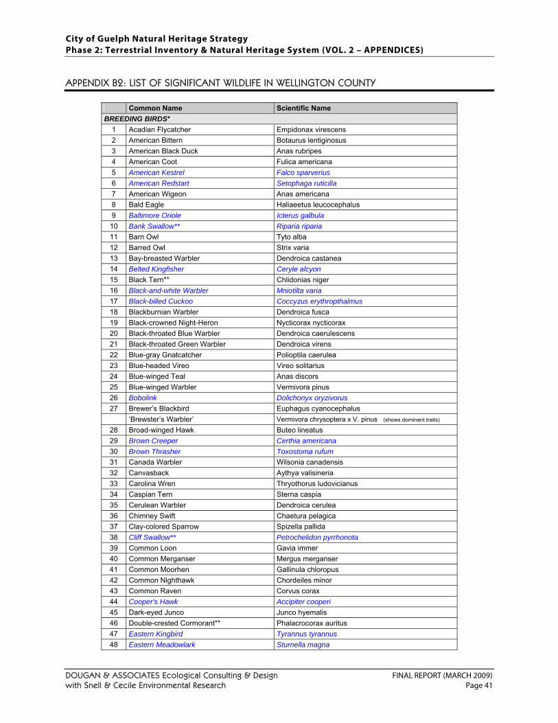
City of Guelph Natural Heritage Strategy Phase 2: Terrestrial Inventory & Natural Heritage System (VOL. 2 – APPENDICES)
DOUGAN & ASSOCIATES Ecological Consulting & Design FINAL REPORT (MARCH 2009) with Snell & Cecile Environmental Research Page 41
APPENDIX B2: LIST OF SIGNIFICANT WILDLIFE IN WELLINGTON COUNTY
Common Name Scientific Name BREEDING BIRDS*
1 Acadian Flycatcher Empidonax virescens 2 American Bittern Botaurus lentiginosus 3 American Black Duck Anas rubripes 4 American Coot Fulica americana 5 American Kestrel Falco sparverius 6 American Redstart Setophaga ruticilla 7 American Wigeon Anas americana 8 Bald Eagle Haliaeetus leucocephalus 9 Baltimore Oriole Icterus galbula
10 Bank Swallow** Riparia riparia 11 Barn Owl Tyto alba 12 Barred Owl Strix varia 13 Bay-breasted Warbler Dendroica castanea 14 Belted Kingfisher Ceryle alcyon 15 Black Tern** Chlidonias niger 16 Black-and-white Warbler Mniotilta varia 17 Black-billed Cuckoo Coccyzus erythropthalmus 18 Blackburnian Warbler Dendroica fusca 19 Black-crowned Night-Heron Nycticorax nycticorax 20 Black-throated Blue Warbler Dendroica caerulescens 21 Black-throated Green Warbler Dendroica virens 22 Blue-gray Gnatcatcher Polioptila caerulea 23 Blue-headed Vireo Vireo solitarius 24 Blue-winged Teal Anas discors 25 Blue-winged Warbler Vermivora pinus 26 Bobolink Dolichonyx oryzivorus 27 Brewer’s Blackbird Euphagus cyanocephalus
‘Brewster’s Warbler’ Vermivora chrysoptera x V. pinus (shows dominant traits) 28 Broad-winged Hawk Buteo lineatus 29 Brown Creeper Certhia americana 30 Brown Thrasher Toxostoma rufum 31 Canada Warbler Wilsonia canadensis 32 Canvasback Aythya valisineria 33 Carolina Wren Thryothorus ludovicianus 34 Caspian Tern Sterna caspia 35 Cerulean Warbler Dendroica cerulea 36 Chimney Swift Chaetura pelagica 37 Clay-colored Sparrow Spizella pallida 38 Cliff Swallow** Petrochelidon pyrrhonota 39 Common Loon Gavia immer 40 Common Merganser Mergus merganser 41 Common Moorhen Gallinula chloropus 42 Common Nighthawk Chordeiles minor 43 Common Raven Corvus corax 44 Cooper's Hawk Accipiter cooperi 45 Dark-eyed Junco Junco hyemalis 46 Double-crested Cormorant** Phalacrocorax auritus 47 Eastern Kingbird Tyrannus tyrannus 48 Eastern Meadowlark Sturnella magna
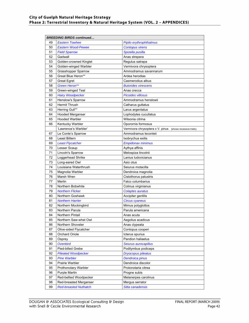
City of Guelph Natural Heritage Strategy Phase 2: Terrestrial Inventory & Natural Heritage System (VOL. 2 – APPENDICES)
DOUGAN & ASSOCIATES Ecological Consulting & Design FINAL REPORT (MARCH 2009) with Snell & Cecile Environmental Research Page 42
BREEDING BIRDS continued…
49 Eastern Towhee Pipilo erythrophthalmus 50 Eastern Wood-Pewee Contopus virens 51 Field Sparrow Spizella pusilla 52 Gadwall Anas strepera 53 Golden-crowned Kinglet Regulus satrapa 54 Golden-winged Warbler Vermivora chrysoptera 55 Grasshopper Sparrow Ammodramus savannarum 56 Great Blue Heron** Ardea herodias 57 Great Egret Casmerodius albus 58 Green Heron** Butorides virescens 59 Green-winged Teal Anas crecca 60 Hairy Woodpecker Picoides villosus 61 Henslow's Sparrow Ammodramus henslowii 62 Hermit Thrush Catharus guttatus 63 Herring Gull** Larus argentatus 64 Hooded Merganser Lophodytes cucullatus 65 Hooded Warbler Wilsonia citrina 66 Kentucky Warbler Oporornis formosus
‘Lawrence’s Warbler’ Vermivora chrysoptera x V. pinus (shows recessive traits) 67 Le Conte’s Sparrow Ammodramus leconteii 68 Least Bittern Ixobrychus exilis 69 Least Flycatcher Empidonax minimus 70 Lesser Scaup Aythya affinis 71 Lincoln's Sparrow Melospiza lincolnii 72 Loggerhead Shrike Lanius ludovicianus 73 Long-eared Owl Asio otus 74 Louisiana Waterthrush Seiurus motacilla 75 Magnolia Warbler Dendroica magnolia 76 Marsh Wren Cistothorus palustris 77 Merlin Falco columbarius 78 Northern Bobwhite Colinus virginianus 79 Northern Flicker Colaptes auratus 80 Northern Goshawk Accipiter gentilis 81 Northern Harrier Circus cyaneus 82 Northern Mockingbird Mimus polyglottos 83 Northern Parula Parula americana 84 Northern Pintail Anas acuta 85 Northern Saw-whet Owl Aegolius acadicus 86 Northern Shoveler Anas clypeata 87 Olive-sided Flycatcher Contopus cooperi 88 Orchard Oriole Icterus spurius 89 Osprey Pandion haliaetus 90 Ovenbird Seiurus aurocapillus 91 Pied-billed Grebe Podilymbus podiceps 92 Pileated Woodpecker Dryocopus pileatus 93 Pine Warbler Dendroica pinus 94 Prairie Warbler Dendroica discolor 95 Prothonotary Warbler Protonotaria citrea 96 Purple Martin Progne subis 97 Red-bellied Woodpecker Melanerpes carolinus 98 Red-breasted Merganser Mergus serrator 99 Red-breasted Nuthatch Sitta canadensis
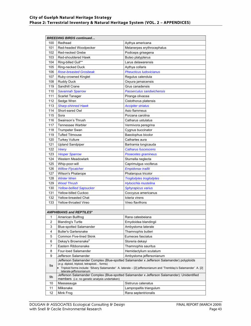
City of Guelph Natural Heritage Strategy Phase 2: Terrestrial Inventory & Natural Heritage System (VOL. 2 – APPENDICES)
DOUGAN & ASSOCIATES Ecological Consulting & Design FINAL REPORT (MARCH 2009) with Snell & Cecile Environmental Research Page 43
BREEDING BIRDS continued… 100 Redhead Aythya americana 101 Red-headed Woodpecker Melanerpes erythrocephalus 102 Red-necked Grebe Podiceps grisegena 103 Red-shouldered Hawk Buteo platypterus 104 Ring-billed Gull** Larus delawarensis 105 Ring-necked Duck Aythya collaris 106 Rose-breasted Grosbeak Pheucticus ludovicianus 107 Ruby-crowned Kinglet Regulus calendula 108 Ruddy Duck Oxyura jamaicensis 119 Sandhill Crane Grus canadensis 110 Savannah Sparrow Passerculus sandwichensis 111 Scarlet Tanager Piranga olivacea 112 Sedge Wren Cistothorus platensis 113 Sharp-shinned Hawk Accipiter striatus 114 Short-eared Owl Asio flammeus 115 Sora Porzana carolina 116 Swainson’s Thrush Catharus ustulatus 117 Tennessee Warbler Vermivora peregrina 118 Trumpeter Swan Cygnus buccinator 119 Tufted Titmouse Baeolophus bicolor 120 Turkey Vulture Cathartes aura 121 Upland Sandpiper Bartramia longicauda 122 Veery Catharus fuscescens 123 Vesper Sparrow Pooecetes gramineus 124 Western Meadowlark Sturnella neglecta 125 Whip-poor-will Caprimulgus vociferus 126 Willow Flycatcher Empidonax traillii 127 Wilson's Phalarope Phalaropus tricolor 128 Winter Wren Troglodytes troglodytes 129 Wood Thrush Hylocichla mustelina 130 Yellow-bellied Sapsucker Sphyrapicus varius 131 Yellow-billed Cuckoo Coccyzus americanus 132 Yellow-breasted Chat Icteria virens 133 Yellow-throated Vireo Vireo flavifrons
AMPHIBIANS and REPTILES*
1 American Bullfrog Rana catesbeiana 2 Blanding's Turtle Emydoidea blandingii 3 Blue-spotted Salamander Ambystoma laterale 4 Butler's Gartersnake Thamnophis butleri 5 Common Five-lined Skink Eumeces fasciatus 6 Dekay's Brownsnake‡ Storeria dekayi 7 Eastern Ribbonsnake Thamnophis sauritus 8 Four-toed Salamander Hemidactylium scutatum 9 Jefferson Salamander Ambystoma jeffersonianum
Jefferson Salamander Complex (Blue-spotted Salamander x Jefferson Salamander) polyploids (e.g. diploid, triploid, tetraploid... forms) 9a • Triploid forms include: ‘Silvery Salamander’ A. laterale – [2] jeffersonianum and ‘Tremblay’s Salamander’ A. [2]
laterale-jefforsonianum
9b Jefferson Salamander Complex (Blue-spotted Salamander x Jefferson Salamander): Unidentified members (i.e. no genetic analysis undertaken)
10 Massasauga Sistrurus catenatus 11 Milksnake Lampropeltis triangulum 12 Mink Frog Rana septentrionalis
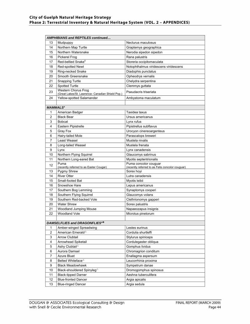
City of Guelph Natural Heritage Strategy Phase 2: Terrestrial Inventory & Natural Heritage System (VOL. 2 – APPENDICES)
DOUGAN & ASSOCIATES Ecological Consulting & Design FINAL REPORT (MARCH 2009) with Snell & Cecile Environmental Research Page 44
AMPHIBIANS and REPTILES continued…
13 Mudpuppy Necturus maculosus 14 Northern Map Turtle Graptemys geographica 15 Northern Watersnake Nerodia sipedon sipedon 16 Pickerel Frog Rana palustris 17 Red-bellied Snake‡ Storeria occipitomaculata 18 Red-spotted Newt Notophthalmus viridescens viridescens 19 Ring-necked Snake Diadophis punctatus 20 Smooth Greensnake Opheodrys vernalis 21 Snapping Turtle Chelydra serpentina 22 Spotted Turtle Clemmys guttata
23 Western Chorus Frog (Great Lakes/St. Lawrence- Canadian Shield Pop.) Pseudacris triseriata
24 Yellow-spotted Salamander Ambystoma maculatum
MAMMALS* 1 American Badger Taxidea taxus 2 Black Bear Ursus americanus 3 Bobcat Lynx rufus 4 Eastern Pipistrelle Pipistrellus subflavus 5 Gray Fox Urocyon cinereoargenteus 6 Hairy-tailed Mole Parascalops breweri 7 Least Weasel Mustela nivalis 8 Long-tailed Weasel Mustela frenata 9 Lynx Lynx canadensis
10 Northern Flying Squirrel Glaucomys sabrinus 11 Northern Long-eared Bat Myotis septentrionalis
12 Puma (recently referred to as Easter Cougar)
Puma concolor couguar (recently referred to as Felis concolor couguar)
13 Pygmy Shrew Sorex hoyi 14 River Otter Lutra canadensis 15 Small-footed Bat Myotis leibii 16 Snowshoe Hare Lepus americanus 17 Southern Bog Lemming Synaptomys cooperi 18 Southern Flying Squirrel Glaucomys volans 19 Southern Red-backed Vole Clethrionomys gapperi 20 Water Shrew Sorex palustris 21 Woodland Jumping Mouse Napaeozapus insignis 22 Woodland Vole Microtus pinetorum
DAMSELFLIES and DRAGONFLIES*
1 Amber-winged Spreadwing Lestes eurinus 2 American Emerald Cordulia shurtleffi 3 Arrow Clubtail Stylurus spiniceps 4 Arrowhead Spiketail Cordulegaster obliqua 5 Ashy Clubtail Gomphus lividus 6 Aurora Damsel Chromagrion conditum 7 Azure Bluet Enallagma aspersum 8 Belted Whiteface Leucorrhinia proxima 9 Black Meadowhawk Sympetrum danae
10 Black-shouldered Spinyleg Dromogomphus spinosus 11 Black-tipped Darner Aeshna tuberculifera 12 Blue-fronted Dancer Argia apicalis 13 Blue-ringed Dancer Argia sedula
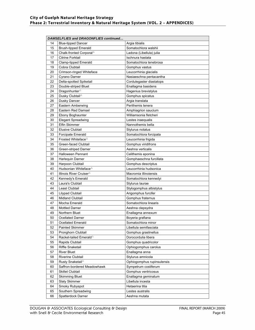
City of Guelph Natural Heritage Strategy Phase 2: Terrestrial Inventory & Natural Heritage System (VOL. 2 – APPENDICES)
DOUGAN & ASSOCIATES Ecological Consulting & Design FINAL REPORT (MARCH 2009) with Snell & Cecile Environmental Research Page 45
DAMSELFLIES and DRAGONFLIES continued…
14 Blue-tipped Dancer Argia tibialis 15 Brush-tipped Emerald Somatochlora walshii 16 Chalk-fronted Corporal Ladona (Libellula) julia 17 Citrine Forktail Ischnura hastata 18 Clamp-tipped Emerald Somatochlora tenebrosa 19 Cobra Clubtail Gomphus vastus 20 Crimson-ringed Whiteface Leucorrhinia glacialis 21 Cyrano Darner Nasiaeschna pentacantha 22 Delta-spotted Spiketail Cordulegaster diastatops 23 Double-striped Bluet Enallagma basidens 24 Dragonhunter Hagenius brevistylus 25 Dusky Clubtail Gomphus spicatus 26 Dusky Dancer Argia translata 27 Eastern Amberwing Perithemis tenera 28 Eastern Red Damsel Amphiagrion saucium 29 Ebony Boghaunter Williamsonia fletcheri 30 Elegant Spreadwing Lestes inaequalis 31 Elfin Skimmer Nannothemis bella 32 Elusive Clubtail Stylurus notatus 33 Forcipate Emerald Somatochlora forcipata 34 Frosted Whiteface Leucorrhinia frigida 35 Green-faced Clubtail Gomphus viridifrons 36 Green-striped Darner Aeshna verticalis 37 Halloween Pennant Celithemis eponina 38 Harlequin Darner Gomphaeschna furcillata 39 Harpoon Clubtail Gomphus descriptus 40 Hudsonian Whiteface Leucorrhinia hudsonica 41 Illinois River Cruiser Macromia illinoiensis 42 Kennedy's Emerald Somatochlora kennedyi 43 Laura's Clubtail Stylurus laurae 44 Least Clubtail Stylogomphus albistylus 45 Lilypad Clubtail Arigomphus furcifer 46 Midland Clubtail Gomphus fraternus 47 Mocha Emerald Somatochlora linearis 48 Mottled Darner Aeshna clepsydra 49 Northern Bluet Enallagma annexum 50 Ocellated Darner Boyeria grafiana 51 Ocellated Emerald Somatochlora minor 52 Painted Skimmer Libellula semifasciata 53 Pronghorn Clubtail Gomphus graslinellus 54 Racket-tailed Emerald Dorocordulia libera 55 Rapids Clubtail Gomphus quadricolor 56 Riffle Snaketail Ophiogomphus carolus 57 River Bluet Enallagma anna 58 Riverine Clubtail Stylurus amnicola 59 Rusty Snaketail Ophiogomphus rupinsulensis 60 Saffron-bordered Meadowhawk Sympetrum costiferum 61 Skillet Clubtail Gomphus ventricosus 62 Skimming Bluet Enallagma geminatum 63 Slaty Skimmer Libellula incesta 64 Smoky Rubyspot Hetaerina titia 65 Southern Spreadwing Lestes australis 66 Spatterdock Darner Aeshna mutata
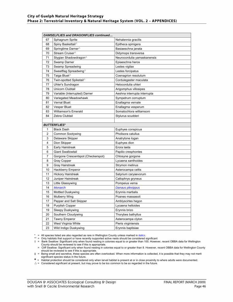
City of Guelph Natural Heritage Strategy Phase 2: Terrestrial Inventory & Natural Heritage System (VOL. 2 – APPENDICES)
DOUGAN & ASSOCIATES Ecological Consulting & Design FINAL REPORT (MARCH 2009) with Snell & Cecile Environmental Research Page 46
DAMSELFLIES and DRAGONFLIES continued…
67 Sphagnum Sprite Nehalennia gracilis 68 Spiny Baskettail Epitheca spinigera 69 Springtime Darner Basiaeschna janata 70 Stream Cruiser Didymops transversa 71 Stygian Shadowdragon Neurocordulia yamaskanensis 72 Swamp Darner Epiaeschna heros 73 Swamp Spreadwing Lestes vigilax 74 Sweetflag Spreadwing Lestes forcipatus 75 Taiga Bluet Coenagrion resolutum 76 Twin-spotted Spiketail Cordulegaster maculata 77 Uhler's Sundragon Helocordulia uhleri 78 Unicorn Clubtail Arigomphus villosipes 79 Variable (Interrupted) Darner Aeshna interrupta interrupta 80 Variegated Meadowhawk Sympetrum corruptum 81 Vernal Bluet Enallagma vernale 82 Vesper Bluet Enallagma vesperum 83 Williamson's Emerald Somatochlora williamsoni 84 Zebra Clubtail Stylurus scudderi
BUTTERFLIES*
1 Black Dash Euphyes conspicua 2 Common Sootywing Pholisora catullus 3 Delaware Skipper Anatrytone logan 4 Dion Skipper Euphyes dion 5 Early Hairstreak Erora laeta 6 Giant Swallowtail Papilio cresphontes 7 Gorgone Crescentspot (Checkerspot) Chlosyne gorgone 8 Gray Copper Lycaena xanthoides 9 Gray Hairstreak Strymon melinus
10 Hackberry Emperor Asterocampa celtis 11 Hickory Hairstreak Satyrium caryaevorum 12 Juniper Hairstreak Callophrys gryneus 13 Little Glassywing Pompeius verna 14 Monarch Danaus plexippus 15 Mottled Duskywing Erynnis martialis 16 Mulberry Wing Poanes massasoit 17 Pepper and Salt Skipper Amblyscirtes hegon 18 Purplish Copper Lycaena helloides 19 Sleepy Duskywing Erynnis brizo 20 Southern Cloudywing Thorybes bathyllus 21 Tawny Emperor Asterocampa clyton 22 West Virginia White Pieris virginiensis 23 Wild Indigo Duskywing Erynnis baptisiae
* = All species listed are also regarded as rare in Wellington County unless marked in italics. ** = Only habitats that support or have recently supported active nests should be considered significant
† = Bank Swallow: Significant only when found nesting in colonies equal to or greater than 100. However, recent OBBA data for Wellington County should be reviewed to see if this is appropriate.
= Cliff Swallow: Significant only when found nesting in colonies equal to or greater than 8. However, recent OBBA data for Wellington County should be reviewed to see if this is appropriate.
‡ = Being small and secretive, these species are often overlooked. When more information is collected, it is possible that they may not merit significant species status in the future.
= Habitat protection should be considered only when larval habitat is present at or in close proximity to where adults were documented. = Considered significant at present, but may prove to be too common to be so regarded in the future.
City of Guelph Natural Heritage Strategy Phase 2: Terrestrial Inventory & Natural Heritage System (VOL. 2 – APPENDICES)
DOUGAN & ASSOCIATES Ecological Consulting & Design FINAL REPORT (MARCH 2009) with Snell & Cecile Environmental Research Page 47
APPENDIX C. NATURAL HERITAGE DATABASE SOURCES
A description of the data sources reviewed and incorporated into the database is described below.
DATA FROM ENVIRONMENTAL STUDIES
More than 50 environmental studies of various scale conducted within or encompassing the City of Guelph were reviewed as part of this study for the purposes of extrapolating any plant records, wildlife records and, in some cases, confirming ELC communities. These studies are listed in Table C-1 below along with the types of data retrieved from them. A few documents were reviewed but excluded because either (a) more than a third of the study area was outside the City of Guelph (e.g., Eramosa River – Blue Springs Watershed Study [1999]) or (b) the report itself relied exclusively on secondary source data and did not include any first-hand records or species lists (e.g., some of the Environmental Assessments). In total, 6350 records of species observations have been entered into the database from environmental studies. This consists of 4908 vascular plant records, 1029 bird records (breeding and non-breeding), 183 herpetofaunal records, 223 mammal records, and 3 invertebrate records. These records translate into a total of 918 species reported in the City of Guelph (i.e., 717 vascular plants, 133 birds, 28 herpetofauna, 28 mammals and 2 invertebrates). Although some of the smaller scale site specific studies (e.g., the Environmental Impact Studies) in the City provided species data that could be definitively associated with a specific area, the larger scale studies (e.g., the watershed and sub-watershed) provided species lists that could not be applied to discreet ELC polygons and were instead applied to all candidate Locally Significant Natural Areas within that study boundary. These species should be considered as potential rather than confirmed. Although we have attempted to ensure that all plant records have been incorporated using a consistent nomenclature (i.e., Newmaster et al. 1998) and that all plant and wildlife records are plausible sightings for Wellington County, it is possible that some erroneously identified or wrongly named species have been incorporated into the database, particularly with respect to sub-species. Additional EIS completed between 2004 and early 2008 were also reviewed in the spring of 2008 to see if any nationally, provincially or locally significant species had been recorded in natural areas that could be associated with specific ELC polygons as mapped for this study. These are also listed in the Table C-1 below.
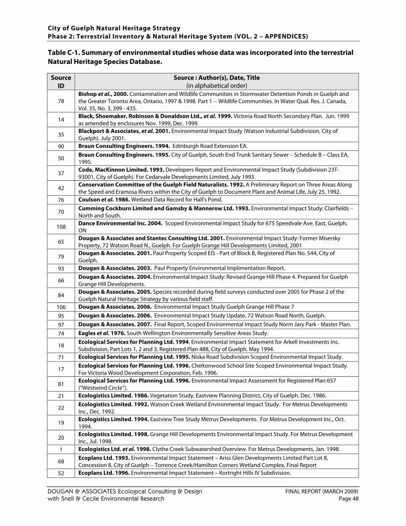
City of Guelph Natural Heritage Strategy Phase 2: Terrestrial Inventory & Natural Heritage System (VOL. 2 – APPENDICES)
DOUGAN & ASSOCIATES Ecological Consulting & Design FINAL REPORT (MARCH 2009) with Snell & Cecile Environmental Research Page 48
Table C-1. Summary of environmental studies whose data was incorporated into the terrestrial Natural Heritage Species Database.
Source ID
Source : Author(s), Date, Title (in alphabetical order)
78 Bishop et al., 2000. Contamination and Wildlife Communities in Stormwater Detention Ponds in Guelph and the Greater Toronto Area, Ontario, 1997 & 1998. Part 1 -- Wildlife Communities. In Water Qual. Res. J. Canada, Vol. 35, No. 3, 399 - 435.
14 Black, Shoemaker, Robinson & Donaldson Ltd., et al. 1999. Victoria Road North Secondary Plan. Jun. 1999 as amended by enclosures Nov. 1999, Dec. 1999.
35 Blackport & Associates, et al. 2001. Environmental Impact Study (Watson Industrial Subdivision, City of Guelph). July 2001.
90 Braun Consulting Engineers. 1994. Edinburgh Road Extension EA.
50 Braun Consulting Engineers. 1995. City of Guelph, South End Trunk Sanitary Sewer – Schedule B – Class EA, 1995.
37 Code, MacKinnon Limited. 1993. Developers Report and Environmental Impact Study (Subdivision 23T-93001, City of Guelph). For Cedarvale Developments Limited, July 1993.
42 Conservation Committee of the Guelph Field Naturalists. 1992. A Preliminary Report on Three Areas Along the Speed and Eramosa Rivers within the City of Guelph to Document Plant and Animal Life, July 25, 1992.
76 Coulson et al. 1986. Wetland Data Record for Hall's Pond.
70 Cumming Cockburn Limited and Gamsby & Mannerow Ltd. 1993. Environmental Impact Study: Clairfields – North and South.
108 Dance Environmental Inc. 2004. Scoped Environmental Impact Study for 675 Speedvale Ave. East, Guelph, ON
65 Dougan & Associates and Stantec Consulting Ltd. 2001. Environmental Impact Study: Former Misersky Property, 72 Watson Road N., Guelph. For Guelph Grange Hill Developments Limited, 2001
79 Dougan & Associates. 2001. Paul Property Scoped EIS - Part of Block B, Registered Plan No. 544, City of Guelph.
93 Dougan & Associates. 2003. Paul Property Environmental Implimentation Report.
66 Dougan & Associates. 2004. Environmental Impact Study: Revised Grange Hill Phase 4. Prepared for Guelph Grange Hill Developments.
84 Dougan & Associates. 2005. Species recorded during field surveys conducted over 2005 for Phase 2 of the Guelph Natural Heritage Strategy by various field staff.
106 Dougan & Associates. 2006. Environmental Impact Study Guelph Grange Hill Phase 7
95 Dougan & Associates. 2006. Environmental Impact Study Update, 72 Watson Road North, Guelph.
97 Dougan & Associates. 2007. Final Report, Scoped Environmental Impact Study Norm Jary Park - Master Plan.
74 Eagles et al. 1976. South Wellington Environmentally Sensitive Areas Study.
18 Ecological Services for Planning Ltd. 1994. Environmental Impact Statement for Arkell Investments Inc. Subdivision, Part Lots 1, 2 and 3, Registered Plan 488, City of Guelph. May 1994.
71 Ecological Services for Planning Ltd. 1995. Niska Road Subdivision Scoped Environmental Impact Study.
17 Ecological Services for Planning Ltd. 1996. Cheltonwood School Site Scoped Environmental Impact Study. For Victoria Wood Development Corporation, Feb. 1996.
81 Ecological Services for Planning Ltd. 1996. Environmental Impact Assessment for Registered Plan 657 (“Westwind Circle”).
21 Ecologistics Limited. 1986. Vegetation Study, Eastview Planning District, City of Guelph. Dec. 1986.
22 Ecologistics Limited. 1992. Watson Creek Wetland Environmental Impact Study. For Metrus Developments Inc., Dec. 1992.
19 Ecologistics Limited. 1994. Eastview Tree Study Metrus Developments. For Metrus Development Inc., Oct. 1994.
20 Ecologistics Limited. 1998. Grange Hill Developments Environmental Impact Study. For Metrus Development Inc., Jul. 1998.
1 Ecologistics Ltd. et al. 1998. Clythe Creek Subwatershed Overview. For Metrus Developments, Jan. 1998.
68 Ecoplans Ltd. 1993. Environmental Impact Statement – Ariss Glen Developments Limited Part Lot 8, Concession 8, City of Guelph – Torrence Creek/Hamilton Corners Wetland Complex, Final Report
52 Ecoplans Ltd. 1996. Environmental Impact Statement – Kortright Hills IV Subdivision.
City of Guelph Natural Heritage Strategy Phase 2: Terrestrial Inventory & Natural Heritage System (VOL. 2 – APPENDICES)
DOUGAN & ASSOCIATES Ecological Consulting & Design FINAL REPORT (MARCH 2009) with Snell & Cecile Environmental Research Page 49
Source ID
Source : Author(s), Date, Title (in alphabetical order)
51 Ecoplans Ltd. 1996. Scoped Environmental Impact Statement, South Creek McCurdy West, Draft Plan of Subdivision, Part Lot 6, Concession 7, City of Guelph, County of Wellington, May 1996
41 Ecoplans Ltd. 1997. Additional Field Surveys in Pine Ridge East Development Area, Torrance Creek Subwatershed. March 4, 1997.
88 Ecoplans Ltd. 2000. Environmental Implementation Report, Kortright Hills IV subdivision, City of Guelph.
47 Environmental Advisory Services Limited. 1994. Westside Joint Venture Property - City of Guelph Scoped Environmental Impact Statement. April 1994.
45 Environmental Advisory Services Limited. 1996. Marden South Wetland Complex Reassessment under the 3rd Edition, 1993 Ontario Wetland Evaluation Methodology Southern Ontario. Coldpoint Properties Limited, October 1996.
91 ESG International Inc. 1999. 6 and 7 Developments Ltd. Environmental Impact Study for Development Adjacent to the Marden South Wetland Complex.
80 ESG International Inc. 1999. Bathgate Drive Extension Scoped Impact Assessment.
33 ESG International Inc. 2000. Scoped Site Environmental Impact Study (1007 Gordon Street, City of Guelph). For The Woolwich Group, August 2000.
92 ESG International Inc. 2001. Impact Assessment for the Proposed Kortright East Subdivision.
36 ESG International Inc. 2001. Environmental Impact Study (63-65 Woodlawn Road West, City of Guelph). For Michaels and Michaels, July 2001.
102 Gamsby and Mannerow Ltd. 2004. Environmental Impact Study, Hebert Development Proposal, City of Guelph, 2004
46 Gamsby and Mannerow Ltd. and Environmental Advisory Services Limited. 1996. Environmental Impact Study and Stormwater Management Plan, Draft Plan Approval, Coldpoint Properties Ltd. Part Lots 2 & 3, Concession 6, City of Guelph.
55 Gamsby and Mannerow Ltd. Cumming Cockburn Limited and Code, MacKinnon Ltd, 1992. Southcreek Residential Development City of Guelph Environmental Impact Study. June 1992.
34 Geomatics International Inc. 1998. Environmental Appraisal (Eastview Planning Area, Valeriote Lands). For Richard Valeriote, November 1998.
39 Geomatics International Inc. 1998. Environmental Impact Study, Watson Road East (Fabio, Wood, Amici Property). Jordan Construction Management, April 1998.
24 Geomatics International Inc., et al. 1992. Mitchell Farm Phase II Environmental Impact Study. For ARMEL Corporation, Dec. 1992.
23 Geomatics International Inc., et al. 1995. Mitchell Farm Phase II Environmental Update Report. For ARMEL Corporation, Sept. 1995.
25 GWS Ecological & Forestry Services Inc. 2003. Environmental Impact Study for Proposed Edinburgh/Stone Road Development South of the Dairy Bush Guelph, Ontario. For Richmond Property Ltd., Apr. 2003.
11 LGL Environmental Research Associates, et al. 1998. South Guelph Secondary Plan Area Scoped EIS. For the City of Guelph and Business Development Department, Nov. 1998.
31 LGL Environmental Research Associates, et al. 2003. 211 Kortright Road Scoped Environmental Impact Study. For Everest Homes, December 2003.
27 LGL Environmental Research Associates. 2001. Dutch Mill Subdivision, City of Guelph Environmental Impact Study. For Outback Development Ltd, Oct. 2001.
100 LGL Environmental Research Associates. 2003. Bird Property, Gordon Street, Guelph, Thomasfield Homes Re-Zoning Application Environmental Overview and Impact Analysis
103 LGL Environmental Research Associates. 2003. Scoped Environmental Impact Study, Dynes Subdivision, City of Guelph, 2003
107 LGL Environmental Research Associates. 2004. Doma-Can Property, Environmental Impact Study, Guelph.
94 LGL Environmental Research Associates. 2005. Scoped Environmental Impact Study Conservation Estates, Guelph.
72 Limnoterra Ltd. 1995. Clairfields Scoped Environmental Impact Assessment.
87 Limnoterra Ltd. 1996. Scoped Environmental Impact Statement, Kortright Towers and Nosam Commercial Plaza, Guelph, ON.
67 MacKinnon & Associates. 1998. Environmental Impact Study: Westminster Woods Ltd, Draft Plan of Subdivision, Lots 6 and 7, Concession 8.1998
49 MacKinnon Hensel & Associates. 1994. Scoped Environmental Impact Assessment: McCurdy Road Residential
City of Guelph Natural Heritage Strategy Phase 2: Terrestrial Inventory & Natural Heritage System (VOL. 2 – APPENDICES)
DOUGAN & ASSOCIATES Ecological Consulting & Design FINAL REPORT (MARCH 2009) with Snell & Cecile Environmental Research Page 50
Source ID
Source : Author(s), Date, Title (in alphabetical order)
Development, Part of Northeast, Part lot 6, Concession 7, City of Guelph, FINAL, 1994
53 MacKinnon Hensel & Associates. 1995. Environmental Evaluation of Development Feasibility, Part Lot 5, Concession 7, Part 1, City of Guelph (“Doma-Can”), February 1995
69 Marshall Macklin Monaghan and LGL Ltd. 1992. Hanlon Creek Watershed Plan, Interim Report, Volumes 1 - 4.
99 Natural Resources Solutions Inc. 2004. Hanlon Creek Business Park Consolidated Environmental Impact Study.
104 Natural Resources Solutions Inc. 2006. Southgate Business Park, Environmental Impact Study.
101 North-South Environmental Inc. 2001. Environmental Impact Study, Westminster Woods East (Adam's Farm).
105 North-South Environmental Inc. 1999. Watson Road East EIS (Amended 1999).
28 North-South Environmental Inc. 1999. Environmental Impact Study, Watson Road East (Fabio, Wood, Amici Property). For Jordon Construction Management, Simon Wood Ltd. and Amici Farms, May 1999.
85 North-South Environmental Inc. 2000. Victoria North Planning Area Scoped Environmental Impact Study
98 North-South Environmental Inc. 2005. Environmental Impact Study for the Lafarge Property.
96 North-South Environmental Inc. 2006. Environmental Impact Study of Watson Creek Subdivision Phase III
29 North-South Environmental Inc., et al. 2002. Victoriaview North Environmental Impact Study. For Victoriaview North Developments Inc., Nov. 2002.
60 Ontario Herpetofaunal Summary, compiled Summer 2005
61 Ontario Mammal Atlas, compiled Summer 2005
75 Ontario Ministry of Natural Resources. 1985. Hanlon Creek Swamp Wetland Data Record.
62 Ontario Odonate Atlas, compiled Summer 2005
86 Paul F. J. Eagles Planning Ltd. 1989. Univ. of Guelph Arboretum south of Stone Road - Vegetation Description and Assessment
38 Paul F. J. Eagles Planning Ltd. 1993. An Assessment of Environmental Impacts of the Springfield Golf Course on the Property of the Foundation for the Support of International Medical Training (Canada). 1993.
89 Paul F. J. Eagles Planning Ltd. 2001. An Evaluation of Environmental Impacts of the Springfield golf course on the Property of the Foundation for the Support of International Medical Training (Canada).
63 ROM Mammal Atlas, compiled Summer 2005
32 Stantec Consulting Inc., et al. 2002. Environmental Impact Study (Gordon Street and Arkell Road, City of Guelph). For The Salvation Army, May 2002.
54 Stantec Consulting Ltd. 2003. Pergola Drive-In Scoped Environmental Impact Study Report. September 2003.
109 Stantec. 2005. Impact Assessment for the Victoria Park Golf Course West Condominium Community.
110 Stantec. 2007. Dallan Lands, Environmental Impact Statement.
44 Totten Sims Hubicki Associates, et al. 2001. Hanlon West Business Park Environmental Impact Study: Appendices.
2 Totten Sims Hubicki, et al. 1997. Torrance Creek Subwatershed Study- Phase 1: Appendices. For the GRCA and the City of Guelph, Oct. 1997.
73 University of Guelph 1971, 1972. Hanlon Creek Ecological Study, Phase A & B.
15 Weinstein Leeming & Associates et al. 1992. River Systems Management Study, Technical Report #1, Inventory and Analysis of Heritage Resources. Aug. 1992.
56 Weinstein Leeming + Associates et al. 1992. City of Guelph River Systems Management Study - Technical Report #1: Inventory and Analysis of Terrestrial and Aquatic Ecology. August 1992. Appendices.
PROVINCIAL NATURAL HERITAGE DATABASES
In the province of Ontario, there are several different organizations that collect and maintain databases/ records related to wildlife species observations in the Province. Table C-2 summarizes the organizations and individuals who provided wildlife data.
City of Guelph Natural Heritage Strategy Phase 2: Terrestrial Inventory & Natural Heritage System (VOL. 2 – APPENDICES)
DOUGAN & ASSOCIATES Ecological Consulting & Design FINAL REPORT (MARCH 2009) with Snell & Cecile Environmental Research Page 51
All data records falling within or immediately adjacent to the City’s boundaries have been incorporated into the database developed for this study, regardless of record date, to provide as much background information on each natural area as possible. No attempts were made to secure data from second Ontario Breeding Bird Atlas (2001 – 2005) since site-specific location information is not typically available and a breeding bird survey was conducted as part of this study. TableC-2. Wildlife natural heritage database contributions. Data Source (Organization) (source no. in database)
Contact Data Type & Currency
Geographic Area Covered
Ontario Herpetofaunal Summary or Atlas (Natural Heritage Information Centre - NHIC) (source #60)
Mike Oldham, Herpetologist
amphibian & reptile observations, current to October 24th 2005
Atlas squares* [NAD83/NAD27]: 17NJ51/17NU51, 17NJ52/17NU52, 17NJ61/17NU61, 17NJ62/17NU62
Ontario Mammal Atlas (source #61)
Sandy Dobbyn, past coordinator of the Ontario Mammal Atlas
mammal observations, current to October 12th 2004
same as above
Ontario Odonate Atlas (NHIC) (source #62)
Colin Jones, Project Zoologist
damselfly & dragonfly data, current to October 2005
same as above
Forest Bird Monitoring Program (FBMP)
Angela Darwin, Database Administrator
locally breeding birds, current to spring 2004
Site #334 (4 point count locations in the University of Guelph Arboretum)
Royal Ontario Museum (ROM) Database (Department of Natural History, ROM) (source #63)
Susan Woodward, Assistant Curator of Mammalogy
mammal records, current to October 2005
Wellington County
Note: Each atlas square is 10x10 km, however records falling outside the City limits were excluded except in cases where they occurred on or just outside the boundary.
FIELD SURVEY DATA (2004 & 2005)
Species data collected by the study team over the 2004 and 2005 field seasons (with a few incidental observations made in 2006) was linked to specific ELC polygons, and in some cases to specific points within ELC polygons, in the database. In total, 355 species records (6006 observations) were added from these field assessments, as follows:
Vascular Plants (June – October 2005, Fall 2006): 293 species, 5289 records Breeding Birds (May – June 2005): 51 species, 615 records Amphibians (April 2004, April 2005): 9 species, 23 records Miscellaneous Wildlife ( May – June 2005): 11 species, 102 records

City of Guelph Natural Heritage Strategy Phase 2: Terrestrial Inventory & Natural Heritage System (VOL. 2 – APPENDICES)
DOUGAN & ASSOCIATES Ecological Consulting & Design FINAL REPORT (MARCH 2009) with Snell & Cecile Environmental Research Page 52
This page intentionally left blank to accommodate double-sided printing.
City of Guelph Natural Heritage Strategy Phase 2: Terrestrial Inventory & Natural Heritage System (VOL. 2 – APPENDICES)
DOUGAN & ASSOCIATES Ecological Consulting & Design FINAL REPORT (MARCH 2009) with Snell & Cecile Environmental Research Page 53
APPENDIX D. DETAILS OF WILDLIFE SURVEY DATA COLLECTION (2004, 2005)
Table D-1. Summary of survey visits made to document breeding amphibians within the City of Guelph in 2004 and 2005.
Date Observer(s) Time in field Total Hours Weather Conditions 1 April 3, 2004 K. Ursic 02:35 – 02:55 0.333 9 - 10° C. Light rain. 2 April 5, 2004 K. Ursic 22:30 – 22:45 0.250 Approximately 4° C 3 April 11, 2004 K. Ursic 19:05 – 19:10 0.083 Overcast. 8° C 4 April 12, 2004 K. Ursic 17:35 – 17:40 0.083 Approximately 4° C 5 April 15, 2004 K. Konze 20:45 – 23:15 2.500 Clear and mostly calm. 5 – 9° C
6 April 17, 2004 K. Konze, K.
Ursic & S. Brinker
20:45 – 00:15 3.500 7 – 10° C. Clear but becoming foggy.
7 April 18, 2004 K. Konze & K. Ursic 20:45 – 23:15 2.50 8 – 12° C.
8 April 22, 2004 D. Havinga 21:00 – 00:00 3.00 Partly cloudy and almost calm. 10 – 13° C
9 April 29, 2004 D. Havinga 20:35 – 23:55 3.333 Mostly clear. 11 – 18° C. Calm, then increasing to moderate breeze
2004 TOTAL HOURS
15.583
10 March 31, 2005
K. Konze, T. Farrell 21:00 – 23:00 2.000 8.5 – 7.5° C. Overcast, occasional light drizzle.
11 April 5, 2005 K. Konze, K. Ursic 21:05 – 22:45 1.666 8.0 – 6.5° C. Overcast. East winds (2 – 12 km/hr)
12 April 8, 2005 K. Konze 14:45 – 15:30 0.750 13° C. Sunny and clear.
13 April 9, 2005 K. Konze, K. Ursic
20:30 – 23:45 3.250 Clear and calm. Temperatures varied according to location & time (8.0C – 4.1° C)
14 April 10, 2005 K. Konze, K. Ursic
20:50 – 22:22 1.533 Clear and mostly calm. 5 – 9° C
15 April 13, 2005 K. Konze, K. Ursic
21:15 – 23:32 2.283 10 – 6.5° C. Clear and little wind.
16 April 14, 2005 K. Konze 21:00 – 00:00 3.000 Clear and almost calm. 8.2 – 5.0° C. 17 April 15, 2005 K. Konze 20:50 – 22:50 2.000 Mostly calm and clear. 5.8 – 4.7° C 18 April 16, 2005 K. Konze 22:52 – 23:02 0.166 Calm and clear, 6° C. 19 April 27, 2005 K. Konze 00:30 – 00:45 0.250 Very light drizzle. 13° C 20 May 27, 2005 K. Konze 00:30 – 01:15 0.750 Partly cloudy.
2005 TOTAL HOURS 17.650
City of Guelph Natural Heritage Strategy Phase 2: Terrestrial Inventory & Natural Heritage System (VOL. 2 – APPENDICES)
DOUGAN & ASSOCIATES Ecological Consulting & Design FINAL REPORT (MARCH 2009) with Snell & Cecile Environmental Research Page 54
Table D-2. List of attributes for which amphibian survey data was gathered (when available). # Attribute Description 1 Site code Temporary code used identify feature on air photo.
2 Amphibians present? Answered as “Yes” or “No” so that it can be easily distinguished/visualized (using GIS) what features support amphibians.
3 Form Answered according to the following categories: “eggs”, “larvae/ juveniles”, or “adults”. 4 Common Name Common names follow Crother (2000). 5 Scientific Name Scientific names follow Crother (2000). 6 Significant in Wellington Co.? Answered as “Yes” or “No”. Appendix B1 (of this document) was used as the source.
7 Call Level Code
Call Level Codes based on protocol used in the Marsh Monitoring Program (BSC, 2003): 0 = No individuals heard calling 1 = Level 1 = Individuals can be counted; calls not simultaneous 2 = Level 2 = Calls distinguishable; some calls simultaneous 3 = Level 3 = Full chorus; calls continuous and overlapping. A more accurate
abundance estimate is not possible. 8 No. of Individuals Exact number or estimate (as for calling frogs and toads) provided 9 Date of observation Shown as: Day-Month-Year
10 Start Time Unit = 24-hour time. 11 Stop Time Unit = 24-hour time.
12 Location Description General description of location according to road names or other commonly recognized areas.
13 Topographic Map No. 40 P/8 or 40 P/9
14 Easting Location information refers to roughly centre of feature where individuals were present, not where individuals were heard from (e.g. along road). 1983 North American datum (NAD83) used.
15 Northing Location information refers to roughly centre of feature where individuals were present, not where individuals were heard from (e.g. along road). 1983 North American datum (NAD83) used.
16 Habitat Type Habitat description information (when available) based on Ecological Land Classification (ELC) System (Lee et al, 1998).
17 Surrounding Habitat Surrounding habitat described in general terms such as: “agricultural”, “old field”, “thicket”, “forest”, “residential”, “industrial”, “commercial”.
18 Habitat Function Habitat function information distinguished according to the following categories: “Breeding habitat”, “potential breeding habitat”, “foraging habitat”, or “movement corridor”.
19 Size of Feature Unit = hectares (ha). 20 Air Temperature Unit = Degrees Celsius (°C). 21 Cloud Cover Measured in tenths (e.g. 0/10 = clear, 10/10 = overcast). 22 Precipitation Precipitation described in general terms: “none/dry”, “damp/haze/fog”, “drizzle”, or “rain”
23 Wind Speed
Wind speed measured using the Beaufort Wind Scale 0 = Calm, smoke rises vertically 1 = Light air movement, smoke drifts 2 = Slight breeze, wind felt on face; leaves rustle 3 = Gentle breeze, leaves and small twigs in constant motion 4 = Moderate breeze, small branches are moved, raises dust and loose paper 5 = Fresh breeze, small trees in leaf begin to sway; crested wavelets form 6 = Strong breeze, large branches in motion
24 Photo taken? Answered as “Yes” or “No”. Serves both as a reference and documentation.
25 Ownership If the owner of the property on which the feature is located was known, it was added for reference.
26 Observer(s) First initial and last name of observer(s) provided.
27 Comments Any comments relevant to the observation, but not already mentioned in the other fields, were included here.
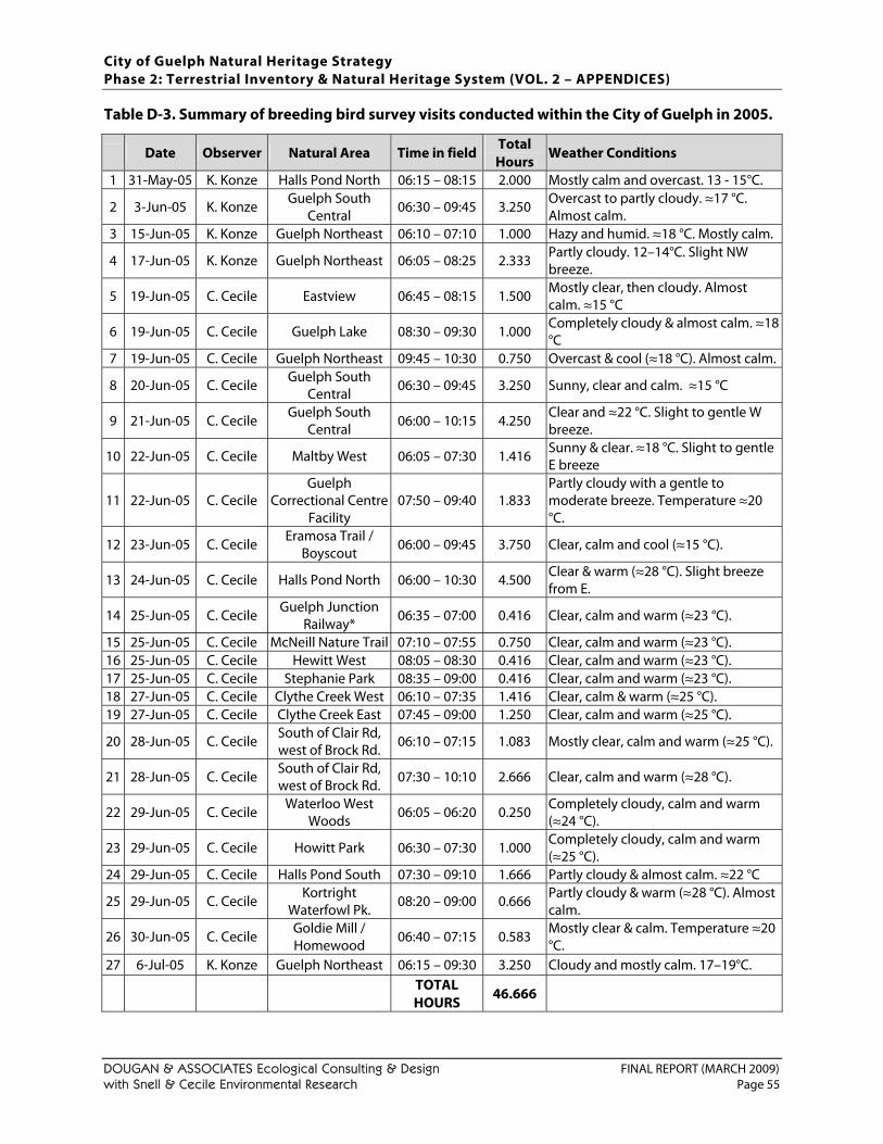
City of Guelph Natural Heritage Strategy Phase 2: Terrestrial Inventory & Natural Heritage System (VOL. 2 – APPENDICES)
DOUGAN & ASSOCIATES Ecological Consulting & Design FINAL REPORT (MARCH 2009) with Snell & Cecile Environmental Research Page 55
Table D-3. Summary of breeding bird survey visits conducted within the City of Guelph in 2005.
Date Observer Natural Area Time in field Total Hours
Weather Conditions
1 31-May-05 K. Konze Halls Pond North 06:15 – 08:15 2.000 Mostly calm and overcast. 13 - 15°C.
2 3-Jun-05 K. Konze Guelph South Central
06:30 – 09:45 3.250 Overcast to partly cloudy. ≈17 °C. Almost calm.
3 15-Jun-05 K. Konze Guelph Northeast 06:10 – 07:10 1.000 Hazy and humid. ≈18 °C. Mostly calm.
4 17-Jun-05 K. Konze Guelph Northeast 06:05 – 08:25 2.333 Partly cloudy. 12–14°C. Slight NW breeze.
5 19-Jun-05 C. Cecile Eastview 06:45 – 08:15 1.500 Mostly clear, then cloudy. Almost calm. ≈15 °C
6 19-Jun-05 C. Cecile Guelph Lake 08:30 – 09:30 1.000 Completely cloudy & almost calm. ≈18 °C
7 19-Jun-05 C. Cecile Guelph Northeast 09:45 – 10:30 0.750 Overcast & cool (≈18 °C). Almost calm.
8 20-Jun-05 C. Cecile Guelph South Central 06:30 – 09:45 3.250 Sunny, clear and calm. ≈15 °C
9 21-Jun-05 C. Cecile Guelph South Central 06:00 – 10:15 4.250 Clear and ≈22 °C. Slight to gentle W
breeze.
10 22-Jun-05 C. Cecile Maltby West 06:05 – 07:30 1.416 Sunny & clear. ≈18 °C. Slight to gentle E breeze
11 22-Jun-05 C. Cecile Guelph
Correctional Centre Facility
07:50 – 09:40 1.833 Partly cloudy with a gentle to moderate breeze. Temperature ≈20 °C.
12 23-Jun-05 C. Cecile Eramosa Trail / Boyscout
06:00 – 09:45 3.750 Clear, calm and cool (≈15 °C).
13 24-Jun-05 C. Cecile Halls Pond North 06:00 – 10:30 4.500 Clear & warm (≈28 °C). Slight breeze from E.
14 25-Jun-05 C. Cecile Guelph Junction Railway*
06:35 – 07:00 0.416 Clear, calm and warm (≈23 °C).
15 25-Jun-05 C. Cecile McNeill Nature Trail 07:10 – 07:55 0.750 Clear, calm and warm (≈23 °C). 16 25-Jun-05 C. Cecile Hewitt West 08:05 – 08:30 0.416 Clear, calm and warm (≈23 °C). 17 25-Jun-05 C. Cecile Stephanie Park 08:35 – 09:00 0.416 Clear, calm and warm (≈23 °C). 18 27-Jun-05 C. Cecile Clythe Creek West 06:10 – 07:35 1.416 Clear, calm & warm (≈25 °C). 19 27-Jun-05 C. Cecile Clythe Creek East 07:45 – 09:00 1.250 Clear, calm and warm (≈25 °C).
20 28-Jun-05 C. Cecile South of Clair Rd, west of Brock Rd. 06:10 – 07:15 1.083 Mostly clear, calm and warm (≈25 °C).
21 28-Jun-05 C. Cecile South of Clair Rd, west of Brock Rd. 07:30 – 10:10 2.666 Clear, calm and warm (≈28 °C).
22 29-Jun-05 C. Cecile Waterloo West Woods 06:05 – 06:20 0.250 Completely cloudy, calm and warm
(≈24 °C).
23 29-Jun-05 C. Cecile Howitt Park 06:30 – 07:30 1.000 Completely cloudy, calm and warm (≈25 °C).
24 29-Jun-05 C. Cecile Halls Pond South 07:30 – 09:10 1.666 Partly cloudy & almost calm. ≈22 °C
25 29-Jun-05 C. Cecile Kortright Waterfowl Pk.
08:20 – 09:00 0.666 Partly cloudy & warm (≈28 °C). Almost calm.
26 30-Jun-05 C. Cecile Goldie Mill / Homewood
06:40 – 07:15 0.583 Mostly clear & calm. Temperature ≈20 °C.
27 6-Jul-05 K. Konze Guelph Northeast 06:15 – 09:30 3.250 Cloudy and mostly calm. 17–19°C.
TOTAL HOURS
46.666

City of Guelph Natural Heritage Strategy Phase 2: Terrestrial Inventory & Natural Heritage System (VOL. 2 – APPENDICES)
DOUGAN & ASSOCIATES Ecological Consulting & Design FINAL REPORT (MARCH 2009) with Snell & Cecile Environmental Research Page 56
This page intentionally left blank to accommodate double-sided printing.
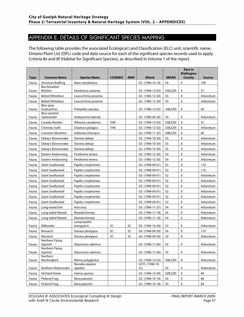
City of Guelph Natural Heritage Strategy Phase 2: Terrestrial Inventory & Natural Heritage System (VOL. 2 – APPENDICES)
DOUGAN & ASSOCIATES Ecological Consulting & Design FINAL REPORT (MARCH 2009) with Snell & Cecile Environmental Research Page 57
APPENDIX E. DETAILS OF SIGNIFICANT SPECIES MAPPING
The following table provides the associated Ecological Land Classification (ELC) unit, scientific name, Ontario Plant List (OPL) code and data source for each of the significant species records used to apply Criteria 8e and 8f (Habitat for Significant Species), as described in Volume 1 of the report.
Type Common Name Species Name COSEWIC MNR GRank SRANK
Rare in Wellington
County Source
Fauna American Bullfrog Rana catesbeiana G5 (1996-10-18) S4 X 109
Fauna Bay-breasted Warbler Dendroica castanea G5 (1996-12-03) S5B,SZN X 27
Fauna Belted Whiteface Leucorrhinia proxima G5 (1985-12-30) S5 X Arboretum
Fauna Belted Whiteface Leucorrhinia proxima G5 (1985-12-30) S5 X Arboretum
Fauna Blue-gray Gnatcatcher Polioptila caerulea G5 (1996-12-03) S4B,SZN X 89
Fauna Blue-spotted Salamander Ambystoma laterale G5 (1996-09-26) S4 X Arboretum
Fauna Canada Warbler Wilsonia canadensis THR G5 (1996-12-03) S5B,SZN X 31
Fauna Chimney Swift Chaetura pelagica THR G5 (1996-12-02) S5B,SZN X Arboretum
Fauna Common Moorhen Gallinula chloropus G5 (1996-11-25) S4B,SZN X 86
Fauna Dekay's Brownsnake Storeria dekayi G5 (1996-10-30) S5 X Arboretum
Fauna Dekay's Brownsnake Storeria dekayi G5 (1996-10-30) S5 X Arboretum
Fauna Dekay's Brownsnake Storeria dekayi G5 (1996-10-30) S5 X Arboretum
Fauna Eastern Amberwing Perithemis tenera G5 (1985-12-30) S4 X Arboretum
Fauna Eastern Amberwing Perithemis tenera G5 (1985-12-30) S4 X Arboretum
Fauna Giant Swallowtail Papilio cresphontes G5 (1998-09-01) S2 X 110
Fauna Giant Swallowtail Papilio cresphontes G5 (1998-09-01) S2 X 110
Fauna Giant Swallowtail Papilio cresphontes G5 (1998-09-01) S2 X Arboretum
Fauna Giant Swallowtail Papilio cresphontes G5 (1998-09-01) S2 X Arboretum
Fauna Giant Swallowtail Papilio cresphontes G5 (1998-09-01) S2 X Arboretum
Fauna Giant Swallowtail Papilio cresphontes G5 (1998-09-01) S2 X Arboretum
Fauna Giant Swallowtail Papilio cresphontes G5 (1998-09-01) S2 X Arboretum
Fauna Giant Swallowtail Papilio cresphontes G5 (1998-09-01) S2 X Arboretum
Fauna Long-eared Owl Asio otus G5 (1996-11-27) S4 X Arboretum
Fauna Long-tailed Weasel Mustela frenata G5 (1996-11-18) S4 X Arboretum
Fauna Long-tailed Weasel Mustela frenata G5 (1996-11-18) S4 X Arboretum
Fauna Milksnake Lampropeltis triangulum SC SC G5 (1996-10-30) S3 X Arboretum
Fauna Monarch Danaus plexippus SC SC G4 (1998-09-30) S4 X 110
Fauna Monarch Danaus plexippus SC SC G4 (1998-09-30) S4 X Arboretum
Fauna Northern Flying Squirrel Glaucomys sabrinus G5 (1996-11-06) S5 X Arboretum
Fauna Northern Flying Squirrel Glaucomys sabrinus G5 (1996-11-06) S5 X Arboretum
Fauna Northern Mockingbird Mimus polyglottos G5 (1996-12-03) S4B,SZN X Arboretum
Fauna Northern Watersnake Nerodia sipedon sipedon
G5T5 (1996-10-31) S5 X Arboretum
Fauna Orchard Oriole Icterus spurius G5 (1996-12-04) SZB,SZN X 84
Fauna Pickerel Frog Rana palustris G5 (1996-10-18) S4 X 86
Fauna Pickerel Frog Rana palustris G5 (1996-10-18) S4 X 84
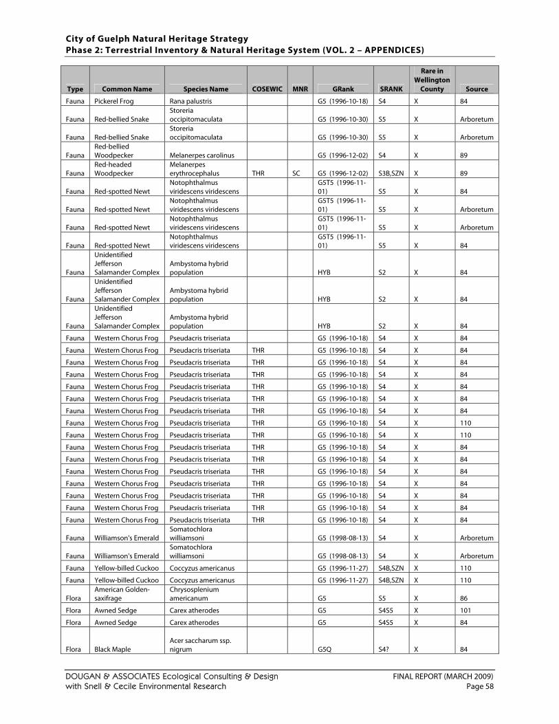
City of Guelph Natural Heritage Strategy Phase 2: Terrestrial Inventory & Natural Heritage System (VOL. 2 – APPENDICES)
DOUGAN & ASSOCIATES Ecological Consulting & Design FINAL REPORT (MARCH 2009) with Snell & Cecile Environmental Research Page 58
Type Common Name Species Name COSEWIC MNR GRank SRANK
Rare in Wellington
County Source
Fauna Pickerel Frog Rana palustris G5 (1996-10-18) S4 X 84
Fauna Red-bellied Snake Storeria occipitomaculata G5 (1996-10-30) S5 X Arboretum
Fauna Red-bellied Snake Storeria occipitomaculata G5 (1996-10-30) S5 X Arboretum
Fauna Red-bellied Woodpecker Melanerpes carolinus G5 (1996-12-02) S4 X 89
Fauna Red-headed Woodpecker
Melanerpes erythrocephalus THR SC G5 (1996-12-02) S3B,SZN X 89
Fauna Red-spotted Newt Notophthalmus viridescens viridescens
G5T5 (1996-11-01) S5 X 84
Fauna Red-spotted Newt Notophthalmus viridescens viridescens
G5T5 (1996-11-01) S5 X Arboretum
Fauna Red-spotted Newt Notophthalmus viridescens viridescens
G5T5 (1996-11-01) S5 X Arboretum
Fauna Red-spotted Newt Notophthalmus viridescens viridescens
G5T5 (1996-11-01) S5 X 84
Fauna
Unidentified Jefferson Salamander Complex
Ambystoma hybrid population HYB S2 X 84
Fauna
Unidentified Jefferson Salamander Complex
Ambystoma hybrid population HYB S2 X 84
Fauna
Unidentified Jefferson Salamander Complex
Ambystoma hybrid population HYB S2 X 84
Fauna Western Chorus Frog Pseudacris triseriata G5 (1996-10-18) S4 X 84
Fauna Western Chorus Frog Pseudacris triseriata THR G5 (1996-10-18) S4 X 84
Fauna Western Chorus Frog Pseudacris triseriata THR G5 (1996-10-18) S4 X 84
Fauna Western Chorus Frog Pseudacris triseriata THR G5 (1996-10-18) S4 X 84
Fauna Western Chorus Frog Pseudacris triseriata THR G5 (1996-10-18) S4 X 84
Fauna Western Chorus Frog Pseudacris triseriata THR G5 (1996-10-18) S4 X 84
Fauna Western Chorus Frog Pseudacris triseriata THR G5 (1996-10-18) S4 X 84
Fauna Western Chorus Frog Pseudacris triseriata THR G5 (1996-10-18) S4 X 110
Fauna Western Chorus Frog Pseudacris triseriata THR G5 (1996-10-18) S4 X 110
Fauna Western Chorus Frog Pseudacris triseriata THR G5 (1996-10-18) S4 X 84
Fauna Western Chorus Frog Pseudacris triseriata THR G5 (1996-10-18) S4 X 84
Fauna Western Chorus Frog Pseudacris triseriata THR G5 (1996-10-18) S4 X 84
Fauna Western Chorus Frog Pseudacris triseriata THR G5 (1996-10-18) S4 X 84
Fauna Western Chorus Frog Pseudacris triseriata THR G5 (1996-10-18) S4 X 84
Fauna Western Chorus Frog Pseudacris triseriata THR G5 (1996-10-18) S4 X 84
Fauna Western Chorus Frog Pseudacris triseriata THR G5 (1996-10-18) S4 X 84
Fauna Williamson's Emerald Somatochlora williamsoni G5 (1998-08-13) S4 X Arboretum
Fauna Williamson's Emerald Somatochlora williamsoni G5 (1998-08-13) S4 X Arboretum
Fauna Yellow-billed Cuckoo Coccyzus americanus G5 (1996-11-27) S4B,SZN X 110
Fauna Yellow-billed Cuckoo Coccyzus americanus G5 (1996-11-27) S4B,SZN X 110
Flora American Golden-saxifrage
Chrysosplenium americanum G5 S5 X 86
Flora Awned Sedge Carex atherodes G5 S4S5 X 101
Flora Awned Sedge Carex atherodes G5 S4S5 X 84
Flora Black Maple
Acer saccharum ssp. nigrum G5Q S4? X 84
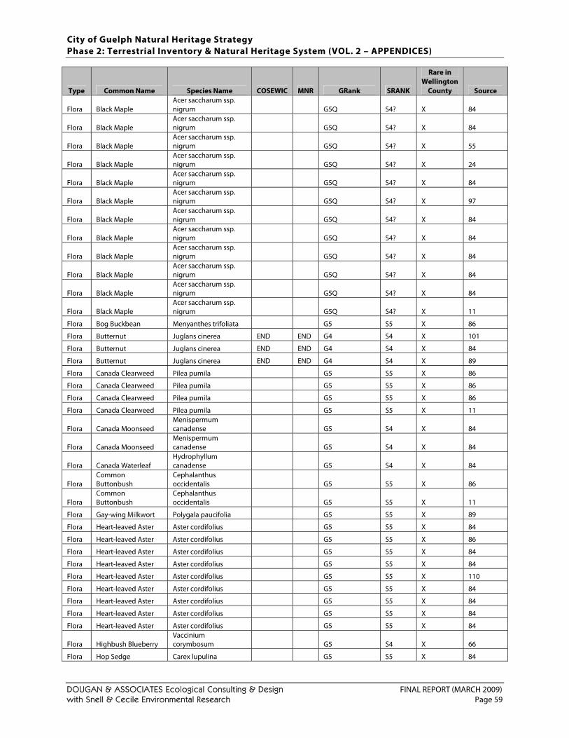
City of Guelph Natural Heritage Strategy Phase 2: Terrestrial Inventory & Natural Heritage System (VOL. 2 – APPENDICES)
DOUGAN & ASSOCIATES Ecological Consulting & Design FINAL REPORT (MARCH 2009) with Snell & Cecile Environmental Research Page 59
Type Common Name Species Name COSEWIC MNR GRank SRANK
Rare in Wellington
County Source
Flora Black Maple Acer saccharum ssp. nigrum G5Q S4? X 84
Flora Black Maple Acer saccharum ssp. nigrum G5Q S4? X 84
Flora Black Maple Acer saccharum ssp. nigrum G5Q S4? X 55
Flora Black Maple Acer saccharum ssp. nigrum G5Q S4? X 24
Flora Black Maple Acer saccharum ssp. nigrum G5Q S4? X 84
Flora Black Maple Acer saccharum ssp. nigrum G5Q S4? X 97
Flora Black Maple Acer saccharum ssp. nigrum G5Q S4? X 84
Flora Black Maple Acer saccharum ssp. nigrum G5Q S4? X 84
Flora Black Maple Acer saccharum ssp. nigrum G5Q S4? X 84
Flora Black Maple Acer saccharum ssp. nigrum G5Q S4? X 84
Flora Black Maple Acer saccharum ssp. nigrum G5Q S4? X 84
Flora Black Maple Acer saccharum ssp. nigrum G5Q S4? X 11
Flora Bog Buckbean Menyanthes trifoliata G5 S5 X 86
Flora Butternut Juglans cinerea END END G4 S4 X 101
Flora Butternut Juglans cinerea END END G4 S4 X 84
Flora Butternut Juglans cinerea END END G4 S4 X 89
Flora Canada Clearweed Pilea pumila G5 S5 X 86
Flora Canada Clearweed Pilea pumila G5 S5 X 86
Flora Canada Clearweed Pilea pumila G5 S5 X 86
Flora Canada Clearweed Pilea pumila G5 S5 X 11
Flora Canada Moonseed Menispermum canadense G5 S4 X 84
Flora Canada Moonseed Menispermum canadense G5 S4 X 84
Flora Canada Waterleaf Hydrophyllum canadense G5 S4 X 84
Flora Common Buttonbush
Cephalanthus occidentalis G5 S5 X 86
Flora Common Buttonbush
Cephalanthus occidentalis G5 S5 X 11
Flora Gay-wing Milkwort Polygala paucifolia G5 S5 X 89
Flora Heart-leaved Aster Aster cordifolius G5 S5 X 84
Flora Heart-leaved Aster Aster cordifolius G5 S5 X 86
Flora Heart-leaved Aster Aster cordifolius G5 S5 X 84
Flora Heart-leaved Aster Aster cordifolius G5 S5 X 84
Flora Heart-leaved Aster Aster cordifolius G5 S5 X 110
Flora Heart-leaved Aster Aster cordifolius G5 S5 X 84
Flora Heart-leaved Aster Aster cordifolius G5 S5 X 84
Flora Heart-leaved Aster Aster cordifolius G5 S5 X 84
Flora Heart-leaved Aster Aster cordifolius G5 S5 X 84
Flora Highbush Blueberry Vaccinium corymbosum G5 S4 X 66
Flora Hop Sedge Carex lupulina G5 S5 X 84
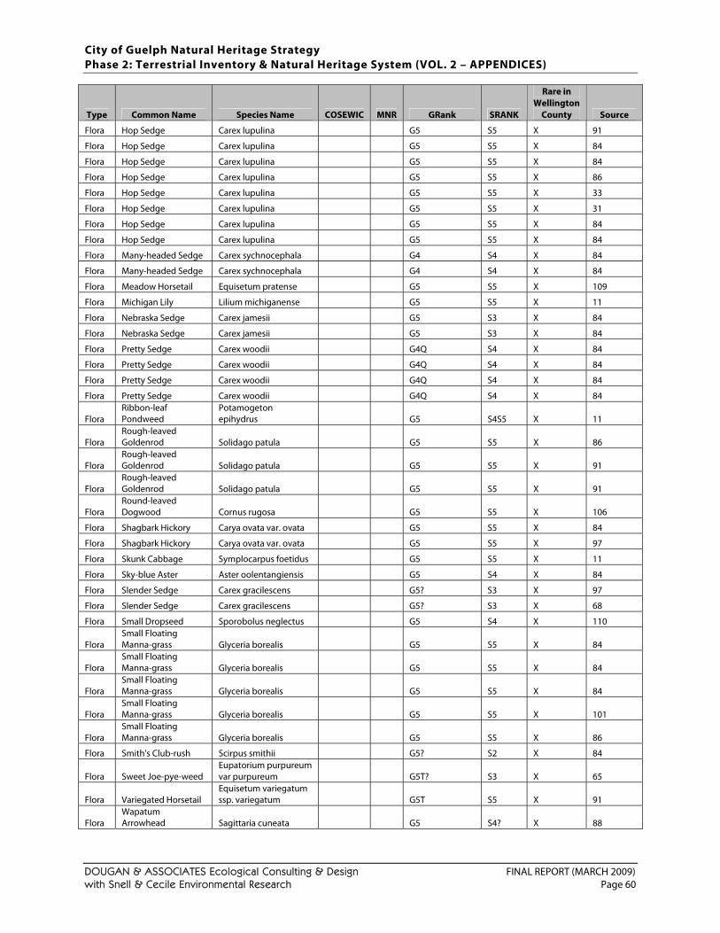
City of Guelph Natural Heritage Strategy Phase 2: Terrestrial Inventory & Natural Heritage System (VOL. 2 – APPENDICES)
DOUGAN & ASSOCIATES Ecological Consulting & Design FINAL REPORT (MARCH 2009) with Snell & Cecile Environmental Research Page 60
Type Common Name Species Name COSEWIC MNR GRank SRANK
Rare in Wellington
County Source
Flora Hop Sedge Carex lupulina G5 S5 X 91
Flora Hop Sedge Carex lupulina G5 S5 X 84
Flora Hop Sedge Carex lupulina G5 S5 X 84
Flora Hop Sedge Carex lupulina G5 S5 X 86
Flora Hop Sedge Carex lupulina G5 S5 X 33
Flora Hop Sedge Carex lupulina G5 S5 X 31
Flora Hop Sedge Carex lupulina G5 S5 X 84
Flora Hop Sedge Carex lupulina G5 S5 X 84
Flora Many-headed Sedge Carex sychnocephala G4 S4 X 84
Flora Many-headed Sedge Carex sychnocephala G4 S4 X 84
Flora Meadow Horsetail Equisetum pratense G5 S5 X 109
Flora Michigan Lily Lilium michiganense G5 S5 X 11
Flora Nebraska Sedge Carex jamesii G5 S3 X 84
Flora Nebraska Sedge Carex jamesii G5 S3 X 84
Flora Pretty Sedge Carex woodii G4Q S4 X 84
Flora Pretty Sedge Carex woodii G4Q S4 X 84
Flora Pretty Sedge Carex woodii G4Q S4 X 84
Flora Pretty Sedge Carex woodii G4Q S4 X 84
Flora Ribbon-leaf Pondweed
Potamogeton epihydrus G5 S4S5 X 11
Flora Rough-leaved Goldenrod Solidago patula G5 S5 X 86
Flora Rough-leaved Goldenrod Solidago patula G5 S5 X 91
Flora Rough-leaved Goldenrod Solidago patula G5 S5 X 91
Flora Round-leaved Dogwood Cornus rugosa G5 S5 X 106
Flora Shagbark Hickory Carya ovata var. ovata G5 S5 X 84
Flora Shagbark Hickory Carya ovata var. ovata G5 S5 X 97
Flora Skunk Cabbage Symplocarpus foetidus G5 S5 X 11
Flora Sky-blue Aster Aster oolentangiensis G5 S4 X 84
Flora Slender Sedge Carex gracilescens G5? S3 X 97
Flora Slender Sedge Carex gracilescens G5? S3 X 68
Flora Small Dropseed Sporobolus neglectus G5 S4 X 110
Flora Small Floating Manna-grass Glyceria borealis G5 S5 X 84
Flora Small Floating Manna-grass Glyceria borealis G5 S5 X 84
Flora Small Floating Manna-grass Glyceria borealis G5 S5 X 84
Flora Small Floating Manna-grass Glyceria borealis G5 S5 X 101
Flora Small Floating Manna-grass Glyceria borealis G5 S5 X 86
Flora Smith's Club-rush Scirpus smithii G5? S2 X 84
Flora Sweet Joe-pye-weed Eupatorium purpureum var purpureum G5T? S3 X 65
Flora Variegated Horsetail Equisetum variegatum ssp. variegatum G5T S5 X 91
Flora Wapatum Arrowhead Sagittaria cuneata G5 S4? X 88
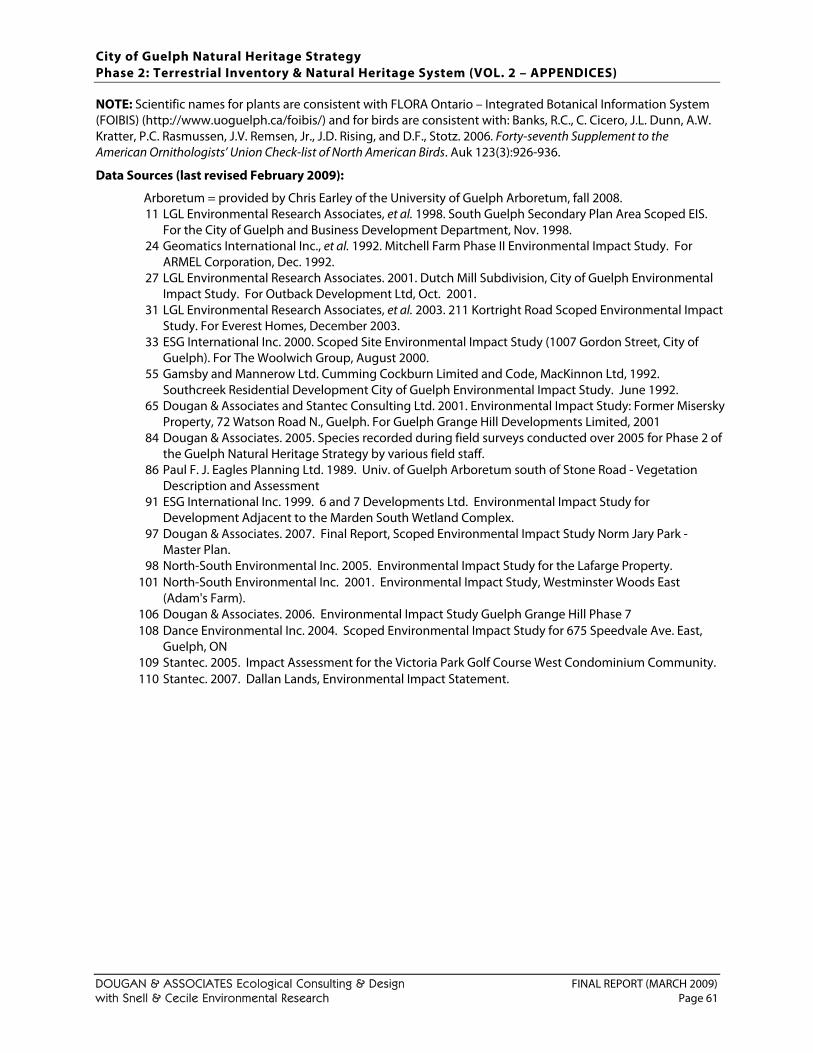
City of Guelph Natural Heritage Strategy Phase 2: Terrestrial Inventory & Natural Heritage System (VOL. 2 – APPENDICES)
DOUGAN & ASSOCIATES Ecological Consulting & Design FINAL REPORT (MARCH 2009) with Snell & Cecile Environmental Research Page 61
NOTE: Scientific names for plants are consistent with FLORA Ontario – Integrated Botanical Information System (FOIBIS) (http://www.uoguelph.ca/foibis/) and for birds are consistent with: Banks, R.C., C. Cicero, J.L. Dunn, A.W. Kratter, P.C. Rasmussen, J.V. Remsen, Jr., J.D. Rising, and D.F., Stotz. 2006. Forty-seventh Supplement to the American Ornithologists’ Union Check-list of North American Birds. Auk 123(3):926-936.
Data Sources (last revised February 2009):
Arboretum = provided by Chris Earley of the University of Guelph Arboretum, fall 2008. 11 LGL Environmental Research Associates, et al. 1998. South Guelph Secondary Plan Area Scoped EIS.
For the City of Guelph and Business Development Department, Nov. 1998. 24 Geomatics International Inc., et al. 1992. Mitchell Farm Phase II Environmental Impact Study. For
ARMEL Corporation, Dec. 1992. 27 LGL Environmental Research Associates. 2001. Dutch Mill Subdivision, City of Guelph Environmental
Impact Study. For Outback Development Ltd, Oct. 2001. 31 LGL Environmental Research Associates, et al. 2003. 211 Kortright Road Scoped Environmental Impact
Study. For Everest Homes, December 2003. 33 ESG International Inc. 2000. Scoped Site Environmental Impact Study (1007 Gordon Street, City of
Guelph). For The Woolwich Group, August 2000. 55 Gamsby and Mannerow Ltd. Cumming Cockburn Limited and Code, MacKinnon Ltd, 1992.
Southcreek Residential Development City of Guelph Environmental Impact Study. June 1992. 65 Dougan & Associates and Stantec Consulting Ltd. 2001. Environmental Impact Study: Former Misersky
Property, 72 Watson Road N., Guelph. For Guelph Grange Hill Developments Limited, 2001 84 Dougan & Associates. 2005. Species recorded during field surveys conducted over 2005 for Phase 2 of
the Guelph Natural Heritage Strategy by various field staff. 86 Paul F. J. Eagles Planning Ltd. 1989. Univ. of Guelph Arboretum south of Stone Road - Vegetation
Description and Assessment 91 ESG International Inc. 1999. 6 and 7 Developments Ltd. Environmental Impact Study for
Development Adjacent to the Marden South Wetland Complex. 97 Dougan & Associates. 2007. Final Report, Scoped Environmental Impact Study Norm Jary Park -
Master Plan. 98 North-South Environmental Inc. 2005. Environmental Impact Study for the Lafarge Property.
101 North-South Environmental Inc. 2001. Environmental Impact Study, Westminster Woods East (Adam's Farm).
106 Dougan & Associates. 2006. Environmental Impact Study Guelph Grange Hill Phase 7 108 Dance Environmental Inc. 2004. Scoped Environmental Impact Study for 675 Speedvale Ave. East,
Guelph, ON 109 Stantec. 2005. Impact Assessment for the Victoria Park Golf Course West Condominium Community. 110 Stantec. 2007. Dallan Lands, Environmental Impact Statement.

City of Guelph Natural Heritage Strategy Phase 2: Terrestrial Inventory & Natural Heritage System (VOL. 2 – APPENDICES)
DOUGAN & ASSOCIATES Ecological Consulting & Design FINAL REPORT (MARCH 2009) with Snell & Cecile Environmental Research Page 62
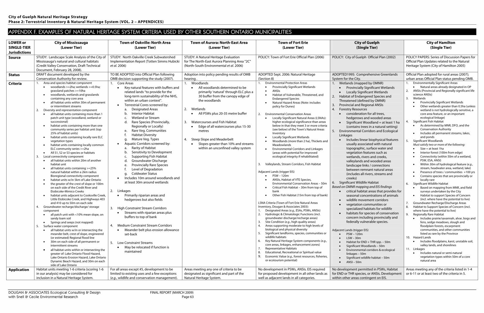
City of Guelph Natural Heritage Strategy Phase 2: Terrestrial Inventory & Natural Heritage System (VOL. 2 – APPENDICES)
DOUGAN & ASSOCIATES Ecological Consulting & Design FINAL REPORT (MARCH 2009) with Snell & Cecile Environmental Research Page 63
APPENDIX F. EXAMPLES OF NATURAL HERITAGE SYSTEM CRITERIA USED BY OTHER SOUTHERN ONTARIO MUNICIPALITIES
LOWER or SINGLE-TIER Jurisdictions
City of Mississauga (Lower Tier)
Town of Oakville: North Area (Lower Tier)
Town of Aurora: North-East Area (Lower Tier)
Town of Fort Erie (Lower Tier)
City of Guelph (Single Tier)
City of Hamilton (Single Tier)
Source STUDY: Landscape Scale Analysis of the City of Mississauga’s natural and cultural habitats (Credit Valley Conservation, Draft Technical Document, February 28, 2008).
STUDY: North Oakville Creek Subwatershed Implementation Report (Totten Simms Hubicki et al. 2006)
STUDY: A Natural Heritage Evaluation for The North-East Aurora Planning Area “2C” (North-South Environmental et al. 2006)
POLICY: Town of Fort Erie Official Plan (2006) POLICY: City of Guelph Official Plan (2002) POLICY PAPERS: Series of Discussion Papers for Official Plan Updates related to the Natural Heritage System (City of Hamilton 2005)
Status DRAFT document developed by the Conservation Authority for review.
TO BE ADOPTED into Official Plan following OMB decision supporting the study (2007).
Adoption into policy pending results of OMB hearing .
ADOPTED Sept. 2006: Natural Heritage (Section 8)
ADOPTED1995: Comprehensive Greenlands System for the City.
Official Plan adopted for rural areas (2007); urban areas Official Plan status pending OMB.
Criteria 1. Area and species habitat component • woodlands >=2ha; wetlands >=0.5ha;
grassland patches >=10ha • woodlands, wetlands and grasslands
containing any core area • all habitat units within 30m of permanent
or intermittent streams 2. Diversity and representation component
• all habitat units containing more than 1 patch unit type (woodland, wetland or successional)
• habitat units containing more than one community series per habitat unit (top 25% of habitat units)
• habitat units containing locally rare ELC vegetation types
• habitat units containing locally common ELC community series >=2ha
• All S1, S2 or S3 species or habitats 3. Local connectivity component
• all habitat units within 20m of another habitat unit
• all habitat units containing >=25% natural habitat within a 2km radius Bioregional connectivity component
• habitat units w/in 5km of Lake Ontario • the greater of the crest of slope or 100m
on each side of the Credit River and Etobicoke-Mimico Creeks
• habitat units adjacent to Cooksville Creek, Little Etobicoke Creek, and Highways 403 and 410 up to 50m on each side
4. Groundwater recharge/discharge/ storage component • all patch unit with <10% mean slope, on
sandy loam soil • Springs and seeps (not mapped)
5. Surface water component • all habitat units w/in or intersecting the
meander belt, crest of slope, engineered (or estimated) Regional flood line
• 30m on each side of all permanent or intermittent streams
• all habitat units within or intersecting the greater of: Lake Ontario Flood Hazard, Lake Ontario Erosion Hazard, Lake Ontario Dynamic Beach Hazard, and 30m on each side of Lake Ontario
1. Core Areas • Key natural features with buffers and
related lands “to provide for the long-term sustainability of the NHS, within an urban context”.
• Terrestrial Cores screened by: a. Designated Areas b. Interior Habitat c. Wetland or Stream d. Rare Species (Provincially,
Regionally or Locally) e. Rare Veg. Communities f. Habitat Diversity g. Mature Veg. Types
• Aquatic Corridors screened by: a. Rarity of Habitat b. Sensitivity to Development c. Supporting Fish Habitat d. Groundwater Discharge e. Provincially Rare Species f. Level of Degradation g. Coldwater Status
• Includes 10m around woodlands and at least 30m around wetlands
2. Linkages
• Primarily riparian areas and hedgerows but also fields
3. High Constraint Stream Corridors
• Streams with riparian areas plus buffers to top of bank
4. Medium Constraint Stream Corridors
• Meander belt plus erosion allowance set-back
5. Low Constraint Streams
• May be relocated if function is maintained
1. Woodlands • All woodlands determined to be
primarily ‘natural’ through ELC plus a 30 buffer from the canopy edge of the woodlands
2. Wetlands
• All PSWs plus 20-35 metre buffer
3. Watercourses and Fish Habitat • Edge of all watercourses plus 15-30
metres
4. Steep Slope and Meaderbelt • Slopes greater than 10% and streams
within an unconfined valley system
1. Environmental Protection Areas • Provincially Significant Wetlands • ANSIs • Habitat of Vulnerable, Threatened, and
Endangered Species • Natural Hazard Areas (Note: includes
policy for Dunes)
2. Environmental Conservation Areas • Locally Significant Natural Areas (LSNAs):
higher ecological significance than areas below in that they meet 3 or more criteria (see below) of the Town’s Natural Areas Inventory
• Locally Significant Wetlands • Woodlands (more than 2 ha), Thickets and
Meadowlands • Environmental Corridors and Linkages
(areas with potential for improved ecological integrity if rehabilitated)
3. Valleylands, Stream Corridors, Fish Habitat Adjacent Lands (trigger EIS)
• PSW – 120m • ANSIs, Habitat of VTE Species,
Environmental Conservation Areas – 50m • Critical Fish Habitat – 30m from top of
bank • Other Fish Habitat (15m from top of bank)
LSNA Criteria (Town of Fort Erie Natural Areas Inventory, Dougan & Associates 2003): 1. Designated Areas (e.g., ESAs, PSWs, ANSIs) 2. Hydrologic & Climatologic Functions (incl.
groundwater discharge/recharge areas) 3. Site Condition (e.g., high quality areas) 4. Areas supporting moderate to high levels of
biological and physical diversity 5. Significant landforms, species, communities or
wildlife habitats 6. Key Natural Heritage System components (e.g.,
core areas, linkages, enhancement zones) 7. Representative Habitats 8. Educational, Recreational or Spiritual value 9. Economic Value (e.g., forest resources, fisheries,
or ecotourism potential)
1. Wetlands (mapped by OMNR) • Provincially Significant Wetlands • Locally Significant Wetlands
2. Habitat of Endangered Species and Threatened (defined by OMNR)
3. Provincial and Regional ANSIs 4. Forestry Resources
• consideration for all trees, hedgerows and wooded areas
• Significant Woodland = at least 1 ha (contains trees in a natural setting)
5. Environmental Corridors and Ecological Linkages • Includes linear biophysical features
usually associated with natural topographic, surface water and vegetation features such as wetlands, rivers and creeks, valleylands and wooded areas landscape links / connections between remnant natural areas (includes all rivers, streams and creeks)
6. Significant Wildlife Habitat Based on OMNR mapping and EIS findings
• critical habitat areas that provides for seasonal concentrations of animals
• wildlife movement corridors • vegetation communities or
specialized habitats for wildlife • habitats for species of conservation
concern including provincially and federally vulnerable species.
Adjacent Lands (trigger EIS)
• PSW – 120m • LSW – 30m • Habitat for END + THR spp. – 50m • Significant Woodlands – 50m • Environmental corridors & ecological
linkages – 50m • Significant wildlife habitat – 50m • ANSI – 50m
1. Environmentally Significant Areas • Natural areas already designated in OP
2. ANSIs (Provincial and Regionally significant life science ANSIs)
3. Wetlands • Provincially Significant Wetlands • Other wetlands greater than 0.5ha (unless
wetland is not hydrologically sensitive, a core area feature, or an important ecological linkage)
4. Significant Fish Habitat • As determined by MNR, DFO, and the
Conservation Authority • Includes all permanent streams, lakes,
and ponds 5. Significant Woodlands
Must satisfy two or more of the following: • Size = at least 1ha • Interior forest (100m from edge) • Connectivity (within 50m of a wetland,
PSW, ESA, ANSI) • Within 30m of hydrological feature (e.g.,
stream, headwater area, wetland, lake) • Presence of trees / communities +100 yrs • Contains species that are provincially or
locally rare 6. Significant Wildlife Habitat
• Based on mapping from MNR, and field surveys undertaken by the City
• Habitat to support Species of Concern (incl. where have the potential to live)
7. Groundwater Recharge/Discharge Areas 8. Habitat to Support Species of Concern (incl.
where have the potential to live) 9. Regionally Rare Habitat
• Includes prairie/savannah, alvar, bogs and fens, sedge meadows, slough and floodplain forests, escarpment communities, and other communities listed as rare by the Province
10. Hazard Lands • Includes floodplains, karst, unstable soil,
valley lands, and shorelines 11. Linkages
• Includes natural or semi-natural vegetation types within 50m of a core natural area
Application Habitat units meeting 1-6 criteria (scoring 1-6 in our analysis) may be considered for inclusion in a Natural Heritage System.
For all areas except #5, development to be limited to existing uses and a few exceptions (e.g., wildlife and conservation management).
Areas meeting any one of criteria to be designated as significant and part of the Natural Heritage System.
No development in PSWs, ANSIs. EIS required for proposed development in all other lands as well as adjacent lands in all categories.
No development permitted in PSWs, Habitat for END or THR species, or ANSIs. Development within other areas contingent on EIS.
Areas meeting any of the criteria listed in 1-4 or 6-11 or at least two of the criteria in 5.
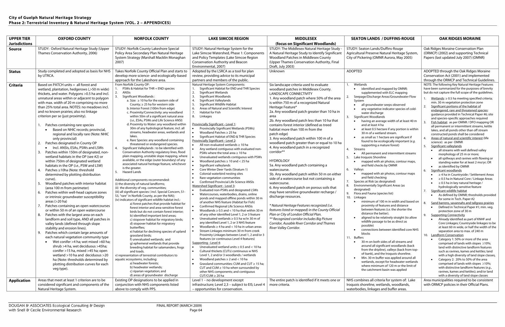
City of Guelph Natural Heritage Strategy Phase 2: Terrestrial Inventory & Natural Heritage System (VOL. 2 – APPENDICES)
DOUGAN & ASSOCIATES Ecological Consulting & Design FINAL REPORT (MARCH 2009) with Snell & Cecile Environmental Research Page 64
UPPER TIER Jurisdictions
OXFORD COUNTY NORFOLK COUNTY LAKE SIMCOE REGION MIDDLESEX (focus on Significant Woodlands)
SEATON LANDS / DUFFINS-ROUGE OAK RIDGES MORAINE
Source STUDY: Oxford Natural Heritage Study (Upper Thames Conservation Authority, 2006)
STUDY: Norfolk County Lakeshore Special Policy Area Secondary Plan Natural Heritage System Strategy (Marshall Macklin Monaghan 2007)
STUDY: Natural Heritage System for the Lake Simcoe Watershed, Phase 1: Components and Policy Templates (Lake Simcoe Region Conservation Authority and Beacon Environmental, 2007)
STUDY: The Middlesex Natural Heritage Study - A Natural Heritage Study to Identify Significant Woodland Patches in Middlesex County (Upper Thames Conservation Authority, Final Draft, July 2003)
STUDY: Seaton Lands/Duffins-Rouge Agricultural Preserve Natural Heritage System, City of Pickering (OMNR Aurora, May 2005)
Oak Ridges Moraine Conservation Plan (ORMCP) (2002) and supporting Technical Papers (last updated July 2007) (OMNR)
Status Study completed and adopted as basis for NHS by UTRCA.
Takes Norfolk County Official Plan and starts to develop more science- and ecologically-based approach for the Lakeshore area.
Adopted by the LSRCA as a tool for plan review, providing advice to its municipal partners and members of the public.
Unknown ADOPTED ADOPTED through the Oak Ridges Moraine Conservation Act (2001) and implemented through the ORMCP and Technical Guidelines.
Criteria Based on PATCH units = all forest and wetland, plantation, hedgerows (,>50 m wide) thickets, and water. Polygons >0.5 ha and incl. unnatural areas within or adjacent to polygon with max. width of 20 m comprising no more than 25% total area. NOTES: no meadows incl. and no known prairies; also no linkage criterion per se (just proximity). 1. Patches containing rare species
• Based on NHIC records; provincial, regional and locally rare (Note: NHIC only provincial)
2. Patches designated in County OP • Incl. ANSIs, ESAs, PSWs and LSWs
3. Patches within 150m of designated, non-wetland habitats in the OP (see #2) or within 750m of designated wetland habitats in the OP (i.e., PSW and LSW)
4. Patches ≥10ha (Note: threshold determined by plotting distribution curve).
5. Woodland patches with interior habitat (area 100 m from perimeter)
6. Patches within well-head capture zones or intrinsic groundwater susceptibility areas (>20 ha)
7. Patches containing an open watercourses or within 50 m of an open watercourse
8. Patches with the largest area on each landform and soil type, AND all patches in valley lands (defined through slope stability and erosion lines).
9. Patches which contain large amounts of each natural vegetation community type • Wet conifer >4 ha; wet mixed >60 ha;
shrub >4 ha, wet deciduous >45ha; conifer >15 ha, mixed >45 ha; open wetland >10 ha and deciduous >20 ha (Note: thresholds determined by plotting distribution curves for each veg type).
From Norfolk County OP: 1. PSWs & Habitat for THR + END species 2. ANSIs 3. Significant Woodlands :
a. Size: ≥ 10 ha for the eastern side of County; ≥ 25 ha for western side
b. Interior Forest (100m from edge) c. Proximity/Connectivity: any woodland
within 50m of a significant natural area (i.e., ESAs, PSWs and Life Science ANSI)
d. Proximity to Water: any woodland within 30m of any hydrological feature, incl. all streams, headwater areas, wetlands and lakes.
e. Rare Species: any woodland containing threatened or endangered species.
4. Significant Valleylands : to be identified with Conservation Authority regulatory lines, flood plain mapping, unstable slope mapping, where available, or the edge (outer boundary) of any associated natural heritage feature, whichever is the greater.
5. Hazard Lands Additional components recommended: (i) the diversity of natural landforms; (ii) the diversity of veg. communities; (iii) all significant species ( incl. Special Concern, S1-S3, “rare” in Norfolk County, as per the NAI); (iv) indicators of significant wildlife habitat incl.:
a) forest patches that provide habitat for forest interior and area-sensitive forest birds but do not contain forest interior; b) identified important bird areas; c) stopover habitat for migratory birds; d) stopover habitat for migratory butterflies; e) habitat for declining species of upland grassland birds; f) unevaluated wetlands; and g) ephemeral wetlands that provide breeding habitat for salamanders, frogs and toads.
v) representation of terrestrial contributors to aquatic ecosystems, including:
a) headwater forests; b) headwater wetlands; c) riparian vegetation; and d) areas of groundwater discharge
Natural Heritage System Components: 1. Significant Habitat for END and THR Species 2. Significant Wetlands 3. Significant Woodlands 4. Significant Valleylands 5. Significant Wildlife Habitat 6. Areas of Natural and Scientific Interest 7. Habitat for Fish 8. Linkages Provincially Significant - Level 1: • Provincially Significant Wetlands (PSWs) • Woodland Patches ≥ 25 ha • Significant Habitat of END & THR Species Provincially Significant - Level 2: • All non-evaluated wetlands ≥ 10 ha • Any wetland contiguous with evaluated non-
PSWs where the total area ≥ 10 ha • Unevaluated wetlands contiguous with PSWs • Woodland patches ≥ 10 and < 25 ha • Significant valleylands • Core Winter Deer Yards (Stratum 1) • Colonial waterbird nesting sites • Rare vegetation communities • Confirmed Provincial Life Science ANSIs Watershed Significant - Level 3: • Evaluated non-PSWs and designated LSWs • Watercourses, waterbodies, drains, online
ponds and mapped offline ponds within 30 m of another NHS feature (Habitat for Fish)
• Confirmed Regional Life Science ANSIs • Woodlands ≥ 0.5 and < 10 ha that within 30 m
of any other identified Level 1, 2 or 3 feature • Unevaluated wetlands ≥ 0.5 ha w/in 30 m of
any identified Level 1, 2 or 3 NHS feature • Woodlands ≥ 4 ha and < 10 ha in urban areas • Stream Linkages minimum 30 m from creek
Proximity Linkages between Level 1, 2 and/or 3 features (or continuous Level 4 features)
Supporting - Level 4: • Unevaluated wetland units ≥ 0.5 and < 10 ha • Cultural thickets (CUTs) continuous w NHS
Level 1, 2 and/or 3 woodlands / wetlands • Woodland patches ≥ 2 and < 10 ha • Grassland communities: CUM and CUT ≥ 15 ha;
CUT and CUM ≥ 10 ha when surrounded by other NHS components; and contiguous CUT/CUM ≥ 20 ha
Six landscape criteria used to evaluate woodland patches in Middlesex County. LANDSCAPE CONNECTIVITY 1. Any woodland patch where 50% of the area is within 750 m of a recognized Natural Heritage Feature* 2a. Any woodland patch greater than 10 ha in area 2b. Any woodland patch less than 10 ha that contains forest interior (defined as treed habitat more than 100 m from the patch edge) 3. Any woodland patch within 100 m of a woodland patch greater than or equal to 10 ha 4. Any woodland patch in a recognized corridor** HYDROLOGY 5a. Any woodland patch containing a watercourse. 5b. Any woodland patch within 50 m on either side of a watercourse but not containing a watercourse. 6. Any woodland patch on porous soils that may have sensitive groundwater recharge / discharge resources. * Natural Heritage Features recognized (i.e. features listed or mapped) in the County Official Plan or City of London Official Plan. ** Recognized corridor includes Big Picture Corridor, Ausable River Corridor and Thames River Valley Corridor.
1. Wetlands • identified and mapped by OMNR;
supplemented with ELC mapping 2. Seepage/Discharge Areas/Groundwater Flow
System • all groundwater seeps observed • any vegetative indicator species of cold-
water discharge 3. Significant Woodlands
• having an average width of at least 40 m and at least 4 ha
• at least 0.5 hectare if any portion is within 30 m of a wetland stream.
• as small as 1 hectare are significant if found to be ecologically important (e.g. supporting a mature forest)
4. Streams • All permanent and intermittent streams
5. Lake Iroquois Shoreline • mapped with air photos, contour maps,
and field checks by OMNR 6. Valleys
• mapped with air photos, contour maps and field checking
7. Species at Risk (as designated) 8. Environmentally Significant Areas (as
designated) 9. Flora and Fauna (species list) 10. Linkages
• minimum of 100 m in width and based on proximity of features and distance between features (i.e. the shorter the distance the better).
• aligned to be relatively straight (to allow wildlife passage to be as direct as possible)
• connections between identified core NHS blocks
11. Buffers • 30 m on both sides of all streams and
around all significant woodlands (back from the dripline), valleys (back from top-of-bank), and the Iroquois shoreline.
• Min. 30 m buffer was applied around all wetlands, except for headwater wetlands where minimum of 120 m or the limit of the catchment basin was applied
NOTE: The following Key Natural Heritage Features have been summarized for the purposes of brevity but do not capture the full scope of the guidelines. 1. Wetlands: ≥ 0.5 ha meeting specified criteria;
min. 30 m vegetation protection zone 2. Significant portions of the habitat of
endangered, rare and threatened species: guidance provided in Technical Paper #6; site and species-specific approaches required
3. Fish habitat: as per OMNR / DFO mapping OR all permanent or intermittent streams, kettle lakes, and all ponds other than off stream constructed ponds shall be considered
4. Areas of natural and scientific interest (life science): as per OMNR
5. Significant valleylands • all streams with well defined valley
morphology of 25 m or more; • all spillways and ravines with flowing or
standing water for at least 2 mo/yr; OR • as identified by OMNR
6. Significant woodlands • ≥ 4 ha in Countryside / Settlement Areas • ≥ 0.5 ha in Natural Core / Linkage Areas • ≥ 0.5 ha in key natural heritage /
hydrologically sensitive feature 7. Significant wildlife habitat
• As defined by OMNR; thresholds provided for some in Tech. Paper #2
8. Sand barrens, savannahs and tallgrass prairies • Defined in Technical Paper #1; min. veg.
protection zone of 30 m 9. Supporting Connectivity
• Already identified as part of KNHF and Core Linkages; Countryside linkages to be at least 60 m wide, or half the width of the separation area to max. of 240 m
10. Landform Conservation • Category 1: 50% or more of the area
comprised of lands with slopes ≥10%; land with distinctive landform features such as ravines, kames and kettles; land with a high diversity of land slope classes .
• Category 2: 20% to 50% of the area comprised of lands with slopes ≥10%; with distinctive landform features (e.g., ravines, kames and kettles); and/or land with a diversity of land slope classes
Application Areas that meet at least 1 criterion are to be considered significant and components of the Natural Heritage System.
Existing OP designations to be applied in conjunction with NHS components listed above to comply with PPS.
Level 1 – no development except infrastructure; Level 2,3 – subject to EIS; Level 4 – opportunities for conservation.
The entire patch is identified if it meets one or more criteria.
NHS combines all criteria for system of: Lake Iroquois shoreline, wetlands, woodlands, waterbodies, linkages and buffer areas.
Area municipalities required to be consistent with ORMCP policies in their Official Plans.
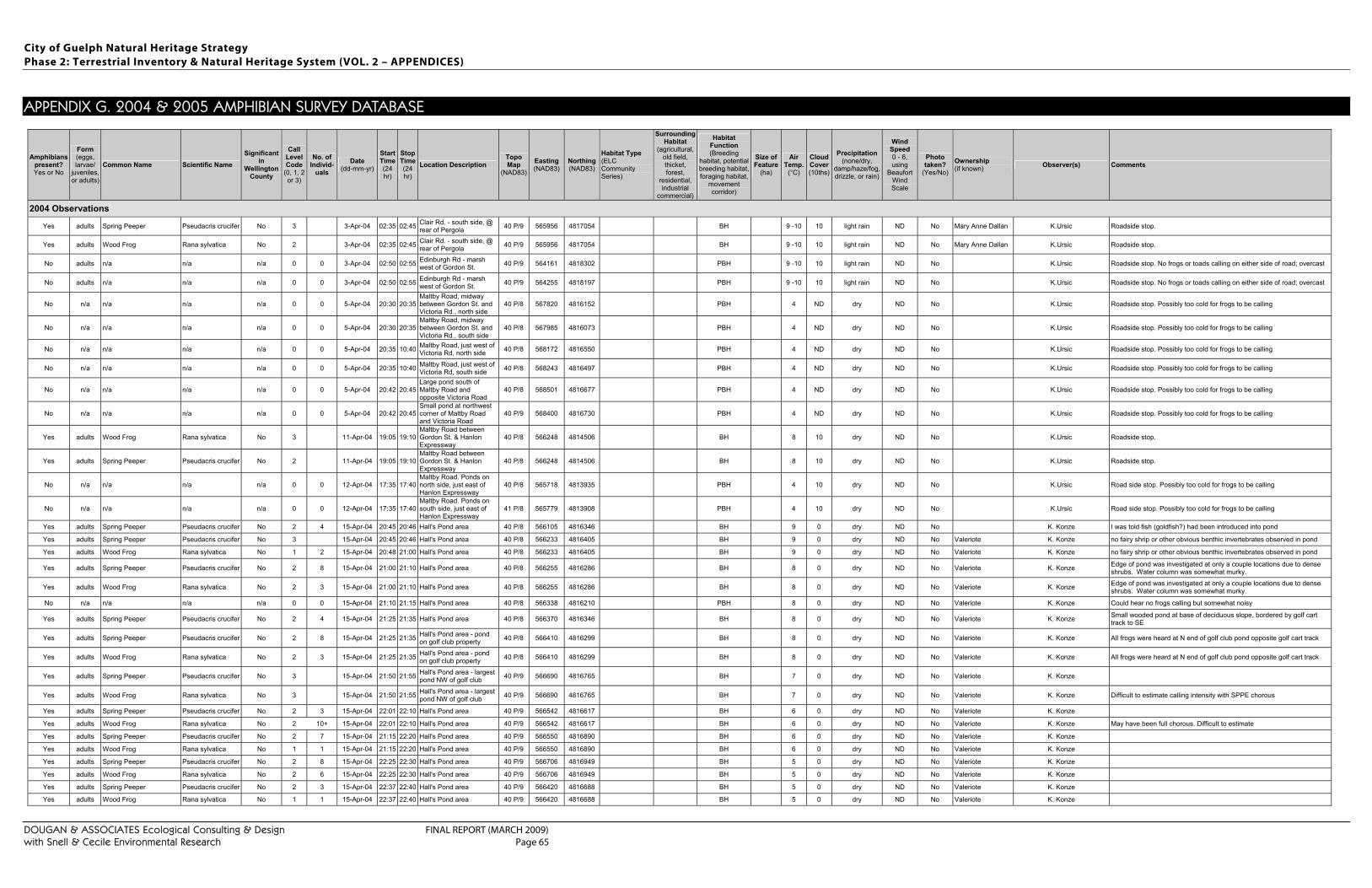
City of Guelph Natural Heritage Strategy Phase 2: Terrestrial Inventory & Natural Heritage System (VOL. 2 – APPENDICES)
DOUGAN & ASSOCIATES Ecological Consulting & Design FINAL REPORT (MARCH 2009) with Snell & Cecile Environmental Research Page 65
APPENDIX G. 2004 & 2005 AMPHIBIAN SURVEY DATABASE
Amphibians present? Yes or No
Form (eggs, larvae/
juveniles, or adults)
Common Name Scientific Name Significant
in Wellington
County
Call Level Code
(0, 1, 2 or 3)
No. of Individ-
uals Date
(dd-mm-yr)
Start Time (24 hr)
Stop Time (24 hr)
Location Description Topo Map
(NAD83) Easting (NAD83)
Northing (NAD83)
Habitat Type (ELC Community Series)
Surrounding Habitat
(agricultural, old field, thicket, forest,
residential, industrial
commercial)
Habitat Function (Breeding
habitat, potential breeding habitat, foraging habitat,
movement corridor)
Size of Feature
(ha)
Air Temp.
(°C)
Cloud Cover (10ths)
Precipitation (none/dry,
damp/haze/fog, drizzle, or rain)
Wind Speed 0 - 6, using
Beaufort Wind Scale
Photo taken?
(Yes/No) Ownership (if known) Observer(s) Comments
2004 Observations
Yes adults Spring Peeper Pseudacris crucifer No 3 3-Apr-04 02:35 02:45 Clair Rd. - south side, @ rear of Pergola 40 P/9 565956 4817054 BH 9 -10 10 light rain ND No Mary Anne Dallan K.Ursic Roadside stop.
Yes adults Wood Frog Rana sylvatica No 2 3-Apr-04 02:35 02:45 Clair Rd. - south side, @ rear of Pergola 40 P/9 565956 4817054 BH 9 -10 10 light rain ND No Mary Anne Dallan K.Ursic Roadside stop.
No adults n/a n/a n/a 0 0 3-Apr-04 02:50 02:55 Edinburgh Rd - marsh west of Gordon St. 40 P/9 564161 4818302 PBH 9 -10 10 light rain ND No K.Ursic Roadside stop. No frogs or toads calling on either side of road; overcast
No adults n/a n/a n/a 0 0 3-Apr-04 02:50 02:55 Edinburgh Rd - marsh west of Gordon St. 40 P/9 564255 4818197 PBH 9 -10 10 light rain ND No K.Ursic Roadside stop. No frogs or toads calling on either side of road; overcast
No n/a n/a n/a n/a 0 0 5-Apr-04 20:30 20:35 Maltby Road, midway between Gordon St. and Victoria Rd., north side
40 P/8 567820 4816152 PBH 4 ND dry ND No K.Ursic Roadside stop. Possibly too cold for frogs to be calling
No n/a n/a n/a n/a 0 0 5-Apr-04 20:30 20:35 Maltby Road, midway between Gordon St. and Victoria Rd., south side
40 P/8 567985 4816073 PBH 4 ND dry ND No K.Ursic Roadside stop. Possibly too cold for frogs to be calling
No n/a n/a n/a n/a 0 0 5-Apr-04 20:35 10:40 Maltby Road, just west of Victoria Rd, north side 40 P/8 568172 4816550 PBH 4 ND dry ND No K.Ursic Roadside stop. Possibly too cold for frogs to be calling
No n/a n/a n/a n/a 0 0 5-Apr-04 20:35 10:40 Maltby Road, just west of Victoria Rd, south side 40 P/8 568243 4816497 PBH 4 ND dry ND No K.Ursic Roadside stop. Possibly too cold for frogs to be calling
No n/a n/a n/a n/a 0 0 5-Apr-04 20:42 20:45 Large pond south of Maltby Road and opposite Victoria Road
40 P/8 568501 4816677 PBH 4 ND dry ND No K.Ursic Roadside stop. Possibly too cold for frogs to be calling
No n/a n/a n/a n/a 0 0 5-Apr-04 20:42 20:45 Small pond at northwest corner of Maltby Road and Victoria Road
40 P/9 568400 4816730 PBH 4 ND dry ND No K.Ursic Roadside stop. Possibly too cold for frogs to be calling
Yes adults Wood Frog Rana sylvatica No 3 11-Apr-04 19:05 19:10 Maltby Road between Gordon St. & Hanlon Expressway
40 P/8 566248 4814506 BH 8 10 dry ND No K.Ursic Roadside stop.
Yes adults Spring Peeper Pseudacris crucifer No 2 11-Apr-04 19:05 19:10 Maltby Road between Gordon St. & Hanlon Expressway
40 P/8 566248 4814506 BH 8 10 dry ND No K.Ursic Roadside stop.
No n/a n/a n/a n/a 0 0 12-Apr-04 17:35 17:40 Maltby Road. Ponds on north side, just east of Hanlon Expressway
40 P/8 565718 4813935 PBH 4 10 dry ND No K.Ursic Road side stop. Possibly too cold for frogs to be calling
No n/a n/a n/a n/a 0 0 12-Apr-04 17:35 17:40 Maltby Road. Ponds on south side, just east of Hanlon Expressway
41 P/8 565779 4813908 PBH 4 10 dry ND No K.Ursic Road side stop. Possibly too cold for frogs to be calling
Yes adults Spring Peeper Pseudacris crucifer No 2 4 15-Apr-04 20:45 20:46 Hall's Pond area 40 P/8 566105 4816346 BH 9 0 dry ND No K. Konze I was told fish (goldfish?) had been introduced into pond
Yes adults Spring Peeper Pseudacris crucifer No 3 15-Apr-04 20:45 20:46 Hall's Pond area 40 P/8 566233 4816405 BH 9 0 dry ND No Valeriote K. Konze no fairy shrip or other obvious benthic invertebrates observed in pond
Yes adults Wood Frog Rana sylvatica No 1 2 15-Apr-04 20:48 21:00 Hall's Pond area 40 P/8 566233 4816405 BH 9 0 dry ND No Valeriote K. Konze no fairy shrip or other obvious benthic invertebrates observed in pond
Yes adults Spring Peeper Pseudacris crucifer No 2 8 15-Apr-04 21:00 21:10 Hall's Pond area 40 P/8 566255 4816286 BH 8 0 dry ND No Valeriote K. Konze Edge of pond was investigated at only a couple locations due to dense shrubs. Water column was somewhat murky.
Yes adults Wood Frog Rana sylvatica No 2 3 15-Apr-04 21:00 21:10 Hall's Pond area 40 P/8 566255 4816286 BH 8 0 dry ND No Valeriote K. Konze Edge of pond was investigated at only a couple locations due to dense shrubs. Water column was somewhat murky.
No n/a n/a n/a n/a 0 0 15-Apr-04 21:10 21:15 Hall's Pond area 40 P/8 566338 4816210 PBH 8 0 dry ND No Valeriote K. Konze Could hear no frogs calling but somewhat noisy
Yes adults Spring Peeper Pseudacris crucifer No 2 4 15-Apr-04 21:25 21:35 Hall's Pond area 40 P/8 566370 4816346 BH 8 0 dry ND No Valeriote K. Konze Small wooded pond at base of deciduous slope, bordered by golf cart track to SE
Yes adults Spring Peeper Pseudacris crucifer No 2 8 15-Apr-04 21:25 21:35 Hall's Pond area - pond on golf club property 40 P/8 566410 4816299 BH 8 0 dry ND No Valeriote K. Konze All frogs were heard at N end of golf club pond opposite golf cart track
Yes adults Wood Frog Rana sylvatica No 2 3 15-Apr-04 21:25 21:35 Hall's Pond area - pond on golf club property 40 P/8 566410 4816299 BH 8 0 dry ND No Valeriote K. Konze All frogs were heard at N end of golf club pond opposite golf cart track
Yes adults Spring Peeper Pseudacris crucifer No 3 15-Apr-04 21:50 21:55 Hall's Pond area - largest pond NW of golf club 40 P/9 566690 4816765 BH 7 0 dry ND No Valeriote K. Konze
Yes adults Wood Frog Rana sylvatica No 3 15-Apr-04 21:50 21:55 Hall's Pond area - largest pond NW of golf club 40 P/9 566690 4816765 BH 7 0 dry ND No Valeriote K. Konze Difficult to estimate calling intensity with SPPE chorous
Yes adults Spring Peeper Pseudacris crucifer No 2 3 15-Apr-04 22:01 22:10 Hall's Pond area 40 P/9 566542 4816617 BH 6 0 dry ND No Valeriote K. Konze
Yes adults Wood Frog Rana sylvatica No 2 10+ 15-Apr-04 22:01 22:10 Hall's Pond area 40 P/9 566542 4816617 BH 6 0 dry ND No Valeriote K. Konze May have been full chorous. Difficult to estimate
Yes adults Spring Peeper Pseudacris crucifer No 2 7 15-Apr-04 21:15 22:20 Hall's Pond area 40 P/9 566550 4816890 BH 6 0 dry ND No Valeriote K. Konze
Yes adults Wood Frog Rana sylvatica No 1 1 15-Apr-04 21:15 22:20 Hall's Pond area 40 P/9 566550 4816890 BH 6 0 dry ND No Valeriote K. Konze
Yes adults Spring Peeper Pseudacris crucifer No 2 8 15-Apr-04 22:25 22:30 Hall's Pond area 40 P/9 566706 4816949 BH 5 0 dry ND No Valeriote K. Konze
Yes adults Wood Frog Rana sylvatica No 2 6 15-Apr-04 22:25 22:30 Hall's Pond area 40 P/9 566706 4816949 BH 5 0 dry ND No Valeriote K. Konze
Yes adults Spring Peeper Pseudacris crucifer No 2 3 15-Apr-04 22:37 22:40 Hall's Pond area 40 P/9 566420 4816688 BH 5 0 dry ND No Valeriote K. Konze
Yes adults Wood Frog Rana sylvatica No 1 1 15-Apr-04 22:37 22:40 Hall's Pond area 40 P/9 566420 4816688 BH 5 0 dry ND No Valeriote K. Konze
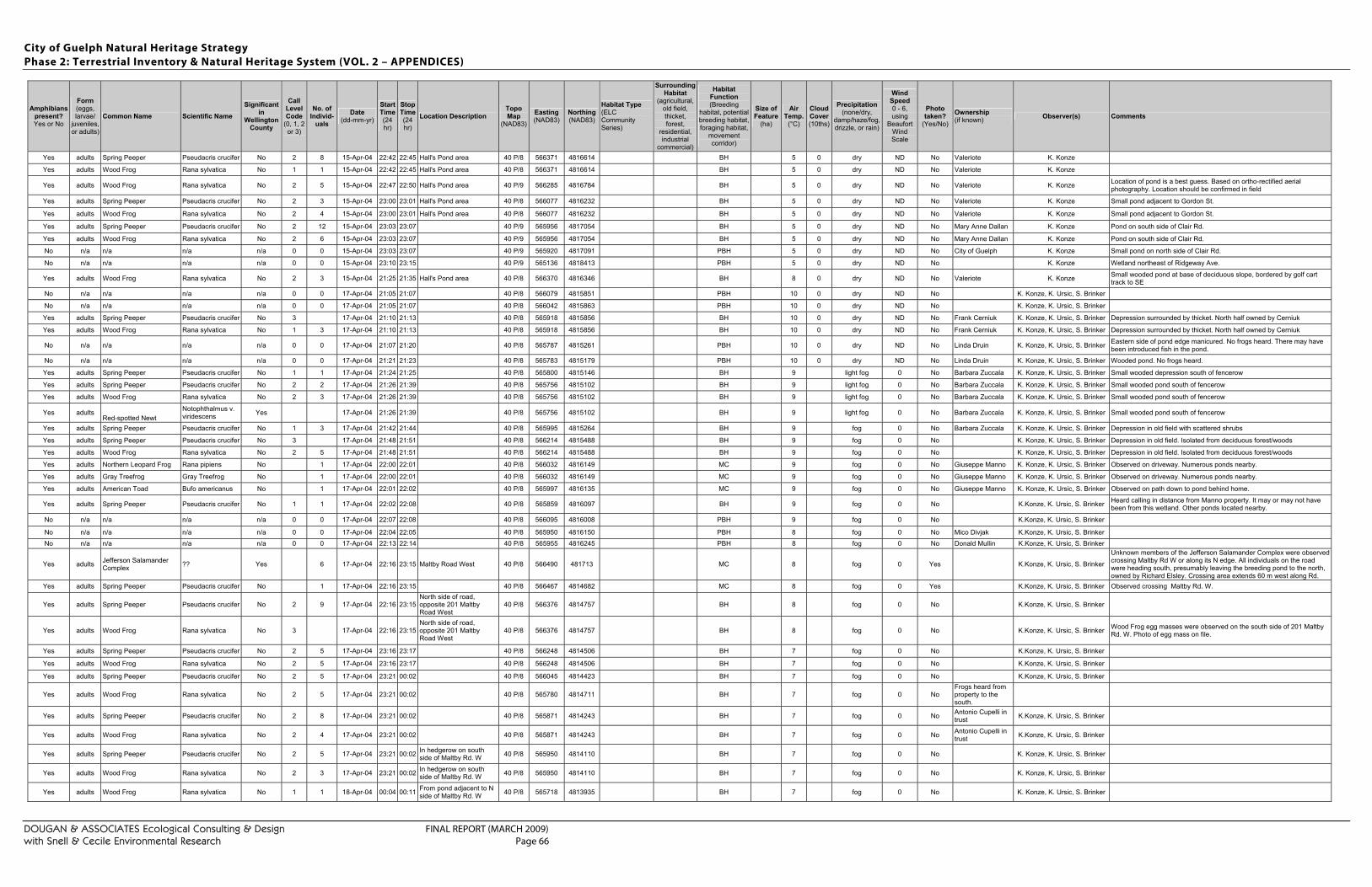
City of Guelph Natural Heritage Strategy Phase 2: Terrestrial Inventory & Natural Heritage System (VOL. 2 – APPENDICES)
DOUGAN & ASSOCIATES Ecological Consulting & Design FINAL REPORT (MARCH 2009) with Snell & Cecile Environmental Research Page 66
Amphibians present? Yes or No
Form (eggs, larvae/
juveniles, or adults)
Common Name Scientific Name Significant
in Wellington
County
Call Level Code
(0, 1, 2 or 3)
No. of Individ-
uals Date
(dd-mm-yr)
Start Time (24 hr)
Stop Time (24 hr)
Location Description Topo Map
(NAD83) Easting (NAD83)
Northing (NAD83)
Habitat Type (ELC Community Series)
Surrounding Habitat
(agricultural, old field, thicket, forest,
residential, industrial
commercial)
Habitat Function (Breeding
habitat, potential breeding habitat, foraging habitat,
movement corridor)
Size of Feature
(ha)
Air Temp.
(°C)
Cloud Cover (10ths)
Precipitation (none/dry,
damp/haze/fog, drizzle, or rain)
Wind Speed 0 - 6, using
Beaufort Wind Scale
Photo taken?
(Yes/No) Ownership (if known) Observer(s) Comments
Yes adults Spring Peeper Pseudacris crucifer No 2 8 15-Apr-04 22:42 22:45 Hall's Pond area 40 P/8 566371 4816614 BH 5 0 dry ND No Valeriote K. Konze
Yes adults Wood Frog Rana sylvatica No 1 1 15-Apr-04 22:42 22:45 Hall's Pond area 40 P/8 566371 4816614 BH 5 0 dry ND No Valeriote K. Konze
Yes adults Wood Frog Rana sylvatica No 2 5 15-Apr-04 22:47 22:50 Hall's Pond area 40 P/9 566285 4816784 BH 5 0 dry ND No Valeriote K. Konze Location of pond is a best guess. Based on ortho-rectified aerial photography. Location should be confirmed in field
Yes adults Spring Peeper Pseudacris crucifer No 2 3 15-Apr-04 23:00 23:01 Hall's Pond area 40 P/8 566077 4816232 BH 5 0 dry ND No Valeriote K. Konze Small pond adjacent to Gordon St.
Yes adults Wood Frog Rana sylvatica No 2 4 15-Apr-04 23:00 23:01 Hall's Pond area 40 P/8 566077 4816232 BH 5 0 dry ND No Valeriote K. Konze Small pond adjacent to Gordon St.
Yes adults Spring Peeper Pseudacris crucifer No 2 12 15-Apr-04 23:03 23:07 40 P/9 565956 4817054 BH 5 0 dry ND No Mary Anne Dallan K. Konze Pond on south side of Clair Rd.
Yes adults Wood Frog Rana sylvatica No 2 6 15-Apr-04 23:03 23:07 40 P/9 565956 4817054 BH 5 0 dry ND No Mary Anne Dallan K. Konze Pond on south side of Clair Rd.
No n/a n/a n/a n/a 0 0 15-Apr-04 23:03 23:07 40 P/9 565920 4817091 PBH 5 0 dry ND No City of Guelph K. Konze Small pond on north side of Clair Rd.
No n/a n/a n/a n/a 0 0 15-Apr-04 23:10 23:15 40 P/9 565136 4818413 PBH 5 0 dry ND No K. Konze Wetland northeast of Ridgeway Ave.
Yes adults Wood Frog Rana sylvatica No 2 3 15-Apr-04 21:25 21:35 Hall's Pond area 40 P/8 566370 4816346 BH 8 0 dry ND No Valeriote K. Konze Small wooded pond at base of deciduous slope, bordered by golf cart track to SE
No n/a n/a n/a n/a 0 0 17-Apr-04 21:05 21:07 40 P/8 566079 4815851 PBH 10 0 dry ND No K. Konze, K. Ursic, S. Brinker
No n/a n/a n/a n/a 0 0 17-Apr-04 21:05 21:07 40 P/8 566042 4815863 PBH 10 0 dry ND No K. Konze, K. Ursic, S. Brinker
Yes adults Spring Peeper Pseudacris crucifer No 3 17-Apr-04 21:10 21:13 40 P/8 565918 4815856 BH 10 0 dry ND No Frank Cerniuk K. Konze, K. Ursic, S. Brinker Depression surrounded by thicket. North half owned by Cerniuk
Yes adults Wood Frog Rana sylvatica No 1 3 17-Apr-04 21:10 21:13 40 P/8 565918 4815856 BH 10 0 dry ND No Frank Cerniuk K. Konze, K. Ursic, S. Brinker Depression surrounded by thicket. North half owned by Cerniuk
No n/a n/a n/a n/a 0 0 17-Apr-04 21:07 21:20 40 P/8 565787 4815261 PBH 10 0 dry ND No Linda Druin K. Konze, K. Ursic, S. Brinker Eastern side of pond edge manicured. No frogs heard. There may have been introduced fish in the pond.
No n/a n/a n/a n/a 0 0 17-Apr-04 21:21 21:23 40 P/8 565783 4815179 PBH 10 0 dry ND No Linda Druin K. Konze, K. Ursic, S. Brinker Wooded pond. No frogs heard.
Yes adults Spring Peeper Pseudacris crucifer No 1 1 17-Apr-04 21:24 21:25 40 P/8 565800 4815146 BH 9 light fog 0 No Barbara Zuccala K. Konze, K. Ursic, S. Brinker Small wooded depression south of fencerow
Yes adults Spring Peeper Pseudacris crucifer No 2 2 17-Apr-04 21:26 21:39 40 P/8 565756 4815102 BH 9 light fog 0 No Barbara Zuccala K. Konze, K. Ursic, S. Brinker Small wooded pond south of fencerow
Yes adults Wood Frog Rana sylvatica No 2 3 17-Apr-04 21:26 21:39 40 P/8 565756 4815102 BH 9 light fog 0 No Barbara Zuccala K. Konze, K. Ursic, S. Brinker Small wooded pond south of fencerow
Yes adults Red-spotted Newt
Notophthalmus v. viridescens Yes 17-Apr-04 21:26 21:39 40 P/8 565756 4815102 BH 9 light fog 0 No Barbara Zuccala K. Konze, K. Ursic, S. Brinker Small wooded pond south of fencerow
Yes adults Spring Peeper Pseudacris crucifer No 1 3 17-Apr-04 21:42 21:44 40 P/8 565995 4815264 BH 9 fog 0 No Barbara Zuccala K. Konze, K. Ursic, S. Brinker Depression in old field with scattered shrubs
Yes adults Spring Peeper Pseudacris crucifer No 3 17-Apr-04 21:48 21:51 40 P/8 566214 4815488 BH 9 fog 0 No K. Konze, K. Ursic, S. Brinker Depression in old field. Isolated from deciduous forest/woods
Yes adults Wood Frog Rana sylvatica No 2 5 17-Apr-04 21:48 21:51 40 P/8 566214 4815488 BH 9 fog 0 No K. Konze, K. Ursic, S. Brinker Depression in old field. Isolated from deciduous forest/woods
Yes adults Northern Leopard Frog Rana pipiens No 1 17-Apr-04 22:00 22:01 40 P/8 566032 4816149 MC 9 fog 0 No Giuseppe Manno K. Konze, K. Ursic, S. Brinker Observed on driveway. Numerous ponds nearby.
Yes adults Gray Treefrog Gray Treefrog No 1 17-Apr-04 22:00 22:01 40 P/8 566032 4816149 MC 9 fog 0 No Giuseppe Manno K. Konze, K. Ursic, S. Brinker Observed on driveway. Numerous ponds nearby.
Yes adults American Toad Bufo americanus No 1 17-Apr-04 22:01 22:02 40 P/8 565997 4816135 MC 9 fog 0 No Giuseppe Manno K. Konze, K. Ursic, S. Brinker Observed on path down to pond behind home.
Yes adults Spring Peeper Pseudacris crucifer No 1 1 17-Apr-04 22:02 22:08 40 P/8 565859 4816097 BH 9 fog 0 No K.Konze, K. Ursic, S. Brinker Heard calling in distance from Manno property. It may or may not have been from this wetland. Other ponds located nearby.
No n/a n/a n/a n/a 0 0 17-Apr-04 22:07 22:08 40 P/8 566095 4816008 PBH 9 fog 0 No K.Konze, K. Ursic, S. Brinker
No n/a n/a n/a n/a 0 0 17-Apr-04 22:04 22:05 40 P/8 565950 4816150 PBH 8 fog 0 No Mico Divjak K.Konze, K. Ursic, S. Brinker
No n/a n/a n/a n/a 0 0 17-Apr-04 22:13 22:14 40 P/8 565955 4816245 PBH 8 fog 0 No Donald Mullin K.Konze, K. Ursic, S. Brinker
Yes adults Jefferson Salamander Complex ?? Yes 6 17-Apr-04 22:16 23:15 Maltby Road West 40 P/8 566490 481713 MC 8 fog 0 Yes K.Konze, K. Ursic, S. Brinker
Unknown members of the Jefferson Salamander Complex were observed crossing Maltby Rd W or along its N edge. All individuals on the road were heading south, presumably leaving the breeding pond to the north, owned by Richard Elsley. Crossing area extends 60 m west along Rd.
Yes adults Spring Peeper Pseudacris crucifer No 1 17-Apr-04 22:16 23:15 40 P/8 566467 4814682 MC 8 fog 0 Yes K.Konze, K. Ursic, S. Brinker Observed crossing Maltby Rd. W.
Yes adults Spring Peeper Pseudacris crucifer No 2 9 17-Apr-04 22:16 23:15 North side of road, opposite 201 Maltby Road West
40 P/8 566376 4814757 BH 8 fog 0 No K.Konze, K. Ursic, S. Brinker
Yes adults Wood Frog Rana sylvatica No 3 17-Apr-04 22:16 23:15 North side of road, opposite 201 Maltby Road West
40 P/8 566376 4814757 BH 8 fog 0 No K.Konze, K. Ursic, S. Brinker Wood Frog egg masses were observed on the south side of 201 Maltby Rd. W. Photo of egg mass on file.
Yes adults Spring Peeper Pseudacris crucifer No 2 5 17-Apr-04 23:16 23:17 40 P/8 566248 4814506 BH 7 fog 0 No K.Konze, K. Ursic, S. Brinker
Yes adults Wood Frog Rana sylvatica No 2 5 17-Apr-04 23:16 23:17 40 P/8 566248 4814506 BH 7 fog 0 No K.Konze, K. Ursic, S. Brinker
Yes adults Spring Peeper Pseudacris crucifer No 2 5 17-Apr-04 23:21 00:02 40 P/8 566045 4814423 BH 7 fog 0 No K.Konze, K. Ursic, S. Brinker
Yes adults Wood Frog Rana sylvatica No 2 5 17-Apr-04 23:21 00:02 40 P/8 565780 4814711 BH 7 fog 0 No Frogs heard from property to the south.
Yes adults Spring Peeper Pseudacris crucifer No 2 8 17-Apr-04 23:21 00:02 40 P/8 565871 4814243 BH 7 fog 0 No Antonio Cupelli in trust K.Konze, K. Ursic, S. Brinker
Yes adults Wood Frog Rana sylvatica No 2 4 17-Apr-04 23:21 00:02 40 P/8 565871 4814243 BH 7 fog 0 No Antonio Cupelli in trust K.Konze, K. Ursic, S. Brinker
Yes adults Spring Peeper Pseudacris crucifer No 2 5 17-Apr-04 23:21 00:02 In hedgerow on south side of Maltby Rd. W 40 P/8 565950 4814110 BH 7 fog 0 No K. Konze, K. Ursic, S. Brinker
Yes adults Wood Frog Rana sylvatica No 2 3 17-Apr-04 23:21 00:02 In hedgerow on south side of Maltby Rd. W 40 P/8 565950 4814110 BH 7 fog 0 No K. Konze, K. Ursic, S. Brinker
Yes adults Wood Frog Rana sylvatica No 1 1 18-Apr-04 00:04 00:11 From pond adjacent to N side of Maltby Rd. W 40 P/8 565718 4813935 BH 7 fog 0 No K. Konze, K. Ursic, S. Brinker
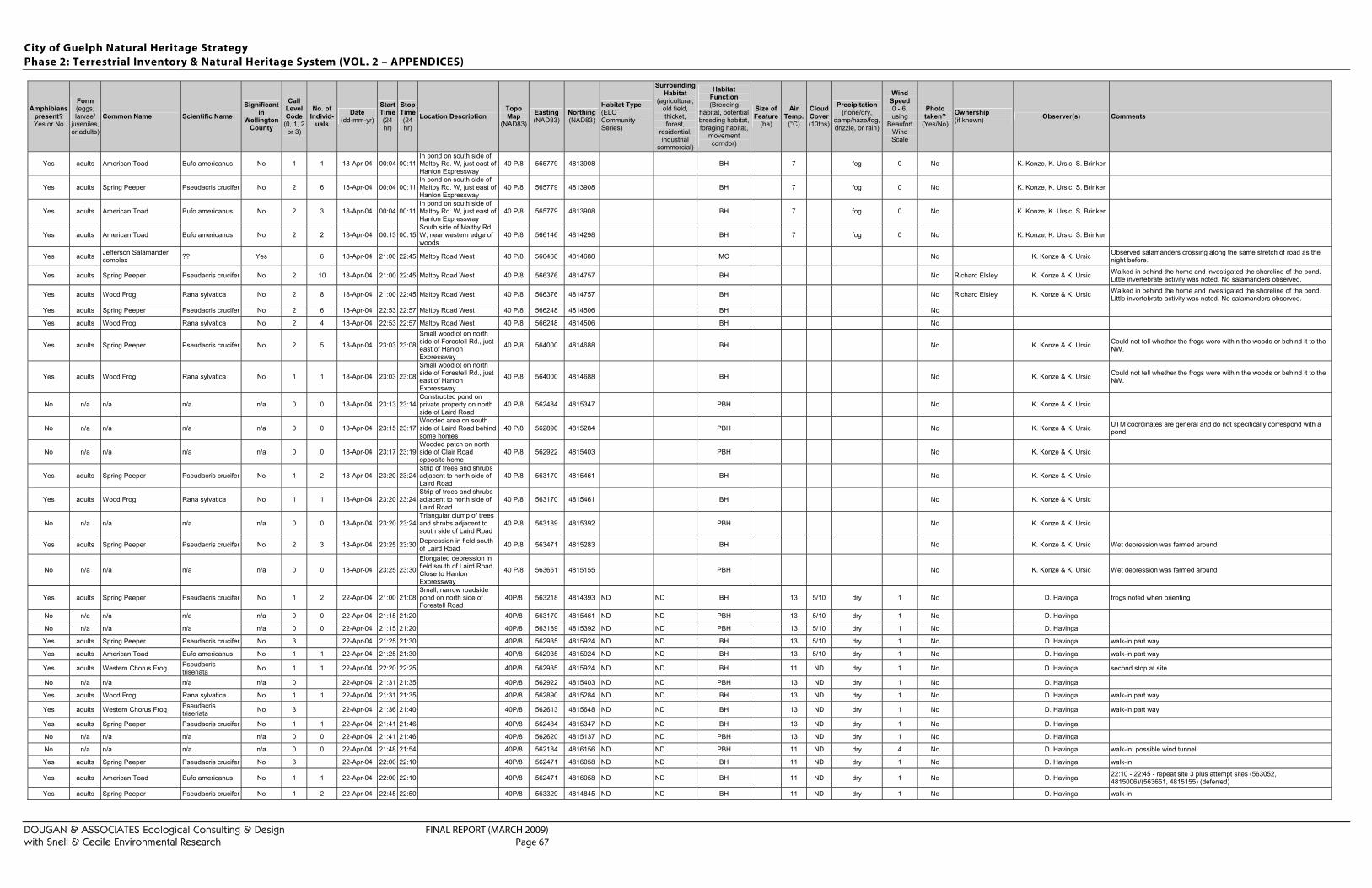
City of Guelph Natural Heritage Strategy Phase 2: Terrestrial Inventory & Natural Heritage System (VOL. 2 – APPENDICES)
DOUGAN & ASSOCIATES Ecological Consulting & Design FINAL REPORT (MARCH 2009) with Snell & Cecile Environmental Research Page 67
Amphibians present? Yes or No
Form (eggs, larvae/
juveniles, or adults)
Common Name Scientific Name Significant
in Wellington
County
Call Level Code
(0, 1, 2 or 3)
No. of Individ-
uals Date
(dd-mm-yr)
Start Time (24 hr)
Stop Time (24 hr)
Location Description Topo Map
(NAD83) Easting (NAD83)
Northing (NAD83)
Habitat Type (ELC Community Series)
Surrounding Habitat
(agricultural, old field, thicket, forest,
residential, industrial
commercial)
Habitat Function (Breeding
habitat, potential breeding habitat, foraging habitat,
movement corridor)
Size of Feature
(ha)
Air Temp.
(°C)
Cloud Cover (10ths)
Precipitation (none/dry,
damp/haze/fog, drizzle, or rain)
Wind Speed 0 - 6, using
Beaufort Wind Scale
Photo taken?
(Yes/No) Ownership (if known) Observer(s) Comments
Yes adults American Toad Bufo americanus No 1 1 18-Apr-04 00:04 00:11 In pond on south side of Maltby Rd. W, just east of Hanlon Expressway
40 P/8 565779 4813908 BH 7 fog 0 No K. Konze, K. Ursic, S. Brinker
Yes adults Spring Peeper Pseudacris crucifer No 2 6 18-Apr-04 00:04 00:11 In pond on south side of Maltby Rd. W, just east of Hanlon Expressway
40 P/8 565779 4813908 BH 7 fog 0 No K. Konze, K. Ursic, S. Brinker
Yes adults American Toad Bufo americanus No 2 3 18-Apr-04 00:04 00:11 In pond on south side of Maltby Rd. W, just east of Hanlon Expressway
40 P/8 565779 4813908 BH 7 fog 0 No K. Konze, K. Ursic, S. Brinker
Yes adults American Toad Bufo americanus No 2 2 18-Apr-04 00:13 00:15 South side of Maltby Rd. W, near western edge of woods
40 P/8 566146 4814298 BH 7 fog 0 No K. Konze, K. Ursic, S. Brinker
Yes adults Jefferson Salamander complex ?? Yes 6 18-Apr-04 21:00 22:45 Maltby Road West 40 P/8 566466 4814688 MC No K. Konze & K. Ursic Observed salamanders crossing along the same stretch of road as the
night before.
Yes adults Spring Peeper Pseudacris crucifer No 2 10 18-Apr-04 21:00 22:45 Maltby Road West 40 P/8 566376 4814757 BH No Richard Elsley K. Konze & K. Ursic Walked in behind the home and investigated the shoreline of the pond. Little invertebrate activity was noted. No salamanders observed.
Yes adults Wood Frog Rana sylvatica No 2 8 18-Apr-04 21:00 22:45 Maltby Road West 40 P/8 566376 4814757 BH No Richard Elsley K. Konze & K. Ursic Walked in behind the home and investigated the shoreline of the pond. Little invertebrate activity was noted. No salamanders observed.
Yes adults Spring Peeper Pseudacris crucifer No 2 6 18-Apr-04 22:53 22:57 Maltby Road West 40 P/8 566248 4814506 BH No
Yes adults Wood Frog Rana sylvatica No 2 4 18-Apr-04 22:53 22:57 Maltby Road West 40 P/8 566248 4814506 BH No
Yes adults Spring Peeper Pseudacris crucifer No 2 5 18-Apr-04 23:03 23:08
Small woodlot on north side of Forestell Rd., just east of Hanlon Expressway
40 P/8 564000 4814688 BH No K. Konze & K. Ursic Could not tell whether the frogs were within the woods or behind it to the NW.
Yes adults Wood Frog Rana sylvatica No 1 1 18-Apr-04 23:03 23:08
Small woodlot on north side of Forestell Rd., just east of Hanlon Expressway
40 P/8 564000 4814688 BH No K. Konze & K. Ursic Could not tell whether the frogs were within the woods or behind it to the NW.
No n/a n/a n/a n/a 0 0 18-Apr-04 23:13 23:14 Constructed pond on private property on north side of Laird Road
40 P/8 562484 4815347 PBH No K. Konze & K. Ursic
No n/a n/a n/a n/a 0 0 18-Apr-04 23:15 23:17 Wooded area on south side of Laird Road behind some homes
40 P/8 562890 4815284 PBH No K. Konze & K. Ursic UTM coordinates are general and do not specifically correspond with a pond
No n/a n/a n/a n/a 0 0 18-Apr-04 23:17 23:19 Wooded patch on north side of Clair Road opposite home
40 P/8 562922 4815403 PBH No K. Konze & K. Ursic
Yes adults Spring Peeper Pseudacris crucifer No 1 2 18-Apr-04 23:20 23:24 Strip of trees and shrubs adjacent to north side of Laird Road
40 P/8 563170 4815461 BH No K. Konze & K. Ursic
Yes adults Wood Frog Rana sylvatica No 1 1 18-Apr-04 23:20 23:24 Strip of trees and shrubs adjacent to north side of Laird Road
40 P/8 563170 4815461 BH No K. Konze & K. Ursic
No n/a n/a n/a n/a 0 0 18-Apr-04 23:20 23:24 Triangular clump of trees and shrubs adjacent to south side of Laird Road
40 P/8 563189 4815392 PBH No K. Konze & K. Ursic
Yes adults Spring Peeper Pseudacris crucifer No 2 3 18-Apr-04 23:25 23:30 Depression in field south of Laird Road 40 P/8 563471 4815283 BH No K. Konze & K. Ursic Wet depression was farmed around
No n/a n/a n/a n/a 0 0 18-Apr-04 23:25 23:30
Elongated depression in field south of Laird Road. Close to Hanlon Expressway
40 P/8 563651 4815155 PBH No K. Konze & K. Ursic Wet depression was farmed around
Yes adults Spring Peeper Pseudacris crucifer No 1 2 22-Apr-04 21:00 21:08 Small, narrow roadside pond on north side of Forestell Road
40P/8 563218 4814393 ND ND BH 13 5/10 dry 1 No D. Havinga frogs noted when orienting
No n/a n/a n/a n/a 0 0 22-Apr-04 21:15 21:20 40P/8 563170 4815461 ND ND PBH 13 5/10 dry 1 No D. Havinga
No n/a n/a n/a n/a 0 0 22-Apr-04 21:15 21:20 40P/8 563189 4815392 ND ND PBH 13 5/10 dry 1 No D. Havinga
Yes adults Spring Peeper Pseudacris crucifer No 3 22-Apr-04 21:25 21:30 40P/8 562935 4815924 ND ND BH 13 5/10 dry 1 No D. Havinga walk-in part way
Yes adults American Toad Bufo americanus No 1 1 22-Apr-04 21:25 21:30 40P/8 562935 4815924 ND ND BH 13 5/10 dry 1 No D. Havinga walk-in part way
Yes adults Western Chorus Frog Pseudacris triseriata No 1 1 22-Apr-04 22:20 22:25 40P/8 562935 4815924 ND ND BH 11 ND dry 1 No D. Havinga second stop at site
No n/a n/a n/a n/a 0 22-Apr-04 21:31 21:35 40P/8 562922 4815403 ND ND PBH 13 ND dry 1 No D. Havinga
Yes adults Wood Frog Rana sylvatica No 1 1 22-Apr-04 21:31 21:35 40P/8 562890 4815284 ND ND BH 13 ND dry 1 No D. Havinga walk-in part way
Yes adults Western Chorus Frog Pseudacris triseriata No 3 22-Apr-04 21:36 21:40 40P/8 562613 4815648 ND ND BH 13 ND dry 1 No D. Havinga walk-in part way
Yes adults Spring Peeper Pseudacris crucifer No 1 1 22-Apr-04 21:41 21:46 40P/8 562484 4815347 ND ND BH 13 ND dry 1 No D. Havinga
No n/a n/a n/a n/a 0 0 22-Apr-04 21:41 21:46 40P/8 562620 4815137 ND ND PBH 13 ND dry 1 No D. Havinga
No n/a n/a n/a n/a 0 0 22-Apr-04 21:48 21:54 40P/8 562184 4816156 ND ND PBH 11 ND dry 4 No D. Havinga walk-in; possible wind tunnel
Yes adults Spring Peeper Pseudacris crucifer No 3 22-Apr-04 22:00 22:10 40P/8 562471 4816058 ND ND BH 11 ND dry 1 No D. Havinga walk-in
Yes adults American Toad Bufo americanus No 1 1 22-Apr-04 22:00 22:10 40P/8 562471 4816058 ND ND BH 11 ND dry 1 No D. Havinga 22:10 - 22:45 - repeat site 3 plus attempt sites (563052, 4815006)/(563651, 4815155) (deferred)
Yes adults Spring Peeper Pseudacris crucifer No 1 2 22-Apr-04 22:45 22:50 40P/8 563329 4814845 ND ND BH 11 ND dry 1 No D. Havinga walk-in
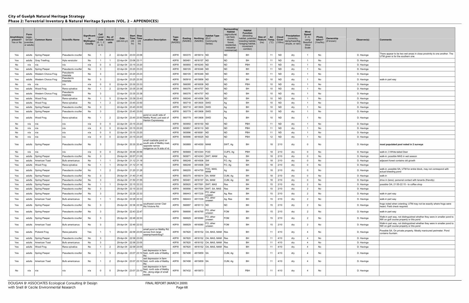
City of Guelph Natural Heritage Strategy Phase 2: Terrestrial Inventory & Natural Heritage System (VOL. 2 – APPENDICES)
DOUGAN & ASSOCIATES Ecological Consulting & Design FINAL REPORT (MARCH 2009) with Snell & Cecile Environmental Research Page 68
Amphibians present? Yes or No
Form (eggs, larvae/
juveniles, or adults)
Common Name Scientific Name Significant
in Wellington
County
Call Level Code
(0, 1, 2 or 3)
No. of Individ-
uals Date
(dd-mm-yr)
Start Time (24 hr)
Stop Time (24 hr)
Location Description Topo Map
(NAD83) Easting (NAD83)
Northing (NAD83)
Habitat Type (ELC Community Series)
Surrounding Habitat
(agricultural, old field, thicket, forest,
residential, industrial
commercial)
Habitat Function (Breeding
habitat, potential breeding habitat, foraging habitat,
movement corridor)
Size of Feature
(ha)
Air Temp.
(°C)
Cloud Cover (10ths)
Precipitation (none/dry,
damp/haze/fog, drizzle, or rain)
Wind Speed 0 - 6, using
Beaufort Wind Scale
Photo taken?
(Yes/No) Ownership (if known) Observer(s) Comments
Yes adults Spring Peeper Pseudacris crucifer No 1 2 22-Apr-04 23:03 23:06 40P/8 565370 4816014 ND ND BH 11 ND dry 1 No D. Havinga There appear to be two wet areas in close proximity to one another. The UTM given is for the southern one.
Yes adults Gray Treefrog Hyla versicolor No 1 1 22-Apr-04 23:06 23:11 40P/8 565481 4816157 ND ND BH 11 ND dry 1 No D. Havinga
No n/a n/a n/a n/a 0 0 22-Apr-04 23:15 23:20 40P/8 565955 4816245 ND ND PBH 11 ND dry 1 No D. Havinga
Yes adults Spring Peeper Pseudacris crucifer No 3 22-Apr-04 23:20 23:23 40P/8 566105 4816346 ND ND BH 11 ND dry 1 No D. Havinga
Yes adults Western Chorus Frog Pseudacris triseriata No 3 22-Apr-04 23:20 23:23 40P/8 566105 4816346 ND ND BH 11 ND dry 1 No D. Havinga
Yes adults Western Chorus Frog Pseudacris triseriata No 3 22-Apr-04 23:25 23:30 40P/8 565918 4815856 ND ND BH 10 ND dry 1 No D. Havinga walk-in part way
No n/a n/a n/a n/a 0 0 22-Apr-04 23:30 23:33 40P/8 566095 4816008 ND ND PBH 10 ND dry 1 No D. Havinga
Yes adults Wood Frog Rana sylvatica No 1 2 22-Apr-04 23:35 23:38 40P/8 566376 4814757 ND ND BH 10 ND dry 1 No D. Havinga
Yes adults Western Chorus Frog Pseudacris triseriata No 3 22-Apr-04 23:35 23:38 40P/8 566376 4814757 ND ND BH 10 ND dry 1 No D. Havinga
Yes adults Wood Frog Rana sylvatica No 1 5 22-Apr-04 23:39 23:43 40P/8 566248 4814506 ND ND BH 10 ND dry 1 No D. Havinga
Yes adults Wood Frog Rana sylvatica No 1 2 22-Apr-04 23:45 23:50 40P/8 565718 4813935 SWD Ag BH 10 ND dry 1 No D. Havinga
Yes adults Spring Peeper Pseudacris crucifer No 3 22-Apr-04 23:45 23:50 40P/8 565718 4813935 SWD Ag BH 10 ND dry 1 No D. Havinga
Yes adults Spring Peeper Pseudacris crucifer No 3 22-Apr-04 23:45 23:50 40P/8 565779 4813908 SWD Ag BH 10 ND dry 1 No D. Havinga
Yes adults Wood Frog Rana sylvatica No 1 2 22-Apr-04 23:45 23:50 pond on south side of Maltby Road, just east of Hanlon Expressway
40P/8 565779 4813908 SWD Ag BH 10 ND dry 1 No D. Havinga
No n/a n/a n/a n/a 0 0 22-Apr-04 23:15 23:20 40P/8 565950 4816150 ND ND PBH 11 ND dry 1 No D. Havinga
No n/a n/a n/a n/a 0 0 22-Apr-04 23:15 23:20 40P/8 565857 4816110 ND ND PBH 11 ND dry 1 No D. Havinga
No n/a n/a n/a n/a 0 0 22-Apr-04 23:15 23:20 40P/8 565996 4816081 ND ND PBH 11 ND dry 1 No D. Havinga
No n/a n/a n/a n/a 0 0 22-Apr-04 23:15 23:20 40P/8 565996 4816025 ND ND PBH 12 ND dry 1 No D. Havinga
Yes adults Spring Peeper Pseudacris crucifer No 3 29-Apr-04 20:35 20:40
small roadside pond on south side of Maltby road, opposite narrow hedgerow on N side of rd.
40P/8 565889 4814050 MAM SWT, Ag BH 18 2/10 dry 0 No D. Havinga most populated pool noted in 2 surveys
No n/a n/a n/a n/a 0 0 29-Apr-04 20:48 20:56 40P/8 565669 4814344 FOD CUP3, Ag PBH 18 2/10 dry 0 No D. Havinga walk-in; 3 White-tailed Deer
Yes adults Spring Peeper Pseudacris crucifer No 3 29-Apr-04 20:57 21:05 40P/8 565871 4814243 SWT, MAM Ag BH 18 2/10 dry 0 No D. Havinga walk-in; possible MAS in wet season
Yes adults American Toad Bufo americanus No 1 1 29-Apr-04 21:12 21:18 40P/8 566248 4814506 SW FO, Ag BH 18 2/10 dry 0 No D. Havinga adjacent forest contains old growth
Yes adults Wood Frog Rana sylvatica No 1 1 29-Apr-04 21:12 21:18 40P/8 566248 4814506 SW FO, Ag BH 18 2/10 dry 0 No D. Havinga
Yes adults Spring Peeper Pseudacris crucifer No 1 2 29-Apr-04 21:20 21:28 40P/8 566205 4814755 FOC, MAS, MAM Ag BH 18 2/10 dry 0 No D. Havinga walk-in; possible SA; UTM for entire block, may not correspond with
actual breeding pond
Yes adults Spring Peeper Pseudacris crucifer No 3 29-Apr-04 21:40 21:45 40P/8 565370 4816014 SA, MAM CUM, Ag BH 18 2/10 dry 0 No D. Havinga walk-in
Yes adults Spring Peeper Pseudacris crucifer No 3 29-Apr-04 21:50 21:55 40P/8 565481 4816157 SA, MAM CUM, Ag BH 18 2/10 dry 0 No D. Havinga drive in (lane); personal contact with tenants (friendly)
Yes adults Spring Peeper Pseudacris crucifer No 1 1 29-Apr-04 22:15 22:23 40P/9 565920 4817091 SWT, MAS Res BH 15 2/10 dry 2 No D. Havinga possible OA; 21:55-22:15 - to coffee shop
Yes adults Spring Peeper Pseudacris crucifer No 3 29-Apr-04 22:15 22:23 40P/9 565956 4817054 SWT, SA, MAS Res BH 15 2/10 dry 2 No D. Havinga
Yes adults Spring Peeper Pseudacris crucifer No 3 29-Apr-04 22:28 22:33 40P/9 566443 4817235 FO, other unseen Ag, Res BH 15 2/10 dry 2 No D. Havinga walk-in part way
Yes adults American Toad Bufo americanus No 1 1 29-Apr-04 22:28 22:33 40P/9 566443 4817235 FO, other unseen Ag, Res BH 15 2/10 dry 2 No D. Havinga walk-in part way
Yes adults Spring Peeper Pseudacris crucifer No 3 29-Apr-04 22:36 22:39 southwest corner Clair Rd./Victoria Rd. 40P/9 566997 4818113 ND ND BH 15 2/10 dry 2 No D. Havinga frogs noted when orienting; UTM may not be exactly where frogs were
heard. Field check required.
Yes adults Spring Peeper Pseudacris crucifer No 3 29-Apr-04 22:43 22:47 40P/9 566690 4816765 FO, other unseen FOM BH 15 2/10 dry 2 No D. Havinga walk-in part way
Yes adults Spring Peeper Pseudacris crucifer No 3 29-Apr-04 22:48 22:53 40P/8 566929 4816580 FO, other unseen FOM BH 15 2/10 dry 2 No D. Havinga Walk-in part way, not distinguished whether they were in smaller pond to
NW on golf course property or this pond
Yes adults American Toad Bufo americanus No 3 29-Apr-04 22:48 22:53 40P/9 566929 4816580 FO, other unseen FOM BH 15 2/10 dry 2 No D. Havinga Walk-in part way, not distinguished whether they were in smaller pond to
NW on golf course property or this pond
Yes adults Pickerel Frog Rana palustris Yes 1 1 29-Apr-04 22:58 23:05 small pond on Maltby Rd. across from large swamp/marsh/bog?
40P/8 567820 4816152 OA, MAS, MAM Res BH 11 4/10 dry 4 No D. Havinga Possible SA. On private property. Mostly manicured perimeter. Pond contains fountain.
Yes adults Spring Peeper Pseudacris crucifer No 3 29-Apr-04 22:58 23:05 40P/8 567820 4816152 OA, MAS, MAM Res BH 11 4/10 dry 4 No D. Havinga
Yes adults American Toad Bufo americanus No 3 29-Apr-04 22:58 23:05 40P/8 567820 4816152 OA, MAS, MAM Res BH 11 4/10 dry 4 No D. Havinga
Yes adults Wood Frog Rana sylvatica No 1 2 29-Apr-04 22:58 23:05 40P/8 567820 4816152 OA, MAS, MAM Res BH 11 4/10 dry 4 No D. Havinga
Yes adults Spring Peeper Pseudacris crucifer No 1 5 29-Apr-04 23:07 23:10 wet depression in farm field, north side of Maltby Rd.
40P/8 567498 4815859 SA CUM, Ag BH 11 4/10 dry 4 No D. Havinga
Yes adults American Toad Bufo americanus No 1 2 29-Apr-04 23:07 23:10 wet depression in farm field, north side of Maltby Rd.
40P/8 567498 4815859 SA CUM, Ag BH 11 4/10 dry 4 No D. Havinga
No n/a n/a n/a n/a 0 0 29-Apr-04 23:07 23:10
wet depression in farm field, north side of Maltby Rd., along edge of small woods
40P/8 567432 4815873 PBH 11 4/10 dry 4 No D. Havinga
City of Guelph Natural Heritage Strategy Phase 2: Terrestrial Inventory & Natural Heritage System (VOL. 2 – APPENDICES)
DOUGAN & ASSOCIATES Ecological Consulting & Design FINAL REPORT (MARCH 2009) with Snell & Cecile Environmental Research Page 69
Amphibians present? Yes or No
Form (eggs, larvae/
juveniles, or adults)
Common Name Scientific Name Significant
in Wellington
County
Call Level Code
(0, 1, 2 or 3)
No. of Individ-
uals Date
(dd-mm-yr)
Start Time (24 hr)
Stop Time (24 hr)
Location Description Topo Map
(NAD83) Easting (NAD83)
Northing (NAD83)
Habitat Type (ELC Community Series)
Surrounding Habitat
(agricultural, old field, thicket, forest,
residential, industrial
commercial)
Habitat Function (Breeding
habitat, potential breeding habitat, foraging habitat,
movement corridor)
Size of Feature
(ha)
Air Temp.
(°C)
Cloud Cover (10ths)
Precipitation (none/dry,
damp/haze/fog, drizzle, or rain)
Wind Speed 0 - 6, using
Beaufort Wind Scale
Photo taken?
(Yes/No) Ownership (if known) Observer(s) Comments
No n/a n/a n/a n/a 0 0 29-Apr-04 23:07 23:10 40P/8 567398 4815966 PBH 11 4/10 dry 4 No D. Havinga
Yes adults Pickerel Frog Rana palustris Yes 1 1 29-Apr-04 23:15 23:20
roadside pond just w of #40/44. In wooded area. Not on golf course property.
40P/8 566200 4816104 SA, MAS, MAM ND BH 11 4/10 dry 4 No D. Havinga possible OA
No n/a n/a n/a n/a 0 0 29-Apr-04 23:25 23:35 40P/8 566363 4816106 OA, SA golf course PBH 11 4/10 dry 4 No D. Havinga walk-in part way; no frogs calling
Yes adults Spring Peeper Pseudacris crucifer No 3 29-Apr-04 23:35 23:38 40P/8 566338 4816210 OA, FOC golf course BH 11 4/10 dry 4 No D. Havinga walk-in
Yes adults Spring Peeper Pseudacris crucifer No 3 29-Apr-04 23:35 23:38 40P/8 566410 4816299 OA, FOC golf course BH 11 4/10 dry 4 No D. Havinga walk-in
No n/a n/a n/a n/a 0 0 29-Apr-04 23:41 23:44 40P/8 566714 4816018 OA, MAM CUT, golf course, Ag PBH 11 4/10 dry 4 No D. Havinga walk-in; possible SA
Yes adults Spring Peeper Pseudacris crucifer No 3 29-Apr-04 23:50 23:55 40P/8 566739 4815819 SA, MAS, MAM CUT, Ag BH 11 4/10 dry 4 No D. Havinga walk-in; possible OA
Yes adults Wood Frog Rana sylvatica No 1 2 29-Apr-04 23:50 23:55 40P/8 566739 4815819 SA, MAS, MAM CUT, Ag BH 11 4/10 dry 4 No D. Havinga walk-in
No n/a n/a n/a n/a 0 0 29-Apr-04 23:25 23:35 40P/8 566556 4815982 OA, SA golf course PBH 11 4/10 dry 4 No D. Havinga walk-in part way; no frogs calling
2005 Observations
No n/a n/a n/a n/a 0 0 31-Mar-05 21:10 21:15
Large pond on east side of deciduous forest (Drouin property - 2093 Gordon St.)
40P/8 565787 4815261 PBH 8.5 10/10 drizzle 0 No Linda Drouin K. Konze, T. Farrell Large pond with no wooded habitat to east. According to proprty owner the pond has fish. Poor candidate for amphibian breeding due to lack of habitat within feature and the presence of fish.
Yes adults Northern Leopard Frog Rana pipiens No 0 3 31-Mar-05 21:15 21:20 Wooded pond on west side of Drouin property (2093 Gordon St.)
40P/8 565783 4815179 PBH 8.5 10/10 drizzle 0 No Linda Drouin K. Konze, T. Farrell All 3 frogs were dead . Property owner mentioned that the pond had fish in it. No edge habitat; lawn comes to edge
No n/a n/a n/a n/a 0 0 31-Mar-05 21:20 21:35 Wooded pond in deciduous forest (2187 Gordon Street)
40P/8 565756 4815102 PBH 8.5 10/10 dry 0 No Barbara Zuccala K. Konze, T. Farrell Mostly ice-covered still. Looks good for amphibian breeding. This was the pond where a Red-spotted Newt was observed in 2004.
No n/a n/a n/a n/a 0 0 31-Mar-05 21:35 21:45 Wooded pond in deciduous forest (2187 Gordon Street)
40P/8 565790 4815074 PBH 8.5 10/10 dry 0 No Barbara Zuccala K. Konze, T. Farrell Mostly ice-covered still. Looks good for amphibian breeding.
No n/a n/a n/a n/a 0 0 31-Mar-05 22:00 22:10 Large open pond 40P/8 565590 4814803 PBH 8.0 10/10 dry 0 No Kenneth Fair K. Konze, T. Farrell Large open pond on western edge of woods. Does not look ideal for breeding by salamanders. Possibly decent breeding habitat for frogs and toads.
No n/a n/a n/a n/a 0 0 31-Mar-05 22:15 22:20 Large open pond 40P/8 565464 4815058 PBH 8.0 10/10 dry 0 No Kenneth Fair K. Konze, T. Farrell Large open pond on western edge of woods. Does not look ideal for breeding by salamanders (too open and grassy). Possibly decent breeding habitat for frogs and toads.
No n/a n/a n/a n/a 0 0 31-Mar-05 22:25 22:30 Large pond on north side of large deciduous woods 40P/8 565402 4815330 PBH 8.0 10/10 dry 0 No
Kenneth Fair & "Transportation Ministry"
K. Konze, T. Farrell Wooded pond is shallow and mucky with little suitable edge habitat. Even though it is partially enclosed by deciduous forest, it does not appear suitable for salamanders, and possibly other frogs and toads.
Yes adults Spring Peeper Pseudacris crucifer No 2 4 5-Apr-05 21:05 21:10 40P/8 565871 4814243 BH 7 10/10 dry 0 No Antonio Cupelli in trust (385 Maltby Rd. West)
K. Konze, K. Ursic
No n/a n/a n/a n/a 0 0 5-Apr-05 21:12 21:17 Swamp on north side of Maltby Road W. 40P/8 566248 4814506 BH 7 10/10 dry 0 No
Antonio Cupelli in trust (385 Maltby Rd. West)
K. Konze, K. Ursic
Yes adults Jefferson Salamander complex ?? Yes n/a 8 5-Apr-05 21:18 22:00 Maltby Road West 40P/8 566466 4814688 MC 7 10/10 dry 0 Yes K. Konze, K. Ursic
Unknown members of this complex were observed moving north across the road. No samples taken. Seen between from UTM to approx. 30 m west of UTM.
Yes adults Spring Peeper Pseudacris crucifer No 1 1 8-Apr-05 14:45 14:50 Deciduous woods on south side of Maltby Road East
40P/8 567000 4815820 FH 13 0/10 dry No K. Konze Location is approximate. There is a small pond in the woods a short distance away. Perhaps it is potential breeding habitat.
Yes adults Spring Peeper Pseudacris crucifer No 2 3 8-Apr-05 14:45 14:55 wet depression in farm field, north side of Maltby Rd.
40P/8 567500 4815859 BH 13 0/10 dry No K. Konze
No n/a n/a n/a n/a 0 0 8-Apr-05 15:10 15:25 Small pond at south edge of deciduous woods, east of Victoria Road
40P/9 567895 4817066 PBH 13 0/10 dry No K. Konze Residence immediately to east. Possibly dug pond.
No n/a n/a n/a n/a 0 0 9-Apr-05 20:45 20:55 Ditch at top of Monarch Rd. at town line. 40P/9 555755 4822061 PBH 8 0/10 dry 0 No K. Konze, K. Ursic
No n/a n/a n/a n/a 0 0 9-Apr-05 20:45 20:55 Woods (Ariss South Natural Area) at top of Monarch Rd.
40P/9 555591 4822138 8 0/10 dry 0 No K. Konze, K. Ursic
Yes adults Western Chorus Frog Pseudacris triseriata No 1 1 9-Apr-05 20:45 20:55
Small depression in field along city limits (thicket and trees?)
40P/9 555866 4822250 BH 8 0/10 dry 0 No K. Konze, K. Ursic
Yes adults Western Chorus Frog Pseudacris triseriata No 1 3 9-Apr-05 21:00 21:20
Large deciduous swamp west of Imperial rd. N. (behind Galaxy Movie Theatre)
40P/9 555582 4821483 BH 8 0/10 dry 0 No K. Konze, K. Ursic
Yes adults Spring Peeper Pseudacris crucifer No 2 7 9-Apr-05 21:00 21:20
Large deciduous swamp west of Imperial rd. N. (behind Galaxy Movie Theatre)
40P/9 555582 4821483 BH 8 0/10 dry 0 No K. Konze, K. Ursic
No n/a n/a n/a n/a 0 0 9-Apr-05 21:25 21:30
Deciduous swamp on north side of Speedvale Ave. W. (just outside city limits)
40P/9 555164 4819380 PBH 8 0/10 dry 0 No K. Konze, K. Ursic
No n/a n/a n/a n/a 0 0 9-Apr-05 21:25 21:30 Deciduous swamp on south side of Speedvale Ave. W. (part of Ellis Cr.
40P/9 555636 4819316 PBH 8 0/10 dry 0 No K. Konze, K. Ursic
City of Guelph Natural Heritage Strategy Phase 2: Terrestrial Inventory & Natural Heritage System (VOL. 2 – APPENDICES)
DOUGAN & ASSOCIATES Ecological Consulting & Design FINAL REPORT (MARCH 2009) with Snell & Cecile Environmental Research Page 70
Amphibians present? Yes or No
Form (eggs, larvae/
juveniles, or adults)
Common Name Scientific Name Significant
in Wellington
County
Call Level Code
(0, 1, 2 or 3)
No. of Individ-
uals Date
(dd-mm-yr)
Start Time (24 hr)
Stop Time (24 hr)
Location Description Topo Map
(NAD83) Easting (NAD83)
Northing (NAD83)
Habitat Type (ELC Community Series)
Surrounding Habitat
(agricultural, old field, thicket, forest,
residential, industrial
commercial)
Habitat Function (Breeding
habitat, potential breeding habitat, foraging habitat,
movement corridor)
Size of Feature
(ha)
Air Temp.
(°C)
Cloud Cover (10ths)
Precipitation (none/dry,
damp/haze/fog, drizzle, or rain)
Wind Speed 0 - 6, using
Beaufort Wind Scale
Photo taken?
(Yes/No) Ownership (if known) Observer(s) Comments
Swamp natural area)
No n/a n/a n/a n/a 0 0 9-Apr-05 21:35 21:35 Wooded area on west side of Elmira Rd. N., just north of Willow Rd.
40P/9 556540 4819573 PBH 8 0/10 dry 0 No K. Konze, K. Ursic
No n/a n/a n/a n/a 0 0 9-Apr-05 21:37 21:40 Wetland area east of Elmira Rd. N., just south of Willow Rd.
40P/9 556869 4819491 PBH 8 0/10 dry 0 No K. Konze, K. Ursic
No n/a n/a n/a n/a 0 0 9-Apr-05 21:50 23:00 Silvercreek Parkway S. at Howwitt Park 40P/9 559111 4820098 FH 8.3 0/10 dry 0 No K. Konze, K. Ursic UTM is for where we listened for frogs.
Yes adults Spring Peeper Pseudacris crucifer No 2 4 9-Apr-05 22:25 22:30 Somewhere east of Longfellow Ave. 40P/9 560431 4825682 BH 6.5 0/10 dry 0 No K. Konze, K. Ursic Location was approximated off an air photo
Yes adults Spring Peeper Pseudacris crucifer No 2 7 9-Apr-05 22:30 23:00 NE of eastern limit of Woodlawn Rd. E. 40P/9 560358 4826113 BH 4.1 0/10 dry 0 No K. Konze, K. Ursic Just outside the city limits
Yes adults Wood Frog Rana sylvatica No 2 5 9-Apr-05 22:30 23:00 NE of eastern limit of Woodlawn Rd. E. 40P/9 560358 4826113 BH 4.1 0/10 dry 0 No K. Konze, K. Ursic Just outside the city limits
Yes adults Spring Peeper Pseudacris crucifer No 2 8 9-Apr-05 22:30 23:00 NE of eastern limit of Woodlawn Rd. E. 40P/9 560192 4826395 BH 4.1 0/10 dry 0 No K. Konze, K. Ursic Just outside the city limits
Yes adults Spring Peeper Pseudacris crucifer No 2 5 9-Apr-05 23:10 23:20
In wetland north of Woodlawn Ave. W., east of the Guelph Junction Railway line
40P/9 557503 4823580 BH 6 0/10 dry 0 No K. Konze, K. Ursic Listened from the new Home Sepot site. The UTM coordinates are approximate only. Part of the Marden South natural Area.
Yes adults Spring Peeper Pseudacris crucifer No 2 4 10-Apr-05 20:50 20:51
Wetland depression surrounded by fields, just north of Speedvale Ave. E.
40P/9 561307 4825773 BH 11 0/10 dry 0 No K. Konze, K. Ursic
Yes adults Spring Peeper Pseudacris crucifer No 1 1 10-Apr-05 20:55 21:10 Woods on south side of Eastview Rd, opposite landfill
40P/9 562510 4825077 BH 11 0/10 dry 0 No K. Konze, K. Ursic Coordinates are approximate. Part of "Clythe Creek A" natural area.
Yes adults Wood Frog Rana sylvatica No 2 2 10-Apr-05 20:55 21:10 Strip of swamp on north side of Eastview Rd by landfill.
40P/9 562483 4825200 BH 11 0/10 dry 0 No K. Konze, K. Ursic
Yes adults Wood Frog Rana sylvatica No 0 10 10-Apr-05 20:55 21:10 Eastview Rd. - opposite landfill and large woods to south
40P/9 562457 4825104 MC 11 0/10 dry 0 No K. Konze, K. Ursic ###############################
Yes adults Western Chorus Frog Pseudacris triseriata No 2 3 10-Apr-05 21:11 21:20
Wetland at NW corner of Grange Road and Watson Road N.
40P/9 562998 48224889 BH 11 1/10 dry 0 No K. Konze, K. Ursic UTM coordinates represent approximate centroid for area where Chorus Frogs, Wood Frogs and Spring Peepers were calling. Most calling appeared to occur to a distance of 100 m N of Grange Road.
Yes adults Wood Frog Rana sylvatica No 2 2 10-Apr-05 21:11 21:20 Wetland at NW corner of Grange Road and Watson Road N.
40P/9 562998 48224889 BH 11 1/10 dry 0 No K. Konze, K. Ursic UTM coordinates represent approximate centroid for area where Chorus Frogs, Wood Frogs and Spring Peepers were calling. Most calling appeared to occur to a distance of 100 m N of Grange Road.
Yes adults Spring Peeper Pseudacris crucifer No 1 3 10-Apr-05 21:11 21:20 Wetland at NW corner of Grange Road and Watson Road N.
40P/9 562998 48224889 BH 11 1/10 dry 0 No K. Konze, K. Ursic UTM coordinates represent approximate centroid for area where Chorus Frogs, Wood Frogs and Spring Peepers were calling. Most calling appeared to occur to a distance of 100 m N of Grange Road.
Yes adults Northern Leopard Frog Rana pipiens No 0 2 10-Apr-05 21:11 21:20 Watson Rd. N. just north of Grange Rd. (between wetland and SWM pond)
40P/9 563032 4824916 MC 11 1/10 dry 0 No K. Konze, K. Ursic Observed dead on road. Are may function as a movement corridor. There are wetlands on either side of the roadway.
Yes adults Spring Peeper Pseudacris crucifer No 2 7 10-Apr-05 21:32 21:40
Wetland north of the intersection of Fuller Dr. & Watson Rd. N. (east side of Watson Rd.)
40P/9 563381 4824889 BH 11 1/10 dry 0 No K. Konze, K. Ursic UTM coordinates represent approximate centroid of wetland where species was calling from. Wetland area was along Watson Creek
Yes adults Wood Frog Rana sylvatica No 2 3 10-Apr-05 21:32 21:40
Wetland north of the intersection of Fuller Dr. & Watson Rd. N. (east side of Watson Rd.)
40P/9 563381 4824889 BH 11 1/10 dry 0 No K. Konze, K. Ursic UTM coordinates represent approximate centroid of wetland where species was calling from. Wetland area was along Watson Creek
Yes adults Western Chorus Frog Pseudacris triseriata No 1 2 10-Apr-05 21:32 21:40
Wetland north of the intersection of Fuller Dr. & Watson Rd. N. (east side of Watson Rd.)
40P/9 563381 4824889 BH 11 1/10 dry 0 No K. Konze, K. Ursic UTM coordinates represent approximate centroid of wetland where species was calling from. Wetland area was along Watson Creek
Yes adults Spring Peeper Pseudacris crucifer No 2 7 10-Apr-05 21:41 21:45 Along Clythe Creek, somewhere East of Watson Road N.
40P/9 564088 4824277 BH 11 1/10 dry 0 No K. Konze, K. Ursic UTM coordinates represent a roughly approximated location. Associated with Clythe Creek
No n/a n/a n/a n/a 0 0 10-Apr-05 21:41 21:45 Pond on north side of Clythe Creek, west of Watson Rd. N.
40P/9 563930 4823900 PBH 11 1/10 dry 0 No K. Konze, K. Ursic
Yes adults Spring Peeper Pseudacris crucifer No 2 6 10-Apr-05 21:50 21:55
West side of Watson Parkway (south of Hwy 7) (west of large, noisy factory)
40P/9 564284 4823166 BH 11 1/10 dry 0 No K. Konze, K. Ursic Wet area at bottom of slope
Yes adults Spring Peeper Pseudacris crucifer No 2 4 10-Apr-05 21:55 22:00
West side of Watson Parkway (south of Hwy 7) (south of large, noisy factory)
40P/9 564510 4823075 BH 11 1/10 dry 0 No K. Konze, K. Ursic Near base of slope in large open valley
Yes adults Wood Frog Rana sylvatica No 1 1 10-Apr-05 21:55 22:00
West side of Watson Parkway (south of Hwy 7) (south of large, noisy factory)
40P/9 564510 4823075 BH 11 1/10 dry 0 No K. Konze, K. Ursic Near base of slope in large open valley
No n/a n/a n/a n/a 0 0 10-Apr-05 22:05 22:10 Pond on south side (or east) of Dunlap Drive. 40P/9 564824 4822966 BH 10 1/10 dry 0 No K. Konze, K. Ursic Appears to be SWM pond
No n/a n/a n/a n/a 0 0 10-Apr-05 22:05 22:10 Pond on south side (or east) of Dunlap Drive. 40P/9 564707 4822754 BH 10 1/10 dry 0 No K. Konze, K. Ursic Appears to be SWM pond
Yes adults Western Chorus Frog Pseudacris triseriata No 1 2 10-Apr-05 22:10 22:15 Wet area east of Dunlap
Drive @ Watson Road 40P/9 564930 4823232 BH 10 1/10 dry 0 No K. Konze, K. Ursic Wet area in hedgerow/ditch (?) near thicket. UTM was approximated off aerial photo.
City of Guelph Natural Heritage Strategy Phase 2: Terrestrial Inventory & Natural Heritage System (VOL. 2 – APPENDICES)
DOUGAN & ASSOCIATES Ecological Consulting & Design FINAL REPORT (MARCH 2009) with Snell & Cecile Environmental Research Page 71
Amphibians present? Yes or No
Form (eggs, larvae/
juveniles, or adults)
Common Name Scientific Name Significant
in Wellington
County
Call Level Code
(0, 1, 2 or 3)
No. of Individ-
uals Date
(dd-mm-yr)
Start Time (24 hr)
Stop Time (24 hr)
Location Description Topo Map
(NAD83) Easting (NAD83)
Northing (NAD83)
Habitat Type (ELC Community Series)
Surrounding Habitat
(agricultural, old field, thicket, forest,
residential, industrial
commercial)
Habitat Function (Breeding
habitat, potential breeding habitat, foraging habitat,
movement corridor)
Size of Feature
(ha)
Air Temp.
(°C)
Cloud Cover (10ths)
Precipitation (none/dry,
damp/haze/fog, drizzle, or rain)
Wind Speed 0 - 6, using
Beaufort Wind Scale
Photo taken?
(Yes/No) Ownership (if known) Observer(s) Comments
Yes adults Spring Peeper Pseudacris crucifer No 2 4 10-Apr-05 22:10 22:15
Somewhere east of Dunlap Drive and Watson Road intersection
40P/9 565308 4823279 BH 10 1/10 dry 0 No K. Konze, K. Ursic UTM coordinated were approximated off aerail photo. This is possibly a very rough estimate of location. Frogs heard from Watson Road.
Yes adults Spring Peeper Pseudacris crucifer No 2 7 10-Apr-05 22:18 22:22 North of Stone Road and east of Eramosa River, before escarpment
40P/9 564938 4822117 BH 10 1/10 dry 0 No K. Konze, K. Ursic UTM coordinates were approximated from aerial photography and may be slightly off.
Yes adults Wood Frog Rana sylvatica No 1 2 10-Apr-05 22:18 22:22 North of Stone Road and east of Eramosa River, before escarpment
40P/9 564938 4822117 BH 10 1/10 dry 0 No K. Konze, K. Ursic UTM coordinates were approximated from aerial photography and may be slightly off.
Yes adults Spring Peeper Pseudacris crucifer No 2 5 13-Apr-05 21:15 21:30 Pond at south end of Boy Scout Camp 40P/9 565121 4821612 BH 10 0/10 dry 0 No K. Konze, K. Ursic Two-parted pond
Yes adults Wood Frog Rana sylvatica No 1 1 13-Apr-05 21:15 21:30 Pond at south end of Boy Scout Camp 40P/9 565121 4821612 BH 10 0/10 dry 0 No K. Konze, K. Ursic Two-parted pond
Yes adults Northern Leopard Frog Rana pipiens No 1 2 13-Apr-05 21:15 21:30 Pond at south end of Boy Scout Camp 40P/9 565121 4821612 BH 10 0/10 dry 0 No K. Konze, K. Ursic Two-parted pond
No n/a n/a n/a n/a 0 0 13-Apr-05 21:46 21:53 Pond at NW corner of Maltby Road E. and Victoria Rd.S.
40P/9 568400 4816730 PBH 10 0/10 dry 0 No K. Konze, K. Ursic Observed a Mink & Muskrat in the pond. Shoreline around pond is partially encircled with large boulderes, eliminating suitable edge habitat.
No n/a n/a n/a n/a 0 0 13-Apr-05 21:46 21:53 Pond at SE corner of Maltby Road E. and Victoria Rd.S.
40P/8 568501 4816677 PBH 10 0/10 dry 0 No K. Konze, K. Ursic
Yes adults Spring Peeper Pseudacris crucifer No 2 6 13-Apr-05 21:55 22:00 Large pond on north side of Maltby Rd. E 40P/8 568172 4816550 BH 10 0/10 dry 0 No K. Konze, K. Ursic
Yes adults Spring Peeper Pseudacris crucifer No 2 1 13-Apr-05 21:55 22:00 Small pond on south side of Maltby Rd. E 40P/8 568243 4816497 BH 10 0/10 dry 0 No K. Konze, K. Ursic
Yes adults Spring Peeper Pseudacris crucifer No 3 13-Apr-05 22:02 22:06 Cone-shaped wetland adjacent to north side of Maltby Rd. E.
40P/8 568132 4816467 BH 10 0/10 dry 0 No K. Konze, K. Ursic
Yes adults Wood Frog Rana sylvatica No 2 3 13-Apr-05 22:02 22:06 Cone-shaped wetland adjacent to north side of Maltby Rd. E.
40P/8 568132 4816467 BH 10 0/10 dry 0 No K. Konze, K. Ursic
Yes adults Spring Peeper Pseudacris crucifer No 3 13-Apr-05 22:10 22:15 Very large wetland on south side of Maltby Rd. E.
40P/8 567970 4816080 BH 10 0/10 dry 0 No K. Konze, K. Ursic
UTM coordinates represent approximate centroid of large wetland where species was calling from. Most individuals were heard off in the disatnce to the south side, presumably from the south side of this large wetland and not beyond.
Yes adults Wood Frog Rana sylvatica No 2 10 13-Apr-05 22:10 22:15 Very large wetland on south side of Maltby Rd. E.
40P/8 567970 4816080 BH 10 0/10 dry 0 No K. Konze, K. Ursic
UTM coordinates represent approximate centroid of large wetland where species was calling from. Most individuals were heard off in the disatnce to the south side, presumably from the south side of this large wetland and not beyond. May have been a code 3.
Yes adults Spring Peeper Pseudacris crucifer No 2 7 13-Apr-05 22:20 22:30
Small marsh on north side of Maltby Rd. E. (west of pond with fountain)
40P/8 567793 4816105 BH 8 0/10 dry 0 No K. Konze, K. Ursic In small cattail marsh just west of pond with fountain
Yes adults Wood Frog Rana sylvatica No 1 1 13-Apr-05 22:20 22:30
Small marsh on north side of Maltby Rd. E. (west of pond with fountain)
40P/8 567793 4816105 BH 8 0/10 dry 0 No K. Konze, K. Ursic In small cattail marsh just west of pond with fountain
Yes adults Northern Leopard Frog Rana pipiens No 1 1 13-Apr-05 22:20 22:30 Large pond on north side of Maltby Rd. E. with fountain
40P/8 567820 4816152 BH 8 0/10 dry 0 No K. Konze, K. Ursic Calling from east edge. Very little habitat along shoreline.
Yes adults Spring Peeper Pseudacris crucifer No 2 7 13-Apr-05 22:30 22:35 Small pond in field on north side of Maltby Rd. E.
40P/8 567432 4815873 BH 8 0/10 dry 0 No K. Konze, K. Ursic
Yes adults Wood Frog Rana sylvatica No 2 4 13-Apr-05 22:30 22:35 Small pond in field on north side of Maltby Rd. E.
40P/8 567500 4815859 BH 8 0/10 dry 0 No K. Konze, K. Ursic
Yes adults Spring Peeper Pseudacris crucifer No 2 4 13-Apr-05 22:40 22:55 Pond and marsh on the N side of Maltby Rd. W. 40P/8 566376 4814757 BH 6.5 0/10 dry 0 No Richard Elsley K. Konze, K. Ursic
Yes adults Wood Frog Rana sylvatica No 2 5 13-Apr-05 22:40 22:55 Pond and marsh on the N side of Maltby Rd. W. 40P/8 566376 4814757 BH 6.5 0/10 dry 0 No Richard Elsley K. Konze, K. Ursic Back in pond
Yes adults Wood Frog Rana sylvatica No 0 12 13-Apr-05 22:40 22:55 Ditch on south side of Maltby Road West, near culvert
40P/8 566488 4814697 BH 6.5 0/10 dry 0 No K. Konze, K. Ursic 12 individuals conted walking along the ditch on the south side of the road
Yes adults Spring Peeper Pseudacris crucifer No 1 2 13-Apr-05 22:57 23:01 Flooded field adjacent to south side of Maltby Road West
40P/8 565890 4814051 BH 6.5 0/10 dry 0 No K. Konze, K. Ursic
Yes adults Wood Frog Rana sylvatica No 2 4 13-Apr-05 23:03 23:07 Swamp on north side of Maltby Road W. (near Hanlon Expressway)
40P/8 565718 4813935 BH 8 0/10 dry 0 No K. Konze, K. Ursic
Yes adults Wood Frog Rana sylvatica No 2 4 13-Apr-05 23:03 23:07 Swamp on south side of Maltby Road W. (near Hanlon Expressway)
40P/8 565779 4813908 BH 8 0/10 dry 0 No K. Konze, K. Ursic
Yes adults Spring Peeper Pseudacris crucifer No 2 2 13-Apr-05 23:03 23:07 Swamp on south side of Maltby Road W. (near Hanlon Expressway)
40P/8 565779 4813908 BH 8 0/10 dry 0 No K. Konze, K. Ursic
No n/a n/a n/a n/a 0 0 13-Apr-05 23:15 23:18 Along Niska Road, just east of Speed River 40P/8 560340 4816880 FH 8 0/10 dry 0 No K. Konze, K. Ursic No frogs heard either on the north or south side of the road. Probably no
wetland habitat nearby
No n/a n/a n/a n/a 0 0 13-Apr-05 23:24 23:28 SWM pond immediately east of Hazelwood Drive 40P/8 561825 4816813 PBH 7 0/10 dry 0 No K. Konze, K. Ursic No frogs were heard
No n/a n/a n/a n/a 0 0 13-Apr-05 23:32 23:34 40P/8 562206 4817139 PBH 7 0/10 dry 0 No K. Konze, K. Ursic No frogs were heard
City of Guelph Natural Heritage Strategy Phase 2: Terrestrial Inventory & Natural Heritage System (VOL. 2 – APPENDICES)
DOUGAN & ASSOCIATES Ecological Consulting & Design FINAL REPORT (MARCH 2009) with Snell & Cecile Environmental Research Page 72
Amphibians present? Yes or No
Form (eggs, larvae/
juveniles, or adults)
Common Name Scientific Name Significant
in Wellington
County
Call Level Code
(0, 1, 2 or 3)
No. of Individ-
uals Date
(dd-mm-yr)
Start Time (24 hr)
Stop Time (24 hr)
Location Description Topo Map
(NAD83) Easting (NAD83)
Northing (NAD83)
Habitat Type (ELC Community Series)
Surrounding Habitat
(agricultural, old field, thicket, forest,
residential, industrial
commercial)
Habitat Function (Breeding
habitat, potential breeding habitat, foraging habitat,
movement corridor)
Size of Feature
(ha)
Air Temp.
(°C)
Cloud Cover (10ths)
Precipitation (none/dry,
damp/haze/fog, drizzle, or rain)
Wind Speed 0 - 6, using
Beaufort Wind Scale
Photo taken?
(Yes/No) Ownership (if known) Observer(s) Comments
Pond on east side of Hanlon Road (south of Kortright Rd. W.)
Yes adults Spring Peeper Pseudacris crucifer No 3 14-Apr-05 21:05 21:10
Depression in field south of Druin property, east of Gordon St., between Clair Rd. and MaltbyRd.
40P/8 566214 4815488 BH 8.2 0/10 dry 0 No K. Konze
Yes adults Wood Frog Rana sylvatica No 2 5 14-Apr-05 21:05 21:10
Depression in field south of Druin property, east of Gordon St., between Clair Rd. and MaltbyRd.
40P/8 566214 4815488 BH 8.2 0/10 dry 0 No K. Konze
Yes adults Spring Peeper Pseudacris crucifer No 1 1 14-Apr-05 21:22 21:28
Small woodland pond on south side of fence in woods, east of Gordon St., between Clair Rd. and MaltbyRd.
40P/8 565800 4815146 BH 8 0/10 dry 0 No K. Konze
Yes adults Spring Peeper Pseudacris crucifer No 1 1 14-Apr-05 22:30 22:45
Small woodland pond on south side of fence in woods, east of Gordon St., between Clair Rd. and MaltbyRd.
40P/8 565756 4815102 BH 8 0/10 dry 0 No K. Konze No salamanders observed in pond, but it looks good.
Yes adults Wood Frog Rana sylvatica No 2 7 14-Apr-05 22:30 22:45
Small woodland pond on south side of fence in woods, east of Gordon St., between Clair Rd. and MaltbyRd.
40P/8 565756 4815102 BH 8 0/10 dry 0 No K. Konze No salamanders observed in pond, but it looks good.
Yes adults Wood Frog Rana sylvatica No 2 5 14-Apr-05 22:47 21:59
Small woodland pond on south side of fence in woods, east of Gordon St., between Clair Rd. and MaltbyRd.
40P/8 565790 4815074 BH 6 0/10 dry 0 No K. Konze No salamanders observed in pond, but it looks good.
Yes adults Wood Frog Rana sylvatica No 3 14-Apr-05 22:01 22:10 small depression in field along south edge of deciduous woods
40P/8 565796 4814942 BH 7 0/10 dry 0 No K. Konze
Yes adults Spring Peeper Pseudacris crucifer No 2 10 14-Apr-05 22:01 22:10 small depression in field along south edge of deciduous woods
40P/8 565796 4814942 BH 7 0/10 dry 0 No K. Konze Possibly code 3
Yes adults Spring Peeper Pseudacris crucifer No 2 12 14-Apr-05 22:18 22:25 Large narrow pond southwest of deciduous woods
40P/8 565590 4814803 BH 7.7 0/10 dry 0 No K. Konze Possibly a code 3. Also heard 2 Canada Geese
Yes adults Spring Peeper Pseudacris crucifer No 2 12 14-Apr-05 22:30 22:39 Large wetland depression west of mixed forest 40P/8 565464 4815085 BH 4.5 0/10 dry 0 No K. Konze
Yes adults Wood Frog Rana sylvatica No 2 4 14-Apr-05 22:30 22:39 Large wetland depression west of mixed forest 40P/8 565464 4815085 BH 4.5 0/10 dry 0 No K. Konze
Yes adults Spring Peeper Pseudacris crucifer No 2 10 14-Apr-05 22:45 22:56 Partly wooded pond NW of large deciduous woods 40P/8 565402 4815330 BH 6.2 0/10 dry 0 No K. Konze
Yes adults Spring Peeper Pseudacris crucifer No 2 5 14-Apr-05 23:05 23:13 Small kettle pond in cultural thicket 40P/8 565586 4815565 BH 5.8 0/10 dry 0 No K. Konze
Yes adults Wood Frog Rana sylvatica No 2 5 14-Apr-05 23:05 23:13 Small kettle pond in cultural thicket 40P/8 565586 4815565 BH 5.8 0/10 dry 0 No K. Konze
Yes adults Wood Frog Rana sylvatica No 1 2 14-Apr-05 23:20 23:24 Small kettle pond surrounded by trees and shrubs
40P/8 565793 4815761 BH 5.0 0/10 dry 0 No K. Konze
Yes adults Wood Frog Rana sylvatica No 2 3 14-Apr-05 23:30 23:35 Small kettle pond surrounded by trees and shrubs
40P/8 565908 4815680 BH 5.1 0/10 dry 0 No K. Konze
Yes adults Spring Peeper Pseudacris crucifer No 1 1 14-Apr-05 23:30 23:35 Small kettle pond surrounded by trees and shrubs
40P/8 565908 4815680 BH 5.1 0/10 dry 0 No K. Konze
Yes adults Wood Frog Rana sylvatica No 2 4 14-Apr-05 23:55 23:59 Wetland and pond on south side of Clair Rd. E. (East of Gordon St.)
40P/9 565956 4817054 BH 6.3 0/10 dry 0 No K. Konze
Yes adults Spring Peeper Pseudacris crucifer No 2 7 14-Apr-05 23:55 23:59 Wetland and pond on south side of Clair Rd. E. (East of Gordon St.)
40P/9 565956 4817054 BH 6.4 0/10 dry 0 No K. Konze
Yes adults Spring Peeper Pseudacris crucifer No 1 1 14-Apr-05 23:55 23:59
Very small pond and marsh on north side of Clair Rd. E. (East of Gordon St.)
40P/9 565920 4817091 BH 6.5 0/10 dry 0 No K. Konze
Yes adults Spring Peeper Pseudacris crucifer No 2 8 15-Apr-05 20:58 21:10 Pond west of railway tracks by Boy Scout Camp
40P/9 564802 4821461 BH 5.8 0/10 dry 0 No K. Konze UTM is approximate centre of wetland area.Pond has berm (?) on east side.
Yes adults Wood Frog Rana sylvatica No 2 5 15-Apr-05 20:59 21:11 Pond west of railway tracks by Boy Scout Camp
40P/9 564802 4821461 BH 5.8 0/10 dry 0 No K. Konze UTM is approximate centre of wetland area.Pond has berm (?) on east side.
Yes adults Spring Peeper Pseudacris crucifer No 1 1 15-Apr-05 21:20 21:24 Pond in agricultural field east of Victoria Rd. S. (south of Stone Rd.)
40P/9 564780 4820443 BH 6.8 0/10 dry 0 No K. Konze Few shrubs around wetland feature.
No n/a n/a n/a n/a 0 0 15-Apr-05 21:25 21:29 Large pond on west side of Victoria Rd. S. 40P/9 564836 4820207 PBH 6.8 0/10 dry 0 No K. Konze Little vegetation around margin of pond.
No n/a n/a n/a n/a 0 0 15-Apr-05 21:25 21:29 Wetland area and pond on east side of Victoria 40P/9 565970 4820359 PBH 6.8 0/10 dry 0 No K. Konze
City of Guelph Natural Heritage Strategy Phase 2: Terrestrial Inventory & Natural Heritage System (VOL. 2 – APPENDICES)
DOUGAN & ASSOCIATES Ecological Consulting & Design FINAL REPORT (MARCH 2009) with Snell & Cecile Environmental Research Page 73
Amphibians present? Yes or No
Form (eggs, larvae/
juveniles, or adults)
Common Name Scientific Name Significant
in Wellington
County
Call Level Code
(0, 1, 2 or 3)
No. of Individ-
uals Date
(dd-mm-yr)
Start Time (24 hr)
Stop Time (24 hr)
Location Description Topo Map
(NAD83) Easting (NAD83)
Northing (NAD83)
Habitat Type (ELC Community Series)
Surrounding Habitat
(agricultural, old field, thicket, forest,
residential, industrial
commercial)
Habitat Function (Breeding
habitat, potential breeding habitat, foraging habitat,
movement corridor)
Size of Feature
(ha)
Air Temp.
(°C)
Cloud Cover (10ths)
Precipitation (none/dry,
damp/haze/fog, drizzle, or rain)
Wind Speed 0 - 6, using
Beaufort Wind Scale
Photo taken?
(Yes/No) Ownership (if known) Observer(s) Comments
Rd. S.
Yes adults Wood Frog Rana sylvatica No 1 2 15-Apr-05 21:34 21:44 Small pond & swamp on west side of Victoria Rd. S. (south of Clair Rd. E.)
40P/9 567174 4817957 BH 5.2 0/10 dry 0 No K. Konze Possibly actually calling from "swamp" portion at south end of feature
Yes adults Northern Leopard Frog Rana pipiens No 1 1 15-Apr-05 21:34 21:44 Small pond & swamp on west side of Victoria Rd. S. (south of Clair Rd. E.)
40P/9 567174 4817957 BH 5.2 0/10 dry 0 No K. Konze
No n/a n/a n/a n/a 0 0 15-Apr-05 21:46 21:50 Small pond at south edge of deciduous woods, east of Victoria Road
40P/9 567895 4817066 PBH 6.0 0/10 dry 0 No K. Konze Residence immediately to east. Possibly dug pond.
No n/a n/a n/a n/a 0 0 15-Apr-05 21:52 21:54 Pond on south side of Maltby Rd. E., surrounded by trees
40 P/8 568322 4816562 PBH 5.5 0/10 dry 0 No K. Konze
Yes adults Spring Peeper Pseudacris crucifer No 2 2 15-Apr-05 21:56 23:08 Pond on south side of Maltby Rd. E., in field 40 P/8 568243 4816497 BH 5.0 0/10 dry 0 No K. Konze
Yes adults Spring Peeper Pseudacris crucifer No 2 6 15-Apr-05 21:56 23:08 Large pond on north side of Maltby Rd. E. 40 P/8 568172 4816550 BH 5.0 0/10 dry 0 No K. Konze
Yes adults Northern Leopard Frog Rana pipiens No 1 1 15-Apr-05 21:56 23:08 Large pond on north side of Maltby Rd. E. 41 P/8 568172 4816550 BH 5.0 0/10 dry 0 No K. Konze
Yes adults Spring Peeper Pseudacris crucifer No 2 10 15-Apr-05 22:17 22:27 Pond north of Maltby Rd. W. 40 P/8 566203 4814822 BH 4.7 0/10 dry 0 No K. Konze
Yes adults Wood Frog Rana sylvatica No 2 2 15-Apr-05 22:17 22:27 Pond north of Maltby Rd. W. 40 P/8 566203 4814822 BH 4.7 0/10 dry 0 No K. Konze
Yes adults Northern Leopard Frog Rana pipiens No 1 1 15-Apr-05 22:17 22:27 Pond north of Maltby Rd. W. 41 P/8 566203 4814822 BH 4.7 0/10 dry 0 No K. Konze
Yes adults Spring Peeper Pseudacris crucifer No 2 9 15-Apr-05 22:29 22:36 Pond north of Maltby Rd. W. 40 P/8 566152 4814871 BH 4.7 0/10 dry 0 No K. Konze
Yes adults Wood Frog Rana sylvatica No 2 7 15-Apr-05 22:29 22:36 Pond north of Maltby Rd. W. 40 P/8 566152 4814871 BH 4.7 0/10 dry 0 No K. Konze
No n/a n/a n/a n/a 0 0 15-Apr-05 22:17 22:38 Pond north of Maltby Rd. W. 40 P/8 566265 4814782 PBH 4.7 0/10 dry 0 No K. Konze
No n/a n/a n/a n/a 0 0 16-Apr-05 22:52 22:55 Open woodland at south end of McNeil property south of Woodlawn Road
40 P/9 555554 4820380 FH 6 0/10 dry 0 No K. Konze
No n/a n/a n/a n/a 0 0 16-Apr-05 22:58 23:01 Swamp/marsh at NE corner of Speadvale Ave. W. and Imperial Road N.
40 P/9 556756 4820853 PBH 6 0/10 dry 0 No K. Konze
Yes adults Wood Frog Rana sylvatica No 1 9 27-Apr-05 00:30 00:45 Marsh and swamp just east of the Canadian Tire on Woodlawn Ave. N
40 P/9 558535 4824157 BH 13 10/10 very light drizzle 0 No K. Konze Part of the 'Riverside Park B' natural area. Most were calling from the
southeast part of the wetland.
Yes adults American Toad Bufo americanus No 0 1 27-Apr-05 00:30 00:45 Marsh and swamp just east of the Canadian Tire on Woodlawn Ave. N
40 P/9 558535 4824157 BH 13 10/10 very light drizzle 0 No K. Konze One observed dead along laneway behind store, immediately twest of
the marsh. Wetland part of the 'Riverside Park B' natural area.
Yes adults Gray Treefrog Hyla versicolor No 2 6 27-Apr-05 00:30 00:45
Small marsh on north side of Maltby Rd. E. (west of pond with fountain)
40P/8 567798 4816105 BH 17 4/10 dry No K. Konze No Pickerel Frog, Northern Leopard Frog or Green Frog heard calling here or from the pond immediately to the east.
Yes adults American Toad Bufo americanus No 2 2 27-Apr-05 00:30 00:45
Small marsh on north side of Maltby Rd. E. (west of pond with fountain)
40P/8 567798 4816105 BH 17 4/10 dry No K. Konze No Pickerel Frog, Northern Leopard Frog or Green Frog heard calling here or from the pond immediately to the east.
Yes adults Gray Treefrog Hyla versicolor No 2 4+ 27-Apr-05 00:30 00:45 Very large wetland on south side of Maltby Rd. E
40P/8 567970 4816080 BH 17 4/10 dry No K. Konze It was difficult to estimate due to the Gray Treefrogs calling on the north side of the road.
No n/a n/a n/a n/a 0 0 27-Apr-05 00:45 00:50 Small pond at south edge of deciduous woods, east of Victoria Road
40P/9 567895 4817066 PBH 17 4/10 dry No K. Konze Residence immediately to east. Possibly dug pond.
No n/a n/a n/a n/a 0 0 27-Apr-05 01:00 01:10 Pond on south side (or east) of Dunlap Drive. 40P/9 564824 4822966 PBH 17 4/10 dry No K. Konze Appears to be SWM pond
No n/a n/a n/a n/a 0 0 27-Apr-05 01:00 01:10 Pond on south side (or east) of Dunlap Drive. 40P/9 564707 4822754 PBH 17 4/10 dry No K. Konze Appears to be SWM pond
Yes adults American Toad Bufo americanus No 2 2 27-Apr-05 01:00 01:10 Near culvert on north side of Dunlap Drive 40P/9 564682 4822980 BH 16 4/10 dry No K. Konze
Yes adults Spring Peeper Pseudacris crucifer No 2 4 27-Apr-05 01:00 01:10
West side of Watson Parkway (south of Hwy 7) (south of large, noisy factory)
40P/9 564510 4823075 BH 16 4/10 dry No K. Konze
No n/a n/a n/a n/a 0 0 27-Apr-05 01:10 01:15 Pond on north side of Clythe Creek, west of Watson Rd. N.
40P/9 563930 4823900 PBH 16 4/10 dry No K. Konze
Yes adults Spring Peeper Pseudacris crucifer No 1 1 27-Apr-05 01:10 01:15 A little ways east of Watson Rd. N., along Clythe Creek
40P/9 563990 4824120 BH 16 4/10 dry No K. Konze UTM coordinates were an estimate taken from an aerial photograph.
Yes adults Gray Treefrog Hyla versicolor No 2 3 27-Apr-05 01:10 01:15 Along Clythe Creek, somewhere East of Watson Road N.
40P/9 564088 4824277 BH 16 4/10 dry No K. Konze UTM coordinates represent a roughly approximated location. Associated with Clythe Creek
Yes adults Gray Treefrog Hyla versicolor No 1 1 31-May-05 06:45 06:50 Large kettle wetland north East of Gordon Street, on north edge of golf course
40P/9 566690 4816765 BH dry No K. Konze Heard calling in the morning from the south edge of the kettle wetland.
Yes adults Green Frog Rana clamitans No 1 2 3-Jun-05 07:13 07:15 Kettle wetland west of Gordon Street, south of Clair Rd.
40P/8 565860 4816110 BH 17 5/10 dry No K. Konze heard in the morning while conducting a breeding bird survey of area.
City of Guelph Natural Heritage Strategy Phase 2: Terrestrial Inventory & Natural Heritage System (VOL. 2 – APPENDICES)
DOUGAN & ASSOCIATES Ecological Consulting & Design FINAL REPORT (MARCH 2009) with Snell & Cecile Environmental Research Page 74
Legend Attribute Description Amphibians present? Answered as “Yes” or “No” so that it can be easily distinguished/visualized (using GIS) what features support amphibians. Form Answered according to the following categories: “eggs”, “larvae/ juveniles”, or “adults”. Common Name Common names follow Crother (2000); n/a = not applicable Scientific Name Scientific names follow Crother (2000); n/a = not applicable Significant in Wellington Co.? Answered as “Yes” or “No”. Appendix B2 (of this document) was used as the source.
Call Level Code
Call Level Codes based on protocol used in the Marsh Monitoring Program (BSC, 2003): 0 = No individuals heard calling 1 = Level 1 = Individuals can be counted; calls not simultaneous 2 = Level 2 = Calls distinguishable; some calls simultaneous 3 = Level 3 = Full chorus; calls continuous and overlapping. A more accurate abundance estimate is not possible.
No. of Individuals Exact number or estimate (as for calling frogs and toads) provided Date of observation Shown as: Day-Month-Year Start Time Unit = 24-hour time. Stop Time Unit = 24-hour time. Location Description General description of location according to road names or other commonly recognized areas. Topographic Map No. 40 P/8 or 40 P/9 Easting Location information refers to roughly centre of feature where individuals were present, not where individuals were heard from (e.g. along road). 1983 North American datum (NAD83) used. Northing Location information refers to roughly centre of feature where individuals were present, not where individuals were heard from (e.g. along road). 1983 North American datum (NAD83) used. Habitat Type Habitat description information (when available) based on Ecological Land Classification (ELC) System (Lee et al, 1998). Surrounding Habitat Surrounding habitat described in general terms such as: “agricultural”, “old field”, “thicket”, “forest”, “residential”, “industrial”, “commercial”. Habitat Function Habitat function information distinguished according to the following categories: “Breeding habitat”, “potential breeding habitat”, “foraging habitat”, or “movement corridor”. Size of Feature Unit = hectares (ha). Air Temperature Unit = Degrees Celsius (°C). Cloud Cover Measured in tenths (e.g. 0/10 = clear, 10/10 = overcast). Precipitation Precipitation described in general terms: “none/dry”, “damp/haze/fog”, “drizzle”, or “rain”
Wind Speed
Wind speed measured using the Beaufort Wind Scale 0 = Calm, smoke rises vertically 1 = Light air movement, smoke drifts 2 = Slight breeze, wind felt on face; leaves rustle 3 = Gentle breeze, leaves and small twigs in constant motion 4 = Moderate breeze, small branches are moved, raises dust and loose paper 5 = Fresh breeze, small trees in leaf begin to sway; crested wavelets form 6 = Strong breeze, large branches in motion
Photo taken? Answered as “Yes” or “No”. Serves both as a reference and documentation. Ownership If the owner of the property on which the feature is located was known, it was added for reference. Observer(s) First initial and last name of observer(s) provided. Comments Any comments relevant to the observation, but not already mentioned in the other fields, were included here. References BSC (Bird Studies Canada). 2003. Marsh Monitoring Program - Training Kit and Instructions for Surveying Marsh Birds, Amphibians and their Habitats. 2003 Edition. 40 pages. Published by Birds Studies Canada in cooperation with Environment Canada and the U.S. Environmental Protection Agency. March 2003. 40 pp. Crother, B.I. (ed.). 2000 (2001). Scientific and Standard English Names of Amphibians and Reptiles of North America North of Mexico, with Comments Regarding Confidence in Our Understanding. Society for the Study of Amphibians and Reptiles Herpetological Circular 29. iii + 82 pp. Lee, H., W.D. Bakowsky, J. Riley, J. Bowles, M. Puddister, P. Uhlig and S. McMurray. 1998. Ecological Land Classification for Southern Ontario: First Approximation and Its Application. Ontario Ministry of Natural Resources, Southcentral Science Section, Science Development and Transfer Branch. SCSS Field Guide FG-02.

City of Guelph Natural Heritage Strategy Phase 2: Terrestrial Inventory & Natural Heritage System (VOL. 2 – APPENDICES)
DOUGAN & ASSOCIATES Ecological Consulting & Design FINAL REPORT (MARCH 2009) with Snell & Cecile Environmental Research Page 75

.
MNR data provided by Queen's Printer of Ontario. Use of the data in anyderivative product does not constitute an endorsement by the MNR or theOntario Government of such products.
Legend
Vegetation Communities
Ecological Land Classification
!(!(
!(!(
!(!(
!(!(
!(!(!(!(!(!(
!( !(!(!(!(!(!(!(!(!(
!(!(!(!(
!(!(!(!(!(!(!(!(
!(
!(!(
!(!(!(
!(
!(!(
!(!(
!(!(!(!(!(!(
!( !(!(
!(!(!(
!(!(
!(!(
!(!(!(!(
!(!(
!(!(
!(!(!(!(!(!(!(!( !( !(
!(!(
!(!(
!(!(
!(
!(!(
!(!(!(
!(!(
!(
!(!(
!(!(!(
!(!(
!(
!(!(
!(!(!(
!(
!( !(
!(!(!(!(!(
!(!(
!( !(
!(!(
!(!(!(!(!( !(!(
!(
!(!(
!(
!( !(
!(!(
!(!(
!(
!(!(!(
!(!(!(!(!(!(!(
!(
!(!(
!(!(!(
!(
!(!(
!(!(!(!(!(
!(
!(
!(
!( !(
!(
!(
!(
!(!(
!(
!(!(
!(
!(
!(
!(
!(
!(
!(!(!(!(
!(
!(!(!(
!(
!(!(!(!(
!(
!(!(!(
!(
!(
!(
!(
!(!(
!(!(!(
!(!(
!(!(!(!(
!(!(!(!(!(
!(!(!(!(!(!(!(!(!(
!(
!( !(
!(!(!(!(!(!(!(!(!(
!(!(!( !(!( !(!(!(
!(!(!(
!(!(
!(
!(
!(
!(!(
!(!(!(
!(!(
!(!(!(!(!(
!(
!(
!(
!(!(
!(!(!(
!(
!(
!(
!(!(
!(
!( !(
!(
!(
Ø
Ø
Ø
Ø
Ø
Ø
Ø
Ø
Ø
Ø
Ø
.
MNR data provided by Queen's Printer of Ontario. Use of the data in anyderivative product does not constitute an endorsement by the MNR or theOntario Government of such products.
Legend
Ø
Amphibian Presence
!(
!(
!(
!(
!(
2004 & 2005Amphibian Survey Results
Criteria Category 1: Areas of Naturaland Scientific Interest (ANSIs)
Criteria Catagory 2: Habitat for ProvinciallyThreatened (THR) & Endangered (END) Species
Criteria Category 3: Significant Wetlands
.
MNR data provided by Queen's Printer of Ontario. Use of the data in anyderivative product does not constitute an endorsement by the MNR or theOntario Government of such products.
Legend
C1. Areas of Natural and Scientific Interest (ANSIs)
C2. Habitat for Provincially Threatened & Endangered Species
C3. Significant Wetlands
Criteria Category 4: Watercourses& Fisheries Resources
.
MNR data provided by Queen's Printer of Ontario. Use of the data in anyderivative product does not constitute an endorsement by the MNR or theOntario Government of such products.
Legend
C4. Surface Water & Fisheries Resources
.
MNR data provided by Queen's Printer of Ontario. Use of the data in anyderivative product does not constitute an endorsement by the MNR or theOntario Government of such products.
Legend
C5. Significant Woodlands
Criteria Category 5:Significant Woodlands
.
MNR data provided by Queen's Printer of Ontario. Use of the data in anyderivative product does not constitute an endorsement by the MNR or theOntario Government of such products.
Legend
C6. Significant Valleylands
C7. Significant Landform
Criteria Category 6: Significant ValleylandsCriteria Category 7: Significant Landform
.
MNR data provided by Queen's Printer of Ontario. Use of the data in anyderivative product does not constitute an endorsement by the MNR or theOntario Government of such products.
Legend
C8. Significant Wildlife Habitat
Criteria Category 8:Significant Wildlife Habitat
!
!
!
!
!
!
!
!!
!
!
!
!
!
!
!
!
!
!
!
!
!
!
!!
!
!
!
!
!
!
!
!
!
!
!
!
!
!
!
!
!
!
!
!!
!
!
!
!
!!
!
!
!!
!
!
!
!
!!
!
!
!
!
!
! !
!
!
!
!
!
!!
!!
!
!
!
!
!
!
!
!
!
!
!
!
!
!
!
!
!
!
!
!
!
!
!
!
!
!
!
!
!
!
!!
!
!
!
!
!
!
!
!
!
!!
!
!!
!
!!
!
!
!
!
!
!
!
!!
!
!
!
!
!
!
!(!(
!(!(
!(
!(
!(
!(
!(
!(
!(
!(
!(!(
!(
!(
!(
!(
!(
!(
!(!(
!(
!(
!(
!(
!(!(
!(
!(
!(!(
!(
!(!(
!(
!(
!(
!(
!(!(
!(
!( !(!(
!(
!(!(
!(
!(!(
!(!(!(
!(
!( !( !( !(!(
!(
!(
!(!(
!(
!(!(
!(
!(
!(
!(
!(
!(!(
!(
!(
!(
!(
!(
!(!(
!(!(
!(!(
!(
!(
!(
!(
!(!(
!(
!(!(
!(
!(!(
!(
!(
!(
!(
!(
!(
!(!(
!(
!(
!(
!(
!(
!(
!(
!(
!(
!(
!(
!(
!(
!(!(
!(
!(
!(
!(
!(
!(
!(
!(
!(
!(
!(
!(
!(
!(
!(
!(
!( !(!(!(
!(
!(
.
MNR data provided by Queen's Printer of Ontario. Use of the data in anyderivative product does not constitute an endorsement by the MNR or theOntario Government of such products.
Supporting Records for Criteria 8e & 8f: Habitat for
Significant Species
Legend
SigSpecies
!(
!(
SigSpecies
!(
!(
8(e) Globally, Nationally orProvincially Significant Species
8(f) Locally Significant Species(not captured by 8(e))
Ø
Ø
Ø
Ø
Ø
Ø
Ø
Ø
Ø
Ø
Ø
ØØ
Ø
Ø
Ø
Ø Ø
Ø
Ø
Ø
X
X
X
X
X
X
Ø
X
XX X
X X
Ø X
Ø
X
X
Ø
Ø
Ø
X
Ø
X
X
Ø
Ø
GO
RDO
N S
T
V IC
TORI
A R
D S
HA
NLO
N X
Y
YORK RD
STONE RD E
EDIN
BURG
H R
D S
WILLOW RD
SPEEDVALE AV W
WOODLAWN RD W
PAISLEY RD
LAIRD RD
WO
OLW
ICH
ST
SPEEDVALE AV E
ERAMOSA RD
STONE RD W
MASSEY RD
DEL
HI S
T
GRANGE RD
MET
CALF
E ST
DO
WN
EY R
D
COLLEGE AV W
ELM
IRA
RD
N
CLAIR RD ECLAIR RD W
WATER ST
EDIN
BURG
H R
D N
S ILV
E RCR
E EK
P Y N
MALTBY RD E
WOODLAWN RD E
CRAW
LEY
R D
ELIZABETH ST
FIFE RD
DAW
SON
RD
RICK
SON
AV
COLLEGE AV E
ARKELL RD
NISKA RD
BRISTOL ST
WATERLOO AV
SCO
TTSD
ALE
DR
AUD
EN R
D
GRANGE ST
EMMA ST
DEAN AV
WESTWOOD RD
VIC
TORI
A R
D N
ALM
A S
T N
R OYA
L R D
ALICE ST
FARLEY DR
HA
NLO
N R
D
PAISLEY ST
IMPERIAL RD
S
EXH
I BIT
ION
ST
K IN
G S
T
BARD BV
DU
BLIN
ST
N
CURTIS DR
HA
DAT
I RD
BAG
OT
ST
KATH
L EEN
ST
PALMER ST
DU
FFER
IN S
T
SERENA LN
WIL
LIA
M S
T
OAK ST
LAN
E ST
LEE ST
WEST ACRES DR
WES
TMO
UN
T RD
NEEVE ST
BRANT AV
WAT
SON
RD
S
MA
RKSA
M R
D
SOU
T HG
ATE
DR
LEW
I S R
D
LIVERPOOL ST
JUNE AV
HARVARD RD
FOREST ST
NO
RFO
LK S
T
MUNICIPAL ST
CLIVE AV
MA
RY S
TFLEMING RD
MALCOLM RD
WES
TERN
AV
COLO
NIA
L DR
MIC
HEN
E R R
D
WATT ST
CAMPBELL RD
DEVERE D
R
HANDS DR
ARR
OW
RD
SLEE
MA
N A
V
WILTON RD
COLE
RD
NIC
KLIN
RD
SOUTH RING RD E
LEMON ST
MCGILVRAY STDUNLOP DR
ERIE
ST
ELMIRA RD
S
DU
KE S
T
FERMA
N D
R
BEVERLEY ST
BAILEY AV
INKERMAN ST
GLE
NBU
R NIE
DR
APP
LEW
OO
D C
R
DEERPATH DR
SAND
ERSON
DR
SHER
IDA
N S
T
CRIMEA ST
UNIVERSITY AV W
DAV
IS S
T
MO
S S P
L
WYN
DH
AM S
T N
KAREN AV
DURHAM ST
MER
GANSER D
RCH
ELTON
WO
OD
AV
CARE
Y CR
FERGUSON ST
FLORENCE LN
SWIF
T CR
GREENWICH D
R
BRAZOLOT DR
ERVI
N C
R
BRA
DSO
N D
R
WEL
LS S
T
MOORE AV
BALSAM DR
HOME ST
SIL V
E RCR
EEK
RD
PARKER PL
BARTON ST
LILAC PL
HAN
LON
RD
SOU
THG
ATE
DR
IMPERIAL RD S
HANDS DRELM
IRA RD S
DATE: MARCH 2009
DRAWN BY: LW
CHECKED BY: MU
PROJECT: DA04-03F
CLIENT: City of Guelph
FIGURE:
. SCALE:1:49,000
MNR data provided by Queen's Printer of Ontario. Use of the data in anyderivative product does not constitute an endorsement by the MNR or theOntario Government of such products.
12
NAD 83 UTM Zone 17
Legend
City Boundary
County of Wellington Greenlands (ii)
Recommended Natural Heritage System
Areas to be Protected, including Minimum Buffers - all Criteria except 3(d), 5(b), 8(e) and 8 (f )
Level and Amount of ProtectionSubject to Site-Specific Study- Criteria 3(d), 5(b), 8(e) and 8 (f )
Ecological Linkages (Criterion 8g)
Naturalization/Restoration Areas (potential,planned and existing) (Criterion 9a)
Ø Confirmed Deer Crossings (Criterion 10a)
Ø Confirmed Amphibian Crossings (Criterion 10b)
X Other Wildlife Crossing Opportunities (Criterion 10c)
NOTES
(1) Wherever possible identified linkages are between 50 m and 100 m wide with a target width to length ratio of 1:2. However, depending on the adjacent land uses and existing opportunities, narrower and longer linkages have been identified. Linkages may include plantations, hedgerows, agricultural lands, City parklands or GRCA lands identified for open space uses, and current golf courses.
(2) Most naturalization / restoration areas are identified on public (GRCA or City-owned lands) where other uses are not planned. Storm water management facilities have been included where they are adjacent to other significant natural areas. These are identified in relation to other protected areas. This is not a comprehensive identification of all potential restoration areas.
(3) Wildlife crossing areas are “flags” to indicate where mitigation measures should be implemented to facilitate wildlife crossings. These may be implemented during road upgrades / improvements (e.g., uderpasses) or sooner (e.g., warning signs).
0 21
Kilometres
Recommended NaturalHeritage System (NHS)
SOURCES(i) From ELC base mapping by Dougan & Associates (2005 – 2009).(ii) County of Wellington (January 2008)(iii) Ontario Ministry of Natural Resources, Guelph District (2008)(iv) Grand River Conservation Authority (2008 – 2009)(v) City of Guelph (2008 – 2009)
REVISED CRITERIA & DRAFT POLICIES FOR THE GUELPH NATURAL HERITAGE STRATEGY Worksheets for the Community Forums March 24 & March 25, 2009 page 1 of 4 Table summarizing criteria categories and criteria used to identify the recommended Natural Heritage System (NHS) for the City of Guelph and associated draft natural heritage policies Categories Criteria + Minimum Buffers Draft Policies
1. Areas of Natural & Scientific Interest (ANSI)
1(a) Provincially Significant Life Science ANSI + 20 m buffer*
1(b) Provincially Significant Earth Science ANSI + 10 m buffer
1(c) Regionally Significant Life Science ANSI + 20 m buffer*
1(d) Regionally Significant Earth Science ANSI (no buffer)
Development not permitted in any type of ANSI except for works related to: flood and erosion control, habitat conservation / restoration or passive recreation (e.g., trails and interpretive signs).
Development not permitted in buffers to ANSIs except for the uses listed above and low impact storm water management facilities provided no negative impacts are demonstrated through an approved Environmental Impact Study (EIS) or Environmental Assessment (EA).
2. Habitat for Provincially Threatened (THR) & Endangered (END) Species
2(a) Habitat for species provincially designated END or THR in Ontario’s Endangered Species Act + buffers TBD
Development not permitted in habitat for THR and END species.
Extent of habitat required and associated buffers to be determined on a case by case basis in consultation with OMNR and Recovery Team (if applicable) and subject to an approved EIS or EA.
3. Significant Wetlands
3(a) Provincially Significant Wetlands (PSW) + 30 m buffer
3(b) Locally Significant Wetlands (LSW) + 15 m buffer
3(c) Other wetlands in closed depressions + 15 m buffer
3(d) Other wetlands not in closed depressions + buffer TBD
Development not permitted in any type of wetlands except for category 3(d) where those wetlands are determined not to provide significant wetland functions and subject to approval by the GRCA in accordance with their policies.
Development not permitted in buffers to wetlands except for works related to: flood and erosion control, habitat conservation / restoration, and passive recreation (e.g., tertiary trails) as supported through an approved EIS or EA.
Proposed development outside the minimum buffer area but within 120 m of a PSW and 30 m of all other wetlands may be permitted provided no negative impacts are demonstrated through an approved EIS or EA, and subject to approval from GRCA.
The status and boundaries of “other wetlands” in category 3(d) needs to be field verified.
4. Surface Water & Fisheries Resources
4(a) Permanent streams / ponds + 15 m buffer
4(b) Intermittent streams +15 m buffer
FISH HABITAT
4(c) Cold Water + 30 m buffer
4(d) Cool Water + 30 m buffer
4(e) Warm Water + 15 m buffer
4(f) Undetermined + 15 m buffer
Development not permitted in any type of stream or fish habitat except for works related to: flood and erosion control, habitat conservation / restoration, or other works permitted by the GRCA and/or the Department of Fisheries and Oceans (DFO) provided no negative impacts are demonstrated through an approved EIS or EA and subject to approval from GRCA and/or DFO.
Development not permitted in buffers to streams or fish habitat except for works related to: flood and erosion control, habitat conservation / restoration, passive restoration (e.g., trails) or low impact storm water management facilities provided no negative impacts are demonstrated through an approved EIS or EA and subject to approval from GRCA and/or DFO.
Infrastructure should avoid surface water and fisheries resources, however, provision for essential infrastructure, including roads, trails and/or linear utilities may cross a stream and/or fish habitat provided no negative impacts are demonstrated through an approved EIS or EA and subject to approval from GRCA and/or DFO.
REVISED CRITERIA & DRAFT POLICIES FOR THE GUELPH NATURAL HERITAGE STRATEGY Worksheets for the Community Forums March 24 & March 25, 2009 page 2 of 4 Categories Criteria + Minimum Buffers Draft Policies
4. Surface Water & Fisheries Resources cont’d
Opportunities to restore piped or culvertized streams to a more natural form to be pursued.
Proposed development within 50 m of a stream or fish habitat is subject to an EIS or EA and subject to approval from GRCA and/or DFO.
Fish habitat classifications need to be field verified.
5. Significant Woodlands
5(a) Woodlands ≥1 ha + 10 m buffer
5(b) Locally Significant Woodland Types ≥0.5 ha (not already captured by 5a) + 10 m buffer
5(c) Cultural Woodlands ≥1 ha + buffer TBD
5(a) & (b) Development not permitted in woodlands except for works related to: flood and erosion control, wildlife habitat conservation / restoration. Trails are to be directed to woodland buffers and may only be permitted within the woodlands if no negative impacts are demonstrated through an approved EIS or EA.
Development not permitted in buffers to woodlands except for works related to: flood and erosion control, habitat conservation / restoration, passive recreation (e.g., trails) or low impact storm water management facilities provided no negative impacts are demonstrated through an approved EIS or EA.
Development within 50 m of a woodland may be permitted provided no negative impacts are demonstrated through an approved EIS or EA.
5(c) Development may be permitted in cultural woodlands (and plantations) subject to an approved EIS or EA and associated tree preservation plan that identifies any opportunities for protection of healthy native species and tree planting.
6. Significant Valleylands
6(a) Regulatory floodplain
6(b) Other Valleys
Development within regulatory floodplains and other and remnant significant valleys is not permitted except for works related to: flood and erosion control, habitat conservation / restoration, passive recreation (e.g., trails), essential infrastructure, linear utilities and low impact storm water management facilities provided no negative impacts are demonstrated through an approved EIS or EA and subject to approval from GRCA.
In all instances, stormwater management facilities are required to be above the meander belt, or the 100 year flood plain, whichever is greater.
Development within buffers may be permitted provided no negative impacts are demonstrated through an approved EIS or EA and, where applicable, approval from GRCA.
7. Significant Landform
7(a) Significant Portions of the Paris‐Galt Moraine (no buffer)
Development not permitted in significant portions of the Paris‐Galt Moraine, as identified, except for works related to: habitat conservation / restoration, required municipal water supply wells, essential linear utilities and passive recreation (e.g., trails) provided no negative impacts are demonstrated through an approved EIS or EA.
Approved works will not involve grading to these areas.
Opportunities to restore habitats to be encouraged.
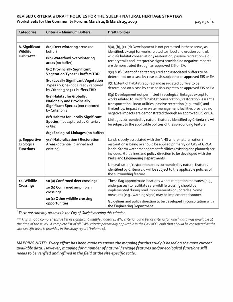
REVISED CRITERIA & DRAFT POLICIES FOR THE GUELPH NATURAL HERITAGE STRATEGY Worksheets for the Community Forums March 24 & March 25, 2009 page 3 of 4 Categories Criteria + Minimum Buffers Draft Policies
8. Significant Wildlife Habitat**
8(a) Deer wintering areas (no buffer)
8(b) Waterfowl overwintering areas (no buffer)
8(c) Provincially Significant Vegetation Types*+ buffers TBD
8(d) Locally Significant Vegetation Types ≥0.5 ha (not already captured by Criteria 3 or 5) + buffers TBD
8(e) Habitat for Globally, Nationally and Provincially Significant Species (not captured by Criterion 2)
8(f) Habitat for Locally Significant Species (not captured by Criteria 2 or 8(e))
8(g) Ecological Linkages (no buffer)
8(a), (b), (c), (d) Development is not permitted in these areas, as identified, except for works related to: flood and erosion control, wildlife habitat conservation / restoration, passive recreation (e.g., tertiary trails and interpretive signs) provided no negative impacts are demonstrated through an approved EIS or EA.
8(e) & (f) Extent of habitat required and associated buffers to be determined on a case by case basis subject to an approved EIS or EA.
8(f) Extent of habitat required and associated buffers to be determined on a case by case basis subject to an approved EIS or EA.
8(g) Development not permitted in ecological linkages except for works related to: wildlife habitat conservation / restoration, essential transportation, linear utilities, passive recreation (e.g., trails) and limited low impact storm water management facilities provided no negative impacts are demonstrated through an approved EIS or EA.
Linkages surrounded by natural features identified by Criteria 1‐7 will be subject to the applicable policies of the surrounding feature.
9. Supportive Ecological Functions
9(a) Naturalization / Restoration Areas (potential, planned and existing)
Lands closely associated with the NHS where naturalization / restoration is being or should be applied primarily on City of GRCA lands. Storm water management facilities (existing and planned) are included. Guidelines and policy direction to be developed with the Parks and Engineering Departments.
Naturalization/ restoration areas surrounded by natural features identified by Criteria 1‐7 will be subject to the applicable policies of the surrounding feature.
10. Wildlife Crossings
10 (a) Confirmed deer crossings
10 (b) Confirmed amphibian crossings
10 (c) Other wildlife crossing opportunities
These flag approximate locations where mitigation measures (e.g., underpasses) to facilitate safe wildlife crossing should be implemented during road improvements or upgrades. Some measures (e.g., warning signs) may be implemented sooner.
Guidelines and policy direction to be developed in consultation with the Engineering Department.
* There are currently no areas in the City of Guelph meeting this criterion.
** This is not a comprehensive list of significant wildlife habitat (SWH) criteria, but a list of criteria for which data was available at the time of the study. A complete list of all SWH criteria potentially applicable in the City of Guelph that should be considered at the site‐specific level is provided in the study report (Volume 1).
MAPPING NOTE: Every effort has been made to ensure the mapping for this study is based on the most current available data. However, mapping for a number of natural heritage features and/or ecological functions still needs to be verified and refined in the field at the site‐specific scale.
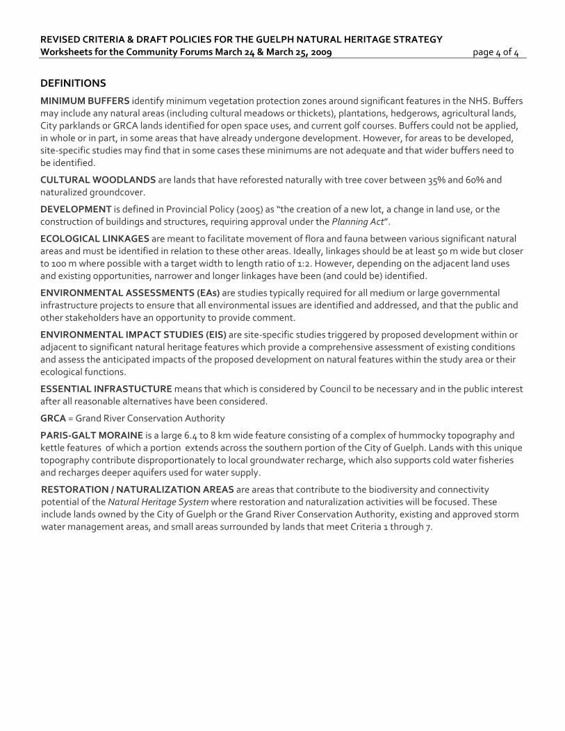
REVISED CRITERIA & DRAFT POLICIES FOR THE GUELPH NATURAL HERITAGE STRATEGY Worksheets for the Community Forums March 24 & March 25, 2009 page 4 of 4
DEFINITIONS
MINIMUM BUFFERS identify minimum vegetation protection zones around significant features in the NHS. Buffers may include any natural areas (including cultural meadows or thickets), plantations, hedgerows, agricultural lands, City parklands or GRCA lands identified for open space uses, and current golf courses. Buffers could not be applied, in whole or in part, in some areas that have already undergone development. However, for areas to be developed, site‐specific studies may find that in some cases these minimums are not adequate and that wider buffers need to be identified.
CULTURAL WOODLANDS are lands that have reforested naturally with tree cover between 35% and 60% and naturalized groundcover.
DEVELOPMENT is defined in Provincial Policy (2005) as “the creation of a new lot, a change in land use, or the construction of buildings and structures, requiring approval under the Planning Act”.
ECOLOGICAL LINKAGES are meant to facilitate movement of flora and fauna between various significant natural areas and must be identified in relation to these other areas. Ideally, linkages should be at least 50 m wide but closer to 100 m where possible with a target width to length ratio of 1:2. However, depending on the adjacent land uses and existing opportunities, narrower and longer linkages have been (and could be) identified.
ENVIRONMENTAL ASSESSMENTS (EAs) are studies typically required for all medium or large governmental infrastructure projects to ensure that all environmental issues are identified and addressed, and that the public and other stakeholders have an opportunity to provide comment.
ENVIRONMENTAL IMPACT STUDIES (EIS) are site‐specific studies triggered by proposed development within or adjacent to significant natural heritage features which provide a comprehensive assessment of existing conditions and assess the anticipated impacts of the proposed development on natural features within the study area or their ecological functions.
ESSENTIAL INFRASTUCTURE means that which is considered by Council to be necessary and in the public interest after all reasonable alternatives have been considered.
GRCA = Grand River Conservation Authority
PARIS‐GALT MORAINE is a large 6.4 to 8 km wide feature consisting of a complex of hummocky topography and kettle features of which a portion extends across the southern portion of the City of Guelph. Lands with this unique topography contribute disproportionately to local groundwater recharge, which also supports cold water fisheries and recharges deeper aquifers used for water supply.
RESTORATION / NATURALIZATION AREAS are areas that contribute to the biodiversity and connectivity potential of the Natural Heritage System where restoration and naturalization activities will be focused. These include lands owned by the City of Guelph or the Grand River Conservation Authority, existing and approved storm water management areas, and small areas surrounded by lands that meet Criteria 1 through 7.
Phase 2: Terrestrial Inventory & Natural Heritage System (NHS)
Phase 3: Natural Heritage Policy Development
COMMUNITY FORUM
March 24 / 25, 2009
NATURAL HERITAGE STRATEGYCITY OF GUELPH
Presentation Outline
1. Study Goals
2. Study Rationale
3. Study Phasing & Status
4. Key Findings: Existing Conditions
5. Overview of Comments & Key Revisions
6. Approach for NHS Identification
7. Recommended Criteria & Draft Policies
application in mapping
associated draft policies
8. Recommended Natural Heritage System (NHS)
9. Concluding Remarks & Key Recommendations
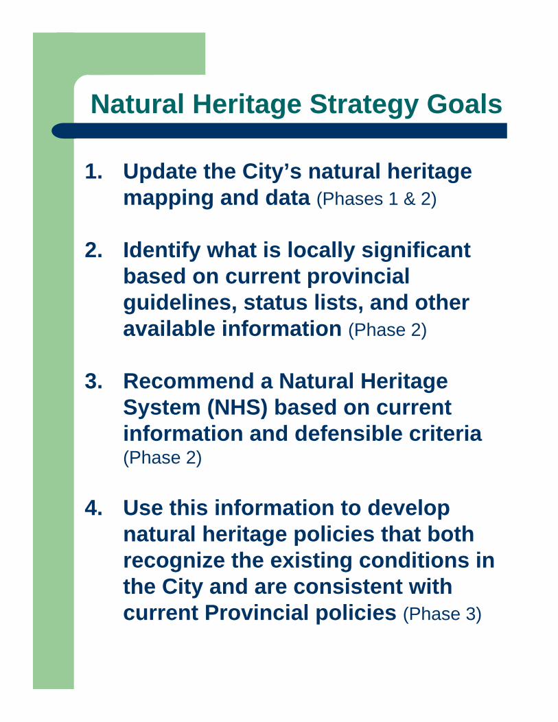
Natural Heritage Strategy Goals
1. Update the City’s natural heritage mapping and data (Phases 1 & 2)
2. Identify what is locally significant based on current provincial guidelines, status lists, and other available information (Phase 2)
3. Recommend a Natural Heritage System (NHS) based on current information and defensible criteria (Phase 2)
4. Use this information to develop natural heritage policies that both recognize the existing conditions in the City and are consistent with current Provincial policies (Phase 3)
Study Rationale:1. Provincial Policy
Municipalities are required to be “consistent with” the Provincial Policy Statement (2005) which states:
– 2.1.1 Natural features and areas shall be protected for the long term.
– 2.1.2 The diversity and connectivity of natural features in an area, and the long-term ecological function and biodiversity of natural heritage systems, should be maintained, restored or, where possible, improved, recognizing linkages between and among natural heritage features and areas, surface water features and ground water features.
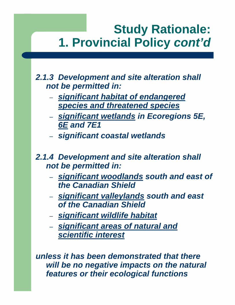
2.1.3 Development and site alteration shall not be permitted in:
– significant habitat of endangered species and threatened species
– significant wetlands in Ecoregions 5E, 6E and 7E1
– significant coastal wetlands
2.1.4 Development and site alteration shall not be permitted in:
– significant woodlands south and east of the Canadian Shield
– significant valleylands south and east of the Canadian Shield
– significant wildlife habitat– significant areas of natural and
scientific interest
unless it has been demonstrated that there will be no negative impacts on the natural features or their ecological functions
Study Rationale:1. Provincial Policy cont’d
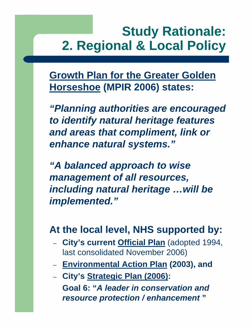
Growth Plan for the Greater Golden Horseshoe (MPIR 2006) states:
“Planning authorities are encouraged to identify natural heritage features and areas that compliment, link or enhance natural systems.”
“A balanced approach to wise management of all resources, including natural heritage …will be implemented.”
At the local level, NHS supported by:– City’s current Official Plan (adopted 1994,
last consolidated November 2006)– Environmental Action Plan (2003), and – City’s Strategic Plan (2006):
Goal 6: “A leader in conservation and resource protection / enhancement ”
Study Rationale:2. Regional & Local Policy
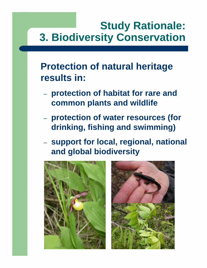
Protection of natural heritage results in:– protection of habitat for rare and
common plants and wildlife
– protection of water resources (for drinking, fishing and swimming)
– support for local, regional, national and global biodiversity
Study Rationale:3. Biodiversity Conservation
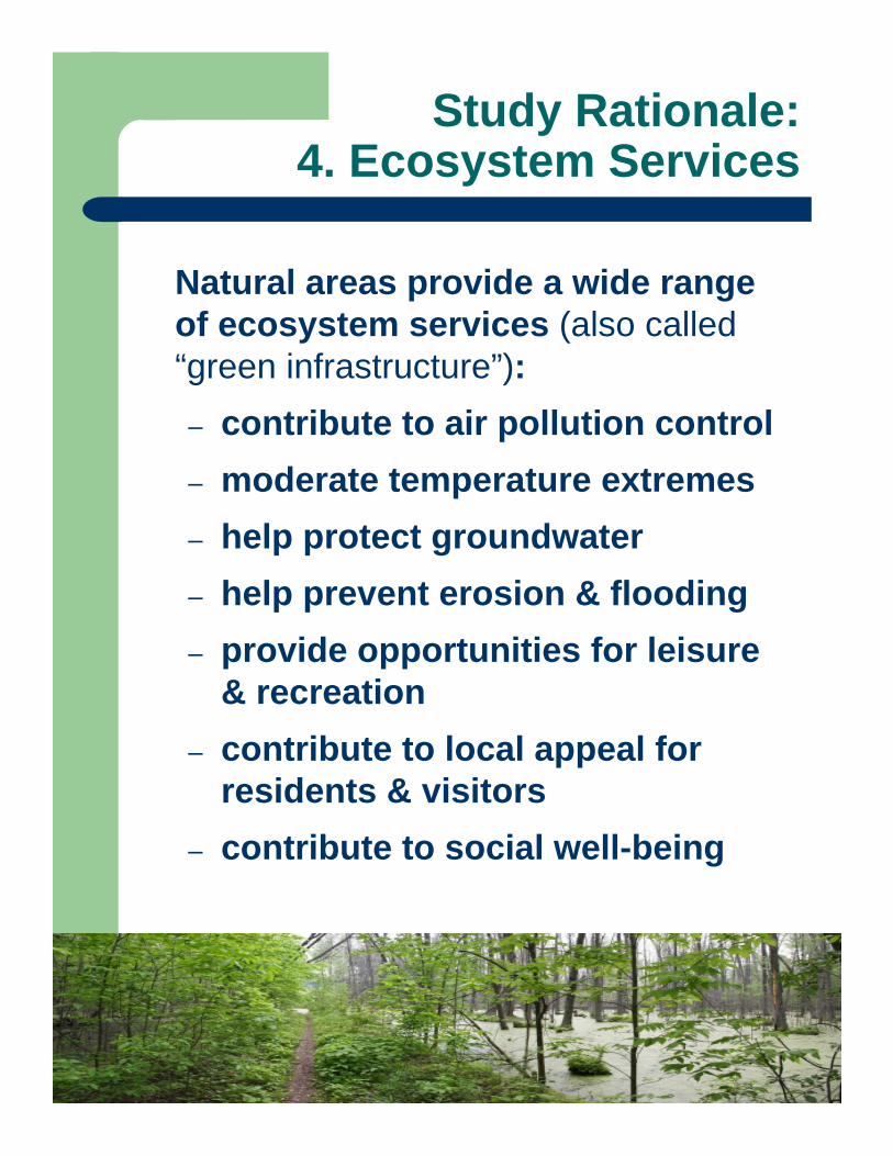
Natural areas provide a wide range of ecosystem services (also called “green infrastructure”):– contribute to air pollution control– moderate temperature extremes– help protect groundwater– help prevent erosion & flooding– provide opportunities for leisure
& recreation– contribute to local appeal for
residents & visitors– contribute to social well-being
Study Rationale:4. Ecosystem Services
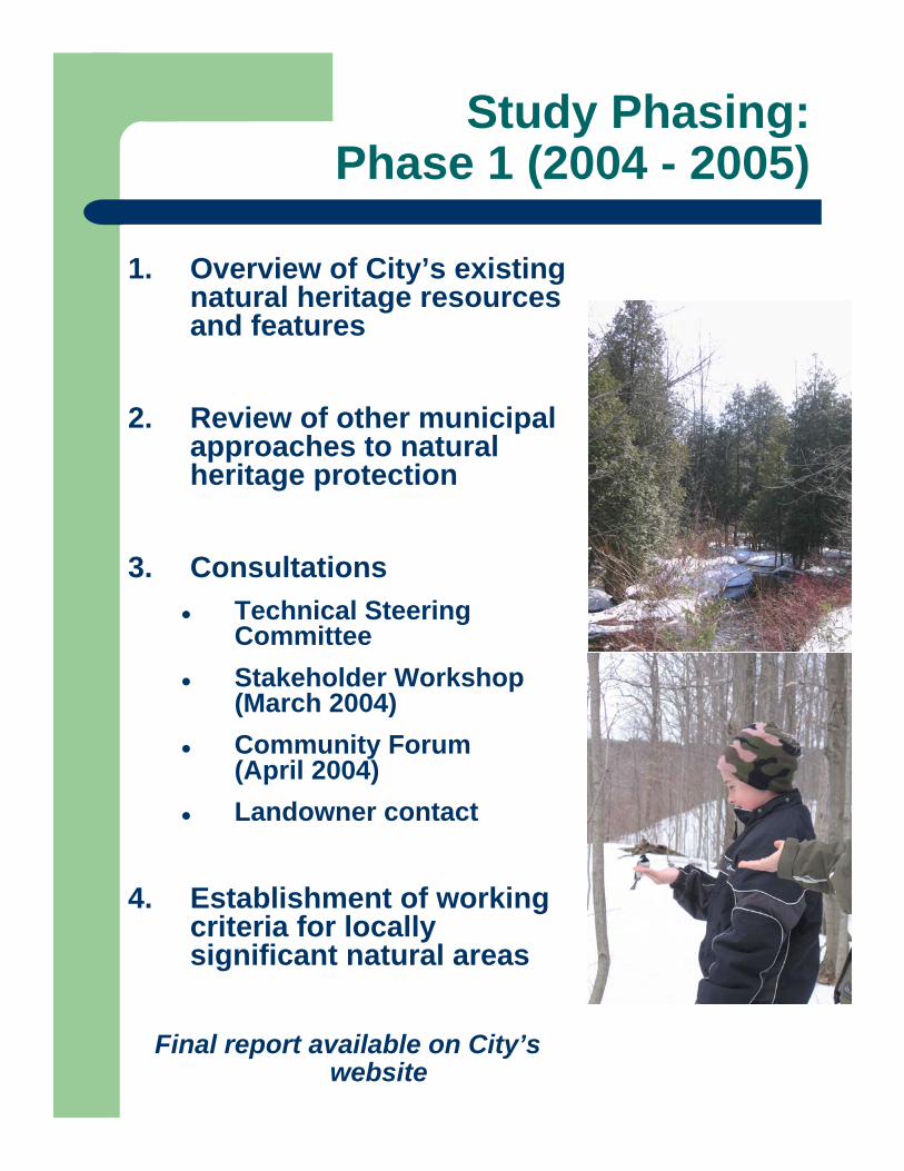
Study Phasing:Phase 1 (2004 - 2005)
1. Overview of City’s existing natural heritage resources and features
2. Review of other municipal approaches to natural heritage protection
3. ConsultationsTechnical Steering CommitteeStakeholder Workshop (March 2004)Community Forum (April 2004)Landowner contact
4. Establishment of working criteria for locally significant natural areas
Final report available on City’s website
Study Phasing:Phase 2 (2005 – 2008)
• Assessment of natural heritage data
• City-wide habitat classification mapping (ELC: Ecological Land Classification)
• Scoped field assessments• ELC, Botanical Surveys, Breeding Bird
Surveys, Amphibian Surveys (outside wetlands / floodplains)
• Updates to mapping / data
• Criteria refinement & application
• Consultations:• Ongoing with City Staff & Steering Committee
• FALL 2008: Committee to Council, Stakeholders / Public, Agencies / Local Municipalities
• Draft Report (released August 2008)
• Draft natural heritage policies under development• Correspond closely with the
recommended NHS criteria
• Preliminary input received from:• City staff• Guelph EAC• NHS Steering Committee
• Draft policy direction presented today for input
Study Phasing:Phase 3 (2008 – 2009)
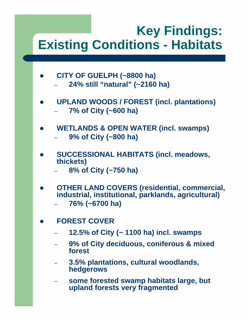
CITY OF GUELPH (~8800 ha) – 24% still “natural” (~2160 ha)
UPLAND WOODS / FOREST (incl. plantations)– 7% of City (~600 ha)
WETLANDS & OPEN WATER (incl. swamps)– 9% of City (~800 ha)
SUCCESSIONAL HABITATS (incl. meadows, thickets)
– 8% of City (~750 ha)
OTHER LAND COVERS (residential, commercial, industrial, institutional, parklands, agricultural)
– 76% (~6700 ha)
FOREST COVER– 12.5% of City (~ 1100 ha) incl. swamps– 9% of City deciduous, coniferous & mixed
forest– 3.5% plantations, cultural woodlands,
hedgerows– some forested swamp habitats large, but
upland forests very fragmented
Key Findings:Existing Conditions - Habitats
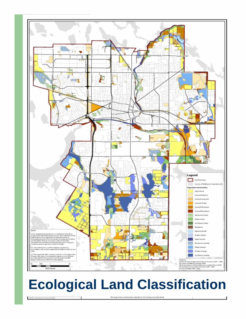
Ecological Land Classification
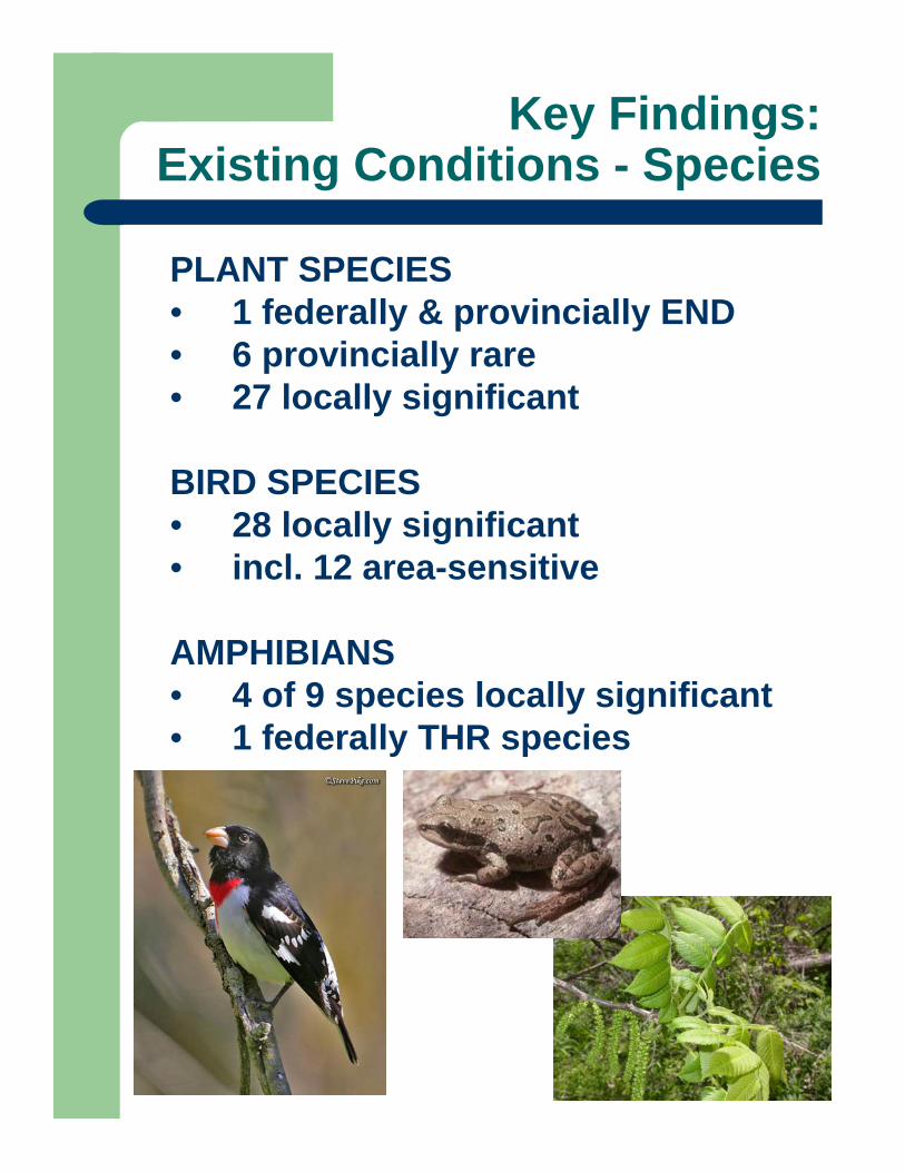
Key Findings:Existing Conditions - Species
PLANT SPECIES• 1 federally & provincially END • 6 provincially rare• 27 locally significant
BIRD SPECIES• 28 locally significant• incl. 12 area-sensitive
AMPHIBIANS• 4 of 9 species locally significant• 1 federally THR species

Approach:Criteria-based
1. Assessment of all remaining natural areas in the City of Guelph
2. Screening of those areas to determine which are significant from a natural heritage perspective
3. Identification of a Natural Heritage System (NHS) using criteria that are:– consistent with requirements of the PPS,
supporting guidelines, related legislation– readily applied with existing data, or data
that can be readily obtained– rooted in the current principles and
practice of conservation biology– consistent with approaches in other
comparable municipalities – reflective of Guelph’s unique natural
heritage
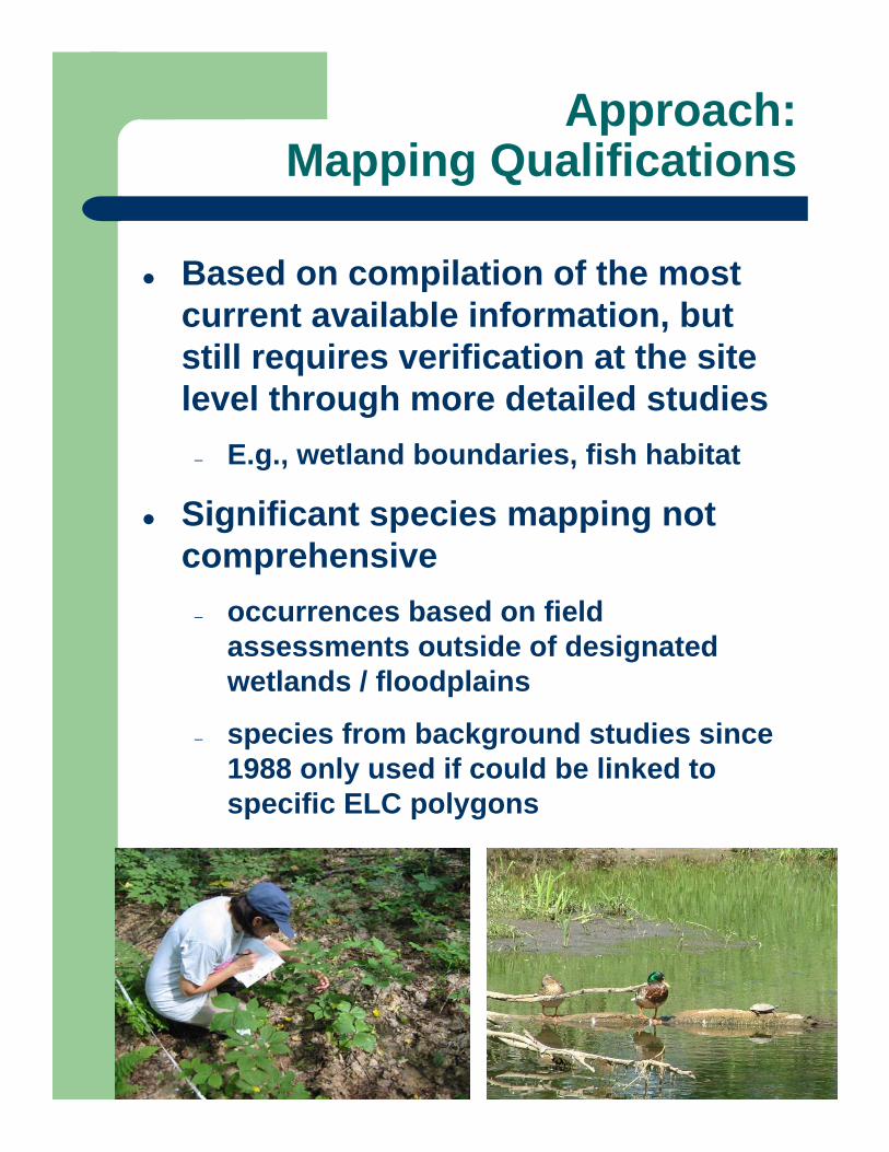
Approach:Mapping Qualifications
Based on compilation of the most current available information, but still requires verification at the site level through more detailed studies
– E.g., wetland boundaries, fish habitat
Significant species mapping not comprehensive
– occurrences based on field assessments outside of designated wetlands / floodplains
– species from background studies since 1988 only used if could be linked to specific ELC polygons

Comments on Draft Report (1 of 2)
General support for NHS & a criteria-based approach
Some comments re. specifics of the criteria & their application:
– the use of a weighted approach (i.e. primary + secondary criteria)
– inclusion of cultural woodlands as Significant Woodlands
– exclusion of plantations from Significant Woodlands
– Significant Landform criterion
– Habitat for Sig Species criterion
Stone Rd. at Edinburgh looking southWatson Pkwy at York

Comments on Draft Report (2 of 2)
Need for:– more refined ELC– minimum buffers– restoration areas
Some areas overlooked:– City and GRCA owned natural areas– University of Guelph Arboretum lands
Some areas captured that should not:– some areas already identified for
development through detailed studies in progress, including linkages
– some wildlife crossings and linkage opportunities overlooked
Stone Rd. at Edinburgh looking south
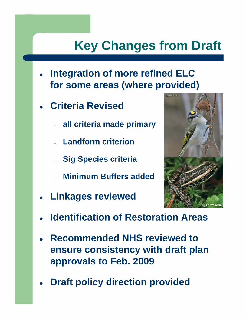
Key Changes from Draft
Integration of more refined ELC for some areas (where provided)
Criteria Revised
– all criteria made primary
– Landform criterion
– Sig Species criteria
– Minimum Buffers added
Linkages reviewed
Identification of Restoration Areas
Recommended NHS reviewed to ensure consistency with draft plan approvals to Feb. 2009
Draft policy direction provided
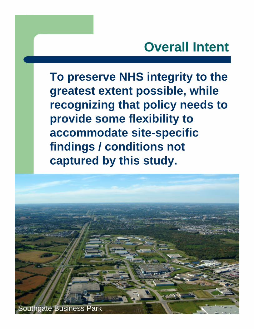
Overall Intent
To preserve NHS integrity to the greatest extent possible, while recognizing that policy needs to provide some flexibility to accommodate site-specific findings / conditions not captured by this study.
Courtesy of the City of Kitchener
Southgate Business Park
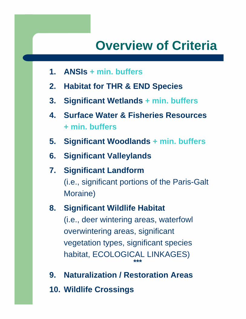
Overview of Criteria
1. ANSIs + min. buffers
2. Habitat for THR & END Species
3. Significant Wetlands + min. buffers
4. Surface Water & Fisheries Resources + min. buffers
5. Significant Woodlands + min. buffers
6. Significant Valleylands
7. Significant Landform (i.e., significant portions of the Paris-Galt Moraine)
8. Significant Wildlife Habitat (i.e., deer wintering areas, waterfowl overwintering areas, significant vegetation types, significant species habitat, ECOLOGICAL LINKAGES)
***
9. Naturalization / Restoration Areas
10. Wildlife Crossings
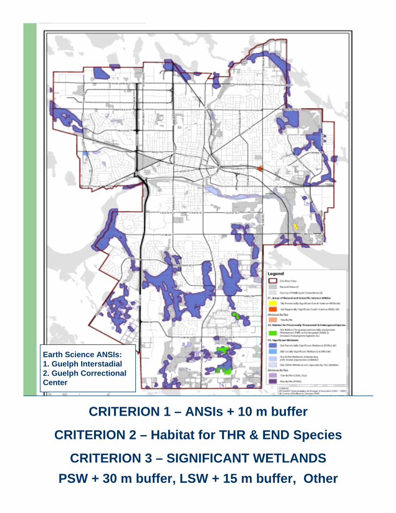
CRITERION 1 – ANSIs + 10 m buffer
CRITERION 2 – Habitat for THR & END Species
CRITERION 3 – SIGNIFICANT WETLANDSPSW + 30 m buffer, LSW + 15 m buffer, Other
Earth Science ANSIs: 1. Guelph Interstadial2. Guelph Correctional Center
DRAFT POLICIES:1. Areas of Natural & Scientific Interest
Development not permitted in any type of ANSI except for works related to:
flood & erosion control
habitat conservation / restoration
passive recreation (e.g., trails, signs)
Development not permitted in buffers to ANSIs except for:
the uses listed above
storm water management facilities
subject to an approved Environmental Impact Study (EIS) or Environmental Assessment (EA)
DRAFT POLICIES:2. Habitat for THR & END Species
Development not permitted in habitat for provincially THR or END species
Extent of habitat required and associated buffers to be determined on a case by case basis in consultation with OMNR and Recovery Team (if applicable) and subject to an approved EIS or EA
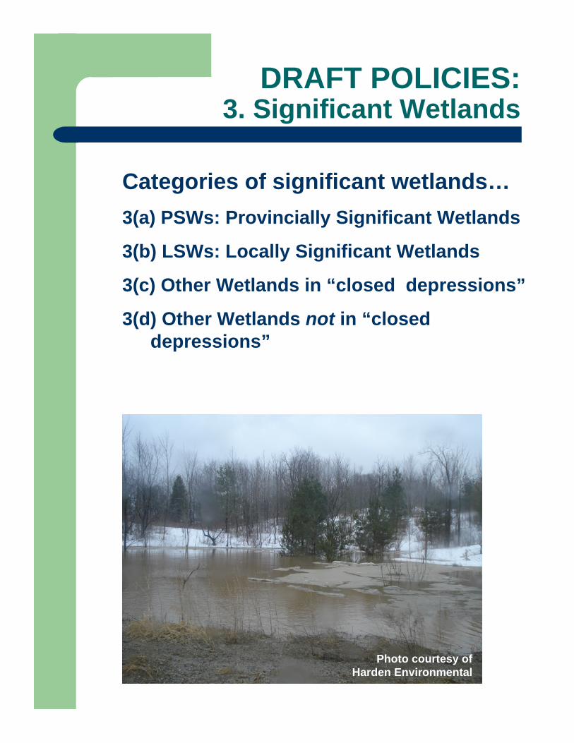
DRAFT POLICIES:3. Significant Wetlands
Categories of significant wetlands…3(a) PSWs: Provincially Significant Wetlands
3(b) LSWs: Locally Significant Wetlands
3(c) Other Wetlands in “closed depressions”
3(d) Other Wetlands not in “closed depressions”
Photo courtesy of Harden Environmental
DRAFT POLICIES:3. Significant Wetlands
Development not permitted in any wetlands except for:
“other wetlands” determined not to provide significant wetland functions
subject to approval by the GRCA in accordance with their policies
Development not permitted in buffers to wetlands except for:
– flood & erosion control– habitat conservation /
restoration– passive recreationas supported through an approved EIS or EA

CRITERION 4: SURFACE WATER & FISHERIES RESOURCES
Streams (Permanent & Intermittent) + 15 m buffer
Cold Water Fish Habitat + 30 m bufferWarm Water Fish Habitat + 15 m buffer
Groundwater Sensitivity Zones
DRAFT POLICIES:4. Surface Water & Fisheries Resources
Development not permitted in any type of stream or fish habitat except for works related to:
flood and erosion control habitat conservation / restorationother works permitted by the GRCA / DFO
subject to an approved EIS or EA
Development not permitted in buffers tostreams or fish habitat except for:
works listed abovestorm water management facilities (?)
subject to an approved EIS or EA and approval from GRCA / DFO
Essential infrastructure (e.g., roads, trails and/or linear utilities) may cross a stream and/or fish habitat subject to an approved EIS or EA and approval from GRCA / DFO
Opportunities to restore piped or culvertized streams to be pursued
CRITERION 5: SIGNIFICANT WOODLANDS“Natural” Woodlands > 1 ha + 10 m buffer
Sugar Maple Woodlands > 0.5 ha + 10 m bufferCultural Woodlands > 1 ha
DRAFT POLICIES:5. Significant Woodlands
Development not permitted in significant woodlands except for works related to:
flood & erosion controlwildlife habitat conservation / restorationpassive recreation (e.g., trails) cultural woodlands (and plantations)
subject to an approved EIS or EA & tree preservation plan
Development not permitted in buffers to woodlands except for:
works listed abovepassive recreation (e.g., trails) storm water management facilities
subject to an approved EIS or EA
EIS or EA to identify opportunities for protection of healthy native species and tree planting
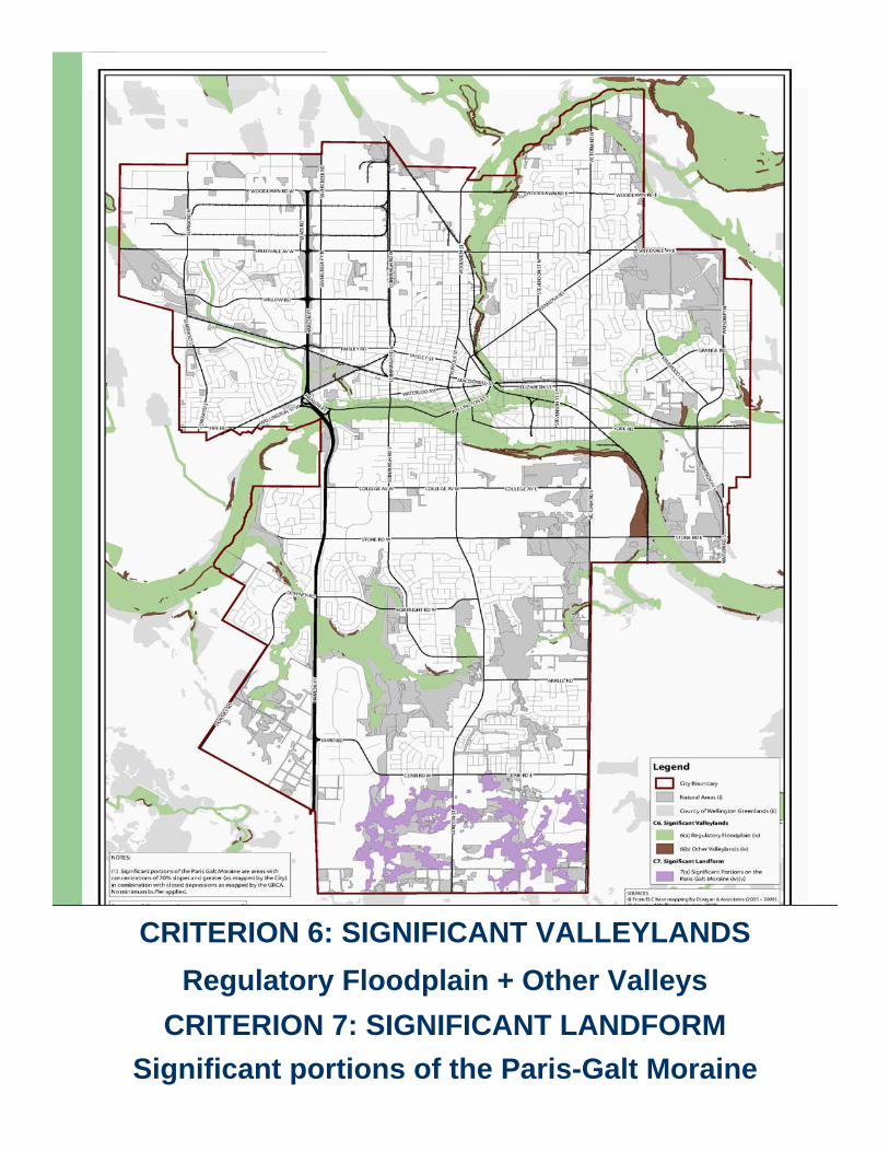
CRITERION 6: SIGNIFICANT VALLEYLANDSRegulatory Floodplain + Other Valleys
CRITERION 7: SIGNIFICANT LANDFORMSignificant portions of the Paris-Galt Moraine
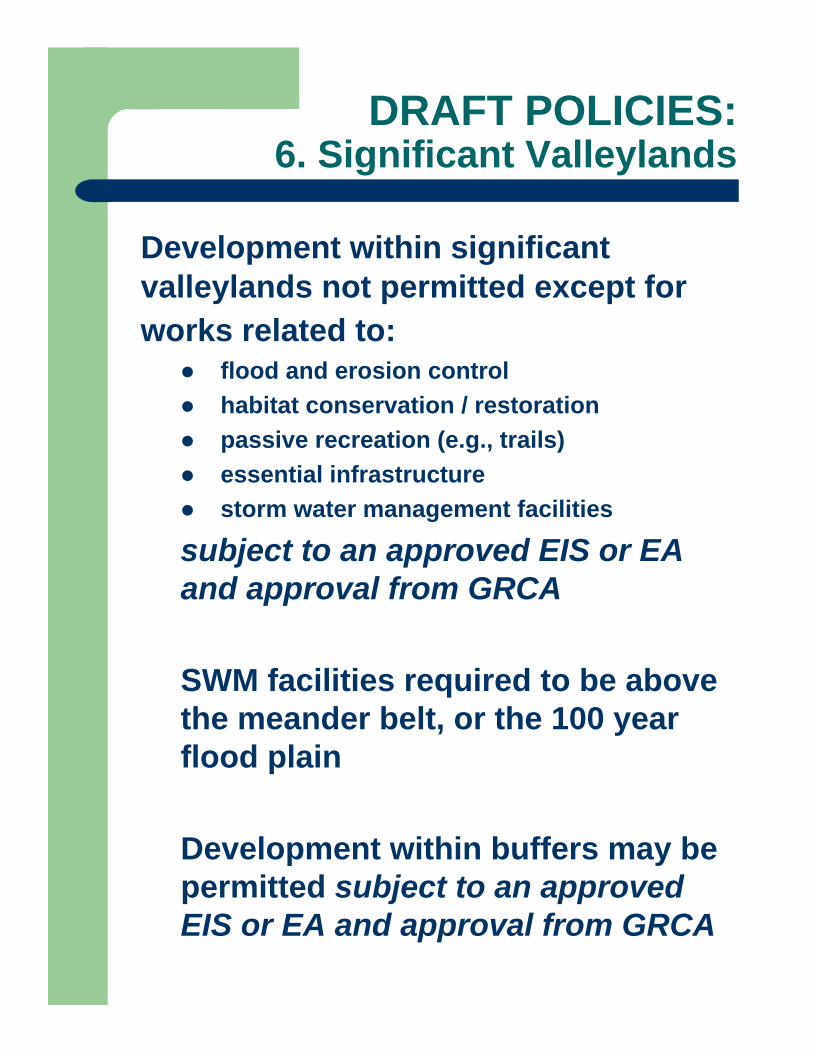
DRAFT POLICIES:6. Significant Valleylands
Development within significant valleylands not permitted except for works related to:
flood and erosion controlhabitat conservation / restorationpassive recreation (e.g., trails) essential infrastructurestorm water management facilities
subject to an approved EIS or EA and approval from GRCA
SWM facilities required to be above the meander belt, or the 100 year flood plain
Development within buffers may be permitted subject to an approved EIS or EA and approval from GRCA

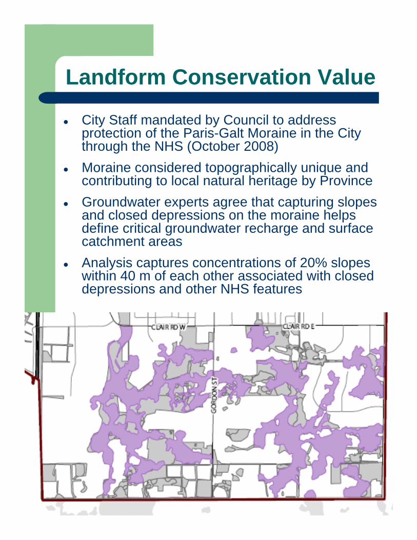
Landform Conservation Value
City Staff mandated by Council to address protection of the Paris-Galt Moraine in the City through the NHS (October 2008)Moraine considered topographically unique and contributing to local natural heritage by ProvinceGroundwater experts agree that capturing slopes and closed depressions on the moraine helps define critical groundwater recharge and surface catchment areasAnalysis captures concentrations of 20% slopes within 40 m of each other associated with closed depressions and other NHS features
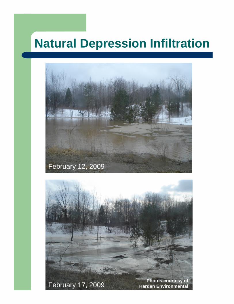
Natural Depression Infiltration
February 12, 2009
February 17, 2009Photos courtesy of
Harden Environmental
SWM Pond Infiltration
February 12, 2009
February 17, 2009Photos courtesy of
Harden Environmental
DRAFT POLICIES:7. Significant Landform
Development not permitted in significant portions of the Paris-Galt Moraine, as identified, except for works related to:
required municipal supply wellshabitat conservation / restorationpassive recreation (e.g., trails) essential infrastructure
subject to an approved EIS or EA
Approved works will not involve grading to these areas
Opportunities to restore habitats to be encouraged

CRITERION 8: SIGNIFICANT WILDLIFE HABITAT8(a) Deer wintering areas
8(b) Waterfowl overwintering areas 8(c) & (d) Significant Vegetation Types8(e) & (f) Habitat for Significant Species
8(g) ECOLOGICAL LINKAGES
DRAFT POLICIES:8. Significant Wildlife Habitat
Development not permitted in deer wintering areas, waterfowl overwintering areas or significant vegetation types except for:
flood & erosion controlhabitat conservation / restorationpassive recreation (e.g., trails) essential infrastructure (?)
subject to an approved EIS or EA
Habitat for significant speciesExtent of habitat required & associated buffers TBD on a case by case basis subject to an approved EIS or EA
DRAFT POLICIES:8. Significant Wildlife Habitat cont’d
Ecological linkagesDevelopment not permitted within linkages except for:
flood and erosion controlhabitat conservation / restorationpassive recreation (e.g., trails) essential infrastructureSWM facilities
subject to an approved EIS or EA
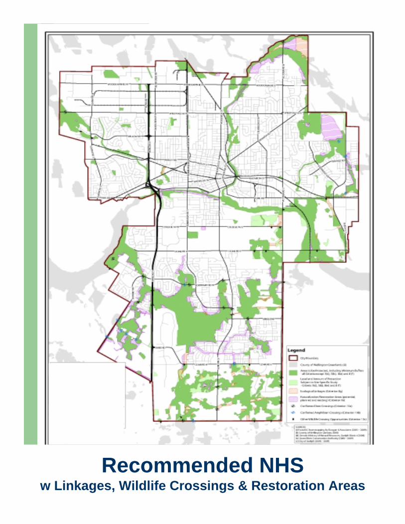
Recommended NHS w Linkages, Wildlife Crossings & Restoration Areas
Blah blah
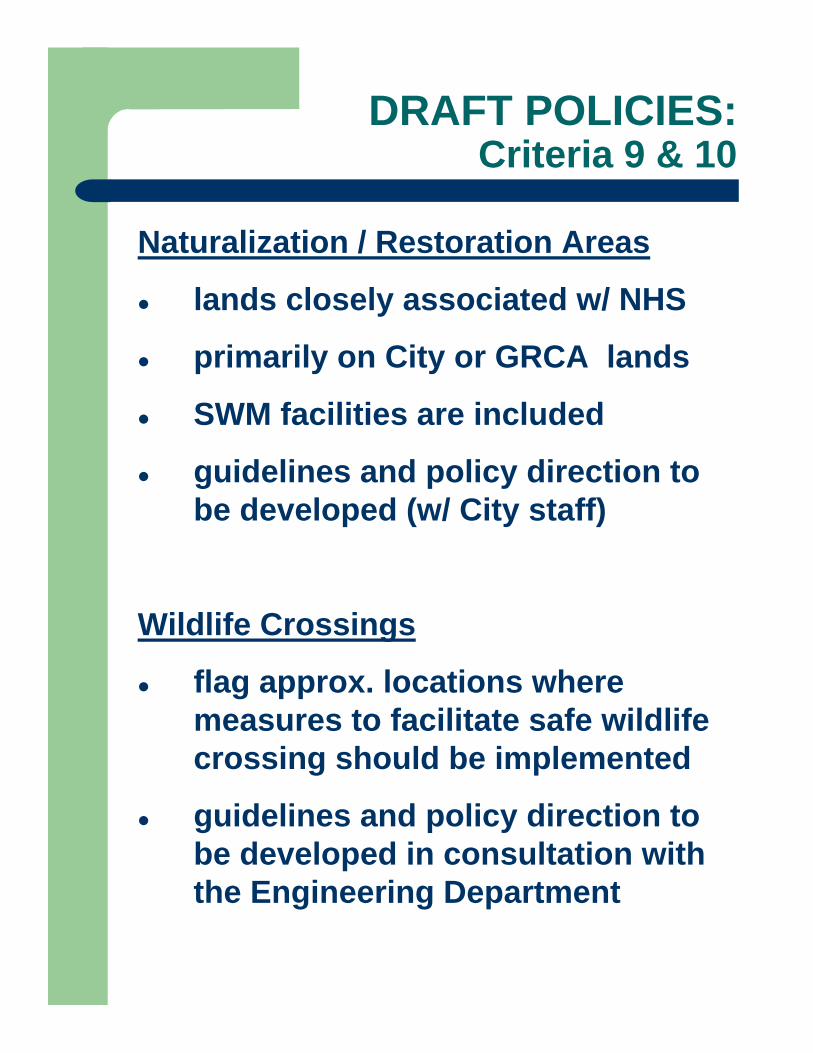
DRAFT POLICIES:Criteria 9 & 10
Naturalization / Restoration Areas
lands closely associated w/ NHS
primarily on City or GRCA lands
SWM facilities are included
guidelines and policy direction to be developed (w/ City staff)
Wildlife Crossings
flag approx. locations where measures to facilitate safe wildlife crossing should be implemented
guidelines and policy direction to be developed in consultation with the Engineering Department
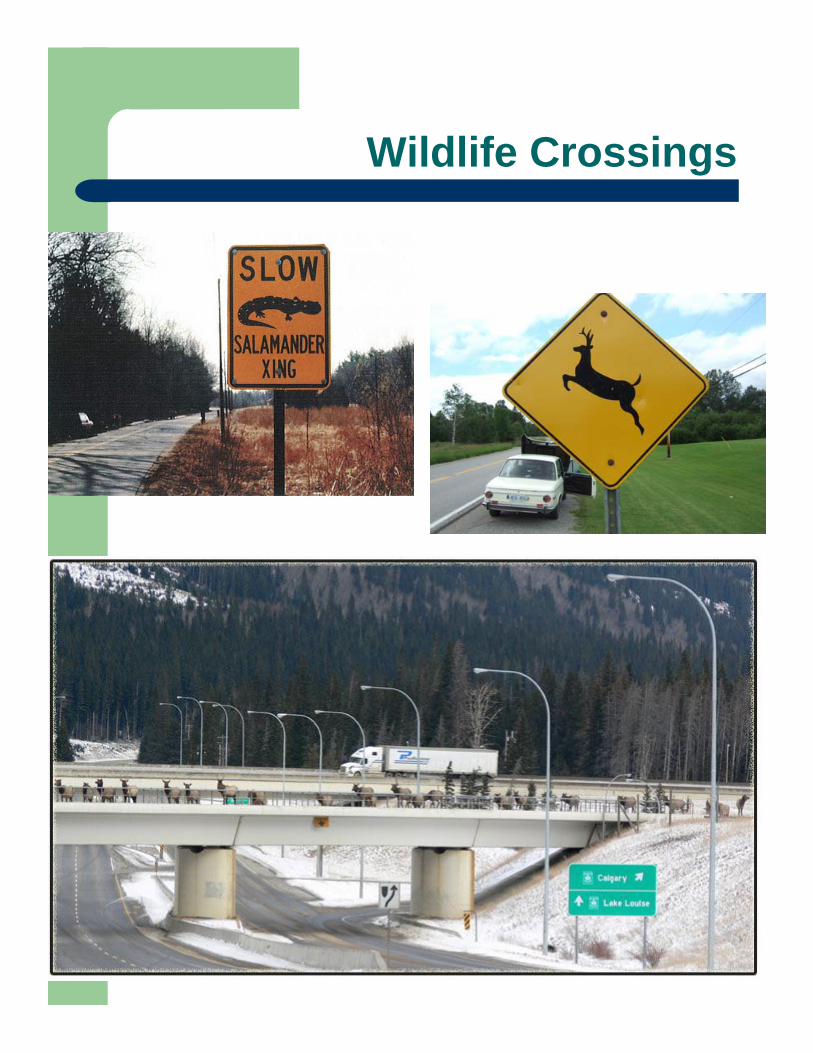
Wildlife Crossings
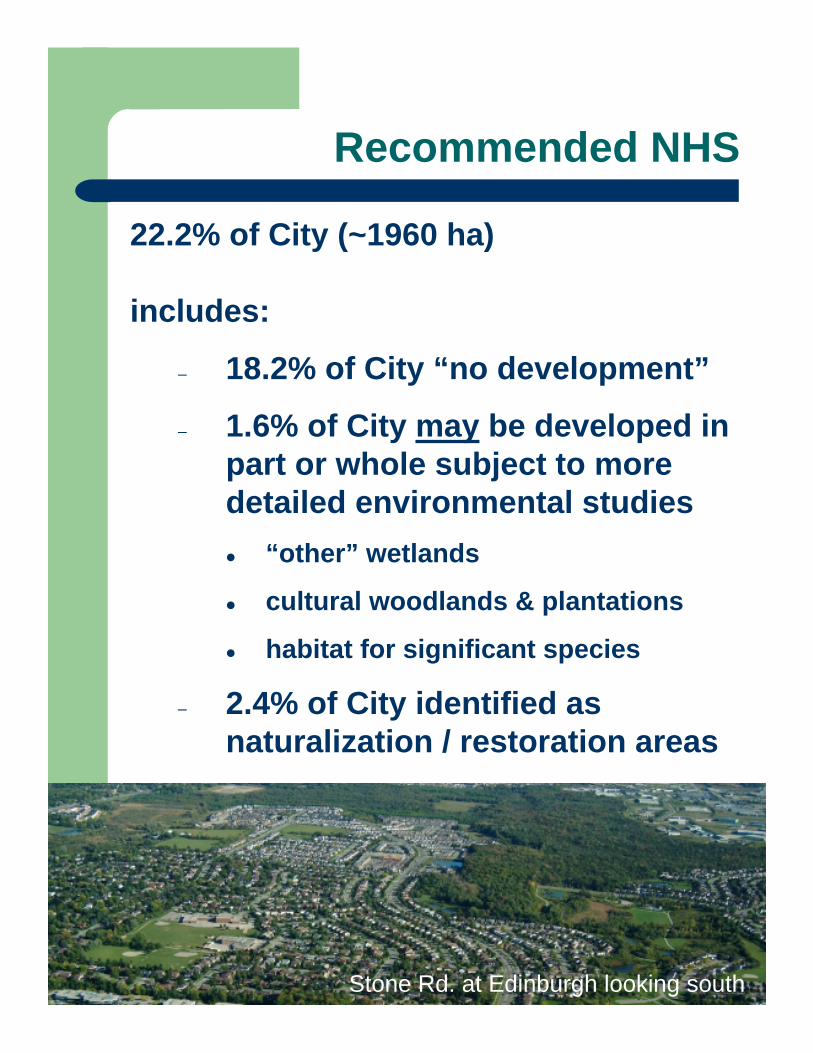
Recommended NHS
22.2% of City (~1960 ha)
includes:
– 18.2% of City “no development”
– 1.6% of City may be developed in part or whole subject to more detailed environmental studies
“other” wetlands
cultural woodlands & plantations
habitat for significant species
– 2.4% of City identified as naturalization / restoration areas
Stone Rd. at Edinburgh looking south
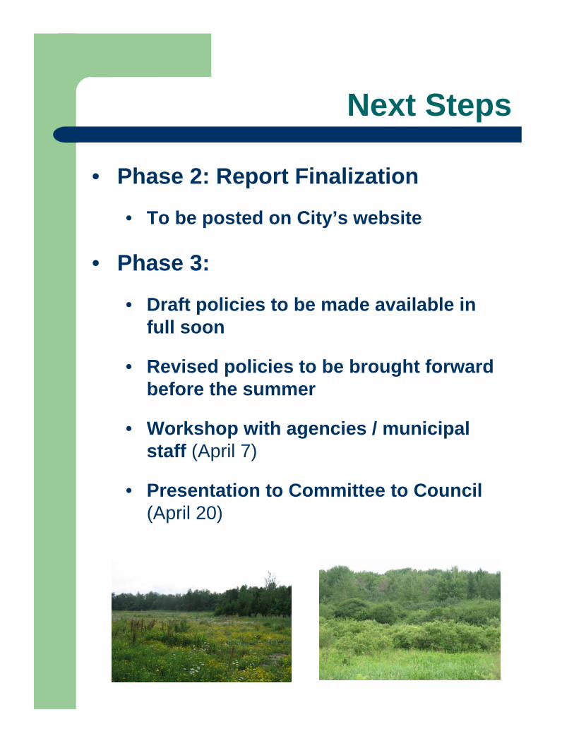
Next Steps
• Phase 2: Report Finalization
• To be posted on City’s website
• Phase 3:
• Draft policies to be made available in full soon
• Revised policies to be brought forward before the summer
• Workshop with agencies / municipal staff (April 7)
• Presentation to Committee to Council (April 20)
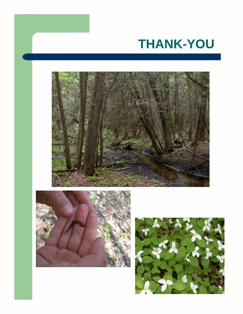
THANK-YOU
1
COMMUNITY FORUMNatural Heritage Strategy Phase II & Phase III
Holiday Inn Conference CentreMarch 24 & 25, 2009
2
• Official Plan (OP) Update commenced August 2007
• Purpose of the OP Update is to:– Achieve conformity with Growth Plan for the
Greater Golden Horseshoe– Ensure consistency with the 2005 Provincial Policy
Statement– Incorporate numerous City studies and policies,
e.g., Natural Heritage Strategy
Official Plan Update Background
2
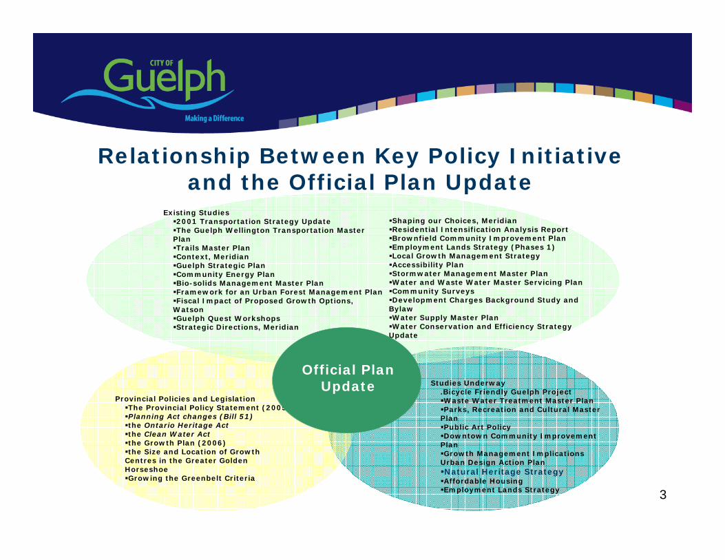
3
Studies Underway.Bicycle Friendly Guelph Project Waste Water Treatment Master Plan Parks, Recreation and Cultural Master
Plan Public Art Policy Downtown Community Improvement
PlanGrowth Management Implications
Urban Design Action Plan Natural Heritage StrategyAffordable Housing Employment Lands Strategy
Provincial Policies and Legislation The Provincial Policy Statement (2005) Planning Act changes (Bill 51)the Ontario Heritage Actthe Clean Water Actthe Growth Plan (2006) the Size and Location of Growth
Centres in the Greater Golden HorseshoeGrowing the Greenbelt Criteria
Existing Studies 2001 Transportation Strategy UpdateThe Guelph Wellington Transportation Master
PlanTrails Master Plan Context, MeridianGuelph Strategic Plan Community Energy Plan Bio-solids Management Master Plan Framework for an Urban Forest Management Plan Fiscal Impact of Proposed Growth Options,
Watson Guelph Quest Workshops Strategic Directions, Meridian
Shaping our Choices, Meridian Residential Intensification Analysis Report Brownfield Community Improvement Plan Employment Lands Strategy (Phases 1) Local Growth Management Strategy Accessibility Plan Stormwater Management Master PlanWater and Waste Water Master Servicing Plan Community Surveys Development Charges Background Study and
Bylaw Water Supply Master Plan Water Conservation and Efficiency Strategy
Update
Official Plan Update
Relationship Between Key Policy Initiative and the Official Plan Update

4
• The Official Plan will be finalized in two phases:
Phase I – Conformity with the Growth Plan as required by the Places to Grow Act
Phase II – Official Plan Update
Official Plan – Phasing and Timing
4
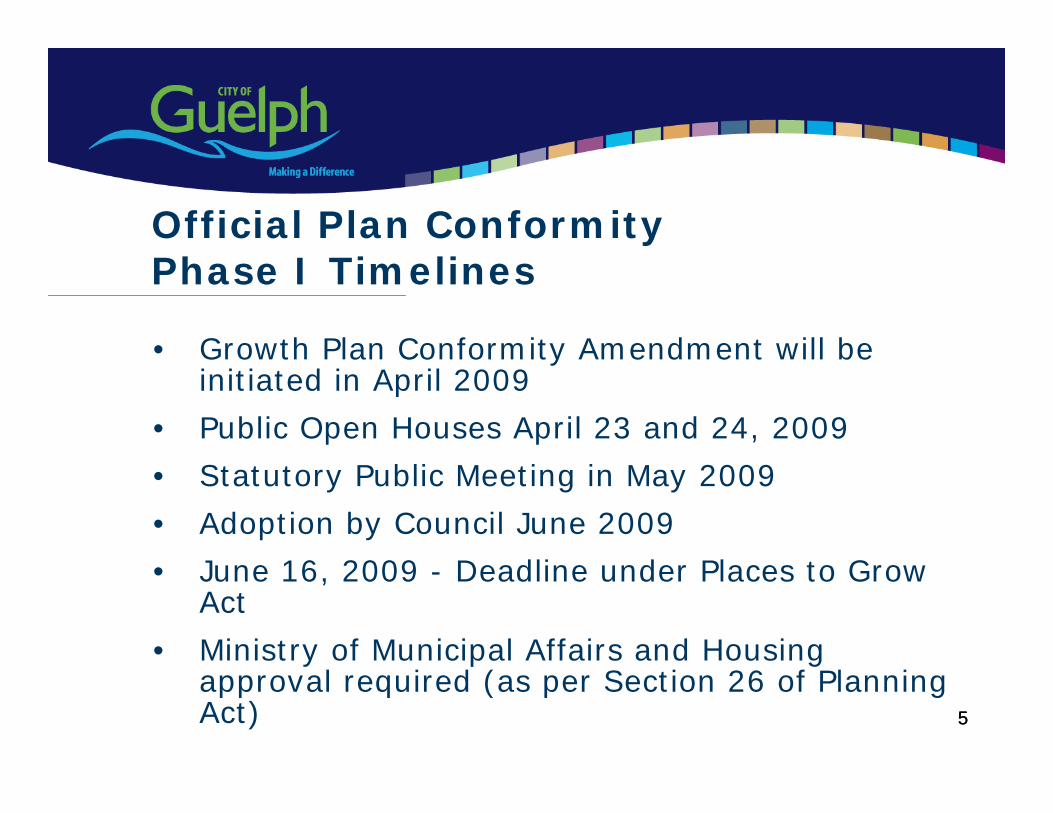
5
• Growth Plan Conformity Amendment will be initiated in April 2009
• Public Open Houses April 23 and 24, 2009
• Statutory Public Meeting in May 2009
• Adoption by Council June 2009
• June 16, 2009 - Deadline under Places to Grow Act
• Ministry of Municipal Affairs and Housing approval required (as per Section 26 of Planning Act)
Official Plan ConformityPhase I Timelines
5
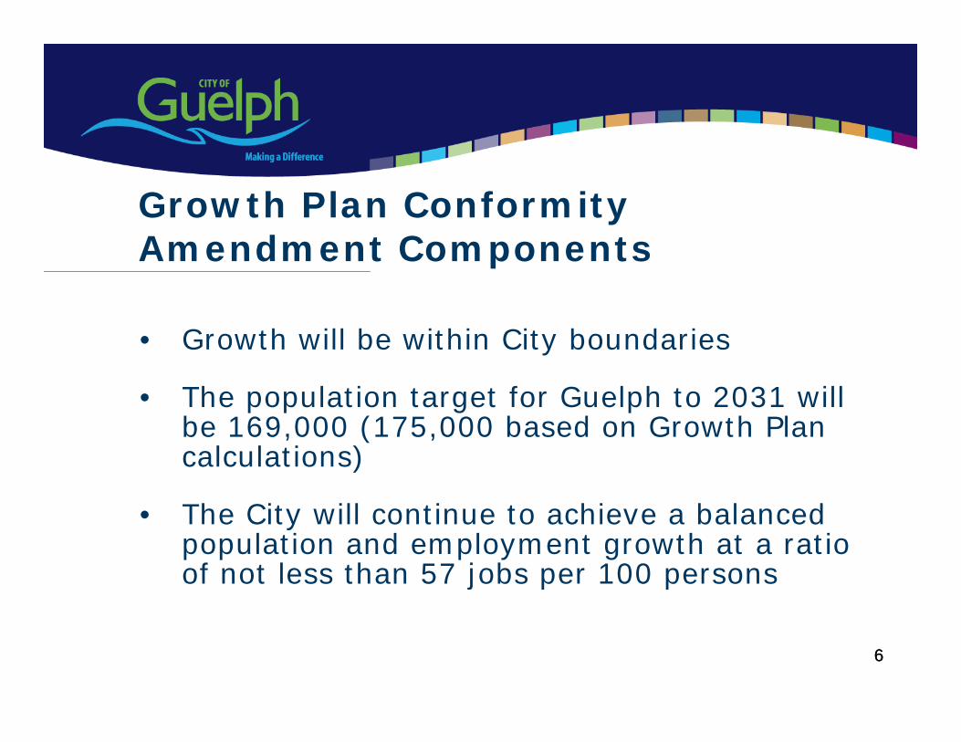
6
• Growth will be within City boundaries
• The population target for Guelph to 2031 will be 169,000 (175,000 based on Growth Plan calculations)
• The City will continue to achieve a balanced population and employment growth at a ratio of not less than 57 jobs per 100 persons
Growth Plan Conformity Amendment Components
6
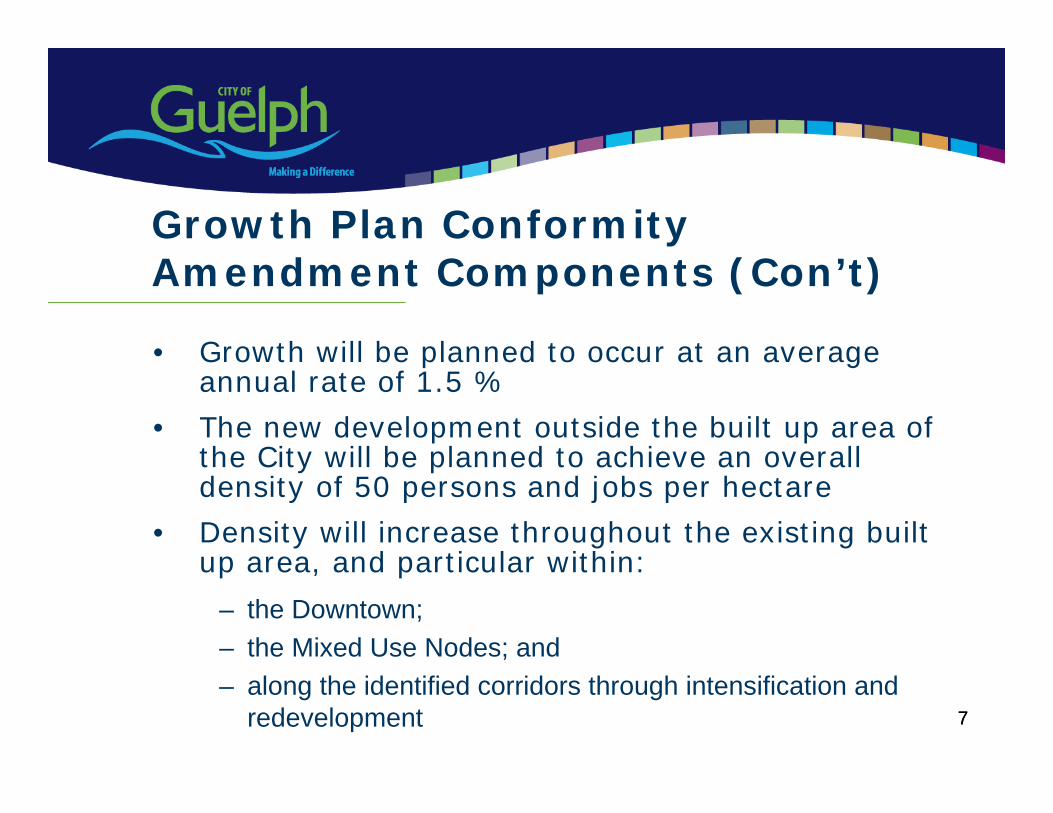
7
• Growth will be planned to occur at an average annual rate of 1.5 %
• The new development outside the built up area of the City will be planned to achieve an overall density of 50 persons and jobs per hectare
• Density will increase throughout the existing built up area, and particular within:
– the Downtown;– the Mixed Use Nodes; and– along the identified corridors through intensification and
redevelopment 7
Growth Plan Conformity Amendment Components (Con’t)
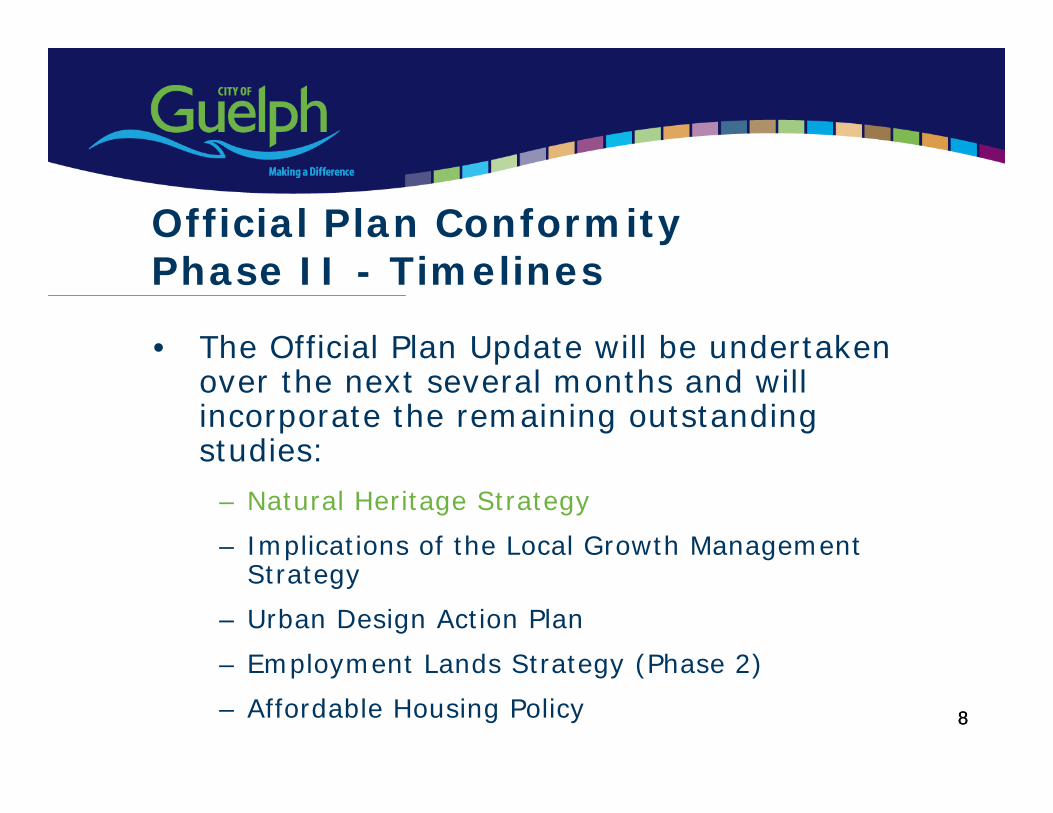
8
• The Official Plan Update will be undertaken over the next several months and will incorporate the remaining outstanding studies:
– Natural Heritage Strategy
– Implications of the Local Growth Management Strategy
– Urban Design Action Plan
– Employment Lands Strategy (Phase 2)
– Affordable Housing Policy
Official Plan Conformity Phase II - Timelines
8
9
• Downtown Secondary Plan
• York Innovation District Secondary Plan
Initiatives to Follow OP Update
9
10
• Natural Heritage Strategy first of the series of City initiatives that will be rolled out between now and the fall to be incorporated into the OP Update
Natural Heritage Strategy
10
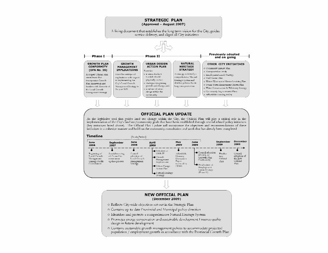
12
• Natural Heritage Strategy Community ForumsSpring 2009 - Policy ForumsFall 2009 - Incorporation into OP Update
• Implications of Growth Management Strategy and Urban Design Action Plan Public Meeting
March 26 March 31 April 4 Fall 2009 Incorporation into OP Update
Important Dates for Official Plan Update (2009)
13
• Growth Plan Conformity Amendment Public Open Houses
April May Statutory Public MeetingJune Council adoption
• Strategic Urban Forest Management Plan April 21
Important Dates for Official Plan Update (2009)
14
Thank you
15
• Natural Heritage Strategy Community ForumsSpring 2009 - Policy ForumsFall 2009 - Incorporation into OP Update
• Growth Plan Conformity Amendment Public Open HousesApril 22 & 23 May - Statutory Public MeetingJune - Council adoptionMMAH Decision
• Implications of Growth Management Strategy and Urban Design Action Plan Public Meeting
March 26 March 31 April 4 Fall 2009 Incorporation into OP Update
• Strategic Urban Forest Management PlanApril 21
Important Dates for Official Plan Update (2009)
NATURAL HERITAGE STRATEGY COMMUNITY FORUM MINUTES MARCH 24, 2009 (6:30 -9:30 PM) Mr. Glenn Pothier, Independent Facilitator, welcomed participants and provided a brief overview of forum, including:
the purpose of the community forum; status of the Natural Heritage Strategy (NHS); setting out the ground rules for participation in the forum; and introduction of the project team, including Michael Benner, Senior Planner retained
to provide the City with peer review of their proposed policies. Ms Marion Plaunt, Manager of Policy Planning and Urban Design, provided a brief presentation of the relationship between the NHS and the City’s current Official Plan (OP) update, including:
an overview of policy inputs to the OP update; timing of the OP update (e.g. Phase I & Phase II); and open house and public meeting dates for Phase I of the OP update.
Ms Margot Ursic, Consulting Planning Ecologist, provided a detailed presentation, including:
the NHS goals, study rationale, and overview of each study phase (e.g. Phase 1, 2, & 3)
key findings of the NHS to date; review of criteria-based approach; overview of comments received to date; key changes as a result of comments received; overview of criteria, mapping, and draft policy direction; clarification of ‘closed depressions’, ‘cultural woodlands’, and definition of
‘development’; breakdown of natural areas in the City by percentage; and next steps.
The following general questions and discussion followed:
Q1. What is intent of mapping privately owned restoration areas? M. Ursic: These are small gaps in the natural areas defined through the other criteria that have been identified as appropriate locations for restoration. Q2. How do ‘unconfirmed areas’ get refined? M. Ursic: Typically through a site-specific Environmental Impact Study (EIS) as part of a development proposal or an Environmental Assessment process associated with infrastructure works.
Q3. ‘Essential infrastructure’ should be more specific. This could be anything Council deems essential. M. Ursic: Agreed that it needs to be defined. Infrastructure was intended to include works related to roads, hydro lines and water pipes/sewer lines. Essential is to be
Natural Heritage Strategy Community Forum Minutes March 24, 2009 Holiday Inn Conference Centre
2
defined to include uses considered essential at a particular location after all reasonable alternatives have been considered. Q4. Why is work undertaken in accordance with the Drainage Act exempt? This type of work often has the greatest impact on natural areas. M. Benner: There is currently provision in Provincial Policy that exempts work undertaken under the Drainage Act. The City is currently working on low impact storm water management standards to address this issue in part. Q5. The significant landform criterion was upgraded from secondary to primary. It should be noted that engineered storm water management facilities infiltrate water as well as, or better than, natural areas and this criteria should be revisited as it would protect a lot of developable land in the South end of the City. M. Ursic: It is understood that SWM facilities may mimic the infiltration capacity provided by the moraine features. However, the moraine also provided other ecological, aesthetic and social functions that can not be replaced by SWM ponds. Notably, many of the areas identified under the significant landform criterion overlap with mapping of other criteria such as significant wetlands, significant woodlands, habitat for significant species and ecological linkages. Follow up to Q5: Are significant landform areas less significant than habitat for significant species? M. Ursic: No.
Q6. The minimum buffer policy refers to vegetative buffers – what about fauna? M. Ursic: Buffers are intended to protect both flora and fauna. Q7. Will NHS policy trump Provincial plans? M. Plaunt: In the event of a conflict, the Provincial Plans would generally take precedence however, municipal plans can be more restrictive than Provincial Plans or policies provided they pose no conflicts. (PPS encourages municipal Official Plans to go beyond the minimum requirements of the PPS.) Q8. Is the Hanlon Expressway considered essential infrastructure? M. Plaunt: The City is currently working with the Province through the Environmental Assessment process to address environmental (and other concerns).
Mr. Pothier provided instructions for the proceeding roundtable working session. The following comments were recorded as part of the roundtable working session:
Concern over the protection of the Hall’s Pond area. Question concerning when wetland mapping was done (e.g. during wet or dry years).
Ms Suzanne Young, Environmental Planner, indicated that the wetlands areas mapping will be refined as development proposals come forward.
Policy for significant landform areas that do not overlap with other criteria should allow these areas to be considered for development subject to a hydrogeological
Natural Heritage Strategy Community Forum Minutes March 24, 2009 Holiday Inn Conference Centre
3
study and EIS demonstrating that there will be no negative impact on groundwater recharge function.
There are many amphibian crossings that are either not documented or are too vague. These crossings should be emphasized, in particular with respect to turtles.
Undeveloped land within significant landform areas should not be developed – regardless of study results.
Minimum buffers degrade the importance of significant portions of natural features. Trails should not be allowed in ANSIs. Policy that permits development subject to an approved EIS or EA should require
that these studies be ‘unbiased’. The following general comments were made:
All natural areas within the City should be identified for protection and restoration, including already developed properties (e.g. brownfields).
Is ownership of significant natural features automatically transferred to the City? M. Plaunt: No. If future development occurs – ownership of the significant features may be transferred to the City as part of the development process or landowners may choose to retain lands as part of a lot/block. A Provincial tax credit (under the Conservation Land Tax Act) is available for Provincial Significant Wetlands that are in private ownership.
‘Essential Infrastructure’ is mentioned in some draft policies but not all. This is inconsistent.
Detached dwelling owners should get compensated for protecting significant natural heritage features.
Stormwater management pond should not be allowed in buffer zones as this could impact surface water.
The description of significant woodlands should describe type of vegetation as the City recently passed a by-law to remove invasive species (e.g. buckthorn) from City-owned land and replace it with native species.
There is a lack of discussion around climate change in the Natural Heritage Strategy. Adaptive management should be considered in policies. M. Ursic: Currently there is no definitive way to measure climate change impacts on a local scale, however, preserving natural areas will help to mitigate anticipated climate change impacts in the City.
Replanting should be required in criteria 5a) and b). M. Plaunt provided a wrap up of the working session and highlighted important future dates concerning the Natural Heritage Strategy and the City’s Official Plan update. The following concluding questions and comments were asked/made:
The definition of cultural woodlands is too broad and could be abused. It should be narrowed.
The City should explain the resolution process for disputing natural heritage designations.
The City should investigate a tax relief strategy for natural areas in private ownership.
Natural Heritage Strategy Community Forum Minutes March 24, 2009 Holiday Inn Conference Centre
4
How does the Urban Forest Management Plan relate? M. Plaunt: implementation of the Natural Heritage Strategy is one of the Strategic Urban Forest Management Plan Framework recommendations.
What is the best practice recommendation for percentage of natural coverage across the City? Is 22% enough? M. Ursic: Environmental Canada recommends that at least 30% of a watershed be forested and 10% be covered by wetlands. However, Guelph is an urban area that has many other interests to balance with the preservation of natural areas. Protecting 22% as identified through the recommended NHS will support the species that currently exist within the City. Naturalization and restoration of other areas within the City will help.
Why are trails allowed in significant natural areas? M. Ursic: Low impact trails can be acceptable if properly designed and associated with good stewardship. It’s important to balance recreational needs with preservation of natural areas.
Councillor Wettstein commented that a balance must be achieved in the preservation of natural areas and asked staff to consider how the ratio of protected natural areas will change as the City develops over the next 25 years.
NATURAL HERITAGE STRATEGY COMMUNITY FORUM MINUTES MARCH 25, 2009 (6:30 -9:30 PM) Mr. Glenn Pothier, Independent Facilitator, welcomed participants and provided a brief overview of forum, including:
the purpose of the community forum; status of the Natural Heritage Strategy (NHS); setting out the ground rules for participation in the forum; and introduction of the project team, including Michael Benner, Senior Planner retained
to provide the City with peer review of their proposed policies. Ms Marion Plaunt, Manager of Policy Planning and Urban Design, provided a brief presentation of the relationship between the NHS and the City’s current Official Plan (OP) update, including:
an overview of policy inputs to the OP update; timing of the OP update (e.g. Phase I & Phase II); and open house and public meeting dates for Phase I of the OP update.
Ms. Margot Ursic, Consulting Planning Ecologist, provided a detailed presentation, including:
the NHS goals, study rationale, and overview of each study phase (e.g. Phase 1, 2, & 3)
key findings of the NHS to date; review of criteria-based approach; overview of comments received to date; key changes as a result of comments received; overview of criteria, mapping, and draft policy direction; clarification of ‘closed depressions’, ‘cultural woodlands’, and definition of
‘development’; breakdown of natural areas in the City by percentage; and next steps.
The following general questions and discussion followed:
Q1. How was the 10m minimum buffer for significant woodlands decided upon? M. Ursic: This is a minimum based on best practice research and literature regarding impacts to woodlands in urbanizing areas. Supporting documentation is included in the Phase 2 Report. Q2. Did recent revisions to the landform criteria change the amount of area captured? M. Ursic: Yes. The area decreased slightly.
Q3. What is the percentage of privately owned significant natural areas vs. publicly owned? J. Downham: The City is currently analyzing this. (Since the meeting the calculations have been done and 22% of the land area of the City is within the Natural Heritage System of which 64% affects public land and 36% affects
Natural Heritage Strategy Community Forum Minutes March 25, 2009 Holiday Inn Conference Centre
2
private land. Of the 36% that affects private land 81% is currently designated within the Core and Non-core Greenlands in the Official Plan.) Q4. Can this information be posted on the City’s website? M. Plaunt: Yes. Q5. Will the identification of ‘Other wetlands’ change the percentage (e.g. 22%) of significant natural area to be protected? M. Ursic: It could increase or decrease depending on the site-specific findings, but not by much. Q6. Can the significant species list be updated if there are changes in status? M. Ursic: Yes, in fact it should be reviewed and updated regularly. This criterion is flexible in so far as the extent of habitat to be protected must be determined on a case by case basis. Notably, if species now occurring in the City are subsequently identified as significant e.g. under the Endangered Species Act, then this will also need to be considered at the site level. This is explained in greater detail in the Phase 2 Report. Q7a). Will the City purchase land that is identified as significant natural heritage or waive property taxes on these lands? M. Plaunt: No. These lands may be conveyed to the City through the development review process (i.e. if development is proposed). Lands identified as significant natural heritage should not be taxed at a high rate in any event. Q7b). Can land owners give their property to the City right now? M. Plaunt: This is a good opportunity for the City to consider, however legal advice is required before providing an answer to this question. Q8. Wildlife crossing signs typically get stolen and the Province isn’t likely to reduce speeds on their roads. What will the City do to address wildlife crossing? M. Ursic: The Natural Heritage Strategy team has been consulting with the City’s Engineers to make them aware of locations and ensure that they incorporate mitigation measures into future road designs including the Hanlon Expressway.
Q9. Are wildlife corridors to be restored? M. Ursic: This will depend on the type of wildlife using them, but identified ecological linkages generally provide good opportunities for reforestation with native species.
Q9. The natural heritage system is important but is it important enough to lower taxes for landowners with significant natural heritage features on their property? M. Plaunt: Once the zoning is updated to reflect protected natural heritage, taxes should eventually be reduced. Q11. Will there be any compensation for investments that have been destroyed? M. Plaunt: No. The City is implementing the natural heritage provisions of the Provincial Policy Statement. Municipal Official Plans are required to be consistent with the PPS.
Natural Heritage Strategy Community Forum Minutes March 25, 2009 Holiday Inn Conference Centre
3
Q12. The Hanlon Creek Business Park development violates all of the principles embodied in the Natural Heritage Strategy. How can this be? Can decisions with respect to this development be reversed? M. Plaunt: Decisions with respect to this development cannot be reversed where approved by the Ontario Municipal Board. New planning applications will trigger site specific review as well as application of new policies. Q13. What is ‘flood and erosion control works?’ M. Benner (consulting Environmental Planner): Could be a dam or levy project, which is reviewed by the GRCA, Department of Fisheries and Oceans and the Ministry of Natural Resources to ensure minimal environmental impacts.
Mr. Pothier provided instructions for the proceeding roundtable working session. After the working session the following general comments were made:
The definition of cultural woodlands is too broad as disturbed natural forests could be included in cultural definition.
The MNR has less sensitive criteria that the City is proposing to identify ANSIs – there is an opportunity to pare down the criteria in the Natural Heritage Strategy.
The City should be more restrictive than the Province with respect to ANSIs. Some buffer widths differ where significant areas overlap. Will the City use the
widest or narrowest width? Policies should not set pre-determined buffers without detailed study of adjacent
lands. There is concern about the natural heritage strategy and fair taxation for property
owners. The City should ensure that all identified wetlands have been evaluation by the
MNR. The GRCA, not the MNR, should evaluate wetlands. All buffers should be 30metres. There should be no development permitted in plantations. Significant landforms should be identified using concentrations of 15% slopes not
20%. The definition of ‘Cultural Woodlands’ could be misinterpreted and result in
development within natural forests. Stormwater management facilities can impair surface water if permitted adjacent to
them. M. Ursic: the City is currently developing on low-impact storm water management guidelines.
The landform criteria is very difficult to implement as it’s hard to translate the moraines function into a physical or spatial feature.
The policies are not 100% clear that the buffers are ‘minimums’.
M. Plaunt provided a wrap up of the working session and highlighted important future dates concerning the Natural Heritage Strategy and the City’s Official Plan update. M. Ursic clarified that the Natural Heritage Strategy team will tighten up the definition of woodlands, the GRCA does evaluate local wetlands, and the buffers identified in the draft policies are an attempt to balance the public input received to date.

Natural Heritage Strategy Community Forum Minutes March 25, 2009 Holiday Inn Conference Centre
4
COMMITTEEREPORT
Page 1 of 58 CITY OF GUELPH COMMITTEE REPORT
TO Community Development and Environmental Services Committee
SERVICE AREA Community Design and Development Services DATE July 20, 2009 SUBJECT Guelph Natural Heritage Strategy Phase 2 Terrestrial
Inventory & Natural Heritage System (March 2009) MOE Environmental Bill of Rights Review Response Paris Galt Moraine (April 2009) Analysis of Growing the Greenbelt
REPORT NUMBER 09-40 ________________________________________________________________________________________________________
RECOMMENDATION “That the Community Design and Development Services Report 09-40 regarding the Natural Heritage Strategy, dated July 20, 2009, be Received;
And that, staff be directed to apply the criteria developed through the Natural Heritage Strategy Phase 2 Report - Terrestrial Inventory & Natural Heritage System prepared by Dougan and Associates, dated March 2009 and summarized in Attachment 2, as the basis for identifying the Natural Heritage System and policies to be incorporated into the Official Plan Update; And that, staff be directed to address the protection of significant portions of the Paris/Galt Moraine through the Natural Heritage System and policies to be incorporated into the Official Plan Update.”

Page 2 of 58 CITY OF GUELPH COMMITTEE REPORT
Page 3 of 58 CITY OF GUELPH COMMITTEE REPORT
TABLE OF CONTENTS
EXECUTIVE SUMMARY ................................................................................... 4 BACKGROUND.............................................................................................. 6 1. Revised Draft 2 Guelph Natural Heritage Strategy (July 2008) Consultation 6 2. Response to the Draft 2 Guelph Natural Heritage Strategy (July 2008) 7 3. Final Phase 2 Guelph Natural Heritage Strategy (March 2009) 7 REPORT....................................................................................................... 9 1. Differences between the July 2008 Draft Natural Heritage Strategy and the
March 2009 Recommended Natural Heritage Strategy 9 2. The Policy Basis for the Recommended Natural Heritage Systems Phase 2
(March 2009) 13 Criteria 1-6 and 8 - Significant Natural Heritage Features and Areas ......... 13 Criteria 9 and 10 - Supportive Ecological Functions and Wildlife Crossings 13 Criterion 7 – Significant Landform Associated with the Paris/Galt Moraine.. 14
3. Draft Policy Direction for the Recommended Natural Heritage System 15 4. Protection of the Paris/Galt Moraine through “Growing the Greenbelt” vs.
Existing Legislation and the Provincial Policy Statement 16 4.1 Environmental Bill of Rights Request for Protection of the Paris/Galt
Moraines ................................................................................. 16 4.2 Functions of Moraines ............................................................... 17 4.3 Applicability of Policies of the PPS............................................... 18 4.4 The Analysis of Expanding the Greenbelt Plan within the City of Guelph
.............................................................................................. 19 4.5 Does the Protected Countryside Designation provide
Adequate Protection? ................................................................ 26 4.6 Conclusion .............................................................................. 31
5. Transition Policies 31 CORPORATE STRATEGIC PLAN...................................................................... 32 FINANCIAL IMPLICATIONS ........................................................................... 32 DEPARTMENTAL CONSULTATION .................................................................. 32 COMMUNICATIONS ..................................................................................... 32 List of Attachments ..................................................................................... 33
Page 4 of 58 CITY OF GUELPH COMMITTEE REPORT
EXECUTIVE SUMMARY The purpose of this report is: 1. To provide Council with an update on the Natural Heritage Strategy and
recommend that the criteria developed through the Natural Heritage Strategy Phase 2 Report (March 2009), form the basis for the Natural Heritage System and policies to be incorporated into the Official Plan update.
The Guelph Natural Heritage Strategy Phase 2 - Terrestrial Inventory & Natural Heritage System (March 2009) has been circulated under separate cover and is available on the City’s web site guelph.ca under “Natural Heritage Strategy”.
2. Update the Council on the results of the Environmental Bill of Rights Review (Review) of whether there is a need for new provincial policy or legislation to protect the Paris/Galt Moraine.
The Review concluded that: a) New Provincial policy or legislation is not required to protect the moraine and
that protection of the groundwater recharge is required by existing provincial policy including the Clean Water Act, the Planning Act and Provincial Policy Statement, Greenbelt Act and is augmented by the Ontario Water Resources Act.
b) That a guidance document be prepared by the Province to assist municipalities in the interpretation of existing legislation and policy.
3. To provide a recommendation to the Council that the Paris/Galt Moraine should
be protected within the City through the Natural Heritage System and the application of the PPS under the Planning Act through the Official Plan Update, rather than by “Growing the Greenbelt”.
The analysis of the criteria for “Growing the Greenbelt” is addressed under Part
4.4 of this report and concludes that:
a) That are two possible methods for potentially identifying a functional relationship between the Greenbelt Plan and the City of Guelph, namely through:
The Water Resource System; and The Natural Heritage System.
b) To address a functional relationship on the basis of the Water Resource
System at the same provincial scale, as was done for the identification of the Protected Countryside of the Greenbelt Plan, would involve the inclusion of significant portions of the Hanlon Creek and the Mill Creek subwatersheds in the Greenbelt Plan. This approach would include the moraine in Guelph, generally below Clair Rd., and would require the support of the County of

Page 5 of 58 CITY OF GUELPH COMMITTEE REPORT
Wellington and Puslinch Township (See Map 2). This approach would conflict with the Growth Plan and the City’s Growth Management Strategy and is not recommended.
c) To apply the functional relationship with the Greenbelt Plan on the basis of
the Natural Heritage System, the Natural Heritage System would first need to be approved through the current Official Plan Update before the Minister would entertain any expansion; and second, this approach would also require the support of the County of Wellington and Puslinch Township to provide connectivity between the City and the Greenbelt Plan. (See Map 3 and 3A)
d) The Protected Countryside permitted uses policies of the Greenbelt Plan
would be more permissive than the potential protection afforded under the PPS with respect to certain uses, e.g., aggregate extraction and agriculture is permitted within the Natural Heritage System of the Greenbelt Plan.
e) Only the Minister (MMAH) can initiate an amendment to the Greenbelt Plan
(Part 5.7 of the Greenbelt Plan).
f) Through the 10 Year Review of the Plan, the Minister will only consider modifications to expand the urban boundary into any portion of the Greenbelt Plan (Protected Countryside and or Natural Heritage System) if the upper or single tier municipality provides a comprehensive justification or growth management study (Part 5.6 of the Greenbelt Plan).
g) Private proponents and/or municipalities cannot initiate an amendment to the
Greenbelt Plan.
h) The provincial Cabinet makes the final decision on all amendment to the Greenbelt Plan (Section 11 and 12 of the Greenbelt Act).
i) It is recommended that the City address the protection of the Paris Galt
Moraine through the Natural Heritage System and the Planning Act and the PPS.

Page 6 of 58 CITY OF GUELPH COMMITTEE REPORT
BACKGROUND The Natural Heritage Strategy commenced in 2004 and has been the subject of a lengthy public engagement process. The detailed background of this process is outlined in the attached staff Report 08-97 dated September 5, 2008. (Attachment 1) On September 5, 2008, the Community Development and Environmental Services Committee received the Revised Draft Phase 2 Natural Heritage Strategy - Terrestrial Inventory & Natural Heritage System update (July 2008) and directed staff to circulate the document for public and stakeholder input before finalization of the Phase 2 Report. Phase 2 is the second of a three phase process. The third and final phase involves the development of the Natural Heritage System mapping and policy for incorporation into the Official Plan Update. 1. Revised Draft 2 Guelph Natural Heritage Strategy (July 2008)
Consultation In accordance with the direction of the Committee, staff undertook a consultation process in the fall of 2008 that included: circulation of the Revised Draft Phase 2 Report to City departments and public
agencies; meetings with the City’s Technical Advisory Committee made up of key
departments, e.g., Operations, Environmental Services, Engineering and Development and Parks Planning;
a public meeting; a stakeholder meeting, for which individual mail notice was provided to all
landowners affected by the draft Phase 2 recommended Natural Heritage System;
review and feedback from the City’s Environmental Advisory Committee; a roundtable meeting with key municipal, ministry agencies and City
departments. Both the Stakeholder and the Public Meeting were well attended by approximately 60-70 people. Following the public and stakeholder meetings held in fall 2008, staff met on an individual basis with numerous landowners and their representatives. In addition, over 60 written submissions were received by the City. There were also additional meetings with City staff in order to ensure that existing approvals were appropriately reflected in the mapping. Commitment was given that additional consultation would take place with respect to draft policies once the comments had been evaluated and the mapping refined.
Page 7 of 58 CITY OF GUELPH COMMITTEE REPORT
2. Response to the Draft 2 Guelph Natural Heritage Strategy (July 2008)
The responses received with respect to the Draft Phase 2 Report are summarized below. 1. The mapping should be accompanied by policies in order to understand the
implications of the recommended Natural Heritage System. 2. What compensation, if any, will be provided for lands within the Natural Heritage
System? 3. Need for more refined Ecological Land Classification on specific sites. 4. Need for the identification of restoration areas. 5. Criticism of the use of primary and secondary criteria. 6. Significant woodlands should not include cultural woodlands. 7. Objection to plantations being excluded from significant woodlands and the
support for including cultural woodlands. 8. Criticism of the Landform Conservation criteria and its association with locally
significant species. 9. List of locally significant wildlife species (and related habitat) was too diverse
and included common species. 10.Mapping refinements were necessary to reflect existing conditions and or
approvals. 11.Some wildlife crossings and linkages were overlooked. 12.City and Grand River Conservation Authority lands were not adequately
considered (e.g., restoration area opportunities). 3. Final Phase 2 Guelph Natural Heritage Strategy (March 2009) Upon consideration of the comments received in the fall of 2008, the Natural Heritage Strategy criteria and mapping have been refined and draft policy direction has been prepared. The revised mapping criteria to define the Natural Heritage System and draft policy direction is attached under Attachment 2 and have been the subject of a second round of consultation in February through to April 2009. The Final Phase 2 Natural Heritage Strategy Report (March 2009) has been provided under separate cover and is posted on the City’s web site and is available to the public at the Community Design and Development Services, 3rd Floor, City Hall. The Recommended Natural Heritage System is attached under Map 1. The revised criteria, mapping and draft policy direction were the subject of review and consultation that included: Internal City staff and external experts; the Technical Steering Committee; the City’s Ecological Advisory Committee and River Systems Advisory
Committee; two Public Forums held on March 24 & 25, 2009; A Roundtable Meeting with key municipal, ministry, agencies and City
departments.

Page 8 of 58 CITY OF GUELPH COMMITTEE REPORT
The two Public Forums were well attended with approximately 60-65 people each night. The comments received in response to the March 2009 NHS to date are summarized in Attachment 3. The most contentious criteria are the Significant Landform, the Cultural Woodlands and Significant Wildlife criteria. These are discussed in detail under Appendix 3. The March 2009, Phase 2 Report has been finalized and provided to the City. Any refinements to the criteria, mapping and policies will need to be addressed through the Official Plan Update.
Page 9 of 58 CITY OF GUELPH COMMITTEE REPORT
REPORT 1. Differences between the July 2008 Draft Natural Heritage
Strategy and the March 2009 Recommended Natural Heritage Strategy
The following summarizes the differences between the July 2008 Draft Natural Heritage Strategy and the Final Phase 2 Report (March 2009) and outlines the general policy direction. 1. Secondary criteria are no longer included. All the criteria, including the
significant landform criterion associated with the Paris/Galt moraine, are primary criteria and are more specifically aligned with the significant natural heritage features and areas and the surface and groundwater features addressed by the Provincial Policy Statement (PPS).
2. Significant Wildlife Habitat now includes ecological linkages in order to ensure that connectivity and linkages are recognized as an integral part of wildlife habitat in accordance with Section 2.1.2 of the PPS.
3. Minimum buffers have been established and have been incorporated into the
mapping of the Natural Heritage System. The minimum buffers have been based upon typical minimum buffers achieved in the City and/or applied by other jurisdictions and are considered reasonable and defensible. It should be noted that the establishment of minimum buffers do not preclude the need to undertake an Environmental Impact Study within the adjacent1 lands to significant natural heritage features. Through the Environmental Impact Study (EIS) process, the adequacy of the buffers will be assessed and may be increased, but not decreased.
4. Cultural Woodlands2 greater than 1 ha are included under Significant Woodlands, however, it is proposed that development and site alteration may be permitted within cultural woodlands provided it is demonstrated through an EIS or Environmental Assessment that there will be no negative impact on the ecological functions, a tree preservation plan is prepared to protect native trees in good condition and provided a tree inventory has been completed and trees are replaced on the property or elsewhere within the City at a suitable ratio. A
1 Adjacent lands are typically 120 m from provincially significant wetlands, and 50m from all other natural heritage features and areas identified under Section 2.2 of the Provincial Policy Statement as identified in the Natural Heritage Reference Manual. 2 Cultural woodlands are defined as lands that have reforested naturally with tree cover between 35% and 60% and contain naturalized groundcover.
Page 10 of 58 CITY OF GUELPH COMMITTEE REPORT
number of policy provisions are under consideration. These include replacement based upon a ratio (e.g., Ratio of 1:3 - for every tree removed, three (3) trees will need to be replaced) or on the basis of replacement of the basal area and/or crown area. A more flexible approach has been applied to cultural woodlands greater than 1 ha on the basis that it has been recognized that cultural communities often have higher proportions of non-native and invasive species, particularly in situations where they are isolated, and therefore may not have much ecological significance.3
5. In the Draft Phase 2 Natural Heritage Strategy (July 2008) the significant landform criteria related to the Paris/Galt Moraine was a secondary criteria and defined on the basis of 15 % slope concentrations. Only those portions of the Paris/Galt Moraine that also met other secondary criteria were defined for protection. In the final Phase 2 report, the criteria is as a stand alone criterion and was defined on the basis of 20 % rather than 15 % slope concentrations in association with closed kettle depressions and the identified natural heritage features (e.g., woodlands and wetlands).
In addition to the comments received, a number of events influenced a refined approach. These are addressed below: “Growing the Greenbelt” In August 2008, the Ministry of Municipal Affairs released the criteria for “Growing the Greenbelt.” On October 10, 2008, the Community Development and Environmental Services Committee (CDES) passed the following resolution:
“That the matter of “Growing the Greenbelt” be referred to staff for consideration in the development of the Local Growth Management Strategy and the Natural Heritage Strategy.”
In view of this direction regarding “Growing the Greenbelt”, coupled with the provisions of the PPS to consider the natural heritage features and areas in conjunction with the surface and ground water resources cited below, the Significant Landform criterion was refined as a primary criterion. The criterion aims to identify the most significant portions of the Paris/Galt Moraine for protection.
It is important to note that landform consideration and protection is a key component identified in the Natural Heritage Reference Manual (OMNR 1999) as well as in the draft revised Natural Heritage Reference Manual released on May 28, 2009, as a feature to be applied in the identification of natural heritage systems. In 3 Dougan and Associates , Page 57.
Page 11 of 58 CITY OF GUELPH COMMITTEE REPORT
the Final Natural Heritage Strategy Phase 2 Report, Dougan and Associates identify the Paris/Galt moraine landforms as contributing to a number of services including:
“contributing to surface and groundwater resources, providing wildlife habitat, providing important linkages, and contributing to biodiversity and aesthetic values in the landscape” 4.
The application of 20 % slope concentrations, in association with closed kettle depressions and other natural heritage features provides a more continuous system approach and identifies the most topographically significant portions of the moraine for protection.
This criterion recognizes the linkage between and among natural heritage features and areas, and surface and groundwater features in accordance with Section 2.1.2 and 2.2.1 of the Provincial Policy Statement.5 It aims to recognize that in addition to the protection of the landform as part of the Natural Heritage System, the PPS (Section 2.2.2) requires that development and site alteration shall be restricted in or near sensitive surface water features and sensitive groundwater features such that these features and their related hydrologic functions will be protected, improved or restored. This ensures that these features and their related hydrological functions will be protected, improved or restored.
The slope concentration approach has been adapted from the approach applied in the Oak Ridges Moraine as described under Section 2 b) below. It has had the benefit of input from several hydrologists and is regarded as a reasonable approach
4 Dougan and Associates et al, City of Guelph Natural Heritage Strategy Phase 2: Terrestrial Inventory & Natural Heritage System, Vol. 1, (March 2009) page 59. 5 2.1.2 The diversity and connectivity of natural features in an area, and the long term ecological function and biodiversity of natural heritage systems, should be maintained, restored or where possible improved, recognizing linkages between and among natural heritage features and areas, surface water features and ground water features. 2.2.1 Planning authorities shall protect, improve or restore the quality and quantity of water by:
c) identifying surface water features, groundwater features, hydrological functions and natural heritage features and areas which are necessary for the ecological and hydrological integrity of the watershed; d) implementing necessary restrictions on development and site alteration to protect, improve or restore vulnerable surface and ground water, sensitive surface water features, and sensitive ground water features and their hydrological functions; d) maintaining linkages and related functions among surface water features, ground water features, hydrological functions and natural heritage features and areas. Vulnerable: means surface and groundwater that can be easily changed or impacted by activities or events, either by virtue of their vicinity to such activities or events or by permissive pathways between such activities and the surface and/or groundwater. Sensitive: means in regard to surface water and groundwater features, means areas that are particularly, susceptible to impacts from activities or events including, but not limited to water withdrawals, and additions of pollutants.
Page 12 of 58 CITY OF GUELPH COMMITTEE REPORT
to define significant landforms in association with surface and groundwater functions in accordance with the above cited provisions of the PPS, and in the absence of detailed hydrogeological data. The protection of significant portions of the moraine through the application of this criteria would not preclude the need for detailed hydrological/stormwater management assessments on the developable portions of the lands in order to ensure that surface and ground water resources will be protected, improved or restored in accordance with the provisions of the PPS. 6. Naturalization/restoration areas have been identified for inclusion in the Natural
Heritage System. These areas are primarily owned by the City and or the Grand River Conservation Authority and may include valley or flood plain lands and City parks intended for passive uses. Within identified City parks naturalization areas will be defined through Park Master planning. The portion of the Eastview Pollinator Park, which is proposed for pollinator habitat, is also identified as a restoration area. Storm water management lands owned by the City, located in close proximity to identified significant natural areas, or where they function as linkages have also been included. These areas provide excellent opportunity for naturalization and thereby will add diversity and connectivity to the landscape. On private land, there are a few pockets of unclassified areas included in restorations areas that are completely surrounded by significant lands identified as part of the Natural Heritage System.
7. The wildlife crossings have been revised based on additional public input and are symbolically identified on the Recommended Natural Heritage System mapping. Their identification “flags” where mitigation/intervention is warranted to ensure safe crossing of public roads by wildlife and driver safety.
The draft policies will clearly establish where development is prohibited in accordance with the PPS and thereby define the developable area within the greenfield area in accordance with the provisions of the Growth Plan. The Growth Plan minimum density target of 50 persons and jobs/ha apply only to the developable area outside identified natural heritage features and areas where development is prohibited.6 The application of the Natural Heritage System, recommended through the Final Phase 2 Report provides approximately 1300 ha of developable area in the greenfield area. In accordance with the Growth Plan density target of 50 persons
6 The Greenbelt Plan calculates the developable area of the Greenfield as the area remaining after removing the natural heritage features where development is prohibited by the PPS, e.g., woodlands, wetlands, valleylands, wildlife habitat, areas of natural and scientific interest, habitat of endangered species and threatened species and fish habitat.

Page 13 of 58 CITY OF GUELPH COMMITTEE REPORT
and jobs per ha, the greenfield area would accommodate a total of 65,000 persons and jobs. It is anticipated that not all the natural heritage system will be able to “netted out” of the developable area and therefore the number of persons and jobs to be accommodated in the greenfield would likely have to be closer to 75,000. As indicated in the Phase IV – Implications Analysis of the City of Guelph’s Local Growth Management Strategy (Report Number 08-122) received by Council on May 4, 2008, the population and employment forecast of an additional 54,000 persons and 32,400 jobs will be accommodated in both the built-up area and the Greenfield area. The Built-up area has been estimated to accommodate an approximate additional 18,500 residential units. Based on this analysis, there is more than sufficient land within the City to accommodate the forecasted growth. 2. The Policy Basis for the Recommended Natural Heritage Systems
Phase 2 (March 2009) The Natural Heritage System recommended in the Final Phase 2 Natural Heritage Strategy is based on the ten (10) criteria outlined in Attachment 2. These are addressed below: Criteria 1-6 and 8 - Significant Natural Heritage Features and Areas Criteria 1 through 6 and Criterion 8, cited below, are based on the provisions of Sections 2.1.3, 2.1.4, 2.1.5 and 2.1.6 of the PPS which restricts development and site alteration within and adjacent to the following natural heritage features: 1. Areas of Natural and Scientific Interest 2. Habitat of Provincially Threatened and Endangered Species 3. Significant Wetlands 4. Surface Water and Fisheries Resources 5. Significant Woodlands 6. Significant Valleylands, and 8. Significant Wildlife Habitat. Criteria 9 and 10 - Supportive Ecological Functions and Wildlife Crossings The Supportive Ecological Functions and Wildlife Crossing criteria identify linkages in the landscape and areas where wildlife is known to cross roads. These criteria aim to maintain, restore and enhance linkages between the natural heritage features and areas and implement Section 2.1.2 of the PPS. Protection of linkages also aims to maintain, restore and, where possible, improve diversity and connectivity of natural features, the long term ecological function and biodiversity and recognizes linkages between and among natural heritage features and areas, surface water features and ground water features.
Page 14 of 58 CITY OF GUELPH COMMITTEE REPORT
Criterion 7 – Significant Landform Associated with the Paris/Galt Moraine Criterion 7, Significant Landform, as discussed above, is based upon Sections 2.1.2, 2.2.1 and 2.2.2 of the PPS and identifies for protection, the most significant portions of the Paris/Galt Moraine within the City. As outlined in the Natural Heritage Strategy, Phase 2 Report on Pages 59-62, the protection of landform conservation has been recognized through Provincial policy for sometime. The precedents set under the Niagara Escarpment Plan and the Oak Ridges Moraine Plan are briefly described below. a) Niagara Escarpment Plan (1985)
In 1973 the Niagara Escarpment Planning and Development Act provided for the development of a Provincial Plan “to provide for the maintenance of the Niagara Escarpment and lands in its vicinity substantially as a continuous natural environment …” (Part 2 of the Niagara Escarpment Planning and Development Act). The Escarpment slopes are identified predominantly for protection. Development may be permitted on existing lots of record or lots created in accordance with the Plan, (e.g. recreation of the original township lot) subject to satisfying the Development Criteria of the Plan. The Niagara Escarpment Plan has been in effect for almost 25 years.
b) Oak Ridges Moraine Plan (2002) The Oak Ridges Moraine Conservation Plan protects a significant portion of southern Ontario through the Natural Core and Natural Linkages designations. Both designations, among other objectives, aim to maintain natural heritage features and connectivity, maintain quality and quantity of groundwater and surface water, and protect landform features. Within these designations, uses are generally restricted to passive recreational uses (non motorized trails, nature appreciation and un-serviced camping on public and institutional lands), existing uses and home businesses.
Within the Countryside Area designation agriculture and other rural uses such as, mineral aggregate extraction and major recreational uses, including golf courses are permitted. The Oak Ridges Moraine Plan further identifies Landform Conservation Areas as an overlay constraint to the above basic designations. The Landform Conservation Areas overlays are defined on the basis of slope concentrations under two categories: Category 1 lands where 50% or more of the land surface exhibit slopes of 10% or greater; lands where there are distinct landform features such as kames, kettles and
ravines; and/or land with a high diversity of land slope classes.
Page 15 of 58 CITY OF GUELPH COMMITTEE REPORT
Category 2 lands were 20-50 % of the land surface exhibit 10 % slopes; exhibits distinctive landform features such as kames, kettles and ravines; and
/or land with a high diversity of land slope classes.7
Under Category 1, uses are required to maintain landform features such as “steep slopes, kames and kettles in their natural undisturbed form.” In addition, development and site alteration are limited to 25 % of the total area of the property, with no more than 15 % impervious. In Category 2 areas, the net developable area is limited to 50 % of the site, with no more than 20 % impervious. Both Provincial plans exhibit a landform based approach for protection and make up the majority of the Greenbelt Plan. 3. Draft Policy Direction for the Recommended Natural Heritage
System Recommended buffers and draft policy direction for each of the Natural Heritage System criteria are outlined in Attachment 2. The draft policy direction was presented as part of the public engagement process. Within the recommended Natural Heritage System and their buffers, the following uses are proposed to be permitted: flood and erosion control, wildlife habitat conservation / restoration/management, passive recreation (e.g., trails and interpretive signs). Development and site alternations will be prohibited within most categories. However, development may be permitted, subject to site specific Environmental Impact Studies (EIS) and were applicable Environmental Assessments within: other wetlands not located within closed depressions (3d) cultural woodlands (5c) habitat of globally, nationally and provincially significant species and (8e) habitats of locally significant wildlife species (8f). Essential transportation and linear utilities are proposed to be permitted within Significant Landforms, Ecological Linkages and Surface Water Resources in order to ensure essential road and servicing connectivity can be achieved.
7 Oak Ridges Moraine Conservation Plan Technical Paper Series 4 – Landform Conservation

Page 16 of 58 CITY OF GUELPH COMMITTEE REPORT
It should be noted that the proposed permitted uses will vary within each criterion. The draft policy direction as contained in Attachment 2 is provided for information. The draft policy direction was provided during the Phase 2 public engagement process in early 2009 to assist the public in understanding the possible permitted uses applicable to each criterion. The feedback from the public will inform the detailed policy development in Phase 3. It is not intended that Council approve the policy direction at this time. The policies will be reviewed in conjunction with the comments received from the February – April 2009 public input and will be incorporated into the Official Plan Update. In conclusion, it is recommended that the Natural Heritage Strategy Phase 2 Report (March 2009) form the basis for identifying the Natural Heritage System and policies for incorporation into the Official Plan Update. 4. Protection of the Paris/Galt Moraine through “Growing the
Greenbelt” vs. Existing Legislation and the Provincial Policy Statement
This report also provides an analysis of whether significant portions of the Paris /Galt Moraine feature should be protected through “Growing the Greenbelt” or through the Planning Act and PPS provisions. As previously cited, the Community Development and Environmental Services Committee directed staff to consider “Growing the Greenbelt” in conjunction with the development of the Local Growth Management Strategy and the Natural Heritage Strategy. The background and staff analysis are addressed below. 4.1 Environmental Bill of Rights Request for Protection of the Paris/Galt
Moraines In the summer of 2007, Mayor Farbridge, on behalf of Council, and Elizabeth Sandals, MPP, requested, through the Environmental Bill of Rights, that there be a review of provincial policy and legislation to determine if there was adequate provincial policy to protect the Paris/Galt Moraines. On July 26, 2007 the Ministry of the Environment agreed to conduct a review. The results of the review were released on May 4, 2009. The EBR Review Response: Paris and Galt Moraines, April 2009, Ministry of the Environment can be viewed on the Ministry of the Environment web site at: www.ene.gov.on.ca/en/water/moraines/EBRReviewWaterlooMoraine. The Review concluded that: “new provincial policy or legislation is not required to protect the functions of
the Paris and Galt moraines at this time;” and
Page 17 of 58 CITY OF GUELPH COMMITTEE REPORT
that the “protection of the groundwater recharge in the Upper Grand River
Watershed and other watersheds located along the Paris and Galt moraines is required by existing provincial policies, such as the Clean Water Act, 2006, the Provincial Policy Statement, 2005, the Greenbelt Plan, and augmented by more general policies for protection of water quality and quantity such as the Ontario Water Resources Act.
However, the Ministry review recommended that a consultation process should be initiated to develop “guidance materials to assist in the implementation of existing policies protecting hydrologic functions” (e.g., policies in the PPS). The EBR Review (Review) indicates that the Ministry will establish a process with stakeholders to determine the extent and scope of the guidance required. This guidance document is to provide details, presumably comparable to the guidance documents produced by the Province to interpret the natural heritage policies of the PPS, e.g., Natural Heritage Reference Manual and Significant Wildlife Technical Guide. It is anticipated that the consultation process and the development of a guidance document will take time to develop. At this time, no timeline has been provided by the Province. However, it is unlikely that it would be finalized in time to assist the City in determining which parts of the Moraine should be identified for protection, either as part of the Official Plan Update or as part of “Growing the Greenbelt.” 4.2 Functions of Moraines In describing the function of moraines, the Review acknowledges the complex interrelationship between water resources and natural heritage features and functions. For example, the Review cites that moraines provide “groundwater recharge, discharge and storage functions, which result in water quality and quantity related benefits, such as: maintenance/improved water quantity and quality of drinking water and water
for other water users; provision and protection of habitat; filtration of water (runoff/rainfall); maintenance of stream flows and wetland and resiliency during seasonal and
long term droughts; decrease of storm flows and downstream flooding; and adaption to impacts of climate change.”8 8 Ministry of the Environment, EBR Review Response: Paris and Galt Moraine, April 2009, page 7.
Page 18 of 58 CITY OF GUELPH COMMITTEE REPORT
4.3 Applicability of Policies of the PPS The Review concludes that the Planning Act and in particular the PPS provides clear policy direction to municipalities in the preparation of official plans to plan future land uses, including restricting where development and site alteration may occur. All planning decisions are required to be consistent with the PPS. The Ministry Review cites the provisions of Sections 2.1.2 (Natural Heritage) and 2.2 (Water) of the PPS (2005) as applicable, to the protection of the moraine as follows:
“The policies of the PPS, 2005 are designed to help maintain and restore the diversity and connectivity of natural features in an area and their ecological functions and biodiversity of natural heritage systems, recognizing linkages between and among natural heritage features and areas, surface water features and groundwater features… The water policies require the identification of surface and groundwater features and hydrologic functions necessary for the ecological and hydrological integrity of the watershed. These features include recharge, discharge, and storage areas. Vulnerable and sensitive ground and surface water features and their functions shall be protected, improved or restored through restrictions on development and site alteration.”9
The recommended Natural Heritage Strategy has relied upon the above cited provision of the PPS to identify the most significant moraine features to be protected as part of the Natural Heritage System. In addition, it should be noted that the detailed Appendix document prepared on behalf of the Ministry - Review of the State of Knowledge for the Waterloo and Paris/Galt Moraines concluded that: 1. new provincial legislation and policy is not required to protect the functions of
the Paris and Galt moraines; 2. protection of groundwater recharge and source waters is required by the
Provincial Policy Statement and the Clean Water Act; 3. the Clean Water Act is expected to address the concerns regarding drinking
water; 4. recharge areas should be defined in areas where land use change is expected; 5. that there is general understanding of the groundwater function, as it relates to
the streams and wetlands where sub watershed studies have been carried out, e.g., the Hanlon and Mill Creek sub watersheds within Guelph;
6. that detailed studies should be carried out at a smaller scale prior to development of these areas10;
9 Ibid., page 17 10 Review of the State of Knowledge for the Waterloo and Paris/Galt Moraines, Feb 2009 Land and Water Policy Branch, Ministry of the Environment, Page 82
Page 19 of 58 CITY OF GUELPH COMMITTEE REPORT
7. the assessment and maintenance of ecological features would generally require an understanding of the recharge, groundwater flow and discharge flow paths11 (presumably determined through the sub-watershed studies) and that this linkage should be characterized at an appropriate scale prior to planning.
The significant landform criteria of the Natural Heritage Strategy has relied upon the sub watershed studies which characterize the moraine “as relatively permeable and supporting high rates of recharge”. This recharge function is identified as being particularly important to the maintenance of baseflow to the Hanlon and Mill Creeks.12 In addition, the Paris/Galt moraine within the City supports numerous provincially significant wetlands and cold water streams, which in turn support diverse ecosystems.13 The significant landform criteria has relied upon the PPS provisions cited above and identifies “the portions of the moraine where groundwater connectivity is most likely to be concentrated.”14 This approach also captures the most dominant parts of the landform, as well as the areas of the moraine that best provide a linkage between surface and groundwater resources, the hummocky terrain, closed depressions and their association with adjacent wetlands and woodlands and related functions, e.g., wildlife corridors and linkages. The hydrogeolgical studies prepared to date were reviewed. However, these studies have been carried out on a watershed basis and were determined to be too general to provide the level of detail at the City scale. Therefore, the approach to identify significant part of the Paris/Galt moraine within the City, aims to reflect the provisions of the PPS cited above and ensures a systems approach to identifying and protecting the most significant portions of the moraine. As recommended by the Review, more detailed studies are intended to be required within the developable areas as part of development applications to ensure water quality and quantity is protected. 4.4 The Analysis of Expanding the Greenbelt Plan within the City of
Guelph In view of the findings of the MOE Review and the development of criteria by the province for “Growing the Greenbelt, the City’s initial request to expand the Greenbelt Plan needs to be addressed. In the fall of 2007, Mayor Farbridge, on behalf of the City, made a request to the Ministry of Municipal Affairs and Housing
11 Ibid, Page 83 12 Natural Heritage Strategy Phase 2, Volume 1 Report, Dougan and Associates, March 2009, Page 61. 13 Ibid., Page 61. 14 Ibid., Page 61.
Page 20 of 58 CITY OF GUELPH COMMITTEE REPORT
that “portions of the City of Guelph be included in the Greenbelt to better protect the Galt –Paris Moraine” within the City of Guelph. See Attachment 4. In August 2008 and in response to municipal interest, the Ministry of Municipal Affairs and Housing released criteria for “Growing the Greenbelt.” Requests to Grow the Greenbelt may be made to the Minister of Municipal Affairs and Housing and requires an amendment to the Greenbelt Plan. In making the request, the municipality is required to demonstrate how each of the criteria have been addressed and provide supporting documentation and maps. The Minister of Municipal Affairs and Housing, after considering the submissions provided from the municipality determines if the process to amend the Greenbelt Plan should be initiated. The final decision to expand the Greenbelt Plan is made by the Provincial Cabinet, upon recommendation of the Minister and may involve a hearing before a hearing officer appointed by the Minister. See Attachment 5. Where an expansion of the Greenbelt Plan is approved by Cabinet, it is required to be designated in the Greenbelt Plan as “Protected Countryside.” There are six criteria that apply to requests to expand the Greenbelt Plan. The six criteria are outlined below, followed by staff comments on applicability: Criterion 1 Municipal Request
The request is from a municipality and is supported by a council resolution.
Comment: Prior to a council resolution, the municipality is required to
conduct a full consultation including notifying all affected landowners, key stakeholder organizations, adjacent municipalities, the public and including the aboriginal community.
The consultation process followed for the Natural Heritage
Strategy and planned for the Official Plan Update would serve as a good basis; however, additional consultation would be needed to fully explain the request and how a decision would impact the residents and other stakeholders.
Criterion 2 Additions to the Greenbelt
The request identifies a proposed expansion area that is either adjacent to the Greenbelt or demonstrate a clear functional relationship to the Greenbelt area (e.g., agricultural, natural heritage system, water resources headwaters, recharge areas and associated wetlands) and how the Greenbelt policies will apply.
Comment: The City of Guelph is not adjacent to the Greenbelt; therefore,
the City would be required to demonstrate a functional relationship to the Greenbelt Plan. The functional relationship is
Page 21 of 58 CITY OF GUELPH COMMITTEE REPORT
addressed below under Criterion 4 – Connections to the Greenbelt System. The appropriateness of the Greenbelt Plan policies is addressed below under Part 4.5.
Criterion 3 Embraces the Greenbelt Purpose
The request demonstrates how the proposed expansion meets the intent of the Vision and one or more of the Goals of the Greenbelt Plan.
Comment: It is anticipated that it could be demonstrated that the following
Greenbelt Plan vision could be met by permanently protecting the natural heritage system and related water resources system through their identification as part of the Natural Heritage System:
“permanent protection to the natural heritage and water resources systems that sustain ecological and human health and that form the environmental framework around which major urbanization… will be organized”
The identification of the natural heritage and water resources system for protection through the Natural Heritage Strategy would also meet the following Greenbelt Plan goals: Protection, maintenance and enhancement of natural
heritage, hydrologic and landform features and functions, including protection of habitat for flora and fauna and particularly species at risk, and
Protection, improvement or restoration of the quality and quantity of ground and surface water and the hydrological integrity of watersheds.15
The appropriateness of this approach is discussed in detail below under Criterion 4 and 5.
Criterion 4 Connections to Greenbelt Systems
One or more of the Greenbelt systems (Natural Heritage System, Agricultural System and Water Resources System) is identified and included in the proposed expansion area and their functional relationship to the existing Greenbelt system is demonstrated.
15 Greenbelt Plan 2005, Page 5.
Page 22 of 58 CITY OF GUELPH COMMITTEE REPORT
Greenbelt expansion must be based upon the same provincial scale Natural Heritage System and Water Resource Systems approach that was used in the Protected Countryside of the Greenbelt Plan.
Comment: Municipal requests to grow the Greenbelt need to identify and include one or more of these systems in the proposed expansion area. The municipality is required to demonstrate a functional relationship between the proposed expansion area and one or more of the systems of the existing Greenbelt Plan based upon the “same provincial scale” applied to development the Greenbelt Plan.
There is no provincial scale Agricultural Systems16 identified within the
Greenbelt Plan that are functionally connected to the City of Guelph. The Natural Heritage System approach is addressed under Criterion 6
below. From a Water Resource System perspective, the Paris/Galt Moraine is
within the Hanlon Creek and Mill Creek Subwatersheds, both of which are part of the Grand River watershed and drain to Lake Erie. There are small areas where there are surface water connections between the Hanlon and Mill Creek subwatersheds and the Greenbelt Plan in the Town of Milton.(See Map 2 – Growing the Greenbelt - Subwatershed Analysis). This overlap has occurred because the Greenbelt Plan follows a municipal boundary rather than a watershed boundary at this location. In fact, the Greenbelt Plan does not include any complete watersheds that drains to Lake Erie.
Also a small portion of the Mill Creek subwatershed is included within
the Greenbelt Plan in Puslinch Township in the area of the 401.17 (See Map 2 Growing the Greenbelt – Subwatershed Analysis) It appears that, for the most part, the Greenbelt Plan intended to follow the Mill Creek subwatershed boundary at this location. It would be difficult to demonstrate a clear defensible surface water system connection on the basis of the small remnant areas that overlap with the Greenbelt Plan.
However, there appears to be a deep bedrock connection as illustrated
by Figure 3-12 of the Mill Creek Subwatershed Study18. Groundwater flows from a high point in the Town of Milton (within the Greenbelt
16 Agricultural Systems are defined to include specialty crop lands, prime agricultural lands and rural areas 17 Mill Creek Subwatershed Study, June 1996, Figure 4-3 18 Mill Creek Subwatershed Study, June 1996, Figure 3-12
Page 23 of 58 CITY OF GUELPH COMMITTEE REPORT
Plan) east of the Puslinch boundary, westerly along the incline in the bedrock topography into the City.
Similar to the Hanlon Creek Subwatershed, the deep bedrock
groundwater flow in the Mill Creek Subwatershed is generally westerly. However, in view of the high elevation of the moraine immediately north of Maltby Road, the localized intermediate groundwater flow is southerly into Mill Creek, which flows westerly and away from the Greenbelt Plan area.
Therefore, if one were to apply “the same provincial scale systems
approach” used in the Protected Country Side of the Greenbelt Plan, both the Hanlon Creek and Mill Creek subwatersheds as identified on Map 2 would need to be included in the Greenbelt Plan (See Map 2 -Growing the Greenbelt – Subwatershed Analysis).
However, this approach would include the entire moraine in the south
end of Guelph and would also require the support and a coordinated approach with the County and the Township to make a request to expand the Greenbelt Plan.
It is also inconsistent with the typical approach applied to the
Greenbelt in two respects: The watersheds included in the Greenbelt Plan generally drain to
Lake Ontario or Lake Simcoe, except where municipal boundaries form the basis of the Greenbelt Plan; and
urban areas are typically not included in the Greenbelt Plan. e.g., St. Catharines, in the Niagara Peninsula. Section 3.4.2 of the Greenbelt Plan indicates that Towns and Villages within the Protected Countryside “continue to be governed by municipal official plans and are not subject to the Greenbelt Plan policies.”
The inclusion of such a large area of the City would conflict with the Growth Plan and the City’s ability to implement its Growth Management Strategy and OPA 39 (Growth Plan conformity Amendment).
For the above reasons, this approach is not recommended. Criterion 5 Complements the Growth Plan for the Greater Golden
Horseshoe
A municipality’s request to expand the Greenbelt may be considered by the Ministry of Municipal Affairs while the municipality is engaged in its associated Growth Plan conformity exercise. The proposed area for expansion cannot impede the implementation of the Growth Plan. The municipality must demonstrate how the expansion area supports the goals, objectives and targets of both the Greenbelt Plan and the Growth Plan.
Page 24 of 58 CITY OF GUELPH COMMITTEE REPORT
Expansions to the Greenbelt may be considered for areas that are outside of the existing urban settlement areas. An exception may be considered for “major natural heritage systems” that are located within existing urban settlement areas “and a significant connection to the Greenbelt area can be demonstrated”. The natural heritage system must be designated within the municipal official plan. Comment: Criteria 3 above addressed how the goal and objectives of the
Greenbelt Plan may be met.
The municipality must also demonstrate that the Greenbelt expansion area supports the targets of the Growth Plan. This includes how future growth needs will be met and how the Greenbelt expansion complements the City’s Growth Plan conformity exercise.
On the basis of the Recommended Guelph Natural Heritage System identified in the Phase 2 Natural Heritage Strategy (March 2009), there would be a minimum of 1300 ha of developable land remaining in the greenfield area outside the Recommended Natural Heritage System identified in the Phase 2 Report. As indicated in the Implications Analysis of the City of Guelph’s Local Growth Management Strategy - Report 09-122, this area provides sufficient land to accommodate growth to 2031 at a density of 50 persons and jobs per ha and, therefore would not impede the implementation of the Growth Plan.
Although Criterion 5 states that “proposed expansions to the Greenbelt should be outside of urban settlement areas designated in municipal official plans”. The criterion provides for an exception that may be considered for “major natural heritage systems” within an urban settlement area provided a significant connection to the Greenbelt area could be demonstrated. Existing examples of major natural heritage systems that are part of the Greenbelt Plan and extend into the surrounding municipality are the Bronte Creek Valley and the valley systems north of Hwy. 403 in the Region of Halton. (See Map 3) The Ministry of Municipal Affairs and Housing staff advise that the intent of this criterion is to permit expansions of the Greenbelt Plan, even where the lands are not necessarily contiguous to the Greenbelt Plan. However, a natural heritage system requires connectivity to function as a system. To expand the Greenbelt Plan in Guelph without the connectivity of the natural heritage system through the Township of Puslinch contradicts the intent of a systems approach. Although in theory this approach may be possible, it lacks credibility from an environmental planning perspective.
Page 25 of 58 CITY OF GUELPH COMMITTEE REPORT
To demonstrate “a significant connection” between the City and the Greenbelt through the County, support from the County of Wellington and the Township of Puslinch would be required.
This criterion also requires that the Natural Heritage System be
designated within a municipal official plan. Therefore Guelph’s Natural Heritage System would have to be approved as part of the City’s Official Plan, in any event, before the Minister would entertain expanding the Greenbelt Plan.
Map 3 and Map 3A illustrate how an amendment based on the Natural Heritage System would theoretically appear within Guelph, and assumes connectivity with the Greenbelt Plan through the Township of Puslinch.
If the Official Plan is approved to include the Natural Heritage System, the benefit of expanding the Greenbelt Plan to include the Natural Heritage System, is questionable in view of the permissive nature of the policy regime of the Protected Countryside/Natural Heritage System provisions. The Greenbelt Natural Heritage System policies permit aggregate extraction and recreational uses, such as golf courses and recreational buildings on those portions of the moraine outside Significant Woodlands and Significant Wetlands. (See details below under Part 4.5.) However, municipal official plans may be more stringent than the Greenbelt Plan, except as it applies to aggregate and agricultural uses. Therefore, if the moraine were included in the Greenbelt Plan, the official plan could not prohibit aggregate or agriculture. (Section 5.3 of the Greenbelt Plan) If the Natural Heritage System were included in the Greenbelt Plan, future expansion of the urban settlement areas into the Greenbelt Plan would not be permitted, except by an amendment to the Greenbelt Plan. (Section 3.4.3 of the Greenbelt Plan) However, such expansions may only be considered through the 10-year Review of the Plan. The amendment process is similar to that illustrated in Attachment 5 for Growing the Greenbelt. Based on the above analysis, staff does not recommend this approach.
Criterion 6 Timing and Relationship to other Provincial Initiatives
A municipality’s request to expand the Greenbelt may be considered by the Ministry while complementary Provincial initiatives are being developed. The request has to demonstrate that the proposed expansion will not undermine
Page 26 of 58 CITY OF GUELPH COMMITTEE REPORT
provincial interests or the planning or implementation of complementary provincial initiatives, e.g., Source Protection Plans under the Clean Water Act.
Comment: It is anticipated that any proposed request to expand the
Greenbelt Plan could demonstrate that the proposed expansion would complement and support provincial policy and would not impede their planning or implementation.
4.5 Does the Protected Countryside Designation provide Adequate
Protection? The “Growing the Greenbelt” policies clearly indicate that any expansion to the Greenbelt Plan would be designated “Protected Countryside” with a Natural Heritage overlay. However, it should be cautioned that the “Protected Countryside” designation is relatively permissive: As discussed in part above: the Natural Heritage System of the Protected Countryside designation, would
permit aggregate operations, and recreational buildings, golf courses and serviced campsites on those portions of the Natural Heritage System identified on the basis of the moraine. (Section 4.3.2.3); and
in addition, the Greenbelt Plan would provide less protection for significant
portions of the Paris/Galt Moraine on the basis that “Provincial Plans shall take precedence over policies in the Provincial Policy Statement to the extent of any conflict”.19 Therefore, the more permissive policies of the Greenbelt Plan would prevail.
Therefore, the systems approach applied by the PPS and reflected in the Recommended Natural Heritage System, if approved, would provide for more protection to the features and associated functions of the moraine in accordance with Sections. 2.1.2 and 2.2 of the PPS. The identification of the Natural Heritage System as part of the Greenbelt, would however, prevent urban settlement expansion into the Greenbelt Plan except by amendment to the Greenbelt Plan. Amendments are required to be initiated by the Minister. Neither a municipality or private proponents may initiate an amendment to the Greenbelt Plan. As addressed above, under Criterion 5, the inclusion of the Natural Heritage System in the Greenbelt is required to meet two fundamental tests, namely:
19 Provincial Policy Statement 2005, Section 4.9.

Page 27 of 58 CITY OF GUELPH COMMITTEE REPORT
a) to be included, the Natural Heritage System is required to be considered “a
major natural heritage system” and b) a “significant connection to the Greenbelt area” must be demonstrated.
These two tests cannot be met without the support of the County of Wellington and the Township of Puslinch. The following Figure 1 provides a comparative analysis of the two approaches to protecting the significant portions of the Moraine e.g., through the Planning Act and the PPS, versus through Growing the Greenbelt.
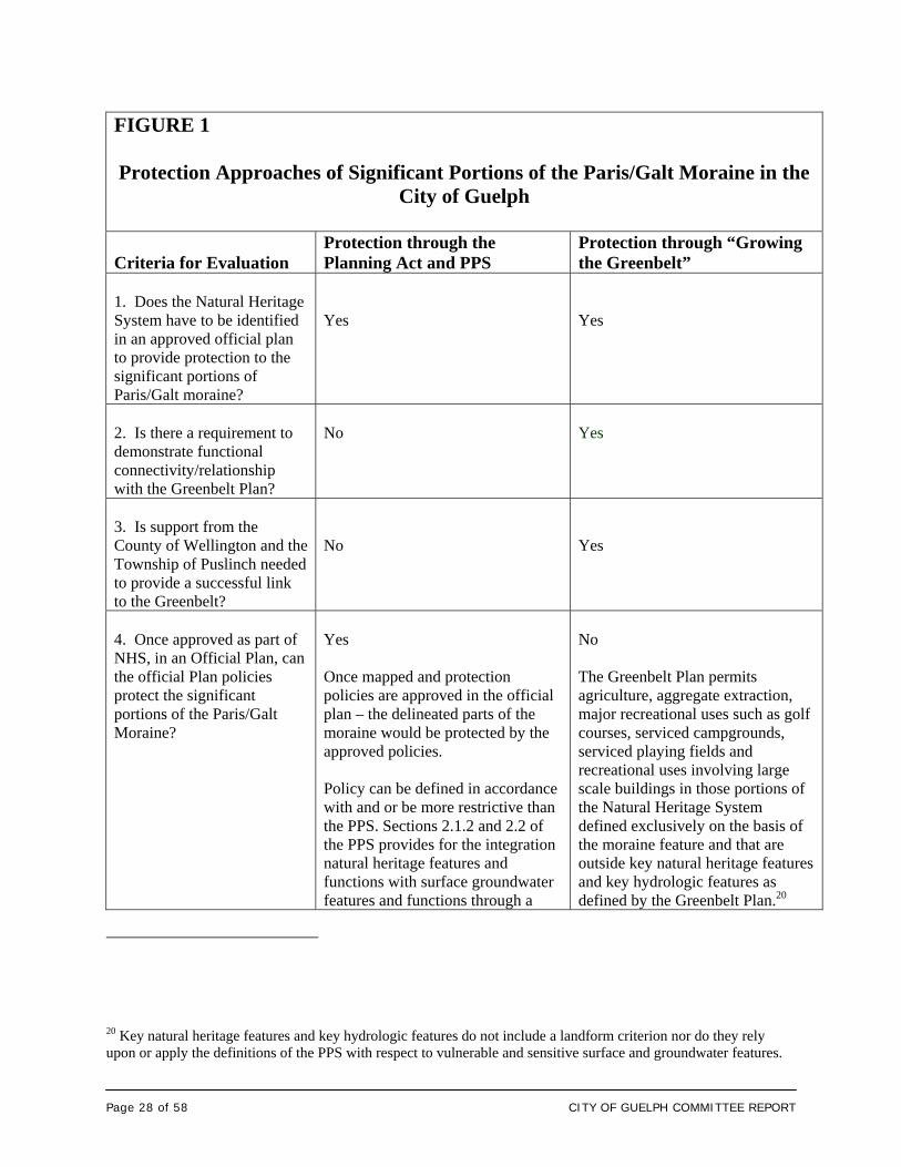
Page 28 of 58 CITY OF GUELPH COMMITTEE REPORT
FIGURE 1
Protection Approaches of Significant Portions of the Paris/Galt Moraine in the
City of Guelph
Criteria for Evaluation
Protection through the Planning Act and PPS
Protection through “Growing the Greenbelt”
1. Does the Natural Heritage System have to be identified in an approved official plan to provide protection to the significant portions of Paris/Galt moraine?
Yes
Yes
2. Is there a requirement to demonstrate functional connectivity/relationship with the Greenbelt Plan?
No
Yes
3. Is support from the County of Wellington and the Township of Puslinch needed to provide a successful link to the Greenbelt?
No
Yes
4. Once approved as part of NHS, in an Official Plan, can the official Plan policies protect the significant portions of the Paris/Galt Moraine?
Yes Once mapped and protection policies are approved in the official plan – the delineated parts of the moraine would be protected by the approved policies. Policy can be defined in accordance with and or be more restrictive than the PPS. Sections 2.1.2 and 2.2 of the PPS provides for the integration natural heritage features and functions with surface groundwater features and functions through a
No The Greenbelt Plan permits agriculture, aggregate extraction, major recreational uses such as golf courses, serviced campgrounds, serviced playing fields and recreational uses involving large scale buildings in those portions of the Natural Heritage System defined exclusively on the basis of the moraine feature and that are outside key natural heritage features and key hydrologic features as defined by the Greenbelt Plan.20
20 Key natural heritage features and key hydrologic features do not include a landform criterion nor do they rely upon or apply the definitions of the PPS with respect to vulnerable and sensitive surface and groundwater features.
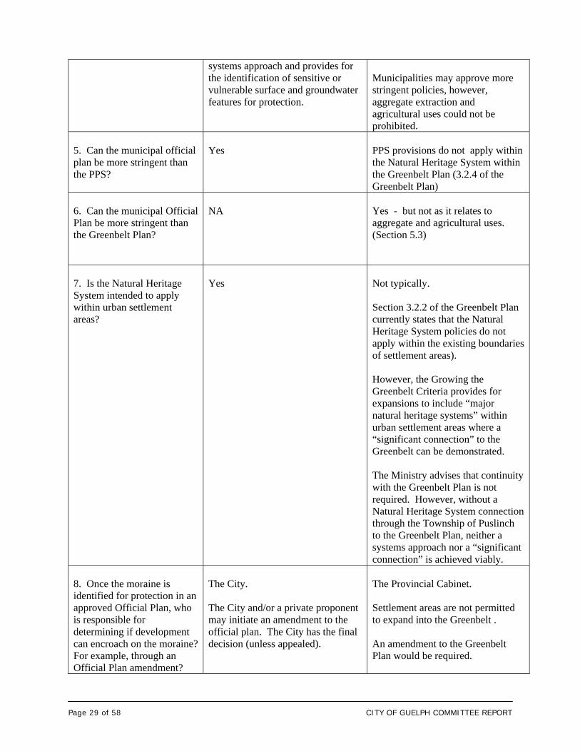
Page 29 of 58 CITY OF GUELPH COMMITTEE REPORT
systems approach and provides for the identification of sensitive or vulnerable surface and groundwater features for protection.
Municipalities may approve more stringent policies, however, aggregate extraction and agricultural uses could not be prohibited.
5. Can the municipal official plan be more stringent than the PPS?
Yes
PPS provisions do not apply within the Natural Heritage System within the Greenbelt Plan (3.2.4 of the Greenbelt Plan)
6. Can the municipal Official Plan be more stringent than the Greenbelt Plan?
NA
Yes - but not as it relates to aggregate and agricultural uses. (Section 5.3)
7. Is the Natural Heritage System intended to apply within urban settlement areas?
Yes
Not typically. Section 3.2.2 of the Greenbelt Plan currently states that the Natural Heritage System policies do not apply within the existing boundaries of settlement areas). However, the Growing the Greenbelt Criteria provides for expansions to include “major natural heritage systems” within urban settlement areas where a “significant connection” to the Greenbelt can be demonstrated. The Ministry advises that continuity with the Greenbelt Plan is not required. However, without a Natural Heritage System connection through the Township of Puslinch to the Greenbelt Plan, neither a systems approach nor a “significant connection” is achieved viably.
8. Once the moraine is identified for protection in an approved Official Plan, who is responsible for determining if development can encroach on the moraine? For example, through an Official Plan amendment?
The City. The City and/or a private proponent may initiate an amendment to the official plan. The City has the final decision (unless appealed).
The Provincial Cabinet. Settlement areas are not permitted to expand into the Greenbelt . An amendment to the Greenbelt Plan would be required.
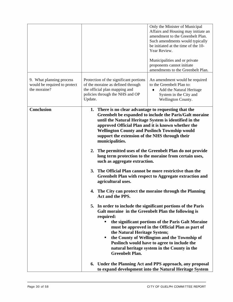
Page 30 of 58 CITY OF GUELPH COMMITTEE REPORT
Only the Minister of Municipal Affairs and Housing may initiate an amendment to the Greenbelt Plan. Such amendments would typically be initiated at the time of the 10- Year Review. Municipalities and or private proponents cannot initiate amendments to the Greenbelt Plan.
9. What planning process would be required to protect the moraine?
Protection of the significant portions of the moraine as defined through the official plan mapping and policies through the NHS and OP Update.
An amendment would be required to the Greenbelt Plan to: Add the Natural Heritage
System in the City and Wellington County.
Conclusion
1. There is no clear advantage to requesting that the Greenbelt be expanded to include the Paris/Galt moraine until the Natural Heritage System is identified in the approved Official Plan and it is known whether the Wellington County and Puslinch Township would support the extension of the NHS through their municipalities.
2. The permitted uses of the Greenbelt Plan do not provide
long term protection to the moraine from certain uses, such as aggregate extraction.
3. The Official Plan cannot be more restrictive than the
Greenbelt Plan with respect to Aggregate extraction and agricultural uses.
4. The City can protect the moraine through the Planning
Act and the PPS.
5. In order to include the significant portions of the Paris Galt moraine in the Greenbelt Plan the following is required: the significant portions of the Paris Galt Moraine
must be approved in the Official Plan as part of the Natural Heritage System;
the County of Wellington and the Township of Puslinch would have to agree to include the natural heritage system in the County in the Greenbelt Plan.
6. Under the Planning Act and PPS approach, any proposal
to expand development into the Natural Heritage System
Page 31 of 58 CITY OF GUELPH COMMITTEE REPORT
would require a Council approval through an Official Plan Amendment.
7. Under the Greenbelt Plan, any proposal to expand
development into the Natural Heritage System would require an amendment to the Greenbelt Plan. Such an amendment would first require Council support and justification before the Minister would initiate an amendment. Cabinet makes the final decision.
Under either approach, support from Council is required.
The advantage is that private proponents cannot initiate
an amendment. Only the Minister can initiate an amendment, and the Minister may agree or disagree with Council.
8. Staff recommend that Council not pursue Growing the
Greenbelt.
4.6 Conclusion Based upon the above analysis, it is recommended that the City not pursue the expansion of the Greenbelt Plan on significant portions of the Paris/Galt moraine within the City. Instead, the significant portions of the Paris/Galt moraine should be identified for protection through the Natural Heritage System and the Official Plan Update in accordance with the provisions of the Planning Act and the PPS. As concluded by the Ministry of the Environment, there is sufficient policy within existing legislation and the PPS to protect the moraine. The Clean Water Act will provide protection of municipal wells, but will not specifically address the moraine outside the identified zones of influence of municipal wells. 5. Transition Policies As indicated in the previous report, current applications being processed will be subject to the provisions of the Official Plan pertaining to natural heritage, the provisions of the Growth Plan and the PPS (2005), as applicable. New development applications will be evaluated against the revised Natural Heritage policies once
Page 32 of 58 CITY OF GUELPH COMMITTEE REPORT
approved by Council and incorporated into the City’s Official Plan. Transition policies will be developed for inclusion in the Official Plan Update. CORPORATE STRATEGIC PLAN Goal 6: A leader in conservation and resource protection/enhancement. Strategic Objective: A biodiverse City with the highest tree canopy percentage
among comparable municipalities. FINANCIAL IMPLICATIONS There is sufficient funding to complete Phase 2 and Phase 3. DEPARTMENTAL CONSULTATION Staff from Policy Planning and Urban Design led the Technical Advisory Committee. Other departments, including other sections of Community Deign and Development Services, Operations, Environmental Services and Economic Development have been consulted. COMMUNICATIONS Consultation with landowners, their representatives, the public, ministries, agencies, City staff, the Technical Steering Committee, the Environmental Advisory Committee and the River Systems Committee has been carried out throughout the finalization of Phase 2 as discussed above. Additional public engagement is proposed with respect to Phase 3 – final mapping and policy development in 2009 for incorporation into the Official Plan updated in the fall 2009. _________________________ _________________________ Prepared By: Recommended By: Marion Plaunt, MES, RPP, MCIP James N. Riddell Manager of Policy and Urban Design Director of Community Design and 519-837-5616 ext. 2426 Development Services [email protected] 519-837-5616 ext. 2361 [email protected] P:\Planning&DevelopmentServices\Planning\CDES REPORTS\2009\09-40 July 20, 2009 Phase 2 Natural Heritage Strategy CDES Final Report.doc
Page 33 of 58 CITY OF GUELPH COMMITTEE REPORT
List of Attachments
Attachment 1 Report 08-97 City of Guelph Natural Heritage Strategy (September 5, 2008) Attachment 2 Table Summarizing the Criteria used to Identify the
Recommended Natural Heritage System and Draft Policy Direction (March 2009)
Attachment 3 Summary of Comments Received in Response to the
Revised Criteria and Draft Policy Direction for Recommended Natural Heritage System(March 2009)
Attachment 4 Mayor Farbridge’s request to the Ministry of Municipal
Affairs Regarding expanding the Greenbelt to include the Paris/Galt Moraine
Attachment 5 Greenbelt Plan Amendment Process MAPS Map 1 Figure 12 Recommended Natural Heritage System – Natural Heritage
Strategy (Phase 2) March 2009 Map 2 Growing the Greenbelt – Subwatershed Analysis Map 3 Growing the Greenbelt - Natural Heritage System Analysis Map 3A Enlargement of Growing the Greenbelt Natural Heritage
System Analysis
Page 34 of 58 CITY OF GUELPH COMMITTEE REPORT
Attachment 1 City of Guelph Draft Natural Heritage Strategy Report Number 08-97 to Community Design and Environmental Services on September 5, 2008
TO Community Design and Environmental Services SERVICE AREA Community Design and Development Services DATE September 5th, 2008 SUBJECT City of Guelph Draft Natural Heritage Strategy REPORT NUMBER 08-97 __________________________________________________________________
RECOMMENDATION THAT the Community Design and Development Services Report 08-97 on the Draft Natural Heritage Strategy prepared by Dougan and Associates dated July 2008, BE RECEIVED and; THAT staff be directed to circulate the City of Guelph Draft Natural Heritage Strategy for public and stakeholder input in order to proceed with finalization of the Strategy. BACKGROUND The Natural Heritage Strategy consists of three phases aimed at building on Guelph’s natural heritage system in order to ensure its long-term protection and enhancement in accordance with the Provincial Policy Statement (2005) and Guelph’s long term vision. The three-phased Guelph Natural Heritage Strategy is intended to facilitate this process by:
updating the City’s natural heritage mapping and data (Phase 1 and 2); identifying what is locally significant based on current provincial guidelines,
status lists, and other available information (Phase 2); recommending a Natural Heritage System based on current information and
defensible criteria (Phase 2); and developing natural heritage policies that reflect the existing conditions in the
City and that are consistent with current Provincial policies.
Page 35 of 58 CITY OF GUELPH COMMITTEE REPORT
Phase 1: Background Work The preparation of a Citywide Natural Heritage Strategy was recommended by the City’s Environmental Action Plan which was supported by Council in 2003. A Technical Steering Committee was established to guide the development of the Strategy. The Steering Committee is composed of ten members from diverse backgrounds and expertise who are knowledgeable in ecology and natural heritage planning. Two representatives from the Guelph and Wellington Development Association (GWDA) sit on the Committee. Dougan and Associates were retained to prepare the Strategy. Phase 1 of the Strategy involved: the development of an understanding of the City’s existing natural heritage
resources and features, a review of other municipal approaches to natural heritage protection, the establishment of working criteria for the identification of locally significant
natural areas. Public input was obtained through: a community survey that was conducted by mail and on the City’s web site; a community forum that was held at the River Run Centre (65 people
attended); and a key stakeholder workshop that was held at the Evergreen Seniors Centre (25
people attended). Phase 1 culminated with the Phase 1 Report in March 2005, which recommended 8 working criteria for the identification of locally significant natural areas, and the recommendations for Phase 2. In March 2005 the revised Provincial Policy Statement also came in to effect which established refined natural heritage policies. Phase 2: Collection of Data and Analysis The specific objectives of Phase 2 were to: (1) update and collect ecological field data for the City’s terrestrial natural areas (i.e., areas outside the floodplains and wetlands) and (2) use the available background and collected field data to apply defensible criteria (initially developed during Phase 1 and refined during the course of this study) in order to develop a recommended Natural Heritage System (NHS) for the City. For the more poorly documented natural areas within the City some field verification was necessary. Landowner contact packages were distributed explaining the Strategy and requesting permission to access specific properties. After the collection of field data, a “working draft” of the Phase 2 report was submitted by Dougan and Associates to City staff.
Page 36 of 58 CITY OF GUELPH COMMITTEE REPORT
In September 2007 planning staff received and reviewed the working draft Phase 2 Report, which was then reviewed by the Technical Steering Committee in January 2008. The Technical Steering Committee, in particular the Guelph and Wellington Development Association (GWDA), raised concerns regarding the draft criteria and the possible effects the criteria would have on potential development. It also became apparent that there was a need to refine the criteria, to ensure the application of the criteria was traceable and update mapping due to the time that had passed since the initiation of the study. The City provided Dougan and Associates updated mapping and reports, including aerial photography (2006), recently completed Environmental Impact Studies and approved draft plans of subdivision. Updated information was also obtained from the Ministry of Natural Resources (e.g., provincially significant wetlands) and the Grand River Conservation Authority (e.g., other wetlands and floodplain mapping). In addition, additional field checks were required to finalize the Ecological Land Classification, address steep slopes and more accurately reflect the requirement “to be consistent” with the 2005 Provincial Policy Statement. REPORT The Revised Draft Natural Heritage Strategy (July2008) is intended to provide the technical background and basis to guide the protection and, where appropriate, enhancement of natural heritage features and areas through a systems approach within an urban and urbanizing context. The results of this work (and the subsequent Phase 3, which includes policy development) will be incorporated into the Official Plan Update which will occur over 2008 and 2009. Dougan and Associates have finalized the Revised Draft Natural Heritage Strategy Report including the establishment of revised recommended criteria which are attached (Attachment 1). The natural heritage system criteria have been applied in a manner that disaggregates each criterion in order to ensure a traceable and transparent process. The recommended criteria have been mapped and are illustrated on Attachment 2 - Recommended Natural Heritage System. The Recommended Natural Heritage System defines those natural heritage features and areas that warrant permanent protection in order to meet the applicable provisions of the Provincial Policy Statement and the City’s Strategic Plan. The revised criteria are explained in Attachment 1 and form the fundamental basis for the Natural Heritage System and are composed of the following: Primary Criteria (Only one primary criterion needs to apply to be part of the Natural Heritage System) 1. Areas of Natural & Scientific Interest [ANSI] 2. Habitat for Provincially Threatened (THR) & Endangered (END) Species 3. Areas of Primary Hydrological Significance 4. Significant Woodlands
Page 37 of 58 CITY OF GUELPH COMMITTEE REPORT
5. Significant Valleylands 6. Areas of Primary Significant Wildlife Habitat
Secondary Criteria (Two (2) secondary criteria need to apply in order to be included in the Natural Heritage System) 7. Areas of Secondary Hydrological Significance 8. Landform Conservation Value 9. Locally Significant Vegetation Types (Areas of Secondary Significant Wildlife
Habitat) 10. Habitat for Significant Species (Areas of Secondary Significant Wildlife
Habitat) Primary Criteria 11. Ecological Linkages & Supportive Functions
Ecological linkages and supportive functions implement Section 2.1.2 of the Provincial Policy Statement which requires:
The diversity and connectivity of natural features in an area, and the long-term ecological function and biodiversity of natural heritage systems, should be maintained, restored or, where possible, improved, recognizing linkages between and among natural heritage features and areas, surface water features and ground water features.
Ecological Linkages / Connectivity, is considered a primary criterion in that it is recognized as a critical component of a natural heritage system (in both policy and precedent) and is applied independently to connect the identified features and areas. It is listed last because it requires identification of other recommended NHS features prior to its application. In accordance with the PPS, proposed development adjacent to the natural heritage system and in particular the features identified in the PPS (e.g., Significant habitat of endangered and threatened species, significant woodlands, significant wetlands, significant valley lands, significant wildlife habitat and significant areas of natural and scientific interest) will be evaluated to ensure that there are no negative impacts on the natural features or their ecological functions. This analysis would be carried out at the site specific level through an Environmental Impact Assessment. On the ground, the proposed Natural Heritage System will consist of a network of natural areas and linkages throughout the City. The ultimate goal of the Natural Heritage Strategy is to contribute to a healthy and attractive City which will also contribute to broader efforts towards an environmentally and socially sustainable community. In August of this year the Revised Draft Natural Heritage Strategy was provided to the Community Design and Environmental Services Committee and City Council for review.
Page 38 of 58 CITY OF GUELPH COMMITTEE REPORT
At this time staff are recommending that the Committee direct staff to obtain public input and comment on the Draft Natural Heritage Strategy Phase 2 Report. If supported by Committee, open house meetings will be arranged with stakeholders (e.g. landowners and public agencies) and the public in late September and early October of this year. Following public and stakeholder input, the Draft Natural Heritage Phase 2 Report will be finalized and brought before City Council. Phase 3 will involve the development of natural heritage policies including addressing, among other things, the natural/urban interface on the adjacent lands to natural features and areas (e.g. wildlife impacts). The mapping and policy changes will be incorporated into the Official Plan Update and will be subject to public meetings, as required by the Planning Act. Any development application that has been submitted and is currently in process is subject to the existing policies of the City’s Official Plan, including the Natural Heritage policies now contained in the Official Plan. New development applications will not be evaluated against the revised Natural Heritage policies until they are approved by Council and adopted into the City’s Official Plan. CORPORATE STRATEGIC PLAN A leader in conservation and resource protection/enhancement FINANCIAL IMPLICATIONS There is sufficient funding to complete Phase II. DEPARTMENTAL CONSULTATION The Natural Heritage Technical Advisory Committee, other Departments, such as Engineering and Environmental Services has been consulted as necessary. COMMUNICATIONS Public consultation, landowner contact and the establishment of the Technical Steering Committee has been carried out during Phases I and II of the project as discussed above. Open house(s) are proposed in the fall with the public and stakeholders. ATTACHMENTS Attachment 1: Revised Criteria Attachment 2: Recommended Natural Heritage System – Map 12

Page 39 of 58 CITY OF GUELPH COMMITTEE REPORT
______________________ ______________________ Prepared By: Recommended By: Carrie Musselman Marion Plaunt Environmental Planner Manager of Policy Planning and Urban Design 519-837-5616 ext. 2356 519-837-5616 ext. 2426 [email protected] [email protected]
______________________ Recommended By: James N. Riddell Director of Community Design and Development Services 519-837-5616 ext. 2361 [email protected] T:\Planning\CD&ES REPORTS\2008\(08-97) City of Guelph Draft Natural Heritage Strategy Phase 2 Report.doc
Page 40 of 58 CITY OF GUELPH COMMITTEE REPORT
Attachment 1: Revised Criteria Primary Criteria Measure(s) Data Source & Comments 1. Areas of Natural & Scientific Interest [ANSI]
- Provincially Significant - Regionally Significant
ANSI mapping obtained from the Ontario Ministry of Natural Resources (OMNR).
2. Habitat for Provincially Threatened (THR) and Endangered (END) Species
- Species designated Endangered or Threatened in Ontario - Species designated Endangered in Canada
No Provincially Endangered or Threatened species currently on record for the City of Guelph. Historical records note the Grey Fox and Blanding’s Turtle being Threatened species.
3. Areas of Primary Hydrological Significance
- Provincially and Locally Significant Wetlands - Permanent Streams - Fish Habitat
Wetland mapping obtained from Ontario Ministry of Natural Resources (OMNR) and Grand River Conservation Authority (GRCA). At this time City-wide fish habitat data is unavailable.
4. Significant Woodlands
- Woodlands of at least 1 ha in size
Woodlands included coniferous, deciduous and mixed forests, cultural woodlands and treed wetlands. Hedgerows and plantations have been excluded.
5. Significant Valleylands
- Regulatory floodplain - Apparent and other valley lands
Floodplain and valley land mapping obtained from the Grand River Conservation Authority (GRCA). Only steep slopes associated with river corridors are captured as other valley lands.
6. Areas of Primary Significant Wildlife Habitat
- Deer wintering areas - Provincially Rare Vegetation - Endangered (END) or Threatened (THR) Species in Canada
Deer wintering areas mapping obtained from Ontario Ministry of Natural Resources (OMNR). Provincially Rare Vegetation information obtained from the Ontario Ministry of Natural Resources Natural Heritage Information Centre (NHIC). The Western Chorus Frog found in areas of Guelph has been listed as Threatened (THR) in Canada.
Secondary Criteria Measure(s) Data Source & Comments 7. Areas of Secondary Hydrological Significance
- Other wetlands (not captured as provincially or locally significant) - Intermittent streams
Wetlands mapping obtained from the Grand River Conservation Authority (GRCA). At this time City-wide Intermittent steam data is unavailable.
8. Landform Conservation Value
- Natural areas within the Paris-Galt Moraine with
“Natural areas” include all woodlands, wetlands and cultural /
Page 41 of 58 CITY OF GUELPH COMMITTEE REPORT
concentrations of natural slopes of at least 15%.
successional vegetation communities, as well as plantations.
9. Locally Significant Vegetation Types (Areas of Secondary Significant Wildlife Habitat)
- Any Ecological Land Classification (ELC) Ecosite Types considered locally rare or uncommon of at least 0.5 ha.
Identified based on information collected for this study or through other local studies. Mapped using Ecological Land Classification (ELC) Community Series mapping.
10. Habitat for Significant Species (Areas of Secondary Significant Wildlife Habitat)
- Waterfowl overwintering areas - Ecological Land Classification (ELC) areas containing Provincially Significant Species and/or Locally Significant Species.
Waterfowl overwintering areas mapping obtained from Ontario Ministry of Natural Resources (OMNR). Species data collected from Committee on the Status of Endangered Wildlife in Canada (COSEWIC), Committee on the Status of Species at Risk in Ontario (COSSARO), Ontario Ministry of Natural Resources (OMNR) Natural Heritage Information Centre (NHIC), Significant Plant list and Significant Wildlife list for Wellington County.
Primary Criterion* Measure(s)
Comments
11. Ecological Linkages & Supportive Functions
- Linkages between natural areas within the NHS of at least 50 m wide but ideally closer to 100m wide - Linkages between the NHS and forested areas just outside the City’s boundary of at least 50 m but ideally closer to 100m wide - Any undeveloped open space in the City providing connectivity between natural areas within the NHS - Confirmed deer and amphibian movement corridors
Using ELC mapping and wildlife field data completed for this study. The target ratio of width to
length for linkages of 1:2 Portions of linkages requiring
restoration to meet the target width (i.e., 100m) are identified and can include any natural areas (including plantations and hedgerows) or agricultural lands.
Previous Greenlands mapping, City open space and parks mapping, and linkages identified in subwatershed studies were considered
* Criterion 11 – Ecological Linkages / Connectivity, is considered a primary criterion in that it is recognized as a critical component of a natural heritage system (in both policy and precedent) and is applied independently, however it is listed last because it requires identification of other recommended NHS features prior to its application.
Page 42 of 58 CITY OF GUELPH COMMITTEE REPORT
Attachment 2: Recommended Natural Heritage System – Map
Page 43 of 58 CITY OF GUELPH COMMITTEE REPORT
Attachment 2 Table Summarizing the Criteria used to Identify the
Recommended Natural Heritage System and Draft Policy Direction (March 2009)
Table summarizing criteria categories and criteria used to identify the recommended Natural Heritage System (NHS) for the City of Guelph and associated draft natural heritage policies Categories Criteria + Minimum Buffers Draft Policies Direction
1. Areas of Natural & Scientific Interest (ANSI)
1(a) Provincially Significant Life Science ANSI + 20 m buffer*
1(b) Provincially Significant Earth Science ANSI + 10 m buffer
1(c) Regionally Significant Life Science ANSI + 20 m buffer*
1(d) Regionally Significant Earth Science ANSI (no buffer)
Development not permitted in any type of ANSI except for works related to: flood and erosion control, habitat conservation / restoration or passive recreation (e.g., trails and interpretive signs).
Development not permitted in buffers to ANSIs except for the uses listed above and low impact storm water management facilities provided no negative impacts are demonstrated through an approved Environmental Impact Study (EIS) or Environmental Assessment (EA).
2. Habitat for Provincially Threatened (THR) & Endangered (END) Species
2(a) Habitat for species provincially designated END or THR in Ontario’s Endangered Species Act + buffers TBD
Development not permitted in habitat for THR and END species.
Extent of habitat required and associated buffers to be determined on a case by case basis in consultation with OMNR and Recovery Team (if applicable) and subject to an approved EIS or EA.
3. Significant Wetlands
3(a) Provincially Significant Wetlands (PSW) + 30 m buffer
3(b) Locally Significant Wetlands (LSW) + 15 m buffer
3(c) Other wetlands in closed depressions + 15 m buffer
3(d) Other wetlands not in closed depressions + buffer TBD
Development not permitted in any type of wetlands except for category 3(d) where those wetlands are determined not to provide significant wetland functions and subject to approval by the GRCA in accordance with their policies.
Development not permitted in buffers to wetlands except for works related to: flood and erosion control, habitat conservation / restoration, and passive recreation (e.g., tertiary trails) as supported through an approved EIS or EA.
Proposed development outside the minimum buffer area but within 120 m of a PSW and 30 m of all other wetlands may be permitted provided no negative impacts are demonstrated through an approved EIS or EA, and subject to approval from GRCA.
The status and boundaries of “other wetlands” in category 3(d) needs to be field verified.
4. Surface Water & Fisheries Resources
4(a) Permanent streams / ponds + 15 m buffer
4(b) Intermittent streams +15 m buffer
FISH HABITAT
4(c) Cold Water + 30 m buffer
4(d) Cool Water + 30 m buffer
Development not permitted in any type of stream or fish habitat except for works related to: flood and erosion control, habitat conservation / restoration, or other works permitted by the GRCA and/or the Department of Fisheries and Oceans (DFO) provided no negative impacts are demonstrated through an approved EIS or EA and subject to approval from GRCA and/or DFO.
Development not permitted in buffers to streams or fish habitat except for works related to: flood and erosion control, habitat
Page 44 of 58 CITY OF GUELPH COMMITTEE REPORT
Categories Criteria + Minimum Buffers Draft Policies Direction
4. Surface Water & Fisheries Resources cont’d
4(e) Warm Water + 15 m buffer
4(f) Undetermined + 15 m buffer
conservation / restoration, passive restoration (e.g., trails) or low impact storm water management facilities provided no negative impacts are demonstrated through an approved EIS or EA and subject to approval from GRCA and/or DFO.
Infrastructure should avoid surface water and fisheries resources, however, provision for essential infrastructure, including roads, trails and/or linear utilities may cross a stream and/or fish habitat provided no negative impacts are demonstrated through an approved EIS or EA and subject to approval from GRCA and/or DFO.
Opportunities to restore piped or culvertized streams to a more natural form to be pursued.
Proposed development within 50 m of a stream or fish habitat is subject to an EIS or EA and subject to approval from GRCA and/or DFO.
Fish habitat classifications need to be field verified.
5. Significant Woodlands
5(a) Woodlands ≥1 ha + 10 m buffer
5(b) Locally Significant Woodland Types ≥0.5 ha (not already captured by 5a) + 10 m buffer
5(c) Cultural Woodlands ≥1 ha + buffer TBD
5(a) & (b) Development not permitted in woodlands except for works related to: flood and erosion control, wildlife habitat conservation / restoration. Trails are to be directed to woodland buffers and may only be permitted within the woodlands if no negative impacts are demonstrated through an approved EIS or EA.
Development not permitted in buffers to woodlands except for works related to: flood and erosion control, habitat conservation / restoration, passive recreation (e.g., trails) or low impact storm water management facilities provided no negative impacts are demonstrated through an approved EIS or EA.
Development within 50 m of a woodland may be permitted provided no negative impacts are demonstrated through an approved EIS or EA.
5(c) Development may be permitted in cultural woodlands (and plantations) subject to an approved EIS or EA and associated tree preservation plan that identifies any opportunities for protection of healthy native species and tree planting.
6. Significant Valleylands
6(a) Regulatory floodplain
6(b) Other Valleys
Development within regulatory floodplains and other and remnant significant valleys is not permitted except for works related to: flood and erosion control, habitat conservation / restoration, passive recreation (e.g., trails), essential infrastructure, linear utilities and low impact storm water management facilities provided no negative impacts are demonstrated through an approved EIS or EA and subject to approval from GRCA.
In all instances, stormwater management facilities are required to be above the meander belt, or the 100 year flood plain, whichever is greater.
Development within buffers may be permitted provided no negative impacts are demonstrated through an approved EIS or EA and, where applicable, approval from GRCA.
Page 45 of 58 CITY OF GUELPH COMMITTEE REPORT
Categories Criteria + Minimum Buffers Draft Policies Direction
7. Significant Landform
7(a) Significant Portions of the Paris‐Galt Moraine (no buffer)
Development not permitted in significant portions of the Paris‐Galt Moraine, as identified, except for works related to: habitat conservation / restoration, required municipal water supply wells, essential linear utilities and passive recreation (e.g., trails) provided no negative impacts are demonstrated through an approved EIS or EA.
Approved works will not involve grading to these areas.
Opportunities to restore habitats to be encouraged.
8. Significant Wildlife Habitat**
8(a) Deer wintering areas (no buffer)
8(b) Waterfowl overwintering areas (no buffer)
8(c) Provincially Significant Vegetation Types*+ buffers TBD
8(d) Locally Significant Vegetation Types ≥0.5 ha (not already captured by Criteria 3 or 5) + buffers TBD
8(e) Habitat for Globally, Nationally and Provincially Significant Species (not captured by Criterion 2)
8(f) Habitat for Locally Significant Species (not captured by Criteria 2 or 8(e))
8(g) Ecological Linkages (no buffer)
8(a), (b), (c), (d) Development is not permitted in these areas, as identified, except for works related to: flood and erosion control, wildlife habitat conservation / restoration, passive recreation (e.g., tertiary trails and interpretive signs) provided no negative impacts are demonstrated through an approved EIS or EA.
8(e) & (f) Extent of habitat required and associated buffers to be determined on a case by case basis subject to an approved EIS or EA.
8(f) Extent of habitat required and associated buffers to be determined on a case by case basis subject to an approved EIS or EA.
8(g) Development not permitted in ecological linkages except for works related to: wildlife habitat conservation / restoration, essential transportation, linear utilities, passive recreation (e.g., trails) and limited low impact storm water management facilities provided no negative impacts are demonstrated through an approved EIS or EA.
Linkages surrounded by natural features identified by Criteria 1‐7 will be subject to the applicable policies of the surrounding feature.
9. Supportive Ecological Functions
9(a) Naturalization / Restoration Areas (potential, planned and existing)
Lands closely associated with the NHS where naturalization / restoration is being or should be applied primarily on City of GRCA lands. Storm water management facilities (existing and planned) are included. Guidelines and policy direction to be developed with the Parks and Engineering Departments.
Naturalization/ restoration areas surrounded by natural features identified by Criteria 1‐7 will be subject to the applicable policies of the surrounding feature.
10. Wildlife Crossings
10 (a) Confirmed deer crossings
10 (b) Confirmed amphibian crossings
10 (c) Other wildlife crossing opportunities
These flag approximate locations where mitigation measures (e.g., underpasses) to facilitate safe wildlife crossing should be implemented during road improvements or upgrades. Some measures (e.g., warning signs) may be implemented sooner.
Guidelines and policy direction to be developed in consultation with the Engineering Department.
* There are currently no areas in the City of Guelph meeting this criterion.
Page 46 of 58 CITY OF GUELPH COMMITTEE REPORT
** This is not a comprehensive list of significant wildlife habitat (SWH) criteria, but a list of criteria for which data was available at the time of the study. A complete list of all SWH criteria potentially applicable in the City of Guelph that should be considered at the site‐specific level is provided in the study report (Volume 1).
MAPPING NOTE: Every effort has been made to ensure the mapping for this study is based on the most current available data. However, mapping for a number of natural heritage features and/or ecological functions still needs to be verified and refined in the field at the site‐specific scale.
DEFINITIONS
MINIMUM BUFFERS identify minimum vegetation protection zones around significant features in the NHS. Buffers may include any natural areas (including cultural meadows or thickets), plantations, hedgerows, agricultural lands, City parklands or GRCA lands identified for open space uses, and current golf courses. Buffers could not be applied, in whole or in part, in some areas that have already undergone development. However, for areas to be developed, site‐specific studies may find that in some cases these minimums are not adequate and that wider buffers need to be identified.
CULTURAL WOODLANDS are lands that have reforested naturally with tree cover between 35% and 60% and naturalized groundcover.
DEVELOPMENT is defined in Provincial Policy (2005) as “the creation of a new lot, a change in land use, or the construction of buildings and structures, requiring approval under the Planning Act”.
ECOLOGICAL LINKAGES are meant to facilitate movement of flora and fauna between various significant natural areas and must be identified in relation to these other areas. Ideally, linkages should be at least 50 m wide but closer to 100 m where possible with a target width to length ratio of 1:2. However, depending on the adjacent land uses and existing opportunities, narrower and longer linkages have been (and could be) identified.
ENVIRONMENTAL ASSESSMENTS (EAs) are studies typically required for all medium or large governmental infrastructure projects to ensure that all environmental issues are identified and addressed, and that the public and other stakeholders have an opportunity to provide comment.
ENVIRONMENTAL IMPACT STUDIES (EIS) are site‐specific studies triggered by proposed development within or adjacent to significant natural heritage features which provide a comprehensive assessment of existing conditions and assess the anticipated impacts of the proposed development on natural features within the study area or their ecological functions.
ESSENTIAL INFRASTUCTURE means that which is considered by Council to be necessary and in the public interest after all reasonable alternatives have been considered.
GRCA = Grand River Conservation Authority
PARIS‐GALT MORAINE is a large 6.4 to 8 km wide feature consisting of a complex of hummocky topography and kettle features of which a portion extends across the southern portion of the City of Guelph. Lands with this unique topography contribute disproportionately to local groundwater recharge, which also supports cold water fisheries and recharges deeper aquifers used for water supply.
RESTORATION / NATURALIZATION AREAS are areas that contribute to the biodiversity and connectivity potential of the Natural Heritage System where restoration and naturalization activities will be focused. These include lands owned by the City of Guelph or the Grand River Conservation Authority, existing and approved storm water management areas, and small areas surrounded by lands that meet Criteria 1 through 7.
Page 47 of 58 CITY OF GUELPH COMMITTEE REPORT
Attachment 3 Summary of Comments Received in Response to the
Revised Criteria and Draft Policy Direction (March 2009)
The following is a brief summary of the comments received categorized on the basis of the criteria.
1. Areas of Natural and Scientific Interest (ANSI)
The minimum buffer of 10 m to Earth and Life Science ANSI’s should be increased.
All buffers should be based on detailed study. Trails should not be permitted in the buffers. The policy should “mirror” the PPS provisions.
Staff Comment A minimum buffer of 10m to the provincially significant Earth Science ANSI is appropriate given that the ANSI is based on an exposed rock cut that exhibits representative stratigraphy and is publicly owned. No buffers are proposed to the regionally significant Earth Science ANSI because it is within the road allowance of the built up area and it would not be reasonable to prohibit development. Trails are proposed to be permitted within the buffers, however, the location and type of trails will be considered through development applications and Park and Trail Master Plans.
2. Habitat for Provincially Threatened and Endangered Species
Policy should address a mechanism to permit the policy and or species to change to reflect changes to threatened and endangered species and or policy.
How will the City be monitoring for protection of threatened and endangered species?
Unfair to expect private property owners to pay for (EIS) studies on their properties.
Staff Comment Policies will be developed to address Species at Risk, including threatened and endangered species. No monitoring is proposed at this time except through subsequent EIS and EIR’s.
Page 48 of 58 CITY OF GUELPH COMMITTEE REPORT
It is accepted policy to require landowners to pay for studies required to support planning applications.
3. Significant Wetlands
Existing wetlands should be reevaluated. Minimum buffers to significant wetlands should be increased to 50 m
from 30 m. Dredged wetlands on golf courses should be restored. Stormwater facilities should not be permitted adjacent to provincially
significant wetlands.
Staff Comment At the time of development, proponents will be required to undertake an evaluation of identified wetland and determine the extent of the wetland and the functions it performs along with the appropriate buffer requirement. The 30 m buffer to the wetland is a minimum buffer. The buffer may be increased within the 120 m adjacent lands analysis carried out through the required EIS. The final extent of the buffer will depend upon the function of the wetland. The 30 m buffer is a reasonable starting point for protection and represents a credible minimum reflected in other municipal official plans that have received approval. Restoration of altered natural environments will be addressed through policy. Storm water management facilities within the buffer to a provincially significant wetland is currently not proposed.
4. Surface Water and Fisheries Resources
Buffers should be measured from the flood fringe. Stormwater management facilities should not be permitted to flow
directly into stream and wetlands. Stormwater management ponds should not be permitted in the
buffers. Stormwater management ponds should be permitted within the
buffers. Support for restoring piped or buried streams to a more natural form.
Staff Comments The issues raised will be considered through the policy analysis. The appropriateness of storm water management facilities within the 30-15 m buffers will be carefully reevaluated.
Page 49 of 58 CITY OF GUELPH COMMITTEE REPORT
The naturalization of existing streams is encouraged by the current Official Plan and will be addressed.
5. Significant Woodlands
The definition of cultural woodlands should be reevaluated. The replacement policy applicable to cultural woodlands should be
clarified with respect to how European Buckthorn, a noxious shrub, should be treated.
European Buckthorn should not be included in significant woodlands. The replacement of trees removed from the cultural woodlots at a ratio
of 1:3 should be reconsidered to address replacement on the basis of basal area.
Smaller woodlands and plantations should be included in this criterion. Minimum buffers should be increased to 30 m from 10m.
Staff Comments The policy treatment provides flexibility where cultural woodlands are dominated by invasive species. The tree replacement policy will be evaluated where invasive species dominate cultural woodlands. The evaluation of buffers within the 50 m adjacent lands will be required and may be increased depending on the function of the woodland.
6. Significant Valleylands Excellent criteria
Staff Comment No additional comment at this time. 7. Significant Landform
Entire Paris-Galt moraine should be protected including buffers in order to protect groundwater recharge.
The landform criterion should be removed from the Natural Heritage System.
Significant landforms that do not contain other significant ecological features and functions (i.e., also meet other criteria) should be considered for development provided hydrogeological and other related studies demonstrate through an approved EIS/EA that recharge function can be maintained.
The protected ands should be based on 15% slopes instead of 20%.
Page 50 of 58 CITY OF GUELPH COMMITTEE REPORT
The area needs to be clearly defined as “no touch”. Development should not be prohibited on the basis of hummocky
topography. Site specific hydrological investigations should be required to assess the potential for maintaining groundwater recharge rates at a watershed scale through EIS. Development scale water budgets, which are quantified at the watershed scale should be used to design stormwater management techniques to maintain average rates of groundwater recharge, groundwater levels, groundwater low, and groundwater discharge to surface water features.
Staff Comments The identification of the significant portions of the Paris /Galt Moraine addresses Sections 2.1.2 and 2.2 of the Provincial Policy Statement and is not solely based upon the hydrological function. Instead, it aims to recognize the linkages between and among the natural heritage features and the surface and groundwater features while maintaining the diversity and aesthetic offered by the landform. The landform criteria also provides an approach to address Council and Committee direction regarding protection of significant portions of the Paris /Galt moraine through the Natural Heritage Strategy and/or through Growing the Greenbelt. Staff is concerned that site specific consideration of the hydrological function alone will not be sufficient to protect the moraine and will result in long term erosion of the feature and its functions. The comments received will be considered through further discussions prior to the development and incorporation of the Natural Heritage System and polices into the Official Plan.
8. Significant Wildlife Habitat
A minimum buffer should be applied. Linkages do not need to be 100m wide. Wildlife tunnels and diversion fences should be required at all
identified wildlife crossing areas. Effective wildlife crossings are necessary. Locally significant wildlife habitat should not be used to sterilize
land. Staff Comment Buffers to significant wildlife habitat will depend on the wildlife present. A site specific EIS will be required to demonstrate no negative impacts on the identified wildlife habitat.
Page 51 of 58 CITY OF GUELPH COMMITTEE REPORT
Wildlife crossing and appropriate mitigation to maintain wildlife habitat (e.g., critical linkages between, food, shelter, feeding, breeding) as well as driver safety will be addressed through policy development. The identification of locally significant wildlife habitat does not sterilize the lands. The extent of the habitat and habitat protection for locally significant species will be the subject of site specific EIS’s and will be determined on a case by case basis.
9. Supportive Ecological Functions (Restoration/Naturalization Areas)
Goal should be towards 30% wooded cover within the City. Ecological linkages should be included as naturalization/restoration
areas with full protection and buffer zones. Identified drainage features that could be restored from
culverted/artificial to a natural state should be identified in addition to land to be restore.
Restoration targets for a variety of habitat cover should be established i.e., 10% forested, 10% grassland, 10% wetland, etc.
Staff Comment Comments will be addressed through subsequent policy development. Restoration policy and direction will be developed through the official Plan update.
10. Wildlife Crossing
Wildlife corridors across major arterial roads (e.g. Gordon St. should be minimized.
Ensure that “turtles” and reptiles are included. Provision for safe wildlife crossings and Gordon Street and the hanlon
should be provided. Backyard encroachment into corridors/crossings should be monitored
e.g., garbage disposal, damage to trees, wildlife entrapment due to conflict between humans and animals.
Deer crossing on, Gordon, south of Clair Road should be marked further north-west between Brock Rd. Nursery and Prior’s Farm.
Staff Comments The official plan will address policy and where applicable the need for detailed guidelines to address Wildlife habitat including the wildlife crossing provisions. EIS are required to address impacts were wildlife cross roads. Appropriate road/highway crossings policies will be addressed to reduce wildlife impacts and driver safety.
Page 52 of 58 CITY OF GUELPH COMMITTEE REPORT
Human wildlife conflicts will need to be the subject of an education program aimed at reducing the real and perceived conflicts. General Comments
1. The Natural Heritage Strategy stresses the importance of Natural Areas to
the City of Guelph but makes no provision for property tax reductions or tax credit for landowners that provide those essential natural areas for the benefit of all taxpayers in the City of Guelph.
2. The Natural Heritage System should be removed where it affects an identified future road and development.
3. Groundwater criteria are absent; this is inconsistent with overall general policies to protect the Paris/Galt Moraine for groundwater.
4. City should acquire the lands in the Natural Heritage System to protect them. 5. Don’t just do the minimum – enrich and enhance the existing NHS by making
the larger buffers to allow for further habitat protection. 6. There needs to be policy to speak to restoration including incentives. 7. Need tree protection by-law to regulate removal of trees to ensure a tree
canopy that will increase the linkage of the NHS across the older urban area. 8. The Conservation Land Tax Credit should be applied within the City on all
lands declared “natural heritage” not just provincially significant wetlands. 9. There is a need for transition policies to address how existing applications will
be considered and request that they be exempt from the proposed NHS designation and policies.
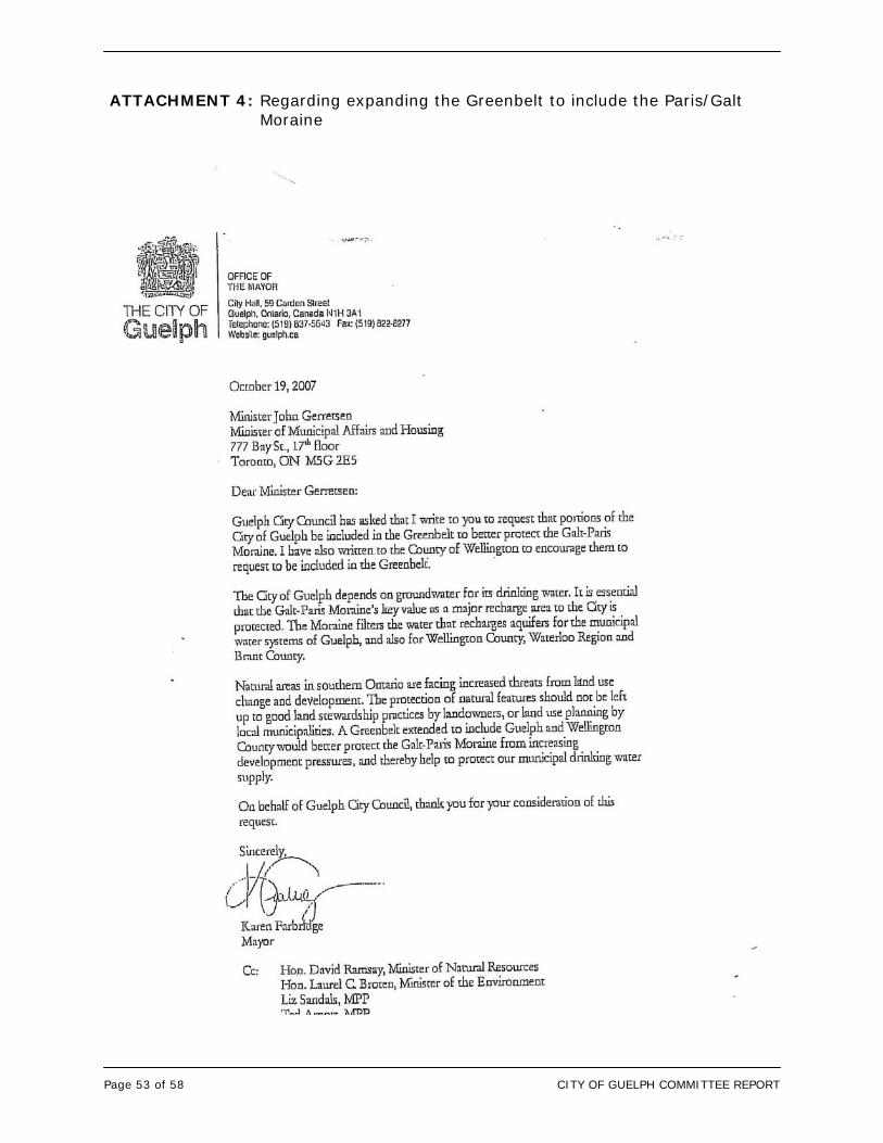
Page 53 of 58 CITY OF GUELPH COMMITTEE REPORT
ATTACHMENT 4: Regarding expanding the Greenbelt to include the Paris/Galt Moraine
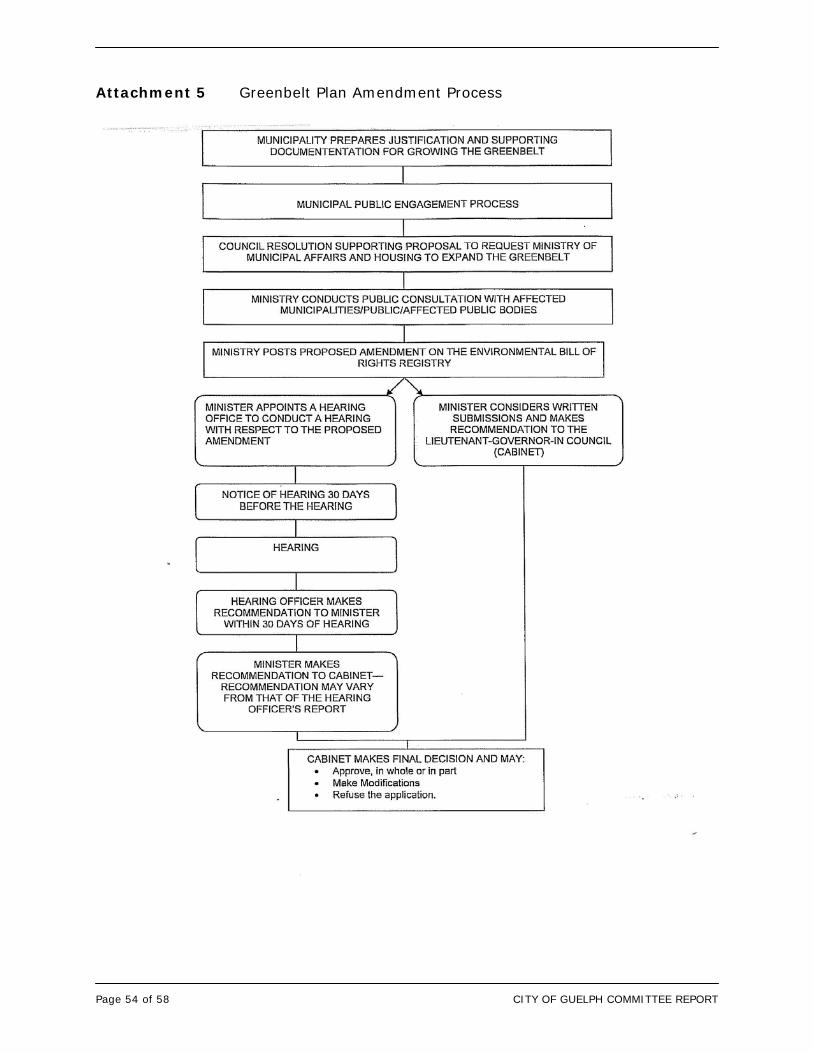
Page 54 of 58 CITY OF GUELPH COMMITTEE REPORT
Attachment 5 Greenbelt Plan Amendment Process
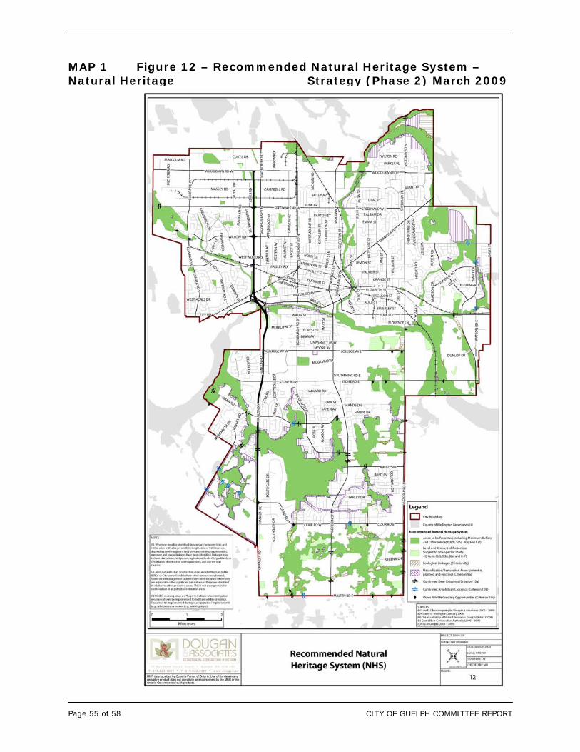
Page 55 of 58 CITY OF GUELPH COMMITTEE REPORT
MAP 1 Figure 12 – Recommended Natural Heritage System – Natural Heritage Strategy (Phase 2) March 2009
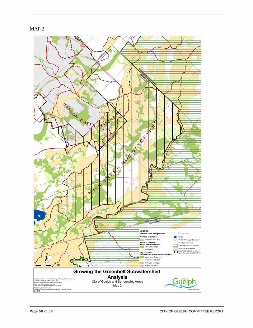
Page 56 of 58 CITY OF GUELPH COMMITTEE REPORT
MAP 2
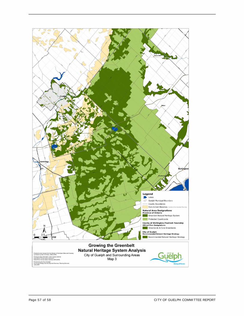
Page 57 of 58 CITY OF GUELPH COMMITTEE REPORT
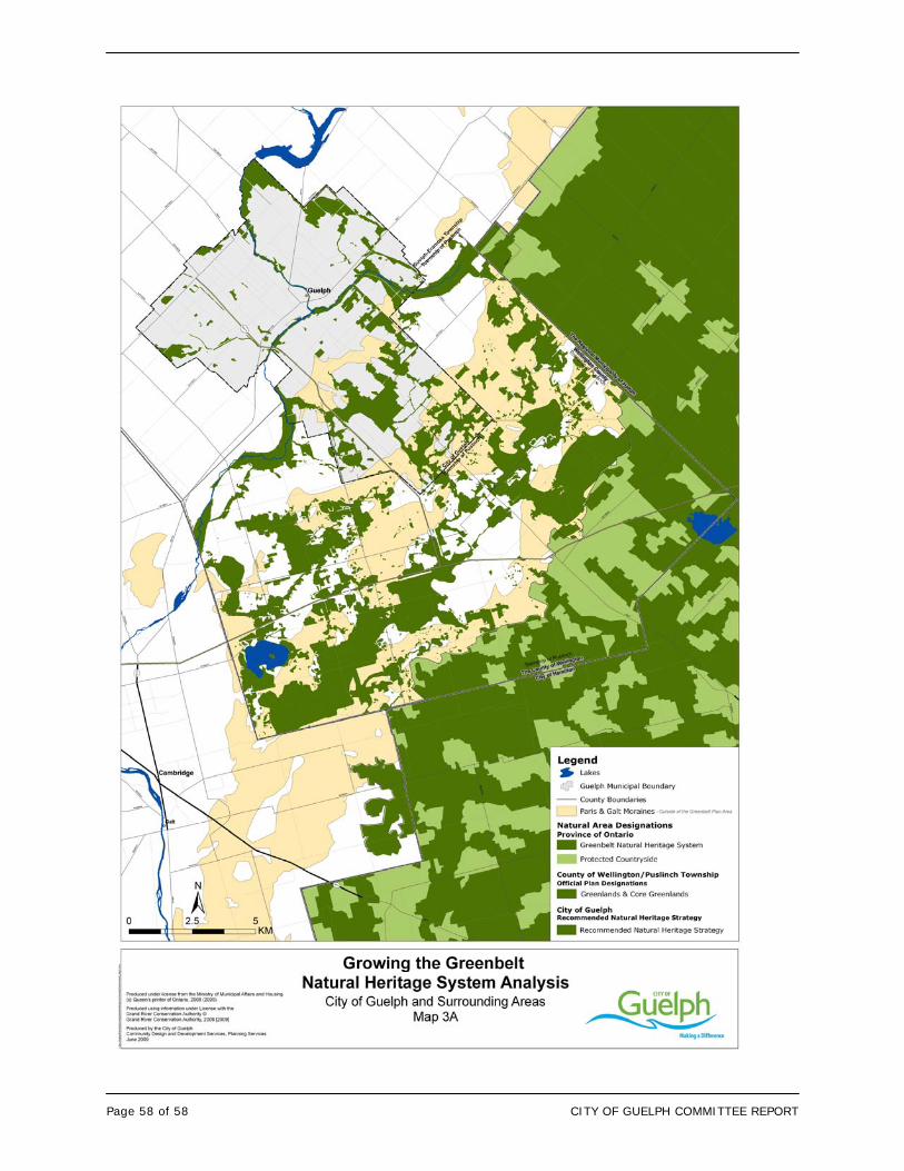
Page 58 of 58 CITY OF GUELPH COMMITTEE REPORT
1
Natural Heritage Strategy
Community Development and Environmental Services Committee
July 20, 2009
2
Natural Heritage Strategy
Purpose of the Report
• Recommend that the Council direct staff to apply the criteria developed through the Natural Heritage Strategy as the basis for identifying the Natural Heritage System and policies to be incorporated into the Official Plan Update
• Update the Council on the results of the EBR Review regarding the adequacy of existing legislation and policy to protect the Paris/Galt Moraine
• Recommend that Council direct staff to address protection of the significant portions of the Paris/Galt moraine through the NHS and the OP Update
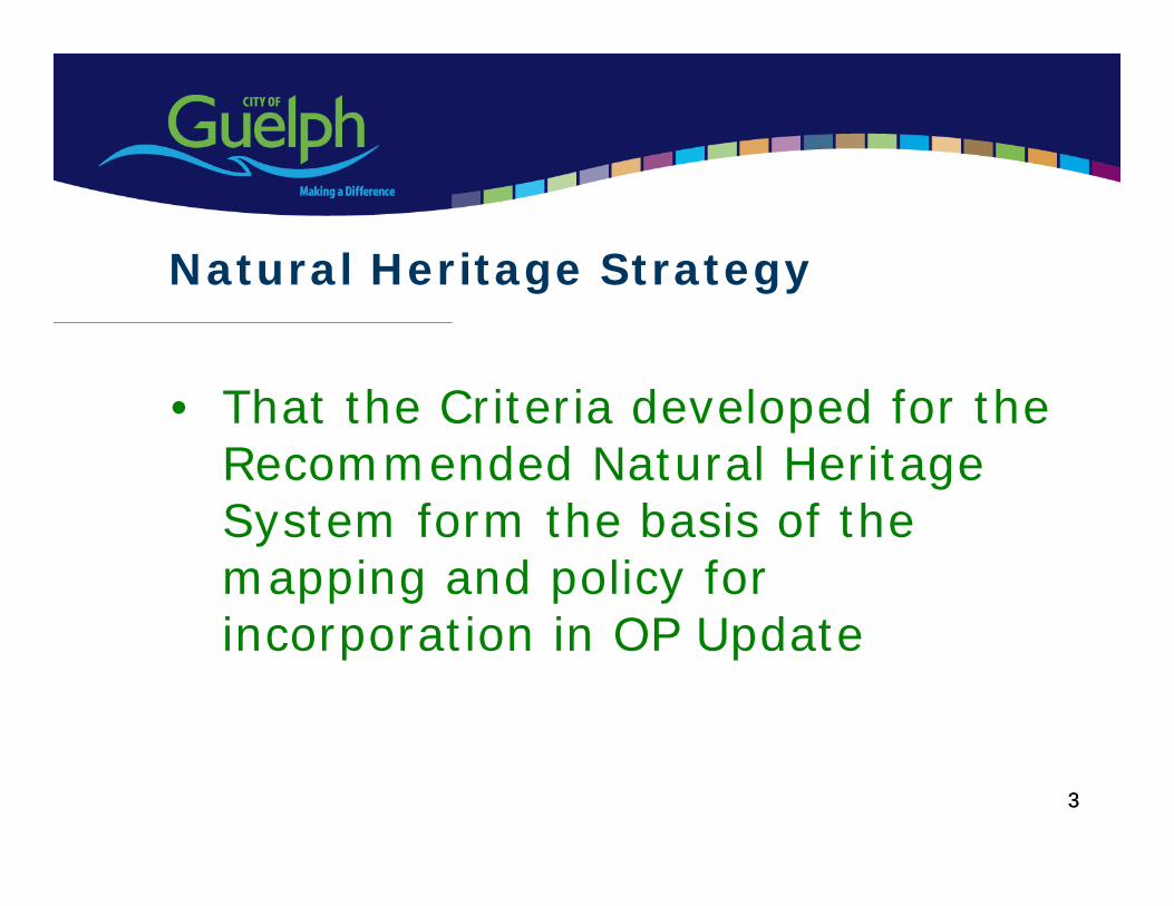
3
• That the Criteria developed for the Recommended Natural Heritage System form the basis of the mapping and policy for incorporation in OP Update
Natural Heritage Strategy
3
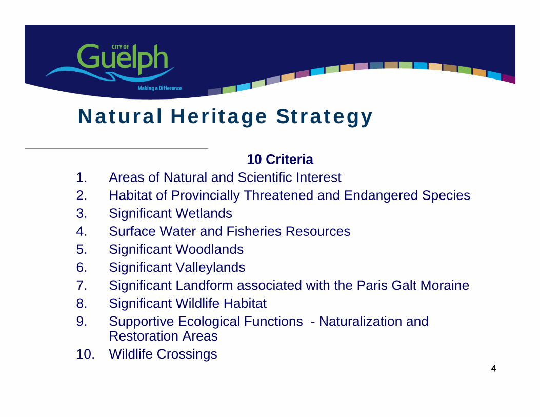
4
10 Criteria 1. Areas of Natural and Scientific Interest2. Habitat of Provincially Threatened and Endangered Species3. Significant Wetlands4. Surface Water and Fisheries Resources5. Significant Woodlands6. Significant Valleylands7. Significant Landform associated with the Paris Galt Moraine 8. Significant Wildlife Habitat9. Supportive Ecological Functions - Naturalization and
Restoration Areas10. Wildlife Crossings
Natural Heritage Strategy
4
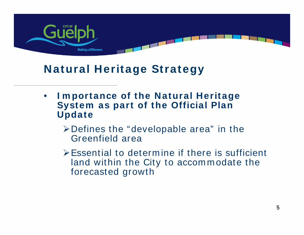
5
• Importance of the Natural Heritage System as part of the Official Plan Update
Defines the “developable area” in the Greenfield area
Essential to determine if there is sufficient land within the City to accommodate the forecasted growth
Natural Heritage Strategy
5
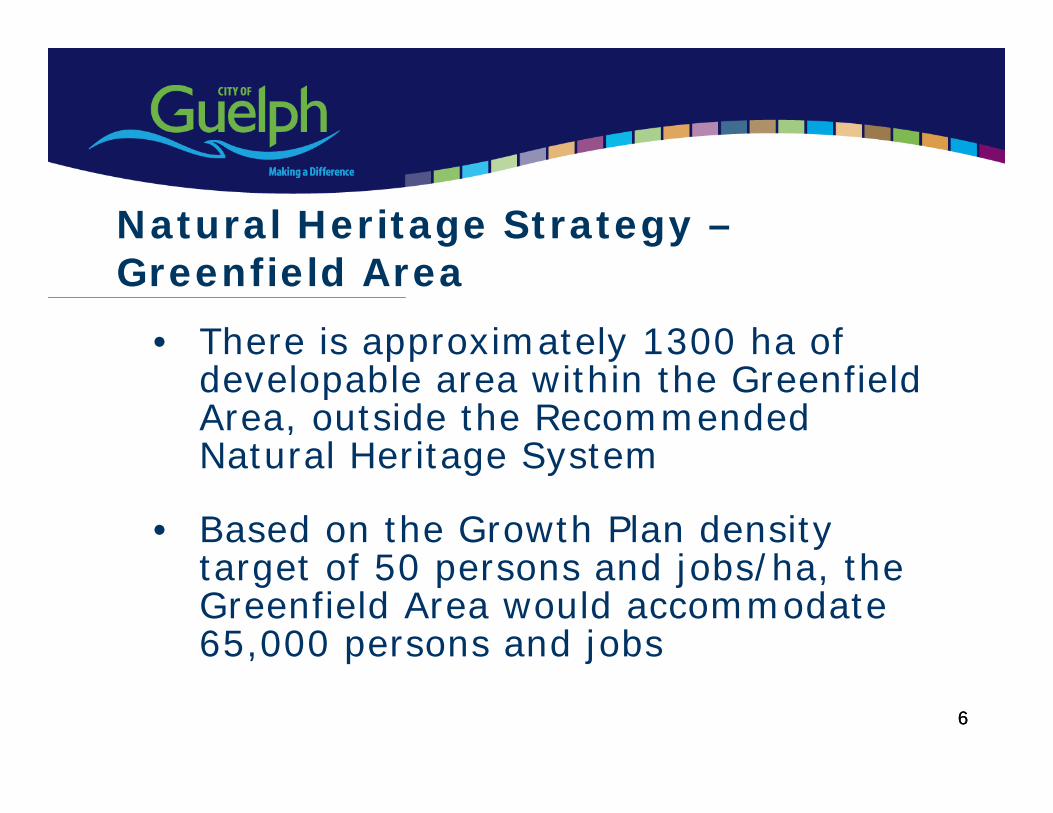
6
• There is approximately 1300 ha of developable area within the Greenfield Area, outside the Recommended Natural Heritage System
• Based on the Growth Plan density target of 50 persons and jobs/ha, the Greenfield Area would accommodate 65,000 persons and jobs
Natural Heritage Strategy –Greenfield Area
6
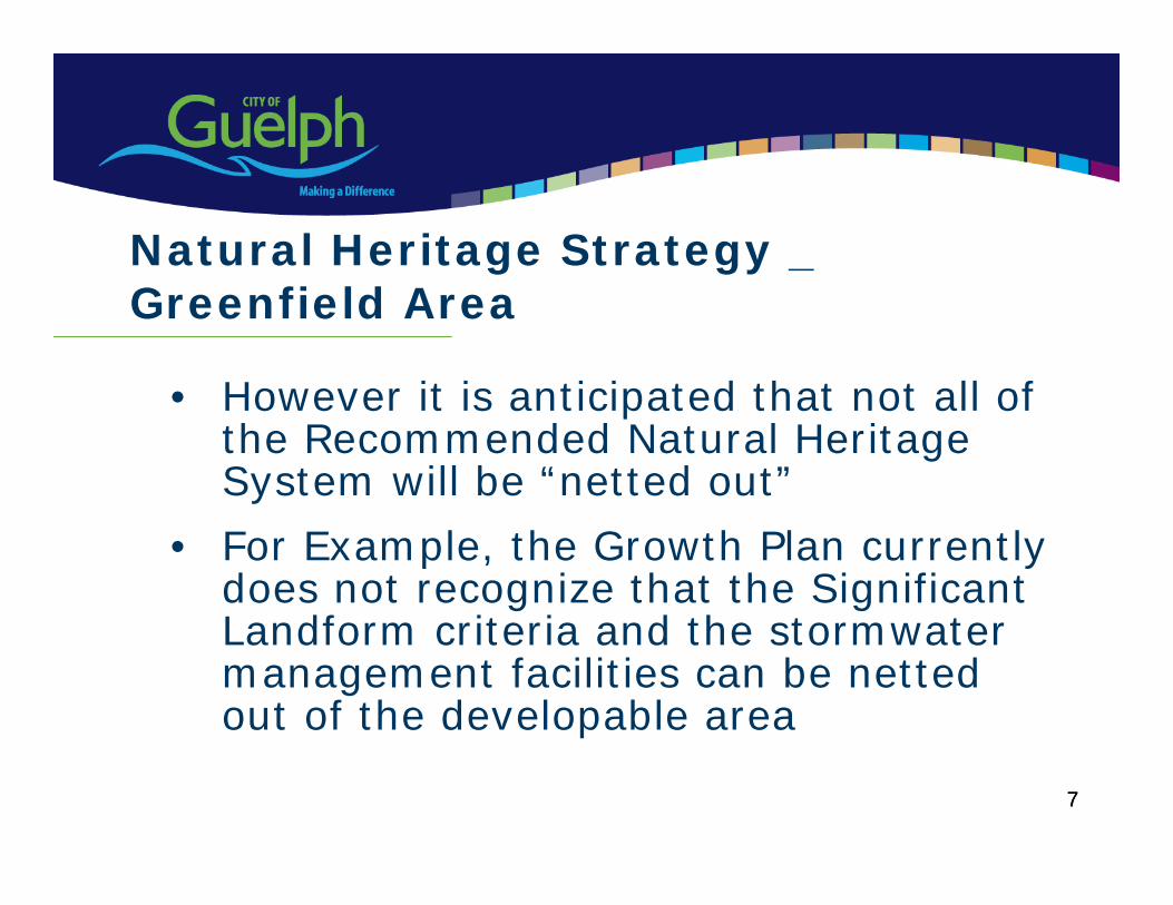
7
• However it is anticipated that not all of the Recommended Natural Heritage System will be “netted out”
• For Example, the Growth Plan currently does not recognize that the Significant Landform criteria and the stormwatermanagement facilities can be netted out of the developable area
7
Natural Heritage Strategy _ Greenfield Area

8
• It is anticipated that The Developable Area may be closer to 1500 ha
• At 50 persons and jobs per ha, approximately 75,000 persons and jobs would need to be accommodated in the Greenfield Area in order to meet the Growth Plan density target
Natural Heritage Strategy –Greenfield Area
8
9
• At either 65,000 or 75,000 persons and jobs within the Greenfield Area, there is more than sufficient land to accommodate the projected 54,000 additional population and 32,400 new jobs within the City boundaries
• E.g., the Built–up area of the City has been estimated to accommodate 18,500 new units or 37,000 - 46,250 persons (@2.0 -2.5 ppu)
Natural Heritage Strategy –Greenfield Area
9
10
Environmental Bill Of Rights Review
• Summer 2007 - City of Guelph and Ms Sandals, MPP requested a review to determine if there was adequate protection through provincial policy and legislation to protect the Paris/Galt moraine
• May 4 2009 MOE Review concluded:“new provincial policy or legislation is not required to protect the functions of the Paris and Galt moraines”
11
Environmental Bill of Rights Review –MOE Conclusions
• There is adequate protection of the groundwater recharge in the Upper Grand River Watershed and other watersheds located along the Paris and Galt moraines through:
Provincial Policy Statement Clean Water Act, 2006 the Greenbelt Plan, and policies for protection of water quality and quantity such as the Ontario Water Resources Act
12
Further concluded that:1.The Planning Act, and the PPS provide clear policy
direction to municipalities through the preparation of official plans to plan future land uses, including restricting where development and site alteration may occur.
2.“The policies of the PPS are designed to …recognize linkages between and among natural heritage features and areas, surface water features and groundwater features…”
Environmental Bill of Rights Review MOE Conclusions
13
Environmental Bill of Rights Review
MOE ConclusionsConclusions cont’d:
3. “The water policies require the identification of surface and groundwater features and hydrologic functions necessary for the ecological and hydrological integrity of the watershed.
These features include recharge, discharge, and storage areas. Vulnerable and sensitive ground and surface water features. Their functions shall be protected, improved or restored through restrictions on development and site alteration.”Sections 2.1.2 (Natural Heritage) and Sections 2.2 (Water) of the PPS.
14
Natural Heritage System – Significant Landform of Paris Galt Moraine
• The identification of the Significant Landform associated with the Paris/Galt moraine as part of the Natural Heritage System relies upon these same sections of the PPS (Sections 2.2.1(Natural Heritage) and 2.2(Water))
15
Growing the Greenbelt
• On October 10, 2008, (CDES) resolution:
“That the matter of “Growing the Greenbelt” be referred to staff for consideration in the development of the Local Growth Management Strategy and the Natural Heritage Strategy.”
16
Growing the Greenbelt – 6 Criteria
1. Demonstrate a functional relationship with Greenbelt Plan2. Request must come through a Municipal Council resolution3. Embraces Purpose of Greenbelt Plan4. Demonstrate functional relationship with the Greenbelt
systems (Natural Heritage System, Water Resources System or Agricultural System)
5. Complements and does not impede the Growth Plan targets or the goals of the Greenbelt Plan
6. Demonstrate that the expansion will not undermine implementation of complimentary provincial initiatives -Source Protection Plans under Clean Water Act.
17
Growing the Greenbelt
Recommendation:That staff be directed to address the protection of significant portions of the Paris/Galt Moraine through the Natural Heritage System and policies to be incorporated into the Official Plan Update
18
Two approaches considered:
• Water Resource System• Natural Heritage System
Growing the Greenbelt
19
Growing the Greenbelt
Water Resources System Approach• In order to reflect the “provincial scale approach” applied to the
Greenbelt Plan, a Subwatershed analysis would include the Hanlon Creek and Mill Creek subwatersheds
• Would require support from Wellington County and PuslinchTownship
• Would include large portion of the City south of Clair Road in the Greenbelt “Protected Countryside” designation – Urban Development would not permitted
• Would conflict with Growth Plan and the City’s ability to meet the population and employment targets
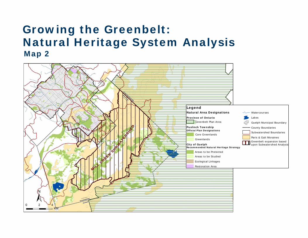
City of GuelphRecommended Natural Heritage Strategy
Restoration Area
Areas to be Studied
Areas to be Protected
Ecological Linkages
Legend
Puslinch TownshipOfficial Plan Designations
Core Greenlands
Greenlands
Natural Area Designations
Province of Ontario
Greenbelt Plan Area
County Boundaries
Lakes
Watercourses
Subwatershed Boundaries
Guelph Municipal Boundary
Paris & Galt Moraines
Greenbelt expansion based upon Subwatershed Analysis
Growing the Greenbelt:Natural Heritage System AnalysisMap 2
21
Growing the Greenbelt
Natural Heritage System Approach
• The Natural Heritage System must first be approved as part of the Official Plan Update
• Support of Wellington County and PuslinchTownship would be required to demonstrate “a significant connection to the Greenbelt area”
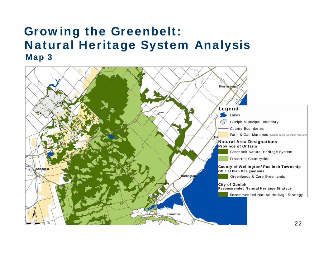
22
Growing the Greenbelt:Natural Heritage System AnalysisMap 3
Legend
Natural Area Designations
City of GuelphRecommended Natural Heritage Strategy
Recommended Natural Heritage Strategy
County Boundaries
Lakes
Guelph Municipal Boundary
Province of OntarioGreenbelt Natural Heritage System
Protected Countryside
Paris & Galt Moraines - Outside of the Greenbelt Plan Area
County of Wellington/Puslinch TownshipOfficial Plan Designations
Greenlands & Core Greenlands
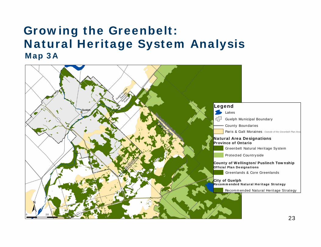
23
Growing the Greenbelt:Natural Heritage System AnalysisMap 3A
Legend
Natural Area Designations
City of GuelphRecommended Natural Heritage Strategy
Recommended Natural Heritage Strategy
County Boundaries
Lakes
Guelph Municipal Boundary
Province of OntarioGreenbelt Natural Heritage System
Protected Countryside
Paris & Galt Moraines - Outside of the Greenbelt Plan Area
County of Wellington/Puslinch TownshipOfficial Plan Designations
Greenlands & Core Greenlands
24
Growing the Greenbelt
Natural Heritage System Approach - Cont’d
• MMAH advised that connectivity to the Greenbelt Plan was not necessary
• To expand the Greenbelt Plan in Guelph without the connectivity of the Natural Heritage System through the Township of Puslinch, to the Greenbelt, contradicts the intent of a systems approach.
25
Growing the Greenbelt
Natural Heritage System Approach - Cont’d• Lands are required to be designated “Protected
Countryside” in the Greenbelt Plan
• The NHS within the Protected Countryside designation in the Greenbelt Plan would not provide long term protection to the moraine from certain uses, such as aggregate extraction or agriculture
• The Official Plan cannot be more restrictive than the Greenbelt Plan with respect to aggregate extraction and agricultural uses
26
Growing the Greenbelt
Natural Heritage System Approach - Cont’d
• Under the Official Plan approach through the Planning Act and PPS, development could not expand into the NHS without Council approval through an Official Plan Amendment
27
Growing the Greenbelt
Natural Heritage System Approach - Cont’d• Under the Greenbelt Plan, development could not expand
into the Natural Heritage System without an amendment to the Greenbelt Plan
• Only the Minister can initiate an amendment to the Greenbelt Plan
• The Minister requires Council support and justification before initiating an amendment (initiation is at the Minister’s discretion)
• Cabinet makes the final decision
28
Growing the Greenbelt
Natural Heritage System Approach - Cont’d• Under either approach, support from Council is
required
• The only apparent advantage is that private proponents cannot initiate an amendment
• Staff recommend that Council not pursue Growing the Greenbelt
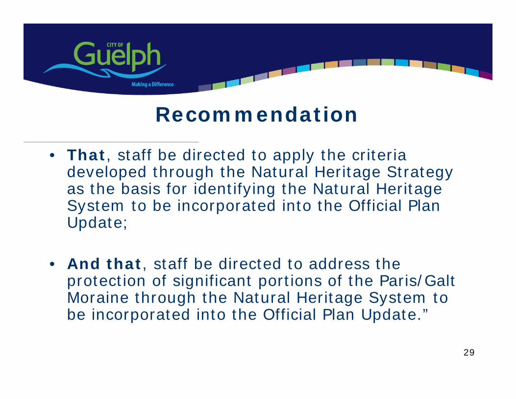
29
Recommendation
• That, staff be directed to apply the criteria developed through the Natural Heritage Strategy as the basis for identifying the Natural Heritage System to be incorporated into the Official Plan Update;
• And that, staff be directed to address the protection of significant portions of the Paris/Galt Moraine through the Natural Heritage System to be incorporated into the Official Plan Update.”

30
Questions?
Phase 2: Terrestrial Inventory & Natural Heritage System (NHS)
FINAL REPORT & RECOMMENDATIONS
Presentation toCommittee to Community Design and Environmental Services (CDES)
July 20, 2009
NATURAL HERITAGE STRATEGY
Presentation Outline
1. Study Phasing & Goals
2. Study Rationale
3. Phase 2 Overview & Phase 3 Status
4. Key Findings: Existing Conditions
5. Overview of Comments & Key Revisions
6. Approach for NHS Identification
7. Recommended Criteria & Draft Policies
application in mapping
associated draft policies
8. Recommended Natural Heritage System (NHS)
9. Concluding Remarks & Key Recommendations
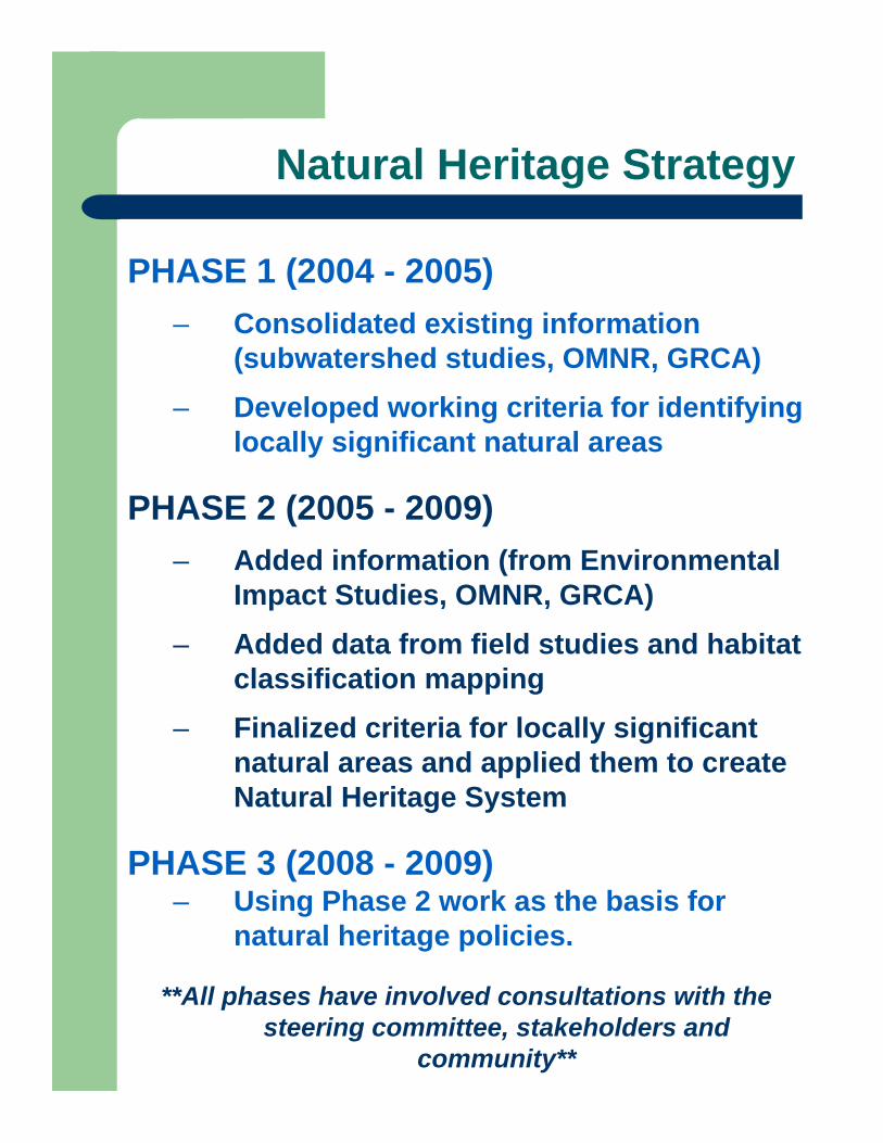
Natural Heritage Strategy
PHASE 1 (2004 - 2005)– Consolidated existing information
(subwatershed studies, OMNR, GRCA)– Developed working criteria for identifying
locally significant natural areas
PHASE 2 (2005 - 2009)– Added information (from Environmental
Impact Studies, OMNR, GRCA)– Added data from field studies and habitat
classification mapping– Finalized criteria for locally significant
natural areas and applied them to create Natural Heritage System
PHASE 3 (2008 - 2009)– Using Phase 2 work as the basis for
natural heritage policies.
**All phases have involved consultations with the steering committee, stakeholders and
community**
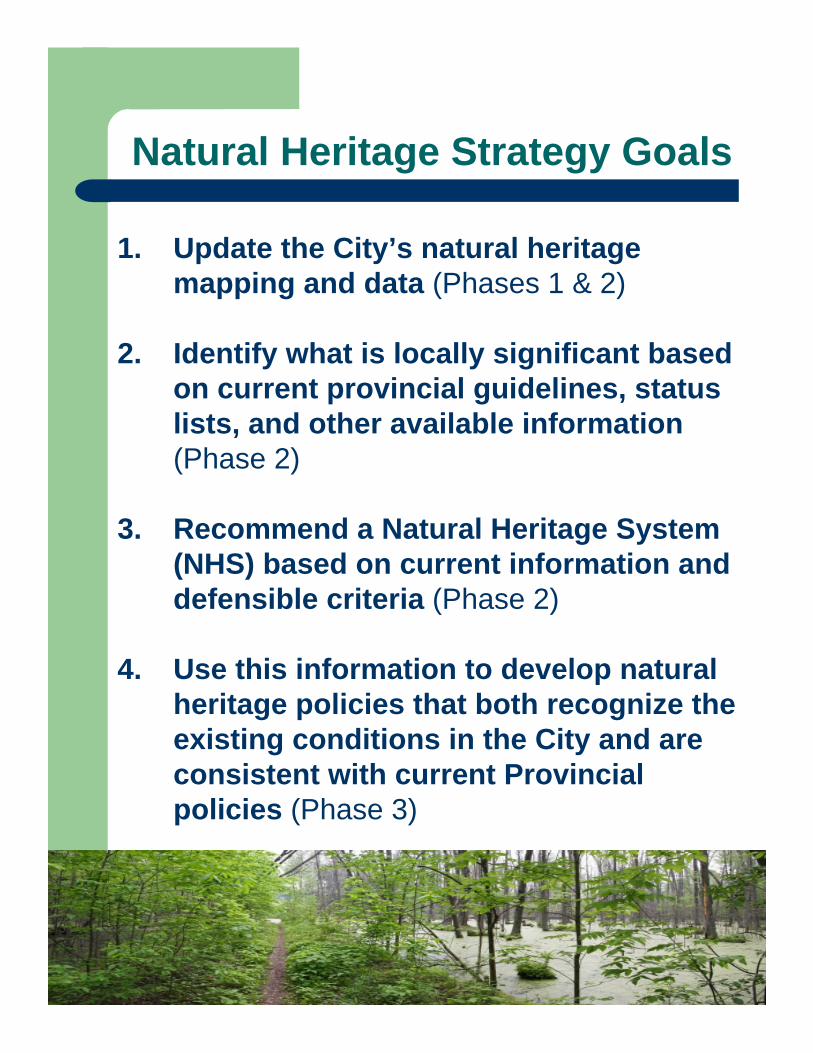
Natural Heritage Strategy Goals
1. Update the City’s natural heritage mapping and data (Phases 1 & 2)
2. Identify what is locally significant based on current provincial guidelines, status lists, and other available information (Phase 2)
3. Recommend a Natural Heritage System (NHS) based on current information and defensible criteria (Phase 2)
4. Use this information to develop natural heritage policies that both recognize the existing conditions in the City and are consistent with current Provincial policies (Phase 3)
Study Rationale
1. Provincial Policy & Legislation– Provincial Policy Statement (2005)– Species at Risk Act for Ontario (2007)
2. Regional & Local Policies– Growth Plan for the Greater Golden
Horseshoe (2006)– City’s current Official Plan (1994, 2006)– Environmental Action Plan (2003)– City’s Strategic Plan (2006)
Goal 6: “A leader in conservation and resource protection / enhancement ”
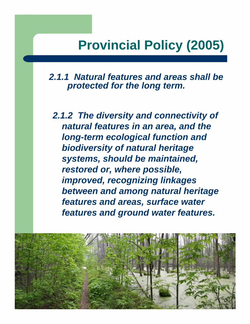
Provincial Policy (2005)
2.1.1 Natural features and areas shall be protected for the long term.
2.1.2 The diversity and connectivity of natural features in an area, and the long-term ecological function and biodiversity of natural heritage systems, should be maintained, restored or, where possible, improved, recognizing linkages between and among natural heritage features and areas, surface water features and ground water features.
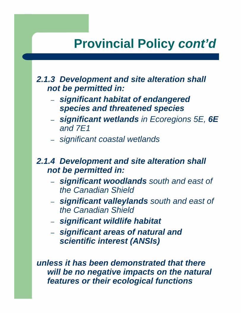
2.1.3 Development and site alteration shall not be permitted in:
– significant habitat of endangered species and threatened species
– significant wetlands in Ecoregions 5E, 6E and 7E1
– significant coastal wetlands
2.1.4 Development and site alteration shall not be permitted in:
– significant woodlands south and east of the Canadian Shield
– significant valleylands south and east of the Canadian Shield
– significant wildlife habitat– significant areas of natural and
scientific interest (ANSIs)
unless it has been demonstrated that there will be no negative impacts on the natural features or their ecological functions
Provincial Policy cont’d
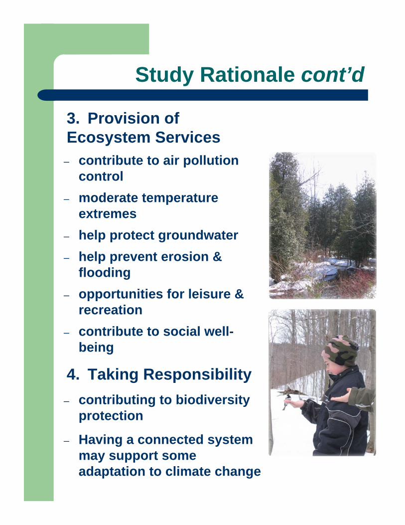
3. Provision of Ecosystem Services
– contribute to air pollution control
– moderate temperature extremes
– help protect groundwater– help prevent erosion &
flooding– opportunities for leisure &
recreation– contribute to social well-
being
4. Taking Responsibility– contributing to biodiversity
protection
– Having a connected system may support some adaptation to climate change
Study Rationale cont’d
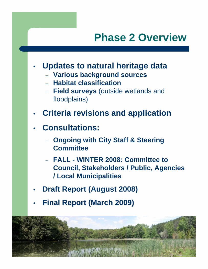
• Updates to natural heritage data – Various background sources– Habitat classification – Field surveys (outside wetlands and
floodplains)
• Criteria revisions and application
• Consultations:– Ongoing with City Staff & Steering
Committee– FALL - WINTER 2008: Committee to
Council, Stakeholders / Public, Agencies / Local Municipalities
• Draft Report (August 2008)
•• Final Report (March 2009)Final Report (March 2009)
Phase 2 Overview
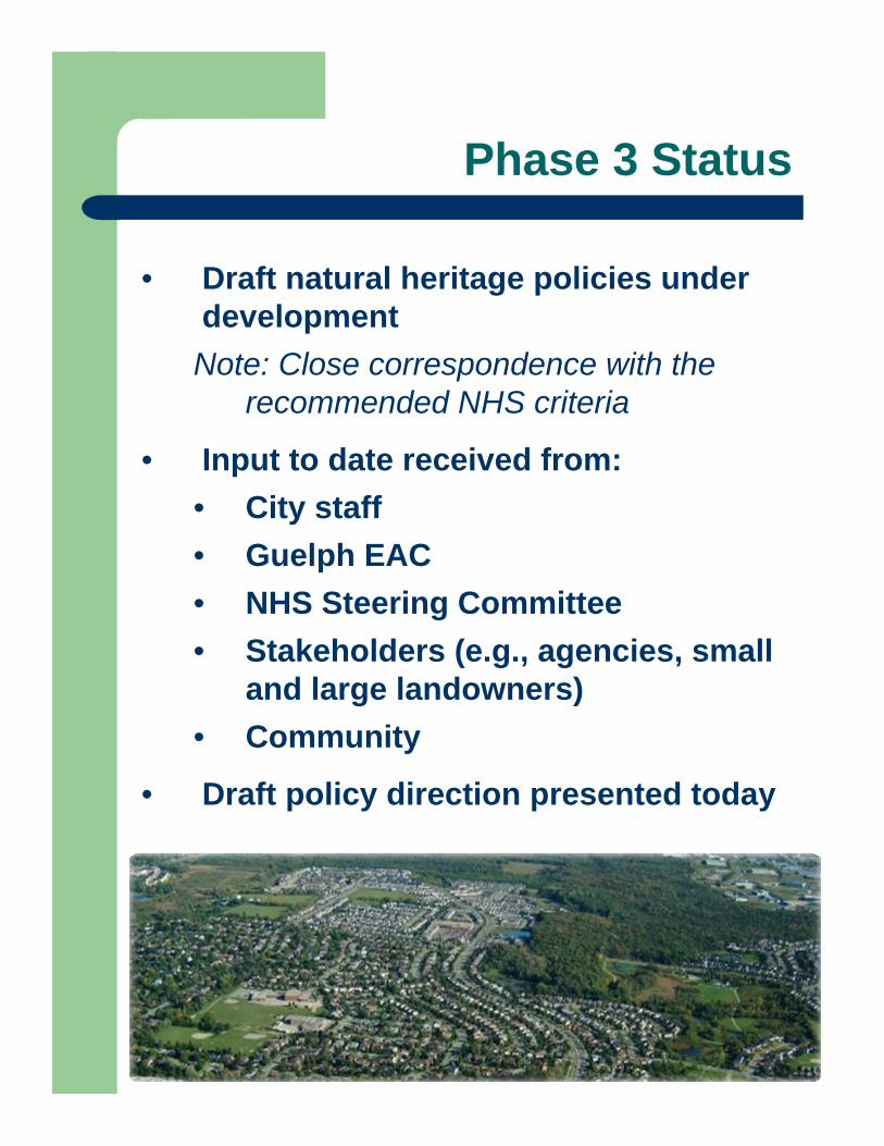
• Draft natural heritage policies under developmentNote: Close correspondence with the
recommended NHS criteria
• Input to date received from:• City staff• Guelph EAC• NHS Steering Committee• Stakeholders (e.g., agencies, small
and large landowners)• Community
• Draft policy direction presented today
Phase 3 Status
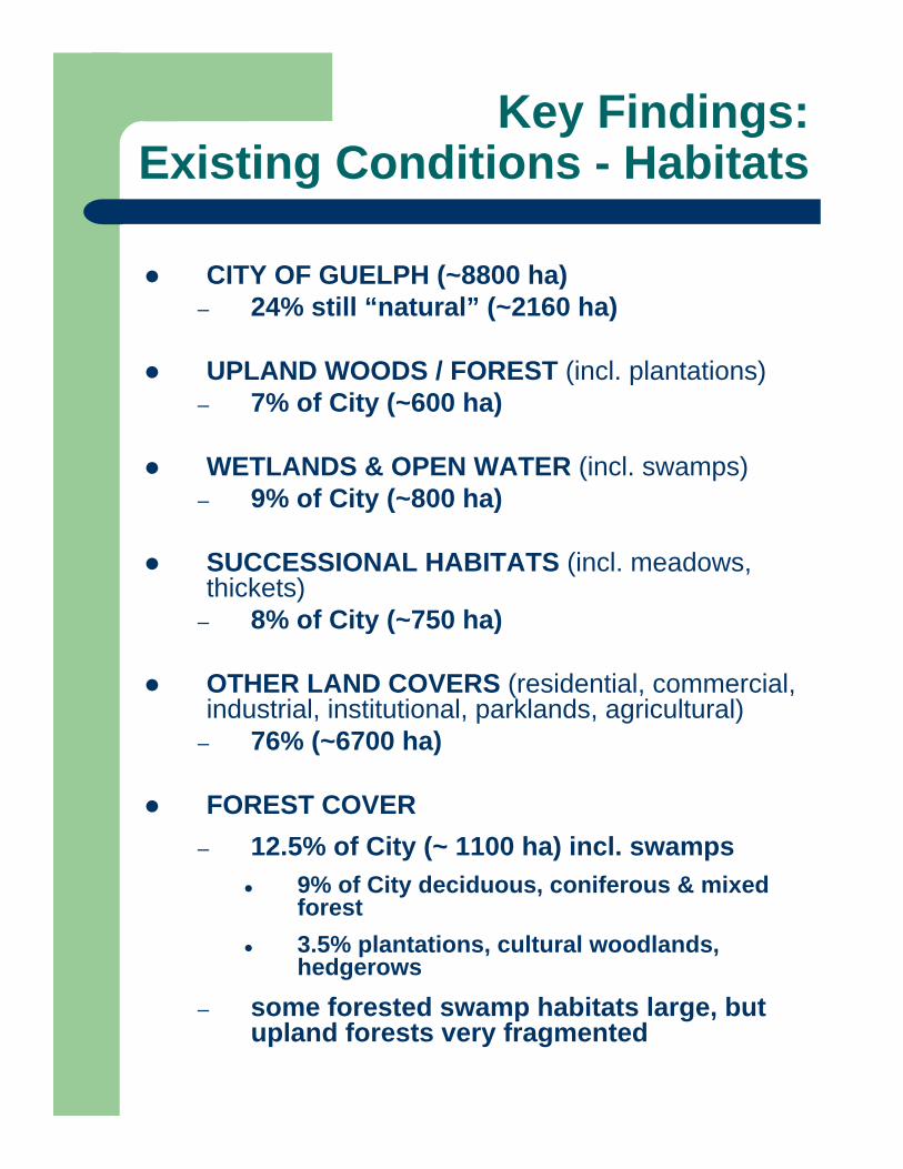
CITY OF GUELPH (~8800 ha) – 24% still “natural” (~2160 ha)
UPLAND WOODS / FOREST (incl. plantations)– 7% of City (~600 ha)
WETLANDS & OPEN WATER (incl. swamps)– 9% of City (~800 ha)
SUCCESSIONAL HABITATS (incl. meadows, thickets)
– 8% of City (~750 ha)
OTHER LAND COVERS (residential, commercial, industrial, institutional, parklands, agricultural)
– 76% (~6700 ha)
FOREST COVER– 12.5% of City (~ 1100 ha) incl. swamps
9% of City deciduous, coniferous & mixed forest3.5% plantations, cultural woodlands, hedgerows
– some forested swamp habitats large, but upland forests very fragmented
Key Findings:Existing Conditions - Habitats

Ecological Land Classification
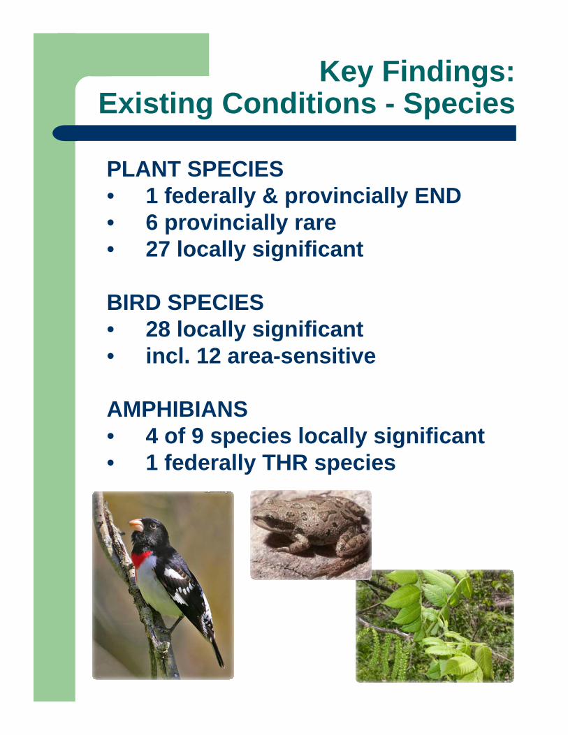
Key Findings:Existing Conditions - Species
PLANT SPECIES• 1 federally & provincially END • 6 provincially rare• 27 locally significant
BIRD SPECIES• 28 locally significant• incl. 12 area-sensitive
AMPHIBIANS• 4 of 9 species locally significant• 1 federally THR species
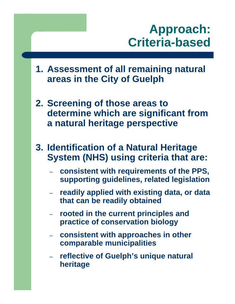
Approach:Criteria-based
1. Assessment of all remaining natural areas in the City of Guelph
2. Screening of those areas to determine which are significant from a natural heritage perspective
3. Identification of a Natural Heritage System (NHS) using criteria that are:– consistent with requirements of the PPS,
supporting guidelines, related legislation– readily applied with existing data, or data
that can be readily obtained– rooted in the current principles and
practice of conservation biology– consistent with approaches in other
comparable municipalities – reflective of Guelph’s unique natural
heritage
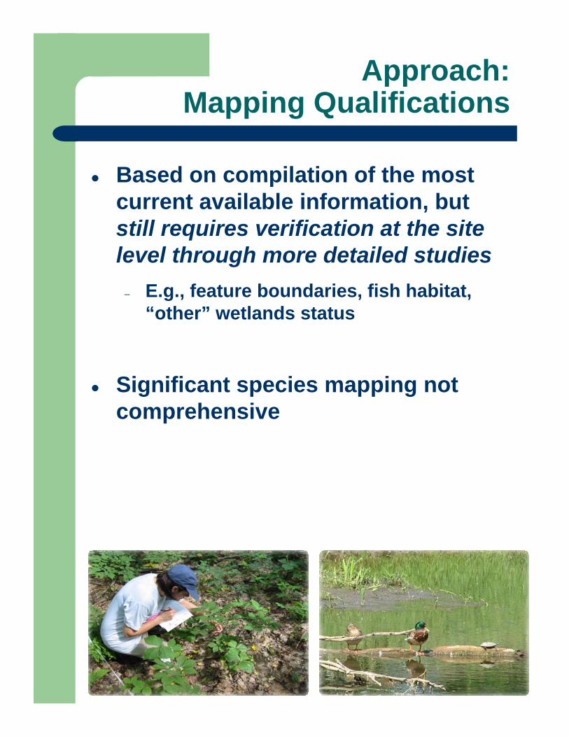
Approach:Mapping Qualifications
Based on compilation of the most current available information, but still requires verification at the site level through more detailed studies
– E.g., feature boundaries, fish habitat, “other” wetlands status
Significant species mapping not comprehensive
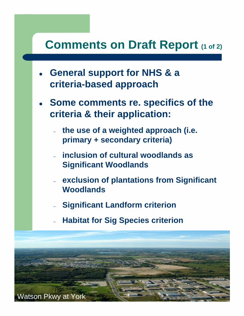
Comments on Draft Report (1 of 2)
General support for NHS & a criteria-based approach
Some comments re. specifics of the criteria & their application:
– the use of a weighted approach (i.e. primary + secondary criteria)
– inclusion of cultural woodlands as Significant Woodlands
– exclusion of plantations from Significant Woodlands
– Significant Landform criterion
– Habitat for Sig Species criterion
Stone Rd. at Edinburgh looking southWatson Pkwy at York
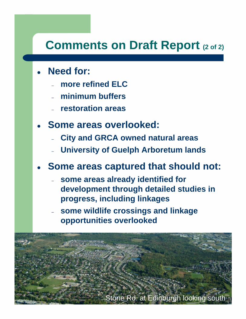
Comments on Draft Report (2 of 2)
Need for:– more refined ELC– minimum buffers– restoration areas
Some areas overlooked:– City and GRCA owned natural areas– University of Guelph Arboretum lands
Some areas captured that should not:– some areas already identified for
development through detailed studies in progress, including linkages
– some wildlife crossings and linkage opportunities overlooked
Stone Rd. at Edinburgh looking south
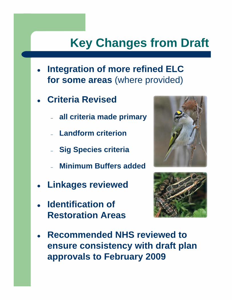
Key Changes from Draft
Integration of more refined ELC for some areas (where provided)
Criteria Revised
– all criteria made primary
– Landform criterion
– Sig Species criteria
– Minimum Buffers added
Linkages reviewed
Identification of Restoration Areas
Recommended NHS reviewed to ensure consistency with draft plan approvals to February 2009
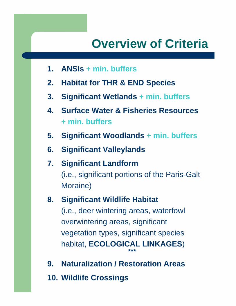
Overview of Criteria
1. ANSIs + min. buffers
2. Habitat for THR & END Species
3. Significant Wetlands + min. buffers
4. Surface Water & Fisheries Resources + min. buffers
5. Significant Woodlands + min. buffers
6. Significant Valleylands
7. Significant Landform (i.e., significant portions of the Paris-Galt Moraine)
8. Significant Wildlife Habitat (i.e., deer wintering areas, waterfowl overwintering areas, significant vegetation types, significant species habitat, ECOLOGICAL LINKAGES)
***
9. Naturalization / Restoration Areas
10. Wildlife Crossings

CRITERION 1 – ANSIs + 10 m buffer
CRITERION 2 – Habitat for THR & END Species
CRITERION 3 – SIGNIFICANT WETLANDSPSW + 30 m buffer, LSW + 15 m buffer, Other
Earth Science ANSIs: 1. Guelph Interstadial2. Guelph Correctional Center
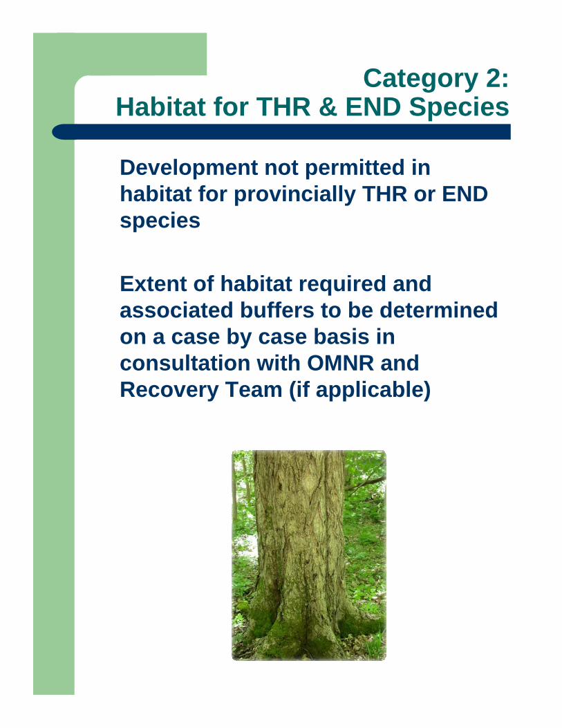
Category 2:Habitat for THR & END Species
Development not permitted in habitat for provincially THR or END species
Extent of habitat required and associated buffers to be determined on a case by case basis in consultation with OMNR and Recovery Team (if applicable)

Category 3: Significant Wetlands
3(a) Provincially Significant Wetlands (PSWs)
3(b) Locally Significant Wetlands (LSWs)
3(c) Other Wetlands: some may be developed if below size threshold
Photo courtesy of Harden Environmental
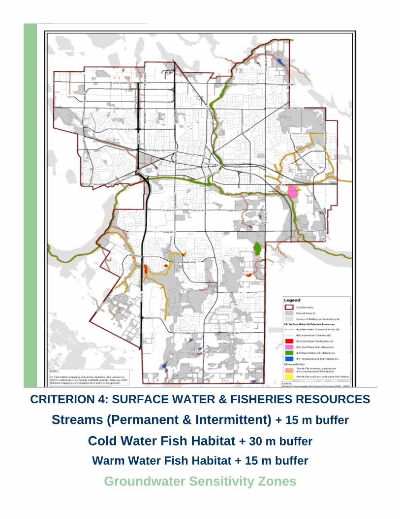
CRITERION 4: SURFACE WATER & FISHERIES RESOURCES
Streams (Permanent & Intermittent) + 15 m buffer
Cold Water Fish Habitat + 30 m bufferWarm Water Fish Habitat + 15 m buffer
Groundwater Sensitivity Zones
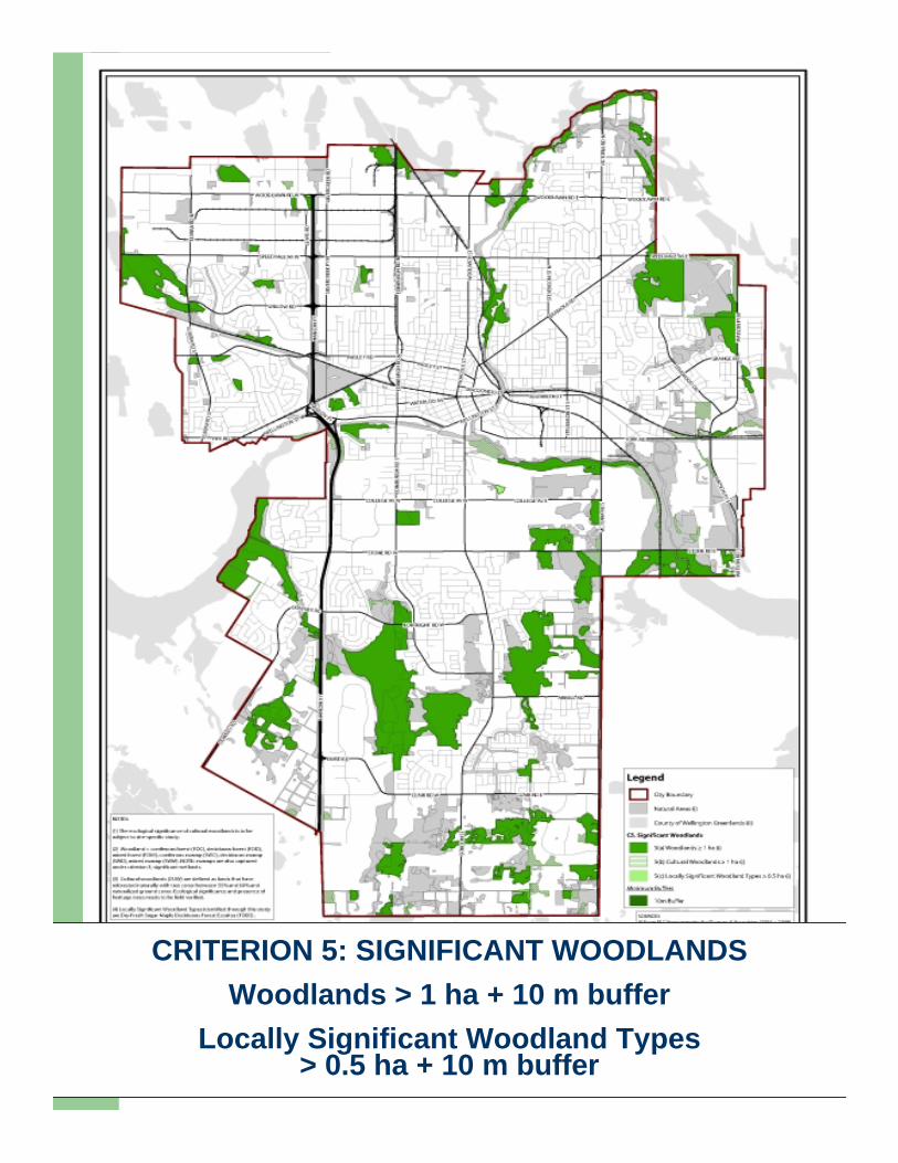
CRITERION 5: SIGNIFICANT WOODLANDSWoodlands > 1 ha + 10 m buffer
Locally Significant Woodland Types > 0.5 ha + 10 m buffer
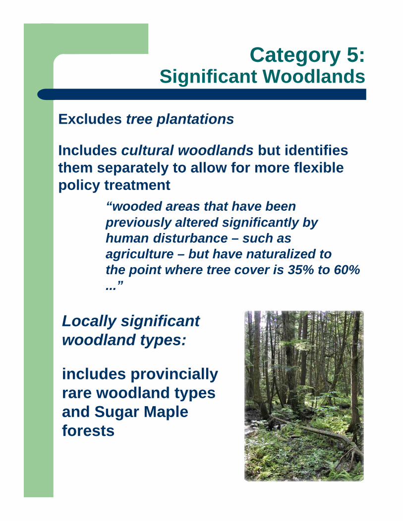
Category 5: Significant Woodlands
Excludes tree plantations
Includes cultural woodlands but identifies them separately to allow for more flexible policy treatment
“wooded areas that have been previously altered significantly by human disturbance – such as agriculture – but have naturalized to the point where tree cover is 35% to 60% ...”
Locally significant woodland types:
includes provincially rare woodland types and Sugar Maple forests
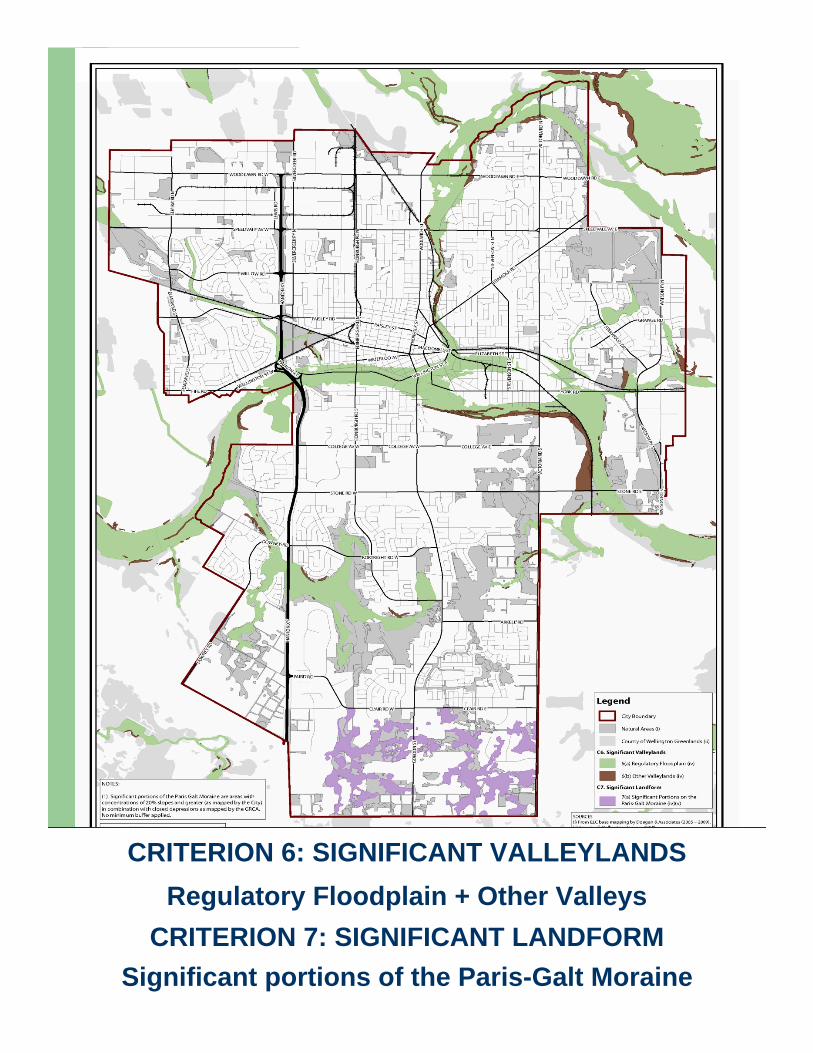
CRITERION 6: SIGNIFICANT VALLEYLANDSRegulatory Floodplain + Other Valleys
CRITERION 7: SIGNIFICANT LANDFORMSignificant portions of the Paris-Galt Moraine
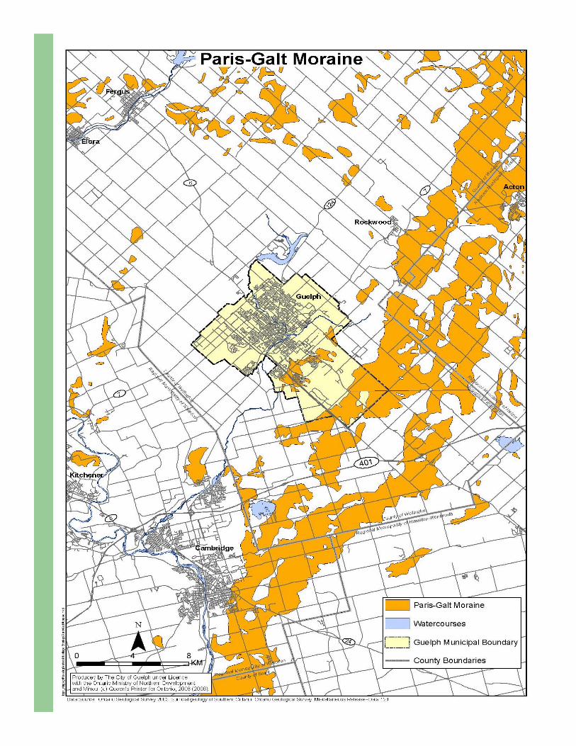
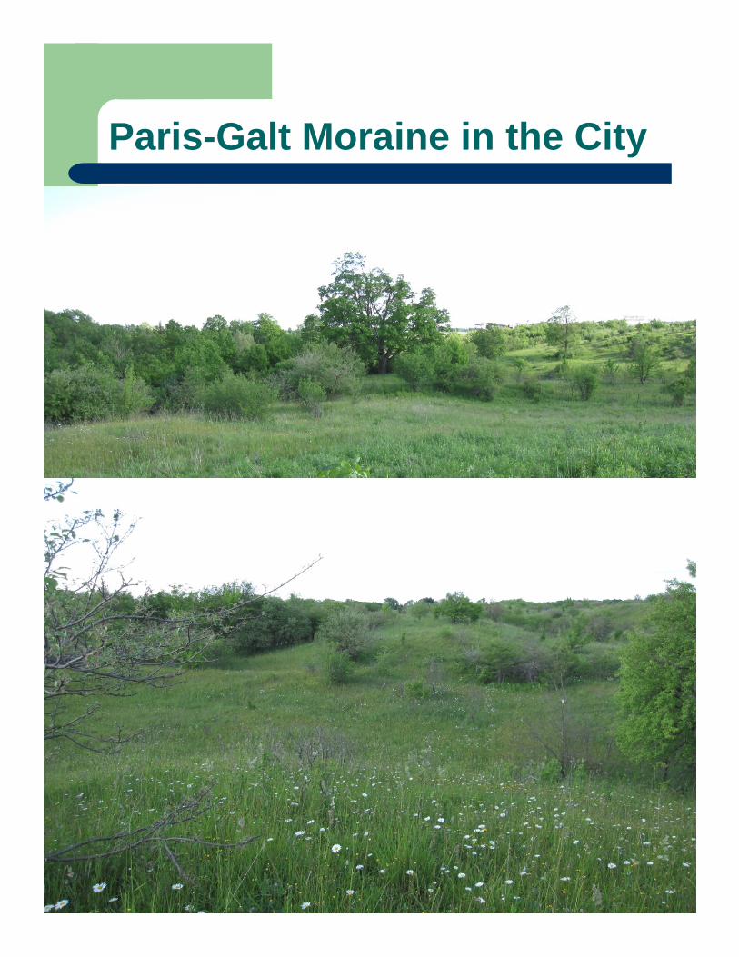
Paris-Galt Moraine in the City

Significant Landform
City Staff mandated by Council to address protection of the Paris-Galt Moraine in the City through the NHS (October 2008).Groundwater experts agree that capturing slopes and closed depressions on the moraine helps define critical groundwater recharge and surface catchment areas.Although the Moraine covers much of the City’s south end, a relatively small proportion has been identified for protection to balance the need to accommodate growth.
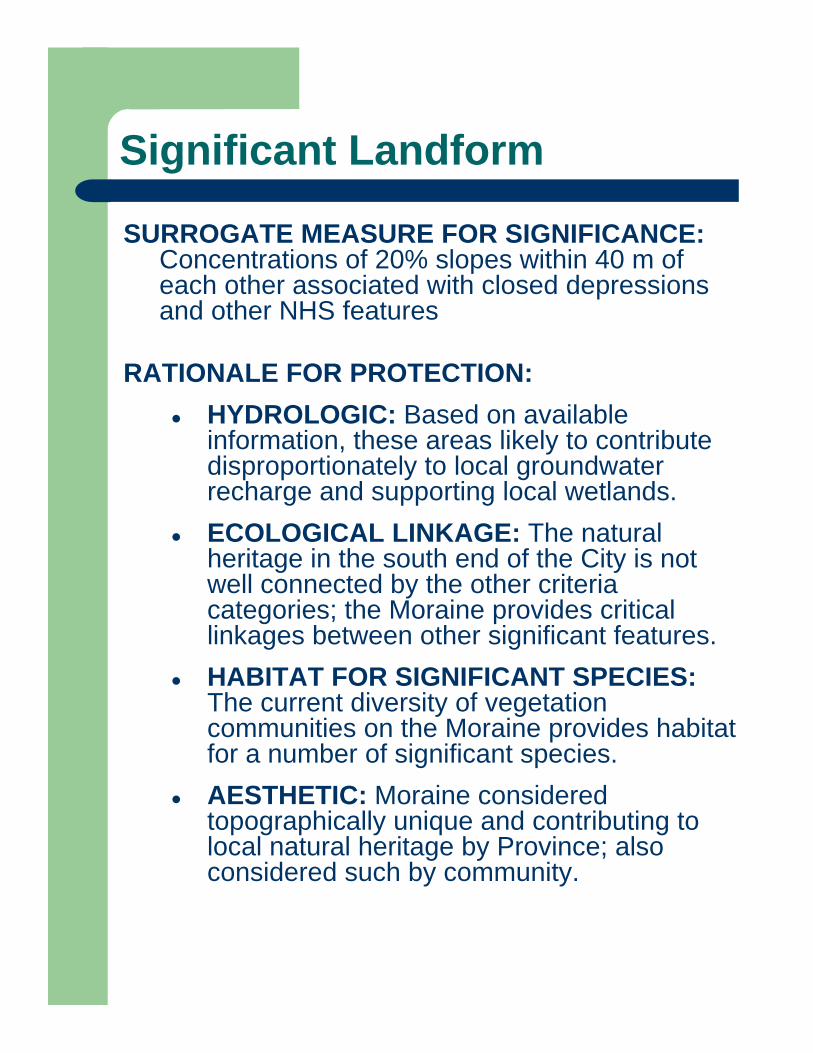
Significant Landform
February 12, 2009
SURROGATE MEASURE FOR SIGNIFICANCE: Concentrations of 20% slopes within 40 m of each other associated with closed depressions and other NHS features
RATIONALE FOR PROTECTION:HYDROLOGIC: Based on available information, these areas likely to contribute disproportionately to local groundwater recharge and supporting local wetlands.ECOLOGICAL LINKAGE: The natural heritage in the south end of the City is not well connected by the other criteria categories; the Moraine provides critical linkages between other significant features.HABITAT FOR SIGNIFICANT SPECIES: The current diversity of vegetation communities on the Moraine provides habitat for a number of significant species.AESTHETIC: Moraine considered topographically unique and contributing to local natural heritage by Province; also considered such by community.
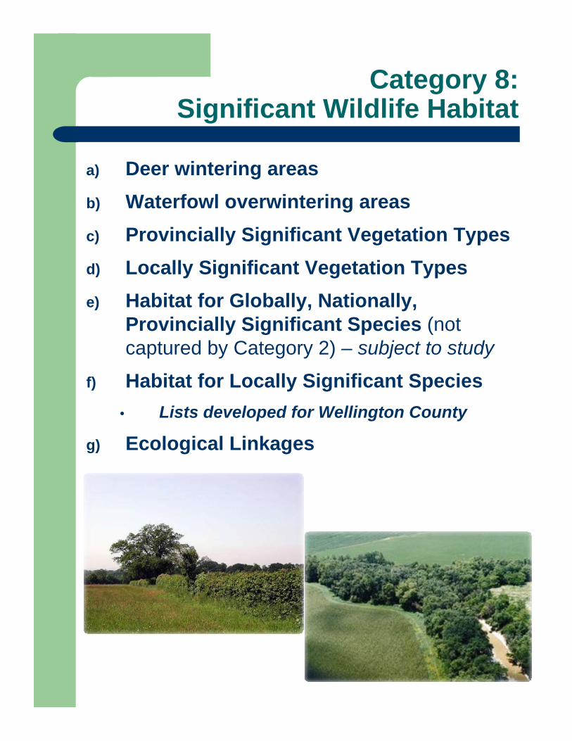
Category 8:Significant Wildlife Habitat
a) Deer wintering areasb) Waterfowl overwintering areasc) Provincially Significant Vegetation Typesd) Locally Significant Vegetation Typese) Habitat for Globally, Nationally,
Provincially Significant Species (not captured by Category 2) – subject to study
f) Habitat for Locally Significant Species• Lists developed for Wellington County
g) Ecological Linkages
CRITERION 8: SIGNIFICANT WILDLIFE HABITAT8(a) Deer wintering areas
8(b) Waterfowl overwintering areas 8(c) & (d) Significant Vegetation Types8(e) & (f) Habitat for Significant Species
8(g) ECOLOGICAL LINKAGES
Criteria 9 and 10
Naturalization / Restoration Areas
lands closely associated w/ NHS
primarily on City or GRCA lands
SWM facilities are included
Wildlife Crossings
flag approx. locations where measures to facilitate safe wildlife crossing should be implemented
guidelines and policy direction to be developed in consultation with the Engineering Department
Wildlife Crossings
Wildlife Crossings

Recommended NHS w Linkages, Wildlife Crossings & Restoration Areas
Blah blah
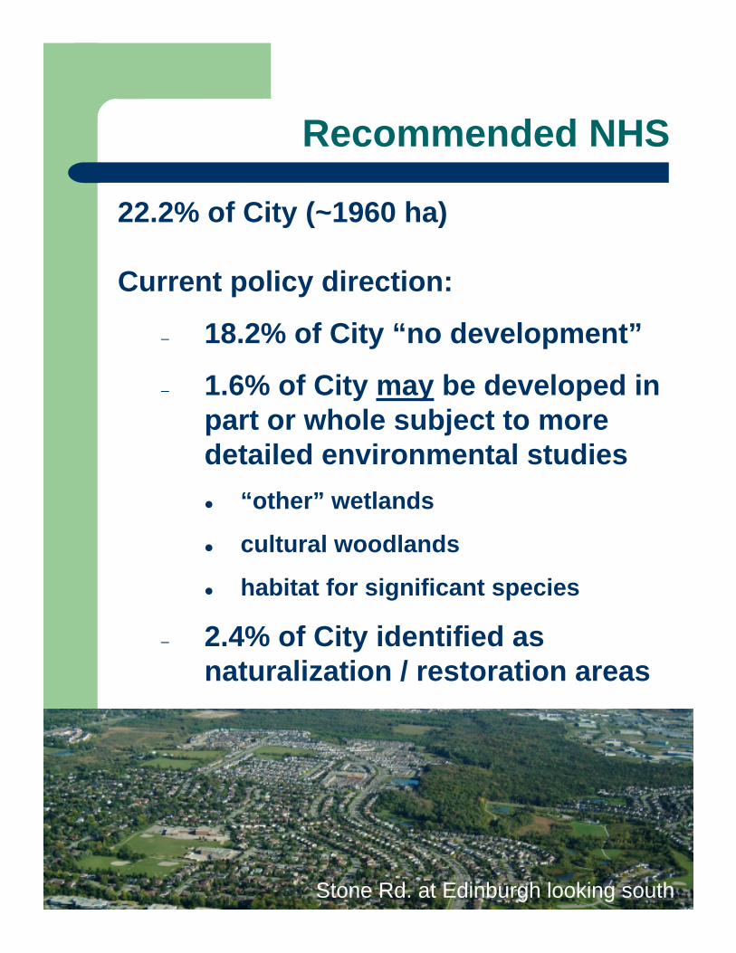
Recommended NHS
22.2% of City (~1960 ha)
Current policy direction:
– 18.2% of City “no development”
– 1.6% of City may be developed in part or whole subject to more detailed environmental studies
“other” wetlands
cultural woodlands
habitat for significant species
– 2.4% of City identified as naturalization / restoration areas
Stone Rd. at Edinburgh looking south
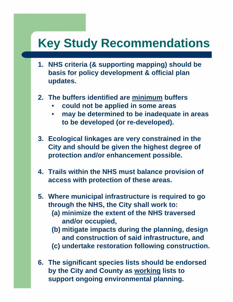
Key Study Recommendations1. NHS criteria (& supporting mapping) should be
basis for policy development & official plan updates.
2. The buffers identified are minimum buffers • could not be applied in some areas • may be determined to be inadequate in areas
to be developed (or re-developed).
3. Ecological linkages are very constrained in the City and should be given the highest degree of protection and/or enhancement possible.
4. Trails within the NHS must balance provision of access with protection of these areas.
5. Where municipal infrastructure is required to go through the NHS, the City shall work to: (a) minimize the extent of the NHS traversed
and/or occupied, (b) mitigate impacts during the planning, design
and construction of said infrastructure, and(c) undertake restoration following construction.
6. The significant species lists should be endorsed by the City and County as working lists to support ongoing environmental planning.
Draft Permitted Uses
Existing usesIn most NHS features
habitat conservation / restoration passive recreation (e.g., trails, signs)
In some NHS featuresflood and erosion controlessential infrastructure (e.g., roads,
pipelines and/or linear utilities)other works permitted by the GRCA / DFO
In buffers to NHS featuresthe uses listed abovelow-impact stormwater managementstorm water management facilities
subject to an approved Environmental Impact Study (EIS) or Environmental Assessment (EA)
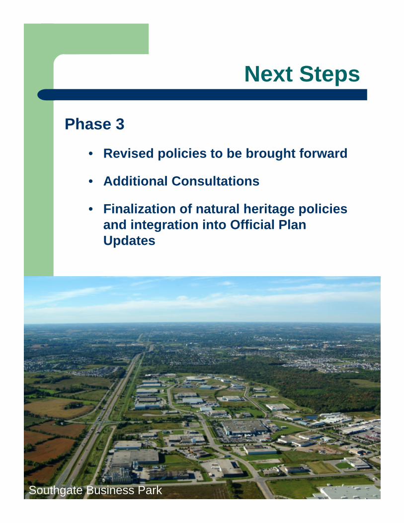
Next Steps
Phase 3
• Revised policies to be brought forward
• Additional Consultations
• Finalization of natural heritage policies and integration into Official Plan Updates
Southgate Business Park
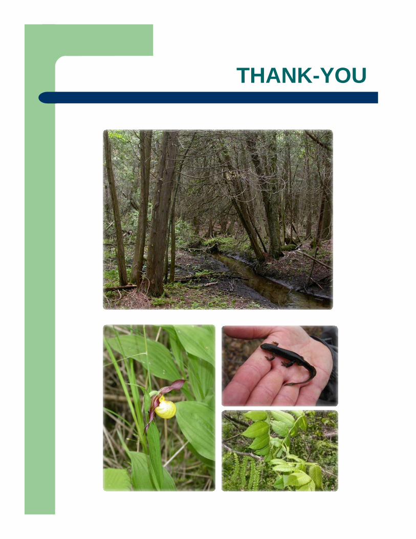
THANK-YOU


