Embed Size (px)
Citation preview
Institute of Field Archaeologists Maritime Affairs Group
1
MARITIME AFFAIRS GROUP
MAG BULLETIN - SPECIAL EDITION March 2007
In this issue we report on the MAG Seminar
‘Informing Marine Designation: Sourcing Field Evaluation of Marine Historic Assets Expertise’
Held on the 8th February 2007, London
Background and Introduction page - 2 Summary of Presentations & Delegate Response,
pages 3 -16 Summary Position Statement, page 16
Institute of Field Archaeologists Maritime Affairs Group
2
Background to the Seminar Welcome to this special edition of the MAG Bulletin. This publication has been compiled after the IFA MAG Seminar ‘Informing Marine Designation: Sourcing Field Evaluation of Marine Historic Assets Expertise’. The seminar was planned in response to debate held at the Maritime Session of the IFA Conference held in Edinburgh in 2006 when the spotlight fell on the way that the heritage agencies are currently funding the investigation and monitoring of historic wreck sites. The legislative regime of the Protection of Wrecks Act was an emergency piece of legislation which passed into law in 1973 in response to threats to a number of specific wreck sites, particularly the Amsterdam, the remains of a Dutch East India vessel lying on hasting beach, and the then relatively recently located site of the Mary Rose. This piece of legislation and associated management structure which includes an Advisory Committee on Historic Wreck Sites, the licensing of all activities on protected sites, and the monitoring of protected wrecks through a single contract, has come to dominate the management and funding of maritime archaeology over the past 30 years. As the maritime archaeological profession has grown and developed, in particular in the last ten years, it is now time to debate whether the Protection of Wrecks Act and associated structures are the best methods of managing our marine cultural heritage. The recent DCMS marine designation review has summarised the key areas where legislative change is required to better serve a wider range of marine historic assets. However, the development and sustainability of the provision of marine advice in support of designation has not been debated. The MAG seminar held on the 8th February 2007 sought to develop debate in this important area. The programme of speakers presenting a range of perspectives on the provision of marine advice included: Antony Firth, Wessex Archaeology David Parham, Bournemouth University Julie Satchell, Hampshire & Wight Trust for Maritime Archaeology Colin Breen, School of Environmental Sciences, University of Ulster Kevin Camidge, Licensee Doug McElvogue, IFA MAG Martin Dean, ADUS After lunch a presentation was given by Paul Jeffery of the Heritage Protection Department of English Heritage which outlined some of the key issues that the then forthcoming White Paper on Heritage Protection would seek to address, particularly in the marine zone. Lively debate of a range of issues raised during the presentations then followed. This provided all attendees with the opportunity to join the debate and include relevant issues. Those attending included professional archaeologists, heritage agencies, licensee groups, nominated archaeologists, maritime trusts, societies and organisations. The seminar was concluded with the development of a Summary Position Statement which was agreed by all participants – a copy of which is included in this Bulletin. All speakers were asked to provide a summary of their presentations, these are outlined below. Additionally seminar attendees were also invited to provide a response for inclusion in this bulletin. I am pleased to be able to provide an addition to this Bulletin, which is a summary by the English Heritage team on the implications for marine heritage of the Heritage Protection White Paper launched on the 9th March 2007. Responses to this document are due by the 1st June, this is a chance to ensure marine cultural assets gain parity of protection with terrestrial remains – we encourage everyone to submit their comments. Finally, MAG would like to thank all those who contributed to the seminar. We would also like to acknowledge the kind support of English Heritage who helped facilitate this event. Julie Satchell, MAG Chair
Institute of Field Archaeologists Maritime Affairs Group
3
The following papers have been kindly provided by the speakers at the seminar. To provide a background to the current approach to the provision of advice in support of the Protection of Wrecks Act English Heritage have provided a summary of Archaeological Services in relation to the PWA 1973.
Description of Archaeological Services in Relation to the Protection of Wrecks Act (1973)
Mark Dunkley, Maritime Team, English Heritage Background Since 1985, a team of professional diving archaeologists has been contracted by the SoS at DCMS to assess designated sites around the UK to provide specialist advice in relation to their duties under the Protection of Wrecks Act (1973). Following the devolution of those functions as respects Scotland and Wales in 1998, the SoS continued the contract with the diving team on their own behalf and on behalf of Scottish Ministers and the Welsh Assembly. This contract expired on the 31st March 2003. Under Section 3 of the National Heritage Act 2002, the SoS directed English Heritage to commission and manage a new contract for the whole of the UK on their behalf. This contract will expire on the 31st March 2008. The principle aim of the Contract is to supply advice to English Heritage, Historic Scotland, Cadw, and the Environment and Heritage Service of Northern Ireland to enable them to advise their respective Secretary of State, Scottish Ministers and Welsh Assembly as appropriate, about issues of designation and licensing under the Protection of Wrecks Act. English Heritage acts as the lead Heritage Agency for the purposes of the Contract. Contract Objectives The objectives of the Contract are to:
• Provide advice relating to the designation of sites under the Protection of Wrecks Act;
• Undertake fieldwork to facilitate the management and understanding of sites under the Protection of Wrecks Act or being considered for designation;
• Provide advice about the management of Protected Wreck Sites;
• Liase between the Heritage Agencies and Licensees;
• Provide advice, assistance or training to Licensees to achieve a high standard of survey, monitoring and post-excavation work, and to;
• Maintain records of interventions and analysis, and dissemination of information about the portfolio of Protected Wrecks to increase the public understanding and appreciation of maritime archaeology.
Site specific investigations are undertaken in accordance with a brief developed by the appropriate Heritage Agency and there is also provision for the contractor to undertake other similar or related work as requested.
The Contract (aka) Anthony Firth, Head of Coastal and Marine Projects, Wessex Archaeology
The contract for Archaeological Services in Relation to the Protection of Wrecks Act 1973 (aka ‘the Contract’) has been central to the development of maritime archaeology in the UK since 1986. Through the Contract, the ADU had a major effect on the profession for 17 years. Over the last four years, the Contract has enabled Wessex Archaeology to make a major contribution to what is known about the UK’s historic wrecks, how it is known, and how capacity can be built to know more in future. A case is being made for more, small projects, presumably carried out by a wider range of contractors. I don’t think it has been established why this would be intrinsically better than one larger contract: for the marine historic environment; for the maritime archaeological profession; or for the public. The resources available through the Contract are provided by society – taxpayers – to support the provision that society – the electorate – has made for protecting certain historic wrecks. If these resources are not deployed
Institute of Field Archaeologists Maritime Affairs Group
4
directly in supporting the requirements of the Act, they can be cut. It would be foolhardy to regard the resources for the Contract as archaeologists’ due, to be split as we see fit. Certainly, there are many things that it would be good to have the resources to pursue in respect of historic wrecks, but surely the first step should be to increase the amount of resources available. Rather than squabbling over an existing pot, we should be making a strong, sustained case in society at large for that pot to be increased. Even so, I don’t think we should expect to have resources put aside for our exclusive use. There are already resources beside the Contract available from the heritage agencies and other bodies, but in order to gain access we have to be able to make our applications as strong as those of colleagues in terrestrial archaeology, historic buildings, landscape survey and so on. Having made the case for the historic environment to be considered seamlessly, we shouldn’t really be hankering after ring-fenced segregation. Maritime archaeology and archaeology as a whole are strongest when – as discipline and as profession – they are combined. I’m very familiar with the financial balances relating to the Contract and, contrary to many assertions, I can assure people that the current Contract provides excellent value-for-money. The initial annual price we tendered for the Contract benefited from the economies of scale that come from a large, multi-year arrangement, even though the Contract has now been scaled back. Annual increments are tied to a figure for general inflation that is lower than actual inflation in the things we need to pay for. This means that as we approach our fifth year, the heritage agencies are getting a very good deal for the taxpayer. From the start, we wanted a quantum change in what was being achieved through the Contract, so we set a demanding standard for ourselves. Having raised expectations while resources have dwindled, we have had to be innovative – in discussion with the heritage agencies – to ensure that methodologies and working practices are both effective and efficient. Making the Contract work is by no means an easy ride; the annual value of the Contract would stretch less far if it were to be split. It might buy more hubbub, but would it deliver more results?
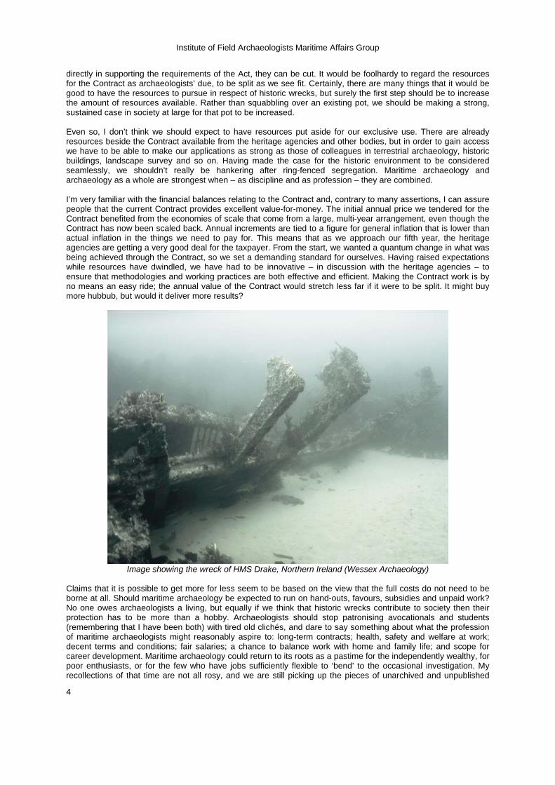
Image showing the wreck of HMS Drake, Northern Ireland (Wessex Archaeology)
Claims that it is possible to get more for less seem to be based on the view that the full costs do not need to be borne at all. Should maritime archaeology be expected to run on hand-outs, favours, subsidies and unpaid work? No one owes archaeologists a living, but equally if we think that historic wrecks contribute to society then their protection has to be more than a hobby. Archaeologists should stop patronising avocationals and students (remembering that I have been both) with tired old clichés, and dare to say something about what the profession of maritime archaeologists might reasonably aspire to: long-term contracts; health, safety and welfare at work; decent terms and conditions; fair salaries; a chance to balance work with home and family life; and scope for career development. Maritime archaeology could return to its roots as a pastime for the independently wealthy, for poor enthusiasts, or for the few who have jobs sufficiently flexible to ‘bend’ to the occasional investigation. My recollections of that time are not all rosy, and we are still picking up the pieces of unarchived and unpublished
Institute of Field Archaeologists Maritime Affairs Group
5
work that resulted. It is only in the last decade that maritime archaeology has started to resemble a profession, and it is by no means inevitable that it should continue to do so. The Contract(or) has been labelled as unproductive, inappropriate, failing to meet basic archaeological standards, and frustratingly limited. I don’t think such a negative case is sustainable. For our part, I’m pretty staggered by what has been accomplished in the last four years. My colleagues at WA have worked hard and achieved excellent results. It is an acknowledged failing that much of the work is not quickly disseminated to a wide audience, so the Contract continues to have an air of mystery. This weakness is not intrinsic to the Contract, however, and both WA and the heritage agencies have generally been able to keep the stakeholders in each site informed, including passing on survey data and reports. In our implementation we have concentrated on ‘basic monitoring, liaison and fact-finding’, but these basics are what the heritage agencies still require. It is perhaps surprising that the baseline for many designated wrecks up to 2003 has been so haphazard, but the crucial information-gathering role of the Contract at its inception is far from complete. A large proportion of our work over the past four years has been concerned with drawing together baseline information about each wreck, its history of investigation, and the sources of data upon which interpretation and management can be based. This has taken a great deal of work to untangle, and in several instances has resulted in designations being changed. The emphasis on establishing reliable baseline information has also led the heritage agencies to direct WA to carrying out some fairly detailed survey work on site, and in the course of our work we have carried out geophysical work, archive assessment, desk-based studies, specialist finds work, liaison with conservators, environmental assessment and so on, all as an integral part of the Contract. In implementing the Contract we have concentrated not just on using a wide range of investigative methods, but in successfully integrating them in order to provide the heritage agencies with a thorough and transparent basis for their decisions. There are a number of technologies that are adding significantly to our capabilities, but the technologies are themselves limited by the skill and experience with which they are combined and used to address archaeological questions. Taking the specific instance of marine geophysics, WA is involved day-to-day in the acquisition, processing and interpretation of all sources from a wide range of sites and environments, pretty or otherwise, forging a cutting edge in the application of marine geophysics to archaeology. We would certainly welcome a freer hand in allocating resources to geophysical acquisition (and some other techniques) where appropriate, but geophysical interpretation is already intrinsic to the Contract in its current form. Although the total amount of time spent by people blowing bubbles is not an end in itself, our methods have enabled us to achieve a good amount of time on site, and to maximise the effectiveness of each minute underwater. Our decision not to chase the weather around the country from forecast to forecast has also proved effective. Certainly, some fieldwork has been blown out almost entirely, but our approach seems to have kept interference by weather to a minimum. Even where fieldwork has been curtailed, we have made productive use of our time by collating and reporting upon information available locally. Any marine operation will have its share of problems with logistics and weather, but I doubt that these are significantly reduced by contractors’ postcodes. As in our work for commercial clients, we are expected to be available and effective in each region that the heritage agencies choose to send us. Our role is to fit within existing relations between curators, licensee groups and other local and regional stakeholders, not to usurp them. Organisations and fora with a regional coastal and marine archaeological focus have a clear role to play, which is why WA has supported them over many years – Severn, Tamar, Dorset, North East, North West, Thames Estuary and so on – but we are also fully used to working in the many regions where archaeological infrastructure and understanding has yet to develop. This is not a regional approach based on easy empty soundbites, but on routine practical engagement with people wherever they are based. If the intention is to secure for future generations the historic environment of the whole of UK waters, then we should not be treating our coasts and seas as a Monopoly board. As the Contract has played such an important role in the past of maritime archaeology, whatever form it might take from 2008 can be expected to affect the future of the discipline also. Contrary to the claim that the Contract is past its sell-by date, I would argue that our current practice is getting ever closer to what the heritage agencies will need in future. Our knowledge of what is out there – and why it is important – is changing, and collectively we are about to embark on highly significant changes to the regimes for heritage protection and marine management. There are bound to be challenges in matching the new regimes to the changing face of the marine historic environment; the heritage agencies will rightly expect future contractors to adapt to and deliver on those challenges. This is not the time to build a new model for the 1970s, 80s and 90s; we should be anticipating the different historic environment, and different society, that we shall come to know by 2050. Having the Contract – or any part of it – is not essential to developing capability in marine archaeology in the UK, as WA demonstrated in the period between 1995 and 2003. However, having a single large Contract in our portfolio in recent years has – alongside other contracts – enabled us to:
• Invest in equipment, particularly in high quality digital video, digital stills and positioning equipment that have contributed directly to the quality of the archaeological record provided to the heritage agencies.
Institute of Field Archaeologists Maritime Affairs Group
6
• Invest in methodologies, especially relating to real-time real-world GIS-based recording of diver observations, integrated and informed by other spatial data, which has had a direct, tangible effect on the heritage agencies’ capacity to make management decisions.
• Invest in staff, both in offering permanent contracts with above-average terms and conditions, and through training.
• Develop our approach to recording, from site-to-site and from Home Country to Home Country, to achieve consistent and high quality products, including materials suitable for wide dissemination.
• Maintain an acknowledged benchmark for best practice in diving operations in the archaeological sector.
• Establish and maintain good working relationships with a range of stakeholders that is now much wider than was traditionally associated with maritime archaeology.
Some of these advances in archaeology would not happen if the level of resources available to any one organisation is not above a certain threshold. Indeed, the rate of advance may yet falter if existing levels of resourcing do not improve. I don’t know whether WA would necessarily win another similar Contract in 2008. I am convinced, however, that the historic environment, its stakeholders, our profession and society at large will be best served by a tendering process that is open, transparent and forward-looking.
The Future for the management of the UK’s Protected Wreck Sites David Parham, Centre for Marine & Coastal Archaeology, Bournemouth University
This paper is written from both my own and Bournemouth University’s experience’s of working with protected wreck sites and discussions with colleagues, both internally and externally about the subject. My personal experience comes from having worked as a named diver on protected wreck sites (PWS), in England, Wales and Scotland, having been the licensee of 2 sites, nominated archaeologist for 6 sites, briefly been appointed by DCMS to take on a limited ‘Archaeological Diving Contractor’ role and my responsibilities for the overall management of research on just under 30% of England’s PWS, amongst other responsibilities. I feel therefore that I am in a particularly informed position to comment on these issues. Back in April 2006 my paper at the IFA conference in Edinburgh concluded with the statement that The funds currently contained within the Protection of Wrecks Act (PWA) contact should be released and used for more strategic research lead projects that can unlock the potential of the UK’s maritime archaeology. Surprisingly, particularly to me, no one within the audience argued with this point and with one notable exception, no one has since. In the meantime many have agreed with my sentiments, this paper explains the logic behind the statement. The PWA contract is now 21 years old (older than most of my students!) and is very much a product of its time, a time when maritime archaeology was overseen by the Department of Transport who lacked internal archaeological expertise, work on some sites could be described as less than ethical and there were few maritime archaeologists in the UK. The contract has worked well in the past, but time has moved on and so has maritime archaeology, particularly since the passing of the National Heritage Act in 2002. Government responsibility for maritime archaeology is now undertaken by the Heritage Agencies (HA), most of whom have the staff capacity to dive on sites themselves. The maritime archaeological sector now includes in excess of 16 UK archaeology diving contractors and a minimum of 22 ‘maritime’ MIFAs. Whilst there have been many technological developments in the field maritime archaeology is still not ‘rocket science’, were specialist advice is needed it can be easily and relatively cheaply be brought in. Despite some disinformation to the contrary, the sector ACoP allows cost effective diving with the common use of SCUBA and capability to dive with Licensees. All of which has been conducted with an exemplary safety record since the introduction of the Diving at Work Regulations in 1982. The initial set up costs to for an archaeological diving contractor, assuming of course that competent staff are used, are therefore not prohibitive and are within the range of many individuals, let alone organisations. Since the passing of the National Heritage Act (the period 2003-6), around, £1.2 million has been spent on the PWA diving contract, about 15% (£0.18 million) of which has been spent on undesignated sites. The aim of the current contract is to supply advice to the HA to enable them to advise their respective governments about issues of designation and licensing under the PWA. Its objectives are to conduct fieldwork to facilitate the management & understanding of designated & undesignated sites, provide advice about the management of PWS, liase between the HA and Licensees, provide advice, assistance or training to Licensees to achieve a high standard of work and to maintain records of interventions, analysis, and dissemination of information to increase the public understanding and appreciation of maritime archaeology. This work ties up 75% of HA PW funding and is in effective a contract to conduct and report on diver surveys of sites and assemble limited archaeological information about them. Neither geophysics, environmental work, post ex, research, conservation, archiving, nor publication are included within the contract. There is no doubt that the usefulness of work conducted since EH’s involvement has vastly increased, however given that all of the objectives, including the equivalent of the
Institute of Field Archaeologists Maritime Affairs Group
7
inspection of undesignated sites, is also undertaken by licensed groups and nominated archaeologists there is massive duplication of effort and the current situation is no longer a cost effective method of the management of the nations underwater cultural heritage and is certainly not the best use of limited public resources. The current system is inequitable, un-inclusive and demonstratively fails to provide any long-term management for sites. Typically considerable funds are spent on an initial survey with limited later support. Thus creating the equivalent of an archaeological ‘one night stand’ where after the initial activity someone else, in the form of Licensees, are left holding the baby with limited support from the state whilst striving to provide the best long term future for their ‘dependants’. Since 2002 in England, and almost 10 years earlier in Scotland, the situation has improved with other work, funded from the HA outside the PWA contract and done at a fraction of its cost (around £0.4 million). This has progressed maritime archaeology beyond fieldwork, released interpreted potential of work undertaken in the past, provided environmental data needed for long term management, progressed outreach beyond the diving community (only 1/300% of the UK population) and importantly allowed maritime work to make a contribution towards the general pool of human knowledge and hence realised the archaeological potential on which the worth of maritime archaeology is based. Whilst highly successful this work has been severely limited as the bulk of potentially available funds are tied to PWA contact. The involvement of licensed groups and their nominated archaeologists in this process has encouraged cross fertilisation of skills and ideas between the various bodies involved. Importantly it has also encouraged investment from outside the HA in the form of funds brought from research trusts, the national lottery and grant aiding bodies to the tune of around £0.1 million annually, in addition to the around £1 million spent by licensed groups and nominated archaeologists in terms of their time and resources. It is evident that the best management plan for the future of the PWA contract is to spread the PWA role and funding amongst the sector by the use of specific or regional nominated archaeological advisors to work with licensed groups. Indeed the system is already partly in place, although almost completely un-funded. In 2005 about 50% of PWS had direct archaeological involvement and 75% of PWS are close to Maritime Archaeological Organisations. Apart from connecting available funding with those who are part of the long-term future of PWS from the outset and embedding archaeologists within diving communities thus developing strong local relationships it has numerous other advantages. It achieves many of the aspirations detailed in Taking to the Water by providing close links with Licensees, supporting the concept of local stewardship, broadens methodological development by involving a greater proportion of the sector in the role providing archaeological advice locally with increased responsiveness and providing a vastly increased incentive for investment beyond HA funds. It also provides a system were many maritime archaeologists can move on from the role of diving technician and enhance their experience and skills by taking on a more rounded and complete role as archaeologists. Thus enhancing the nations maritime archaeological capacity and providing an enhanced career development by providing a better funded and broader environment with greater opportunity in which maritime archaeologists (both paid and unpaid) and maritime archaeology can develop and grow.
Informing Marine Designation: The Solent Experience Julie Satchell, Hampshire & Wight Trust for Maritime Archaeology
As the marine cultural heritage sector and wider marine management approaches are rapidly developing, it is critical that we assess the delivery of marine advice within the current and potential future systems. The experience of the Hampshire & Wight Trust for Maritime Archaeology, as a regionally based charitable trust working with a wide range of marine historic assets, including Designated Wreck sites, provides a case study which could be used as a model for other areas of the UK. The HWTMA now has over 15 years experience dealing with marine historic assets, this has involved developing a network of contacts which include curators, HER’s, museums, licensee groups, individuals, dive clubs and a wide range of stakeholder organisations. The Solent is home to seven of the UK’s Protected Historic Wreck sites. We are actively involved with a number of these sites and are on-hand to provide help and support for the others. HWTMA and licensed groups – experience has shown that key factors for developing working relationships with licensee groups are:
• Diplomacy – protected wreck sites are often highly politicised • Investment of time in the development of relationships with the group • Willingness to provide advice and help usually in the evenings and at weekends • Ability to join group activities either in the water or at the project base • Training is not just about courses, it is an on-going commitment to help develop skills • Requirement for financial assistance to support HWTMA staff time
Institute of Field Archaeologists Maritime Affairs Group
8
In terms of long term monitoring of sites the engagement of licensed groups is key. However, it must be recognised that this requires the time and support of an Archaeological Advisor. When established this working relationship can provide a wide range of benefits for historic assets. This can build towards the ideal situation where ‘A Protected Wreck Site is for life, not just for a season’. HWTMA and Protected wreck sites – local knowledge and regular diving fieldwork in the region enable an integrated approach to sites. Monitoring of the Needles and Yarmouth Roads sites can be integrated into other diving operations in the Western Solent. Diving usually involves both professional and volunteer divers, this provides reporting by experienced archaeologists while introducing divers to a Protected wreck site which increases appreciation of historic assets. This long-term involvement with sites allows research programmes to be developed and importantly enables information to be fed into a wide range of dissemination and education initiatives to raise the public profile of the sites. However, this work requires funding; the HWTMA currently engages in fundraising to undertake such work providing additional input into designated sites. Our experience with Protected Wreck sites shows that they benefit from:
• Ongoing monitoring of sites by divers familiar with often complex archaeology and topography • Achieving best value by incorporating monitoring dives with other fieldwork • Involving volunteers teams alongside professional teams to maximise diving time, promote inclusively
and foster long-term conservation ethics • Maximising public involvement through local displays and exhibitions and activities
Other marine historic assets in the Solent Through our research led fieldwork program, supported by monies raised by the HWTMA, we are also investigating a wide range of historic assets:
• Diving in the Eastern Solent investigating historic shipwrecks that could be future candidates for designation as Marine Historic Assets.
• Preparing a case for the designation of a site lying 3 miles off the Needles.
• Working on submerged prehistoric landscapes including mapping, survey and excavation of stratified submerged occupation sites dating from the Mesolithic. These sites are eroding fast, but do not have any statutory protection within the current heritage protection regime.
• Responding to reports of discovery and location of new archaeological sites from a variety of sources including divers, fishermen, dive boat operators, and people visiting the coast.
• Location, study and dissemination of information on a wide range of sites in the inter-tidal zone.
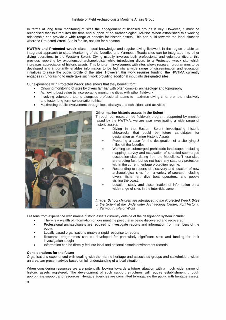
Image: School children are introduced to the Protected Wreck Sites of the Solent at the Underwater Archaeology Centre, Fort Victoria, nr Yarmouth, Isle of Wight
Lessons from experience with marine historic assets currently outside of the designation system include:
• There is a wealth of information on our maritime past that is being discovered and recovered • Professional archaeologists are required to investigate reports and information from members of the
public • Locally based organisations enable a rapid response to reports • Research programmes can be developed for particularly significant sites and funding for their
investigation sought • Information can be directly fed into local and national historic environment records
Considerations for the future Organisations experienced with dealing with the marine heritage and associated groups and stakeholders within an area can present advice based on full understanding of a local situation. When considering resources we are potentially looking towards a future situation with a much wider range of historic assets registered. The development of such support structures will require establishment through appropriate support and resources. Heritage agencies are committed to engaging the public with heritage assets,
Institute of Field Archaeologists Maritime Affairs Group
9
this can be achieved through drawing on the help and support of diving groups to monitor sites. When this aided by input and direction from professional archaeologists this can be a cost effective approach. To conclude, the HWTMA is just one example of a regional organisation that undertakes marine archaeological investigations and is well placed to provide advice and data gathering for heritage agencies. Whether a regional solution to the provision of advice is sustainable in all areas is debateable, however, using the skills and resources of established professional organisations who are ‘on the door step’ of a number of protected sites and marine historic assets offers a cost effective and flexible option.
Informing Marine Designation Kevin Camidge, Licencee
It seems obvious that information on designated and candidate sites is needed by Heritage managers and the Advisory Committee on Historic Wreck Sites to enable them to make informed decisions. This information is at present supplied by the diving contractor, currently Wessex Archaeology and previously the Archaeological Diving Unit. Given the relatively small budget available for managing and investigating the designated wreck sites it is perhaps worth looking briefly at how this money is currently apportioned. English Heritage has a budget of about £100,000 per year for the designated sites. The licensees of the designated sites fund their own work on these sites; the amount spent by licensees annually is an unknown but not inconsiderable sum. The diving contract costs in excess of £200,000 per year. The dive contractor spends about 112 days at sea per year. The cost per site visited is in excess of £15000. There are two principal types of fieldwork performed by the diving contractor; designated site assessments and undesignated site assessments. The designated site assessments are often in support of the licensees’ own work while the undesignated assessments are usually to determine whether a site should be designated under the protection of wrecks act.
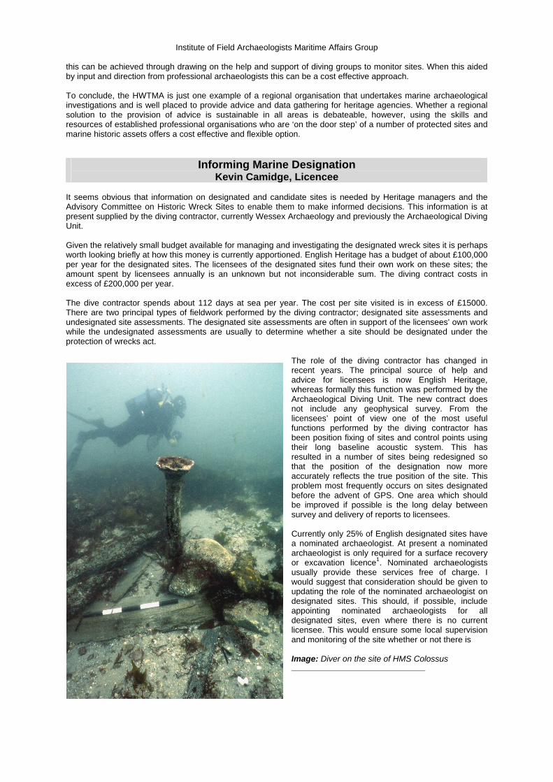
The role of the diving contractor has changed in recent years. The principal source of help and advice for licensees is now English Heritage, whereas formally this function was performed by the Archaeological Diving Unit. The new contract does not include any geophysical survey. From the licensees’ point of view one of the most useful functions performed by the diving contractor has been position fixing of sites and control points using their long baseline acoustic system. This has resulted in a number of sites being redesigned so that the position of the designation now more accurately reflects the true position of the site. This problem most frequently occurs on sites designated before the advent of GPS. One area which should be improved if possible is the long delay between survey and delivery of reports to licensees. Currently only 25% of English designated sites have a nominated archaeologist. At present a nominated archaeologist is only required for a surface recovery or excavation licence1. Nominated archaeologists usually provide these services free of charge. I would suggest that consideration should be given to updating the role of the nominated archaeologist on designated sites. This should, if possible, include appointing nominated archaeologists for all designated sites, even where there is no current licensee. This would ensure some local supervision and monitoring of the site whether or not there is Image: Diver on the site of HMS Colossus
Institute of Field Archaeologists Maritime Affairs Group
10
licensed activity on the site. The Nominated Archaeologists would also be in a position to produce Desk Based Assessments of the sites where these have not already been done. There would still be a need for a diving contractor to undertake undesignated site assessments. This regime would reduce the scope and presumably cost of the diving contract, hopefully making more of the existing funds available for commissioned projects on designated sites. For example the provision of high quality geophysical survey - this could provide access to a number of valuable survey tools for licensees including multibeam bathymetry, sidescan sonar, magnetic surveys and sub-bottom profiling. These surveys could either be provided by the diving contractor or be separately commissioned. In conclusion, my personal ‘wish list’ for designated sites acknowledges the strengths of the licensees. They often put in considerable dive time on the site, allowing them, with proper archaeological assistance, to be in the best position to produce the detailed, baseline surveys which form the backbone of the archaeological record on the designated sites. The number of nominated archaeologists should be increased so that as far as possible every designated site has a nominated archaeologist. This may require that the role and responsibilities of the nominated archaeologist are redefined. This should allow routine tasks such as designated site assessments to be undertaken by the nominated archaeologist, who would usually also be the most appropriate person to carry out the desk based assessment of the site. Undesignated site assessments would still need to be undertaken by the diving contractor. This should allow some of the resources currently employed on the diving contract to be used for other commissioned work on the designated sites. More high quality geophysical survey would be of great advantage on the designated sites. In most cases this technology is beyond the reach of the licensees.
Informing Marine Designation: The IFA Perspective Douglas McElvogue, IFA MAG
“A consistent management policy is needed from the Heritage bodies!”
Arguably we already have one and have had one. 1 contractor for all, no matter the geographical location in the country nor the expertise of the contractor.
Why Change?
Government has implemented change through the extension of English Heritage remit, which has lead to the Devolved Governments following suit. EU directives on marine spatial planning will also have either impact, requiring heritage input into the management process. A requirement for sustainable development in the marine zone will see the use of our heritage assets increase, as tourism assets. All this will see a growth of industry in the marine zone, with a connected growth in the heritage sector, both within heritage management and contracting.
Stakeholders want change, have a voice and are willing to use it! The main stakeholders are the licensees and other archaeologists, however businesses looking towards the marine zone also look for better management procedures and mitigation strategies and capacity.
The profession is maturing due to growth in the marine sector. There are more professional archaeologist in the UK than 10 years ago, with demand outstripping capacity, seeing working opportunities for non-UK residents.
Sourcing field evaluation of Marine historic expertise, what is the issue?
The main stakeholders know how to do it, so why are we asking this? The stake holders: recognise specialists and use them, insist on professional behaviour from archaeologists and the heritage bodies and will complain if it is not forth coming, below standard work is not accepted, funding for site work is found and secured, greater than that given by the heritage agencies, the stakeholders dive within their ACOP’s and do not use a separate ACOP and therefore restrict themselves, the stakeholders have a reduced management overburden seeing a greater efficiency in the use of funding.
Why then is there an issue? The issue is being raised as it is felt that sites are being neglected. This is conversely seen as wasting resources, and there being a lack of direct participation in the process by the stakeholders.
The feeling that there is a lack of transparency in the management process engenders feelings towards a lack of cost effective programming of resources which leads to frustrations.
A professional management policy is needed from the Heritage bodies! Diving (Methodology)
The correct Approved Code of Practise (ACOP) should be used for field evaluations of archaeological sites. It is not correct to insist on a non-sector code of practice within the sector.
Sites not dived due to misinterpretation and strict adherence to non-sector ACOP. Below minimum team size should not be accepted (HSE =10 complaints in inshore/inland 2006),
possible future complaints in Archaeological Sector.
Institute of Field Archaeologists Maritime Affairs Group
11
Proper reporting of incidences should be insisted upon so as we can learn from them. For example “dangerous occurrences” = trapped diver in ascent line, lost diver, rapid assents, equipment failure, umbilical entrapment. All have happened in the archaeological sector but have not been reported.
Heritage agency sponsored guidance notes on diving persist in miss-information, and do not give full details leading to uniformed decisions and a misrepresentation of methodologies.
University Students
Diving at Work Regulations 1997 (DWR) apply where there is at least one person who takes part as a “diver”, and a “diver” is defined in the Regulations as “a person at work who dives”. As university students are not employees of the university and the student is not likely to be at work then DWR will not apply to this activity unless it is conducted as part of a university organised activity where there are persons at work.
There is already IFA guidance for the use of students and volunteers in place. Reporting needs interpretation and understanding not just images, recording and monitoring
• Much is made of underwater photography, side scan and multi-beam images of sites • Such images are used to record the site and for monitoring purposes • More interpretation of the archaeology is required
IFA is acting for the benefit of the profession
Changes to constitution to bring marine/maritime archaeologist in line with rest of profession Standards and guidance being issued for non-specialists (NARR/Survey) Technical notes being issued (Diving) Marine/Maritime peculiar or particular aspects included in other IFA documents – archaeological
archives IFA consultation on site designations IFA representation on NGO’s Marine/Maritime representation on IFA validation committee to ensure appropriate peer review Marine/Maritime representation on disciplinary procedures Programme to increase Registered Archaeological Organisations
The Way forward
Bringing Marine/Maritime sector in line with terrestrial sector Same standards and same structure for Marine/Maritime archaeology Regionalisation Contracting out specific site monitoring work Employing specialists within the process Maintaining professional standards Increasing Heritage agencies own capacity/expertise
High-resolution multibeam sonar as a primary tool for marine archaeological investigations
Martin Dean, ADUS (The conclusions reached here are based on the authors’ experiences in marine archaeology and digital imaging. This includes many years of involvement in archaeological diving operations relating to heritage management, extensive experience of archaeological data collection with all types of geophysical survey equipment, and familiarity with the requirements of making visual data comprehensible to a wide audience.) High-resolution multibeam sonar surveys can provide solutions to many of the problems relating to the investigation and management of submerged archaeological sites. Commercially available systems deployed appropriately can give unprecedented speed and accuracy in site surveying, and provide many other advantages that benefit both site licensees and heritage managers, including making archaeological sites easier to explain to the public. To make sensible management decisions, first there is a requirement to know what archaeological evidence is available within a given area. Managers need to know how much of each site is exposed, how much is buried, and what is the overall state of preservation. Each site can then be compared to known typologies and potential threats evaluated so that its overall cultural value and need for protection can be assessed. Wreck information available to heritage managers is often in the following formats: diver reports, diver survey, desk-based assessment, geophysical survey. Significant elements of these may have been provided at no charge due to the work being done by unpaid enthusiasts. While this can be a cost-effective way of gathering
Institute of Field Archaeologists Maritime Affairs Group
12
information, the data quality cannot always be guaranteed, and the data may not always be available when needed. Despite that, good quality work by enthusiasts must continue to be an important element in the care of historic wreck sites, but it needs to be interleaved with high quality paid data collection, particularly where specialised types of information are required before a set time. Similarly, in the past, long-term monitoring of designated sites has relied too much on subjective diver observation rather than the collection of comparable and quantifiable data.
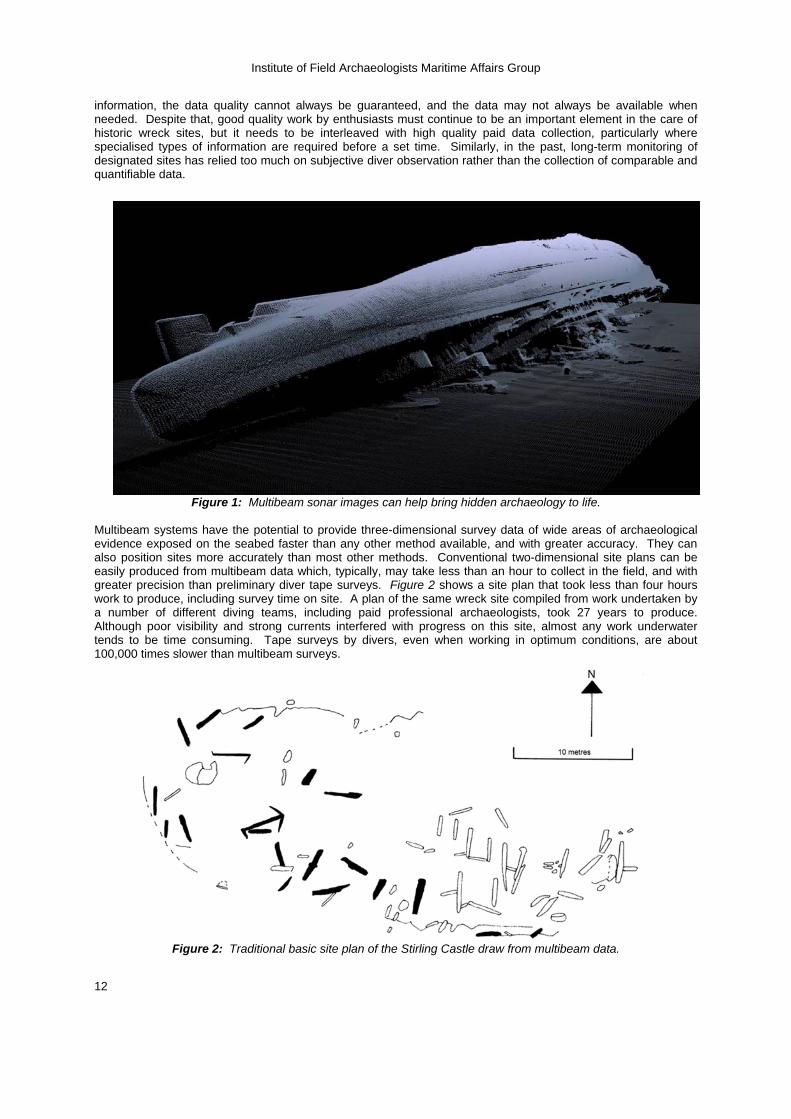
Figure 1: Multibeam sonar images can help bring hidden archaeology to life. Multibeam systems have the potential to provide three-dimensional survey data of wide areas of archaeological evidence exposed on the seabed faster than any other method available, and with greater accuracy. They can also position sites more accurately than most other methods. Conventional two-dimensional site plans can be easily produced from multibeam data which, typically, may take less than an hour to collect in the field, and with greater precision than preliminary diver tape surveys. Figure 2 shows a site plan that took less than four hours work to produce, including survey time on site. A plan of the same wreck site compiled from work undertaken by a number of different diving teams, including paid professional archaeologists, took 27 years to produce. Although poor visibility and strong currents interfered with progress on this site, almost any work underwater tends to be time consuming. Tape surveys by divers, even when working in optimum conditions, are about 100,000 times slower than multibeam surveys.
Figure 2: Traditional basic site plan of the Stirling Castle draw from multibeam data.
Institute of Field Archaeologists Maritime Affairs Group
13
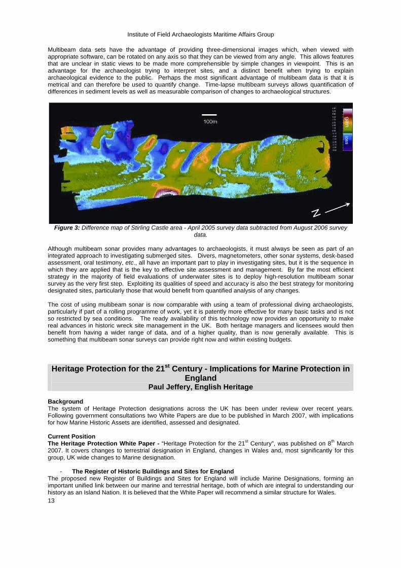
Multibeam data sets have the advantage of providing three-dimensional images which, when viewed with appropriate software, can be rotated on any axis so that they can be viewed from any angle. This allows features that are unclear in static views to be made more comprehensible by simple changes in viewpoint. This is an advantage for the archaeologist trying to interpret sites, and a distinct benefit when trying to explain archaeological evidence to the public. Perhaps the most significant advantage of multibeam data is that it is metrical and can therefore be used to quantify change. Time-lapse multibeam surveys allows quantification of differences in sediment levels as well as measurable comparison of changes to archaeological structures.
Figure 3: Difference map of Stirling Castle area - April 2005 survey data subtracted from August 2006 survey
data.
Although multibeam sonar provides many advantages to archaeologists, it must always be seen as part of an integrated approach to investigating submerged sites. Divers, magnetometers, other sonar systems, desk-based assessment, oral testimony, etc., all have an important part to play in investigating sites, but it is the sequence in which they are applied that is the key to effective site assessment and management. By far the most efficient strategy in the majority of field evaluations of underwater sites is to deploy high-resolution multibeam sonar survey as the very first step. Exploiting its qualities of speed and accuracy is also the best strategy for monitoring designated sites, particularly those that would benefit from quantified analysis of any changes. The cost of using multibeam sonar is now comparable with using a team of professional diving archaeologists, particularly if part of a rolling programme of work, yet it is patently more effective for many basic tasks and is not so restricted by sea conditions. The ready availability of this technology now provides an opportunity to make real advances in historic wreck site management in the UK. Both heritage managers and licensees would then benefit from having a wider range of data, and of a higher quality, than is now generally available. This is something that multibeam sonar surveys can provide right now and within existing budgets. Heritage Protection for the 21st Century - Implications for Marine Protection in
England Paul Jeffery, English Heritage
Background The system of Heritage Protection designations across the UK has been under review over recent years. Following government consultations two White Papers are due to be published in March 2007, with implications for how Marine Historic Assets are identified, assessed and designated. Current Position The Heritage Protection White Paper - “Heritage Protection for the 21st Century”, was published on 8th March 2007. It covers changes to terrestrial designation in England, changes in Wales and, most significantly for this group, UK wide changes to Marine designation.
- The Register of Historic Buildings and Sites for England The proposed new Register of Buildings and Sites for England will include Marine Designations, forming an important unified link between our marine and terrestrial heritage, both of which are integral to understanding our history as an Island Nation. It is believed that the White Paper will recommend a similar structure for Wales.
Institute of Field Archaeologists Maritime Affairs Group
14
The DEFRA Marine Bill White Paper is due to be published on 15th March. It is primarily concerned with wider issues of Marine environmental management and Spatial Planning. However, it is likely to include consideration of Heritage as one of its triggers. Designation in the future, definitions & requirements for information A key to the future Designation system for historic assets is a greater need to assess sites against published criteria, in England known as Principles of Selection. Designation decisions will increasingly need to include a “Reason for Designation”, or “Summary of Importance”. This justification for inclusion of an asset will be the most important part of the designation documentation, explaining why an asset is deemed to be of significant special interest to merit protection. The description will in future be intended to support the decision and to explain what is being designated, including key historic links. This new focus on not just “what” but “why” for all Historic Asset designations will require access to better information, both on significance within a particular class of Asset and of the wider national and international significance of the asset type. This approach will provide a much clearer understanding of what is seen as important and the reasons. This will in turn inform discussions about the subsequent management of the Asset, whether a specific site being considered for a Heritage Partnership Agreement under the Register in England or a broader Marine Spatial Planning issue under the UK wide Marine Bill. The criteria will provide standard questions for research to answer where a specific marine asset is being investigated. To ensure the criteria is appropriate and up to date, information about both historic research and any changes to asset numbers and condition will need to be collated effectively. - Definitions. The DCMS Consultation (Protecting our Marine Historic Environment) identified that the marine environment contains the marine historic environment made up of historic assets (from submerged landscapes, sites, finds, to shipwrecks). Clear definitions of what constitutes a marine historic asset, what they are and how they are linked to the criteria will be at the core of informing designation decisions and of identifying and recording both designated (protected) and also other assets not protected on the Register. Historic Environment Records Historic Environment Records will be the focus of much attention as the databases on which ALL known historic assets, not just the designated ones, are recorded. The Heritage Protection White Paper makes recommendations on the need for easily accessible and more standardised provision of HERs’ and the sharing of information between local and national databases. These are the ideal place for information to be collated and accessible and this has implications for marine assets which are currently not recorded systematically on coastal HERs. Monitoring Mechanisms for monitoring designated marine sites and the process for obtaining advice are another key area for the future. Here, mechanisms for recreational divers being given a way of reporting changes to site conditions might be one way of involving the public in protecting our marine heritage. Certainly, as on land, there is unlikely to be significant new funding available for monitoring and the question is more, how can we realign the current resources and support them to improve the system by building on examples of good practice and using mechanisms like Heritage Partnership Agreements to focus resources where they are most needed. Conclusion The two White Papers represent significant challenges and opportunities for the Heritage Sector, not least in the Marine Environment. The response to the consultation carried out by DCMS showed that the public felt more should be done to protect our marine heritage. If we are to do this effectively in the future, whatever the legislative framework, good quality information and evaluation to agreed standards across the sector will be essential. Paul Jeffery, Heritage Protection Programmes Team Manager, English Heritage 9th March 2007 White Paper: http://www.culture.gov.uk/Reference_library/Consultations/2007_current_consultations/hpr_whitepaper07.htm Contact [email protected]
Institute of Field Archaeologists Maritime Affairs Group
15
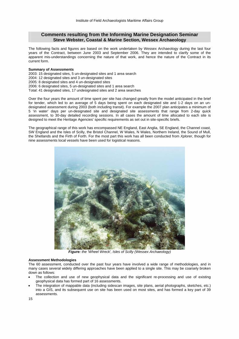
Comments resulting from the Informing Marine Designation Seminar
Steve Webster, Coastal & Marine Section, Wessex Archaeology The following facts and figures are based on the work undertaken by Wessex Archaeology during the last four years of the Contract, between June 2003 and September 2006. They are intended to clarify some of the apparent mis-understandings concerning the nature of that work, and hence the nature of the Contract in its current form. Summary of Assessments 2003: 15 designated sites, 5 un-designated sites and 1 area search 2004: 12 designated sites and 3 un-designated sites 2005: 8 designated sites and 4 un-designated sites 2006: 6 designated sites, 5 un-designated sites and 1 area search Total: 41 designated sites, 17 undesignated sites and 2 area searches Over the four years the amount of time spent per site has changed greatly from the model anticipated in the brief for tender, which led to an average of 5 days being spent on each designated site and 1-2 days on an un-designated assessment during 2003 (both including transit). For example the 2007 plan anticipates a minimum of 5 ‘in water’ days per un-designated site and designated site assessments that range from 2-day quick assessment, to 30-day detailed recording sessions. In all cases the amount of time allocated to each site is designed to meet the Heritage Agencies’ specific requirements as set out in site-specific briefs. The geographical range of this work has encompassed NE England, East Anglia, SE England, the Channel coast, SW England and the Isles of Scilly, the Bristol Channel, W Wales, N Wales, Northern Ireland, the Sound of Mull, the Shetlands and the Firth of Forth. For the most part this work has all been conducted from Xplorer, though for nine assessments local vessels have been used for logistical reasons.
Figure: the 'Wheel Wreck', Isles of Scilly (Wessex Archaeology)
Assessment Methodologies The 60 assessment, conducted over the past four years have involved a wide range of methodologies, and in many cases several widely differing approaches have been applied to a single site. This may be coarsely broken down as follows: • The collection and use of new geophysical data and the significant re-processing and use of existing
geophysical data has formed part of 16 assessments. • The integration of mappable data (including sidescan images, site plans, aerial photographs, sketches, etc.)
into a GIS, and its subsequent use on site has been used on most sites, and has formed a key part of 39 assessments.
Institute of Field Archaeologists Maritime Affairs Group
16
• Some level of desk-based work has formed part of all of the assessments, but in 30 cases this type of work has represented a key component of the assessment.
• Tracked diver survey, and the live integration of diver records directly into a database has been a key component of the recording system applied to 39 of the sites assessed. In some cases this has been the main tool used to position features on the seabed. In these cases the methodology has been developed to the extent that it is now possible to generate plans, to the level of accuracy expected from an off-set survey, for large sites within a small number of dives. Where used for navigation it has proved possible to hugely reduce the time taken trying to find features in low visibility, and it is also an invaluable tool for evidencing the area of seabed covered during searches. The database has also been developed to the extent that full terrestrial standard recording (involving context sheets) can now be undertaken ‘live’ on submerged sites.
• Video and still photography has been used as a standard recording tool in all but the blackest water. In addition to this, rapid photo-mosaics have been employed as a key recording tool on 12 sites. This ‘free-swimming’ type of photogrammetry is less accurate (though not significantly) but far quicker than traditional methods that employ a frame. It was developed at the end of the 2003 season and is now a key component on all sites where suitable conditions prevail.
• Planning using drawing frames and tapes is the most time-consuming means of producing a site plan. However, it is still the best means of producing an accurate plan on many sites, and has been used during eight assessments.
• Direct measured surveys using tapes have formed part of most diver assessments, but in 19 cases this has been a key method of recording.
• Monitoring, formerly seen as one of main roles of the Contractor has been a key component of 10 assessments. However, in only one case was this monitoring aimed at the work of individuals, for the most part ‘monitoring’ refers to the placing and recording of specific points on wrecks.
• And lastly, in three cases shore based work (other than desk-based assessment) was employed. There is no one model for the assessment, recording and monitoring of a historic shipwreck; each site presents it’s own unique set of challenges. The decision as to which methods should be applied to which sites has been determined by position, bathymetry, the nature of the site and also conditions at the time of the assessment. But above all, the driving factor behind each assessment and the methods used has been the brief supplied by the Heritage Agency, and hence the questions that they want answered. The seminar ended with the drafting of a summary position statement which drew on information presented during the talks and discussion. This statement outlines the way forward for the discipline in relation to the provision of advice within the marine designation system. These principles were unanimously agreed on at by all those attending.
• Resources must be used in most efficient and flexible way that is to maximum public benefit • The system must encourage inclusivity and long term relationships • All work must be done to professional standards, by competent practitioners • Have a statutory system which:
Provides close links with stakeholders Supports the concept of local stewardship Provides appropriate archaeological advice locally Provides incentives for investment beyond Heritage Agency funds Enhances maritime archaeological capacity Broadens methodological development Provides enhanced career development
• Lobby effectively for increases in marine heritage funding This Position Statement presents some challenges, however, considering the progress that has been achieved in relation to the marine historic environment in the past ten years these challenges should not been seen as insurmountable!
Please feel free to copy and distribute this Bulletin to your organisation


