Embed Size (px)
Citation preview

The Silverstein Law FirmA Professional Corporation
215 North Marengo Avenue, 3rd Floor Pasadena, California 91101-1504
PHONEr (626) 4494200 FaXi (626) 4494205
[email protected] www. RobertSilverste inLaw. com
September 1, 2015
HAND DELIVERED
Council Member Jose Huizar, ChairCouncil Member Marqueece Harris-Dawson, Vice-ChairCouncil Member Gilbert A. CedilloCouncil Member Mitchell EnglanderCouncil Member Felipe FuentesLos Angeles City CouncilPlanning and Land Use Mgt. Committeec/o City Clerk, Room 395City Hall, 200 North Spring StreetLos Angeles, CA 90012-4801
3qcc.q
oiT
PLUM CommitteeSeptember 1, 2015Page 2
II. THE PROJECT SUBMITTALS ARE INCOMPETE, MAKING ANY APPROVAL IMPROPER AT THIS TIME.
A Mitigated Negative Declaration is inappropriate “where the agency has failed either to provide an accurate project description or to gather information and undertake an adequate environmental analysis. An accurate and complete project description is necessary for an intelligent evaluation of the potential environmental impact of the agency’s action.” City of Redlands v. County of San Bernardino (2002)96 Cal.App.4th 398, 406. “[Ojnly through an accurate view of the project may the public and interested parties and public agencies balance the proposed project’s benefits against its environmental cost, consider appropriate mitigation measures, assess the advantages of terminating the proposal and properly weigh other alternatives.” City of Santee v. County of San Diego (1989) 214 Cal.App.3d 1438, 1454.
An accurate project description includes complete and correct project submittals. According to the DCP March 11, 2015 Recommendation Report to the ELAAPC: “the Deputy Advisory Agency did not approve the buildings’ footprints and elevation. . .The applicant was required to submit a revised map that addressed those issues and LADOT concerns. See January 26, 2015 Decision Letter, Condition 15.c. This does not yet appear to have occurred. Accordingly, the Project should be denied and the appeal granted on this basis alone.
In sustaining the actions and adopting the findings of the DAA, the ELAAPC stripped out condition 15.c, presumably as a result of a new site plan submitted in February 2015 to address LADOT concerns. That site plan, however, did not revise building footprints or elevations. The revised map - including elevations - is what provides the accurate and complete project description necessary for an intelligent evaluation of the potential environmental impact. Until a revised map is submitted, and opportunity for review provided, approval of the Project is improper.
Additionally, even though the ELAAPC stripped out condition 15.c, it did not change the DAA findings. Because the DAA findings would have been contingent on changes being made to the footprints and elevations, findings necessary to approve the Project cannot be made. See Section IV.B, infra.

PLUM CommitteeSeptember 1, 2015Page 3
III. A FAIR ARGUMENT EXISTS OF POTENTIALLY SIGNIFICANTENVIRONMENTAL IMPACTS. MAKING USE OF A MITIGATEDDECLARATION INAPPROPRIATE,
A. Legal Standard
A strong presumption in favor of requiring preparation of an Environmental Impact Report (“EIR”) is built into the California Environmental Quality Act (“CEQA”). This presumption is reflected in what is known as the “fair argument” standard, under which an agency must prepare an EIR whenever substantial evidence in the record supports a fair argument that a project may have a significant effect on the environment. Laurel Heights Improvement Ass'n v. Regents of the Univ. of Cal. (1993) 6 Cal.4th 1112, 1123; Communities for a Better Environment v. California Resources Agency (2002) 103 Cal.App.4th 98, 111-112.
An EIR must be prepared where there is substantial evidence that significant effects “may” occur. League for Protection of Oakland’s Architectural and Historic Resources v. City of Oakland (1997) 52 Cal.App.4th 896, 904-905. A project “may” have a significant effect on the environment if there is a “reasonable probability” that it will result in a significant impact. No Oil, Inc, v. City of Los Angeles (1974) 13 Cal.3d 68, 83, n. 16. If any aspect of the project may result in a significant impact on the environment, an EIR must be prepared even if the overall effect of the project is beneficial. CEQA Guidelines § 15063(b)(1),
Substantial evidence “includes fact, a reasonable assumption predicated upon fact, or expert opinion supported by fact.” Pub. Res. Code § 21080(e)(1). It also includes “reasonable inferences from this information that a fair argument can be made to support a conclusion, even though other conclusions might also be reached ....” (Emphasis added.) CEQA Guidelines § 15384(a).
The fair argument test is a “low threshold” test for requiring the preparation of an EIR. No Oil, supra, 13 Cal.3d at 84. Evidence supporting a fair argument of a significant environmental impact triggers preparation of an EIR regardless of whether the record contains contrary evidence. League for Protection, supra, 52 Cal.App.4th at 904-905. This standard reflects a preference for requiring an EIR to be prepared, and a preference for resolving doubts in favor of environmental review. Mejia v. City of Los Angeles (2005) 130 Cal.App.4th 322, 332.

PLUM CommitteeSeptember 1, 2015Page 4
B. A Fair Argument Exists of Significant, Unmitigable Land Use and
Planning Impacts.
1* Silver Lake-Echo Park - Elysian Village Community Plan.
A fair argument that there may be significant environmental impacts exists if the Project conflicts with any applicable land use plan, policy or regulation of an agency with jurisdiction over the Project adopted for the purpose of avoiding or mitigating an environmental effect. Here, the Project is inconsistent with a number of relevant residential policies in the Community Plan. Specifically, the Project is inconsistent with policies that include the following:
• 1-1.3 Protect existing single family residential neighborhoods from new out-ofscale development.
• 1-1.4 Encourage new infill residential development that complements existing development and architectural style.
• 1-1.5 Protect existing stable single family and low-density multiple family residential neighborhoods from encroachment by higher density residential and other incompatible uses.
• 1-1.6 Promote the preservation of existing single and multiple family neighborhoods.
• 1-3.1 Seek a higher degree of architectural compatibility and landscaping for new infill development to protect the character and scale of existing residential neighborhoods. (See Exh. 1 [pp. Ill-1 -9].)
According to a motion put forward by Councilman O’Farrell and seconded by PLUM Chair Councilman Huizar on March 18, 2014 seeking to initiate a General Plan amendment and rezoning (Exh. 2), “[t]he 800-block of Hyperion Avenue has a unique neighborhood character and environmental setting characterized by hillside lots, substandard streets, mature vegetation and early twentieth century housing.”
The proposed Project is an 8-lot SLS on a buildable area of 12,513 square feet, slightly more than 14 acre. The submitted plans show the homes to be 3-stories, 36 feet high, and in a box style, significantly taller than homes on surrounding properties.
PLUM CommitteeSeptember 1, 2015Page 5
Appellant has provided substantial evidence of the Project’s incompatibility with the surrounding community with a height and massing that will dramatically alter the neighborhood character. The Project’s scale dwarfs adjacent properties, and orients upper-floor balconies directly into neighbors’ windows, further compromising privacy and neighborhood character. (Exh. 3.)f This creates a potentially significant environmental impact not yet addressed, and one for which an MND is inappropriate. At a minimum, an EIR is required.
2. Small Lot Subdivision Guidelines.
One of the bases of the appeal was that the Project does not comply with the SLS Design Guidelines. (Exh. 4.) The appellant provided ten different guidelines with which the Project conflicts:
• The Project is not context sensitive. (Id., p. 1.)
• The Design is not compatible with the existing neighborhood. (Id., p, 6.)
• The Developer has not considered the design elements of the 8 homes and how they will enhance the overall neighborhood character. (Id., p. 8.)
• The characteristics of the Project do not relate to the surrounding built form, respecting the overall neighborhood character and existing topography. (Id., p.
9.)
• The Project is not compatible with the existing neighborhood. (Id., p. 9.)
• The Project does not take into account the neighborhood context for existing front yard setbacks. (Id., p. 10.)
• The Project’s building heights are not constructed with a building to height ratio of 1-4. (Id, p. 17.)
• The Project is not appropriately designed to and scaled to transition from the single-family properties surrounding it. (Id., p. 24.)
• The Project does not minimize the number of windows and balconies overlooking neighboring interior private yards and windows. (Id., 24.)
i These photos were part of a presentation made by the appellant to the ELAAPC.

PLUM CommitteeSeptember 1, 2015Page 6
Staffs response to the ELAAPC was not that the Project complied with the SLS Guidelines. Rather, the response was simply that the Guidelines are not mandates or regulations; they simply illustrate a series of common design guidelines, best practices and case studies. The discretionary nature of the Guidelines, however, is beside the point. Conformity with the Guidelines is an indicator of conformity with the residential policies of the Community Plan enacted to protect single-family neighborhoods from out- of-scale development. Indeed, one of the programs to implement policies 1-1.3, 1.1-4, and 1-3.1 is the establishment of design guidelines.
Inherent in establishing design guidelines is that conformity and consistency with them is necessary to establish conformity and consistency with the underlying policies. Failing to conform to the SLS Design Guidelines, whether mandatory or not, thus means that the Project is inconsistent with the relevant residential policies of the Silver Lake- Echo Park-Elysian Village Community Plan.
3. Citywide Residential Design Guidelines.
In addition to the SLS Guidelines, the City also has Citywide Residential Design Guidelines whose purpose is to implement the urban design principles that are a part of the Framework Element of the City’s General Plan. (Exh. 5.) One of the Guidelines addressing relationship to adjacent buildings is “mitigate negative shade/shadow and privacy impacts by stepping back upper floors and avoiding direct views into neighboring single-family yards.” (Id.) The inconsistency of the proposed Project with this Guideline is further evidence of inconsistency with the relevant portions of the General Plan.
C. A Fair Argument Exists of Significant, Unmitigable Traffic Impacts.
1. Project Impacts.
Among the questions asked by the Initial Study is whether the Project would substantially increase hazards due to a design feature. Here, the common access driveway is as narrow as 12 feet - 40% narrower than the minimum identified in the City’s Private Street Regulations, General Variation 2001-1. See Section IV.D, infra.
The driveway is too narrow for simultaneous ingress/egress. Given the particulars of this stretch of Hyperion Avenue -including a blind sloping S-curve and its function as a collector street (even though it is identified as a local street), a common access driveway that does not allow for simultaneous ingress/egress would be a design feature that substantially increases public safety hazards (id.), creating a potentially

PLUM CommitteeSeptember 1, 2015Page 7
significant impact for which an MND is inappropriate. Accordingly, use of an MND is improper. At a minimum, an EIR is required.
2. Cumulative Traffic Impacts.
According to the Initial Study, “[t]he proposed project does not reach a threshold that requires preliminary review by LADOT.” However, there is no mention of cumulative impacts at all.
That a threshold for project analysis may not have been met does not mean that no impacts, or no cumulative impacts, exist. Communities for a Better Environment v. California Resources Agency (2002) 103 Cal.App.4th 98, 117.
A cumulative impact consists of an impact which is created as a result of the combination of the project together with other projects causing related impacts. CEQA Guidelines § 15130(a)(1). “One of the most important environmental lessons evident from past experience is that environmental damage often occurs incrementally from a variety of small sources. These sources appear insignificant, assuming dimensions only when considered in light of the other sources with which they interact.” Los Angeles Unified School District v. City of Los Angeles (1997) 58 Cal.App.4th 1019, 1025 (internal citations and quotes omitted).
CEQA recognizes the potential for an accumulation of small contributions to a problem to create a cumulative effect, and requires investigation and disclosure of the potential of a project to be the straw that breaks the camel’s back. Guidelines § 15065(a)(3). If a lead agency finds a project’s incremental effect is not “cumulatively considerable,” the agency does need not to consider that effect significant, but it must “briefly describe its basis for [so] concluding. ..Guidelines § 15130(a). As with other aspects of CEQA, “cumulative impact analysis must be interpreted so as to afford the fullest protection of the environment within the reasonable scope of the statutory and regulatory language.” Citizens To Preserve the Ojai v. County of Ventura (1985) 176 Cal.App.3d 421, 431-432.
Over 2,000 individual homes were approved in more than 200 SLS developments between 2005 and November 2014. (Exh. 6.) A Los Angeles Times article from July 13, 2013 suggests the bulk of them are in and around the Silverlake and Echo Park neighborhoods. (Exh. 7.) Anecdotally, we are aware of at least 135 lots in 23 SLS developments within two miles of the proposed project that we believe are very recent past, present, and probable future SLS projects producing related or cumulative traffic impacts. (Exh. 8.) One additional single family home on the 800 block of Hyperion

PLUM CommitteeSeptember 1, 2015Page 8
Avenue was listed for sale as an “investment opportunity” (Exh. 9), implying that it, too, is ripe for subdivision. Because of their size, cumulative impacts analysis for most, if not all, of these projects has probably never occurred. We are also aware of what we believe are at least 814 multi-family dwelling units in another 11 projects that may be considered related projects. (Id.) This does not include commercial projects, which would add further traffic.
As noted in the attached correspondence from Mr. Herman Basmaciyan, a consulting traffic engineer with over 50 years’ experience, this level of development within the general vicinity of the proposed Project could have a potentially significant cumulative circulation impact on:
• Level of Service (LOS) impacts at signalized intersections
• LOS impacts on Caltrans facilities: SR-101 and SR-2 Freeways; freeway ramp terminals
• Traffic operational and safety considerations at unsignalized intersections
• LOS impacts at Congestion Management Program (CMP) monitoring intersections and/or on CMP facilities
• Addition of vehicular traffic on local streets
• Increased potential conflicts between vehicular and pedestrian/bicycle traffic(Exh. 10.)
A multitude of new projects are underway in and around Silverlake/Echo Park and in the immediate vicinity of the Project, as well as several other nearby projects in the planning stages or reasonably foreseeable. Citizens Assn, for Sensible Development of Bishop Area v. County of Invo (1985) 172 Cal.App.3d 151, made it clear that consideration must reach beyond those projects currently under environmental review: “Related projects currently under environmental review unequivocally qualify as probable future projects to be considered in a cumulative analysis. [Citation.] In addition, even projects anticipated beyond the near future should be analyzed for their cumulative effect.” Id. at 168, citing Bozung v. Local Area Formation Com. (1975) 13 Cal.3d at 284.

PLUM CommitteeSeptember 1, 2015Page 9
“A cumulative impact analysis which understates information concerning the severity and significance of cumulative impacts impedes meaningful public discussion and skews the decisionmaker’s perspective concerning the environmental consequences of the project, the necessity for mitigation measures, and the appropriateness of project approval.” Citizens to Preserve the Ojai v. County of Ventura (1985) 176 CaI.App.3d 421, 431. Accordingly, use of an MND is improper. At a minimum, an EIR is required.
D. A Fair Argument Exists of Significant, Unmitigable Geologic Impacts.
As noted in the attached geotechnical report from Wilson Geosciences, Inc. (Exh. 11), there is a fair argument of potentially significant geologic and geotechnical impacts caused by the Project.2ln particular, Mr. Wilson and Mr. Abdel-Haq have identified “substantial evidence of potential slope instability within and adjacent to the proposed development site that have not been considered.” (Id. at p. 6.) Accordingly, use of an MND is improper. At a minimum, an EIR is required.
IV. THERE IS NO SUBSTANTIAL EVIDENCE TO SUPPORT THEFINDINGS NECESSARY TO APPROVE THE VESTING TENTATIVE TRACT MAP.
Pursuant to Government Code Sections 66474.60 and 66474.61, the City Council shall deny approval of a tentative map if any one of the findings is made:
(a) That the proposed map is not consistent with applicable general and specific plans....
(b) That the design or improvement of the proposed subdivision is not consistent with applicable general and specific plans.
(c) That the site is not physically suitable for the type of development.
(d) That the site is not physically suitable for the proposed density of development.
Given the size and length of the references cited in Mr. Wilson’s and Mr. Abdel- Haq’s report, they are being provided to the City Clerk in digital format only and are not attached in hard copy to this letter.

PLUM CommitteeSeptember 1, 2015Page 10
(e) That the design of the subdivision or the proposed improvements are likely to cause substantial environmental damage or substantially and avoidably injure fish or wildlife or their habitat.
(0 That the design of the subdivision or the type of improvements is likely to cause serious public health problems.
(g) That the design of the subdivision or the type of improvements will conflict with easements, acquired by the public at large, for access through or use of property within the proposed subdivision. In this connection, the legislative body may approve a map if it finds that alternate easements, for access or for use, will be provided, and that these will be substantially equivalent to ones previously acquired by the public.
Here, the City Council must make some of these findings. As a result, the City Council must deny the vesting tentative tract map.
A. The Proposed Map is Not Consistent with the Applicable General Plan.
The portion of the Land Use Element of the General Plan governing the Project is the Silver Lake-Echo Park-EIysian Village Community Plan. According to the Plan, “[enhancing quality of life and preserving neighborhood character are [its] priorities.” (Exh. 1 [p. III-l],) As detailed above in Section III.B, the Project is not consistent with these priorities and the relevant policies in the Plan designed to advance those priorities, including the SLS Design Guidelines that have the effect of implementing some of the policies. Substantial evidence does not exist to make findings to the contrary.
In addition, the Project is not consistent with Policy 1-6.1, “[l]imit development according to the adequacy of the existing and assured street circulation system within the Plan area and surrounding areas.” (Id. [p. Ill-14].) The substandard nature of the 800 block of Hyperion Avenue has been demonstrated through the motion put forward by Councilman O’Farrell and seconded by PLUM Chair Councilman Huizar. (Exh. 2.) Hyperion is classified as a secondary road north of Fountain, but is considered only a

PLUM CommitteeSeptember 1, 2015Page 11
local street south of Fountain/ Based on long-term observations of area residents, though, Hyperion south of Fountain functions much more intensively than a local street, serving as a collector between Fountain and Melrose.4 The inadequacy of the street for additional traffic is exacerbated by a sloping blind ‘S’ curve just north of the Project site. (Exh. 13 &14.) Simply put, Hyperion is inadequate for additional traffic, including that from this and other planned and potential small lot subdivisions along the street.
It is also inconsistent with Policy 1.6-4, “[ejnsure that any proposed development be designed to enhance and be compatible with adjacent development.” As noted in Section I1I.B.2, the Project is not consistent with community character and the scale and orientation is not compatible with adjacent development. (See also Exh. 3.)
The ELAAPC finding of consistency is limited to a conclusory statement with no evidence to support it. The finding does identify the land use designation for the Project site, implying conformity with the allowable density, but as noted throughout this correspondence, the Plan is far more than an agglomeration of land use designations and corresponding maximum densities.
B. The Design or Improvement of the Proposed Subdivision is Not Consistent with the General Plan.
The inconsistencies identified above in Sections III.B and IV.A are equally applicable here.
Moreover, the findings of the DAA, sustained by the ELAAPC, were contingent on revisions to the building footprints and elevations. While the ELAAPC eliminated the required revisions, it did not change the findings - findings that were contingent on those revisions. The evidence in the record thus still supports a conclusion that the design or improvement of the proposed Project is inconsistent with the relevant policies of the Silver Lake-Echo Park-Elysian Village Community Plan, at least until such time as
Although invalidated by the Superior Court, the Hollywood Community Plan Update (“HCPU”) EIR also treated Hyperion north of Fountain as a Secondary Highway. The Hollywood Community Plan and HCPU do include Hyperion south of Fountain, but the HCPU EIR did consider Hyperion as transitioning from a Secondary Highway to a Collector Street at Fountain. (Exh. 12.)
4 Hyperion merges with Hoover before reaching Melrose.

PLUM CommitteeSeptember 1, 2015Page 12
revised building footprints and building elevations are submitted, and a proper opportunity for review provided.
The ELAAPC finding here was virtually devoid of any discussion of the design or subdivision improvements in the context of the Plan, only conclusory discussion of dimensional requirements in the context of the SLS ordinance. There is no discussion of the SLS Guidelines. As such, substantial evidence does not exist to support a finding of consistency.
C. The Applicant’s Arguments Re General Plan Consistency Are Misleading and Without Evidentiary Support.
The vast majority of the issues and claims raised in the Applicant’s March 2 and March 18, 2015 correspondence have already been addressed herein. Several comments, however, bear further response:
The Applicant states that 12-foot driveways are commonly approved in Small Lot Subdivisions. (March 18, 2015 correspondence, p. 4.)Whether approval of 12-foot driveways is allegedly “common” (and the applicant provides one example) is irrelevant. The determination of a safe and acceptable common access driveway width is site specific, subject to public safety considerations. Here, the Appellant has provided substantial evidence of a fair argument that the proposed width is a public safety hazard and creates potentially significant traffic/circulation impacts.
The Applicant goes on to claim that the appeal provides no analysis or evidence explaining how the MND is deficient with respect to any specific environmental impact. (March 18, 2015 correspondence, p. 5.) Please refer to Section III. The Appellant has provided substantial evidence to support the argument that the site is not suitable for the proposed density and to meet the fair argument standard under CEQA with respect to land use/planning, transportation/circulation, and geotechnical impacts.
The Applicant states there is currently a housing crisis in Silver Lake and throughout the city and this Project contributes to the Mayor’s “goal” of providing new housing. (March 18, 2015 correspondence, p. 6.) The Mayor’s goals are not intended to be used to circumvent the General Plan and Los Angeles Municipal Code and to sacrifice public safety. We also note there is already a significant amount of new development in Silver Lake and Echo Park. Just within a 2-mile radius of the Project site we have identified at least 949 dwelling units, both single family and multi-family, that are of recent construction, in the planning stages, or otherwise reasonably foreseeable. (See Section III.C, supra.)

PLUM CommitteeSeptember 1, 2015Page 13
D. The Site is Not Physically Suitable for the Proposed Density of Development.
There are two issues that lead to a finding that the site is not physically suitable for the proposed density of development: public safety and neighborhood character. The ELAAPC finding here was virtually devoid of any discussion of the density of the development, except to say that the density is permitted under the applicable land use designation and zoning. The appropriateness of a site-specific density is also a function of the circulation system and the character of the neighborhood in which a project site sits.
The substandard nature of the 800 block of Hyperion Avenue has been demonstrated. (Exh. 2.) It is a local street that functions as a collector street between Fountain Ave and Melrose Ave. The inadequacy of the street for additional traffic is exacerbated by a sloping blind ‘S’ curve just north of the Project site, which has been the site of several accidents including at least one fatality in the last 12 years. (Exhs. 13, 14.)5 Traffic calming devices have been rejected by the Fire Department because it uses this stretch of Hyperion Ave as a vital connector to meet emergency response time requirements, leaving it a very dangerous section of road. Simply put, traffic associated with the additional density created by the proposed Project adversely affects traffic and pedestrian safety, making the site not suitable for the density of the proposed project.
This negative impact to traffic safety is exacerbated by what appears to be a substandard driveway apron that does not meet the driveway width recommended in the LADOT Manual of Policies and Procedures. The proposed Project provides a 24-foot driveway apron. The LADOT Manual recommends 28 feet. (Exh.15.) No rationale for this deviation is given, but a driveway apron width less than the LADOT recommendation is further evidence that the site is not physically suitable for the proposed density of development.
The width of the driveway itself, not just the driveway apron, also provides evidence that the site is not suitable for the density of the proposed project. At two points within the subdivision the driveway narrows to 12 feet, while at a third point it narrows to just under 15 feet. This violates the City’s Private Street Regulations, General Variation 2001-1 (Exh. 16), which allows variations to permit common driveway facilities, subject to the following conditions:
Exhibits 13-15 were part of a presentation made to the ELAAPC by the Appellant.

PLUM CommitteeSeptember 1, 2015Page 14
“3. The driveway within such easement is improved to a width in conformance with the Fire Department’s fire access standards as stated in Section 57.09.03 of the Los Angeles Municipal Code, but in no event less than 20 feet....(Emphasis added.)6
Additionally, the structures on either side of the driveway are only 12 feet apart where the driveway narrows to 12 feet, and just less than 15 feet where the driveway narrows to that amount. This, too, is a violation of the General Variation Conditions, “5. The unobstructed distance-from the ground to the sky-between buildings located on either side of said driveway is no less than 20 feet...”
Fire access considerations as a part of driveway/private street conditions are clearly a public safety issue. Indeed, this is more than a fire access issue; it is also a general safety and access issue, especially since pedestrians and bicyclists also will be sharing the driveway. What this says about the proposed Project is that the Applicant cannot achieve the density sought without compromising public safety. Again, this is evidence that the site is not suitable for the density of the proposed project.
Even with the Deputy Advisory Agency mandating a 20-foot reservoir space to provide space for one automobile while waiting for ingress or egress, the amount of traffic on Flyperion Avenue, along with the additional vehicles regularly using a common-access driveway allowing movement in only one direction at a time, will compromise public safety. While the Deputy Advisory Agency is also requiring the street to be widened, the additional space is simply not enough to accommodate three automobiles side by side and thus cannot be construed as enhancing public safety. In the event that a car is waiting in the carriage space, traffic moving south through the blind “S” curve and down the steep slope on this section of Hyperion Avenue will have little time to react and be more likely to attempt to go around the waiting car than to stop. Appellant has seen this occur on a regular basis. South-bound traffic will likely be even more tempted to do so with the additional street width, which will be insufficient to remedy the hazard. (Exh. 14.)
We also note that the street widening is being accomplished by reducing the parkway/buffer between cars and pedestrians, therefore sacrificing pedestrian safety to
There is no longer a Section 57.09.03 in the Los Angeles Municipal Code available on-line and appears to have been renumbered Section 57.503.1.6. (Exh. 17.)

PLUM CommitteeSeptember 1,2015Page 15
produce the illusion of increased automobile safety. Residents of Hyperion Avenue have gained the situational and experiential awareness to properly assess this public safety concern and have communicated such to the Deputy Advisory and the East Los Angeles Area Planning Commission, without so much as acknowledgment. In fact, this concern over public safety has been communicated to the City of Los Angeles for over a decade - starting at least with communications to then-CD13 Councilman Eric Garcetti. (Exh.18.)
The density of the development is also inconsistent with neighborhood character and adjacent properties. Through various motions put forward by members of the City Council over the last two years, there is a recognition of an inherent tension between the SLS Ordinance and character of existing, stable and built-out single family neighborhoods. (Exh. 2, Exh. 19 [Motion presented by Councilmember LaBonge, Nov.1, 2013; Motion presented by Councilmembers O’Farrell and Bonin, July 1, 2015].) The O’Farrell motion of March 18, 2014, in particular, shows how this tension plays out on the 800 block of Hyperion. (Exh, 2.) See Sections III.B and iV.A. To the extent scale and mass can be equated with density, here too, the site is not physically suitable for the proposed density of development, given the height of the buildings compared to those surrounding the proposed Project. The size and mass of the Project will also deprive residences to the north of light during the winter months and a cooling northerly wind known by residents of this area as the “Vermont Draw” during the summer months.
The most common response to any argument that the site is not suited for the proposed density of the development is to point out that the maximum number of units permitted under the zone in question is much higher than what is being sought. This response, however, is a red herring to the relevant issue.
The zoning on every property establishes the range of uses, their maximum permitted density or intensity, and a host of other regulatory requirements, including yards, height, and parking requirements. The site may also be subject to other regulatory restraints, such as grading restrictions. Thus, a site may be developed to the maximum density only provided it conforms to all applicable provisions of the zone. The maximum density practical or suitable for a site is not necessarily the same as the maximum density theoretically permitted for the site. Such is the case here.

PLUM CommitteeSeptember 1, 2015Page 16
V. CONCLUSION.
Based on the foregoing and prior objections in the record, we respectfully request that the City Council grant the appeal and reject the Project.
OBERT P. SILVERSTEIN FOR
THE SILVERSTEIN LAW FIRM
cc: Sharon Gin (via Hand Delivery) Clients (via email)

Exhibit 1
Chapter II!
LAND USE POLICIES AND PROGRAMS
Residential
Chapter III of the Plan Text contains land use planning goals, objectives, policies and programs. Organized by land use category this section is divided into residential, commercial and industnal land use and public and institutional service system categories The Planning Department is responsible for the goals, objectives, policies, initiation and direct implementation of the programs contained in Chapter III.
Enhancing quality of life and preserving neighborhood character are priorities of the Plan, based on input from community stakeholders. As one of the City's oldest areas, its neighborhoods- Silver Lake, Echo Park and Elysian Valley-have grown up with the city and reflect its history, culture, diversity and architectural legacy. As a result, the Plan incorporates goals, objectives, programs and policies that preserve the unique identity and character of its distinct neighborhoods. The goals are aimed at ensuring that the Plan area remains a source of housing for people of all economic levels-giving all income levels access to Downtown and employment centers-and promoting and enhancing its strong sense of community and identity. An important segment and ingredient of this sense of community identity is the area's thriving creative and artistic community and enclaves which greatly lend to the area's distinctive character and its desirability.
Design guidelines can be used to implement many of the Plan area's residential goals, including guidelines for infill development on hillsides whose often substandard streets pose a challenge for parking and circulation. Generally, to preserve the character of existing neighborhoods, guidelines are intended to encourage development that conforms to the prevailing scale and massing and retains densities that bring a particular level of functionality and urban character to the Plan area's neighborhoods. New multiple family residences, especially those that are found in neighborhoods where single and multiple family residences are mixed, should be sensitive to the topography and the constraints of hillside streets and complement the prevailing scale, character and represented architectural styles. Where appropriate and possible, traditional courtyard-style, multiple family housing developments that incorporate open space, provide a friendly environment for pedestrians, and de-emphasize in their design vehicular access and parking are encouraged.
The Plan designates residential land use densities as indicated in Table I. The table depicts the reasonable expected population and dwelling unit count for the year 2010, using the mid-point of the range for the dwelling units per net acre category. The midpoint represents a reasonable factor to use, as new development within each land use category is not likely to occur at one or the other extremes of the range but rather throughout the entire range.
Silw Ula-td» f*rfc-ffyiian Viltty Community fUo
111-1

Plan Population and Dwelling Unit Capacity
Residential
Land Use
Category
Dwelling
Units Per
Net Acre Midpoint (Range)
Number of
Dwelling
Units Net Acres
Persons
Per
Dwelling
Unit
(2010)
Reasonable
Expected
Population
Low 6.5 (4+ TO 9) 4,198.86 645.978 3.03 12,722.55
LowMedium I
13.5 (9+ to18) 8,446.88
625.6953.07 25,931.92
LowMedium il
23.5 (18+TO 29) 11,970.92
509.4013.07 36,750.72
Medium 42(20+ TO 55) 6,370.77
151.6853.06 19,494.56
TOTALS 30,987.43 1,932.759 94,899.75*•This number does not include the number of dwelling units expected to be developed in commercial areas. When counting the number of dwelling units forecasted to be developed in commercial areas, the reasonable expected population is estimated to be 95,258.
GOAL 1 A SAFE, SECURE AND HIGH QUALITY RESIDENTIAL ENVIRONMENTFOR ALL ECONOMIC, AGE AND ETHNIC SEGMENTS OF THE PLAN AREA.
Objective 1-1 Achieve and maintain a housing supply sufficient to meet the diverseeconomic and socioeconomic needs of current and projected population to the year 2010.
Policies
1-1.1 Maintain an adequate supply and distribution of multiple family, low income and special needs housing opportunities in the Community Plan Area.
Program: The Plan Map identifies specific areas where multiple family residential development is permitted.
Program: Encourage use of Los Angeles Housing Department (LAHD) housing development programs which provide financing for the construction of new and the acquisition and rehabilitation of existing multiple family housing. Programs also offer loans for the rehabilitation of multiple family apartments occupied by low- income families in partnership with housing developers,
Sitvw Uke^dw Vaficy Comrmmity PUn
MI-2

community housing development organizations and existing property owners.
1-1.2 Improve the quality of existing single family and multiple family housing throughout the Plan Area
Program: Promote the rehabilitation of existing housing stock over demolition.
Program: Assist the LAHD in identifying low income areas, particularly in Echo Park, where funds can be allocated to make existing housing compliant with minimum health and safety standards.
Program: Promote use among Plan area residents of the LAHD's single family housing rehabilitation loan program, the Handyworker program and home ownership assistance programs to encourage maintenance, repair, rehabilitation and home ownership among eligible low-and moderate-income homeowners and residents in the area.
Program: Encourage developers of new residential multiple family development to reserve 15% of new rental and condominium units for very low to moderate-income households. Affordable rent levels are those that do not exceed 30% of 50% to 120% of area median income.
1-1.3 Protect existing single family residential neighborhoods from newout-of-scaie development.
Program: In Chapter V, Urban Design guidelines encourage infill residential development that complements existing scale, massing, setbacks and character and is compatible with architectural styles in stable single family neighborhoods.
Program: Adhere to existing zoning which buffers single family residential areas from higher density multiple family areas with transitional low medium multiple family residential zones, retain the height limitations in residential areas and concentrate new development in designated Mixed Use Boulevards.
Program: Designate portions of Temple Street, SunsetBoulevard and Fountain and Hyperion Avenues as Mixed Use Boulevards to encourage an increase in the housing supply and preserve single family neighborhoods (see Figures 1 and 3).
Program: Stabilize neighborhoods in lower-income areas by increasing home ownership through the use of LAHD home ownership assistance programs for low- and moderate-income residents.
S3w |*lc*-€cho Part-flyHaw Vatey Co«n<mm«tY fUt

1-1.4 Encourage new infill residential development that complements existing development and architectural style.
Program: Design Guidelines and Standards for residential development are included in Chapter V, the Urban Design Chapter of the Community Plan
1-1.5 Protect existing stable single family and low-density multiple family residential neighborhoods from encroachment by higher density residential and other incompatible uses.
Program: The Plan Map identifies lands where only single family residential development is permitted; it protects these areas from encroachment by designating, where appropriate, transitional residential densities which serve as buffers.
1-1.6 Promote the preservation of existing single and multiple family neighborhoods.
Program: The Community Plan establishes residential land use categories and makes an appropriate designation for each neighborhood in the Community Pian Area. All zone changes, subdivisions, parcel maps, variances, conditional uses, specific plans, community and neighborhood revitalization programs for residential projects shall be consistent with Community Plan land use designations.
Program: Promote use of the Homeowner's Encouragement Loan Program (HELP), administered by the City's Housing Department, which provides rehabilitation loans to owners of small residential buildings (one to four units) to correct code violations.
Program: Promote use of the Neighborhood Preservation Program, administered by the City’s Housing Department which provides rehabilitation loans to owners of residential buildings of five or more units that are occupied by low-to moderate-income households.
Program: Promote use of the Neighborhood Recovery Program, administered by the City’s Housing Department, which identifies programs and organizes City Services including rehabilitation loans and home ownership programs.
Program: Seek Targeted Neighborhood Initiative (TNI) hinds, a grant program initiated by the Mayor’s Office and administered by the various City departments (often the City's Departments of Housing and Community Development and the Community RedevelopmentAgency), to support housing rehabilitation, home ownership, public improvements and economic development.
Silvtf UMdw Vatfey Cwwwwfy Ww

Objective 1-2
1-1.7 Promote the unique quality and functionality of the Community Plan Area’s mixed single and multiple family residential neighborhoods by encouraging infill development that continues to offer a variety of housing opportunities that capitalize on the eclectic character and architectural styles of existing development.
Program: Enforce design guidelines and standards forresidential development that are included in the Urban Design Chapter of the Community Plan.
Reduce automobile trips in residential areas by locating new housing in areas offering proximity to goods, services and facilities.
Policies
1 -2.1 Locate higher residential densities near commercial centers and major bus routes where public service facilities, utilities and topography will accommodate this development.
Program: Maintain and continue the implementation of the City’s Land Use/Transportation policy.
Program: The Plan concentrates higher residential densities near transit corridors and in mixed-use areas (see policy 1-2.2).
Program: Re-zone Temple Street from Benton Way to Robinson Street to the RAS 3 zone to promote mixed-use development along a major bus route.
1-2.2 Encourage multiple family residential development in commercially zoned areas in designated Neighborhood Districts and Community Centers and along Mixed Use Boulevards (see Figure 1) and, where appropriate, provide floor area bonuses as an incentive to encourage mixed-use development in those areas .
Program: Encourage development in the designated Neighborhood District on Glendale Boulevard from south of Fletcher Dr. to Deane St. (Silver Lake/Gfendale Boulevard Neighborhood District; see Figures 1 and 2).
Neighborhood Districts, activity centers that serve a surrounding residential population of 15,000-20,000 people, should be composed of commercial (offering a mix of neighborhoodsupporting retail and services), small professional office, small cultural facilities and residential units. In designated Neighborhood Districts, mixed-use development incorporating ground floor commercial and above ground residential uses are encouraged and permitted by-right within existing permitted Floor
SHver Uifce-tcho farfc-ffytiafl Valky Community flan
111-5

Area Ratios, Joint live/work units are encouraged when scale and uses are complementary to surrounding development.
Program: Encourage zone changes or other appropriate discretionary actions to allow increased FAR levels in the following areas (see Figures 1, 2 and 5J :
• Alvarado Street/Sunset Boulevard Community Center -1.5:1 FAR for commercial only structures in the Community Center and a maximum 3:1 FAR for mixed- use development, with appropriate discretionary approval, on Alvarado Street from Sunset Boulevard to Temple Street.
Community Centers, activity centers that serve a surrounding residential population of 25,000-100,000 people, should comprise community-supporting retail and services and office commercial, residential units, entertainment uses and larger cultural facilities and public facilities. Mixed-use development is encouraged in all Community Centers. As noted above, a mixed-use FAR bonus is offered in specific Community Centers to provide incentive for development that incorporates both uses, commercial on the ground floor with residential uses above.
Program: Encourage mixed-use development and permit mixed- use FAR bonuses on designated Mixed Use Boulevards to provide incentives for developments that incorporate ground floor commercial and above ground residential uses (see Figures 1, 2 and 5) as follows:
• Sunset Boulevard - from the Pasadena Freeway to Fountain Avenue with a 1.5:1 commercial and mixed-use FAR, except specific segments as listed in Policy 2-4.3, and shown in Figure 5, where a maximum 1.5:1 commercial and 3:1 mixed- use FAR would be permitted, with appropriate discretionary approval.
• Temple Street - from Glendale Boulevard to Silver Lake Boulevard with a 1.5:1 commercial FAR and a 3:1 mixed-use FAR, with appropriate discretionary approval.
• Fountain and Hyperion Avenues from Sunset Boulevard to Rowena Avenue with a 1.5:1 commercial and mixed-use FAR. Mixed-use projects that incorporate public open space and/or community amenities or facilities (defined in Policy 21.1), will receive an FAR bonus equal to the square footage dedicated to these uses, with appropriate discretionary approval.
Silver UMctw Vaftey Qwnnmnfty fU
HI-6

Program: Re-zone Temple Street from Benton Way to Robinson Street to the RAS 3 zone to promote mixed-use development along a major bus route
1(1*7
Figure 1»
;. \ '
Adopted General Plan Framework
i s 1 Neighborood District
Community Center
mmmmmm Mixed Use Boulevard
A/ Synser Beutewd MiTtd Use Boulevard
I^J temple Street Mit^ Uw Boulevard
Hyperion AwweAouotam A*t nue Miurf Um> floutevard
A^V«f»SrrtttCd>TiniKMt^C«iVerSwwi ftwle«nSAjisn(Sateeot*evaf(j Corwwmrv Conte*
Svmei Boutevarf/tclw Part: Awrwe Comnin-Tr Ceniet
S*M« Ufce 6outeotci^(enddie fioutevard Moighiw*ood 0«n«‘*ci
Proposed General Plan Framework Modifications
■unuHiiHii Mixed Use Boulevard
trttranjn of fte Suiiei Boulevard Mned Use (fatevaa
f rteramn gl Vnpte Sneei Mued Uso Boulevard (Rampart 3oule'®rd io Sih« late Boufevanfl _Asilver Lake/Echo Park/Elysian Valley Community Plan Update
GENERAL PLAN FRAMEWORKlos Aflgefes City flemimj Departing * Graphic Se*vices Section • December, 7004

Objective 1-3 Preserve and enhance the varied and distinct character and integrity of existing single and multiple family neighborhoods.
Policies
1-3.1 Seek a higher degree of architectural compatibility and landscaping for new infill development to protect the character and scale of existing residential neighborhoods.
Program: Chapter V of this Plan, Urban Design, includes design guidelines for residential development to help implement this policy.
Program: Prepare a historic resource survey or other necessary studies to establish a Historic Preservation Overlay Zone or other Supplemental Use District, as appropriate, to protect the neighborhood character and period architecture of the area generally bounded by Douglas Street, Elysian Park, the 5 Freeway, the Glendale Freeway, Glendale Boulevard, Berkeley Avenue, Benton Way and Temple Street.
Program: The Plan recommends that Echo Park Lake and all park facilities be afforded special attention in the context of the above-proposed Supplemental Use District to identify and institute measures that ensure development around the park preserves park facilities and viewsheds of the lake and from the lake to downtown and conserves this defining neighborhood amenity.
Program: The Plan advocates the preservation of the existing public staircases as community amenities, recreational resources and public rights-of-way that lend to the unique character and history of the Plan area.
Program: The Plan advocates the preservation of stable single and multiple family residential areas. Design guidelines and standards will encourage compatibility in building siting, massing and design.
1-3.2 Preserve existing views in hillside areas.
Program: Strictly interpret and implement the adopted Citywide Hillside Ordinance to limit heights of buildings, residential both new construction and additions.
Program: Require decision-makers to condition newdevelopment adjacent to or in the viewshed of Elysian Park, the Los Angeles River, Echo Park Lake and the Silver Lake Reservoir to protect views from public lands and roadways, when discretionary actions are required.
Silw l*ke-Edw faHt-tiyiiiii Valley Community rUr>
111-9

Objective 1-4
Program: Where appropriate, encourage the "cluster concept" as the preferred method of residential development in hillside areas to minimize grading and its associated disturbances on the natural environment.
Program: Decision-makers are discouraged from approving variances to the Hillside Ordinance, the Big House Ordinance, code provisions or other governing standards that regulate height, yards, setbacks or other requirements that determine the height, bulk and massing of infill residential development and additions on hillsides.
1-3.3 Consider factors such as neighborhood character and identity, compatibility of land uses, impacts on services and public facilities and impacts on traffic levels when changes in residential densities are proposed.
Program: The decision-maker should adopt a finding which addresses these factors as part of any decision relating to changes in planned residential densities.
Promote and ensure the provision of adequate housing for all persons, including special needs populations, regardless of income, age or ethnic background.
Policies
1-4.1 Promote greater individual choice in type, quality, price and location of housing.
Program: The Plan promotes greater individual choice through its allocation of lands for a variety of residential densities.
1-4.2 Promote mixed-use housing projects in pedestrian-oriented areas and designated Mixed Use Boulevards, Neighborhood Districts and Community Centers to increase supply and maintain affordability (see Figures 1,2, and 3).
Program: Maintain and continue the implementation of the City's adopted Land Use/Transportation Policy-
Program; Floor area bonuses for mixed-use projects are applied as appropriate (as identified in Policy 2-4.3) to encourage mixed- use in Neighborhood Districts, Community Centers and Mixed Use Boulevards (see Figures 1,2 and 5).
Program: The Plan specifically identifies the following areas in which development of joint live/work buildings and units is particularly encouraged, including commercial areas identified as Mixed Use Boulevards, Community Centers and Neighborhood
Silver Ute-tcho rarinfhniaa Vdtey Community Pl*n
111-10

Districts (see Figures 1 and 2)
• Sunset Boulevard from the Pasadena Freeway to Fountain Avenue.
• Echo Park Avenue south of Morton Street to Sunset Boulevard and north of Morton Street on commercially zoned properties or where deemed appropriate
• The Glendale/Silver Lake Boulevards Neighborhood District.• Glendale Boulevard north of Sunset Boulevard to the
Glendale Freeway Terminus (also recommended as a Commercial and Artcraft Overlay District).
• The Alvarado Street/Sunset Boulevard Community Center, encompassing Alvarado Street from Temple Street to Montana Street and Sunset Boulevard from Echo Park Avenue to Waterloo Street.
• The south side of Rowena Avenue from Glendale Boulevard to Hyperion Avenue.
• The industrial land abutting the Los Angeles River (see industrial policy section for more detail).
Program: Re-zone Temple Street from Benton Way to RobinsonStreet to the RAS 3 zone to promote mixed-use developmentalong a major bus route.
Silver firii-fly*i«i Vaflcy Community ftin
111-11

Figure 2m
' \
Centers
Proposed Glendale BoulevardCommercial and Artcraft Overlay District
Elysian Valley Industrial Area
Mixed Use Boulevard
Commercial Lots on Echo Park Avenue
-ASilver Lake/Echo Park/Elysian Valley Community Plan Update
IDENTIFIED LIVE/WORK & MIXED-USE AREASLos Angeles City Panning Oepafifnef* * Graphic Services Section • Oecertiber. 2QQ4

Objective 1-5
1-4.3 Ensure that new housing developments minimize displacement of low-income residents.
Program: The decisron-maker is encouraged to make findings that show how the goals of this Plan are promoted if approving any new housing project that potentially displaces existing residents and conditions approval on the relocation of displaced low-income residents.
1-4.4 Increase home ownership options by providing opportunities for development of townhouses, condominiums and similar types of housing.
Program: Encourage a diversity of housing types including condominium units be built in addition to rental units in areas designated for Low Medium Residential land use.
Preserve and enhance neighborhoods with distinctive and significant historic or architectural character.
Policies
1-5.1 Protect and enhance the historic and architectural legacy of the Plan area's neighborhoods.
Program: The Plan Map identifies the Angelino Heights Historic Preservation Overlay Zone which protects a significant Victorian- era housing collection and representations of other historically significant architectural styles found throughout the City.
Program: The Plan Map and an appendix identify the City’s significant Modernist-era homes, the largest collection of which is located in Silver Lake around the Silver Lake Reservoir. The Plan recommends that status as Historic-Cultural Monuments be sought for these individual structures, as appropriate, to preserve them a nd that infill deve lopm ent incorporate the style's signifi cant features, when possible.
Program: The plan includes an appendix of the designated Historic-Cultural Monuments located within the Plan area boundaries.
Program: Prepare a historic resource survey or other necessary studies to establish a Historic Preservation Overlay Zone or other Supplemental Use District, as appropriate, to protect the neighborhood character and period architecture of the area generally bounded by Douglas Street, Elysian Park, the 5 Freeway, the Glendale Freeway, Glendale Boulevard, Berkeley Avenue, Benton Way and Temple Street.
Program: Include Echo Park Lake in future neighborhood
Silver Ufce-tcho rirfc-fValley Community fUn
111-13

Objective 1 -6
conservation and preservation efforts with the goal of protecting park facilities and significant viewsheds to and from the fake.
Program: Support on-going efforts to study and expand the boundaries of the Angelino Heights HPOZ to include Echo Park Avenue south of Sunset Boulevard.
Program: Work with other City departments and community groups to educate area residents about the value of the area's housing stock and promote home improvement and rehabilitation that preserves existing wood siding, windows and characterdefining features of period (1905-1930s) structures The Preservation Plan for the Angelino Heights HPOZ will serve as a valuable tool.
Program: Design Guidelines and Standards for residential development are included in the Chapter V, Urban Design, of the Community Plan.
1 -5.2 Encourage reuse of historic resources in a manner that maintains and enhances the historic character of structures and neighborhoods.
Program: Encourage, where appropriate, the re-use ofhistorically significant buildings when the proposed uses are found to be compatible with both the building's historic character and surrounding uses.
Limit the density of residential development in hillside areas to that which can reasonably be accommodated by infrastructure and natural topography.
Policies
1-6,1 Limit development according to the adequacy of the existing and assured street circulation system within the Plan area and surrounding areas.
Program: Continue the implementation of the Citywide Hillside Ordinance.
1-6.2 Ensure the availability of adequate sewers, drainage facilities, fireprotection services and facilities and other public utilities to support development within hillside areas.
Program: Decision-makers should adopt a finding which addresses the availability of these services and utilities as part of any decision relating to hillside residential development.
Slim firt-Elyiim Vtlify Coinmuwly Plan
111-14

COMMERCIAL
Program: Decision-makers should strictly interpret and implement the adopted Citywide Hillside Ordinance and are discouraged from granting variances from its provisions. When granting variances, decision-markers shall make a finding that proposed developments are compatible with existing development in character, mass, siting and architectural style,
1-6.3 Consider the steepness of the topography and suitability of the geology in any proposal for development within the Plan area.
Program: The Plan retains hillside areas in restrictive plan designations and zones due to topography. Continue the implementation of the Subdivision Map Act on individual applications.
Program: Decision-makers are encouraged to strictly interpret and implement the Hillside Ordinance and other relevant ordinances and regulations and are discouraged from granting variances from these provisions in residential hillside neighborhoods.
1 -6.4 Ensure that any proposed development be designed to enhance and be compatible with adjacent development.
Program: Continue the strict and uniform application of the Citywide Hillside Ordinance.
Program: Decision-makers should make findings of compatibility with adjacent development when discretionary actions are required
The Silver Lake-Echo Park-Elysian Valley Community Plan area contains several commercial thoroughfares that provide its residents with a wide range of retail shopping and services. While certain areas increasingly offer an array of unique and attractive boutique, vintage and antique shops and cafes and restaurants that draw consumers from a wide area, other commercial corridors are characterized by strip malls and auto- oriented uses. Alvarado and Temple Streets and Fountain and Hyperion Avenues tend to cater to auto-oriented uses, while Sunset. Silver Lake and the northern portions of Glendale Boulevard and Rowena Avenue offer enclaves of pedestrian friendly, shopping environments. Often, however, poor design and the physical layout of shopping centers add to poor circulation and traffic congestion on surface streets throughout the Plan area. Design guidelines as well as other policies and programs governing commercial development are intended to improve the aesthetic quality and functionality of commercial areas-both those that cater to auto uses and those areas that have desirable pedestrian-oriented features that should be preserved and enhanced.
The intent of the Plan is to preserve and improve the quality of pedestrian- oriented commercial centers; concentrate auto-oriented commercial uses
Silver Ltlie-fcho Par4-ffyv'«n Vdley Corramintty Plan
111-15

Exhibit 2

J4AR 1 fi Hurt
PLANNING & LAND USfc wini^twiax 1MOTION
The 800-block of Hyperion Avenue has a unique neighborhood character and environmental setting characterized by hillside lots, substandard streets, mature vegetation and early twentieth century housing. The current General Plan designation is Medium Residential and the zoning is R3 (Multiple Dwelling), but the subject area is not built out to that capacity.
The community has become increasingly concerned that new development at the R3 level will be out-of-scale with existing development and incompatible with the existing conditions, namely the narrow street system and hillside topography.
In 2009, the Council adopted a General Plan Amendment and Zone and Height District Change (2008-2325-GPA-ZC-HD) for an area including a collection of parcels on the west side of Hyperion Avenue beginning at 877 N. Hyperion and extending to Del Mar Avenue to the north. The Medium Residential General Plan designation was reduced to Low Medium II Residential and the R3-1VL (Multiple Dwelling, Height District 1 Very Limited) zone and height district were reduced and modified to [Q] RDI .5-1D. (Permanent Qualified conditions,Restricted Density Multiple Dwelling zone, height district 1 Development Limitations).
The environment and neighborhood character of the area bounded by 877 N. Hyperion Avenue, and Del Mar Avenue is substantially similar to that of the area bounded by 867 N,Hyperion Avenue to the north and Adrian Street to the south. The community has indicated a desire to extend the General Plan Amendment, Zone Change and Height District Change to that latter section of Hyperion Avenue.
A General Plan Amendment for the west side of the 800 block of Hyperion Avenue is consistent with the intent and purposes of the adopted Silver Lake-Echo Park-Elysian Valley Community Plan, in that the proposed Plan Amendment will ensure that any infill development will be compatible with the existing scale and character of the neighborhood and can be supported by the surrounding street system and topography.
I THEREFORE MOVE that the Council instruct the Planning Department, in consultation with Council District 13, to initiate consideration of a General Plan Amendment and Zone and Height District Change, including the preparation and adoption of any required ordinance, with respect to various parcels located on the west side of Hyperion Avenue, beginning at 801 N. Hyperion Avenue and extending to 867 N. Hyperion Avenue,
PRESENTED BY
MITCH O’FARRELL^^
Councilmeraber, IS"1 District^gP^
SECONDED BY:

Exhibit 3

The Proi] idj|{ti^fene-story prope¥tie&^# fientedli»into neighbo^' LdovS^
s over a


Exhibit 4

DESIGN GUIDELINES
v\
"" f&kr

This handbook provides recommendations for addressing the complexities ot designing small (ot developments to be within conformance of the General Plan. Each guideline should be considered in a proposed project. However, because of the unique nature of each small lot development, not aff will be appropriate in every case.
The guidelines are intended to help guide architects, developers, and residents in designing for a more livable city. Incorporating these guidelines into a project’s design will encourage more compatible architecture, attractive multi-family residential districts, context-sensitive design, and sustainable environments, and will also contribute to pedestrian activity and place-making.
Tentative tract and parcel maps for small lot subdivisions must be consistent with the City's General Plan and Community Plans in order to be approved. It is important to review all relevant city documents for policies that may affect your small lot design and layout.
Published January 2014Cover photos: Artis, Cullen Street Art District Homes, Rock Row
Document is designed to be printed double-sided.

Introduction
About Small Lot Subdivisions
Site Planning................................................
Building ■
Landscaping..... .........................................
Sustainability.................................................
Case Studies........
Appendices
A. Venice Specific Plan Verification
EL Pre-Filing Preparation List and Meeting Form
C. Sample Subdivision Layout

S f." A L L LO:
■.i.. ■ >-
The Small Lot Ordinance allows for subdivisions in areas zoned for multi-family or commercial uses, permitting the development of this small lot in Echo Park.
Smafl lot homes must be structurally independent with no shared foundations or common walls.
The City of f.os Angeles has enacted the Small f. ot Ordinance (No. 176354) to allow the construction of fee- simple, infill housing on small lots in multi-family and commercial zones. While home ownership options have traditionally been limited to single-family homes on 5,000 square foot lots or condominiums, the passage of the Small Lot Ordinance extends these options to include townhomes, row houses, and other types of infill housing typicafly onfy available for rent.
T he Ordinance provides a more space-efficient and economically attractive alternative for sites zoned for apartment or condominium uses. In short, the Small Lot Ordinance simplifies the land subdivision process, making it easier for developers to construct creative new fee-simple homes in urban areas.
It was envisioned to allow the subdivision of underutilized land in multi-family and commercial areas for the creation of up to 15 lots with detached single-family homes. It was not intended to generate a request for a General Plan amendment and zone change to permit the development. Generally, these homes have smaller lot areas, compact building footprints, and minimal streetfront and setback requirements. They are distinct from condominiums in that the tenants of these compact homes have complete ownership of that lot.
While the Ordinance provides a smart-growth alternative to the suburban single-family home, generally reduces density, and creates new options for home ownership, it also brings a new set of spatial complexities. For instance, challenges brought on by neighborhood context and the proximity of adjacent structures require thoughtful considerations about massing, height, and transitional areas from adjacent properties. These spatial constraints require innovative design solutions.
4 INTRODUCTION

Sf/Al.L LC1
Small Lot Design GuidelinesThis handbook provides design guidelines issued by iho advisory agency to address these complexities while also promoting trie Pom.pi and creation of small lot housing with neighborhood compatibility lor consisted / '.nth applicable General and Specific Plans. The Guidelines outline recommendations for onpuimtioo and urban form, setbacks and building transitions, parking and driveways, building design and materials, and landscaping and access. Hie recommendations are nut mandatory, but help to guide decision-makers to ensure that a project is compatible with its surroundings. Projects that are not in compliance with the Guidelines may be subject to delays, redesign, and community appeals.
Applying the GuidelinesThe Guidelines outlined in this document identify the level of design quality expected for small lot developments. They provide guidance and direction for applying policies contained within the Genera! Plan Framework and the Community Plans. Incorporating these Guidelines into a project's design will encourage more compatible architecture, attractive residential projects, context-sensitive design, opportunities for pedestrian activity, and overall contribute to an enhanced sense of place.
Interested property owners, developers, and designers should first review the zoning of the property before proceeding with the project- The Small Lot Ordinance and Guidelines are only applicable to developments within multi-family and commercial zones. They are also only applicable to modestly-scaled well-designed projects with 47 or less dwelling units. Projects with a greater number of units will need further review prior to accepting the applications for filing.
The Guidelines are intended for use by the Planning Department, as well as other City agencies and department staff, developers, architects, engineers, and community members in evaluating project applications. The Guidelines should also be used in conjunction with relevant policies from the General Plan Framework and Community Plans. In order to ensure the creation of well-designed and context-sensitive small lot homes, the Guidelines listed here will apply to all new small lot applications.
Small lot projects must substantially comply with the Small Lot Design Guidelines in order to receive project approval. However, some leniency and creativity is permitted in implementing these Guidelines. For instance, in cases where special circumstances make complete compliance infeasible or impossible, the project must nonetheless substantially conform to the overarching goafs of the Guidelines. Development applications must then demonstrate clear alternatives that achieve the same goals and objectives, and describe to what extent these Guidelines are incorporated into the project design.
In short, the Small Lot Design Guidelines will only be used to condition approved projects, and may not serve as the basis for a project approval or denial. Conditions imposed by the initial decision-maker may be appealed.
INTRODUCTION 5

‘.iV.A'.i L{: ;
OVERARCHING GOALS
to v;-Huro tne creation oi woil • designed and compatible developments that improve the cc-m.-xi m too built environinom. t-1-:.’ Small Lot Design Guidelines promote the following
123
4
5
Create high quality nm ar a; id outdoor living environments for all residents.
Enhance the public realm
Provide fee-simple home ownership opportunities for a greater number of people, at a wider range of income levels.
Provide solutions for infill housing.
Design and configure housing to be compatible with the existing neighborhood context, especially in sensitive areas. This includes areas contained within Specific Plans, Community Design Overlays (CDOs), and Historic Preservation Overlay Zones (HPOZs).
6 Prioritize the livability and market value of a project over strict density.
6 INTRODUCTION

SMALL LOT
. .T ■ M ■
1
3
4
5
6
7
8
9
Si nail iot subdivisions are no: condominiums. Properties are titled in tee simple, meaning ino, ■. in be bought and sold just like conventional single-family homes.
Subdivisions are only permitted in areas zoned for multi-family housing or commercial uses for projects with up to 47 dwelling units. Projects with a greater number of units will need further review prior to accepting the applications for filing.
Small lot homes must be structurally independent, with no shared foundations or common walls. Tins also applies to the conversion of existing buildings into small lot homes, which are permitted by the Small Lot Ordinance.
Generally, the subdivisions will only have one dwelling unit per lot, although duplexes and triplexes are permitted.
The Ordinance reduces the minimum lot size and side yard requirements and eliminates requirements for conventional street frontage, allowing for flexibility to be compatible with the existing neighborhood context. This allows for the creation of more space-efficient compact homes. Small lots may be irregularly shaped, a minimum area of 600 square feet, and at least 16 feet wide.
A 5-foot setback is required between the subdivision and adjoining properties. There are no yard or setback requirements along alleys, streets, or between lots within the approved subdivision.
All structures on a lot which includes one or more dwelling units, may, taken together, occupy no more than 80 percent of the lot area, unless the tract or parcel map provides common open space equivalent to 20 percent of the lot area of each lot not meeting this provision.
Parking may be provided anywhere on the site, either on individual or shared lots or a separate parking garage. Communal parking areas must be accessible via the community driveway, street, or alley, and have clear pathways connecting to residential units. Tandem parking is also allowed.
Small lot subdivisions must be filed as a Vesting Tentative Track Map or as an illustrated Parcel Map. Both will require supplemental site plans, building elevations, and other illustrative information.
Each proposed small lot subdivision must be reviewed and approved by City Staff, and is subject to public hearing and appeals.
QUICK FACTS 7

fv' ,A i. L L C-
The Rock Row development in Eagle Rock features a central driveway wild alternative paving.
Constructing infill housing offers a unique sot of design challenges not only on the parcel level, but also on the neighborhood level and within the public realm. Developers and architects must therefore consider the design elements of each small lot home and how they will enhance the overall neighborhood character and vitality of the larger public realm.
ParcelSmall lot design is fundamentally a site planning challenge.It requires addressing practical spatial requirements while simultaneously creating high-quality living environments These spatial requirements include: small lot sizes and awkward configurations; parking and automobile access; pedestrian circulation; adequate access to air, light, and ventilation; outdoor space and privacy; and refuse bin placement and utilities location. Developers must address these issues in ways that ultimately enhance the living environment of each dwelling unit.
Additionally, each home must exhibit a high level of design quality, including: well-articulated entries and facades to each dwelling unit, proportionate windows, quality building materials, connections to a pedestrian circulation system, and context-sensitive elements.
NeighborhoodBy its very nature, infill development occurs in neighborhoods with preexisting development and characteristics, and should therefore supplement to and enhance the overall quality of the neighborhood. At this
8 SITE PLANNING

SMALL LOT
scut ■ mm: and architects must consider the three-din ie: > io: ul nature of the entire development, including height, m assing, siting, and orientation. These characteristics must relate to the surrounding built form, respecting the overall neighborhood character and existing topography.
Other considerations include building patterns, streetscape characteristics, orientation to the street, pedestrian routes, transit stops, parking arrangements, and opportunities for defensible space considerations, each of which impact a development’s integration into the neighborhood context.
Public RealmEach infill project, however small, must contribute to a vital and coherent public realm through an improved network of streets and sidewalks that is pleasant, interesting, and comfortable for pedestrian activity. To do so, each project should focus on the relationship between the proposed small lot subdivision and the public environment, with emphasis on; building siting and orientation, height and massing, articulation of facades and entry ways, building fenestration, pedestrian circulation, type and placement of street trees, landscaping and transitional spaces, and location of driveways and garages.
Through the use of courtyards and grasscrete paving, the Perlita Mews development in Atwater Village strives tor livable shared spaces.
Objective Design and configure housing to be consistent with applicable General and Specific Plans, be compatible with the existing neighborhood, while also striking a balance between parking, adequate common areas, and the public realm.
SITE PLANNING 9

SVAi.L L (; I
RELATIONSHIP TO THE STREET GUIDELINES
Sufficient space should be provided for an entry, landing and transitional landscaping between the sidewalk and private entryway
When designed well, small lot developments can enhance the preexisting character of a good street or improve a fragmented one. Therefore, small lot developments should embrace, rather than ignore, the street. Although there are no requirements for front setbacks, neighborhood context shall provide direction for setting buildings back from the street.
Minimal setbacks are appropriate for small lots on commercial streets. Similarly, setbacks are not required for dwelling units with ground-floor retail. On residential streets, preexisting front setbacks should guide the distance that a development is set back from the street. Moreover, a 5 foot side setback is required of any property adjacent to the perimeter of the small lot project and development.
In areas with an existing prevailing street setback, align the small lot development to be consistent with this setback and provide continuity along the street edge. Slight deviations from the setback are acceptable.
On residential streets with varying setbacks, the front yard setback should be within 5 feet of the average setback of adjacent properties.
On commercial streets with a range of setbacks, small lot developments should nearly abut the sidewalk, allowing sufficient room for entry, front stoop, and some transitional landscaping. However, this is not required for dwellings with ground floor retail.
10 SITE PLANNING

SMALL LOT
RELATIONSHIP TO THE STREET ILLUSTRATIONS
Where applicable, proposed small lot developments should align with the prevailing setback of the street
■ I ■■................
« * < «
Where appftcabie, proposed small lot developments Blong commercial streets should nearly abut tho sidewalk.
SITE PLANNING tt

SMALL LOi
SITE LAYOUT AND CIRCULATION GUIDELINES
Enhanced paving denotes the entryway to the Vesper Village development in Van Nuys.
Small lot developments are presented witn numerous spatial challenges that requite innovative ciooign mons. Regardless of spatial constraints, development:; muJ strive for neighborhood compatibility and be able to lit all aspects such as parking and driveways, adequate trash and utility locations, adequate indoor and outdoor living space, within the project site.
Builders and designers should consider all possible configurations that take advantage of the site topography in providing sufficient open space, and consider how characteristics of the street and adjacent structures affect the overall form and orientation of the proposed development.
1
2
3
45
6
7
Configure homes to front public streets, primary entryway, circulation walkways, and open spaces, rather than driveways.
For homes not adjacent to the public street, provide pedestrian circulation in the form of private walkways or clearly delineated paths of travel from the sidewalk to their entryway.
Maximize green space while minimizing the total amount of driveway space.
Where possible, utilize alleyways for vehicular access.
Take advantage of existing topography and natural features (i.e. existing trees) to maintain appropriate grade levels consistent with surrounding structures.
Homes fronting a public street should have the primary entrance and main windows facing the street.
Enhanced paving should mark the pedestrian and vehicular entries of complexes to provide a sense of arrival.
12 SITE PLANNING

SMALL LOT
SITE LAYOUT AND CIRCULATION GUIDELINES.'CON ONUEIO
Design floor plan layouts sn a I >ir.n width, and depth to maximt/-- T-nbto outdoorspaces.
Provide space for entry, front landing, and transitional landscaping between the public sidewalk and private entryway.
Provide direct paths of travel for pedestrian destinations within the development. Whenever relevant, create primary entrances for pedestrians that are safe, easily accessible, and a short distance from transit stops.
When multiple units share a common driveway that is lined with individual garages, provide distinguishable pedestrian paths to connect parking areas to articulated individual entries.
Vary building placement to increase variation in facades and more articulated building edges.
The Cullen Street development demonstrates a side access driveway with the front unit having a strong relationship to the streel.
SITE PLANNING 13

SMAU. loi
POSSIBLE CONFIGURATIONS
When iear (iowew.'iys are used O The streettroni should sun giw the appeara1 ice ol on entry © Pedestrian entrances should closely align with (he entrances of adjacent dwelling units
puhhc street
14 SITE PLANNING

SMALL LOT
POSSIBLE CONFIGURATIONS (CONTINUED)
When tom L driveways are use'*. jlIy[l,l ; :ru: I or t'j II t! blUe-valh
Wien an alternative Ldnveway is used, all tear units that do not front on the public sidewalk should still have a separate pedestrian path
When side access driveways are used:O Small lot developments with a side access driveway should configure front homes to be accessible from Ihe sidewalk.
O interior homes should be accessible from both the driveway and a private walkway at the front ol the homes.
SITE PLANNING

1 v.-^n ;v.-\ ■s
:>vall i (•
POSSIBLE CONFIGURATIONS (CONTINUED)
Row houses wilh shared driveways enhance the street front by reducing the number of driveway cuts and vehicle/pedestrian conflicts. This results in enhanced and more opportunities for pedestrian entries.
The combination of tandem parking and deep garage setbacks can minimize the amount of slreeffront dedicated to driveways.
16 SITE PLANNING

SMALL 1,01
BUILDING-TO-STREET PROPORTIONGi;iDt:i.iHFS
Building lo-sueet proportion refers to Hie telalionship between foe height o! buildings on either side ol a si reel and li ie width between (nose buildings. An ideal proportion between these two creates a ploasa.nl and visually interesimy public realm. The public realm, therefore, may be considered as an "outdoor room" that is shaped by the “walls" of the building heights and the “floors" of the roadway. Through proper setbacks, appropriate building heights, and lush landscaping, small tot developments can help contribute to the creation of these outdoor rooms.
Outdoor rooms with excessively wide roadways or short building heights tend to eliminate any sense of enclosure for the pedestrian. Therefore, building heights should be constructed at a minimum of one-quarter of the width of the roadway.
In cases where neighborhood context may preclude increased building heights, trees may be planted along the street or front yard to help increase the sense of enclosure.
f-'U' iy Los Angeles streets have undesirable height-width ratios with: low-«se buildings, narrow sidewalks, and extremely wide streets.
Small lots should be constructed with a building-to- height ratio of l-to-4. In other words, buildings should have a height of at least one-quarter of the width of the roadway. For example, on a 100 foot wide street, an appropriate building height would be 25 feet.
Abbot Kinney Blvd. in Venice is an example of a more appropriate txiilding-to-street proportion.
Define the proper proportion of the public right of way through the planting of shade trees and low- growing vegetation (see Landscaping Section for further information).
Plant shade trees and ornamental plants to define the edge and increase visual interest to both the public and private realms. Avoid placing 4-foot-tall or higher shrubs immediately adjacent to the sidewalk.
SITE PLANNING 17

SVALl 1.0'
This small lot development creates a height -widlh ratio ol approximately 1.5. and provides little sense of enclosure to the pedeslnao. Although it may not Oe possible to alter the building heights, a series ol landscaping interventions can enhance the semblance ol an outdoor room.
Landscaping within the public, transitional, and private realms heightens ihe semblance ol an outdoor room. Here, canopy-crealing shade trees have been added to effectively reduce the width between buildings, and bringing the height-width ratio to approximately 1:2.5. .
18 SITE PLANNING

SMALL LO T
PARKING AND DRIVEWAY GUIDELINES
Tne desi.'ir1 of sm..P id developments must strike a parilr ular spatial balance it tm.v.t simultaneously maintain high - quality public mb pumio Lung environments while also accommodating 1.-; ; w nuton-uGle. in poor d-.wign lap.arts small lot configurations nilew parking, driveway'-., and garages to dominate the landscape, creating conflicts for pedestrians and decreasing the overall aesthetic quality of the development. Improperly placed parking at the front of townhouses can have unsightly effects onto the streetfront. Frequent curb cuts and driveways jeopardize pedestrian safety and eliminate space tor street trees and on-street parking. Ideally, designs should locate parking to be behind dwellings and accessible from alleys where present. If driveways are necessary, designs should minimize their width, number, and visual impact.
1
23
4
5
6 7
Locate parking to the rear of dwellings where homes front the public street.
Where available, use alleyways as access to off- street parking.
If individual front driveways must be used, the setback of the building should allow for an ample amount of landscaping space and a front entryway, porch, or landing.
Allow for a pedestrian access path separate from driveway whenever possible. When the driveway provides pedestrian access to individual dwellings, a distinguishable path should be provided.
Access driveways should be designed to be no wider than circulation and backup requirements, while still allowing for landscaping and a pedestrian access path on-site.
Space permitting, design the driveway area for multifunctional uses.
Structures should limit encroachment over the driveway area to not restrict the movement of trucks.
These homes have garages located In the rear of the buildings.
Rock Row uses permeable paving to provide a more hospitable pedestrian path along the driveway.
SITE PLANNING 19

V/ A L L l r- ■ '
The placement of individual driveways along the slreetfront can disrupt the continuity of the sidewalk and public realm, and eliminate space for street tiees and on-streetparking.
However, when driveways are located to the rear of dwellings, the streetscape can become a comfortabfe outdoor space for residents and passers-by.
Number of spacesihe 1 os Angeles Municipal Code lists requirements for the pm. i si on M parking spaces for residential developments.
Mojd ! rrnres are required to provide:• 3 sp ices for each home
iandem parking is also acceptable, space permitting. One space can be dedicated for a compact car.
Duplex and triplex developments are required to provide:• 1 space for each unit with less than 3 habitable rooms• 1.5 spaces for each unit with 3 habitable rooms• 2 spaces for units with more than 3 habitable rooms
Small lot developments are also required to provide guest parking based on site layout and circulation. Small lots are subject to the following guest parking requirements:• Developments with less than 10 units: 0 spaces• Developments with 10-100 units: 0.25 spaces per unit• Developments with over 100 units: 0.5 spaces per unit
Locally adopted Specific Plans may require more parking.In these cases, the locally adopted plans supercede these parking requirements.
DimensionsThe Municipal Code requires the following dimensions for parking spaces:
• 8‘6" x 18’ for standard-size cars;• 7’6” x 15' for compact cars.
Driveway widths depend on lot depth and building configuration. Individual front driveways should be 10 feet wide. In these instances, the building width should adequately allow for integral front parking plus some yard and porch or landing space. Access driveways will vary in width depending on lot size, depth, and building height, and are required to meet Code requirements for stall dimensions and access aisle. Please consult the Fire Department for further information.
20 SfTE PLANNING

SMALL LOT
mm..-•••A"
In order' to make townhouse construction more feasible, the Small Lot Ordinance minimizes the required sizes of side, rear, and front yards. As a result, small lots are ultimately shaped by building configuration. Designers should consider how the arrangement of interior space affects exterior massing and how the configuration of building elements respond to adjacent buildings. Design strategies incorporating neighborhood context include considerations of: building height transitions, arrangement of buildings and open space, landscape elements, vehicular driveways and pedestrian paths, and architectural details and scaling devices that breakdown the massing of the development.
With reduced setback requirements and small lot areas, providing access to air, light, and ventilation is more challenging for small lot developments than typical singlefamily designs. Thus, architects and builders must take full advantage of the unique design opportunities presented to them to create fivable environments.
Sensitive window and balcony placement in the Rock Row development are key to enhancing the light and ventilation of the home's interior.
Objective: Develop the overall form and relationship of the buildings by focusing on neighborhood compatibility and high-quality design of the following elements: entry, height and massing, building facade, roof lines, and materials.
Die Buzz Court developmentdemonstrates how the front unit of the development is designed to engage the public street and sidewalk.
BUILDING 21

S V r‘ L, [*'■■■■
Entry'ways, porches and stoops clearly delineate public and private realms while maintaining a comfortable relationship between these realms and their users.
These home entrances sit a few steps above the sidewalk. A small landscaped area provides a buffer between the sidewalk and building edge.
ENTRY GUIDELINES
When entries are well articulated and easy (■ > find, they function as gateways— simultaneously welcoming visitors, allowing for seasonal decorations, and clearly delineating the boundaries of the private realm. They may also offer habitable outdoor space in the form of a small front porch or patio.
■j Primary entryways should be clearly identifiable and connected to the public street by a walkway. Individual residences should incorporate transitions such as landscaping, paving, porches, stoops, and canopies.
Homes that front a public street should have their primary entryway accessible from the street. Garages should not take the place of the main entryway.
Entryways should sit at a grade comparable to those of the surrounding structures, and should never tower above the street.
Use ornamental low-level lighting to highlight and provide security for pedestrian paths and entrances. Ensure all parking areas and walkways are illuminated.
Sole entrances should be at grade level. Homes with multiple entrances may include a secondary entrance at three to five steps above grade or consistent with the average grade of existing structures.
Entrances that front commercial boulevards should allow room for a stoop and entryway and ideally some landscaped area.
Ground-floor commercial arrangements fronting on the street in a commercial district do not require a separation between the entry and the street. See Special Guidelines for Ground-Floor Commercial Uses (p. 28) for further information.
Incorporate transitions such as landscaping, paving material, porches, stoops, and canopies at the primary entrance to each residence, and at the main pedestrian entrance to the development from the sidewalk.
22 building

SMALL LOT
ENTRY (CONTINUED).
Small loi homes with e/cessivo grudihg lend to lower awkwardly above the neighborhood 3rd mdewaik This creates a physical aruj visual Damei between the pubkc and private realms.
A boiler interaction between a small lot development and lhe street is achieved when buildings are only a tew steps above street level. This creates a clear sight tine between the sidewalk and the Iron! entry.
BUILDING 23

small LOf
HEIGHT AND MASSING GUIDELINES
Varied budding heights and massing creates a more interesting and walk- able strecifronl.
While building heighi is often criiicized for a project’s incompatibility with the neighborhood, it is more often the building's massing--the overall volume oi tne building - ■ that can cause the new structure to seem out of context Well-designed buildings do not "max out” the allowable building massing permilled by the code --height limits, yard, setbacks-but employ variations in height, massing, rhythm, and texture to reduce the perceivable massing of the building. These variations serve dual functions: they help small developments mesh with their surroundings, while also enhancing the overall quality of Ihe street by providing visual interest and a pedestrian scale.
Use the surrounding built environment to inform decisions about variations in height and massing.
Avoid excessive differences in height between the proposed development and adjacent buildings.
Provide sufficient space between buildings, articulation along the street frontage, and visual breaks to diminish the scale and massing.
Small lot developments should be appropriately designed and scaled to transition from single-family properties using methods such as step backs, building placement, driveway location, variations in height, and landscape screening elements.
24 BUILDING

SMALL LOT
This small lot development maxes out ISO building envelope and does r\;l respond to surrounding context
By breaking down the height, massing, and tacade of the buildings, this small lot development becomes more compatible with the surrounding neighborhood.
BUILDING 25

■//a: ! i
The Buzz Court development alternates texture, color, and materials on the front facade.
Small overhangs above the doors at Maltman Bungalows provide shade and shelter, as well as adding articulation to the entryway.
BUiLDlNG FACADE GUIDELINES
The building facade is a crun ti eh.-,nc-ef m relating the buildmq to the street and nm-joborliood Design elements such as porches and sin- tps eai t bn my-d to orient the housing towards tiie sire-' i end pron-me active and interesting neighborhoods Efincti.-niy placed and articulated doors, window's, and balconies can ennance the overall quality of the project.
-j Employ architectural details to enhance scale and ’ interest by breaking the facade up into distinct planes
that are offset from the main building facade.
The placement of windows should follow a consistent rhythm to create visual clarity and character-defining features white avoiding the creation of blank walls.
Provide windows on building facades that front on public streets, private driveways, and internal pedestrian pathways within the development.
Layer architectural features to emphasize elements such as entries, corners, windows, and organization of units.
Alternate different textures, colors, materials, and distinctive architectural treatments to add visual interest while avoiding blank facades.
Treat all facades of the building with an equal level of detail, articulation, and architectural rigor.
Include overhead architectural features at entrances and windows that provide shade and passive cooling.
Design balconies so that their size and location maximize their intended use for open space. Avoid "tacked on” balconies with limited purpose or function.
9
26 BUILDING
Reduce the monotony of undifferentiated facades through landscape screening elements, entry enhancements, and building/garage facades.
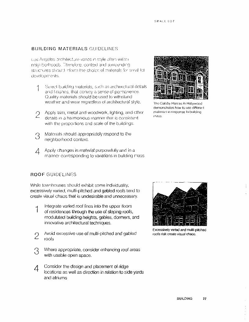
SMALL LOT
BUILDING MATERIALS GUIDELINES
Los Angeles architecture vanes in style often within neighborhoods. Therefore, context and surrounding structures should inform the choice of materials tor small lot developments
■1 Select building materials, such as architectural details and finishes, that convey a sense of permanence. Quality materials should be used to withstand weather and wear regardless of architectural style.
o Apply trim, metal and woodwork, lighting, and other details in a harmonious manner that is consistent with the proportions and scale of the buildings.
The Gafsby Homes in Hollywood demonstrates how to use different materials in response to building mass.
Materials should appropriately respond to the neighborhood context.
Apply changes in material purposefully and in a manner corresponding to variations in building mass.
ROOF GUIDELINES
While townhouses should exhibit some individuality, excessively varied, multi-pitched and gabled roofs tend to create visual chaos that is undesirable and unnecessary.
j Integrate varied roof lines into the upper floorsI of residences through the use of sloping roofs,
modulated building heights, gables, dormers, and innovative architectural techniques.
o Avoid excessive use of multi-pitched and gabled roofs
O Where appropriate, consider enhancing roof areas with usable open space.
Excessively varied and multi-pitched roofs risk create visual chaos.
Consider the design and placement of ridge locations as well as direction in relation to side yards and atriums
BUILDING 27

r-M-M.i. in:
SPECIAL GUIDELINES for GROUND-FLOOR COMMERCIAL USES
Small lot developments along commercial corridors may be required to provide ground-floor commercial uses along the streetfront. Similar to standard commercial projects, these mixed- use small lots must employ high-quality architecture to define the character of the proposed development. Storefronts must be vibrant, transparent, and protected, and most importantly, be compatible with the form and character ol the existing commercial district.
Gf0u:"'- ...... i : : ,I)jC6Sm (he t.aylu Hock small loidevelopment feature recessed entrances, protective awnings, and wide windows tor a pleasant pedestrian experience.
j Ensure that storefronts convoy an individual I expression of each tenant's identity while adhering to
a common architectural theme and rhythm.
O Design storefronts with a focus on window design to create a visual connection between the interior and exterior.
O Incorporate traditional storefront elements by ^ including a solid base for storefront windows. Use
high quality durable materials such as smooth stucco or concrete, ceramic tile, or stone for the window base.
1 ho Evo and Luma residential lowers in Downtown Los Angelos features live work units with ground - floor commercial and attached upper-lovol residences. ' ■
Provide shelter from the sun and rain for pedestrians along the public right-of-way where the buildings meet the street. Extend overhead cover across driveways or provide architecturally integrated awnings, arcades, and canopies.
Align awnings with others on the block, particularly the bottom edge of the awning. Coordinate the awning color with the color scheme of the entire building front.
Ensure-that store entrance^ ara,t^^^edA rWflush, .with the edge'of the buiMf^^jSpp.aFticatete ihe sfcnftphi an^provide sheiteffpr^^^id^' entering ' and exiting.
■■ l .- \ y4 ••, t£*r '.v.v 1;. -7
! -
. WM--. . -- • -■ .'1 ‘ ■' • t f •*' ' • •' ■ ■:j . , - :-•••. : \ ■. . -■ :• -1' •* • • . ■' r
\ -L J-E-: .-L; : '.!' ' Li.
u '* - */.- ■
&m
•>' --■■■■■
y-.1*
mmm
mm

SMALL LOT
The lam hr mo of a small lot project can be divided into three art\<;; It us provides a nelpfal framework for designing a cohesive landscape plan, the public area consists of tbe street, parkway, sidewalk, and driveway; the private area incorporates spaces not within a common area or driveway; and the transitional area is comprised of the spaces in between. It is important to strike a balance between privacy, transparency, visual interest, and order when landscaping for these areas.
This approach clearly delineates public, private and transitional zones without creating walls and yet maintains visual interest through variations in plant materials, grades, and limited hardscape. This also minimizes water consumption and maximizes contributions to local flora and fauna while also enhancing the living environment of both the public, private, and transitional areas.
Objective; Design landscaping that delineates the public, private, and transitional areas; enhances visual interest; and utilizes native and drought tolerant plants.
c
)
O Public. 0 transitional, and 0 private areas.
LANDSCAP1NG 29

s-V a 11. L o'
FRONT AND COMMON AREA GUIDELINES
Excessive use o! turf grass is visuaiiy bland, requires extensive irrigation, and fails lo enhance or define both the public and private outdoor spaces.
Front yarci:; and common hh.-h.. .-.onm a dual function, and therefore cfoeive particular atiention. They act as doth habitable > Aiinnor -.pace tor its owners and as snared areas within the proposed development and the neighborhood. The yard is a visual amenity to the development, neighborhood, and passers-by. Additionally, it serves as a semi-transparent bridge between the private interior of the home and common areas.
Landscaping should be visually interesting, sustainable, and relatively easy to maintain. Turf grass should be used sparingly. Use water-conserving plant materials and irrigation systems. Utilize trees along the parkway and shorter shrubs in the transitional zone.
However, sublie variations in grade and drought-tolerant plant materials helps to gracefufly define transitions in the landscape.
-j Use a range of low-water and drought-tolerant plant 1 materials and ground cover to provide visual interest
in place of turf grass.
p Use fences and shrubbery less than 3’6" tali in areas ^ adjacent to the sidewalk (within 5’ of front lot line),
and common public areas.
O Plant shade trees within public areas, ideally spaced ^ between 15' and 20' apart, to screen blank building
facades and shade the driveway and parking areas.
45
Whenever possible, use subtle variations in grade.
Plant parkways separating the curb from the sidewalk with trees, ground cover, low- growing vegetation, or permeable materials that accommodate both pedestrian movement and clearance for car doors.
Design the landscape to be integrated with the building and for the intended use of the space.
30 LANDSCAPING

SIM ALL LOT
PRIVATE OUTDOOR SPACES GUIDELINES
Private outdoor spaces can lake the form of small interior yards, balconies, and roof decks. For these cpm.m;. the emphasis should be placed on flexibility, f w yard space, plant materials need not be too varied, so that residents may easily modify tnem to make them their own.
H Designate fully private outdoor space whenever possible.
O Utilize plants that can be easily modified/maintained by residents.
O Provide balconies to enhance rather than substitute^ for actively used common open spaces. Balconies
and roof decks should be generous enough in size to create usable spaces.
The use of raised beds in varying heights provides for a flexible outdoor space by serving as both landscaping and seating options.
PLANT MATERIALS GUIDELINES
Ultimately the landscape should enhance the natural environment of the neighborhood and should be relatively low-maintenance. Drought-tolerant and native species satisfy both of these criteria by creating visually appealing and sustainable landscapes.
-j Apply mulch in between and around plants to ’ conserve moisture and eliminate bare earth, which
can look unsightly.
O Use water-conserving ground cover instead of turf grass.
0 Avoid invasive plant materials.
^ Plant in groupings according to water needs,
tkj Incorporate existing natural features and topography.
For more information, visit: http://www.bewaterwise.com/ Gardensoft/garden_types.aspx?[istType=types
LANDSCAPING 31

small lot
This side yard is wide enough to aliow for layers of planting and decorative paving.
PRIVACY GUIDELINES
With small lot developments come issues of; ouc ,
not only for residents, but also for those ot i iwg ih-.-ir li properties, for instance, improperly demp'-.i .y-ti ws result in balconies overlooking neighboring yards or other balconies, and windows facing directly into ad|.acent residences.
Small lot designs should maximize access to private outdoor space, light, and views, while ensuring an adequate level of privacy for all residents. This will require particular attention to the orientation and spatial configuration ot the development, distances between walls, and the location of windows and balconies.
Whenever possible, small lot designs should designate some fully private outdoor space for each dwelling. This can take the form of small interior yards, balconies, and roof decks.For these spaces, emphasis should be placed on flexibility.
Windows and balconies from separate dwellings should not face or overlook each other,
2
34
Minimize the number of windows overlooking neighboring interior private yards.
Use translucent glass, landscaping, and screens to create privacy.
Provide functional distances between building walls and vary height to maximize private outdoor space, light and views.
Plant trees, shrubs, and vines to screen walis between property lines. Use variations in color, material, and texture.
Rooftop open space should be located away from the building edge to enhance privacy.
32 LANDSCAPING

SMALL LOT
Proposed smail lot projects pic.-wu ,1 uniuue oppoitunity for innovative sustainable uppiou.-.'i-:--, TIkso sites allow for environmentally-sound principles to be applied on a smaller scale, helping to mitigate tne development's impact on the surrounding neighborhood. They also provide the opportunity to employ strategies that might be cost prohibitive on a larger scale such as solar roof materials, semi-permeable paving materials, and energy and water efficiency. Ail development is required to meet Los Angeles Standard Urban Stormwater Mitigation Plan (SUSMP) requirements and Low Impact Development (LID) strategies (Ord. 181899).
A permeable driveway (concrete grid titled with grass) increases storm water infiltration on the small lot.
Objective: Achieve low-impact development through design that focuses on environmental sensitivity in site planning, building, landscaping, and construction.
SITE PLANNING GUIDELINES
-j Incorporate renewable energy technologies (such as 1 photovoltaic panels) on-site.
n Use permeable paving materials (such as porous asphalt, porous concrete, permeable concrete pavers and grid systems filled with gravel or grass) where allowed by the Alternative Paving Material Ordinance (No. 182431).
O Utilize adequate, uniform, and glare-free lighting such ^ as dark-sky compliant fixtures, to avoid uneven light
distribution, harsh shadows, and light spillage.
A Reduce pollution by controlling soil erosion, waterway sedimentation and airborne dust generation.
r Seamlessly integrate the SUSMP and LID elements ^ into the project design.
SUSTAINABILITY 33

1,17 a:.1 1,0 r
The Gatsby Homes integrate photovoltaic panels into its roof for enhanced energy efficiency.
Mature trees should be preserved during small lot construction.
BUILDING GUIDELINES
1
2
3
4
5
67
8
Use passive cooling systems like operable windows for ventilation.
Provide controllable s\ stems such as localized thermostat control, tank lighting, or localized lighting controls.
Provide connection between indoor and outdoor spaces to take advantage of natural light and ventilation.
Maximize water efficiency and minimize water waste within buildings.
Use energy efficient equipment to increase the energy efficiency of the buildings.
Use renewable, recycled, and regional materials.
Use certified wood provided from environmentally responsible forest management.
Use or redirect demolition material to recyclable or reusable centers (Ord. 181519).
34 SUSTAINA81LITY

SMALL LOT
LANDSCAPE GUIDELINES
Plan! !no;\ to made buildings to reduce too boat /J on-st.
f .militate storm water capture, retention and mtflbation, and prevent runoff by using permeable or porous paving materials in heu of concrete or asphalt. Collect, store, and reuse storm water for landscape irrigation as per SUSMP and LID requirements.
Los Angeles Low-Impact Development (LID) and Standard Urban Stormwater Mitigation Plan (SUSMP) requirements mandate stormwater to be managed through filtration or reuse for all development projects, including small tot developments. There are various ways to incorporate storm water techniques while also using thoughtful design. The City offers different storm water management techniques that don't overwhelming the design of the project.
The Auburn 7 development provides enhanced landscaping along a DWP easement as a unique amenity for its residents.
Some of the small scale Best Management Practices include:
1. Rain Barrels & Small Cisterns2. Permeable or Porous Pavement Systems3. Planter Boxes4. Rain Gardens5. Dry Wells
For more information, refer to the City of Los Angeles Low Impact Development Best Management Practices Handbook.
SUSTAINABILITY 35

UMALL I. 0 i
Since the City of Los Angeles passed the Small Lot Subdivision Ordinance in 2005, small lot projects have been under development in neighborhoods across Los Angeles. As of November 2013, over 160 subdivision cases have been filed, resulting in the approval of over 1,500 individual lots. 39 subdivisions were recorded, creating approximately 330 new lots on the County Assessment Roll.
This section of the handbook looks at model small lot subdivision developments built between 2006 and 2010 and highlights some outstanding features.
As these model projects demonstrate, the Small Lot Ordinance is not only increasing the quantity of housing available to the market, but also the variety. The Small Lot Ordinance helps developers provide housing to meet the demands of an increasingly disparate set of Angeleno needs and lifestyles.
36 CASE STUDIES

SMALL LOT
ROCK ROW,EAGLE ROCK Heyday Partnership 1546 Yosemite Drive
!5 homesi to oonoos sir AvahleiZoning: HI.) 1.5 t Zoning Adjustments1 5
1st LEED Certified Small Lol Subdivision.
Each townhouse has a senes of decks and balconies.
Simple maintenance organization for driveway, trash areas, and landscape.
Neighborhood council and Southern California Edison supported Heyday Partnership in being exempted from street widening.
Sustainable Features: Permeable driveway, instant hot water heaters, indoor air quality control, green roofs, solar arrays.
Site Plan.
Architectural rendering highlighting roof gardens, entry ways and grasscrete driveway. Also note the visual interest created by the use of materials and varied window orientation.
CASE STUDIES 37

SJv' "m. I. LL
Low water plants minimize water consumption and enhance the transition between the front sidewalk and building facade. Permeable paving material reduces the perceived width of a double-loaded driveway, while providing for a more comfortable pedestrian path of travel and reducing the amount of visible paving material.
The development contains landscaping along the project's public edge to create a pleasant pedestrian environment
A green roof helps absorb runoff, reduces the heat island effect, and provides an attractive amenity for residents.
The front two homes are configured with their main entrance close to the sidewalk. This, in addition to a small front landscape section and the Grasscrete paving material provides a good transition from the public to the private realm.
as CASE STUDIES

SMALL LOT
AUBURN 7,SILVE.R LAKE:Mass Architects 2748 Auburn Street
1 1.1 h1/t.'r. j I \ . 1 1 1.'* 1
2 level'; of habitable flooring
Only a 5” air gap between units requires more engineering for earthquake protection than a typical single family home.
Floor to ceiling windows
Each unit has an option for solar electricity.
Informal agreement with the Department of Water and Power to use the front easement as garden space.
With no walls separating the front yard space the easement becomes a community amenity white still retaining the feel of a private yard
Interior spaces have a good relationship with the exterior as all units have front garden space in the easement. There is a pedestrian path that runs between the landscaping and the homes which helps define the edge.
CASE STUDIES 39

Permeable paving (decomposed granite) alows the infiltration of storm water. Homes feature private patios.
Site furnishings make tho development's public areas usable.
Community garden built on space leased from DWP
t
40 CASE STUOtES

SMALL LOT
CULLEN STREET ART DISTRICT HOMES, Modative26?4 Cullen Street
3 ;nn ijuS yl .v.ov. i c( ' , s.jl- I.. . i1 , iaU 1 li .’I
Zoning HO 1 :>
Adjacent Culver City Arts District served as inspiration
Rear unit has mother-in-Saw unit with separate entrance
All units have second story private deck/balcony
Site plan shows linear configuration with a shared driveway and a pedestrian path separate from driveway.
Front home has primary entrance oriented to the street with generous front landscaping to transition between public and private
Interior spaces as well as doors & windows were configured to provide privacy between homes and adjacent property.
Single-pitched roof has southern orientation to accommodate future solar panel installation
Front unit designed to have excellent orientation to the street with front entrance and pedestrian path connected to the public sidewalk, aid lush front landscaping buffer. Although the second story deck extends away tram the home, the rest of the massing is pulled away from the street which creates a nice transition between public and private space.
CASE STUDIES 41

5 iV A L l L V :
The homes are designed to each have second story private deck space that is pulled away from the property line and located above the driveway. This activates the access path while orienting the private spaces away from adjacent residential
Rear unit features a double car garage for primary home, and a single car garage for mother-in-law unit with private deck above parking.
Example of how private balcony space on the second floor can still activate the front of the property near the property edge
A striking color on the interior of the covered parking provides a strong visual link from the sidewalk to the rear of the development, creates character, and provides a connection with the other units
42 CASE STUOIES

SMALL LOT
MALTMAN BUNGALOWS, ECHO PARK Civic Enterprise Associates 918 Maitman, Echo Park
17 Homes(18 units allowable)Zoning, RD2-1VL Zoning Variances: 5 Zoning Adjustments: 3
Historic bungalows provide small compact units.
Porches, visibility, and close proximity provide a safe environment for residents,
: // Jr
Site Plan.
A smaller truck from a private trash company can navigate a smaller driveway for trash collection.
The utilities are on a mufuaf easement. Units have a one car garage; no guest parking is provided.
Sustainable Features:An adapted reuse and/ or an historic preservation project is inherently more sustainable than new construction.
Selected by Architectural Record magazine as one of their 2008 Record Houses.
Restoration preserved the charm of original units.
CASE STUOIES 43
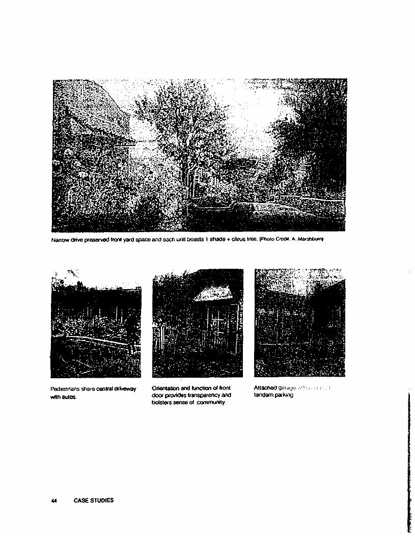
Narrow drive preserved front yard space and each unit boasts 1 shade + citrus tree. (Photo Crocfci: a. Marshtxxn)
Pedestrians share central driveway with autos.
Orientation and function of front door provides transparency and bolsters sense of community.
Attached garage -mr.i.: tandem parking
44 CASE STUOtES

SMALL LOT
PERLiTA MEWS. ATWATER VILLAGE Corsini + Stark Architects 4254 Perlita Avenue
23 ! lomo:;
indoor/OuiduO' home”, .ti . organized around intunoi courtyards and designed in a Modernist style.
Sustainable Features; Grasscrefe paving allows water to reach the water table and reduces pollution from runoff.Clerestory windows provide natural ventilation; heat rises through the top of the townhouse, cooling the units.Fewer exterior walls limit the places where heat and energy can seep out.
Adaptable units; Units can be combined and expanded around the interior courtyards. More affordable than buying one very large house. Rear units can be separated since they have a rear staircase.
This home on one of the edges of the project shows the interior courtyard space connected to a side yard, providing additional usable open space.
CASE STUDIES 45

SI.'ALL !. O'
The interior courtyard spaces create an outdoor roorri that also provides access to light and air for the second story.
Rendering of how the garage, driveway, and primary entrance interact
Rendering of a courtyard created by two adjacent buildings. While each side is a private patio, joining these spaces provides the perception of a larger volume of space.
46 CASE STUDIES

SMALL LOT
PREUSSFOUR, CIENEGA HEIGHTS Danny Cerezo, Architect 2008 Preuss Road
4 homes built (5 allowed)
Zoning: RD 1.5-1
Average lot size: 1,780-2,560 s f.
Each unit Is 2 stories with a 3 bedroom/3 bathroom configuration
All homes feature over 400 s.f. of private open space off of the main living level.
—TIT—■ UNI! 3 |
IMH
*—* i i . I - ~ ;
■; II. '“1 1 ?■ ii t <
.U..
Site Plan shows the arrangement of the units with parking accessed via an ailey and a 6 foot wide pedestrian passageway in the center. Parking for all homes is accomplished with a tandem configuration to the rea of the site.
Each home also features a 2.8Kw solar panel system as a standard feature.
All hardwood flooring has been reclaimed from a bam in Tennessee that was slated for demolition.
Sustainable features include exterior fiber cement siding installed as a rain screen system, electric vehicle chargers, bio-filtration planters, and a central heating and air is multi- zoned to maximize comfort.
Front elevation shows good height and massing relationship with surrounding structures and balconies facing the public sidewalk.
CASE STUDIES 47
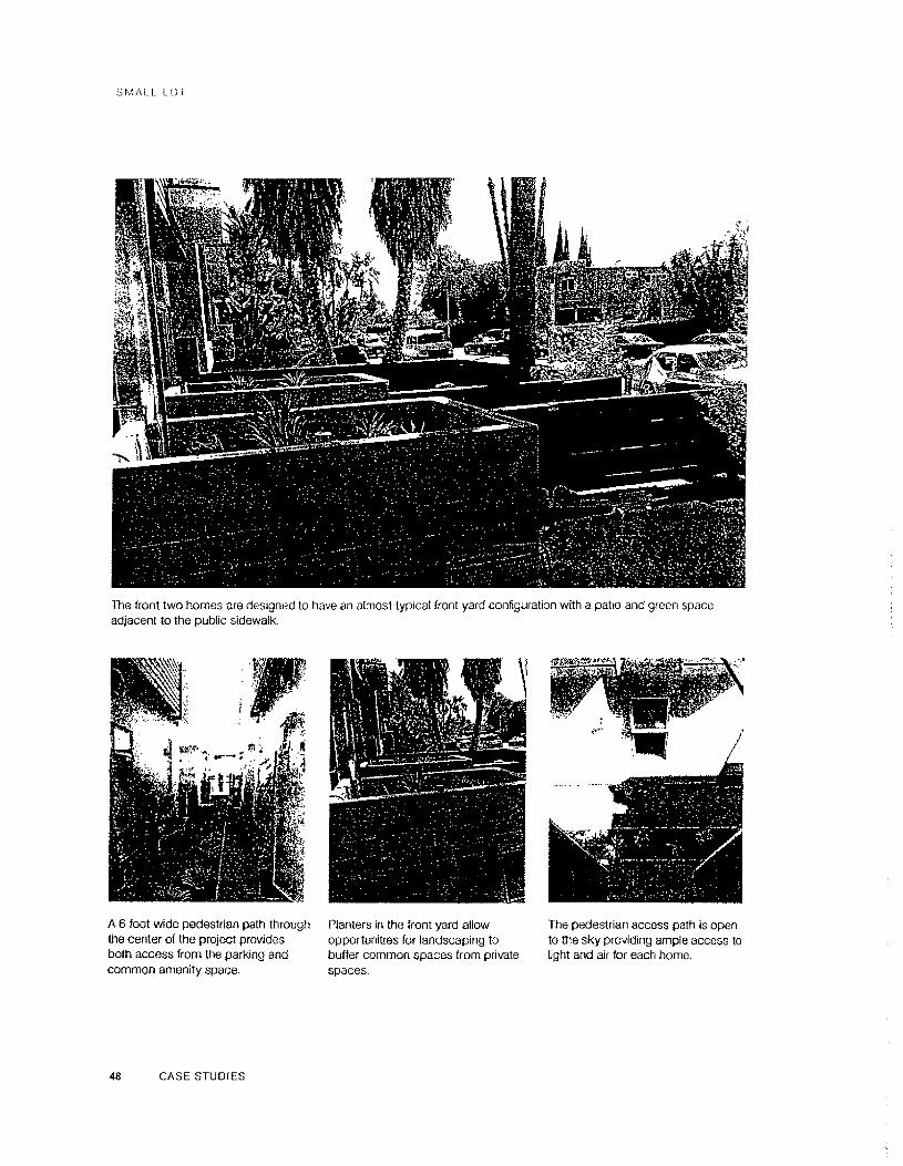
SMALL LOT
The front two homes are designed 1o have an almost typical front yard configuration with a pafio and green space adjacent to the pubtic sidewalk.
A 6 foot wide pedestrian path through the center of the project provides both access from the parking and common amenity space.
Ranters in the front yard allow opportunities for landscaping to buffer common spaces from private spaces.
The pedestrian access path is open to the sky providing ample access to light and air for each home.
48 CASE STUDIES

SMALL LOT
BUZZ COURT.SILVER LAKE Heyday Partnership Buzz Court, Los Angeles 90039
6 homes built (6 allowed)
Zoning: (Q)C2-1VL
Average lot size: 1,720 si
Variances/adjuslments: 6
LOT 6
PLAN CLOT 1
PLAN BLOT 3
PLANS■ : :
*&S5S*fK3Swi.\ 'A :
Each home is 3 stories witha rooftop deck as amenity Site Plan shows the arrangement ot the units in a unique zigzag pattern thatspace staggers the home placement on either side of the narrow lot.
The zigzag pattern allows for greater separation between units and creates an added sense of privacy for rear units
Common maintenance agreement for driveway, access gate, trash area, and landscape
Additional notes: Certified LEED Platinum, Permeable Driveway, Solar Arrays, Instant Hot Water Heaters, Indoor Air Quality Controls, Exceed Title-24 by >30%, Green Roofs.
The primary entry of the front home is clearly delineated by landscape planters and the massing of the facade. A second floor balcony brings an element of private space into the public environment, activating both the tront facade and the sidewalk ot this more urban streetscape.
CASE STUDIES 49

SMALL LOi
The Buzz Court project is located along a more urban sfreetscape than other small lot development. As a result, the architects design a facade that looks more commercial than residential while still placing residential elements like a balcony on the front facade.
The unique spatial arrangement of the development causes the homes to have a staggered effect, making the spaces between buildings seem more open.
The facade treatment provides for a visually interesting and appealing display at night. The shading element provides privacy for the residents while still allowing light to be displayed along the sidewalk. The front entrance is clearly illuminated for safety and delineation.
While the homes are configured to provide adequate access to the garages for cars, the interior spaces are arranged so that windows and balconies do not directly face each other. This creates a better sense of privacy for homes that are closely spaced.
so CASE STUDIES

SMALL LOT
EDGECLIFf:E TERRACE. SILVER LAKEGreen City Building Company 1372 Edgeciiffe Drive, Los Angeles
•T homos built (4 ailowed.i
Zoning: RD1.S-1VL
Average lot size: 1,840 s.f.
Variances/adjustments: only an "early start" variance
Key design elements include Site Plan snows the arrangement of the units on the narrow lot with amplecorner glass, natural cedar front yard landscaping and a large balcony/deck for the rear unitsiding, and metal exterior accents.
The front and rear houses have ground ievei open garden space, while ail units have rooftop terraces..
The project was designed to be neighborhood appropriate, with deferential massing by cutting the garages into the up-slope and providing a significant third floor setback.
A 35' front yard building line setback was provided and landscaped.
Three existing decades-old street trees were preserved as part of the project. The slightly sloping site resulted in the units having a “stacked" configuration
and the garages bang cut into the slope. A 35 foot front setback was provided
CASE STUDIES 51

S^'ALl. !,0
The site has a two story building on one side and a single story residence on the other. As a result, the mass and height of the buildings are located on the side adjacent to the two story building.
The entries for each individual home are separated from the driveway and have a direct connection to the public sidewalk.
The view from the rear deck shows how the units are “stacked" to follow the slope of the site. Ail homes also have window orientation over the driveway to help activate the space.
Interior spaces are organized around access to light and air with large windows and a balcony (front unit)
52 CASE STUDIES

S M ALL LOT
VESPER VILLAGE, VAN NUYSKen Stockton, Architects Silverberg Development Corp. 14550 West Kittndge Street
16 Homos(51 units allowable)Zoning' CR-1VL-CDO Zoning Variances: 3 Zoning Adjustments: 4
Built prior to tlie Small Lot Ordinance, this development provided the framework for the passage of the Ordinance.
Was a result of community opposition to new apartment complexes. Individual owner-occupied homes were preferable. Small Lot subdivision was a compromise.
The utilities are on a mutual easement. Units have a one car garage; no guest parking is provided.
Has a 3-foot separation between homes.
Uses a very modest annual maintenance fund for the driveway and mail boxes. No home owners association.
Three-foot-deep front yards soften the transition from stucco facade to hard- scape drive.
CASE STUDIES S3

r/ a s i lot
The 26-foot width between homes is syncopated with a 32’ distance occurring at the garage/parking. This articulates the massing of the buildings and prevent the pedestrian from feeling ‘boxed in".
Two-foot separation between homes. Pedestrian environment along the Open sight iines to front doors.edge of the development features pleasant landscaping and trees.
54 CASE STUDIES

SMALL LOT
APPENDIX AVENICE SPECIFIC PLAN VERIFICATION
Til-; v.oioohi: V; of Von.cu has a refined set of small lot guidelines that are based on ttie Venem ('m.i-.i.il Specific Plan. A summary follows. Architects and developers proposing a si null lot ptojoO for Venice should consul! the Specific Plan, and where it is not explicit, refer to tie: Los Angeles Municipal Code, including the Small Lot Ordinance.
1. Parking: Required parking for subdivision projects shall be based on the parking requirements pursuant to the Venice Coastal Specific Plan—2 or 3 spaces, depending on lot width. Each new lot resulting from a small lot subdivision that contains one unit wifi fall under the "single family dwelling" category in the Specific Ptan. For purposes of parking calculations, small lot subdivisions shall be considered “less than dO feet in width, or less than 35 feet in width if adjacent to an alley." Where new lots resulting from a small lot subdivision include multiple units on a lot, they shall provide 2.25 parking spaces for each dwelling unit.
2. Driveways: All driveways and vehicular access shall be from the alleys, when present, When projects abut an alley, each newly resulting subdivided lot shall be accessible from the alley and not the street. Exceptions may be made for existing structures where alley access is infeasible.
3. Setbacks: Front, rear and side yard setbacks abutting an area outside of the subdivision shall be consistent with the Specific Plan, where it sets limitations. This includes locations in which new lots abut a lot that is not created pursuant to the Small Lot Subdivision Ordinance and not part of the project, or where the lots abut a waterway or street.
4. Multiple Lots: Existing lots may be subdivided into multiple lots so long as the averaged newly resulting lot size is equivalent to the minimum requirement for “lot area per dwelling unit” established for each residential zone in the LAMC, pursuant to the Small Lot Subdivision Ordinance.
5. Multiple Units: Lots subdivided pursuant to the Small Lot Subdivision Ordinance shall be limited to one unit per resultant lot, unless the lot size is large enough to permit additional units based on the “lot area per dwelling unit" calculation established for each residential zone. In no case may a newly resultant lot contain more than three units. Generally, the combined density of the newly resulting lots shall not exceed the permitted density of the original lot, pre-subdivision. For Subareas of Venice that restrict density by limiting the number of units on a lot by a defined number, the resulting density from multiple lots may increase the originally permitted density on one original lot. Unit restrictions prescribed for Subareas shall still apply to individual resulting lots, but not over the entire pre-subdivided area.
APPENDiCES 55

‘•VALL 1.0 F
VENICE SPECIFIC PLAN VERIFICATION (CONTINUED)
(>. Affordable Replacement Units: Proiocis m some Subareas ol Venice are required to provide ‘Replacement Affordable Unii(s)" as defined m Section 5(1) of the Specif ic f-^Ian when there are any units in excess of two units on newly resulting single lots. I he requirement to replace an affordable unit will increase the number of units that would otherwise be permitted under the Small Lot Subdivision Ordinance only when the development includes three units on a lot. Mello Act requirements to replace affordable units still apply in all circumstances, and consistent with the Specific Plan, any affordable replacement units shall be replaced on the small lot subdivision project site.
7. Density: Density shall not exceed the density permitted by zoning of the original lot, which is the “lot area per dwelling unit” restriction for each zone as determined by the Venice Coastal Specific Plan, or when not explicit in the Specific Plan, the Los Angeles Municipal Code.
56 APPENDICES

SMALL LOT
APPENDIX BPRE-FILING PREPARATION LIST AND MEETING FORM
Small Lot Meeting Request:
Prior to Meeting:Our goal is to ensure that your meeting goes as smoothly as possible. In preparation for your time with the Planning Department staff, please carefully read through, complete, and return (electronically) two (2) business days prior to your appointment day, the required information contained in this checklist to ensure that items that need attention are addressed during the course of the meeting.
1. Read through Small Lot Ordinance No. 176354. You can find it on:• htto://citypianninq. iacitv.org/• click on Policy Initiatives• click on Housing• dick on Small Lot Subdivision (Townhome) Ordinance
or• Full address:
fhttp://citvplanninq.lacitv.org/Policvlnitiatives/Housinq/Small%20Lot/SmallLot-DesignGuide.pdf)
2. Also, read through:• Small Lot Guidelines• FAQ sheet• Notes
3. Bring 3 copies each of the foiiowing:• Small Lot Meeting form (pages 2 and 3)• Full ZIMAS property report with map (http://zimas.lacitv.oro/• Site or Plot plans with dimensions, lot areas, driveways, etc.
APPENDiCES 57
SMALL LOT
PART 1: GENERAL INFORMATION 1
Fill in the following information and return this form to the at least two (2) business days prior to your scheduled meeting date.
Case Number:(if applicable)
Address / Location / Neighborhood:
Case Planner:(if applicable)
Project Description:
Objective from meeting with UDS, Subdivision or Expedited:
PART 2; SUPPLEMENTAL DOCUMENTATION
Provide the following materials fif available) in electronic/digital format. (Email is preferred)
1. Entitlement Application2. Project Architectural Plans (Floors/Elevations/ Sections)3. Site Plan4. Site Photos, and Adjacent Property Photos5. Aerial Photos6. Landscape Plans7. Radius Map8. Zoning Map
58 APPENDICES

SMALL LOT
PART 3: PROJECT DESCRIPTION
Name(s)/relationship of people presenting the proposed project:
Name:______ ______________________Company:__________________________Phone:_________ __________________Email:_______ ______________________Owner_Engineer_Developer__ArchitectOther:_______ _____________________ __
Name:______________________________Company:__________________________Phone:________________________ ____Email:______________________________Owner___Engineer_Developer__Architect.Other:______________________________
Existing Zoning:_________________ Proposed Zoning:___________________
Applicable uses on adjacent properties
Single family Apartments Commerciat Condos
Industrial School Park Other: ____________
Proposed number of lots and units: _____________
Proposed number of guest parking spaces on-site: (if applicable) ______________
Front yard setbacks on adjacent and nearby properties:______________
Proposed lots range in area from: _____________sq. ft. to:________________ sq. ft.
APPENDICES 59
SMAL L LOT
FREQUENTLY ASKED QUESTIONS '
Does the Small Lot Ordinance require a home owners association?
No, you do not need a home owners association (you can have one if you like). Instead, you can use a maintenance association formed to maintain the areas used in common, e.g. driveways, landscape, trash location, etc.
Do you have to identify each proposed lot?
Yes. You need to show the lot lines on the tract map or parcel map for all proposed lots and must indicate the front yards of each.
What do I do with common areas such as parking and landscape?
You can record reciprocal easement in these common areas.
Can parking spaces be separate from dwellings?
Yes. Parking spaces may be grouped together on a separate lot within the boundaries of the tract or parcel map. You may not place grouped parking under the development ~ the lots must remain fee simple.
What is the minimum size a tot can be?
Small lots must be at least 600 s.f.
Does this Ordinance apply to R2 Zoning?
This Ordinance almost never applies to R2 Zoning. Please consult the Department of City Planning Geoteam if you are considering an R2 lot.
What about setbacks required for the Small Lot Ordinance?
No front yard setbacks are required within an approved small lot subdivision. Flowever, a five foot setback is required from any property adjacent to the perimeter of the small lot tract or parcel map.
60 APPENDICES

SMALL LOT
What about fences and walls?
Fences and walls within 5 feet of the front lot line (see FAQ above) shall be no more than 42 inches in height. Fences and walls within five feet of the side and rear lot lines shall be no more than 6 feet in height.
Why are you asking for all of the setback dimensions during the tract or parcel map approval process?
If you wish to begin construction before the final map records, then you must also file a Zoning Administrator Case for alt setbacks that deviate from the Los Angeles Municipal Code as if the Lots have not recorded.
What are the requirements for tract/parcel map filings?
1. Tract maps must be filed as Vesting Tentative Tract Maps with accompanying site plan layout, elevations and other illustrative information. Site plan layout is to be superimposed on proposed lot lines.
2. Parcel Maps must be filed with accompanying site plan layout, elevations and other iilustrative information. Site plan layout is to be superimposed on proposed lot lines.
3. Entitle tentative map or preliminary parcel map:“Vesting Tentative Tract Map No.______(or “Preliminary Parcel Map No.______ ”)for Small Lot Subdivision Purposes"
4. Each Tentative tract or Preliminary parcel map must include:
"NOTE: Small Lot Single Family Subdivision in the_____Zone, per Ordinance No.176,354.”
What are requirements for the maps?
1. Reciprocal easements: Easement(s) outside of the building envelopes shall be identified for any underground utilities - water, sewer, gas, irrigation etc. - that serve all homes and must cross over other lots to serve those homes.
2. Easement(s) outside of building envelopes must be identified for electrical, cable, satellite, telephone or similar lines for the same reason.
3. Easement(s) outside the building envelope must be identified for vehicular, pedestrian access across lot lines; and drainage across property lines.
APPENDICES 61
SMALL LOT
When can I submit construction drawings to the Department of Building and Safety for Plan Check?
The Department of Building and Safety will ONLY accept construction drawings for Plan Check after the effective date of the Advisory Agency approval under the Small Lot Ordinance of a subdivision for the division of land (Tract or Parcel Map). The early submittal must be accompanied by an effective Zoning Administrator determination specifically permitting deviations from the Zone Code for setbacks/separation between buildings as if the map has not recorded.
How long will it take to get my plans approved?
We advise that you check with the Department of Building and Safety for their Plan Check procedures (including expediting review); with the relevant Geoteam in the Planning Department for the subdivision approval times. Projects may pay an extra fee for expedited review through the Planning Department’s Expedite Section - the procedure takes approximately 90 days.
62 APPENOfCES

SMALL LOT
APPENDIX CSAMPLE SUBDIVISION LAYOUT
Include in Notes Section:"Note: Small
Lot Single Family Subdivision inthe__Zone,pursuant to Ordinance No. 176354”
VESTING TENTATIVE TRACT MAP for SMALL LOT SUBDIVISION PURPOSES’
SETBACK CHART
LOT#
FrontYard
RearYard
Side Side
1 X' x’ X' x'
2 X' X' X' X'
3 x' x’ X’ x1
4 X’ X' X' X'
5 X’ x' X' x’
I
Indicate location of any guest parking
Designate front yards for each lot
Show building footprints and label lots
LOT 4 H
LOT 5 t — Indicate property
; lines
LOT 3 S-n LOT 6
Indicate setbacks for - all front, rear, and side yards
Indicatetrashcollectionareas
Label "community drive way/fire lane" (includingdimensions), and identify any easements outside the building envelopes (e.g, pedestrian ingress/egress, emergency access, utilities)
*N
1. All other information required by Sec. 1 7.00 for filing is also required but is not shown in this example.
APPENDICES 63

For more information about the City of Los Angeles Small Lot Subdivision Ordinance. Small Lol Design Guidelines, and additional resources, visit the following.
Small Lot Subdivision Ordinance:http://clkreD.lacitv.orq/onlinedoc$/2004/Q4-1546 ORD 176354 01 -31 -2005.pdf
Small Lot Design Guidelines:http://urbandesiqnla.com/resource$/SmallLotDesiqnGuidelines.php
California Green Building Standards Code (Cal Green): http://www.documents.dqs.ca.qov/bsc/CALGreen/2010 CA Green Bldg.pdf
City of Los Angeles Low Impact Development Best Management Practices Handbook: http://www.lastormwater.org/wp-content/fiies mf/lidhandbookfinal62212.pdf
Standard Urban Stormwater Mitigation Plan (SUSMP) and Low-Impact Development (LID) Ordinance {No. 181899):http://clkrep.lacitv.org/onlinedocs/2009/09-1554 ord 181899.pdf
Storm Water Pollution Control Ordinance (No. 173494): http://clkreo.lacitv.org/onlinedocs/1999/99-2420 ORD 173494 09-14-2000.pdf
Landscape Ordinance (No. 170978):http://clkrep.1acitv.org/onlinedocs/1992/92-0043 ORD 170978 04-03-1996.pdf
Alternative Paving Material Ordinance (No. 182431): http://cikrep.lacitv.oro/onlinedocs/2011/11-1331 ord 182431.pdf

ACKNOWLEDGEMENTS
MAYOREric Garceiti
CITY COUNCILDistrict 1: Gilbert CediiloDistrict 2: Paul KrekonanDistrict 3: Bob Blumentiold
DEPARTMENT STAFFSimon PastuchaHead of the Urban Design Studio
District 4; Tom LaBongeDistrict 5: Paul KoretzDistrict 6: Nury MartinezDistrict 7; Felipe PuentesDistrict 8: Bernard ParksDistrict 9: Curren D. Price, Jr.District 10: Herb J. Wesson, Jr.District 11: Mike Bonin
INTERNSConnie ChauvAlan ComoElizabeth EneBrian GarciaJune Scott
District 12: Mitchell EnglanderDistrict 13: Mitch O’FarrellDistrict 14: Jose HuizarDistrict 15: Joe Buscaino
Special thanks to all the designers, consultants, and developers who assisted in the creation of this document.
CITY PLANNING COMMISSIONRenee Dake Wilson, FAIA, PresidentDana Perlman, Vice PresidentRobert L. Ahn, CommissionerDavid H. Ambroz, CommissionerMaria Cabildo, CommissionerCaroline Chloe, CommissionerRichard Katz, CommissionerJohn W. Mack, CommissionerMarta Segura, Commissioner
PLANNING DEPARTMENTEXECUTIVE OFFICEMichael J. LoGrande, DirectorAlan Bell, Deputy DirectorUsa Webber, AICP, Deputy DirectorEva Yuan-McDaniel, Deputy Director

URBAN DESIGN STUDIOLOS ANGELES DEPARTMENT OF CITY PLANNING 200 N. Spring Street, Room 705 Los Angeles, CA 90012

Exhibit 5
OTYWOE'DESIGN GUIDELINESMulti-Family Residential & Commercial Mixed-Use Projects
city
wid
e des
ign g
uide
lines

The City of Los Angeles' General Plan Framework Element and each of the City's 35 Community Plans promote architectural and design excellence in buildings, landscape, open space, and public space. They also stipulate that preservation of the City's character and scale, including its traditional urban design form, shall be emphasized in consideration of future development. To this end, the Citywide Design Guidelines have been created to carry out the common design objectives that maintain neighborhood form and character while promoting design excellence and creative infill development solutions.
The Citywide Design Guidelines serve to implement the 10 Urban Design Principles, a part of the Framework Element. These principles are a statement of the City's vision for the future of Los Angeles, providing guidance for new development and encouraging projects to complement existing urban form in order to enhance the built environment in Los Angeles. While called "urban", the Urban Design Principles reflect citywide values to be expressed in the built environment of the City, establishing a design program for the City. They are intended to embrace the variety of urban forms that exist within Los Angeles, from the most urban, concentrated centers to our suburban neighborhoods.
3

Relationship to Adjacent Buildings
1 Ensure that new buildings are compatible in scale, massing, style, and/or architectural materials with existing structures in the surrounding neighborhood. In older neighborhoods, new developments should likewise respect the character of existing buildings with regards to height, scale, style, and architectural materials.
2 For RD1.5, RD2, R3, R4, RAS3, and RAS4 developments, apply additional setbacks in side and rear yards abutting single-family and/or R2 zoned lots.
3 Where multi-family projects are adjacent to single-family zones, provide a sensitive transition by maintaining a height compatible with adjacent buildings. Mitigate negative shade/shadow and privacy impacts by stepping back upper floors and avoiding direct views into neighboring single-family yards.
RECOMMENDED
/New development maintains existing theme in neighborhood
NOT RECOMMENDED
AScale, height, and architectural style incompatible with adjacent development
15

Exhibit 6

L.A.'s Small Lot Homes: Destroying Low-Rent Housing, Restoring the American Dream,... Page 1 of 10
L.A.'s Small Lot Homes: Destroying Low-Rent Housing, Restoring the American Dream, or Both?(http://www.kcet.org/news/agenda/planning/los-angeles-smalMoLhomes.html)
by Chase Scheinbaum
Raquel Arias and her son, James, at their Silver Lake bungalow, which a developer wants toreplace with small lot homes, j Photo: Chase Scheinbaum
\ This story has been published in tandem with a segment for KCET's award-winning TV show"SoCal Connected." Watch it here now.
When Raquel Arias' Silver Lake bungalow is demolished, the last remnants of her disappearing
neighborhood will be gone.The 35-year-old has lived in a rent-controlled house on the comer of North
http://www.kcet.org/news/agenda/planning/los-angeles-small-lot-homes.html

L.A.’s Small Lot Homes: Destroying Low-Rent Housing, Restoriilg the American Dream,... Page 2 of 10
Coronado and Marathon streets her entire life. Her parents, whom she lives with along with her
4-year-old son, have lived on the same lot even longer.
Over the years, she has watched her immediate neighborhood make a familiar transformation. The
low-income Hispanic neighbors have moved out in search of lower rent, and the immediate area has
become younger, whiter, more Asian, and more affluent. If it weren't for rent control, she, a laid-ofF
school district employee, and her parents, a housecleaner and valet, wouldn't be able to afford their
two-bedroom home.
"I’m one of the few people that’s still around since I grew up," said the soft-spoken woman with deep
brown eyes and straight brown hair. "Everything around here is like triple the amount of rent that we
pay."
Story Continues Below
■■ FROM^grg ^MY-WINNING ARTS AND
- GET SOCAL ARTS INFO WEEKLY ^ "Art & Culture Features
................. ... Weekly DocumentariesTHE NEWSLETTER Art Event Listings
ARTBOUND
Support KCET
Come August, the family will move aside for a controversial new housing type that has been available
in L.A. just ten years: a small lot subdivision. Many small lot homes are sleek and boxy, clearly of a
different lineage than surrounding bungalows, apartments, or condos, and frequently fetch upwards of
three-quarters of a million dollars. On Coronado Street, the property owner wants to level a duplex
and a fourplex to build 10 independent homes, a project approved by the city last fall.
Three other families living on the property have already left. "They weren’t happy at all," Arias said.
Initially, they resolved to fight the development but eventually settled for relocation fees. "They were
intimidated, 1 guess, so they decided to sign." Now Arias and her family are the sole tenants.
They have been permitted to live on the property for one additional year because her parents are
senior citizens and her four-year-old son, James, is mentally disabled. His condition requires round-
the-clock care. Beyond the inconvenience and sadness of leaving her neighborhood, he is reason
enough to want to stay. His neurologist is just two miles down the road and another therapist he
sometimes sees is also nearby. Moving will likely require Arias to find new doctors for the boy, a
disruption she would rather forego. She has applied for low-income housing, but it could take until
mid-November to get a final response, which would be more than two months past the eviction date.
http://www.kcet.org/news/agenda/planning/los-angeles-small-lot-homes.htmI

L.A.'s Small Lot Homes: Destroying Low-Rent Housing, Restoring the American Dream,... Page 3 of 10
A small lot subdivision in Los Angeles. City planners say developments like these could
make homeownership a reality for more Angelenos. But some residents say the homes are
ruining the character of neighborhoods, j Photo: Lata Pandya
Arias felt helpless when she first learned she might have to leave. "1 didn't know what was going to
happen or who to turn to," she said. But word of her predicament spread to neighbors who have
rallied to help. More than 170 of them signed a petition against the development, and they've gone as
far as measuring the grade and width of streets to disprove facts used in the project's approval. They
don't want to see her leave. And in a larger sense, the proposed development has touched a nerve.
They — like numerous residents across L.A. - have grown frustrated with the boxy homes they say
are a new form of mansioitization ruining the neighborhood's character.
And the homes are multiplying. Last year through November, the latest data available, 37 small lot
developments were approved — the most of any year yet. Silver Lake has its share of small lots and
residents say developers are coming to them with ever more cash offers. "A lot of affordable housing
being destroyed," said Anne Hars, a neighbor who has helped lead the Coronado Street fight. "A lot of
people really hate this architecture that's going up," she said. "They just loom over everything."
Some academics say the ordinance could help lower L.A.'s exorbitant home prices and help
accommodate a growing population, a mandate issued by Mayor Eric Garcetti. But from Arias's
vantage, it doesn’t seem fair. "Everywhere you go, you see these big ugly apartments and they're super
http://www.kcet.org/news/agenda/planning/los-angeles-small-lot-homes.html
L.A.'s Small Lot Homes: Destroying Low-Rent Housing, Restoring the American Dream,... Page 4 of 10
expensive," she said. "Where before there used to be nice little stores, now there are only luxury
apartment complexes. It's losing its beauty."
* * * * *
Arias surely isn't alone. Angelenos have made way for at least some of the more than 2,000 small
homes that have gone up since they became legal in 2005. Though they are dispersed across the city,
many developments have sprung up in increasingly pricey neighborhoods like Echo Park, Highland
Park, Silver Lake, and Eagle Rock. To some, that seems odd, given the city's claim that small lots are
"more affordable."
L.A. is among the priciest cities in the U.S. to buy real estate, and has one of the lowest rates of
homeownership in the country. Which is exactly why city officials dreamed up small lot homes. The
ordinance was intended to create more homes thereby driving down home prices and growing the
city's housing stock. As an added benefit, the homes themselves were expected to be less expensive
than comparably sized single-family residences (because they sit on smaller plots) or condos (because
of monthly fees).
The more small lots we build, the more affordable home prices will become, said Richard K. Green, director of USC's Lusk School of Real Estate. "If this is done enough it could have a big upside," he
said.
Green believes the ordinance is a sound way of growing a denser city. "We need to figure out how to
shoehorn more houses into L.A." Though he would like to see more protective laws for people like
Arias, he said the ordinance may be a necessary evil. "When we make policy changes, there are
always winners and losers. Most things are win-lose, and if you have more winners than losers maybe
that's okay."
Jake Wegmannn, an architecture professor who has studied L.A.'s zoning, agreed. "The trouble with
these things is that we focus on the people who get displaced but it's harder to see the effects of people
who don't get housing there," he said. "You're hearing about the costs of moving forward with the
development, but consider the consequences of doing nothing."
As for affordability, it's relative: small lots generally cost between $500,000 and $850,000 for
between 700 to 2,500 square feet. (The median single-family home price in the city of L.A. is
$526,000, according to Zillow). Where Arias's rent-controlled bungalow stands today, a developer
http://www.kcet.org/news/agenda/planning/los-angeles-small-lot-homes.html

L.A.'s Small Lot Homes: Destroying Low-Rent Housing, Restoring the American Dream,... Page 5 oflO
plans to build 10 three-bedroom homes (hat will be priced at up to three-quarters of a million dollars.
Still, thanks to the ordinance, Wegmann said, that price may not be as high as it sounds. "Its one of
the few tools I can see that will result in family-friendly and middle income or upper middle income
housing that is affordable to a couple making good salaries, rather than someone with a multi-million
dollar inheritance."
A * i i
The Small Lot Subdivision Ordinance reduced minimum lot sizes from 5,000 to 600 square feet on
land zoned for commercial uses, apartments, condominiums, duplexes, or bungalow courts, and
reduced setbacks so homes could more closely abut neighbors and sidewalks. And in their short lives, the resulting homes have often been admired.
To cite some examples, the Architect's Newspaper fawned that they offer "a rare dose of optimism for
the city's developers and architects," and noted that many "sport a decidedly modem aesthetic." Dwell
and the L.A. Times have likewise gushed over them, and this article in Urban Land Magazine credits
L.A.s innovative law with spurring the creation of homes that "appeal to a discerning market of 25- to
50-year-old urban professionals...who seek a more urbane lifestyle in a waikable neighborhood."
But it's clear that many Angelenos find them unattractive. An internal document shows that city
officials report that the public often views small tots as oversized, out of place, and inconsistent with
their surroundings.
Silver Lake's band of critics does not object to all of the diminutive homes. They do object to the
homes' minimal setbacks, that developers are permitted to squeeze so many units together, that small
lots are permitted adjacent to single-family houses, and that low-income residents can be displaced.
City Councilman Tom LaBonge is a critic himself. In 2013, he entered a motion to rewrite the
ordinance, saying the homes have "disrupted the character of existing neighborhoods." it failed to
pass.
A A ifc lit A
Joe Ryan Ferrell's Waverly Drive home in Silver Lake is ground zero for small lot development. At
the moment, single-family homes line his street, but that could quickly change. A developer intends to
http://www.kcet.org/news/agenda/pIanning/los-angeles-small-lot-homes.html

L.A.'s Small Lot Homes: Destroying Low-Rent Housing, Restoring the American Dream,... Page 6 of 10
build small tots immediately next door, and different developers have made cash offers on his house,
the single-family home next door, and another property a few doors down, apparently ail with the
hopes of subdividing into small lots. A development called Buzz Court already stands around the
comer, and near that one, another is under construction.
"My neighborhood is getting slammed with these. Almost everyone has a cash offer," said the lanky
29-year-old member of the Silver Lake Neighborhood Council. The small lot boom began on his
street in 2009 with the construction of a development named Auburn 7. Like this flattering Dwell
magazine article, Ferrell doesn't object to these seven small homes. To him, they're the "gold
standard," partly because a hillside location makes them appear shorter than they are and he finds the
design attractive. Additionally, a parcel of green space (owned by Los Angeles Department of Water
and Power) sets them far back from his street. Ferrell points out, though, that the green space makes
Aubum 7 an exception to the rule — an average development will not luck into an adjacent,
undeveloped green space.
Just down the road, though, on a commercial stretch of Glendale Boulevard, lies a development that
shares none of the charms of Auburn 7, Ferrell believes. That's the site of SL70, a development of 70
small homes that he said are too dense. With so many units, the development dominates the area.
"They took cheap," he said. "They're right on top of each other."
http://www.kcet.org/news/agenda/planning/los-angeles-small-lot-homes.html

L.A.'s Small Lot Homes: Destroying Low-Rent Housing, Restoring the American Dream,... Page 7 of 10
A few minutes away in Hollywood, at Fountain and Gower, another development is under
construction that Ferrell believes is poorly designed. It is taller than surrounding single-family homes,
and it seems a person standing on a balcony would be able to peer right into a neighbor's backyard or
kitchen window.
"Whoever came up with this did not think about the consequences," Ferrell said. "Instead of
McMansions, you're getting five houses on the same lot."
An artist’s rendering of the proposed Coronado Street development shows modern-looking
townhouses with large windows. Neighbors see much more. To Hars, Arias' neighbor, the design is
totally incompatible with the surroundings. "We didn't object to modem design, it’s modern design on
steroids that we objected to," she wrote in an appeal to the city, which was denied in January,
Neighbors have also voiced concern that the development would be taller than surrounding structures, cut off neighbors' view of the setting sun, Hollywood sign and Griffith Observatory, doesn't provide
enough green space, and be out of keeping with the "architectural character" of Silver Lake.
An artist's rendering of the small lot home development slated to replace Raquel Arias' home in Silver Lake, j Photo: Chase Scheinbaum
http://www.kcet.org/news/agenda/planning/los-angeles-small-lot-homes.html

L.A.'s Small Lot Homes: Destroying Low-Rent Housing, Restoring the American Dream,... Page 8 of 10
"In a funny way, it exemplifies what is so awful about this ordinance," said Heather Carson, a
member of the Silver Lake Neighborhood Council. Carson and others stress that they are not against
small lots per se, but that they see many similarly undesirable proposals. "I've seen projects from over
30 developers and they all look the same," she said. There are other frustrating resemblances:
Developers want to use minimum setbacks and maximum dimensions of width and height. That
approach might work in one neighborhood, but not another, she said, but the ordinance doesn’t see it
that way. "What Silver Lake needs is not what West Los Angeles needs. Everybody's affected
differently."
RafTi Shiranian, who is behind the development at North Coronado and Marathon streets, takes
another view of the project. "This piece of property was a dumping ground. There was a homeless
person living there," he said. Shiranian points out that zoning allows for 18 units but he has opted to
erect just 10. Designing a development in closer keeping with the neighborhood is "impossible," he
said, when the surrounding buildings, many built early last century, are so different. "We believe we
are doing a project that enhances the community and be as sensitive as we can to maintaining the
character of an old neighborhood and do a responsible development."
tk sfc * A Jr
The ordinance has its roots in a study done in the late '90s, when Los Angeles was deep in a housing
crisis it has yet to emerge from. City leaders dispatched a task force of more than 100 academics,
advocates, and government representatives to determine the scope of L.A.'s problems and recommend
solutions. In 2000, they produced a report noting that L.A, had one of the lowest homeownership
rates in the country and that, despite a growing population and increasingly unaffordable homes, housing production was at a "standstill."
The task force concluded the city could alleviate this problem by allowing more small "beach-style
lots" like those in Santa Monica and Venice. Doing so, they wrote, "would allow more families to
achieve the American dream of homeownership."
Thus was bom the idea, said the ordinance's author, Jane Blumenfeld, who retired as acting deputy
director of the planning department in 2010. "It gave people an opportunity to own fee simple single
family homes in a neighborhood they wouldn't otherwise be able to afford," she said. "Compared to
surrounding single-family homes, these were more affordable."
(It's a common misconception that the ordinance was intended to increase density; small lot
http://www.kcet.org/news/agenda/planning/los-angeles-smaIl-lot-homes.html

L.A.'s Small Lot Homes: Destroying Low-Rent Housing, Restoring the American Dream,... Page 9 oflO
developments may increase or decrease density compared to what stood before. Following the study,
city planners devised measures for numerous things, including affordability and density, Blumenfeld
said, but the small lot ordinance was not one of them. "In L.A., the housing situation is so complex
there is never going to be one magic bullet to fix it all," she said.)
In practice, the result has been just what planners imagined back then, said Simon Pastucha, a senior
L.A. city planner. "The goal was creating something you can step into out of the rental market and go
into homeownership. In some cases, it has generated that kind of opportunity."
Lisa Webber, a department spokesperson, said the ordinance is not a part of re:code L.A., a huge
effort to overhaul city zoning currently underway. And while the city has no plan to revise the
ordinance, "We’re open to modifying it now that we’ve had some time to see how it’s working out."
To Ferrell and others who do not like that small lots can be plunked in residential areas, Pastucha
would point out that local zoning allows for apartments and condominiums. "It's an area that’s long
been planned to be denser, but nobody's used to it." When city planners determine zoning, they plan
for what the city might want or need in 25 years. "Now we're getting to a point where the population
and economics are there," Pastucha said.
* * ★ £
Arias and her neighbors are not finished. They plan to fight their lost appeal in City Hall and, if
necessary, superior court. But, barring action by city leaders or a judge, Arias and her family will
have to pick up and leave by August 20.
She has watched her neighbors move to Lancaster and Palmdale, where rents are lower. But the
family is considering moving to South L.A., where they have relatives, or relocating to Nevada.
Should they choose to stick around their hometown, they will be entering the worst rental market in
the U.S., where renters spend far more than the commonly recommended 30 percent of income.
Strangely, if academics and city planners are right, demolishing her house — and many others like it -
will someday lead to more affordable housing. It isn't clear when that day will come, though, and it probably won't be soon enough for Arias.
"1 think it's time to leave L.A.," she said.
http://www.kcet.org/news/agenda/pianning/los-angeles-small-lot-homes.html

L.A.'s Small Lot Homes: Destroying Low-Rent Housing, Restoring the American Drea... Page 10 of 10
neighbors can defeat a proposed development, Arias will have to find a new place to live by
August 20. | Photo: Chase Scheinbaum
More: Map: Where Are L.A.'s Small Lots Being Built?
http://www.kcet.org/news/agenda/planning/los-angeles-small-lot-homes.html

Exhibit 7

In urban L.A., developers are buiMing trendy homes on tiny lots - latimes Page 1 of 3
Advertise men!
€3 The CfRVI gummy multivitamin from Centrum
(tin tnm
UH VKMUl.Ki.. lAfllonu • - Cnlliv’Mi,us* - Huiunc**
Adve'tisemenj
FROM THE ARCHIVES
Crime alerts for Silver Lake, Toluca Lake and 6 other
LA.-NplA'inkrr 28, 201$
Santa in LA. / Think snow-globally, shop tocatly. But...Ntnvniber JO. ZOOS
So glad his home was turned into a condo
June 12. 2008
In urban LA., developers are building trendy homes on tiny lotsThe Idlest in t.os Angeles residential devclopmcni. Clusters of skinny single family homes in [he cifij's hippesi neighborhoods.
July 13, 2013 | By Andrew Khouri
Just north of downtown Los Angeles, skinny homes on tiny lots are sprouting from the hillsides — a building boom of miniature proportions.
The rectangular structures come in dusters of six or 15, or even 70, and developers are racing to build them in trendy Silver Lake and Echo Park. They're eyeing younger home buyers who crave hip cafes and proximity to work but don’t want a sky-high condo or a Craftsman bungalow.
The so-called small-lot homes speak to a growing desire for a more compact and walkable Los Angeles, while still clinging to the single-family ideal that spread outward from downtown over the last century. The homes often have a small patio or roof deck but no backyard. The buyer owns little land beyond what sits beneath the house, a tiny footprint that cuts the cost in pricey neighborhoods.
Echo Park Tableaux November j, 2002
LA Council Extends Silver Lake, Echo Park Building...
May 23.1985
MORE STORIES ABOUT
Business
"It's sort of the iPhone or Prius of homes," said Christian Navar, co-founder of LA architecture firm Modative, which designs the projects and hired five more employees this year to handle the boom.
The Saguaro$95.20 Book now Booking.com
In the next 18 months, builders will break ground on roughly 250 small-lot homes in Silver Lake, Echo Park and northeast L.A., said Chris Gomez-Ortigoza, a land broker specializing in the deals. And the trend is spreading toother neighborhoods including Studio City, North Hollywood and Toluca Lake. The homes typically fetch between $500,000 and $800,000.
Robert Kim is among the buyers whom developers are looking to attract. The 35-year-old had grown tired of his 16-mfle commute from Brentwood to his job at the historic Park Plaza Hotel, across from MacArthur Park. So Kim began looking for a new home, finally settling on an airy, modem Echo Park three-bedroom for $669,000 instead of a "fixer-upper"
Rca!_cstalc
Echo I*a rk
Not_.hvc_'vcb
"I wouldn't have the time or patience to do that," he said.
When Kim moves into his new small-lot home next month, he'll cut his commute to three miles and avoid the Santa Monica and San Diego freeways during rush hour.
The Echo Park project was developed by Planet Home Living of Newport Beach. Seven of what will soon be fifteen homes, priced between $669,900 and $768,394, have already sold. And the developer plans to
hltp://articles.jatimes.com/2013/jul/13/business/Ia-Fi-small-lot-homes-20130714
In urban L.A., developers are building trendy homes on tiny lots - latimes Page 2 of 3
break ground on about 45 more smaJl-iot homes in the next 18 months in Silver Lake and Echo Park, said Michael Marini, Planet Home's chief executive.
"I love this area," Marini said, shortly after lunching with his wife at an Echo Park restaurant known for its small plates of sustainably grown produce and meat.
Bu ilders usually pack in two or ihree bed rooms, stacked in two or three stories. Size typical ly ranges from 1,000 to 2,000 square feet, allowing for a spacious living room and kitchen on an open floor plan.
The homes are clustered in mini-communities, a modern twist on L.A.'s famed bungalow courts. There are no shared walls, but neighbors are separated by mere inches. Developers enclose the miniature gap between the homes to keep out water and unwanted critters, giving the impression of town houses.
Such projects grow from a 2005 Los Angeles city ordinance that aimed to add more affordable for-sale housing — at least by LA. standards — in densely packed neighborhoods. It lets developers carve up a lot zoned for multi-family use into small single-family plots, allowing multiple homes with separate foundations. The regulations chopped the minimum single-family lot size in those areas from 5,000 square feel to 600 square feet. The city of Glendale is now considering a similar ordinance.
Unlike condo owners, residents of small-lot homes own a plot of land, which makes financing easier for both builders and home buyers. And although small-lot owners do pay a monthly fee for common area upkeep, it's typically much less than homeowners' association dues at condo developments.
16.1% 2014 Annuity Return ^advi.sorwoi'Id.coni/ConipareAnnuidesTrue investor Returns with no Risk. Find out how with our Free Report.
Nfivar, of the architecture firm Modative, sees the compact homes as a chance to inject more homeowners into walkable neighborhoods, who wiii in turn support more businesses. Their popularity, he said, is evidence of a younger generation that wants to live more efficiently.
"This isn't your parents' house," he said, seated in Modalive's office in the Helms Bakery complex.
In Silver take, developerTrumark Homes hopes tobreak ground this summer on 70 small-lot, three-story homes with no backyards, most with rooftop decks. Trumark plans to sell them early next year for between $575,000 and $635,000.
“It's an attainable price point for the young urban buyer," Trumark partner Jason Kliewersaid, adding that the company is planning an additional 18 small-lot homes across the street.
Navar’s firm has designed most of its small-lot projects in a strip of Los Angeles near the Culver City art district. Jeff Morrical and Phil Olson, both 31. moved to a three-story small-lot home off La Cienega Boulevard in January, after deciding against “the romanticism" of rehabbing an older property. They paid $650,000 for the Modative-designed property within walking distance of art galleries.
Forex MarketwaMstroctciailv. com/Free-ReportThe Dollar And Euro Are Doomed. These 3 Currencies Will Take Over. 1
1 | 2 | Next
FEATURED
http://articles.latimes.com/2013/j ul/13/business/la-fi-small-lot-homes-20130714

In urban L.A., developers are building trendy homes on tiny lots - latimes Page 3 of 3
meammGang tattoo leads to a murder conviction
Lynyrd Skynyrd denounces Confederate flag, angering some fans
How not to say the wrong thing
MORE:
Seizure tjed to FloJo’s Death
His 104 scores make his case
Brutal Murder by Teen-Age Girls Adds to Britons' Shock
Comaneci Confirms Suicide Attempt, Magazine Says
£0S Angeles 2ilinC£ Copynghi J015 Los Angetes Times I index by Keyword [ index by Date 1 Privacy Policy | Terms of Service
http://articIes.latimes.com/2013/jul/l 3/business/la-fi-smali-lot-homes-20130714

Exhibit 8

Proposed/planned, under construction, recently completed residential projects~
Silverlake/Echo Park with 2 miles of 853-857 Hyperion Ave.
Project 857 Hyperion Ave. 8SFDU1 2241 Hyperion Ave. 6SFDU2 2420 Hyperion Ave. 17MFDU3 817 Hyperion Ave. 1 SFDU sold - 5 SFDU
foreseeable4 Silverlake/Marathon 30 Units5 Silverlake/Bellevue 136 MFDU6 1933 Griffith Park
Blvd.11 SFDU
7 846 Coronado St. 10 SFDU8 944 Benton Way 3 SFDU9 3008 Marathon St. 14 SFDU10 2323 Glendale Blvd. 5 SFDU11 1425 Waterloo St. 10 SFDU12 3443 Descano 2 SFDU13 638 Tularosa 10 SFDU14 816 N. Maltman
Ave.3 SFDU
15 1628 Micheitorena 4 SFDU16 722 N. Lucile Ave 7 SFDU17 4321 Burns 5 SFDU18 927 Hyperion Ave. 4 SFDU19 1041 N. Manzanita 4 SFDU (under
construction)20 3425 W. Larissa Dr. 2 SFDU21 3310 W. Larissa Dr. 2 SFDU22 912 Alvarado 6 SFDU23 865 Sanborn 11 MFDU24 807 Harvard 9 SFDU (3 lots)25 557 Oxford 4 SFDU26 4136 Normal 5 SFDU27 321-353 Carondelet 29 MFDU28 338 Mariposa 14 MFDU29 141 New Hampshire 10 MFDU30 3200 Temple 49 MFDU31 Temple nr. Hoover 67 MFDU32 1308 N. Maltman
Ave.3 SFDU

H4< i.',' -M -
uoogle Mapshttps.//www.google.com/maps/dlr/857+Hypefion+Ave,+Los+ADgeIes,+CA+90029//@34.0..
S > ! i H •
f f ijin3 j i II S W
« «fillt t * i
i■ K
E
i ? I• .5 * f
■ ^WIM■ ? .' J «t*m*/*»*«■* f 5 f* I !J I ,t a ,
■'.V ill f! i II.,v i i I i ^
•ft rill- -tan [I fl)Wh>rt*f
\? m e v
i Mi
i i i a
* fj*r:*; hilb I > i > | " JMis''-*• i i >**■ I *-- ■ - * .
I^WWA*
f !s i
f i ?* p d
^\4 A ^ *
vV /* /'x/* s /' .
Gojfolc "-v,/ ■ »' / r /
V /r-N/ \
Map data ©201S Google 1000 ft i___
V '•* / /

Exhibit 9

817 Hyperion Ave, Los Angeles, r t 90029 - Home For Sale and Real Estate r <sting - realtor.co... Page I of 5
BUY RENT MORTGAGE REALTORS' LOCAL
< Fidct to scarce vi-ewmQ nor c • o • j j.e -ujrn.j i:ji .■ingtr.tjj dountv ^r> jr gt?iz*s 817 hyperion ave
NEWS & ADVJCE Log in
Home For Sale • Active
817 Hyperion AveLos Angeles. CA 90029
Gel PrequaiiSed wuh Wetis Fargo$995,000
Estimate Payment View Rates\T Save ! i f* Share . | & Prml j
Pfesorled by Brokered byKen Wfnfck CoWvrtll Banker Residential Brokerage - Los Fell*
Tell Me More About This Property
| Full Name
Your Email
Phone (Optional)
iMessage ldp^ona ?
I would Ike more information regarding this a property at 617 Hyperw Ave , los Angeles.CA v■iwi-kt
Request More Details
By sending a request you agree to our Privacy Polrcy
Listing AgentKen WinickDream Finder it's free visit my websiteMobfe: (213) 304-0126Offioe: (323} 906-2431Broker (323) 665-6641Email AgentView Agent"8 WebsrteAgent's Other Listings
View your latest Credit Scores from AH 3 Bureaus for Free
Open HousesSorting by Open House Date Request a private showing
Overview Photos (17) Schools & Neighborhood Property History Payment Options
Listing BrokerColdwell Banker Residential Brokerage - Los Feliz
COLDLUGLL B/lNtVGR UOffice: (323) 665-5641 Email Office Visit Broker’s Website Broker's Other Lrsiings
Property Details_____________________________________________-Back on Marker Great Inveslor opportunity zoned R-3£nchamk>g cottage with city view*. Completeiy fenced in for privacy. stroS along a vintage brick walkway and enter the home through a romantic courtyard. The quaint iving room aid dkiing area have French windows that open to the courtyard atiowing a peaceful letting « you listen to the tricking water koni the fountain. A cozy robuil fireplace and hardwood fioof* complete the area. Enter Into an open kitchen with Spanish ties a..Read Mote
Moving Cost CalculatorSponsored by
Arnica
Move From Move To
1 zip code j ^90029 -ITzipTeehup—Feedback ;
http;//www, realtor.com/realestateandhomes-detai I/S 17-Hyperion-A ve_Los-AngeIes_CA_90029_... 7/15/2015

Exhibit 10
Herman Basmaciyan, IMLTraffic, Transportation, ParkingExpert Witness and Consulting Services701 Marguerite AvenueCorona del Mar, CA 92625Tel: [email protected]
August 10,2015The Silversteiii Law Firm, APC 215 North Marengo Avenue, 3rd Floor Pasadena, CA 91101-1504Att: Mr. Bradiy S. Torgan, AICP Project Number: 150701
Subject: Case No. YIT-72500-SL. 853 & 857 Hyperion Avenue 90029
Dear Mr. Torgan:
In response to your request, I have reviewed the potential cumulative traffic impacts in the Silver Lake area of the City of Los Angeles, specifically related to the proposed Small Lot (SL) development at 853 & 857 Hyperion Avenue 90029. The proposed development would consist of eight single family dwelling units. In accordance with the Policies and Procedures of the Los Angeles Department of Transportation (LADOT), the proposed development would not, by itself add sufficient vehicular traffic to the street system. Therefore, an analysis of the project-specific traffic impacts of the proposed development was not required by the City.
However, a multitude of single family and multi-family residential units have either been completed recently or are in various stages of the planning process in the Silver Lake area. To our knowledge (there may be additional units as yet unknown to us), within an approximately two-mile radius of the proposed project, these known development proposals have recently added, or would add a total of 135 single family and 814 multifamily residential units.
Cumulatively, these known 949 single family and multi-family units, plus the proposed project would add approximately 6,800 daily vehicular trips on a weekday. About 530 vehicular trips in the morning peak hour and about 500 in the afternoon peak hour would be added to the street system in the area. For an individual project with this level of traffic generation, the LADOT would require the preparation of a Traffic Study for the evaluation of potential traffic impacts because the amount of traffic would exceed the threshold of 43 trips in the peak hour established by the LADOT (as staled on Page 5 of the LADOT Traffic Study Policies and Procedures; please refer to two pages following Exhibits I and II). Yet, the potential impacts of these related projects, taken cumulatively, are not addressed in the Mitigated Negative Declaration (MND) for the proposed development at 853 & 857 Hyperion Avenue 90029. A list of (he known

Page Page 2 of 3The Silverstein Law Firm, Att: Mr. Brad Torgan
related projects and the computation of the added traffic are presented in attachedExhibits I and If, respectively.
The following types of potential cumulative traffic impacts could occur within the arearoughly bounded by Interstate 5 (1-5) on the North, State Route 2 (SR-2) and GlendaleBoulevard on the East, State Route 101 (SR-101) on the South, and Vermont Avenue onthe West:
A. Level of Service (LOS) impacts at signalized intersections, for example, and without limitation, the intersections of: Hyperion Avenue and Sunset Boulevard; Silver Lake Boulevard and Parkman Avenue; Silver Lake Boulevard and Marathon Street; Silver Lake Boulevard and Bellevue Avenue; Silver Lake Boulevard and London Street; Temple Street and Hoover Street (school crossing); Hoover Street and Melrose Avenue; Hoover Street and Santa Monica Boulevard; Glendale; Glendale Boulevard and Silver Lake Boulevard; Glendale Boulevard and Berkeley Avenue; among others.
B. LOS impacts on Caltrans facilities: 1-5, SR-IOI. and SR-2 Freeways; as well as freeway ramp terminals because about 500 new peak hourly trips will be generated by the cumulative developments. Based on likely travel patterns, many of them will use the freeways serving the area (SR-101, SR-2 and 1-5) and trigger the need for consultation with Caltrans and analysis of these facilities per the Memorandum of Understanding between the City of Los Angeles and Caltrans on the subject of traffic study requirements for Caltrans facilities. In addition, the signalized intersection of the SR-101 northbound entrance and exit ramps at Bellevue Avenue; the SR-101 southbound ramp terminal at Alvarado Street; the SR-101 northbound ramp terminal at Alvarado Street; the signalized intersection of the SR-101 northbound entrance and exit ramps at Bellevue Avenue/Rampart Boulevard; the SR-101 southbound ramp terminal at Silver Lake Boulevard; the SR-101 northbound ramp terminal at Silver Lake Boulevard; the southbound SR-2 exit ramp terminal at Glendale Avenue/Waterloo Street/Fargo Street (especially important because the intersection has marked school crossings on Glendale Boulevard and on Fargo Street) and the intersection of Alessandro Street at the start of the northbound SR-2 Freeway could be impacted. The southbound 1-5 exit ramp terminal on Riverside Drive and the 1-5 southbound entrance ramp terminal on Riverside Drive could also be impacted.
C. Traffic operational and safety considerations at unsignalized intersections, for example, and without limitation, the intersections of: Hyperion Avenue and Efife Street; Hyperion Avenue and Del Mar Avenue; Michehorena Street and London Street; Alessandro Street and Duane Street; Glendale Boulevard and Farwell Avenue; Glendale Boulevard and Brandon Street (especially important because of the presence of a marked crosswalk across Glendale Boulevard); Glendale Boulevard and Aaron Street; among others.
D. LOS impacts at Congestion Management Program (CMP) monitoring intersections and/or on CMP facilities, including 1-5, SR-101, and SR-2, that operate under congested conditions during either the morning or afternoon peak hours, or both, in the morning and afternoon peak hours. The LOS Angeles County Metropolitan Transportation Authority (I.AMTA) CMP document indicates that the SR-101 and 1-5 Freeways operate under LOS F conditions both in the morning and afternoon peak hours. The portion of SR-2 south of 1-5 operates at LOS F in tile morning peak hour.

Page Page 3 of 3The Siiverstein r,aw Firm, Att: Mr. Brad Torgan
E. Addition of vehicular traffic on local streets such as: MaltmanAvenue; Kodak Avenue; Tularosa Drive; Micheltorena Street, Melrose Avenue; Marathon Street; among others.
F. Increased potential conflicts between vehicular and pedestrian/bicycle traffic such as the intersections of Westmoreland Avenue and Clinton Street (school crossing); Temple Street and Rosemont Avenue (school crossing); Marathon Street and Mohawk Street (school crossing); Rosemont Avenue and Santa Ynez Street (school crossing); among others.
A Transportation Specific Plan (TSP) does not appear to have been established for the Silver Lake area. Without such a plan, individual projects may not be required to pay traffic impact fees that can be used for roadway and traffic signal system improvements in the area. As a result, traffic volumes would continue to increase with each development that is approved, without a dedicated funding source to make needed improvements.
In preparing this letter, 1 have referred to the following documents:
• Traffic Study Policies and Procedures, LADOT, 2014• 2013 Traffic Volumes on the California State Highway System• Community Plan for Silver Lake - Echo Park - Elysian Valley• City of Los Angeles CEQA Thresholds, Section L.Transportation• List of Related Projects and Map, based upon information obtained from City of
Los Angeles and other public sources
To conclude, based upon my analysis of the facts and data regarding the proliferation of past, present and reasonably foreseeable development projects in the Silver Lake area, and specifically within an approximately 2-mile radius of the subject project, and further based upon my experience as a traffic engineer, a fair argument exists that the subject project, in combination with the proliferation of other projects in the vicinity, may cause and contribute to significant, immitigable cumulative traffic impacts, and at various locations cumulative pedestrian safety impacts, which should require the preparation of an Environmental Impact Report to properly disclose, study and mitigate these significant cumulative impacts.
I am a Civil and Traffic engineer Registered in California with over 50 years of experience in the field of transportation and traffic engineering. My c.v. is attached for your use as needed.
Please contact me if I can provide further details or answer any questions about this matter.
Att Exhibits I and if; Curriculum Vitae

EXHIBIT 1PROPOSED/PLANNED, UNDER CONSTRUCTION, AND RECENTLY COMPLETED RESIDENTIAL PROJECTS
WITHIN TWO MILES OF 863 & 887 HYPERIONRef, No. (a) Addraaa Comments SF MF
B 2241 Hyperion Ave, Hearing on 7/15/15 6C 2420 Hyperion Ave. No date set for Hearing 17
•s^i^assyaSi^^ ■&;1 817 Hyperion Ave. Lots sold very recently - expected number of units 52 Sitvertake/Marathon DAA Hearing held 4/23/15, awaiting determination 303 Siivertake/Bellevue DAA Hearing 7/1/15 1364 Hollywood/Hlllhurst ENV-2014-2580-EAF 2025 1933 Griffith Park Bfvd, Linder construction 11
11 846 Coronado St. Expected single family units on recently sold lot 1012 S44 Benton Way VTT-73056-SL, staff asslgned6/18/15 313 3008 Marathon St. Under construction 1415 1425 Waterloo St VTT-72776-SL, DAA Determination 11/14/14 1018 3443 Detcano ENV-2015-1001-EAF 217 838 Tufarosa Under construction 1018 816 N. Maltman Ave. Under construction 319 1628 Mlcheltorena AA-2014-4159-PMLA-SL, DAA hearing 7/1/15 420 722 N. Luctle Ave VTT-72383-SL, under construction 721 4321 Bums DAA determination 2/15/13 522 927 Hyperion Ave. Completed within the last 2 or 3 years 423 1041 N. Manzanita Completed within the last 2 or 3 years 426 3425 W. Larissa Dr. VTT-73620-SL, staff assigned 6/19/15 227 3310 W. Larissa Dr. TT-73199-CN, staff assigned 3/10/15 228 912 Alvarado ENV-2014-2580-EAF 629 2844 W. Rowena Ave. Built within iast three years 630 866 Sanborn Under construction 1131 807 Harvard VTT-73339-CN-SL, DAA hearing 6/3/15 932 557 Oxford DAA determination 6/2/15 433 4136 Normal Under construction 534 321-363 Carondelet TT-73199-CN, staff assigned 3/10/15 2936 338 Mariposa Small lot subdivision, under construction 1436 141 New Hampshire DAA Determination 5/28/15 1037 2610 Temple Going before SLNC and neighbors 4738 Temple nr. Hoover DAA Determination 11/14/14 6740 1308 Maltman Under construction 342 1910 Temple Foreseeable protect, per media reports 251
TOTAL 136 814
(a) Map reference number - please see map attached to Appeal Letter,

EXHIBIT II
ESTIMATED TRIPS FOR PROPOSED PROJECT AND RELATED PROJECTS WITHIN TWO MILES OF 8S3-857 HYPERION
Number of Number of Trips Based on trip Rates In Lower Portion of TableDUs Daily AM Peak PM Peak
Total Inbound Outbound Total Inbound Outbound
Single Family OUs for Cumulative Projects 135 1,350 108 32 76 95 66 28
Multi Family DUs for Cumulative Projects 814 5,413 415 83 332 399 259 140
Subtotal 948 6,763 523 115 408 493 325 168
Single Family DUs for 853-857 Hyperion 8 80 8 2 4 6 4 2
Total for Proposed Project and Related Projects 657 6343 530 11* 412 499 329 170
.. ' . :/ i
Trip RatesDaily AM 3eak PM Peak
Total Inbound Outbound Total Inbound Outbound
Single Family DUs {a) 10.00 0.80 0.24 0.56 0.70 0.49 0,21
Multi Family DUs (h) 6,65 0.61 0.10 0.41 0.49 0.32 0.17
(a) The dally trip rate for this category Is taken from the Traffic Analysis Report for Picasso Brentwood-from Cumulative Analysis P.47, in turn taken from ITE. The peak hourly rates are those published by SANDAG, recognized by LADOT as an alternative sourc
(b) All rates for this category are taken from the Traffic Analysis Report for Picasso Brentwood- from Cumulative Analysis P.47 In turn taken from ITE,
Note: DU means Dwelling Unit

Moving Los Angeles Forward
Traffic Study Policies and Procedures
August 2014
City of Los Angeles Department of Transportation
http://iadotlacity.ong/
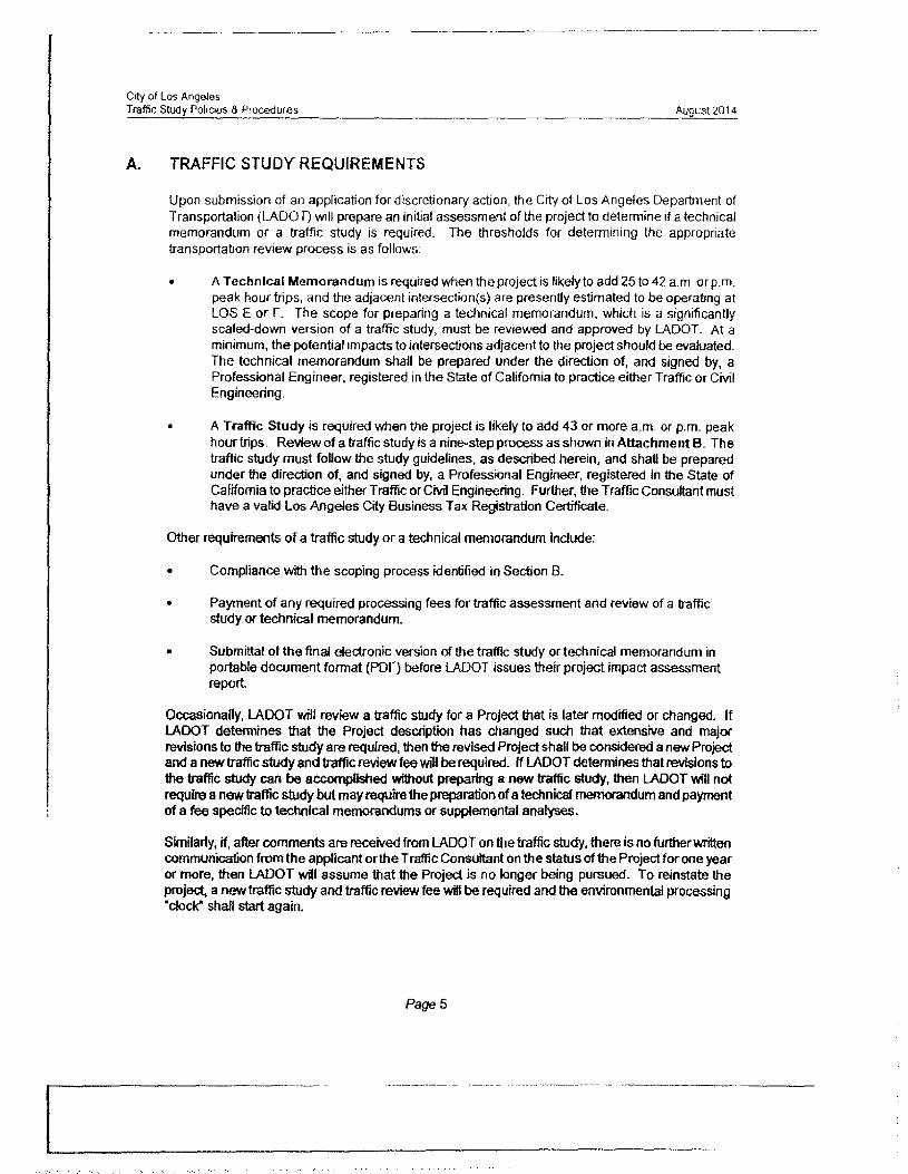
City of Los AngelesTraffic Study Policies & Procedures August 2014
A. TRAFFIC STUDY REQUIREMENTS
Upon submission of an application for discretionary action, the City of Los Angeles Department of Transportation (LADOT) will prepare an initial assessment of the project to determine if a technical memorandum or a traffic study is required. The thresholds for determining the appropriate transportation review process is as follows;
• A Technical Memorandum is required when the project is likely to add 25 to 42 a m orp.m. peak hour trips, and the adjacent intersection(s) are presently estimated to be operating at LOS E or F. The scope for preparing a technical memorandum, which is a significantly scaled-down version of a traffic study, must be reviewed and approved by LADOT. At a minimum, the potential impacts to intersections adjacent to the project should be evaluated. The technical memorandum shall be prepared under the direction of, and signed by, a Professional Engineer, registered in the State of California to practice either Traffic or Civil Engineering.
• A Traffic Study is required when the project is likely to add 43 or more a.m. or p.m. peak hour trips. Review of a traffic study is a nine-step process as shown in Attachment B. The traffic study must follow the study guidelines, as described herein, and shall be prepared under the direction of, and signed by, a Professional Engineer, registered in the State of California to practice either Traffic or Civil Engineering. Further, fire Traffic Consultant must have a valid Los Angeles City Business Tax Registration Certificate.
Other requirements of a traffic study or a technical memorandum include;
• Compliance with the scoping process identified in Section B.
• Payment of any required processing fees for traffic assessment and review of a traffic study or technical memorandum.
• Submittal of the final electronic version of the traffic study or technical memorandum in portable document format (PDF) before LADOT issues their project impact assessment report.
Occasionally, LADOT will review a traffic study for a Project that is later modified or changed. If LADOT determines that the Project description has changed such that extensive and major revisions to the traffic study are required, then the revised Project shall be considered a new Project and a new traffic study and traffic review fee will be required, ff LADOT determines that revisions to the traffic study can be accomplished without preparing a new traffic study, then LADOT will not require a new traffic study but may require the preparation of a technical memorandum and payment of a fee specific to technical memorandums or supplemental analyses.
Similarly, if, after comments are received from LADOT on the traffic study, there is no further written communication from the applicant or the T raffic Consultant on the status of the Project for one year or more, then LADOT will assume that the Project is no longer being pursued. To reinstate the project, a new traffic study and traffic review fee wifi be required and the environmental processing "dock" shall start again.
Page 5

ATTACHMENT
Herman Basmaciyan, P.E.Profile
• Over 50 years of transportation planning and traffic engineering experience, including consulting services to legal professionals
• Expert witness services in San Diego, Orange, Los Angeles, Riverside, and San Mateo Counties in California and in Maricopa County, Arizona in eminent domain, traffic engineering, transportation engineering/planning, and parking matters
• Experience in numerous traffic impact studies, transportation planning projects, parking studies, public transportation system planning and operations, analysis of land use/transportation system interrelationships, and other traffic/transportation engineering projects
• Management of, or key role in, a wide variety of transportation, transit, and traffic engineering projects in California, Oregon, Washington, Arizona, Nevada, Colorado, Montana, New Mexico, Ohio, and Louisiana
Education• Master of Science in Civil Engineering, University of Virginia, 1962• Bachelor of Science in Civil Engineering, Robert College, 1960• Numerous Short Courses in Transportation and T raffic Engineering
Registration Professional Engineer.
• California, Civil• California, Traffic• Arizona {retired status)• Florida (retired status)• Washington (retired status)
Professional Organizations• Institute of Transportation Engineers• American Society of Civil Engineers
Herman Basmaciyan

Employment History• Individual Providing Expert Witness and Consultant Services, Corona del
Mar, CA, since January 2005• Transportation Consultant, County of Riverside, Riverside, CA, 2005
2011 *• Vice President, Kimley-Hom and Associates, Inc, Orange, CA 1992-2004• Principal, Basmaciyan-Damell, Inc., Irvine, CA 1978-1992• Principal, Herman Basmactyan and Associates, Newport Beach, CA 1976
1978• Senior Associate, VTN Corporation, Irvine, CA, and Bellevue, WA 1971
1976• Senior Transportation Planning Engineer, DeLeuw, Cather and
Company, San Francisco, CA 1970-1971• Advisory Analyst, Service Bureau Corporation (then a subsidiary of IBM),
Palo Alto, CA 1967-1970• Director, Puget Sound Regional Transportation Study, Seattle, WA 1962
1967• Research Assistant, Virginia Council of Highway Research,
Charlottesville, VA 1960-1962
Herman Basmaci yan
Page 2

Exhibit 11

August 6, 2015
Mr, Robert P. Silverstein, Esq.The Silverstein Law Firm 215 Marengo, 3rd Floor Pasadena, CA 91101-1504
SUBJECT: Engineering Geology and Geotechnical Review of “Geologic and SoilsEngineering Update Proposed Eight-Unit Residential Development Lots 3 and 4, Block C, Lincolnian Heights Tract 853 and 857 North Hyperion Avenue Los Angeles, California for ADC Real Estate Group, LTD, Byer Geotechnical, Inc., Project Number BG 22023 September 10, 2014”, dated September 10, 2014, by Byer Geotechnical, Inc.
REFERENCES: See attached References Cited
Dear Mr. Silverstein:
At your request, we have reviewed the subject report with regard to the proposed grading, and the engineering geology and geotechnical conditions at the project site. The subject report references and incorporates a number of earlier reports that are discussed here as well. The subject Byer Geotechnical, Inc. (Byer) report was provided as a 68 page Adobe Acrobat file with a Geologic Map and geologic cross-sections A-A and B-B that incorporate the data from the earlier reports. Byer Geotechnical, Inc. conducted no new field studies and performed no laboratory tests. A scanned five page City of Los Angeles Geologic and Soils Report Approval Letter for the subject report was also reviewed.
BackgroundThe proposed development property consists of two side-by-side lots (3 and 4) each approximately 150 feet long and 50 feet wide elongated northwest-southeast (Byer, 2014, Geologic Map), The proposed project consists of eight three-story single-family homes (four on a lot) each with a two car garage on the bottom floor. Homes would be spread evenly across the lots from northwest to southeast. A preliminary estimate of the building mass to be added to Lots 3 and 4 is approximately 570 tons (assumes 60 pounds per square-foot of building space). The property slopes downward approximately 16 feet from Hyperion Avenue to the northwest property lines (Byer, 2014).
Temporary cut slopes would be necessary throughout the property for the construction of foundations and retaining walls, with wall heights up to 6 feet (Byer, 2014; Sections A-A and B- B). No permanent cut slopes are proposed.
Investigation methods employed at the site included surface geologic mapping, hand-dug test pits, and 24-inch diameter machine dug bucket auger borings. All test pits and the two bucket auger borings were logged to depth by engineering geologists. Samples were collected for laboratory testing. There is no indication for any of the studies referenced that historic aerial

photographs were interpreted to determine pre-deveiopment geologic conditions at the site, for example evidence of landslides or oil/gas drilling/development.
There are two identically shaped and sized lots bordering Lots 3 and 4 on the northwest. These lots are lower in elevation and have addresses on Sanborn Avenue. Where these lots join Lots 3 and 4, ground elevations with the project site are approximately 366 feet and where they meet Sanborn Avenue they are approximately elevation 335 feet, with an elevation difference of approximately 31 feet over a distance of 150 feet (Appendix, Figure 1). A line between these elevations slopes at approximately 12 degrees to the west-northwest away from Lots 3 and 4 (Figure 2). The Sanborn Avenue lots are developed with single-family residential units. Cadastral maps with 5-foot topographic contours from ZIMAS (City of Los Angeles, 2015) were reviewed (see Figure 1). Lots 3 and 4 are classified as “Hillside Area (Zoning Code)”.
General Geologic ConditionsLamar (1970) and Dibblee (1991) previously mapped this area as Puente Formation bedrock. Both maps show a northwesterly plunging anticlinal axis (an upward fold tilted to the northwest) just south of the project site. Site-specific geologic/geotechnical reports show two geologic units are mapped within the project site: 1) Recent (Holocene) residual soil and 2) Tertiary (Miocene) Puente Formation bedrock (Byer, 2014; Sections A-A and B-B). Residual soil and bedrock are covered with man-made artificial fill (map symbol af) over most of the site and, along with the residual soil, would be removed based on the grading plan (Byer, 2014), so that in those areas only Puente Formation bedrock (Tp or Tush) would remain. Engineered compacted fill would be place on the lots where necessary to create the desired surface grades.
A critically important issue in Hillside Area properties with underlying bedrock formations is the angle (dip) and direction (strike) of the bedrock layering compared to the angle (topographic slope) of the ground surface. If the topographic slope has a steeper (greater) angle than the bedding angle then the bedding is called “out-of-slope” or “daylighted”. This means the bedrock mass forming the slope has no down slope physical restraint to moving along a weak bedding plane from its higher elevation to lower elevations below. Such an occurrence is commonly termed a landslide. While many factors can be involved, this sliding potential with daylighted bedding is exacerbated when a large building mass is placed on the already potentially landslide prone bedrock slope. This daylighted condition is documented to exist at the subject site.
Field investigations and reports by four geotechnical firms (Keith Ehlert, 1989; Soils International, 1989; A.G.I Geotechnical, Inc. [AGI], 2008, and GeoConcepts, Inc., 2013) are used by Byer (2014) as the basis for their report. Considering the field data from the four reports, Puente Formation bedrock is described as follows by the four firms who are cited as having done field investigations work at the site. 1
1. Ehlert and Soils International (Byer, 2014): Poor copies of the field logs are provided by Byer (2014) without any other part of the report(s). It appears that each company logged/described two 24-inch diameter bucket auger borings (B1 and B2) and one hand dug test pit (TP1) excavation within Lot 3 (857). BI and B2 extended to depths of 22-feet and 12-feet, respectively, while TP1 extended to 7 feet deep with a sample at 8 feet deep (below
Proposed Development 853 and 857 North Hyperion AvenueAugust 6, 2015Page 2

the bottom of TP1). The Puente Formation is described as having moderately well- to well- defined bedding, consisting of clayey siltstone, siltstone, shale, and sandstone/siltstone. Bedrock was generally brown and light gray with orange-brown staining, and contained joints sometimes filled with gypsum. Geologic bedding (distinct layering in the bedrock) in the Puente Formation was described as variable and tilted (dip direction) to the north and northwest generally the same direction as the slope face between Lots 3/4 and Sanborn Avenue below. As described above, bedding orientation (dip direction and dip angle in degrees) is critical to determining slope stability. Borings B1 and B2 by Ehlert and Soils International indicate claystone and siltstone to depths near 22-feet close to the northwest site property lines. Bedding dips between 7- and 16-degrees to the north and northwest toward the northwest property lines.
2. A.G.I. Geotechnical. Inc. (AG1. 2008; Byer, 2014): Copies of the field test pit logs are provided by Byer (2014) without any other part of the report. The AGI report text was available separately without the logs. AGI logged/described two hand-dug test pits (TP1 and TP2) excavated within Lot 3 (857). TP1 and TP2 extended to depths of 5-feet and 8.5-feet, respectively. The Puente Formation is described as thinly bedded, consisting of clayey siltstone, shale, and occasional siliceous shales. Bedrock was generally grayish, grayish- brown, rusty brown, and yellowish-brown and containing caliche (gypsum?) between bedding planes. Geologic bedding in the Puente Formation was described as dipping to the north and northwest generally the same direction as the slope face between Lots 3/4 and Sanborn Avenue below. Bedding orientations measured in TP1 and TP2 indicate claystone and siltstone in TP2 near the northwest site property line dipping between 6- and 15-degrees to the north and northwest toward the northwest property lines. TP1 nearer the southeast property line (Hyperion), shows bedding dipping between 5- and 10-degrees to the north and northwest toward the northwest property lines.
3. GeoConcepts. Inc. (GeoConcepts. 2013; Byer. 2014): Copies of the GeoConcepts field test pit logs, the Geologic Map, and laboratory test data are provided by Byer (2014) without any other part of the report. The GeoConcepts report text was available separately along with this same information. GeoConcepts logged/described four hand dug test pits (TP1 through TP4) excavated within Lot 4 (853). TP1 (southeast), TP2 (north center), TP3 (southwest), and TP4 (northwest comer) extended to depths of 5-feet, 4.5-feet, 6-feet, and 8.5-feet, respectively. The Puente Formation is described as interbedded shale and sandstone, generally well bedded, buff to light brown/tan in color. Geologic bedding in the Puente Formation was described as dipping to the north toward Lot 3. Bedding orientations measured in TP I, TP2, and TP3 indicate shale and sandstone dipping 18-, 7-, and 6-degrees, respectively toward the north property lines. No bedding angles were recorded in TP4 nearer the northwest property lines.
Additionally, fractures were noted in test pits excavated and mapped by Ehlert and AGI. No specific orientations were given for these fractures. Fractures can be important to slope stability since they are planes of weakness that can separate materials into smaller blocks and wedges within rock masses where they intersect bedding planes.
Proposed Development 853 and 857 North Hyperion AvenueAugust 6, 2015Page 3

Geologic faults, which can be classified as non-active, potentially active, or active, are not mapped at the subject site. Groundwater was not encountered in any of the subsurface exploration excavations.
Slope Stability ConsiderationsGeologic/Geotechnical Cross-sections: Geologic/geotechnical cross-sections depict thedistribution of geologic units in the subsurface and the dip of geologic bedding planes within a project site, and in any adjacent areas that might be impacted by the project development activities. AGI (2008), GeoConcepts (2013), and Byer (2014) prepared geologic cross-sections parallel to the long and short dimensions of Lots 4, 4, and 4/3, respectively. These cross-sections are described below.
1. GeoConcepts cross-sections A-A’ and B-B’ show up to approximately 5-feet of artificial fill and residual soil overlying bedrock. Rather than attempt to plot the actual or apparent dip of the bedding planes documented in their test pits, they show non-specific, wavy lines scattered throughout the subsurface with no quantification of bedding dip amount or direction. In the report, they indicate that bedding strike (a horizontal line on the bedding surface) is generally northeast and the dips (bedding slope perpendicular to the strike) are to the north at 6- to 18- degrees. They indicate that there are no dominant joint or fracture patterns, and conclude that “anticipated bedrock structure” is favorable for development. Considering these general conclusions there was no evaluation made of “offsite” areas upslope to the east or down slope to the west that could be affected by project grading and development.
2. Byer’s cross-sections A-A and B-B show up to approximately 4-feet of combined artificial fill and residual soil overlying bedrock. Cross-sections are based on previous investigations and reports without new field investigations. Instead of plotting the actual or apparent dip of the bedding planes documented in the test pits and borings discussed above, they show nonspecific, oval-shaped patterned features scattered throughout the subsurface with no quantification of bedding dip amount or direction. In their report, it is indicated that bedding generally dips to the west and north at 5- to 18 degrees. They indicate that the “generally- massive nature of the sandstone and the relatively gentle dip of the shale layers is favorably oriented for stability of the site”. For temporary excavations, there may be a “daylighted bedding condition” for “west- and north-facing excavations”. There is no discussion of joint or fracture patterns, and no discussion of the much weaker claystone and clayey siltstone documented by Ehlert and Soils International. In the General Findings section, they conclude, “Geotechnical issues affecting the project include bedding planes mapped in the test pits, which generally dip gently to the north and northwest. North- and northwest facing excavations may remove support from bedding and will need to be trimmed to a l’A:l gradient,” Considering these general “onsite” conclusions, there was no evaluation made of “offsite” areas down slope to the west and northwest that could be affected by the potential “daylighted bedding condition” in the claystone and clayey siltstone. 3
3. AGI prepared one cross-section A-A’ that shows up to approximately 5-feet of combined artificial fill and residual soil overlying bedrock. Byer does not present or discuss this crosssection. AGI plotted on A-A’ the actual or apparent dip of the bedding planes documented in
Proposed Development 853 and 857 North Hyperion AvenueAugust 6, 2015Page 4

the test pits and borings discussed above with quantification of bedding dip amount and direction. In their report, it is indicated that bedding generally dips to the north and northwest at 5- to 15-degrees. They state, “The bedrock was observed to be thinly bedded. Bedding orientation of the Puente Formation strike in a northeast to southwest direction and dip toward the north and northwest at shallow angles ranging from 5 to 15 degrees.” (The presence of the northwesterly plunging anticline [Lamar, 1970; Dibblee, 1991] supports this observation of a general northwesterly dip.) No specific recommendations regarding geologic bedding are made for temporary excavations, and there is no discussion of crosssection A-A’ in the text. Cross-section A-A’ utilizes the two AGI test pits and the data from Ehlert (1989) and Soils International (1989) to show there is an apparent geologic bedding dip of 7-degrees to the northwest toward the descending slope bordering Sanborn Avenue (Figure 2). There is no depiction or discussion of this descending slope and of the role that a potentially daylighted bedding condition could have on the slope down to Sanborn Avenue, in particular, based on construction of the proposed development. In addition, there is no discussion of joint or fracture patterns. AGI recommends that northwest facing construction cuts over five feet high be laid back (trimmed) to a 1:1 (horizontal:vertical) gradient. Considering the onsite conditions, AGI found that “From a geologic and geotechnical standpoint, the subject site is suitable for construction of the planned apartment buildings.” No evaluation is made of “offsite” areas down slope to the west and northwest that might be affected by a potential daylighted bedding condition considering the 7-degree out-of-slope apparent bedding dip.
4. T.I.N. Engineering Company (1994) prepared a soils and geologic engineering investigation regarding distressed foundations at 836 Sanborn (Lot 21), three lots to the south and west down slope from the subject Lots 3 and 4. Their four cross-sections A-A’ and B-B’ (on Plates I and II) show daylighted (out-of-slope) bedding planes at angles of 5- to 8-degrees, and they attributed the distress to the foundations as inadequate depth below the lowest daylighted bedding plane.
Bedrock Characteristics: The bedrock characterization described above by Byer portrays the Puente Formation as “interbedded shale, siltstone, and sandstone” based on the onsite investigations. Discussing geologic structure they refer to the “generally-massive nature of the sandstone and relatively-gentle dip of shale layers”, but nowhere mention claystone and clayey siltstone documented by Ehlert and Soils International in the only deep excavations made on the lots. In fact, these deep bucket auger borings with down-hole geologic logs are not described specifically in the Byer text. This is important because the residual strength implied for along- bedding stability analyses would be much lower for the claystone and clayey siltstone encountered within Lot 4 than the sandstone, shale and siltstone reported by Byer.
AGI and GeoConcepts performed laboratory testing of samples but no laboratory testing information was available for the Soils International report. Testing included one direct singleshear test on Puente Formation bedrock by GeoConcepts (cohesion 0.400 kips per square foot [kfs] and friction angle 31 degrees). AGI apparently performed no bedrock strength testing, although this portion of their report was not available. None of the consultant’s reports available
Proposed Development 853 and 857 North Hyperion AvenueAugust 6, 2015Page 5

for this project indicates that City of Los Angeles (2014) recommended bedrock slope stability analyses were performed.
Due to: 1) the reported presence of claystone and clayey siltstone beneath Lot 4; 2) the potential out-of-slope daylighted bedding condition depicted by the AGI cross-section A-A2 * * 5 for Lot 4; and 3) the massive weight of the eight homes that would surcharge the bedrock mass beneath the site and above Sanborn Avenue, bedding plane/translational slope failure analysis should be performed. A geologic cross-section perpendicular to slope and extending into the area northwest of the property is critical from a slope stability standpoint. Considering the geologic bedding structure as discussed above, some mapped bedding attitudes (e.g., see the attitude of 7- degrees on AGI cross-section A-A’ and the various bedding attitudes on the Byer Geologic Map), such a cross-section would exhibit an out-of-slope component. Translational failure slope stability analyses along such a component could determine critical bedding planes that could affect the feasibility of the current project design, in addition, the presence steeply dipping fractures and joints might also present areas of weaker strength affecting the slope stability calculations. Therefore, these factors should be accounted for as necessary in translational failure slope stability analyses in the area southeast from Sanborn to Hyperion.
GroundwaterNo groundwater or seepage was noted in borings or test pits excavated at the site (Byer, 2014). In addition to potential onsite infiltration, structures upslope from the project site appear to be in areas where rainfall, irrigation, and run off could infiltrate the ground surface and flow down gradient toward the project site. It is assumed that the pathways would be predominantly along fractures and bedding planes in the Puente Formation bedrock. This condition should be fully considered in slope stability analyses.
Other Geotechnical Considerations1. The consultant indicates that on-site materials may be used for backfilling behind retaining
walls and provides recommended earth pressure values for design of retaining walls. Clayey materials with medium and high expansion potential were encountered at the site. Considering this, the recommended earth pressure values recommended by Byer Geotechnical Group is about 50% higher than corresponding values recommended by GeoConcepts and A.G.l, and appear to be significantly lower than published recommended values for the type of on-site materials (e.g., NAVFAC, 2012, California Building Standards Commission, 2014, and the 2013 California Building Code ).
2. The consultant recommends on page 11 of the Byer Geotechnical Group report that “Footings adjacent to retaining walls should be deepened below a 1:1 plane from the bottomof the lower retaining wall, or the footing should be designed as grade beams to bridge from the wall to the 1:1 plane”. However, surcharge loads, including footings, above the 1:1 plane may impose lateral surcharge load on the lower retaining wall. A surcharge load is any load (such as a building) imposed on the surface of the soil close enough to the excavation tocause a lateral pressure to act on the system in addition to the basic earth pressure. Thepotential for lateral surcharge is usually evaluated using a recognized method of analysis
Proposed Development 853 and 857 North Hyperion AvenueAugust 6, 2015Page 6

(e.g., Spangler & Handy (1982), Soil Engineering, fourth Edition, Harper & Row, New York;or Navy Design Manual NAVFAC, 2012).
Summary of Results and ConclusionsOur review indicates there is substantial geologic evidence for potential slope instability within and adjacent to the proposed development site that have not been considered. In our professional opinion, these issues should be considered and addressed prior to approval of the project as it is currently defined. In particular, the long-term bedrock slope stability is questionable due to the geologic bedding orientation, slope angles to the northwest, assumed material strengths, potential presence of undocumented joints and fractures, and up slope groundwater/seepage, and the mass of the proposed eight residential structures (Figures I and 2). The City of Los Angeles (LADBS, 2014) requires a formal static and pseudo static (slope deformation analyses) slope stability analysis for Hillside Area lots and/or for slopes: “where adverse geologic conditions are encountered, the soils report shall provide slope stability analysis in accordance with P/BC 2014049 and P/BC 2011-050 where applicable”. P/BC 2014-049 requires the studies for all slopes that expose unfavorable geologic structure such as unsupported bedding.
In addition, P/BC 2014-049 recommends “Shear strength parameters used in stability evaluations may be based upon peak test values where appropriate. Parameters not exceeding residual test values shall be used for previous landslides, along shale bedding planes, highly distorted bedrock, overconsolidated fissured clays, and for organic topsoil zone under fill”. The current report does not provide laboratory residual strength test data for the claystone and clayey siltstone, clearly identified by Ehlert and Soils International beneath Lot 4 and potentially projecting beneath Lot 3, as required by P/B 2014-049 for determining material properties. Such properties are required for the translational slope stability analysis and must be determined with from tests “made on an appropriate number of samples removed from test pits that represent the material in a particular slope”. Alternatively, if no test data are available, “An arbitrary residual angle of shearing resistance of six degrees and cohesion of 75 pounds per square foot may be used to represent the strength on shale bedding and in landslide debris in lieu of parameters determined by laboratory testing.” Any bedding plane failure that may occur could have a very significant detrimental effect on the environment down slope from the subject property and may result in significant damage to adjacent existing structures down slope along Sanborn Avenue. Addressing the above issues may result in a need for additional design measures to demonstrate feasibility of the current design and to mitigate the potential for adverse impacts on the proposed development.
ClosureThis report has been prepared for the sole use and benefit of our client. The analysis, results, and conclusions were prepared in general compliance with normal industry practice in the City and County of Los Angeles County. The intent of the report is to advise our client of geotechnical and engineering geologic conditions at the subject site, and the possible effects of these conditions on the proposed development and surrounding properties. It should be understood that the geotechnical engineering and engineering geologic consulting provided represents professional opinions and the contents of this report are not perfect. Any errors or omissions noted by any party reviewing this report should be reported to Wilson Geosciences Inc. and Geo-
Proposed Development 853 and 857 North Hyperion AvenueAugust 6, 2015Page 7

Proposed Development 853 and 857 North Hyperion AvenueAugust 6,2015Page 8
Dynamics, Inc. in a timely fashion. Only the client can authorize subsequent use of this report. No warranty is either expressed or implied.
Please contact the undersigned if you have any questions.
Sincerely,
WILSON GEOSCIENCES INC.
Kenneth Wilson Principal Geologist P.G. #3175, C.E.G. #928 (626) 791-1589
/qTkbbcth ibmson\!a>No. 928
CERTIFIED ENGINEERING
GEOLOGIST
GEO-DYNAMICS, INC
REFERENCES CITED
A.G.l. Geotechnical, Inc. (AGI), 2008, Preliminary Geotechnical Investigation, Proposed Apartment Buildings, Lincolnian Heights Tract, Lot 3, 857 Hyperion Ave., Los Angeles, California, dated June 30, 2008.
Bowles, J. E., 1982, “Foundation Analyses and Design”, Third Edition.
Byer Geotechnical, Inc, (Byer), 2014, Geologic and Soils Engineering Update Proposed Eight- Unit Residential Development Lots 3 and 4, Block C, Lincolnian Heights Tract 853 and 857 North Hyperion Avenue Los Angeles, California for ADC Real Estate Group, LTD. Geotechnical, Inc., Project Number BG 22023 September 10, 2014
California Building Standards Commission, 2014, 2013 California Building Standards Code, http://www.bsc.ca.gov/codes.asnx.
City of Los Angeles Department of Building and Safety (LADBS), 2014, Slope Stability Evaluation and Acceptance Standards, P/BC 2014-049, LABC 7006.3, 7014.1, effective 01-01-2014.
Department of the Navy, Naval Facilities Engineering Command (NAVFAC), 2012, Unified Facilities Criteria (UFC) Geotechnical Engineering (UFC 3-220-01), dated 1 November 2012, Approved for U.S. Army Corps of Engineers, Naval Facilities Engineering Command (Preparing Activity), and Air Force Civil Engineer Center.

Proposed Development 853 and 857 North Hyperion AvenueAugust 6, 2015Page 9
Dibblee, T. W. Jr., 1991, Geologic Map of the Hollywood and Burbank (South lA) 7.5-minute Quadrangles, Map No. DF-30, scale 1:24,000.
GeoConcepts, Inc. (GeoConcepts), 2013, Preliminary Geologic and Geotechnical Engineering Investigation, Proposed Five Lot Small Lot Subdivision, Detached Single Family Residences, Tract: Lincolnian Heights, Lot: 4, Block: C, 853 Hyperion Avenue, Los Angeles, California, dated August 12, 2013.
Lamar, D. L., 1970, Geology of the Elysian Park-Repetto Hills Area, Los Angeles County, California, California Division of Mines and Geology (CDMG) Special Report 101.
Southern California Earthquake Center (SCEC), 2002, Recommended Procedure for Implementations of DMG Special Publication 117, Guidelines for Analyzing and Mitigating Landslide Hazards in California, In California Implementation Committee: T. F. Blake Chair, T. F. Blake, R. A. Hollingsworth, and J. P. Stewart Editors.
Stark, T. D., H. Choi, and S. McCone, 2005, "Drained Shear Strength Parameters for Analysis of Landslides," Journal of Geotechnical and Geoenvironmental Engineering, ASCE, Vol. 131, No. 5, May, 2005, pp. 575-588.
T.I.N. Engineering Company (TIN), 1994, Combined Soil and Geologic Engineering Investigation and Report for Remedial Repair of Existing Distressed Foundations Adjacent to Interior Ventilation Shaft at 836 North Sanborn, Silver Lake Area, City of Los Angeles, California, dated September 19, 1994; addendum November 18, 1994.
Watry, S. M. and Lade, P. V., 2000, “Residual Shear Strength of Bentonites on Palos Verdes Peninsula, California, GeoDenver 2000, Proceedings, Geo-Institute of the American Society of Civil Engineers.
Z1MAS, 2015, City of Los Angeles, http://zimas.iacity.org/, accessed July 2015.

Proposed Development $53 and 857 North Hyperion AvenueAugust 6,2015Page 10
APPENDIX
Figures I and 2

FIGURE 1 - Topographic Contours in the Vicinity of 853 and 857 North Hyperion Avenue
AVE s
3 r—fr%/' ■
SOURCE: ZIMAS, Map Sheet 144A201 (5-foot contours), 2015 fhtto://zimasJacitv.oro/t.
FIGURE 2 - A.G.I. Geotechnical Inc. 2008 Geologic Cross-section A-A’
CROSS-SECTION
PROPOSED I UNIT OVER PROPOSED OARAGE
PROPOSED .1 UNIT BUILDING
EXISTING RESIDENCEHYPERION AVE/ P.L.
„ toil
Sanborn Avenue 31-feet below
kffmidwtt wU ■
DISTANCE (feet)Projection ofthe ZIMAS topographic slope angle (dashed brown line) from Sanborn Avenue at 12-degrees into the property subsurface showing AGI 7-degree out-of-slope bedding angles (red dashed lines).SOURCE: AGI, 2008
(Original scale 1” = 20’)SCALE 1” = 30’ PLATE 2

Exhibit 12

Draft Environmental Impact Report State Clearinghouse No.2002041009
FEIR-CD-1636
City of LA EIR No. 2005-2158(EIR) __________ CPC No. 97-0043{CPU)
Secondary Highways
East-West
* Barham Boulevard- is classified a Secondary Highway that defines a boundary for the northern portion of the study area, it forks into West Olive Avenue and Forest Lawn Drive. It has two lanes in each direction with on-street parking on both sides of the street, with length of time restrictions in many blocks. The posted speed limit along Barham Boulevard is 35 MPH.
* Los Feliz Boulevard- is a secondary highway from Western Avenue to Vermont Avenue. It becomes a Major Class II Highway east of Vermont Avenue. The posted speed limit along Los Feliz Boulevard is 35 MPH at the point where it transitions into a Major Class II Highway.
* Franklin Avenue- is a Secondary Highway in the Plan Area from Gardner Street to St. George Street to the east. It has segments with two lanes in each direction with on-street parking on both sides of the street as well as segments with one-lane in each directions and parking. There are left turn pockets at some, but not all intersections.
• Fountain Avenue- is a Secondary Highway in the Plan Area with two lanes in each direction as well as time restricted and metered parking lanes on both sides of the street from Fairfax Avenue to La Brea Avenue. There is a gap in which Fountain becomes a Collector from La Brea Avenue to Wilcox Avenue. Fountain Avenue then continues as a Secondary Highway from Wilcox Avenue to Hyperion Avenue. There are left turn pockets at most intersections between Western Avenue and Cahuenga Boulevard. There is also a center lane turn lane from Van Ness Street to Wilton Avenue.
• Griffith Park Boulevard- is a Secondary Highway in the Plan Area from Hyperion Avenue to Los Feliz Boulevard. North of Los Feliz Boulevard it transitions into a Local road.
• Hyperion Avenue- is a Secondary Highway in the Plan Area with two lanes in each direction as well as time restricted and metered parking lanes on both sides of the street from Glendale Boulevard to Fountain Avenue where it transitions into a Collector street,
• Laurel Canyon Boulevard - is a Secondary Highway in the Plan area that turns into Crescent Heights Boulevard at Sunset Boulevard. Other than a few blocks at its southern end, Laurel Canyon Boulevard is one lane in each direction with limited on-street parking as it works through the hills.
* Melrose Avenue - is a Secondary Highway in the Plan Area with two lanes in each direction as well as intermittent time restricted and metered parking lanes on both sides of the street. There are also center turn lanes and pockets at a number of locations.
Hollywood Community Plan Update Page 4.5-5
00003184

Exhibit 13

tvu i i/pctiun avc - uoogle Maps https://www.google.eom/maps/@34.087791II 8.282086.3a,75y, 197.1 h,90t/data=!3m7! lei...
908 Hyperion Ave
l.os Angeles, California Street View - Apr 2015
image capture: Apr 201S © 201S Google
ofl 7/15/2015 10:25 AM
diiie«£ll!34AHMIW1 ■ el.!feB!W“*mnv:iMlra11 !*«»». .S4"W»" •
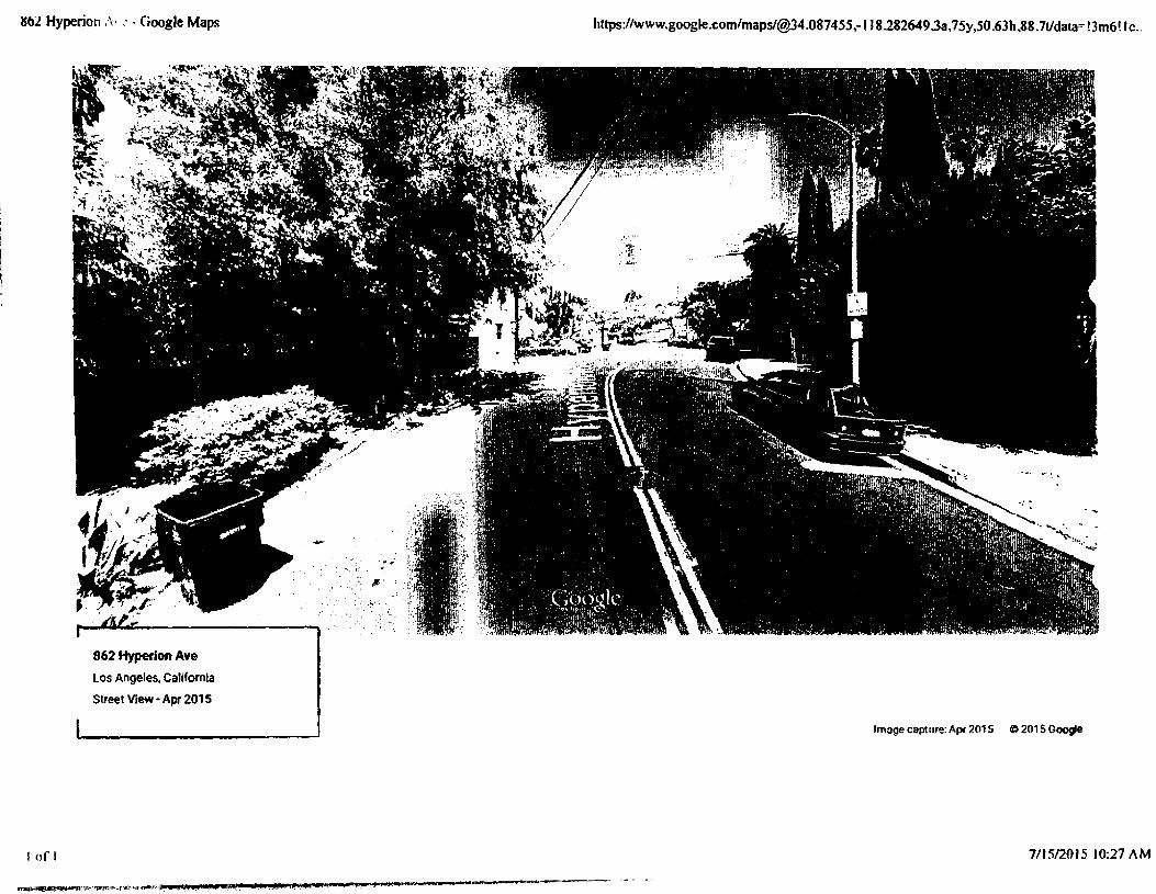
862 Hyperion , \ - Google Maps https://www.google.eom/maps/@34.087455,-H8.282649J3a,75y,50.63h,88.7t/ckmH3m6!lc..
862 Hyperton Ave
Los Angeles. California
Street View - Apr 2015
Image capture: Apr 2015 © 201S Google
I oft 7/15/2015 10:27 AM

Exhibit 14

Car speedi attached to tel and blowing


|IM^nj. Cfr . ilSli:*1 -»-'--:iHi.-.f.-nn.ang|ji


SMALL I (J !
The development features 23 homes with double-loaded garages on a center access driveway and internal courtyards
The interior courtyard spaces create an outdoor room that also provides access to light and air for the second story.
Rendering of how the garage, driveway, and primary entrance interact
Rendering of a courtyard created by two adjacent buildings. While each side is a private patio, joining these spaces provides the perception of a larger volume ot space.
46 CASE STUDIES

SMALL LOT
PREUSSFOUR, CfENEGA HEIGHTS Danny Cerezo, Architect 2008 Preuss Road
A homos bull (5 aibv/wJi
Zoning' RD i 5-1
Average lot size: 1,780-2,560 s.f.
Each unit is 2 stories with a 3 bedroom/3 bathroom configuration
All homes feature over 400 s.f. of private open space off of the main living level.
Site Plan shows the arrangement of the units with parking accessed via an alley and a 6 foot wide pedestrian passageway in the center. Parking for alt homes is accomplished with a tandem configuration to the rea of the site.
Each home also features a 2.8Kw solar pane) system as a standard feature.
All hardwood flooring has been reclaimed from a barn in Tennessee that was slated for demolition.
Sustainable features include exterior fiber cement siding installed as a rain screen system, electric vehicle chargers, bio-filtration planters, and a central heating and air is multi- zoned to maximize comfort.
Front elevation shows good height and massing relationship with surrounding structures and balconies facing the public sidewalk.
CASE STUDIES 47

S !■/ all l O
A 6 foot wide pedestrian path through the center of the project provides both access from the parking and common amenity space.
Planters in the front yard allow opportunities for landscaping to buffer common spaces from private spaces.
The pedestrian access path is open to the sky providing ample access to light and air for each home.
48 CASE STUDIES

SMALL. LOT
BUZZ COURT.SILVER LAKE Heyday Partnership Buzz Court, Los Angeles, 90039
G homes built (6 allowed)
Zoning: {Q)C2dVL
Average lot size: 1,720 s.f.
Variances/adjustments: 6
Each home is 3 stories witha rooftop deck as amenity Site Plan shows the arrangement of the units in a unique zigzag pattern thatspace staggers the home placement on either side of the narrow lot.
The zigzag pattern allows for greater separation between units and creates an added sense of privacy for rear units
Common maintenance agreement for driveway, access gate, trash area, and landscape
Additional notes: Certified LEED Platinum, Permeable Driveway, Solar Arrays, Instant Hot Water Heaters, indoor Air Quality Controls, Exceed Title 24 by >30%, Green Roofs.
The primary entry of the front home is dearly delineated by landscape planters and the massing of the facade. A second Boor balcony brings an element of private space into the public environment, activating both the front facade and the sidewalk of this more urban streetscape.
CASE STUDIES 49

SMA: i. [O'
The unique spatial arrangement of the development causes the homes to have a staggered effect, making the spaces between buildings seem more open.
The facade treatment provides for a visually interesting and appealing display at night. The shading element provides privacy for the residents while stiff allowing light to be displayed along the sidewalk. The front entrance is clearly Illuminated for safety and delineation.
While die homes are configured to provide adequate access to the garages for cars, the interior spaces are arranged so that windows and balconies do not directly face each other. This creates a better sense of privacy for homes feat are closely spaced.
so CASE STUDIES

Exhibit 15

T-“...02/200JSECTION331 ORlVLvVAV Dl iiON
OeikHin>C'flt o! F'f.inbponauon MANUAL Ok POLICIES & PROCEDURES
Modifications to channelization to make proposed driveway locations acceptable shall be paid for by the permittee requesting the change, prior to approval of the permit. Such modifications shall be approved by the Transportation Engineer of the appropriate district office.
C. Driveways at Tee IntersectionsDriveways for properties at the top of a T" intersection are to be centered within one foot of the prolongation of the terminating street center line. The driveway at the top of the T- intersection should be a Case 3 type driveway in a residential area, and a Case 4 type driveway in a commercial area (see attached Department of Public Works Standard Plan No. S-440-3). Where this is not possible, the driveway should conform to Sub-Section V.B (Location of Driveways Adjacent to Intersections).
D. Distance between Driveways
Wherever possible, two-way driveways should be separated by a minimum of 50 feet of full height curb to minimize conflict between vehicles using the adjoining driveways.
VI. Driveway Design
A. Basic Principles
Driveways should be designed to minimize possible conflicts between users of parking facilities and users of abutting street systems. The design should address pedestrian safety, sight distance, width of the lane from which the right turns into the driveway are made (i.e. 12 foot curb lane requires a wider driveway), size and turning characteristics of vehicles using the driveway (i.e. delivery trucks require wider driveways), complexity of vehicular movements, density of traffic on the abutting street (traffic and street width), speed of vehicles on the abutting street, arrival or departure rate of vehicles using the driveway, and any other considerations that would affect the safety and efficient use of City streets. It should be recognized that driveway design recommendations may vary depending upon site constraints, location, and usage. Existing driveways can be approved as constructed if the project which has necessitated their review is of limited scope or is re-striping only.
B. Width of Driveways
Not withstanding existing Code requirements, the following driveway widths are recommended:
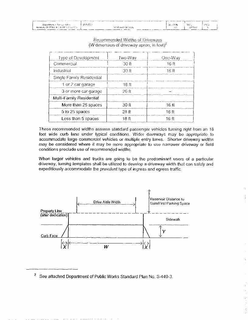
l>CP(if1nx-ni IMANUAL Cf- PQl I. if-
.. -c , | SUGJEC T, 1 I'ft'H LVl j ORIVF.WAV DESIGN
I SID! KIN
J__JfiDA I E orjooi
Recommended Widths of Driveways (M/dimension of driveway apron, in feet)2
| Type of DevelopmentCommercialIndustrial
Two-Way30 ft30 ft
One-Way16 ft
16 ftSingle Family Residential
1 or 2 car garage 18 ft---------------- --—----------
3 or more car garage 26 ftMulti-Family Residential
- -
More than 25 spaces 30 ft 16 ft5 to 25 spaces 28 ft 16 ftLess than 5 spaces 18 ft 16 ft
These recommended widths assume standard passenger vehicles turning right from an 18 foot wide curb lane under typical conditions. Wider driveways may be appropriate to accommodate large commercial vehicles or multiple entry lanes. Shorter driveway widths may be considered where it may be more appropriate to use narrower driveway or field conditions preclude use of recommended widths.
When larger vehicles and trucks are going to be the predominant users of a particular driveway, turning templates shall be utilized to develop a driveway width that can safely and expeditiously accommodate the prevalent type of ingress and egress traffic.
Drive Aisle WidthReservoir Distance to Gate/First Parking Space
(after dedication)Sidewalk
Curb Face / \ l Y/
<-->X
X-................................ \ 401XI
^ /w
2 See attached Department of Public Works Standard Plan No. S-440-3.

Exhibit 16

a. i : r i-y , k > >
t,fvfl.vS l ' «'• • r '
C- ' P\-r u ■ T
r'f"CR
>.' ■3:.• ■ c -i.r •; ■ ‘
i-‘\ £/'_> t.' -1 ' ' '
M / • EG 1 o * •"Mif-'/.i > . ■ 1 I A fit L PO‘,t 1 l Ar .--.T-T
ri-' -'L-, •_ - cw LG 1 3 c. ■* A r\ > -jC>^
C, M3 IT'S. RE£ C->.» ‘/iiSS iOn tA-ttv^ivC ASSIST Md
ti I 3> 5BO-S223
City or Los AngelesCal ,FO«ni-
-sCMi^D J RlOUG-',:::• '■ T ’J-1
.Ai)n) 2-T 2001
i * re u 11 -• [, or f ic c 5,! *) 1 H r•: ;>y
D<^£. crc*(21 3i 5fl0-i 160-''r‘NKLIN p EOtPf-i <r-‘£^
C-'E '■’f T - P^CTO'i I.i T ‘ «G( ‘ t!G3
EG^prvis1 6 HAMI'JC’J t c’ » - ■ • ,t»r - ••
, 1 A Liv, i ■.,: - , ^ J • ■ . •• ' •
• • • > ' c- >t;G. I j i Git ; Mi.
I -' _■ O 1 M. 1 ''f.
C Oj SSL •» /
TO:
FROM:
Interested Fames
,cCon Howt)’Director of Planning
SUBJECT. REVISED POLICIES FOR PRIVATE STREET REGULATIONS, GENERAL VARIATION NO- 200M AND 2001-2, COMMUNITY DRIVEWAYS .
Attached are the two new standard policies which modify the Private Street Reg-ulations. The authority for these modifications is found in Section 18.12 of the Los Angeles Municipal Code. These new policies were developed following collaboration with the Department of Building and Safety in an effort to clarify the number of lots which could be served by common driveways.
There are two policies. The first, “Private Street Regulations, General Variation 2001-1,” applies to the use of common driveway facilities for single family residential uses. The revised policy will permit a common driveway to serve no more than two single family residential uses. The second policy, “Private Street Regulations, General Variation 2001-2," addresses the use of the community driveway for all other laud uses. The revised policy continues to permit community driveways to serve an unlimited number of lots.
In both policies, the requirements with respect to legal lots, Fire Department access and Department of Building and Safety requirements continue. •
The chief reason for revising these policies was to distinguish between single family uses and non-single family uses.
These policies will become effective on May 1,2001,
CH.jJc
Attachments: Private Street Regulations, General Variation 2001-1 (Single Family)Private Street Regulations, General Variation 2001-2 (all others)
PUBLIC COUNTER fk CONSTRUCTION SERVICES CENTER 201 NORTH FIGUEROA STREET. ROOM 300 - r2l 3» 977-6083
VAN NUYS - 625 l VAN NUY5 SU'D , \ * Fl_OGR. VAN NUTS 9 1*0 I • 7S6-B595
AN EQUAL EMPLOYMENT OPPORTUNITY - AFFIRMATIVE ACTION EMPLOYER *fO ami inic)?eg«tfr

PRIVATE STREET REGULATIONS GENERAL VARIATION 2001-1 (Operational Date: May 1, 2001)
Common Driveways for Single Family Uses
The following variation applies to lots zoned RW-1 or more restrictive containing single-family residential uses except that both of the lots may be vacant. For other than single family properties, see General Variation 2001 -2
Pursuant to the authority vested in the Director of Planning by the provisions of Section 18.12, Article 8, Chapter 1 of the Los Angeles Municipal Code, relating to the issuance of building permits for two existing lots, the Director hereby grants the following variation to permit common driveway facilities without further approval by the Director of Planning, subject to the following conditions:
], That the lots are separate legal parcels of record prior to July 30, 1962 with requiredstreet frontage or are separate parcels or lots shown on a recorded Parcel Map or recorded Tract Map; or have a recorded Certificate of Compliance; and
2. Tire driveway shall not cross more than one lot and shall not serve more than 2 existing single family residential lots; and
3. The driveway within such easement is improved to a width in conformance with the Fire Department's fixe access standards as stated in Section 57.09.03 of the Los Angeles Municipal Code, but in no event less than 20 feet; and
4. Ingress and egress easements in the common driveway have been recorded in favor of the involved owners in a manner satisfactory to the Department of Building and Safety; and
5. The unobstructed distance - from the ground to the sky - between buildings located on . either side of said driveway is no less than 20 feet and otherwise meets all other setback and yard requirements of the LAMC.
This variation shall remain in effect until rescinded by subsequent action. It supercedes the previous General Variations dated February 1, 1996, March 28, 1974 and Jane 23, 1967.
CON HOWE Director of Planning
cc: Department of Building and SafetyLos Angeles Fire Department Bureau of Engineering Department of Transportation

private street regulations GENERAL VARIATION 2001-2 (Operational Date: May I, 2001)
Com/nor. Driveways for industrial. Commercial and MuJti-Family Uses
'Hie following variation does not apply to lots zoned RW-1 or more restrictive containing single family residential uses. See General Variation 2001-1
Pursuant to the authority vested in the Director or Planning by the pi O'- isions of Section 13 12 Article 8, Chapter 1 of the Los Angeles Municipal Code, relating to the issuance of building permits for two oi more existing Jots, the Director heieby grams the following variation to permit common driveway tacuities without tuaher approval by the Director of Planning, subject to thefollowing conditions:
1. That the lots are separate legal parcels of record prior to July 30, 1962 with required street frontage or are separate parcels or lots shown on a recorded Parcel Map or recorded Tract Map; or have a recorded Certificate of Compliance; and
2. Notwithstanding Section 12.21-A of the Los Angeles Municipal Code, a driveway within such easement is permitted over one or more lots to serve another lot(s). The driveway shall not be located and maintained on property which is in a more restrictive zone than that of the property on which die buijding(s) served rs (are) located; except that where a Jot is partly in the P Zone and partly a C or M Zone, any P Zone may be used. A driveway may also be located in a more restrictive zone than the zone of the lot where any of the building(s) is (are) located provided that the uses are permitted in the more restrictive zone; and
3. The driveway within such easement is improved to a width-in conformance with the Fire Department's fire access standards as stated in Section 57.09.03 of the Los Angeles Municipal Code, but in no event less than 20 feel; and
4. Ingress and egress easements in the common driveway have been recorded in favor of the involved owners that need the easement in a manner satisfactory to the Department of Building and Safety; and.
5. The unobstructed distance - from the ground to the sky - between buildings located on either side of said driveway is no less than 20 feet and otherwise meets all other setback and yard requirements of the LAMC.
This variation shall remain in effect until rescinded by subsequent action. It supercedes the ' "" ts dated February I, 1996, March 28, 1974 and June 23, 1967.
CON HOWE Director of Planning
cc: Department of Building and SafetyLos Angeles Fire Department Bureau of Engineering Department of Transportation

Exhibit 17

ARTICLE 7 FIRE PROTEC TION ' NO PREVEN TION (TIRE CODE) Page 1 of I
Los Angeles Municipal Code
SEC. 57.503.1.6. EASEMENTS.
Where (Ire lanes are required under Section 57.503-1.4 of this section to provide access for Fire Department emergency \ chicles, and such fire lanes are other than access roads, they shall be granted to the City without cost as easements from a public street or alley to the required terminal point. Provided, however, that the easement requirement may be waived, unless otherwise required by the General Plan of the City of Los Angeles, where the Department determines that the acquisition of an easement is not necessary for the protection of the public safety and welfare. Fire lanes shall be designated and maintained as follows:
1. Fire lanes shall have a minimum clear roadway width of 20 feet when no parking is allowed on either side.
2. Those portions of a fire lane which must accommodate the operation of Fire Department aerial ladder apparatus shall have a minimum clear roadway width of 28 feet when no parking is allowed on either side.
3. Those portions of a Fire lane 30 feet on either side of a private fire hydrant shall have a minimum clear roadway width of 28 feet. No parking shall be permitted within those portions of the roadway which are within 30 feet of and on the same side of the roadway as a private fire hydrant.
4. Where parking is allowed on only one side of a required fire lane parking shall be on the same side of the roadway as the hydrants.
5. Where parallel parking is allowed on either side of a fire lane, the roadway width shall be increased eight feet for each parking lane.
6. Where access requires accommodation of Fire Department apparatus, overhead clearance shall not be less than 14 feet.
7. Dead end fire lanes shall terminate in cul-de-sacs or other approved turning areas consistent with the Department of Public Works Standard Street Dimension Plan D-22549.
8. Fire lanes shall be paved to the City Engineer's standards for public alleys.
http://www.amlegal.com/aIpscripts/get-content.aspx 7/16/2015

Exhibit 18

Prom: -Erie Garcettt" <[email protected]>
To: [email protected]>
Cc: *Anft Guerrero" <[email protected]>
Sent: Mon, Aug 18,2004 02:21 PM
Subject: Re: Hyperion improvements
Thanks lor the very ktnd note, David and SaJile. And glad to be of service. We try and help folks have a voice in their own neighborhoods and know that there are many great allies we have in the departments as was proven in this case, Thanks as always for your advocacy, Ideas, and commitment]
All the best,
Eric
Councilmember, City of Los Angeles District 13 (313) 473-7013visit oar Web site atwww.cdl3.com Sign-up for email updates at http^A?ww.!adty.or^eoundlfcdl3/cdl3optin.htm
»> [email protected]" <[email protected]> 03/16/04 01:13PM »>
Dear Ana and ©1c,
SallteandH wahfedfto leteypu,,know that the signs and die bumps down the middle ofhow much we apptedate your efforts in getting this
aoeaffigfl&feg. l$S|apra^-M$pna^i ofTOpc Mahdjement even implemented my stflfera&fi Hdi5ver, notjdst through the S-turn. it Is niceto cdhstituents. Thank you somuch ftor your htf^rlh setoff tip toe meefihgi with the’ Bureau of Traffic Management. These tvyo impfbvedwnts? ceftelhiy make the street safer and make us feel much better about living here. Hopefully, motorists traveling on Hyperion will heed the warnings and act accordingly. Thank you again.
Sincerely,David Modem & Sallle Hofmeister

Exhibit 19

NOV l 2013
M O T I 0 N
The Small Lot Subdivision Ordinance was enacted by die City of Los Angeles in '2004. The Small Lot Subdivision Ordinance is an innovative zoning tool Ural ailou.s development of townliouse style homes on urban infill lots with commercial or multi-family residential zoning. In most cases, the density of a Small Lot Subdivision is much less than what an apartment or condominium developer could build.
Despite its advantages, over the last nine years, problems in the implementation of the Small Lot Subdivision Ordinance have come to light. In many cases, Small Lot Subdivisions have disrupted the character of existing neighborhoods. They are not compatible with nearby buildings and do not relate well to the street.
To solve this problem, the Director of Planning should update and improve the Small Lot Subdivision Guidelines. They are out of date and must be amended to reflect the reality of the Small Lot Subdivisions being built today. In addition, the Small Lot Subdivision Ordinance should be evaluated and amended if necessary to see if it contains provisions that make it difficult for Small Lot Subdivisions to fit in with existing neighborhoods.
1 THEREFORE MOVE that the Department of Planning be instructed to update and improve the Small Lot Subdivision Guidelines.
I FURTHER MOVE that tire Department of City Planning, with the assistance of the City Attorney, be instructed to evaluate the Small Lot Subdivision Ordinance and prepare any changes to tire Ordinance that are necessary to ensure that future Small Lot Subdivisions are compatible with the neighborhood.
'Tom LaBonge Councilmember, 41h District
SECONDED BY:

M O T f O N
The Small Loi Subdivision Ordinance was approved by t!ie Cm of l.os Angelo in 2005 10 provide tec- simple home ownership opportunities in the City and to promote residential infill development in multi family and commercial zones After more than 10 years of implementation, the Small Lot Subdivision Ordinance has been used extensively m the City and no more so titan m eclectic and historic neighborhoods including Echo Park, Silver Lake and Venice
Originally proposed as an alternative means to encoui age additional for-sale housing opportunities for the burgeoning first-time home-buying market, it has often resulted in the development of high-end, luxury townhomes rather than tor-sale housing that is more aifordable These new homes often replace older bungalows and cottages that are themselves more affordable for those v ith low and moderate incomes, often resulting m projects that are out of scale and lacking in character in comparison u> their surruundings.
While the ordinance has created a new urban honieownership alternative to the traditional single-family home, it also brings a new set of spaciai complexities that should be addressed by the Planning Department, For instance, projects face challenges brought on by neighborhood context, and the proximity of adjacent structures requiring thoughtful consideration about massing, height, and transitional space from the adjacent properties.
Additionally, particularly where the preservation of neighborhood character is specifically mentioned m both the Small Lot Subdivision Guidelines and the community plans, designing and configuring new homes to be compatible with the existing neighborhood context is of utmost importance.
I THEREFORE MOVE that the Council instruct the Planning Department to report within 60 days regarding potential updates to the Small Lot Subdivision Ordinance and Guidelines.
1 FURTHER MOVE that the Council instruct the Planning Department to report on adaptive reuse incentives that could apply to existing bungalow courtyards, adaptive reuse and/or preservation incentives that could apply to existing residences on multi-family lots that have room for additional infill, and preservation or other incentives that could also create new homeownership opportunities that incentivize the maintenance of existing structures while adding more units.
1 FURTHER MOVE that the Council instruct the Planning Department, with the assistance of the City Attorney, to report on concerns that the Small Lot Subdivision Guidelines cannot be enforced and report on how best to codify Guideline requirements, including private on-site trash collection for projects of four or more units and on-sitc guest parking.
I FURTHER MOVE that the Council instruct the Planning Department to report on creating a unique set of requirements that apply to small lot projects of 20 or more units to ensure that larger subdivisions result in quality urban design and sufficient project open space.
PRESENTED S’!VI ITCH (VlTAnWl i
PRESENTED B\
DCSECONDED BY: o


