Embed Size (px)
Citation preview
THE SILVERSTElN LAW FIRM 215 NORTH MARENGO AVENUE, 3RD FLOORPASADENA, CALIFORNIA 91101-1504
PHONE, (626) 4494200 FAX, (626) 4494205
A Professional Corporation
VIA HAND DELIVERY
June 18,2013
Hon. Edward P. Reyes, ChairHon. Jose HuizarHon. Mitchell EnglanderPlanning & Land Use Management CommitteeCity of Los Angeles200 N. Spring Street, Rm. 395Los Angeles, CA 90012
Re: Objections To Millennium Hollywood Project;Appeals ofVTTM-71837-CN-IA andCPC-2008-3440-VZC-CUB-CU-ZV-HD; ENV-2011-0675-EIR
Dear Chair Reyes and Members of the PLUM Committee:
Appellant Communities United for Reasonable Development ("Appellant")respectfully appeals the April 27, 2013 Determination Letters and approvals of the CityPlanning Commission related to the Millennium Hollywood Project ("Project").
Appellant is a broad coalition of Los Angeles community organizations (and theindividuals they represent) in the Hollywood area including, but not limited to:Beachwood Canyon Neighborhood Association, Argyle Civic Association, Hancock ParkHomeowners Association, Hollywood Dell Civic Association, HollywoodlandHomeowners Association, Los Feliz Improvement Association, The Oaks HomeownersAssociation, and Whitley Heights Civic Association. Appellant's position herein issupported by a wide array of Neighborhood Councils and many other associations fromacross the City representing more than 250,000 residents, all of which oppose the Project.(See Exhibit 1 for a more complete listing of groups which are either a part of Appellantor are on record as opposing the Project.)
As discussed more fully below, Appellant is aggrieved because the City PlanningCommission ("CPC") erred and abused its discretion in approving the Project EIR and allrelated Project entitlements. This body should grant the instant appeals and reject theEIR for the Project.
Members of the PLUM CommitteeCity of Los AngelesJune 18, 2013Page 2
1. THE ENVIRONMENTAL IMPACT REPORT IS LEGALLY DEFICIENTAND DOES NOT SUPPORT THE TRACT MAP OR CPC PROJECTAPPROVALS.
a. The City And EIR's Failure To Require The Developer To Specify AStable, Accurate, and Finite Project Description Violates the MostBasic Mandate of CEQA.
The City's proposed Land Use Equivalency Program and Millennium ProjectDevelopment Regulations grant so much "flexibility" that City decision makers and thepublic have been deprived of participating in a meaningful environmental review process."An EIR must include detail sufficient to enable those who did not participate in itspreparation to understand and to consider meaningfully the issues raised by the proposedproject." Laurel Heights Improvement Assn. v. Regents of University of California(1988) 47 Ca1.3d 376, 405.
The Project's Draft Environmental Impact Report ("DEIR") describes one project"concept", two "scenarios," and six project alternatives, but the DEIR fails to specifywhich of the concepts or scenarios, if any, is proposed for construction. An "accurate,stable, and finite project description is the sine qua -non of an informative and legallysufficient EIR." San Joaquin Raptor Rescue Center v. County of Merced (2007) 149Cal.App.4th 645,655, quoting County ofInyo v. City of Los Angeles (1977) 71Cal.App.3d 185, 193. Accordingly, this EIR is defective because the use of anunconstricted Land Use Equivalency Program, with an infinite number of possible mixeduse combinations, fails to objectively demonstrate substantial evidence that all possiblesignificant environmental impacts have been identified and disclosed, much lessmitigated to the greatest extent possible.
Significantly, a rebuttal letter from the Millennium Developer's attorney datedMay 31, 2013 weakly and falsely asserts that "the project description in the Draft EIR isflexible, but it is also accurate, stable, and legally adequate." Apparently, even counselfor the Developer cannot bring himself to claim that an infinite number of possiblecombinations of mixed uses granted under the Land Use Equivalency Program is "finite,"as required by language in controlling case law.
Members of the PLUM CommitteeCity of Los AngelesJune 18, 2013Page 3
b. The Lack Of A Stable, Accurate and Finite Project Description ResultsIn A Cascade Of Failures Throughout The EIR To Identify And.Mitigate Potential Significant Impacts.
Various comment letters submitted to the City in response to the DEIR and otheradministrative appeals filed against the tract map approvals raised significant deficiencieswith the DEIR's project description. The vague and ever-changing project descriptioncombined with other refusals of the Project Developer and the City to disclose andmitigate the Project's significant, adverse impacts have been extensively documented inobjection letters attached to our initial appeal documents filed with the City, andincorporated again by reference herein.
These objection letters and the exhibits previously submitted into the recorddemonstrate that the City, as lead agency, failed to adequately analyze at least thefollowing EIR subject areas: aesthetics, air quality, climate change, cultural resources,geology/seismology, land use, noise, open space, parks, parking, public services, traffic,utilities/service systems, vibration, cumulative impacts, growth-inducing impacts, andalternatives. Appellant adopts all of the objections set forth in the letters attached to theappeals filed with the City, and directs the City Council's attention to all of the data andevidence attached to the DEIR comment letters in the Final EIR. .
In addition, Appellant adopts each objection letter andadministrative appealsubmitted to the City during the environmental review process and the hearings beforethe Advisory Agency, Hearing Officers, and the City Planning Commission. .Specifically, Appellant directs the City Council's attention to the administrative appealsof the Vesting Tentative Tract Map No. 71837 -CN by the AMDA College andConservatory of the Performing Arts, Annie Geoghan, Argyle Civic Association,Beachwood Canyon Neighborhood Association, Hollywood Dell Civic Association, andHolJywoodland Homeowners Association including all of the data and evidence attachedto those administrative appeals.
c. The Lack Of A Finite Project Description Appears Intended ToObscure What The Project Is Until After Expiration Of The CEQAAnd Planning Act Statutes Of Limitations.
The Land Use Equivalency Program and Millennium Development Regulationseviscerate the required CEQA review for this Project. Multiple comments on the DEIRnoted that the Project Developer has failed to commit to any particular project. But more
Members of the PLUM CommitteeCity of Los AngelesJune 18, 2013Page 4
ominous than just the inconsistency with CEQA is the very idea that City of Los Angelesofficials, led by City Councilmember Eric Gareetti in whose district the MillenniumProject sits, would allow a developer to essentially write its own DevelopmentRegulations that would apply only to its property, and to pair it with a Land UseEquivalency Program that allows the developer to wait until after CEQA and PlanningAct statutes oflimitation expire before requiring public revelation of what the Project is.As such, the refusal to commit to a particular Project proposal using the pretense thatsomehow the real estate market is "uncertain" is a gross breach of the City's mandatory,good faith duty under CEQA to fully disclose the proposed Project, its impacts andfeasible mitigation as part of the environmental review process. A good faith effort bythe City as lead agency would have prevented the Millennium Developer from wastingeveryone's time trying to review an EIR which lacks a legally sufficient projectdescription.
Such a bait and switch is illustrated by the recent Wilshire Grand RedevelopmentProject in Downtown. In that case, the ErR described a project with two towers.However, once the applicable statutes of limitation expired, the developer, with greatfanfare and press releases, announced that it was combining the two towers together tocreate a super tower that will become the tallest building west of the Mississippi River.CEQA does not permit the use of an ill-defined project description to postponeannouncing what the project will really be. The Millennium Developer was required tospecify its project so that the impacts could be intelligently assessed and mitigated.Having failed to do so, the Project must be rejected and sent back for environmentalreview based upon a stable and finite project description.
d. The EIR Omits Disclosure Or Analysis Of The Land Use Impact FromViolating The City Advisory Agency Requirement Of 2.5 ParkingSpaces For Each Condominium Unit.
As set forth in more detail in the appeal of Annie Geoghan, the City failed todisclose or analyze in the ErR the land use impact of essentially granting a variance fromthe Advisory Agency's requirement that a developer provide 2.5 parking spaces for eachcondominium unit. The failure to disclose and analyze this land use impact is a fatal.flaw.
The City treats the Millennium Developer with impermissible favoritism byrefusing to require this Project to seek, justify, and obtain a variance from the AdvisoryAgency's requirement. This is especially true when in connection with the nearby
Members of the PLUM CommitteeCity of Los AngelesJune 18, 2013Page 5
Hollywood Gower Project, I the City's EIR disclosed the existence of the 2.5-parking-space requirement and analyzed the impacts of seeking and obtaining a variance from therequirement. (Exhibit 2.) ..
The EIR is fatally flawed and must be recirculated with proper analysis of land useimpacts from all variances sought from City land use laws and policies.
e. The EIR Fails To Adequately Analyze Impacts On EmergencyResponse Times And/Or Relies Upon Response Time Data That LAFDNow States Is Unreliable.
The EIR purports to analyze the impact of the Project on the demand for fireservices and concluded there is no significant impact. The EIR fails to fully and correctlyanalyze the time to respond to emergencies at the top of the Project's proposed towers,and improperly relies upon data regarding response times by the Los Angeles FireDepartment (Table IV.J.I-3, Average Response Times July 5, 201 l-Decernber 14,2011)that have been officially declared unreliable.
As indicated in the report of the Fire Department attached at Exhibit 3, page 3,"all prior reporting data should not be relied upon until they are properly recalculated andvalidated with the new recommended changes." (Emphasis added.) In other words, dueto serious problems with the manner in which the Los Angeles Fire Department hadreported emergency and fire response times, all prior data before implementation of therecommendations of the November 2, 2012 Task Force on Information and Data AnalysisReport are not to be relied upon. That means that the Project ErR used demonstrably
This firm successfully challenged the City Council's certification of a FinalErR and approval of various land use entitlements for the formerly proposed, 20-storyHollywood Gower project. La Mirada Avenue Neighborhood Association of Hollywoodv. City of Los Angeles and Los Angeles City Council, et aI., Los Angeles CountySuperior Court Case No. BS132533. At trial, this finn proved that the City had violatedCEQA and had also violated the due process and fair hearing rights of this firm'scommunity group client. A writ of mandate from the Court issued invalidating the City'Scertification of the Hollywood Gower ErR and invalidating the City'S approval of all landuse and other entitlements for that project. Although the Hollywood Gower project hasbeen successfully challenged and invalidated, what is relevant for purposes of thisobjection letter is the City'S admissions and actions in that case.
Members of the PLUM CommitteeCity of Los AngelesJune 18, 2013Page 6
false and now officially repudiated - data for analyzing and mitigating impacts.Recirculation is required, utilizing correct reporting data.
Emergency response times are a matter of life and death and must be based uponaccurate data, especially when merely arriving at the front gate of a lJ-million-square-foot complex with two possible 585-foot towers will result in significant further delays inreaching persons in need of emergency services. The time consumed to reach a strickenperson in the upper floors would be significantly longer than the Fire Department's timeto merely arrive at the site. The EIR completely failed to analyze the amount ofadditional time to respond to emergencies at the top of the towers, including to a possiblerestaurant/bar, and how those possible scenarios will be addressed though mitigationmeasures.
The EIR's arialysis of the new proposed "Twin Towers West" options with up totwo, 585-foot-high towers as an attractive terrorist target, and the consequent impacts onfire and police services, is nonexistent. Something as unprecedented as dual sky scrapersin Hollywood must be analyzed in terms of these potential environinental impacts. Thefailure to do so is a failure to proceed in the manner required by law. See Mani Bros.Real Estate Group v. City of Los Angeles (2007) 153 Cal.AppAth 1385, 1405 ("we find,as did the trial court, that the conclusory assertion in the 2005 Addendum that theModified Project will have an insignificant impact on the provision of police services isnot supported by substantial evidence").
"[A 1 significant impact would occur if the implementation of the Proposed Planwould ... require the unplanned upgrading or improvements of existing fire protectionequipment or infrastructure due to proposed land use designation changes." Given theintensity and density of the proposed Project and its attraction to possible terrorist attack,by failing to tie the conclusion with the analysis (in fact, there was no analysis) the Cityhas again violated the law by failing to disclose the "analytic route the ... agencytraveled from evidence to action." Laurel Heights Improvement Assn. v. Regents ofUniversity of Cali fomi a (1988) 47 Ca1.3d 376, 404.
Because the Millennium EIR failed to analyze the impact of emergency responsetimes to the tops of the proposed towers, and because it relied upon demonstrably faultyFire Department response time data that has since been declared to be unreliable, the EIRhas no substantial evidence to establish that the Project will not have significant impactson fire and safety protection for the City or the occupants/users of the Project site. Theresimply has been a failure of proper disclosure and analysis. The DEIR must be
Members of the PLUM CommitteeCity of Los AngelesJune 18,2013Page 7
recirculated with proper disclosure and analysis of impacts related to fire, police andemergency response times, and fire, paramedic, and police facilities and resources,including related to potential terrorist attacks.
f. The 500-Foot Radius From The Hollywood Freeway Shown In TheEIR Is Inaccurate; 500 Feet From The Freeway Encompasses More OfThe Project Site Than Disclosed By The City In The EIR.
The EIR contains an inaccurate map of the Project site that claims to delineateareas that are within (and outside of) 500 feet of the Hollywood Freeway. (Exhibit 4,Figure 3 from the Draft ErR Air Quality Report using Bing mapping). Using the 100-foot scale shown on Figure 3 of the EIR and making a ruler with 5 times the 100-footscale, the EIR's map visibly depicts a sweep of the 500-foot boundary that is less than500 feet, as would be indicated by the same map's scale. (Exhibit 4, Figure 3 from theDraft EIR with ruler comparison.) A similar result appears when using data from GoogleEarth mapping. (Exhibit 5, Google Earth Map with similar scaled comparison.)
Accordingly, the Draft EIR's map and conclusion of the percentage of theMillennium Project within 500 feet of the Hollywood Freeway are incorrect. An accuratedepiction of the proximity of the building site to the 101 Freeway might result in aconclusion that no residential or hotel uses can be built on the East Site. But thedecisionmakers and the public cannot presently know whether that isso based upon thefalse depiction in the EIR. If the EIR's misrepresentation is off by as little as 20-30 feetas it visually appears, the percentage of the East Project site within 500 feet of theHollywood Freeway is significantly understated in the ErR. This means that the ErRpresents false information, upon which the PLUM Committee cannot engage in informeddecisionmaking.
A decisionmaker such as the City Planning Commission or the City Council doesnot know if the 500-foot boundary from the Freeway sweeps within the design envelopeof any proposed building podium or the tower for the East Site. Without exact andcorrect identification of the 500-foot boundary, it is impossible for the City'Sdecisionmakers or the public to know that all feasible mitigation measures have beenimposed to protect the health and lives of sensitive receptors that may occupy theincreased portion of the Project site within 500 feet of the Hollywood Freeway.
For this reason, the EIR's analysis and proposed mitigation measures, relying onfalse and inaccurate maps and percentage calculations, are inadequate to protect the
Members of the PLUM CommitteeCity of Los AngelesJune 18, 2013Page 8
occupants and users of the Project site. Recirculation with proper disclosure and analysesis required.
g. The CPC's Precedent That Multi-Family Units Should Not Be LocatedWithin 500 Feet Of A Freeway Should Mandate Denial Of The Project.
Many of the air quality concerns that have been raised by other commenters wereaddressed recently by the CPC during consideration of another project, the Casden Westproject, near the 405 Freeway in West Los Angeles on February 28, 2013. While theCPC ultimately recommended approval of that project, the CPC did so only afterimposing a condition requiring the applicant to move all residential units outside of 500feet from the freeway. (Exhibit 6 [April 4, 2013 Determination letter, pp Q-6, F-44].)The findings noted health risk impacts, and specifically identified outdoor air quality as abasis for the condition. (Id. [pp. F-114-116].) During the course of the February 28hearing, the CPC expressed numerous health risk concerns, which are equally applicablehere. These included:
• The general health concerns of putting residential units within 500 feetof a freeway;
• The difficulty in relying on a HEPA filter of Merv-13 to achieve 0.1micron diameter filtration, the particulate matter that poses the greatesthealth risk, according to the air quality consultant who testified at thehearing; and
It The reduction in the effectiveness of any filter with windows (and, ashere, balcony doors) that open.
The City should demand of the Millennium Project no less than it demanded ofCasden West. Granting exceptions to increase the height, FAR and density of residentialunits or hotel rooms - within 500 feet of the Hollywood Freeway is contrary toestablished CPC policy, contrary to recent precedent, and is in disregard of significanthealth and safety issues which the CPC extensively addressed in its consideration of theCas den West project and its rejection of new multi-family dwelling units within 500 feetof a freeway. We have transcribed a portion of the CPC hearing of February 28, 2013and have attached it as Exhibit 7.
Members of the PLUM CommitteeCity of Los AngelesJune 18, 2013Page 9
To the extent that the Project proposes or may potentially allow under any"flexibility" scenario residential or hotel uses within 500 feet of and/or within the knowndust plume of the Hollywood Freeway, the Project should be denied on this additionalground. The City and Millennium Developers should not place human lives at risk bylocating sensitive receptors so close to the 101 Freeway, especially when maps in the ErRinaccurately depict the 500-foot distance from the 101 Freeway.
h. The Project Is Inconsistent With The Freeway Adjacent AdvisoryNotice For Sensitive Uses.
The basis of these concerns can be found in the City's Zoning Information (ZI)No. 2427, Freeway Adjacent Advisory Notice for Sensitive Uses, adopted in November2012, and attached hereto at Exhibit 8. The EIR must be recirculated to properly grapplewith the Project's conflicts with the ZI. It is clear from the ZI that the Project isinconsistent with standard conditions and design alternatives, in particular buildingorientation and reduction in operable windows. Increasing density and FAR on theProject site so close to the Freeway is inconsistent with the intent of the ZI.
i. The Project Is Inconsistent With The General Plan Air QualityElement.
The ZI also shows the Project's inconsistency with General Plan Air QualityElement Policy 4.3.1, "revise the City's General Plan/Community Plans to ensure thatnew or related sensitive receptors are located to minimize significant health risks posedby air pollution sources." (Id.) Granting significant exceptions to the Community Plan inorder to substantially increase the density and number of units in the Project does theexact opposite of minimizing significant health risks posed by air pollution sources.
We also note the findings of the Casden West project include the following LandUse Planning significant impact, "Land Use Planning (Conflict with Land Use Plan,Policy, or Regulation) It is located in close proximity to the San Diego Freeway, whichmay result in health risk impacts. Specifically outdoor air quality impacts .... " (Exhibit6 [poF-114].) These impacts result in additional inconsistencies with relevant land useplans and policies. Cl.4, ["impacts related to the inconsistencies with General Planpolicies, including the health risk impacts discussed above will remain significant andunavoidable"].) The same applies with full force for this Project, yet the Project EIR hasfailed to adequately disclose, analyze and mitigate these significant air quality impacts.
Members of the PLUM CommitteeCity of Los AngelesJune 18, 2013Page 10
j. Air Quality Issues Prevent The Necessary Findings To Be Made ForApproval Of A Vesting Tentative Tract Map.
There is no substantial evidence in the record that the Project will not result inresidents and hotel guests being exposed to significant, unmitigable air quality impactsand effects. This is in part because no enforceable mitigation measure prohibitsdevelopment of the site with sensitive uses within 500 feet of the Hollywood Freeway. Infact, Project conditions B.1.5, B.1.6, and B.1.7 are so vaguely written that they fail tomeet the City's mandatory obligation to implement all feasible mitigation, as outlined inthe Health Risk Assessment at pages 18-21. (Exhibit 9.)
Having failed to provide for definite and enforceable Project conditions that notonly prohibit any sensitive uses and receptors within 500 feet of the Hollywood Freewaybut also implement prohibitions of balconies and operable windows for all sensitive usesfacing the Freeway, the City has failed to implement all feasible mitigation measures toprotect the Project's occupants from significant, negative exposure to carcinogenic airtoxics,
Recent studies and articles regarding health risks from adjacent freeway pollutantsdemonstrate that the risks are serious. (Exhibit 10.) Further, it appears that the EIRunderestimated exposure to toxics. A UCLA/CARB study published in December 2012,following completion of the Health Risk Assessment for the Millennium Project, showsmarkedly higher concentration of freeway pollutants in the early morning hours, whenpeople are more likely to be at home, than had previously been believed. (Exhibit 11.)See also the April 17, 2013 Los Angeles Time article, "Freeway Air Pollution TravelsFarther In Early Morning." (Exhibit 12.) Thus, there is even more evidence that theHealth Risk Assessment improperly understated the risk of exposure and the number offeet from the Freeway where sensitive receptor exposures must be limited in order toavoid toxic air exposures.
Finally, with this evidence of magnitude of risk associated with the entire buildingsite, the necessary findings for approval of a Vesting Tentative Tract Map cannot bemade with respect to any land use that includes sensitive receptors. See Govt. Code §§66474.61(d), (f).
Members of the PLUM CommitteeCity of Los AngelesJune 18,2013Page 11
k, The City Has Violated CEQA By Refusing To Study The Project AndIts Impacts Per Caltrans' Requests And Requirements.
The reason that CEQA requires a consultation process with responsible and trusteeagencies is to ensure that the lead agency performs the necessary studies for the EIR inconformity with requirements imposed by the consulted agencies. In this case, theCalifornia Department of Transportation required the City, inter alia, to conduct ananalysis of potential impacts on the adjoining Hollywood Freeway using particular studymodels, data input and related criteria.
Over Caltrans' objections, the City and the EIR have failed to do so. As furtherset forth in the report of traffic engineer Herman Basmaciyan (Exhibit 13), the Cityfailed to use the Caltrans-demanded traffic model for analyzing the potential Projectimpacts on the adjacent Hollywood Freeway, and instead purported to study impactsusing alternative methods - which actually resulted in no study of the Project's impactsto the 101 Freeway. When Caltrans officials objected that the DEIR was deficientbecause the City refused to perform studies as sought by Caltrans, the City unlawfullyclaimed that it was not required to do so. This is a violation of the City's mandatoryduties under CEQA. The City's study approach failed to provide complete or accurateinformation. The City'S use of the CMP methodology did not provide sufficientinformation related to the Project's impacts on the freeway system, and therefore did notadequately consider the potential significance of the Project's impacts on the freewaysystem.
The City appears to seek to shift the cost of correcting the negative freewayimpacts from the Millennium Developer to the taxpayers of California. The City may notignore its duties owed to a responsible agency and, by extension, to the public. The LosAngeles Department of Transportation "tail" does not wag the Caltrans "dog."
I. The EIR's Traffic Study Is Deficient For Other Reasons.
The EIR's traffic, circulation and parking analyses are legally deficient onnumerous other grounds, as set forth in Mr. Basmaciyan' s report, mandating recirculationof a new DEIR to address the significant gaps and/or errors in the current EIR. (Exhibit13.)
Members of the PLUM CommitteeCity of Los AngelesJune 18,2013Page 12
m, The City's Deficient ReiatedProjects List For The Millennium ProjectOmits Major Projects Disclosed And Analyzed In Other Recent EIRsFor Hollywood Projects Certified By The City, Thus Rendering TheEIR's Cumulative Impacts Analysis Defective.
As noted by Caltrans in its December 10,2012 letter at page 2, comment 3, theJune 2012 Traffic Impact Study failed to include a cumulative traffic analysis for U.S.101 (the Hollywood Freeway). The omission of the cumulative impacts analysis on amajor adjoining freeway, as specifically called out by the responsible agency, is a fatalomission requiring recirculation of the ErR.
The EIR's cumulative impacts analysis is further deficient and therefore defectivebecause it has omitted numerous related projects that should have been disclosed andanalyzed. As shown in the: (1) Target at Sunset and Western; and (2) Hollywood GowerEIRs in Hollywood which were recently certified by the City of Los Angeles (Exhibit14), various other projects were included on those related projects lists which must beincluded in the Project ErR. To omit them not only denies the public and decisionmakersthe information they need for informed decisionmaking, but also is arbitrary andcapricious by the City, and an abuse of discretion on that additional ground.
As stated in Bakersfield Citizens for Local Control v. City of Bakersfield (2004)124 Cal.App.4th 1184: "Proper cumulative impacts analysis is absolutely critical tomeaningful environmental review" (id. at 1217), and "questions concerning ...cumulative impacts constitute important issues of broad public interest that are likely toreoccur." Id. at 1203.
Cumulative impacts are defined as "two or more individual effects which, whenconsidered together, are considerable or which compound or increase otherenvironmental impacts." CEQA Guidelines § 15355. "The cumulative impact fromseveral projects is the change in the environment which results from the incrementalimpact of the project when added to other closely related past, present, and reasonablyforeseeable probable future projects." CEQA Guidelines § 15355(b).
As the Supreme Court has stated, without proper consideration of cumulativeimpacts, this critical issue may be "submerged," with potentially "disastrousconsequences" to the environment. Bozung v. Local Agency Formation Com. (1975)"13Ca1.3d 263, 283-284.
Members of the PLUM CommitteeCity of Los AngelesJune 18,2013Page 13
As set forth in Exhibit 14, there are a multitude of new projects underway in theHollywood area, and in the vicinity of the Project. In addition, there are several otherprojects which are reasonably foreseeable, although not necessarily in the formalplanning stage.
Citizens Assn. for Sensible Development of Bishop Area v. County ofInyo (1985)172 Cal.App.3d 151, made it clear that consideration of cumulative impacts must reachbeyond those projects currently under environmental review: "Related projects currentlyunder environmental review unequivocally qualify as probable future projects to beconsidered in a cumulative analysis. [Citation.] In addition, even projects anticipatedbeyond the near future should be analyzed for their cumulative effect." Id. at 168, citingBozung v. Local Area Formation Committee (1975) 13 Cal.3d at 284.
"A cumulative impact analysis which understates information concerning theseverity and significance of cumulative impacts impedes meaningful public discussionand skews the decisionmaker's perspective concerning the environmental consequencesof the project, the necessity for mitigation measures, and the appropriateness ofprojectapproval." Citizens to Preserve the Ojai v. County of Ventura (1985) 176 Cal.App.3d421,431. All of those failings are present with regard to the Project's EIR.
If it is "reasonable and practical" to include other projects in a project'scumulative impacts analysis, then the lead agency is required to do so. San FranciscansFor Reasonable Growth v. City and County of San Francisco (1984) 151 Cal.App.3d 61,77. "While foreseeing the unforeseeable is not possible, an agency must use its bestefforts to find out and disclose all that it reasonably can." CEQA Guidelines § 15144(emphasis added). It was "reasonable and practical" for the City to have included theseother projects in the Project's current cumulative impacts analysis - especially since theywere included in other recent Hollywood project EIRs - but the City has failed to do so.Until a complete list of related projects is disclosed in a recirculated DEIR, the criticalissue of cumulative impacts has not been properly analyzed or mitigated. The ProjectEIR is defective on this additional ground.
The Project EIR must be recirculated to include a proper and complete relatedprojects list so that a proper and complete cumulative impacts analysis can be performed.In its present state, the EIR fails at this basic informational level.
Members of the PLUM CommitteeCity of Los AngelesJune 18, 2013Page 14
n. The EIR Falsifies The Proximity Of The Project Site To The FaultRupture Study Zone And Improperly Omits Any Reference To TheActual Location Of The Strands Of The Hollywood Fault That HaveBeen Mapped On The Project Site.
The Alquist-Priolo Act was enacted "to provide policies and criteria to assistcities, counties, and state agencies in the exercise of their responsibility to prohibit thelocation of development and structures for human occupancy across the trace of activefaults." Public Resources Code § 2621.5.2 When a proposed development project iswithin an Earthquake Fault Zone established by the State under the Alquist-Priolo Act,the City must require "prior to the approval of a project, a geologic report defining anddelineating any hazard of surface fault rupture." Public Resources Code § 2623(a).Similarly, the City of Los Angeles in its Safety Element of the General Plan hasestablished broader Earthquake Fault Rupture Study Areas (these are broader anddifferent from the Alquist-Priolo Earthquake Zone Areas) (Exhibit 16; City SafetyElement Map) where it has undertaken to automatically require a fault investigationreport for projects located within those areas.
When a geologic report is required by a governmental unit, it is required to meetcertain content and recommendation requirements set by the State Mining and GeologyBoard. Public Resources Code § 2624(c). In determining whether or not to require afault investigation report for a particular development proposal, Special Publication 42-Fault-Rupture Hazard Zones in California (Interim Revision 2007), advises that "[ljocalgovernmental units must require developers to have project sites within the EarthquakeFault Zones evaluated to determine if a potential hazard from any fault, whetherheretofore recognized or not, exists with regard to proposed structures and theiroccupants." Id. at p. 9. Moreover, having a project site outside of an Earthquake FaultZone does not exempt a major development from avoiding such critical investigation."Active faults may exist outside the Earthquake Fault Zones on any zone map.Therefore, fault investigations are recommended for all critical and important
2 A history of the Alquist-Priolo Act published in 2010 by the CaliforniaGeological Survey in February 2010 is attached at Exhibit 15 for a more completesummary of how the Act is implemented.
Members of the PLUM CommitteeCity of Los AngelesJune 18, 2013Page 15
developments proposed outside the Earthquake Fault Zones." Id. (emphasis added.)Relevant portions of Special Publication 42 are attached hereto at Exhibit 17}
The substantive mandates of the Act are carried out in adopted regulations if anactive fault trace is found on a project site regardless of whether or not it is within anEarthquake Fault Zone. California Code of Regulations, Title 14, Division 2, Section3603(a) states:
"No structure for human occupancy, identified as a projectunder Section 2621.6 of the Act, shall be permitted to beplaced across the trace of an active fault. Furthermore, as thearea within fifty (50) feet of such active faults shall bepresumed to be underlain by active branches of that faultunless proven otherwise by an appropriate geologicinvestigation and report prepared as specified in Section3603(d) of this subchapter, no such structures shall bepermitted in this area."
Under the Guidelines for Evaluating the Hazard of Surface Rupture, thisobservation is particularly relevant to the Millennium Project: "A more detailed
3 The following passage from the City'S EIR prepared in connection with therecently adopted Hollywood Community Plan Update confirms that the City knows andunderstands the state law and regulatory requirements, including that a property need notbe located strictly within an Alquist-Priolo Zone to trigger close investigation of seismichazards from potential fault rupture:
"Alquist-Priolo Earthquake Fault Zoning Act: The Alquist-Priolo Earthquake FaultZoning Act (formerly the Alquist-Priolo Special Studies Zone Act) signed into law inDecember of 1972, requires the delineation of zones along active faults in California.The purpose of the Alquist-Priolo Act is to regulate development on or near active faulttraces to reduce the hazard of fault rupture and to prohibit the location of moststructures for human occupancy across these traces. Cities and counties mustregulate certain development projects within the zones, which include withholdingpermits until geologic investigations demonstrate that development sites are notthreatened by future surface displacement. Surface fault rupture is not necessarilyrestricted within an Alquist-Priolo Zone." (Exhibit 18; Hollywood Community PlanUpdate Final EIR at page 4.8-9 [emphasis added].)
Members of the PLUM CommitteeCity of Los AngelesJune 18,2013Page 16
investigation should be made for hospitals, high-rise buildings, and other critical orsensitive structures than for low-occupancy structures such as wood- frame dwellings thatare comparatively safe." (Exhibit 17; [Publication 42 at p. 29].)
The record in this case establishes a shocking lack of compliance with the Alquist-Priolo Act/Regulations and CEQA by professionally-licensed experts hired by theMillennium Developer and by City personnel who oversaw and are required by law toexercise independent judgment regarding the adequacy of both environmental reviewunder CEQA and compliance with the minimum content requirements of a faultinvestigation report. The magnitude of these deficiencies is fatal to approval of theMillennium Project.
Strong evidence exists that the Millennium Developer's geological firm preparedtwo materially misleading reports which make false claims that the Hollywood Fault is0.4 miles from the Project Site, when strands of it actually run through the entireMillennium Project Site. These reports include graphical depictions of the Project Site inrelation to both the Hollywood Fault and the City's Safety Element's Earthquake FaultRupture Study Zone that attempt to mislead the public and City officials into believingthat no earthquake faults are nearby or on the Millennium Project Site.
Additionally, strong evidence exists that City staff conducted perfunctory andpassive review of the reports and allowed the Millennium Developer's EIR consultant toprepare false responses to public comments on the Draft EIR regarding the existence offaults on-site, including failing to disclose the existence of a November 30, 2012 FaultInvestigation Report or circulation of it for public comment as part of the critical publicparticipation requirements of CEQ A. An outline of the evidence now follows:
At the hearing before the CPC on March 28.2013, Hollywood resident Brian Dyercalled to the CPC's attention the extensive work of James Francis Dolan, Professor ofEarth Sciences at the University of Southern California, regarding the location anddocumented active status of the Hollywood Fault. (Exhibit 19 [Wilson Report, ExhibitB].) Professor Dolan, one of the most recognized experts on the location of theHollywood Fault strands, has described in his scholarly work the existence of a strand orstrands of the Hollywood Fault south of Yucca Street within both the East and West Sitesof the Millennium Project. (Exhibit 19 [Report, Exhibit B].) Professor Dolan's work isspecifically listed as associated with the Hollywood Fault (Number 392) by theCalifornia Geological Survey in its Explanatory Text to Accompany the 2010 FaultActivity Map of California:
Members of the PLUM CommitteeCity of Los AngelesJune 18,2013Page 17
"392HOLLYWOOD FAULT
HoloceneClark and others, 1984 (4,000-6,000 yrs)
Dolan and others, 1997Weber and others, 1980 (p. A-3 and Plate 1)
Ziony and Jones, 1989Ziony and Yerkes, 1985 (p. 57)"
(Exhibit 19 [Report, Exhibit D at p. 33].)
Additionally, Professor Dolan's work in connection with the Hollywood Fault isofficially recognized by the United States Geological Survey - an agency of the federalgovernment. The online USGS map shows one strand of the Hollywood Fault runningthrough or immediately adjacent to the Millennium Project Site. (Exhibit 20.)
Professor Dolan's work builds upon earlier detailed studies nearby for the RedLine Subway. Those studies at Figure 2a, by Crook and Proctor (1992), show twostrands of the Hollywood Fault running through the Millennium Project Site. (Exhibit19 [Report at p. 4 & Exhibit B, Crook and Proctor Study at p. 234].)
Further, the Fault Rupture Study Zone boundary runs across large portions of thesoutherly portion of the Millennium Project Site. (Exhibit 19 [Report at p. 5].)
According to the MTA Redline Subway EIR, there is a 5% chance of a magnitude7 earthquake on the Santa Monica-Hollywood fault within the next 100 years, which isthe expected duration ofa building. (Exhibit 21.) In 2010, Professor Dolan's studentsprepared a presentation that included pictures of the scarp of the Hollywood Faultrunning across Vine Street along Yucca Street. (Exhibit 22 [presentation pictures].)Therefore, the public record is filled with public and authoritative data on the locationand active status of the Hollywood Fault - all information readily available to theMillennium Developer's geologic experts and the City.
Given that the location of the Hollywood Fault is called out on the most basic faultlocation maps of the United States and California governments as being on theMillennium Project Site, and that a Fault Rupture Study Zone boundary of the City'sSafety Element bisects the Project Site, one would expect detailed mapping of thesepossible risks and a detailed discussion in the ErR because these conditions could expose
Members of the PLUM CommitteeCity of Los AngelesJune 18,2013Page 18
human occupants of the Millennium Project to catastrophic injury or death in the event ofa surface rupture affecting the proposed 585-foot-high towers.
If an active fault trace runs through any portion of the Millennium Project site, thepresence of the fault would require serious modifications to the proposal or even make itimpossible to approve or construct with the California State-mandated 50-foot minimumsetbacks from fault traces. Thus, a great deal of financial interest of the MillenniumDeveloper rode on the conclusions of the geologist it hired to prepare the geologicalinvestigation of the Project Site - analysis incorporated into the ElR.
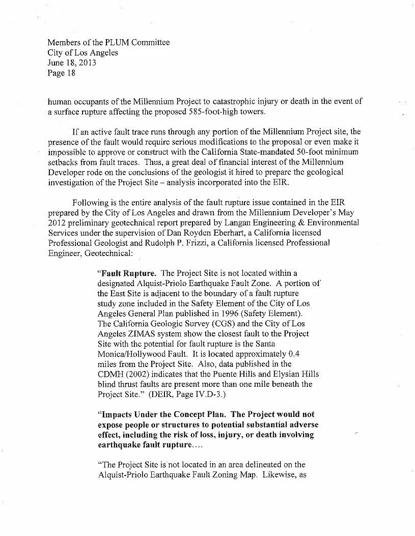
Following is the entire analysis of the fault rupture issue contained in the EIRprepared by the City of Los Angeles and drawn from the Millennium Developer's May2012 preliminary geotechnical report prepared by Langan Engineering & EnvironmentalServices under the supervision of Dan Royden Eberhart, a California licensedProfessional Geologist and Rudolph P. Frizzi, a California licensed ProfessionalEngineer, Geotechnical:
"Fault Rupture. The Project Site is not located within adesignated Alquist-Priolo Earthquake Fault Zone. A portion ofthe East Site is adjacent to the boundary of a fault rupturestudy zone included in the Safety Element of the City of LosAngeles General Plan published in 1996 (Safety Element).The California Geologic Survey (CGS) and the City of LosAngeles ZIMAS system show the closest fault to the ProjectSite with the potential for fault rupture is the SantaMonicaJHollywood Fault. It is located approximately 0.4miles from the Project Site. Also, data published in theCDMH (2002) indicates that the Puente Hills and Elysian Hillsblind thrust faults are present more than one mile beneath theProject Site." (DEIR, Page IVD-3.)
"Impacts Under the Concept Plan. The Project would notexpose people or structures to potential su bstantial adverseeffect, including the risk of loss, injury, or death involvingearthquake fault rupture ....
"The Project Site is not located in an area delineated on theAlquist-Priolo Earthquake Fault Zoning Map. Likewise, as
Members of the PLUM CommitteeCity of Los AngelesJune 18,2013Page 19
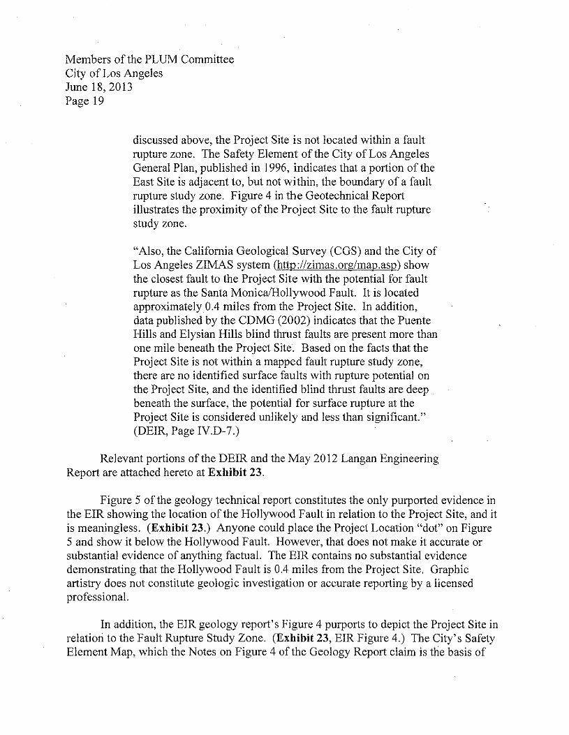
discussed above, the Project Site is not located within a faultrupture zone. The Safety Element of the City of Los AngelesGeneral Plan, published in 1996, indicates that a portion of theEast Site is adjacent to, but not within, the boundary of a faultrupture study zone. Figure 4 in the Geotechnical Reportillustrates the proximity of the Project Site to the fault rupturestudy zone.
"Also, the California Geological Survey (CGS) and the City ofLos Angeles ZIMAS system (http;//Zimas.org/map.asp) showthe closest fault to the Project Site with the potential for faultrupture as the Santa Monica/Hollywood Fault. It is locatedapproximately 0.4 miles from the Project Site. In addition,data published by the CDMG (2002) indicates that the PuenteHills and Elysian Hills blind thrust faults are present more thanone mile beneath the Project Site. Based on the facts that theProject Site is not within a mapped fault rupture study zone,there are no identified surface faults with rupture potential onthe Project Site, and the identified blind thrust faults are deepbeneath the surface, the potential for surface rupture at theProject Site is considered unlikely and less than significant."(DEIR, Page IY.D-7.)
Relevant portions of the DEIR and the May 2012 Langan EngineeringReport are attached hereto at Exhibit 23.
Figure 5 of the geology technical report constitutes the only purported evidence inthe EIR showing the location of the Hollywood Fault in relation to the Project Site, and itis meaningless. (Exhibit 23.) Anyone could place the Project Location "dot" on Figure5 and show it below the Hollywood Fault. However, that does not make it accurate orsubstantial evidence of anything factual. The EIR contains no substantial evidencedemonstrating that the Hollywood Fault is 0.4 miles from the Project Site. Graphicartistry does not constitute geologic investigation or accurate reporting by a licensedprofessional.
In addition, the EIR geology report's Figure 4 purports to depict the Project Site inrelation to the Fault Rupture Study Zone. (Exhibit 23, EIR Figure 4.) The City'S SafetyElement Map, which the Notes on Figure 4 of the Geology Report claim is the basis of
Members of the PLUM CommitteeCity of Los AngelesJune 18,2013Page 20
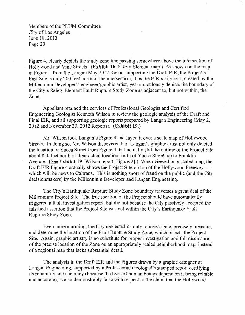
Figure 4, clearly depicts the study zone line passing somewhere above the intersection ofHollywood and Vine Streets. (Exhibit 16, Safety Element map.) As shown on the mapin Figure 1 from the Langan May 2012 Report supporting the Draft EIR, the Project'sEast Site is only 200 feet north of the intersection, thus the EIR's Figure 1, created by theMillennium Developer's engineer/graphic artist, yet miraculously depicts the boundary ofthe City's Safety Element Fault Rupture Study Zone as adjacent to, but not within, theZone.
Appellant retained the services of Professional Geologist and CertifiedEngineering Geologist Kenneth Wilson to review the geologic analysis of the Draft andFinal EIR, and all supporting geologic reports prepared by Langan Engineering (May 2,2012 and November 30, 2012 Reports). (Exhibit 19.)
Mr. Wilson took Langan's Figure 4 and layed it over a scale map of HollywoodStreets. In doing so, Mr. Wilson discovered that Langan's graphic artist not only deletedthe location of Yucca Street from Figure 4, but actually slid the outline of the Project Siteabout 850 feet north of their actual location south of Yucca Street, up to FranklinAvenue. (See Exhibit 19 [Wilson report, Figure 2].) When viewed on a scaled map, theDraft ErR Figure 4 actually shows the Project Site on top of the Hollywood Freeway -which will be news to Caltrans. This is nothing short of fraud on the public (and the Citydecisionmakers) by the Millennium Developer and Langan Engineering.
The City'S Earthquake Rupture Study Zone boundary traverses a great deal of theMillennium Project Site. The true location of the Project should have automaticallytriggered a fault investigation report, but did not because the City passively accepted thefalsified assertion that the Project Site was not within the City's Earthquake FaultRupture Study Zone.
Even more alarming, the City neglected its duty to investigate, precisely measure,and determine the location of the Fault Rupture Study Zone, which bisects the ProjectSite. Again, graphic artistry is no substitute for proper investigation and full disclosureof the precise location of the Zone on an appropriately scaled neighborhood map, insteadof a regional map that lacks substantial detail.
The analysis in the Draft EIR and the Figures drawn by a graphic designer atLangan Engineering, supported by a Professional Geologist's stamped report certifyingits reliability and accuracy (because the lives of human beings depend on it being reliableand accurate), is also demonstrably false with respect to the claim that the Hollywood
Members of the PLUM CommitteeCity of Los AngelesJune 18, 2013Page 21
Fault is 0.4 miles (2,112 feet) away from the Project Site. While it might be true thatportions of the Hollywood Fault lie .4 miles away whether measured to the east or thewest, the clear implication of the language used in the EIR is that the Hollywood Faultcomes no closer than 0.4 miles. That contention is simply false.
The work of Professor Dolan not only disproves the May 2012 geological reportby Langan Engineering, but it establishes substantial evidence that any geology studentcould find in the public record showing strands of the Hollywood Fault cutting throughthe center of the Project Site. Yet the EIR and the May 2012 Langan Report are bizarrelysilent about these critical issues. Professor Dolan himself in an email to representativesof Appellant made this observation:
"In response to your questions, please find attached our 1997paper on the Hollywood fault. Figure 4 is a detailed map ofthe area of your concern. This peer-reviewed paper has beenwidely known and cited for the past 15 years, so everybody inthe southern California geological/earthquake hazardcommunity should certainly be aware of it.
"1 would also suggest that you peruse 'the CaliforniaGeological Survey website to get a copy of their active faultmap of the area.
"Note that in the figure from our paper we are mapping faultscarps (shaded in gray), cliff-like features associated with faultmovements. The prominent north-side-up scarp north of theCapitol Records building is the most prominent of these (easyto see if you stand art] Hollywood and Vine and look North).But there is another, more southerly strand in this area that isshown on the map that is based on scarps to the east and west,separated by younger material corning out of the Cahuengadrainage, as well as by a groundwater barrier near Cahuengaand Yucca. The presence of at least two strands in this area iscommon along major faults like the Hollywood fault, whichare not typically just a single strand, but rather zones offaulting that can encompass several different strands.
Members of the PLUM CommitteeCity of Los AngelesJune 18, 2013Page 22
"Looking at our mapping of these scarps from the perspectiveof almost 20 years later, I am not completely convinced thatthe southern strand shown in the figure has that pronouncedchange in orientation at Vine Street (shown swinging Northright at Vine Street). This looks as if it could have at leastpartially been caused by deposition of young material and/orerosion associated with the small south-flowing drainage justeast of Vine Street, as well as by construction of Vine Streetitself.
"In any event, the only way to sort out the exact locations andstates of activity of faults in this area would be throughextensive subsurface exploration (boreholes, trenching, seismicreflection, etc.), which I assume is being done for this projectas a matter of course? (Email of James Dolan dated June 3,2013.) (Exhibit 24.)
When informed that the ErR described no detailed examination of this issue,Professor Dolan was incredulous:
"1 will try to give you a call later this morning. But the factthat the Hollywood fault is not yet zoned under the State'sAlquist-Priolo Act doesn't mean that it isn't an active faultzone (it is). It just means the State hasn't gotten around tozoning it yet, even though I've been asking them to do so since1992, when I first mapped the Hollywood-Santa Monica faultsystem. The California Geological Survey moves at a glacialpace with zoning faults. Moreover, the fact that it is not yetzoned in no way obviates the requirement that one notbuild structures designed for human occupancy directlyatop active faults.
"Given the scope of this project, I would assume that thedevelopers must have done a detailed subsurface geologicalinvestigation to look for possible active faulting beneath theirsite. Do you know what they have (or have not) done in thisregard? There must be a geological report that includes adetailed discussion of the potential for active faulting at their
Members of the PLUM CommitteeCity of Los AngelesJune 18, 2013Page 23
site. The Hollywood fault is one of the best known activefaults in California, and that 1997 paper has been publiclyavailable in a widely circulated mainstream peer-reviewedjournal for many years. Plus, I've led dozens of field tripsalong the Hollywood fault over the years that have includedmany dozens (if not hundreds) of consulting geologists, as wellas LA City and County geologists. So it's not as if anyonecould credibly plead ignorance of the existence andapproximate location of the Hollywood fault in that area.
"Bottom line: Based on our mapping back in the 1990s,supplemented by the consulting geologists reports we discussin that paper, it looks as if there is at least one strand of theHollywood fault extending approximately through themiddle of that block, but to determine its exact location andstate of activity would require extensive subsurface faultinvestigations (boreholes, trenching, seismic reflection, etc.).They MUST have done the detailed subsurface faultinvestigations necessary to determine the exact locationsand states of activity of fault strands in that area. I can'tbelieve that they wouldn't have done this as part of duediligence for developing the site. If they didn't, it wouldseem from my perspective that they should be required to doso by the City and/or County andlor COS geologist (whoeveris charged with this issue for that area). To undertake adevelopment of this scale (or indeed any development) inthat area of known active faulting without doing detailedsubsurface fault investigations just doesn't make anysense." (Email of James Dolan dated June 4, 2013,8:09 a.m.)(Exhibit 24; emphasis added.)
Later, Professor Dolan expressed shock about the claim that the Hollywood Faultis 0.4 miles from the Millennium Site:
"Do you know the name of the geological consulting companythat did the site investigation? Do you have a copy of theirreport? Can you get one? If so, can you send it to me? Pleasefill me in with what you know. I'm always in search of new
Members of the PLUM CommitteeCity of Los AngelesJune 18, 2013Page 24
data on faulting in the LA region, and this sounds as if it couldbe a rich source.
"I don't see how there is any way that their proposed buildingis 0.4 miles from that southern strand of the Hollywood fault.Is that what they said? Maybe they mean distance to thenorthern strand? Even that isn't 0.4 miles away, ifIunderstand where they are proposing to build. Do they meanE-W distance to previous study sites? If so, that doesn't reallymean anything in terms of proximity to a fault that extends E-W. I'd be very much surprised if at least some part of theirproposed building wasn't much closer to that southern strandin the block north of Hollywood and west of Vine. But I awaitgetting a look at their report on the subsurface investigationsbefore saying anything beyond that." (Email of James Dolandated June 4, 2013, 12:08 p.m.) (Exhibit 24.)
When Professor Dolan looked over the EIR and the location of the few boreholesperformed to investigate the Millennium Site's geology, he was stunned:
"Thanks for sending the draft EIR. I've taken a quick look,and I'm honestly not quite sure what to say. I want to becircumspect, but trying to find an E-W fault with an E-W(i.e., fault-parallel) transect of four incompletely sampled(18" of core every 5' of depth) boreholes is simply ... well,stunning. So stunning that I would suspect that theyweren't looking for a fault at this location, as this studycould not possibly have been designed to look for potentialE-W-trending strands orthe Hollywood fault system.Puzzling, as my mapping shows the fault either through [or]right next to their site, and the CGS website shows the northernstrand of the Hollywood just north of Yucca at the veryprominent scarp.
"In any event, this subsurface analysis, if this is all that hasbeen done, is completely inadequate in terms of a fault-investigation report. There's no way that they could ever
Members of the PLUM CommitteeCity of Los AngelesJune 18, 2013Page 25
hope to determine where faults are (or aren't) at theirproposed building site from iust these Jour boreholes.
"Is that really all there is? At some point along the line,somebody associated with this development project MUSThave done a more detailed subsurface analysis to check forfaulting." (Email ofJames Dolan dated June 4, 2013, 1:27p.m.) (Exhibit 24; emphasis added.)
Thereafter, Professor Dolan contacted the City's geologist, Dana Prevost, andasked for access to any further study of the Project Site for active faults. Herecommended to Appellant's representatives that they ask the City for a copy of thereport, which request was made by a representative of Appellant on or about June 4,2013, when Appellant became aware of the existence of the November 30, 2012 LanganReport. (A copy of the November 30, 2012 Fault Investigation Report prepared byLangan Engineering is attached at Exhibit 19 [Wilson Report at Exhibit A).)
This was the first time that Appellant became aware that the City required theMillennium Developer to conduct a Fault Investigation Report for the Project Site.Appellant then retained the services of Mr. Wilson to review the Draft and Final EIR forthe Project, as well as the Langan May 2012 geotechnical report ("May Report") and thehitherto undisclosed Langan November 30, 2012 Fault Investigation Report ("NovemberReport").
Mr. Wilson's investigation concluded that neither the Draft nor Final EIR containssubstantial evidence to support the contention that one or more strands of the HollywoodFault do not traverse the Project Site. In fact, his interpretation of boring data containedin the November Report, but inexplicably not discussed by Langan, suggests evidence ofa fault running between Borings B I and B2 on the Millennium Project West Site. Mr.Wilson also concluded that water table locations in one of the four original bore holesfrom the May Report was additional evidence of a water barrier on the East Site justsouth of the most southern boring. (See Exhibit 19.)
Even more disturbing is the sequence of events that led to the City failing to reviseand re-circulate the Draft EIR. While the Langan preliminary geology report wascompleted on May 2, 2012, shortly thereafter, on July 2,2012, the City required theLangan November Report to investigate for faults. The new borings were conductedonly on the West Site, and not up in the vicinity of Yucca Street from July 16-21,2012.
Members of the PLUM CommitteeCity of Los AngelesJune 18,2013Page 26
No new borings, no trenching, and no seismic reflection were performed at all on the EastSite.
When the B2 drilling core sample revealed evidence that might support aconclusion of faulting on the Project Site (older materials on top of younger carbon-datedmaterials), on October 11,2012, two additional boreholes were drilled (B5 and B6) oneither side ofB2. Data from boreholes B5 and B6 also showed older material lying overyounger material. These three of six boreholes suggest a need for further investigationthrough the techniques Professor Dolan stated: trenching on both sites, in a manneractually designed to attempt to locate and transect the faults, more complete sampling ofthe borehole materials, and seismic reflection studies. None of this was done and,strangely, the City'S geologist required nothing further.
The inconsistent data was explained away with Langan Engineering asserting thatB2 samples "were likely due to sample contamination from portions of the fill stratumfalling into the core from shallower depths during coring." No fact is cited as a basis tobelieve that such amateurish professional negligence could be a valid explanation, or ifthat really was the belief, why new, more carefully conducted borings did not occur.
For the B5 sample, which also shows older material over the top of youngermaterials, Langan opined that groundwater borne acids made "[t]he age of the analyzedsediment [to be] understood [as] older than the apparent age." For the B6 sample,Langan Engineering had a different explanation for why it also had older materialsdeposited over younger materials: "The reported apparent age of the sample fromapproximately 22 feet below ground surface was likely complicated by fluctuations incarbon content of sediments as carbon cycles through the subsurface profile duringreworking, incorporation, and redeposition of older sediment into younger sediment."Despite Langan making excuses for the anomalies, Appellant's geologist Wilson pointedout significant evidence of a fault that Langan failed to discuss at all in the NovemberReport. (Exhibit 19.)
The City'S geologist merely filed the November Fault Investigation Report away,and its existence was hidden from the public by City Planners. Given Langan's grosslyincorrect assertion that the Hollywood Fault was 0.4 miles away, the City failed in itsduty to assure reliable and accurate data by removing Langan from work on the FaultInvestigation team. How could City officials, knowing that the 0.4 mile claim wasunbelievable and inaccurate, allow Langan Engineering to conduct the FaultInvestigation?
Members of the PLUM CommitteeCity of Los AngelesJune 18,2013Page 27
Perhaps it was because certain City Hall partisans wanted the Millennium Projectto be heard and decided by the City Council before Councilmember Eric Garcetti leftoffice on July 1,2013. On October 25, 2012, before the November Report wascompleted, the City released the Draft EIR for public comment from October 25,2012 toDecember 10,2012. City staff had to know that the claim that the Hollywood Fault was0.4 miles from the Project Site was false because the City had ordered the FaultInvestigation on July 2, 2012.
Knowing that there might be an earthquake fault on the Project Site, someone inthe City nonetheless decided to release the materially misleading Draft EIR for publiccomment. No mention of a Fault Investigation Report was added to the Draft EIR beforeit was released for public comment. In fact, because such a critical study affecting thesafety of human beings was not yet complete, the City violated its duty of good faithdisclosure of known facts by prematurely releasing the Draft EIR with such a glaringdeficiency. In doing so, the public was deprived of knowing about or participating in theevaluation of the Fault Investigation Report. The Draft EIR is incomplete and thusfatally flawed on this additional ground.
The November Report was completed November 30, 2012, yet City staff did notpull back the Draft EIR for revision and recirculation, even though Plate 1 at the rear ofthe completed November Report (which was not disclosed to the public or madepart of the EIR) depicted two possible fault lines running through both the East andWest Sites of the Millennium Project. This also violated the City's mandatory dutiesunder CEQA regarding a good faith effort at FULL disclosure of potential significantimpacts. CEQA Guidelines § 15151.
On February 8, 2013, the City issued a Notice of Completion of the Final EIR. Inthe Final EIR, despite the existence of the November Report known to City staff, theCity: (I) failed to disclose the existence of the November Report containing two faultlines crossing both East and West Sites; (2) failed to correct the Draft EIR's statementsthat the Hollywood Fault was 0.4 miles away from the Project Site; and (3) failed toallow the public to evaluate the credibility of the Langan Engineering Fault Report andcomment on the reasoning why the results in half of the boreholes were ignored in theconclusions of the report.
Additionally, in responding in the Final EIR to public comments 24-4, 44-4, 45-9,63-5, 64-10 and 70-5 raising concerns about the existence of nearby earthquake faults ordanger of earthquakes, the City affirmatively misrepresented that the Hollywood Fault
Members of the PLUM CommitteeCity of Los AngelesJune 18,2013Page 28
was 0.4 miles from the Project Site in its response to Comment 24-4 and repeatedlyreferred the public to this false response over and over.
Nowhere in the Final EIR did City Planners state the correct location of theHollywood Fault, or report to the public the results of the November Report. Also, theNovember Report was not released as a supporting appendix to the Final EIR, nor has itbeen released to any member of the public until Appellant obtained a copy when itlearned ofits existence. All of these actions are a gross violation of the City's mandatoryduty under CEQA to make a good faith effort at full disclosure, to analyze potentialsignificant impacts, and to impose all feasible mitigation measures.
In the absence of substantial evidence to support the conclusion that the entire siteis free of active fault traces, the Project cannot be lawfully approved. All the evidence(including much that was suppressed or buried by the City and Millennium) supports theconclusion that: (1) there are active fault traces on or at the site; and (2) the City andMillennium deliberately failed to conduct a legitimate inquiry and investigation. CEQAGuidelines Section 15151 requires "a good faith effort at full disclosure." (Emphasisadded.)
In fact, City staffs failure to correct any of these glaring misrepresentations mustbe interpreted as a failure of the City to review the Final EIR responses prepared by theMillennium Developer's CEQA preparer, which not only violates CEQA's duty toexercise independent judgment, but shocks the conscience that City staff would act socavalierly regarding a matter of life and death.
In 2004-2005 - coincidentally also called the Millennium project (at Sunset andLa Cienega in West Hollywood) - a then-proposed condo/hotel tower project was shownto potentially have active fault traces traversing the project site. The West HollywoodPlanning Commission, to its great credit, ordered the whole process stopped until theproject site was trenched, geologists from all sides went in and studied the fault, and tooksoil samples for independent testing. Why is it so difficult to get City of Los Angelesofficials to require similar studies for a much larger and more dangerous project, one withcompelling and authoritative evidence of active fault traces across the Project site,including from the California Geological Survey's 2010 Fault Activity Map showing theHollywood Fault passing through the Millennium Project Site - which is readilyavailable to anyone who is actually looking for it? The CGS's 2010 Fault Activity Mapcan be accessed and enlarged/zoomed in at this link:
Members of the PLUM CommitteeCity of Los AngelesJune 18,2013Page 29
http://www.conservation.ca.gov/cgs/cgs history/Pages/20 10 faultmap.aspx, and isincorporated herein by this reference.
Due to the City's failure to disclose and analyze the location of the HollywoodFault and the Fault Rupture Study Zone boundary on or at the Millennium Project Site,the EIR fails as the information disclosure document it is required to be.
o. The City Unlawfully Delayed Full Investigation Of The Project SiteGeology Until After Discretionary Approval.
Mitigation Measure D-I states that "Prior to the issuance of building or gradingpermits, the Project Applicant shall submit a final geotechnical report prepared by aregistered civil engineer or certified engineering geologist to the written satisfaction ofthe Department of Building and Safety." The condition goes further to describe thepurposes of the report, none of which is to fully investigate whether or not faults existnear Yucca Street or on the West or East Sites.
As discussed above, and given the Millennium Developer's willingness to hiregeologists who have made documented material misrepresentations of facts about thegeologic conditions of the Project Site, City staff must reject the work of LanganEngineering as a breach of professional responsibility." Instead, the City must now hire atruly independent and qualified firm to investigate the presence of Hollywood Faultstrands and assure a complete investigation using bore holes, trenches and other modemmethods of investigation for the presence of fault lines on both sites that have not yetbeen performed by anyone.
The magnitude of this issue is so large, and the risk to human life so great, that itwould violate CEQA to postpone or ignore the issue. The final geological report must becompleted and included in a recirculated DEIR made available for pubic review andcomment before any discretionary approvals are made.
4 Indeed, Business and Professions Code Section 7860(b )(2) listsmisrepresentation, fraud, or deceit by a geologist or geophysicist in his or her practice ascause for revocation or suspension of a professional license. B&P Code Section 7872(h)makes a knowing violation of 7860 a misdemeanor criminal offense.
Members of the PLUM CommitteeCity of Los AngelesJune 18,2013Page 30
p. Conclusion: The Millennium EIR Is Fatally Flawed And Cannot BeApproved.
For all of the foregoing reasons, the Project's EIR is grossly flawed and cannot beused as an environmental clearance document to support approval of any part of theMillennium Project.
n. WILLIAM ROSCHEN AND HIS FELLOW CITY PLANNINGCOMMISSION MEMBERS VIOLATED GOVERNMENT CODE 1090 INAPPROVING THE CITY'S ENTRY INTO MULTIPLE MASTERCOVENANT AND AGREEMENTS WITH THE MILLENNIUM PROJECTDEVELOPER, AND THUS, ALL ENTITLEMENTS ARE VOID, AS ISTHIS CITY COUNCIL PROCESS.
The Millennium Developer applied for variances, conditional use permits,reductions in parking, a tract map and a development agreement in connection with theProject surrounding the historic Capitol Records building on Vine Street in Hollywood.After the City Advisory Agency approved the tract map, six community groups filedappeals of that decision. Both the appeals and additional City Project entitlements, forwhich the CPC was the initial decision maker, came on for hearing before the CPC onMarch 28, 2013.
In the week leading up to the CPC hearing, the City Attorney made it known thatCPC President William Roschen's architectural firm, Roschen Van Cleve Architects, hadbeen retained by the Project Developer for professional architectural services inconnection with the Project, including having already prepared the Aesthetic ImpactsReport attached to the DEIR appendices. (Exhibit 25.) In addition, the mitigationmeasures recommended in the Historic Resources Technical Report include a proposedmeasure that the design team "will consult with a preservation architect or other qualifiedprofessional regarding compatible design and siting of new construction." Because theCity Attorney failed to release for public inspection a copy of the Roschen Van CleveArchitects/Millennium Developer contract, it is unknown whether William Roschen'sfirm is proposed to provide further services after the Millennium Project Developer mayreceive its requested City Council approvals.
At the beginning of the CPC meeting, Assistant City Attorney AdrienneKhorasanee announced that because Roschen had a personal services contract with the
Members of the PLUM CommitteeCity of Los AngelesJune 18, 2013Page 31
Millennium Developer, under Government Code Section 1090, the City Attorneydetermined that Roschen had a prohibited financial conflict of interest in the proposedDevelopment Agreement for the Project. On this basis, Roschen and the entire CPC wasbarred from considering or approving the proposed Development Agreement.
Ms. Khorasanee then stated twice before the hearing that the MillenniumDeveloper had decided to withdraw its request for the Development Agreement.Khorasanee then said that because the Development Agreement had been withdrawn, theCPC was free to consider the remaining City entitlements being sought for the Project.
During the hearing, Daniel Wright of The Silverstein Law Firm objected to theCPC hearing the matter because if Roschen had a disqualifying interest in theDevelopment Agreement, then he likely had a similar disqualifying interest in theremaining entitlements. This objection and others made by members of the public duringthe hearing were ignored by the CPC and City Attorney. At the conclusion of thehearing, the CPC unanimously voted to approve the Project entitlements, minus theDevelopment Agreement.
There are other key facts regarding the remaining CPC entitlements consideredand approved on March 28, 2013. The CPC considered and denied the six appeals of theAdvisory Agency's tract map approvals. The tract map approval is conditioned upon(emphasis added):
"Prior to recordation of the final map the subdivider shallprepare and execute a Covenant and Agreement (PlanningDepartment General Form CP-6770) in a manner satisfactoryto the Planning Department, binding the subdivider and allsuccessors to the following:"
And then the tract map approval determination letter lists approximately 45 pagesof project conditions and obligations that the Project Developer must promise toimplement in exchange for the City granting discretionary approval of the tract map. Thetract map determination letter, dated February 22, 2013, was executed on behalf of theCity by "Michael Legrande, Advisory Agency By Jim Tokunaga, Deputy AdvisoryAgency." The CPC letter of determination granting approval of the tract map and itsoverruling of the appeals filed by the community groups is substantially the same and isdated April 27, 2013.
Members of the PLUM CommitteeCity of Los AngelesJune 18,2013Page 32
The other CPC entitlements are included in an April 27, 2013 DeterminationLetter issued by the CPe. Q Condition 33 states (emphasis added):
"Covenant. Prior to the issuance of any permits relative tothis matter, an agreement concerning all of the informationcontained in these conditions shall be recorded in the CountyRecorder's Office. The agreement shall run with the landand shall be binding on any subsequent property owners,heirs or assigns. The agreement shall be submitted to theCity Planning Department for approval before beingrecorded. After recordation, a copy bearing the Recorder'snumber and date shall be provided to the Department of CityPlanning for attachment to the file."
Additionally, at multiple locations in the staff recommendation report, the usualCity Planning Department language that obligates a developer to execute the Covenantand Agreement Form is relied upon as a means to reduce the agreed upon Projectconditions and alleged environmental mitigation measures to an enforceable agreementbetween the City and the Millennium Project Developer.
Based upon the foregoing, both the Advisory Agency determination letter and theCPC determination letter include multiple provisions that effectively require, as acondition of the Project Developer's acceptance of the benefits of the City'S approvals,that the Developer must accept the burdens imposed by the Project conditions.
The City's determination letters present offers to enter into covenants andagreements that contain the Project conditions and impose them as permanent covenantsrunning with the land against the Developer and successors in title. The process alsoinvolves the Millennium Project Developer's acceptance of those covenants andconditions. In other words, offer, acceptance and consideration create a contract (the"CPC Entitlement Contracts") which the CPC Commissioners participated in makingthrough their approval of the CPC entitlements and issuance of the letters ofdetermination under their approval authority.
The relevant Government Code provisions are Sections 1090 and 1091:
Govt. Code § 1090. Conflicts of interest contracts, sales and purchases:
Members of the PLUM CommitteeCity of Los AngelesJune 18,2013Page 33
"Members of the Legislature, state, county, district, judicialdistrict, and city officers or employees shall not be financiallyinterested in any contract made by them in their officialcapacity, or by any body or board of which they are members.Nor shall state, county, district, judicial district, and cityofficers or employees be purchasers at any sale or vendors atany purchase made by them in their official capacity.
As used in this article, "district" means any agency of the stateformed pursuant to general law or special act, for the localperformance of govemmental or proprietary functions withinlimited boundaries."
Govt. Code § 1091. Remote interest of officer or member:
(a) An officer shall not be deemed to be interested in a contractentered into by a body or board of which the officer is amember within the meaning of this article if the officer hasonly a remote interest in the contract and if the fact of thatinterest is disclosed to the body or board of which the officer isa member and noted in its official records, and thereafter thebody or board authorizes, approves, or ratifies the contract ingood faith by a vote of its membership sufficient for thepurpose without counting the vote or votes of the officer ormember with the remote interest.
(b) As used in this article, "remote interest" means any of thefollowing:
[Subdivisions (1) to (10) omitted]
(11) That of an engineer, geologist, or architectemployed by a consulting engineering or architectural firm.This paragraph applies only to an employee of a consultingfirm who does not serve in a primary management capacity,and does not apply to an officer or director of a consultingfirm.
Members of the PLUM CommitteeCity of Los AngelesJune 18,2013Page 34
[Subdivisions (12) to (16) omitted]
(c) This section is not applicable to any officer interested in acontract who influences or attempts to influence anothermember of the body or board of which he or she is a memberto enter into the contract.
(d) The willful failure of an officer to disclose the fact of his orher interest in a contract pursuant to this section is punishableas provided in Section 1097. That violation does not void thecontract unless the contracting party had knowledge of the factof the remote interest of the officer at the time the contract wasexecuted.
Government Code Section 1090 is California's strict conflict of interest law thatcodified the common law prohibition against self-dealing by public officials. Its origin istraceable almost to the formation of the state. (See Stats. 1851, ch. 136, § 1, p. 522.)Essentially, Section 1090 bars a public agency from entering into any contract in which apublic official with an interest therein participates in the making thereof. One foolishenough to hire a public official in any capacity in connection with the public contract thatthe same public official will approve or make, or that the body he sits on will approve ormake, soon learns that the contract is void and any financial costs to the public agencyshall be disgorged and returned to the public treasury.
The seminal case in this area is Thomson v. Call (1985) 38 Ca1.3d 633("Thomson"). As the California Supreme Court observed, Section 1090 requires that:
"every public official be guided solely by the public interest,rather than by personal interest, when dealing with contractsin an official capacity. Resulting in a substantial forfeiture,this remedy provides public officials [and those who seek toenter public contracts] with a strong incentive to avoidconflict-of-interest situations scrupulously." Id. at 650.
In Thomson, a taxpayer challenged a series of transactions where CouncilmemberCall and his wife sold adjoining land to a multi-family housing project developer, who aspart of the transaction donated the parcel to the City in exchange for the projectentitlements. Evidence showed that although the parcel appraised for approximately
Members of the PLUM CommitteeCity of Los AngelesJune 18, 2013Page 35
$30,000, the Calls were paid $258,000 for their parcel. The trial court orderedCouncil member Call to disgorge the entire $258,000 purchase price while leaving title tothe parcel in the City. Even though Council member Call claimed the transactionbenefited the City by providing new parkland for its citizens, the Supreme Court held thatthe goals of avoiding even the appearance of impropriety and the undivided loyalty ofpublic officials required disgorgement of the $258,000. This result was requiredregardless of the whether there was a showing of a loss of money by the public agency,whether the transaction was fair to the public agency, or whether there was evidence ofactual fraud or dishonesty.
The fact pattern in Thomson involving the grant of land use entitlements inconnection with a major development project provides background to consider the usualquestions that must be answered in a Section 1090 situation.
The issue is analyzed based upon the following questions:
1. Who is the individual with the potential conflict of interest?2. Does the decision involve a contract and is that contract ultimately
executed?3. Is the individual making or participating in making the contract?4. Does the official have a financial interest in the contract?5. If the official is a board member, does a remote interest exception apply?6. For all officials, does a non-interest exception apply?7. Can the limited "rule of necessity" be applied?8. If a contract has been made in violation of Section I090, what are the
consequences?
Following is an analysis of each of these questions in the context of the MillenniumProject.
1. The Person: The individual with the potential conflict of interest is thePresident of the City Planning Commission, William Roschen, who is a principal ownerand managing partner of Roschen Van Cleve Architects, a firm he owns with his wife.Section 1090 applies to all public officials, including board members, officers,employees, and independent contractors who perform a public function. Thomson,supra, 38 Cal.3d at 645-650 [city council member]; Campagna v. City of Sanger (1996)42 Cal.App.3d 533 [contract city attorney]. The Los Angeles City Attorney on March28, 2013 publicly declared that William Roschen has a Section 1090 interest in the
Members of the PLUM CommitteeCity of Los AngelesJune 18,2013Page 36
Development Agreement. So there can be little dispute that Roschen has a potentialunlawful financial interest in any contract related to the Millennium Project.
2. The Contract: In determining whether or not the individual would beinvolved in making a contract, the California Attorney General and the Courts havereferred to general contract principles. The following California Attorney Generalopinions have used traditional contract law principles to determine whether or not theperson with a potential conflict of interest is involved with the making of a contract: 89Ops.Cal.Atty.Gen. 258, 260 (2006); 84 Ops.CaI.Atty.Gen. 34, 36 (2001); 78Ops.Cal.Atty.Gen. 230, 234 (1995). Following general contract law principles, Section1090 may not be narrowly construed to defeat its purpose to disqualify participation inany form of a contract. Carson Redevelopment Agency v. Padilla (2006) 140Cal.AppAth 1323, 1333; People v. Honig (1996) 48 Cal.AppAth 289,314.
The Millennium Project included not only the proposal to enter into aDevelopment Agreement, but also a set of entitlements granted with a large list of Projectconditions. In order to assure the City and public interest that the Millennium Developerwill carry out all of the Project conditions, prior to the issuance of any building permits,the City's grant of the entitlements is conditioned on the execution and recording of acovenant and agreement setting forth all of the conditions of Project approval. Thecovenant and agreement makes all Project conditions enforceable, contractual conditionsupon the owner of the land and successors in title. For example, through the covenantand agreement, the City could sue the Millennium Developer or its successors in interestin contract for violation of any Project condition which had been imposed by the City inreturn for the City'S granting of the various entitlements.
In 1978, after considering the statutory goals in evaluating whether a developmentagreement was a contract, the California Attorney General substantially relied upon CivilCode definitions of a contract to find that a development agreement granted in connectionwith a real estate project was a contract within the meaning of Section 1090:
"A development agreement contains the essential elements ofa contract as defined by the Legislature. 'A contract is anagreement to do or not to do a certain thing.' (Civ. Code, §1549.) 'It is essential to a contract that there should be: 1.Parties capable of contracting; 2. Their consent; 3. A lawfulobject; and, 4. A sufficient cause or consideration.' (Civ.Code, § 1550.) A development agreement contemplates that
Members of the PLUM CommitteeCity of Los AngelesJune 18,2013Page 37
both the city or county and the developer will agree to do ornot to do certain things. Both parties will mutually consentto terms and conditions allowable under the law. Both willreceive consideration. The developer will essentially receivethe local agency's assurance that he can complete the project.The local agency in turn will reap the benefit of thedevelopment, with all the conditions it might legitimatelyrequire, such as streets, parks, and other publicimprovements or facilities. (See Civ. Code, §§ 1556, 1565,1595,1596,1605.)" 78 Ops.CaI.Atty.Gen. 230, 231-232.
The Los Angeles City Attorney recognized that the Millennium DevelopmentAgreement was a contract within the meaning of Section 1090. However, it appears thatthe Los Angeles City Attorney failed to apply the same contract principles in evaluatingthe tract map and other proposed City entitlements to determine if they constitutecontracts. The City entitlements include the City'S tract map approvals and the otherCity entitlements in which the CPC was the initial decision maker for the City.
The consent of the City of Los Angeles and the Millennium Developer to enterinto a mutually enforceable contractual agreement is expressed by two writtendocuments: (I) The CPC/City Council Determination Letters signed by legallyauthorized representatives of the City, and (2) the Covenant and Agreement signed by theMillennium Developer that lists all of the City's conditions under which the City iswilling to grant the Proj ect entitlements. Both the tract map approvals and the other Cityland use entitlements granted in the CPC determination letters contain Project conditionsstating that the City will only issue permits to proceed to Project construction when theMillennium Developer executes and records in the land records of the County the MasterCovenant and Agreement memorializing that the Developer binds itself and itssuccessors to all of the Project conditions recorded in a form to the satisfaction of theCity Planning Department.
Traditional contract principles do not require a single written instrument for thereto'be a contract. Mutual consent by the parties to a contract can be expressed in theexchange of written documents. Civil Code Section 1614 provides that "A writteninstrument is presumptive evidence of a consideration." The formality of the promisesexchanged between the City and the Project Developer to carry out a contractual zoningmatter supports the conclusion that the City'S tract map and other determinations
Members of the PLUM CommitteeCity of Los AngelesJune 18, 2013Page 38
combined with the Developer's offer of execution of a Master Covenant and Agreementconstitutes mutual assent to and of a contract.
For the same reasons, the other CPC Project entitlements considered by the CPCon March 28, 2013 also amount to a contract, not much different from the proposedDevelopment Agreement, particularly since the City Planner testified at the hearing thatthe City would incorporate much of the substantive provisions of the withdrawnDevelopment Agreement into the CPC entitlements that would be granted by theremaining CPC Commissioners hearing the case.
The conclusion that both the City and Millennium Developer understand that theyare entering into an enforceable agreement is bolstered by language likely written by theMillennium Developer and accepted by the City in an Errata to the Final EIR:
"Withdrawal of the Development Agreement does not affectthe approval of the Project, the substantive provisions of theDevelopment Regulations or the Land Use EquivalencyProgram that control the height, bulk, massing, use and otheressential aspects of [the] Project that may impact the physicalenvironment. Each of these controls has been incorporatedinto the "Q" conditions to be adopted and approved by theCity and, as conditions of the Project approvals, each of themwill be fully enforceable by the City throughout the life ofthe Project."
Thus, both the City and Millennium Developer agree that they are grantingentitlements in exchange for Project conditions, and they are enforceable throughexecution of a Covenant and Agreement that binds the parties and successors in interest.Just like the Development Agreement, that is a contract, too.
3. The Making: Having determined that Roschen has a potential conflict ofinterest in a contract, the next question is whether he is involved in the making of thecontract.
Participation in the making of a contract is also very broadly construed byCalifornia courts and the California Attorney General. Any act including preliminarydiscussions, negotiations, planning, drawing of plans, and solicitation of bids areincluded (Millbrae Assn. for Residential Survival v. City of Millbrae (1968) 262
Members of the PLUM CommitteeCity of Los AngelesJune 18,2013Page 39
Cal.App.2d 222, 237) as well as deciding on a formal approval or authorization of thecontract.
This prohibition extends to the entire board of which Roschen is a member,whether or not he participates in the public hearing:
"[W]here an official is a member of a board or commissionthat has the power to execute the contract, he or she isconclusively presumed to be involved in the making of his orher agency's contracts irrespective of whether he or sheactually participates in the making of the contract. (Thomsonv. Call (1985) 38 Cal.3d 633, 645 & 649; Fraser-YamerAgency, Inc. v. County of Del Norte (1977) 68 Cal.App.3d201; 89 Ops.Ca1.Atty.Gen. 49 (2006).)" Conflicts a/Interest(2010) California Attorney General's Office, p. 60.
Roschen's status as President of the CPC, and given that City Planning staffoverseen by the CPC would carry out the execution and approval of the Master Covenantand Agreements to implement the CPC decision, mean that the entire Cl'C was "disqualified from participating in the making of the CPC Entitlement Contracts.
4. Financial Interest: As determined above, the contracting parties are theCity of Los Angeles and the Millennium Project Developer. Roschen is therefore notdirectly interested in the proposed contract. However, as an architect who has providedand been paid by the Millennium Project Developer for services during theenvironmental assessment of the Project's impacts upon the Capitol Records and othernearby buildings, Roschen has an indirect financial interest in the CPC EntitlementContract. (Exhibit 25.) Additionally, Roschen may be under contract to provideprofessional services to the Millennium Developer related to the Millennium Projectbecause the Historic Resources Technical Report in the appendices of the EIRrecommend that "The Project design team will consult with a preservation architect orother qualified professional regarding compatible design and siting of new construction."(Exhibit 26.) Roschen has recently been hired as a consulting preservation architect onother controversial projects such as the Sunset Gordon project where he was involved inCIM Group's illegal demolition of the 1924 Old Spaghetti Factory building and historicSunset Blvd. facades. Thus, Millennium is not the only major developer that has giventhe President of the City Planning Commission work to do on their projects.
Members of the PLUM CommitteeCity of Los AngelesJune 18, 20 J3Page 40
Roschen has an indirect financial interest in the proposed CPC EntitlementContracts that would enable the Millennium Project to move forward for which he hasreceived compensation and, depending upon his consulting contract withthe MillenniumDeveloper, may bring additional compensation to his architectural firm" Indirectfinancial interests that are not remote or non-interests as statutorily defined are unlawfulinterests" Thomson v. Call (1985) 38 Cal.3d 633, 645, citing Moody v. Shuffleton (1928)203 Cal. 100.
5. Remote Interest: Government Code Section 1091 allows members ofmulti-members bodies to make a contract when one member of the board has a remoteinterest if that member disqualifies himself from participating and discloses this fact inthe minutes. Govt. Code § 1091(c). The possible remote interest that could apply in thiscase would be Section 1091(b)( II) which authorizes an engineer, geologist, or architectwho provides services to a consulting, engineering, or architectural firm so long as he orshe does not serve as an officer, director, or in a primary management capacity. BecauseRoschen is a principal of his architectural firm, he is both an owner and serves in aprimary management capacity. This status removes Roschen from a possible statutoryremote interest exception to Section 1090.
6. Non Interest: Government Code Section 1091.5 sets forth certainsituations where a technical financial interest might disqualify a public official in theabsence of these additional exceptions. There is a long list of interests that theLegislature has determined to be non-interests. Based upon a review of these additionalexceptions, it does not appear that Roschen would qualify for any of them.
7. Rule of Necessity: A limited rule of necessity can apply to allow a boardmember or individual to participate in making certain contracts, but this exception islimited to essential municipal services where no other source is available. Because theapproval of the Millennium Project Entitlement Contracts is not an essential service, butrather a discretionary land use decision, no rule of necessity allows William Roschen orthe CPC to participate in making the Entitlement Contracts.
8. Remedy for Violation of 1090: Because the City, Roschen and the CPCallowed the Millennium Project to go to hearing and approval before the CPCCommissioners, they have violated Section 1090. Violation of Section 1090 may triggeran investigation by the District Attorney to determine whether or not Roschen and theMillennium Project Developer violated the law, including criminal provisions. If there is
Members of the PLUM CommitteeCity of Los AngelesJune 18, 2013Page 41
a criminal finding, including of a knowing violation of Section 1097, Roschen would beforever barred from holding public office.
A Section 1090 violation would entitle any interested person to initiate litigationto set aside the CPC Entitlement Contracts and require disgorgement of all financialbenefits wrongfully enjoyed by Roschen, if any.
Based upon the foregoing analysis, William Roschen has a conflict of interest inthe Millennium Project Development Agreement and the CPC Entitlement Contracts.His interest, although indirect, disqualifies himself and the CPC from participating inmaking of the contracts. His conflict of interest is neither remote nor a statutorily definednon-interest, and because no limited rule of necessity applies, the CPC violated Section1090 by participating in making the CPC Entitlement Contracts which involve offers,acceptances and consideration, and which will culminate in a series of recordedCovenants and Agreements.
Because a Section 1090 violation taints the entire transaction, there is no lawfulway for the City Council to approve the Millennium Project and enter into the unlawfulCPC Entitlement Contracts. The entire Project must be rejected on this additionalground. To the extent that the process is restarted at some point - which seems unlikelyin light of the seismic issues discussed above - it must be restarted through a fully publicprocess which includes a new DEIR, one that is not tainted in any manner by Roschen'sinvolvement or work on studies, including studies that he prepared and was paid for andwhich currently infect the EIR before you, all in violation of Govt. Code Section 1090.
m. THE CITY VIOLATED APPELLANT AND THE PUBLIC'S DUEPROCESS RIGHTS BY FAILING TO ATTACH THE PROPOSEDDEVELOPMENT REGULATIONS AND LAND USE EQUIVALENCYPROGRAM TO THE CITY'S LETTERS OF DETERMINATION.
The LAMC authorizes any aggrieved person to file an appeal from the CPC'sapproval of Project entitlements, including the vesting tentative tract map. It goeswithout saying that before a meaningful appeal may be prepared by any appellant, theCity has a duty, as a matter of fair hearing process, to issue a complete letter ofdetermination setting forth the actions taken by the City. On May 1,2013, this firmnotified the City of the uncertainty of precisely what Development Regulations and whatLand Use Equivalency Program was approved by the City Planning Commission, asfollows:
Members of the PLUM CommitteeCity of Los AngelesJune 18, 2013Page 42
"RE: VTTM-71837-CN-IA and CPC-2008-3440- VZC-CUB-CU-ZV-HD
Mr. Williams:
Our office received the above-referenced determination lettersissued by the Los Angeles City Planning Commission on April 27,2013.
VTTM-71837 Determination
The Determination Letter for VTTM-71837-CN-IA states on page8, Paragraph 14(b) that: "The design and development of thestructure shall be in substantial conformance with the DevelopmentRegulations attached to CPC-2008-3440- VZC-CUB-CU-ZV -HDand CPC-2013-103-DA. Paragraph 14(c) contains a similarprovision that refers to the Development Regulations.
On page 8, Paragraph 14(a) states: "Limit the proposed developmentto the following uses, and/or as described in the Land UseEquivalency Program pursuant to CPC-2008-3440- VZC-CUB-CU-ZV-HD and CPC-2013-103-DA."
Thus, in order to fully understand the action ofthe City PlanningCommission in VTTM 71837-CN-IA, a person receiving theDetermination Letter must refer to the CPC Determination to reviewthe proposed Development Regulations and Land Use EquivalencyProgram.
CPC Determination
The CPC Determination Letter on page Q 1 in rnultiple places refersto the "attached" Exhibit D (the Land Use Equivalency Program)and Exhibit C (the Millennium Project Development Regulations).(The CPC Determination Letter makes no apparent reference to anyExhibits A or B.) The detailed Land Use Equivalency Program andthe Millennium Project Development Regulations contain
Members of the PLUM CommitteeCity of Los AngelesJune 18, 2013Page 43
substantive provisions of the CPC' s decision that are supposed to beattachments to the Determination Letter.
Our review of the copies of the two Determination Letters, andthose received by other members of the interested public show thatthe City failed to attach these critical portions of the CPCDetermination Letters. We have no idea if the Land UseEquivalency Program or the Development Regulations adopted bythe CPC are the same or different from prior iterations of thosedocuments that were originally proposed as part of a DevelopmentAgreement now publicly withdrawn by the Developer andpresumably not considered by the City.
Without attaching the precise version of these documents that theCPC supposedly approved as part of its substantive decision, it isimpossible for the interested public to determine what the CPC isapproving, whether or not the interested public objects to what hasbeen approved, and how to intelligently formulate an appeal of theCPC's decision if one was trying to formulate one. For thesereasons, both Determination Letters, which expressly refer to andrely upon substantive portions of the decision omitted from thematerials mailed to the interested public, fail to constituteconstitutionally valid notice of the actions of the CPC.
On this basis, we demand that the CPC immediately give the publicnotice of rescission of the two Determination Letters and issue fulland complete determination letters in accordance with concepts ofconstitutionally required notice of the CPC's entire decision.
Please contact me as soon as possible to inform whether or not theCity will cure and correct this serious public notice problem."
Despite this demand for immediate clarification of what the City PlanningCommission had approved, the City waited six days to respond. The City's responsearrived just a few hours before the deadline for filing an appeal of the tract map, therebyforeclosing Appellant's ability to look at the particular location of the final approveddocuments before expiration of the appeal period.
Members of the PLUM CommitteeCity of Los AngelesJune 18, 2013Page 44
The City Planning Commission Assistant merely stated that it is the "standardpractice" of the City not to mail attachments to letters of determination, but that thepublic may view these attachments at the City Planning Department in City Hall duringregular business hours. One wonders if there is a difference between the letter ofdetermination of the City Planning Commission mailed to the applicant whose projectwas approved by the City Planning Commission, and those mailed to appellants and other
. interested parties. If there is, the City has shown favoritism toward the applicant's rightto notice compared to those interested persons who asked for written notice of the City'sdecision. This improperly deprived Appellant and all members of the interested public ofa complete notice of the CPC's actions, in violation of due process of law.
Nowhere is this alleged City "standard practice" set forth in the letter ofdetermination so that a member of the public who received the notice of the CPC's actionwould know where to look. The closest reference is a statement that the record for thepurposes of the environmental review is in the custody of the City Planning Department,but there is no statement of where an aggrieved person might look to find the applicableattachments to the letters of determination.
Additionally, to the best of the knowledge of Appellant, the MillenniumDevelopment Regulation and the Land Use Equivalency Program are not "voluminous,"as asserted by the City Planning Commission's assistant. Minimum constitutional dueprocess requires that the burden of the City to attach the two exhibits to these letters ofdetermination was not so great as to justify not doing so, especially where the letters ofdetermination failed to inform potential appellants where to obtain copies of the actualapproved documents.
For this reason, Appellant has been prejudiced to the extent it has been unable toformulate and identify all potential grounds for appealing the decisions of the CityPlanning Commission. The City's refusal to correct this fatal notice error is a prejudicialabuse of discretion that deprived Appellant of the right to complete notice of the CityPlanning Commission's actions. For this reason, Appellant reserves the right to raiseadditional grounds for appeal, which grounds were obscured or hidden by the City'sfailure to give full notice of the decisions it made. The City may not constitutionally pickand choose who is to know the actions of its City Planning Commission.
In a rebuttal letter dated May 31, 2013, attorneys for the Millennium Developerassert at page 3 that there is no due process violation because the proposed Land UseEquivalency Program and the Development Regulations were contained in the Draft EIR
Members ofthe PLUM Committee. City of Los Angeles
June 18,2013Page 45
and therefore, both Appellant and average members of the public could dig through theappendices to locate copies of these documents.
This is nonsense. Without seeing the precise wording of what the CPC approved,the public and Appellant have no way of comparing the original proposed documents inthe Draft EIR to the final approved versions to assure that no changes crept into theapproved version.
And apparently attorneys for the Millenniun Developer are talking out of bothsides of their mouth. At the same time they wrote these claims that Appellant and thepublic could look at the versions in the Draft ErR to find out what the final action was oris, they were participating in the review and release of the City's Errata to the Final EIR,also dated May 2013. Page I of the Errata states:
"Minor revisions and clarifications have been made to theDevelopment Regulations and are attached to this ErrataSheet as Exhibit A. The proposed changes to theDevelopment Regulations do not deprive the public of eithera meaningful opportunity to comment upon a substantialadverse environmental effect of the Project or a feasible wayto mitigate or avoid such an effect that the Project proponenthas declined to implement."
And true to form for the City of Los Angeles, a copy of the DevelopmentRegulations as now revised is not attached to the Errata to the Final EIR as scanned intothe online official City Council file. No one has been given access to this reviseddocument, which mayor may not be accurately described in the Errata.
Even review of the Errata suggested that changes characterized as "minor" areactually significant. According to the Errata, the floor plate of one of the towers just got5% bigger and the math looks like that is almost 6,000 more square feet. Where is this6,000 additional square feet going to be added to the towers? Will it cause a significantimpact on views of the Capital Records building? How much will it change trafficvolumes, parking demand, police services, etc.?5 Who knows?
All CEQA subject areas should be revisited alone based upon thispotentially significant change to the Project.
5
Members of the PLUM CommitteeCity of Los AngelesJune 18, 2013Page 46
Appellant cannot have a fair hearing before the City Council when it has notreceived proposed changes, evidence and argument related to the new version of theDevelopment Regulations it is appealing. The inability to meet the new changes withevidence and argument is a denial of due process oflaw. Clark v. City of HermosaBeach (1996) 48 Cal.App.4th 1152. See also Govt. Code Section 65803 that the City ofLos Angeles has never implemented. In fact, without disclosing the changes, the publicis expected to take the City's word that the changes are "minor" and "non-substantive"and do not deprive anyone of due process of law. Due process requires more than justthe City's bald assertion that it has complied with CEQA and due process.
IV. THE PROJECT ENTITLEMENTS BASED UPON THE UNLAWFULL YADOPTED HOLLYWOOD COMMUNITY PLAN UPDATE AREFURTHER SUBJECT TO NULLIFICATION ..
The Project has been approved based upon the Hollywood Community PlanUpdate, which is currently subject to litigation in three separate lawsuits that mayoverturn the City Council's adoption of the new community plan and its associatedzoning. The Project has not been conditioned on the possibility that the underlyingzoning will be placed back to zoning that is much less dense than that used and approvedin the letters of determination. This flaw is fatal to the density approved for the Project,and the Millennium Developer can have no vested interest in the Project density soughtshould the Hollywood Community Plan Update be overturned in those pending lawsuits.
V. THE LAND USE EQUIVALENCY PROGRAM IMPOSED AS A "Q"CONDITION EXCEEDS THE AUTHORITY OF THE CITY PLANNINGDEPARTMENT AND CITY COUNCIL, AND THUS IS ULTRA VIRES.
The CPC letter of determination cites LAMC Section 12.32G as purportedauthority to adopt Q conditions in association with the Project approvals. Among the Qconditions listed in the CPC letter of determination is a statement that:
"The use ofthe subject property shall be limited to those usespermitted in the Land Use Equivalency Program, attached as ExhibitD QI as permitted in the C2 Zone as defined in Section l2.16.A ofthe LAMC." (Emphasis added.)
The Land Use Equivalency Program claims without any supporting evidence inthe record that it is necessary to grant the applicant "flexibility" in deciding what the
Members of the PLUM CommitteeCity of Los AngelesJune 18,2013Page 47
Project will be due to the "uncertainty" of the real estate market. There is no datawhatsoever that the alleged "uncertainty" of the real estate market is any different nowcompared to years in the past. The Land Use Equivalency Program, completelyunjustified as being required for any legitimate purpose (other than to evade CEQAreview and public accountability for what the Project is or will be [see Section I (a)-(c),supra]), does not meet the purposes set forth in the Q condition provisions of the LAMC.
Retired City of Los Angeles Zoning Administrator Jon Perica in his reportattached at Exhibit 27 explains that the history and use of Q conditions in real estatedevelopment projects in Los Angeles was for the purpose of imposing further restrictions'on a project in connection with a zone change. When the Millennium Project Developerwithdrew the Development Agreement, the City Planning Department attempted to use Qconditions to authorize the Millennium Development Regulations and the MillenniumLand Use Equivalency Program.
As outlined by Mr. Perica, the City enacted the use ofQ conditions whendevelopers obtained zone changes and then, instead of submitting plans to build theproject that they said they would build, submitted plans to build a project also authorizedunder the new zone. Q conditions have been used to impose additional restrictions in useand site development that exceed those imposed by the zoning set forth in the LAMC. Infact, Q conditions act much like a Development Agreement (particularly where the City'sstandard Q conditions include a requirement to reduce all of the project conditions to anenforceable contract) in the sense that while the developer gets the certainty of buildingthe project under current laws and regulations existing at the time of approval of theDevelopment Agreement, the developer can only build the project restricted to the use,density, height, and size limits specified in the Q conditions.
However, instead of imposing a restriction, the Millennium Developer's Land UseEquivalency Program grants infinite flexibility for the Project Developer to wait untilafter expiration of the CEQA and Planning Act statutes of limitations to reveal what willbe constructed. Instead of protecting the public from adverse environmental impacts, itmay now perversely (and illegally) purport to authorize them.
Because the City has made no showing that the Land Use Equivalency Program isactually necessary, or that it furthers the purposes set forth in LAMC Section l2.32.Gthat constitute the authority to impose Q conditions, or is consistent with that section, theAdvisory Agency and the City Planning Commission exceeded their Municipal Code
Members of the PLUM CommitteeCity of Los AngelesJune 18, 2013Page 48
authority in approving the Land Use Equivalency Program as part of the applicant'sentitlements.
Furthermore, the Q condition seems to be written as a back door method to returnto the very "bait and switch" zone change mischief that Q conditions were intended bythe City Council to halt when it enacted LAMe Section 12.32.0. As the entitlementliterally reads, the Millennium Project Developer can choose land uses that wereanalyzed in the EIR as part of the Land Use Equivalency Program OR it can choose anyother land use authorized in the C2 zone. This appears to authorize any of the very broadlist of uses in a C2 zone, including uses that have not been disclosed or analyzed at all inthe EIR. For instance, in a C2 zone, other uses allowed by right include anything in morerestrictive zones such as private schools or auditoriums seating up to 3,000, and similaruses ..
Is the peculiar wording of the Q condition that allows any of the uses in the LandUse Equivalency Program OR those uses in the C2 zone a giant loophole allowing theMillennium Project Developer to add uses to the Project after the expiration of the CEQAand State Planning Code statutes of limitation, which uses have not been disclosed,studied or mitigated at all? If the City uses such poorly worded Q conditions, thepotential authorization of undisclosed and unstudied land uses constitutes a violation ofthe purposes set forth in LAMC Section 12.32.0, and of CEQA.
Additionally, the C2 zone is not defined in the LAMC section cited in theentitlement (it is set forth in LAMC Section 12.14, not 12.l6), so what is precisely beingauthorized is very unclear - the opposite of the purpose and intent of Q conditions, whichare normally used to restrict uses to those declared by the developer and studied in theenvironmental review documents. On this additional ground, the Project entitlementssought by the Millennium Developer and approved by the CPC are illegal.
VI. THE MILLENNIUM DEVELOPMENT REGULATIONS, WHICHPURPORT TO GRANT RELIEF FROM APPLICABLE LOS ANGELESMUNICIPAL CODE PROVISIONS, VIOLATE THE CITY CHARTERAND STATE LAW ON PLANNING UNIFORMITY.
The Millennium Development conditions, however the final version attached tothe applicant's version of the letter of determination (or subsequent "Errata") may read,purport to allow, through the use of a Q condition, land use entitlemerits that are morepermissive than the applicable LAMC provisions. Section 1.4.2 on page 5 of the version
Members of the PLUM CommitteeCity of Los AngelesJune 18, 2013Page 49
of the Development Regulations attached to the March 28,2013 Planning Staff Reportstates:
"Wherever the [Millennium Development] Regulationscontain provisions which establish regulations that aredifferent from or more or less restriCtive than the zoning orland use regulations in the Los Angeles Municipal Code("LAMC") that apply to the Project Site, the Regulationsshall prevail pursuant to the Millennium DevelopmentAgreement approved by the City Council." (Emphasisadded.)
The DEIR also declared that the Millennium Development Regulations, to theextent that they were more permissive than the LAMC, would prevail.
Q condition No.2 provides that before the City will issue any permits for thesubject project, the Millennium Developer's detailed development plans "shall besubmitted for review and approval by the Department of City Planning - Major ProjectSection for verification of compliance with the Development Regulations attached asExhibit C." (CPC Letter of Determination, p. Q-l.)
This Q condition, which incorporates the Development Regulations merely byreference, are actually a giant loophole to override any LAMC provision that conflictswith the special, ad-hoc Millennium Development Regulations. As set forth above and inMr. Perica's report attached at Exhibit 27, Q conditions are required to impose additionalrestrictions to assure that a developer receiving a zone change will build the projectpromised, and not something that was not originally proposed. As Mr. Perica explains,the Millennium Development Regulations purport to override the Los Angeles MunicipalCode; that is not a permissible use of a Q condition. It exceeds the authority conferredupon the City Planning Department and CPC because it violates the City Charterprovisions on variances, and it violates Government Code Section 65860 that requiresuniformity between and among a city's general plan, zoning laws and regulations, andsubordinate project entitlements.
A project's Q condition may not declare itself superior to this City'S Charter orState laws. Neighbors in Support of Appropriate Land Use v. County of Tuolumne(2007) 157 Cal.App.4th 997,1009-1010 (county's purported use of developmentagreement provisions to grant a use unauthorized by county's zoning ordinance were
Members of the PLUM CommitteeCity of Los AngelesJune 18,2013Page 50
ultra vires acts of the Board of Supervisors and void ab initio). In the Neighbors case,the county argued that the development agreement statute authorized the Board ofSupervisors to negotiate and grant to a developer a use that was not authorized for thezone in which the subject property was located. The Court of Appeal rejected thecontention. (Id. at 1012-1015.) The Court of Appeal, citing language in the SupremeCourt's seminal land use case of Topanga Association for a Scenic Community v. Countyof Los Angeles (1974) 11 Cal. 3d 506, 517-518, that zoning is like a contract, observedthat neither general zoning laws nor the Development Agreement Act permit a publicagency to override other existing laws via a contractual agreement with a developer:
"By creating an ad hoc exception to benefit one parcel in thiscase - an exception that was not a rezoning or otheramendment of the ordinance, not a conditional use permit inconformance with the ordinance, and not a proper variance -the county allowed this 'contract' to be broken." (rd. at1009.)
In a similar manner, the City originally planned to confer upon the MillenniumDevelopment Regulations superiority over the LAMC by entering into a developmentagreement. When that plan was dashed by the Government Code Section 1090 conflictdiscussed above, the City Planning Department and Millennium Developer hastily triedto adopt the Millennium Development Regulations as a Q condition (which the CityAttorney apparently did not realize violated Section 1090 as well). Whether adoptedunder the Development Agreement Act or a Q condition, City officials have no authorityto grant ad hoc exemption of the Millennium Project from the LAMC - or the CityCharter-mandated process for obtaining a variance.
Requests for relief from the LAMC are required to be considered via the CityCharter-mandated variance process. There is no question that the City lacks authority tooverride the City Charter or the Zoning Code in a Project condition. Accordingly, theMillennium Development Regulations and Land Use Equivalency Program are unlawful.
Whenever an applicant requests relief from strict application of a particularLAMC provision, Los Angeles Charter Section 562 requires the owner/applicant to applyfor a variance. It is unlawful to use a Q condition to adopt custom written developmentregulations that purport to override LAMC provisions that are more restrictive, andwithout applying for a variance as required by the people in their Charter. Because theAdvisory Agency and the CPC exceeded their authority in approving Project
Members of the PLUM CommitteeCity of Los AngelesJune 18,2013Page 51
Development Regulations that purport to override LAMC provisions and the LosAngeles Charter, the Project approvals are ultra vires acts and void ab initio on thisadditional ground. .
VII. Q CONDITION 2 THAT PURPORTS TO GIVE PLANNING STAFFUNFETTERED DISCRETION TO MODIFY THE PROJECT TOOVERRIDE THE MUNICIPAL CODE AND THE PROJECTCONDITIONS IS AN UNLAWFUL DELEGATION OF LEGISLATIVEPOWER.
Q condition 2 includes this breathtaking new authority of the City PlanningDepartment - Major Projects Section staff; "Minor deviations may be allowed in orderto comply with the provisions of the Municipal Code, the subject conditions, and theintent of the subject permit authorization."
This language purports to authorize someone - it is not clear who - to approvewithout a public hearing "minor deviations," which are not defined, from the MunicipalCode and the Project conditions. This is illegal, in the first place, on the ground that it isvoid for vagueness. Second, no statutory or Municipal Code authority is cited thatauthorizes such variance power, and none exists. 'II! fact, for the City PlanningDepartment to contend that it has the power to grant minor deviations from projectconditions or declare an intent contrary to the clear language of a project conditioncontradicts the holding in Terminal Plaza Corp. v. City and County of San Francisco(1986) 186 Ca1.App.3d 814, 830-835. In that case, San Francisco planners claimed thatthey could reinterpret a project condition to mean something other than the words usedby the City Planning Commission when it approved the project. Id. The Court held thata zoning administrator or City staff member has no such power. Id. The report of retiredLos Angeles Zoning Administrator Jon Perica explains that to his knowledge, the City ofLos Angeles has never granted such authority, and the proposal to allow non-publicvariance decision-making is inconsistent with applicable laws.
Moreover, for the City Planning Department and CPC to try to authorize it as partof a Q condition is inconsistent with the purpose and intent of Q conditions. For thisadditional reason, the actions of the Planning Department and CPC are ultra vires andvoid ab initio.
Members of the PLUM CommitteeCity of Los AngelesJune 18,2013Page 52
VIII. SUBSTANTIAL EVIDENCE DOES NOT SUPPORT THE FINDINGS FORTHE CITY'S GRANT OF CONDITIONAL USES AND VARIANCES.
The Project Developer sought a vesting conditional use to permit a hotel within500 feet of an R zone and a master conditional use to permit the sale and dispensing of afull line of alcohol for on- and off-site consumption and live entertainment. Additionally,the Project Developer sought a zone variance to permit outdoor eating areas above theground floor, and a zone variance to permit reduced parking for a sports club/fitnessfacility.
Because the Project description fails to set forth the number, location and a myriadof other essential factors to evaluate the hotel and its associated uses or all of the variouslocations for the dispensing of alcohol, it is impossible to make the necessary findings tosupport these conditional uses. Specifically, there can be no adequate findings on allegedunusual circumstances or hardship justifying the variances, nor can there be a reliablefactual basis to conclude that the conditional use will not be incompatible with adjoiningproperties or even uses within the Millennium Project because the Millennium Developerhas refused to specify what the Project will actually be.
Similarly, because the Project description fails to set forth the number, locationand a myriad of other essential factors to evaluate the alleged hardship and other variancefindings to justify the requested outdoor eating areas and the reduced parking for sportsclublfitness facility, it is impossible to make the necessary findings to support the grantof variances. For instance, because the Project Developer was not required by Cityofficials to state exactly whanhe Project is, the City cannot make findings that the bars,restaurant and other outdoor noise, music, and patrons will not disturb the residents of theProject itself or adjoining landowners. Without a finite Project proposal, the Cityessentially has handed its authority over to the Project Developer to determine what is oris not compatible with the various uses that end up being built on the site. This is illegal.
Members of the PLUM CommitteeCity of Los AngelesJune 18,2013Page 53
IX. THE CITY'S MAY 2013 ERRATA TO THE FINAL EIR FALSELYCLAIMS THAT THE CITY WILL STILL RECEIVE THE "COMMUNITY
..BENEFITS" OFFERED BY THE PROJECT.
On page 3 of the City's May 2013 Errata to the Final EIR, the City asserts thateven though the Development Agreement was withdrawn by the Millennium Developer,all promised community benefits will still be received. This claim is utterly false."
The Millennium Project has a group of supporters consisting of its paidconsultants, non-profits who hope to receive grants from Millennium, union workers whowant the promised prevailing wage for construction jobs, and the City itself because of apromise of Millennium to pay millions of dollars into an affordable housing fund. But ifany of these Project supporters put down their porn poms and actually read the CPC'sLetter of Determination, NONE of the promised monetary payments to benefit unions,non-profits and others have been incorporated into the "Q" Conditions.
Most likely, in order to retain the support of those erstwhile beneficiaries,Millennium will stand up at the PLUM Committee meeting and ..SAY it will honor all ofits commitments voluntarily. This will be said with a wink to the City Attorney who hastaken the position that voluntary project conditions are unenforceable against adeveloper.
Thus, after the Millennium Developer uses that chorus of supporters in front of theCity Council, the flower will fall from the vine and those supporters may soon learn thatMillennium will refuse to "honor" any of its voluntary commitments.
X. THE CONDUCT OF CITY PLANNING OFFICIALS AND THE CITYATTORNEY VIOLATE THE GOOD FAITH OBLIGATIONS OF THOSEWHO HOLD PUBLIC OFFICE.
The way in which the Millennium Hollywood Project entitlements are beingprocessed by City officials marks an alarming departure from their mandatory duty to
6 The elimination and/or non-enforceability of the so-called "communitybenefits" that were to be conferred through the now-withdrawn Development Agreementalso renders all of the City's findings allegedly in support of any Statement of OverridingConsiderations under CEQA invalid. The evidence does not support the findings, and thefindings do not support the approvals.
Members of the PLUM CommitteeCity of Los AngelesJune 18,2013Page 54
carry out the responsibilities of their offices with "disinterested skill, zeal, and diligence,and primarily for the benefit of the public." Noble v. City of Palo Alto (1928) 89Cal.App.2d 47, 51; Clark v. City of Hermosa Beach (1996) 48 Cal.App.4th 1152, 1170.It is a fundamental principle of law that public officers must obey the law, Wirin v.Parker (1957) 48 Cal.2d 890, 894, and they have absolutely no authority to decide toignore laws they are duty bound by their office to carry out, whether or not they disagreewith them. Lockyer v. City and County of San Francisco (2004) 33 Cal. 4th 1055, 1079-1082.7
Our Supreme Court long ago confirmed that acceptance of election or appointmentto a public office carries with it the duty to exercise good faith and diligence, even if thelaw does not expressly state it. San Diego County v. Utt (1908) 173 Cal. 554, 559-560.The Court of Appeal confirmed this principle in holding that a public officer is, as aresult of holding his office, duty-bound to discharge those responsibilities with integrityand fidelity to the public that he or she serves. Terry v. Bender (1956) 143 Cal.App.2d198,206.
These fundamental precepts of public service have been discarded by the way theCity Planning Department, the CPC, and City Councilman and soon-to-be-Mayor EricGarcetti have overseen preparation of a scheme to break the "social contract" with thestakeholders living and working broadly in the City of Los Angeles, and specifically inthe vicinity of the proposed Millennium Hollywood Project.
Since when does CEQA allow a developer not to commit to particular projectbefore analyzing it for potential impacts and required mitigation?
Since when can the City Planning Director require a nearby property owner atHollywood & Gower to seek and obtain a variance from the Advisory Agency'sregulation requiring 2.5 parking spaces per condominium unit, but the MillenniumDeveloper is allowed to proceed as if the Advisory Agency's regulation does not evenexist?
7 The United States Supreme Court has consistently held that allgovernmental officials from the highest to lowest are creatures of law and are bound toobey it. The Floyd Acceptances (1868) 74 U.S. 666; Burton v. United States (1906) 202U.S. 344 (1906); Davis v. Passman (1979) 442 U.S. 228.
Members of the PLUM CommitteeCity of Los AngelesJune 18,2013Page 55
Since when did the City of Los Angeles determine, in direct violation of CEQAmandates, that it could override the specific study directions given by Caltrans, aresponsible agency under CEQA with specific rights and duties?
Since when does the City participate in the obfuscation of life and safety issuesrelated to the proximity of an active earthquake fault within the Project site? The totallack of substantial evidence to support the false conclusion that the Hollywood Fault isfar away from the Project site, the failure to address the data from Dr. Dolan of USC, andthe suppression of the California Geological Survey's 2010 Fault Map which showsactive faults across the Millennium Site, shock the conscience. It most certainly does notcomply with the requirements of CEQA or State law regarding building in, near or on anearthquake rupture zone.
Since when can a developer who has business before the City's PlanningCommission think he can "facilitate" his Project entitlements through the City by hiringthe President of the City Planning Commission to work on the very Project Mr. Roschenand his Commission colleagues were asked to consider and approve?
Since when does the City Planning Department staff think that it can grant itself ina Q condition the power to approve secret variances from Project conditions imposed bythe CPC, and unilaterally interpret the "intent" of those project conditions - in directviolation of law, including Terminal Plaza Corp. v. City and County of San Francisco(1986) 186 Cal.App.3d 814, 830-835?
Since when did the City of Los Angeles and the City Attorney conclude that theycould allow a developer to write special development regulations that explicitly state thatwhen adopted by the City (in a development agreement, and now a Q condition contract)the developer's regulations would "prevail" over the City'S own Charter and MunicipalCode?
And finally, since when did it become a policy and practice of the City to ignoreapplicable state and local laws en masse to approve completely inappropriate real estateprojects while ignoring all duties of public trust, fidelity and good faith, and thusrequiring communities to sue the City to compel its compliance with laws which ourCalifornia and United States Supreme Courts say they must obey as public officials?
The City has committed a gross violation of the public trust in allowing theMillennium Hollywood Project to get this far. The law requires that City officials carry
Membersofthe PLUM CommitteeCity of Los AngelesJune 18, 2013Page 56
out their mandatory duty to protect the health, safety and welfare of the community bydenying this Project and the subject ElR.
X. CONCLUSION.
On behalf of Appellant, its constituent groups, dozens of supporting neighborhoodassociations, and hundreds of thousands of Hollywood and City of Los Angeles residents,we urge you to reject the Project and its EIR entirely.
~~~~.£-Z~~:..-c.y' , ~OBERT P. SILVERSTElN
FORTHE SILVERSTElN LAW FIRM
RPS:jmrAttachments
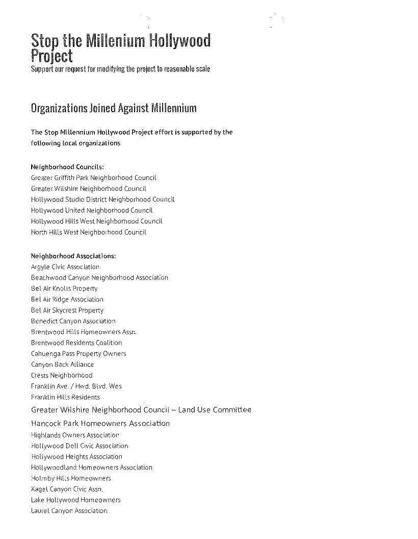
Stop the Miilenium HollywoodProjectSupport our request for modifying the project to reasonable scale
Organizations Joined Against Millennium
The Stop Mi llennium Hollywood Project effort is supported by the
following local organizations
Neighborhood Councils:
Greater Griffith Park Neighborhood Council
Greater Wilshire Neighborhood Council
HolLywood Studio District Neighborhood CounciL
HolLywood United Neighborhood Council
HolLywood Hills West Neighborhood Council
North HiLlsWest Neighborhood CounciL
Neighborhood Associations:
ArgyLe Civic Association
Beachwood Canyon Neighborhood Association
Bel Air Knolls Property
Bel Air Ridge Association
Bel Air Skycrest Property
Benedict Canyon Association
Brentwood Hills Homeowners Assn.
Brentwood Residents Coalition
Cahuenga PassProperty Owners
Canyon Back Alliance
Crests Neighborhood
Franklin Ave. / HWd. Blvd. Wes
Franklin Hills Residents
Greater Wilshire Neighborhood Council - Land Use Committee
Hancock Park Homeowners Association
Highlands Owners Association
Hollywood Dell Civic Association
Hollywood Heights Association
Hollywoodland Homeowners Association
Holmby Hills Homeowners
Kagel Canyon Civic Assn.
Lake Hollywood Homeowners
Laure I Canyon Association
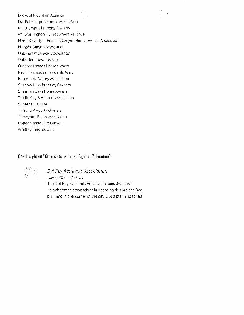
Lookout Mountain Alliance
Los Feliz 1mprovement Association
Mt. Olympus Property Owners
Mt. Washington Homeowners' Alliance
North Beverly - Franklin Canyon Home owners Association
Nichols Canyon Association
Oak Forest Canyon Association
Oaks Homeowners Assn.
Outpost. Estates Homeowners
Pacific Palisades Residents Assn.
Roscomare Valley Association
Shadow Hills Property Owners
Sherman Oaks Homeowners
Studio City Residents Association
Sunset Hills HOA
Tarzana Property Owners
Torreyson-Flynn Association
Upper Mandeville Canyon
Whitley Heights Civic
One thought on "Organizations Joined Against Millennium"
Del Rey Residents AssociationJune 4, 2013 at 7:41 am
The Del Rey Residents Association joins the other
ne ighborhood associations in opposing this project. Bad
planning in one corner of the city is bad planning for all.
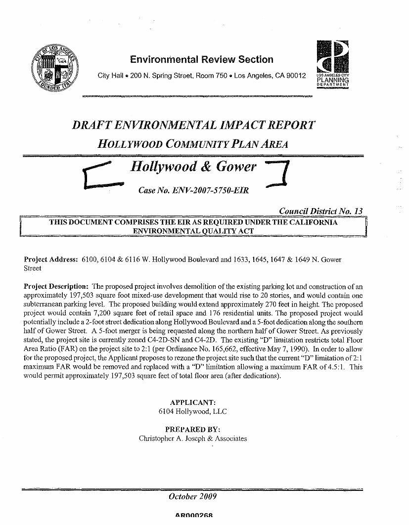
Environmental Review Section ~trJI~LOS ANGELES CITYPLANNINGDEPARTMENT
City Hall. 200 N. Spring Street, Room 750. Los Angeles, CA 90012
DRAFT ENVIRONMENTAL IMPACT REPORTHOLLYWOOD COMMUNITY PLAN AREA
Case No. ENV-2007-S7S0-EIR
Hollywood & Gower
Council District No. 13THIS DOCUMENT COMPRISES THE EIR AS REQUIRED UNDER THE CALIFORNIA
ENVIRONMENTAL OUALITY ACT
Project Address: 6100,6104 & 6116 W. Hollywood Boulevard and 1633, 1645, 1647 & 1649 N. GowerStreet
Project Description: The proposed project involves demolition of the existing parking lot and construction of anapproximately 197,503 square foot mixed-use development that would rise to 20 stories, and would contain onesubterranean parking level. The proposed building would extend approximately 270 feet in height. The proposedproject would contain 7,200 square feet of retail space and 176 residential units. The proposed project wouldpotentially include a 2-foot street dedication along Hollywood Boulevard and a 5-foot dedication along the southernhalf of Gower Street. A S-foot merger is being requested along the northem half of Gower Street. As previouslystated, the project site is currently zoned C4-20-SN and C4-20. The existing "0" limitation restricts total FloorArea Ratio (FAR) on the project site to 2:1 (per Ordinance No. 165,662, effective May 7,1990). In order to allowfor the proposed project, the Applicant proposes to rezone the project site such that the current "0" limitation of2: 1maximum FAR would be removed and replaced with a "0" limitation allowing a maximum FAR of 4.5: I. Thiswould permit approximately 197,503 square feet of total floor area (after dedications).
APPLICANT:6104 Hollywood, LLC
PREPARED BY:Christopher A. Joseph & Associates
October 2009
liROOO?fiR
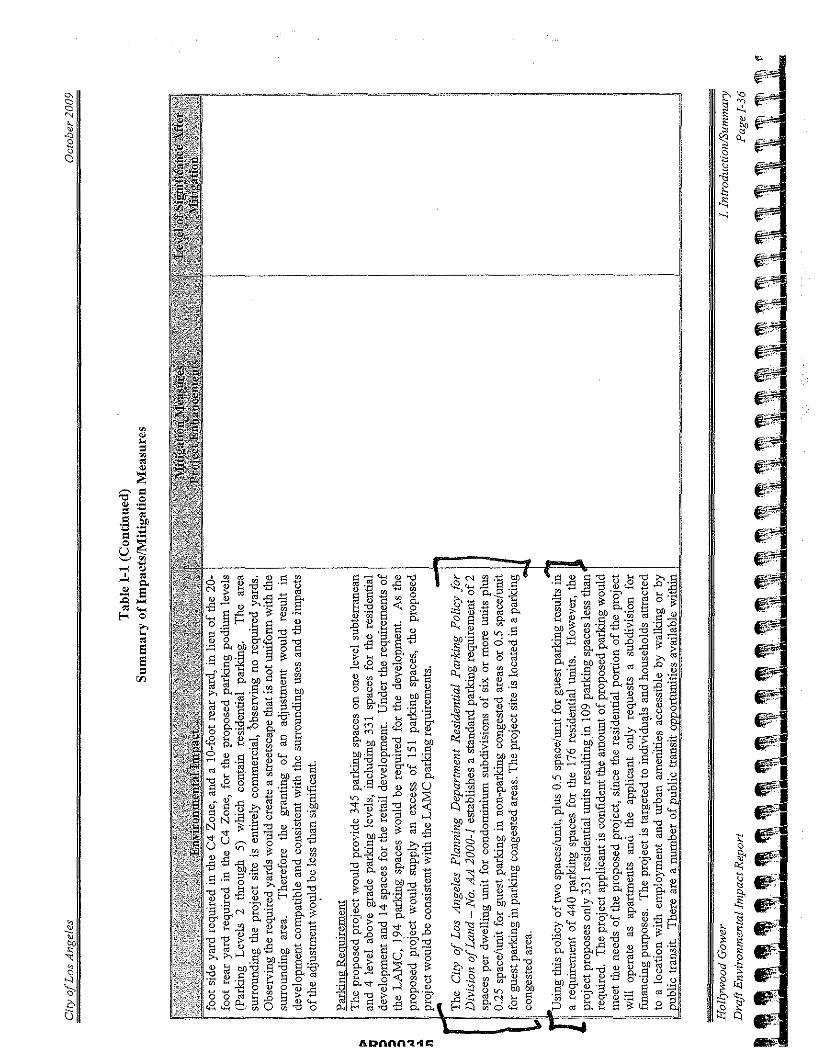
~
~ '0o,0 '"0 ~ ..,.'" ~
l'- "~ ~"'II ~o .go"~."g
"">-.;
ADnnn.o:t."a:;;
f$;.;"f$i:;;tlf;~;~;:;;
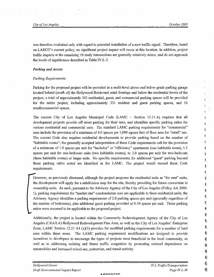
City oj Los Angeles October 2009
was therefore evaluated only with regard to potential installation of a new traffic signal. Therefore, basedon LADOT's current policy, no significant project impact will occur at this location. In addition, projecttraffic impacts at the remaining 10 study intersections are generally relatively minor, and do not approachthe levels of significance described in Table IV.L-3.
Parking and Access
Parking Requirements
Parking for the proposed project will be provided in a multi-level above and below grade parking garagelocated behind (south of) the Hollywood Boulevard retail frontage and below the residential levels of theproject; a total of approximately 345 residential, guest, and commercial parking spaces will be providedfor the entire project, including approximately 331 resident and guest parking spaces, and 14retail/commercial spaces.
The current City of Los Angeles Municipal Code (LAMC - Section 12.2I.A) requires that alldevelopment projects provide off street parking for their uses, and identifies specific parking ratios forvarious residential and commercial uses. The standard LAMC parking requirements for "commercial"uses include the provision of a minimum of 4.0 spaces per 1,000 square feet of floor area for "retail" use.The current Code also requires residential developments to provide parking based on the number of"habitable rooms"; the generally accepted interpretation of these Code requirements call for the provisionof a minimum of 1.0 spaces per unit for "bachelor" or "efficiency" apartments (one habitable room), 1.5spaces per unit for one-bedroom units (two habitable rooms), to 2.0 spaces per unit for two-bedroom(three habitable rooms) or larger units. No specific requirements for additional "guest" parking beyondthose parking ratios noted are identified in the LAMC. The project would exceed these Coderequirements.
However, as previously discussed, although the project proposes the residential units as "for rent" units,the development will apply for a subdivision map for the site, thereby providing for future conversion toownership units. As such, pursuant to the Advisory Agency of the City of Los Angeles (Policy AA 2000-I), parking requirements for "market rate" condominium uses are applicable to these residential units; theAdvisory Agency identifies a parking requirement of 2.0 parking spaces per unit (generally regardless ofthe number of bedrooms), plus additional guest parking provided at 0.50 spaces per unit. These parkingratios were assumed to be applicable to the proposed project.
Additionally, the project is located within the Community Redevelopment Agency of the City of LosAngeles (CRA/LA) Hollywood Redevelopment Plan Area, as well as the City of Los Angeles' EnterpriseZone; LAMC Section 12.21 A4 (x)(3) provides for modified parking requirements for a number of landuses within these areas. The LAMC parking requirement modifications are designed to provideincentives to developers to encourage the types of projects most beneficial to the local community, aswell as to addressing existing and future traffic congestion by promoting reduced dependence onautomobiles and increased mixed-use, pedestrian, and transit activity.
Hollywood Gower
Draft Environmental Impact Report[VL Traffic/Transportation
Page !V.L-38
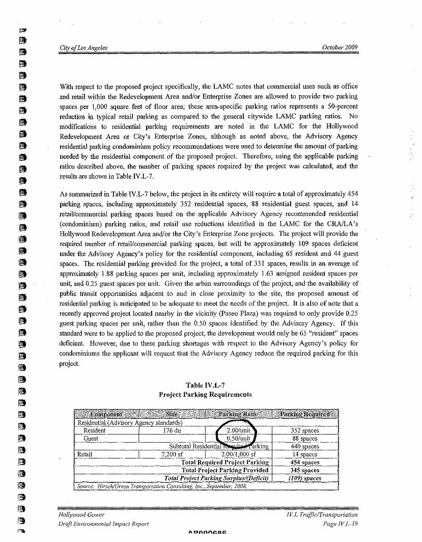
City of Los Angeles October 2009
With respect to the proposed project specifically, the LAMC notes that commercial uses such as officeand retail within the Redevelopment Area and/or Enterprise Zones are allowed to provide two parkingspaces per 1,000 square feet of floor area; these area-specific parking ratios represents a 50-percentreduction in typical retail parking as compared to the general citywide LAMC parking ratios. Nomodifications to residential parking requirements are noted in the LAMC for the HollywoodRedevelopment Area or City's Enterprise Zones, although as noted above, the Advisory Agencyresidential parking condominium policy recommendations were used to determine the amount of parkingneeded by the residential component of the proposed project. Therefore, using the applicable parkingratios described above, the number of parking spaces required by the project was calculated, and theresults are shown in Table IV.L-7.
As summarized in Table IV.L-7 below, the project in its entirety will require a total of approximately 454parking spaces, including approximately 352 residential spaces, 88 residential guest spaces, and 14retail/commercial parking spaces based on the applicable Advisory Agency recommended residential(condominium) parking ratios, and retail use reductions identified in the LAMC for the CRAlLA'sHollywood Redevelopment Area andlor the City's Enterprise Zone projects. The project will provide therequired number of retail/commercial parking spaces, but will be approximately 109 spaces deficientunder the Advisory Agency's policy for the residential component, including 65 resident and 44 guestspaces. The residential parking provided for the project, a total of 331 spaces, results in an average ofapproximately 1.88 parking spaces per unit, including approximately 1.63 assigned resident spaces perunit, and 0.25 guest spaces per unit. Given the urban surroundings of the project, and the availability ofpublic transit opportunities adjacent to and in close proximity to the site, the proposed amount ofresidential parking is anticipated to be adequate to meet the needs of the project. It is also of note that arecently approved project located nearby in the vicinity (Pasco Plaza) was required to only provide 0.25guest parking spaces per unit, rather than the 0.50 spaces identified by the Advisory Agency. If thisstandard were to be applied to the proposed project, the development would only be 65 "resident" spacesdeficient. However, due to these parking shortages with respect to the Advisory Agency's policy forcondominiums the applicant will request that the Advisory Agency reduce the required parking for thisproject.
Table IV.L-7Project Parking Requirements
352 s aces88 s aces440 s aces
Retail 14s aces454 s aces345 s aces
Hollywood GowerDraft Environmental Impact Report
IV.L Traffic/TransportationPage IV.L-39
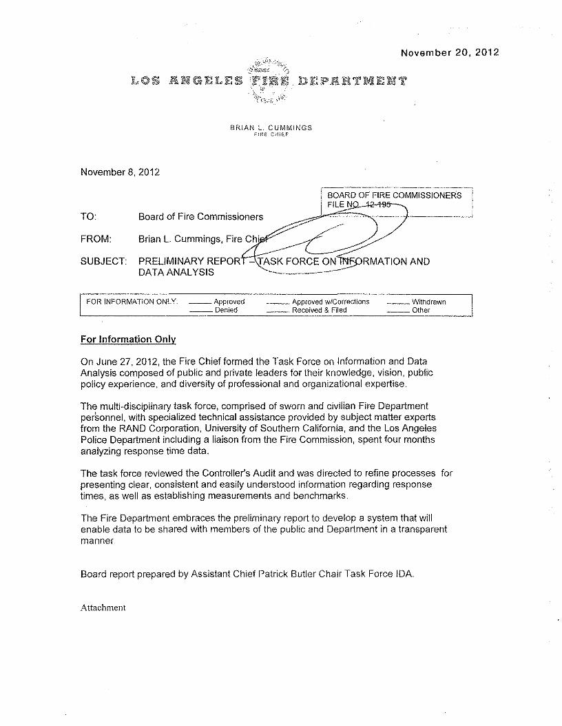
November 20, 2012
BRiAN L, CUMMINGSFiRE CHlfif'
November 8,2012
TO: Board of Fire Commissioners
BOARD OF FIRE COMMISSIONERSFILE N~'-t95--~
':::::~.- ..
--~C~~-\fASK FORCE ON RMATION AND
.....--..._-_._-------- ..-FROM:
SUBJECT: PRELIMINARY REPORDATA ANALYSIS
FOR INFORMATION ONLY __ Approved__ Denied
__ Approved wrcorrecuons __ Withdrawn__ Received & Filed __ Other
For Information Only
On June 27, 2012, the Fire Chief formed the Task Force on Information and DataAnalysis composed of public and private leaders for their knowledge, vision, publicpolicy experience, and diversity of professional and organizational expertise,
The multi-disciplinary task force, comprised of sworn and civilian Fire Departmentpersonnel, with specialized technical assistance provided by subject matter expertsfrom the RAND Corporation, University of Southern California, and the Los AngelesPolice Department including a liaison from the Fire Commission, spent four monthsanalyzing response time data.
The task force reviewed the Controller's Audit and was directed to refine processes forpresenting clear, consistent and easily understood information regarding responsetimes, as well as establishing measurements and benchmarks,
The Fire Department embraces the preliminary report to develop a system that willenable data to be shared with members of the public and Department in a transparentmanner
Board report prepared by Assistant Chief Patrick Butler Chair Task Force IDA
Attachment
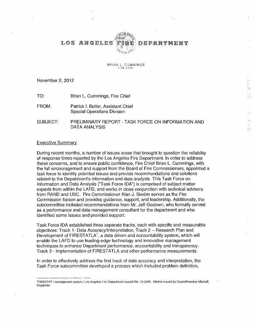
BRIAN L. CUMMINGS)':fl" CH!E~
November 2, 2012
TO: Brian L. Cummings, Fire Chief
FROM: Patrick I. Butler, Assistant ChiefSpecial Operations Division
SUBJECT: PRELIMINARY REPORT - TASK FORCE ON INFORMATION ANDDATA ANALYSIS
Executive Summary
During recent months, a number of issues arose that brought to question the reliabilityof response times reported by the Los Angeles Fire Department. In order to addressthese concerns, and to ensure public confidence, Fire Chief Brian L. Cummings, withthe full encouragement and support from the Board of Fire Commissioners, appointed atask force to identify potential issues and provide recommendations and solutionsrelated to the Department's information and data analysis. This Task Force onInformation and Data Analysis ("Task Force IDA") is comprised of subject matterexperts from within the LAFD, and works in close conjunction with technical advisorsfrom RAND and USC. Fire Commissioner Alan J. Skobin serves as the FireCommission liaison and provides guidance, support, and leadership. Additionally, thesubcommittee included recommendations from Mr. Jeff Godown, who formally servedas a performance and data management consultant for the department and whoidentified some issues and provided support.
Task Force IDA established three separate tracks, each with specific and measurableobjectives: Track 1- Data Accuracy/Interpretation, Track 2 - Research Plan andDevelopment of FIRESTATLA', a data driven and accountability system, which willenable the LAFD to use leading-edge technology and innovative managementtechniques to enhance Department performance, accountability and transparency.Track 3 - Implementation of FIRESTATLA and other performance measurements.
In order to effectively address the first track of data accuracy and interpretation, theTask Force subcommittee developed a process which included problem definition,
'FIRESTAT I management system I Los Angeles Fire Department council file: 12"0240 - Motion moved by Councilmember Mitchel!Englander
Fire ChiefTask Force Preliminary ReportNovember 2,2012Page 2 of 20
methodology, identification of data sources, analysis, testing, and implementation. Thisreport is primarily focused on Track 1, Data Accuracy/Interpretation.
The initial research required analysis of approximately 2.4 million incident recordscollected between January of 2007 and March of 2012, as well as recent data from July,August and September of 2012.
As a result of our initial analysis the subcommittee identified issues in the following fourareas and have implemented short-term solutions and provided recommendations forlonger-term solutions: 1) LAFD Computer Aided Dispatch, 2) Training/Education, 3)Integration and Synchronization, and 4) Technology. Additionally the Task Forceconducted an emergency response time analysis.
1) The LAFD Computer Aided Dispatch system (CAD) is a 30 year old system that wasdesigned and implemented for dispatching emergency resources. During the last 30years, it has had several hardware and software upgrades, including a new platformwhich was upgraded through reverse engineering in 2002. The LAFD CAD was notdesigned for the demand of today's data reporting requirements and has limitations withmany current technologies. It is an event-driven system with human interaction thatcaptures transactions and inputs from callers, dispatchers, and responding units. Whileit can be used to provide data-based reports, the use should be limited in scope andonly with a complete understanding of reporting criteria. Through initial analysis, thesubcommittee found problems with the reporting system and the reporting criteria.These problems have since been identified and corrections implemented to ensureaccurate reporting.
The corrections include several programming changes as well as establishing criteriafor incident codin~ and separating non-ernerqency responses as recommended in theController's Audit. In addition, the subcommittee developed and implemented aStandards Management System to identify and flag data anomalies. A new report" isnow generated that supervisors and analysts can then use to determine the nature ofthese anomalies, which may be caused by human error, process inefficiency, and/orunique aspects of Los Angeles. Because the time-stamping process from the timeLAFD takes the call to resources arriving at the scene is currently not completelyautomatic, and there are other steps that involve human interaction, human errors willcontinue to occur. However, once they are identified, the involved procedure, wheneverpossible, will be modified in order to reduce the frequency of occurrences. Similarly,should an anomaly be due to inefficiency of the existing process, efforts are beingimplemented for process improvements.
2 http://controUer.!acity.orgisteUenUgroups/electedofficials/@ctf_contributor/documents!contribuIOf_web_conlentilacityp __020450.pdf3 Outside Standards Report - Developed by FirstWalch and the LAFD
Fire ChiefTask Force Preliminary ReportNovember 2,2012Page 3 of 20
The new Standards Management System developed by the subcommittee, withproperly defined categories will provide a constant feedback loop for identifying andcorrecting anomalies. With these short term implementations, the existing CAD systemcan now provide more accurate data than before, and the department can use it forlimited reporting purposes until enhancements to CAD system are made. Further, allprior reporting data should not be relied upon until they are properly recalculated andvalidated with the new recommended changes.
2) Training/Education - The statistical analysis of data by LAFD department staff whoare not trained in this field led in part to inaccurate reporting. A general lack of dataknowledge, interpretation, and understanding of the CAD systems can magnify thisproblem.
It became apparent that policy decisions based on data requires professional analyststo work more closely with policy makers to improve decision making and eliminateambiguity. Until the selection, development and formal training of LAFD staff who workin a number of disciplines including data analysis are accomplished, future data-baseddecisions should include input from the Task Force.
3) Integration and Synchronization - The data which the LAFD relies on to make certainpublic safety decisions is managed, maintained, and accessed by multiple departments.The Information Technology Agency (ITA) maintains the CAD data production, and boththe LAFD Management Information Systems Division (MIS) and Planning Section shareand access these data through a sub-set of data bases and filtering reports. To achieveaccuracy and accountability, all participants who playa role in data reporting, should bewell integrated and synchronized. The LAFD needs to improve its processes ofintegration and synchronization with ITA. ITA has trained and qualified experts, manywith over 25 years of experience in this field. It is essential that upon finding dataanomalies, a thorough investigation and cross checking with ITA should occur. In thepast, there have been cases where ITA employees with expert knowledge in datamanagement and interpretation were never accessed by LAFD staff. In addition therewere times when both agencies used different interpretations, which led to differentconclusions.
Until a formal integration process is in place, all Fire Department requests for CAD datareports and interpretation should be routed through the LAFD Metropolitan FireDispatch and Communications Division which will vet these with the Public SafetyDispatch Division from the Information Technology Agency.
4) Technology - There are a number of technologies available that can enhance publicsafety and reduce response times, and are at varying degrees of progress in thedepartment. These technologies include; Fire Station Alerting System (FSAS),Computer Aided Dispatch System (CAD), Global Positioning Systems(GPS), AutomaticVehicie Locating Systems (AVL), Geographic Information Systems (GIS), Automatic
Fire ChiefTask Force Preliminary ReportNovember 2, 2012Page 4 of 20
Resource Recommendation Software (ARRS),and Traffic Pre-emption Systems.Currently, the Department does not have GPS or AVL in all of its units and is in theprocess of replacing the FSAS. A team outside the scope of the Task Force wasassembled to assess the current CAD system and make recommendations for a futuresystem.
The Department should develop a comprehensive technology-based strategic plan toaddress these and other needs. While technology is not a substitute for humaninteraction and decision making, it can certainly enhance efficiency in the operationalaspects of resource dispatch and deployment.
Response Time Analysis
Because the initial focus of the subcommittee was aimed at data accuracy andinterpretation, a baseline analysis of the department's emergency response time wasconducted to better understand and identify problems. After running preliminary testswith the new changes and recommendations in place, the subcommittee conducted anemergency response time analysis for the month of September 2012 and arrived at thefollowing results:
The averaqe" total response time for all 911 emergency incidents in the City of LosAngeles from the time a 911 call is received by an LAFD dispatcher to the time the firstunit arrives on scene is 6 minutes and 47 seconds (6:47)
Using the NFPA 1710 national standard for fire department response time performancethe following are the preliminary results: EMS 60.9% and Fire 61.3%.
Accurate reporting of response time is an important tool in assuring the best possibleemergency service for the City of Los Angeles. An accurate understanding of howquickly first responders are able to get on scene at emergencies is important for FireDepartment management, city policy makers, and the public to determine theappropriate allocation of resources for the Los Angeles Fire Department.
Recommendations
Thus far the Task Force subcommittee has recommended and implemented (thosemarked with an asterisk below) the following recommendations as a result of ourresearch, which we recommend should be adopted and implemented by thedepartment.
• 'Report total emergency response times to be from the time of call receipt by theLAFD to the time of the first unit on scene, according to guidelines set forth byNFPA12215andNFPA1710e .
4 City wide average is used in this method to establish a baseline but not as a statistical inference or performance indicator.
Fire ChiefTask Force Preliminary ReportNovember 2, 2012Page 5 of 20
• *Establish clear and unambiguous definitions and standards for all terms, suchas coding of incident types, used in the CAD data base.
• *Adopt the Standards Management System to flag, trap, and mitigate dataanomalies in the areas of 1} call processing time, 2} turnout time, and 3} traveltime.
• *Expand the current use of FirstWatch®7 to include and continue near real timemonitoring of CAD data with an emphasis on response time analysis.
• *Expand the current use of Palantir Gotham™8 and/or other appropriate systemsto aggregate and integrate databases for the purpose of departmentperformance analysis.
• *Expand the current partnership with RAND Corporation to include policyanalysis, operations research, and provide recommendations for technologyenhancements and process improvements.
• Adopt and implement minimum training and education requirements for LAFDanalysts.
• Establish a specific data analysis unit within the LAFD which includes technicalassistance from outside experts and academics.
• Maintain continual analysis of CAD data.• Develop and implement a publicly accessible website that provides response
times by community and district.• Integrate the LAFD Metropolitan Fire Dispatch and Communications Division with
the Public Safety Dispatch Division from the Information Technology Agency intoa single entity to mirror the model used by LAPD in TEAMS II.
• In order to provide consistency, maintain the current command team atMetropolitan Fire Dispatch and Communications Division until the programmingchanges and technology upgrades are in place.
• Determine and analyze the call processing and transfer time from the LAPDPublic-Safety Answering Point (PSAP) to LAFD.
e Report response times by district, community and other geographical areas.• Develop a process and coding system to identify transitional calls and responses
(Emergency to Non-Emergency and Non-Emergency to Emergency).• Analyze call processing and consider separating Card 33, 37, and other time
intensive protocols for the purposes of analysis.• Implement programming changes that restrict out of sequence MOe entries.
5 National Fire Protection Association 1221 - Standard tor the Installation, Maintenance, and Use of Emergency ServicesCommunications Systems ( New Changes Adopted 2012)6 National Fire Protection Asscclation 1710 - Standard for the Organization and Deployment of Fire Suppression Operations,Emergency Medical Operations, and Special operations to the Public by Career Fire Departments 2010 Edition7 FirstWatch® a syndromic surveillance program and real-time early warning system.8 Palanur Technologies is a software company that produces the Palantir Gotham" and Palantlr Metropolis" platforms foranalyzing, integrating. and visualizing data. including structured, unstructured, relational, temporal, and qeospattal data.
Fire ChiefTask Force Preliminary ReportNovember 2, 2012Page 6 of 20
Background
On July 7,2012, Fire Chief Brian L. Cummings, with the full encouragement andsupport from the Board of Fire Commissioners assembled the LAFD Task Force onInformation and Data Analysis ("Task Force IDA") to identify potential issues andprovide recommendations and solutions related to the Department's information anddata analysis. This Task Force on Information and Data Analysis ("Task Force IDA") iscomprised of subject matter experts from within the LAFD, and works in closeconjunction with technical advisors from RAND and USC. Fire Commissioner Alan J.Skobin serves as the Fire Commission liaison and provides guidance, support, andleadership. Additionally, the subcommittee included recommendations from Mr. JeffGodown, who formally served as a performance and data management consultant forthe department and who identified some issues and provided support.
The Task Force mission statement is: To develop systems, policies, and processes toaccurately and transparently capture, measure, analyze, and report the inputs, outputsand outcomes of our Department. This real time accurate information will enhanceleadership and policy decisions and allow our internal and external stakeholders to seeand measure our performance, initiate discussion and dialogue, as well as develop anddisseminate best practices throughout the Department.
Task Force IDA established three separate tracks, each with specific and measurableobjectives. Each track has a subcommittee assigned to develop systems, policies, andprocesses to address each objective.
Track 1- Data Accuracy/Interpretation
• Conduct an analysis on LAFD data collection and review coding of incident types.• Develop a consistent methodology for differentiating and coding emergency and
non-emergency incidents.• Develop a single agreed upon system for data processing and reporting of the
statistical information.• Analyze data, draw comparisons, and suggest policies and practices that might
produce improvements in our system.
Track 2 Research Plan and Development of FIRESTATLA
• Identify best practices in data collection and analysis from other fire departmentsand academia, and look for opportunities to apply these models in our organization.
• Determine what areas of the organization can benefit from data analysis.
Fire ChiefTask Force Preliminary ReportNovember 2, 2012Page 7 of 20
• Seek input from the various segments of the Department and ensure that the fieldand operational level provide feedback.
• Determine resource needs and which Bureaus, Divisions, Sections, Units should beresponsible.
• Determine how to gather performance data from other areas of the Department (e.g.OT, Work Comp, etc.) and develop a framework for objective and transparentanalysis and decision making.
Track 3 -Implementation of FIRESTATLA
• Implement real time data analysis tools in order to report accurate and timely data.• Implement leadership and accountability strategies that use data and other metrics
(e.g. gap analysis) to drive continuous process improvement inthe organization.• Implement a consistent format for dialogue across the organization where data and
other metrics can be discussed to help form the basis for improvements, changes,and best practices.
• Develop a method for disseminating best practices throughout the Department.• Implement a publicly accessible system (website) to access real time information on
response times and other performance data that the public wants to know.
Scope
This preliminary report has been developed to provide an overview, progress, andrecommendations specifically related to Track 1 - Data Accuracy and Interpretation inthe following 4 areas 1) LAFD Computer Aided Dispatch 2) Training/Education 3)Integration and Synchronization 4) Technology. Additionally the Task Forcesubcommittee conducted an emergency response time analysis.
The subcommittee assigned to data accuracy and interpretation is primarily a teamwhich consists of members from public agencies, private enterprise, academia, andresearch institutions. These include; the Los Angeles Fire Department (LAFD), the LosAngeles Police Department (LAPD), Information Technology Agency (ITA),FirstWatch®, Palantir Technologies, USC, and the RAND Corporation.
Methodology
In order to effectively address data accuracy and interpretation, the team developed aprocess to define the problem, establish a methodology, identify data sources, andanalyze data, testing, and implementation. Primary methods included; directobservations, interviews, qualitative and quantitative analysis. The initial steps requiredteam members to analyze 2,425,582 incident records from January 1, 2007 to March
·26,2012 as well as 64,000 records from July, August, and September of 2012. Once apotential issue was identified, the team selected solutions and implemented these in a
Fire ChiefTask Force Preliminary ReportNovember 2, 2012Page 8 of 20
test bed "sandbox" server to test their findings. If the issue was resolved, the solution(s)would be tagged, identified with a number and implemented into the "live" data base.
Findings
A public-safety answering point (PSAP), is a call center responsible for answering callsto an emergency telephone number for police, fire, rescue, and ambulance services. Inthe City of Los Angeles, the LAPD serves as the PSAP and is the initial 911 receivingpoint of emergency calls for service. If the call requires a fire department response, thecall is then transferred to the Metropolitan Fire Dispatch and Communications Division.In 2011 the LAFD responded to approximately 373,000 incidents".
LAFD Computer Aided Dispatch- The computer aided dispatch system is designedprimarily to dispatch, and maintain the status of resources in the field. In the LAFD CADsystem, fire department dispatchers receive calls for service from various sources; onesource is the Enhanced 911 (E911), which is interfaced with the computer andautomatic number identification automatic location identification (ANI-AU). This systemautomatically inputs the telephone number and address of the caller into the CAD,eliminating the time required to manually locate the address and facilitating the processof request for service. As the dispatcher gains information on the type of call through aseries of questions, it is manually entered into the CAD system. When the CAD systemhas sufficient information to recommend a response algorithm; it will do so by issuingthe recommendation for the approval of the dispatcher. (See Attachment C for CallProcessing and Response Time Continuum)
Apart from E911, there are several other ways in which the public and other agenciescan call and request emergency service. Those include; calls via 10 digit numbers, callstransferred from another PSAP, calls from a third party, out of state calls, and othermethods. Calls that originate outside of E911 do not have ANI-AU and requiredispatchers to verify and manually enter the address, which increases call processingtime and ultimately increase total response time. Cell phone calls require more time tovalidate the address and location of the caller.
In addition, a CAD system manages resource status and interfaces with a recordsmanagement system to capture and retain incident data. The central focus of a CADsystem should be aimed at making the job of the 911 call takers, dispatchers, resourcecontrollers and first responders faster, safer and more efficient so that the publicreceives fast and effective service. While these objectives are critical, accuratestatistical reporting and analysis should not be compromised, because they are theindicators whether objectives are met and or better met.
9 11-10-2011 LAFD Fire Facts
Fire ChiefTask Force Preliminary ReportNovember 2,2012Page 9 of 20
The use of trained and qualified personnel and the partnership with outside privateenterprises such as FirstWatch® , is essential when interpreting reports and makingdata-based decisions from the CAD system. The CAD system requires continualsoftware and programming upgrades/changes, each of which may consider and excludedifferent types of data anomalies. It is important to make clear what is excluded fromthe calculation of the response time and explain why these anomalies are treated anddisplayed separately.
The LAFD CAD is over 30 years old and certain enhancements and improvements tothe LAFD system could improve both the dispatching, response, and reporting aspect. Itmay also have some limitations that can no longer be adapted to adequately andreliably interface with new systems and technologies. An LAFD dispatcher shouldalways be able to process calls and provide pre-arrival instructions without completing alarge number of steps. Anything that can be auto-populated or automated with the latesttechnology such as the capabilities of geographic information systems (GIS) andautomatic vehicle location (AVL) or other service enhancements should beimplemented.
The overall system uses a combination of technology and human interaction toeffectively dispatch resources and provide service. This human interaction also presentsareas for human error to occur. Three areas were identified where human error couldimpact dispatching and data capturing: 1) Call Processing, 2) Dispatching, and 3)Responding.
During cali processing, dialogue between the requesting party and dispatcher cancreate conditions for error. Some examples include unknown address/location, type ofemergency, language barrier, third party information, and other information that requiresthe dispatcher to verify and cross check the information, each of which further delaysdispatch. Additionally, some calls require special detailed instruction for processing,including lost hikers, inter-facility transports, locating caller, Emotional Content andCooperation Score (ECCS-Ievel), or other necessary time required to effectivelydispatch the resources.
During dispatching, the dispatcher has to initiate a series of command prompts andmaintain situational awareness for other calis pending in the queue. This manualinteraction is subject to human error and has the potential to delay a dispatch.
During response, the responding units manually update their status and push buttonson a mobile data computer (MDC) to signal and trigger a time stamp when they areenroute to a call (ENR), on-scene of a call (ONS) and then available from the call (AVI).These data are captured by the CAD and essentially determine this segment of theresponse timeline. If a firefighter forgets to push the button or the radio signal isinterrupted due to radio coverage or a system outage, then this time sequence may beincomplete or incorrect. The subcommittee found approximately 150 records per month
Fire ChiefTask Force Preliminary ReportNovember 2, 2012Page 10 of 20
that appeared to have out of order, incomplete, or negative time stamps. These arebeing analyzed and are identified by the Standards Management System.Programming changes that restrict MDC out of sequence entries may eliminate some ofthese errors.
One of the initial action items for the subcommittee was to analyze response time datato identify patterns and outliers. During this process, it was discovered that there wereinstances where the data inaccurately reported some response times to take as long as28 hours to arrive on scene. This was clearly a mistake. By homing in on these outliersand drilling down into these incidents, the subcommittee determined that certainprogramming changes to the computer aided dispatch system (CAD) caused thereporting side of the CAD to generate data that was inaccurately interpreted.
The programming changes that affected these reports were the result of priorprogramming changes that were designed to address issues, which the subcommitteefound had caused unintended second and third order effects.
As reported in the City Controller's Audlt'", the Department did not have a consistentmethod for differentiating and coding emergency responses and non-emergencyresponses. This issue was addressed by the subcommittee and resolved by adopting asingle standard which clearly defines these types of responses. Using this new standardthe department will be able to more accurately report response times and perhapsrecalculate previously-reported inaccurate data that have drawn public attention.Additionally the subcommittee identified transitional calls; those that can originate as anemergency call/response and then are downgraded to non-emergency or upgradedfrom non-emergency to emergency are not easily identified and should be assigned aseparate code in the CAD when this takes place because they can skew data.
The following is a list of issues that were discovered and programming changes thathave been implemented to enhance reporting criteria 11:
• WRS Override - Subsequent responding units overriding the initial on-scenetime.
• Date Stamp Clock - Some data fields had an additional 24 hour time stampadded.
• Dropped Records - The MIS data base had missing records due to a routine datapush.
• Emergency and Non-Emergency criteria - Controller's Audit found errors incriteria.
• Pended Calls - Dispatcher training has been implemented.• Address Command Prompt - Incorrect/old address data on the command line
caused faulty time stamp.
10 nnp.scontrone r.lacity. org/stellenUgroups/elecledofficials!@ctr _contributor/documents/contributor _web _contenVlacityp _020450.pdf11 These programming changes will be monitored with the SMS to ensure compliance.
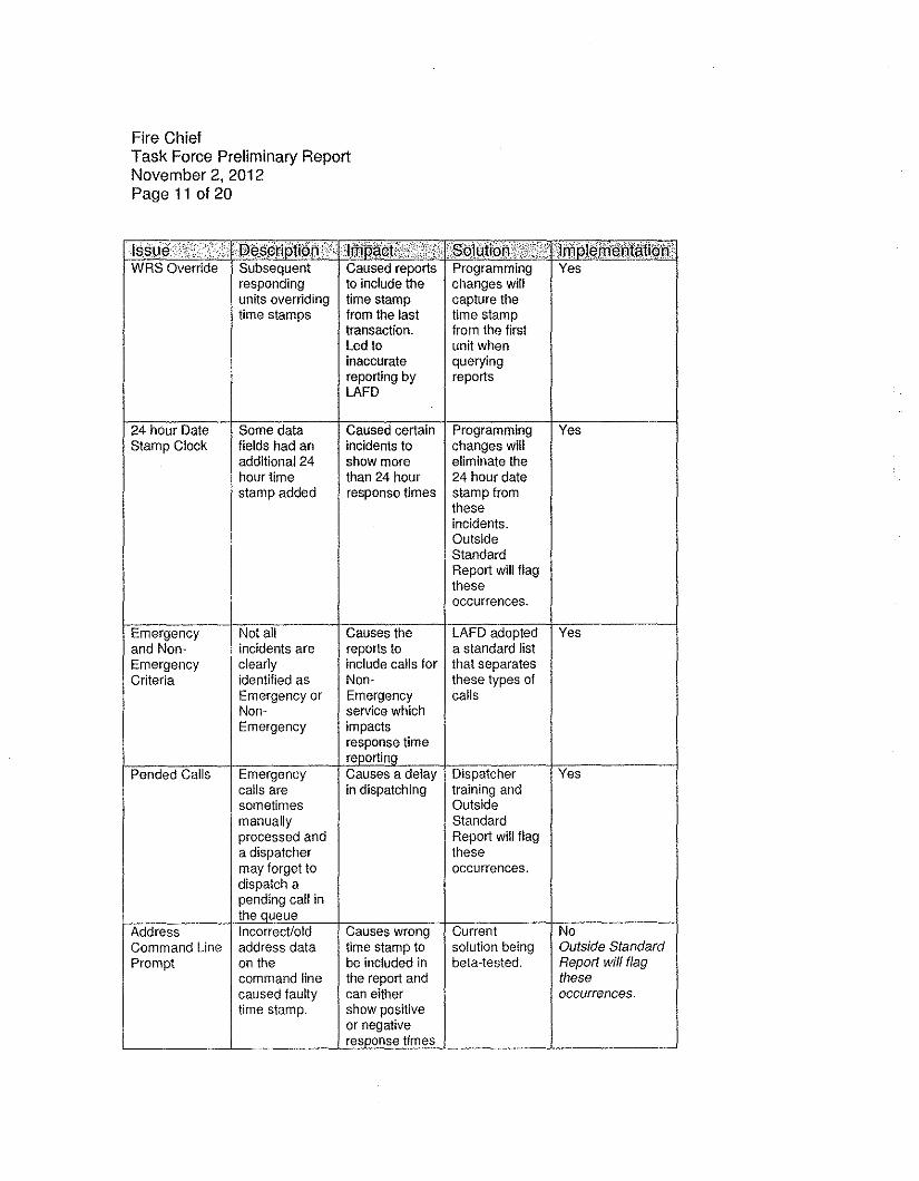
Fire ChiefTask Force Preliminary ReportNovember 2, 2012Page 11 of 20
l"d'id.'FF"'i"r; i§[",W RS Override Subsequent Caused reports Programming Yes
responding to include the changes willunits overriding time stamp capture thetime stamps from the last time stamp
transaction. from the firstLed to unit wheninaccurate queryingreporting by reportsLAFD
24 hour Date Some data Caused certain Programming YesStamp Clock fields had an incidents to changes will
additional 24 show more eliminate thehour time than 24 hour 24 hour datestamp added response times stamp from
theseincidents.OutsideStandardReport will flagtheseoccurrences.
Emergency Not all Causes the LAFD adopted Yesand Non- incidents are reports to a standard listEmergency clearly include calls for that separatesCriteria identified as Non- these types of
Emergency or Emergency callsNon- service whichEmergency impacts
response timereportino
Pended Calls Emergency Causes a delay Dispatcher Yescalls are in dispatching training andsometimes Outsidemanually Standardprocessed and Report will flaga dispatcher thesemay forget to occurrences.dispatch apending call inthe queue
Address Incorrect/old Causes wrong Current NoCommand Line address data time stamp to solution being Outside StandardPrompt on the be included in beta-tested. Report will flag
command line the report and thesecaused faulty can either occurrences.time stamp. show positive
or negativeresponse times
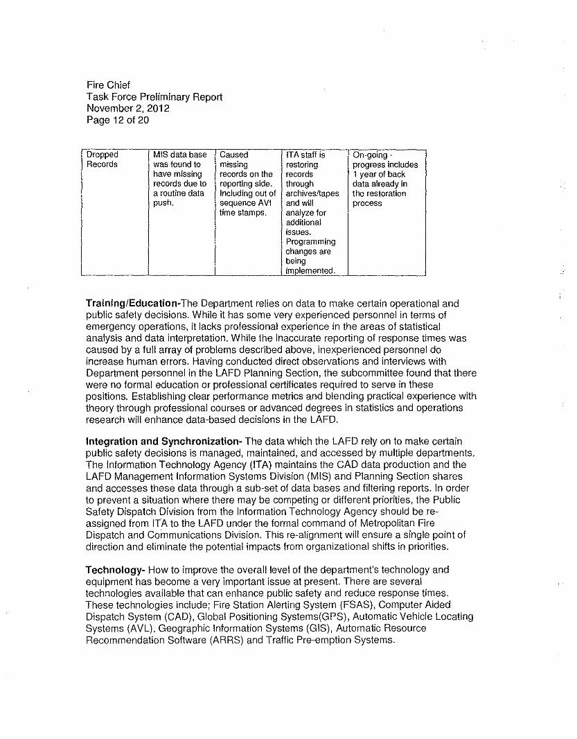
Fire ChiefTask Force Preliminary ReportNovember 2,2012Page 12 of 20
Dropped MIS data base Caused ITA staff is On-going -Records was found to missing restoring progress includes
have missing records on the records 1 year of backrecords due to reporting side. through data already ina routine data Including out of archives/tapes the restorationpush. sequence AVI and will process
time stamps. analyze foradditionalissues.Programmingchanges arebeingimplemented.
Training/Education-The Department relies on data to make certain operational andpublic safety decisions. While it has some very experienced personnel in terms ofemergency operations, it lacks professional experience in the areas of statisticalanalysis and data interpretation. While the inaccurate reporting of response times wascaused by a full array of problems described above, inexperienced personnel doincrease human errors. Having conducted direct observations and interviews withDepartment personnel in the LAFD Planning Section, the subcommittee found that therewere no formal education or professional certificates required to serve in thesepositions. Establishing clear performance metrics and blending practical experience withtheory through professional courses or advanced degrees in statistics and operationsresearch will enhance data-based decisions in the LAFD.
Integration and Synchronization- The data which the LAFD rely on to make certainpublic safety decisions is managed, maintained, and accessed by multiple departments.The Information Technology Agency (ITA) maintains the CAD data production and theLAFD Management Information Systems Division (MIS) and Planning Section sharesand accesses these data through a sub-set of data bases and filtering reports. In orderto prevent a situation where there may be competing or different priorities, the PublicSafety Dispatch Division from the Information Technology Agency should be re-assigned from ITA to the LAFD under the formal command of Metropolitan FireDispatch and Communications Division. This re-alignment will ensure a single point ofdirection and eliminate the potential impacts from organizational shifts in priorities.
Technology- How to improve the overall level of the department's technology andequipment has become a very important issue at present. There are severaltechnologies available that can enhance public safety and reduce response times.These technologies include; Fire Station Alerting System (FSAS), Computer AidedDispatch System (CAD), Global POSitioning Systems(GPS), Automatic Vehicle LocatingSystems (AVL), Geographic Information Systems (GIS), Automatic ResourceRecommendation Software (ARRS) and Traffic Pre-emption Systems.
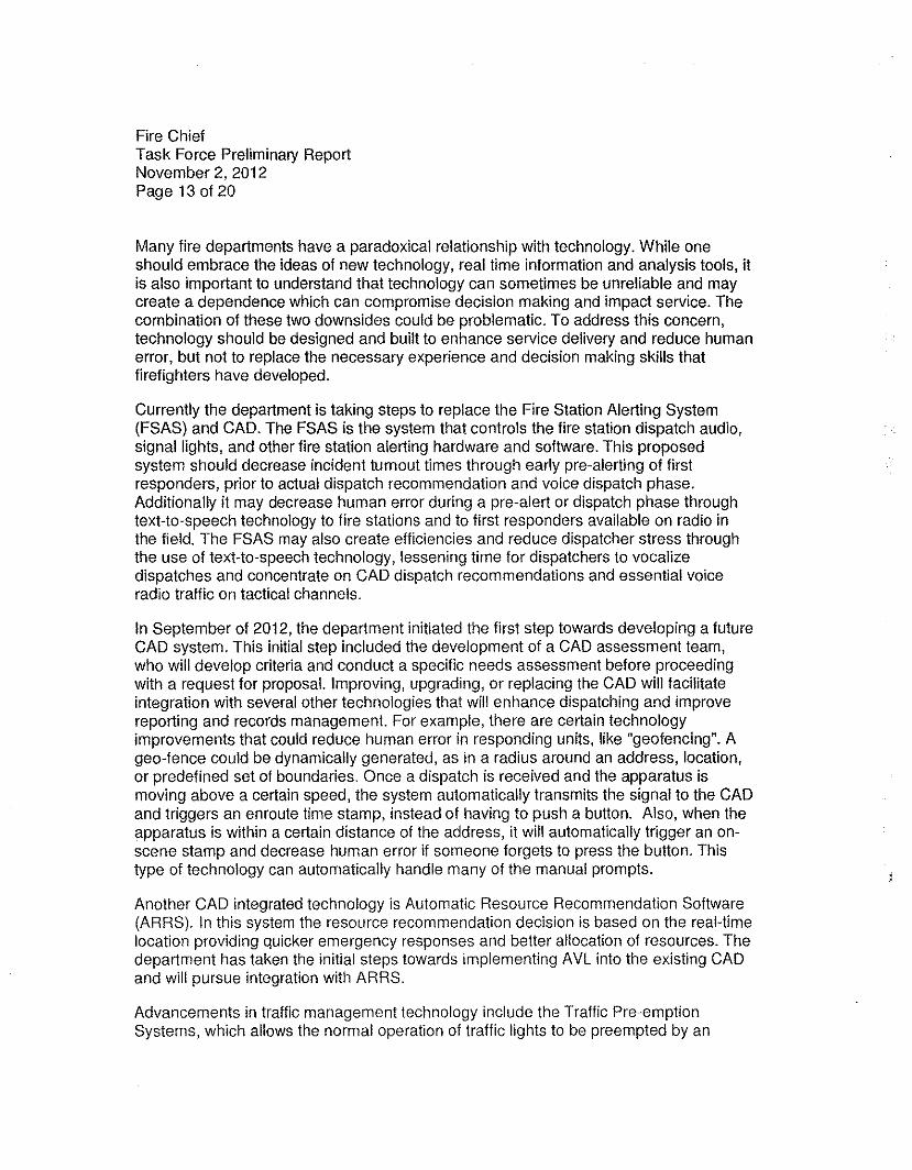
Fire ChiefTask Force Preliminary ReportNovember 2, 2012Page 13 of 20
Many fire departments have a paradoxical relationship with technology. While oneshould embrace the ideas of new technology, real time information and analysis tools, itis also important to understand that technology can sometimes be unreliable and maycreate a dependence which can compromise decision making and impact service. Thecombination of these two downsides could be problematic. To address this concern,technology should be designed and built to enhance service delivery and reduce humanerror, but not to replace the necessary experience and decision making skills thatfirefighters have developed.
Currently the department is taking steps to replace the Fire Station Alerting System(FSAS) and CAD. The FSAS is the system that controls the fire station dispatch audio,signal lights, and other fire station alerting hardware and software. This proposedsystem should decrease incident tumout times through early pre-alerting of firstresponders, prior to actual dispatch recommendation and voice dispatch phase.Additionally it may decrease human error during a pre-alert or dispatch phase throughtext-to-speech technology to fire stations and to first responders available on radio inthe field. The FSAS may also create efficiencies and reduce dispatcher stress throughthe use of text-to-speech technology, lessening time for dispatchers to vocalizedispatches and concentrate on CAD dispatch recommendations and essential voiceradio traffic on tactical channels.
In September of 2012, the department initiated the first step towards developing a futureCAD system. This initial step included the development of a CAD assessment team,who will develop criteria and conduct a specific needs assessment before proceedingwith a request for proposal. Improving, upgrading, or replacing the CAD will facilitateintegration with several other technologies that will enhance dispatching and improvereporting and records management. For example, there are certain technologyimprovements that could reduce human error in responding units, like "geofencing". Ageo-fence could be dynamically generated, as in a radius around an address, location,or predefined set of boundaries. Once a dispatch is received and the apparatus ismoving above a certain speed, the system automatically transmits the signal to the CADand triggers an enroute time stamp, instead of having to push a button. Also, when theapparatus is within a certain distance of the address, it will automatically trigger an on-scene stamp and decrease human error if someone forgets to press the button. Thistype of technology can automatically handle many of the manual prompts.
Another CAD integrated technology is Automatic Resource Recommendation Software(ARRS). In this system the resource recommendation decision is based on the real-timelocation providing quicker emergency responses and better allocation of resources. Thedepartment has taken the initial steps towards implementing AVL into the existing CADand will pursue integration with ARRS.
Advancements in traffic management technology include the Traffic Pre-emptionSystems, which allows the normal operation of traffic lights to be preempted by an
Fire ChiefTask Force Preliminary ReportNovember 2,2012Page 14 of 20
emergency vehicle. This system is designed to help reduce response times andenhance traffic safety by stopping conflicting traffic and allowing the emergency vehicleright-of-way.
The subcommittee recommends that the department continue to upgrade and replacetheir systems as well as adopt and implement many of these new technologies toimprove safety, service, and reduce response times.
Response Time Analysis 12- While the initial focus of the subcommittee was aimed atdata accuracy and interpretation, a baseline analysis of the Department's emergencyresponse time was conducted to verify that the programming changes and StandardsManagement System were accurate. After running preliminary tests with July andAugust data, the subcommittee ran the same test with the new changes andrecommendations in place for September and determined the following results:
The averaqe" total response time for all 91114 emergenc¥ incidents in the City of LosAngeles from the time a 911 call is received by an LAFD1 dispatcher to the time thefirst unit arrives on scene is 6 minutes and 47 seconds (6:47). This time includes theaverage call processing time of 1 minute and 42 seconds.
The response time analysis was based on the following criteria:
• All emergency responses (Fire/Other/EMS) within the month of September 2012;from the time a call is received via a 911 call by the LAFD dispatch center to thetime the first until arrives on scene of the incident address. This total responsetime for this calculations includes; call processing time, turnout time, and traveltime.
• Removing records that had negative time records or out of sequence timestamps, which are being reviewed as part of the subcornmlttee'srecommendations.
The subcommittee also broke down these calls into Fire and EMS and compared themto the NFPA 1710 performance standard, which states that "the fire department shallestablish a performance objective of not less than 90 percent for the achievement ofeach turnout time and travel time objective specified in 4.1.2.1 ".
Using the criteria for Emergency Medical Services and Fire the following are the resultsfor the month of September 201216:
12 See Attachment A - FirstWatcil September Response Time Data Review - LAFD Task Force lOA13 Average is used in this method to establish a baseline but not as a statistical inference or performance indicator.14 Calls received via 911 lines were analyzed in this test because they include an initial time stamp.15 This number does not include the cal! transfer time from the LAPD PSAP to lAFD.IS Note: Using only 1 month of data as a baseline - sample size may nol be indicative of a larger set.
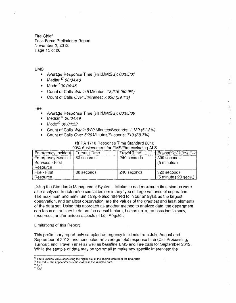
Fire ChiefTask Force Preliminary ReportNovember 2, 2012Page 15 of 20
EMS• Average Response Time (HH:MM:SS): 00:05:01• Median 1700:04:40• Mode'800:04:45• Count of Calls Within 5 Minutes: 12,216 (60.9%)• Count of Calls Over 5 Minutes: 7,836 (39. 1%)
Fire• Average Response Time (HH:MM:SS): 00:05:38• Median 19 00:04:49• Mode20 00:04:52• Count of Calls Within 5:20 Minutes/Seconds: 1,130 (61.3%)• Count of Calls Over 5:20 Minutes/Seconds: 713 (38.7%)
NFPA 1710 Response Time Standard 2010A h' f EMS/F I dl ALS90% c ievernent or Ire exc u mg
Emeroencv Incident Turnout Time Travel.Tlrne .,\ ..F't(l$li~n§i3Tim(l·Emergency Medical 60 seconds 240 seconds 300 secondsServices - First (5 minutes)ResourceFire - First 80 seconds 240 seconds 320 secondsResource (5 minutes 20 secs.)
Using the Standards Management System - Minimum and maximum time stamps werealso analyzed to determine causal factors in any type of large variance of separation.The maximum and minimum sample also referred to in our analysis as the largestobservation, and smallest observation, are the values of the greatest and least elementsof the data set. Using this approach as another method to analyze data, the departmentcan focus on outliers to determine causal factors, human error, process inefficiency,resources, and/or unique aspects of Los Angeles
Limitations of this Report
This preliminary report only sampled emergency incidents from July, August andSeptember of 2012, and conducted an average total response time (Call Processing,Turnout, and Travel Time) as well as baseline EMS and Fire calls for September 2012.While the sample of data may be too small to make any specific inferences; the
17 The numerical value separating the higher hal! of the sample data from the lower half.15 The value thaI appears/occurs most often in the sampled data.19 Ibid:<0 {bid
Fire ChiefTask Force Preliminary ReportNovember 2, 2012Page 16 of 20
department will be able to conduct additional response time analysis by specific queries,such as EMS, Fire, and other types of incidents with the recommendations in place.
The subcommittee did not analyze the department deployment plans" and did not applythose factors to the scope of this analysis.
Further Research
The subcommittee recommends that the department continue to analyze responsetimes and other data as well as compare these numbers within a larger sample size.Additionally, the department should analyze response times in different communitiesand fire station districts. This research can be achieved by expanding the use cif theRAND Corp., USC, FirstWatch®, Palantir Technologies and other industry experts, aswell as establishing an LAFD Data Analysis Unit with trained personnel. Continuedtesting and analysis will be required to identify and ensure that data anomalies areproperly addressed.
FIRESTATLA -In April of 2012, Councilmember Mitchell Englander introduced a motiondirecting the department to develop and implement FIRESTATLA, a data drivenperformance and accountability system which will enable the LAFD to use leading-edgetechnology and innovative management techniques to identify gaps and enhancedepartment performance. The Task Force has undertaken the lead for development andimplementation of this important program, which will transition this to the departmentonce it is developed. While the primary focus of the Task Force thus far has been dataaccuracy and interpretation, a separate committee of the Task Force has madesignificant progress in developing the framework for FIRESTATLA with the support andguidance from Chief Brian Cummings, Fire Commissioner Alan J. Skobin and JohnNeuman, the LAPD Senior Management Analysts and Assistant Commanding Officer ofthe Real-Time Analysis and Critical Response (RACR) Division22
•
Commissioner Skobin, who formerly served as an LAPD Commissioner for 9 years, hastremendous background in public safety and was integrally involved with performanceimprovements and institutional reform at the LAPD. His experience, along with that ofJohn Neuman, who has a depth of knowledge and experience, and was recentlyassigned to assist with FIREST ATLA, will provide the necessary foundation for the TaskForce to develop the vital framework and strategy for FIRESTATLA. FIRESTATLA willuse data as the foundation for transparency, accountability, and development of bestpractices.
21 Modified Coverage Plan(MCP) - Enhanced Modified Coverage Plan (EMCP) - Deployment Plan (DP)22 Detailed to the lAFD with the support of LAPD Chief Charlie Beck, and facilitated by the Deputy Mayor for Homeland Securityand Public Safety.
Fire ChiefTask Force Preliminary ReportNovember 2, 2012Page 17 of 20
The Task Force plans to issue a public report on its progress and strategy forimplementation of FIRESTATLA. The target date for completion of this report is earlyDecember 2012.
Conclusion
This preliminary report identified issues with the current CAD system, data accuracy,and interpretation. The subcommittee implemented solutions and recommendations thatwill allow the department to once again report response times. With the implementationof new technologies, FIRESTATLA, Standards Management System, training anddeveloping a formal structure for analysis and reporting, the subcommittee is confidentthat the department will be able to accurately, transparently, and reliably reportresponse times, and to ensure public confidence.
Patrick I. Butler, Assistant ChiefLos Angeles Fire DepartmentSpecial Operations DivisionTask Force on Information and Data Analysis
Acknowledgements
The following is the list of subcommittee members and advisory teams that contributedto the content of this preliminary report or provided advisory support.
Task Force IDA Subcommittee on Data Accuracy and Interpretation
Fire Commissioner Alan J. SkobinLos Angeles Board of Fire CommissionersTask Force Liaison
Assistant Chief Patrick ButlerLAFD Special Operations DivisionTask Force IDA Leader
Assistant Chief Daniel McCarthyLAFD Metropolitan Fire Dispatch and Communications DivisionCommander .
Fire ChiefTask Force Preliminary ReportNovember 2, 2012Page 18 of 20
Captain Xenophon GikasLAFD Metropolitan Fire Dispatch and Communications DivisionSystems Integration Specialist
Firefighter/Paramedic John FloresLAFD Quality Improvement Section
Mr. Kurt SatoLAFD Management Information Systems DivisionDirector of Systems
Mr. James WolfeLAFD Management Information Systems DivisionSr. Systems Analysts
Mr. Oscar BarreraLAFD Management Information Systems DivisionSr. Systems Analysts
Ms. Stella Bairamian, Information Technology AgencyInformation Systems Manager
Mr. Boualame MokraneInformation Technology AgencySystem Programmer
Mr. Andy Luu,Information Technology AgencyProgram Analysts
Task Force IDA Members - Subcommittee on Performance Measurements andTechnofogv
Battalion Chief Alicia WelchLAFD Emergency Services BureauCommander, Battalion 18
Assistant Chief Gregory ReynarLAFD Emergency Medical Services
Battalion Chief Steve RudaLAFD Bureau of Fire Prevention and Public Safety
Fire ChiefTask Force Preliminary ReportNovember 2,2012Page 19 of 20
Captain Thomas GikasLAFD Office of the Fire ChiefPlanning Section
Captain Richard FieldsLAFD Training DivisionProgram Development and Delivery Unit
Captain Cheyane CaldwellLAFD Training DivisionProgram Development and Delivery Unit
Advisorv Team
Dr. Brian Chow, Ph.D. RAND, Senior Physical Scientisthttp://www.rand.org/about/people/c/chowbriang.html
Dr. Rajiv Maheswaran, Ph.D. USC, Information Sciences Institutehttp://www.isi.edu/-maheswar/
Dr. Yu-Han Chang, Ph.D. USC, Information Sciences Institutehttp://www.yuhanchang.com/
Dr. Spike Curtis, Ph.D, Palantir Technologies Inc.
LAPD Captain Sean Malinowski, Ph.D.Commanding Officer of Real-time Analysis and Critical Response (RACR) Divisionhttp://www.lapdonline.org/topanga community police station/comm bio view/46843
LAPD John Neuman, Senior Management Analyst IIAssistant Commanding Officer of Real-time Analysis and Critical Response (RACR)Division
Mr. Todd Stout, FirstWatch®Mr. Jon Baker, FirslWalch®Mr. John Sellers, FirstWatch®Ms. Debbie Gilligan, FirstWatch®
Fire ChiefTask Force Preliminary ReportNovember 2, 2012Page 20 of 20
References and Attachments
Attachment A - FirstWatch - September Response Time Data Review -LAFD TaskForce IDA -10/10/2012 (Preliminary Report)
Attachment B - Outside Standards Report (Example)
Attachment C - Call Processing and Response Continuum
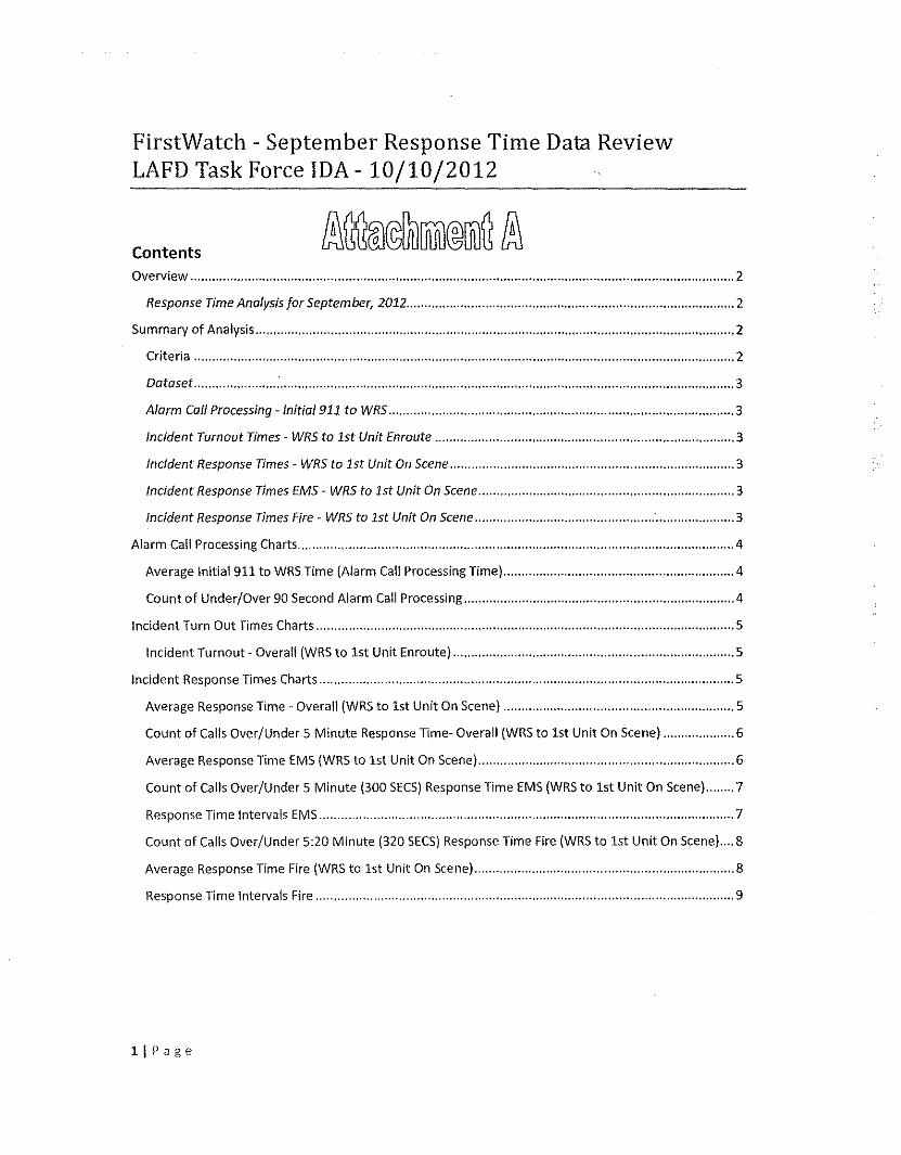
FirstWatch - September Response Time Data ReviewLAFD Task Force IDA - 10/10/2012
ContentsOverview , , , , , 2
Response Time Analysis for September, 2012 2
Summary of Analysis 2
Criteria 2
Dataset : 3
Alarm Call Processing -lnitial911 to WRS 3
Incident Turnout Times - WRS to 1st Unit Enroute 3
Incident Response Times - WRS to 1st Unit On Scene 3
Incident Response Times EMS - WRS to 1st Unit On Scene 3
Incident Response Times Fire- WRS to 1st Unit On Scene 3
Alarm Call Processing Charts 4
Average Initial 911 to WRS Time (Alarm Call Processing Time) 4
Count of Under/Over 90 Second Alarm Call Processing 4
Incident Turn Out Times Charts 5
Incident Turnout· Overall (WRS to 1st Unit Enroute) 5
Incident Response Times Charts 5
Average Response Time - Overall (WRS to 1st Unit On Scene) 5
Count of Calls Over/Under 5 Minute Response Time- Overall (WRS to 1st Unit On Scene) 6
Average Response Time EMS (WRS to 1st Unit On Scene) 6
Count of Calls Over/Under 5 Minute (300 SECS)Response Time EMS (WRS to 1st Unit On Scene) 7
Response Time Intervals EMS 7
Count of Calls Over/Under 5:20 Minute (320 SECS)Response Time Fire (WRS to 1st Unit On Scene) 8
Average Response Time Fire (WRS to 1st Unit On Scene) 8
Response Time Intervals Fire 9
llPage
FirstWatch - September Response Time Data ReviewLAFDTask Force IDA- 10/10/2012
Overview
Response Time Analysis for September, 2012The basis of the criteria used in following response time analysis is centered on information provided bythe Task Force IDAsub-committee. Asking the question: How long does it take to get a resource to a911 emergency call from the time that it is received by LAFD? There are two specific segments that weare focused on for this report: 1) Alarm Call Processing -Initial 911 to WRS and 2) Response Time - WRSto 1" Unit On Scene.
Summary of Analysis
CriteriaFirstWatch Trigger Source for Analysis: Task Force IDA-LAFD - Response Time 5 mins
• Date Range: Between September 1, 2012 00:00:00 and September 30, 201223:59:59• All Fire and EMS emergency calls that came in on a 911 phone line, excluding specified non-
emergency calls types. (Also referred to as "Overall" in this report)• Excludes the following non-emergent Incident types:
11A1,12A2,12A2E,12A3,12A3E,13A1,13A1C,16A1,16A2,16A3,17AOG,17A1,17A1G,17A1J,17A2,17A2G,17A2l,17 A3,17A3G,17A3l,1701,1701J,18A1,lA1,20A1,20A1C,20A1H,21A1,21A2,22A1,22A1A,22A1B,22A1M,22A1X,22A1Y,2301 V,2401,25A1,25A1B ,25A1V,25A1W,25A2,25A2B, 25A2V,25A2W,26Al,26A10,26A11,26A12,26A13,26A14,26A15,26A16,26A17,26A18,26A19,26A2,26A20,26A21,26A22,26A23,26A24,26A25,26A26,26A27,26A28,26A3,26A4,26A5,26A6,26A7,26A8,26A9,26010,26011,26012,26013,26014,26015,26016,26017,260,8,,26019,2602,26020,26021,26022,26023,26024,26025,26026,26027,26028,2603 ,2604 ,2605 ,2606,260 7,2608,2609 ,27AlG,27A1S,27A1X,29A1,29A1A,29A1 M,29 AlU, 29A1X,290 1,2A1,2A11,2A1M, 2A2,2A21,2A2M,30A1,30A2, 36AO,36A1A,36A1B,36A2A,36A2B,36A2 C,3A1,3A2,3A3AAIAA1SAA2AA2S,5A1,5A2, 7A3,7A3E,7A3F,8A1,801,801B,801C,801G,801M,801N,801R,801S,80lU,9Bl,9BlA,9B1B,9B1C,9B1D,9B1E,9B1F,9B1G,F0,ENG,ILLEGAL,INVEST,INVESTA,INVESTF,1NVESTL,INVESTM,INVESTP,INVESn,LOST,SAFEH,SAFES,TIRE,TOW,TRK,TSI,VIP.
• Calls must have an Initial 911 and 1" Unit On Scene timestamp to be a qualified record.e Measured against 5 minute (300 seconds) response time standard (60 seconds for Alarm call
Processing and 240 seconds for turn-out and travel time)• No specific unit type or capability designation is used for filtering criteria. We are evaluating all
resource types.
21Page
FirstWatch - September Response Time Data ReviewLAFDTask Force IDA- 10/10/2012
Dataset• September 2012 - Total Overall Calls: 22,049
• Total Records Removed with Errors: 154 (0.7%)
o Bad or irregular records based on items identified in discussions - l.e. > 1" Unit Enroute
timestamp before 1" Unit On Scene, and data entry errors for the September data set.
Recommend not focusing on these specific calls, since a low percentage.
• Total Calls Evaluated (Errors Removed): 21,895
Alarm Call Processing -Initial 911 to WRS• Average Initial 911 to WRS - Alarm Call Processing (HH:MM:SS): Time: 00:01:42
• Count of Calls Over 90 Seconds: 10,994 (50.2%)
• Count of Calls Within 90 Seconds: 10,901 (49.8%)
incident Turnout Times - WRS to Lst Unit Enroute• Average Incident Turnout - WRS to 1" Unit Enroute(HH:MM:SS): 00:00:57
Incident Response Times - WRS to Lst Unit OnScene• Average Response Time (HH:MM:SS): 00:05:05
• Count of Calls Over 5 Minutes: 8,650 (39.5%)
• Count of Calls Within 5 Minutes: 13,245 (60.5%)
Incident Response Times EMS- WRS to 1st Unit On Scene• Average Response Time (HH:MM:SS): 00:05:01
• Count of Calls Over 5 Minutes: 7,836 (39.1%)
• Count of Calls Within 5 Minutes: 12,216 (60.9%)
Incident Response Times Fire - WRS to Lst Unit On Scene• Average Response Time (HH:MM:SS): 00:05:38
• Count of Calls Over 5:20 Minutes/Seconds: 713 (38.7%)
• Count of Calls Within 5:20 Minutes/Seconds: 1,130 (61.3%)
31Page
FirstWatch - September Response Time Data ReviewLAFD Task Force IDA - 10/10/2012
Alarm Call Processing Charts
Average Initial 911 to WRSTime (Alarm Call Processing Time)
Row Labels\,1"i1.Sepl·Sep3-Sopa-sec5·S,,?s-se»7·Sep8·S~pS·Sep10·S~p11·$op12-80pB·Se?14·$oplS·Sapl$-SepH·Sepla·s~p19-5eplO-Sep7.1·$op:?2·Scp23·S~plA·Sep25·Sap26·Sap27·Scp26·S~!}29'Scp3Q·SeoGrand Total
Average of Initia:l91.ttoWRSfijH:MM;~S)
0001:4600'01:4200:014300,01'3600:01:3900:01:450001.4100:01'4900,01:-1200:01:39OO:Ol;dO00:014000;01:4600:01'.4900'01:4300:01.3700:01.'.4400.1)1 :3400:01;3700:01.3600:01"4400,01:46(lOOlA50001 :4200.01.350001'4600.01:4200'014300013700014000:01:42
Count of Under/Over 90 Second Alarm Call Processing
i ""..,l.. ,~owlabe!s(:!i1,SIlPi2·Sep13-$lIp14.Sep)5.Sepi&-Sep,1·Sep;S-Sep!9-Sepil0.Sepl11-SeplZ-Sep13-S11p
; 14·Sep: 15-Sep\ 16-SepI 17.SepilS_Sop'19-S~p:20·Sep!21-Sep22-Sep'23-$11pN·Sep25-Sep26>Sep27...Sep
;23-Sop:29,S~p,30:.SapGr!lnd Total'Percentage
41Page
Column'Laliels i,"','
GrandOV'er,~ ,U,n4er99, -Totlll
. JG7 301 6Gil351 373 724351) 365 723337 392 729303 344 647367 2133 6$0386 361 747400 316 716427 399 826372 411 783:.44 411 755344 362 726401 323 724469 397 866426 430 856351 408 759374 323 691307 400 701saa 355 676299 366 635440 385 825dQ4 33B HZ379 319 696369 369 738316 401 717352 312 56-l346 31~ 665354 318 672363 387 750365 391 756
109\14 1'6901 218955(1.2% 49.8%
FirstWatch - September Response Time Data ReviewLAFD Task Force IDA - 10/10/2012
Incident Turn Out Times Charts
Incident Turnout- Overall (WRS to Lst Unit Enroute]Av~ra!ioi ofWRS T<>
1~E!lR{O!i1i:MM.:,S$J. "
00,'005900',00.5600:00.530000.590000'55_00010100.00.5500'00:5900,01:/".5900:00:5300:00-5600;00.6500:00.5500:1)0:5800:005500',00.-5700:00'5900;00:56CO.-OO·5700:0(1:5600,00:55000{).5600,01,0000:00:59{IQ'OO:S6OO:CO.$<I00:00:5700:00,5600:00:56OQ-O(l:58'iiti"dio:5"'i
~oVlLabcls,-!;i·Sep - .Z·Seprase'<I·Sep.s-see6.S~p
·7.S~p8·S~p9·S~p
. lO·Sup11·Sep12·Scp
;13·Sep14·Sep
:15·$aplG·ScpH,$ap
:18·Sep,19·SaplO,Sep
ill_Sap22·$¢pnSep24·$ep25·$ep26·Sap
'27.Sap28·Sep29·$ep:}O:~~P.'"Grund TOlal
Incident Response Times Charts
Average Response Time· Overall (WRS to 1st Unit On Scene)Averagel.ifWRS
to1stONS(HIi:MM:SS)
Row U,bols;.~~j (ResponS(} Timo)t-S..p 0005'(142·Sep 00_05,04J-Sep 00,0.1584·S~p 000&.(155·Se" (10:04'.46!;·Sep 00,(15157·S~p 0005:00B·S~p 00(1507'iJ·S~p 00',050610·Se(> (I(I',{)5-0211.$<,(> on (15:0311·Sen 00,'05:05n,Sep 00:04:54M,Sep 00,05:35ts-see 00,05:1716.sep 00:05:04H,Sep 00'05:0918-Sop 0(1:04:57IS·Sep (10,(14,5920·Sep 00:05:0121·Sep 00:05:0(17..2·$op O(!,05:0G23·Sop 00:(15:012.\·Sep OO'O~:5925-$00 O(l'{I4:S92G.Sep 00:(14:552f.Sop 0005'0928·S~p 000$'0329·Sep (100510JO·Sep 000503Gf~ll!ITo!a! 00:05:05
51 Page
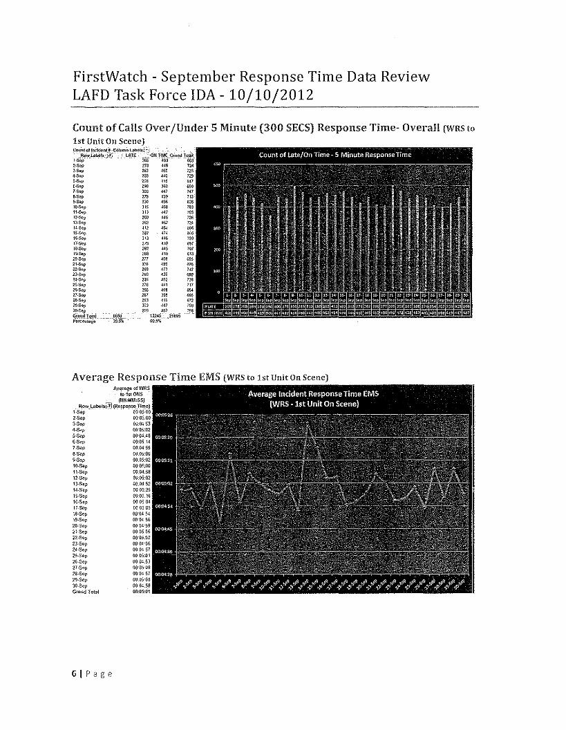
FirstWatch - September Response Time Data ReviewLAFD Task Force IDA - 10/10/2012
Count of Calls Over IUnder 5 Minute (300 SECS)Response Time- Overall (WRS to1st Unit On Scene)Counlof l_nclde"I_~Colum;, 4bIi15:.:;',
'~"",.LIlI>il!S ;.,:i:) ~TE ,..,-.:,Qn,m~€Giond To.t.\itj·Sep 265 40~ &68a,scl> 27a 4~& 1243.So" 263 460 1234.s"p 2$J 4M) 729.-SOp 228 419 &.\16-S~p 200 360 650,.$op lao·W 747a.sep are 439 1189-Sup 330 4% 826l(1..Sep )1$ JGI,I 78311.s~p )1> J42 7$512·$1)" 280 446 72Sn·Sep 262 462 n4!4.$~p ~12 4$.1 a6615·Se~ Ja. 414 asslS.Sop 313 4~6 159'7·S~p 27S 418 G~7la-SOp 26~ 445 10719-5tlp 2Sa JIG ~7820·S~p 217 406 68S21-Sep )26 499 %25~2·Sop 269 H3 74223·$ap 2GO 43~ 69B24·$Cp 286 452 n~25·Sep 2iG 441 71125·$ep 2% 408 61>42!-Sep 261 sse 66528.S~p 253 419 ~7229·$¢p )03 441 750
~~:';$IOiaj .'86~O 2691324~~~721895 J,SPorC9ntaga jg:&iI 60.5%
Average Response Time EMS (WHS to :1st Unit On Scene)Av",fIlgnofW,RS
to1stOllS ,~. '{HH:MM:SSj
~ow.l,_lIbelsr:!l (R\lSpOfl~Tl/ll(l1t-se» 01),'05,00a-see 00:05,'003·S~p 00;04'1;34·Sep 0005:02s-se» 00'04',48s.se 00:05:147 ,SIlP 00:1)455a-see 00.05:1)6S-5ep 00;05:02-lO-5ep 0005;00n·Sep OOJ}1.5812-8ep 00:05:02-\J·Sep OO.O~:5214·Sep 00'05:2515·$(11' 00:05,'1616·$ap 000504nSC'll 00050518·Sep OO,'(US419·$61' OOOd,5620·Se)) 00 Od59nSep 000506nSep 0005.02-23·Sep 00 0·1'~62A·$ep 0(1045725·S~p 0005:0126·$(11' OQ,OHijU-S'lp 00'05 OIl2a·Sep 0004 572~·Sep 00,050830-$ep 0004:58Gmnd Tola! 00:05:(.11
61Page
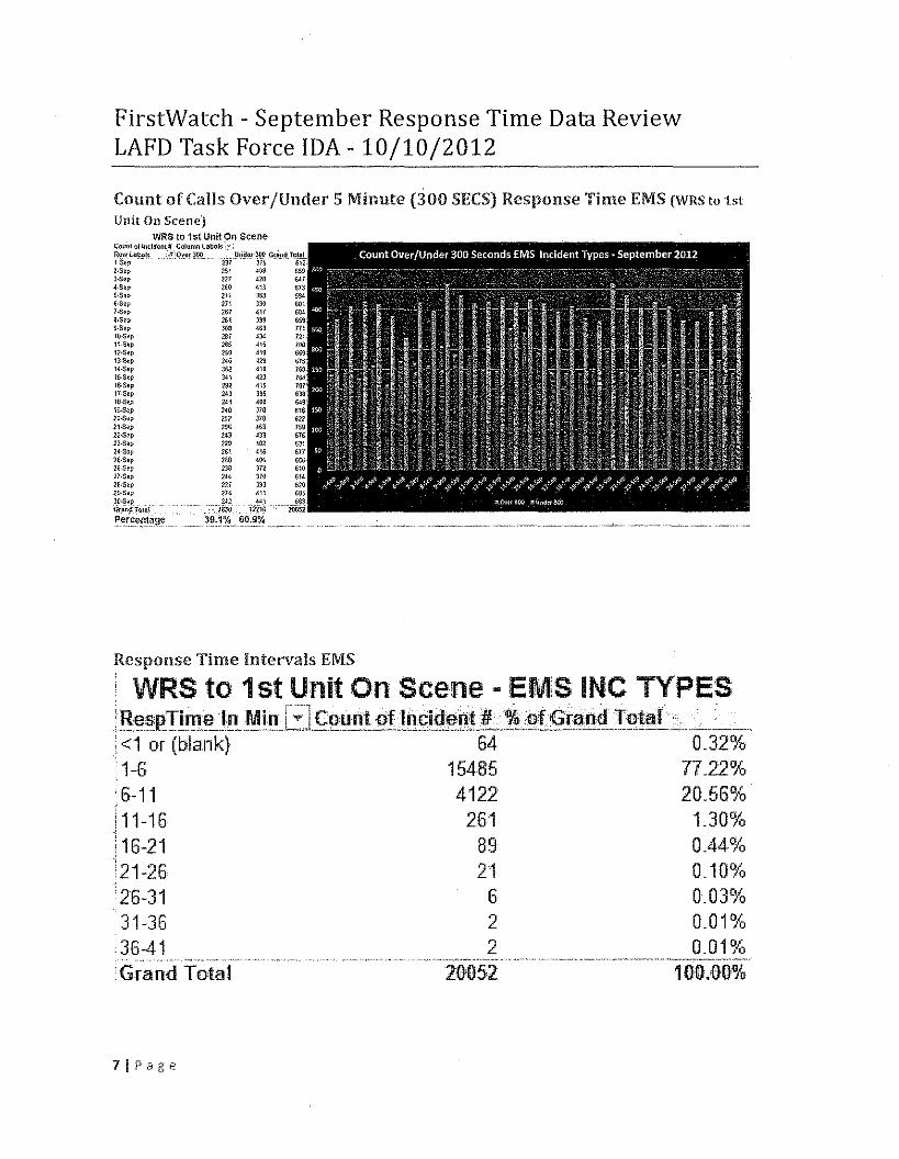
FirstWatch - September Response Time Data ReviewLAFD Task Force IDA- 10/10/2012
Count of Calls Over /Under 5 Minute (300 SEeS) Response Time EMS (WRS to 1stUnit On Scene)
WRS to 1st Unit On Scene(OUOl01!nclduot/f Column (.~li&{s:·:g9'~,laool. .:-:r,o_"O')O:O ". J,Io,ii:l'lI}1(Il,q(~J'H"'!LI·S~p ,- , ..• - :m 375 612~·S~l' lSI ~Qa 6593,s01' 217 420 &IT~·Sep ZGO 413 fj1J •5·$~p 211 >~3 $$4~·S~~ 271 330 GOt7·S.p 267 411 Ge4a.s?!, 2(;1 398 6599·S~p 308 ~G3 nt .100$.1' 21:11 H4 72111.$01' ?SS ~15 10612.S.p 250 419 669lH,lOp NG ~29 G75WSup 352 416 168IS·SCI' 141 423 764I&-Sop 292 415 107\7.Sep 243 395 63<1lB·S.., 241 40a 6491;l·S~p 240 JI$ fila20.s~p 252 JlO 62221-S~p 296 ~63 75922~p 243 4)3 6152j·S~p 229 ~02 63124-S~p 261 416 61725-S~p 260 406 G562G·Sep aae 372 61027·Sop 244 370 6142~·S.p 221 393 5202S.Sep 214 411 6a5
~~in~SToi(i('-, - -'."iij~ "iiii~ -w~~~_~r~~"!~~_~_~_,__39.1% 60,9%
Response Time Intervals EMS
: WRS to 1st Unit On Scene - EMS INC TYPES" , ' , , " -_- - r"-~'"l "", """ """",,':,:' ",',LI!~oSiP.!i~'9-'!I_Mi~fl~L::J9ount_~!)flpil;l~n!:.I!··.·.~~~!G!~mf~!9Ji!~··....~~ ~.I<1 or (blank) 64 0.32%1-6 15485 71.22%
i 6-11 4122 20~56~'d!11-16 261 UO%i 16-21 89 0.44%.;'21-26 21 0~10%'26-31 6 0~03%31-36 2 O~01%36-41 2 O~01%
_'_ ..... ,,_ n", ""~ .. ".'" .. ,~._. .W"., __ •__,~,_.·_, •• ,_"._._._"" __ •••_._, •• ~,"~.'
Grand Total 10051 100.00%
71Page
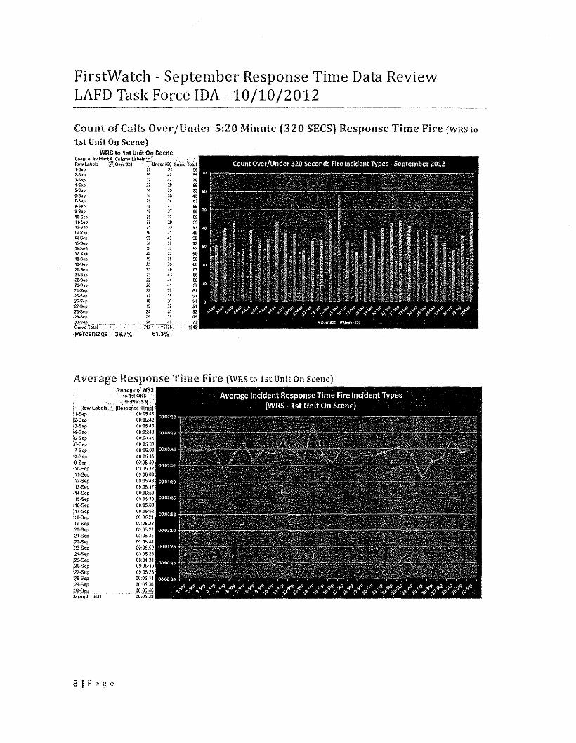
FirstWatch - September Response Time Data ReviewLAFD Task Force IDA - 10/10/2012
Count of Calls Over/Under 5:20 Minute (320 SECS)Response Time Fire (WRS toLst UnitOn Scene)I. , WRS,tQ1stUnltOnScene,CoOIl! oHllcldcm~-.C,,:I",!," l"'b<:IIJ!.::.: ".' .. ,,'R~v/Lab"ls i,'!"eQ./llr320 Und<lf32~GrnndToto;ll·S~p 2, 31 562·$•., 2& 40 65i)-Sop 32 44 7G~.S~p 21 Z!:I 565·S~p 1~ 39 53~·S,p !4)S 49;.S<!p 2~ 34 63a·s~p 15 014 599·S_p l~ 37 55lO·So1' ss 37 62lH~o)p 27 aa ss12-S¢p 24 33 ,713.S~p 15:lo1 49l~·S~p 53 as 9815·Sop 3. 56 saIS-Sep 18 34 5217";;ep 32 27 5918-S~p 19 39 sa"19.5<!p l5:15 SO21)..Sep 23 ~o eJ21.Sop 23 43 sen·$np 22 4~ &;V·Sop 26 41 G724·S~p U 39 612~.S.p 12 39 $125·S.. ie ao 5427-Sol' 1~ 32 51n.sop 24 28 S2
'29·S.p 29 lG GSJ9,:~R",.,.,,,,,"e _~4 ,~J --,-,.~,':§!~,!!.~"T!='.t~!..._" __.,J.l ..L,_.,,:.,!.~~_D_ ""'Percentage "'-38.70/. 61.3%
Average Response Time Fire (WRS to 1st Unit On Scene]Average of WRS
lo,1stONSt-'"' .,tIlH;MM:SS}
t.. ._8~)'!J"l:I_~!1I!;,,~!:im!l_&p()J!!l!!Ji'.lt~r.; l·S e p 00',05:48l/!-Sep 00:05:42i3.$ep 00-05'A5;4·S~p 0(}:(\5:43'S.Sep 0(1',04,',44:6·Sep OO,05_3~7·Se? 00'06_006·S~p 00_05.159·S~p 00:{I$:4010·S~p 00053211·S~p 00 OG0912·$ep 00'05:4313·Se? 00,0517H·Se;:> 00,06:5015·S~p 00,05:3016·Sep 00,'05.0817·S~p 00,05.52ta-sec 00',05:.21ta-sec 00',0503221).Sep 000$.2721·Sep O!l:053522·$ep OO:05:4~23-Sep 00:05'.52:24·Sep 00,05292S·Sep 00:04:J1
:26.$op 00'05:1027·Sep 0{):05-232S·Sep 00:06:112S·S~p 00,05.3639~Sep 000!i:J5
:Grl;llld Total oo:osja
8iPage
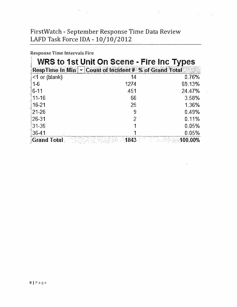
FirstWatch - September Response Time Data ReviewLAFD Task Force IDA - 10/10/2012
Response Time Intervals FireI
i ..\\IR~••t()1.~~U~it2~~~~~~-\~i~~I~~.!¥e~.~l~esrrri·I11i:!··IFI.•Mi~••••aC;t)ti·~t\t)f:;ij.~irqe;!'It~\$~]af:•.~.f~t.j.:~pttil!··"'."i;.5\j1<1 or (blank) 14 0_76%-11~6 1274 69_13%!6-11 451 24-47%-,j11-16 66 3_58%'116-21 25 1.36%i
121-26 9 0.49%i
!26-31 2 0_11%i 31-36 1 0_05%13641 . 1 0_05%+.....,..:-.~"~,~"~-.,.-~~~-::""'.--.~~-.,ec:~,,-_",--:--'--"'-~7"-, ' ",,~:'~""'7-'-' ','----·--·7--:-·---~·-· ..-r-r-r- ..----, ,,-:-:-~.-,,- ;'-:-'-'_7-:---:":'~-IGramrl Total .. .' 18:43 .. 1~it).06%
91Page
-e-- ~,ii1 c:> so "" '" r, f:ft <0 ,~t"- " ~':1 ~ ~i~ ; 4, <>; ...., '" r:~ ." ~,'" <>; t,.:.!-
~ ~ t-,= ~ ~ ;9: '" ~ ~ O! ~ ~ ~-'
~ -c- ~ ~-e .::; <; <; .::; <; 0 0 0 '" '" '" 0 '" 0 .., 0
"" '" "" '" 0 <=> '" <=> <=> '" co '" <=> ca co 0ro-o VIcrc OJ~~ U~ "-.c :::lb 0"-o VI::> OJu 0::c
'3 -0~ OJ.;;;0>- w..."iiicroz- co ~ <0 ~ " '" (<") l£ co '"ro <:'l 'P ." ~ '" Q
;"":"": '5-o Q ~ ~ '" ~ 0 10C "" ~ g '" '" "" '" ~0 .::; '" <=> <; g 8 16 '"u '" "'" "" "" '" ;0 0,
@ " ~~,0>-
¢:!J C
~ '" 0is ~'" .;;; M M
@ cu 2:- " '"~ ~c»rc 0 ~
~" c '".~ ro 0 '" '" I.-m OJ"" Eg "" .S; >' ,0 i3Q +-'
~ - I'- '" en C
$ ~ 0 OJ-(i@ ,; -o Xl [:;; rs U'" f.l '"c
~
~ ~ 8 R ..c0 r;;. ::>~~ <; 8 u0.. <'5 " '" '" +-''" ~
::> ro<II '" cIt: :3 ~ ~ ~ ~ ~
0..-0 J! 00
VI~ 0cc-0 .e
'" co '" crt ~ ." };; 00 '0 ,;::! fi g C1; '" M <Coc: J ~~" " N .., '" '" ;;:; ;;:; '"ca 0 8 "" g g .., g .., '"' '"' H r'-l r'-l r'-l- '" "" ~ c» g ~ ~ '" '" ~ "" '"0(1) ~ '" <=> "" d d <::> d d co d d 0 0Q) '" '" '" ca '" co c» ca '" co '" co co co co <::> 0
"0 e--'(ii 0> ::l': ::l': ::l': ~ a: :s If ~ '" ~ ::?: :s ::;; '" ::;; '"- ~ Q D- c, 0- r« 0- o, 0. -c 0. Q. Q.::> .", !A i'lil ~ ~ (- oo ~ r, r, (- n co '" ...., N0 '" t"': ,~'" 8i r~ M -" " ~ M ,~'" '"" "'-1 {"J co '?J '" M c; 1F, '" e-i
"c'-j r:-.: co
'" (.~ -er Y- o -sr co '" M ..., co,
.~ .~ "" M ,-, co 'n '0 ~ 00 r- ,:0 e-r co ,,' '" '" ?€'M '" N N \::! N ~ N N N N N N N N '"" § § ~ § § ;S § ;S § ,§ §~> til ~ 8i '" t!
coIC.' <:0' ~ '"~ ~ ... " ..,. ~ ::! "'" "" ::! ::! -er -er -et -er g
::5 a ~~
~ ~ ~ ~ ~ ~ ~Q) .~ a CJ ~ ~ CJ a ';",i
.5 ~~0
J- Q!.8 ,,",
'" '" -" 2>'" ~v-
"c 11f c0 c <>0.. >l ~ -g<J) -" 1'!-§
"~ '" "E''" ro ~~ ·cIt: ,,~ CJ 0..
-c~
'" '"'OJo- J;;._ OJ
~rn .lj<II OJ '0.E", oS<II ,.,>f-<""-"-;; -"U <II
"-'"is
Source; ,bing
I 'L '"
'" '"5"110 'j(jO
J" i,I'~
1
Figure 3Approximate limits of the Project Site
Within 500 Feet of the 101-JFreeway
Figure 3Approximate Limits of the Project Site
Within 500 Feet of the lOI-Freeway
\
'"
? \(0
Scale (Feet)
Source: bing maps. 2011; Image courtesy of Microsoft Corporation and USGS. 2011.
Figure 3Approximate Limits of the Project Site
Within 500 Feet of the lOt-Freeway
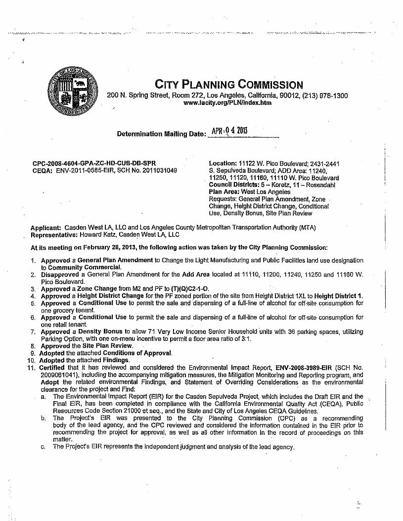
CITY PLANNING COMMISSION200 N. Spring Street, Room 272, Los Angeles, California, 90012, (213) 978-1300
www.laclty.org/PLN/lndex.htm
Determination Mailing Date: APR' Q 4; 2013
CPC-2008-4604-GPA-ZC-HD-CUB-DB-SPRCEQA: ENV-2011-0585-EIR, SCH No. 2011031049
Location: 11122 W. Pica Boulevard; 2431-2441S. Sepulveda Boulevard; ADD Area: 11240,11250,11120,11160,11110 W. Pico BoulevardCouncil Districts: 5 - Koretz, 11 - RosendahlPlan Area: West Los AngelesRequests: General Plan Amendment, Zone .Change, Height District Change, ConditionalUse, Density Bonus, Site Plan Review
Applicant: Casden West LA, LLC and los Angeles County Metropolitan Transportation Authority (MTA)Representative: Howard Katz, Casden West LA, lLC
At its meeting on February 28, 2013, the following action was taken by the City Planning Commission:
1. Approved a General Plan Amendment to Change the Light Manufacturing and Public Facilities land use designationto Community Commercial.
2. Disapproved a General Plan Amendment for the Add Area located at 11110,11200,11240,11250 and 11160 W.Pico Boulevard.
3. Approved a Zone Change from M2 and PF to (T)(Q)C2-1-0. .4. Approved a Height District Change for the PF zoned portion of the site from Height District 1XL to Height District 1.5. Approved a Conditional Use to permit the sale and dispensing of a full-line of alcohol for off-site consumption for
one grocery tenant.6. Approved a Conditional Use to permit the sale and dispensing of a full-line of alcohol for off-site consumption for
one retail tenant.7. Approved a Density Bonus to allow 71 Very Low Income Senior Household units with 36 parking spaces, utilizing
Parking Optlon, with one on-menu incentive to permit a floor area ratio of 3:1.8. Approved the Site Plan Review.9. Adopted the attached Conditions of Approval.
10. Adopted the attached Findings.11. Certified that it has reviewed and considered the Environmental Impact Report, ENV-2008-3989-EIR (SCH No.
2009061041), including the accompanying mitigation measures, the Mitigation Monitoring and Reporting program, andAdopt the related environmental Findings, and Statement of Overriding Considerations as the environmentalclearance for the project and Find: .a. The Environmental Impact Report (EIR) for the Casden Sepulveda Project, which includes the Draft EIR and the
Final EIR, has been completed in compliance with the Callfomla Environmental Quality Act.(CEQA), PublicResources Code Section 21000 et seq., and the State and City of Los Angeles CEQA Guidelines.
b. The Project's EIR was presented to the City Planning Commission (CPC) as a recommendingbody of the lead agency, and the CPC reviewed and considered the information contained in the EIR prior torecommending the project for approval, as well as all other information in the record of proceedings on thismatter.
c. The Project's EIR represents the independent judgment and analysis of the lead agency.
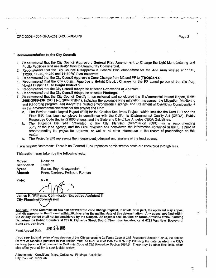
CPC-2008-4604-GPA-ZC-HD-CUB-DB-SPR Page 2
Recommendation to the City Council:
1. Recommend that the City Council Approve a General Plan Amendment to Change the Ught Manufacturing andPublic Facilities land use designation to Community Commercial.
2. Recommend that the City Council Disapprove a General Plan Amendment for the Add Area located at 11110,11200, 11240, 11250 and 11160 W. Pico Boulevard.
3. Recommend that the City Council Approve a Zone Change from M2 and PF to (T)(Q)C2-1-O.4. Recommend that the City Council Approve a Height District Change for the PF zoned portion of the site from.
Height District lXL to Height District 1. . .5. Recommend that the City Council Adopt the attached Conditions of Approval.6. Recommend that the City Council Adopt the attached Findings. .7.. Recommend that the City Council Certify it has reviewed and considered the Environmental Impact Report, ENV-
200B-3989-EIR (SCH No. 2009061041), including the accompanying mitigation measures, the Mitigation Monitoringand Reporting program, and Adopt the related environmental Findings, and Statement of Overriding Considerationsas the environmental clearance for the project and Find:a. The Environmental Impact Report (EIR) for the Casden Sepulveda Project, which Includes the Draft EIR and the
Final EIR, has been completed in compliance with the California Environmental Quality Act (CEQA), PublicResources Code Section 21000 et seq., and the State and City of Los Angeles CEQA Guidelines.
b. The Project's EIR was presented to the City PlannIng CommissIon (CPC) as a recommendingbody of the lead agency, and the CPC reviewed and considered the information contained in the EIR prior torecommending the project for approval, as well as aU other information in the record of proceedings on thismatter.
c. The Project's EIR represents the independent judgment and analysis of the lead agency.
Fiscal Impact Statement: There is no General Fund impact as administrative costs are recovered through fees.
This action was taken by the following vote:
Moved:Seconded:Ayes:Absent:
RoschenLessinBurton, Eng, HovaguimianFreer, Cardoso, Perlman, Romero
Vote:
mission Executive Assistant IIsion
Appeals: If the Commission has disapproved the Zone Change request, in whole or in part, the applicant may appealthat disapproval to the Council within 20 days after the mailing date oflhis detenoinalion. Any appeal not filed withinthe 20·day period shall not be considered by the Cou[lcll. All appeals shall be filed on forms provided at the PlanningDepartment's Public Counters at 201 N. Figueroa Street, Fourth Floor, Los Angeles, or at 6262 Van Nuys Boulevard,Suite 251, Van Nuys.
APR 241013Final Appeal Date: _
If you seek judicial review of any decision of the City pursuant to Calffornia Code of Civil Procedure Seelion 1094.5, the petitionfor writ of mandate pursuant to that section must be filed no later than Ihe 90th day following the dale on which the City'sdecision became final pursuant to California Code of Civil Procedure Section 1094.6. There may be other time limits whichalso affect your ability to seek judicial review.
Attachments: Conditions. Maps, Ordinance, Findings. ResolutionCity Planner: Henry Chu
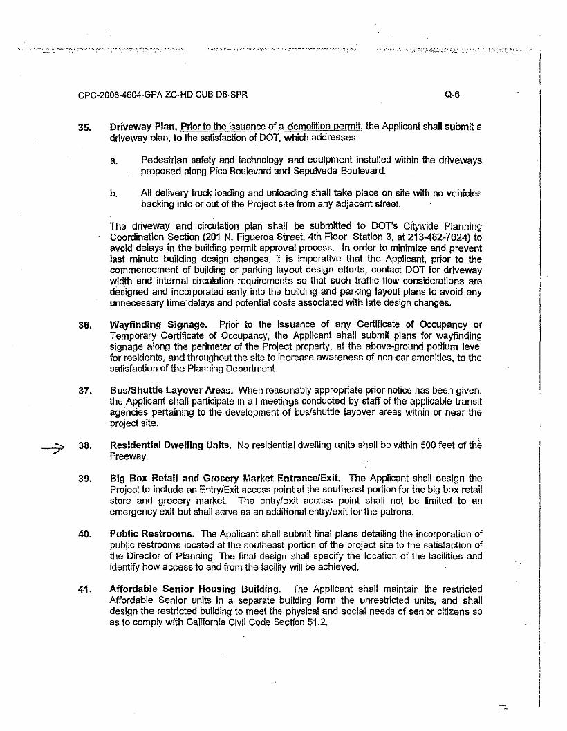
CPC-200B-4604-GPA-ZC-HD-CUB-DB-SPR 0-6
35. Driveway Plan. Prior to the issuance of a demolition permit, the Applicant shall submit adriveway plan, to the satisfaction of DOT, which addresses:
a. Pedestrian safety and technology and equipment installed within the drivewaysproposed along Pica Boulevard and Sepulveda Boulevard.
b. All delivery truck loading and unloading shall take place on site with no vehiclesbacking into or out of the Project site from any adjacent street.
The driveway and circulation plan shall be submitted to DOT's Citywide PlanningCoordination Section (201 N. Figueroa Street, 4th Floor, Station 3, at 213-482-7024) toavoid delays in the building permit approval process. In order to minimize and preventlast minute building design changes, it is imperative that the Applicant, prior to thecommencement of building or parking layout design efforts, contact DOT for drivewaywidth and internal circulation requirements so that such traffic flow considerations aredesigned and incorporated early into the building and parking layout plans to avoid anyunnecessary time delays and potential costs associated with late design changes.
36. Wayfinding Signage. Prior to the issuance of any Certificate of Occupancy orTemporary Certificate of Occupancy, the Applicant shall submil plans for wayfindingsignage along the perimeter of the Project property, al the above-ground podium levelfor residents, and throughout the site to increase awareness of non-car amenities, to thesatisfaclion of the Planning Department.
37. Bus/Shuttle Layover Areas. When reasonably appropriate prior notice has been given,the Applicant shall participate in all meetings conducted by staff of the applicable transitagencies pertaining to the development of bus/shuttle layover areas within or near theproject site.
Residential Dwelling Units. No residential dwelling units shall be within 500 feet of theFreeway.
-7 38.
39. Big Box Retail and Grocery Market Entrance/Exit. The Applicant shall design theProject to include an Entry/Exit access point at the southeast portion for the big box retailstore and grocery market. The entry/exit access point shall not be limited to anemergency exit but shall serve as an additional entry/exit for the patrons.
40. Public Restrooms. The Applicant shall submit final plans detailing the incorporation ofpublic restrooms located at the southeast portion of the project site to the satisfaction ofthe Director of Planning. The final design shall specify the location of the facilities andidentify how access to and from the facility wm be achieved.
41. Affordable Senior Housing Building. The Applicant shall maintain the restrictedAffordable Senior units in a separate building form the unrestricted units, and shalldesign the restricted building to meet the physical and social needs of senior citizens soas to comply with California Civil Code Section 51.2.
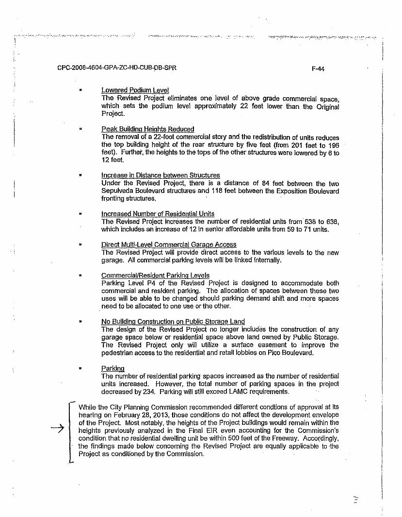
","y., •. ~...,. """,_"'.," ••,1-, ""' •.. y.• '
CPC-2008-4604-GPA-ZC-HD-CUB-PB-SPR F-44
• Lowered Podium LevelThe Revised Project eliminates one level of above grade commercial space,which sets the podium level approximately 22 feet lower than the OriginalProject.
• Peak Building Heights ReducedThe removal of a 22-foot commercial story and the redistribution of units reducesthe top building height of the rear structure by five feet (from 201 feet to 196feet). Further, the heights to the tops of the other structures were lowered by 6 to12 feet.
• Increase in Distance between StructuresUnder the Revised Project, there is a distance of 84 feet between the twoSepulveda Boulevard structures and 118 feet between the Exposition Boulevardfronting structures. .
• Increased Number of Residential UnitsThe Revised Project increases the number of residential units from 538 to 638,which includes an increase of 12 in senior affordable units from 59 to 71 units.
• Direct Multi-Level Commercial Garage AccessThe Revised Project will provide direct access to the various levels to the newgarage. All commercial parking levels will be linked Internally.
• Commercial/Resident Parking LevelsParking Level P4 of the Revised Project is designed to accommodate bothcommercial and resident parking. The allocation of spaces between these twouses will be able to be changed should parking demand shift and more spacesneed to be allocated to one use or the other.
• No Building Construction on Public Storage LandThe design of the Revised Project no longer includes the construction of anygarage space below or residential space above land owned by Public Storage.The Revised Project only will utilize a surface easement to improve thepedestrian access to the residential and retail lobbies on Pica Boulevard.
• ParkingThe number of residential parking spaces increased as the number of residentialunits increased. However, the total number of parking spaces in the projectdecreased by 234. Parking will still exceed LAMC requirements.
- While the City Planning Commission recommended different condtions of approval at itshearing on February 28, 2013, those conditions do not affect the development envelopeof the Project. Most notably, the heights of the Project buildings would remain within theheights previously analyzed in the Final EIR even accounting for the Commission'scondition that no residential dwelling unit be within 500 feet of the Freeway. Accordlnqly,the findings made below concerning the Revised Project are equally applicable to ·theProject as conditioned by the Commission.
·.'.'-
CPC-200B-4604-GPA-ZC-HD-CUB-DB-SPR F-114
would eliminate the CO significant impact that would have occurred under the Original. Project.
2. Mitigation Measures.
a. See Mitigation Measure (b) in Section F.2. below.
3. Findings.
Changes or alterations have been required in, or incorporated into, the Original Project,which avoid or substantially lessen the significant environmental effects of operationalemissions generated by the Original Project. Yet, the potential for a significant project-specific and cumulative impact remains, as is the case for the Revised Project. Thereare no feasible mitigatiqn measures that would avoid or substantially lessen thesesignificant environmental impacts. However, for the reasons described above, theRevised Project would not result in any new significant impacts or increase the severityof any previously identified significant impact with respect to this environmental impact,and the same mitigation measures will be incorporated into the Revised Project.Specific economic, legal, social, technological, or other constderanons, includingconsiderations identified in Section XI of this document (Statement of OverridingConsiderations) justify the decision to proceed with the Revised Project despite thissignificant impact.
4. Rationale for Findings,
The following rationale was applicable to the Original Project and remains applicable tothe Revised Project: Operational emissions will be primarily generated by motorvehicles. The Project will prepare and implement a TDM program to the satisfaction ofLADOT that will reduce traffic impacts of the Project and encourage Project residents,employees, and patrons to reduce vehicular traffic on the street and freeway systemduring the most congested periods of the day. Moreover, the Project is a transit orienteddevelopment that will increase density in proximity to, and encourage the use of publictransit in an established urban environment. However, even with implementation of thismitigation, impacts related to ROG, NOx and CO will remain significa'nt and unavoidable.There is no feasible mitigation that would further reduce this impact.
6. Reference.
For a complete discussion of Air Quality (operations) impacts, see Section IV.C of theDEIR, MMRP (Mitigation Measure N-2), and Errata #3.
---7 c. Land Use Planning (Conflict with Land Use Plan, Policy or Regulation)
1. Description of Significant Effects.
The Original Project would require the demolition of existing buildings at the Project Siteand the development of the site with mixed-use commercial and residential uses. Theapplicant is requesting multiple discretionary approvals in connection with the same.While the Original Project would result in new mixed-use residential and retaildevelopment, it is located in close proximity to the San Diego Freeway, which may resultin health risk impacts, specifically outdoor air quality impacts, and is inconsistent withcertain policies and objectives set forth in the City's General Plan concerningpreservation of industrial uses.
,'" "." ,~-::"," ~-.':"" ,,_:~,,'''.' ,' .••:'_.""" "', ,'. , ..,.,_",,~',.' ",_" .".-.'"""'....'~.~:';O--,"~:':;~-_."
!
CPC-2008-4604-GPA-ZC-HD-CUB-DB-5PR F-115
For the same reasons, the Revised Project will be inconsistent with those policies sincethe Revised Project would provide the same uses (residential and commercial) andgenerate substantially the same aggregate number of employees and resident.
The Add Area Project is the re-designation of three properties from Light Manufacturingand Public Facilities to Community Commercial in order to provide for logical, consistentarea-wide planning and uniform land use designations in the future. No zone change isproposed in connection with the re-designation. Accordingly, there will beinconsistencies between the zoning of the Add Area Project properties and the newGeneral Plan designation if the Add Area Project is approved. Said inconsistencies willalso mean that the existing self-storage facility on the Add Area Project site will becomea non-conforming use if the Add Area Project is approved.
2. Mitigation Measures.
a. For the residential portion of the Development Project, an airfiltration system shall be installed arid maintained with filtersmeeting or exceeding the ASHRAE standard 52.2 MinimumEfficiency Reporting Value (MERV) of 13, to the satisfaction of theDepartment of Building and Safety.
3. Findings.
Changes or alterations had been required in, or incorporated into, the Original Project,which avoid or substantially lessen the significant environmental effects related to landuse and planning, and generated by the Original Project. However, the potential forsignificant project-specific and cumulative impacts remain. The same level and impactsapply equally to the Revised Project; although for the. reasons described above, theRevised Project would not result in any new significant impacts or increase the severityof any previously identified significant impact with respect to this environmental impact,and the same mitigation measures will be incorporated into the Revised Project. Thereare no feasible mitigation measures that would avoid or. substantially lessen thesesignificant environmental effects. However, specific economic, legal, social,technological, or other considerations, including considerations identified in Section XI ofthis document (Statement of Overriding Considerations) justify the decision to proceedwith the Revised and Add Area Projects despite this significant impact.
4. Rationale for Findings.
The following rationale was applicable to the Original Project and remains applicable tothe Revised Project. The inconsistency of the Project with certain policies andobjectives in the General Plan relate to the siting of residential uses near sources of airpollution and the preservation of existing industrial uses. Inconsistency iii theserespects does not necessarily dictate that the Project is inconsistent with the GeneralPlan as a whole. State law does not require a perfect match between a proposedproject and the applicable land use plan. Thus, state law does not impose a requirementthat a proposed project comply with every policy in a land use plan since such policiesoften try to accommodate a wide range of competing interests. Thus, to be "consistent"with a land use plan itself, the proposed project must only be "in harmony" with theapplicable land use plan. As found in the Findings Regarding General Plan Amendmentand Zone Change for Casden West LA, LLC's Proposed Project at Pico Boulevard andSepulveda Boulevard, the Revised Project is consistent with numerous policies in theGeneral Plan and Community Plan, including pollcies encouraging transit orienteddevelopment and increasing density near rail lines. The Project Site is consistent with
-...., . ·Y· _.::.;: .... ,
CPC-200B-4604-GPA-ZC-HD-CUB-DB-SPR F-116
those policies, which existing uses at the Project Site do nothing to advance. However,the inconsistency with objectives related to the siting of residential uses near air pollutionsources and preserving existing Industrial uses may cause a land use impact that issignificant within the ~eaning of CEQA, given the City's particular CEQA significancethreshold for land use impacts for this project.
The Project will exceed relevant health risk thresholds as indicated in the Final EIR. Nofeasible and quantifiable mitigation is available to reduce outdoor PM10 and PM2.5emissions and indoor N02 t-hour concentrations to levels below relevant health riskthresholds. While there is no quantifiable mitigation available to reduce the potentialimpacts set forth above, there are several available mitigation strategies that couldimprove outdoor and indoor air quality at the Project Site. These include: (1) locateopens space areas (courtyards, patios, balconies, etc.) as far from the freeway sourcesas possible; (2) plant vegetation between receptors and freeway sources; (3) considersite plan design minimizing operable windows and building frontages to the freeway; (4)consider options for mechanical and ventilation systems (l.e., supply or exhaust basedsystems); (5) if a supply-based system is proposed (i.e., actively brining outside airthrough intake ducts), consider locating intakes as far from the freeway sources aspossible. To the extent feasible, these strategies will be implemented, and they mayserve to reduce the aforementioned impacts to a less than Significant level. However,because these strategies are not quantifiable, impacts related to inconsistencies withGeneral Plan policies, including the health risk impacts discussed above' will remainsignificant and unavoidable.
The Add Area Project is the re-designation of three properties from Light Manufacturingand Public Facilities to Community Commercial. The re-designation is intended toprovide for logical, consistent area-wide planning and uniform land use designationswithin the Development Project area, and in the neighborhood as a whole.Notwithstanding this intent, the re-designation will create zoning inconsistencies in theshort term because the Add Area Project parcels are not currently zoned consistent withthe proposed General Plan designation. For these reasons, impacts related to land useconsistency would also be significant and unavoidable for the Add Area Project. Thereis no mitigation that would avoid these conflicts.
The Project will result in the loss of an existing industrial site in the City. It will replaceexisting industrial uses with a job-rich, mixed-use housing development, however, andwill result in a net increase of jobs at the Project Site. Nonetheless, and because ofGeneral Plan policies that express a preference for preserving industrial uses within theCity, this impact will remain significant and unavoidable.
5. Reference.
For a complete discussion of land Use Planning impacts, see Section IV.I of the DEIR,(Mitigation Measure 1-3), Errata #3, and the Findings Regarding General PlanAmendment and Zone Change for Casden West LA, llC's Proposed Project at PicoBoulevard and Sepulveda Boulevard.
D. Original and Revised Project - Noise (Cumulative Construction andOperation) .
1. Description of Significant Effects.
As discussed above, project-specific construction noise impacts would not rise to a levelof significance. Nonetheless, the Original Project, together with associated relatedprojects could result in a cumulatively Significant impact with respect to construction
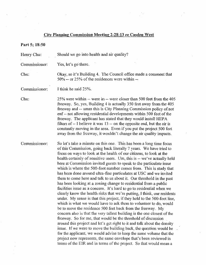
City Planning Commission Meeting 2-28-13 re Casden West
Part 5; 18:50
Henry Chu:
Commissioner:
Chu:
Commissioner:
Chu:
Commissioner:
. Should we go into health and air quality?
Yes, let's go there.
Okay, so it's Building 4. The Council office made a comment that50% -- or 25% of the residences were within --
I think he said 25%.
25% were within -- were in -- were closer than 500 feet from the 405freeway. So, yes, Building 4 is actually 350 feet away from the 405freeway and -- umm this is City Planning Commission policy of notenf -- not allowing residential developments within 500 feet of thefreeway. The applicant has stated that they would install HEPAfilters of -- I believe it was 13 -- on the opposite end, but the air isconstantly moving in the area. Even if you put the project 500 feetaway from the freeway, it wouldn't change the air quality impacts.
So let's take a minute on this one. This has been a long time focusof this Commission, going back literally 7 years. We have tried tofocus on ways to look at the health of our citizens, to look at thehealth certainly of sensitive users. Um, this is -- we've actually heldhere at Commission invited guests to speak to the particulate issuewhich is where the 500-foot number comes from. This is study thathas been done around ultra- fine particulates at USC and we invitedthem to come here and talk to us about it. Our threshold in the pasthas been looking at a zoning change to residential from a publicfacilities issue as a concem. It's hard to go to residential when weclearly know the health risks that we're putting, I think, our residentsunder. My sense is that this project, if they held to the 500-foot line,which is what we would have to ask them to volunteer to do, wouldbe to move the residence 500 feet back from the freeway. Myconcern also is that the very tallest building is the one closest of thefreeway. So for me, that would be the threshold of discussionaround this project and let's get right to it and talk about the densityissue. Ifwe were to move the building back, the question would befor the applicant, we would advise to keep the same volume that theproject now represents, the same envelope that's been reviewed interms of the EIR and in terms of the project. So that would mean a
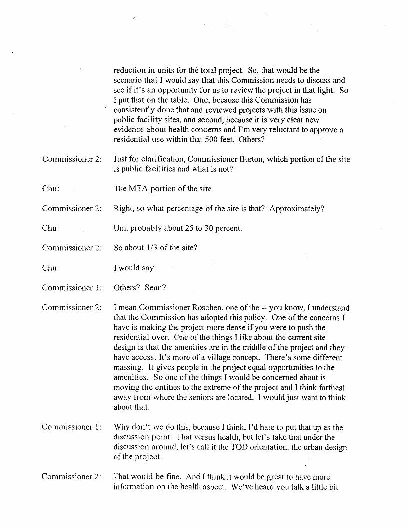
reduction in units for the total project. So, that would be thescenario that I would say that this Commission needs to discuss andsee ifit's an opportunity for us to review the project in that light. SoI put that on the table. One, because this Commission hasconsistently done that and reviewed projects with this issue onpublic facility sites, and second, because it is very clear newevidence about health concerns and I'm very reluctant to approve aresidential use within that 500 feet. Others?
Commissioner 2: Just for clarification, Commissioner Burton, which portion of the siteis public facilities and what is not?
Chu: The MTA portion of the site.
Commissioner 2: Right, so what percentage of the site is that? Approximately?
Chu: Um, probably about 25 to 30 percent.
Commissioner 2: So about 113of the site?
Chu: I would say.
Commissioner I: Others? Sean?
Commissioner 2: I mean Commissioner Roschen, one of the -- you know, I understandthat the Commission has adopted this policy. One of the concerns Ihave is making the project more dense if you were to push theresidential over. One of the things I like about the current sitedesign is that the amenities are in the middle of the project and theyhave access. It's more of a village concept. There's some differentmassing. It gives people in the project equal opportunities to theamenities. So one of the things I would be concerned about ismoving the entities to the extreme of the project and I think farthestaway from where the seniors are located. I would just want to thinkabout that.
Commissioner I: Why don't we do this, because I think, I'd hate to put that up as thediscussion point. That versus health, but let's take that under thediscussion around, let's call it the TOD orientation, theurban designof the project.
Commissioner 2: That would be fine. And [ think it would be great to have moreinformation on the health aspect. We've heard you talk a little bit
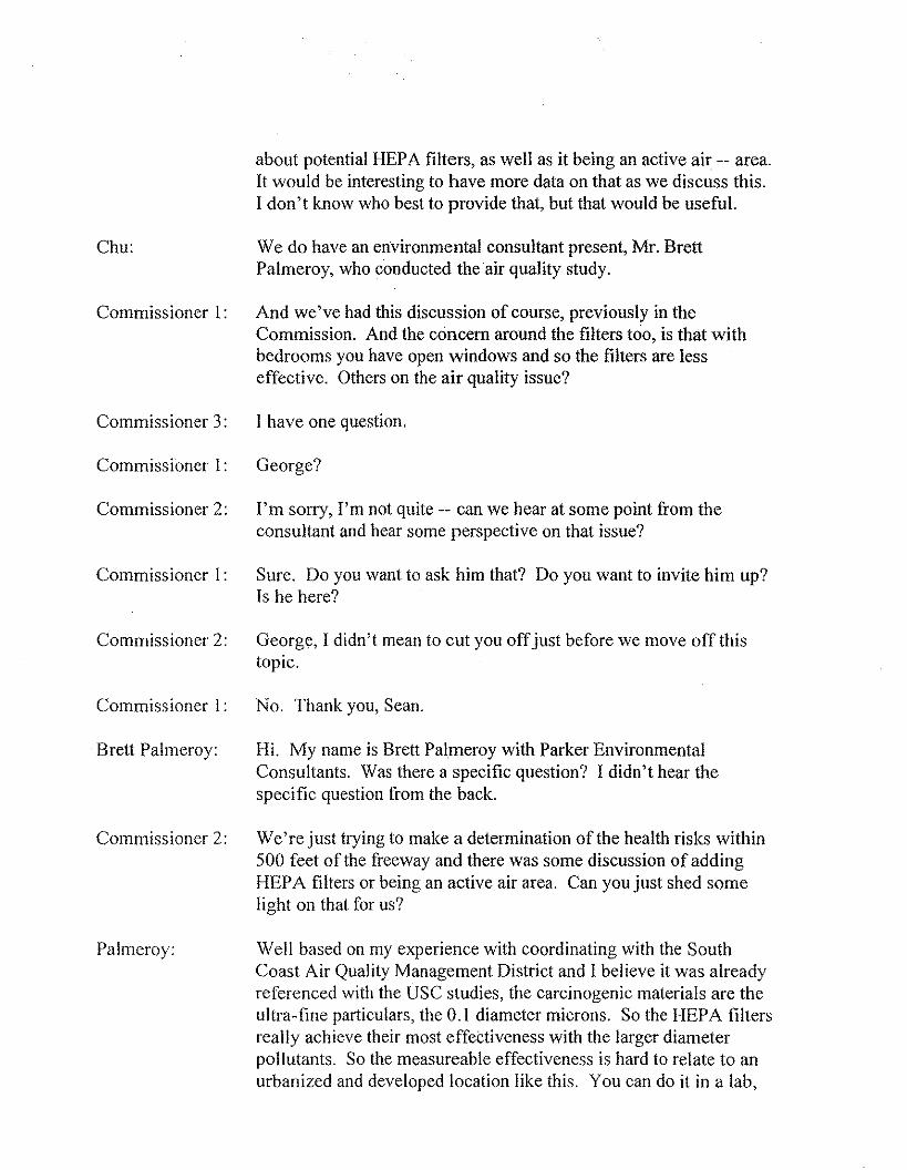
about potential HEPA filters, as well as it being an active air -- area.It would be interesting to have more data on that as we discuss this.I don't know who best to provide that, but that would be useful.
Chu: We do have an environmental consultant present, Mr. BrettPalmeroy, who conducted the air quality study.
Commissioner 1: And we've had this discussion of course, previously in theCommission. And the concern around the filters too, is that withbedrooms you have open windows and so the filters are lesseffective. Others on the air quality issue?
Commissioner 3: I have one question.
Commissioner 1: George?
Commissioner 2: I'm sorry, I'm not quite -- can we hear at some point from theconsultant and hear some perspective on that issue?
Commissioner I: Sure. Do you want to ask him that? Do you want to invite him up?Is he here?
Commissioner 2: George, I didn't mean to cut you off just before we move off thistopic.
Commissioner I: No. Thank you, Sean.
Brett Palmeroy: Hi. My name is Brett Palmeroy with Parker EnvironmentalConsultants. Was there a specific question? I didn't hear thespecific question from the back.
Commissioner 2: We're just trying to make a determination of the health risks within500 feet of the freeway and there was some discussion of addingHEP A filters or being an active air area. Can you just shed somelight on that for us?
Palmeroy: Well based on my experience with coordinating with the SouthCoast Air Quality Management District and I believe it was alreadyreferenced with the USC studies, the carcinogenic materials are theultra-fine particulars, the 0.1 diameter microns. So the HEPA filtersreally achieve their most effectiveness with the larger diameterpollutants. So the measureable effectiveness is hard to relate to anurbanized and developed location like this. You can do it in a lab,
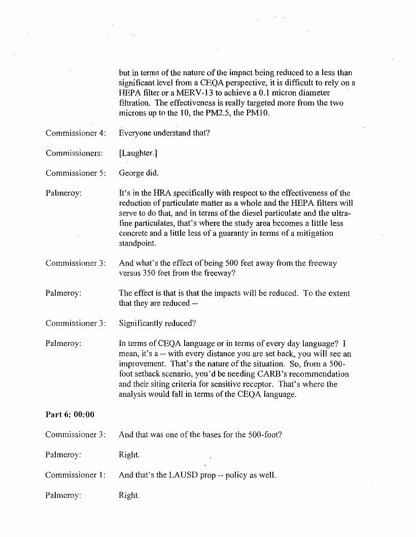
but in terms of the nature of the impact being reduced to a less thansignificant level from a CEQA perspective, it is difficult to rely on aHEPA filter or a MER V-13 to achieve a 0.1 micron diameterfiltration. The effectiveness is really targeted more from the twomicrons up to the 10, the PMl.5, the PMIO.
Commissioner 4: Everyone understand that?
Commissioners: [Laughter.]
Commissioner 5: George did.
Palmeroy: It's in the HRA specifically with respect to the effectiveness of thereduction of particulate matter as a whole and the HEP A filters willserve to do that, and in terms ofthe diesel particulate and the ultra-fine particulates, that's where the study area becomes a little lessconcrete and a little less of a guaranty in terms of a mitigationstandpoint.
Commissioner 3: And what's the effect of being 500 feet away from the freewayversus 350 feet from the freeway?
Palmeroy: The effect is that is that the impacts will be reduced. To the extentthat they are reduced --
Commissioner 3: Significantly reduced?
Palmeroy: In terms of CEQA language or in terms of every day language? Imean, it's a -- with every distance you are set back, you will see animprovement. That's the nature of the situation. So, from a 500-foot setback scenario, you'd be needing CARB's recommendationand their siting criteria for sensitive receptor. That's where theanalysis would fall in terms ofthe CEQA language.
Part 6; 00:00
Commissioner 3: And that was one of the bases for the 500-foot?
Palmeroy: Right.
Commissioner I: Arid that's the LAUSD prop -- policy as well.
Palmeroy: Right.
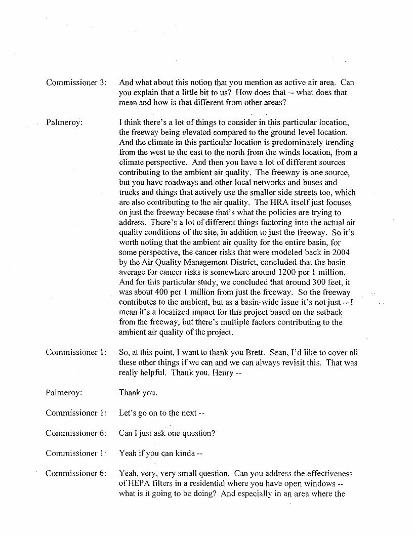
Commissioner 3: And what about this notion that you mention as active air area. Canyou explain that a little bit to us? How does that -- what does thatmean and how is that different from other areas?
Palmeroy: I think there's a lot of things to consider in this particular location,the freeway being elevated compared to the ground level location.And the climate in this particular location is predominately trendingfrom the west to the east to the north from the winds location, from aclimate perspective. And then you have a lot of different sourcescontributing to the ambient air quality. The freeway is one source,but you have roadways and other local networks and buses andtrucks and things that actively use the smaller side streets too, whichare also contributing to the air quality. The HRA itself just focuseson just the freeway because that's what the policies are trying toaddress. There's a lot of different things factoring into the actual airquality conditions of the site, in addition to just the freeway. So it'sworth noting that the ambient air quality for the entire basin, forsome perspective, the cancer risks that were modeled back in 2004by the Air Quality Management District, concluded that the basinaverage for cancer risks is somewhere around 1200 per 1 million.And for this particular study, we concluded that around 300 feet, itwas about 400 per 1 million from just the freeway. So the freewaycontributes to the ambient, but as a basin-wide issue it's not just -- Imean it's a localized impact for this project based on the setbackfrom the freeway, but there's multiple factors contributing to theambient air quality of the project.
Commissioner I: So, at this point, I want to thank you Brett. Sean, I'd like to cover allthese other things if we can and we can always revisit this. That wasreally helpful. Thank you. Henry --
Palmeroy: Thank you.
Commissioner 1: Let's go on to the next --
Commissioner 6: Can I just ask one question?
Commissioner I : Yeah if you can kinda --
Commissioner 6: Yeah, very, very small question. Can you address the effectivenessofHEPA filters in a residential where you have open windows--what is it going to be doing? And especially in an area where the
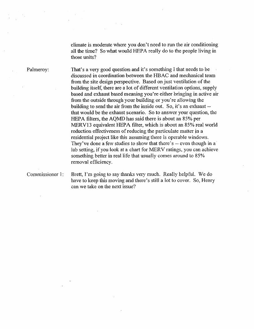
climate is moderate where you don't need to run the air conditioningall the time? So what would HEP A really do to the people living inthose units?
Palmeroy: That's a very good question and it's something I that needs to bediscussed in coordination between the HBAC and mechanical teamfrom the site design perspective. Based on just ventilation of thebuilding itself, there are a lot of different ventilation options, supplybased and exhaust based meaning you're either bringing in active airfrom the outside through your building or you're allowing thebuilding to send the air from the inside out. So, it's an exhaust --that would be the exhaust scenario. So to answer your question, theHEPA filters, the AQMD has said there is about an 85% perMERV13 equivalent HEPA filter, which is about an 85% real worldreduction effectiveness of reducing the particulate matter in aresidential project like this assuming there is operable windows.They've done a few studies to show that there's -- even though in alab setting, if you look at a chart for MERV ratings, you can achievesomething better in real life that usually comes around to 85%removal efficiency.
Commissioner 1: Brett, I'm going to say thanks very much. Really helpful. We dohave to keep this moving and there's still a lot to cover. So, Henrycan we take on the next issue?
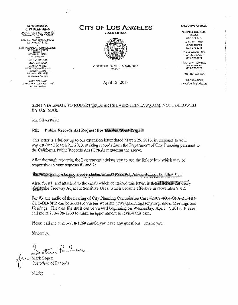
DEPAflrFMENT OfCITY PLANNING
200 N. SPRING STREET, ROOM 525los ANGRES,CA 90012~4801
ANO6262 VAN NUY$ BLVD.,SUITE351
VAN NuYS, CA 91401
CITY PLANNING COMMISSiONWIllIAM ROSCHEN
PRESIDENTREGINA M. FREER
VlCe,.PRESIDtNTSEAN. O. 6UH.TONDI£GO CARDOSOCAMILlAM. ENG
GEORGE HOVAGUlMIANROBERT LESSIN.
DANA M. PERLMANBARBARA ROMERO
JAMES WILlIAMSCOMMISSION IJ(EctmVE ASSlSlANT D
(213) 978-1300
CI1Y OF Los ANGELESCALlFORN~ MICHAEL J. LOGRANDE
DlREClOR(213) 9-78-127l
ALAN BELl, AlepDEPUTY ceecron(213) 978-1272
USA M. WEBBER, AlepOEPUlY OlREdOR(213) 978-1274
EVA YUAN~MCDANlELPEPU1\' PIRECfOR(213) 978-1273
FAX: (213) 978-127:'
ANTON!O R. VILLARA!GOSAMAYOR
April 12, 2013INFORMATION
www,planning,jacity.org
SENT VIA EMAIL [email protected]. NOT FOLLOWEDBYU.S.MAIL
Mr. Silverstein:
This letter is a follow up to our extension letter dated March 29, 2013, in response to yourrequest dated March 21, 2013, seeking records from the Department of City Planning pursuant tothe California Public Records Act (CPRA) regarding the above.
After thorough research, the Department advises you to use the link below which may beresponsive to your requests #1 and 2:
_lI'Mil'lfJ1!!!!!lIl1ioo;lil<lli!ilji)!!iIh~,;swdiesilairqilS~ISIIaIIiRpt.,M\fiW¥N"ti.ce ...ExhibitsA-F. pdf• '",- ~.' ""0' ." •..•. _. '-'·"¥'~'''''·.'''';;"''''"''''''''-'';",''·'·'':':.'~II.'''';{'"" •."""" .. , .",. .. _., .. ", _ , , _'_''"' _'0""",<';, ",. ;.;;,,..',;;;;'.,..(:.~~;;;:'.';,·i:i',\.X':..~.,;':\;.,··:-.', ,..• ;. '••"
Also, for #J, and attached to the email whichcoutainedthisletter.isth_l.fCIl.AI!liI~.;j~!fuh~1or Freeway Adjacent Sensitive Uses, which became effective in November 2012.
For #3, the audio of the hearing of City Planning Commission Case #2008-4604-GPA-ZC-HD-CUB-DB-SPR can be accessed via our website: www.planning.lacity.org, under Meetings andHearings. The case file itself can be viewed beginning on Wednesday, April 17, 2013. Pleasecall me at 213-798- J260 to make an appointment to review this case.
Please call me at 213-97&-1260 should you have any questions. Thank you.
Sincerely,
~~~~MarkLopez. U Custodian of Records
ML:bp
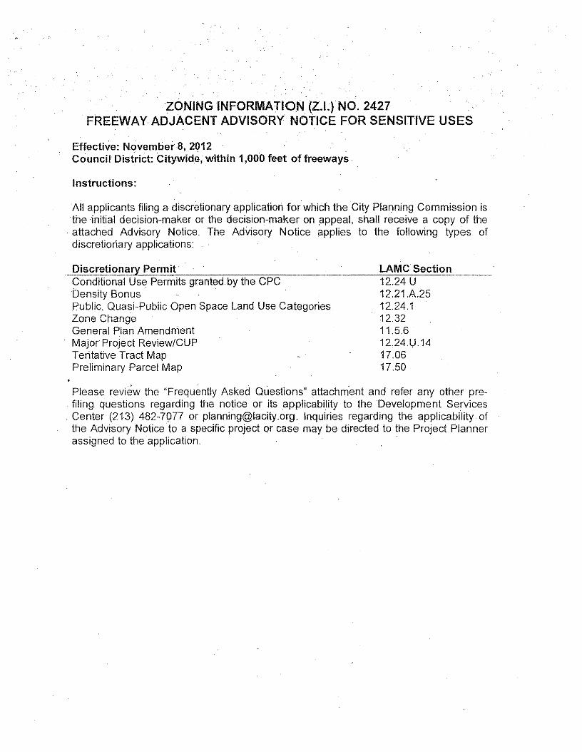
ZONING INFORMATION (Z.l.) NO. 2427FREEWAY ADJACENT ADVISORY NOTICE FOR SENSITIVE USES
Effective: November 8, 2012Council District: Citywide, within 1,000 feet of freeways
Instructions:
All applicants filing a discretionary application forwhich the City Planning Commission isthe initial decision-maker or the decision-maker on appeal, shall receive a copy of theattached Advisory Notice. The Advisory Notice applies to the following types ofdiscretionary applications:
Discretionary Permit LAMe SectionConditional Use Permits granted.by the CPCDensity Bonuspublic, Quasi-Public Open Space Land Use CategoriesZone ChangeGeneral Plan AmendmentMajor Project Review/CUPTentative Tract MapPreliminary Parcel Map
12.24 U12.21A2512.24.112.3211.5.612.24.U.1417.0617.50
Please review the "Frequently Asked Questions" attachment and refer any other pre-. filing questions regarding the notice or its applicability to the Development Services. Center (21.3) 482-7977 or [email protected]. Inquiries regarding the applicability ofthe Advisory Notice to a specific project or case may be directed to the Project Plannerassigned to the application.
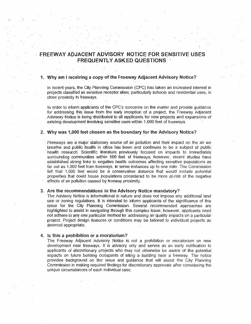
FREEWAY ADJACENT ADVISORY NOTICE FOR SENSITIVE USESFREQUENTLY ASKED QUESTIONS
1. Why am I.rec.eiving a copy of the Freeway Adjacent Advisory Notice?
In recent years, the City Planning Commission (CPC) has taken an increased interest inprojects classified as sensitive receptor sites, particularly schools and residential uses, inclose proximity to freeways.
In order to inform applicants of the CPC's concerns on the matter and provide guidancefor addressing this issue from the early inception of a project, the Freeway Adjacent
. Advisory Notice is being distributed to all applicants for new projects and expansions ofexisting development involving sensitive uses within 1,000 feet of freeways.
2. Why was 1,000 feet chosen as the boundary for the Advisory Notice?
Freeways are a major stationary source of air pollution and their impact on the air webreathe and public health in cities has been and continues to be a subject of public
. health research.· Scientific literature previously focused on impacts to immediatelysurrounding communities within 500 feet of freeways; however, recent studies haveestablished strong links to negative health outcomes affecting sensitive populations asfar out as 1,000 feet from freeways, in some instances up to one mile. The Commissionfelt that 1,000 feet would be a conservative distance that would include potentialproperties that could house populations considered to be more at-risk of the negativeeffects of air pollution caused by freeway proximity,
3. Are the recommendations in the Advisory Notice mandatory?The Advisory Notice is informational in nature and does not impose any additional landuse or zoning regulations, It is intended to inform applicants of the significance of thisissue for the City Planning Commission, Several recommended approaches arehighlighted to assist in navigating through this complex issue; however, applicants neednot adhere to anyone particular method for addressing air quality impacts on a particularproject Project design features or conditions may be tailored to individual projects asdeemed appropriate.
4. Is this a prohibition or a moratorium?The Freeway Adjacent Advisory Notice is not a prohibition or moratorium on newdevelopment near freeways. It is advisory only and serves as an early notification toapplicants of discretionary projects who may not otherwise be aware of the potentialimpacts on future building occupants of siting a building near a freeway. The noticeprovides background on the issue and guidance that will assist the City PlanningCommission in making required findings for discretionary approvals after considering theunique circumstances of each individual case,
ADVISORY NOTICE REGARDING SENSITIVE USES NEAR FREEWAYS
TO: APPLICANTS FOR NEW PROJECTS AND EXPANSIONS OF EXISTINGDEVELOPMENTS INVOLVING SENSITIVE USES WITHIN 1,000 FEET OF FREEWAYS
FROM: THE CITY PLANNING COMMISSION
EFFECTIVE DATE: NOVEMBER 8,2012
CITY PLANNING COMMISSION'S STATEMENT OF CONCERN:The purpose of this notice is to alert applicants to the City Planning Commission's recentconcerns relative to the placement of sensitive uses near freeways. In recent years, the CityPlanning Commission (CPG) has taken an increased interest in projects classified as sensitivereceptor sites, particularly schools and residential uses, in close proximity to freeways.
APPliCABILITY AND INTENT OF THIS NOTICE:This notice serves to advise applicants for discretionary land use requests under the authority ofthe City Planning Commission otthe Commission's concerns. Project design alternatives havebeen identified below. If integrated into the project design, these measures may help to reduceor address impacts and public health risks, and therefore, should be considered.
EiACKGROUND:Review of recent air pollution studies shows a strong link between the chronic exposure ofpopulations to vehicle exhaust and particulate matter from roads and freeways and elevated riskof adverse health impacts, particularly in sensitive populations such as young children and olderadults. Areas located within 500 feet of a freeway' are known to experience the greatest.concentrations of fine and ultrafine particulate matter (PM), a pollutant implicated in asthma andother health conditions. In 2003, the California Legislature enacted SB 352, which precludes thesiting of public schools within 500 feet of a freeway, unless it can be shown that any significanthealth risk can be mitigated.
On January 26, 2009 the City Planning Department presented a report to the City PlanningCommission in response an earlier Commission request for Department staff to outlinerecommendations addressing.the issue of public health and freeway proximity. In response to asubsequent request on November 11, 2011, the Planning Department submitted a report inJanuary 2012 outlining potential mitigation measures for housing projects in proximity tofreeways. On July 12, 2012 the CPC directed staff to prepare an advisory notice notifyingapplicants of the Commission's interest and careful consideration of public health implications intheir review of freeway-adjacent projects.
DEFINITION OF SENSITIVE USES:South Coast AQMD's Guidance Document for Addressing Air Quality Issues 111 C,eneral Plansand Local Planninq, defines a sensitive receptor as a person in the population who isparticularly susceptible to health effects due to exposure to an air contaminant
1 Freeway, as defined in the Caltrans Highway Design Manual- Chapter6Q. pg. 60~2' (May 7, 2012}"Freeway-~A divided arterial highway with full control of access and with grade separations. at intersections."
The following are land uses (sensitive sites) where sensitive receptors are typically located:
• residences• schools, playgrounds and childcare centers• long-term health care facilities• rehabilitation centers• adult day care/convalescent centers• hospitals• retirement homes
EXISTING ADOPTED POLICIES:The City's General Plan already contains adopted policies addressing health-based risks andoutcomes. Below are a few that are directly related to the placement of sensitive uses nearfreeways.
Air Quality Element Policy 4.3.1: Revise the City's General Plan/Community Plans toensure that new or related sensitive receptors 'are located to minimize significant healthrisks posed by air pollution sources.
Housing Element Policy 4.1.9: Whenever possible, assure adequate health-basedbuffer zones between new residential and emitting industries.
Housing Element Policy 2.1.2: Establish standards that enhance health outcomes.
A Finding of consistency with the existing policies in the City's adopted General Plan will beweighed in the Commission's consideration of each project, as set forth in LAMC Section 12.32C.3 (Land Use Legislative Actions):
"Procedure for Applications. (Amended by Ord. No. 173,754, Elf. 3/5/01.) Once acomplete application is received, as determined.by the Director, the Commission shall hold apublic hearing or direct a Hearing Officer to hold the hearing. If a Hearing Officer holds thepublic hearing, he or she shall make a recommendation for action on the application. Thatrecommendation shall then be heard bv the Planning Commission. which may hold a publichearing and shall make a report and recommendation regarding the relation of the proposedland use ordinance to the General Plan and whether adoption of the proposed land useordinance will be in conformity with public neceSSity, convenience, general welfare and goodzoning practice."
STANDARD CONDITIONS AND DESIGN ALTERNATIVES TO CONSIDER:Currently, there is no requirement to provide mitigation measures to address diminishedambient air quality in projects that are developed "by-right" - that is, without discretionaryapproval. However, with projects that require discretionary approval, the City has anopportunity to impose conditions to lessen the effects of air pollution exposure.
Incorporating the following standard conditions can further enable the Commission to evaluatethe merits of a project in order to make the required Findings.
Though impact analysis of the air environment on new sensitive receptors in proximity totransportation facilities is not required by CEQA, in the interest of providing information to the
public, and creating healthy communities, the following measures should be taken underadvisement.
1. Conduct Site~Specific Health Risk AssessmentThe City Planning Commission advises that applicants of projects requiring an EnvironmentalImpact Report, located in proximity of a freeway, and contemplating residential units, schools,and other sensitive uses, perform a Health Risk Assessment as a supplemental technical report.The Health Risk Assessment can provide valuab Ie information to applicants in understandingany potential health risks associated with a project and will enable applicants to make informeddecisions about site planning and design up-front, from the earliest stages of a project. A HealthRisk Assessment is prepared by a qualified consultant who can: identify air quality levelsparticular to a specific project site based upon variables such as topography and prevailing windpatterns, for example; disclose potential health risks to future residents or occupants that mayresult from the project; and offer best practices to improve health outcomes, based uponemerging research and in accordance with policies of the South Coast Air Quality ManagementDistrict (SCAQMD).
2. Improve Indoor Air Quality with MERV-Rated or HEPA Air Filtration EquipmentAs a condition of approval, the City Planning Commission may, at its discretion, impose arequirement that any project proposing sensitive land uses (as defined above) within 1,000 feetof a freeway shall be required to install and maintain air filters meeting or exceeding theASHRAE Standard ..52.2 Minimum Efficiency Reporting Value (MERV) of 11 or higher.
3. Further Reducing Exposure through Project Design
Building Orientation. Locateopen space areas (courtyards, patios, balconies, etc) as farfrom the freeway sources as possible;
Screening with Vegetation. Plant vegetation between receptors and freeway sources.Mature tree species such as redwood, live oak, and deodar trees have found to removeparticulate matter'.
Reduce Operable Windows. Consider designing a site plan that requires minimaloperable windows on freeway-facing frontages.
FUTURE STEPS:The City may go further to address this issue in New Community Plans, as part of the newHealth and Well ness Chapter of the General Plan Framework, and possibly throughdevelopment standards in the Comprehensive Zoning Code Revision. In the interim thisimportant issue will continue to be brought to the fore, and alternatives and conditions suitableto each individual project considered.
2. Cahill. Thomas A. 2008. Removal Rates of Particulate Matter onto Vegetation as a Function of Particle SizeBreathe California Sacramento-Emigrant Trails
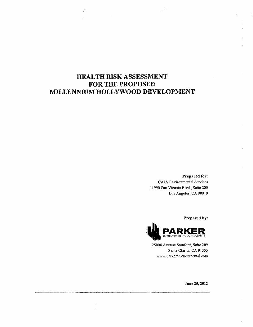
HEALTH RISK ASSESSMENTFOR THE PROPOSED
MILLENNIUM HOLLYWOOD DEVELOPMENT
Prepared for:CAJA Environmental Services
11990 San Vicente Blvd., Suite 200Los Angeles, CA 90019
Prepared by:
~ eaMBA~N~TB25000 Avenue Stanford, Suite 209
Santa Clarita, CA 91355www.parkerenvironmental.com
June 25, 2012
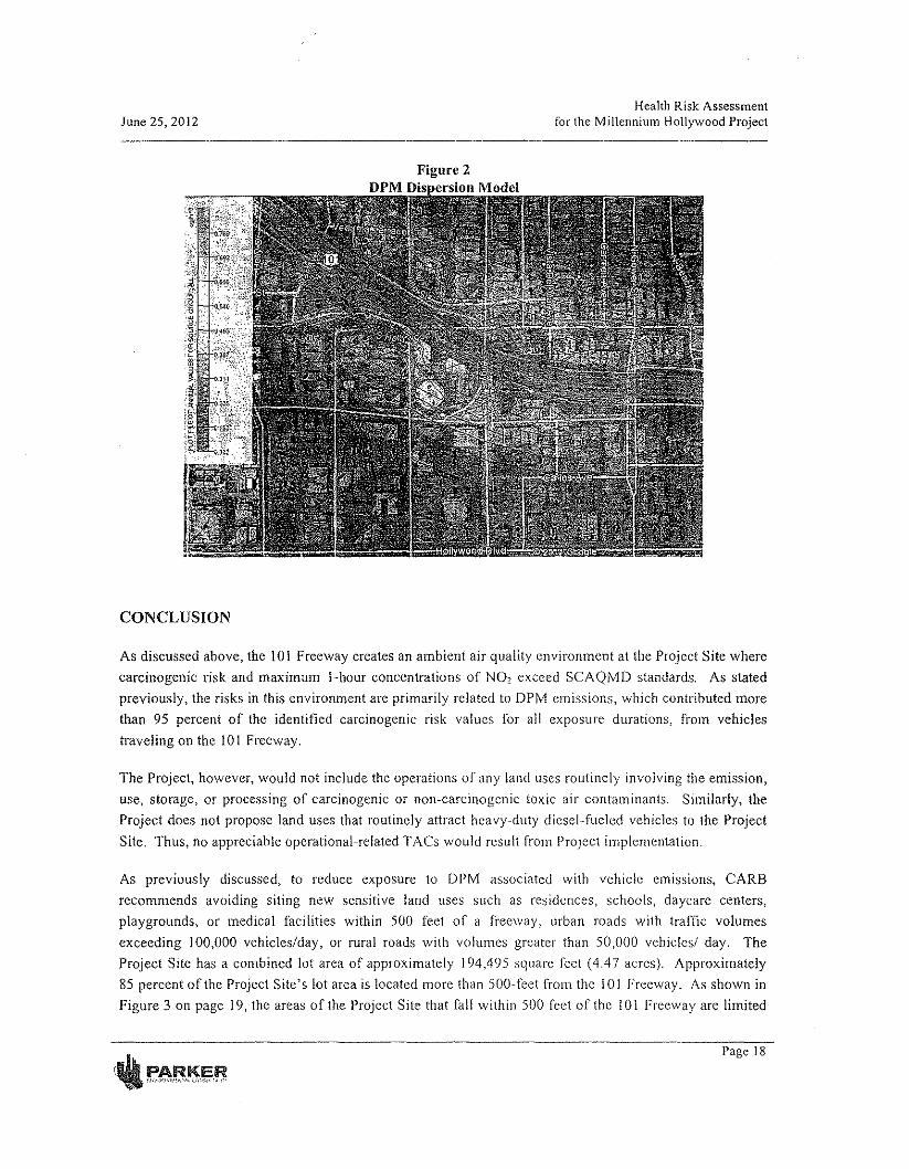
June 25, 2012Health Risk Assessment
for the Millennium Hollywood Project
Figure 2DPM Dis ersion Model
CONCLUSION
As discussed above, the 101 Freeway creates an ambient air quality environment at the Project Site wherecarcinogenic risk and maximum l-hour concentrations of NO, exceed SCAQMD standards. As statedpreviously, the risks in this environment are primarily related to DPM emissions, which contributed morethan 95 percent of the identified carcinogenic risk values for all exposure durations, from vehiclestraveling on the 101 Freeway.
The Project, however, would not include the operations of any land uses routinely involving the emission,usc, storage, or processing of carcinogenic or non-carcinogenic toxic air contaminants. Similarly, theProject does not propose land uses that routinely attract heavy-duty diesel-fueled vehicles to thc ProjectSite. Thus, no appreciable operational-related TACs would result from Project implementation.
As previously discussed, to reduce exposure to DPM associated with vehicle emissions, CARBrecommends avoiding siting new sensitive land uses such as residences, schools, daycarc centers,playgrounds, or medical facilities within 500 feet of a freeway, urban roads with traffic volumesexceeding 100,000 vehicles/day, or rural roads with volumes greater than 50,000 vehicles! day. TheProject Site has a combined lot area of approximately 194,495 square feet (4.4 7 acres). Approximately85 percent of the Project Site's lot area is located more than 500-fcet from the 101 Freeway. As shown inFigure 3 on page 19, the areas of the Project Site that fall within 500 feet of the 101 Freeway are limited
Page 18
June 25, 2012Health Risk Assessment
for the Millennium Hollywood Project
to areas within the East Site and include a portion of the Capitol Records Complex and a separateapproximate 2,800 square-foot triangular-shaped area within northeast corner of the East Site. TheCapitol Records Complex is currently developed with commercial office land uses, and is proposed to beretained as office uses under the proposed development. As such, no residential or other sensitive landuses would be located within this area on the East Site as part of the Project. The approximate 2,800square-foot triangular-shaped area on the northeast corner of the East Site does fall within the proposedpodium footprint of the proposed structure, and as such could potentially be developed with residential orother sensitive land uses. This area represents approximately 1.4 percent of the Project Site's total lotarea. Thus, approximately 98.6% of the Project's proposed development area would be located fartherthan 500 feet from the 101 Freeway. Accordingly, the Project would be substantially consistent withCARB's siting recommendations. As discussed previously in this report, the Project Site is within theHollywood Community Plan Area, for which the City recently completed a Final EIR for the HollywoodCommunity Plan Update. CARB commented on the City's EIR and stated that "lilf the lead agencydetermines that a mitigation measure requiring a 500 foot buffer between the 101 Freeway and sensitiveland uses is infeasible then the potential health risks impacts to these receptors should be quantified.""Accordingly, this BRA has been prepared to quantify health risks at the Project Site. Based on thefindings of air pollutant concentrations predicted for the Project Site, thc Project's sensitive land useswould be exposed to unhealthy outdoor air quality.
To minimize adverse health effects associated with diminished ambient air pollution levels in the projectvicinity, the Department of City Planning recommends that projects incorporate air filtration systems withfilters meeting or exceeding the ASHRAE 52.2 Minimum Efficiency Reporting Value (MERV) of 13, tothe satisfaction of the Department of Building and Safety. While MERV 13 filters would be effective inimproving indoor air quality as compared to lower efficiency filters, data published by the SCAQMDindicates that filters with this rating typically achieve a dust spot efficiency of approximately 85% forPM,o and PM,.,. Yet, DPM (the primalY TAC of COncern at the Project Site) is classified as ultrafineparticulate (Icss than PMo,) and thus the indoor air filtration would have no measureable affect atlowering the indoor carcinogenic risk at the Project Site. Thus, no feasible miti~ation is available toreduce carcinogenic risk impacts or exposure impacts to elevated NO, at the Project Site to levels belowthe thresholds of significance.
Certain strategies may nevertheless improve outdoor and indoor air quality at the Project Site. Thesestrategies include:
Attempting to locate open space areas, such as courtyards, patios, balconies, as far from thefreeway sources as possible;
Considering vegetation plantings between sensitive receptor uses and freeway sources;
Considering site plan design that limits operable windows and building frontages to the freeway;
20 CARS Comment Letter on Hollywood Community Plan Update DraJi IilR, Vi, June 1, 2011.
Page
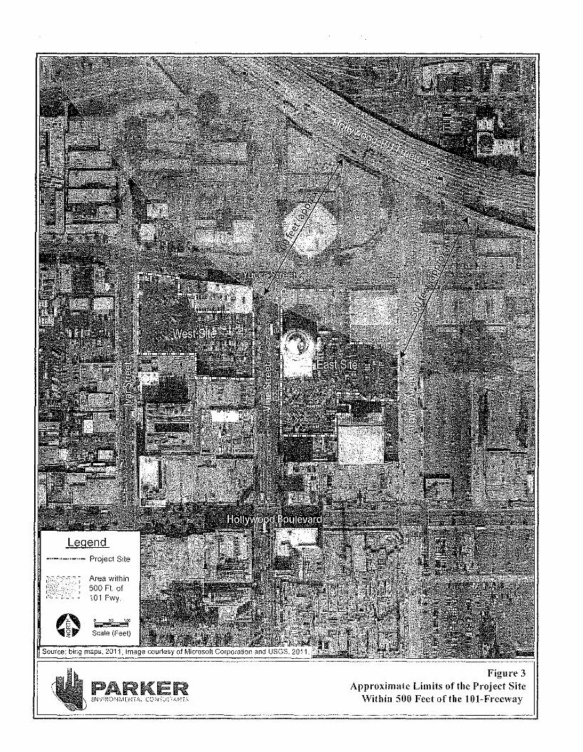
Area within500 Ft. of101 Fwy.
50 -..l,'fScale (Feet)
"Source: bing maps. 2011. Image courtesy of Microsoft Corporation and USGS. 2011.
PARKERENV:RO:\lMEI~Tr,_,_ CO'\i-;:~):rAH'iS
Figure 3Approximate Limits of the Project Site
Within 500 Feet of the IOI-Freeway
June 25, 2012Health Risk Assessment
for the Millennium Hollywood Project
• Considering options for mechanical and ventilation systems, such as supply or exhaust basedsystems, that enhance air quality;
• Considering that, if a supply-based system (i.e., actively bringing outside air through intakeduets) is used, it locates intakes as far from the freeway sources as possible.
In summary, the Project Site is located in an existing ambient air quality environment that exceedsstandards due to heavy traffic on the 101 Freeway. This HRA has quantified and disclosed the potentialair quality health risks associated with the Project Site location consistent with the recommendations ofCARB and the Department of City Planning's recommended approach for projects within the HollywoodCommunity Plan Area that are within 500 feet of the 101 Freeway.
, ,
•
•
21
ESTABLISHED IN 1812 SEPTEMBER 9, 2004 VOL.351 NO.ll
The NEW ENGLANDJOURNAL of MEDICINE
The Effect of Air Pollution on Lung Developmentfrom 10 to 18 Years of Age
w.James Gauderman, Ph,D" Edward Avol, M.S., Frank Gilliland, M.D" Ph.D., Hita Vora, M.S"Duncan Thomas, Ph.D., Kiros Berhane, Ph.D., Rob McConnell, M.D., Nino Kuenzli, M.D., Fred Lurmann, M.S.,
Edward Rappaport, M.S" Helene Margolis, Ph.D" David Bates, M,D., and John Peters, M.D.
ABSTRACT
BACKGROUND
Whether exposure to air pollution adversely affects the growth oflung function duringthe period of rapid lung development that occurs between the ages ofl0 and 18 years isunknown.
From the Department of Preventive Medi-cine, University of Southern California, LosAngeles (W.J.G., EA, F.G., H.V., D.T., K.B.,R.M., N.K., E,R.,J.P.); Sonoma Technology,Petaluma, Calif. (F.L); Air Resources Board,
.State of Calffomt a, Sacramento (H.M.); andthe University of British Columbia, Vancou-ver, B.c., Canada (D.B.). Address reprintrequests to Dr. Gauderman at the Depart.ment of Preventive Medicine, Universityof Southern California, 1540 Alcazar St.,Suite 220, Los Angeles, CA 90089, or [email protected].
METHODS
In this prospective study, we recruited 1759 children (average age, 10 years) from schoolsin 12 southern California communities and measured lung function annually for eightyears. The rate of attrition was approximately 10 percent per year. The communitiesrepresented a wide range of ambient exposures to ozone, acid vapor, nitrogen dioxide,and particulate matter. Linear regression was used to examine the relationship of airpollution to the forced expiratory volume in one second (FEV1) and other spirometricmeasures. N EnglJ Med 2004;351:1057·67.
Copyrighl © 2004 MQ;sochufr.U~ M~dical Sociely.
RESULTS
Over the eight-year period, deficits in the growth of FEV1were associated with expo-sure to nitrogen dioxide (P=O.005), acid vapor (P=O.004), particulate matter with anaerodynamic diameter of less than 2.5 urn (PM,.,) (P=O.04), and elemental carbon(P=O.007), even after adjustment for several potential confounders and effect modifi-ers. Associations were also observed for other spirometric measures. Exposure to pol-lutants was associated with clinically and statistically significant deficits in the FEV1at-rained at the age of 18 years, For example, the estimated proportion of lS-year-oldsubjects with a low FEV1(defined as a ratio of observed to expected FEV1ofless than 80percent) was 4.9 times as great at the highest level of exposure to PM2.5 as at the lowestlevel of exposure (7.9 percentvs. 1.6 percent, P=0.002).
CONCLUSIONS
The results of this study indicate that current levels of air pollution have chronic, adverseeffects on lung development in children from the age ofl0 to 18 years, leading to clin-ically significant deficits in attained FEV1as children reach adulthood.
N ENGLJ MED 351;11 WWW.NEJM.ORG SEPHMSER 9. 2004 10$7
The New England Journal of MedicineDownloaded from nejm.org on AprilS, 2011. For personal use only. No other uses without permission.
Copyright © 2004 Massachusetts Medical Society. All rights reserved.
1058
The NEW ENGLAND JOURNAL <!fMEDICINE
HERE IS MOUNTING EVIDENCE THATair pollution has chronic, adverse effectson pulmonary development in children.
Longitudinal studies conducted in Burope"? andthe United States4~6have demonstrated that expo-sure to air pollution is associated with reductions inthe growth oflung function, strengthening earlierevidence7-12 based on cross-sectional data. How-ever, previous longitudinal studies have followedyoung children for relatively short periods (two tofour years), leaving unresolved the question ofwhether the effects of air pollution persist from ad-olescence into adulthood. The Children's HealthStudy" enrolled children from 12 southern Cali-fornia communities representinga wide range of ex-posures to ambient air pollution. We documentedthe children'S respiratory growth from the ages of10 to 18 years. Over this eight-year period, childrenhave substantial increases in lung function. Bytheage of 18 years, girls' lungs have nearly matured,and the growth in lung function in boys has slowedconsiderably, as compared with the rate in earlieradolescence.l" We analyzed the association be-tween long-term exposure to ambient air pollutionand the growth in lung function over the eight-yearperiod from the ages of10 to 18 years. We also ex-amined whether any observed effect of air pollutionon this eight-year growth period results in clinicallysignificant deficits in attained lung function at theage of18 years.
METHODS
STUDY SUBJECTS
In 1993, the Children's Health Study recruited 1759fourth-grade children (average age, 10 years) fromelementary schools in 12 southern California corn-munities as partof an investigation of the long-termeffects of air pollution on children's respiratoryhealth.6,12,13 Data on pulmonary function were ob-tained by trained field technicians, who traveled tostudy schools annually from the spring of 1993through the spring 00001 to perform maximal-effort spirometric testing of the children. Details ofthe testing protocol have been published previous-ly.12 We analyzed three measures of pulmonaryfunction: forced vital capacity (FVC), forced expira-toryvolume in the first second (FEV1), and maximalmidexpiratory flow rate (MMEF). Pulmonary-func-tion tests were not performed on any child who wasabsent from school on the day of testing, but such a
child was still eligible for testing in subsequentyears. Children who moved away from their recruit-ment communitywere classified as lost to follow-upand were not tested further. From the initial sampleof the 1759 children in 1993, the number of chil-dren available for follow-up was 1414 in 1995, 1252in 1997,1031 in 1999, and 747 in 2001, reflectingthe attrition of approximately 10 percent of subjectsper year.
Abaseline questionnaire, completed at study en-try by each child's parents or legal guardian, wasused to obtain information on the children's char-acteristics, including race, presence or absence ofHispanic ethnic background, level of parental edu-cation, presence or absence of a history of asthmadiagnosed by a doctor, exposure to maternal smok-ing in utero, and household exposure to gas stoves,pets, and environmental tobacco smoke. Questionsadministered at the time of annual pulmonary-func-tion testing were used to update information onasthma status, personal smoking status, and expo-sure to environmental tobacco smoke. The distribu-tion of base line characteristics of all study subjectsand of two subgroups defined according to thelength offollow-up (all eight years or less than eightyears) is shown in the Supplementary Appendix(available with the full text of this article at www,nejm.org). The length of follow-up was significant-ly associated with factors related to the mobility ofthe population, including race, presence or absenceof Hispanic ethnic background, presence or ab-sence of exposure to environmental tobacco smoke,and parents' level of education. However, the lengthoffollow-up was not significantly associated withbaseline lung function or the level of exposure toair pollution, suggesting that the loss to follow-updid not differ with respect to the primary variablesofinterest.
The study protocol was approved by the institu-tional review board for human studies at the Uni-versity of Southern California, and written informedconsent was provided by a parent or legal guardianfor all study subjects. We did not obtain assent fromminor children, since this was not standard practicewhen the study was initiated.
AIR-POllUTION DATA
Air-pollution-monitoring stations were establishedin each of the 12 study communities and providedcontinuous data, beginning in 1994. Each stationmeasured average hourly levels of ozone, nitrogen
N £Net J MEO 351;11 WWW.NEjM.ORC SEPTEMBER 9, 2004
The New England Journal of MedicineDownloaded from nejm.org on April 5, 2011. For personal use only. No other uses without permission.
Copyright © 2004 Massachusetts Medical Society. An rights reserved.
EFFECT OF AIR POLLUTION ON LUNG DEVELOPMENT IN CHILDREN
dioxide, and particulate matter with an aerodynarn-ic diameter ofless than 10 urn (PM10). Stations alsocollected two-week integrated-filter samples formeasuring add vapor and the mass and chemicalmakeup of particulate matter with an aerodynamicdiameterofless than 2.5 pm (PM2:.5)' Acid vapor in-eluded both inorganic acids (nitric-and hydrochlo-ric) and organic adds (formic and acetic). For sta-tistical analysis, we used total acid, computed as thesum of nitric, formic, and acetic acid levels. Hydro-chloric acid was excluded from this sum, since lev-els were very low and close to the limit of detection.In addition to measuring PM2.S, we determined thelevels of elemental carbon and organic carbon,using method 5040 of the National Institute for Oc-cupational Safety and Health.P We computed an-nual averages on the basis of average levels in a24-hour period in the case ofPM10 and nitrogen di-oxide, and a two-week period in the case ofPM2.5'elemental carbon, organic carbon, and acid vapor.For ozone, we computed the annual average of thelevels obtained from 10 a.m. to 6 p.m. (the eight-hour daytime average) and of the one-hour maximallevels. We also calculated long-term mean pollutantlevels (from 1994 through 2000) for use inthe statis-tical analysis of the lung-function outcomes.
STATISTICAL ANALYSIS
The outcome data consisted of the results of 5454pulmonary-function tests of876 girls and 5300 testsof883 boys over the eight-year period. We adopteda two-stage regression approach to relate the longi-tudinal pulmonary-function data for each child tothe average air-pollution levels in each study com-munity.
The first-stage model was a regression of eachpulmonary-function measure (values were log-transformed) on age to obtain separate, community-specific average growth curves for girls and boys.To account for the growth pattern during this peri-od, we used a linear spline model'" that consisted offour straight lines over the age intervals of youngerthan 12 years, 12 to 14 years, 14 to 16 years, and old-er than 16 years, constrained to be connected at thethree "knot" points. The model included adjust-rnents for log values for height; body-mass index(the weight in kilograms divided by the square ofthe height in meters); the square of the body-massindex; race; the presence or absence of Hispanicethnic background, doctor-diagnosed asthma, anytobacco smoking by the child in the precedingyear,
exposure to environmental tobacco smoke, and ex-ercise or respiratory tract illness on the day of thetest; and indicator variables for the field technicianand the spirometer. In addition to these covariates,random effects were included to account for themultiple measurements contributed by each sub-ject. An analysis of residual values confirmed thatthe assumptions of the model had been satisfied.The first-stage model was used to estimate the meanand variance of the growth inlung function over theeight-year period in each of the 12 communities,separately for girls and boys.
The second-stage model was a linear regressionof the 24 sex- and community-specific estimates ofthe growth in lung function over the eight-year pe-riod on the corresponding average levelsof each airpollutant in each community. Inverses of the first-stage variances were incorporated as weights. and acommunity-specific random effectwas included toaccount for residual variation between communi-ties. A sex-by-pollutant interaction was included inthe model to evaluate whether there was a differencein the effect of a given pollutant between the sexes,and when this value was nonsignificant, the modelwas refitted to estimate the sex-averaged effecrofthepollutant. Pollutanteffecrs are reported as the differ-ence in the growth in lung function over the eight-year period from the least to the most pollutedcomm unity, with negative differences indicative ofgrowth deficits with increasing exposure. We alsoconsidered two-pollutant models obtained by si-multaneously regressing the growth in lung func-tion over the eight-year period on pairs ofpollutants.
In addition to examining the growth in lungfunction over the eight-year period, we analyzed theFEV1measurements obtained in 746 subjects dur-ing the last year of follow-up (average age, 17.9years) to determine whether exposure to air pollu-tion was associated with clinically significant defi-cits in attained FEV1•We defined a low FEV1as anattained FEV1below 80 percent of the predicted val-ue, a criterion commonly used in clinical settings toidentify persons who are at increased risk for ad-verse respiratory conditions. To determine the pre-dicted FEV11 we first fitted a regression model forobserved FEV1 (using log-transformed values) withthe following predictors: log-transformed height,body-mass index, the square of the body-mass in-dex, sex, race or ethnic group, asthma status, fieldtechnician, and interactions between sex and log-transformed height, sex and asthma, and sex and
N eNGLJ MEO 351;11 WWW.NEJM.ORG SEPTEMBER 9. 2004
The New England Journal of MedicineDownloaded from nejm.org on April 5, 2011. For personal use only. No other uses without permission.
Copyright © 2004 Massachusetts Medical Society. All rights reserved.
1059
The NEW ENGLAN D JOURNAL ojMEDICINE
race or ethnic group. This model explained 71 per-cent of the variance in the attained FEV1level. Foreach subject, we then computed the predicted FEV,from the model and considered subjects to have alow FEY, if the ratio of observed to predicted FEV,was less than 80 percent. Linearregression was thenused to examine the correlation between the corn-munity-speciflc proportion of subjects with a lowFEY1and the average level of each pollutant from1994 through 2000. This model included a commu-nity-specific random effect to account for residualvariation. Regression procedures in SASsoftvvare16
were used to fit all models. Associations denoted asstatistically significant were those that yielded aP value ofless than 0.05, assuming a two-sided al-ternative hypothesis.
RESULTS
From 1994 through 2000, there Was substantialvariation in the average levels of study pollutantsacross the 12communiries, with relatively Iittleyear-to-year variation in the annual levels within eachcommunity (Fig. 1). From 1994 through 2000, the
80
I 70
"40
ss30zs20
1510
5
o,~~~~~~~~~~~~~~AL AT LM LB RV UP
14
80
70
'050
40
30
20
10
O'.uc":'-"'AT"-"L"'-' ...J1A'7--"LN"C-'L7:M'-C'LB~M7!L-'-=RV7-"5'"O-5I!"M'-"U"'P-
12
10
35
,
2
O~~~la~L£~~La~~~ill-~~Al AT lE LA LN lM LB Ml RV SM UP
Community
AL AT LA IN LM LB ML RV SD SM UP
I.,
1.4
AL AT LE LA LN lM LB Ml RV SD SM UP
Community
Figure 1. Mean (+SD} Annual Average levels of Pollutants from 1994 through 2000 in the 12 Study Communities in Southern California.ALdenotes Alpine, AT Atascadero, LE lake Elsinore, LA Lake Arrowhead~'LN Lancaster, LM Lompoc, LB long Beach. ML Mira Lorna, RVRiverside, SD San Dimas, SM Santa Maria, and UP Upland. 03 denotes ozone, NOz nitrogen dioxide, and PMlOand PMz.s particulate matterwith an aerodynamic diameter of less than 10 /Amand less than 2.5 Jim, respectively.
1060 N ~NGLJ M~D 351:11 WWW.NEJM.ORG SEPHM6ER 9. 2004
The New England Journal of MedicineDownloaded from nejm.org on April 5, 2011. For personal use only. No other uses without permission.
Copyright © 2004 Massachusetts Medical Society. All rights reserved.
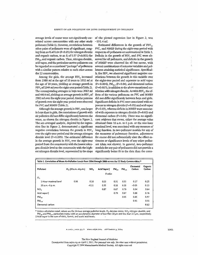
EFFECT OF AIR POLLUTION ON LUNG DEVELOPMENT IN CHILDREN
average levels of ozone were not significantly cor-related across communities with any other studypollutant (Table 1). However, correlations betweenother pairs of pollutants were all significant, rang-ingfrom an RofO.64 (P<O.OS)for nitrogen dioxideand organic carbon, to an RofO.97 (P<O.OOl)forPM10 and organic carbon. Thus, nitrogen dioxide,acid vapor, and the particulate-matter pollutants canbe regarded as a correlated "package" of pollutantswith a similar pattern relative to each other acrossthe 12 communities.
Among the girls, the average FEV1 increasedfrom 1988 ml at the age oflO years to 3332 ml atthe age of 18 years, yielding all average growth inFEV1of1344 ml over the eight-year period (Table 2).The corresponding averages in boys were 2082 mIand 4464 ml, yielding an average growth in FEV1of2382 ml over the eight-year period. Similar'patternsof growth over the eight-year period were observedfor FVCand MMEF (Table 2).
Although the average growth in FEV1was largerin boys than in girls, the correlations of growth withair pollution did not differ significantly between thesexes, as shown for nitrogen dioxide in Figure 2.The sex-averaged analysis, depicted by the regres-sion line in Figure 2, demonstrated a significantnegative correlation between the growth in FEV1
over the eight-year period and the average nitrogendioxide level (p=o.OOS). The estimated differencein the average growth in FEVlover the' eight-yearperiod from the community with the lowest nitro-gen dioxide level to the community with the high-est nitrogen dioxide level, represented by the slope
of the plotted regression line in Figure 2, was-101.4 ml.
Estimated differences in the growth of FEV1,
FVC, and MMEF during the eight-year period withrespect to all pollutants are summarized in Table 3.Deficits in the growth of FEV1and FVC were ob-served for all pollutants, and deficits in the growthof MMEF were observed for all but ozone, withseveral combinations of outcome variables and pol-lutants attaining statistical significance. Specifical-ly, for FEV1 we observed significant negative cor-relations between the growth in this variable overthe eight-year period and exposure to acid vapor(P=O.004), PM,., (P=O.04), and elemental carbon(P=O.007), inaddition to the above-mentioned cor-relation with nitrogen dioxide. As with FEV1, the ef-fects of the various pollutants on FVC and MMEFdid not differ significantly between boys and girls.Significant deficits in FVCwere associated with ex-posureto nitrogen dioxide (p=o.OS) and acid vapor(P=O.03), whereas deficits in MMEF were associat-ed with exposure to nitrogen dioxide (P=O.02) andelemental carbon (P=O.04). There was no signifi-cant evidence that ozone, either the average valueobtained from 10 a.m, to 6 p.m. or the one-hourmaximal level, was associated with any measure oflung function. In two-pollutant models for any ofthe measures of pulmonary function, adjustmentfor ozone did not substantially alter the effect es-timates or significance levels of any other pollut-ant (data not shown). In general, two-pollutantmodels for any pairofpollutants did not provide asignificantly better fit to the data than the corre-
Elemental OrganicPollutant o, (10 a.m.-6 p.m.) NO, AcidVapor'j' PM10 PM2..~ Carbon Carbon
R value
0,l-Hour maximal level 0.9S 0.10 0.53 0.31 0.33 0.17 0.25
10 a.m.-6 p.m. -0.11 0.35 O.lS 0.18 -0.03 0.13
NO, 0.87 0.67 0.79 0.94 0.64
Add vapor] 0.79 0.87 0.88 0.76
PMlO 0.95 0.85 0.97
PM2-s 0.91 0.91
Elemental carbon 0.82
Table 1.Correlation of Mean Air-Pollution Levels from 1994 through 2000 across the 12 Study Communities.*
.,. Unless otherwise noted, values are the 24-hour average pollution levels. 03 denotes ozone. N02 nitrogen dioxide, andPM10 and PM2•5 particulate matter with an aerodynamic diameter ofless than 10 pm and less than 2.5 pm, respectively.
t Add vapor is the sum of nitric, formic, and acetic acid levels.
N ~NGL J MED 351;11 WWW.NEJM.ORG SEPTEMBER 9, 2004
The New England Journal of MedicineDownloaded from neim.org Oil April S, 2011. For personal use only. No other uses without permission.
Copyright © 2004 Massachusetts Medical Society. All rights reserved,
1061
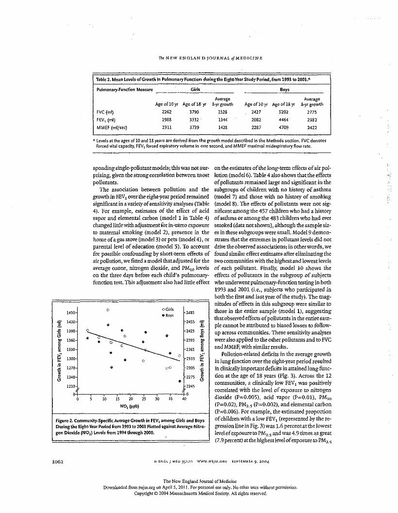
The NEW ENGLAN D JOURNAL GfMEDICIN E
Boys
Table 2. Mean levels of Growth in Pulmonary Function duringthe Eight-Year Study Period, from 1993 to 2001.*
Putmonery-Functicn Measure G:::i""I"s _
Age of10yr
2262
1988
2311
Age of18 yr
3790
3332 .
3739
FVC(ml)
FEV1 (ml)
MMEF (ml/sec)
AverageS-yr growth
1528
1344
1428
Age of IS yr
520244644709
Averageg-yr growth
277523822422
Age oflOyr
242720822287
* Levels at the ages of 10 and 18 years are derived from the growth model described in the Methods section. FVC denotesforced vital capacity, FEVl forced expiratory volume in one second, and MMEF maximal midexpiratory flow rate.
sponding single-polluranrmodels: this was not sur-prising, given the strong correlation between mostpollutants.
The association between pollution and thegrowth in FEVlover the eight-year period remainedsignificant in a variety of sensitivity analyses (Table4). For example, estimates of the effect of addvapor and elemental carbon (model 1 in Table 4)changed little with adjustment for In-utero exposureto maternal smoking (model 2), presence in thehome of a gas stove (model 3) or pets (model 4) , orparental level of education (model 5). To accountfor possible confounding by short-term effects ofair pollution, we fitted a model that adjusted for theaverage ozone, nitrogen dioxide, and PMlO levelson the three days before each child's pulmonary-function test. This adjustment also had little effect
0 OGirls1450 • Boys 2485
"" 1420 2455 "".§. • .§.• 1390
~
2425 •G t'tl CO. =ee 1360 2395 ""c • Q • c
0 0 0E 1330 2365 E• •Gf • • Gf0u, 1300 • 0 2335 ~.s • 00 .5~ 1270 2305 ~~ 1240 2275 ~o • o
1210 2245or fo, , , , , ,0 10 15 20 25 30 35 40
N02 (ppb)
Figure 2. Community-Specific Average Growth in FEVl among Girls and BoysDurlngthe Eight-Year Period from 1993 to 2001 Plotted against Average Nlrrc-gen Dioxide (N02) levels from 1994 through 2000.
1062
on the estimates of the long-term effects of air pol-lution (model 6). Table 4 also shows that the effectsof pollutants remained large and significant in thesubgroups of children with no history of asthma(model 7) and those with no history of smoking(model 8). The effects of pollutants were not sig-nificant among the 457 children who had a historyof asthma or among the 483 children who had eversmoked (data not shown), although the sample siz-es in these subgroups were small. Model 9 demon-strates that the extremes in pollutant levels did notdrive the observed associations; in other words, wefound similar effect estimates after eliminating thetwo communities with the highest and lowestlevelsof each pollutant. Finally, model 10 shows theeffects of pollutants in the subgroup of subjectswho underwent pulmonary-function testing in both1993 and 2001 (i.e., subjects who participated inboth 'the first and last year of the study). The mag-nitudes of effects in this subgroup were similar tothose in the entire sample (model 1), suggestingthat observed effects of pollutants in the entire sam-ple cannot be atttibuted to biased losses to follow-up across communities. These sensitivity analyseswere also applied to the other pollutants and to FVCand MMEF,with similar results.
Pollution-related deficits in the average growthin lung function over the eight-year period resultedin clinically important deficits in attained lung func-tion at the age of 18 years (Fig. 3). Across the 12communities, a clinically low FEV1 was positivelycorrelated with the level of exposure to nitrogendioxide (P=0.005), acid vapor (P=0.01), PMlO
(P=0.02), PM,.5 (P=0.002), and elemental carbon(P=0.006). For example, the estimated proportionof children with a low FEV1 (represented by the re-gression line in Fig. 3) was 1.6 percentatthe lowestlevelof exposure to PM2S and was 4.9 times as great(7.9 percent) at the highest levelof exposure to PM,.5
N ENGL) MED 351;11 WWW.NEJM.ORG SEPTEMBER 9. 2004
The New England Journal of MedicineDownloaded from nejm.org on AprilS, 201 I. For persona} use only. No other uses without permission.
Copyright © 2004 Massachusetts Medical Society. All rights reserved.
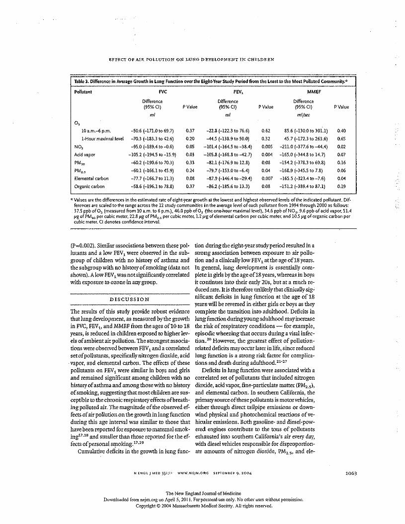
EFFECT OF AIR POLLUTION ON LUNG DEVELOPMENT IN CHILDREN
Table 3. Difference in Average Growth in Lung Function overthe Eight-Year Study Period from the least to the Most Polluted Community.*
Pollutant FVC FEV, MMEF
Difference Difference Difference(95% CI) PValue (95% CI) PValue (95% CI) P Value
rnl rnl ml/sec0,
10 a.m.-6 p.m. -50.6 (-171.0 to 69.7) 0.37 -22.8 (-122.3 to 76.6) 0.62 85,6 (-130,0 to 301.1) 0040
I-Hour maximal level -70.3 (-183.3 to 42.6) 0.20 -44.5 (-138.9 to 50.0) 0.32 45.7 (-172.3 to 263.6) 0.65
NO, -95,0 (-189,4 to -0,6) 0.05 -101,4 (-164.5 to -38.4) 0.005 -211.0 (-377.6 to -44.4) 0.02
Acid vapor -105.2 (-194.5 to -15.9) 0,03 -105.8 (-168.8 to -42.7) 0.004 -165.0 (-344,8 to 14,7) 0.07
PMlO -60.2 (-190,6 to 70.3) 0.33 -82.1 (-176.9 to 12.8) 0.08 -154.2 (-378.3 to 69.8) 0.16
PM2•S -60.1 (-166.1 to 45.9) 0,24 -79.7 (-153.0 to -6.4) 0.04 -168.9 (-345.5 to 7.8) 0.06
Elemental carbon -77.7 (-166.7 to 11.3) 0.08 -87.9 (-146.4 to -29.4) 0,007 -165.5 (-323.4 to -7.6) 0,04
Organic carbon -58.6 (-196.1 to 78.8) 0.37 -86.2 (-185.6 to 13.3) 0.08 -151.2 (-389.4 to 87.1) 0.19
.. Values are the differences in the estimated rate of eight-year growth at the lowest and highest observed levels of the indicated pollutant. Dif·ferences are scaled to the range across the 12 study communities in the average level of each pollutant from 1994 through 2000 as follows:37.5 ppb 0(03 (measured from 10 a.m. to 6 p.m.], 46.0 ppb ofO~ (the one-hour maximal level), 34.6 ppb ofN02, 9,6 ppb of add vapor, 51.4fig of PMlO per cubic meter, 22.8 fig ofPM.:<.s per cubic meter, 1.2 /Agof elemental carbon per cubic meter, and 10.5 fig of organic carbon percubic meter, CI denotes confidence interval.
(p~0.002). Similar associations between these pol-lutants and a low FEV 1were observed in the sub-group of children with no history of asthma andthe subgroup with no history of smoking (data notshown). A low FEV1was not significantly correlatedwith exposure to ozone inany group.
DISCUSSION
The results of this study provide robust evidencethat lung development, as measured by the growthin FVC,FEV" and MMEF from the ages o£1O to 18years, is reduced in children exposed to higher lev-els of ambient air pollution. The strongest associa-tions were observed between FEV 1and a correlatedsetof pollutants, specifically nitrogen dioxide, acidvapor, and elemental carbon. The effects of thesepollutants on FEV 1were similar in boys and girlsand remained significant among children with nohistory of asthma and among those with no historyof smoking, suggesting that most children are sus-ceptible to the chronic respiratory effects of breath-ing polluted air. The magnitude of the observed ef-fects of air pollution on the growth in lung functionduring this age interval was similar to those thathave been reported for exposure to maternal smok-ing17,18and smaller than those reported for the ef-fects of personal stpoking.17,19
Cumulative deficits in the growth in lung func-
tion during the eight-year study period resulted in astrong association between exposure to air pollu-tion and a clinically low FEV 1at the age of18 years.In general, lung development is essentially com-plete in girls by the age of18 years, whereas in boysit continues into their early 20s, but at a much re-duced rate. Itis therefore unlikely that clinically sig-nificant deficits in lung function at the age of 18years will be reversed in either girls or boys as theycomplete the transition into adulthood. Deficits inlung function duringyoung adulthood may increasethe risk of respiratory conditions - for example,episodic wheezing that occurs during a viral infec-tion.20 However, the greatest effect of pollution-related deficits may occur later in life, since reducedlung function is a strong risk factor for complica-tions and death during adulthood. 21-27
Deficits in lung function were associated with acorrelated set of pollutants that included nitrogendioxide, acid vapor, fine-particulate matter (PM2•S),
and elemental carbon. In southern California, theprimary source of these pollutants is motorvehicles,either through direct tailpipe emissions or down-wind physical and photochemical reactions of ve-hicular emissions. Both gasoline- and diesel-pow-ered engines contribute to the tons of pollutantsexhausted into southern California's air every day,with diesel vehicles responsible for disproportion-ate amounts of nitrogen dioxide, PMz.5' and ele-
N ENClj M£D 351;11 WWW.NE)M,ORC SEPTEMBER 9, 2004
The New England Journal of MedicineDownloaded from nejm.org on AprilS, 2011. For personal use only. No other uses without permission.
Copyright © 2004 Massachusetts Medical Society. All rights reserved.
1063
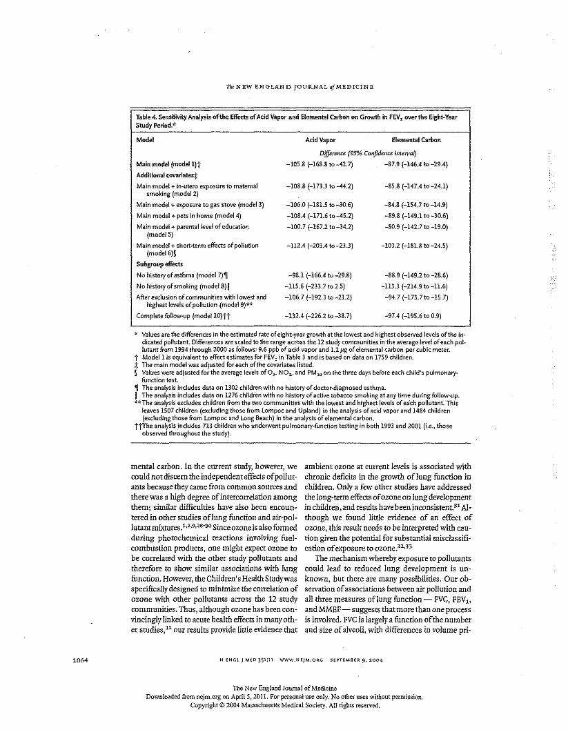
1064
The N EW ENGLAN D JOURNAL of MEDICIN E
Add Vapor
Table 4. Sensitivity Analysis of the Effects of Acid Vapor and Elemental Carbon on Growth in FEVlover the Eight-YearStudy Period.'"
Model Elemental Carbon
Main model (modell}t
Additional covarletesf
Main model + in-utero exposure to maternalsmoking (model 2)
Main model + exposure to gas stove (model 3)
Main model + pets in home (model 4)
Main model + parental/eve! of education(modelS)
Main model + short-term effects of pollution(model 6)1
Subgroup effectsNo history of asthma (model 7)~
No history of smoking (modeIS)11
After excluston of communities with lowest andhighest levels of pollution (model 9)**
Complete follow-up (model lO)tt
Difference (95% Confidence Interval)
-105.8 (-16S.8 to-42.7) -87.9 (-146.4 to-29.4)
-108.8 (-173.3 to -44.2) -85.8 (-147.4 to -24.1)
-106.0 (-181.5 to -30.6)
-108.4 (-171.6 to-45.2)
-100.7 (-167.2 to -34.2)
-84.8 (-154.7 to -14.9)
-89.8 (-149.1 to -30.6)
-80.9 (-142.7 to -19.0)
-112.4 (-201.4 to -23.3) -103.2 (-181.8 to -24.5)
-98.1 (-166.4 to -29.8)
-115.6 (-233.7 to 2.5)
-106.7 (-192.3 to-21.2)
-88.9 (-149.2 to -28.6)
-113.3 (-214.9 to -11.6)
-94.7 (-173.7 to -15.7)
-132.4 (-226.2 to -38.7) . -97.4 (-195.6 to 0.9)
* Values are the differences in the estimated rate of eight-year growth at the lowest and highest observed levels of the in·dlcated pollutant. Differences are scaled to the range across the 12 study communities in the average level of each pol-lutantfrom 1994 through 2000 as follows:9.6 ppb of add vapor and 1.2 fig of elemental carbon per cubic meter.
1" Modell is equivalent to effect estimates for FEV1 in Table 3 and is based on data on 1759 children.=!: The main model was adjusted for each of the ccvartates listed.§ Values were adjusted for the average levels of 0), NOl-' and PM10 on the three days before each child's pulmonary.
function test.~ The analysis includes data on 1302 children with no history of doctor-diagnosed asthma.II The analysis includes data on 1276 children with no history of active tobacco smoking at any time during follow-up.**The analysis excludes children from the two communities with the lowest and highest levels of eech pollutant. This
leaves 1507 children (excluding those from lompoc and Upland) in the analysis of add vapor and 1484 children(excluding those from lompoc and Long Beach) in the analysis of elemental carbon.
ttThe analysis includes 713 children who underwent pulmonary-function testing in both 1993 and 2001 [i.e., thoseobserved throughout the study).
mental carbon. In the current study, however, wecould not discern the independent effects of pollut-ants because they came from common sources andthere was a high degree of intercorrelation amongthem; similar difficulties have also been encoun-tered in other studies oflung function and air-pol-lutantrnixtures.1,2,9,28"30 Since ozone is also formedduring photochemical reactions involving fuel-combustion products, one might expect ozone tobe correlated with the other study pollutants andtherefore to show similar associations with lungfunction. However, the Children's Health Study wasspecifically designed to minimize the correlation ofozone with other pollutants across the 12 studycommunities. Thus, although ozone has been con-vincingly linked to acute health effects in many oth-er studies.P our results provide little evidence that
ambient ozone at current levels is associated withchronic deficits in the growth of lung function inchildren. Only a few other studies have addressedthe long-term effects of ozone on lung developmentin children, and results have been inconsistent. 31 Al-though we found little evidence of an effect ofozone, this result needs to be interpreted with can-cion given the potential for substantial misclassifi-cation of exposure to ozone.32,33
The mechanism whereby exposure to pollutantscould lead to reduced lung development is un-known, but there are many possibilities. Our ob-servation of associations between air pollution andall three measures oflung function - FVC, FEV1.,
and MMEF- suggests that more than one processis involved. FVCis largely a function of the numberand size of alveoli, with differences in volume pti-
N ENGL J MED 351:11 WWW.NEJM.ORG SEPTEMBER 9. 2004
The New England Journal of MedicineDownloaded from nejm.org on April 5, 2011. For personal use only. No other uses without permission.
Copyright © 2004 Massachusetts Medical Society. All rights reserved.
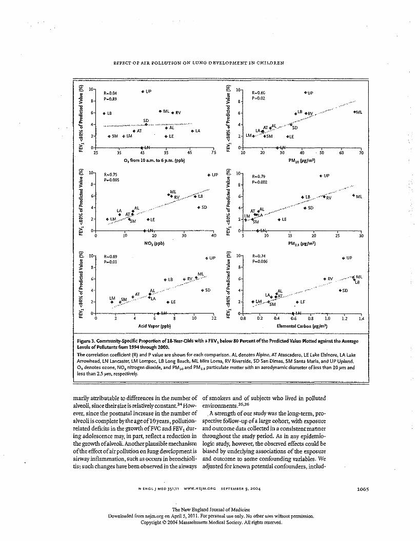
EFFECT OF AIR POLLUTION ON LUNG DEVELOPMENT IN CHTLDREN
g 10 • UP [ 10• R .. o.o4 • R .. O.66 'UP
~ P .. O.89 .l! P .. O.028 f; 8
] 6 .. Ml + RV l 6 .. LB +RV " ..~.",.... "
OMLHB11 Sf> ;,: ~,,,,,,,>
~,c~4 4 --~;D'0 ~
AT.A~".o"'"• AL 0
~ oAT .LA S LA~",'"~ 2 .SM .LM HE ~ 2 lM.,·,,'·".SM 'LEv ve 0 >' 0w~ 2S 3S 45 55 65 75 ~ 10 20 30 40 SO 60 70
OJ from 10 a.m. to 6 p.m. (ppb) PM10 (JIg/m3)
[ 10 R ...O.75 • UP ~ 10 • UP• • R.. O.79
~P ...O.OO5
~ P",,0.OO28 8
] ,C l..~'"
Ml ..,"'~"'o> ••• ,,~eR~"·6 *..RV, u<"""'..-'. LB , +tB 'ML
1 ,.•..r' .•"' 11 ~..'."~
4 .Al . ",,,.,,, • SO ~ 4 ",,
• SO'0 LA '0 AT.Al " -''if!. • AT~,"'''''- '* lM "'LA~"'"0 2 ~.,~'~-""'<"'~~M +L' 0 2 t~--+s~ HE~ ecv v
r£ 0 r£ 0u, 0 10 20 30 40 u, 5 10 15 20 2S 30
N02(ppb) PMZ.5 (JIg/m3)
~ 10 R...O.69 • UP[ 10 R.. O.74 • UP• P .. O.OI • P.. O.OO6" "~ 8 ~ 8
] ML..,, +LB v RY._,t .. ,··' f s +RV .,"/'"""\ Ml
11 . LB
c,4 Al,,<""" +50
c,4 ..At ..."...." ...,.,. '50'0 AT ."" '0
'* LM .SM~",,,,., ... '+LA '* LA·.t~"L:·v'''··
0 2 • HE 0 2 ~;~M"'"""SM oLE~ ..-.~"""- ~v v
r£ 0 r£ 0~ 0 2 4 6 8 10 12 u, 0,0 0,2 OA 0,' 0,8 1,0 1,2 lAAcid Vapor (ppb) Elemental Carbon (pg/ml)
Figure 3. Community-Specific Proportion of18·Year·Olds with a FEV 1below 80 Percent of the Predicted Value plotted against the AverageLevels of Pollutants from 1994 through 2000.The correlation coefficient (R) and P value ate shown for each comparison. AL denotes Alpine, AT Atascadero, LE Lake Elsinore, LA LakeArrowhead, IN Lancaster, LM Lompoc, LB Long Beach, ML Mira Lorna, RV Riverside, SD San Dimas, SM Santa Maria, and UP Upland,03 denotes ozone, NO~ nitrogen dioxide, and PM10 and PM~.s particulate matter with an aerodynamic diameter of less than 10 14m andless than 2.5 Jim, respectively.
marily attributable to differences in the number ofalveoli, since their size is relatively constant. 34 How-ever, since the postnatal increase in the number ofalveoli is complete bythe age oflO years, pollution,related deficits in the growth ofFVC and FEV, dur-ing adolescence may, in part, reflect a reduction inthe growth of alveoli. Another plausible mechanismof the effect of air poIIution on lung development isairway inflammation, such as occurs in bronchioli-tis: such changes have been observed in the airways
of smokers and of subjects who lived in pollutedenvironments.3S,36
.A strength of our study was the long-term, pro-spective follow-up of a large cohort, with exposureand outcome data collected in a consistent mannerthroughout the study period, As in any epidemio-logic study, however, the observed effects could bebiased by underlying associations of the exposureand outcome to some confounding variables. Weadjusted for known potential confounders, includ-
N ENGl) MED 351;11 WWW.NEJM.ORG SEPTEMBER 9,2004 1065
The New England Journal of MedicineDownloaded from nejrn.org on AprilS, 2011. For personal use only. No other uses without permission.
Copyright © 2004 Massachusetts Medical Society. All rights reserved.
1066
The NEW ENGLAN D JOURNAL of MEDIC IN E
ing personal characteristics and other sources ofexposure to pollutants, but the possibility of con-founding by other factors still exists. Over the eight-year follow-up period, approximately 10 percent ofstudy subjects were lost to follow-up each year. At-trition is a potential source of bias ina cohort studyifloss to follow-up is related to both exposure andoutcome. However, we did not see evidence that theloss of subjects was related to either baseline lungfunction or exposure to air pollution. In addition,we observed significant associations between airpollution and lung growth in the subgroup of chil-dren who were followed for the full eight years ofthe study, with effects that were similar in magni-tude to those in the group as a whole, thus makingloss of subjects an unlikely source of bias.
We have shown that exposure to ambient airpollution is correlated with significant deficits inrespiratory growth over an eight-year period, lead-ing to clinically important deficits in lung functionat the age ofl8 years. The specific pollutants that
REfEfiENCES
1. Frischer I, Studnicka M, Gartner C,et al. Lung function growth and ambientozone: a three-year population study inschool children. AmJ Respir CritCare Med1999;160:390·6.2. Iedrychowski W, FlakE, Mroz E. The ad-verse effect onow levels of ambient air poi-lutants on lung function growth in preadc-lescent children. Environ Health Perspect1999;107:669-74.3. Horak Fir, Studnicka M, Gartner C,et al. Particulate matter and lung functiongrowth in children: a 3-yr follow-up study inAustrian schoolchildren. Eur Respir J 2002;19:838-45.4. Gauderman W)', McConnel! R, GillilandF, er al, Association between air pollutionand lung function growth in southern Cali-fornia children. Am J Respir Crit Care Med2000;162:1383-90.5. AvoIEL, Gauderman W), Tan SM, lon-don SI, Peters JM. Respiratory effects cfre-locating to areas of differing air pollutionlevels. Am J Respir Crit Care Med 2001;164:2067-72.6. Gauderman W), Gilliland OF, Vora H, ctal. Association between air pollution andlung function growth in southern Californiachildren: results from a second cohort. Am}Respir Orlt Care Med 2002;166:76-84.7, Ware JH, perris BO jr, Dockery DW,Spengler 1D, Stram DO, Speiser FE. Effectsof ambient sulfur oxides and suspendedparticles on respiratory health ofpreadoles-cent children. Am Rev Respir Dis 1986;133:834-42.8. Dockery ow, Spelzcr FE, Stram DO,Ware JH, Spengler JD, Perris BG Jr. Effects
were associated with these deficits included nitro-gen dioxide, acid vapor, PM2•5, and elemental car-bon. These pollutants are products of primary fuelcombustion, and since they are present at similarlevels in many other areas, 37 ,38 we believe that ourresults can be generalized to children living outsidesouthern California. Given the magnitude of the ob-served effects and the importance oflung functionas a determinant of morbidity and mortality duringadulthood, continued emphasis on the identifica-tion of strategies for reducing levels of urban air pol-lutants is warranted.
Supported in part by a contract (A033-186) with the California AirResources Board, 'grants (5P30ES07048 and lP01ES11627) fromthe National Institute of Environmental Health Sciences, and theHastings Foundation.
weare indebted to Morton Lippmann, Jonathan Samet, FrankSpeizer.Jchn Spengler, ScottZeger, Paul Enright, William Linn, andDane westerdahl for important advice; to the school principals,teachers, students, and parents in each cfthe 12 study communitiesfor their cooperation; and especially to the members of the healthtesting field team for their efforts.
ofinbalable particles on respiratory healthof children. Am Rev Respir Dis 1989;139:587-94.9. Schwartz J. Lung function and chronicexposure to air pollution: a cross-sectionalanalysis of NHANES n. Environ Res 1989;50:309-2l.10. Ralzenne M, Neas 1M, Damokosh AI, eral. Health effects of acid aerosols on NorthAmerican children: pulmonary function.Environ Health Perspect 1996;104:50(j-.14.11. Committee of the Environmental andOccupational Health Assembly of'the Amer-lean Thoracic Society. Health effects of OUt-door air pollution. Am J Resplr Crit CareMed 1996;153:3~50,4n-98.12, Peters JM, Avol E, Gauderman W], er al.A study of twelve Southern California com-munitieswith differing levels and types ofairpollution. Il. Effects on pulmonary function.Am J Respir Crlt Care Med 1999;159:768-75.13. Peters JM, Avol E, Navidi W, et al.A study of twelve Southern California com-munities with differing levels and types ofair pollution. L Prevalence of respiratorymorbidity. Am J Respir Crlr Care Med 1999;159:760-7.14. Wang X, Dockery OW, Wypij 0, et atPulmonary function growth velocity in chii-dren 6 to 18 years of age. Am Rev Respir Dis1993;148:1502-8.15. Elemental carbon (diesel exhaust). In:NIOSH manual of analytical methods. No.5040. Issue 3 (interim report). Cincinnati:National Institute for Occupational Safetyand Health, 1999.1£. SASISIATuser's guide, version 9. Cary,N.C.: SASInstitute, 2002.
17. TagerIB, Weiss ST, Munoz A, Rosner B,Speizer FE. Longitudinal studyafthe effectsof maternal smoking on pulmonary fimc-ticnln children. N Engl J Med 1983;309:699-703.18. Wang X,Wypij 0, Gold DR, er al. Alon-gitudina! study of the effects of parentalsmoking on pulmonary function in children6·18 yeats. Am J Respir Crit Care Med 1994;149:1420-5.19. Tager I, Munoz A, Rosner B, Weiss ST,Carey V; Speizer FE. Effect of cigarettesmoking on the pulmonaryfimction of chi 1-dren and adolescents. Am Rev Respir Dis1985;131:752-9,20. Mckean M, Leech M, Lambert PC,HewittC, MyintS, Silverman M. A model ofviral wheeze in nonasthmatic adults: symp-toms and physiology. Eur Respir J 2001;18:2B2.21. Schroeder BB, Welch VL, Couper D,et al. Lung function and incident coronaryheart disease: the Atherosclerosis Risk inCommunities Study, Am J Epidemiol 2003;158:1171-8l.22. schunemann HJ, Dorn ], Grant BJ,Winkelstein W Jr, Trevisan M. Pulmonaryfunction is a long-term predictor cfmonall-ty in the general populations 29-year follow-up of the Buffitlo Health Swdy. Chest 2000;118:656-64.23, Knuiman MW, James AL, Davitini ML,Ryan G, Bartholomew HC, Musk AW.Lungfimctlon, respiratory symptoms, and mor-tali!}': results from the Busselron HealthStudy. Ann EpidemioI1999;9:297-306.24. Hole OJ, WattGC, Davey Smith 0, HartCL, Gillis CR, Ha.wthorne VM. Impaired
N ENGl J MEO 351;11 WWW.NEjM.ORG SEPTEMBER 9, 2004
The New England Journal of MedicineDownloaded from ncjm.org on April 5, 2011. For personal use only. No other uses without permission,
Copyright © 2004 Massachusetts Medical Society. AI! rights reserved.
EFFECT OF AIR POLLUTION ON LUNG DEVELOI"MENT IN CHILDREN
lung function and mortality risk in men andwomen: findings from the Renfrow andPaisley prospective population study, BMJ1996;313:711~5.25. Kennell WB, Hubert H, Lew EA. vitalcapacity as a predictor of cardiovascular dis-ease: the Framingham Soody. Am Heart J1983;105:311~5,'26. Friedman GD, Klatsky AL, SiegelaubAB. Lung function and risk of myocardial in-farction and sudden cardiac death, N Engl JMed 1976;294:1071-5.27, Ashley F, Kannel! WE, Sorlie PD, Mas-son R.. Pulmonary function: relation to ag-ing, cigarette habit, and mortality, Ann In-tern Med 1975;82:739-45,28. Detels R, Tashkin DP, Sayre ]W, et al.The UCLApopulation studies of chronic ob-structive respiratory disease, 9. Lung func-tion changes associated with chronic expo-sure to photochemical oxidants: a cohortstudy among never-smokers. Chest 1987;92:594-603.
29, Detels R, Tashkin OP, Sayre JW, et al.The UCLA population studies of CORD, X.A cohort study of changes in respiratoryfunction associated with chronic exposureto SOx, NOx, and hydrocarbons. AmJ PublicHealth 1991;81:35{)-9,30, Tashlcin OP,DetelsR., SimmonsM, etal.The UCLApopulation studies of chronic ob-structive respiratory disease. XI. Impactof airpol!ution and smoking on annual change inforced expiratory volume in one second. AmJ Resplr Crlt Care Med 1994;149:1209-17.31. Tager ill, Air pollution and lung func-tion growth: is it ozone? Am J Respir CritCare Med 1999;160:387-9.32. Avol B1, Navidi WC, RappaportEB, Pe-ters JM, Acute effects of ambient ozone onasthmatic, wheezy, and healthy children.Res Rep Health EffInst1998;82:BO.33. Samar JA, Schwartz J, Catalano P], SuhHH, Gaseous pollutants in particulate matterepidemiology: confounders or surrogates?Environ Health Perspect2001; 109:1053-61.
34. Ochs M, Nyengaard JR, Jung A, et al.The number of alveoli in the human lung.Am J Respir Crit Care Med 2004;169:120-4,35. Churg A, Brauer M, del Carmen Avila-Casado M, Portoul TI, Wright JL. Chronicexposure to high levels of particulate air pol-lution and small airway remodeling, Envi-ron Health Perspect2003;111:714-8,36, Sherwin R.P, Rlchrers V,KraftP, RlchtersA. Centriacinar region inflammatory dis-ease in young individuals: a comparativestudy of Miami and Los Angeles residents.Virchows Arch 2000;437:422·8.37. TolockaM,Solomon P, Mitchell W, Nor-rlsG, GemmiUD, WienerR.. Bastvs. Westinthe US: chemica! characteristics of PM2.5during the winter of1999. Aerosol Sci 'lech-noI2001;34:88-96.38. Latest findings on national air quality)2002 status and trends, Research TrianglePark, N,C.: Environmental Protection Agen-cy, 2003. (Report no. 454IK-03-001.)Copyn'ghl © 2004 MIJnIJmll$etts Medical Society.
FULL TEXT OF ALL JOURNAL ARTICLES ON THE WORLD WIDE W£8
Access to the complete text oftheJouma! on the Internet is free to all subscribers. To use this Web site, subscribers should go tothe Journal's home page (www.nejm.org)andregisterbyenteringtheirnames and subscriber numbers as they appear on theirmailing labels. After this one-time registration, subscribers can use their passwords to log on for electronic access to the entirejournal from any computer that is connected to the Internet. Features include a library of all issues since January 1993 andabstracts since January 1975, a full-text search capacity, and a personal archive for saving articles and search results of interest.All articles can be printed in a format that is virtually identical to that of the typeset pages. Beginning six months afterpublication,the ful! text of all Original Articles and Special Articles is available free to nonsubscribers who have completed a brief registration.
N ENGL J MEO 351;11 WWW.NEJM.ORG SEPTEMBER 9. 2004
The New England Journal ofMedlcineDownloaded from nejm.org on April 5, 2011. For personal use only. No other uses without permission.
Copyright © 2004 Massachusetts Medical Society. All rights reserved.
1067
Special Issue
Welcome to ourCenter Newsletter:
The goal of our Center is toimprove health by investigatingenvironmental exposures,addressing risks from theseexposures, studying who might bemost susceptible, and linking ourresearch efforts with thecommunities we serve.
Our Center has scientists from USCand UCLA who study cancer,respiratory disease and adversereproductive outcomes. Some ofour scientists also develop newmethods for designing studies andevaluating exposures.
We hope that our newsletters wil!help you learn more about ourresearch efforts and communityoutreach and education activities.
Or. Frank GillilandCenter Director
If you missed any issues ofthe newsletter, please go to
our website.
Moving Forward:A conference on
healthy solutions for
living near a highway affectshmg development in children,
accordi ng to a USC study
Major traffic exposure could result in lifetime deficits inlung function
Los Angeles, .Jan. 25, 2007 - Children who live near a major highway are not onlymore likely to develop asthma or other respiratory diseases, but their lungdevelopment may also be stunted.
According to a study that will appear in the February 17 issue of The Lancet andnow available online, researchers at the Keck School of Medicine of the Universityof Southern California (USC) found that children who lived within 500 meters of afreeway, or approximately a third of a mile, since age 10 had substantial deficits inlung function by the age of 18 years, compared to children living at least 1500meters, or approximately one mile, away.
"Someone suffering a pollution-related deficit in lung funclion as a child will probablyhave less than heallhy lungs all of his or her life," says lead author W. JamesGauderman, associate professor of preventive medicine at the Keck School ofMedicine of USC. "And poor lung function in later aduillife is known to be a majorrisk factor for respiratory and cardiovascular diseases."
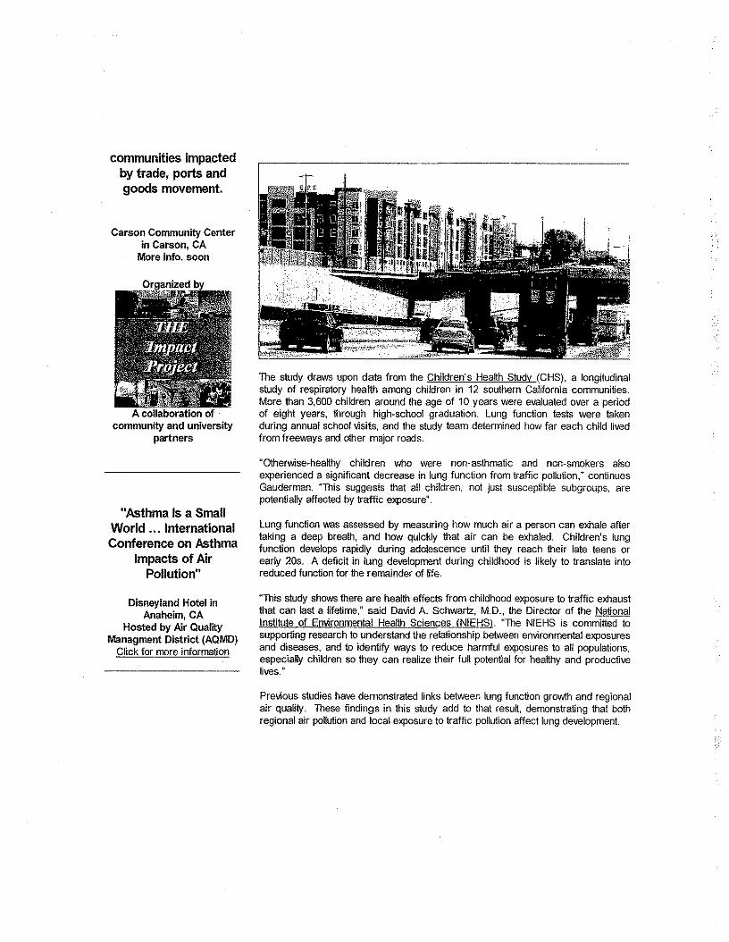
communities impactedby trade, ports andgoods movement.
Carson Community Centerin Carson, CA
More info. soon
A collaboration ofcommunity and university
partners
"Asthma Is a SmallWorld ... InternationalConference on Asthma
Impacts of AirPollution"
Disneyland Hotel inAnaheim, CA
Hosted by Air Qual~yManagment District (AQMD)
Click for more information
The study draws upon data from the Children's Heatth Study (CHS), a longitudinalstudy of respiratory heaUh among children in 12 southern California communities.More than 3,600 children around the age of 10 years were evaluated over a periodof eight years, through high-school graduation. Lung function tests were takenduring annual school visits, and the study team determined how far each child livedfrom freeways and other major roads.
uOthelVJise~healthy children who were non-asthmatic and non-smokers a!soexperienced a significant decrease in lung function from traffic pollution," continuesGauderman. "This suggests that all children, not just susceptible subgroups, arepotentially affected by traffic exposure".
Lung function was assessed by measuring how much air a person can exhale aftertaking a deep breath, and how quickly that air can be exhaled. Children's lungfunction develops rapidly during adolescence until they reach their late teens orearly 20s. A deficit in lung development during childhood is likely to translate intoreduced function for the remainder of life.
"This study shows there are health effects from childhood exposure to traffic exhaustthat can last a lifetime," said David A, Schwartz, M.D., the Director of the NationalInstitute of Environmental Health Sciences (NIEHS). "The NIEHS is committed tosupporting research to understand the relationship between environmental exposuresand diseases, and to identify ways to reduce harmful exposures to all populations,especially children so they can realize their full potential for healthy and productivelives."
Previous studies have demonstrated links between lung function growth and regionalair quality. These findings in this study add to that resut, demonstrating that bothregional air pollution and local exposure to traffic pollution affect lung development.
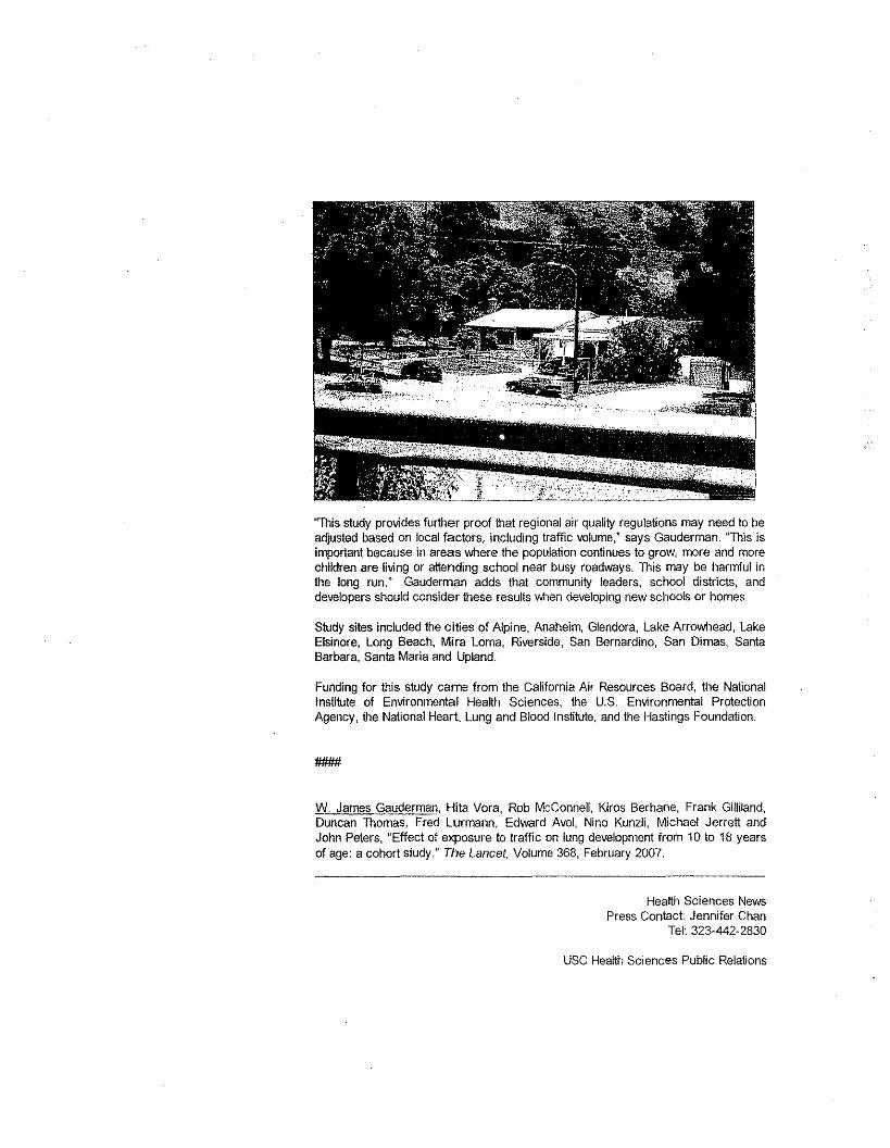
''This study provides further proof that regional air quality regulations may need to beadjusted based on local factors, including traffic volume," says Gauderman. "This isimportant because in areas vvhere the population continues to grow, more and morechildren are living or attending school near busy roadways. This may be harmful inthe long run." Gauderman adds that community leaders, schoo! districts, anddevelopers should consider these results when developing new schools or homes.
Study sites included the cities of Alpine, Anaheim, Glendora, Lake Arrowhead, lakeElsinore, Long Beach, Mira Lorna, Riverside, San Bernardino, San Dimas, SantaBarbara, Santa Maria and Upland.
Funding for this study came from the California Air Resources Board, the NationalInstitute of Environmental Health Sciences, the U.S. Environmental ProtectionAgency, the National Heart, Lung and Blood Institute, and the Hastings Foundation.
-W. James Gauderman, Hita Vora, Rob McConnell, Kiros Berhane, Frank Gilliland,Duncan Thomas, Fred Lurmann, Edward Avol, Nino Kunzli, Michael Jerrett andJohn Peters, "Effect of exposure to traffic on lung development from 10 to 18 yearsof age: a cohort study," The Lancet, Volume 368, February 2007.
Health Sciences NewsPress Contact: Jennifer Chan
Tel: 323-442-2830
USC Health Sciences Public Relations
1975 Zonal Ave, KAM 400Los Angeles, CA 90033
Tel: 323-442-2830, Fax: 323-442-2832htlp:/I\MMN,usc,edulhsclinfolprl
For more information, please contact the Community Outreach and EducationProgram of SCEHSC,
Outreach Contacts:Andrea Hricko, Tel: 323-442-3077, e-mail: ahicko@usc,eduCarla Truax, Tel: 323-442-2745, e-mail: ctruax@usc,eduAlena Groopman, Tel: 323-442-1359, groopman@usc,edu
To view other press stories from today, January 26, please go to:
LA Times article: Freeways' tainted air harms children's lungs, experts say
Sacramento Bee article: Living near busy roads tied to kids' !ung risk
Faculty Profile: Dr. W. James Gauderman
Professor of Preventive MedicineDivision of BiostatisticsKeck School of Medicine of USC
Expertise:L--'---' ---'
Photo Credits:Photo of freeway and
- Air pollution and increased incidence of asthma, bronchitis and otherrespiratory illnesses in children- Smog and its long-term effects on lung development- Long-term effects on children's lungs of air pollulants such as nilrogendioxide, particulate matter and acid vapors resulting from the burning offossil fuels and emissions from industrial plants- Lung function and respiratory health in school-aged children in SouthernCalifornia~ Gene/environment interactions~ Gene/smoking interaction in lung cancer~ Genetic epidemiology~ Environmental healthw Biostatistics
apartments: Allison CookPhoto of guard rail and house:Allison CookPhoto of Dr. JamesGauderman: USC ExpertDirectory
Additional Information:- Researcher, Children's Heallh Study (CHS)- Director of Biostatistics Core, Southern California Environmental Health SciencesCenter (SCEHSC)
More:Biographical information can be found at:http://WW>N,usc.edu/schools/medicine/utiVdirectories/facultyIprofile.php?Personls ID=351
This newsletter is produced by tile Center's Community Outreach and Education Program. with special thanxs to'Alena Oroopman. Andrea Hricko, Rishi Pate! and Carla Truax. and outreach volunteer/writer Bonnie Nadzam
This e-mail has been sent to you by the Community Outreach and Education Program of the Southern California Environmental HealthSciences Center (SCEHSC) based at the Keck School of Medicine of the University of Southern California (USC). OUf Center, funded by the
National Institute of Environmental Health Sciences, has scientific investigators from USC and the UCLA Schools of Public Health and Medicine.For more information. please visit WINW.lJsc.edu/medjcine/scehsc or e-mail us at [email protected]. Thanks for reading!
This message was sent to by:Southern California Environmental Health Sciences Center1540 Alcazar Street. CHP 236Los Angeles, CA 90033
Un su bscrib e:If you would like to be removed from this list, please click here,
Sent li$ing :
SlmpleSend,~,tI,,,,,,!.sim~{e;:end.coe
http://www.laweekly.com/2010-03-06/news/black-lung-lofts/
Black lung loftsMany children being raised in L.A.'s hip, new freeway-adjacent housing are damaged for lifeBy Patrick Range McDonaldSaturday, Mar 62010
On a recent afternoon in the Eastside neighborhood of lincoln Heights, Fay Green stands in the hallwayof her apartment complex, which sits just feet above the bumper-to-bumper traffic of the 1-5freeway. Asoft-spoken black woman, she lives with her five kids and one grandson in an urban planner's idea ofperfection: the dense, "Avenue 26" master-planned community, touted by Mayor Antonio Villaraigosaand the city's Department of Housing as an environmentally smart "transit-oriented development" inthe city's core, efficiently served by light rail. From the outside, the stylish-looking village of 156 condos,called Puerta del Sol, and 378 other apartments squeezed between Avenue 26 and the thundering 1-5gives off a Crate & Barrel vibe. But Green's four-bedroom unit, in the building dubbed Tesoro del ValleFamily Apartments, is regularly dirtied by a heavy film of what she calls "dust." She explains, "I clean theplace up, and in two or three days, I have to wipe again."
The bedroom of her young son, who has a sinus problem, requires extra attention so he can breathe;Green herself suffers from asthma. She says these sicknesses started before she moved to Avenue 26,erected less than 100 feet from one of the world's busiest, and filthiest, freeways, used by 285,000vehicles per day. But when the weather is hot, or other conditions create smog, Green notices thatmany of her kids start to cough. She won't feel well, either.
Green moved into the new apartment in 2006. She vaguely remembers a TV news report about thehealth risks of living near a freeway, but had never really thought about whether she or her young familycould become sick from the clouds of vehicle exhaust and tire-brake dust that hover above, and directlynext to, the 1-5.
Her neighbors tell a similar story. JesseA. Flores, in his 60s, says he never thought about the problems ofliving adjacent to a major freeway. "So far, I'm okay," he says. "Nothing wrong with me."
Aura Sanabria, a 20-something mother of three young kids, has the same concerns Green has. She toocomplains about the heavy "dust" that builds up in her apartment. "I'm always cleaning and dusting,"she says.
Teenager Andrew Garcia says he and his parents never think about the invisible particles that work theirway into the family home. "All we think about is that it's easier to get on the freeway or to the Metro,"says Garcia, who takes the Gold Line to high school,
These residents don't know what the science shows, but L.A.'selected leaders do.
In 2004, USC's landmark Children's Health Study made waves nationally, confirming that thousands ofSouthern California children living in near high-traffic roadways were contracting higher levels ofcrippling asthma and children living in smoggy areas were suffering impaired lung development.
The study proved long-held beliefs that fine particles such as those caused by tire rubber and brakemetal - so tiny that scientists say the dust seeps through the smallest cracks and holes and thus is notblocked by air filtration systems or triple-paned windows - were burrowing into people's lungs.
When the revelations broke in The New England Journal of Medicine, L.A. was in the grips of a badlyoverheated housing bubble. City Hall politicians and planning officials were embracing trendy housingprojects alongside freeways, especially downtown, where urbanists touting a "sustainable" lifestyle, freeof suburban commuting, were moving into places like the Medici and Orsini lUXUrycomplexes - astone's throw from the Harbor and Hollywood freeways, respectively.
L.A. officials were so thrilled with the new apartments rising next to freeways that they got into an uglytussle with Orsini developer Geoff Palmer when he rebuffed City Hall's pressure to make room in hisfreeway-adjacent Medici building - for low-income families including children.
Meanwhile, on the other side of downtown, the Los Angeles Housing Department provided downpayments to buyers to move into Puerta del Sol, a stylish condo complex in the Avenue 26 communitywhere teenager Andrew Garcia breathes in the factorylike emissions and particulates created daily by285,000 vehicles.
Since then, with the city's enthusiastic backing, including that of Councilman Ed Reyes,who representsLincoln Heights, the village's politically well-connected developer, Percy Vaz, has marketed the projectto families tired of commuting - in effect, targeting parents to live in an area scientists now know isunusually hazardous to their children's health.
"We've known for eight or 10 years there have been these impacts," says Dr. Joe Lyou, executivedirector of California Environmental Rights Alliance, an environmental justice group. He sees thepoliticians at City Hall as knowingly endangering children.
In January 2007, USCscientists followed up their widely hailed Children's Health Study with an evenmore detailed and damning longitudinal study of 3,600 Southern California children - and this time thescientists went down to L.A. City Hall to get the attention of the politicians.
"I woke up one morning and read about [the study] in the newspaper," says Michael Woo, who sits onthe Los Angeles planning commission and is dean of Cal Poly's College of Environmental Design. "That'swhen I started to put two and two together" - to realize that the city's residential zoning policies weremaking kids sick.
The new study showed that alarming numbers of children ages 10 to 18 who live within about a block -528 feet - of a Southern California freeway suffer reduced lung development, a deficit likely to persistthrough adulthood, and which may increase the risk of respiratory disease and premature death. (Threeweeks ago, a group of USCand European scientists delivered more bad news: Hardening of the arteriesis twice as common among Angelenos living within a block of an LA freeway.)
But instead of playing a key role in the city's planning decisions, USC's 2007 study was ignored. City Hallleaders, dominated by the desires of developer-contributors and a strong chorus of "density hawks,"were rewriting hard-fought Community Plans, tossing out height and size restrictions on apartmentcomplexes citywide, and permitting the destruction of thousands of units of historic and affordablehousing.
Through city zoning laws, subsidies, city pension-fund investments and other policies, city leaders havepeddled freeway-abutting housing as "smart" land use that satisfies developers' push for "in-fill"projects on "underutilized" land. At one point during the frenetic housing boom in 2006, Villaraigosa andcity-pension trustees held a press conference at the Puerta del Sol condos in the Avenue 26development perched above the 1-5freeway. The mayor touted the development as a model example ofmiddle-class housing in which to "raise a family" - a view that remains unshaken inside City Hall today.
Today, in fact, the Department of City Planning chief Gail Goldberg and the Office of Mayor AntonioVillaraigosa concede to L.A.Weekly that nobody in City Hall is tracking, or can even estimate, thenumber of children who have moved into housing erected within 500 feet of freeways since scientistsdocumented the chilling health effects. Los Angeles lawmakers are making no effort to measure thehuman health costs of such housing. And with the shattered L.A. housing market now showing the firstfew signs of recovery, City Hall is set, once again, to embrace freeway-adjacent housing that's marketedto families.
One of the few elected leaders willing to be open about the unfolding situation is Hollywood-area CityCouncilman Tom LaBonge, who says, "It would be great if we could call a time-out and try to plan better,but it's not practical." He's given his blessing to freeway-adjacent housing in his district, and he insists,"We need to save jobs. 11
Nor do the city's planning department, Villaraigosa and the Los Angeles City Council warn buyers andtenants about the hazards of moving kids right next to freeways - the relatively modest disclosure rulesought two years ago by USC'sscientists that some developers say they could live with.
"Regulation is years behind the science," says Bahram Fazeli, a researcher and policy analyst forCommunities for a Better Environment, a grassroots environmental-justice organization that focuses onissues like addressing the "cumulative impacts" of smog. Of the Southern California freeway studies,Fazeli stresses, "The evidence that children are harmed is overwhelming."
L.A.'s major freeways were mostly built in the 1950s and 1960s, slashing through cohesive residentialneighborhoods and creating strange dead-end streets in places like Hollywood, Westwood, Toluca Lake,Boyle Heights and Lincoln Heights. In the 1980s and 1990s, when new housing sprouted up besidefreeways in West L.A., Reseda,Studio City, Hollywood and many other areas, environmentalists warnedthat purposely placing housing next to the world's busiest and most polluted freeways was a bad idea.They argued that any public good - providing affordable housing or addressing pent-up ownershipdemand for condos - was outweighed by extensive health costs to people and society.
But the science wasn't there to back up the activists - until a team of mostly USCscientists publishedthe 2004 multimillion-dollar Children's Health Study in the prestigious New England Journal of Medicine.Studying more than 1,700 children, scientists compared communities that enjoy clean air, such as LakeArrowhead and Alpine, to those with dirty air, such as Riverside and Long Beach. The study showed highrates of underdeveloped lungs among children in the polluted areas. The implications were clear: long-term health problems ranging from asthma to early death for significant numbers of children beingraised in Southern California.
"That study had a tremendous impact because of the quality of the research," says environmentalistLyou, who also sits on the governing board of the South Coast Air Quality Management District, whichsets air pollution-control policies affecting more than 16 million people. "It really shocked a lot of
people. It not only confirmed what people in the field already knew, but it also created an undebatableview on the issue. II
Around the same time, UCLAalso published important findings showing that pregnant women who livedwithin 750 feet of a freeway had a greater-than-normal risk of delivering premature babies.
When USCscientists Rob McConnell, Jim Gauderman and others followed up the 2004 study byresearching a much larger group of children - specifically to look into health problems caused by livingwithin 528 feet of Southern California's crammed freeways - the findings worried epidemiologistGauderman enough to testify before the City Council.
In Council chambers on April 25, 2007, he warned: "It's not just watery eyes or coughing after aparticularly polluted day.... We're talking about long-term risks of asthma, long-term risks of reducedlung development in children."
Scientists are especially concerned about nitrogen oxide and "particulate matter," essentially a dust thatsometimes can't be seen. Particulates can be metals, gas emissions from cars and trucks, tire rubber andtire-brake dust. When mothers like FayGreen and Aura Sanabria complain about never-ending "dust"that settles inside their apartments in the Puerta del Sol development next to the 1-5,they are actuallytalking about particulate matter.
When kids breathe in this highly toxic particulate, it goes deep into their lungs and can cause long-termhealth problems.
After listening to researcher Gauderman, several City Council members sounded ready to act.
Council District 12 representative Greig Smith, from the San Fernando Valley, announced that he andCouncil District 1 representative Ed Reyes, from the city's Eastside, had put forth a motion to study theidea of changing zoning laws to discourage or stop new housing within 500 feet of freeways.
"Maybe we should change the way of doing things around here," Smith told Gauderman and his councilcolleagues. And City Council District 6 representative Tony Cardenas, also from the San Fernando Valley,declared, "We have a lot of issues in my district we'd like to address, but with science, in my opinion, it'sthe best way for us to create the best defense in order to defend the community."
Janice Hahn, who represents Council District 15 in San Pedro and is running this year for California'slieutenant governor as an environmental candidate, was even more forceful, announcing, "I think thetime for studies is over. I think the time for action is now."
l.A.'s lawmakers talked a big game. But it was nothing more.
Councilman LaBange, who set up Gauderman's visit to the City Council,.concedes today that, after thatdowntown hearing nearly three years ago, the City Council did nothing. Smith and Reyes' motion to"look into" a 500:foot barrier zone between new homes and freeways never turned into anythingsubstantive; Smith and Reyes recently declined to comment to the Weekly about their long-abandonedmotion.
Within months of USC'sappeal to the City Council, in fact, one of L.A. 's most brash examples of freeway-abutting housing, the Universal Lofts, rose in Cahuenga Passat 3450 Cahuenga Blvd., with a bannerexhorting Angelenos to both "live" and "work" in the pricey, corrugated metal-and-cinder blockbuildings.
City zoning approvals allowed the developer to cram his $4,000-per-month, three-bedroom apartmentsand $1 million condos into a strip of land no more than 20 feet from the 234,000 vehicles that rumble bydaily on the Hollywood Freeway.
LaBonge says such housing will continue to rise because "environmental issues need to compete with allother issues," and averting a city fiscal disaster is the only thing on the City Council members' minds.
But critics say that hardly explains the City Council's failure to warn residents or to pursue betterplanning when the city was flush with funds. Bill Gallegos, executive director of Communities for aBetter Environment, says, "They can't ignore the science. It just can't be shunted off to the side becauseof the economic crisis. I!
LaBonge's logic probably wouldn't go over well with an activist parent like Elaine Lyles, whose daughterItanza developed asthma when she was 10 years old - she's now a sophomore in college. Lyles, acommercial real estate broker, volunteers at a healthy-lungs advocacy organization, and she doesn'twant any parent or child to go through the ordeals her family suffered.
For years, Lyles has lived near the 10 freeway in the South Robertson neighborhood; Itanza attended anearby school. Years ago, upon receiving harrowing calls from school that her young daughter couldn'tbreathe, Lyles was told by her doctor that the girl had contracted asthma due to "pollutants in theatmosphere." The diagnosis changed Itanza Lyles' life.
"She would have difficulty breathing and I would tell her to calm down and be patient," Elaine Lylesrecalls. She sometimes clashed with doctors, who pushed her daughter to scale back her athleticactivities in order to improve her health. "But she's full of life and active, and she would get angrybecause she couldn't live life to the fullest."
Lyles witnessed Itanza suffer horrific asthma attacks, which can kill victims via suffocation, and sheremains haunted by the fear that her daughter could die at anytime. A friend at church tragically lost achild during a severe asthma attack, devastating her and shocking the Lyles family. "Your kid can't getair," Lyles says. "You have as many inhalers as possible around, but you never know. As a parent, you'renever free of the idea that your child could succumb."
Lyles' oldest daughter doesn't have asthma. The first five years of her life, when her tiny lungs wereundergoing a critical stage of development, the Lyles family lived far from a major LosAngeles freeway,in the Hollywood Hills near Griffith Park. "It's probably why she has better lung health," Lyles says. Manyscientists today would probably agree.
Percy Vaz, developer of the Lincoln Heights master-planned community where Fay Green and AuraSanabria clean up thick "dust" in the Tesoro del Valle apartments, opposes a buffer zone betweenhousing and freeway lanes. "I think there are apartment buildings just as susceptible on a majorthoroughfare," says Vaz, a prominent local developer and founder of AMCAL Housing, which specializes
in for-sale and rental affordable housing. "Would we have a buffer zone on Wilshire Boulevard? On a gutlevel, 500 feet is far overreaching.
But even crowded Wilshire Boulevard doesn't carry anything approaching 285,000 cars per day, nordoes any L.A. surface street. The sheer volume on the city's freeways is a key reason why people aregetting sick.
Yet Vaz doesn't think a health-hazard warning for renters or buyers is necessary. In fact, his tenantSanabria, the mother of three young children, is more concerned about homeless people sleepingnearby, and neighbor Jesse Flores worries about gang activity in the area. "They're killing each other likefools," Flores says.
Vaz reports that no one - not the city Planning Departrnent nor Ed Reyes,chairman of the City Council'sPlanning and Land Use Management Committee, who represents Lincoln Heights - has spoken to himabout enacting buffer zones or requiring a disclosure statement for housing placed within 500 feet offreeways. (Through a spokeswoman, Reyes tells the Weekly he's "unavailable" to talk about the healthimpacts caused when City Hall approves housing that abuts freeways.)
"If you're buying a home near a freeway, you know it's there," Vaz says. "The freeway is hitting you inthe face. Most people are buying and renting because there is a freeway." Moreover, he is seeing moreand more units erected near the freeways, in part, because "there's a shortage of land and people willbuild where they can," even on often-expensive freeway-adjacent land.
With city officials now focused on preventing the city government of Los Angeles from sliding into adeeper fiscal crisis, a debate over the health of tens of thousands of local children is unlikely to bewelcomed by the City Council or Villaraigosa.
According to Woo, neither the City Council, led by electric car-driving Council President Eric Garcetti,nor Villaraigosa, who wants Los Angeles to be "the cleanest and greenest city" in America, has shown aninterest in the 500-foot buffers or hazard-disclosure regulations suggested by the scientists. Inside CityHall, where real estate developers have enjoyed outsized influence for the past 100 years or so, suchrestrictions, Woo says, would "probably be very controversia1."
But neither is the issue being pushed by the environmental community in Southern California, which hasbeen much more focused on lobbying the California Legislature on state environmental laws and globalwarming.
"I can't think of an [environmental] group that's fighting development near freeways," says MarthaArguello, executive director of the Los Angeles chapter of Physicians for Social Responsibility, anonprofit, public-health advocacy group. "I'm hard-pressed."
The nonprofit organization Breathe LA - which promotes itself as a 107-year-old public-benefit groupdedicated to "clean air and healthy lungs in Los Angeles County" - is giving its 2010 Breath of LifeAward to District 9 City Councilwoman Jan Perry. The strongly pro-development Perry has pushed forlofts, condos and apartments next to and near downtown's jammed freeways.·She has not pushed anyplan to warn Angelenos about the serious health effects on children who move into that housing.
According to Breathe LA.'s announcement, sent to the media a few days ago, Jan Perry promotes "cleanair and healthy lungs ... each and every day."
Environmentalists, says Bahram Fazeli of Communities for a Better Environment, have perhaps missedan opportunity by focusing on other issues, such as cleaning up the ports and working with the Mayor'sOffice to sign off on a "cumulative-impacts" directive.
Although the directive has been slow in coming, it would ideally force city departments to look into howspecific, major projects, such as a new oil refinery or airport expansion, add overall pollution toneighborhoods - and then plan accordingly. But the cumulative-impacts rule probably would be silenton the more direct threat to human health - housing being built right next to L.A. freeways.
"Maybe we made a mistake, maybe we should have gone with (freeway-adjacent housing)," Fazelioffers. "But we always think about these things, and think about strategy, and we only have limitedresources. "
Some environmentalists also act as cheerleaders for dense urban housing, including that along freeways,arguing that it helps to combat global warming by discouraging suburban living. Their focus is not on thehealth of individuals but the planet.
For all of these reasons, the people who move their children into unusually unhealthy, freeway-frontageprojects fall into the cracks.
Ramel Pascual, Los Angeles acting deputy mayor for energy and environment, says villaraigosa "issomeone who looks at public health and thinks it's very important."
".But the mayor has yet to look seriously at the danger of living next to the freeway. Says Pascual: "It'sworth exploring."
On August 14, 2008, USCpreventive medicine professor Rob McConnell and the university's communityoutreach expert Andrea Hricko sat before Villaraigosa's political appointees on the city PlanningCommission to share USC's2007 freswav-housmg findings. The meeting had been arranged by planningcommissioner Mike Woo, who was worried about freeway-adjacent housing.
Jim Gauderman's USCcolleague, environmental-health researcher McConnell, told the Los AngelesPlanning Commission, "The very smallest particles pass right through the respiratory system and into thebody, including the brain." McConnell and Hricko urged city planners to push for a SOD-foot buffer zonebetween new housing and freeways or, at least, pursue an ordinance requiring developers to disclose toprospective renters or buyers the risks of living within one block of freeways.
Hricko cited Puerta del Sol, the city-backed condos near the 1-5freeway in Lincoln Heights, and themassive, 1,000-unit, walled-in, University Village directly abutting the 405 freeway in West L.A., as twotroubling, real-life examples of housing developments that could make residents sick. "There are a lot ofsmall kids in that housing," Hricko said of University Village.
It's ironic that UCLA, with great ballyhoo, touted the new University Village as affordable college housingin the 19905 and filled it with university students and employees. University Village immediately flanksboth sides of the 405 freeway along Sawtelle and Sepulveda boulevards, where 281,000 passing cars
and trucks create one of the world's most congested freeways. The roar of traffic necessitated toweringsound walls, yet the University Village Web site boasts a playground and "state-of-the-art" child-carecenter - for 200 children.
The pale-stucco apartment buildings have a hipster feel that has attracted many young medical-schoolstudents and other student residents, as well as UCLAemployees. They probably think it's a great dealbecause the rents are set below market rates for the pricey Westside.
According to a UCLAscientist who works with the EPASouthern California Particle Center, no studies ofhealth effects were conducted at University Village. But in 2004 scientists measured the shape' and sizeof the indoor and outdoor ultra fine "nano" particles in the village - which are of concern to scientistsbecause nano particles can act as miniature transporters of toxins into the human respiratory tract.
Just like developer Geoff Palmer's upscale Orsini and Medici residences in L.A.'s "new downtown," andthe Avenue 26 project, University Village sits well inside the son-toot zone scientists say is hazardous tokids - and, they fear, almost no amount of mitigation can change that. Some scientists say that air-filtration systems designed into buildings - and even double-paned and triple-paned windows that arecommon in the luxurv downtown condos next to the Harbor and Hollywood freeways - cannot stop thefinest pollutants from finding their way in.
As McConnell told the city's planning commission in 2008, when pollution is tested next to SouthernCalifornia freeways "you see a huge increase in a number of traffic-related pollutants, and it diminishesquite rapidly when you go back to 300 meters" or 984 feet, about two city blocks. The number ofasthma cases among children, McConnell explained, tracks the same way - more sick kids near thefreeway, more healthy kids farther away.
That day, the USCprofessor gave the planning commissioners an unusually firm recommendation: "Ithink there's strong health-science justification for regulating exposures within 500 feet of roadwayswith heavy traffic," he said. "I'm not sure that will guarantee the health of our children, but I think thatthere's very good evidence that within that margin, what might be thought of as a margin of safety, thatthere are health effects that children are going to be suffering."
Hricko concurred, saying a 500-foot buffer zone was merely a "start" and strongly suggested that realestate developers be required to disclose to prospective buyers and tenants the facts about possiblehealth risks of living right next to a freeway.
By the end of the two-hour City Hall meeting in the late summer of 2008, Michael Woo, the planningcommissioner, was shaken to the bone. "My reaction was, 'This is a very serious problem,' that it'sworse than I thought," Woo tells L.A.Weekly.
Then-planning commission President Jane Usher ordered Los Angeles City Planning Department stafferCharlie Rausch to return in three months with "next-steps" suggestions from the planning departmentfor the planning commission to consider, and potentially enact.
But by the deadline in November 2008, Rausch's boss, planning chief Gail Goldberg, had failed toproduce any "next steps" for the planning commission. Goldberg and Usher, in fact, were busy sparringover City Hall's controversial push to increase housing density in neighborhoods citywide. Goldberg ledCity Hall's so-called density hawks, and Usher was on the other side, upset that carefully designed
Community Plans were too often ignored by Goldberg's planning department - for example, thatdevelopers seeking height and size "variances" to override local zoning were regularly given the greenlight. Usher resigned as planning commission president that December, in a very public parting.
The next month, in January 2009, with the outspoken Usher gone, Goldberg finally delivered her list offreeway-adjacent housing recommendations, which Woo describes as "weak." Goldberg suggestedseveral mitigation ideas she said had been "proven very effective." Among other things, Goldberg saidvegetation could be planted between housing and freeways - but some scientists say a thick and deepstand of mature trees would be required.
She suggested the installation of home air-filtration systems and proposed that developers installwindowstllat don't open - both measures that scientists say do not keep fine-particulate matter out ofthe lungs of children and others because the dust is so pervasive and works its way through abuilding'stiniest.cracks and holes.
The planning department and Goldberg "never really accommodated anything from that [August]meeting" with the scientists, says Angelo Logan, executive director of East Yard Communities forEnvironmental Justice, who was present and also testified.
Goldberg's halfhearted recommendations have now become a forgotten, and possibly lost, publicdocument.
City Planning Department Deputy Director Vincent Bertoni could not find the year-old "first steps"report for the Weekly after repeated requests in January, according to Bertoni's aide. And although thatlist of recommendations is clearly a public document, another staffer said it's something that the LosAngeles City planning department would not keep for future reference - a claim that drew anincredulous response from former commissioner Usher.
The Weekly finally obtained a copy of the forgotten Gail Goldberg plan from an environmental activist. Itcontains no suggestions that families or others be warned before renting or buying housing within ablock of an L.A. freeway.
Today, years after scientists warned City Hall leaders, Woo says the planning commission has "no legaltools to prevent a developer from building" family housing right next to a freeway. And environmentalistLogan backs this up, saying that the problems of "planning near freeways has been ignored."
Developers of the "vast majority" of housing in L.A. don't need permission from Villaraigosa's planningcommissioners because the developers are not seeking special variances to get around height or densityrules, Woo says. As a result, the planning corrimissibn has limited chances to challenge freeway-adjacenthousing. "We don't have a very good process for at least questioning housing projects near freeways,"he says.
One developer who would oppose a freeway buffer zone is Jeremy Byk, vice president of real estatedevelopment at Sherman Oaks-based IMT Residential. IMT builds apartments near the 101 and 405freeways in the San Fernando Valley, with literature promoting "easy freeway access." One luxuryproject in Encino, with a towering lobby and grape-arbor facade still under construction, will soon offertwo- and three-bedroom, mostly market-rate apartments 70 feet from the humming roadbed of theVentura Freeway.
For IMT, if it can place an apartment building on land directly adjacent to a busy freeway, it canadvertise, without paying a penny, to thousands of motorists every day. The complex in Encino, at 5501Newcastle Ave., had for months a banner festooned across the front reading "Multi-Family Housing,"which could be seen by the roughly 291,000 cars and trucks that pass that stretch daily.
"We like to be near as highly trafficked and high-visibility roadways as possible," says Byk. "It drives oursales that way."
He says he hasn't read the USCstudies and didn't know about the push by scientists for the 500-footbuffers or a disclosure statement warning parents. He says he's fine with the idea of a health-hazarddisclosure statement, but not a buffer zone. "It's ridiculous."
The developer says he is "always concerned" about the health of his tenants. But he is apparentlyunaware that some scientists don't believe current mitigation measures sufficiently keep out thepervasive toxic particles. He explains, "We're building modern buildings with air filters and dual-panedwindows. We mitigate as much as possible."
Byk argues that in the future, vehicles will be far cleaner, and that current levels of lung damage will bereduced. "Emissions from cars and diesel trucks are ever diminishing ..' I don't see it as a long-term,significant issue."
But, as Lyou of AQMD points out, California is many years from attaining lower, federally mandatedemissions standards - and the volume of traffic is not decreasing but increasing. Even if radically lowertailpipe emissions were achieved in the next decade, Lyou says, cars and trucks will continue to producevast amonts of hazardous freeway particulate matter from tire rubber and brake dust.
If leading scientists are shocked that their years of effort researching the health of thousands of childrenin Southern California produced zero action from L.A.'s mayor and 15 council members, many areunwilling to say so - or even to discuss their disappointment - publicly.
Andrea Hricko, director of community outreach at USC'sKeck School of Medicine, though not a SCientist,is charged with educating elected officials about important studies conducted by scientists like RobMcConnell and Jim Gauderman. But she doesn't play the kind of political hardball needed to get CityCouncil members and the Mayor's Office involved in a controversial issue that would almost certainlyinfuriate developers - who are big campaign contributors to many City Hall politicians.
"This particular issue about buffer zones and freeways is a difficult one for city policy," Hricko sayspolitely.
Although researcher McConnell strongly and very publicly supported 500-foot buffer zones in 2008, andHricko backed him up and firmly put forth the idea of a health-hazard disclosure statement, shebacktracked recently, telling the Weekly that she and McConnell "haven't advocated for a particularthing." The city of Los Angeles, she now says, has "plans to develop" regulations to address the problem
. of new housing next to freeways.
In fact, city leaders have no such plan. Officials in the Planning Department can't even find the old ideasfrom Gail Goldberg's January 2009 "first-steps" list. Comments from Councilman LaBonge, commissioner
Woo, and acting deputy mayor Pascual make clear that no elected City Hall politician is taking up thecause.
Yet Los Angeles City Council members do approve headline-grabbing environmental policies that tend toportray them as benevolent guardians of human health.
The council has banned smoking outdoors in or near restaurant patios, and in 2008, the council placed acontroversial temporary ban on new fast-food outlets in a 32-square-mile area of South Los Angelesafter Jan Perry said her constituents were eating too much fat. She and other council members used thescientifically dubious argument that fast-food chains were to blame, only to be embarrassed by a RandCorp. study some months later clearly showing that South Los Angeles actually has fewer fast-foodchains than several areas of LA
The council is not considering a disclosure ordinance, however, to warn people about the well-researched and proven risks, especially for children, of living right next to a freeway. Joe Lyou finds thesituation "outrageous," saying, "To create housing near areas that are dangerous for your health justseems so fundamentally wrong."
Researcher from Children's H~"'lital Los Angeles and USC Finds Provvnity to Freeway L. Page I of2
F1NOA DOCTOR) DONATE TODAY I VOLUNTEER I CAREERS! ESPANOL I CONTACT US
~.o ~ • K,9i!fJ'j, , ,..........,F""""""""f if;r~ ! HOME i AftOUT PATIENTS&FAMIl!(S GIVING
About Our ResearchInstitute
RESEARCH PRESS RELEASES
Research Support
'1 'iHEALTKCARE ?ROFESSlONA!S
GO
RESEARCHER FROM CHILDREN'S HOSPITAL LOS ANGELES AND USC FINDS PROXIMITY TO FREEWAY ISASSOCIATED WITH AUTISM
Scientific Priorities
Research NewsCase-control study demonstrates connection be/ween autism and traffic pollution
MEDIA CONTACT: E!lin Kavanagll at (323) 361·8505Email: [email protected]
lOS ANGELES (December 16, 2010) -living near a freeway may be associated wilhincreased risk of autism, according to a study published by a team of researchers fromChildren's Hospital Los Angeles. the Keck School of Medicine of the University ofSouthern California (USC) and the UC Davis MIND lnstjtule.
The paper will appear online in the journal Environmental Health Perspectives thisweak
·Children bom to mothers living within 309 meters of a freeway appeared to be twiceas likely to have autism," said HealherVolk PhD MPH, and first author on the study.Dr. Vo!k holds a joint appointment althe Community Health Olllcomes & InterventionResearch Program at The Saban Research Institute of Chlldren'$ Hospital losAngeles, the Zilkha Neurogenetic institute and the Department of PreventativeMedicine at USC
Research AfI/lusl Report
Bench To Bedside
careers & Education
Contact Us
Saban Auditorium
Autism is a developmental disorder that has long been ascribed to genetic factors.While changes in diagnostic criteria and increased awareness have been thought tocontribute to the rising incidence of the disorder, these factors alone cannot explainthe dramatic increase in the number of children affected. The Centers for DiseaseControt reported a 57 percent increase cewecnzocz and 2006. This study supportsthe theory that environmental factors, in conjunction with a strong genetic risk. may beone possible explanation for tile increase
Hea!herVolk PhD MPH Community, HealthOu/comes & InleNenlion Research Program atThe Saban Ressaroh Instilule of Children'sHospital Los Angeles, the Zilkha NeurogeneticInsliluto and Ille Department of PreventativeMedicine at USC
INhlle litue is known about the role of environmental pollutants on autism, air pollution exposure during pregnancy has been seen to havephysical and developmental effects on the tetcs in other studies. Exposure to air pollution during the first months of life has also beenlinked to cognitive developmental derey. However, the authors said that this study is lhe first to link exposure to vehicular pollutants withautism risk, though direct measurements of pollutants were not made.
Data from children with autism and typically developing children. who served as controls, were drawn from the Childhood Autlsm Risksfrom Genetics and the Environment (CHARGE) study, a population-based case-control study of preschool children. Children werebetween the ages of 24 and 60 months atthe start of the study and lived in communities around los Angeles, San Francisco andSacramento. Population-based controls were recruited from state of California birth files, and were frequency matched to the autismcases by age, gender, and broad geographic area. Each participating family was evaluated in person. All cnitdren were assessed;assessment of autism was done using well-validated instruments.
The study examined the locations where the children's families' lived during the first. second and third trimesters of their mothers'pregnancies, and at the time of the baby's birth and looked at tile proximity of eese homes to a major road or freeway. The participants'gestational ages were determined using ultrasound measurements and prenatal records
Or. Volk and her colleagues found that living within 309 meters of a freeway (or just over 1000 feet) at birth was associated with a fwo-fcldincrease in autism risk. This association was not altered by adjustment for child gender or ethnicity. maximum education in the home.maternal age, or prenatal smoking. The researchers found no consistent pattern of association of autism with proximily to a major road
Traffic-related air pollutants have been observed to induce inflammation and oxidative stress in toxicological and human studles. Theemerging evidence that oxidative stress and infiammation are involved in the pathogenesis of autism supportsthe findings of this stcdy
·We expect 10 find many. perhaps dozens, of environmental teeters over the next few years, with each of them probably contributlng to afraction of autism cases. It is highly likely that most of them operate in conjunction with other exposures anwor with genes," said INa Hertz-Picclotto. PhD, chief of the division of environmental and cccupauonerreanh in the Department of Public Health Sciences at UC Davis,and principal investigator on the CHARGE study
Dr. Volk's co-authors on the study include: Rob McConnell. MO. from the Department of Preventative Medicine at USC, lrva Hertz-Picciotto. PhD, and Lora Deostche. MS. from the University of California at Davis, and Fred Lurmann, of Sonoma Technology, Inc
This study was supported by granls from the Nalionallnstilute of Environmental Health sccrces.u-e Environmental Protection Agency,the MIND Institute. the Southern California Environmental Health Sciences Center. Autism Speaks. and me Las Madrinas Endowment onAutism Research, Intervention and outcomes
The Saban Research Institute of Children's Hospital Los Angeles is among the largest and most productive pediatric research facilities inthe United States. with 100 investigators at work on 186 laboratory studies, cuncetvets and community-based research and healthservices. The Saban Research Institute is ranked eighth in Nationa! Institutes of Health funding among children's hospitals in tile UnitedStates
Founded in 1901. Children's Hospital Los Angeles is one of tne nation's leading children's hospitals and is acknowledged worldwide for itsleadership in pediatric and adolescent health. Children's Hospital Los Angeles is one of only seven children's hospitals in the nation - andthe only children's hospital on the West Coast - ranked for two consecutive years in 31110 pediatric specialties in the U.S. News & WorldReport rankings and named to the magazine's "Honor RoW of children's hospitals
Established in 1885. the Keck School of Medicine of USC {www.keck.usc.edu}isdedicatedtoexcellencein medical education, patientcare and research Children's Hospital Los Angeles is staffed by physicians and scientists who are on the Keck School facuTty. The KeckSchool is home to a number of leading scientific programs, including the Zilkha Neurogenelic Insti1ule{www,usc.edufschoolsfmedicinefresearchlinstitutes/znif}. a premier translalional brain disease institute dedicated to discovering Ihecauses of and developing treatments for a variely of brain disorders. Children's Hospital los Angeles is a premier teaching hospital andhas been affiliated with n-e Keck School of Medicine of tile University of Southern California since 1932 .
www.chla.org
http://www.chla.org/ site/apps/nlnet! content2.aspx?c=i pINKTO AJsG&b=6079997 &ct=897 5... 4/5/2011
Researcher from Children's B····uital Los Angeles and USC Finds Pro+nity to Freeway i... Page 2 of2
ADDRESS41;50 SUNSET6LVDLOS ANGELES, CA 90027323.660,2450WEBMASTER EMA1L
© 2010 CHLA· All Rights Reserved
LINKS• About Us• Patients & Families• Healthcam Professionals
• Research• Giving• See Full Sitemap
STAY CONNECTED• News Room• On YouTube• On Twitter• On Facebook
TERMS AND CONDITIONS AWARDS AND RECOGNITION• Terms of Use• User Privacy• Patient Privacy
http://www.chla. orgl sitel apps/nlnet/ content2.aspx?c=ipINKTO AJ sG&b=6079997 &ct=897 5... 4/5/20 11
Study Links Autism to 101,405 Freeway Traffic - Going Green - Sher ...
ShermanOaks
ht1p://shermanoaks.patch.coml groups/going-green/p/study-links-autism- ...
Home News Events BusinessesBoards
News I Going Green
Study Links Autism to 101, 405 FreewayTrafficThe UCLAstudy Identlfles 7,603 autistic children whose mothers wereexposed to high levels of air pollution during pregnancy.
Posted by Jared Morgan (Editor), MarCh 11, 2013 at 03:26 pm
®TOYOTA Patch's GoIng Green series offers new Ideas forconserving our natural resources. Sponsored byToyota's RAV4 tv
4 Comment Recommend use 0
Researchers at UCLA have discovered a link between cases ofautism in Los Angeles County and air pollution caused mostly byfreeway traffic In the area, including that of the 101 and 405freeways near Sherman Oaks.The study, published March lin Environmental HealthPerspectives, looked at 7,603 children ages 3~5 who werediagnosed with autism during 1998·2009 and found associationsbetween the disorder and pregnant women living In Los AnglesCounty. The researchers worked closely with the CaliforniaDepartment of Developmental Services and other agencies toIdentify children for the study.
The researchers - Tracy Ann Becerra, Michelle Wilhelm, JamOlsen, Myles Cockburn and Beate Ritz - used a lend- useregression model of statistical analysis and data from ambient airpollutant monitoring stations positioned throughout l.A. County.
4 Comment Recommend
f"',., ..................+...
1of9
Boards All Boards"
Make an announcement,speak your mind, or sellsomething
Bank of America"Express YourThanks" CampaignConnects •••In an effort to showappreciation for ournation's militaryservice members andveterans, Bank..Announcements May 31,2013 at 02:52 pm
Bank of America
New SynchronizedSwimming Team1L.A. Splash! Is a newvalley synchronizedswim team that startedin January of this year.We ...
Announcements May 31,2013 at 11:59 am
Kristin
Get the Dally Newsletter loin Sign In
Search
5/31120134:09 PM
Study Links Autism to 101,405 Freeway Traffic .roing Green - Sher...
DMDG March 11, 2013 at 07:B&gl<lS InappropriateNot surprising, but very sad news. Have you ever run or bike nearBalboa Park? Even with the huge changes In emissions control over
Btyntf15d:tr!Wa0ttl:EM8tdhl:li~OOlGf;traffic Is stili a major Impact to the
I'm tlWmt.I'tf¥eit)O&8r.tety.d~bb.'lived rlgtR.aJ;otfunt'i06 under the fIl£pregnant with him and this makes
that he Is facing a lifetime of cneue
find a great little house to rent ... I jthat everyone has their challenges
point towards a cause for sornethln
was preventable) adds Insult to Injlfeel ... well, ~9ullty" doesn't quite co
Recommend
Flag as Inappropriate
Buzllghtyear aka marty March 14, 2013 at 03:03 amTHIS IS NOT REPORTING. Oh here Is the other headlines for the
same storyhttp://brentwood,patch.com/users/jared¥morganAfterthwe firstfew along the 210 freeway, you will see the headline change withdifferent freeways, none of which Is In the story. The story shows
correlation, not causation. He deeded to make his own Ideas up,
then make ot personal for each community. LIE, UE LIE!!!!!!Recommend
Flag as Inappropriate
Buzlightyear aka marty Mardl 14, 2013 at 03: 12 am
Sherman oaks mom,Please ... you have a heart, and I am sure you are doing your best.The arltide does NOT... DOES NOT say what Jared put In for a
headline. The artrde does not show any correlation. Jared is an
activist, not a reporter. look at all the different headlines for the
same story: http://brentwood.patch.com/users/jared-morganPerhaps you should email him to let him know the grief he put upon
you. If you want more, think of it this way. Pollution from cars isdramatically down from thirty years ago. Everyone In California Is
breathing better air no matter where on lives.
http://www.forbes.com/sltes/eco*nomtcs/2012/08/23/los·angeles-poUution-from-car-exhaust-ls-down-98/
Recommend
Flag as Inappropriate
Leave a comment
Who's Blogging?
Become a blogger today!Get started now
Start blogging
20f9
http://shermanoaks.pa,,,<"com!groups/going-greenlp/study-links-autism- ...
Missing YourNewsletter?You may have to signup again, but it's easyand fast through yourFACEBOOKaccount,dick the ...
Announcements May 31,2013 at 10:45 am
Mike Szymanski(Editor)
Amazing KittvPhotos (BIG Kitty!)See Alan's photos of acheetah visiting at hishouse!...
Opinion May 30, 2013 at10:13 pm
Mike Szymanski
(Editor)
Picasso Dali ChagallMiro Renoir ArtWe wholesale over2000 different subjectsof art from respectedmuseum artist such asPablo...
Announcements May 30,2013 at 05:55 pm
Tammy
5131/20134:09 PM
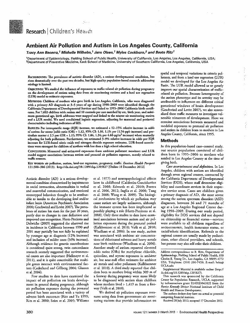
Ambient Air Pollution and Autism in Los Angeles County, CaliforniaTracy Ann Becerra.' Michelle Wilhelm; Jem Olsen,' Myles Cockburn/ and Beate Ritz'1Department of Epidemiology, Fielding School of Public Health, University of California, Los Angeles, Los Angeles, California, USA;20epartment of Preventive Medicine, Keck School of Medicine, University of Southern California, Los Angeles, California, USA
BACKGROUND:The prevalence of autistic disorder (AD), a serious developmental condition, hasrisen dramatically over the past two decades, but high-quality populerion-based research addressingetiology is limited.OBJECTIVES:We studied the influence of exposures to rraffio-reiared air pollution during pregnancyon the development of autism using data from air monitoring stations and a land use regression(LUR) model to estimate exposures.
METHODS: Children of mothers who gave birth in Los Angeles, California. who were diagnosedwith a primary AD diagnosis at 3-5 years of age duting 1998-2009 were identified through theCaUfornia Department ofDevelopmentaI Services and linked to 1995-2006 California birth certjfi-cates. For 7.603 children with autism and 10 controls per case matched by sex, hirth year, and mini-mum gestational age, birth addresses were mapped and linked to the nearest air monitoring stationand a LUR model. We used condtdonal Ioglsnc regression, adjusting for maternal and perinatalcharacteristics including indicators ofSES.REsULTS:Per intetquartile range (lQR) Increase, we estimated a 12-15% relative increase in oddsof autism for ozone [odds ratio (OR) '" 1.12.95% CI: 1.06. 1.19; per 1L54-ppb increase} and par-ticulate matter S 2.5 pm (OR to 1.15; 95% CI: 1.06, 1.24; pcr 4.68-pg/m3 increase) when mutuallyadjusting for both pollutants. Furthermore, we estimated 3-9% relative increases in odds per IQRincrease for LUR ..based nitric oxide and nitrogen dioxide exposure estimates. LUR-based associa-tions were strongest for children of mothers with less than a high school education.
CONCLUSION: Measured and estimated exposures from ambient pollutant monitors and LURmodel suggest associations between autism and prenatal air pollution exposure, mostly related totraffic sources.
KEYWORDS:air pollution, autism, land-use regression, pregnancy. traffic: Environ Health Perspect12"380-386 (2013). httpdldx.do;'o,g/10.12891ehp.1205827[Oolin,18D,eombe,2012)
Autistic disorder (AD) is a serious develop-mental condition characterized by impairmentsin social interaction, abnormalities in verbaland nonverbal communication, and restrictedstereotyped behaviors thought to be attribut-able to insults to the developing fetal andlorinfant brain (American Psychiatric Association2000; Geschwind and Levitt 2007). The preva-lence of autism has risen for the past 20 years,partly due to changes in case definition andimproved case recognition. Hertz-Plcclorto andDelwiche (2009) suggested the observed risein incidence in California between 1990 and2001 may partially but not fully be explainedby younger age at diagnosis (12% increase)and inclusion of milder cases (56% increase),Although evidence for genetic contributionsis considered quite srrong, twin concordanceresearch recently suggested that environmen-tal causes are also important (Hallmayer et al.2011), and it is quite conceivable that multi-pie genes interact with environmental fac-tors (Cederlund and Gillberg 2004: Glassonet al, 2004).
Few studies to date have examined theimpact of air pollution on brain develop-ment in general during pregnancy, althoughair pollution exposure during the prenatalperiod has _been associated with a variety ofadverse birth outcomes (Ritz and Yu 1999;Ritz er al. 2000; Sram er al. 2005; Williams
380
et al. 1977) and neuropsychological effectslater in childhood (Caldercn-Garciduefiaser al. 2008; Edwards er al. 2010; Pereraet a]. 2006, 2012; Suglia et al. 2008; Tanger al. 2008; Wang et al. 2009). The biologi-cal mechanisms by which air pollution maycause autism are largely unknown, althoughthe immune system has been implicated aspossibly playing a role (Herrz-Picclorto et al.2008). Only three studies to date have exam-ined associations between autism and air pol-lution exposures during the prenatal period(Kalkbrenner er al. 2010; Yolk er al. 2010;Windham er al. 2006). In one study, autismwas associated with ambient air concentra-tions of chlorinated solvents and heavy metalsnear birch residences (Windham er al. 2006).Another study of autism reported elevatedodds ratios (ORs) for methylene chloride,quinoline, and styrene exposures in ambientair. but near-null effccc estimates for ambientair metals and other pollutants (Kalkbrenneret al. 2010). A third study reported that chil-dren born to mothers living within 309 m ofa freeway during pregnancy were more likelyto be diagnosed with autism than childrenwhose mothers lived> 1,419 m from a free-way (Yolk et aI. 2010).
We derived air pollution exposure mea-sures using data from government air rnoni-toring stations that provide information on
spatial and temporal variations in criteria pol-lutants, and from a land use regression (LUR)model we developed for the Los Angeles AirBasin. The LUR model allowed us to greatlyimprove our spatial characterization of traffic-related air pollution. Because heterogeneity ofthe autism phenotype and -its severity may beattributable to influences on different criticalgestational windows of brain development(Geschwind and Levitt 2007), we also season-alized these traffic measures to investigate vul-nerable trimesters of development. Here weexamine associations between measured andmodeled exposures to prenatal air pollutionand autism in children born to mothers in LosAngeles County, California, since 1995.
MethodsIn this population-based case-control study.our source population consisted of chil-dren born in 1995-2006 [0 mothers whoresided in Los Angeles County at the time ofgiving birth.
Caseascertainment and definitwn. In LosAngeles. children with autism are identifiedthrough seven regional centers, contracted bythe California Department of DevelopmentalServices (DDS), whose Staff determine eligi-bility and coordinate services in their respec-tive service areas. Cases are children givena primary diagnosis of AD. the most severeamong the autism spectrum disorders (ASD)diagnoses, between 36 and 71 months ofage at a Los Angeles Regional Center dur-ing 1998-2009. During our study period,eligibility for DDS services did not dependon citizenship or financial status-serviceswere available to all children regardless ofsocioeconomic, health insurance status. orracial/ethnic identification. Referrals to theregional centers are usually made by pediatri-cians, other clinical providers, and schools,but parents may also self-refer their children.
Address correspondence to B. Ritz, Department ofEpidemiology, Fielding School of Public Health. 650Charles E. Young Dr., Los Angeles. CA 90095·1772USA. Telephone: (310) 206·7458. E-mail: [email protected]
Supplemental Material is available online (http://dx.doi.org/I0.1 289/ehp. 1205827).
This research was sponsored by the CaliforniaCenter for Population Research. UCLA, supportedby infrastructure grant R24HD041022 from theEunice Kennedy Shriver National Institute of ChildHealth and Human Development.
The authors declare they have no actual or potentialcompeting financial Inrerese.
Received28 July 2012; accepted 17 December 2012.
VOLUME121 j NUMBER3 I March 2013 • Environmental Health Perspectives
The diagnosis of AD was based onthe Diagnostic and Statistical Manual ofMental Disorders, 4th Edition, Text Revision(DSM-N-R) (American Psychiatric Association2000), code 299.00, reported on the ClientDevelopment Evaluation Report (CDER).Validation studies have established the. reli-ability and validity of the CDER in California(California Department of DevelopmentalServices 1986,2007).
Record linkage. We attempted tolink 10,821 DDS records of children withautism to their respective birth records usingthe National Program of Cancer RegistriesRegistry Plus" Link Plus Software [Centersfor Disease Conrrol and Prevention (CDC)2010a]. Given the child's first and last name,birth date, and sex; mother's first and lastname and birth date; and father's last nameand birth dare, we probablllsrlcally matchedthe two records and reviewed all high scor-ing linkages (. 25), almost half of the link-ages (9,120 of 22,806), only accepting thosemanually confirmed to be likely matches (seeCDC for record linkage concepts) (CDC2010b). The remaining lower scoring linkageswere reviewed using SAS version 9.2 (SASInstitute Inc., Cary, NC) and accepted onthe condition that the child's first and lastname, and birth date matched perfectly. Wecorrectly linked 8,600 DDS records (79.5%of all cases) to birth records. Of the 2,221DDS records not linked to CA birth records,35% were not born in Los Angeles County,46% were missing birthplace information,and only 19% recorded the child as born inLos Angeles County. The most common rea-son for nonlinkage was missing or incompletelinkage information on either of the records.
From among linked cases, we furtherexcluded children whose mother's residencywas outside of Los Angeles County duringher pregnancy (n = 41), records with missingor implausible gestational ages {c 21 or > 46weeks) or birth weights « 500 g or > 6,800 g)(n = 508), and cases who did not have a pri-mary diagnosis of AD (n '" 448), leaving afinal sample of 7,603 children with autismsuccessfully linked to a birth certificate whomet all inclusion criteria.
Control selection. We selected 10 con-trols for each case from our source popula-tion. Using birth certificates, each control wasrandomly selected without replacement andmatched on birth year and sex. In addition,each control's gestational age at birth had to
be equal to or greater than the gestational ageat birth of their matched case to ensure prena-tal exposures could be estimated for compa-rable lengths of time. Children were eligibleas controls if they had no documentation ofautism-c-did not have a DDS record in LosAngeles County by 2009. had a plausiblegestational age (21-46 weeks inclusive) and
birth weight (500-6,800 g inclusive), and themother resided in Los Angeles County at thetime ofhirth.
Marching by birth year balanced the largeincrease in autism rates during the case ascer-tainment period, 1998-2009. The matchedcontrol set included 76,030 children born dur-ing 1995-2006. From among these, we furtherexcluded 248 control children who died before6 years of age (71 months) based on Californiadeath records, leaving 75,782 controls.
Residential locations at delivery that werereported on birth cerrlflcares were mappedusing a custom gcocoder (Goldberg et ai.2008), and further exclusions were necessaryif residential addresses were not geocodable(9 cases. 147 controls) [see SupplementalMaterial, Table S 1 (Imp'! Idx.doi.org/l0.12891ehp.l205827)J. The geocoded residendal loca-tions at birth were then linked to the near-est government air monitoring station in LosAngeles County and our LUR model.
This research was approved by theUniversity of California. Los Angeles, Office ofthe Human Research Protection Program andthe California Committee for the Protectionof Human Subjects. and was exempted frominformed consent requirements.
Exposure assessment. Using measurementsfor the criteria pollutants carbon monoxide(CO), nitrogen dioxide (N02), nitric oxide(NO). ozone (03)' and particulate matterconcentrations with an aerodynamic diameters 10 fU11 (PMIO) and s 2.5 ~m (PM,,,) fromnearest monitoring stations, we estimatedaverage exposures for the entire pregnancy andfor three specific periods during pregnancy .based on the birth date and gestational agereported on the birth certificate: first trimester(estimated first day of last menstrual periodthrough day 92). second trimester (days93-185), and third trimester (day 186 to dateof birrh). The length of each pregnancy aver-aging period for controls was the same as fortheir matched case! Averaging periods for eachautistic risk set were truncated at the gesta-tional age of the matched case at birth. Hourlymeasurements for CO, N02, NO. and 03(1000-1800 hours) were first averaged foreach day if sufficient data were available [fordetails, see Supplemental Material. Table S2(htrp:lldx.doLorg/l0.1289/ehp.1205827)J.Daily averages for the gaseous pollutants and24-hr measurements ofPMIO-and PM2.5 (col-lected every 6 and 3 days, respectively) werethen averaged over the different pregnancyperiods when data were sufficient to do so(see Supplemental Material, Table S2).
To classify prenatal exposures to traffic-related pollutants on a more spatially-resolvedscale, we extracted NO and NOz concen-nation estimates at each residential locationfrom the LUR model surfaces we developedfor the los Angeles Air Basin (Su et al. 2009).
Environmental Health Perspectives' VOLUME 1211 NUMBER31 Mann 2013
Pollution and autism in Los Angeles
This LUR model was based on approximately200 measurements of outdoor air pollutiontaken during 2006-2007 in locations acrosslos Angeles County, in addition to predic-tors of traffic exhaust concentrations (such astrafflc COUnts, truck routes, and roadways).The model explained 81% and 860/0 of thevariance in measured NO and N02 concen-trations. respectively (Su et aI. 2009).
The LUR models most closely approxi-mate annual average concentrations. Thus,in addition to using the LUR annual average("unseasonalized") estimates. we also gener-ated "seasonalized" estimates to incorporateyearly and monthly air pollution variations.Specifically, using ambient air monitoringdata for NO and N02 at the closest monitor-ing station, the LUR estimates were adjustedto represent pregnancy month-specific LURvalues by multiplying the LUR (unseasonal-ired) estimates.for NO and NOz by the ratioof average ambient NO and NOz during eachpregnancy month to annual average ambientNO and NO, (2006-2007). These seasonal-Ized monthly LUR values were then averagedover each pregnancy period. We applied thesame exclusion criteria for missing values asdescribed above when generating the preg-nancy month scaling factors using the govern-ment monitoring data.
Statistical analysis. We calculatedPearson's correlation coefficients to examinerelations between the various pollutant mea-sures. Associations between air pollution expo-sure and odds of AD diagnosis were examinedusing one- and two-pollutant models. Weadjusted for LUR e...stlmates of traffic-relatedexposures in our monitor-based pollutantmodels and assessed particles and the gaseouspollucanr ozone together in the same model.We calculated ORs and 95% CIs using condi-tional logistic regression to estimate increasesin odds of AD per Inrcrquartlle range (IQR)Increase in pregnancy exposures, based onexposure distributions in the controls.
We adjusted for potential confounders forwhich data were available on birth certificatesbased on prior knowledge (see Table 1 for cate-gories used in models); maternal age. maternalplace of birth. race/erhnlcity, and education;type of birth (single. multiple), parity; insurancetype (public, private, or other, a proxy for socio-economic status); and gestational age at birth(weeks). In addition. we estimated pollutanteffects without adjustment for gestational age to
allow for the possibility that rhls factor might bean inrermediare and thus on the causal pathwaybetween air pollution and autism.
We expected maternal education to cor-relate with estimates of air pollution andautism (Ponce er a1. 2005), so we also usedunconditional logistic regression models toestimate associations stratified by maternaleducation (Jess than high school, high school,
381
Becerra et al.
Table 1. Demographic and prenatal characteristics by case (7,594) and control group (n = 75,635) Inl%lJ.
Characteristics AD cases Controls8Sex
Malefemale
Birth year199519961997199819992000200120022003200420052006
Gestational age (weeks) (mean ± SOlMaternal characteristicsMaternal age at delivery (years)
<1819-2526-3031-35> 35Missing
Materna! birthplaceu.s.tenForeign-bornUnknown
Maternal race/emnichyNon-Hispanic whiteNon-Hispanic blackHispanicAsianOther/unknown
Maternal education< High schoolHigh school> High schoolUnknown
Prenatal characteristicsType of birth
SingleMultiple
Insurance typePublic (Medi-Cal)PrivateOtherUnknown
ParityOne (index birth)TwoThree> ThreeUnknown
Birth weight (9) (mean ± SO)Paternal age at delivery (years)
< 1819-2526-3031-35>35Unknown
Paternal education< High schoolHigh school> High schoolUnknown
6,291182.811,303117.21
62,643182.8112,992117.21
27713.7131914.2138215.0148716.4145516.0159417.8173219.61885111.71
1,035113.611,034113.61
874111.5152016.91
39.0 ± 2.6
2,76213.713,17314,213,81215.014,85916.414,53316.015,90417.817,28519.618,776111.61
10,336113.7110,284113,618,735111.615,17616.81
39.4 ± 2.3
17812.311,673122.012,034126.812,159128.411,550120.41
°
4,99716.6123,906131.6120,228126.7116,845122.319,654112.81
510.01
3,544146.714,038153.21
1210.11
32,590143.1142,930156.81
11510.11
2,625134.6162218.21
3,183141.911,073114.11
9111.21
20,616127.316,02818.01
40.118153.018,123110.71
75011.01
1,725122.711,861124.513,926151.71
8211.11
27,232136.0{20,115126.6127,400136.21
88811.21
7,218195.0137615.01
73,880197.711,75512.31
2,971139.114,432158.41
11711.517411.01
39,382152.1133,746144.61
1,92512.6158210.81
3,280143.212,556133.711,134114.91
62318.21110.01
3321.0 ± 640.9
29,399138.9123,495131.1113,296117.619,417112.41
2810.013377.8 ± 543.3
5310.711,017113.411,545120.411,999126.312,502132.91
47816.31
1,48412.0116,067121.2117,752123.5117,174122.7117.286122.915,87217.81
1,508119.911,931{25.413,589147.31
56617.41
23,653131.3119,725126.1125,145133.217,11219.41
~Controls are matched to cases by sex and birth year, and at minimum reached the gestational age of the case.
382
more than high school) controlling for thematching variables (birth year. sex, and gesta~donal weeks at birth) in addition to me othercovarlates noted above.
ResultsBoth mothers and fathers of children withautism were older and more educated thanparents of control children, and mothers weremore often non-Hispanic white but less oftenHispanic. especially foreign-born Hispanic(Table I). A higher percentage of mothers ofcase children 'were primiparous and had mul-tiple gestations. As expected. children withautism had a lower mean gestational age atbirth and birth weight than control children.Of the children with autism not linked to aLos Angeles County birth record, parentalcharacteristics were undetermined becauseof frequent missing information- 50-60%missing maternal and paternal age/birthday(results not shown). However, of these non-linked DDS records, 42% of families wereHispanic (results not shown), comparable (0
the 41.90/0 Of Hispanic mothers of case chil-dren included in this study (Table 1).
Unseasonalized LUR-hased exposure esti-mates for NO and N02 were negatively cor-related with entire pregnancy ozone (r." -0.23and -0.33. respectively) but positively cor-related with entire pregnancy CO, NO, NOl>and PM,., (r = 0.22-0.43), and as expected,correlations between measured levels of pol-lutants and seasonallzed LUR estimates werestronger than correlations with unseasonal-ized LUR estimates (r "" 0.30-0.73) [seeSupplemental Material, Table S3 (http://dx.doi,org/10.1289/ehp.1205827)J. Eventhough all trimester-specific measures corte-lared moderately with entire pregnancy aver-ages (r 2: 0.46), second-trimester exposureaverages correlated most strongly with entirepregnancy averages (r 2: 0.80), and first- andthird-trimester averagesfor the same pollutantswere least correlated (r"" 0.05-0.37) {resultsnot shown}.
We estimated 4-7% relative increases inodds of an AD diagnosis per IQR increasein unseasonalized LUR measures of NO andN02 in adjusted models (Table 2). TheseOR estimates remained similar (1.03 to 1.09)in two-pollutant adjusted models (Table 3).ORs for autism per lQR increase in monitor-based estimates of entire pregnancy exposureto NO and N02 were slightly smaller thanassociations with IQR increases in LUR-based estimates (Table 2). We also estimatedincreases in odds of AD diagnosis per IQRincrease in entire pregnancy exposure to ozone(OR = 1.06; 95% CI: 1.01, Ll2) and PM,.,(OR = 1.07; 95% CI: 1.00. Ll5) (Table 2).In two-pollutant models these estimatesincreased (0, OR = L12; 95% CI: 1.06,Ll9: PM,,, OR = LIS; 95% CI: 1.06, 1.24)
VOLUME1211 NUMBER31 March2013 • EnvironmentalHealth Perspectives
when we mutually adjusted for both pollutants(Table 3). In addition, without adjustmentfor gestational weeks at birth, associationsincreased further or remained the same; forthe two-pollutant models including ozone andPM2.5 (0, OR = I.l4; 95% CI; !.IO, !.I9;PM2.5 OR = !.I5; 95% CI: 1.09, 1.22) or0, and LUR-N02 (0, OR = !.IO; 95% CJ:1.06, I.l4; LUR-N02 OR = 1.10; 95% CI:1.07, 1.13)(resuh, nor shown).
In general, effect estimates did not showconsistent patterns across trimesters in one-pollutant models. For example. average second-and third- but not first-trimester exposures to
03 were associated with AD [first-trimesterOR = 1.00 (95% CI: 0.97, 1.03); second-rrl-mester OR = 1.02 (95% CI: 1.00, 1.05); third-rdmesrer OR = 1.04 (95% CI: 1.01, 1.06)J[see Supplemental Material, Table S4 (http://dx.doi.org/IO.1289/ehp_1205827)J.
Table 2. Associations between lOR increases in entire pregnancy average air pollution exposures andAD; conditional logistic regression analysis using matched controls,"
Unadjusted Adjustedb
Exposure metric lOR OR rf (case/control) ORI95%CIIU·LUR-NO 9.40ppb 0.87 7,420172.231U·LUR-NO, 5.41 ppb 0.91 7,420172.231S-LUR-NO 18.46ppb 0.84 6.279/52.144S-LUR-NO, 9.70ppb 0.87 6.279/52.144CO 0.55 ppm 0.85 7.421172.253NO 29.67ppb 0.85 7.421172.253NO, 10.47ppb 0.89 7,421172.2530, 11.54ppb 1.19 7,421172.253PM,o 8.25 pg/m' 0.96 6,795/63.662PM,., 4.68 pg/m' 1.01 5.840/55.776
1.0411.00.1.0811.0711.03.1.1211.0210.96.1.0811.0510.98.1.1210.9910.94.1.0511.0110.95.1.0711.0410.98.1.1011.0611.01.1.1211.0310.96.1.1011.0711.00.1.151
Abbreviations: S-LUR, seasonauzed land use regression; U-LUR, unseescnejzed land use regression."'Controlsmatched to cases by birth year, sex, and at minimum reached the gestational age of the case. bAdjustedtormaternal age, education, race/ethnicity, maternal place of birth~type of birth, parity, insurance type, gestational weeksat birth (continuousJ.tSamp!e with complete data fl.e., strata with at least one case and onecontroll.
Table 3. Associations between lOA increases in entire pregnancy average air pollution exposures andAD: conditional logistic regression analysis using matched controls," adlusted=iwo-polletantmodels.
Tf Pollutant 1 Pollutant 2Pollutant 1 lOR Pollutant 2 lOR (case/control) ORI95%Cn ORI95%CII0, 11.54ppb U-LUR-NO 9.4 ppb 7,420172.131 1.0811.03.1.141 1.0611.02.1.1110, 11.54ppb U-LUR·NO, 5.4 ppb 7,410172.131 1.0811.03.1.141 1.0911.04.1.131NO 29.67ppb U·lUR-NO 9.4 ppb 7,420172.231 0.9910.93. 1.051 1.0411.00.1.091NO 29£7 ppb U·LUR-NO, 5.4 ppb 7,420172.231 0.9810.92. 1.041 1.0811.03.1.131CO 0.55 ppm U-LUR-NO 9.4 ppb 7,420172.231 0.9710.91. 1.031 1.0511.00.1.091CO 0.55ppm U·LUR-NO, 5.4 ppb 7,420172.131 0.9610.91. 1.021 1.0811.03.1.131PMlO 8.25 pg/m' U-LUR-NO 9.4 ppb 6,794/63.642 1.0210.95.1.101 1.0411.00.1.091PMlO 8.25 pg/m' U-LUR-NO, 5.4 ppb 6.794/63.641 1.0010.93.1.071 1.0811.03.1.131PM2.5 4.68 jJg/m3 U-LUR·NO 9.4 ppb 5~39/55.757 1.061029. 1.141 1.0310.98.1.081PM2.5 4.68pg/m' U·LUR-NO, 5.4 ppb 5.839/55,757 1.0510.97.1.121 1.0711.01.1.1210, 11.54ppb PM10 8.25 pg/m' 6.795/63.662 1.0611.01.1.121 1.0410.97.1.1110, 11.54ppb PM2.5 4.68 pg/m' 5.840/55.776 1.1211.06.1.191 1.1511.06.1.241U-LUR, unseasonejzed land use regression,'Controls matched to cases by birth year, sex, and at minimum reached the gestational age ot the case, IIAdiusted formaternal age, education, race/ethnicity, maternal place 01 birth; type of birth, parity, insurance type, gestational weeksat birth (continuousl. "Sample with complete data (le., strata with at least one case and one control).
Pollution and autism in los Angeles
Adjusting for maternal education changedair pollution effect estimates most strongly.likely because socioeconomic status is stronglyassociated both with air pollution exposure andautism diagnosis. We also investigated potentialeffect measure modification of the air pollutionand autism association: We examined whetherair pollution effect estimates vary according tostrata of maternal education possibly due todifferences in vulnerability, in actual exposure,or exposure and outcome misclasslfication.Generally. LUR-basoo traffic-related pollutantestimates showed the strongest association withautism in children of the least educated moth-ers, compared with mothers in the highest edu-cational stratum (Table 4).
DiscussionWe estimated an approximately 3-9% rela-tive increase in the odds of AD per IQRincrease in entire pregnancy exposure to NO(9.40 ppb) and N02 (5.41 ppb) as estimatedby our two-pollutant LUR models. Our LURmodel was built upon neighborhood-levelmeasures of nitrogen oxides (NOx) and rep-resents smaller-scale variability in exhaust pol-lutants, compared with estimates based onair monitoring station measurements (Zhouand Levy 2007). We also estimated a 5-15%relative increase in the odds of AD per IQRincrease in entire pregnancy exposure toPM2.> (4.68 ~g/m') (Table 3). a pollutantwhose concentrations are driven partly byfossil fuel combustion in motor vehicles. Inaddition. an 11.54-ppb increase jn 03 expo-sures during pregnancy was associated with a6-12% relative increase in the odds of havinga child diagnosed with autism.
Few studies have previously examinedassociations between air pollution-relatedexposures during the prenatal period andlater development of autism. and none usedambient air monitoring data or LUR mod-els to estimate risk in a large population. Arelatively small study (284 cases, 657 con-trols) in the San Francisco Bay, California,area used study-specific census traer pollution
Table 4. Associations between IUR increases in entire pregnancy average air pollution axposures and AD: unconditional logistic regression by maternal education.Adjusted DRs by materna! education"
< High school High schoo! > High schoolPollutant lOR Case/control Adjusted OR Case/control Adjusted OR Case/contro! Adjusted ORU-lUR·NO 9.40 ppb 1.713/27.051 1.1111.05.1.181 1.842/19.962 1.0310.97.1.091 3.865/26.987 0.9910.95.1.031U·lUR·NO, 5.41 ppb 1.713127.051 1.1711.1O.1.251 1.842/19.962 1.0611.00.1.131 3.865/26.987 1.0310.99.1.071S-LUR-NO 18.46ppb 1,435/23.270 1.0310.96.1.101 1.513/16.533 1.0210.95.1.091 3.331122.872 1.0110.96.1.071S-LUR-NO, 9.70ppb 1,435/23.270 1.0410.97.1.271 1.513/16.533 1.0710.99.1.151 3.331122.872 1.0711.01.1.121CO 0.55 ppm 1.714/27.036 0.9010.85.0.961 1.842/19.949 1.0310.97.1.091 3.865/26.960 1.0911.04.1.141NO 29.67ppb 1.714/27.036 0.9610.89.1.031 1.842/19.949 1.0110.95.1.091 3.865/26.960 1.0410.99.1.101NO, 10.47ppb 1.714127.036 0.9710.90,1.041 1.842/19.949 1.0811.01.1.161 3.865/26.960 1.0711.02.1.1210, llE4ppb 1.714/27.036 1.0911.01.1.161 1.842/19.949 1.0711.01.1.141 3.865/26.960 1.0410.99.1.091PM,., 825pg/m' 1.352120.540 1.0410.96.1.121 1.415/15.647 1.0911.01.1.171 3.074/21.970 1.0611.00.1.121PM," 4.68 pg/m' 1.585/24.775 0.9710.91.1.041 1.670/18.273 1.0811.01.1.161 3.550/24.707 1.0210.97.1.071Abbreviations: S-LUR. seascnallzed land use regression; U-LUR, unseasonaueed land use regression. Missing maternal education {case/controll: U-LUR: 63m8; S-LUR: 50/605; monitor-based criteria: 6l1715; PMIO: 57/659; PM2.~:51/596,'Adjusted for child's birth year, sex; maternal age, race/ethnicity, maternal place of birth: type of birth, parity, insurance type, gestational weeks at b'u1h{continuous}.
Environmental Health Perspectives· VOLUME 1211 NUMBER31 March 2013 383
Becerra et sl.
scores derived from annual average concen-trations and found hazardous air pollutant(HAP) concentrations (i.e .• mercury. cad-mium, nickel. trichloroethylene, and vinylchloride) near birth residences to he assocl-ared with autism (Windham ee aI. 2006). Astudy by Kalkbrenner et aI. (2010) in NorthCarolina and West Virginia. with less expo~sure variability compared with California,reponed near-null effecc esrlmares for metalsand several pollutants associated with AD inthe San Francisco study. Both studies reliedon the same HAP pollutant data source andthe CDC autism surveillance system (Autismand Developmental Disabilities MonitoringNetwork) to Identify cases. However. insteadof sampling controls from birth certificates,the North Carolina/West Virginia studyinvestigators, using education records. selectedcontrol children with speech and languageimpairment (383 cases, 2,829 controls). Athird study (304 autism cases and 259 rypi-cally developing controls) based in California[Childhood Autism Risks from Genetics andthe Environment (CHARGE) sntdy] reportedrelatively strong associations (OR", 1.86, 95%CI, 1.04. 3.45) between childhood autismand proximity (living within 309 m) to a free-way during pregnancy (Hertz-Piccicrro ex al.2006; Volk er al. 2010). Trimester-specificaddresses were geocodcd, and measures ofdistance to freeways and major roads werecalculated using geographic information sys-tem software. This small study was the firstto suggest that traffic-related exposures mightincrease the risk of autism. In our study, weobserved weaker associations with monitor-based and modeled air pollution exposureestimates in a much larger study population.
Gestational toxicity may plausibly resultfrom maternal exposure to NOl, which hasbeen shown to disturb early neuromotor devel-opment in animals. causing coordination defi-cits and reduced activity and reactivity in rats(Tabacova et al, 1985); specifically. NO, expo-sure at low (0.05--j).10 mglm') and high (Iand 10 mg/m3) concentrations for 6 hr eachday throughout gestation affected neuromo-tor development in offspring. The mean N02level in our srudy (30.8 ppb) [see SupplementalMaterial. Table S3 (http,lIdx.doi.orgilO.12891ehp.1205827)} fulls within the exposure rangeclassified as "low" in this animal study (0.05-0.10 mglm' or 26.6-53.2 ppb). Beckermaner aI. (2008) suggested that NO may be a proxymeasure for ultrafine particle (UFP; < 0.1 p.min aerodynamic diameter) exposures from traf-fic exhaust and reported strong correlationsbetween l-week average concentrations ofNO, N02• and NOt and short-term (10 min)measures of UFP (r = 0.8-0.9) at varying dis-tances from a major expressway in Toronto.Canada. Fine particles (PM2.5) can cause oxi-dative stress, and in vitro animal and human
384
postmortem brain studies showed they cantrigger cellular toxicity and brain eel! parhol-ogy (Lai et al. 2005; Li et aI. 2003. Peters et al.2006). Hertz-Plcclotro et al. (2005) foundthat maternal PM2.5 exposures 2 weeks beforebirth were associated with altered lympho-cyte Immunophenotypes, and suggested thatthis might mediate effects of air pollution onchildhood morbidity. Developmental immunesystem disruption has been hypothesized toplaya role in neurobehavloral disorders suchas autism, considering the close connectionbetween the development of the immune sys-tern and the central nervous system (Hertz-Plcclouo et aI. 2008).
To our knowledge. this is the first studyto suggest associations between ozone andAD. Although 03 levels have dropped overthe last decade. the Los Angeles region stilloften has the highest levels of 03 nationwide,violating federal health standards an averageof 137 days/year (averages from 2007 through2009) (Roosevelt 2011). In contrast with thetraffic-related and particle associations thatbecame positive only when we adjusted formaternal education. 03 effect estimates movedcloser toward the null after adjustment forcovarlares. This is consistent with expectations,because traffic-related pollution is higher inlower~SES (socioeconomic status) neighbor-hoods, whereas 03 levels are higher in subur-ban high-SES areas. and autism is more likelyto be diagnosed earlier in children of motherswith higher SES. Specifically. 0, and NO fol-low opposite distribution patterns across theLos Angeles Air Basin. 03 is formed by photo-chemical reactions in the presence of precursorpollutants from exhaust, and concentrationsare low near freewayslroadways (due to pres-ence of strong NO emission sources) andhigher in suburban neighborhoods (Wilhelmer al. 2009). Controlled animal studies suggestthat 03 may cause adverse neurobehevloraleffects after gestational exposure (Kavlock et al.1980; Petruzzi etal. 1995; Sorace et al. 2001).
We relied on information recorded onCalifornia birth certificates to adjust forpotential confounding by prenatal risk factorsfor autism reponed in the literature (Gardenerer. al. 2009, 2011 )-parental age at birth.parity, maternal place of birth, and multiplebirths. However, we were unable to controlfor potential confounding due to maternalphysical and mental health history, or mater-nal active or passive smoking. Women giv-ing birth in Los Angeles are predominantlyHispanic, and our survey of 2.543 womengiving birth in Los Angeles County in 2003found that only I% of foreign-born Hispanic,5% of U.S.-horn Hispanics. and 7% of non-Hispanic whites were active smokers dur-ing pregnancy (Hoggatt et al. 2012). Also.a recent study found no assocladon [preva-lence ratio = 0.88 (95% G 0.72. 1.08)J of
maternal smoking during pregnancy withAD (Kalkbrenner et al. 2012). Confoundingby other SES-related factors potentially cor-related with air pollution is also a concern.Families of lower SES are more likely exposedto air pollution, and less likely represented inthe autism case group, possibly due to under-ascertainment (Durkin et al. 2010; Grineskiet a]. 2007; Institute of Medicine 1999),which could have potentially biased our effectestimates toward the null. However, we esti-mated stronger associations among those withthe lowest maternal education for LUR-basedestimates of NO and N02• We adjusted forrype of insurance (public vs. private pay), aswell as other SES indicators important in theLos Angeles community [i.e., maternal placeof birch and education) because we previ-ously showed that these factors were sufficientto adjust adequately for SES in Los AngelesCounty birth outcome and air pollution stud-ies; effect estimates for air pollution and birthoutcomes were very similar when we adjustedfor maternal occupation, income. and educa-tion or simply for birth certificate-derivedSES measures (Hoggatt cr al. 2012).
In addition to being a confounder. ges-tational age at birth may also be a mediatorbetween air pollution and autism. In analysesnot adjusting for gestational weeks at birthwe estimated larger or similar effect sizes.However, not adjusting for gestational ageat birth may also result in biased estimatesbecause of our matching design. Specifically,because conrrols were sampled from amongchildren who at birth had reached at mini-mum the gestational age of the matched case,gestational age as a matching variable requiredthar we analytically control for it. Thus themagnitude and direction of any potential biasfrom adjusting or not adjusting for gestationalage at birth is not easily quantifiable.
A source of exposure measurement error isthe reliance on address information reportedon birth certificates, which does not accountfor women who worked far from home or res-idential mobility during pregnancy. PreviousU.S.-based studies (1997-2004) indicare that15-30% of women change residence dur-ing pregnancy (Chen et al. 2010; Lupo er al.2010). In our previous population-basedsurvey of 2,543 women residing in 111 ZIPcodes in Los Angeles County and deliver-ing in 2003, 22% reponed moving duringpregnancy (Ritz er al. 2007). Our surveyalso found pregnant women of lower SESless likely to be employed and more likely to
spend time near their residence, suggestingexposure is less misclasslfied for lower com-pared with higher-SES women,
Distance from a monitoring stationlikely introduced some nondifferenrial mis-classification of exposure, especially for pol-lutants such as CO and N02 that are more
VOlUME 1211 NUMBER31 March 2013 • Environmental Health Perspectives
heterogeneously distributed. On average, thedistance between home addresses and thenearest monitoring station was 6.7 miles inour study, and monitor-based estimates ofCO, NO, and N02 are questionable in theirvalidity if air pollution measurements are moreaccurate representations of actual exposuresforwomen living closer to a station (Ghosh et at2012; WUhelm er al. 2011). Ambient stationmeasures for PM2.5 and 03' however, are lesslikely to misrepresent actual exposures.becausethese pollutants are generally considered morehomogeneously distributed over larger regions.
LUR-derived NO and N02 estimates aremuch more spatially resolved than monitor-based estimates, and were previously associ-ated with adverse pregnancy outcomes in thesame Los Angeles population (Ghosh et al.2012; Wdhelm er al. 2011). Our LUR modelnot only represents local traffic-related pol-lution well. it reduces possible confoundingby spatial SES factors. For example, autismdiagnoses have been reported to vary spatiallyin California due to SES (Van Meter er at2010). but measures of air pollution are notinherently influenced by these spatial factorsrelated to SES (Wilhelm et al. 2009). Forpollutants that are more homogeneous overlarger regional areas, such as PM2.5 and 03'confounding due to SES is possible; never-theless, associations were stronger when wemutually adjusted for both pollutants.
A major strength of our study was theuse of our novel LUR exposure measures fortraffic-related pollution in addition to routine.government monitoring station data for crite-ria pcllutanrs to help identify specific emls-slons of concern for autism. Furthermore,selection bias due to participation is unlikelyto have occurted.
ConclusionsTIle observed association with the LUR modelestimates and monitoring station-based 03and PM2.5 measures suggest a link betweenAD and traffic-related exposures during preg-nancy. Ideally. future autism and air pollu-tion studies should use neighborhood-levelmonitoring or modeling of air toxins such aspolycyclic aromatic hydrocarbons and pos-sibly speciated PM2.5 to determine whetherthese results are reproducible with improvedair pollution assessment.
REFERENCES
American Psychiatric Association. 2000. Diagnostic andStatistical Manual of Mental Disorders. Fourth Edition,Text Revision. Washington, OC:American PsychiatricAssociation.
Beckerman B, aerren M, Brook JR, Verma OK. Arain MA.Finkelstein MM. 2OOS.Correlation of nitrogen dioxide withother traffic -pnUutants near a major expressway. AtmosEnviron 42:275-250.
Calderon-Gartiduenas l.Mora- Tiscareft(l A, Ontiveros E. Gomez-Garza G, Barregan-Mejia G, Broadway J. at at 2008. Air
poUlJ110n,cognitive deficits and brain abnormalities: a pilotstudy with children and dogs. Brain Cogn 68(2):117-127.
California Department of Developmental Services. 1986.COER Materials for Regional Centers: COER Manual.Available: tmp://www.dds.ca.gr;v/FactsStats/docs/COER_manuaIBM.pdf{accessed 5 Febru81Y2013}.
California Department of Developmenta! Services. 2007. AutismSpectrum Disorders: Changes in the California Easeload,An Update: June 15a7-June 2007. Available: http:t/www.dds.ca.gov/AtitismlHome.cfm {accessed 23 October 20111.
CDC jCenters for Disease Control and Preventlonl, 201Oa. UnkPlus: Probabilistic Recr;rd linkage Software from C~C.Available: www.cdc.gov{ncellitracking/webinars/mar06!rawson.pdf [aneessed 8 December 2012J.
CDC !Centers for Disease C(lntroi and Preventionj. 2010b. NationalProgram of Cancer Registries (NPCRI. Registry Plus. a suiteof publicly available software programs for collecting andprotes:sing cancer registry data. Availab!e: http://www.cdc.gov/cancer/npcr/ {accessed 8 December 20121.
Cederlund M, Gil!berg C. 2004. One hundred males withAsperger syndrome: a clinical study of background andassociated factors. Oev Med Child NeuroI46(10):652-660.
Chen L, Bell EM, Caton AR, Orusche! CM, Lin S. 2010.Residential mobiiity during pregnancy and the potential lorambient air pollution exposure mtsclasslncauon. EnvironRes 110(2):162-168.
Durkin MS, Maenner MJ, Meaney FJ, Lew SE, mGuiseppi, C.Nicholas JS, et at. 2010. Socioeconomic inequality in theprevalence of autism spectrum disorder: Evidence from aus. cross-sectional study. PLoS One:dei:l0.1371/journal.pone.C011551 {Online 12 July 201O}.
Edwards SC, Jedrychowski W, Butscner M. Camann 0,Kieltyka A, Mroz E, et a!. 2010. Prenatal exposure to air-borne polycyclic aromatic hydrocarbons and children'sintelligence atS years of ago in a prospective cohort studyin Poland. Environ Health Petspact 118:1326-1331.
Gardener H, Spiegelman D, Buka SL 2009. Prenatal risk factorsfor autism: comprehensive meta-analysis. Br J Psychiatryt95(1t.7-14.
GardanerH, Spiegelman 0, Buka SL 2(111.Perinatal and neona-tal risk factors for autism; a comprehensive meta-analysis.Pediatrics 128(2):344-355.
Geschwind DH,Levitt P. 20(17. Autism spectrum disorders:developmental disconnection syndromes. Curr IlplnNeurobiol1711 ):103-111.
Ghosh JKC, Wilhelm M, Su J, Goldberg 0, Cockburn M,Jarrett M, et at. 2012. Assessing the influence of traffic-related airpo!tution on risk of term low birth weight on thebasis of land-use-based regression models and measuresof airtcxles. Am J EpidemioI175(12):1262-1274.
Glasson EJ, Bower C, Petterson B. de Klerk N. Chaney G,Hatlmaver JF. 2004. Perinatal factors and the develop-ment of autism: a populanon study. Arch Gen Psychiatry61(6):618-627.
Goldberg OW, Wilson JP, Knoblock CA, Ritz B. Cockburn MG.2008 .. An effective and efficient approach for manu-ally improving geocoded data. Int J Health Geogr 7:60;doi:l0.1186n476~72X-HO (Online 26 November 2008J.
Grineski S, Bolin B, Boone C. 2007. Criteria air pollution andmarginaraed populati(lns: environmental inequity in metro-politan Phoenix, Arizona. Soc Sci Q 88(2);535-554.
Ha1!mayer J, Cleveland S, Torres A. Phillips J. Cohen B.Torigoe T. et er. 2011_ Genetic heritabifity and shared envi·fonmantal factors among twin pairs with autism. Arch GenPsychiatly 6811 1);1095-1 102.
Hertz-Ptceietto I, Croen LA, Hansen R. Jones CR.van de Water J, Pessatt IN. 2005. The CHARGE study: anepidemiologic investigation of genetic and environmentalfactors contributing to autism. Environ Health Perspect114:1119-1125.
Heru-Plccteno I, Delwiche L 2009. The rise in autism and thetole of age at diagnosis. Epidemiology 2O{11:84-50.
Hertz-Picciotte I, Herr CEW, Yap p·s. Dostal M, ShumwayRH, Ashwood P, et at 2005. Air pollution and lympho-cyte phenotype proportions in cord blood. Environ HealthPerspect 113:1391-1398.
Herta-Plccleue I, Park H-Y, Dostal M, Kccan A. trnovec T.Sram R. 2008. Prenatal exposures to persistent and non-persistent organic compounds and effects on immunesystem development. Basic cun Pharmacol Texico!102(21:146--154.
Hoggatt K. Flores M, Solorio R. Wilhelm M. Rill B. 2012. The"tenea EpidemiologiC Paradox' revisited: The role ofbirthplace and acculturation in predicting infant low birth
Environmental Health Perspectives • VOLUME 121 ) NUMBER 3! March 2013
Pollution and autism in Los Angeles
weight for taunes in los Angeles. CA. J Immigr MinorHealth 14(5):87!H184.
Institute of Medicine. 1599. Toward Environmental Justice:Research, Education. and HEtalth Policy Needs. Available:http://www.iom.edU/ReportsJl999!Toward-Environmental-Justice-Research-Education-and-Hoalth-Policy-Needs.aspx {accessed 9 Oecember2012J.
Kalkbrenner AE, Braun JM, Ouridn MS. Maenner MJ. Cunniff C.lee L-C, et at 2012. Materna! smoking during pregnancyand the prevelence of autism spectrum disorders using datafrom the Autism and OeveJopmentalDlsabi!ities MonitoringNetwork.. Environ Health Perspect 120:1042-1048.
Kalkbrenner AE, Daniels Jl, Chen J-C, Poole C. Emch M.Morrissey J. 2010. Perinatal exposure to hazardousair pollutants and autism spectrum disorders at age 8.Epidemiology 21{5j:631~1.
Kavtock RJ, Meyer E, Grabowski CT. 1980. Studies on thedevelopmental toxicity of ozone: Postnatal effects. Toxieo!lett5{1j:3-9.
Lal C-H, Uou S·H, lin H·C, Shih T-S, Tsai P-J, Chen J-S, et et.2005. Exposure to traffic exhausts and oxidative DNA dam-age. Occup Environ Med 62(4):21&-222.
li N, Siolrtas C, Cho A, Schmitz O. Misra C, Sempf J, et at. 2003.Ultrafine particulate pollutants induce oxidative stressand mitochondria! damage. Environ Health Perspect111:455-460. '
lupo PJ, Symanski E, Chan W, MitcbellLE, Waller OK,Canfield MA, et er. 2010. Oifferances in exposure assign-ment between conception and delivery: the impact of.rneternel mObility. Paediatr Perinat Epidemiol24(2):200-208.
Perera FP, Bauh V, Whyatt RM, TsaiW-Y, Tang O,DiazO, et al.2006. Effect of prenatal exposure to airborne polycyclicaromatic hydrocarbons en neumdevetcpment in the first3 years of life among inner-city children. Environ HealthPerspect 114:1287-1292.
Perera FP, Tang 0, Wang S, Vishnevetsky J, Zhang B, Dial 0,et et. 2012. Prenatal polycyclic aromatic hydrocarbon(PAHj exposure and child behavior at age 6-7 years.Environ Health Perspect 120:921-926.
Peters A, Veronesi B, cateersn-aercteueaes L, Gehr P,Chen lC, Geiser M, et al, 2006. Translocation and potentialneurological effects of fine and ultrafine particles a criticalupdate. Part Fibre ToxieoI3:13; doi:1O.1186!1743-891H-13{Online 8 September2006].
Petruzzi S, Fiore M, Oet!'Omo G, Bignami G, Alleva E. 1995.Medium and long-term behavioral effects in mice ofextended gestational exposure to ozone. Neurotoxico!TeratoI17(4):463-470.
Ponce NA. Hoggatt KJ. Wilhelm M, Ritz 8. 2005. Preterm birth:The interaction of t-affic-retated air pollution with ecu-nomic hardship to los Angeles neighborhoods. Am JEpidemioI162(2):I4G-I48.
Ritz B, Wilhelm M, Hoggatt KJ, Ghosh JKC. 2007. Ambient airpoUution and preteen birth in the environment and preq-nancy outcomes study at the Uni\lersity of California. losAngeles. Am J Epidemiol 166(9}:1045-105l
Ritz B, Yu F. 1999. The effect of ambient carbon monoxideon low birth weight among children born in southernCalifornia between 1989 and 1993. Environ Health Perspect107:17-25.
Ritz B, Yu F. Chapa G, Fruin S. 2000. Effect of air pollution onpreterm birth among children born in southern Californiabetween 1989 and 1993. Epidemiology 11 \51:502-511.
Roosevelt M. 2011. LA., Bakersfield remain among U.S:s mostpolluted cities, report says. los Angeles Times, 27 April.Available: http://articlesJatimes.comI2011/apr/27/loca!/ta-me·califomia-air-20110427Iaccessed 8 December 2012].
scrace A. AcetJs tn. Alleva E. Santucci D. 2001. Prolonged expu-sure to low doses of ozone: short- and long·term changes inbehavioral performance in mice. Environ Bee 85121:122-134.
sram RJ, Binkovii B, OeimekJ, Bobak M. 2.OIJ5. Ambient air pot-lution and pregnancy outcomes; a review of the literature.Environ Health Perspect 113(41:375-382.
Su JG, Jerrett M. Beckerman B. Wilhelm M. Ghosh JKC, Ritz B.2009. Predicting traffic-related air pollution in los Angelesusing a distance decay regression selection strategy.Environ Res 109(6):557-670.
Suglia SF, Gryparis A, Wright RO, Schwartz J. Wright RJ. 2008.Association of black carbon with cognition among chil-dren in a prospective birth cohort study. Am J Epidemio!167(3):280-286.
ranecove S. Nikiforov B, Balabaeva L 1985. Postnatal effectsof maternal exposure to nitrogen dioxide. NeurobehavTexico! TeratoI1:785-789.
385
Becerra et al.
Tang 0, u T, uu JJ, zncu Z, Yuan T, Chen Y, er at 20na. Effectsof prenatal exposure to coal·burning pollutants on chil-dum's development in China. Environ Health Perspect116:674-679.
Van Meter KC, Christiansen LE, Delwiche tn, Azari R,Carpenter TE, Hettz·Picciotto I. 2010. Geographic distribu-tion of autism in California: a retrospective birth cohortanalysis. Autism Res 3(11:19-29.
Voll<HE. Hertz-Plcclettc I, Delwiche l,lurmann F, McConnell R.2010. Residential proximity to freeways and autism in theCHARGE study. Environ Health Perepect 119:873-877.
Wang S, Zhang J, Zeng X, Zeng Y, Wang S. Chen S. 2009.Association of traffiC-felated air poUlItion with children'sneurcbeheviorat functions in o.uamhou, China. EnvironHealth Perspect 117:1612-1618.
Wilhelm M, Ghosh JK, Su J, Cockburn M, Jerrett M, Ritz B.2011. Traffic-related air taxies and term low birth weightin los Angeles County, California. Environ Health Perspect120:132-138.
Wilhelm M, Wan t, Ritz B. Z0lI9. Olftdoor air pollution, familyand neighborhood environment. and asthma in LA FANSchildren. Health Place 15(11:25-35.
Williams l. Spence A, Tldernan SC. 1977. Implications at theobserved effects of air pollution on birth weight Soc Bioi24(1):1-9. .
Windham GC, Zhang L Burtier R. Croen LA. Grether JK. 2006.Atltism spectrum diserders in relation to distribution ofhazardous air pollutants in the San Francisco bay area.Environ Health Perspect 114:143&-1444.
Zhou y, levy JI. 2007. Factors influencing the spatial extentof mobile secrce air poUution impacts: a meta-analysis.BMC Public Health 7:89; doi:l0.1186/1471-245S-7-89 [Online22May2OO7l.
386 VOLUME121 1NUMBER31 March 2013 • Environmental Health Perspectives
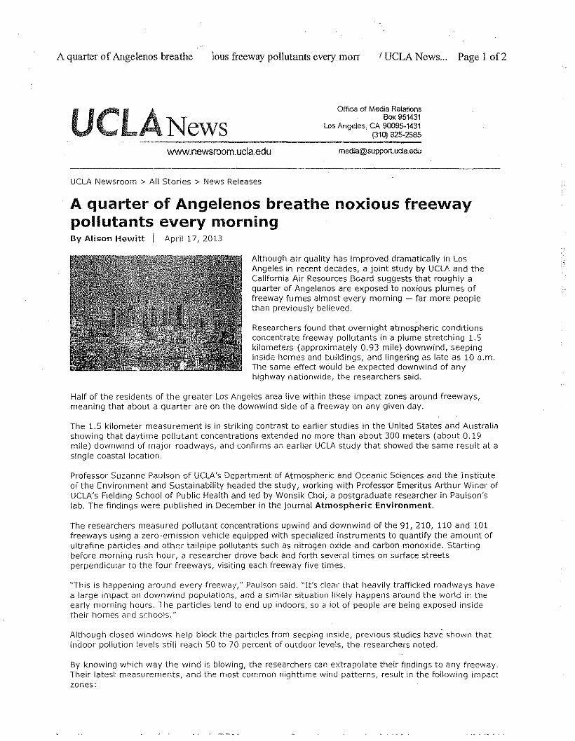
A quarter of Angelenos breathe lous freeway pollutants every morr IUCLA News... Page I of2
UCLA NewsOffice of Meoia Relations
Box 951431Los Angeles. CA 90095·1431
(310) 825·2585..•.•_.__._----------_-.:......:.-_-www.newsroom.ucla.edu [email protected]
UCLA Newsroom> All Stories> News Releases
A quarter of Angelenos breathe noxious freewaypollutants every morningBy Alison Hewitt i April 17, 2013
Although air quality has improved dramatically in LosAngeles in recent decades, a joint study by UCLA and theCalifornia Air Resources Board suggests that roughly aquarter of Angelenos are exposed to noxious plumes offreeway fumes almost every morning - far more peoplethan previously believed.
Researchers found that overnight atmospheric conditionsconcentrate freeway pollutants in a plume stretching 1. 5kilometers (approximately 0.93 mile) downwind, seepinginside homes and buildings, and lingering as late as 10 a.m.The same effect would be expected downwind of anyhighway nationwide, the researchers said.
Half of the residents of the greater Los Angeles area live within these impact zones around freeways,meaning that about a quarter are on the downwind side of a freeway 'On any given day,
The 1.5 kilometer measurement is in striking contrast to earlier studies in the United States and Australiashowing that daytime pollutant concentrations extended no more than about 300 meters (about 0.19mile) downwind of major roadways, and confirms an earlier UCLA study that showed the same result at asingle coastal location.
Professor Suzanne Paulson of UCLA's Department of Atmospheric and Oceanic Sciences and the Instituteof the Environment and Sustainability headed the study, working with Professor Emeritus Arthur Winer ofUCLA's Fielding School of Public Health and led by Wonsik Choi, a postgraduate researcher in Paulson'slab. The findings were published in December in the journal Atmospheric Environment.
The researchers measured pollutant concentrations upwind and downwind of the 91,210, 110 and 101freeways using a zero-emission vehicle equipped with specialized instruments to quantify the amount ofultrafine particles and other tailpipe pollutants such as nitrogen oxide and carbon monoxide. Startingbefore morning rush hour, a researcher drove back and forth several times on surface streetsperpendicular to the four freeways, visiting each freeway five times.
"This is happening around every freeway," Paulson said. "It's clear that heavily trafficked roadways havea large impact on downwind populations, and a similar situation likely happens around the world in theearly morning hours. The particles tend to end up indoors, so a lot of people are being exposed insidetheir homes and schools."
Although closed windows help block the particles from seeping inside! previous studies have shown thatindoor pollution levels still reach 50 to 70 percent of outdoor levels, the researchers noted.
By knowing which way the wind is blowing, the researchers can extrapolate their findings to any freeway.Their latest measurements, and the most common nighttime wind patterns, result in the following impactzones:
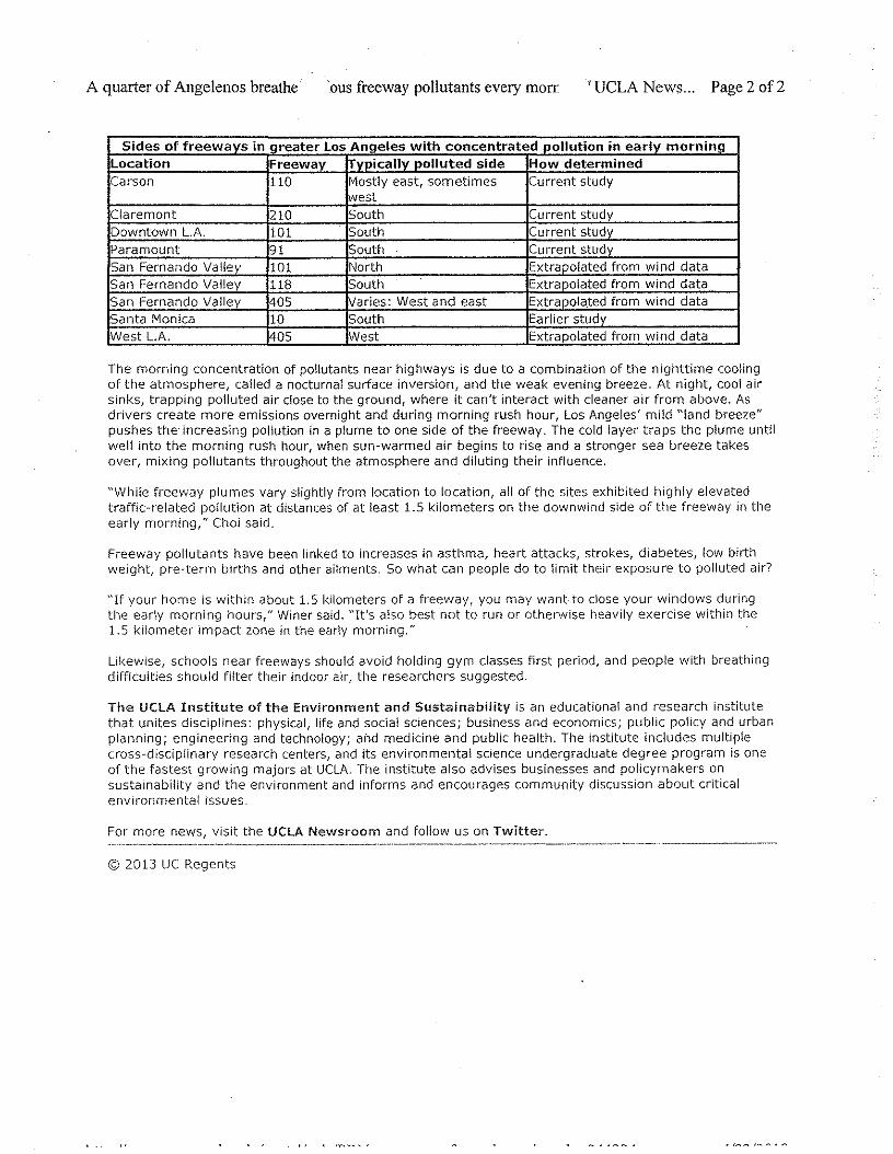
A quarter of Angelenos breathe 'ous freeway pollutants every morr 'UCLA News., Page 2 of 2
Sides of freeways in creater Los Anaeles with concentrated ooltution in earlv morn inaLocation Freewav trvpicallv polluted side How determinedCarson 110 Mostly east, sometimes Current study
westClaremont 210 South Current studyDowntown LA 101 South Current stuovParamount 91 South Cu rrent studySan Fernando Valley 101 North Extrapolated from wi nd dataSan Fernando Valley 118 South Extrapolated from wind dataSan Fernando Vallev 405 lVaries: West and east Extrapolated from wind dataSanta Monica 10 South Earlier studvWest L.A. 405 West Extrapolated from wind data
The morning concentration of pollutants near highways is due to a combination of the nighttime coolingof the atmosphere, called a nocturnal surface inversion, and the weak evening breeze. At night, cool airsinks, trapping polluted air close to the ground, where it can't interact with cleaner air from above. Asdrivers create more emissions overnight and during morning rush hour, los Angeles' mild "land breeze"pushes the increasing pollution in a plume to one side of the freeway. The cold layer traps the plume untilwell into the morning rush hour, when sun-warmed air begins to rise and a stronger sea breeze takesover, mixing pollutants throughout the atmosphere and diluting their influence.
"While freeway plumes vary slightly from location to location, all of the sites exhibited highly elevatedtraffic-related pollution at distances of at least 1.5 kilometers on the downwind side of the freeway in theearly morning," CI10i said.
Freeway pollutants have been linked to increases in asthma, heart attacks, strokes, diabetes, low birthweight, pre-term births and other ailments. 50 what can people do to limit their exposure to polluted air'
"If your home is within about 1.5 kilometers of a freeway, you may wantto dose your windows duringthe early morning hours," Winer said. "It's also best not to run or otherwise heavily exercise within the1.5 kilometer impact zone in the early morning."
likewise, schools near freeways should avoid holding gym classes first period, and people with breathingdifficulties should filter their indoor air, the researchers suggested.
The UCLA Institute of the Environment and Sustainability is an educational and research institutethat unites disciplines: physical, life and social sciences; business and economics; public policy and urbanplanning; engineering and technology; and medicine and public health. The Institute includes multiplecross-disciplinary research centers, and its environmental science undergraduate degree program is oneof the fastest growing majors at UCLA. The institute also advises businesses and policymakers onsustainability and the environment and informs and encourages community discussion about criticalenvironmental issues.
For more news, visit the UCLA Newsroom and follow us on Twitter.
© 2013 UC Regents
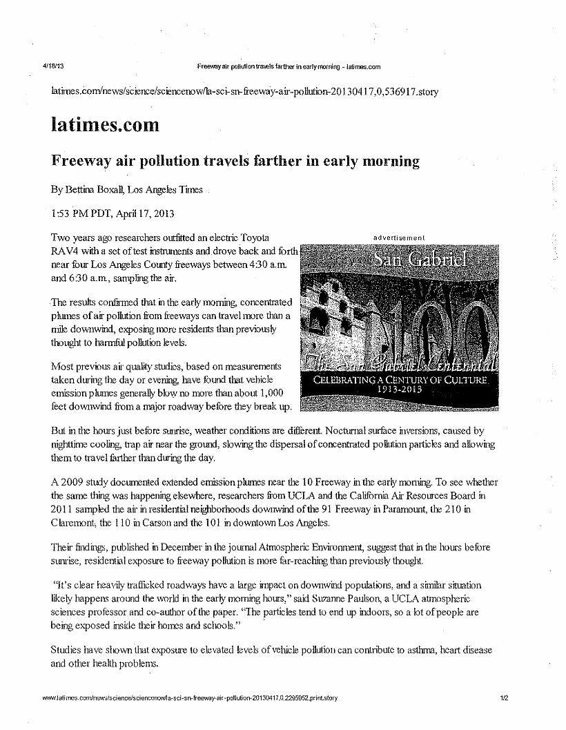
4fl8113 Freeway air pollution travels farther in early morning - latimes.com
Iatimes.comlnews/science/sciencenowfla-sci-sn- freeway-air-pollution-20 130417,0,536917 .story
latimes.comFreeway air pollution travels farther in early morning
By Bettina Boxall, Los Angeles Times
1:53 PM PDT, Aprill7, 2013
Two years ago researchers outfitted an electric ToyotaRA V4 with a set of test instruments and. drove back and forthnear four Los Angeles County freeways between 4:30 a.m,and 6:30 a.m, sampling the air.
ad ve rti se men t
Most previous air quality studies, based on measurementstaken during the day or evening, have found that vehicleemission plumes generally blow no more than about 1,000feet downwind from a major roadway before they break up.
The results confirmed that in the early morning, concentratedplumes of air pollution from freeways can travel more than amile downwind, exposing more residents than previouslythought to harmful pollution levels.
But in the hours just before sunrise, weather conditions are different. Nocturnal surface inversions, caused bynighttime cooling, trap air near the ground, slowing the dispersal of concentrated pollution particles and allowingthem to travel further than during the day.
A 2009 study documented extended emission plumes near the 10 Freeway in the early moming. To see whetherthe same thing was happening elsewhere, researchers from UCLA and the Califomia Air Resources Board in20 II sampled the air in residential neighborhoods downwind of the 91 Freeway in Paramount, the 210 inC laremont, the 110 in Carson and the 101 in downtown Los Angeles.
Their findings, published in December in the journal Atmospheric Environment, suggest that in the hours beforesunrise, residential exposure to freeway pollution is more fur-reaching than previously thought.
"It's clear heavily trafficked roadways have a large impact on downwind populations, and a similar situationlikely happens around the world in the early morning hours," said Suzanne Paulson, a UCLA atmosphericsciences professor and co-author ofthe paper. 'The particles tend to end up indoors, so a lot of people arebeing exposed inside their homes and schools." -
Studies have shown that exposure to elevated levels of vehicle pollution can contnbute to asthma, heart diseaseand other health problems.
\WN{.\atimes.com/nev.'Sfsciencefsciencenowlla-sci-sn-.freeway-air-poUutiorr20130417,O,2295952,printstory 1/2
4/18113 FrOOW<r{ air pollution tra\els farther in early morning ~ latimes.com
In greater Los Angeles, where apartment buildings and siogle- furnily homes stand cheek by jowl with some of thebusiest freeways in the nation, the researchers estimated that on any given morning, roughly a quarter of thepopulation could be exposed to downwind pollution consisting ofultrafine particles, nitric oxide andhydrocarbons.
Their advice: If you live within roughly a mile of a freeway and are downwind, keep your windows closed in thehours just before sunrise. Use air conditioning. Install HEPA air filters. Postpone outdoor exercise until later inthe morning or exercise further away from the highway.
After sunrise, the surface air warms up and the inversion breaks up, diluting the pollution
bet t ina. box alli?]) fat im e.\'.COin
Copyright © 2013, Los Angeles Times
wwwJatimes.comlnews/sciencelsciencenowlla-sci-srrfreeway-air-pollutiOn-20130417,Q,2295952,print.story '212
IlmUlltN lIiiSlt~iU;n'jllN~ 1.:&,ltTraffic, Transportation, ParkingExpert Witness and Consulting Services701 Marguerite AvenueCorona de! !\liar, CA 92625Tel: [email protected]
June 3, 2013
Mr. Robert SilversteinThe Silverstein Law Firm, APC215 North Marengo Avenue, 3rd FloorPasadena, CA 91101-1504
Proj. No. 130501
Subject: Millennium Hollywood Project
Dear Mr. Silverstein
Per your request, I have reviewed the Millennium Hollywood Projectenvironmental documentation related to traffic, circulation and parking. Thisdocumentation consists of:
• the Draft Environmental Impact Report (DEIR) iocludiog its applicableAppendices, and
• the Final Environmental Impact Report (FEIR) including its applicableAppendices
In addition I have referred to the followiog documents:
.:. Traffic Study Policies and Procedures (TSPP), Dated May 2012, publishedby the City of Los Angeles Department of Transportation (LA DOT),
.:. 2010 Congestion Management Program (CMP) prepared by the LosAngeles County Metropolitan Transportation Authority (LACTMA)
.:. Guide to the Preparation of Traffic Studies (Guide), Caltrans
[ am a Registered Civil and Traffic Engineer in the State of California(Registration Numbers 20137 and 525, respectively) and a Registered Engioeer (inretired status) in the States of Washiogton, Arizona, and Florida. I have over 50
:~;
Mr. Robert SilversteinJune 3, 2013 Page 2
years of experience in traffic and transportation engineering, traffic modeling andforecasting, parking studies, and the preparation of traffic impact studies. I havepersonally prepared or had a key role in the preparation of over 400 reports invarious jurisdictions in California, Washington, Oregon, Arizona, Nevada, andOhio, as well as several multi-State projects sponsored by the U.S. Department ofTransportation. My curriculum vitae (cv.) is preseuted as Exhibit 1, attached.
Based on my review of the documents cited above and my education, professionalknowledge and many years of experience, I have noted several deficiencies andloromissions in the environmental documentation for the Millennium HollywoodProject. These deficiencies andlor omissions are discussed in the following pagesof this letter.
A. Deficiencies in Process, Mitigation Measures and Monitoring
1. Cal trans concerns have not been addressed adequately: CMP guidelines(Appendix D, Page D-2, attached as Exhibit 2) state: "Caltrans must alsobe consulted through the Notice of Preparation (NOP) process to identifyother specific locations to be analyzed on the state highway system." Byletter dated May 18,2011 (attached as Exhibit 33) Caltrans requestedspecifically that the traffic study address the freeway main line and allonJofframps of State Route 101 (SR-IOI) within a five-mile radius of theproposed Millennium Hollywood Project. In the same letter, Caltrans alsoreferred the project's traffic consultant to Caltrans' traffic study guide andindicated that Caltrans staff "would like to meet with the traffic consultantto identify study locations in the State facilities before preparing theEuvironmental Impact Report (EIR)." Page UI-34 of the DEIR (attached asExhibit 4) states that "representatives from the City of Los AngelesDepartment of City Plaoning met with Caltrans Planning staff onSeptember 15, 2011."
The Traffic Study prepared by Crain & Associates and included in theDEIR as Appendix IV.K.I (title pages are presented as Exhibit 5, attached)states in two places (please see Exhibits 5-a and 5-b) that the traffic studywas performed in accordance with the LADOT TSPP (please see Exhibit 6for the title page of the TSPP). The LADOT TSPP reiterates the LACounty CMP requirement that Caltrans should be contacted and furtherstates that "To assist in the evaluation of impacts on State facilities, theproject's traffic consultant should refer to Caltrans' Guide for thePreparation of Traffic Impact Studies ... " and provides a link to access theweb site (please see Exhibit 6-a).
'---------------------------------_ .._-_._---_.----
Mr. Robert SilversteinJune 3, 2013 Page 3
The DEIR Traffic Study did not comply with the CMP guidelines andLADOT's TSPP, despite the written comments from Caltrans and themeeting held with Caltrans on September.IS, 2011.
After preparation of the DEIR, Caltrans submitted a letter dated December12, 2012 (please see Exhibit 7) reiterating its concerns about andrequirements for the DEIR and providing further specific guidance as towhat analyses would be required for Caltrans to conclude that impacts onthe State Highway System are adequately analyzed. As stated in theCaltrans letter dated February 19, 2013 (please see Exhibit 8), Caltransconsiders the responses to its previous comments to be inadequate andremains concerned about the lack of mandated disclosure and analysis offreeway operations (such as mainline traffic flow, weaving movements onthe freeway, queuing at exit ramps that might hinder mainline flow,queuing at entrance ramp meters, merging/diverging maneuvers) and theproject's impacts on those.
I have reviewed the responses that the City of Los Angeles provided in theFEIR to Caltrans' comments in the December 10, 2012 letter. I concurwith Caltrans that significant unanswered issues remain, and significantinformational gaps mar the EIR The City'S study approach fails to providecomplete or accurate information. The City's use of the CMP methodologydoes not provide sufficient information related to the Project's impacts onthe freeway system, and therefore did not adequately consider the potentialsiguificance of the Project's impacts on the freeway system. The City'sresponses to Caltrans are presented as Exhibit 9, attached. Following aresome further thoughts about the City's inadequate and/or improperresponses as contained in Exhibit 9:
Response to Comment No. 03-2: The CMF methodology is based purely onthe traffic volume on the freeway, without recoguizing such matters asweaving, queuing, merging and diverging movements. The Caltransmethodology, which is based on the Highway Capacity Manual, takes intoconsideration these freeway operational matters, which are, in tum, affectedby such freeway design features as spacing of entry/exit points, presence orlack of auxiliary lanes, and others. While the Caltrans Guide does notprovide specific threshold gnidelines, it provides a methodology fordetermining freeway LOS correctly. The City and this EIR are mandated tocomply with the Caltrans methodology and to disclose and analyze impactsaccordingly in a recirculated DEIR.
Response to Comment No. 03-3: The documentation provided in AppendixB of the FEIR, Modeling Procedures and Results, is inadequate. The verybrief documentation does not provide any credible data to support the
mmllHii'll ~tA§lUlU;n"l~N,I'Jl\..
'-------------_._----._-------_ .......---_ .._ ...._ ..
Mr. Robert SilversteinJune 3, 2013 Page 4
statement that "The model demonstrated that the Project will not result inthe addition of 150 trips or more to any freeway segment." The 4-pagedocument falls far short of providing enough information for the public tomake an informed judgment. The documentation should contain, as aminimum, information for the starting point which is the unaltered SCAGRegional Model as refined by LA DOT for use in the City of Los Angeles(the Base Model) in addition to the two scenarios presented "Base MinusProject" and "Base Plus Project." At a minimmn, the informationpresented for each of the three scenarios should include:
• For the area within a 5-mile radius of the Project (as requested inCaltrans' letter in response to the NOP), computer-generated plots ofthe roadway network showing the raw (unadjusted) traffic volumesthat resulted from the traffic assignment process. The plots shouldbe of sufficiently large-scale to make it possible to read the trafficvolumes on freeway-mainline, the HOV lanes (if any), and each ofthe entrance and exit ramps. A similar plot should be providedpresenting the number of lanes assumed for all freeways and ramps,as well as the number of lanes and facility types assumed for allarterial facilities.
• Socio-economic data for the two Traffic Analysis Zones (TAZs) thatcontain the Project, along with a map of the TAZ boundaries withinthe five-mile radius area
• A listing, or graphic presentation, of all freeway and major transitimprovements (BRT, Light Rail, Metrolink, other fixed-guideway)that are included in the 2035 SCAG Regional Model but are not inservice or are not under construction for the area bounded by 1-10 onthe South, 1-405 on the West, SR-101lSR-134/1-21O on the North,and 1-710 (alignment extended to 1-210) on the East. For all fourlimits, the information should be presented for the freeways that arereferenced to describe the boundaries.
The additional data requested should be available from the computermodels that were run either in printed form, or can be plotted/printedreadily from model files. The public cannot make an informed judgment asto the impacts of the Project on the freeway system based on what has beenprovided in the FErR.
Response to Comment No. 03-5: The thoughts expressed in No. 03-2 and03-3 are applicable here also.
Response to Comment No. 03-6: The statement that "Rather, the signalizedintersections and the freeway mainline sections were determined to formthe capacity constraints in the Hollywood area" is contradictory to the
nl Blltlt[lU\i EM".,) ~llJ\UflliN, l1'. Ii.
Mr. Robert SilversteinJune 3, 2013 Page 5
Traffic Study findings. The Traffic Study determined that of the 37intersections analyzed, 31 had LOS of "C" or better in both the morningand afternoon peak hours. Five intersections had LOS "0" or better in bothpeak hours. Only one had LOS "0" in the morning and LOS "E" in theafternoon peak hour (please see Exhibit 5-f, attached.) This fmding wouldsignify no capacity constraints associated with signalized intersections inthe area and is directly contradictory to the statement in the response to thiscomment. Either the statement is not supported by substantial evidence orthe intersection analysis presented in the Traffic Study is faulty. Eitherinstance represents a deficiency in the environmental documentation.
Response to Comment No. 03-7: No further thoughts beyond thoseexpressed in Item B.2 later in this letter.
Response to Comment No. 03-9: The selected zone analysis methodologyis a very valuable analysis tool to determine the true "demand" created bythe Project. It is appropriate for infill projects because the "intercepted"trips have already been deducted due to the pass-by reduction in the tripgeneration process. Using the trip distribution percentages from theselected zone analysis and applying the vehicular trip generation aftercredits, would account for "intercepted" trips.
Response to Comment No. 03-11: It is ironic that the City uses a "PlanningMethodology" which does not take into consideration signal timing at all inthe basic computation, but then applies a credit to reflect the effect of an"operational" feature such as the computerized signal system. Nonetheless,the real question is whether the CMA analysis produces LOS results forexisting conditions that are consistent with actual conditions. Expresseddifferently, if there are long queues at an intersection and yet the CMAmethod produces an LOS of "C" or "0" or better, one would have toconclude that the CMA method does not do the job correctly.
Response to Comment No. 03-12: If in fact the freeway mainlineconstitutes a capacity constraint as stated in the City's response to Caltranscomment No. 03-6, the ramp meters are likely set at or near the maximumrates Caltrans deems possible. In the future, metering rates would be morelikely to be tighter, allowing fewer vehicles per hour onto the freeway,rather than more, unless major capacity improvements are made on thefreeway. It would be in the City'S best interest to perform the analysesrequested by Caltrans to publicly disclose and understand what problemsthe City may be facing in the future, and to mitigate those problems andimpacts.
r
Mr. Robert SilversteinJune3,2013 Page 6
Response to Comment No. 03-13: The City's response ignores the basicissue which is that the weaving movements are an important considerationin determining freeway LOS.
Response to Comment No. 03-14: No further thoughts except that it wouldbe in the best interests of the City to perform the analyses requested byCaltrans.
2. Trip caps need further definition: While the trip equivalency provisionsgive the City and the developer latitude in controlling the amount ofdevelopment, the trip caps in the FEIR do not provide sufficient safeguardsfor certain situations that may mise, for the following reasons:
a) More development than addressed in the current environmentaldocuments would be possible: FEIR P.IV-22, bottom of page (pleasesee Exhibit 10) states that" No building permits shall be issued or othermeasures taken by the City, which would allow the Project-related tripgeneration to exceed the Trip Cap, unless other supplemental analysis iscompleted." This statement implies that the trip caps may be violatedwith additional analysis and that more development than addressed inthe current environmental analysis could be approved. Also, it is notstated whether the approval of the supplemental analysis would beunder administrative purview or subject to CEQA compliance andpublic review.
b) The number of peak hourly trip credit for existing developmentshould be fixed: In order to prevent future analysts from raising thetrip credit allowed for existing development, the amount of credit shouldbe fixed at the level established in the current environmental analysis,180 in the morning peak hour and 182 in the afternoon peak hour. Thiscan be accomplished by inserting the maximum amount of credit intoFEIR P.IV-18, Bullet item (c) (please see Exhibit 10).
c) Trip caps for the project should be directional, not total for peakhour: It does not take much effort to come up with a mixed use scenariothat stays within the peak hour total cap but violates the directionalpeak. Traffic impacts are in many cases sensitive to the direction oftravel. Trip caps for the project should be made directional.
3. Actual compared to estimated trips: There is no provision in the trafficmonitoring program to assess whether actual vehicular trips to/from theproject exceed, in any phase of development or at full development, theestimated vehicular trips, and what action would be taken if the actual
'-------------- --- .•_--_ ..•.__ .
Mr. Robert SilversteinJune 3,2013 Page 7
trips were to exceed the estimated trips. This information should beprovided in a recirculated DEIR.
B. Technical Points
1. The Traffic Study states that Vine Street is classified as a Major HighwayClass II between Franklin Avenue and Melrose Avenne, and that the widthof Vine Street within these limits is 65-75 ft. (please see Exhibit 5-c). TheTraffic Study does not state the actual width of Vine Street along thefrontage of the proposed Project. Exhibit 6-c, attached, indicates that theCity of Los Angeles Public Department Standards call for a width of 80 or90 ft. for the Major Highway Class II classification. Accordingly, thewidth of Vine Street is not compliant with current City design standards.The prior Hollywood Commnnity Plan, which may become the operativecommunity plan again, depending on the outcome of current litigationregarding the Updated Hollywood Community Plan (applicable excerpts inExhibit II, attached) also designates Vine Street as a Major Highway ClassII, but with Modified design standards that call for a curb-to-curb width of70 ft, with 15-ft sidewalks on either side of the street. Since the actualwidth of Vine Street along the frontage of the proposed Project is not statedin the Traffic Study, it is not possible to ascertain whether the street designis in compliance with the design standards of the Community Plan. Theenviromnental documents are silent in the matter of the width of VineStreet even though it has significance in conjunction with the transitridership credits as discussed in the next paragraph.
2. The reduction of vehicular trips by 25% due to expected transit ridershipexceeds what the City Department of Transportation recommends in itsTraffic Study Policies and Procedures (please see Exhibit 6-c attached).Per the gnidelines, the maximum of 25% rednction may be applicable todevelopments that are "above or adjacent to a Metro Rail, Metrolink, orOrange Line station." Developments within Y. mile walking distance mayqualify for up to a 15% transit credit if certain improvements, including theprovision of wider- than-standard sidewalks and dedication of additionalright-of-way along the project frontage, are provided. The proposedmitigation measures do not contain such provisions. Accordingly, a 25%reduction as taken in the EIR is facially inapplicable and improper.
3. Truck access to the site is not analyzed, and the process of accommodatingloading/unloading is not described. This is a significant omission ofinformation necessary for informed decisiomnaking and disclosure andmitigation of potential significant impacts. It is acknowledged that forpurposes of intersection capacity and Level of Service, truck traffic is notan issue. Nevertheless, truck traffic in the immediate vicinity of the Project
Mr. Robert SilversteinJune 3, 2013 Page 8
and within the Project may present traffic operational problems dependingon the location and configuration of truck loading/unloading areas, hours ofdelivery, the location and configuration of entry/exit points, and the size oftrucks. This matter is not discussed at all in the environmental documents,except general statements to the effect that these matters will be handledlater in discussions between the developer and City staff. Such deferredanalysis and mitigation is improper.
4. Intersection Level of Service (LOS) computation does not consider theeffect of pedestrian traffic on intersection capacity. Ina high pedestrianactivity area such as Hollywood Boulevard, pedestrians may causesubstantial delay to vehicular traffic, especially vehicles turning left orright. The LADOT TSPP states that the standard intersection LOScomputation procedure may be modified to reflect the effect of certainconditions, including high pedestrian volumes (please see Exhibit 6-d,attached). No adjustments were made in the LOS computations to reflectthe effect of high pedestrian volumes. This omission results in a distortionof the conclusions, making them invalid indicators of actual conditions andimpacts that can be expected to be experienced.
5. The existence of the midblock pedestrian signal on Vine is not evenmentioned. The relationship of the pedestrian signal location vis-a-vis theproject driveways on Vine is not discussed. Based on the approximatedimensions provided in the Traffic Study (please refer to Exhibit 5-d,attached), the West Site driveway on Vine Street wonld be about 60 to 70 ftnorth of the existing pedestrian cross-walk and midblock pedestrian signal.The East Site driveway would be about ISO ft south of the cross-walk. Theproximity of the existing signalized cross-walk to the two full-servicedriveways proposed by the Project will create numerous opportunities forpedestrian/vehicular conflicts and potential pedestrian/vehicle collisions.Accordingly, there is a significant omission of necessary information aboutpedestrian safety impacts. This should be remedied in a recirculated DEIR.
6. For purposes of the traffic study, certain assumptions would need to havebeen made as to the allocation of land uses to each of the two portions ofthe proposed project (East Site v. West Site). This allocation is necessaryto make, in turn, the allocation of the traffic to the intersectionsimmediately adjacent to the Project as shown in the Traffic Study.However, the allocation of vehicular traffic to the project driveways is notpresented in the Traffic Study. Also, the need for traffic control devices tobe installed at the project driveways, if any, is not discussed, exceptmentioning that this matter will be coordinated with the City. Accordingly,there is a significant omission of necessary information. This should be
Mr. Robert SilversteinJune3,2013 Page 9
remedied in a recirculated DEIR. This lack of information makes itimpossible to assess the following potentially significant impacts:
• Will it be necessary to install a traffic signal at either or both of theProject driveways on Vine Street?
• If yes, what would be the impact on the mid-block pedestrian signal?• If not, how will pedestrian/vehicle conflicts be treated and to what
extent will pedestrian activity disrupt traffic into and out of thedriveways?
7. The pedestrian entry/exit points to the project and the pedestrian linkagesbetween the East Site and the West Site of the Project are not shown, so itis not possible to assess:
• Whether the East and West Sites are truly integrated to constitnte asingle project for purposes of internal trip-making and sharedparking.
• Whether the pedestrian linkages are going be sufficiently convenientin order to justify the internal trip making levels.
• How internal pedestrian circulation to/from the various projectcomponents will be accommodated.
• To what extent added pedestrian traffic at the mid-block pedestriansignal would cause additional delays to through traffic on VineStreet.
8. Parking-The residential tower (East Site) would have 450 units and 675residential parking spaces, or 1.5 spaces per unit. In accordance with theTraffic Stndy, the total requirement would be 2.25 spaces per unit, or 1013parking spaces, if the residential development were to be stand-alone, ratherthan part of a mixed use development (please see Exhibit 5-e). If theresidential tower is built and occupied before any of the office/commercial,there would be no opportunity for shared parking or internal trip-making, sothere would be a parking shortage of 338 spaces.
9. If movie/theater uses are allowed within the commercial designation, therecould be traffic and parking impacts, especially on weekend afternoons andevenings when movie/theater and retail uses both attract high levels ofpatronage. This type of potential impact attributable to specific uses is notaddressed in the EIR. Accordingly, there is a significant omission ofnecessary information. This should be remedied in a recirculated DEIR.
Mr. Robert SilversteinJune 3, 2013 Page 10
Please contact me if I can provide further details or clarification about any matterscovered in this letter.
Sincerely, ;2' < ,
tI: /. . /.> AY7/[C~ 1~-~~aw"~' j
Herman Basmaciyan. P.E.
LIST OF EXHIBITS
l. Curriculum Vitae2. Excerpts from the 2010 Los Angeles County Congestion Management
Program3. Caltrans letter in response to Nap, dated May 18, 20114. Excerpt from DEIR for Millennium Hollywood Project - Page IIl-345. Excerpts from Traffic Study (Appendix IV.K.l ofDElR for Millennium
Hollywood Project)a. Compliance with City Procedures (page 1)b. Compliance with City Procedures (Page 4)c. Width of Vine Street
6. Excerpts from the LADOT TSPPa Requirement to contact Caltrans and refer to Caltrans proceduresb. City of LA Roadway Design Standardsc. Transit Creditd. Project Site Plan and Location of Drivewayse. Parking Space Requirementsf. CMA Analysis Summary for Existing Conditions
7. Caltrans Letter of December 12, 20128. Caltrans Letter of February 19, 20139. City's Responses to Caltrans Comments in December 12, 2012 Letter10. Trip caps11. Excerpts from the Hollywood Commuuity Plan-Street Classifications and
Design Standards
tl---------------------------_ __ _._-
LIST OF EXHffiITS
(Attached to Letter from Herman Basmaciyan to Mr. Robert SilversteinDated May 30, 2013)
1. Curriculum Vitae2. Excerpts from the 2010 Los Angeles County Congestion Management Program
(CMP)3. Caltrans letter in response to Notice of Preparation (NOP), dated May 18, 20114, Excerpt from DEIR for Millennium Hollywood Project - Page III-345, Excerpts from Traffic Study (Appendix IV.K.l ofDEIR for Millennium
Hollywood Project)a. Compliance with City Procedures (page 1)b. Compliance with City Procedures (Page 4)c. Width of Vine Streetd. Project Site Plan and Location of Drivewayse. Parking Space Requirementsf CMA Analysis Summary for Existing Conditions
6. Excerpts from the City of Los Angeles Department of Transportation (LADOT)Traffic Study Policies and Procedures (TSPP)
a. Requirement to contact Caltrans and refer to Caltrans proceduresb. City of Los Angeles Roadway Design Standardsc. Transit Credit
7. Caltrans Letter of December 12,20128, Caltrans Letter of February 19, 20139, City'S Responses to Caltrans Comments in December 12, 2012 Letter10. Trip caps11. Excerpts from the Hollywood Community Plan-Street Classifications and Design
Standards
EXHIBIT 1
Curriculum Vitae (2 pages)
Herman Basmaciyan, P.E.
Profile• Over 50 years of transportation planning and traffic engineering experience,
including services to legal professionals• Expert witness services in San Diego, Orange, Los Angeles, Riverside, and San
Mateo Counties in eminent domain, traffic engineering, transportationengineering/planning, and parking matters
• Experience in numerous traffic impact studies, transportation planning projects,parking studies, analysis ofland use/transportation system interrelationships andtraffic/transportation engineering
• Management of, or key role in, a wide variety of transportation/traffic engineeringprojects in California, Oregon, Washington, Arizona, Nevada, Colorado,Montana, New Mexico, Ohio, and Louisiana
Expert Witness Experience• Service to legal professionals since 1978, as a consultant and as a designated
expert witness• Courtroom expert witness testimony on 5 occasions• Deposition on 12 occasions• Advised legal professionals as consultant and potential expert witness in over 20
cases settled with no need for deposition
Education• Master of Science in Civil Engineering, University of Virginia, 1962• Bachelor of Science in Civil Engineering, Robert College, 1960• Numerous Short Courses in Transportation and Traffic Engineering
RegistrationProfessional Engineer:
• California, Civil• California, Traffic• Arizona (retired status)• Florida (retired status)• Washington (retired status)
Professional Organizations• Institute of Transportation Engineers• American Society of Civil Engineers
Employment History• Individual Providing Expert Witness and Consultant Services, Corona del Mar,
CA, since January 2005• Transportation Consultant, County of Riverside, Riverside, CA, 2005-2011• Vice President, Kimley-Horn and Associates, Inc, Orange, CA 1992-2004• Principal, Basmaciyan-Darnell, Inc., Irvine, CA 1978-1992• Principal, Herman Basmaciyan and Associates, Newport Beach, CA 1976-1978• Senior Associate, VTN Corporation, Irvine, CA, and Bellevue, WA 1971-1976• Senior Transportation Planning Engineer, Del.euw, Cather and Company, San
Francisco, CA 1970-1971• Advisory Analyst, Service Bureau Corporation (then a subsidiary ofIBM), Palo
Alto, CA 1967-1970
• Director, Puget Sound Regional Transportation Study, Seattle, WA 1962-1967
• Research Assistant, Virginia Council of Highway Research, Charlottesville, VA1960-1962
EXHIBIT 2
EXCERPTS FROM LOS ANGELES COUNTY CONGESTION MANAGEMENTPROGRAM (CMP)
Cover PagePage D-2 from CMP Document
(Total of2 Pages)
ApPENDIXD· GUIDELINESFORCMP TRANSPORTATIONIMPACTANALYSIS PAGED·2
D.3 PROJECTS SUBJECT TO ANALYSIS
In general a CMP TIA is required for all projects required to prepare an EnvironmentalImpact Report (EIR) based on local determination. A TIA is not required if the lead agencyfor the EIR finds that traffic is not a significant issue, and does not require local or regionaltraffic impact analysis in the EIR. Please refer to Chapter 5 for more detailed information.
CMP TIA guidelines, particularly intersection analyses, are largely geared toward analysisof projects where land use types and design details are known. Where likely land uses arenot defined (such as where project descriptions are limited to zoning designation andparcel size with no information on access location), the level of detail in the TIA may beadjusted accordingly. This may apply, for example, to some redevelopment areas andcitywide general plans, or community level specific plans. In such cases, where projectdefiuition is insufficient for meaningful intersection level of service analysis, CMP arterialsegment analysis may substitute for intersection analysis.
D.4 STUDY AREA
The geographic area examined in the TIA must include the following, at a minimum:
o All CMP arterial monitoring intersections, including monitored freeway on- or off-rampintersections, where the proposed project will add 50 or more trips during either theAM or PM weekday peak hours (of adjacent street traffic).
o IfcMP arterial segments are being analyzed rather than intersections (see Section D.3),the study area must include all segments where the proposed project will add 50 ormore peak hour trips (total of both directions). Within the study area, the TIA mustanalyze at least one segment between monitored CMP intersections.
o Mainline freeway monitoring locations where the project will add 150 or more trips, ineither direction, during either the AM or PM weekday peak hours.
o Caltrans must also be consulted through the Notice of Preparation (NOP) process toidentify other specific locations to be analyzed on the state highway system.
If the TIA identifies no facilities for study based on these criteria, no further traffic analysisis required. However, projects must still consider transit impacts (Section D.8.4).
D.5 BACKGROUND TRAFFIC CONDITIONS
The following sections describe the procedures for documenting and estimatingbackground, or non-project related traffic conditions. Note that for the purpose of a TIA,these background estimates must include traffic from all sources without regard to theexemptions specified in CMP statute (e.g., traffic generated by the provision oflow and verylow income housing, or trips originating outside Los Angeles County. Refer to Chapter 5,Section 5.2.3 for a complete list of exempted projects).
D.S.l Existing Traffic Conditions. Existing traffic volumes and levels of service (LOS) onthe CMP highway system within the study area must be documented. Traffic counts must
2010 Congestion Management Program far Los Angeles County
EXHffiIT3Caltrans Letter in Response to Notice of Preparation (NOP)
Dated May 18, 20113 Pages
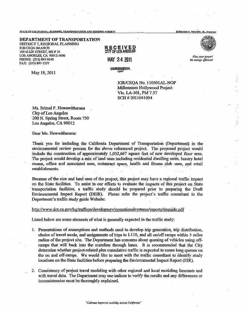
STATEOFCMJfORNIA=BUSINES$. TRANSPORTATION AND HOUSING AGENCY EDMUNDG, RROWN,JR . Governor
DEPARTMENT OF TRANSPORTATIONDISTRICT 7, REGiONAL PLANNINGIGRfCEQA BRANCHlOOMAJNSTREET, MS# 16LOS ANGELES, CA 90012-3606PHONE: (213) 897-9140FAX: (213) 891-1337
IUiCEIVEDC!iV OFlOS ANGELES
MAY242011 Flex J!fJUr jKlWer!Be energy efficient!
May 18,2011
IGRlCEQA No. 110501AL-NOPMillennium Hollywood ProjectVic. LA-I01, PM 7.37SCH # 20 II 04 1094
Ms. Srimal P. HewawitharanaCity of Los Angeles
·200 N. Spring Street, Room 750Los Angeles, CA 90012
Dear Ms. Hewwitharana:
Thank you for including the California Department of Transportation (Department) in theenvironmental review process for the above referenced project. The proposed project wouldinclude the construction of approximately 1,052,667 square feet of new developed floor area,The project would develop a mix of land uses including residential dwelling units, luxury hotelrooms, office and associated uses, restaurant space, health and fitness club uses, and retailestablishments. . .
Because ofthe size and land uses of the project, this project may have a regional traffic impacton the State facilities. To assist in our efforts to evaluate the impacts of this project on State
. transportation facilities, a traffic study should be prepared prior to preparing the DraftEnvironmental hnpact Report (DEIR). Please refer the project's traffic consultant to theDepartment's traffic study guide Website:
http://www.dot.ca.govlhg/traffops/developserv/operationalsystems/reports/tisguide.pdf
Listed below are some elements of what is generally expected in the traffic study:
I. Presentatious of assumptions and methods used to develop trip generation, trip distribution,choice of travel mode, and assignments of trips to 1-110, and all on/offramps within 5 milesradius of the project site. The Department has concerns about queuing of vehicles using off-ramps that will back into the mainline through lanes. It is recommended that the Citydetermine whether project-related plus cumulative traffic is expected to cause long queues onthe on and off-ramps. We would like to meet with the traffic consultant to identify studylocations on the State facilities before preparing the Environmental Impact Report (EIR).
2. Consistency of project travel modeling with other regional and local modeling forecasts andwith travel data. The Department may nse indices to verify the results and any differences orinconsistencies must be thoroughly explained.
"Caltrans improves mobility across California"
Ms. Srimal P. HewawitharanaMay 18, 2011Page20f3
3. Analysis of ADT, AM and PM peak-hour volumes for both the existing and future conditionsin the affected area. Utilization of transit lines and vehicles, and of all facilities, should berealistically estimated. Future conditions should include build-out of all projects and anyplan-horizon years. (see next item)
4. Inclusion of all appropriate traffic volumes. Analysis should include existing traffic, trafficgenerated by the project, cumulative traffic generated :from all specific approveddevelopments in the area, and traffic growth other than from the project and developments.
5. Discussion of mitigation measures appropriate to alleviate anticipated traffic impacts. Thesemitigation discussions should include, but not be limited to, the following:
" Description of Transportation Infrastructure Improvements$ Financial Costs, Funding Sources and Financing$ Sequence and Scheduling Considerations" Implementation Responsibilities, Controls, and Mouitoring
Any mitigation involving transit or Transportation Demand Management (TDM) should bejustified and the results conservatively estimated. Improvements involving dedication ofland or physical construction may be favorably considered.
6. The Department may accept fair share contributions toward. pre-established or futureimprovements on the State Highway System. Please use the following ratio when estimatingproject equitable share responsibility: additional traffic volume due to project implementationis divided by the total increase in the traffic volume (see Appendix ''B'' of the Guide).
Please note that for purposes of determining project share of costs, the number of trips fromthe project on each traveling segmeut or element is estimated in the context of forecastedtraffic volumes, which include build-out of all approved and not yet approved projects andother sources of growth. Analytical methods such as select-zone travel forecast modelingmight be used.
Please be reminded that as the responsible agency underCEQA, the Department hasauthority to determine the required freeway analysis for this project and is responsible forobtaining measures that will off-set project vehicle trip generation that worsens StateHighway facilities. CEQA allows the Department to develop criteria for evaluating impactson the facilities that it manages. In addition; the County CMP standards states that theDepartment should be consulted for the analysis of State facilities. State Routes mentionedin item #1 should be analyzed, preferably using methods suggested in the Department'sTraffic Impact Study Guide. To help determine the appropriate scope, we request that aselect zone model run is performed. We welcome the opportunity to provide consultationregarding the Department's preferred scope and methods of analysis.
We look forward to reviewing the traffic study and expect to receive a copy from the StateClearinghouse when the DEIR is completed. Should you wish to expedite the review process orreceive early feedback from the Department please feel free to send a copy of the DEIR directlyto our office.
"Caltrans improves mobility across California"
Ms. Srimal P. HewawifuaranaMay 18, 2011Page 3 of3
As discussed in your telephone conversation on -May 17, 2011 wiili Mr. Alan Lin, ProjectCoordinator, we would like to extend an invitation to meet with the City, developer, and thetraffic consultant early in the process to discuss potentia! traffic impacts to the State facilities andpossible mitigation measures prior to the preparation of the EIR. .
If you have any questions, please feel free to contact me at (213) 897-9140 or Alan Lin theproject Coordinator at (213) 897-8391 and refer to IGRlCEQA No. 110501 AL.
;rr(l~«rJa5k--~NNAWATSON
IGRlCEQA Branch Chief
cc: Scott Morgan, State Clearinghouse
"Cakrans improves mobility across California"
EXIDBIT4
Excerpt from the DEIR for the Millenninm Hollywood Project
Page III-34, Indicates Meeting with Caltrans was held (I Page)
City of Los Angeles October 2012
Libraries
Existing Library Facilities
The Goldwyn Hollywood Regional Branch Library (the Hollywood Regional Branch) would serve theProject. The Library is approximately 0.24 miles from the Project Site, located at 1623N. Ivar Avenue. 15
Based on Planning Department estimates, the LAPL estimates the Hollywood Regional Branch 2010service population as approximately 91,980, and its 2020 service population as approximately 94,494.There are no planned improvements to add capacity through expansion. 16
Additional details pertaining to existing and proposed libraries serving the Project area are provided inSection IY.J.5, Libraries, of this Draft ElR.
Transportation - Traffic, and Parking
Regulatory Framework
State of CaliforniaDepartmentof Transportation(Caltrans)
As the owner and operator of the State Highway System (SHS), the State of California Department ofTransportation (Caltrans) implements established state planning priorities in all functional plans,programs, and activities. These priorities arc: I) to promote infill development and equity byrehabilitating, maintaining, and improving existing infrastructure that supports infill development andappropriate reuse and redevelopment of previously developed land, and by preserving cultural andhistoric resonrces; 2) to protect environmental and agricultural resources by preserving and enhancingvaluable natural resources, including working landscapes, natural lands, recreation areas, and other openspace areas; and 3) to encourage efficient development patterns by ensuring that infrastructure supportscompact development adjacent to existing developed areas that are appropriately planned for growth andserved by adequate transportation and other essential utilities and services (GC §650141.1).17
Caltrans has the responsibility to coordinate and consult with local jurisdictions and Tribal Governmentswhen proposed local land use plarming and development may impact these facilities. Pursuant to Section21092.4 of the Public Resources Code (PRC), for projects of statewide, regional, or areawidesignificance, the lead agency shall consult with transportation plarming agencies and public agencieswhich have transportation facilities within their jurisdictions which could be affected by the project.Consistent with this requirement, representatives from the City of Los Angeles Department of CityPlanning met with Caltrans Planning staff on September 15, 2011.
15 Email correspondence with Joseph Mol/es, Los Angeles Public Library, November 16,2011.
Ibid
Caltrans, Deputy Directive (DD)-25-RI, Effective June 2005, Re: Local Development IntergovernmentalReview (LD-IOR).
16
17
Millennium Hollywood ProjectDraft Environmental Impact Report
Ill. Environmental SettingPage Ill-34
EXHIDITS
EXCERPTS FROM TRAFFIC STUDY (APPENDIX IV.K.l) TO DEIR
Exhibit 5 a-Cover and Title Pages of Traffic StudyExhibit 5 b-Description of Project Site and Description of Study Procedures (2 Pages)
Exhibit 5 c-Documenting Width of Vine Street (1 Page)Exhibit 5 d-Conceptual Project Site Plan and Text Describing Location of Driveways
(2 Pages)Exhibit 5 e-Parking Space RateslRequirements (1 Page)
Exhibit 5 f-Summary of Intersection Level of Service Summary for 20 II Conditions. (IPage)
Appendix IV.K.l
Traffic Impact Study ReportProposed Millennium Hollywood Development, Hollywood California
Crain & Associates(June 2012)
TRAFFIC IMPACTSTUDY REPORT FOR PROPOSED
MillENNIUM HOllYWOOD DEVELOPMENT
HOllYWOOD, CALIFORNIA
Prepared for:
MillENNIUM HOllYWOOD u,c
Crain & Associates300 Corporate Pointe, Suite 470
Culver City, California 90230(310) 473-6508
Prepared by:
June 2012
INTRODUCTION
Crain & Associates has been retained to prepare this traffic analysis that assesses the
potential impacts of the Millennium Hollywood Project on the surrounding roadway
system. The analysis that follows was prepared in accordance with the assumptions,
methodology and procedures approved by LADOT. (See Appendix A for the
Memorandum of Understanding ("MOU") outlining the study parameters agreed to with
LADOT.)
The Project will be developed on two sites that are located on the opposite sides of Vine
Street. The East Site is located on the southeast comer of Yucca Street and Vine
Street. The West Site is located across Vine Street, southwest of the comer of Yucca
Street and Vine Street (the East Site and West Site are referred to collectively as the
"Site"). The Site is located within the Hollywood Community of the City of Los Angeles
and, as shown in Figure 1, Project Site Vicinity Map, is within the Hollywood
Redevelopment Project area.
The Project would be a mixed use development, including residential, office, retail,
quality restaurant, sports/ fitness club and luxury hotel uses on two sites. As part of the
Project, the existing rental car facility area on the West Site will be demolished, but the
existing Capitol Records Complex on the East Site will be preserved. The Capitol
Records Complex includes the 13-story Capitol Records Building, along with its ancillary
studio recording uses, and the existing two-story Gogerty Building.
This report presents the results of the analysis of existing (2011) and future (2020)
traffic conditions before and after Project completion at the following 37 study
intersections.
1. 101 Freeway NB Off-Ramp/Cahuenga Boulevard
2. Franklin Avenue/Highland Avenue (North)
1
These study intersections were selected because they were identified as having
potentially significant traffic impacts and therefore require a detailed analysis. The
selection was made in consultation with LADOT.
The locations of these study intersections relative to the Site are shown in Figure 2,
Study Intersection Map. These intersections are the critical intersections along the
primary access routes to and from the Site, and are the intersections expected to be
most affected by Project traffic. As agreed to with LADOT, since the Site is along a
major highway, in a commercial area, and not adjacent to any areas zoned for single
family homes, no residential street segments were expected to have traffic conditions
impacted by the Project traffic. (For analysis purposes, segments of local streets in an
area designated for single-family homes are considered as "residential street
segments".) Therefore, residential street segments would not be potentially significantly
impacted by the Project and therefore residential segments were not required to be
analyzed in this traffic report.
It should be noted that this report was prepared using the standard LADOT analysis
format and procedures. The individual intersection traffic impacts for each project are
determined to either be significant or not Significant. The LADOT determination is
based upon the magnitude of the project impact considering the project impact and also
considering the cumulative traffic voiumes (including existing traffic, ambient growth and
related projects growth) anticipated to occur. By following the MOU and the other
applicable LADOT Traffic Study guidelines, this report conforms to standard City
procedures for determining both project and cumulative traffic impacts. Further, the
Project land-uses and densities are consistent with the City's General Plan, including
the existing and currently under consideration update of the Hollywood Community
Plan. The Project also utilizes the land-uses incorporated into the Hollywood
Community Plan update currently being considered by the City. Therefore the Project
land-uses and design address the area transportation needs.4
Cahuenga Boulevard, a north-south roadway, is designated as a Secondary Highway
south of Franklin Avenue and a Major Highway Class II to the north. North of Franklin
Avenue, Cahuenga Boulevard accesses the Hollywood Freeway. West of the Site,
Cahuenga Boulevard provides two through lanes per direction within an approximate 56-
foot wide roadway near its intersection with Hollywood Boulevard. There are left-turn
channelization at most major intersections; however, left turns are prohibited during the
weekday PM peak period (4:00 PM to 7:00 PM) at its intersections with Hollywood
Boulevard and Selma Avenue.
Highland Avenue, a north-south roadway, is designated as a Major Highway Class II
north of Melrose Avenue and a Divided Secondary Street south of Melrose Avenue. In
the vicinity of the Site, this roadway provides three through travel lanes per direction, with
left andfor right-turn channelization provided at the intersection with Hollywood
Boulevard. Parking is prohibited on Highland Avenue at all times in the vicinity of the
Site. Highland Avenue connects to the Hollywood Freeway with full northbound and
southbound ramp connections approximately one and a half mile northwest of the Site.
Vine Street is a north-south Major Highway Class II between Franklin Avenue and
Melrose Avenue, south of which, it transitions to Rossmore Avenue which is desiqnated
as a collector street. North of Franklin Avenue, Vine Street is desiqnated as a Collector
Street. Immediately south of Franklin Avenue, a southbound Hollywood Freeway off-
ramp extends to Vine Street Vine Street bisects the Site and provides two travel lanes
per direction and left-turn channelization within an approximate 65- to 75-foot roadway
width. The Hollywood Walk of Fame branches down both sides of Vine Street between
Yucca Street and Sunset Boulevard.
Ivar Avenue, west of the Site, is a north-south local street with a roadway width of
approximately 46 feet. It has one travel lane in each direction. Left turns are prohibited
from 6:00 AM to 3:00 PM at its intersection with Hollywood Boulevard.
14
')I
i !~ Jlvar Avenue
(F~I
II
Ics:1o rn!o;r(/)!-'~ f~I
('--
rI
/I
1112120j~
7
W\'\ W,ClOl'10IldOlSociote\,com
Vine Street
.m. "! s.'---gr-'.
tT__ .__ -¢=-- __.~ __ J
oAvenue
--I
IFIGURE 3
CONCEPTUAL PROJECT SITE PLAN
Project Parking and Access
The Project would provide on-site parking in accordance with the parking requirements
of the LAMC, and as otherwise permitted through a variance for the sports club parking
and the Development Agreement with the use of a shared parking program. The actual
number of parking spaces required for the Project will be dependent upon the land uses
developed in accordance with the Land Use Equivalency Program included in the
Development Agreement. (That program would limit the Project trip generation levels to
those analyzed in this study.) The existing parking requirements and agreements that
apply to the Capitol Records Complex would remain in place.
Based on the code required parking standards and the implementation of a shared
parking program (see Appendix E for the detailed parking analysis), it is envisioned that
the Project would include above-grade parking within the podium structures and
approximately six levels of below grade parking. The existing parking requirements and
agreements that apply to the Capitol Records Complex would remain in place.
Vehicular access to the West Site will be provided via two full-service driveways along
Ivar Avenue and Vine Street respectively. The driveway on Ivar Avenue will be located
approximately 250 feet south of Yucca Street and the driveway on Vine Street will be
located approximately 270 feet south of Yucca Street. Both driveways will serve the
parking structure on the West Site and thereby all uses of the project including the
residential, commercial and non-commercial components situated on the West Site.
To access the East Site, three full-service driveways will be provided on Vine Street,
Yucca Street and Argyle Avenue. The driveway on Vine Street will be located about
460 feet south of Yucca Street and will serve both the parking for both the residential
and the office uses. The second East Site driveway, located on Argyle Avenue
approximately 360 feet south of Yucca Street, will serve exclusively for the residential
38
Millennium HollywoodEIR Scenarios Shared Parking Analysis
Table 1Hollywood Redevelopment Project Area
Parking Rates
LANPUSE RATE'
Residential Condominiums 2.25 Spaces I I DUHotel: Rooms 1-30 I Space I I RM
Rooms 31-60 I Space I 2 RMRooms 61+ I Space I 3RMRestaurantILounge 2 Spaces I I KSFConference/Banquet 2 Spaces I I KSF
Health ClubWI >50 KSF Office 2 Spaces I I KSFOther 10 Spaces I I KSFOffice 2 Spaces I I KSFRetail 2 Spaces I I KSFRestaurant 2 Spaces I I KSF
Notes
I DU = Dwelling Unit; RM ""Room; KSF "'"1,000 Square Feet.
As shown in Table 2, the maximum parking demand for each land use component of the Projectwas then calculated, These maximum parking demands were then used to develop sharedparking profiles based on the parking demand ratios and methodology provided in the UrbanLand Institute's Shared Parking (2nd Edition, 2005) handbook. The procedures in the handbookaccount for parking demand fluctuations based on month of the year, time-of-day, weekdayversus weekend, and customer/visitor versus employee, For resident parking, 1.5 out of the 2,25parking spaces per residential unit in the Project will be assigned rather than shared, As detailedin the Shared Parking procedures, the assigned spaces were treated as 100 percent occupied at alltimes, The remaining residential parking and the parking for the other land uses would beshared, rather than being restricted for a particular land use, Thus, the percentage of parkingspaces anticipated to be utilized/available at any given time was taken into account, The detailedcalculations are included in the Attachment.
Crain & Associates 2
Table 3Critical Movement Analysis (CMA) Summary
Existing (2011) Traffic Conditions
AM Peak Hour PM Peak HourNo. Intersection CMA LOS CMA LOS1. 101 Fwy NB Off-Ramp/ Cahuenga Blvd. 0.353 A 0.648 B2. Franklin Ave.! Highland Ave. (North) 0.734 C 0.833 D3. Franklin Ave.! Highland Ave. (South) 0.763 C 0.744 C4. Franklin Ave.! Cahuenga Blvd. 0.833 D 0.955 E5. Franklin Ave.-101 Fwy SB Off-RampMne St. 0.377 A 0.628 B6. Franklin Ave.-101 Fwy NB On-Ramp/Argyle Ave. 0.669 B 0.789 C7. Franklin Ave.! Gower St. 0.591 A 0.752 C8. Franklin Ave.! Beachwood Dr. 0.663 B 0.664 B9. Yucca St.! Cahuenga Blvd. 0.447 A 0.617 B10. Yucca St.!lvar Ave. 0.095 A 0.169 A11. Yucca St.! Vine St. 0.429 A 0.378 A12. Yucca St.! Argyle Ave. 0.111 A 0.300 A13. Hollywood Blvd.! Fuller Ave. 0.507 A 0.425 A14. Hollywood Blvd.! La Brea Ave. 0.898 D 0.737 C15. Hollywood Blvd.! Highland Ave. 0.708 C 0.741 C16. Hollywood Blvd.! Cahuenga Blvd. 0.741 C 0.701 C17. Hollywood Blvd.! Ivar Ave. 0.366 A 0.416 A18. Hollywood Blvd.! Vine St. 0.734 C 0.703 C19. Hollywood Blvd.! Argyle Ave. 0.445 A 0.617 B20. Hollywood Blvd.! Gower St. 0.693 B 0.637 B21. Hollywood Blvd.! Bronson Ave. 0.527 A 0.479 A22. Hollywood Blvd.! 101 Fwy SB Off-Ramps 0.471 A 0.357 A23. Hollywood Blvd.! 101 Fwy NB Off-Ramps 0.340 A 0.311 A24. Selma Ave.! Cahuenga Blvd. 0.468 A 0.561 A25. Selma Ave.!lvar Ave. 0.121 A 0.294 A26. Selma Ave.! Vine St. 0.467 A 0.512 A27. Selma Ave.! Argyle Ave. 0.256 A 0.338 A28. Sunset Blvd.! Highland Ave. 0.886 D 0.831 D29. Sunset Blvd.! Cahuenga Blvd. 0.673 B 0.703 C30. Sunset Blvd.!lvar Ave. 0.355 A 0.513 A31. Sunset Blvd.! Vine St. 0.806 D 0.737 C32. Sunset Blvd.! Argyle Ave. 0.439 A 0.443 A33. De Longpre Ave.! Cahuenga Blvd. 0.341 A 0.389 A34. De Longpre Ave.! Vine St. 0.468 A 0.585 A35. Fountain Ave.! Vine St. 0.684 B 0.765 C36. Santa Monica Blvd.! Vine st. 0.754 C 0.797 C37. Melrose Ave.! Vine St 0.747 C 0.821 D
26
EXHIDIT6
EXCERPTS FROM LADOT TRAFFIC STUDY POLICIES AND PROCEDURES(TSPP)
Exhibit 6 a-Page 7 ofTSPP (Requires Contact with Caltrans) (1 Page)Exhibit 6 b-Attachment D ofTSPP-Standard Street Dimensions (1 Page)
Exhibit 6 c=-Pages 8 and 9 ofTSPP-Allowable Transit Credits (2 Pages)
MovinglcsAngelesForwara
Traffic Study Policiesand Procedures
May 2012
City of Los AngelesDepartment of Transportation
http://lado t.lacity. orgl
City of Los AngelesTraffic Study Policies & Procedures May 2012
D. CONGESTION MANAGEMENT PROGRAM (CMP) GUIDELINES
The "Congestion Management Program for Los Angeles County" includes guidelines intendedto assist local agencies in evaluating impacts of land use projects on the CMP system throughthe preparation of a regional transportation impact analysis (TIA). Appendix "8" of the 2010CMP for Los Angeles County identifies the requirements and outlines the guidelines in thepreparation of the CMP transportation impact analysis. A CMP TIA is necessary for all projectsrequired to prepare an Environmental Assessment based on local determination. Thegeographic area examined in the TIA must include, at a minimum, the following:
• All CMP arterial rnonitorinq intersections, including freeway on and off-rampintersections, where a proposed project is expected to add 50 or more trips during eitherthe weekday a.m. or p.m. peak hours (of adjacent street traffic).
• Mainline freeway monitoring locations where a project is expected to add 150 or moretrips, in either direction, during either the weekday a.m. or p.m. peak hours.
Caltrans shall be consulted through the Notice of Preparation (NaP) process to identify otherspecific locations to be analyzed on the state highway system. To assist in the evaluation ofimpacts on State facilities, the project's traffic consultant should refer to Caltrans' "Guide for thePreparation of Traffic Impact Studies" found at the following web site:
http://www.dot.ca.gov/hq/traffops/developserv/operationalsystemsIreportsitisguide.pdf
If, based on these criteria, the TIA identifies no impacted regional facilities, further CMP trafficanalysis is not required. However, projects must still consider transit impacts (Appendix D of2010 CMP for Los Angeles Countv) and provide a calculation of CMP "credits" and "debits" forthe project. For further information about the CMP TIA process, please call LADOT CMPMonitoring Section at (213) 972-8473.
E. TRIP GENERATION CALCULATIONS
1. ITE Trip Generation RatesThe latest edition of ITE's Trip Generation Handbook for trip generation rates andformulas should be used to estimate the Project's trip generation. However, if theProject is in a TSP area, then the procedures and trip rate identified in the TSP shouldbe applied. If other rates are proposed, then these rates must first be submitted withappropriate background survey data for approval by LADOT.
2. Unique DevelopmentsUnique types of development may require trip generation studies of similar facilities inorder to determine actual trip rates for use in the impact analysis. These developmentsmay include land uses for which trip generation rates are not available in the ITE TripGeneration Handbook, or land uses for which the rates in the ITE Trip GenerationHandbook are based on a small sample of surveyed sites. The procedures and theresults of the trip generation studies must be approved by LADOT.
7
ATTACHMENTD
l.~F+~i~.., I r-
NONCONllNUOUS LOCAL STREETMay include wt-de-sac. loop streetsond short connector streets. Wherean opp:ilmd inmmat peoostrlon ¥temis prov~ded the ~..sc...oy on OM :;idemay be reduced to J-feet.
_4S'f49"( •'~O':J6 .. . $"·("'·'--l'-,!f6a-,=t'
3~UT f ~Hlgtl:;r~-
20' m;n for use 00 adjoining mojor or OOCOR-~ do", hl,h""'" excect 'M' the I.",e-~j::2>'lUll cone. WIdthS shown In parentheses shall be.
r-l provided in multiple residentioJ zones,
ARTERIAL STRmS
gr'· ;~: gW' =r'~FS1' (56') ! ')51' (56') I---.. 1 ~
MAJOR HIGHWAY4:lASS IAt interncctions with other YGjor HiQhways. the IlJf9erwidths shoi/tl'l in Jxuentheses shoula be prOvided. CI!ldetennined by lADOT. utilizing (I standard Flare Section.r ,..."'". ~7.'-F40· (45') SOi(90'4j)' (45')=ff,
---. I ~MAJOR HIGHWAY-ClASS II
At intersections where lAOOT has doterm1ne<l that duolleft tum lones oro required. tho lal]!er width3 shown~~QreO~~~i~:S shall be provided, utilizing a Standard
e •
f~oCF~3S·===-21t:=8: ~3S9l--V I ~
SECONDARY HIGHWAY
TRANSmONAL EXTENSIONS
NON-ARTERIAL STREETS HILLSIDE STREETS
~"r=. ~:-=r-=ti' <? .~. 18:4s;22'-..+--22' ",~ 20'-;--.2;)' . B<:rm
~L -I' ~ 115J <>'1: Ii. ~~o:::tt:I. .r- r m• .-II- <?,
COllECTOR· STREET HIllSIDE COllECTOR STREET ,fO( use In quorter mae streets and IC. II!.school area$. 44'h "'+481 ~.,~t ~+~rr-~--... I .....- ,.--II- '-.j ,
INDUSTRIAl COllECTOR STREET HIll.SIDE STREET,·m. %.For use in Indll$lriol or&as to assist the lOCAlflow of focal trudt tmffic: within those &: 2-crees to oOJQCent arterial streets. A 35'...,.. ~ ""~curb return radius is required, ,.. L "'T'·· ;1 '.FI2l==»i=f:~24. 'II ~-Is: . 1 I . 5~ ,. m• .-li- '-.j1';(-~ i r:E HIUSIOE STREET / ~*llMrrm 2'm;n.
LOCAl STREET (PariUng on one side only)
iF'··4l-[?'~""'Er1 rcseroent U""Line
ACCESS ROADWAYroNOfTlONAl
(Umite1f to 4 dwemnQ units. and (J
maximum length of ;-)00 feel PrivateSkeet ooIy)
R. I £.rnSTANDARD! WN.J<.WAY
CROSS - S£cnON
where a ::Iesi9.notedMajor" Highwoy (Closs I or U) or aSecondary Highway cresses another designated <irterioIstreet (:md then clu;mges in designotWn to Q street oflesser standerd width, the street of lesser :!Itnn<fardwidth shall be widened on both Sl'~ from the inter-section to the width of the higher designation andtapered in a Standard acre section, 0$ shown below.to provide on orderly transition.
•
STANDARD FLARE SECllON( ptoo View)
ALLEYS
SfAt/DARD CROSS-SECTION
Note: For fire trw:kclearance. no obstructiontoller than 6" sholl bepermitted within 3 ft. ofthe curb. On-stre6tparking sho!! be prohibited.
SfANDMO CUT -CORNERSFOR 90° INTERSECTION
(Pion V!e\If) CUL-DE-SAC(Plan View)
Dimensions shown henxm ere (lOt to scale. UA.Y BE U~
PREPARED IN COOPERATION WftH THE DEPARTMENTS OF TRANSPORTATION AND COY PlANNING
MINIMUM TURNING AREA(Pion View)
NOlE:
BUREAU OF ENGINEERING
STANDARD STREET DIMENSIONS
DEPARTMENT OF PUBUC WORKS CITY OF LOS ANGElES
STANDARD PlAN5-+70-0
DESlSNfD DRAWN BY CHECIC£D fJY': 0 nu;.u;.F. R. TAma( L GANAJA
0-22549
VAULT INDEX NUMBER8-4426 -
THIS STANDARD PlAN BECOMES EFfEC1lVE ON NOVEMBER 10, 1999
SHEET 1 OF 2 SHEETS
City of Los AngelesTraffic Study Policies & Procedures May 2012
3. Existing UseWhen estimating the Project's net new trips, any claim for trip credits for an "existing"active land use requires that the "existing" use is/was in place at the time of the baseyear traffic counts. Generally, for CEQA purposes this means the "existing" use musthave been active for at least 6 months during the past 2 years. To fully ensure that"existing use" trip credit claims are validated by LADOT, supporting documentation(leasing agreements, utility bills, etc.) must be submitted. Documentation of anyprevious environmental review of the circulation impacts of the "existing" use should beincluded in this submittal. Note that some specific plan ordinances allow different timeframes for the determination of existing use trip credits and of any applicable trip fees.
4. Terminated Land-UseAny claim for trip credits for a previously terminated land use must be supported withappropriate documentation of the previous active use, such as copies of any buildingpermit, certificate of occupancy, business license, lease agreement, affidavits, orphotographs as well as documentation as to when the previous land use was terminated.Documentation of any previous environmental review of the circulation impacts of theterminated land use should also be submitted in support of such claims. The absence ofdocumentation of previous enVironmental review may resultin denial of the claim for tripcredits.
5. Pass-by TripsAny claim for "pass-by" trip credits must use the trip reduction rates in the "LADOT Policyon Pass-By Trips" in Attachment H. However, these rates may be superseded byadditional guidelines provided in speclflc plans or interim control ordinances. Theserates are not applicable when reviewing impacts at Project driveways and atintersection(s) immediately adjacentto the Project site. These rates shall not be used indetermining the need for a traffic study.
6. Transit CreditLADOT encourages developers to design and construct translt-friendly projects thatprovide safe and walkable sidewalks to and from transit stations for project patrons. Inline with the City policy to promote the use of mass transit and walking, LADOT, at itsdiscretion, may allow up to a 25% transit/walk trip credit subject to the followingguidelines, on a case by case basis:
a. Developments above or adjacent to a Metro Rail, Metrolink, or Orange Linestation, or to a similar dedicated transit line station with convenient pedestrianaccess to the station may qualify for up to 25% transit credit. The actual creditprovided should be determined by an analysis of the transit service frequencyand density at the specified transit station.
b. Developments within a 1/4 mile walking distance of a transit station, or of aRapidBus stop, may qualify for up to a 15% transit credit. The actual creditprovided will be determined by an analysis of the transit service frequency and
. density at the specifled transit station or RapidBus stop intersection. To obtainthe maximum credit, applicants should implement the following improvements(listed in priority order):
8
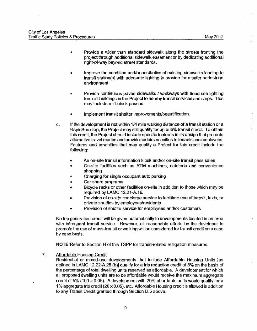
City of Los AngelesTrafflc Study Policies & Procedures May 2012
• Provide a wider than standard sidewalk along the streets fronting theproject through additional sidewalk easement or by dedicating additionalright-of-way beyond street standards.
• Improve the condition and/or aesthetics of existing sidewalks leading totransit station(s) with adequate lighting to provide for a safer pedestrianenvironment.
• Provide continuous paved sidewalks / walkways with adequate lightingfrom all buildings in the Project to nearby transit services and stops. Thismay include mid-block paseos.
• Implement transit shelter improvementslbeautification.
c. If the development is not within 1/4 mile walking distance of a transit station or aRapidBus stop, the Project may still qualify for up to 5% transit credit. To obtainthis credit, the Project should include specific features in its design that promotealternative travel modes and provide certain amenities to tenants and employees.Features and amenities that may qualify a Project for this credit include thefollowing:
• An on-site transit information kiosk and/or on-site transit pass sales• On-site facilities such as ATM machines, cafeteria and convenience
shopping• Charging for single occupant auto parking• Car share programs• Bicycle racks or other facilities on-site in addition to those which may be
required by LAMC 12.21-A.16.• Provision of on-site concierge service to facilitate use of transit, taxis, or
private shuttles by employees/residents• Provision of shuttle service for employees and/or customers
No trip generation credit will be given automatically to developments located in an areawith infrequent transit service. However, all reasonable efforts by the developer topromote the use of mass-transit or walking will be considered for transit credit on a caseby case basis.
NOTE: Refer to Section H of this TSPP for transit-related mitigation measures.
7. Affordable Housing CreditResidential or mixed-use developments that include Affordable Housing Units [asdefined in LAMC 12.22-A.25 (b)] qualify for a trip reduction credit of 5% on the basis ofthe percentage of total dwelling units reserved as affordable. A development for whichall proposed dwelling units are to be affordable would receive the maximum aggregatecredit of 5% (100 x 0.05). A development with 20% affordable units would qualify for a1% aggregate trip credit (20 x 0.05), etc. Affordable Housing credit is allowed in additionto any Transit Credit granted through Section 0.6 above.
9

EXHIBIT 7
Caltrans Letter in Response to Draft Environmental Impact Report (DEIR)Dated December 10, 2012
(4 Pages)
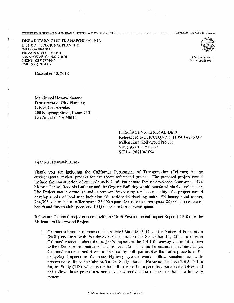
DEPARTMENT OF TRANSPORTATIONDISTRICT 7, REGIONAL PLANNING!GRlCEQA Blt~\lCH100 MAIN STREET, MS # 16LOS ANGELES, CA 90012-3(,06PHONE: (213) 897-9140FAX: (213) 897-1337
Fk:"i'YOl{r power!Be ~it~I'g}'~fJicIfHt(1
December 10,2012
Ms. Srimal HewawitharanaDepartment of City PlanningCity of Los Angeles200 N. spring Street, Room 750Los Angeles, CA 90012
IGRfCEQA No. 121036AL-DEIRReferenced to IGRfCEQA No. 11050IAL-NOPMillennium Hollywood ProjectVic. LA·IOI, PM 7.37SCI! #: 2011041094
Dear Ms. Hewawitharana:
Thank you for including the California Department of Transportation (Caltrans) in theenvironmental review process for the above referenced project. The proposed project wouldinclude the construction of approximately I million square feet of developed floor area. Thehistoric Capitol Records Building and the Gogerty Building would remain within the project site.The Project would demolish and/or remove the existing rental car facility. The project woulddevelop a mix. of land uses including 461 residential dwelling units, 254 luxury hotel rooms,264,303 square feet of office space, 25,000 square feet of restaurant space, 80,000 square feet ofhealth and fitness club space, and J 00,000 square feet of retail space.
Below are Caltrans' major concerns with the Draft Environmental Impact Report (DEIR) for theMillennium Hollywood Project:
1. Caltrans submitted a comment letter dated May 18, 201 I, on the Notice of Preparation(NOP) and me! with the developer's consultant on September 15, 2011, to discussCaltrans" concerns about the project's impact on the US-IOL freeway and on/off rampswithin the 5 miles radius of the project site. The traffic consultant acknowledgedCaltrans ' concerns and it was understood by both parties that the traffic procedures foranalyzing impacts to the state highway system would follow standard statewideprocedures outlined in Caltrans Traffic Study Guide. However, the June 2012 TrafficImpact Study (TIS), which is the basis for the traffic impact discussion in the DElR, didnot follow those procedures and does not analyze the impacts to the state highwaysystem.
"'Cal'rdns improves mohilit)! across Caf{fcrrrra"
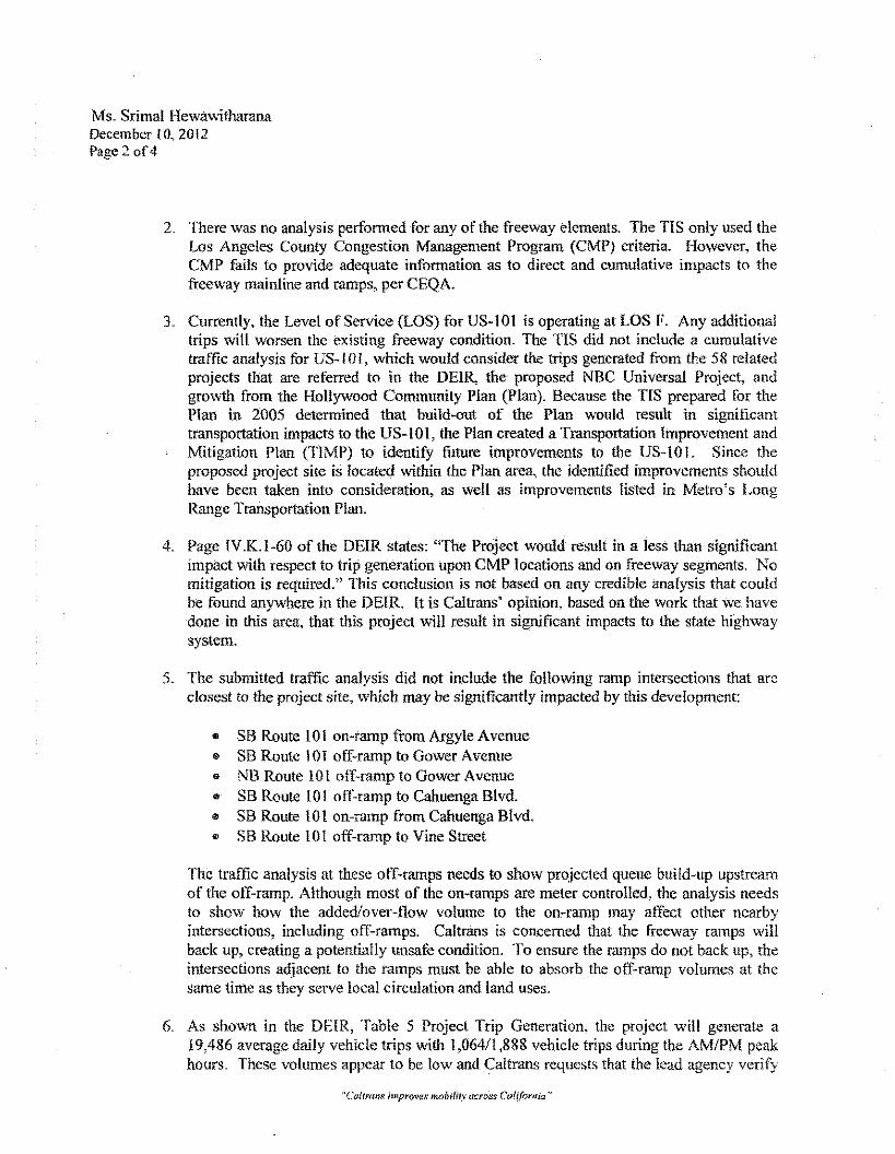
Ms. Srimal HewawitharanaDecember1O,20!2Page 2 of4
2. There was no analysis performed for any of the freeway elements. The TIS only used theLos Angeles County Congestion Management Program (CMP) criteria. However, theCMP fails to provide adequate information as to direct and cumulative impacts to thefreeway mainline and ramps, per CEQA.
3. Currently, the Level of Service (LOS) for US-lOi is operating at LOS F. Any additionaltrips will worsen the existing freeway condition. The TIS did not include a cumulativetraffic analysis for US-IO I, which would consider the trips generated from the 58 relatedprojects that are referred to in the DEll<, the proposed NBC Universal Project, andgrowth from the Hollywood Community Plan (Plan). Because the TIS prepared for thePlan in 2005 determined that build-out of the Plan would result in significanttransportation impacts to the US-IOI, the Plan created a Transportation Improvement andMitigation Plan (TIMP) to identify future improvements to the US-IO!. Since theproposed project site is located within the Plan area, the identified improvements shouldhave been taken into consideration, as well as improvements listed in Metro's LongRange Transportation Plan.
4. Page IV.K.I-60 of the DEIR states: "The Project would result in a less than significantimpact with respect to trip generation upon CMP locations and on freeway segments. Nomitigation is required." This conclusion is not based on any credible analysis that couldbe found anywhere in the DEIR. lt is Caltrans' opinion, based on the work that We havedone in this area, that this project will result in significant impacts to the state highwaysystem.
5. The submitted traffic analysis did not include the following ramp intersections that arcclosest to the project site, which may be significantly impacted by this development:
• SB Route lOLen-ramp from Argyle Avenuee SB Route 10J off-ramp to Gower Avenuee NB Route LOIoff-ramp to Gower Avenue.. SB Route 101 off-ramp to Cahuenga Blvd." SB Route 101 on-ramp from Cahuenga Blvd.$ SB Route 101 off-ramp to Vine Street
The traffic analysis at these off-ramps needs to show projected queue build-up upstreamof the off-ramp. Although most of the on-ramps are meter controlled, the analysis needsto show how the added/over-flow volume 10 the on-ramp may affect other nearbyintersections, including off-ramps. Caltrans is concerned that the freeway ramps willback up, creating a potentially unsafe condition. To ensure the ramps do not back up, theintersections adjacent to the ramps must be able to absorb the off-ramp volumes at thesame time as they serve local circulation and land uses.
6. As shown in the DEIR, Table 5 Project Trip Generation, the project will generate a19,486 average daily vehicle trips with 1,064/1,888 vehicle trips during the AM/PM peakhours. These volumes appear to be low and Caltrans requests that the lead agency verify
"Cattrane impnwes mobility across California"
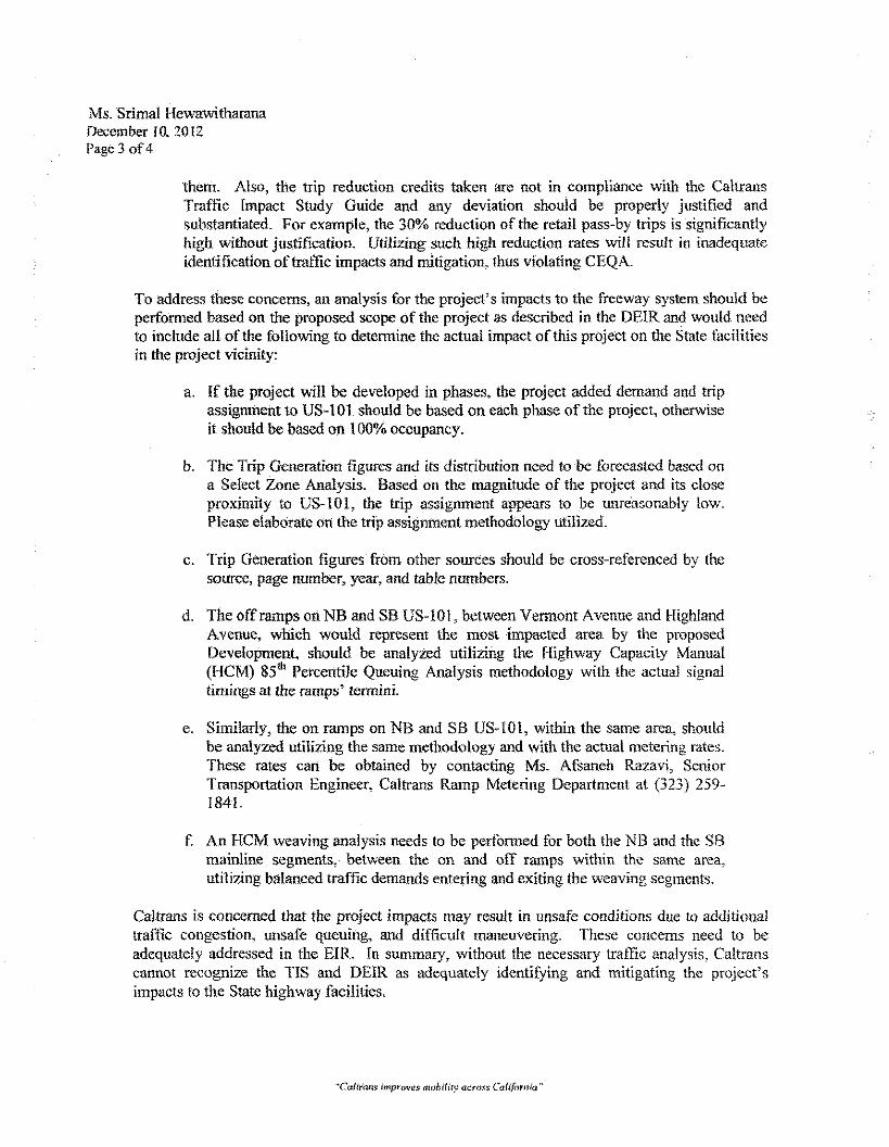
Ms. Srimal HewawitharanaDecember10, 2012Page 3 of4
them. Also, the trip reduction credits taken are not in compliance with the CahransTraffic Impact Study Guide and any deviation should be properly justified andsubstantiated. For example, the 30% reduction of the retail pass-by trips is significantlyhigh without justification. Utilizing such high reduction rates will result in inadequateidentification of traffic impacts and mitigation, thus violating CEQA.
To address these concerns, an analysis for the project's impacts to the freeway system should beperformed based on the proposed scope of the project as described in the DEIR and would needto include all of the following to determine the actual impact of this project on the State facilitiesin the project vicinity:
a. If the project will be developed in phases, the project added demand and tripassignment to US-101 should be based on each phase of the project, otherwiseit should be based on 100% occupancy.
b. The Trip Generation figures and its distribution need to be forecasted based ona Select Zone Analysis. Based on the magnitude of the project and its closeproximity to US-WI, the trip assignment appears to be unreasonably tow.Please elaborate on the trip assignment methodology utilized.
c. Trip Generation figures from other sources should be cross-referenced by thesource, page number, year, and table numbers.
d. The off ramps on NB and SB US-IOI, between Vermont Avenue and HighlandAvenue, which would represent the most impacted area by the proposedDevelopment, should be analyzed utilizing the Highway Capacity Manual(HCM) 85th Percentile Queuing Analysis methodology with the actual signaltimings at the ramps' termini.
c. Similarly, the on ramps on NB and SB US-lOl, within the same area, shouldbe analyzed utilizing the same methodology and with the actual metering rates.These rates can be obtained by contacting Ms. Afsaneh Razavi, SeniorTransportation Engineer, Caltrans Ramp Metering Department at (323) 259-1841.
f. An HCM weaving analysis needs to be performed for both the NB and the SBmainline segments, between the on and off ramps within the same area,utilizing balanced traffic demands entering and exiting the weaving segments.
Caltrans is concerned that the project impacts may result in unsafe conditions due to additionaltraffic congestion, unsafe queuing, and difficult maneuvering. These concerns need to beadequately addressed in the EIR. In summary, without the necessary traffic analysis, Caltranscannot recognize the TIS and DEIR as adequately identifying and mitigating the project'simpacts to the State highway facilities,
Ms. Srimal HewawitharanaDecember 10, 2012Page 4 of4
If you have any questions, please feel free to contact Alan Lin the project coordinator at (213)897-8391 and refer to IGRfCEQA No. 121036AL
Sincerely,
. \c: .•
DIAl'l~A WATSONIGRfCEQA Branch Chief
cc: Scott Morgan, State Clearinghouse
"Cahrans improves {1J()biJity across Caft/omia-'
ExnmIT8
Caltrans Letter in Response to Final Environmental Impact Report (FEIR)Dated February 19,2013
(5 Pages)
DEPARTMENT OF TRANSPORT AnONDISTRICT 7, REGIONAL PLAl'I"NINGIGRICEQA BRANCH100 MAfN STREET, MS # 16LOS ANG~:LES, CA 91)(112-3606PHONE: (213)897-9140h\X: (213) 897- L137
Flex your power·'Be euergy e.Uicient:'
February 19, 2013
Ms, Srimal HewawitharanaDepartment of City PlanningCity of Los Angeles200 N. spring Street, Room 750Los Angeles, CA 90012
IGR!CEQA No. 130204AL-FEIRReferenced toIGR/CEQA No, 110501AL-NOPIGRfCEQA No. 121036AL-DEIRMillennium Hollywood ProjectVic. LA-lOi, PM 7.37SCH #: 2011041094
bear Ms ..Hewawitharana:
Thank you for the opportunity to review the Final Environmental Impact Report (FEIR) for the\ Millennium Hollywood Project (Project). This letter serves to reiterate our concerns that the
FEiR does not fulfill the requirements of the California Environmental Quality Act (CEQA}.
We have the following comments after reviewing the FEIR:
L CEQA requires the preparation of an ElR to identify a project's significant effects on theenvironment, identify alternatives to the project, and devise measures to mitigate or avoidthose effects. (Pub. Resources Code §§ 21002.1, subd, (a) & 2106L) This Project is a projectof statewide, regional, or areawide significance. (CEQA Guidelines § 15206, subd. (b).)When a project is of statewide, regional, or areawide significance, CEQA requires that thelead agency consult with responsible agencies, state agencies with jurisdiction over resourcesaffected by the project, and public agencies with jurisdiction over a transportation facility.(Pub. Resources Code §21092.4. § 21 153; CEQA Guidelines § 15086.) Caltrans notified theCity of Los Angeles (City) that to properly assess the potential impacts to the State HighwaySystem (SHS) from the Project, a proper traffic impact study (TIS) must be completed.
2. A valid TIS represents the linchpin in Caltrans' efforts to assess a project's potential impactsto the State transportation infrastructure, To assist the City in its preparation of a valid TIS,Caltrans informed the City that the TIS needs to comply with the "Caltrans Guide for thePreparation of the Traffic Impact Studies". Unfortunately, the City did not work withCaltrans and instead relied on its own Congestion Management Program (C!'vfP), whichDOES NOT adequately study the impacts to the SHS. Because the TIS did not adequately'analyze the traffic impacts, the City there tore did not identify adequate mitigation. Calrrans isconcerned that the Project impacts may result in unsafe conditions due to additional trafficcongestion, unsafe queuing, and difficult maneuvering. The City's analysis incorrectlyfocuses its attention on impacts to the ClvlPfrom the project. CEQA does not call for an
"Cahrans improves mohili{v across California"
Ms. Srimal HewawitharanaFebruary 19,2013Page 20f5
evaluation of the impacts of a proposed project on an existing plan; it is concerned with theimpacts from the project upon the environment, which is defined as the existing physicalconditions in the affected area. The City did not study impacts to or identify adequatemitigation for the SHS.
3. Caltrans operates a multi-modal transportation system across the State, and is responsible forthe planning, building and maintenance of that system. (SIS. & Hwy. Code § 90 er seq.)While the lead agency for a project has the authority to determine the initial significance ofthe project's impacts under CEQA, Caltrans has the ultimate authority under the Streets andHighways Code, as the owner and operator of the facilities, to make that determination on theSHS.
4. The intent of the CMP is to assist federal, state and local agencies in developing andimplementing comprehensive planning strategies to handle traffic congestion. (Gov. Code, §60588) Unfortunately, the eMP process does not adequately evaluate the impacts to theSHS,nor does it make the City the final authority over highway safety issues. As the owner andoperator of the SHS facilities, Caltrans provides comments on environmental documents andthe analysis of impacts to the SHS.
5. The purpose of allowing the public and other governmental agencies the opportunity to reviewElRs includes: sharing expertise, disclosing agency analyses, checking for accuracy, detectingomissions, discovering public concerns, and soliciting counter proposals. (CEQA Guidelines,Section 15200.) The ns did not provide Caltrans, or any other reader, with sufficient trafficanalysis to properly review and assess the traffic assumptions, lead agency analysis, andconclusions regarding the Project and its impacts.
6. The CMP does not capture the same data for anelysis that the Highway Capacity Manual.(HeM) uses. For example, the CMP (1) fails to analyze off-ramps, (2) faits (0 analyzefreeway impacts, including where existing LOS is F, if the Project trip assignments is lessthan I50 cars, (3) uses a flawed percentage ratio to determine the significance of impacts, and(4) incorrectly analyzes cumulative traffic impacts.
7. The CMP, Section D4 Study Area, indicates that "The geographic area examined in the TIAmust include the following, at a minimum" and "Caltrans must also he consulted through theNotice of Preparation (NOP) process to identify oflie I" specific locations to be analyzed on thestate highway system." Caltrans identified potential study locations for the Project, but theCity does not include an analysis of these locations in the FErR.
8. CEQA requires mitigation lor site-specific issues. However, the eMF docs not include site-specific safety considerations, nor is it based on an appropriate measure of effectiveness forsite-specific considerations. Therefore, analysis under the CMP alone does not comply withClOQA.
9. The FEIR fails to provide queuing analysis on the off ..ramp where the freeway ramps willback up, creating a potential unsafe condition. As Caltrans has already informed the City, theoff-ramps which would represent the most impacted area from the Project should be analyzedutilizing the HCM 8S"' percentile queuing analysis methodology with the actual signal timingsat the ramps termini. The City did not do this analysis in the FEIR, nor docs the CMP addressthis issue.
"Ca.!lraf1.\: irtlprown: mobility l1CI'"OS:S C aliforllid"
Ms. Srimal HewawitharanaFebruary 19.2013Page 3 of5
10. The CMP improperly uses a percentage criterion for determining the significance of trafficimpacts. The use of a "ratio theory" or "comparative approach," such as the CMP's "2%increase in trips" criterion, improperly measures a proposed project's incremental impactrelative to the existing cumulative effect rather than measuring the combined effects of boththe project and other relevant past, present, and future projects.
lI. A lead agency that intends to approve developments with unmitigated significant trafficimpacts must mike Findings that no measures are feasible to mitigate those impacts, and mustissue a Statement of Overriding Considerations, which indicates that allowing this project toproceed would be in the best interest of the general public.
12. Caltrans' Concerns with the City's Response to Comments in the FEIR:
a) Concerns rcga!rliing Response to Comment Nos. 03-2 and 03-5The Traffic Impact Study Guide (T1SG) states that "Caltrans endeavors to maintain atarget LOS at the transition between LOS C and LOS D on the State highway facilities.However, Cal trans acknowledges that this may not always be feasible and recommendsthat the lead agency consult with Caltrans to determine the appropriate target LOS." TheCity failed to consult with Caltrans to determine the appropriate target LOS for thisproject.
What's more, the State Highway facility can absorb additional traffic withoutdegradation, if it is operating at a higher level of service where there are uncongestedoperations, nigher travel speeds and freedom of movement. However, the greater thecongestion, the lower the threshold of traffic needed to create an impact. The TISadescribes the trip generation changes that would trigger the need to consult with Caltransor that are likely to indicate a probable significant effect. At certain locations, even lessthan 50 peak hour trips may have a significant impact on operations and the LOS.Impacts are most often considered significant by Caltrans if they might create an unsafecondition by increasing or relocating traffic demand, thereby increasing the risk of tummovement conflicts on the SHS. The other major concern is when the integrity of theSHS would be at risk from physically undermining or destroying the structures. Trafficthat exceeds an operational or capacity threshold will have a different level ofsignificance depending on whether the analysis looks at mainline or access locations.
b) Concerns regarding Response to Comment Nos. 03-3,03-4 and 03-5The Trensportation Modeling Procedures and Results (Appendix B of FEIR)demonstrates that the Project adds traffic to the freeway. Cumulatively, the 58 relatedprojects that are referred to in the DElR, the proposed NBC Universal Project and theHollywood Community Plan, also add traffic to the freeway and should have beenincluded in the model. Route 101 already operates at LOS F in the vicinity of the Project.Regardless of programs that include upgrades to the transit system or TDM to improvetraffic conditions, the net effect of any additional trips likely will worsen the existingfreeway condition. Adopting an arbitrary value of 150 or more trips to constitute asignificant impact is not a realistic approach and does not capture the impacts to the SHS.Any additional traffic 10 the mainline, particularly where the LOS is operating at "F" orworst, needs to be mitigated in compliance with CEQA.
"Caitram improves mf)bili~)'acrons California"
Ms. Srimal HewawitharanaFebruary 19,2013Page 4 of5
Page 1 of the 'l'ransportation Modeling Procedures and Results states, "the HollywoodCommunity PIa.'1 Update was also determined not to have a significant impact on thefreeway system." This statement is false; according to the DEIR (SCI'! No.20(20410009) for the Hollywood Community Plan Update (Page 4.5-30), the proposedplan compared to the 2005 conditions would result in an unavoidable significant adversetransportation impact and the Plan offers transportation improvements to mitigate thetraffic impacts. The Hollywood Community Plan TIMP includes LRTPHighway/Freeway Improvements (page 48), LRTP Arterial Street Improvements (page49), and Capital Improvements (page 66). All of those improvements Include freewaymainline and on/off ramp improvements in the project vicinity.
Caltrans will consider any and all improvements that would benefit the SHS, includingthe ATSAC/Adaptive Traffic Control System Highway and Street Traffic SignalManagement System. Instead, Cal trans was and still is unable to assess the benefits ofsuch a program because there is no traffic study in the EIR that includes the necessaryanalysis.
e) Concerns regarding Response to Comment Nos. 03-6, 03-H, and 03-14The listed ramp intersections are "those at which the Project traffic impacts have thepotential to be significant and substantial." The study locations should include allfreeway elements, including freeway mainline, weaving sections, meters, ramps, andramp junctions, in the study area. The traffic impact analysis methodologies are spelledout in the Caltrans guidelines and are used throughout the State when State Highwayfacilities are involved. For off-ramps and ramp junctions, Caltrans uses the HeM foranalysis. The PErK is flawed because the City relies upon the Critical MovementAnalysis (CMA), which does not address off-ramp queuing that can lead to operationaland safety issues.
Without a queuing analysis at the intersections of US-tOI off-ramp (see Caltrans letterdated December 10, 2012, Item #5 and !f6d), neither Caltrans nor the City can determinewhether the traffic from the off-ramps will back up to the mainline, thus creating anunsafe condition to the public. Therefore, the FEIR fails to provide and analyze theimpacts upon the SHS from queuing. Again, please provide the traffic analysis at thespecified locations, per our Comment Nos. 03-6 and 03-11, as there may be significantimpacts from the Project.
d) Concerns regarding Response to Comment No. 03-7Caltrans concurs with Comment No. 59-27 (Jordon, David). The internal capture rates inTable IV.K.1-4 lack support. LADOT relies on Tl'E studies from Florida from the early[990s and these studies arc outdated. Instead, the Texas A & M University, TexasTransportation Institute for the Federal Highway Administration collected updated data atLegacy To".<TICenter in February 2010. Please submit this data and the correspondinganalysis for this Project to Caltrans for our review.
e) Concerns regarding Response to Comment NoJ13-9Limitations exist regardless of the type of analysis used, but Cal trans prefers the SelectZone Analysis. If the City instead utilize, a manual approach, the analysis should include
"Caflrani> improves mobr/fly across Cal[(omia"'
Ms. Srimal HewawitharanaFebruary 19.2013Page 5 of5
an appropriate study area that addresses impacts to State Highway facilities. Consultationwith Caltrans is a critical step in the seeping process and all stakeholders should beincluded in the environmental review; unilateral review and approval by LADOT is notsufficient
The traffic model analysis (FElR Appendix B) provides alternative values tor the trafficon US-to 1 which select locations that are too dosed to the project resulting in anincomplete model analysis for the project trips distribution on the US-I01 where onlysmall amount of trip is assigned to US-l 0 I.
t) Concerns regarding Response to Comment No. 03-13The City must conduct an HCM weaving analysis for both the northbound andsouthbound mainline segments, between the on- and off-ramps within the project vicinityutilizing balanced traffic demands entering and exiting the weaving segments. Thiswould show whether the traffic flow willoperate safely.
As stated above. Caltrans is concerned that the project impacts may result in unsafe conditionsdue to additional traffic congestion, unsafe queuing, and difficult maneuvering. These concernsneed to be, and have not been, adequately addressed in the E!R. In summary, without thenecessary traffic analysis, Caltrans cannot agree (hat the FEIR substantively identifies andmitigates the Project's impacts to the State highway facilities as required under CEQA.
We have been and will continue to be available to work in partnership with the City to identifyadequate mitigation as a result of the traffic impacts from the Millennium Hollywood proposedproject, If you have any questions, please feel free to contact me at (213) 897-9140 or Alan Lin,the project coordinator. at (213) 897-8391. and please refer to IGR/CEQA No. 130204AL.
Sincerely,
DIANNA WATSONIGRlCEQA Branch Chief
cc: Scott Morgan, State ClearinghouseJon Foreman, City of Los Angeles
"Cahrans improves mQbility (u.'T(}:rs c.:difomia t'
EXHffiIT9
EXCERPT FROM FErn (PAGES III.B-5 THROUGH III.B-12
Responses to Caltrans' Comments (8 Pages)
City of Los Angeles February 2013
LETTER NO. 03 - CALIFORNIA DEPARTMENT OF TRANSPORT ATlON (CAL TRANS)
Dianna WatsonIGR/CEQA Branch ChiefDistrict 7, Regional Planning100 Main Street, MSHI6, Los Angeles.Cs, 90012-3606
December 10,2012
Comment No. 03-1
Thank you for including the California Department of Transportation (Caltrans) in the environmentalreview process for the above referenced project. The proposed project would. include the construction ofapproximately 1 million square feet Of developed tl 001' area. The historic Capitol Records Building andthe Gogerty Building would remain within the project site. The Project would demolish and/or removethe existing rental car facility. The project would develop a mix of land uses including 461 residentialdwelling units, 254 luxury hotel rooms, 264,303 square reel of office space, 25,000 square feet ofrestaurant space, 80,000 square feet of health and fitness club space, and 100,000 square feet of retailspace.
Below are Caltrans' major concerns with the Draft Environmental Impact Report (DErR) for theMillennium Hollywood Project:
Response to Comment No. 03~1
The comment. is an introduction and as such, the comment is acknowledged for the record and will beforwarded to the decision-making bodies, for their review and consideration. See Response to CommentNos. 03-2 to 03-15 (Caltrans) for further detail.
Comment No. 03-2
I. Caltrans submitted a comment letter dated May 18, 20 II, 011 the Notice of Preparation (NOP) and metwith the developer's consultant on September 15, 201l, to discuss Caltrans' concerns about the project'simpact 011 the US-I 0 1 freeway and on/off ramps within the 5 miles radius of the project site. The trafficconsultant acknowledged Caltrans' concerns and it was understood by both parties that the trafficprocedures for analyzing impacts to the state highway system would follow standard statewide proceduresoutlined in Cal trans Traffic Study Guide, However, the June 2012 Traffic impact Study (TiS), which isthe basis for the traffic impact discussion in the DErR, did not follow those procedures and does notanalyze the impacts to the state highway system.
Millen/Hum Hollywood ProjectFinal Environmental Impact Report
[[I.E Responses to Comments, Individual ResponsesPage /11.8-5
City of Los Angeles February 2013
Response to Comment No. 03-2.
As cited in the comment, Caltrans was consulted during the Nap process. The concerns andrecommendation of Caltrans were considered during the transportation analysis seeping process,including the usc of the Caltrans draft procedures. Also taken into account were the concerns andrecommendations of other Nap commenters, as well as the City of Los Angeles Department ofTransportation (LADOT) policies and the past analyses. conducted for similar projects by the City ofLosAngeles (the lead agency). The comment states that the Traffic Study does not analyze the impacts to thestate highway system; however, the Traffic Study analyzed key freeway ramps utilizing LADOT'ssignalized intersection L()S methodology and of freeway mainline segments utilizing the CongestionManagement Program (CMP) recommended methodology. The Cal trans Traffic Study Guide wasconsulted in the preparation of the Traffic Study but it does not provide a definition of thresholds ofsignificance; therefore, the CMP methodology was used because it defines thresholds of significance andis the standard methodology used by the lead agency for all traffic studies within the City of Los Angeles.The eMP, a state-mandated program, includes procedures and thresholds that provide a consistentevaluation of projects to address the potential impacts on the regional transportation system.
Comment No. 03-3
2. There was no analysis performed for any of the freeway clements. The TIS only used the Los AngelesCounty Congestion Management Program (CMP) criteria. However, the CM? fails to provide adequateinformation as to direct and cumulative impacts to the freeway mainline and ramps, per CEQA.
ReslJonse to Comment No. 03-3
The CMP criteria provide an initial review to determine if significant Project impacts may ocelli" arid intum require further study. The initial review in the Traffic Study concluded that Project impacts would beless than significant, so subsequent analyses were determinedito not be needed. Support for thisconclusion is provided by the recently certified Hollywood Community Plan Update EnvironmentalImpact Report which was also determined not to have a significant impact on the freeway system.
To address Caltrans' concerns, an additional model analysis was conducted. The analysis used thecurrent Southern California Association of Governments (SCAG) model for year 2035, with LADOTrefinements, for the initial future projections (the Base Model). Sec Appendix B, TransportationModeling Procedures and Results, attached hereto for the model procedures and results. The modeldemonstrated that the Project will not result in the addition of 150 trips or more to any freeway segment.This analysis verifies that Project traffic impacts on the regional system will be less than significant.
Comment No. 03-4
3. Currently, the Level of Service (LOS) for US-IOI is operating at LOS F. Any additional trips willworsen the existing 1i'cewaycondition. The TlS did not include a cumulative traffic analysis tor US-WI,which would consider the trips generated from the 58 related projects that are referred to in the DEIR, the
Millennium Hollywood ProjectFilla! linvtronmental Impact Report
IlI.B Responses to Comments <Individual ResponsesPage lIf.B-6
Cuy cf Los Angeles FebrUGry2013
proposed NBC Universal Project, al1dgrowth from the Hollywood Community Plan (Plan). Because theTIS prepared for the Plan in 2005 determined that build-but of the Plan would result in significanttransportation impact, to the uS-in I, the Plan created a Transportation Improvement and Mitigation Plan(TIMP) to identify future Improvements to the US-I 0 I. Since the proposed project site is located withinthe Plan area, the identified improvements should have been taken into consideration; as well asimprovements listed in Metro's Long Range Transportation Plan.
Response to Comment No. 03-4
The Project" Is not expected to generate more (han 150 additional trips on the freeway system. Therefore,based on the CMP criteria used by the City of Los Angeles on this and other projects, the Project wouldnot result in significant traffic impacts on the freeway mainline (see Response to Comment ]\10. 03-3(Caltrans) above). In addition, the Project will provide infill uses that reduce regional trip demand ascalled for by the Smart Growth Initiatives in the Demand Section of the Metro's Long RangeDevelopment Plan (LRDP) and in the Sustainable Community Strategies within the RegionalTransportation Plan adopted by SCAG. As mitigation, the Project will participate in upgrades to theregional transportation system by funding or implementing other programs called for in the LRDP andTlMP. These programs include signal system upgrades, upgrades to the transit system (through theProject installing shelters at area bus stops, improving the pedestrian linkages to those stops, and fundingof alternative mode lanes), and a TDM Program to help reduce project automobile trip demand. Thesemitigation measures will improve conditions on the Congestion Management Plan system, including theregional freeway system. Also, given the robust transit system in theProject's VIcinity, a main focus ofthe transportation mitigation program is to reduce automobile trips by enhancing pedestrian and bicyclelinkages to the transit system and investing in multi-modal transportation improvements. This focus isconsistent with LADOT's Traffic Study Guidelines and the objectives identified in the HollywoodCommunity Plan Update.
Further, no applicable Hollywood Community Plan Update Transportation Improvement and MitigationPlan (TfMP) requirements are listed in the comment and, after additional review of the TIMP, noapplicable TIMP requirements or additional measures were identified. For example, the CapitolImprovement measures in the TIMP are not at locations identified as having unmitigatable significantProject impacts. Project participation in the program called for in the TIMP to "coordinate Caltrans'freeway traffic management system with the ATSAC/Adaptive Traffic Control System (ATCS) highwayand street traffic signal management system" was discussed ill the meeting which took place onDecember 4, 2012 between City, Project and Caltrans representatives but rejected by Caltransrepresentatives.
Comment No. 03-5
4. Page .IV.K.I-60 of the DEiR states: "The Project would result in a less than significant impact withrespect to trip generation upon CMP locations and on freeway segments. No mitigation is required."This conclusion is not based 011 any credible analysis that could be found anywhere in the DEIR. It is Cal
Millennium Hollywood ProjectFinal Environmental Impact Report
I!I.B Responses 10" Comments - Individual ResponsesPage 111.8-7
Cuy of Los Angeles February 21113
trans' opinion, based on the work that we have done in this area, that this project will result in significantimpacts to the state highway system.
Response to Comment No. 03-5
The Traffic Study and the Draft EHi. analyzed impacts to cMp locations and freeway segments based onthe CMP criteria (see Response to Comment No. 03·2 (Caftransj). Based on the data from this analysis,the Traffic Study concluded that Project impacts would be less than significant, so subsequent analyseswere determined to not be needed. However, an additional model analysis was conducted using thecurrent SCAG model for year 2035 for the initial future projections (the Base Model).This analysis alsoshows that Project traffic impacts on the freeway system will be less than significant. Sec the Responseto Comment No.03-3 for additional details.
Com men! No. 03-6
5. The submitted traffic analysis did not include the following ramp intersections that are closest to theproject site, which may be significantly impacted by this development:
• SB Route 101 on-ramp from Argyle Avenue
• SB Route 101 off-tamp to Gower Avenue
• NB Route 101 off-ramp to Gower Avenue
• SB Route 101 off-ramp to Cahuenga Blvd.
• S8 Route !OI on-ramp from Cahuenga Blvd.
• 58 Route 101 off-ramp to Vine Street
The traffic analysis at these off-ramps needs to show projected queue build-up upstream of the off-ramp.Although most of the all-ramps arc meter controlled, the analysis needs to show how the added/over-flowvolume to the on-ramp may affect other nearby intersections, including off-ramps. Caltrans is concernedthat the freeway ramps will back up, creating a potentially unsafe condition. To ensure the ramps do notback up, the intersections adjacent to the ramps must be able to absorb the off-ramp volumes at the sametime as they serve local circulation and land uses.
({.Sllons. to COlli mell! No. 03-6
Standard City procedures as outlined in the LADOT Traffic Study Policies and Procedures, May20l2,were selected as the most appropriate for use in the Traffic Study. The study locations selectedwere those locations at which the Project traffic impacts have the potential to be significant andsubstantial. The locations at which traffic impacts may be significant arc the critical capacity constraints
Millennium Hollywood ProjectFinol Envlronmental bnpact Report
I11.B Responses to Comments =lndividual ResponsesPage 111.13·8
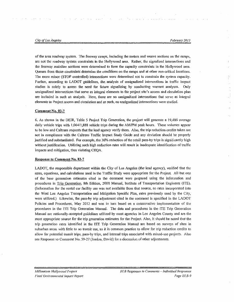
City oj Los Angeles February 2013
of the 'area roadway system. 'The freeway ramps, 'including the meters and weave sections on the: ramps,are not the roadway system constraints in the Hollywood area, Rathel', the signalized intersections andthe freeway mainline sections were determined to form the capacity constraints in the Hollywood area.Queues from those constraints determine the conditions on the ramps and at other non-critical locations.The more minor (STOP controlled) intersections were determined not to constrain the system capacity.Further, according to LADOT guidelines, the. analysis of unsignalized intersections in traffic impactstudies is solely to assess the need forfuture signalizing by eonducting warrant analyses. Onlyunsignalized intersections that serve as integral elements to the project site's access and circulation planare included in such an .analysis, Here, there are no unsignalized intersections that serve as' integralelements to Project access and circulation and as such.no unsignalized intersections were studied.
Comment No. 03-7
6. As shown in the DEli<.,Table 5 Project Trip Generation, the project will generate a 19,486 averagedaily vehicle trips with 1,064/1,888 vehicle trips during the AM/PM peak hours. These volumes appearto be low and Caltrans requests that the lead agency verify them. Also, the trip reduction credits taken arenot in compliance with the Caltrans Traffic Impact Study Guide and any deviation should be properlyjustified and substantiated. for example, the 30% reduction ofthe retail pass-by trips is significantly highwithout justification. Utilizing such high reduction rates will result in inadequate identification of trafficimpacts and mitigation, thus violating CEQA.
Response to Comment No. 03-7
LADOT, the responsible department within the City of Los Angeles (the lead agency), verified that therates, equations, and calculations used in the Traffic Study were appropriate for the Project. All but oneof the base generation estimates cited in the comment were prepared using the information andprocedures in JJ:ill Generation, 8th Edition, 2008 Manual, Institute of Transportation Engineers (lTE).(Information for the rental car facility usc was not available from that source, so rates incorporated intothe West Los Angeles Transportation and Mitigation Specific Plan, rates previously used by the City,were utilized.) Likewise, the pass-by trip adjustment cited in the comment is specified in the LADOTPolicies and Procedures, May 2012 and was in turn based on a conservative implementation of theprocedures in the I'I'E Trip Generation Manual. The data and procedures in the ITE Trip GenerationManual are nationally-accepted guidelines utilized by most agencies in Los Angeles County and are themost appropriate source for the trip generation estimates for the Project, Also, it should be noted that thetrip generation rates identified in the ITE Trip Generation Manual are based on surveys of sites insuburban areas with little to no transit use, so it is common practice to allow for trip reduction credits toallow for potential transit trips, pass-by trips, and internal trips associated with mixed-use projects. Alsosee Response to Comment No. 59-27 (Jordon, David) for a discussion of other adjustments.
Millennium Hollywood ProjectFinal Environmental Impact Report
JI!.BResponses to Comments - Individual ResponsesPage fl!.B-9
City qf Los Angeles February 2013
Comment No; 03-8
To address' these COIlCeiTlS, an analysis for the project's impacts to the freeway system should beperformed based on the proposed scope of the project as described in the DErR and would need to includeall of the following to determine the actual impact of this project 011 the State facilities in the projectvicinity:
a. If the project will be developed in phases, the project added demand and trip assignment to US-101 should be based on each phase of the project otherwise it should be based on 100%
occupancy.
Response to Comment No. 03-8
Please see Response to Comment No.03-3 (Caltrans) concerning the project freeway impacts includingimpacts on the US 101. The Project does not have defined phases, so no phasing analysis is appropriate.The Traffic Study, the Draft BIR, and the analysis in Response to Comment No. 03-3 above analyzed the"worst-case scenario" of'100% occupancy.
Comment No. 03-9
b. The Trip Generation figures and its distribution need to be forecasted based 011 a Select ZoneAnalysis. Based on the magnitude of the project and its close proximity to US-I 0 J, the tripassignment appears to be unreasonably low. Please elaborate on the trip assignment methodologyutilized.
ResponSe to Comine"! No. 03-9
The select zone analysis recommended in the comment is not considered appropriate for the Project. Aselect zone analysis fails to accurately analyze urban infill projects, including the Project. In particular, aselect zone 'analysis does not take intercepted trips into account, and intercepted trips are a majorfactorfor urban in-fill projects. Further, urban areas (such as the Traffic Study area in Hollywood)containnumerous more minor streets with signalized intersections that are not in the regional mode! network.
Those intersections may he significantly impacted, but the streets and the intersections would not havetrips assigned to them by a select zone analysis.
A manual approach Was selected as the most appropriate method to be used for the Traffic Study. Themanual procedures utilized separated the Project into components by land uses and separately assignedthe trips to and from those components. The assignments considered the types of land uses in thesurrounding area to which the component's trips would be linked. The assignments were individuallyreviewed and approved by LADOT and ate detailed in the Trame Study. See Appendix K.I of the Draft
EIR.
Millennium Hollywood ProjectFinal Environmental Impact Report
1I1.B Responses to Comments <Individual ResponsesPage IfUi-/O
City Q( Los Angeles Feb1'/lQl)12013
Coi",".,,! 1'10.03-10
c. Trip Generation figures from other sources should be cross-referenced by the source, pagenumber, year, and table numbers.
Response to Comlliellt No. 03-10
Appendix D of the Traffic Study (Appendix K.I of the Draft ElR) lists the source, land use codes (whichmay be within multi-page sections), source edition, and year. The land-use code and independent variabledictate the formula used. Tables were not used.
Comment No. 03-\l
d. The off ramps on NB and SB OS-IOI, between Vermont Avenue and Highland Avenue, whichwould represent the most impacted area by the proposed Development, should be analyzedutilizing the Highway Capacity Manual (HCM) 85th Percentile Queuing Analysis methodologywith the actual signal timings at the ramps' termini.
Respollseto Comment No. 03-11
The CMA methodology was selected for use in the Traffic Study for all intersections. The CMA analysisis specified Foruse in traffic studies by the lead agency, the City of Los Angeles. Traffic Study Policiesand Procedures, May 2012published by the City of Los Angeles, Department of Transportation specifiesCMA calculations as the methodology to be used in City of Los Angeles traffic studies. The CMAmethodology Was selected for inclusion in the City of Los Angeles manual as it is a "PlanningMethodology" rather than an "Operations Methodology". It should be noted that (he methodologyrecommended in the comment would be dependent upon the signal timing remaining fixed through 2035for the horizon year to be accurate; whereas the computerized signal systems now being employed in theCity of Los Angeles vary the signal liming on an instantaneous basis. However, additional methodologiesmay be required to be used during detailed mitigation design by the agency approving implementation ofa mitigation measure, with appropriate adjustments being made.
COOllne1l1 No. 03-12
e. Similarly, the on ramps on NB and SB US-IOI, within the same area, should be analyzedutilizing the same methodology and with the actual metering rates. These rates can be obtainedby contacting Ms. Afsaneh Razavi, Senior Transportation Engineer, Caltrans Ramp MeteringDepartment at (323) 259- 1841.
Millennium Hollywood ProjectFinal Envtronmentat hnpoct Report
ffl. B Responses 10 Comments - Individual ResponsesPage fII./!-1l
City of LosAngetes February 20J 3
Response to Comment N(}.03-12
Standard City procedures as outlined in the LADO,], Trame Study Policies and Procedures. May 2012,Were selected as the most appropriate for use in the Traffic Study. See Response to Comment Nos. 03-6and 03-11 (Caltrans) for additional information.
Com men! No. 03-13
f. An HCM weaving analysis needs to be performed for both the NB and SB mainline segments,between the on and offramps within the same area, utilizing balanced traffic demands enteringand exiting the Weaving segments.
\leopolISe 10 Comment No. 03-13
Standard City procedures as outlined in the LADOT Traffic Study Policies and Procedures, May 2012,were selected as the most appropriate for use in the Traffic Study. See Response to Comment Nos. 03-6and 03-11 (Caltrans) for additional information.
Comment No. 03-14
Caltrans is concerned that the project impacts may result in unsafe conditions due to additional trafficcongestion, unsafe queuing, and difficult maneuvering. These concerns need to be adequately addressedill the EIR.
Response to Comment No. 03-14
These concerns are adequately addressed in the Traffic Study and Section IV.K.I Transportation- Trafficof the Draft BIR. The Traffic Study, the Draft EIR, and the additional analysis provided ill Response toComment No. 03-03 above adequately demonstrate traffic impacts resulting from the Project. SeeResponse to Comment Nos.U3-3 and 03-6 (Caltrans) for additional information.
Comment No, 03-15
In summary, without the necessary traffic analysis, Caltrans cannot recognize the TIS and DEIR asadequately identifying and mitigating the project's impacts to the State highway facilities.
[fyou have any questions, please feel free to contact Alan Lin the project coordinator at (213) 897-8391and refer to IGRlCEQA No. 121036AL.
Rcsponse 10 Comment No. 03-1;),
The Traffic Study, the Draft EIR, and the additional analysis provided in Response to Comment No. 03-03 above adequately demonstrate traffic impacts resulting from the Project. See Response to COlllmen~Nos. 03-2 through 03-11 (Cal trans) for additional information.
Millennium Hollywood ProjectPinal Environmental Impact Report
f{f.B Responses (0 Comments= Individual ResponsesPage mB-12
EXHIDlTlO
EXCERPTS FROM DEIR (PAGES IV-iS AND IV-220
Trip Caps (Total of2 Pages)
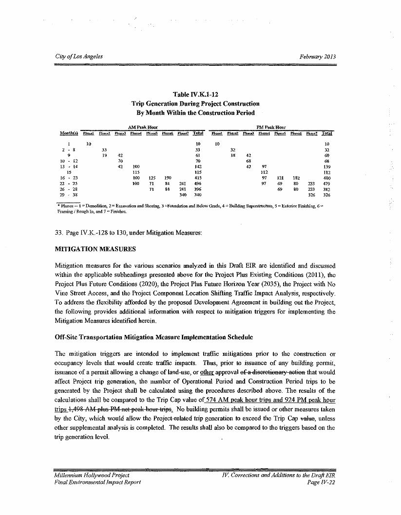
City ojLos Angeles February 2013
Table lV.K.l-12Trip Generation During Project Construction
By Month Within the Construction Period
AM Pcak Hour PM Peak HourMonth(s) Phase1 ~ PhasaJ Phasa4 ~ ~ ~ !!lli!! ~ ~ ~ l'hasa4 ~ Phasa6 f!!!E2 Dl!al
1 10 10 10 102 • 8 33 33 32 32
9 19 42 61 18 42 6010 ~ 12 70 70 68 6813 - 14 42 100 142 42 97 139
15 us !lS 112 11216 ~ 23 100 125 190 415 97 121 182 40022 - 25 100 71 84 241 496 97 69 80 233 47926 - 28 71 84 241 396 69 80 233 38229 - 38 340 340 326 326
* Phases -- I Demolition, 2"" Excavation and Shoring, 3 =Foundation and Below Grade, 4 "" Building Superstructure,S"'" Exterior Finishing, 6 '"Framing I Rough In, and 7 '" Finishes.
33. Page rYK-128(0 130, under Mitigation Measures:
MITIGA nON MEASURES
Mitigation measures for the various scenarios analyzed in this Draft FIR are identified and discussedwithin the applicable subheadings presented above for the Project Plus Existing Conditions (2011), theProject Plus Future Conditions (2020), the Project Plus Fnture Horizon Year (2035), the Project with NoVine Street Access, and the Project Component Location Shifting Traffic Impact Analysis, respectively.To address the flexibility afforded by the proposed Development Agreement in building out the Project,the following provides additional information with respect to mitigation triggers for implementing theMitigation Measures identified herein.
Off-Site Transportation Mitigation Measure Implementation Schedule
The mitigation (riggers are intended to implement traffic mitigations prior to the construction oroccupancy levels that would create traffic impacts. Thus, prior to issuance of any building permit,issuance of a permit allowing a change of land-use, or other approval of a disoretionary aotion that wouldaffect Project trip generation, the number of Operational Period and Construction Period trips to begenerated by the Project shall be calculated using the procedures described above. The results of thecalculations shall be compared to the Trip Cap value of 574 AM peak hour trips and 924 PM peak hourtrips 1,498 AM ~lus PM net ~eal( heur tri~s. No building permits shall be issued or other measures takenby the City, which would allow the Project-related trip generation to exceed the Trip Cap ~, unlessother supplemental analysis is completed. The results shall also be compared to the triggers based on thetrip generation level,
Millennium Hollywood ProjectFinal Environmental Impact Report
!V. Corrections and Additions to the Draft EIRPage /V.]]
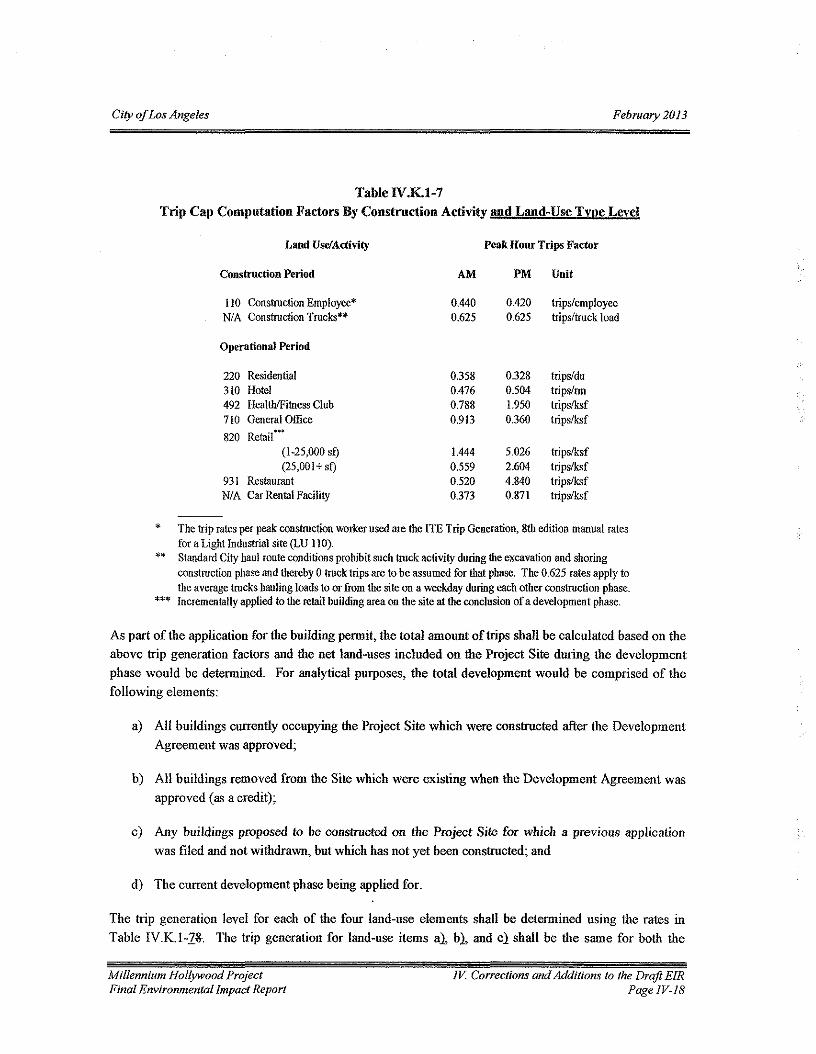
City of Los Angeles February 2013
Table IV.K.1-7Trip Cap Computation Factors By Construction Activity and Land-Use Type Level
Land Use/Activity Peak Hour Trips Factor
Construction Period AM PM Unit
110 Construction Employee'N/A Construction Trucks=
0.4400.625
0.4200.625
trips/employeetrips/truck load
Operational Period
220 Residential310 Hotel492 HealthlFitness Club710 General Office820 RetaiC'
(1-25,000 sf)(25,001+ sf)
931 RestaurantN/A Car Rental Facility
0.358 0.328 trips/du0.476 0.504 trips/rm0.788 1.950 tripslksf0.913 0.360 tripslksf
1.444 5.026 tripslksf0.559 2.604 tripslksf0.520 4.840 tripslksf0.373 0.87l tripslksf
The trip rates per peak construction worker used are the ITE Trip Generation, 8th edition manual ratesfor a Light Industrial site (LU I!O).
** Standard City haul route conditions prohibit such truck activity during the excavation and shoringconstruction phase and thereby 0 truck trips are to be assumed for that phase. The 0.625 rates apply tothe average trucks hauling loads to or from the site on a weekday during each other construction phase.Incrementally applied to the retail building area on the site at the conclusion of a development phase.
*
***
As par! of the application for the building permit, the total amount of trips shall be calculated based on theabove trip generation factors and the net land-uses included on the Project Site during the developmentphase would be determined. For analytical pmposes, the total development would be comprised of thefollowing elements:
a) All buildings currently occupying the Project Site which were constructed after the DevelopmeutAgreement was approved;
b) All buildings removed from the Site which were existing when the Development Agreement wasapproved (as a credit);
c) Any buildings proposed to be constructed on the Project Site for which a previous applicationwas filed and not withdrawn, but which has not yet been constructed; and
d) The current development phase being applied for.
The trip generation level for each of the four land-use elements shall be determined using the rates inTable IV.K.l-Z~. The trip generation for land-use items a}, b}, and c) shall be the same for both the
Millennium Hollywood ProjectFinal Environmental Impact Report
IV. Corrections and Additions to the Draft ErRPage IV-I8
EXHIBIT 11
EXCERPS FROM THE HOLLYWOOD COMMUNITY PLAN
Cover PageMap 10 Generalized Circulation
Map 32 Modified Street Standards: Central HollywoodFigure I Standard and Modified Street Standards
(Total of 4 Pages)
, 'wi' j;)' _,,"":""~'I''II, "'/, '!"~ """,,,
II/I: 'II ~ 1{1I.,!~. .-II flTf' ~"',. 11 c. "
J ""'If(t "If If. '. ,i.flfl
t 1/11!"% 77 ''''' 77 {f '""fA. .
""ce .." 'is-- e.15
"' '0 '""' - '"en e: -e Q.
U " " .,>- .'" EtIlrn S 6 ,ro
1: -I;(.) c, '"C0;' "Ql
0> <:- '0; ~-ti, .;>- :;: rn (5 E~'2,~
-c t50::
.~c e "'"'" .(1;1_0.;.
'" " 2 (5 '~':(J_-:~~
u '0:;;: '" :;;: o C,O-t.? '-' ~~-~:$:~e: ......
....~E~,i:,,_~.- 9, "'Q
-= Ico '" "'" " "c .!!l :g~., @."~E=
'!i => 0p.;.::t:
-'"'".,
1:3>-'"- s:'"ee .s: .>-0> ~ ~to :~1:3 :i: 0 -.;-0 ...~ c:: c.> ~>- 0 '"to 0
00s: ,~<tr c.>
0...IIIJ:: :2 >- en u
~'" ~ ~ -0>- :i: "0 ., -c 0 '"III "'C '" ......,~ c:: !E '"' ~ 0s: ~ ~.!2. 'C 0 "C Q) ...'" 0 ~ 0 '0 0 IIICO to
:2 :2 :2~ :2 :2 en uu;
-eI: III)
®mII)
...!
Major Highway- Class IIStreet Designation Standards
Roadway I
J;..-.---'-~------104' RightofWay---------+!.JI tf I
te
;....------~-100' Right
Sec. Street De.. 8tc:;nd::lrd:~;econdCJr,/ H
T rc
JI:~,----'----,-:-=--:-=-~90'Rightof Way~~-~~---,--+,
66' Roadway
Figure 1Hollywood Community Plan
STANDARD AND MODIFIED STREET STANDARDSt~!An~I~-CityPlom;ngD.,~~~M • ~~~ s~"';"'s SO";",,'. D';~"2oo71N~t t~Scale t
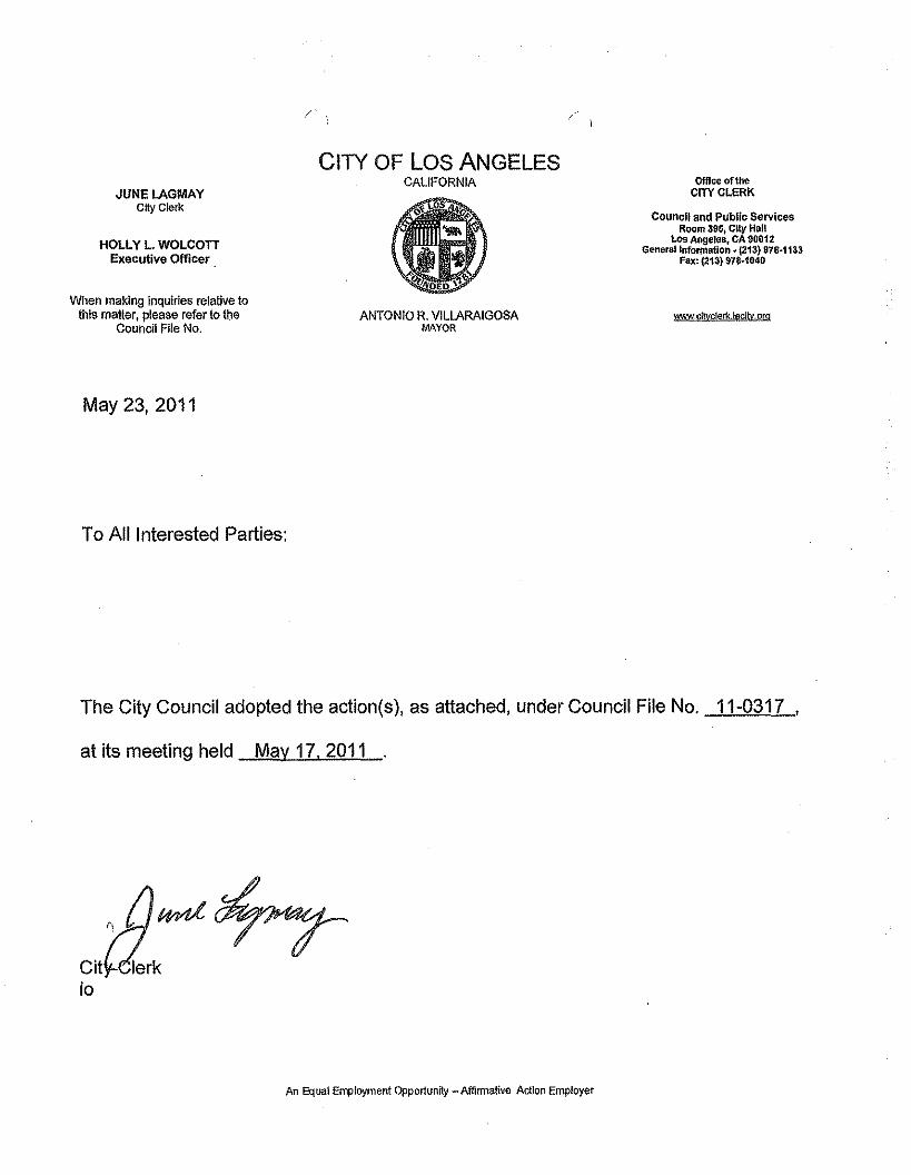
CITY OF LOS ANGELESCALIFORNIA
JUNELAGMAYCity Clerk
OffIce of theCITYC~ERK
HOLLY L. WOLCOnExecutive Officer
councn and Public ServicesRoom 395, City Hall
los Angeles, CA 90012General Information • (213) 978-1133
Fax: (213) 978·1040
When making Inquiries relative tothis maner, please refer to the
Council File No.ANTONIO R. VILLARAIGOSA
MAYORwwwc!l\Ic1erk.lacltv,org
May 23,2011
To All Interested Parties:
The City Council adopted the action(s), as attached, under Council File No. 11-0317 ,
at its meeting held May 17, 2011
Citio
An Equal Employment Opportunity - Affirmative Action Employer
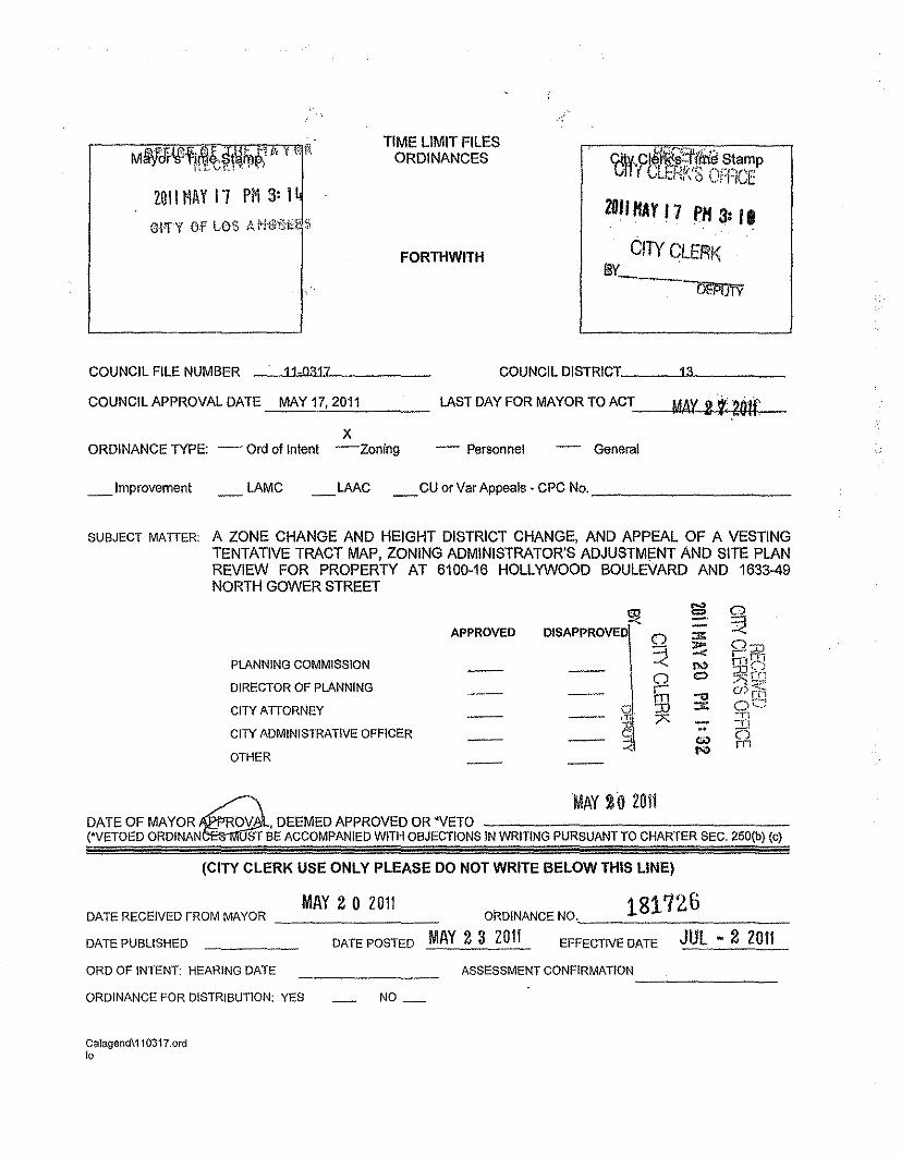
TIME LIMIT FILESORDINANCESM~Ji-I§l'\'i' "tiYt~"n 1:_ ¥':.! \\ ': ,J
LOll MAY11 PI1 3: I
FORTHWITH
COUNCIL FILE NUMBER
ctl 'CIJ~~~llVIii€!Starnv h vi1!L'Cf.Jif"" """"''-'''il'",I 1.1\ V ',..rr~jvc
2DIIHAYl7 PH31/.
CITY CLERKBY--~
COUNCIL APPROVAL DATE MAY 17, 2011
COUNCIL DISTRICT__ --'1"'3~ _
LAST DAY FOR MAYOR TO ACT-~~~~m--MAY2i201f
11-0317
XORDINANCE TYPE: - Ord of Intent -Zoning - Personnel - General
_ Improvement LAMC _LAAC _CU or Var Appeals· CPC No, _
SUBJECT MATIER: A ZONE CHANGE AND HEIGHT DISTRICT CHANGE, AND APPEAL OF A VESTINGTENTATIVE TRACT MAP, ZONING ADMINISTRATOR'S ADJUSTMeNT AND SITE PLANREVIEW FOR PROPERTY AT 6100-16 HOLLYWOOD BOULEVARD AND 1633-49NORTH GOWER STREET
!:!< s:g 0- ~APPROVED -l 0 :::n:
:?:so- 0::0-< rn-
PLANNING COMMISSION Il¢ f\lr~';0" ,
0 C) ~S~,lDIRECTOR OF PLANNING \Ti c» rf!)-0CITY ATIORNEY ~d :D ::ll: Oc:;
7Z ~n
~
-I'!
CITY ADMINISTRATIVE OFFICER .. (')"'"Il¢ rn
OTHER
= MAY 20 2011DATE OF MAYOROV ,DEEMED APPROVED OR 'VETO('VETOED ORDINAN ST BE ACCOMPANIED WITH OBJECTIONS IN WRITING PURSUANT TO CHARTER SEC, 250(b) (c)
(CITY CLERK USE ONLY PLEASE DO NOT WRITE BELOW THIS LINE)
MAY 20 2011 181726DATE RECEIVED FROM MAYOR ORDINANCE NO,, _
DATE PUBLISHED DATE POSTED MAY 2 3 2011 EFFECTIVE DATE JUL - 2 2011ORO OF INTENT: HEARING DATE
ORDINANCE FOR DISTRIBUTION: YES NO_
ASSESSMENT CONFIRMATION--'------
Calagend\110317.ord10
\TO THE COUNCIL OF THECITY OF LOS ANGELES
FILE NO. 11-0317
Your PLANNING AND LAND USE MANAGEMENT Committee
reports as fo !lows:
ENVIRONMENTAL IMPACT REPORT, STATEMENT OF OVERRIDING CONSIDERATIONS, MITIGATIONMONITORING AND REPORTING PROGRAM, PLANNING AND LAND USE MANAGEMENT COMMITTEEREPORT, ORDINANCE relative to a Zone Change and Height District Change, and appeal of a Vesting TentativeTract Map, Zoning Administrators Adjustment and Site Plan Review for property at 6100-6116 Hollywood Boulevardand 1633-1649 North Gower Street,.
Recommendations for Council action, SUBJECT TO THE APPROVAL OF THE MAYOR:
1. CERTIFY that the Environmental Impact Report (EIR No. ENV-2007-5750-EIR; State Clearing House No.2008011113) has been completed in compliance with the California Environmental Quality Act, the StateGuidelines and the City Guidelines and that the City Council has reviewed the information contained thereinand considered it along with other factors related to this project; that this determination reflects theindependent judgment of the lead agency, City of Los Angeles; and that the documents constituting therecord of proceedings in this matter are located in Council file No. 11-0317 in the custody of the City Clerkand in the files of the Department of City Planning in the custody of the Environmental Review Section; andADOPT the Environmental Impact Report.
2. ADOPT FINDINGS made pursuant to and in accordance with Section 21081 of the Public Resources Codeand the Statement of Overriding Considerations prepared by the City Planning Department and ADOPT theStatement of Overriding Considerations.
3. ADOPT FINDINGS pursuant to and in accordance with Section 21081.6 of the California State PublicResources Code, the Mitigation Monitoring and Reporting Program as the Findings of Council and ADOPTthe Mitigation Monitoring and Reporting Program.
4. ADOPT FINDINGS of the Planning and Land Use Committee as the Findings of Council.
5. PRESENT and ADOPT the accompanying ORDINANCE, approved by City Planning Commission, effectinga Zone Change and Height District Change from C4-2D-SN and C4-2D to [T][Q)C4-2D-SN and [T][Q)C4-2D,respectively, with a new"D" Development Limitation to allow a maximum floor area ratio of 4.5:1 for adevelopment resulting in a net increase of 50 or more dwelling units for the construction of a 20-story mixed-use development with 176 residential condominiums and 7,200 square feet of ground floor retail uses with 345parking spaces in the proposed [T][Q]C4-2D-SN and [T][Q]C4-2D Zones for property located at 6100-6116Hollywood Boulevard and 1633-1649 North Gower Street, subject to Conditions of Approval.
Applicant: 6104 Hollywood, LLCRepresentative: Jessica Pakdaman, Craig Lawson and Co., LLC
CPC 2008-3087-ZC-HD-ZAA-SPRVTT70119-1A
6. RESOLVE TO DENY APPEAL filed by Doug Haines, La Mirada Avenue Neighborhood Association ofHollywood (Robert Silverstein, The Silverstein Law Firm, Representative) from the determinations ofthe CPCTHEREBY APPROVING 1)Vesting Tentative Tract Map No. 70119-CN for the merger and re-subdlvision of6 .lots; 2) a Zoning Administrator's Adjustment from Section 12,16-C,2 to permit a zero-foot westerly side yard(including the side yards located althe southwest corner of the Site) in lieu olthe required 16feet and a 10-footrear yard in lieu of the required 20 feet for the parking structure for residential use in the C4 Zone; and 3) SitePlan Review for property located at 6100-6116 Hollywood Boulevard and 1633-1649 North Gower Street,subject to Conditions of Approval.
7. REMOVE the "T' Tentative classification as described in detail on the sheet( s) attached to the Council file,
8. ADVISE the applicant of "Q" Qualified classification time limit as described in the Committee report.
9, ADVISE the applicant that, pursuant to California State Public Resources Code Section 21081.6, the Cityshall monitor or require evidence that mitigation conditions are Implemented and maintained throughout thelife of the project and the City may require any necessary fees to cover the cost of such monitoring.
10. ADVISE the applicant that, pursuant to State Fish and Game Code Section 711.4, a Fish and Game Feeand/or Certificate of Fee EXemption is now required to be submitted to the County Clerk prior to orconcurrent with the EnVironmental Notice of Determination filing.
Fiscal Impact Statement: The Planning Department reports that there is no General Fund impact, as administrativecosts are recovered through fees.
Community Impact Statement: YesAgainst Proposal: Hollywood Studio District Neighborhood Council
TIME LIMIT FILE - MAY 17, 2011
(LAST DAY FOR COUNCIL ACTION - MAY 17, 2011)
Summary:
At the public hearing held on May 10. 2011, the Planning and Land Use Management (PLUM) Committeeconsidered an Environmental Impact Report, Mitigation Monitoring and Reporting Program, Statement of OverridingConsiderations and related California Environmental Quality Act findings; City Planning Commission (CPC) reportand Ordinance effecting a Zone Change and Height District Change from C4-2D-SN and C4-2D to [TJ[Q]C4-2D-SNand [T][Q]C4-2D, respectively, with a new "D" Development Limitation to allow a maximum floor area ratio of 4.5:1;and Appeal filed by Doug Haines, La Mirada Avenue Neighborhood Association of Hollywood (Robert Silverstein,The Silverstein Law Firm, Representative) from the determinations ofthe CPC in approving; 1)Vesting Tentative TractMap No. 70119-CN for the merger and re-subdivislon of 6 lots; 2) a Zoning Administrator's Adjustment from Section12,16-C,2 to permit a zero-foot westerly side yard (including the side yards located at the southwest corner of the site)in lieu of the required 16 feet and a to-root rear yard in lieu of the required 20 feet for the parking structure forresidential use in the C4 Zone; and 3) Site Plan Review for a development resulting in a net increase of 50 or rnoredwelling units for the construction of a 20-story mixed-use development with 176 residential condominiums and 7,200square feet of ground floor retail uses with 345 parking spaces in the proposed [T][Q]C4-2D-SN and [T][Q]C4-2DZones for property located at 6100-6116 Hollywood Boulevard and 1633-1649 North Gower Street, subject toConditions of Approval. .
-2-
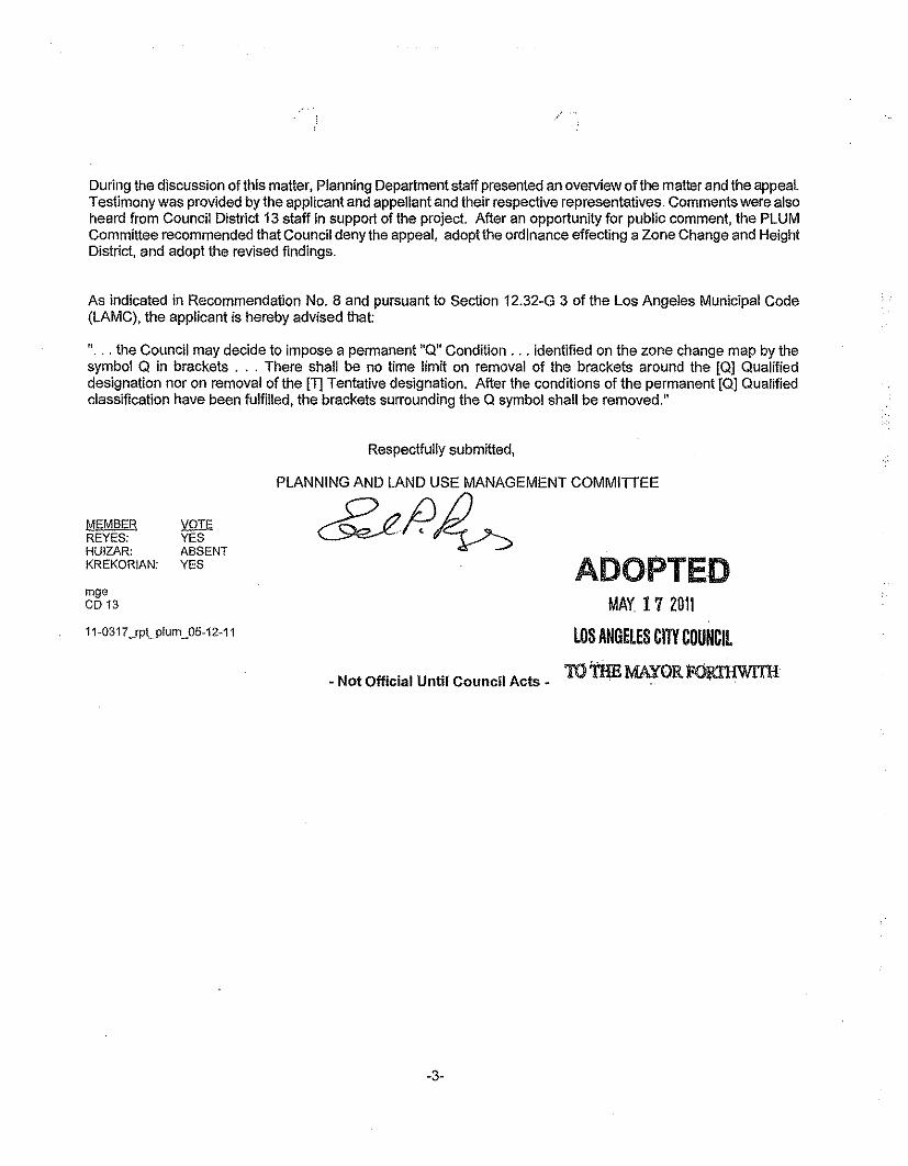
During the discussion of this matter, Planning Department staff presented an overview of the matter and the appeal.Testimony was provided by the applicant and appellant and their respective representatives. Comments were alsoheard from Council District 13 staff in support of the project. After an opportunity for public comment, the PLUMCommittee recommended that Council deny the appeal, adopt the ordinance effecting a Zone Change and HeightDistrict, and adopt the revised findings.
As indicated in Recommendation No.8 and pursuant to Section 12.32-G 3 of the Los Angeles Municipal Code(LAMC), the applicant is hereby advised that:
"... the Council may decide to impose a permanent "Q" Condition ... identified on the zone change map by thesymbol Q in brackets ... There shall be no time limit on removal of the brackets around the [Q] Qualifieddesignation nor on removal of the [T] Tentative desiqnation, After the conditions of the permanent {Q] Qualifiedclasslflcation have been fulfilled, the brackets surrounding the Q symbol shall be removed."
Respectfully submitted,
MEMBERREYES:HUIZAR:KREKORIAN:
VOTEYESABSENTYES
PLANNING AND LAND USE MANAGEMENT COMMITTEE
~p~
- Not Official Until Council Acts -
ADOPTEDMAY. 17 2011
LOS ANGELES CITY COUNCIL
roms MAYOR rosrawrra
mgeCD 13
11-0317 _rpt..plum_05-12-11
-3-
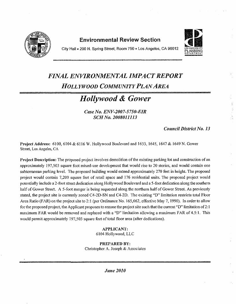
Environmental Review Section ~~
~~LOS ANGELES CITYPLANNINGDEPARTMENT
City Hall. 200 N. Spring Street, Room 750. Los Angeles, CA 90012
FINAL ENVIRONMENTAL IMPACT REPORTHOLLYWOOD COMMUNITY PLAN AREA
Hollywood & GowerCase No. ENV-2007-5750-EIR
SCH No. 2008011113
Council District No. 13
Project Address: 6100,6104 & 61 16 W. Hollywood Boulevard and 1633, 1645, 1647 & 1649 N. GowerStreet, Los Angeles, CA
Project Description: The proposed project involves demolition of the existing parking lot and construction of anapproximately 197,503 square foot mixed-use development that would rise to 20 stories, and would contain onesubterranean parking level. The proposed building would extend approximately 270 feet in height. The proposedproject would contain 7,200 square feet of retail space and 176 residential units. The proposed project wouldpotentially include a 2-foot street dedication along Hollywood Boulevard and a 5-foot dedication along the southernhalf of Gower Street. A 5-foot merger is being requested along the northern half of Gower Street. As previouslystated, the project site is currently zoned C4-20-SN and C4-20. The existing "0" limitation restricts total FloorArea Ratio (FAR) on the project site to 2: I (per Ordinance No. 165,662, effective May 7, 1990). In order to allowfor the proposed project, the Applicant proposes to rezone the project site such that the current "0" limitation of2: 1maximum FAR would be removed and replaced with a "0" limitation allowing a maximum FAR of4.5:1. Thiswould permit approximately 197,503 square feet oftotal floor area (after dedications).
APPLICANT:6104 Hollywood, LLC
PREPARED BY:Christopher A. Joseph & Associates
June 2010
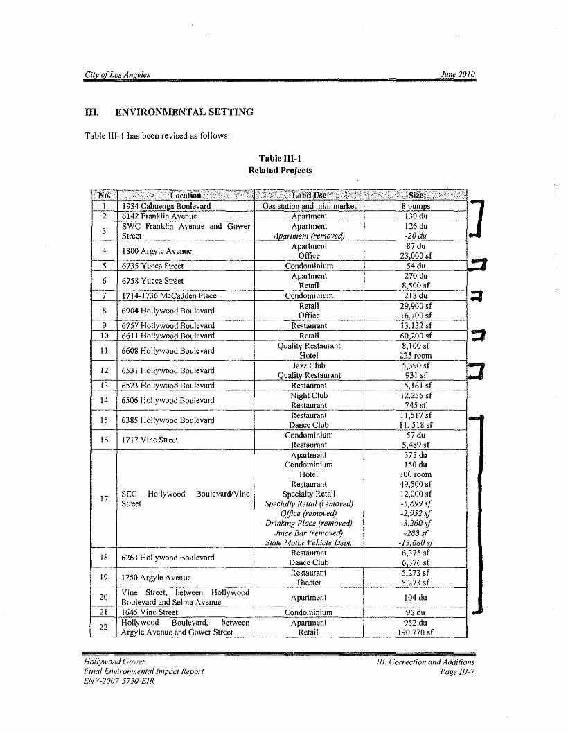
City of Los Angeles June 2010
III. ENVIRONMENTAL SETTING
Table III-I has been revised as follows:
Table III-IRelated Projects
:.l'Iii:< ........;.....} ': .;< <...... ..< ...•;;;, •••.".... .....H.+....····..;i".~ ....'··F;;;.ijI 1934 Cahuenga Boulevard Gas station and mini market 8 pumps ]2 6142 Franklin Avenue Aoartment 130 du
3 SWC Franklin Avenue and Gower Apartment 126 duStreet Anartment (removed) -20 du
4 1800 Argyle Avenue Apartment 87 duOffice 23,000 sf
~5 6735 Yucca Street Condominium 54du
6 6758 Yucca Street Apartment 270 duRetail 8,500 sf
7 1714-1736 McCadden Place Condominium 218 du :I8 6904 Hollywood Boulevard Retail 29,900 sf
Office 16,700 sf9 6757 Hollywood Boulevard Restaurant 13,132 sf10 6611 Hollvwood Boulevard Retail 60,200 sf :J11 6608 Hollywood Boulevard Quality Restaurant 8,100 sf
Hotel 225 room
12 6531 Hollywood Boulevard Jazz Club 5,390 sf r1Quality Restaurant 931 sf13 6523 Hollywood Boulevard Restaurant 15,161 sf
14 6506 Hollywood Boulevard NightClub 12,255 sfRestaurant 745 sf
15 6385 Hollywood Boulevard Restaurant 11,517sf i-Dance Club 11,518sf
16 1717 Vine Street Condominium 57 duRestaurant 5,489 sfApartment 375 du
Condominium 150 duHotel 300 room
Restaurant 49,500 sf
17 SEC Hollywood BoulevardIVine Specialty Retail 12,000 sfStreet Specialty Retail (removed) -5,699 sf
Office (removed) -2,952 sfDrinking Place (removed) -3,260 sf
Juice Bar (removed) -288 sfState Motor Vehicle DeDI. -13,680s(
18 6263 Hollywood Boulevard Restaurant 6,375 sfDance Club 6,376 sf
19 1750 Argyle Avenue Restaurant 5,273 sfTheater 5,273 sf
20 Vine Street, between Hollywood Apartment 104 duBoulevard and Selma Avenue21 1645 Vine Street Condominium 96 du ,-22 Hollywood Boulevard, between Apartment 952 du
Argyle Avenue and Gower Street Retail 190,770 sf
Hollywood GowerFinal Environmental Impact ReportENV-2007-5750-EIR
III. Correction and AdditionsPage 1!1-7
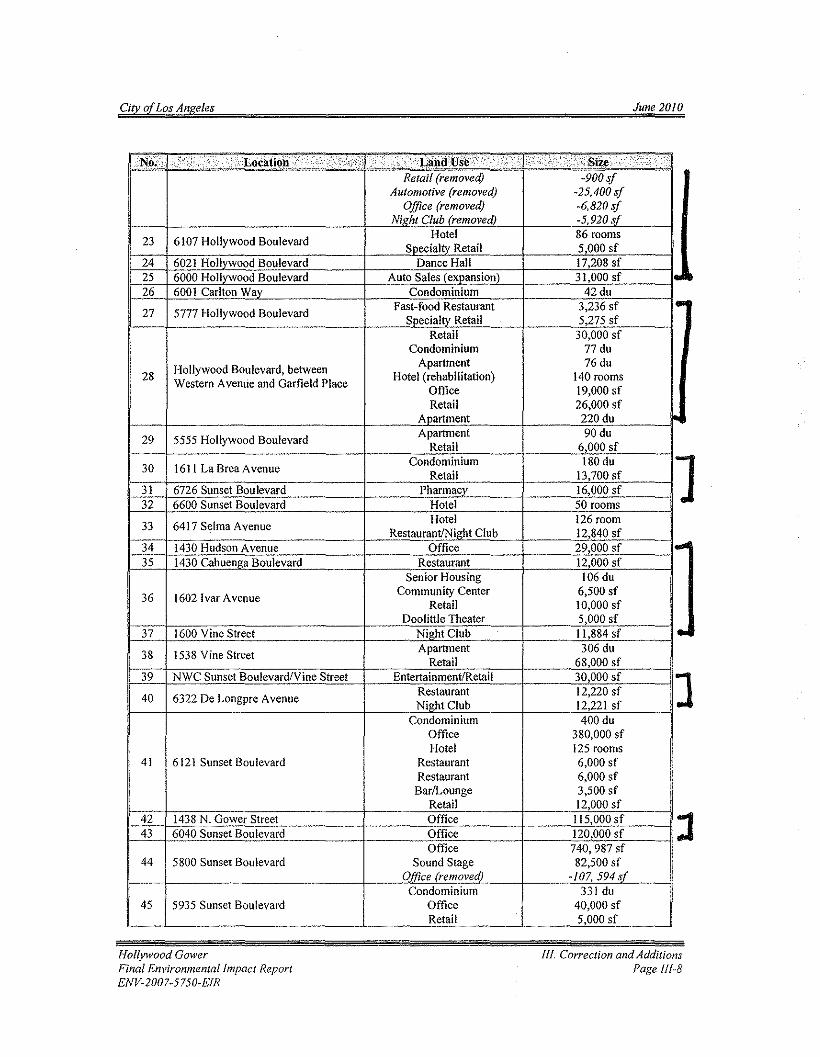
City of Los Angeles June 2010
<Nii!'" ;:r; ····....·;1 ./. ········.·/:;;;/:1 ;:.>/:.~.../. '..·: ..·/''''..:,8ize .. ,.' ..... //Retail (removed) -900 sf
Automotive (removed) -25,400 sfOffice (removed) -6,820 sf
Nigh; Club (removed) -5,920 ;f
23 6107 Hollywood Boulevard Hotel 86 roomsSoecialtv Retail 5000 sf
24 6021 Hollywood Boulevard Dance Hall 17,208 sf25 6000 Hollvwood Boulevard Auto Sales (exuanslon) 31,000 sf "26 600 I Carlton Way Condominium 42du
27 5777 Hollywood Boulevard fast-food Restaurant 3,236 sf eoSpecialty Retail 5,275 sf
Retail 30,000 sfCondominium 77 du
Hollywood Boulevard, between Apartment 76du28 Western Avenue and Garfield Place Hotel (rehabilitation) 140 rooms
Office 19,000 sfRetail 26,000 sf
Apartment 220du
29 5555 Hollywood Boulevard Apartment 90duRetail 6000 sf
30 161l La Brea Avenue Condominium 180 du ]Retail 13,700 sf31 6726 Sunset Boulevard Pharmacv 16,000 sf32 6600 Sunset Boulevard Hotel 50 rooms
33 6417 Selma Avenue Hotel 126 roomRestaurant/Night Club 12,840 sf
34 1430 Hudson Avenue Office 29,000 sf ...35 1430 Cahuenza Boulevard Restaurant 12,000 sf
Senior Housing 106du
36 16021var Avenue Community Center 6,500 sfRetail 10,000 sf
Doolittle Theater 5,000 sf37 1600 Vine Street Night Club 11,884 sf ..38 1538 Vine Street Apartment 306 du
Retail 68,000 sf39 NWC Sunset BoulevardlVine Street EntertainmentIRctail 30,000 sf ]40 6322 De Longpre Avenue Restaurant 12,220 sf
Night Club 12,221 sfCondominium 400du
Office 380,000 sfHotel 125 rooms
41 6121 Sunset Boulevard Restaurant 6,000 sfRestaurant 6,000 sf
BarlLounge 3,500 sfRetail 12,000 sf
42 1438 N. Gower Street Office II 5,000 sf :J43 6040 Sunset Boulevard Office 120,000 sfOffice 740,987 sf
44 5800 Sunset Boulevard Sound Stage 82,500 sfOffice (removed) -/07,594 sf
Condominium 331 du45 5935 Sunset Boulevard Office 40,000 sf
Retail 5,000 sf
Hollywood GowerFinal Environmental Impact ReportENV-2007-5750-EIR
/If. Correction and AdditionsPage III-S
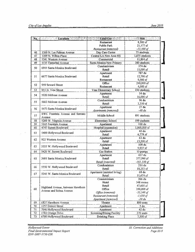
City of Los Angeles June 2010
No;, ,.i" ,'c,' ,',.,.,:> 'i':T >",'i"i'i",'i. u;;~trse:,i\",;i;/;" ,'" ',t illiRestaurant 8,500 sf 1-Public Park 21,177 sf
Restaurant (removed) -13,500 sf46 1260 N, Las Palmas Avenue Day Care Center 75 students47 1309 N, Wilton Place Central LA New Area HS 1,875 students48 1541 Western A venue Commercial 11,864 sf49 1115 Tamarind Avenue Santa Monica New Primary 380 students I-50 6911 Santa Monica Boulevard Condominium 374du
Retail 15,000 sfApartment 787 du
51 6677 Santa Monica Boulevard Retail 12,700 sfRestaurant 9,500 sf
52 959 Seward Street Office 240,000 sf ]Restaurant 4,000 sf53 955 N, Vine Street Vine Elementary School 230 students
54 5920 Melrose Avenue Apartment 54duRetail 16,000 sf
55 5663 Melrose Avenue Condominium 96 duRetail 3,350 sf
56 5473 Santa Monica Boulevard Apartment 27 du I-Apartments (removed) -48du
57 SWC Fountain Avenue and Serrano Middle School 891 studentsAvenue58 5200 W. Virginia Avenue Elementary School 599 students59 5165 Fountain A venue Apartment 110 du60 4747 Sunset Boulevard Hospital (expansion) 1,000,000 sf I ..
61 5400 Hollywood Boulevard Apartment 42duRetail 6,778 sf
62 922 Western Avenue Apartment 63 du ]Retail 13,500 sf
63 5555 W. Hollywood Boulevard Apartment 108 duRetail 9,937 sf
64 5420 W. Sunset Boulevard Gas Station 10 pumpsApartment 437 du
65 560 I Santa Monica Boulevard Retail 377,990 sfRetail (removed) -161,550 sf
66 5550 W. Hollywood Boulevard Condominium 216 du JRetail 18,353 sf
67 5245 W. Santa Monica Boulevard Apartment (assisted living) 68 duRetail 51,674sf
Condominium 266 duHotel 348 rooms
Highland Avenue, between Hawthorn Retail 47,605 sf68 Office 350,000 sfAvenue and Selma A venue
Office (removed) -55,549 sfRestaurant (removed) -1,650sJApartment (removed) -20du
69 6837 Hawthorn Avenue Theater 800 seats ]70 1257 Detroit Street Apartment 5 du71 7046 Hollywood Boulevard Apartment 42du72 1782 Orange Drive Screeninz/Dininz Facility 270 seats73 6700 Hollywood Boulevard Drinking Place 7,500 sf
Hollywood GowerFinal Environmental Impact ReportENV-2007-5750-EIR
lfl. Correction and AdditionsPage 11/-9
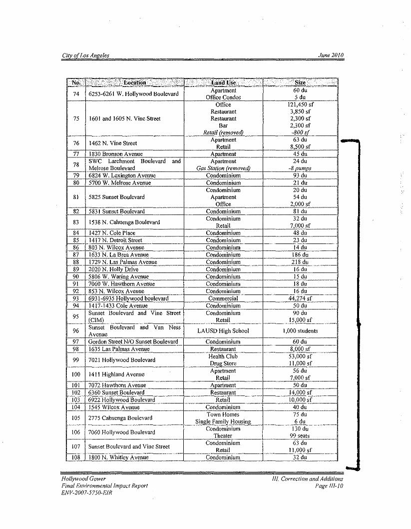
City of Los Angeles June 2010
:N~;'1"',["",('"''',''''' ,('(;;" .ei' "."..:.(,! .'('!( (La.d,Use. ( " (",. "'Size' ,"74 6253-6261 W. Hollywood Boulevard Apartment 60 du
Office Condos 5 duOffice 121,450 sf
Restaurant 3,850 sf75 1601 and 1605 N. Vine Street Restaurant 2,300 sf
Bar 2,300 sfRetail (removed) -800 sf
Apartment 63 du76 1462 N. Vine Street Retail 8,500 sf77 1830 Bronson A venue Apartment 45 du
78 SWC Larchmont Boulevard and Apartment 24duMelrose Boulevard Gas Station (removed) -8 numos
79 6824 W. Lexington Avenue Condominium 93 du80 5700 W. Melrose Avenue Condominium 21 du
Condominium 20 du81 5825 Sunset Boulevard Apartment 54du
Office 2,000 sf82 5831 Sunset Boulevard Condominium 81 du
83 1538 N. Cahuenga Boulevard Condominium 32 duRetail 7,000 sf
84 1427 N. Cole Place Condominium 48 du85 1417 N. Detroit Street Condominium 23 du86 803 N. Wilcox AVenue Condominium 14 du87 1633 N. La Brea Avenue Condominium 186 du88 1729 N. Las Palmas Avenue Condominium 218 du89 2020 N. Hollv Drive Condominium 16 du90 5806 W. Waring Avenue Condominium 15 du91 7060 W. Hawthorn Avenue Condominium 18 du92 853 N. Wilcox Avenue Condominium 16 du93 6931-6935 Hollvwood boulevard Commercial 44,274 sf94 1417-1433 Cole Avenue Condominium 50 du
95 Sunset Boulevard and Vine Street Condominium 90 du(ClM) Retail 15,000 sf
96 Sunset Boulevard and Van Ness LAUSD High School 1,000 studentsAvenue97 Gordon Street NIO Sunset Boulevard Condominium 60du98 1635 Las Palmas Avenue Restaurant 8,000 sf
99 7021 Hollywood Boulevard Health Club 53,000 sfDrua Store 11,000 sf
100 1411 Highland Avenue Apartment 56 duRetail 7,000 sf
101 7072 Hawthorn Avenue Anartment 50 du102 6360 Sunset Boulevard Restaurant 14,000 sf103 6922 Hollvwood Boulevard Retail 10,000 sf104 1545 Wilcox Avenue Condominium 40 du
105 2775 Cahuenga Boulevard Town Homes 75 duSingle Familv Housina 6 du
106 7060 Hollywood Boulevard Condominium 130 duTheater 99 seats
107 Sunset Boulevard and Vine Street Condominium 63 duRetail 11,000 sf
108 1800 N. Whitley Avenue Condominium 32 du
-...Hollywood Gower
Final Environmental Impact ReportENV-2007-5750-EfR
III. Correction and AdditionsPage tu-to
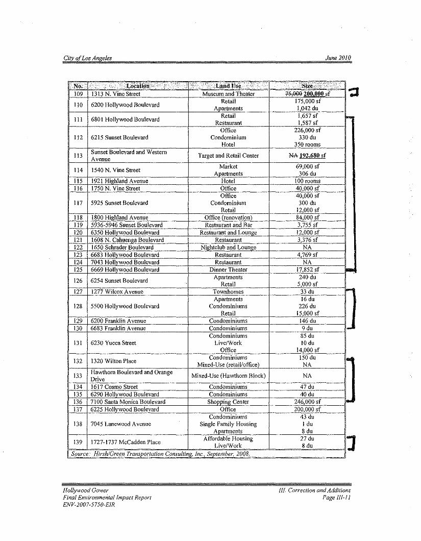
City of Los Angeles June 2010
No. 1'\'",;",,;, , ,;. ;. ;.,';' i":":""",,[jandUse,' ,'c, '",' '" "':",'",'81;00"',";',\\
':I109 1313 N. Vine Street Museum and Theater ~200.000sf
110 6200 Hollywood Boulevard Retail 175,000 sfApartments 1042 du
III 680 I Hollywood Boulevard Retail 1,657 sf 1-Restaurant 1,587 sf
Office 226,000 sf112 6215 Sunset Boulevard Condominium 330 du
Hotel 350 rooms
113 Sunset Boulevard and Western Target and Retail Center NA 192,680 sfAvenue
114 1540 N. Vine Street Market 69,000 sfApartments 306 du
115 1921 Highland Avenue Hotel 100 rooms116 1750 N. Vine Street Office 40,000 sf
Office 40,000 sf117 5925 Sunset Boulevard Condominium 300 du
Retail 12,000 sf118 1800 Highland Avenue Office (renovation) 84,000 sf119 5936-5946 Sunset Boulevard Restaurant and Bar 3,755 sf120 6350 Hollvwood Boulevard Restaurant and Lounze 12,000 sf121 1608 N. Cahuenza Boulevard Restaurant 3376 sf122 1650 Schrader Boulevard Nightclub and Lounge NA123 6683 Hollvwood Boulevard Restaurant 4769 sf124 7043 Hollywood Boulevard Restaurant NA125 6669 Hollywood Boulevard Dinner Theater 17,852 sf ...126 6254 Sunset Boulevard Apartments 240 du
Retail 5,000 sf127 1277 Wilcox Avenue Townhomes 33 du M
Apartments 16du128 5500 Hollywood Boulevard Condominiums 226 du
Retail 15,000 sf129 6200 Franklin Avenue Condominiums 146 du130 6683 Franklin Avenue Condominiums 9du 1-'
Condominiums 85 du131 6230 Yucca Street Live/Work 10 du
Office 14,000 sf
132 1320 Wilton Place Condominiums 150 du I-Mixed-Use (retail/office) NA
133 Hawthorn Boulevard and Orange Mixed-Use (Hawthorn Block) NADrive134 1617 Cosmo Street Condominiums 47 du135 6290 Hollywood Boulevard Condominiums 40du136 7100 Santa Monica Boulevard Shopping Center 246,000 sf I-137 6225 Hollvwood Boulevard Office 200,000 sf
Condominiums 43 du138 7045 Lanewood Avenue Single Family Housing I du
Apartments 8 du
139 1727-1737 McCadden Place Affordable Housing 27 du JLive/Work 8 du- "-" --- .Source.' Hi~sfVGr~:,~.!ranseor!::~ionConsu!.tir:.&, Inc., Se{!.tembe~,200~.:....._
Hollywood GOlVerFinal Environmental Impact ReportENV-2007-5750-E1R
III. Correction and AdditionsPage Iff-II
JUNELAGMAYCity Clerk
CITY OF LOS ANGELESCALIFORNIA
HOLLY L. WOLCOTTExecutive Officer
Office of theCITY CLERK
couneu and public ServicesRoom 395, City Hall
los Angeles, CA 90012General h'1fotmatlon • (213) 978~1133
Fax: (213) 9784040
When making Inquiries relative tothis matter, please refer to the
Council FOe No.ANTONIO R. VILLARAIGOSA
MAYOR
SHANNON HOPPESCouncil and Public Services
Division
www.cityclerk.laclty.ora
December 7, 2012
To All Interested Parties:
The City Council adopted the action(s), as attached, under Council File No. 12-1604,
at its meeting held November 20, 2012.
ICity1}~~os E!
An Equal Employment Opportunity - Affirmative Action Employer
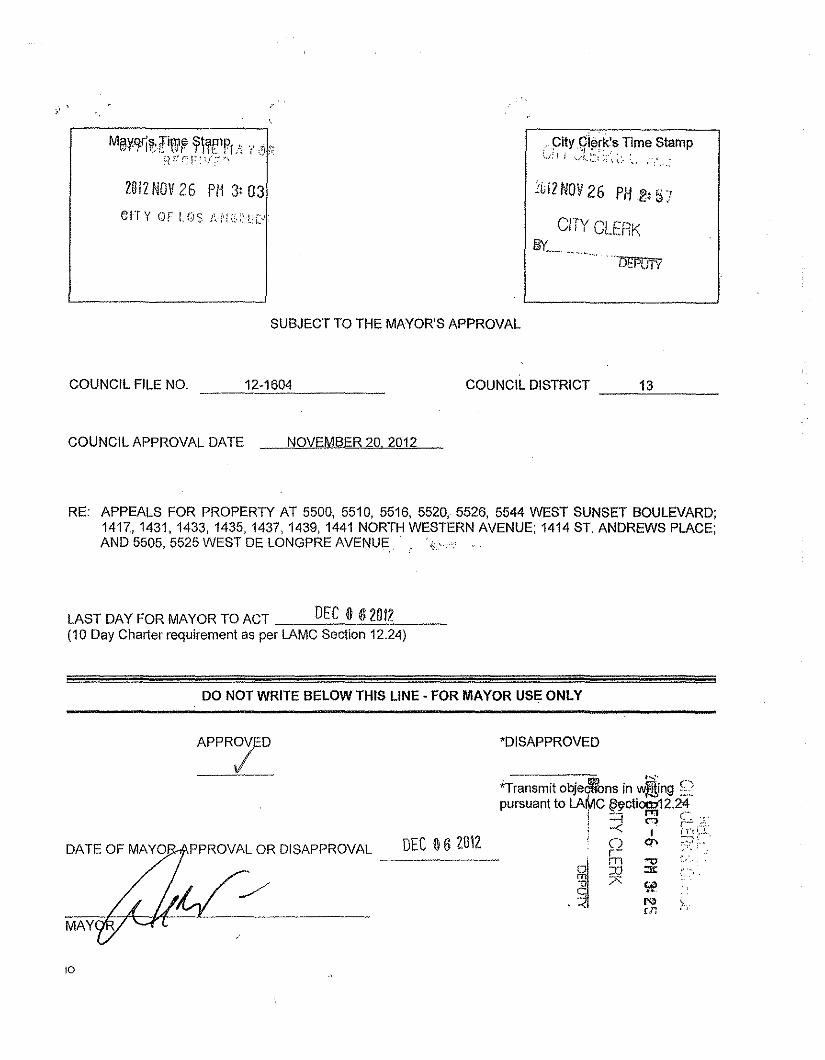
MiBY-9-ritliWr )llrfPj:\ l' ,'j !iH ::"(~F : '/ ;;',,',
2012NOV26 P11 3: 03
CIT Y OF LOS MI;:,"lC,'i
",pitygi¢rk's Time stamp:..... : 1 i ~A.:~;~<:,:_,,", : .
~Gi2NOV 26 P/12: b 7
CITY ClERKBY-~~.,...,~.~,...
". DEPUTY
SUBJECT TO THE MAYOR'S APPROVAL
COUNCIL FILE NO. 12-1604
COUNCIL APPROVAL DATE NOVEMBER 20. 2012
COUNCIL DISTRICT ---'-'----13
RE: APPEALS FOR PROPERTY AT 5500, 5510, 5516, 5520, 5526, 5544 WEST SUNSET BOULEVARD;1417,1431,1433, 1435,1437,1439,1441 NORTH WESTERN AVENUE; 1414 ST. ANDREWS PLACE;AND 5505, 5525 WEST DE LONGPRE AVENUE i'i' ,
LAST DAY FOR MAYOR TO ACT DEC 0 62012(10 Day Charter requirement as per LAMC Section 12.24)
DO NOT WRITE BELOW THIS LINE - FOR MAYOR USE ONLY
DEC 06 2012PPROVAL OR DISAPPROVAL -----
10
'DISAPPROVED
"Transmit objedflbns in ~ng ~'pursuant to LAMC ~ctiOCD12.24
I -- "" ,",; --I C") {.!..i -< I In! 0 0\ ~;]r- ";::",
. ~
~' !jj ~ ." ~ ~
N ~rn c,
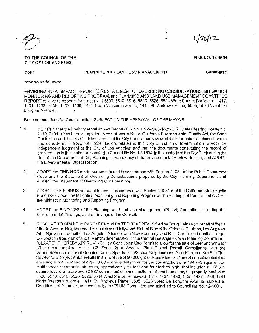
, .
\, .s
TO THE COUNCIL OF THECITY OF LOS ANGELES
FILE NO. 12·1604
Your PLANNING AND LAND USE MANAGEMENT Committee
reports as follows:
ENVIRONMENTAL IMPACT REPORT (EIR), STATEMENT OF OVERRIDING CONSIDERATIONS, MITIGATiONMONITORING AND REPORTING PROGRAM, and PLANNING AND LAND USE MANAGEMENT COMMITTEEREPORT relative to appeals for property at 5500,5510,5516,5520,5526,5544 West Sunset Boulevard; 1417,1431,1433,1435,1437, 1439, 1441 North Western Avenue; 1414 SI. Andrews Place; 5505, 5525 West DeLongpre Avenue.
Recommendations for Council action, SUBJECT TO THE APPROVAL OF THE MAYOR:
1. CERTIFY that the Environrnentallrnpact Report (EIR No. ENV·2008·1421·EIR, State Clearing House No.2010121011) has been completed in compliance with the California Environmental Quality Act, the StateGuidelines and the City Guidelines and that the City Council has reviewed the information contained thereinand considered it along with other factors related to this project; that this determination reflects theindependent judgment of the City of Los Angeles; and that the documents constituting the record ofproceedings in this matter are located in Council file No. 12·1604 in the custody of the City Clerk and in thefiles of the Department of City Planning in the custody of the Environmental Review Section; and ADOPTthe Environmental Impact Report.
2. ADOPT the FINDINGS made pursuant to and in accordance with Section 21081 of the Public ResourcesCode and the Statement of Overriding Considerations prepared by the City Planning Department andADOPT the Statement of Overriding Considerations.
3. ADOPT the FINDINGS pursuant to and in accordance with Section 21081.6 of the California State PublicResources Code, the Mitigation Monitoring and Reporting Program as the Findings of Council and ADOPTthe Mitigation Monitoring and Reporting Program.
4. ADOPT the FINDINGS of the Planning and Land Use Managemeni (PLUM) Committee, including theEnvironmental Findings, as the Findings of the Council.
5. RESOLVE TO GRANT IN PART / DENY IN PART THE APPEALS filed by Doug Haines on behalf of the LaMirada Avenue Neighborhood Association of Hollywood, Robert Blue olthe Citizen's Coalition, Los Angeles,Aiha Nguyen on behalf of Los Angeles Alliance for a New Economy, and R. J. Comer on behalf of TargetCorporation from part of and the entire determination of the Central Los Angeles Area Planning Cornmission(CLAAPC), THEREBY APPROVING: 1) a Conditional Use Permit to allow for the sale of beer and wine foroff-site consumption in the C2 Zone, 2) a SpecifiC Plan Project Permit Compliance with theVermontlWestern Transit Oriented District Specific Plan/Station Neighborhood Area Plan, and 3) a Site PlanReview for a project Which results in an increase of 50,000 gross square feet or more of nonresidential floorarea and a net increase of over 1,000 average daily trips, for the construction of a 194,749 square foot,multi-tenant commercial structure, approximately 84 feet and four inches high, that includes a 163,862square foot retail store and 30,887 square feet of other smaller retail and food uses, for property located at5500,5510,5516,5520,5526,5544 West Sunset Boulevard; 1417, 1431, 1433, 1435, 1437, 1439, 1441North Western Avenue; 1414 SI. Andrews Place; 5505, 5525 West De Longpre Avenue, subject toConditions of Approval, as modified by the PLUM Committee' and attached to Council file No. 12·1604.
Applicant: Target CorporationRepresentative: Vasanthi Okuma, Greenberg Farrow
APCC-2008-2703-SPE-CUB-SPP-SPR
6. INSTRUCT City Planning Department Urban Design Studio to meet with the Applicant, prior to the issuanceof building permit, to review the proposed signage and to approve a final Signage plan.
7. ADVISE the applicant that, pursuant to State Fish and Game Code Section 711.4, a Fish and Game Feeand/or Certificate of Fee Exemption is now required to be submitted to the County Clerk prior to orconcurrent with the Environmental Notice of Determination filing.
Fiscal Impact Statement: The CLAACPC reports that there is no General Fund impact as administrative costs arerecovered through fees.
Community Impact Statement: Yes
Against proposal: Hollywood Studio District Neighborhood Council
TIME LIMIT FILE - DECEMBER 3, 2012
(LAST DAY FOR COUNCIL ACTION - NOVEMBER 21, 2012)
Summary:
At a meeting held on November 13, 2012 (continued from November 6, 2012), the PLUM Committee considered anEIR, Statement of Overriding Considerations, Mitigation Monitoring and Reporting Program and a CLAAPC reportrelative to appeals for property at 5500,5510,5516,5520,5526,5544 West Sunset Boulevard; 1417, 1431, 1433,1435,1437, 1439, 1441 North Western Avenue; 1414 SI. Andrews Place; 5505, 5525 West De Longpre Avenue.Staff from the City Planning Department and the City Attorney's Office gave the Committee background informationon the matter and answered questions. Representatives of the Applicant and Appellants and City Council Officestaff also provided testimony.
After an opportunity for public comment, the Committee recommended that Council to grant in part /deny in part theappeals filed by Doug Haines on behalf of the La Mirada Avenue Neighborhood Association of Hollywood, RobertBlue of the Citizen's Coalition, Los Angeles, Aiha Nguyen on behalf of Los Angeles Alliance for a New Economy,and R. J. Comer on behalf of Target Corporation from part of and the entire determination of the Central LosAngeles Area Planning Commission, thereby approving: 1) a Conditional Use Permit to allow for the sale of beerand wine for off-site consumption in the C2 Zone, 2) a Specific Plan Project Permit Compliance with theVermontlWestern Transit Oriented District Specific Plan/Station Neighborhood Area Plan, and 3) a Site PlanReview for a project which results in an increase of 50,000 gross square feet or more of nonresidential floor areaand a net increase of over 1,000 average daily trips, for the construction of a 194,749 square foot, multi-tenantcommercial structure, approximately 84 feet and four inches high, that includes a 163,862 square foot retail storeand 30,887 square feet of other smaller retail and food uses, for property located at 5500, 5510,5516,5520,5526,5544 West Sunset Boulevard; 1417, 1431, 1433, 1435, 1437, 1439, 1441 North Western Avenue; 1414 SI.Andrews Place; 5505, 5525 West De Longpre Avenue, subject to Conditions of Approval, as modified by the PLUMCommittee and attached to Council file No. 12-1604. This matter is now forwarded to the Council for itsconsideration.
-2-
M~REYES:HUIZAR:ENGLANDER:
SOCO 1311/14112
y':OT~YESABSENTYES
#12/12-1604Jpt_11.13-12
MAYOR WITHf/LE.
Respectfully submitted,
PLANNING AND LAND USE MANAGEMENT COMMITTEE
ADOPTEDNOV 2 (I 2012
LOS ANGElES em COUNCIL
- Not Official Until Council Acts .
-3-
los Angeles City Planning Department JI~~i1iLOS ANG\:LES CITYPLANNINGOEPAFlTMENT
City Hall' 200 N. Spring Street, Room 750 • los Angeles, CA90012
DRAFT ENVIRONMENTAL IMPACT REPORT
HOLL YWOOD COMMUNITY PLAN AREA
Target at Sunset and WesternCase No. ENV-2008-1421-EfR
SCHNo.2010121011Council District No. 13
- - - ..-THIS DOCUMENT COMPRISESTHE FIRSTPART OF THE ENVIRONMENTAL IMPACT REPORT(EIR) FORTHE
PROPOSEDPROJECTDESCRIBED.THE FINAL EIRWill COMPRISE THE SECONDAND FINAL PART.
Project Address: 5520 West Sunset Boulevard, Los Angeles, CA 90028
Project Description: Demolition of a 59,561-square-foot single-story commercial structure, an electricalsubstation and a surface parking lot and construction of a three-story 194,749 square-foot multi-tenantcommercial structure that includes a 163,862-square-foot retail store (Target) and 30,887 square feet of othersmaller retail and food uses. The project would also include 458 at-grade and above-ground parking spaces.
APPLICANT:Target Stores
PREPAREDBY:Environmental Review Section
Los Angeles City Planning Department
January 2012
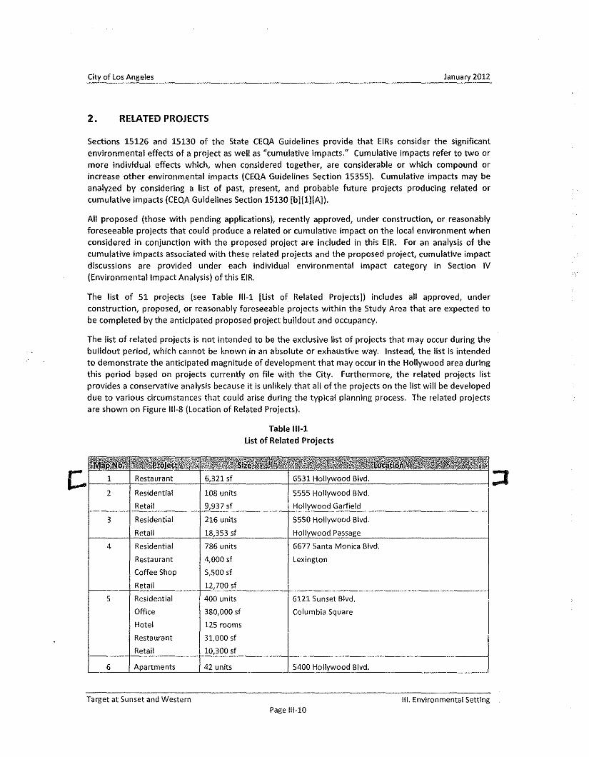
City of los Angeles January 2012
2. RElATED PROJECTS
Sections 15126 and 15130 of the State CEQA Guidelines provide that EIRs consider the significantenvironmental effects of a project as well as "cumulative impacts," Cumulative impacts refer to two ormore individual effects which, when considered together, are considerable or which compound orincrease other environmental impacts (CEQA Guidelines Section 15355). Cumulative impacts may beanalyzed by considering a list of past, present, and probable future projects producing related orcumulative impacts (CEQAGuidelines Section 15130 [b][I][A)).
All proposed (those with pending applications), recently approved, under construction, or reasonablyforeseeable projects that could produce a related or cumulative impact on the local environment whenconsidered in conjunction with the proposed project are included in this EIR. For an analysis of thecumulative impacts associated with these related projects and the proposed project, cumulative impactdiscussions are provided under each individual environmental impact category in Section IV(Environmental Impact Analysis) of this EIR.
The list of 51 projects (see Table 111·1 [list of Related Projects]) includes all approved, underconstruction, proposed, or reasonably foreseeable projects within the Study Area that are expected tobe completed by the anticipated proposed project buildout and occupancy.
The list of related projects is not intended to be the exclusive list of projects that may occur during thebuildout period, which cannot be known in an absolute or exhaustive way. Instead, the list is intendedto demonstrate the anticipated magnitude of development that may occur in the Hollywood area duringthis period based on projects currently on file with the City. Furthermore, the related projects listprovides a conservative analysis because it is unlikely that all of the projects on the list will be developeddue to various circumstances that could arise during the typical planning process. The related projectsare shown on Figure 111·8(Location of Related Projects).
Table 111-1list of Related Projects
Restaurant 6,321 sf 6531 Hollywood Blvd.
2 Residential 108 units 5555 Hollywood Blvd.Retail 9,937 sf Hollywood Garfield
3 Residential 216 units 5550 Hollywood Blvd.Retail 18,353 sf Hollywood Passage
4 Residential 786 units 6677 Santa Monica Blvd.
Restaurant 4,000 sf lexingtonCoffee Shop 5,500 sfRetail 12,700 sf
5 Residential 400 units 6121 Sunset Blvd.Office 380,000 sf Columbia SquareHotel 125 roomsRestaurant 31,000 sfRetail 10,300 sf
6 Apartments 42 units 5400 Hollywood Blvd.
Target at Sunset and Western III. Environmental SettingPage 111-10
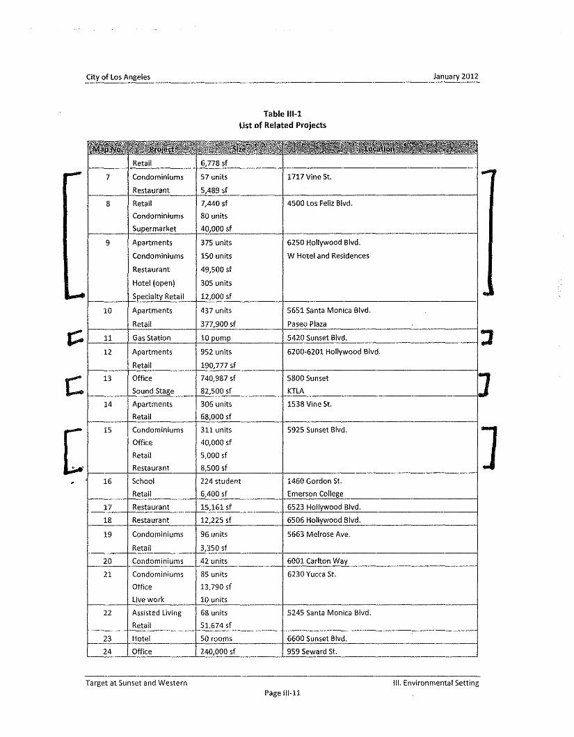
City of Los Angeles January 2012
Table 111-1list of Related Projects
•.• _R':..Jl..•·"..·:w:;qUi!-'.. "'. ,.. J.~!!;, ... ". . ••. ·R .• 9.' ..'Retail 6,778 sf
,..- 7 Condominiums 57 units 1717 Vine St.: ...
Restaurant 5,489 sf
8 Retail 7,440 sf 4500 Los Feliz Blvd.
Condominiums 80 units
Supermarket 40,000 sf
9 Apartments 375 units 6250 Hollywood Blvd.
Condominiums 150 units W Hotel and Residences
Restaurant 49,500 sf
Hotel (open) 305 units
I.- Specialty Retail 12,000 sf ..10 Apartments 437 units 5651 Santa Monica Blvd.
Retail 377,900 sf paseo Plaza
r;::: 11 Gas Station 10 pump 5420 Sunset Blvd. J12 Apartments 952 units 6200·6201 Hollywood Blvd.
Retail 190,777 sf
r; 13 Office 740,987 sf 5800 Sunset JSound Stage 82,500 sf KTLA
14 Apartments 306 units 1538 Vine St.
Retail 68,000 sf
[ 15 Condominiums 311 units 5925 Sunset Blvd. JOffice 40,000 sf
Retail 5,000 sf
Restaurant 8,500 sf. 16 School 224 student 1460 Gordon 51.
Retail 6,400 sf Emerson College
17 Restaurant 15,161 sf 6523 Hollywood Blvd.
18 Restaurant 12,225 sf 6506 Hollywood Blvd.
19 Condominiums 96 units 5663 Melrose Ave.
Retail 3,350 sf
20 Condominiums 42 units 6001 Carlton Way
21 Condominiums 85 units 6230 Yucca St.
Office 13,790 sf
live work 10 units
22 Assisted living 68 units 5245 Santa Monica Blvd.
Retail 51,674 sf
23 Hotel 50 rooms 6600 Sunset Blvd.
24 Office 240,000 sf 959 Seward 51.
Target at Sunset and Western Ill. Environmental SettingPage 111-11
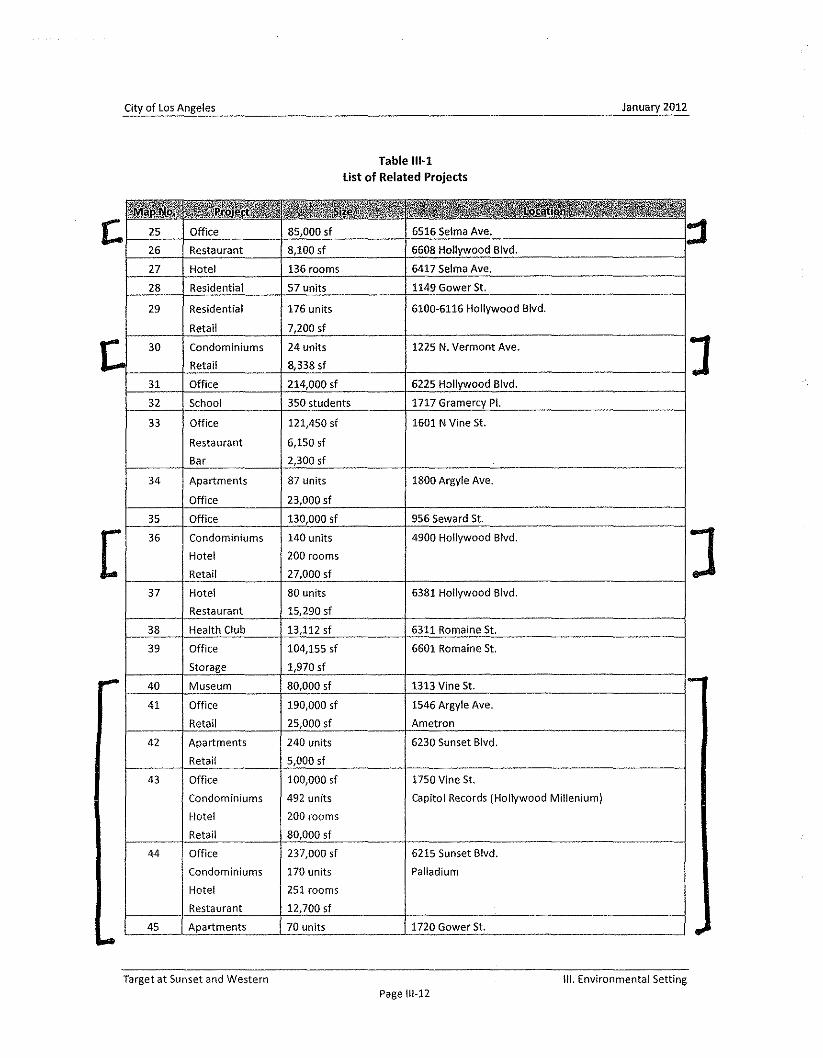
City of LosAngeles January 2012
Table 111-1list of Related Projects
IIlfr ·ll'IIlRr······ f .~/.. ,l"~ e e e: .,J!Jt~!1f@t ~.;liM:;!ii\?lg~,iJi ' .. , .,itt.lli!.", .1;" •. , • . " ..,
C. 25 Office 85,000 sf 6516 Selma Ave. ::I26 Restaurant 8,100 sf 6608 Hollywood Blvd.
27 Hotel 136 rooms 6417 Selma Ave.
28 Residential 57 units 1149 Gower 51.
29 Residential 176 units 6100-6116 Hollywood Blvd.
Retail 7,200 sf
t 30 Condominiums 24 units 1225 N. Vermont Ave, JRetail 8,338 sf
31 Office 214,000 sf 6225 Hollywood Blvd.
32 School 350 students 1717 Gramercy PI.
33 Office 121,450 sf 1601 N Vine St.
Restaurant 6,150 sf
Bar 2,300 sf
34 Apartments 87 units 1800 Argyle Ave.
Office 23,000 sf
35 Office 130,000 sf 956 Seward St.
[ 36 Condominiums 140 units 4900 Hollywood Blvd.
Hotel 200 rooms
Retail 27,000 sf
37 Hotel 80 units 6381 Hollywood Blvd.
Restaurant 15,290 sf
38 Health Club 13,112 sf 6311 Romaine St.
39 Office 104,155 sf 6601 Romaine St.
Storage 1,970 sf- 40 Museum 80,000 sf 1313 Vine St. 1-
41 Office 190,000 sf 1546 Argyle Ave.
Retail 25,000 sf Ametron
42 Apartments 240 units 6230 Sunset Blvd.
Retail 5,000 sf
43 Office 100,000 sf 1750 Vine St.
Condominiums 492 units capitol Records (Hollywood Millenium)
Hotel 200 rooms
Retail 80,000 sf
44 Office 237,000 sf 6215 Sunset Blvd.
Condominiums 170 units PalladiumHote! 251 roomsRestaurant 12,700 sf
45 Apartments 70 units 1720 Gower St.
""-
]
Target at Sunset and Western III. Environmental SettingPage 111-12
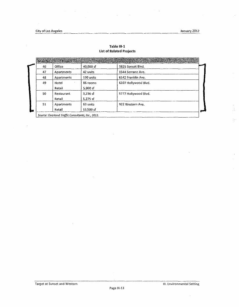
City of Los Angeles January 2012
Table 111-1list of Related Projects
Apartments 42 units 1544 Serrano Ave.
Apartments 130 units 6142 Franklin Ave,
Hotel 86 rooms 6107 Hollywood Blvd,
Retail 5,000 sf
50 Restaurant 3,236 sf 5777 Hollywood Blvd,
Retail 5,275 sf
51 Apartments 63 units 922 Western Ave.
Retail 13,500 sf
Source; Overland Traffic Consultants, Inc., 2011.
Target at Sunset and Western III. Environmental SettingPage 111-13
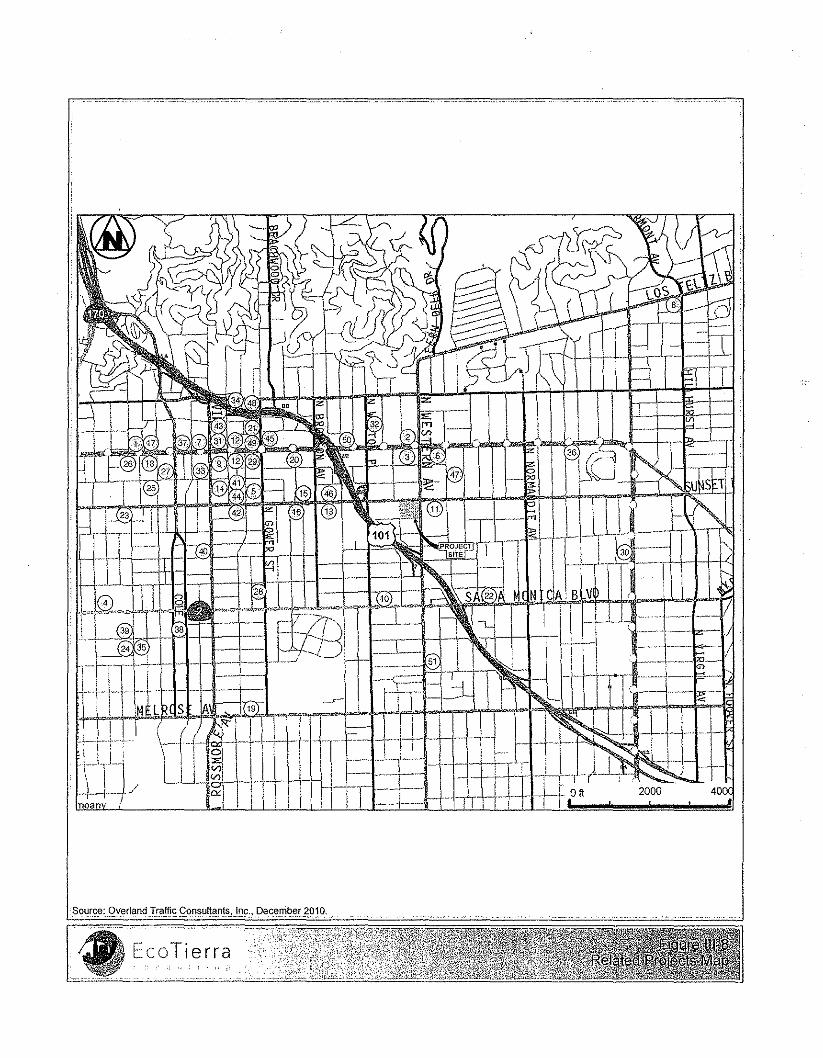
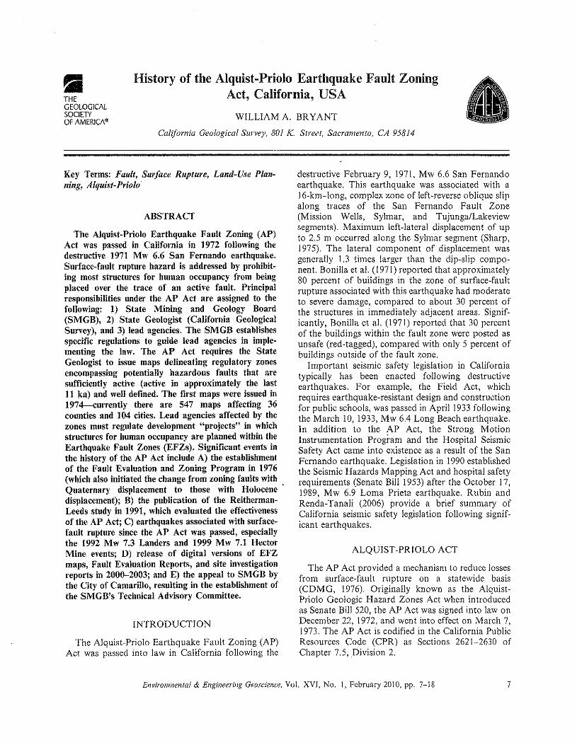
•THEGEOLOGICALSOCIETYOF AMERICA"
History of the Alquist-Priolo Earthquake Fault ZoningAct, California, USA
WILLIAM A, BRYANT
California Geological Survey, 801 K. Street, Sacramento, CA 95814
Key Terms: Fault, Surface Rupture, Land-Use Plan-ning, Alquist-Priolo
ABSTRACT
The Alquist-Priolo Earthquake Fault Zoning (AP)Act was passed in California in 1972 following thedestructive 1971 Mw 6,6 San Fernando earthquake,Surface-fault rupture hazard is addressed by prohibit-ing most structures for human occupancy from beingplaced over the trace of an active fault. Principalresponsibilities under the AP Act are assigned to thefollowing: I) State Mining and Geology Board(SMGB), 2) State Geologist (California GeologicalSurvey), and 3) lead agencies. The SMGB establishesspecific regulations to guide lead agencies in imple-menting the law. The AP Act requires the StateGeologist to issue maps delineating regulatory zonesencompassing potentially hazardous faults that aresufficiently active (active in approximately the lastII ka) and well defined. The first maps were issued in1974-currently there are 547 maps affecting 36counties and 104 cities. Lead agencies affected by thezones must regulate development "projects" in whichstructures for human occupancy are planned within theEarthquake Fault Zones (EFZs). Significant events inthe history of the AP Act include A) the establishmentof the Fault Evaluation and Zoning Program in 1976(which also initiated the change from zoning faults withQuaternary displacement to those with Holocenedisplacement); B) the publication of the Reitherman-Leeds study in 1991, which evaluated the effectivenessof the AP Act; C) earthquakes associated with surface-fault rupture since the AP Act was passed, especiallythe 1992 Mw 7.3 Landers and 1999 Mw 7,1 HectorMine events; D) release of digital versions of EFZmaps, Fault Evaluation Reports, and site investigationreports in 2000-2003; and E) the appeal to SMGB bythe City of Camarillo, resulting in the establishment ofthe SMGB's Technical Advisory Committee.
INTRODUCTION
The Alquist-Priolo Earthquake Fault Zoning (AP)Act was passed into law in California following the
destructive February 9, 1971, Mw 6,6 San Fernandoearthquake, This earthquake was associated with alc-km-Iong, complex zone of left-reverse oblique slipalong traces of the San Fernando Fault Zone(Mission Wells, Sylmar, and Tujunga/Lakeviewsegments), Maximum left-lateral displacement of upto 2,5 m occurred along the Sylmar segment (Sharp,1975), The lateral component of displacement wasgenerally 1.3 times larger than the dip-slip compo-nent. Bonilla et al. (1971) reported that approximately80 percent of buildings in the zone of surface-faultrupture associated with this earthquake had moderateto severe damage, compared to about 30 percent ofthe structures in immediately adjacent areas, Signif-icantly, Bonilla ct al. (1971) reported that 30 pereentof the buildings within the fault zone were posted asunsafe (red-tagged), compared with only 5 percent ofbuildings outside of the fault zone,
Important seismic safety legislation in Californiatypically has been enacted following destructiveearthquakes, For example, the Field Act, whichrequires earthquake-resistant design and constructionfor public schools, was passed in April 1933 followingthe March 10, 1933, Mw 6.4 Long Beach earthquake,In addition to the AP Act, the Strong MotionInstrumentation Program and the Hospital SeismicSafety Act came into existence as a result of the SanFernando earthquake, Legislation in 1990establishedthe Seismic Hazards Mapping Act and hospital safetyrequirements (Senate Bill 1953) after the October 17,1989, Mw 6,9 Lorna Prieta earthquake, Rubin andRenda-Tanali (2006) provide a brief summary ofCalifornia seismic safety legislation following signif-icant earthquakes,
ALQUIST-PR10LO ACT
The AP Act provided a mechanism to reduce lossesfrom surface-fault rupture on a statewide basis(CDMG, 1976), Originally known as the Alquist-Priolo Geologic Hazard Zones Act when introducedas Senate Bill 520, the AP Act was signed into law onDecember 22,1972, and went into effect on March 7,1973, The AP Act is codified in the California PublicResources Code (CPR) as Sections 2621-2630 ofChapter 7,5, Division 2,
Environmental & Engineering Geoscience, VoL XVI, No, 1, February 2010, pp- 7-18 7
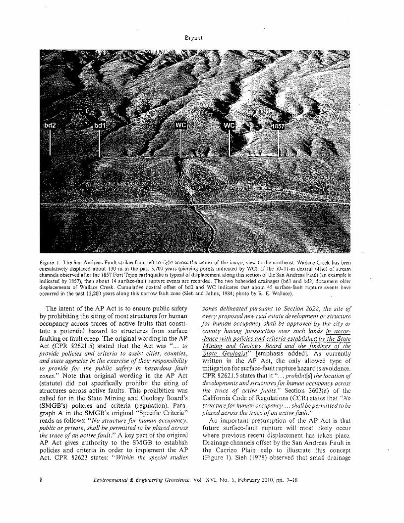
Bryant
Figure I. The San Andreas Fault strikes from left to fight across the center of the image; view to the northeast Wallace Creek has beencumulatively displaced about 130 m in the past 3,700 years (piercing points indicated by We). If the 10-\ l-m dextral offset of streamchannels observed after the 1857 Fort Tejon earthquake is typical of displacement along this section of thc San Andreas Fault (an example isindicated by 1857), then about 14 surface-fault rupture events are recorded. The two beheaded drainages (bdJ and bd2) document olderdisplacements of Wallace Creek. Cumulative dextral offset of bd2 and we indicates that about 45 surface-fault rupture events haveoccurred in the past 13,200 years along this narrow fault zone (Sieh and Jahns, 1984; photo by R. E. Wallace).
The intent of the AP Act is to ensure public safetyby prohibiting the siting of most structures for humanoccupancy across traces of active faults that consti-tute a potential hazard to structures from surfacefaulting or fault creep. The original wording in the APAct (CPR §2621.5) stated that the Act was" ... toprovide policies and criteria to assist cities, counties,and stale agencies in the exercise of their responsibility10 provide for the public safety in hazardous faultzones." Note that original wording in the AP Act(statute) did not specifically prohibit the siting ofstructures across active faults. This prohibition wascalled for in the State Mining and Geology Board's(SMGB's) policies and criteria (regulation). Para-graph A in the SMGB's original "Specific Criteria"reads as follows: "No structure for human occupancy,public or private, shall be permitted to be placed acrossthe trace 4an active fault." A key part of the originalAP Act gives authority to the SMGB to establishpolicies and criteria in order to implement the APAct. CPR §2623 states: "Within the special studies
8
zones delineated pursuant to Section 2622, the site ofevery proposed new real estate development or structurefor human occupancy shall be approved by the city orcounty having jurisdiction over such lands in accor-dance with policies and crUeria established by the StaleMining and Geologv Board and the findings ot tlzeState Geologist" [emphasis added]. As currentlywritten in the AP Act, the only allowed type ofmitigation for surface-fault rupture hazard is avoidance.CPR §2621.5 states that it " ... prohibit[s] the location ofdevelopments and structures/or human occupancy acrossthe trace of active faults." Section 3603(a) of theCalifornia Code of Regulations (CCR) states that "Nostructure/or human occupancy ... shall be permitted to beplaced across the trace ojan activefault."
An important presumption of the AP Act is thatfuture surface-fault rupture will most likely occurwhere previous recent displacement has taken place.Drainage channels offset by the San Andreas Fault inthe Carrizo Plain help to illustrate this concept(Figure I). Sieh (1978) observed that small drainage
Environmental & Engineering Geoscience, vel. XVI. No.1, February 2010, pp. 7-18
History of the AP Act
Table 1. Responsibilities under the Alquist-Priolo Earthquake Fault Zoning (AP) Act. Sections cited are from California Public ResourcesCode (CPR) and California Code of Regulations (CeR).
State Mining and Geology Board1. Formulates policies and criteria to guide cities and counties (CPR §2621.5 and 2623)2. Serves as Appeals Board (CPR §673)
State GeologistL Delineates Earthquake Fault Zones; compiles and issues maps to cities, counties, and state agencies (CPR §2622)
a. Prepares Preliminary Review Mapsb. Prepares Official Maps
Reviews new data (CPR §2622)a. Revises existing mapsb. Compiles new maps
3. Approves requests for waivers initiated by cities and counties (CPR §2623)Lead Agencies
1. Must adopt zoning laws, ordinances, rules, and regulations; primary responsibility for implementing AP Act (CPR §262! .5)2. Must post notices of new Earthquake Fault Zones Maps (CPR §262J.9 and 2622)3. Regulates specified "projects" within Earthquake Fault Zones (CPR §2623)
a. Determines need for geologic reports prior to project approvalb. Reviews and approves geologic reports prior to issuing development permitsc. May initiate waiver procedures (CPR §2623)
Property Ownersl . Must prepare geologic report for specific projects and avoid surface-fault rupture hazard [CPR §2623.(a) and
CCR §3603.(d)]Must disclose to prospective buyers if property is located within AP EFZs (CPR §2621.9)
2.
2.Other
I.2.
Seismic Safety Commission-advises State Geologist and State Mining and Geology Board (CPR §2360)State Agencies-prohibited from siting structures for human occupancy across active fault traces (CPR §2621.5)
channels just southwest of Wallace Creek weredextrally offset 10-11 m during the 1857 Mw 7.8Fort Tejon earthquake. The active Wallace Creekdrainage channel shows a cumulative dextral offset ofabout 130 m. Sieh and Jahns (1984) determined thatthis amount of displacement has taken 3,700 years toaccumulate. To the northwest, beheaded drainagechannels document older displacements of WallaceCreek. Approximately 475 m of cumulative dextraloffset has occurred in the past 13,200years (Sieh andJahns, 1984). If one assumes that earthquakes withground displacements of IO-II m arc typical for thissection of the San Andreas Fault, then about 45surface-fault rupture events have occurred along thisvery narrow fault zone over a period of 13,200 years.
Responsibilities for carrying out the Act are sharedbetween the State Geologist (California GeologicalSurvey), SMGB, affected lead agencies (cities, coun-ties, and state agencies), and property owners(Table I). These entities are discussed in the followingparagraphs.
State Mining and Geology Board
Policies and criteria are developed by the SMGB toassist all concerned with implementing the AP Act.These policies and criteria were codified as Section3600 et. seq., Division 2, Title 14 of the California
Administrative Code .(currently referred to as theCalifornia Code of Regulations) on January 31, 1979.The SMGB provides definitions of terms used in theAP Act, requires cities and counties to notify propertyowners within proposed new and revised EarthquakeFault Zones (EFZs), provides opportunity for thepublic to comment on preliminary review maps ofEFZs, and serves as an appeals board (CPR §673).
State Geologist
The State Geologist evaluates potentially activefaults (evidence of displacement in Quaternary time)and establishes regulatory zones (EFZs) encompass-ing those faults that are sufficiently active and welldefmed. Sufficiently active faults are those faults withevidence of surface displacement during Holocenetime (approximately the last 11,000 years). Holocenesurface displacement may be directly observed orinferred; it need not be present everywhere along afault to qualify that fault for zoning. A fault isconsidered well defined if its trace is clearly detectableby a trained geologist as a physical feature at or justbelow the ground surface. The criterion of welldefined is somewhat subjective and can be influencedby rock type, climate, vegetation, slip rate, and styleof displacement. A critical consideration is that thefault, or some part of it, can be located in the field
Environmental & Engineering Geoscience, Vol. XVI, No.1, February 2010, pp. 7-18 9
with sufficient precision and confidence so that therequired site-specific investigation would meet withsome success.
"Potentially active fault" is not defined in either theAP statute (AP Act) or the regulations (policies andcriteria of the SMGB) and often has been inferred todenote a lack of Holocene displacement. The term"potentially" only appears in CPR §2622(a), whichdiscusses zoning criteria for the State Geologist. Anexplanation for "potentially active fault" is found inSpecial Publication 42 (Bryant and Hart, 2007). Thisexpression is generally referred to in the context ofzoning criteria based on Quaternary displacement. Itis important to note that the term potentially activefault does not exclude displacement in Holocene time(see figure 2 in Bryant and Hart [2007]).Therefore, itdoes not follow that a "potentially active fault" canbe judged "inactive" unless there is evidence thatsupports the conclusion that the fault has not beenactive in Holocene time.
Preliminary Review Maps of Alquist-Priolo EFZs(AP EFZs) are issued by the State Geologist onstandard U.S. Geological Survey 1:24.000-scale, 7.5-minute quadrangle maps. Following a 90-day reviewperiod, the SMGB will hold at least one publichearing to receive comments pertaining to thetechnical merit of the proposed AP EFZs. The StateGeologist considers and incorporates review com-ments and issues Official Maps to affected leadagencies within 90 days of the close of the reviewperiod. Section 2622(c) requires the State Geologist tocontinually review new geologic and seismic data andto revise or issue additional new AP EFZ maps whenwarranted. To date the State Geologist has issued 551..Official Maps ofEFZs. Of these, 161maps have been'revised and four have been withdrawn.
The State Geologist also has the authority toapprove waiver requests submitted by lead agencies(CPR §2623). See the discussion under "LeadAgencies" (below) for further information on thewaiver procedure.
Lead Agencies
Lead agencies (cities, counties, and state agencies)are responsible for ensuring that structures for humanoccupancy that are considered projects under the APAct arc not placed across the trace of an active fault.Affected lead agencies adopt the AP Act into theirgeneral plan. Counties specifically arc required topost a notice identifying the location of AP EFZmaps in their jurisdiction and the effective date of thenotice within 5 days of receiving an Official EFZmap. These notices arc to be posted at the offices ofthe county recorder, county assessor, and county
Bryant
planning commission [CPR §2622(d)]. Lead agenciesmust require geologic investigations directed by aCalifornia-licensed Professional Geologist beforebuilding permits can be issued or subdivisions canbe approved within an AP EFZ. A critical responsi-bility of the lead agency is to ensure that the fault-rupture hazard report is adequate by having thereport reviewed by a third-party California-licensedProfessional Geologist.
There may be occasions when a lead agency findsthat the geologic report for a specific site may not benecessary because it determines that no undue faultrupture hazard exits. This condition typically occurswhere several previous investigations in close prox-imity to the subject site have documented a lack ofsurface-fault rupture hazard. The lead agency has theoption to submit a waiver request, along withaccompanying documentation, to the State Geologistfor approval [CPR §2623(a)]. If the State Geologistconcurs that there is no undue hazard of surface-faultrupture at the site, the local lead agency may issue abuilding permit without the requirement of a siteinvestigation. To date, there have been 85 waiverrequests submitted to the State Geologist since thefirst maps were issued; 80 percent of these waiverrequests have been approved.
Property Owners
Property owners and developers (applicants forbuilding permits or subdivisions) are responsible forcompleting a geologic investigation and preparing ageologic report for projects within an AP EFZ.Ultimately it is the responsibility of the propertyowner, represented by a California-licensed Profes-sional Geologist, to determine if the hazard ofsurface-fault rupture exits on the property and if so,to avoid the hazard [CPR §2623(a); CCR §3603(d)].Property owners are also responsible for disclosing topotential buyers if their property is located in an APEFZ (CPR §2621.9).
SIGNIFICANT HISTORICAL MI.LESTONES
Name Changes
The AP Act was originally named the Alguist-Priolo Geologic Hazard Zones Act and was intendedto address a broader scope of seismically inducedground deformation hazards. It was decided by theoriginal SMGB's Advisory Committee that thestandard of practice in 1972 was not sufficientlydeveloped to address ground deformation hazardsother than surface-fault rupture. The AP Act wasrenamed the Alquist-Priolo Special Studies Zones Act
10 Environmental & Engineering Geoscience, Vol. XVI, No. I, February 2010, pp. 7-18
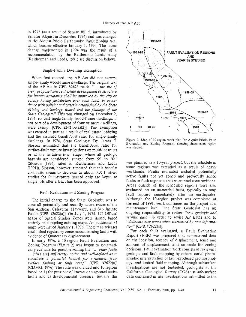
History of the AP Act
in 1975 (as a result of Senate Bill 5, introduced bySenator Alquist in December 1974) and was changedto the Alquist-Priolo Earthquake Fault Zoning Act,which became effective January I, 1994. The namechange implemented in 1994 was the result of arecommendation by the Reitherman-Leeds study(Reithcrman and Leeds, 1991; sec discussion below).
Single-Family Dwelling Exemption
When first enacted, the AP Act did not exemptsingle-family wood-frame dwellings. The original textof the AP Act in CPR §2623 reads: " ... the site ofevery proposed new real estate development or structurefor human occupancy shall be approved by the city orcounty having jurisdiction over such lands in accor-dance with policies and criteria established by the StateMining and Geology Board and the findings 4 theState Geologist." This was changed on December 2,1974, so that single-family wood-frame dwellings, ifnot part of a development of four or more dwellings,were exempt [CPR §2621.6(a)(2)J. This exemptionwas created in part as a result of real estate lobbyingand the assumed benefit!cost ratio for single-familydwellings. In 1974, State Geologist Dr. James E.Siosson estimated that the benefit/cost ratio forsurface-fault rupture investigations on multi-lot tractsor at the tentative tract stage, where all geologichazards are considered, ranged from 5:1 to 10:1(Slosson [1974J, cited in Reitherman and Leeds[I991J). Slosson, however, reported that this benefit!cost ratio seems to decrease to about 0.05:I wherestudies for fault-rupture hazard only are keyed tosingle lots after a tract has been approved.
Fault Evaluation and Zoning Program
The initial charge to the State Geologist was tozone all potentially and recently active traces of theSan Andreas, Calaveras, Hayward, and San JacintoFaults [CPR §2622(a)J. On July I, 1974, 175 OfficialMaps of Special Studies Zones were issued, basedentirely on compiling existing maps. An additional 81maps were issued January I, 1976.These map releasesestablished regulatory zones encompassing faults withevidence of Quaternary displacement.
In early 1976, a lO-region Fault Evaluation andZoning Program (Figure 2) was begun to systemati-cally evaluate for possible zoning the" ... otherfaults... [that are] sufficiently active and well-defined as toconstitute a potential hazard .for structures from.surface faulting or fault creep" [CPR §2622(a)J(CDMG, 1976).The state was divided into 10regionsbased on I) the presence of known or suspected activefaults and 2) developmental pressure. Initially this
Figure 2. Map of IO-region work plan for Alquist-Priolo FaultEvaluation and Zoning Program, showing dates each regionwas studied.
was planned as a IO-year project, but the schedule insome regions was extended as a result of heavyworkloads. Faults evaluated includod potentiallyactive faults not yet zoned and previously zonedfaults or fault segments that warranted zone revisions.Areas outside of the scheduled regions were alsoevaluated on an as-needed basis, typically to mapfault rupture immediately after an earthquake.Although the IO-region project was completed atthe end of 1991, work continues on the project at amaintenance level. The State Geologist has anongoing responsibility to review "new geologic andseismic data" in order to revise AP EFZs and to"delineate new zones when warranted by new informa-tion" [CPR §2622(c)J.
For each fault evaluated, a Fault EvaluationReport (FER) was prepared that summarized dataon the location, recency of displacement, sense andamount of displacement, and rationale for zoningdecisions. Fault evaluation work consists of reviewinggeologic and fault mapping by others, aerial photo-graphic interpretation of fault-produced geomorphol-ogy, and limited field mapping. Although subsurfaceinvestigations arc not budgeted, geologists at thcCalifornia Geological Survey (CGS) usc sub-surfacedata contained in site investigations submitted to the.
Environmental & Engineering Geoscience, Vol. XVI, No.1, February 2010, pp- 7-l8 II
State Geologist to augment the air photo interpreta-tion and field mapping.
CGS geologists have produced about 250 FERssummarizing evidence for or against zoning decisionsfor potentially active faults throughout California.There have been 18 Official Map releases since theFault Evaluation and Zoning Program began.
Reitherman-Leeds Study
In 1986 the California Seismic Safety Commissionrecommended an impartial evaluation of the AP Act.In 1991, CGS (then the Division of Mines andGeology) released the Reitherman-Leeds study (Rei-therman and Leeds, 1991). This study evaluated 62policy issues that ranged from increasing the author-ity and scope of the AP Act to abolishing the AP Act.Overall, Reitherman-Leeds concluded that the APAct is effective, and they recommended implementing27 policy issues. Most have been implemented,including the following:
1) establishing the Seismic Hazards Mapping Act,2) more aggressive enforcement by the California
Board for Geologists and Geophysicists,3) revision of CGS Note 49 (guidelines for fault
rupture hazard investigations),4) changing the AP Act's name to the Earthquake
Fault Zoning Act,5) changing the disclosure statement (part of
Natural Hazards Disclosure Act),6) publishing a non-technical brochure explaining
the AP Act, and7) increasing the availability of FERs and consult-
ing reports filed with the State Geologist.
One recommendation yet to be clarified is the issueof setback distance. There are varying degrees ofapplication of setbacks among local lead agencieswith respect to the interpretation of CCR §3603(a).The current language states the following:
No structurefor human occupancy, identified as a project underSection 2621.6 of the Act, shall be permitted to be placed across thetrace of an active foult. Furthermore, as thc area within fifty (50) feetof such actille (aults shalt be presumed to be under/fJ.in by activebranches of that fault' unless proven otherwise by an appropriategeologic investigation and report prepared as specified in Section3603.d of this subchapter, no such structures shall be pennitted inthis area [emphasis added].
Reitherman and Leeds found this language to beopen to various interpretations: some lead agenciesmandate a no-build zone 50 ft (J 5 m) from activefaults, while others allow structures to be sited closerthan 50 ft (J 5 m), if appropriate, based on site-specific
Bryant
investigations. As written, there is no specifiedminimum distance. However, the original wordingofthis section by the SMGB did state that 50 ft (15 m)represented a minimum standard:
... Furthermore. the area within fifty (50) feet of an active fault shaltbe assumed to be underlain by active branches of thatfauk unless anduntil proven otherwise by an appropriate geologic inoeuigacion andsubmission of a report, by a geologist registered in the State ofCalifornia. This 50 toOf standard is intended to represent minimumcriteria only (or all structures. lr is the opinion of the Board thatcertain essential or critical structures, such as high-1'ise buildings,hospitals, and schools should be subject to more restrictive criteria atthe discretion of Cities and Counties [emphasis added).
The wording as originally written remained ineffect until 1984. Local lead agencies affected by theAP Act prior to 1984 adopted the AP Act into theirgeneral plan, and some jurisdictions may haveincluded this 50-ft (15 m) minimum distance as amandatory requirement. This may explain why somelocal jurisdictions currently mandate a specific 50-ft(15 m) setback from active faults within an AP EFZ.
In concept, a setback, or no-build zone, is delineatedaround active faults located during a site investigationto allow an appropriate level of conservatism or factorof safety. The width of a setback zone allows for theoccurrence of near-fault deformation and the inherentuncertainties of projecting the location of the faultbetween known data points. The width of anappropriate no-build zone can vary, based on site-specific geologic conditions, style and complexity offaulting, and number and spacing of trenches. Thus, insome circumstances it may be appropriate to site astructure closer than 50 ft (15 m), and in othersituations, 50 ft (15 m) may be entirely inadequate.
Earthquakes with Surface-Fault RuptureSince the Passage of the AP Act
Twenty-five earthquakes or earthquake sequencesassociated with surface-fault rupture have occurredsince the first AP EFZ maps were issued in 1974(Table 2). Thirteen events occurred along faults notpreviously zoned: nine (69 percent) occurred prior tothe CGS regional evaluation, and four (31 percent)occurred after the region had been evalua ted.
The most significant surface rupturing events todate were the 1992 Mw 7.3 Landers and the 1999 Mw7.1 Hector Mine earthquakes (Figure 3). The Landersevent was associated with the largest amount ofsurface-fault rupture in California since the 1906 SanFrancisco earthquake. Approximately 85 km ofsurface rupture, with maximum dextral offset ofabout 6 m and an average dextral offset of about 3 m,was recorded (Hart et al., 1993; Sieh et al., 1993). This
12 Environmental & Engineering Geoscience, VoL XVI, No. 1, February 2010, pp. 7-J8
History of the AP Act
earthquake was unique because several faults rup-tured, including the Johnson Valley, HomesteadValley, Emerson, and Camp Rock Faults (Figure 3).The rupture was especially complex, with broad zonesof distributed displacement between and connectingthe principal faults. Most faults that ruptured hadbeen zoned in 1988. However, many of the stepoverareas had not been zoned. Faulting sometimesextended significantly beyond those AP EFZ bound-aries encompassing the ends of faults (Figure 4). Hartet al. (1993) estimated that about 55 percent of faultrupture occurred within established AP EFZs. About31 percent was outside of AP EFZs, and the remaining14 percent of rupture outside of the zones occurred onpreviously unmapped faults not appearing to meetzoning criteria (Hart et aI., 1993).Many of the faultsthat ruptured have been shown to have relatively lowslip rates (about 0.5 mm/yr) with correspondingly longrecurrence intervals (between4 ka and 12ka) (Hecker etaI., 1993;Lindvall and Rockwell, 1994;Rubin and Sieh,1997;and Rockwell et aI., 2000).
The Hector Mine earthquake was similar incomplexity where. traces of the Lavic Lake Faultsplayed off of the Bullion Fault. AP EFZs had beenestablished in 1988for traces of the Bullion Fault, butthe Lavie Lake Fault had not been zoned. Post-earthquake studies indicated that the Lavie LakeFault in the Bullion Mountains had not ruptured fortens of thousands of years prior to the 1999 event(Lindvall et aI., 2000).
These observations indicate that caution should beused when evaluating faults characterized by low sliprates that have not had surface displacement for a longtime. It is important to understand the age of the mostrecent event and the recurrence intervals of these faults.Another important consideration is the complexity andwidth of the surface faulting observed in both theLanders and Hector Mine earthquakes. Are the rupturepatterns, complexity, and width indicativeof and uniqueto the Eastern California Shear Zone, or are thesecomplexities typical of large surface-faulting events?
In contrast to the Landers and Hector Mineearthquakes, the 2004 Mw 6.0 Parkfield earthquakewas associated with surface faulting that was verysimilar to the location and pattern of displacementdocumented in the 1966Mw 6.1 Parkfield event (Brownet aI., 1967; Rymer et aI., 2006). The 2004 surfacefaulting, with one minor exception, was located entirelywithin the previously established AP EFZs.
Digital Products
One of the recommendations of the Reitherrnan-Leeds study was to reproduce the FERs and siteinvestigation reports filed with CGS in compliance
with the AP Act. CGS (then the Division of Mines andGeology) issued microfiche copies of the FERs andtabulated data on site investigation reports (Divisionof Mines and Geology, I990a, 1990b, 1990c, 1990d,1990e;Wong et aI., 1990;and Wong, 1995).Microfichecopies of the FERs, especially the map data, weregenerally not optimal, and those needing to referenceor review specific consulting reports were requiredeither to obtain copies from CGS or to visit the BayArea regional office, where the site report collectionwas kept on file for public access.
In the late 1990s CGS began an effort to providedigital products from the AP Program in response tothe Reitherman-Leeds study. Digital images of APEFZ maps were released as portable documentformat (pdf) tiles in 2000, followed by vector GISfiles of faults and EFZs in 2001. The 1990s vintagemicrofiche copies of FERs were replaced in 2002 bydigital images of the reports, including high-resolu-tion pdf tiles of the maps (Bryant and Wong, 2002a,2002b, 2002c). The collection of site-specific faultinvestigation reports was released in 2003 (Wong,2003a, 2003b).This fault investigation report collectionincludes specific reports in pdf format, an interactivesite index map, and GIS files of site investigationlocations. Site reports filed with the State Geologistthrough 2000 are available on compact disk. Hard copyreports are no longer filed in the Bay Area office.Reports received after 2000 are available for referenceat the Sacramento office of COS.
Camarillo Issue and State Mining andGeology Board
The City of Camarillo requested an interpretationof SMGB regulations in late 2006. At issue was howthe AP Act was interpreted with respect to thepresumption of activity of faults located within EFZs.Is the entire area within an AP EFZ presumed to beunderlain by active faults until demonstrated other-wise? Another issue raised was the intent of thesetback language in CCR §3603(a). Did this regula-tion mandate that structures cannot be placed closerthan 50 ft (15 m) from each fault encountered in a siteinvestigation, or was there some degree of flexibility"Must one setback from faults with small amounts ofdisplacement that cannot be proven inactive, or isstructural mitigation allowed for such faults?
This request for clarification resulted from aninvestigation of a site underlain by extensively faultedPlio-Pleistocene Saugus Formation. Principal activetraces of the Simi-Santa Rosa Fault Zone werelocated on the site and setbacks were recommended.However, the site previously had been used forborrow and lacked any remaining younger stratigra-
Environmental & Engineering Geoscience, VoL XVT, No.1, February 2010, pp. 7-18 13
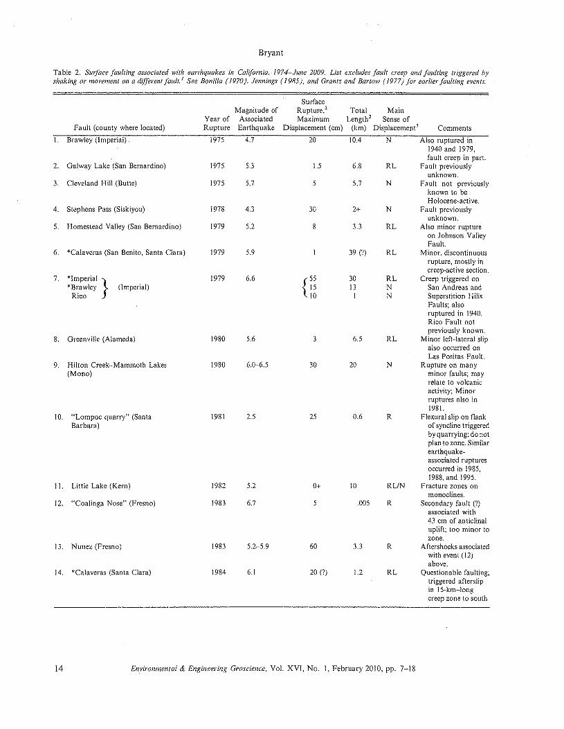
Bryant
Table 2. Surface faulting associated with earthquakes in California, /974-June 2009. List excludes fault creep and faulting triggered byshaking or movement on a different fault, I See Bonilla ( /970 j, Jennings (1985), and Grantz and Bartow (1977) for earlier faulting events.
SurfaceMagnitude of Rupture.' Total Main
Year of Associated Maximum Length' Sense ofFault (county where located) Rupture Earthquake Displacement (em) (km) Displacement' Comments
1. Brawley (Imperial) 1975 4.7 20 10.4 N Also ruptured in1940 and 1979,fault creep in part.
2. Galway Lake (San Bernardino) 1975 5.3 1.5 6.8 RL Fault previouslyunknown.
3. Cleveland Hill (Butte) 1975 5.7 5 5.7 N Fault not previouslyknown to beHolocene-active.
4. Stephens Pass (Siskiyou) 1978 4.3 )0 2+ N Fault previouslyunknown.
5. Homestead Valley (San Bernardino) 1979 5.2 8 3.3 RL Also minor ruptureon Johnson ValleyFault.
6. "Calaveras (San Benito, Santa Clara) 1979 5.9 39 (?) RL Minor. discontinuousrupture, mostly increep-active section,
7. "Imperial } 1979 6.6 r )0 RL Creep triggered on"Brawley (Imperial) 15 13 N San Andreas and
Rico 10 I N Superstition HillsFaults; alsoruptured in 1940.Rico Fault notpreviously known.
8. Greenville (Alameda) 1980 5.6 3 6.5 RL Minor left-lateral slipalso occurred onLas Pcsitas Paull.
9. Hilton Creek-Mammoth Lakes 1980 6.0-·6.5 30 20 N Rupture on many(Mono) minor faults; may
relate to volcanicactivity: Minorruptures also in1981.
10. "Lompoc quarry" (Santa 1981 2.5 25 0.6 R Flexural slip on flankBarbara) of syncline triggered
by quarrying; donotplan to zone. Similarearthquake-associated rupturesoccurred in 1985,1988, and 1995.
II. Little Lake (Kern) 1982 5.2 0+ 10 RUN Fracture zones allmonoclines.
12. "Coalinga Nose" (Fresno) 1983 6.7 5 .005 R Secondary fault ('?)associated with43 em of anticlinaluplift; too minor tozone.
13. Nunez (Fresno) 1983 5.2-5.9 60 3.3 R Aftershocks associatedwith event (12)above.
14. "Calaveras (Santa Clara) 1984 6.1 20 (1) 1.2 RL Questionable faulting;triggered afterslipin l Sckm-longcreep zone to south.
14 Environmental & Engineering Geoscience, Vol. XVI, No. I, February 2010, pp. 7-J8
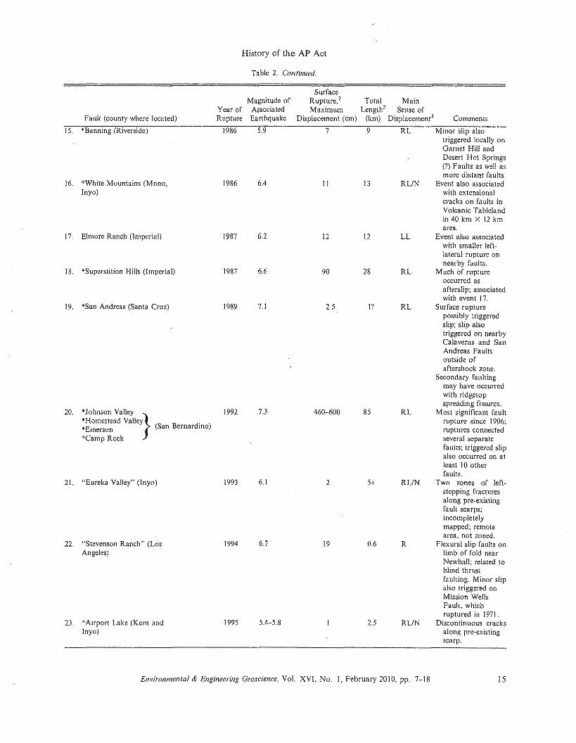
History of the AP Act
Table 2. Continued.
SurfaceMagnitude of Rupture." Total Main
Year of Associated Maximum Length+ Sense ofFault (county where located) Rupture Earthquake Displacement (em) (km) Displacemenr' Comments
15. "Banning (Riverside) 1986 5.9 7 9 RL Minor slip alsotriggered locally onGarnet Hill andDesert Hot Springs(?) Faults as well asmore distant faults,
16. "White Mountains (Mono, 1986 6.4 II 13 RLiN Event also associatedInyo) with extensional
cracks on faults inVolcanic Tablelandin 40 km X 12 kmarea.
17. Elmore Ranch (Imperial) 1987 6.2 12 12 LL Event also associatedwith smaller left-lateral rupture onnearby faults.
18. "Superstition Hills (Imperial) 1987 6.6 90 28 RL Much of ruptureoccurred asafterslip: associatedwith event 17.
19. *San Andreas (Santa Cruz) 1989 7.1 2.5 I'? RL Surface rupturepossibly triggeredslip; slip alsotriggered on nearbyCalaveras and SanAndreas Faultsoutside ofaftershock zone,
Secondary faultingmay have occurredwith ridgetopspreading fissures.
20. "Johnson Valley 1992 7.3 460-600 85 RL Most significant fault'Homestead Valley} . rupture since 1906;"Emerson (San Bernardino) ruptures connected"Camp Rock several separate
faults; triggered slipalso occurred on atleast 10 otherfaults.
21. "Eureka Valley" (Inyo) 1993 6.1 2 5+ RLiN Two zones of left-stepping fracturesalong pre-existingfault scarps;incompletelymapped: remotearea, not zoned.
22. "Stevenson Ranch" (Los 1994 6.7 19 0.6 R Flexural slip faults onAngeles) limb of fold near
Newhall; related toblind thrustfaulting. Minor slipalso triggered onMission WellsFault. whichruptured in 1971,
23. "Airport Lake (Kern and 1995 5.4-5.8 2.5 RUN Discontinuous crackslnyo) along pre-existing
scarp,
Environmental & Engineering Geoscience, Vol. XVI, No. I, February 2010, pp. 7-18 15
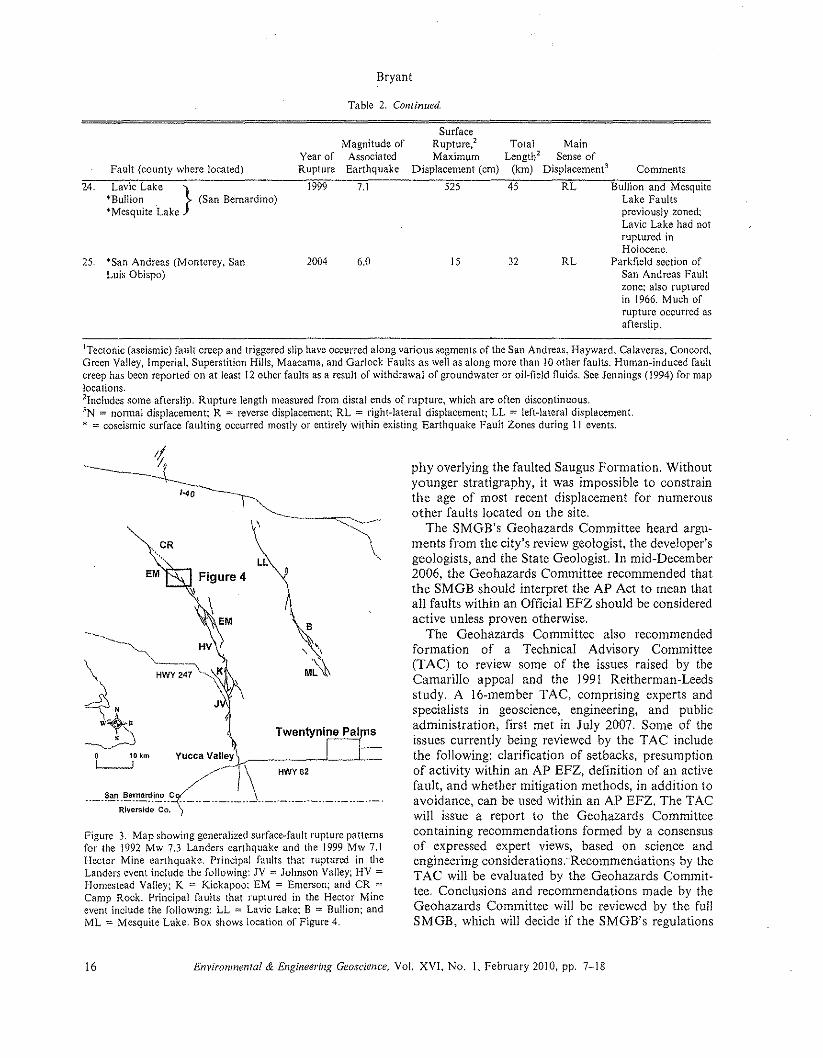
Table 2. Continued.
Bryant
Fault (county where located)Year ofRupture
Magnitude ofAssociatedEarthquake
SurfaceRupture.' Total MainMaximum Length" Sense of
Displacement (ern) (km) Displacement" Comments
24. Lavic Lake }I!<Bu!1ion. (San Bernardino)"Mesquite Lake
7.11999
25. "'San' Andreas (Monterey, SanLuis Obispo)
6.02004
525 45 RL Bullion and MesquiteLake Faultspreviously zoned;Lavic Lake had notruptured inHolocene.
32 RL Parkfield section ofSan Andreas Faultzone: also rupturedin 1966. Much ofrupture occurred asafterslip.
15
ITectonic (aseismic) fault creep and triggered slip have occurred along various segments of the San Andreas, Hayward, Calaveras, Concord,Green Valley, Imperial, Superstition Hills, Maacama, and Garlock Faults as well as along more than 10 other faults. Human-induced faultcreep has been reported on at least 12 other faults as a result of withdrawal of groundwater or oil-field fluids. See Jennings (]994) for maplocations.2lnc!lIdes some afteralip. Rupture length measured from distal ends of rupture, which are often discontinuous.IN := normal displacement; R := reverse displacement: RL = right-lateral displacement; LL = left-lateral displacement."' := coseismic surface faulting occurred mostly or entirely within existing Earthquake Fault Zones during 11 events.
EM Figure 4}
B
-, \M~
Figure 3. Map showing generalized surface-fault rupture patternsfor the 1992 Mw 7.3 Landers earthquake and the 1999 Mw 7.1Hector Mine earthquake. Principal faults that ruptured in theLanders event include the following: JY = Johnson Valley; HY =Homestead Valley; K := Kickapoo: EM := Emerson; and CR =Camp Rock. Principal faults that ruptured in the Hector Mineevent include the following: LL := Levie Lake; B := Bullion; andML = Mesquite Lake. Box shows location of Figure 4.
phy overlying the faulted Saugus Formation. Withoutyounger stratigraphy, it was impossible to constrainthe age of most recent displacement for numerousother faults located on the site,
The SMGB's Geohazards Committee heard argu-ments from the city's review geologist, the developer'sgeologists, and the State Geologist. In mid-December2006, the Geohazards Committee recommended thattbe SMGB should interpret the AP Act to mean thatall faults within an Official EFZ should be consideredactive unless proven otherwise.
The Geohazards Committee also recommendedformation of a Technical Advisory Committee(TAC) to review some of the issues raised by theCamarillo appeal and the 1991 Reithcrman-Leedsstudy. A Io-rnernber TAC, comprising experts andspecialists in geoscience, engineering, and publicadministration, first met in July 2007. Some of theissues currently being reviewed by the T AC includethe following: clarification of setbacks, presumptionof activity within an AP EFZ, definition of an activefault, and whether mitigation methods, in addition toavoidance, can be used within an AP EFZ. The TACwill issue a report to the Geohazards Committeecontaining recommendations formed by a consensusof expressed expert views, based on science andengineering considerations . 'Recommendations by theTAC will be evaluated by the Geohazards Commit-tee. Conclusions and recommendations made by theGeohazards Committee will be reviewed by the fullSMGB, which will decide if the SMGB's regulations
16 Environmental & Engineering Geoscience, Vol. XVI, No. I, February 2010, pp. 7-18
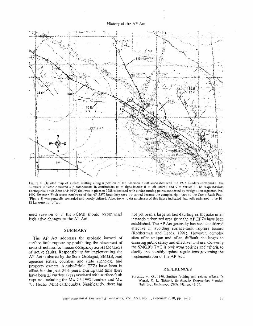
History of the AP Act
.. , Z;;R--SiS,,;'. r..,\
Figure 4. Detailed map of surface faulting along a portion of the Emerson Fault associated with the 1992 Landers earthquake, Thenumbers indicate observed slip components in centimeters (rl :::: right-lateral: 11 := left lateral; and v 0:::: vertical). The Alquist-PrioloEarthquake Fault Zone (AP EFZ) that was in place in 1988 is depicted with circled turning points connected by straight-line segments. Pre-1992 Emerson Fault traces northwest of the AP EFZ boundary were not zoned because the complex right-step to the Camp Rock Fault(Figure 3) was generally concealed and poorly defined. Also. trench data northwest of this figure indicated that soils estimated to be 10-12 ka were not offset.
need revrsion or if the SGMB should recommendlegislative changes to the AP Act.
SUMMARY
The AP Act addresses the geologic hazard ofsurface-fault rupture by prohibiting the placement ofmost structures for human occupancy across the tracesof active faults, Responsibility for implementing theAP Act is shared by the State Geologist, SMGB, leadagencies (cities, counties, and state agencies), andproperty owners, Alquist-Priolo EFZs have been ineffect for the past 34'/, years, During that time therehave been 25 earthquakes associated with surface-faultrupture, including the Mw 7,3 1992 Landers and Mw7,1 Hector Mine earthquakes, Significantly, there has
not yet been a large surface-faulting earthquake in anintensely urbanized area since the AP EFZs have beenestablished, The AP Act generally has been consideredeffective in avoiding surface-fault rupture hazard(Reitherman and Leeds, 1991), However, complexsites offer unique and often difficult challenges toensuring public safety and effective land use, Currentlythe SMGB's TAC is reviewing policies and criteria toclarify and possibly update regulations governing theimplementation of the AP Act.
REFERENCES
BONILLA,M. G., 1970, Surface faulting and related effects. InWiegal. R. L. (Editor), Earthquake Engineering: Prentice-Hall. Inc., Englewood CiiffsvNl. pp. 47·-74.
Environmental & Engineering Geoscience. Vol. XVI, No.1, February 2010, pp. 7-.18 17
BONILLA,M, G,; BUCHANAN,J, M,; CASTLE, R, 0,; CLARK, M, M,;FRIZZELL, V, A.; GULLIVER,R, M.; MILLER, F. K.; PINKERTON,J. P.; Ross, D. c, SI'lARP,R. V.; YERKES, R. F.; ANDZIONY, J.1., 1971, Surface faulting. In The Sail Fernando, California.Earthquake of February 9, 1971: U.s. Geological SurveyProfessional Paper 733. pp. 55-79.
BROWN, R, D" JR.; VEDDER,J. G.; WALLACE, R. E.; ROTH, E. F,;YERKES, R, F,; CASTLE, R. 0,; WAANANER, A. 0.; PAGE, R.W.; ANDEATON,J. P., 1967, The Parkfield-Cholame CaliforniaEarthquake of June-August 1966,,,,,""SUIjaceGeologic Effects,Water-Resources Aspects. and Preliminary Seismic: Data: U.S .•Geological Survey Professional Paper 579. 66 p.
BRYANT, W, A, AND HART, E, W" 2007, Fault-Rupture HazardZones in California: California Geological Survey SpecialPublication 42 (Interim Revision 2007), 42 p, (digital versiononly, electronic document, available at ftp://ftp.consrv.ca.gOY Ip ubid mglpubs/sp/Sp4 2.pd f).
BRYANT, W. A. AND WONG. P., 2002a, Fault Evaluation ReportsPrepared under the Alquist-Priolo Earthquake Fault. ZoningAc!, Region I, Central California: California GeologicalSurvey CD 2002·0 I.
BRYANT, W, A, AND WONG, P" 2002b, Fault Evaluation ReportsPrepared under the Alquist-Priolo Earthquake Fault ZoningAct, Region 2, Southern California: California GeologicalSurvey CD 2002·02.
BRYANT, W. A. AND WONG, P., 2002c, Fault Evaluation ReportsPrepared under the Alquist-Priolo Earthquake Pauli ZoningAct, Region 3, Northern and Eastern California: CaliforniaGeological Survey CD 2002-03.
CALIFORNIA DIVISION OF MINES ANI) GEOLOGY (COMO). 1976,Active Fault Mappirlg and Evaluation Program-Ten YearProgram to Implemenr Alquist-Priolo Special Studies ZonesAct: California Division of Mines and Geology SpecialPublication 47, 42 p.
DIVISION OF MINES AND G"'OLOGY. I990a, Microfiche Copies ofFault Evaluation Reportsfor Northern Caltfornta: Division ofMines and Geology Open-File Report 90-10.
DIVISION Or' MINES ANI) GeOLOGY, 1990b, Microfiche Copies ofFault Evaluation Reports /01' the Southern Coast Ranges:Division of Mines and Geology Open-File Report 90·11.
DIVISION OF MINeS AND GEOLOGY. I990c, Microfiche Copies 0/Fault Evaluation Reports/or the Transverse Ranges: Divisionof Mines and Geology Open-File Report 90-J2.
DIVISION OF MIN!::S AND GEOLOGY, J990d, Microfiche Copies ofFault Evaluation Reports for the Peninsular Ranges: Divisionof Mines and Geology Open-Pile Report 90~!3.
DIVISION OF MINES AND GEOLOGY. 1990e, Microfiche Copies ofFault Evaluation Reports for Eastern California: Division ofMines and Geology Open-File Report 90-14.
G~ANTZ, A. AND BARTOW,A" 1977, Active Faults 0/ California:U.S. Geological Survey Pamphlet, 15 p.
HART. E. W.; BRYANT, W. A.; ANDTREIMAN, 1. A., 1993, Surfacefaulting associated with the June 1992 Landers earthquake.California: California Geology, Vol. 46, No.1, pp. 10-16.
HECKER,S.: FUMAL,T. E.; POWERS.T.J.; HAMILTON,1. c.; GARVIN.C.D.; SCHWARTZ,D. P.; ANDCiNTI, F. R., J993, Late Pleistocene-Holocene behavior of the Homestead Valley fault segment-.1992 Landers. CA surface rupture (Abstract): EOS Transac-tions American Geophysical Union, 1993 Fall Meeting, p. 612.
JeNNINGS, C. W., 1985, An Explanatory Text to Accompany (he1:750.000 Scalf! Fault and Geologic Maps 0/ California:Division of Mines and Geology Bulletin 201, 197 p., 2plates.
JENNINGS. C. W .. 1994, Fault activity map of California andadjacent areas with locations and ages of recenr volcaniceruptions: California Department of Conservation, Division
18
Bryant
of Mines and Geology Data Map Series No.6, 92 p., scale1:750,000.
LINDVAI.L, S.; ROCKWELl., T.; AND RUBIN, C; 2000, CollaborativePaleoseismic Studies along the 1999 Hector Mine EarthquakeSurface Rupture and Adjacent Faults: Southern CaliforniaEarthquake Center Annual Report, 6 p.
LrNDvALL, S. C. ANDROCKWELL,T. K" 1994, Continuing paleoseis-mic studies along the southern 1992 Landers earthquakerupture (Abstract): Geological Society America AbstractsPrograms, Cordilleran Section Meeting, Vol. 26, No.2, p. 67.
REITHERMAN. R. AND LEEDS, D. J., 1991, A Study of theEffectiveness 0/ the Alquist-Priolo Program: Division ofMines and Geology Open-File Report OFR 90-18. 131 p.
ROCKWELL, T. K.; LINDVALL, S,; HERZBERG, M.; MURIlACH, D,;DAWSON, T.; AND BERGER, G., 2000, Paleoseismology of theJohnson Valley, Kickapoo. and Homestead Valley faults:Clustering of earthquakes in the eastern California shearzone: Bulletin Seismological Society America, Vol. 90. No.5,pp. 1200-1236.
RUBIN, C. B. AND RENDA-TANALI, L. 2006, 100 Years of SeismicSafety ill Colifomia: Electronic document. available at http://www.seismic.ca.gov/pdf.files/I 00_ YearsSeismioSarety. pdf
RUBIN, C. M. ANDSIEH, K. E" 1997, Long dormancy, low slip rate.and similar slip-per-event for the Emerson fault, easternCalifornia shear zone: Journal Geophysical Research,Vol. 102, No. B7, pp. 15319-15333.
RYMER, M. 1.; TINSLEY, J. c., III; TREIMAN, 1. A.; ARROWSMITH,J.R.; CLAHAN, K. B,; ROSINSKI.A. M.; BRYANT,W, A,; SNYDeR,I-I. A,; Furs, G. S,; TOKE, N. A.; AND BAWDEN,G. W" 2006,Surface fault slip associated with the 2004 Parkfield,California, earthquake: Bulletin Seismological Society Amer-ica, Vol. 96, No. 4B, pp. SII··S27.
SHARI', R. V., !975. Displacement on tectonic ruptures. InOakeshott, G. B. (Editor), San Fernando. California. Earth-quake oI9 February 197/: California Division of Mines andGeology Bulletin 196, pp. 187-194.
SIEH, K.; JONES, L.; I-IAUKSSON, E.; HUDNUT, K.: E6ERHART-PHILLIPS, D.; HEATON. T.: HOUGH, S,; HUTrON, K.; KANA.MORI, E.; LILJE, A.: L!NDVALL,S.; MCGILL. S. P.; MORI, 1.;RUBIN, C; SrOTILLA, J. A,; STOCK, J.; THIO, H. K.; TREIMAN.J,; WERNICKE, B.; AND ZACHARIASEN, J., 1993, Near-fieldinvestigations of the Landers earthquake sequence, April toJuly 1992: Science, Vol. 260, pp. 171··176.
SIEH, K. E., 1978. Slip along the San Andreas fault associated withthe great 1857 earthquake: Bulletin Seismological SocietyAmerica, Vol. 68. pp. 1421-1428.
81EB, K. E. ANDJAHNS, R. H., 1984, Holocene activity of the SanAndreas fault at Wallace Creek, California: GeologicalSociety America Bulletin, Vol. 95, No.8, pp. 883-896.
8LOSSON. 1. E., 1974, Letter of November 21. 1974 in thecorrespondence files of James Slosson.
WONG. P., 1995. Index to Geologic Reports for Development Siteswithin Earthquake Fault Zones in California, January 1.1989[(}December 31, 1994: Division of Mines and Geology Open-File Report 95-9.
WONG, P., 2003a, Fault Investigation Reports/or Development Siteswithin Alquist-Priolo Earthquake Fault Zones in NorthernCaltfomia. 1974-2000: California Geological Survey CD2003·0 I.
WONG, P., 2003b, Fault Investigation Reports/or Development Siteswithin Alquist-Priolo Earthquake Faull Zones in Southern Cali-fornia. /974-2000: California Geological Survey CD 2003-02.
WONG. P.: HART. E. W,: AND WILLS, C. 1.,1990, Directory of FaultInvesttgauon Reports for Development Sties within SpecialStudies Zones in California, /974-1988: California Divisionof Mines and Geology Open-File Report 90- 15.
Environmental & Engineering Geoscience, VoL XYI, No. I. February 2010, pp. 7-18
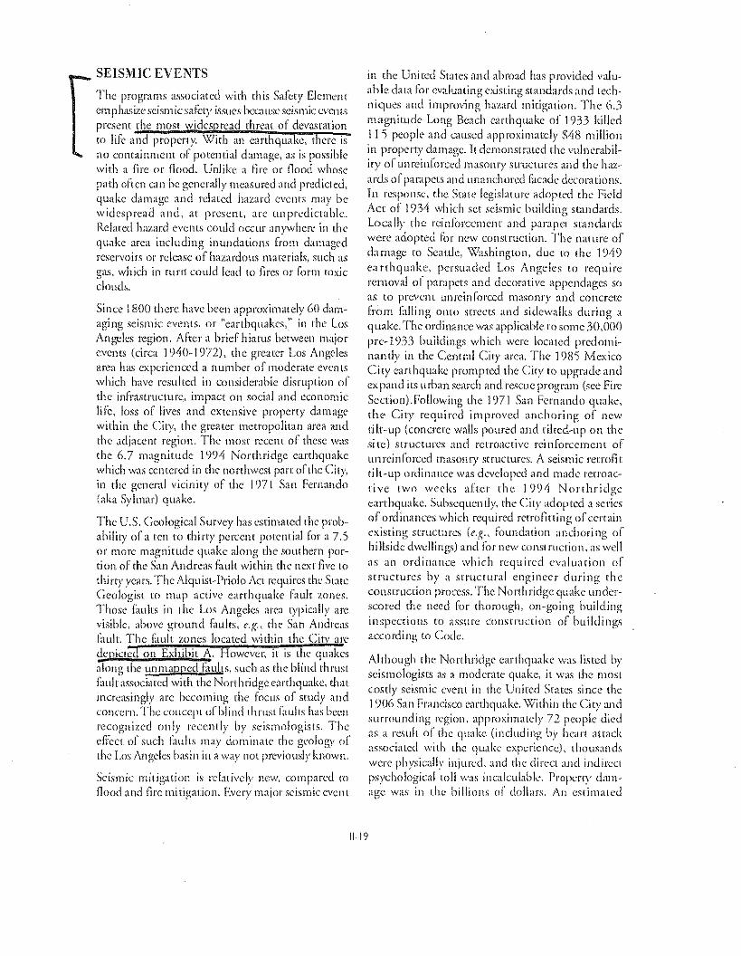
SEISMIC EVENTS
The programs associated with this Safety Elementem phasize seism ic safety issues hC'C.11.1Sl' seismic C\'Cl1t'S
present the most wides >read thrc~Hof devastation10 life and property. \,;7itl1 an carthqua cc, mere isno containment of potential damage, as is possiblewith a fire or flood. Unlike a nrc or flood whosepath often can be generally measured and predicted,quake damage and related hazard events may bewidespread and, at present, arc unpredictable.Related hazard ('VC!lL':; could occur anywhere in thequake area including inundations from damagedreservoirs or release of hazardous materials, such asgas, which in rurtt could lead to fires or Corm toxicclouds.
Since 1800 there have been approximately 60 darn-aging seismic events, or "earthquakes," in the LosAngeles region. After a brief hiatus between majorevents (circa 1940- 1972), the greater Los AngelcBarea has experienced a number of moderate eventswhich have resulted ill considerable disruption ofthe infrastructure" impact on social and economiclife, loss of jive", and extensive property damagewithin the City, the greater metropolitan urea andthe adjacent region. The most' recent of these W~lS
the 6.7 magnitude 1')94 Northridge earthquakewhich was centered in the northwest pan: of the City,in the general vicinity of the J f)7} San Fernando(aka Sylmar) quake.
The U.S. Geological Survey has estimated the prob-ability ofa ten rorhirty percent potential for a 7.5or more magnitude quake along the southern por-tion of the San Andreas fault within the next five tothirty years. The Alqu is!..Priolo ACI requires the StateGeologist to map active earthquake 1:1UIt zones.Those faults in ihc Los Angeles area typically arcvisible, above ground faults, c.g.. the San Andreasfault. The GllIll zones located within the Citv arc
- I Idepicted on Exhibit A. However; it is t ic qua'i.es;iong the unmapped GUiltS, such as the blind thrustfault associated with the Northridge earthquake, thatincreasingly arc becoming the focus of study andconcern. 'rile concqH ofblind rhrusi Iauhs has beet!recognized only rccenrly by seismologists. ThedIcer of such j-;1U!tS may dominate the geology of'the Los Angdes basin in a \vay not previously known.
Seismic mitigation is relatively IW\V, compared toflood and fire mitigation. Every major seismic event
in the United State, and abroad has provided valu-able data for evaluating existing standards and tech-niques and improving hazard mitigation. The: 6,.)magnitude LAlt1g Beach earthquake of 193:3 killed1I ') people and caused approximately $48 millionin propcrt)' damage. It demonstrated the vulnerabil-ity of' unreinforccd masonry structures and the haz-ards ofparapee, and unanchored facade decorations.Tn response, the State legislature adopted [he FieldAct of 1()34 which set seismic building standards.Locally the reinforcement and parap(~ standardswere adopted for new construction. The nature of'damage to Scaule, \X1ashingtoll, due to the 1949earthquake, persuaded Los Angeles to requireremoval or p<\rapets and decorative appendages soas to prevent unrcinlorccd masonry and concretefrom falling onto streets and sidewalks during aquake. The ordinance was applicable 1:0 some .30,000pre ..19.33 buildings wh ich were located prcdomi-nantlv in the Ccnrral City area. The 1')85 MexicoCity earthquake prompted the CiIY to upgrade andexpand its urban search and rescue program (see FireSectit)u).Foliowing the 1971 San Fernando quake,the City required improved anchoring of newtilt-up (concrete walls poured and tilted-up on thesite) structures and retroactive reinforcement ofunrcinforccd [nasonr), structures. A seismic retrofittilt-up ordinance was developed and made rerroac-live two weeks after the 1994 Northridgeearthquake. Subsequently, the City adopted a seriesof ordinances which required rcrrofiuing ofcertainexisting structures (e.g., foundation anchoring ofhillside dwellings) and lor new construction, as wellas an ordinance which required evaluation ofstructures hy a structural engineer during theconstruction procc,s,'l.The Northridge quake under-scored the need for thorough, on-going buildinginspections to assure construction of buildingsaccording to Code.
Although the Northridge earthquake was listed byseismologist'! as a moderate quake, it was the mostcostly seismic event in the United Sr.ucs since the1'JOGSan Francisco earthquake. \'Vithill the City andsurrounding region, approximately 72 people diedas a result of' rhc quake (including hy heart arrackassociated with the quake experience), thousandswere physically injured, and tile direct and indirectpsychological loll W~lS incalculable, Property dam-age was in rhc hillicns of' dollars. An est.inuu cd
11-19
Y},OOO(as or Iune 1996) building' were damagedin the City, some requiring demolition. Approxi-mutely 5,800 buildings had to be partially or tornllyvacated, including approximately 25,640 mostlymuluple-residential dwelling units. By the aurnrnnfoll(')\.ving the quake, some 27,(}00 units weredeemed in danger of being lost:hCG\uSC owners haddiH'icl.llty financing repair costs.
In addition, the inlrasrructurc (Exhibit H) of themetropolitan area was severely disrupted. Freewayscollapsed, the power systems [or the City and linkedcommunities <-1.') far away as Oregon \<VCf(' tempo-rarilv "blacked out:" and cornmun icatious were dis-rupicd. Due 1.0 abatement measures, planning, train-ing and inter-agency and inter-jurisdictional coer-dinarion, response was much more efficient rhan inJ 971 f()llowin~ the San Fernando quake. Stronacr~ chuilding"codc~ and required rctTofltting follnwillgrhc San Fernando quake contributed to a reductionin damage to structures and buildings and resultedin bcrrcr coura inrncnt of hazardous materials.Coordinated response resulted in more rapid idcn-Lineation of damage sites. extinguishing of fires,addressing of flre hazards, administering, often Frombattle-field like temporary facilities, to the injuredand displaced and initiation of work to restore thedisrupted cities and region. Closure of businesses,disruption of services and dislocation of' people hada significant domino effect on the economy of theregion, stare and nation. The economic impact'would have been greater had the quake been moresevere or had disruption or the infrastructure con-tinued for a longer period of lime.
The fact that the Northridge event occurred at 4:31a.m. January 17, ! ()()4 on the Marrin Luther KingJr. national holiday rna)' have been the primary rC<I-
son for so little loss of life and human injun', A lownumber of commuters were traveling on rhc free-ways and streets and few people "vert in offices,industrial, commercial buildings, public garages andshopping centers, many of which suffered severestructural and non-structural damage. Many erner-gene)! and. seismic expert'; believe that had [he quakeOCClUTCd at Inidday, instead of during the predawn.the loss of life and injury figures would have beensubstanually higher, Nevertheless, emergency forceswere severely challenged by the event."rile Northridge quake was nne or the most mea-sured earthquakes in history due (0 extensive scls-
mit instrumentation in buildings and 011 the groundrhronghout. the region. Information from seisrno-logical instruments. damage report~ and other dataprovided a wealth of inforrnarion for experts to ana-lyze. Traditional theories about land usc siting andexisting building code provisions were called intoquestion. It is known that the complex Los Angelesfault system interacts with the alluvia! soils and othergeologic conditions ill the hills and basins. Thisinteraction appears to pose a potential seismic threatfa r every part. of rhc Ci ry, regardless of the' u ndcrly-ing geologic and soils condit ions. Structural darn-age docs not occur due to any one factor. The dura-tion and intensity of (he shaking, distance from theepicenter, composition or the soil and type or COIl-
strucr ion, all arc factors in dercnnininc the extent"of damage which rnay OCCLlI'. Alluvial and artificially
uncompacted soils [end to amp!i(y the shaking. Shal-low ground water, com hi ned with uncompacted. soilscan result in liquefaction (quicksand effect) duringa strong quake. Therefore, it is difficult to escapethe impacts of a quake. During the Northridgequake, damage appeared to have a more directrelationship t:o building construction than did. prox-imiry to the epicenter. Largely as a result of theNorthridge earthquake, the national Uniform Build-ingCodc was amended in 1994 to require rhar newdevelopment projects provide gcorcch nical reportswhich assess potential consequences of liqucfacrionand soil strength loss and propose appropriate miti-galion measures, e.g" walls supported by conrinu-ous footings, steel reinforcement of floor slabs, etc.These provisions were incorporated into the LosAngeles Cil}' Building Code, effective January 1')96.Exhibit B identifies. ill a general mauncr, areassusceptible to liquefaction. It was prepared for theGeneral Plan Framework Element environmentalimpact report and is based on the County or LosAngeles 19{)OSafety Element liquefaction exhibit.It. identifies areas deemed to he liquefaction orpotentia! liquefaction areas, based on occurrencesof shallow ground water t ouerhcr with recen t
alluvial deposits. "
One or [he sl1rpri,~ing findings followine the• ~ h
Northridge quake was that muuv steel Irarnc build-ings, believed before the-quake to be the safest SlTUC~
lure.'>, suifered unexpected wc.lding join! dam;lgc.Such damage resulted in the evacuation of an 11-story building in wrest Los Angeles several monrhs
after the quake when it was determined that thedamage to building joints had dangerously weak-ened the huilding structure. The building waslocated miles from Northridge, ill the basin on theother side (south) of the Santa Monica Mounrai ns.Ar the time this Safet), Element was under prepara-tion experts had nOI dcrcrmincd an acccprab!«method [or retrofitting such buildings.
These arc important findings for Los Angeles be-cause Los Angeles is a built citv. Few large tracts ofland remain which have no! already been developedwith some usc. i'vlan)' key facilities, such as freeways,already fol low Iaul: lines through mountain passes.Buildings already arc built on uncompacted and al-luvial soils. Pan or the downtown center, includingits many high rise buildings, is built near the ElysianPark blind thrust fault which many SCislllologisrsbelieve could be tile source of a major seismic eventin the not so distant future. Physical expansion andchange in the City will occur primarily throughrehabilirariou of existing structures and redevelop-merit of exisling neighborhoods. The City's biggestchallenge is how to protect' an existing ciry and itsinhabitants from future damage. Many believe thisshould be accomplished through improved build-ing design instead of prohibition of construction.At the time this Element: was under preparation,the Ciry was retrofitting City I"TaIIand some Port orLos Angck\,>[lCilirics with base isolators to make thestructures less prone to failure during strong groundshaking. This type of retrofitting is a step in address-ing the strengthening of built structures,
Pre-seismic event land usc planning with a view torcconfiguring the devastated areas though post-,eventchanges ill land usc, intensity or development, eic.
generally are not included as programs of this SafetyElement. It has been the City's experience that theunpredictability or seismic events, bot.h as tolocation and damage, renders such planningimpractical. Devastation, while widespread, gene!'··ally docs not completely destroy en tire blocks, neigh-borho ods or large geograt1hic areas. Therefore.rcbuildi ng tends to be more of a 11 in fill acrivirv thanan urban clearance and reconstruction enterprise.However, rradirioual redevelopment programs arcincluded in the optional tools available for rccon ..su-ucrion or severely damaged areas and arc beingused to rebuild neighborhoods dcvnstutcd hy theNorthridge quake.
Hazard assessment, The State Public ResourcesCode Section 2699 requires that a safety element"take into account" available seismic hazard mapsprepared by the State Geologist pursuant to rheAlquist-Priolo Earthquake Fault Zoning Act 01'1')72, subscquenrly amended (Public ResourcesCode Sections 2()21-2():)O, origi n<lllyknown as rheAlquist-Priolo Special Studies Zones Act) and theSeismic Hazard lVlapping Act of' ]990, subsequentlyamended (Public Resources Code Sections 269()·2()99,6 and ,'l72()·372'i), The Alquist. Priolo Act wasestublished as a direct result or the 1971 SanFernando earthquake. It requires rhar the StateGeologist map active faults throughout the State.Those maps which are applicable to the Ci ry of LosAngeles ;~reincorporated into Exhibit A of lhis SafetyElement.-The Hazard Mapping Act requires the State Cco]o-gist to map areas subject to amplified ground shak-ing (or conditions which have potential for arnpli-fied ground shaking), liquefaction and landslidehazard areas. Following the ]994 Northridge earth-quake, the hazard IU<lpping program was revised andaccelerated. The ['naps were under preparation con-currently with the preparation or this Safety Elc-merit. The First liquefaction and landslide hazardInaps are scheduled to be released in 1996. Groundshaking maps arc scheduled for release beginning in1997, The entire mapping program is expected tobe completed around 1999. Local jurisdictions arcrequired by the Mapping Act to require additionalstudies and appropriate mitigation measures fordevelopment project ... in areas identified as YOlCrl"
rial hazard areas by the maps. As maps are releasedf()J" Los Angeles they will be utilized by the Buildingand Safety Department in helping to identify areaswhere additional soils and geology srudies arc neededfor evaluation of hazards and imposition or appro-priate mitigation mea..cures prior to issuance of'build-ing permits. Once the entire set of maps for LosAngeles is complete it: will be used to revise the soilsand geology exhibits of this Sulcry Eh-mcnt. Themaps, along with informarion heing developed hyprivate technical organizations, such as the South-ern California Earthquake Center and CaliforniaInstitute of Technology, will assist the City in cvalu-ating how to strengthen irs land use and develop-mcnt codes and development' permit procedures soas to better protect life and property from seismic
hazards. The Building Code already has been revisedutilizing data secured relative to the Northridge andother recent significant seismic event's. The subjectSafety Element fulfills current requirements, basedupon available official maps and reliable data. Ida-rive to fault zones (Exhibit A), liquefaction areas(Exhibil B) and slope failure (Exhibit C). Theseexhibits will be revised following receipt of the rcli-able new inform.uion. In addition to the hazard
.mapping provisions, the State requires that prop-erry sellers or agents disclose to potential propertybuyers geotechnical repons and their contents.
HAZARDOUS ~L\TERIALSHazardous materials have been a concern since J ')00when the City experienced its first major oil indus-try fire. Extraction of oil and gas deposits began inI H96 when Edward Doheny discovered oil at Sec..ond Street and Glendale Boulevard (Westlake com-munity). By I~oohe had erected over (,00 woodenoil rigs and installed hundreds of storage ranks andrelated facilities. III that year <1 fam ily bonfireiglli ted the oil field at Bixel Street. An estimated10.000 gallons of hlazi ng oil spilled down rhc hillsbut was diverted and suppressed before it reachedthe densely built Central City. The saving or thedowntown from a potential disaster prompted theCit)' to purchase more fire suppression equipmentand to expand (he number or fire stations and per-sonnel. Subsequent oil Field fires in the Doheny andother fields throughout the Cit)' resulted in regula-lions to assure conrainrncnr of oil fires in oil Gelds,refineries and oil and gas storage {acilirics.
Much of' the a rca south or the San fa Monica Moun-rains is underlain by gas and oil deposits. Suchdeposits exist. under other areas or the City as well(Exhibit E). Natural gas, crude oil and hydrogensulfide can work their way to the surface or infil-trate. structures, causing potential fire and healthhazards, In addition, landfills arc sources of meth-ane gas. The existence of underground gas andhazardous materials deposits reg uircs moni to ring ofexcavations and known seepage areas. A major inci-den! occurred in 1971 during the tunneling for theFeather River Project when a methane explosionkilled 1Hworkers. Incidents relating to the gas seep,·age GI used tern porary safet), shutdowns of rhc MetroRail sub\vay tunneling in ]1)93·J)').
In rhc 1920.s rhe I.I,\C of chemicals and hazardousmaterials in rhe City's expanding manufacturing andcommercial sectors increased the hazards for bothworkers and the general populace. A series of moviestudio back lor fires and film processing laboratoryfires occurred in the late ] 920s. These incidents ledro the enactment ofCity regulations to protect work-ers and the public from fires and fumes associatedwith highly Ilammablc film and chemicals used illfilm processing as well as from hazards associatedwith {lammahlc movie sets.
Todav hazardous materials arc used in commercial,indu;trial. institutional and agricultural enterprisesas well as households rhroughour the Ciry. Los An-geles operates both a major international airport anda major harbor within irs boundaries and operatesother airport Etcilitics within and outside its bound-ariec.P'lazardnus and highly Ilamrnablc materials arcshipped through, stored and used (especially fuels)at these facilities. They also are transported alongfi'ccways and bighways and arc stored in laciliticsthroughout the City. Many hazardous materials, if'released by accident or catastrophic event. couldcause severe damage to hu man life and health andto the facilities andcould disrupt. activities within aradius of several miles around the release sire.
During the 1()94. Northridge earthquake, over 100inciden rs of quake related release of hazardousmaterials were reported. or these, 23 involvedrelease of natural gas, 10 involved release of gasesand liquid chemicals at educational institutions andR involved release ofhazardous marenals at medica!facilities. Gas leaks or chemical reactions triggeredfires which destroyed or damaged nine universityscience laboratories. Rupture ofa high pressure natu-ral gas Iinc tinder Balhoa Boulevard in Cranada Hillsresulted in a fire v..-hich damaged utility lines andadjacent homes. Petroleum pipeline leaks releasedIj,OOObarrels of crude oil into the Santa Clara Rivernorth of"Los Angeles and caused fires in [he Mis-sion IIil!.1 section of the City.
Fires C<111 damage lahelillg and warning signs whicharc posted 011 chemical and fuel containers and 011
structures to identify' presence of hazardous rnarcri-abo Identification ofhazardous materials, storage andhand.ling sites and inforrnarion about containmentfacilities and/or procedures are important lO pro-tect emergency personnel as well 11$ employees and
11-22
CHAPTER III - GOALS, OBJECTIVES AND POLICIES
The Safety Element goalc, objectives. policies and prograrns arc broadly stared to reflect the comprehensivescope of the Emergency Operations Organization (EOO). The EOO is the only program that implementsthe Element. The Element's policies outline administrative considerations which are addressed by EOOprocedures, including in; Master Plan, or which arc observed in the carrying our of the Plan. All Cityagencies arc pan of [be EOO. All City emergency preparedness. response and recovery programs arc inre-grated into EOO operations and are reviewed and revised continuously.
Because City codes and regulations con min standards for water, streets, ctc., the Safety Element programsgenerally do not contain specific standards. An exception is the Fire Code policy which contains standardswhich, at the time this Element was under preparation, were contained only in the 1979 Fire. Protectionand Prevention Element of the General Plan. Until the standards are incorporated into the Fire Code orother regulations or plans, this is the only place where they are located. The}' arc needed to guide Cirydevelopment actions. Other standards which were [baed in the 1979 Fire Protection and PreventionElement have been incorporated into City Codes or superseded by other regulations or procedures.
HAZARD MITIGATION
GOAL!A city where potential injury, loss of life, property damage and disruption of the social and economic lifeor the City due to fire, water related hazard, seismic event. gcologic conditions or release or hazardousmaterials disasters is minimized. l
Obj ective 1. IImplement comprehensive hazard miugarion plan s and programs thal arc integrated wirh each other andwith the City's comprehensive emergency response and recovery plans and programs.
Policies1.1.1 Coordination. Coordinate information garhering\ program formulation and program
implcmen ration between City agencies, other jurisdictions and appropriate public and privateentities ro achieve the maximum mutual benefit with the greatest efficiency of funds and staff.IAII EOO hazard mitigation programs involving cooperative efforts between entitiesimplement this policy.]
1,1,2 Disruption reduction. Reduce, to the greatest exre 111' feasible and wi tlii n the resources avai lable,potentia! critical E:lciliry,goverumerual functions, infrastructure and inlorrnarion resourcedisruption due to natural disaster, IAII EO() programs involving mitigation of disruption ofessential infrasrrucrurc, services and governmental operations systems and prepare personnel forquickly reestablishing damaged systems implement this policy]
1..1..5 Facility/systems maintenance. Provide redundancy (back-up) systems and strategies forconunu.uiou of adequate critical infrastructure systems and services so .1<;' 1.0 assure adequatecirculation, communicarions. power, transportation, water and other services for emergencyresponse in the event of disaster related systems disruptions. [All EOO programs that involveprovision of back up systems and procedures for reestablishment of essential infrastructure,services and governmental operations which art' disrupted implement this pulicy.]
111-1
1.1.4 Hcalth/environmenral protection, Protect' the public and worker s from the release of hazardousmaterials and protect City water supplies and resources Irom contamination resulting fromaccidental release or intrusion resulting from a disaster event, including protection of theenvironment and public from potential health and safety hazards associated with programimplementation. [AllfOO hazardous materials hazard and water pollution mitigation programsimplement th is policy.]
1.1.5 Risk reduction, Reduce porcnual risk hazards due to natural disaster to the greatest extentfeasible within the resources available, including provision of information and training, [Allprograms that: incorporate current data, knowledge and technology in revising and implementingplans (including this S;:tfctyElement), codes, standards and procedures that arc designed to reducepotential liaz..ards and risk from hazards potentially associated with natural disasters implementthis policy. I
1.1.6 Stale and federal regulations. Assure compliance wirh applicable state and federal planning anddevelopment regulations, ("g., Alquist-Priolo Earthquake Fault Zoning Act, State Wrapping Actand Cobey-Alquist Flood Plain Managemenr Act. IAlI EOO natural hazard enforcement andimplementation progr~lms relative to non-City rcgularious implement this policy]
EMERGENCY RESPONSE (Multi-Hazard)
GOAL 2A cit)' that responds with the maximum feasible speed and efficiency to disaster events so as to minimizeinjury, loss of' life. property damage and disruption of the social and economic life of rhe Ci ry and itsimmediate environs.
Objective 2.1Develop and implement comprehensive emcrgcIH.Y response plans and programs thai arc integrated witheach other and with the City'S comprehensive hazard mitigation and recovery plans and programs,
Policies2.1.1 Coordination. Coordinate program formulation and implcmcnratiou between City agencies,
adjacent jurisdictions and appropriate private and public entities so as to achieve, to the greatest'extent feasible and within the resources available, the maximum mutual benefit with the greatestefficiency of' funds and staff, fAI! E,OO response f)rngral11~ involving cooperative effortsbetween entities implement this policy]
2.1.2 Health and environmental prorccrion, Develop and implement procedures to protect theenvironment and public, including animal control and care, to rhe grc<l[cstextent feasible withinthe resources available, from potential health and safety hazards associated with hazard mitigationand disaster recovery efforts, IAll EOO emergency response and recovery programs thatmitigate environmental impact's 01' provide care and control nfanim"l" injured or released by anemergency situation implement this policy.]
2.1,3 Info rtnarion. develop and implemen t, with ill i.hc resources available. train ing programs .1ndinformational rnutcrials designed to assist the general public in handling disaster situations ill lieuof or until emergency personnel can provide assistance. [All EOO response programs involvingtraining, collection and. dissemination of warning, guidance and assistance infonn.uion tothe public implement this policy]
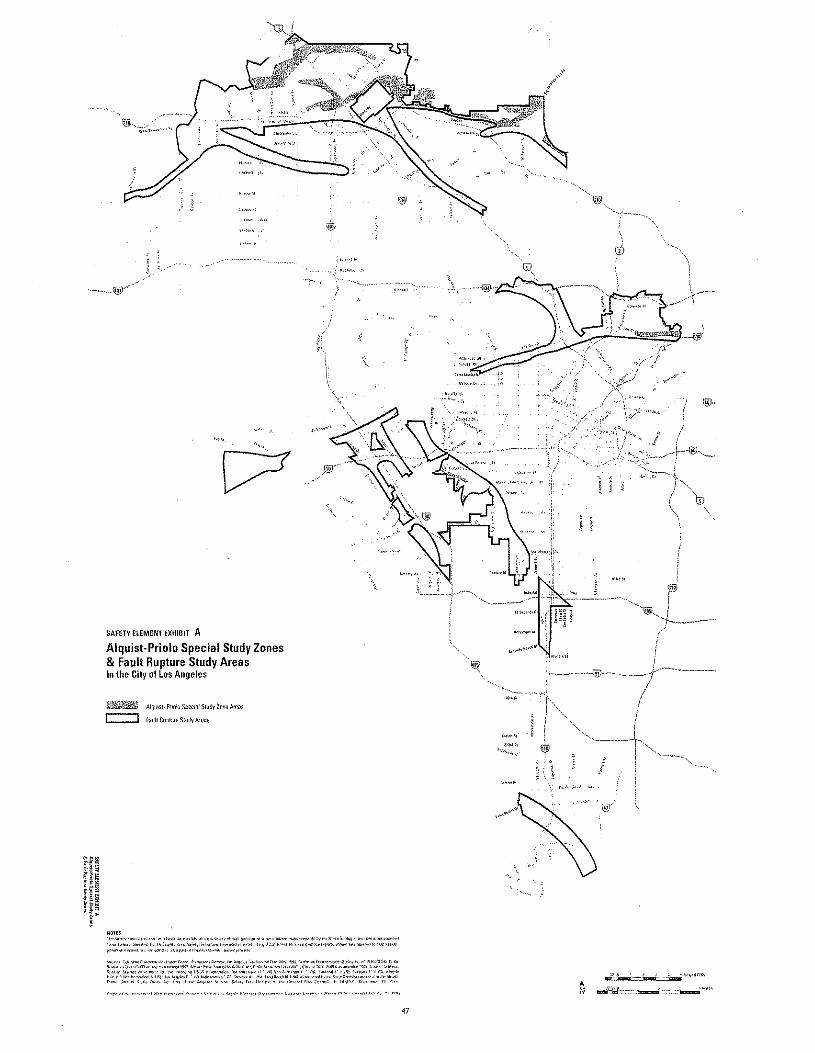
SAFETY elEMENT EXHIBIT A
Alquist-Priolo Special Study Zones& Fault Rupture Study AreasIn the City of los Angeles
ref!ii1fi.!~&%' AInu';" P,iolo "p~~'~1Slud\" '""il Areas
r:=::J r';"~1 nun!"'" Swrly A%1I
i§.\
cD
>,
"\
,I"",'"M." .•" ,,
i" ....,',
AN 11'"" ",,,,,,,-==~=.:'"::~=-.:~
47
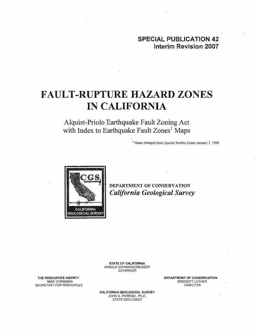
SPECIAL PUBLICATION 42Interim Revision 2007
FAULT-RUPTURE HAZARD ZONESIN CALIFORNIA
Alquist-Priolo Earthquake Fault Zoning Actwith Index to Earthquake Fault Zones! Maps
I Name changed from Special Studies Zones January 1, 1994
DEPARTMENT OF CONSERVATION
California Geological Survey
STATE OF CALIFORNIAARNOLDSCHWARZENEGGER
GOVERNOR
THE RESOURCES AGENCYMIKE CHRISMAN
SECRETARY FOR RESOURCES
DEPARTMENT OF CONSERVATIONBRIDGED LUTHER
DIRECTOR
CALIFORNIA GEOLOGICAL SURVEYJOHN G. PARRISH, PH.D.
STATE GEOLOGIST
SPECIAL PUBLICATION 42
FAULT -RUPTURE HAZARD ZONES IN CALIFORNIA
Alquist-Priolo Earthquake Fault Zoning ActWith Index to Earthquake Fault Zones Maps
by
WILLIAM A. BRYANT and EARL W. HART
Geologists
Interim Revision 2007
California Department of ConservationCalifornia Geological Survey
801 K Street, MS 12-31Sacramento, California 95814
PREFACE
The purpose of the Alquist-Priolo Earthquake Fault Zoning Act is to regulate development nearactive faults so as to mitigate the hazard of surface fault rupture.
This report summarizes the various responsibilities under the Act and details the actions taken bythe State Geologist and his staff to implement the Act.
This is the eleventh revision of Special Publication 42, which was first issued in December 1973 as an"Index to Maps of Special Studies Zones." A text was added in 1975 and subsequent revisions weremade in 1976, 1977, 1980, 1985, 1988, 1990, 1992, 1994, and 1997. The 2007 revision is an interimversion, available in electronic format only, that has been updated to reflect changes in the index mapand listing of additional affected cities. In response to requests from various users of Alquist-Priolomaps and reports, several digital products are now available, including digital raster graphic (pdf) andGeographic Information System (GIS)files of the Earthquake Fault Zones maps, and digital files of FaultEvaluation Reports and site reports submitted to the California Geological Survey in compliance with theAlquist-Priolo Act (see Appendix E).
On January 1, 1994, the name of the Alquist-Priolo Special Studies Zones Act was changed to theAlquist-Priolo Earthquake Fault Zoning Act, and the name Special Studies Zones was changed toEarthquake Fault Zones as a result of a July 25,1993 amendment.
Information on new and revised Earthquake Fault Zones maps will be provided as supplements untilthe next revision of this report.
CONTENTS
INTRODUCTION""""""",,,,,,,,,,,,,,,,,,,,,,,,, """""",.".""",,,,,,,,,,,,,,,,, ,,,,,,,,,,,,,,,,,,,,,,, ",,,,,,,,,,,,,,,,,,,,,,,,.,,,,,,, 1
PROGRAM FOR ZONING AND EVALUATING FAULTS,
Requirements of the Act" .
Initial Program for Zoning Faults
Definitions, Policies, Rationale ..
Fault and Fault Zone"
Fault Trace.i... ,.."""",, ..Active Fault.;
Potentially Active Fault..
Sufficiently Active and Well-Defined ...
Delineating the Earthquake Fault Zones"
Fault Evaluation and Zoning Program" ..... ,,""'"
Uses and Llmnations of Earthquake Fault Zones Maps "" '''" ... """ " " " ,"'"
"""""""""""""""",."""""""""""",2
"." ",,2
'"'' " ,,,,,2
..."" ","""'''''" ..", ...",, " ..,,"'" ,,,, ...... 3''''''', "'''" ..,,,'' '"'''' ,,,..3
"",,,,,5
"', .."."""., ...,...",., ..",'" .,5
..".",,,,,,,,,,,,,,,,5
",....",..""""",5
" " .. ,....."",,6
.", ..".."""",,6
...""""".9
INDEX TO MAPS OF EARTHQUAKE FAULT ZONES"""""""""""""""""", ,,",,"""" ",""',,"""""""" 9
..."",,9Availability of Earthquake Fault Zones Maps
REFERENCES '"'' '" ,,,,,,, '"',,',,''''''',',''''' "" "''',,' '"'' '"'',''' ''''''','','' ,,,,,,,,, ,,,", '"'''''' """",,,' '"'' ""'''' '" ," '''','' 1 0
APPENDICES """,,,,,,,,,,,,,,,,,,,,,,,,,,,,,,,,,,,,,,,,,,,"'"'''''''''''' ."",,,,,,,,,,,,," ""',",,",""""'''''''''''' "",,,,,,,,,,,,,,,22
""""""".".", ..22
""" ....""".".,,,26
."",,28
" ..... 33
"""",,36,.""",, ..... ,..,.. ,,42
Appendix A, Alquist-Priolo Earthquake Fault Zoning Act """"",,,,,,,,,.,,,,'
Appendix B. Policies and Criteria of the State Mining and Geology Board"
Appendix C, Guidelines for Evaluating the Hazard of Surface Fault Rupture"
Appendix D, General Guidelines for Reviewing Geologic Reports" .
Appendix E, Products of the Fault Evaluation and Zoning Program"
Appendix F, Waiver Procedure for the Alquist-Priolo Act"
TABLESTable 1, Summary of responsibilities and functions under the Alquist-Priolo Earthquake Fault
Zoning Act" " , """." """""",,''',,'','' """""""""."""""""",,",,
Table 2, Summary of policies and criteria adopted by the State Mining and Geology Board
and codified in California Code of Regulations"
Table 3. Official Maps of Earthquake Fault Zones issued 1974 through 2007"
Table 4, Cities and counties affected by Earthquake Fault Zones as of August 2007 "
Table 5. Surface faulting associated with earthquakes in California, 1974-June 2007 ".
'"'' ."""""""".,, 1
"""",,,,,,,,,.,,,,2
"".""""""",,, ..,2
."",.",,,,,,,,,,,,3
""" ."".""",,,8
FIGURESFigure 1. Principal active faults in California zoned under the Alquist-Priolo Earthquake
Fault Zoning' Act.,
Figure 2. Geologic time scale .
Figure 3, Example of Earthquake Fault Zones Map"
Figure 4. Index to Official Maps of Earthquake Fault Zones"
"" .....,....""".",,4
".",."""""."".,,5
",,,,,,,,,,,,,,,,,, ..,,,7
""'"""'" , 11-21
FAULT-RUPTURE HAZARD ZONESIN CALIFORNIA
William A. Bryant and Earl W. Hart
By
INTRODUCTION
The Alquist-Priolo Earthquake Fault Zoning Act wassigned into law December 22,1972, and went into effect March 7,1973. The Act, codified in the Public Resources Code asDivision 2, Chapter 7.5, has been amended ten times. A completetext of the Act is provided in Appendix A. The purpose of thisAct is to prohibit the location of most structures for humanoccupancy across the traces of active faults and to therebymitigate the hazard of fault rupture (Section 2621.5).
This law initially was designated as the Alquist-PrioloGeologie Hazard Zones Act. The Act was renamed the Alquist-Priolo Special Studies Zones Act effective May 4, 1975 and theAlquist-Priolo Earthquake Fault Zoning Act effective January 1,1994. The original designation "Special Studies Zones" waschanged to "Earthquake Fault Zones" when the Act was lastrenamed.
Under the Act, the State Geologist (Chief of theCalifornia Geological Survey [CGS)) is required to delineate"Earthquake Fault Zones" (EFZs) along known active faults inCalifornia. Cities and counties affected by the zones mustregulate certain development "projects" within the zones. Theymust withhold development permits for sites within the zonesuntil geologic investigations demonstrate that the sites are notthreatened by surface displacement from future faulting. TheState Mining and Geology Board provides additional regulations(Policies and Criteria) to guide cities and counties in theirimplementation of the law (California Code of Regulations, Title14, Div. 2). A summary of principal responsibilities andfunctions required by the Alquist-Priolo Act is given in Table 1.The Policies and Criteria are summarized in Table 2, and thecomplete text is provided in Appendix B.
This publication identifies and describes (l) actions takenby the State Geologist to delineate Earthquake Fault Zones, (2)policies used (0 make zoning decisions, and (3) Official Maps ofEarthquake Fault Zones issued to date. A continuing program toevaluate faults for future zoning or zone revision also issummarized. Other aspects of the Alquist-Priolo EarthquakeFault Zoning Act and its implementation are discussed by Hart(1978 and 1986). The effectiveness of the AP Act and programwas evaluated by Reitherman and Leeds (1990). The program isimplementing many of the recommendations in that report.
Information presented here is based on various in-housedocuments and publications of the authors and others of the CGS(see Appendix E).
Table 1, Summary of responsibilities and [unctions under Ihe Alquist-Priolo Earrhquake Fault 2<JningAcl (.fee Appendix. A for full tal oj Act),
State Mining and Geology Board
1. Formulates policies and criteria to guide cities andcounties (Sec. 2621.5 and 2623). (See Appendix B.)
2. Serves as Appeals Board (Sec. 673).
State Geologist
l . Delineates Earthquake Fault Zones; compiles and issuesmaps to cities, counties. and state agencies (Sec. 2622).a. Preliminary Review Maps.b. Official Maps.
2. Reviews new data (Sec. 2622).a. Revises existing maps.b. Compiles new maps.
3. Approves requests for waivers initiated by cities andcounties (Sec. 2623).
Cities and Counties
1. Must adopt zoning laws, ordinances. rules, and regulations;primary responsibility for implementing Act (Sec. 2621.5),
2. Must post notices of new Earthquake Fault Zones Maps(See. 2621.9 and 2622).
3. Regulates specified "projects" within earthquake FaultZone, (Sec. 2623).
a. Determines need for geologic reports prior to projectdevelopment.
b. Approves geologic reports prior to issuing developmentpermits.
c. May initiate waiver procedures, (See Appendix F.)
Other
l . Seismic Safety Commission ~advises State Geologist and StateMining and Geology Board (Sec. 2630).
2, Stale Agencies - prohibited from Siting structures for humanoccupancy across active fault traces (Sec, 2621.5),
3, Disclosure - prospective buyers of any real property locatedwithin an Earthquake Fault Zone must be notified of that fact(Sec. 2621.9).
2 CALIFORNIA GEOLOGICAL SURVEY SP42
1abfe 2. Summary of policies and criteria adopted by (he Stare Miningand Geology Board and codified in Q1l/Jomhl Code of Regukuians(lee Appelldix 8for full tea).
POlicies
I. Defines active fault (equals potential hazard) as a fault that hashad surface displacement during Holocene time (last 11,DOOyears) (Sec, 3(01).
2. Defines "structure for human occupancy" and other terms(S"".3601).
3. Requires cities and counties to notify property owners withinproposed new and revised Earthquake Fault Zones (Sec,3602).
4. Provides opportunity for public to comment on PreliminaryReview Maps of Earthquake Fault Zones (Sec. 3602).
5. Provides for comments and recommendations. to StateGeologist regarding Preliminary Review Maps (Sec. 3602).
Specific Criteria for Lead Agencies (Sec. 3603)
I. No structure for human occupancy defined as a "project" ispermitted on the trace of an active fault. Unless provenotherwise, the area within 50 feet of an active fault ispresumed to be underlain by active branches of the fault.
2. Requires disclosure of Earthquake Fault Zones to the public.
3. Requires that buildings converted to structures for humanoccupancy comply with provisions of the Act
4. Requires geologic reports directed at the problem ofpotential surface faulting for all projects defined bythe Act,
S. Requires cities and counties to review geologic reports foradequacy,
6. Requires that geologic reports be submitted to the StateGeologist for open-file.
PROGRAM FOR ZONING AND EVALUATINGFAULTS
Requirements of the Act
Section 2622 of the Alquist-Priolo Earthquake FaultZoning Act (Appendix A) requires the State Geologist to:
I. "Delineate ... appropriately wide earthquake faultzones to encompass all potentially and recently active traces ofthe San Andreas, Calaveras, Hayward, and San Jacinto faults,and such other faults, or segments thereof, as the StateGeologist determines to be sufficiently active and well-definedas to constitute a potential hazard to structures from surfacefaulting or fault creep."
2. Compile maps of Earthquake Fault Zones and submitsuch maps to affected cities, counties, and state agencies fortheir review and comment. Following appropriate reviews,the State Geologist must provide Official Maps to the affectedcities, counties, and state agencies.
3, Continually review new geologic and seismic data torevise the Earthquake Fault Zones or delineate additionalzones.
These requirements constitute the basis for the StateGeologist's fault-zoning program and for many of the policiesdevised to implement the program.
Initial Program for Zoning FaultsAs required under the Act, the State Geologist initiated a
program early in 1973 to delineate Earthquake Fault Zones toencompass potentially and recently active traces of the San
"Andreas, Calaveras, Hayward, and San Jacinto faults, and tocompile and distribute maps of these zones, A project teamwas established within the CGS to develop and conduct aprogram for delineation of the zones,
Initially, 175 maps of Earthquake Fault Zones weredelineated for the four named faults, These zone maps, issuedas Preliminary Review Maps, were-distributed for review bylocal and state government agencies on December 31, 1973,Following prescribed 90-day review and revision periods,Official Maps were issued on July 1,1974. At that time, theEarthquake Fault Zones became effective and the affectedcities and counties were required to implement programs toregulate development within the mapped zones, A second setof Official Maps -- 81 maps of new zones and five maps ofrevised zones -- was issued on January 1, 1976 to delineatenew and revised zones, Additional Official Maps of new andrevised zones were issued in succeeding years, as summarizedin Table 3.
Table 3, Official Maps of Earthquake Fault Zones issued /974 throughAu us! 2007,
NEWMAPS
REVISEDMAPS
WITHDRAWNMAPSDATE OF ISSUE
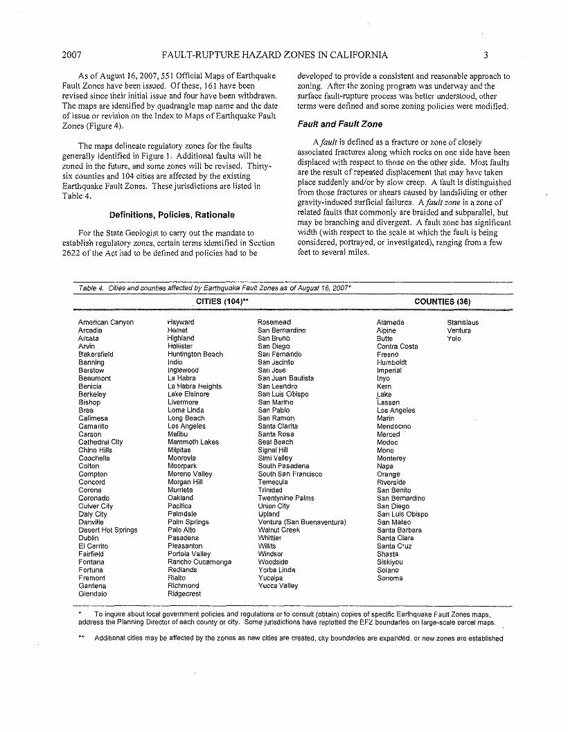
2007 FAULT-RUPTURE HAZARD ZONES IN CALIFORNIA
As of August 16, 2007, 551 Official Maps of EarthquakeFault Zones have been issued. Of these, 161 have beenrevised since their initial issue and four have been withdrawn.The maps are identified by quadrangle map name and the dateof issue or revision on the Index to Maps of Earthquake FaultZones (Figure 4).
The maps delineate regulatory zones for the faultsgenerally identified in Figure 1. Additional faults will bezoned in the future, and some zones will be revised. Thirty-six counties and 104 cities are affected by the existingEarthquake Fault Zones. These jurisdictions are listed inTable 4.
Definitions, Policies, Rationale
For the State Geologist to carry out the mandate toestablish regulatory zones, certain terms identified in Section2622 of the Act had to be defined and policies had to be
3
developed to provide a consistent and reasonable approach tozoning. After the zoning program was underway and thesurface fault-rupture process was better understood, otherterms were defined and some zoning policies were modified.
Fault and Fault Zone
A/ault is defined as a fracture or zone of closelyassociated fractures along which rocks on one side have beendisplaced with respect to those on the other side. Most faultsare the result of repeated displacement that may have takenplace suddenly andlor by slow creep. A fault is distinguishedfrom those fractures or shears caused by landsliding or othergravity-induced surficial failures. A/ault zone is a zone ofrelated faults that commonly are braided and subparallel, butmay be branching and divergent. A fault zone has significantwidth (with respect to the scale at which the fault is beingconsidered, portrayed, or investigated), ranging from a fewfeet to several miles.
Table 4, Cities and counties ,affected by Earthquake Fault Zones as of August 16, 2007*
. CITIES (104)~ COUNTIES (36)
American CanyonArcadiaArcataArvinBakersfieldBanningBarstowBeaumontBeniciaBerkeleyBishopBreaCalimesaCamarilloCarsonCathedral CityChino HillsCoachellaColtonComptonConcordCoronaCoronadoCulver CityDaly CityDanvilleDesert Hot SpringsDublinEI CerritoFairfieldFontanaFortunaFremontGardenaGlendale
HaywardHemetHighlandHOllisterHuntington BeachIndioInglewoodLa HabraLa Habra HeightsLake ElsinoreLivermoreLoma LindaLong 'BeachLos AngelesMalibuMammoth LakesMilpitasMonroviaMoorparkMoreno ValleyMorgan HiliMurrietaOaklandPacificaPalmdalePalm SpringsPalo AltoPasadenaPleasantonPortola ValleyRancho CucamongaRedlandsRialtoRichmondRidgecrest
RosemeadSan BernardinoSan BrunoSan DiegoSan FernandoSan JacintoSan JoseSan Juan BautistaSan LeandroSan Luis ObispoSan MarinoSan PabloSan RamonSanta ClaritaSanta RosaSeal BeachSigna! HillSimi ValleySouth PasadenaSouth San FranciscoTemeculaTrinidadTwentynine PalmsUnion CityUplandVentura (San Buenaventura)Walnut CreekWhittierWilHtsWindsorWoodsideYorba LindaYucaipaYucca Valley
AlamedaAlpineButteContra CostaFresnoHumboldtImperialInyoKernLake'LassenLos AngelesMarinMendocinoMercedModocMonoMontereyNapaOrangeRiversIdeSan BenitoSan BernardinoSan DiegoSan Luis ObispoSan MateoSanta BarbaraSanta ClaraSanta CruzShastaSiskiyouSolanoSonoma
StanislausVenturaYolo
To inquire about local government policies and regulations or to consult (obtain) copies of specific Earthquake Faull Zones maps,address the Planning Director of each county or city. Some jurisdictions have replotted the EFZ boundaries on large-scale parcel maps.
Additional cities may be aff~cted by the zones as new cities are created, city boundaries are expanded, or new zones are established
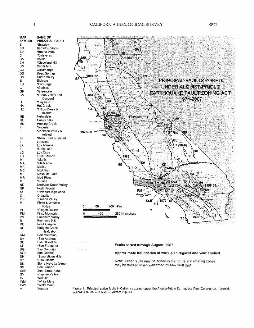
MAPSYMBOL88S8VCCACHCMCUOSOVEFSGGRGV
HHAHCHEHLHUIJ
KFLLALLLaLSMMAM8MCMEMRNNONFNIaavP
PIPMPVRRCRHRMSAseSFSGSGASHSJSNSSSSRSVWWMwwv·
4
NAME OFPRINCIPAL FAULT"BrawleyBartlett Springs"Buena Vista"CalaverasCalico"Cleveland HillCedar MIn.CucamongaDeep SpringsDeath ValleyElsinore"Fort Sage"Garlock"Greenville"Green Valley and
Concord"HaywardHat Creek"Hilton Creek &
relatedHelendaleHoney LakeHunting Creek"Imperial"Johnson Valley &
related"Kern Front & relatedLenwocdLos Alamos"Little LakeLos 0$0$Litlle Salmon'Manix-MaacameMalibuMcArthurMesquite LakeMad River"NunezNorthern Death ValleyNorth Frontal"Newport-InglewoodOrtigalita"Owens ValleyPleito & Wheeler
Ridge'Plspah-BullicnPinto MountainPanamint ValleyRaymond HillRose CanyonRodgers Creek-
HealdsburgRed Mountain-san AndreasSan Cayetano-san FernandoSan GregorioSan Gabriel"Superstition Hills"San JacintoSierra Nevada (zone)San SimeonSimi-Santa RosaSurprise ValleyWhittier"White Mtns"White WolfVentura
CALIFORNIA GEOLOGICAL SURVEY SP42
197!J..SO
o."",,,,,.50,,,,,,,,,,,,,,,;100 miles
eO~!!5;;;;;.:1~OO~~!!!!!;;200kilometers
Faults zoned through August 2007
Approximate boundaries of work-plan regions and year studied
Note: Other faults may be zoned in the future and existing zonesmay be revised when warranted by new fault data
Figure 1, Principal active faults in California zoned under the Alqulst-Priolo Earthquake Fault Zoning Act. Asteriskindicates faults with historic surface rupture.
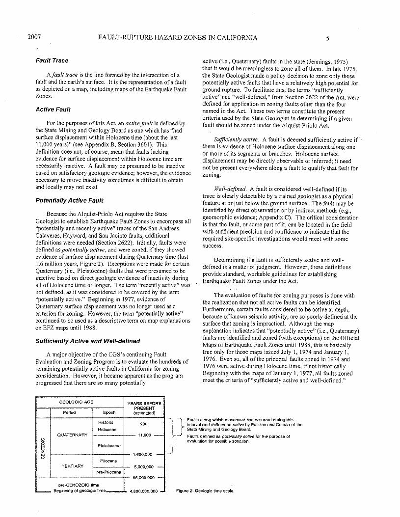
2007 FA UL T-RUPTURE HAZARD ZONES IN CALIFORNIA 5
Fault Trace
A/aull trace is the line formed by the intersection of afault and the earth's surface, It is the representation of a faultas depicted on a map, including maps of the Earthquake FaultZones.
Active Fault
For the purposes of this Act, an active fault is defined bythe State Mining and Geology Board as one which has "hadsurface displacement within Holocene time (about the last11,000 years)" (see Appendix B, Section 3601). Thisdefinition does not, of course, mean that faults lackingevidence for surface displacement within Holocene time arenecessarily inactive. A fault may be presumed to be inactivebased on satisfactory geologic evidence; however, the' evidencenecessary to prove inactivity sometimes is difficult to obtainand locally may not exist.
Potentially Active Fault
Because the Alquist-Priolo Act requires the StateGeologist to establish Earthquake Fault Zones to encompass all"potentially and recently active" traces of the San Andreas,Calaveras, Hayward, and San Jacinto faults, additionaldefinitions were needed (Section 2622). Initially, faults weredefined as potentially active, and were zoned, if they showedevidence of surface displacement during Quaternary time (last1.6 million years, Figure 2). Exceptions were made for certainQuaternary (i.e., Pleistocene) faults that were presumed to beinactive based on direct geologicevidence of inactivity duringall of Holocene time or longer, The term "recently active" wasnot defined, as it was considered to be covered by the term"potentially active," Beginning in 1977, evidence ofQuaternary surface displacement was no longer used as acriterion for zoning. However, the term "potentially active"continued to be used as a descriptive term on map explanationson EFZ maps until 1988.
Sufficiently Active and Well-defined
A major objective of the CGS's continuing FaultEvaluation and Zoning Program is to evaluate the hundreds ofremaining potentially active faults in California for zoningconsideration. However, it became apparent as the programprogressed that there are so many potentially
GEOLOGIC AGE YEARS BEFOAEPRESENT
Period EpOCh (estimated)
Historic 200Holocene
QUATERNARY 11,000 -o2 Pleistocene0z
1,600,000 -woPliocene
TERTIARY 5,000,000 -pre-Pliocene
66,000,000 -
pre-CENOZOIC timeLa.- Beginning of geologic time 4,600,000,000 ..
active (i.e., Quaternary) faults in the state (Jennings, 1975)that it would be meaningless to zone all of them. In late 1975,the State Geologist made a policy decision to zone only thosepotentially active faults that have a relatively high potential forground rupture. To facilitate this, the terms "sufficientlyactive" and "well-defined," from Section 2622 of the Act, weredefined for application in zoning faults other than the fournamed in the Act. These two terms constitute the presentcriteria used by the State Geologist in determining if a givenfault should be zoned under the Alquist-Priolo Act.
Sufficiently active. A fault is deemed sufficiently active if'there is evidence of Holocene surface displacement along oneor more of its segments or branches, Holocene surfacedisplacement may be directly observable or inferred; it neednot be present everywhere along a fault to qualify that fault forzoning,
Well-defined. A fault is considered well-defined if itstrace is clearly detectable by a trained geologist as a physicalfeature at or just below the ground surface. The fault may beidentified by direct observation or by indirect methods (e.g.,geomorphic evidence; Appendix C), The critical considerationis that the fault, or some part of it, can be located in the fieldwith sufficient precision and confidence to indicate that therequired site-specific investigations would meet with somesuccess.
Determining if a fault is sufficiently active and well-defined is a matter of judgment. However, these definitionsprovide standard, workable guidelines for establishingEarthquake Fault Zones under the Act.
The evaluation of faults for zoning purposes is done withthe realization that not all active faults can be identified.Furthermore, certain faults considered to be active at depth,because of known seismic activity, are so poorly defined at thesurface that zoning is impractical. Although the mapexplanation indicates that "potentially active" (i.e. Quaternary)faults are identified and zoned (with exceptions) on the OfficialMaps of Earthquake Fault Zones until 1988, this is basicallytrue only for those maps issued July I, 1974 and January I,1976. Even so, all of the principal faults zoned in 1974 and1976 were active during Holocene time, if not historically.Beginning with the maps of January I, 1977, all faults zonedmeet the criteria of "sufficiently active and well-defined."
l--)FaUlts along which movement has occurred during thisL~Interval and defined as active by Policies and Criteria of ther State Mining and Geology Board.
]
"" ...-J Faults cennec as potentially ncave for the purpose 01evaluation for possible zonation.
Figure 2. GeOlogic time scale.
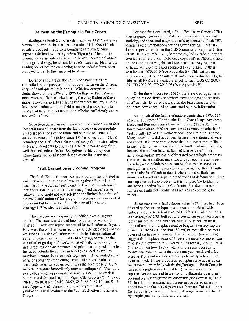
6 CALIFORNIA GEOLOGICAL SURVEY SP42
Delineating the Earthquake Fault Zones
Earthquake Fault Zones are delineated on U.S. GeologicalSurvey topographic base maps at a scale of 1:24,000 (1 inchequals 2,000 feet). The zone boundaries are straight-linesegments defined by turning points (Figure 3). Most of theturning points are intended to coincide with locatable featureson the ground (e.g., bench marks, roads, streams). Neither theturning points nor the connecting zone boundaries have beensurveyed to verify their mapped locations.
Locations of Earthquake Fault Zone boundaries arecontrolled by the position of fault traces shown on the OfficialMaps of Earthquake Fault Zones. With few exceptions, thefaults shown on the 1974 and 1976 Earthquake Fault Zonesmaps were not field-checked during the compilation of thesemaps. However, nearly all faults zoned since January 1, 1977have been evaluated in the field or on aerial photographs toverity that they do meet the criteria of being sufficiently activeand well-defined.
Zone boundaries on early maps were positioned about 660feet (200 meters) away from the fault traces to accommodateimprecise locations of the faults and possible existence ofactive branches. The policy since 1977 is to position the EFZboundary about 500 feet (150 meters) away from major activefaults and about 200 to 300 feet (60 to 90 meters) away fromwell-defined, minor faults. Exceptions to this policy existwhere faults are locally complex or where faults are notvertical.
Fault Evaluation and Zoning Program
The Fault Evaluation and Zoning Program was initiated inearly 1976 for the purpose of evaluating those "other faults"identified in the Act as "sufficiently active and well-defined"(see definition above) after it was recognized that effectivefuture zoning could not rely solely on the limited fault data ofothers, Justification of this program is discussed in more detailin Special Publication 47 ofthe Division of Mines andGeology (1976; also see Hart, 1978).
The program was originally scheduled over a f O-yearperiod, The state was divided into 10 regions or work areas(Figure 1), with one region scheduled for evaluation each year.However, the work in some regions was extended due to heavyworkloads, Fault evaluation work includes interpretation ofaerial photographs and limited field mapping, as well as theuse of other geologists' work. A list of faults to be evaluatedin a target region was prepared and priorities assigned, The listincluded potentially active faults not yet zoned, as well aspreviously zoned faults or fault-segments that warranted zonerevisions (change or deletion), Faults also were evaluated inareas outside of scheduled regions, as the need arose (e.g, tomap fault rupture immediately after an earthquake). The faultevaluation work was completed in early 1991. The work issummarized for each region in Open-File Reports (OFR) 77-8,78-10,79-10,81-3,83-10,84-52,86-3,88-1,89-16, and 91-9(see Appendix E). Appendix E is a complete list ofpublications and products of the fault Evaluation and ZoningProgram,
For each fault evaluated, a Fault Evaluation Report (FER)was prepared; summarizing data on the location, recency ofactivity, and sense and magnitude of displacement. Each FERcontains recommendations for or against zoning, These in-house reports are filed at the CGS Sacramento Regional Officeat 801 K Street, MS 12-31, Sacramento, 95814, where they areavailable for reference. Reference copies of the FERs are filedin the COS's Los Angeles and San Francisco Bay regionaloffices. An index to FERs prepared 1976 to April 1989 isavailable as OFR 90-9 (see Appendix E). This list and anindex map identify the faults that have been evaluated. Digitalfiles of all FER's are available in pdfformat (CGS CD 2002-01; CD 2002-02; CD 2002-03) (see Appendix E).
Under the AP Act (Sec. 2622), the State Geologist has anon-going responsibility to review "new geologic and seismicdata" in order to revise the Earthquake Fault Zones and todelineate new zones "when warranted by new information,"
As a result ofthe fault evaluations made since 1976,295new and ISS revised Earthquake Fault Zones Maps have beenissued and four maps have been withdrawn (Table 3). Thefaults zoned since 1976 are considered to meet the criteria of"sufficiently active and well-defined" (see Definitions above),Many other faults did not appear to meet the criteria and werenot zoned. It is important to note that it is sometimes difficultto distinguish between slightly active faults and inactive ones,because the surface features formed as a result of minor,infrequent rupture are easily obliterated by geologic processes(erosion, sedimentation, mass wasting) or people's activities.Even large scale fault-rupture can be obscured in complexgeologic terranes or high-energy environments, Recent fault-rupture also is difficult to detect where it is distributed asnumerous breaks or warps in broad zones of deformation, As aconsequence of these problems, it is not possible to identifyand zone all active faults in California, For the most part,rupture on faults not identified as active is expected to beminor,
Since zones were first established in 1974, there have been25 earthquakes or earthquake sequences associated withsurface faulting in various parts of California (Table 5). Thisis an average of 0.75 fault-rupture events per year. Most of therecent surface faulting has been relatively minor; either interms of amount of displacement or length of surface rupture(Table 5). However, one foot (30 em) or more displacementoccurred during seven events. Earlier records (incomplete)suggest that displacements of 3 feet (one meter) or more occurat least once every 15 to 20 years in California (Bonilla, 1970;Grantz and Bartow, 1977), Many of the recent coseismicevents occurred on faults that were not yet zoned, and a fewwere on faults not considered to be potentially active or noteven mapped. However, coseismic rupture also occurred onfaults mostly or entirely within the Earthquake Fault Zones innine of the rupture events (Table 5). A sequence of fourrupture events occurred in the Lompoc diatomite quarry andpresumably was triggered by quarrying (see event #10, Table5), In addition, aseismic fault creep has occurred on manyzoned faults in the last 30 years (see footnote, Table 5). Mostfault creep is tectonically induced, although some is inducedby people (mainly by fluid withdrawal).
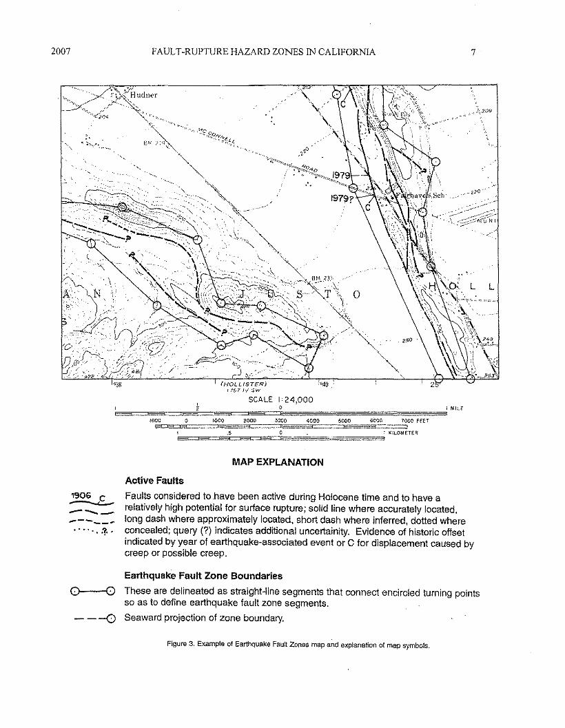
2007 FAULT-RUPTURE HAZARD ZONES IN CALIFORNIA 7
(HOLLISTER)11.'57 rv $'\.'1
SCALE I' 24,000
MAP EXPLANATION
..•... :? .
Active FaultsFaults considered to have been active during Holocene time and to have arelatively high potential for surface rupture; solid line where accurately located,long dash where approx.imately located, short dash where inferred, dotted whereconcealed; query (7) indicates additional uncertainity. Evidence of historic offsetindicated by year of earthquake-associated event or C for displacement caused bycreep or possible creep.
1906 C-....:.:.----------
---0
Earthquake Fault Zone Boundaries
These are delineated as straight-line segments that connect encircled turning pointsso as to define earthquake fault zone segments.Seaward projection of zone boundary.
0---0
Figure 3. Example of Earthquake Fault Zones map and explanation of map symbols.
8 CALIFORNIA GEOLOGICAL SURVEY SP42
!
I1lg:lltc,
.g"ige~•~i
iIJ!l"5II~'"II~.
JU~~hl!~ !~~~~E~~"i~HI~f~~~I>;" ~~~~j~i~!l~Ii 0 u;·~ri"1 !Eii~f.~~l·I>;hi~IH~n 1lf'Ill.a~ aIHlr~t f'0" ~¥i~J~~~ &~
UiP...Iie ip~.~ il·]l~I" nrn
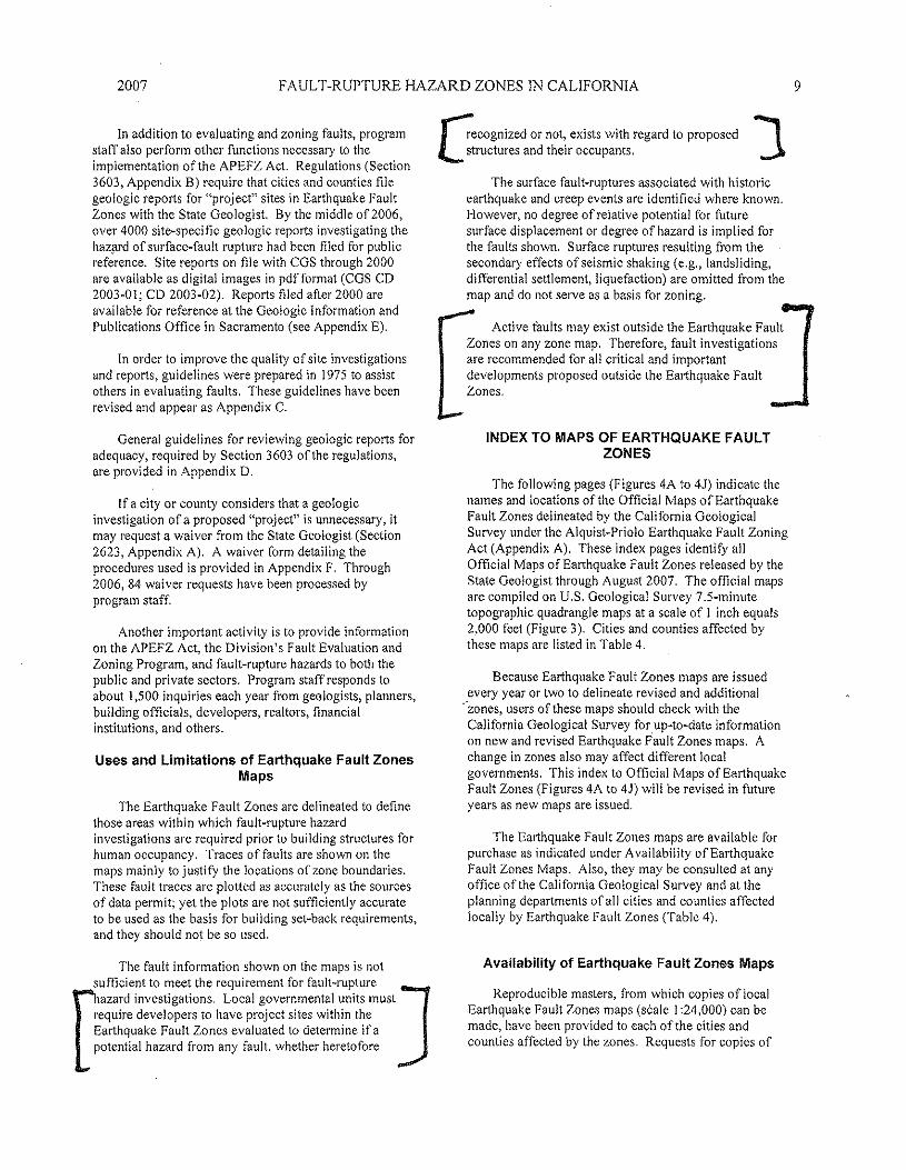
2007 FAULT-RUPTURE HAZARD ZONES IN CALIFORNIA
In addition to evaluating and zoning faults, programstaff also perform other functions necessary to theimplementation of the APEFZ Act. Regulations (Section3603, Appendix B) require that cities and counties filegeologic reports for "project" sites in Earthquake FaultZones with the State Geologist. By the middle of2006,over 4000 site-specific geologic reports investigating thehazard of surface-fault rupture had been filed for publicreference. Site reports on file with CGS through 2000are available as digital images in pdf format (CGS CD2003-01; CD 2003-02). Reports filed after 2000 areavailable for reference at the Geologic Information andPublications Office in Sacramento (see Appendix E).
In order to improve the quality of site investigationsand reports, guidelines were prepared in 1975 to assistothers in evaluating faults. These guidelines have beenrevised and appear as Appendix C.
General guidelines for reviewing geologic reports foradequacy, required by Section 3603 of the regulations,are provided in Appendix D.
If a city or county considers that a geologicinvestigation of a proposed "project" is unnecessary, itmay request a waiver from the State Geologist (Section2623, Appendix A). A waiver form detailing theprocedures used is provided in Appendix F. Through2006, 84 waiver requests have been processed byprogram staff.
Another important activity is to provide informationon the APEFZ Act, the Division's Fault Evaluation andZoning Program, and fault-rupture hazards to both thepublic and private sectors. Program staff responds toabout 1,500 inquiries each year from geologists, planners,building officials, developers, realtors, financialinstitutions, and others.
Uses and Limitations of Earthquake Fault ZonesMaps
The Earthquake Fault Zones are delineated to definethose areas within which fault-rupture hazardinvestigations are required prior to building structures forhuman occupancy. Traces of faults are shown on themaps mainly to j usti fy the locations of zone boundaries.These fault traces are plotted as accurately as the sourcesof data permit; yet the plots are not sufficiently accurateto be used as the basis for building set-back requirements,and they should not be so used.
The fault information shown on the maps is notsufficient to meet the requirement for fault-rupture
Dazard investigations. Local governmental units must]
require developers to have project sites within theEarthquake Fault Zones evaluated to determine if apotential hazard from any fault, whether heretofore
r7ecognized or not, exists with regard to proposed JLstructures and their occupants.
The surface fault-ruptures associated with historicearthquake and creep events are identified where known.However, no degree of relative potential for futuresurface displacement or degree of hazard is implied forthe faults shown. Surface ruptures resulting from thesecondary effects of seismic shaking (e.g., landsliding,differential settlement, liquefaction) are omitted from themap and do not serve as a basis for zoning.
Active faults may exist outside the Earthquake FaultZones on any zone map. Therefore, fault investigationsare recommended for all critical and importantdevelopments proposed outside the Earthquake FaultZones.
INDEX TO MAPS OF EARTHQUAKE FAULTZONES
The following pages (Figures 4A to 4.1) indicate thenames and locations of the Official Maps of EarthquakeFault Zones delineated by the California GeologicalSurvey under the Alquist-Priolo Earthquake Fault ZoningAct (Appendix A). These index pages identify allOfficial Maps of Earthquake Fault Zones released by theState Geologist through August 2007. The official mapsare compiled on U.S. Geological Survey 7.5wminutetopographic quadrangle maps at a scale of 1 inch equals2,000 feet (Figure 3). Cities and counties affected bythese maps are listed in Table 4.
Because Earthquake Fault Zones maps are issuedevery year or two to delineate revised and additional
"zones, users of these maps should check with theCalifornia Geological Survey for up-to-date informationon new and revised Earthquake F'ault Zones maps. Achange in zones also may affect different localgovernments. This index to Official Maps of EarthquakeFault Zones (Figures 4A to 4)) will be revised in futureyears as new maps are issued.
The Earthquake Fault Zones maps are available forpurchase as indicated under Availability of EarthquakeFault Zones Maps. Also, they may be consulted at anyoffice of the California Geological Survey and at theplanning departments of all cities and counties affectedlocally by Earthquake Fault Zones (Table 4).
Availability of Earthquake Fault Zones Maps
Reproducible masters, from which copies of localEarthquake Fault Zones maps (scale I :24,000) can bemade, have been provided to each of the cities andcounties affected by the zones. Requests for copies of
9
10 CALIFORNIA GEOLOGICAL SURVEY SP42
particular Earthquake Fault Zones maps of local areasshould be directed to the Planning Director of theappropriate city or county, Refer to the index ofEarthquake Fault Zones maps for the quadrangle namesof the maps needed.
Arrangements also have been made with ARC-Bryant (formerly BPS Reprographic Services), SanFrancisco, to provide paper copies of the EarthquakeFault Zones maps to those who cannot get themconveniently from the cities and counties.
ARC-Bryant945 Bryant StreetSan Francisco, CA 94103Telephone: (415) 495-8700 ,
Each map must be ordered by quadrangle name asshown on the index map. The cost of the maps isnominal; handling and C.O.D. charges are extra. Thesemaps are not sold by the California Geological Survey.
Digital files of the maps can be obtained from theCalifornia Geological Survey in both digital raster (pdf)and Geographic Information System (GIS) format. Referto Appendix E for more inillimation on obtaining digitalfiles' of the maps.
REFERENCES(See Appendix E for Complete List of AP Products)
Bonilla, M.G., 1970, Surface faulting and related effects,in Wiegel, R,L, editor, Earthquake Engineering:Prentice-Hall, lnc., Englewood Cliffs, New Jersey, p.47-74.
California Division of Mines and Geology, 1976, Activefault mapping and evaluation program -- 10-yearprogram to implement Alquist-Priolo Special StudiesZones Act: California Division of Mines andGeology Special Publication 47, 42 p.
Grantz, A. and Bartow, A" 1977, Active faults ofCalifornia: U.S. Geological Survey pamphlet, 15 p.
Hart, E. W., 1978, Zoning for the hazard of surface faultrupture in California: International Conference onMicrozonation, 2nd, San Francisco, 1978,Proceedings, v. 2, p. 635-646.
Hart, E.W., 1986, Zoning forthe hazard of surfacefaulting in California, in Proceedings ConferenceXXXII -~ Workshop on future directions inevaluating earthquake hazards in southern
California, November 12-13, 1985: U.S. GeologicalSurvey Open-File Report 86-401, p. 74-83.
Jennings, C.W., 1975, Fault map of California withlocations of volcanoes, thermal springs, and thermalwells: California Division of Mines and GeologyData Map No. I, scale 1:750,000.
Jennings, C.W., 1985, An explanatory text to accompanythe 1:750,000 scale Fault and Geologic Maps ofCalifornia: Division of Mines and Geology Bulletin201,197 p., 2 plates.
Jennings, C.W., 1994, Fault activity map of Californiaand adjacent areas: California Department ofConservation, Division of Mines and GeologyGeologic Data Map No.6, scale 1:750,000(appendices).
Reitherman, R. and Leeds, DJ., 1990, A study of theeffectiveness of the Alquist-Priolo program:California Division of Mines and Geology Open-FileReport 90-18, 131 p.
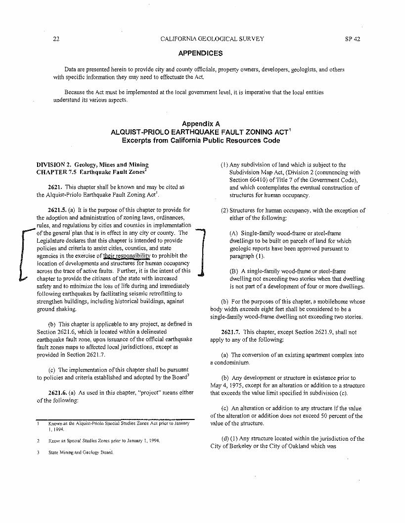
22 CALIFORNIA GEOLOGICAL SUR VEY SP 42
APPENDICES
Data are presented herein to provide city and county officials, property owners, developers, geologists, and otherswith specific information they may need to effectuate the Act,
Because the Act must be implemented at the local government level, it is imperative that the local entitiesunderstand its various aspects.
Appendix AALQUIST -PRIOLO EARTHQUAKE FAULT ZONING ACT'
Excerpts from California Public Resources Code
DIVISION 2. Geology, Mines and MiningCHAPTER 7.5 Earthquake Fault Zones'
2621. This chapter shall be known and may be cited asthe Alquist-Priolo Earthquake Fault Zoning Act'.
2621.5. (a) It is the purpose of this chapter to provide forthe adoption and administration of zoning laws, ordinances,rules, and regulations by cities and counties in implementationof the general plan that is in effect in any city or county. TheLegislature declares that this chapter is intended to providepolicies and criteria to assist cities, counties, and stateagencies in the exercise of their responsibility to prohibit thelocation of developments and structures for human occupancyacross the trace of active faults, Further, it is the intent of thischapter to provide the citizens of the state with increasedsafety and to minimize the loss of life during and immediatelyfollowing earthquakes by facilitating seismic retrofitting tostrengthen buildings. ineJuding historical buildings, againstground shaking.
(b) This chapter is applicable to any project, as defined inSection 262l.6, which is located within a delineatedearthquake fault zone, upon issuance of the official earthquakefault zones maps to affected local jurisdictions, except asprovided in Section 262l.7.
(c) The implementation of this chapter shall be pursuantto policies and criteria established and adopted by the Board)
2621.6. (a) As used in this chapter, "project" means eitherof the following:
Known as the Alquist-Priolo Special Studies Zones Act prior to january1, 1994.
2 Know as Special Studies Zones prior to January 1, 1994
State Mining and Geology Board
(I) Any subdivision ofland which is subject to theSubdivision Map Act, (Division 2 (commencing withSection 66410) of Tille 7 of the Government Code),and which contemplates the eventual construction ofstructures for human occupancy.
(2) Struetures for human occupancy. with the exception ofeither of the following:
(A) Single-family wood-frame or steel-framedwellings to be built on parcels ofland for whichgeologic reports have been approved pursuant toparagraph (I).
(B) A single-family wood-frame or steel-framedwelling not exceeding two stories when that dwellingis not part of a development of four or more dwellings,
(b) For the purposes of this chapter, a mobilehome whosebody width exceeds eight feet shall be considered to be asingle-family wood-frame dwelling not exceeding two stories,
2621.7. This chapter, except Section 262l.9, shall notapply to any of the following:
(a) The conversion of an existing apartment complex intoa condominium.
(b) Any development or structure in existence prior toMay 4, 1975, except for an alteration or addition to a structurethat exceeds the value limit specified in subdivision (c).
(c) An alteration or addition to any structure if the valueof the alteration or addition does not exceed 50 percent of thevalue of the structure.
(d) (l) Any structure located within the jurisdiction of theCity of Berkeley or the City of Oakland which was
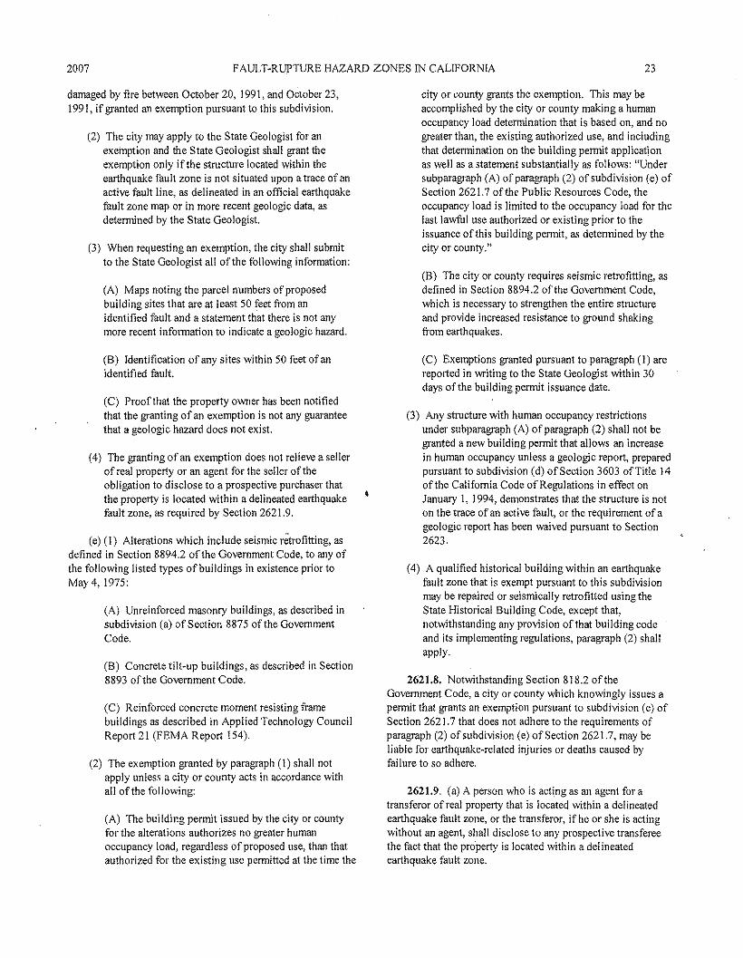
2007 FAVLT-RUPTIJRE HAZARD ZONES IN CALIFORNIA 23
damaged by fire between October 20,1991, and October 23,1991, if granted an exemption pursuant to this subdivision.
(2) The city may apply to the State Geologist for anexemption and the State Geologist shall grant theexemption only if the structure located within theearthquake fault zone is not situated upon a trace of anactive fault line, as delineated in an official earthquakefault zone map or in more recent geologic data, asdetermined by the State Geologist.
(3) When requesting an exemption, the city shall submitto the State Geologist all of the following information:
(A) Maps noting the parcel numbers of proposedbuilding sites that are at least 50 feet from anidentified fault and a statement that there is not anymore recent information to indicate a geologic hazard.
(B) Identification of any sites within 50 feet of anidentified fault.
(C) Proof that the property owner has been notifiedthat the granting of an exemption is not any guaranteethat a geologic hazard does not exist.
(4) The granting of an exemption does not relieve a sellerof real property or an agent for the seller of theobligation to disclose to a prospective purchaser thatthe property is located within a delineated earthquakefault zone, as required by Section 2621.9.
(e) (l) Alterations which include seismic retrofitting, asdefined in Section 8894.2 of the Government Code, to any ofthe following listed types of buildings in existence prior toMay 4,1975:
(A) Unreinforced masonry buildings, as described insubdivision (a) of Section 8875 of the GovernmentCode.
(B) Concrete tilt-up buildings, as described in Section8893 of the Government Code.
(C) Reinforced concrete moment resisting framebuildings as described in Applied Technology CouncilReport 21 CFEMA Report 154).
(2) The exemption granted by paragraph CI) shall notapply unless a city or county acts in accordance withall of the following:
(A) The building permit issued by the city or countyfor the alterations authorizes no greater humanoccupancy load, regardless of proposed use, than thatauthorized for the existing use permitted at the time the
city or county grants the exemption. This may beaccomplished by the city or county making a humanoccupancy load determination that is based on, and nogreater than, the existing authorized use, and includingthat determination on the building permit applicationas well as a statement substantially as follows: "Undersubparagraph CA)of paragraph (2) of subdivision (e) ofSection 2621.7 of the Public Resources Code, theoccupancy load is limited to the occupancy load for thelast lawful usc authorized or existing prior to theissuance of this building permit, as determined by thecity or county."
CB) The city or county requires seismic retrofitting, asdefined in Section 8894.2 of the Government Code,which is necessary to strengthen the entire structureand provide increased resistance to ground shakingfrom earthquakes.
(C) Exemptions granted pursuant to paragraph CI) arereported in writing to the State Geologist within 30days of the building permit issuance date.
(3) Any structure with human occupancy restrictionsunder subparagraph (A) of paragraph (2) shall not begranted a new building permit that allows an increasein human occupancy unless a geologic report, preparedpursuant to subdivision (d) of Section 3603 of Title 14of the California Code of Regulations in effect onJanuary I, 1994, demonstrates that the structure is noton the trace of an active fault, or the requirement of ageologic report has been waived pursuant to Section2623.
(4) A qualified historical building within an earthquakefault zone that is exempt pursuant to this subdivisionmay be repaired or seismically retrofitted using theState Historical Building Code, except that,notwithstanding any provision of that building codeand its implementing regulations, paragraph (2) shallapply.
2621.8. Notwithstanding Section 818.2 of theGovernment Code, a city or county which knowingly issues apermit that grants an exemption pursuant to subdivision (e) ofSection 2621.7 that does not adhere to the requirements ofparagraph (2) of subdivision (e) of Section 2621.7, may beliable for earthquake-related injuries or deaths caused byfailure to so adhere.
2621.9. (a) A person who is acting as an agent for atransferor of real property that is located within a delineatedearthquake fault zone, or the transferor, if he or she is actingwithout an agent, shall disclose to any prospective transfereethe fact that the property is located within a del ineatedearthquake fault zone.
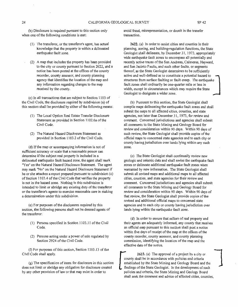
24 CALIFORNIA GEOLOGICAL SURVEY SP 42
(b) Disclosure is required pursuant to this section onlywhen one of the following conditions is met:
(I) The transferor, or the transferor's agent, has actualknowledge that the property is within a delineatedearthquake fault zone.
(2) A map that includes the property has been providedto the city or county pursuant to Section 2622, and anotice has been posted at the offices of the countyrecorder, county assessor,and county planningagency that identifies the location of the map andany information regarding changes to the mapreceived by the county.
(c) In all transactions that are subject to Section 1103 ofthe Civil Code, the disclosure required by subdivision (a) ofthis section shall be provided by either of the following means:
(I) The Local Option Real Estate Transfer DisclosureStatement as provided in Section I 102.6a of theCivil Code.
(2) The Natural Hazard Disclosure Statement asprovided in Section 1103.2 of the Civil Code.
(d) If the map or accompanying information is not ofsufficient accuracy or scale that a reasonable person candetermine if the subject real property is included in adelineated earthquake fault hazard zone, the agent shall mark"Yes" on the Natural Hazard Disclosure Statement. The agentmay mark "No" on the Natural Hazard Disclosure Statement ifhe or she attaches a report prepared pursuant to subdivision (c)of Section 1103.4 of the Civil Code that verifies the propertyis not in the hazard zone. Nothing in this subdivision isintended to limit or abridge any existing duty of the transferoror the transferor's agents to exercise reasonable care in makinga determination under this subdivision.
(e) For purposes ofthe disclosures required by thissection, the following persons shall not be deemed agents ofthe transferor:
(I) Persons specified in Section 1103.11 of the CivilCode.
(2) Persons acting under a power of sale regulated bySection 2924 of the Civil Code.
(I) For purposes of this section, Section 1103.13 of theCivil Code shall apply.
(g) The specification of items for disclosure in this sectiondoes not limit or abridge any obligation for disclosure createdby any other provision of law or that may exist in order to
avoid fraud, misrepresentation, or deceit in the transfertransaction.
2622. (a) In order to assist cities and counties in theirplanning, zoning, and building-regulation functions, the StateGeologist shall delineate, by December 31, 1973, appropriatelywide earthquake fault zones to encompass all potentially andrecently active traces of the San Andreas, Calaveras, Hayward,and San Jacinto Faults, and such other faults, or segmentsthereof, as the State Geologist determines to be sufficientlyactive and well-defined as to constitute a potential hazard to Jstructures from surface faulting or fault creep. The earthquakefault zones shall ordinarily be one-quarter mile or less inwidth, except in circumstances which may require the StateGeologist to designate a wider zone.
(b) Pursuant to this section, the State Geologist shallcompile maps delineating the earthquake fault zones and shallsubmit the maps to all affected cities, counties, and stateagencies, not later than December 31, 1973, for review andcomment. Concerned jurisdictions and agencies shall submitall comments to the State Mining and Geology Board forreview and consideration within 90 days. Within 90 days ofsuch review, the State Geologist shall provide copies of theofficial maps to concerned state agencies and to each city orcounty having jurisdiction over lands lying within any suchzone,
(c) The State Geologist shall continually review newgeologic and seismic data and shall revise the earthquake faultzones or delineate additional earthquake fault zones whenwarranted by new information. The State Geologist shallsubmit all revised maps and additional maps to all affectedcities, counties, and state agencies for their review andcomment. Concerned jurisdictions and agencies shall submitall comments to the State Mining and Geology Board forreview and consideration within 90 days. Within 90 days ofthat review, the State Geologist shall provide copies of therevised and additional official maps to concerned stateagencies and to each city or county having jurisdiction overlands lying within the earthquake fault zone.
(d) In order to ensure that sellers of real property andtheir agents are adequately informed, any county that receivesan official map pursuant to this section-shall post a noticewithin five days of receipt of the map at the offices of thecounty recorder, county assessor, and county planningcommission, identifying the location of the map and theeffective date of the notice.
U2623. (a) The approval ofa project by a city or
county shall be in accordance with policies and criteriaestablished by the State Mining and Geology Board and thefindings of the State Geologist. In the development of suchpolicies and criteria, the State Mining and Geology Boardshall seek the comment and advice of affected cities, counties,
1

2007 FAULT-RUPTURE HAZARD ZONES IN CALIFORNIA 25
[ and state agencies. Cities and counties shall require, prior to ]the approval of a project, a geologic report defining anddelineating any hazard of surface fault rupture, If the city orcounty finds that no undue hazard of that kind exists, thegeologic report on the hazard may be waived, with the approvalof the State Geologist.
(b) After a report has been approved or a waiver granted,subsequent geologic reports shall not be required, providedthat new geologic data warranting further investigations is notrecorded.
(c) The preparation of geologic reports that are requiredpursuant to this section for multiple projects may beundertaken by a geologic hazard abatement district.
2624. Notwithstanding any provision of this chapter,cities and counties may do any of the following:
(I) Establish policies and criteria which are stricter thanthose established by this chapter.
(2) Impose and collect fees in addition to those requiredunder this chapter.
(3) Determine not to grant exemptions authorized underthis chapter.
2625. (a) Each applicant for approval of a project may becharged a reasonable fee by the city or county havingjurisdiction over the project.
(b) Such fees shall be set in an amount sufficient to meet,but not to exceed, the costs to the city or county ofadministering and complying with the provisions of thischapter.
[
(c) The geologic report required by Section 2623 shall beJin sufficient detail to meet the criteria and policies establishedby the State Mining and Geology Board for individual parcelsofland.
2630. In carrying out the provisions of this chapter, theState Geologist and the board shall be advised by the SeismicSafety Commission.
SIGNED INTO LAW DECEMBER 22,1972; AMENDED SEPTEMBER 16, 1974, MAY 4,1975, SEPTEMBER 28,1975,SEPTEMBER 22,1976, SEPTEMBER 27, 1979, SEPTEMBER 21,1990, JULY 29, 1991, AUGUST 16, 1992, JULY 25,
1993, OCTOBER 7,1993, AND OCTOBER 7,1997
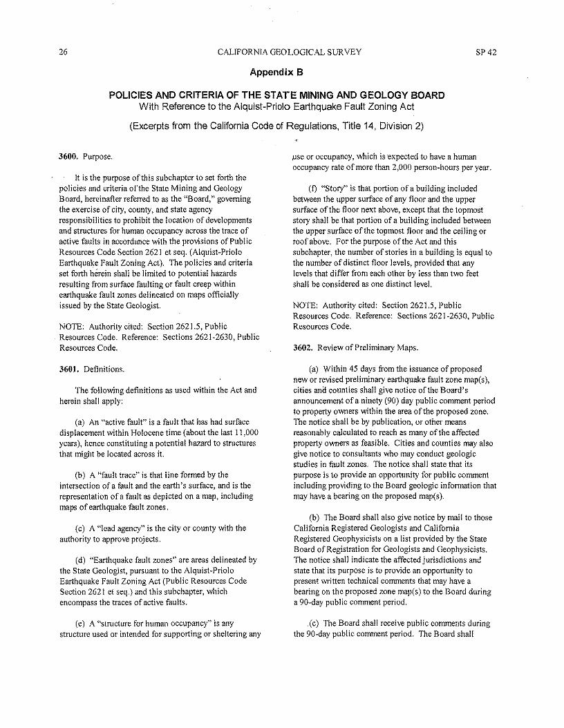
26 CAUFORNIA GEOLOGICAL SURVEY SP 42
Appendix B
POLICIES AND CRITERIA OF THE STATE MINING AND GEOLOGY BOARDWith Reference to the Alquist-Priolo Earthquake Fault Zoning Act
(Excerpts from the California Code of Regulations, Title 14, Division 2)
3600. Purpose.
It is the purpose of this subchapter to set forth thepolicies and criteria of the State Mining and GeologyBoard, hereinafter referred to as the "Board," governingthe exercise of city, county, and state agencyresponsibilities to prohibit the location of developmentsand structures for human occupancy across the trace ofactive faults in accordance with the provisions of PublicResources Code Section 2621 et seq. (Alquist-PrioloEarthquake Fault Zoning Act). The policies and criteriaset forth herein shall be limited to potential hazardsresulting from surface faulting or fault creep withinearthquake fault zones delineated on maps officiallyissued by the State Geologist.
NOTE: Authority cited: Section 2621.5, PublicResources Code. Reference: Sections 2621-2630, PublicResources Code.
3601. Definitions.
The following definitions as used within the Act andherein shall apply:
(a) An "active fault" is a fault that has had surfacedisplacement within Holocene time (about the last 11,000years), hence constituting a potential hazard to structuresthat might be located across it.
(b) A "fault trace" is that line formed by theintersection ofa fault and the earth's surface, and is therepresentation of a fault as depicted on a map, includingmaps of earthquake fault zones.
(c) A "lead agency" is the city or county with theauthority to approve projects.
(d) "Earthquake fault zones" are areas delineated bythe State Geologist, pursuant to the Alquist-PrioloEarthquake Fault Zoning Act (Public Resources CodeSection 262 I et seq.) and this subchapter, whichencompass the traces of active faults.
(e) A "structure for human occupancy" is anystructure used or intended for supporting or sheltering any
use or occupancy, which is expected to have a humanoccupancy rate of more than 2,000 person-hours per year.
(I) "Story" is that portion ofa building includedbetween the upper surface of any floor and the uppersurface of the floor next above, except that the topmoststory shall be that portion of a building included betweenthe upper surface of the topmost floor and the ceiling orroof above. For the purpose of the Act and thissubchapter, the number of stories in a building is equal tothe number of distinct floor levels, provided that anylevels that differ from each other by less than two feetshall be considered as one distinct level.
NOTE: Authority cited: Section 2621.5, PublicResources Code, Reference: Sections 2621-2630, PublicResources Code.
3602. Review of Preliminary Maps.
(a) Within 45 days from the issuance of proposednew or revised preliminary earthquake fault zone map(s),cities ana counties shall give notice of the Board'sannouncement of a ninety (90) day public comment periodto property owners within the area of the proposed zone.The notice shall be by publication, or other meansreasonably calculated to reach as many of the affectedproperty owners as feasible. Cities and counties may alsogive notice to consultants who may conduct geologicstudies in fault zones. The notice shall state that itspurpose is to provide an opportunity for publ ic commentincluding providing to the Board geologic information thatmay have a bearing on the proposed map(s).
(b) The Board shall also give notice by mail to thoseCalifornia Registered Geologists and CaliforniaRegistered Geophysicists on a list provided by the StateBoard of Registration for Geologists and Geophysicists.The notice shall indicate the affected jurisdictions andstate that its purpose is to provide an opportunity topresent written technical comments that may have abearing on the proposed zone map(s) to the Board duringa 90-day public comment period.
.(c) The Board shall receive public comments duringthe 90-day public comment period. The Board shall
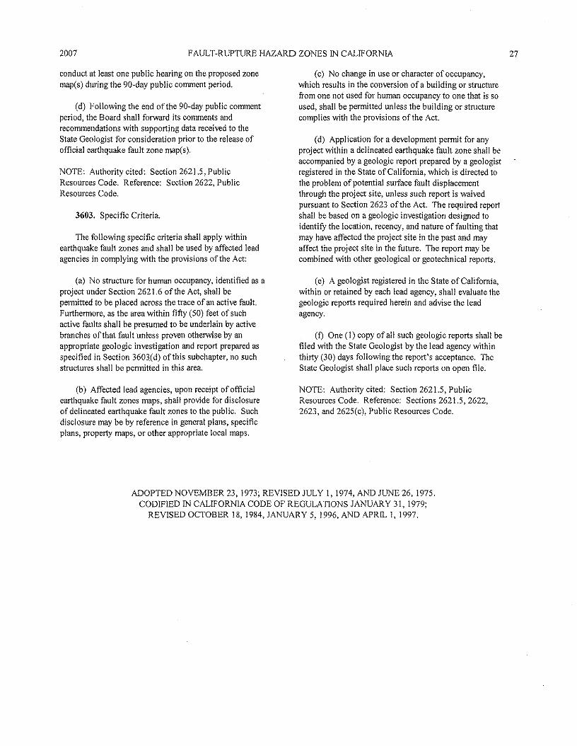
2007 FAULT-RUPTURE HAZARD ZONES IN CALIFORNIA 27
conduct at least one public hearing on the proposed zonemap(s) during the 90-day public comment period.
(d) Following the end of the 90-day public commentperiod, the Board shall forward its comments andrecommendations with supporting data received to theState Geologist for consideration prior to the release ofofficial earthquake fault zone map(s).
NOTE: Authority cited: Section 2621.5, PublicResources Code. Reference: Section 2622, PublicResources Code.
3603. Specific Criteria.
The following specific criteria shall apply withinearthquake fault zones and shall be used by affected leadagencies in complying with the provisions of the Act:
(a) No structure for human occupancy, identified as aproject under Section 2621.6 of the Act, shall bepermitted to be placed across the trace of an active fault.Furthermore, as the area within fifty (50) feet of suchactive faults shall be presumed to be underlain by activebranches of that fault unless proven otherwise by anappropriate geologic investigation and report prepared asspecified in Section 3603(d) of this subchapter, no suchstructures shall be permitted in this area.
(b) Affected lead agencies, upon receipt of officialearthquake fault zones maps, shall provide for disclosureof delineated earthquake fault zones to the public. Suchdisclosure may be by reference in general plans, specificplans, property maps, 01' other appropriate local maps.
(c) No change in use or character of occupancy,which results in the conversion of a building or structurefrom one not used for human occupancy to one that is soused, shall be permitted unless the building or structurecomplies with the provisions of the Act.
(d) Application for a development permit for anyproject within a delineated earthquake fault zone shall beaccompanied by a geologic report prepared by a geologistregistered in the State of California, which is directed tothe problem of potential surface fault displacementthrough the project site, unless such report is waivedpursuant to Section 2623 of the Act. The required reportshall be based on a geologic investigation designed toidentify the location, recency, and nature of faulting thatmay have affected the project site in the past and mayaffect the project site in the future. The report may becombined with other geological or geotechnical reports.
(e) A geologist registered in the State of Cali forni a,within or retained by each lead ageney, shall evaluate thegeologic reports required herein and advise the leadagency.
(I) One (I) copy of all such geologic reports shall befiled with the State Geologist by the lead agency withinthirty (30) days following the report's acceptance. TheState Geologist shall place such reports on open file.
NOTE: Authority cited: Section 2621.5, PublicResources Code. Reference: Sections 2621.5, 2622,2623, and 2625(c), Public Resources Code.
ADOPTED NOVEMBER 23, 1973; REVISED JULY I, 1974, AND JUNE 26,1975.CODIFIED IN CALIFORNIA CODE OF REGULATIONS JANUARY 31, 1979;
REVISED OCTOBER 18, 1984, JANUARY 5,1996, AND APRIL 1,1997.
28 CALIFORNIA GEOLOGICAL SURVEY SP42
Appendix C
GUIDELINES FOR EVALUATING THE HAZARDOF SURFACE RUPTURE
(These guidelines, also published as DMG Note 49 (1997), are not part of the Policies and Criteria of the StateMining and Geology Board. Similar guidelines were adopted by the Board for advisory purposes in 1996.)
These guidelines are to assist geologists who investigatefaults relative to the hazard of surface fault rupture.Subsequent to the passage of the Alquist-Priolo EarthquakeFault Zoning Act (1972), it became apparent that many faultinvestigations conducted in California were incomplete orotherwise inadequate for the purpose of evaluating thepotential of surface fault rupture. It was further apparent thatstatewide standards for investigating faults would bebeneficial. These guidelines were initially prepared in 1975as DMG Note 49 and have been revised several times sincethen.
The investigation of sites for the possible hazard ofsurface fault rupture is a deceptively difficult geologic task.Many active faults are complex, consisting of multiple breaks.Yet the evidence for identifying active fault traces is generallysubtle or obscure and the distinction between recently activeand long-inactive faults may be difficult to make. It isimpractical from an economic, engineering, and architecturalpoint of view to design a structure to withstand seriousdamage under the stress of surface fault rupture. Once astructure is sited astride an active fault, the resulting fault-rupture hazard cannot be mitigated unless the structure isrelocated, whereas when a structure is placed on a landslide,the potential hazard from landsliding often can be mitigated.Most surface faulting is confined to a relatively narrow zone afew feet to a few tens offeet wide, making avoidance (i.e.,building setbacks) the most appropriate mitigation method.However, in some cases primary fault rupture or rupture alongbranch faults can be distributed across zones hundreds offeetwide or manifested as broad warps, suggesting thatengineering strengthening or design may be of additionalmitigative value (e.g., Lazarte and others, 1994).
No single investigative method will be the best, or evenuseful, at all sites, because of the complexity of evaluatingsurface and near surface faults and because of the infinitevariety of site conditions. Nonetheless, certain investigativemethods are more helpful than others in locating faults andevaluating the recency of activity.
The evaluation of a given site with regard to the potentialhazard of surface fault rupture is based extensively on theconcepts of recency and recurrence of faulting along existingfaults. In a general way, the more recent the faulting thegreater the probability for future faulting (Allen, 1975).Stated another way, faults ofknown historic activity duringthe last 200 years, as a class, have a greater probability forfuture activity than faults classified as Holocene age (last11,000 years) and a much greater probability of future activitythan faults classified as Quaternary age (last 1.6 millionyears). However, it should be kept in mind that certain faultshave recurrent activity measured in tens or hundreds of yearswhereas other faults may be inactive for thousands of yearsbefore being reactivated. Other faults may be characterizedby creep-type rupture that is more or less on-going. Themagnitude, sense, and nature of fault rupture also vary fordifferent faults or even along different strands of the samefault. Even so, future faulting generally is expected to recuralong pre-existing faults (Bonilla, 1970, p. 68). Thedevelopment of a new fault or reactivation of a long-inactivefault is relatively uncommon and generally need not be aconcern in site development.
As a practical matter, fault investigations should be 1directed at the problem of locating existing faults and thenattempting to evaluate the recency of their activity. Datashould be obtained both from the site and outside the sitearea. The most useful and direct method of evaluatingrecency is to observe (in a trench or road cut) the youngestgeologic unit faulted and the oldest unit that is not faulted.Even so, active faults may be subtle or discontinuous andconsequently overlooked in trench exposures (Bonilla andLienkaemper, 1991). Therefore, careful logging is essentialand trenching needs to be conducted in conjunction withother methods. For example, recently active faults may alsobe identified by direct observation of young, fault-relatedgeomorphic (i.e., topographic) features in the field or onaerial photographs. Other indirect and more interpretivemethods are identified in the outline below. Some of thesemethods are discussed in Bonilla (1982), Carver andMcCalpin (1996), Hatheway and Leighton (1979), McCalpin
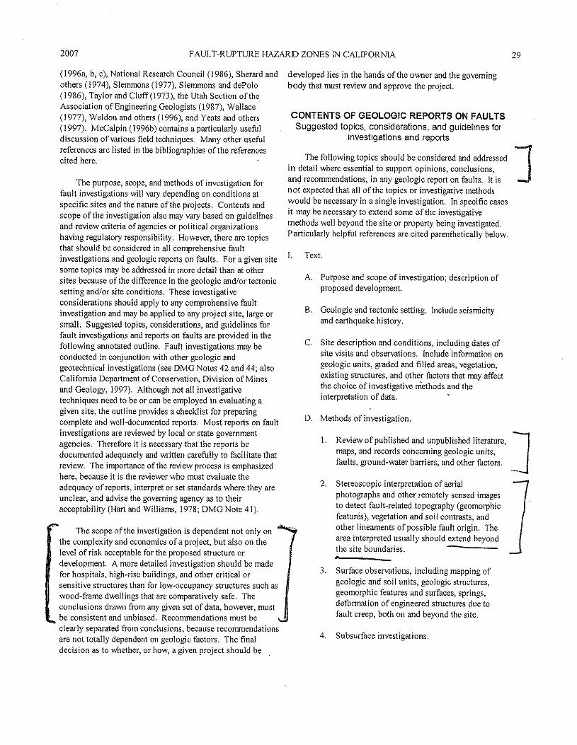
2007 FAULT-RUPTURE HAZARD ZONES IN CALIFORNIA 29
(I 996a, b, c), National Research Council (1986), Sherard andothers (1974), Slemmons (1977), Slemmons and dePolo(J 986), Taylor and Cluff(1 973), the Utah Section of theAssociation of Engineering Geologists (J 987), Wallace(1977), Weldon and others (1996), and Yeats and others(1997), McCalpin (I 996b) contains a particularly usefuldiscussion of various field techniques, Many other usefulreferences are listed in the bibliographies of the referencescited here.
The purpose, scope, and methods of investigation forfault investigations will vary depending on conditions atspecific sites and the nature of the projects, Contents andscope of the investigation also may vary based on guidelinesand review criteria of agencies or political organizationshaving regulatory responsibility, However, there are topicsthat should be considered in all comprehensive faultinvestigations and geologic reports on faults. For a given sitesome topics may be addressed in more detail than at othersites because of the difference in the geologic and/or tectonicsetting and/or site conditions. These investigativeconsiderations should apply to any comprehensive faultinvestigation and may be applied to any project site, large orsmall. Suggested topics, considerations, and guidelines forfault investigations and reports on faults are provided in thefollowing annotated outline. Fault investigations may beconducted in conjunction with other geologic andgeotechnical investigations (see DMG Notes 42 and 44' alsoCalifornia Department of Conservation, Division ofMi'nesand Geology, 1997), Although not all investigativetechniques need to be or can be employed in evaluating agiven site} the outline provides a checklist for preparingcomplete and well-documented reports, Most reports on faultinvestigations are reviewed by local or state governmentagencies. Therefore it is necessary that the reports bedocumented adequately and written carefully to facilitate thatreview. The importance of the review process is emphasizedhere, because it is the reviewer who must evaluate theadequacy of reports, interpret or set standards where they areunclear, and advise the governing agency as to theiracceptability (Hart and Wil!iarns, 1978; DMG Note 41),
The scope of the investigation is dependent not only onthc complexity and economics of a project, but also on thelevel of risk acceptable for the proposed structure ordevelopment, A more detailed investigation should be madefor hospitals, high-rise buildings, and other critical orsensitive structures than for low-occupancy structures such aswood-frame dwellings that are comparatively safe, Theconclusions drawn from any given set of data, however, mustbe consistent and unbiased, Recommendations must beclearly separated from conclusions, because recommendationsare not totally dependent on geologic factors, The finaldecision as to whether, or how, a given project should be
developed lies in the hands of the owner and the governingbody that must review and approve the project.
CONTENTS OF GEOLOGIC REPORTS ON FAULTSSuggested topics, considerations, and guidelines for
investigations and reports
The following topics should be considered and addressed Jin detail where essential to support opinions, conclusions,and recommendations, in any geologic report on faults, It isnot expected that all ofthe topics or investigative methodswould be necessary in a single investigation. In specific casesit may be necessary to extend some of the investigativemethods well beyond the site or property being investigated,Particularly helpful references are cited parenthetically below,
L Text.
A, Purpose and scope of investigation; description ofproposed development.
B, Geologic and tectonic setting, Include seismicityand earthquake history,
C. Site description and conditions, including dates ofsite visits and observations, Include information ongeologic units, graded and filled areas, vegetation,existing structures, and other factors that may affectthe choice of investigative methods and theinterpretation of data.
D, Methods of investigation,
1. Revi.ewofPublished and unpublished literature, ]maps) and records concerning geologic units,faults, ground-water barriers, and other factors.
2. Stereoscopic interpretation of aerialphotographs and other remotely sensed imagesto detect fault-related topography (geomorphicfeatures), vegetation and soil contrasts, andother lineaments of possible fault origin, Thearea interpreted usually should extend beyondthe site boundaries,
3, Surface observations, including mapping ofgeologic and soil units, geologic structures,geomorphic features and surfaces, springs,deformation of engineered structures due tofault creep, both on and beyond the site,
4. Subsurface investigations.
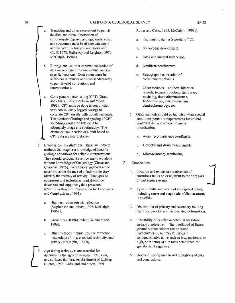
30 CALIFORNIA GEOLOGICAL SURVEY
Rutter and Catto, 1995; McCalpin, 1996a).a. Trenching and other excavations to permitdetailed and direct observation ofcontinuously exposed geologic units, soils,and structures; must be of adequate depthand be carefully logged (see Taylor andCluff, 1973; Hatheway and Leighton, 1979;McCalpin, 1996b).
b. Borings and test pits to permit collection ofdata on geologic units and ground water atspecific locations, Data points must besufficient in number and spaced adequatelyto permit valid correlations andinterpretations.
c. Cone penetrometer testing (CPT) (Grantand others, 1997; Edelman and others,1996). CPT must be done in conjunctionwith continuously logged borings tocorrelate CPT results with on-site materials,The number of borings and spacing of CPTsoundings should be sufficient toadequately image site stratigraphy. Theexistence and location of a fault based onCPT data are interpretative.
5. Geophysical investigations. These are indirectmethods that require a knowledge of specificgeologic conditions for reliable interpretations.They should seldom, if ever, be employed alonewithout knowledge ofthe geology (Chase andChapman, 1976). Geophysical methods alonenever prove the absence of a fault nor do theyidentify the recency of activity. The types ofequipment and techniques used should bedescribed and supporting data presented(California Board of Registration for Geologistsand Geophysicists, 1993).
a. High resolution seismic reflection(Stephenson and others, 1995; McCalpin,1996b).
b. Ground penetrating radar (Cai and others,1996).
c. Other methods include: seismic refraction,magnetic profiling, electrical resistivity, andgravity (McCalpin, 1996b).
Age-dating techniques are essential fordetermining the ages of geologic units, soils,and surfaces that bracket the time(s) of faulting(Pierce, 1986; Birkeland and others, 1991;
SP 42
a. Radiometric dating (especially 14C).
b. Soil-profile development.
c. Rock and mineral weathering.
d. Landform development.
e. Stratigraphic correlation ofrocks/minerals/fossi Is.
f Other methods -- artifacts, historicalrecords, tephrochronology, fault scarpmodeling, thermoluminescence,lichenornetery, paleomagnetism,dendrochronology, etc.
7. Other methods should be included when specialconditions permit or requirements for criticalstructures demand a more intensiveinvestigation.
a. Aerial reconnaissance overflights.
b. Geodetic and strain measurements.
c. Microseismicity monitoring.
E. Conclusions.
1. Location and existence (or absence) of Jhazardous faults on or adjacent to the site; agesof past rupture events.
2. Type of faults and nature of anticipated offset,including sense and magnitude of displacement,if possible.
3. Distribution of primary and secondary faulting(fault zone width) and fault-related deformation.
4. Probability of or relative potential for futuresurface displacement. The likelihood of futureground rupture seldom can be statedmathematically, but may be stated insemiquantitative terms such as low, moderate, orhigh, or in terms of slip rates determined forspecific fault segments.
5. Degree of confidence in and limitations of dataand conclusions.
2007
F. Recommendations.
FAULT-RUPTURE HAZARD ZONES IN CALIFORNIA
I. Setback distances of proposed structures fromhazardous faults. The setback distancegenerally will depend on the quality of data andtype and complexity offault(s) encountered atthe site. In order to establish an appropriatesetback distance from a fault located by indirector interpretative methods (e.g. borings or conepenetrometer testing), the area between datapoints also should be considered underlain by afault unless additional data are used to moreprecisely locate the fault. State and localregulations may dictate minimum distances (e.g.,Sec. 3603 of California Code of Regulations,Appendix B).
2. Additional measures (e.g., strengthenedfoundations, engineering design, flexible utilityconnections) to accommodate warping anddistributive deformation associated with faulting(Lazarte and others, 1994).
3. Risk evaluation relative to the proposeddevelopment.
4. Limitations of the investigation; need foradditional studies.
II. References.
A Literature and records cited or reviewed; citationsshould be complete.
B. Aerial photographs or images interpreted -- list type,date, scale, source, and index numbers.
C. Other sources of information, including well records,personal communications, and other data sources.
Ill. Illustrations --these are essential to the understanding ofthe report and to reduce the length oftext.
A. Location map -- identity site locality, significantfaults, geographic features, regional geology, seismicepicenters, and other pertinent data; I :24,000 scaleis recommended. If the site investigation is done incompliance with the Alquist-Priolo Act, show sitelocation on the appropriate Official Map ofEarthquake Fault Zones.
Site development map -~ show site boundaries,existing and proposed structures, graded areas,streets, exploratory trenches, borings, geophysical
traverses, locations of faults, and other data;recommended scale is 1:2,400 (I inch equals 200feet), or larger.
C. Geologic map -- show distribution of geologic units(if more than one), faults and other structures,geomorphic features, aerial photographic lineaments,and springs; on topographic map I :24,000 scale orlarger; can be combined with lIl(A) or lIl(B).
D. Geologic cross-sections, if needed, to provide 3-dimensional picture.
E. Logs of exploratory trenches and borings -- showdetails of observed features and conditions; shouldnot be generalized or diagrammatic. Trench logsshould show topographic profile and geologicstructure at a 1:1 horizontal to vertical scale; scaleshould be I :60 (I inch = 5 feet) or larger.
F. Geophysical data and geologic interpretations.
IV. Appendix: Supporting data not included above (e.g.,water well data, photographs, aerial photographs).
Authentication: Investigating geologist's signature andregistration number with expiration date.
REFERENCESAllen, C.R., 1975, Geologic criteria for evaluating seismicity:
Geological Society of America Bulletin, v. 86, p. 1041-1056.
Birkeland, P.W., Machette, M.N., and Haller, K.M., 1991,Soils as a tool for applied Quaternary geology: UtahGeological and Mineral Survey MiscellaneousPublication 91-3, 63 p.
Bonilla, M.G., 1970, Surface faulting and related effects, inWiegel, R.L., editor, Earthquake Engineering, Prentice-Hall, Inc., Englewood Cliffs, New Jersey, p. 47-74.
Bonilla, M.G., 1982, Evaluation of potential surface faultingand other tectonic deformation: U.S. Geological SurveyOpen-File Report 82-732, 58 p.
Bonilla, M.G., and Lienkaemper, J.1., 1991, Factors affectingthe recognition offaults in exploratory trenches: U.S.Geological Survey Bulletin 1947,54 p.
Cai, J., McMecham, GA, and Fisher, M.A., 1996,Application of ground-penetrating radar to investigation
31
J
J
32 CALIFORNIA GEOLOGICAL SUR VEY SP42
of near-surface fault properties in the San Francisco bayregion: Bulletin of the Seismological Society of America,v. 86, p. 1459-1470.
California Department of Conservation, Division of Minesand Geology DMG Notes:
DMG NOTE 41 - General guidelines for reviewinggeologic reports, 1997.DMG NOTE 42 - Guidelines to geologic/seismicreports, 1986.DMG NOTE 44 - Recommended guidelines forpreparing engineering geologic reports, 1986.DMG NOTE 49 - Guidelines for evaluating the hazardof surface fault rupture, 1997.
California Department of Conservation, Division of Minesand Geology, 1997, Guidelines for evaluating andmitigating seismic hazards in California: SpecialPublication 117,74 p.
California State Board of Registration for Geologists andGeophysicists, 1993, Guidelines for geophysical reports,5 p.
Carver, G.A., and McCalpin, l.P., 1996, Paleoseismology ofcompressional tectonic environments, in McCaipin, J ,P.,editor, Paleoseismology: Academic Press, p. 183-270.
Chase, G.W. and Chapman, R.H., 1976, Black-box geology--uses and misuses of geophysics in engineering geology:California Geology, v. 29, p 8-12.
Edelman, S.H., and Holguin, A.R., 1996 (in press), ConePenetrometer Testing for characterization and samplingof soil and groundwater, in Morgan, J.H, editor,Sampling Environmental Media ASTM STP 1282:American Society for Testing Materials, Philadelphia,Pennsylvania.
Grant, L.B., Waggoner, J.T., Rockwell, T.K., and von Stein,C., 1997, Paleoseismicity of the North Branch of theNewport-Inglewood fault zone in Huntington Beach,California, from cone penetrometer test data: Bulletin ofthe Seismological Society of America, v. 87, no. 2, p.277-293.
Hart, E.W., and Williams, J.W., 1978, Geologic reviewprocess, California Geology, v. 31, n. 10, p. 235-236.
Hatheway, A.W., and Leighton, F.B., 1979, Trenching as anexploratory tool, in Hatheway, A. W. and McClure, C.R.,Jr., editors, Geology in the siting of nuclear power plants:
Geological Society of America Reviews in EngineeringGeology, v.lV, p. 169-195.
Lazarte, C.A., Bray, J.D., Johnson, A.M., and Lemmer, R.E.,1994, Surface breakage of the 1992 Landers earthquakeand its effects on structures: Bulletin of theSeismological Society of America, v. 84, p. 547·561.
McCalpin, J.P. (editor), 1996a, Paleoseismology: AcademicPress, 588 p.
McCalpin, J.P., 1996b, Field techniques in paleoseismology,in McCalpin, J.P., editor, Paleoseismology: AcademicPress, p. 33·83.
McCalpin, J.P., I996c, Paleoseismology in extensionalenvironments, in McCaipin, J.P., editor,Paleoseismology: Academic Press, p. 85·146.
National Research Council, 1986, Studies in geophysics _.active tectonics: National Academy Press, Washington,D.C., 266 p. (Contains several articles evaluating activefaulting).
Pierce, K.L., 1986, Dating Methods, in Studies in geophysicsM_ active tectonics: National Academy Press, Washington,D.C., p. 195-214.
Rutter, N.W., and Catto, N.R., 1995, Dating methods forQuaternary deposits: Geological Society of Canada,GEOTEXT2, 308 p.
Sherard, J.L., Cluff, L.S., and Allen, C.R., 1974, Potentiallyactive faults in dam foundations: Geotechnique, Instituteof Civil Engineers, London, v. 24, n. 3, p. 367-428.
Slemmons, D.B., 1977, State-of-the-art for assessingearthquake hazards in the United States: Report 6, faultsand earthquake magnitude: U.S. Army EngineerWaterways Experiment Station Miscellaneous Paper S-73·1, 129 p. with 37 p. appendix.
Slemmons, D.B. and dePolo, C.M., 1986, Evaluation ofactive faulting and associated hazards, in Studies ingeophysics -- active tectonics: National Academy Press,Washington, D.C., p. 45-62.
Stephenson, W.J., Rockwell, T.K., Odum, J.K., Shedlock,K.M., and Okaya, D.A., 1995, Seismic reflection andgeomorphic characterization of the onshore Palos Verdesfault zone, Los Angeles, California: Bulletin of theSeismological Society of America, v. 85, p. 943-950.
2007 FAULT-RUPnJRE HAZARD ZONES IN CALIFORNIA 33
Taylor, C,L., and Cluff, L.S" 1973, Fault activity and itssignificance assessed by exploratory excavation, inProceedings of the Conference on tectonic problems ofthe San Andreas fault system: Stanford UniversityPublication, Geological Sciences, v, XIII, September1973, p. 239-247,
Utah Section ofthe Association of Engineering Geologists,1987, Guidelines for evaluating surface fault rupturehazards in Utah: Utah Geological and Mineral SurveyMiscellaneous Publication N, 2 p,
Wallace, R,E" 1977, Profiles and ages of young fault scarps,north-central Nevada: Geological Society of AmericaBulletin, v. 88, p, 1267-1281.
Weldon, R.J" II, McCalpin, J,P" and Rockwell, T,K., 1996,Paleoseismology of strike-slip tectonic environments, inMcCalpin, J,P" editor, Paleoseismology: AcademicPress, p, 271-329,
Yeats, R,S" Sieh, K,E" and Allen, CA, 1997, Geology ofEarthquakes: Oxford University Press, New York, N,Y"576 p,
GENERAL GUIDELINES FOR REVIEWING GEOLOGIC REPORTS
Appendix D
(These general guidelines are published as DMG Note 41 (1997), Similar guidelines were adopted bythe State Mining and Geology Board for advisory purposes in 1996),
The purpose of this article is to provide generalguidance for those geologists who review geologic reportsof consultants on behalf of agencies having approvalauthority over specific developments, These generalguidelines are modified from an article titled, "GeologicReview Process" by Hart and Williams (1978),
The geologic review is a critical part of the evaluationprocess of a proposed development. It is the responsibilityof the reviewer to assure that each geologic investigation,and the resulting report, adequately addresses the geologicconditions that exist at a given site. In addition to geologicreports for tentative tracts and site development, a reviewerevaluates Environmental Impact Reports, Seismic Safetyand Public Safety Elements of General Plans, ReclamationPlans, as-graded geologic reports, and final, as-builtgeologic maps and reports, In a sense, the geologicreviewer enforces existing laws, agency pol icies, andregulations to assure that significant geologic factors(hazards, mineral and water resources, geologic processes)are properly considered, and potential problems aremitigated prior to project development. Generally, thereviewer acts at the discretion or request of, and on behalfofa governing agency -- city, county, regional, state, federal~- not only to protect the government's interest but also toprotect the interest of the community at large, Examples of
the review process in a state agency are described byStewart and others (1976), Review at the local level hasbeen discussed by Leighton (1975), Berkland (1992),Larson (1992), and others, Grading codes, inspections, andthe review process are discussed in detail by Scullin(1983), Nelson and Christenson (1992) specificallydiscuss review guidelines for reports on surface faulting.
THE REVIEWER
Qualifications
In order to make appropriate evaluations of geologicreports, the reviewer should be an experienced geologistfamiliar with the investigative methods employed and thetechniques available to the profession, Even so, thereviewer must know his or her limitations, and at times askfor the opinions of others more qualified in specialty fields(e.g., geophysics, mineral exploitation and economics,ground water, foundation and seismic engineering,seismology). In California, the reviewer must be licensedby the State Board of Registration for Geologists andGeophysicists in order to practice (Wolfe, 1975), TheBoard also certifies engineering geologists andhydrogeologists, and licenses geophysicists, Local andregional agencies may have additional requirements.
34 CALIFORNIA GEOLOGICAL SURVEY SP 42
The reviewer must have the courage of his or herconvictions and should not approve reports if an inadequateinvestigation has been conducted. Like any review process,there is a certain "give-and-take' involved between thereviewer and investigator. Ifthere is clear evidence ofincompetence or misrepresentation in a report, this factshould be reported to the reviewing agency or licensingboard. California Civil Code Section 47 provides animmunity for statements made "in the initiation or course ofany other proceedings authorized by law." Courts haveinterpreted this section as providing immunity to letters ofcomplaint written to provide a public agency or board,including licensing boards, with information that the publicboard or agency may want to investigate (see King v.Borges, 28 Cal. App. 3d 27 [1972); and Brody v.Montalbano, 87 Cal. App. 3d 725 [1978)). Clearly, thereviewer needs to have the support of his or her agency inorder to carry out these duties.
The reviewer should bear in mind that some geologicinvestigators arc not accomplished writers, and almost allare working with restricted budgets. Also, the reviewer mayby limited by their agency's policies, procedures, and feestructures. Thus, while a reviewer should demand thatcertain standards be met, he or she should avoid runningrough-shod over the investigator. The mark of a goodreviewer is the ability to sort out the important from theinsignificant and to make constructive comments andrecommendations.
A reviewer may be employed full time by the reviewingagency or part-time as a consultant. Also, one reviewingagency (such as a city) may contract with another agency(such as a county) to perform geologic reviews. The bestreviews generally are performed by experienced reviewers.Thus, the use of multiple, part-time reviewers by a givenagency tends to prevent development of consistently high-quality and efficient reviews. One ofthe reasons for this isthat different reviewers have different standards, whichresults in inconsistent treatment of development projects.The primary purpose of the review procedure should alwaysbe kept in mind -- namely, to assure the adequacy ofgeologic investigations.
Other Review Functions
Aside from his or her duties as a reviewer. thereviewing geologist also must interpret the geologic datareported to other agency personnel who regulatedevelopment (e.g., planners. engineers, inspectors). Also,the reviewing geologist sometimes is called upon to makeinvestigations for his or her own agency. This is commonwhere a city or county employs only one geologist. In fact,some reviewers routinely divide their activities between
reviewing the reports of others and performing one orseveral other tasks for the employing agency (such asadvising other agency staff and boards on geologic matters;making public presentations) (see Leighton, 1975).
Conflict of Interest
In cases where a reviewing geologist also must performgeologic investigations, he or she should never be placed inthe position of reviewing his or her own report, for that isno review at all. A different type of conflict commonlyexists in a jurisdiction where the geologic review isperformed by a consulting geologist who also is practicingcommercially (performing geologic investigations) withinthe same jurisdictional area. Such situations should beavoided, ifat all possible.
GEOLOGIC REVIEW
The Report
The critical item in evaluating specific siteinvestigations for adequacy is the resulting geologic report.A report that is incomplete or poorly written cannot beevaluated and should not be approved. As an expediency,some reviewers do accept inadequate or incomplete reportsbecause of their personal knowledge of the site. However,unless good reasons can be provided in writing, it isrecommended that a report not be accepted until it presentsthe pertinent facts correctly and completely.
The conclusions presented in the report regarding thegeologic hazards or problems must be separate from andsupported by the investigative data. An indicationregarding the level of confidence in the conclusions shouldbe provided. Recommendations based on the conclusionsshould be made to mitigate those geology-related problemswhich would have an impact on the proposed development.Recommendations also should be made concerning theneed for additional geologic investigations.
Report Guidelines and Standards
An investigating geologist may save a great deal of time(and the client's money), and avoid misunderstandings, ifhe or she contacts the reviewing geologist at the initiationof the investigation. The reviewer should not only befamiliar with the local geology and sources of information,he or she also should be able to provide specific guidelinesfor investigative reports and procedures to be followed.Guidelines and check-lists for geologic or geotechnicalreports have been prepared by a number of reviewingagencies and are available to assist the reviewer in his orher evaluation of reports (e.g., DMG Notes 42, 44, 46, 48,and 49; California Department of Conservation, Division of
2007 FAULT-RUPTURE HAZARD ZONES IN CALIFORNIA 35
Mines and Geology, 1997). A reviewer also may wish toprepare his or her own guidelines or check-lists for specifictypes of reviews.
Ifa reviewer has questions about an investigation,these questions must be communicated in writing to theinvestigator for response. After the reviewer is satisfiedthat the investigation and resulting conclusions areadequate, this should be clearly indicated in writing to thereviewing agency so that the proposed developmentapplication may be processed promptly. The last and oneof the more important responsibilities of the reviewershould be implementation of requirements assuring reportrecommendations are incorporated and appropriateconsultant inspections are made.
The biggest problem the reviewer faces is theidentification of standards. These questions must be asked:"Are the methods of investigation appropriate for a givensite?" and "Was the investigation conducted according toexisting standards of practice?" Answers to these questionslie in the report being reviewed. For example, a reportedlandslide should be portrayed on a geologic map of the site.The conclusion that a hazard is absent, where previouslyreported or suspected, should be documented by statingwhich investigative steps were taken and precisely what wasseen. The reviewer must evaluate each investigative stepaccording to existing standards. It should be recognizedthat existing standards of practice generally set minimumrequirements (Keaton, 1993). Often the reviewer is forcedto clarify the standards, or even introduce new ones, for aspecific purpose.
Depth (Intensity) of Review
The depth ofthe review is determined primarily by theneed to assure that an investigation and resultingconclusions are adequate, but too often the depth of reviewis controlled by the time and funds available. A report on asubdivision (e.g., for an EIR or preliminary report) may besimply evaluated against a check-list to make certain it iscomplete and well-documented. Additionally, the reviewermay wish to check cited references or other sources of data,such as aerial photographs and unpublished records.
Reviewers also may inspect the development site andexamine excavations and borehole samples. Ideally, a fieldvisit may not be necessary jfthe report is complete andwell-documented. However, field inspections are of value,and generally are necessary to determine if field data arereported accurately and completely. Also, if the reviewer isnot familiar with the general site conditions, a brieffieJdvisit provides perspective and a visual check on the reportedconditions. 'Whether or not on-site reviews are made, it is
important to note that the geologic review process is notintended to replace routine grading inspections that may berequired by the reviewing agency to assure performanceaccording to an approved development plan.
Review Records
For each report and development project reviewed, a clear,concise, and logical written record should be developed.This review record may be as detailed as is necessary,depending upon the complexity of the project, the geology,and the quality and completeness of the reports submitted.At a minimum, the record should:
1. Identify the project, penmits, applicant, consultants,reports, and plans reviewed;
2. Include a clear statement of the requirements to be metby the parties involved, data required, and the plan,phase, project, or report being considered or denied;
3. Contain summaries of the reviewer's fieldobservations, associated literature and aerialphotographic review, and oral communications withthe applicant and the consultant;
4. Contain copies of any pertinent writtencorrespondence; and
5. The reviewer's pame and license number(s), withexpiration dates.
The report, plans, and review record should be kept inperpetuity to document that compliance with localrequirements was achieved and for reference during futuredevelopment, remodeling, or rebuilding. Such records alsocan be a valuable resource for land-use planning and real-estate disclosure.
Appeals
In cases where the reviewer is not able to approve ageologic report, or can accept it only on a conditional basis,the developer may wish to appeal the review decision orrecommendations. However, every effort should be made toresolve problems infonmally prior to making a formalappeal. An appeal should be handled through existinglocal procedures (such as a hearing by a County Board ofSupervisors or a City Council) or by a specially appointedTechnical Appeals and Review Panel comprised ofgeoscientists, engineers, and other appropriateprofessionals, Adequate notice should be given to allow .time for both sides to prepare their cases. After an
36 CALIFORNIA GEOLOGICAL SURVEY SP 42
appropriate hearing, the appeals decision should be inwriting as part of the permanent record.
Another way to remedy conflicts between theinvestigator and the reviewer is by means of a third partyreview. Such a review can take different paths ranging fromthe review of existing reports to in-depth fieldinvestigations. Third party reviews are usually done byconsultants not normally associated with thereviewing/permitting agency.
REFERENCESBerkland, J.O., 1992, Reviewing the geologic review
process at the county level, inStaut, M,L., editor,Association of Engineering Geologists Proceedings,35th Annual Meeting, p, 333-336.
California Department of Conservation, Division of Minesand Geology DMG Notes:
DMG NOTE 4 I - General guidelines for reviewinggeologic reports, 1997.
DMG NOTE 42 - Guidelines to geologic/seismic reports,1986.
DMG NOTE 44 - Recommended guidelines for preparingengineering geologic reports, 1986.
DMG NOTE 46 - Guidelines for geologic/seismicconsiderations in environmental impact reports, 1986.
DMG NOTE 48 - Checklists for the review ofgeologic/seismic reports for California public schools,hospitals and essential services buildings, 1997.
DMG NOTE 49 - Guidelines for evaluating the hazard ofsurface fault rupture, 1997 (see Appendix C).
California Department of Conservation, Division of Minesand Geology, 1997, Guidelines for evaluating andmitigating seismic hazards in California: SpecialPublication 117,74 p.
Hart, E.W., and Williams, J.W., 1978, Geologic reviewprocess: California Geology, v. 31, p. 235-236.
Keaton, J.R., 1993, Environmental and engineering geologypractice from the technical-professional societyperspective: ABG News, Pall 1993, v. 36, no. 4, p. 19-21.
Larson, R.A., 1992, A philosophy of regulatory review, inStout, M,L., editor, Association of EngineeringGeologists Proceedings, 35th Annual Meeting, p. 224-226.
Leighton, F.B., 1975, Role of geotechnical consultants andreviewers for the County of San Mateo: CaliforniaGeology, v. 28, p. 178-181.
Nelson, C.V., and Christenson, G.E., 1992, Establishingguidelines for surface fault rupture hazardinvestigations -- Salt Lake County, Utah, in Stout,M.L., editor, Association of Engineering GeologistsProceedings, 35th Annual Meeting, p. 242-249.
Rogers, J.D,. and Olshansky, R.B., 1992, Science versusadvocacy -- the reviewers role to protect the publicinterest, in Stout, M,L., editor, Association ofEngineering Geologists Proceedings, 35th AnnualMeeting, p. 371-378.
Scullin, C.M., 1983, Excavation and grading codeadministration, inspection, and enforcement: Prentice-Hall, Inc., Englewood Cliffs, New Jersey, 405 p.
Stewart, R.M., Hart, E.W., and Amimoto, P.Y., 1976, Thereview process and the adequacy of geologic reports:Bulletin of the International Association ofEngineering Geology, n. 14, p, 83-88. (Reprinted inCalifornia Geology, October 1977, v. 30, p. 224-229).
Wolfe, J., 1975, More on registration: California Geology,v. 28, p. 155-156.
EXECUTIVE OFFICES
M!CHAEL). LOGRANDEDIRECTOR
(213) 978-1271
ALAN BELL. AIC?ACT!NG p~ruTY PIRECTOR
(213) 978-1272
VINCENT r. BERTONI, AICPDEPUTY llIRf.C1'OR(213) 978-1274
EVA YUAN-MCDANIELDEPUTY O!R&'CTUR(213) 978·1273
FAX: (213) 978-1275
DEPARTMENT OFCITY PLANNING
200 N. SPRINGSTREET, ROOM 525LosANGIiLf;S,CA 90012-4801
'"6262 VAN NUYSBI.VD.• StI1T1i351VAN NuYs,CA 91401
CCITY PLANNING COMMISSION
WJ[.L!AM ROSCHEN!'RES!Pf.NT
REGINA M. FREERVICf.-PRESmWT
SEAN O. BURTONDIEGO CARDOSOMATT-EPSTE!N
FR. SPENCER T. KEZ10SYOLANDA OROZCOBARBARA ROMERO
MICHAEL K. WOOC
JAMES WILLIAMSCOMMISSION eXECUTiVE ASSISTANT
(213) 978-1300
CITY OF Los ANGELESCALIFORNIA
ANTONIO R. VILLARAIGOSA. MAYOR
!NFORMATIONwww.plannlng.lactty.org
DRAFT PROGRAM ENVIRONMENTAL IMPACT REPORTHOLLYWOOD COMMUNITY PLAN AREA
Hollywood Community Plan UpdateENV-2005-2158-EIR
CPC no. 97-0043State Clearinghouse No. 2002041009
Council Districts 4, 5 and 13
Project Location: The Hollywood Community Plan covers 25 square miles, extending roughly south of the Cities ofBurbank and Glendale and the Ventura Freeway, west of the Golden State Freeway, north of Melrose Avenue and east ofMulholland Drive and the Cities of West Hollywood and Beverly Hills, including a strip of land south of the City of WestHollywood and north of Rosewood Avenue, between La Cienega Boulevard and La Brea Avenue.
Project Description: The Proposed Hollywood Community Plan (Proposed Plan) includes changes in land use designationsand zones that are intended to accommodate growth anticipated in the SCAG 2030 Forecast and allow for additionaldevelopment. Hollywood is a prime location for transit-oriented development. The investment in transit infrastructure inHollywood provides an opportunity for integrating transportation planning with land use planning. The recommendedpattern of land use directs future growth to areas of Hollywood where new development can be supported by transportationinfrastructure and different types of land uses can be intermingled to reduce the length and number of vehicle trips. Mixed-use development around Metro stations and transit corridors would give residents and visitors mobility choices that wouldenable reduction in the number and length of vehicle trips thus reducing greenhouse gas emissions associated with travelbehavior, in accordance with recent legislation (SB 375). As part of redirecting growth, the Proposed Plan includes removingandlor revising development limitations on commercial zones and multi-family residential zones that were imposed duringthe previous Update in 1988. The Proposed Plan also contains policies and programs to protect the character of low-scaleresidential neighborhoods and the rich built history of key buildings and places that are considered historically and cultural1ysignificant. Modified street standards are proposed to align standards with existing conditions and use of streets, as well asaccommodate features of streets that are identified as Historic-Cultural Monuments, such as the Hollywood Walk of Fame.Proposed land use changes would be implemented by Plan amendments, zone changes, and height district changes and otherlong-range implementation programs.
PREPARED BY:Los Angeles City Planning Department
March 2011
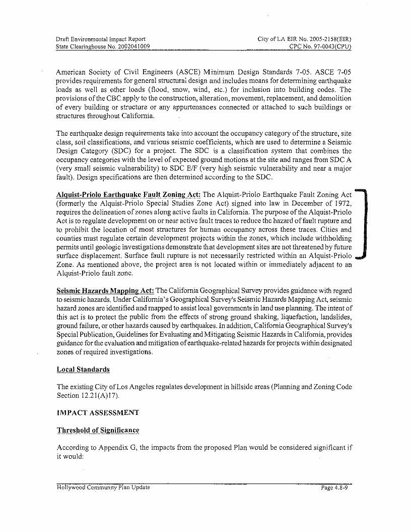
Draft Environmental Impact ReportState Clearinghouse No. 2002041009
City of LA EIR No. 2005-21 58(EIR)CPC No. 97-0043(CPU)
American Society of Civil Engineers (ASCE) Minimum Design Standards 7-05. ASCE 7-05provides requirements for general structural design and includes means for determining earthquakeloads as well as other loads (flood, snow, wind, etc.) for inclusion into building codes. Theprovisions of the CBC apply to the construction, alteration, movement, replacement, and demolitionof every building or structure or any appurtenances connected or attached to such buildings orstructures throughout California.
The earthquake design requirements take into account the occupancy category of the structure, siteclass, soil classifications, and various seismic coefficients, which are used to determine a SeismicDesign Category (SOC) for a project. The SOC is a classification system that combines theoccupancy categories with the level of expected ground motions at the site and ranges from SOC A(very small seismic vulnerability) to SOC ElF (very high seismic vulnerability and near a majorfault). Design specifications are then determined according to the SOc.
Alquist-Priolo Earthquake Fault Zoning Act: The Alquist-Priolo Earthquake Fault Zoning Act(formerly the Alquist-Priolo Special Studies Zone Act) signed into law in December of 1972,requires the delineation of zones along active faults in California. The purpose of the Alquist-PrioloAct is to regulate development on or near active fault traces to reduce the hazard offault rupture andto prohibit the location of most structures for human occupancy across these traces. Cities andcounties must regulate certain development projects within the zones, which include withholdingpermits until geologic investigations demonstrate that development sites are not threatened by futuresurface displacement. Surface fault rupture is not necessarily restricted within an Alquist-PrioloZone. As mentioned above, the project area is not located within or immediately adjacent to anAlquist-Priolo fault zone.
Seismic Hazards Mapping Act: The California Geographical Survey provides guidance with regardto seismic hazards. Under California's Geographical Survey's Seismic Hazards Mapping Act, seismichazard zones are identified and mapped to assist local governments in land use planning. The intent ofthis act is to protect the public from the effects of strong ground shaking, liquefaction, landslides,ground failure, or other hazards caused by earthquakes. In addition, California Geographical Survey'sSpecial Publication, Guidelines for Evaluating and Mitigating Seismic Hazards in California, providesguidance for the evaluation and mitigation of earthquake-related hazards for projects within designatedzones of required investigations.
Local Standards
The existing City of Los Angeles regulates development in hillside areas (Planning and Zoning CodeSection 12.21 (A) 17).
IMPACT ASSESSMENT
Threshold of Significance
According to Appendix G, the impacts from the proposed Plan would be considered significant ifit would:
Hollywood Community Plan Update Page 4.8-9
June 17,2013
Robert P. Silverstein, Esq.The Silverstein Law Firm, APC215 N. Marengo Avenue, 3rd FloorPasadena, CA 91101
SUBJECT: Review and Analysis of Millennium Hollywood Project FaultInvestigation Study Dated November 30, 2012 by Laugan Engineering& Environmental Services
Dear Mr. Silverstein:
INTRODUCTION, QUALIFICATIONS AND REPORT ORGANIZATION
This firm was retained by your office to review the Fault Investigation Report dated November 30,2012 prepared by Langan Engineering & Environmental Services (November Langan Report--(see Exhibit A). We understand from you that the November Langan Report was not included bythe City of Los Angeles as part of the Draft or Final EIR for the Millennium Hollywood Project(Millennium Project), or otherwise distributed to the public, and that it was discovered andobtained by your office on or about June 4, 2013. For this review, we also utilized other availablereports to determine the adequacy of the subject fault investigation described in the NovemberLangan Report. The other reports accessed included: 1) the draft (DEIR) and final (FEIR)environmental impact reports for the Millennium Project; 2) the May 2012 Langan PreliminaryGeotechnical Report for the Millennium Project; 3) the City of Los Angeles Safety Element(1996); 4) two fault investigation reports focused on the property by Crook and Proctor (1992) andDolan and others (1997); and 5) other readily available maps and reports relating to the potentialfor active earthquake faults to exist near, at, and/or on the Millennium Project Site. Items 4references are attached (see Exhibit B).
I have been a licensed Professional Geologist and Certified Engineering Geologist in the State ofCalifornia since 1972. My resume is attached as Exhibit C.
This letter report includes: 1) a brief description of the proposed project as we understand it; 2)brief comments on the DEIR and the FEIR as related to fault rupture, which is a specific issuecalled out in the CEQA Appendix G Guidelines for environmental impact studies; 3) briefcomments on the May 2, 2012 Langan report; and 4) comments on the subject November Langanreport. For item 4, subsections refer to topics/issues from the subject November Langan Report.
MILLENNIUM PROJECT DESCRIPTION
The Millennium Project Site is located in the Hollywood area of the City of Los Angeles,California. The Site lies between Ivar Avenue to the west, Yucca Street to the north, ArgyleAvenue to the east, and the Pantages Theatre and other office or hotel buildings to the south. VineStreet bisects the Project Site into a "West Site" and an "East Site." The Capitol Records Buildingand other historic structures are located on the East Site.
Page 1
HollywoodMillenniumProjectReview and Analysis of Fault InvestigationReportJune 17,2013
The Millennium Project, located on these 4.47 acres, proposes a total of 1,166,970 square feet ofdeveloped floor area and more than 800,000 square feet of underground and above-groundparking. The Millennium Project Applicant indicates that the Concept Plan includes podiumbuildings rising up to 12 stories, a possible hotel tower, and two towers of offices or residentialuse up to 55 stories or 585 feet.
For the East Site, the proposed new construction is to be placed on the southern portion of theproperty down to the southern property line so as to provide a separation distance from the historicCapital Records Building which is located on the northern half of the East Site. The proposed585-foot tower on the East Site would be at or adjacent to the southern property line, and in mostscenarios, facing Vine Street.
For the West Site, the proposed new construction, including a potential 200-room hotel tower,would run from the northwest comer at Ivar Avenue and Yucca Street southeast to the portion ofthe property that faces Vine Street. The proposed 585-foot tower on the West Site would be setback somewhat from Vine Street but rise out of a podium structure up to 12 stories high.
THE DEIR AND FEIR FOR THE MILLENNIUM HOLLYWOOD PROJECT
DEIR: The DEIR contains one paragraph devoted to fault rupture (page IV.D-2). Citations tosupporting information, data, and maps are direct and indirect with the assumption that the May 2,2012 Langan report (May Langan Report) is the primary source. This report is not a faultinvestigation report, but is a preliminary geotechnical engineering study that has this singleparagraph devoted to fault rupture. In the DEIR and the May Langan Report, reliance for the"closest fault" being "0.4 miles from the Project Site" is not specific as to what fault or whatdirection from the Project Site. From the references cited we can determine:
1. The May Langan Report shows only the 1996 City of Los Angeles Safety Element FaultRupture Study Area (FRSA) Map, but shows no actual fault, however suggesting it issouth of the Millennium Project Site within the FRSA;
2. The City of Los Angeles ZIMAS system shows no fault locations and only provides aGIS computed distance to the Hollywood fault, which we determined from the system tobe 0.49 to 0.60 mile depending upon the parcel selected. This suggests (by selectingprogressively more southerly parcels) the fault is programmed into the City's ZIMASsystem as north of the Project Site;
3. A reference to CDMH 2002 (likely intended to be CDMG (2002» is to an outdatedregional fault map with no detailed information on the Hollywood fault location.
4. An unspecified reference to CGS is likely to something called "Active Near-Source FaultZones map" noted in the May Langan Report and in the April 28, 20 II City of LosAngeles Initial Study where the 0.4 miles (0.63 km) may first appear, but the source forthe statement that the fault is 0.4 miles from the Site is unspecified and thus unknown.
Our conclusion from the DEIR paragraph and the May Langan Report is that the City Initial StudyGeology and Soils item a.l (fault rupture) discussion was used nearly intact and considered noother research. In fact, we believe none of the sources fully cited in the DEIR show a faultlocation.
Page 2
HollywoodMillenniumProjectReviewand Analysis of Fault InvestigationReportJune 17,2013
In 2010, the California Geological Survey (CGS) published its 2010 Fault Activity Map ofCalifornia, which became the primary source for determining if a location in California might beunderlain by an active or potentially active fault. In the pamphlet accompanying the map, one candetermine what reports were utilized to make the location determination for each fault. A copy ofthe statewide CGS 2010 Fault Activity Map of California (available online athttp://www.quake.ca.gov/gmaps/FAM/faultactivitymap.html) and relevant excepts from theaccompanying pamphlet are attached as Exhibit D. The Hollywood fault (Fault No. 392) is listedand shows several reports that form the basis for the State's most recent and credible active faultlocation map. This authoritative source was not used for the DEIR or the May Langan Report.
FEIR: The November Langan Report documenting the fault investigation was prepared, based onits date, at least 3 months prior to the publication of the FEIR and discusses the potential forfaulting through the West and East Sites south of Yucca Street and crossing Vine Street. TheFEIR does not mention this November Langan Report or its findings. The November LanganReport is not attached as one of the A through J appendices, and Responses appear to only refer tothe DEIR and the May Langan Report used to prepare the Geology and Soils section for the DEIR(see above). At least two fault rupture related comments (Nos. 24-4 and 45-9) were responded toin the FEIR, but the November Langan Report findings are not mentioned in support of theResponses. In fact, the commenter for Comment No. 45-9 seems to recognize (withoutspecifically citing) the existence of the technical studies and maps (Crook and Proctor, 1992;Dolan and others, 1997) mentioned in the November Langan Report.
"Comment No. 45-9Since there is a major earthquake fault at Yucca and Vine Street, it is a danger to build theseskyscrapers in that vicinity. I believe further study should be done on this. In the event of amajor earthquake, those skyscrapers would create a huge problem. Large numbers of peoplewould rush out of the buildings into the street, creating even more of a challenge for fire andpolice vehicles to get through.
Response to Comment No. 45-9For additional information regarding fault rupture and the potential for a major earthquake tooccur, please refer to Response to Comment 24-4 (Anderson, Robert) above."
It seems inappropriate that the November Langan Report was not available to the public prior to orin conjunction with the DEIR and that the November Langan Report was not referenced in theResponses to Comments No. 24-4 and 45-9 in the FEIR. As discussed for the DEIR, the 2010CGS Fault Activity Map of California also was not used in the FEIR.
THE MAY 2012 PRELIMINARY GEOTECHNICAL STUDY
General Observations: The May and November Langan Engineering geotechnical and faultinvestigation reports do not contain key information available at the time from the 2010 CGS FaultActivity Map of California and its cited references. This is discussed above and in our opinionleads to conclusions in both reports related to the location and character of the Hollywood faultthat are incomplete with regard to the Millennium Project Site. Also noted above, and as youindicated, the November Langan Report was not released to the public or included with the DEIR
Page3
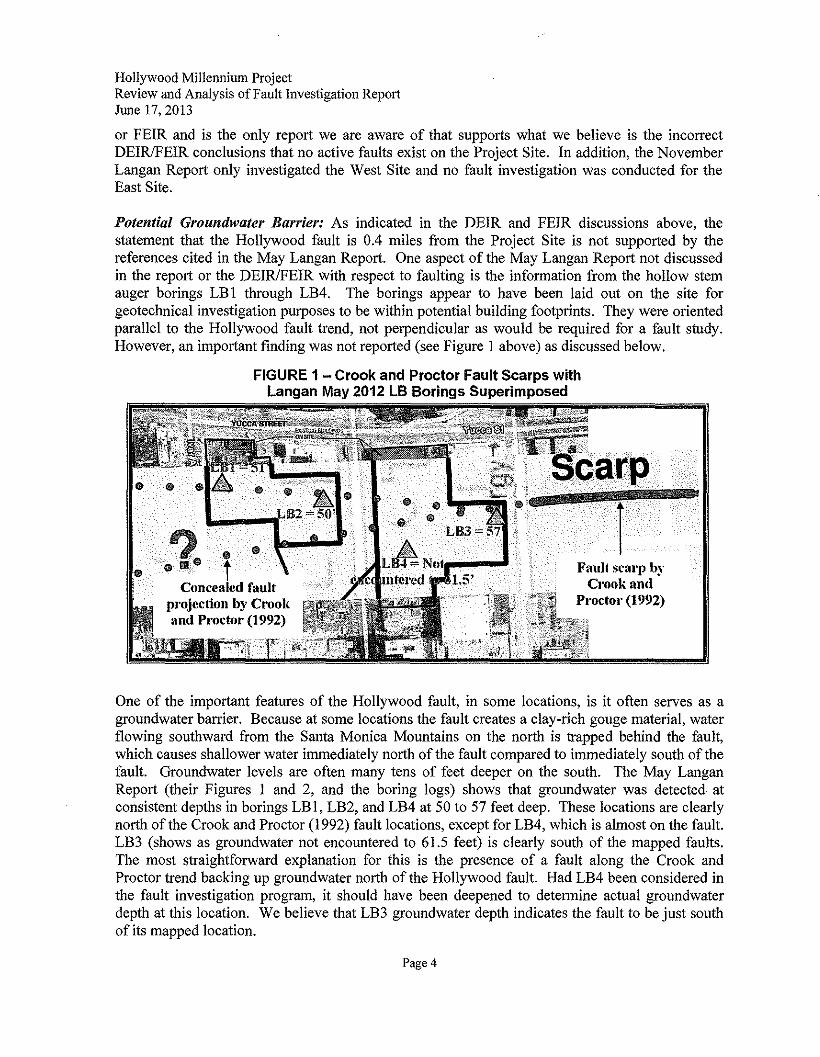
HollywoodMillenniumProjectReviewand Analysis of Fault InvestigationReportJune 17,2013
or FEIR and is the only report we are aware of that supports what we believe is the incorrectDEIRIFEIR conclusions that no active faults exist on the Project Site. In addition, the NovemberLangan Report only investigated the West Site and no fault investigation was conducted for theEast Site.
Potential Groundwater Barrier: As indicated in the DEIR and FEIR discussions above, thestatement that the Hollywood fault is 0.4 miles from the Project Site is not supported by thereferences cited in the May Langan Report. One aspect of the May Langan Report not discussedin the report or the DEIRIFEIR with respect to faulting is the information from the hollow stemauger borings LB I through LB4. The borings appear to have been laid out on the site forgeotechnical investigation purposes to be within potential building footprints. They were orientedparallel to the Hollywood fault trend, not perpendicular as would be required for a fault study.However, an important finding was not reported (see Figure I above) as discussed below.
FIGURE 1 - Crook and Proctor Fault Scarps withLangan May 2012 LB Borings Superimposed
Concealed faultprojection by Crookand Proctor (1992)
Fault scarp byCrook and
Proctor (1992)
One of the important features of the Hollywood fault, in some locations, is it often serves as agroundwater barrier. Because at some locations the fault creates a clay-rich gouge material, waterflowing southward from the Santa Monica Mountains on the north is trapped behind the fault,which causes shallower water immediately north of the fault compared to immediately south of thefault. Groundwater levels are often many tens of feet deeper on the south. The May LanganReport (their Figures I and 2, and the boring logs) shows that groundwater was detected atconsistent depths in borings LB I, LB2, and LB4 at 50 to 57 feet deep. These locations are clearlynorth of the Crook and Proctor (1992) fault locations, except for LB4, which is almost on the fault.LB3 (shows as groundwater not encountered to 61.5 feet) is clearly south of the mapped faults.The most straightforward explanation for this is the presence of a fault along the Crook andProctor trend backing up groundwater north of the Hollywood fault. Had LB4 been considered inthe fault investigation program, it should have been deepened to determine actual groundwaterdepth at this location. We believe that LB3 groundwater depth indicates the fault to be just southof its mapped location.
Page 4
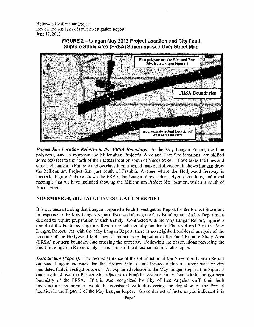
HollywoodMillenniumProjectReviewand Analysis of Fault InvestigationReportJune 17,2013
FIGURE 2 -Langan May 2012 Project Location and City FaultRupture Study Area (FRSA) Superimposed Over Street Map
Blue polygons are the West and EastSites from Langan Figure 4
Project Site Location Relative to the FRSA Boundary: In the May Langan Report, the bluepolygons, used to represent the Millennium Project's West and East Site locations, are shiftedsome 850 feet to the north of their actual location south of Yucca Street. If one takes the lines andstreets of Langan's Figure 4 and overlays it on a scaled map of Hollywood, it shows Langan drewthe Millennium Project Site just south of Franklin Avenue where the Hollywood freeway islocated. Figure 2 above shows the FRSA, the Langan-drawn blue polygon locations, and a redrectangle that we have included showing the Millennium Project Site location, which is south ofYucca Street.
NOVEMBER 30, 2012 FAULT INVESTIGATION REPORT
It is our understanding that Langan prepared a Fault Investigation Report for the Project Site after,in response to the May Langan Report discussed above, the City Building and Safety Departmentdecided to require preparation of such a study. Contrasted with the May Langan Report, Figures 3and 4 of the Fault Investigation Report are substantially similar to Figures 4 and 5 of the MayLangan Report. As with the May Langan Report, there is no neighborhood-level analysis of thelocation of the Hollywood fault lines or an accurate depiction of the Fault Rupture Study Area(FRSA) northern boundary line crossing the property. Following are observations regarding theFault Investigation Report analysis and some of the documentation it relies upon.
Introduction (Page 1): The second sentence of the Introduction of the November Langan Reporton page I again indicates that that Project Site is "not located within a current state or citymandated fault investigation zone". As explained relative to the May Langan Report, this Figure 3once again shows the Project Site adjacent to Franklin Avenue rather than within the northernboundary of the FRSA. If this was recognized by City of Los Angeles staff, their faultinvestigation requirement would be consistent with discovering the depiction of the Projectlocation in the Figure 3 of the May Langan Report. Given this set of facts, as you indicated it is
Page 5
HollywoodMillenniumProjectReview and Analysisof Fault InvestigationReportJune 17,2013
unclear why it is stated that the City's requirement to investigate for on-site faults was basedsolely on Section 1803.5.11 of the Los Angeles Building Code since the Project Site "is locatedwithin 500 feet of the Hollywood fault trace (as mapped by the California Geologic Survey (CGS)and the United States Geological Survey (USGS»." This seems to be inconsistent with thestatement that the Hollywood Fault is 0.4 miles from the Project Site. It is unclear if the Cityrealized that reliable maps show (though not in the Langan Reports) fault traces mapped directlythrough the Project Site. This issue is discussed further in relation to other figures in theNovember Langan Report.
Hollywood Fault (page 4): The discussion of the Hollywood fault begins with Langan againstating that the " ... fault is reportedly located approximately 0.4 miles from the Site", which asdiscussed above is not accurate based on references fully cited. Once again, there is no citation toany authoritative information source that can be independently verified.
Summary of Prior Fault Studies (pages 4-5): In this portion of the November Langan Report,there are brief summaries of prior stndies of the locations and characteristics of the Hollywoodfault. Crook and Proctor (1992) used aerial photograph evidence of scarp features andobservations in borings to project two fault traces directly through the Project Site (Plate I). Acopy of the Crook and Proctor study is attached as part of Exhibit B.
The November Langan Report's description and discussion of the Dolan and others (1997) studyis incomplete. Dolan and others did not perform an aerial photographic review as indicated in theNovember Langan Report (the words "aerial", "photograph", and "photo" do not appear in theDolan report). Their geomorphic study was based on using 1920s topographic maps to map faultscarps (a steeper slope between two flatter areas - the fault is below and in front of the scarp) andthen they field checked the topographic results to confirm a scarp existed. They accounted forpossible grading and ruled that out as a means to form the scarps. There is no statement byLangan that Figure 4 of the Dolan and others 1997 study depicts a fault scarp trace through thenorthern portion of the Project Site. Dolan and others also presented evidence of data to the westwhere there is a groundwater barrier along the trend of the scarps (darker shading in Figure 4 ofDolan and others 1997 study); this is not reported in the November Langan Report. Additionally,the November Langan Report does not mention that the Dolan and others (1997) study confirmedthe 1992 report of Crook and Proctor, in particular that they agreed with the existence of thesouthern Crook and Proctor fault strand, which traverses the center of the Millennium East Siteand the southern edge of the West Site (see Figure 1 above).
Based upon review of the November Langan Report descriptions of the work of Crook and Proctor(1992) and Dolan and others (1997), it appears that significant aspects of those two key studies arenot included or not completely summarized. Crook and Proctor have worked in this portion ofsouthern California for well over 45 years and have numerous peer-reviewed publications andgeologic maps. Dolan is a key technical contributor to the Southern California Earthquake Centerand has numerous papers published in peer-reviewed journals, others dealing with faulting alongthe Santa Monica Mountains. With respect to Crook and Proctor (1992) the November LanganReport states:
Page 6
Hollywood Millennium ProjectReview and Analysis of Fault Investigation ReportJune 17,2013
"One (1) of the Metro Rail boring encountered a rock fragment overlying alluvium, whichthe authors interpreted as Miocene age sedimentary rock overlies alluvium; therebysuggesting two (2) east-west trending branches of the Hollywoodfault could project throughthe Site. Note that their conclusions are based on limited subsurface data and additionalsampling was not performed to confirm if the rock fragment was from a bedrock unit orfrom a boulder within the alluvium. "
In our opinion, this diminishes Crook and Proctor's work, when in fact their report states thatMetro Rail boring 28B encountered 10 feet offault breccia (not a single rock fragment) consistingof brecciated sandstone, alluvium, and siltstone, at 122 feet deep in a hole otherwise consisting ofentirely alluvium to 220 feet deep as shown on their Figure 2b. In other situations we have seen,such a description may well have prompted a program of trenching, geophysics, and properlyplaced bore holes to prove or disprove these observations.
Plate 1 - Hollywood Fault Locales: Plate I depicts two traces of the Hollywood fault, one lyingapproximately 800 feet north of the Project Site (USGS, 2005) and another fault trace is shownsouth of Franklin Avenue within approximately 400 feet of the Project Site attributed to Crook andProctor. The Crook and Proctor report clearly shows in their Figures I and 2a that they map thetwo other fault scarp traces of the Hollywood Fault through the Millennium Project Site, both Eastand West Sites. In this case, once again, Langan's maps confirm that these faults are much closerthan 0.4 miles (2112 feet) from the Millennium Project Site. In fact, they are located on theProject Site.
Plate 1 also depicts existing scarps, bore holes, and other data by Crook and Proctor (1992) thatsupport their suspected location of fault traces through the Project Site. Had this Plate been part ofthe Geology and Soils data analyzed as part of the Draft EIR and reviewed by City staff with theMay Langan Report, in our professional opinion it is likely that a full fault investigation of theentire Project Site would have been required including borings, trenching, geophysical surveys,and other modern techniques to determine whether and where active faults are located on theProject Site.
Plate 2 - Subsurface Profile A-A ': The November Langan Report does not discuss theinterpretation of subsurface profile (cross-section) A-A' in Plate 2, which shows the geologic unitsdefined by analysis of the sonic drilling samples. There is mention of the general parameters ofthe information shown on cross-section A-A', but no detailed interpretation and analysis of whatbedding or structural features are present, and how these may relate to the presence or lack offaulting. The only comment is that there appears to be no offset of the groundwater surface asshown in the sonic borings. This may be significant, but the Hollywood Fault (indeed manyfaults) are not everywhere a perfect barrier to water flow. Also, more reliable water levels wereobtained for the May Langan Report discussed earlier. Therefore, the groundwater surface aloneis not dispositive with regard to fault activity.
Other interesting information is shown in cross-section A-A' but not discussed in the NovemberLangan Report text. There is no discussion of the elevation difference of the base of the youngalluvium (Qya) where it overlies the top of the older alluvium (Qoa). On the north side of thesection, this geologic contact is nearly a perfect straight line through Borings B4, B3, and B6.
Page 7
HollywoodMillenniumProjectReview and Analysis of Fault InvestigationReportJune 17,2013
But, at Borings B2 and B5, the surface suddenly jumps up some 4 to 5 feet, only to then dropdown again about 12 feet at Boring B1. From the level surface defined by B4, B3, and B6 to thesurface at B 1, there is a drop of 8 feet with a high point in between. Since the Hollywood fault hasa movement of up on the north side, this 8 feet of "up-on-the-north" elevation difference must beexplained, and a reverse fault may be the best explanation. The 8 feet, ifit is fault displacement isat the low end of the projections of Dolan and others' observations of roughly 9 to 21 feet.
In addition, in this same geologically questionable area between Borings B2/B5 and B1, there isalmost no correlation of the sedimentary units, to the extent they were fully mapped by Langan.Units in Boring B1 are predominantly CL (a clay-rich material) and the materials in the area ofBorings B21B5 at the same elevations (roughly 320 to 355 feet elevation) are SP, SW, and SM(various types of sand). These two type of materials are laid down in completely differentenvironments (e.g., a lake for clay versus a river for sand) so should not normally be juxtaposedagainst one another. While some other explanation may be suggested, this juxtaposition of unlikedeposits combined with the drop in the base on the Qya immediately above, and the deepergroundwater in LB3 indicates that north-side-up offset on the Hollywood fault a logicalexplanation. The November Langan Report does not recognize or discuss either significantgeologic feature.
CALIFORNIA GEOLOGICAL SURVEY 2010 FAULT ACTIVITY MAP OF CALIFORNIA
As mentioned above, the California Geological Survey published in 2010 its Fault Activity Map ofCalifornia, which has become the primary source for determining if a location in California mightbe underlain by an active or potentially active fault. The Hollywood Fault (Fault No. 392) isshown on the map, but this recent comprehensive source was not used for the DEIR, the MayLangan Report, the November Langan Report, or the FEIR. As shown in Figure 3 below, thisState map shows the Hollywood fault potentially passing through the Hollywood MillenniumProject Site as documented by Crook and Proctor (1992). The description of the orange bandaround the fault classifies it as "Holocene fault displacement during past 11,700 years withouthistoric record." Most consider the presence of this fault on the 2010 CGS Fault Map as evidenceof its existence and active status unless proven otherwise.
CONCLUSIONS
Considering all ofthe foregoing discussion, we conclude that:
1. The fault investigation technical studies supporting the DEIR and FEIR have not adequatelyconsidered all relevant existing data describing possible or probable locations of theHollywood fault at and near the Hollywood Millennium Project Site;
2. For the fault location data cited there are inconsistencies in the stated distance from theHollywood Millennium Project Site to the Hollywood fault, which may have affected studiesrequired by the City;
Page 8
HollywoodMillenniumProjectReview and Analysis of Fault InvestigationReportJune 17,2013
FIGURE 3 - City Street Map Superimposed over 2010 California StateFault Activity Map Showing Hollywood Fault (No. 392)
3. May Langan Report investigations have provided information suggesting a possiblegroundwater barrier south of their borings LBI, LB 2, and LB4;
4. November Langan Report investigations have provided information suggesting a possibleoffset of the young and older alluvium contact and possible fault juxtaposition of unlikegeologic layering between borings B2/B5 and BI;
5. The FEIR does not reference the November Langan Report or the Crook and Proctor (1992)and Dolan and others (1997) studies or the California Geological Survey 2010 Fault ActivityMap of California, which individually and collectively provide sufficient data to suspect activefaulting through the Hollywood Millennium Project Site.
Thank you for the opportunity to participate in this process and to offer the above comments.
Respectfully Submitted,Wilson Geosciences Inc.
Kenneth Wilson, Principal GeologistProfessional Geologist No. 3175Certified Engineering Geologist No. 928
Page 9

EXHIBIT A
FAULT INVESTIGATION REPORT
for the
HOLLYWOOD DEVELOPMENTVESTING TENTATIVE TRACT 71837
1720-1770 N. VINE STREET1745-1753 N. VINE STREET
6236·6334 W. YUCCA STREET1733-1741, N. ARGYLE AVENUE
1746-1764 N. IVAR STREETHOLLYWOOD, CALIFORNIA
Prepared For:
Millennium Partners301 Mission Street, level B1
San Francisco, California 94105
Prepared By:
LA NliA N
Langan Engineering & Environmental Services18662 MacArthur Boulevard, Suite 456
s~~ol'l-:-:A"""LG--~o Irvine, California 926~"2·/S,<vCj i-\\)EN eel>; ~Q .... /
~,~# ~~\%'/ -~/I'.l.g No. 965 ~. (* CERTIFIED~ ENGINEERING ..":7 GEOLOGIST ~
~ r: 0o~Cf>,'\.\«
Dan R Eberhart, PG, CEGAssociateCEG #965
ENGINEERING & ENVIRONMENTAL SERVICES30 November 2012
70019502
J 866;> MacArthur Boulevard, Suite 456 Irvine, CA 926]2 To 949.255.8640 F, 949.255,864] www.langan.com
Fault Investigation ReportHoflywood DevelopmentVesting Tentative Tract 77837Hollywood California
30 November 2012700019502Page iof ii
INTRODUCTION , , , , , , , " ,1SITE LOCATION AND DESCRiPTION , ,..,', ,", , " ,.., ,' 1
West Site , , ,." ,' ,..,..,.., ,,1
East Site,."".""" .."""" .."."""""""",."""." """"""""'''''''''''''''''''''''''''''''''''''''''''''' 2Proposed Development.. , ,' .." ,', .., ,.." ,,2Regional Geology and Groundwater ", , , , , , , 3
LOCAL FAULTS .., ,', , , , , , 3Puente Hills and Elysian Park Thrust Faults ,3Hollywood Fault".", " ,""""""""""", .. ,""""""', ,..,.,"""""""',., ..,"",.,""",. 4
Crook and Proctor ,', , , .. , ", " ..4Dolan et al. , , , , , , ,' .." 5Law/Crandall .."""', ..,"., ,..,," .,"""'" ,., ,.,.,""'" """ ""'" .,"" """" ".," ."" .,' "",,5Geo Pentech """"""""""""""""""""""""""""""""""., ..",.".""""""" .. """"""" 5Lei ghton Consulting, Inc"","""""',.,',.,", .. ,"""',.,',., ,"""""""', ..".,.,.,.,"""',.,.,.,. 5
Stereographic Aerial Photographs " .., , , , ,..5FAULT INVESTIGATION."", .."., ,., ,.." ..""" " ,..,""","""", "." ..,""""',., ,.."., 5FINDINGS""""""".",.,.,."",., ".""""".,"""",.,.".,""""',""', ,., ..,"',.,""",.,., "."",6
Subsurface Conditions , ,' , , , " , ,..,,6Artificial Fill IAlI , , , ,', , , , ,..,,6Young Alluvium 10ya) , " , , , , ,..,'6Old Alluvium 100a) .., , ,", ,', , ,' ,7Groundwater "" ..""",.,' " " ..' ",.,.".,"", ,., "', ..,' "" "'" "" ", ,"" ."", '" , ",.7
Laboratory Testing , ,..", , " , , ,.., " ..'7Uncertainties in SSAMS Dating of Sediment 7Results of SSAMS Dating ,.., " " , , ,', ', , ,,8
DISCUSSION AND EVALUATION " " " " ,, ..8CONCLUSiONS"","""""""",.".,',.,',., ,,.,""",.: ,.,.,"""""""",.,:.,',.,"'""""".",9LIMITATIONS, , " ,., "".",."""""","",.,.,""',.,""",', ,,"',',"""",.,', .., "",,9REFERENCES ,.." .." ,., , " , 10
TABLES1 Summary of Borings2 Apparent Age Results Reported by SSAMS Dating
FIGURES1 Site Location Map2 Historic Groundwater Level Map3 City Fault Rupture Study Zone Map4 Quaternary Fault Map5 Boring & Cross Section Location Map
APPENDICESA Boring LogsB Introduction to Radiocarbon Determinations by AMS MethodC Single-Stage Accelerator Mass Spectrometry Dating Results
LANGAN
Fault Investigation ReportHollywood DevelopmentVesting Tentative Tract 71837Hollvwood California
30 November 2012700019502Page ii of;;
PLATES1 Hollywood Fault Locales2 Subsurface Profile A-A'
LANGAN
Fault Investigation ReponHollywood DevelopmentVesting Tentative Tract 71837Hollywood California
30 November 2012700019502
Page 1 of 15
INTRODUCTION
As requested by Millennium Hollywood, LLC (Millennium) and Sheppard Mullin Richter &Hampton, LLP (Sheppard Mullin), we completed a fault investigation for the proposedMillennium Hollywood Development (Site) in Hollywood, California. The fault investigation wasperformed because although fault investigations have not been traditionally required bvthe Cityof Los Angeles' (City) Department of Building and Safety within or immediately adjacent to theSite and the Site is not located within a current state or city mandated fault investigation zone,the City has required a fault investigation be performed within the Site in accordance withSection 1803.5.11 of the Los Angeles Building Code since it is located within 500 feet of theHollywood fault trace (as mapped by the California Geologic Survey (CGS) and the UnitedStates Geological Survey (USGS).
The purposes of this report are to:
• Summarize our understanding of the current development plans for the Site,
• Provide an overview of available information on active faults in the immediate vicinity ofthe Site, and
• Present the details and results of our fault investigation within the Site.
An active fault, as defined by the CGS and Los Angeles County Department of Public Works isa fault that has ruptured in the most recent 11,000 years (Holocene age). New constructionsintended for human occupancy are prohibited from spanning active faults per the Alquist-PrioloSpecial Study Zones Act of 1972.
Previously, Langan performed a limited geotechnical field investigation within the Site insupport of the project Environmental Impact Report (EIR). The results of the previousinvestigation are presented under a separate cover, "Preliminary Geotechnical EngineeringStudy, Millennium Hollywood Development, Hollywood, California," dated 2 May 2012.
SITE LOCATION AND DESCRIPTION
The Site is located within the Hollywood Community Plan Area in the City of Hollywood. TheSite is bound by Yucca Street in the north, Ivar Avenue in the west, Argyle Avenue in the east,and mixed-use structures in the south. The Site is bisected by Vine Street, which therebycreates two development sub-areas referred to as the West Site and the East Site. Refer toFigure 1 - Site Location Map. The West Site is approximately 78,629 square feet (1.81 acres)and the East Site is approximately 115,866 square feet (2.66 acres), for a combined lot area ofapproximately 194,495 square feet (4.47 acres).
West Site
The West Site is bound by Yucca Street and two (2) mixed-use buildings to the north, IvarAvenue on the west, Vine Street to the east, and two (2) mixed-use buildings to the south. Thetwo (2) buildings bordering the West Site to the north include a two- (2) story art-deco buildingwith retail, office, and residential uses and the five- (5) story Marsha Toy building at thesouthwest corner of Yucca Street and Vine Street. The Marsha Toy building is currently
LA NfiA N
Fault Investigation ReponHo/fywood DevelopmentVesting Tentative Tract 71837Hollvwood California
30 November 20 12700019502
Page 2 of 15
occupied by the American Musical and Dramatic Academy (AMDA). The buildings bordering theWest Site to the south include the two- (2) story Avalon Theater building fronting Vine Street,and a one- (1) story commercial office building fronting Ivar Avenue.
The West Site is presently occupied by an at-grade parking lot and an Enterprise Rent-A-Carfacility. The Enterprise property is located on the southeast corner of Yucca Street and IvarAvenue and consists of a one- (1) story building, a car wash and detailing area under a canopy,and an at-grade parking lot. The remainder of the West Site is an asphalt-paved parking lot,portions of which are (i) operated by Coast Parking, LLC and accessible to the public for a fee,(ii) permit parking for Capitol Records employees, and (iii) reserved parking for Galpin StudioRentals of Hollywood. Elevations within the West Site were inferred from a topographic mapprepared by Hall & Foreman, Inc. to be sloping southeastward from approximately el. 406 feetnear the northwest corner to approximately el. 387 feet near the southeast corner of the WestSite. As much as approximately 10 feet of elevation change occurs at the boundary betweenthe Enterprise site and the remainder of the West Site, south of the Enterprise property; thechange in grade is facilitated by a south-facing slope, between one (1) foot high in the west andthree (3) feet high at the east end and a three (3) to 10 foot high concrete masonry unit (CMU)retaining wall located east of the slope. The height of the CMU wall increases toward the east.
East Site
The East Site is bound by Yucca Street and the former KFWB radio station property to thenorth, Vine Street to the west, Argyle Avenue to the east, and two (2) buildings to the south.The two (2) buildings to the south include the Pantages Theater building at the northwestcorner of Hollywood Boulevard and Argyle Avenue and a one- (1) story restaurant buildingknown as the Lexington Social House fronting Vine Street. .
The East Site is presently occupied by two (2) buildings and an at-grade parking lot. The CapitolRecords building, (1750 North Vine Street), a 13-story building with single story below-gradereverb chambers is located in the northwest portion of the Site and the two- (2) story Gogertyoffice building is located north of the Capitol Records building along Yucca Street. Theremainder of the East Site is an asphalt-paved parking lot accessible to the public for a fee.There are small sheds and a small guard booth associated with the on-site parking operationsand several planting areas on the East Site. Elevations within the East Site were inferred froma topographic map prepared by Hall & Foreman, Inc. to be sloping southward fromapproximately et, 407 feet near the northeast corner to approximately el. 382 and 384 feet nearthe southwest and southeast corners of the East Site, respectively.
Proposed Development
The Project involves the construction and operation of a new mixed-use and transit-orienteddevelopment anchored by the historic Capitol Records Tower building that would transform theseries of under-utilized parcels into a pedestrian-friendly development located on approximately4.47 acres in the Hollywood area of the City of Los Angeles.
According to the Concept Plan project description provided by Millennium a total ofapproximately 1,166,970 square feet of developed floor area will be constructed. The uses willinclude residential, commercial, retail, and hotel. The Project will include the construction of
LAN6AN
Fault Investigation ReportHollywood DevelopmentVesting Tentative Tract 71837Hollvwood California
30 November 20 12700019502
Page 3 of 15
towers placed within the development envelope on the East and West Sites. Towers up to220 feet above ground surface will be located on the northwest portion of the West Site andthe east side of the East Site. Towers up to 585 feet above ground surface will be located onthe eastern half of the West Site and on the west side of the East Site (south of the CapitolRecords building). Up to six (6) levels of excavation are proposed beneath the West and EastSites.
Final structure heights, specific building footprints within the development envelope, finalfoundation loads, and design lifespan will be refined upon final project design and according tothe Project's Development Guidelines and Standards.
Regional Geology and Groundwater
The Site is located in the Central Block of the Los Angeles Basin which is a sedimentary-filledbasin in the Peninsular Range geomorphic province. The Central block is bordered by the SantaMonica Mountains to the north, Beverly Hills to the west, the Elysian Hills to the east, andBaldwin Hills and the Central Plain to the south.
Based on the USGS Map of the Los Angeles Quadrangle (2005) and the Dibblee FoundationMap of the Hollywood Quadrangle (1991), the Site is underlain by alluvial fan depositsconsisting of Holocene and late Pleistocene age gravel, sand and silt deposited mainly fromflooding streams and debris flows. These alluvial fan deposits are reportedly underlain by olderlate to middle Pleistocene age alluvial fan deposits which generally consist of silt, sand andgravel deposits. Miocene age Monterey Formation sandstone and shale reportedly underlie thelate Pleistocene age deposits at an unknown depth. The CGS's Geologic Compilation ofQuaternary Surficial Deposits in Southern California, Los Angeles 30' x 60' Quadrangle (2010)map reports the Site is underlain by old alluvial fan deposits (Qof) consisting of late to middlePleistocene moderately dissected boulder, cobble, gravel, sand and silt underlain by tertiaryage sandstone, siltstone, mudstone, shale, and siliceous and calcareous sediments.
Based on the CGS's Historically Highest Groundwater Contours and Borehole Log DataLocations, Hollywood Quadrangle map, dated 1998, the depth to groundwater within the Siteand immediate vicinity is greater than 80 feet below the ground surface and displays a regionaltrend of increasing depth northward toward the Santa Monica Mountains. Refer to Figure 2 -Historic Groundwater Level Map to observe the reported groundwater trend and approximateSite location.
LOCAL FAULTS
A portion of the Site is located adjacent to the northern boundary of a Fault Rupture Study Areadefined in the Safety Element of the City's General Plan (1996). Refer to Figure 3 - City FaultRupture Study Zone Map. The Site is also located in close proximity to the Puente Hills andElysian Park thrust faults and the Hollywood fault. Figure 4 - Quaternary Fault Map shows thelocation of the Site in relation to active faults in southern California.
Puente Hills and Elysian Park Thrust Faults
Data published by the CGS (formerly CDMG) in 2002 indicates the Puente Hills and the ElysianPark blind thrust faults are present more than 1 mile beneath the Site. Blind thrust faults are
LA N6A N
Fault Investigation ReportHoffywood DevelopmentVesting Tentative Tract 71837Holtvwood California
30 November 20 12700019502
Page 4 of 75
shallow-dipping (less than 45 degrees) reverse faults that terminate before they reach theground surface. Since Puente Hills and Elysian Park Thrust faults do not extend to the surface,surface rupture from these faults within the Site is considered to be unlikely.
Hollywood Fault.' The CGS's Active Near-Source Fault zone map and the City's ZIMAS system indicate the Santa
Monica/Hollywood fault is the closest fault to the Site with the potential for fault rupture; thefault is reportedly located approximately 0.4 miles from the Site. The CGS reports this fault is asinistral (left-lateral) strike-slip fault with a reverse oblique component of movement and a dipangle of 70 degrees to the north.
The USGS reports the Hollywood fault is an active, sinistral-reverse oblique fault that is anintegral part of the east-west frontal fault system (EWFFZ). The fault is reportedly 14kilometers in length with an average strike of North 76 degrees East (N76E). The dip angle ofthe fault varies between 25 and 90 degrees to the north.
Additional characteristic subsurface features of the Hollywood fault include:
• The fault acts as a groundwater barrier, producing higher groundwater levels north ofthe fault than south of the fault and
• The fault juxtaposes Tertiary-age bedrock or Pleistocene-age older alluvial depositsagainst Holocene-age alluvial deposits of the Los Angeles Basin.
The Hollywood fault is typically reported to be located at the base of the Santa MonicaMountains, south of Franklin Avenue and north of Yucca Street in the vicinity of the Site;however one (1) study indicates that the fault could be located south of Yucca Street. A briefsummary of prior publications that discuss the Hollywood fault within the Site and vicinity arepresented in the following paragraphs. Refer to the References for additional documents thatwere reviewed as part of our investigation.
Crook and ProctorCrook and Proctor (1992) discuss the location and seismic activity of the Hollywood fault asdetermined by several scarps and observations of two (2) trenches, four (4) borings, and two (2)building excavations at the base of the Santa Monica Mountains in the cities of Los Angelesand Hollywood. The subsurface investigations referenced by Crook and Proctor occurredbetween 1981 and 1992. The only data south of Yucca Street is from four (4) borings(identified as 28, 28-2, 28A, and 28B) drilled on Cahuenga Boulevard, north of HollywoodBoulevard for the Los Angeles Metro Rail subway alignment in 1981 through 1983. One (1) ofthe Metro Rail borings encountered a rock fragment overlying alluvium, which the authorsinterpreted as Miocene age sedimentary rock overlies alluvium; thereby suggesting two (2)east-west trending branches of the Hollywood fault could project through the Site. Note thattheir conclusions are based on limited subsurface data and additional sampling was notperformed to confirm if the rock fragment was from a bedrock unit or from a boulder within thealluvium.
Beyond the limits of the Site, the authors concluded the Hollywood fault trends northeasterly atthe base of the Santa Monica Mountains, between Beverly Hills and the Los Angeles River.
LANGAN
Fault Investigation ReportHollywood DevelopmentVesting Tentative Tract 71837Hol/vwood California
30 November 20 12700019502
Page 5 of 15
Evidence of the Hollywood fault was not proven to exist between the western limit of the cityof Beverly Hills and the Pacific Ocean, Refer to Plate 1 - Hollywood Fault Locales forapproximate locations of these reported fault scarps in the vicinity of the Site,
Dolan et al.Dolan et al. (1997) performed an aerial photograph review and concluded that two possible faultscarps were present east and west of the Site. Due to the potential fault scarps, they inferredthat buried traces of the Hollywood fault could traverse the Site, Their conclusions are basedon geomorphic data available at the time and did not include a subsurface investigation toconfirm if buried fault traces were present.
Law/CrandallLaw/Crandall performed a fault investigation on the property located at 1840 North HighlandAvenue in 2000, This property is located approximately Y, mile northwest of the Site, Basedon this investigation, they identified four (4) active fault strands attributed to the Hollywoodfault were located in the northern portion of the property, Active faulting was not detected inthe southern portion of this property,
GeoPentechGeoPentech performed an investigation in 2001 to refine the location of two (2) of thepreviously identified active faults within the northern portion of the property located at 1840North Highland Avenue, This consultant further investigated the northern portion of thisproperty in 2004 and identified two (2) other fault strands traverse the northern portion of theproperty,
Leighton Consulting, Inc,Leighton Consulting performed a fault investigation at 1805 Highland Avenue in 2011, Basedon this investigation, they identified four (4) east-west trending secondary strands attributed theHollywood fault system, The fault strands were determined to be consistent with the mappedlocation of the Hollywood fault and its general trend in the region, however the consultantcommented that additional investigation would be required to precisely locate the significantactive secondary faults within the site,
Stereographic Aerial Photographs
We reviewed various stereoqraphic aerial photographs depicting the Site, taken between 1952and 1998, Evidence of discernable faulting was not observed within the Site in thephotographs, Our interpretation of the photographs suggests the Hollywood fault trendsgenerally east-west and is located beyond the northern limit of the Site,
FAULT INVESTIGATION
As agreed upon with the City on 2 July 2012, we performed a fault investigation using sonicborings within the West Site to investigate for active faulting and limited our investioation tothe West Site, A total of six (6) sonic borings, four (4) battered sonic borings (B1 though B4)and two (2) vertical sonic borings (B5 and B6) were performed at the Site as part of our faultinvestigation, Refer to Figure 5 - Boring and Cross Section Location Map for approximateboring locations, The battered borings were drilled at angles between approximately 30 and 32
LANGAN
Fault Investigation ReponHollywood DevelopmentVesting Tentative Tract 71837Hoflvwood California
30 November 20 12700079502
Page 6 of 15
degrees from vertical toward the south by Cascade Drilling between 16 July and 21 July 2012and the vertical sonic borings were drilled by BC2 Drilling on 11 October 2012. Each boringwas drilled under the full-time observation of a Langan Geologist to depths betweenapproximately 50 and 98.6 feet below existing grade. Refer to Table 1 - Summary of SonicBorings for an overview of the boring details. Prior to drilling, Underground Service Alert ofSouthern California (DigAlert) was contacted and the boring locations were checked for thepresence of subsurface utilities by Pacific Coast Locators.
Sampling was performed continuously using high frequency resonant energy to advance adouble-cased system. Groundwater levels were measured in each boring at completion ofdrilling. Each borehole was backfilled with cement grout using the tremie method and cappedwith rapid set concrete upon completion. The soil cuttings were containerized in 55-gallondrums that were stored on site until the material was characterized as non-hazardous wasteand subsequently disposed of at an appropriate facility
Following completion of the fieldwork, the core samples were transported to a storage facilitywhere a Certified Engineering Geologist examined each core using hand lenses and a MunsellSoil Color Chart. The materials were classified using the Unified Soil Classification System(USCS). Refer to Appendix A for the sonic boring logs.
FINDINGS
Subsurface Conditions
The sonic core data indicates the subsurface soils consist of a fill stratum overlying youngalluvium (Oya) (less than 11,000 years in age) over old alluvium (Ooa) (greater than 11,000 yearsin age). Our interpretation of the subsurface material and groundwater conditions observed inthe sonic borings is summarized in the following paragraphs. Refer to Plate 2 - SubsurfaceProfile A-A' for a profile of the subsurface conditions developed from the sonic borings.
Artificial Fill (Af)A surficial layer of asphalt pavement ranging in thickness from approximately two (2) to three(3) inches was encountered in each sonic boring. An approximately five (5) to eight and a half(8Yz) foot thick fill stratum (All was encountered below the asphalt pavement. The fill primarilyconsisted of very loose to loose, brown, silty very fine to medium grained sand with a lesseramount of soft to medium stiff sandy silt. Fragments of asphalt and concrete were scatteredthroughout the fill. Low sample recoveries (between a to 50 percent) were retrieved within thefill stratum likely due to the loose nature of the material.
.Young Alluvium (Oya)Young alluvial fan deposits (Ova) were encountered below the fill material to depths betweenapproximately 17Y, and 34 feet below existing grade. This unit was the youngest natural unitencountered during our investigation and consisted primarily of loose to medium dense,medium brown to orange brown, silty very fine to fine grained sand-with kisser amounts of siltymedium to coarse grained sand. Scattered clayey sands, silts, and poorly and well gradedsands were interbedded within the silty sands. Low sample recoveries (less than 50 percent)were retrieved within the upper loose materials. Contacts within the strata of unit Oya weregenerally gradational. The contact between Oya and underlying Ooa was an erosionalunconformity.
LA 1\16A 1\1
Fault Investigation ReportHollywood DevelopmentVesting Tentative Tract 71837Hollvwood California
30 November 20 12700079502
Page 7 of 15
Old Alluvium (Ooa)Older alluvial fan deposits (Ooa) were encountered below Oya to the maximum depth exploredduring this investigation. Overall, Ooa displayed an overall trend of fining particle size fromnorth to south; coarse grained materials (gravels and sands) were encountered in the northernportion of the Site grading to finer size particles (silts and clays) southward, away from thematerial source, the Santa Monica Mountains. Contacts within the strata of unit Ooa wereprimarily gradational.
GroundwaterGroundwater was measured upon completion of each boring at depths ranging fromapproximately 43 feet (B1) to 54Y, feet (B4) below existing grade. The measured depths show atrend of increasing depth to groundwater northward within the Site and are approximately 35 to47 feet higher than the historically highest groundwater levels.
Laboratory TestingBETA Analytical Inc performed radiocarbon dating using Single-Stage Accelerator MassSpectrometry (SSAMS) technology on 22 soil samples selected from the cores, to age date thesubsurface units within the Site. SSAMS measures the ratio of carbon 14 ('4C) and carbon13/12 1'3I12C) isotopes in samples. Information on SSAMS dating technology is provided inAppendix B. Separable macrofossils (charcoal, plant, shell, etc) were not found in any of thecore samples, therefore sediment was age dated. The results of the SSAMS dating aresummarized in Table 2 - Results of Radiocarbon Dating and full details are provided in AppendixC.
Uncertainties in SSAMS Dating of SedimentThe following uncertainties were considered when the age date results were reviewed:
• The sample size required for SSAMS dating is significantly small relative to the size ofthe subsurface that underlies the Site and the surrounding geographic region; thereforethe relationship between the sample size, test results, and the nature of the region'sgeologic environment from which the sample was collected were considered when theSSAMS test results were applied to specific portions of the subsurface of the Site.
• The carbon content of sediment fluctuates as carbon is transported through thesubsurface profile by various processes including, not limited to the following:
o Reworking, incorporation, and redeposition of older sediment into youngersediment and
o Transportation of humic acids through sediments by fluctuations in groundwaterand percolation of surface water through the subsurface profile, which canintroduce carbon of varying ages into the sedimentary units.
• As acids migrate to increasing depths in the subsurface profile, apparent ages of theaffected sediment generally report younger ages. This is common of sediments thatare not well drained, organic-rich, and/or where water ponds in sediment.
LA 1\J6A I\J
Fault Investigation ReportHollywood DevelopmentVesting Tentative Tract 71837Hol1vwood California
30 November 2012700079502
Page 8 of 15
• Climate and biotic and physical/chemical factors affect the rate at which carbon cyclesthrough sediment.
• Sediments that are very low in carbon content at the time of their deposition aregenerally susceptible to humic acid contamination.
Results of SSAMS Dating
As shown on Table 2, the general trend of the age dated samples indicates increasing sedimentage with increasing depth in the sonic borings. In general, the apparent ages reported forsamples collected within the shallow alluvium confirm this unit is less than 11,000 years in age;confirming recent alluvium extends to between 17Yz and 34 feet below ground surface withinthe Site. Apparent ages of the deeper alluvium determined the material is greater than 11,000years in age and therefore older than recent age. Based on these apparent ages, youngalluvium overlies old alluvium within the Site. The following anomalies were identified in thesample results:
• Boring B2: An inconsistent apparent date (older material over younger material) wasreported at approximately 20 feet below ground surface in boring B2. The soils at thisdepth were further explored with two (2) additional sonic borings, B5 and B6, cored inthe immediate vicinity of sonic boring B2. Apparent age results from borings B5 and B6samples confirmed the sample results at 20 feet from boring B2 were notrepresentative of the overall stratigraphic environment. The anomalous ages fromboring B2 were likely due to sample contamination from portions of the fill stratumfalling into the core from shallower depths during coring.
• Boring B5: Groundwater was encountered in boring B5 at approximately 46.5 feetbelow ground surface and the groundwater bearing sediment was selected forlaboratory analysis to determine the effect of groundwater on age dated sediment. Theyoung apparent age reported for this sample with respect to apparent ages of overlyingsamples, is attributed to the presence of acid(s) that was transported by groundwater tothe sediment and lingered in the sample after pretreatment. The age of the analyzedsediment is understood to be older than the apparent age.
• Boring B6: The reported apparent age of the sample from approximately 22 feet belowground surface was likely complicated by fluctuations in carbon content of sediments ascarbon cycles through the subsurface profile during reworking, incorporation, andredeposition of older sediment into younger sediment.
DISCUSSION AND EVALUATIONThe thin fill horizon present across the surface of the West Site was not considered significantin this evaluation of recent faulting within the Site, therefore only the alluvial units encounteredbelow the fill stratum were examined in depth. Characteristics of alluvial fan environments,regional geologic findings by others, the regional groundwater trend, and apparent agesreported by single-stage radiocarbon dating technology were employed during this evaluation ofthe subsurface conditions within the Site. Our findings are as follows:
LANGAN
Fault Investigation ReportHoffywood DevelopmentVesting Tentative Tract 71837Hollvwood California
30 November 2012700079502
Page90f15
1. The Site is located on a broad alluvial plain at the base of the Santa Monica Mountains.The underlying alluvium was transported from the Santa Monica Mountains anddeposited within the Site by gravity and water. As such, the underlying stratigraphicunits slope gently away from the mountains and exhibit a trend in fining particle sizefrom north to south, consistent with the character of an alluvial depositionalenvironment at the base of a mountain range. Visual evidence of faulting and/orshearinq was not observed in the samples recovered as part of our investigation,therefore changes in alluvial thickness and locale across the Site were attributed toirregularities associated with the alluvial depositional environment and related erosionand not faulting.
2. Geologic publications have been issued by others regarding the location and seismicactivity of the Hollywood fault; however urbanization of Hollywood and neighboringcities at the base of the Santa Monica Mountains has obscured the fault trace at thesurface. Urbanization of the area has also limited the locations where subsurfaceexplorations can be performed to delineate the fault. Literature by Dolan et al. indicatestraces of the Hollywood fault are suspected to be located in the vicinity of the Site;however, the specific location of the fault traces are not well defined and a subsurfaceinvestigation was not performed within the Site, prior to this investigation to explore thepossible fault traces. The only published studies involving field documented evidence ofactive faults are for sites north of Franklin Street.
3. The regional trend in historical high groundwater indicates the depth to groundwaterincreases northward toward the Santa Monica Mountains, of which was observedwithin the Site. Evidence of a groundwater barrierts) between borings was notobserved within the Site. As such, groundwater within the Site corresponds with theregional trend for groundwater without any interruption attributed to faulting.
4. Detailed 'Inspection of the continuous cores indicate young alluvium consistentlyoverlies older alluvium and revealed no visual evidence of shearing that would beassociated with faulting. Radiocarbon dating confirmed that sediments increase in agewith depth.
CONCLUSIONSBased on the results of our investigation, we have concluded that active faulting is not presentwithin the limits of our investigation within the Site as shown on Figure 5.
LIMITATIONS
The findings and conclusions provided in this report are our best judgment, to a reasonabledegree of certainty and are based on subsurface conditions inferred from a limited number ofborings as well as project information provided by Millennium Partners to date. This report hasbeen prepared for use by Millennium Partners and their project team in their determination ofthe feasibility of the proposed development. The information in this report cannot be utilized orrelied upon for adjacent properties which are beyond the limits of that which is the specificsubject of this report.
LANGAN
Fault Investigation ReportHoflvwood DevelopmentVesting Tentative Tract 71837Hoflvwood California
30 November 2012700019502
Page 100i15
REFERENCES
Stereographic Aerial PhotographsDate
11-04-195210-27-195403-04-196901-30-197011-07-197605-12-197907-07-198807-07-198805-25-199005-13-199307-11-199510-18-1998
Source: Continental Aerial Photo, Inc
Index/Photo No.AXJ-4K-160 & -161AXJ-20K-46 & -47
25-16-8760-4-118&-119
76162 200 & 2015-164
19265 & 1926619290 & 19291C81 9-45 & 9-46
C89-21-218 &-219C115-26-34 & -35C128-26-14 & -15
Scale1":1,666'1":1 ,666'1":2,500'1":4,000'1":2,000'1":2,800'1":2,166'1" :2,166'1":2,800'1" :2,000'1":2,000'1" :2,000'
Reports1. Bryant, W. A. (compiler) (2005)' "Digital Database of Quaternary and Younger Faults from
the Fault Activity Map of California, version 2.0," California Geological Survey Web Page,http://www.consrv.ca.gov/CGS/information/publications/QuaternaryFaults_ver2.htm.accessed 25 October 2012.
2. California Building Standards Commission (2010), "2010 California Building Code (CBC),"Sacramento, California.
3. California Department of Conservation, Division of Mines and Geology (1986) "SpecialStudies Zones Map of the Hollywood Quadrangle."
4. California Department of Conservation, Division of Mines and Geology (Revised 1997,supplements 1 and 2 added 1999), "Fault Rupture Hazard Zones in California, Alquist-PrioloSpecial Study Zones Act of 1972, Special Publication 42."
5. California Department of Conservation, Division of Mines and Geology (1998)' "SeismicHazard Evaluation of the Hollywood 7.5-Minute Quadrangle, Los Angeles County,California," Open-File Report 98' 17.
6. California Department of Conservation, Division of Mines and Geology (1998), "SeismicHazard Evaluation of the Hollywood 7.5-Minute Quadrangle, Los Angeles County,California," Seismic Hazard Report 026.
7. California Geological Survey (2002), "California Fault Parameters Map."
8. California Geologic Survey (2002), "Guidelines for Evaluating the Hazard of Surface FaultRupture," Note 49.
LANGAN
Fault Investigation ReportHollywood DevelopmentVesting Tentative Tract 77837Hollywood Cafifornia
30 November 20 12700079502
Page 71 of 15
9. California Geological Survey (2008), "Guidelines for Evaluating and Mitigating SeismicHazards in California," Special Publication 117A.
10. California Geological Survey (2010)' "Geologic Compilation of Quaternary Surficial Depositsin Southern California," Special Report 217.
11. City of Los Angeles Department of City Planninc (2009), "Recommendation Report, 1800 to1802 North Argyle Avenue & 6217,6221-6223 West Yucca Street."
12. City of Los Angeles (2005), "Geology Report Approval Letter, Log # 45839, Soils/GeologyFile - 2, 1840 Highland Avenue."
13. Law/Crandall (2000), "Report of Fault Rupture Hazard Investigation, 1840 North HighlandAvenue, Hollywood District, Los Angeles, California."
14. City of Los Angeles Inter-Departmental Correspondence (2012) "Geology and Soils ReportCorrection Letter, Vesting Tentative Tact 71837, Log # 77007, Soils/Geology File - 2, 1720-1770 N. Vine Street, 1745-1753 N. Vine Street, 6236-6334 W. Yucca Street, 1733-1741 N.Argyle Avenue, and 1746-1764 N. Ivan Street."
15. City of Los Angeles Zoning Information and Map Access System website, available athttp://zimas.lacity.org/map.asp.
16. Crook, R. and R.J. Proctor (1992), "The Santa Monica and Hollywood Faults and theSouthern California Boundary of the Transverse Ranges Province," in Engineering GeologyPractice of Southern California.
17. Cooke, Michele L. and Marshal, Scott T (2006), "Fault slip rates from three-dimensionalmodels of the Los Angeles Metropolitan area, California," Geophysical Research Letters,Vol. 33.
18. Department of City Planning, Los Angeles, California (1996), "Safety Element of the City ofLos Angeles General Plan."
19. Dibblee, Jr., Thomas W. (1991), "Geologic Map of the Hollywood and Burbank (south Yz)Quadrangles, Los Angeles County, California," Dibblee Geological Formation Map #DF-30.
20. Dolan et ai, (1997), "Active Tectonics, Paleoseismology, and Seismic Hazards of theHollywood Fault, Northern Los Angeles Basin, California," GSA Bulletin, v. 109, no. 12, 9.1595-1616.
21. Dolan et al. (2000)' "Paleoseismologic Evidence for an Early to Mid-Holocene Age of theMost Recent Surface Rupture on the Hollywood Fault, Los Angeles, California," Bulletin ofthe Seismological Society of America, 90, 2, pp. 334-344.
22. Fang, Hsai-Yang (19911."Foundation Engineering Handbook," Second Edition.
LAN6AN
Fault Investigation ReponHollvwood DevelopmentVesting Tentative Tract 71837Hollvwood California
30 November 20 12700079502
Page 120f15
23. GeoPentech (2001), "Potential Fault Surface Rupture Hazard and Proposed Development at1840 Highland Site, Hollywood, California."
24. GeoPentech (2004), "Addendum No.3 to January 24, 2001 Report: Potential Fault SurfaceRupture Hazardand Proposed Development at 1840 Highland Site, Hollywood, California."
25. GeoPentech (2005), "Addendum No.4 to January 24, 2001 Report: Potential Fault SurfaceRupture Hazard and Proposed Development at 1840 Highland Site, Hollywood, California."
26. Group Delta Consultants (2006), "Preliminary Geotechnical Report, Proposed High RiseResidential Development, 6230 Yucca Street, Hollywood, California."
27. Langan Engineering and Environmental Services (2012), "Preliminary GeotechnicalEngineering Study, Millennium Hollywood Development, Hollywood, California."
28. Law (2000), "Report of Fault Rupture Hazard Investigation, 1840 North Highland Avenue,Hollywood District, Los Angeles, California."
29. Leighton Consulting. Inc. (2011), "Fault Rupture Hazard Evaluation, Proposed Mixed UseDevelopment, 1805 Highland Avenue, Los Angeles, California."
30. Los Angeles Building Code (2011).
31. Los Angeles County Department of Public Works (2010)' Manual for Preparation ofGeotechnical Reports.
32. Millennium Hollywood Project (2011)' draft "Development Regulations: Guidelines andStandards. "
33. Millennium Hollywood Towers (2008), Overall Plot Plan, Drawing Number A101.
34. Naval Facilities Engineering Command (2011), Soils Mechanics, Foundations, and EarthStructures, NAVFAC DM-7.
35. Pratt et ai, (2002), "Shallow seismic imaging of folds above the Puente Hills blind-thrustfault, Los Angeles, California" Geophysical Research Letters, Vol. 29, No 9.
36. SCEC Working Group C (20011. "Active Faults in the Los Angeles Metropolitan Region",SCEC Special Pub. Series, No. 001, Southern California Earthquake Center.
37. Tokimatsu K. and Seed, H.B. (1987) "Evaluation of Settlements in Sands Due to EarthquakeShaking," Journal of Geotechnical Engineering Division, ASCE, Vol. 113, No.8.
38. Treiman, J. Jerome (compiler) (2000), "Fault number 102;Hollywood fault,in Quaternaryfault and fold database of the United States," TJ.s. Geological Survey website,http://earthquakes.usgs.gov/regional/qfaults, accessed 25 October 2012.
LANEiAN
Fault Investigation ReportHof/ywood DevelopmentVesting Tentative Tract 71837HoJlywood California
30 November 20 12700019502
Page 130f15
39. Yerkes, R.F and Campbell, R.H. (2005) "Preliminary Geologic Map of theQuadrangle, Southern California," USGS Open-File Report 2005-1019.
Los Angeles
Personal Communications
1. Personal Communication with Dana Prevost and Jeffrey Wilson, 2 July 2012.
2. Personal Communication with Dana Prevost and Jeffrey Wilson, 8 November 2012.
DRE DMF RR:dre sam
lVangan.com\dataIIR\dataS\700019502\Office Dara\Aeports\GeotechnicaIlFault Investigation Report\700019502 Fault Investigation Report.doc
LA N6A N

Fault Investigation ReportHollywood DevelopmentVesting Tentative Tract 71837Hollvwood California
30 November 2012700019502
TABLES
LANnAN
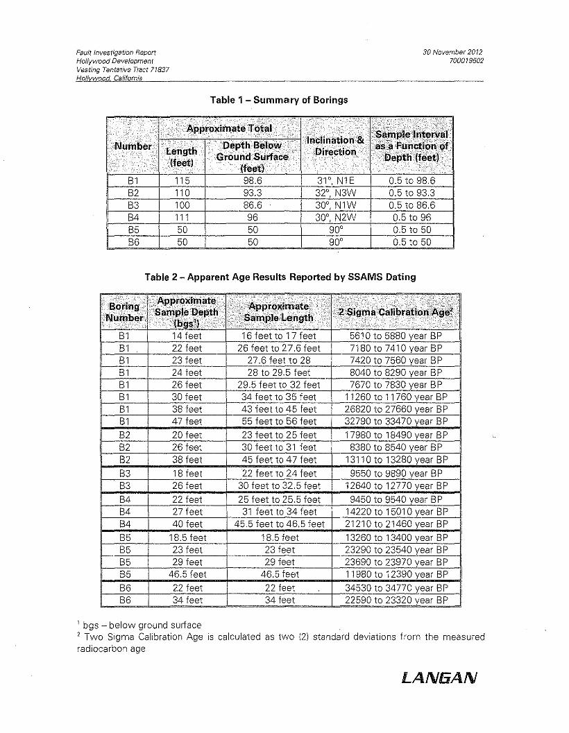
Fault Investigation ReportHollywood DevelopmentVesting Tentative Tract 71837Hollywood California
30 November 20 12700079502
Table 1 - Summary of Borings
50
32°, N3W 0,5 to 93,3B1 115 98,6 31°,N1E 0,5 to 98,6
B5 90°
0,5 to 86,6
0,5 to 50
B2100
50
86,6 30°, N1W110 93,3
B3B4 111 96 30°, N2W 0,5 to 96
B6 50 50 90° 0,5 to 50
Table 2 - Apparent Age Results Reported by SSAMS Dating
ii,;" ,e le'.Shgei:n;';'/;!0tz!iY!;0 :t'[~.liC ,i' c', iC:'L1i,,L i",,:' c:i.'.'",,'" 'eu!!!itd~,,! 'f.eei,i.)!. ,.i.',;f .... ~;7·' '·...,;/0;[1;")-')7".,
Bl 14 feet 16 feet to 17 feet 5610 to 5880 year BPBl 22 feet 26 feet to 27,6 feet 7180 to 7410 year BPBl 23 feet 27,6 feet to 28 7420 to 7560 year BPBl 24 feet 28 to 29,5 feet 8040 to 8290 year BPBl 26 feet 29,5 feet to 32 feet 7670 to 7830 year BPBl 30 feet 34 feet to 35 feet 11260 to 11760 year BPBl 38 feet 43 feet to 45 feet 26820 to 27660 year BPBl 47 feet 55 feet to 56 feet 32790 to 33470 year BP
B2 20 feet 23 feet to 25 feet 17980 to 18490 year BPB2 26 feet 30 feet to 31 feet 8380 to 8540 year BPB2 38 feet 45 feet to 47 feet 13110 to 13280 year BP
B3 18 feet 22 feet to 24 feet 9550 to 9890 year BPB3 26 feet 30 feet to 32,5 feet 12640 to 12770 year BP
B4 22 feet 25 feet to 25,5 feet 9450 to 9540 year BPB4 27 feet 31 feet to 34 feet 14220 to 15010 year BPB4 40 feet 45,5 feet to 46,5 feet 21210 to 21460 year BP
B5 18,5 feet 18,5 feet 13260 to 13400 year BPB5 23 feet 23 feet 23290 to 23540 year BPB5 29 feet 29 feet 23690 to 23970 year BPB5 46,5 feet 46,5 feet 11980 to 12390 year BP
B6 22 feet 22 feet 34530 to 34770 year BPB6 34 feet 34 feet 22590 to 23320 year BP
1 bgs - below ground surface2 Two Sigma Calibration Age is calculated as two (21 standard deviations from the measuredradiocarbon age
LANGAN
Fault Investigation ReportHollywood DevelopmentVesting Tentative Tract 71837Hollvwood California
30 November 2012700019502
FIGURES
LA N5A N
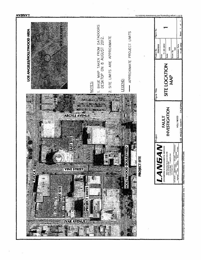
·::11,11sa::l!lUas 1!ljI,lIlI,l)I,IW!/I1,I3 pue 6u",l:lal,l!6U3 l,Ie61,1~1 ~ Wr.:@
(f) "0:: ....a ,
za (f) , ii0 f- " ~<{ . w ::;; "f-N f- ::;<{- <{o~ ::;; f- g N .sX U 5 0
::;;f-- • N ~ ~Qa w ,alf) ..., £8 g z >~ ••o::=> 0:: a -R ~ m .10..u..l!> 0.. 0:: .~ ;; j J E
=> <{ 0.. £ Q ~Z«w w W0<:00 f-0:: <{ Z-c <{f-Z ::;; 00..
0 (f) Xf- a
~Q.<{tL ::;; a::::;;0 ::; 0..f-- 0 0.. 9~w;::: <{Vi (f)lf) w z
w <{w f- Wf- (DO [ij o wa w ~Z N -' ;= l-
• i.i)5e
<z'"0Z ~
0 iIoI-~ c
0...JO § ,~::l_ z
~t;:;~~" 8xw '"> ::;
wZ o;; z.e, <e ga
o
il~~~
t"i~
J/
L. -J!
ENGINEERING e. ENVIRONMENTAL SERVICES FAULT RUPTUREINVESTIGATION
Project No.700019502
2
Notes:1. Base Map reproduced from "Historically Highest Groundwater Contours and Borehole Log Data Locations,
Hollywood Quadrangle" from Seismic HazardZone Report 026, by State of California Department ofConservation Division of Mines and Geology, dated 1998.
2. Contour lines indicate depth to groundwater in feet.
16002 MocAnt1u.-1I",,:.,.,d. S"IIO 456INioo. CA 92612·1~OOP: 949.25S.I.I6~O f,949.255.6&l1www.lMg"O.com
HISTORICGROUNDWATER
LEVELMAP
Dote11-30-2012
LAN6ANProject Figure TItle
N1S
NOW""Rs~' p.llUgnVAAIA MtI'IVOR>< COI<NE'Cl'="'ORIE}./, W~<l'N'A e......m:./<tllA
MVPt<'.~1 OWAo ATl<tN~ !XIW\ 's'A>ItIV\
Drown ByJAB
r---------------------------------------------------------~~ i~
Notes:1. Base figure reproduced from "Safety Element of the City of Los Angeles General Plan Exhibit A
"Alquist-Priolo Special Study Zones & Fault Rupture Study Areas", 1996.~
I,1
..-------------------------,~~~--------------------_r.~~~~----------------~~~~~----_,~~~-------I.~Project Figure TItle Pro)tlctNo. fl<.;ur1!No. -:;LA N IiAN .0\' '0001.502 ,FAULT CITY FAULT 11->0..2.12 3 r
~~:r~E:~·~~6:::~:::o4:G6 INVESTIGATION RUPTURE STUDY Scale NTS ,~www.langnn,C<lm ZONE MAP orcen a •
NOW'~RSEY P"~NS'<V~N'" N1;WV()RK CONN~Cl'Ct!' wewn y g''o.~=c~JAB~----1-------------.'"'~()fI.\af'-OR'~BA' VlR~~NS CA~~N'A'&ll>J.Ml' HOLLYWOOD IR"vllIioll Doto~~~~~~~~~~~~~~~~L~OS~A~N~G~EL~E~S~CO~U~N~TY~~~C~AU~FO~R~N~IA~_. ----------L-~I~1-~~~2~.~12"-.J.:Sh=':'\~~1~'~I~1..J@
'\\\Qngon,col'I\dQtu.\lr\olo.to.S\700019502\cnold olo:to. _ 700019502\flg ....re 3.olwg
ENGINeERING" ENVIRONMENTAL SERVICES
S' Qu~\.ma<y loUI\> o<>wcod If"" UoilOO 5181.. GOQil:'\l".i Su,"oy (USGS)
,~ Al.1iv. !""III. I.u~ '''''''$, ~"~laull sy,tom, i~l.d n."" .1>0",,","Il'" 01 mOIl.""'''! 0 •• '
~,o1a>lll.Cll(lyOW'
] :J ~1~g.~I~I,I~~CEr~~~":,~":'~~~~~O?fOUP00c.morrna Ellrtl\q"",,~
!'C-,...,w"'''''''f'"~'""'''£i'''''''''' MT·7!1"""""·7·'·'"'~"='="='''="·=''=·''='======::::!_-'-'::::::''''::'''''::::-'-'':'1 """""""",,,.=. ".~"",.~.,,,\,,,,,:,.,.,.
I!
saneocrcee Faull Zone
Miles
LAN6AN QUATERNARY FAULT MAPMlllENIUM HOLLYWOOD DEVELOPMENTENGINEERiNG & ENVIflONMICNrt.( SEIWicrS
,aSG2M~oMh"' BoUlov.rd, Su':. '56Itvi"~, CA 92G12
P:~49,255.a~o F: 9"9.25s,aS41www .•an~.n.C<lm HOllYWOOD CA
'''''«>'''''S~'''''''''''"'"''''''''"''''"'~'l"''''''''''':C-
ZZ ° 1;w;g z .J ~
,Lf')V> W z
0: >-0:'" zw~ 0 ~° wwo :c
'~ 1i° <DOZ 0,,0 V>0 oJ 85:5 Ci=~ ~ "'" . !D>-N >- W,W",- '" ~N~ ;d::l"" '",O~ a ::::!~O
~X ",0 "':Oz I N N 'N,,>- °ONZ o~'" '" 0 5 u gS
o<n '" w>-Q w"," ~ N ~ U N
",:0 "'~>- ",wz w ~5 , " ,~" c, ~;;S:;; WO'" ~ 0 ~tb'~ .~g:0 c, "z~ '" "8 ~z", '" '" °
,..'!!b !
.~ I",:o~ 0'2:: E -w w ,._w '" g 8z a-;;'" '" roNifl <DNO c. 8 ~ ">-z <
J.~0-.JI -z w",0O
Il-0 <n roNj::: o>- ro«ww -c Z CI.."'Il- s Vl>-~Z ",,,,,,, tt:;N
~O~"0 ~5~i5 OW>>- :0 ZOO'" :Ow
~Iwo< w _,.....)(/} i2~tx "'>-<n<n '" ~'" 00","'w >- ° 0.0:;) W 0000 ,,~ l.:d:; z<DO in ro~ ....n. 0000 "'Il-N '" .; "' ZwO_ V)
0:::V)i=~
OV)<a:lOU~ 0:::0s U...J~
sz I0
f-!<
h-'Q:::l_«f-u.. tI)w> ~.~ z ~~ §
ia
!L- -Jl
N'flINlf7
>-w~~~OwZ N N >-u >-<n 0'" ~>- -c s " f?f!; ~~ ~:iN >-'"N c:. ~~::l d~gz
0>-~z>- Zz o~
u <30 '", ~~ ~~Ew OU .0 I-a z!=,>-F z>' ::0~~
0 a:o§(} "'''' 00 0"'00: ~u >-0 ~Nu, OWI-c::r ~~ ~ z >-~-0 :EZZCD0VlF .... '-'>' 0 ~~w ::E>-ozg zz o F ~,.. ::;00>- z-e P5Q u ~ z>'>'
" !=,~!f~w w w z~~!ff5--! ~ V> 0:0 0:"''''X ro" o wI wQQ
0 o;:,;;:wC!(.:l V> ~" I>->-0: -,::;~;::1;~ UZ Z ~ >-V>~c, -'W(.:lO::O:: za: ~ 0 ~o o:~~c, ~g: t:,gg 00 0 0: 00: :?6~'" v>ro <D u V>~
§Io ;1;8 ~i"i~~- ~l'-~,
!II
Fault Investigation ReportHollywood DevelopmentVesting Tentative Tract 71837Hollvwood, California
30 November 20 12700079502
APPENDICES
LANGAN
Fault Investigation ReportHollywood DevelopmentVesting Tentative Tract 71837Hollywood California
30 November 2072700079502
APPENDIX ABORING LOGS
LA N5A N
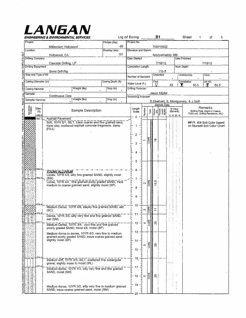
LAN6ANLog of Boring B1 Sheet of 5
Plunge (deg) Project No.
-59 700019502Bearing (deg) Elevation and Datum
181 Approximately 388Date Started Date Finished
7/16/12 7/18/12Completion Length Rock Depth
ENGINEERING II< ENVIRONMENTAL SERVICESProject
Millennium HollvwoodLocation
§ Hollywood, CAWhD~'~iII"'in~g'C~o~m~p~an~yC-~~~~~C------------------L--------~-1n;~~~-----"~~~~~~~~~~--------------------1
~~~~~~~~-"c~a~s~c~a~de~D~ri~lI~in~a.'=L~p ~~~~~~c---~~~----to.~~~-------'~~"-------~
,_ Drilling Equipment
: Sonic Drill Rig 115 ft -Number of Samples
Disturbed Undisturbed core- - -
Waler Level (fL)First Completion 24 HR.s: 53 :!: 50,5 z 50.5
~ Size and Type of Bit•
E!ev. Sample Description length j • ,~~~
N·Va!ue(ft) Scale ~ §g (Blowsfft)
388.0 « 3:~m 10 20 30 40
387.7 ~~sphalt Pavement0
•
./'Soft, 10YR 2/1, SILT, trace coarse and finegrained sand,trace clay, scattered asphalt concrete fragments, damp r- 1 -[FILL]
r- 2 -w~ c; ;0'0
r- 3 - o
I- 4 -
##YR #1# Soil Color basedon Munsell Soil Color Chart
r- 5
r- 9 -
I- 8 -
~W~ f- MediumDense, 10YR4T6~iaYeyfine graTned-SANo:-wet- - f- 10~~b (SCI
W
~o~:'.:, ':,: ':.:', 378.6f- DenSe:-10VR 3/3,' SIlty very tfrieandfine grained-SAND:- - - - 11 -t--t=-H---f----ji:, .: ~;', wei(SM) .
377. r-lv1edium Dense. TOYR374:-veryrine-andline graTned- - - -I- 12 -poorly graded SAND, trace silt, moist (SP)
Medium dense to dense, 1OYR 4/3, very fine to mediumgrained poorly graded SAND, trace coarse grained sand,slightly moist (SP)
J 374.3r-lvledTUm Stiff, fbYR473,sj[T~ scattered fmesubanguTar - -I- 16,.gravel, slightly moist to moist (ML)
I'.:::,.'~ ':.:::.~:':'373.41- ""Medium den-se,-lOYR-473:siUY very fine andfrrie-grafned - - f- 17 -_ SAND,moist(SM); :i·:: .;.:;{,8·.··: ::,"I: ..';;,
w
'"oc ::0o
w
"oc c>
8 N
r- 13 +-+-&--1--1
I- 14 -
'"NI- 15 -
I- 18 -
Medium dense, 10YR 3/2, silty very fine to medium grainedSAND, trace coarse grained sand, moist (SM)
t- 19 -
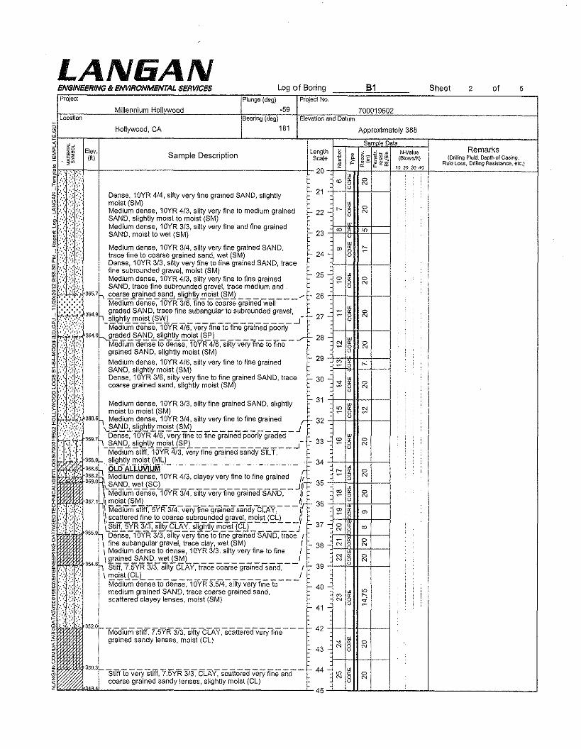
LAN6ANENGINEERING ill ENVIRONMENTAL SERVICES Log of BoringProject
Millennium HollvwoodPlunge (deg)
-59Location Bearing (deg)
g Hollywood, CA 181
W
~"~I-;:~~-r-------------------------------1------------1-~--~1=:;::~~~~EL::::::r--------:::::::--------i"'" ~g Elev. length
, ~~ (ft) Sample Description Scale
i..,·,,'"~t>} \:. Dense, 10YR414,silty very fine grained SAND, slightly
Il;il! ~~:~j~"i~~~l~!5::::::::::'',' .' '. Medium dense, 10YR 3/4, silty very fine grained SAND,
~.::.:t.~,:: trace fine to coarse grained sand, wet (8M)~" ,::':;',:,>,:',' ,":,' Dense, 10YR 3/3, silty very fine to fine grained SAND, trace::.: :;,:~:,', fine subrounded gravel, moist (8M)'fl r-. ":':{:" Medium dense, 1OYR 4/3, silty very fine to fine grained~ ,: ~ '::'::lr. SAND, trace fine subrounded gravel, trace medium and~ ;~~.:;.~:'; 365.7" .£o~~jI.r~n~d~~n~~j~~.£!1~s.!j~~ ......, 26 +--l--H---'I--I!.:::! ••••••••• Medium dense, 10YR 3/6, fine to coarse grained well~~~~8:364.9h waded SA~D, trace fine subangular to subrounded gravel, _ r, .," i..'\':',;/, _ ~g1:'t!l: !!!OEU~I'Q. ..J 27q ;",,:.:::,:,::;', Medium dense, 10YR 4/6, very fine to fine grained poorly@""f:;:;;; 364oN~~<!..S~IiD.2..s.!!.gh.tit!!!O~US!L ./" 28
Medium dense to dense, 10YR 4/6, silty very fine to finegrained SAND, slightly moist (8M)Medium dense, 10YR 4/6, silty very fine to fine grainedSAND, slightly moist (SM)Dense, 10YR 3/6, silty very fine to fine grained SAND, trace r:- 30 _coarse grained sand, slightly moist (SM)
Medium dense, 10YR 3/3, silty fine grained SAND, slightlymoist to moist (8M)h Medium dense, 10YR 3/4, silty very fine to fine grained r 32 -+....Jf::.'-I1---+--...j
\.S~r:!F".s.!!.g!:'.tlx.!!!O~tJS.0L Jh Dense, 1OYR 4/6, very fine to fine grained poorly graded L, .,
j_~!::I~~\!tJtI}:'2!~sU~l J 33
_ ' '. ' Medium stiff, 10YR 4/3, very fine grained sandy SILT,§v;:,?;: ' 358.91- .. ~i~~Iy' ~~i!t.(~~L._.._.._.._ ._._.._.._.._.._.._.' 34 -+....J-I1---+-...j..J '. ',' : .:. 358.5
R,OLD ALLUVIUM r
!il" ',' .." ~~::~\.~~g:~U~L:~~3~C~:~V~ry~~e~o~:~~n~d_j; 35~ \ Medium dense, 10YR 3/4, silty very fine grained SAND, IIIi.., ",", 3571h!II'2!~S!.J~M.). ~ llrl'- 36 +--4;;rt1I--+---It:! ",:,: ,,:;.. ;',,'. \ Medium snrr, 5YR 3/4, very fine grained sandy CLAY, If8 ;,::::::':;', \~~~t~~ .!!.,n:!.t.£. ~~s~ ~~~~~ .2!~~!!.l£!.s~j£Ll __ 1/~ /;: <:' /: LS!!.ff.!..5.!:~3E0i1!Y..9!:.Ai,~Iif1h!1Lm~i~!f~ J 37~ . . ~ 355.9h Dense, 10YR 3/3, silty very fine to flne grained SAND, trace rg l:t1 \ fine subangular gravel, trace clay, wet (SM) I 38~ \ Medium dense to dense, 10YR 3/3, silty very fine to fine /~EI: m 3546h\l!'~n~d.2~i'!P,-w"-tlS~L 1 r --I---J.Y.H---4--ii] ....: .,..'f.;'.l, . Stiff, 7.5YR 3/3, silty CLAY, trace coarse prained sand, r r- 39 -ffi ::,;.:\.:::, \ ~o~U~L 1 -§ :.:': .. :' Medium dense to dense, 10YR 3,5/4, silty very fine to 40 _~ ",:'. ,',::,:,:.~,":,::. medium grained SAND, trace coarse grained sand,g :'":. . scattered clayey lenses, moist (SM)
~':\.}~!;).~:"':":"~
I~
Project No.
ElevationandDatum
=- 21
B1
700019502
22
I'- 43 -
24 -
44 -
352.01- _
Medium stiff, 7,5YR 3/3, silty CLAY, scattered very finegrained sandy lenses. moist (Cl)
42 ++*-+----1
25
31 -'1--I---H--+---j
41
Sheet of2 5
w-e- " 0N 0 N
U
W
'" " 0N 8 N
,
350.31-- _
Stiff to very stiff, 7,5YR 3/3, CLAY, scattered very fine andl.,.. n coarse grained sandy lenses, slightly moist (CL)~~----~----~----~--------------L45~-L~-L__L-~-...IL- --...I
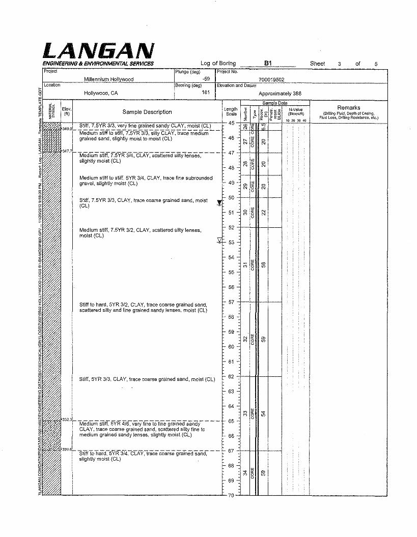
LAN6ANENGINEERING & ENVIRONMENTAL SERVICES Log of Boring Sheet 3 of 5Project Plunge (deg) Project No,
Millennium Hell ood -59 700019502Location Bearing (deg) Elevation and Datum
Hollywood, CA 181 Approximately 388
Sam le DataElev, length • , ~*~N-Value Remarks(ft) Sample Description Scale " ~. §§: (8Iows/ft) (DrRling Fluid, Depth of Casing,E, r cc ~e!w Fluid Loss, Drifting Resistance, etc.)z 10 20 30 40
Stiff, 7,5YR 3/3, very fine grained sandy CLAY, moist (CL) 45 co'" oc
MediUm StitTtostiff~i5YR-373,siity CLAY, trace-mediUm -- 0
grained sand, slightly moist to moist (CL) 46 w" oc 0
'" 0 '"0
M~~mSti~7.~R~~~Y~Cattere~m0~~~---47sllqhtly moist (ct) co ~ 0
48 N 0 NU
Medium stiff to stiff, 5YR 3/4, CLAY, trace fine subroundedgravel, slightly moist (CL) 49 w
'" oc 0
'" 0 No
Stiff, 7.5YR 3/3, CLAY, trace coarse grained sand, moist 50(el) w
51 0 s NcoU
N
Medium stiff, 7.5YR 3/2, CLAY, scattered sHty lenses, 52moist (Cl.)
53
54 w~ oc co'" 0 '"055
56
57Stiff to hard, 5YR 3/2, CLAY, trace coarse grained sand,scattered silty and fine grained sandy lenses, moist (Cl)
58
59N ~ '"'" 0 '"c60
61
62Stiff, 5YR 3/3, CLAY, trace coarse grained sand, moist (CL)
63
64 wco oc "'" 0 io0
Medium STIff.5YR 476~verY flnetOflne gra"it1edsandy- - - - 65CLAY, trace coarse grained sand, scattered silty fine tomedium grained sandy lenses, slightly moist (CL) 66
67S@to hard:-5YR3T4~CLAY~race coarse graTneasand~ --slightly moist (CL)
68 ur-e- oc c»eo 0 ioo69
70
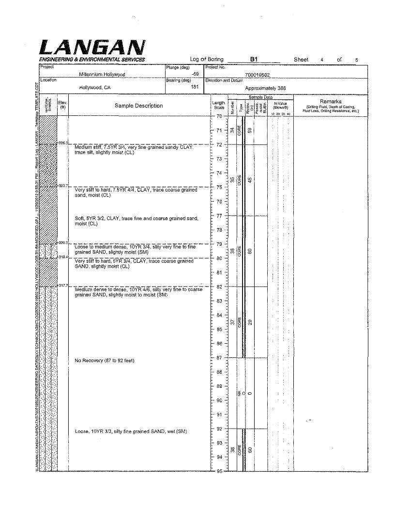
LAN6ANLog of Boring SheetENGINEERING & ENVIRONMENTAL SERVICES of4 5
Project Plunge(deg) ProjectNo.
-59 700019502Millennium Holt DodLocation Bearing (deg) Elevation and Datum
181 Approximately 388Hollywood, CA
~c5 Elev. L th .... Remarkslt~ • SID . t! eng 0> N-Valua~?:: (tt) amp e escnp Ion Scale z€ (Blows/ft) (Dr11lingFluid, Depth of Casing,a-' ~ Fluid Loss, Drilling Resistance, etc.j
~~+-------------------------------~70~~~~~~~~----------------~
Medium STItT,f."SYR3/4:-very-fine grainedsandy-CLAY,- -- 72trace silt, slightly moist (CL)
73
74ill
'" e: '"co 0 "0
VerysilitTo hard-;-i]:YR4i4,CLAY,tracecoarsegrafiled - - 75sand, moist (Cl.}
76
Soft, 5YR 3/2, CLAY, trace fine and coarse grained sand, 77
moist (el)78
320.3 Toose tomediUm dense-;-15YR3i"4, Silty very "fine to fine - - 79ill
<0 " 0grained SAND, slightly moist (SM) '" 0 <00319,4 verysWTo hard:-5YR374:-C"[AY~racecoarse gralned- -- 80
SAND, slightly moist (eLI81
317.7 -KtiedTlimdenseto dense. fOYR41'6', siltY very fine to Coarse - 82grained SAND, slightly moist to moist (8M)
83
84ill
"" " 0
'" 0 N085
86
0:
~
~~'r::..."".%0liil ;:.:: ,', .(I) '. '
§
§::\~.:.\:(:,
I~~~~::'.:'::: .r.::'
ill::·:' '.;:'::?'~.::'.:.......~::'':: ',' .:..s .: ,\:~:::-.
!(i~~:::E '::. ',:.;,>.~:'.:: .:~.::::;"
i).~:?/:,
87
88
89« 0z
90-
91
92
93-w
<0 " 0
'" 0 <0094
95
No Recovery (87 to 92 feet)
Loose, 10YR 3/3, silty fine grained SAND, wet (SM)
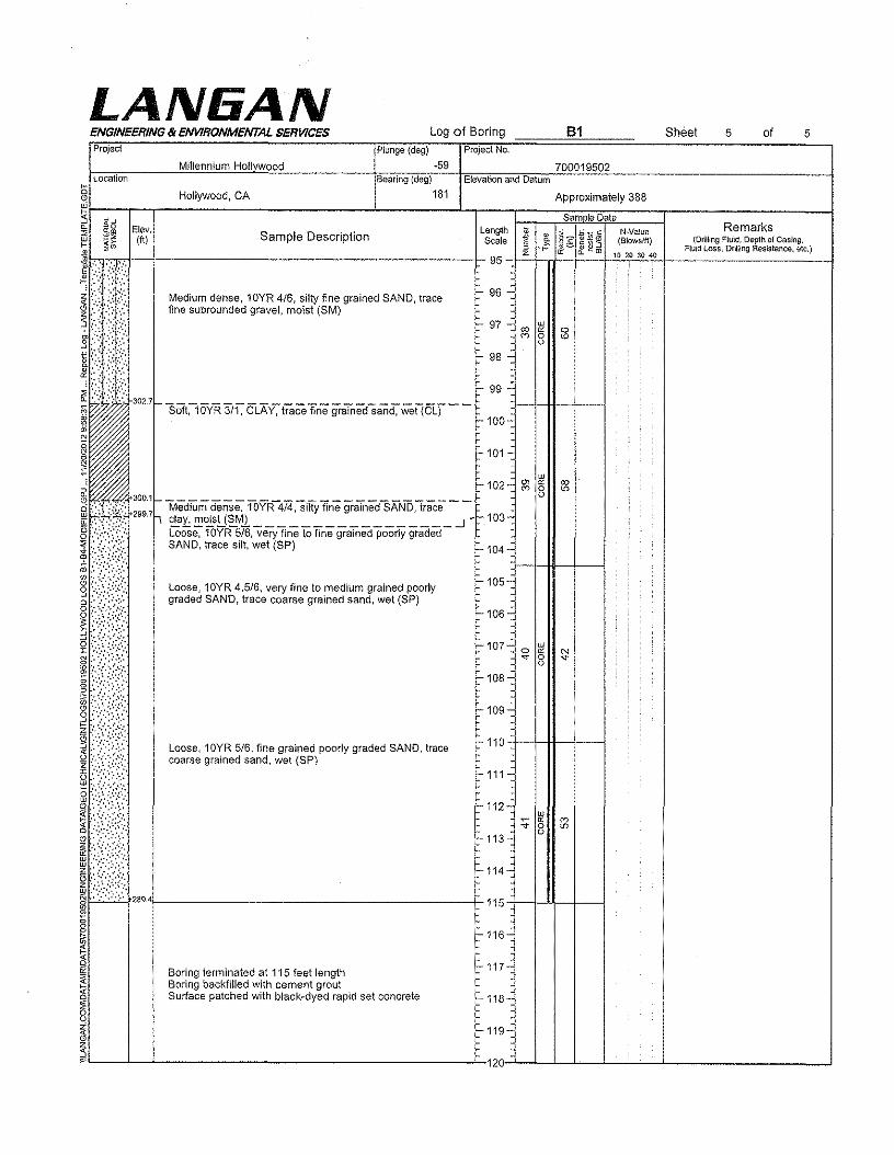
LAN6ANLog of Boring 61 SheetENGINEERING & ENVIRONMENTAL SERVICES of5 5
Project Plunge (deg) Project No.
·59Millennium Holtvwood 700019502Location Bearing (deg)
§ Hollywood, CA 181 Approximately 388
~r-~.:"~r-~------~------------------------L-----------1-'1----l==:==:Js~a~m~la~D~'ililliL:=====r--------~~::~------__ia:2 Elev. Length Q'i ,..b _ e N.Value Remarks
~ ~~ (ftl Sample Description Scale i.J §g g ~:3 (Blowslft) (DrillingFluid, Depth of Casing.J .:::.;~.;<. 95 c: "" ro io aoaoac "old toss.Drtllio,Resistance, etc.)
1~ii~::,:~~:~=f~.:::\1~qrained "~" trace ~ ~ •
~ , '~302.7~ SOf(i5VR 3i[CLA'Y."tfaCefine graTnedsand;"Wet(cLf- - r ",:J--+-Jjl-+--i= ~ ~100-•~i
Elevation and Datum
f-101-
f- 102-~ 300.'f- _
~ :\'?X': 299.7h ~:~;~ui~l~Y~~~~t~f:e~:i~e~~A~~~a~e_.J~103--
i~Wi.;: ~~~6:;r~~: ~{t;:a;~)to fine grained poorly graded
i;:'jIr~),~:)\::::o ......
Wffi::::.{:;":":(':',.. ':: " ....~.... : .;.,:z ",',!:bI • : •• '
@g~
~
~
~~L-~~L- ~
f-104-
f-105-
r, 106c
F-107C W0 " N.. 0 -e-
0
f-108-
f-109-
F-110
f-111-
f-112-W
::; « '"0 '"F-113C 0
f-114-
115
t, 116-
i=-117C
f-118-
f-119-
120
Loose, 10YR 4.5/6, very fine to medium grained poorlygraded SAND, trace coarse grained sand, wet (SP)
Loose, 10YR 5/6, fine grained poorly graded SAND, tracecoarse grained sand, wet (SP)
289.4tl- --F-
Boring terminated at 115 feet lengthBoring backfilled with cement groutSurface patched with black-dyed rapid set concrete
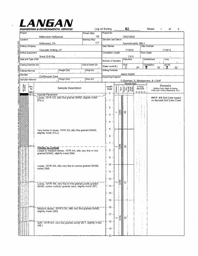
LAN6ANProject
ENGINEERING & ENVIRONMENTAL SERVICES
Millennium Hollywood
Log of Boring B2 Sheet of 5
Plunge (deg) Project No,
-58 700019502Bearing (deg) Elevation and Datum
177 Approximately 388.2Date Started Date Finished
7118/12 7119112Completion Length Rock Depth
Location
g Hollvwood, CAW~D'-ri~lIi~"9~Coo=m=p=a="yC--C~~~~~------~---------"------------~~~==o-----~~~~~C;~~~~o-------------------1~.... Cascade Drtlllnq, LP~~D'-(~11Ii="9~Eq=u=(p=m='=mc-~~~~~~~c--------------------------+o=~~c>==~--~~~c---~C7.~=c.c-------~~=--------12 Sonic Drill Riaf Size and Type of Bit~ -,bC'-a=,;="gOOD=;a=m=m=e~,(=;"=)C---------------------------rcl(c=a'=;"=9=D~'=P"'th=(Wft')-_-+-------------h,"c---------+O~=w~---C--hoC7.'---~---1~~~-c--------------------,~~~~------~1-n~~",--_--+"","-=~====--~~~----~--~~------~--~~--~~---1:3 Casing Hammer w IWeight (lbs) w I Drop (in) w Drilling Foreman
.§' Sampler
15 Sampler Hammer&
~5 Elev.~ ~~ (tI) Sample Description:i :::;<11m,.....~3~"~.2~~~Uill~""~3r1t----------c-------------------~~¢lj[IIJ 387<9r-,Asphalt Pavement~ Loose, 10YR 2/2, silty fine grained SAND, slightly moist~ [FILLJ
Continuous Core_I Weight(lbs)
110 ft -Number of Samples
Disturbed Undisturbed Core- - -
Water Level (ft.)First Completion 24HR.s: 54 .Y 52 z 52
_ I Drop (in)
Jason KlipfelInspecting Engineer
D.Eberhart, S. Montccrnerv. S J.GoffSample Data
Very loose to loose, 10YR 2/2, silty fine grained SAND,slightly moist [FILL}
Length , ; ~'~3NNalue Remarks•Scale " c. §g (Blows/ft) (Drillillg Fluid. Depth of Casing.§ i" If e to Fluid Loss. Drilling Resistance. etc.)z oc 10 20 30 400./"
##YR #1# Soil Color based1 - on Munsell Soil Color Chart
- 2 -w~ oc 00 '"- 3 - 0
~ 4 .:
r- 5
c- 6 -
377.6
t- 7 - w·YQliNi.DiLLtj\ifUM· _. _. _. - - - _ .._. -- - N oc 0
0 N0
Loose to medium dense. 10YR 4/4, silty very fine to fine I- 8 -grained SAND, slightly moist (SM)
I- 9 -
Loose.10YR 4/4, silty very fine to coarse grained SAND. I- 10
moist (8M)I- 11 -
I- 12 - w
Loose,lOYR 416-;- verYfitietofine grainedpoorlygraded --co oc OJ0
0SAND, some medium grained sand. slightly moist (SP) - 13 -
- 14
EI- 15
I- 19 -
LAN6ANProject
ENGINEERING 8< ENVIRONMENTAL SERVICES Log of Boring Sheet 2 of 5Plunge (deg) ProjectNo.
-58 700019502Millennium Hall oodBearing (deg) Elevationand Datum
177 Approximately 388,2
Sam Ie DataLength II ~~~*~N-VIl!ua Remarks
Sample Description •Scale § c.~§.
(B!owsfft) (Drilling Flu!d, Depth of Casing.~ cf2w Fluid Loss, Drilling Resistance, etc.)z 10 20 SO 4{l
Soft, 10YR 4/4, very fine grained sandy SILT, slightly moist 20
~~----------------------~Medium dense, 7.5YR 3/3, silty very fine grained SAND, 21trace fine subangular grave!, slightly moist (8M)
22 urio " ..-
0 -e-U.OLifliLLiiVii.irif--H- . __ ..- H_. _ .._. __ . 23
Stiff, 7,5YR 4/3, CLAY, trace medium to coarse grainedsand, trace silt, slightly moist (CL) 24
25Verysiiff~7:SYR3i3, very fine gralneds8ndY CLAY, moist-(el)
26
Dense:-7 ']YR '41"6, clayey fine graTrled SAUD ,tracefineto- - 27 wcoarse subangular gravel, moist (SC) <D " so
0 '"- 28 o
29
30Loose to medium dense, 7.5YR 4/4, clayey very finegrained SAND, moist to very moist (SC)
Loose,"1OY'R414-;-frrieto medium grained-poorly graded- -- 31SAND, trace coarse grained sand, trace fine subroundedgravel, some clay, wet (SP) 32 w
"- " <D0 coo
Loose ,7 :5VR5/8, fine to coarse grained weu graded - - - - 33SAND, trace fine subangular gravel, slightly moist (8W)
34
35"'MediLiii1d'eiiSe;-7.5YR 416-:-s'ffiyfineTocoarse grained - --SAND, trace fine subangular gravel, trace clay, slightlymoist (SM) 36
37 urco " ~0o38
39
40Me-drum StlfftosiTff~i]YR-3i3,very fine graTnedsandy - --CLAY, slightly moist (CL)
41MedIUm deiiSe;-lOYR-316,siity Tine graTnedSAND,siigtiily--
42moist (8M) w
'"rr <D0 eo
43 oLoose, 10YR 4.5/6, silty very fine to fine grained SAND.trace fine angular to subangular gravel, damp (8M)
44 -
45
Hollywood, CA
LANIiANENGINEERING II< ENVIRONMENTAL SERVICES Log of Boring 5Project
Millennium Hcllvwcod
Plunge (deg) Project No.
-58
82
700019502
Sheet 3 of
Location Elevation and DatumBearing (deg)
g Hollywood, CA 177 Approximately 388.2
l"
~~~~[:~-------------------------------CL-----------L-l[~=-1=~::;Js~.¥m~leJD~.~mL:::::=r--------~::::~------_1"" ~g Elev. length t ';.;:; ~E NNalue Remarks~~ (ft) Sample Description Scale z€ .~ 8'2 qj.!2<o (9!owslft) {DrillingF!ukl,DepthofCasing,
~*b1'-·r."'7-7t--1r-~==~"""'""~~~~~~~=C~COMCo-~~C----+-45-f~-"+--Tt&--~+~~o_.-~1-~,"~'~020~O~,o~F_'O_Id_LO_'_"_D_'_lIin_9_R_"_i'_"_"_,_ .•_,,_.)__ ~~~, ',:% Dense, 10YR 3/6, clayey very fine grained SAND, slightly ;~ . '.':;% moist (ell :, '...,;,.;:~.!?\1 x:i Y.:'5 .".",<:2: 34831-;"'.:'::'.:...~:.'::, ' Medium dei1Se,-WYR414,siityvery fine to fine graTnea-- -!- 47 - uro SAND, slightly moist (8M) ~ 8i:':y ::. I- 48 -
I- 46 -
.!I- 52 -
r- 49 -
r- 50 -+-+-+1---+--1Medium dense, 10YR 4/4, silty very fine to medium grainedSAND, trace coarse grained sand, trace clay, slightly moist(SM) I- 51 -
Loose, 10YR 3/4, silty fine to medium grained SAND, tracecoarse grained sand, moist (SM)
Loose, 10YR 4/6, silty fine grained SAND, wet (SM)
t- 62 -
I- 64 -
r- 65 +-+H--+---1Medium dense, 1OYR 3/4, flne to coarse grained weI!graded SAND, scattered coarse subrounded gravel. wet(SW) - 66-
67 -
Medium dense, 1OYR 3/4, fine to coarse grained wellgraded SAND, wei (SW)
68 -
- 69 --
LAN6ANB2Log of Boring Sheet ofENGINEEf1ING 8< ENVlf10NMEI'ITAL SEf1V1CES 4 5
Project Plunge (deg) Project No.
-58Millennium Hollywood 700019502Location Bearlng (deg)
177Elevation and Datum
§~j-;:~~~-------------------------------"------------L-~----T==;==;Js~a~m~rn~elD~a~taL:=====r--------~:::.::_------_1a. ~g Elev. Length'" ';;:; _ c N.Value Remarks~ ~~ (tt) Sample Description Scale z~ .* 8:? :g.*~ (Blowslfl) (DrmingFluid,OepthofCasing,
:iV' ~ .- ff. --I ~ ~ co Fluid Loss. Drilnng Resistance. etc.)~ .•••••••• 70 -+-=-+-rl- __ +- __ +-'"'-""-o.,,"'-',,o'+ -I~ Medium dense, 1OYR 4/6, fine to coarse grained well~ ::::::::: graded SAND, trace fine subangular gravel, wet (SW)
~~:~:~:~:~!f:t,~f.:~327,1_Loose to mediUm, 10YR416,fine TomediUm graliied pooriY -.3 ':'::::::.:.,,:' graded SAND, wet (SP)t:' : ..... 326.3 _
&rx::I"" ',','. Loose to medium, 10YR 4/4, clayey very fine to fine(!i . •.... . grained SAND, wet (So)i" ".
~, ':,:...~.,:~.,
~ ::':::';:; ::::':324,6_ "Loose,l6YR" 516-:siftYflneandmedlUm graTriedSAND,w6t-
1,;:,:::,::::/ (SM)
·,,:tf
Hollywood, CA Approximately 388,2
- 71 -
72 -ill
~ " :?;0o73
74
75
- 76.
322.9Very -denSe~1 ovR:3/[ Clayey very fii1810 medium grained - 77
ill
~ e; ccSAND, moist (SC) 0 '"78 - o
79 -
Dense, 10YR 3/6, clayey very fine to fine grained SAND, 80wet (SC)
Dense to very dense, 1OYR 4/4, clayey very fine to fine - 81 -grained SAND, trace coarse grained sand, moist (Se)
82 -ill
" " co0 '"83 - o
- 84 ~
85
86 -Loose to mediUm dense-: fOYR"414, sUtY fine to coarse - - -grained SAND, trace fine subangular gravel, trace clay,slightly moist (SM) - 87 -
- 88-
- 89 -
~ 90 -
~ 91 -tI- 92 -
ill
~ « '"8 -sr-I- 93 -
I- 94 -
95
Loose, 10YR 4/4, silty fine to coarse grained SAND, tracefine subangular gravel. trace silty lenses, wet (SM)
Loose, 10YR 3/4, silty very fine grained SAND, slightlymoist (SM)
LAN6ANMillennium Hollvwood
Log of BoringENGINEERING & ENVIRONMENTAL SERVICES Sheet of5 5Project
700019502Location Bearing (deg)
177
Plunge (deg) Project No.
-58Elevation and Datum
Hollywood, CA Approximately 388.2
Sam le DataLength ~ • 8e ~'f2,§ N-YalueScale § !5 .~l~a; (Blows/ft)
z oc 10 20 30 4095
- 96 -
- 97 -w
0 « coN 0 -e
98 -o
- 99 -
100
!-101-
'-102-w
N tx co0 "r 103-o
'-104 -
'-105
:-106-
!-107-w
N oc '"N 0 co'-108-
c
r-109-
110
-111-
'-112 -
r- 113-
'-114-
-115-
-116-
~ 117-
118-
-119-_
120
•. -t; Loose, 10YR 4/4, silty fine to coarse grained SAND, tracetine subrounded gravel, wet (8M)
Medium dense, 10YR 4/6, silty very fine to fine grainedSAND, slightly moist to moist (8M)
Loose, 10YR 5/4, silty fine to medium grained SAND, tracecoarse grained sand, wet (8M)
Loose to medium dense, 10YR 4/4, silty very fine to finegrained SAND, wet (SM)
Medium dense, 10YR 4/4, silty very fine grained SAND,moist (SM)
Medium dense, 10YR 5/8, silty very fine to fine grainedSAND, trace fine subangular to subrounded gravel, moistISM)
Boring terminated at 110 feet lengthBoring backfilled with cement groutSurface patched with black-dyed rapid set concrete
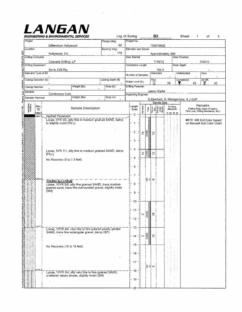
Log of Boring B3 Sheet 1 of 5Plunge (deg) Project No.
-60 700019502Bearing (deg) Elevation and Datum
179 Approximately 389Date Started Date Finished
7/19/12 7120/12Completion Length Rock Depth
LAN6ANENGINEERING & ENVIRONMENTAL SERVICESProject
Millennium HollvwoodLocation
§ Hollvwood,CAW~D~'~iUi~ng~C~om~pa~n~y--~~~~~~-----------------L-------c~-i~~~~-----"~~~~~>n~~~~-------------------4
~~~~~~~~~c~a~s~ca~d~e~D~r~iI~!ln~g"~L~P ~~~~~~ __-"~~~ __~~~~ ~~~ ~
,--- Drilling Equipment
tJ Sonic Drill Ria 100ft -Number of Samples
Disturbed Undisturbed Core- - -
Water level (ft.)First I~mplel!on 24 HR.52 56 .'l 55 s. 55
Drilling Foreman
Jason KlipfelInspecting Engineer.3 Sampler Continuous Core
15 Sampler Hammer -IWeigh\ (Ibs) ! Drop (in)
%~~~==-r------------~------------~---~I------~-~~~~-r~~D~.EJb~e~r~ha~rt1'~S~.=M:o:n:ttq:(o=m~e~~,,~&~J~.~G~O~ff~::~~-1......j Sam Ie Data~5 Elev. length ~ .. tc-veiue Remarks
~ ~~ {ft) Sample Description Scale 1i 8"2 ~:!!l U5 (Blowslfl) (Dr~lingFILlid,Depth of Casing,9: :fw '389.0 ~ f?: & <=.. ~ ~ ffi 10 20 30 40 Fluid loss, Drilling Resistance, etc.)
~im.l~38~8~'7~~'~A~SP~h~a~lt~p~a~v~e~m~e~n~t---------------------------~~-0 .;:;! Loose:-5YR 372;SITfyfine tomedrumgrained SAND, damp~ to slightly moist [FILL} - 1 -
it Size and Type of Bit;!. -'hc~a~s~,"~grD~ia~m~e~te~rT;(i~nl~--------------------------r,I\c~a~s"in~grD~e~Pt~h"(ft"I-_-1-------------i~.------CC-~~~zoc-~~~~o---~---i~~~~==~--~-------'~~~~----~Tn.~",~-i~~~~--~=-----~-i~~--~~~=---~---i:) Casing Hammer ~ IWeight {Ibs) _ I Drop (in) _
2 ~ ~ N
8 ~- 3
Loose, 5YR 7/1, silty fine to medium grained SAND, damp "- 4W
" " ~[FILL) 0Q
No Recovery (5 to 7.5 feet) c- 5
- 6 -
c- 7 -yQlrN,niLCu\ijUM - - - - d - - - - --
Loose, 10YR 5/8, silty fine grained SAND, trace mediumgrained sand, trace fine subrounded gravel, slightly moist(SM)
c- 8 -
f- 9 -
I- 10 +--hrl--f--4
t- 11 -
f- 19 -
~c 0
~c 0
##YR #1# Soil Color basedon Munsell Soil Color Chart
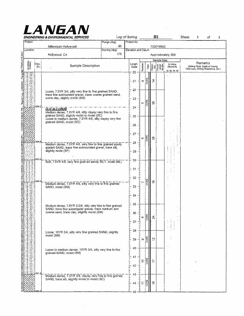
LAN6ANLog of Boring
Project
ENGINEERING & ENVIRONMENTAL SERVICES
700019502
83 Sheet 2 of 5
Bearing (deg) Elevationand Datum
g Hollywood, CA 179 Approximately 389
~j-~"~-r=--r-------------------------------L-----------1--r---~::~~=s~a~m~le~D~a~ta~::::=T--------~~::~------__jW
~ ~g Elev. SID . r length:;; >,:, 'ti 0:: NNalu6 Remarks~~ (f!) ampe escnp Ion Scale z~ ! §g ~~~ (Blowsfft) (DrU!irlgFluid, Depth of Casing.
~ ::;W « c, ....m 10 20 ;'0 40 Fluid Loss, Drming Resistance, etc.)
~ib(:~:~.~~;.~,.+--t----------------------------------------j-20-+~-'~~~~~~~~--------~--------~~':': '-:, :,:". ,,~. .',
!/';:;;:8. ",:::.',..;:,:£:.'.i .,", :< '-::.
Location
"Ql • ,,'
6i . ,'.~ ,.'.o ....::
N_~:'": ".':'
Millennium Hollvwood
Plunge (deg) ProjectNo.
-60
wI- 21 - ..- " ;!:0
0
Loose, 7,5YR 3/4, silty very fine to fine grained SAND, I- 22trace fine subrounded gravel, trace coarse grained sand,some clay, slightly moist (8M) I- 23 - w
'"c: ro0 '"36a.2 -I- 24-0OLD-ALLUViUM" _ .. _._ .. _._ .. _ .. _ .. _ .. _ .. _.-
Medium dense, 7.5YR 4/4, silty clayey very fine to finegrained SAND, slightly moist to moist (SC) 25Loose to medium dense, 7.SYR 4/6, silty clayey very finegrained SAND, moist (SC)
L 26-
- 36-
- 37-
Loose, 10YR 3/4, silty very fine grained SAND, slightlymoist (SM)
- 38 +-+-H-+--l
- 39 - m §Loose to medium dense, 10YR 3/4, silty very fine to finegrained SAND, moist (SM)
- 40 ++-H---+--i
- 41 -~ §
- 42 -
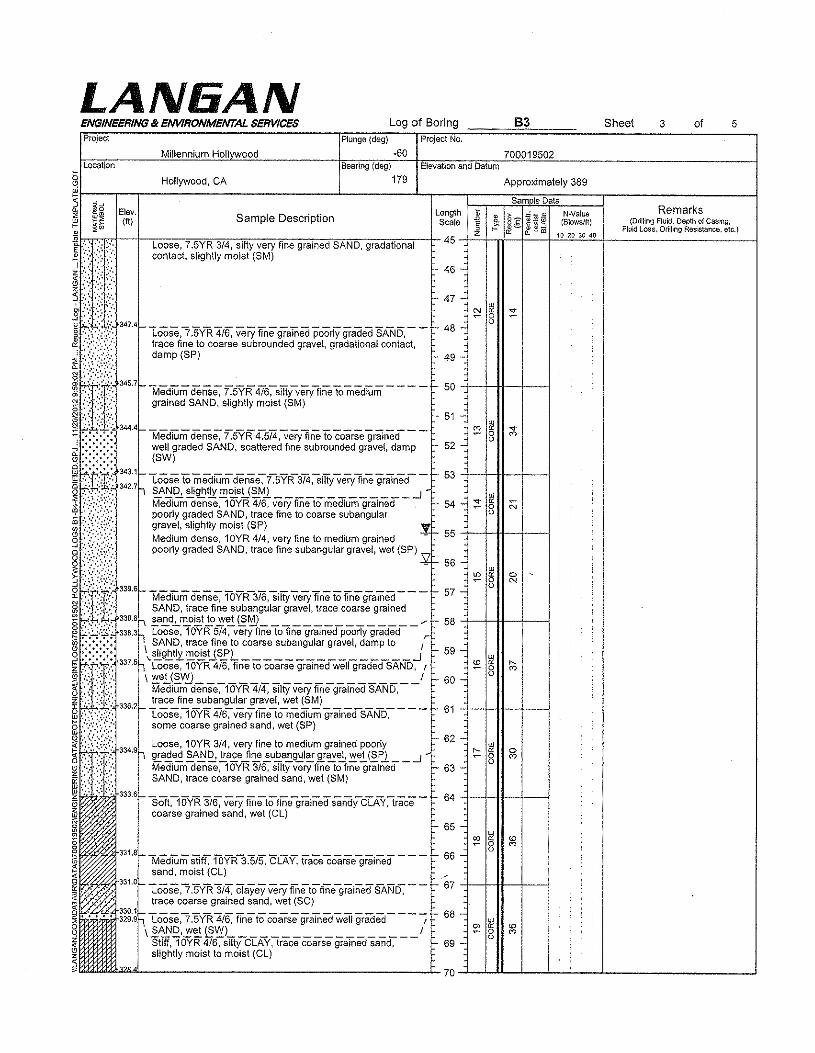
LAN6ANENGINEERING lit ENVIRONMENTAL SERVICES Log of Boring 63 Sheet 3 of
Millennium HollvwoodPlunge (deg)
-60Project No.
5Project
Location700019502
Bearing (deg)
~ Hollywood, CA 179 Approximately 389~r-~~~~-------------------------------"------------L-~--__1=~==~s~a~m~"lD~a~,aL:====:r--------::::::~-------J~I .$~ E'o". Remarks.:: UI~ ")' SID .. Length ~ "",;, ~ '" N-Valua1:! ~(;; (ft ampe escription Scale E ! g:§: Z~~ (Blowslft) (DriliingFluicl,DepthofCasing,U> ~ tt 0.. .... III 10 20 3() 40 Fltlid Loss. Drilling Resistance. etc.)
~ :'< ';'.: ;"', Loose, 7.5YR 3/4, silty very fine grained SAND, gradational 45 -+-=-f-Ti---t----t-"'-'''-'''-'''+-----------------------I~ .> ....,. : contact, slightly moist (SM)d:{,:::';:':, -46-
Hr;:[)::' - 47 - ~ §g t:~:~:.f.::.347.4 -Loose,7 :5YR4/6, Very fine graTrieci pooriY graded SAND, - - 48-
~;i{;.;;:: ~:~e/(~w coarsesubroundedgravel,gradationalcontact, 49 _
~~tT::345.7 - "Medrum dense, 7.5YR 4I6:-srnyveryfine Tomedium - - - - - 50 +-1'--1+--+--1~ :Y±:' grainedSAND, slightlymoist(SM)
~*\}:/:344'- MediumdeiiS,,7.5YR4-:5'i4,very fineTo coarse grained _ _ 51 - ;:; § ;;\..; .:.:.:.:. well graded SAND, scattered fine subrounded gravel, damp 52 -~::::::::: (SW)~(t:~r::::~.;- Looseto mediUmderiSe~r5YR3i4;Sm)ivery linegrained- - - 53 +--1-1-1---1---1~t~:,':i' . \ ~!,!'2,.~®tIl:!!,~sU~Ml ...J-~ .:.,:.:': ',>:.... Medium dense, 1OYR 4/6, very fine to medium grained 54 - ~ ~,!:: ::,:;:/,::: poorly graded SAND, trace fine to coarse subangu!ar ..,~ .:.:.<:.>:.:':.: gravel, slightly moist (SP) .!8····:::::·,:::· Medium dense, 10YR 4/4, very fine to medium grained - 55 +--t-H---j---18 ::::,~:~:t,·r::: poorly graded SAND, trace fine subangular gravel, wet (SP) \7
0.,','.,,'., ....- 56-~ ::::.~:;:·r}:::.~tt~t;··339.6- Medium dense, 1OVR-316,siify very fine to fine grained - - - 57-~~~t::£'~338.8 ~:n~~~~~~tet~r:e~(~~)gular gravel, trace coarse grained /'0""" '. "'\ 58 +-+tI--+---IRp,.·~~;:;i·;338.3.., loose, 10YR 5/4, very nne to fine grained poorly graded rw.·.·.·.·. \ SAND, trace fine to coarse subangular gravel, damp to I~I::::::::: 3375 \.~g~t!z~~US£L .J - 59-z '7.'.: "llie:, . l loose, 10YR 4/6, fine to coarse grained weI! graded SAND, r- . ',.' \ '!!.e~j~V'!L 1 - 60-
Medium dense, 1OYR 4/4, silty very fine grained SAND,336.2 ~~:.!~e~~~~~r .,gr~v:!,~:! ~~) _
- loose, 10YR 4/6, very fine to medium grained SAND, 61some coarse grained sand, wet (SP)
334 9 loose, 10YR 3/4, very fine to medium grained poorly. ""\ ~a.9.e~ §..A!ll2.!.!!.a.£eJi~..!uE.a!!.g.::l~fE"~~ ~e.!. (§Yl __ ..J -
Medium dense, 10YR 3/6, silty very fine to fine grained - 63 -w;'. " :.., SAND, trace coarse grained sand, wet (SM)~ .: -r. :;: : ... 333.6C5 SofC"1oVR3i~Veryftnetotlne-grained SaridyCTAY~race - 64 +--t-H--'j--I~ coarse grained sand, wet (Cl)~.m
§ 331.8
I.,< .~~....~~
Elevation and Datum
62 -
65 -
Medium Stiff," fOYR3~/5. CCAY,tracecoarsegrained - - - - 66 -sand, moist (Cl) .--"
331.0_ Loose,l"lN"R3/4,CTayeyVeryftnetoffile-grained SAND, - - 67 +--j-H----'j---jtrace coarse grained sand, wet (SC)
~~g:~1LOO88,7 .5VR 4/6, fine to coarse graTnedwetl graded - - - -; 68 - w\2~£,~~{§~L 1 ~ 8
Stiff, 10YR 4/6, silty CLAY, trace coarse grained sand, 69 -slightly moist to moist (Cl.)
~~------------------------------~70~-Lll--L-...!~~-...!----------------...!
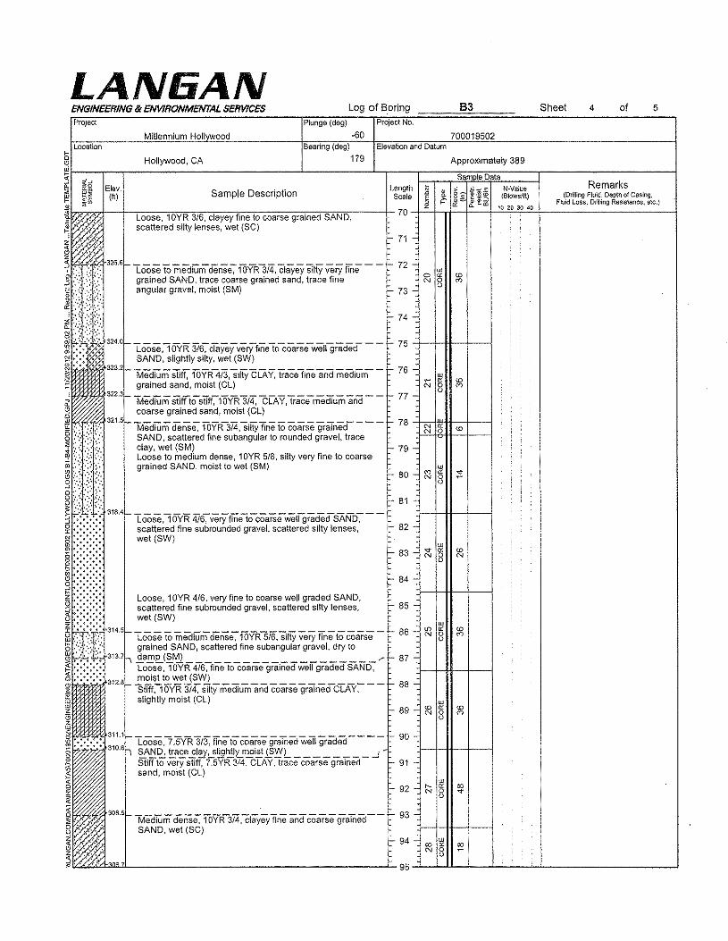
LAN6ANENGINEERING IX ENVIRONMENTAL SERVICES Log of Boring 5Project
Millennium Hollvwood
Plunge (deg) Project No.
·60 700019502
63 Sheet of
location Elevation and DatumBearing (deg)
§ Hollywood, CA 179 Approximately 389§~----c-~-------------------------------"------------"--r----~-----cs~a-m-coll'~D~a~ta-------r----------------------~
~~~g Elev. Length ~ ,,:..,; ~ eN-Value Remarks
,__ ~~ (ft) Sample Description Scale E ! 8'2:1!'* ~ (Blows/It) (DrillingFluid, Dapthof Casing.<lI :Ii'" i &::::;. !:f. ~ co 10 20 30 40 Fluid Loss, Drilling Resistance. etc.)
~bl~'~'~'+-~~'Lo~0=s~e~'<10",Y~R""3"16"~CI~a'ye=Y~fi~ln~e·to77co~a=r=se==gr=a'-ln~e~d<S~A~NT.D',----~-70& . '. ,." scattered s!lty lenses, wet (SC) 71
Il4f<ir..:~:F,"'.,,:'1"3266-100se to mediUm dense-;-16VR3i4, clayey Silty very fine- - - - 72~ ::.:: ',",,:' grained SAND, trace coarse grained sand, trace finei,:",~:.\,:\-.angular gravel, moist (SM)
4
: ':::':':';:".~,,~:,:(/:,~I£:::'.~ 324.0_LOoSe,lOY'R 316-:CiayeyverYfinetocoarseweligraded- - - 75 +-HI+-~-~N SAND, slightly silty, wet (SW)I ·323.2!-Me"diUmS"t1ff,lOYR4i3,sihyCLAY, traceline and medium- - 76-
grained sand, moist (CL)322.31-------------------------- - 77it Medium stiff to stiff, 10YR 3/4, CLAY, trace medium and
coarse grained sand, moist (CL)
~:',:~if:321,5f-MediUm deriSt3,"lOYR-3i4:si»y Tineto coarse gralned- - - - ,.. 78 +~~~~41f-",~----1o~~:,.:.,,:;.:::/. SAND, scattered fine subangular to rounded gravel, trace
,," " :' clay.wet (SM) - 79 -OJ .:::,~ .:\: ~~::::, ~~~~:Jos~~~~~~i:~~~~~~1;J:8, silty very fine to coarse
§ ::::.:~:',~:~~":::, - 80 - ~ §
~i:\.?~{3184,.. Loose ,1 OYR 416-;- verYfiiie;ocoafsewet19radedSAND-;-__ - 81 -:)--1-11--+----+... -:.:.:-;. scattered fine subrounded gravel, scattered silty lenses, - 82 -~:U~~~~wet (SW) - 83 _ ~ § ~
I.~.:.j.:.j.:.:.:. Loose, 10YR 416,veryfinetocoarsewellgraded SAND, - 84 -:)--1-11--+----+:; scattered fine subrounded gravel, scattered silty lenses, :- 85 -5 -:-:.;.:- wet (SW)
~f6~if,314,5 Loose to mediUmdense~fOYR5i6,sHtY very 'finetacoarse - !- 86 - ~ §~ :':J:::I:' grained SAND, scattered fine subanqular gravel, dry too '-';';i)~313,7 '\ .~a.':"eJ!:>'~ ~:. 87 -
I- .;. •••• :- Loose, 10YR 4/6, fine to coarse grained well graded SAND, :1--+-+1-4--+~il":':':':312.8_-§~~~y~e~}'~itymediumanacoarSegrarned-CTAY:--- - 88 -
Z
ffi slightly moist (CL) UJ
(3 - 89 - ~ 8z
~ :.:.:.:.: 311.1_ LOOSe,7,5YR3/3, fineto coarsegralnedweii graded- - - - ,- 90 -.:5 310,6""\ ~A~~ t!:,.a£.e~!~:...?!!.fJ~Lm...9~~'!il -1 :I--+-H--+----Ig Stiff to very stiff, 7.5YR 3/4, CLAY, trace coarse grained 91 -I sand, moist (Cl)
~ " ' 308'- -l',iediumdense.lOYR-3i4,clayey fine and coarse grainea- - 93_v " SAND, wet (SC) :J--+-H--I--~~ ')." ..' ,Z~,.' ,
73 -
74
- 92 -
94 ro ~N 3
95~-Lll--L~~~·~ ~
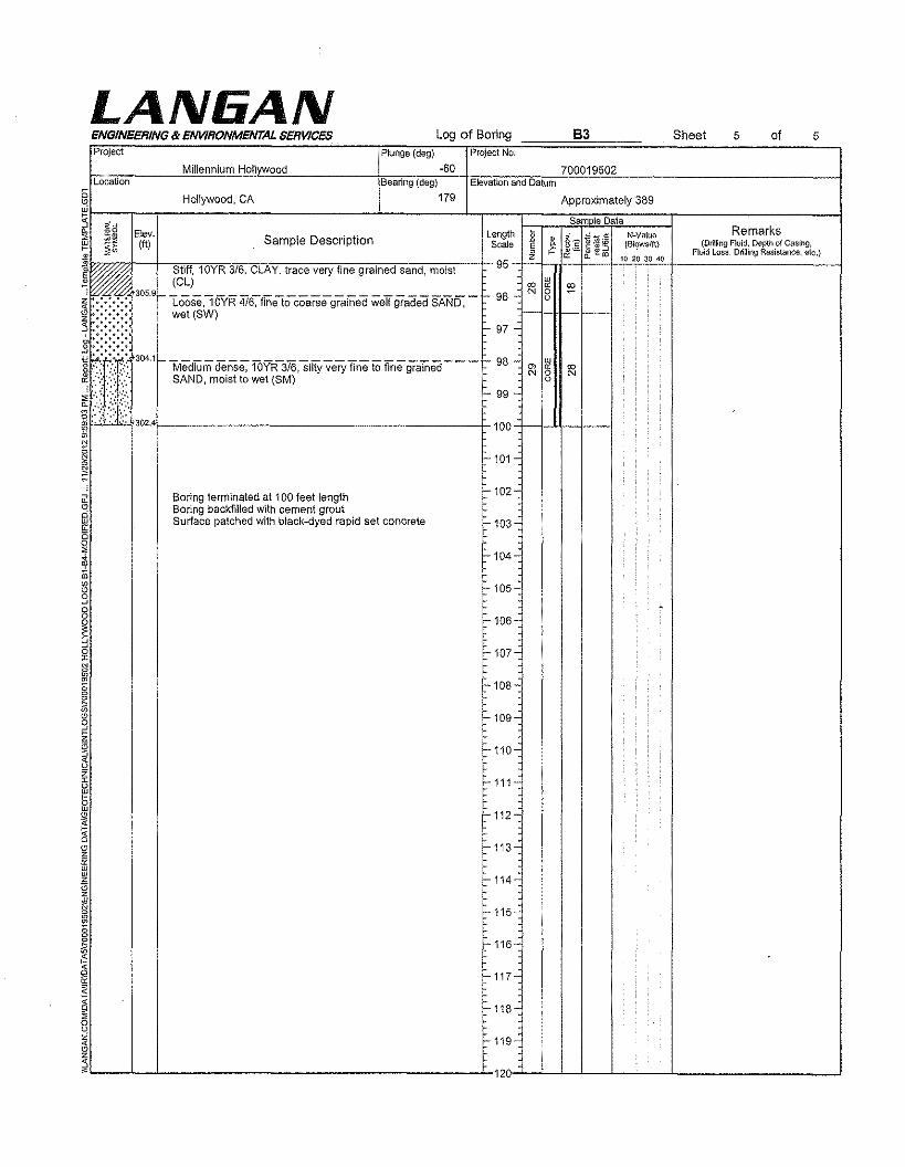
LA NliA NENGINEERING & ENVIRONMENTAL SERVICES Log of Boring 83 Sheet 5 of 5
o
Project Plunge (deg) Project No.
Millennium Hollvwood -60 700019502Location Bearing (deg) Elevation and Datum
Hollywood, CA 179 Approximately 389
~a Sam Ie DataElev. Length • §'2 " c rc-vaiue Remarks
~~ Sample Description •1ft) Scale " r: ~'*3 (Bt,?wSlft) (Drilling Fluid. pepin of Casing,E," 0 w= ~E!r.o Fluid Loss, Drilling Resistance. etc.)• z ~ 10 20 30 40• Stiff, 10YR 3/6, CLAY, trace very fine grained sand, moist 95. :&- w
~~/////-: (el) co c: co305.9 ~-------------------------- I=- 96 .: N 0 ~
~/( Loose, 10YR 4/6, fine to coarse grained well graded SAND, 0
wet (SW)97 -~~:@:304.1 ~-------------------------- .; 98 .: ~Medium dense, 10YR 3/6, silty very fine to fine grained m co
~:i};;?' N 0 NSAND, moist to wet (8M) 0
:. 99 .;
302.4 100
101C
Boring terminated at 100 feet length:'102 .,
Boring backfilled with cement groutSurface patched with black-dyed rapid set concrete 103
104-
1=-105-,
106
"" 107"
:'108-
109-
110-
z111
1=-112--c<
113-,urur
114zzg I=- 115-~m;;0
116 -R-c<
117-~
~ 118
~ 1=-119-<~z5~ 120
o
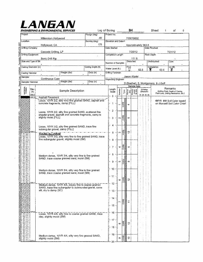
Log of Boring B4 Sheet of 5
Plunge (deg) Project No.
-60 700019502Bearing (deg) Elevation and Datum
178 Approximately 393.5Date Started Date Finished
7/20/12 7121112Completion length Rock Depth
111 ft -Number of Samples
Disturbed UndIsturbed Core- -
Water Level (ft.)First Completion 24 HR.s: 62.5 .'! 62.5 Sf.
Elev. length • • §'2 ~'~3ts-veiue RemarksSample Description ~1ft) Scale § ~ (Blows/tt) (Drilling Fluid, Depth of Casing,
<\)'=> ~~m Fluid Loss, Drilling Resistance, etc.)393.5 z " 10 20 30 40
393.2 -'''i~SPhalt Pavement ....r 0
iLoose, 10VR 3/2, silty very fine grained SAND, asphalt and
ur ##YR #/# Soli Color basedconcrete fragments, damp [FILL] 1 " on Munsell Soil Color Chart~ 0 "0
Loose, 10YR 3/2, silty fine grained SAND, scattered fine - 2
angular gravel, asphalt and concrete fragments, damp to urslighlly moist [FILL] - 3 - N " io0
0
LA NliA NENGINEERING & ENVIRONMENTAL SERVICESProject
Millennium HollywoodLocation
§ HollyWood, CAW Drilling Company
~ Cascade Drillina, LPi1l Drilling Equipmentr'* Sonic Drill Ria
t- 4
w+ 5 - eo "00c- 6
e- 7 - -e- ~00
Loose, 10YR 3/2, silty fine grained SAND, trace finesubangular gravel, damp [FILL]
'YOU1iCfALLU\t1UM"-"-"-"-"-"-"-"-"- ._..-Loose, 10YR 3/3, silty very fine to fine grained SAND, tracefine subangular gravel, slightly moist (SM)
Medium dense, 10YR 3/4, silty very fine to fine grainedSAND, trace coarse grained sand, moist (SM)
- 8
- 9 -
Medium dense, 10YR 3/4, silty very fine to fine grainedSAND, trace coarse grained sand, moist (8M)
c- 10 ++H-+-1- 11 -
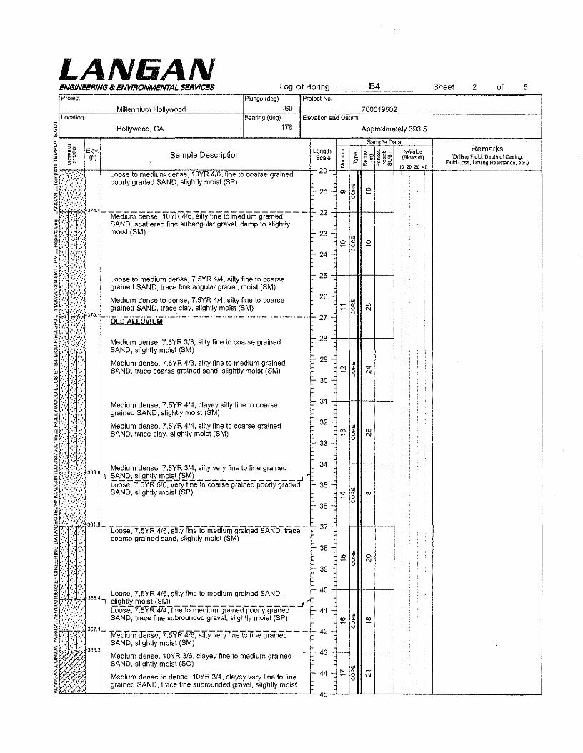
LANliANProject Plunge (deg)
-60
Log of BoringProject No.
Bearing (deg)
§ Hollywood, CA 178 Approximately 393,5
~j-~~~g~[E~'e-,l.-------C-----------------------1------------1-~L-en-g~th~='~==~>Js~a¥:ill._~lel~¥a~~~N=~=a=,,=,==r-------~R~e:rn:a:r:k~s-----c--i~ I!.!~ (ft) Sample Description Scale z€ ,~8 c ~ '* ~ (Siows/f\) (Drilling fluid. Depth of Casing.e ~ <!I - ,..- ~;:::. &. ~ to 10 20 30 40 Fluid Loss. Orilling Resistance, etc.)
~~~---r~Lo~o~s~e'w~m~e~d"iu~m~de~n~s~e-,~10~Y"R"~~6-,fifl.1n~e~t~o~c~oa~r~s~e~g~rn~in~e~d'-~~20-+~t,rl--+~-+~~••.~~~;----------------------ipoorly graded SAND, slightly moist (SP)
21 m \it ~8
374.41- Medium dense; 1OvR-4i6,siify fine to ;nediumgrained - - - 22 -j--+-H--f----1SAND, scattered fine subangular gravel, damp to slightlymoist(SM) - 23 -
ENGINEERING & ENVIRONMENTAL SERVICES
Millennium HollvwoodLocation Elevation and Datum
grained SAND, trace clay, slightly moist (8M)§ 370,1f-"OLifAi..IUVjUM··-·"-"-"_··_··_"-"-"-"_· - .- .j- 27-
o~ Medium dense, 7.5YR 3/3, silty fine to coarse grained
SAND, slightlymoist(SM)Medium dense, 7.5YR 4/3, silty fine to medium grainedSAND, trace coarse grained sand, slightly moist (SM)
Medium dense, 7,5YR 4/4, clayey silty fine to coarsegrained SAND, slightly moist (SM)
Medium dense, 7.5YR 4/4, silty fine to coarse grainedSAND, trace clay, slightly moist (SM)
~ 3 3 Medium dense, 7,5YR 3/4, silty very fine to fine grainedz t<.f;;:";.': 66r '?.A!:!~ ~\!!111X !,!,",-s!J'?.Ml ...Jg! Loose, 7.5YR 5/6, very fine to coarse grained poorly graded~ SAND, slightly moist (SP)
~",,''''0<,,361,5 -Loose,? .5yR4/6, slHyfineto med1urrlgrainedSANb~t;:ace - 37 +-1--tt-+--1
coarse grained sand, slightly moist (SM)
11:::)·::9/ Loose,7.5YR 416,SIltyfinetomedium grainedSAND,e" ~:~::t~:'35841 hg, .~:,.: ~g_t!l~~!J~Ml ..Jg >,":. Loose, 7.5YR 4/4, tine to medium grained poorly graded 41~ . '," , . SAND, trace fine subrounded gravel, slightly moist (SP);3 •\ .....~ ,~tt:fi: 357 1f- MediUm deilSe,-75YR 4/6-;-siITyveryflM Tofine grruned- - - - 42 -~ :::.,':t':.:}::., SAND, slightly motet (SM)~I" ',' 356 3f-lvie'di'Um den'Se,-1bVR-3i6,cfayey fine to medium-grained - - - 43 +-Hft-~--18 '," SAND, slightly moist (se)~ ~ ~ No '.'" Medium dense to dense, 10YR 3/4, clayey very fine to fine 44 8~ ". '.' gramed SAND, trace fine subrounded gravel, slightly mOIst
45~~~~--~----~---------- --...l
Loose to medium dense, 7.5YR 4/4, silty fine to coarsegrained SAND, trace flne angular gravel, moist (SM)
Medium dense to dense, 7,5YR 4/4, silty fine to coarse
I- 25 +-+-1+--+--1
I- 28 +-+-1+--+--1
I- 24 -
I- 26 -
- 29-
30
31
700019502
84
32 -
- 33
35 -
- 36 -
38
- 39-
Sheet of2 5
- 34 +-1-*-+--1
40 +-1-*-+--1
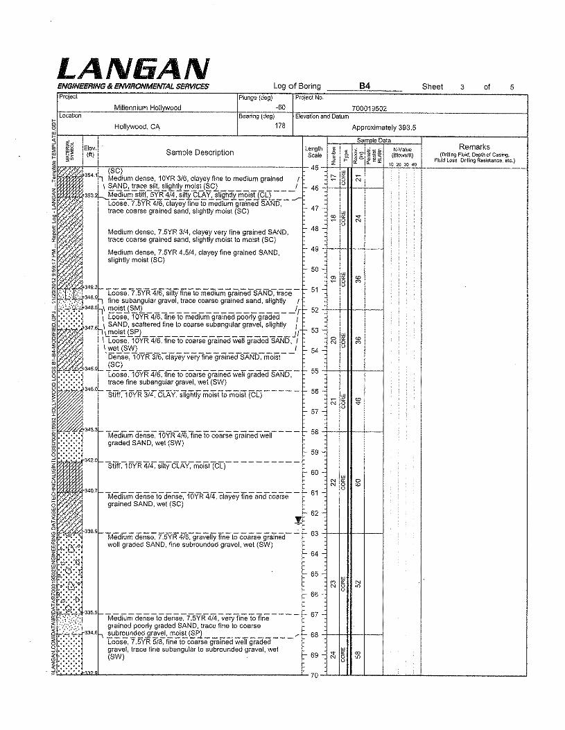
LA NliA NENGINEERING & ENVIRONMENTAL SERVICES Log of Boring B4 Sheet 3 of 5
cc
Project Plunge {deg} Project No.
Millennium Hollvwood -60 700019502Location Bearing (deg) Elevation and Datum
Hollywood, CA 178 Approximately 393.5
i" Sam le Data
ffi~ Elev:Sample Description Length ~ 8'2 ~OiS NNalue Remarks
§G 1ft) Scale E ! c~:3 (81owslft) (Drilling Flu!d, Depth of Casing., .~ Fluid Loss, Drilling Resistance, etc.)
* z ts; tf ...r.o 10 20 30 40
~'' " (SC) 45
ill" . -354.11 Medium dense, 10YR 3/6, clayey fine to medium grained r ~ « N• 8, \ SAND, trace allt, slightly moist (SC) I I- 46
353.2 --.M~~U!.::~l!t~57.Bi~~~ "tL~~~~1!r~~u~l..;~-=---'," Loose, 7.5YR 4/6, clayey fine to medium grained SAND, i- 47 -trace coarse grained sand, slightly moist (SC) ill
~'", :2 " -e-
'," 0 NU
" ,,'. I- 48 -o Medium dense, 7.5YR 3/4, clayey very fine grained SAND,fr,'.'
,' . . , trace coarse grained sand, sllghtly moist to moist (SC),," I- 49.' Medium dense, 7,5YR 4.5/4, clayey fine grained SAND,
','. slightly moist (SC)
" .. f- 50 - w, "
:.:if, ~ " co8 M
,ffiE$!34R3
Loose,? ]'YR 4/6, SiltY fineto medium grah1edSANb~trace - I- 51 -348.9 1, fine subanqular gravel, trace coarse grained sand, slightly (348.5 1,\ moist (SM) I I- 52
\ Loose, 1ClYR-416,finetomediUm graTriecipooriY graded - - r
I347.6 \ SAND, scattered fine to coarse subangular gravel, slightly J..... 'c:.. l:l.!"~i~ @5 ____________________ JI f- 53 -
ill
Loose, 10YR 4/6, fine to coarse grained well graded SAND, J 0 " co
::,./ N 0 M
t wet (SW) 1 o'Dense.10YR3/6:-clayeyveryfliie grained-SAND-;- niOlSt--
I- 54 -
345.9(SC) I- 55Loose ,1OY"R4I6,finetocoarsegramed weif graded SAND,-trace fine subangular gravel, wet (SW)
345.0 sill"C15VR 314, CLAY~SITglitiYmoTsfio-moiSt (?;L) - - - -- I- 56 -illj. ~ " co
N 0 -sr-j- 57 -
o
~.343.3 -lvledium dense.-WYR-4i6,fine 10coarse graTned-well- - - - I- 58
))~ graded SAND, wet (SW)I- 59 -
342.0 - Silff:-iOYR 41.[ $TItyClA'Y:-riiOiSt(c1r - - - - - - - --f- 60 -
illN " 0N 8 co
'340.7 - Medium denseto dense~ fOYR4/4, chiiYeyfine andcoarse - I- 61 -, " '.'
, , grained SAND, wet (SC).'.:'
l'I- 62 -, "
,.',.. .... 338.9I--------------------------~ f- 63- ?".~•••• Medium dense, 7.5YR 4/6, gravelly fine to coarse grained
"<5:0 well graded SAND, fine subrounded gravel, wet (SW)'::::-::: f- 64 -.t>-,'. ~
0:'::;';' I- 65;.;.ti·9 M ~ N
.~<: ;. N 0 "'I- 66o
.;C;;:; :ti~;9.::'335.51--------------------------- l- 67 -·:·:.:f·'::::"· Medium dense to dense, 7.5YR 4/4, very fine to fine..:;. " grained poorly graded SAND, trace fine to coarse;';:';;;: 334.6~ !.u~~~~d ilr~v~,!Yl.£!~ @f1 ____________ ""I- 68
Loose, 7.5YR 5/8, fine to coarse grained well graded:tr gravel, trace fine subangular to subrounded gravel, wet illI- 69 " " co(SW) N 0 '"o
"",
70
LAN6ANENGINEERING 8< ENVIRONMENTAL SERVICES Log of Boring 5Project Plunge (deg)
Millennium Hollvwood v60Project No.
700019502
84 Sheet 4 of
Location Bearing (deg)
g Hollywood, CA 178
~ ig Elev. Length~ ~~ (ft) Sample Description ScaleI~ Dense, 7.5YR4/6, clayey coarse grained SAND, slightly 70~~. moist (SC) 71 _
J '1' ':. " 331.1)-- '- - 72 -, .:-; ':,. ':( Medium dense, 7,5YR 5/4, silty fine to coarse grained.3::.~:~(.::::::'. SAND, scattered fine to coarse subangular gravel, slightly
) ~,:.~ ,;. 330.3~ro~:~:~~tYR5j~ graveiTyfineto co-arse graTned-weU- - - /' 73iHC~ graded SAND, fine subrounded gravel wet (SW)
:_~a:T.,,:~.::j·':':',:~.:.',:.328 11- DenSe~7]yR5i4,$dty fine to coarse 9ralnedSAND,- ---:' scattered fine subangular gravel, slightly motst (SM) 76 -
.:: ;:::: 77 -§ " " .~ 1--1.oose,Y.5YR 5/6. fine to coarse gramedweii gr8cted- - - - - 78 -1--+-It-+---I8 SAND, scattered fine subrounded gravel, wet (SW)
~
~f~~:i;;324.2 Dense;-5YR-314,siiIifine to coarse graTned-SANb;- - - - - 80
1m~':::~:::::~~~:~M~C_..--:.~W#' angular gravel, wet (SC)g :.:.:.:~: 321,61--CooSe,'?SVR 4/6,finelocoarse graTnedweTI graded- - -- 83 +-HIt--1I-----IR -:.;.:-;. SAND, wet (SW)
:
~~<".-~~~~.320.8f- Hard,"r5YR373;-CIAv;1race coarse graTnedsand-:-traC€i - - - 84 -_ ~ fine subangular gravel, slightly moist (CL)
851~ ~§~ :: -~~~ ',',,'."', 317.3_-COOSe,"lOYR'476-:-finetomediumgraTned-poorlygraded--- - 88 +-HH--'H--Ii:lijm ers.e M" trace fine to coarse subanq ular pravel ."",,
~: siTf(loVR 3it[ cLj.\V-:-trace fine to coarse 5ubangUiar - - - 90 wo ~ gravel, trace coarse grained sand. slightly moist (CL) - ..~ 8~~ -91-~~~ .:.: ',:,;:':::,313,8_ DenSe;loVR 3i3,'ST1tyf1"iieto medium graTnecfSAND:- - --
O
~':.:•.':.:.'.:....:.'.:..:.'" slightly moist (SM)~ Dense, 10YR 3/3, silty fine to coarse grained SAND,~ :. ':: :,:.::>': ~312.1 slightly moist (SM) OJ ~ co(Ii • BI" Medrum dense, 1OYR-314,clayey sandy weigraded - - - - 94 N 8 to~ ~:~~ GRAVEL, medium and coarse grained sand, fine to coarse .~~L-~ ~95~~~~ __ L- L- ~
Elevation and Datum
Approximately 393.5Sam le Data
C>co
C>so
Nverue(Blows/It)
10203040
Remarks(Drilling F!uld, Depth 01 Casing,
Fluid loss. Drilling Resistance. etc.]
- 74 -
- 75 -
79
89
92
93 ++*-+---1
LAN6ANENGINEERING & ENVIRONMENTAL SERVICES Log of BoringProject Plunge (deg)
·60MlIIennlum HollvwoodLocation
Project No.
Elevation and Datum
84
700019502
Sheet of5 5
Bearing (deg)
S 178e Hollywood, CA?~;:~__-r-------------------------------1------------l-~----1=~::;1~~~~::::::r-------~::::~~------l;:1 .$5 Remarks::'E ffigJ: Elev. SID . ti~ ~i',; (f1) amp e escnp Ion {Dnlling Fluid, Depth of Casing,
"" w Fluid Loss. Drilling Resistance, etc.j
h'!·~~0:':4~#', ••, ,
-c ... :.'~,~~, .~,..:-,...J • '..,...1::' .. ,. 308.6!- _
Ii+, ", ' .. .' Loose to medium dense, 7.5YR 4/4, gravelly silly SAND,(£ : ',,' .' .:. fine to coarse angular to subrounded gravel, fine to medium, ' grained sand, slightly moist (SM)
~::: ::~'; ::,Qi' •Ii>' ','~::.:::. ,,:.g"" ", 306.0~",:,~.
: -,. .....,.i1 ' .. :•.
~iii-304.3 ..:j.--+-H---I--lu:: :,.; -: ,:':. Loose,-=;:5YR 3/6. fine to medium grained pciOriygraded - - ~ 103~ :::',}:::'~\:::', SAND, trace coarse grained sand. wet (SP)
~ '.,:,~ grained sand, fine to coarse subanguJar gravel. trace ctay,5.' :,"",' 3oo,oil ~ifLh~~~slt£..~0~tJ..~wl ,....t:-108+--HfI__+---R ',,:::1.';':: ':",:, Loose, 7,5YR 5/6, silty fine to coarse grained SAND, trace@ ',:::::"::'. 299,lf-.!!~!u::.a~g~~~a~e~~e.!J~Ml 1=_109..:.9 , ~ .. ' Loose, 7,5YR 4/4, clayey sandy well graded GRAVEL,~·:i~ medium to coarse grained sand, fine to coarse subrounded§ _:~.~ gravel, slightly moist to moist (GW) ~ 110-.....:.,~'·.:i~297,4'1----------------------------------1'-111 +--f-Jl.\-_+----l
I"~~§z
~
!•<~
~~ ! .~L_~ __ L- _L120}~-L~~-L~ __ ~--~------ __ ~
Approximately 393.5
Sam le DataLength 2 . 8?.-" n-veiueScale E ~
m!2iO (Blows/ft).~""~, &~(!Jz tx: 10 20 30 4095
:. 96 .,urc» " co
N 0 "'o97
98
subangular gravel, slightly moist (GW)Loose to medium dense, 5YR 6/2, sandy welt gradedGRAVEL, fine to coarse angular to subangular grave!,medium to coarse grained sand, slightly moist (GW)
Loose,7 ,SV'R4/3. sandy weUgraded 8M VEL,fine to - - -coarse angular to subanqular gravel, very fine to fine andcoarse grained sand, slightly moist (GW)
Boring terminated at 111 feet lengthBoring backfilled with cement groutSurface patched with black-dyed rapid set concrete
t, 99 .;
100-
101.,
e-102.:
106-
107-
e-112-
113-
114-
e-115-_
116-
1-117-
1-118-
Logof Boring B5 Sheet of 3Project No.
700019502Elevation and Datum
Aooroximatelv 388Date Started Data Finished
10/11/12 10/11/12Completion Depth Rock Depth
50ft .Number of Samples
Disturbed Undisturbed Core
ICasing Depth (ft) Waler Level (ft.)First Completion 24 HR.jl 47 :!: 46.5 'L .
IDrop (in) Drilling Foreman
Clint JeffersonInspecting EngineerI Drop (In)
D.Eberhart & S. MontaomervSam Ie Data
LAN6ANENGINEERING 8t ENVIRONMENTAL SERVICESProject
Millennium HollvwoodLocation
Hollvwood,CADrilling Company
BC2 Environmentalgho~r~iIl~i"~9cE~qU"iP~m~e~""t-"~~~~~~~--------------------------~~~~~~c---~~~----to.~~~------~~~'--------l~ Sonic Drill Rio~ Size and Type of Bita~hC~a~'~i"~9co~ia~m~'"'t'~r"(in~IC---------------------------~~~~h7<n--1-------------+~,---------~~~~c_----io'"c_------__1~·~_c-cc_----------------_,~~~CT-------L_,o==_~----~wm=c~~=_--~~-----C~--L;=-----~~-"~"-----C----l~ Casing Hammer IWeight (lbs)
~hs~a~m~p~I'~r=======S~~~~~~::::~~========~::~~====~~""ng",,,","..'~~~~~-------- ~:::~ Continuous Core~ Sampler Hammer IWeight (!bs)i~LT----~----~--~~~~~~~~~1- ~§ EI"."" 1ft) SampleDescription~~~~~f3~88~.O~=0~~~~~~~~~~~~~~~~~~~~~~~~ 387.7r-,Asphalt Pavementtt Loose, 10YR 3/6, silty very fine and fine grained SAND.~ scattered asphalt concrete fragments, slightly moist {FILt]
~N
~s
Depth il 8. §~~~~n-veue Remarks
Scale E (Blows/H) (Drilling Fluid, Depth of Casing,, f: a::,§, &:~III Fluid Loss, Drll!lng Resistance, etc.)z 10 20 30 400 ,../"
##YR#1# SoilColorbasedI- 1 - on Munsell SoH Color Chart
I- 2 -
I- 3 ., ~ ~ co8 '"
I§
!~g Loose, 10YR 3/6, silty medium and coarse gramed SAND,R ~ '. 379,5 scattered asphalt concrete fragments, slightly moist to r:I)·':;,;; \~o~~Yo~lf~~~~~ns:,1~Y;6/~, s~ty~ery-fln~to~o:'s:J- 9 -::::i'" " -: grained wen graded SAND, trace fine subrounded gravel, 10~ ',{ ",:y, scattered Silty pockets, slightly moist (SM)Z ' '"
~ ~:~'::::,i'3770_ Loose to mediUmderiSe~10YRSffl,veryfine, fine and - - - 115 :":";::":':::', coarse grained poorly graded SAND, trace fine subrounded ("') ~9 :,:.'::"':::':'::,:, gravel, scattered silty pockets, damp (SP) - 12 - 8
II::~~~'i~'::'3730_ MediUm stiff, 1OYR4i6,very fine and tTriegramed saildy- - - 15-;; .':. -: SILT, trace fine to coarse subrounded gravel, scatteredg':' ,":,:3720,\ !!1!1E..0~~s.!..~g~t~I!!!~~~~~g..!:!t~!!!0.EU~L.L .... - 16-~ .: ;:, Medium dense, 10YR 6/6, Silty very fine gramed SAND,g:t:' : ';,' ", damp to slightly motet (SM)0::: • ,,' ',., - 17 -
~i:'" 3705_'6Lo-ALLUViuM - - - - - - - - - - - - "" ~~ Stiff, 10YR 3/4, CLAY, trace coarse grained sand, slightly - 18 - '-'S moist to moist (Cl)
~~
Loose to medium dense, 10YR 3/4, silty very fine and finegrained SAND, slightly moist to moist (FILL)Medium stiff, 10YR 3/6, medium and coarse grained sandySilT, slightly moist to moist [FILL]
5
4 -
7N ~
8
- 6 -
~l'"~"' L20~-Lil--L~ __ ~~ ~- 19 -
8
LA NliA N85Log of Boring Sheet ofENGINEERING 8< ENVIRONMENTAL SERVICES 2 3
Project Project No.
Millennium Hell ood 700019502Location Elevation and Datum
Hollywood, CA Approximately 388
Sam e DataRemarks
(Drilling Fluid, Depth of Casing.Fluid loss, Drilling Resistance. etc.)
Elev.(ft)
DepthScaleSa,!1lp1e Description
21
22
23
24Stiff to very stiff, 10YR 4/4, silty CLAY, trace fine andcoarse grained sand, trace fine subangular gravel, sllghUymoist to moist (CL) 25
ac,
~<'l 361.0
1,w.L~:-:.;.:-:w~•• ~.. ~. 358.038 357.0
~~:::::;....J ·o·.n...·.o-l·.·.W.·~ .~ .0':-: tlg; .' .~.' 355.0
1\\7::·i~1i4#
s ','."~"~ .::.:,.G'i :': ,',. ',:,
II!n~)i;;
26Stiff to very stiff, 10YR 4/4, silty CLAY, trace fine andcoarse grained sand, slightly !!l0ist to moist (CL)
M~ium*M~O~M~Wffi3~5,Ve~fineM~~ffie-grained SAND, trace clay, slightly moist to moist (SP)
27
28
29Medium dense, 1OYR-4i6,firie to coarse graTned-SAND-;- --trace fine subangu!ar gravel, slightly moist to moist (SW)
stiff ~ 6VR 314.SITtyCLAY~tracecoarse gr8Jnedsand. - - -slightly moist to moist (CL)
Loose to medium dense, lOYRsi4, grav8ilyvery-flneto- - -coarse grained well graded SAND, fine to coarse angular tosubangular gravel, trace cobble, damp (SW)
30++*-+--131
32
33LOOse to medIUm dense, lOYR3i4", very fine and fine- - - -grained poorly graded SAND, trace slit, damp to slightlymoist (SP)MediUm stiff. ioYR3/4, Silty eLA Y, trace fine graTnedsand,"slightly moist to moist (CL)
Medium dense, 1OYR5i6,siitY very fine to coarse grarned--SAND, slightly moist (SM)
34
35
- 36
Medium dense to dense, 10YR 4/4, silty fine to coarsegrained SAND, trace coarse subangu\ar qravel. slightlymoist (SM)
37
38Loose to medium dense, 10YR 5/6, silty very fine, fine andcoarse grained SAND, slightly moist (8M) 39
40v"41
Loose to medium dense, 10YR 4/4, silty very fine and finegrained SAND. scattered fine to coarse angular tosubangu!ar gravel, trace medium grained sand. damp toslightly moist (SM)
42
43
44Loose to medium dense, 10Y~ 3/4, silty medium and
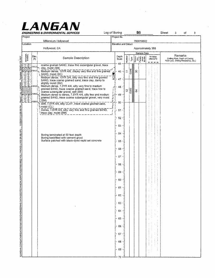
LANliANENGINEERING & ENVIRONMEIVTAL SERVICES Log of Boring B5 Sheet 3 of 3Project Project No.
Millennium Hollvwood 700019502Location Elevation and Datum
Hollywood,CA Approximately 388
$5Data
Elev. Depth ~~]~'*3 N·Value Remarks"w Sample Description •~, 1ft) Scale e • (Blowslft) (Drilling Fluid, Depth of Casirlg.~~ , i" ft!!1ll Fluid loss. Drining Resistance, etc.)z " 10 2() 30 40
.':J::,::':': coarse grained SAND, trace fine subangular gravel, trace 45342,5 ,~~~~u~~_________________~W2V w
," ':. 342.0 1 Medium dense, 10YR 4/6, clayey very fine and fine grained_! 46 - ;:: " 0'\}, 0 eo\~~£,.!!'£is.!..I~CL ________________ ii o
Medium dense, 10YR 3/4, silty very fine and fine grained 47SAND, trace coarse grained sand, trace clay, damp to -: ::.~.::. <':, slightlymoist (SM),:~:~340.0 1 Medium dense, 7,5YR 4/4, silty very fine to medium r l- 48-
\ grained SAND, trace coarse grained sand, trace fine to w;:! oc ..
coarse subangular gravel, wet (SM) I 0 ccU339.0 l,\ Medium dense to dense, 7,5YR 4/4, silty fine and medium If l- 49 -.L:;~i 1\grained SAND, trace coarse subangular gravel, very moist /I
338.0 """!\L~~7.5YR474~sTIty-CLAy,trace coarse grained sand-:- - -11[r 50II moist (Cl) I\ Dense, 7,5Y'R 4i3," S'ITtyverYflneaiidfine grarnedsAND~-: l- 51 -I.t~~E!~,.!:'~~@~ _______________ -1
r 52 -
r 53-
Boring terminated at 50 feet depth l- 54-Boring backfilled with cement groutSurface patched with black-dyed rapid set concrete t- 55-
r 56-
r 57-
r 58-
r 59-
r 60-
r 61 -
t- 62-
r 63-
r 64-
["'66 -
67 -
L8-
r- 69-
70
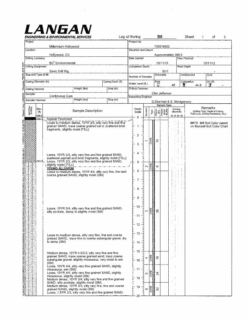
LAN6ANProject
ENGINEERING & ENVIRONMENTAL SERVICES
Millennium Hollvwood
Log of BoringProject No,
66 Sheet of 3
locationHollywood, CA
Elevation and Datum700019502
Approximately 388.5Drilling Company Date Started Date Finished
f- BC2 Environmental 10/11/12 10/11/12~bD'-(~llIi~ng~Eq~U""iP~m~'~n't-=~~~~~~"---------------------------tc~'=m=p~te=ti~'=nOD=ep=t"h---"~~~---icR~,=ck~D~e=p~thC-----~~~~-------i~:5 Sonic Drill RiQ~ Size and Type of BlI
~§~,?.<:Z?, ,',iJ.383.5
Cl ':.:,:: ••:.::>
ur '.~ .:.:-
l!i1!~:?,
:.:':,:,. '.:'
.,'.',::E -.'; .,',,"8 ':',' .~::.~',' .':,
!i;/li
I Drop (in)
Clint JeffersonInspecting Engineer
Elev.1ft)
388.5
Sample Description
Loose, 10YR 3/3, silty very fine and fine grained SAND,scattered asphalt and brick fragments, slightly moist [FILL]Loose, 10YR 3/3, silty very fine and fine grained SAND,
\~I!9~.t!¥.f!l2!~!Jf.I.!:q_ .. _ .. _ .. _ .. _ .. _ .. _ .. _ .. _ .. _ .. _ .. }YOUNG ALLUVIUMLoose to medium dense, 1OYR 4/4, silty very fine, fine 'andcoarse grained SAND, slightly moist (SM)
Loose, 10YR 5/4, silty very fine and fine grained SAND,silty pockets, damp to slightly moist (SM)
Undisturbed
DepthScale
D.Eberhart & S. MontgomerySam le Data
a. ,.;.::: _ c N-Valu6
Z
§ ,~ 8'2 :g.*~ (Blows/tt)~ ..... &:::;'&;.l!!m 102030400i=~4=~~~-------------I
2 -w~ ~ ~0
- 3 - c
4 -
5 wN " co0
- 6 o
- 7 -
- 8 -
- 9 -
~ 10 -ur
eo " co0 coo
~ 11 -
r 12-
Loose to medium dense, silty very fine, fine and coarse '- 13 -grained SAND, trace fine to coarse subangular gravel, dryto damp (8M) t., 14 -
Medium dense, 1OYR 4,5/3.5, silty very fine and fine f- 15urgrained SAND, trace coarse grained sand, trace coarse -e- e: ;!:subangu!ar grave!, slightly micaceous, very moist to wet f- 16 - 0c
(8M)Loose, 10YR 4/4, silty very fine grained SAND, slightly
l- 17 -micaceous, wet (SM) urLoose, 10YR 4/4; silty very fine grained SAND, slightly io " .,.
0 Nmicaceous, slightly moist (SM) cMedium dense, 10YR 3/4, silty very fine and fine grained t- 18 -SAND, silty pockets, slightly moist (SM)Medium dense, 10YR 3/3, silty very fine, fine and coarse - 19 - ~ 0grained SAND, slightly moist (SM) co 0 io
Loose, 7,5YR 3/3, silty very fine and fine grained SAND, o
20
Core
Remarks(Drilling Fluid, Depth of Casing,
Fluid loss, Drilling Resistance, etc.)
##YR #1# Soil Color basedon Munsell Soil Color Chart
388.2~A~h.a.!!. ~a~e!:2~~ -/Loose to medium dense, 1QYR 3/3, silty very fine and finegrained SAND, trace coarse grained sand, scattered brick - 1 -fragments, slightly moist [FILL]
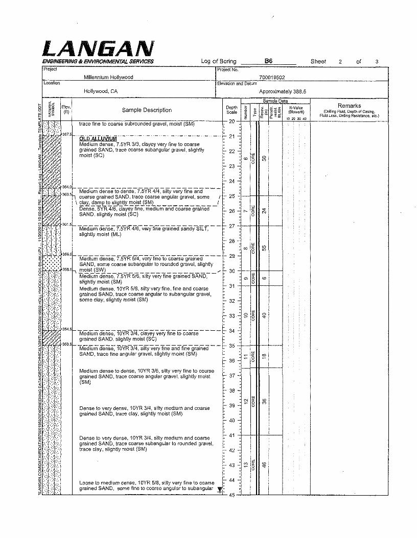
LAN6ANENGINEERING'" ENVIRONMENTAL SERVICES Log of Boring B6 Sheet 2 ofProject Project No.
3
700019502Elevation and Datum
Approximately 388.5
Samole DataDepth ~ • » ~ Vj.s N-ValueScale § " §:[ ~'''3 (8Jowslft)
'" " ~ foo20
z 10 20 30 40
..
.I- 21 -:
l- 22 - w<0 " 0
0 en0
I- 23 -~S·' .'1::: •. ,.... -24-
J ..~t\t:·::'~f-Medium dE:nseto dense-:- f"SYR414:SliyveryfiriEi and - - -'I: "'. ' 11, coarse gramed SAND, trace coarse angular qravel, some r r- 25~ ',: ,:; " \ clay, damp to slightly moist (8M) I8' ',' :",:. Dense, SVR4/6. clayey fine. medium-andcoarsegralned - t- 26 _~ .:: ,:,", SAND, slightly moist (SC)
~>::~:'::::361.5!- MearumdeiiS€,"7.5YR476-.-very-finegralnedsandy-SiIT. - - t- 27 -+-l-H---!f---i§ '::. :, .. slightly moist (ML)0:.':<': 1-28-
f}P;: 3595 - MediUm dense; 7:5YR 5I4-;-verYfine(Oeoarsegrained - - + 29 -i£ .:.:.:.:. SAND, some coarse subangular to rounded gravel, slightly~r".:r::.~.::3585, .'!'~s.tj~v:D ? I- 30 -I--t:C
wtl--t--1
:3 ",",,:,\ ,:',,' Medium dense, 7.5YR 5/6, silty very fine grained SAND, OJ 0::: (D
8 :'',:.:::''::,' slightly moist (SM) -l--j-=8'"lt-t----i0··'······· 1-31~ .::~':,~/: Medium dense, 10YR 5/8, silty very fine, fine and coarse:l :> .:::'':::' grained SAND, trace coarse angular to subangular gravel,0:< '':',:'/' some clay, slightly moist (8M) ~ 32 _
I\i}i'\ I- 33 - ~ §3~ 354.51- MedIUm dense.-lOYR-3i4 ,clayey very line to coarse - - - - I- 34 -~ ~ grained SAND, slightly moist (8C)
~ :',:.. ::: :>, 353.51- MediUm deiiSe.-lOYR-3i4,siity very fine and finegralned - - l- 35 -+-l-H--'f--i~ .:"~'.::'::::":" SAND. trace fine angular grave!, slightly moist (SM) ...- ~3::':'''<:'' 1-36-"-"
£::!:....: .:.', "". :1--+-++--+--1" '::.
(!) v- :. Medium dense to dense, 10YR 316,silty very fine to courseI- 37 -grained SAND, trace coarse angular gravel, slightly moist
(SM)
I- 38 -w;:; tx <0
l- 39 - 0 coDense to very dense, 10YR 3/4, silty medium and coarse 0
grained SAND, trace clay, slightly moist (SM) -I- 40 -
I- 41Dense to very dense, 10YR 3/4, silty medium and coarsegrained SAND, trace coarse subangular to rounded gravel,trace clay, slightly moist (SM) l- 42 -
wI- 43 - " " <0
0 '"0
Loose to medium dense, 10YR 5/8, silty very fine to coarse I- 44 -grained SAND. some fine to coarse angular to subangu!ar ! .
45
Millennium Hollvwoodlocation
Hollywood, CA
E!ev.1ft) Sample Description
trace fine to coarse subrounded grave!, moist (SM)
::
Remarks(Drilling Fluid, Depth of Casing,
Fluid Loss, Drilling Resistance. etc.)
co
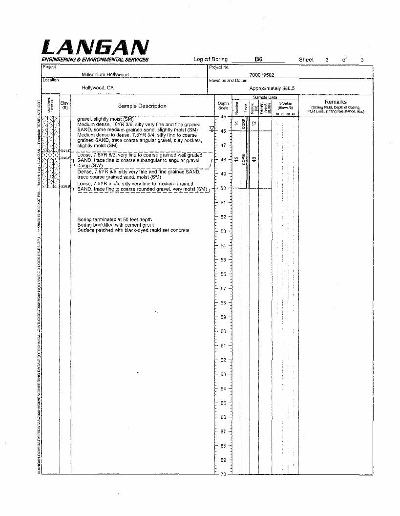
LAN6ANENGINEERING 8t ENVIRONMENTAL SERVICES Log of Boring 86 oSheet 3Project Project No.
Millennium Hollvwocd 700019502Location Elevation and Datum
Hollywood, CA Approximately 388,5
Sam Ie Data~ ~S Etev. Depth t ,..';; ~ <:: N-Value Remarks'-' ~~ (tt) Sample Description Scale ..~ ! @g ~~:3 {Blows/It} Fjj~ri~~~.F~~~in~e£~~~:a~~~i,n~ic.)
~~rc~e-~------c-~~--~~~c--------------------------t--+~Z-+CTf"~f"~"_W+-'~O~2~0220~'O-+ -4~.: ,:.:~.:, gravel, slightly moist (SM) 45 ::! R:i!!:! ::',:: :::' ':::' Medium dense, 10YR 3/6, silty very fine and fine grained" '"
<l> .. ', :< ',''', SAND, some medium grained sand, slightly moist (8M) -¥t=- 46 +-4-':C!.J--+---I} :(:: ::':::, Me?iU~~:~s~ ~odense,7.5YR 3~4,silty fire fO coar~et,---',',~":'.':.::.: gram8 , race coarse angu ar grave, cay poe e s,
.': .;..... '. slightly moist (SM)t :.:.:::.:341.01- Loose,7.5yR6i3, veryflneto coarse graTne'dweiigraded---l ~~~:~': .... 34Q.5h SAND, trace fine to coarse subangular to angular gravel., {I- 48:< .~-:.:.:.. \ damp (SW) . IS :::::;':.::: Dense. 7,5YR 6i6~STityverjfiiieaii<ffine 9raTnedSAND~- I=- 49I':.::: ./:: .;.:,:. trace coarse grained sand, moist (SM)....;';:.r ;':,:;.; Loose, 7,5YR 5.5/5. silty very fine to medium grained
~':, 338.5h ~A~~ ~~"!!~!e.£.05:!~!9~£.e~~a..::.el ~ry ~o~US~l.J ...~ 50 +-i-..1-1--I----I~8ssN
I
47 •
Boring terminated at 50 feet depthBoring backfilled with cement groutSurface patched with black-dyed rapid set concrete
it~~w238
~~
Izi"ooz;II~~
"~8~~L-__~~ --L
3
Fault Investigation ReportHollywood DevelopmentVesting Tentative Tract 71837Hollvwood California
30 November 2012700019502
APPENDIX BINRODUCTION TO RADIOCARBON DETERMINATIONS BY AMS METHODOLOGY
LANIiAN
BETARadiocarbon Dating
Consistent AccuracyDelivered On~Time
Introduction to Radiocarbon Determinations by theAccelerator Mass Spectrometry Method
AMS Counting
Tbe 14C Metbod;
There are three principal isotopes of carbon which occur naturally - C12, C13 (bothstable) and Cl4 (unstable or radioactive). These isotopes are present in the followingamounts Cl2 - 98.89%, Cl3 - l.ll% and Cl4 - 0.00000000010%. Thus, one carbon 14atom exists in nature for every 1,000,000,000,000 or (I in a trillion) C12 atoms in livingmaterial. The radiocarbon method is based on the rate of decay of the radioactive orunstable carbon isotope 14 (14C), which is formed in the upper atmosphere through theeffect of cosmic ray neutrons upon nitrogen 14. The reaction is;
14N + n => 14C + P
(Where n is a neutron and p is a proton).
The l4C formed is rapidly oxidized to 14C02 and enters the earth's plant and animal lifeways through photosynthesis and the food chain. The rapidity of the dispersal of C 14 intothe atmosphere has been demonstrated by measurements of radioactive carbon producedfrom thermonuclear bomb testing. 14C also enters the Earth's oceans in an atmosphericexchange and as dissolved carbonate (the entire 14C inventory is termed the carbonexcbange reservoir (Aitken, 1990». Plants and animals which utilize carbon inbiological food chains take up l4C during their lifetimes. They exist in equilibrium withthe C 14 concentration of the atmosphere, that is, the numbers of C14 atoms and non-radioactive carbon atoms stays approximately the same over time. As soon as a plant oranimal dies, they cease the metabolic function of carbon uptake; there is noreplenishment of radioactive carbon, only decay.
Libby, Anderson and Arnold (1949) were the first to measure the rate of this decay. Theyfound that after 5568 years, half the Cl4 in the original sample will have decayed andafter another 5568 years, half of that remaining material will have decayed, and so on(see figure 1 below). The half-life (t 1/2) is the name given to this value which Libbymeasured at 5568±30 years. This became known as the Libby half-life. After 10 half-lives, there is a very small amount of radioactive carbon present in a sample. At about 50- 60 000 years, then, the limit of the technique is reached (beyond this time, other
radiometric techniques must be used for dating). By measuring the CI4 concentration orresidual radioactivity of a sample whose age is not known, it is possible to obtain thecount rate or number of decay events per gram of Carbon. By comparing this withmodern levels of activity (J 890 wood corrected for decay to 1950 AD) and using themeasured half-life it becomes possible to calculate a date for the death of the sample.As 14C decays it emits a weak beta particle (b ), or electron, which possesses an averageenergy of 160keV. The decay can be shown;
14C=> 14N + b
Thus, the 14C decays back to 14N. There is a quantitative relationship between the decayof 14C and the production of a beta particle. The decay is constant but spontaneous. Thatis, the probability of decay for an atom of 14C in a discrete sample is constant, therebyrequiring the application of statistical methods for the analysis of counting data.It follows from this that any material which is composed of carbon may be dated. Hereinlies the true advantage of the radiocarbon method, it is able to be uniformly appliedthroughout the world on any material that contains residual carbon.Because of this laboratories from around the world are producing radiocarbon assays forthe scientific community. The C14 technique has been and continues to be applied andused in many, many different fields including hydrology, atmospheric science,oceanography, geology, palaeoclimatology, archaeology, biomedicine and materialsscience.
The Accelerator Mass Spectrometry method of direct C14 isotope counting was firstperformed in 1977 by scientific research teams at Rochester and Toronto, the GeneralIonex Corporation and soon after additional measurements were carried out at SimonFraser and McMaster Universities (Gove, 1994).
Radiocarbon dating using Accelerator Mass Spectrometry (AMS) differs from the decaycounting methods in that the amount of 14Cin the sample is measured directly, rather thanby waiting for the individual radioactive decay events to occur. This makes the technique1,000 to 10,000 times more sensitive than decay counting. The enhanced sensitivity isachieved by accelerating sample atoms as ions to high energies using a particleaccelerator, and using nuclear particle detection techniques. Additionally because of theincreased sensitivity counting times are greatly reduced (minutes to hours, instead ofdays) and sub-milligram sample sizes can be routinely measured. Because of this agreatly increased range of sample types and sizes can now be measured that previouslygas-proportional or LSC counting techniques could not.
14In the CAMS technique, the element of interest (sample carbon) is chemicallyseparated from the original sample, converted to graphite, pressed into a cathode (sampletarget holder) where if forms a solid graphite plug or layer and is then placed into asputter ion source of an accelerator.
This methodology outlines the general graphite sample preparation (chemistry) and AMScounting procedures at BETA Analytic Inc., for organic and carbonate samples. Throughthis process the C02 produced from carbonaceous raw materials is cryogenically purified(separated from non-combustible gases) and reduced to solid graphite for measurement' inan AMS.
Conversion of Sample Carbon to Graphite;
Sample Pretreatment;
Each sample must first be pretreated or the material of interest isolated to insure that onlythe primary carbon of interest will be analyzed. As many different types of carboncontaining compounds are present, different pretreatment regimes have been developedto concentrate and isolate the particular carbon fraction of interest prior to dating. (SeePretreatment Glossary - Standard Pretreatment Protocols at Beta Analytic).
C02 Generation;
The pretreated sample carbon is first oxidized to C02 either by combustion in an Oxygenstream or through direct reaction with reduced Cupric Oxide (metal wire / powder) fororganics or through acid hydrolysis for carbonates.
CombustionOrganic + 02 + ilH => C02(Sample) (900°C)
OR Acid HydrolysisCarbonate + HCl => C02(Sample)
Organic + CuO + I'lH => C02(Sample) (900"C)
The C02 generated is then cryogenically purified by removing water vapor and any non-combustible/condensable gases by passing through a series of dry-icc / Methanol watertraps (- -78°C) and depending on the sample type a series of liquid Nitrogen / Pentaneslush traps (-129°C).
Conversion of C02 to Graphite (Graphitization reaction);
To produce the small amounts of elemental carbon from C02 for measurement in anAMS we use the Bosch reaction (Manning and Reid, 1977) that is a chemical reactionbetween carbon dioxide and hydrogen that produces elemental carbon (graphite), waterand heat.
The reaction takes place as two successive reductions; first to carbon monoxide and thento carbon, which permeates and adheres to the surface of the Cobalt powder (catalyst).More details on graphitization techniques and catalysts can be found in Vogel et al, 1984.
The overall reaction is as follows;
(550 to 650°C)C02 (g) + 2 H2 (g) -> cr;;) + 2 H20 CD
(COCatalyst)
However, the above reaction is actually the result of two separate reactions. The firstreaction; the water gas shift reaction is a fast one;
The second reaction controls the overall reaction rate;
During the graphitization procedure cryogenically cleaned, dry C02 produced from thecombustion or acid hydrolysis, is transferred cryogenically (with Liquid Nitrogen @ -196°C)* to a specially designed graphitization cell under vacuum that is composed ofVycor glass, Pyrex glass and Stainless Steel (modified design after Lloyd et ai, 199I).
* NOTE; Prior to the introduction of the C02 over the cobalt catalyst in the graphitization cell. the cobaltis pre-conditioned to remove any carbon contaminants by being evacuated, then purged with Hydrogenmultiple times and.finaily reduced over '4 atmosphere of hydrogen for 1·2 hours at 550°C to 650°C
The pre-conditioned graphitization cell contains either a 4.5 mg or 3.5 mg aliquot ofCobalt metal powder (a mixture of 85% Alfa Aesar -400 mesh, and 15% Alfa AesarPuratronic -22 mesh) that is specific to the size of the sample being graphitized
Based on the amount of C02 generated during the combustion the C02 is cryogenicallytransferred to a graphitization cell containing and amount of Cobalt that is 3x greater inweight than the amount of carbon (3:I ratio), then and aliquot of Ultra-Pure ResearchGrade Hydrogen is added such that the amount of Hydrogen is 3x greater in volume asthe sample C02 (3: I ratio).
The graphitization cell is then placed into a 550°C to 650°C oven for a period of 10-12hours while the water produced during the graphitization is continuously removed via acold finger that is part of the graphitization cell, by a dry-ice Methanol slush (_78°C).
After 10-12 hours have passed the pressure in the graphitization cell is inspected to insurethat the reaction has gone to completion (that the C02 has been converted to graphitewith a minimum yield falling in the range of 80- I00%). If the reaction has not reachedcompletion, the graphitization cell is returned to the oven, and reacted again for a periodof 4-10 hrs. If the reaction does not reach an 80- 100% completion following the secondgraphitization attempt, the sample is analyzed again starting from combustion.
If the graphitization has gone to completion, the graphitization cell is placed under avacuum and allowed to warm to room temperature causing all water vapor formed duringthe graphitization reaction to be pumped away, leaving the graphite dry. The graphite isthen purged Ix with ultra-pure (99.999) Argon which has passed through an ascaritemolecular sieve to remove any C02 and a silicone drying agent to remove any watervapor. This is then followed by pumping to a vacuum and then purged again with ultra-pure (99.999) Argon to equalize with atmospheric pressure.
The graphitization tube is then removed from the graphitization cell and capped with anAI-foil cover and placed in a test-tube rack ready to be loaded into a cathode for AMScounting.
AMS Cathode (Target) Loading;
The prepared graphite sample is placed into an AMS cathode (target) by pouring thegraphite directly from the graphitization tube into the cathode. The graphite powder isthen compressed to a minimum of 150 psi (gauge reading) in an Arbor press or byhammering with a press-pin. .'
The surface of the graphite (target face) is optically inspected to insure that the graphiteappears to be smooth and homogenous (i.e. the graphite does not appear uneven ormottled in coloration). The cathode (target) is then placed into a cathode wheel andplaced into the AMS along with the necessary Modern Standards (OXI and/or OXIl,organic and carbonate blanks, TIRI known age standards (organic and or carbonate) andsufficient blind QA samples (samples previously measured by LSC and/or AMS) forC 14113 and C 14112 detection.
AMS Counting;
As is common with other kinds of mass spectrometry, AMS counting is performed byconverting the atoms in the sample (graphite) into a beam of fast moving ions (chargedatoms). The mass of these ions is then separated by the application of magnetic andelectric fields and measured by nuclear particle detection techniques. The measurementof radiocarbon by mass spectrometry is very difficult because its concentration is lessthan one atom in 1,000,000,000,000 (one-trillion) atoms. Thus the accelerator is used tohelp remove ions that might be confused with radiocarbon before the final detection.
The sample is put into the ion source (as graphite) and is ionized by"bombarding it withcesium ions and then focused into a fast-moving beam. The ions produced are negativewhich prevents the confusion of 14Cwith 1"Nsince nitrogen does not form a negative ion.The first bending magnet is used in the same way as the magnet in an ordinary massspectrometer to select ions of mass 14 (this will include large number of 12CH2,and I3CH'ions and a very few 14C ions).
The ions then enter the accelerator. As they travel to the terminal detector they areaccelerated sufficiently such that when they collide with the gas molecules in the stripper,all of the molecular ions (such as 12CH2and 13CH) are broken up allowing most of the Cions to pass through to a second bendin¥ magnet which further separates the ions with themass and momentum expected of 14C, I C, and 12C.
Finally the filtered 14C ions enter the detector where their velocity and energy arechecked so that the number of 14Cions in the sample can be counted.
Not all of the radiocarbon atoms put into the ion source end up reaching the detector andso the stable isotopes, 12Cand 13Care measured as well in order to monitor the detectionefficiency. For each sample a ratio of f4C/I3C is calculated and compared tomeasurements made on standards with known ratios. .
Uncertainties in AMS;
Soon after the first AMS spectrometers were developed, the quality of AMSmeasurements was demonstrated through comparisons of the error in the mean of a seriesof n AMS measurements for a sample (external error) to the counting statistics of themeasured total counts, N, in that series of measurements (internal error). If J.l is the meanof a group of individual measurements, each with variance 0'2 (here assumed equivalentfor all measurements), the fractional precisions were shown to be equivalent;
Indeed, equivalence of the standard error in the mean of AMS measurements to theprecision expected from counting statistics demonstrated the degree to which thespectrometer and its operation are free of systematic error. (Wolfli, et aI., 1983; Donahue,Jull, & Zabel, 1984; Farwell, et aI., 1984; Suter, et aI., 1984).
The development of a uniform sample material for 14C AMS; filamentous or fullerenegraphite (Vogel et ai, 1984), provided intense ion beams for all samples and standards,bringing the internal and external uncertainties into routine equivalence for precise(0' ,,;1%) AMS quantification. (Bonani, et aI., 1987; Vogel, at aI., 1987).
Sample Isotopic Fractionation (Stable Isotope Ratios 13/12C);
In order to provide radiocarbon determinations that are both accurate and precise, it isnecessary to measure the stable isotopes of l3C and 12C and their ratio. This isperformed by extracting a small amount of the C02 generated during the combustion oracid hydrolysis and measuring the l31l2C ratio relative to the PDB mass-spectrometrystandard. This ratio is later used in the calculation of the radiocarbon age and error tocorrect for isotopic fractionation in nature.
Fractionation during the geochemical transfer of carbon in nature produces variation inthe equilibrium distribution of the isotopes of carbon (12C, 13C and 14C). Craig (1953)first identified that certain biochemical processes alter the equilibrium between thecarbon isotopes. Some processes, such as photosynthesis for instance, favors one isotopeover another, so after photosynthesis, the isotope Cl3 is depleted by 1.8% in comparisonto its natural ratios in the atmosphere (Harkness, 1979). Conversely the inorganic carbondissolved in the oceans is generally 0.7% enriched in 13C relative to atmospheric carbondioxide. The extent of isotopic fractionation on the 14C/12C ratio which must bemeasured accurately, is approximately double that for the measured 13C/12C ratio. Ifisotopic fractionation occurs in natural processes, a correction can be made by measuringthe ratio of the isotope 13C to the isotope 12C in the sample being dated. The ratio ismeasured using an ordinary mass spectrometer. The isotopic composition of the samplebeing measured is expressed as delta13C which represents· the parts per thousanddifference (per mille) between the sample carbon 13 content- and the content of theinternational PDB standard carbonate (Keith et aI., 1964; Aitken, 1990). A dl3C value,then, represents the per mille (part per thousand) deviation from the PDB standard, PDB
refers to the Cretaceous belemnite formation at Peedee in South Carolina, USA. Thisnomenclature has recently been changed to VPDB (Coplen, 1994).
In summary, then, isotopic fractionation refers to the fluctuation in the carbon isotoperatios as a result of natural biochemical processes as a function of their atomic mass(Taylor, 1987). Variations as such are unrelated to time and natural radioactive decay. Itis common practice in radiocarbon laboratories to correct radiocarbon activities forsample fractionation. The resultant ages are termed "normalized", meaning the measuredactivity is modified with respect to -25 per mille wrt VPBD. The correction factor mustbe added or subtracted from the conventional radiocarbon age.
The deitaCI3 value for a sample can yield important information regarding theenvironment from which the sample comes, or the mixtures of materials used to produceit. Because the isotope value of the sample reflects the isotopic composition ·of theimmediate environment. In the case of shellfish for example, marine shells typicallypossess a dCI3 value of between -I and +4 per mille, whereas river shells possess a valueof between -8 and -12 per mille, therefore, in a case where the precise environment of theshell is not known, it is possible to determine the most likely by analysis of the dC 13result.
Fractionation also describes variations in the isotopic ratios of carbon brought about bynon-natural causes. For example, samples may be fractionated in the laboratory through avariety of means. Usually, this is due to lack of attention to detail and incompleteconversion of the sample from one stage to another or from one part of the laboratory toanother. In Liquid Scintillation Counting, for example, incomplete synthesis of acetyleneduring lithium carbide preparation may result in a low yield and concurrent fractionation.Similarly, the transfer of gases in a vacuum system may involve fractionation error if thesample gas is not allowed to equilibrate throughout the total volume. Atoms of larger orsmaller mass may be favored in such a situation. If, however, the entire sample isconverted completely from one form to another (e.g. solid to gas, acetylene to benzene)then no fractionation will occur.
Radiocarbon Age and Error Calculation;
Much of the information presented in this section is based upon the paper Stuiver, M. andPolach, FLA. 1977. Discussion; Reporting of 14C data. Radiocarbon 19; 355-63.The radiocarbon age of a sample is obtained by measurement of the residualradioactivity. This is calculated through careful measurement of the residual activity (pergram C) remaining in a sample whose age is unknown, compared with the activitypresent in Modern and Background samples.
Modern standard;
The principal modern radiocarbon standard isN .I.S.T (National Institute of Standards andTechnology; Gaithersburg, Maryland, USA) Oxalic Acid I (C2H204). Oxalic acid I isN.I.S.T designation SRM 4990 B and is termed HOxl. This is the InternationalRadiocarbon Dating Standard. Ninety-five percent of the activity of Oxalic Acid from the'year 1950 is equal to the measured activity of the absolute radiocarbon standard whichis 1890 wood. 1890 wood was chosen as the radiocarbon standard because it was growingprior to the fossil fuel effects of the industrial revolution, The activity of 1890 wood is
corrected for radioactive decay to 1950. Thus 1950, is year 0 BP by convention inradiocarbon dating and is deemed to be the 'present'. 1950 was chosen for no particularreason other than to honor the publication of the first radiocarbon dates calculated inDecember 1949 (Taylor, 1987;97).
The Oxalic acid standard was made [rom a crop of 1955 sugar beet. There were 100'0Ibsmade. The isotopic ratio of HOx I is -19.3 per mille with respect to (wrt) the PBDstandard belemnite (Mann, 1983). The Oxalic acid standard which was developed is nolonger commercially available. Another standard, Oxalic Acid II was prepared whenstocks of HOx I began to dwindle. The Oxalic acid II standard (HOx 2; N.I.S.Tdesignation SRM 4990 C) was made from a crop of 1977 French beet molasses. In theearly 1980's, a group of 12 laboratories measured the ratios of the two standards. Theratio of the activity of Oxalic acid II to I is 1.2933±0.001 (the weighted mean) (Mann,1983).The isotopic ratio ofHOx II is -17.8 per mille.
According to Stuiver and Polach (1977), all laboratories should report their results eitherdirectly related to NBS Oxalic acid or indirectly using a sub-standard which is related toit.
Background Detection;
It is vital for a radiocarbon laboratory to know the contribution to routine sample activityof non-sample radioactivity. Obviously, this activity is additional and must be removedfrom calculations. In order to make allowances for background counts and to evaluate thelimits of detection, materials which radiocarbon specialists can be fairly sure contain noactivity are measured under identical counting conditions as normal samples. Backgroundsamples usually consist of geological samples of infinite age such as coal, lignite,limestone, ancient carbonate, anthracite, marble or swamp wood. By measuring theactivity of a background sample, the normal radioactivity present while a sample ofunknown age is being measured can be accounted for and deducted.
Conventional radiocarbon ages (BP);
A radiocarbon measurement, termed a conventional radiocarbon age (or CRA) isobtained using a set of parameters outlined by Stuiver and Polach (1977), in the journalRadiocarbon. A time-independent level of C 14 activity for the past is assumed in themeasurement ofa CRA. The activity of this hypothetical level ofCl4 activity is equal tothe activity of the absolute international radiocarbon standard.The Conventional Radiocarbon Age BP is calculated using the radiocarbon decayequation;
t=-8033In(Asn/Aon)
Where -8033 represents the mean lifetime of 14C (Stuiver and Polach, 1977). Aon is theactivity in counts per minute of the modern standard, Asn is the equivalent cpm for thesample. 'In' represents the natural logarithm. "A CRA embraces the following recommended conventions;
• a half-life of 5568 years;• the use of Oxalic acid I or II as the modern radiocarbon standard;
• correction for sample isotopic fractionation (deltaC13) to a normalized or basevalue of -25.0 per mille relative to the ratio ofC12/C13 in the carbonate standardVPDB (more on fractionation and deltaC13);
• the use of 1950 AD as 0 BP, ie all C 14 ages head back in time from 1950;• the assumption that all C 14 reservoirs have remained constant through time.
Additional terms are sometimes requested to be or reported with, or in-lieu of thestandard Conventional Radiocarbon Age BP result from which all others aremathematically derived. These are the "Measured Radiocarbon Age BP", PercentModern Carbon (pMC), Mean Biobased Result (expressed in %), Percent Mean BiogenicCarbon Content, Percent Biomass C02, Fraction Modern Carbon (fmdn or fMC) as wellas d14C, D14C, delta 14C, 1I14C and delta 131l2C (all of which are expressed in permille notation (%) rather than per cent notation.)
d 14C represents the per mille depletion in sample carbon 14 pnor to isotopicfractionation correction and is measured by;
d14C=((Asn/Aon) -1)1000 per mille
DI4C represents the 'normalized' value of d14C. 'Normalized' means that the activity isscaled in relation to fractionation of the sample, or its deItaC13 value. All D 14C valuesare normalized to the base value of- 25.0 per mille with respect to the standard carbonate (VPDB). D14C is calculated using;
D14C=d14C - 2(dC13 + 25)(1 + d14C/IOOO) per mille
This value can then be used to calculate the CRA using the equation given above.
Radiocarbon age=-8033 In(l + D14C/IOOO)
100 0
~100
-1<00 ("l~
"J:.
~ Ii'-1<00
'*'8:Ii: -400 ~.it 50 -500 '9
I ~.000 ~
'"-700 ~25 -'l00 i
-900
-1000
o 2 '.8IOg~UWmaMm •• aM%.~G~.G~Ro.dio<:<ubon I\ge (Ie }'IlOI.BP)
Figure I; Decay curve for C 14 showing the activity at one half-life (t/2). The terms"%Modern", or "pMC" and D14C are shown related in this diagram along with theRadiocarbon age in years BP (Before 1950 AD).
Age reporting;
If the reservoir corrected conventional radiocarbon age calculated is within the past 200years, it should by convention be termed 'Modern' (Stuiver and Polach, 1977; 362). If asample age falls after 1950, it is termed greater than Modern, or >Modern. Absolutepercent modern (%M or pMC - 'percent modern carbon') is calculated using;
%)M=lOO x Asn/Aabs
or,
Asn/Aon(1I8267(y-1950)) x 100 percent
Where Aabs is the absolute international standard activity, 1/8267 is the lifetime based onthe new half life (5730 yr), Y = the year of measurement of the appropriate standard. Thisis an expression of the ratio of the net modern activity against the residual normalizedactivity of the sample, expressed as a percentage and it represents the proportion ofradiocarbon atoms in the sample compared to that present in the year 1950 AD. Thus,%Modern becomes a useful term in describing radiocarbon measurements for the past 45years when, due to the influx of artificial radiocarbon into the atmosphere as a result ofnuclear bomb testing the 'age' calculation becomes a 'future' calculation.
If the sample approaches DI4C = -1000 per mille within 2 standard deviations, it isconsidered to be indistinguishable from the laboratory background, ie, not able to beseparated with confidence from the laboratory count-rates which result from a samplewhich contains no radionuclide. In this instance, a Greater-Than Age is calculated. Anexample of a Greater-Than Age is >55, 000 yr or >50,000 yr (Gupta and Polach, 1985).
Samples whose age falls between modern and background and are given finite ages.Standard errors released with each radiocarbon assay are usually rounded by convention(Stuiver and Polach, 1977). Again, not all laboratories subscribe to these conventions,some do not round up ages.
Standard Error and Sources of Error;
Statistical analysis is necessary in radiocarbon dating because the decay of C14 althoughconstant, is spontaneous. It is not possible to measure the entire radioactivity in a givensamp Ie, hence the need for some kind of statistical analysis of counted data. Thedistribution of counted CI4 decay events will, over time, yield a pattern. The pattern istermed a "normal distribution curve". A normal or "Gaussian" distribution describes thesymmetrical bell shaped cluster of events around the average or mean of the data. In anormal distribution, 2 out of 3, or 68% of the values or counts observed will fall withinone standard deviation of the average of the data. At two standard deviations, 95% of theobserved counts will fall within the range and at three standard deviations, 99~o of thecounts which comprise the normal distribution will fall within this region. Eachradiocarbon date is released as a conventional radiocarbon age with 'standard error'. Thisis the '±' value and by convention is ± I sigma. The standard error is based principally
upon counting statistics, however other sources of error are possible and their effects arelisted below;
Summary; The accuracy of radiocarbon dates (modified from Polach, H.A. 1976).
e. Distribution of C14 Surface ocean latitudiual Interpretation of results.in nature dependence -400 to -750
yr. Deep ocean -1800 yr.Interpretation of results
I Sources of Error Effect upon AgeDetermination
Measnres to minimize the errorincnrred
2. Inherenta. C14 half-life
Statistical; Typically±1%Modern or less I
Big samP.les, longer count. times,.1 repeat sample assays.~~~~~~~r~~=-~~~~
1. Precision of agedetermination
Multiply CRA's by 1.03 ifnecessary
[---;~~~~----[-variabl~~~~Jf450Y-;fur-rt;Wei;=~~~;;-~~
[C.CI4 Modern [-- Vari~ble > 80 y; . International crosscheck of
- d. va:::;i:~~n-past· .•[-..O..~800yr~beY~;;d-;;-~i2ka ..lTr~~ ~~:::~-...al.;.l1'b-r:~::t:~~~iseC14 production rates not determined . interpret results iu radiometric
; ; timescale .. ..•.•.......•. "'- - -." "" •.....• ,. -""""'-_"'-"-'-'-,._- -•... ,., -.~,..- ..,., ,',' """"'"-,,"',,--,.,, ,,"_""-'" ."
Libby half life 3% too low
f. Changes of C14 Industrial effect ca -2.5%concentration iu the and atom bomb effect
atmosphere. +160% in atmosphere
[3. co.n.ta.m.. i.nation. I Nil to 300 yr up to 15 ka; Iuterpretation of results,
>20 ka possible beyond 25 analysis and dating of extractedka. pretreated fractions.I::~~,::i",.g,of [==~-.I~:~::::;~~~:~:~~:'~d
r;=~m~A'-~'-~O~ec~~-:~~'-0e-J~~;~!c-'t~.~=I... Intermediate ... rnterpretationOfresu!ts ...
16. Human I. Intermediate I. Care in field and laboratory7. Interpretation of I Intermediate ~ Care in interpretation,results interdisciplinary approach and
collaboration
Accuracy and Precision in Radiocarbon Dating;
It is important to note the meaning of "accuracy" and "precision" in radiocarbon dating.Accuracy refers to the date being a 'true' estimate of the age of a sample within the rangeof the statistical limits or ± value of the date. Thus, for the sake of argument, if we were.radiocarbon dating a sample of human bones from an individual who we knew died in
1066 AD, and obtained a date of 1040±40 AD, we would have dated the event of hisdeath accurately. If however the date obtained were 1000±15 AD, we would beinaccurate. In terms of precision, however, the former is imprecise in comparison to thelatter because of the larger stated error value. As such it can be seen that the date ofIOOO±15 AD while being highly precise is, in this instance, inaccurate.
Reservoir Effects;
A Conventional Radiocarbon Age or CRA does not take into account specific differencesbetween the activity of different carbon reservoirs. A CRA is derived using an agecalculation based upon the decay corrected activity of the absolute radiocarbon standard(1890 AD wood) which is in equilibrium with atmospheric radiocarbon levels (asmentioned previously, 1890 wood is no longer used as the primary radiocarbon standard,instead Oxalic Acid standards I and II were correlated with the activity of the originalstandard). In order to ascertain the ages of samples which were formed in equilibriumwith different reservoirs to these materials, it is necessary to provide an age correction.Implicit in the Conventional Radiocarbon Age BP is the fact that it is not adjusted for thiscorrection.
Radiocarbon samples which obtain their carbon from a different source (or reservoir)than atmospheric carbon may yield what is termed apparent ages. A shellfish alive todayin a lake within a limestone catchment, for instance, will yield a radiocarbon date whichis excessively old. The reason for this anomaly is that the limestone, which is weatheredand dissolved into bicarbonate, has no radioactive carbon. Thus, it dilutes the activity ofthe lake meaning that the radioactivity is depleted in comparison to 14C activityelsewhere. The lake, in this case, has a different radiocarbon reservoir than that of themajority of the radiocarbon in the biosphere and therefore an accurate radiocarbon agerequires that a correction be made to account for it.
One of the most commonly referenced reservoir effects concerns the ocean. The averagedifference between a radiocarbon date of a terrestrial sample such as a tree, and a shellfrom the marine environment is about 400 radiocarbon years (see Stuiver and Braziunas,1993). This apparent age of oceanic water is caused both by the delay in exchange ratesbetween atmospheric C02 and ocean bicarbonate, and the dilution effect caused by themixing of surface waters with upwelled deep waters which are very old (Mangerud1972). A reservoir correction must therefore be made to any conventional shell dates toaccount for this difference. Human bone may be a problematic medium for dating insome instances due to human consumption of fish, whose C14 label will reflect the oceanreservoir. In such a case, it is very difficult to ascertain the precise reservoir differenceand hence apply a correction to the measured radiocarbon age.
Spurious radiocarbon dates caused by volcanic emanations of radiocarbon-depleted C02probably also come under the category of reservoir corrections. Plants which grow in thevicinity of active volcanic fumaroles will yield a radiocarbon age which is too old. Brunset at. (1980) measured the radioactivity of modern plants growing near hot springs heatedby volcanic rocks in western Germany and demonstrated a deficiency in radiocarbon ofup to 1500 years through comparison with modern atmospheric radiocarbon levels.Similarly, this effect has been noted for plants in the bay of Palaea Kameni near theprehistoric site of Akrotiri, which was buried by the eruption of the Thera volcano over3500 years ago (see Weninger, 1989). The effect has been suggested as providing dates in
error for the eruption of Thera which has been linked to the demise of the Minoancivilization in the Aegean, One modern plant growing near the emanations had anapparent age of 1390 yr. The volcanic effect has a limited distance however. Bruns et al.(1980) found that at 200 m away from the source, plants yielded an age in agreementwith that expected, They suggested that the influence of depleted C02 declined rapidlywith increasing distance from the source, Radiocarbon discrepancies due to volcanic C02emissions are a popular source of ammunition for fundamentalist viewpoints keen topresent evidence to show that the radiocarbon method is somehow fundamentally flawed,
Suess or Industrial Effect;
Since about 1890, the use of industrial and fossil fuels has resulted in large amounts ofC02 being emitted into the atmosphere, Because the source of the industrial fuels hasbeen predominantly material of infinite geological age ( e.g, coal, petroleum), whoseradiocarbon content is nil, the radiocarbon activity of the atmosphere has been lowered inthe early part of the 20th century up until the 1950's, The atmospheric radiocarbon signalhas, in effect, been diluted by about 2%, Hans Suess (1955) discovered the industrialeffect (also called after him) in the 1950's. A number of researchers found that theactivity they expected from material growing since 1890 AD was lower, The logicalconclusion from this was that in order to obtain a modern radiocarbon reference standard,representing the radiocarbon activity of the 'present day', one could not very well usewood which grew in the 1900's since it was affected by this industrial effect. Thus it wasthat 1890 wood was used as the modern radiocarbon standard, extrapolated for decay to1950 AD
Atom Bomb Effect;
Since about 1955, thermonuclear tests have added considerably to the C14 atmosphericreservoir. This C14 is 'artificial' or 'bomb' C14, produced because nuclear bombs producea huge thermal neutron flux, The effect of this has been to almost double the amount ofC14 activity in terrestrial carbon bearing materials (Taylor, 1987),
De Vries (1958) was the first person to identify this 'Atom Bomb' effect. In the northernhemisphere the amount of artificial carbon in the atmosphere reached a peak in 1963 (inthe southern hemisphere around 1965) at about 100% above normal levels, Since thattime the amount has declined owing to exchange and dispersal of C 14 into the Earth'scarbon cycle system, The presence of bomb carbon in the earth's biosphere has enabled itto be used as a tracer to investigate the mechanics of carbon mixing and exchangeprocesses,
Fault Investigation ReportHollvwood DevelopmentVesting Tentative Tract 71837Hollvwood California
30 November 2012700019502
APPENDIX CSINGLE-STAGE ACCELERATOR MASS SPECTOMETRY DATING RESULTS
LAN5AN
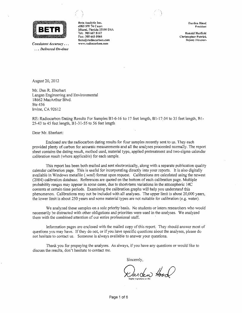
Bern Analytic inc.4985 SW 74 CourtMhuni. f'lo-ridtl331 S6 USATcl~3t)5 667 5-167Fax: 305 663 U9(i4Hctll(oi{rndJncnrboll.cllntwww.radtucarbon.eom
Durden HOQd.Prestdcnt
Rnnnid HutfieklChr-lstuphcr- Patrick
f)Cl)Uly ntrccsorsConsistent Accuracy ...
... Delivered On-time
August 20, 2012
Mr. Dan R. EberhartLangan Engineering and Environmental18662 MacArthur Blvd.Ste 456Irvine, CA 92612
RE: Radiocarbon Dating Results For Samples BI-6-16 to 17 feet length, BI-I7:34 to 35 feet length, Bl-25-43 to 45 feet length, B1-31-55 to 56 feet length
Dear Mr. Eberhart:
Enclosed are the radiocarbon dating results for four samples recently sent to us. They eachprovided plenty of carbon for accurate measurements and all the analyses proceeded normally. The reportsheet contains the dating result, method used, material type, applied pretreatment and two-sigma calendarcalibration result (where applicable) for each sample.
This report has been both mailed and sent electronically, along with a separate publication qualitycalendar calibration page. This is useful for incorporating directly into your reports. It is also digitallyavailable in Windows metafile (.wmf) format upon request. Calibrations are calculated using the newest(2004) calibration database. References are quoted on the bottom of each calibration page. Multipleprobability ranges may appear in some cases, due to short-term variations in the atmospheric 14Ccontents at certain time periods. Examining the calibration graphs will help you understand thisphenomenon. Calibrations may not be included with all analyses. The upper limit is about 20,000 years,the lower limit is about 250 years and some material types are not suitable for calibration (e.g. water).
We analyzed these samples on a sole priority basis. No students or intern researchers who wouldnecessarily be distracted with other obligations and priorities were used in the analyses. We analyzedthem with the combined attention of our entire professional staff.
Information pages are enclosed with the mailed copy of this report. They should answer most ofquestions you may have. If they do not, or if you have specific questions about the analyses, please donot hesitate to contact us. Someone is always available to answer your questions.
Thank you for prepaying the analyses. As always, if you have any questions or would like todiscuss the results, don't hesitate to contact me.
Sincerely,
Page 1 of 6
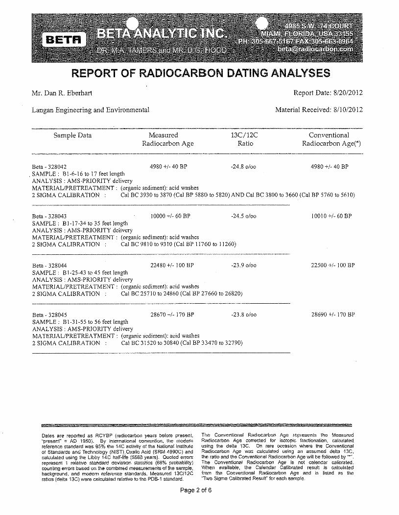
REPORT OF RADIOCARBON DATING ANALYSES
Mr. Dan R. Eberhart Report Date: 8/20/2012
Langan Engineering and Environmental Material Received: 8110/20 12
Sample Data MeasuredRadiocarbon Age
13C/12CRatio
ConventionalRadiocarbon Age(*)
Beta - 328042 4980 +1-40 BP -24.80/00 4980 +1- 40 BP. SAMPLE: B1-6-16 to 17 feet lengthANALYSIS: AMS-PRIORITY deliveryMATERIAL/PRETREATMENT: (organic sediment): acid washes2 SIGMA CALIBRATION Cal BC 3930 to 3870 (Cal BP 5880 to 5820) AND Cal BC 3800 to 3660 (Cal BP 5760 to 5610)
Beta - 328043 10000 +1-60 BP -24.50/00SAMPLE: BI-17-34 to 35 feet lengthANALYSIS: AMS-PRIORITY deliveryMATERIAL/PRETREATMENT: (organic sediment): acid washes2 SIGMA CALIBRATION: Cal BC 9810 to 9310 (Cal BP 11760 to 11260)
10010 +1- 60 BP
Beta - 328044 22480 +1- 100 BP -23.90/00SAMPLE: BI-25-43 to 45 feet lengthANALYSIS: AMS-PRIORITY deliveryMATERIAL/PRETREATMENT: (organic sediment): acid washes2 SIGMA CALIBRATION Cal BC 25710 to 24860 (Cal BP 27660 to 26820)
22500 +/- 100 BP
Beta - 328045 28670 +/- 170 BP -23.80/00SAMPLE: BI-31-55 to 56 feet lengthANALYSIS: AMS-PRIORlTY deliveryMATERIAL/PRETREATMENT: (organic sediment): acid washes2 SIGMA CALIBRATION: Cal BC 31520 to 30840 (Cal BP 33470 to 32790)
28690 +1- 170 BP
#d' Ai hSif ti NYW * %5& 65Mb? %': iiiiJi4±#&±* 5 4§@' @#%
Dates are reported as RCYBP (radiocarbon years before present,"present" = AD 1950). By international convention, the modernreference standard was 95% the 14C activity of the National Instituteof Standards and Technology (NIST) .Oxenc Acid (SRM 4990C) andcalculated using the Libby 14C half-fife (5568 years). Quoted errorsrepresent 1 relative standard deviation statistics (68% probability)counting errors based on' the combined measurements of the sample,background, and modern reference standards. Measured 13C/12Cratios (delta 13C) were calculated relative to the PDB~1 standard,
The Conventional Radiocarbon Age represents the MeasuredRadiocarbon Age corrected for isotopic fractionation, calculated.using the delta '13C. On rare occasion where the ConventionalRadiocarbon Age was calculated using an assumed deita13C,the ratio and the Conventional Radiocarbon Age wi!! be followed by "".The Conventional Radiocarbon Age is not calendar calibrated.When available, the Calendar Calibrated result is calculatedfrom the Conventional Radiocarbon Age and is listed as the"Two Sigma Calibrated Result" for each sample.
Page 2 016
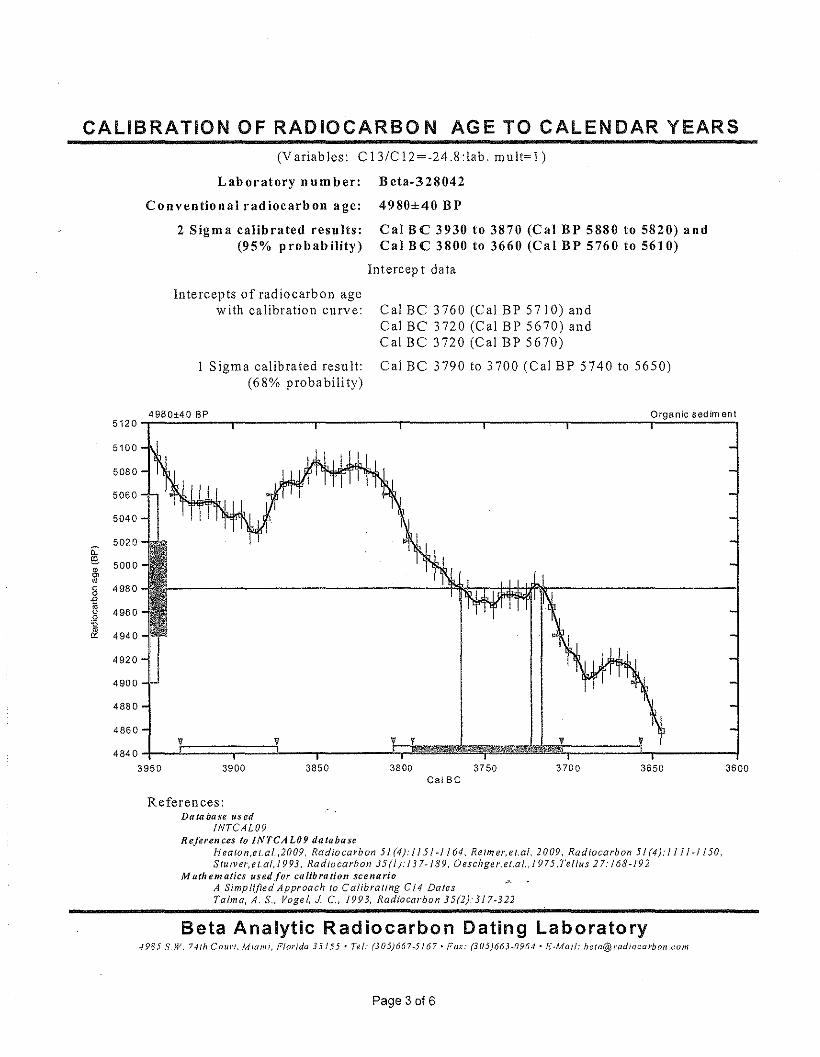
CALIBRATION OF RADIOCARBON AGE TO CALENDAR YEARS(Variables: CI3/C12=-24.8:lab. mu lt=l )
Laboratory number: Beta-328042
Conventional radiocarbon age:
2 Sigma calibrated results:(95% probability)
4980±40 BP
Cal BC 3930 to 3870 (Cal BP 5880 to 5820) andCal BC 3800 to 3660 (Cal BP 5760 to 5610)
Intercept data
Intercepts of radiocarbon agewith calibration curve: Cal Be 3760 (Cal BP 5710) and
Cal Be 3720 (Cal BP 5670) andCal Be 3720 (Cal BP 5670)
Cal Be 3790 to 3700 (Cal BP 5740 to 5650)Sigma calibrated result:(68% probability)
4980±40 BP5120
5100
5080
5060
5040
5020il:@.
5000•'"ro0 49800-2s 4960.Q-cIJ. 4940
4920
4900
4880
4860V V
48403950 3900 3850
Organic sedim en!
3800 3750 3700 3650 3600Cal Be
References:Database used
INTCAL09References to INTCAL09 database
Heaton .e t.al. ,2009, Radiocarbon 5 I (4): I J 51 ~J164, Retm er, e t.al. 2009, Radiocarbon 5/ (4): 1 J II ¥} 150,S lu tv er. ei.at, / 993, Radiocarbon 35 (/): 13 7~/89, Oeschge r.et.al. 1975. Tel/us 2 7: 168~19 2
Ma(hematics used for calibration scenarioA Simplified Approach to Calibrating Cf4 DatesTalm a, A. S., Vogel, J c., 1993, Radiocarbon 35(2r317·322
Beta Analytic Radiocarbon Dating Laboratory4985 S,W. 74111(;0111"1,Miami, Florida 33/55' Tel.' (305)667-5/67' Fax: (305)663-0964' E·Mail: [email protected]
Page 3 of 6
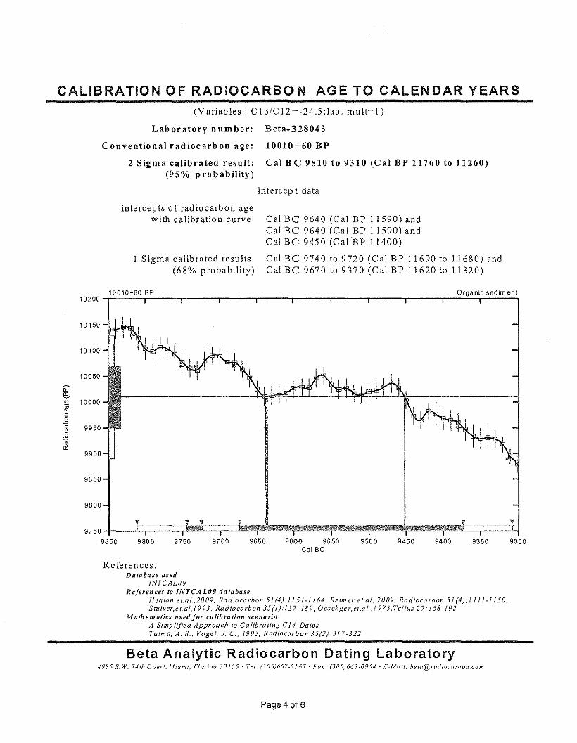
CALIBRATION OF RADIOCARBON AGE TO CALENDAR YEARS(Variables: C13/C12=-24.S:1ab. mult=l)
Laboratory number: Beta-328043
Conventional radiocarbon age: 10010±60 BP
2 Sigma calibrated result: Cal Be 9810 to 9310 (Cal BP 11760 to 11260)(95% probability)
Intercep t data
Intercepts of radiocarbon agewith calibration curve:
Sigma calibrated results:(68% probability)
Cal Be 9640 (Cal BP 11590) andCal Be 9640 (Cal BP 11590) andCal Be 9450 (Cal BP 11400)
Cal Be 9740 to 9720 (Cal BP 11690 to 11680) andCal Be 9670 to 9370 (Cal BP 11620 to 11320)
10010±60 BP Organic sediment10200-r~~~~---'------r-----'------r-----'------r-----'------r--~~~~~
10150
10100
10050
~(l5, 10000ro§-e~ 9950.Q
&9900
9850
9800
9750~--~~====~~~==~=J~!p~~~~~~~~~~~~~~~~~Mt~r===~9850 9800 9750 9700 9650 9600 9550
Cal Be9500 9450 9400 9350 9300
References:Database used
INTCAL09References to INTCAL09 database
Heaton .e t.al. ,2009, Radiocarbon 5/ (4): I !5 J -/ J 64, Re im er. e t.al. 2009, Rad ioea rbon 5/ (4): J I J / -I 150.Stu iver,e t.al, 1993, Radiocarbon 35 (/): I 3 7- J 89, Oeschge r, et.a t.,J 975, Tel/us 27: j 68 -/ 9 2
Math em «tics used for ca lib fa lion scene rioA Simplified Approach to Calibrating C 14 DatesTatm a. A. S., Vogel, J C.. 1993, Radiocarbon 35(2):317-322
Beta Analytic Radiocarbon Dating Laboratory-1985 S,W. 7-1111Cour{. Miami, Florida 33155' Tel: (305}667-5167' Fax: (305}663-0964' E-Mail: beta@radiocarbon,com
Page 4 of 6
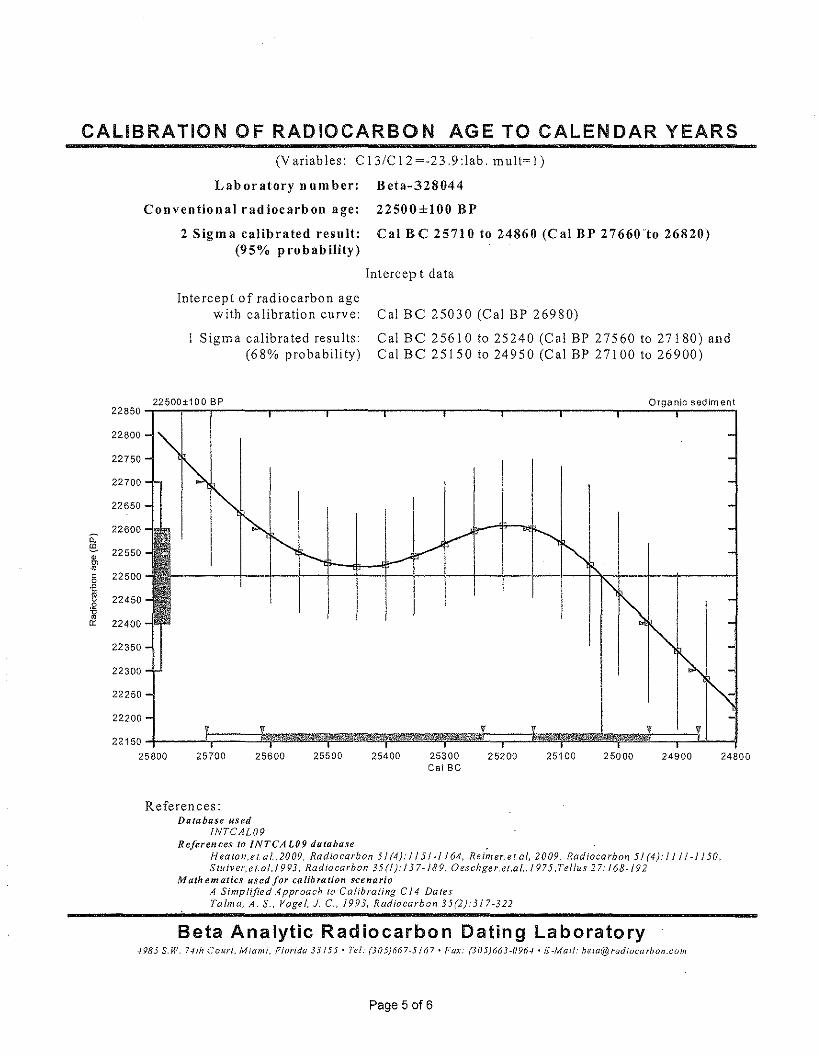
CALIBRATION OF RADIOCARBON AGE TO CALENDAR YEARS(Variables: CI3ICI2=-23.9:lab. mult=l)
Laboratory n urn ber: Beta-328044
Conventional radiocarbon age: 22500±100 BP
2 Sigma calibrated resuit: Cal BC 25710 to 24860 (Cal BP 27660(0 26820)(95% probability)
Intercept data
Intercept of radiocarbon agewith calibration curve:
Sigma calibrated results:(68% probability)
Cal Be 25030 (Cal BP 26980)
Cal Be 25610 to 25240 (Cal BP 27560 to 27180) andCal Be 25150 to 24950 (Cal BP 27100 to 26900)
22500±100 BP Organlc sediment22850-r---r--,-------~----~r-----~------_r------,_------~----_,r_--~~------~
22800
22750
22700
22650
22600~ 22550g~~.2
~
122500
22450
22400
22350
22300
22250
22200
25700 25600 2480025500 25400 25300Cal Be 25200 25100 25000 24900
References:Database used
INTCAL09References to INTCAL09 database .
H ealon,e t. a /.,2009, Radiocarbon 5 J (4): / I 5/ ·1 164, Re im er, et.at, 2 009, Radiocarbon 5 J (4).' II J I" 1150.Stu tv er, e (.al.1993. Radiocarbon 35 (/): J 3 7-189, Oeschge r.et.at., / 9 75. Tel/us 2 7: J 68 -19 2
M nth em atics used for calibration scenarioA Simplified Approach (0 Calibrating CJ4 DalesTalma, A. S .. Vogel, J c., 1993, Radiocarbon 35(2):317-322
Beta Analytic Radiocarbon Dating Laboratory4985 S.W. 741h Court, Miami, Florida 33/55' Tel: (305)667-5/67. Fax: (305)663-0%./' h--Mai/; [email protected]/n
Page 5 of 6
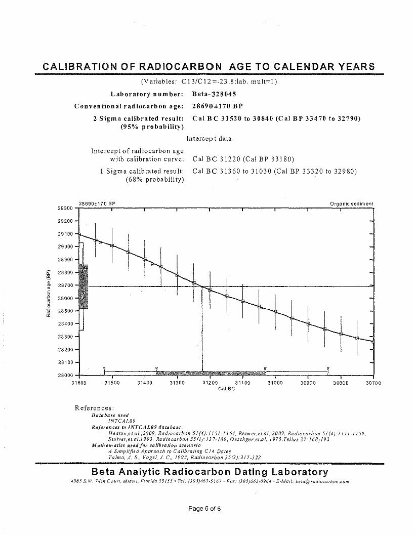
CALIBRATION OF RADIOCARBON AGE TO CALENDAR YEARS(Variables: CI3/C12=-23.8:1ab. mult=l)
Laboratory number: Beta-328045
Conventional radiocarbon age: 28690±170 BP
2 Sigma calibrated result: Cal Be 31520 to 30840 (Cal BP 33470 to 32790)(95% probability)
Intercep t data
Intercept of radiocarbon agewith calibration curve:
Sigma calibrated result:(68% probability)
Cal BC 31220 (Cal BP 33180)
Cal BC 31360 to 31030 (Cal BP 33320 to 32980)
28690±170 BP Organic sediment29300-r~~~~-------';-------r-------'--------r-------.--------r-----~~~~~'
29000
29200
29100
28900
~ 28800
g 28700
~s.Q
&28600
28500
28400
28300
28200
28100
28000~-----1:;========r=ji~~~~~~~~~~~~~~:;========r===:i--,-------~31600 31500 31400 31300 31200 31100
Cal Be 31000 30900 30800 30700
References:Database used
INTCAL09References to INTCAL09 database
Heaton .e t.a t. ,2009, Radtocariton 5 J (4): J I 5/-1 164, Retm er. e t.al. 2009, Radiocarbon 5 J (4): I j 1/-1 150,Stutver.et.ot.t vv s, Radiocarbon 35 (l): j 37-189, Oeschger.et.at. 1975. Tel/us 2 7: 168;192
Mathematics used for calibration scenarioA Simplified Approach to Calibrating C 14 DatesTalma, A. S., Vogel, J C., 1993, Radiocarbon 35(2):317-322
Beta Analytic Radiocarbon Dating Laboratory4985 S.W, 74th Court, Miami, Florida 33155' Tel: (305)667-5/67' Fax: (305)663-0964' £·Mai/: [email protected]
Paqe B ot s
BETABt~tllAn:llytic Inc.4985 S\V 74 CourtMhuni, Ffotidn 3315S USATel: 3115667 516iFax: 30$ 663'0964llc,tn(it::'rndi ecarbon.enmwww.radtccurbee.cem
Durden lluodPresidcut
Ronald fhlffii!ldChristopher PI\trick
I)CP.llly ntrecrcrsConsistent Accuracy ...
• ~ . DeJi~'eJ'(!(1Ofj-time
August 29, 2012
Mr. Dan R. EberhartLangan Engineering and Environmental18662 MacArthur Blvd.Stc 456Irvine, CA 92612USA
RE: Radiocarbon Dating Results For Samples B1-11-26t027ft 8in Length, B1-I2-27ft Sin to 28ft Length,BI-12113-28 to 29ft 6in Length, BI-14I1S-29ft 6in to 32ft Length
Dear Mr. Eberhart:
Enclosed are the radiocarbon dating results for four samples recently sent to us. They eachprovided plenty of carbon for accurate measurements and all the analyses proceeded normally. As usual,the method of analysis is listed on the report with the results and calibration data is provided whereapplicable.
As always, no students or intern researchers who would necessarily be distracted with otherobligations and priorities were used in the analyses. We analyzed them with the combined attention ofOur entire professional staff.
If you have specific questions about the analyses, please contact us. We are always available toanswer your questions.
Thank you for prepaying the analyses. As always, if you have any questions or would like todiscuss the results, don't hesitate to contact me.
Sincerely,
GMclvWDigital sig!1aturo on filn
Page 1 of 6
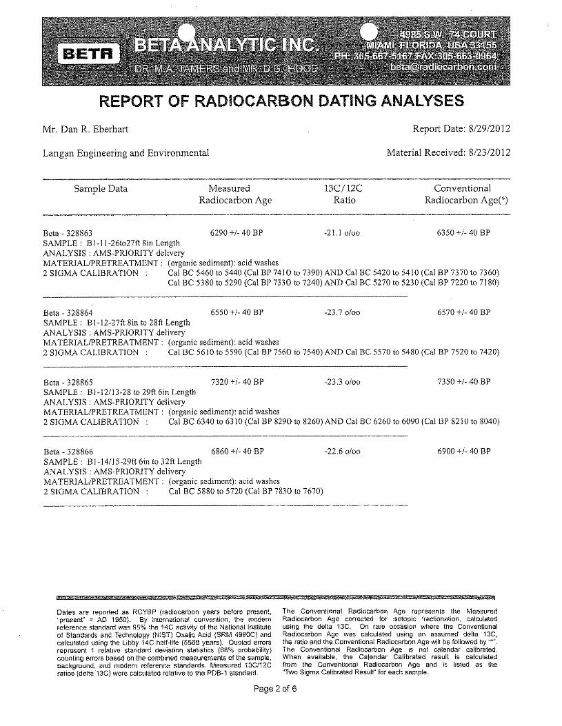
REPORT OF RADIOCARBON DATING ANALYSES
Mr. Dan R. Eberhart Report Date: 8/29/2012
Langan Engineering and Environmental Material Received: 8/2312012
Sample Data MeasuredRadiocarbon Age
l3C/12CRatio
ConventionalRadiocarbon Age("')
Beta - 328863 6290 +1-40 BP -2 I. I 0100 6350 +/- 40 BPSAMPLE: BI-I 1-26t027ft 8in LengthANALYSIS: AMS-PRIORITY deliveryMATERIAL/PRETREATMENT: (organic sediment): acid washes2 SIGMA CALIBRATION Cal BC 5460 to 5440 (Cal BP 7410 to 7390) AND Cal BC 5420 to 54 I0 (Cal BP 7370 to 7360)
Cal BC 5380 to 5290 (Cal BP 7330 to 7240) AND Cal BC 5270 to 5230 (Cal BP 7220 to 7180)
Beta - 328864 6550 +1-40 BP -23.70100 6570 +1-40 BPSAMPLE: BI-12-27ft 8in to 28ft LengthANALYSIS: AMS-PRIORlTY deliveryMATERIALIPRETREATMENT: (organic sediment): acid washes2 SIGMA CALIBRATION Cal BC 5610 to 5590 (Cal BP 7560 to 7540) AND Cal BC 5570 to 5480 (Cal BP 7520 to 7420)
Beta - 328865 7320 +1-40 BP -23.3 0100 7350 +1-40 BPSAMPLE: Bl-12113-28 to 29ft 6in LengthANALYSIS: AMS-PRIORITY deliveryMATERIAL/PRETREATMENT: (organic sediment): acid washes2 SIGMA CALIBRATION: Cal BC 6340 to 6310 (Cal BP 8290 to 8260) AND Cal BC 6260 to 6090 (Cal BP 82 I0 to 8040)
Beta - 328866 6860 +1-40 BP -22.60100SAMPLE: BI-14115-29ft 6in to 32ft LengthANALYSIS: AMS-PR10RITY deliveryMATERIALIPRETREATMENT: (organic sediment): aeid washes2 SIGMA CALIBRATION Cal BC 5880 to 5720 (Cal BP 7830 to 7670)
6900 +1-40 BP
*"' MiS p'f 86M? 5 i@@M;1 &%&3**"",
Dates are reported as RCYBP (radiocarbon years before present,"present" ::; AD 1950). By international convention, the modernreference standard was 95% the 14C activity of the National Institute01 Standards and Technology (N!ST) Oxalic Acid {SRM 4990C} andcalculated using the Libby 14C half-life (5568 years), Quoted errorsrepresent 1 relative standard deviation statistics (68% probability)counting errors based on the combined measurements of the sample,background, and modem reference standards. Measured 13C/12Cratios (delta', 3C) were calculated relative to the PDB·1 standard.
The Conventional Radiocarbon Age represents the MeasuredRadiocarbon Age corrected for isotopic fractionation, calculatedusing the delta '13C, On rare occasion where the ConventionalRadiocarbon Age was calculated using an assumed delta 13C,the ratio and the Conventional Radiocarbon Age wilt be followed by ..• ".TI)€! Conventional Radiocarbon Age is not calendar calibrated.When available, the Calendar Calibrated result is calculatedfrom the Conventional Radiocarbon Age and is listed as the"Two Sigma Calibrated Result" for each sample.
Page 2 of 6
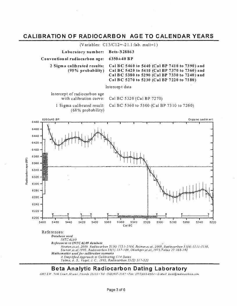
CALIBRATION OF RADIOCARBON AGE TO CALENDAR YEARS(Variables: CI3/CI2=-2l.l:lab. mult=l)
Laboratory number: Beta-328863
Conventional radiocarbon age: 6350±40 BP
2 Sigma calibrated results: Cal Be 5460 to 5440 (Cal BP 7410 to 7390) and(95% probability) Cal Be 5420 to 5410 (Cal BP 7370 to 7360) and
Cal Be 5380 to 5290 (Cal BP 7330 to 7240) andCal Be 5270 to 5230 (Cal BP 7220 to 7180)
Intercep t data
Intercept of radiocarbon agewith calibration curve:
Sigma calibrated result:(68% probability)
Cal BC 5320 (Cal BP 7270)
Cal BC 5360 to 5300 (Cal BP 7310 to 7260)
6350±40 BP Organic sediment6480'-~--.---~r----.-----.----.----'~---.-----.----'-----r----'--~-r----,
r
6460
64406420
6400
6380iL~ 6360•0>mc 63400.e~ 6320.Q'0m
6300'"6280
6260
6240
6220
6200 T5480 5460
r5440 5420 5400 5380 5360 5340 5320 5300 5280 5260 5240 5220
Cal Be
References:Database used
lNTCAL09References to INTCAL09 database
Heaton .e t.al. ,2009. Radiocarbon 51 (4): 115 J - J 16 4, Retmer.e t. al. 2009, Radiocarbon 5 1(4): / 11 / -11 50.Stu tver, et.al, 1993, Radio carbo n 35(1): 13 7-/89, Oi sch.ge r,el,a I" 197 5.T ellus 27: 168-192
Mathematics used for calibration scenarioA Simplified Approach to Calibrating Cl4 DatesTa 1ma, A, S., Vogel, J, C.. 1993, Radiocarbon 35(2):317M322
Beta Analytic Radiocarbon Dating Laboratory./985 S,W, r-nh Court,Mlami, Florida 33155 - Tel: (305)667-5/67 «Far: (305)663-0964' E-Mail: beIa@radio~'arbon.com
Page 3 016
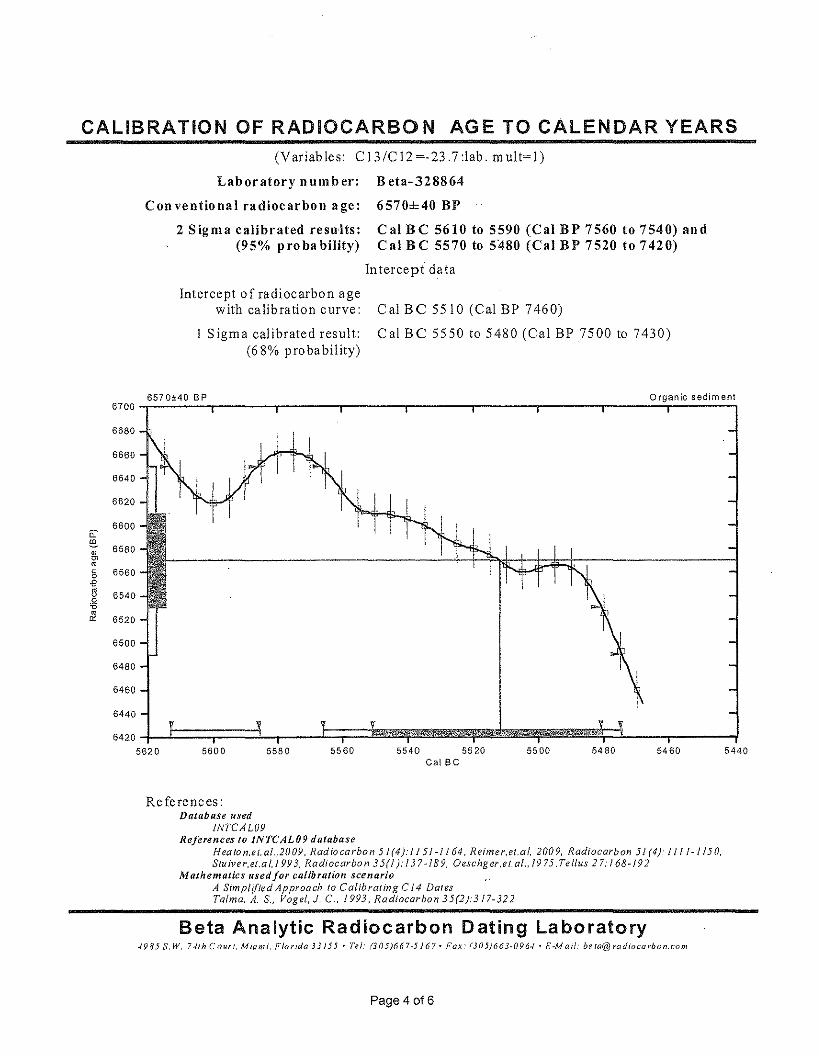
CALIBRATION OF RADIOCARBON AGE TO CALENDAR YEARS(Variables: C13!C12=-23.7:lab. mult=l)
Laboratory number: Beta-328864
Conventional radiocarbon age: 6570±40 BP
2 Sigma calibrated results:(95% pro ba bility)
Cal BC 5610 to 5590 (Cal BP 7560 to 7540) andCal BC 5570 to 5480 (Cal BP 7520 to 7420)
Intercept data
Intercept of radiocarbon agewith calibration curve:
1 Sigma calibrated result:(68% probability)
Cal BC 5510 (Cal BP 7460)
Cal BC 5550 to 5480 (Cal BP 7500 to 7430)
6570±40 BP Organic sediment6700-r~~~-r-------r-------r-------r-------r-------r-------r----~~~~---'
6600iC!O!.
6680
6660
6640
6620
6580
6560
6540
6520
5580 5560 5460 5440
6500
6480
6460
6440
5600 5540 5520Cal Be
5500 5480
References:Database used
lNTCAL09References 10 INTCAL09 database
H eo to n.et. a/.,2009, Rad iocarbo n 5 1(4): II 51-1164. Retmer.et.a 1. 200 9, Radiocarbon 51 (4): 1111-1150,Stu tver.et.a t. J 993, Ra dtocarbo n 35(1 r 13 7 -is 9, Oeschg er,e t.al., 19 75, Tetlus 27: 168 -1 9 2
Mathematics used/or calibration scenarioA Simpltfted Approach to C alib rat ing C 14 DatesTalmo. A. S., Vogei- J, C., 1993, Radiocarbon 35(2):317-322
Beta Analytic Radiocarbon Dating Laboratory4985 S,W, r-nh Covrt, Miami, Florida 33J55' Tel: (305)667·5J67. Fax: (305)663-096./· s.u sa. bela@ratiiocar/Jon.com
Page 4 016
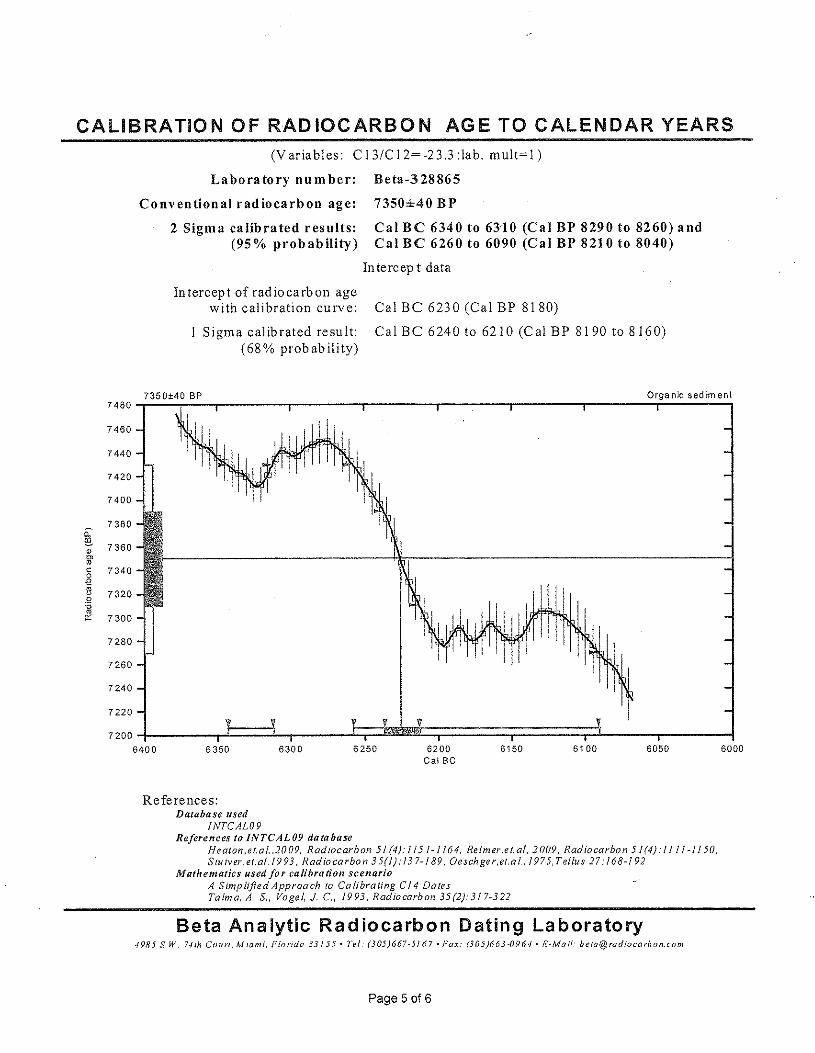
CALIBRATION OF RADIOCARBON AGE TO CALENDAR YEARS(Variables: C13/C12=-23.3:lab. mult=L)
Laboratory number: Beta-328865
Conventional radiocarbon age: 7350±40 BP
2 Sigma calibrated results: Cal BC 6340 to 6310 (Cal BP 8290 to 8260) and(95% probability) Cal BC 6260 to 6090 (Cal BP 8210 to 8040)
Intercept data
Intercept of radiocarbon agewith calibration curve:
Sigma calibrated result:(68 % prob ab ility)
Cal BC 6230 (Cal BP 8180)
Cal BC 6240 to 6210 (Cal BP 8190 to 8160)
Orqa ole sed irnen!7350±40 BP7480
7460
7440
7420
7400
73800:-@.
7360IDe»roc 73400€~ 7320.Q-o&l 7300
7280
7260
7240
7220
72006400 6350 6300 6250 6200
Ca! Be6150 6100 6050 6000
References:Database used
INTCAL09References to INTCAL09 database
neaton.et.at.accs. Radiocarbon 51 (4): I 151-1164, Retmer.etal, 2009, Radiocarbon 51(4): 1l1/-lI50,Stu tver, el.af.19 93. Radiocarbon 35(1): 137- / 89. Oeschge r.et,a l., /975, Teflus 27: 168-192
Mathematics used/or calibration scenarioA Simplified Approach to Caltbra ung C14 DalesTalma, A. S., Vogel, J. C, /993, Radiocarbon 35(2):3/ 7~322
Beta Analytic Radiocarbon Dating Laboratory4985 S.W. r-nh Coun, Miami, Florida 33155' 1'10/: (305)667-5/67 • Pax: (305)663-0964· H-Mall: [email protected]
Page 5 of 6
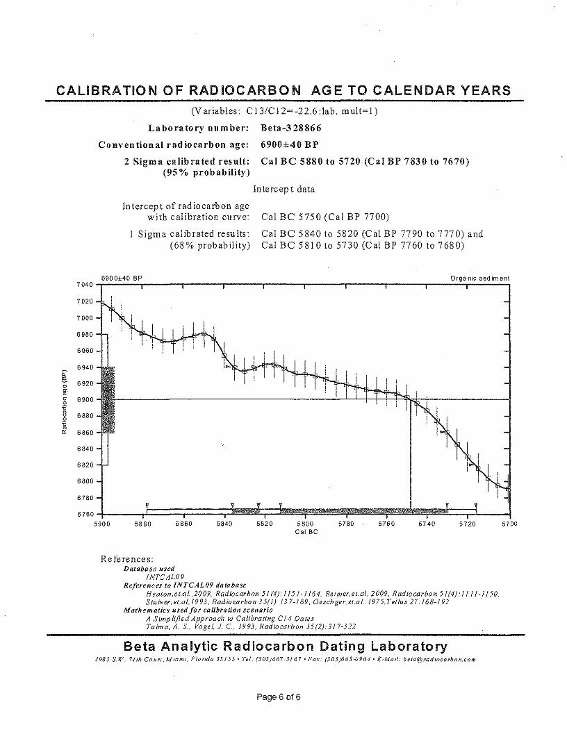
CALIBRATION OF RADIOCARBON AGE TO CALENDAR YEARS(Variables: C13/C12=-22.6:lab. mult=l)
Laboratory number: Beta-328866
Conventional radiocarbon age: 6900±40 BP
2 Sigma calibrated result: Cal Be 5880 to 5720 (Cal BP 7830 to 7670)(95% probability)
Intercept data
In tercept of radiocarbon agewith calibration curve:
Sigma calibrated results:(68% probability)
Cal Be 5750 (Cal BP 7700)
Cal Be 5840 to 5820 (Cal BP 7790 to 7770) andCal Be 5810 to 5730 (Cal BP 7760 to 7680)
Orga nlc sed im ent6900±40 BP7040
7020
7000
6980
6960
69400:-~ 6920•~roc 69000-e~ 6880.2-ero0: 6860
6840
6820
6800
6780V
67605900 5880 5860 5840
- " I
5820 5800Cal Be
5780 5760 5740 5720 5700
References:Database used
fNTCAL09References to INTCAL09 database
Heaton .e t.a 1.. 2009, Radiocarbon 51 (4).' 115 J" 1164. Re tmer,e t. at, 2009, Rad iocarbo n 5 1(4).' , I / / -11 50,S lu iver, et.al, 1993, Radio carbon 35(1): 137-189, Oesch.ger,et.a L, 1975.T ellus 27: 168-192 .
Mathematics used for calibration scenarioA Simplified Approach 10 Calibrating Cl 4 DatesTalm a, A. 8., Vogel, 1. C., 1993, Radiocarbon 35(2):317-322
Beta Analytic Radiocarbon Dating Laboratory4985 s,w. 74th Court, MIGmi, Plorida 33155' Tel: (305)667.5167. Pax.' (305)663.0964' E-Mail: [email protected]
Page 6 016
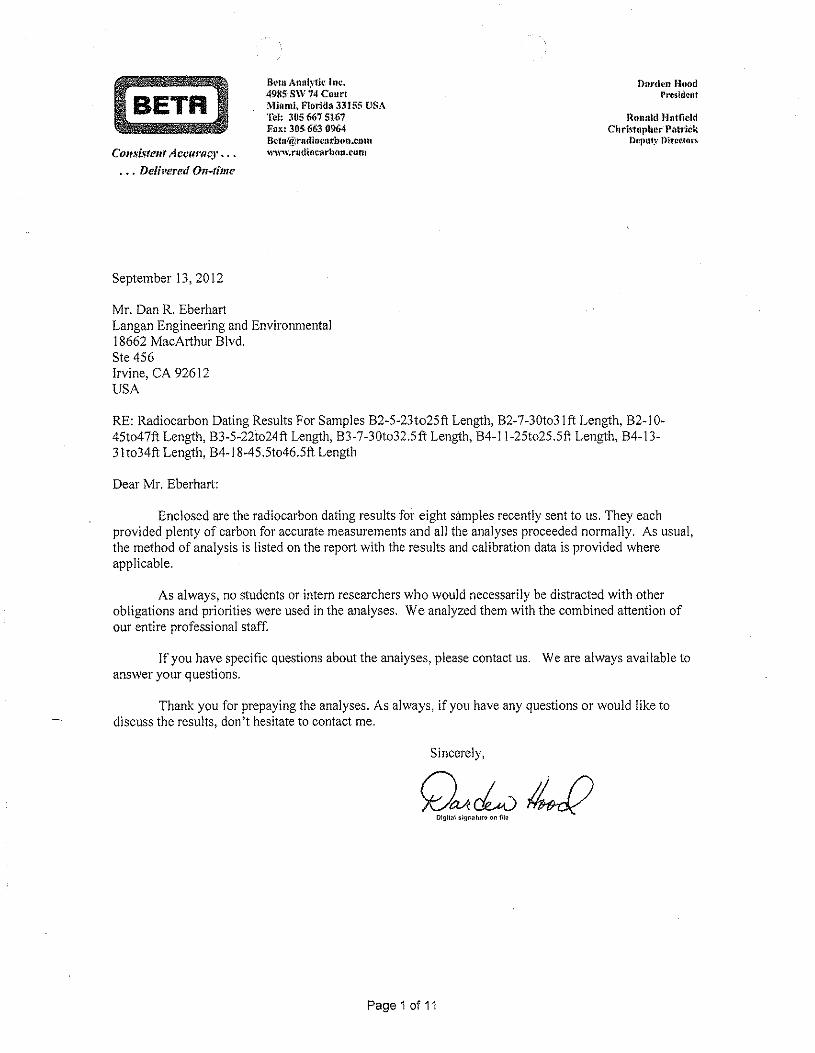
Bera Anllly1k Inc,4985 SW 14 CourtMill mi. Florld~133155 USATcJ~ .305667516'7Fox: 305 663 @64Bc,tn(.[!rudiflca-rbun.cl)it1www.radtccarbon.cem
Darden Hoodrrestdcnt
Renald HatfieldCbrtstepber- Pfltrick
Deputy ntrecmrsConsistent ACCllrlwJ' •.•
. • . Delivered On-time
September 13,2012
Mr. Dan R. EberhartLangan Engineering and Environmental18662 MacArthur Blvd.Ste 456Irvine, CA 92612USA
RE: Radiocarbon Dating Results For Samples B2-5-23to25ft Length, B2-7-30t031 ft Length, B2-10-45t047ft Length, B3-5-22t024ft Length, B3-7-30t032.5ft Length, B4-11-25t025.5ft Length, B4-13-31t034ft Length, B4-18-45.5t046.5ft Length
Dear Mr. Eberhart:
Enclosed are the radiocarbon dating results for eight samples recently sent to us. They eachprovided plenty of carbon for accurate measurements and all the analyses proceeded normally. As usual,the method of analysis is listed on the report with the results and calibration data is provided whereapplicable.
As always, no students or intern researchers who would necessarily be distracted with otherobligations and priorities were used in the analyses. We analyzed them with the combined attention ofour entire professional staff.
If you have specific questions about the analyses, please contact us. We are always available toanswer your questions.
Thank you for prepaying the analyses. As always, if you have any questions or would like todiscuss the results, don't hesitate to contact me.
Sincerely,
Page 1 of 11
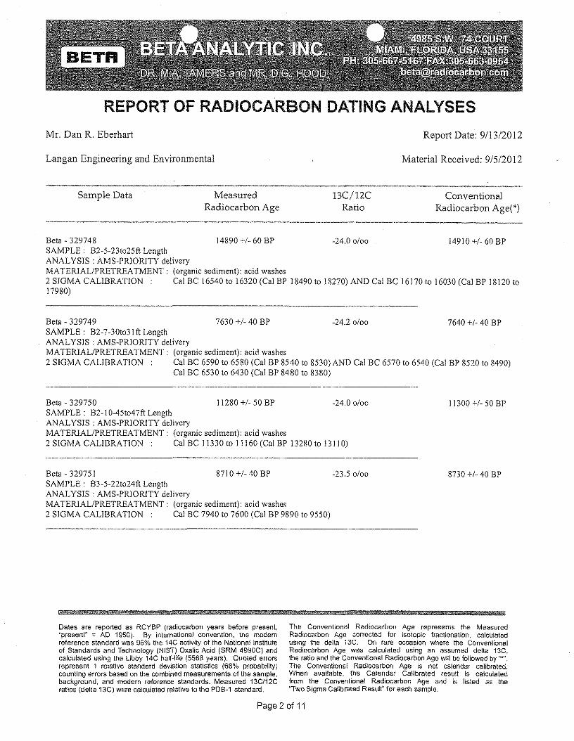
REPORT OF RADIOCARBON DATING ANALYSES
Mr. Dan R. Eberhart Report Date: 9113/2012
Langan Engineering and Environmental Material Received: 9/5/2012
Sample Data MeasuredRadiocarbon Age
13C/12CRatio
ConventionalRadiocarbon Age(*)
Beta·329748 14890 +1· 60 BP ·24.00/00 14910 +1· 60 BPSAMPLE: B2·5·23t025ft LengthANAL YSIS : AMS·PRIORITY deliveryMATERIAL/PRETREATMENT: (organic sediment): acid washes2 SIGMA CALIBRATION Cal BC 16540 to 16320 (Cal BP 18490 to 18270) AND Cal BC 16170 to 16030 (Cal BP 18120 to17980)
Beta- 329749 7630 +1· 40 BP ·24.20/00 7640 +1· 40 BPSAMPLE: B2·7·30t03Ift LengthANALYSIS: AMS·PRIORITY deliveryMATERIALIPRETREATMENT: (organic sediment): acid washes2 SIGMA CALIBRATION Cal BC 6590 to 6580 (Cal BP 8540 to 8530) AND Cal BC 6570 to 6540 (Cal BP 8520 to 8490)
Cal BC 6530 to 6430 (Cal BP 8480 to 8380)
Bete - 329750 11280 +1· 50 BP ·24.00/00SAMPLE: B2·1 0·45t047ft LengthANALYSIS: AMS·PRIORITY deliveryMATERIAL/PRETREATMENT: (organic sediment): acid washes2 SIGMA CALIBRATION Cal BC 11330 to II 160 (Cal BP 13280 to 13 I 10)
11300 +1· 50 BP
Beta· 32975 I 8710 +1· 40 BP ·23.50/00SAMPLE: B3·5·22t024ft LengthANALYSIS: AMS·PRIORITY deliveryMATERIAL/PRETREATMENT: (organic sediment): acid washes2 SIGMA CALIBRATION Cal BC 7940 to 7600 (Cal BP 9890 to 9550)
8730 +1· 40 BP
; 8Wi§W¥d i h *Dates are reported as RCYBP (radiocarbon years before present.'present" :: AD 1950). By international convention, the modernreference standard was 95% the 14C activity of the National Instituteof Standards and Technology (NIST) Oxalic Acid (SRM 4990C) andcalculated using the Libby 14C half-file (5568 years). Quoted errorsrepresent 1 relative standard deviation stattstlcs (68% probability)counting errors based on the combined measurements of the sample,background, and modern reference standards. Measured 13C/12Cratios (delta 13C) were calculated relative to the POBv1 standard.
The Conventional Radiocarbon Age represents the MeasuredRadiocarbon Age corrected for isotopic fractionation, calculatedusing the delta '13C. On rare occasion where the ConventionalRadiocarbon Age was calculated using an assumed delta 13C,the ratio and the Conventional Radiocarbon Age will be followed by'?",Tile Conventional Radiocarbon Age is 1101 calendar calibrated,When available, the Calendar Calibrated result is calculatedfrom the Conventional Radiocarbon Age and is listed as the"Two SIgma Caljbrated Result" for each sample.
Page 2 of 11
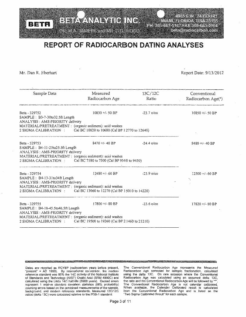
REPORT OF RADIOCARBON DATIt.;JGANALYSES
Mr. Dan R. Eberhart Report Date: 9113/2012
Sample Data MeasuredRadiocarbon Age
13C/12CRatio
ConventionalRadiocarbon Age(*)
Beta - 329752 10830 +1-50 BP -23.70/00SAMPLE: B3-7-30t032.5ft LengthANALYSIS: AMS-PRIORITY deliveryMATERIALIPRETREA TMENT: (organic sediment): acid washes2 SIGMA CALIBRATION Cal BC 10820 to 10680 (Cal BP I 2770 to 12640)
10850 +/- 50 BP
Beta - 329753 8470 +/- 40 BP -24.4 0/00SAMPLE: B4-11-25t025.5ft LengthANALYSIS: AMS-PR10RITY deliveryMATERIALIPRETREATMENT: (organic sediment): aeid washes2 SIGMA CALIBRATION Cal BC 7580 to 7500 (Cal BP 9540 to 9450)
8480 +1-40 BP
Beta - 329754 12480 +/- 60 BP -23.90/00SAMPLE: B4-13-3It034ft LengthANALYSIS: AMS-PRIORITY deliveryMATERIALIPRETREATMENT: (organic sediment): acid washes2 SIGMA CALIBRATION: Cal BC 13060 to 12270 (Cal BP 15010 to 14220)
12500 +1-60 BP
Beta - 329755 17800 +1-80 BP -23.60/00SAMPLE: B4-18-45.51046.5ft LengthANALYSIS: AMS-PRIORlTY deliveryMATERIALIPRETREATMENT: (organic sediment): aeid washes2 SIGMA CALIBRATION Cal BC 19500 to 19260 (Cal BP 21460 to 21210)
17820 +/- 80 BP
HHmi #¥%!5§ MdW
Dales are reported as RCY6P (radiocarbon years before present,"present" = AD 1950). By international convention, the modernreference standard was 95% the 14C activtty ot the National Instituteof Standards and Technology (NIST) Oxalic Acid (SRM 4990C) andcalculated using the Libby 14C half·life (5568 years). Quoted errorsrepresent 1 relative standard devlanon statistics (68% probabiUty)counting errors based on the combined measurements of tile sample,background, and modern reference standards. Measured 13C/12Cratios (delta 13C) were calculated relative to the PDB~1 standard.
The Conventional Radiocarbon Age represents the MeasuredRadiocarbon Age corrected for isotopic fractionation, calculatedusing the delta 13C. On rare occasion where the ConventionalRadiocarbon Age was calculated using an assumed delta 13C,the ratio and the Conventional Radiocarbon Age wUl be followed by "".The Conventional Radiocarbon Age Is not calendar calibrated.When available, the Calendar Calibrated result is calculatedfrom the Conventional Radiocarbon Age and is listed 3S\ the"Two Sigma Calibrated Result" for each sample.
Page 3 of 11

CALIBRATION OF RADIOCARBON AGE TO CALENDAR YEARS(Variables: CI3/CI2=-24:1ab. mult=l)
Laboratory number: Beta-329748
Conventional radiocarbon age: 14910±60 BP
2 Sigma calibrated results: Cal Be -16540 to 16320 (Cal BP 18490 to 18270) and(95% probability) Cal Be 16170 to 16030 (Cal BP 18120 to 17980)
Intercep t data
Intercepts of radiocarbon agewith calibration curve:
Sigma calibrated results:(68% probability)
Cal Be 16460 (Cal BP 18410) andCal Be 16430 (Cal BP 18380) andCal Be 16090 (Cal BP 18040)
Cal Be 16510 to 16370 (Cal BP 18460 to 18320) andCal Be 16120 to 16060 (Cal BP 18070 to 18010)
14910±60 BP Organic sediment15100
15050
15000
14950
;;:-!!!.• 149000>•C0€
14850~.Q-cron:
14800
14750
14700
\, , , ,
a-
.~V '-... '-... -
V ~ -,- 1\ I
/ -, -)/
~~ I -
\" / \\ -
I~
\ i-
i\.~
- I-v I• V v v V • •
" :"'., I , I I I. I I I1465016600 16550 16500 16450 16400 16350 16300 16250 16200 16150 16100 16050 16000
Cal BeReferences:
Database usedINTCAL09
References to INTCAL09 databaseH eaton,e t.a l. ,2009, Radiocarbon 51 (4): I J 5/ "/ J 64. Re tmer. e l.al, 2009. Radiocarbon 5 J (4): / II !.t j 50.Stu iv er,e t.al.l 9 93, Radiocarbon 35 (!):13 7- J 8 9, Oeschger. et.al., I 975, Tel/us 27: /68 -19 2
Mathematics used/or calibration scenarioA Simplified Approach 10 Calibrating C 14 DatesTalma, A, S" Vogel, J C" /993, Radiocarbon 35(2):317-322
Beta Analytic Radiocarbon Dating Laboratory·1985 S.W. 74th Court, Miami, Florida 33155' Tel: (305)667-5/67' Fax: (305)663-0964' E-Mail: [email protected]
Page4of11
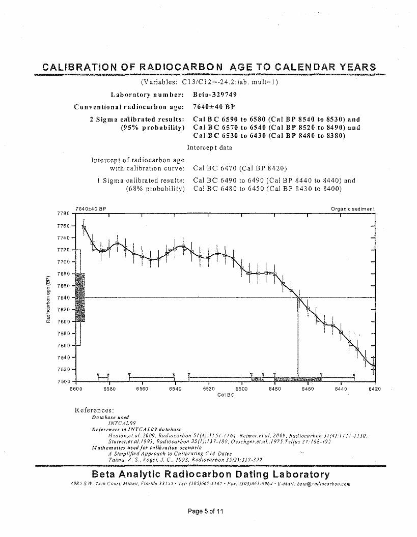
CALIBRATION OF RADIOCARBON AGE TO CALENDAR YEARS(Variables: C13/C12=-24.2:lab. mu lt=L)
Laboratory n urn ber:
Conventional radiocarbon age:
2 Sigma calibrated results:(95% probability)
Intercept of radiocarbon agewith calibration curve:
Sigma calibrated results:(68% probability)
Beta-329749
7640±40 BP
Cal BC 6590 to 6580 (Cal BP 8540 to 8530) andCal B C 6570 to 6540 (Cal BP 8520 to 8490) andCal BC 6530 to 6430 (Cal BP 8480 to 8380)
Intercep t data
Cal Be 6470 (Cal BP 8420)
Cal Be 6490 to 6490 (Cal BP 8440 to 8440) andCal Be 6480 to 6450 (Cal BP 8430 to 8400)
7640±40 BP Organic sediment7780-r~~~-r-------r-------r-------r-------r-------r-------r----~~~~~~
7760
7740
7720
7700
7680ii:-i!!. 7660•'"wc 76400€~ 7620.Q-oro0: 7600
7580
7560
7540
7520
75006600
T VI
64206580 6560 6540 6520 6500Cal Be
6480 6460 6440
Referen ces:Database used
INTCAL09References to INTCAL09 database
Heaton .e t. af,,2009, Radiocarbon 5! (4): IJ 5/-/ 164. Reim ev.et.at, 2009 . Radiocarbon 5J (4): II J I-I /50,S lU tver,e t, at, J 9 93, Radiocarbon 35 (I): 13 7- /89, Oeschge r.et.otJ 975 .Tettu s 27: 168 - J 9 2
M ath em atics used for calibration scenario .A Simplified Approach to Cattbraung Cf4 DatesTalmo, A, S" Vogel. 1. C., 1993, Radiocarbon 35(2): 317-322
Beta Analytic Radiocarbon Dating Laboratory4985 s.w. r-un Court, Miami. Florida 33155' Tel: (305)667"5167' Fax: (305)663-0964' E-Mail: [email protected]
Page 5 of 11

CALIBRATION OF RADIOCARBON AGE TO CALENDAR YEARS(Variables: CI3/CI2~-24:1ab. mult=l)
Laboratory n urn ber: Beta-329750
Conventional radiocarbon age: 11300±50 BP
2 Sigma calibrated result: Cal BC 11330 to 11160 (Cal BP 13280 to i3110)(95% probability)
Intercep t data
Intercept of radiocarbon agewith calibration curve:
Sigma calibrated result:(68% probability)
Cal BC 11240 (Cal BP 13190)
CalBC 11300to 11190 (Cal BP 13250to 13140)
11300±50 BP Organic sediment11500-r-------.-------,r-------r_------,--------r-------.-------,r-----~r_------,
11450
11160
11400
-- 11350~~ro
~~.0
&
11300
11250
11200
11150
11320 11280 1118011260 11240GalBe
11220 1120011300
References:Database used
INTCAL09References to INTCAL09 database
H eaton,e r, at. ,2009, Radiocarbon 5 J (4): J /5 / -/164, Re im er. e t.at, 2009, Radiocarbon 5! (4): I I / j -I /50,Stuiver, et. al.l 9 93, Radiocarbon 35 (1): / 37-189, Oes chge t,et.at., 1975, Tetlus 27: J 68 -19 2
Mathematics used for calibration scenarioA Simplified Approach to Calibrating Cf4 DatesTatm a. A, S., Vogel, 1. C, 1993, RadiocarboI135(2);317~322
Beta Analytic Radiocarbon Dating Laboratory4985 $.W. 74th Court, Miami, Florida 33/55' Tel: (305)667.5167, Fax: (305)663.0964' E~M(Ji!: [email protected]
Page 6 of 11
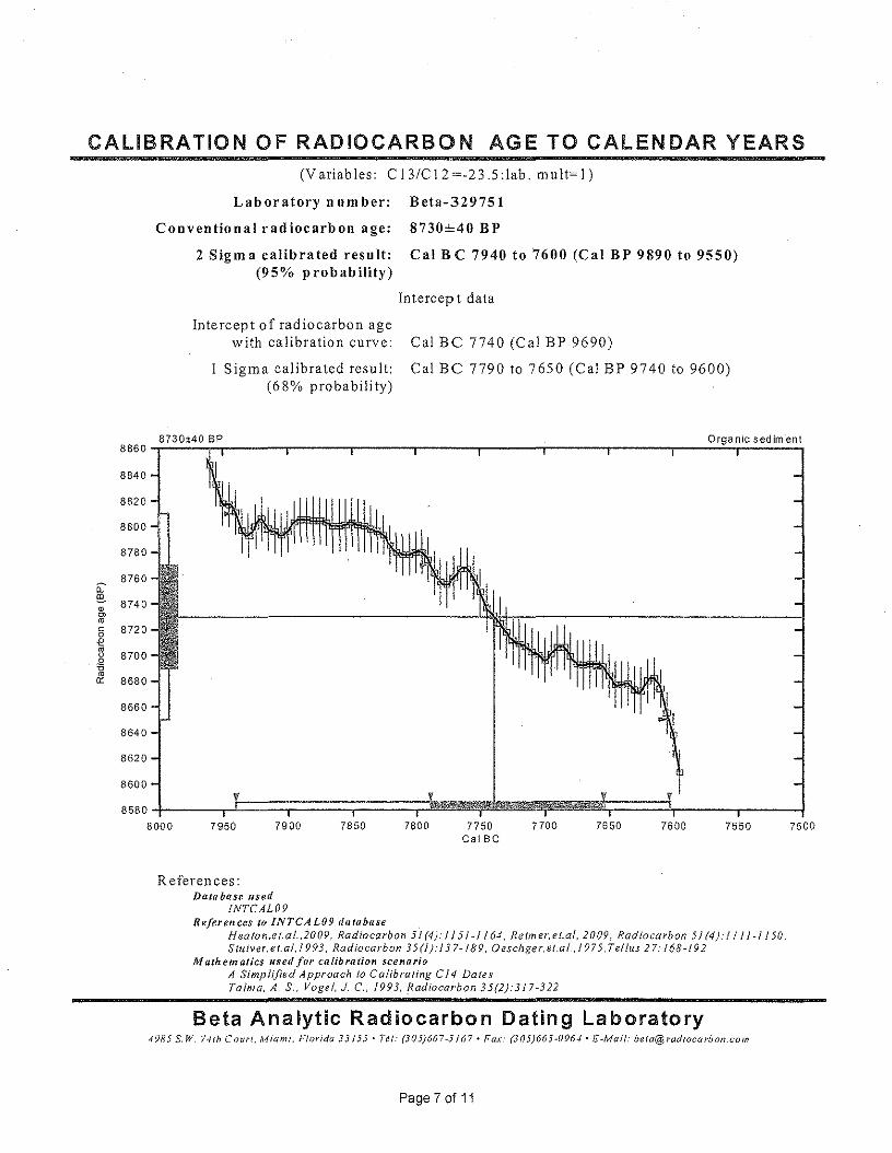
CALIBRATION OF RADIOCARBON AGE TO CALENDAR YEARS
87600:-!!!.
(Variables: CI3/CI2=-23.5:lab. mult=l)
Laboratory number:
Conventional radiocarbon age:
2 Sigma calibrated result:(95% probability)
Beta-329751
8730±40 BP
Cal B C 7940 to 7600 (Cal BP 9890 to 9550)
7500
Intercep t data
Intercept of radiocarbon agewith calibration curve:
Sigma calibrated result:(68% probability)
Cal BC 7740 (Cal BP 9690)
Cal BC 7790 to 7650 (Cal BP 9740 to 9600)
8730±40 BP Organic sedim-ent8860-r~~~~------r-----~r-----~-------r-------r------~------r---~~~~~~
III
8840
8820
8800
8780
8740
8720
8700
86BO
8660
8640
8620
8600
85804-----,l~===;~==~====~~~~~~~~~====~----_.--~8000 7950 7650 75507900 7850 7800 7750
Cal Be7700 7600
References:Database used
fNTCAL09References to INTCAL09 database
H eaton.e t. al., 2009, Radiocarbon 51 (4): J J 5/ ~l J 64, Retm er. e t.at, 2009, Radiocarbon 51 (4): I J j J -1150,Stuiver. e t. at. 19 93, Radiocarbon 35 (l): f 37- J 8 9, Oeschger.et.at. J 975 .Tellus 27: 168 -19 2
Mathematics used for calibration scenarioA Simplified Approach to Calibrating Cf4 DatesTolm a. A, S" Vogel. J C, 1993, Radtocarb on 35(2):317·322
Beta Analytic Radiocarbon Dating Laboratory4985 SW. 741h Court, Miami, Florida 33155· Tel: (305}667.5/67. Fax: (305)663·0964 'li¥Mail: beta@radiocCll'bon.com
Page 7 of 11
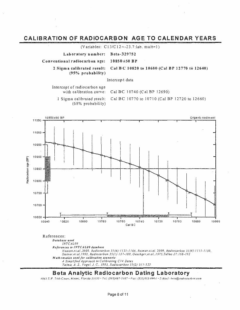
CALIBRATION OF RADIOCARBON AGE TO CALENDAR YEARS(Variables: CI3/CI2=-23.7:lab. mult=l)
Laboratory number: Beta-329752
Conventional radiocarbon age: 10850±50 BP
2 Sigma calibrated result: Cal Be 10820 to 10680 (Cal BP 12770 to 12640)(95% probability)
Intercep t data
Intercept of radiocarbon agewith calibration curve:
Sigma calibrated result:(68% probability)
Cal BC 10740 (Cal BP 12690)
Cal BC 10770 to 10710 (Cal BP 12720 to 12660)
10850±50 BP Organic sediment11050-r-------,--------r-------r-------,--------r----~_,--------r_----~T_------_,
11000
10950
c;: 10900[!!.
•'"roc 108500-e~.Q-o 10800&1
10750 -
10700
1065010840 10780 10760 10740
Cal Be 10720 10700 1068010820 10800
References:Database used
/NTCAL09References to INTCAL09 database
H eaton.e t. a/,,2009, Radiocarbon 51 (4): II 5/ -/ /64, Retm er. e t.at. 2009, Radiocarbon 51 (4 j: II / / - J 150.Stu iv er, e t.at.t 993, Radiocarbon 35 (I j: j 37- J 89, Oeschge t, et.at., 1975, Tet/us 27: /68 - /92
M nth em atics used for calibration scenarioA Simplified Approach (0 Calibrating C 14 DalesTatm a. A. S.. Vogel, J C, /993, Radiocarbon 35(2):317*322
10660
Beta Analytic Radiocarbon Dating Laboratory4985 S,W, 74th Court, Miami, Florida 33/55' Tel: (305)667-5167' Fax: (305)663-0964' E-Mail: [email protected]..'om
Page80f11
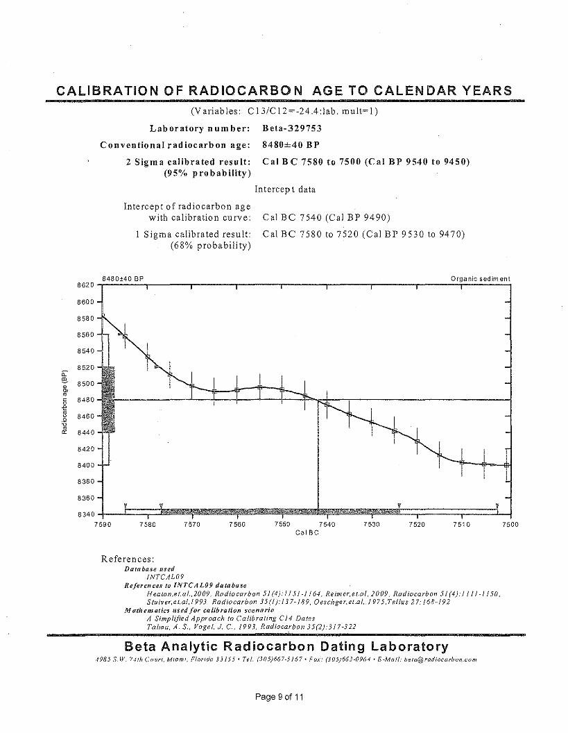
CALIBRATION OF RADIOCARBON AGE TO CALENDAR YEARS(Variables: CI3!CI2=-24.4:lab. mult=l)
Laboratory number: Beta-329753
Conventional radiocarbon age: 8480±40 BP
2 Sigma calibrated result: Cal BC 7580 to 7500 (Cal BP 9540 to 9450)(95% probability)
Intercep t data
Intercept of radiocarbon agewith calibration curve:
Sigma calibrated result:(68% probability)
Cal BC 7540 (Cal BP 9490)
Cal BC 7580 to 7520 (Cal BP 9530 to 9470)
8480±40 BP Organic sediment8620-r~~~~-------'--------r-------'--------r-------'--------r-----~~~~~~
8480
8600
8580
8540
8560
8520
"@. 8500•Ii's-e~.Q
&8460
8440
8420
8400
8380
83608340~__-1==~==~~~~~~~~~~~~~~~~~~~~~~~V==:;======~======1-~7590 7580 7570 7560 7550 7540
Cal Be7530 7520 7510 7500
References:Database used
INTCAL09References to INTCAL09 database
Heato n.et.al ..2009, Radiocarbon 51 (4): I / 51-1164, Retmer.et.at . 2009, Radiocarbon 5/ (4)./111-1/50.S tuiv er, e t.ai, 1993, Radiocarbon 35 (I): / 3 7-/89, Oes chger. et.at ,/975 .Tetlus 27: 168-19 2
Mathematics used/or calibration scenarioA Simplified Approach to Calibrating C14 DatesTolm a. A. S., Vogel, 1. c.. 1993, Radioca,rbon 35(2):317-322
Beta Analytic Radiocarbon Dating Laboratory-1985 S.W. 74th Co uri, Miami, Florida 33155' Tel: (305)667-5167' Fax: (305)663-0964' E-Mail: [email protected]
Page 9 of 11
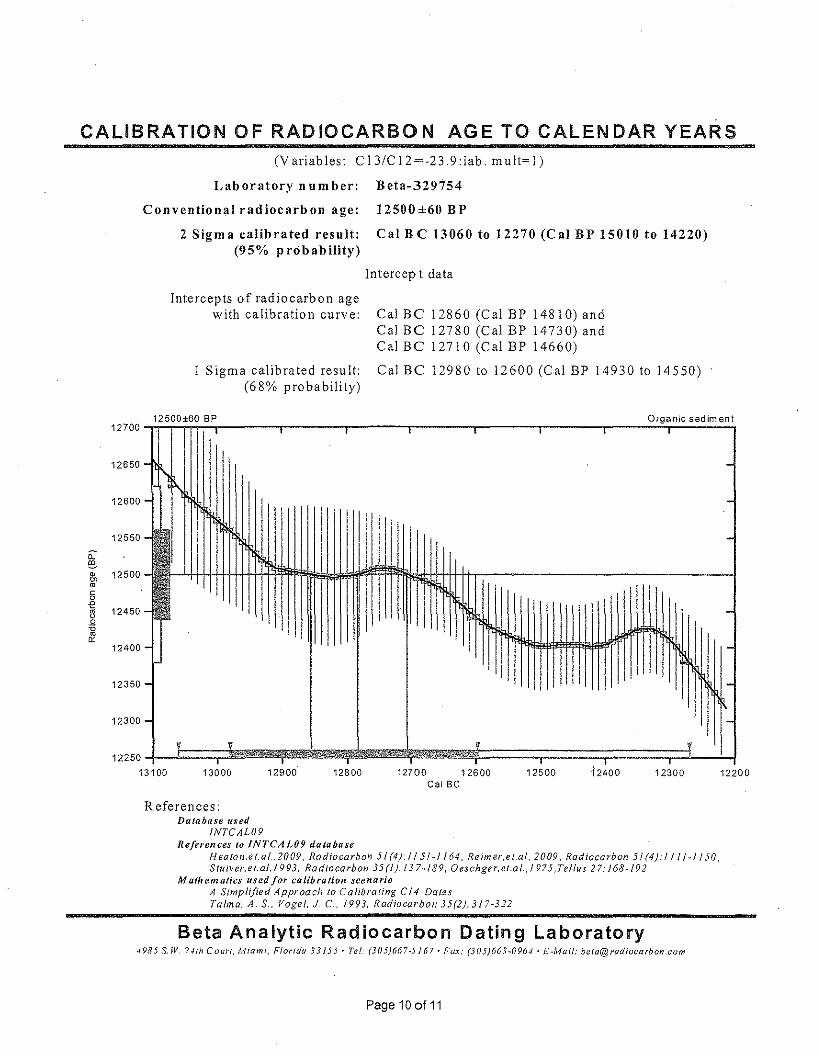
CALIBRATION OF RADIOCARBON AGE TO CALENDAR YEARS
12700
12650
12600
12550n:~• 12500'"roc0-2 12450~.Q-cro
'" 12400
12350
12300
(Variables: C13/C12=-23.9:1ab. m u lt=L)
Laboratory number: Beta-329754
Conventional radiocarbon age: 12500±60 BP
2 Sigma calibrated result: Cal BC 13060 to 12270 (Cal BP 15010 to 14220)(95% probability)
Intercep ( data
Intercepts of radiocarbon agewith calibration curve: Cal Be 12860 (Cal BP 14810) and
Cal Be 12780 (Cal BP 14730) andCal Be 12710 (Cal BP 14660)
Cal Be 12980 to 12600 (Cal BP 14930 to 14550)Sigma calibrated result:(68% probability)
12500±60 BP Organic sediment, , , , • ,
-I'.f\
-
- -I I II r
I-, WI
I-
,
- ,, -
- i-
!'- !-
v V v V,,1225013100 1240012900 12800 12700 12600
Cal Be1250013000 12300 12200
References:Database used
INTCAL09References to INTCAL09 database
H ea(on.e t.at.. 2009, Radiocarbon 51 (4): I J 5! -1164, Re im er,e t.al, 2009, Radiocarbon 5' (4):' / II" / /50,S tutv er, et.al. J 993, Radiocarbon 35 (I): 137" 189, Oeschger. et.at., /975, Tel/us 27: J 68 - /9 2
Mathematics used/or calibration scenarioA Simplified Approach to Calibrating CI4 DatesTalmo. A. s., Vogel, J c.. 1993, Radiocarbon 35(2):317-322
Beta Analytic Radiocarbon Dating Laboratory4985 S.W, 741h Court, Miami, Florida 33155· Tel: (305}667-5 /67· Fax: (305}663-0964' E-Mail: [email protected]
Page 10 of 11

CALIBRATION OF RADIOCARBON AGE TO CALENDAR YEARS(Variables: C 13/C 12=-23.6 :lab. mult= I)
Laboratory number: Beta-329755
Conventional radiocarbon age: 17820±80 BP
2 Sigma calibrated result: Cal Be 19500 to 19+60 (Cal BP 21460 to 21210)'(95% probability)
Intercep t data
Intercept of radiocarbon agewith calibration curve:
Sigma calibrated result:(68% probability)
Cal BC 19400 (Cal BP 21350)
Cal BC 19460 to 19330 (Cal BP 21410 to 21280)
17820±80 BP Organic sediment18100
18050
18000
17950
17900
n:~ 17850•0>roc 178000e~ 17750.Q-oro0:
17700
17650
17600
17550
17500~__JC~==:;~===;~~~~~~~~~~~~~~~~~V==:;====~==:;~===;1- __~19520 19500 19480 19460 19440 19420 19400 19380 19360 19340 19320 19300 19280 19260 19240
Cal Be
References:Database used
INTCAL09References to INTCAL09 database
H eaton,e f. a t .. 2009, Radiocarbon 51 (4): I J 5/-/ j 64. Re im er, e t.at, 2009, Radiocarbon 51 (4): I II / -/ J 50,S tuiver,e t.at, I 993, Radiocarbon 35 (I): 13 7- J 8 9, Oescnge r.et.at. / 9 7 5 Jeffus 2 7: J 68 -19 2
Mathematics used/or calibration scenario 'A Simplified Approach to Calibrating CI4 DalesTolma. A. S., Vogel, J C., 1993, Radiocarbon 35(2}:3J7~322
Beta Analytic Radiocarbon Dating Laboratory4985 S.W. 74th Court, Miami, Florida 33155· Tel: (30j)667-5167. Fax: (305)663-096.f· [-Mail: [email protected]
Page 11 of 11
Belli ,\ualytk Inc.4985 SV.' 74 CeurtMiltll1i, Flt)rid~ 33155 USATel: ,:1056675167Fnx! 30:5 663 0'964Bef:[email protected]
Darden RoodPresidellt
Ihmnld HutfieldChristopher Pt\tr1ck
nt'plny ntrcercrsConsistent ACCUTfu!J' ...
.•. Delivered On-time
October 26, 2012
Mr. Dan R. EberhartLangan Engineering and Environmental18662 MacArthur Blvd.Ste 456Irvine, CA 92612USA
RE: Radiocarbon Dating Results For Samples B5-4-l8.5ft depth, B5-6-23ft depth, B6-6-22ft depth, B6-I0-34ft depth
Dear Mr. Eberhart:
Enclosed are the radiocarbon dating results for four samples recently sent to us. They eachprovided plenty of carbon for accurate measurements and all the analyses proceeded normally. As usual,the method of analysis is listed on the report with the results and calibration data is provided whereapplicable.
As always, no students or intem researchers who would necessarily be distracted with otherobligations and priorities were used in the analyses. We analyzed them with the combined attention ofour entire professional staff.
If you have specific questions about the analyses, please contact us. We are always available toanswer your questions.
Thank you for prepaying the analyses. As always, if you have any questions or would like todiscuss the results, don't hesitate to contact me.
Sincerely,
GMcL;~Olgitat signatura on fIIo
Page 1 of 6
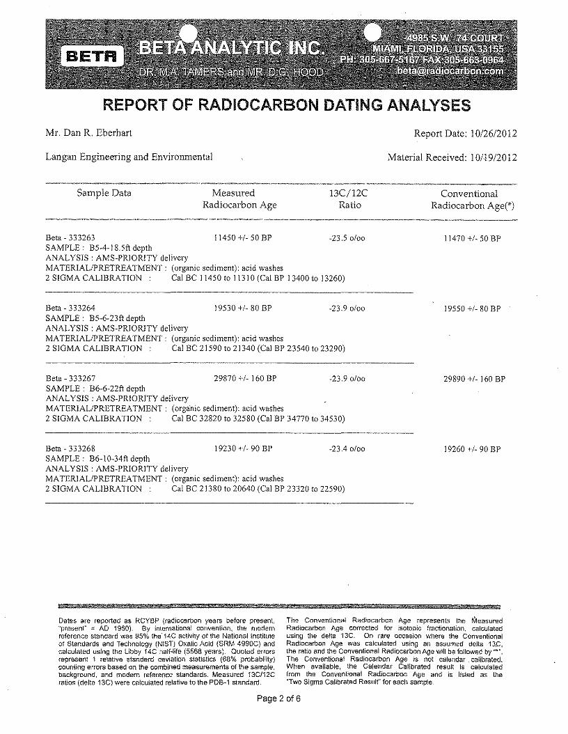
REPORT OF RADIOCARBON DATING ANALYSESMr. Dan R. Eberhart Report Date: 10/26/2012
Langan Engineering and Environmental Material Received: 101·19/2012
Sample Data MeasuredRadiocarbon Age
13C/12CRatio
ConventionalRadiocarbon Age(')
Beta - 333263 11450 +1- 50 BP -23.5 0100SAMPLE: B5-4-18.5ft depthANAL YSIS : AMS·PRIORITY deliveryMATERIALIPRETREATMENT: (organic sediment): acid washes2 SlOMA CALIBRATION Cal BC 11450 to 11310 (Cal BP 13400 to 13260)
11470 +1- 50 BP
Beta - 333264 19530 +/. 80 BP -23.9 0/00SAMPLE: B5-6-23ft depthANALYSIS: AMS-PRIORITY deliveryMATERIALIPRETREATMENT: (organic sediment): acid washes2 SlOMA CALIBRATION Cal BC 21590 to 21340 (Cal BP 23540 to 23290)
19550 +1- 80 BP
Beta - 333267 29870 +/- 160 BP -23.9 0100SAMPLE: B6-6-22ft depthANALYSIS: AMS-PRIORlTY deliveryMATERIALIPRETREA TMENT: (organic sediment): acid washes2 SlOMA CALIBRATION Cal BC 32820 to 32580 (Cal BP 34770 to 34530)
29890 +1- 160 BP
Beta·333268 19230 +1- 90 BP -23.4 0100SAMPLE: B6-1O-34ft depthANALYSIS: AMS-PRIORlTY deliveryMATERIALIPRETREATMENT: (organic sediment): acid washes2 SIGMA CALIBRATION Cal BC 21380 to 20640 (Cal SP 23320 to 22590)
19260 +1· 90 SP
§ §iA- 5!& W* AM , aM
Dates are reported as ReYBP (radiocarbon years before present"present" = AD 1950). By international convention, the modernreference standard was 95°/0:. the"14C activity of the National instituteof Standards and Technology (NIST) Oxalic Acid (SRM 4990C) andcalculated using the libby 14C half-life (5568 years). Quoted errorsrepresent 1 relative standard deviation statistics (680/0 probability)counting errors based on the combined measurements of the sample,background, and modem reference standards, Measured 13C/12Cratios (delta 13G) were calculated relative to the PDB~1standard.
The Conventional Radiocarbon Age represents the MeasuredRadiocarbon Age corrected for isotopic fractionation, calculatedusing the delta '13C, On fare occasion where the ConventionalRadiocarbon Age was calculated usjng an assumed della 13.C,the ratio and the Conventional Radiocarbon Age w!ll be followed by "'".Tile Conventional Radiocarbon Age is not calendar calibrated,When evanatse. the Calendar Calibrated result Is calculatedfrom the Conventional Radiocarbon Age and is listed as the"Two Sigma Calibrated Result" for each sample.
Page 2 of6
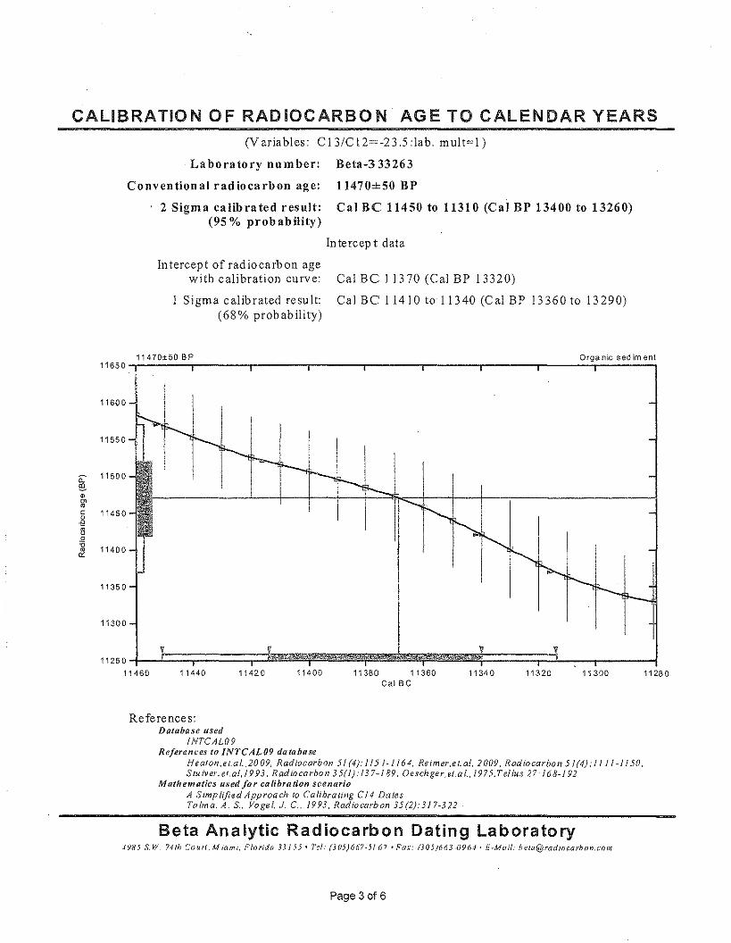
CALIBRATION OF RADIOCARBON AGE TO CALENDAR YEARS(Variables: CI3/CI2=-23.5:1ab. mult=l)
Laboratory number: Beta-333263
Conventional radiocarbon age:
2 Sigma calibrated result:(95% probability)
11470±50 BP
Cal BC 11450 to 11310 (Cal BP 13400 to 13260)
In tercep t data
Intercept of radiocarbon agewith calibration curve:
Sigma calibrated result:(68% probability)
Cal BC 11370 (Cal BP 13320)
Cal Be 11410 to 11340 (Cal BP 13360 to 13290)
11470±50 BP
11300
11600
11500
11550
11450
11400
11350
11440 11420 11400 11380 11360Cal Be
11340 11320 11300 11280
References:Database used
INTCAW9References to INTCAL09 database
HeaI0I1,e{,al..2009, Radiocarbon 51 (4): /15 '~1 /64, Reim er.e t.al, 2009, Radiocarbon 51(4): I J J 1-1150,Stu tver, et.at. 1993, Rad to carbo n 35(1):! 37-189, Oesch ger, et,a l., 1975, T elius 27: 168-192
Mathematics used/or calibration scenarioA Simplified Approach to Calibrating CI4 DatesTatm a. A. S, Vogel, J. C., 1993, Radiocarbon 35(2):317-322
Beta Analytic Radiocarbon Dating Laboratory4985 S.W, 74th Court, Miami, Florida 33155· tel.' (305)667·5167, Fax: (305)663·0964' E-Mail: beta@radlOcarbon,c()m
Page 3 of 6

CALIBRATION OF RADIOCARBON AGE TO CALENDAR YEARS(Variables: CI3/CI2=-23.9:lab. mult=l)
Laboratory number: Beta-333264
Conventional radiocarbon age: 19550±80 BP
2 Sigma calibrated r esult: Cal Be 21590 to 21340 (Cal BP 23540 to 23290)(95% probability)
In te rc ep I data
Intercept of radiocarbon agewith calibration curve:
Sigma calibrated result:(68 % probability)
Cal BC 21450 (Cal BP 23400)
Cal B C 215 10 to 21400 (C al BP 23460 to 23340)
19550±80 BP Organic sediment19800-.~--~-'-'r-'--.--~.-----r----.r----.----.-----r----.-----r~--~----'19750
19700
1965019600
•~ 19550c
il~.Q
~
Il.
19500
19250~__l:~====;===:;=====r:i~~~~~~~~~~~~~~~~V==~====~==~21600 21580 21560 21540 21520 21500 21480 21460 21440 21420 21400 21380 21360 21340
Cal Be
19450
19400
19350
19300
References:Database used
INTCAL09References to INTCAL09 database
Heaton .e La {,,2009, Radiocarbon 51 (4),' 115 t • , /64. Reimer.e t.al, 2009, Rad iocarbo n 5 1(4): II I J "! 150,Stu iver, et.at.l 9 93, Rad tocarbon 35(1 j: 13 7- / 89, Oesch ger.el.a I., 1975, Tellus 27: J 68-192
Mathematics used for calibration scenarioA SimplifledApproach to Calibrating C14 DatesTalm a, A, S: Vogel, 1. c., 1993. Radiocarbon 35(2):317~322
Beta Analytic Radiocarbon Dating Laboratory4985 S.W. 741h Co u rt , Miami. Florida 33155· Tel: (305}667-5J67' Fax: (305}663-0964' E-Mail: [email protected]
Page 4 of6
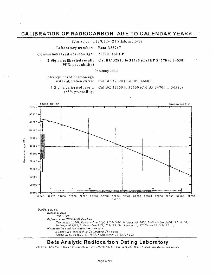
CALIBRATION OF RADIOCARBON AGE TO CALENDAR YEARS
29890± 160 BP30400
30300
30200
30100
~ 30000
~• 29900c»roc0€ 29800~.0-c& 29700
29600
29500
(Variables: CI3/C12=-23.9:lab. m ult=l )
Laboratory number: Beta-333267
Conventional radiocarbon age: 29890±160 BP
2 Sigma calibrated resnlt: Cal Be 32820 to 32580 (Cal BP 34770 to 34530)(95 % probability)
Intercep t data
Intercept of radiocarbon agewith calibration curve:
Sigma calibrated result:(68% probability)
Cal BC 32690 (Cal BP 34640)
Cal BC 32750 to 32630 (Cal BP 34700 to 34580)
v29300~--~~==:;====;===:;==~~~~~~~~~~~~~~~t:;:==~~==~--~32840 32820 32800 32780 32760 32740 32720 32700 32680 32660 32640 32620 32600 32580 32560
Cal Be
Orqe nlc sed lrnent
29400
References:Database used
INTCAL09References to INTCAL09 database
Heaton .e l.a l.,2009, Radiocarbon 51 (4): I J 5 J -!164, Retmer,e t. at, 2009, Radiocarbon 5 1(4): 1111- / 150,Stu tver, et.at. /993, Radio carbo 11 35(1): 137-189, Oesch ger.et,a I., 1975,T ellus 27: 168-1 92
Mathematics used for calibration scenarioA Simplified Approach /0 Calibrating Cl4 DatesTalm a, A. S.. Vogel. J. C. 1993. Radiocarbon 35(2):317-322
Beta Analytic Radiocarbon Dating Laboratory4985 S,W, 741h Courl.Miami. Florida 33155' Tel: (305)667·5167. Fax: (305}(i(i3-096.f' E-Mail: [email protected]
Page 5 of 6
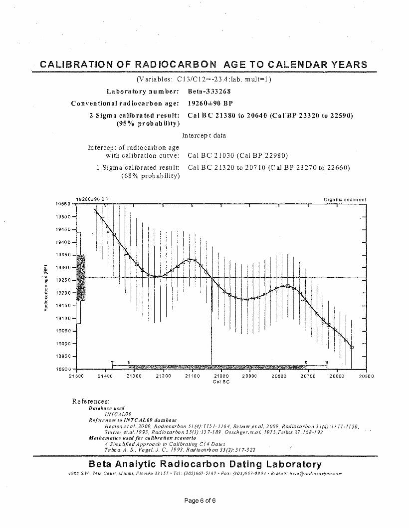
CALIBRATION OF RADIOCARBON AGE TO CALENDAR YEARS(Variables: CI3/CI2=-23.4:lab. mult=l)
Laboratory number: Beta-333268
Conventional radiocarbon age: 19260±90 BP
2 Sigma calibrated result: Cal BC 21380 to 20640 (CarBP 23320 to 22590)(95% probability)
In tercep t data
In tereept of rad io earb on agewith calibration curve:
Sigma calibrated result:(68% probability)
Cal BC 21030 (Cal BP 22980)
Cal BC 21320 to 20710 (Cal BP 23270 to 22660)
19260±90 BP Organic sediment19550-r----rTln-'''~-r-,-----~,-----._·----_,,------,_----~·r_----_r----~r_----_,
r\,1\]
I-l\
19350-I!'\.~ ,
I', T\, l
I I 1'\\
I
I I
19500-
I II
.-----19300
-
1\ -I -
• • V V I I -18900~------~t:==~~~~~,',·~~~,~~~~,~~~~,~~~~~~~;:,==3-_r~-L~21500 21400 21300 21200 21100 21000 20900
Cal Be
I
,~~ I
I 1\l,'I 1\I fI1l'\,.
19450-
20800 20600
---
20500
References:Database used
INTCAL09References to INTCAL09 database
J-/eaton,el.al.,2009. Radiocarbon 51 (4):1 15 /~1164. Retmer.etat. 2009, Radiocarbon 51(4):11/1-1/50,Stu tver. et.al. !9 93, Rad iocarbo n 35(1): J 3 7~189, Oesch ger.ei.a /.. J 9 75, Tellus 27: 168~1 92
Mathematics used for calibration scenarioA Simplified Approach to Calibrating Cf4 DalesTalm a. A. S., Vogel, J. c.. 1993, Radiocarbon 35(2):317-322
20700
Beta Analytic Radiocarbon Dating Laboratory4985 S.W. 74th COUrI, Miami, Florida 33155' rei: (305}667-5/67' Fax: (305}663-0964' 1:':'Mail: [email protected]
Page 6 016
19400-
19250
19200
19150-
19100-
19050-
19000-
18950-
Beta Anulyfie Inc.4985 SW 74 CuurrMiami. Florida 33155 USATe!, 305 6675167Fll.\:: 3D:; 663 tl964Bc1a(I(','rntiiocarbon.cnJ1lwww.radlucurbcn.cem
Durden HoodPresident
Ronald HatfieldChrrseepbcr Patrtck
Deputy ntreercrsConsistent. A ccu/'a<-:l' ...
... Delivered On...time
October 29, 2012
Mr. Dan R. EberhartLangan Engineering and Environmental18662 MacArthur Blvd.Ste 456Irvine, CA 92612USA
RE: Radiocarbon Dating Results For Samples B5-7-29ft depth, B5-11-46.5ft depth
Dear Mr. Eberhart:
Enclosed are the radiocarbon dating results for two samples recently sent to us. They eachprovided plenty of carbon for accurate measurements and all the analyses proceeded normally. As usual,the method of analysis is listed on the report with the results and calibration data is provided whereapplicable.
As always, no students or intern researchers who would necessarily be distracted with otherobligations and priorities were used in the analyses. We analyzed them with the combined attention ofour entire professional staff.
If you have specific questions about the analyses, please contact us. We are always available toanswer your questions.
The cost of analysis was previously invoiced. As always, if you have any questions or would liketo discuss the results, don't hesitate to contact me.
Sincerely,
Page 1 of 4
REPORT OF RADIOCARBON DATING ANALYSES
Mr. Dan R. Eberhart Report Date: 10/29/2012
Langan Engineering and Environmental Material Received: 10119/2012
Sample Data MeasuredRadiocarbon Age
13C/12CRatio
ConventionalRadiocarbon Age(*)
Beta- 333265 19950 +/· 80 BP ·23.5 0/00
SAMPLE: B5·7·29ft depthANALYSIS: AMS·PRIORITY deliveryMATERIAL/PRETREATMENT: (organic sediment): acid washes2 SIGMA CALIBRATION Cal BC 22020 to 21740 (Cal BP 23970 to 23690)
19970 +/· 80 BP
Beta·333266 10300 +/· 50 BP ·23.6 0100 10320 +1· 50 BPSAMPLE: B5·11-46.5ft depthANALYSIS: AMS·PRIORITY deliveryMATERIAL/PRETREATMENT: (organic sediment): acid washes2 SIGMA CALlBRA nON Cal BC 10440 to 10290 (Cal BP 12390 to 12240) AND Cal BC 10280 to 10030 (Cal BP 12240 to
11980)
4 , Hili , $ & :r i
Dates are reported as RCYBP (radiocarbon years before present,"present" '" AD 1950). 8y international convention, the modernreference standard was 95% the 14C activity of the National Instituteof Standards and Technology (NIST) Oxalic Acid (SRM 4990C) andcalculated using the Libby 14C halt-life (5568 years). Dueled errorsrepresent 1 relative standard deviation statistics (68% probabHlty)counting errors based on the combined measurements of the sample,background. and modern reference standards. Measured 13C/12Cratios (delta 13C) were calculated relative to the PDB~1 standard,
The Conventional Radiocarbon Age represents the MeasuredRadiocarbon Age corrected for isotopic fractionation. calculatedusing the delta 13C. On rare occasion where the ConventionalRadiocarbon Age was calculated .using an assumed delta 13C,the ratio and the Conventional Radiocarbon Age wlll be fcltowed by "".Tile Conventional Radiocarbon Age is not calendar calibrated.When available, the Calendar Calibrated result Is calculatedfrom the Conventional Radiocarbon Age and is listed as the"Two Sigma Cellbrated Result" for each sample.
Page 2 of4
CALIBRATION OF RADIOCARBON AGE TO CALENDAR YEARS(Variables: C 13/C 12=-23.5 :lab. m ult=L)
Laboratory nu m ber: Beta-333265
Conventional radiocarbon age: 19970±80 BP
2 Sigma calibrated result: 'Cal BC 22020 to 21740 (Cal BP 23970 to 23690)(95% probability)
In tercep t data
Intercept of radiocarbon agewith calibration curve:
Sigma calibrated result:(68% probability)
19970±80 BP20250
20200
20150
20100
20050
a:~ 20000ID~roc 199500-es
19900.Q-cro
'" 19850
19800
19750
19700
1965022050 22000 21950
Cal BC 21910 (Cal BP 23860)
Cal BC 21960 to 21840 (Cal BP 23910 to 23790)
Orga nlc sed im en!
I
--~~~~~I-'+-~~-I----~I l
1
,.Z21900 21850 21800 21750 21700
Cal Be
References:Dot abe se used
INTCAL09References to INTCAL09 database
Heaton.et.al.,2009, Radiocarbon 51 (4): 115/-1 164, Reimer.et.al, 2009. Radiocarbon 51(4}:! 111-1/50,Stu iver, et.al, 1993, Rad iocarbon 35(1): 13 7-189. Oesch ger.ei.a I"~1975, Tellus 27: 168-/92
Mathematics used for calibration scenarioA Simplified Approach to Calibrating C14 DalesTalma, A. S., Vogel, J c. 1993, Radiocarbon 35(2):3/ 7~322
Beta Analytic Radiocarbon Dating Laboratory4985 S,W. 74fhCourl,Miami, Florida 33155· Tet : (305}667-5J67 'Fax: (305)663-0964' E-Mail: [email protected]
Page 3 of 4
CALIBRATION OF RADIOCARBON AGE TO CALENDAR YEARS(Variables: CI3/CI2=-23,6:lab, mult=l)
Laboratory number: Beta-333266
Conventional radiocarbon age:
2 Sigm a calibrated results:(95% probability)
10320±50 BP
Cal BC 10440 to 10290 (Cal BP 12390 to 12240) andCal BC 10280 to 10030 (Cal BP 12240 to 11980)
10320±50 BP Organic sediment10500,_------r_----_r------~-----r------,_----_,------,_------r_--~_r----__,10450
10400
10350
10300
10250
10200
10150
Intercept data
Intercept of radiocarbon agewith calibration curve:
Sigma calibrated results:(68% probability)
Cal Be 10140 (Cal BP 12090)
cusc 10420 to 10410 (Cal BP 12370to 12360) andCal Be 10260 to 10240 (Cal BP 12210 to 12190) andCal Be 10200 to 10100 (C al BP 12140 to 12050)
10100~------,J==Ji'[-;=::::~::::::~U:::~i:::::~~~~~~~~::::::;:Jr--~10500 10450 10150 10050 100001010010400 10350 10300 10250
Cal Be10200
References:Database used
INTCAL09References to INTCAL09 database
Heaton, et.a t. ,2009, Radiocarbon 5/ (4): 115 /-1164. Reimer,e t.al. 2009 . Radiocarbon 5 1(4): I J 11-1/50,Stu iver, ei.at, 1993, Rad tocarbo n 35(1).' I~ 7- / 89, Oesch ger.et,a I., 1975, Tellu s 27.' 168-192
Mathematics used for calibration scenarioA Simplified Approach to Calibrating CliDafesTaima, A. S: Vogel, J c., 1993, Radiocarbon 35(2):317~322
Beta Analytic Radiocarbon Dating Laboratory4985 S.W. 741h Co un. Miami, Florida 33155· Tel: (305)667·5167. Fax: (305)663-0964. E-Mail: [email protected]
Page4 of 4
Fault Investigation ReponHoffywood DevelopmentVesting Tentative Tract 71837Hof/ywood C"aIYLifog,r:onlijia'-_-'- _
30 November 2012700019502
PLATES
LANIiAN
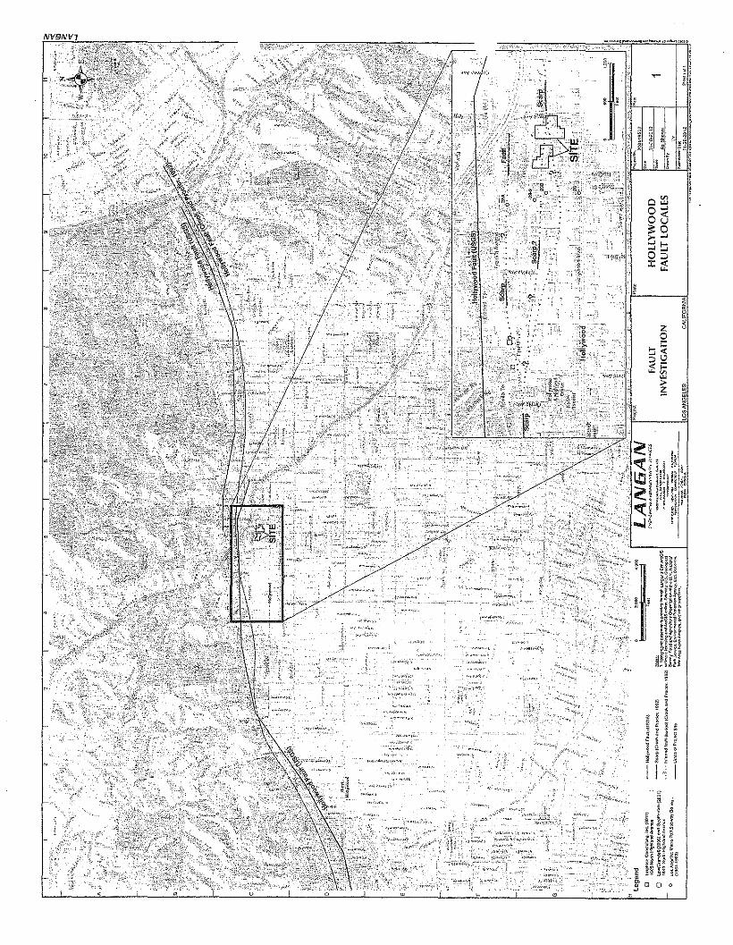
·"',",.,,'LH
'_'W"_~ ,
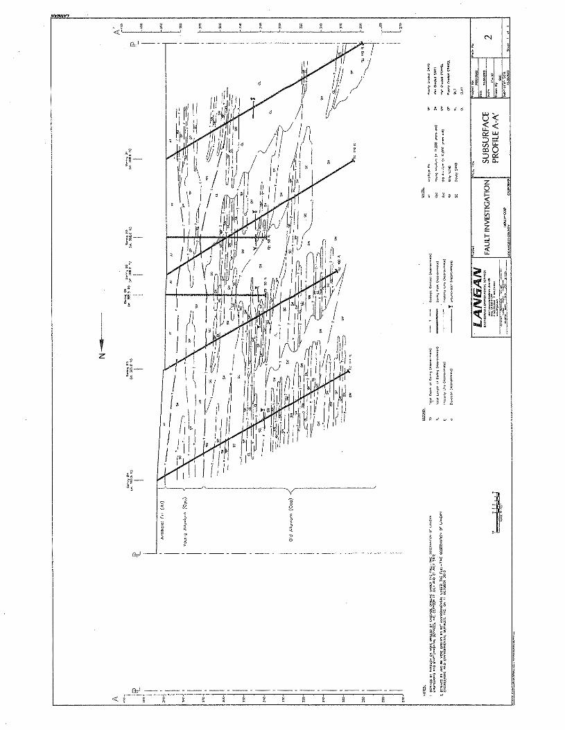
! o~7----'--'~! ', ; ! s'--";' ~ .
N '
l~ I
~Z

·EXHIBITB
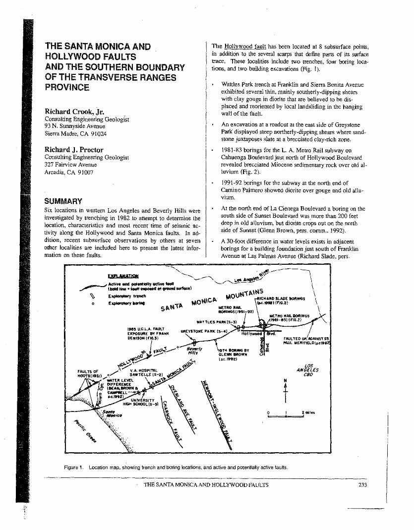
THE SANTA MONICA ANDHOLLYWOOD FAULTSAND THE SOUTHERN BOUNDARYOF THE TRANSVERSE RANGESPROVINCE
Richard Crook, Jr.Consulting Engineering Geologist93 N. Sunnyside AvenueSierra Madre, CA 91024
Richard J. ProctorConsulting Engineering Geologist327 Fairview AvenueArcadia, CA 91007
SUMMARYSix locations in western Los Angeles and Beverly Hills wereinvestigated by trenching in 1982 to attempt to determine thelocation, characteristics and most recent time of seismic ac-tivity along the Hollywood and Santa Monica fault'. In ad-dition, recent subsurface observations by others at sevenother localities are included here to present the latest infor-mation on these faults,
_______ /let, ""'em ... Iy _.."... t , • .... _ ......,.l
~ E--..""'"o E~Y"'"
TIle Hollywood fault has been located at 8 subsurface points,in addition to the several scarps that define parts of its surfacetrace. These localities include two trenches, four boring loca-tions, and two building excavations (Fig. I).
Wattles Park trench at Franklin and Sierra Bonita Avenueexhibited several thin, mainly southerly-dipping shearswith clay gouge in diorite that are believed to be dis-placed and reoriented by local landsliding in the hangingwall of the fault.
An excavation at a roadcut at the east side of GreystonePark displayed steep northerly-dipping shears where sand-stone juxtaposes slate at a brecciated. clay-rich zone.
1981-83 borings for the L. A. Metro Rail subway onCahuenga Boulevard just north of Hollywood Boulevardrevealed brecciated Miocene sedimentary rock over old al-luvium (Fig. 2).
1991-92 borings for the subway at the north end ofCamino Palmero showed diorite over gouge and old allu-vium.
At the north end of La Cienega Boulevard a boring on thesouth side of Sunset Boulevard was more than 200 feetdeep in old alluvium, but diorite crops out on the northside of Sunset (Glenn Brown, pers, comm., 1992).
A 30-foot difference in water levels exists in adjacentborings for a building foundation just south of FranklinAvenue at Las Palmas Avenue (Richard Slade, pers.
1914 IOIIIING 8YGLtHN MOWN(p.~.,"ZI
FAULTED GftAGAiNSTSS,f'IIIUL MERIFIEl.O(p.ct9S
t.\OI'lICANlfTIItO JIM..8OftINGS(I99I-92)
I M£TRO RAIl80RIHGS
WATl\..\!:$PAftt(IS,,_,,}~~:::~~I":,:'-:._3}_I_f1_G._'}..-'6MYSTONE PARt( (5-4) ,..,. Yd.
LOSANGELESceo
Figure 1. Location map, showing trench and boring locations, and active and potentially active faults.
THE SANTA MONICA AND HOLLYWOOD FAULTS 233
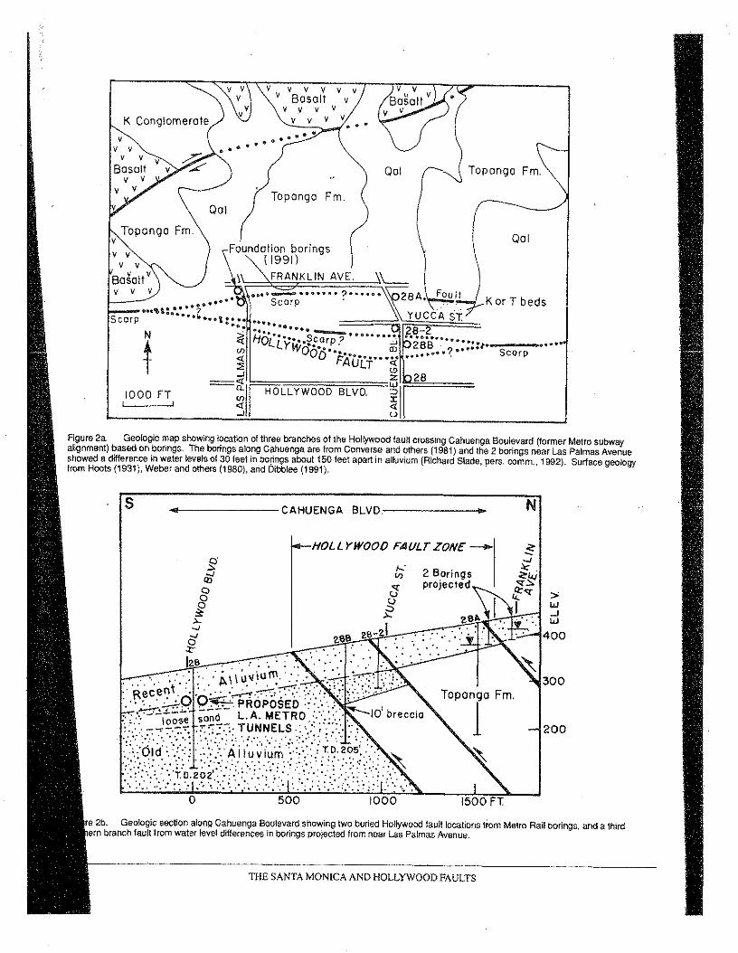
K Conglomerate
Figure 2a. Geologic map showing location of three branches of the Hollywood fault crossing Cahuenga Boulevard (tormer Metro subwayallgnment) based on borings. The borings along Cahuenga are from Converse and others (1981) and the 2 borings near Las Palmas Avenueshowed a difference in water levels of 30 feel in bo~ngs about 150 feet apart in alluvium (Richard Slade, pers. comm.. 1992). Surface geologyfrom Hoots (1931), Weber and others (1980), and Dibblee (1991),
v vvvvvv Bosolt
v v vv y
N
300
200
re 2b. Geologic section along Oahuenqa Boulevard showing two buried Hollywood fault locations from Melro Rail borings, and a thirdern branch fault Irom water level differences in borings projected from near Las Palmas Avenue.
y vv
vv
•••.. ....II> fI 4- .. "
Topanga Fm.001
001
Topanga Fm.
Foundation borings( 1991)
FRANKLINAVE.
'...,,---"."'''Scarp
••• ,_ :> ..Scarp . ~.;;.::.~./ _K or T beds......
.. to ......•••", ?Scarp ...... , ......... ::....•....?i H····· s~·····..···~ OLLYi,~·.:arp. .'" 'Y 00·D"...... IT)
<i FAULT·· ... ~..::! <.?
...! ~~~~~~~=z 28=<i:'!i.lr Wu~:;:I~1 =:: HOLLYWOOD BLVD. :1000 FTI
s ~.~----------CAHUENGA BLVD~.---------- ••
2 Boringsprojected
HOLL YWOOOFAI/LT ZONE'-§qj
I;......J
~ . . ~6
_..,--:-:-:'128;:.. . ' '. , . . .- .... ' '" :~\\Uviurn.· .... : '.. ~, ;"i.........••.• :.:.1"'\, .', .~', •.. , ·'i·.:'..:-~·-,· ,::,'.' oeceo• , ''-'''-'-''.'" ." "0 ·0:.....-~ i ', ''', ",' .• , ." " , . ';'-':". .~. PROPOSED.:.,' ...•'. . I
••• ~.!..-~' --nd-- L A METRO ::: '.'. 10 breccia'. " loose SO •• ' •• : ;:: .
~,:,r;4N,Jf't-j~~:~t;"W"F,;,f
/...:'"§
~z8-:d ..
>'w...Jw
·~-...-,400.. "
...
o 500 1000
THE SANTA MONICA AND HOLLYWOOD FAULTS
cornm., 1992); the northern boring reportedly encounteredwater at 15 feet and the southern boring at 45 feet (Fig.3),
Granite was seen faulted against Puente Formation sand-stone in a Los Feliz district residential excavation (PaulMerifield, pers. comm., 1982).
Frank Denison (pers. comm., 1985) mapped Modele For-mation shale faulted over Pleistocene old alluvium, withthe fault striking N60E and dipping an average of 35degrees north, in a library building excavation at the westpart of the UCLA campus north of Gayley Avenue andeast of Veteran Avenue (Fig. 3). This exposure is the onlyhard evidence that a potentially active fault exists in- thisreach, However, his northeast strike appears to align witha small fault mapped by Hoots (1931, Plate 16), ratherthan the projected westward trace of the Hollywood fault,We made a long south-trending trench at the north part ofthe Brentwood Hospital Veterans property, 1000 feet westof UCLA. across 'a stepped surface of an old fan, butfound no fauIt.
All these localities, except at UCLA, show an g-mile Holly-wood fault segment extending northeasterly from BeverlyHills to the Los Angeles River, defining the south base of theSanta Monica. Mountains. West of the west boundary of
N,W.PART OFUCLA CAMPUS
.'.'
~~.....,~~..'
: DD y.....
: ~~D....~..51'" 21•~ SAXON.. 'L, I RESIDENTIAL
SOUTHERN SU1TE5
REGIONAlj~LIBRARY ~4 'Ii',
[ 4vli'
N
t
~igu~e 3a. Locati?n map of western UCLA campus showing (for thefirst time) the location of the thrust fault exposure in the excavation forthe library b~i!ding mapped by Frank Denison in 1985 (personalcomrnurucatlon). Modele Formation shale overrides old alluvium, withtwo parallel faults at N60E, 35N. The location of faults in thefoundations of adjacent buildings has not been reponed.
..'
Beverly Hills, at the mouth of Benedict Canyon, the topogra-phy and geology changes to dissected large old alluvial fans,and the fault has not been proven to exist in this 6-mile seg-ment extending to the Pacific Ocean, It should be noted thatHoots (1931) shows faults in three canyons near the coastthat seem to line up with a westward extension of the Holly-wood fault (Fig. I).
Recency of displacement on the Hollywood fault could notbe absolutely determined, although geomorphic expression(Weber and others, 1980; Dolan and Sieh, 1991) suggests lateQuaternary movement.
The Santa Monica fault has several scarps extending 6 mileson-shore from Santa Monica Bay, and is exposed at themouth of Potrero Canyon north of the City of Santa Monica.It was also exposed in a foundation excavation and by ourtrenching at two locations:
A foundation excavation and pumping test at WilshireBoulevard and Bundy Drive defines a segment of the fault(Robert Bean, Glenn Brown and Alice Campbell, pers.comm., 1992).
Our trenches at the southwest corner of the U. S. VeteransAdministration Sawtelle property exhibited near-verticalto south-dipping normal shear zones with clay gougetrending roughly east-west.
Trenches at University High School displayed two well-defined steep southerly-dipping normal faults, consistingof 2 to 12 inches of sheared clay, with apparent lateral dis-placements. No datable materials were found in any dis-placed units.
Proposed trenching on both the Santa Monica and Hollywoodfaults by Caltech (James Dolan and Kerry Sieh, pers. comm.,1992) may be completed by the time this paper is printed andmay reveal new evidence on recency of faulting. Haukssonand Saldivar (1986) believe the 1930 MS.2 earthquake inSanta Monica Bay was on the Santa Monica fault. West ofhere, recent work by Rzonca and others (1991) and Drumm(in this chapter) indicates that the Malibu Coast fault movedin Holocene time .
OVERVIEW AND CONJECTURE ON THESOUTHERN BOUNDARY OF THETRANSVERSE RANGES PROVINCEThe Santa Monica fault zone is a portion of the much longerAnacapa-Malibu Coast-Santa Monica-Hollywood-Raymond-Sierra Madre-Cucamonga fault system that stretches morethan' 100 miles from offshore west of Ventura County 1OCajon Pass (Fig. 4). This system of faults roughly definesthe southern structural boundary between the TransverseRanges (mainly left-lateral and thrust faults) and the Peninsu-
I Jar Ranges (mainly steep right-lateral faults) provinces of
THE SANTA MONICA AND HOLLYWOOD FAULTS 235
236 THE SANTA MONICA AND HOLLYWOOD FAULTS
southern California. At Cajon Pass, this boundary is right-laterally offset 15 miles along the San Jacinto fault, and re-sumes eastward as the Banning thrust fault. (See Fig. 5.) Al-though this fault system may have been a through-going ac-tive entity at some time in the past, Yerkes and Lee (1979a,b), Chapman and Chase (1979) and Weber and others (1980)suggest that since late Pleistocene time this is no longer so.Our work at Caltech in 1975-78 (Crook and others, 1987),led us to believe that the Sierra Madre fault zone and theRaymond fault behave as several discrete segments that actindependently to local tectonic stresses and that they there-fore should be treated as individual segments with regard tofuture seismic activity. This conclusion is also extended tothe Anacapa-Malibu Coast-Santa Monica-Hollywood faultsystem. Figure 3 shows the interrupted nature of the faults,particularly the nearby Sierra Madre fault zone that is actu-ally a connected series of thrust faults that curve north-eastward to become steep left-slip faults. We believe eachthrust segment moves independently to cause typically mod-crate-sized earthquakes. such as the M 6.5 San Fernandoearthquake in 1971.
In our opinion, therefore, a scenario of a long reach of thefault system moving to cause an earthquake with a magni-tude approaching 7.5 is unlikely. Bonilla and others (1984)indicate such a large event would rupture the ground surfacefor almost 50 miles; a long rupture length does not appear tofit the direct arcuate thrust fault traces, nor the locaJ tectonics
(e.g. Allen, 1975; Hauksson , 1990, and Hauksson thisvolume).
Until approximately 1987 the boundary between the Trans-verse Ranges and the Peninsular Ranges provinces was con-sidered to be the obvious geomorphic southern limit of theTransverse Ranges. In other words, the southernmost steepparts of the Santa Monica, San Gabriel and San Bernardinomountain ranges. However, work by Davis (1987) suggestedthat the actual boundary might lie south of these areas as aseries of north-dipping blind thrusts. This model appears tohave been confirmed by the October 1987 Whittier Narrowsearthquake. Geologic and seismic studies of this earthquakeby Davis and others (1989) and Hauksson and Jones (1989),and of other subsequent earthquakes (Hauksson, 1990;Hauksson and Jones, 1991), have suggested that the bound-ary between the two provinces lies south of the Santa Mon-ica-Hollywood-Raymond-Sierra Madre-Cucamonga fault sys-tem. The boundary exists as a zone of exposed and buriednortheast-trending, left lateral strike-slip faults (San Jose, In-dian Hill, Walnut Creek and Red Hill) east of the Los An-geles Basin and a series of northwest- to west-trending blindthrusts (Davis and others, 1989) in the central part of the LosAngeles basin.
At the far western end of the Los Angeles basin this bound-ary is less defined at present. Here the presently activebounding fault appears to be the Santa Monica fault, al-though on-shore Holocene movement has yet to be proven.
TRANSVERSEMOJAVE
DESERTRANGES
OKngrd
SA."n,~ CRUI , o~
.o0<:'/1(:
C
Dc'0,
N
t0 '0 '0 3OMll"
D PohndQle
237
Figure 4, Regionallault map, shOWing uncertainty of south boundary of Transverse Ranges Province in this part 01 southern California. Queriesindicate doubts as 10 connection between E·W faults. See text for discussion. The Sierra Madre thrust fault forms distinct segments as it swingsNE into canyons and becomes steep tett-Iaterat faults: ETC'" Big Tujunga Canyon; GM·AS .. Gould Mesa-Arroyo Seco; C·SC ""ciemeheu-sawpnCanyon; DC .. Dalton Canyon; SAC"" San Antonio Canyon.
THE SANTA MONICA AND HOLLYWOOD FAULTS
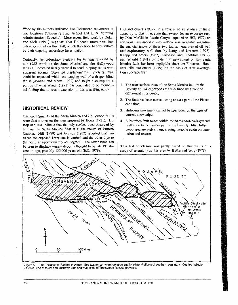
Work by the authors indicated late Pleistocene movement attwo locations (University High School and U. S. VeteransAdministration, Sawtelle). More recent field work by Dolanand Sieh (1991) suggests that Holocene movement hasindeed occurred on this fault, which they hope to substantiateby their ongoing subsurface investigation.
Curiously, the subsurface evidence for faulting revealed byour 1982 work on the Santa Monica' and the Hollywoodfaults all indicated nearly vertical to south-dipping faults withapparent normal (dip-slip) displacements. Such faulting ,could be expected within the hanging wall of a deeper blindthrust (Avouac and others, 1992) and might also explain aportion of what Wright (1991) has concluded to he rnonocli-naJ folding due to recent extension in this area (Fig, 6a-c).
HISTORICAL REVIEW
Onshore segments of the Santa Monica and Hollywood faultswere first shown on the map prepared by Hoot, (1931). Hismap and text indicate that the only surface trace observed byhim on the Santa Monica fault is at the mouth of PotreroCanyon. Hill (1979) and Johnson (1932) reported that twotraces are exposed here; one is vertical and the other dips tothe north at approximately 45 degrees. The latter trace canbe seen to displace terrace deposits thought to he late Pleisto-cene in age, possibly 125,000 years old (Hill, 1979).
Hill and others (1979), in a review of all studies of thesezones up to that timet state that except for an exposure seenby John McGill in Rustic Canyon (quoted in Hill, 1979) noadditional site-specific information was available regardingthe surficial traces of these two faults. Analyses of oil welland exploratory well data by Lang and Dreesen (1975),Knapp and others (1962), Jacobson and Lindblom (1977),and Wright (1991) indicate that movement on the SantaMonica fault has been negligible since the Pliocene. How-ever, Hill and others (1979), on the basis of their investiga-tion conclude that:
1. The near-surface trace of the Santa Monica fault in theBeverly Hills-Hollywood area is defined by a zone ofdifferential subsidence;
2. The fault has been active during at least part of the Pleisto-cene time;
3. Holocene movement cannot be precluded on the basis ofcurrent knowledge;
4. Subsurface fault traces within the Santa Monica-Raymondfault zone in the eastern part of the Beverly Hills-Holly-wood area are actively undergoing tectonic strain accumu-lation and release,
This last conclusion was partly based on the results of astody of seismicity in this area by Buika and Teng (1978).
N
tFigure 5. The Transverse Ranges province. Sse text for comment on apparent right-lateral offsets of southern boundary. Queries indicateunknown end of faults and unknown east and west ends of Transverse Ranges province.
THE SANTA MONICA AND HOLLYWOOD FAULTS238
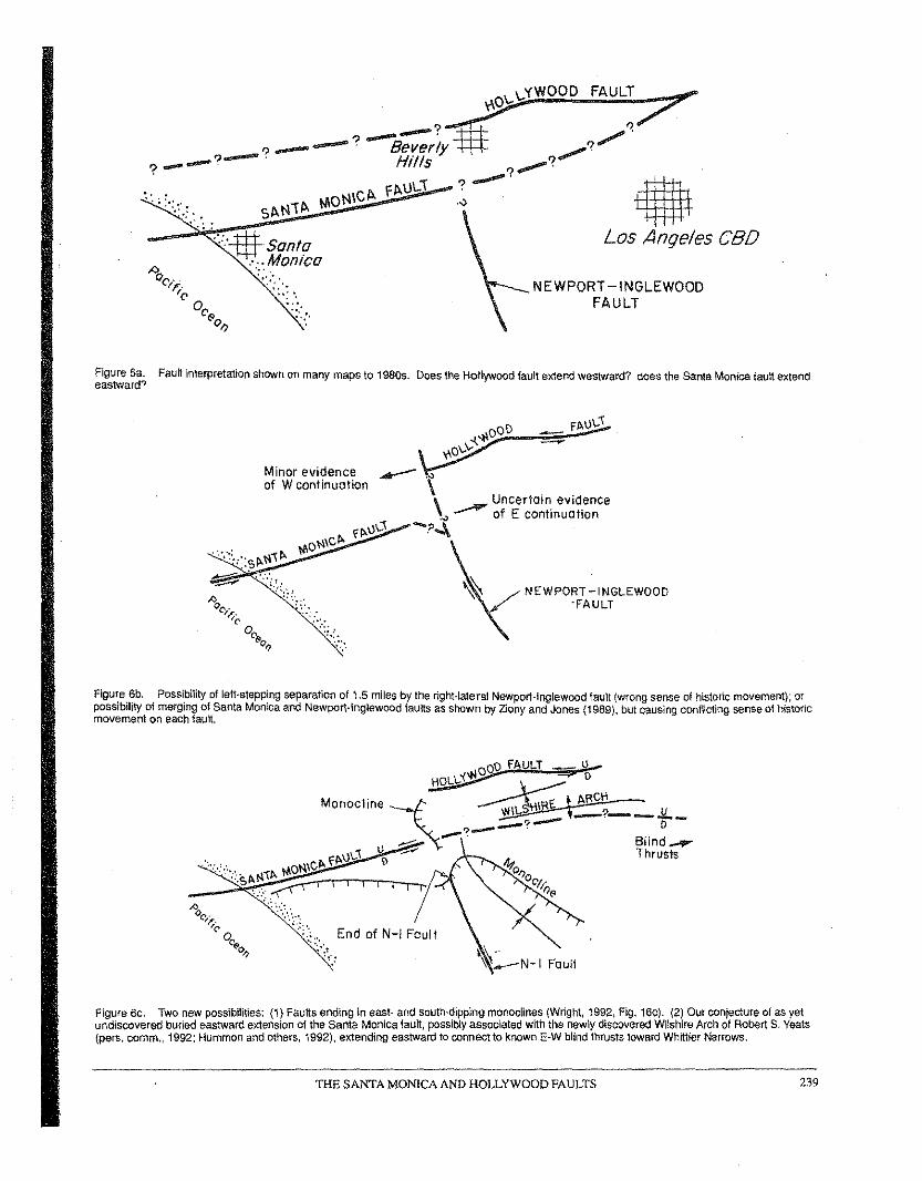
~O\..\..YWOOD FAULT7?_-?-e;;r~Y~ __?/'l.
?_ U'II ?.....? __ rtt S ?.,.,.,...'" . I'I>-ll\..i ? ..-. .ditth',; :-:":.,::" SI>-tlil>- ,""otllCI>- .o ~
,; :"'::J$f Santa Los Anqe/es CBD" ..Monica'"
NEWPORT-INGLEWOODFAULT
"'':,',.. '..: "
",..:.
Figure 6a. Fault interpretation shown on many maps to 1980$. Does the Hollywood fault extend westward? does the Santa Monica fault extendeastward?
Minor evidence ~ ,.,of W cont inuotion \
\Uncertain evidence
;.,) of E continuation-?~
NEWPORT-INGLEWOOD'FAULT
Figure eb. Possibility of left-stepping separation of 1.5 miles by the right-lateral Newport-Inglewood fault (wrong sense of historic movement); orpossibility of merging of Santa Monica and Newport-Inglewood faults as shown by Zlony and Jones (1989), but causing conflicting sense 01historicmovement on each fault.
_,,~vl~~ \ __~o
Monocline ~ ~c~ _.!I.. ____?.--.. 0...-?-.--:; 81 lnd __~ ""'" 4? Thrusts
01)~~,,-r~__ o~,II)~
End of N-I Foul t
~ :'--N-I Faull
Figure ec. Two new possibilities: (1) Faults ending in east- and south-dipping monoclines (Wright, 1992, Fig. 16c). (2) Our conjecture of as yetundiscovered buried eastward extension of the Santa Monica fault, possibly associated with the newly discovered Wilshire Arch of Robert S. Yeats(pers. cornm. 1992; Hemmen and others, 1992), extending eastward to connect to known E-W blind thrusts toward Whittier Narrows.
THE SANTA MONICA AND HOLLYWOOD FAULTS 239
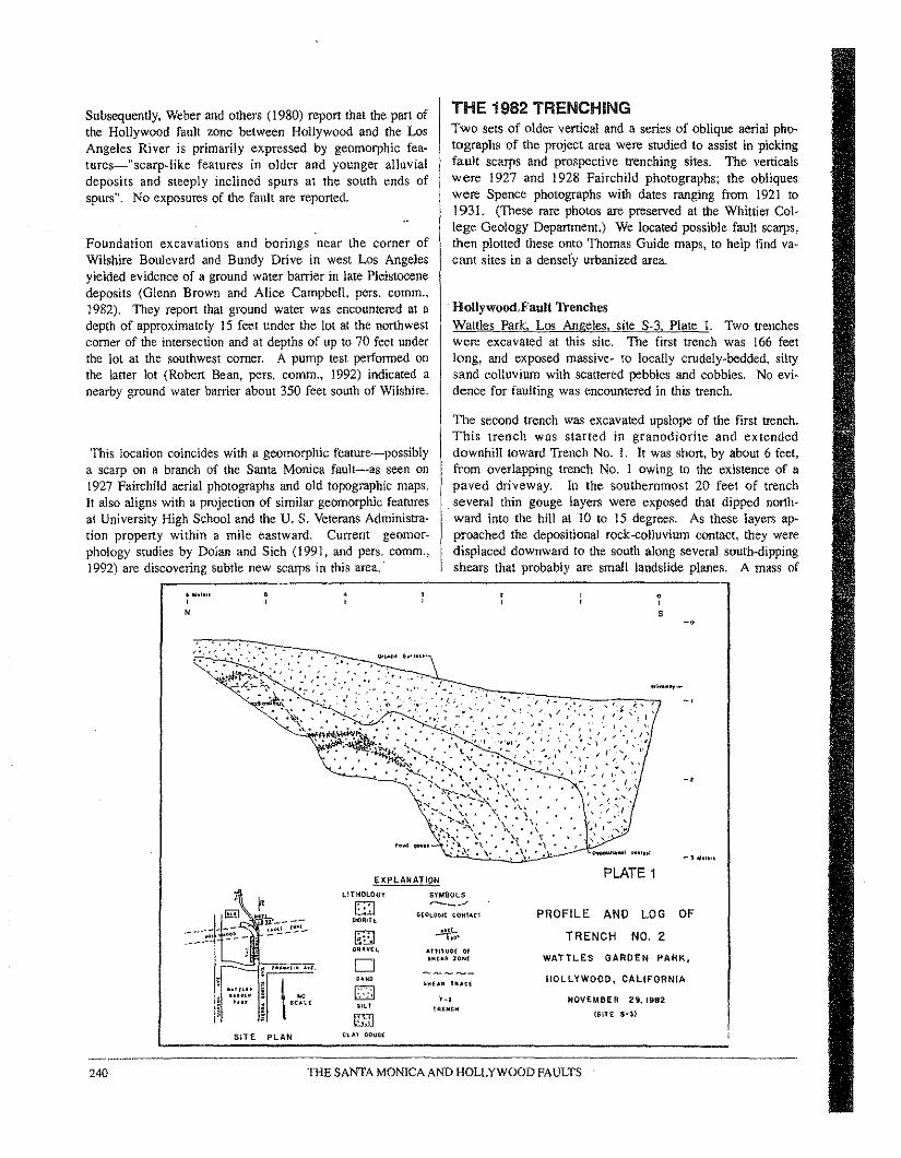
Subsequently, Weber and others (1980) report that the part ofthe Hollywood fault zone between Hollywood and the LosAngeles River is primarily expressed by geomorphic fea-rures=-t'scarp-hke features in older and younger alluvialdeposits and steeply inclined spurs at the south ends ofspurs". No exposures of the fault are reported,
Foundation excavations and borings near the comer ofWilshire Boulevard and Bundy Drive in west Los Angelesyielded evidence of a ground water barrier in late Pleistocenedeposits (Glenn Brown and Alice Campbell, pers. comm.,1982). They report that ground water was encountered at adepth of approximately 15 feet under the lot at the northwestcorner of the intersection and at depths of up to 70 feel underthe lot at the southwest corner. A pump test performed onthe latter lot (Robert Bean, pers. comm., 1992) indicated anearby ground water barrier about 350 feet south of Wilshire.
This location coincides with a geomorphic feature-possiblya scarp on a branch of the Santa Monica fault-as seen on1927 Fairchild aerial photographs and old topographic maps.It also aligns with a projection of similar geomorphic featuresal University High School and the U. S. Veterans Administra-tion property within a mile eastward. Current geomor-phology studies by Dolan and Sieh (1991, and pers. comm.,1992) are discovering subtle new scarps in this area."
EKPlANATION PLATE 1
f'LITHOLOGY SYMeOLS
lSI ~-~B G£O~OGlt CQtI'''CT PROFILE AND LOG OF
~~-~~ PIO'''H---,;. !"~- [S] ~. TRENCH NO. 2
aq ...V[~ AtHHIt>( Gr
0 ttiUR lONt WATTLES GARDEN PARK,;rt: -- ..... ~.-......-5~MO ~tlU" UAt~ HOLLYWOOD, CALIFORNIA
~.,".. EJ.. uu '1"-; NOVEMBER 29, 1982,.., i sc ...~( $ILl TRINe!!
[I;'] lSlTE Sol)
'"SITE pLAN t~AT /lOUG(
~ '....10","
THE 1982 TRENCHINGTwo sets of older vertical and a series of oblique aerial pho-tographs of the project area were studied to assist in pickingfault scarps and prospective trenching sites. The verticalswere 1927 and 1928 Fairchild photographs; the obliqueswere Spence photographs with dates ranging from 1921 to1931. (These rare photos are preserved at the Whittier Col-lege Geology Departmem.) We located possible fault scarps,then plotted these onto Thomas Guide maps, to help find va-cant sites in a densely urbanized area.
. Hellywood.Faalt TrenchesWattles Park, Los Angeles, site S-3, Plate 1. Two trencheswere excavated at this site. The first trench was 166 feetlong, and exposed massive- to locally crudely-bedded, siltysand colluvium with scattered pebbles and cobbles. No evi-dence for faulting was encountered in this trench.
The second trench was excavated upslope of the first trench.This trench was started in granodiorite and ex tendeddownhill toward Trench No. 1. It was short, by about 6 feet,from overlapping trench No. lowing to the existence of apaved driveway. In the southernmost 20 feet of trenchseveral thin gouge layers were exposed mat dipped north-ward into the hill at 10 to 15 degrees. As these layers ap-proached the depositional rock-colluvium contact, they weredisplaced downward to the south along several south-dippingshears that probably are small landslide planes. A mass of
e,s -.
-l ..."."
240 THE SANTA MONICA AND HOLLYWOOD FAULTS
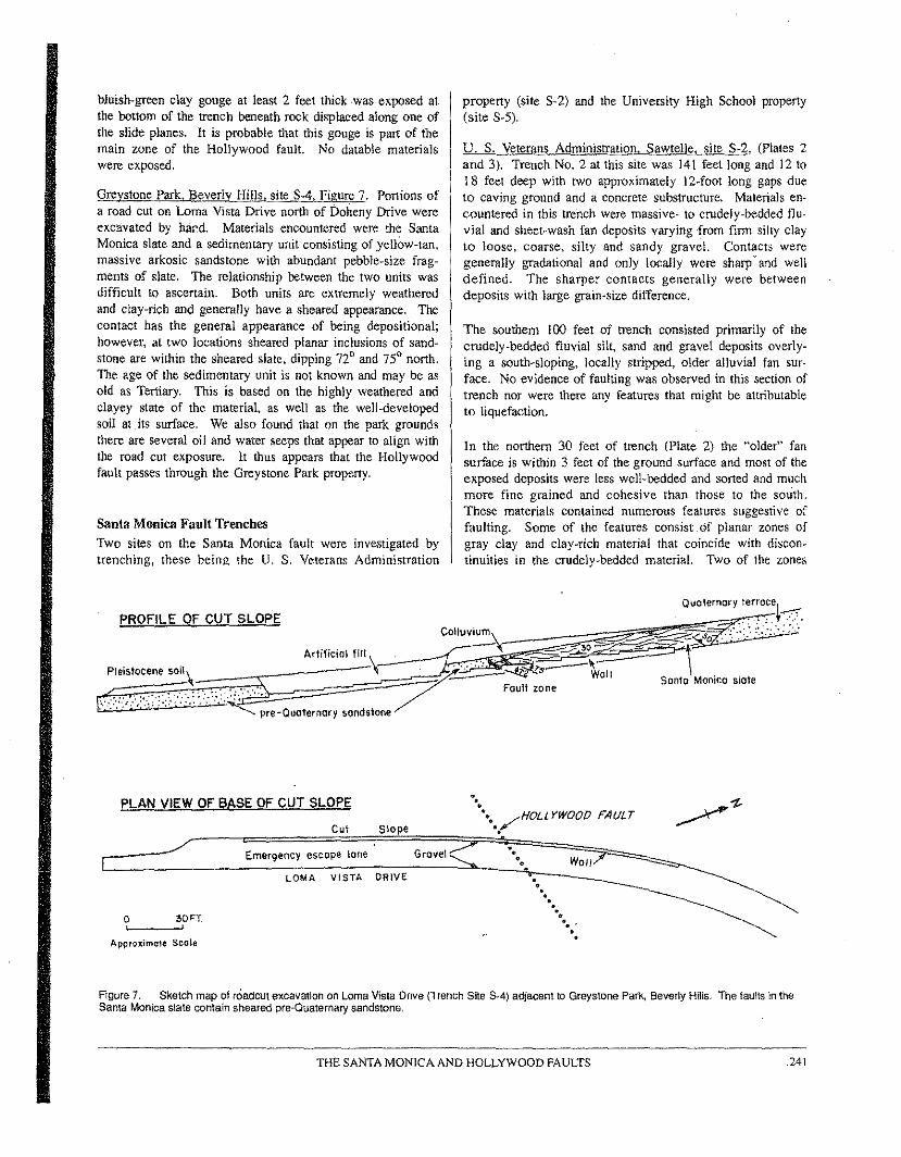
bluish-green clay gouge at least 2 feet thick was exposed atthe bottom of the trench beneath rock displaced along one ofthe slide planes. It is probable that this gouge is part of themain zone of the Hollywood fault. No datable materialswere exposed.
Greystone Park. Beverly HillsLsite S-4, Figure 7. Portions ofa road cut on Lorna Vista Drive north of Doheny Drive wereexcavated by har:d. Materials encountered were the SantaMonica slate and a sedimentary unit consisting of yellow-tan,massive arkosic sandstone with abundant pebble-size frag-ments of slate. The relationship between the two units wasdifficult to ascertain, Both units are extremely weatheredand clay-rich and generally have a sheared appearance. Thecontact has the general appearance of being depositional;however, at two locations sheared planar inclusions of sand-stone are within the sheared slate, dipping 72° and 75° north.The age of the sedimentary unit is not known and may be asold as Tertiary. This is based on the highly weathered andclayey state of the marerial, as well as the well-developedsoil at. its surface, We also found that on the park groundsthere are several oil and water seeps that appear to align withthe road cut exposure, It thus appears that the Hollywoodfault passes through the Greystone Park property.
Santa Monica Fault TrenchesTwo sites on the Santa Monica fault were investigated bytrenching, these being the U. S, Veterans Administration
property (site S-2) and the University High School property(site S-5),
U, S, Veter'!.ns Administration, Sawtelle, site S-2, (Plates 2and 3), Trench No.2 at this site was 141 feet long and 12 to18 feet deep with two approximately 12-foot long gaps dueto caving ground and a concrete substructure. Materials en-countered in this trench were massive- to crudely-bedded flu-vial and sheet-wash fan deposits varying from firm silty clayto loose, coarse, silty and sandy gravel. Contacts weregenerally gradational and only locally were sharp' and welldefined, The sharper contacts generally were betweendeposits with large grain-size difference.
The southern 100 feet of trench consisted primarily of thecrudely-bedded fluvial silt, sand and gravel deposits overly-ing a south-sloping, locally stripped, older alluvial fan sur-face. No evidence of faulting was observed in this section oftrench nor were there any features that might be attributableto liquefaction.
In the northern 30 feet of trench (Plate 2) the "older" fansurface is within 3 feet of the ground surface and most of theexposed deposits were less well-bedded and sorted and muchmore fine grained and cohesive than those to the south.These materials contained numerous features suggestive offaulting. Some of the features consist.of planar zones ofgray clay and clay-rich material that coincide with discon-tinuities in the crudely-bedded material. Two of the zones
Quolernary t~~~o~e~~,
COllUVium\: ~-~ "::'::.~. :<,>: '.:.:::--::::_ - "0,' ..:-__ ,,~----..2°~~"""i-ArMicwl filt \ . .~_:=.::----Pleistocene501\ .~ ~ . ':' -~ i".s--~Oll Santo Monico slate
/" Fault zone, " :~" :"': ~,~:.. :',:.: -: ~ ~re-Quoternary sonds1one
PROFILE OF CUT SLOPE
PLAN VIEW OF BASE OF CUT SLOPE
Cut Slope
WOIIEmerqency escape lone Grovel
.•-,••• /HOLLYWOOO FA(JLT
,-,'.
LOMA VISTA DRIVE
o sort'-,----',
Approximole Scale
,0.....
" " ',,
Figure 7, Sketch map of roaocut excavation on Lorna Vista Drive(TrenchSite SA) adjacent to Greystone Park,BeverlyHills. The faults intheSanta Monicaslate contain sheared pre-Quaternarysandstone,
THE SANTA MONICA AND HOLLYWOOD FAULTS .241
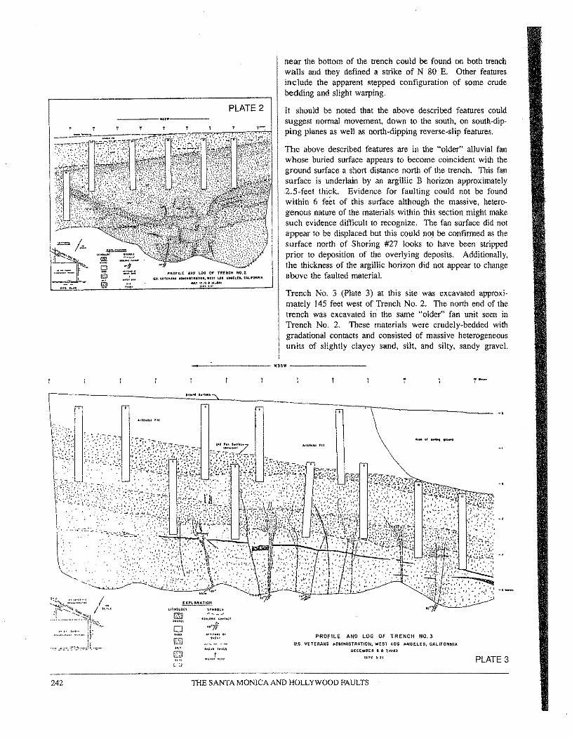
_____ ~n. _PLATE 2
~1I0'IU ANO LOll or TlltNtl1 110,t11.., v(f~"M' _"nu,"oo, ...n 1.01 u.~nn"~",j~Ol<.I·
,",,'~;::!.,:"...
near the bottom of the trench could be found on both trenchwalls and they defined a strike of N 80 E. Other featuresinclude the apparent stepped configuration of some crudebedding and slight warping.
It should be noted that the above described features couldsuggest normal movement, down to the south. on south-dip-ping planes as well as north-dipping reverse-slip features.
The above described features are in the "older" alluvial fanwhose buried surface appears to become coincident with theground surface a short distance north of the trench. This fansurface is underlain by an argillic B horizon approximately2.5-feet thick. Evidence for faulting could not be foundwithin 6 feet of this surface although the massive, hetero-genous nature of the materials within this section might makesuch evidence difficult to recognize, The fan surface did notappear to be displaced but this could not be confirmed as thesurface north of Shoring #27 looks to have been strippedprior to deposition of the overlying deposits. Additionally,the thickness of the argillic horizon did not appear to changeabove the faulted material.
Trench No. 3 (Plate 3) at this site was excavated approxi-mately 145 feet west of Trench No.2. The north end of thetrench was excavated in' the same "older>! fan unit seen inTrench No.2. These materials were crudely-bedded withgradational contacts and consisted of massive heterogeneousunits of slightly clayey sand, silt, and silty, sandy graveL
__ -'- Ifl~W ------- __
1.......
E~Pl ..H"'lIGN
c,,~~~o~' "~.9.'.~R --_ .........", ....."0 ,,'jf.... ''''''.' .'IGJ "f"
us.."Cl .... .f ,,"..L, ~
PROfiLE ANO LOG OF TRENCH NO.3'IElERA/iS ,,1)~\tNISTRATION. WEST res AHGELtS. CALIFORNIA
[I(C(l.III(" ,& ~I!pn
Ulff .,.1 PLATE 3
242 TIlE SANTA MONICA AND HOLLYWOOD FAULTS
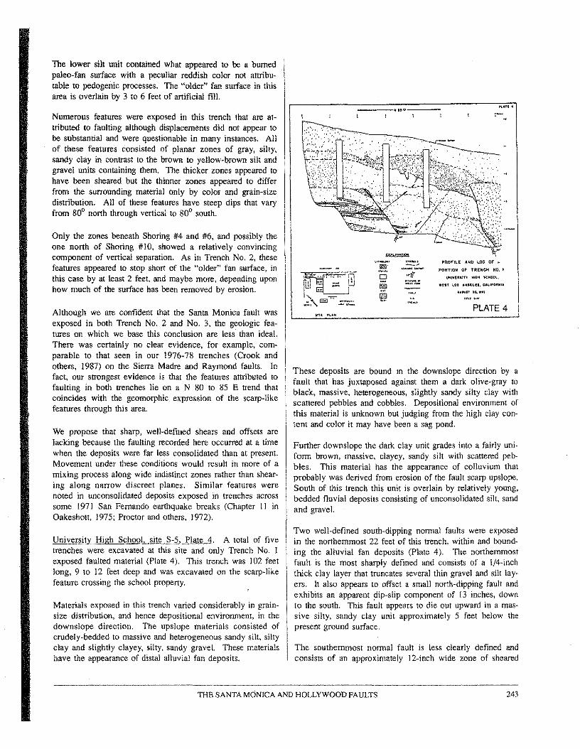
The lower sill unit contained what appeared to be a burnedpaleo-fan surface with a peeuliar reddish color not attribu-table W pedogenic processes. The "older" fan surface in thisarea is overlain by 3 to 6 feet of artificial fill.
Numerous features were exposed in this trench that are at-tributed to faulting although displacements did not appear tobe substantial and were questionable in many instances, Allof these features consisted of planar zones of gray, silty,sandy clay in contrast to the brown to yellow-brown silt andgravel units containing them. The thicker zones appeared tohave been sheared but the thinner zones appeared to differfrom the surrounding material only by color and grain-sizedistribution, All of these features have steep dips that varyfrom 80° north through vertical to 80° south.
Only the zones beneath Shoring #4 and #6, and possibly theone north of Shoring #10, showed a relatively convincingcomponent of vertical separation. As in Trench No.2, thesefeatures appeared to stop short of the "older" fan surface, inthis Case by at least 2 feet, and maybe more, depending uponhow much of the surface has been removed by erosion.
Although we are confident that the Santa Monica fault wasexposed in both Trench No, 2 and No.3, the geologic fea-tures on which we base this conclusion are less than ideal.There was certainly no clear evidence. for example. corn-parable to that seen in our 1976-78 trenches (Crook andothers, 1987) on the Sierra Madre and Raymond faults, Infact, our strongest evidence is that the features attributed tofaulting in both trenches lie on a N 80 to 85 E trend thatcoincides with the geomorphic expression of the scarp-likefeatures through this area.
We propose that sharp, well-defined shears and offsets arelacking because the faulting recorded here occurred at a timewhen the- deposits were far less consolidated than at present.Movement under these conditions would result in more of amixing process along wide indistinct zones rather than shear-ing along narrow discreet planes. Similar features werenoted in unconsolidated deposits exposed in trenches acrosssome 1971 San Fernando earthquake breaks (Chapter II inOakeshott. 1975; Proctor and others, 1972).
University High School, site 5-5, Plate 4, A total of fivetrenches were excavated at this site and only Trench No. 1exposed faulted material (Plate 4). This trench was 102 feetlong, 9 to 12 feet deep and was excavated on the scarp-likefeature crossing the school property.
Materials exposed in this trench varied considerably in grain-size distribution, and hence depositional environment, in thedownslope direction. The upslope materials consisted ofcrudely-bedded to massive and heterogeneous sandy silt, siltyclay and slightly clayey, silty, sandy gravel. These materialshave the appearance of distal alluvial fan deposits .
'''iii5''Cl
\'!1I1lI
PROFILE AND UlG OF ..
PORTION OF TRENCH NO. I\IN!\I~Uln II~M IC~"O~.
wur ~Ol UnfUI ~'~o,,'''.~"""" 1<1, 1
PLATE 4
These deposits are bound in the downslope direction by afault that has juxtaposed against them a dark olive-gray toblack, massive, heterogeneous, slightly sandy silty clay withscattered pebbles and cobbles. Depositional environment ofthis material is unknown but judging from the high clay con-tent and color it may have been a sag pond.
Further downslope the dark clay unit grades into a fairly uni-form brown, massive, clayey, sandy silt with scattered peb-bles. This material has the appearance of colluvium thatprobably was derived from erosion of the fault scarp upslope,South of this trench this unit is overlain by relatively young,bedded fluvial deposits consisting of unconsolidated silt, sandand gravel.
Two well-defined south-dipping normal faults were exposedin the northernmost 22 feet of this trench, within and bound-ing the alluvial fan deposits (Plate 4). The northernmostfault is the most sharply defined and consists of a 1/4-inchthick clay layer that truncates several thin gravel and silt lay-ers. It also appears to offset a small north-dipping fault andexhibits an apparent dip-slip component of 13 inches, downto the south. This fault appears to die out upward in a mas-sive silty, sandy clay unit approximately 5 feet below thepresent ground surface.
The southernmost normal fault is less clearly defined andconsists of an approximately 12-inch wide zone of sheared
._-----------_._--_.243THE SANTA MONICA AND HOLLYWOOD FAULTS
clay and gravel. The materials on either side of this zone aresignificantly different suggesting considerably more displace-ment than on the northernmost fault. The apparent verticalcomponent of displacement is down to the south as suggestedby the sense of drag exhibited by depositional contacts in thefootwall. Significant lateral slip is suggested by the total lackof similarity of units on either side of the fault. This faultalso appears to die out upward approximately 4 feet belowthe present ground surface and within the central portion of amassive gravel bed; this was seen on both walls of thetrench.
Three sub-parallel north-dipping features were exposed in thetrench between the two south-dipping faults, Two of thesefeatures consist of gray colored streaks with no evidence ofshearing or displacement. The third feature consists of a 118-inch thick clay layer that contains two thin pods of sand. Atits upper end this layer widened to 1/2- to 314-inch and ex-tends approximately 2.5 inches into the base of the graveldeposit that is faulted by the southernmost normal fault. Nodisplacement was evident along this feature. Another sub-parallel feature, north of the northernmost normal fault, ex-hibited a minor amount of reverse displacement in the formof a deformed silt bed.
A peculiar occurrence noted in a portion of the trench is thatof abundant calcium carbonate in the form of caliche, Thesedeposits were found only filling pores in the matrix of theuppermost gravel deposit and fractures in the upper portionof the clay unit on the south side of the southernmost normalfault. Caliche was found nowhere else in this trench nor inthe other trenches at University High School.
Charcoal was collected from a silty sand layer at depths of3.5 and 5 feet in Trench No. 2 (log not included herein).Dates were determined by Beta Analytic, Inc., Coral Gables,Florida. The samples yielded radiocarbon dates of 630 ±70(Beta-6110) years B.P. and 380 ±130 (Beta-6111) years B.P.respectively and are in conflict.
1981-83 BORINGS FOR L.A. METRO RAILUntil 1990, the Southern California Rapid Transit Districtwas the public agency designated to design and build a sub-way system for Los Angeles, During the period 1979-1984,the District convened an eight-person Board of GeotechnicalConsultants to prepare an exploration program and to adviseon anticipated geologic conditions for subway construction.The geologists on the Board were Ronald Heuer, RichardJahns, Eric Lindvall and Richard Proctor. Several of the rec-ommended exploratory borings for a proposed subway routealong Cahuenga Boulevard have bracketed traces of theHollywood fault north of Hollywood Boulevard (see Fig. 2).Boring #28 at the south encountered only Quaternary fIuvialdeposits to a total depth of 202 feet and boring #28A, 1.000feet north, encountered Tertiary rock at a depth of 63 feet(Converse and others, 1981). The Hollywood fault has to lie
between these two borings. The Board recommended thatadditional borings be drilled to try to better define the faultlocation. In February 1983 boring #28B was drilled whichencountered the fault as 10 feet of brecciated sandstone, allu-vium and siltstone at a depth of 122 feet in a hole otherwiseentirely in alluvium to a total depth of 205 feet. From thegeologist's log, the breccia is described, from one Bdnchsample, as follows: "Mixed I"' to 2"' masses, densely packedat skewed angles. 1. Sandstone fragments, angular, mottledlight brown/dark yellowish-orange, fine to medium, ce-mented, massive. 2. Gravelly sand (I"' gravel), light tomod. brown, well-graded, unconsolidated, very dense, with
. irregular dark reddish-brown stained masses. 3, Siltstone,grayish orange, at near-vertical angle, minor",
PHYSIOGRAPHY AND AGE OF FAULTINGIt appears that the Hollywood fault between ColdwaterCanyori on the west and at least to Western Avenue on theeast, lies at the break in slope at the south edge of the SantaMonica Mountains. We were unable to ascertain the recencyof faulting. It does appear, however, from the steepness ofthe alluvial fan surfaces in this reach and the lack of signifi-cant drainage entrenchment on these surfaces that late Qua-ternary movement has occurred on this fault.
West of Coldwater Canyon the fan surfaces are older, highlydissected and entrenched, suggesting that the Hollywoodfault in this area has not been ,so recently active, or as Hoots(1931) suggested, the deformation has been by folding ratherthan faulting. This geomorphic boundary between areas ofdiffering geomorphology also coincides with a northwest pro-jection of the Newport-Inglewood fault zone (Dolan andSreh. 1991).
The Santa Monica fault through west Los Angeles is fairlywell known at depth from oil well data (especially Wright,1991). The surface expression is best defined by a 2.5-milelong stretch of scarp-like features between Stanford Streetand Washington Avenue On the west, and Manning Avenueand Santa Monica Boulevard on the east, These featureshave the appearance of being relatively old. as compared tothe Raymond fault scarp in Arcadia, San Marino and SouthPasadena (Crook and others, 1987). Nevertheless, these fea-tures were the primary reason for trenching at both Univer-sity High School and the U. S. Veterans Administration prop-erty. We were successful in finding faults at these sites.None of the Holocene fluvial deposits exposed in thesetrenches exhibited any faults or features attributable toseismic shaking, such as infilled lurch cracks OT liquefactionstructures.
One surprising feature of the Santa Monica fault is that noevidence was found that would confirm that it is a north-dip-ping reverse fault. This may be due to either the fact that wedid not expose the main fault in any of our trenches and that'the features We saw are antithetic faults above ~ thrust fault
244 THE SANTA MONICA AND HOLLYWOOD FAULTS
(e.g., Avouac and others, 1992). or that the most recentmovement has been predominantly strike-slip along highangle faults.
It might be argued that the scarp on the fan surface east ofPotrero Canyon (Hoots, 1931; Hill, 1979) indicates Holocenemovement on the Santa Monica fault. The age of the fansurface in that area, however, almost certainly is pre-Hole-cene.
Obviously a recurrence interval for the Santa Monica faultcannot be determined from our data. OUT work also cannotprove Holocene movement on the on-shore portion of thisfault. even though the geomorphic evidence suggests it.
REFERENCESAllen, C, R. 1975. Geological criteria for evaluating seismicity: GeologicalSociety of America Bulletin, vel. 86, p. 1041-1057.
Avouac, P, P Meyer. B., and 'Iapponruer, P., 1992, On the growth of normalfaults and the existence of flats and ramps along the El Asnam active fold andthrust system: Tectonics, vol. 11, p. I-II.
Bonilla, M. G" Mark, R. K. and Lienkaemper, J, J .• 1984, Statistical relationsamong earthquake magnitude, surface rupture length, and surface fault dis-placement: Bull. Seismological SOCiety of America, vot. 74, no. 6, p. 2379-2441.
Bulka. J, A" and Teng, 'Ia-liang, 1978, Recent seismicity and fault-plane solu-tions of Santa Monica Mountains, Santa Monica Bay and northern Los An-geles basin, in Geologic Guide and Engineering Geology Case Histories LosAngeles Metropolitan Area, D. L. Lamar, Chairman; Association of Engineer-ing Geologists First Annual California Sections Conference, p. 64-72.
Chapman, R. H., and Chase, O. W., 1979, Geophysical investigation of theSanta Monica-Raymond fault zone, Los Angeles County, California, inEarthquake hazards associated with faults in the greater Los AngelesMetropolitan Area, Los Angeles County, California, including faults in theSanta Monica-Raymond, Verdugo-Eagle Rock, and Benedict Canyon faultzones: California Div. of Mines and Geology, OPR 76-16 LA, Chapter E, p.E-I to E-30.
Converse: Consultants. Earth Sciences Associates and Geo/gesources Consult-ants, 1981, Metro Rail Project, Geotechnical Investigation: Repcn forSouthern California Rapid Transit District, Los Angeles, California: VolumesIandIL
Crook, R. Jr., Allen, C. R" Kamb, B., Payne, C. M., and Proctor, R. J., 1987,Quaternary geology and seismic hazard of the Sierra Madre and associatedfaults, western San Gabriel Mountains, California: U. S. Geological SurveyProfessional Paper 1339, p. 27~63, and 1978 California Institute ol Technol-ogy, Contribution No. 3191.
Davis, T, L., 1987, Subsurface study of the (ale Cenozoic structural geology ofthe Los Angeles Basin: !JSGS Open-File Report 87-374, p. 143-147.
Davis, T, L., Narnson. J., and Yerkes, R. F., 1989, A cross-section of the LosAngeles area: seismically active fold and thrust bell. the 1987 Whinier Nar-rows earthquake, and earthquake hazard: Oeopnys. Res, vol. 94, p. 9644-9664.
Dibblee, T. W .. Jr .. 1991, Geologic Map of the Beverly Hills and Van NuysSouth Half Quadrangles: Dibblee Geologic Foundation Map DF-3 I. P. O.Box 60560, Santa Barbara, CA 93160 ($10.00).
Dolan, J. F. and Sieh. K. E., 1991, Structural style and geomorphology of theSanta Monica-Hollywood fault system: Abstract in EOS (Transactions ofAmer. Oeopnys. Union), vel. 72. p. 319-320,
Durrell, Cordell, 1954. Geology of the Santa Monica Mountains, Los Angelesand Ventura Counties, in Geology of southern California: California Divisionof Mines Bulletin 170, Map Sheet 8.
Elliott, J. L., 1951, Geology of [he eastern Santa Monica Mountains betweenLaurel Canyon and Beverly Glen Boulevards, Los Angeles County, Califor-nia: Unpublished Master's thesis, University of California, Los Angeles, 57 p.
Ellsworth, W, L.• Campbell. R, H" Hill, D. P., and others, 1973, Point Mugu,California. earthquake of21 February 1973, and Its aftershocks: Science, vot.182. p. 1127-1129.
Erickson, R. C., and Spaulding, A, 0,,1975, Orban oil production and sub-sidence control- a case history. Beverly Hills (east) oil field, California:Society of Petroleum Engineers of the American Institute of Mining. metallur-gical and Petroleum Engineers Paper No. SPE 5603, 13 p.
Hauksson, E" 1990, Earthquakes, faulting and stress in the Los Angeles basin:J. of Geophys. Res" vel. 95, p- 15.365-15,394.
Hauksson, E" and Jones, L. M., 1989, The 1987 Whittier Narrows eanbquakesequence in Los Angeles, southern California: seismological and tectonicanalysis: 1. of Geophys. Res. vol. 94, p. 9569-9589.
Heuksson. E" and Jones. L. M.• 1991, The 1988 and 1990 Uplandearthquakes: left-lateral faulting adjacent to the central Transverse Ranges: 1.of Geophys. Res. vol. 96, p. 8143-8165.
Hauksson, E .. and Saldivar. G, V.. 1986. The !930 Santa Monica and the 1979Malibu earthquakes: Bull. Seismological Society of America. vol. 76. no. 6.
Hill, R. L .. 1979, Potrero Canyon fault and University High School escarp-ment, in Field Guide to Selected Engineering Geologic Features. SantaMonica Mountains, J, R. Keaton. Chairman: Association of EngineeringGeologists. Southern California Section. Annual Field Trip, Map 19, p. 83-103.
Hill, R. L .• Sprotte, E. C., Chapman, R. W" and 6 ethers. 1979. Earthquakehazards associated with faults in the greater Los. Angeles metropolitan area,Los Angeles County, California, including faults in the Santa Monica-Raymond, Verdugo-Eagle Reck. and Benedict Canyon faun zones: CaliforniaDivision of Mines and Geology Open File Report 79v16LA, 20\ p., 2 plates.
Hili, R. L .. Slade, R. C., Sprone, E. c., and Bennett, J. H .• 1978, LOCation andactivity assessment of the Santa Monica fault, Beverly Hills-Hollywood area.California: in Geologic Guide and Engineering Geology Case Histories LosAngeles area, D. L. Lamar. Chairman: AEG Pirst Annual California SectionsConference, Los Angeles, p. 167"174.
Hoots. H. W., 1931, Geology of the eastern part of the Santa MOnica Moun-tains, Los Angeles County. California: U. S. Geologica! Survey ProfessionalPaper !65¥C, p. 83-134.
Hummon, C., Schneider, C. L. and Yeats, R. $., 1992, late Quaternary defor-mation of late Pleistocene marine gravels in the northern Los Angeles basin:Abstract. Cordilleran Section Mtg., Gecl. Soc. Am., Eugene, OR.
Jacobson, 1. B .. and Lindblom. R. G., 1977, Timing - geological andgovernmental - in urban oil development, Los Angeles. California: Oil andGlIS Journal, vel. 75. 00. 6, p. 160-176.
Johnson, H. R., 1932, Folio of plates to accompany geologic report, QuelindaEstate: Unpublished report containing 25 plates including annotatedphotographs, resistivity survey data, geologic maps and palinspastic cross-sec-tions Illustrating the geologic history of the Pacific Palisades area.
Knapp, R. R., Traxler, J, D., Newhill, 'r. J., Laughlin. D. 1., Stewart, R. D"Heath, E, G., Stark. H, E., Wissler, S. G .• and Holman, W. H., 1962, Cenozoiccorrelation sections across the Los Angeles basin from Beverly Hills to New-port, California: American Association of Petroleum Geologists, Pacific Sec-tion. scale 1 inch to [,000 feet vertical, and I inch to 5,000 horizontal.
Lamar, D. L., 1975. Relationship between Hollywood and Raymond Hillfaults: Association of Engineering Geologists. Field trip guidebook, John W.Byer. Chairman, Los Angeles, p. 44-45.
Long, H. R., and Dreesen, R. S., 1975, Subsurface structure of thenorthwestern Los Angeles basin: California Division of Oil and Gas Techni-cal Papers Report No. TP,O!, p. 15-2l.
Oakeshou. G., (ed,) 1975, San Fernando, California. earthquake of9 February1971: Bulletin 196, California Division of Mines and Geology, 463 p.
Proctor, R. J., CrOOk, R. Jr., McKeown, M. H" and Moresco. R. L" 1972,Relation of known faul1li to surface ruptures. 1971 San Fernando earthquake,southern California: Geological Society of America Bulletin. vol. 83, p. 1601-1618.
245THE SANTA MONICA AND HOLLYWOOD FAULTS
Rzonca. O. F., H. A. Spellman. E. W. Fall and R.J, Shelmon, 1991. Holocenedisplacement of the Malibu Coast fault zone, Winter Mesa, Malibu, CA: en-gineering geologic implications: Bull. Assoc. Engineering Geologists. vot. 28.no. 2, p. J47"15&.
Weber, F. H,Bennett. 1. H., Chapman, R. H" and others, 1980, Earthquakehazards associated with the verdugo-Bagte Rock and Benedict Canyon faultzones, Los AngelesCounty, California: California Division of Mines andGeology Open File Report 80-IOLA. 166 p.• 4 plates.
Wright, T, L., 1991, Structural geology and tectonic evolution of the Los An-geles Basin: in,Biddle, K, T, (ed.) Active Margin Basins, American Assoc.Petroleum Geologists Memoir 52, Chapter 3,
Yerkes, R. F., and Lee, W. H, K, 1979a, Late Quaternary deformation in theWestern Transverse Ranges of California: U. S. Geological Survey Circular799·B, p. 27·37.
Yerkes, R. r..and Lee, W. H. K, 1979b, Faults, fault activity, epicenters, focaldepths, focal mechanisms, J 970·1975 earthquakes, western Transverse Ran"ges, California: U. S. Geological Survey, Map MF 1032.
Ziony. J, 1. (ed.), 1985, Evaluating Earthquake Hazards in the Los AngelesRegion: U. S. Geological Survey Professional Paper 1360, 505 p,
Ziony, 1. 1., and L. M. Jones, 1989, Map showing late Quaternary faults and1978"84 seismicity of the Los Angeles region, California: U. S. GeologicalSurvey Map MF" 1964.
246 TIlE SANTA MONICA AND HOLLYWOOD FAULTS
Downloadedfromgsabulletin.gsapubs.orgon March7, 2011
Geological Society of America Bulletin
Active tectonics, paleoseismology, and seismic hazards of the Hollywood fault,northern Los Angeles basin, California
James F. Dolan, Kerry Sieh, Thomas K. Rockwell, Paul Guptill and Grant Miller
Geological Society of America Bulletin 1997;109;1595-1616doi: 10.1130/0016-7606(1997)1 09<1595:ATPASH>2.3.CO;2
Permission request
click www.gsapubs.org/cgi/alerts to receive free e-mail alerts when new articlescite this article
click www.gsapubs.org/subscriptions/to subscribe to Geological Society ofAmerica Bulletin
click http://www.geosociety.orgipubsicopyrt.htm#gsato contactGSA
Email alerting services
Subscribe
Copyright not claimed on content prepared wholly by U.S. government employees within scope of theiremployment. Individual scientists are hereby granted permission, without fees or further requests to GSA,to use a single figure, a single table, andlor a brief paragraph of text in subsequent works and to makeunlimited copies of items in GSA's journals for noncommercial use in classrooms to further education andscience. This file may not be posted to any Web site, but authors may post the abstracts only of theirarticles on their own or their organization's Web site providing the posting includes a reference to thearticle's full citation. GSA provides this and other forums for the presentation of diverse opinions andpositions by scientists worldwide, regardless of their race, citizenship, gender, religion, or politicalviewpoint. Opinions presented in this publication do not reflect official positions of the Society.
Notes
Geological SOCietyof America
THEGEOLOGICALSOCIETYOF AMERICA
Downloaded from gsabulletin.gsapubs.org on March 7, 2011
Active tectonics, paleoseismology, and seismic hazards of the Hollywoodfault, northern Los Angeles basin, California
James F.DOlan*1}Kerry Sieh'
Thomas K. Rockwell'
Paul Guptill
Grant Miller
Seismological Laboratory, California Institute ofTechnology, Pasadena, California 91125
Department of Geological Sciences, San Diego State University, San Diego, California 92182
Geosyntec Consultants, Huntington Beach, California 92648
Advanced Earth Sciences, Irvine, California 92618
ABSTRACT
Data from geotechnical boreholes andtrenches, in combination with geomorpho-logic mapping, indicate that the Hollywoodfault is an oblique, reverse-left-lateral faultthat has undergone at least one surface-rupturing earthquake during latest Pleisto-cene to middle or late Holocene time. Geo-morphologic observations show that the faultextends for 14 km along the southern edge ofthe eastern Santa Monica Mountains, fromthe Los Angeles River westward throughdowntown Hollywood to northwestern Bev-erly Hills, where the locus of active deforma-tion steps 1.2 km southward along the WestBeverly Hills lineament to the Santa Monicafault. Rupture of the entire Hollywood fault,by itself, could produce a Mw -6.6 earth-quake, similar in size to the highly destruc-tive, 1994 Northridge earthquake, but evencloser to more densely urbanized areas. As-suming a 0.35 mm/yr minimum fault-slip rateconsistent with available geologic data, wecalculate an average maximum recurrenceinterval for such moderate events of ::;;-4000yr. Although occurrence of such moderateevents is consistent with the elapsed timesince the poorly constrained age of the mostrecent surface rupture, the data do not pre-clude a longer quiescent interval suggestive oflarger earthquakes. If earthquakes muchlarger than M~"-6.6 occurred in the past, we
* Present Address: Department of Earth Sciences,University of Soinhern California, Los Angeles, Cali-Iornia 900S9.0740; e-mail: dolan(gjearth.l!sc.edll.
"Dolan. Sieh. find Rockwell arc members of theFault Zone Geology Group, Southern California Earth-quake Center, University of Southern California, LosAngeles, California 90089-0740.
speculate that they may have been generatedby the Hollywood fault together with otherfaults in the Transverse Ranges SouthernBoundary fault system.
INTRODUCTION
During the past decade ideas about the seismichazards facing urban Los Angeles have under-gone dramatic revision and refinement Earlierearthquake scenarios for the metropolitan regionfocused primarily on the effects of' a great (M",7.7 to 7.9) earthquake generated by the San An-dreas fault, which is located more than 50 kmnortheast of downtown Los Angeles (Fig. I). Notuntil the mid-1980s (c.g., Wcsnousky, 1986;Toppozada, 1988) did attention tum to the poten-tin 1 hazards posed by faults directly beneath themetropolitan area. The 1987 Mw 6.0 WhittierNarrows earthquake and the 1994 MIl' 6, 7 North-ridge earthquake clearly demonstrated the seis-mic hazards associated with these urban faults.More recent seismic hazard assessments incorpo-rate the possibility of large urban earthquakes, aswell as the recurrence of a major earthquake onthe San Andreas fault (e.g., Working Group onCalifornia Earthquake Probabilities, 1995). Be-cause of their proximity to metropolitan LosAngeles, moderately large to large earthquakes(Mw 7.0 to 7.5) generated by the urban faultscould cause at least as much, and possibly moredamage, than a much larger earthquake occurringon the San Andreas fault (Working Group on Cal-ifomia Earthquake Probabilities, 1995; Dolan oral., 1995; Heaton et al.. 1995). At least two suchlarge earthquakes have occurred during historictime in southern California on faults similar tothose that underlie the metropolitan region: theDecember 21, 1812, M '"'-'7.1 Santa BarbaraChannel earthquakes (Toppozada, 1981) and the
GSA Bulletin: December 1997: v. 109: no. !2; p. 1595-1616; 15 figures: ytabfes.
1595
July 21,1952, Mw 7.5 Kern County event (Hankset al., 1975; Stein and Thatcher, 1981; Wallace,!988; Ellsworth, 1990). Neither of these earth"quakes resulted in widespread damage or majorloss of life, because both regions were relativelysparsely populated at the time of the earthquakes.
Despite a heightened awareness ofthe potentialfor destructive earthquakes from faults beneathmetropolitan Los Angeles, as well as numerousrecent studies that have illuminated the activetectonics of the region (e.g.. Hauksson. 1990;Wright, 1991; Shaw and Suppe, 1996), too littleinformation exists about the earthquake historiesand recent kinematics of these faults to constructrealistic probabilistic hazard maps for the metro-politan region. Specifically, we have only sparsedata concerning recurrence intervals, dates andsizes of past events, slip rates, and kinematics formany faults. Furthermore, we do not know the ex-act nature and surficial location of many of thesefaults. Knowledge of these fault parameters is es-sential for constructing realistic probabilistic sets-mic hazard models for southern California.
Over the past several years we have beenstudying the active tectonics and paleoseismol-ogy of the northern Los Angeles metropolitanregion; the area extends from Pacific Palisadesand Santa Monica on the coast, eastwardthrough Beverly Hills, Hollywood, downtownLos Angeles, and east Los Angeles to WhittierNarrows (Fig. l ). In this paper we discuss our re-sults from the Hollywood fault, which extendsfor 14 km through this densely urbanized region(Fig. 2). We first describe the results of our geo-morphologic and palecseismclogic studies ofthe fault and then discuss the implications ofthese data for seismic hazard assessment in themetropolitan Los Angeles region. In addition tothe implications of these results for seismic haz-ard analysis, data from this and similar studies of
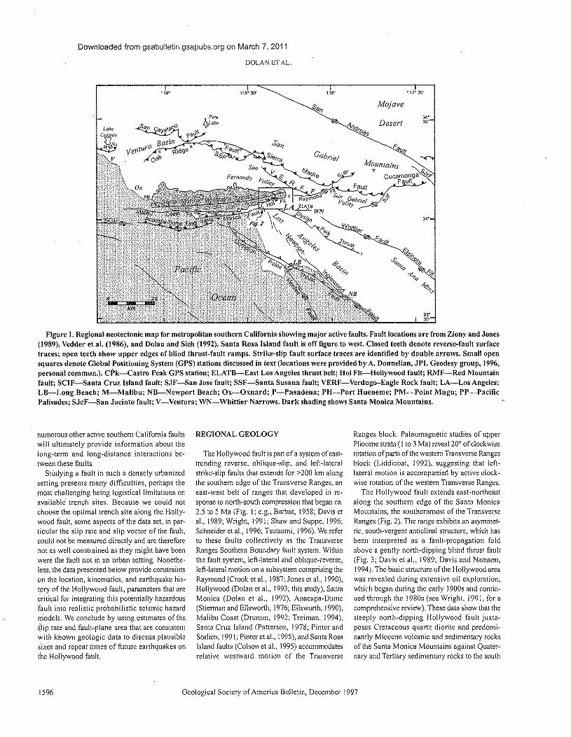
Downloaded from gsabulletin.gsapubs.org on March 7, 2011
DOLAN ETAL.
119"
Mojave118" 30' 118" 117" 30'
Desert
~qvlt
MOUntains+ •
cucamonga <.IeA'F ult,
Fault
33"JO'
Figure 1. Regional neotectonic map for metropolitan southern California showing major active faults. Fault locations are from Ziony and Jones(1989), Vedder et al. (1986), and Dolan and Sieh (1992). Santa Rosa Island fault is off figure to west. Closed teeth denote reverse-fault surfacetraces; open teeth show upper edges of blind thrust-fault ramps. Sn-lke-slip fault surface traces are identified by double arrows. Small opensquares denote Global POSitioning System (GPS) stations discussed in text (locations were provided by A. Donnellan, JPL Geodesy group, 1996,personal commun.). CP'k-Castro Peak GPS station; ELATB-East Los Angeles thrust belt; Hoi Fit-Hollywood fault; RMF-Red Mountainfault; SelF-Santa Cruz Island fault; SJF-San Jose fault; SSF-Santa Susana fault; VERF-Verdugo-Eagle Rock fault; LA-Los Angeles;LB-Long Beach; M-MaJibu; NB-Newport Beach; Ox-Oxnard; Ps--Pasadena; PH-Port Hueneme; PM-Point Mugu; PP-PacificPalisades; SJcF-San Jacinto fault; V-Ventura; WN-Whittier Narrows. Dark shading shows Santa Monica Mountains.
numerous other active southern California faultswill ultimately provide information about thelong-term and long-distance interactions be-tween these faults.
Studying a fault in such a densely urbanizedsetting presents many difficulties, perhaps themost challenging being logisticallimitations onavailable trench sites. Because we could notchoose the optimal trench site along the Holly-wood fault, some aspects of the data set, in par-ticular the slip rate and slip vector of the fault,could not be measured directly and are thereforenot as well constrained as they might have beenwere the fault not in an urban setting. Ncnethe-less, the data presented below provide constraintson the location, kinematics, and earthquake his-tory of the Hollywood fault, parameters that arecritical for integrating this potentially hazardousfault into realistic probabilistic seismic hazardmodels. We conclude by using estimates of the~lip rate and fault-plane area that are consistentwith known geologic data to discuss plausiblesizes and repeat times of future earthquakes onthe Hollywood fault.
1596
REGtONAL GEOLOGY
The Hollywood fault is part of a system of east-trending reverse, oblique-slip. and left-lateralstrike-slip faults that extends for >200 km alongthe southern edge of the Transverse Ranges, aneast-west belt of ranges that developed in re-sponse to north-south compression that began ca.2.5 to 5 Ma (Fig. I; e.g., Barbat, 1958; Davis etal., 1989; Wright, 1991; Shaw and Suppe. 1996;Schneider et al., 1996; Tsursumi, 1996). We referto these faults collectively as the TransverseRanges Southern Boundary fault system. Withinthe fault system, left-lateral and oblique-reverse,left-lateral motion on a subsystem comprising theRaymond (Crook et al., 1987; Jones cr al., 1990),Hollywood (Dolan et al., 1993; this study), SantaMonica (Dolan et al., 1992), Anacapa-Dume(Stierman and Ellsworth, 1976; Ellsworth, 1990),Malibu Coast (Drumm, 1992; 'Freiman, 1994),Santa Cruz. Island (Patterson, 1978; Pinter andSorlien, 199!; Pinter et al., 1995), and Santa RosaIsland faults (Colson et al.. 1995) accommodatesrelative westward motion of the Transverse
Geological Society of America Bulletin, December 1997
Ranges block. Paleomagnetic studies of upperPliocene strata (1 to 3 Ma) reveal 200 of clockwiserotation of parts of the western Transverse Rangesblock (Liddicoat, 1992), suggesting that left-lateral motion is accompanied by active clock-wise rotation of the western Transverse Ranges.
The Hollywood fault extends east-northeastalong the southern edge of the Santa MonicaMountains, the southernmost of the TransverseRanges (Fig. 2). The range exhibits an asymmet-ric, south-vergent anticlinal structure, which hasbeen interpreted as a fault-propagation foldabove a gently north-dipping blind thrust fault(Fig. 3; Davis ct al.. \989; Davis and Namson,J 994). The basic structure of the Hollywood areawas revealed during extensive oil exploration,which began during the early J 900s and contin-ued through the 1980s (see Wright, J 991, for acomprehensive review). These data show that thesteeply north-dipping Hollywood fault juxta-poses Cretaceous quartz diorite and predomi-nantly Miocene volcanic and sedimentary rocksof the Santa Monica Mountains against Quater-nary and Tertiary sedimentary rocks to the south
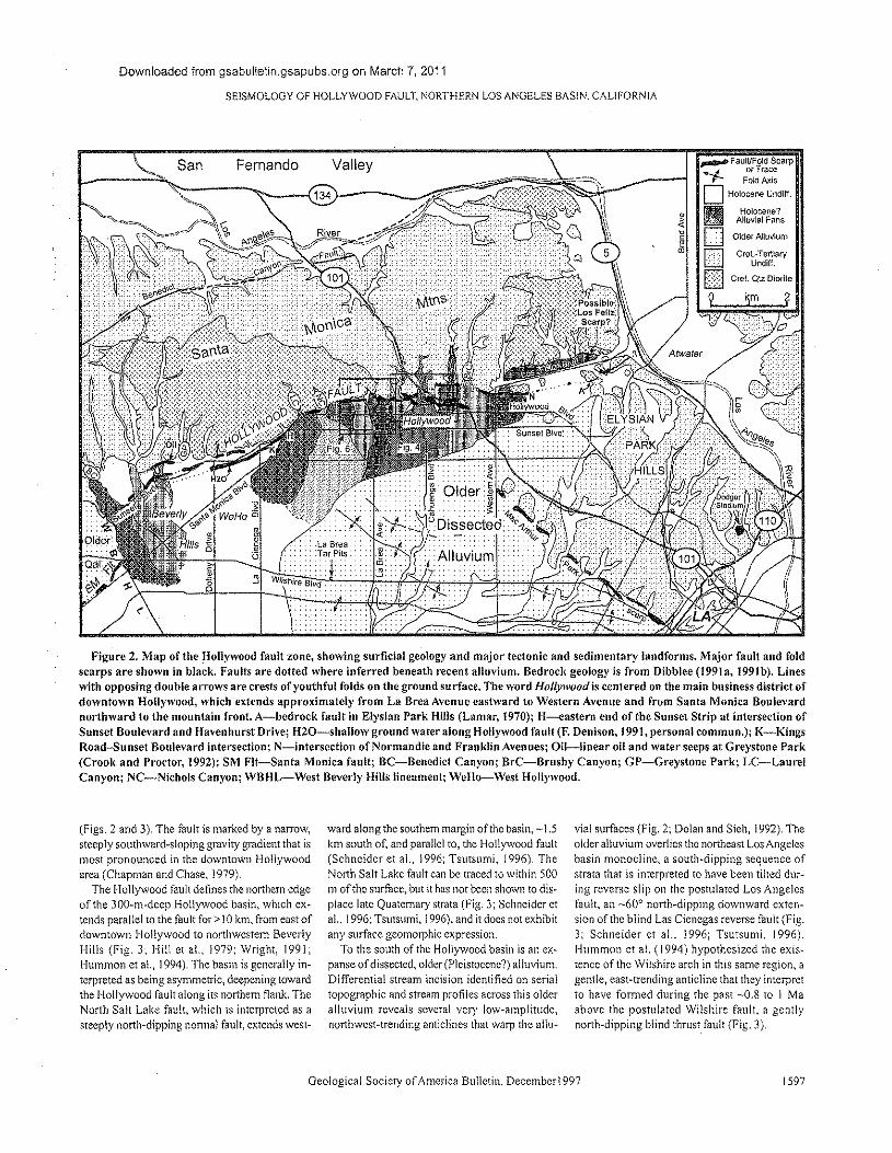
Downloaded from gsabulletin.gsapubs.org on March 7, 2011
SEISMOLOGY OF HOLLYWOOD FAULT, NORTHERN LOS ANGELES BASIN. CALIFORNIA
San Fernando Valley134'\--- _
",.... FaultiFold Scarp...J or Tracer- Fold AxisD Holocene Undiff.
_ Holocene?~ Alluvial FansD Older Alluvium
EITl cre~~gi~~ary
Iillilll cret. Qtz Diorite
9 ~m f
Figure 2. Map of the Hollywood fault zone, showing surficial geology and major tectonic and sedimentary landforms. Major fault and foldscarps are shown in black. Faults are dotted where inferred beneath recent alluvium. Bedrock geology is from Dibblee (1991a, 199Ib). Lineswith opposing double arrows are crests of youthful folds on the ground surface. The word Hollywood is centered on the main business district ofdowntown Hollywood, which extends approximately from La Brea Avenue eastward to Western Avenue and from Santa Monica Boulevardnorthward to the mountain front. A-bedrock fault in Elysian Park Hills (Lamar, 1970); H-eastern end of the Sunset Strip at intersection ofSunset Boulevard and Havenhurst Drive; H20-shallow ground water along Hollywood fault (F. Denison, 1991, personal commun.); K-KingsRoad-Sunset Boulevard intersection; N-intersection of Norman die and Franklin Avenues; Oil-linear oil and water seeps at Oreystone Pari,(Crook and Proctor, 1992); SM Fit-Santa Monica fault; Be-Benedict Canyon; Br-Cc--Brushy Canyon; GP-Greystone Park; LC-LaurelCanyon; NC-Nichols Canyon; WBHl.r-West Beverly Hills lineament; WeHo-West Hollywood.
(Figs. 2 and 3). The fault is marked by a narrow,steeply southward-sloping gravity gradient that ismost pronounced in the downtown Hollywoodarea (Chapman and Chase, 1979).
The Hollywood fault defines the northern edgeof the 30D-m-deep Hollywood basin, which ex-tends parallel to the fault for> 10 km, from east ofdowntown Hollywood to northwestern BeverlyHills (Fig. 3; Hi!! et al., 1979; Wright, 1991,Hummon et al., 1994). The basin is generally in-terpreted as being asymmetric, deepening towardthe Hollywood fault along its northern flank. TheNorth Salt Lake fault, which is interpreted as asteeply north-dipping normal fault, extends west-
ward along the southern margin of the basin, ~ 1.5km south of, and parallel to, the Hollywood fault(Schneider et al., 1996; Tsursumi, 1996), TheNorth Salt Lake fault can be traced to within 500m of the surface, but it has not been shown to dis-place late Quaternary strata (Fig. 3; Schneider etal., 1996; Tsutsurni, 1996), and it docs not exhibitany surface geomorphic expression.
To the south of the Hollywood basin is an ex-panse of dissected, olderfPlcistoccnc") alluvium.Differential stream incision identified on serialtopographic and stream profiles across this olderalluvium reveals several very low-amplitude,northwest-trending anticlines that warp the allu-
Geological Society of America Bulletin, December! 997
vial surfaces (Fig. 2; Dolan and Sieh, 1992). Theolder alluvium overlies the northeast Los Angelesbasin monocline, a south-dipping sequence ofstrata that is interpreted to have been tilted dur-ing reverse slip on the postulated Los Angelesfault, an ~60°north-dipping downward cxren-sion of the blind Las Cieuegas reverse fault (Fig.3; Schneider ct al. 1996; Tsutsumi. 1996).Hummon et al. (1994) hypothesized the exis-tence of the Wilshire arch in this same region, agentle, east-trending anticline that they interpretto have formed during the past -0.8 to I Maabove the postulated Wilshire fault, a gentlynorth-dipping blind thrust fault (Fig. 3).
1597
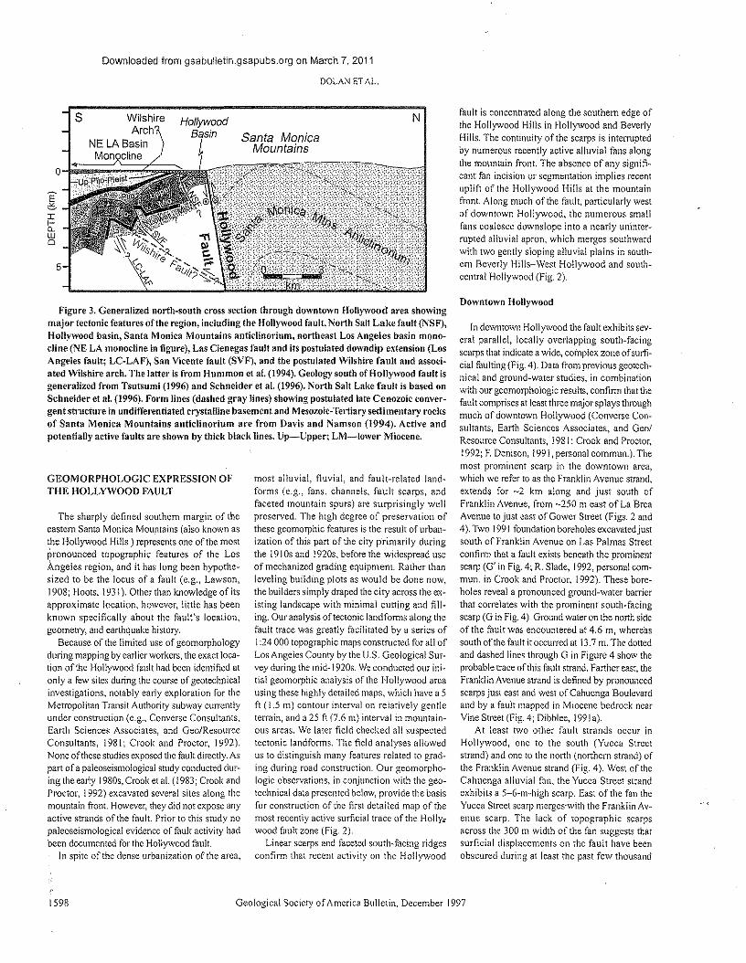
Downloaded from gsabulletin.gsapubs.org on March 7, 2011
DOLAN ET AL.
HollywoodB sin
Ns
~
two
5
Santa MonicaMountains
figure 3. Generalized north-south cross section through downtown Hollywood area showingmajor tectonic features of the region, including the Hollywood fault, North Salt Lake fault (NSF),Hollywood basin, Santa Monica Mountains anticlinorium, northeast Los Angeles basin mono-cline (NE LA monocline in figure), Las Cienegas fault and its postulated downdip extension (LosAngeles fault; LC-LAF), San Vicente fault (SYF), and the postulated Wilshire fault and associ-ated Wilshire arch. The latter is from Hummon et al. (1994). Geology south of Hollywood fault isgeneralized from Tsutsumi (1996) and Schneider et al. (1996). North Salt Lake fault is based onSchneider et al. (1996). Form lines (dashed gray lines) showing postulated late Cenozoic conver-gent structure in undifferentiated crystalline basement and Mesozoic-Tertiary sedimentary rocksof Santa Monica Mountains anticlinorium are from Davis and Namson (1994). Active andpotentially active faults are shown by thick black lines. Up-Upper; LM-Iower Miocene.
GEOMORPHOLOGIC EXPRESSION OFTHE HOLLYWOOD FAULT
The sharply defined southern margin of theeastern Santa Monica Mountains (also known asthe Hollywood Hills ) represents one of the mostpronounced topographic features of the LosAngeles region, and it has long been hypothe-sized to be the locus of a fault (e.g., Lawson,1908; Hoots, 193 I). Other than knowledge of itsapproximate location, however, little has beenknown specifically about the fault's location,geometry, and earthquake history.
Because of the limited use of geomorphologyduring mapping by earlier workers, the exact loca-tion of the Hollywood fault had been identified atonly a few sites during the course of geotechnicalinvestigations, notably early exploration for theMerropoliran Transit Authority subway currentlyunder construction (e.g., Converse Consultants,Earth Sciences Associates, and Gee/ResourceConsultants, 1981; Crook and Proctor, 1992),None ofthese studies exposed the fault directly, Aspart of a paleoscismological study conducted dur-ing the early 1980s, Crook et al. (1983; Crook andProctor, 1992) excavated several sites along themountain front. However, they did not expose anyactive strands of the fault. Prior to this study nopaleoseismological evidence of fault activity hadbeen documented for the Hollywood fault.
In spite of the dense urbanization of the area,
1598
most alluvial, fluvial, and fault-related land-forms (e.g., fans, channels, fault scarps, andfaceted mountain spurs) are surprisingly wellpreserved. The high degree of preservation ofthese geomorphic features is the result of urban-ization of this part of the city primarily duringthe 1910s and j 920s, before the widespread useof mechanized grading equipment. Rather thanleveling building plots as would be done now,the builders simply draped the city across the ex-isting landscape with minimal cutting and fill-ing. Our analysis of tectonic landforms along thefault trace was greatly facilitated by a series of! :24 000 topographic maps constructed for all ofLos Angeles County by the U.S. Geological Sur-vey during the mid·I920s. We conducted our ini·tial geomorphic analysis of the Hollywood areausing these highly detailed maps, which have a 5ft (1.5 Ill) contour interval on relatively gentleterrain, and a 25 ft (7.6 m) interval in mountain-ous areas. We later field checked all suspectedtectonic landforms. The field analyses allowedus to distinguish many features related to grad-ing during road construction. Our geomorpho-logic observations, in conjunction with the geo-technical data presented below, provide the basisfor construction of the firs! detailed map of themost recently active surficial trace of the Holly:wood fault zone (Fig. 2).
Linear scarps and faceted south-facing ridgesconfirm that recent activity on the Hollywood
Geological Society of America Bulletin, December! 997
fault is concentrated along the southern edge ofthe Hollywood Hills in Hollywood and BeverlyHills. The continuity of the scarps is interruptedby numerous recently active alluvial fans alongthe mountain front. The absence of any signifi-cant fan incision or segmentation implies recentuplift of the Hollywood Hills at the mountainfront. Along much of the fault, particularly westof downtown Hollywood, the numerous smallfans coalesce downslope into a nearly uninter-rupted alluvial apron, which merges southwardwith two gently sloping alluvia! plains in south-em Beverly Hills-West Hollywood and south-centra! Hollywood (Fig. 2).
Downtown Hollywood
In downtown Hollywood the fault exhibits sev~cral parallel, locally overlapping south-facingscarps that indicate a wide, complex zone of sum"cial faulting (Fig. 4). Data from previous geotech-nical and ground-water studies, in combinationwith our geomorphologic results. confirm that thefault comprises at least three major splays throughmuch of downtown Hollywood (Converse COil"sultants. Earth Sciences Associates, and Gee/Resource Consultants, J 981; Crook and Proctor,!992; F. Denison, 1991, personal commun.). Themost prominent scarp in the downtown area,which we refer to as the Franklin Avenue strand,extends for ~2 km along and just south ofFranklin Avenue, from -250 m east of La BreaAvenue to just east of Gower Street (Figs. 2 and4). Two j 991 foundation boreholes excavated justsouth of Franklin Avenue on Las Palmas Streetconfirm that a fault exists beneath the prominentscarp (G' in Fig. 4; R. Slade, 1992, personal com-mun. in Crook and Proctor, 1992). These bore-holes reveal a pronounced ground-water barrierthat correlates with the prominent south-facingscarp (G in Fig, 4). Ground water on the north sideof the fault was encountered at 4.6 m, whereassouth of the fault it occurred at 13,7 m. The dottedand dashed lines through G in Figure 4 show theprobable trace of this fault strand. Farther east, theFranklin Avenue strand is defined by pronouncedscarps just east and west of Cahuenga Boulevardand by a fault mapped in Miocene bedrock ncarVine Street (Fig. 4; Dibblee, 199 Ia).
At least two other fault strands occur inHollywood, one to the south (Yucca Streetstrand) and one to the north (northern strand) ofthe Franklin Avenue strand (Fig. 4). West of theCahuenga alluvial fan, the Yucca Street strandexhibits a 5-6-m-high scarp. East of the fan theYucca Street scarp merges-with the Franklin Av~enue scarp. The lack of topographic scarpsacross the 300 m width of the fan suggests thatsurficial displacements on the fault have beenobscured during at least the past few thousand
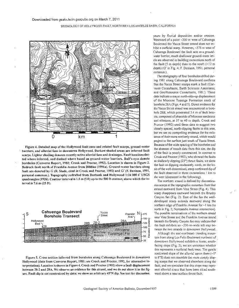
Downloaded from gsabulletin.gsapubs.org on March 7, 2011
SE1SMOLOGY OF HOLLYWOOD FAULT, NORTHERN LOS ANGELES BAS!N, CALIFORNiA
o km 1
Figure 4. Detailed map of the Hollywood fault zone and related fault scarps, ground-waterbarriers, and alluvial fans in downtown Hollywood. Darkest shaded areas are inferred faultscarps. Lighter shading denotes recently active alluvial fans and drainages. Fault locations dot-ted where inferred, and dashed where based on ground-water barriers. Bull's-eyes denoteboreholes (Converse Report, 1981; Crook and Proctor, 1992). Location is shown in Figure 2.Bedrock fault north of Franklin Avenue from Dibblee (199Ia). Ground-water barriers alongfault are denoted by G (R. Slade, cited in Crook and Proctor, 1992) and G' (F. Denison, 1991,personal commun.). Topography redrafted from Burbank and Hollywood 1:24 000 6' USGSquadrangles (1926). Contour interval is t.5 m (5 ft) up to the 500 ft contour, above which the in-terval is 7.6 m (25 ft).
s Cahuenga BoulevardBorehole Transect
Figure 5. Cross section inferred from boreholes along Cahuenga Boulevard in downtownHollywood (data from Converse Report, 1981; see Crook and Proctor, 1992, for alternative ln-terpretaucn). Location is shown in Figure 4. Crook and Proctor (1992) show a fault displacementbetween 28~2and 28A. We observe no evidence for this strand, and we do not show it in the fig-lire. Fault dip is not constrained by data; we show an arbitrary 45°N dip. See text for discussion.
Geological Society of America Bulletin, December1997
175
150 "§"
125 '*100 §.
75 ,~
50 ~
25
years by fluvial deposition and/or erosion.Westward of a point -300 m west of CahuengaBoulevard the Yucca Street strand does not ex-hibit a surficial scarp. However, -375 m west ofCahuenga Boulevard the fault acts as a ground-water barrier; much shallower ground-water lev-els are observed in building excavations north ofthe fault (5 m depth) than to the south (>12 mdepth) (G' in "Fig. 4; F. Denison, 199 I, personalcommun.).
The stratigraphy of four boreholes drilled dur-ing 1981 along Cahuenga Boulevard confirmsthat the Yucca Street scarps mark a fault (Con-verse Consultants, Earth Sciences Associates,and Gee/Resource Consultants, 1981), Thesedata indicate a major north-side-up displacementof the Miocene Topanga Formation south ofborehole 28A (Figs. 4 and 5). Direct evidence forthe Yucca Street strand was encountered in bore-hole 28B, which penetrated 3.4 rn of fault brec-cia, composed of phacoids of Miocene sandstoneand siltstone, at 37 to 40 m depth. Crook andProctor (1992) used these data \0 suggest twoclosely spaced, north-dipping faults in this area,but we see no compelling evidence for the exis-tence of their more northerly strand, which wouldproject to the surface just south of Yucca Street.Because of the wide spacing ofthe boreholes andthe absence of trench data from this site, the dipof the fault is poorly constrained. In contrast toCrook and Proctor (1992), who showed the faultsas shallowly dipping (23") thrust faults, we showthe fault as dipping moderately north, on the ba-sis of the well-determined, steep northward dip ofthe fault observed in three excavations 1 km tothe west (discussed in the following).
The northern strand is defined by discontinu-ous scarps at the topographic mountain front thatextend eastward from Vine Street (Fig. 4). Thisscarp disappears eastward beneath the BrushyCanyon fan (Fig. 2). East of the fan the well-developed scarp extends eastward along thenorthern edge of Franklin Avenue for -1 km (tonorth in Fig. 2; Normandie Avenue intersection).The possible terminations of the northern strandnear Vine Street and the Franklin Avenue strandbeneath the Brushy Canyon fan may indicate thatthe fault exhibits an ~350-m~wide left step be-tween the two strands in downtown Hollywood.
Although the east-northeast-trending moun-tain front along Los Feliz Boulevard northeast of .downtown Hollywood exhibits a linear, south-facing slope (Fig. 2), we are uncertain whetherthis represents a surficial fault trace. The gentlesouthward slope of the alluvial apron there (_5<lto 80S) does not resemble the more steeply slop"ing scarps that we observed elsewhere along thefault, and we speculate that this slope may repre-sent alluvial strata that have been tilled south"ward above a near-surface thrust fault.
1599
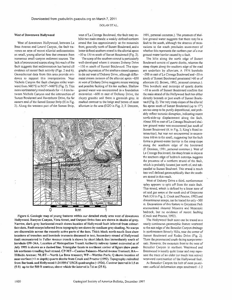
Downloaded from gsabulletin.gsapubs.org on March 7, 2011
DOLANETAL
West of Downtown Hollywood
West of downtown Hollywood, between LaBrea Avenue and Laurel Canyon, the fault tra-verses an area of recent alluvial sedimentationon small, young alluvial fans that emanate fromnumerous small-canyon sediment sources. Thelack of pronounced scarps along this reach of thefault suggests that sedimentation has buried allevidence of recent fault activity (Figs. 2 and 6).Geotechnical data from this area provide evi-dence to support this interpretation. NearNichols Canyon the fault changes strike west-ward from N85°E to N55°-N60"E (Fig. 2). Thismore northeasterly trend extends for ~ 1.6 km be-tween Nichols Canyon and the intersection ofSunset Boulevard and Havenhurst Drive, the fareastern end of the famed Sunset Strip (H in Fig,2), Along the western part of the Sunset Strip,
west of La Cienega Boulevard, the fault may ex-hibit two main strands: a weakly defined northernstrand that lies approximately at the mountainfront, generally north of Sunset Boulevard, and abetter defined southern strand in the alluvial apron-50 to 150m south of Sunset Boulevard (Fig, 2),
The scarp of the southern strand is particularlywell-developed where it crosses Doheny Drive-150 m south of Sunset Boulevard. The topo-graphic expression ofthe southern strand appearsto die out west of Doheny Drive, although differ-ential stream incision of the alluvial apron ~850m west of Doheny Drive suggests recent warpingand possible faulting of the fan surface, Shallowground water was encountered in a foundationexcavation -600 m east of Doheny Drive; theclayey granitic soil there is greenish gray, inmarked contrast to the beige and brown of mostalluvium in the area (H20 in Fig, 2; E Denison,
o km 1Figure 6. Geologic map of young features within our detailed study area west of downtown
Hollywood. Runyon Canyon, Vista Street, and Outpost Drive fans are shown in shades of gray.Narrow, dark gray horizontal swath shows location of Hollywood fault inferred from subsur-face data. Fault scarps inferred from topography are shown by medium gray shading. No scarpsare discernible across the recently active parts of the fans. Thick black north-south lines showlocations of trenches and borehole transects discussed in text. Secondary strand of Hollywoodfault encountered in Fuller Avenue trench is shown by short black line immediately south ofborehole OW-34A. Location of Metropolitan Transit Authority subway tunnel excavated as ofJuly 1995 is shown as a dashed line. Triangular facets in northeast corner of figure show possi-ble northeast-trending fault strand. CP-MT -Camino Palmero-Martel Avenue Transect; HA-Hillside Avenue; NLBT -North La Brea transect; WP-Wattles Park; Q shows location ofnear-surface «1 m depth) quartz diorite from Crook and Proctor (1992). Topography redraftedfrom Burbank and Hollywood 1:240006' USGS quadrangles (-1926). Contour interval is 1.5 m(5 ft) up to the 500 ft contour, above which the interval is 7.6 m (25 It).
1600 Geologica! Society of America Bulletin, December 1997
1991, personal commun.). The presence of shal-low ground water suggests that there may be afault to the south, although the absence of exca-vations to the south precludes assessment ofwhether this represents the northern part ofa trueground-water barrier caused by a fault
The hills along the north edge of SunsetBoulevard consist of quartz diorite, whereas thesteep slopes along the southern edge of the roadare underlain by alluvium, A 1974 borehole-200 m east of La Cienega Boulevard and ~50 msouth of Sunset Boulevard penetrated >60 m ofalluvium (G, Brown, 1993, personal comrnun.).This borehole and outcrops of quartz diorite~ 10m south of Sunset Boulevard con finn thatthe main strand of the Hollywood fault lies eitherdirectly beneath or just south of Sunset Boule-vard (Fig, 2), The vel)' steep slopes of the alluvialfan apron south of Sunset Boulevard (up to 1]0)are too steep to be purely depositional, and prob-ably reflect tectonic disruption, indicating recentnorth-side-up displacement along the fault.About 300 m east of La Cienega Boulevard shal-low ground water was encountered just south ofSunset Boulevard (K in Fig, 2; King's Road in~tersection), but was not encountered in cxcava-tions 160 m to the south, suggesting that the faultforms a ground-water barrier in the steep slopealong the southern' edge of the boulevard(F. Denison, 199!, personal comrnun.). West ofLa Cienega Boulevard, the sharp break in slope atthe southern edge of bedrock outcrops suggeststhe presence of a northern strand of the fault,which is probably located just north of, and sub-parallel to Sunset Boulvard. This strand is muchless well defined geomcrphically than the south-em strand in this reach,
West of Doheny Drive a third, northernmostsplay appears to split off from the main fault.This strand, which is defined by a linear zone ofoil and gas seeps at the south end of GreystonePark (Oil in Fig, 2; Crook and Proctor. 1992) anddiscontinuous scarps, can be traced for only ~500m. Excavations of this feature in Greystone Parkencountered sheared Miocene and Mesozoicbedrock, but no evidence of recent faulting(Crook and Proctor, 1992),
The Hollywood fault zone can be traced as anearly continuous geomorphic feature westwardto the east edge of tile Benedict Canyon drainagein northwestern Beverly Hills, near the comer ofSunset Boulevard and Rodeo Drive (Fig. 2),There the pronounced south-facing scarps rermi-narc. However, the mountain from to the west ofBenedict Canyon in northern Westwood andBrentwood is locally quite linear and may repre-sent the trace of an older (or much less active)westward continuation of the Hollywood fault
At Benedict Canyon the belt of most promi-nent surficial deformation steps southward ~ 1,2
Downloaded from gsabulletin.gsapubs.org on March 7, 2011
SEISMOLOGY OF HOLLYWOOD FAULT, NORTHERN LOS ANGELES BAS1N, CALIFORNIA
km to the Santa Monica fault (Figs, ! and 2).This left step in the fault system corresponds toa pronounced east-facing, north-northwest-trending topographic scarp that we refer to as theWest Beverly Hills lineament (Dolan and Sieh,J 992). The lineament, which separates a regionof highly dissected older alluvium to the westfrom the young Beverly Hills alluvial plain tothe east, may represent an east-dipping normalfault associated with extension along the left stepbetween the Hollywood and Santa Monicafaults. Continuation of this feature to the south ofthe fault stepover, however, suggests the alrerna-tive possibility that, at least south of the stopover,the lineament Is the surficial expression of acomplex, oblique reverse-right-lateral, north-northwest-trending fault system, encompassingboth the Newport-Inglewood right-lateral strike-slip fault system and a northern extension of theCompton blind thrust system (Dolan and Sieh,1992). The West Beverly Hills lineament may bea fold scarp along the northern extension of theback limb of the Compton blind thrust anticline,which was identified farther to the south byShaw and Suppe (1996). That is, the surfaceslope of the lineament scarp may be a dip slopealong the east-dipping backlimb of a fold, thebase of which is onlapped by young, flat-lyingalluvium of the Beverly Hills plain (Dolan andSieh, J 992). Another possibility is that the linea"menr is cur by a probable right-lateral strike-slipfault, which we have interpreted as the north em-most of a series of Ieft-srepping, en echelonright-lateral fault segments that make up thenorthern Newport-Inglewood fault zone (Figs. J
and 2; Dolan and Sieh, 1992).
East of Downtown Hollywood
East of downtown Hollywood, geomorphicdata indicate that the Hollywood fault extendsgenerally along the mountain front about toWestern Avenue, where it diverges from themountain front and continues eastward into thebedrock of the northern Elysian Park Hills (Fig.2). Between downtown Hollywood and WesternAvenue the fault exhibits a discontinuous, 8-25-m-high. south-facing scarp. The easternmostdocumented expression of the Hollywood faultoccurs in the Elysian Park Hills northwest ofdowntown Los Angeles, where Lamar (J 970) re-ported a bedrock fault that juxtaposes quartzdiorite and upper Miocene (Mohnian) sandstone(A in Fig. 2). Although this bedrock fault doesnot displace late Quaternary strata, it is alongtrend with the young Hollywood fault scarp atNormandic Avenue, and thus may represent thebedrock expression of the active fault. Weber eral. (J 980) reported scarps in the eastern floodplain of the Los Angeles River in the Atwater
area and suggested that they represent the east-ward continuation of the Hollywood fault. How-ever, because these scarps are parallel to an east-trending reach of the main river channel just tothe south, we suggest that it is likely that they arefluvial terrace risers, rather than fault scarps. Wecannot trace the geomorphic expression of theHollywood fault across the flood plain and intothe hills northeast of the Los Angeles River.Gravity data, however, suggest that at least thebedrock expression of the fault extends eastwardacross the river toward the Raymond fault(Chapman and Chase, 1979).
DETAILED STUDY AREA WEST OFDOWNTOWN HOLLYWOOD
Geotechnical investigations for the subwayrunnel through the Santa Monica Mountains andtwo storm-drain trenches excavated by Los An-geles County provide detailed data on the gecm-etry, kinematics, and earthquake history of theHollywood fault in a 700Ml11~widearea just westof downtown Hollywood (Figs. 2 and 6). Thestudy area, bounded on the east by North La BreaAvenue and on the west by Wattles Park, encom-passes two small alluvia! fans emanating fromcanyons draining the Hollywood Hills-the Run-yon Canyon fan, and a fan emanating from acanyon 2! 5 m to the west (Fig. 6), which we referto as Vista canyon; we refer to the associated fanas the Vista fan. Downslope, the Vista and Run-yon Canyon fans merge iuto a larger, compositefan. Sediment input from Runyon Canyon ap-pears to dominate this composite fan, as wouldbe expected from the much larger catchment ofRunyon Canyon (Fig. 6).
The youngest significant alluvial deposition onthe Runyon Canyon and Vista fans appears to berecent, and no surficial scarps of the Hollywoodfault are discernible crossing these deposits. TheHollywood Hills in this area are composed ofmid-Cretaceous, -coarse-grained quartz diorite(Hoots, 1931; Dibblee, 1991 a; Wright, 1991),and most of the strata exposed in boreholes andexcavations into the fans consist of sand andgravel derived from erosion of the plutonic rocks.Quartz diorite crops out at the northern end ofFuller Avenue and was encountered within I m ofthe surface in excavations at the northern ends ofLa Brea Avenue and Vista Street.
Continuously Cored Boreholes
We completed 30 continuously cored bore-holes along two north-south transects (Fig. 6).The western transect was 525 m long and con-sisted of25 boreholes that extended southwardfrom the mountain front along Camino Palmeroand Martel Avenue. The eastern transect con-
Geological Society of America Bulletin, December I997
sisted of 5 closely spaced boreholes along LaBrea Avenue 375 m east of the Camino Palmerotransect. The boreholes along the two transectsranged from 14 to 73 m in depth and all but onewas continuously cored to produce 9 cm diame-ter cores. The cores were hand scraped to removethe drilling rind of disturbed material.
Most of the cores were recovered using ahollow-stem auger; the deeper pans of severaldeep holes (B-IO, B-13, B-14, SM-I, SM-IA,and SM~ 18) were drilled using a rotary core-mudsystem. The upper ~1.5m (5 ft) of the holes werenot cored due to the friable nature of the material,but the loose sand and minor gravel from theseintervals was recovered during drilling. Core re-covery was generally very good in al! holes, andrecovery in most intervals exceeded 90%. How-ever, isolated intervals of no nrc covery as thick as50 ern were common throughout many cores. Afew rare intervals of nonrecovery were as muchas 1.5 m thick. Hole 8-15 was a 70-cm·diameterbucket-auger hole, which we examined directlyby being lowered by winch into the hole.
Camino Palmero-Martel Avenue Transect.Boreholes along the Camino Palmero-Marte!Avenue transect were drilled just west of theRunyon Canyon fan axis during the summer of1992 (Fig. 6). The northernmost boreholes penc-trated quartz diorite (Fig. 7). The upper surface ofthe quartz diorite, which dips southward 20°,more steeply than the 6° dip of the alluvial fansurface, is onlapped by young alluvial deposits.
The oldest alluvial deposits, herein referred toas unit C, consist of generally massive, beige tobrown alluvial sand and minor gravel and clayeysilt interlayered with several dark brown buriedsoils. In order to correlate these buried soils fromcore to core, we laid am all of the cores simulta-neously in a parking lot. We correlated soils inadjacent holes on the basis of color, texture, thepresence of buried A and argillic (Bt) horizons,and the thickness of these horizons relative tointervening intervals that did not exhibit any soildevelopment. We were careful to keep track ofthe locations of unrecovered intervals and did notlet these intervals influence our correlations. Thecorrelations reveal that all of the buried soils dipgently southward, parallel to the recent fan SUI'·
face (Fig. 7).In order to determine an approximate accumu-
lation rate on the Runyon Canyon fan, we con-ducted detailed analyses of the six soils exposedin core B~31. These analyses, which includedparticle-size analysis and estimates of the meanhorizon index (MHl) and soil development index(SDl) for each soil, are described in the Appen-dix. Our results show that the surface soil (soil I)and the shallowest buried soil (soil 2) exhibit rel-atively weak soil development, whereas thelower four soils (soils 3 through 6) exhibit mod-
1601
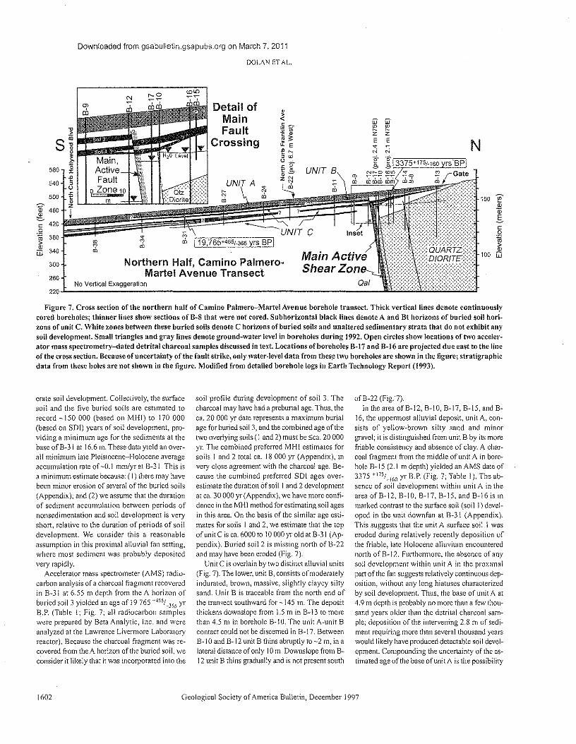
Downloaded from gsabulletln.gsapubs.org on March 7, 2011
DOLAN ET AL.
Detail ofMainFault
Crossing
w W~ ~z zE E~N N
'~r.c~~~----~~s~~~~~~~~N
150 ~2<Dgc.Q
~100 iIi
Northern Half, Camino Palmero-Martel Avenue Transect
No Vertical Exaggeration220~---------------------------------------------------------J~~~~~~~~J
300260
Figure 7. Cross section of the northern half of Camino Palmero-Martel Avenue borehole transect. Thick vertical lines denote continuouslycored boreholes; thinner lines show sections of B~8 that were not cored. Subhor-lzcntal black lines denote A and Bt horizons of buried soil hori-zons of unit C. White zones between these buried soils denote C horizons of buried soils and unaltered sedimentary strata that do not exhibit anysoil development. Small triangles and gray lines denote ground-water level in boreholes during 1992. Open circles show locations of two acceler-ator mass spectrometry-dated detrital charcoal samples discussed in text. Locations of'boreholes B-17 and B-16 are projected due east to the lineof the cross section. Because of uncertainty of the fault strike, only water-level data from these two boreholes are shown in the figure; stratigraphicdata from these holes are not shown in the figure. Modified from detailed borehole logs in Earth Technology Report (1993).
crate soil development. Collectively, the surfacesoil and the five buried soils arc estimated torecord -150 000 (based 01\ MHI) to 170000(based on SOT) yean; of soil development, pro-viding a minimum age for the sediments at thebase of B-3 1at 16.6 m. These data yield an over-all minimum late Pleistocene-Holocene averageaccumulation rate of -0.1 mm/yr at B-3!. This isa minimum estimate because: (I) there may havebeen minor erosion of several of the buried soils(Appendix); and (2) we assume that the durationof sediment accumulation between periods ofnonsedimentation and soil development is veryshort, relative to the duration of periods of soildevelopment. We consider this a reasonableassumption in this proximal alluvial fan setting,where mas! sediment was probably depositedvery rapidly.
Accelerator mass spectrometer (AMS) radio-carbon analysis of a charcoal fragment recoveredin B~3 I at 6.55 m depth from the A horizon ofburied soil 3 yielded an age of 19 765 +455/',,3(,5 yrB.P. (Table 1; Fig. 7; all radiocarbon sampleswere prepared by Beta Analytic, Inc. and wereanalyzed at the Lawrence Livermore Laboratoryreactor). Because the charcoal fragment was re~covered from the A horizon of the buried soil, weconsider it likely that it was incorporated into the
1602
soil profile during development of soil 3. Thecharcoal may have had a preburial age. Thus, theca. 20 000 yr date represents a maximum burialage for buried soil S, and the combined age of thetwo overlying soils (I and 2) must be sea. 20 000yr. The combined preferred MHI estimates forsoils I and 2 total ca. 18 000 yr (Appendix), invery close agreement with the charcoal age. Be-cause the combined preferred SOl ages over-estimate the duration of soil I and 2 developmentat ca. 30000 yr (Appendix), we have more coufi-dence in the MHI method for estimating soil agesin this area. On the basis of the similar age esti-mates for soils I and 2, we estimate that the topof unit C is ca. 6000 to 10 000 yr old at B~31 (Ap·pendix). Buried soil 2 is missing north ofB-22and may have been eroded (Fig, 7).
Unit C is overlain by two distinct alluvial units(Fig. 7). The lower, unit B, consists of moderatelyindurated. brown, massive, slightly clayey siltysand. Unit B is traceable from the north end ofthe transect southward for -145 !11. The depositthickens downslope from 1.5 rn in 8-13 to morethan 4.5 m in borehole 8-! O. The unit A-unit Bcontact could not be discerned in B-17. BetweenB-IO and B-! 2 unit B thins abruptly 1'0 -2 m. in alateral distance of only 10m. Downslope from B-12 unit B thins gradually and is not present south
Geological Society of America Bulletin, December 1997
ofB-22 (Fig. 7).In the area ofB-12, B-\O, B-17, B-15, and B-
16, the uppermost alluvial deposit, unit A, con-sists of yellow-brown silty sand and minorgravel; it is distinguished from unit B by its morefriable consistency and absence of clay. A char-coal fragment from the middle of unit A in bore-hole B- J 5 (2.1 m depth) yielded an AMS date of3375 +m/_l<,O yr B.P. (Fig, 7; Table!), The ab-sence of soil development within unit A in thearea of 8-12,8-10, B-17, B-15, and 8-16 is inmarked contrast to the surface soil (soil J) devel-oped in the unit downfan at B·31 (Appendix).This suggests that the unit A surface soil! waseroded during relatively recently deposition ofthe friable, late Holocene alluvium encounterednorth ofB~12. Furthermore, the absence of anysoil development within unit A in the proximalpart of the fan suggests relatively continuous dep-osition, without any long hiatuses characterizedby soil development. Thus, the base of unit A at4.9 J11 depth is probably no more than a few thou-sand years older than the detrital charcoal sam-ple; deposition of the intervening 2.8 J11 of sedi-ment requiring more than several thousand yearswould likely have produced detectable soil devel-opment. Compounding the uncertainty of the es-timated age of the base of unit A is the possibility
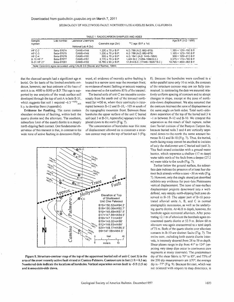
Downloaded from gsabulletin.gsapubs.org on March 7, 2011
SEISMOLOGY OF HOLLYWOOD FAULT; NORTHERN LOS ANGELES BASIN, CALIFORNIA
TABLE 1, RADIOCARBON SAMPLES AND AGES
Catendric age (20) l~C age (B.P ± 10)Age B.P, (A.D. 1950)Sample
numberLab number lawrence Livermore
National Lab # (20)
HF C-2 8eta·57674 CAMS-4148 1,230 ± 70 yr B.P.HF C-3 8eta-57675 CAMS-4149 1,230 ± 70 yr BoP.HF C"4 881a-57676 CAMS-4150 300 ± 70 yr B.P,B-1SHFT 8e\a-57677 CAMS-4151 3.170±70yrB.P,8-31 HF 21' 8eta-57681 CAMS-41S2 16,760 ± 90 yrB.P.
A.D. 786 (A.D. 662-979)A.D, 786 (A.D. 662-979)A.D. 1641 (AD. 1446-1954)1.424 B.C, (1264-1599 B.C.)17,814 B.C, (17448-18267 B.C.)
1,165 + 125/-195 B.P.1.165 + 125/-195 B.P.
309 + 195/-315 B.P.3,375 ,. 175/-160 B.P.
19,765 + 455/-365 B.P.
Note: Calendric ages calculated using CALIS 3,0 (Stuiver and Reimer, 1993).
that the charcoal sample had a significant age atburial. On the basis of the limited available cvi-dence, however, our best estimate of .the base ofunit A is ca. 4000 to 8000 yr RP. This age is sup-ported by our analysis of the weak surface soildeveloped through the top of unit A in hole B~31,which suggests that soil! required -6.5 +14.H/-4.5
k.y. to develop there (Appendix).Evidence for Faulting. The cores contain
abundant evidence of faulting, within both thequartz diorite and the alluvium. The southern,subsurface Emit of the quartz diorite is a steeplynorth-dipping fault contact. One fundamental obw
servation of this transect is that, in contrast to thewide zone of active faulting in downtown Holly-
wood, all evidence of recently active faulting islocated in a narrow zone near the mountain front;no evidence of recent faulting or tectonic warpingwas observed in the southern 85% of the transect.
The buried soils of unit C are traceable contin-uously from the south end of the transect north-ward for >450 m, where their continuity is inter-rupted between B· J 2 and B· 10, -,105 m south ofthe topographic mountain front. Between theseboreholes the upper surface of the unit C buriedsoil (soil 3 at Bw3!; Appendix) appears to be dis-placed down to the north (Fig. 7).
The concentration of boreholes near this zoneof displacement allowed us to construct a struc-ture contour map on the top of buried soil 3 (Fig,
Figure 8. Structure-contour map of the top of the uppermost buried soil of unit C (soil 3) in thearea of the most recently active fault strand at Camino Palmero. Contours are in feet (1 ff = 0.3 m).Numbered dots indicate the locations of boreholes. Vertical separation across fault is -5 ft (1.501)and is mountain-side down.
Geological Society of America Bulletin, December1997
8). Because the boreholes were confined to astrike-parallel zone only 10m wide, the contoursof the structure contour map are not fully con-strained. In contouring the data we assumed rela-tively uniform spacing of contours and no abruptchanges in slope, except at the zone of north-side-down displacement. We also assumed thatthe contours intersect the zone of displacement atthe same.angle on, both sides, Total north-side-down separation of the top of the buried soil 3 is-1 m between g, 12 and g. J O. We interpret thisseparation as the result of fault rupture, ratherthan fluvial incision of the Runyon Canyon fan,because buried soils 3 and 4 are vertically sepe-rated down-to-the-north the same amount be-tween B-12 and a. I0 (Fig. 7), Thus, the buried,north-facing scarp cannot be ascribed to incisionof only the shallowest unit C buried soil (soil 3).This fault strand coincides with a ground-waterbarrier, which separates a shallow (17 m deep)water table north of the fault from a deeper (27.2m) water table to the south (Fig. 7).
Farther below the ground surface, the subsur-face data indicate the presence of at least four dis-tinct fault strands within a zone -30 m wide (Fig.7). However, only the single strand just describedexhibits any evidence for post-late Pleistocenevertical displacement. The zone of near-surfacedisplacement projects downward into a well-defined, very steeply north-dipping fault zone ob-served in B-10, The upper part cf Bvl O pene-trated alluvial units A, B, and C in normalstratigraphic succession, as well as the underly-ing quartz diorite. At 40.8 m depth, however, theborehole again reentered alluvium. After pene-trating J 2.1 m of alluvium the borehole again en-countered quartz diorite at 53.9 rn. Below 60 malluvium was again encountered to a total depthof 73 Ill. Both of the quartz diorite over alluviumcontacts in B~I0 arc distinct faults (Fig. 7). Theentire core, including both quartz diorite inter-vals, is intensely sheared from 28 to 59 In depth.Shear planes range in dip from 41" to 124" (op-posing very steep dips occur in continuous coresegments at many intervals). The predominantdip of the shear fabric is 70" to 85", and 75% ofthe 200 dip measurements arc ~70"; the averagedip is ~77° (Fig, 9). Because the core, which wasnot oriented with respect to map directions, is
160J
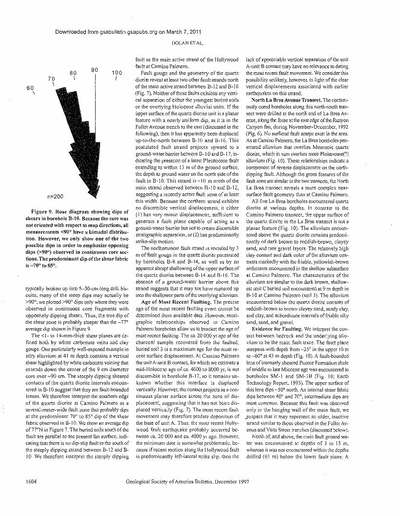
Downloaded from gsabulletin.gsapubs.org on March 7, 2011
DOLAN ETAL.
60\
70\
80\
90 100I
Figure 9. Rose diagram showing dips ofshears in borehole B-10. Because the core wasnot oriented with respect to map directions, allmeasurements <900 have a bimodal distribu-tion. However, we only show one of the twopossible dips in order to emphasize opposingdips (>90°) observed in continuous core sec-tions. The predominant dip ofthe shear fabricis _700 to 85°,
typically broken up into s-Sn-cm-tong drill bis-cuits, many of the steep dips may actually be>90°; we plotted >900 dips only where they wereobserved in continuous core fragments withoppositely dipping shears. Thus, the true dip ofthe shear zone is probably steeper than the _77°average dip shown in Figure 9,
The <1- to lq-rnm-thick shear planes are de-fined both by white carbonate veins and claygouge, One particularly well-exposed example insilty alluvium at 41 m depth contains a verticalshear highlighted by white carbonate veining thatextends down the center of the 9 cm diametercore over -90 ern. The steeply dipping shearedcontacts of the quartz diorite intervals encoun-tered in B- I0 suggest that they are fault-boundedlenses. We therefore interpret the southern edgeof the quartz diorite at Camino Palmero as aseveral-meter-wide fault zone that probably dipsat the predominant 70° to 85° dip of the shearfabric observed in B~IO. We show an average dipof77°N in Figure 7. The buried soils south of thefault are parallel to the present fan surface, indi-cating that there is no dip-slip fault to the south ofthe steeply dipping strand between 8--12 find 8--10. We therefore interpret the steeply dipping
1604
fault as the main active strand of the Hollywoodfault at Camino Palmero.
Fault gouge and the geometry of the quartzdiorite reveal at least two other fault strands northof the main active strand between B-12 and B~ I0(Fig. 7). Neither ofthese faults exhibits any verti-cal separation of either the youngest buried soilsor the overlying Holocene alluvial units. If theupper surface of the quartz diorite unit is a planarfeature with a nearly uniform dip, as it is in theFuller Avenue trench to the east (discussed in thefollowing), then it has apparently been displacedup-to-the-north between B~10 and B- 16. Thispostulated fault strand projects upward 1"0 aground-water barrier between 8-~I 0 and B-17, in-dicating the presence of a latest Pleistocene faultextending to within 13 m of the ground surface,the depth to ground water on the north side of thefault in B~ 1O. This strand is -10m north of themain strand observed between B-1 0 and B~ 12,suggesting a recently active fault zone of at leastthis width. Because the northern strand exhibitsno discernible vertical displacement, it either(!) has very minor displacement, sufficient togenerate a fault plane capable of acting as aground-water barrier but not to create discerniblestratigraphic separation, or (2) has predominantlystrike-slip motion.
The northernmost fault strand is revealed by 3m of fault gouge in the quartz diorite penetratedby boreholes B-8 and B~14, as well as by anapparent abrupt shallowing of the upper surface ofthe quartz diorite between 8--14 and B~16. Theabsence of a ground-water barrier above thisstrand suggests that it may not have ruptured upinto the shallower parts ofthc overlying alluvium.
Age of Most Recent Faulting. The preciseage of the most recent faulting event cannot bedetermined from available data. However, strati-graphic relationships observed in CaminoPalmero boreholes allow us to bracket the age ofmost recent faulting. The ca. 20 000 yr age of thecharcoal sample recovered from the faulted,buried soil 3 is a maximum age for the most re-cent surface displacement. At Camino Palmerothe unit A-unit B contact, for which we estimate amid-Holocene age of ca. 4000 to 8000 yr, is notdiscernible in borehole B~!7, so it remains un-known whether this interface is displacedvertically. However, the contact projects as a con-tinuous planar surface across the zone of dis-placement, suggesting that it has not been dis-placed vertically (Fig. 7). The most recent faultmovement may therefore predate deposition ofthe base of unit A. Thus. the most recent Holly-wood fault earthquake probably occurred be-tween ca. 20 000 and ca. 4000 yr ago, However,the minimum date is somewhat problematic, be-cause if recent motion along the Hollywood faultis predominantly left-lateral strike slip. then the
Geological Society of America Bulletin, December 1997
lack of appreciable vertical separation of the unitA-unit B contact may have no relevance to datingthe most recent fault movement. We considerthispossibility unlikely, however, in light of the clearvertical displacements associated with earlierearthquakes on this strand.
North La Brea Avenue Transect. The continu-ously cored boreholes along this north-south tran-sect were drilled at the north end of La Brea Av-enue, along the fossc at the east edge of the RunyonCanyon fan, during November-December. !992(Fig. 6). No surficial fault scarps exist in the area.As at Camino Palmero, the La Brea boreholes pen-etrated alluvium that overlies Mesozoic quartzdiorite, which in turn overlies more Pleistocenet")alluvium (Fig. !0). These relationships indicate acomponent of reverse displacement on the north-dipping fault. Although the gross features of thefault zone are similar in the two transects, the NorthLa Brea transect reveals a more complex near-surface fault geometry than at Camino Palmero.
All five La Brea boreholes encountered quartzdiorite at various depths, In Contrast to theCamino Palmero transect, the upper surface ofthe quartz diorite in the La Brea transect is not aplanar feature (Fig. !0). The alluvium encoun-tered above the quartz diorite consists predomi-nantly of dark brown to reddish-brown, clayeysand, and rare grave! layers. The relatively highclay content and dark color of the alluvium con-trasts markedly with the friable, yellowish-brownsediments encountered in the shallow subsurfaceat Camino Palmero. The characteristics of thealluvium are similar TO the dark brown, shallow-est unit C buried soil encountered at 9 m depth inB~10 at Camino Palmero (soil 3). The alluviumencountered below the quartz diorite consists ofreddish-brown to brown clayey sand, sandy clay,and clay, and Subordinate intervals offriablc siltysand, sand, and gravel.
Evidence for Faulting. We interpret the con-tact between bedrock and the underlying allu-vium to be the main fault trace. The fault planesteepens with depth from ~25°in the upper 10mto ~60° at 43 m depth (Fig. !0). A fault-boundedlens of intensely sheared Puente Formation shaleof middle to late Miocene age was encountered inboreholes SM~ 1 and SM-! B (Fig, 10; EarthTechnology Report, 1993). The upper surface ofthis lens dips -50° north. An internal shear fabricdips between 40° and 70°; intermediate dips aremost common. Because this fault was observedonly in the hanging wall of the main fault, we.suspecr that it may represent an older, inactivestrand similar to those observed in the Fuller Av~enue and Vista Street trenches (discussed below).
North of, and above, the main fault ground wa~tel' was encountered at depths of 3 to 13 In,
whereas it was not encountered within the depthsdrilled (61 m) below the lower fault plane. A
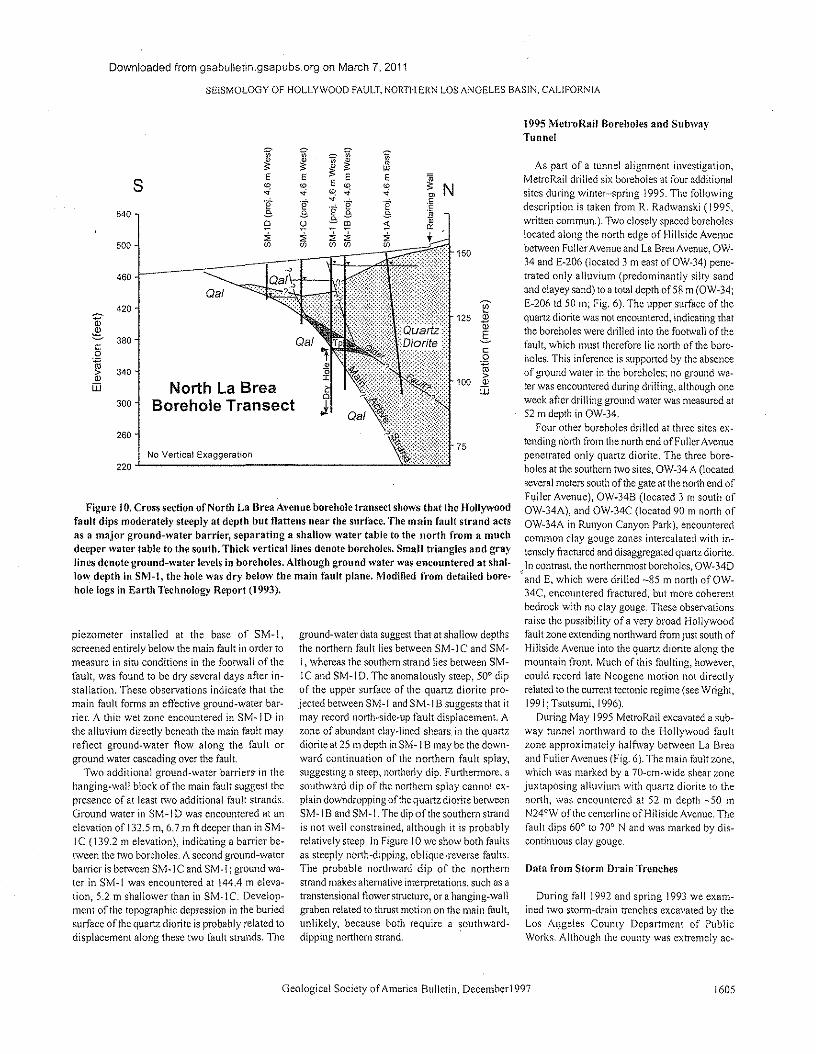
Downloaded from gsabulietin.gsapubs.org on March 7. 2011
SEISMOLOGY OF HOLLYWOOD FAULT. NORTHERN LOS ANGELES BASIN. CALIFORNIA
I "~s E E
ID ID.. ..e- "e-
540 e ec "~ "500 <Il <Il
460
Oal420
380
No Vertical Exaggeration
co1 340
ill North La BreaBorehole Transect300
260
220
1!125 2
a>.s
cJ
co
~100 Q)
ill
Figure 10. Cross section of North La Brea Avenue borehole transect shows that the Hollywoodfault dips moderately steeply at depth but flattens near the surface. The main fault strand actsas a major ground-water barrier, separating a shallow water table to the north from a muchdeeper water table to the south. Thick vertical lines denote boreholes. Small triangles and graylines denote ground-water levels in boreholes. Although ground water was encountered at shal-low depth in SM-I, the hole was dry below the main fault plane. Modified from detailed bore-hole logs in Earth Technology Report (1993).
piezometer installed at the base of SM-l,screened entirely below the main fault in order tomeasure in situ conditions in the footwall of thefault, was found to be dry several days after in-stallation, These observations indicate that themain fault forms an effective ground-water bar-rier. A thin wet zone encountered in SM-I Dinthe alluvium directly beneath the main fault mayreflect ground-water flow along the fault orground water cascading over the fault
Two additional ground-water barriers- in thehanging-wall block of tile main fault suggest thepresence of at least rwo additional fault strands.Ground water in SM-I D was encountered at anelevation of 132.5 m, 6.7 rn ft deeper than in SM-1C (139.2 m elevation), indicating a barrier be-tween the two boreholes. A second ground-waterbarrier is between SM·IC and SM·1; ground wa-ter in SM-! was encountered at 144.4 m eleva-tion, 5.2 In shallower than in SM·le. Develop-ment of the topographic depression in the buriedsurface of the quartz diorite is probably related todisplacement along these two fault strands. The
ground-water data suggest that at shallow depthsthe northern fault lies between SM-l C and SM¥I, whereas the southern strand lies between SM-IC and SM-lD. The anomalously steep, 50" dipof the upper surface of the quartz diorite pro-jected between SM¥1 and SM·1 B suggests that itmay record north-side-up fault displacement. Azone of abundant clay-lined shears. in the quartzdiorite at 25 m depth in SM-\ B may be the down-ward continuation of the northern fault splay,suggesting a steep, northerly dip. Furthermore, asouthward dip of the northern splay cannot ex-plain downdropping of the quartz diorite betweenSM· 1B and SM· 1.The dip of tile southern strandis not well constrained, although it is probablyrelatively steep. In Figure J 0 we show both faultsas steeply north-dipping, oblique-reverse faults.The probable northward dip of the northernstrand makes alternative interpretations, such as atranstensional flower structure, or a hanging-wallgraben related to thrust motion on the main fault,unlikely, because both require a southward-dipping northern strand.
1995 MctroRaii Boreholes and SubwayTunnel
As part of a tunnel alignment investigation,MetroRa!1 drilled six boreholes at four additionalsites during winter-spring 1995. The followingdescription is taken from R. Radwanski (J 995,written commun.). Two closely spaced boreholeslocated along the north edge of Hillside Avenuebetween Fuller Avenue and La Brea Avenue, OW·34 and E-206 (located 3 m east ofOW·34) pene-trated only alluvium (predominantly silty sandand clayey sand) to a total depth of 58 m (OW-34;E-206 td 50 111; Fig, 6). The upper surface of thequartz diorite was not encountered, indicating thatthe boreholes were drilled into the footwall of thefault, which must therefore lie north of tile bore-holes. This inference is supported by the absenceof ground water in the boreholes; no ground wa-ter was encountered during drilling, although oneweek after drilling ground water was measured at52 ru depth in OW-34.
Four other boreholes drilled at three sites ex-tending north from the north end ofFuller Avenuepenetrated only quartz diorite. The three bore-holes at the southern two sites. OW-34 A (locatedseveral meters south of the gate at the north end ofFuller Avenue), OW-34B (located 3 m south ofOW-J4A), and OW-34C (located 90 m north ofOW-34A in Runyon Canyon Park), encounteredcommon clay gouge zones intercalated with in-tensely fractured and disaggregated quartz.diorite.In contrast, the northernmost boreholes, OW-34D
"and E, which were drilled ~85 m north of OW-34C, encountered fractured, but more coherentbedrock with no clay gouge. These observationsraise the possibility ofa very broad Hollywoodfault zone extending northward from just south ofHillside Avenue into the quartz diorite along themountain front. Much of this faulting, however,could record late Neogene motion not directlyrelated to the current tectonic regime (see Wright,1991; Tsutsumi, 1996).
During May 1995 Mctrokail excavated a sub-way tunnel northward to the Hollywood faultzone approximately halfway between La Breaand Fuller Avenues (Fig. 6). The main fault zone,which was marked by a 70-cm-wide shear zonejuxtaposing alluvium with quartz diorite to thenorth, was encountered at 52 m depth -50 mN24°W of the centerline of'Hillside Avenue. Thefault dips 60° to 70° N and was marked by dii;-continuous clay gouge.
Data from Storm Drain Trenches
During fall 1992 and spring 1993 we exam-ined two storm-drain trenches excavated by theLos Angeles County Department of PublicWorks. Although the county was extremely ac-
Geological Society of America Bulletin, Decemberl997 1605
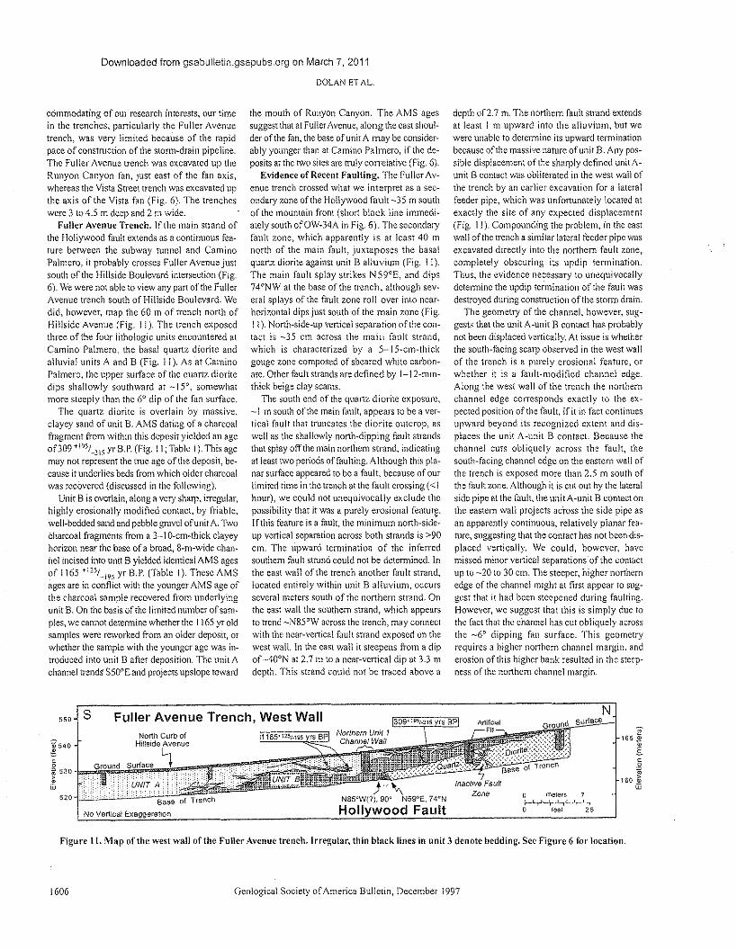
Downloaded from gsabulletin.gsapubs.org on March 7, 2011
DOLAN ET AL,
commodaring of our research interests, our timein the trenches, particularly the Fuller Avenuetrench, was very limited because of the rapidpace of construction of the storm-drain pipeline,The Fuller Avenue trench was excavated up theRunyon Canyon fan, just cast of the fan axis,whereas the Vista Street trench was excavated upthe axis of the Vista fan (Fig, 6). The trencheswere 3 to 4.5 m deep and 2 m wide.
Fuller Avenue Trench. If the main strand ofthe Hollywood fault extends as a continuous fea-ture between the subway tunnel and CaminoPalmero, it probably crosses Fuller AVenue JUS!
south of the Hillside Boulevard intersection (Fig.6). We were not able to view any part of the FullerAvenue trench south of Hillside Boulevard, Wedid, however, map the 60 111 of trench north ofHillside Avenue (Fig. 11). The trench exposedthree of the four lithologic units encountered atCamino Palmero, the basal quartz diorite andalluvia! units A and B (Fig, ! 1). As at CaminoPalmero, the upper surface of the quartz dioritedips shallowly southward at _15°, somewhatmore steeply than the 60 dip of the fan surface.
The quartz diorite is overlain by massive,clayey sand of unit B. AMS dating of a charcoalfragment from within this deposit yielded an ageof309 +195/_315 yr B.P. (Fig. 11; Table I). This agemay not represent the true age of the deposit, be-cause it underlies beds from which older charcoalwas recovered (discussed in the following).
Unit B is overlain, along a very sharp, irregular,highly erosionally modified contact, by friable,well-bedded sand and pebble grave! of unit A. Twocharcoal fragments from a 3-1 Occm-thick clayeyhorizon near the base of a broad, Bern-wide chan-he! incised into unit B yielded identical AMS agesof ! 165 +125/ ...19S yr B.P. (Table 1). These AMSages are in conflict with the younger AMS age ofthe charcoal sample recovered from underlyingunit B. On the basis of the limited number of sam-ples, we cannot determine whether the! 165 yr oldsamples were reworked from an older deposit, orwhether the sample with the younger age was in-troduced into unit B after deposition. The unit Achannel trends S500Eand projects upslope toward
the mouth of Runyon Canyon. The AMS agessuggest that at Fuller Avenue, along the cast shoul-der of the fan, the base of unit A may be consider-ably younger than at Camino Palmero, if the de-posits at the two sites are truly correlative (Fig. 6).
Evidence of Recent Faulting. The Fuller Av-enue trench crossed what we interpret as a sec-ondary zone of the Hollywood fault -35 m southof the mountain front (short black line immedi-ately south ofOW-34A in Fig. 6). The secondaryfault zone, which apparently is at least 40 mnorth of the main fault, juxtaposes the basalquartz diorite against unit B alluvium (Fig. J 1).The main fault splay strikes N59°E, and dips74°NW at the base of the trench, although sev-eral splays of the fault zone roll over into ncar-horizontal dips just south of the main zone (Fig.1 l ). North-side-up vertical separation of the con-tact is -35 em across the main fault strand,which is characterized by as",", l Sccm-thickgouge zone composed of sheared white carbon-ate. Other fault strands are defined by I-f z-mm-thick beige clay seams.
The south end of the quartz diorite exposure,-1 m south of the main fault, appears to be a ver-tical fault that truncates the diorite outcrop, aswell as the shallowly north-dipping fault strandsthat splay off the main northern strand, indicatingat least twO periods of faulting. Although this pla-nar surface appeared to be a fault, because of ourlimited time in the trench at the fault crossing « Ihour), we could not unequivocally exclude thepossibility that it was a purely erosional feature.If this feature is a fault, the minimum north-side-up vertical separation across both strands is >90em. The upward termination of the inferredsouthern fault strand could not be determined. Inthe east wall of the trench another fault strand,located entirely within unit B alluvium, occursseveral meters south of the northern strand. Onthe east wall the southern strand, which appearsto trend ~N85°W across the trench, may connectwith the ncar-vertical fault strand exposed on thewest wall. In the east wall it steepens from a dipof ~400N at 2.7 In to a near-vertical dip at 3.3 111
depth. This strand could not be traced above a
depth of2.7 111. The northern fault strand extendsat least 1 m upward into the alluvium, but wewere unable to determine its upward terminationbecause of the massive nature of unit B. Any pos-sible displacement of the sharply defined unit A-unit B contact was obliterated in the west wall ofthe trench by an earlier excavation for a lateralfeeder pipe, which was unfortunately located atexactly the site of any expected displacement(Fig. 11). Compounding the problem, in the eastwall of the trench a similar lateral feeder pipe wasexcavated directly into the northern fault zone,completely obscuring its updip termination.Thus, the evidence necessary to unequivocallydetermine the updip termination of the fault wasdestroyed during construction of the srorm drain.
The geometry of the channel, however, sug-gests that the unit A-unit B contact has probablynot been displaced vertically. At issue is whetherthe south-facing scarp observed in the west wallof the trench is a purely erosional feature, orwhether it is a fault-modified channel edge.Along the west wall of the trench the northernchannel edge corresponds exactly to the ex-pected position of the fault, if it in fact continuesupward beyond its recognized extent and dis-places the unit A-unit B contact. Because thechannel cuts obliquely across the fault, thesouth-facing channel edge on the eastern wall ofthe trench is exposed more than 2.5 m south ofthe fault zone. Although it is cut out by the lateralside pipe at the fault, the unit A-unit B contact onthe eastern wall projects across the side pipe asan apparently continuous, relatively planar fea-ture, suggesting that the contact has not been <iis-placed vertically. We could, however, havemissed minor vertical separations of the contactup to -20 to 30 cm. The steeper, higher northernedge of the channel might at first appear to sug-gest that it had been steepened during faulting.However, we suggest that this is simply due tothe fact that the channel has cut obliquely acrossthe _6° dipping fan surface. This geometryrequires a higher northern channel margin. anderosion of this higher bank resulted in the steep-ness of the northern channel margin,
s550 Fuller Avenue Trench, West Wall Nsurface
"165,*
E-oo~
160 ~w
Geological Society of America Bulletin, December 1997
,.~::::f;~!;i\e;~:::'~~,}:, Base 01 rreoc
Inactive FaullZone 0 meters
I ' ,25o 'feet'
!540
~53°~.E~I~1I2w
520 Base of Trench
No Vertical Exaggeration
1165"251.195 rs BP
J~N85UW(?).900 N59"E.74"NHollywood Fault
Figure II. Map of the west wall of the Fuller Avenue trench. Irregutar, thin black lines in unit 3 denote bedding. See Figure 6 for location.
1606
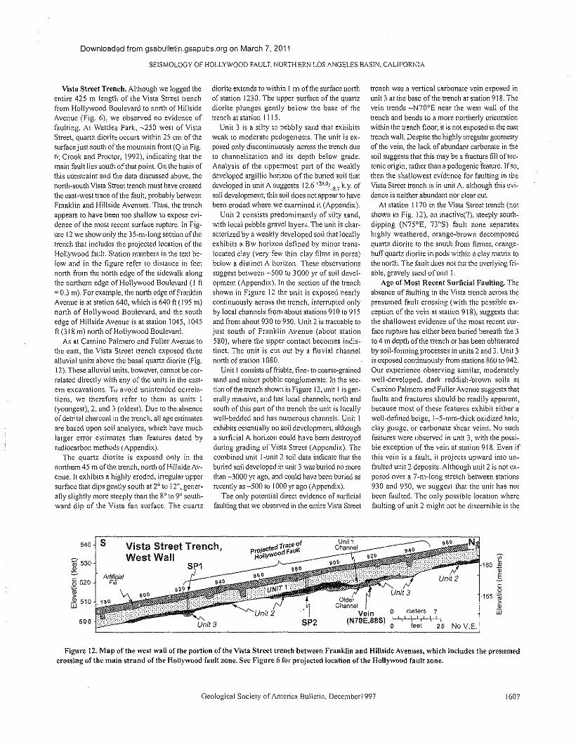
Downloaded from gsabulletin.gsapubs.org on March 7, 2011
SEISMOLOGY OF HOLLYWOOD FAULT, NORTHERN LOS ANGELES BAS1N, CALIFORNIA
540rsS;-~V~is~t~a~S:t~re:e:t~T~re:n~c~h~,--------~d~T:~:C'~Oif----~~~----_=====~~~~::~proJecte d FaUltWest Wall HOUYWoO
J-~-
Vista Street Trench. Although we logged theentire 425 m length of the Vista Street trenchfrom Hollywood Boulevard to north of HillsideAvenue (Fig. 6), we observed no evidence offaulting. At Wattles Park, ~250 west of VistaStreet, quartz diorite occurs within 25 em of thesurface just south of the mountain front (0 in Fig.6; Crook and Proctor, 1992), indicating that themain fault lies south of that point. On the basis ofthis constraint and the data discussed above, thenorth-south Vista Street trench must have crossedthe east-west trace of the fault, probably betweenFranklin and Hillside Avenues. TI1US,the trenchappears to have been too shallow to expose evi-dence of the most recent surface rupture. In Fig~ure 12 we show only the 35~m-long section of thetrench that includes the projected location of theHollywood fault. Station numbers in the text be-low and in the figure refer to distance in feetnorth from the north edge of the sidewalk alongthe northern edge of Hollywood Boulevard (I ft=' 0.3 m). For example, the north edge of FranklinAvenue is at station 640, which is 640 ft (195 01)north of Hollywood Boulevard, and the southedge of Hillside Avenue is at station 1045, 1045ft (318 m) north of Hollywood Boulevard.
As at Camino Palmero and Fuller Avenue tothe east, the Vista Street trench exposed threealluvial units above the basal quartz diorite (Fig.12). These alluvial units, however, cannot be cor-related directly with any of the units in the east-ern excavations. To avoid unintended ccrrela-[ions, we therefore refer to them as units I(youngest), 2, and J (oldest). Due to the-absenceof detrital charcoal in the trench, all age estimatesare based upon soil analyses, which have muchlarger error estimates than features dated byradiocarbon methods (Appendix).
The quartz diorite is exposed only in thenorthern 45 m of the trench, north of Hillside Avw
enue. It exhibits a highly eroded, irregular uppersurface that dips gently south at 2° to 12°, goner-ally slightly more steeply than the 8° to 9° south-ward dip of the Vista fan surface. The quartz
diorite extends to within I m of the surface northof station! 230. The upper surface of the quartzdiorite plunges gently below the base of thetrench at station 11 J 5.
Unit 3 is a silty to pebbly sand that exhibitsweak to moderate pedogenesis. The unit is ex-posed only discontinuously across the trench dueto channelization and its depth below grade.Analysis of the uppermost part of the weaklydeveloped argillic horizon of the buried soil thatdeveloped in unit A suggests 12.6 +2H.O(R.7 k.y. ofsoil development; this soil does not appear to havebeen eroded where we examined it (Appendix).
Unit 2 consists predominantly of silty sand,with local pebble gravellayers. The unit is char-acterized by a weakly developed soil that locallyexhibits a Bw horizon defined by minor trans-located clay (very few thin clay films in pores)below a distinct A horizon. These observationssuggest between -500 to 3000 yr of soil dcvel-oprnent (Appendix). In the section of the trenchshown in Figure 12 the unit is exposed nearlycontinuously across the trench, interrupted onlyby local channels from about stations 910 to 915and from about 930 to 950. Unit 2 is traceable tojust south of Franklin Avenue (about station580), where the upper contact becomes indis-tinct The unit is cut Out by a fluvial channelnorth of station 1080.
Unit I consists of friable, fine- to coarse-grainedsand and minor pebble conglomerate. In the sec-tion of the trench shown in Figure 12, unit I is gen-erally massive, and has local channels; north andsouth of this pan of the trench the unit is locallywell-bedded and has numerous channels. Unit Iexhibits essentially no soli development, althougha surficial A horizon could have been destroyedduring grading of Vista Street (Appendix). Thecombined unit I-unir 2 soil data indicate that theburied soil developed in unit 3 was buried 110 morethan -3000 yr ago, and could have been buried asrecently as -500 to 1000 yr ago (Appendix).
The only potential direct evidence of surficialfaulting that we observed in the entire Vista Street
trench was a vertical carbonate vein exposed inunit 3 at the base of the trench at station 918, Thevein trends -N700E near the west wall of thetrench and bends to a more northerly orientationwithin the trench floor; it is not exposed in the easttrench wall. Despite the highly irregular geometryof the vein, the lack of abundant carbonate in thesoil suggests that this may be a fracture fill of tee-tonic origin, rather than a pedogenic feature. If so,then the shallowest evidence for faulting in theVista Street trench is in unit A, although this evi-dence is neither abundant nor dear cut. .
At station! 170 in the Vista Street trench (notshown in Fig. 12), an inactivet"), steeply south-dipping (N75°E, 73°S) fault zone separateshighly weathered, orange-brown decomposedquartz diorite to the south from firmer, orange-buff quartz diorite in pods within a clay matrix tothe north. The fault does not cut the overlying fri~able, gravely sand of unit J.
Age of Most Recent Surficial Faulting. TI1eabsence of faulting in the Vista trench across thepresumed fault crossing (with the possible ex-ception of the vein at station 918), suggests thatthe shallowest evidence of the most recent sur-face rupture has either been buried beneath the 3to 4 m depth of the trench or has been obliteratedby soil-forming processes in units 2 and 3. Unit 3is exposed continuously from stations 860 to 942.Our experience observing similar, moderatelywell-developed, dark reddish-brown soils atCamino Palmero and Fuller Avenue suggests thatfaults and fractures should be readily apparent,because most of these features exhibit either awell-defined beige, l-c-mm-thick oxidized halo,clay gouge, or carbonate shear veins. No suchfeatures were observed in unit 3, with the possi-ble exception of the vein at station 918. Even ifthis vein is a fault, it projects upward into un-faulted unit 2 deposits. Although unit 2 is not ex-posed over a 'r-m-long stretch between stations930 and 950, we suggest that the unit has norbeen faulted. The only possible location wherefaulting of unit 2 might not be discernible is the
~530~§ 520.~2 510uu
ArtificialFi/f
500
~1601
co155 ~
>ID[jJ
OlderChannel
Vein 0 meters 7(N70E,88S) 01-1"+-\\.-'~-'":''+'-,'25 No V.E.
Figure 12. Map of the west wall of the portion of the Vista Street trench between Franklin and Hillside Avenues, which includes the presumedcrossing of the main strand of the Hollywood fault zone. See Figure 6 for projected location of the Hollywood fault zone.
Geologica! Society of America Bulletin, December! 997 1607
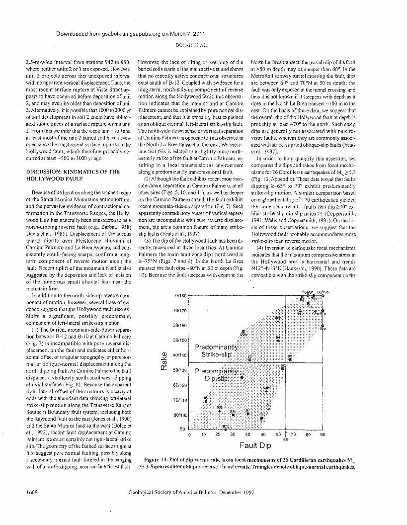
Downloaded from gsabulletln.gsapubs.org on March 7, 2011
DOLAN ETAL.
2.S-m-wide interval from stations 942 to 950,where neither units 2 or 3 are exposed. However,unit 2 projects across this unexposed intervalwith no apparent vertical displacement. Thus, themost recent surface rupture at Vista Street ap-pears to have occurred before deposition of unit2, and may even be older than deposition of unit3. Alternatively, it is possible that J 000 to 2000 yrof soil development in soil 2 could have obliter-ated subtle traces of a surface rupture within unit2. From this we infer that the weak unit I soil andat least most of the unit 2 buried soil have devel-oped since the most recent surface rupture on theHollywood fault, which therefore probably oc-curred at least -500 to 3000 yr ago,
DISCUSSION: KINEMATICS OF THEHOLLYWOOD FAULT
Because of Its location along the southern edgeof the Santa Monica Mountains anticlinorium.and the pervasive evidence of contractional de-formation in the Transverse Ranges, the Holly-wood fault has generally been considered to be anorth-dipping reverse fault (e.g., Barbat, 1958;Davis et al., 1989). Displacement of Cretaceousquartz diorite over Pleistocene alluvium atCamino Palmero and La Brea Avenue, and con-sistently south-facing scarps, confirm a long-term component of reverse motion along thefault. Recent uplift of rhc mountain front is alsosuggested by the deposition and lack of incisionof the numerous small alluvial fans near themountain front.
In addition to the north-side-up reverse corn-ponent of motion, however, several lines of evi-dence suggest that.the Hollywood fault also ex-hibits a significant, possibly predominant,component of left-lateral strike-slip motion.
(1) The buried, mountain-side-down separa-tion between B~12 and B-1 0 at Camino Palmero(fig. 7) is incompatible with pure reverse dis-placement on the fault and indicates either hori-zontal offset ofirregular topography, or pure nor-mal or oblique-normal displacement along thenorth-dipping fault. At Camino Palmero the faultdisplaces a shallowly south-southwest-dippingalluvial surface (fig. 8). Because the apparentrighr-lareral offset of the contours is clearly atodds with the abundant data showing left-lateralstrike-slip motion along the Transverse RangesSouthern Boundary fault system, including boththe Raymond fault to the east (Jones et al., 1990)and the Santa Monica fault to the west (Dolan et31., 1992), recent fault displacement at CaminoPalmero is almost certainly not right-lateral strikeslip. The geometry ofthe faulted surface might atfirst suggest pure normal faulting, possibly alonga secondary normal fault formed in the hangingwall of a north-dipping, near-surface thrust fault.
1608
However, the lack of tilting or warping of theburied soils south of the main active strand showsthat no recently active contractional structuresexist south ofB-12. Coupled with evidence for along-term, north-side-up component of reversemotion along the Hollywood fault, this observa-tion indicates that the main strand at CaminoPalmero cannot be explained by pure normal dis-placement, and that it is probably best explainedas an oblique-normal, left-lateral strike-slip fault.The north-side-down sense of vertic a! separationat Camino Palmero is opposite to that observed inthe North La Brea transect to the east. We specu-late that this is related ro a slightly more north-easterly strike of the fault at Camino Palmero, re-suiting in a local transtensional environmentalong a predominantly unnspressionel fault
(2) Although the fault exhibits recent mountain-side-down separation at Camino Palmero, at allother sites (figs. 5, 10, and I l ), as well as deeperon the Camino Palmero strand, the fault exhibitsrecent mountain-side-up separation (Fig. 7). Suchapparently contradictory senses of vertical separa-tion are incompatible with pure reverse displace-ment, but arc a common feature of many strike-slip faults (Yeats et al. !997).
(3) The dip of the Hollywood fault has been di-rectly measured at three localities, At CaminoPalmero the main fault zone dips northward at~_75°N (figs. 7 and 9), In the North La Breatransect the fault dips _600N at 50 m depth (Fig.10). Because the fault steepens with depth in the
0/180
10/170
20/160
30/150
OJ 40/140.Y:ctS
0:: 50/130
60/120
70/110
o 20 3010
North La Brea transect, the overall dip of the faultat >50 m depth may be steeper than 60°. in theMetroRail subway tunnel crossing the fault, dipsarc between 60° and 700N at 50 m depth; thefault was only exposed at the tunnel crossing, andthus it is not known if it steepens with depth as itdoes in the North La Brea transect -J 00 In to theeast. On the basis of these data, we suggest that
'the overall dip of the Hollywood fault at depth isprobably at least _70° to the north. Such steepdips are generally not associated with pure re-verse faults, whereas they are commonly associ-ared with strike-slip and oblique-slip faults (Yeatset al., 1997).
In order to help quantify this assertion, wecompared the dips and rakes from focal mocha-nisms for 26 Cordilleran earthquakes ofM",;:: 5.3(Fig. 13; Appendix). These data reveal that faultsdipping ;::_65° to 70° exhibit predominantlystrike-slip motion. A similar comparison based011 a global catalog of 170 earthquakes yieldedthe same basic result-faults that dip ~70° ex-hibit strike-slip.dip-slip ratios> 1 (Coppersmith,1991; Wells and Coppersmith, 199!), On the ba-sis of these observations, we suggest that theHollywood fault probably accommodates morestrike-slip than reverse motion.
(4) Inversion of earthquake focal mechanismsindicates that the maximum compressive stress inthe Hollywood area is horizontal and trendsN l2°-N !3°E (Hauksson, 1990). These data arecompatible with the strike-slip component on the
66a/81 68f79b
40 50 80 90
Fault Dip
Figure 13. Plot of dip versus rake from focal mechanisms of 26 Cordilleran earthquakes Mw;:::5.3.Squares show oblique-reverse-thrust events. Triangles denote oblique-normal earthquakes.
Geological Society of America Bulletin, December 1997
Downloaded from gsabulletin.gsapubs.org on March 7, 2011
SEISMOLOGY OF HOLLYWOOD FAULT, NORTHERN LOS ANGELES BASIN, CALIFORNIA
north-northeast-trending Hollywood fault beingleft lateral. Furthermore, the orientation of thestresses indicates that the more northeast-strikingparts of tile fault may accommodate a larger com-ponent of left-lateral motion than the more east-erly trending sections of the fault, such as thereach through downtown Hollywood (Fig, 2). Thedepth of the Hollywood basin is based on datafrom only a few wens (Wright, 1991; Hummon etal., \994; Tsutsurni, 1996), and it is therefore im-possible to correlate the depth of this basin withchanges in orientation of the Hollywood fault.However, on the basis of the evidence describedabove for a probable component ofleft-lateral slipon the Hollywood fault, we speculate that theHollywood basin has formed at least partially inresponse to oblique, normal to left-lateral slipalong more northeasterly trending stretches of theHollywood fault, including the -N60oE trendingNichols Canyon-Sunset Strip releasing bend, the~N25°E trending Benedict Canyon releasingbend at the western end of the fault, and possiblythe 350~m~wide left step between the Franklinand northern strands of the Hollywood fault justeast of downtown Hollywood (Fig. 2). We furtherspeculate that extension across the West BeverlyHills lineament at least partially explains the exis-tence of the low-lying Beverly Hills alluvial plaineast of the lineament; motion through the Bene-dict Canyon releasing bend has resulted in in-creased accommodation space to the east that isfilled by alluvium derived from Benedict andLaurel Canyons (Fig. 2).
Our geomorphic analysis failed rc provide anydirect evidence ofleft-lateral strike slip along theHollywood fault, either in the form of offsetdrainages or displaced fans. We attribute this torapid aggradation of the alluvial fans, which haveburied all potential evidence of strike-slip offsets(e.g., offset streams), and earthquake recurrenceintervals that are long relative to the rate of geo-morphic activity. For example, at Camino,Palmero the displaced top of buried soil 3 at 7 mdepth is the shallowest well-documented faultedfeature. The apparently unfaulted unit Acunit Bcontact there lies at a depth of almost 5 m, sug-gesting that at least that much deposition has oc-curred since the most recent surface rupture thatcould have generated any discernible surficialstrike-slip offsets. Similarly, evidence of the mostrecent surface rupture may have been buried be-neath trench depth by more than 3 to 4 m of sed-iment at Vista Street. Furthermore, our data re-veal late Holocene sediment accumulation on thefans at the fault crossing, rather than deep inci-sion of channels that might be discernible eventhrough the urban overprint.
We speculate that the Jack of discerniblelarge-scale offsets of the fans may be due to aconveyor-belt style of sediment input from the
numerous, closely spaced canyon sedimentsources. In this model, strike-slip motion alongthe fault would continually move the alluvialapron past the sediment sources, preventing thedevelopment of very large individual fans at anysingle canyon input and forming an alluvialapron upon which small fans develop. Such aprocess may explain the relatively small sizes ofthe fans observed along the central reach of theHollywood fault. This hypothesis could be testedby excavating an east-west transect of sites in thefootwall of the fault. The transects would be de-signed to document the three-dimensional tran-sition from fans composed predominantly ofsediment eroded from Tertiary sedimentary andvolcanic strata exposed in the Hollywood Hillsnorth of downtown Hollywood, to fans com-posed predominantly of eroded quartz diorite ex-posed to the west (Fig. 2). In summary, we con-tend that the lack of offset geomorphologicfeatures docs not necessarily preclude a signifi-cant component of left-lateral strike-Slip motionalong the Hollywood fault.
Potential Interactions Between the HollywoodFault and Nearby Faults
Both the Hollywood and Santa Monica faultsare interpreted to be north-dipping, oblique-reverse, left-lateral faults (Dolan and Sieh, 1992;Dolan et al., 1992; this study). Coupled with thesimilar orientations of the two faults, this leads usto interpret them as closely related strands withina single fault system that might rupture togetherduring large earthquakes (Fig. 2). However, thethree northeast-trending releasing bends alongthe Hollywood fault could act as earthquake seg-ment boundaries, as has been shown along otherfaults (e.g., Sibson. 1985),
Recognition of a component of left-lateralstrike slip on the HollYWOOdfault also raises thepossibility that It may directly connect with theleft-lateral Raymond fault to the east (Fig. I).Such a connection has long been postulated on thebasis of the similar strike of the two faults (e.g.,
Barbat, 1958; Lamar, 1961), and gravity data,which suggest overall continuity of basementtrends across the Los Angeles River (Chapmanand Chase, 1979). However, the area between thesouthwestemmost well-established location of tileRaymond fault ~·5 km east of the Los AngelesRiver (Weber et al., 1980) and the easternmostscarps of the Hollywood fault just west of the LosAngeles River is very complex topographically,and a thoroughgoing easr-northeasr-trending faulttrace cannot be verified on the basis of geomor-phic expression (Fig. !). Rather, it appears that theRaymond fault splays westward into several east-trending, cblique-rcversct") faults (Weber et al.,1980; Crook ct al., 1987). Although left-lateral
Geological Society of America Bulletin, December1997
slip on the Raymond fault may ultimately betransferred to the Hollywood fault through someunknown mechanism, the Raymond fault may actat least partially as a left-lateral tear fault transfer-ring motion from the Sierra Madre fault to theVerdugo-Eagle Rock fault system (Fig. I). How-ever, the presence of Pleisrocene-Holocenef")fault scarps of the western Raymond system westof Arroyo Seco, west of the presumed point of in-teraction with the Verdugo-Eagle Rock fault sys-tem, indicates that some slip on the Raymondfault system extends westward toward the Holly-wood fault. Trenches excavated across one strandof the Raymond fault at the base of a drained,Scm-deep reservoir west of Pasadena revealednumerous steeply north-dipping faults (640 to85°)(Dcpartment of Water and Power Report,1991). The steep dips and contradictory, but pre-dominantly normal, vertical separations acrossthese faults suggest that they are strike-slip faults,indicating that some left-lateral motion is trans-ferred along the Raymond fault west of the EagleRock fault intersection.
Age of Most Recent Activity of the HollywoodFault
In the absence of demonstrable evidence forHolocene displacements (Crook et al., 1983;Crook and Proctor, !992), the Hollywood faulthas not been zoned as active by the State of Cali-forma. Our data indicate that the Hollywood faulthas generated at least one surface rupture sincelatest Pleistocene time, suggesting that it is almostcertainly capable of producing damaging earth-quakes in the future. The -500 to 3000 yr intervalrequired to develop the unfaulted Vista Street soils(Fig. 12) represents the minimum interval-sincethe most recent earthquake on the main strand.This estimate is supported by data from the FullerAvenue trench (Fig. I J), which suggest, but donot prove, that no movement has occurred on thesecondary strand of the fault exposed there in atleast 1200 yr. An even older minimum age is sug-gested by the lack of discernible vertical displace-ment of the -4000 to 8000 yr old unit A-unit Bcontact across the main fault zone at CaminoPalmero. Although this latter age estimate ispoorly constrained, recovery of an -3500 yr oldcharcoal fragment from the middle of unit A, 2,8m above the apparently unfaulted contact, sug-gests a long period of quiescence since the mostrecent Hollywood fault surface rupture.
The ca. 20 000 yr B.P. charcoal date from thefaulted buried ;;011 3 at Camino Palmero (Fig. 7)represents a maximum age for the most recentsurface displacement on the Hollywood fault. Wedo not know the exact depth of the upward termi-nation of the most recent surface rupture atCamino Palmero. The shallowest displaced
1609
Downloaded from gsabulletin.gsapubs.org on March 7, 2011
DOLAN 8T AL.
marker discernible in the cores is the unit BcunitC contact. In the Fuller Avenue trench, however,rupture clearly extended well above the contact,at leas! I In up into unit B (Fig. ! I). Thus, ifstratigraphic units are correlative between FullerAvenue and Camino Palmero, the most recentsurface rupture may significantly postdate the<-20 000 yr old unit B-C contact. In summary,our best estimate is that the most recent surfacerupture on 01C Hollywood fault occurred duringdeposition of unit B between ca. 20 000 and 4000yr ago. Available evidence does not allow us toexclude the possibility that more than one eventhas occurred during this time interval.
Constraints on the Slip Rate of the HollywoodFault
The dense urbanization of the Hollywood areaprecludes excavation of a three-dimensional net-work of trenches designed to assess the rate andamount of latera! Slip on the Hollywood fault;virtually the entire length of the fault is eitherpaved or covered with buildings. Consequently,the overall slip rate and the relative proportions oflatera! to vertical slip have not been directly mea-sured, Nonetheless, we can usc a combination ofthe borehole data, soil analyses, and regionalgeologic and geodetic information to place con-srraints on the slip rate and slip vector of the fault.
Despite the mountain-Side-down separation oflatest Ptclsroccoerh-cnrly Holocene(?) depositsat Camino Palmero, the displacement of quartzdiorite over alluvium in both borehole transectssuggests that the Hollywood fault exhibits a long-term component of reverse displacement Theweakly constrained -0.1 mm/yr late Pleistocene-Holocene sediment-accumulation rate estimatedfrom soil analyses at 8-31, when extrapolatedup-fan 170 m to just south of the fault crossing,yields an approximate age of ca. 660 000 to750 000 yr for sediments at 73 m depth (correla-tive with the base of 8-1 0) (Fig. 7; Appendix).The parallelism of tile buried soils with the fansurface implies that the accumulation rate at thefault crossing is similar to that at B~31, and thatthis is therefore a reasonable extrapolation.
Because the quartz diorite was not observed inthe footwall of the fault, the minimum amount ofseparation across the fault zone equals the verti-cal distance between the bottom of B-1 0 and theprojection of the planar upper surface of thequartz diorite southward across all four knownstrands of the fault, Dividing this distance, -50m, by the sediment age yields a minimum rein-tive uplift rate of -0.07 mmlyr across the fault.For a local fault dip of7Y', this uplift rare yieldsa weakly constrained, minimum mid-Pleistoceneto present dip-slip rate of ~O.075 rum/yr. We em-phasize, however, that extrapolation of data on
1610
late Pleistocene-Holocene accumulation ratesback several hundred thousand years introducesa potentially significant, but unquantifiable, de-gree cfuncertainry in these age estimates, and inthe accumulation rates and fault-slip rates that wederive from them.
We can also estimate an approximate maxi-mum, long-term dip-slip rate on the basis of thethickness of Quaternary alluvium filling the'Hollywood basin south of tile fault. Dividing thepresumed maximum 300 m depth to early Qua-ternary marine gravels at the base of the alluvialsection by their estimated ca. 0.8 to 1.2 Ma age(Hummon et al., 1994; D. Ponti, 1995, writtencommun.) yields a maximum long-term upliftrate of ....{).3 to 0.4 mm/yr. An overall 700 dip forthe Hollywood fault yields a similar dip-slip rateof -0.3 to 0.4 mm/yr. This long-term rate is amaximum because: (I) the Hollywood basinprobably developed at least partially. and possi-bly mainly, in response to motion through theNichols Canyon-Sunset Strip and BenedictCanyon releasing bends; and (2) the bottom ofbasin may be shallower than 300 m over most ofthe length of the Hollywood fault. If any ofHollywood basin subsidence is due to strike-slipmotion, and we suspect that much of it is, the truereverse dip-Slip rate on the Hollywood fault mustbe slower than the -0.3 to 0.4 mmlyr maximumrate. Given the maximum and minimum con-straints determined above, in the following dis-cussion we use 0.25 ± O.! 5 mm/yr, the average ofthe minimum (--0.1 mm/yr) and maximum (-0.4mm/yr) rate estimates, as a reasonable dip-sliprate forthe Hollywood fault.
The estimated _700 overall dip of the faultsuggests that it may accommodate more strike-slip than reverse motion. In the following discus-sion, however, we assume a conservative strike-slip.dip-slip ratio of 1, which yields an overalloblique-slip rate of -0,35 ± 0.2 nun/yr. This rateis probably a minimum because we suspect thatthe actual strike-slip rate may be higher, possiblyconsiderably higher, than the dip-slip rate; in thefar western part of the Transverse Ranges South-ern Boundary fault system, the Santa Cruz Islandand Santa Rosa Island faults exhibit left-lateralstrike-slip rates of -0,75 and -I mm/yr, respec-tively (Pinter et al., 1995; Colson et al., 1995).
A strike-slip rate along the Hollywood faultsignificantly >0.25 rnm/yr is not precluded by re-cent geodetic data. Global Positioning SystemCGPS) geodetic data from foul' sites northwest ofHollywood (open squares in Fig. 1) show that thewestern Transverse Ranges, including the SantaMonica Mountains, are moving westward as ablock relative to sires in the Los Angeles basin ato to 2 mm/yr (A. Donnellan, JPL Geodesy Group,!996, personal ccmmuu.). These dam suggest thata major strike-slip fault is between the Santa
Geological Society of America Bulletin, December! 997
Monica Mountains and the Los Angeles basin.The Hollywood fault is the most likely fault
on which thisleft-lateral strike-slip motion couldbe accommodated. The only other near-surfacefault that has been proposed in the Hollywoodarea is the North Salt Lake fault, which parallelsthe Hollywood fault ~1.5 km to the south (Fig. 3;Schneider et al., 1996; Tsutsumi, !996). TheNorth Salt Lake fault, however, exhibits no sur-face expression and may no longer be active.Available subsurface data do not clearly resolvewhether the fault cuts .late Quaternary strata(Tsursumi, 1996). In contrast, the data discussedin this paper show that the Hollywood fault:(I) is well expressed at the surface; (2) has pro-duced at least one earthquake since latest Pleis-tocene time; (3) is steeply dipping, which im-plies a strike-slip component of motion;(4) exhibits near-surface deformation at CaminoPalmero indicative of strike-slip offset; and(5) has contradictory vertical separations on sin-gle strands consistent with predominantly strike-slip motion. On the basis of these observations,we suggest that most, if not all, of the left-lateralstrike-slip motion between the Santa MonicaMountains and Los Angeles basin is accommo-dated along the Hollywood fault. Future GPSdata will provide increasingly tighter constraintson the true slip rate of the Hollywood fault dur-ing the next decade.
Size and Frequency of Future HollywoodFault Earthquakes
Although we have no direct information con-cerning the recurrence interval for Hollywoodfault earthquakes, the probable long duration of
.' the current quiescent period implies that the faultexhibits a recurrence interval measurable interms of several thousands, rather than hundreds.of years. In the absence of direct recurrence datawe can use estimates of the size or'the Holly-wood fault plane and minimum and maximuminferred slip rates to speculate about the size andfrequency of future Hollywood fault earthquakes.
The Hollywood fault is 14 km in length. As-suming an average fault dip 01'70° and a thick-ness of the seismogenic crust of -17 km yields atotal fault surface area of -250 km2. These datasuggest that rupture of the entire Hollywood faultcould produce a Mw ~6.6 earthquake with -1.5 111
of average slip across the rupture plane (Dolan etal., 1995). Assuming an oblique-slip rate for theHollywood fault ofO.35 nun/yr. which we inferto be a probable minimum, yields a recurrenceinterval for aM", 6.6 earthquake of::;~4000 yr. Asdiscussed above, this slip rate estimate is poorlyconstrained, and a faster rate would result in acorrespondingly shorter expected recurrence in·terval. The Vista Street trench data indicate that it
Downloaded from gsabulletin.gsapubs.org on March 7, 2011
SEISMOLOGY OF HOLLYWOOD FAULT, NORTHERN LOS ANGELES BAS1N, CALIFORNIA
has been at least 500 yr, and possibly more than3000 yr, since the most recent surface rupture onthe fault. This minimum age is consistent withthe average recurrence interval that we calculatefor hypothetical, moderate earthquakes, How-ever, the apparent lack of vertical displacement ofthe unit Acunit B contact at Camino Palmero sug-gests that the most recent earthquake occurredeven earlier, probably before -4000 yr ago, andpossibly 20 000 yr ago. Although it is possiblethat a longer quiescent period could simply re-flect an anomalously long interval between mod-erate earthquakes, it is equally possible that thecurrent quiescent period indicates a recurrenceinterval that is longer than that expected for mod-erate earthquakes. Thus, the possibility of muchless frequent, and therefore probably larger,earthquakes on the Hollywood fault cannot beexcluded on the baSIS of available data. Resolu-tion of this question awaits the results of plannedexcavations across the Hollywood fault. Ifsuchlarge earthquakes have occurred on the Holly-wood fault, we speculate that they could have in-volved the Hollywood fault together with othertranspressional faults in the Transverse RangesSouthern Boundary fault system (e.g., the adja-cent Santa Monica and/or Raymond faults).
Implications for Seismic Hazard Assessmentin Northern Los Angeles Basin
The Hollywood fault appears to be capable ofgenerating an earthquake comparable to the 1994Mw 6.7 Northridge event, which directly caused31 deaths and resulted in more than 20 billion dol-lars in damage (Scientists of the USGSI SeEe,1994). The Northridge earthquake occurred be-neath the San Fernando Valley, a predominantlyresidential region northwest of downtown Los An-geles (Fig. 1). In contrast, the Hollywood fault rra-verses a much more densely urbanized region. Ofparticular concern are the numerous older srruc-lures in this section of Los Angeles, includingmany unrcinforccd masonry buildings and olderhigh-rise buildings. Many of these buildings sus-tained damage during the Northridge earthquake,despite the fact that they were located more than
25 km from the nearest part of the rupture plane.The Northridge earthquake served as a re-
minder of the importance of source directivity asone of the primary controls on the location andmagnitude of strong ground motions and conse-quent damage (Wald et al., J996). For example,if a Hollywood fault earthquake initiated nearthe base of the seismogenic crust and propagatedup the fault plane, as occurred at Northridge,much of the energy would be focused directly to-ward the most densely urbanized part of the LosAngeles metropolitan area. Another concern isthat the Hollywood fault, in contrast 10 the blindthrust fault that produced the Northridge earth-quake, ruptures through to the surface in largeearthquakes. In addition to the obvious implica-tions for damage to infrastructure associatedwith potential surface displacements, surface-rupturing earthquakes are likely to excite muchstronger long-period surface waves than earth-quakes that do not rupture to the surface (e.g..Liu and Heaton, 1984; Vidale and Heimberger,1988). Such long-period surface waves couldrepresent a significant hazard to the many high-rise buildings in the region (Heaton er al., 1995;Olsen and Archuleta, J996).
CONCLUSIONS
From a seismic hazard perspective, perhapsour most important result is that the Hollywoodfault is probably active and capable ofproducingdamaging earthquakes beneath the densely ur~ -banized northern Los Angeles basin. Prior to thisstudy no paleoseismologic information wasavailable for the fault, which is consequently notzoned as active by the State of California. Thefault has ruptured to the surface at least once dur-ing the past 20 000 yr. Unfaulred deposits thatcross the fault indicate that the most recent earth-quake occurred at least -500 to 3000 yr ago.However, stratigraphic relations in several exca-vations lead us to suspect that the most recentsurface rupture probably occurred earlier, possi-bly during latest Pleistocene to early or rrtid-Holocene time, between -4000 and 20 000 yrago. Although the minimum age of the most re-
TABLE A1
cent surface rupture is consistent with the occur-rence of moderate (Mw -6.6) earthquakes alongthe Hollywood fault, the poorly constrained ageof the most recent event is also consistent withthe occurrence of less frequent, and thereforeprobably larger, earthquakes. We speculate that ifsuch large ruptures have occurred, they may haveinvolved simultaneous rupture of [he Hollywoodfault and adjacent faults of the Transverse RangesSouthern Boundary fault system.
Although it has generally been considered a re-verse fault, recent mountain-side-down displace-ment documented at one site, coupled with theprobable steep overall dip (-700N) and north-northeast strike of the fault, suggest a significant,possibly predominant, component of left-lateralstrike-slip motion along the Hollywood fault Inaddition to the strike-slip component, the sparseavailable data suggest that the Hollywood faultexhibits a component of reverse displacement of-0.25 mm/yr, indicating that overall motion isoblique reverse, left- latera! strike-slip.
ACKNOWLEDGMENTS
This research was sUPP01ted by grants fromthe California Department of Transportation, theCity of Los Angeles. the County of Los Angeles,and the National Science Foundation, adminis-rered by the Southern California EarthquakeCenter. We thank the Metropolitan Transit Au-thority Red Line subway project, in particularRichard Radwanski, Timothy Smimoff andTony Stirbys, for helpful discussions and forallowing publication of the borehole data. Wealso thank the County of Los Angeles Depart-ment of Public Works, Gary Johnson in particu-lar, for allowing us access to storm-draintrenches. Frank Denison graciously provided uswith important unpublished data from numerousgeotechnical studies of tile Hollywood fault. Wethank also Andrea Donnellan for helpful discus-sions about recent global positioning system(GPS) results. Anne Lilje generated digital tope-graphic data from 1920s~vintage maps. SteveWesnousky, Dan Ponti, Tom Wright, and SteveWells provided useful comments.
SUMMARY OF MHI AND SOl RESULTS FROM SOILS IN THEVISTA STREET TRENCH AND BOREHOLE 8-31
Soil MHI SOl Predicted age (ka) (20')MHI SOl
Vista 2 (buried) (3.4 to? m depth)B-31 (surface/#1)B-31 (soil #2)8-31 (soil #3)B-31 (soil #4)B-31 (soil #5)B-31 (soil #6)Averages (B-31)
0.310.190.290.440.480.530.46
N.D.42.247.888.3
108.398.990.4
12.6 +28.0/-8.7 N.D.6.5 +14.8f-4.S 14.5 +45.6f-4.6
11.3 +25.11-7.8 15.8 +49.7/-5.026.2 +57.0/-17.9 30.' +93.9/-9.732.8 +71.3f-22.5 41.4 +129.5/-i3.243.3 +94.8/-29.7 35.6 +111.3/-11.429.3 +63.7/-20.0 31.1 +97.1/-10.0
149.4 +328.7/-102.4 168.5 +527.1(-53.9Noles: MHI maximum horizon index, SOl soil development index. N.D. no data
Geological Society of America Bulletin, Dccembcr1997 1611
Downloaded from gsabulletin.gsapubs.org on March 7, 2011
TABLE A2. SOIL DESCRIPTIONS FROM THE VISTA STREET TRENCH AND BOREHOLE B-31
Pedon Horizon Depth Color Text Structure Consistency Clay Bound. Sand Silt Clay H.I. SOl Notes(em) films (%) (%) (%)
Vista 1 Ab? (94-144) SL 76 16 8C (144-322) (195) LS·SL 82.4 11.5 6.1C (144-322) (235) LS 83.1 11 5.9C (144-322) (290) SL 78.4 14.5 7.1Bwb? (322-330+) SL 72 19 9
Vista 2 C (undiff.) 0-270 10YR 314m, 5/5d LS-SL rn-sc so, so, po n.o. 82 11.6 6.4 0.07 Scatteredpebbles
2Ab '270-312 10YR 314m, 4f5d SL m-tcsck so-en. so, ps 0.0 9. w-s 71.6 19.3 9.1 0.15 6.52Ab2 312-340 10YR 314m, 4f5d SL m-tcsoa sri. SO-SS, ps 0.0 g.w 70.1 20.4 9.5 0.18 5.13Ab 340-371 10YR 314m, 3.5/4d SL tcscx h. ss. p vnpo 0. W 64.8 24.7 10.5 0.29 9.13Bt 371-400+ 10YR 3.5/4m, 4.5f4d SL 2csbk vh, s, p Znpo, inpl, vncl 0.0 61.3 25.4 13.3 0.41 11.8
8-31 Gone 0-1.52Btj 1,52-1.83 10YR 5/4d, 4/4m SL sp. ss 1-2ncl 64.4 25 10.6 0.19 5.9BC 1.83-2.74 10YR 5/4d, 4/4m sgSL so, po vncl 73.6 17.9 85 0,12 10.9 Pebbly SL2BC 2.74-2,90 10YR 514d, 4/5m SL s, P tcopo 56,7 29.9 13,4 0.25 4 Minor clay
staining3Cox 2.90-3.73 10YR 5/6d, 4.5f3m SL ss. so n.o. 72.6 18.9 8.4 0.11 9.148tjb 3,73-4.27 10YR 514d, 4/3m SL a, P 1np1&po 64.3 26.8 89 0.29 15.748C1b 4.27-5.03 10YR 514d, 4/3m SL S8, po tnpo, 1coer 65.5 24.3 10.2 0,12 9.148C2b 5.03-6.40 10YR 5f4d, 4/4m SL 5S,po 1ncl 62.1 25.2 12.7 0,12 16,45Ab 6.40-6.55 9YR 5/4d. 3.5/4m SL s. P n.o. 60.7 27.2 12,1 0,21 3.2 Many v.t
pores,14Cdate@17ka
58t1b 6,55-6.86 10YR 5/4d, 9YR 314m L e. P 3n&1mkpo,3ncl 51.2 32.6 16.1 0.44 13,65812b 6,86-7.32 10YR 5/4d, 4/4m SL S, P 2npo&cI 60.3 23.8 15.9 0.33 15.258C1b 7.32-7.77 10YR 5/4d. 4/4m SL es. ps tnpo 69,8 19.8 10.4 0.17 7.758C2b 7,77-9.75 10YR 5/6d, 4/4m SL es. ps lnpo 67,8 21.6 10.6 0,19 37.66Ab 9.75-9.91 10YR 4/6d. 314m SL ss, p vncc 57.8 28.4 13,7 0.23 3.768tb 9.91-10.36 10YR 4/6d, 7,5YR L s, p-vp 3npf, anazmeoo 50 33.5 16.5 0.48 21.6
313m. 68C 10.36-11.73 10YR 5/5d, 9YR 314m SL s P t-znoc. 2 nel 55,6 26.7 17,6 0.34 46.6
78tb 11.73-12.34 10YR 4.5/6d, 7,5YR s. p-vp 3npo&pf&c1. 1mkpo 0.53 32.3314m
78Cb 12.34-13.26 10YR 5.5/5d, 4/5m SL s. ps inpo 0.24 22,188tb 13.26-13.72 10YR 5/6d, 9YR 4/4m SCL e. P 2-3n&mkpo, Snct 0.46 21.298cb 13,72-14.78 10YR 4.5/6d. 4/4m vgSL SS,ps znct, 1npo&br 0.26 27.610Bcb 14.78-15.24 10YR 5/5d, 4/5m SL as. ps vnpo 0.18 8.3118Cb 15.24-15.70 10YR 4.5/6d, 4/4m LS-SL so, po tncl. vnpo 0.17 7.8128Cb 15.70-16.46 7.5-10YR 516d. 314m SL SS,P vnpo, pf 0.26 19.8
TABLE A3. MAXIMUM HORiZONTAL INDEX (MH1) DATA FOR SOILS FROM VISTA STREET TRENCH AND BOREHOLE B-31
Profile MHI SV Conf. Log Error in !J ofY SlY-V) Cant Error in Y pop. Ag' 95% predictedint. ag' Max. Min, int. Max, Min. (yr)
Vista 2 0.31 0.0608 0,1273 4,10 4.23 3.97 0,2420 0.5065 4.61 3.60 12,653 40,616 3942B31#1 0.19 0.0797 0,1667 3.81 3.98 3.64 0,2474 0.5178 4.33 3.29 6464 21,298 1962831#2 0.29 0.0635 0,1329 4.05 4.19 3,92 0.2427 0.5079 4,56 3.55 11,313 36,435 3513831#3 0.44 0.0512 0.1071 4.42 4.53 4.31 0.2397 0.5018 4.92 3.92 26.193 83,172 8249831#4 0.48 0.0516 0.1079 4.52 4.62 4.41 0.2398 0.5020 5.02 4.01 32,764 104,081 10,314831#5 0.53 0.0544 0.1138 4.64 4,75 4.52 0,2404 0.5033 5.14 4.13 43,344 138.100 13,604B31#6 0.46 0.0512 0,1071 4.47 4,57 4.36 0.2397 0.5018 4.97 3.97 29,295 93,020 9226
TABLE A4. SOiL DEVELOPMENT INDEX (SOl) DATA FOR SOILS FROM VISTA STREET TRENCH AND BOREHOLE 8-31
Profile SOl SY' Coot Log Error in 11ofY Sly VI cent Error in Y pop. Ag' 95% predictedint. ag' M" Min. int. Max Min. (yr) ag' CJ,
(0.95) (0,95) Max. Min.
Vista 2831#1 42.20 0.0611 0,1290 4,16 4.29 4.03 0.2361 0.4982 4.66 3,66 14.488 45,628 4,600831#2 47.80 0.0590 0,1245 4.20 4.32 4.08 0.2356 0.4971 4.70 3.70 15,835 49,741 5,041831#3 88.30 0.0525 0,1107 4.48 4.59 4.37 0,2341 0.4938 4.97 3,99 30.120 93.903 9.661831#4 108.30 0.0557 0,1175 4.62 4.73 4.50 0.2348 0.4954 5.11 4,12 41,377 129.461 13,225B31#5 98.90 0.0536 0.1132 4.55 4.67 4.44 0.2343 0.4944 5.05 4.06 35,641 111,258 11,417831#6 90.40 0.0526 0,1110 4.49 4.60 4.38 0.2341 0.4939 4.99 4,00 31,141 97.101 9.987
1612 Geological Society of America Bulletin, December! 997
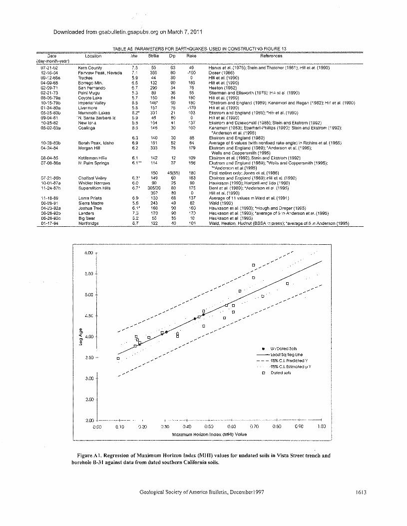
Downloaded from gsabulletin.gsapubs.org on March 7, 2011
TABLE AS, PARAMETERS FOR EARTHQUAKES USED IN CONSTRUCTING FIGURE 13
Date Location Mw Strike Dip Rake References(day-month-year)
07-21-52 Kern County 7.S 50 63 49 Hanks at at. (1975); Stein and Thatcher (1981): Hill er at. (1990)12-16-54 Fairview Peak. Nevada 7.1 350 60 -150 Doser (1986)09-12-66a Truckee 5.9 44 80 0 Hill at at (1990)04-09-68 Borrego MIn 6.5 132 90 180 Hill at el. (1990)02-09-71 San Fernando 6.7 290 54 76 Heaton (1982)02-21-73 Point Mugu 5.3 80 36 55 Stierman and Ellsworth (1976): Hill et at. (1990)08-06-79a Coyote Lake 5.7 150 84 180 Hill at at (1990)i0-15-79b Imperial Valley 6.5 146' 90 180 "Ekstrom and England (1989): Kanamori and Regan (1982): Hill et at. (1990)01-24-80a livermore 5.8 157 75 -170 Hill et at. (1990)OS-25-80b Mammoth Lakes 6.2' 331 21 103 Ekstrom and England (1989): 'Hill et at. (1990)09-04-81 N. Santa Barbara Is 5.9 45 80 0 Hill et et (1990)10-25-82 New Idria 5.5 154 41 137 Ekstrom and Dziewcnski (1985); Stein and Ekstrom (1992)05-02-83a Coalinga 6.5 145 30 100 Kanamori (1983): Eberhart-Phillips (1990): Stein and Ekstrom (1992);
'Anderson et ai. (1995)6.3 140 30 88 Ekstrom and England (1989)
10-28-83b Borah Peak, Idaho 6.9 151 52 64 Averaga of 6 values (with nonfixed rake angle) in Richins at at. (1985)04-24-84 Morgan Hill 6.2 333 76 179 Ekstrom and England (1989); 'Anderson et at (1995);
Wens and Coppersmith (1995)08-04-85 Kettleman Hills 6.1 142 12 109 Ekstrom et al. (1992): Stein and Ekstrom (1992)07-08-86a N. Palm Springs 6.1" 114 37 156 Ekstrom and England (1989): 'Wells and Coppersmith (1995):
"Anderson et a1.(1995)150 45(55) 180 First motion only; Jones et at. (1986)
07-21-86b Chalfant Valley 6,3' 149 60 163 Ekstrom and England (1989): Hill et al. (1990)10-01-87a Whittier Narrows 6.0 90 25 90 Hauxsson (1990); Hartzell and !ida (1990)11-24-87b Superstition Hills 6.7' 305/20 80 175 Bent et al. (1989): 'Anderson et al. (1995)
35? 80 0 Hill et at. (1990)11-18-89 lorna Prieta 6.9 130 68 137 Averaga of 11 values in Wald et at. (1991)06-28-91 Sierra Madre 5.6 243 49 82 Wald (1992)04-23-92a Joshua Tree 6,1' 160 90 160 Haoksscn et at (1993); "Hough and Dreger (1995)06-28-92b landers 7.3 170 90 170 Hauksson et at. (1993); 'average of 5 in Anderson et at. (1995)06-28-92c Big Bear 6.2 55 85 10 Heuksson et at. (1993)01-17-94 Northridge 6.7 122 40 101 Wald, Heaton, Hudnut (BSSA in press); 'average of 5 in Anderson (1995)
o.0
oo
< <<-< <
<
0 0o
0
--<-<<
e UnDoted Soils--least scReguoe- - - 95%C.I. Predicted Y
95% C.1. Estimated IJ Y
o Doted soils
3.50
0.70 0.80 0.900.<10 0,50 0.600.20 0.30
Maximum Horizon Index (MHI) Value
Figure A1. Regression of Maximum Horizon Index (MHO values for undated soils in Vista Street trench andborehole B-31 against data from dated southern California soils.
Geological Society of America Bulletin, December1997
1.00
1613
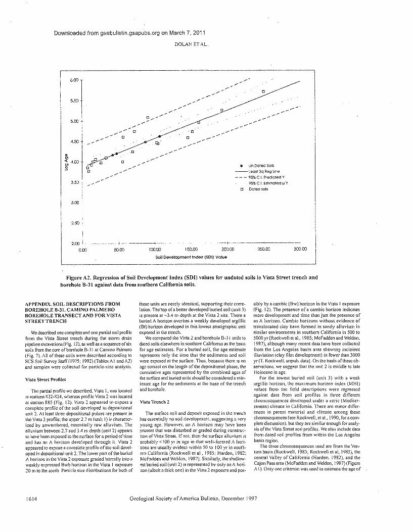
Downloaded from gsabulletin.gsapubs.org on March 7, 2011
DOLAN ET AL,
600
o
o
5.50
3DO
2.50
• Un Doted sons-- teost Sq Reg Une
- - - 95% C,L Predicted V
95% C,I, rsrmoreo u yo octerr soas
50.00Soil peverccroent Index (SDl) Value
-----1
300002.00
0.00 100.00 150.00-;
200.00 250.00
Figure A2. Regression of Soil Development Index (SDI) values for undated soils in Vista Street trench andborehole 8-31 against data from southern California soils.
AI>PENDlX. SOIL DESCRIPTIONS FROMBOREHOLE 8·31, CAMINO PALMEROBOllEHOLE TRANSECT AND FOR VISTASTREETTRENCH
We described one complete and one partial soil profilefrom the Vista Street trench during the storm drainpipeline excavations (Fig. !2), as well as a sequence of sixsoils from the core of borehole 8-31 at Camino Palmero(Fig. 7), All of these soils were described according [0
SCS Soil Survey Swff(1975; 1992) (Tables A I and A2)and samples were collected for particle-size analysis,
Vista Street Profiles
The partial profile we described, Vista I, was locatedar stations R22-R24, whereas profile Vista 2 was locatedat station Rg5 (Fig. 12). Vista 2 appeared to expose acomplete profile of the soli developed in depositionalunit 2. At least three depositional pulses are present inthe Vista 2 profile; the upper 2.7 rn (unit I) is character-ized by unweathered, essentially raw alluvium. Thealluvium between 2.7 and 3.4 III depth (unit Z) appearsto have been exposed to the surface for a period of timeand has an A horizon developed through it. Vista 2appeared to expose a complete profile of the soil devel-oped in depositional unn z.Tbe lower part of the buriedA horizon in the Vista 2 exposure graded laterally into aweakly expressed Bwb horizon in the Vista I exposure20 m to the south. Particle size distributions for both of
1614
these units are nearly identical, supporting their corre-lation. The'top ofa better developed buried soil (unit 3)is present at -3.4 III depth at the Vista 2 site. There aburied A horizon overlies a weakly developed argillic(Bt) horizon developed in this lowest stratigraphic unitexposed in the trench.
We compared the Vista 2 and borehole B-31 soils todated soils elsewhere in southern California as the basisfor age estimates. For a buried soil, the age estimaterepresents only the time that the sediments and soilwere exposed at the surface. Thus, because there is noage control on the length cf'the depositional phase, thecumulative ages represented by the combined ages ofthe surface and buried soils should be considered a min-imum age for the sediments at the base of the trenchand borehole.
Vista Trench 2
The surface soil and deposit exposed in the trenchhas essentially no soil development, suggesting a veryyoung age. However, an A horizon may have beenpresent that was disturbed or graded during construc-tion of Vista Street. Ifnot, then the surface alluvium isprobably <100 yr in age in tha! well-formed A hori-zons arc usually evident within 50 to 100 yr in south-ern California (Rockwell ct al., 1985; Harden, !982;Mcf-adden and Weldon, 1987), Similarly, the shallow-est buried soil (unil2) is represented by only an A hori-zon (albeit a thick one) in the Vista 2 exposure and pes-
Geological Society of America Bulletin, December! 997
sibly by a cambic (Bw) horizon in the Vista I exposure(Fig. 12). The presence of a cambic horizon indicatesmore development and time than just the presence ofan A horizon. Cambic horizons without evidence oftranslocated clay have formed in sandy alluvium insimilar environments in southern California in 500 to5000 yr(Rockwe!l er al., 1985; McFadden and Weldon,1987), although many recent data have been collectedfrom the Los Angeles basin area showing incipientilluviation (clay film development) in fewer than 3000yr(T. Rockwell, unpub. data). On the basis of these ob-servations, we suggest that the unit 2 is middle to lateHolocene in age.
For the lowes! buried soil (unit 3) with a weakargillic horizon, the maximum horizon index (MHI)values from the field descriptions were regressedagainst data from soil profiles in three differentchronosequences developed under a xeric (Mediter-ranean) climate in California. There are minor differ-ences in parent material and climate among thesechronosequences (see Rockwell, er al., !990, for a com-plete discussion), but they are similar enough for analy-sis of the Vista Street soil profiles. We also include datafrom dated soil profiles from within the Los Angelesbasin region.
The three chronosequences used are from the Ven-lura basin (Rockwell, 19R3; Rockwell et al, 1985), thecentral Valley of California (Harden, 1982), and theCajon Pass area (McFadden and Weldon, !987) (FigureA!). Only one criterion was used to estimate the age of
Downloaded from gsabulletin.gsapubs.org on March 7, 2011
SEISMOLOGY OF HOLLYWOOD FAULT, NORTHERN LOS ANGELES BASIN, CALIFORN!A
the Vista Street trench soils: the maximum horizon In-dex (MHI). as presented in Harden (!982), Ponti(1985). and Rockwell et al. (1994), Two other criteria,the profile mass accumulation of secondary clay, asdetermined by panicle-size analysis, and the soil devel-opment index (SOl) ofHardcn (1982), are usually alsoused, but only the top of the argillic horizon was ex-posed. so there arc too many assumptions thai wouldhave to be made to apply these techniques. The MH Iparameter converts field description data of the best-developed horizon (usually the Bt] to numerical valuesthat allow numerical comparison [0 the dated profiles.We assume that the exposed portion of the Bt horizonthat we described is representative of'nus unit's soil. Weunderstand that such an assumption, if incorrect, couldlead to wide significant errors in the age estimate of thesoil. We therefore do not use our age estimate of soil 3for any paleoearthqceke calculations.
The MHI data for the three chronosequences, alongwith the other Los Angeles basin profiles (not presentedhere; these will form the focus ofa future paper), definea log-linear trend with <I high r2 value (0.85; Fig. A I).Regression of the Vista 2 MHI value (0.31) indicates anexposure age of 12.6 ~2X·()/.~.7ka.
Borehole B·31
Borehole 6·31 penetrated a sequence of six soilsover a verticalthickness of 16.6 m. For these profiles.both Mill and SDI values were calculated and re-gressed against the same dated soils used for the VistaStreet trench (Figs. A I and A2; Tables A3 and A4).Similar to the MHI, the SDI converts the field descrip-tion data into numerical values but uses the entire soilprofile: they can also be compared to dated soils. Thesurface soil in 8-31 was not described in {he upper 5 ft(-1.5 m) due 10 lack of core recovery. Thus, cautionshould be used in interpreting the age estimates for thesurface soil.
The MH! and SO! values for the six 8·31 soils aresummarized in Table A 1. The minimum likely age forthe deepest sediments exposed in the core, calculatedby adding the best estimates for each of the surface andburied soils, is ca. 150000 (MH1) to 170000 (SD!). Asnoted above, the one charcoal fragment recoveredfrom 8-31 was recovered from theA horizon of soil 3,and was probably added 10 the soil profile during de-velopment of soil 3. Thus, the charcoal AMS age(19,765 ~4S51_36.s yr B.P.) probably provide" a maxi-mum age for the cumulative development of soils Iand 2. The similarity of this maximum age with the cu-mulative Ml-JI age estimates for soils I and 2 (-I B000yr) leads us to place more confidence in {he MHI esti-mates of soil ages in 8-3! than the SD! estimates.
REFERENCES CITED
Anderson, J., Wesncusky, S. G .• Stirling. M. W., Sleeman.M. P.. and Kumamoto. 1995. Regressions for magnitudeof earthquakes incorporating !:1UII~Iip rate as an indepen-dent parameter: University of Nevada. Reno. MackaySchool of Mines. Soisrnological Laboratory and Centerfor Neotectonic Studies Report 95-0i. Nevada. 33 p
Barbat. W. F.. )951;. The Los Angeles basin area. California. illWeeks, L. G .• cd .. Habitat of oil: Tulsa. Oklahoma. Amcr-ican Association of Petroleum Geologists. n. 620.77
Bent.A .. Heimberger, D. Y.. Stead. R. J .• and Ho-Liu, P.. 1%9,Waveform modeling of the November In7 SuperstitionHills earthquakes: Scismulogy Society of America But-lctm.v. 79, p. 500-514
Chapman. R. H .. and Chase. G. W.. 1979, Geophysical invcxti-gaucns Mthe Santa Monica-Raymond faui! zone. LosAngelo, County, Californin: California Division of'Mincsand Geology Open-File Report 79-16, p. E-I-E·30
Colson, K. B.. Rockwell. T. K.•Thorup. K. M., and Kennedy.G. L., 1995, Neotectonics of the left-lateral Santa RO~l1Island fault. western Transverse Ranges, southern Cali-fornia: Geological Society of America Abstracts withProgram" v. 27. no. 5, p. II.
Converse Consultants, Earth Sciences Associates. and GeolResource Consultants, 19::\I. Mctrokail geotechnical in-vcstignuon report: Los Angeles. Southern CaliforniaRapid Transit District. v.! and II. 42 p., 4 appendices
Coppersmith, K. J., 1991. Seismic source characterization forengineering seismic hazard analysis: Stanford, Califor-nia, Earthquake Engineering Research Instinnc. lntcma-tiona! Conference on Seismic Zonation Proceedings. 4th,v. l, p, 3-25.
Crook, R .• Proctor. R., and Lindval I, C. E .• 1983, Scisrnictty ofthe Santa Monica and Hollywood faults determined bytrenching: U.S, Geological Survey Final Technical Re-pen. Contract 14·01l-000 1-20523, 26 p.
Crook. R.• Jr., Allcn, C. R., Kamb, B .• Payne, C. M ..and Proctor,R. J .• 1987. Quaternary geology and seismic hazard of theSierra Madre and associated faults. western San GabrielMountains; U.S. Geological Survey Professional Paper1339.p.27-63.
Crook. R .. and Proctor, R., 1992. The Hollywood lind SantaMonica faults and the southern boundary of the Trans-verse Ranges province, in Pipkin, B., and Procter. R.,cds., Engineering geology practice in southern California:Belmont, California, Star Pubfislung, p. 233-246.
Davis. T. L.. Nemson, J .• and Yerkes. R. P.. 198'.1.A cross sec-tion of tho Los Angeles area: Seismically active fold andthrust bell. the 19117whinier Narrows earthquake. andearthquake hazard; Journal (If Geophysical Research.v. 94. p. 9644····9664.
Davis. T. L.. and Namson. J. S., 1994,A balanced cross sectionof the 1994 Northridge earthquake. southern California'Nature, v, 372. p. 167-169.
Dibblco. T. W., 1991 a. Geologic map ofthc Hollywood-Burbank{south hall) quadrangles: Santa Barbara. California, DibbleGeologic Foundation Map DF·30, scale 1:24 (}()O.
Dibblcc. T. W.. 1991b. Geologic map of the Beverly Hills nndVan Nuys (south half) quadrangles: Santa Barbara. Cali-fornia. Dibble Geologic Foundation Map DF.31, scutc1:24000.
Dolan, J. F., and Sich. K .. 1992, Tectonic geomorphology ofthe northern 1.0> Angeles basin: Seismic hazards andkinematics of young faull movement. In Ehhg.P, L., andSteiner, E. A .. cds., Engincenng geology field trips:Oraligc County. Santa Monica Mountains, and Malibu.Guidebook and Volume: Los Angelcs. California, Asso-ciation of Engineering Geologists, p. B2()....B2(l.
Dolan, J. F., Sieh. K., and Rockwell. T. K .. 1992. Palcoscis-mology and geomorphology of the northern Los AngelesBasin: Evidence for Holocene activity on the Santa Mon-ica fault und identification of new strike-slip faultsthrough downtown Los Angeles: Eos (Transaction, Amer-ican Geophysical Union). v. 73, p. Si\9.
Dolan. J. F., Sich. K .. Guptill. P.,Miller, G., Rockwell. T. K.andSmirnoff', T., 1993, Suuctural geology. fmllt kinematics,and preliminary palccscismclogic results from the Holly.wood fault: New data from continuously cored boringsnnd gectcchnicat trenches, Hollywood, California: Eos(Transaction. American Geophysical Linton], v. 74. p. 427.
Dolan. J. F.• Sich. K., Rockwell, T. K., Yeats. R. S., Shaw, J.,Suppc. L, Huftilc, G .. and Oath. E., 1995. Prospects forlarger or more frequent earthquakes in greater mcrropoli-tan Los Angeles, California: Science. 1'. 267. p. 199···205.
DDseT, D. I.. 1986, Earth processes in the Rainbow Moun-tain-Fairview Peak-Dixie Valley, Nevada. region1954-! 959: Journal of Geophysical Research, v. 91,p.12572-125H6
Drumm, P. L. 1992. Holocene displacement of the centralsplay of the Malibu Coast fault lone. Lange Canyon,Mabba, ill Pipkin. [3., and Proctor. R .. cds., Engineeringgeology practice III Southern California: Belmont. Cali-fornia, Star Publishing, p. 247-254
Department of Water end Power Report. 1991. Mcndiuu Tanksue preliminary geologic report: City of 1.0, AngelesDepartment of Water and Power Report AX 45()·'December 199!. 2 appendices, 3 plates. 8 p.
Earth Technology Report. 1993, hlVc~\igati()n~ of the Holly-wood fault: Segment .1, Metro Red Line: Prepared forEngineering Management Ccnsultunt. Long Beach, Cal-
Geological Society of America Bulletin, Dcccmbcr1997
itcmia, and Los Angeles Metropolitan Transit Authority,MetroRail Red Line Project. Los Angeles. California;Project 1192·2038, 4() p., 5 appendices.
Eberhart-Phillips. D .. 1990. Three-dimensional P and S vcioc-ity structure in the Coalinga region, California: Journal ofGeophysical Research, v. 94, p. 15565-155&6.
Ekstrom. G .. and Dzicwcnski, A. M .. 19115.Centroid-momenttensor solutions for 35 earthquakes in western NorthAmerica (1977··19!l3): Seismology Society or AmericaBulletin. v. 75. p. 23--29
Ekstrom, G.. and England, P.. 19119,Seismic strain rates in rc-gfons of distriburcd continental deformation: Journal ofGeophysical Research. v. 94. p. )0231--10257,
Ekstrom, G., Stein, R. S., and Eberhart-Phillips. D., 1992, Scis-mieity and geometry of ~ II O-km-long blind thrust fault.I. The )985 Kettleman Hius. California. earthquake:Journal of' Goophysical Research, 1'. 97, p. 4~43-4R64.
Ellsworth, W. L, )99(), Earthquake history, 1769-1989: U.S.Geological Survey Professional Paper 1515, p. 153-18~L
Hanks. T. C., Hileman. J. A., and Thatcher, W., 1975, Seismicmoments of the larger earthquakes of the southern Cali-fornia region: Geological Society of America BUlletin.v.l!6,p.1131-1139.
Harden. J. W., 19112,A quantitative index of soil developmentfrom field descriptions: Examples from e chrcncscqucnccin central California: Gcodcrma. 1', 28, p. 1-2::\.
Hartzell. S., lind llda. M .. 1990. Source complexity of the 19::\7Whinier narrows, California. earthquake from strongground motion records: Journal of Geophysical Research.v.9S,p.12475-12485.
Hauksson. E., 1990, Earthquake s. faulting. and SITe:;sin the LosAngeles basin: Journal of Gcophysicat Research. v. 95,p.15365-·15394.
Huuksscn, [\, Jones. L. M .. Hutton. K., and Eberhart-Phillips,D., 1993, The 1992 Landers earthquake sequence: Scls-mologicat observations: Journal of Geophysical Research,v. 9R, p. 19835-191l5R.
Heaton, T. H., 1982, The 1971 San Fernando earthquake: Adouble event": Seismological Society of America Bul-letin, v. 72. p. 2037·,,2062.
Henton, T. H .. Hull, 1. F.. Wald. D.J .• and Halling, M. '0/., 1995,Response ofhigh-rise and base-isolated buildings to ahypothetical M\\" 7.0 blind thrust earthquake: Science,v. 267, p. 20(r"'2) I.
Hill, R. L.. Sproao. E. C, Bcnncn.J. H. Real. C. R; and Slade,R. C .• 1979. Location and activity of the Santa Monicafault, Beverly Hills-Hollywood area, California, earth-quake hazards associated with fall Its in the greater LosAngeles metropolitan area. Los Angeles County. includ-ing faults in thc Santa Monica-Raymond. Verdugo-EagleRock, and Benedict Canyon fau!! zones. Callfcruiu Divi-sion of Mines and Geology Oren-File 79·16 LA.p, BI-B43
Hill. D. P.• Eaton. J. P.. and Jones, L. M., 1990. Seismicity,19IW-19t;6: U.S. Geologica! Survey Professional PapertSIS.p.! 15-151.
Hoots. H. W .. 1931. Geology of the eastern pan of the SantaMonica Mountains. LO$ Angeles COUnty: U.S. Geologi-cal Survey Professional Paper 16S-c' p. 83-134.
Hough. S., and Dreger, D .. 1995. Source parameters of the 23April 1992 M 6. t Joshua Tree. California, earthquake andus aftershocks: Empirical Green's function analysis ofCJEOS and TERRAseope data: Seismology Society ofAmerica Bulletin, v.ll5, p. 1576--1590.
Hummon, C: Schneider, C, Yeats. R., Dolan, J. F.. Sich. K.,and Huftile, G., 1994. The Wilshire fault: Earthquakes inHollywood": Geology. -e. 22. p. 291--294
Jones. L. M .. Huuon. l. K., Given, D. D., and Allen, C. R"19H6, The July 19116 North Palm Springs, California,earthquake: Seismology Society M America Bulletin.v. 76,p. 1l!30-IfD7.
Jones. L. M., Sicb. K. E.. Haukssou, E., and Hutton. L. K.,1990, ThcJ December 19RI; Pasadena earthquake: Evi-lienee for strike-slip motion nil the Raymond fault: Sen-molcgical Society of'Arncrica Bulletin. 1'. HO,p. 474·-4!l2.
Knnamon. 1-1.• 19H3, Mechanism of" the 19l!3 Coalinga earth-quakedetermined from long-period surface waves: Cali-fornia Division of Mines and Geology Special Publica-tion 66. p. 23'>··240
Lamar. D. L.. 1961. Structural evolution of the northern m<1rginof the Los Angeles basin [Ph.D. disscn.]: Los Angeles,Univcrsjry ofCuiifbmiu. 106 P
1615
Downloaded from gsabulletin.gsapubs.org on March 7, 2011
DOLAN ETAL
Lamar. D. L.. 1970. Geology of the Elysian Park-Repetto Hillsarea. Los Angeles County. California: California Divisionof Mines and Geology Special Report )01,45 p.
Lawson. A. Co. 1909. Tho California earthquake of April Ill,1906. Report of the state earthquake investigation com-mince: Washington, D.C. Carnegie Institution of Wash-ington Publication 117.v I, parts 1-2.451 p,
Liddicoat, J, C. 199::, Paleomagnetics crmc rico Formation,Santa Paula Creek. Ventura basin. California: Gcophysi-cal JOUnlU! lnrcrnatioual. v. 110, p. 267-,275
Liu. B., and Heaton, T.. 19l!4. Ray analysis of ground velocitiesand accelerations from the 1971 San Fernando, Califor-nia. earthquakes: Seismology Society of America But-letir.,v.74,p.I<)51-·]96K
McFnddcn. L. D.. and Weldon, n., Ill, ]<)};7, Rates andprecesses of soil development on Quaternary terraces inCajon Pas" Cnlifomia: Geological SOCiC1Yof AmericaBulletin. v. 9X, p. 2~W-29:1.
Olsen, K, 8., and Archuleta. R, J., 19%. Three-dimensionalsimulation of earthquakes 011the Los Angeles fault sy~-tern: Seismology Society of Amcnca Bulletin, v. X6.p,575-596.
Patterson. R. H .. 197R. Tectonic geomorphology and ncotcc-tonics of the Santa Cruz Island fault, Snnra BarbaraCounty. California [Master's thesis]: Santa Barbara. Uni-versity of Cali form a, 140 p.
Pinter. N .. and Scrticn. C .. 1991. Evidence for latesl Pleistoceneto Holocene movement on the Santa Cruz Island fault.California: Geology. v. 19. p. <)09-912.
Pinter. N,. Lucddcckc-Pmter, $" Keller. E, A., 1995. Short-termand long-term nctiviry on the Santa Cruz Island fault, Cal-ifornia; Geological Society of America Abstracts withPrograms. v, 27. no. 6, p. A'375-AH6.
Ponti. D. J.. 19B5, The Quaternary alluvial sequence oruc An-telope Valley, California: Geological Society of AmericaSpecial Paper 203, p. 79-96,
Richins, W. D., Smith. R. B .. Langer. C. J .. Zollwcg.J. C.. King.J. J" and Pcchmau. J, C" 19X5, The ]9R3 Borah Peak.Idaho, earthquake: Relationship of aftershocks to themain shock. sunacc faulting, :\I1dregionaltectonics: tf.S.Geological Survey Opcn-Ftlc Report R5·290. p. 2::;5"·310
Rockwell. T. K .. 191H. Soil chronology. geology. lind ncotcc-tonics of the north-central Ventura Basin, California[Ph.D. disscrt.]: Santa Barbara, University ofCalifomia.424 p.
Rockwell, T. K .. Johnson. D. L.. Keller. E. A .. and DcmbrolfG. R.. 19R5. A lute Pleistocene-Holocene $,')iI chronosequence in the central vconen Basin. southern California,USA. in Richards, K .. Arnone. R .. and Ellis, S., cds .. Gee-morphology and soils: London. George Allen and Unwin,p.309-327.
Rockwell. T. K .. Loughman. C .. and Mcrifield, p" 1990. LateQuaternary rate of slip along the San Jacinto tl1Ultzonencar Anza, southern California: Journal of GeophysicalRC~MCh. v. 95. p- B593-R605.
Rockwell, L Vaughan. R. Bickncr. F.. and Hanson, K. L ..1994. Correlation and ago:estimates of soils developed in
1616
marine terraces across the San Simeon fault zone. ccmralCalifornia. in Alterman. L B" McMullcn, R. B., Cluff,L S.. and Slcmmons. D. S., eds., Scismoiccronics of thecentral California Coast Ranges: Geologica! Society ofAmerica Special Paper 292. p. 151·· I 66,
Schneider. C. Huromon. C.; Yeats, R, S., lind Huftuc. G. J .•1996. Structural evolution ofthe northern Los Angelesbasin. California. based on growth strata: Tectonics, v. IS.p.341-355.
Scientists of USGSIS('EC, 1994. The magnitude (,.7 North-ridge. California, earthquake of 17 January 1994: Science,v, 266. p. 3B9"':197.
SCS $()il Survey Staff. 1975.S()illa~oll()my: Washington. D. C.,U.S, Department of Agriculture Handbook 436, 754 p.
Shaw, J, H" and Seppc. J., 1996. Earthquake hazards of activeblind thrust faults under the central Los Angelos Basin,California: Journal ofGeophysical Research. \I, 101.p. ::;(,2:1···1<642.
S1\),011. R. H" 19R5. Sioppiug of earthquake ruptures at dila-uonal faulljogs: Nature. v. 316,p. 24R,,·251
Stein, R. S .. and Thatcher, 'IV.. 19i{). Seismic lind aseismic de-Iormarion associated with the 1952 Kern County. Callfor-nia. earthquake and relationship (0 the Quaternary historyof the While Wolf fault: Journal of'Gconbysrcal Research.v, S6. p. 4913.-4921"
Stein, R. S., and Ekstrom. G., 1992. Seismicity and geometryof a llOckm-long blind thrust fault. 2. Synthesis of the19X2-19R5 California earthquake sequence: Journal ofGeophysical Research, v. 97. p. 4U)S.-4RB3,
Sucrman. D. J" and Ellsworth. W. L., 1976. Aftershocks ofthe February 21. 1973 Point Mugu, California earth-quake: Seismology Society of America Bulletin. v, 66,p.1931-1952. ,
Stuiver, M .• and Reimer. P.]" 1993. Extended 14Cdata base andrevises CAL!B 3.0 I~C age calibrarion program: Radio-carbon, v. 35, p. 215-230.
Toppozada. T.. 1981. preparation of isoscismat maps and sum-maries of reponed effects for pre·1900 California earth-quakes: Calltomla Division of Mines and Geology Open-File RcportRl-! 1, IR2p
Tnppozada. T. I9RR. Planlling scenario tor a major earthquakeOil the Newport-Inglewood fault zone: San Francisco.California Division of Mines and Geok}gy Special Publi-cation 99. !91 p.. 3 appendices.
Trciman. J. A .. 1994. The Malibu Coesr fault: San francisco,Califomin Division of Mines and G¢ology Faull Evalua-tion Report FER 229. 42 P
Tsutsumi. H" 1996. Evaluation of seismic hazards from theMedian Tectonic Line. Japan. and blind thrust faults in theLos Angeles metropolitan urea. Califomia [Ph.D. dis-scrt.]: Corvallis. Oregon Slate Univcrsny 129 p.
vcddcr.J .. G" Greene, H. G., Clarke. S. H. and Kennedy. M. P,19116.Geologic map ofmid-scuther-n California coon-ecnra! margin (Map 2A) ..in Greene, 1-1 .. and Kennedy, M"cdx.. California conuncmet margin geologic mup series(area 2 of7; map shoot ! of 4): U,S. Geological Surveyand Callfomia Division nf Mines and Geology. scale:
Geologica! Society of America Bulletin, December 1997
1:250000.Vidulc. J. E., and Heimberger. D. v.. 19R1l.Elastic finite-differ-
once modeling of the 1971 San Fernando. Calitornla,earthquake: Seismology Society of America Bulletin.v, 7B,p, 122-·141.
Wald, D. J., 1992, Strong motion and broadband teleseismicanalysis cftho 1991 Sierra Madre. California, earthquake-Journal of'Gcophysicel Research. v, 97, p. I 1033-·11046,
Wald. D. J .. Heaton. T.l-l.,and Heimberger, D. v.. 1991, Rup-turc model of the 191<9Lorna Prieta earthquake from theinversion or srrcog motion and broadband teleseismicdata: Seismological Society of America Bulletin. v. III ,p.1540-·1572-
Wald, D, 1.. Heaton. T. H .. and Hudnut. K. W .. 1996. The sliphistory cf'thc 1994 Northridge. California, earthquake de-tcrmiued From mong ground motion. teleseismic. GPS.and leveling data: Seismology Society of America Bul-letin. v.S6, p. S49··370.
Wallace, T. c., InR. The seismic source process of the 1952Kern County. California, earthquake: Seismological Rc-search Loners. 1'. 59, p. 20.
Weber. F. H .. Bennett. J. H .• ('hOPI11.111. R. H .. ct at .. Chase.G. W.• end SIlUl. R. B.. 19KQ,Earthquake hazards llSSO-
ciarcd with the Verdugo-Eagle Rock and BenedictCanyon fault zones. 1.0. Angeles County. California:California Division of Mine, and Geology Open FileReport KO-IOLA, 4 plates, 166 p.
wells. D. L. and Coppersmith, K. J., 1991. Analysis of tauh dipand sense of slip for historical earthquakes: Scismologi-ca! Research Letters. v. 62, p, 3R.
Wells. D .. and Coppersmith. K.. 1995. New empirical relation-ships among magnitude. rupture length, rupture width.rupture area, and surface displacement: Seismology Soci-ety of America Bulletin, v. 84, p, 974-1002,
Wcsnousky, S., 1986. Earthquakes. Quaternary faults. and seis-michezard in California: Journal of Geophysical Research,v,91,p.12587·-12631.
Working Group on California Earthquake Probabilities, 1995,Seismic hazards in sO\lIhe111California: Probable earth-quakes, 1994-·2024: Seismology Society of America Bul-letin. v. B5. p, 379-439
Wright, T, L" 1991, Structural geology and tectonic evolutionof the t.os Angeles Basin. in Biddle. K, T., cd .. Active-mnrgin basins: American Association of Porrolcum Gcol-ogists Memoir 52. p. 35···]06.
Yeats, R. S .• Sich. K., and Allen. C. R" 1997. Tho geology ofearthquakes: New York, Oxford University Press. 5(lR p.
Ziony, J.I .. and Jones. L. M.. 19R9. Map showing late Quater-nary f3\111, and 197X··B4 seismicity ortnc Los Angelesregion: U.S, Geological Survey Miscellaneous FieldStudies Map MF·1964. scale 1:250 (l(ll).
MANUSCR!l'T RECEIVED BY TJIf, SOCIETY M I,,.,. 9. 1996REVISED MANUSCRll'T RF.CEIVF-t) MAl' 21. 1997MANUSCRWTACCEPTEDJUNE 17. 1997SOlffllF.RN CALIFOaNIA E/IRTltQIiAKECENTER P\IIlLlCflTjON 266CIILlfORNlfI INSTITUTE Of TECIINOI.OUY Pt!llLiCATION 6210
Pwuco '" U.S./\
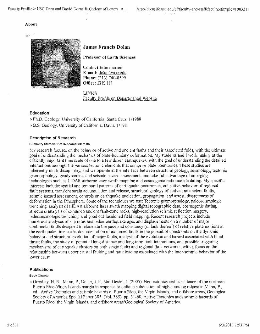
Faculty Profile> USC Dana and David Dornsife College of Letters, A... http://dornsife.usc.edu/cf!faculty-and-staff/faculty.cfin?pi d= I 003211
About
James Francis Dolan
Professor of Earth Sciences
Contact InformationE-mail: dolaI1@usG&duPhone: (213) 740-8599Office: ZHS 111
LINKSE'l£.I!ItyJ>J:2fiJ~g!lJ?fl'~!1I!l~llt~L.w<;J?~il~
Educationf Ph.D. Geology, University of California, Santa Cruz, 111988f B.S. Geology, University of California, Davis, 111981
Description of ResearchSummary Statement of Research Interests
My research focuses on the behavior of active and ancient faults and their associated folds, with the ultimategoal of understanding the mechanics of plate-boundary deformation. My students and I work mainly at thecritically important time scale of one to a few dozen earthquakes, with the goal of understanding the detailedinteractions amongst the various tectonic elements that comprise plate boundaries. These studies areinherently multi-disciplinary, and we operate at the interface between structural geology, seismology, tectonicgeomorphology, geodynamics, and seismic hazard assessment, and take fuJI advantage of emergingtechnologies such as LiDAR airborne laser swath mapping and cosmogenic radionuclide dating. My specificinterests include: spatial and temporal patterns of earthquake occurrence, collective behavior of regionalfault systems, transient strain accumulation and release, structural geology of active and ancient faults,seismic hazard assessment, controls on earthquake nucleation, propagation, and arrest, discreteness ofdeformation in the lithosphere. Some of the techniques we use: Tectonic geomorphology, paleoseismologictrenching, analysis of LiDAR airborne laser swath mapping digital topographic data, cosmogenic dating,structural analysis of exhumed ancient fault-zone rocks, high-resolution seismic reflection imagery,paleoseismologic trenching, and good old-fashioned field mapping. Recent research projects includenumerous analyses of slip rates and paleo-earthquake ages and displacements on a number of majorcontinental faults designed to elucidate the pace and constancy (or lack thereof) of relative plate motions atthe earthquake time scale, documentation of exhumed faults in the pursuit of constraints on the dynamicbehavior and structural evolution of major faults, analysis of the evolution and hazard associated with blindthrust faults, the study of potential long-distance and long-term fault interactions, and possible triggeringmechanisms of earthquake clusters on both single faults and regional fault networks, with a focus on therelationship between upper crustal faulting and fault loading associated with the inter-seismic behavior of thelower crust.
PublicationsBook Chapter
f Grindlay, N. R., Mann, P., Dolan, J. F., Van-Gestel, J. (2005). Neotectonics and subsidence of the northernPuerto Rico-Virgin Islands margin in response to oblique subduction of high-standing ridges: in Mann, P.,ed., Active Tectonics and seismic hazards of Puerto Rico, the Virgin Islands, and offshore areas, GeologicalSociety of America Special Paper 385. (Vol. 385). pp. 31-60. Active Tectonics ands seismic hazards ofPuerto Rico, the Virgin Islands, and offshore areas/Geological Society of America.
5 of II 613/2013 1:53 PM
Faculty Profile> USC Dana and David Dornsife College ofLetters, A. .. http://dornsife.usc.edu/cf/faculty-and-stafflfaculty.cfin?pid~ 1003211
f Dolan, J. F., Wald, D. (1998). The 1943-1953 north-central Caribbean earthquake sequence: Activetectonic setting, seismic hazards, and implications for Caribbean-North America plate motions: GSASpecial Paper 326 Active tectonics of the north-central Caribbean, (eds.) Dolan, J. F., and P. Mann. (Vol.326). pp. 143-169. Geological Society of America.
f Dolan, J. F., Mullins, H. T., Wald, D. (1998). Active tectonics of the north-central Caribbean: Obliquecollision, strain partitioning, and opposing subducted slabs: GSA Special Paper 326 Active tectonics of thenorth-central Caribbean, (eds.) Dolan, J. F., and P. Mann. (Vol. 326). pp. 1-61. Geological Society ofAmerica.
• Dolan, J. F., Mann, P., Monechi, S., de Zoeten, R., Heubeck, C., Shiroma, J. (1991). Sedimentologic,stratigraphic, and tectonic synthesis of Eocene-Miocene sedimentary basins, Hispaniola and Puerto Rico,in Mann, P, Draper, G., and Lewis, J., eds., Geologic and Tectonic Development of the North America-Caribbean Plate Boundary in Hispaniola. (Vol. Special Paper 262). pp, 217-264. Geological Society ofAmerica.
f Dolan, J. F., Beck, c., Ogawa, Y, Klaus, A. (1990). Eocene-Oligocene sedimentation in the TiburonRise/ODP Leg 110 area: An example of significant upslope now of distal turbidity currents: in Mascle, A.,and Moore, J. C, eds., Scientific Results of the Ocean Drilling Program, v. I lOB. (Vol. IlOB). pp. 47-83.Scientific Results of the Ocean Drilling Program.
• Beck, C., Ogawa, Y, Dolan, J. F. (1990). Eocene paleogeography of the southeastern Caribbean: Relationsbetween sedimentation on the Atlantic abyssal plain at Site 672 and evolution of the South Americanmargin, in Moore, J. c., and Mascle, A., eds., Scientific Results of the Ocean Drilling Program, v. IlOB.(Vol. IlOB). pp. 7-15. Scientific Results of the Ocean Drilling Program.
• Dolan, J. F. (1987). The relationship between the R2 seismic reflector and a zone of abundant detrital andauthigenic smectite, DSDP 610, Rockall Plateau region, north Atlantic: in Kidd, R., and Ruddiman, W.,eds., Initial Reports of the Deep Sea Drilling Project, v. 94: Washington, D. C. (U. S. Government PrintingOffice). (Vol. 94). pp. 1109-1115. Initial Reports of the Deep Sea Drilling Project (DSDP Leg 94).
Journal Article
, Madden Madugo, C., Dolan, 1. F., Hartleb, R. D. (2012). 2012, New paleoearthquake ages from thewestern Garlock fault: Implications for regional earthquake occurrence in southern California. Bulletin ofthe Seismological Society of America. Vol. 102, pp. 2282-2299.
• Ganev, P. H., Dolan, J. F., McGill, S. F., Frankel, K. L. (2012). 2012, Constancy of geologic slip rate alongthe central Garlock fault: Implications for strain accumulation and release in southern California.Geophysical Journal International.
• Roder, B., Lawson, M., Rhodes, E. J., Dolan, J. F., McAuliffe, L., McGill, S. (2012). 21012, Assessing thepotential of luminescence dating lor slip rate studies on the Garlock fault, Mojave Desert, California, USA.Quaternary Geochronology. Vol. 10, pp. 285-290.
f Frankel, K. L., Dolan, J. F., Owen, L. A., Ganev, P., Finkel, R. C. (2011). 2011, Spatial and temporalconstancy of seismic strain release along an evolving segment of the Pacific-North America plateboundary. Earth & Planetary Science Letters. Vol. 304, pp. 565-576.
• Kozaci, 6., Dolan, .I. E, Yon Ill, 6., Hartleb, R. D. (20 II). 20 II, Paleoseismologic evidence for therelatively regular recurrence of infrequent, large-magnitude earthquakes on the eastern North Anatolianfault at Yaylabeli, doi: I0.1130/L 118. I. Lithosphere.
• Owen, L. A., Frankel, K. L., Knott, J. R., Reynhout, S., Finkel, R. C., Dolan, J. E, Lee, J. (201 1).2011,Beryllium-I 0 terrestrial cosmogenic nuclide surface exposure dating of Quaternary landforms in DeathValley. Geomorphology. Vol. 125, pp. 541-557; doi: 10.1 016/j.geomorph.2010.1 0.024.
• Frost, E., Dolan, J. F., Ratschbacher, L., Hacker, B., Seward, G. (2011). 2011, Direct observation of faultzone structure at the brittle-ductile transition along the Salz.ach-Ennstal-Mariazell-Puchberg fault system,Austrian Alps. Journal of Geophyscial Research. Vol. 116, pp. B02411; doi: 10.1029/20 I OJB0077 I 9.
• Pratt, T. L., Dolan, J. F. (2010). 2010, Comment on "Near-surface location, geometry, and velocities of theSanta Monica fault zone, Los Angeles, California". Bulletin of the Seismological Society of America. Vol.100 (Sa), pp. 23292337; doi: 10.1785/0120090142.
6 of II 6/312013 1:53 PM
Faculty Profile> USC Dana and David Dornsife College of Letters, A... http://dornsife.usc.edulcf/faculty-and-staff/faculty.cfin?pid~ 1003211
• Ganev, P. N., Dolan, J. F., Blisniuk, K., Oskin, M., Owen, L. A. (20 I0). 2010, Paleoseismologic evidencefor multiple Holocene earthquakes on the Calico fault: Implications for earthquake clustering in the EasternCalifornia Shear Zone. Lithosphere. Vo1.2 (4), pp. 287-298, doi: 10. 1130/L82.1; Data Repository 20102.
• Ganev, P. N., Dolan, 1. E, Frankel, K. L., Finkel, R. C. (2010).2010, Rates of extension along the FishLake Valley fault and transtensional deformation in the Eastern California shear zone-Walker Lane belt.Lithosphere. Vo1.2, pp. 33-49; doi: 10.1130/L51.1; Data Repository 2009285.
• Leon, L. A., Dolan, J. F., Shaw, J. H., Pratt, T. L. (2009). 2009, Evidence for large-magnitude Holoceneearthquakes on the Compton blind thrust fault, Los Angeles, California. Journal of Geophyscial Research.pp. doi:l 0.1 029/2008JB006129.
• Frost, E., Dolan, J. F., Sammis, C. G., Ratschbacher, L., Hacker, B. R., Cole, J. (2009). 2009, Progressivestrain localization in a major strike-slip fault exhumed from mid-seismogenic depths: Structuralobservations from the Salzach-Ennstal-Mariazell-Puchberg fault system, Austria. Journal of GeophysicalResearch. Vo1. 114 (B04406), pp. doi: 10.1 029/2008JB005763.
• Elliott, A. J., Dolan, J. F., Oglesby, D. D. (2009). 2009, Evidence from coseismic slip gradients for dynamiccontrol on rupture propagation and arrest through stopovers: Jour. Geophys. Res. - Solid Earth. Journal ofGeophysical Research. Vo1. 114 (B023 13), pp. doi: 10.1 029/2008JB005969.
• Kozaci, 6., Dolan, J. F., Finkel, R. C. (2009). 2009, Late Holocene Slip Rate for the central NorthAnatolian Fault, from Tahtakorpru, Turkey, from Cosmogenic lOBe Geochronology: Implications for theConstancy of Fault Loading and Strain Release Rates. Journal of Geophysical Research. Vo1. 114, pp.doi: 10.1 029/2008JB005760.
• Plesch, A., Shaw, J. H., Benson, C., Bryant, W. A., Carena, S., Cooke, M., Dolan, J. F., 21 others, a.(2007). Community Fault Model (CFM) for Southern California. Bulletin of the Seismological Society ofAmerica. Vo1.97, pp. 1793-1802, doi: 10.1785/0122.
• Cole, J., Hacker, B. R., Ratschbacher, L., Dolan, J. F., Seward, G., Frost, E., Frank, W. (2007). Localizedductile shear below the seismogenic zone: Structural analysis of an exhumed strike-slip fault, AustrianAlps. Journal of Geophysical Research. Vo1. 112, pp. doi:l0.1029/2007JB004975.
~Kozaci, 0., Dolan, J. F., Finkel, R. C., Hartleb, R. D. (2007). A 2000-year slip rate for the North Anatolianfault, Turkey, from cosmogenic 36Cl geochronology: Implications for the constancy of fault loading andslip rates. Geology. Vo1. 35, pp. 867-870; doi: 1O.1130/G23187 A.1.
• Leon, L. A., Christofferson, S. A., Dolan, J. F., Shaw, 1. 1-1., Pratt, T. L. (2007). Earthquake-by-earthquakefold growth above the Puente Hills blind thrust fault, Los Angeles, California: Implications for foldkinematics and seismic hazard. Journal of Geophysical Research. Vol. 112 (B03S03), pp.doi: I0.1 029/2006JB004461.
• Dolan, J. F., Bowman, D. D., Sammis, C. G. (2007). Long-range and long-term fault interactions insouthern California. Geology. Vo1.35, pp. 855-858.
• Frankel, K. L., Dolan, J. F., Finkel, R. c., Owen, L. A., Hoeft, J. S. (2007). Spatial variations in slip ratealong the Death valley-Fish Lake Val1ey fault system determined from LiDAR topographic data andcosmogenic lOBe geochronology. Geophysical Research Letters. Vol. 34 (L 18303), pp.doi:l 0.1 029/2007GL030549.
• Frankel, K. L., Dolan, 1. F. (2007). Characterizing arid-region alluvial fans with airborne laser swathmapping digital topographic data. Journal of Geophysical Research - Earth Surface. pp.doi: 10.1 029/2006JF000644.
• Dolan, J. F., Avouac, J. (2007). Introduction to special section: Active Fault-Related Folding: StructuralEvolution, Geomorphologic Expression, Paleoseismology, and Seismic Hazards. Journal of GeophysicalResearch. Vo1. 112, pp. doi:1 O.1029/2007JB004952.
• Frankel, K. L., Brantley, K., Dolan, J. F., Finkel, R. C., others, s. (2007). Cosmogenic lOBe and 36Clgeochronology of offset alluvial fans along the northern Death Valley fault zone: Implications for transientstrain in the eastern California shear zone. Journal of Geophysical Research. pp.doi:l 0.1 029/2006JB004350.
• Hartleb, R. D., Dolan, J. F., Kozaci, 0., Akyuz, S., Seitz, G. (2006). A 2,500-year-long paleoseismologicrecord of large, infrequent earthquakes on the North Anatolian fault at Cukurcimen, Turkey. Bulletin ofGeological Society of America. Vol. 118, pp. 823-840.
7 of II 6/3/20131:53 PM
Faculty Profile> USC Dana and David Dornsife College of Letters, A.. http://dornsife.usc.edulcf/faculty-and-staff/faculty.cfin?pid~ 1003211
~Dolan, J. F., Bowman, D. D. (2004). Tectonic and seisrnologic setting of the September 22, 2003 PuertoPlata, Dominican Republic, earthquake: Implications for earthquake hazard in northern Hispaniola.Seismological Research Letters. Vol. 75, pp. 587-597.
~Hartleb, R. D., Dolan, J. F., Akyuz, S., Yerli, B. (2003). A 2,000 year record of earthquake occurrencealong the central North Anatolian fault, from trenches at Alayurt, Turkey. Bulletin of the SeismologicalSociety of America. Vol. 93 (5), pp. 1935- I954.
• Dolan, J. F., Christofferson, S. A., Shaw, J. H. (2003). Recognition of paleoearthquakes on the Puente Hillsblind thrust fault, Los Angeles, California. Science. Vol. 300, pp. 115- I18.
• Shaw, J. H., Plesch, A., Dolan, J. F., Pratt, T. L., Fiore, P. (2002). Puente Hills blind-thrust system, LosAngeles basin, California. Bulletin of the Seismological Society of America. Vol. 92, pp. 2946-2960.
• Dolan, J. F. (2002). Shallow folding imaged above the Puente Hills blind-thrust fault, Los Angeles,California. Geophysical Research Letters. Vol. 29, pp. 18-1 to 18-4, doi: 10. I 02912001 GL014313.
• Hartleb, R. D., Dolan, J. F., Akyuz, S., Dawson, T., Tucker, A. Z., Yerli, B., Rockwell, T. K., Toraman, E.,Cakir, Z., Dikbas, A., Altunel, E. (2002). Surface rupture and slip distribution along the Karadere segmentof the 17-August- 1999 Izmit, Turkey, earthquake. Bulletin of the Seismological Society of America. Vol.92, pp. 67-78.
• Harris, R. A., Dolan, J. F., Hartleb, R. D., Day, S. M. (2002). The 1999 Izmit, Turkey earthquake -- A testof the dynamic stress transfer model for intra-earthquake triggering. Bulletin of the Seismological Societyof America. Vol. 92, pp. 245-255.
• Barka, A., Akyuz, H. S., Altunel, E., Sunal, G., Cakir, Z., Dikbas, A., Yerli, B., Armijo, R., Meyer, B., deChabalier, J., Rockwell, T., Dolan, J., Hartleb, R., Dawson, T., Christofferson, S., Tucker, A., Fumal, T.,Langridge, R., Stenner, H" Lettis, W., Bachhuber, J., Page, W. (2002). Surface rupture and slip distributionof the 17 August 1999 Izmit earthquake (Mw 7.4), North Anatolian fault. Bulletin of the SeismologicalSociety of America. Vol. 92, pp. 43-60.
• Dolan, J. E, Rockwell, T. K (2001). Paleoseismologic evidence for a very large (Mw>7), recent surfacerupture on the eastern San Cayetano fault, Ventura County, California: Was this the source of the damagingDecember 2 I, 1812 earthquake? Bulletin of the Seismological Society of America. Vol. 9 I, pp, 14 I 7- I432.
~Tucker, A. Z., Dolan, J. F. (2001). Paleoseismologic evidence for a >8 ka age for the most recent surfacerupture on the eastern Sierra Madre fault, northern Los Angeles metropolitan region. Bulletin ofSeismological Society of America. Vol. 91, pp. 232-249.
~Borrero, J., Dolan, J. F., Synolakis, C. (2001). Tsunamis within the eastern Santa Barbara Channel.Geophysical Research Letters. Vol. 28, pp. 643-646.
~Weaver, K. D., Dolan, J. F. (2000). Paleoseismology and seismic hazards ofthe Raymond fault, LosAngeles County, California. Bulletin of the Seismological Society of America. Vol. 90, pp. 1409-1428.
• Dolan, J. F., Sieh, K. E., Rockwell, T. K. (2000). Late Quaternary activity and seismic potential of theSanta Monica fault system, Los Angeles, California. Geological Society of America Bulletin. Vol. 112, pp.1559-1581.
~Dolan, J. F, Stevens, D., Rockwell, T. K. (2000). Paleoseismologic evidence for an early to mid-Holoceneage of the most recent surface rupture on the Hollywood fault, Los Angeles, California. Bulletin of theSeismological Society of America. Vol. 90, pp, 334-344.
~van Gestel, J., Mann, P., Grindlay, N., Dolan, J. F. (1999). Three-phase tectonic evolution of the northernmargin of Puerto Rico as inferred from an integration of seismic reflection, well, and outcrop data. MarineGeology. Vol. 16 I, pp. 257-286.
• Field, E., Jackson, D., Dolan, J. F. (1999), A new look at earthquake occurrence in southern California: Nodeficit or huge earthquakes required. Bulletin of the Seismological Society of America. Vol. 89, pp.559-578.
• Mann, P., Grindlay, N. R., Dolan . .I. F. (1999). Subduction to strike-slip transitions on plate boundaries.GSA Today. Vol. 9, pp, 14- I 6.
• Pratt, T. L., Dolan, J. F., Odum, J. K., Stephenson, W. J., Williams, R. A., Templeton, M. E. (1998).Multi-scale seismic imaging of active fault zones for seismic hazard assessment: A case study of the SantaMonica fault zone, Los Angeles, California. Geophysics. Vol. 63, pp. 479-489.
8 of 1 1 613/2013 1:53 PM
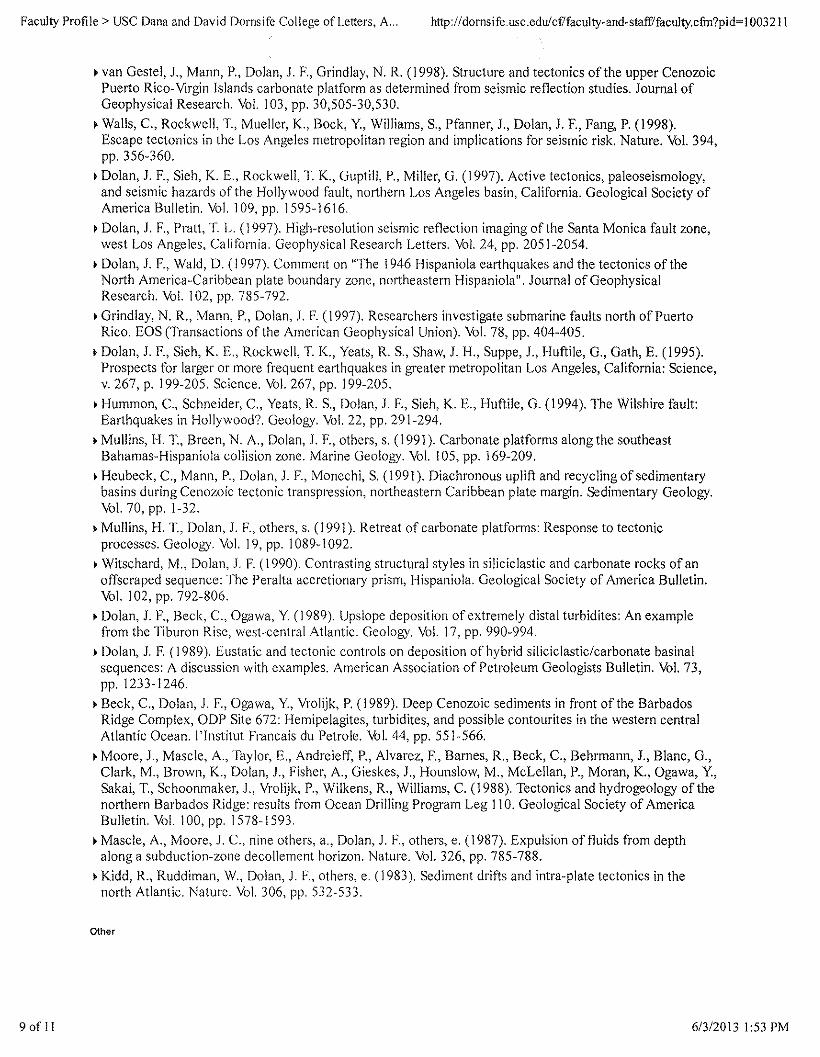
Faculty Profile> USC Dana and David Dornsife College of Letters, A... http://dornsife.usc.edulcf/faculty-and-staff/faculty.cfin?pid=1 003211
~van Gestel, J., Mann, P., Dolan, J. F., Grindlay, N. R. (1998). Structure and tectonics of the upper CenozoicPuerto Rico-Virgin Islands carbonate platform as determined from seismic reflection studies. Journal ofGeophysical Research. Vol. 103, pp. 30,505-30,530.
~Walls, C., Rockwell, 1'., Mueller, K., Bock, Y, Williams, S., Pfanner, 1., Dolan, J. F., Fang, P. (1998).Escape tectonics in the Los Angeles metropolitan region and implications for seismic risk. Nature. Vol. 394,pp. 356-360.
~Dolan, J. F., Sieh, K. E., Rockwell, T. K., Guptill, P., Miller, G. (1997). Active tectonics, paleoseismology,and seismic hazards of the Hollywood fault, northern Los Angeles basin, California. Geological Society ofAmerica Bulletin. Vol. 109, pp. 1595-1616.
~Dolan, J. r., Pratt, T. L. (1997). High-resolution seismic reflection imaging of the Santa Monica fault zone,west Los Angeles. California, Geophysical Research Letters. Vol. 24, pp. 2051-2054.
• Dolan, J. r., Wald, D. (1997). Comment on "The 1946 Hispaniola earthquakes and the tectonics of theNorth America-Caribbean plate boundary zone, northeastern Hispaniola". Journal of GeophysicalResearch. Vol. 102, pp. 785-792.
~Grindlay, N. R., Mann, P., Dolan, J. F. (1997). Researchers investigate submarine faults north of PuertoRico. EOS (Transactions of the American Geophysical Union). Vol. 78, pp. 404-405.
• Dolan, J. F., Sieh, K. E., Rockwell, 1'. K., Yeats, R. S., Shaw, 1. H., Suppe, 1., Huftile, G., Gath, E. (1995).Prospects for larger or more frequent earthquakes in greater metropolitan Los Angeles, California: Science,v. 267, p. 199-205. Science. Vol. 267, pp. 199-205.
• Humrnon, c., Schneider, C., Yeats, R. S., Dolan, J. F., Sieh, K. E., Huftile, G. (1994). The Wilshire fault:Earthquakes in Hollywood? Geology. Vol. 22, pp. 291-294.
• Mullins, H.l~, Breen, N. A., Dolan, J. F., others, s. (1991). Carbonate platforms along the southeastBahamas-Hispaniola collision zone. Marine Geology. Vol. 105, pp. 169-209.
• Heubeck, C., Mann, P., Dolan, J. r., Monechi, S. (1991). Diachronous uplift and recycling of sedimentarybasins during Cenozoic tectonic transpression, northeastern Caribbean plate margin. Sedimentary Geology.Vol. 70, pp. 1-32.
• Mullins, H. T., Dolan, J. F., others, s. (1991). Retreat of carbonate platforms: Response to tectonicprocesses. Geology. Vol. 19, pp. 1089-1092.
• Witschard, M., Dolan, J. F. (1990). Contrasting structural styles in siliciclastic and carbonate rocks of anoffscraped sequence: The Peralta accretionary prism, Hispaniola. Geological Society of America Bulletin.Vol. 102, pp. 792-806.
• Dolan, J. F., Beck, c., Ogawa, Y (1989). Upslope deposition of extremely distal turbidites: An examplefrom the Tiburon Rise, west-central Atlantic. Geology. Vol. 17, pp. 990-994.
• Dolan, J. F. (1989). Eustatic and tectonic controls on deposition of hybrid siliciclastic/carbonate basinalsequences: A discussion with examples. American Association of Petroleum Geologists Bulletin. Vol. 73,pp. 1233-1246.
~Beck, C., Dolan, J. F., Ogawa, Y, Vrolijk, P. (1989). Deep Cenozoic sediments in front of the BarbadosRidge Complex, ODP Site 672: Hernipelagites, turbidites, and possible contourites in the western centralAtlantic Ocean. I'lnstitut Francais du Petro Ie. Vol. 44, pp. 551-566.
• Moore, J., Mascie, A., Taylor, E., Andreieff, P., Alvarez, F., Barnes, R., Beck, C., Behrmann, 1., Blanc, G.,Clark, M., Brown, K., Dolan, J., Fisher, A., Gieskes, J., Hounslow, M., McLellan, P., Moran, K., Ogawa, Y.,Sakai, 1'., Schoonmaker, .I., Vrolijk, P., Wilkens, R., Williams, C. (1988). Tectonics and hydrogeology of thenorthern Barbados Ridge: results from Ocean Drilling Program Leg 110. Geological Society of AmericaBulletin. Vol. 100, pp. 1578-1593.
• Mascle, A., Moore, J. C., nine others, a., Dolan, J. F., others, e. (1987). Expulsion of fluids from depthalong a subduction-zone decollement horizon. Nature. Vol. 326, pp. 785-788.
• Kidd, R., Ruddiman, W., Dolan, J. F., others, e. (1983). Sediment drifts and intra-plate tectonics in thenorth Atlantic. Nature. Vol. 306, pp. 532-533.
Other
9 of II 61312013 1:53 PM
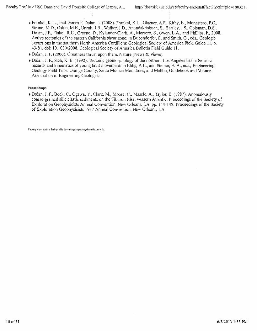
Faculty Profile> USC Dana and David Dornsife College of Letters, A .., http://dornsife.usc.edulcf/faculty-and-staff/faculty.cfm?pid~ I003211
o Frankel, K, L" incl. James F. Dolan, a, (2008), Frankel, K.L., Glazner, A.F., Kirby, E., Monastero, F,C"Strane, M.D" Oskin, M.E., Unruh, J.R., Walker, J.D" Anandakrishnan, S" Bartley, J,S" Coleman, D,S"Dolan, J.F., Finkel, R.C., Greene, D., Kylander-Clark, A., Morrero, S., Owen, LA, and Phillips, F., 2008,Active tectonics of the eastern California shear zone: in Dubendorfer, E. and Smith, G., eds., Geologicexcursions in the southern North America Cordillera: Geological Society of America Field Guide 11, p.43-81, doi: 10.1030/2008. Geological Society of America Bulletin Field Guide 11.
o Dolan, 1. F. (2006). Greatness thrust upon them. Nature (News & Views) .• Dolan, 1. F., Sieh, K. E. (1992). Tectonic geomorphology of the northern Los Angeles basin: Seismic
hazards and kinematics of young fault movement: in Ehlig, P. L., and Steiner, E. A., eds., EngineeringGeology Field Trips: Orange County, Santa Monica Mountains, and Malibu, Guidebook and Volume.Association of Engineering Geologists.
Proceedings
o Dolan, 1. F., Beck, c., Ogawa, Y, Clark, M., Moore, c., Mascle, A., Taylor, E. (1987). Anomalouslycoarse-grained siliciclastic sediments on the Tiburon Rise, western Atlantic: Proceedings of the Society ofExploration Geophysicists Annual Convention, New Orleans, LA. pp, 144-148. Proceedings of the Societyof Exploration Geophysicists 1987 Annual Convention, New Orleans, LA.
Faculty may update their profile by visiting lillp.~/fm.x9,\!ru!!,i.f~.,Jl'i~,&(!!'!.
10 of II 6/3/20131:53 PM

EXHIBIT C
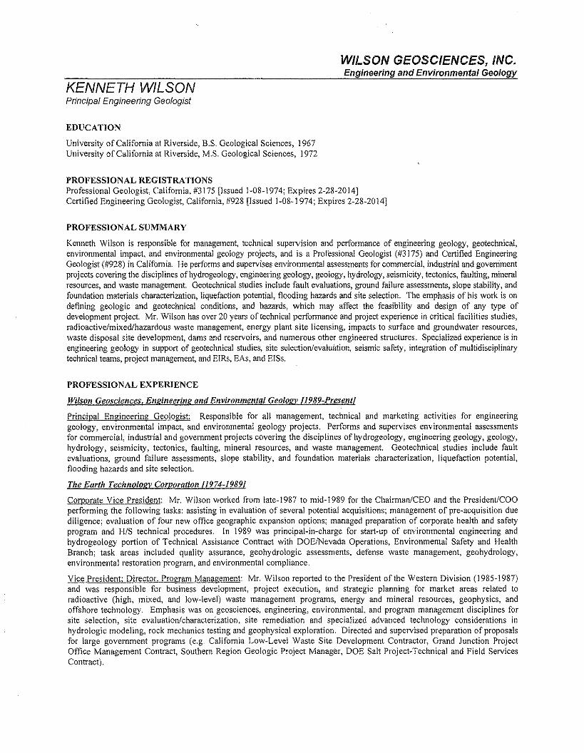
WILSON GEOSCIENCES, INC.Engineering and Environmental Geology
KENNETH WILSONPrincipal Engineering Geologist
EDUCATION
University of California at Riverside, B.S. Geological Sciences, 1967University of California at Riverside, M.S. Geological Sciences, 1972
PROFESSIONAL REGISTRATIONSProfessional Geologist, California, #3175 [Issued 1-08-1974; Expires 2-28-2014]Certified Engineering Geologist, California, #928 [Issued 1-08-1974; Expires 2-28-2014]
PROFESSIONAL SUMMARY
Kenneth Wilson is responsible for management, technical supervision and performance of engineering geology, geotechnical,environmental impact, and environmental geology projects, ard is a Professional Geologist (#3175) and Certified EngineeringGeologist (#928) in California. He performs and supervises environmental assessments for commercial, industrial and governmentprojects covering the diseiplines of hydrogeology, engineering geology, geology, hydrology, seismicity, tectonics, faulting, mineralresources, and waste management. Geotechnical studies include fault evaluations, ground failure assessments, slope stability, andfoundation materials characterization, liquefaction potential, flooding hazards ard site selection. The emphasis of his work is ondefining geologic and geotechnical conditions, and hazards, which may affect the feasibility and design of ary type ofdevelopment project. Mr. Wilson has over 20 years of technical performance and project experience in critical facilities studies,radioactive/mixed/hazardous waste management, energy plant site licensing, impacts to surface and groundwater resources,waste disposal site development, dams and reservoirs, and numerous other engineered structures, Specialized experience is inengineering geology in support of geotechnical studies, site selection/evaluation, seismic safety, integration of multidisciplinarytechnical teams, project maragement, and EIRs, EAs, ard EISs.
PROFESSIONAL EXPERIENCE
Wilson Geosciences. Engineering and Environmental Geology 11989-Present!
Principal Engineering Geologist: Responsible for all management, technical and marketing activities for engineeringgeology, environmental impact, and environmental geology projects, Performs and supervises environmental assessmentsfor commercial, industrial and government projects covering the disciplines ofhydrogeoiogy, engineering geology, geology,hydrology, seismicity, tectonics, faulting, mineral resources, and waste management. Geotechnical studies include faultevaluations, ground failure assessments, slope stability, and foundation materials characterization, liquefaction potential,flooding hazards and site selection.
The Earth Technology Corporation [1974-19891
Corporate Vice President: Mr. Wilson worked from late-1987 to mid-1989 for the Chairman/CEO and the PresidenVCOOperforming the following tasks: assisting in evaluation of several potential acquisitions; management of pre-acquisition duediligence; evaluation of four new office geographic expansion options; managed preparation of corporate health and safetyprogram and HIS technical procedures. In 1989 was principal-in-charge for start-up of environmental engineering andhydrogeology portion of Technical Assistance Contract with DOElNevada Operations, Environmental Safety and HealthBranch; task areas included quality assurance, geohydrologic assessments, defense waste management, geohydrology,environmental restoration program, and environmental compliance.
Vice President; Director, Program Management: Mr. Wilson reported to the President of the Western Division (1985-1987)and was responsible for business development, project execution, and strategic planning for market areas related toradioactive (high, mixed, and low-level) waste management programs, energy and mineral resources, geophysics, andoffshore technology, Emphasis was on geosciences, engineering, environmental, and program management disciplines forsite selection, site evaluation/characterization, site remediation and specialized advanced technology considerations inhydrologic modeling, rock mechanics testing and geophysical exploration. Directed and supervised preparation of proposalsfor large government programs (e.g. California Low-Level Waste Site Development Contractor, Grand Junction ProjectOffice Management Contract, Southern Region Geologic Project Manager, DOE Salt Project-Technical and Field ServicesContract).
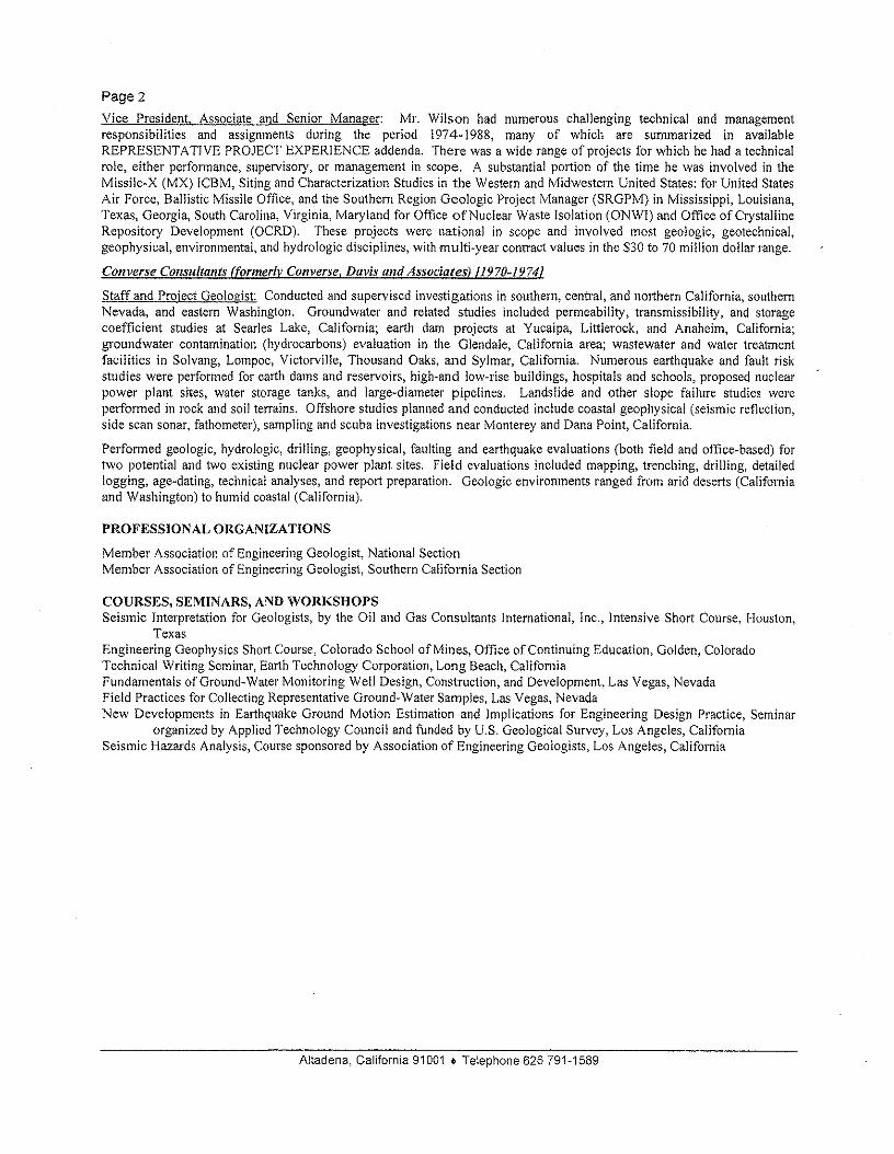
Page 2Vice President. Associate and Senior Manager: Mr. Wilson had numerous challenging technical and managementresponsibilities and assignments during the period 1974-1988, many of which are summarized in availableREPRESENTATIVE PROJECT EXPERIENCE addenda. There was a wide range of projects for which he had a technicalrole, either performance, supervisory, or management in scope, A substantial portion of the time he was involved in theMissile-X (MX) ICBM, Siting and Characterization Studies in the Western and Midwestern United States: for United StatesAir Force, Ballistic Missile Office, and the Southern Region Geologic Project Manager (SRGPM) in Mississippi, Louisiana,Texas, Georgia, South Carolina, Virginia, Maryland for Office afNuclear Waste Isolation (ONWI) and Office of CrystallineRepository Development (OCRD). These projects were national in scope and involved most geologic, geotechnical,geophysical, environmental, and hydrologic disciplines, with multi-year contract values in the $30 to 70 million dollar range.
Converse Consultants (formerly Converse, Davis and Associates) 11970-19741
Staff and Project Geologist: Conducted and supervised investigations in southern, central) and northern California, southernNevada, and eastern Washington. Groundwater and related studies included permeability, transmissibility, and storagecoefficient studies at Searles Lake, California; earth dam projects at Yucaipa, Littlerock, and Anaheim, California;groundwater contamination (hydrocarbons) evaluation in the Glendale, California area; wastewater and water treatmentfacilities in Solvang, Lompoc, Victorville, Thousand Oaks, and Sylmar, California. Numerous earthquake and fault riskstudies were performed for earth dams and reservoirs, high-and low-rise buildings, hospitals and schools, proposed nuclearpower plant sites, water storage tanks, and large-diameter pipelines. Landslide and other slope failure studies wereperformed in rock and soil terrains. Offshore studies planned and conducted include coastal geophysical (seismic reflection,side scan sonar, fathometer), sampling and scuba investigations near Monterey and Dana Point, California.
Performed geologic, hydrologic, drilling, geophysical, faulting and earthquake evaluations (both field and office-based) fortwo potential and two existing nuclear power plant sites. Field evaluations included mapping, trenching, drilling, detailedlogging, age-dating, technical analyses, and report preparation. Geologic environments ranged from arid deserts (Californiaand Washington) to humid coastal (California).
PROFESSIONAL ORGANIZA TlONS
Member Association of Engineering Geologist, National SectionMember Association of Engineering Geologist, Southern California Section
COURSES, SEMINARS, AND WORKSHOPSSeismic Interpretation for Geologists, by the Oil and Gas Consultants International, Inc., Intensive Short Course, Houston,
TexasEngineering Geophysics Short Course, Colorado School of Mines, Office of Continuing Education, Golden, ColoradoTechnical Writing Seminar, Earth Technology Corporation, Long Beach, CaliforniaFundamentals of Ground-Water Monitoring Well Design, Construction, and Development, Las Vegas, NevadaField Practices for Collecting Representative Ground-Water Samples, Las Vegas, NevadaNew Developments in Earthquake Ground Motion Estimation and Implications for Engineering Design Practice, Seminar
organized by Applied Technology Council and funded by U.S. Geological Survey, Los Angeles, CaliforniaSeismic Hazards Analysis, Course sponsored by Association of Engineering Geologists, Los Angeles, California
Altadena, California 91001 • Telephone 626 791-1589

EXHIBITD
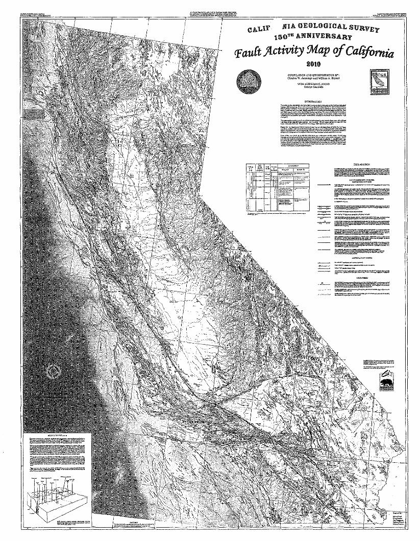
CALIF MIA GEOLOGICAL SURV!':l'150T8 ANNIVERSARY
PauCt ;4.ctivity ~ap of Caf!fornia2011)
COMPIU.TIO~ MiD IIlTERPRSTAtIOl< BY,ChN'l .. W. JotIni.&. "od W;Uiom A. SO)'Mt
WI"'" A~~I~1'ANC£'·RO'I'(\"",.".5.u,<'IIo
=~"r."'..r.~-:'~=-",:"_'~"",,,_"_N'__ ~'_
~~;~f~:;;;~~"".---"""-----"'.. - ~s.~.:r.:r~,:."='#.::.."=!':--" .................. "";.~.;;.".:::;~;-:;,r;!:'.::z:-..=-~ ~S:=-=~::;:;:;:.;':l==
ii-~~~sJ:~*=;s;.~~-l$;.-=...~::=:::::,':~,.a~·::-':afa~e~!-r-~~T:::...=1t'b-~-- -.-- ~---.-,-fi:-:=..~~=>E'=~:.=.=...~........._ •..n_ _
=.::::.:~.:".;..~_.".M N.....
An Explanatory Text to Accompany theFault Activity Map of California
Scale 1:750,000
1_:, I, ii . ..p.i~ i-'-'-'- .
CALlFQRN1ACONSERVATION
ARNOLD SCHWARZENEGGER. Governor LESTER A. SNOW, Secretary BRIDGETI LUTHER. Director JOHN G. PARRISH, Ph.D., State GtlologistSTATE OF CALIFORNIA THE NATURAL. RESOURCES AGENCY DEPARTMENT OF CONSERVAnON CALIFORNIA GEOLOGICAL SURVEY
CALIFORNIA GEOLOGICAL SURVEY
JOHN G. PARRISH, Ph.D.STATE GEOLOGIST
Copyright © 2010 by the California Department of Conservation,California Geological Survey.
All rights reserved. No part of this publication rna/be reproducedwithout written consent of the California Geological Survey.The Department of Conservation makes no warranties as to thesuitability of this product for any given purpose.
An Explanatory Text to Accompany theFault Activity Map of California
Scale 1:750,000
Compilation and Interpretation byCHARLES W. JENNINGS and WILLIAM A. BRYANT
Oigilal Prepa ration byMilind Patel, Ellen Sander, Jim Thompson, Barbra Wanish, and Millon Fonseca
2010
•'. .! ,
:. :YjvlY ;- ,CALIFORNIA
CONSERVATION
Suggested citation:Jennings, CW., and Bryant, WA, 2010, Fault activity map of California: California Geological Survey Geologic
Data Map No.6, map scale 1:750,000.
ARNOLD SCHVVARZENEGGER, ccverncr LESTER A, SNOW. Secretary BRIDGETT LUTHER, Director JOHN G. PARRISH. Ph.D" Sloto.GeolOgistSTATE OF CALIFORNIA rae NATIJRAL RESOURCES AGENCY DEPARTMENT OF CONSERVA110N CALIFORNIA GEOLOGICAL SURVEY
An Explanatory Text to Accompany theFault Activity Map of California
INTRODUCTION
The 2010 edition of the FAULT ACTIVTY MAPOF CALIFORNIA was prepared in recognition of the150lh Anniversary of the California GeologicalSurvey (CGS). It replaces the FAULT ACTIVITYMAP OF CALIFORNIA AND ADJACENT AREAS(Jennings, 1994) and is more complete with theaddition of recent data. The map shows thelocations of known faults that can be portrayed at1:750,000 scale and indicates the latest age whendisplacements took place, according to availabledata. The displacements may have been associatedwith earthquakes or may have been the result ofgradual creep along the fault surface. Faultsexhibiting creep or triggered creep are identified onthe map with appropriate symbols. The faults arecolor-coded and designated into one of fivecategories: historic (red), Holocene (orange), lateQuaternary (green), undivided Quaternary (purple),and pre-Quaternary (black).
Fault names are indicated on the map wherespace permits, including newly named faults.Some of the faults on the 1994 map were deletedor revised to reflect new, more detailed studies.The ages of faults on the 1994 map have beenrevised where improved dating methods wereavailable. Lastly, occurrences of surface faultingcaused by earthquakes since 1994 have beenadded.
In order to effectively catalog the infonmation,the faults have generally retained the referencenumbers originally assigned in 1994. Thesenumbers are referenced in Appendix A andAppendix B accompanying this map and report.Each entry in these appendices includes: the nameof the fault, its most recent age of activity, and thesources for fault location and recency. If the faulthas been encompassed in an Official EarthquakeFault Zone, the 7.5 minute quadrangle mapsprepared and issued by CGS are listed.
The 1994 version of the Fault Activity Map ofCalifornia showed selected faults that exhibitedQuaternary displacement in Oregon, Nevada, andBaja California. We decided to limit the data towithin California's boundaries for the 2010 version ofthe Fault Activity Map. Consult the National
.Quaternary Fault and Fold Database for fault trace
data for states adjacent to California(http://earthquake.usgs.gov/hazards/qfaults/). Thealigned seismicity and locations of Quaternaryvolcanoes are not shown on the 2010 Fault ActivityMap. However, the location of Quaternaryvolcanoes can be found on the 2010 version of theGeologic Map of California (Jennings and others,2010).
Digital CompilationA significant difference from the 1994 version of
the Fault Activity Map of California is the method offault compilation. Almost all of the Quaternary faultsshown in the 2010 version of the Fault Activity Maphave been digitally compiled from original-scalesource maps (1:12,000 to 1:250,000) used for the1975 and 1994 maps, as well as more recentmapping when available. This compilation method.insures that locations of these faults are moreaccurate than those depicted on previous editions ofthe Fault Activity Map. Also, the line width for faultsdepicted on the 2010 Fault Activity Map has beenreduced from 0.35 mm to 0.2 mm (260 m to 150 mwidth at a scale of 1:750,000). This was done inorder to more accurately portray the location andcomplexity of faults showing evidence ofdisplacement during Quaternary time. The Pre-Quaternary faults remain the same as in the 1994version,
Base MaterialsThe base map for the new Fault Activity Map of
California consists of a shaded relief image and acombination of cultural, political, transportation,geographic, and hydrologic features. The onshoreshaded relief image was derived from 90-meterDigital Elevation Models (DEM) available from theNational Elevation Data Set (http://ned.usgs.gov).The offshore bathymetric shaded relief image wasderived from DEMs available from the CaliforniaDepartment of Fish and Game(http://dfg .ca.govIbiogeodata/gis/mr _ bathy. asp). Thecultural, political, transportation, geographic andhydrologic features depicted in the base map werelargely derived from data obtained from the Cal-Atlas Geospatial Clearinghouse (http://atlas.ca.gov) .
1
Select geographic features throughout the state andin the offshore region were digitized from USGS1:500,000-scale topographic maps and include aselection of peaks in the Sierra Nevada named afterhistoric survey members. Projection of the base maplayers is Teale Albers, 1983 North American Datum.
FAULTSIntroduction
The Fault Activity Map of California showswhere faults have been recognized and mapped.Many of the faults are assigned numbers and arekeyed to descriptions in Appendix A and AppendixB. In addition, Table 1 describes surface faultrupture associated with earthquakes that are knownto have occurred in California. If a Quaternary faulthas no number, it was taken from the initial FaullMap of California (Jennings, 1975). Refer to Bulletin201 (Jennings, 1985) for the source on which thefault and its age were based.
As with the 1994 Fault Map of California, aconservative approach was followed for this newedition - we felt it is better to show those faultswhere evidence is questionable rather than to ignorethem. Hence, some questionable faults may havebeen included as long as they are based on somereasonable data. Omission of such infomnation maylead decision-makers for building critical structuresto assume no fault hazard exists. The prudentcourse should be to include questionable data tosuggest where future investigations are neededbefore any final design and construction takes place.
Although it is not possible to tell if a fault will bereactivated, we assume that if a fault has beenactive for millions of years and has been active inhistoric or recent geologic (Quaternary) time, it isvery likely to become active again. This assumptionis borne out by studies of historically active faults inCalifornia and elsewhere.
Fault Activity Definitions
The temns "active," "potentially active,""capable," and "Inactive," have been interpreteddifferently by geologists, seismologists, andaqencies, depending on the purpose on hand. Toavoid confusion, this Fault Activity Map does not usethese terms. Instead, faults are classified accordingto the age of latest displacement and, hence, are asfactual as the geologic data upon which the fault isbased. This procedure continues the practice usedfor the 1994 Fault Activity Map of California.Because a common understanding of terms .isessential, the following excerpts from BULLETIN201, An Explanatory Text to Accompany the
1:750,000 Scale Faull and Geologic Maps ofCalifornia (Jennings, 1985) are restated here.
"In defining the term "fault," geologists haveno significant disagreement; the variousdefinitions differ only in the elaboration. Allagree in defining a fault as a tectonic fracture orbreak in the earth's crust along whichdisplacement (horizontal, vertical, or diagonalmovement) has taken place, In elaborating,some definitions further specify: (I) that thefracture or break may be either a discrete surfaceor a wide zone of fractures; (2) that the fault maybe a result of repeated displacements which tookplace suddenly or very slowly as a result of creepslippage; and (3) that the cumulativedisplacement may be measurable frommillimeters to kilometers.
All definitions of "active faults" in commonuse imply future movement commonlyconstituting a geologic hazard. In recent years,specialized definitions vary according to the typeof structure to be built in the vicinity of a faultand the degree of risk acceptable for a particulartype of structure. The most conservativedefinition is that of the U.S. Nuclear RegulatoryCommission (NRC). In defining fault activityfor its special uses, the NRC sought to avoid themisunderstanding that might arise from its use ofthe term "active" by using the term "capable" inits place. A "capable fault" is defined as a faultthat exhibits one or more of the followingcharacteristics:(1) movement at or near the ground surface atleast once within the past 35,000 years, ormovement of a recurring nature within the past500,000 years; (2) macro seismicityinstrumentally determined with records ofsufficient precision to demonstrate a directrelationship with the fault; (3) a structuralrelation to a fault deemed "capable" such thatmovement on one can be reasonably expected tobe accompanied by movement on the other.
in California, speciaJ definitions for activefaults were devised to implement the Alquist-Priolo Earthquake Fault Zon ing Act of I 972,which regulates development and construction inorder to avoid the hazard of surface fault rupture,The State Mining and Geology Board establishedPolicies and Criteria in accordance with the Act.They defined an "active fault" as one which has"had surface displacement within Holocene time(about the last 11,000 years). A "potentiallyactive fault" was considered to be any fault that"showed evidence of surface displacement .during Quaternary time (last 1.6 million years).Because of the large number of potentially active
2
Table 1. Known surface fault rupture associated with earthquakes in California.
Surface MaximumVear Fault (location) Magnitude'
Rupture Displacement References3Length and Type of Slip'
(kilometers) ( centimeters)
1812 San Andreas (Wrightwood) 7± 25+ No data Jacoby and others, 1988
1838 San Andreas (San 'I 60+ No data Louderback, 1947Francisco-Mission Santa Toppozada and Borchardt, 1998Clara?) Bakun, 1999
1857 San Andreas 7.9 322± RL 950 Wood, 1955(Parkfield-Fort Tejon to Bonilla, 1970Wrightwood) Agnew and Sieh, 1978
Sieh, 1978b
1861 Calaveras (Dublin) 5.3 13± No data Radbruch, 1968 (p. 52·53)Toppozada and others, 1981 (p. 148)
1868 Hayward (Oakland to Warm 6.8 48± RL 90 Lawson and others, 1908Springs) V 30 Bonilla, 1970
Toppozada and others, 1981 (p, 152)
1868 San Andreas (Dos Palmos) No data "long fissure" No data Townley and Allen, 1939 (p, 500
1872 Owens Valley' (Big Pine to 7.8<1 100+ RL 600 Hobbs, 1910Olancha) Some LL Knopf, 1918
V 700 Bonilla, 1970Beanland and Clark, 1994
1875 Surfaoe rupture previously 6.0? No data No data Bonilla, 1970reported at Clio' Toppozada and others, 1981 (p, 156)
1890 San Andreas (Chittenden) 6.3 8± 30? Holden, 1898 (p. 150)Lateral Lawson and others, 1908 (p. 110)
Toppozada and others, 1981 (p, 162)
1892 Unarned" 6.4 1.6 No data(Allendale, Sacramento Toppozada and others, 1981 (p. 164)Valley)
1899 San Jacinto { 6.6 327 No data Danes, 1907Bonilla, 1970Toppozada and others, 1981 (p. 169)
1901 San Andreas (Parkfield) 6+ "several miles" V 30 Lawson and others, 1908 (pAO)Townley and Allen, 1939Brown and others, 1967 (p, 10)
1906 San Andreas 7.8 432 RL600Lawson and others, 1908
(Shelter Cove to San Juan V 90Bonilla, 1970
Bautista)
1916 San Andreas" (Gorman 6± No data o data Branner, 1917area) Bonilla, 1959 (p. 134)
1922 San Andreas (Cholarne 6.5 OA7 No data Townley and Allen, 1939area) Richter, 1958 (p, 533)
1934 San Andreas (Parkfield 6.3 3 No data Byerly and Wilson, 1935 (p, 233)area) Richter, 1958 (p. 534)
1940 Imperial (Calit-Mex.) 6.9 64+ RL 580 IUlrich, 1941V 120 Bonilla, 1970
Hileman and others, 1973
1947 Manix (Mojave Desert) 6.2 1.6 LL 7.6 Richter, 1958Bonilla, 1970Hileman and others, 1973
1950 Fort Sage (Honey Lake 5.6 8.9 V 20 Gianella, 1957Valley) Bonilla, 1970
1951 Superstition Hills 5.6 32± RL slight Allen and others, 1965Bonilla, 1970
3
Table 1- continued
Surface Maximum
Year Fault (location) Magnitude' Rupture Displacement References3
Length and Type of Slip'(kilometers) (centimeters)
1952 White Wolf (Arvin- 7.4 57 LL 76 Buwalda and St. Amand, 1955Tehachapi) and V 122 Bonilla, 1970
6.4 Hileman and others, 19731966 Imperial 3.6 9.7 RL.1.5 Brune and Allen, 1967b
Bonilla, 19701966 San Andreas (Parkfield) 64 37 RL 17.8' Brown and others, 1967
V 5 9 Bonilla, 19701966 Unnamed (Truckee) 10 5.9 16.1 No data Carter. 1966
Kachadoorian and others, 19671968 Unnamed (La Habra)" ? 0.32 LL 5 Yerkes, 1972 (p. 31)
V 2.S± Lamar, 19721968 Coyote Creek (Borrego 6.6 31 RL 38+ Allen and others, 1968
Mountain) Hileman and others, 1973Clark, 1972a
1971 San Fernando 6.6 15.3 LL 100 U.S. Geological Survey, 1971 (p.55)V 100 Hileman and others, 1973
Allen and others, 1975 (p, 275)1975 Galway Lake 5.2 6.8 RL 1.5 Hill and Beeby, 1977
Bryant and Hart, 20071975 Cleveland Hill (Oroville Dam 5.7 5.7 RL4 Hart and Rapp, 1975
area) V51975 Brawley 4.7 104 V20 Sharp, 1976
Bryant and Hart, 2007
1978 Stephens Pass (E. ofMt. 4.6 2+ V30 Bennett and others, 1979Shasta) Bryant and Hart, 2007
1979 Homestead Valley 5.2 3.25 RL10 Hill and others, 1980V4
1979 Johnson Valley 5.2 1.45 RL 1 Hill and others, 1980V1
1979 Calaveras (Coyote Lake 5.8 39? RL 0.5 Urhamm er, 1980area) Lee and others, 1979
Armstrong, 19791979 Imperial 6.6 30 RL 55
Brawley 13 V 15 U.S. Geological Survey, 1982Rico 1 V10(Imperial County)
1980 Greenville 5.8 6.5 RL3 Hart, 1981b(Livermore Valley area)
1980 Hilton Creek 6.0 - 6.5 20 V30 Taylor and Bryant, 1980(Mammoth Lakes area) Bryant and Hart, 2007
1981 "Lompoc Quarry"';; 2.5 0.6 V25 U.S. Geological Survey, 1984
1982 Little Lake 5.2 10 RL slight !ROQUremOreand Zellmer, 1983V slight Bryant and Hart 2007
1983 "Coalinga Nose" 6.7 0.005 V5 Rymer and Ellsworth, 1990Bryant and Hart, 2007
1983 Nunez (Coaling area) 5.2-5.9 3.3 V60 Rymer and Ellsworth, 1990Hart and Mcjunkin, 1983
1984 Calaveras (Morgan Hill 6.1 1.2 RL 20? Hart, 1984carea)"
1986 Banning 6.1 9 RL 7 Sharp and others, 1986b
1986 White Mountains (Chalfant 6.2 13 RL 11 Kahle and others, 1986Valley area) Lienkaemper and others, 1987
4
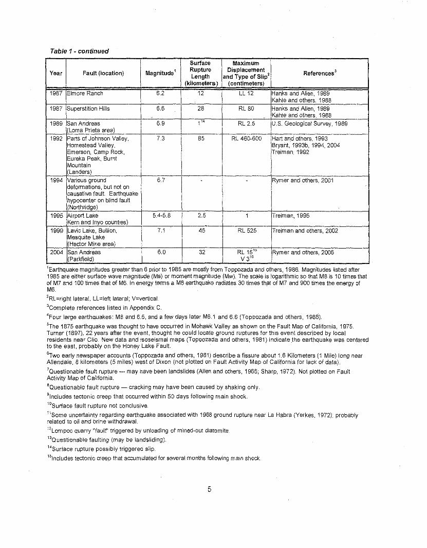
Table 1- continued
Surface MaximumYear Fault (location) Magnitude' Rupture Displacement References 3
Length and Type of Slip'(kilometers) (centimeters)
1987 Elmore Ranch 6.2 12 LL 12 Hanks and Allen, 1989Kahle and others, 1988
1987 Superstition Hills 6.6 28 RL 80 Hanks and Allen, 1989Kahle and others, 1988
1989 San Andreas 6.9 1" RL 2.5 U.S. Geological Survey, 1989(Lama Prieta area)
1992 Parts of Johnson Valley, 7.3 85 RL 460-600 Hart and others, 1993Homestead Valley, Bryant, 1993b, 1994,2004Emerson, Camp Rock, Treiman, 1992Eureka Peak, BurntMountain(Landers)
1994 Various ground 6.7 - - Rymer and others, 2001deformations, but not oncausative fault. Earthquakehypocenter on blind fault(Northridge)
1995 Airport Lake 5.4-5.8 2.5 1 Treiman, 1995Kern and Inyo counties}
1999 l.avic Lake, Bullion, 7.1 45 RL 525 Treiman and others, 2002Mesquite Lake(Hector Mine area)
2004 San Andreas 6.0 32 RL15" Rymer and others, 2006(Parkfield) V 315
'Earthquake magnitudes greater than 6 prior to 1985 are mostly from Toppozada and others, 1986. Magnitudes listed atter1985 are either surface wave magnitude (Ms) or moment magnitude (Mw). The scale is logarithmic so that M8 is 10 times thatof M7 and 100 times that of M6. In energy terms a M8 earthquake radiates 30 times that of M7 and 900 times the energy ofM6.
'RL=right lateral, Ll.=Iett lateral; v=vertical.
'Complete references listed in Appendix C.
'Four large earthquakes: M8 and 6.5, and a few days later M6.1 and 6.6 (Toppozada and others, 1986).
5The 1875 earthquake was thought to have occurred in Mohawk Valley as shown on the Fault Map of California, 1975.Turner (1897), 22 years after the event, thought he could locate ground ruptures for this event described by localresidents near Clio. New data and isoseismal maps (Toppozada and others, 1981) indicate the earthquake was centeredto the east, probably on the Honey Lake Fault.
'Two early newspaper accounts (Toppozada and others, 1981) describe a fissure about 1.6 Kilometers (1 Mile) long nearAllendale, 8 kilometers (5 miles) west of Dixon (not plotted on Fault Activity Map of California for lack of data).
'Questionable fault rupture - may have been landslides (Allen and others, 1965; Sharp, 1972). Not plotted on FaultActivity Map of California.
'Questionable fault rupture - cracking may have been caused by shaking only.
9!nc!udes tectonic creep that occurred within 50 days following main shock.10Surface fault rupture not conclusive,"Some uncertainty regarding earthquake associated with 1968 ground rupture near La Habra (Yerkes, 1972); probablyrelated to oil and brine withdrawal.
12Lompoc quarry "fault" triggered by untoadmq of mined-out diatomite."Questionable faulting (may be landsliding).
"Surface rupture possibly triggered slip.
"tnctuces tectonic creep that accumulated for several months following main shock.
5
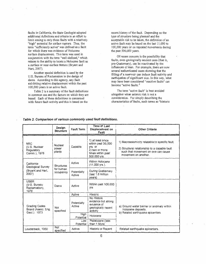
faults in California, the State Geologist adoptedadditional definitions and criteria in an effort tolimit zoning to only those faults with a relatively"high" potential for surface rupture. Thus, theterm "sufficiently active" was defined as a faultfor which there was evidence of Holocenesurface displacement. This term was used inconjunction with the term "well-defined," whichrelates to the ability to locate a Holocene fault asa surface or near-surface feature (Bryant andHart, 2007).
Another special definition is used by theU.S. Bureau of Reclamation in the design ofdams. According to this agency, any fault .exh ibiting relative displacement within the past100,000 years is an active fault.
Table 2 is a summary of the fault definitionsin common use and the factors on which they arebased. Each of these definitions is concernedwith future fault activity and this is based on the
recent history of the fault. Depending on thetype of structure being planned and theacceptable risk to be taken, the definition of anactive fault may be based on the last 11,000 to100,000 years or on repeated movements duringthe past 500,000 years.
Of recent concern is the possibility thatfaults, even geologically ancient ones (that is,pre-Quaternary), can be reactivated by theinfluences of man, For example, there are nowseveral authenticated cases showing that thefilling of a reservoir can induce fault activity andearthquakes of significant size. In this way, whatmay have been considered "inactive faults" canbecome "active faults.'!
The term "active fault" is best avoidedaltogether when seismic risk is not aconsideration. For simply describing thecharacteristics of faults, such terms as "historic
Table 2. Comparison of various commonly used fault definitions,
Design Time of LastFault Term Displacem ent on Other CriteriaStructure Fault
1) at least 0 nce 1) Macroseismicity relatable to specific fault.NRC Nuclear
within past 35,000(U.S. Nuclear power Capable yrs, or
2) Structural relationship to a capable faultRegulatory 2) two or moreComm.), 1978 plants times within past such that movement on one can cause
500, 000 vrs. movement on another,
California Active Within Holocene
Geological Survey Structures (11,000 yrs.).
(Bryant and Hart, for humanDuring Quaternaryoccupancy Potentially
2007) Active (last 1.6 millionvears)
USSR(U.S. Bureau Dams Active Within past 100,000Reclamation). yrs1976
Active HistoricNo Historic
Potentially evidence but strongevldence ofGrading Codes Not Active geologically recent a) Ground water barrier or anomaly within
Board (Assoc. Eng. specified activitY Holocene deposits,Geol.), 1973
High b) Related earthquake epicenters
PotentialHolocene
Low Pleistocene (lessPotential than 1 Mvrs)'
Louderback. 1950 Not Active Historic or Recent Related earthquake epicenters.specified
6
fault," "Holocene fault," "Quaternary fault, "pre-Quaternary fault," or "seismically active fault" arepreferable. With these designations, a projectgeologist, after confirming the designation ofafault, can then go on and make an independentdetermination of its activity relative to the type ofstructur~ to be built and the acceptable risk."
Fault AgeThe fault map depicts what is known about the
recency of displacement along faults. However, futurestudies may find additional faults, require replotting offaults, or, in some cases, change the age classificationshown here. The age classifications are based ongeologic evidence to determine the youngest faultedunit and the oldest unfaulted unit along each fault orfault section. If Quaternary displacement is indicated,the fault is classified into one of three categories withinQuaternary time (Holocene, late Quaternary, orQuaternary undifferentiated). Faults with reportedsurface rupture during historic time are furtherclassifted as historically active.
The reliability of the age classifications on thismap is dependent upon several factors. First, andperhaps foremost, fault-related geomorphic featuresmay have been destroyed by natural or humanactivities. Geomorphic features, such as scarps,troughs, offset drainage channels, triangular facetedspurs and sag ponds, are geologically temporary.They may be easily destroyed by erosion or coveredby vegetation and their preservation is stronglyaffected by climate. Likewise, fault features may bemodified or destroyed by works of humans, especiallyin urban areas. Second, geologists may have differentinterpretations of faults after examining incompletegeologic evidence for recency of faulting. Third, theages of the rock units used to classify the faults maynot be accurately known, or in some cases,Quaternary rocks may be absent. Fourth, some of thedata used to classify faults on this map were based onstudies not done directly to determine the recency offault activity.
The color code on the Fault Activity Map ofCalifornia reflects the latest age at which fault rupturehas occurred and not the age the fault originated.
Thus, a fault showing Holocene or Quaternarydisplacement may have originated several millionyears before and may have had several previousdisplacements.
The age of some faults listed in Appendix A,referenced by Clark and others (1984), is given inyears. These are generally minimum and maximumages of offset features. These features include a widerange of geologic, biologic and cultural features thatallow fault displacements to be measured or estimatedand dated. Among the dating methods used were:radiometric dating of volcanic rocks; soil profiledevelopment; soil or geomorphology correlations;historic records; dendrochronology (tree rings); aminoacid and uranium series on mollusks; carbon 14 oncharcoal and organic sediments; paleontology; andsea-level curves.
Blind Thrust Faults
Blind thrust faults typically are low angle structuresin areas of active folding, such as the TransverseRanges of southern California. The upper extent ofthe fault plane may terminate several kilometers belowthe ground surface and the surface expression is oftendelineated by young anticlines. These faults can beseismogenic (Stein and Yeats, 1989) and haveproduced strong earthquakes in California, such as the1983 Mw 6.4 Coalinga and 1994 Mw 6.7 Northridgeearthquakes. Although significant work has been doneon identifying blind thrust faults and. associated folds,especially in the southern California area (Plesch andothers, 2007), we have decided to continue thepractice of showing faults that displace the surface, aswell as near surface concealed faults, on the 2010Fault Activity Map of California. The National SeismicHazard Maps incorporate blind thrust fault models inCalifornia, specifically in the southern TransverseRanges/northern Peninsula Ranges boundary, SantaBarbara Channel, and along the western margin of theGreat Valley (WGCEP, 2008). Consult this referencefor information on location and characterization of blindthrust faults.
7
REFERENCES CITED
Bryant, W.A., and Hart, E,W., 2007, Fault-Rupturehazard zones in California: California GeologicalSurvey Special Publication 42, 42 p. (digitalversion only, electronic document available atftp:lfftp,consrv,ca,govlpubldmglpubslsp/Sp42,pdf),
Clark, M,M" Harms, K,K" Lienkaemper, J,J"Harwood, D,S., Lajoie, K,R" Matti, J,C" Perkins,JA, Rymer, M,J" Sarna-Wojcicki, A.M" Sharp,R.V" Sims, J.D" Tinsley, J.C" III, and Ziony, J,I.,1984, Preliminary slip-rate table and map of lateQuaternary faults of California: U,S. GeologicalSurvey Open-File Report 84-106, 12 p., 5 plates,map scale 1:1,000,000.
Jennings, CW" 1975, Fault map of California Withlocation of volcanoes, thermal springs and thermalwells: California Division of Mines and Geology,Geologic Data Map No.1, map scale 1:750,000.
Jennings, C.w., 1985, An explanatory text toaccompany the 1:750,000 scale fault and geologicmaps of California: California Division of Minesand Geology, Bulletin 201,197 p. 2 plates,
Jennings, C.w., 1994, Fault activity map of Californiaand adjacent areas with locations and ages ofrecent volcanic eruptions: California Department ofConservation, Division of Mines and Geology DataMap Series No, 6, 92 p. 2 plates, map scale1:750,000.
Jennings, CW., modifications by Gutierrez, C., Bryant,w., Saucedo, G" and Wills, C., 2010, Geologicmap of California: California Geological SurveyGeologic Data Map Series No.2, scale 1:750,000,
Plesch, A" Shaw J,H., Benson, C., Bryant, WA,Carena, S., Cooke, M., Dolan, J., Fuis, G" Gath,E" Grant, L., Hauksson, E., Jordan, T,H.,Kamerling, M., Legg, M" Lindvall, S" Magistrale,H., Nicholson, C., Niemi, N. Oskin, M" Perry, S.,Planansky, G., Rockwell, T" Shearer, P. Sorlien,C. SOss, M.P" Suppe, J., Treiman, J., and Yeats,R" 2007, Community Fault Model (CFM) forSouthern California: Bulletin of the SeismologicalSociety of America, v. 97, p. 1793-1802, doi10,1785/0120050211.
Stein, R.S., and Yeats, R.S., 1989, Hiddenearthquakes: Scientific American, p. 48-57, June1989.
U.S. Bureau of Reclamation, 1976, Proposed faultclassification and investigation criteria, in Cluff,L.S" Packer, DR, and Moorhouse, D,C" 1977,Earthquake evaluation studies of the Auburn Damarea: Summary report: Woodward-ClydeConsultants, unpublished report for the U.S.Bureau of Reclamation, p. USBR-1-USBR-5,
U,S, Nuclear Regulatory Commission, 1978, Code ofFederal Regulations, Title 10, Energy: Part 100,Reactor site criteria; Appendix A, Seismic andgeologic Siting criteria for nuclear power plants:NRC, Washington, D.C.
WGCEP, 2008, The Uniform California earthquakerupture forecast, version 2 (UCERF 2): 2007Working Group on California EarthquakeProbabilities: California Geological Survey SpecialReport 203, 96 p., 16 appendices.
8
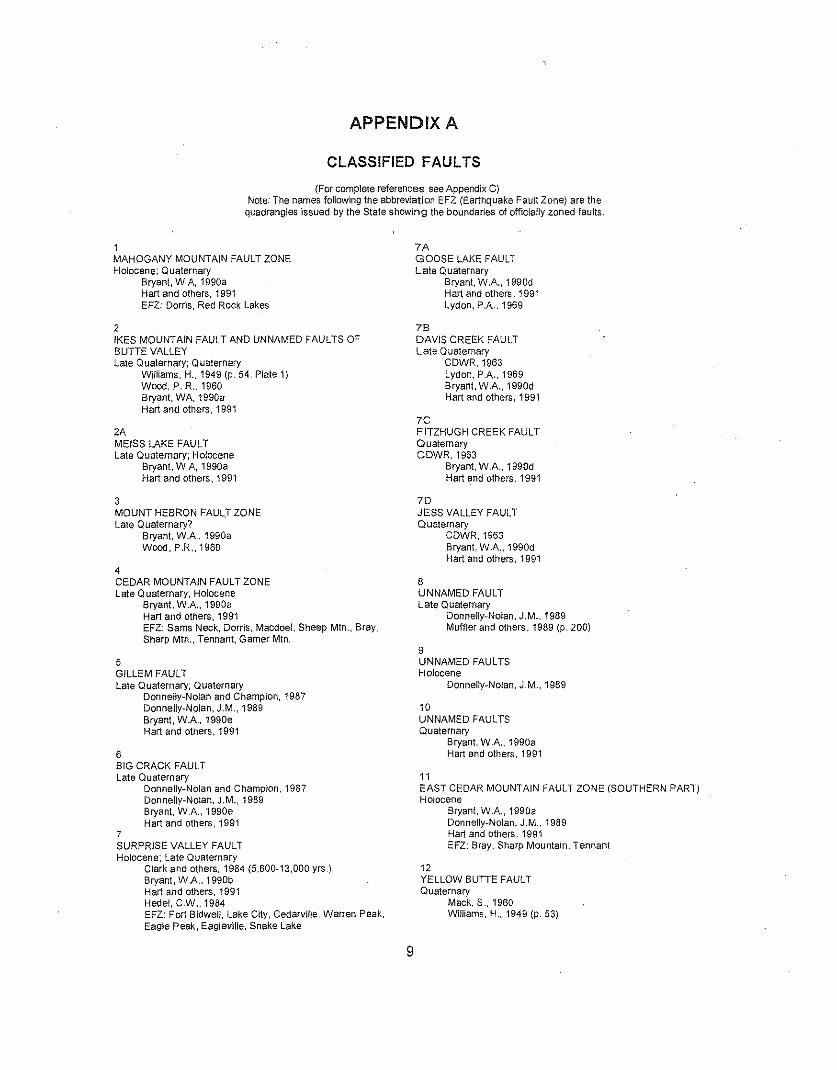
APPENDIX A
CLASSIFIED FAULTS
(For complete references see Appendix C)Note: The names following the abbreviation EFZ (Earthquake Fault Zone) are the
quadrangles issued by the State shOw'lng the boundaries of officially zoned faults.
1MAHOGANY MOUNTAIN FAULT ZONEHolocene; Quaternary
Bryant. W A. 1990aHart and others, 1991EFZ: Dorris, Red Rock Lakes
2IKES MOUNTAIN FAULT AND UNNAMED FAULTS OFBUTTE VALLEYLate Quaternary; Quaternary
WiUiams, H.. 1949 (p. 54, Plate 1)Wood, P. R .. 1960Bryant, WA, 1990aHart and others, 1991
2AMEISS LAKE FAULTLate Quaternary; Holocene
Bryant. W A, 1990aHart and others, 1991
3MOUNT HEBRON FAULT ZONElate Quaternary?
Bryant. WA, 1990aWood, P.R" 1960
4CEDAR MOUNTAIN FAULT ZONELate Quaternary; Holocene
Bryant, W.A., 1990aHart and others, 1991EFZ: Sarna Neck, Dorris, Macdoel, Sheep MIn., Bray,Sharp Mtn., Tennant, Gamer MIn.
5GILLEM FAULTLate Quaternary; Quaternary
Donnelly-Nolan and Champion, 1987Donnelly-Nolan, J.M., 1989Bryant, W.A" 1990eHart and others, 1991
6BIG CRACK FAULTLate Quaternary
Donnelly-Nolan and Champion. 1987Donnelly-Nolan. J.M., 1989Bryant, WA, 1990eHart and others, 1991
7SURPRISE VALLEY FAULTHolocene; Late Quaternary
Clark and others. 1984 (5,600-13,000 yrs.)Bryant, WA. 1990bHart and others, 1991Hedel. CW .. 1984EFZ; Fort Bidwell, Lake City, Cedarville, Warren Peak,Eagle Peak, Eagleville, Snake Lake
7AGOOSE LAKE FAULTLate Quaternary
Bryant, WA, 1990dHart and others, 1991Lydon, PA, 1969
78DAVIS CREEK FAULTLate Quaternary
CDWR,1963Lydon, PA, 1969Bryant, WA, 1990dHart and others, 1991
7CFITZHUGH CREEK FAULTQuaternaryCDWR,1963
Bryant. W.A" 1990dHart and others, 1991
7DJESS VALLEY FAULTQuaternary
CDWR,1963Bryant, W.A., 1990dHart and others, 1991
8UNNAMED FAULTLate Quaternary
Donnelly-Nolan, J.M., 1989Muffler and others, 1989 (p. 200)
9UNNAMED FAULTSHolocene
Donnelly-Nolan, J.M., 1989
10UNNAMED FAULTSQuaternary
Bryant, WA, 1990aHart and others, 1991
11EAST CEDAR MOUNTAIN FAULT ZONE (SOUTHERN PART)Holocene
Bryant. W.A., 1990aDonnelly-Nolan, J.M., 1989Hart and others, 1991EFZ: Bray, Sharp Mountain, Tennant
12YELLOW BUTTE FAULTQuaternary
Mack. S .. 1960Williams, H., 1949 (p. 53)
9
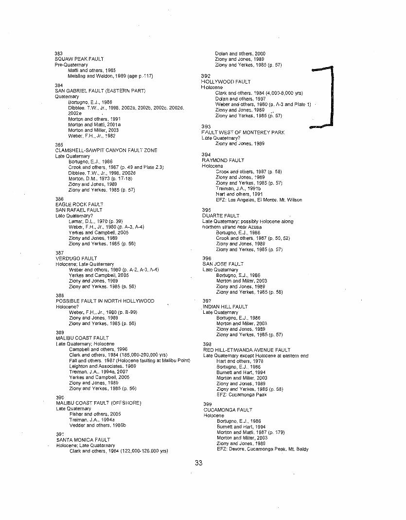
383SQUAW PEAK FAULTPre-Quaternary
MaW and others, 1985Meis!ing and Weldon, 1989 (age p.·117)
384SAN GABRIEL FAULT (EASTERN PART)Quaternary
Bortugno, E.J., 1986Dlbblee, T.W., Jr.. 1998, 2002a, 2002b, 2002e, 2002d.2002eMorton and others, 1991Morton and MatH, 2001 aMorton and Miller, 2003Weber, F,H.,Jr .. 1982
385ClAMSHEll-SAWPIT CANYON FAULT ZONELate Quaternary
Bortugno, E.J., 1986Crook and others, 1987 (p. 49 and Plate 2.3)Dlbblee. T.W" Jr.. 1998, 2002dMorton, D.M" 1973 (p.17-18)Ziony and Jones, 1989Ziony and Yerkes, 1985 (p. 57)
386EAGLE ROCK FAULTSAN RAFAEL FAULTLate Quaternary?
lamar, o.i., 1970 (p. 39)Weber, F.H" Jr., 1980 (p. A-3, A-4)Yerkes and Campbell. 2005ztonv and Jones, 1989Ziony and Yerkes, 1985 (p, 56)
387VERDUGO FAULTHolocene; Late Quaternary
Weber and others, 1980 (p. A~2, A-3, A-4)Yerkes and Campbell, 2005Ziony and Jones, 1989Ziony and Yerkes, 1985 (p. 56)
388POSSIBLE FAULT IN NORTH HOllYWOODHolocene?
Weber, F.H" Jr.. 1980 (p. 8-99)Ziony and Jones, 1989Ziony and Yerkes. 1985 (p. 56)
389MALIBU COAST FAULTLate Quaternary; Holocene
Campbell and others, 1996Clark and others. 1984 (185,000-200,000 yrs)FaU and others, 1987 (Holocene faulting at Malibu POint)Leighton and Associates, 1989Treirnan. J.A. 1994a, 2007Yerkes and Campbell, 2005Ziony and Jones, 1989Ziony and Yerkes. 1985 (p. 56)
390MALIBU COAST FAULT (OFFSHORE)Late Quaternary
Fisher and others, 2005Freiman. J.A.. 1994aVedder and others. 1986b
391SANTA MONICA FAULTHolocene; Late Quaternary
Clark and others. 1984 (122,000·126,000 yrs)
Dolan and others, 2000Ziony and Jones. 1989Ziony and Yerkes, 1985 (p. 57)
392HOll YWOOD FAULTHolocene
Clark and others. 1984 (4,000·6,000 yrs)Dolan and others, 1997Weber and others, 1980 (p. A·3 and Plate 1)Ziony and Jones. 1989 \Ziony and Yerkes. 1985 (p. 57)
393. FAULT WEST OF MONTEREY PARK
Late Quaternary?Ziony and Jones, 1989
394RAYMOND FAULTHolocene
Crook and others, 1987 (p. 58)Ziony and Jones, 1989Zlony and Yerkes, 1985 (p. 57)Treiman, JA, 1991bHart and others, 1991EFl: Los Angeles, EI Monte. Mt. Wilson
395DUARTE FAULTLate Quaternary; possibly Holocene alongnorthern strand near Azusa
Bortugno, E,J., 1986Crook and others, 1987 (p. 50, 52)Ziony and Jones, 1989Ziony and Yerkes, 1985 (p. 57)
396SAN JOSE FAULTLate Q uaternary
Bortugno, E,J., 1986Morton and Milter, 2003zionv and Jones, 1989Ziony and Yerkes, 1985 Ip. 58)
397INDIAN Hill FAULT
. Late QuaternaryBortugno, E.J., 1986Morton and MiHer, 2003Zlony and Jones, 1989Ziony and Yerkes, 1985 (p. 57)
398RED Hill-ETIWANDA AVENUE FAULTLate Quaternary except Holocene at eastern end
Hart and others, 1978Bortuqno. E.J., 1986Burnett and Hart. 1994Morton and Miller, 2003Ziony and Jones, 1989Ziony and Yerkes. 1985 (p. 58)EFZ: Cucamonga Peak
399CUCAMONGA FAULTHolocene
Bortuqno. E.J .. 1986Burnett and Hart, 1994Morton and Matti, 1987 (p. 179)Morton and Miller, 2003Ziony and Jones. 1989EFZ: Devore. Cucamonga Peak. Mt. Baldy
33
APPENDIX CREFERENCES
Aalto. K.R., Cashman. P.H., Cashman, S.M., and Kelsey, H.M.,1981, Geology of the Coast Ranges, Del Norte and northernHumboldt counties, California: Unpublished mapping for theCalifornia Division of Mines and Geology, scales 1:24,000and 1:62,500. "
Aalto, K.R" Irwin, W.P .. and Kelsey, H.M., 1988, Reconnaissancegeologic map of the Pilot Creek quadrangle, Humboldt andTrinity Counties, California: U.S, Geological Survey Open-File Report 88~363, scale 1:62,500.
Agnew, D.C., and Sleh, K.D., 1978, A documentary study of thefelt effects of the great California earthquake of 1857:Bulletin Seismological Society of America. v. 68, no, 6, p.1717-1729.
Akers, R.J., and McQuilkin, M.J., 1975. Geologic investigation ofthe Oroville earthquake, in Sherburne, R.W., and Hauge.C.J., editors, Oroville, California, earthquake, 1 August 1975:California Division of Mines and Geology Special Report124, p. 45-52.
Allen, C.R., 1972, California Institute of Technology, writtencommunication, October 18, 1972, (possible 1969 triggeredfault creep).
Alien, C.R., St. Amand, P., Richter, C.F .• and Nordquist, J.M"1965, Relationship between seismicity and geologicstructure in the southern California region: BulletinSeismological Society of America, v. 55, no. 4, p. 753-797.
Allen, C.R., Grantz, A, Brune," J.N., Clark, M,M., Sharp, Rv ..Theodore, T.G., Wolfe, E.W.• and Wyss, M., 1968. TheBorrego Mountain, California, earthquake of 9 April 1968: Apreliminary report Bulletin Seismological Society of America,v. 58, no. 3, p. 1183-1186.
Allen, C.R., and others, 1972, Map showing surface ruptures atthe time of and after the Borrego Mountain earthquake ofApril 9, 1968 (GMT), in The Borrego Mountain earthquake ofApril 9, 1968: U.S. Geological. Survey Professional Paper787, Plate 1.
Allen, C.R.. Hanks, T.C., and Whitcomb, 'J.H., 1975,Seismological studies of the San Fernando earthquake andtheir tectonic implications, in Oakeshott. G,B., editor, SanFernando. California, earthquake of 9 February 1971:California Division of Mines and Geology Bulletin 196. p.257-262.
Allen, J.E., 1946, Geology of the San Juan Bautista quadrangle,California: California Division of Mines and Geology Bulletin133, p. 9-76. pt. 1.
Allison, M.L., Whitcomb, J,H., Cheatum, C.E., and McEuen, R.B.,1978, Elsinore fault seismicity: The September 18, 1973,Aqua Caliente Springs, California, earthquake series:Bulletin Seismological Society of America, v. 68, no. 2, p.429-440.
Alt, J.N., Schwartz, D.P., and McCrumb, DR., 1977, Regionalgeology and tectonics, Volume 3 of the earthquakeevaluation studies of the Auburn Dam area: report byWoodward-Clyde Consultants to the U.S. Bureau ofReclamation. Denver, 118 p. plus appendices.
Anderson, L.W., Anders, M.H., and Ostenaa. DA, 1982, lateQuaternary faulting and seismic hazard potential easternDiablo Range, California, in Hart, E.W.; Hirschfeld, S.E" andSchulz, SA, editors, Proceedings, Conference onearthquake hazards in the eastern San Francisco Bay area:
California Division of Mines and Geology Special Publication62, p. 197-206.
Antonnen, G.J., Danehy, EA, and Fallin, JAT., 1974, The KingsCanyon lineament: a cross-grain ERTS-1 lineament incentral California: Proceedings of First InternationalConference on the New Basement Tectonics, UtahGeological Association, Publication 5, p. 81-93.
Armin, R.A.. and John, D.A., 1983, Preliminary geologic map ofthe Freel Peak 15-minute quadrangle, California andNevada, with Quaternary geology by J.C. Dchrenwend: U.S.Geological Survey Miscellaneous Investigations Series Map1-1424,scale 1:62.500.
Armstrong. C,F., 1979, Coyote Lake earthquake of 6 August1979: California Geology, v. 32, no. 11. p. 248-251.
Aydin, A, and Page, 8.M., 1984, Diverse Pliocene-Quaternarytectonics in a transform environment, San Francisco Bayregion, California: Geological Society of America Bulletin. v.95, no. 11, p. 1303-1317 (age of structures p. 1305).
Aydin, A., Johnson, AM.. and Fleming, R.W, 1992,Right-lateral-reverse surface rupture along the San Andreasand Sargent faults associated with the October 17, 1989.Lorna Prieta earthquake: Geology, v, 20, p. 1063~1067.
Babcock, E.A., 1969, Structural geology and geophysics of theDurmid area, Imperial vaney, California: Unpublished Ph,D.thesis, Institute of Geophysics and Planetary Physics.University of California at Riverside, 149 p.
Babcock, E.A" 1971, Detection of active faulting using obliqueinfrared aerial photography in the Imperial Valley, Cafltomia:Geological SOCiety of America. Bulletin, v. 82, no. 11, p.3191. Figure 2.
Bacheller, J., !I!. 1978. Quaternary geology of the Mojave Desert- Eastern Transverse Ranges boundary in the Vicinity ofTwentynine Palms, California: University of caurorrua. LosAngeles, unpublished M.S. thesis, 157 p.
Batley, R.A., 1989, Geologic map of Long Valley Caldera, Mono-lnyo Craters Volcanic Chain, and vicinity, eastern California:U.S. Geological Survey Miscellaneous investigations SeriesMap 1-1933. scale 1:62,500.
Bailey, R.A., and Koeppen, R.P., 1977, Preliminary geologic mapof Long Valley caldera, Mono County, California: U.S.Geologica! Survey Open-File Report 77~468, scale 1:62,500.
Bakun, W.H .. 1999, Seismic activity of the San Francisco Bayregion: Bulletin of the Seismological Society of America. v.89. p. 764-784.
Baldwin, J.N., Unruh, J.R .. and Lettis. W,R .. 1998, Neotectonicinvestigation of the northward extension of the Green Valleyfault. Napa County, California: U.S: Geological SurveyNational Earthquake Hazards Reduction Program FinalTechnical Report, Award #1434-HQ-96-GR-02738,. 27 p.
Baldwin. J.,N., Kelson, KI., and Randolph, C.E., 2000, LateQuaternary fold deformation along the Northridge Hills fault,Northridge. California: Detormatlon coincident with pastNorthridge blind thrust earthquakes and other nearbystructures?; Bulletin of the Seismological SOCietyof America,v. 90, no. 3, p. 629-642.
60
Dohrenwend, J.C., 1982, Surficial geologic map of the WalkerLake txa-osqree quadrangle, Nevada and California: U.S.Geological Survey Miscellaneous Field Studies MapMF-1382-C, scale 1:250,000.
Dohrenwend, J.C., and Brem. G.F., 1982, Reconnaissancesurficial geologic map of the Bridgeport quadrangle.California and Nevada: U.S. Geological SurveyMiscellaneous Field Studies Map MF~1371. scale 1:62.500.
Dohrenwend. J.C., Schell, B.A .. Menges, C.M.. Moring, B.C .. andMcKittrick. M.A., 1'992, Reconnaissance photoqeoloqic mapof young (Quaternary and late Tertiary) faults in Nevada, inSinger, E.A.. editor. Nevada Mineral Resource Assessment:U.S. Geological Survey (work in review).
Dolan, J.F .. sien, K.. Rockwell, TK, Guptill, P. and Miller, G ..1997, Active tectonics, paleoselsrnofoqy. and sesmchazards of the Hollywood fault, northern Los Angeles basin,California: Geological Society of America Bulletin, v,109,notz p.1595~1616.
Dolan, J.F., Sieh, K., and Rockwell, T.K .. 2000, Late Quaternaryactivity and seismic potential of the Santa Monica faultsystem, Los Angeles, California: Geological Society ofAmerica Bulletin v. 112, no. 10, p. 1559~1581.
Donnelly-Nolan, J.M" 1989, 1990, Faulting on and adjacent toMedicine Lake Volcano: U.S. Geological Survey unpublishedmapping in progress and personal cornmunlcatlon. February1989, September 1989, and March 21, 1990.
Donnelly-Nolan. J,M., and Champion, D.E., 1987, Geologic mapof Lava Beds National Monument, northern California: U.S.Geological Survey Miscellaneous investigations Series Map1~1804,scale, 1:24,000.
Donovan, DE., 1991, Neotectonics of the southern AmargosaDesert, Nye County, Nevada and lnyo County, California:University of Nevada. Reno, unpublished M.S. thesis, 151 p..5 plates.
Drewes. H., 1963, Geology of the Funeral Peak quadrangle.California, on the east flank of Death Valley: U.S. GeologicalSurvey Professional Paper a ta. 75 p.
Dudley, T., 1986, Lake Almanor Dam, Butt Valley Dam: CaliforniaDepartment of Water Resources, Division of Safety of Dams.Memorandum of seismic review, 6 p. (unpublished).
Dudley. T., 1988, Magalia fault: California Department of WaterResources, Division of Safety of Dams, Memorandum offault evaluation, 9 p., Figure 1, scale 1:62,500 (unpublished).
Duffield, W.A., 1975, Late Cenozoic ring faulting and volcanism inthe Coso Range area of California: Geology, v. 3, no. 6, p.335-338.
Duffield, W.A., and Bacon, C.R., 1981, Geologic map of the Cosovolcanic field and adjacent areas. lnyo County, California:U.S, Geological Survey Miscellaneous Investigations SeriesMap I~1200, scale 1:50.000,
Dutcher. L.C .. and Garrett, A.R., 1963, Geologic and hydrologicfeatures of the San Bernardino area, California; with specialreference to underflows across the San Jacinto fault: U.S.Geological Survey Water Supply Paper 1419, 113 p.
Earth Sciences Associates, 1976, Humboldt Bay power plant site,geOlogy investigations: Unpublished report for Pacific Gasand Electric Company. 101 p.
Earth SCiences Associates, 1980, Seismic and fault activity study.proposed Glenn Reservoir complex: Unpublished report forCalifornia Department of Water Resources, Sacramento,California (p.III-25),
Ehlig, P.L., compiler, 1986, Neotectonics and faulting in southernCalifornia: Geological Society of America, 82nd AnnualMeeting of Cordilleran Section, Los Angeles. California,Guidebook for Field Trip 18.
Ellen, S., McLaughlin. R.J., Blake, M.C., Jr.. Jayko. A.S., andIrwin, W.P., 1989, Geolopic map of Garberville quadrangle,1:100,000 scale, U.S. Geological Survey (in preparation),
Ellsworth, W.L .. Olson. J.A., Shljo, L.N., and Marks, S.M.. 1982,Seismicity and active faults in the eastern San FranciscoBay reqicn. in Hart, E.W., Hirschfeld, S.E .. and Schulz, S.S ..editors, Proceedings. Conference on earthquake hazards inthe eastern San Francisco Bay area: California Division ofMines and GeOlogy Special Publication 62. p. 83~91, map p.85.
Envicom. 1976. Seismic safety element for the general plan, rnvo-Mono Association of Governmental Entities: Unpublishedconsulting report for Inyo and Mono counties, 129 p. 2Appendices, 9 plates.
Eric, J.H., Stromquist, A.A., and Swinney, C.M., 1955, Geologyand mineral deposits of the Angels Camp and Sonoraquadrangles, Calaveras and Tuolumne counties, California:California Division of Mines Special Report 41.55 p.
Fall, E" Rzonca, G.F., and Spellman, H.A., 1987 Late Quaternarytaulttnp. Malibu Coast fault zone, Malibu, California:Association of Engineering Geologists Newsletter. January1987, p. 17.
Fisher, M.A" Greene, H.G., Normark, W.R., and SUter, RoW.,2005, Neotectonics of the Offshore Oak Ridge fault nearVentura, Southern California: Bulletin of the SeismologicalSociety America, v. 95, p. 739~744,
Franks, A.L., 1980, Environmental geology-land use planning,erosion and sedimentation west Martis Creek drainagebasin, California: University of California. Davis. Ph.D.dissertation, 371 p., plate 1, scale 1:12,000.
Fraser,W.A. and Nasfrtan, F., 1981. Reeveluatlon of seismichazards for Frenchman, Grizzly Valley. and Antelope Dams:California Department of Water Resources (unpublishedreport).
Fraticelll, L.A., Albers, J.P .. lrwin, W.P., Blake. M.C., Jr., 1987.Geologic map of Redding 1 x 2 degree quadrangle, Shasta,Tehama, Humboldt and Trinity counties. California: U.S.Geological Survey Open-File Report 87~257 (with a fewmodifications by M.C. Blake Jr., personal communication,1989).
Fuls. G.S., 1982, Displacement of the Superstition Hills faulttriggered by the earthquake, in The lrnpenal Valley.California earthquake of October 15, 1979: U.S. GeologicalSurvey Professional Paper 1254, p. 145~154, Plate 2, scale1.24,000.
Galehouse, J.S., 1992, Theodolite measurements of creep rateson San Francisco Bay region faults: National EarthquakeHazards Reduction Program Summaries, Volume I: U.S.Geologica! Survey Open-File Report 92~258, p. 256w261.
Ganaway, A.J" 1977, Geology of the Point Reyes Peninsula,Marin County, California: Oautomla Division of Mines andGeology Bulletin 202,72 p., 1 plate.
Gay. T.E., Jr., and Aune, a.A., 1958. Alturas Sheet. GeologicMap of California: California Division of Mines, scale1:250,000.
Glanena, V.P., 1957. Earthquake and faulting, Fort SageMountains. California, December 1950: BulletinSeismological SOCietyof America. v. 47, no. 3. p. 173~177
72
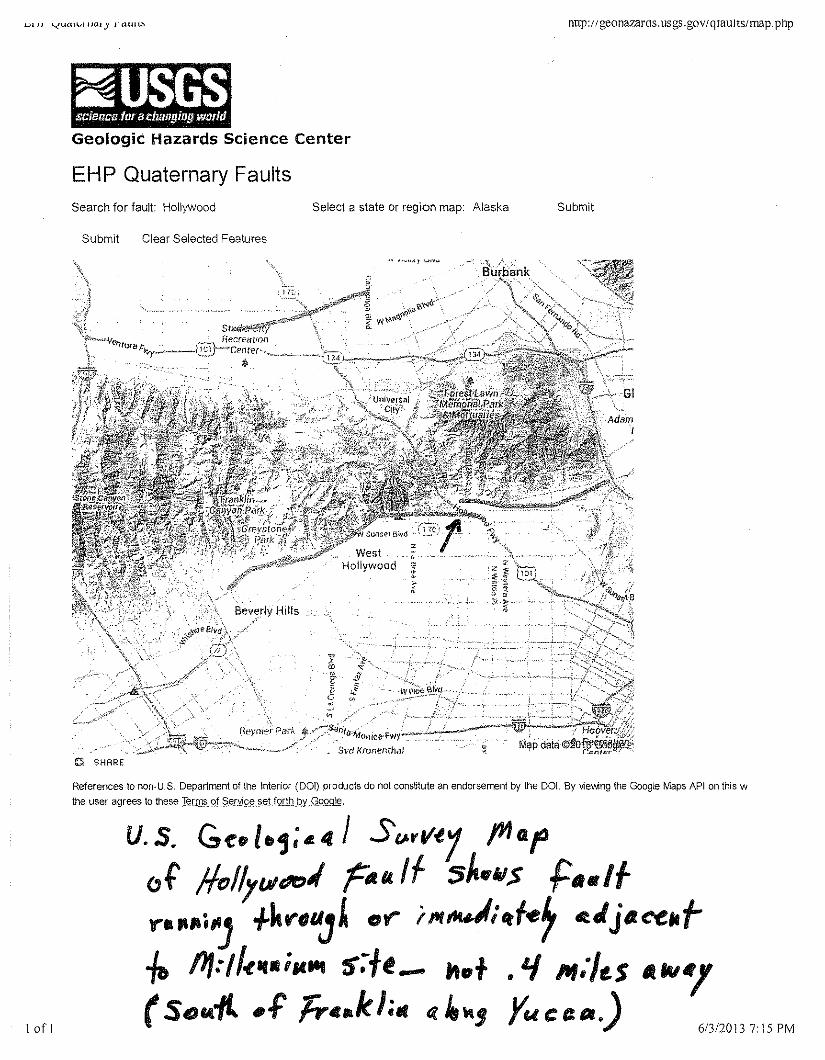
rnrp: II geonazaros. usgs. gOYIqrauns/map. pnp
~Geologic Hazards Science Center
EHP Quaternary FaultsSearch for fault: Hollywood Select a state or region map: Alaska Submit
Submit Clear Selected Features
o SHARE
References to non-uS. Department of the Interior (DOl) products do not constitute an endorsement by the DO!. By viewng the Google Maps API on this wthe user agrees to these Jerms of Seryj,g~_§§Lt.QIlb.'py.J2.9Q9ki.
1of I
u.s. G~Pl.,; 4£ "I s(.I.rl/-l1 /YIGfof !lfJ/lyl.lldf:JI rll1l.1f sh#lltl$ flN"lf".""''') +kf"fIlJ£ or'" 'Itf".J;rtf-er c.JjlAce"t-/& !J1:/I-e ..,.il4ltt s-:+e_ JIt.+ • 'I M;/"$ 4tM'l(Sc)f4-f(. .f Tr c.k ha« ~ 4~,Yu C I:lJ'.) 6/3/2013 715 PM
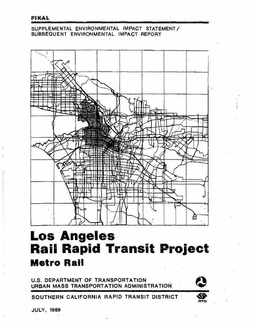
IFUilAL
SUPPLEMENTAL ENVIRONMENTAL IMPACT STATEMENTISU"BSEQUENT ENVIRONMENTAL IMPACT REPORT
,.~'.~...:
Los AngelesRail Rapid Transit ProjectMetro Railu.s. DEPARTMENT OF TRANSPORTATION ......URBAN MASS TRANSPORTATION ADMINISTRATION ~e.7SOUTHERN CALIFORNIA RAPID TRANSIT DISTRICT· ..
RTC
JULY, 1989
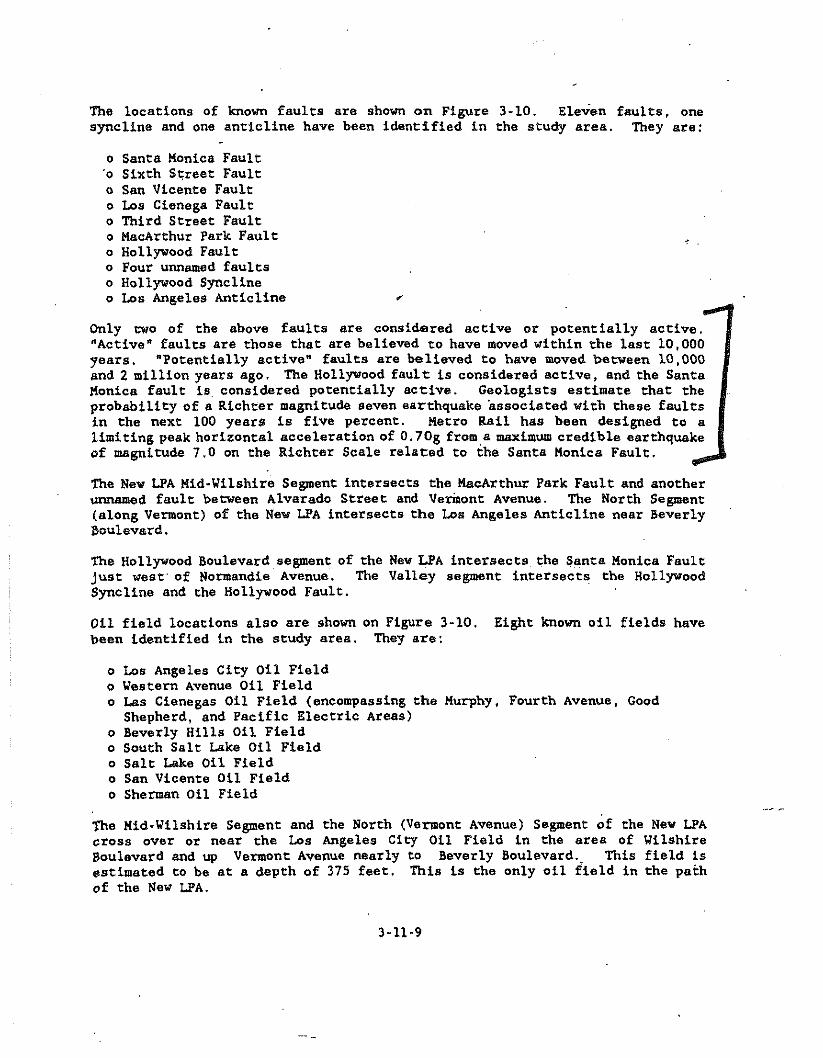
The locations of known faults are shown on Figure 3-10. Eleven faults, onesyncline and one anticline have been identified in the study area. They are:
o Santa Monica Fault'0 Sixth Street Faulto San Vicente Faulto Los Cienega Faulto Third Street Faulto MacArthur Park Faulto Hollywood Faulto Four unnamed faultso Hollywood Synclineo Los Angeles Anticline
Only cwo of the above faults are considered active or potentially active."Active" faults are those that are believed to have moved within the last 10,000years. 'Potentially active" faults are believed to have moved between 10,000and 2 million years ago. The Hollywood fault is considered active, and the SantaKonica fault is considered potentially active. Geologists estimate that theprobability of a Richter magnitude Seven earthquake associated with these faultsin the next 100 years is five percent. Metro Rail has been designed to alimiting peak horizontal acceleration of O.70g from,a maximum credible earthquakeof magnitude 7.0 on the Richter Scale related to the Santa Monica Fault.
The New LPA Mid-Wilshire Segment intersects the Macarthur Park Fault and anotherunnamed fault between Alvarado Street and Vermont Avenue. The North Segment(along Vermont) of the New LPA intersects the Los Angeles Anticline near Beverly~oulevard.The Hollywood Boulevard segment of the New LPA intersects the Santa Monica FaultJust west' of Normand!e Avenue. The Valley segment intersects the HollywoodSyncline and the Hollywood Fault.011 field locations also are shown on Figure 3-10. Eight known oil fields havebeen identified in the study area. They are:
o Los Angeles City Oil Fieldo Western Avenue Oil Fieldo Las Cienegas Oil Field (encompassing the Murphy, Fourth Avenue, Good
Shepherd, and Pacific Electric Areas)o Beverly Hills Oil Fieldo South Salt Lake Oil Fieldo Salt Lake Oil Fieldo San Vicente Oil Fieldo Sherman Oil Field
The Kid-Wilshire Segment and the North (Vermont Avenue) Segment of the New LPAcross over or near the Los Angeles City Oil Field in the area of WilshireBoulevard and up Vermont Avenue nearly to Beverly Boulevard., This field isestimated to be at a depth of 375 feet, This is the only oil field in the pathof the New LPA.
3-11-9
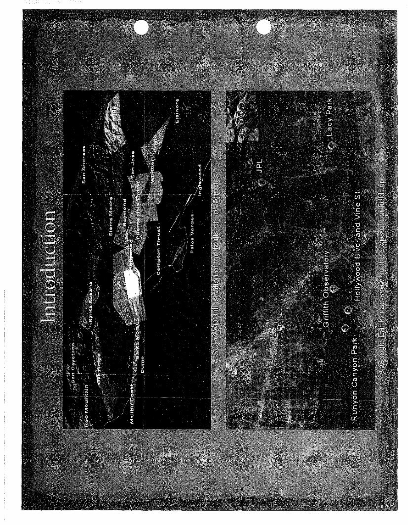
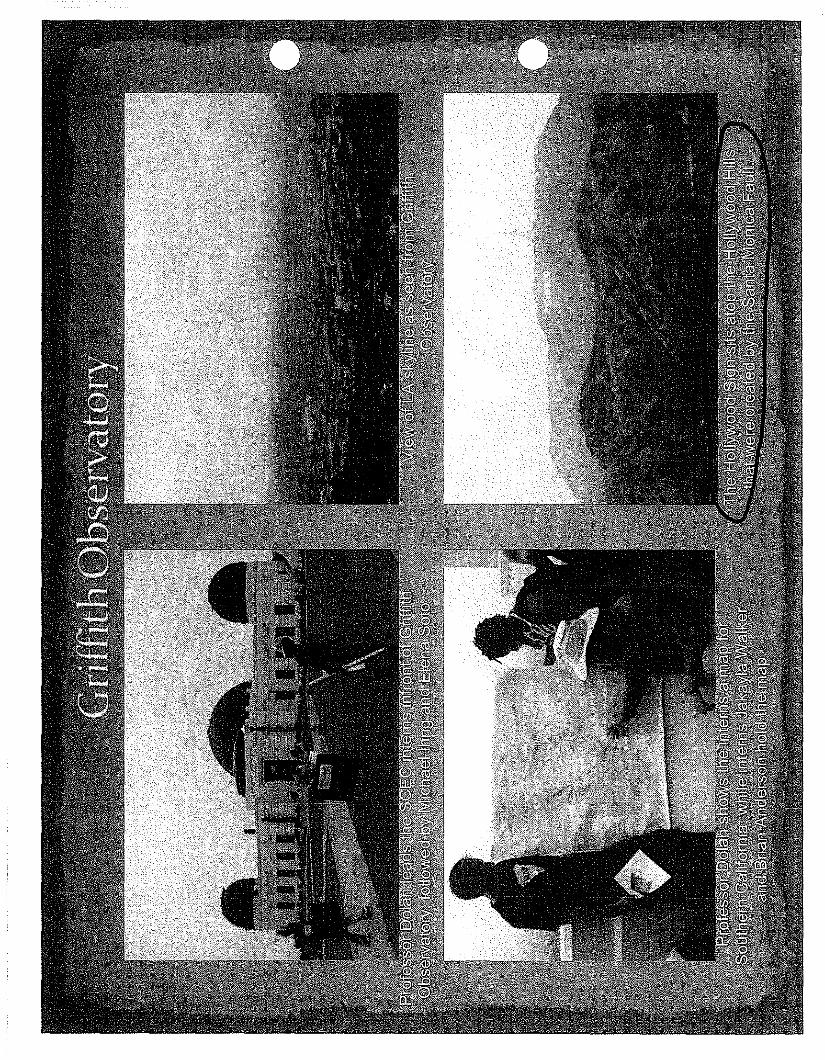
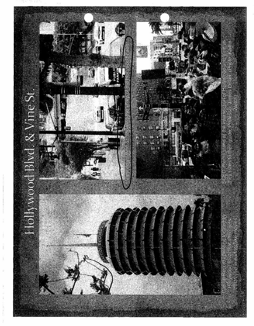
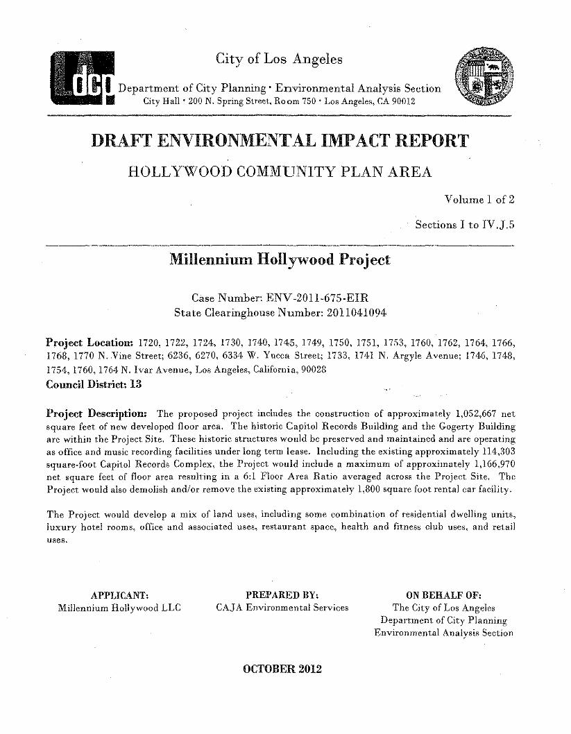
City of Los Angeles
IDepartment of City Planning' Environmental Analysis SectionIii.. City Hall' 200 N. Spring Street, Room 750 . Los Angeles, CA 90012
DRAFT ENVIRONMENTAL IMP ACT REPORT
HOLLYWOOD COMMUNITY PLAN AREA
Volume 1 of 2
Sections I to IV.J.5
Millennium Hollywood Project
Case Number: ENV-2011-675-EIRState Clearinghouse Number: 2011041094
Project Location: 1720, 1722, 1724, 1730, 1740,174.5, 1749, 1750, 1751, 1753, 1760, 1762, 1764, 1766,1768,1770 N. Vine Street; 6236, 6270, 6334 W. Yucca Street; 1733, 174·1 N. Argyle Avenue; 1746, 1748,1754,1760,1764. N. Ivar Avenue, Los Angeles, California, 90028Council District: 13
Project Description: The proposed project includes the construction of approximately 1,052,667 netsquare feet of new developed floor area. The historic Capit.ol Records Building and the Gogerty Buildingare within the Project Site. These historic structures would be preserved and maint.ained and are operatingas office and music recording facilities under long t.erm lease. Including the existing approximately 114,303square-foot Capitol Records Complex, the Project. would include a maximum of approximately 1,166,970net square feet of floor area resulting in a 6:1 Floor Area Ratio averaged across the Project Site. TheProject would also demolish andlor remove the existing approximately 1,800 sqnare foot rental car facility.
The Project would develop a mix of land uses, including some combination of residential dwelling units,luxury hotel rooms, office and associated uses, restaurant space, health and fit.ness club uses, and ret.ailuses.
APPLICANT,Millennium Hollywood LLC
PREPARED BY,CAJ A Environmental Services
ON BEHALF OF,The City of Los Angeles
Depart.ment of City PlanningEnvironmental Analysis Section
OCTOBER2012
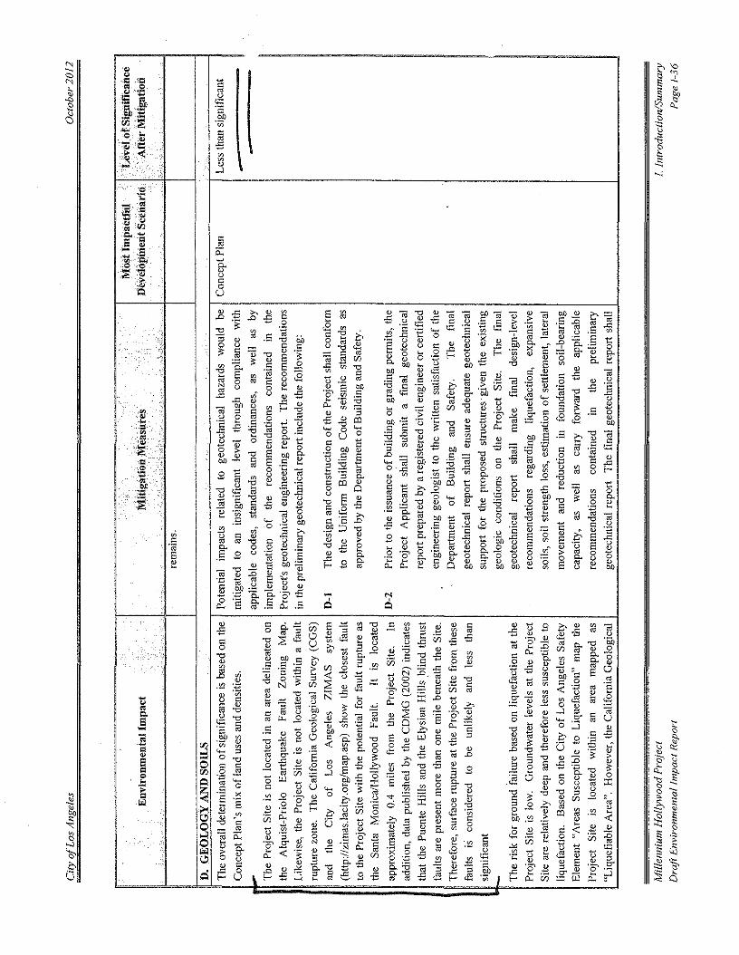
II
I ..
••••••.'
,
.
.'
-,Q
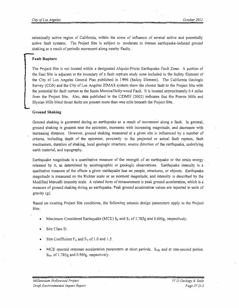
City of Los Angeles October 2012
seismically active region of California, within the zone of influence of several active and potentiallyactive fault systems. The Project Site is subject to moderate to intense earthquake-induced groundshaking as a result of periodic movement along nearby faults.
Fault Rupture
The Project Site is not located within a designated Alquist-Priolo Earthquake Fault Zone. A portion ofthe East Site is adjacent to the boundary of a fault rupture study zone included in the Safety Element ofthe City of Los Angeles General Plan published in 1996 (Safety Element). The California GeologicSurvey (COS) and the City of Los Angeles ZIMAS system show the closest fault to the Project Site withthe potential for fault rupture as the Santa Monica/Hollywood Fault. It is located approximately 0.4 milesfrom the Project Site. Also, data published in the CDMH (2002) indicates that the Puente Hills andElysian Hills blind thrust faults are present more than one mile beneath the Project Site.
Ground Shaking
Ground shaking is generated during an earthquake as a result of movement along a fault. In general,ground shaking is greatest near the epicenter, increases with increasing magnitude, and decreases withincreasing distance. However, ground shaking measured at a given site is influenced by a number ofcriteria, including depth of the epicenter, proximity to the projected or actual fault rupture, faultmechanism, duration of shaking, local geologic structure, source direction of the earthquake, underlyingearth material, and topography.
Earthquake magnitude is a quantitative measure of the strength of an earthquake or the strain energyreleased by it, as determined by seismographic or geologic observations. Earthquake intensity is aqualitative measure of the effects a given earthquake has on people, structures, or objects. Earthquakemagnitude is measured on the Richter scale or as moment magnitude, and intensity is described by theModified Mercalli intensity scale. A related form of measurement is peak ground acceleration, which is ameasure of ground shaking during an earthquake. Peak ground acceleration values are reported in units ofgravity (g).
Based on existing Project Site conditions, the following seismic design parameters apply to the ProjectSite:
• Maximum Considered Earthquake (MCE) Ss and S, of I .785g and 0.600g, respectively.
• Site Class D.
• Site Coefficient FAand Fv of 1.0 and 1.5.
• MCE spectral response acceleration parameters at short periods. SMSand at one-second period.SM' of 1.785g and 0.900g, respectively.
Millennium Hollywood ProjectDraft Environmental Impact Report
IV D Geology & SoilsPage IV.D-3
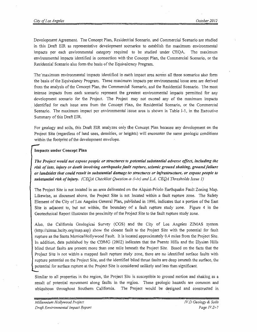
City of Los Angeles October 2012
Development Agreement. The Concept Plan, Residential Scenario, and Commercial Scenario are studiedin this Draft EIR as representative development scenarios to establish the maximum environmentalimpacts per each environmental category required to be studied under CEQA. The maximumenvironmental impacts identified in connection with the Concept Plan, the Commercial Scenario, or theResidential Scenario also form the basis of the Equivalency Program.
The 'maximum environmental impacts identified in each impact area across all three scenarios also formthe basis of the Equivalency Program. These maximum impacts per environmental issue area are derivedfrom the analysis of the Concept Plan, the Commercial Scenario, and the Residential Scenario. The mostintense impacts from each scenario represent the greatest environmental impacts permitted for anydevelopment scenario for the Project. The Project may not exceed any of the maximum impactsidentified for each issue area from the Concept Plan, the Residential Scenario, or the CommercialScenario. The maximum impact per environmental issue area is shown in Table I-I, in the ExecutiveSummary of this Draft EIR.
For geology and soils, this Draft EIR analyzes only the Concept Plan because any development on theProject Site (regardless of land uses, densities, or heights) will encounter the same geologic conditionswithin the footprint of the development envelope.
Impacts under Concept Plan
The Project would not expose people or structures to potential substantial adverse effect, including therisk of loss, injury or death involving earthquake fault rupture, seismic ground shaking, ground failureor landsides that could result in substantial damage to structures or infrastructure, or expose people tosubstantial risk of injury. (CEQA Checklist Question a (i-iv) and L.A. CEQA Thresholds Issue 1)
The Project Site is not located in an area delineated on the Alquist-Priolo Earthquake Fault Zoning Map.Likewise, as discussed above, the Project Site is not located within a fault rupture zone. The SafetyElement of the City of Los Angeles General Plan, published in 1996, indicates that a portion of the EastSite is adjacent to, but not within, the boundary of a fault rupture study zone. Figure 4 in theGeotechnical Report illustrates the proximity of the Project Site to the fault rupture study zone.
Also, the California Geological Survey (CGS) and the City of Los Angeles ZIMAS system(http://zimas.lacity.org!map.asp) show the closest fault to the Project Site with the potential for faultrupture as the Santa Monica/Hollywood Fault. It is located approximately 0.4 miles from the Project Site.In addition, data published by the CDMG (2002) indicates that the Puente Hills and the Elysian Hillsblind thrust faults are present more than one mile beneath the Project Site. Based on the facts that theProject Site is not within a mapped fault rupture study zone, there are no identified surface faults withrupture potential on the Project Site, and the identified blind thrust faults are deep beneath the surface, thepotential for surface rupture at the Project Site is considered unlikely and less than significant.
Similar to all properties in the region, the Project Site is susceptible to ground motion and shaking as aresult of potential movement along faults in the region. These geologic hazards are common andubiquitous throughout Southern California. The Project would be designed and constructed in
Millennium Hollywood ProjectDraft Environmental Impact Report
rVD Geology & SoilsPage It'D»?
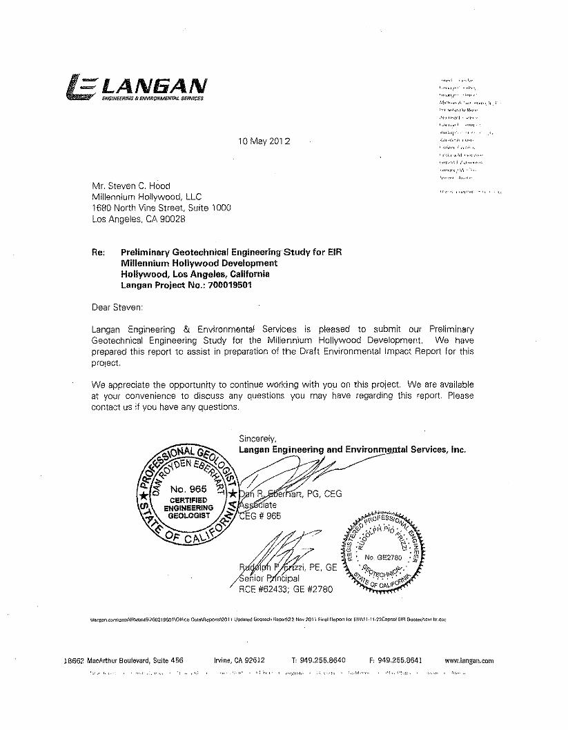
=LANEiAN . ,~,..,I ""., ",.
ENGfNElifllNG 8t EfMRONMENTAL SI!RV1CES
10 May 2012""""1'"",'i"""/<;""I-
Mr. Steven C, HoodMillennium Hollywood, LLC1680 North Vine Street, Suite 1000Los Angeles, CA 90028
"'.,-,; ,,,,'0"'" "-",. l,
Re: Preliminary Geotechnical Engineering Study for EIRMillennium Hollywood DevelopmentHollywood, Los Angeles, CaliforniaLangan Project No.: 700019501
Dear Steven:
Langan Engineering & Environmental Services is pleased to submit our PreliminaryGeotechnical Engineering Study for the Millennium Hollywood Development. We haveprepared this report to assist in preparation of the Draft Environmental Impact Report lor thisproject,
We appreciate the opportunity to continue working with you on this project. We are availableat your convenience to discuss any questions you may have regarding this report. Pleasecontact us if you have any questions,
Sincerely,Langan Engineering and Environ'om:=>_1 Services, Inc,
18662 MacArthur Boulevard, Sulte 456 Irvine, CA 92612 T, 949,255,8640 F, 949,255,8641 www.langan.ccm,: :"
PRELIMINARY GEOTECHNICALENGINEERING STUDY
MILLENNIUM HOLLYWOODDEVELOPMENT
HOllYWOOD, CALIFORNIA
Prepared for:Millennium Hollywood, LLC
1680 North Vine Street, Suite 1000Los Angeles, CA 90028
Prepared by:Langan Engineering and Environmental Services
18662 MacArthur Boulevard, Suite 456Irvine, CA 92612
10 May 2012Langan Project No. 700019501
=LAN6ANENGINEERING & ENVIRONMENTAL SERVICES
Preliminary Geotechnical Engineering StudyMi1Iennium Hollywood DevelopmentHollvwood California
70 May 2072700019507
Page 6 of 11
expansive potential. These soils were encou ntered at depths between approximately23 and 28 feet, and 78 and 83 feet below ground surface. The shallower potentiallyexpansive soils will be removed within the tootprintts) of the below grade parkinggarages. The deeper soils are below the saturated zone and exist at a depth that willnot adversely impact the performance of the building foundations.
SEISMIC ,CONSIDERATIONSMapped FaultsThe Site is not located within an Alquist-Priolo Special Study Zone Area. However, aportion of the East Site is adjacent to the boundary of a fault rupture study zoneincluded in the Safety Element of the City of Los Angeles General Plan published in1996 (Safety Element). Figure 4 presents the Site location in relation to the FaultRupture Study Zones map as included in the Sefety Element
The California Geological Survey (CGSI.which was formerly known as California Divisionof Mines and Geology (CDMG)) Active Near-Source Fault zones map; and the City ofLos Angeles ZIMAS system (hl1p://zimas.lacity.org/map.asp) show the closest fault tothe Site with the potential for fault rupture as the Santa Monica/Hollywood Fault. It islocated approximately 0.4 miles from the Site. Data published by the CDMG (2002)indicates the Puente Hills and the Elysian Hills blind thrust faults are present more thanone mile beneath the Site. These faults are blind thrust faults. Therefore, surfacerupture at the Site from these faults is considered to be unlikely. Figure 5 shows theSite in relation to the active faults in southern California. As discussed above, the Site isnot located within a mapped fault rupture study zone.
landslidesThe Site is not within a designated landslide area according to the landslide inventoryand hillside area map in the City of Los Angeles Safety Element. (Safety Element 1996).Figure 6 shows the Site relative to the Safety Element "Landslide Inventory & HillsideAreas" map. The Site and the surrounding topography is relatively flat and mostlycovered with impervious surfaces. Thus, the Site 'IS not susceptible to landslides.
Seismic Design ParametersThis report was prepared based on the project description information contained in theProject's Draft Environmental Impact Report. For final design of the Project beforeconstruction, and in accordance with the applicable seismic provisions of the 2010California Building Code (2010 CBCI. we recommend the following seismic designparameters be used:
• Maximum Considered Earthquake (MCE) S, and S, of 1.785g and 0.600g,respectively.
• Site Class D.
• Site Coefficients FA and Fvof 1.0 and 1.5.
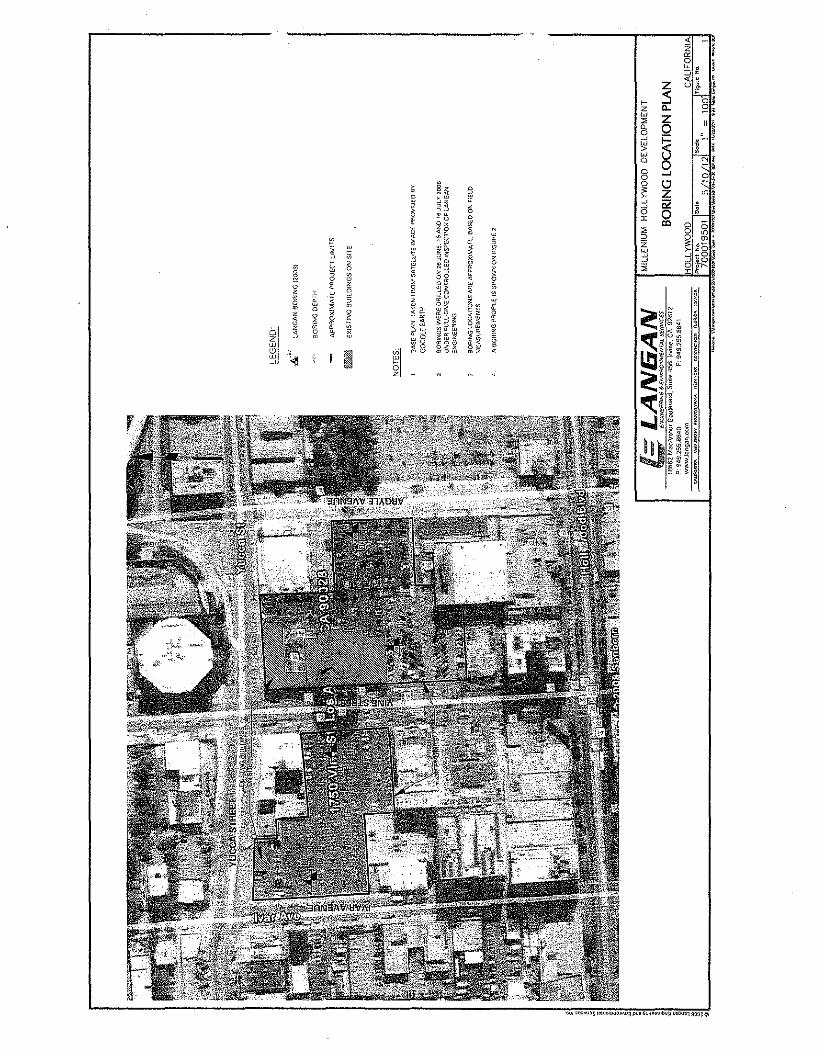
-c ~'z ,c; ,0 !~,:0' e< eZ Ut I
~ s o·z 0.. S;.w Z::;;
"!c, Q0 , ,~ § .. ~~':! ~ !w N!0
0~,.... 0'0
Q .-~0~ Z "">-~ '" ,~ •0 0J: ~!co 0 :1:1a 0:0 o ,"'z %: ~O i':l ~_o~ 6·I1.R as :r::. £ ..,
, ~~ 0,0 , a ~J
~";;::, e:0
• 0 0
~ ~§ ~< ~§ ~ §~
,~5i ~ s
§ e,. 2 '0 0
~~ 0 a ~j ~ ~3 8 00 0~ 2 :2 oe: ~ I,o
13 ~~~
a ~ ~"' :; 5 e ~0 ~ > m~ ggm
" 0
~0z o s ~q~5~ •• 2 s Z0
*gw ~Z " ~ < Vl u. '"
bl 0 " ~ o.w o·S m < £;, ... ? ~~~z
*0 g~iliur 0 Owo
''41. I ~I0 "'::;;: <a'.,
!,!I
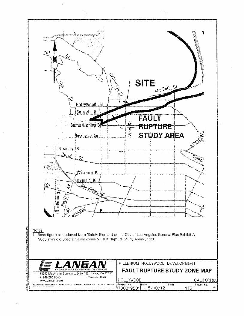
~
·1~~
I~~~--~~----~---=~=-~==~~-=~~--,-----------------------------------------~r =LAN6ANg, ENGINEERiNG s ENVIRONMENTAL SERVICES
.\J 18662 MacArthur Boulevard, Suite 456 Irvine. CA 92612~ P: 949.255.8640 F: 949.255.8641:J www.lanaen.com HOll YWOOD CALIFORNIA~ CALIFORNIA NEWJEflSEY PENNSYlVANIA NEWYO!1K CONNEC1ICU"l fLORIDA NEVADA Project No. Scale FIgure No. 4@L- ~ __--__-- ----~7~O~O~O~19~5~O~1b-~~~~----~N~T~S~------~
Notes:1. Base figure reproduced from "Safety Element of the City of Los Angeles General Plan Exhibit A
"Alquist-Priolo Special Study Zones & Fault Rupture Study Areas", 1996.
MlllENIUM HOllYWOODDEVELOPMENT
FAULT RUPTURE STUDY ZONE MAP
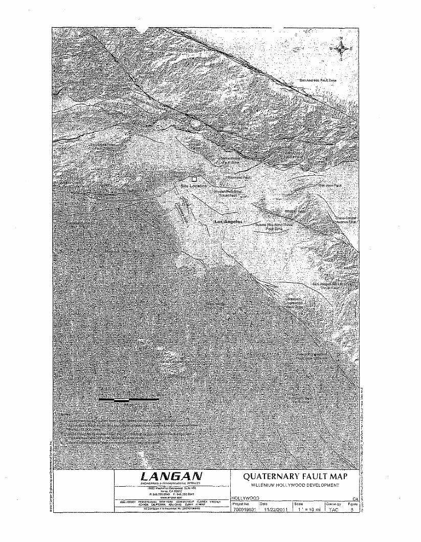
1~6(l1 M.cA""Uf&cU"VI>«', SuilO 456'MM. CA 92612
1>,1)<I9.2~5,a~O F:M9.255.$$41
1-~"~"~'""M~"~"'""~"'O,".o.~~"-;":-'"W";~~:~:~·"~;:~~~"""",""~'CO.,fiOO"W'.C••,.OC'W,_.--_tH~O""L~LYVV~OO"O<O~-----------Co----------Co----C--~""~L 1===="~'~·:~~'~'M:':'§.§:~~W.M~,~~W'::::~.~""'~"~~~:'~,,~~~~·~;~~W:·~~"·~·~'====1'i;Q~2~~Q';:~9~'s~Ol:1J'O=':;~~·'~/2'-2~/:;210011,__ ILS='.i;'~~·C":..11QOcm"'-i_iLD~~C;;;~~'=Yi!~FJi~~'='"j,~
LANGAN QUATERNARY FAULT MAPMILLENIUM HOLLYWOOD DEVELOPMENT
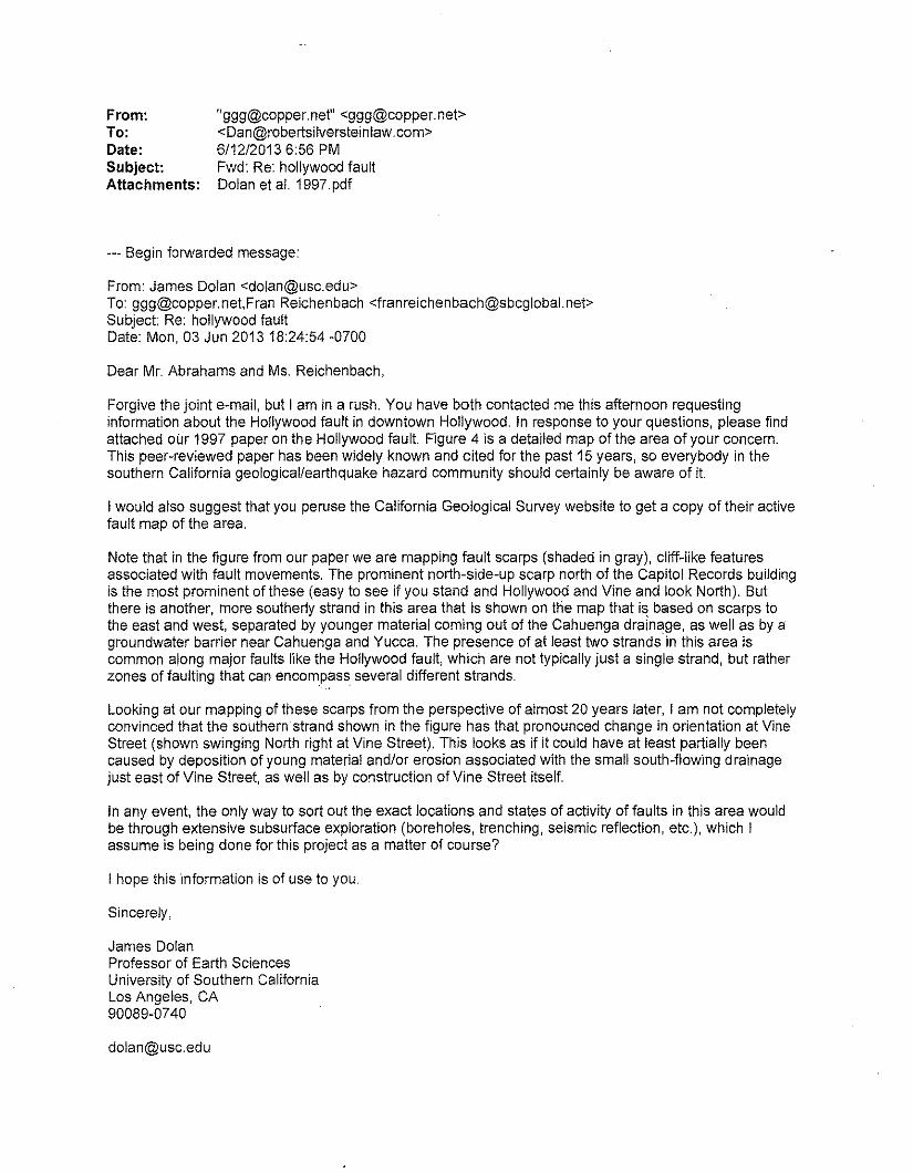
From:To:Date:Subject:Attachments:
"[email protected]" <[email protected]><[email protected]>6/12/20136:56 PMFwd: Re: hollywood faultDolan et at, 1997. pdf
--- Begin forwarded message:
From: James Dolan <[email protected]>To: [email protected],Fran Reichenbach <[email protected]>Subject: Re: hollywood faultDate: Mon, 03 Jun 2013 18:24:54 -0700
Dear Mr. Abrahams and Ms. Reichenbach,
Forgive the joint e-mail, but I am in a rush. You have both contacted me this afternoon requestinginformation about the Hollywood fault in downtown Hollywood. In response to your questions, please findattached our 1997 paper on the Hollywood fault. Figure 4 is a detailed map of the area of your concern.This peer-reviewed paper has been widely known and cited for the past 15 years, so everybody in thesouthern California geological/earthquake hazard community should certainly be aware of it.
I would also suggest that you peruse the California Geological Survey website to get a copy of their activefault map of the area.
Note that in the figure from our paper we are mapping fault scarps (shaded in gray), cliff-like featuresassociated with fault movements. The prominent north-side-up scarp north of the Capitol Records buildingis the most prominent of these (easy to see if you stand and Hollywood and Vine and look North). Butthere is another, more southerly strand in this area that is shown on the map that i~ based on scarps tothe east and west, separated by younger material coming out of the Cahuenga drainage, as well as by agroundwater barrier near Cahuenga and Yucca. The presence of at least two strands in this area iscommon along major faults like the Hollywood fault, which are not typically just a single strand, but ratherzones of faulting that can encompass several different strands.
Looking at our mapping of these scarps from the perspective of almost 20 years later, I am not completelyconvinced that the southern strand shown in the figure has that pronounced change in orientation at VineStreet (shown swinging North right at Vine Street). This looks as if it could have at least partially beencaused by deposition of young material and/or erosion associated with the small south-flowing drainagejust east of Vine Street, as well as by construction of Vine Street itself.
In any event, the only way to sort out the exact locations and states of activity of faults in this area wouldbe through extensive subsurface exploration (boreholes, trenching, seismic reflection, etc.), which Iassume is being done for this project as a matter of course?
I hope this information is of use to you.
Sincerely,
James DolanProfessor of Earth SciencesUniversity of Southern CaliforniaLos Angeles, CA90089-0740
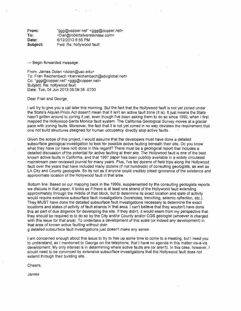
From:To:Date:Subject:
"[email protected]" <[email protected]><[email protected]>6/12/20136:56 PMFwd: Re: hollywood fault
--- Begin forwarded message:
From: James Dolan <[email protected]>To: Fran Reichenbach <[email protected]>Cc: "[email protected]" <[email protected]>Subject: Re: hollywood faultDate: Tue, 04 Jun 2013 08:09:38 -0700
Dear Fran and George,
I will try to give you a call later this morning. But the fact that the Hollywood fault is not yet zoned underthe State's Alquist-Priolo Act doesn't mean that it isn't an active fault zone (it is). It just means the Statehasn't gotten around to zoning it yet, even though I've been asking them to do so since 1992, when I firstmapped the Hollywood-Santa Monica fault system. The California Geological Survey moves at a glacialpace with zoning faults. Moreover, the fact that it is not yet zoned in no way obviates the requirement thatone not build structures designed for human occupancy directly atop active faults.
Given the scope of this project, I would assume that the developers must have done a detailedsubsurface geological investigation to look for possible active faulting beneath their site. Do you knowwhat they have (or have not) done in this regard? There must be a geological report that includes adetailed discussion of the potential for active faulting at their site. The Hollywood fault is one of the bestknown active faults in California, and that 1997 paper has been publicly available in a widely circulatedmainstream peer-reviewed journal for many years. Plus, I've led dozens of field trips along the Hollywoodfault over the years that have included many dozens (if not hundreds) of consulting geologims, as well asLA City and County geologists. So its not as if anyone could credibly plead ignorance of the existence andapproximate location of the Hollywood fault in that area. .
Bottom line: Based on our mapping back in the 1990s, supplemented by the consulting geologists reportswe discuss in that paper, it looks as if there is at least one strand of the Hollywood fault extendingapproximately through the middle of that block, but to determine its exact location and state of activitywould require extensive subsurface fault investigations (boreholes, trenching, seismic reflection, etc.).They MUST have done the detailed subsurface fault investigations necessary to determine the exactlocations and states of activity of fault strands in that area. I can't believe that they wouldn't have donethis as part of due diligence for developing the site. If they didn't, it would seem from my perspective thatthey should be required to to do so by the City and/or County and/or CGS geologist (whoever is chargedwith this issue for that area). To undertake a development of this scale (or indeed any development) inthat area of known active faulting without doing detailed subsurface fault investigations just doesn't make any sense.
I am concerned enough about this issue to try to free up some time to come to a meeting, but I need youto understand, as I mentioned to George on the telephone, that I have no agenda in this matter vis-a-visdevelopment. My only interest is in determining where active faults are (or aren't). In this case, however, Iwould need to be convinced by extensive subsurface investigations that the Hollywood fault does notextend through their building site.
Cheers,
James
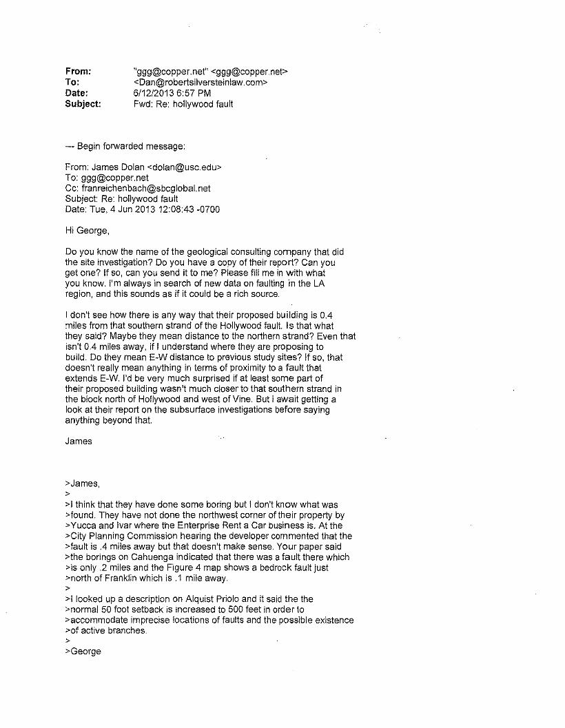
From:To:Date:Subject:
"[email protected]" <[email protected]><[email protected]>6/12/20136:57 PMFwd: Re: hollywood fault
--- Begin forwarded message:
From: James Dolan <[email protected]>To: [email protected]: [email protected]: Re: hollywood faultDate: Tue, 4 Jun 201312:08:43 -0700
Hi George,
Do you know the name of the geological consulting company that didthe site investigation? Do you have a copy of their report? Can youget one? If so, can you send it to me? Please fill me in with whatyou know. I'm always in search of new data on faulting in the LAregion, and this sounds as if it could be a rich source.
I don't see how there is any way that their proposed building is 0.4miles from that southern strand of the Hollywood fault. Is that whatthey said? Maybe they mean distance to the northern strand? Even thatisn't 0.4 miles away, if I understand where they are proposing tobuild. Do they mean E-W distance to previous study sites? If so, thatdoesn't really mean anything in terms of proximity to a fault thatextends E-W. I'd be very much surprised if at least some part oftheir proposed building wasn't much closer to that southern strand inthe block north of Hollywood and west of Vine. But I await getting alook at their report on the subsurface investigations before sayinganything beyond that.
James
>James,>>1think that they have done some boring but I don't know what was>found. They have not done the northwest corner of their property by>Yucca and Ivar where the Enterprise Rent a Car business is. At the>City Planning Commission hearing the developer commented that the>fault is .4 miles away but that doesn't make sense. Your paper said>the borings on Cahuenga indicated that there was a fault there which>is only .2 miles and the Figure 4 map shows a bedrock fault just>north of Franklin which is .1 mile away.>>1 looked up a description on Alquist Priolo and it said the the>normal 50 foot setback is increased to 500 feet in order to>accommodate imprecise locations of faults and the possible existence>of active branches.>>George
From:To:Date:Subject:
"[email protected]" <[email protected]><[email protected]>611212013 6:57 PMFwd: Re: hollywood fault
--- Begin forwarded message:
From: James Dolan <[email protected]>To: [email protected]: Re: hollywood faultDate: Tue, 4 Jun 201313:27:15 -0700
Hi George,
Thanks for sending the draft EIR. I've taken a quick look, and I'mhonestly not quite sure what to say. I want to be circumspect, buttrying to find an E-W fault with an E-W (i.e., fault-parallel)transect of four incompletely sampled (18" of core every 5' of depth)boreholes is simply ... well, stunning. So stunning that I wouldsuspect that they weren't looking for a fault at this location, asthis study could not possibly have been designed to look forpotential E-W-trending strands of the Hollywood fault system.Puzzling, as my mapping shows the fault either through right next totheir site, and the CGS website shows the northern strand of theHollywood just north of Yucca at the very prominent scarp.
In any event, this subsurface analysis, if this is all that has beendone, is completely inadequate in terms of a fault-investigationreport. There's no way that they could ever hope to determine wherefaults are (or aren't) at their proposed building site from justthese four boreholes.
Is that really all there is? At some point along the line, somebodyassociated with this development project MUST have done a moredetailed subsurface analysis to check for faulting.
James
>James,>>here is the report:>>http://cityplanning.lacity.org/eir/Millennium%20Hollywood%20ProjectiDEIRIDEIR%20AppendicesIMlIIennium%20Hollywood%20DEI R_Volume%201 %20Appendices_ COMPI LED. pdf>>Iangan engineering and environmental services>>report starts on page 699>>George
Appendix IV.A
Aesthetic Impacts Report by Roschen Van Cleve Architects(August 2012)
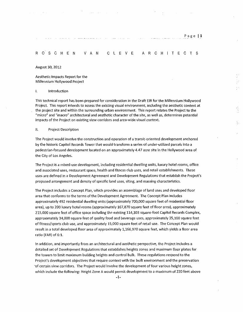
Page 11
R 0 S C HEN V A N C LEV E ARCHITECTS
August 30, 2012
Aesthetic Impacts Report for theMillennium Hollywood Project
I. Introduction
This technical report has been prepared for consideration in the Draft EIR for the Millennium HollywoodProject. This report intends to assess the existing visual environment, including the aesthetic context atthe project site and within the surrounding urban environment. This report relates the Project to the"micro" and "macro" architectural and aesthetic character of the site, as well as, determines potentialimpacts of the Project on existing view corridors and area-wide visual context.
II. Project Description
The Project would involve the construction and operation of a transit-oriented development anchored
by the historic Capitol Records Tower that would transform a series of under-utilized parcels into a
pedestrian-focused development located on an approximately 4.47 acre site in the Hollywood area of
the City of Los Angeles.
The Project is a mixed-use development, including residential dwelling units, luxury hotel rooms, office
and associated uses, restaurant space, health and fitness club uses, and retail establishments. These
uses are defined in a Development Agreement and Development Regulations that establish the Project's
proposed arrangement and density of specific land uses, siting, and massing characteristics.
The Project includes a Concept Plan, which provides an assemblage of land uses and developed floor
area that conforms to the terms of the Development Agreement. The Concept Plan includes
approximately 492 residential dwelling units (approximately 700,000 square feet of residential floor
area), up to 200 luxury hotel rooms (approximately 167,870 square feet of floor area), approximately
215,000 square feet of office space including the existing 114,303 square-foot Capitol Records Complex,
approximately 34,000 square feet of quality food and beverage uses, approximately 35,100 square feet
of fitness/sports club use, and approximately 15,000 square feet of retail use. The Concept Plan would
result in a total developed floor area of approximately 1,166,970 square feet, which yields a floor area
ratio (FAR) of 6:1.
In addition, and importantly from an architectural and aesthetic perspective, the Project includes a
detailed set of Development Regulations that establishes heights zones and maximum floor plates for
the towers to limit maximum building heights and control bulk. These regulations respond to the
Project's development objectives that require context with the built environment and the preservation
'of certain view corridors. The Project would involve the development of four various height zones,
which include the following: Height Zone A would permit development to a maximum of 220 feet above
-1-
P a e 2
ground zone and would be located on the northwest portion of the West Site; Height Zone B wouldpermit development to a maximum of 585 feet above ground zone and would be located on the easternhalf of the West Site; Height Zone C would be located on the west side of the East Site fronting VineStreet (south of the Capitol Records Building) and would permit buildings to be a maximum of 585 feetabove grade; and Height Zone D would be located on the east side of the East Site fronting ArgyleAvenue and would permit buildings to a maximum height of 220 feet above grade. The Project alsocontains massing standards. Thus, the scale and massing of the Project will be regulated pursuant to theDevelopment Regulations in a manner that the buildout of the Project will occur within a pre-determined massing envelope. The Development Regulations and architectural components of theProject ultimately control the aesthetic and architectural variations that could affect visual resources.Thus, these components were assessed to determine potential visual impacts associated with theProject.
III. Aesthetic Analysis and Contextual Concepts of Urban Form
A. Aesthetic Concepts Related to the Project Site and Surroundings
Starting with the architectural and visual character of the Project, the composition of the threeindividual towers (two new project structures plus the Capitol Records Tower) is designed to create a"unified whole" with the historic Capitol Records Tower as its compositional center. This aesthetic andarchitectural strategy will ensure a well-balanced integration of the Capitol Records Tower at both themicro and macro site scale. This compositional strategy adds urban and visually enhanced qualities tothe site and its surroundings while maintaining architectural spacing in recognition of existing structures.
Conceptually, the "micro site" of the project is designed primarily to provide complementary andsupportive spatial setting for the Capitol Records Tower. It also allows the Project to fully engage,extend, and redefine the pedestrian experience in this area of Hollywood because the Project visuallyand architecturally transforms a currently underutilized portion of the site. The micro site (which is theimmediate surroundings of the Project) includes publicly accessible open spaces and engagingarchitectural features that that will add to the Hollywood experience. These plazas will enliven thevisitor and community appreciation for the destination areas at, and around, the micro site such as thehistoric Capitol Records Tower, the historic Playhouse and the world famous corner of Hollywood andVine.
Similarly, the "macro site" (consisting of the Project's relation to the wider aesthetic and architecturalcontext surrounding the site) is conceived to align with and amplify the familiar gateway qualities of thehistoric Capitol Records Tower. This aesthetic and architectural strategy has the potential tocomplement the Hollywood skyline on the traditional Vine Street corridor. In addition, the Project'sarchitectural and visual prominence will be consistent with and will further the unique architecturalsyntax of Hollywood by adding a new welcoming icon of design and unique place making that integratesHollywood's past while building Hollywood's future. In this way, the Project will complement andsupport Hollywood's visual quality, recognized vistas and evolving aesthetic character.
8. Relation of Onsite Aesthetic Concepts to Potential Project Impacts
-2-
Pagel3
The micro site provides the historic Capitol Records Tower a supportive spatial setting by a spatialexpansion surrounding the entire cylindrical form of the historic Capitol Records Tower to ensure thehistoric Capitol Records Tower will not be completely smothered by the project density, but will beenhanced and recognized. By crafting a compatible project backdrop that is sensitive to thearchitectural features and historic views; is complementary with the spacing and scale of the iconictower; and that integrates supportive space surrounding the historic Capitol Records Tower withappropriate program uses, the micro site design protects the visual character of the site. This project-related urbanization includes a heightened pedestrian experience with intimate spatial engagements forall with the historic Capitol Records Tower that are not possible today on the existing parking lots. Theexisting visual character and quality of the site will therefore be protected and improved throughcompositional harmony and spatial orchestration of views of the familiar icon from the freeway, fromVine Street, from the sidewalks and, significantly, from on site.
',
In addition, the micro site fully engages, extends, and redefines the Hollywood pedestrian experience bybringing to Vine Street world-class plazas, mini parks, through-block passages, and destination publicspaces that link and extend the experience of the Hollywood Walk of Fame with multiple historic icons,existing open spaces, and adjacent streets to replace the existing surface parking lots.Also by locating distinguished and unique retail opportunities at street level on both sides of Vine Street,along through-block passages, along spaces surrounding the Capitol Records Tower, and on projectedges facing the plazas and streets, the existing pedestrian urban intent, and visual quality of the site,will be protected and raised.
Finally, by designing street level environments that welcome visitors and locals in a series of intimatepublic spaces conceived in the Hollywood paradigm of intimate public outdoor rooms, such as thehistoric Chinese Theater and Egyptian Theater Forecourts, but specifically and dramatically unique toplace making around the historic Capitol Records Tower, the Project will enhance this edge of Hollywoodto the quality of other iconic Hollywood sites, which enhances the architectural features of the site andimproves the visual character and quality of the site.
C. Analysis of Vistas, Viewpoint Obstruction and Aesthetic Contrast
In addition to the aesthetic concepts discussed above, the potential levels of aesthetic impactsassociated with the Project can be described and discussed in three primary categories.
1. Scenic Vistas
The existing scenic vistas from the Hollywood Hills are a diverse expanse of urban Los Angeles whichshould be described as a basin wide perspective. These views include multiple urban centers such asdowntown, Century City and the Wilshire corridor. The full texture and fabric of these views involveshigh rise, low rise and Single family neighbors combining into an architecturally-diverse picture of theLos Angeles Basin. The texture and fabric of the Project is consistent with this basin view and will addurban figure and form in balance with the other urban centers represented in the scenic vista views ofthe Los Angeles Basin from viewpoints in the Hollywood Hills.
Other scenic vistas from different areas of the hills are consistent with the basin-wide perspective.Granted, the view of the historic Capitol Records Tower will change and vary with the hillside viewinglocations and dependent on the height and massing of the implemented project development scenario.
-3-
Page 14
In every case, however, the distance from the vista viewpoints in the Hollywood Hills to the CapitolRecords Tower involves the key aesthetic feature in the textural view of the vista rather than as aspecific object to be identified and distinguished. Hence, the Project's potential impact on vistas is notconsidered materially adverse given the diversified urban context of the basin and varied architecturalfeatures and structures that comprise the viewshed.
2. Potential Obstructions of Valued Views
A key view from a focal point at grade level is the view of the Project from the corner of Hollywood andVine. At the Project's lower design height of 220 feet, and even the 400-foot height, the obstruction ofthis familiar view could be significant. The view blockage is significant under these developmentscenarios because the cylindrical shape of the Capitol Records Tower would not be easily recognized. AsProject structure height increases, however, the additional setback becomes adequate to visuallydescribe the form and identify the iconic structure creating a spatial setting around the historic towerthat preserves the valued views. From the vista views noted above, the architectural components andcharacter of the site's valued visual resources are less distinguishable as the urbanized fabric anddeveloped character of the site and the area consume stand-alone structures into an urbanized macroperspective. The resulting obstruction, and potential related project impacts, from this perspective arenot considered significant given architectural and visual context.
3. Visual Contrast with Urbanized Setting and Existing Features
The site and its surroundings are fully urbanized and represent urban form, fabric and architecture.From many of the surrounding residential streets and commercial boulevards, there will be views of theproject. These views will be distinguished by the heights of the project, but will be consistent with theareas existing aesthetic image, urban texture and city form. This is primarily because diverse character inurban form and design is a hallmark of Los Angeles and our many different Los Angeles neighborhoodsand associated aesthetic contrast. The pattern of height juxtapositions is common in the project area,and in the City generally, and becomes the very nature of Los Angeles' character rather than a thematicurban fabric or a limited architectural language. Thus, the density, height and massing of the Projectmay be different than the existing uses on the site and in the area, yet the urbanized nature of the siteand architectural features of Project are not in material contrast with the urban fabric of the area.
IV. Conclusions
In summary, the Project would not have a substantial adverse effect on scenic resources or substantiallydegrade the quality of the existing environment. The existing aesthetic environment, from both a microand macro perspective, around the Project Site is fully urbanized. In fact, the focused pedestrianurbanization and skyline orchestration would substantially evolve the aesthetic nature of the project sitefrom both a micro and macro perspective. The immediate focal viewpoints from limited street-levelperspectives could be obstructed under certain development scenarios. Overall, however, the Project'sadditional urban uses, architectural components, and aesthetic character on an in-fill site will not onlyimprove, but "turnaround" a long neglected site into an urban Hollywood gateway at the top of VineStreet. Accordingly, on balance with the existing visual environment, viewed from afar and near, theproject's aesthetic impacts are mostly considered less than significant.
-4-
~ "u -0 w 0~ "ec0 ro~ a ~w
>~ az~~
Z0!- f. ..
• U~ill«~w
r ~"~Xzw_Z
>-~"0z 00
w U~-- ill
x j-.,.ur~0or~~Z4~IX
.>
~~
0 ~~ro00 ~0
%~ ~~ ~~ %0~I
"J ~Z»0 az; ::lG 12'" Uill ~t:;}
IU
o '"40 ~0 illc~ Z
4>. r--0xz >-> Z0<- W~ Z o4 ;:U0 "U~ 0 <>
~~0
-rw ~" '"L. W~(. Z() i;;0 <:_.
c,
" :;:() :0.» Z'.U ur
"'"',. ~1,;1
Z P-.0 ;ZU
aoo3~~~oI
oz<
oooa
"-z~oo~zou,"'"
oo
~ N
0 0w,~0
a ,Q
•
~L s-~
wco0I~~Z4m~0
...Zwo"-c
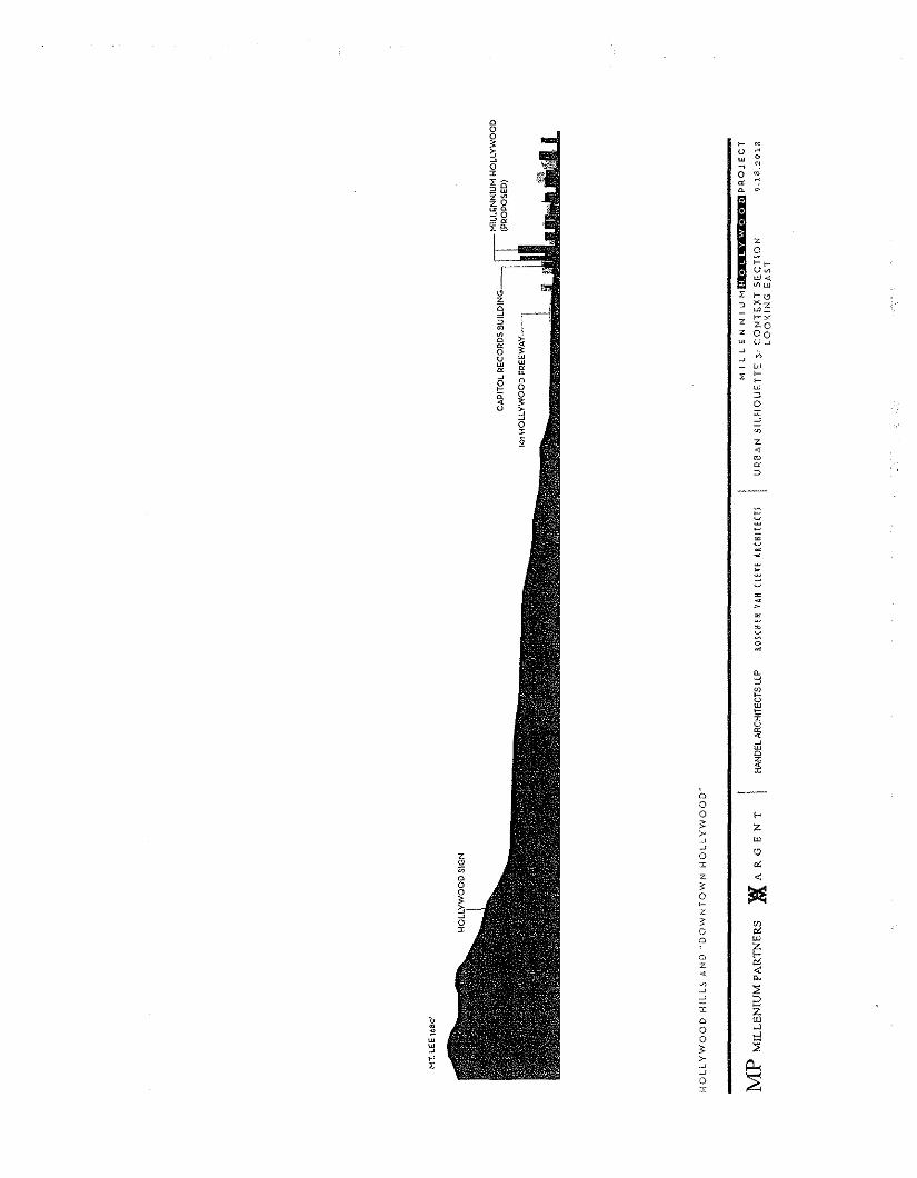
-z:2rru~ur -a;~"'c Z rOz
0 Xz" • .L~ II r"S z ZOro z 00~" ~ u~a ~ "0 ~U "'ur "' "'a ff Z r-,
" ~0"'Ii: 0'
4 0U 0:~~Z4co~"
~~>
~~>:;
~e,:J~ow1=r
"'"~WQ~
Q00 f->
Zc-~Ul_.
~ o0z '"z, <5:
~0
z< enG '"a wa i:z. '"., -c
c,~ :;~~ :0I Z
'0 o tu, 0 "',..,w 0 ~"' ""f- ,.
~Z .0~;;B0
·X
Appendix IV.C
Millennium Hollywood Project Historic Resources Technical Report
Historic Resources Group(July 2012)
Millennium Hollywood ProjectHistoric Resources Technical ReportJuly 2012HISTORIC RESOURCES GROUP
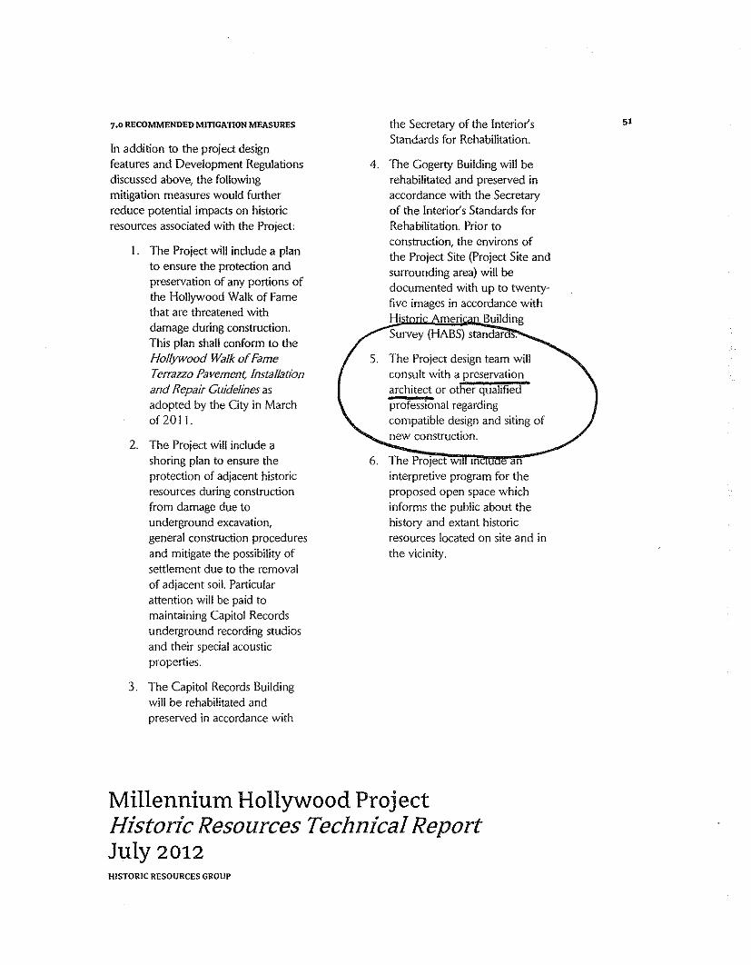
7.0 RECOMMENDED MITIGATION MEASURES the Secretary of the Interior's 51
In addition to the project designStandards for Rehabilitation.
features and Development Regulations 4. The Cogerty Building will bediscussed above, the following rehabilitated and preserved inmitigation measures would further accordance with the Secretaryreduce potential impacts on historic of the Interior's Standards forresources associated with the Project: Rehabilitation. Prior to
I. The Project will include a planconstruction, the environs ofthe Project Site (Project Site and
to ensure the protection and surrounding area) will bepreservation of any portions of documented with up to twenty-the Hollywood Walk of Fame five images in accordance withthat are threatened with Hi meri Buildingdamage during construction. Survey (HABS) stan darThis plan shall conform to theHollywood Walk of Fame S. The Project design team willTerrazzo Pavement, Installation consult with a preservationand Repair Guidelines as architect or other qualifiedadopted by the City in March professional regardingof 2011. compatible design and siting of
2. The Project will include anew construction.
shoring plan to ensure the 6. The Project WI In anprotection of adjacent historic interpretive program for theresources during construction proposed open space whichfrom damage due to informs the public about theunderground excavation, history and extant historicgeneral construction procedures resources located on site and inand mitigate the possibility of the vicinity.settlement due to the removalof adjacent soil. Particularattention will be paid tomaintaining Capitol Recordsunderground recording studiosand their special acousticproperties.
3. The Capitol Records Buildingwill be rehabilitated andpreserved in accordance with
Millennium Hollywood ProjectHistoric Resources Technical ReportJuly 2012HISTORIC RESOURCES GROUP
FROM THE DESK OF JON PERICA10338 ETIWANDA AVE, NORTHRIDGE, CA 91326
May 17th, 20 \3
Honorable LA City Council
JUSTIFICATION TO DENY PROJECT - CPC 2008-3440(VZC)(CUB)(CU)(ZV)(HD)ENV 201l-67S-EIR
My name is Jon Perica and I worked in the Los Angeles Planning Department for 35years, including working as a Zoning Administrator for 20 years issuing legal decisions on over2,500 cases. My decisions were based on the required legal findings and a fair and impartialevaluation of each case irrespective of the applicant and political popularity of the case. None ofmy cases were ever overturned by a Superior Court action. Over these many years of ruling ondevelopment projects I have learned what makes a "good" project. Unfortunately, theMillennium Hollywood Project is not a good project and cannot legally be supported withappropriate findings.
I have reviewed the applicant's requests and City Planning Commission determinationfor the above cited mixed use project in Hollywood at 1750 Vine Street and I strongly believethat the City Council should deny the applicant's request for the following reasons.
I. Failure to follow Zone Code: City Charter Requirements and Procedures.
The governing hierarchy for land use decisions in the City of Los Angeles starts with theCity Planning and Zone Code (Section 526 City Charter). The Zone Code defines the by-rightuses by specific zone, "Conditional Uses" (Sec 12.24 of the Code) permitted in a case-by-casesituation by specific zone and a Variance process (Section 12.27 of the Code) for relief on acase-by-case basis if, due to some unique aspect of the land, an applicant cannot comply with thestrict requirements of the Zoning Code.
At the next level of planning review, the City can impose case-by-case Conditions ofapproval as temporary requirements designated by this symbol (Q) or permanent conditionsdesignated by a [Q] symbol. These conditions become officially part of the actual zoning for theparticular parcel of land. Q conditions are defined in Section 12.32 G (2), which says theyidentify how, cc ••• property not be utilized for all uses ordinarily permitted in a particular zone ... "so the Q restricts by-right uses in a zone. Lastly, the City can impose conditions that arepermanent but which do not change the official zoning and these are simply listed as conditions
of approval of a particular discretionary land use application. Most City conditions ondevelopment cases are this last process which takes the form of "contract zoning." Through thisprocess, the project is conditioned on the developer executing a Master Covenant and Agreementwhich memorializes all of the Q conditions intended to restrict the project to particular land usesor mitigate certain environmental impacts of the project.
If any applicant requests changes to any City project conditions, other than a simpleclarification of intent or very minor adjustment of a conditions due to unintended difficulties,such modifications must be done in as a formal request with public notice and hearing based onnumerous municipal code provisions.
The Millennium Hollywood application before the City Council contains a proposed QCondition that opens a giant loophole to allow Planning Department staff to override the LosAngeles Municipal Code, adopted conditions imposed on the project as a condition of approval,and a right to declare what the "intent" of any of entitlements mean, apparently regardless oftheir wording.
The Planning Commission's April 27, 2013 approval of the Hollywood Millenniumproject application includes Condition #2 (Site Development" on page Q-I). The particularcondition, as worded, allows Millennium Hollywood to file a request for, and City Planningofficials to grant code changes and adopted condition changes without any public notice orhearing: "Minor deviations may be allowed in order to comply with provisions of the MunicipalCode, the subject conditions, and the intent of the subject permit authorization". While thissentence sounds simple, in reality is very troubling and would set a bad precedent for the City tofollow in the future.
In its essence, Condition #2 gives Millennium Hollywood an opportunity to evade fullcompliance with any of the hundreds of City conditions or existing City Code provisions thatrestrict and describe how the project will be constructed and operate.
The first specific problem is due process to adjoining property owners and interestedparties. Will there be a written request by the applicant and public notice and hearing with appealrights? Currently, changes to existing project conditions are made by written action by thePlanning Department (with a hearing, or without a public hearing when the Department makes awritten finding that the particular request is not "controversial" and would not "adversely"impact adjacent properties). A Planning Department decision to change an existing condition issent to adjacent residents and is appealable so due process is provided in many City processes.
By way of example, Section 12.28 B.2 of the Zone Code sets a clear process for"modifications" by defining a measurable amount of permitted change (up to 20% for yard andarea intrusion and 10% for area reductions) if the modification is filed with another request.Section 12.28 B.2 requires a public hearing unless the Planning Department determines that therequested change will not cause a public controversy and have a less than significant impact onadjacent properties. Thus, any Millennium Hollywood future "minor" deviation beyond a slightreduction in yard and lot area (10-10%) requests would not be consistent with Section 12.28.B.2.
- 2 -
Condition #2 for the Hollywood Millennium Project appears to bypass the City's minor projectchange procedures, like that specified in Section 12.28.B.2, without stating so. I know of noprovision that authorizes a Q Condition to override numerous City due process provisions thatprotect adjoining property owners and provide a right of review.
The second specific problem is that subjective and arbitrary changes to conditions can bemade by the Planning Department staff behind closed doors. There are too many unansweredquestions about the scope of the power conferred on the Planning Staff. What is the definition ofa "minor deviation"? What is a "minor" deviation on a 30-unit apartment is not the same as a"minor" deviation on a one million square foot project with possible towers 585 feet tall. SinceCondition #2 is an unrestricted power to modify everything about the Project, presumably a CityPlanning official would be empowered to make a minor modification of the tower heights. Asingle "minor" deviation on a super large project such as this could have significant impacts. A"minor" 20 percent height increase (117 feet) would take the towers to over 700 feet in height.
Are there any measurable standards to define "minor"? If there are no quantifiablestandards, one Planning Department staffs determination of "minor" could vary widely fromothers undermining the goals of consistency in land use laws of the City. As a result, therewould be a complete inconsistency in the application of this extraordinary power. By what ZoneCode authority can the City allow this Condition #2 which creates an undefined new process forchanging adopted conditions of approval and overriding the Municipal Code?
The existing Zone Code grants no specific authority to change conditions based on thesimple wording of Condition #2. By what Zone Code authority can Millennium Hollwood makethese requests? Who in the Planning Department will make a final decision on requested "minordeviations"? Why is there no appellate process consistent with other City planning processes?
Q conditions are intended to restrict some of the by-right uses permitted for the projectbased upon the zoning for the site. Future changes to Q conditions could in fact allow anincrease in what the zone use would permit (i.e. auto detailing/auto repair/tune-up) adjacent to aresidential zone without further Zone Code required discretionary approval under a processwhere residential space and commercial spaces were changed under the general argument ofequivalency of trip generation.
The possible City Planning Department staff modification of Q conditions in such anundefined process would be an "unbridled" self-grant of power inconsistent with the Zone Code.The Planning Commission is folding this "presumed" authority into the standard Q conditionprocess for case approvals found in Zone Code Section 12.32 -- which only gives the PlanningCommission authority to approve some or all of a request and impose conditions. The PlanningCommission has current authority over existing project conditions but not over future changes toalready approved conditions that Millennium Hollywood did not appeal before the City Counciltook the final approval action. Based upon my years of experience, I know of no MunicipalCode provision that authorizes the Planning Commission to impose Condition #2 - because it isnot really a condition. Rather it is an awesome new power of the City Planning Department staffto rewrite any City law or adopted condition.
o- ) -
In theory, by using the Land Use Equivalency Program also approved in Condition #2(see Lack of Authority Finding #2 below), the Planning Department could make changes notallowed by the Zone Code without requiring a Zone Variance to be filed. In the hierarchy ofplanning authority described above, case conditions are below the Zone Code and cannotsupersede the Zone Code without following all existing standards and requirements. There hasnever been such a condition written to allow future Q Condition changes without a publicprocess on any Planning Department approval I have seen, and this unfettered power would set aterrible precedent for future projects.
Only with a defined standard for the amount of change allowed and a transparent processfor public notification and public hearing should any future change to any condition be allowed.The Planning Commission has exceeded its authority in approving Condition #2 because there isno Zone Code authority to approve future Q condition changes without written standards,updated environmental review, and a written decision, all followed by a public process of appeal.
Finally, Condition #2, which allows undefined future changes and modifications, couldalso be carried out without any required further environmental and public review in violation ofCEQA and the City's own environmental review procedures.
Conclusion - The City'S two existing planning processes for minor deviations are extremelylimited and defined: 1) One for limited changes of conditions/intent or a letter explaininglanguage or 2) A minor yard and lot area reductions. Condition #2 of the Millennium HollywoodProject authorizing unfettered discretion for City Planning Department staff to re-write ZoneCode without a variance process, and to re-write City Council adopted project conditions has noauthority in the Zone Code provisions allowing imposition of Q conditions. The stated purposeand intent of Q conditions is to impose additional restrictions of a particular project to protect thepublic interest, not add unrestrained power to re-write the laws of this City and specific projectconditions in a room at City Hall. For this reason, Condition #2 is wildly at variance with thehistory of Zone Code administration in this City and appears to be without any precedent.
2. Lack of Zone Code Authority for Land Use Equivalency Program - Future Changes toPast Approvals without New Approvals.
The City Planning Department has offered a Land Use Equivalency program whichenables a developer to propose future changes in uses on large projects that take a long time to beconstructed, however such programs have been limited only to Development Agreements. Therehad been a Development Agreement for the Millennium Hollywood Project, but I am informed itwas withdrawn due to a conflict of interest of the Planning Commission President who hasworked on the Millennium Hollywood Project.
It now appears that the Millennium Land Use Equivalency Program has been shifted bythe City Planning Commission into Q Condition #1: "Permitted Use. The use of the subjectproperty shall be limited (0 those uses permitted in the Land Use Equivalency Program, attachedas Exhibit D or as permitted in the C2 Zone as defined in Section 12.16 A of the L.A.M.C."
- 4 -
While a Development Agreement under the State Planning Law allows use of the property to bea subject of such agreements, there is no explicit authority for Land Use Equivalency Programsthat would permit an applicant to swap out land uses to be constructed over a long period of timewithout further discretionary decision or environmental review.
The Millennium Hollywood Project goes even further, however. The City PlanningCommission, when it was barred from considering a proposed Land Use Equivalency Program aspart of a Development Agreement, now has dropped the Land Use Equivalency Program into a Qcondition. I know of no authority for a Q condition to grant a Land Use Equivalency Program.And this makes sense because, as indicated above, the Zone Code provides that Q conditions areused to further restrict land uses otherwise allowed by Code - not grant provisions that would bemore permissive such as a Land Use Equivalency Program.
Since enactment of state law that permits Development Agreements, the City has enteredinto Development Agreements to provide some certainty that projects taking a long time to buildwill not be subject to changes in zoning laws before the project is constructed. That is theprincipal purpose of a Development Agreement. The idea is that very large projects can take 3-5 years or more from original planning to final occupancy. There may be a greater demand in amixed use project for housing in the future than currently, when the applicant secured approvalfor more office use. Whenever an applicant sought flexibility for this type of risk, it wasrequired to set forth two or three specific project options so that the project could still be feasiblyanalyzed under environmental laws yet provide a measure of flexibility for future development.Thus, in the future, the applicant could change the land uses within the strict options defined atthe outset. The Land Use Equivalency Program authority to change originally approved uses fordifferent uses would occur without any further discretionary review so long as it was within thestrict limits of the original discretionary approval. This was the theory behind the PlanningDepartment Land Use Equivalency Program.
The Land Use Equivalency Concept does not exist in the City Zone Code as a formalprocess. The willingness of the City Planning Department to consider flexibility seems to haveevolved after a developer came to the Planning Department several decades ago with a largeproject and asked for future flexibility. After the City Planning Department allowed this optionas part of a Development Agreement with strict options, it became known in the Los Angelescommunity of land use attorneys, land use consultants, large developers and City Councilmembers. Few members of the public, neighborhood councils, or homeowner organizations areaware of this flexibility program because the Planning Department does not advertise thisprogram and the Department has no written rules as to how it operates.
While the City has approved several Land Use Equivalency applications over severaldecades, to the best of my knowledge, none of them have had any further environmental reviewto determine if the change in uses that were allowed caused more adverse impacts that theoriginally approved uses. Without any public notification of a requested land use change, there isno appeal opportunity if the Planning Department made changes that in fact were morepermissive in their impact than the original grant conditions (i.e, conversion of a "restaurant"into a "nightclub").
- 5 -
· As an example. the Howard Hughes Project next to the 405 freeway just north ofLAXreceived a Land Use Equivalency approval in the early 1990's but there Wl\3 no accurete standardprovided in its entitlements for how "equivalency" of impacts would be measured using uamageneration. There was also no indloation of what level of staff review be necessary for changeeunder the plan. Would review be done by lass experienced line staff or by IIsenior staff memberbetter able to evaluate tbe complexity of all the issues Involved Is a very large project of over onemillion square feet? There were no answers to these questions and the process remains secretwithout public trlll1Bparency and participation. Thus, the Howard Hughes Project startds as anexample of how the Land Use Equivalency Program hilll been unreliable in protectingcommunities without subsequent reviews fot each cbange in the selected land UII\:S of a projelrt.
Conclusion - The Millennium Hollywood Land Usc Equivalency Program imposed WI a Qcondition exceeds the RllthOrlty of!ho City PllUlningCommission.. A Q condition Is used torestrict uses. height, and other project matters beyond that provided in the Zone Code by right.In my years of experience. I have never seen a Land Use Equivalency Program allowed inanything but a Development Agreement, and then, only if the project options were clearlydefined and studied lUI part of the initial project approval.
"The use of a Q condition to authorize a Land Usa Equivalency Program also would BetII
terrible precedent for future land use decisions on major development projeell;. The MillenniumHollywood Land Use Equivalency Program, which grants almost completely undefined options,violates the City Zone Code standards for making open publio decisions. No significantpl!mning application 1!Jrethe Millennium Hollywood Project should be immune from nonna!City laws and procedures.
-6-


