Embed Size (px)
Citation preview
Intl. J. River Basin Management Vol. 5, No. 3 (2007), pp. 207–221
© 2007 IAHR, INBO & IAHS
The state of the Colorado River ecosystem in Grand Canyon: Lessons from10 years of adaptive ecosystem managementJEFF LOVICH and THEODORE S. MELIS, United States Geological Survey, Southwest Biological Science Center,2255 North Gemini Drive, MS-9394, Flagstaff, Arizona 86001, USA
ABSTRACTThe year 2005 marked the 10th anniversary of the completion of the Final Environmental Impact Statement (EIS) on the Operation of Glen CanyonDam on the Colorado River, USA. A decade of research and monitoring provides an important milestone to evaluate the effects of dam operations onresources of concern and determine whether or not the desired outcomes are being achieved, or if they are even compatible with one another or not.A comprehensive effort was undertaken to assess the scientific state of knowledge of resources of concern, as identified in the EIS. The result was thefirst systematic attempt by scientists to conduct an assessment of the changing state of Colorado River ecosystem resources in Grand Canyon overa decadal timeframe. In the EIS, 30 resource attributes are listed along with predictions for how those resources would respond under the Secretaryof the Interior’s 1996 Record of Decision, an operating prescription based on the preferred alternative of Modified Low-Fluctuating Flows (MLFF).Because of a lack of data or subsequent analyses to confirm whether some predictions stated in the EIS were correct, or not, 14 or 47 percent ofthe outcomes, are essentially unknown. Excluding outcomes that are unclear, then the remaining predictions in the EIS were correct in 7 out of 16outcomes, or 44 percent of the categories listed. Mixed outcomes occur in 4 out of 16, or 25 percent of the categories, and failed predictions, occurin 5 out of 16, or 31 percent of the categories. As such, less than 50 percent of the outcomes were predicted correctly, underscoring the uncertaintiesassociated with working in a large complex system with few to no long-term data sets. Similar uncertainties are faced by all resource managerscharged with ecosystem restoration globally. The acceptability of this kind of uncertainty is influenced by interpretation, societal values, agencymissions and mandates, and other factors. However, failure to correctly predict the future, in and of itself, is not deleterious under the paradigmof adaptive management where large uncertainties provide opportunities for learning and adjustment through an iterative process of “learning-by-doing” (Walters and Holling, 1990). Although recent science has documented a continued decline of environmental resources of the Colorado Riverbelow Glen Canyon Dam, it has also identified options that might still be implemented by managers to achieved desired future conditions in GrandCanyon.
Keywords: Adaptive Management; Colorado River; Grand Canyon; Glen Canyon Dam; humpback chub; Grand Canyon Monitoringand Research Center; sediment; sand.
Introduction
March, 2005 marked the 10th anniversary since completion of theFinal Environmental Impact Statement (EIS) on the Operation ofGlen Canyon Dam (U.S. Department of the Interior, 1995). Thenext year, 1996, saw the implementation of the Glen CanyonDam Adaptive Management Program (AMP) as a means of guid-ing the operation of Glen Canyon Dam to achieve the objectivesoutlined in the EIS. Gloss et al. (2005) document the first sys-tematic review of the effects of Glen Canyon Dam operations onthe natural and cultural resources of the Grand Canyon and thusprovide an important milestone for evaluating the success of theprogram to date. This paper has four objectives: (1) to providean overview of the Colorado River Basin and Glen Canyon Damas background to the other objectives; (2) to briefly describe theroles and functions of the Glen Canyon Dam Adaptive Manage-ment Program; (3) to discuss lessons learned over the last decadeand their applicability to dam management in general; and (4) todiscuss opportunities for future research.
Received on May 24, 2006. Accepted on September 1, 2006.
207
The Colorado River
The Colorado River is one of the most important rivers in thewestern United States providing water for over 25 million people(Schmit et al., 2005). According to information summarized byBlinn and Poff (2005) the basin encompasses over 642,000 km2
and ranges from 42◦N to 32◦N latitude. Draining nearly 8% ofthe land area of the United States, the Colorado River and its 22major tributaries flow through seven states (Wyoming, Colorado,Utah, Arizona, Nevada, New Mexico, and California), and twocountries, including a small part of Mexico.
The river heads at over 3,000 m in the Rocky Mountains ofthe United States and unregulated flows were driven largely bysnowmelt before the construction of Glen Canyon Dam and otherdams. Flows through the Grand Canyon ranged from a low of85 m3/s in the late summer to about 2,300 m3/s in the late spring.Flood flows of 8,500 m3/s were recorded in historical times andflows of greater than 14,160 m3/s may have occurred in the last1,600 years. The annual unit area discharge of 29,800 m3/km2

208 Jeff Lovich and Theodore S. Melis
or runoff of 2.98 cm/yr gives the Colorado River basin the dis-tinction of being one of the driest in the world (Blinn and Poff,2005). It is also one of the most regulated and impacted rivers inthe world with over 40 large flow-regulation structures and diver-sions along its length (Blinn and Poff, 2005; Nilsson et al., 2005).Most of the runoff (64%) is used for irrigation and another 32%is lost to evaporation from reservoirs. Additional information onthe river is provided by Blinn and Poff (2005) and Topping et al.(2003) and the reader is referred there for details beyond thosepresented in this paper.
The river flows through Grand Canyon National Park creatingone of the world’s premier river canyons. The park was desig-nated a World Heritage Site by the United Nations Educational,Scientific and Cultural Organization in 1979. Created in 1919,the park encompasses almost 500,000 ha. The canyon is approxi-mately 450 km in length, 24 km across at its widest point, and over1,800 m deep at some points. In addition to its physical attributes,the canyon has important cultural significance to several NativeAmerican tribes (Fairley, 2005).
Glen Canyon Dam
Construction of Glen Canyon Dam began in 1957, and the lastbucket of concrete was poured in 1963. The concrete arch struc-ture is 216 m high and impounds an approximately 300 km long,65,315 ha reservoir named Lake Powell. The storage capacity ofLake Powell is about 3.42 × 10¹⁰ m3. Eight generating units arefitted at the dam with a combined output of about 1.3 million kilo-watts (Bureau of Reclamation, 2006). These units are typicallyoperated to meet “peaking” electrical demand in the southwesternU.S., with diurnal releases ranging from about 142 to 708 cubicmeters per second. The dam is situated about 24 km upstreamfrom the eastern boundary of Grand Canyon National Park.
Prior to the construction of the dam the Colorado River inthe Grand Canyon was characterized by highly variable flows(see above) and high sediment loads. The volatile nature of theriver contributed to regular scouring of the riparian habitat. Watertemperatures ranged from a low of about 0◦ to a high of about29◦C. The sediment-laden water prevented significant develop-ment of aquatic plants and as such, energy inputs into the systemwere dominated by allochthonous sources such as driftwood andterrestrial leaf litter (Kennedy and Gloss, 2005). This low pro-ductivity likely contributed to low species diversity, but the harshconditions fostered the development of a significant endemic fishfauna. Eight fish species occurred in the Grand Canyon prior tothe construction of the dam (Mueller and Marsh, 2002) and fourspecies are now extirpated (see below).
After the construction of the dam, flows were altered signif-icantly by removing most of the seasonal and annual variationthat occurred under natural conditions (Topping et al., 2003).Flood frequency was significantly reduced by dam operations.Most variation in the system now occurs on a daily basis toenhance hydropower generation. The dam also traps about 84%of the sand that formerly entered Grand Canyon resulting indischarges of clear water instead of the turbid water that character-ized the pre-dam environment. The increased water clarity allows
photosynthetic activity to occur in the river bed and large reachesof the river now have energy inputs dominated by autochthonousinstream production (Kennedy and Gloss, 2005). However, trib-utaries below the dam, such as the Paria and Little ColoradoRivers, intermittently add high concentrations of fine sedimentto the main channel (Wright et al., 2005). In addition, because thewater enters penstocks deep below the surface of the lake beforebeing routed through the turbines, discharges are cold year roundranging from 7◦ to 12◦C (Vernieu et al., 2005).
Post-dam changes in the river environment have not beenfavorable to native fish populations, while fostering the dom-inance of non-native fish species (Gloss and Coggins, 2005),especially salmonids (rainbow trout – Onchorhyncus mykiss andbrown trout – Salmo trutta). In addition to these ecological effectsof dam operations there have been beneficial effects on recre-ational river use (Loomis et al., 2005) and water and power uses(Harpman and Douglas, 2005). Additional details on these ben-efits are provided in the sections on hydropower and recreationbelow.
Glen Canyon Dam Adaptive Management Program
Glen Canyon Dam was completed before the passage of the U.S.National Environmental Policy Act in 1969 or the EndangeredSpecies Act in 1973. Environmental concerns regarding the daminitially focused on inundation of Glen Canyon upstream fromGrand Canyon. However, after construction of the dam was com-pleted, concern mounted over the effects of dam operations ondownstream resources in Grand Canyon National Park. Appre-hension regarding the environmental effects of the dam led toa series of environmental studies from 1982 through 1996, pas-sage of the Grand Canyon Protection Act in 1992, and ultimately,completion of the Final EIS and Record of Decision in 1995 and1996 (U.S. Department of the Interior, 1995, 1996), respectively(see Schmit et al., 2005; Stevens and Gold, 2003 for more detailson the evolution of the program).
All of the alternatives considered in the EIS recommendedthe implementation of “adaptive management” as a frameworkfor dam management, and the Record of Decision institutional-ized that approach when the preferred alternative (Modified LowFluctuating Flows [MLFF]: see Table 1 for defining parameters)was selected. The EIS (U.S. Department of the Interior, 1995)states:
“It is intended that the ROD [Record of Decision]will initiate a process of ‘adaptive management,’whereby the effects of dam operations on down-stream resources would be assessed and the resultsof those resource assessments would form the basisfor future modifications of dam operations. Manyuncertainties still exist regarding the downstreamimpacts of water releases from Glen Canyon Dam.The concept of adaptive management is based onthe recognized need for operational flexibility torespond to future monitoring and research findingsand varying resource conditions.”
The state of the Colorado River ecosystem in Grand Canyon: Lessons from 10 years of adaptive ecosystem management 209
Table 1 Operating limits and general likelihood of occurrence under the preferred alternative (U.S. Department of the Interior, 1995) of Modified LowFluctuating Flows. Conditions are based on operating rules constrained by annual hydrology.
General Range of Hydrologic Conditions for Glen Canyon DamDry (minimum of 8.23–10 MillionAcre Feet of annual release)
Normal (10–15 Million Acre Feetof annual release)
Wet (15–20 Million Acre Feet ofannual release)
Minimum releases 7a.m.–7 p.m.(cfs)
8,000 (likely only duringweekends)
8,000 (unlikely to occur) 8,000 (very unlikely to occur)
Minimum releases 7p.m.–7 a.m.(cfs)
5,000 (very likely to occur onweekends)
5,000 (unlikely to occur) 5,000 (very unlikely to occur)
Maximum Peak under diurnalreleases (cfs)
25,000 (daily peaks reach about18,000–19,000 cfs, mainly duringsummer)
25,0001 (daily peaks reach about20,000–24,000 cfs, mainly duringsummer)
25,000 (steady flows at this leveloccur for 1.5 MAF monthlyreleases)
Daily fluctuations (cfs/24 hrs) 5,000 6,000 (all possible) 8,0002 5,000 (unlikely) 6,000 (possible)8,0003 (Most Likely)
5,000 (unlikely) 6,000 (unlikely)8,0004 (most likely)
Ramp rate (cfs/hr) 4,000 up (always) 1,500 down(always)
4,000 up (always) 1,500 down(always)
4,000 up (always) 1,500 down(always)
Monthly volume (Million AcreFeet)
480,000–900,000 700,000–1,200,000 800,000–2,000,000
1Exceeded during habitat maintenance flows.2Maximums represent normal or routine limits and may necessarily be exceeded during high water years.3Maximums represent normal or routine limits and may necessarily be exceeded during high water years.4Maximums represent normal or routine limits and may necessarily be exceeded during high water years.
Thus, the Glen Canyon Dam Adaptive Management Program(AMP) was created. Adaptive management within the context ofGlen Canyon, (1) embraces a relatively new paradigm of naturalresource agencies governing with input from stakeholders; (2)recognizes the uncertainty associated with agency decisions andpolicies; (3) allows stakeholders to make formal recommenda-tions to the U.S. Secretary of the Interior via a Federal AdvisoryCommittee; and (4) places a premium on stakeholders developinga shared vision.
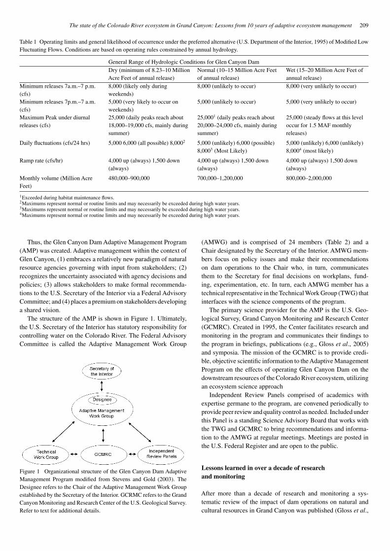
The structure of the AMP is shown in Figure 1. Ultimately,the U.S. Secretary of the Interior has statutory responsibility forcontrolling water on the Colorado River. The Federal AdvisoryCommittee is called the Adaptive Management Work Group
Figure 1 Organizational structure of the Glen Canyon Dam AdaptiveManagement Program modified from Stevens and Gold (2003). TheDesignee refers to the Chair of the Adaptive Management Work Groupestablished by the Secretary of the Interior. GCRMC refers to the GrandCanyon Monitoring and Research Center of the U.S. Geological Survey.Refer to text for additional details.
(AMWG) and is comprised of 24 members (Table 2) and aChair designated by the Secretary of the Interior. AMWG mem-bers focus on policy issues and make their recommendationson dam operations to the Chair who, in turn, communicatesthem to the Secretary for final decisions on workplans, fund-ing, experimentation, etc. In turn, each AMWG member has atechnical representative in the Technical Work Group (TWG) thatinterfaces with the science components of the program.
The primary science provider for the AMP is the U.S. Geo-logical Survey, Grand Canyon Monitoring and Research Center(GCMRC). Created in 1995, the Center facilitates research andmonitoring in the program and communicates their findings tothe program in briefings, publications (e.g., Gloss et al., 2005)and symposia. The mission of the GCMRC is to provide credi-ble, objective scientific information to the Adaptive ManagementProgram on the effects of operating Glen Canyon Dam on thedownstream resources of the Colorado River ecosystem, utilizingan ecosystem science approach
Independent Review Panels comprised of academics withexpertise germane to the program, are convened periodically toprovide peer review and quality control as needed. Included underthis Panel is a standing Science Advisory Board that works withthe TWG and GCMRC to bring recommendations and informa-tion to the AMWG at regular meetings. Meetings are posted inthe U.S. Federal Register and are open to the public.
Lessons learned in over a decade of researchand monitoring
After more than a decade of research and monitoring a sys-tematic review of the impact of dam operations on natural andcultural resources in Grand Canyon was published (Gloss et al.,
210 Jeff Lovich and Theodore S. Melis
Table 2 Stakeholders in the Glen Canyon DamAdaptive Management Program with membershipon the Federal Advisory Committee known as theAdaptive Management Work Group.
Cooperating agencies1. Bureau of Reclamation2. U.S. Fish and Wildlife Service3. Department of Energy4. Bureau of Indian Affairs5. National Park Service6. Hopi Tribe7. Hualapai Tribe8. Navajo Nation9. Southern Paiute Consortium10. Pueblo of Zuni
State agency11. Arizona Game & Fish Department
Environmental Groups12. Grand Canyon Wildlands Council13. Grand Canyon Trust
Recreation Interests14. Grand Canyon River Guides15. Federation of Fly Fishers
Basin States16. Arizona17. California18. Colorado19. Nevada20. New Mexico21. Wyoming22. Utah
Federal Power Purchase Contractors23. Colorado River Energy Distributors Association24. Utah Associated Municipal Power
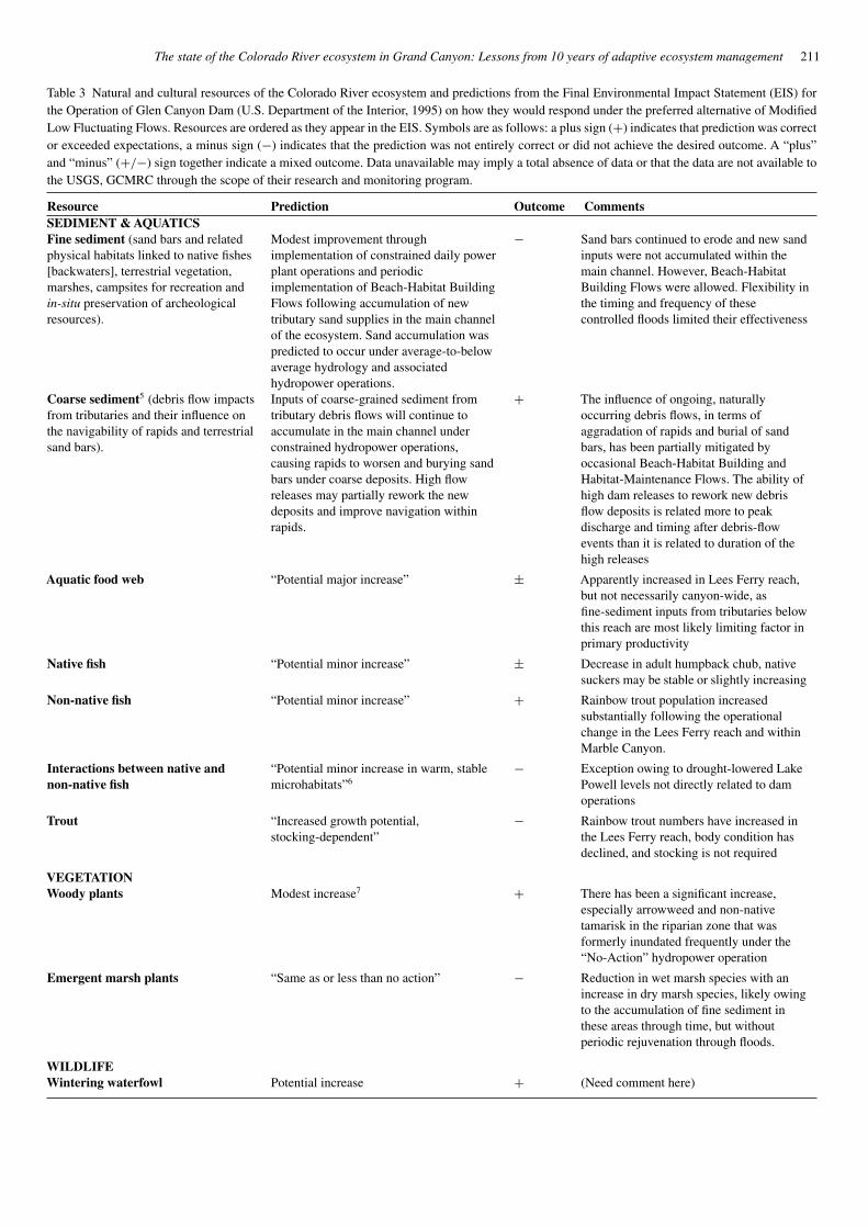
2005). One of the goals of this compilation was a review of thepredictions contained in Table II-7 of the EIS (summarized inTable 3). The table contains a list of resources and associatedpredictions on how those same resources would respond underthe preferred alternative. An expanded list of predictions in aslightly different time scale is given in Schmidt et al. (1998).
During preparation of the EIS, the best scientific data wereused to generate those prognostications. From the precipice oftime, a decade later, we have significant new information to usein evaluating the dam’s re-operation relative to objectives of the1995 EIS, and the 1992 Grand Canyon ProtectionAct. In this sec-tion we will summarize what we have learned about the ColoradoRiver ecosystem from the perspective of over a decade of scien-tific inquiry, and discuss challenges facing continued researchand monitoring in support of the Glen Canyon Dam AdaptiveManagement Program (AMP).
Integrated Quality-of-water – The presence and design of GlenCanyon Dam have caused major environmental changes to theColorado River ecosystem including: (1) alterations in the timing
and variability of the river’s annual, season and daily flow pat-terns, (2) drastic reduction of the sand supply to the Glen, Marbleand Grand Canyon reaches and (3) reduced annual variabilityin temperature. On the basis of current science information,the MLFF operating alternative has not effectively mitigatedthe influence of regulation with respect to either the thermaland hydrologic changes, or the sand supply limitation of thedownstream ecosystem.
Detailed monitoring of water quality throughout Lake Powellspans a period of about 40 years, making this one of the mostrobust monitoring efforts conducted under the AMP. These datacoupled with downstream temperature data provide rich oppor-tunities for the limnological modeling of the reservoir; an effortthat is currently underway. Given the importance of Lake Powellas the major source of water for the Colorado River ecosystembelow, this monitoring program serves as an early warning systemfor changes in quality-of-water.
While the information on the reservoir briefly summarizedby Vernieu et al. (2005) has shown that dam operations haveaffected some resources downstream from Glen Canyon Dam,water quality in this large reservoir appears to be largely unaf-fected by the new dam operations since 1991. However, thereservoir does have the potential to exert substantial impacts ondownstream resources. For example, the current drought thatstarted in 2000, reduced the level and volume of Lake Powellto elevations not seen since the reservoir was initially filling inthe late 1960’s. The lower reservoir storage level has broughtwarmer surface (epilimnetic) waters to the penstocks causingincreased water temperatures to be discharged into the canyon.In addition, continued reservoir drawdown has resulted in the re-suspension of large amounts of deltaic sediment in the reservoir.The organic material contained in this sediment caused a decreasein oxygen concentrations in the reservoir that could potentiallybe discharged downstream.
Overall, the water quality of the reservoir appears to be morestrongly linked to climatic annual to decadal variability govern-ing spring inflow events, protracted swings in upper ColoradoRiver Basin hydrology and by continuing depletions basin-wide,than it is by the re-operation of the hydropower plant over thelast decade under the preferred alternative (MLFF). This is truebecause the Record of Decision did not change Long-RangeOperating Criteria tied to mandatory transfers from Upper toLower Colorado River Basin states. However, periodic release ofshort-duration spills that bypass the hydropower plant (controlledfloods, termed “Beach-Habitat Building Flows”) are one elementof the current Record-of-Decision that does have an immediateinfluence on the structure of the reservoir. The changes appearrelated to the fact that such releases are made from outlet worksat depths beneath the power plant intakes where temperaturesand oxygen levels tend to be lower. Potentially, releases madefrom higher elevations in the reservoir (by means of a Selec-tive Withdrawal Structure [SWS]) would also change reservoircharacteristics, but with uncertain influence on the downstreamecosystem, particularly with warmer discharges.
The effects of warmer water on downstream biologicalresources are difficult to predict with certainty and potentially
The state of the Colorado River ecosystem in Grand Canyon: Lessons from 10 years of adaptive ecosystem management 211
Table 3 Natural and cultural resources of the Colorado River ecosystem and predictions from the Final Environmental Impact Statement (EIS) forthe Operation of Glen Canyon Dam (U.S. Department of the Interior, 1995) on how they would respond under the preferred alternative of ModifiedLow Fluctuating Flows. Resources are ordered as they appear in the EIS. Symbols are as follows: a plus sign (+) indicates that prediction was corrector exceeded expectations, a minus sign (−) indicates that the prediction was not entirely correct or did not achieve the desired outcome. A “plus”and “minus” (+/−) sign together indicate a mixed outcome. Data unavailable may imply a total absence of data or that the data are not available tothe USGS, GCMRC through the scope of their research and monitoring program.
Resource Prediction Outcome CommentsSEDIMENT & AQUATICSFine sediment (sand bars and relatedphysical habitats linked to native fishes[backwaters], terrestrial vegetation,marshes, campsites for recreation andin-situ preservation of archeologicalresources).
Modest improvement throughimplementation of constrained daily powerplant operations and periodicimplementation of Beach-Habitat BuildingFlows following accumulation of newtributary sand supplies in the main channelof the ecosystem. Sand accumulation waspredicted to occur under average-to-belowaverage hydrology and associatedhydropower operations.
− Sand bars continued to erode and new sandinputs were not accumulated within themain channel. However, Beach-HabitatBuilding Flows were allowed. Flexibility inthe timing and frequency of thesecontrolled floods limited their effectiveness
Coarse sediment5 (debris flow impactsfrom tributaries and their influence onthe navigability of rapids and terrestrialsand bars).
Inputs of coarse-grained sediment fromtributary debris flows will continue toaccumulate in the main channel underconstrained hydropower operations,causing rapids to worsen and burying sandbars under coarse deposits. High flowreleases may partially rework the newdeposits and improve navigation withinrapids.
+ The influence of ongoing, naturallyoccurring debris flows, in terms ofaggradation of rapids and burial of sandbars, has been partially mitigated byoccasional Beach-Habitat Building andHabitat-Maintenance Flows. The ability ofhigh dam releases to rework new debrisflow deposits is related more to peakdischarge and timing after debris-flowevents than it is related to duration of thehigh releases
Aquatic food web “Potential major increase” ± Apparently increased in Lees Ferry reach,but not necessarily canyon-wide, asfine-sediment inputs from tributaries belowthis reach are most likely limiting factor inprimary productivity
Native fish “Potential minor increase” ± Decrease in adult humpback chub, nativesuckers may be stable or slightly increasing
Non-native fish “Potential minor increase” + Rainbow trout population increasedsubstantially following the operationalchange in the Lees Ferry reach and withinMarble Canyon.
Interactions between native andnon-native fish
“Potential minor increase in warm, stablemicrohabitats”6
− Exception owing to drought-lowered LakePowell levels not directly related to damoperations
Trout “Increased growth potential,stocking-dependent”
− Rainbow trout numbers have increased inthe Lees Ferry reach, body condition hasdeclined, and stocking is not required
VEGETATIONWoody plants Modest increase7 + There has been a significant increase,
especially arrowweed and non-nativetamarisk in the riparian zone that wasformerly inundated frequently under the“No-Action” hydropower operation
Emergent marsh plants “Same as or less than no action” − Reduction in wet marsh species with anincrease in dry marsh species, likely owingto the accumulation of fine sediment inthese areas through time, but withoutperiodic rejuvenation through floods.
WILDLIFEWintering waterfowl Potential increase + (Need comment here)
212 Jeff Lovich and Theodore S. Melis
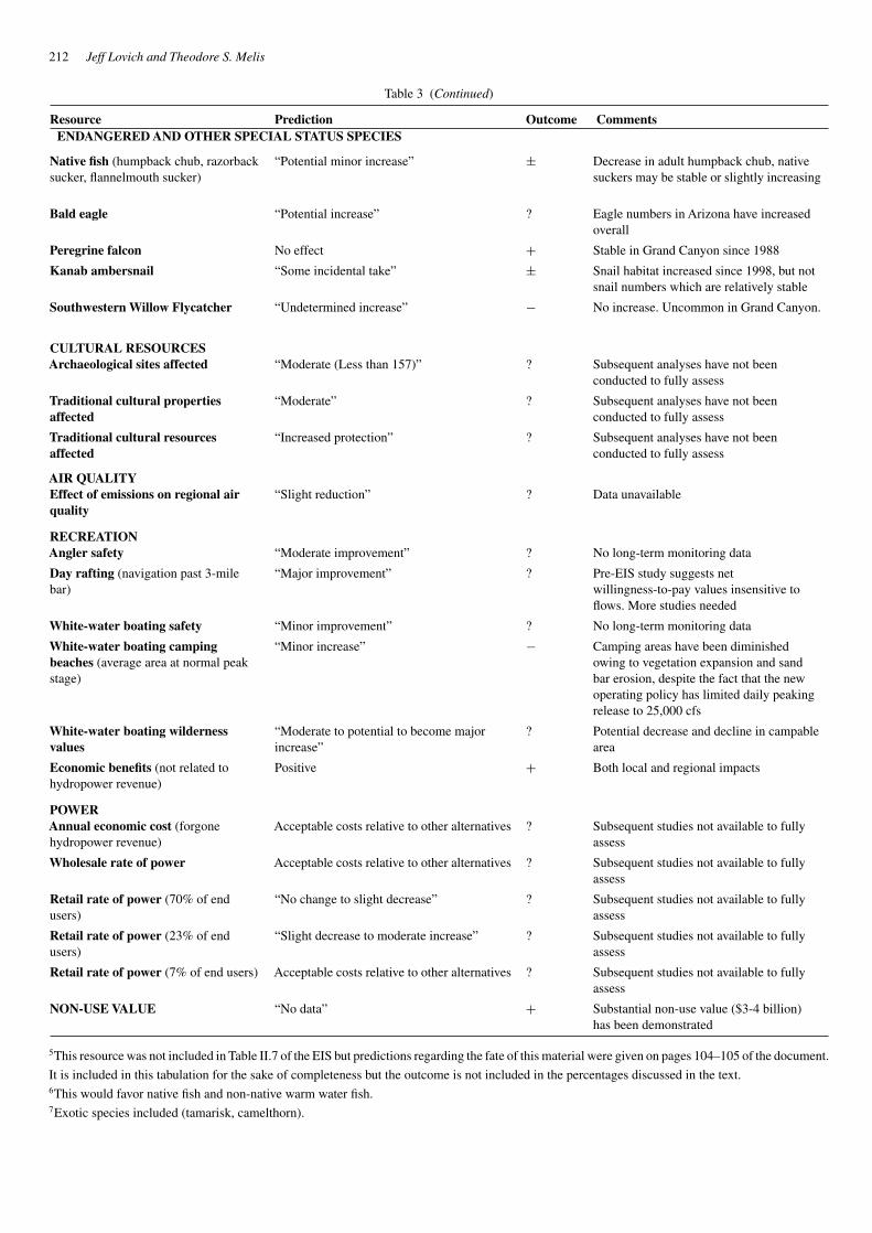
Table 3 (Continued)
Resource Prediction Outcome CommentsENDANGERED AND OTHER SPECIAL STATUS SPECIES
Native fish (humpback chub, razorbacksucker, flannelmouth sucker)
“Potential minor increase” ± Decrease in adult humpback chub, nativesuckers may be stable or slightly increasing
Bald eagle “Potential increase” ? Eagle numbers in Arizona have increasedoverall
Peregrine falcon No effect + Stable in Grand Canyon since 1988
Kanab ambersnail “Some incidental take” ± Snail habitat increased since 1998, but notsnail numbers which are relatively stable
Southwestern Willow Flycatcher “Undetermined increase” − No increase. Uncommon in Grand Canyon.
CULTURAL RESOURCESArchaeological sites affected “Moderate (Less than 157)” ? Subsequent analyses have not been
conducted to fully assess
Traditional cultural propertiesaffected
“Moderate” ? Subsequent analyses have not beenconducted to fully assess
Traditional cultural resourcesaffected
“Increased protection” ? Subsequent analyses have not beenconducted to fully assess
AIR QUALITYEffect of emissions on regional airquality
“Slight reduction” ? Data unavailable
RECREATIONAngler safety “Moderate improvement” ? No long-term monitoring data
Day rafting (navigation past 3-milebar)
“Major improvement” ? Pre-EIS study suggests netwillingness-to-pay values insensitive toflows. More studies needed
White-water boating safety “Minor improvement” ? No long-term monitoring data
White-water boating campingbeaches (average area at normal peakstage)
“Minor increase” − Camping areas have been diminishedowing to vegetation expansion and sandbar erosion, despite the fact that the newoperating policy has limited daily peakingrelease to 25,000 cfs
White-water boating wildernessvalues
“Moderate to potential to become majorincrease”
? Potential decrease and decline in campablearea
Economic benefits (not related tohydropower revenue)
Positive + Both local and regional impacts
POWERAnnual economic cost (forgonehydropower revenue)
Acceptable costs relative to other alternatives ? Subsequent studies not available to fullyassess
Wholesale rate of power Acceptable costs relative to other alternatives ? Subsequent studies not available to fullyassess
Retail rate of power (70% of endusers)
“No change to slight decrease” ? Subsequent studies not available to fullyassess
Retail rate of power (23% of endusers)
“Slight decrease to moderate increase” ? Subsequent studies not available to fullyassess
Retail rate of power (7% of end users) Acceptable costs relative to other alternatives ? Subsequent studies not available to fullyassess
NON-USE VALUE “No data” + Substantial non-use value ($3-4 billion)has been demonstrated
5This resource was not included in Table II.7 of the EIS but predictions regarding the fate of this material were given on pages 104–105 of the document.
It is included in this tabulation for the sake of completeness but the outcome is not included in the percentages discussed in the text.6This would favor native fish and non-native warm water fish.7Exotic species included (tamarisk, camelthorn).
The state of the Colorado River ecosystem in Grand Canyon: Lessons from 10 years of adaptive ecosystem management 213
include both positive and negative ecological consequences. Pos-sibilities include allowing for mainstem spawning of native fish,allowing the invasion and dominance of warmwater fishes fromLake Mead and the Little Colorado River, possible adverse alter-ation of the food base, and uncertain effects on the coldwaterfishery in the Lees Ferry reach. The “natural” warming of GlenCanyon Dam releases owing to falling reservoir levels provides animportant opportunity to test system responses preceding instal-lation of a SWS on the dam. In addition, lower reservoir storagelevels are contributing to increased salinity in discharges. Con-tinued monitoring of both the reservoir and downstream qualityof water in the river ecosystem will be required to mitigate anyadverse impacts associated with dam operations under continueddrought conditions. Linking reservoir processes to downstreamquality of water parameters is a high priority for future researchand monitoring, especially as related to native and non-nativefish interactions, recruitment success in humpback chub anddynamics associated with the food base of the river. An annualto decadal-scale synthesis of the forty-year time series for LakePowell quality of water is a next essential step in the researchprogram.
Climate and drought – The preceding section on water qual-ity monitoring in Lake Powell underscores the effect of putativeshort-term climate trends on limnological parameters. Currentunderstanding of global climate drivers provides little ability topredict the timing or extent of droughts over much of the ColoradoRiver Basin (Webb et al., 2005). Data from tree rings suggestthat multi-decadal droughts are not unknown in the basin and theorganisms and natural processes that developed in Grand Canyonevolved in response to such natural variation. While the currentdrought may not be a so-called “megadrought” because of the lim-ited duration to date, only time will tell when it ends. Research isneeded to improve the ability to forecast climate in the ColoradoRiver Basin. Jain and others (2005), have recently reported a late20th century trend toward increasing annual variation in stream-flow within the large river basins of the western U.S., includingthe Colorado River. They also report an increasing synchroneityin the response of these western river basins over the same periodsince the 1970’s when water use in the southwestern U.S. began toaccelerate. If such a trend persists, then the challenges associatedwith simultaneously managing water supplies and maintainingenvironmental resources of the arid southwest will likely onlyincrease through time under increasing depletions and forecastuncertainties (Pulwarty and Melis, 2001).
Mitigating the influence of protracted drought was initiallythe main objective for constructing Glen Canyon Dam. This wasachieved by locating the dam at a site that maximized the stor-age capacity of Lake Powell. The vast storage volume of thereservoir (about 3.42 × 10¹⁰ m3), provides a time buffer of upto several years against periods of below average runoff in theupper basin. This storage capacity is of immense benefit to upperColorado River Basin states faced with the challenge of simul-taneously pursuing development, while also needing to meet thewater supply needs of downstream users. The strategy of maxi-mizing water storage above Glen Canyon Dam is also of interestenvironmentally in that it is effective at mitigating the ecological
role that drought plays in the Colorado River ecosystem belowthe dam. For instance, operation of the dam without a sedimentbypass system or SWS means that the river’s flow and sediment-transport capacity are increased on average (Topping et al., 2003).However, the thermal regime of the river now hovers somewherebetween the conditions that occurred in the pre-dam era betweenwinter and summer, while the currently diminished sedimentload is representative of a pre-dam mega-drought with respectto tributary sand production. These limitations in the dam’s oper-ation appear to greatly limit options for achieving environmentalobjectives related to restoration and sustainable management ofunique aquatic and terrestrial parts of the Grand Canyon’s riverinelandscape.
Hydropower production – As the preceding two sections havedemonstrated, climatic variability and its affect on hydrologicconditions can have large, if not overriding, effects on resourcesof concern to the AMP. Hydropower is also a highly valuedresource of concern to society and environmental constraintson dam operations under the MLFF policy have large annualeconomic costs (see Harpman and Douglas, 2005). The accept-ability of those costs has to be interpreted within the contextof societal values which abruptly shifted away from a focusedpolicy of resource development toward one where preservationof natural resources is increasingly valued. This shift in valuesoccurred only after river regulation was underway. Loomis et al.(2005) demonstrated that dam operations benefited both localand regional economies through stabilization of flows relativeto pre-EIS and pre-dam conditions, which in turn facilitated thedevelopment of a significant industry associated with white-waterrafting (see recreational use and non-use section below). Signif-icant non-use values add to the economic value of the GrandCanyon experience regardless of whether respondents visit thecanyon or not. A detailed ex-post facto cost-benefit analysis ofGlen Canyon Dam operations will ultimately be needed to fullyassess the MLFF operation versus documented environmentalbenefits. Such assessments are also needed to fully evaluate anyconsideration of additional experimental designs or to eventualimplementation of any alternative, longer-term changes in thecurrent operating strategy intended to achieve management goals.
Fine sediment – The much hoped for outcome of modestimprovement in sand bar resources, as originally proposed andpredicted in the EIS, has not been realized (Table 3). Detailedsynthesis studies of sand inputs and outputs to the system (sandmass balance), intensive field monitoring, and remotely sensedchange detection analyses all point to a decrease in fine sed-iment resources in Glen, Marble and Grand Canyons in thepost-EIS era. These changes have resulted in smaller and coarser-grained sand bar deposits, particularly in the upper reaches ofthe ecosystem where sand supply is most limited. Loss of sandhabitats in the ecosystem was documented under the No-Actionera (1964–1990), but has continued since dam operations havebeen altered to mitigate sand bar erosion. Sand export appears tobe driven primarily by the annual strategy of patterning monthlyrelease volumes within MLFF to match seasonally varied regionalwater supply in the west, variation in seasonal power demandsand benefits related to economics of daily “load-following.”
214 Jeff Lovich and Theodore S. Melis
Sand-transport data collected from 1999 through 2004, indicatethat whenever the monthly flow regime from the Glen CanyonDam forces daily peak discharges above 10,000 cfs for extendedperiods, such operations tend to export newly input sand fromdownstream tributaries and pre-existing sand storage in the mainchannel relatively quickly. Sediment transport calculations dur-ing the EIS substantially under-predicted the capacity of suchoperations to export new sand inputs and instead predicted thataverage to below average MLFF operations would allow new sandsupplies from tributaries below the dam to accumulate throughtime over multiple years. Such accumulated inputs were thenthe basis for predicting that periodically released Beach-HabitatBuilding Flows would result in sustainable sand bar restoration.Unfortunately, even during years of minimal release hydrology(8.23 million acre feet volumes released from 2000–2004), suchexporting flow peaks of 18,000 to 20,000 cfs are a frequentlyoccurring phenomenon in both winter and summer months thatannually limits accumulation of new sand supplies from tribu-taries (Rubin et al., 2002; Topping et al., 2000a, b; Toppinget al., 2006; Wright et al., 2005).
Although MLFF limitations on the daily allowable peak dis-charge were intended to reduce sand export and bar erosion, itappears that the annual pattern of monthly volumes released fromthe dam (with peak daily flows at their highest during the summersediment input months of July and August) is the greatest fac-tor preventing accumulation of new sand inputs from tributariesover multi-year time scales. Despite minimum allowable annualvolumes of water released from Glen Canyon Dam during 2000–2004 (8.23 million acre feet), sand inputs from the Paria and LittleColorado Rivers were quickly transported downstream duringmonths in which release schedules forced daily peaks to between18,000–20,000 cfs. Owing to this, the greatest factor limitingBeach-Habitat Building Flows in achieving habitat restoration istied to condition of sand supply limitation that persists from yearto year, even during continuous, multi-year drought conditions inthe Upper Colorado River Basin and below average MLFF oper-ations. While the seasonally adjusted pattern of monthly releasesduring a prolonged drought provides significant economic bene-fit to some stakeholders in terms of hydropower revenues, thesebenefits apparently come at the expense of environmental goalstied to downstream sand resources and related habitats.
Since closure of Glen Canyon Dam has eliminated about 84%of the sand that historically entered Grand Canyon, managing theremaining supply below the dam will apparently require carefulprescription of managed BHBF’s, strategically released imme-diately following natural sand inputs. It is not yet clear whethereven this strategy will succeed in sustainable restoration of sandresources throughout Grand Canyon (Topping et al., 2006; Rubinet al., 2002). In essence, efforts to restore sand bars withoutsufficient sand supplies are analogous to attempting to restorea bankrupt financial system with modest infusions of interestrather than substantial investments of principal. Since physicalprocesses related to hydrology and sediment transport are rela-tively well studied, a logical question is why the writers of the EISpredicted this outcome incorrectly? Again, the EIS writers usedthe best science that was available, but three critical monitoring
programs for measuring suspended-sediment flux throughout theCanyon were discontinued in the early 1970’s, forcing the EISteam to evaluate a discontinuous set of post-dam transport dataand then work with flawed assumptions rather than continu-ous data records of flow and sediment concentration. Clearly,long-term core monitoring efforts are essential to the success ofadaptive management and accurate predictions.
The EIS assumption that sand would accumulate on the bedof river over multiple years is now known to be flawed. Ourresearch suggests that future management of sediment shouldinvolve high flow releases immediately following inputs of sandand finer sediment from tributaries below the dam. While suchreleases are controversial in that they must bypass the hydropowerplant, recent studies also suggest that the duration of such flowsmay need to be only a small fraction of what was originally sug-gested. Such fine tuning in the prescription of controlled floodsused for achieving habitat restoration (Stevens et al., 2001) willlikely reduce the financial impacts and controversy associatedwith such management actions. One alternative test of the MLFFconcept for multi-year accumulation of sand supply might be toequalize monthly volumes during droughts so as to further limitdaily peaks over such periods. If such a test failed to increasesand supply through multi-year accumulation of tributary sandinputs, then objectives for sand habitat restoration might have tobe reconsidered, or more proactive strategies, such as sedimentaugmentation, might need to be implemented.
Coarse sediment – This resource was not included in TableII-7 of the EIS but is included because of its importance to theoverall ecological condition of the river in Grand Canyon. In con-trast to fine sediment, coarse sediment inputs have largely beenunaffected by the presence or operation of Glen Canyon Dam.This owes to the presence of hundreds of unregulated tributarycanyons along the length of Grand Canyon that contribute coarsesediment to the system. However, with the erosion of fine sedi-ment from the system (see above) tied to dam operations underModified Low Fluctuating Flows, an overall sediment trend forthe Grand Canyon reach has been coarsening of the substrate inthe river channel, as fines are eroded, leaving gravel and largermaterial. The impact of this “coarsening” of the river substratehas two profound biological implications. First is the creationof preferred habitat for benthic invertebrates, an important com-ponent of the food base. Second, is the creation of spawningsubstrate for the non-native rainbow trout. Both of these changesmove the system farther from pre-dam conditions, potentiallybenefiting non-native species at the expense of natives.
Inputs of coarse sediment are largely localized and episodic,triggered by local storm events and rockslides (Webb et al., 2005).When debris flows occur, they contribute to the existing system ofrapids for which Grand Canyon is famous by restricting channelwidth in outwash areas. Under regulated flows associated withGlen Canyon Dam operations, floods above 45,000 cfs are nowextremely rare in the Canyon. As a result the river no longerhas the power to rework coarse sediment deposits in rapids tothe extent possible before construction of the dam. It is possiblethat some rapids will increase in size owing to regulated flows.Research is needed to determine if high spike flows from the
The state of the Colorado River ecosystem in Grand Canyon: Lessons from 10 years of adaptive ecosystem management 215
dam would be effective at reworking coarse sediment depositsperiodically to mimic unregulated conditions.
Aquatic food base – Prior to the construction of the dam, thesediment-laden waters of the Colorado River continually scouredriver bottom habitats and permitted little light penetration, bothof which strongly limited the growth of algae and other aquaticplants. Most of the nutrients and energy that entered GrandCanyon arrived as drift from sources outside the river. Theseexternal inputs of energy arrived in the form of leaf litter, coarsewoody debris, and other materials carried down from terrestrialsources or upstream tributaries. Following completion of GlenCanyon Dam, water discharged downstream was cold and clear,as described in the section on Quality of Water. This clear waterallowed for the development of a substantial food base dominatedprimarily by algae and aquatic plants, thus changing the domi-nant energy inputs from external sources to instream production.The plentiful algae in the post-dam Colorado River support a highdensity of invertebrates (Kennedy and Gloss, 2005).
As one goes downstream from the Lees Ferry tailwaters,tributary inputs of sediment limit light penetration, and hencephotosynthesis, causing abrupt decreases in algae standing massand a transition back towards the dominance of external energysources. Invertebrates communities also shift with this transitionin energy sources, and filter-feeding invertebrates that capturefine particles of leaf litter and other detritus appear to domi-nate downstream reaches. However, the biomass of invertebratesappears to also decrease with downstream distance, perhapsbecause there is less energy available in the system due to thereduction in algae standing mass. Considerable research is stillneeded to better understand the effects that dam operations andepisodic inputs of sediment from tributaries have on the food baseacross the entire Colorado River ecosystem.
Dam operations under MLFF probably led to increases in thestanding mass of food base resources (i.e., algae and inverte-brates) due to steadier flows and greater minimum discharges ofclearer water (Table 3). However, declines in humpback chubpopulations since implementation of MLFF suggest this changein the aquatic food base may have not necessarily benefitednative fish that evolved in the turbid waters that characterizedthe pre-dam environment.
A critical future research need is to develop a better under-standing of the linkages between the food base and the actualprey base of fish, both native and non-native. A large amount ofdata have been collected on the food items consumed by non-native rainbow and brown trout, but comparable data are notavailable for the humpback chub due to the endangered status ofthis fish. Use of stable isotope analysis will be critical to assessingthe energy sources and trophic pathways that are importance tofish. Additionally, critical tests of the hypothesis that competitionbetween non-native trout and humpback chub is negatively affect-ing humpback chub populations are not available. Eating the samefood items is only the first criteria to establish that competition isnegatively impacting a particular species. For competition to havea negative impact on a species, overlapping resources must alsobe limited and one species must be more efficient at harvestingthe limited resources than another. In the food-rich environment
of the post-dam Colorado River, the second criteria may not bea reasonable assumption. Further research will be required todetermine if this hypothesis is supported by data.
Fish – Eight species of native fish were found in the GrandCanyon prior to the modern era. Most of these were endemic tothe Colorado River system making this one of the most unique fishcommunities in the world (Mueller and Marsh, 2002). Of those,only four remain including the humpback chub, the blueheadsucker, the flannelmouth sucker and the speckled dace. Gone arethe razorback sucker, bonytail, roundtail chub and the Coloradopikeminnow, all of which survive outside of Grand Canyon. Thehumpback chub is endangered and its numbers have droppeddramatically in the last decade. At the same time, non-native fishhave increased in both diversity and abundance.
The reasons for the decline of native fish are commonly citedto include the construction and operation of numerous dams onthe Colorado River, the introduction of non-native predatory andcompetitive fishes, and the introduction of diseases and parasites(Mueller and Marsh, 2002). The actual mechanisms of declineand extirpation are poorly known owing to a lack of early data onpopulation numbers and the fact that declines were well estab-lished prior to construction of major dams (but not prior to theintroduction of exotic species).
Our knowledge of the effect of dam operations on native fish isincomplete, but there is only a limited body of evidence that Mod-ified Low-Fluctuating Flows have been beneficial to the survivaland recruitment of humpback chub, to support the prediction ofthe EIS (Table 3). However, we do not know if the overall adultdecline of chub, and the recent evidence of recruitment and flat-tening of the population trend during the decade of operationsunder this regime is attributable to Modified Low-FluctuatingFlows per se (Gloss and Coggins, 2005; Coggins et al., 2006a;Melis and Coggins, in review). Mechanical removal of non-nativefish, especially rainbow trout is currently in the fourth year ofa four year implementation strategy to test the hypothesis thatreduction of predatory and competitive fish species will resultin an increase in survival and recruitment of humpback chub.While the GCMRC has demonstrated that mechanical removal isan effective way to significantly reduce the number of non-nativetrout in the removal reach (Gloss and Coggins, 2005), fishery sci-entists are still collecting the data required (2003 and beyond) toevaluate the hypothesized response in humpback chub. Given ourknowledge of the life history of the chub, a signal is not expectedfor four or five years after the initiating of mechanical removalefforts.
In contrast to recent decline in the abundance of adult chub,populations of both bluehead and flannelmouth suckers appearto have remained relatively stable under the current flow regimeof Modified Low Fluctuating Flows. The reasons for this persis-tence are currently unknown. On the other hand, the relativelystable habitat conditions created under Modified Low Fluctuat-ing Flows, coupled with a coarsening of substrate in the riverchannel (see above section on fine sediment), appear to havegreatly favored rainbow trout, particularly in the Lees Ferryreach, as reflected in their increasing numbers during the lastdecade.
216 Jeff Lovich and Theodore S. Melis
In addition to establishing better linkages between our knowl-edge of the food base, dam operations, and fish populations,we need to focus future research on the effects of warmingdischarges of water from Glen Canyon Dam. An SWS is antici-pated to be installed on the dam sometime later in this decadeand substantial questions remain unanswered on its effects.Will the SWS warm water temperatures to a point where mainchannel spawning of humpback chub is possible? Will youngnative fish emerging from natal habitat in the Little ColoradoRiver be able to survive and grow in the warmer waters? Willthe tailwater trout fishery below the dam remain healthy andviable? Will new diseases, parasites and invasive species becomeestablished in warmer habitats? Will warmwater predatory fishfrom downstream establish themselves as dominant species inthe Grand Canyon fish community? Will non-native trout inthe Little Colorado River/main channel confluence decreasein abundance as a result of increasing temperatures? Theseare all critical questions that must be answered in the nearfuture.
Terrestrial vegetation – Dam operations under Modified LowFluctuating Flows greatly stabilized antecedent and pre-EIS flowconditions in the Grand Canyon with significant impacts on ripar-ian vegetation (Ralston, 2005). The EIS predicted a modestincrease in woody vegetation (Table 3) and that prediction islargely correct, if not understated. The EIS also predicted thatmarsh communities would be the same as or less than expectedunder the No Action alternative, but that prediction was largelyincorrect. Since implementation of Modified Low FluctuatingFlows there has been a decrease in wet marsh vegetation and anincrease in dry marsh vegetation.
The pre-dam environment was subject to large variations inflow that regularly scoured shoreline habitats of vegetation, reset-ting the system after major floods. Scouring flows are now rareadding an element of stability to the system and ultimately affect-ing plant communities. For example, since daily peaking releasesunder Modified Low Fluctuating Flows are limited to no morethan 25,000 cfs, the old high water vegetation zone is nowdependent entirely on incident precipitation for water. This hasresulted in some changes to species composition, particularlythose species that don’t have deep tap roots to reach the watertable associated with river flows. Removing access to surfacewater from desert plant communities, forcing them to rely on inci-dent precipitation only, has been documented to lead to decreasesin plant biomass over time (Schlesinger et al., 1989).
The stability of flows has also encouraged an increase in veg-etation density in and near the wetted zone. While an increasein vegetation may appear to be desirable, one of the impacts is adecrease in available camping area for recreationists (Kaplinskiet al., 2005). Furthermore, the increase is largely attributable toexpansion of non-native saltcedar or tamarisk into the riparianzone, often resulting in a monoculture that is not always ben-eficial to wildlife (Lovich and de Gouvenain, 1998). However,recent research suggests that moving toward more natural riverflow regimes with the use of pulse floods allows native plantsspecies to become established despite the presence of tamarisk(Glenn and Nagler, 2005).
Overall, interim (1991–1996) and Modified Low Fluctuat-ing Flows (1996–2005) have caused a contraction in the extentof the riparian plant community, comprised of more homoge-neous (including non-native species) plant assemblages, withmore mature individuals. The export of fine sediments fromthe system is further reducing available substrate for vegetationand marsh vegetation. The effects of large-scale restructuringof riparian plant communities in the Grand Canyon is expectedto have cascading impacts on co-adapted animal species, espe-cially neotropical migrant birds. Future research should focus onidentifying the responses of animals to this fundamental changein habitat structure, the relationship between riparian vegetationand insects as related to the food web of the river, and examiningthe affects of human-mediated removal of exotic vegetation vs.natural disturbance.
Birds – Bird monitoring in the Grand Canyon related to theGlen Canyon Dam Adaptive Management Program has beendriven by two factors: 1) concern regarding the possible effectsof dam operations on sensitive species (e.g., Bald Eagles –Haliaeetus leucocephalus, Peregrine Falcons – Falco peregri-nus anatum, and Southwestern Willow Flycatchers – Empidonaxtraillii extimus), and 2) the perception that birds are good ecolog-ical indicators of short-term (post-dam) changes in the canyon.Overall, it appears that birds are neither driving the ecologicalsystem in the Grand Canyon, as they do in other ecosystems(Croll et al., 2005), nor are their regional population dynam-ics strongly driven by factors within the canyon. Research hasdemonstrated only a minimal direct effect of dam operations onmost birds. An exception to this generalization is shown for water-fowl that appear to have benefited from the stability of post-damflows (Table 3) (Holmes et al., 2005).
However, at the local level, changes in riparian vegetation,mentioned above, have resulted in increased bird density anddiversity in the Grand Canyon. As such, post-dam flows havehad indirect effects on the bird community via their more directeffects on plant community structure. Beyond that, it is difficult torelate dam operations to bird dynamics, especially for neotropicalmigrants. These hemispherical migrants are affected by factorsthroughout both their breeding and wintering ranges. For exam-ple, a decline in Southwestern Willow Flycatcher numbers mightbe caused by mortality on the wintering range in Central or SouthAmerican and have nothing to do with impacts in the GrandCanyon, or elsewhere, in the breeding range.
Future bird research and monitoring in the Grand Canyonrequires answering some fundamental questions. First, shouldbirds continue to be monitored under the Glen Canyon DamAdaptive Management Program given the indirect relationshipbetween dam operations and most bird population dynamics?Second, how exactly do dam operations affect plant commu-nity dynamics and ultimately birds? Finally, how do vegetationcharacteristics affect individual bird species?
Special status species – Many of the research and monitoringefforts in the Glen Canyon Dam Adaptive Management Programare necessitated by compliance requirements from various laws,especially the U.S. Endangered SpeciesAct (Ralston, 2005). Onespecies, the Kanab ambersnail, is assumed to be found naturally
The state of the Colorado River ecosystem in Grand Canyon: Lessons from 10 years of adaptive ecosystem management 217
at only two locations, one in the Grand Canyon and another insouthern Utah. Genetic analyses are underway to assess the levelof differentiation between Grand Canyon populations and snailpopulations with similar morphology north of the canyon.
The largest population at Vaseys Paradise is found in the varialzone of dam operations and is thus susceptible to being washedaway during rapid changes in flows. In the past, significant effortshave been undertaken to protect snail populations during experi-mental floods, including temporarily uprooting snail habitat (withsnails) immediately before a flood and then returning the habitatat the conclusion of the experimental flow. Despite the vulnerabil-ity of such a small species, in such a spatially-limited distribution,snail numbers appear to be relatively stable post-EIS.
With only two breeding pairs of Southwestern Willow Fly-catchers present in the Grand Canyon in recent years, efforts tomonitor the effects of dam operations on this species are ham-pered by small sample sizes and issues identified in the sectionon Birds above. Monitoring efforts should be continued for otherrare and special status species to prevent them from decliningfurther and being listed as threatened or endangered species.
Cultural resources – Mass balance studies examining inputsand exports of sand and other fine sediments in the ColoradoRiver ecosystem demonstrate a net export of this resource asa result of dam operations. The sand that is being exported iscoming not only from new tributary inputs, but also existingbeaches and river terraces that contain archaeological sites. Manyarchaeological sites in Grand Canyon have been covered withwindborne (aeolian) sand for centuries. This sand was transportedfrom lower-elevation beaches that were frequently re-suppliedwith new sand sources derived from annual floods during thepre-dam era. Following dam closure in 1963, operations wereoptimized for maximum water storage and power revenue (withinthe constraints of existing law and policies), rather than for strate-gically conserving limited downstream remaining sand suppliesfor restoration of sand bars (and presumably, long-term preser-vation of cultural sites). With more sand continually leaving theecosystem than being supplied, more and more of these preser-vation sites are being exposed to the ravages of erosion. As sitesare eroded, artifacts and structures are increasingly exposed,where they become susceptible to visitor impacts and destabi-lization due to loss of the surrounding sedimentary matrix. Suchchanges make it difficult, if not impossible for archaeologiststo reconstruct and interpret the historical and cultural informa-tion contained within these important settings in Grand CanyonNational Park (Fairley, 2005).
Future research and monitoring of cultural resources needsto focus on the effects of all components of the MLFF damoperations, most specifically, how the monthly pattern of annualreleases might be revised to more effectively influence conser-vation of new sand inputs from tributaries so as to mitigate thecurrent, continuous fine-sediment deficit.
Recreational use and non-use values – One of the resourcesthat appear to have benefited most from the stabilizing influenceof Modified Low Fluctuating Flows, relative to more variable damoperations, is recreational use of the river. By eliminating veryhigh and very low discharges conditions, flows that favor year
round recreational boating and fishing are fostered. Although themost comprehensive regional economic study of recreation isnow 10 years old (Douglas and Harpman, 1995), the figures areimpressive: over $46 million in non-resident total expendituresand maintenance of 586 jobs, with 438 jobs in commercial raftingalone. Presumably those figures are even higher now (Loomiset al., 2005).
Based on data collected over 10 years ago, non-use values,or estimates of the “existence” value of Grand Canyon NationalPark, Glen Canyon National Recreation Area, tribal lands, andthe resources therein, to citizens who may never actually engagein recreational activities in the area, are estimated at $3–4 billion(Loomis et al., 2005). The public at large is willing to pay tohave flows and other management actions that benefit the canyonand its resources. While some may question the utility of non-use valuation of Grand Canyon resources, the estimates reflectthe iconic values that make Grand Canyon National Park famousthroughout the world.
Future research should focus on detailed analyses of how GlenCanyon National Recreation Area fishing use, catch rates andfish condition are related to flows. Economic data on fishing andrecreational rafting also need to be updated to establish currentbaseline data before new flow regimes are initiated. Finally, stud-ies to quantify the wilderness experience of recreationists need tobe initiated so that the benefit of eventually achieving ecosystemrestoration can be fully evaluated.
Campsites – Since the implementation of Modified Low-Fluctuating Flows, there has been about a 15% per year reductionin campable area in the Grand Canyon (Kaplinski et al., 2005).Losses occurred in both critical (campsite-limited) and non-critical reaches, but the largest losses have occurred in criticalareas. Losses are thought to be attributable to both net sedimentexports under current dam operations (see section above on finesediment), as well as encroachment of woody vegetation (seesection above on terrestrial vegetation). However, while dailyriver stage restrictions under the MLFF provide some benefits tocampsite area by limiting the varial zone to below 25,000 cfs,camping areas between this upper stage and the former dailylimit under the No Action policy (33,000 cfs) have become lessaccessible owing to vegetation expansion. The exact relationshipand interaction between these two factors and dam operationsis unknown and provides a challenge for future researchers. Forexample, increased vegetation in sand bar areas may also pro-vide greater substrate stability and shade, both limiting campsiteerosion rates and enhancing camping areas from an aestheticperspective. Tradeoffs between vegetation expansion and sandbar stability must also be considered from the perspective thatincreased vegetation might also limit the potential for wind pro-cesses to blow sand deposits upslope into cultural preservationsites subject to rainfall and runoff erosion?
How accurate were the 1995 EIS predictions?
The outcomes summarized in Table 3, and presented in the discus-sions above, present a kind of “report card” to assess the accuracy
218 Jeff Lovich and Theodore S. Melis
of predictions that formed the foundation of the Glen CanyonDam Adaptive Management program, implemented under theEIS with the preferred alternative of Modified Low-FluctuatingFlows. It is important to emphasize that the outcomes listed arebased on the best available scientific information and judgment,and are subject to revision as additional information becomesaccessible. We attempted to generalize our evaluations in a con-servative fashion; details are contained in the original works citedin this paper. With these caveats, we offer the following observa-tions on the ability of current technologies to predict ecosystem,societal and economic responses in Grand Canyon National Parkand Glen Canyon National Recreation Area and associated triballand areas of the ecosystem beyond those boundaries.
Because of a lack of data or subsequent analyses to confirmwhether the prediction stated in the EIS was correct, or not, 14of 30 (excluding coarse sediment: see above), or 46 percent ofthe outcomes, are essentially unknown at the time of this writing,despite ten years since completion of the EIS. These unresolvedoutcomes constitute an important list for further study in the pro-gram. Correct predications accounted for only 5 outcomes, or17 percent of the categories listed. Mixed outcomes occur in 6or 20 percent of the categories, and failed predictions, scored asnegative outcomes, occur in 5 or 17 percent of the categories.
Excluding predictions where the outcome is still unknown(n = 14), the percentage of outcomes that were correctly pre-dicted (5 out of 16 remaining) is only 31 percent, underscoringthe uncertainties associated with working in a large complex sys-tem with few to no data sets. Assuming only three categoriesof outcomes (+, −, or +/−), and that the outcomes are cor-rectly assigned, then the proportion of each outcome mentionedabove is not statistically different from an equal probability ofany outcome (χ2 = 0.125, P = 0.94). In other words, theability of the EIS writers to predict the outcome of ModifiedLow-Fluctuating Flows 10 years latter was, it appears, no betterthan random chance. A more optimistic approach would be toassign at least a partially successful rating to mixed outcomes(+/−). Under that scenario, 11 out of 16, or 69 percent of theoutcomes might be deemed correctly predicted, at least in part.However, this proportion too is not statistically different fromrandom chance (χ2 = 2.25, P = 0.13).
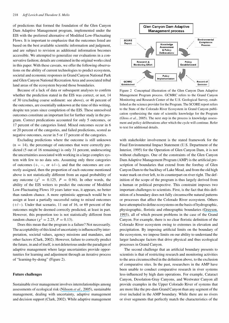
Does this mean that the program is a failure? Not necessarily.The acceptability of this kind of uncertainty is influenced by inter-pretation, societal values, agency missions and mandates, andother factors (Clark, 2002). However, failure to correctly predictthe future, in and of itself, is not deleterious under the paradigm ofadaptive management where large uncertainties provide oppor-tunities for learning and adjustment through an iterative processof “learning-by-doing” (Figure 2).
Future challenges
Sustainable river management involves interrelationships amongassessments of ecological risk (Nilsson et al., 2005), sustainablemanagement, dealing with uncertainty, adaptive managementand decision support (Clark, 2002). While adaptive management
Figure 2 Conceptual illustration of the Glen Canyon Dam AdaptiveManagement Program process. GCMRC refers to the Grand CanyonMonitoring and Research Center of the U.S. Geological Survey, estab-lished as the science provider for the Program. The SCORE report refersto the State of the Colorado River Ecosystem in Grand Canyon publi-cation synthesizing the state of scientific knowledge for the Program(Gloss et al., 2005). The next step in the process is knowledge assess-ment and policy deliberations after which the cycle will continue. Referto text for additional details.
with stakeholder involvement is the stated framework for theFinal Environmental Impact Statement (U.S. Department of theInterior, 1995) for the Operation of Glen Canyon Dam, it is notwithout challenges. One of the constraints of the Glen CanyonDam Adaptive Management Program (AMP) is the artificial pre-scription of boundaries that extend from the forebay of GlenCanyon Dam to the backbay of Lake Mead, and from the old highwater mark on river left, to its counterpart on river right. The def-inition of the scope of the program is thus largely derived froma human or political perspective. This constraint imposes twoimportant challenges to scientists. First, is the fact that this defi-nition of a boundary does not fully circumscribe natural patternsor processes that affect the Colorado River ecosystem. Othershave attempted to define ecosystems on the basis of hydrographic,physiographic, floristic and ethnographic boundaries (Grayson,1993), all of which present problems in the case of the GrandCanyon. For example, there is no clear floristic definition of theColorado River ecosystem owing to extremes in elevation andprecipitation. By imposing artificial limits on the boundary ofthe ecosystem, we impose limits on our ability to understand thelarger landscape factors that drive physical and thus ecologicalprocesses in Grand Canyon.
The second challenge that an artificial boundary presents toscientists is that of restricting research and monitoring activitiesto the area circumscribed in the definition above, to the exclusionof comparative sites. In the past, researchers in the AMP havebeen unable to conduct comparative research in river systemsless-influenced by high dam operations. For example, CataractCanyon, Desolation-Gray Canyons, and Westwater Canyon allprovide examples in the Upper Colorado River of systems thatare more like the pre-dam Grand Canyon than any segment of theriver included in the AMP boundary. While there are no riversor river segments that perfectly match the characteristics of the
The state of the Colorado River ecosystem in Grand Canyon: Lessons from 10 years of adaptive ecosystem management 219
pre-dam Grand Canyon, important analytical opportunities arelost by not expanding the study to incorporate sites more like acontrol.
Spatial scope is not the only constraint that presents a chal-lenge to understanding the form and function of the ColoradoRiver ecosystem. Temporal issues operate on scales of over 10orders of magnitude, ranging from billions of years to minutes,depending on whether one considers the geomorphic frameworkof the canyon or the hour-to-hour effects of dam operations onthat same framework. This extreme variability happens simulta-neously, confounding efforts to determine cause and effect. Anexample is provided by studies directed at understanding the pop-ulation ecology of the humpback chub. These fish evolved in acanyon that reflects billions of years of geological history, overmillions of years of natural selection, with a life span of decades, atime to maturity of 3–5 years, with wide annual pre-dam variationin flows and temperatures, now complicated with daily and hourlyvariations in flow (but not temperature) post-EIS. The complex-ity of factors and temporal scales present enormous challengesto effectively determining how population numbers vary in timeand space and underscores the importance of long-term studiesto describe patterns and processes. Long-lived organisms like thehumpback chub require decades to capture population variabilityrelated to their life span (Congdon et al., 1994).
Another problem, identified in the past, has been a need forgreater integration of studies. As the complexity of issues in theGlen Canyon DamAdaptive Management Program become moreobvious, so does the need for interdisciplinary, not just multi-disciplinary science. Great progress has been achieved since thisissue was highlighted by Meretsky and Melis (1997). Continuedefforts will be required to integrate knowledge across disciplinesand scales, and develop a more robust conceptual model for theColorado River ecosystem (Walters et al., 2000; Walters andKorman, 1999).
Conclusion
The outcomes of many of the predictions contained in the 1995EIS are unknown or unsatisfactory. The proportions of outcomesthat are correct vs. incorrect are not significantly different fromwhat would be expected by random chance (Table 3). Likepredicting the weather, there is a substantial amount of uncer-tainty, even more, in predicting the ecophysical impacts of damoperations on a large river.
Considerable knowledge has been gained from focused, sys-tematic studies of the Colorado River ecosystem in GrandCanyon. Research, including conceptual and other models(Walters et al., 2000; Coggins et al., 2006b) and monitoring con-ducted by U.S. Geological Survey scientists and their cooperatorshave conclusively demonstrated a net loss of sediment from thesystem and documented the decline of the federally endangeredhumpback chub during the last decade. Both findings are criticalpieces of information to assess conditions and adjust managementactions in the spirit of adaptive management. As in all research,more questions are generated than answers, but those questions
form the basis for future studies, another palpable benefit of theprogram to date. It is also important to note that water deliveryrequirements continued to be met throughout the decade post-EIS, despite increased costs associated with environmental andexperimental regulation of flows.
In an evaluation of a similar Colorado River conservation pro-gram, Brower et al. (2001) identified several solutions to theproblems of consensus-based management (it is important tonote that the AMP is not consensus-based): (1) program successshould be judged by species recovery, (2) the Federal governmentshould retain the ability to impose regulatory sanctions in theevent of continued population declines (see also Meretsky et al.,2000), and 3) funding should be provided by an agency with clearspecies-protection responsibilities to reduce the disproportionateinfluence of utilitarian interest groups. In large measure, theseapproaches are implemented under the AMP. Just as important,the success of the approach taken to achieve the desired outcomesof the management program should be evaluated against whetheror not the actions taken result in ecosystem responses that movein at least the general direction of those stated goals and objec-tives (Palmer et al., 2005). A substantial body of science nowexists for the Colorado River ecosystem. The overarching ques-tion is, what will society do with the knowledge now availableto move into the next phase of the Glen Canyon Dam AdaptiveManagement Program?
References
1. Blinn, D.W. and Poff, N.L. (2005). Colorado River Basin.in A.C. Burke and Cushing, C.E. (eds.), Rivers of NorthAmerica. Academic Press, San Diego, pp. 483–538.
2. Brower, A., Reedy, C. and Yelin-Kefer, J. (2001). “Con-sensus versus Conservation in the Upper Colorado RiverBasin Recovery Implementation Program,” ConservationBiology, 15, 1001–1007.
3. Bureau of Reclamation. (2006). Glen Canyon Dam Facts(http://www.usbr.gov/uc/news/gcdfacts.html).
4. Clark, M.J. (2002). “Dealing with Uncertainty: AdaptiveApproaches to Sustainable River Management,” AquaticConservation: Marine and Freshwater Ecosystems, 12,347–363.
5. Coggins, L.G, Pine, W.E. III, Walters, C.J., VanHaverbeke, D.R., Ward, D. and Johnstone, H.C.(2006a). “Abundance Trends and Status of the Little Col-orado River Population of Humpback Chub,” N. Amer. J.Fish. Mngt, 26, 233–245.
6. Coggins, L.G, Pine, W.E. III, Walters, C.J. and Martell,S.J.D., (2006b). “Age-Structured Mark-recapture Analysis:A Virtual-Population-Analysis-Based Model for AnalyzingAge-Structured Capture-Recapture Data,” N. Amer. J. Fish.Mngt, 26, 201–205.
7. Congdon, J.D., Dunham, A.E. and van Loben Sels,R.C. (1994). “Demographics of Common Snapping Turtles(Chelydra serpentina): Implications for Conservation and
220 Jeff Lovich and Theodore S. Melis
Management of Long-Lived Organisms,” Amer. Zool, 34:397–408.
8. Croll, D. A., Maron, J.L., Estes, J.A., Danner, E.M.and Byrd, G.V. (2005). “Introduced Predators TransformSubarctic Islands from Grassland to Tundra,” Science, 307,1959–1961.
9. Douglas, A.J. and Harpman, D.A. (1995). “Estimat-ing Recreation Employment Effects with IMPLAN forthe Glen Canyon Dam Region,” Journal of EnvironmentalManagement, 44, 233–247.
10. Fairley, H.C. (2005). Cultural resources in the ColoradoRiver Corridor, in S.P. Gloss, Lovich, J.E. and Melis, T.S.(eds.), The state of the Colorado River ecosystem in theGrand Canyon: U.S. Geological Survey Circular 1282. 220pages, pp. 177–192.
11. Glenn, E.P. and Nagler, P.L. (2005). “Comparative Eco-physiology of Tamarix Ramosissima and Native Trees inWestern U.S. Riparian Zone,” Journal of Arid Environments,61, 419–446.
12. Gloss, S.P. and Coggins, L.G. (2005). Fishes of GrandCanyon, in S.P. Gloss, Lovich, J.E.: and Melis, T.S. (eds.).The state of the Colorado River Ecosystem in the GrandCanyon: U.S. Geological Survey Circular 1282. 220 pages,pp. 33–56.
13. Gloss, S.P., Lovich, J.E. and Melis, T.S. (eds.). (2005).The state of the Colorado River ecosystem in the GrandCanyon: U.S. Geological Survey Circular 1282. 220 pages.
14. Grayson, D.K. (1993). The desert’s past: A natural prehis-tory of the Great Basin, Washington, D.C. SmithsonianInstitution Press. 356 pp.
15. Harpman, D.A. and Douglas, A.J. (2005). Status andtrends of hydropower production at Glen Canyon Dam,in S.P. Gloss, Lovich, J.E. and Melis, T.S. (eds.).The state of the Colorado River ecosystem in the GrandCanyon: U.S. Geological Survey Circular 1282. 220 pages,pp. 165–176.
16. Holmes, J.A., Spence, J.R. and Sogge, M.K. (2005). Birdsof the Colorado River in Grand Canyon: a synthesis of status,trends, and dam operation effects, in S.P. Gloss, Lovich,J.E. and Melis, T.S. (eds.), The state of the Colorado RiverEcosystem in the Grand Canyon: U.S. Geological SurveyCircular 1282. 220 pages, pp. 123–138.
17. Jain, S., Hoerling M. and Eischeid, J. (2005), “DecreasingReliability and Increasing Synchroneity of Western NorthAmerican Streamflow,” Journal of Climate, 18, 613–618.
18. Kaplinski, M., Behan, J., Hazel, J.E., Parnell, R.A. andFairley, H.C. (2005). Recreational values and campsitesin the Colorado River ecosystem, in S.P. Gloss, Lovich,J.E. and Melis, T.S. (eds.), The state of the ColoradoRiver ecosystem in Grand Canyon: U.S. Geological SurveyCircular 1282. 220 pages, pp. 191–205.
19. Kennedy, T.A. and Gloss, S.A. (2005). Aquatic ecol-ogy: the role of organic matter and invertebrates, in S.P.Gloss, Lovich, J.E. and Melis, T.S. (eds.), The state ofthe Colorado River ecosystem in the Grand Canyon: U.S.Geological Survey Circular 1282. 220 pages, pp. 87–101.
20. Loomis, J., Douglas, A.J. and Harpman, D.A. (2005).Recreation use values and nonuse values of Glen and GrandCanyons, in S.P. Gloss, Lovich, J.E. and Melis, T.S (eds.)The state of the Colorado River Ecosystem in the GrandCanyon: U.S. Geological Survey Circular 1282. 220 pages,pp.153–164.
21. Lovich, J.E. and de Gouvenain, R.G. (1998). Saltcedarinvasion in desert wetlands of the southwestern UnitedStates: ecological and political implications, in S.K.Majumdar, Miller, E.W. and Brenner, F.J. (eds.). Ecol-ogy of Wetlands and Associated Systems. PennsylvaniaAcademy of Science, pp. 447–467.
22. Meretsky, V.J., Wegner, D.L. and Stevens, L.E. (2000).“Balancing Endangered Species and Ecosystems: A CaseStudy of Adaptive Management in Grand Canyon,” Envi-ronmental Management, 25, 579–586.
23. Meretsky, V.J. and Melis, T.S. (1997). Integration ofGrand Canyon physical and biological information: Aprogress report: Proceedings of the Third Biennial Confer-ence of Research on the Colorado Plateau, C. van Riper IIIand Deshler, E.T. , (eds.). U.S. Department of the Interior,National Park Service, p. 193–213.
24. Mueller, G.A. and Marsh, P.C. (2002). Lost, a desertriver and its native fishes: A historical perspective of thelower Colorado River. Information and Technology ReportUSGS/BRD/ITR-2002-0010. U.S. Government PrintingOffice, Denver, Colorado. 69 pp.
25. Nilsson, C., Reidy, C.A., Dynesius, M. and Revenga, C.(2005). “Fragmentation and Flow Regulation of the World’sLarge River Systems,” Science, 308, 405–408.
26. Palmer, M.A., Bernhardt, E.S. , Allan, J.D. , Lake,P.S., Alexander, G., Brooks, S., Carr, J., Clayton, S.,Dahm, C.N., Follstad Shah, J., Galat, D.L., Gloss,S., Goodwin, P., Hart, D.D., Hassett, B., Jenkinson, R.,Kondolf, G.M., Lave, R., Meyer, J.L. , O’Donnell, T.K.,Pagano, L. and Sudduth, E. (2005). “Standards for Eco-logically Successful River Restoration,” Journal of AppliedEcology, 42, 208–217.
27. Pulwarty, R.S. and Melis, T.S. (2001). Climate Extremesand Adaptive Management on the Colorado River: Lessonsfrom the 1997–1998 ENSO Event,” Journal of Environmen-tal Management, 63, 307–324.
28. Ralston. (2005). Riparian vegetation and associatedwildlife, in S.P. Gloss, Lovich, J.E. and Melis, T.S. (eds.).The state of the Colorado River ecosystem in the GrandCanyon: U.S. Geological Survey Circular 1282. 220 pages,pp. 103–122.
29. Rubin, D.M., Topping, D.J., Schmidt, J.C., Hazel, J.,Kaplinski, M. and Melis, T.S. (2002). “Recent SedimentStudies Refute Glen Canyon Dam Hypothesis,” Eos, Amer.Geophys. Union, 83(25), 273, 277–278.
30. Schlesinger, W.H., Fonteyn, P.J. and Reiner, W.A.(1989). “Effects of Overland Flow on Plant Water Relations,Erosion, and Soil Water Percolation on a Mojave DesertLandscape,” Soil Science Society of America Journal, 53,1567–1572.
The state of the Colorado River ecosystem in Grand Canyon: Lessons from 10 years of adaptive ecosystem management 221
31. Schmidt, J.C., Webb, R.H., Valdez, R.A., Marzolf, R.and Stevens, L.E. (1998). “Science and Values in RiverRestoration in the Grand Canyon,” Bioscience, 48, 735–747.
32. Schmit, L.M., Gloss, S.P. and Updike, C.N. (2005). Intro-duction, in S.P. Gloss, Lovich, J.E. and Melis, T.S. (eds.).The state of the Colorado River ecosystem in the GrandCanyon: U.S. Geological Survey Circular 1282. 220 pages,pp. 1–16, .
33. Stevens, L.E. and Gold, B.D. (2003). Monitoringfor adaptive management of the Colorado River ecosys-tem in Glen and Grand Canyons, in D.E. Busch, andTrexler, J.C. (eds.). Monitoring ecosystems: interdisci-plinary approaches for evaluating ecoregional initiatives.Island Press, Washington, D.C. 447 pages, pp. 101–134.
34. Stevens, L.E., Ayers, T.J., Bennett, J.B., Christiansen,K., Kearsley, M.J.C., Meretsky, V.J., A.M. Phillips III,Parnell, R.A., Spence, J., Sogge, M.K., Springer, A.E.and Wegner, D.L. (2001). “Planned Flooding and ColoradoRiver Riparian Trade-Offs Downstream from Glen CanyonDam,” Arizona. Ecological Applications, 11, 701–710.
35. Topping, D.J., Rubin, D., Schmidt, J., Hazel, J., Melis,T., Wright, S., Kaplinski, M., Draut, A., Breedlove, M.,2006, Comparison of sediment-transport and bar responseresults from the 1996 and 2004 controlled-flood experimentson the Colorado River in Grand Canyon, in Proceedingsof the 8th Federal Interagency Sedimentation Conference,April 2–6, (2006) Reno, NV, pp. 1–8.
36. Topping, D.J., Schmidt, J.C. and Vierra, L.E., Jr. (2003).Computation and Analysis of the Instantaneous-DischargeRecord for the Colorado River at Lees Ferry, Arizona –May 8, 1921, through September 30, 2000. U.S. GeologicalSurvey Professional Paper 1677. 118, pp.
37. Topping, D.J., Rubin, D.M., Nelson, J.M., Kinzel, P.J. andCorson, I.C. (2000a). “Colorado River Sediment Transport1. Natural Sediment Supply Limitation and the Influenceof Glen Canyon Dam,” Water Resources Research, 36(2),515–542.
38. Topping, D.J., Rubin, D.M. , Nelson, J.M., Kinzel,P.J. and Corson, I.C. (2000b). “Colorado River Sedi-ment Transport 2. Systematic Bed-Elevation and Grain-Size Effects of Sand Supply Limitation,” Water ResourcesResearch, 36(2), 543–570.
39. U.S. Department of the Interior. (1995). Operation of GlenCanyon Dam Final Environmental Impact Statement: Salt
Lake City, Utah, Bureau of Reclamation, Upper ColoradoRegion, 337 p., appendices.
40. U.S. Department of the Interior. (1996). Record of Decision,Operation of Glen Canyon Dam: Washington, D.C., Officeof the Secretary of Interior, 13 p.
41. Vernieu, W.S., Hueftle, S.J. and Gloss, S.P. (2005). Waterquality in Lake Powell and the Colorado River, in S. P.Gloss, Lovich, J.E. and Melis, T.S. (eds.). The state ofthe Colorado River ecosystem in the Grand Canyon: U.S.Geological Survey Circular 1282. 220 pages, pp. 69–85.
42. Vernieu, W.S., Hueftle, S.J. and Gloss, S.P. (2005).Water quality in Lake Powell and the Colorado River, inS.P. Gloss, Lovich, J.E. and Melis, T.S. (eds.). The stateof the Colorado River ecosystem in the Grand Canyon: U.S.Geological Survey Circular 1282. 220 pages, pp. 69–85.
43. Walters, C.J., Korman, J., Stevens, L.E. and Gold, B.D.(2000). “Ecosystem Modeling for Evaluation of AdaptiveManagement Policies in the Grand Canyon,” Conserv. Ecol.,4, 1–65.
44. Walters, C. and Korman, J. (1999). “Cross-Scale Mod-eling of Riparian Ecosystem Responses to HydrologicManagement,” Ecosystems, 2, 411–421.
45. Walters, C.J. and Holling, C.S. (1990). Large-ScaleManagement Experiments and Learning by Doing,” Ecol-ogy, 71(6), 2060–2068.
46. Webb, R.H., Hereford, R. and McCabe, G.J. (2005).Climatic fluctuations, drought and flow in the ColoradoRiver, in S.P. Gloss, Lovich, J.E. and Melis, T.S. (eds.).The state of the Colorado River ecosystem in the GrandCanyon: U.S. Geological Survey Circular 1282. 220 pages,pp. 57–68.
47. Webb, R.H., Griffiths, P.G., Magirl, C.S. and Hanks,T.C. (2005). Debris flows in Grand Canyon and the rapids ofthe Colorado River, in S.P. Gloss, Lovich, J.E. and Melis,T.S. (eds.). The state of the Colorado River ecosystem in theGrand Canyon: U.S. Geological Survey Circular 1282. 220pages, pp. 139-152.
48. Wright, S.A, Melis, T.S., Topping, D.J. and Rubin, D.M.(2005). Influence of Glen Canyon Dam operations on down-stream sand resources of the Colorado River in GrandCanyon, in S.P. Gloss, Lovich, J.E. and Melis, T.S. (eds.).The state of the Colorado River ecosystem in the GrandCanyon: U.S. Geological Survey Circular 1282. 220 pages,pp. 17–31.


