Embed Size (px)
Citation preview
Geomorphology 101 (2008) 497–509
Contents lists available at ScienceDirect
Geomorphology
j ourna l homepage: www.e lsev ie r.com/ locate /geomorph
Application of sedimentary-structure interpretation to geoarchaeologicalinvestigations in the Colorado River Corridor, Grand Canyon, Arizona, USA
Amy E. Draut a,⁎, David M. Rubin a, Jennifer L. Dierker b, Helen C. Fairley c, Ronald E. Griffiths c,Joseph E. Hazel Jr. d, Ralph E. Hunter a, Keith Kohl c, Lisa M. Leap b, Fred L. Nials e,David J. Topping c, Michael Yeatts f
a U.S. Geological Survey, 400 Natural Bridges Drive, Santa Cruz, CA 95060, United Statesb National Park Service, 823 San Francisco St., Suite B., Flagstaff, AZ 86001, United Statesc U.S. Geological Survey, Grand Canyon Monitoring and Research Center, 2255 N. Gemini Drive, Flagstaff, AZ 86001, United Statesd Department of Geology, Northern Arizona University, Flagstaff, AZ 86011, United Statese GeoArch, 10450 W. 8th Place, Lakewood, CO 80215, United Statesf Hopi Cultural Preservation Office, Northern Arizona University Department of Anthropology, Flagstaff, AZ 86011, United States
⁎ Corresponding author. Tel.: +1 831 427 4733; fax: +1E-mail address: [email protected] (A.E. Draut).
0169-555X/$ – see front matter. Published by Elsevier Bdoi:10.1016/j.geomorph.2007.04.032
A B S T R A C T
A R T I C L E I N F OArticle history:
We present a detailed geoar Accepted 1 April 2007Available online 14 March 2008Keywords:Sedimentary structuresFlood depositsFluvial processesGeoarchaeologyGrand CanyonGlen Canyon Dam
chaeological study of landscape processes that affected prehistoric formation andmodern preservation of archaeological sites in three areas of the Colorado River corridor in Grand Canyon,Arizona, USA. The methods used in this case study can be applied to any locality containing unaltered, non-pedogenic sediments and, thus, are particularly relevant to geoarchaeology in arid regions. Resolving theinteraction of fluvial, aeolian, and local runoff processes in an arid-land river corridor is important becausethe archaeological record in arid lands tends to be concentrated along river corridors. This study usessedimentary structures and particle-size distributions to interpret landscape processes; these methods arecommonplace in sedimentology but prove also to be valuable, though less utilized, in geoarchaeology andgeomorphology. In this bedrock canyon, the proportion of fluvial sediment generally decreases with distanceaway from the river as aeolian, slope-wash, colluvial, and debris-flow sediments become more dominant. Wedescribe a new facies consisting of ‘flood couplets’ that include a lower, fine-grained fluvial component andan upper, coarser, unit that reflects subaerial reworking at the land surface between flood events. Grain-sizedistributions of strata that lack original sedimentary structures are useful within this river corridor todistinguish aeolian deposits from finer-grained fluvial deposits that pre-date the influence of the upstreamGlen Canyon Dam on the Colorado River. Identification of past geomorphic settings is critical forunderstanding the history and preservation of archaeologically significant areas, and for determining thesensitivity of archaeological sites to dam operations. Most archaeological sites in the areas studied wereformed on fluvial deposits, with aeolian deposition acting as an important preservation agent during the pastmillennium. Therefore, the absence of sediment-rich floods in this regulated river, which formerly depositedlarge fluvial sandbars fromwhich aeolian sediment was derived, has substantially altered processes by whichthe prehistoric, inhabited landscape formed, and has also reduced the preservation potential of manysignificant cultural sites.
Published by Elsevier B.V.
1. Introduction
1.1. Effects of Glen Canyon Dam on the Colorado River Corridor, GrandCanyon
The Colorado River corridor through Grand Canyon, Arizona, con-tains nearly 500 archaeological sites that collectively record severalthousand years of prehistoric human occupation. Archaeologicalresearch and monitoring in Grand Canyon National Park focus in-
831 427 4748.
.V.
creasingly on the potential effects of Glen Canyon Dam operations onthe landscape inwhich these cultural sites arepreserved (e.g., Herefordet al., 1993; Yeatts, 1996; Thompson and Potochnik, 2000). To assessthe degree to which selected archaeological sites and the geomorphicsurroundings are sensitive to dam operations, we combined techni-ques of sedimentology, geomorphology, and archaeology to investigateerosional, transport, anddepositional processes that have influenced thelandscape from prehistoric times through today. Particularly valuable inthis work is the use of sedimentary structures, sometimes combinedwith grain-size analyses, to identify depositional facies. Such methods,commonly used by sedimentologists to infer depositional setting andto characterize flow strength, direction, and depth, are also valuable in
498 A.E. Draut et al. / Geomorphology 101 (2008) 497–509
geoarchaeological studies as a means of identifying processes thatformed prehistoric, inhabited landscapes and that affect modern pre-servation of cultural sites.
Since the closure of Glen Canyon Dam in 1963, the natural hydro-logic and sedimentary regimes along the Colorado River in the reachthrough Grand Canyon have changed significantly (e.g., Andrews,1986; Webb et al., 1999; Topping et al., 2003; Hazel et al., 2006a). Thedam has reduced the fluvial sediment supply at the upstreamboundary of Grand Canyon National Park by ∼95%. Regulation ofriver discharge by dam operations has important implications forstorage and redistribution of sediment in the river corridor. In theabsence of floods, sediment cannot be deposited at the higher ele-vations that received sediment regularly before dam closure. Riparianvegetation has colonized areas at lower elevation than in pre-damtime when annual floods removed young vegetation (Turner andKarpiscak, 1980). These factors have caused a system-wide decrease inthe size and number of subaerial sand deposits over the past fourdecades, punctuated by episodic aggradation during exceptional high-flow intervals in 1983–1984, 1996, and 2004, and by sediment inputfrom occasional tributary floods (Beus et al., 1985; Schmidt and Graf,1987; Kearsley et al., 1994; Hazel et al., 1999; Schmidt et al., 2004).
Post-dam alterations in the flow and sediment load of the ColoradoRivermay affect the preservationpotential of archaeological siteswithinthe river corridor, even above the annual flood zone (Hereford et al.,1993; Yeatts, 1996; Thompson and Potochnik, 2000). The annual floodzone is defined here by the mean annual pre-dam flood, 2410 m3/s(85,000 ft3/s); the ‘pre-dam flood limit’, the highest elevation at whichfluvial deposits are locally present, was roughly equivalent to a rare,major event of 8500 m3/s (300,000 ft3/s; Topping et al., 2003). Manycultural sites located in or on sediment deposits are actively erodingbecause of aeolian deflation and incision by gullies (Leap et al., 2000;Neal et al., 2000; Fairley, 2003). Hereford et al. (1993) suggested thatgully incision of sediment deposits, and the base level to which smalldrainage systems respond, were linked to dam operations; theyhypothesized that pronounced arroyo incision was caused by loweringof the effective base level at themouths of ephemeral drainages tomeetthe new, post-dam elevation of high-flow sediment deposition, ∼3–4mbelow the lowest pre-dam alluvial terraces. Thompson and Potochnik(2000) modified this hypothesis to include restorative effects of fluvialdeposition in the mouths of gullies and arroyos, which raises effectivebase level, and new aeolian deposition on pre-dam alluvial deposits aswind reworks flood-deposited sand. Thompson and Potochnik (2000)concluded that sediment deprivation and lack of floods, caused by damoperations, reduce the potential for new deposition that could healgullies formed by precipitation runoff.
To understand how the presence and operation of Glen Canyon Dammay influence the stability of archaeological features downstream, site-specific stratigraphic and geomorphic knowledge is essential. Establish-ing the local importance of fluvial, aeolian, and other processes in pre-dam and post-dam time is an important prerequisite for accurateassessments of dam effects. Detailed investigations of the sedimentaryrecord at three locations along the Colorado River corridor in GrandCanyon were initiated to determine the relative importance of variousgeomorphic processes in nearby archaeologically significant areas,information that can then be used to evaluate site sensitivity to damoperations. Management applications of this study were addressed indetail by Draut and Rubin (2007); here, we present this work as a casestudy in geoarchaeology within the river corridor of an arid-land bed-rock canyon and discuss the applicability of the sedimentologymethodsused here to other systems.
1.2. Previous work: sedimentary structures and Grand Canyongeoarchaeology
Fairley et al. (1994) completed the first comprehensive survey ofarchaeological sites along the Colorado River corridor inGrandCanyon,
providing baseline data for defining the depositional context of manyarchaeological sites. Subsequent monitoring summaries by the Na-tional Park Service (NPS) document geomorphic observations relatedto archaeological-site location, condition, and preservation (e.g., Leapet al., 2003). Geomorphicmapping byHereford (1993) and byHerefordet al. (1993,1996) in an area known as the Palisades generated detailedinterpretations of the surficial geology and radiocarbon dates thatcomplement this study; the Palisades was one location used byHereford et al. (1993) and Thompson and Potochnik (2000) toformulate the base-level hypotheses discussed above. Grams andSchmidt (1999) used historical photographs of the Palisades area todocument reduction in the extent of surficial sand deposits since 1890.High-resolution mapping by Yeatts (1996) and Hazel et al. (2000)demonstrated net aggradation of sand deposits at Palisades as a resultof a 1996 experimental flood released fromGlen CanyonDam, inferredaeolian migration of sediment to higher elevation over the followingyear, and identified those consequences of the 1996flood as potentiallybeneficial for archaeological-site preservation.
Many studies have demonstrated the utility of sedimentary struc-tures for characterizing depositional environments and paleo-flowconditions, notably Walker (1963), Stokes (1968), Harms et al. (1975),Hunter (1977a,b), McKee (1979), Rubin and Hunter (1982,1987), Rubin(1987), and Southard and Boguchwal (1990). Various sedimentaryenvironments associated with archaeological sites have been dis-cussed in an overview by Stein and Farrand (1985), within whichGladfelter (1985) addressed sediment storage and chronostratigraphyof cultural sites in alluvial settings and Hassan (1985) reviewed arid-land fluvial geomorphology in a geoarchaeological context. WithinGrand Canyon, McKee (1938) first presented facies descriptions ofColorado River flood strata. Rubin et al. (1990) and Schmidt (1990)used stratigraphic exposures in river-level sand bars to describe theevolution of separation and reattachment bars in zones of flow recir-culation in eddies. Rubin et al. (1994) used sedimentary structures inflood deposits from the early 1980s to estimate rates of deposition andto evaluate the potential effect of various dam-controlled flow regimeson erosion and accumulation of sediment on sandbars, concepts latermodeled by Wiele and Franseen (2001). Grain-size trends, inparticular upward coarsening, within Grand Canyon flood depositswere shown to indicate a limitation of sediment supply in pre-damand post-dam floods by Rubin et al. (1998), Topping et al. (2000a,b),and Rubin and Topping (2001). To complement the present study,Draut and Rubin (2005, 2006) measured wind, aeolian sediment-transport, and precipitation patterns in the river corridor over morethan two years.
1.3. Study sites
This study focuses on the Palisades, Lower Comanche, and ArroyoGrande areas of Grand Canyon (Fig. 1); by law, specific details ofarchaeological-site locations cannot be disclosed. These reaches of theriver corridor are characterized by alluvial terraces that representmultiple episodes of floodplain aggradationwithin the pool-and-dropbedrock canyon of the Colorado River. The ‘pools’ are reaches of thechannel up to several km long, bounded at each end by constrictionsformed by rockfalls and debris fans at themouths of side canyons. Thisenvironment is broadly similar to the Class A1 (high-energy stream,non-cohesive sediment) floodplain classification described by Nansonand Croke (1992), in which isolated deposits of alluvial sand, silt, andclay overlie poorly sorted gravel and boulders derived from localbedrock. The cross-channel distance between exposed bedrock wallsat each study location is on the order of hundreds of meters. Thehighest alluvial terraces at each site contain deposits left by pre-damflood events of over 5660 m3/s (200,000 ft3/s; Topping et al., 2003),much higher than any post-dam floods have been. The terraces at allthree sites contain arroyo networks (sensu Patton and Schumm, 1981)up to several meters deep and wide resulting from incision by local
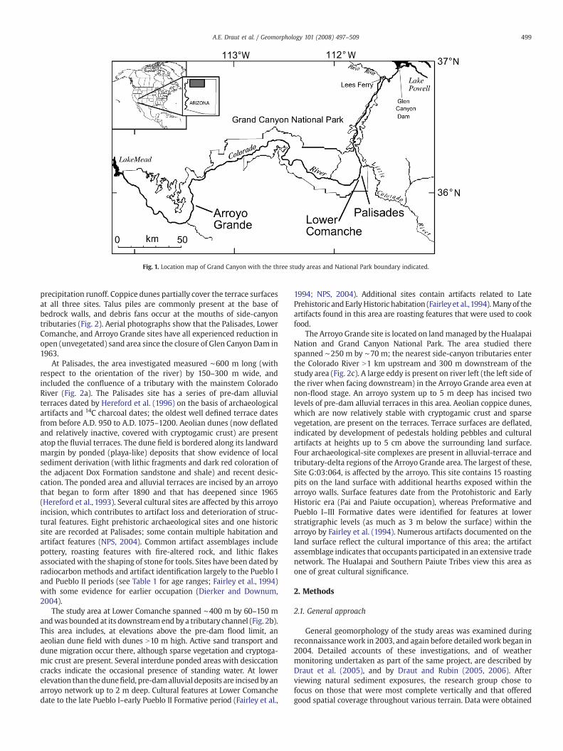
Fig. 1. Location map of Grand Canyon with the three study areas and National Park boundary indicated.
499A.E. Draut et al. / Geomorphology 101 (2008) 497–509
precipitation runoff. Coppice dunes partially cover the terrace surfacesat all three sites. Talus piles are commonly present at the base ofbedrock walls, and debris fans occur at the mouths of side-canyontributaries (Fig. 2). Aerial photographs show that the Palisades, LowerComanche, and Arroyo Grande sites have all experienced reduction inopen (unvegetated) sand area since the closure of Glen Canyon Dam in1963.
At Palisades, the area investigated measured ∼600 m long (withrespect to the orientation of the river) by 150–300 m wide, andincluded the confluence of a tributary with the mainstem ColoradoRiver (Fig. 2a). The Palisades site has a series of pre-dam alluvialterraces dated by Hereford et al. (1996) on the basis of archaeologicalartifacts and 14C charcoal dates; the oldest well defined terrace datesfrom before A.D. 950 to A.D. 1075–1200. Aeolian dunes (now deflatedand relatively inactive, covered with cryptogamic crust) are presentatop the fluvial terraces. The dune field is bordered along its landwardmargin by ponded (playa-like) deposits that show evidence of localsediment derivation (with lithic fragments and dark red coloration ofthe adjacent Dox Formation sandstone and shale) and recent desic-cation. The ponded area and alluvial terraces are incised by an arroyothat began to form after 1890 and that has deepened since 1965(Hereford et al., 1993). Several cultural sites are affected by this arroyoincision, which contributes to artifact loss and deterioration of struc-tural features. Eight prehistoric archaeological sites and one historicsite are recorded at Palisades; some contain multiple habitation andartifact features (NPS, 2004). Common artifact assemblages includepottery, roasting features with fire-altered rock, and lithic flakesassociatedwith the shaping of stone for tools. Sites have been dated byradiocarbon methods and artifact identification largely to the Pueblo Iand Pueblo II periods (see Table 1 for age ranges; Fairley et al., 1994)with some evidence for earlier occupation (Dierker and Downum,2004).
The study area at Lower Comanche spanned ∼400 m by 60–150 mandwas bounded at its downstream end by a tributary channel (Fig. 2b).This area includes, at elevations above the pre-dam flood limit, anaeolian dune field with dunes N10 m high. Active sand transport anddune migration occur there, although sparse vegetation and cryptoga-mic crust are present. Several interdune ponded areas with desiccationcracks indicate the occasional presence of standing water. At lowerelevation than thedunefield, pre-damalluvial deposits are incised byanarroyo network up to 2 m deep. Cultural features at Lower Comanchedate to the late Pueblo I–early Pueblo II Formative period (Fairley et al.,
1994; NPS, 2004). Additional sites contain artifacts related to LatePrehistoric andEarlyHistoric habitation (Fairleyet al.,1994).Manyof theartifacts found in this area are roasting features that were used to cookfood.
The Arroyo Grande site is located on landmanaged by the HualapaiNation and Grand Canyon National Park. The area studied therespanned ∼250 m by ∼70 m; the nearest side-canyon tributaries enterthe Colorado River N1 km upstream and 300 m downstream of thestudy area (Fig. 2c). A large eddy is present on river left (the left side ofthe river when facing downstream) in the Arroyo Grande area even atnon-flood stage. An arroyo system up to 5 m deep has incised twolevels of pre-dam alluvial terraces in this area. Aeolian coppice dunes,which are now relatively stable with cryptogamic crust and sparsevegetation, are present on the terraces. Terrace surfaces are deflated,indicated by development of pedestals holding pebbles and culturalartifacts at heights up to 5 cm above the surrounding land surface.Four archaeological-site complexes are present in alluvial-terrace andtributary-delta regions of the Arroyo Grande area. The largest of these,Site G:03:064, is affected by the arroyo. This site contains 15 roastingpits on the land surface with additional hearths exposed within thearroyo walls. Surface features date from the Protohistoric and EarlyHistoric era (Pai and Paiute occupation), whereas Preformative andPueblo I–III Formative dates were identified for features at lowerstratigraphic levels (as much as 3 m below the surface) within thearroyo by Fairley et al. (1994). Numerous artifacts documented on theland surface reflect the cultural importance of this area; the artifactassemblage indicates that occupants participated in an extensive tradenetwork. The Hualapai and Southern Paiute Tribes view this area asone of great cultural significance.
2. Methods
2.1. General approach
General geomorphology of the study areas was examined duringreconnaissancework in 2003, and again before detailed work began in2004. Detailed accounts of these investigations, and of weathermonitoring undertaken as part of the same project, are described byDraut et al. (2005), and by Draut and Rubin (2005, 2006). Afterviewing natural sediment exposures, the research group chose tofocus on those that were most complete vertically and that offeredgood spatial coverage throughout various terrain. Data were obtained
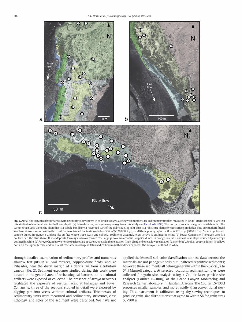
Fig. 2. Aerial photographs of study areas with geomorphology shown in colored overlays. Circles with numbers are sedimentary profiles measured in detail; circles labeled ‘T’ are testpits studied in less detail and to shallower depth. (a) Palisades area, with geomorphology from this study and Hereford (1993). The northern area in pale green is a debris fan. Thedarker green strip along the shoreline is a cobble bar, likely a reworked part of the debris fan. In light blue is a relict (pre-dam) terrace surface. In darker blue are modern fluvialsandbars at an elevation within the usual dam-controlled fluctuations (below 566 m3/s [20,000 ft3/s]; in all three photographs the flow is 226 m3/s [8000 ft3/s]). Areas in yellow arecoppice dunes. In orange is a playa-like surface where slope-wash and colluvial sediments accumulate. An arroyo is outlined in white. (b) Lower Comanche. The green area is aboulder bar; the blue shows fluvial deposits forming a narrow terrace. The large yellow area contains coppice dunes. In orange is a talus and colluvial slope drained by an arroyooutlined inwhite. (c) Arroyo Grande: two terrace surfaces are apparent, one at higher elevation (light blue) and one at lower elevation (darker blue). Aeolian coppice dunes, in yellow,occur on the upper terrace and to its east. The area in orange is talus and colluvium with bedrock exposed. The arroyo is outlined in white.
500 A.E. Draut et al. / Geomorphology 101 (2008) 497–509
through detailed examination of sedimentary profiles and numerousshallow test pits in alluvial terraces, coppice-dune fields, and, atPalisades, near the distal margin of a debris fan from a tributarycanyon (Fig. 2). Sediment exposures studied during this work werelocated in the general area of archaeological features but no culturalartifacts were exposed or collected. The presence of arroyo networksfacilitated the exposure of vertical faces; at Palisades and LowerComanche, three of the sections studied in detail were exposed bydigging pits into areas without cultural artifacts. Thicknesses ofsedimentary units were measured and sedimentary structures, clastlithology, and color of the sediment were described. We have not
applied the Munsell soil-color classification to these data because thematerials are not pedogenic soils but unaltered regolithic sediments;however, these sediments all belong generally within the 7.5YR (6/2 to6/4) Munsell category. At selected locations, sediment samples werecollected for grain-size analysis using a Coulter laser particle-sizeanalyzer (Coulter LS-100Q) at the Grand Canyon Monitoring andResearch Center laboratory in Flagstaff, Arizona. The Coulter LS-100Qprocesses smaller samples, and more rapidly, than conventional siev-ing. This instrument is calibrated using dry-sieving techniques toproduce grain-size distributions that agree to within 5% for grain sizes63–900 μ.
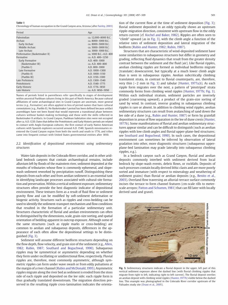
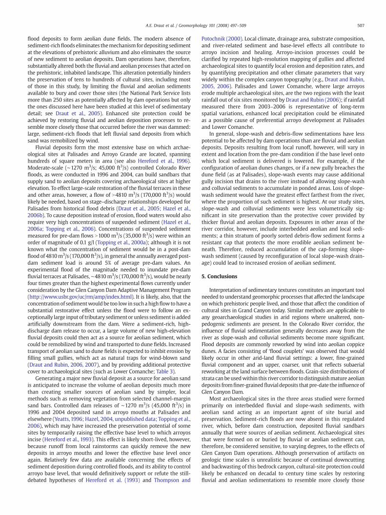
Fig. 3. Sedimentary structures indicate a fluvial deposit in the upper, left part of thisvertical sediment exposure above the dashed line (with fluvial climbing ripples thatmigrate from right to left, indicating right-to-left current). The fluvial deposit overliesan aeolian deposit with climbing wind ripples (Hunter, 1977b) visible below the dashedline. This example was photographed in the Colorado River corridor upstream of thePalisades study site (Draut et al., 2005).
Table 1Chronology of human occupation in the Grand Canyon area, Arizona (after Fairley, 2003)
Period Age
Paleoindian ca. 12,000–8000 B.C.Archaic ca. 8000–1000 B.C.Early Archaic ca. 8000–5000 B.C.Middle Archaic ca. 5000–3000 B.C.Late Archaic ca. 3000–1000 B.C.
Preformative (Basketmaker II) ca. 1000 B.C.–A.D. 400Formative ca. A.D. 400–1250Early Formative A.D. 400–1000
(Basketmaker III) ca. A.D. 400–800(Pueblo I) A.D. 800–1000
Late Formative A.D. 1000–1300(Pueblo II) A.D. 1000–1150(Pueblo III) A.D. 1150–1300
Late Prehistoric A.D. 1300–1540Protohistoric A.D. 1540–1775Early Historic A.D. 1776–1850Late Historic ca. A.D. 1850–1950
Names of periods listed in parentheses refer specifically to stages of developmentwithin ancestral Puebloan cultures living in this part of North America. Because culturalaffiliations of some archaeological sites in Grand Canyon are uncertain, more generalterms (e.g., Formative) are often applied in lieu of period names that have culturalconnotations (e.g., Pueblo II). No Basketmaker I period has been defined because artifactassemblages have not been found that would represent a transitional phase betweencultures without basket-making technology and those with the skills reflected inBasketmaker II artifacts. In Grand Canyon, Puebloan habitation sites were not occupiedafter ca. A.D.1220. Dates that define the Protohistoric and Early Historic periods are relatedto contact with Anglo-European cultures; the first contact of early Native Americancultures with Spanish explorers occurred around A.D. 1540, Spanish missionaries re-entered the Grand Canyon region from both the north and south in 1776, and tribescame into frequent contact with United States governmental entities after 1850.
501A.E. Draut et al. / Geomorphology 101 (2008) 497–509
2.2. Identification of depositional environments using sedimentarystructures
Water-lain deposits in the Colorado River corridor, and in other arid-land bedrock canyons that contain archaeological remains, includealluvium left by floods of themainstem river, sediment deposited at themouths of tributaries whose flow is commonly ephemeral, and slope-wash sediment reworked by precipitation runoff. Distinguishing thesedeposits from each other and from aeolian sediment is an essential taskin identifying landscape processes associated with cultural-site forma-tion andpreservation.Within avertical sedimentexposure, sedimentarystructures often provide the best diagnostic indicator of depositionalenvironment. These textures form as a result of fluid flow or sedimentgravity flow and can be modified by soft-sediment deformation orbiogenic activity. Structures such as ripples and cross-bedding can beused to identify the sediment-transportmechanism andflowconditionsthat resulted in the formation of a particular sedimentary unit.Structures characteristic of fluvial and aeolian environments can oftenbe distinguished by the dimensions, scale, grain-size sorting, and spatialorientation of bedding apparent in outcrop exposure. Although some ofthe same structures (such as ripple marks or cross-bedding) arecommon to aeolian and subaqueous deposits, differences in the ap-pearance of each often allow the depositional settings to be distin-guished (Fig. 3).
Sediment will assume different bedform structures depending ontheflowdepth,flowvelocity, and grain size of the sediment (e.g., Allen,1982; Rubin, 1987; Southard and Boguchwal, 1990). Subaqueousripples may be symmetrical or asymmetric depending on whetherthey form under oscillating or unidirectional flow, respectively. Fluvialripples are, therefore, most commonly asymmetric, although sym-metric ripples can form under wave swash or from eddy pulsations atthemargin of a river channel (Rubin andMcDonald,1995). Asymmetricripplesmigrate along the river bed as sediment is eroded from the stossside of each ripple and deposited on the lee side; each ripple form isthus gradually translated downstream. The migration direction pre-served in the resulting ripple cross-lamination indicates the orienta-
tion of the current flow at the time of sediment deposition (Fig. 3);fluvial sediment deposited in an eddy typically shows an upstreamripple-migration direction, consistent with upstream flow in the eddyreturn current (cf. Kochel and Baker, 1982). Ripples are often seen to“climb” upward (as in Fig. 3), with the climb angle a function of therelative rates of sediment deposition and lateral migration of thebedform (Rubin and Hunter, 1982; Rubin, 1987).
Structures that are characteristic of wind-deposited sediment havesome similarities to subaqueous structures but differ in geometry andgrading, reflecting fluid dynamics that result from the greater densitycontrast between the sediment and the fluid (air). Like fluvial ripples,aeolian climbing ripples are formed as individual bedforms migrate(translate) downcurrent, but typically at a much lower climb anglethan is seen in subaqueous ripples. Aeolian subcritically climbingtranslatent strata, in contrast to fluvial counterparts, are, therefore,very thin (∼2 mm in Fig. 3) and tabular (Hunter, 1977a,b). As eachripple form migrates over the next, a pattern of ‘pinstriped’ stratacommonly forms from climbing wind ripples (Hunter, 1977b; Fig. 3).Within each individual stratum, sediment particles are inverselygraded (coarsening upward), a product of the grain-size sorting ofsand by wind. In contrast, inverse grading in subaqueous climbingripples is rare or absent. In addition to climbing wind ripples, aeoliansedimentary structures can result from avalanching of sand down thelee side of a dune (e.g., Rubin and Hunter, 1987) or form by grainfalldeposition in areas of flow separation in the lee of dune crests (Hunter,1977b). Somemanifestations of fluvial and aeolian sedimentary struc-tures appear similar and can be difficult to distinguish (such as aeolianripples with low climb angles and fluvial upper-plane-bed structures;see Southard and Boguchwal, 1990). In such cases, the depositionalenvironment can sometimes be inferred by observation of lateralgradation into other, more diagnostic structures (subaqueous upper-plane-bed lamination may grade laterally into subaqueous climbingripples, e.g.).
In a bedrock canyon such as Grand Canyon, fluvial and aeoliandeposits commonly interbed with sediment derived from localbedrock by slope-wash events, debris flows, or rockfalls. Deposits ofsuch processes contain locally derived lithic clasts and aremore poorlysorted and immature (with respect to mineralogy and weathering ofsediment grains) than fluvial or aeolian deposits (e.g., Benito et al.,2003). Overland flow traversing an alluvial-terrace surface commonlyincises the terrace to form channel features (cm-scale rills to meter-scale arroyos; Patton and Schumm,1981) that can fill later with locallyderived sand and gravel.
Table 2Summary of sedimentary processes affecting archaeological areas at Palisades
Site number Age and affiliation of site Sediment on which site was originally built Sediment overlying site Sedimentary and geomorphic characteristics
C:13:033 Uncertain; probablePueblo I–III
Debris-fan cobbles, gravel Aeolian (minor) Dominated by debris-flow deposition
C:13:098 Historic Debris-fan cobbles, gravel None Remains of 19th century cabin built on debris-fansediment
C:13:099 Pueblo I–II Fluvial; slope-wash sand and gravel Aeolian; distal debris-flow material Interbedding of fluvial, aeolian, debris-flow andslope-wash sediments
C:13:100 Pueblo I–II Fluvial Fluvial/aeolian Fluvial sediment modified by windC:13:101 Pueblo I–II Rounded cobbles, likely fluvial Aeolian (minor) Coppice dunes overlying rounded cobblesC:13:272 Pueblo I–II Debris-fan cobbles, gravel Fluvial and aeolian Fluvial sediment modified by wind into coppice
dunes; bioturbatedC:13:334 Pueblo I–II Fluvial; ponded slope-wash Fluvial Eroding out of apparent fluvial depositC:13:336 Pueblo I–II Likely fluvial (artifacts not in
original position)Fluvial/aeolian Fluvial sediment reworked by wind into coppice
dunesC:13:355 Pueblo II Fluvial; distal debris-flow Fluvial and aeolian Area dominated by debris fan, smaller volumes
of fluvial and aeolian sediment
Archaeological-site numbers are those assigned by theNational Park Service (NPS). Detailed discussions of processes in these areasmay be found inDraut et al. (2005). Prehistoric siteshave been dated by radiocarbonmethods and artifact identification to the Pueblo I and Pueblo II (PI and PII) periods (Fairley et al.,1994) although some evidence exists for Preformativeoccupation (Dierker and Downum, 2004). The historic site is associated with mining activity and was occupied from A.D. 1890–1910.
502 A.E. Draut et al. / Geomorphology 101 (2008) 497–509
It is particularly advantageous to identify landscape processesusing sedimentary structures in addition to surface morphologybecause landforms may be unrelated to depositional processes thatemplaced the sediment in the sub-surface. Documented examplesinclude yardangs, fluvial ripples scoured into beach swash (Fig. 11 ofRubin, 1987), and marine tidal ridges scoured into the surface of afluvial deposit following sea-level transgression (Berné et al., 2002). Ineach case, the surface forms represent erosion into older sedimentthat was deposited by processes other than those that generated thesurface form. Therefore, if sedimentary structures are well preserved,the most complete record of prehistoric and historic landscapeprocesses will be obtained by investigating sub-surface sedimentol-ogy and surficial geomorphology.
3. Results and interpretation
Very detailed descriptions of sedimentary profiles and grain-sizeanalyses from the three study sites were discussed by Draut et al.(2005). Here, we summarize the local depositional environments inthese regions and use the data to focus on the broader applicability ofthese techniques in addressing geoarchaeological problems. Geo-morphic and sedimentary processes that affect each studied archae-ological site are summarized for Palisades, Lower Comanche, andArroyo Grande in Tables 2, 3, and 4, respectively.
Stratigraphic sections at Palisades (Fig. 4a) indicate repeatedinundation of this area by Colorado River floods in pre-dam time.Fluvial deposits containing climbing ripples were present in three of
Table 3Summary of sedimentary processes affecting archaeological areas at Lower Comanche
Site number Age and affiliation of site Sediment on which site was origina
C:13:273 Early Formative(Basketmaker III)
Fluvial, aeolian; colluvial
C:13:274 Pueblo I–II Aeolian
C:13:333 Pueblo I–II Aeolian
C:13:335 Pueblo I–II AeolianC:13:337 Pueblo I–II AeolianC:13:373 Prehistoric to Early Historic Hopi Aeolian
Site numbers have been assigned by NPS. Most cultural features in this area date to the Late PIsite contains artifacts related to late prehistoric and early historic use by theHopi Tribe (Fairleyobtained from a hearth feature by Yeatts (1998).
the four profiles studied, and the fourth contained sediment for whichfluvial deposition was suspected but could not be confirmed bysedimentary textures. The extent of fluvial deposits, defined bysedimentary structures, demonstrates that the entire terrace area inthe Palisades regionwas submerged episodically during pre-dam highflows. No post-dam flows (since 1963) have inundated this terrace.The consistent upstream migration direction of fluvial ripplesindicates that an eddy existed in this area during pre-dam floods. Astage–discharge relationship developed from driftwood depositsindicated that the terraced area was almost entirely inundated by aflow of ∼5940 m3/s (210,000 ft3/s; Hazel et al., 2006b), a flood levelreached most recently in 1884. Reworking of fluvial sediment by windwas apparently common, evidenced by aeolian deposits betweenfluvial deposits; aeolian material was also found interbedded withplaya-like sediment where slope-wash runoff had formed small,isolated ponds. The proportion of water-lain sediment derived fromlocal sources (slope-wash and distal debris flows) was found toincrease landward and toward a debris fan at the mouth of a tributarynorth of the study area (Fig. 2a).
Six of the nine archaeological sites at Palisades were formed in oron fluvial sediment, some of which had been reworked by wind(Table 2). Five of the nine sites are preserved at least in part by a coverof aeolian sediment, with minor contributions from aeolian sedimen-tary cover at two additional sites. Erosion associated with arroyoincision affects two of the sites. Exposure of artifacts can be attributedat least in part to aeolian deflation at five sites. Influence of debrisflows from a side canyon was apparent at five of nine sites. Four sites
lly built Sediment overlying site Sedimentary and geomorphic characteristics
Aeolian (minor) Fluvial and aeolian deposits interbeddedwith slope-wash colluvium
None Aeolian substrate overlies distal debris-fansediment
Aeolian (minor) Site destabilized by aeolian deflation anddune migration
Aeolian Exposed by aeolian deflationNone Aeolian dunes; site in interdune areaAeolian Site destabilized by aeolian deflation and
dune migration
–Early PII Formative period (A.D. ∼900–1000; Fairley et al., 1994; NPS, 2004). At least oneet al.,1994). The Early Formative age given for Site C:13:273 is based on radiocarbon ages
Table 4Summary of processes affecting archaeological areas at Arroyo Grande
Site number Age and affiliation of site Sediment on which site was originally built Sediment overlying site Sedimentary and geomorphic characteristics
G:03:064, F1 Protohistoric to Early Historic Pai Aeolian Aeolian (minor) Coppice dunes on upper-terrace surfaceG:03:064, F2 Protohistoric to Early Historic Pai Aeolian Aeolian (minor) Coppice dunes on upper-terrace surfaceG:03:064, F3 Protohistoric to Early Historic Pai Aeolian Aeolian (minor) Coppice dunes on upper-terrace surfaceG:03:064, F4 Protohistoric to Early Historic Pai Aeolian Aeolian (minor) Interdune area in coppice-dune field; arroyo
incision affects feature stabilityG:03:064, F5 Protohistoric to Early Historic Pai Aeolian Aeolian (minor) Interdune area in coppice-dune field; affected
by aeolian deflationG:03:064, F6 Protohistoric to Early Historic Pai Terrace surface (dominantly fluvial) None Arroyo incision affects terrace surface in the
vicinity of this featureG:03:064, F7 Protohistoric to Early Historic Pai Terrace surface (dominantly fluvial) None Surface of upper terraceG:03:064, F8 Protohistoric to Early Historic Pai Terrace surface (dominantly fluvial) None Surface of upper terraceG:03:064, F9 Protohistoric to Early Historic Pai Terrace surface (dominantly fluvial) None Surface of upper terraceG:03:064, F10 Protohistoric to Early Historic Pai Terrace surface (dominantly fluvial) None Surface of upper terraceG:03:064, F11 Protohistoric to Early Historic Pai Terrace surface (dominantly fluvial) None Surface of upper terraceG:03:064, F12 Protohistoric to Early Historic Pai Aeolian Aeolian (partially covers feature) Small coppice dunes on upper-terrace surface.
Feature affected by arroyo incisionG:03:064, F13 Protohistoric to Early Historic Pai Aeolian None Small coppice dunes on upper-terrace surface.
Feature affected by arroyo incisionG:03:064, F14 Protohistoric to Early Historic Pai Interbedded fluvial/aeolian/colluvial Aeolian Exposed in small drainage within upper terraceG:03:064, F15 Protohistoric to Early Historic Pai Colluvium None Near landward edge of upper terrace, in area
dominated by slope-wash sedimentationNot assigned Unknown Slope-wash colluvium and aeolian Fluvial, aeolian, and colluvial Charcoal hearth feature exposed in arroyo wall
within upper terrace, near measured Section 8
Site and feature numbers are those assigned by NPS. The site numbered G:03:064 includes 15 separate features (most of which are roasting pits) spread across several thousandsquare meters. Detailed discussions of these areas can be found in Draut et al. (2005). Most cultural features that can be examined without excavation in this area are exposed on theland surface. In general these are associated with the Protohistoric and Early Historic-era Pai culture related to the Paiute and Hualapai Tribes. Many of the exposed sites are on thebroad upper terrace where aeolian coppice dunes occur locally. This aeolian sand apparently represents reworked fluvial sediment; coppice dunes overlie a terrace composed ofinterbedded fluvial, aeolian, and colluvial (slope-wash) materials. Thus these features were built on aeolian sediment directly, but this relatively thin aeolian substrate is underlain byvolumetrically more substantial flood deposits.
503A.E. Draut et al. / Geomorphology 101 (2008) 497–509
were formed directly on debris-flow sediment (including cobble-sizedclasts at the historic and one prehistoric site) and at least one site hadbeen overlain by distal debris-flow material after initial human oc-cupation (Table 2).
Stratigraphy of the southern, arroyo-incised part of the LowerComanche area indicated multiple episodes of fluvial sedimentationfollowed by reworking at the land surface by wind and local runoffthat follows rainfall events (Fig. 4b). Aeolian climbing ripples werepresent in some of the deposits; much of the silt and fine sand did notcontain preserved diagnostic sedimentary structures. Colluvium(recognized by sandstone and shale clasts derived from the localDox Formation bedrock) was present in all six profiles studied atLower Comanche. Fluvial sedimentary structures were observed onlyin the two profiles closest to the river. Numerous channel-fill struc-tures were apparent in arroyo-wall exposures.
Five of the six cultural sites at Lower Comanche are located withinthe large aeolian dune field (Table 3). Four of those were originallysituated on aeolian sediment, with the fifth built on an interdune, playa-like surface. Four siteswere at least partially buried byaeolian sediment;two of those four have onlyminor sediment cover (b10 cm thick). Threeof the five sites within the dune field are affected by modern aeoliandeflation and dunemigration. The one archaeological site not located inor among the large coppice dunes at Lower Comanche (Site C13:273;Table 3) was constructed on a terrace that contained slope-wash mate-rial interbedded with lighter-colored, better-sorted fine sediment withpoorly preserved sedimentary structures that appeared to gradelaterally into fluvial and aeolian deposits.
Colorado River flood deposits dominate the stratigraphic recordaround the extensive archaeological site at Arroyo Grande. Profileswithinthe upper terrace (Fig. 2c) showed the proportion of fluvial sedimentgenerally increasing toward the river. The record of flood deposition isbest preserved in sedimentary profiles closest to the river, with 15individual floods evident in one profile (Section 6; Fig. 4c). All profilesshowed evidence of subaerial reworking and incorporation of colluvialand slope-wash sediments between floods. The repeated occurrence offluvial deposits overlain by subaerial sediment led to the description of a
‘flood couplet’ facies consisting of a lower fluvial and upper subaerialmember (Fig. 5). Thefluvial portionofmanyof theseflood couplets beginswith a white to pale buff-colored silt-and-clay lower layer. Sedimentarystructures in fluvial deposits most commonly indicate flow toward thenorth or west, evidence of a large eddy at high flow in this area similar tothe one that exists there today even at non-flood flow. Bioturbation andthe presence of biotite and amphibole lithic clasts in the upper parts offlood couplets (common minerals in the local gneiss bedrock) indicatereworking of the flood sediment at the land surface; pedogenic soilhorizons are not developed. Poorly sorted, lithic-rich channel-fill depositsin twoof themeasuredprofiles, and inother exposures in the arroyowallswhere strata were not described in detail, indicate multiple episodes ofgully formation and filling during subaerial exposure.
Aeolian sediment constitutes a relatively minor volume in thesections measured at Arroyo Grande; where present, aeolian dunedeposits extended as much as 2 m beneath the land surface. The mostlikely sediment source for the small, deflated coppice dunes visible onthe land surface today is reworking of the extensive fluvial depositsthat created the terrace morphology in this area.
Of the 16 cultural features studied at ArroyoGrande,15 are exposedat the land surface (Table 4). Fourteen were formed on the surface ofthe upper terrace, of which seven are located within coppice dunes onthe terrace surface. Seven of the 14 features on the terrace surface arepartially covered by aeolian sediment. Of the two features not on theupper terrace surface, one was built on colluvium near the landwardedge of the terrace and the other, for which no site name or affiliationhas been assigned, was exposed within an arroyo wall. That hearthfeature had been dug into slope-wash and aeolian sediment and wasburied by fluvial, aeolian, and colluvial sediments after its use.
4. Discussion
4.1. Interpretation of sedimentary textures
Analysis of sedimentary textures yielded new insights, at a level ofdetail not reached by previous studies, into the suite of landscape
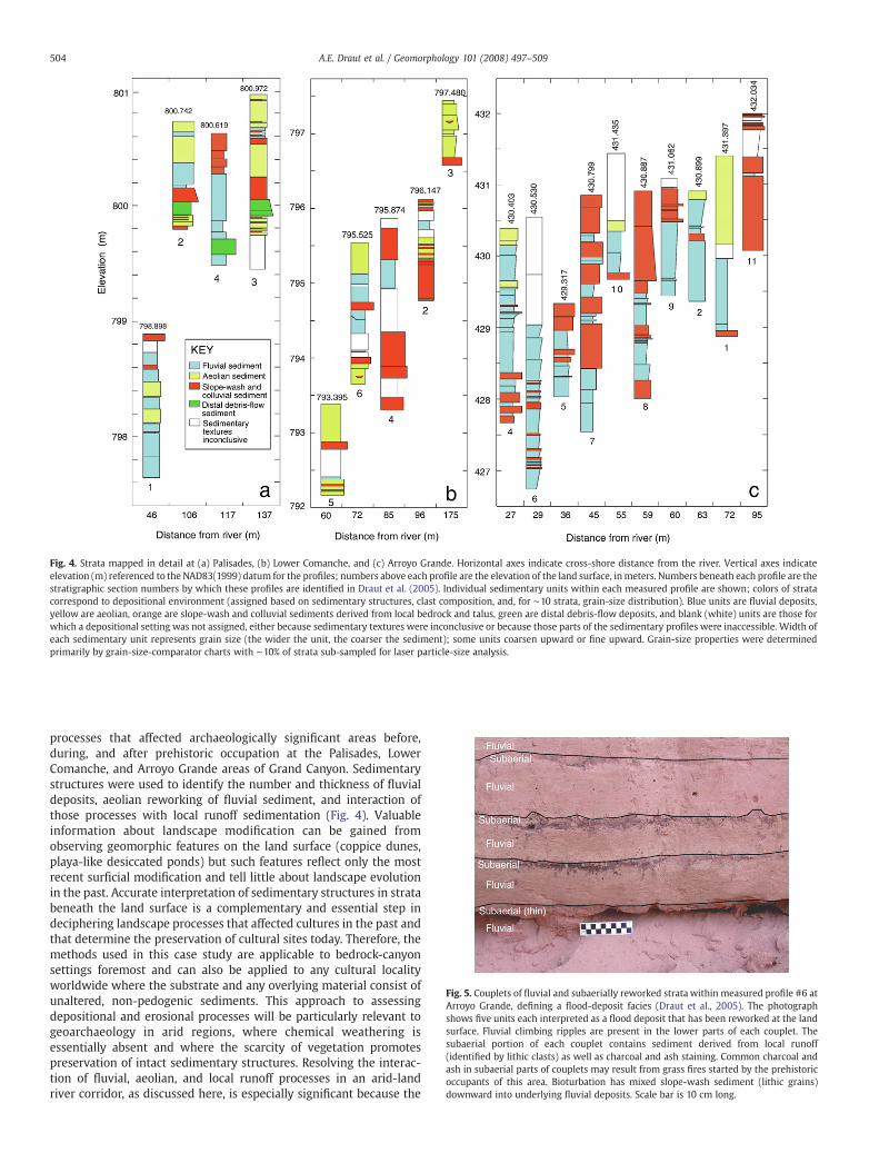
Fig. 4. Strata mapped in detail at (a) Palisades, (b) Lower Comanche, and (c) Arroyo Grande. Horizontal axes indicate cross-shore distance from the river. Vertical axes indicateelevation (m) referenced to the NAD83(1999) datum for the profiles; numbers above each profile are the elevation of the land surface, inmeters. Numbers beneath each profile are thestratigraphic section numbers by which these profiles are identified in Draut et al. (2005). Individual sedimentary units within each measured profile are shown; colors of stratacorrespond to depositional environment (assigned based on sedimentary structures, clast composition, and, for ∼10 strata, grain-size distribution). Blue units are fluvial deposits,yellow are aeolian, orange are slope-wash and colluvial sediments derived from local bedrock and talus, green are distal debris-flow deposits, and blank (white) units are those forwhich a depositional setting was not assigned, either because sedimentary textures were inconclusive or because those parts of the sedimentary profiles were inaccessible. Width ofeach sedimentary unit represents grain size (the wider the unit, the coarser the sediment); some units coarsen upward or fine upward. Grain-size properties were determinedprimarily by grain-size-comparator charts with ∼10% of strata sub-sampled for laser particle-size analysis.
Fig. 5. Couplets of fluvial and subaerially reworked strata within measured profile #6 atArroyo Grande, defining a flood-deposit facies (Draut et al., 2005). The photographshows five units each interpreted as a flood deposit that has been reworked at the landsurface. Fluvial climbing ripples are present in the lower parts of each couplet. Thesubaerial portion of each couplet contains sediment derived from local runoff(identified by lithic clasts) as well as charcoal and ash staining. Common charcoal andash in subaerial parts of couplets may result from grass fires started by the prehistoricoccupants of this area. Bioturbation has mixed slope-wash sediment (lithic grains)downward into underlying fluvial deposits. Scale bar is 10 cm long.
504 A.E. Draut et al. / Geomorphology 101 (2008) 497–509
processes that affected archaeologically significant areas before,during, and after prehistoric occupation at the Palisades, LowerComanche, and Arroyo Grande areas of Grand Canyon. Sedimentarystructures were used to identify the number and thickness of fluvialdeposits, aeolian reworking of fluvial sediment, and interaction ofthose processes with local runoff sedimentation (Fig. 4). Valuableinformation about landscape modification can be gained fromobserving geomorphic features on the land surface (coppice dunes,playa-like desiccated ponds) but such features reflect only the mostrecent surficial modification and tell little about landscape evolutionin the past. Accurate interpretation of sedimentary structures in stratabeneath the land surface is a complementary and essential step indeciphering landscape processes that affected cultures in the past andthat determine the preservation of cultural sites today. Therefore, themethods used in this case study are applicable to bedrock-canyonsettings foremost and can also be applied to any cultural localityworldwide where the substrate and any overlying material consist ofunaltered, non-pedogenic sediments. This approach to assessingdepositional and erosional processes will be particularly relevant togeoarchaeology in arid regions, where chemical weathering isessentially absent and where the scarcity of vegetation promotespreservation of intact sedimentary structures. Resolving the interac-tion of fluvial, aeolian, and local runoff processes in an arid-landriver corridor, as discussed here, is especially significant because the
505A.E. Draut et al. / Geomorphology 101 (2008) 497–509
archaeological record in arid lands tends to be concentrated in rivercorridors, where humanpopulations have regular access towater (e.g.,Hassan, 1985).
Even in arid regions, however, not all strata preserve diagnosticstructures. In most cases, absence of sedimentary structures in fine-grained sediment is attributable to biologic effects. Vegetationinterferes with the development of aeolian sedimentary structures;wind ripples forming on a sparsely vegetated surface have shortercrests and less regular trough elevation than on unvegetated surfaces,while denser vegetation reduces or prevents aeolian transport of sand(Olson,1958; Ash andWasson,1983; Buckley, 1987). Organic debris onthe land surface can also interfere with the development of windripples, as can a variable wind direction during deposition. Bioturba-tion by trampling, animal burrowing, and the growth of plant roots, asseen at the Grand Canyon study sites, can disturb or destroy sedi-mentary structures. Bioturbation in subaerial and subaqueous envi-ronments can quickly obscure sedimentary structures, particularlyif the rate of sediment deposition is slow (e.g., Dott and Bourgeous,1982).
If sedimentary structures are not apparent, reworking of a primarysedimentary deposit can sometimes be inferred from the morphologyand composition of the deposit. In the absence of lithic grains or adistinctive color that implies incorporation of local runoff sediment(such as, in this study, clasts from gneiss bedrock), fine-graineddeposits in the Colorado River corridor are generally interpreted ashaving been derived from Colorado River sediment. Flood depositsthat have been reworked by wind commonly exhibit surface mor-phology that includes sand shadows or coppice dunes. If neithersedimentary structures nor aeolian landforms are evident, it is dif-ficult if not impossible to determine whether light-colored fine-grained sediment within terraces remains in its original position asfluvial units or has been reworked by wind.
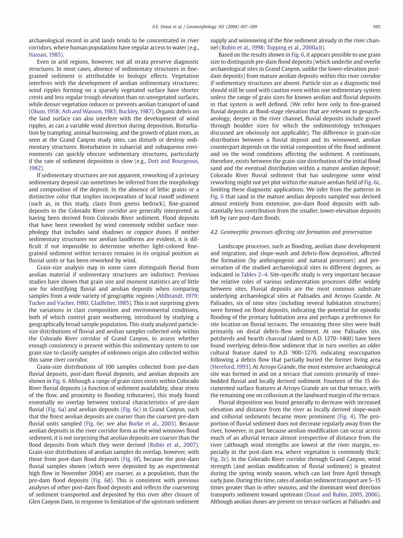
Grain-size analysis may in some cases distinguish fluvial fromaeolian material if sedimentary structures are indistinct. Previousstudies have shown that grain size and moment statistics are of littleuse for identifying fluvial and aeolian deposits when comparingsamples from a wide variety of geographic regions (Ahlbrandt, 1979;Tucker and Vacher, 1980; Gladfelter, 1985). This is not surprising giventhe variations in clast composition and environmental conditions,both of which control grain weathering, introduced by studying ageographically broad sample population. This study analyzed particle-size distributions of fluvial and aeolian samples collected only withinthe Colorado River corridor of Grand Canyon, to assess whetherenough consistency is present within this sedimentary system to usegrain size to classify samples of unknown origin also collected withinthis same river corridor.
Grain-size distributions of 100 samples collected from pre-damfluvial deposits, post-dam fluvial deposits, and aeolian deposits areshown in Fig. 6. Although a range of grain sizes exists within ColoradoRiver fluvial deposits (a function of sediment availability, shear stressof the flow, and proximity to flooding tributaries), this study foundessentially no overlap between textural characteristics of pre-damfluvial (Fig. 6a) and aeolian deposits (Fig. 6c) in Grand Canyon, suchthat the finest aeolian deposits are coarser than the coarsest pre-damfluvial units sampled (Fig. 6e; see also Burke et al., 2003). Becauseaeolian deposits in the river corridor form as the wind winnows floodsediment, it is not surprising that aeolian deposits are coarser than theflood deposits from which they were derived (Rubin et al., 2007).Grain-size distributions of aeolian samples do overlap, however, withthose from post-dam flood deposits (Fig. 6f), because the post-damfluvial samples shown (which were deposited by an experimentalhigh flow in November 2004) are coarser, as a population, than thepre-dam flood deposits (Fig. 6d). This is consistent with previousanalyses of other post-dam flood deposits and reflects the coarseningof sediment transported and deposited by this river after closure ofGlen Canyon Dam, in response to limitation of the upstream sediment
supply and winnowing of the fine sediment already in the river chan-nel (Rubin et al., 1998; Topping et al., 2000a,b).
Based on the results shown in Fig. 6, it appears possible to use grainsize to distinguish pre-dam flood deposits (which underlie and overliearchaeological sites in Grand Canyon, unlike the lower-elevation post-dam deposits) from mature aeolian deposits within this river corridorif sedimentary structures are absent. Particle size as a diagnostic toolshould still be used with caution evenwithin one sedimentary systemunless the range of grain sizes for known aeolian and fluvial depositsin that system is well defined. (We refer here only to fine-grainedfluvial deposits at flood-stage elevation that are relevant to geoarch-aeology; deeper in the river channel, fluvial deposits include gravelthrough boulder sizes for which the sedimentology techniquesdiscussed are obviously not applicable). The difference in grain-sizedistribution between a fluvial deposit and its winnowed, aeoliancounterpart depends on the initial composition of the flood sedimentand on the wind conditions affecting the sediment. A continuum,therefore, exists between the grain-size distribution of the initial floodsand and the eventual distribution within a mature aeolian deposit;Colorado River fluvial sediment that has undergone some windreworking might not yet plot within the mature aeolian field of Fig. 6c,limiting these diagnostic applications. We infer from the patterns inFig. 6 that sand in the mature aeolian deposits sampled was derivedalmost entirely from extensive, pre-dam flood deposits with sub-stantially less contribution from the smaller, lower-elevation depositsleft by rare post-dam floods.
4.2. Geomorphic processes affecting site formation and preservation
Landscape processes, such as flooding, aeolian dune developmentand migration, and slope-wash and debris-flow deposition, affectedthe formation (by anthropogenic and natural processes) and pre-servation of the studied archaeological sites to different degrees, asindicated in Tables 2–4. Site-specific study is very important becausethe relative roles of various sedimentation processes differ widelybetween sites. Fluvial deposits are the most common substrateunderlying archaeological sites at Palisades and Arroyo Grande. AtPalisades, six of nine sites (including several habitation structures)were formed on flood deposits, indicating the potential for episodicflooding of the primary habitation area and perhaps a preference forsite location on fluvial terraces. The remaining three sites were builtprimarily on distal debris-flow sediment. At one Palisades site,potsherds and hearth charcoal (dated to A.D. 1270–1460) have beenfound overlying debris-flow sediment that in turn overlies an oldercultural feature dated to A.D. 900–1270, indicating reoccupationfollowing a debris flow that partially buried the former living area(Hereford, 1993). At Arroyo Grande, the most extensive archaeologicalsite was formed in and on a terrace that consists primarily of inter-bedded fluvial and locally derived sediment. Fourteen of the 15 do-cumented surface features at Arroyo Grande are on that terrace, withthe remaining one on colluvium at the landwardmargin of the terrace.
Fluvial deposition was found generally to decrease with increasedelevation and distance from the river as locally derived slope-washand colluvial sediments became more prominent (Fig. 4). The pro-portion of fluvial sediment does not decrease regularly away from theriver, however, in part because aeolian modification can occur acrossmuch of an alluvial terrace almost irrespective of distance from theriver (although wind strengths are lowest at the river margin, es-pecially in the post-dam era, where vegetation is commonly thick;Fig. 2c). In the Colorado River corridor through Grand Canyon, windstrength (and aeolian modification of fluvial sediment) is greatestduring the spring windy season, which can last from April throughearly June. During this time, rates of aeolian sediment transport are 5–15times greater than in other seasons, and the dominant wind directiontransports sediment toward upstream (Draut and Rubin, 2005, 2006).Although aeolian dunes are present on terrace surfaces at Palisades and
Fig. 6. Comparison of grain-size distributions, obtained by laser particle-size analysis, in fluvial and aeolian deposits. Values on vertical axes indicate the cumulative percent of thesediment sample that is finer than the corresponding grain diameter shown on the horizontal axes, ranging from 0.037 mm (coarse silt) to 1.000 mm (the boundary between coarsesand and very coarse sand; Boggs, 1995). (a) Grain-size distributions of 27 sediment samples from 10 different fluvial strata, all deposited by Colorado River floods that pre-dated theclosure of Glen Canyon Dam. Samples were identified as fluvial deposits by the presence of unequivocal sedimentary structures. Multiple samples were collected from some flooddeposits because grain size commonly varies vertically within each deposit (Rubin et al., 1998). (b) Grain-size distributions of 63 samples from 10 different deposits of a November2004 experimental flood in Grand Canyon. (c) Grain-size distributions of 10 aeolian deposits in Grand Canyon. (d) Comparison of the pre-dam fluvial deposits from (a), the light-grayfield outlined in a solid line, with the post-dam (November 2004) deposits of (b), the darker gray field and dashed line. Deposits of the 2004 flood are coarser, and show a tighterdistribution, than the pre-dam deposits. (e) Comparison of the pre-dam fluvial deposits of (a), the light-gray field, with the aeolian deposits of (c), the dark gray field. (f) Comparisonof the post-dam, November 2004 flood deposits of (b), the medium-gray field with dashed border, with the aeolian deposits of (c), the dark gray field.
506 A.E. Draut et al. / Geomorphology 101 (2008) 497–509
Arroyo Grande, aeolian sediment was found to be more important as aprotective cover of sites than as the substrate onwhich cultural featuresoriginated. At LowerComanche, in contrast,five of the six archaeologicalsites were formed on and are partially buried by aeolian sediment;however, the largest and most extensive site at Lower Comanche is notin the aeolian dune field but is on a lower-elevation terrace constructedof fluvial, aeolian, and slope-wash deposits.
In all three study areas, geomorphic processes that affect thecondition of cultural sites today include arroyo incision, wind action,and episodic local deposition of slope-wash and debris-flow material.Arroyo incision and aeolian processes contribute to exposure anderosion of artifacts in all three areas. Aeolian deflation exposes artifactsthat are then subjected to erosion by rainfall runoff, and dune migra-tion (particularly at Lower Comanche) causes down-slope movementof artifacts. Episodic deposition of flood sediment, which formerlyaffected archaeologically significant areas at Palisades and ArroyoGrande, no longer occurs at those elevations under the current dam-controlled flow regime of the Colorado River.
Abundant charcoal and ash material in many strata (commonlyseen at Arroyo Grande; Fig. 5) is most probably attributable to grassfires during times of subaerial exposure. It is likely that these fireswere deliberately set by the inhabitants of the area, although lightningstrikes could also have caused occasional fires. The Hualapai and
Southern Paiute Tribes, both with ancestral ties to the Arroyo Granderegion, have cultural traditions that include the deliberate setting ofgrass fires to initiate seed germination and to prevent other, largerfires from starting (L. Jackson and I. Bullets, oral commun. with L. M.Leap, 2004). The setting of grass fires was practiced at certain pre-scribed times of year, and continues today. Other possible reasons fordeliberately set fires include hunting and warfare (Powell, 1878; Kellyand Fowler, 1986; Boyd, 1999).
4.3. Implications for site protection and sediment restoration
Many archaeological sites, including most of those at Palisades,Lower Comanche, and Arroyo Grande, were formed on terraces thatconsist largely of alluvium. Many of those sites are preserved today by acombination of burial (both by flood deposits and aeolian dunes) andlimited arroyo erosion. From prehistoric times until the closure of GlenCanyon Dam in 1963, the greatest fluvial deposition in this river oc-curred during spring snowmelt floods that regularly exceeded even thehighest post-dam discharge; the highest post-dam flow of 2750 m3/s(97,000 ft3/s) occurred in 1983, while the pre-dam eight-year flood levelwas 3540 m3/s (125,000 ft3/s; Topping et al., 2003). Annual sediment-rich floods occurred concurrently with or just before the spring windyseason, during which wind would have remobilized sand from the new
507A.E. Draut et al. / Geomorphology 101 (2008) 497–509
flood deposits to form aeolian dune fields. The modern absence ofsediment-richfloodseliminates themechanism fordepositing sedimentat the elevations of prehistoric alluvium and also eliminates the sourceof new sediment to aeolian deposits. Dam operations have, therefore,substantially altered both the fluvial and aeolianprocesses that acted onthe prehistoric, inhabited landscape. This alteration potentially hindersthe preservation of tens to hundreds of cultural sites, including mostof those in this study, by limiting the fluvial and aeolian sedimentsavailable to bury and cover those sites (the National Park Service listsmore than 250 sites as potentially affected by dam operations but onlythe ones discussed here have been studied at this level of sedimentarydetail; see Draut et al., 2005). Enhanced site protection could beachieved by restoring fluvial and aeolian deposition processes to re-semble more closely those that occurred before the river was dammed:large, sediment-rich floods that left fluvial sand deposits from whichsand was remobilized by wind.
Fluvial deposits form the most extensive base on which archae-ological sites at Palisades and Arroyo Grande are located, spanninghundreds of square meters in area (see also Hereford et al., 1996).Moderate-scale (∼1270 m3/s; 45,000 ft3/s) controlled Colorado Riverfloods, as were conducted in 1996 and 2004, can build sandbars thatsupply sand to aeolian deposits covering archaeological sites at higherelevation. To effect large-scale restoration of the fluvial terraces in theseand other areas, however, a flow of N4810 m3/s (170,000 ft3/s) wouldlikely be needed, based on stage–discharge relationships developed forPalisades from historical flood debris (Draut et al., 2005; Hazel et al.,2006b). To cause deposition instead of erosion, flood waters would alsorequire very high concentrations of suspended sediment (Hazel et al.,2006a; Topping et al., 2006). Concentrations of suspended sedimentmeasured for pre-dam flows N1000 m3/s (35,000 ft3/s) were within anorder of magnitude of 0.1 g/l (Topping et al., 2000a); although it is notknown what the concentration of sediment would be in a post-damflood of 4810m3/s (170,000 ft3/s), in general the annually averaged post-dam sediment load is around 5% of average pre-dam values. Anexperimental flood of the magnitude needed to inundate pre-damfluvial terraces at Palisades,∼4810m3/s (170,000 ft3/s), would be nearlyfour times greater than the highest experimental flows currently underconsideration by the Glen Canyon DamAdaptive Management Program(http://www.usbr.gov/uc/rm/amp/index.html). It is likely, also, that theconcentrationof sedimentwouldbe too low in suchahighflow tohave asubstantial restorative effect unless the flood were to follow an ex-ceptionally large input of tributary sedimentor unless sediment is addedartificially downstream from the dam. Were a sediment-rich, high-discharge dam release to occur, a large volume of new high-elevationfluvial deposits could then act as a source for aeolian sediment, whichcould be remobilized by wind and transported to dune fields. Increasedtransport of aeolian sand to dune fields is expected to inhibit erosion byfilling small gullies, which act as natural traps for wind-blown sand(Draut and Rubin, 2006, 2007), and by providing additional protectivecover to archaeological sites (such as Lower Comanche; Table 3).
Generating a major new fluvial deposit as a source for aeolian sandis anticipated to increase the volume of aeolian deposits much morethan creating smaller sources of aeolian sand by simpler, localmethods such as removing vegetation from selected channel-marginsand bars. Controlled dam releases of ∼1270 m3/s (45,000 ft3/s) in1996 and 2004 deposited sand in arroyo mouths at Palisades andelsewhere (Yeatts, 1996; Hazel, 2004, unpublished data; Topping et al.,2006), which may have increased the preservation potential of somesites by temporarily raising the effective base level to which arroyosincise (Hereford et al., 1993). This effect is likely short-lived, however,because runoff from local rainstorms can quickly remove the newdeposits in arroyo mouths and lower the effective base level onceagain. Relatively few data are available concerning the effects ofsediment deposition during controlled floods, and its ability to controlarroyo base level, that would definitively support or refute the still-debated hypotheses of Hereford et al. (1993) and Thompson and
Potochnik (2000). Local climate, drainage area, substrate composition,and river-related sediment and base-level effects all contribute toarroyo incision and healing. Arroyo-incision processes could beclarified by repeated high-resolution mapping of gullies and affectedarchaeological sites to quantify local erosion and deposition rates, andby quantifying precipitation and other climate parameters that varywidely within the complex canyon topography (e.g., Draut and Rubin,2005, 2006). Palisades and Lower Comanche, where large arroyoserode multiple archaeological sites, are the two regions with the leastrainfall out of six sitesmonitored by Draut and Rubin (2006); if rainfallmeasured there from 2003–2006 is representative of long-termspatial variations, enhanced local precipitation could be eliminatedas a possible cause of preferential arroyo development at Palisadesand Lower Comanche.
In general, slope-wash and debris-flow sedimentations have lesspotential to be affected by dam operations than are fluvial and aeoliandeposits. Deposits resulting from local runoff, however, will vary inextent and location from the pre-dam condition if the base level ontowhich local sediment is delivered is lowered. For example, if theconfiguration of aeolian dunes changes, or if a new gully breaches thedune field (as at Palisades), slope-wash events may cause additionalgully incision that drains to the river instead of allowing slope-washand colluvial sediments to accumulate in ponded areas. Loss of slope-wash sediment would have the greatest effect farthest from the river,where the proportion of such sediment is highest. At our study sites,slope-wash and colluvial sediments were less volumetrically sig-nificant in site preservation than the protective cover provided bythicker fluvial and aeolian deposits. Exposures in other areas of theriver corridor, however, include interbedded aeolian and local sedi-ments; a thin stratum of poorly sorted debris-flow sediment forms aresistant cap that protects the more erodible aeolian sediment be-neath. Therefore, reduced accumulation of the cap-forming slope-wash sediment (caused by reconfiguration of local slope-wash drain-age) could lead to increased erosion of aeolian sediment.
5. Conclusions
Interpretation of sedimentary textures constitutes an important toolneeded to understand geomorphic processes that affected the landscapeonwhich prehistoric people lived, and those that affect the condition ofcultural sites in Grand Canyon today. Similar methods are applicable toany geoarchaeological studies in arid regions where unaltered, non-pedogenic sediments are present. In the Colorado River corridor, theinfluence of fluvial sedimentation generally decreases away from theriver as slope-wash and colluvial sediments become more significant.Flood deposits are commonly reworked by wind into aeolian coppicedunes. A facies consisting of ‘flood couplets’ was observed that wouldlikely occur in other arid-land fluvial settings: a lower, fine-grainedfluvial component and an upper, coarser, unit that reflects subaerialreworking at the land surface between floods. Grain-size distributions ofstrata can be usedwithin this river corridor to distinguishmature aeoliandeposits fromfiner-grainedfluvialdeposits that pre-date the influence ofGlen Canyon Dam.
Most archaeological sites in the three areas studied were formedprimarily on interbedded fluvial and slope-wash sediments, withaeolian sand acting as an important agent of site burial andpreservation. Sediment-rich floods are now absent in this regulatedriver, which, before dam construction, deposited fluvial sandbarsannually that were sources of aeolian sediment. Archaeological sitesthat were formed on or buried by fluvial or aeolian sediment can,therefore, be considered sensitive, to varying degrees, to the effects ofGlen Canyon Dam operations. Although preservation of artifacts ongeologic time scales is unrealistic because of continual downcuttingand backwasting of this bedrock canyon, cultural-site protection couldlikely be enhanced on decadal to century time scales by restoringfluvial and aeolian sedimentations to resemble more closely those
508 A.E. Draut et al. / Geomorphology 101 (2008) 497–509
processes that occurred before the river was regulated by upstreamdams, including large, sediment-rich floods that left fluvial depositsfrom which sediment was remobilized by wind.
Acknowledgements
This project was sponsored by the U.S. Geological Survey andBureau of Reclamation through the Grand Canyon Monitoring andResearch Center. Permission towork in the study areas was granted bythe Grand Canyon National Park and by the Hualapai Tribal HistoricPreservation Office. N. Andrews, K. Burnett, M. Dai, B. Dierker, C.Fritzinger, S. Jones, T. Porter, M. Rubin, and E. Todd provided logisticalsupport in the field and laboratory. This work has benefited frominsightful discussion and comments by T. Melis, J. Balsom, M. Barger,L. Jackson, I. Bullets, and R. Hereford. We thank J. Warrick, C. Storlazzi,and D. Fenn of the USGS for their reviews of this manuscript, and threeanonymous external reviewers for their comments and suggestions.
References
Ahlbrandt, T.S., 1979. Textural parameters of eolian deposits. In: McKee, E.D. (Ed.), A Studyof Global Sand Seas. U.S. Geological Survey Professional Paper, vol. 1052, pp. 21–58.
Allen, J.R.L., 1982. Sedimentary Structures: Their Character and Physical Basis. Elsevier,New York. 644 pp.
Andrews, E.D., 1986. The Colorado River—a perspective from Lees Ferry, Arizona. In:Wolman, M.G., Riggs, H.C. (Eds.), Surface Water Hydrology: Geological Society ofAmerica, Decade of North American Geology O-1, pp. 304–310.
Ash, J.E., Wasson, R.J., 1983. Vegetation and sand mobility in the Australian desertdunefield. Zeitschrift für Geomorphologie. Supplementband 45, 7–25.
Benito, G., Sánchez-Moya, Y., Sopeña, A., 2003. Sedimentology of high-stage flooddeposits of the Tagus River, central Spain. Sedimentary Geology 157, 107–132.
Berné, S., Vagner, P., Guichard, F., Lericolais, G., Liu, Z., Trentesaux, A., Yin, P., Yi, H.I.,2002. Pleistocene forced regressions and tidal sand ridges in the East China Sea.Marine Geology 188, 293–315.
Beus, S.S., Carothers, S.W., Avery, C.C., 1985. Topographic changes in fluvial terracedeposits used as campsite beaches along the Colorado River in Grand Canyon.Journal of the Arizona–Nevada Academy of Science 20, 111–120.
Boggs Jr., S., 1995. Principles of Sedimentology and Stratigraphy. Prentice Hall, UpperSaddle River, New Jersey.
Boyd, R.T. (Ed.),1999. Indians, Fire, and the Land. Oregon State University Press, Corvallis,Oregon.
Buckley, R., 1987. The effect of sparse vegetation on the transport of dune sand by wind.Nature 325, 426–428.
Burke, K.J., Fairley, H.C., Hereford, R., Thompson, K.S., 2003. Holocene terraces, sanddunes, and debris fans along the Colorado River in Grand Canyon. In: Beus, S.S.,Morales, M. (Eds.), Grand Canyon Geology. Oxford University Press, New York,pp. 352–370.
Dierker, J.L., Downum, C.E., 2004. Excavations at four sites on and near the Palisadesdelta, Grand Canyon National Park. Northern Arizona University, ArchaeologicalReport 1216b. 80 pp.
Dott Jr., R.H., Bourgeous, J., 1982. Hummocky stratification—significance of its variablebedding sequences. Geological Society America Bulletin 93, 663–680.
Draut, A.E., Rubin, D.M., Dierker, J.L., Fairley, H.C., Griffiths, R.E., Hazel Jr., J.E., Hunter, R.E.,Kohl, K., Leap, L.M., Nials, F.L., Topping, D.J., Yeatts, M., 2005. Sedimentology andstratigraphy of the Palisades, Lower Comanche, and Arroyo Grande areas of theColorado River Corridor, Grand Canyon, Arizona. U.S. Geological Survey ScientificInvestigations Report 2005-5072. http://pubs.usgs.gov/sir/2005/5072/.
Draut, A.E., Rubin, D.M., 2005. Measurements of wind, aeolian sand transport, andprecipitation in the Colorado River corridor, Grand Canyon, Arizona—November2003 to December 2004. U.S. Geological Survey Open-File Report 2005-1309.http://pubs.usgs.gov/of/2005/1309/.
Draut, A.E., Rubin, D.M., 2006. Measurements of wind, aeolian sand transport, andprecipitation in the Colorado River corridor, Grand Canyon, Arizona—January 2005to January 2006. U.S. Geological Survey Open-File Report 2006-1188. http://pubs.usgs.gov/of/2006/1188/.
Draut, A.E., Rubin, D.M., 2007. The role of aeolian sediment in the preservation ofarchaeological sites in the Colorado River corridor, Grand Canyon. Arizona: FinalReport on Research Activities, 2003–2006. U.S. Geological Survey Open-File Report2007-1001. http://pubs.usgs.gov/of/2007/1001/.
Fairley, H.C., Bungart, P.W., Coder, C.M., Huffman, J., Samples, T.L., Balsom, J.R., 1994. TheGrand Canyon river corridor survey project; archaeological survey along the ColoradoRiver between Glen Canyon Dam and Separation Canyon. Cooperative Agreement No.9AA-40-07920, GrandCanyonNational Park, Prepared in Cooperationwith theBureauof Reclamation, Glen Canyon Environmental Studies. Flagstaff, Ariz. 276 pp.
Fairley, H.C., 2003. Changing river; time, culture, and the transformation of landscape inthe Grand Canyon—a regional research design for the study of cultural resourcesalong the Colorado River in lower Glen Canyon and Grand Canyon National Park,Arizona. Statistical Research, Inc., Prepared for the U.S. Geological Survey, GrandCanyon Monitoring and Research Center, Flagstaff, Ariz. Technical Series, vol. 79.179 pp.
Gladfelter, B.G., 1985. On the interpretation of archaeological sites in alluvial settings.In: Stein, J.K., Farrand, W.R. (Eds.), Archaeological Sediments in Context. Peopling ofthe Americas Edited Volume Series, vol. 1. University of Maine, pp. 41–52.
Grams, P.E., Schmidt, J.C., 1999. Integration of photographic and topographic data todevelop temporally and spatially rich records of sand bar change in the PointHansbrough and Little Colorado River confluence study reaches. Reportsubmitted to Grand Canyon Monitoring and Research Center, Flagstaff, Ariz.,84 p.
Harms, J.C., Southard, J.B., Spearing, D.R., Walker, R.G., 1975. Depositional environmentsas interpreted from primary sedimentary structures and stratification sequences.SEPM Short Course No. 2. 161 pp.
Hassan, F.A., 1985. Fluvial systems and geoarchaeology in arid lands: with examplesfrom North Africa, the Near East, and the American Southwest. In: Stein, J.K.,Farrand, W.R. (Eds.), Archaeological Sediments in Context. Peopling of the AmericasEdited Volume Series, vol. 1. University of Maine, pp. 53–68.
Hazel Jr., J.E., 2004. Northern Arizona University, unpublished data.Hazel Jr., J.E., Kaplinski, M., Parnell, R., Manone, M., Dale, A., 1999. Topographic and
bathymetric changes at thirty-three long-term study sites. In: Webb, R.H., Schmidt,J.C., Marzolf, G.R., Valdez, R.A. (Eds.), The Controlled Flood in Grand Canyon.Washington, D. C. AGU Monograph, vol. 110, pp. 161–183.
Hazel, J.E., Kaplinski, M., Manone, M., Parnell, R., 2000. Monitoring arroyo erosion ofpre-dam river terraces in the Colorado River ecosystem, 1996–1999, Grand CanyonNational Park, Arizona. Northern Arizona University, Department of Geology, Draftfinal report to the Grand Canyon Monitoring and Research Center, cooperativeagreement CA 1425-98-FC-40-22630. 29 pp.
Hazel Jr., J.E., Topping, D.J., Schmidt, J.C., Kaplinski, M., 2006a. Influence of a dam on fine-sediment storage in a canyon river. Journal of Geophysical Research 111, F01025.
Hazel Jr., J.E., Kaplinski, M., Parnell, R., Kohl, K., Topping, D.J., 2006b. Stage–dischargerelations for the Colorado river in Glen, Marble, and Grand Canyons, Arizona, 1990–2005. U.S. Geological Survey Open-File Report 2006-1243.
Hereford, R., 1993. Map showing surficial geology and geomorphology of the PalisadesCreek archaeologic area, Grand Canyon National Park, Arizona. U.S. GeologicalSurvey Open-File Report 93-553, scale 1:4,600.
Hereford, R., Fairley, H.C., Thompson, K.S., Balsom, J.R., 1993. Surficial geology, geo-morphology, and erosion of archeological sites along the Colorado River, easternGrand Canyon, Grand Canyon National Park, Arizona. U.S. Geological Survey Open-File Report, pp. 93–517.
Hereford, R., Thompson, K.S., Burke, K.J., Fairley, H.C., 1996. Tributary debris fans and thelate Holocene alluvial chronology of the Colorado River, eastern Grand Canyon,Arizona. Geological Society of America Bulletin 108, 3–19.
Hunter, R.E., 1977a. Terminology of cross-stratified sedimentary layers and climbingripple structure. Journal of Sediment Petrology 47, 697–706.
Hunter, R.E., 1977b. Basic types of stratification in small eolian dunes. Sedimentology 24,361–387.
Kearsley, L.H., Schmidt, J.C., Warren, K.D., 1994. Effects of Glen Canyon Dam on ColoradoRiver sand deposits used as campsites in Grand Canyon National Park, USA.Regulated Rivers: Research and Management 9, 137–149.
Kelly, I.T., Fowler, C.S., 1986. Southern Paiute. In: d'Azevedo, W.L. (Ed.), Handbook ofNorth American Indians 11—Great Basin. Smithsonian Institution, Washington, D.C.,pp. 368–397.
Kochel, R.C., Baker, V.R., 1982. Paleoflood hydrology. Science 215, 353–361.Leap, L.M., Kunde, J.L., Hubbard, D.C., Andrews, N.B., Downum, C.E., Miller, A.R., Balsom,
J., 2000. Grand Canyon Monitoring Project 1992–1999: synthesis and annual reportFY99. Report prepared by Grand Canyon National Park and Northern ArizonaUniversity, submitted to the Bureau of Reclamation, Upper Colorado Region, SaltLake City, Utah, Grand Canyon National Park, River Corridor Monitoring Project,Report #66.
Leap, L.M., Dierker, J.L., Andrews, N.B., 2003. Fiscal year 2003 archaeological sitemonitoring and management activities along the Colorado River in Grand CanyonNational Park. Report prepared by Grand Canyon National Park and NorthernArizona University, submitted to the Bureau of Reclamation, Upper ColoradoRegion, Salt Lake City, Utah, Grand Canyon National Park, River Corridor MonitoringProject, Report #89.
McKee, E.D., 1938. Original structures in Colorado River flood deposits of Grand Canyon.Journal of Sedimentary Petrology 8, 77–83.
McKee, E.D., 1979. Sedimentary structures in dunes. In: McKee, E.D. (Ed.), A Study ofGlobal Sand Seas. U.S. Geological Survey Professional Paper, vol. 1052, pp. 83–134.
Nanson, G.C., Croke, J.C., 1992. A genetic classification of floodplains. Geomorphology 4,459–486.
National Park Service, 2004. U.S. Department of the Interior, National Park Service,Intermountain Antiquities Computer System Archaeological Site Database, GrandCanyon National Park.
Neal, L.A., Gilpin, D., Jonas, L., Ballagh, J.H., 2000. Cultural resources data synthesiswithin the Colorado River corridor, Grand Canyon National Park and Glen CanyonNational Recreation Area, Arizona. SWCA, Inc. Cultural Resources Report 98-85submitted to Grand Canyon Monitoring and Research Center.
Olson, J.S., 1958. Lake Michigan dune development 1; wind-velocity profiles. Journal ofGeology 66, 254–263.
Patton, P.C., Schumm, S.A., 1981. Ephemeral-stream processes: implications for studiesof Quaternary valley fills. Quaternary Research 15, 24–43.
Powell, J.W., 1878. Report on the lands of the arid region of the United States, with amore detailed account of the lands of Utah. Washington, D.C., U.S. GovernmentPrinting Office, reprinted in 1962 (Wallace Stegner, Ed.) by The Belknap Press ofHarvard University, Cambridge, Massachusetts.
Rubin, D.M., 1987. Cross-bedding, bedforms, and paleocurrents. SEPM Concepts inSedimentology and Paleontology, vol. 1. 187 pp.
509A.E. Draut et al. / Geomorphology 101 (2008) 497–509
Rubin, D.M., Hunter, R.E., 1982. Bedform climbing in theory and nature. Sedimentology29, 121–138.
Rubin, D.M., Hunter, R.E., 1987. Field guide to sedimentary structures in the Navajo andEntrada Sandstones in southern Utah and northern Arizona. Arizona Bureau ofGeology and Mineral Technology, Special Paper, vol. 5, pp. 126–139.
Rubin, D.M., Schmidt, J.C., Moore, J.N., 1990. Origin, structure, and evolution of areattachment bar, Colorado River, Grand Canyon, Arizona. Journal of SedimentaryPetrology 60, 982–991.
Rubin, D.M., Schmidt, J.C., Anima, R.A., Brown, K.M., Hunter, R.E., Ikeda, H., Jaffe, B.E.,McDonald, R.R., Nelson, J.M., Reiss, T.E., Sanders, R., Stanley, R.G., 1994. Internal struc-ture of bars in Grand Canyon, Arizona and evaluation of proposed flow alternativesfor Glen Canyon Dam. U.S. Geological Survey Open-File Report 94–594.
Rubin, D.M., McDonald, R.R., 1995. Nonperiodic eddy pulsations. Water ResourcesResearch 31, 1595–1605.
Rubin, D.M., Nelson, J.M., Topping, D.J., 1998. Relation of inversely graded deposits tosuspended-sediment grain-size evolution during the 1996 flood experiment in GrandCanyon. Geology 26, 99–102.
Rubin, D.M., Topping, D.J., 2001. Quantifying the relative importance of flow regulationand grain size regulation of suspended sediment transport α and tracking changesin grain size of bed sediment β. Water Resources Research 37, 133–146.
Rubin, D.M., Chezar, H., Harney, J.N., Topping, D.J., Melis, T.S., Sherwood, C.R., 2007.Underwatermicroscope formeasuring spatial and temporal changes in bed-sedimentgrain size. Sedimentary Geology 202, 402–408.
Schmidt, J.C., Graf, J.B., 1987. Aggradation and degradation of alluvial sand deposits, 1965to 1986, Colorado River, Grand Canyon National Park, Arizona. U.S. GeologicalSurvey Open-File Report 87-555 120 pp.
Schmidt, J.C., 1990. Recirculating flow and sedimentation in the Colorado River in GrandCanyon, Arizona. Journal of Geology 98, 709–724.
Schmidt, J.C., Topping, D.J., Grams, P.E., Hazel, J.E., 2004. System-wide changes in thedistribution of fine sediment in the Colorado River corridor between Glen CanyonDam and Bright Angel Creek, Arizona. Final report submitted to Grand CanyonMonitoring and Research Center by the Department of Aquatic, Watershed, andEarth Resources, Utah State University, 107 p.
Southard, J.B., Boguchwal, L.A., 1990. Bed configurations in steady unidirectional wa-ter flows. Part 2. Synthesis of flume data. Journal of Sedimentary Petrology 60,658–679.
Stein, J.K., Farrand, W.R. (Eds.), 1985. Archaeological Sediments in Context. Peopling ofthe Americas Edited Volume Series, vol. 1. University of Maine. 147 pp.
Stokes, W.L., 1968. Multiple parallel-truncation bedding planes: a feature of wind-deposited sandstone formations. Journal of Sedimentary Petrology 38, 510–515.
Thompson, K.S., Potochnik, A.R., 2000. Development of a geomorphic model to predicterosion of pre-dam Colorado River terraces containing archaeological resources.
SWCA, Inc. Cultural Resources Report 99-257, submitted to the Grand CanyonMonitoring and Research Center.
Topping, D.J., Rubin, D.M., Vierra Jr., L.E., 2000a. Colorado River sediment transport 1.Natural sediment supply limitation and the influence of Glen Canyon Dam. WaterResources Research 36, 515–542.
Topping, D.J., Rubin, D.M., Nelson, J.M., Kinzel III, P.J., Corson, I.C., 2000b. Colorado Riversediment transport 2. Systematic bed-elevation and grain-size effects of sandsupply limitation. Water Resources Research 36, 543–570.
Topping, D.J., Schmidt, J.C., Vierra Jr., L.E., 2003. Computation and analysis of the instan-taneous-discharge record for the Colorado River at Lees Ferry, Arizona — May 8, 1921through September 30, 2000. U.S. Geological Survey Professional Paper 1677. 118 pp.
Topping, D.J., Rubin, D.M., Schmidt, J.C., Hazel Jr., J.E.,Wright, S.A., Kaplinski, M., Draut, A.E.,Breedlove, M.J., 2006. Comparison of sediment-transport and bar-response resultsfrom the 1996 and 2004 controlled-flood experiments on the Colorado River in GrandCanyon. Proceedings of the 8th Federal Interagency Sediment Conference, Reno,Nevada, April 2006.
Tucker, R.W., Vacher, H.L., 1980. Effectiveness of discriminating beach, dune, and riversands by moments and the cumulative weight percentages. Journal of SedimentaryPetrology 50, 165–172.
Turner, R.M., Karpiscak, M.M., 1980. Recent vegetation changes along the Colorado Riverbetween Glen Canyon Dam and Lake Mead, Arizona. U.S. Geological SurveyProfessional Paper 1132. 125 pp.
Walker, R.G., 1963. Distinctive types of ripple-drift cross-lamination. Sedimentology 2,173–188.
Webb, R.H., Wegner, D.L., Andrews, E.D., Valdez, R.A., Patten, D.T., 1999. Downstreameffects of Glen Canyon Dam on the Colorado River in Grand Canyon—a review. In:Webb, R.H., Schmidt, J.C., Marzolf, G.R., Valdez, R.A. (Eds.), The Controlled Flood inGrand Canyon: Washington, D.C. AGU Monograph, vol. 110, pp. 1–21.
Wiele, S.M., Franseen,M.A., 2001. Sand transport and bed evolutionmodeling applicationsin theColoradoRiver, GrandCanyon. In:Glysson,G.D. (Ed.), Proceedings of the SeventhFederal Interagency Sedimentation Conference, pp. 115–119.
Yeatts, M., 1996. High elevation sand deposition and retention from the 1996 spike flow—
an assessment for cultural resources stabilization. In: Balsom, J.R., and Larralde, S.(Eds.),Mitigation andmonitoring of cultural resources in response to the experimentalhabitat buildingflow inGlenandGrandCanyons, Spring1996. Report submitted to theBureau of Reclamation (Grand Canyon Monitoring and Research Center), Flagstaff,Ariz., December 1996, 124–158.
Yeatts, M., 1998. 1997 data recovery at five sites in the Grand Canyon—final report.Report submitted to Grand Canyon National Park, River Corridor MonitoringProject, Report #60.