Embed Size (px)
Citation preview
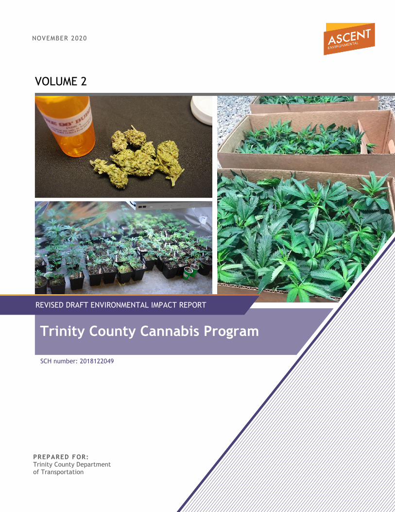
VOLUME 2
NOVEMBER 2020
PREPARED FOR: Trinity County Department of Transportation
REVISED DRAFT ENVIRONMENTAL IMPACT REPORT
Trinity County Cannabis Program
SCH number: 2018122049
18010132.01
Volume 2 Revised Draft Environmental Impact Report
for the
Trinity County Cannabis Program SCH Number: 2018122049
Prepared for: Trinity County Department of Transportation
P.O. Box 2490 31301 State Highway 3 Weaverville, CA 96093
Attn: David Colbeck, Environmental Compliance Specialist
Prepared by: Ascent Environmental
455 Capitol Mall, Suite 300 Sacramento, CA 95814
Contact: Pat Angell, Project Manager
November 2020

PREFACE This document consists of the Trinity County Cannabis Program Draft EIR that has been revised based on comments received during the 45-day public comment period, County staff initiated minor edits and clarifications, and updates to the Draft EIR development assumptions used in Volume 1, Chapter 4, “Comments Received After the Draft EIR Comment Period,” Table 4-2. These revisions did not result in the identification of any new significant impacts or a substantial increased severity of significant impacts identified in the Draft EIR. Thus, recirculation of the Draft EIR is not required pursuant to State CEQA Guidelines Section 15088.5.
Trinity County Cannabis Program Revised Draft EIR v
TABLE OF CONTENTS Section Page
LIST OF ABBREVIATIONS ........................................................................................................................................................................... v
EXECUTIVE SUMMARY ......................................................................................................................................................... ES-1 ES.1 Introduction ....................................................................................................................................................................... ES-1 ES.2 Summary Description of the Project ......................................................................................................................... ES-1 ES.3 Environmental Impacts and Recommended Mitigation Measures ............................................................... ES-2 ES.4 Alternatives to the Project ........................................................................................................................................... ES-3 ES.5 Areas of Controversy ..................................................................................................................................................... ES-3 ES.6 Issues to Be Resolved .................................................................................................................................................... ES-4
1 INTRODUCTION ........................................................................................................................................................................ 1-1 1.1 Purpose of This EIR ............................................................................................................................................................1-1 1.2 Scope of the Environmental Analysis ......................................................................................................................... 1-2 1.3 Agency Roles and Responsibilities .............................................................................................................................. 1-3 1.4 CEQA Process and Scope of Environmental Analysis ........................................................................................... 1-4 1.5 Draft EIR Organization ..................................................................................................................................................... 1-9
2 PROJECT DESCRIPTION ...........................................................................................................................................................2-1 2.1 Project Background and Need ..................................................................................................................................... 2-1 2.2 Project Objectives .............................................................................................................................................................. 2-1 2.3 Project Location ................................................................................................................................................................. 2-1 2.4 Project Background .......................................................................................................................................................... 2-1 2.5 Proposed County Cannabis Program ...................................................................................................................... 2-12 2.6 Cannabis Operation Development Assumptions ................................................................................................ 2-22 2.7 Intended Use of This EIR .............................................................................................................................................. 2-23 2.8 Potential Permits and Approvals Required ............................................................................................................ 2-27
3 ENVIRONMENTAL IMPACTS AND MITIGATION MEASURES ........................................................................................3-1 3.1 Aesthetics .......................................................................................................................................................................... 3.1-1 3.2 Agricultural and Forestry Resources ....................................................................................................................... 3.2-1 3.3 Air Quality ........................................................................................................................................................................ 3.3-1 3.4 Biological Resources ..................................................................................................................................................... 3.4-1 3.5 Archaeological, Historical, and Tribal Cultural Resources ............................................................................... 3.5-1 3.6 Energy................................................................................................................................................................................ 3.6-1 3.7 Geology and Soils ......................................................................................................................................................... 3.7-1 3.8 Greenhouse Gas Emissions and Climate Change............................................................................................... 3.8-1 3.9 Hazards and Hazardous Materials .......................................................................................................................... 3.9-1 3.10 Hydrology and Water Quality .................................................................................................................................. 3.10-1 3.11 Land Use and Planning ............................................................................................................................................... 3.11-1 3.12 Noise and Vibration ..................................................................................................................................................... 3.12-1 3.13 Public Services ............................................................................................................................................................... 3.13-1 3.14 Transportation/Traffic .................................................................................................................................................3.14-1 3.15 Utilities and Service Systems .................................................................................................................................... 3.15-1 3.16 Wildfire ............................................................................................................................................................................. 3.16-1
Table of Contents Ascent Environmental
Trinity County vi Cannabis Program Revised Draft EIR
4 CUMULATIVE IMPACTS .......................................................................................................................................................... 4-1 4.1 Introduction to the Cumulative Analysis ................................................................................................................... 4-1 4.2 Cumulative Setting ............................................................................................................................................................ 4-1 4.3 Cumulative Impact analysis ........................................................................................................................................... 4-4
5 ALTERNATIVES ...........................................................................................................................................................................5-1 5.1 Introduction ......................................................................................................................................................................... 5-1 5.2 Considerations for Selection of Alternatives ........................................................................................................... 5-2 5.3 Alternatives Considered but Not Evaluated Further ............................................................................................ 5-6 5.4 Alternatives Selected for Detailed Analysis ............................................................................................................. 5-7 5.5 Environmentally Superior Alternative ...................................................................................................................... 5-25
6 OTHER CEQA-MANDATED SECTIONS ................................................................................................................................6-1 6.1 Growth Inducement .......................................................................................................................................................... 6-1 6.2 Significant and Unavoidable Adverse Impacts ....................................................................................................... 6-2 6.3 Significant and Irreversible Environmental Changes ............................................................................................ 6-3
7 REPORT PREPARERS ................................................................................................................................................................. 7-1
8 REFERENCES ...............................................................................................................................................................................8-1
Appendices (included in a flash drive) Appendix A – Notice of Preparation and Comments Received Appendix B – Cannabis Program Appendix C – Air Quality, Energy, and Greenhouse Gases Emissions Modeling Data Appendix D – Traffic and Noise Modeling Data
Figures Figure 2-1 County Location ................................................................................................................................................................ 2-2 Figure 2-2 Overview of Major Land Ownership and Communities in County ................................................................. 2-3 Figure 2-3 Licensed Cultivation Sites in 2018 ............................................................................................................................... 2-5 Figure 2-4 Estimated Extent of Cannabis Cultivation Identified and Licensed ............................................................... 2-13 Figure 3.1-1 Photos of Existing Cannabis Cultivation Operations in the County ............................................................. 3.1-5 Figure 3.1-2 Photos of Existing Cannabis Cultivation Operations in the County ............................................................. 3.1-6 Figure 3.2-1 County Land Areas Enrolled in the Williamson Act ........................................................................................... 3.2-3 Figure 3.2-2 TPZ Zoned Areas in the County ............................................................................................................................... 3.2-6 Figure 3.4-1 Conifer Forest/Woodland ........................................................................................................................................... 3.4-8 Figure 3.4-2 Hardwood Forest/Woodland .................................................................................................................................... 3.4-9 Figure 3.4-3 Agricultural and Developed ..................................................................................................................................... 3.4-10 Figure 3.4-4 Grassland, Herbaceous, and Shrub ........................................................................................................................3.4-11 Figure 3.4-5 Aquatic, Riparian, and Meadow ............................................................................................................................. 3.4-12 Figure 3.4-6 Late-Successional and Old-Growth Forest ......................................................................................................... 3.4-13 Figure 3.4-7 Critical Habitat ............................................................................................................................................................. 3.4-32 Figure 3.4-8 Sensitive Natural Communities - Aquatic and Terrestrial Communities ................................................. 3.4-33 Figure 3.4-9 Mule Deer (Columbian Black-Tailed Deer Subspecies) Critical Winter Range ...................................... 3.4-36
Ascent Environmental Table of Contents
Trinity County Cannabis Program Revised Draft EIR vii
Figure 3.4-10 Habitat Connectivity .................................................................................................................................................. 3.4-37 Figure 3.4-11 Habitat Conservation Plans ..................................................................................................................................... 3.4-39 Figure 3.4-12 Spotted Owl Activity Areas ..................................................................................................................................... 3.4-49 Figure 3.10-1 Hydrology in Trinity County...................................................................................................................................3.10-20 Figure 3.10-2 Flood Hazard Zones in Trinity County ...............................................................................................................3.10-22 Figure 3.10-3 Groundwater Basins in Trinity County ................................................................................................................3.10-23 Figure 3.10-4 Extent of Cannabis Cultivation Identified in the Cannabis Priority Watersheds .................................. 3.10-27 Figure 3.11-1 County Zoning ...............................................................................................................................................................3.11-4 Figure 3.16-1 Potential Burn Severity Rating .............................................................................................................................. 3.16-10 Figure 3.16-2 State Responsibility Areas in Trinity County ...................................................................................................... 3.16-11
Tables Table ES-1 Summary of Impacts and Mitigation Measures ................................................................................................... ES-5 Table 1-1 Summary of NOP Comments ........................................................................................................................................ 1-4 Table 2-1 State Cannabis Operation License Types ................................................................................................................. 2-9 Table 2-2 Estimates of the Extent of Cannabis Cultivation in 2016 in Trinity County .................................................. 2-11 Table 2-3 Development Assumptions ......................................................................................................................................... 2-24
Table 3.3-1 National and California Ambient Air Quality Standards .................................................................................. 3.3-2 Table 3.3-2 NCUAQMD New Source Review Significance Thresholds .............................................................................. 3.3-6 Table 3.3-3 Criteria Air Pollutant and Precursor Emissions Associated with Construction of New
Cultivation and Noncultivation Operations ........................................................................................................ 3.3-15 Table 3.3-4 Mitigated Criteria Air Pollutant and Precursor Emissions Associated with Construction of New
Cultivation and Noncultivation Operations ........................................................................................................ 3.3-17 Table 3.3-5 Criteria Air Pollutant and Precursor Emissions Associated with Existing Cannabis Operations
(2020) ............................................................................................................................................................................... 3.3-19 Table 3.3-6 Criteria Air Pollutant and Precursor Emissions Associated with Cannabis Operations (2020) ......... 3.3-19 Table 3.3-7 Mitigated Criteria Air Pollutant and Precursor Emissions Associated with Cannabis Operations (2020) .. 3.3-22 Table 3.4-1 Habitat Types within Trinity County ........................................................................................................................ 3.4-6 Table 3.4-2 Special-Status Plant Species Known to Occur in Trinity County and Their Potential for
Occurrence .................................................................................................................................................................... 3.4-18 Table 3.4-3 Special-Status Wildlife Species Known to Occur in Trinity County and Their Potential for
Occurrence ................................................................................................................................................................... 3.4-24 Table 3.5-1 Known Historical Resources in Trinity County .................................................................................................... 3.5-11 Table 3.5-2 Summary of AB 52 Consultation ............................................................................................................................ 3.5-16
Table of Contents Ascent Environmental
Trinity County viii Cannabis Program Revised Draft EIR
Table 3.6-1 Operational Energy Consumption – Existing Operations ................................................................................ 3.6-8 Table 3.6-2 Construction Energy Consumption ......................................................................................................................... 3.6-9 Table 3.6-3 Operational Energy Consumption – New Operations .................................................................................... 3.6-10 Table 3.6-4 Gasoline and Diesel Consumption Associated with New Cultivation and Noncultivation
Operations ..................................................................................................................................................................... 3.6-12 Table 3.7-2 The Modified Mercalli Scale of Earthquake Intensities ..................................................................................... 3.7-7
Table 3.8-1 Statewide GHG Emissions by Economic Sector .................................................................................................. 3.8-6
Table 3.8-2 Operational GHG Emissions Associated with Existing Cannabis Sites (2020)........................................... 3.8-9
Table 3.8-3 GHG Emissions Associated with Construction of Licensed Cannabis Sites (2019) .................................. 3.8-9
Table 3.8-4 Operational GHG Emissions Associated with New Cannabis Sites (2020) ............................................... 3.8-10
Table 3.10-1 Technical Report Requirements by Tier ............................................................................................................... 3.10-8 Table 3.10-2 Facility Status .............................................................................................................................................................. 3.10-10 Table 3.10-3 Site Maintenance Status .......................................................................................................................................... 3.10-10 Table 3.10-4 Stormwater Runoff Monitoring ............................................................................................................................ 3.10-10 Table 3.10-5 Flood Conditions in Trinity County ..................................................................................................................... 3.10-19 Table 3.10-6 Wild, Scenic, and Recreational Rivers of Trinity County ...............................................................................3.10-25 Table 3.10-7 List of Impaired Waterways in Trinity County (2014/2016 303[d] List) ....................................................3.10-25 Table 3.10-8 Estimated Cannabis Program Water Demand ................................................................................................3.10-35
Table 3.11-1 Zoning Districts ............................................................................................................................................................. 3.11-3 Table 3.12-1 Maximum Allowable Noise Exposure - Transportation Noise Sources .................................................... 3.12-2 Table 3.12-2 Maximum Allowable Noise Exposure – Stationary Noise Sources ............................................................. 3.12-2 Table 3.12-3 Typical A-Weighted Noise Levels .......................................................................................................................... 3.12-4 Table 3.12-4 Summary of Modeled Existing Traffic Noise Levels ......................................................................................... 3.12-6 Table 3.12-5 Summary of Modeled Traffic Noise Levels under Existing and Existing-Plus-Project Conditions . 3.12-11
Table 3.14-1 Existing Roadway Segment LOS on State Facilities within Trinity County ............................................... 3.14-6 Table 3.14-2 Two-Lane Conventional Highways ........................................................................................................................ 3.14-9 Table 3.14-3 Roadway Segment Level of Service Thresholds ............................................................................................... 3.14-9 Table 3.14-4 Existing LOS with and without Licensed Commercial Cannabis Operations ........................................ 3.14-14 Table 3.16-1 Shasta-Trinity National Forest Unit Fire Management Capacity ............................................................... 3.16-12 Table 4-1 Geographic Scope of Cumulative Impacts ............................................................................................................... 4-1 Table 5-1 Summary of Environmental Effects of the Alternatives Relative to the Cannabis Program ................. 5-25
Trinity County Cannabis Program Revised Draft EIR ix
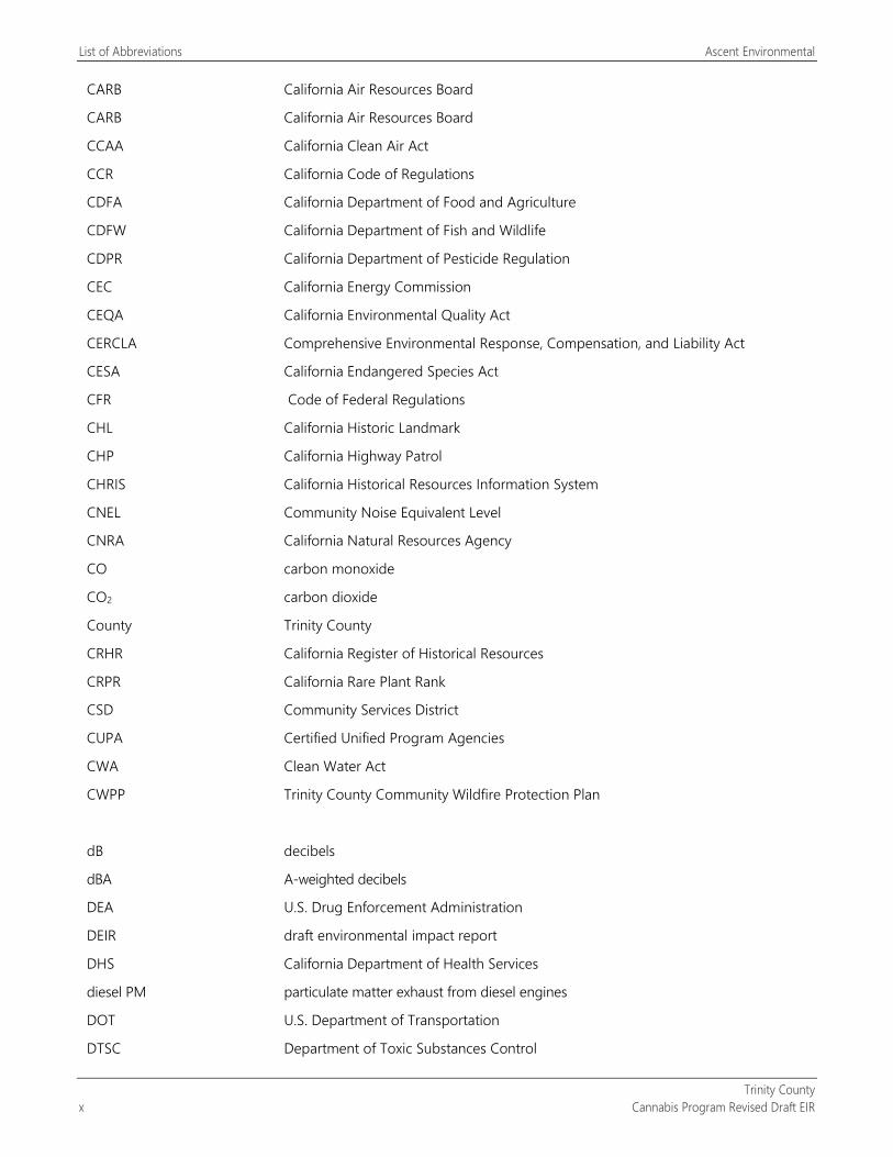
LIST OF ABBREVIATIONS °F degrees Fahrenheit
µg/m3 micrograms per cubic meter
2017 Scoping Plan California’s 2017 Climate Change Scoping Plan
2018 Shasta-Trinity Unit Strategic Fire Plan
AADT average annual daily traffic
AB Assembly Bill
ABF Standard New England Aquatic Base Flow Standard
AERMOD American Meteorological Society/Environmental Protection Agency Regulatory Model Improvement Committee modeling system
AFV alternative fuel vehicle
ALUC airport land use commission
ANSI American National Standards Institute
ASME American Society of Mechanical Engineers
ASTM American Society for Testing and Materials
BLM Bureau of Land Management
BMP best management plans
BPTC best practical treatment or control
CAA federal Clean Air Act
CAAA federal Clean Air Act Amendments of 1990
CAFE Corporate Average Fuel Economy
cal BP calibrated years before present
CAL FIRE California Department of Forestry and Fire Protection
Cal/OSHA California Division of Occupational Safety and Health
CalCannabis CalCannabis Cultivation Licensing
CalEEMod California Emissions Estimator Model
CALFIRE California Department of Forestry and Fire Protection
California Energy Code Title 24, Part 6, Building Energy Efficiency Standards
Caltrans California Department of Transportation
CAP criteria air pollutant
CAP climate action plans
List of Abbreviations Ascent Environmental
Trinity County x Cannabis Program Revised Draft EIR
CARB California Air Resources Board
CARB California Air Resources Board
CCAA California Clean Air Act
CCR California Code of Regulations
CDFA California Department of Food and Agriculture
CDFW California Department of Fish and Wildlife
CDPR California Department of Pesticide Regulation
CEC California Energy Commission
CEQA California Environmental Quality Act
CERCLA Comprehensive Environmental Response, Compensation, and Liability Act
CESA California Endangered Species Act
CFR Code of Federal Regulations
CHL California Historic Landmark
CHP California Highway Patrol
CHRIS California Historical Resources Information System
CNEL Community Noise Equivalent Level
CNRA California Natural Resources Agency
CO carbon monoxide
CO2 carbon dioxide
County Trinity County
CRHR California Register of Historical Resources
CRPR California Rare Plant Rank
CSD Community Services District
CUPA Certified Unified Program Agencies
CWA Clean Water Act
CWPP Trinity County Community Wildfire Protection Plan
dB decibels
dBA A-weighted decibels
DEA U.S. Drug Enforcement Administration
DEIR draft environmental impact report
DHS California Department of Health Services
diesel PM particulate matter exhaust from diesel engines
DOT U.S. Department of Transportation
DTSC Department of Toxic Substances Control
Ascent Environmental List of Abbreviations
Trinity County Cannabis Program Revised Draft EIR xi
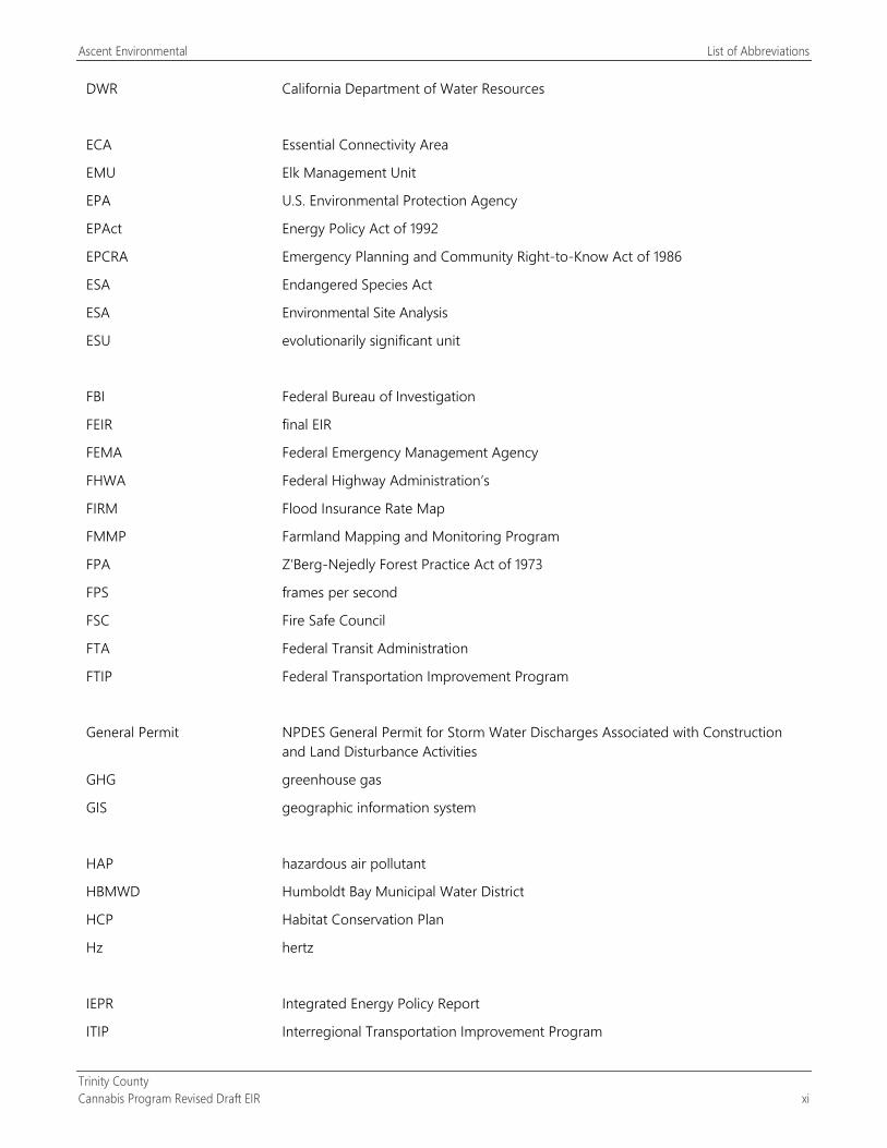
DWR California Department of Water Resources
ECA Essential Connectivity Area
EMU Elk Management Unit
EPA U.S. Environmental Protection Agency
EPAct Energy Policy Act of 1992
EPCRA Emergency Planning and Community Right-to-Know Act of 1986
ESA Endangered Species Act
ESA Environmental Site Analysis
ESU evolutionarily significant unit
FBI Federal Bureau of Investigation
FEIR final EIR
FEMA Federal Emergency Management Agency
FHWA Federal Highway Administration’s
FIRM Flood Insurance Rate Map
FMMP Farmland Mapping and Monitoring Program
FPA Z’Berg-Nejedly Forest Practice Act of 1973
FPS frames per second
FSC Fire Safe Council
FTA Federal Transit Administration
FTIP Federal Transportation Improvement Program
General Permit NPDES General Permit for Storm Water Discharges Associated with Construction and Land Disturbance Activities
GHG greenhouse gas
GIS geographic information system
HAP hazardous air pollutant
HBMWD Humboldt Bay Municipal Water District
HCP Habitat Conservation Plan
Hz hertz
IEPR Integrated Energy Policy Report
ITIP Interregional Transportation Improvement Program

List of Abbreviations Ascent Environmental
Trinity County xii Cannabis Program Revised Draft EIR
ITP Incidental Take Permit
ITSP Interregional Transportation Strategic Plan
lb/day pounds per day
LCFS Low Carbon Fuel Standard
Leq Equivalent Continuous Sound Level
Lmax Maximum Sound Level
LOS level of service
LSA Agreement Lake and Streambed Alteration Agreement
LTO Licensed Timber Operator
MBTA Migratory Bird Treaty Act
MCL maximum contaminant levels
mgd million gallons per day
MMI Modified Mercalli Intensity Scale
MMTCO2e million metric tons of carbon dioxide equivalent
mPa micro-Pascals
MPO metropolitan planning organization
MTCO2e/year metric tons of carbon dioxide equivalent per year
NAAQS national ambient air quality standards
NAHC Native American Heritage Commission
NCAB North Coast Air Basin
NCAQMD North Coast Air Quality Management District
NCUAQMD North Coast Unified Air Quality Management District
NEHRP National Earthquake Hazards Reduction Program
NFIP National Flood Insurance Program
NHPA National Historic Preservation Act
NMFS National Marine Fisheries Service
NO nitric oxide
NO2 nitrogen dioxide
NOA naturally-occurring asbestos
NOAA National Oceanic and Atmospheric Administration
NOP notice of preparation
NOX oxides of nitrogen
Ascent Environmental List of Abbreviations
Trinity County Cannabis Program Revised Draft EIR xiii
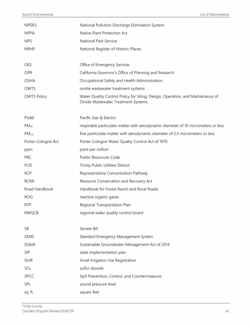
NPDES National Pollution Discharge Elimination System
NPPA Native Plant Protection Act
NPS National Park Service
NRHP National Register of Historic Places
OES Office of Emergency Services
OPR California Governor’s Office of Planning and Research
OSHA Occupational Safety and Health Administration
OWTS onsite wastewater treatment systems
OWTS Policy Water Quality Control Policy for Siting, Design, Operation, and Maintenance of Onsite Wastewater Treatment Systems
PG&E Pacific Gas & Electric
PM10 respirable particulate matter with aerodynamic diameter of 10 micrometers or less
PM2.5 fine particulate matter with aerodynamic diameter of 2.5 micrometers or less
Porter-Cologne Act Porter-Cologne Water Quality Control Act of 1970
ppm parts per million
PRC Public Resources Code
PUD Trinity Public Utilities District
RCP Representative Concentration Pathway
RCRA Resource Conservation and Recovery Act
Road Handbook Handbook for Forest Ranch and Rural Roads
ROG reactive organic gases
RTP Regional Transportation Plan
RWQCB regional water quality control board
SB Senate Bill
SEMS Standard Emergency Management System
SGMA Sustainable Groundwater Management Act of 2014
SIP state implementation plan
SIUR Small Irrigation Use Registration
SO2 sulfur dioxide
SPCC Spill Prevention, Control, and Countermeasure
SPL sound pressure level
sq. ft. square feet
List of Abbreviations Ascent Environmental
Trinity County xiv Cannabis Program Revised Draft EIR
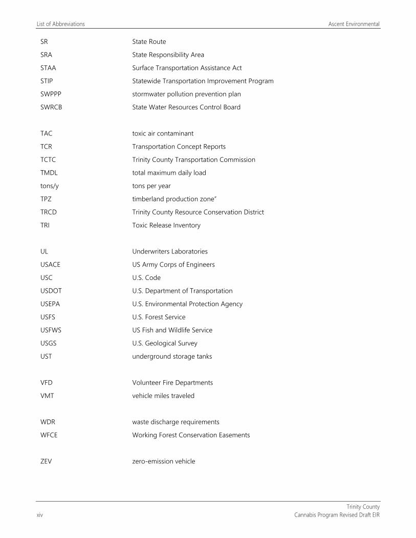
SR State Route
SRA State Responsibility Area
STAA Surface Transportation Assistance Act
STIP Statewide Transportation Improvement Program
SWPPP stormwater pollution prevention plan
SWRCB State Water Resources Control Board
TAC toxic air contaminant
TCR Transportation Concept Reports
TCTC Trinity County Transportation Commission
TMDL total maximum daily load
tons/y tons per year
TPZ timberland production zone”
TRCD Trinity County Resource Conservation District
TRI Toxic Release Inventory
UL Underwriters Laboratories
USACE US Army Corps of Engineers
USC U.S. Code
USDOT U.S. Department of Transportation
USEPA U.S. Environmental Protection Agency
USFS U.S. Forest Service
USFWS US Fish and Wildlife Service
USGS U.S. Geological Survey
UST underground storage tanks
VFD Volunteer Fire Departments
VMT vehicle miles traveled
WDR waste discharge requirements
WFCE Working Forest Conservation Easements
ZEV zero-emission vehicle
Trinity County Cannabis Program Revised Draft EIR ES-1
EXECUTIVE SUMMARY
ES.1 INTRODUCTION This summary is provided in accordance with California Environmental Quality Act Guidelines (State CEQA Guidelines) Section 15123. As stated in Section 15123(a), “an EIR [environmental impact report] shall contain a brief summary of the proposed action and its consequences. The language of the summary should be as clear and simple as reasonably practical.” As required by the guidelines, this chapter includes (1) a summary description of the Trinity County Cannabis Program (County Cannabis Program, Cannabis Program, or project), (2) a synopsis of environmental impacts and recommended mitigation measures (Table ES-1, presented at the end of this chapter), (3) identification of the alternatives evaluated and of the environmentally superior alternative, (4) a discussion of the areas of controversy associated with the project, and (5) identification of issues to be resolved.
ES.2 SUMMARY DESCRIPTION OF THE PROJECT
ES.2.1 Project Location The proposed County Cannabis Program encompasses the unincorporated lands of Trinity County. These lands exclude any state- and federally owned or operated lands.
ES.2.2 Project Objectives The project objectives of the County Cannabis Program, based on County Resolution No. 2016-077, “A Resolution of the Board of Supervisors of the County of Trinity Adopting Four Principles on Local Regulation of Cannabis,” are to:
regulate cannabis operations in a manner that ensures that the county is a safe place for all residents to live and work,
protect the county’s quality of life and natural environment,
ensure that cannabis operations avoid environmental damage and detrimental impacts on communities and neighborhoods,
regulate cannabis operations to protect the county’s reputation as a tourist destination, and
align the County’s commercial cannabis regulations with state requirements.
ES.2.3 Overview of Project The Cannabis Program consists of the readoption of the six ordinances that regulate commercial cannabis operations in the unincorporated area of the county. It also includes the following proposed amendments:
a proposed amendment to Section S315-843(1)(i), which would increase the Designated Area for cultivation activities from 200 percent to 250 percent,.
This draft EIR (DEIR) also recommends incorporation of proposed mitigation measures identified in Table ES-1 into the ordinances.
These ordinances are summarized in the following subsections. The complete text of these ordinances is provided in Appendix B.
Land owned by state and federal agencies and tribal trust land are not subject to the County Cannabis Program.
Executive Summary Ascent Environmental
Trinity County ES-2 Cannabis Program Revised Draft EIR
ES.3 ENVIRONMENTAL IMPACTS AND RECOMMENDED MITIGATION MEASURES
ES.3.1 Project-Specific Impacts This EIR has been prepared pursuant to CEQA (Public Resources Code Section 21000 et seq.) and the State CEQA Guidelines (California Code of Regulations, Title 14, Chapter 3, Section 15000 et seq.) to evaluate the physical environmental effects of the proposed Trinity County Cannabis Program. Trinity County is the lead agency for the project. Table ES-1 provides a summary of the environmental impacts of the Cannabis Program. The table provides the level of significance of the impact before mitigation, recommended mitigation measures, and the level of significance of the impact after implementation of the mitigation measures.
ES.3.2 Significant and Unavoidable Impacts and Cumulative Impacts
Mitigation measures have been identified in Sections 3.1 through 3.16 of this DEIR that are intended to mitigate project effects to the extent feasible. For the following environmental issue areas, one or more impacts are considered significant and unavoidable; that is, no feasible mitigation is available to reduce the project’s impacts or the project’s contribution to cumulative impacts to a less-than-significant level.
AIR QUALITY Construction-generated emissions from later projects under the Cannabis Program (Impact 3.3-1)
During operation of commercial cannabis cultivation and noncultivation operations, generation of emissions of reactive organic gases, oxides of nitrogen, respirable particulate matter with an aerodynamic diameter of 10 micrometers or less, and fine particulate matter with an aerodynamic diameter of 2.5 micrometers or less that exceed applicable daily and annual mass emission thresholds established by the North Coast Unified Air Quality Management District (Impact 3.3-2)
Project contribution to cumulative air quality impacts emissions
During the cultivation and processing of cannabis, the generation of odors associated with the plant itself, which during maturation can produce substantial odors (Impact 3.3-3)
Project contribution to cumulative impacts from exposure of people to objectionable odors
NOISE During commercial cannabis operations, possible exposure of noise-sensitive receptors to traffic noise levels that
exceed the Trinity County General Plan exterior noise standards for transportation noise (Impact 3.12-3)
Project contribution to cumulative traffic noise impacts
TRANSPORTATION/TRAFFIC During operation of the Cannabis Program, addition of vehicle trips to existing traffic levels on the state highway
system within Trinity County, which would be greatest during the peak harvest time and could result in the level of service (LOS) degrading below LOS C along segments of State Route (SR) 3 (Impact 3.14-2)
Project contribution to cumulative traffic impacts on SR 3 and SR 299
Ascent Environmental Executive Summary
Trinity County Cannabis Program Revised Draft EIR ES-3
UTILITIES AND SERVICE SYSTEMS Increased water demand from public water systems for commercial cannabis facilities (Impact 4.15-2)
Project contribution to cumulative public water supply impacts
ES.4 ALTERNATIVES TO THE PROJECT The following provides brief descriptions of the alternatives evaluated in this DEIR:
Alternative 1: No Project Alternative. This alternative would consist of continued implementation of the existing ordinances that make up the Cannabis Program without the proposed amendment to Section S315-843(1)(h) to increase the Designated Area for cultivation activities.
Alternative 2: Siting Limitation for Commercial Cannabis Sites Alternative. This alternative would modify the Cannabis Program and restrict the siting of new commercial cannabis cultivation and noncultivation uses to sites that have already been developed or otherwise disturbed (graded and vegetation removed). No new commercial cultivation would be allowed in the following Cannabis Priority Watersheds designated by the State Water Resources Control Board (SWRCB): Upper South Fork Trinity River, Middle South Fork Trinity River, Lower South Fork Trinity River, Upper Hayfork Creek, and the Lower Hayfork Creek.
Alternative 3: Restricted Commercial Cannabis Cultivation Alternative. This alternative would modify the Cannabis Program provisions for commercial cultivation to reduce the total number of cultivation licenses allowed from 530 to 280. All other aspects of the Cannabis Program would remain in place.
Alternative 4: Reduced Commercial Cannabis Operations Alternative. This alternative would modify the Cannabis Program in the following manner:
Restrict the siting of new commercial cannabis cultivation and noncultivation uses to sites that have already been developed or otherwise disturbed (graded and vegetation removed). No new commercial cultivation would be allowed in the following Cannabis Priority Watersheds designated by the SWRCB: Upper South Fork Trinity River, Middle South Fork Trinity River, Lower South Fork Trinity River, Upper Hayfork Creek, and the Lower Hayfork Creek.
Reduce the total number of cultivation licenses allowed from 530 to 280.
Require new commercial cannabis cultivation operations to be operated within an enclosed building or greenhouse structure with a controlled ventilation and odor control system.
As further described in Chapter 5, “Alternatives,” Alternative 4 is the environmentally superior alternative.
ES.5 AREAS OF CONTROVERSY Section 15123 of the State CEQA Guidelines requires the summary section of a DEIR to identify areas of controversy known to the lead agency, including issues raised by agencies and the public. The following provides a summary of issues raised through scoping and comments on the notice of preparation (NOP) that could be considered controversial. The comment letters received on the NOP are included in Appendix A of this document:
Identification of the proper baseline conditions for the EIR impact analysis
Concerns regarding the County’s ability to conduct enforcement activities against illegal cannabis operations
Biological and watershed impacts from existing and new cannabis operations
Impacts related to traffic operations from cannabis cultivation operations
Executive Summary Ascent Environmental
Trinity County ES-4 Cannabis Program Revised Draft EIR
Land use compatibility with cannabis operations in regard to noise and odors
Nighttime lighting impacts on wildlife
Generator noise impacts on wildlife
Water quality impacts from cannabis cultivation associated with sediment, pesticides, fertilizers, petroleum products, and other materials
Water diversion impacts on fisheries and other aquatic resources
Loss of natural habitat (e.g., wetlands, riparian, forest, and other sensitive habitat areas) from conversion by cannabis cultivation
Fire hazards from cannabis cultivation facilities
Groundwater supply issues from increased groundwater use by cannabis cultivation
Impacts on flood zones from cannabis operations and cultivation
Visual impacts of commercial cannabis operations
Air quality and dust impacts
Water quality impacts from roadway development and use
The need for the County to adopt a grading program
ES.6 ISSUES TO BE RESOLVED Section 15123 of the State CEQA Guidelines requires the summary section of a DEIR to identify issues to be resolved in the EIR, including the choice among alternatives and whether or how to mitigate the significant project effects. Issues to be resolved, in addition to the areas of controversy, include the following:
whether the Cannabis Program should include the proposed amendment to Section S315-843(1)(i), which would increase the allowed Designated Area for cultivation activities from 200 percent to 250 percent (20 percent increase);
whether the extent of cannabis operations should be limited as evaluated in Chapter 5, “Alternatives”; and
whether additional performance standards for the construction and operation of commercial cannabis facilities, including their locations in the county, should be identified.
Ascent Environmental Executive Summary
Trinity County Cannabis Program Revised Draft EIR ES-5
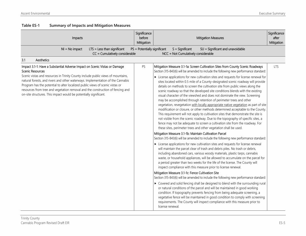
Table ES-1 Summary of Impacts and Mitigation Measures
Impacts Significance
before Mitigation
Mitigation Measures Significance
after Mitigation
NI = No impact LTS = Less than significant PS = Potentially significant S = Significant SU = Significant and unavoidable CC = Cumulatively considerable NCC = Not Cumulatively considerable
3.1 Aesthetics
Impact 3.1-1: Have a Substantial Adverse Impact on Scenic Vistas or Damage Scenic Resources Scenic vistas and resources in Trinity County include public views of mountains, natural forests, and rivers and other waterways. Implementation of the Cannabis Program has the potential to alter localized public views of scenic vistas or resources from tree and vegetation removal and the construction of fencing and on-site structures. This impact would be potentially significant.
PS Mitigation Measure 3.1-1a: Screen Cultivation Sites from County Scenic Roadways Section 315-843(6) will be amended to include the following new performance standard: License applications for new cultivation sites and requests for license renewal for
sites located within 0.5 mile of a County-designated scenic roadway will provide details on methods to screen the cultivation site from public views along the scenic roadway so that the developed site conditions blends with the existing visual character of the viewshed and does not dominate the view. Screening may be accomplished through retention of perimeter trees and other vegetation, revegetation with locally appropriate native vegetation as part of site modification or closure, or other methods determined acceptable to the County. This requirement will not apply to cultivation sites that demonstrate the site is not visible from the scenic roadway. Due to the topography of specific sites, a fence may not be adequate to screen a cultivation site from the roadway. For these sites, perimeter trees and other vegetation shall be used.
Mitigation Measure 3.1-1b: Maintain Cultivation Parcel Section 315-843(6) will be amended to include the following new performance standard: License applications for new cultivation sites and requests for license renewal
will maintain the parcel clear of trash and debris piles. No trash or debris, including abandoned cars, various woody materials, plastic tarps, cannabis waste, or household appliances, will be allowed to accumulate on the parcel for a period greater than two weeks for the life of the license. The County will inspect compliance with this measure prior to license renewal.
Mitigation Measure 3.1-1c: Fence Cultivation Site Section 315-843(6) will be amended to include the following new performance standard: Covered and solid fencing shall be designed to blend with the surrounding rural
or natural conditions of the parcel and will be maintained in good working condition. If topography prevents fencing from being adequate screening, a vegetative fence will be maintained in good condition to comply with screening requirements. The County will inspect compliance with this measure prior to license renewal.
LTS
Executive Summary Ascent Environmental
Trinity County ES-6 Cannabis Program Revised Draft EIR
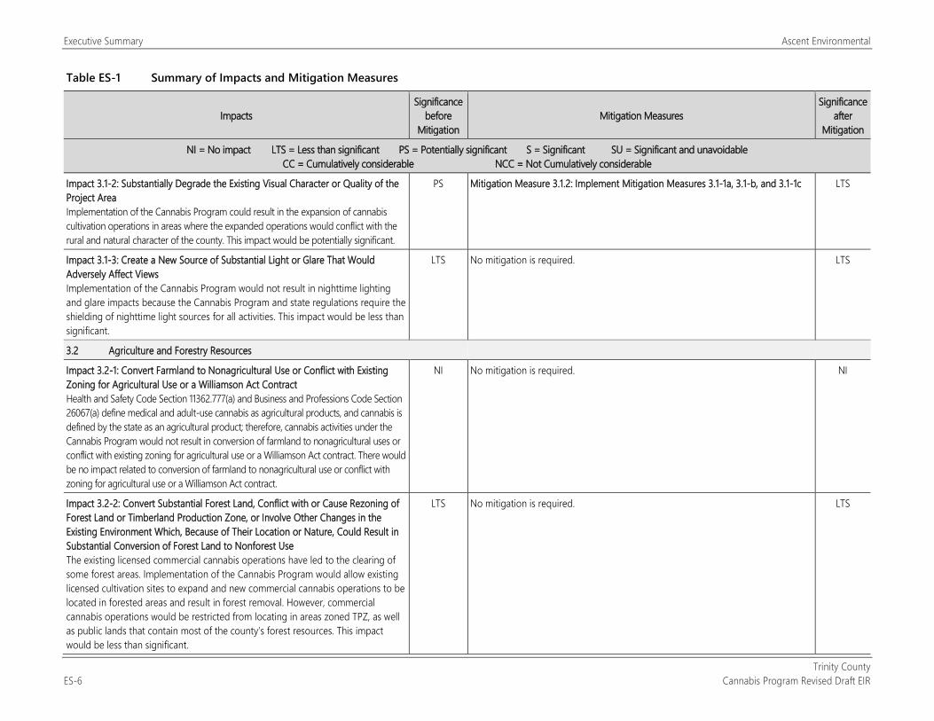
Table ES-1 Summary of Impacts and Mitigation Measures
Impacts Significance
before Mitigation
Mitigation Measures Significance
after Mitigation
NI = No impact LTS = Less than significant PS = Potentially significant S = Significant SU = Significant and unavoidable CC = Cumulatively considerable NCC = Not Cumulatively considerable
Impact 3.1-2: Substantially Degrade the Existing Visual Character or Quality of the Project Area Implementation of the Cannabis Program could result in the expansion of cannabis cultivation operations in areas where the expanded operations would conflict with the rural and natural character of the county. This impact would be potentially significant.
PS Mitigation Measure 3.1.2: Implement Mitigation Measures 3.1-1a, 3.1-b, and 3.1-1c LTS
Impact 3.1-3: Create a New Source of Substantial Light or Glare That Would Adversely Affect Views Implementation of the Cannabis Program would not result in nighttime lighting and glare impacts because the Cannabis Program and state regulations require the shielding of nighttime light sources for all activities. This impact would be less than significant.
LTS No mitigation is required. LTS
3.2 Agriculture and Forestry Resources
Impact 3.2-1: Convert Farmland to Nonagricultural Use or Conflict with Existing Zoning for Agricultural Use or a Williamson Act Contract Health and Safety Code Section 11362.777(a) and Business and Professions Code Section 26067(a) define medical and adult-use cannabis as agricultural products, and cannabis is defined by the state as an agricultural product; therefore, cannabis activities under the Cannabis Program would not result in conversion of farmland to nonagricultural uses or conflict with existing zoning for agricultural use or a Williamson Act contract. There would be no impact related to conversion of farmland to nonagricultural use or conflict with zoning for agricultural use or a Williamson Act contract.
NI No mitigation is required. NI
Impact 3.2-2: Convert Substantial Forest Land, Conflict with or Cause Rezoning of Forest Land or Timberland Production Zone, or Involve Other Changes in the Existing Environment Which, Because of Their Location or Nature, Could Result in Substantial Conversion of Forest Land to Nonforest Use The existing licensed commercial cannabis operations have led to the clearing of some forest areas. Implementation of the Cannabis Program would allow existing licensed cultivation sites to expand and new commercial cannabis operations to be located in forested areas and result in forest removal. However, commercial cannabis operations would be restricted from locating in areas zoned TPZ, as well as public lands that contain most of the county’s forest resources. This impact would be less than significant.
LTS No mitigation is required. LTS
Ascent Environmental Executive Summary
Trinity County Cannabis Program Revised Draft EIR ES-7
Table ES-1 Summary of Impacts and Mitigation Measures
Impacts Significance
before Mitigation
Mitigation Measures Significance
after Mitigation
NI = No impact LTS = Less than significant PS = Potentially significant S = Significant SU = Significant and unavoidable CC = Cumulatively considerable NCC = Not Cumulatively considerable
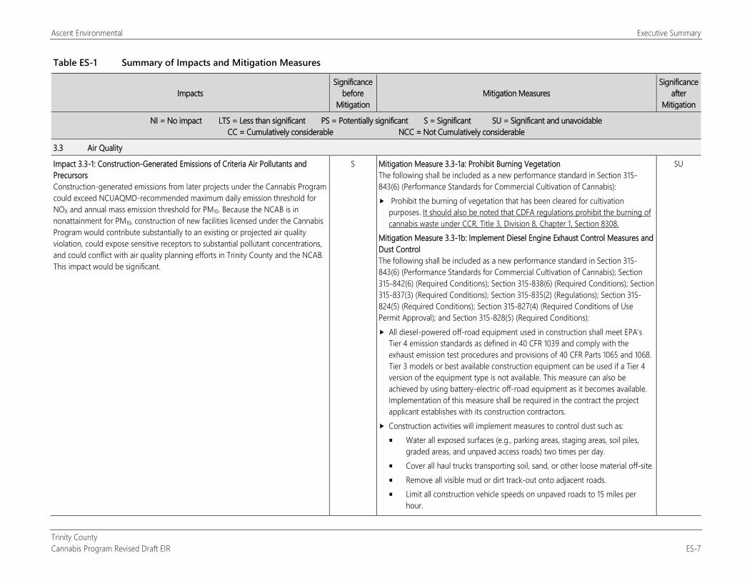
3.3 Air Quality
Impact 3.3-1: Construction-Generated Emissions of Criteria Air Pollutants and Precursors Construction-generated emissions from later projects under the Cannabis Program could exceed NCUAQMD-recommended maximum daily emission threshold for NOX and annual mass emission threshold for PM10. Because the NCAB is in nonattainment for PM10, construction of new facilities licensed under the Cannabis Program would contribute substantially to an existing or projected air quality violation, could expose sensitive receptors to substantial pollutant concentrations, and could conflict with air quality planning efforts in Trinity County and the NCAB. This impact would be significant.
S Mitigation Measure 3.3-1a: Prohibit Burning Vegetation The following shall be included as a new performance standard in Section 315-843(6) (Performance Standards for Commercial Cultivation of Cannabis): Prohibit the burning of vegetation that has been cleared for cultivation
purposes. It should also be noted that CDFA regulations prohibit the burning of cannabis waste under CCR, Title 3, Division 8, Chapter 1, Section 8308.
Mitigation Measure 3.3-1b: Implement Diesel Engine Exhaust Control Measures and Dust Control The following shall be included as a new performance standard in Section 315-843(6) (Performance Standards for Commercial Cultivation of Cannabis); Section 315-842(6) (Required Conditions); Section 315-838(6) (Required Conditions); Section 315-837(3) (Required Conditions); Section 315-835(2) (Regulations); Section 315-824(5) (Required Conditions); Section 315-827(4) (Required Conditions of Use Permit Approval); and Section 315-828(5) (Required Conditions): All diesel-powered off-road equipment used in construction shall meet EPA’s
Tier 4 emission standards as defined in 40 CFR 1039 and comply with the exhaust emission test procedures and provisions of 40 CFR Parts 1065 and 1068. Tier 3 models or best available construction equipment can be used if a Tier 4 version of the equipment type is not available. This measure can also be achieved by using battery-electric off-road equipment as it becomes available. Implementation of this measure shall be required in the contract the project applicant establishes with its construction contractors.
Construction activities will implement measures to control dust such as: Water all exposed surfaces (e.g., parking areas, staging areas, soil piles,
graded areas, and unpaved access roads) two times per day. Cover all haul trucks transporting soil, sand, or other loose material off-site. Remove all visible mud or dirt track-out onto adjacent roads. Limit all construction vehicle speeds on unpaved roads to 15 miles per
hour.
SU
Executive Summary Ascent Environmental
Trinity County ES-8 Cannabis Program Revised Draft EIR
Table ES-1 Summary of Impacts and Mitigation Measures
Impacts Significance
before Mitigation
Mitigation Measures Significance
after Mitigation
NI = No impact LTS = Less than significant PS = Potentially significant S = Significant SU = Significant and unavoidable CC = Cumulatively considerable NCC = Not Cumulatively considerable
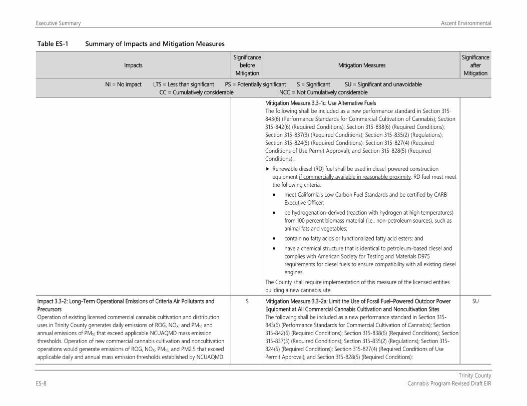
Mitigation Measure 3.3-1c: Use Alternative Fuels The following shall be included as a new performance standard in Section 315-843(6) (Performance Standards for Commercial Cultivation of Cannabis); Section 315-842(6) (Required Conditions); Section 315-838(6) (Required Conditions); Section 315-837(3) (Required Conditions); Section 315-835(2) (Regulations); Section 315-824(5) (Required Conditions); Section 315-827(4) (Required Conditions of Use Permit Approval); and Section 315-828(5) (Required Conditions): Renewable diesel (RD) fuel shall be used in diesel-powered construction
equipment if commercially available in reasonable proximity. RD fuel must meet the following criteria: meet California’s Low Carbon Fuel Standards and be certified by CARB
Executive Officer; be hydrogenation-derived (reaction with hydrogen at high temperatures)
from 100 percent biomass material (i.e., non-petroleum sources), such as animal fats and vegetables;
contain no fatty acids or functionalized fatty acid esters; and have a chemical structure that is identical to petroleum-based diesel and
complies with American Society for Testing and Materials D975 requirements for diesel fuels to ensure compatibility with all existing diesel engines.
The County shall require implementation of this measure of the licensed entities building a new cannabis site.
Impact 3.3-2: Long-Term Operational Emissions of Criteria Air Pollutants and Precursors Operation of existing licensed commercial cannabis cultivation and distribution uses in Trinity County generates daily emissions of ROG, NOX, and PM10 and annual emissions of PM10 that exceed applicable NCUAQMD mass emission thresholds. Operation of new commercial cannabis cultivation and noncultivation operations would generate emissions of ROG, NOX, PM10, and PM2.5 that exceed applicable daily and annual mass emission thresholds established by NCUAQMD.
S Mitigation Measure 3.3-2a: Limit the Use of Fossil Fuel–Powered Outdoor Power Equipment at All Commercial Cannabis Cultivation and Noncultivation Sites The following shall be included as a new performance standard in Section 315-843(6) (Performance Standards for Commercial Cultivation of Cannabis); Section 315-842(6) (Required Conditions); Section 315-838(6) (Required Conditions); Section 315-837(3) (Required Conditions); Section 315-835(2) (Regulations); Section 315-824(5) (Required Conditions); Section 315-827(4) (Required Conditions of Use Permit Approval); and Section 315-828(5) (Required Conditions):
SU
Ascent Environmental Executive Summary
Trinity County Cannabis Program Revised Draft EIR ES-9
Table ES-1 Summary of Impacts and Mitigation Measures
Impacts Significance
before Mitigation
Mitigation Measures Significance
after Mitigation
NI = No impact LTS = Less than significant PS = Potentially significant S = Significant SU = Significant and unavoidable CC = Cumulatively considerable NCC = Not Cumulatively considerable
Thus, operational emissions of ozone precursors (i.e., ROG and NOX) and of PM2.5 could conflict with NCUAQMD’s efforts to maintain the CAAQS and NAAQS for ozone and PM2.5. Given that the NCAB is designated as nonattainment with respect to the CAAQS for PM10, implementation of the Cannabis Program could contribute to an existing or projected air quality violation. This impact would be significant.
Limit the use of off-road equipment that is powered by gasoline, diesel, or other fossil fuels where available. This requirement does not apply to generators.
Mitigation Measure 3.3-2b: Require Use of Low Emission Diesel Back-Up Generators at All Commercial Cannabis Cultivation and Noncultivation Sites The following shall be included as a new performance standard in Section 315-843(6) (Performance Standards for Commercial Cultivation of Cannabis); Section 315-842(6) (Required Conditions); Section 315-838(6) (Required Conditions); Section 315-837(3) (Required Conditions); Section 315-835(2) (Regulations); Section 315-824(5) (Required Conditions); Section 315-827(4) (Required Conditions of Use Permit Approval); and Section 315-828(5) (Required Conditions): All generators shall meet EPA’s Tier 4 emission standards as defined in 40 CFR
1039 and comply with the exhaust emission test procedures and provisions of 40 CFR Parts 1065 and 1068. Tier 3 models or best available model can be used if a Tier 4 version of the equipment type is not available. This measure can also be achieved by using battery-electric off-road equipment as it becomes available. Implementation of this measure shall be required in the contract the project applicant establishes with its construction contractors.
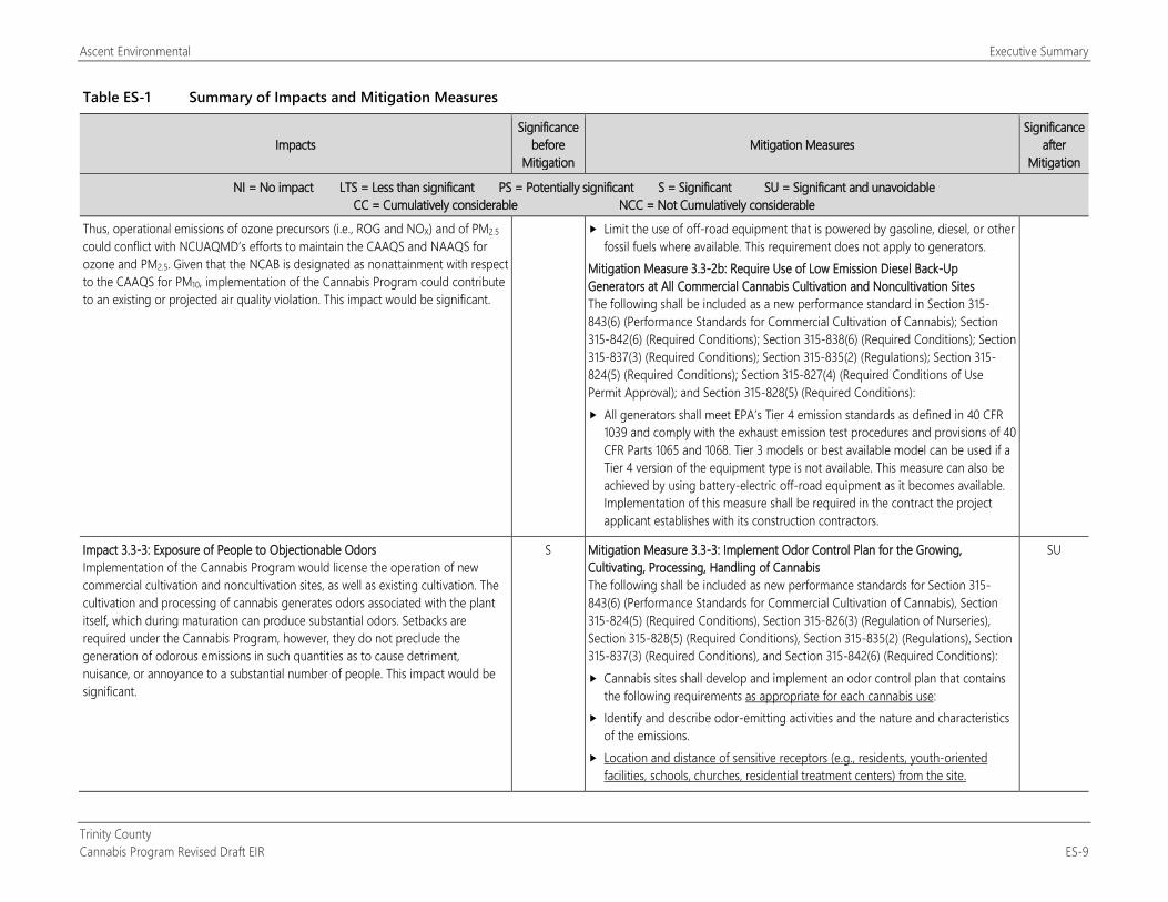
Impact 3.3-3: Exposure of People to Objectionable Odors Implementation of the Cannabis Program would license the operation of new commercial cultivation and noncultivation sites, as well as existing cultivation. The cultivation and processing of cannabis generates odors associated with the plant itself, which during maturation can produce substantial odors. Setbacks are required under the Cannabis Program, however, they do not preclude the generation of odorous emissions in such quantities as to cause detriment, nuisance, or annoyance to a substantial number of people. This impact would be significant.
S Mitigation Measure 3.3-3: Implement Odor Control Plan for the Growing, Cultivating, Processing, Handling of Cannabis The following shall be included as new performance standards for Section 315-843(6) (Performance Standards for Commercial Cultivation of Cannabis), Section 315-824(5) (Required Conditions), Section 315-826(3) (Regulation of Nurseries), Section 315-828(5) (Required Conditions), Section 315-835(2) (Regulations), Section 315-837(3) (Required Conditions), and Section 315-842(6) (Required Conditions): Cannabis sites shall develop and implement an odor control plan that contains
the following requirements as appropriate for each cannabis use: Identify and describe odor-emitting activities and the nature and characteristics
of the emissions. Location and distance of sensitive receptors (e.g., residents, youth-oriented
facilities, schools, churches, residential treatment centers) from the site.
SU
Executive Summary Ascent Environmental
Trinity County ES-10 Cannabis Program Revised Draft EIR
Table ES-1 Summary of Impacts and Mitigation Measures
Impacts Significance
before Mitigation
Mitigation Measures Significance
after Mitigation
NI = No impact LTS = Less than significant PS = Potentially significant S = Significant SU = Significant and unavoidable CC = Cumulatively considerable NCC = Not Cumulatively considerable
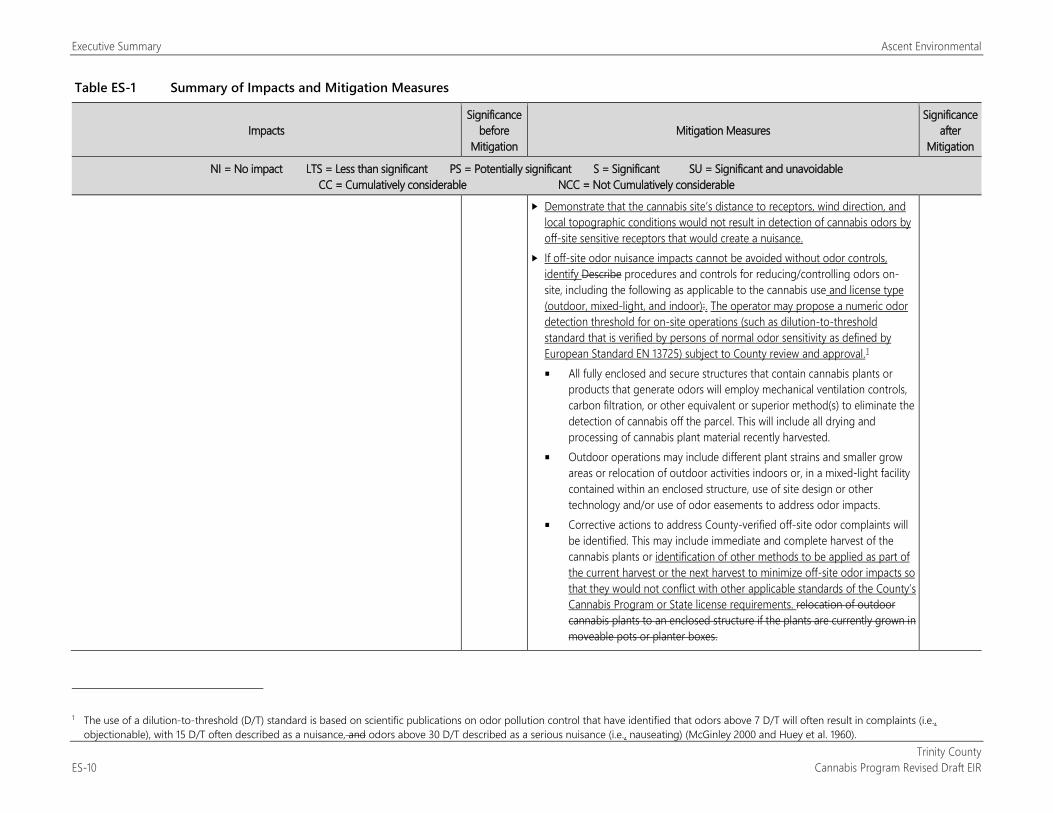
Demonstrate that the cannabis site’s distance to receptors, wind direction, and local topographic conditions would not result in detection of cannabis odors by off-site sensitive receptors that would create a nuisance.
If off-site odor nuisance impacts cannot be avoided without odor controls, identify Describe procedures and controls for reducing/controlling odors on-site, including the following as applicable to the cannabis use and license type (outdoor, mixed-light, and indoor):. The operator may propose a numeric odor detection threshold for on-site operations (such as dilution-to-threshold standard that is verified by persons of normal odor sensitivity as defined by European Standard EN 13725) subject to County review and approval.1 All fully enclosed and secure structures that contain cannabis plants or
products that generate odors will employ mechanical ventilation controls, carbon filtration, or other equivalent or superior method(s) to eliminate the detection of cannabis off the parcel. This will include all drying and processing of cannabis plant material recently harvested.
Outdoor operations may include different plant strains and smaller grow areas or relocation of outdoor activities indoors or, in a mixed-light facility contained within an enclosed structure, use of site design or other technology and/or use of odor easements to address odor impacts.
Corrective actions to address County-verified off-site odor complaints will be identified. This may include immediate and complete harvest of the cannabis plants or identification of other methods to be applied as part of the current harvest or the next harvest to minimize off-site odor impacts so that they would not conflict with other applicable standards of the County’s Cannabis Program or State license requirements. relocation of outdoor cannabis plants to an enclosed structure if the plants are currently grown in moveable pots or planter boxes.
1 The use of a dilution-to-threshold (D/T) standard is based on scientific publications on odor pollution control that have identified that odors above 7 D/T will often result in complaints (i.e.,
objectionable), with 15 D/T often described as a nuisance, and odors above 30 D/T described as a serious nuisance (i.e., nauseating) (McGinley 2000 and Huey et al. 1960).
Ascent Environmental Executive Summary
Trinity County Cannabis Program Revised Draft EIR ES-11
Table ES-1 Summary of Impacts and Mitigation Measures
Impacts Significance
before Mitigation
Mitigation Measures Significance
after Mitigation
NI = No impact LTS = Less than significant PS = Potentially significant S = Significant SU = Significant and unavoidable CC = Cumulatively considerable NCC = Not Cumulatively considerable
3.4 Biological Resources
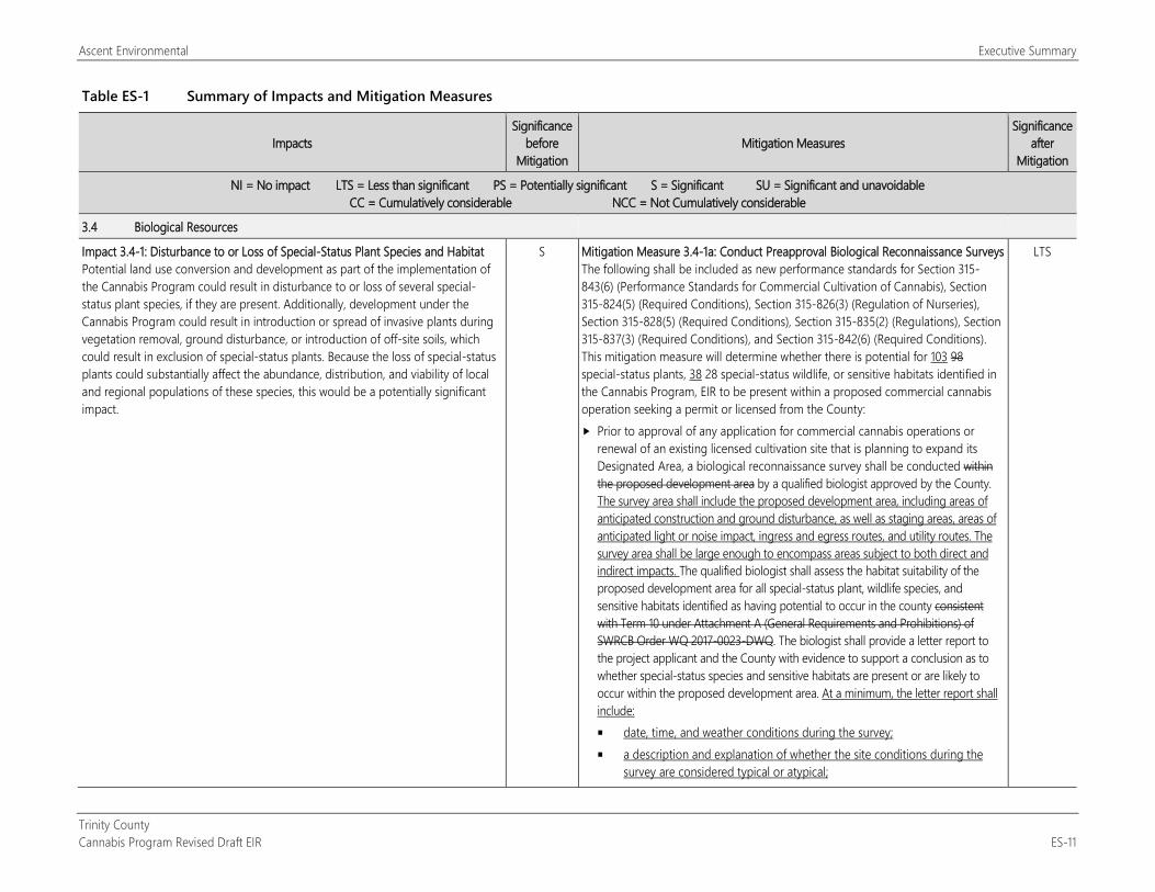
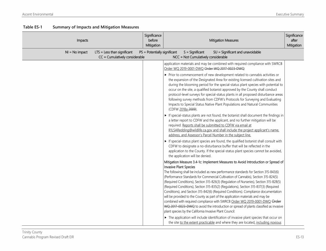
Impact 3.4-1: Disturbance to or Loss of Special-Status Plant Species and Habitat Potential land use conversion and development as part of the implementation of the Cannabis Program could result in disturbance to or loss of several special-status plant species, if they are present. Additionally, development under the Cannabis Program could result in introduction or spread of invasive plants during vegetation removal, ground disturbance, or introduction of off-site soils, which could result in exclusion of special-status plants. Because the loss of special-status plants could substantially affect the abundance, distribution, and viability of local and regional populations of these species, this would be a potentially significant impact.
S Mitigation Measure 3.4-1a: Conduct Preapproval Biological Reconnaissance Surveys The following shall be included as new performance standards for Section 315-843(6) (Performance Standards for Commercial Cultivation of Cannabis), Section 315-824(5) (Required Conditions), Section 315-826(3) (Regulation of Nurseries), Section 315-828(5) (Required Conditions), Section 315-835(2) (Regulations), Section 315-837(3) (Required Conditions), and Section 315-842(6) (Required Conditions). This mitigation measure will determine whether there is potential for 103 98 special-status plants, 38 28 special-status wildlife, or sensitive habitats identified in the Cannabis Program, EIR to be present within a proposed commercial cannabis operation seeking a permit or licensed from the County: Prior to approval of any application for commercial cannabis operations or
renewal of an existing licensed cultivation site that is planning to expand its Designated Area, a biological reconnaissance survey shall be conducted within the proposed development area by a qualified biologist approved by the County. The survey area shall include the proposed development area, including areas of anticipated construction and ground disturbance, as well as staging areas, areas of anticipated light or noise impact, ingress and egress routes, and utility routes. The survey area shall be large enough to encompass areas subject to both direct and indirect impacts. The qualified biologist shall assess the habitat suitability of the proposed development area for all special-status plant, wildlife species, and sensitive habitats identified as having potential to occur in the county consistent with Term 10 under Attachment A (General Requirements and Prohibitions) of SWRCB Order WQ 2017-0023-DWQ. The biologist shall provide a letter report to the project applicant and the County with evidence to support a conclusion as to whether special-status species and sensitive habitats are present or are likely to occur within the proposed development area. At a minimum, the letter report shall include: date, time, and weather conditions during the survey; a description and explanation of whether the site conditions during the
survey are considered typical or atypical;
LTS
Executive Summary Ascent Environmental
Trinity County ES-12 Cannabis Program Revised Draft EIR
Table ES-1 Summary of Impacts and Mitigation Measures
Impacts Significance
before Mitigation
Mitigation Measures Significance
after Mitigation
NI = No impact LTS = Less than significant PS = Potentially significant S = Significant SU = Significant and unavoidable CC = Cumulatively considerable NCC = Not Cumulatively considerable
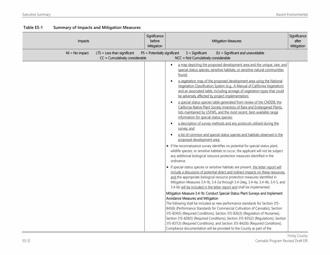
a map depicting the proposed development area and the unique, rare, and special-status species, sensitive habitats, or sensitive natural communities found;
a vegetation map of the proposed development area using the National Vegetation Classification System (e.g., A Manual of California Vegetation) and an associated table, including acreage of vegetation types that could be adversely affected by project implementation;
a special-status species table generated from review of the CNDDB, the California Native Plant Society Inventory of Rare and Endangered Plants, lists maintained by USFWS, and the most recent, best-available range information for special-status species;
a description of survey methods and any protocols utilized during the survey; and
a list of common and special-status species and habitats observed in the proposed development area.
If the reconnaissance survey identifies no potential for special-status plant, wildlife species, or sensitive habitats to occur, the applicant will not be subject any additional biological resource protection measures identified in the ordinance.
If special-status species or sensitive habitats are present, the letter report will include a discussion of potential direct and indirect impacts on these resources, and the appropriate biological resource protection measures identified in Mitigation Measures 3.4-1b, 3.4-2a through 3.4-2mo, 3.4-4a, 3.4-4b, 3.4-5, and 3.4-6b will be included in the letter report and shall be implemented.
Mitigation Measure 3.4-1b: Conduct Special-Status Plant Surveys and Implement Avoidance Measures and Mitigation The following shall be included as new performance standards for Section 315-843(6) (Performance Standards for Commercial Cultivation of Cannabis), Section 315-824(5) (Required Conditions), Section 315-826(3) (Regulation of Nurseries), Section 315-828(5) (Required Conditions), Section 315-835(2) (Regulations), Section 315-837(3) (Required Conditions), and Section 315-842(6) (Required Conditions). Compliance documentation will be provided to the County as part of the
Ascent Environmental Executive Summary
Trinity County Cannabis Program Revised Draft EIR ES-13
Table ES-1 Summary of Impacts and Mitigation Measures
Impacts Significance
before Mitigation
Mitigation Measures Significance
after Mitigation
NI = No impact LTS = Less than significant PS = Potentially significant S = Significant SU = Significant and unavoidable CC = Cumulatively considerable NCC = Not Cumulatively considerable
application materials and may be combined with required compliance with SWRCB Order WQ 2019-0001-DWQ Order WQ 2017-0023-DWQ: Prior to commencement of new development related to cannabis activities or
the expansion of the Designated Area for existing licensed cultivation sites and during the blooming period for the special-status plant species with potential to occur on the site, a qualified botanist approved by the County shall conduct protocol-level surveys for special-status plants in all proposed disturbance areas following survey methods from CDFW’s Protocols for Surveying and Evaluating Impacts to Special Status Native Plant Populations and Natural Communities (CDFW 2018a 2009).
If special-status plants are not found, the botanist shall document the findings in a letter report to CDFW and the applicant, and no further mitigation will be required. Reports shall be submitted to CDFW via email at [email protected] and shall include the project applicant’s name, address, and Assessor’s Parcel Number in the subject line.
If special-status plant species are found, the qualified botanist shall consult with CDFW to designate a no-disturbance buffer that will be reflected in the application to the County. If the special-status plant species cannot be avoided, the application will be denied.
Mitigation Measure 3.4-1c: Implement Measures to Avoid Introduction or Spread of Invasive Plant Species The following shall be included as new performance standards for Section 315-843(6) (Performance Standards for Commercial Cultivation of Cannabis), Section 315-824(5) (Required Conditions), Section 315-826(3) (Regulation of Nurseries), Section 315-828(5) (Required Conditions), Section 315-835(2) (Regulations), Section 315-837(3) (Required Conditions), and Section 315-842(6) (Required Conditions). Compliance documentation will be provided to the County as part of the application materials and may be combined with required compliance with SWRCB Order WQ 2019-0001-DWQ Order WQ 2017-0023-DWQ to avoid the introduction or spread of plants classified as invasive plant species by the California Invasive Plant Council: The application will include identification of invasive plant species that occur on
the site to the extent practicable and where they are located, including noxious
Executive Summary Ascent Environmental
Trinity County ES-14 Cannabis Program Revised Draft EIR
Table ES-1 Summary of Impacts and Mitigation Measures
Impacts Significance
before Mitigation
Mitigation Measures Significance
after Mitigation
NI = No impact LTS = Less than significant PS = Potentially significant S = Significant SU = Significant and unavoidable CC = Cumulatively considerable NCC = Not Cumulatively considerable
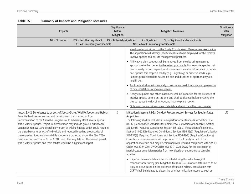
weed species prioritized by the Trinity County Weed Management Association. The application will identify specific measures to be employed for the removal invasive species and on-site management practices.
All invasive plant species shall be removed from the site using measures appropriate to the species to the extent practicable. For example, species that cannot easily reroot, resprout, or disperse seeds may be left on site in a debris pile. Species that resprout readily (e.g., English ivy) or disperse seeds (e.g., Pampas grass) should be hauled off-site and disposed of appropriately at a landfill site.
Applicants shall monitor annually to ensure successful removal and prevention of new infestations of invasive species.
Heavy equipment and other machinery shall be inspected for the presence of invasive species before on-site use, and shall be cleaned before entering the site, to reduce the risk of introducing invasive plant species.
Only weed-free erosion control materials and mulch shall be used on-site.
Impact 3.4-2: Disturbance to or Loss of Special-Status Wildlife Species and Habitat Potential land use conversion and development that may occur from implementation of the Cannabis Program could adversely affect several special-status wildlife species. Project implementation may include ground disturbance, vegetation removal, and overall conversion of wildlife habitat, which could result in the disturbance to or loss of individuals and reduced breeding productivity of these species. Special-status wildlife species are protected under the ESA, CESA, California Fish and Game Code, CEQA, and other regulations. The loss of special-status wildlife species and their habitat would be a significant impact.
S Mitigation Measure 3.4-2a: Conduct Preconstruction Surveys for Special-Status Amphibians The following shall be included as new performance standards for Section 315-843(6) (Performance Standards for Commercial Cultivation of Cannabis), Section 315-824(5) (Required Conditions), Section 315-826(3) (Regulation of Nurseries), Section 315-828(5) (Required Conditions), Section 315-835(2) (Regulations), Section 315-837(3) (Required Conditions), and Section 315-842(6) (Required Conditions). Compliance documentation will be provided to the County as part of the application materials and may be combined with required compliance with SWRCB Order WQ 2019-0001-DWQ Order WQ 2017-0023-DWQ for the protection of special-status amphibian species from new development related to cannabis activities. If special-status amphibians are detected during the initial biological
reconnaissance survey (see Mitigation Measure 3.4-1a) or are determined to be likely to occur based on the presence of suitable habitat, consultation with CDFW shall be initiated to determine whether mitigation measures, such as
LTS
Ascent Environmental Executive Summary
Trinity County Cannabis Program Revised Draft EIR ES-15
Table ES-1 Summary of Impacts and Mitigation Measures
Impacts Significance
before Mitigation
Mitigation Measures Significance
after Mitigation
NI = No impact LTS = Less than significant PS = Potentially significant S = Significant SU = Significant and unavoidable CC = Cumulatively considerable NCC = Not Cumulatively considerable
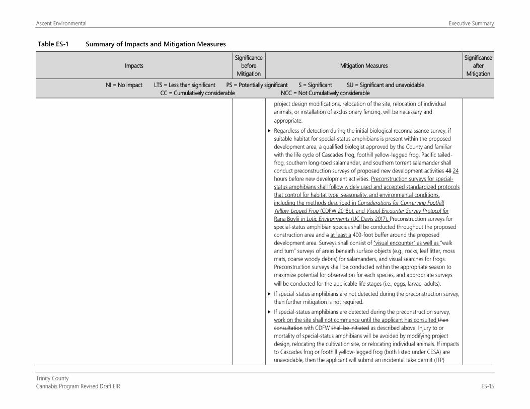
project design modifications, relocation of the site, relocation of individual animals, or installation of exclusionary fencing, will be necessary and appropriate.
Regardless of detection during the initial biological reconnaissance survey, if suitable habitat for special-status amphibians is present within the proposed development area, a qualified biologist approved by the County and familiar with the life cycle of Cascades frog, foothill yellow-legged frog, Pacific tailed-frog, southern long-toed salamander, and southern torrent salamander shall conduct preconstruction surveys of proposed new development activities 48 24 hours before new development activities. Preconstruction surveys for special-status amphibians shall follow widely used and accepted standardized protocols that control for habitat type, seasonality, and environmental conditions, including the methods described in Considerations for Conserving Foothill Yellow-Legged Frog (CDFW 2018b), and Visual Encounter Survey Protocol for Rana Boylii in Lotic Environments (UC Davis 2017). Preconstruction surveys for special-status amphibian species shall be conducted throughout the proposed construction area and a at least a 400-foot buffer around the proposed development area. Surveys shall consist of “visual encounter” as well as “walk and turn” surveys of areas beneath surface objects (e.g., rocks, leaf litter, moss mats, coarse woody debris) for salamanders, and visual searches for frogs. Preconstruction surveys shall be conducted within the appropriate season to maximize potential for observation for each species, and appropriate surveys will be conducted for the applicable life stages (i.e., eggs, larvae, adults).
If special-status amphibians are not detected during the preconstruction survey, then further mitigation is not required.
If special-status amphibians are detected during the preconstruction survey, work on the site shall not commence until the applicant has consulted then consultation with CDFW shall be initiated as described above. Injury to or mortality of special-status amphibians will be avoided by modifying project design, relocating the cultivation site, or relocating individual animals. If impacts to Cascades frog or foothill yellow-legged frog (both listed under CESA) are unavoidable, then the applicant will submit an incidental take permit (ITP)
Executive Summary Ascent Environmental
Trinity County ES-16 Cannabis Program Revised Draft EIR
Table ES-1 Summary of Impacts and Mitigation Measures
Impacts Significance
before Mitigation
Mitigation Measures Significance
after Mitigation
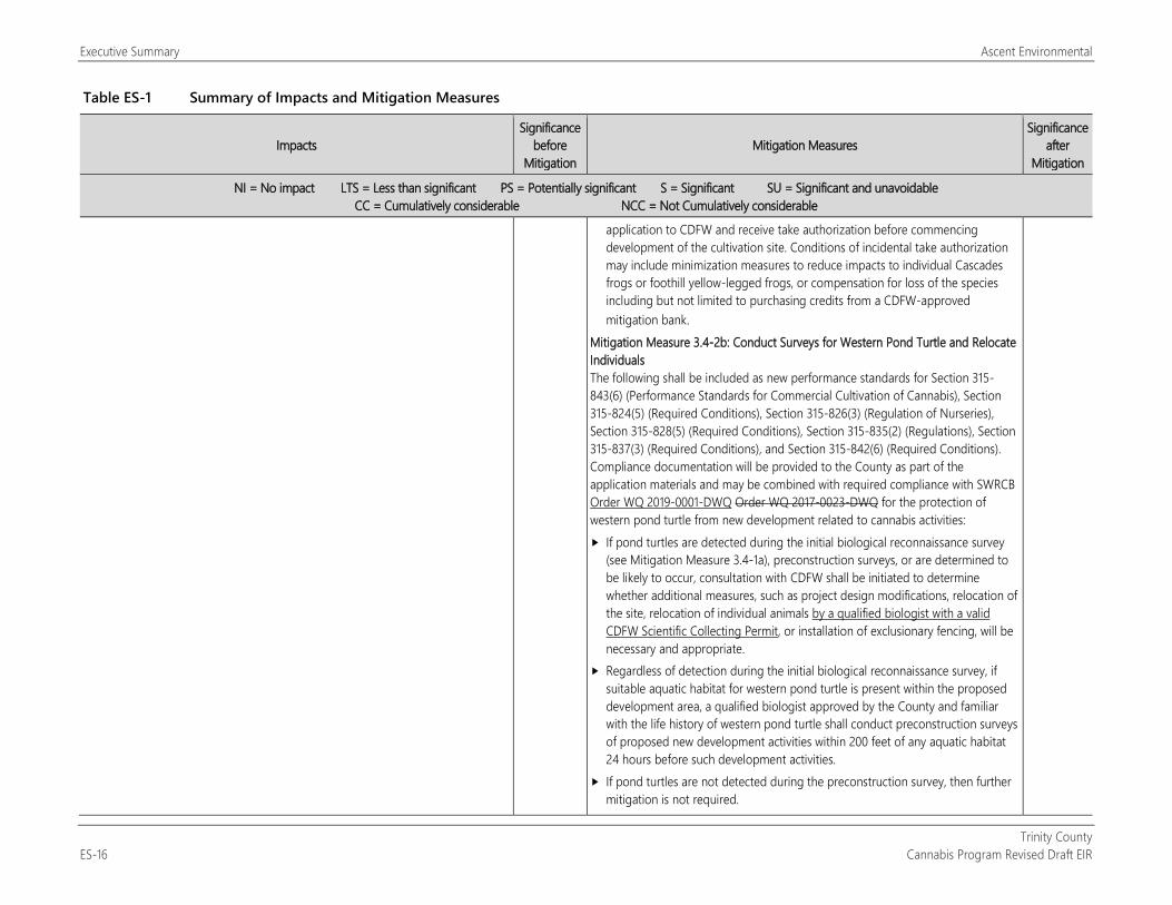
NI = No impact LTS = Less than significant PS = Potentially significant S = Significant SU = Significant and unavoidable CC = Cumulatively considerable NCC = Not Cumulatively considerable
application to CDFW and receive take authorization before commencing development of the cultivation site. Conditions of incidental take authorization may include minimization measures to reduce impacts to individual Cascades frogs or foothill yellow-legged frogs, or compensation for loss of the species including but not limited to purchasing credits from a CDFW-approved mitigation bank.
Mitigation Measure 3.4-2b: Conduct Surveys for Western Pond Turtle and Relocate Individuals The following shall be included as new performance standards for Section 315-843(6) (Performance Standards for Commercial Cultivation of Cannabis), Section 315-824(5) (Required Conditions), Section 315-826(3) (Regulation of Nurseries), Section 315-828(5) (Required Conditions), Section 315-835(2) (Regulations), Section 315-837(3) (Required Conditions), and Section 315-842(6) (Required Conditions). Compliance documentation will be provided to the County as part of the application materials and may be combined with required compliance with SWRCB Order WQ 2019-0001-DWQ Order WQ 2017-0023-DWQ for the protection of western pond turtle from new development related to cannabis activities: If pond turtles are detected during the initial biological reconnaissance survey
(see Mitigation Measure 3.4-1a), preconstruction surveys, or are determined to be likely to occur, consultation with CDFW shall be initiated to determine whether additional measures, such as project design modifications, relocation of the site, relocation of individual animals by a qualified biologist with a valid CDFW Scientific Collecting Permit, or installation of exclusionary fencing, will be necessary and appropriate.
Regardless of detection during the initial biological reconnaissance survey, if suitable aquatic habitat for western pond turtle is present within the proposed development area, a qualified biologist approved by the County and familiar with the life history of western pond turtle shall conduct preconstruction surveys of proposed new development activities within 200 feet of any aquatic habitat 24 hours before such development activities.
If pond turtles are not detected during the preconstruction survey, then further mitigation is not required.
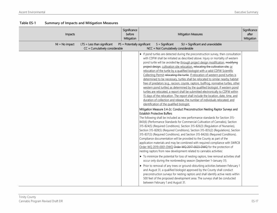
Ascent Environmental Executive Summary
Trinity County Cannabis Program Revised Draft EIR ES-17
Table ES-1 Summary of Impacts and Mitigation Measures
Impacts Significance
before Mitigation
Mitigation Measures Significance
after Mitigation
NI = No impact LTS = Less than significant PS = Potentially significant S = Significant SU = Significant and unavoidable CC = Cumulatively considerable NCC = Not Cumulatively considerable
If pond turtles are detected during the preconstruction survey, then consultation with CDFW shall be initiated as described above. Injury or mortality of western pond turtle will be avoided by through project design modification, modifying project design, cultivation site relocation, relocating the cultivation site, or relocation of the turtle by a qualified biologist with a valid CDFW Scientific Collecting Permit relocating the turtle. If relocation of western pond turtles is determined to be necessary, turtles shall be relocated to similar nearby habitat free of predators (e.g., racoon, coyote, raptors, bullfrog, nonnative turtles, other western pond turtles) as determined by the qualified biologist. If western pond turtles are relocated, a report shall be submitted electronically to CDFW within 15 days of the relocation. The report shall include the location, date, time, and duration of collection and release; the number of individuals relocated; and identification of the qualified biologist.
Mitigation Measure 3.4-2c: Conduct Preconstruction Nesting Raptor Surveys and Establish Protective Buffers The following shall be included as new performance standards for Section 315-843(6) (Performance Standards for Commercial Cultivation of Cannabis), Section 315-824(5) (Required Conditions), Section 315-826(3) (Regulation of Nurseries), Section 315-828(5) (Required Conditions), Section 315-835(2) (Regulations), Section 315-837(3) (Required Conditions), and Section 315-842(6) (Required Conditions). Compliance documentation will be provided to the County as part of the application materials and may be combined with required compliance with SWRCB Order WQ 2019-0001-DWQ Order WQ 2017-0023-DWQ for the protection of nesting raptors from new development related to cannabis activities: To minimize the potential for loss of nesting raptors, tree removal activities shall
occur only during the nonbreeding season (September 1–January 31). Prior to removal of any trees or ground-disturbing activities between February 1
and August 31, a qualified biologist approved by the County shall conduct preconstruction surveys for nesting raptors and shall identify active nests within 500 feet of the proposed development area. The surveys shall be conducted between February 1 and August 31.
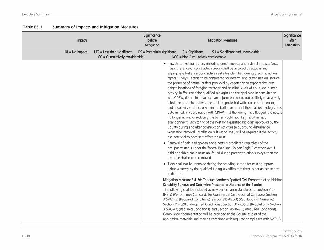
Executive Summary Ascent Environmental
Trinity County ES-18 Cannabis Program Revised Draft EIR
Table ES-1 Summary of Impacts and Mitigation Measures
Impacts Significance
before Mitigation
Mitigation Measures Significance
after Mitigation
NI = No impact LTS = Less than significant PS = Potentially significant S = Significant SU = Significant and unavoidable CC = Cumulatively considerable NCC = Not Cumulatively considerable
Impacts to nesting raptors, including direct impacts and indirect impacts (e.g., noise, presence of construction crews) shall be avoided by establishing appropriate buffers around active nest sites identified during preconstruction raptor surveys. Factors to be considered for determining buffer size will include the presence of natural buffers provided by vegetation or topography; nest height; locations of foraging territory; and baseline levels of noise and human activity. Buffer size if the qualified biologist and the applicant, in consultation with CDFW, determine that such an adjustment would not be likely to adversely affect the nest. The buffer areas shall be protected with construction fencing, and no activity shall occur within the buffer areas until the qualified biologist has determined, in coordination with CDFW, that the young have fledged, the nest is no longer active, or reducing the buffer would not likely result in nest abandonment. Monitoring of the nest by a qualified biologist approved by the County during and after construction activities (e.g., ground disturbance, vegetation removal, installation cultivation sites) will be required if the activity has potential to adversely affect the nest.
Removal of bald and golden eagle nests is prohibited regardless of the occupancy status under the federal Bald and Golden Eagle Protection Act. If bald or golden eagle nests are found during preconstruction surveys, then the nest tree shall not be removed.
Trees shall not be removed during the breeding season for nesting raptors unless a survey by the qualified biologist verifies that there is not an active nest in the tree.
Mitigation Measure 3.4-2d: Conduct Northern Spotted Owl Preconstruction Habitat Suitability Surveys and Determine Presence or Absence of the Species The following shall be included as new performance standards for Section 315-843(6) (Performance Standards for Commercial Cultivation of Cannabis), Section 315-824(5) (Required Conditions), Section 315-826(3) (Regulation of Nurseries), Section 315-828(5) (Required Conditions), Section 315-835(2) (Regulations), Section 315-837(3) (Required Conditions), and Section 315-842(6) (Required Conditions). Compliance documentation will be provided to the County as part of the application materials and may be combined with required compliance with SWRCB
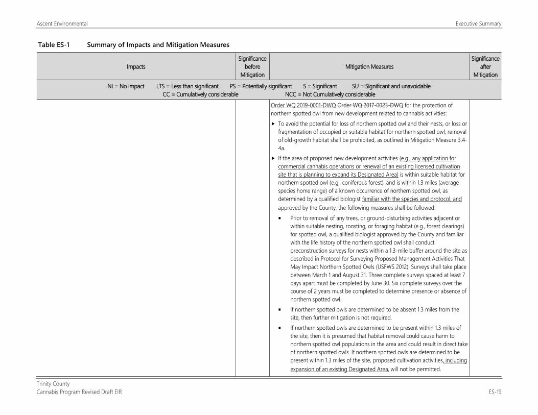
Ascent Environmental Executive Summary
Trinity County Cannabis Program Revised Draft EIR ES-19
Table ES-1 Summary of Impacts and Mitigation Measures
Impacts Significance
before Mitigation
Mitigation Measures Significance
after Mitigation
NI = No impact LTS = Less than significant PS = Potentially significant S = Significant SU = Significant and unavoidable CC = Cumulatively considerable NCC = Not Cumulatively considerable
Order WQ 2019-0001-DWQ Order WQ 2017-0023-DWQ for the protection of northern spotted owl from new development related to cannabis activities: To avoid the potential for loss of northern spotted owl and their nests, or loss or
fragmentation of occupied or suitable habitat for northern spotted owl, removal of old-growth habitat shall be prohibited, as outlined in Mitigation Measure 3.4-4a.
If the area of proposed new development activities (e.g., any application for commercial cannabis operations or renewal of an existing licensed cultivation site that is planning to expand its Designated Area) is within suitable habitat for northern spotted owl (e.g., coniferous forest), and is within 1.3 miles (average species home range) of a known occurrence of northern spotted owl, as determined by a qualified biologist familiar with the species and protocol, and approved by the County, the following measures shall be followed: Prior to removal of any trees, or ground-disturbing activities adjacent or
within suitable nesting, roosting, or foraging habitat (e.g., forest clearings) for spotted owl, a qualified biologist approved by the County and familiar with the life history of the northern spotted owl shall conduct preconstruction surveys for nests within a 1.3-mile buffer around the site as described in Protocol for Surveying Proposed Management Activities That May Impact Northern Spotted Owls (USFWS 2012). Surveys shall take place between March 1 and August 31. Three complete surveys spaced at least 7 days apart must be completed by June 30. Six complete surveys over the course of 2 years must be completed to determine presence or absence of northern spotted owl.
If northern spotted owls are determined to be absent 1.3 miles from the site, then further mitigation is not required.
If northern spotted owls are determined to be present within 1.3 miles of the site, then it is presumed that habitat removal could cause harm to northern spotted owl populations in the area and could result in direct take of northern spotted owls. If northern spotted owls are determined to be present within 1.3 miles of the site, proposed cultivation activities, including expansion of an existing Designated Area, will not be permitted.
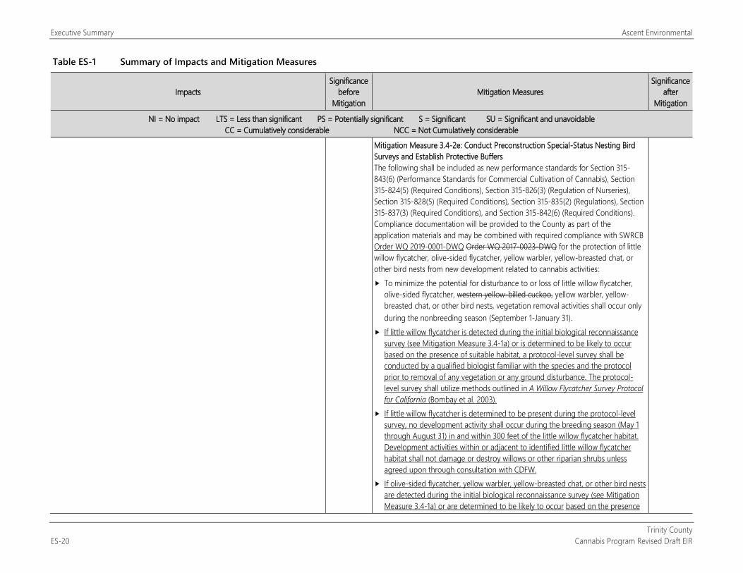
Executive Summary Ascent Environmental
Trinity County ES-20 Cannabis Program Revised Draft EIR
Table ES-1 Summary of Impacts and Mitigation Measures
Impacts Significance
before Mitigation
Mitigation Measures Significance
after Mitigation
NI = No impact LTS = Less than significant PS = Potentially significant S = Significant SU = Significant and unavoidable CC = Cumulatively considerable NCC = Not Cumulatively considerable
Mitigation Measure 3.4-2e: Conduct Preconstruction Special-Status Nesting Bird Surveys and Establish Protective Buffers The following shall be included as new performance standards for Section 315-843(6) (Performance Standards for Commercial Cultivation of Cannabis), Section 315-824(5) (Required Conditions), Section 315-826(3) (Regulation of Nurseries), Section 315-828(5) (Required Conditions), Section 315-835(2) (Regulations), Section 315-837(3) (Required Conditions), and Section 315-842(6) (Required Conditions). Compliance documentation will be provided to the County as part of the application materials and may be combined with required compliance with SWRCB Order WQ 2019-0001-DWQ Order WQ 2017-0023-DWQ for the protection of little willow flycatcher, olive-sided flycatcher, yellow warbler, yellow-breasted chat, or other bird nests from new development related to cannabis activities: To minimize the potential for disturbance to or loss of little willow flycatcher,
olive-sided flycatcher, western yellow-billed cuckoo, yellow warbler, yellow-breasted chat, or other bird nests, vegetation removal activities shall occur only during the nonbreeding season (September 1-January 31).
If little willow flycatcher is detected during the initial biological reconnaissance survey (see Mitigation Measure 3.4-1a) or is determined to be likely to occur based on the presence of suitable habitat, a protocol-level survey shall be conducted by a qualified biologist familiar with the species and the protocol prior to removal of any vegetation or any ground disturbance. The protocol-level survey shall utilize methods outlined in A Willow Flycatcher Survey Protocol for California (Bombay et al. 2003).
If little willow flycatcher is determined to be present during the protocol-level survey, no development activity shall occur during the breeding season (May 1 through August 31) in and within 300 feet of the little willow flycatcher habitat. Development activities within or adjacent to identified little willow flycatcher habitat shall not damage or destroy willows or other riparian shrubs unless agreed upon through consultation with CDFW.
If olive-sided flycatcher, yellow warbler, yellow-breasted chat, or other bird nests are detected during the initial biological reconnaissance survey (see Mitigation Measure 3.4-1a) or are determined to be likely to occur based on the presence
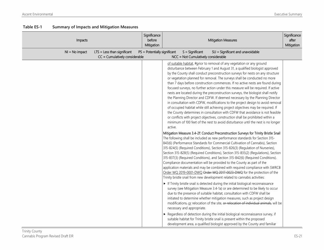
Ascent Environmental Executive Summary
Trinity County Cannabis Program Revised Draft EIR ES-21
Table ES-1 Summary of Impacts and Mitigation Measures
Impacts Significance
before Mitigation
Mitigation Measures Significance
after Mitigation
NI = No impact LTS = Less than significant PS = Potentially significant S = Significant SU = Significant and unavoidable CC = Cumulatively considerable NCC = Not Cumulatively considerable
of suitable habitat, Pprior to removal of any vegetation or any ground disturbance between February 1 and August 31, a qualified biologist approved by the County shall conduct preconstruction surveys for nests on any structure or vegetation planned for removal. The surveys shall be conducted no more than 7 days before construction commences. If no active nests are found during focused surveys, no further action under this measure will be required. If active nests are located during the preconstruction surveys, the biologist shall notify the Planning Director and CDFW. If deemed necessary by the Planning Director in consultation with CDFW, modifications to the project design to avoid removal of occupied habitat while still achieving project objectives may be required. If the County determines in consultation with CDFW that avoidance is not feasible or conflicts with project objectives, construction shall be prohibited within a minimum of 100 feet of the nest to avoid disturbance until the nest is no longer active.
Mitigation Measure 3.4-2f: Conduct Preconstruction Surveys for Trinity Bristle Snail The following shall be included as new performance standards for Section 315-843(6) (Performance Standards for Commercial Cultivation of Cannabis), Section 315-824(5) (Required Conditions), Section 315-826(3) (Regulation of Nurseries), Section 315-828(5) (Required Conditions), Section 315-835(2) (Regulations), Section 315-837(3) (Required Conditions), and Section 315-842(6) (Required Conditions). Compliance documentation will be provided to the County as part of the application materials and may be combined with required compliance with SWRCB Order WQ 2019-0001-DWQ Order WQ 2017-0023-DWQ for the protection of the Trinity bristle snail from new development related to cannabis activities: If Trinity bristle snail is detected during the initial biological reconnaissance
survey (see Mitigation Measure 3.4-1a) or are determined to be likely to occur due to the presence of suitable habitat, consultation with CDFW shall be initiated to determine whether mitigation measures, such as project design modifications, or relocation of the site, or relocation of individual animals, will be necessary and appropriate.
Regardless of detection during the initial biological reconnaissance survey, if suitable habitat for Trinity bristle snail is present within the proposed development area, a qualified biologist approved by the County and familiar
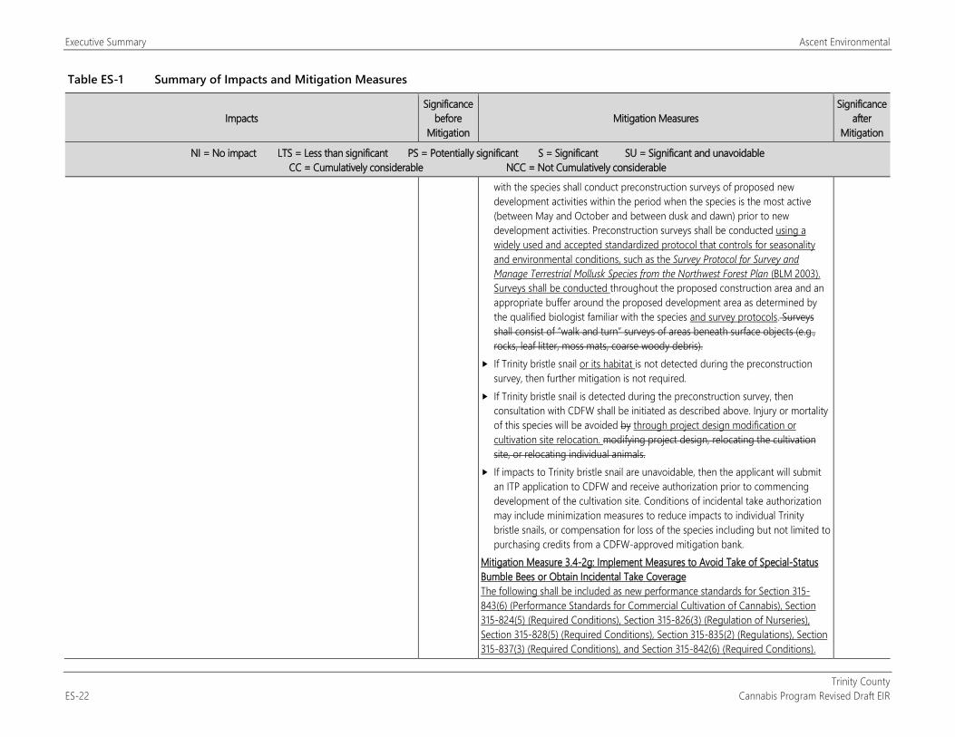
Executive Summary Ascent Environmental
Trinity County ES-22 Cannabis Program Revised Draft EIR
Table ES-1 Summary of Impacts and Mitigation Measures
Impacts Significance
before Mitigation
Mitigation Measures Significance
after Mitigation
NI = No impact LTS = Less than significant PS = Potentially significant S = Significant SU = Significant and unavoidable CC = Cumulatively considerable NCC = Not Cumulatively considerable
with the species shall conduct preconstruction surveys of proposed new development activities within the period when the species is the most active (between May and October and between dusk and dawn) prior to new development activities. Preconstruction surveys shall be conducted using a widely used and accepted standardized protocol that controls for seasonality and environmental conditions, such as the Survey Protocol for Survey and Manage Terrestrial Mollusk Species from the Northwest Forest Plan (BLM 2003). Surveys shall be conducted throughout the proposed construction area and an appropriate buffer around the proposed development area as determined by the qualified biologist familiar with the species and survey protocols. Surveys shall consist of “walk and turn” surveys of areas beneath surface objects (e.g., rocks, leaf litter, moss mats, coarse woody debris).
If Trinity bristle snail or its habitat is not detected during the preconstruction survey, then further mitigation is not required.
If Trinity bristle snail is detected during the preconstruction survey, then consultation with CDFW shall be initiated as described above. Injury or mortality of this species will be avoided by through project design modification or cultivation site relocation. modifying project design, relocating the cultivation site, or relocating individual animals.
If impacts to Trinity bristle snail are unavoidable, then the applicant will submit an ITP application to CDFW and receive authorization prior to commencing development of the cultivation site. Conditions of incidental take authorization may include minimization measures to reduce impacts to individual Trinity bristle snails, or compensation for loss of the species including but not limited to purchasing credits from a CDFW-approved mitigation bank.
Mitigation Measure 3.4-2g: Implement Measures to Avoid Take of Special-Status Bumble Bees or Obtain Incidental Take Coverage The following shall be included as new performance standards for Section 315-843(6) (Performance Standards for Commercial Cultivation of Cannabis), Section 315-824(5) (Required Conditions), Section 315-826(3) (Regulation of Nurseries), Section 315-828(5) (Required Conditions), Section 315-835(2) (Regulations), Section 315-837(3) (Required Conditions), and Section 315-842(6) (Required Conditions).
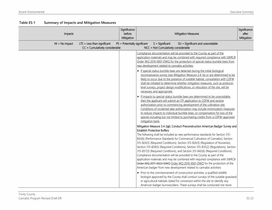
Ascent Environmental Executive Summary
Trinity County Cannabis Program Revised Draft EIR ES-23
Table ES-1 Summary of Impacts and Mitigation Measures
Impacts Significance
before Mitigation
Mitigation Measures Significance
after Mitigation
NI = No impact LTS = Less than significant PS = Potentially significant S = Significant SU = Significant and unavoidable CC = Cumulatively considerable NCC = Not Cumulatively considerable
Compliance documentation will be provided to the County as part of the application materials and may be combined with required compliance with SWRCB Order WQ 2019-0001-DWQ for the protection of special-status bumble bees from new development related to cannabis activities: If special-status bumble bees are detected during the initial biological
reconnaissance survey (see Mitigation Measure 3.4-1a) or are determined to be likely to occur due to the presence of suitable habitat, consultation with CDFW shall be initiated to determine whether mitigation measures, such as protocol-level surveys, project design modifications, or relocation of the site, will be necessary and appropriate.
If impacts to special-status bumble bees are determined to be unavoidable, then the applicant will submit an ITP application to CDFW and receive authorization prior to commencing development of the cultivation site. Conditions of incidental take authorization may include minimization measures to reduce impacts to individual bumble bees, or compensation for loss of the species including but not limited to purchasing credits from a CDFW-approved mitigation bank.
Mitigation Measure 3.4-2gh: Conduct Preconstruction American Badger Survey and Establish Protective Buffers The following shall be included as new performance standards for Section 315-843(6) (Performance Standards for Commercial Cultivation of Cannabis), Section 315-824(5) (Required Conditions), Section 315-826(3) (Regulation of Nurseries), Section 315-828(5) (Required Conditions), Section 315-835(2) (Regulations), Section 315-837(3) (Required Conditions), and Section 315-842(6) (Required Conditions). Compliance documentation will be provided to the County as part of the application materials and may be combined with required compliance with SWRCB Order WQ 2017-0023-DWQ Order WQ 2019-0001-DWQ for the protection of the American badger from new development related to cannabis activities: Prior to the commencement of construction activities, a qualified wildlife
biologist approved by the County shall conduct surveys of the suitable grassland or agricultural habitats slated for conversion within the site to identify any American badger burrows/dens. These surveys shall be conducted not more
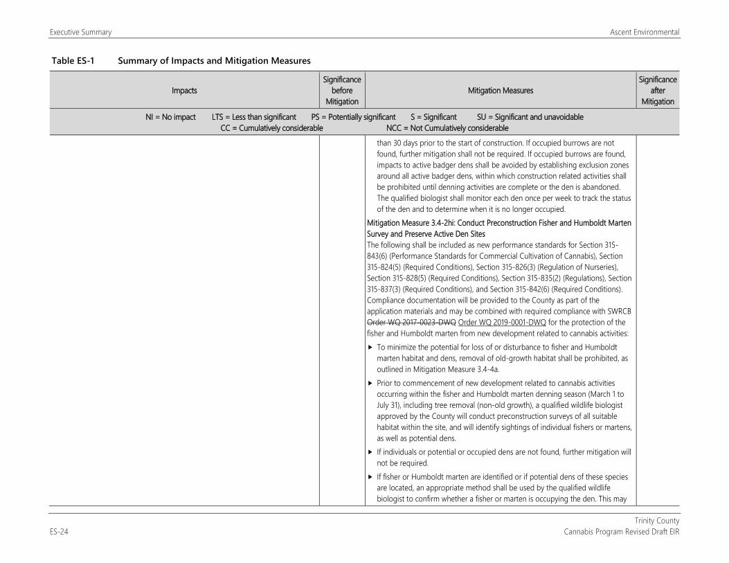
Executive Summary Ascent Environmental
Trinity County ES-24 Cannabis Program Revised Draft EIR
Table ES-1 Summary of Impacts and Mitigation Measures
Impacts Significance
before Mitigation
Mitigation Measures Significance
after Mitigation
NI = No impact LTS = Less than significant PS = Potentially significant S = Significant SU = Significant and unavoidable CC = Cumulatively considerable NCC = Not Cumulatively considerable
than 30 days prior to the start of construction. If occupied burrows are not found, further mitigation shall not be required. If occupied burrows are found, impacts to active badger dens shall be avoided by establishing exclusion zones around all active badger dens, within which construction related activities shall be prohibited until denning activities are complete or the den is abandoned. The qualified biologist shall monitor each den once per week to track the status of the den and to determine when it is no longer occupied.
Mitigation Measure 3.4-2hi: Conduct Preconstruction Fisher and Humboldt Marten Survey and Preserve Active Den Sites The following shall be included as new performance standards for Section 315-843(6) (Performance Standards for Commercial Cultivation of Cannabis), Section 315-824(5) (Required Conditions), Section 315-826(3) (Regulation of Nurseries), Section 315-828(5) (Required Conditions), Section 315-835(2) (Regulations), Section 315-837(3) (Required Conditions), and Section 315-842(6) (Required Conditions). Compliance documentation will be provided to the County as part of the application materials and may be combined with required compliance with SWRCB Order WQ 2017-0023-DWQ Order WQ 2019-0001-DWQ for the protection of the fisher and Humboldt marten from new development related to cannabis activities: To minimize the potential for loss of or disturbance to fisher and Humboldt
marten habitat and dens, removal of old-growth habitat shall be prohibited, as outlined in Mitigation Measure 3.4-4a.
Prior to commencement of new development related to cannabis activities occurring within the fisher and Humboldt marten denning season (March 1 to July 31), including tree removal (non-old growth), a qualified wildlife biologist approved by the County will conduct preconstruction surveys of all suitable habitat within the site, and will identify sightings of individual fishers or martens, as well as potential dens.
If individuals or potential or occupied dens are not found, further mitigation will not be required.
If fisher or Humboldt marten are identified or if potential dens of these species are located, an appropriate method shall be used by the qualified wildlife biologist to confirm whether a fisher or marten is occupying the den. This may
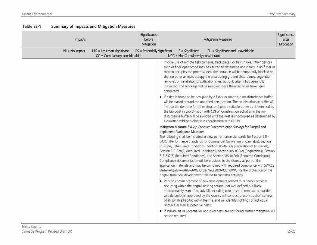
Ascent Environmental Executive Summary
Trinity County Cannabis Program Revised Draft EIR ES-25
Table ES-1 Summary of Impacts and Mitigation Measures
Impacts Significance
before Mitigation
Mitigation Measures Significance
after Mitigation
NI = No impact LTS = Less than significant PS = Potentially significant S = Significant SU = Significant and unavoidable CC = Cumulatively considerable NCC = Not Cumulatively considerable
involve use of remote field cameras, track plates, or hair snares. Other devices such as fiber optic scope may be utilized to determine occupancy. If no fisher or marten occupies the potential den, the entrance will be temporarily blocked so that no other animals occupy the area during ground disturbance, vegetation removal, or installation of cultivation sites, but only after it has been fully inspected. The blockage will be removed once these activities have been completed.
If a den is found to be occupied by a fisher or marten, a no-disturbance buffer will be placed around the occupied den location. The no-disturbance buffer will include the den tree (or other structure) plus a suitable buffer as determined by the biologist in coordination with CDFW. Construction activities in the no-disturbance buffer will be avoided until the nest is unoccupied as determined by a qualified wildlife biologist in coordination with CDFW.
Mitigation Measure 3.4-2ij: Conduct Preconstruction Surveys for Ringtail and Implement Avoidance Measures The following shall be included as new performance standards for Section 315-843(6) (Performance Standards for Commercial Cultivation of Cannabis), Section 315-824(5) (Required Conditions), Section 315-826(3) (Regulation of Nurseries), Section 315-828(5) (Required Conditions), Section 315-835(2) (Regulations), Section 315-837(3) (Required Conditions), and Section 315-842(6) (Required Conditions). Compliance documentation will be provided to the County as part of the application materials and may be combined with required compliance with SWRCB Order WQ 2017-0023-DWQ Order WQ 2019-0001-DWQ for the protection of the ringtail from new development related to cannabis activities: Prior to commencement of new development related to cannabis activities
occurring within the ringtail nesting season (not well defined but likely approximately March 1 to July 31), including tree or shrub removal, a qualified wildlife biologist approved by the County will conduct preconstruction surveys of all suitable habitat within the site, and will identify sightings of individual ringtails, as well as potential nests.
If individuals or potential or occupied nests are not found, further mitigation will not be required.
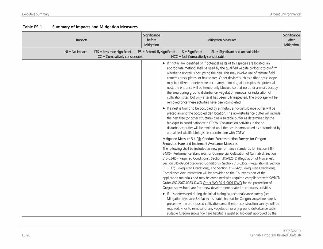
Executive Summary Ascent Environmental
Trinity County ES-26 Cannabis Program Revised Draft EIR
Table ES-1 Summary of Impacts and Mitigation Measures
Impacts Significance
before Mitigation
Mitigation Measures Significance
after Mitigation
NI = No impact LTS = Less than significant PS = Potentially significant S = Significant SU = Significant and unavoidable CC = Cumulatively considerable NCC = Not Cumulatively considerable
If ringtail are identified or if potential nests of this species are located, an appropriate method shall be used by the qualified wildlife biologist to confirm whether a ringtail is occupying the den. This may involve use of remote field cameras, track plates, or hair snares. Other devices such as a fiber optic scope may be utilized to determine occupancy. If no ringtail occupies the potential nest, the entrance will be temporarily blocked so that no other animals occupy the area during ground disturbance, vegetation removal, or installation of cultivation sites, but only after it has been fully inspected. The blockage will be removed once these activities have been completed.
If a nest is found to be occupied by a ringtail, a no-disturbance buffer will be placed around the occupied den location. The no-disturbance buffer will include the nest tree (or other structure) plus a suitable buffer as determined by the biologist in coordination with CDFW. Construction activities in the no-disturbance buffer will be avoided until the nest is unoccupied as determined by a qualified wildlife biologist in coordination with CDFW.
Mitigation Measure 3.4-2jk: Conduct Preconstruction Surveys for Oregon Snowshoe Hare and Implement Avoidance Measures The following shall be included as new performance standards for Section 315-843(6) (Performance Standards for Commercial Cultivation of Cannabis), Section 315-824(5) (Required Conditions), Section 315-826(3) (Regulation of Nurseries), Section 315-828(5) (Required Conditions), Section 315-835(2) (Regulations), Section 315-837(3) (Required Conditions), and Section 315-842(6) (Required Conditions). Compliance documentation will be provided to the County as part of the application materials and may be combined with required compliance with SWRCB Order WQ 2017-0023-DWQ Order WQ 2019-0001-DWQ for the protection of Oregon snowshoe hare from new development related to cannabis activities: If it is determined during the initial biological reconnaissance survey (see
Mitigation Measure 3.4-1a) that suitable habitat for Oregon snowshoe hare is present within a proposed cultivation area, then preconstruction surveys will be required. Prior to removal of any vegetation or any ground disturbance within suitable Oregon snowshoe hare habitat, a qualified biologist approved by the
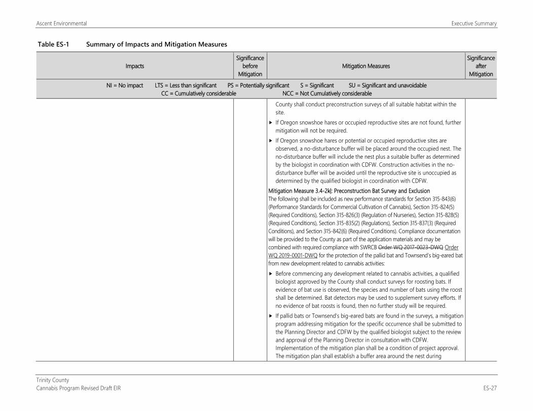
Ascent Environmental Executive Summary
Trinity County Cannabis Program Revised Draft EIR ES-27
Table ES-1 Summary of Impacts and Mitigation Measures
Impacts Significance
before Mitigation
Mitigation Measures Significance
after Mitigation
NI = No impact LTS = Less than significant PS = Potentially significant S = Significant SU = Significant and unavoidable CC = Cumulatively considerable NCC = Not Cumulatively considerable
County shall conduct preconstruction surveys of all suitable habitat within the site.
If Oregon snowshoe hares or occupied reproductive sites are not found, further mitigation will not be required.
If Oregon snowshoe hares or potential or occupied reproductive sites are observed, a no-disturbance buffer will be placed around the occupied nest. The no-disturbance buffer will include the nest plus a suitable buffer as determined by the biologist in coordination with CDFW. Construction activities in the no-disturbance buffer will be avoided until the reproductive site is unoccupied as determined by the qualified biologist in coordination with CDFW.
Mitigation Measure 3.4-2kl: Preconstruction Bat Survey and Exclusion The following shall be included as new performance standards for Section 315-843(6) (Performance Standards for Commercial Cultivation of Cannabis), Section 315-824(5) (Required Conditions), Section 315-826(3) (Regulation of Nurseries), Section 315-828(5) (Required Conditions), Section 315-835(2) (Regulations), Section 315-837(3) (Required Conditions), and Section 315-842(6) (Required Conditions). Compliance documentation will be provided to the County as part of the application materials and may be combined with required compliance with SWRCB Order WQ 2017-0023-DWQ Order WQ 2019-0001-DWQ for the protection of the pallid bat and Townsend’s big-eared bat from new development related to cannabis activities: Before commencing any development related to cannabis activities, a qualified
biologist approved by the County shall conduct surveys for roosting bats. If evidence of bat use is observed, the species and number of bats using the roost shall be determined. Bat detectors may be used to supplement survey efforts. If no evidence of bat roosts is found, then no further study will be required.
If pallid bats or Townsend’s big-eared bats are found in the surveys, a mitigation program addressing mitigation for the specific occurrence shall be submitted to the Planning Director and CDFW by the qualified biologist subject to the review and approval of the Planning Director in consultation with CDFW. Implementation of the mitigation plan shall be a condition of project approval. The mitigation plan shall establish a buffer area around the nest during
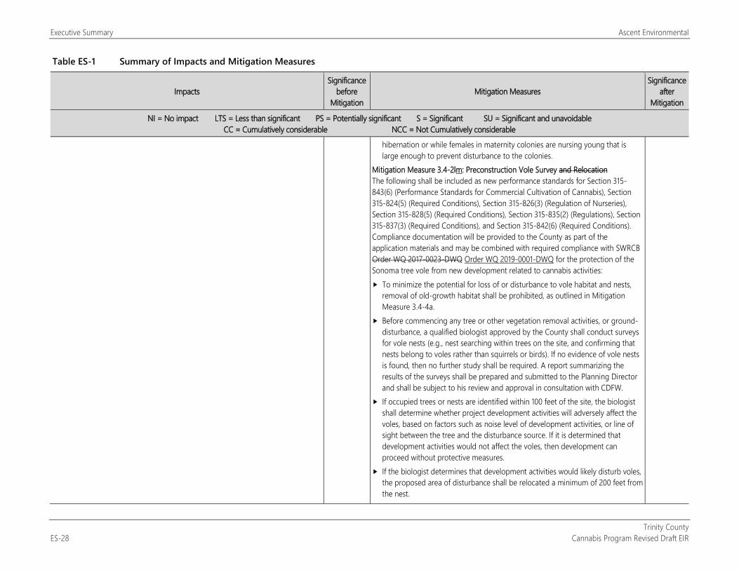
Executive Summary Ascent Environmental
Trinity County ES-28 Cannabis Program Revised Draft EIR
Table ES-1 Summary of Impacts and Mitigation Measures
Impacts Significance
before Mitigation
Mitigation Measures Significance
after Mitigation
NI = No impact LTS = Less than significant PS = Potentially significant S = Significant SU = Significant and unavoidable CC = Cumulatively considerable NCC = Not Cumulatively considerable
hibernation or while females in maternity colonies are nursing young that is large enough to prevent disturbance to the colonies.
Mitigation Measure 3.4-2lm: Preconstruction Vole Survey and Relocation The following shall be included as new performance standards for Section 315-843(6) (Performance Standards for Commercial Cultivation of Cannabis), Section 315-824(5) (Required Conditions), Section 315-826(3) (Regulation of Nurseries), Section 315-828(5) (Required Conditions), Section 315-835(2) (Regulations), Section 315-837(3) (Required Conditions), and Section 315-842(6) (Required Conditions). Compliance documentation will be provided to the County as part of the application materials and may be combined with required compliance with SWRCB Order WQ 2017-0023-DWQ Order WQ 2019-0001-DWQ for the protection of the Sonoma tree vole from new development related to cannabis activities: To minimize the potential for loss of or disturbance to vole habitat and nests,
removal of old-growth habitat shall be prohibited, as outlined in Mitigation Measure 3.4-4a.
Before commencing any tree or other vegetation removal activities, or ground-disturbance, a qualified biologist approved by the County shall conduct surveys for vole nests (e.g., nest searching within trees on the site, and confirming that nests belong to voles rather than squirrels or birds). If no evidence of vole nests is found, then no further study shall be required. A report summarizing the results of the surveys shall be prepared and submitted to the Planning Director and shall be subject to his review and approval in consultation with CDFW.
If occupied trees or nests are identified within 100 feet of the site, the biologist shall determine whether project development activities will adversely affect the voles, based on factors such as noise level of development activities, or line of sight between the tree and the disturbance source. If it is determined that development activities would not affect the voles, then development can proceed without protective measures.
If the biologist determines that development activities would likely disturb voles, the proposed area of disturbance shall be relocated a minimum of 200 feet from the nest.
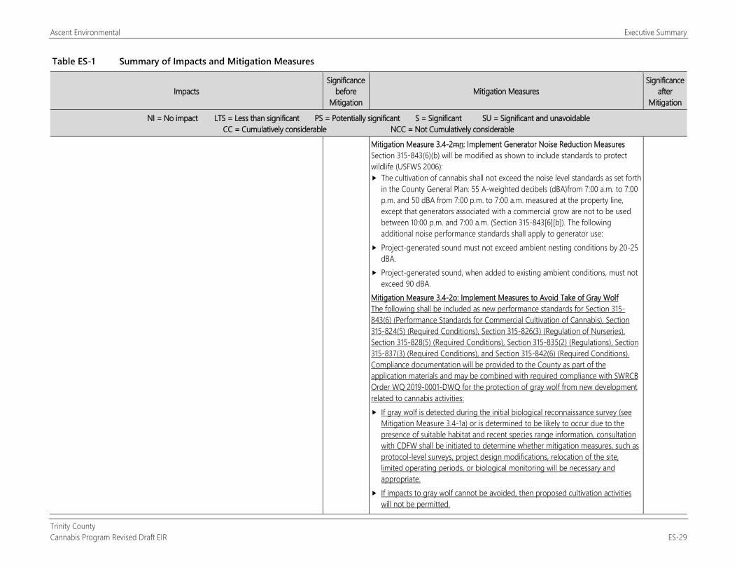
Ascent Environmental Executive Summary
Trinity County Cannabis Program Revised Draft EIR ES-29
Table ES-1 Summary of Impacts and Mitigation Measures
Impacts Significance
before Mitigation
Mitigation Measures Significance
after Mitigation
NI = No impact LTS = Less than significant PS = Potentially significant S = Significant SU = Significant and unavoidable CC = Cumulatively considerable NCC = Not Cumulatively considerable
Mitigation Measure 3.4-2mn: Implement Generator Noise Reduction Measures Section 315-843(6)(b) will be modified as shown to include standards to protect wildlife (USFWS 2006): The cultivation of cannabis shall not exceed the noise level standards as set forth
in the County General Plan: 55 A-weighted decibels (dBA)from 7:00 a.m. to 7:00 p.m. and 50 dBA from 7:00 p.m. to 7:00 a.m. measured at the property line, except that generators associated with a commercial grow are not to be used between 10:00 p.m. and 7:00 a.m. (Section 315-843[6][b]). The following additional noise performance standards shall apply to generator use:
Project-generated sound must not exceed ambient nesting conditions by 20-25 dBA.
Project-generated sound, when added to existing ambient conditions, must not exceed 90 dBA.
Mitigation Measure 3.4-2o: Implement Measures to Avoid Take of Gray Wolf The following shall be included as new performance standards for Section 315-843(6) (Performance Standards for Commercial Cultivation of Cannabis), Section 315-824(5) (Required Conditions), Section 315-826(3) (Regulation of Nurseries), Section 315-828(5) (Required Conditions), Section 315-835(2) (Regulations), Section 315-837(3) (Required Conditions), and Section 315-842(6) (Required Conditions). Compliance documentation will be provided to the County as part of the application materials and may be combined with required compliance with SWRCB Order WQ 2019-0001-DWQ for the protection of gray wolf from new development related to cannabis activities: If gray wolf is detected during the initial biological reconnaissance survey (see
Mitigation Measure 3.4-1a) or is determined to be likely to occur due to the presence of suitable habitat and recent species range information, consultation with CDFW shall be initiated to determine whether mitigation measures, such as protocol-level surveys, project design modifications, relocation of the site, limited operating periods, or biological monitoring will be necessary and appropriate.
If impacts to gray wolf cannot be avoided, then proposed cultivation activities will not be permitted.
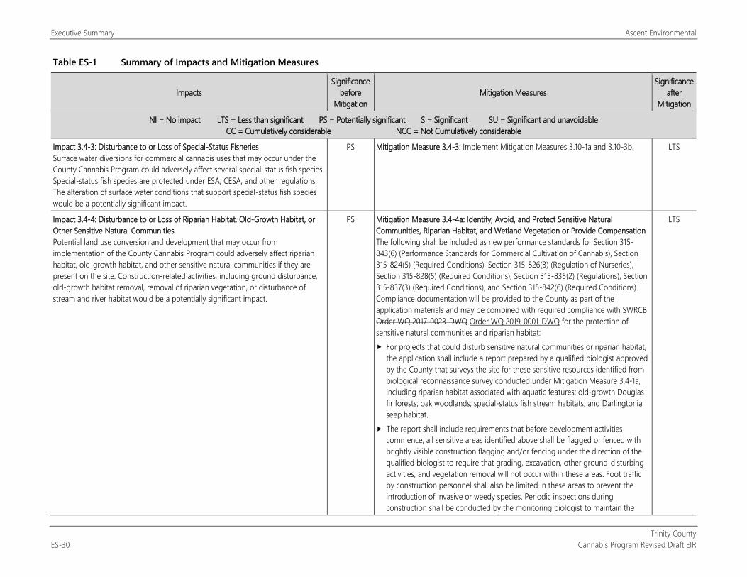
Executive Summary Ascent Environmental
Trinity County ES-30 Cannabis Program Revised Draft EIR
Table ES-1 Summary of Impacts and Mitigation Measures
Impacts Significance
before Mitigation
Mitigation Measures Significance
after Mitigation
NI = No impact LTS = Less than significant PS = Potentially significant S = Significant SU = Significant and unavoidable CC = Cumulatively considerable NCC = Not Cumulatively considerable
Impact 3.4-3: Disturbance to or Loss of Special-Status Fisheries Surface water diversions for commercial cannabis uses that may occur under the County Cannabis Program could adversely affect several special-status fish species. Special-status fish species are protected under ESA, CESA, and other regulations. The alteration of surface water conditions that support special-status fish species would be a potentially significant impact.
PS Mitigation Measure 3.4-3: Implement Mitigation Measures 3.10-1a and 3.10-3b. LTS
Impact 3.4-4: Disturbance to or Loss of Riparian Habitat, Old-Growth Habitat, or Other Sensitive Natural Communities Potential land use conversion and development that may occur from implementation of the County Cannabis Program could adversely affect riparian habitat, old-growth habitat, and other sensitive natural communities if they are present on the site. Construction-related activities, including ground disturbance, old-growth habitat removal, removal of riparian vegetation, or disturbance of stream and river habitat would be a potentially significant impact.
PS Mitigation Measure 3.4-4a: Identify, Avoid, and Protect Sensitive Natural Communities, Riparian Habitat, and Wetland Vegetation or Provide Compensation The following shall be included as new performance standards for Section 315-843(6) (Performance Standards for Commercial Cultivation of Cannabis), Section 315-824(5) (Required Conditions), Section 315-826(3) (Regulation of Nurseries), Section 315-828(5) (Required Conditions), Section 315-835(2) (Regulations), Section 315-837(3) (Required Conditions), and Section 315-842(6) (Required Conditions). Compliance documentation will be provided to the County as part of the application materials and may be combined with required compliance with SWRCB Order WQ 2017-0023-DWQ Order WQ 2019-0001-DWQ for the protection of sensitive natural communities and riparian habitat: For projects that could disturb sensitive natural communities or riparian habitat,
the application shall include a report prepared by a qualified biologist approved by the County that surveys the site for these sensitive resources identified from biological reconnaissance survey conducted under Mitigation Measure 3.4-1a, including riparian habitat associated with aquatic features; old-growth Douglas fir forests; oak woodlands; special-status fish stream habitats; and Darlingtonia seep habitat.
The report shall include requirements that before development activities commence, all sensitive areas identified above shall be flagged or fenced with brightly visible construction flagging and/or fencing under the direction of the qualified biologist to require that grading, excavation, other ground-disturbing activities, and vegetation removal will not occur within these areas. Foot traffic by construction personnel shall also be limited in these areas to prevent the introduction of invasive or weedy species. Periodic inspections during construction shall be conducted by the monitoring biologist to maintain the
LTS
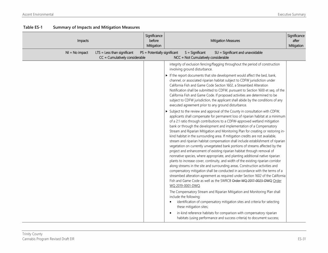
Ascent Environmental Executive Summary
Trinity County Cannabis Program Revised Draft EIR ES-31
Table ES-1 Summary of Impacts and Mitigation Measures
Impacts Significance
before Mitigation
Mitigation Measures Significance
after Mitigation
NI = No impact LTS = Less than significant PS = Potentially significant S = Significant SU = Significant and unavoidable CC = Cumulatively considerable NCC = Not Cumulatively considerable
integrity of exclusion fencing/flagging throughout the period of construction involving ground disturbance.
If the report documents that site development would affect the bed, bank, channel, or associated riparian habitat subject to CDFW jurisdiction under California Fish and Game Code Section 1602, a Streambed Alteration Notification shall be submitted to CDFW, pursuant to Section 1600 et seq. of the California Fish and Game Code. If proposed activities are determined to be subject to CDFW jurisdiction, the applicant shall abide by the conditions of any executed agreement prior to any ground disturbance.
Subject to the review and approval of the County in consultation with CDFW, applicants shall compensate for permanent loss of riparian habitat at a minimum of a 2:1 ratio through contributions to a CDFW-approved wetland mitigation bank or through the development and implementation of a Compensatory Stream and Riparian Mitigation and Monitoring Plan for creating or restoring in-kind habitat in the surrounding area. If mitigation credits are not available, stream and riparian habitat compensation shall include establishment of riparian vegetation on currently unvegetated bank portions of streams affected by the project and enhancement of existing riparian habitat through removal of nonnative species, where appropriate, and planting additional native riparian plants to increase cover, continuity, and width of the existing riparian corridor along streams in the site and surrounding areas. Construction activities and compensatory mitigation shall be conducted in accordance with the terms of a streambed alteration agreement as required under Section 1602 of the California Fish and Game Code as well as the SWRCB Order WQ 2017-0023-DWQ Order WQ 2019-0001-DWQ. The Compensatory Stream and Riparian Mitigation and Monitoring Plan shall include the following: identification of compensatory mitigation sites and criteria for selecting
these mitigation sites; in-kind reference habitats for comparison with compensatory riparian
habitats (using performance and success criteria) to document success;
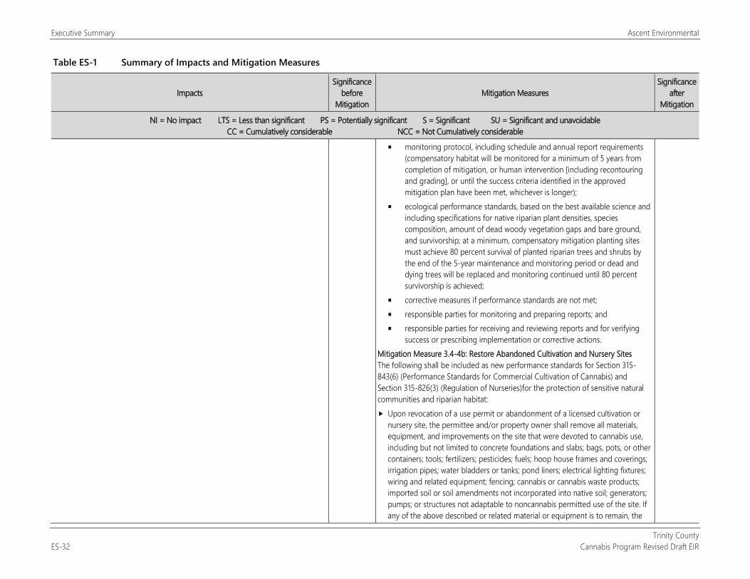
Executive Summary Ascent Environmental
Trinity County ES-32 Cannabis Program Revised Draft EIR
Table ES-1 Summary of Impacts and Mitigation Measures
Impacts Significance
before Mitigation
Mitigation Measures Significance
after Mitigation
NI = No impact LTS = Less than significant PS = Potentially significant S = Significant SU = Significant and unavoidable CC = Cumulatively considerable NCC = Not Cumulatively considerable
monitoring protocol, including schedule and annual report requirements (compensatory habitat will be monitored for a minimum of 5 years from completion of mitigation, or human intervention [including recontouring and grading], or until the success criteria identified in the approved mitigation plan have been met, whichever is longer);
ecological performance standards, based on the best available science and including specifications for native riparian plant densities, species composition, amount of dead woody vegetation gaps and bare ground, and survivorship; at a minimum, compensatory mitigation planting sites must achieve 80 percent survival of planted riparian trees and shrubs by the end of the 5-year maintenance and monitoring period or dead and dying trees will be replaced and monitoring continued until 80 percent survivorship is achieved;
corrective measures if performance standards are not met; responsible parties for monitoring and preparing reports; and responsible parties for receiving and reviewing reports and for verifying
success or prescribing implementation or corrective actions. Mitigation Measure 3.4-4b: Restore Abandoned Cultivation and Nursery Sites The following shall be included as new performance standards for Section 315-843(6) (Performance Standards for Commercial Cultivation of Cannabis) and Section 315-826(3) (Regulation of Nurseries)for the protection of sensitive natural communities and riparian habitat: Upon revocation of a use permit or abandonment of a licensed cultivation or
nursery site, the permittee and/or property owner shall remove all materials, equipment, and improvements on the site that were devoted to cannabis use, including but not limited to concrete foundations and slabs; bags, pots, or other containers; tools; fertilizers; pesticides; fuels; hoop house frames and coverings; irrigation pipes; water bladders or tanks; pond liners; electrical lighting fixtures; wiring and related equipment; fencing; cannabis or cannabis waste products; imported soil or soil amendments not incorporated into native soil; generators; pumps; or structures not adaptable to noncannabis permitted use of the site. If any of the above described or related material or equipment is to remain, the
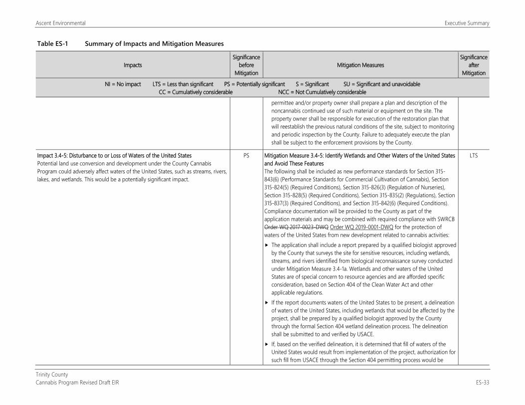
Ascent Environmental Executive Summary
Trinity County Cannabis Program Revised Draft EIR ES-33
Table ES-1 Summary of Impacts and Mitigation Measures
Impacts Significance
before Mitigation
Mitigation Measures Significance
after Mitigation
NI = No impact LTS = Less than significant PS = Potentially significant S = Significant SU = Significant and unavoidable CC = Cumulatively considerable NCC = Not Cumulatively considerable
permittee and/or property owner shall prepare a plan and description of the noncannabis continued use of such material or equipment on the site. The property owner shall be responsible for execution of the restoration plan that will reestablish the previous natural conditions of the site, subject to monitoring and periodic inspection by the County. Failure to adequately execute the plan shall be subject to the enforcement provisions by the County.
Impact 3.4-5: Disturbance to or Loss of Waters of the United States Potential land use conversion and development under the County Cannabis Program could adversely affect waters of the United States, such as streams, rivers, lakes, and wetlands. This would be a potentially significant impact.
PS Mitigation Measure 3.4-5: Identify Wetlands and Other Waters of the United States and Avoid These Features The following shall be included as new performance standards for Section 315-843(6) (Performance Standards for Commercial Cultivation of Cannabis), Section 315-824(5) (Required Conditions), Section 315-826(3) (Regulation of Nurseries), Section 315-828(5) (Required Conditions), Section 315-835(2) (Regulations), Section 315-837(3) (Required Conditions), and Section 315-842(6) (Required Conditions). Compliance documentation will be provided to the County as part of the application materials and may be combined with required compliance with SWRCB Order WQ 2017-0023-DWQ Order WQ 2019-0001-DWQ for the protection of waters of the United States from new development related to cannabis activities: The application shall include a report prepared by a qualified biologist approved
by the County that surveys the site for sensitive resources, including wetlands, streams, and rivers identified from biological reconnaissance survey conducted under Mitigation Measure 3.4-1a. Wetlands and other waters of the United States are of special concern to resource agencies and are afforded specific consideration, based on Section 404 of the Clean Water Act and other applicable regulations.
If the report documents waters of the United States to be present, a delineation of waters of the United States, including wetlands that would be affected by the project, shall be prepared by a qualified biologist approved by the County through the formal Section 404 wetland delineation process. The delineation shall be submitted to and verified by USACE.
If, based on the verified delineation, it is determined that fill of waters of the United States would result from implementation of the project, authorization for such fill from USACE through the Section 404 permitting process would be
LTS
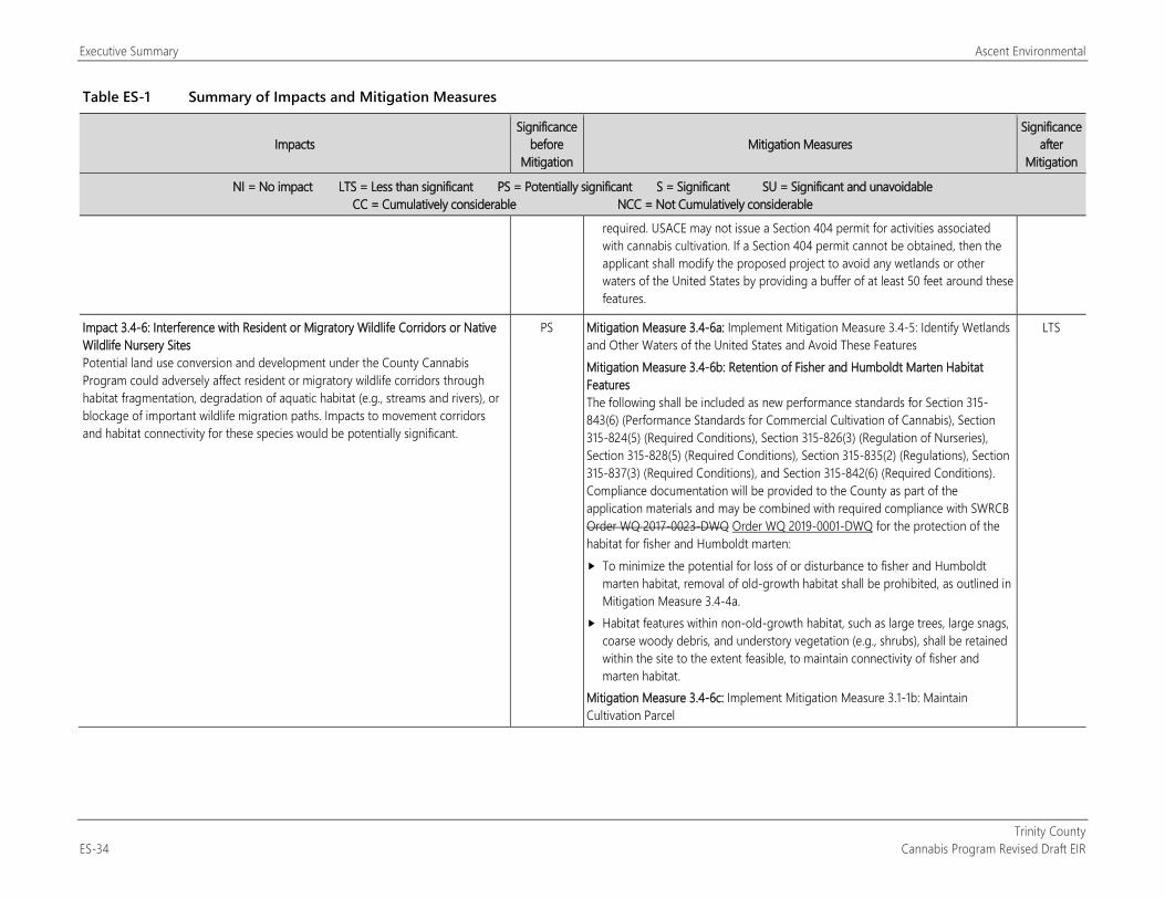
Executive Summary Ascent Environmental
Trinity County ES-34 Cannabis Program Revised Draft EIR
Table ES-1 Summary of Impacts and Mitigation Measures
Impacts Significance
before Mitigation
Mitigation Measures Significance
after Mitigation
NI = No impact LTS = Less than significant PS = Potentially significant S = Significant SU = Significant and unavoidable CC = Cumulatively considerable NCC = Not Cumulatively considerable
required. USACE may not issue a Section 404 permit for activities associated with cannabis cultivation. If a Section 404 permit cannot be obtained, then the applicant shall modify the proposed project to avoid any wetlands or other waters of the United States by providing a buffer of at least 50 feet around these features.
Impact 3.4-6: Interference with Resident or Migratory Wildlife Corridors or Native Wildlife Nursery Sites Potential land use conversion and development under the County Cannabis Program could adversely affect resident or migratory wildlife corridors through habitat fragmentation, degradation of aquatic habitat (e.g., streams and rivers), or blockage of important wildlife migration paths. Impacts to movement corridors and habitat connectivity for these species would be potentially significant.
PS Mitigation Measure 3.4-6a: Implement Mitigation Measure 3.4-5: Identify Wetlands and Other Waters of the United States and Avoid These Features Mitigation Measure 3.4-6b: Retention of Fisher and Humboldt Marten Habitat Features The following shall be included as new performance standards for Section 315-843(6) (Performance Standards for Commercial Cultivation of Cannabis), Section 315-824(5) (Required Conditions), Section 315-826(3) (Regulation of Nurseries), Section 315-828(5) (Required Conditions), Section 315-835(2) (Regulations), Section 315-837(3) (Required Conditions), and Section 315-842(6) (Required Conditions). Compliance documentation will be provided to the County as part of the application materials and may be combined with required compliance with SWRCB Order WQ 2017-0023-DWQ Order WQ 2019-0001-DWQ for the protection of the habitat for fisher and Humboldt marten: To minimize the potential for loss of or disturbance to fisher and Humboldt
marten habitat, removal of old-growth habitat shall be prohibited, as outlined in Mitigation Measure 3.4-4a.
Habitat features within non-old-growth habitat, such as large trees, large snags, coarse woody debris, and understory vegetation (e.g., shrubs), shall be retained within the site to the extent feasible, to maintain connectivity of fisher and marten habitat.
Mitigation Measure 3.4-6c: Implement Mitigation Measure 3.1-1b: Maintain Cultivation Parcel
LTS
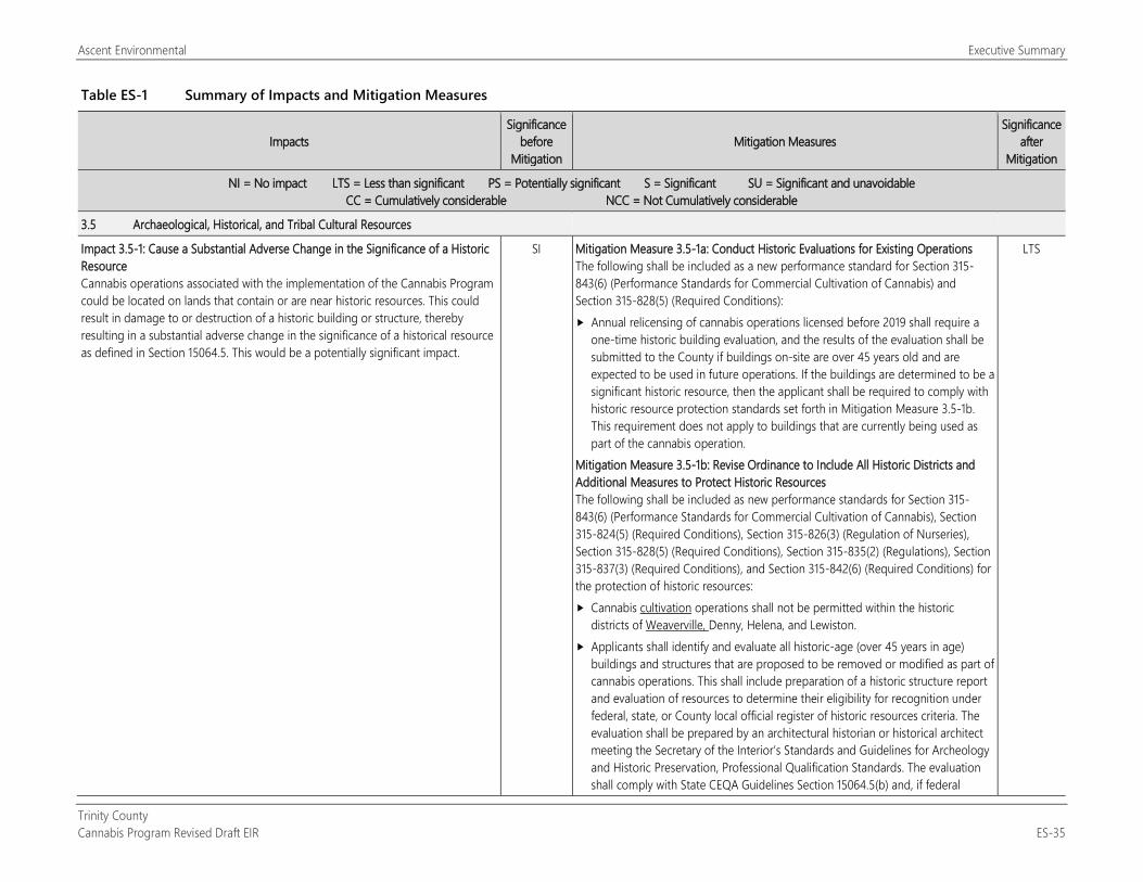
Ascent Environmental Executive Summary
Trinity County Cannabis Program Revised Draft EIR ES-35
Table ES-1 Summary of Impacts and Mitigation Measures
Impacts Significance
before Mitigation
Mitigation Measures Significance
after Mitigation
NI = No impact LTS = Less than significant PS = Potentially significant S = Significant SU = Significant and unavoidable CC = Cumulatively considerable NCC = Not Cumulatively considerable
3.5 Archaeological, Historical, and Tribal Cultural Resources
Impact 3.5-1: Cause a Substantial Adverse Change in the Significance of a Historic Resource Cannabis operations associated with the implementation of the Cannabis Program could be located on lands that contain or are near historic resources. This could result in damage to or destruction of a historic building or structure, thereby resulting in a substantial adverse change in the significance of a historical resource as defined in Section 15064.5. This would be a potentially significant impact.
SI Mitigation Measure 3.5-1a: Conduct Historic Evaluations for Existing Operations The following shall be included as a new performance standard for Section 315-843(6) (Performance Standards for Commercial Cultivation of Cannabis) and Section 315-828(5) (Required Conditions): Annual relicensing of cannabis operations licensed before 2019 shall require a
one-time historic building evaluation, and the results of the evaluation shall be submitted to the County if buildings on-site are over 45 years old and are expected to be used in future operations. If the buildings are determined to be a significant historic resource, then the applicant shall be required to comply with historic resource protection standards set forth in Mitigation Measure 3.5-1b. This requirement does not apply to buildings that are currently being used as part of the cannabis operation.
Mitigation Measure 3.5-1b: Revise Ordinance to Include All Historic Districts and Additional Measures to Protect Historic Resources The following shall be included as new performance standards for Section 315-843(6) (Performance Standards for Commercial Cultivation of Cannabis), Section 315-824(5) (Required Conditions), Section 315-826(3) (Regulation of Nurseries), Section 315-828(5) (Required Conditions), Section 315-835(2) (Regulations), Section 315-837(3) (Required Conditions), and Section 315-842(6) (Required Conditions) for the protection of historic resources: Cannabis cultivation operations shall not be permitted within the historic
districts of Weaverville, Denny, Helena, and Lewiston. Applicants shall identify and evaluate all historic-age (over 45 years in age)
buildings and structures that are proposed to be removed or modified as part of cannabis operations. This shall include preparation of a historic structure report and evaluation of resources to determine their eligibility for recognition under federal, state, or County local official register of historic resources criteria. The evaluation shall be prepared by an architectural historian or historical architect meeting the Secretary of the Interior’s Standards and Guidelines for Archeology and Historic Preservation, Professional Qualification Standards. The evaluation shall comply with State CEQA Guidelines Section 15064.5(b) and, if federal
LTS
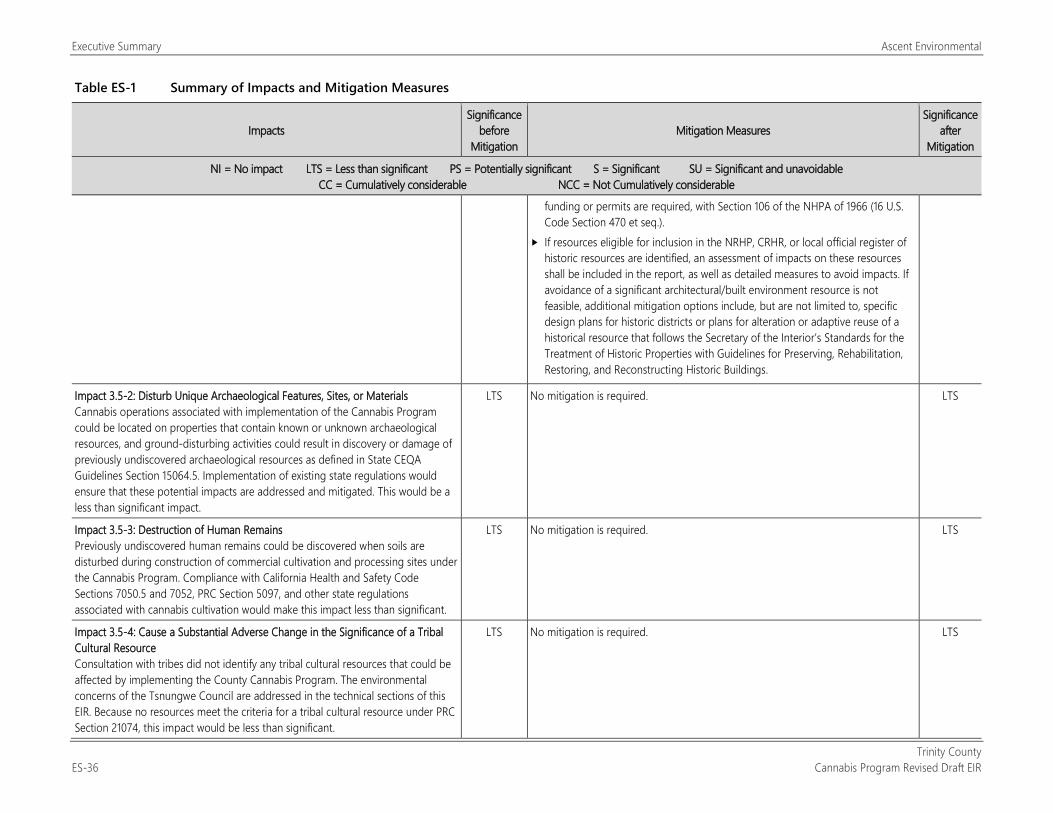
Executive Summary Ascent Environmental
Trinity County ES-36 Cannabis Program Revised Draft EIR
Table ES-1 Summary of Impacts and Mitigation Measures
Impacts Significance
before Mitigation
Mitigation Measures Significance
after Mitigation
NI = No impact LTS = Less than significant PS = Potentially significant S = Significant SU = Significant and unavoidable CC = Cumulatively considerable NCC = Not Cumulatively considerable
funding or permits are required, with Section 106 of the NHPA of 1966 (16 U.S. Code Section 470 et seq.).
If resources eligible for inclusion in the NRHP, CRHR, or local official register of historic resources are identified, an assessment of impacts on these resources shall be included in the report, as well as detailed measures to avoid impacts. If avoidance of a significant architectural/built environment resource is not feasible, additional mitigation options include, but are not limited to, specific design plans for historic districts or plans for alteration or adaptive reuse of a historical resource that follows the Secretary of the Interior’s Standards for the Treatment of Historic Properties with Guidelines for Preserving, Rehabilitation, Restoring, and Reconstructing Historic Buildings.
Impact 3.5-2: Disturb Unique Archaeological Features, Sites, or Materials Cannabis operations associated with implementation of the Cannabis Program could be located on properties that contain known or unknown archaeological resources, and ground-disturbing activities could result in discovery or damage of previously undiscovered archaeological resources as defined in State CEQA Guidelines Section 15064.5. Implementation of existing state regulations would ensure that these potential impacts are addressed and mitigated. This would be a less than significant impact.
LTS No mitigation is required. LTS
Impact 3.5-3: Destruction of Human Remains Previously undiscovered human remains could be discovered when soils are disturbed during construction of commercial cultivation and processing sites under the Cannabis Program. Compliance with California Health and Safety Code Sections 7050.5 and 7052, PRC Section 5097, and other state regulations associated with cannabis cultivation would make this impact less than significant.
LTS No mitigation is required. LTS
Impact 3.5-4: Cause a Substantial Adverse Change in the Significance of a Tribal Cultural Resource Consultation with tribes did not identify any tribal cultural resources that could be affected by implementing the County Cannabis Program. The environmental concerns of the Tsnungwe Council are addressed in the technical sections of this EIR. Because no resources meet the criteria for a tribal cultural resource under PRC Section 21074, this impact would be less than significant.
LTS No mitigation is required. LTS
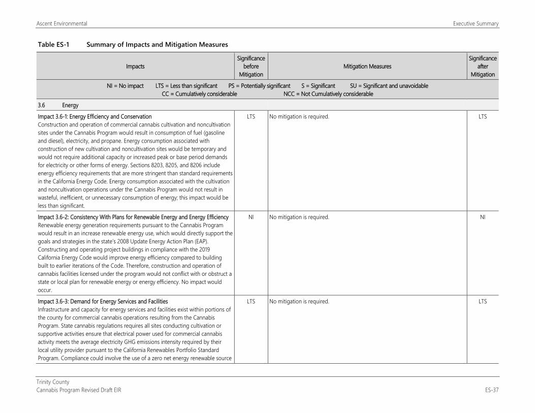
Ascent Environmental Executive Summary
Trinity County Cannabis Program Revised Draft EIR ES-37
Table ES-1 Summary of Impacts and Mitigation Measures
Impacts Significance
before Mitigation
Mitigation Measures Significance
after Mitigation
NI = No impact LTS = Less than significant PS = Potentially significant S = Significant SU = Significant and unavoidable CC = Cumulatively considerable NCC = Not Cumulatively considerable
3.6 Energy
Impact 3.6-1: Energy Efficiency and Conservation Construction and operation of commercial cannabis cultivation and noncultivation sites under the Cannabis Program would result in consumption of fuel (gasoline and diesel), electricity, and propane. Energy consumption associated with construction of new cultivation and noncultivation sites would be temporary and would not require additional capacity or increased peak or base period demands for electricity or other forms of energy. Sections 8203, 8205, and 8206 include energy efficiency requirements that are more stringent than standard requirements in the California Energy Code. Energy consumption associated with the cultivation and noncultivation operations under the Cannabis Program would not result in wasteful, inefficient, or unnecessary consumption of energy; this impact would be less than significant.
LTS No mitigation is required. LTS
Impact 3.6-2: Consistency With Plans for Renewable Energy and Energy Efficiency Renewable energy generation requirements pursuant to the Cannabis Program would result in an increase renewable energy use, which would directly support the goals and strategies in the state’s 2008 Update Energy Action Plan (EAP). Constructing and operating project buildings in compliance with the 2019 California Energy Code would improve energy efficiency compared to building built to earlier iterations of the Code. Therefore, construction and operation of cannabis facilities licensed under the program would not conflict with or obstruct a state or local plan for renewable energy or energy efficiency. No impact would occur.
NI No mitigation is required. NI
Impact 3.6-3: Demand for Energy Services and Facilities Infrastructure and capacity for energy services and facilities exist within portions of the county for commercial cannabis operations resulting from the Cannabis Program. State cannabis regulations requires all sites conducting cultivation or supportive activities ensure that electrical power used for commercial cannabis activity meets the average electricity GHG emissions intensity required by their local utility provider pursuant to the California Renewables Portfolio Standard Program. Compliance could involve the use of a zero net energy renewable source
LTS No mitigation is required. LTS
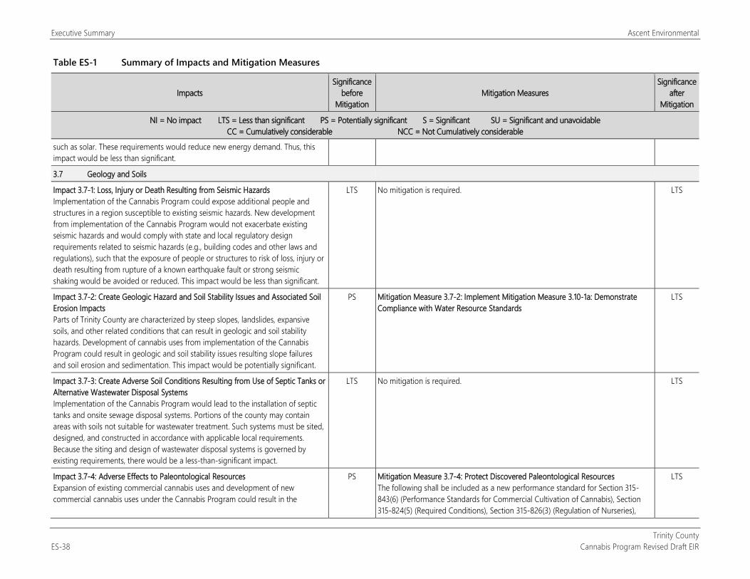
Executive Summary Ascent Environmental
Trinity County ES-38 Cannabis Program Revised Draft EIR
Table ES-1 Summary of Impacts and Mitigation Measures
Impacts Significance
before Mitigation
Mitigation Measures Significance
after Mitigation
NI = No impact LTS = Less than significant PS = Potentially significant S = Significant SU = Significant and unavoidable CC = Cumulatively considerable NCC = Not Cumulatively considerable
such as solar. These requirements would reduce new energy demand. Thus, this impact would be less than significant.
3.7 Geology and Soils
Impact 3.7-1: Loss, Injury or Death Resulting from Seismic Hazards Implementation of the Cannabis Program could expose additional people and structures in a region susceptible to existing seismic hazards. New development from implementation of the Cannabis Program would not exacerbate existing seismic hazards and would comply with state and local regulatory design requirements related to seismic hazards (e.g., building codes and other laws and regulations), such that the exposure of people or structures to risk of loss, injury or death resulting from rupture of a known earthquake fault or strong seismic shaking would be avoided or reduced. This impact would be less than significant.
LTS No mitigation is required. LTS
Impact 3.7-2: Create Geologic Hazard and Soil Stability Issues and Associated Soil Erosion Impacts Parts of Trinity County are characterized by steep slopes, landslides, expansive soils, and other related conditions that can result in geologic and soil stability hazards. Development of cannabis uses from implementation of the Cannabis Program could result in geologic and soil stability issues resulting slope failures and soil erosion and sedimentation. This impact would be potentially significant.
PS Mitigation Measure 3.7-2: Implement Mitigation Measure 3.10-1a: Demonstrate Compliance with Water Resource Standards
LTS
Impact 3.7-3: Create Adverse Soil Conditions Resulting from Use of Septic Tanks or Alternative Wastewater Disposal Systems Implementation of the Cannabis Program would lead to the installation of septic tanks and onsite sewage disposal systems. Portions of the county may contain areas with soils not suitable for wastewater treatment. Such systems must be sited, designed, and constructed in accordance with applicable local requirements. Because the siting and design of wastewater disposal systems is governed by existing requirements, there would be a less-than-significant impact.
LTS No mitigation is required. LTS
Impact 3.7-4: Adverse Effects to Paleontological Resources Expansion of existing commercial cannabis uses and development of new commercial cannabis uses under the Cannabis Program could result in the
PS Mitigation Measure 3.7-4: Protect Discovered Paleontological Resources The following shall be included as a new performance standard for Section 315-843(6) (Performance Standards for Commercial Cultivation of Cannabis), Section 315-824(5) (Required Conditions), Section 315-826(3) (Regulation of Nurseries),
LTS
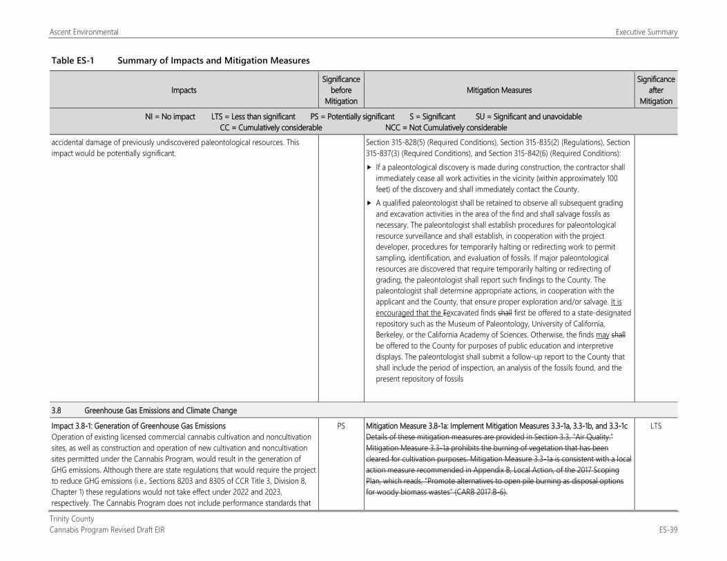
Ascent Environmental Executive Summary
Trinity County Cannabis Program Revised Draft EIR ES-39
Table ES-1 Summary of Impacts and Mitigation Measures
Impacts Significance
before Mitigation
Mitigation Measures Significance
after Mitigation
NI = No impact LTS = Less than significant PS = Potentially significant S = Significant SU = Significant and unavoidable CC = Cumulatively considerable NCC = Not Cumulatively considerable
accidental damage of previously undiscovered paleontological resources. This impact would be potentially significant.
Section 315-828(5) (Required Conditions), Section 315-835(2) (Regulations), Section 315-837(3) (Required Conditions), and Section 315-842(6) (Required Conditions): If a paleontological discovery is made during construction, the contractor shall
immediately cease all work activities in the vicinity (within approximately 100 feet) of the discovery and shall immediately contact the County.
A qualified paleontologist shall be retained to observe all subsequent grading and excavation activities in the area of the find and shall salvage fossils as necessary. The paleontologist shall establish procedures for paleontological resource surveillance and shall establish, in cooperation with the project developer, procedures for temporarily halting or redirecting work to permit sampling, identification, and evaluation of fossils. If major paleontological resources are discovered that require temporarily halting or redirecting of grading, the paleontologist shall report such findings to the County. The paleontologist shall determine appropriate actions, in cooperation with the applicant and the County, that ensure proper exploration and/or salvage. It is encouraged that the Eexcavated finds shall first be offered to a state-designated repository such as the Museum of Paleontology, University of California, Berkeley, or the California Academy of Sciences. Otherwise, the finds may shall be offered to the County for purposes of public education and interpretive displays. The paleontologist shall submit a follow-up report to the County that shall include the period of inspection, an analysis of the fossils found, and the present repository of fossils
3.8 Greenhouse Gas Emissions and Climate Change
Impact 3.8-1: Generation of Greenhouse Gas Emissions Operation of existing licensed commercial cannabis cultivation and noncultivation sites, as well as construction and operation of new cultivation and noncultivation sites permitted under the Cannabis Program, would result in the generation of GHG emissions. Although there are state regulations that would require the project to reduce GHG emissions (i.e., Sections 8203 and 8305 of CCR Title 3, Division 8, Chapter 1) these regulations would not take effect under 2022 and 2023, respectively. The Cannabis Program does not include performance standards that
PS Mitigation Measure 3.8-1a: Implement Mitigation Measures 3.3-1a, 3.3-1b, and 3.3-1c Details of these mitigation measures are provided in Section 3.3, “Air Quality.” Mitigation Measure 3.3-1a prohibits the burning of vegetation that has been cleared for cultivation purposes. Mitigation Measure 3.3-1a is consistent with a local action measure recommended in Appendix B, Local Action, of the 2017 Scoping Plan, which reads, “Promote alternatives to open pile burning as disposal options for woody biomass wastes” (CARB 2017:B-6).
LTS
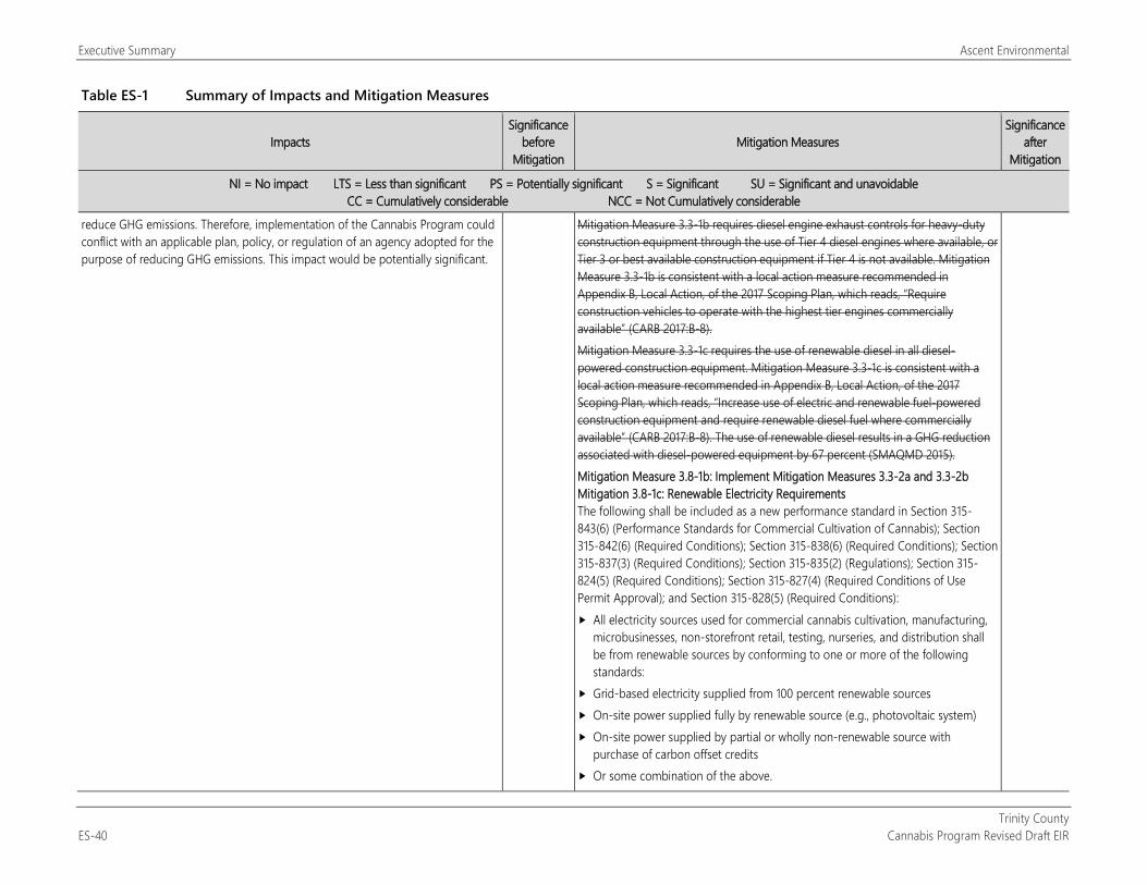
Executive Summary Ascent Environmental
Trinity County ES-40 Cannabis Program Revised Draft EIR
Table ES-1 Summary of Impacts and Mitigation Measures
Impacts Significance
before Mitigation
Mitigation Measures Significance
after Mitigation
NI = No impact LTS = Less than significant PS = Potentially significant S = Significant SU = Significant and unavoidable CC = Cumulatively considerable NCC = Not Cumulatively considerable
reduce GHG emissions. Therefore, implementation of the Cannabis Program could conflict with an applicable plan, policy, or regulation of an agency adopted for the purpose of reducing GHG emissions. This impact would be potentially significant.
Mitigation Measure 3.3-1b requires diesel engine exhaust controls for heavy-duty construction equipment through the use of Tier 4 diesel engines where available, or Tier 3 or best available construction equipment if Tier 4 is not available. Mitigation Measure 3.3-1b is consistent with a local action measure recommended in Appendix B, Local Action, of the 2017 Scoping Plan, which reads, “Require construction vehicles to operate with the highest tier engines commercially available” (CARB 2017:B-8). Mitigation Measure 3.3-1c requires the use of renewable diesel in all diesel-powered construction equipment. Mitigation Measure 3.3-1c is consistent with a local action measure recommended in Appendix B, Local Action, of the 2017 Scoping Plan, which reads, “Increase use of electric and renewable fuel-powered construction equipment and require renewable diesel fuel where commercially available” (CARB 2017:B-8). The use of renewable diesel results in a GHG reduction associated with diesel-powered equipment by 67 percent (SMAQMD 2015). Mitigation Measure 3.8-1b: Implement Mitigation Measures 3.3-2a and 3.3-2b Mitigation 3.8-1c: Renewable Electricity Requirements The following shall be included as a new performance standard in Section 315-843(6) (Performance Standards for Commercial Cultivation of Cannabis); Section 315-842(6) (Required Conditions); Section 315-838(6) (Required Conditions); Section 315-837(3) (Required Conditions); Section 315-835(2) (Regulations); Section 315-824(5) (Required Conditions); Section 315-827(4) (Required Conditions of Use Permit Approval); and Section 315-828(5) (Required Conditions): All electricity sources used for commercial cannabis cultivation, manufacturing,
microbusinesses, non-storefront retail, testing, nurseries, and distribution shall be from renewable sources by conforming to one or more of the following standards:
Grid-based electricity supplied from 100 percent renewable sources On-site power supplied fully by renewable source (e.g., photovoltaic system) On-site power supplied by partial or wholly non-renewable source with
purchase of carbon offset credits Or some combination of the above.
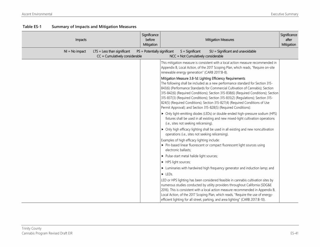
Ascent Environmental Executive Summary
Trinity County Cannabis Program Revised Draft EIR ES-41
Table ES-1 Summary of Impacts and Mitigation Measures
Impacts Significance
before Mitigation
Mitigation Measures Significance
after Mitigation
NI = No impact LTS = Less than significant PS = Potentially significant S = Significant SU = Significant and unavoidable CC = Cumulatively considerable NCC = Not Cumulatively considerable
This mitigation measure is consistent with a local action measure recommended in Appendix B, Local Action, of the 2017 Scoping Plan, which reads, “Require on-site renewable energy generation” (CARB 2017:B-8). Mitigation Measure 3.8-1d: Lighting Efficiency Requirements The following shall be included as a new performance standard for Section 315-843(6) (Performance Standards for Commercial Cultivation of Cannabis); Section 315-842(6) (Required Conditions); Section 315-838(6) (Required Conditions); Section 315-837(3) (Required Conditions); Section 315-835(2) (Regulations); Section 315-824(5) (Required Conditions); Section 315-827(4) (Required Conditions of Use Permit Approval); and Section 315-828(5) (Required Conditions): Only light-emitting diodes (LEDs) or double-ended high-pressure sodium (HPS)
fixtures shall be used in all existing and new mixed-light cultivation operations (i.e., sites not seeking relicensing).
Only high efficacy lighting shall be used in all existing and new noncultivation operations (i.e., sites not seeking relicensing).
Examples of high efficacy lighting include: Pin-based linear fluorescent or compact fluorescent light sources using
electronic ballasts; Pulse-start metal halide light sources; HPS light sources; Luminaries with hardwired high frequency generator and induction lamp; and LEDs. LED or HPS lighting has been considered feasible in cannabis cultivation sites by numerous studies conducted by utility providers throughout California (SDG&E 2016). This is consistent with a local action measure recommended in Appendix B, Local Action, of the 2017 Scoping Plan, which reads, “Require the use of energy-efficient lighting for all street, parking, and area lighting” (CARB 2017:B-10).
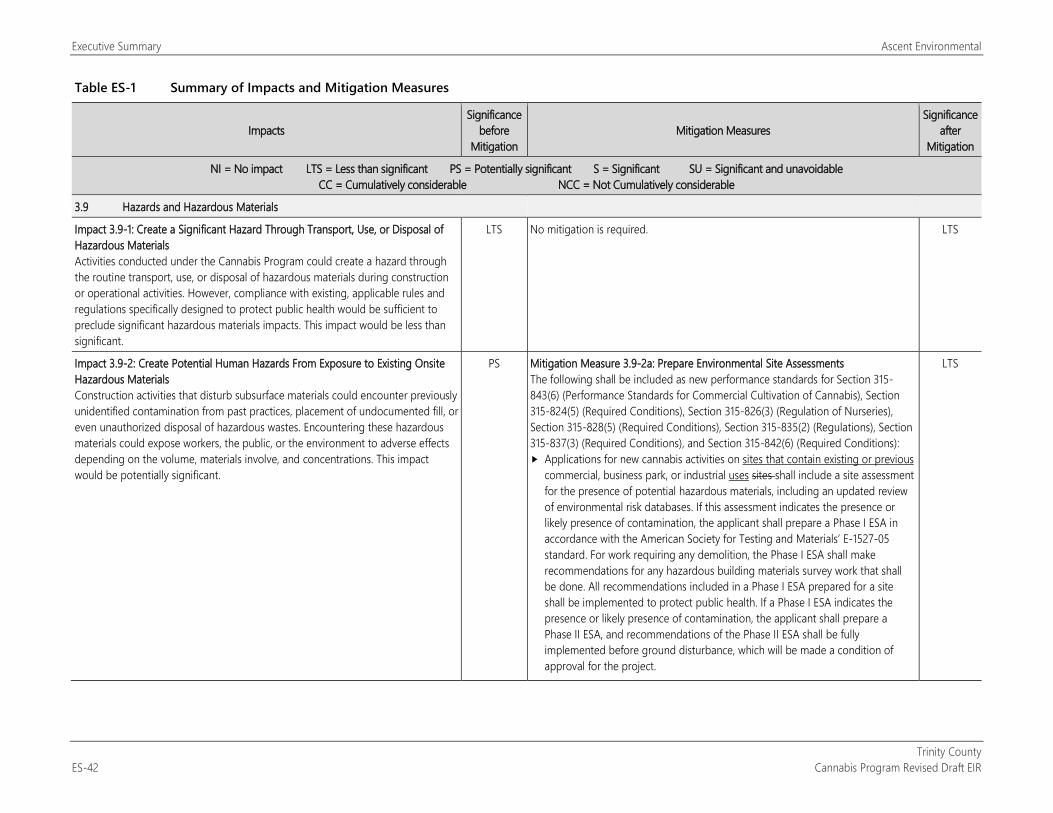
Executive Summary Ascent Environmental
Trinity County ES-42 Cannabis Program Revised Draft EIR
Table ES-1 Summary of Impacts and Mitigation Measures
Impacts Significance
before Mitigation
Mitigation Measures Significance
after Mitigation
NI = No impact LTS = Less than significant PS = Potentially significant S = Significant SU = Significant and unavoidable CC = Cumulatively considerable NCC = Not Cumulatively considerable
3.9 Hazards and Hazardous Materials
Impact 3.9-1: Create a Significant Hazard Through Transport, Use, or Disposal of Hazardous Materials Activities conducted under the Cannabis Program could create a hazard through the routine transport, use, or disposal of hazardous materials during construction or operational activities. However, compliance with existing, applicable rules and regulations specifically designed to protect public health would be sufficient to preclude significant hazardous materials impacts. This impact would be less than significant.
LTS No mitigation is required. LTS
Impact 3.9-2: Create Potential Human Hazards From Exposure to Existing Onsite Hazardous Materials Construction activities that disturb subsurface materials could encounter previously unidentified contamination from past practices, placement of undocumented fill, or even unauthorized disposal of hazardous wastes. Encountering these hazardous materials could expose workers, the public, or the environment to adverse effects depending on the volume, materials involve, and concentrations. This impact would be potentially significant.
PS Mitigation Measure 3.9-2a: Prepare Environmental Site Assessments The following shall be included as new performance standards for Section 315-843(6) (Performance Standards for Commercial Cultivation of Cannabis), Section 315-824(5) (Required Conditions), Section 315-826(3) (Regulation of Nurseries), Section 315-828(5) (Required Conditions), Section 315-835(2) (Regulations), Section 315-837(3) (Required Conditions), and Section 315-842(6) (Required Conditions): Applications for new cannabis activities on sites that contain existing or previous
commercial, business park, or industrial uses sites shall include a site assessment for the presence of potential hazardous materials, including an updated review of environmental risk databases. If this assessment indicates the presence or likely presence of contamination, the applicant shall prepare a Phase I ESA in accordance with the American Society for Testing and Materials’ E-1527-05 standard. For work requiring any demolition, the Phase I ESA shall make recommendations for any hazardous building materials survey work that shall be done. All recommendations included in a Phase I ESA prepared for a site shall be implemented to protect public health. If a Phase I ESA indicates the presence or likely presence of contamination, the applicant shall prepare a Phase II ESA, and recommendations of the Phase II ESA shall be fully implemented before ground disturbance, which will be made a condition of approval for the project.
LTS
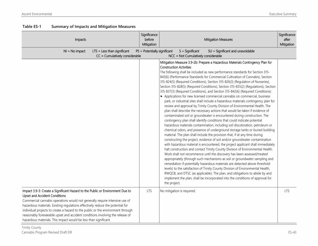
Ascent Environmental Executive Summary
Trinity County Cannabis Program Revised Draft EIR ES-43
Table ES-1 Summary of Impacts and Mitigation Measures
Impacts Significance
before Mitigation
Mitigation Measures Significance
after Mitigation
NI = No impact LTS = Less than significant PS = Potentially significant S = Significant SU = Significant and unavoidable CC = Cumulatively considerable NCC = Not Cumulatively considerable
Mitigation Measure 3.9-2b: Prepare a Hazardous Materials Contingency Plan for Construction Activities The following shall be included as new performance standards for Section 315-843(6) (Performance Standards for Commercial Cultivation of Cannabis), Section 315-824(5) (Required Conditions), Section 315-826(3) (Regulation of Nurseries), Section 315-828(5) (Required Conditions), Section 315-835(2) (Regulations), Section 315-837(3) (Required Conditions), and Section 315-842(6) (Required Conditions): Applications for new licensed commercial cannabis on commercial, business
park, or industrial sites shall include a hazardous materials contingency plan for review and approval by Trinity County Division of Environmental Health. The plan shall describe the necessary actions that would be taken if evidence of contaminated soil or groundwater is encountered during construction. The contingency plan shall identify conditions that could indicate potential hazardous materials contamination, including soil discoloration, petroleum or chemical odors, and presence of underground storage tanks or buried building material. The plan shall include the provision that, if at any time during constructing the project, evidence of soil and/or groundwater contamination with hazardous material is encountered, the project applicant shall immediately halt construction and contact Trinity County Division of Environmental Health. Work shall not recommence until the discovery has been assessed/treated appropriately (through such mechanisms as soil or groundwater sampling and remediation if potentially hazardous materials are detected above threshold levels) to the satisfaction of Trinity County Division of Environmental Health, RWQCB, and DTSC (as applicable). The plan, and obligations to abide by and implement the plan, shall be incorporated into the conditions of approval for the project.
Impact 3.9-3: Create a Significant Hazard to the Public or Environment Due to Upset and Accident Conditions Commercial cannabis operations would not generally require intensive use of hazardous materials. Existing regulations effectively reduce the potential for individual projects to create a hazard to the public or the environment through reasonably foreseeable upset and accident conditions involving the release of hazardous materials. This impact would be less than significant.
LTS No mitigation is required. LTS
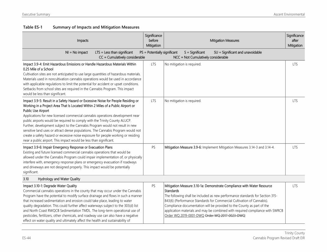
Executive Summary Ascent Environmental
Trinity County ES-44 Cannabis Program Revised Draft EIR
Table ES-1 Summary of Impacts and Mitigation Measures
Impacts Significance
before Mitigation
Mitigation Measures Significance
after Mitigation
NI = No impact LTS = Less than significant PS = Potentially significant S = Significant SU = Significant and unavoidable CC = Cumulatively considerable NCC = Not Cumulatively considerable
Impact 3.9-4: Emit Hazardous Emissions or Handle Hazardous Materials Within 0.25 Mile of a School Cultivation sites are not anticipated to use large quantities of hazardous materials. Materials used in noncultivation cannabis operations would be used in accordance with applicable regulations to limit the potential for accident or upset conditions. Setbacks from school sites are required in the Cannabis Program. This impact would be less than significant.
LTS No mitigation is required. LTS
Impact 3.9-5: Result in a Safety Hazard or Excessive Noise for People Residing or Working in a Project Area That Is Located Within 2 Miles of a Public Airport or Public Use Airport Applications for new licensed commercial cannabis operations development near public airports would be required to comply with the Trinity County ALUCP. Further, development subject to the Cannabis Program would not result in new sensitive land uses or attract dense populations. The Cannabis Program would not create a safety hazard or excessive noise exposure for people working or residing near a public airport. This impact would be less than significant.
LTS No mitigation is required. LTS
Impact 3.9-6: Impair Emergency Response or Evacuation Plans Existing and future licensed commercial cannabis operations that would be allowed under the Cannabis Program could impair implementation of, or physically interfere with, emergency response plans or emergency evacuation if roadways and driveways are not designed properly. This impact would be potentially significant.
PS Mitigation Measure 3.9-6: Implement Mitigation Measures 3.14-3 and 3.14-4. LTS
3.10 Hydrology and Water Quality
Impact 3.10-1: Degrade Water Quality Commercial cannabis operations in the county that may occur under the Cannabis Program have the potential to modify surface drainage and flows in such a manner that increased sedimentation and erosion could take place, leading to water quality degradation. This could further affect waterways subject to the 303(d) list and North Coast RWQCB Sedimentation TMDL. The long-term operational use of pesticides, fertilizers, other chemicals, and roadway use can also have a negative effect on water quality and ultimately affect the health and sustainability of
PS Mitigation Measure 3.10-1a: Demonstrate Compliance with Water Resource Standards The following shall be included as new performance standards for Section 315-843(6) (Performance Standards for Commercial Cultivation of Cannabis). Compliance documentation will be provided to the County as part of the application materials and may be combined with required compliance with SWRCB Order WQ 2019-0001-DWQ Order WQ 2017-0023-DWQ:
LTS
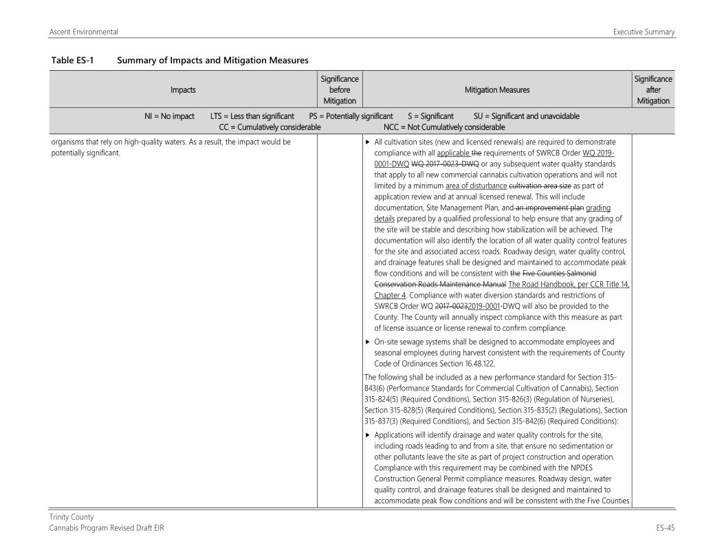
Ascent Environmental Executive Summary
Trinity County Cannabis Program Revised Draft EIR ES-45
Table ES-1 Summary of Impacts and Mitigation Measures
Impacts Significance
before Mitigation
Mitigation Measures Significance
after Mitigation
NI = No impact LTS = Less than significant PS = Potentially significant S = Significant SU = Significant and unavoidable CC = Cumulatively considerable NCC = Not Cumulatively considerable
organisms that rely on high-quality waters. As a result, the impact would be potentially significant.
All cultivation sites (new and licensed renewals) are required to demonstrate compliance with all applicable the requirements of SWRCB Order WQ 2019-0001-DWQ WQ 2017-0023-DWQ or any subsequent water quality standards that apply to all new commercial cannabis cultivation operations and will not limited by a minimum area of disturbance cultivation area size as part of application review and at annual licensed renewal. This will include documentation, Site Management Plan, and an improvement plan grading details prepared by a qualified professional to help ensure that any grading of the site will be stable and describing how stabilization will be achieved. The documentation will also identify the location of all water quality control features for the site and associated access roads. Roadway design, water quality control, and drainage features shall be designed and maintained to accommodate peak flow conditions and will be consistent with the Five Counties Salmonid Conservation Roads Maintenance Manual The Road Handbook, per CCR Title 14, Chapter 4. Compliance with water diversion standards and restrictions of SWRCB Order WQ 2017-00232019-0001-DWQ will also be provided to the County. The County will annually inspect compliance with this measure as part of license issuance or license renewal to confirm compliance.
On-site sewage systems shall be designed to accommodate employees and seasonal employees during harvest consistent with the requirements of County Code of Ordinances Section 16.48.122.
The following shall be included as a new performance standard for Section 315-843(6) (Performance Standards for Commercial Cultivation of Cannabis), Section 315-824(5) (Required Conditions), Section 315-826(3) (Regulation of Nurseries), Section 315-828(5) (Required Conditions), Section 315-835(2) (Regulations), Section 315-837(3) (Required Conditions), and Section 315-842(6) (Required Conditions): Applications will identify drainage and water quality controls for the site,
including roads leading to and from a site, that ensure no sedimentation or other pollutants leave the site as part of project construction and operation. Compliance with this requirement may be combined with the NPDES Construction General Permit compliance measures. Roadway design, water quality control, and drainage features shall be designed and maintained to accommodate peak flow conditions and will be consistent with the Five Counties
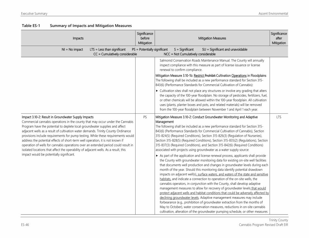
Executive Summary Ascent Environmental
Trinity County ES-46 Cannabis Program Revised Draft EIR
Table ES-1 Summary of Impacts and Mitigation Measures
Impacts Significance
before Mitigation
Mitigation Measures Significance
after Mitigation
NI = No impact LTS = Less than significant PS = Potentially significant S = Significant SU = Significant and unavoidable CC = Cumulatively considerable NCC = Not Cumulatively considerable
Salmonid Conservation Roads Maintenance Manual. The County will annually inspect compliance with this measure as part of license issuance or license renewal to confirm compliance.
Mitigation Measure 3.10-1b: Restrict Prohibit Cultivation Operations in Floodplains The following shall be included as a new performance standard for Section 315-843(6) (Performance Standards for Commercial Cultivation of Cannabis): Cultivation sites shall not place any structures or involve any grading that alters
the capacity of the 100-year floodplain. No storage of pesticides, fertilizers, fuel, or other chemicals will be allowed within the 100-year floodplain. All cultivation uses (plants, planter boxes and pots, and related materials) will be removed from the 100-year floodplain between November 1 and April 1 each year.
Impact 3.10-2: Result in Groundwater Supply Impacts Commercial cannabis operations in the county that may occur under the Cannabis Program have the potential to deplete local groundwater supplies and affect adjacent wells as a result of cultivation water demands. Trinity County Ordinance provisions include requirements for pump testing. While these requirements would address the potential effects of short-term well operation, it is not known if operation of wells for cannabis operations over an extended period could result in isolated locations that affect the operability of adjacent wells. As a result, this impact would be potentially significant.
PS Mitigation Measure 3.10-2: Conduct Groundwater Monitoring and Adaptive Management The following shall be included as a new performance standard for Section 315-843(6) (Performance Standards for Commercial Cultivation of Cannabis), Section 315-824(5) (Required Conditions), Section 315-826(3) (Regulation of Nurseries), Section 315-828(5) (Required Conditions), Section 315-835(2) (Regulations), Section 315-837(3) (Required Conditions), and Section 315-842(6) (Required Conditions) associated with projects using groundwater as a water supply source: As part of the application and license renewal process, applicants shall provide
the County with groundwater monitoring data for existing on-site well facilities that documents well production and changes in groundwater levels during each month of the year. Should this monitoring data identify potential drawdown impacts on adjacent well(s), surface waters, and waters of the state and sensitive habitats, and indicate a connection to operation of the on-site wells, the cannabis operators, in conjunction with the County, shall develop adaptive management measures to allow for recovery of groundwater levels that would protect adjacent wells and habitat conditions that could be adversely affected by declining groundwater levels. Adaptive management measures may include forbearance (e.g., prohibition of groundwater extraction from the months of May to October), water conservation measures, reductions in on-site cannabis cultivation, alteration of the groundwater pumping schedule, or other measures
LTS
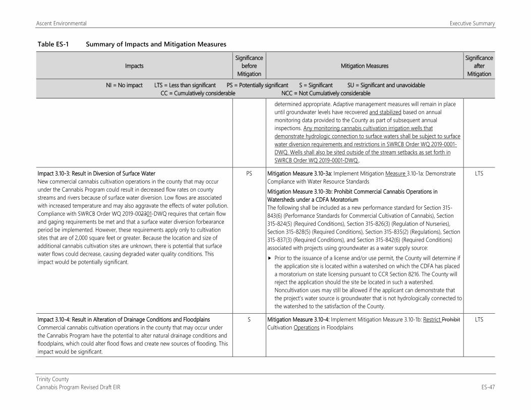
Ascent Environmental Executive Summary
Trinity County Cannabis Program Revised Draft EIR ES-47
Table ES-1 Summary of Impacts and Mitigation Measures
Impacts Significance
before Mitigation
Mitigation Measures Significance
after Mitigation
NI = No impact LTS = Less than significant PS = Potentially significant S = Significant SU = Significant and unavoidable CC = Cumulatively considerable NCC = Not Cumulatively considerable
determined appropriate. Adaptive management measures will remain in place until groundwater levels have recovered and stabilized based on annual monitoring data provided to the County as part of subsequent annual inspections. Any monitoring cannabis cultivation irrigation wells that demonstrate hydrologic connection to surface waters shall be subject to surface water diversion requirements and restrictions in SWRCB Order WQ 2019-0001-DWQ. Wells shall also be sited outside of the stream setbacks as set forth in SWRCB Order WQ 2019-0001-DWQ..
Impact 3.10-3: Result in Diversion of Surface Water New commercial cannabis cultivation operations in the county that may occur under the Cannabis Program could result in decreased flow rates on county streams and rivers because of surface water diversion. Low flows are associated with increased temperature and may also aggravate the effects of water pollution. Compliance with SWRCB Order WQ 2019-002301-DWQ requires that certain flow and gaging requirements be met and that a surface water diversion forbearance period be implemented. However, these requirements apply only to cultivation sites that are of 2,000 square feet or greater. Because the location and size of additional cannabis cultivation sites are unknown, there is potential that surface water flows could decrease, causing degraded water quality conditions. This impact would be potentially significant.
PS Mitigation Measure 3.10-3a: Implement Mitigation Measure 3.10-1a: Demonstrate Compliance with Water Resource Standards Mitigation Measure 3.10-3b: Prohibit Commercial Cannabis Operations in Watersheds under a CDFA Moratorium The following shall be included as a new performance standard for Section 315-843(6) (Performance Standards for Commercial Cultivation of Cannabis), Section 315-824(5) (Required Conditions), Section 315-826(3) (Regulation of Nurseries), Section 315-828(5) (Required Conditions), Section 315-835(2) (Regulations), Section 315-837(3) (Required Conditions), and Section 315-842(6) (Required Conditions) associated with projects using groundwater as a water supply source: Prior to the issuance of a license and/or use permit, the County will determine if
the application site is located within a watershed on which the CDFA has placed a moratorium on state licensing pursuant to CCR Section 8216. The County will reject the application should the site be located in such a watershed. Noncultivation uses may still be allowed if the applicant can demonstrate that the project’s water source is groundwater that is not hydrologically connected to the watershed to the satisfaction of the County.
LTS
Impact 3.10-4: Result in Alteration of Drainage Conditions and Floodplains Commercial cannabis cultivation operations in the county that may occur under the Cannabis Program have the potential to alter natural drainage conditions and floodplains, which could alter flood flows and create new sources of flooding. This impact would be significant.
S Mitigation Measure 3.10-4: Implement Mitigation Measure 3.10-1b: Restrict Prohibit Cultivation Operations in Floodplains
LTS
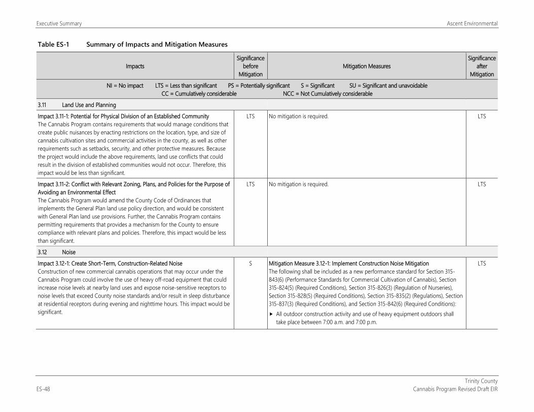
Executive Summary Ascent Environmental
Trinity County ES-48 Cannabis Program Revised Draft EIR
Table ES-1 Summary of Impacts and Mitigation Measures
Impacts Significance
before Mitigation
Mitigation Measures Significance
after Mitigation
NI = No impact LTS = Less than significant PS = Potentially significant S = Significant SU = Significant and unavoidable CC = Cumulatively considerable NCC = Not Cumulatively considerable
3.11 Land Use and Planning
Impact 3.11-1: Potential for Physical Division of an Established Community The Cannabis Program contains requirements that would manage conditions that create public nuisances by enacting restrictions on the location, type, and size of cannabis cultivation sites and commercial activities in the county, as well as other requirements such as setbacks, security, and other protective measures. Because the project would include the above requirements, land use conflicts that could result in the division of established communities would not occur. Therefore, this impact would be less than significant.
LTS No mitigation is required. LTS
Impact 3.11-2: Conflict with Relevant Zoning, Plans, and Policies for the Purpose of Avoiding an Environmental Effect The Cannabis Program would amend the County Code of Ordinances that implements the General Plan land use policy direction, and would be consistent with General Plan land use provisions. Further, the Cannabis Program contains permitting requirements that provides a mechanism for the County to ensure compliance with relevant plans and policies. Therefore, this impact would be less than significant.
LTS No mitigation is required. LTS
3.12 Noise
Impact 3.12-1: Create Short-Term, Construction-Related Noise Construction of new commercial cannabis operations that may occur under the Cannabis Program could involve the use of heavy off-road equipment that could increase noise levels at nearby land uses and expose noise-sensitive receptors to noise levels that exceed County noise standards and/or result in sleep disturbance at residential receptors during evening and nighttime hours. This impact would be significant.
S Mitigation Measure 3.12-1: Implement Construction Noise Mitigation The following shall be included as a new performance standard for Section 315-843(6) (Performance Standards for Commercial Cultivation of Cannabis), Section 315-824(5) (Required Conditions), Section 315-826(3) (Regulation of Nurseries), Section 315-828(5) (Required Conditions), Section 315-835(2) (Regulations), Section 315-837(3) (Required Conditions), and Section 315-842(6) (Required Conditions): All outdoor construction activity and use of heavy equipment outdoors shall
take place between 7:00 a.m. and 7:00 p.m.
LTS
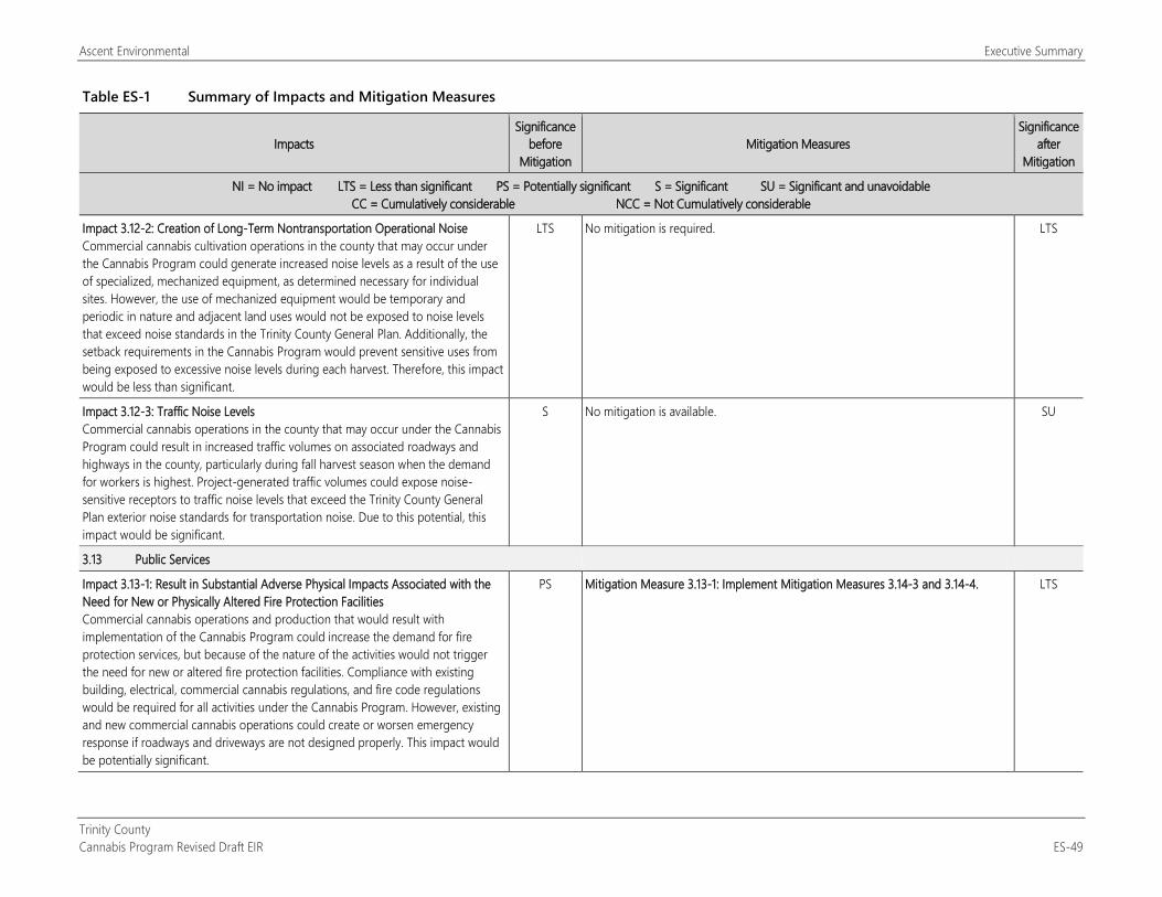
Ascent Environmental Executive Summary
Trinity County Cannabis Program Revised Draft EIR ES-49
Table ES-1 Summary of Impacts and Mitigation Measures
Impacts Significance
before Mitigation
Mitigation Measures Significance
after Mitigation
NI = No impact LTS = Less than significant PS = Potentially significant S = Significant SU = Significant and unavoidable CC = Cumulatively considerable NCC = Not Cumulatively considerable
Impact 3.12-2: Creation of Long-Term Nontransportation Operational Noise Commercial cannabis cultivation operations in the county that may occur under the Cannabis Program could generate increased noise levels as a result of the use of specialized, mechanized equipment, as determined necessary for individual sites. However, the use of mechanized equipment would be temporary and periodic in nature and adjacent land uses would not be exposed to noise levels that exceed noise standards in the Trinity County General Plan. Additionally, the setback requirements in the Cannabis Program would prevent sensitive uses from being exposed to excessive noise levels during each harvest. Therefore, this impact would be less than significant.
LTS No mitigation is required. LTS
Impact 3.12-3: Traffic Noise Levels Commercial cannabis operations in the county that may occur under the Cannabis Program could result in increased traffic volumes on associated roadways and highways in the county, particularly during fall harvest season when the demand for workers is highest. Project-generated traffic volumes could expose noise-sensitive receptors to traffic noise levels that exceed the Trinity County General Plan exterior noise standards for transportation noise. Due to this potential, this impact would be significant.
S No mitigation is available. SU
3.13 Public Services
Impact 3.13-1: Result in Substantial Adverse Physical Impacts Associated with the Need for New or Physically Altered Fire Protection Facilities Commercial cannabis operations and production that would result with implementation of the Cannabis Program could increase the demand for fire protection services, but because of the nature of the activities would not trigger the need for new or altered fire protection facilities. Compliance with existing building, electrical, commercial cannabis regulations, and fire code regulations would be required for all activities under the Cannabis Program. However, existing and new commercial cannabis operations could create or worsen emergency response if roadways and driveways are not designed properly. This impact would be potentially significant.
PS Mitigation Measure 3.13-1: Implement Mitigation Measures 3.14-3 and 3.14-4. LTS
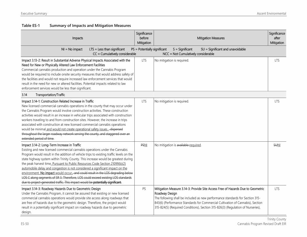
Executive Summary Ascent Environmental
Trinity County ES-50 Cannabis Program Revised Draft EIR
Table ES-1 Summary of Impacts and Mitigation Measures
Impacts Significance
before Mitigation
Mitigation Measures Significance
after Mitigation
NI = No impact LTS = Less than significant PS = Potentially significant S = Significant SU = Significant and unavoidable CC = Cumulatively considerable NCC = Not Cumulatively considerable
Impact 3.13-2: Result in Substantial Adverse Physical Impacts Associated with the Need for New or Physically Altered Law Enforcement Facilities Commercial cannabis production and operation under the Cannabis Program would be required to include onsite security measures that would address safety of the facilities and would not require increased law enforcement services that would result in the need for new or altered facilities. Potential impacts related to law enforcement services would be less than significant.
LTS No mitigation is required. LTS
3.14 Transportation/Traffic
Impact 3.14-1: Construction Related Increase in Traffic New licensed commercial cannabis operations in the county that may occur under the Cannabis Program would involve construction activities. These construction activities would result in an increase in vehicular trips associated with construction workers traveling to and from construction sites. However, the increase in trips associated with construction at new licensed commercial cannabis operations would be minimal and would not create operational safety issues. , dispersed throughout the larger roadway network serving the county, and staggered over an extended period of time.
LTS No mitigation is required. LTS
Impact 3.14-2: Long-Term Increase in Traffic Existing and new licensed commercial cannabis operations under the Cannabis Program would result in the addition of vehicle trips to existing traffic levels on the state highway system within Trinity County. This increase would be greatest during the peak harvest time. Pursuant to Public Resources Code Section 21099(b)(2) automobile delay and congestion is not considered a significant impact on the environment. No impact would occur., and could result in the LOS degrading below LOS C along segments of SR 3. Therefore, LOS could exceed existing LOS standards due to project-generated traffic. This impact would be potentially significant.
PSNI No mitigation is available required. SUNI
Impact 3.14-3: Roadway Hazards Due to Geometric Design Under the Cannabis Program, it cannot be assured that existing or new licensed commercial cannabis operations would provide site access along roadways that are free of hazards due to the geometric design. Therefore, the project would result in a potentially significant impact on roadway hazards due to geometric design.
PS Mitigation Measure 3.14-3: Provide Site Access Free of Hazards Due to Geometric Roadway Design The following shall be included as new performance standards for Section 315-843(6) (Performance Standards for Commercial Cultivation of Cannabis), Section 315-824(5) (Required Conditions), Section 315-826(3) (Regulation of Nurseries),
LTS
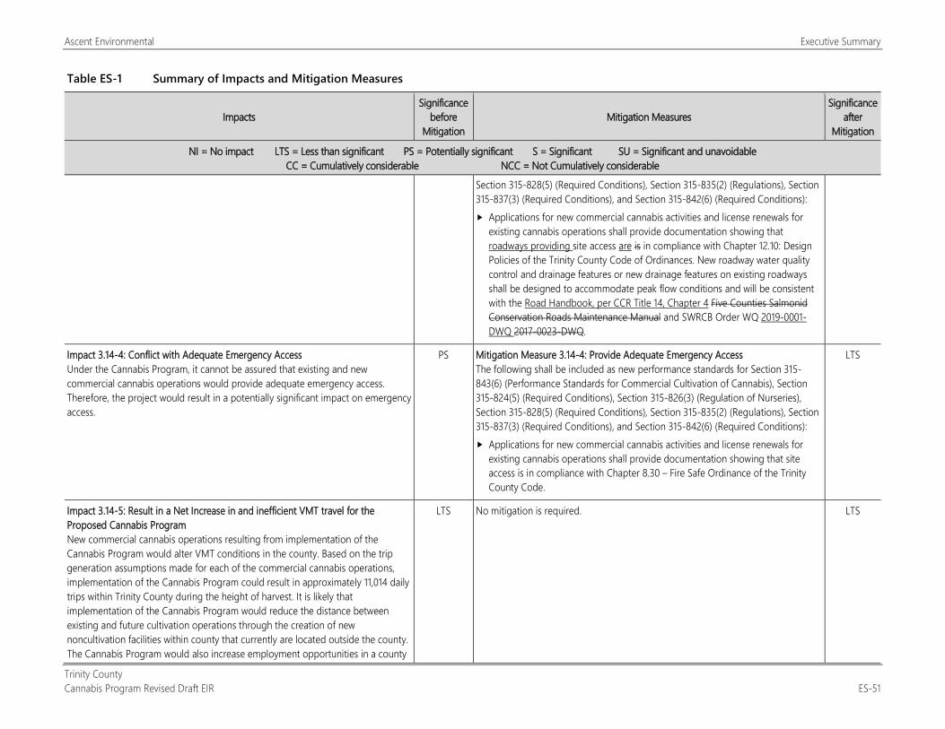
Ascent Environmental Executive Summary
Trinity County Cannabis Program Revised Draft EIR ES-51
Table ES-1 Summary of Impacts and Mitigation Measures
Impacts Significance
before Mitigation
Mitigation Measures Significance
after Mitigation
NI = No impact LTS = Less than significant PS = Potentially significant S = Significant SU = Significant and unavoidable CC = Cumulatively considerable NCC = Not Cumulatively considerable
Section 315-828(5) (Required Conditions), Section 315-835(2) (Regulations), Section 315-837(3) (Required Conditions), and Section 315-842(6) (Required Conditions): Applications for new commercial cannabis activities and license renewals for
existing cannabis operations shall provide documentation showing that roadways providing site access are is in compliance with Chapter 12.10: Design Policies of the Trinity County Code of Ordinances. New roadway water quality control and drainage features or new drainage features on existing roadways shall be designed to accommodate peak flow conditions and will be consistent with the Road Handbook, per CCR Title 14, Chapter 4 Five Counties Salmonid Conservation Roads Maintenance Manual and SWRCB Order WQ 2019-0001-DWQ 2017-0023-DWQ.
Impact 3.14-4: Conflict with Adequate Emergency Access Under the Cannabis Program, it cannot be assured that existing and new commercial cannabis operations would provide adequate emergency access. Therefore, the project would result in a potentially significant impact on emergency access.
PS Mitigation Measure 3.14-4: Provide Adequate Emergency Access The following shall be included as new performance standards for Section 315-843(6) (Performance Standards for Commercial Cultivation of Cannabis), Section 315-824(5) (Required Conditions), Section 315-826(3) (Regulation of Nurseries), Section 315-828(5) (Required Conditions), Section 315-835(2) (Regulations), Section 315-837(3) (Required Conditions), and Section 315-842(6) (Required Conditions): Applications for new commercial cannabis activities and license renewals for
existing cannabis operations shall provide documentation showing that site access is in compliance with Chapter 8.30 – Fire Safe Ordinance of the Trinity County Code.
LTS
Impact 3.14-5: Result in a Net Increase in and inefficient VMT travel for the Proposed Cannabis Program New commercial cannabis operations resulting from implementation of the Cannabis Program would alter VMT conditions in the county. Based on the trip generation assumptions made for each of the commercial cannabis operations, implementation of the Cannabis Program could result in approximately 11,014 daily trips within Trinity County during the height of harvest. It is likely that implementation of the Cannabis Program would reduce the distance between existing and future cultivation operations through the creation of new noncultivation facilities within county that currently are located outside the county. The Cannabis Program would also increase employment opportunities in a county
LTS No mitigation is required. LTS
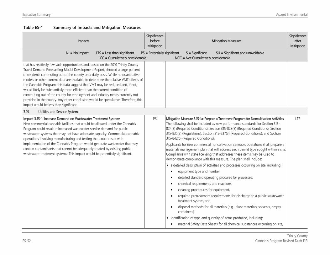
Executive Summary Ascent Environmental
Trinity County ES-52 Cannabis Program Revised Draft EIR
Table ES-1 Summary of Impacts and Mitigation Measures
Impacts Significance
before Mitigation
Mitigation Measures Significance
after Mitigation
NI = No impact LTS = Less than significant PS = Potentially significant S = Significant SU = Significant and unavoidable CC = Cumulatively considerable NCC = Not Cumulatively considerable
that has relatively few such opportunities and, based on the 2010 Trinity County Travel Demand Forecasting Model Development Report, showed a large percent of residents commuting out of the county on a daily basis. While no quantitative models or other current data are available to determine the relative VMT effects of the Cannabis Program, this data suggest that VMT may be reduced and, if not, would likely be substantially more efficient than the current condition of commuting out of the county for employment and industry needs currently not provided in the county. Any other conclusion would be speculative. Therefore, this impact would be less than significant.
3.15 Utilities and Service Systems
Impact 3.15-1: Increase Demand on Wastewater Treatment Systems New commercial cannabis facilities that would be allowed under the Cannabis Program could result in increased wastewater service demand for public wastewater systems that may not have adequate capacity. Commercial cannabis operations involving manufacturing and testing that could result with implementation of the Cannabis Program would generate wastewater that may contain contaminants that cannot be adequately treated by existing public wastewater treatment systems. This impact would be potentially significant.
PS Mitigation Measure 3.15-1a: Prepare a Treatment Program for Noncultivation Activities The following shall be included as new performance standards for Section 315-824(5) (Required Conditions), Section 315-828(5) (Required Conditions), Section 315-835(2) (Regulations), Section 315-837(3) (Required Conditions), and Section 315-842(6) (Required Conditions): Applicants for new commercial noncultivation cannabis operations shall prepare a materials management plan that will address each permit type sought within a site. Compliance with state licensing that addresses these items may be used to demonstrate compliance with this measure. The plan shall include: a detailed description of activities and processes occurring on site, including:
equipment type and number, detailed standard operating procures for processes, chemical requirements and reactions, cleaning procedures for equipment, required pretreatment requirements for discharge to a public wastewater
treatment system, and disposal methods for all materials (e.g., plant materials, solvents, empty
containers). Identification of type and quantity of items produced, including:
material Safety Data Sheets for all chemical substances occurring on site,
LTS
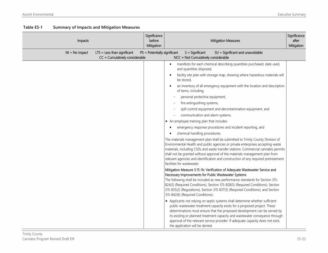
Ascent Environmental Executive Summary
Trinity County Cannabis Program Revised Draft EIR ES-53
Table ES-1 Summary of Impacts and Mitigation Measures
Impacts Significance
before Mitigation
Mitigation Measures Significance
after Mitigation
NI = No impact LTS = Less than significant PS = Potentially significant S = Significant SU = Significant and unavoidable CC = Cumulatively considerable NCC = Not Cumulatively considerable
manifests for each chemical describing quantities purchased, date used, and quantities disposed,
facility site plan with storage map, showing where hazardous materials will be stored,
an inventory of all emergency equipment with the location and description of items, including:
personal protective equipment, fire extinguishing systems, spill control equipment and decontamination equipment, and communication and alarm systems.
An employee training plan that includes: emergency response procedures and incident reporting, and chemical handling procedures.
The materials management plan shall be submitted to Trinity County Division of Environmental Health and public agencies or private enterprises accepting waste materials, including CSDs and waste transfer stations. Commercial cannabis permits shall not be granted without approval of the materials management plan from relevant agencies and identification and construction of any required pretreatment facilities for wastewater. Mitigation Measure 3.15-1b: Verification of Adequate Wastewater Service and Necessary Improvements for Public Wastewater Systems The following shall be included as new performance standards for Section 315-824(5) (Required Conditions), Section 315-828(5) (Required Conditions), Section 315-835(2) (Regulations), Section 315-837(3) (Required Conditions), and Section 315-842(6) (Required Conditions): Applicants not relying on septic systems shall determine whether sufficient
public wastewater treatment capacity exists for a proposed project. These determinations must ensure that the proposed development can be served by its existing or planned treatment capacity and wastewater conveyance through approval of the relevant service provider. If adequate capacity does not exist, the application will be denied.
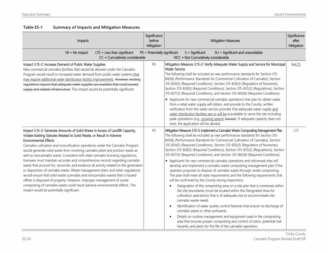
Executive Summary Ascent Environmental
Trinity County ES-54 Cannabis Program Revised Draft EIR
Table ES-1 Summary of Impacts and Mitigation Measures
Impacts Significance
before Mitigation
Mitigation Measures Significance
after Mitigation
NI = No impact LTS = Less than significant PS = Potentially significant S = Significant SU = Significant and unavoidable CC = Cumulatively considerable NCC = Not Cumulatively considerable
Impact 3.15-2: Increase Demand of Public Water Supplies New commercial cannabis facilities that would be allowed under the Cannabis Program would result in increased water demand from public water systems that may require additional water distribution facility improvements. However, existing regulations require that adequate water supplies are available that could exceed supply and related infrastructure. This impact would be potentially significant.
PS Mitigation Measure 3.15-2: Verify Adequate Water Supply and Service for Municipal Water Service The following shall be included as new performance standards for Section 315-843(6) (Performance Standards for Commercial Cultivation of Cannabis), Section 315-824(5) (Required Conditions), Section 315-826(3) (Regulation of Nurseries), Section 315-828(5) (Required Conditions), Section 315-835(2) (Regulations), Section 315-837(3) (Required Conditions), and Section 315-842(6) (Required Conditions): Applicants for new commercial cannabis operations that plan to obtain water
from a retail water supply will obtain, and provide to the County, written verification from the water service provider that adequate water supply and water distribution facilities are or will be is available to serve the site including peak operations (e.g., growing season harvest). If adequate capacity does not exist, the application will be denied.
SULTS
Impact 3.15-3: Generate Amounts of Solid Waste in Excess of Landfill Capacity, Violate Existing Statutes Related to Solid Waste, or Result in Adverse Environmental Effects Cannabis cultivation and noncultivation operations under the Cannabis Program would generate solid waste from involving cannabis plant and product waste as well as noncannabis waste. Consistent with state cannabis licensing regulations, licensees must maintain accurate and comprehensive records regarding cannabis waste that account for, reconcile, and evidence all activity related to the generation or disposition of cannabis waste. Waste management plans and other regulations would ensure that solid waste (cannabis and noncannabis waste) that is hauled offsite is disposed of properly. However, improper management of onsite composting of cannabis waste could result adverse environmental effects. This impact would be potentially significant.
PS Mitigation Measure 3.15-3: Implement a Cannabis Waste Composting Management Plan The following shall be included as new performance standards for Section 315-843(6) (Performance Standards for Commercial Cultivation of Cannabis), Section 315-824(5) (Required Conditions), Section 315-826(3) (Regulation of Nurseries), Section 315-828(5) (Required Conditions), Section 315-835(2) (Regulations), Section 315-837(3) (Required Conditions), and Section 315-842(6) (Required Conditions): Applicants for new commercial cannabis operations and relicensed sites will
develop and implement a cannabis waste composting management plan if the operator proposes to dispose of cannabis waste through onsite composting. The plan shall meet all state requirements and the following requirements that will be confirmed by the County during inspections. Designation of the composting area on a site plan that is contained within
the site boundaries (must be located within the Designated Area for cultivation operations) that is of adequate size to accommodate site cannabis waste needs.
Identification of water quality control features that ensure no discharge of cannabis waste or other pollutants.
Details on routine management and equipment used in the composting area that ensures proper composting and control of odors, potential fuel hazards, and pests for the life of the cannabis operation.
LTS
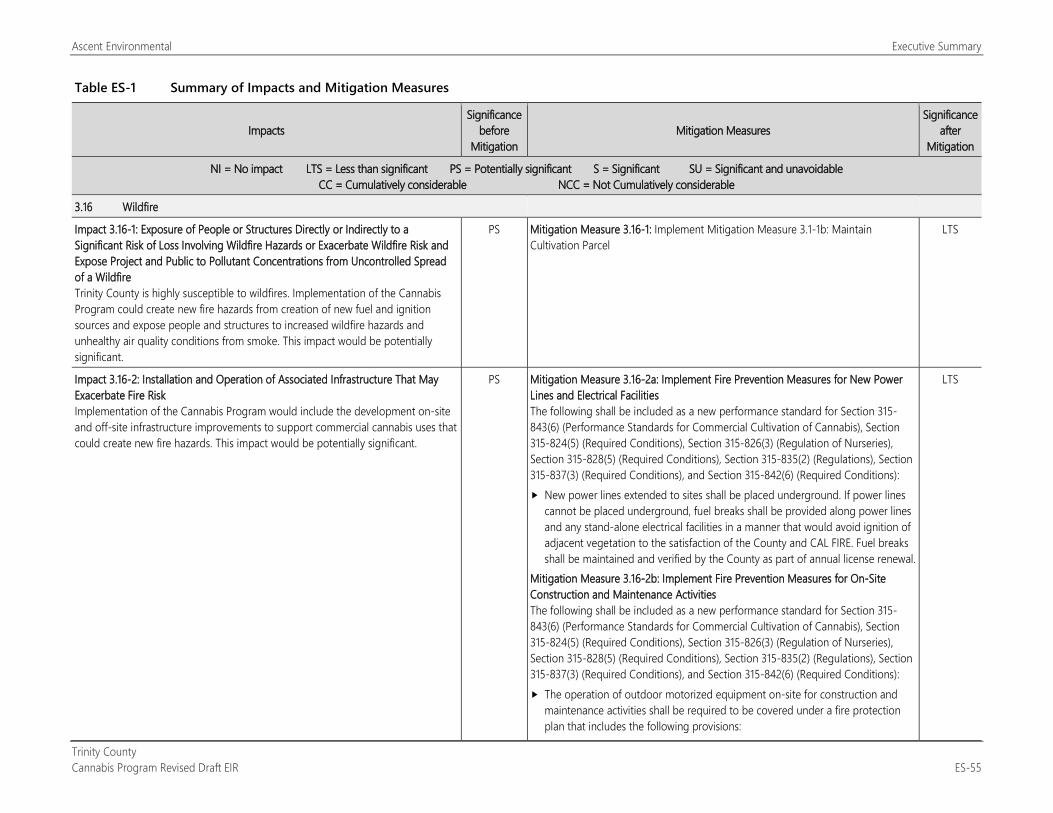
Ascent Environmental Executive Summary
Trinity County Cannabis Program Revised Draft EIR ES-55
Table ES-1 Summary of Impacts and Mitigation Measures
Impacts Significance
before Mitigation
Mitigation Measures Significance
after Mitigation
NI = No impact LTS = Less than significant PS = Potentially significant S = Significant SU = Significant and unavoidable CC = Cumulatively considerable NCC = Not Cumulatively considerable
3.16 Wildfire
Impact 3.16-1: Exposure of People or Structures Directly or Indirectly to a Significant Risk of Loss Involving Wildfire Hazards or Exacerbate Wildfire Risk and Expose Project and Public to Pollutant Concentrations from Uncontrolled Spread of a Wildfire Trinity County is highly susceptible to wildfires. Implementation of the Cannabis Program could create new fire hazards from creation of new fuel and ignition sources and expose people and structures to increased wildfire hazards and unhealthy air quality conditions from smoke. This impact would be potentially significant.
PS Mitigation Measure 3.16-1: Implement Mitigation Measure 3.1-1b: Maintain Cultivation Parcel
LTS
Impact 3.16-2: Installation and Operation of Associated Infrastructure That May Exacerbate Fire Risk Implementation of the Cannabis Program would include the development on-site and off-site infrastructure improvements to support commercial cannabis uses that could create new fire hazards. This impact would be potentially significant.
PS Mitigation Measure 3.16-2a: Implement Fire Prevention Measures for New Power Lines and Electrical Facilities The following shall be included as a new performance standard for Section 315-843(6) (Performance Standards for Commercial Cultivation of Cannabis), Section 315-824(5) (Required Conditions), Section 315-826(3) (Regulation of Nurseries), Section 315-828(5) (Required Conditions), Section 315-835(2) (Regulations), Section 315-837(3) (Required Conditions), and Section 315-842(6) (Required Conditions): New power lines extended to sites shall be placed underground. If power lines
cannot be placed underground, fuel breaks shall be provided along power lines and any stand-alone electrical facilities in a manner that would avoid ignition of adjacent vegetation to the satisfaction of the County and CAL FIRE. Fuel breaks shall be maintained and verified by the County as part of annual license renewal.
Mitigation Measure 3.16-2b: Implement Fire Prevention Measures for On-Site Construction and Maintenance Activities The following shall be included as a new performance standard for Section 315-843(6) (Performance Standards for Commercial Cultivation of Cannabis), Section 315-824(5) (Required Conditions), Section 315-826(3) (Regulation of Nurseries), Section 315-828(5) (Required Conditions), Section 315-835(2) (Regulations), Section 315-837(3) (Required Conditions), and Section 315-842(6) (Required Conditions): The operation of outdoor motorized equipment on-site for construction and
maintenance activities shall be required to be covered under a fire protection plan that includes the following provisions:
LTS
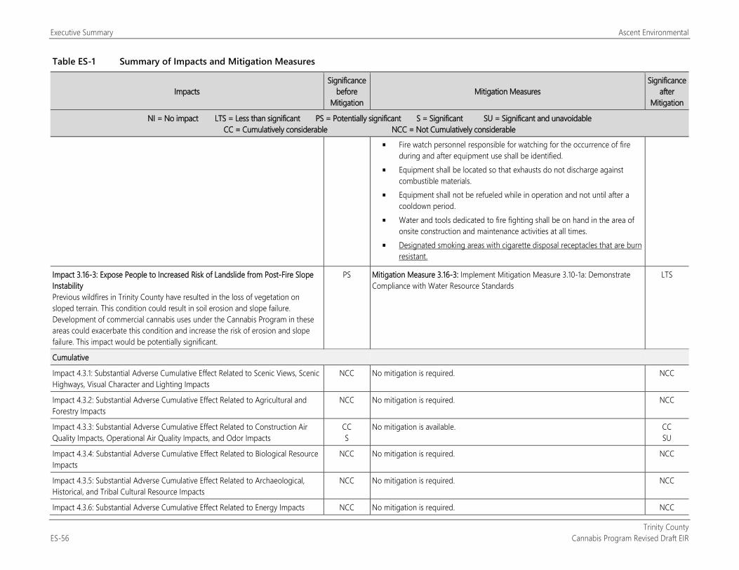
Executive Summary Ascent Environmental
Trinity County ES-56 Cannabis Program Revised Draft EIR
Table ES-1 Summary of Impacts and Mitigation Measures
Impacts Significance
before Mitigation
Mitigation Measures Significance
after Mitigation
NI = No impact LTS = Less than significant PS = Potentially significant S = Significant SU = Significant and unavoidable CC = Cumulatively considerable NCC = Not Cumulatively considerable
Fire watch personnel responsible for watching for the occurrence of fire during and after equipment use shall be identified.
Equipment shall be located so that exhausts do not discharge against combustible materials.
Equipment shall not be refueled while in operation and not until after a cooldown period.
Water and tools dedicated to fire fighting shall be on hand in the area of onsite construction and maintenance activities at all times.
Designated smoking areas with cigarette disposal receptacles that are burn resistant.
Impact 3.16-3: Expose People to Increased Risk of Landslide from Post-Fire Slope Instability Previous wildfires in Trinity County have resulted in the loss of vegetation on sloped terrain. This condition could result in soil erosion and slope failure. Development of commercial cannabis uses under the Cannabis Program in these areas could exacerbate this condition and increase the risk of erosion and slope failure. This impact would be potentially significant.
PS Mitigation Measure 3.16-3: Implement Mitigation Measure 3.10-1a: Demonstrate Compliance with Water Resource Standards
LTS
Cumulative
Impact 4.3.1: Substantial Adverse Cumulative Effect Related to Scenic Views, Scenic Highways, Visual Character and Lighting Impacts
NCC No mitigation is required. NCC
Impact 4.3.2: Substantial Adverse Cumulative Effect Related to Agricultural and Forestry Impacts
NCC No mitigation is required. NCC
Impact 4.3.3: Substantial Adverse Cumulative Effect Related to Construction Air Quality Impacts, Operational Air Quality Impacts, and Odor Impacts
CC S
No mitigation is available. CC SU
Impact 4.3.4: Substantial Adverse Cumulative Effect Related to Biological Resource Impacts
NCC No mitigation is required. NCC
Impact 4.3.5: Substantial Adverse Cumulative Effect Related to Archaeological, Historical, and Tribal Cultural Resource Impacts
NCC No mitigation is required. NCC
Impact 4.3.6: Substantial Adverse Cumulative Effect Related to Energy Impacts NCC No mitigation is required. NCC
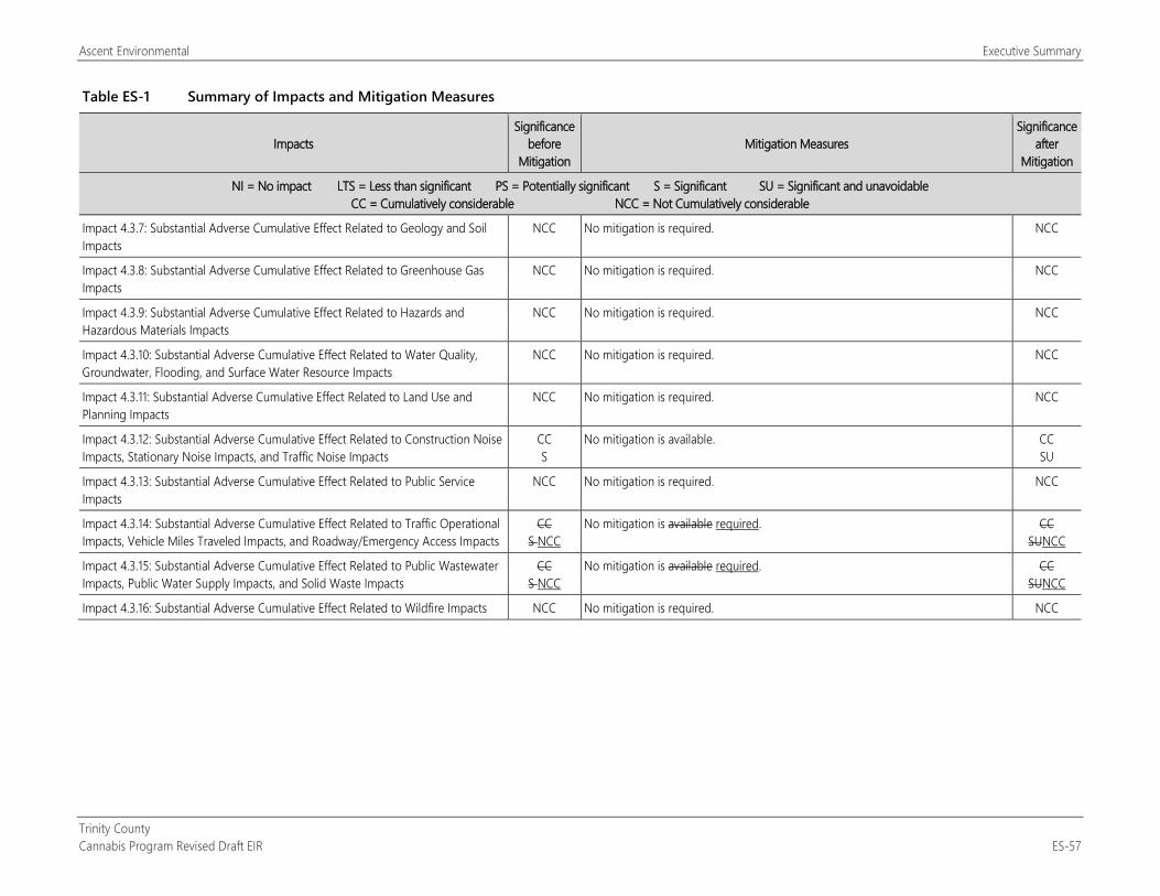
Ascent Environmental Executive Summary
Trinity County Cannabis Program Revised Draft EIR ES-57
Table ES-1 Summary of Impacts and Mitigation Measures
Impacts Significance
before Mitigation
Mitigation Measures Significance
after Mitigation
NI = No impact LTS = Less than significant PS = Potentially significant S = Significant SU = Significant and unavoidable CC = Cumulatively considerable NCC = Not Cumulatively considerable
Impact 4.3.7: Substantial Adverse Cumulative Effect Related to Geology and Soil Impacts
NCC No mitigation is required. NCC
Impact 4.3.8: Substantial Adverse Cumulative Effect Related to Greenhouse Gas Impacts
NCC No mitigation is required. NCC
Impact 4.3.9: Substantial Adverse Cumulative Effect Related to Hazards and Hazardous Materials Impacts
NCC No mitigation is required. NCC
Impact 4.3.10: Substantial Adverse Cumulative Effect Related to Water Quality, Groundwater, Flooding, and Surface Water Resource Impacts
NCC No mitigation is required. NCC
Impact 4.3.11: Substantial Adverse Cumulative Effect Related to Land Use and Planning Impacts
NCC No mitigation is required. NCC
Impact 4.3.12: Substantial Adverse Cumulative Effect Related to Construction Noise Impacts, Stationary Noise Impacts, and Traffic Noise Impacts
CC S
No mitigation is available. CC SU
Impact 4.3.13: Substantial Adverse Cumulative Effect Related to Public Service Impacts
NCC No mitigation is required. NCC
Impact 4.3.14: Substantial Adverse Cumulative Effect Related to Traffic Operational Impacts, Vehicle Miles Traveled Impacts, and Roadway/Emergency Access Impacts
CC S NCC
No mitigation is available required. CC SUNCC
Impact 4.3.15: Substantial Adverse Cumulative Effect Related to Public Wastewater Impacts, Public Water Supply Impacts, and Solid Waste Impacts
CC S NCC
No mitigation is available required. CC SUNCC
Impact 4.3.16: Substantial Adverse Cumulative Effect Related to Wildfire Impacts NCC No mitigation is required. NCC

Executive Summary Ascent Environmental
Trinity County ES-58 Cannabis Program Draft EIR
This page intentionally left blank.
Trinity County Cannabis Program Revised Draft EIR 1-1
1 INTRODUCTION This draft environmental impact report (DEIR) evaluates the potential environmental impacts of the Trinity County Cannabis Program regulating commercial cannabis activities (Cannabis Program or project). It has been prepared under the direction of Trinity County in accordance with the requirements of the California Environmental Quality Act (CEQA) (Public Resources Code [PRC] Sections 21000–21177) and the State CEQA Guidelines (California Code of Regulations [CCR], Title 14, Division 6, Chapter 3, Sections 15000–15387). The County is the lead agency for consideration of this EIR and potential project approval.
The Trinity County Cannabis Program consists of the readoption of the six ordinances that regulate commercial cannabis operations in the unincorporated area of the county. It also includes a proposed amendment to County Code Section S315-843(1)(i), which would increase the Designated Area for cultivation activities from 200 percent to 250 percent. This DEIR also recommends amendments to the ordinances through proposed mitigation measures identified in Table ES-1 and Sections 3.1 through 3.16.
1.1 PURPOSE OF THIS EIR CEQA requires that public agencies consider the significant and potentially significant adverse environmental effects of projects over which they have discretionary approval authority before taking action on those projects (PRC Section 21000 et seq.). CEQA also requires that each public agency avoid or mitigate to a less-than-significant level, wherever feasible, the significant and potentially significant adverse environmental effects of projects it approves or implements. If implementing a project would result in significant and unavoidable environmental impacts (i.e., significant effects that cannot be feasibly mitigated to a less-than-significant level), the project can still be approved, but the lead agency decision maker—in this case, the Trinity County Board of Supervisors—must prepare findings and issue a “statement of overriding considerations” explaining in writing the specific economic, social, or other considerations that they believe, based on substantial evidence, make those significant effects acceptable (PRC Section 21002, CCR Section 15093).
According to State CEQA Guidelines Section 15064(f)(1), preparation of an EIR is required whenever a project may result in a significant adverse environmental impact. An EIR is an informational document used to inform public agency decision makers and the public of the significant and potentially significant environmental effects of a project, identify possible ways to mitigate or avoid the significant effects, and describe a range of reasonable alternatives to the project that could feasibly attain most of the basic objectives of the project while substantially lessening or avoiding any of the significant environmental impacts. Public agencies are required to consider the information presented in the EIR when determining whether to approve a project.
In accordance with State CEQA Guidelines Section 15168, this document is a program EIR that examines the environmental impacts of a series of actions (e.g., issuing discretionary permits or zoning clearance certificates). This type of EIR focuses on the changes in the environment that would result from the issuance of rules, regulations, plans, or other general criteria attributable to a continuing program. In accordance with State CEQA Guidelines Section 15168, a program EIR must examine the overall environmental effects of the entire program and potential actions carried out as part of the program, including construction and operational activities.
As encouraged under CEQA, the County intends to use this Program EIR to streamline the environmental review and consideration of future cannabis operation applications. The County plans to make full use of existing streamlining provided by CEQA, as well as emerging streamlining techniques that may become available later, as applicable. Subsequent to adoption of the Cannabis Program, applicants may apply for cannabis use permits pursuant to the new regulations. Individual applications for commercial cannabis operations under the ordinance will be subject to further site-specific environmental review as applicable under CEQA pursuant to State CEQA Guidelines Section 15168(c), Use with Later Activities. This section of the guidelines addresses environmental review of projects intended to be addressed in a program for which an EIR was prepared. The County may determine that the environmental
Introduction Ascent Environmental
Trinity County 1-2 Cannabis Program Revised Draft EIR
impacts of an individual application are adequately addressed in the EIR and that no further environmental review is required. However, the County may determine that an additional focused environmental review is required for an individual applicant. Preparation of a site-specific environmental review document, such as a negative declaration or mitigated negative declaration, would be required if the County determines that the individual application would cause a significant environmental impact that was not examined in the EIR or would substantially increase the severity of a previously identified significant impact under State CEQA Guidelines Sections 15162 and 15168(c).
Under the provisions of PRC Section 21083.3 and State CEQA Guidelines Section 15183, lead agencies can use EIRs prepared for zoning actions to analyze the impacts of proposed cannabis projects that may be approved pursuant to the ordinance and limit later project-level analysis to only site-specific issues not already examined (if any). Under the above-referenced code sections, CEQA analysis for later projects is limited to issues “peculiar” to the site or new environmental concerns not previously addressed. State CEQA Guidelines Section 15183(f) provides that impacts are not “peculiar” to the project if uniformly applied development policies or standards substantially mitigate that environmental effect. Upon approval, the Cannabis Program would meet the definition of a uniformly adopted standard, and compliance with the Cannabis Program would allow CEQA streamlining to be used.
Because it has principal authority over approval of the project, Trinity County is the lead agency, as defined by CEQA, for this EIR. Other public agencies that may have jurisdiction over the project and subsequent actions related to the project are listed below in Section 1.3, “Agency Roles and Responsibilities.”
1.2 SCOPE OF THE ENVIRONMENTAL ANALYSIS Pursuant to CEQA and the State CEQA Guidelines, a lead agency shall focus an EIR’s discussion on significant environmental effects and may limit discussion of other effects to brief explanations about why they are not significant (PRC Section 21002.1, CCR Section 15128). Potentially significant impacts were identified based on review of comments received as part of the notice of preparation (NOP) scoping process (Appendix A) and additional research and analysis of relevant project data during preparation of this DEIR.
The County has determined that the project has the potential to result in significant environmental impacts on the following resources, which are addressed in detail in this DEIR:
Aesthetics
Agriculture and Forestry Resources
Air Quality
Biological Resources
Archaeological, Historical, and Tribal Cultural Resources
Energy
Geology and Soils
Greenhouse Gas Emissions and Climate Change
Hazards and Hazardous Materials
Hydrology and Water Quality
Land Use and Planning
Noise
Public Services
Transportation/Traffic
Utilities and Service Systems
Wildfire
1.2.1 Effects Found Not to Be Significant
CEQA allows a lead agency to limit the detail of discussion of environmental effects that are not potentially significant (PRC Section 21100, CCR Sections 15126.2[a] and 15128). It was determined, for reasons described below, that the project would not result in significant environmental impacts in the following areas:
Mineral Resources
Population and Housing
Recreation
Ascent Environmental Introduction
Trinity County Cannabis Program Revised Draft EIR 1-3
MINERAL RESOURCES Development under the project would permit land for commercial cannabis activities (depending on the zoning district and the parcel size; see Chapter 2, “Project Description,” for more details). Commercial cultivation operations would not involve permanent facilities and structures that would prohibit future access to mineral resources. Commercial noncultivation cannabis uses would be primarily located within designated commercial and industrial land areas in unincorporated communities that do not support mineral resource production. As a result, implementation of the project would not result in the loss of availability of or preclude the recovery of mineral resources within the county. Therefore, no significant impacts on mineral resources would occur, and this issue is not discussed further.
POPULATION AND HOUSING The California Department of Finance projects that Trinity County’s population will decrease from 13,404 in 2019 to 13,232 by 2040 (California Department of Finance 2019). The California Employment Development Department estimates that the county’s 2018 average workforce was 5,040 and had a 5.3-percent unemployment rate (270 persons unemployed) (California Employment Development Department 2019). The state also estimates that the county had 2,710 jobs in the county at the beginning of 2019. It is estimated that the implementation of the Cannabis Program could create up to 945 471 new permanent full-time equivalent jobs (see Table 2-3). It is anticipated that this potential job creation would be primarily absorbed by the county’s existing workforce and would not induce substantial population growth and necessitate the construction of new housing. Commercial cannabis uses are not expected to displace housing or displace people because cultivation would be required to be setback from residential uses. Commercial noncultivation uses would be located within designated commercial and industrial land areas. Therefore, no significant impacts on population and housing would occur, and this issue is not discussed further in this EIR. The potential for growth-inducing effects, however, is considered, as required by CEQA, in Chapter 6, “Other CEQA-Mandated Sections.”
RECREATION Implementation of the project would not directly result in increased use of recreational facilities. In addition, as noted above, the project would not result in a substantial increase in countywide population such that indirect impacts on recreational facilities could occur. Therefore, no significant impacts on recreation would occur, and this issue is not discussed further in this EIR.
1.3 AGENCY ROLES AND RESPONSIBILITIES
1.3.1 Lead Agency Trinity County is the lead agency responsible for approving and carrying out the project and for ensuring that the requirements of CEQA have been met. After the EIR public review process is complete, the Trinity County Board of Supervisors will determine whether to certify the EIR (see State CEQA Guidelines Sections 15090) and approve the project.
1.3.2 Trustee and Responsible Agencies Under CEQA, a responsible agency is a public agency, other than the lead agency, that has responsibility to carry out or approve a project (PRC Section 21069). A trustee agency is a state agency that has jurisdiction by law over natural resources that are held in trust for the people of the State of California (PRC Section 21070).
The following trustee and responsible agencies may have jurisdiction over elements of the project:
California Department of Consumer Affairs, Bureau of Cannabis Regulation;
California Department of Fish and Wildlife, Region 1;
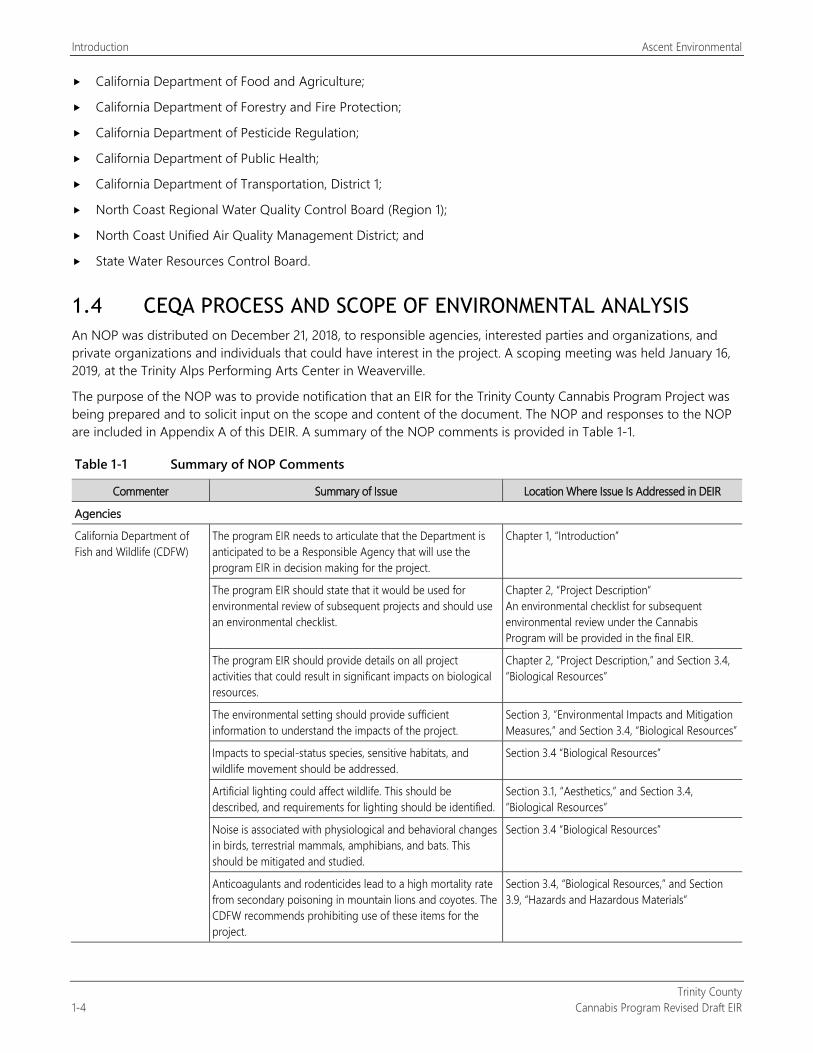
Introduction Ascent Environmental
Trinity County 1-4 Cannabis Program Revised Draft EIR
California Department of Food and Agriculture;
California Department of Forestry and Fire Protection;
California Department of Pesticide Regulation;
California Department of Public Health;
California Department of Transportation, District 1;
North Coast Regional Water Quality Control Board (Region 1);
North Coast Unified Air Quality Management District; and
State Water Resources Control Board.
1.4 CEQA PROCESS AND SCOPE OF ENVIRONMENTAL ANALYSIS An NOP was distributed on December 21, 2018, to responsible agencies, interested parties and organizations, and private organizations and individuals that could have interest in the project. A scoping meeting was held January 16, 2019, at the Trinity Alps Performing Arts Center in Weaverville.
The purpose of the NOP was to provide notification that an EIR for the Trinity County Cannabis Program Project was being prepared and to solicit input on the scope and content of the document. The NOP and responses to the NOP are included in Appendix A of this DEIR. A summary of the NOP comments is provided in Table 1-1.
Table 1-1 Summary of NOP Comments
Commenter Summary of Issue Location Where Issue Is Addressed in DEIR
Agencies
California Department of Fish and Wildlife (CDFW)
The program EIR needs to articulate that the Department is anticipated to be a Responsible Agency that will use the program EIR in decision making for the project.
Chapter 1, “Introduction”
The program EIR should state that it would be used for environmental review of subsequent projects and should use an environmental checklist.
Chapter 2, “Project Description” An environmental checklist for subsequent environmental review under the Cannabis Program will be provided in the final EIR.
The program EIR should provide details on all project activities that could result in significant impacts on biological resources.
Chapter 2, “Project Description,” and Section 3.4, “Biological Resources”
The environmental setting should provide sufficient information to understand the impacts of the project.
Section 3, “Environmental Impacts and Mitigation Measures,” and Section 3.4, “Biological Resources”
Impacts to special-status species, sensitive habitats, and wildlife movement should be addressed.
Section 3.4 “Biological Resources”
Artificial lighting could affect wildlife. This should be described, and requirements for lighting should be identified.
Section 3.1, “Aesthetics,” and Section 3.4, “Biological Resources”
Noise is associated with physiological and behavioral changes in birds, terrestrial mammals, amphibians, and bats. This should be mitigated and studied.
Section 3.4 “Biological Resources”
Anticoagulants and rodenticides lead to a high mortality rate from secondary poisoning in mountain lions and coyotes. The CDFW recommends prohibiting use of these items for the project.
Section 3.4, “Biological Resources,” and Section 3.9, “Hazards and Hazardous Materials”
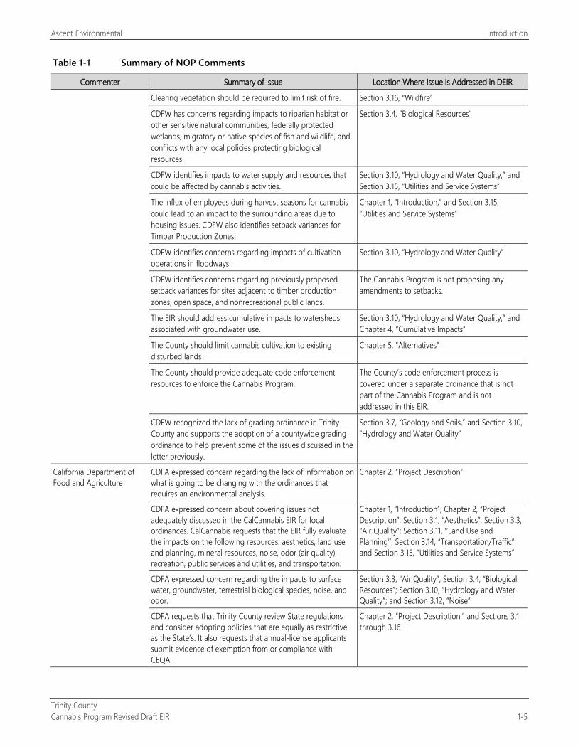
Ascent Environmental Introduction
Trinity County Cannabis Program Revised Draft EIR 1-5
Table 1-1 Summary of NOP Comments
Commenter Summary of Issue Location Where Issue Is Addressed in DEIR
Clearing vegetation should be required to limit risk of fire. Section 3.16, “Wildfire”
CDFW has concerns regarding impacts to riparian habitat or other sensitive natural communities, federally protected wetlands, migratory or native species of fish and wildlife, and conflicts with any local policies protecting biological resources.
Section 3.4, “Biological Resources”
CDFW identifies impacts to water supply and resources that could be affected by cannabis activities.
Section 3.10, “Hydrology and Water Quality,” and Section 3.15, “Utilities and Service Systems”
The influx of employees during harvest seasons for cannabis could lead to an impact to the surrounding areas due to housing issues. CDFW also identifies setback variances for Timber Production Zones.
Chapter 1, “Introduction,” and Section 3.15, “Utilities and Service Systems”
CDFW identifies concerns regarding impacts of cultivation operations in floodways.
Section 3.10, “Hydrology and Water Quality”
CDFW identifies concerns regarding previously proposed setback variances for sites adjacent to timber production zones, open space, and nonrecreational public lands.
The Cannabis Program is not proposing any amendments to setbacks.
The EIR should address cumulative impacts to watersheds associated with groundwater use.
Section 3.10, “Hydrology and Water Quality,” and Chapter 4, “Cumulative Impacts”
The County should limit cannabis cultivation to existing disturbed lands
Chapter 5, “Alternatives”
The County should provide adequate code enforcement resources to enforce the Cannabis Program.
The County’s code enforcement process is covered under a separate ordinance that is not part of the Cannabis Program and is not addressed in this EIR.
CDFW recognized the lack of grading ordinance in Trinity County and supports the adoption of a countywide grading ordinance to help prevent some of the issues discussed in the letter previously.
Section 3.7, “Geology and Soils,” and Section 3.10, “Hydrology and Water Quality”
California Department of Food and Agriculture
CDFA expressed concern regarding the lack of information on what is going to be changing with the ordinances that requires an environmental analysis.
Chapter 2, “Project Description”
CDFA expressed concern about covering issues not adequately discussed in the CalCannabis EIR for local ordinances. CalCannabis requests that the EIR fully evaluate the impacts on the following resources: aesthetics, land use and planning, mineral resources, noise, odor (air quality), recreation, public services and utilities, and transportation.
Chapter 1, “Introduction”; Chapter 2, “Project Description”; Section 3.1, “Aesthetics”; Section 3.3, “Air Quality”; Section 3.11, ‘’Land Use and Planning’’; Section 3.14, “Transportation/Traffic”; and Section 3.15, “Utilities and Service Systems”
CDFA expressed concern regarding the impacts to surface water, groundwater, terrestrial biological species, noise, and odor.
Section 3.3, “Air Quality”; Section 3.4, “Biological Resources”; Section 3.10, “Hydrology and Water Quality”; and Section 3.12, “Noise”
CDFA requests that Trinity County review State regulations and consider adopting policies that are equally as restrictive as the State’s. It also requests that annual-license applicants submit evidence of exemption from or compliance with CEQA.
Chapter 2, “Project Description,” and Sections 3.1 through 3.16
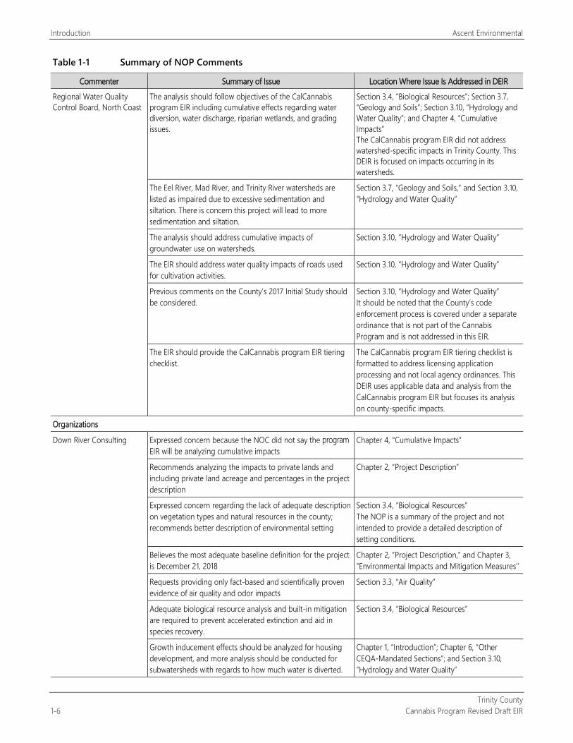
Introduction Ascent Environmental
Trinity County 1-6 Cannabis Program Revised Draft EIR
Table 1-1 Summary of NOP Comments
Commenter Summary of Issue Location Where Issue Is Addressed in DEIR
Regional Water Quality Control Board, North Coast
The analysis should follow objectives of the CalCannabis program EIR including cumulative effects regarding water diversion, water discharge, riparian wetlands, and grading issues.
Section 3.4, “Biological Resources”; Section 3.7, “Geology and Soils”; Section 3.10, “Hydrology and Water Quality”; and Chapter 4, “Cumulative Impacts” The CalCannabis program EIR did not address watershed-specific impacts in Trinity County. This DEIR is focused on impacts occurring in its watersheds.
The Eel River, Mad River, and Trinity River watersheds are listed as impaired due to excessive sedimentation and siltation. There is concern this project will lead to more sedimentation and siltation.
Section 3.7, “Geology and Soils,” and Section 3.10, “Hydrology and Water Quality”
The analysis should address cumulative impacts of groundwater use on watersheds.
Section 3.10, “Hydrology and Water Quality”
The EIR should address water quality impacts of roads used for cultivation activities.
Section 3.10, “Hydrology and Water Quality”
Previous comments on the County’s 2017 Initial Study should be considered.
Section 3.10, “Hydrology and Water Quality” It should be noted that the County’s code enforcement process is covered under a separate ordinance that is not part of the Cannabis Program and is not addressed in this EIR.
The EIR should provide the CalCannabis program EIR tiering checklist.
The CalCannabis program EIR tiering checklist is formatted to address licensing application processing and not local agency ordinances. This DEIR uses applicable data and analysis from the CalCannabis program EIR but focuses its analysis on county-specific impacts.
Organizations
Down River Consulting Expressed concern because the NOC did not say the program EIR will be analyzing cumulative impacts
Chapter 4, “Cumulative Impacts”
Recommends analyzing the impacts to private lands and including private land acreage and percentages in the project description
Chapter 2, “Project Description”
Expressed concern regarding the lack of adequate description on vegetation types and natural resources in the county; recommends better description of environmental setting
Section 3.4, “Biological Resources” The NOP is a summary of the project and not intended to provide a detailed description of setting conditions.
Believes the most adequate baseline definition for the project is December 21, 2018
Chapter 2, “Project Description,” and Chapter 3, “Environmental Impacts and Mitigation Measures’’
Requests providing only fact-based and scientifically proven evidence of air quality and odor impacts
Section 3.3, “Air Quality”
Adequate biological resource analysis and built-in mitigation are required to prevent accelerated extinction and aid in species recovery.
Section 3.4, “Biological Resources”
Growth inducement effects should be analyzed for housing development, and more analysis should be conducted for subwatersheds with regards to how much water is diverted.
Chapter 1, “Introduction”; Chapter 6, “Other CEQA-Mandated Sections”; and Section 3.10, “Hydrology and Water Quality”
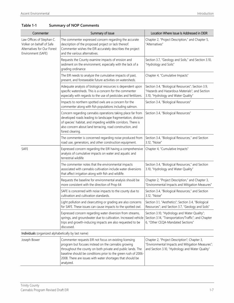
Ascent Environmental Introduction
Trinity County Cannabis Program Revised Draft EIR 1-7
Table 1-1 Summary of NOP Comments
Commenter Summary of Issue Location Where Issue Is Addressed in DEIR
Law Offices of Stephan C. Volker on behalf of Safe Alternatives for Our Forest Environment (SAFE)
The commenter expressed concern regarding the accurate description of the proposed project or lack thereof. Commenter wishes the EIR accurately describes the project and the various alternatives.
Chapter 2, “Project Description,” and Chapter 5, “Alternatives”
Requests the County examine impacts of erosion and sediment on the environment, especially with the lack of a grading ordinance
Section 3.7, “Geology and Soils,” and Section 3.10, “Hydrology and Soils”
The EIR needs to analyze the cumulative impacts of past, present, and foreseeable future activities on watersheds.
Chapter 4, “Cumulative Impacts”
Adequate analysis of biological resources is dependent upon specific watersheds. This is a concern for the commenter especially with regards to the use of pesticides and fertilizers.
Section 3.4, “Biological Resources”; Section 3.9, “Hazards and Hazardous Materials”; and Section 3.10, “Hydrology and Water Quality”
Impacts to northern spotted owls are a concern for the commenter along with fish populations including salmon.
Section 3.4, “Biological Resources”
Concern regarding cannabis operations taking place far from developed roads leading to landscape fragmentation, division of species’ habitat, and impeding wildlife corridors. There is also concern about land terracing, road construction, and forest clearing.
Section 3.4, “Biological Resources”
The commenter is concerned regarding noise produced from road use, generators, and other construction equipment.
Section 3.4, “Biological Resources,” and Section 3.12, “Noise”
SAFE Expressed concern regarding the EIR having a comprehensive analysis of cumulative impacts on water and aquatic and terrestrial wildlife
Chapter 4, “Cumulative Impacts”
The commenter notes that the environmental impacts associated with cannabis cultivation include water diversions that affect irrigation along with fish and wildlife.
Section 3.4, “Biological Resources,” and Section 3.10, “Hydrology and Water Quality”
Requests the baseline for environmental analysis should be more consistent with the direction of Prop 64
Chapter 2, “Project Description,” and Chapter 3, “Environmental Impacts and Mitigation Measures”
SAFE is concerned with noise impacts to the county due to cultivation and cultivation standards.
Section 3.4, “Biological Resources,” and Section 3.12, “Noise”
Light pollution and clearcutting or grading are also concerns for SAFE. These issues can cause impacts to the spotted owl.
Section 3.1, “Aesthetics”; Section 3.4, “Biological Resources”; and Section 3.7, “Geology and Soils”
Expressed concern regarding water diversion from streams, springs, and groundwater due to cultivation. Increased vehicle trips and growth-inducing impacts are also requested to be discussed.
Section 3.10, “Hydrology and Water Quality”; Section 3.14, “Transportation/Traffic”; and Chapter 6, “Other CEQA-Mandated Sections”
Individuals (organized alphabetically by last name)
Joseph Bower Commenter requests EIR not focus on existing licensing program but focuses instead on the cannabis growing throughout the county on both private and public lands. The baseline should be conditions prior to the green rush of 2006-2008. There are issues with water shortages that should be analyzed.
Chapter 2, “Project Description”; Chapter 3, “Environmental Impacts and Mitigation Measures”; and Section 3.10, “Hydrology and Water Quality”
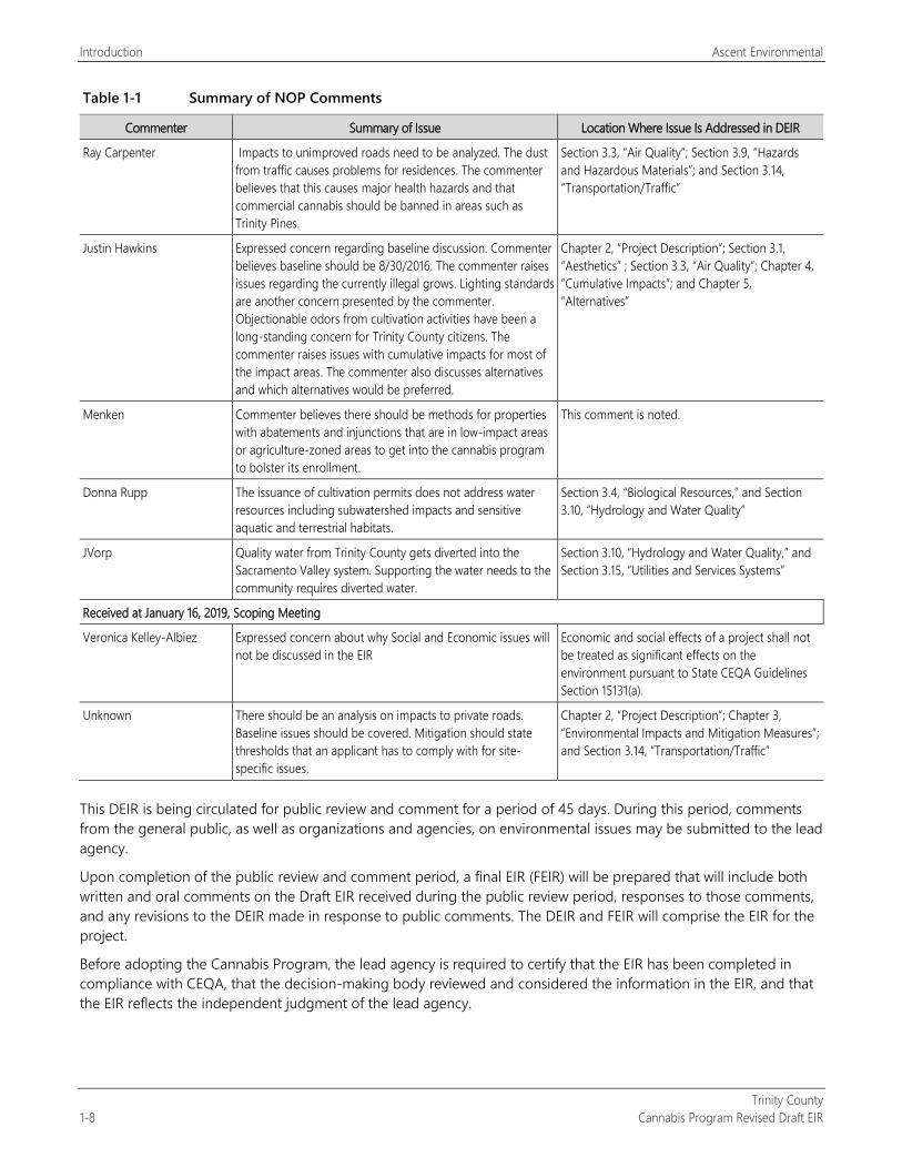
Introduction Ascent Environmental
Trinity County 1-8 Cannabis Program Revised Draft EIR
Table 1-1 Summary of NOP Comments
Commenter Summary of Issue Location Where Issue Is Addressed in DEIR
Ray Carpenter Impacts to unimproved roads need to be analyzed. The dust from traffic causes problems for residences. The commenter believes that this causes major health hazards and that commercial cannabis should be banned in areas such as Trinity Pines.
Section 3.3, “Air Quality”; Section 3.9, “Hazards and Hazardous Materials”; and Section 3.14, “Transportation/Traffic”
Justin Hawkins Expressed concern regarding baseline discussion. Commenter believes baseline should be 8/30/2016. The commenter raises issues regarding the currently illegal grows. Lighting standards are another concern presented by the commenter. Objectionable odors from cultivation activities have been a long-standing concern for Trinity County citizens. The commenter raises issues with cumulative impacts for most of the impact areas. The commenter also discusses alternatives and which alternatives would be preferred.
Chapter 2, “Project Description”; Section 3.1, “Aesthetics” ; Section 3.3, “Air Quality”; Chapter 4, “Cumulative Impacts”; and Chapter 5, “Alternatives”
Menken Commenter believes there should be methods for properties with abatements and injunctions that are in low-impact areas or agriculture-zoned areas to get into the cannabis program to bolster its enrollment.
This comment is noted.
Donna Rupp The issuance of cultivation permits does not address water resources including subwatershed impacts and sensitive aquatic and terrestrial habitats.
Section 3.4, “Biological Resources,” and Section 3.10, “Hydrology and Water Quality”
JVorp Quality water from Trinity County gets diverted into the Sacramento Valley system. Supporting the water needs to the community requires diverted water.
Section 3.10, “Hydrology and Water Quality,” and Section 3.15, “Utilities and Services Systems”
Received at January 16, 2019, Scoping Meeting
Veronica Kelley-Albiez Expressed concern about why Social and Economic issues will not be discussed in the EIR
Economic and social effects of a project shall not be treated as significant effects on the environment pursuant to State CEQA Guidelines Section 15131(a).
Unknown There should be an analysis on impacts to private roads. Baseline issues should be covered. Mitigation should state thresholds that an applicant has to comply with for site-specific issues.
Chapter 2, “Project Description”; Chapter 3, “Environmental Impacts and Mitigation Measures”; and Section 3.14, “Transportation/Traffic”
This DEIR is being circulated for public review and comment for a period of 45 days. During this period, comments from the general public, as well as organizations and agencies, on environmental issues may be submitted to the lead agency.
Upon completion of the public review and comment period, a final EIR (FEIR) will be prepared that will include both written and oral comments on the Draft EIR received during the public review period, responses to those comments, and any revisions to the DEIR made in response to public comments. The DEIR and FEIR will comprise the EIR for the project.
Before adopting the Cannabis Program, the lead agency is required to certify that the EIR has been completed in compliance with CEQA, that the decision-making body reviewed and considered the information in the EIR, and that the EIR reflects the independent judgment of the lead agency.
Ascent Environmental Introduction
Trinity County Cannabis Program Revised Draft EIR 1-9
1.5 DRAFT EIR ORGANIZATION This Draft EIR is organized into chapters, as identified and briefly described below. Chapters are further divided into sections (e.g., Chapter 3, “Environmental Impacts and Mitigation Measures” and Section 3.6, “Energy”):
“Executive Summary”: This chapter introduces the Trinity County Cannabis Program Project; provides a summary of the environmental review process, effects found not to be significant, and key environmental issues; and lists significant impacts and mitigation measures to reduce significant impacts to a less-than-significant level.
Chapter 1, “Introduction”: This chapter provides a description of the lead and responsible agencies, the legal authority and purpose for the document, and the public review process.
Chapter 2, “Project Description”: This chapter describes the location, background, and goals and objectives for the Trinity County Cannabis Program Project and describes the project elements in detail.
Chapter 3, “Environmental Impacts and Mitigation Measures”: The sections within this chapter evaluate the expected environmental impacts generated by the program, arranged by subject area (e.g., Land Use, Hydrology and Water Quality). Within each subsection of Chapter 3, the regulatory background, existing conditions, analysis methodology, and thresholds of significance are described. The anticipated changes to the existing conditions after development of the project are then evaluated for each subject area. For any significant or potentially significant impact that would result from project implementation, mitigation measures are presented, and the level of impact significance after mitigation is identified. Environmental impacts are numbered sequentially within each section (e.g., Impact 3.2-1, Impact 3.2-2, etc.). Any required mitigation measures are numbered to correspond to the impact numbering; therefore, the mitigation measure for Impact 3.2-2 would be Mitigation Measure 3.2-2.
Chapter 4, “Cumulative Impacts”: This chapter provides information required by CEQA regarding cumulative impacts that would result from implementation of the Cannabis Program together with other past, present, and probable future projects.
Chapter 5, “Alternatives”: This chapter evaluates alternatives to the program, including alternatives considered but eliminated from further consideration, the No Project Alternative, and two alternative development options. The environmentally superior alternative is identified.
Chapter 6, “Other CEQA-Mandated Sections”: This chapter evaluates growth-inducing impacts and irreversible and irretrievable commitment of resources and discloses any significant and unavoidable adverse impacts.
Chapter 7, “Report Preparers”: This chapter identifies the preparers of the document.
Chapter 8, “References”: This chapter identifies the documents and individuals used as sources for the analysis presented in the DEIR.

Introduction Ascent Environmental
Trinity County 1-10 Cannabis Program Revised Draft EIR
This page intentionally left blank.
Trinity County Cannabis Program Revised Draft EIR 2-1
2 PROJECT DESCRIPTION
2.1 PROJECT BACKGROUND AND NEED
Trinity County is proposing to amend and readopt its existing regulations related to the licensing of commercial cannabis operations (referred to herein as the “County Cannabis Program” or “Cannabis Program”). In support of its proposal, the County is conducting a programmatic environmental review of the impacts of implementing the County Cannabis Program.
2.2 PROJECT OBJECTIVES The project objectives of the County Cannabis Program, based on County Resolution No. 2016-077, “A Resolution of the Board of Supervisors of the County of Trinity Adopting Four Principles on Local Regulation of Cannabis,” are to:
regulate cannabis operations in a manner that ensures that the county is a safe place for all residents to live and work,
protect the county’s quality of life and natural environment,
ensure that cannabis operations avoid environmental damage and detrimental impacts on communities and neighborhoods,
regulate cannabis operations to protect the county’s reputation as a tourist destination, and
align the County’s commercial cannabis regulations with state requirements.
2.3 PROJECT LOCATION Trinity County is located in northern California, east of Humboldt County, south of Siskiyou County, west of Shasta County, and north of Mendocino County (Figure 2-1). It encompasses 2,051,988 acres, approximately 76 percent of which is under federal ownership consisting of tribal lands, the Shasta-Trinity, Six Rivers, and Mendocino National Forests and four wilderness areas: Yolla Bolly-Middle Eel, Trinity Alps, Chanchelula, and North Fork (Figure 2-2). There are 26 unincorporated communities in the county: Coffee Creek, Trinity Center, Covington Mill, Minersville, Weaverville, Lewiston, Junction City, Helena, Big Flat, Big Bar, Del Loma, Burnt Ranch, Hawkins Bar, Denny, Salyer, Douglas City, Hayfork, Hyampom, Peanut, Wildwood, Post Mountain, Forest Glen, Mad River, Ruth, Zenia, and Kettenpom. These unincorporated communities are under the jurisdiction of the County. There are no incorporated cities within the county.
2.4 PROJECT BACKGROUND This section presents an overview of cannabis operations and state and County cannabis regulations.
2.4.1 Summary of Cannabis Cultivation and Commerce Processes Cannabis cultivation requires the same basic conditions of most plants: a growth medium, light, water, and nutrients. This section generally describes requirements and activities associated with cannabis cultivation, including indoor and outdoor growth requirements, harvesting activities, and preparation of cannabis products for sale. It also describes the commerce process for cannabis, which includes testing, manufacturing, distribution, and retail activities. The County has issued 286 commercial cannabis operation licenses between adoption of its first commercial cannabis ordinance in August 2016 and December 2018 (Hubbard, pers. comm., 2018).
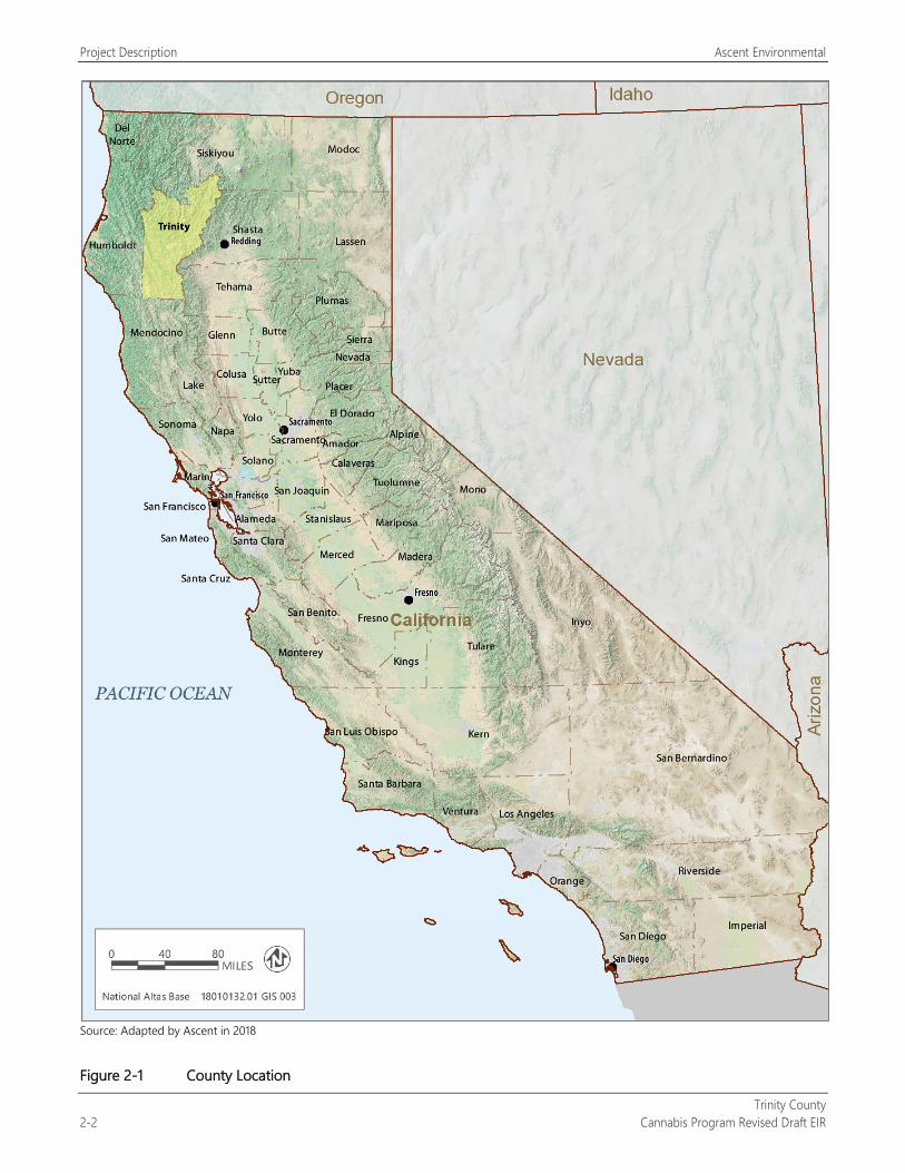
Project Description Ascent Environmental
Trinity County 2-2 Cannabis Program Revised Draft EIR
Source: Adapted by Ascent in 2018
Figure 2-1 County Location
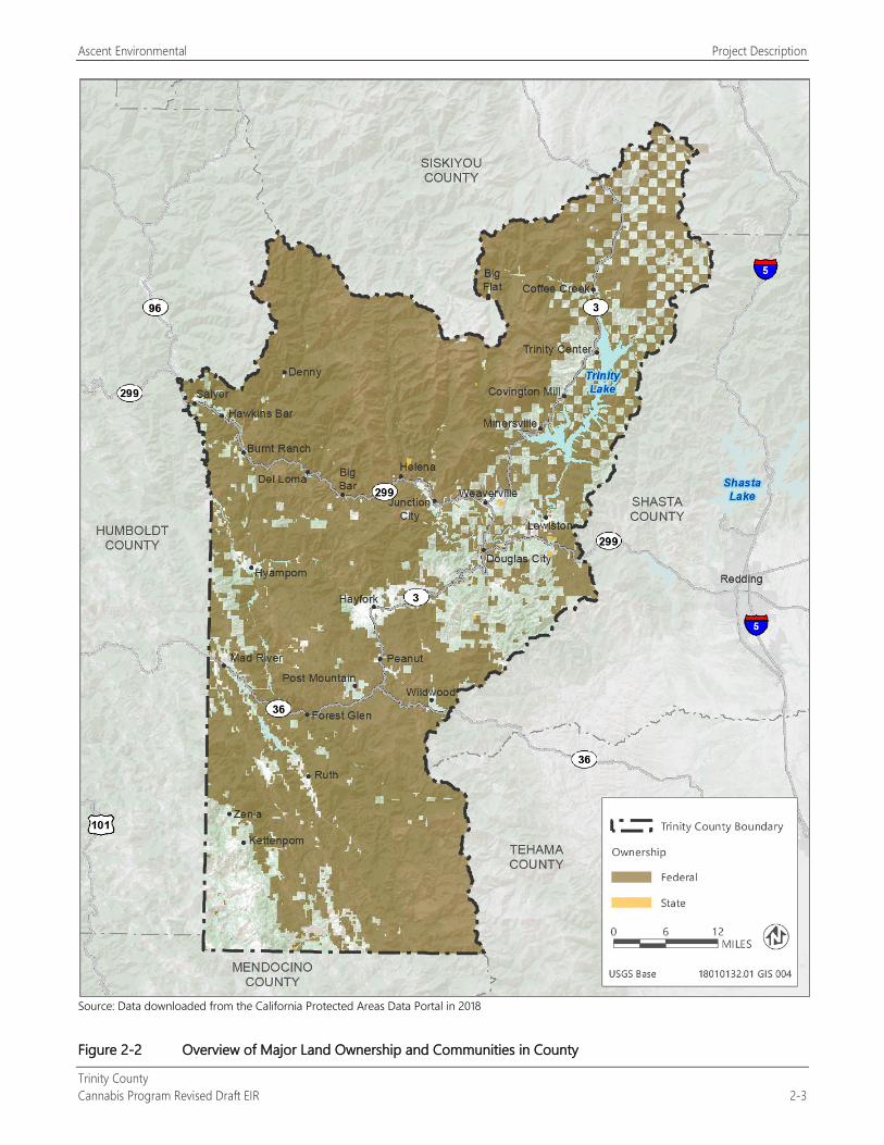
Ascent Environmental Project Description
Trinity County Cannabis Program Revised Draft EIR 2-3
Source: Data downloaded from the California Protected Areas Data Portal in 2018
Figure 2-2 Overview of Major Land Ownership and Communities in County
Project Description Ascent Environmental
Trinity County 2-4 Cannabis Program Revised Draft EIR
CULTIVATION OPERATIONS This section summarizes cultivation operation types and the current extent of these operations in the county. Figure 2-3 identifies parcels licensed by the County for cultivation in 2018.
Nursery Operations To maintain specific varieties of cannabis at cultivation sites, the practice of cloning is often employed. Mature female plants maintained in a vegetative nonflowering stage using artificial light for approximately 18 hours per day are used as a source of the cuttings, or “clones.” Cuttings (i.e., targeted trimmings of a plant) are taken and dipped into a medium to stimulate root growth. After roots develop, the clones are placed into small pots to grow to a size sufficient for transplanting to larger pots in which they grow to maturity. The clones must all be female plants with the same genetic composition as the “mother” plant.
Germination, the process during which seeds sprout, typically occurs in a nursery in an enclosed greenhouse building. Generally, germination is initiated by soaking seeds between wet paper towels, soaking them in a cup of water at room temperature, planting them in wet peat pellets, or planting them directly in potting soil. Warmth, darkness, and moisture initiate metabolic processes, such as the activation of hormones that trigger the expansion of the embryo in the seed. After germination is complete, seedlings are prepared for indoor, outdoor, or mixed-light cultivation.
Nurseries can be located on the cultivation sites as an ancillary component of cultivation operations when used to support on-site needs without separate state licensing. Nurseries can also be operated as a stand-alone retail or wholesale operation that can provide a source of seed or immature clone plants that can be purchased for personal use or as part of a commercial cultivation operation. These types of nurseries are licensed separately from cultivation under the state’s licensing process. There are no existing stand-alone nurseries in Trinity County.
Outdoor Cultivation Cannabis can be grown outdoors, either in natural soil or in pots of premade or commercial soil with no artificial light. Some strains perform better than others in outdoor settings, depending on conditions. To generate optimum quantities of cannabinoids, the active chemical compounds in cannabis, the plant needs fertile soil and long hours of daylight. For outdoor cultivation, growers generally select areas that receive 12 hours or more of sunlight per day. Depending on the varietal, each plant can reach as much as 12 or more feet in height with a radius of 6 feet or more.
Although state regulations describe outdoor cultivation for cannabis as cultivation in strictly full-sun conditions, Ordinance 315-843 includes the following definition: “Outdoors“ or ”Outdoor Cultivation“ means the cultivation of mature cannabis without the use of artificial lighting in the canopy area at any point in time. Artificial lighting is permissible only to maintain immature plants. Light deprivation is permitted. CalCannabis recognizes this variation from the state’s definition of outdoor cultivation and confirms that state compliance is predicated on a cultivation site being licensed appropriately with the state. For operations licensed as county outdoor sites using light deprivation, the site must be licensed as mixed-light with the state.
There were 111 active state-licensed outdoor cultivation sites growing or eligible to grow cannabis in the county in December 2018 (California Department of Food and Agriculture 2018). The canopy area of individual licensed cultivation sites in the county ranges from 5,000 square feet (sq. ft.) to 10,000 sq. ft. The term “cannabis cultivation canopy area” is the defined footprint of the cannabis plant area calculated in square feet and measured using physical boundaries of all area(s) that will contain mature plants at any point in time. The cannabis cultivation canopy area is the basis of determining license types under the state and County licensing programs. Buildings and other structures typically found at county outdoor cultivation sites include single-family residences, outbuildings used for material storage and processing of on-site cultivated cannabis, water storage tanks and ponds, and greenhouses. Outdoor cultivation in Trinity County generates one harvest per year.
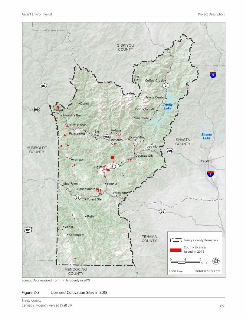
Ascent Environmental Project Description
Trinity County Cannabis Program Revised Draft EIR 2-5
Source: Data received from Trinity County in 2019
Figure 2-3 Licensed Cultivation Sites in 2018
Project Description Ascent Environmental
Trinity County 2-6 Cannabis Program Revised Draft EIR
Mixed-Light Cultivation Mixed-light cultivation uses a combination of natural and supplemental artificial lighting to increase the number of harvests in a year. Mixed-light cultivation operations allow for manipulation of light and dark cycles through the use of artificial lighting or deprivation of light. Light manipulation is used to increase or decrease the vegetative and flowering phases by mimicking seasonal daylight variation. In the northern hemisphere, daylight exceeds 12 hours per day beginning with the vernal equinox (March 21) and is less than 12 hours per day after the autumnal equinox (September 21). Longer light exposure, which in nature peaks at the summer solstice (June 21), is associated with the vegetative stage; the flowering stage is prompted when the number of daylight hours approaches 12 hours per day or less.
Light manipulation techniques can increase the number of harvests per year. Artificial light is used to “extend” daylight hours or to disrupt periods of darkness (typically for approximately 2 hours in the middle of the night) to foster vegetative development. This is achieved in mixed-light operations by covering hoop houses (temporary structures used in mixed-light operations) with light-blocking opaque tarps, which are used to promote flowering. In addition, artificial light may be used to supplement sunlight during periods of low light (e.g., several days of rain). Light systems that are not connected to the electrical grid use generators and/or solar-powered batteries when natural light is not available to power lights. Mixed-light cultivation in Trinity County generates three harvests per year.
There were 85 active state-licensed mixed-light cultivation sites in the county in December 2018 (California Department of Food and Agriculture 2018). The canopy area of individual licensed mixed-light cultivation sties ranges from 2,500 sq. ft. to 10,000 sq. ft. (average size ranges between 5,000 sq. ft. and 10,000 sq. ft.). Buildings and other structures typically found at county mixed-light cultivation sites include single-family residences, outbuildings used for material storage and processing of on-site cultivated cannabis, hoop houses, water storage tanks and ponds, and greenhouses.
Indoor Cultivation Indoor cultivation makes exclusive use of artificial light during the vegetative and flowering phases. Generally, cultivating cannabis indoors rather than outdoors is more complicated and expensive, but it allows the cultivator complete control over the growing environment and increases the number of harvests per year. Plants of any type can be grown faster indoors than outdoors because light, carbon dioxide concentrations, and humidity can be controlled. Plants can also be grown indoors through the use of hydroponics, which uses a mineral nutrient solution in water rather than soil.
Year-round indoor cultivation requires substantial energy for lighting fixtures, cooling ventilation systems, humidity control, watering, and air filtration systems.
Water demand for indoor cultivation varies, depending on whether the grower employs a water capture/reuse system. The use of dehumidifiers or modified air conditioning systems that can capture water for reuse can reduce water demand.
There were two active state-licensed indoor cultivation sites in the county in December 2018. These indoor operations are contained in buildings that cultivate up to 500 sq. ft. of canopy area. Indoor cultivation are typically operated to generate on-going harvests during the year.
PROCESSING ACTIVITIES Processing involves drying, curing, grading, trimming, and packing. These steps may be performed within the parcel where the cannabis was grown or at separate licensed facilities that accept product from multiple cultivation sites. Commercial cannabis harvesting and processing activities for outdoor cultivation generally require approximately 10–15 employees. Plants are trimmed of their leaves to reveal buds, which typically are hang-dried or placed on drying racks in a warehouse, barn, or other enclosed building. Trimming may be done by hand or through the use of mechanized trimming. Cultivation sites may accommodate harvest staff on-site, or staff may commute daily. Harvested and trimmed cannabis typically is vacuum-sealed in plastic bags.
Ascent Environmental Project Description
Trinity County Cannabis Program Revised Draft EIR 2-7
Although processing facilities supporting on-site cannabis cultivation are located in the county, there are no state-licensed processing facilities in the county that accept product from off-site cultivation sites.
TESTING ACTIVITIES Upon taking physical possession of a cannabis goods batch, cannabis distributors are required under CCR Title 16, Division 42, Section 5304, to have the cannabis tested by a licensed testing laboratory. Testing facilities must be an accredited laboratory that perform tests consistent with the requirements of CCR Section 5702. Cannabis must be sampled for the following constituents:
cannabinoids;
foreign material;
heavy metals;
microbial impurities;
mycotoxins;
moisture content and water activity;
residual pesticides;
residual solvents and processing chemicals;
terpenoids, if applicable; and
homogeneity, if applicable.
There are currently no testing facilities in the county. The nearest licensed testing facilities are in Humboldt County.
MANUFACTURING ACTIVITIES Manufacturing is the process by which the raw agricultural product is transformed into a concentrate, edible products, or a topical product. The production, preparation, propagation, or compounding of cannabis or cannabis product is accomplished through extraction methods and/or chemical synthesis. Extraction usually involves the use of a closed-loop system using carbon dioxide or volatiles (e.g., butane) to remove the key constituents from the cannabis. Various types of licenses can be obtained through the state for different types of manufacturing activities, which can include packaging or repackaging medical cannabis products or labeling or relabeling the cannabis product container.
There are currently no manufacturing facilities in the county. The nearest licensed manufacturing facilities are in Humboldt County and Sonoma County.
DISTRIBUTION ACTIVITIES Under current state law, manufactured cannabis products must pass through a licensed distributor before they can be offered for retail sale to patients with physician recommendations for medical cannabis use or to adults for recreational use. The distribution phase includes an important quality control step whereby the product is held by independent licensed testing laboratories for testing for cannabis constituent content, strength, and contaminants.
There were 10 active state-licensed distribution facilities (eight were transport-only) in the county in December 2018 (California Bureau of Cannabis Control 2018). These distribution facilities are located in the communities of Junction City, Weaverville, Lewiston, Douglas City, Hayfork, and Zenia.
Project Description Ascent Environmental
Trinity County 2-8 Cannabis Program Revised Draft EIR
RETAIL ACTIVITIES Retail facilities are required under the state licensing process to maintain and implement operating procedures for the safe transportation of cannabis, inventory procedures, quality control process for cannabis goods, security and surveillance systems, and waste management procedures. Retail sale of cannabis products is required by state law to be conducted exclusively through licensed dispensaries to qualified patients holding physician recommendations for cannabis use, which may include persons under 21 years of age, or through separate licensed retail outlets for adults 21 years of age and older for recreational use. The retail outlets may not offer alcohol or tobacco products for sale. However, state licenses do not require separate licensed retail outlets for medical cannabis and adult cannabis uses.
There are currently no retail facilities in the county. The nearest licensed retail facilities are in Humboldt County.
The following discussion describes state-licensed retail activities for cannabis and cannabis products.
Non-Storefront Retail State-licensed non-storefront retail use consists of the selling of cannabis or cannabis products to consumers from licensed premises that are not open to the public and from a retailer who conducts sales exclusively for delivery.
Storefront Retail State-licensed storefront retail uses include on-site sales and delivery of cannabis or cannabis products to consumers. Retail building sites generally range from 900 to 3,500 sq. ft. in size (Ascent Environmental 2018). The common hours of operation for cannabis retail operations are 9:00 a.m. to 9:00 p.m.
Microbusiness Licensed microbusinesses may combine cultivation operations (up to 10,000 sq. ft. of cannabis canopy area), manufacturing, distribution, and retail use. Such an operation would be analogous to a winery with an associated small vineyard and a retail outlet.
2.4.2 Evolution of State Cannabis Regulations
COMPASSIONATE USE ACT (1996) AND THE MEDICAL MARIJUANA PROGRAM ACT (2003) The Compassionate Use Act of 1996, which allowed for the medical use of cannabis in California under state law, was passed through voter approval of Proposition 215. It allowed patients with a valid doctor’s recommendation and the patients’ designated primary caregivers to possess and cultivate cannabis for personal medical use without facing criminal charges from the state. The Compassionate Use Act changed California’s penal code by decriminalizing the cultivation and possession of medical marijuana by a patient or the patient’s primary caregiver for the patient’s personal use and by creating a limited defense to the crimes of possessing or cultivating marijuana.
The passage of Senate Bill (SB) 420 (Statutes of 2003) enacted the Medical Marijuana Program Act, which clarified the scope and application of the Compassionate Use Act and established the California medical marijuana program. Specially, this act established a voluntary program for the issuance of identification cards to qualified patients and established procedures under which a qualified patient with an identification card may use marijuana for medical purposes to protect patients and their caregivers from arrest.
MEDICAL CANNABIS REGULATION AND SAFETY ACT (2015) Originally referred to as the Medical Marijuana Regulation and Safety Act but renamed through subsequent amendments, the Medical Cannabis Regulation and Safety Act consists of three separate bills that were enacted together in September 2015 (Assembly Bill [AB] 266, AB 243, and SB 643). The bills created a comprehensive state licensing system for the commercial cultivation, manufacture, retail sale, transport, distribution, delivery, and testing of
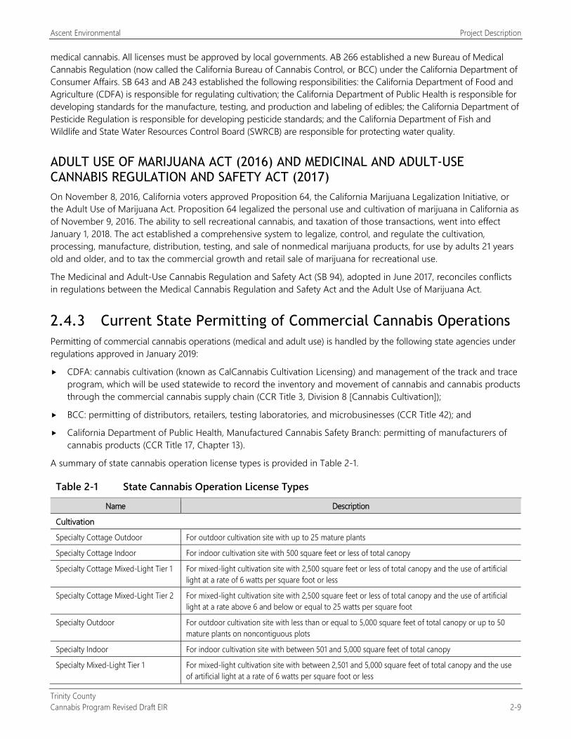
Ascent Environmental Project Description
Trinity County Cannabis Program Revised Draft EIR 2-9
medical cannabis. All licenses must be approved by local governments. AB 266 established a new Bureau of Medical Cannabis Regulation (now called the California Bureau of Cannabis Control, or BCC) under the California Department of Consumer Affairs. SB 643 and AB 243 established the following responsibilities: the California Department of Food and Agriculture (CDFA) is responsible for regulating cultivation; the California Department of Public Health is responsible for developing standards for the manufacture, testing, and production and labeling of edibles; the California Department of Pesticide Regulation is responsible for developing pesticide standards; and the California Department of Fish and Wildlife and State Water Resources Control Board (SWRCB) are responsible for protecting water quality.
ADULT USE OF MARIJUANA ACT (2016) AND MEDICINAL AND ADULT-USE CANNABIS REGULATION AND SAFETY ACT (2017) On November 8, 2016, California voters approved Proposition 64, the California Marijuana Legalization Initiative, or the Adult Use of Marijuana Act. Proposition 64 legalized the personal use and cultivation of marijuana in California as of November 9, 2016. The ability to sell recreational cannabis, and taxation of those transactions, went into effect January 1, 2018. The act established a comprehensive system to legalize, control, and regulate the cultivation, processing, manufacture, distribution, testing, and sale of nonmedical marijuana products, for use by adults 21 years old and older, and to tax the commercial growth and retail sale of marijuana for recreational use.
The Medicinal and Adult-Use Cannabis Regulation and Safety Act (SB 94), adopted in June 2017, reconciles conflicts in regulations between the Medical Cannabis Regulation and Safety Act and the Adult Use of Marijuana Act.
2.4.3 Current State Permitting of Commercial Cannabis Operations Permitting of commercial cannabis operations (medical and adult use) is handled by the following state agencies under regulations approved in January 2019:
CDFA: cannabis cultivation (known as CalCannabis Cultivation Licensing) and management of the track and trace program, which will be used statewide to record the inventory and movement of cannabis and cannabis products through the commercial cannabis supply chain (CCR Title 3, Division 8 [Cannabis Cultivation]);
BCC: permitting of distributors, retailers, testing laboratories, and microbusinesses (CCR Title 42); and
California Department of Public Health, Manufactured Cannabis Safety Branch: permitting of manufacturers of cannabis products (CCR Title 17, Chapter 13).
A summary of state cannabis operation license types is provided in Table 2-1.
Table 2-1 State Cannabis Operation License Types
Name Description
Cultivation
Specialty Cottage Outdoor For outdoor cultivation site with up to 25 mature plants
Specialty Cottage Indoor For indoor cultivation site with 500 square feet or less of total canopy
Specialty Cottage Mixed-Light Tier 1 For mixed-light cultivation site with 2,500 square feet or less of total canopy and the use of artificial light at a rate of 6 watts per square foot or less
Specialty Cottage Mixed-Light Tier 2 For mixed-light cultivation site with 2,500 square feet or less of total canopy and the use of artificial light at a rate above 6 and below or equal to 25 watts per square foot
Specialty Outdoor For outdoor cultivation site with less than or equal to 5,000 square feet of total canopy or up to 50 mature plants on noncontiguous plots
Specialty Indoor For indoor cultivation site with between 501 and 5,000 square feet of total canopy
Specialty Mixed-Light Tier 1 For mixed-light cultivation site with between 2,501 and 5,000 square feet of total canopy and the use of artificial light at a rate of 6 watts per square foot or less
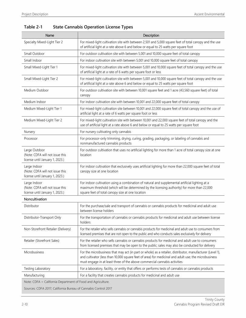
Project Description Ascent Environmental
Trinity County 2-10 Cannabis Program Revised Draft EIR
Table 2-1 State Cannabis Operation License Types
Name Description
Specialty Mixed-Light Tier 2 For mixed-light cultivation site with between 2,501 and 5,000 square feet of total canopy and the use of artificial light at a rate above 6 and below or equal to 25 watts per square foot
Small Outdoor For outdoor cultivation site with between 5,001 and 10,000 square feet of total canopy
Small Indoor For indoor cultivation site with between 5,001 and 10,000 square feet of total canopy
Small Mixed-Light Tier 1 For mixed-light cultivation site with between 5,001 and 10,000 square feet of total canopy and the use of artificial light at a rate of 6 watts per square foot or less
Small Mixed-Light Tier 2 For mixed-light cultivation site with between 5,001 and 10,000 square feet of total canopy and the use of artificial light at a rate above 6 and below or equal to 25 watts per square foot
Medium Outdoor For outdoor cultivation site with between 10,001 square feet and 1 acre (43,560 square feet) of total canopy
Medium Indoor For indoor cultivation site with between 10,001 and 22,000 square feet of total canopy
Medium Mixed-Light Tier 1 For mixed-light cultivation site between 10,001 and 22,000 square feet of total canopy and the use of artificial light at a rate of 6 watts per square foot or less
Medium Mixed-Light Tier 2 For mixed-light cultivation site with between 10,001 and 22,000 square feet of total canopy and the use of artificial light at a rate above 6 and below or equal to 25 watts per square foot
Nursery For nursery cultivating only cannabis
Processor For processor-only trimming, drying, curing, grading, packaging, or labeling of cannabis and nonmanufactured cannabis products
Large Outdoor (Note: CDFA will not issue this license until January 1, 2023.)
For outdoor cultivation that uses no artificial lighting for more than 1 acre of total canopy size at one location
Large Indoor (Note: CDFA will not issue this license until January 1, 2023.)
For indoor cultivation that exclusively uses artificial lighting for more than 22,000 square feet of total canopy size at one location
Large Indoor (Note: CDFA will not issue this license until January 1, 2023.)
For indoor cultivation using a combination of natural and supplemental artificial lighting at a maximum threshold (which will be determined by the licensing authority) for more than 22,000 square feet of total canopy size at one location
Noncultivation
Distributor For the purchase/sale and transport of cannabis or cannabis products for medicinal and adult use between license holders
Distributor-Transport Only For the transportation of cannabis or cannabis products for medicinal and adult use between license holders
Non-Storefront Retailer (Delivery) For the retailer who sells cannabis or cannabis products for medicinal and adult use to consumers from licensed premises that are not open to the public and who conducts sales exclusively for delivery
Retailer (Storefront Sales) For the retailer who sells cannabis or cannabis products for medicinal and adult use to consumers from licensed premises that may be open to the public; sales may also be conducted for delivery
Microbusiness For the microbusiness that may act (in part or whole) as a retailer, distributor, manufacturer (Level 1), and cultivator (less than 10,000 square feet of area) for medicinal and adult use; the microbusiness must engage in at least three of the above commercial cannabis activities
Testing Laboratory For a laboratory, facility, or entity that offers or performs tests of cannabis or cannabis products
Manufacturing For a facility that creates cannabis products for medicinal and adult use
Note: CDFA = California Department of Food and Agriculture.
Sources: CDFA 2017; California Bureau of Cannabis Control 2017
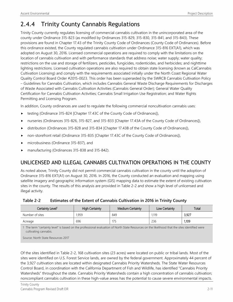
Ascent Environmental Project Description
Trinity County Cannabis Program Revised Draft EIR 2-11
2.4.4 Trinity County Cannabis Regulations Trinity County currently regulates licensing of commercial cannabis cultivation in the unincorporated area of the county under Ordinance 315-823 (as modified by Ordinances 315-829, 315-830, 315-841, and 315-843). These provisions are found in Chapter 17.43 of the Trinity County Code of Ordinances (County Code of Ordinances). Before this ordinance existed, the County regulated cannabis cultivation under Ordinance 315-816 EXT(A1), which was adopted on August 30, 2016. Licensed commercial operations are required to comply with the limitations on the location of cannabis cultivation and with performance standards that address noise; water supply; water quality; restrictions on the use and storage of fertilizers, pesticides, fungicides, rodenticides, and herbicides; and nighttime lighting restrictions. Licensed cultivation operations are also required to obtain state licensing (known as CalCannabis Cultivation Licensing) and comply with the requirements associated initially under the North Coast Regional Water Quality Control Board Order #2015-0023. This order has been superseded by the SWRCB Cannabis Cultivation Policy – Guidelines for Cannabis Cultivation, which includes Cannabis General Waste Discharge Requirements for Discharges of Waste Associated with Cannabis Cultivation Activities (Cannabis General Order); General Water Quality Certification for Cannabis Cultivation Activities; Cannabis Small Irrigation Use Registration; and Water Rights Permitting and Licensing Program.
In addition, County ordinances are used to regulate the following commercial noncultivation cannabis uses:
testing (Ordinance 315-824 [Chapter 17.43C of the County Code of Ordinances]),
nurseries (Ordinances 315-826, 315-827, and 315-833 [Chapter 17.43A of the County Code of Ordinances]),
distribution (Ordinances 315-828 and 315-834 [Chapter 17.43B of the County Code of Ordinances]),
non-storefront retail (Ordinance 315-835 [Chapter 17.43C of the County Code of Ordinances]),
microbusiness (Ordinance 315-837), and
manufacturing (Ordinances 315-838 and 315-842).
UNLICENSED AND ILLEGAL CANNABIS CULTIVATION OPERATIONS IN THE COUNTY As noted above, Trinity County did not permit commercial cannabis cultivation in the county until the adoption of Ordinance 315-816 EXT(A1) on August 30, 2016. In 2016, the County conducted an evaluation and mapping using satellite imagery and geographic information system (GIS) mapping data to estimate the extent of existing cultivation sites in the county. The results of this analysis are provided in Table 2-2 and show a high level of unlicensed and illegal activity.
Table 2-2 Estimates of the Extent of Cannabis Cultivation in 2016 in Trinity County
Certainty Level1 High Certainty Medium Certainty Low Certainty Total
Number of sites 1,959 849 1,119 3,927
Acreage 696 175 236 1,109 1 The term “certainty level” is based on the professional evaluation of North State Resources on the likelihood that the sites identified were
cultivating cannabis.
Source: North State Resources 2017
Of the sites identified in Table 2-2, 168 cultivation sites (23 acres) were located on public or tribal lands. Most of the sites were identified on U.S. Forest Service lands, are owned by the federal government. Approximately 44 percent of the 3,927 cultivation sites are located within designated Cannabis Priority Watersheds. The State Water Resources Control Board, in coordination with the California Department of Fish and Wildlife, has identified “Cannabis Priority Watersheds” throughout the state. Cannabis Priority Watersheds contain a high concentration of cannabis cultivation; noncompliant cannabis cultivation in these high-value areas has the potential to cause severe environmental impacts.
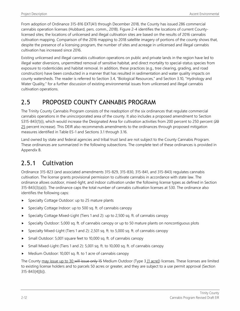
Project Description Ascent Environmental
Trinity County 2-12 Cannabis Program Revised Draft EIR
From adoption of Ordinance 315-816 EXT(A1) through December 2018, the County has issued 286 commercial cannabis operation licenses (Hubbard, pers. comm., 2018). Figure 2-4 identifies the locations of current County-licensed sites; the locations of unlicensed and illegal cultivation sites are based on the results of 2016 cannabis cultivation mapping. Comparison of the 2016 mapping to 2018 satellite imagery of portions of the county shows that, despite the presence of a licensing program, the number of sites and acreage in unlicensed and illegal cannabis cultivation has increased since 2016.
Existing unlicensed and illegal cannabis cultivation operations on public and private lands in the region have led to illegal water diversions, unpermitted removal of sensitive habitat, and direct mortality to special-status species from exposure to rodenticides and habitat removal. In addition, these practices (e.g., tree clearing, grading, and road construction) have been conducted in a manner that has resulted in sedimentation and water quality impacts on county watersheds. The reader is referred to Section 3.4, “Biological Resources,” and Section 3.10, “Hydrology and Water Quality,” for a further discussion of existing environmental issues from unlicensed and illegal cannabis cultivation operations.
2.5 PROPOSED COUNTY CANNABIS PROGRAM The Trinity County Cannabis Program consists of the readoption of the six ordinances that regulate commercial cannabis operations in the unincorporated area of the county. It also includes a proposed amendment to Section S315-843(1)(i), which would increase the Designated Area for cultivation activities from 200 percent to 250 percent (20 25 percent increase). This DEIR also recommends amendments to the ordinances through proposed mitigation measures identified in Table ES-1 and Sections 3.1 through 3.16.
Land owned by state and federal agencies and tribal trust land are not subject to the County Cannabis Program. These ordinances are summarized in the following subsections. The complete text of these ordinances is provided in Appendix B.
2.5.1 Cultivation Ordinance 315-823 (and associated amendments 315-829, 315-830, 315-841, and 315-843) regulates cannabis cultivation. The license grants provisional permission to cultivate cannabis in accordance with state law. The ordinance allows outdoor, mixed-light, and indoor cultivation under the following license types as defined in Section 315-843(3)(a)(i). The ordinance caps the total number of cannabis cultivation licenses at 530. The ordinance also identifies the following caps:
Specialty Cottage Outdoor: up to 25 mature plants
Specialty Cottage Indoor: up to 500 sq. ft. of cannabis canopy
Specialty Cottage Mixed-Light (Tiers 1 and 2): up to 2,500 sq. ft. of cannabis canopy
Specialty Outdoor: 5,000 sq. ft. of cannabis canopy or up to 50 mature plants on noncontiguous plots
Specialty Mixed-Light (Tiers 1 and 2): 2,501 sq. ft. to 5,000 sq. ft. of cannabis canopy
Small Outdoor: 5,001 square feet to 10,000 sq. ft. of cannabis canopy
Small Mixed-Light (Tiers 1 and 2): 5,001 sq. ft. to 10,000 sq. ft. of cannabis canopy
Medium Outdoor: 10,001 sq. ft. to 1 acre of cannabis canopy
The County may issue up to 30 will issue only 15 Medium Outdoor (Type 3 [1 acre]) licenses. These licenses are limited to existing license holders and to parcels 50 acres or greater, and they are subject to a use permit approval (Section 315-843[4][b]).
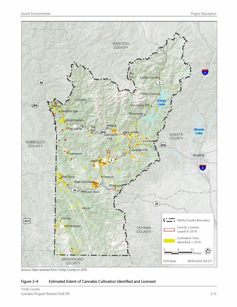
Ascent Environmental Project Description
Trinity County Cannabis Program Revised Draft EIR 2-13
Source: Data received from Trinity County in 2019
Figure 2-4 Estimated Extent of Cannabis Cultivation Identified and Licensed
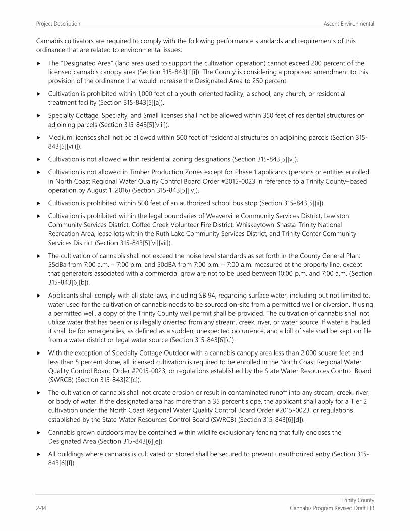
Project Description Ascent Environmental
Trinity County 2-14 Cannabis Program Revised Draft EIR
Cannabis cultivators are required to comply with the following performance standards and requirements of this ordinance that are related to environmental issues:
The “Designated Area” (land area used to support the cultivation operation) cannot exceed 200 percent of the licensed cannabis canopy area (Section 315-843[1][i]). The County is considering a proposed amendment to this provision of the ordinance that would increase the Designated Area to 250 percent.
Cultivation is prohibited within 1,000 feet of a youth-oriented facility, a school, any church, or residential treatment facility (Section 315-843[5][a]).
Specialty Cottage, Specialty, and Small licenses shall not be allowed within 350 feet of residential structures on adjoining parcels (Section 315-843[5][viii]).
Medium licenses shall not be allowed within 500 feet of residential structures on adjoining parcels (Section 315-843[5][viii]).
Cultivation is not allowed within residential zoning designations (Section 315-843[5][v]).
Cultivation is not allowed in Timber Production Zones except for Phase 1 applicants (persons or entities enrolled in North Coast Regional Water Quality Control Board Order #2015-0023 in reference to a Trinity County–based operation by August 1, 2016) (Section 315-843[5][iv]).
Cultivation is prohibited within 500 feet of an authorized school bus stop (Section 315-843[5][ii]).
Cultivation is prohibited within the legal boundaries of Weaverville Community Services District, Lewiston Community Services District, Coffee Creek Volunteer Fire District, Whiskeytown-Shasta-Trinity National Recreation Area, lease lots within the Ruth Lake Community Services District, and Trinity Center Community Services District (Section 315-843[5][vi][vii]).
The cultivation of cannabis shall not exceed the noise level standards as set forth in the County General Plan: 55dBa from 7:00 a.m. – 7:00 p.m. and 50dBA from 7:00 p.m. – 7:00 a.m. measured at the property line, except that generators associated with a commercial grow are not to be used between 10:00 p.m. and 7:00 a.m. (Section 315-843[6][b]).
Applicants shall comply with all state laws, including SB 94, regarding surface water, including but not limited to, water used for the cultivation of cannabis needs to be sourced on-site from a permitted well or diversion. If using a permitted well, a copy of the Trinity County well permit shall be provided. The cultivation of cannabis shall not utilize water that has been or is illegally diverted from any stream, creek, river, or water source. If water is hauled it shall be for emergencies, as defined as a sudden, unexpected occurrence, and a bill of sale shall be kept on file from a water district or legal water source (Section 315-843[6][c]).
With the exception of Specialty Cottage Outdoor with a cannabis canopy area less than 2,000 square feet and less than 5 percent slope, all licensed cultivation is required to be enrolled in the North Coast Regional Water Quality Control Board Order #2015-0023, or regulations established by the State Water Resources Control Board (SWRCB) (Section 315-843[2][c]).
The cultivation of cannabis shall not create erosion or result in contaminated runoff into any stream, creek, river, or body of water. If the designated area has more than a 35 percent slope, the applicant shall apply for a Tier 2 cultivation under the North Coast Regional Water Quality Control Board Order #2015-0023, or regulations established by the State Water Resources Control Board (SWRCB) (Section 315-843[6][d]).
Cannabis grown outdoors may be contained within wildlife exclusionary fencing that fully encloses the Designated Area (Section 315-843[6][e]).
All buildings where cannabis is cultivated or stored shall be secured to prevent unauthorized entry (Section 315-843[6][f]).
Ascent Environmental Project Description
Trinity County Cannabis Program Revised Draft EIR 2-15
Any fuel, fertilizer, pesticide, fungicide, rodenticide, herbicide or other substance toxic to wildlife, children, or pets shall be stored in a secured and locked structure or device. All use of pesticide products shall be in compliance with state pesticide laws and regulations enforced by the County Agricultural Commissioner’s Office, Trinity County Environmental Health and the California Department of Pesticide Regulation (Section 315-843[6][g]).
Hazardous materials and wastes from agricultural businesses are regulated by Trinity County Environmental Health and the Department of Toxic Substances Control Trinity CUPA (Section 315-843[6][h]).
Rodenticides that require a California Restricted Materials permit cannot be used, those that are designated as federally Restricted Use Products can only be used by a certified applicator (Section 315-843[6][i]).
The following rodent repellents may be used in and around cannabis cultivation sites consistent with the label: Capsicum oleoresin, Putrescent Whole Egg Solids and Garlic (Section 315-843[6][j]).
All lighting associated with the operation shall be downcast, shielded and/or screened to keep light from emanating off-site or into the sky (Section 315-843[6][l]).
Those cultivations using artificial lighting from mixed-light cultivations shall shield greenhouses so that little to no light escapes. Light shall not escape at a level that is visible from neighboring properties between sunset and sunrise (Section 315-843[6][m]).
The cultivation of cannabis shall comply with Cal Fire and California Department of Fish and Wildlife (CDFW) regulations and any other resource agency having jurisdiction, including all activity but not limited to; clearing of land, stream crossings, water diversions, and riparian buffer zones (Section 315-843[6][n]).
Applicant shall obtain coverage under the General Permit for Discharges of Storm Water Associated with Construction Activity for construction projects that disturb one or more acres of land surface, specifically for new site preparation and development (Section 315-843[6][o]).
An applicant shall not be denied a license for the following reasons (Section 315-843[6][p]):
The property has an unlicensed structure without plumbing or electricity, if the structure is less than 120 square floor feet.
The property has an unoccupied out-building without plumbing or electricity, if the building was built prior to 2001.
All licensed cultivators within Trinity County can self-transport their own product to licensed distributors and/or manufactures as permitted by state law. Cultivators must obtain the appropriate state license permitting self-transport within ninety (90) days of receiving permission from the County. Cultivators must indicate on their Trinity County application that they would like permission to self-transport (Section 315-843[3][c]).
Nothing in this section shall be construed as a limitation on the County’s authority to abate any violation which may exist from the cultivation of cannabis plants or any part thereof from any location, indoor or outdoor, including from within a fully enclosed and secure structure (Section 315-843[6][q]).
Environmental and animal friendly linings should be used when constructing water ponds on the property (Section 315-843[6][t]).
2.5.2 Manufacturing Ordinances 315-838 and 315-842 cover the approval of manufacturing for cannabis products subject to obtaining the appropriate use permit. The regulations allows for nonvolatile or mechanical methods of manufacturing facilities (Type 6, Type N, and Type P state license) to be permitted in the following zoning districts after the appropriate use permit is obtained: General Commercial, Heavy Commercial, Industrial, Agricultural, Specific Unit Development, Agricultural Preserve, and Agricultural Forest. Manufacturing facilities licensed as a microbusiness involving a Type 6, or low-impact extraction, license may be permitted in Rural Residential and Unclassified zoning districts if the appropriate use permit is obtained. Cannabis manufacturing involving volatile, nonvolatile, or mechanical methods
Project Description Ascent Environmental
Trinity County 2-16 Cannabis Program Revised Draft EIR
(Type 7 state license) are permitted (subject to issuance of a Conditional Use Permit) in the following zoning districts: Heavy Commercial, Industrial, and Specific Unit Development. However, manufacturing is not allowed in the Whiskeytown-Shasta-Trinity National Recreation Area, lease lots within the Ruth Lake Community Services District, the Historic District of Weaverville, the Coffee Creek Volunteer Fire District, the Trinity Center Community Services District, and a portion of the Lewiston Community Services District.
The ordinance also lists the following requirements that are related to environmental issues:
Cannabis manufacturing facilities shall be located only in zones that specifically provide for this use. The facility shall not be on prime Agricultural Soil, as determined by the Planning Director or his/her designee (Section 315-842[4][A]).
Cannabis manufacturing facilities shall not be allowed within 1,000 feet of a youth-oriented facility, school, church, or residential treatment facility. Cannabis manufacturing facilities shall not be within 500 feet from an authorized school bus stop, unless a variance is obtained (Section 315-842[4][B]).
All cannabis manufacturing operations shall ensure that cannabis is obtained from licensed cultivation sources and shall implement best practices and comply with state law to ensure that all manufactured Cannabis products are properly stored, labeled, transported and inspected prior to distribution at a legally permitted and licensed retail outlet. Cannabis manufacturing operations shall purchase at least 75 percent of its cannabis from Trinity County sources (Section 315-842[4][C]).
Security plan shall be developed which is compliant with state requirements and submitted with an application and must be sufficient to restrict access to only those intended and to deter trespass and theft of cannabis or cannabis products (Section 315-842[4][D]).
A detailed operating site plan must be submitted with an application for the appropriate Use Permit (Section 315-842[4][E]).
Fire plans must be prepared by the applicant and approved by the Weaverville Fire District Chief or a designee of the Trinity County Board of Supervisors. An approved fire plan must be submitted with an application the appropriate Use Permit (Section 315-842[4][F]).
Applicants must apply for Certified Unified Program Agencies ("CUPA") which, for Trinity County, is administered through the Department of Toxic Substances Control (Section 315-842[4][G]).
Any employees of a cannabis manufacturing facility operating potentially hazardous equipment shall be trained on the proper use of equipment and on the proper hazard response protocols in the event of equipment failure. In addition, employees handling edible cannabis products or ingredients shall be trained on proper food safety practices (Section 315-842[4][H]).
Type 7 (state license type) applicants are required to obtain a Conditional Use Permit before starting operations, including infrastructure and building improvements specific to the use, and the following additional requirements must be met (Section 315-842[4][J]):
Extractions must be in closed loop system as defined and prescribed by State of California.
Wastewater shall be disposed of into an adequate sewage system, as prescribed by Trinity County Environmental Health Division and pursuant to California State regulations.
The facility must be setback a minimum of I00 feet from all adjacent property lines. Application for a variance from this provision will be considered concurrently with application for a Conditional Use Permit from the Trinity County Planning Commission.
All building structures must have operational automatic fire sprinklers.
Type 6, Type 7, or Type N (state license type) licensees who wish to register as a shared use facility shall obtain a Conditional Use Permit before starting operations, including infrastructure and building improvements (Section 315-842[4][K]).
Ascent Environmental Project Description
Trinity County Cannabis Program Revised Draft EIR 2-17
For Type 6 licenses the following requirements must be met to qualify for a Director's Use Permit. Applicants who meet these requirements must obtain an approved Director's Use Permit before starting operations, including infrastructure and building improvements specific to the use (Section 315-842[4][L]).
The manufacturing business:
Operates under a Type N or Type P license.
Utilizes extractions with butter or food-grade oils, provided that the resulting extract or concentrate shall be used solely in the manufacture of the licensee's infused product, and shall not be sold to any other licensee.
Utilizes extractions methods such as Rosin Pressing, Bubble/Water Hash or Kief/Dry Sifting.
Any post-extraction methods that involve substances included in Title 8. Industrial Relations Division I. Department of Industrial Relations Chapter 3.2. California Occupational Safety and Health Regulations (Cal/OSHA) Subchapter I. Regulations of the Director of lndustrial Relations Article 5. Hazardous Substances Information and Training (Refs & Annos) CCR§ 339 The Hazardous Substances List may require a Conditional Use Permit, as determined by the Director.
The manufacturing business does not employ more than three permanent, full-time employees, and/or does not compensate more than 6,240 employee work hours per year.
The manufacturing business does not generate more than two non-employee vehicles per week.
The manufacturing facilities are operated within the footprint of an existing building.
Vehicle access to the Manufacturing premises utilizing a shared and privately owned or maintained road or driveway shall prompt the Trinity County Planning Department to notify adjacent impacted property owners. Objections from adjacent impacted property owners may require mitigation measures or require a Conditional Use Permit, as determined by the Director.
All Type 6, Type P or Type N applicants that do not meet the requirements outlined in Section 2 - subsection 4 L shall obtain a Conditional Use Permit before starting operations, including infrastructure or building improvements specific to the use (Section 315-842[4][M]).
The manufacturer shall allow access to the facility and access to records if requested by the County, its officers, or agents, for an annual inspection and submit to inspections from the County or its officers to verify compliance with all relevant rules, regulations, and conditions (Section 315-842[6][A]).
The property owner shall be responsible for ensuring that all commercial cannabis activities at the site operate in good standing with permits and licenses required by the Trinity County Code and state law. Failure to take appropriate action to evict or otherwise remove operators who do not maintain permits or licenses in good standing with the County or state shall be grounds for the suspension or revocation of a Use Permit pursuant to the ordinance chapter (Section 315-842[6][D]).
The manufacturing facilities and activities shall be maintained in accordance with the operating plans approved by the County (Section 315-842[6][E]).
At any time during the license period, a licensee may request to change the manufacturing activities conducted at the licensed premises. All proposed changes require pre-approval, including infrastructure or building improvements specific to the new use. To request approval for proposed changes, the licensee shall submit a revised operating plan and drawings per Trinity County's application process.
Any change requests shall be evaluated on a case-by-case basis by Trinity County Planning Department, and upon approval, the licensee may begin conducting the additional manufacturing operation or make the requested change to the premises. The existing license shall be amended to reflect the change in operations, if applicable, but the date of expiration shall not change.
Project Description Ascent Environmental
Trinity County 2-18 Cannabis Program Revised Draft EIR
2.5.3 Microbusinesses Ordinance 315-837 covers the allowance for microbusiness licenses. Microbusinesses are allowed in zoning districts that are zoned for at least two or more of the following qualifying commercial cannabis activities in addition to cultivation: manufacturing (Type 6, Type N, or Type P), distribution (Types 11 and 13), and retail (Type 9 – Non-Storefront Retail). The microbusiness must comply with the following requirements that are related to environmental issues:
An applicant for a microbusiness license must be licensed under the County’s cultivation licensing program and cultivating on an area 10,000 sq. ft. or less and holding a valid Type 1 or Type 2 cultivation license. The combination of the microbusiness and cultivation license will count as one license as allowed by Ordinance 315-829 (Section 315-837[2][A]).
An applicant for a microbusiness license must hold a Trinity County cultivation license, engage in and be appropriately zoned for at least two or more of the qualifying commercial cannabis activities listed above. Microbusiness licenses shall not relieve the Licensee of the requirements of holding and following the requirements of the individual license (Section 315-837[2][B]).
All microbusiness activities shall not be conducted inside a private residence or require persons to pass through a private residence to access the licensed premises (Section 315-837[2][E]).
Microbusiness applicants shall obtain a Conditional Use Permit. Microbusiness applicants may qualify for a Director’s Use Permit rather than a Conditional Use Permit when the following conditions apply (Section 315-837[2][F]):
The microbusiness does not employ more than three permanent, full-time employees, and/or does not compensates no more than 6,240 employee work hours per year.
The microbusiness does not generate more than two non-employee vehicles visiting the licensed premises at any one time, or no more than six non-employee vehicles per week.
Should the vehicle access to property on which the microbusiness license is granted be a shared and privately owned or maintained road or driveway, the Trinity County Planning Department will notify adjacent property owners who share use of the road/driveway. Objections from adjacent property owners who share use of the road/driveway may lead to further mitigation measures or the need for the microbusiness applicant to obtain a Conditional Use Permit as determined by the Director (Section 315-837[2][G]).
The primary hours of operation shall be limited to 7:00 a.m. to 8:00 p.m. Monday through Saturday, and 8:00 a.m. to 5:00 p.m. Sundays (Section 315-837[2][H]).
Comply with all state and County codes related cultivation, manufacturing, distribution and retail, unless amended (Section 315-837[3][A]).
Allow access to any facilities or vehicles utilized in transportation, records if requested by the County, its officers, or agents, and allow inspections from the County or its officers to verify compliance with all relevant rules, regulations and conditions (Section 315-837[3][B]).
Obtain a valid and fully executed commercial Cannabis microbusiness license from the state prior to commencing operations, maintain such license in good standing in order to continue operations (Section 315-837[3][D]).
Ensure that all commercial Cannabis activities at the site operate in good standing with permits and licenses required by the Trinity County Code and state law (Section 315-837[3][E]).
Be limited to the following distribution amounts: in addition to the product that is grown pursuant to licensee's Cannabis Cultivation License, the microbusiness can distribute the following amount of third party product (Section 315-837[3][F]):
Those with a Specialty Cottage licenses can distribute 125 lbs. of product.
Ascent Environmental Project Description
Trinity County Cannabis Program Revised Draft EIR 2-19
Those with a Specialty Outdoor licenses can distribute 250 lbs. of product.
Those with a Small Outdoor or Mixed-Light Tier 1 and 2 licenses can distribute 500 lbs. of product.
Cannabis distributed from a third party shall be at least 75 percent from Trinity County sources (Section 315-837[3][G]).
Only be located in zoning districts where commercial cannabis licenses are allowed according to their respective ordinance (Cultivation Ordinance 315-823 and amendments; Manufacturing Ordinance 315-838, Distribution Ordinance 315-828 and Non-Storefront Retail Ordinance 315-835) (Section 315-837[3][H]).
A Microbusiness License shall not be allowed within the most restrictive setback distance as provided for in the Cultivation License or commercial cannabis activities permitted as part of this Microbusiness License, unless a variance is otherwise obtained (Section 315-837[3][I]).
2.5.4 Non-Storefront Retail Ordinance 315-835 covers non-storefront retail licenses. However, non-storefront retail is not allowed on prime Agricultural Soil and in the Whiskeytown-Shasta-Trinity National Recreation Area lease lots of the Ruth Lake Community Services District, Timber Production Zones (except for qualified Phase 1 applicants), residential zones, the Weaverville Community Services District, the Coffee Creek Volunteer Fire District, the Trinity Center Community Services District and Bucktail Subdivisions (Units 1–3), and a portion of the Lewiston Community Services District. The following requirements apply to non-storefront retail that are related to environmental issues:
Sales and deliveries must only take place between 6:00 a.m. and 10:00 p.m. (Section 315-835[2][B][i]).
All cannabis goods must be placed in an opaque exit package prior to leaving the premises (Section 315-835[2][B][ii]).
Deliveries may be made only by employees of the retailer (Section 315-835[2][B][iii]).
Deliveries must be to a private residence and cannot be sent to a post office box. The private residence of the consumer must be off-site resident of the Non-Storefront Retail licensee’s location. For purposes of this section, “private residence” means a house, an apartment unit, a mobile home, or other similar dwelling (Section 315-835[2][B][iv]).
Delivery vehicles may not contain more than the amounts allowed under state Code of Cannabis goods at any time (Section 315-835[2][B][v]).
The licensee must be able to immediately locate all delivery vehicles at all times (Section 315-835[2][B][vi]).
Non-storefront retail licensees cannot package or label cannabis goods (Section 315-835[2][B][vii]).
Non-storefront retail premises and activities are not allowed within 1,000 feet of a youth-oriented facility, school, church, or residential treatment facility, and not allowed within 500 from an authorized school bus stop unless a variance is obtained (Section 315-835[2][J]).
2.5.5 Testing Facilities Ordinance 315-824 covers cannabis testing facilities. Testing facilities can be located within General Commercial, Heavy Commercial, and Industrial zoning districts subject to Use Permit approval. Testing facilities are required to comply with the following performance standards and regulations that are related to environmental issues:
Shall not be within 1,000 feet of a youth-oriented facility, a school, any church, or residential treatment facility or within 500 feet of an authorized school bus stop and will be measured from footprint of buildings to edge of parcel boundary if sensitive receptors are present (Section 315-824[3][b][i]).
Project Description Ascent Environmental
Trinity County 2-20 Cannabis Program Revised Draft EIR
The owners, operators, and employees of the cannabis testing facilities shall be independent from all other persons, associations, and/or entities involved in the cannabis industry, and shall not hold any other state or County license related to cannabis (Section 315-824[3][b][ii]).
Cannabis testing facilities shall apply for appropriate licensing and/or register with any state agencies upon establishment of a state regulatory framework as required by the state and provide copies of the license application and the issued license to the County (Section 315-824[3][b][iii]).
Cannabis testing facilities shall show proof of ISO 17025 accreditation, or proof that the applicant is in the process of applying for or is preparing to apply for ISO 17025 accreditation as required by the state (Section 315-824[3][b][iv]).
Cannabis testing facilities shall adopt a written standard operating procedures for laboratory processes and analytical methods as required by state regulations (Section 315-824[3][b][v]).
Cannabis testing facilities shall adopt a written standard operating procedure to obtain samples for testing according to state regulations (Section 315-824[3][b][vi]).
Cannabis testing facilities shall dispose of test samples according to state regulations and document waste disposal procedures followed for each sample (Section 315-824[3][b][ix]).
Cannabis testing facilities shall comply with all safety standards and requirements for cannabis testing facilities identified by the state, and shall ensure the safety of its employees and the proper disposal of all chemicals and byproducts pursuant to California Department of Public Health guidelines, California Division of Occupational Safety and Health requirements, California Department of Transportation, California Department of Toxic Substances Control (Trinity County CUPA), and Trinity County Department of Environmental Health (Section 315-824[3][b][x]).
Cannabis testing facilities shall adopt a written security protocol and implement the protocol to prevent diversion, theft, and loss of cannabis samples (Section 315-824[3][b][xiii]).
Operators of the testing facility shall allow access to the facility and access to records if requested by the County or state, its officers, or agents, and shall pay for routine and focused inspections and submit to inspections from the County or its officers to verify compliance with all relevant rules, regulations, and conditions (Section 315-824[5][a]).
The testing facility and related activities shall be maintained in accordance with the operating plans accepted by the County (Section 315-824[5][e]).
A safety and security plan shall be submitted and accepted by the County. This plan shall be updated annually. All security protocols shall be implemented prior to commencing operations (Section 315-824[5][f]).
Hours of operation shall be determined on a site-specific basis established in the Use Permit associated with the testing facility (Section 315-824[5][g]).
2.5.6 Nurseries Ordinance 315-826 regulates cannabis nurseries. Cannabis nursery facilities are permitted in the Agriculture, Heavy Commercial, Heavy Industrial/Manufacturing, Light Industrial/Manufacturing, Industrial, and Specific Unit Development zoning districts with Conditional Use Permit approval. However, nurseries are not allowed in the Whiskeytown-Shasta-Trinity National Recreation Area and the Ruth Lake Community Services District. The ordinance dictates the following requirements and standards for nurseries that are related to environmental issues:
A cannabis nursery shall possess and be in full compliance with a Type 4 state license (Section 315-826[3][a][i]).
Cannabis nurseries shall not be located within 1,000 feet of a youth-oriented facility, school, church, or residential treatment facility or within 500 feet of an authorized school bus stop. Variances are allowed upon review of the Planning Commission (Section 315-826[3][a][ii]).
Ascent Environmental Project Description
Trinity County Cannabis Program Revised Draft EIR 2-21
Cannabis nurseries shall have security measures, including fencing, sufficient to restrict access and deter trespass and theft of cannabis or cannabis products. Fencing must include a lockable gate that is locked at all times when the property owner and/or employees are not on the premises. Fencing shall not violate any other ordinance, code section, or provision of law regarding height and location restrictions and shall not be constructed or covered with plastic or cloth, although shade cloth may be used on the inside of the fence (Section 315-826[3][a][iv]).
Cannabis nurseries may grow clones and immature plants indoors, but only when allowed by the required Conditional Use Permit (Section 315-826[3][a][v]).
Cannabis nurseries shall comply with all other provisions of the Trinity County Code and the Zoning Ordinance (Section 315-826[3][a][vi]).
Development standards: The development standards (such as setbacks, minimum lot coverage, etc.) shall be as shown for the applicable zoning district, provided, however, that the Planning Commission may establish more restrictive standards on a case-by-case basis during the use permit approval process (Section 315-826[3][a][vii]).
In addition to any other conditions and mitigation measures required, all of the following conditions shall apply to all Cannabis nurseries (Section 315-826[4][a]):
All Cannabis nursery license holders shall maintain accurate records on sales, including proof that sales occur only to licensed individuals.
Sales shall only be to licensed cannabis cultivators in the state of California.
License holders shall comply with all applicable state and County laws.
The Trinity County Agricultural Commissioner may create standards for plant quality which shall comply with State of California regulations.
All sales locations shall have adequate parking to accommodate customers.
Glare from nursery facilities and resale locations shall not emanate onto neighboring properties. This condition will also be reviewed on a case-by-case basis as part of the use permit process.
Cannabis nurseries shall comply with the cultivation plan required in state Type 4 licenses.
Operators of Cannabis nurseries shall allow access to the facility and access to records if requested by the County, its officers, or agents; shall pay for an annual inspection; and shall submit to inspections from the County or its officers to verify compliance with all relevant rules, regulations, and conditions (Section 315-826[4][b]).
Any person operating a Cannabis Nursery shall obtain a valid and fully executed commercial Cannabis Cultivation Type 4 State License prior to commencing operations and must maintain such license in good standing to continue operations (Section 315-826[4][e]).
The property owner shall be responsible for ensuring that all commercial cannabis activities at the site operate in good standing with permits and licenses required by Trinity County Code and state law. Failure to take appropriate action to evict or otherwise remove operators who do not maintain permits or licenses in good standing with the County or state shall be grounds for the suspension or revocation of the Cannabis nursery license (Section 315-826[4][f]).
Cannabis nurseries and related activities shall be maintained in accordance with operating plans approved by the County (Section 315-826[4][g]).
Project Description Ascent Environmental
Trinity County 2-22 Cannabis Program Revised Draft EIR
2.5.7 Distribution Facilities Ordinance 315-828 provides the regulations for distribution facilities. Distribution is allowed in General Commercial, Heavy Commercial, Industrial, Agricultural, and Specific Unit Development zoning districts subject to Conditional Use Permit approval. An amendment to the ordinance provides a program fee due annually from the date of issuance. The ordinance dictates the following regulations and standards for cannabis distribution that are related to environmental issues:
Cannabis distribution facilities shall not be allowed within 1,000 feet of a youth-oriented facility, school, church, or residential treatment facility or within 500 feet of an authorized school bus stop, unless a variance is obtained (Section 315-828[3][B]).
All Cannabis distributors shall ensure that Cannabis is obtained from licensed cultivation sources and shall implement best practices to ensure that all Cannabis products are properly stored, labeled, transported, and tested prior to distribution at a legally permitted and licensed facility (Section 315-828[3][C]).
Security plan shall be developed which is compliant with state requirements and submitted with an application and must be sufficient to restrict access to only those intended to deter trespass and theft of Cannabis or Cannabis products shall be provided and maintained. The Security plan shall be approved by the Board of Supervisors, or its designee (Section 315-828[3][D]).
A site operations plan shall be submitted with the application for a Conditional Use Permit (Section 315-828[3][E]).
The distributor shall allow access to the facility and any vehicles utilized in transportation, and access to records if requested by the County, its officers, or agents, and shall allow inspections from the County or its officers to verify compliance with all relevant rules, regulations and conditions (Section 315-828[5][A]).
Any person operating a cannabis distribution facility shall obtain a valid and fully executed commercial cannabis distribution license or provisional license from the state prior to commencing operations, and must maintain such license in good standing in order to continue operations (Section 315-828[5][C]).
The property owner shall be responsible for ensuring that all commercial cannabis activities at the site operate in good standing with permits and licenses required by Trinity County Code and state law. Failure to take appropriate action to evict or otherwise remove licensees who do not maintain permits or licenses in good standing with the County or state shall be grounds for the suspension or revocation of a Conditional Use Permit pursuant to this Chapter (Section 315-828[5][D]).
The distribution facility and activities shall be maintained in accordance with the operating plan associated with the Conditional Use Permit and approved by the County (Section 315-828[5][E]).
2.6 CANNABIS OPERATION DEVELOPMENT ASSUMPTIONS The action analyzed in this EIR is the adoption of a modified set of regulations that would apply countywide and is therefore programmatic in nature. As a result, this EIR considers implementation of the Cannabis Program generally. It does not provide a specific review of the potential impacts of every individual cannabis project that is in operation or may be proposed. This EIR evaluates the effectiveness of the proposed land use requirements and development performance standards in addressing environmental impacts associated with the activities of licensed commercial cannabis uses that are currently operating and the development and operation of new commercial cannabis operations that would be approved under the Cannabis Program. Where potentially significant environmental impacts are identified, this EIR also discusses mitigation measures (e.g., in the form of modifications to the Cannabis Program) that would reduce or avoid significant impacts.
Commercial cannabis operations that do not comply with the Cannabis Program would be considered illegal. Enforcement activities targeting operations out of compliance would be taken by the County in coordination with other agencies and would bring some cultivation operations into compliance with County and state standards and
Ascent Environmental Project Description
Trinity County Cannabis Program Revised Draft EIR 2-23
result in the closure of others. However, it is acknowledged that illegal cannabis operations would likely continue to occur in the county after adoption and implementation of the Cannabis Program. Although this EIR acknowledges the adverse environmental effects of continued illegal cannabis operations as part of the environmental baseline condition, the EIR does not propose mitigation measures to address existing illegal operations, because they are not part of the project.
Table 2-3 summarizes what is reasonably foreseeable within Trinity County upon implementation of the Cannabis Program. It presents assumptions based on County staff expertise, review of current cannabis operations in the county, state-licensed cannabis operations in other rural communities with similar rural land use characteristics (e.g., Humboldt County), available cannabis application data, and other published information regarding cannabis operations. The future of cannabis operations in the county may vary from what is set forth here because the cannabis business is market-driven and guided by unpredictable economic and regulatory forces. The assumptions regarding the extent of cannabis use operations in the county (existing and new) presented in Table 2-3 provide the basis for the analysis provided in this EIR.
2.7 INTENDED USE OF THIS EIR As encouraged under CEQA, the County intends to use this Program EIR to broadly evaluate the impacts, countywide, of the ordinance and to streamline the environmental review and consideration of future cannabis operation applications. The County plans to make full use of existing streamlining provided by CEQA, as well as emerging streamlining techniques that may become available later, as applicable. Subsequent to adoption of the Cannabis Program, applicants may apply for cannabis use permits pursuant to the new regulations. Individual applications for commercial cannabis operations under the ordinance would be subject to further site-specific environmental review as applicable under CEQA in accordance with State CEQA Guidelines Section 15168(c), Use with Later Activities. This section of the guidelines addresses environmental review of projects intended to be addressed in a program for which an EIR was prepared. The County may determine that the environmental impacts of an individual application are adequately addressed in this EIR and that no further environmental review is required. However, the County may determine that an additional focused environmental review is required for an individual applicant. Preparation of a site-specific environmental review document, such as a negative declaration or mitigated negative declaration, would be required if the County determines that the individual application would cause a significant environmental impact that was not examined in the EIR or would substantially increase the severity of a previously identified significant impact under State CEQA Guidelines Sections 15162 and 15168(c).
Under Public Resources Code 21083.3 and State CEQA Guidelines Section 15183, lead agencies can use EIRs prepared for zoning actions to analyze the impacts of proposed cannabis projects that may be approved pursuant to the ordinance, and limit later project-level analysis to only site-specific issues not already examined (if any). Under the above-referenced code sections, CEQA analysis for later projects is limited to issues “peculiar” to the site or new environmental concerns not previously addressed. State CEQA Guidelines Section 15183(f) provides that impacts are not “peculiar” to the project if uniformly applied development policies or standards substantially mitigate that environmental effect. Upon approval, the Cannabis Program would meet the definition of a uniformly adopted standard, and compliance with the Cannabis Program would allow for CEQA streamlining to be used.
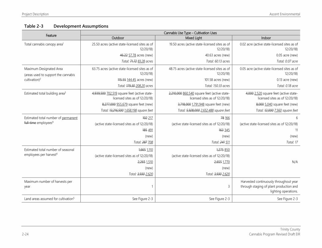
Project Description Ascent Environmental
Trinity County 2-24 Cannabis Program Revised Draft EIR
Table 2-3 Development Assumptions
Feature Cannabis Use Type – Cultivation Uses Outdoor Mixed Light Indoor
Total cannabis canopy area1 25.50 acres (active state-licensed sites as of 12/20/18)
46.22 57.78 acres (new) Total: 71.72 83.28 acres
19.50 acres (active state-licensed sites as of 12/20/18)
40.63 acres (new) Total: 60.13 acres
0.02 acre (active state-licensed sites as of 12/20/18)
0.05 acre (new) Total: 0.07 acre
Maximum Designated Area (areas used to support the cannabis cultivation)2
63.75 acres (active state-licensed sites as of 12/20/18)
115.55 144.45 acres (new) Total: 179.30 208.20 acres
48.75 acres (active state-licensed sites as of 12/20/18)
101.58 acres (new) Total: 150.33 acres
0.05 acre (active state-licensed sites as of 12/20/18)
0.13 acre (new) Total: 0.18 acre
Estimated total building area3 4,939,500 702,519 square feet (active state-licensed sites as of 12/20/18)
8,277,000 955,679 square feet (new) Total: 13,216,500 1,658,198 square feet
2,210,000 860,540 square feet (active state-licensed sites as of 12/20/18)
3,718,000 1,791,948 square feet (new) Total: 5,928,000 2,652,488 square feet
4,000 2,520 square feet (active state-licensed sites as of 12/20/18)
8,000 5,040 square feet (new) Total: 12,000 7,560 square feet
Estimated total number of permanent full-time employees4
102 217 (active state-licensed sites as of 12/20/18)
185 491 (new)
Total: 287 708
78 166 (active state-licensed sites as of 12/20/18)
163 345 (new)
Total: 241 511
6 (active state-licensed sites as of 12/20/18)
11 (new)
Total: 17
Estimated total number of seasonal employees per harvest4
1,665 1,110 (active state-licensed sites as of 12/20/18)
2,265 1,510 (new)
Total: 3,930 2,620
1,275 850 (active state-licensed sites as of 12/20/18)
2,655 1,770 (new)
Total: 3,930 2,620
N/A
Maximum number of harvests per year 1 3
Harvested continuously throughout year through staging of plant production and
lighting operations.
Land areas assumed for cultivation5 See Figure 2-3 See Figure 2-3 See Figure 2-3
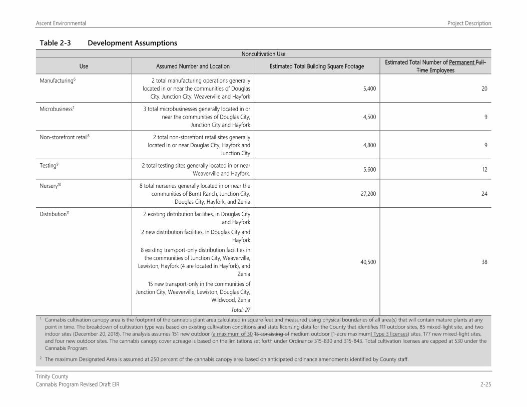
Ascent Environmental Project Description
Trinity County Cannabis Program Revised Draft EIR 2-25
Table 2-3 Development Assumptions Noncultivation Use
Use Assumed Number and Location Estimated Total Building Square Footage Estimated Total Number of Permanent Full-Time Employees
Manufacturing6 2 total manufacturing operations generally located in or near the communities of Douglas
City, Junction City, Weaverville and Hayfork 5,400 20
Microbusiness7 3 total microbusinesses generally located in or near the communities of Douglas City,
Junction City and Hayfork 4,500 9
Non-storefront retail8 2 total non-storefront retail sites generally located in or near Douglas City, Hayfork and
Junction City 4,800 9
Testing9 2 total testing sites generally located in or near Weaverville and Hayfork. 5,600 12
Nursery10 8 total nurseries generally located in or near the communities of Burnt Ranch, Junction City,
Douglas City, Hayfork, and Zenia 27,200 24
Distribution11 2 existing distribution facilities, in Douglas City and Hayfork
2 new distribution facilities, in Douglas City and Hayfork
8 existing transport-only distribution facilities in the communities of Junction City, Weaverville,
Lewiston, Hayfork (4 are located in Hayfork), and Zenia
15 new transport-only in the communities of Junction City, Weaverville, Lewiston, Douglas City,
Wildwood, Zenia Total: 27
40,500 38
1. Cannabis cultivation canopy area is the footprint of the cannabis plant area calculated in square feet and measured using physical boundaries of all area(s) that will contain mature plants at any point in time. The breakdown of cultivation type was based on existing cultivation conditions and state licensing data for the County that identifies 111 outdoor sites, 85 mixed-light site, and two indoor sites (December 20, 2018). The analysis assumes 151 new outdoor (a maximum of 30 15 consisting of medium outdoor [1-acre maximum] Type 3 licenses) sites, 177 new mixed-light sites, and four new outdoor sites. The cannabis canopy cover acreage is based on the limitations set forth under Ordinance 315-830 and 315-843. Total cultivation licenses are capped at 530 under the Cannabis Program.
2. The maximum Designated Area is assumed at 250 percent of the cannabis canopy area based on anticipated ordinance amendments identified by County staff.
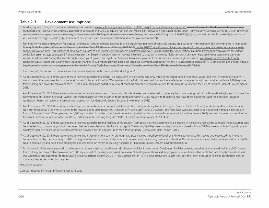
Project Description Ascent Environmental
Trinity County 2-26 Cannabis Program Revised Draft EIR
Table 2-3 Development Assumptions 3. Building square footage for outdoor cultivation was based on average building area identified in 2020 Trinity County cultivator survey results review of current cultivation operations in Trinity,
Humboldt, and Yolo Counties and was assumed to consist of 44,500 6,329 square feet per site. Mixed-light cultivation was based on the 2020 Trinity County cultivator survey results on review of current cultivation operations in the county in comparison with 2018 application data from Yolo County. An average building size of 23,000 10,124 square feet per site for mixed-light cultivation was used. An average of 2,000 1,260 square feet per site was used for indoor cultivation (Ascent Environmental 2018).
4. Full-time Permanent employment for outdoor and mixed-light operations assumes four 8.5 employees per acre of cannabis canopy area based on information in the amendments to Humboldt County Code Regulating Commercial Cannabis Activities Draft EIR (Humboldt County 2017:2-30) on the 2020 Trinity County cultivator survey results, and assumed increases in 1-acre cannabis canopy cultivation sites. This number of employees equates to approximately 2 permanent employees for every 10,000 square feet of operation. Full-time Permanent employment for indoor cultivation assumes approximately 2.7 employees per site. Seasonal employment for harvest is limited to outdoor and mixed-light cannabis cultivation because indoor operations generate several small harvests during the year through staged plant growth and light use. Seasonal harvest employment for outdoor and mixed-light cultivation was based on 2020 Trinity County cultivator survey results and County staff input on changes in cultivation activities based on cannabis cultivation application review. It is assumed to consist of 15 10 employees per site per harvest based on information in the amendments to Humboldt County Code Regulating Commercial Cannabis Activities Draft EIR (Humboldt County 2017:2-30).
5. It is assumed that cultivation activities would continue to occur in the areas identified in Figure 2-3. 6. As of December 20, 2018, there were no state-licensed cannabis manufacturing operations in the county and only three in the region (one in Sonoma County and two in Humboldt County). It
was assumed that two manufacturing operations would be established, in Weaverville and Hayfork. It is assumed that each manufacturing operation would be contained within a 2,700-square-foot building and have 10 employees each. These assumptions are based on review of cannabis manufacturing applications for Humboldt County and the City of Needles. (Ascent Environmental 2018)
7. As of December 20, 2018, there were no state-licensed microbusinesses in the county. Microbusinesses were assumed to generally be located along two of the three state highways in or near the communities of Junction City and Hayfork. The microbusinesses were assumed to be contained within a 1,500-square-foot building and have three employees (per the Cannabis Program restrictions) based on review of microbusiness application for Humboldt County. (Ascent Environmental 2018)
8. As of December 20, 2018, there were no state-licensed cannabis non-storefront retail uses in the county and only two in the region (one in Humboldt County and one in Mendocino County). Non-storefront retail sites were assumed to be located along State Route 299 (Junction City) and State Route 3 (Hayfork). The retail uses were assumed to be contained within a 2,400-square-foot building and have 1.82 employees per 1,000 square feet of building area based on review of existing sites and cannabis operator information (Ascent 2018) and employment assumptions in the Santa Barbara County Cannabis Land Use Ordinance and Licensing Program Draft EIR (Santa Barbara County 2017:3.14-12).
9. As of December 20, 2018, there were no state-licensed cannabis testing facilities in the county. Testing facilities were assumed to be located in the same areas as the cannabis manufacturing uses because testing of cannabis product is required before a manufacturing facility can accept it. The testing facilities were assumed to be contained within a 2,800-square-foot building and have six employees per site based on review of information provided by the City of Eureka for a testing facility (Dumouchel, pers. comm., 2018).
10. As of December 20, 2018, there were no state-licensed nurseries in the county, although two sites have obtained Conditional Use Permits to conduct this activity and expressed the intent to become licensed by the state early in 2019. Testing facilities were assumed to be located in or near areas of existing cannabis cultivation. Nurseries were assumed to be contained within a 3,400-square-foot facility and have three employees per site based on review of existing nurseries in Humboldt County (Ascent Environmental 2018).
11. Distribution facilities were assumed to be located in or near existing state-licensed distribution facilities in the county. Distribution facilities were assumed to be contained within a 1,500-square-foot building and have 1.28 employees per 1,000 square feet of building area based on review of existing operations and employment assumptions in the Santa Barbara County Cannabis Land Use Ordinance and Licensing Program Draft EIR (Santa Barbara County 2017:3.14-12). Section 315-841(3)(c) allows cultivators to self-transport their own product to licensed distributors and/or manufactures as permitted by state law.
Values are rounded.
Source: Prepared by Ascent Environmental 2018 2020
Ascent Environmental Project Description
Trinity County Cannabis Program Revised Draft EIR 2-27
2.8 POTENTIAL PERMITS AND APPROVALS REQUIRED The following approvals would be needed by the County for implementation of this project:
Readoption and amendment of the Cannabis Program, which consists of the following ordinances:
Ordinances 315-823, 315-829, 315-830, 315-841, and 315-843 (cultivation);
Ordinance 315-824 (testing);
Ordinances 315-826 and 315-827 (nurseries);
Ordinances 315-828 and 315-834 (distribution);
Ordinance 315-835 (non-storefront retail);
Ordinance 315-837 (microbusiness); and
Ordinances 315-838 and 315-842 (manufacturing).
The following state license approvals would be required for subsequent individual commercial applicants:
CDFA: cannabis cultivation (known as CalCannabis Cultivation Licensing) and management of the track and trace program;
BCC: permitting of distributors, retailers, testing laboratories, and microbusinesses; and
California Department of Public Health, Manufactured Cannabis Safety Branch: permitting of manufacturers of cannabis products.

Project Description Ascent Environmental
Trinity County 2-28 Cannabis Program Revised Draft EIR
This page intentionally left blank.
Trinity County Cannabis Program Revised Draft EIR 3-1
3 ENVIRONMENTAL IMPACTS AND MITIGATION MEASURES
APPROACH TO THE ENVIRONMENTAL ANALYSIS This DEIR evaluates and discloses the environmental impacts associated with implementing the Trinity County Cannabis Program, in accordance with CEQA (PRC Section 21000 et seq.) and the State CEQA Guidelines (CCR Title 14, Chapter 3, Section 1500 et seq.). Sections 3.1 through 3.16 of this DEIR each include the following components:
“Regulatory Setting”: This subsection presents information on the laws, regulations, plans, and policies that relate to the issue area being discussed. Regulations originating from the state and local levels are each discussed as appropriate. Cannabis is identified as a Schedule 1 controlled substance under the federal Controlled Substance Act. Operations related to the growing, processing, and sale of cannabis products are in violation of federal law. Federal agencies are prohibited from issuing permits or approvals for any operation that is in violation of federal law. Thus, compliance with federal permitting requirements that would usually address environmental impacts (e.g., filling of waters of the United States and incidental take authorization under the federal Endangered Species Act) is not legally possible.
“Environmental Setting”: This subsection describes the existing environmental conditions in the project area, pursuant to State CEQA Guidelines Section 15125. The environmental setting generally serves as the baseline against which environmental impacts are evaluated. State CEQA Guidelines Section 15125(a) states that the physical environmental conditions as they exist at the time the NOP is published normally constitute the baseline physical conditions by which a lead agency determines whether an impact is significant.
For the purposes of this DEIR, the description of the baseline conditions includes the relicensing and operation of existing commercial cannabis operations that have been licensed by the County since it adopted its first commercial cannabis regulations (Ordinance 315-816 EXT[A1]), on August 30, 2016. As described in Chapter 2, “Project Description,” the County has issued 286 commercial cannabis operation licenses between adoption of Ordinance 315-816 EXT[A1] in August 2016 and December 2018.
In 2016, the County conducted an evaluation and mapping using satellite imagery and GIS mapping data to estimate the extent of existing cultivation sites in the county and identified up to 3,927 sites encompassing approximately 1,108 acres (Table 2-2). Of the sites identified in Table 2-2, 168 cultivation sites (23.08 acres) were located on public and tribal lands. Most of the 168 sites were identified on U.S. Forest Service lands. Exhibit 2-4 identifies current County-licensed sites with unlicensed and illegal cultivation based on 2016 cannabis cultivation mapping. Comparison of the 2016 mapping to 2018 satellite imagery of portions of the county has confirmed that the number of sites and extent of acreage in unlicensed and illegal cannabis cultivation have increased since 2016.
Cultivation operations that do not comply with the Cannabis Program would be considered illegal. Enforcement activities targeting operations out of compliance would be taken by the County in coordination with other agencies with the intent that some would be brought into compliance with County and state standards and the closure of others. However, it is acknowledged that illegal cannabis operations would continue to occur in the county because legality has been shown to not constrain operations to date. Although this DEIR acknowledges the adverse environmental effects of continued illegal cannabis operations as part of the environmental baseline condition, because they are existing (and illegal) they are not part of the project; in this context, they would not result in environmental effects associated with the project and would not be mitigated. This is consistent with the requirements of CEQA, which is to consider the proposed project, and case law, as further discussed below.
Existing illegal cannabis cultivation operations are disclosed as part of the baseline condition in this DEIR in compliance with CEQA. Because the State CEQA Guidelines (Section 15125[a]) state that the baseline physical conditions are the basis by which a lead agency determines whether an impact of the project is significant, impact significance and mitigation is not assigned to these illegal activities. Published case law has confirmed that baseline conditions include unpermitted and harmful activities that have occurred before a project has been
Approach to Environmental Analysis Ascent Environmental
Trinity County 3-2 Cannabis Program Revised Draft EIR
analyzed. In Center for Biological Diversity v. Department of Fish and Wildlife (2015), 234 Cal.App.4th 214 (183 Cal.Rptr.3d 736), the Fourth Appellate District ruled that the baseline condition must reflect the physical conditions at the time the environmental analysis begins even if the current conditions include unauthorized and environmentally harmful conditions that never received environmental review. Other published court decisions that support this interpretation of CEQA include Riverwatch v. County of San Diego (1999), 76 Cal.App4th 1428 (91 Cal.Rptr. 2d 322), and Fat v. County of Sacramento (2002), 97 Cal.App.4th 1270 (119 Cal.Rptr.2d 402).
“Environmental Impacts and Mitigation Measures”: This subsection presents thresholds of significance and discusses the effects of the Trinity County Cannabis Program on the existing environment, including the environment beyond the county boundaries, in accordance with State CEQA Guidelines Section 15126.2. The methodology for impact analysis is described, including the technical studies and other sources of substantial evidence upon which the analyses rely. The thresholds of significance are defined and explained, and those thresholds for which the project would have no impact are disclosed and dismissed from further evaluation. Project impacts and mitigation measures are numbered sequentially in each subsection (e.g., Impact 3.2-1, Impact 3.2-2, Impact 3.2-3, etc.). A summary impact statement precedes a more detailed discussion of each environmental impact. The discussion presents the analysis, rationale, and substantial evidence upon which conclusions are drawn, and the determination of the impact’s level of significance is presented in bold text. A “less-than-significant” determination indicates that implementing the project would not result in a substantial adverse change in the physical environment. A “significant” determination indicates that it would result in a substantial adverse change in the physical environment. A “potentially significant” determination indicates that implementing the project might result in a substantial adverse change if the impact were to occur but that there is uncertainty regarding if the impact would result. Potentially significant impacts are treated the same as significant impacts under CEQA in terms of procedural requirements and the need to identify feasible mitigation. Mitigation measures are identified, as feasible, to avoid, minimize, rectify, reduce, or compensate for significant and potentially significant impacts, in accordance with State CEQA Guidelines Section 15126.4. Unless otherwise noted, the mitigation measures presented are recommended in this EIR for consideration by the County to adopt as conditions of approval.
Where an existing law, regulation, or permit specifies mandatory and prescriptive actions about how to fulfill the regulatory requirement as part of the project definition, leaving little discretion in its implementation, and would avoid an impact or maintain it at a less-than-significant level, the environmental protection afforded by the regulation is considered before determining impact significance. Where existing laws or regulations specify a mandatory permit process for future projects, performance standards without prescriptive actions to accomplish them, or other requirements that allow substantial discretion in how they are accomplished, or have a substantial compensatory component, the level of significance is determined before applying the influence of the regulatory requirements. In this circumstance, the impact would be potentially significant or significant, and the regulatory requirements would be included as a mitigation measure.
This subsection also states whether the application of mitigation measures would reduce project impacts to a less-than-significant level. Significant and unavoidable impacts are identified as appropriate in accordance with State CEQA Guidelines Section 15126.2(b). Significant and unavoidable impacts are also summarized in Chapter 6, “Other CEQA-Mandated Sections.”
The full references for the sources cited in Sections 3.1 through 3.16 are presented in Chapter 8, “References,” organized by section number.
Ascent Environmental Aesthetics
Trinity County Cannabis Program Revised Draft EIR 3.1-1
3.1 AESTHETICS This section provides a description of existing visual conditions and scenic resources in Trinity County. The following analysis considers the quality and character of existing scenic resources and the potential visibility of existing and new commercial cannabis operations from surrounding areas, including physical changes, lighting, and glare. Potential short-term and long-term visual impacts that could result from construction and operation of cannabis facilities under the Cannabis Program are discussed, and mitigation measures are recommended as necessary to reduce potentially significant adverse effects.
Three comment letters received in response to the NOP identified concerns related to adverse effects on scenic vistas, scenic resources, designated scenic highways, and nighttime conditions (from lighting) (see Table 1-1 and Appendix A). These issues are addressed in this section.
3.1.1 Regulatory Setting
FEDERAL
National Scenic Byways Program The National Scenic Byways Program is part of the U.S. Department of Transportation, Federal Highway Administration. The program was established to help recognize, preserve, and enhance selected roads throughout the United States. The U.S. Secretary of Transportation recognizes certain roads as All-American Roads or National Scenic Byways based on one or more archaeological, cultural, historic, natural, recreational, and scenic qualities. State Route (SR) 299 is recognized as a Forest Service Scenic Byway, located between the cities of Arcata and Redding. SR 3 (Weaverville north), Rainier Road, Rush Creek Road, Trinity Dam Boulevard, Wildwood Road, and Guy Covington Drive are all part of the designated Trinity Heritage Scenic Byway.
Wild and Scenic Rivers Act The Wild and Scenic Rivers Act of 1968 was enacted to protect “certain selected rivers of the Nation which, with their immediate environments, possess outstandingly remarkable scenic, recreational, geologic, fish and wildlife, historic, cultural or other similar values.” The act states that these rivers “shall be preserved in free-flowing condition, and…they and their immediate environments shall be protected for the benefit and enjoyment of present and future generations” (Wild and Scenic Rivers Act [16 U.S. Code Sections 1271–1287], Public Law 90-542). Protected rivers are designated as wild, scenic, or recreational rivers; segments of a given river may be designated with one or all of these classifications. California has approximately 189,454 miles of river, of which 1,999.6 miles are designated as wild and scenic, 1 percent of the state’s river miles (Wild and Scenic Rivers 2017). Sections of the Trinity and Eel Rivers within the county are classified as wild, scenic, or recreational under the Wild and Scenic Rivers Act under federal and state designations.
STATE
California Code of Regulations CCR Title 3, Food and Agriculture, Division 8, Cannabis Cultivation, Chapter 1, Cannabis Cultivation Program includes following requirements for the control of light sources at cultivation sites:
Section 8304(c): All outdoor lighting used for security purposes shall be shielded and downward facing.
Section 8304(g): Mixed-light license types of all tiers and sizes shall ensure that lights used for cultivation are shielded from sunset to sunrise to avoid nighttime glare.
Aesthetics Ascent Environmental
Trinity County 3.1-2 Cannabis Program Revised Draft EIR
California Energy Commission Building Energy Efficiency Standards for Outdoor Lighting Title 24, Parts 1 and 6, Building Energy Efficiency Standards, adopted by the California Energy Commission on November 5, 2003, includes requirements for outdoor lighting. These standards are updated periodically. The last update took effect January 1, 2017.
The requirements of the outdoor lighting standards vary according to “Lighting Zone.” The allowed lighting power is based on the brightness of existing lighting in the surrounding area because eyes adapt to darker surrounding conditions, and less light is needed to properly see. Providing greater power than is needed potentially leads to debilitating glare and to an increasing spiral of brightness as over bright projects become the surrounding conditions for future projects, causing future projects to unnecessarily consume energy and contribute to light pollution.
The California Energy Commission defines the boundaries of Lighting Zones based on U.S. Census Bureau boundaries for urban and rural areas, as well as the legal boundaries of wilderness and park areas. The smallest amount of power is allowed in Lighting Zone 1, and increasingly more power is allowed in Lighting Zones 2, 3, and 4. By default, government-designated parks, recreation areas, and wildlife preserves are Lighting Zone 1; rural areas are Lighting Zone 2; and urban areas are Lighting Zone 3. Lighting Zone 4 is a special use district that may be adopted by a local government.
California Scenic Highway Program The California Scenic Highway Program was created by the California Legislature in 1963 and is managed by the California Department of Transportation. The goal of this program is to preserve and protect scenic highway corridors from changes that would affect the aesthetic value of the land adjacent to highways. A highway may be designated “scenic” depending on how much of the natural landscape travelers can see, the scenic quality of the landscape, and the extent to which development intrudes on travelers’ enjoyment of the view.
No highways in Trinity County are “officially designated” under the California Scenic Highway Program. However, SR 3 and a portion of SR 299 are considered eligible for the program. For the purpose of this analysis, they will be treated as scenic resources.
LOCAL
Trinity County General Plan Circulation Element The Circulation Element designates that the following roadways are scenic:
Trinity Dam Road,
Rush Creek Road,
Canyon Creek Road, and
Sky Ranch Road.
The following policies are related to County-designated scenic roadways:
Policy 1.13.B: Assess each project’s contribution to the aesthetics of the area in which it is implemented and support those projects that enhance the visitor’s experience in the region.
Policy 1.15.D: Cooperate with interested landowners to obtain grants or other resources to improve visual quality along roadways with a high scenic value.
Trinity County General Plan Open Space Element The Open Space Element identifies the following recommendations regarding aesthetics and scenic resources:
Develop plans for acceptance of Highway 299 and Highway 3 as official state scenic highways and also certain county roads as official county scenic roads.
Acquire scenic easements for conservation of Trinity County’s scenic beauty.
Ascent Environmental Aesthetics
Trinity County Cannabis Program Revised Draft EIR 3.1-3
Develop scenic highway zoning in addition to the scenic conservation and recreation zoning now in effect in many areas of the county, all of which are designed to preserve the scenic areas of the county.
Control encroachment of cut and fill slopes into scenic easement areas or corridors along scenic highways whether state or county.
Retain the rural atmosphere of the county through the use of open space.
Douglas City Community Plan The Douglas City Community Plan details community design goals for the future of the community. The following goals relate to aesthetics:
to maintain the identity of existing neighborhood areas,
to encourage the preservation of historical structures within the Plan Area, and
to retain and enhance the overall high visual quality of the Plan Area.
The community plan seeks to protect the historic aspect and improve the existing quality of the area.
Junction City Community Plan The Junction City Community Plan is designed to ensure that the community character is retained. The following plan goals help maintain the community character:
to maintain the identity of existing neighborhood areas,
to encourage the preservation of the historical structures within the Plan Area, and
to retain and enhance the overall high visual quality of the Plan Area.
Lewiston Community Plan The Lewiston Community Plan includes the following goals to help retain the identity of the community:
to maintain the identity of existing neighborhood areas,
to encourage the preservation of historical structures within the Plan Area, and
to retain and enhance the overall high visual quality of the Plan Area.
Weaverville Community Plan The Weaverville Community Plan details the following policies or goals specific to community design in the area:
to recognize the importance, and provide for the protection and enhancement, of the community’s historical character;
to incorporate special provisions to protect and enhance the appearance of the community along State Highways 299 and 3;
to emphasize and retain existing neighborhood characteristics; and
to provide for a variety of land use types and residential densities within the plan area consistent with the rural nature of the town.
Trinity County Code of Ordinances Chapter 17.25 (Scenic Overlay Zone) and 17.29C (Architectural Review and Preservation: Special Treatment) of the Code of Ordinances provide additional regulations regarding the design of development and improvements in these areas in order to retain the scenic and community character.
Aesthetics Ascent Environmental
Trinity County 3.1-4 Cannabis Program Revised Draft EIR
3.1.2 Environmental Setting Trinity County is a rural/forested county with 26 unincorporated communities. Because of its varied topography, the county offers a range of scenic features, including forests, wilderness areas, rivers and other waterways, recreation areas, rural communities, and scenic roadways.
SCENIC FEATURES OF THE COUNTY
Forests and Wilderness Areas Trinity County has large portions of forests and wilderness areas. Approximately 83 percent of the county land area consists of forests (Table 3.4-1). Portions of two national forests—the Shasta-Trinity National Forest and the Six Rivers National Forest—are located in the county. The Shasta-Trinity National Forest encompasses 2,210,485 acres. The Six Rivers National Forest occupies roughly 1,400 square miles with a portion located in Trinity County. Much of these forests consist of mountainous topography. Trinity County is also home to the Trinity Alps, which cover 517,000 acres of the county.
Rivers and Other Waterways The rivers in Trinity County include the Trinity River, a portion of the Eel River, Dobbyn Creek, Kekewaka Creek, and Chamise Creek. Trinity County also contains portions of the Mad River and Van Duzen River, Trinity Lake and Lewiston Lake along the Trinity River, and Ruth Lake along the Mad River.
Recreation Areas Trinity Lake, Ruth Lake, and Lewiston Lake provide many recreational opportunities. These include camping, fishing, and enjoyment of the lakes. The lakes have areas for visitors to walk and hike.
Rural Communities The communities within Trinity County are not incorporated cities. These communities are rural, primarily consisting of residential development. The communities of Weaverville, Douglas City, and Hayfork also include commercial, office, and industrial land uses. Outside of these communities, the county consists of grazing lands (both irrigated and nonirrigated) for livestock and agricultural areas. Agricultural field crops are mainly concentrated in the western portion of the county in and near the community of Hyampom. Some of these communities contain historic districts. For a more in-depth discussion of historic districts, see Section 3.5, “Archaeological, Historical, and Tribal Cultural Resources.” Weaverville contains a historic district in the downtown of the community.
VISUAL CHARACTERISTICS OF CURRENT COMMERCIAL CANNABIS OPERATIONS IN THE COUNTY Although existing cannabis operations are located countywide, there is a concentration of cannabis cultivation operations in the central portion of the county, near Weaverville. Existing outdoor and mixed-light cannabis cultivation in the county generally is located in remote rural residential and agricultural land areas that are exposed (i.e., clear of trees and other vegetation that would obstruct sunlight and harvest operations) (Figure 3.1-1). On-site features can include a range of structures, including a nursery/greenhouse, hoop houses, storage buildings for equipment and materials, solar panels, wire fencing covered in tarp, and employee/caretaker housing (Figure 3.1-2). Cannabis cultivation sites are usually screened with some form of solid fencing to protect from public views along roadways, while open-wired fencing sometimes borders the perimeter of the overall cannabis operation. As shown in the photographs, the cultivation sites range in appearance from what is typical of agriculture (hoop houses) to sites that are aesthetically degraded from their likely prior, more forested or natural appearance.
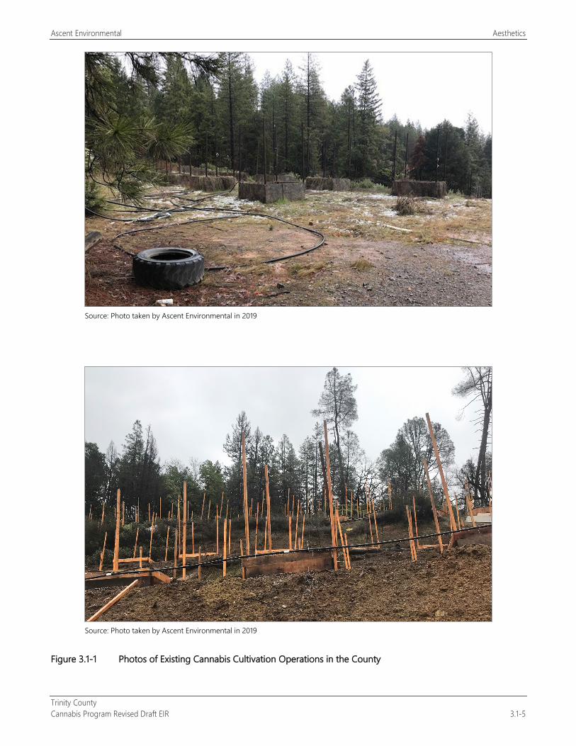
Ascent Environmental Aesthetics
Trinity County Cannabis Program Revised Draft EIR 3.1-5
Source: Photo taken by Ascent Environmental in 2019
Source: Photo taken by Ascent Environmental in 2019
Figure 3.1-1 Photos of Existing Cannabis Cultivation Operations in the County
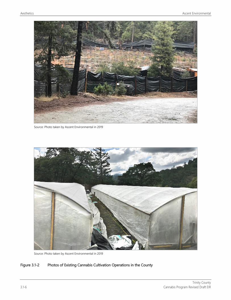
Aesthetics Ascent Environmental
Trinity County 3.1-6 Cannabis Program Revised Draft EIR
Source: Photo taken by Ascent Environmental in 2019
Source: Photo taken by Ascent Environmental in 2019
Figure 3.1-2 Photos of Existing Cannabis Cultivation Operations in the County
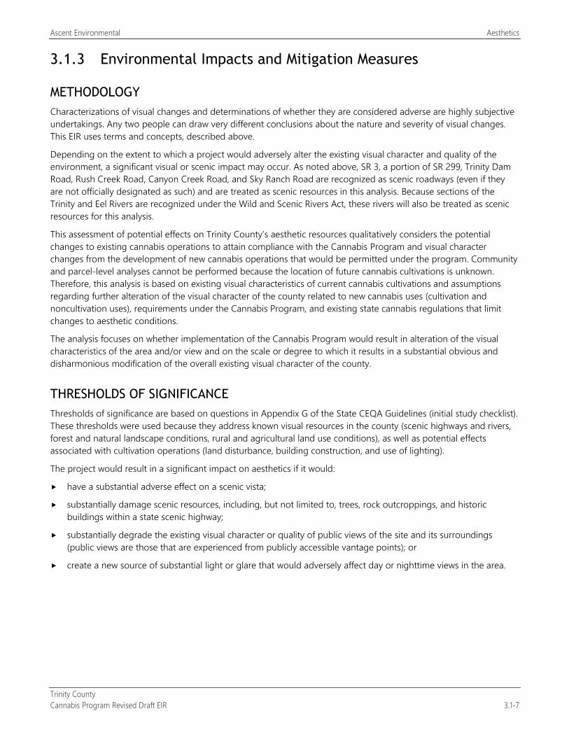
Ascent Environmental Aesthetics
Trinity County Cannabis Program Revised Draft EIR 3.1-7
3.1.3 Environmental Impacts and Mitigation Measures
METHODOLOGY Characterizations of visual changes and determinations of whether they are considered adverse are highly subjective undertakings. Any two people can draw very different conclusions about the nature and severity of visual changes. This EIR uses terms and concepts, described above.
Depending on the extent to which a project would adversely alter the existing visual character and quality of the environment, a significant visual or scenic impact may occur. As noted above, SR 3, a portion of SR 299, Trinity Dam Road, Rush Creek Road, Canyon Creek Road, and Sky Ranch Road are recognized as scenic roadways (even if they are not officially designated as such) and are treated as scenic resources in this analysis. Because sections of the Trinity and Eel Rivers are recognized under the Wild and Scenic Rivers Act, these rivers will also be treated as scenic resources for this analysis.
This assessment of potential effects on Trinity County’s aesthetic resources qualitatively considers the potential changes to existing cannabis operations to attain compliance with the Cannabis Program and visual character changes from the development of new cannabis operations that would be permitted under the program. Community and parcel-level analyses cannot be performed because the location of future cannabis cultivations is unknown. Therefore, this analysis is based on existing visual characteristics of current cannabis cultivations and assumptions regarding further alteration of the visual character of the county related to new cannabis uses (cultivation and noncultivation uses), requirements under the Cannabis Program, and existing state cannabis regulations that limit changes to aesthetic conditions.
The analysis focuses on whether implementation of the Cannabis Program would result in alteration of the visual characteristics of the area and/or view and on the scale or degree to which it results in a substantial obvious and disharmonious modification of the overall existing visual character of the county.
THRESHOLDS OF SIGNIFICANCE Thresholds of significance are based on questions in Appendix G of the State CEQA Guidelines (initial study checklist). These thresholds were used because they address known visual resources in the county (scenic highways and rivers, forest and natural landscape conditions, rural and agricultural land use conditions), as well as potential effects associated with cultivation operations (land disturbance, building construction, and use of lighting).
The project would result in a significant impact on aesthetics if it would:
have a substantial adverse effect on a scenic vista;
substantially damage scenic resources, including, but not limited to, trees, rock outcroppings, and historic buildings within a state scenic highway;
substantially degrade the existing visual character or quality of public views of the site and its surroundings (public views are those that are experienced from publicly accessible vantage points); or
create a new source of substantial light or glare that would adversely affect day or nighttime views in the area.
Aesthetics Ascent Environmental
Trinity County 3.1-8 Cannabis Program Revised Draft EIR
ENVIRONMENTAL IMPACTS AND MITIGATION MEASURES
Impact 3.1-1: Have a Substantial Adverse Impact on Scenic Vistas or Damage Scenic Resources
Scenic vistas and resources in Trinity County include public views of mountains, natural forests, and rivers and other waterways. Implementation of the Cannabis Program has the potential to alter localized public views of scenic vistas or resources from tree and vegetation removal and the construction of fencing and on-site structures. This impact would be potentially significant.
As described in Section 3.1.3, “Environmental Setting,” the county has a wealth of natural beauty and offers many scenic vistas and resources from key travel routes and recreational sites. Scenic resources include mountains, forests and wilderness areas, rivers and other waterways, rural communities, and designated scenic roadways. Because of the various scenic features that are present, scenic vistas and resources can be identified in most parts of the county. Potential visual effects associated with commercial cannabis operations under the Cannabis Program would generally include those related to the establishment of cultivation areas, structures used for processing/drying and storing cannabis, and on-site nurseries, as well as construction of solid fencing around the perimeter of the cultivation areas (Figure 3.1-2). Noncultivation cannabis operations (e.g., manufacturing, distribution, non-storefront retail, and microbusiness) include construction of new structures or reuse of existing structures within existing rural communities. Buildings associated with new noncultivation cannabis operations would appear visually similar to those associated with existing noncultivation cannabis operations. Although the visual quality of cannabis cultivation is not substantially different from that of other row crops or greenhouse cultivation of vegetables when located in areas of existing agricultural operation, cultivation that occurs in forested areas and livestock grazing areas is more visually prominent because the operation is visually dissimilar and it often alters the character of the view.
Existing Licensed Commercial Cannabis Operations Figure 2-3 shows cultivation sites licensed in the county in 2018. There are approximately 113 acres of existing licensed cultivation site development (defined as “Designated Area” under the Cannabis Program) and 10 distribution facilities in the county (Table 2-3). These sites are required to renew their licenses annually under the Cannabis Program. As shown in Figure 2-3, existing licensed cultivation sites are located along SR 3 and SR 299. Field review identified that some existing cultivation sites are visible from these highways. Cultivation sites within the forested portion of SR 3 were highly visible because the clearing of the site, planting of cannabis, structures, water storage facilities, and debris piles contrasted with the surrounding forested condition. Other cultivation sites were visible because of the use of black tarp as part of the perimeter fencing, which is visually disharmonious with the surrounding natural or rural visual character. Although these sites are part of the existing visual conditions along these scenic corridors, continued operation of these cultivation sites may further affect public scenic views from expansion of operations through the proposed amendment to expand the Designated Area for cultivation activities (land clearing, storage facilities, nurseries [greenhouses], extension of electrical facilities, and other related outdoor uses) from 200 percent of the licensed cannabis canopy area to 250 percent. Thus, this impact associated with existing licensed cannabis cultivation operations would be potentially significant.
New Licensed Commercial Cannabis Operations As shown in Table 2-3, implementation of the Cannabis Program would allow up to 246.16 217.26 acres of new cannabis cultivation development activity in the county. New cannabis cultivation operations could be located in areas similar to existing licensed sites, further altering scenic resources and viewsheds in the county through site clearing; construction of structures, fencing, roadways, water storage facilities, and infrastructure improvements for electricity and drainage; and other activities. This impact would be most prominent for forested cultivation sites visible from SR 3 and SR 299. This could also occur along other County-designated scenic roadways. New licensed cultivation would reduce visual impacts on county waterways through compliance with setback and avoidance requirements of the State Water Resources Control Board. The reader is referred to Section 3.10, “Hydrology and Water Quality,” for further information on these requirements. Therefore, the impact associated with implementation of the Cannabis Program related to new cannabis cultivation would be potentially significant.
Ascent Environmental Aesthetics
Trinity County Cannabis Program Revised Draft EIR 3.1-9
Implementation of the Cannabis Program would provide for noncultivation operations that would consist of manufacturing, microbusiness, non-storefront retail, testing, and distribution (Table 2-3). These uses, which would be located in buildings ranging in size from 1,000 square feet to 2,800 square feet, are anticipated to be located in the communities of Douglas City, Hayfork, Junction City, and Weaverville. This development would be similar in scale and appearance to existing development in these communities and would be required to meet design policies and standards set forth in the Trinity County General Plan, Hayfork Community Plan, and County Code of Ordinances. Thus, the impact from noncultivation cannabis operations would be less than significant.
Mitigation Measures
Mitigation Measure 3.1-1a: Screen Cultivation Sites from County Scenic Roadways Section 315-843(6) will be amended to include the following new performance standard:
License applications for new cultivation sites and requests for license renewal for sites located within 0.5 mile of a County-designated scenic roadway will provide details on methods to screen the cultivation site from public views along the scenic roadway so that the developed site conditions blends with the existing visual character of the viewshed and does not dominate the view. Screening may be accomplished through retention of perimeter trees and other vegetation, revegetation with locally appropriate native vegetation as part of site modification or closure, or other methods determined acceptable to the County. This requirement will not apply to cultivation sites that demonstrate the site is not visible from the scenic roadway. Due to the topography of specific sites, a fence may not be adequate to screen a cultivation site from the roadway. For these sites, perimeter trees and other vegetation shall be used.
Mitigation Measure 3.1-1b: Maintain Cultivation Parcel Section 315-843(6) will be amended to include the following new performance standard:
License applications for new cultivation sites and requests for license renewal will maintain the parcel clear of trash and debris piles. No trash or debris, including abandoned cars, various woody materials, plastic tarps, cannabis waste, or household appliances, will be allowed to accumulate on the parcel for a period greater than two weeks for the life of the license. The County will inspect compliance with this measure prior to license renewal.
Mitigation Measure 3.1-1c: Fence Cultivation Site Section 315-843(6) will be amended to include the following new performance standard:
Covered and solid fencing shall be designed to blend with the surrounding rural or natural conditions of the parcel and will be maintained in good working condition. If topography prevents fencing from being adequate screening, a vegetative fence will be maintained in good condition to comply with screening requirements. The County will inspect compliance with this measure prior to license renewal.
Significance after Mitigation Implementation of Mitigation Measure 3.1-1a would address impacts on scenic views and scenic resources by requiring the screening of new cultivation sites and the establishment of screening features at existing cultivation sites, ensuring that these features do not dominate the scenic view. Mitigation Measures 3.1-1b and 3.1-1c would require that the cultivation parcel site conditions be maintained clean of trash and debris piles and that fencing blend with the surrounding conditions of the parcel. These mitigation measures would be consistent with the intent of Circulation Element Policy 1.15D and recommendations of the Open Space Element. Therefore, the impact would be less than significant.
Aesthetics Ascent Environmental
Trinity County 3.1-10 Cannabis Program Revised Draft EIR
Impact 3.1-2: Substantially Degrade the Existing Visual Character or Quality of the Project Area
Implementation of the Cannabis Program could result in the expansion of cannabis cultivation operations in areas where the expanded operations would conflict with the rural and natural character of the county. This impact would be potentially significant.
As described in Section 3.1.3, “Environmental Setting,” the county has many scenic resources, including mountains, forests and wilderness areas, rivers and other waterways, rural communities, and designated scenic roadways that create unique visual character conditions in each region and community of the county. Potential visual effects associated with commercial cannabis operations under the Cannabis Program would generally include those related to the establishment of cultivation areas, structures used for processing/drying and storing cannabis, and on-site nurseries, as well as construction of solid fencing around the perimeter of the cultivation areas (Figure 3.1-2). Noncultivation cannabis operations (e.g., manufacturing, distribution, non-storefront retail, and microbusiness) include construction of new structures or reuse of existing structures within rural communities. These features have the potential to alter the local visual character of a region or community in the county.
Existing Licensed Commercial Cannabis Operations As discussed for Impact 3.1-1 and shown in Figure 2-3, existing licensed cultivation sites are located along the state highway corridors and within or near the county’s rural communities. In some unforested portions of the county, the visual character of cannabis cultivation is not substantially different from that of other existing agricultural operations. However, cultivation that occurs in forested areas, in livestock grazing areas, and near rural communities is more visually prominent and often conflicts with the visual character of the surrounding area. This is typically a result of clearing on-site trees and vegetation, establishment of cannabis planters or hoop houses for mixed-light cultivation, grading to establish benches for cultivation sites, construction of solid perimeter fencing, and the establishment of trash and debris piles (Figures 3.1-1 and 3.1-2). Implementation of the Cannabis Program could further expand this existing visual condition through the proposed amendment to expand the Designated Area for cultivation activities (land clearing, storage facilities, nurseries, and other related uses) from 200 percent of the licensed cannabis canopy area to 250 percent. Thus, the impact associated with existing licensed cannabis cultivation operations would be potentially significant.
New Licensed Commercial Cannabis Operations Implementation of the Cannabis Program would allow the construction and operation of up to 246.16 217.26 acres of new cannabis cultivation development activity in the county, which could expand the visual character impacts identified above for existing licensed commercial cannabis operations. These visual character impacts would occur through site clearing; construction of structures, fencing, roadways, water storage facilities, and infrastructure improvements for electricity and drainage; and other activities. Therefore, the impact associated with implementation of the Cannabis Program related to new cannabis cultivation would be potentially significant.
As discussed for Impact 3.1-1, implementation of the Cannabis Program would also provide for noncultivation operations that would consist of manufacturing, microbusiness, non-storefront retail, testing, and distribution. These uses are anticipated to be located in the communities of Douglas City, Hayfork, Junction City, and Weaverville. This development would be similar in scale and appearance to existing development in these communities and would be required to meet design policies and standards set forth in the Trinity County General Plan, Hayfork Community Plan, and County Code of Ordinances. Thus, the impact from noncultivation cannabis operations would be less than significant.
Mitigation Measures
Mitigation Measure 3.1.2: Implement Mitigation Measures 3.1-1a, 3.1-b, and 3.1-1c
Significance after Mitigation Implementation of Mitigation Measure 3.1-1a would address visual character impacts by requiring the screening of new cultivation sites and the establishment of screening features at existing cultivation sites to ensure that these features do not dominate the scenic view. Screening features would be consistent with surrounding natural features
Ascent Environmental Aesthetics
Trinity County Cannabis Program Revised Draft EIR 3.1-11
to avoid the appearance of excessive land clearing. Mitigation Measures 3.1-1b and 3.1-1c would require that the cultivation parcel site conditions be maintained clean of trash and debris piles and that fencing blend with the surrounding conditions of the parcel. This would address new cultivation visual character impacts as well improve existing visual character conditions. Therefore, the impact would be less than significant.
Impact 3.1-3: Create a New Source of Substantial Light or Glare That Would Adversely Affect Views
Implementation of the Cannabis Program would not result in nighttime lighting and glare impacts because the Cannabis Program and state regulations require the shielding of nighttime light sources for all activities. This impact would be less than significant.
Cannabis operations and cultivation are known to use light sources for cultivation of the cannabis plant (nurseries, mixed-light cultivation, and indoor cultivation) in addition to nighttime lighting associated with security. If not adequately controlled, these light sources can create substantial light and glare impacts, adversely affecting neighboring land uses and wildlife.
Existing and New Licensed Commercial Cannabis Operations Mixed-light and indoor cultivation operations use lighting to extend the photoperiod for the cannabis plants. Such lighting may create a nuisance to adjacent and nearby properties, residences, and/or motorists traveling on nearby roadways. Artificial night lighting used for cannabis cultivation operations could result in adverse ecological effects on terrestrial and aquatic resources. Security lighting could affect nighttime views or disturb neighboring residents. The degree to which such lighting would have adverse impacts on sensitive receptors would vary among proposed cultivation sites. Lighting used for cultivation purposes could create additional ambient lighting within the area and be intrusive to neighboring residents. Depending on the location of lighting for outdoor and/or mixed-light cultivation, spillover of lighting could occur to varying degrees and result in additional light and glare at off-site locations, including nearby residences.
Some mixed-light cultivation operations use hoop houses, or nonpermanent structures supported with PVC pipes draped with opaque plastic sheeting. Nurseries may also use nighttime lighting to manipulate growth. At night, for mixed-light cultivation to take place, lights are placed over the plants to trigger plant flowering and produce more harvests. With lights on in the hoop houses at night, the structures emit a glow of light and are illuminated. The hoop houses and associated light have the potential to be visible from roadways, hillsides, and neighboring residences and be viewed as out of character with the rural uses in the area.
The Cannabis Program includes the following requirements that ensure nighttime lighting and glare impacts are avoided:
All lighting associated with the operation shall be downcast, shielded and/or screened to keep light from emanating off-site or into the sky (Section 315-843[6][l]).
Those cultivations using artificial lighting from mixed-light cultivations shall shield greenhouses so that little to no light escapes. Light shall not escape at a level that is visible from neighboring properties between sunset and sunrise (Section 315-843[6][m]).
These performance standards are consistent with CCR Sections 8304(c) and 8304(g) regarding state licensing requirements for cultivation.
Thus, because the Cannabis Program would not allow for increased nighttime lighting to be visible, this impact would be less than significant.
Mitigation Measures No mitigation is required.

Aesthetics Ascent Environmental
Trinity County 3.1-12 Cannabis Program Revised Draft EIR
This page intentionally left blank.
Ascent Environmental Agriculture and Forestry Resources
Trinity County Cannabis Program Revised Draft EIR 3.2-1
3.2 AGRICULTURE AND FORESTRY RESOURCES This section evaluates the potential agriculture and forestry resource impacts of the proposed Trinity County Cannabis Program Project. The existing forest resource characteristics and the existing policies and regulations related to agricultural and forestry resources are described.
Comment letters received in response to the NOP identified concerns regarding biological resource and watershed impacts related to the clearing of forest areas and subsequent grading for cannabis cultivation. The reader is referred to Section 3.4, “Biological Resources,” and Section 3.10, “Hydrology and Water Quality,” for evaluation of these impacts.
3.2.1 Regulatory Setting
FEDERAL No federal plans, policies, regulations, or laws related to agriculture and forestry resources are applicable to the project.
STATE
California Land Conservation Act of 1965 The California Land Conservation Act of 1965, better known as the Williamson Act, created a program for counties to protect viable agricultural land by offering tax incentives to property owners to keep their land in agricultural production and prevent the premature conversion of farmland to urban uses. The act provides an arrangement wherein private landowners voluntarily restrict their land to agricultural and compatible open space uses under a contract with the County, known as a land conservation contract or Williamson Act contract, in exchange for property tax relief.
A Williamson Act contract is an enforceable restriction on land and is binding on all future owners of the property. The minimum term for a contract is 10 years, and the contract is automatically renewed annually, unless either party gives notice of nonrenewal.
Figure 3.2-1 identifies those areas of the county that are enrolled as nonprime agricultural land. Nonprime agricultural land is defined as open space land of statewide significance under the California Open Space Subvention Act (Government Code Section 16143). These lands include irrigated and nonirrigated crops and other open space uses that are compatible with agriculture.
Cannabis As an Agricultural Product Health and Safety Code Section 11362.777(a) and Business and Professions Code Section 26067(a) define medical and adult-use cannabis as agricultural products.
California Public Resources Code “Forest land” is defined in PRC Section 12220(g) as:
land that can support 10-percent native tree cover of any species, including hardwoods, under natural conditions, and that allows for management of one or more forest resources, including timber, aesthetics, fish and wildlife, biodiversity, water quality, recreation, and other public benefits.
Agriculture and Forestry Resources Ascent Environmental
Trinity County 3.2-2 Cannabis Program Revised Draft EIR
“Timberland” is defined in PRC Section 4526 as:
land, other than land owned by the federal government and land designated by the board as experimental forest land, which is available for, and capable of, growing a crop of trees of any commercial species used to produce lumber and other forest products, including Christmas trees. Commercial species shall be determined by the board on a district basis after consultation with the district committees and others.
California Government Code The following California Government Code definitions are applicable to the project:
Section 51104(g) defines “timberland production zone” (TPZ) as an area that has been zoned pursuant to Section 51112 or 51113 and that is devoted to and used for growing and harvesting timber or for growing and harvesting timber and compatible uses. Compatible uses, defined in Section 51104(h), include the construction and maintenance of electric transmission facilities.
Section 51112 identifies situations that would warrant a decision that a parcel is not devoted to and used for growing and harvesting timber or for growing and harvesting timber and compatible uses.
Section 51113 allows the opportunity for a landowner to petition that his or her land be zoned for timberland production.
Section 51201(c)(5) defines “prime agricultural land” as land that has returned from the production of unprocessed agricultural plant products an annual gross value of not less than $200 per acre for 3 of the previous 5 years.
Z’Berg-Nejedly Forest Practice Act of 1973 The Z’Berg-Nejedly Forest Practice Act of 1973 (FPA) (PRC Sections 4511–4517) established the state Board of Forestry and Fire Protection, whose mandate is to protect and enhance the state’s unique forest and wildland resources. This mandate is carried out through enforcement of the California Forest Practice Rules (Title 14, CCR, Chapters 4, 4.5, and 10). The California Department of Forestry and Fire Protection (CAL FIRE) enforces the laws that regulate logging on nonfederal lands in California.
Z’Berg-Warren-Keene-Collier Forest Taxation Reform Act of 1976 According to the Z’berg-Warren-Keene-Collier Forest Taxation Reform Act (California Government Code Sections 51110–51119.5: Article 2), enacted in 1976, counties must provide for the zoning of land used for growing and harvesting timber as TPZs. Land use under a TPZ is restricted to growing and harvesting timber and to compatible uses approved by the County. In return, taxation of timberland under a TPZ is based only on such restrictions in use.
California Timberland Productivity Act of 1982 The California Timberland Productivity Act of 1982 (California Government Code Sections 51100–51104) identifies the benefits of the state’s timberlands and acknowledges the threat of timberland loss through land use conversions. The law identifies policies intended to preserve timberland, including maintaining an optimum amount of timberland, discouraging premature conversion, discouraging expansion of urban land uses into timberlands, and encouraging investments in timberland. The law establishes a TPZ on all qualifying timberland that is devoted to and used for growing and harvesting timber or for growing and harvesting timber and compatible uses. The law also provides that timber operations conducted in a manner consistent with forest practice rules (the FPA) shall not be or become restricted or prohibited because of any land use in or around the locality of those operations.
California Forest Practice Rules The California Forest Practice Rules of 2012 define the timber harvest activities that are regulated under Title 14, CCR, Chapters 4, 4.5, and 10, and under the FPA, Division 4, Chapter 8, PRC. CAL FIRE is the enforcing agency responsible for ensuring that logging and other forest-harvesting activities are conducted in a manner that preserves and protects fish, wildlife, forests, and streams.
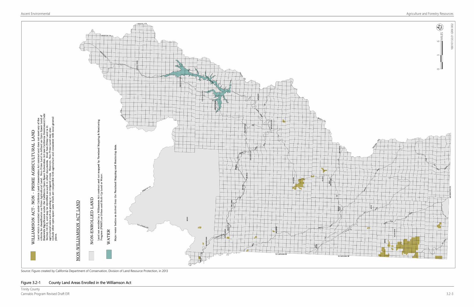
Ascent Environmental Agriculture and Forestry Resources
Trinity County Cannabis Program Revised Draft EIR 3.2-3
Source: Figure created by California Department of Conservation, Division of Land Resource Protection, in 2013
Figure 3.2-1 County Land Areas Enrolled in the Williamson Act
Ascent Environmental Agriculture and Forestry Resources
Trinity County Cannabis Program Revised Draft EIR 3.2-5
Before any harvesting activities occur, with some exceptions (see below), landowners must prepare a timber harvest plan, which outlines the timber proposed for harvesting, the methods of harvesting, and the steps that will be taken to prevent damage to the environment. Timber harvest plans are required to be prepared by Registered Professional Foresters. When a timberland owner proposes to carry out a project that would result in the conversion of timberland to a nontimber growing use, the owner must secure a Timberland Conversion Permit from CAL FIRE. Projects that would result in the conversion of less than 3 acres of timberland may qualify for an exemption from this provision.
CAL FIRE Forest Legacy Program The Forest Legacy Program protects environmentally important forest land threatened with conversion to nonforest uses. Protection of California’s forests through this program ensures they continue to provide such benefits as sustainable timber production, wildlife habitat, recreation opportunities, watershed protection, and open space. Intact forests also contribute significantly to the storage and sequestration of carbon. Under this competitive grant program, CAL FIRE purchases or accepts donations of conservation easements or fee title of productive forest lands to encourage their long-term conservation. The primary tool CAL FIRE uses to conserve forest lands in perpetuity is permanent Working Forest Conservation Easements (WFCEs). WFCEs do more than just restrict development and conversion on a property, WFCEs protect forest values by concentrating on sustainable forest practices that provide economic value from the land and encourage long-term land stewardship.
The Grizzly Mountain Ranch South site in the southwestern portion of the county is participating in this program (CAL FIRE 2019).
LOCAL
Trinity County General Plan Trinity County General Plan Open Space Element provides the following recommendations regarding agriculture and forestry resources in Trinity County:
Protect crop lands wherever possible and only those uses related to agriculture should be located in the crop land areas.
Agricultural uses including crop lands, cattle raising areas, and forest lands should be encouraged and protected as a means of providing open space.
Agricultural lands which are used for grazing and other purposes, although not considered prime soils should be given every protection and consideration should be given to including them in the agricultural preserves.
Agricultural lands although not prime in Trinity County must be recognized as an equal to other major land uses and given the protection it deserves as a developed use.
Protect the scarce agricultural land.
Encourage continuous sustained yield practices on public and private forest land.
Retain the minimal agricultural lands for open space.
Trinity County Code of Ordinances Ordinance 315-41.1 establishes standards and restrictions for areas zoned TPZ (Figure 3.2-2). The ordinance allows land uses in TPZ areas that are compatible with growing and harvesting of timber, such as watershed management, habitat improvement projects, improvements associated with timber operations, agricultural uses, and recreation.
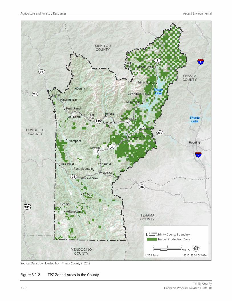
Agriculture and Forestry Resources Ascent Environmental
Trinity County 3.2-6 Cannabis Program Revised Draft EIR
Source: Data downloaded from Trinity County in 2019
Figure 3.2-2 TPZ Zoned Areas in the County
Ascent Environmental Agriculture and Forestry Resources
Trinity County Cannabis Program Revised Draft EIR 3.2-7
3.2.2 Environmental Setting
AGRICULTURAL RESOURCES The county has approximately 563 acres committed to agricultural uses, with the largest concentration of agricultural activity in and around the communities of Salyer, Hawkins Bar, and Hyampom.
Agricultural Productivity By California standards, Trinity County’s agricultural production is small. The county produced approximately $13.5 million of the state’s $20 billion of annual farm goods in 2016. Trinity County’s 2016 Crop Report identified the following as top agricultural commodities after timber production (Trinity County 2016):
grapes,
field crops,
fruits and vegetables,
nursery stock, and
apiary.
Trinity County is ranked 56th of 58 counties in the state for gross value for agricultural production in 2016 without timber production and 54th including timber (CDFA 2016).
Prime and Nonprime Agricultural Lands The land best suited for a wide range of agricultural crops is called “prime” agricultural land. The California Farmland Mapping and Monitoring Program (FMMP) is a nonregulatory program that provides a consistent and impartial analysis of agricultural land use and land use changes throughout California. The modern soil surveys produced by the Natural Resources Conservation Service are the basis for the FMMP. Trinity County has an updated soil survey but is not included in the latest FMMP released by the California Department of Conservation.
Cannabis Cultivation Trinity County is said to be located within the Emerald Triangle (Trinity, Humboldt, and Mendocino Counties), considered by many to be the center of domestic cannabis cultivation in the United States, if not the world. Through much of history, growing cannabis was an illicit, clandestine, contraband activity, and it is still prohibited by federal criminal law. As a consequence, it developed in remote rural locations, dispersed in relatively small areas of cultivation on large tracts of land. The primary values of these remote locations to illicit growers are ease of concealment and difficulty for law enforcement. Most cannabis cultivation operations are in areas that were previously suited only for forest or grazing lands, too steep and without sufficient water or adequate soils to support commercially viable cultivation of other legal field or orchard crops.
FORESTED AREAS AND TIMBERLANDS Trinity County contains more than 1.7 million acres of forest land (see Table 3.4-1 and Figures 3.4-1 and 3.4-2 in Section 3.4, “Biological Resources”), covering approximately 83 percent of the county’s total land area. Within these forest lands are public lands, including national forests, and four wilderness areas. County lands zoned TPZ are shown in Figure 3.2-2. Forest resources, much like agricultural resources, are dependent on the quality of the climate and soils. Trinity County’s mild and wet climate is conducive to timber production.
Trinity County’s 2106 Crop Report identified timber production as the county’s highest value agricultural commodity at $10,020,241 (74 percent of the county’s total agricultural production in 2016) (Trinity County 2016).
Agriculture and Forestry Resources Ascent Environmental
Trinity County 3.2-8 Cannabis Program Revised Draft EIR
Forest Types Trees are generally classified as hardwood (including oak, alder, and other deciduous or broadleaf species) or softwood (including fir, spruce, pine, redwood, and all other coniferous or needle-bearing species), although some “hardwoods” are softer than softwoods. Land cover types, including forest types, are described under “Environmental Setting” in Section 3.4, “Biological Resources.” As shown in Exhibit 3.4-1 and listed in Table 3.4-1, Sierran mixed conifer and Douglas fir are the dominant forest types of the county, consisting of 1,170,628 acres of the county.
Timberland Conversion from Cannabis Cultivation The remote nature of most of the county has historically helped conceal and attract cannabis cultivation. Clandestine cannabis operations throughout the county have contributed to the conversion of timberland on private and public lands. Forest land in portions of the county that have been cleared for cannabis cultivation are apparent from satellite images available through Google Earth.
3.2.3 Environmental Impacts and Mitigation Measures
METHODOLOGY The following analysis evaluates reasonably foreseeable compliance responses to the Cannabis Program. The analysis focuses specifically on actions that could result in the use of agricultural lands for commercial cannabis operations, conversion of designated TPZ and other forest lands, and conflicts with policies and regulations intended to protect farmland and timberlands. The reader is referred to Chapter 2, “Project Description,” for a description of proposed regulation of commercial cannabis operations and the anticipated extent of new commercial cannabis operations.
THRESHOLDS OF SIGNIFICANCE Based on the questions in Appendix G of the State CEQA Guidelines (initial study checklist), the project would have a significant adverse effect related to agricultural and forestry resources if it would:
convert Prime Farmland, Unique Farmland, or Farmland of Statewide Importance (Farmland), as shown on the maps prepared pursuant to the FMMP of the California Resources Agency, to nonagricultural use;
conflict with existing zoning for agricultural use or a Williamson Act contract;
conflict with existing zoning for, or cause rezoning of, forest land (as defined in PRC Section 12220[g]), timberland (as defined by PRC Section 4526), or timberland zoned Timberland Production (as defined by Government Code Section 51104[g]);
result in the loss of forest land or conversion of forest land to nonforest use; or
involve other changes in the existing environment, which, due to their location or nature, could result in conversion of Farmland to nonagricultural use or conversion of forest land to nonforest use.
These thresholds were used because they address farmland and forestry resources considered important by the state and Trinity County and address whether the implementation of the Cannabis Program could conflict with the county’s existing agricultural and timber operations.
Ascent Environmental Agriculture and Forestry Resources
Trinity County Cannabis Program Revised Draft EIR 3.2-9
ENVIRONMENTAL IMPACTS AND MITIGATION MEASURES
Impact 3.2-1: Convert Farmland to Nonagricultural Use or Conflict with Existing Zoning for Agricultural Use or a Williamson Act Contract
Health and Safety Code Section 11362.777(a) and Business and Professions Code Section 26067(a) define medical and adult-use cannabis as agricultural products, and cannabis is defined by the state as an agricultural product; therefore, cannabis activities under the Cannabis Program would not result in conversion of farmland to nonagricultural uses or conflict with existing zoning for agricultural use or a Williamson Act contract. There would be no impact related to conversion of farmland to nonagricultural use or conflict with zoning for agricultural use or a Williamson Act contract
Farmland (Prime Farmland, Unique Farmland, and Farmland of Statewide Importance) has not been mapped by the state for Trinity County. Cannabis is defined by the state (Health and Safety Code Section 11362.777[a] and Business and Professions Code Section 26067[a]) as an agricultural product; therefore, cultivation activities in agricultural areas would not result in conversion to a nonagricultural use.
Existing Licensed Commercial Cannabis Operations As noted above, the state considers cannabis to be an agricultural product. The continued operation of licensed commercial cannabis cultivation sites in compliance with the Cannabis Program would not result in the conversion of agricultural uses or conflict with Williamson Act contracts and agricultural zoning. No impact would occur.
New Licensed Commercial Cannabis Operations The Cannabis Program would allow cannabis supporting uses (nurseries, manufacturing, distribution, and microbusinesses) within agriculturally zoned areas. These uses are considered agricultural supportive uses that do not with agricultural uses and are similar to buildings and operations commonly used in agricultural activities (barns, equipment storage, processing, greenhouses, and offices). Non-storefront retail would not be allowed to be located on prime agricultural soils, and testing facilities would not be allowed in any agriculturally zoned areas. Thus, the Cannabis Program would not result in the conversion of agricultural uses or conflict with Williamson Act contracts and agricultural zoning associated with new commercial cannabis operations. No impact would occur.
Mitigation Measures No mitigation is required.
Impact 3.2-2: Convert Substantial Forest Land, Conflict with or Cause Rezoning of Forest Land or Timberland Production Zone, or Involve Other Changes in the Existing Environment Which, Because of Their Location or Nature, Could Result in Substantial Conversion of Forest Land to Nonforest Use
The existing licensed commercial cannabis operations have led to the clearing of some forest areas. Implementation of the Cannabis Program would allow existing licensed cultivation sites to expand and new commercial cannabis operations to be located in forested areas and result in forest removal. However, commercial cannabis operations would be restricted from locating in areas zoned TPZ, as well as public lands that contain most of the county’s forest resources. This impact would be less than significant.
Forest land represents approximately 83 percent of the county (1.7 million acres). Implementation of the Cannabis Program would result in new or expanded commercial cannabis cultivation activities throughout the unincorporated county. Licensed commercial cannabis operations under the Cannabis Program would be generally excluded from lands zoned TPZ (326,168 acres), as well as public lands, including the Shasta-Trinity, Six Rivers, and Mendocino National Forests and four wilderness areas (Yolla Bolly-Middle Eel, Trinity Alps, Chanchelulla, and North Fork) that encompass 2,051,988 acres for a grand total of 2,378,156 acres of protected forest land of the county’s total land area. These protected areas make up most of the forest conditions in the county as shown in Figures 2-2, 3.2-2, and 3.4-1.
Agriculture and Forestry Resources Ascent Environmental
Trinity County 3.2-10 Cannabis Program Revised Draft EIR
CAL FIRE provides exemptions for timberland conversions for conversions of 3 acres or less of timberland for cultivation sites. Applicants are required to comply with these regulations and show the County the application for exemption with CAL FIRE. If the CAL FIRE 3-acre-or-less exemption is accepted, the County would not allow for clearing land greater than the designated area if the intent of the clearing is to cultivate cannabis. If a cannabis cultivation applicant requests County approval on a less than 3-Acre conversion exemption, the County requests documentation from the applicant demonstrating that the conversion from timber land is to another legal use and is subject to the following:
The applicant must be enrolled in the County’s commercial cannabis program.
The applicant must submit a site plan that indicates the square footage that will be converted to commercial cannabis use and the additional acreage that will be converted for any other bona fide intent.
The site plan for the proposed conversion must reflect the information provided on the site plan submitted for the commercial cannabis cultivation license.
The County will not approve any conversion to commercial cannabis that is greater than the Designated Area associated with the approved commercial cannabis license issued for the subject site.
The County will not approve any conversion including a stated bone fide intent for cannabis cultivation without receiving verification from the State Water Resources Control Board that the applicant is enrolled, and in compliance with, the State Water Resources Control Board Cannabis Cultivation General Order
County site inspectors will do a post-harvest inspection to verify that the area converted to commercial cannabis cultivation use is consistent with the site plan submitted with the less than 3-acre conversion exemption and what is currently on file with the commercial cannabis license. Site development must reflect the same information as what is provided on the site plan for the approved commercial cannabis cultivation license.
In the case that Trinity County Planning Department inspectors or staff determine that the post-harvest area converted to commercial cannabis cultivation does not match the site plan or the bona fide intention listed on the exemption does not match on-the-ground conditions, the applicant’s enrollment in the commercial cannabis program will be suspended and remediation of any areas harvested in excess of what was originally identified for conversion will be remediated.
Unless identified in a less than 3-acre conversion exemption with the bona fide intent of commercial cannabis, areas converted under a less than 3-acre conversion exemption for any other bona fide intent are ineligible for commercial cannabis cultivation for 2 years from completion of the conversion
Existing Licensed Commercial Cannabis Operations Several existing licensed commercial cannabis cultivation operations have already cleared on-site forest conditions as part of site preparation and are part of the baseline conditions of the county. However, the proposed amendment to Section 315-843(1)(i) provisions to increase the Designated Area (land area used to support the cultivation operation) from 200 percent to 250 percent of the licensed cannabis canopy area would allow existing cultivation sites to expand and clear additional forest on-site. This would further fragment forest conditions in areas where cannabis cultivation occurs. Biological resource impacts related to the loss of forest habitat are addressed in Section 3.4, “Biological Resources.” As noted above, the majority of forest conditions in the county are protected from licensed cannabis activities under the Cannabis Program. Thus, this impact would be less than significant.
New Licensed Commercial Cannabis Operations New licensed commercial cannabis operations could result in additional loss of forest lands. As identified in Table 2-3, the Designated Areas of all new licensed cannabis cultivation operations could remove up to 246.16 217.26 acres of forest land (assuming it is all located on forested sites) within the same areas of the county where cultivation currently occurs. This would result in loss of 0.014 0.012 percent of the county’s total forest land acreage and is therefore not considered a substantial loss by the County. As noted above, the majority of forestland areas in the county are protected from licensed cannabis activities under the Cannabis Program because they consist of public lands and

Ascent Environmental Agriculture and Forestry Resources
Trinity County Cannabis Program Revised Draft EIR 3.2-11
areas zoned TPZ where new cannabis uses are prohibited (see Figures 2-2, 3.2-2, and 3.4-1). Thus, this impact would be less than significant.
Mitigation Measures No mitigation is required.

Agriculture and Forestry Resources Ascent Environmental
Trinity County 3.2-12 Cannabis Program Revised Draft EIR
This page intentionally left blank.
Ascent Environmental Air Quality
Trinity County Cannabis Program Revised Draft EIR 3.3-1
3.3 AIR QUALITY This section includes a discussion of existing air quality conditions, a summary of applicable regulations, and an analysis of potential construction and operational air quality impacts caused by proposed development of the Trinity County Cannabis Program (referred to as “project”). Mitigation is developed as necessary to reduce significant air quality impacts to the extent feasible.
Several comment letters regarding dust emissions and odors were received in response to the Notice of Preparation (see Appendix A). These issues are addressed in this section.
3.3.1 Regulatory Setting Air quality in the project area is regulated through the efforts of federal, State, regional, and local government agencies. These agencies work jointly, as well as individually, to improve air quality through legislation, planning, policy-making, education, and a variety of programs. The agencies responsible for improving the air quality within the air basins are discussed below.
FEDERAL
U.S. Environmental Protection Agency The U.S. Environmental Protection Agency (EPA) has been charged with implementing national air quality programs. EPA’s air quality mandates draw primarily from the federal Clean Air Act (CAA), which was enacted in 1970. The most recent major amendments made by Congress in 1990. EPA’s air quality efforts address both criteria air pollutants and hazardous air pollutants (HAPs). EPA regulations concerning criteria air pollutants and HAPs are presented in greater detail below.
Criteria Air Pollutants The CAA required EPA to establish national ambient air quality standards (NAAQS) for six common air pollutants found all over the U.S. referred to as criteria air pollutants. EPA has established primary and secondary NAAQS for the following criteria air pollutants: ozone, carbon monoxide (CO), nitrogen dioxide (NO2), sulfur dioxide (SO2), respirable particulate matter with aerodynamic diameter of 10 micrometers or less (PM10) and fine particulate matter with aerodynamic diameter of 2.5 micrometers or less (PM2.5), and lead. The NAAQS are shown in Table 3.3-1. The primary standards protect public health and the secondary standards protect public welfare. The CAA also required each state to prepare a State implementation plan (SIP) for attaining and maintaining the NAAQS. The federal Clean Air Act Amendments of 1990 (CAAA) added requirements for states with nonattainment areas to revise their SIPs to incorporate additional control measures to reduce air pollution. California’s SIP is modified periodically to reflect the latest emissions inventories, planning documents, and rules and regulations of the air basins as reported by their jurisdictional agencies. EPA is responsible for reviewing all SIPs to determine whether they conform to the mandates of the CAA and its amendments, and whether implementation will achieve air quality goals. If EPA determines a SIP to be inadequate, EPA may prepare a federal implementation plan that imposes additional control measures. If an approvable SIP is not submitted or implemented within the mandated time frame, sanctions may be applied to transportation funding and stationary air pollution sources in the air basin.
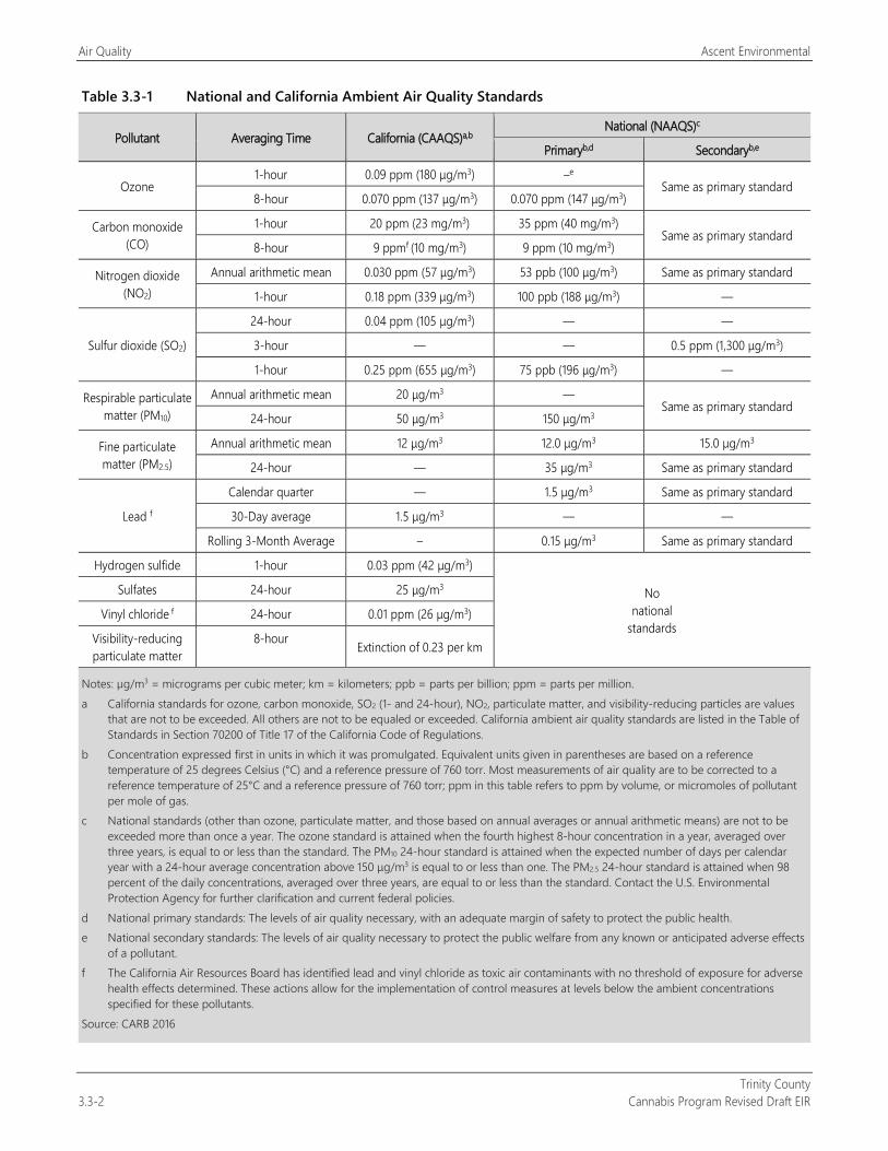
Air Quality Ascent Environmental
Trinity County 3.3-2 Cannabis Program Revised Draft EIR
Table 3.3-1 National and California Ambient Air Quality Standards
Pollutant Averaging Time California (CAAQS)a,b National (NAAQS)c
Primaryb,d Secondaryb,e
Ozone 1-hour 0.09 ppm (180 μg/m3) –e
Same as primary standard 8-hour 0.070 ppm (137 μg/m3) 0.070 ppm (147 μg/m3)
Carbon monoxide (CO)
1-hour 20 ppm (23 mg/m3) 35 ppm (40 mg/m3) Same as primary standard
8-hour 9 ppmf (10 mg/m3) 9 ppm (10 mg/m3)
Nitrogen dioxide (NO2)
Annual arithmetic mean 0.030 ppm (57 μg/m3) 53 ppb (100 μg/m3) Same as primary standard
1-hour 0.18 ppm (339 μg/m3) 100 ppb (188 μg/m3) —
Sulfur dioxide (SO2)
24-hour 0.04 ppm (105 μg/m3) — —
3-hour — — 0.5 ppm (1,300 μg/m3)
1-hour 0.25 ppm (655 μg/m3) 75 ppb (196 μg/m3) —
Respirable particulate matter (PM10)
Annual arithmetic mean 20 μg/m3 — Same as primary standard
24-hour 50 μg/m3 150 μg/m3
Fine particulate matter (PM2.5)
Annual arithmetic mean 12 μg/m3 12.0 μg/m3 15.0 μg/m3
24-hour — 35 μg/m3 Same as primary standard
Lead f
Calendar quarter — 1.5 μg/m3 Same as primary standard
30-Day average 1.5 μg/m3 — —
Rolling 3-Month Average – 0.15 μg/m3 Same as primary standard
Hydrogen sulfide 1-hour 0.03 ppm (42 μg/m3)
No national
standards
Sulfates 24-hour 25 μg/m3
Vinyl chloride f 24-hour 0.01 ppm (26 μg/m3)
Visibility-reducing particulate matter
8-hour Extinction of 0.23 per km
Notes: µg/m3 = micrograms per cubic meter; km = kilometers; ppb = parts per billion; ppm = parts per million. a California standards for ozone, carbon monoxide, SO2 (1- and 24-hour), NO2, particulate matter, and visibility-reducing particles are values
that are not to be exceeded. All others are not to be equaled or exceeded. California ambient air quality standards are listed in the Table of Standards in Section 70200 of Title 17 of the California Code of Regulations.
b Concentration expressed first in units in which it was promulgated. Equivalent units given in parentheses are based on a reference temperature of 25 degrees Celsius (°C) and a reference pressure of 760 torr. Most measurements of air quality are to be corrected to a reference temperature of 25°C and a reference pressure of 760 torr; ppm in this table refers to ppm by volume, or micromoles of pollutant per mole of gas.
c National standards (other than ozone, particulate matter, and those based on annual averages or annual arithmetic means) are not to be exceeded more than once a year. The ozone standard is attained when the fourth highest 8-hour concentration in a year, averaged over three years, is equal to or less than the standard. The PM10 24-hour standard is attained when the expected number of days per calendar year with a 24-hour average concentration above 150 μg/m3 is equal to or less than one. The PM2.5 24-hour standard is attained when 98 percent of the daily concentrations, averaged over three years, are equal to or less than the standard. Contact the U.S. Environmental Protection Agency for further clarification and current federal policies.
d National primary standards: The levels of air quality necessary, with an adequate margin of safety to protect the public health. e National secondary standards: The levels of air quality necessary to protect the public welfare from any known or anticipated adverse effects
of a pollutant. f The California Air Resources Board has identified lead and vinyl chloride as toxic air contaminants with no threshold of exposure for adverse
health effects determined. These actions allow for the implementation of control measures at levels below the ambient concentrations specified for these pollutants.
Source: CARB 2016
Ascent Environmental Air Quality
Trinity County Cannabis Program Revised Draft EIR 3.3-3
Hazardous Air Pollutants and Toxic Air Contaminants Toxic air contaminants (TACs), or in federal parlance, HAPs, are a defined set of airborne pollutants that may pose a present or potential hazard to human health. A TAC is defined as an air pollutant that may cause or contribute to an increase in mortality or in serious illness, or that may pose a hazard to human health. TACs are usually present in minute quantities in the ambient air; however, their high toxicity or health risk may pose a threat to public health even at low concentrations.
A wide range of sources, from industrial plants to motor vehicles, emit TACs. The health effects associated with TACs are quite diverse and generally are assessed locally, rather than regionally. TACs can cause long-term health effects such as cancer, birth defects, neurological damage, asthma, bronchitis, or genetic damage; or short-term acute affects such as eye watering, respiratory irritation (a cough), running nose, throat pain, and headaches.
For evaluation purposes, TACs are separated into carcinogens and non-carcinogens based on the nature of the physiological effects associated with exposure to the pollutant. Carcinogens are assumed to have no safe threshold below which health impacts would not occur. This contrasts with criteria air pollutants for which acceptable levels of exposure can be determined and for which the ambient standards have been established (Table 3.3-1). Cancer risk from TACs is expressed as excess cancer cases per one million exposed individuals, typically over a lifetime of exposure.
EPA and, in California, the California Air Resources Board (CARB) regulate HAPs and TACs, respectively, through statutes and regulations that generally require the use of the maximum available control technology or best available control technology (BACT) for air toxics to limit emissions.
STATE CARB is the agency responsible for coordination and oversight of State and local air pollution control programs in California and for implementing the California Clean Air Act (CCAA). The CCAA, which was adopted in 1988, required CARB to establish California ambient air quality standards (CAAQS) (Table 3.3-1).
Criteria Air Pollutants CARB has established CAAQS for sulfates, hydrogen sulfide, vinyl chloride, visibility-reducing particulate matter, and the above-mentioned criteria air pollutants. In most cases the CAAQS are more stringent than the NAAQS. Differences in the standards are generally explained by the health effects studies considered during the standard-setting process and the interpretation of the studies. In addition, the CAAQS incorporate a margin of safety to protect sensitive individuals.
The CCAA requires that all local air districts in the state endeavor to attain and maintain the CAAQS by the earliest date practical. The CCAA specifies that local air districts should focus particular attention on reducing the emissions from transportation and area-wide emission sources. The CCAA also provides air districts with the authority to regulate indirect sources.
Toxic Air Contaminants TACs in California are regulated primarily through the Tanner Air Toxics Act (Assembly Bill [AB] 1807, Chapter 1047, Statutes of 1983) and the Air Toxics Hot Spots Information and Assessment Act of 1987 (AB 2588, Chapter 1252, Statutes of 1987). AB 1807 sets forth a formal procedure for CARB to designate substances as TACs. Research, public participation, and scientific peer review are required before CARB can designate a substance as a TAC. To date, CARB has identified more than 21 TACs and adopted EPA’s list of HAPs as TACs. Most recently, particulate matter (PM) exhaust from diesel engines (diesel PM) was added to CARB’s list of TACs.
After a TAC is identified, CARB then adopts an airborne toxics control measure for sources that emit that particular TAC. If a safe threshold exists for a substance at which there is no toxic effect, the control measure must reduce exposure below that threshold. If no safe threshold exists, the measure must incorporate BACT for toxics to minimize emissions.
Air Quality Ascent Environmental
Trinity County 3.3-4 Cannabis Program Revised Draft EIR
The Hot Spots Act requires that existing facilities that emit toxic substances above a specified level prepare an inventory of toxic emissions, prepare a risk assessment if emissions are significant, notify the public of significant risk levels, and prepare and implement risk reduction measures.
CARB has adopted diesel exhaust control measures and more stringent emissions standards for various transportation-related mobile sources of emissions, including transit buses, and off-road diesel equipment (e.g., tractors, generators). Over time, the replacement of older vehicles will result in a vehicle fleet that produces substantially lower levels of TACs than under current conditions. Mobile-source emissions of TACs (e.g., benzene, 1-3-butadiene, diesel PM) have been reduced significantly over the last decade and will be reduced further in California through a progression of regulatory measures (e.g., Low Emission Vehicle/Clean Fuels and Phase II reformulated gasoline regulations) and control technologies. With implementation of CARB’s Risk Reduction Plan, it is expected that diesel PM concentrations will be 85 percent less in 2020 in comparison to year 2000 (CARB 2000). Adopted regulations are also expected to continue to reduce formaldehyde emissions emitted by cars and light-duty trucks. As emissions are reduced, it is expected that risks associated with exposure to the emissions will also be reduced.
Sierra Club v. County of Fresno In December 2018, the California Supreme Court issued its decision in Sierra Club v. County of Fresno (226 Cal.App.4th 704), also known as the Friant Ranch decision. The case reviewed the long-term, regional air quality analysis contained in the EIR for the proposed Friant Ranch development. The Friant Ranch development site is located in unincorporated Fresno County within the San Joaquin Valley Air Basin, an air basin currently in nonattainment for multiple NAAQS and CAAQS, including ozone, PM10, and PM2.5. The Court ruled that the air quality analysis failed to adequately disclose the nature and magnitude of long-term air quality impacts from emissions of criteria pollutants and precursors “in sufficient detail to enable those who did not participate in its preparation to understand and consider meaningfully the issues the proposed project raises.” The Court noted that the air quality analysis did not provide a discussion of the foreseeable adverse effects of project-generated emissions on Fresno County’s likelihood of exceeding the NAAQS and CAAQS for criteria air pollutants nor did it explain why it was not “scientifically possible” to determine such a connection. The Court concluded that “because the EIR as written makes it impossible for the public to translate the bare numbers provided into adverse health impacts or to understand why such translation is not possible at this time,” the EIR’s discussion of air quality impacts was inadequate.
California Code of Regulations The following requirements are included in the CCR, Title 3, Division 8, Chapter 1.
Section 8306. Generator Requirements.
(a) For the purposes of this section, “generator” is defined as a stationary or portable compression ignition engine pursuant to title 17, division 3, chapter 1, subchapter 7.5, section 93115.4 of the California Code of Regulations.
(b) Licensees using generators rated at 50 horsepower and greater shall demonstrate compliance with either, as applicable, the Airborne Toxic Control Measure for stationary engines pursuant to title 17, division 3, chapter 1, subchapter 7.5, sections 93115 through 93115.15 of the California Code of Regulations, or the Airborne Toxic Control Measure for portable engines pursuant to title 17, division 3, chapter 1, subchapter 7.5, sections 93116 through 93116.5 of the California Code of Regulations. Compliance shall be demonstrated by providing a copy of one of the following to the department upon request:
(1) For portable engines, a Portable Equipment Registration Certificate provided by the California Air Resources Board; or
(2) For portable or stationary engines, a Permit to Operate, or other proof of engine registration, obtained from the Local Air District with jurisdiction over the licensed premises.
(c) Licensees using generators rated below 50 horsepower shall comply with the following by 2023:
(1) Either (A) or (B):
Ascent Environmental Air Quality
Trinity County Cannabis Program Revised Draft EIR 3.3-5
(A) Meet the “emergency definition for portable engines in title 17, division 3, chapter 1, subchapter 7.5, sections 93116.2(a)(12) of the California Code of Regulations, or the “emergency use” definition for stationary engines in title 17, division 3, chapter 1, subchapter 7.5, section 93115.4(a)(30); or
(B) Operation 80 hours or less in a calendar year; and
(2) Either (A) or (B):
(A) Meet Tier 3 with Level 3 diesel particulate filter requirements pursuant to title 13, division 3, chapter 14, sections 2700 through 2711 of the California Code of Regulations;
(B) Meet Tier 4, or current engines requirements if more stringent, pursuant to title 40, chapter 1, subchapter U, part 1039, subpart B, section 1039.101 of the Code of Federal Regulations.
(d) All generators shall be equipped with non-resettable hour-meters. If a generator does not come equipped with a non-resettable hour-meter an after-market non-resettable hour-meter shall be installed.
LOCAL
North Coast Unified Air Quality Management District
Criteria Air Pollutants The North Coast Unified Air Quality Management District (NCUAQMD) is the primary agency responsible for planning to meet the NAAQS and CAAQS in Humboldt, Del Norte, and Trinity Counties’ portions of the North Coast Air Basin (NCAB). NCUAQMD works to maintain the NAAQS and CAAQS for all criteria air pollutants. NCUAQMD attains and maintains air quality conditions in its jurisdiction through a comprehensive program of planning, regulation, enforcement, technical innovation, and promotion of the understanding of air quality issues. The clean air strategy of the NCUAQMD includes preparing plans for the attainment of ambient air quality standards, adopting and enforcing rules and regulations concerning sources of air pollution, and issuing permits for stationary sources of air pollution. NCUAQMD also inspects stationary sources of air pollution and responds to citizen complaints, monitors ambient air quality and meteorological conditions, and implements programs and regulations required by the CAA, CAAA, and CCAA.
All projects are subject to NCUAQMD rules and regulations in effect at the time of construction. Specific rules applicable to the construction and operation of new cannabis cultivation and noncultivation operations include the following:
Rule 102. Required Permits. Any project that includes the use of equipment capable of releasing emissions to the atmosphere may be required to obtain permit(s) from NCUAQMD before equipment operation. The applicant, developer, or operator of a project that includes an emergency generator, boiler, or heater should contact NCUAQMD early to determine whether a permit is required, and to begin the permit application process. Portable construction equipment (e.g., generators, compressors, pile drivers, lighting equipment) with an internal combustion engine greater than 30 horsepower must have a NCUAQMD permit or CARB portable equipment registration.
Rule 104. Prohibitions. This rule establishes the following requirements to reduce fugitive dust emissions:
No person shall allow handling, transporting, or open storage of materials in such a manner which allows or may allow unnecessary amounts of particulate matter to become airborne.
Reasonable precautions shall be taken to prevent particulate matter from becoming airborne, including, but not limited to, the following provisions:
Covering open bodied trucks when used for transporting materials likely to give rise to airborne dust.
Conduct agricultural practices in such a manner as to minimize the creation of airborne dust.
The use of water or chemicals for control of dust in the demolition of existing buildings or structures, construction operations, the grading of roads or the clearing of land.
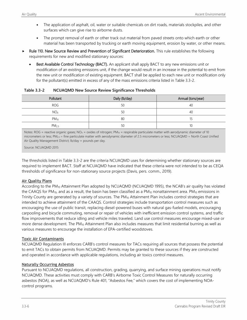
Air Quality Ascent Environmental
Trinity County 3.3-6 Cannabis Program Revised Draft EIR
The application of asphalt, oil, water or suitable chemicals on dirt roads, materials stockpiles, and other surfaces which can give rise to airborne dusts.
The prompt removal of earth or other track out material from paved streets onto which earth or other material has been transported by trucking or earth moving equipment, erosion by water, or other means.
Rule 110. New Source Review and Prevention of Significant Deterioration. This rule establishes the following requirements for new and modified stationary sources:
Best Available Control Technology (BACT). An applicant shall apply BACT to any new emissions unit or modification of an existing emissions unit, if the change would result in an increase in the potential to emit from the new unit or modification of existing equipment. BACT shall be applied to each new unit or modification only for the pollutant(s) emitted in excess of any of the mass emissions criteria listed in Table 3.3-2.
Table 3.3-2 NCUAQMD New Source Review Significance Thresholds
Pollutant Daily (lb/day) Annual (tons/year)
ROG 50 40
NOX 50 40
PM10 80 15
PM2.5 50 10
Notes: ROG = reactive organic gases; NOX = oxides of nitrogen; PM10 = respirable particulate matter with aerodynamic diameter of 10 micrometers or less; PM2.5 = fine particulate matter with aerodynamic diameter of 2.5 micrometers or less; NCUAQMD = North Coast Unified Air Quality Management District; lb/day = pounds per day.
Source: NCUAQMD 2015
The thresholds listed in Table 3.3-2 are the criteria NCUAQMD uses for determining whether stationary sources are required to implement BACT. Staff at NCUAQMD have indicated that these criteria were not intended to be as CEQA thresholds of significance for non-stationary source projects (Davis, pers. comm., 2019).
Air Quality Plans According to the PM10 Attainment Plan adopted by NCUAQMD (NCUAQMD 1995), the NCAB’s air quality has violated the CAAQS for PM10, and as a result, the basin has been classified as a PM10 nonattainment area. PM10 emissions in Trinity County are generated by a variety of sources. The PM10 Attainment Plan includes control strategies that are intended to achieve attainment of the CAAQS. Control strategies include transportation control measures such as encouraging the use of public transit, replacing diesel-powered buses with natural gas-fueled models, encouraging carpooling and bicycle commuting, removal or repair of vehicles with inefficient emission control systems, and traffic flow improvements that reduce idling and vehicle miles traveled. Land use control measures encourage mixed-use or more dense development. The PM10 Attainment Plan also includes measures that limit residential burning as well as various measures to encourage the installation of EPA-certified woodstoves.
Toxic Air Contaminants NCUAQMD Regulation III enforces CARB’s control measures for TACs requiring all sources that possess the potential to emit TACs to obtain permits from NCUAQMD. Permits may be granted to these sources if they are constructed and operated in accordance with applicable regulations, including air toxics control measures.
Naturally Occurring Asbestos Pursuant to NCUAQMD regulations, all construction, grading, quarrying, and surface mining operations must notify NCUAQMD. These activities must comply with CARB’s Airborne Toxic Control Measures for naturally occurring asbestos (NOA), as well as NCUAQMD’s Rule 401, “Asbestos Fee,” which covers the cost of implementing NOA-control programs.
Ascent Environmental Air Quality
Trinity County Cannabis Program Revised Draft EIR 3.3-7
Trinity County General Plan The Trinity County General Plan Safety Element includes the following policies related to air quality:
The burning of any material shall be in compliance with burning permits, conditions and/or standards established by the North Coast Air Quality Management District (NCAQMD).
Support and encourage programs such as fuel reduction, prescribed fires, and landscape-scale vegetation management as recommended in the Trinity County Community Wildfire Protection Plan to reduce air quality impacts of wildfires.
Support and encourage fire suppression of wildfires that may have an acute air quality health impact on local population centers and recreation areas.
The County shall require an analysis of potential air quality impacts associated with significant new developments as required by CEQA, including appropriate mitigation measures prior to approval of the project development.
Ground disturbing construction and grading shall employ fugitive dust control strategies to prevent visible emissions from exceeding NCAQMD regulations and prevent public nuisance.
The County shall encourage that all projects requiring earth-disturbing activities or a building permit that would result in earth disturbance, in areas likely to contain naturally occurring asbestos to have a California-registered geologist knowledgeable about asbestos-containing formations inspect the project for asbestos hazards.
3.3.2 Environmental Setting The project area is located in the NCAB. The NCAB includes all of Del Norte, Humboldt, Trinity, and Mendocino Counties and the northern portion of Sonoma County. The ambient concentrations of air pollutant emissions are determined by the amount of emissions released by the sources of air pollutants and the atmosphere’s ability to transport and dilute such emissions. Natural factors that affect transport and dilution include terrain, wind, atmospheric stability, and sunlight. Therefore, existing air quality conditions in the area are determined by such natural factors as topography, meteorology, and climate, in addition to the amount of emissions released by existing air pollutant sources, as discussed separately below.
CLIMATE, METEOROLOGY, AND TOPOGRAPHY In general, the climate of northern coastal California is characterized by cool summers and mild winters with frequent fog and significant amounts of rain. In coastal areas, the ocean helps to moderate temperatures year-round. Further inland, the summers are hotter and drier and the winters colder and snowier. At high elevations in inland areas, it is cool in the summers and snowier in the winter. The average annual rainfall in Trinity County ranges from 37 inches in Weaverville to 43 inches in Sayler (WRCC 2016). Approximately 90 percent of the annual precipitation falls between October and April. Higher rainfall in winter often influences high river levels. Winter snowfall is common at higher elevations. The dry season is between May and September.
Average temperatures in Trinity County range from 94 degrees Fahrenheit (°F) in the summer to 27°F during the winter (WRCC 2016). Atmospheric conditions such as wind speed, wind direction, and air temperature gradients interact with the physical features of the landscape to drive the movement and dispersal of air pollutant emissions. In the NCAB, dominant winds exhibit a seasonal pattern, especially in coastal areas. In the summer months, strong north to northwesterly winds are common and during the winter, storms from the South Pacific increase the percentage of days with winds from southerly quadrants. Wind direction often assumes a daily pattern in the river canyons that empty into the Pacific. In the morning hours, cool air from higher elevations flows down the valleys while later in the day, as the lower elevation air heats up, this pattern is reversed and the airflow heads up the canyon. These airflows are often quite strong. Offshore and onshore flows are also common along the coast and associated with pressure systems in the area. Onshore flows are also common along the coast and are associated with pressure systems in the
Air Quality Ascent Environmental
Trinity County 3.3-8 Cannabis Program Revised Draft EIR
area. Onshore flows frequently bring foggy cool weather to the coast, while offshore flows often blow fog away from the coast and bring sunny warm days.
Trinity County commonly experiences two types of inversions, vertical and horizontal, that affect the vertical depth of the atmosphere through which pollutants can be mixed. Vertical air movement is important in spreading pollutants through a thicker layer of air. Horizontal movement is important in spreading pollutants over a wider area. Upward dispersion of pollutants is hindered wherever the atmosphere is stable; that is, where warm air overlies cooler air below.
Because of the region’s topography and coastal air movements, inversion conditions are common in the NCAB. Inversions are created when warm air traps cool air near the ground surface and prevents vertical dispersion of air. Valley, geographic basins, and coastal areas surrounded by higher elevations are the most common locations for inversions to occur. During the summer, inversions are less prominent, and vertical dispersion of the air is good. However, during the cooler months between late fall and early spring, inversions last longer and more geographically extensive; vertical dispersion is poor, and pollution may be trapped near the ground for several concurrent days.
Radiation inversion occurs when the air layer near the surface of the ground cools and may extend upward several hundred feet. Radiation inversion in Trinity County is found in the night and early mornings almost daily, but is more prominent from late fall to early spring where there is less sunlight and it is cooler. Radiation inversion tends to last longer into the morning during the winter months than in the summer.
Subsidence inversion is caused by downward moving air aloft, which is common in the area of high pressure along and off the coast. The air warms at a rate of 5.5°F per 1,000 feet as it descends. Thus, it arrives at a lower height warmer than the air just below and limits the vertical mixing of air. Subsidence inversion often affects a large area and is more common during the summer months. This inversion, which usually occurs from late spring through the early fall, can be very strong and shallow given the cooling of the lower layers from the cool ocean water.
In the NCAB, air quality it predominantly influenced by the climatic regimes of the Pacific. In summer, warm ground surfaces draw cool air in from the coast, creating frequent thick fogs along the coast and making northwesterly winds common. In winter, precipitation is high, wintertime surface wind directions are highly variable, and weather is more affected by oceanic storm patterns (NCUAQMD 1995:II-1 to II-3).
CRITERIA AIR POLLUTANTS Concentrations of criteria air pollutants are used to indicate the quality of the ambient air.
Ozone Ground-level ozone is not emitted directly into the air, but is created by chemical reactions between reactive organic gases (ROG) and oxides of nitrogen (NOX). Ozone at ground level is a harmful air pollutant because of its effects on people and the environment, and is the main ingredient in smog (EPA 2016).
Acute health effects of ozone exposure include increased respiratory and pulmonary resistance, cough, pain, shortness of breath, and lung inflammation. Chronic health effects include permeability of respiratory epithelia and possibility of permanent lung impairment (EPA 2016). Emissions of the ozone precursors ROG and NOX have decreased over the past several years because of more stringent motor vehicle standards and cleaner burning fuels. Emissions of ROG and NOX decreased from 2000 to 2010 and are projected to continue decreasing from 2010 to 2035 (CARB 2013).
Nitrogen Dioxide NO2 is a brownish, highly reactive gas that is present in all urban environments. The major human-made sources of NO2 are combustion devices, such as boilers, gas turbines, and mobile and stationary reciprocating internal combustion engines. Combustion devices emit primarily nitric oxide (NO), which reacts through oxidation in the atmosphere to form NO2. The combined emissions of NO and NO2 are referred to as NOX and are reported as equivalent NO2. Because NO2 is formed and depleted by reactions associated with photochemical smog (ozone), the NO2 concentration in a particular geographical area may not be representative of the local sources of NOX emissions (EPA 2012).

Ascent Environmental Air Quality
Trinity County Cannabis Program Revised Draft EIR 3.3-9
Acute health effects of exposure to NOX includes coughing, difficulty breathing, vomiting, headache, eye irritation, chemical pneumonitis, or pulmonary edema, breathing abnormalities, cough, cyanosis, chest pain, rapid heartbeat, and death. Chronic health effects include chronic bronchitis and decreased lung function (EPA 2016).
Particulate Matter PM10 is emitted directly into the air, and includes fugitive dust, soot, and smoke from mobile and stationary sources, construction operations, fires and natural windblown dust, and particulate matter formed in the atmosphere by reaction of gaseous precursors (CARB 2013). PM2.5 includes a subgroup of smaller particles that have an aerodynamic diameter of 2.5 micrometers or less. PM10 emissions in the NCAB are dominated by emissions from area sources, primarily fugitive dust from vehicle travel on unpaved and paved roads, farming operations, construction and demolition, and particles from residential fuel combustion. Direct emissions of PM10 are projected to remain relatively constant through 2035. Direct emissions of PM2.5 have steadily declined in the NCAB between 2000 and 2010 and then are projected to increase very slightly through 2035. Emissions of PM2.5 in the NCAB are dominated by the same sources as emissions of PM10 (CARB 2013).
Many adverse health impacts have been associated with exposure to both PM10 and PM2.5 (CARB 2017). For PM2.5, short-term exposures (up to 24-hours duration) have been associated with premature mortality, increased hospital admissions for heart or lung causes, acute and chronic bronchitis, asthma attacks, emergency room visits, respiratory symptoms, and restricted activity days. These adverse health effects have been reported primarily in infants, children, and older adults with preexisting heart or lung diseases. In addition, of all of the common air pollutants, PM2.5 is associated with the greatest proportion of adverse health effects related to air pollution, both in the United States and world-wide.
Short-term exposures to PM10 have been associated primarily with worsening of respiratory diseases, including asthma and chronic obstructive pulmonary disease, leading to hospitalization and emergency department visits.
Long-term (months to years) exposure to PM2.5 has been linked to premature death, particularly in people who have chronic heart or lung diseases, and reduced lung function growth in children. The effects of long-term exposure to PM10 are less clear, although several studies suggest a link between long-term PM10 exposure and respiratory mortality.
Attainment Status The NCAB is designated nonattainment with respected to the CAAQS for PM10, and is designated as attainment for all other CAAQS and NAAQS for criteria air pollutants (NCUAQMD n.d.). The attainment status for each criteria air pollutant is based on ambient measurements collected at monitoring stations in the NCAB. Monitoring results have shown that the principal pollutant of concern in the NCAB, including Trinity County, is PM10. The largest source of PM10 in the NCAB consists of fugitive dust emissions generated by vehicle travel on unpaged roads. The control of fugitive road dust plays a key role in NCUAQMD’s attainment strategy (NCUAQMD 1995:V-2). Other sources of PM10 in the NCAB include exhaust from on-road and off-road vehicles, open burning of vegetation (both residential and commercial), residential wood stoves, and stationary industrial sources (e.g., timber mills).
TOXIC AIR CONTAMINANTS According to the California Almanac of Emissions and Air Quality (CARB 2013), the majority of the estimated health risks from TACs can be attributed to relatively few compounds, the most important being diesel PM (CARB 2013:5-2 to 5-4). Diesel PM differs from other TACs in that it is not a single substance, but rather a complex mixture of hundreds of substances. Although diesel PM is emitted by diesel-fueled internal combustion engines, the composition of the emissions varies depending on engine type, operating conditions, fuel composition, lubricating oil, and whether an emissions control system is being used. Unlike the other TACs, no ambient monitoring data are available for diesel PM because no routine measurement method currently exists. However, CARB has made preliminary concentration estimates based on a PM exposure method. This method uses the CARB emissions inventory’s PM10 database, ambient PM10 monitoring data, and the results from several studies to estimate concentrations of diesel PM. In addition to diesel PM, the TACs for which data are available that pose the greatest
Air Quality Ascent Environmental
Trinity County 3.3-10 Cannabis Program Revised Draft EIR
existing ambient risk in California are benzene, 1,3-butadiene, acetaldehyde, carbon tetrachloride, hexavalent chromium, para-dichlorobenzene, formaldehyde, methylene chloride, and perchloroethylene.
ODORS Odors are generally regarded as an annoyance rather than a health hazard. However, manifestations of a person’s reaction to foul odors can range from psychological (e.g., irritation, anger, or anxiety) to physiological (e.g., circulatory and respiratory effects, nausea, vomiting, and headache). Odor is inherently complex because it is often caused by a mixture of chemical substances and has subjective components associated with human perception by the olfactory senses. Odorants (odor-causing chemicals) are often complex mixtures of chemical substances, and even slight changes in the chemical composition of the mixtures can greatly affect how humans perceive a particular odor. Some odors can also be caused by very minute levels of odorants (sometimes in the parts-per-trillion range) that can be detected by human noses but are well below instrumental or laboratory detection levels. Human noses, on the other hand, are well-adapted at distinguishing specific odors in complex environments.
The ability to detect odors varies considerably among the population and overall is quite subjective. Some individuals can smell very minute quantities of specific substances; others may not have the same sensitivity but may have sensitivities to odors of other substances. In addition, people may have different reactions to the same odor; an odor that is offensive to one person may be perfectly acceptable to another (e.g., fast food restaurant). It is important to also note that an unfamiliar odor is more easily detected and is more likely to cause complaints than a familiar one. This is because of the phenomenon known as odor fatigue, in which a person can become desensitized to almost any odor and recognition only occurs with an alteration in the intensity. Odor sources of typical concern include wastewater treatment plants, sanitary landfills, composting facilities, recycling facilities, petroleum refineries, chemical manufacturing plants, painting operations, rendering plants, and food packaging plants.
Cannabis Odor Research The typical smell of cannabis originates from roughly 140 different terpenes. A terpene is a volatile, unsaturated hydrocarbon that is found in essential oils of plants, especially conifers and citrus trees. Some terpenes are identified explicitly in research (myrcene, pinene, limonene). The “skunk” odor is primarily volatile thiols. Cannabis contains alpha-linolenic acid, which may break down under ultraviolet rays of sunlight into methyl and butyl thiols.
Some researchers define an “odor activity value” (OAV), which is the chemical compound concentration divided by the chemical compound odor detection threshold (which is a literature-based value). A higher OAV could mean a more significant odor. One shortcoming of the OAV is the quality of the odor detection thresholds may be low. Highly odorous compounds in low concentrations that may have a more potent OAV are nonanal, decanol, o-cymene, and benzaldehyde. In other research findings, it is believed the majority of the odor in cannabis flowers is linked to pinene, limonene, and terpinolene.
Terpenes that are commonly identified and/or thought to warrant further evaluation for odor impacts include myrcene, pinene, limonene, b-caryophyllene, terpinolene, nonanal, decanol, o-cymene, and benzaldehyde. Utilizing published literature–based odor detection thresholds (where available) for these chemical compounds yields a range of 1 part per billion (ppb) to 3,500 ppb. Literature-based odor detection thresholds can vary widely (by orders of magnitude) for the same chemical compound.
As the research described above suggests, there is not a clear or consistent numerical threshold to use for cannabis odors. Because odor is a perception-based phenomenon and involves complex mixtures of substances rather than singular chemical molecules, it is important to evaluate odors comprehensively (in terms of odor) rather than breaking down individual chemical compounds of the odor. Dispersion modeling has been conducted by other counties to determine the distance from which cannabis odor may be detected. The results of this modeling indicated that specific cannabis compounds may be detectable at a distance of 2 miles or more depending on weather conditions (Kern County 2017:4.3-66 and 4.3-67).
Ascent Environmental Air Quality
Trinity County Cannabis Program Revised Draft EIR 3.3-11
When cannabis is grown in enclosed, indoor environments (buildings and greenhouses), odor-causing chemicals are concentrated and have been found to generate significant odors within the air space. It has been reported that cannabis grown in greenhouses can generate odor with strengths ranging from 30,000 to 50,000 odor units. This implies that the untreated indoor air would need to be diluted up to 50,000 times with clean air to be reduced to levels that are no longer detectable to humans with normal odor sensitivity.
Public Health/Nuisance Issues A review of recent scientific publications identified no studies that evaluated the health effects associated with exposure to cannabis odors. An evidence brief prepared by Public Health Ontario (Public Health Ontario 2018) states that “most substances responsible for odors in the outdoor air are not present at levels that can cause long-term health effects. However, exposure to unpleasant odors may affect an individual’s quality of life and sense of well-being.” This statement was made in reference to odors in general and not cannabis odors in particular. The City of Denver prepared a Cannabis Environmental Best Management Practices document (City of Denver 2018), which states that “the rate of VOC [volatile organic compound] emissions from cannabis cultivation facilities is relatively unknown…. [T]hese VOCs from the cannabis industry typically do not pose a direct threat to human health.” Although research is limited, it is anticipated that the concentration of cannabis odors is not significant enough to create a public health concern for off-property residential receptors.
NATURALLY OCCURRING ASBESTOS NOA was identified as a TAC in 1986 by CARB. NOA is located in many parts of California, and is commonly associated with ultramafic rocks, according to a special publication by the California Geological Survey (Churchill and Hill 2000). Asbestos is the common name for a group of naturally occurring fibrous silicate minerals that can separate into thin but strong and durable fibers. Ultramafic rocks form in high-temperature environments well below the surface of the earth. By the time they are exposed at the surface by geologic uplift and erosion, ultramafic rocks may be partially to completely altered into a type of metamorphic rock called serpentinite. Sometimes the metamorphic conditions are right for the formation of chrysotile asbestos or tremolite-actinolite asbestos in the bodies of these rocks, along their boundaries, or in the soil.
Asbestos could be released into the air from serpentinite or ultramafic rock if the rock is broken or crushed. At the point of release, asbestos fibers could become airborne, causing air quality and human health hazards. Natural weathering and erosion processes act on asbestos bearing rock and soil, increasing the likelihood for asbestos fibers to become airborne if disturbed (California Geological Survey 2002:22).
According to the report, A General Location Guide to Ultramafic Rocks in California—Areas More Likely to Contain Naturally Occurring Asbestos, there are areas of Trinity County in which asbestos is likely to occur (Churchill and Hill 2000). The Trinity County Safety Element identifies the presence of NOA in the eastern portion of the county (Trinity County 2014:90).
SENSITIVE RECEPTORS Sensitive receptors are generally considered to include those land uses where exposure to pollutants could result in health-related risks to sensitive individuals, such as children and the elderly. Residential dwellings, schools, hospitals, playgrounds, and similar facilities are of primary concern because of the presence of individuals particularly sensitive to pollutants and/or the potential for increased and prolonged exposure of individuals to pollutants. These types of land uses exist in all developed areas of Trinity County.
Air Quality Ascent Environmental
Trinity County 3.3-12 Cannabis Program Revised Draft EIR
3.3.3 Environmental Impacts and Mitigation Measures
METHODOLOGY This EIR evaluates the air quality impacts of all cultivation and noncultivation operations that could be permitted under the Cannabis Program. The analysis focuses on a conservative estimate of impacts to air quality that could occur from the types of cultivation and noncultivation operations that could be permitted under the program. Limitations and restrictions regarding the types, sizes, and intensity of permitted cultivation and noncultivation operations are summarized in Chapter 2, “Project Description.” This analysis is consistent with Trinity County Safety Element policies that require the consideration and mitigation of air quality impacts.
Permitted commercial cannabis cultivation and noncultivation operations could result in an increase in emissions from short-term construction-related activities and their long-term operation. The California Emissions Estimator Model (CalEEMod) Version 2016.3.2 was used to estimate emissions of criteria air pollutants and precursors associated with the construction and operation of the types and sizes of indoor, outdoor, mixed-light, and noncultivation operations that could be approved under the Cannabis Program. This modeling is based on the number and size of these new facilities, as well as climatic conditions in the county. Construction-related emissions were estimated for individual license types and scaled based on the number of cultivation and noncultivation sites that could be constructed simultaneously. It was assumed up to 67 individual sites could be under construction at the same time, based on County commercial cannabis licensing data. For details about construction assumptions and scaling, refer to Appendix C.
Operational emissions were also estimated. CalEEMod was used to estimate on-site operational emissions, including emissions generated by off-road equipment, maintenance activity, and fertilizer application. CalEEMod default energy consumption rates were adjusted to account for energy efficiency improvements from the 2019 California Energy Code, which would result in a 30 percent reduction in energy consumption compared with the 2016 California Energy Code that is included in CalEEMod. Default energy consumption assumes a mix of electricity and natural gas, however, because there are no natural gas pipelines in Trinity County, on-site propane tanks are often used. The level of natural gas consumption estimated by CalEEMod was converted to propane using an energy content-based conversion factor. Off-road equipment includes the use of a utility vehicle (e.g., John Deere Gator) for outdoor and mixed-light cultivation sites, and a forklift for noncultivation operations. Back-up diesel generators were also assumed to be used at mixed-light cultivation sites.
Mobile-source emissions of criteria air pollutant and precursors associated with vehicle exhaust were estimated using CARB’s Emission Factor 2017 model, trip generation rates derived from the development assumptions presented in Chapter 2, “Project Description,” and CalEEMod default trip lengths for Trinity County. Section 3.14, “Transportation/Traffic” includes details about the derivation of trip generation by licensed facility type. Refer to Appendix C for modeling assumptions and calculations. Operational emissions were estimated for the full number of operations that could be licensed under the program and it was assumed that this number of facilities could be fully operational by 2020.
Mass emissions of mobile-source fugitive PM10 and PM2.5 dust were estimated using CARB’s Miscellaneous Process Methodology 7.10 for Unpaved Road Dust on Non-Farm Roads (CARB 2012). This methodology estimates PM10 emissions using an equation that incorporates unpaved road miles traveled, an emissions factor, and a rainfall adjustment based on the project’s location. It was assumed that all existing licensed and new cultivation sites would generate trips on unpaved roadways because they are likely to be located in more remote areas of the county. It was also assumed that existing and new licensed noncultivation sites would be located in developed parts of the county and therefore not generate vehicle trips on unpaved roadways. Fugitive PM2.5 dust emissions were estimated using a fraction based on PM10 emissions that is recommended in EPA’s AP-42 Emission Factors (Midwest Research Institute 2006).
Dispersion modeling was conducted to better understand the localized concentrations of fugitive PM10 dust that would result from vehicle travel on unpaved roads. Dispersion modeling was conducted with CARB-approved American Meteorological Society/Environmental Protection Agency Regulatory Model Improvement Committee
Ascent Environmental Air Quality
Trinity County Cannabis Program Revised Draft EIR 3.3-13
modeling system (AERMOD), Version 18081 (EPA 2018) with the graphical user interface, AERMOD View, Version 9.6.5 (Lakes Environmental Software 2018). Modeling was conducted in accordance with guidance published by the California Office of Environmental Health and Hazard Assessment (OEHHA 2015). The modeling also used one year of hourly meteorological data provided by NCUAQMD supplemented with historical hourly cloud cover data attained from Weather Underground for the Lonnie Pool Field Weaverville Airport station (Weather Underground 2019) and processed using the AERMET module in AERMOD View.
As described in Section 3.3.2, “Environmental Setting,” odors are generally regarded as an annoyance rather than a health hazard. However, manifestations of a person’s reaction to foul odors can range from psychological (e.g., irritation, anger, or anxiety) to physiological (e.g., circulatory and respiratory effects, nausea, vomiting, and headache). Odor is inherently complex because it is often caused by a mixture of chemical substances and has subjective components associated with human perception by the olfactory senses. The results of dispersion modeling indicate that specific cannabis compounds may be detectable at a distance of 2 miles or more depending on weather conditions, but such modeling cannot determine whether the detection would be considered a nuisance (Kern County 2017:4.3-66 and 4.3-67). Thus, the impact analysis qualitatively evaluates the potential of cannabis uses to create odors that create a public nuisance or adversely affect nearby residents or businesses.
THRESHOLDS OF SIGNIFICANCE NCUAQMD has developed relatively brief guidance for use by lead agencies when preparing CEQA documents (NCUAQMD n.d.). NCUAQMD has not formally adopted CEQA thresholds of significance for evaluating impacts to air quality but rather utilizes the mass emission level criteria for determining when stationary sources are required to implement BACT, as defined in NCUAQMD Rule 110 and presented in Table 3.3-2. For the purposes of this EIR, these mass emission level criteria are considered to be the allowable incremental contribution by a project or plan while still maintaining overall attainment of the CAAQS and NAAQS in Trinity County and the NCAB. These thresholds are also used to determine whether a project or plan could expose sensitive receptors to substantial pollutant concentrations of criteria air pollutants, that is, concentrations that exceed the NAAQS and CAAQS, which are scientifically substantiated, numerical concentrations considered to be protective of human health. For these reasons, implementation of the Cannabis Program would result in a significant impact to air quality if it would result in:
construction- or operation-related emissions that exceed of ROG, NOX, or PM2.5 that exceed 50 pounds per day (lb/day); or PM10 that exceeds 80 lb/day or 15 tons per year (tons/year); or ROG and NOX that exceeds 40 tons/year; or PM2.5 that exceeds 10 tons/year;
local mobile-source CO emissions that would violate or contribute substantially to an exceedance of the 1-hour CAAQS of 20 parts per million (ppm) or the 8-hour CAAQS of 9 ppm; or
objectionable odors affecting a substantial number of people.
ISSUES NOT DISCUSSED FURTHER The establishment of new commercial cannabis operations permitted under the Cannabis Program could result in ground-disturbance activities in areas known to contain NOA. However, NCUAQMD requires projects conform with CARB’s Airborne Toxic Control Measures for NOA, which requires control measures during activities that involve ground disturbance. Any ground disturbance activity in locations where asbestos-containing soils are suspected or identified would be required to implement these control measures to prevent exposure of NOA to nearby receptors.
Regarding the potential for CO “hot spots” at local intersections, these types of effects only have the potential to occur at intersections experiencing extremely high volumes of traffic. For instance, the Sacramento Metropolitan Air Quality Management District determined that CO hot spots only have the potential to occur at intersections that experience a traffic volume greater than 31,600 vehicles per hour (SMAQMD 2016:4-8). Operational activities at individual facilities are not anticipated to generate more than 32 trips per day during the peak harvest period, as explained in Section 3.14, “Transportation/Traffic.” Moreover, the commercial cannabis operations would be generally spread throughout the county. Thus, it is not anticipated that vehicle trips generated by cultivation operations would
Air Quality Ascent Environmental
Trinity County 3.3-14 Cannabis Program Revised Draft EIR
result in congestion at any intersection that experiences high volumes of vehicles or long wait times. For these reasons, it is not anticipated that the additional trips associated with new cannabis operations would contribute substantially to traffic congestion at affected intersections such that local CO “hot spots” would occur that exceed the CAAQS or NAAQS for CO.
Construction and operation of the permitted cultivation and noncultivation operations may involve the use of diesel-powered equipment that emit diesel PM. However, the amount of construction activity at any single location would not be intensive (i.e., approximately one piece of off-road equipment being used at a time) would be temporary and would not take place at the same site for longer than a few months. Operational activities would not include any major sources of TACs and all operations would be subject to comply with setback distances specified in the Cannabis Program (i.e., a minimum 350-foot buffer between operations and existing residential land uses). Given the minimal construction activities, the lack of major sources of TACs, and the setback requirements, the construction and operation of new cannabis facilities would not expose existing receptors to substantial TAC concentrations.
Trinity County’s portion of the NCAB is in attainment for all criteria air pollutants and precursors. Individual cultivation sites may include back-up diesel generators but would not include new stationary sources that could potentially exceed established emissions limits for ROG, NOX, PM10, PM2.5, CO, and SO2.
ENVIRONMENTAL IMPACTS AND MITIGATION MEASURES
Impact 3.3-1: Construction-Generated Emissions of Criteria Air Pollutants and Precursors
Construction-generated emissions from later projects under the Cannabis Program could exceed NCUAQMD-recommended maximum daily emission threshold for NOX and annual mass emission threshold for PM10. Because the NCAB is in nonattainment for PM10, construction of new facilities licensed under the Cannabis Program would contribute substantially to an existing or projected air quality violation, could expose sensitive receptors to substantial pollutant concentrations, and could conflict with air quality planning efforts in Trinity County and the NCAB. This impact would be significant.
Existing Licensed Commercial Cannabis Operations Construction emissions associated with existing licensed commercial cannabis cultivation operations and distribution operations are not quantified because these facilities have already been constructed. However, it is acknowledged that continued operation of these cultivation sites could result in some minor construction activities through the proposed amendment that would allow expansion of the Designated Area for cultivation activities from 200 percent of the licensed cannabis canopy area to 250 percent (20 percent increase). Similar to construction air quality impacts for new licensed commercial cannabis uses, this impact would be significant.
New Licensed Commercial Cannabis Operations
Construction of Cultivation Operations Construction of commercial cultivation operations would require earthwork and use of heavy-duty off-road equipment that would generate exhaust emissions and fugitive dust. Generally, the intensity of construction activity would be similar to a residential renovation or building addition project. Construction of individual outdoor cultivation operations could involve the clearing of vegetation, grading, or other earth disturbance activities to establish a grow area, the laying of a gravel pad to support the containers in which the cannabis is planted, installation of a water storage tank or pond, and approximately 44,500 6,329 square feet (sq. ft.) of indoor noncultivation space. Construction of individual indoor and mixed-light cultivation operations would involve the construction of a greenhouse or grow building of up to 23,000 10,124 sq. ft. and 2,000 1,260 sq. ft., respectively, as well as a water storage tank or pond, and noncultivation indoor space.
The construction of new individual cultivation operations would last approximately 7 months at each cultivation site, and heavy-duty off-road equipment would be used for approximately 22 weeks at each single new cultivation operation. Emissions of fugitive PM10 and PM2.5 dust would primarily be generated by ground-disturbance during site
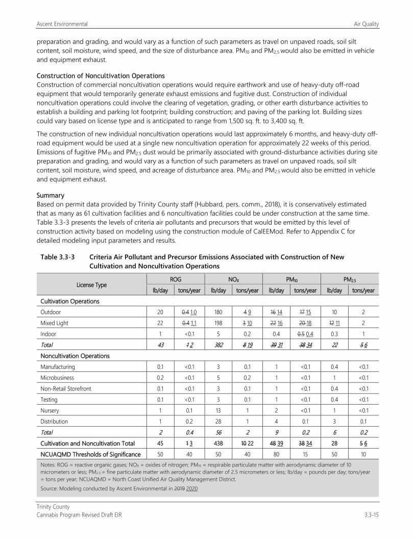
Ascent Environmental Air Quality
Trinity County Cannabis Program Revised Draft EIR 3.3-15
preparation and grading, and would vary as a function of such parameters as travel on unpaved roads, soil silt content, soil moisture, wind speed, and the size of disturbance area. PM10 and PM2.5 would also be emitted in vehicle and equipment exhaust.
Construction of Noncultivation Operations Construction of commercial noncultivation operations would require earthwork and use of heavy-duty off-road equipment that would temporarily generate exhaust emissions and fugitive dust. Construction of individual noncultivation operations could involve the clearing of vegetation, grading, or other earth disturbance activities to establish a building and parking lot footprint; building construction; and paving of the parking lot. Building sizes could vary based on license type and is anticipated to range from 1,500 sq. ft. to 3,400 sq. ft.
The construction of new individual noncultivation operations would last approximately 6 months, and heavy-duty off-road equipment would be used at a single new noncultivation operation for approximately 22 weeks of this period. Emissions of fugitive PM10 and PM2.5 dust would be primarily associated with ground-disturbance activities during site preparation and grading, and would vary as a function of such parameters as travel on unpaved roads, soil silt content, soil moisture, wind speed, and acreage of disturbance area. PM10 and PM2.5 would also be emitted in vehicle and equipment exhaust.
Summary Based on permit data provided by Trinity County staff (Hubbard, pers. comm., 2018), it is conservatively estimated that as many as 61 cultivation facilities and 6 noncultivation facilities could be under construction at the same time. Table 3.3-3 presents the levels of criteria air pollutants and precursors that would be emitted by this level of construction activity based on modeling using the construction module of CalEEMod. Refer to Appendix C for detailed modeling input parameters and results.
Table 3.3-3 Criteria Air Pollutant and Precursor Emissions Associated with Construction of New Cultivation and Noncultivation Operations
License Type ROG NOX PM10 PM2.5
lb/day tons/year lb/day tons/year lb/day tons/year lb/day tons/year
Cultivation Operations
Outdoor 20 0.4 1.0 180 4 9 16 14 17 15 10 2
Mixed Light 22 0.4 1.1 198 3 10 22 16 20 18 12 11 2
Indoor 1 <0.1 5 0.2 0.4 0.5 0.4 0.3 1
Total 43 1 2 382 8 19 39 31 38 34 22 5 6 Noncultivation Operations
Manufacturing 0.1 <0.1 3 0.1 1 <0.1 0.4 <0.1
Microbusiness 0.2 <0.1 5 0.2 1 <0.1 1 <0.1
Non-Retail Storefront 0.1 <0.1 3 0.1 1 <0.1 0.4 <0.1
Testing 0.1 <0.1 3 0.1 1 <0.1 0.4 <0.1
Nursery 1 0.1 13 1 2 <0.1 1 <0.1
Distribution 1 0.2 28 1 4 0.1 3 0.1
Total 2 0.4 56 2 9 0.2 6 0.2 Cultivation and Noncultivation Total 45 1 3 438 10 22 48 39 38 34 28 5 6
NCUAQMD Thresholds of Significance 50 40 50 40 80 15 50 10 Notes: ROG = reactive organic gases; NOX = oxides of nitrogen; PM10 = respirable particulate matter with aerodynamic diameter of 10 micrometers or less; PM2.5 = fine particulate matter with aerodynamic diameter of 2.5 micrometers or less; lb/day = pounds per day; tons/year = tons per year; NCUAQMD = North Coast Unified Air Quality Management District. Source: Modeling conducted by Ascent Environmental in 2019 2020
Air Quality Ascent Environmental
Trinity County 3.3-16 Cannabis Program Revised Draft EIR
As shown in Table 3.3-3, construction of new facilities licensed under the ordinance would generate daily levels of NOX and annual levels of PM10 that exceed applicable mass emission thresholds. On the one hand, these estimates are considered conservative because construction of all new cannabis facilities may not take place at the same time. On the other hand, construction of some new cannabis facilities may involve burning of vegetation after it is cleared from the sites and emissions associated with vegetation burning are not accounted for in Table 3.3-3. The addition of NOX, which is a precursor to ozone, could result in an increase in ambient concentrations of ozone in the NCAB and, moreover, increase the likelihood that ambient concentrations exceed the CAAQS and NAAQS. As summarized in “Environmental Setting,” above, human exposure to ozone may cause acute and chronic health impacts including coughing, pulmonary distress, lung inflammation, shortness of breath, and permanent lung impairment. Also, the increase in construction-generated emissions of PM10 could impede air quality planning efforts to bring the NCAB back into attainment of the CAAQS for PM10 (i.e., the PM10 Attainment Plan adopted by NCUAQMD [NCUAQMD 1995]). By evaluating emissions against NCUAQMD’s mass emission thresholds, it is possible that the health complications associated with exposure to increased concentrations of ozone and PM10 would be exacerbated by project-related construction activity. Construction activities resulting from the Cannabis Program would contribute substantially to the NCAB’s nonattainment status for PM10 and could result in an increase in the potential for adverse health impacts to occur from exposure to ozone and PM10. For these reasons, this impact would be significant.
Mitigation Measures
Mitigation Measure 3.3-1a: Prohibit Burning Vegetation The following shall be included as a new performance standard in Section 315-843(6) (Performance Standards for Commercial Cultivation of Cannabis):
Prohibit the burning of vegetation that has been cleared for cultivation purposes. It should also be noted that CDFA regulations prohibit the burning of cannabis waste under CCR, Title 3, Division 8, Chapter 1, Section 8308.
Mitigation Measure 3.3-1b: Implement Diesel Engine Exhaust Control Measures and Dust Control The following shall be included as a new performance standard in Section 315-843(6) (Performance Standards for Commercial Cultivation of Cannabis); Section 315-842(6) (Required Conditions); Section 315-838(6) (Required Conditions); Section 315-837(3) (Required Conditions); Section 315-835(2) (Regulations); Section 315-824(5) (Required Conditions); Section 315-827(4) (Required Conditions of Use Permit Approval); and Section 315-828(5) (Required Conditions):
All diesel-powered off-road equipment used in construction shall meet EPA’s Tier 4 emission standards as defined in 40 CFR 1039 and comply with the exhaust emission test procedures and provisions of 40 CFR Parts 1065 and 1068. Tier 3 models or best available construction equipment can be used if a Tier 4 version of the equipment type is not available. This measure can also be achieved by using battery-electric off-road equipment as it becomes available. Implementation of this measure shall be required in the contract the project applicant establishes with its construction contractors.
Construction activities will implement measures to control dust such as:
Water all exposed surfaces (e.g., parking areas, staging areas, soil piles, graded areas, and unpaved access roads) two times per day.
Cover all haul trucks transporting soil, sand, or other loose material off-site.
Remove all visible mud or dirt track-out onto adjacent roads.
Limit all construction vehicle speeds on unpaved roads to 15 miles per hour.
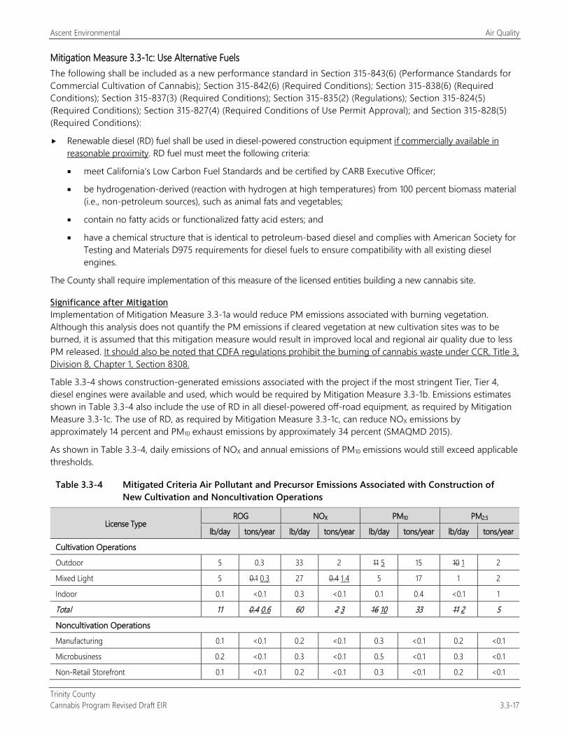
Ascent Environmental Air Quality
Trinity County Cannabis Program Revised Draft EIR 3.3-17
Mitigation Measure 3.3-1c: Use Alternative Fuels The following shall be included as a new performance standard in Section 315-843(6) (Performance Standards for Commercial Cultivation of Cannabis); Section 315-842(6) (Required Conditions); Section 315-838(6) (Required Conditions); Section 315-837(3) (Required Conditions); Section 315-835(2) (Regulations); Section 315-824(5) (Required Conditions); Section 315-827(4) (Required Conditions of Use Permit Approval); and Section 315-828(5) (Required Conditions):
Renewable diesel (RD) fuel shall be used in diesel-powered construction equipment if commercially available in reasonable proximity. RD fuel must meet the following criteria:
meet California’s Low Carbon Fuel Standards and be certified by CARB Executive Officer;
be hydrogenation-derived (reaction with hydrogen at high temperatures) from 100 percent biomass material (i.e., non-petroleum sources), such as animal fats and vegetables;
contain no fatty acids or functionalized fatty acid esters; and
have a chemical structure that is identical to petroleum-based diesel and complies with American Society for Testing and Materials D975 requirements for diesel fuels to ensure compatibility with all existing diesel engines.
The County shall require implementation of this measure of the licensed entities building a new cannabis site.
Significance after Mitigation Implementation of Mitigation Measure 3.3-1a would reduce PM emissions associated with burning vegetation. Although this analysis does not quantify the PM emissions if cleared vegetation at new cultivation sites was to be burned, it is assumed that this mitigation measure would result in improved local and regional air quality due to less PM released. It should also be noted that CDFA regulations prohibit the burning of cannabis waste under CCR, Title 3, Division 8, Chapter 1, Section 8308.
Table 3.3-4 shows construction-generated emissions associated with the project if the most stringent Tier, Tier 4, diesel engines were available and used, which would be required by Mitigation Measure 3.3-1b. Emissions estimates shown in Table 3.3-4 also include the use of RD in all diesel-powered off-road equipment, as required by Mitigation Measure 3.3-1c. The use of RD, as required by Mitigation Measure 3.3-1c, can reduce NOX emissions by approximately 14 percent and PM10 exhaust emissions by approximately 34 percent (SMAQMD 2015).
As shown in Table 3.3-4, daily emissions of NOX and annual emissions of PM10 emissions would still exceed applicable thresholds.
Table 3.3-4 Mitigated Criteria Air Pollutant and Precursor Emissions Associated with Construction of New Cultivation and Noncultivation Operations
License Type ROG NOX PM10 PM2.5
lb/day tons/year lb/day tons/year lb/day tons/year lb/day tons/year
Cultivation Operations
Outdoor 5 0.3 33 2 11 5 15 10 1 2
Mixed Light 5 0.1 0.3 27 0.4 1.4 5 17 1 2
Indoor 0.1 <0.1 0.3 <0.1 0.1 0.4 <0.1 1
Total 11 0.4 0.6 60 2 3 16 10 33 11 2 5
Noncultivation Operations
Manufacturing 0.1 <0.1 0.2 <0.1 0.3 <0.1 0.2 <0.1
Microbusiness 0.2 <0.1 0.3 <0.1 0.5 <0.1 0.3 <0.1
Non-Retail Storefront 0.1 <0.1 0.2 <0.1 0.3 <0.1 0.2 <0.1
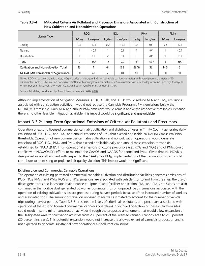
Air Quality Ascent Environmental
Trinity County 3.3-18 Cannabis Program Revised Draft EIR
Table 3.3-4 Mitigated Criteria Air Pollutant and Precursor Emissions Associated with Construction of New Cultivation and Noncultivation Operations
License Type ROG NOX PM10 PM2.5
lb/day tons/year lb/day tons/year lb/day tons/year lb/day tons/year
Testing 0.1 <0.1 0.2 <0.1 0.3 <0.1 0.2 <0.1
Nursery 1 <0.1 1 0.1 1 <0.1 1 <0.1
Distribution 1 0.1 2 0.1 3 <0.1 1 <0.1
Total 2 0.2 4 0.2 6 <0.1 3 <0.1
Cultivation and Noncultivation Total 13 1 64 2 3 22 16 33 14 5 5
NCUAQMD Thresholds of Significance 50 40 50 40 80 15 50 10
Notes: ROG = reactive organic gases; NOX = oxides of nitrogen; PM10 = respirable particulate matter with aerodynamic diameter of 10 micrometers or less; PM2.5 = fine particulate matter with aerodynamic diameter of 2.5 micrometers or less; lb/day = pounds per day; tons/year = tons per year; NCUAQMD = North Coast Unified Air Quality Management District.
Source: Modeling conducted by Ascent Environmental in 2019 2020
Although implementation of Mitigation Measures 3.3-1a, 3.3-1b, and 3.3-1c would reduce NOX and PM10 emissions associated with construction activities, it would not reduce the Cannabis Program’s PM10 emissions below the NCUAQMD threshold. Daily NOX and annual PM10 emissions would remain above the respective thresholds. Because there is no other feasible mitigation available, this impact would be significant and unavoidable.
Impact 3.3-2: Long-Term Operational Emissions of Criteria Air Pollutants and Precursors
Operation of existing licensed commercial cannabis cultivation and distribution uses in Trinity County generates daily emissions of ROG, NOX, and PM10 and annual emissions of PM10 that exceed applicable NCUAQMD mass emission thresholds. Operation of new commercial cannabis cultivation and noncultivation operations would generate emissions of ROG, NOX, PM10, and PM2.5 that exceed applicable daily and annual mass emission thresholds established by NCUAQMD. Thus, operational emissions of ozone precursors (i.e., ROG and NOX) and of PM2.5 could conflict with NCUAQMD’s efforts to maintain the CAAQS and NAAQS for ozone and PM2.5. Given that the NCAB is designated as nonattainment with respect to the CAAQS for PM10, implementation of the Cannabis Program could contribute to an existing or projected air quality violation. This impact would be significant.
Existing Licensed Commercial Cannabis Operations The operation of existing permitted commercial cannabis cultivation and distribution facilities generates emissions of ROG, NOX, PM2.5, and PM10. ROG and NOX emissions are associated with vehicle trips to and from the sites, the use of diesel generators and landscape maintenance equipment, and fertilizer application. PM10 and PM2.5 emissions are also contained in the fugitive dust generated by worker commute trips on unpaved roads. Emissions associated with the operation of existing cultivation sites are greatest during harvest periods because of the increased number of workers and associated trips. The amount of travel on unpaved roads was estimated to account for the number of vehicle trips during harvest periods. Table 3.3-5 presents the levels of criteria air pollutants and precursors associated with operation of the existing licensed commercial cannabis operations. Continued operation of these cultivation sites could result in some minor construction activities through the proposed amendment that would allow expansion of the Designated Area for cultivation activities from 200 percent of the licensed cannabis canopy area to 250 percent (20 percent increase). This potential expansion would not increase the allowed extent of cannabis production and is not expected to generate substantial new operational air pollutant emissions.
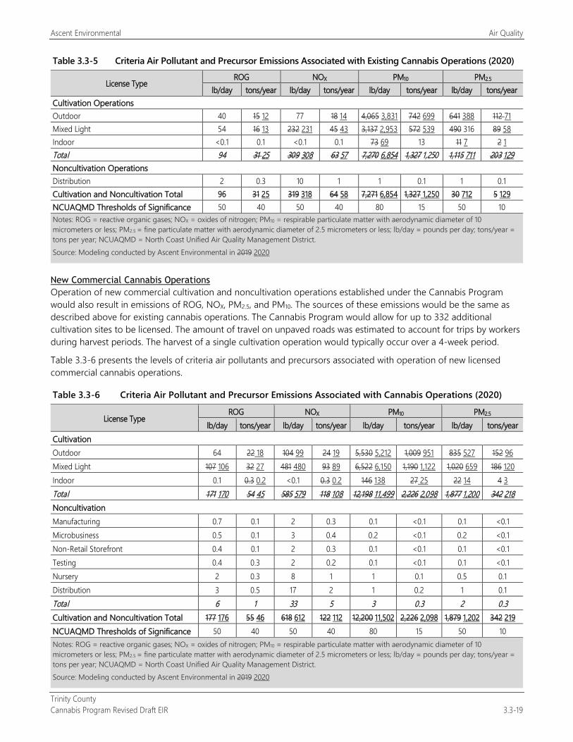
Ascent Environmental Air Quality
Trinity County Cannabis Program Revised Draft EIR 3.3-19
Table 3.3-5 Criteria Air Pollutant and Precursor Emissions Associated with Existing Cannabis Operations (2020)
License Type ROG NOX PM10 PM2.5
lb/day tons/year lb/day tons/year lb/day tons/year lb/day tons/year Cultivation Operations Outdoor 40 15 12 77 18 14 4,065 3,831 742 699 641 388 112 71 Mixed Light 54 16 13 232 231 45 43 3,137 2,953 572 539 490 316 89 58 Indoor <0.1 0.1 <0.1 0.1 73 69 13 11 7 2 1 Total 94 31 25 309 308 63 57 7,270 6,854 1,327 1,250 1,115 711 203 129 Noncultivation Operations Distribution 2 0.3 10 1 1 0.1 1 0.1 Cultivation and Noncultivation Total 96 31 25 319 318 64 58 7,271 6,854 1,327 1,250 30 712 5 129 NCUAQMD Thresholds of Significance 50 40 50 40 80 15 50 10 Notes: ROG = reactive organic gases; NOX = oxides of nitrogen; PM10 = respirable particulate matter with aerodynamic diameter of 10 micrometers or less; PM2.5 = fine particulate matter with aerodynamic diameter of 2.5 micrometers or less; lb/day = pounds per day; tons/year = tons per year; NCUAQMD = North Coast Unified Air Quality Management District. Source: Modeling conducted by Ascent Environmental in 2019 2020
New Commercial Cannabis Operations Operation of new commercial cultivation and noncultivation operations established under the Cannabis Program would also result in emissions of ROG, NOX, PM2.5, and PM10. The sources of these emissions would be the same as described above for existing cannabis operations. The Cannabis Program would allow for up to 332 additional cultivation sites to be licensed. The amount of travel on unpaved roads was estimated to account for trips by workers during harvest periods. The harvest of a single cultivation operation would typically occur over a 4-week period.
Table 3.3-6 presents the levels of criteria air pollutants and precursors associated with operation of new licensed commercial cannabis operations.
Table 3.3-6 Criteria Air Pollutant and Precursor Emissions Associated with Cannabis Operations (2020)
License Type ROG NOX PM10 PM2.5
lb/day tons/year lb/day tons/year lb/day tons/year lb/day tons/year Cultivation Outdoor 64 22 18 104 99 24 19 5,530 5,212 1,009 951 835 527 152 96 Mixed Light 107 106 32 27 481 480 93 89 6,522 6,150 1,190 1,122 1,020 659 186 120 Indoor 0.1 0.3 0.2 <0.1 0.3 0.2 146 138 27 25 22 14 4 3 Total 171 170 54 45 585 579 118 108 12,198 11,499 2,226 2,098 1,877 1,200 342 218 Noncultivation Manufacturing 0.7 0.1 2 0.3 0.1 <0.1 0.1 <0.1 Microbusiness 0.5 0.1 3 0.4 0.2 <0.1 0.2 <0.1 Non-Retail Storefront 0.4 0.1 2 0.3 0.1 <0.1 0.1 <0.1 Testing 0.4 0.3 2 0.2 0.1 <0.1 0.1 <0.1 Nursery 2 0.3 8 1 1 0.1 0.5 0.1 Distribution 3 0.5 17 2 1 0.2 1 0.1 Total 6 1 33 5 3 0.3 2 0.3 Cultivation and Noncultivation Total 177 176 55 46 618 612 122 112 12,200 11,502 2,226 2,098 1,879 1,202 342 219 NCUAQMD Thresholds of Significance 50 40 50 40 80 15 50 10 Notes: ROG = reactive organic gases; NOX = oxides of nitrogen; PM10 = respirable particulate matter with aerodynamic diameter of 10 micrometers or less; PM2.5 = fine particulate matter with aerodynamic diameter of 2.5 micrometers or less; lb/day = pounds per day; tons/year = tons per year; NCUAQMD = North Coast Unified Air Quality Management District. Source: Modeling conducted by Ascent Environmental in 2019 2020
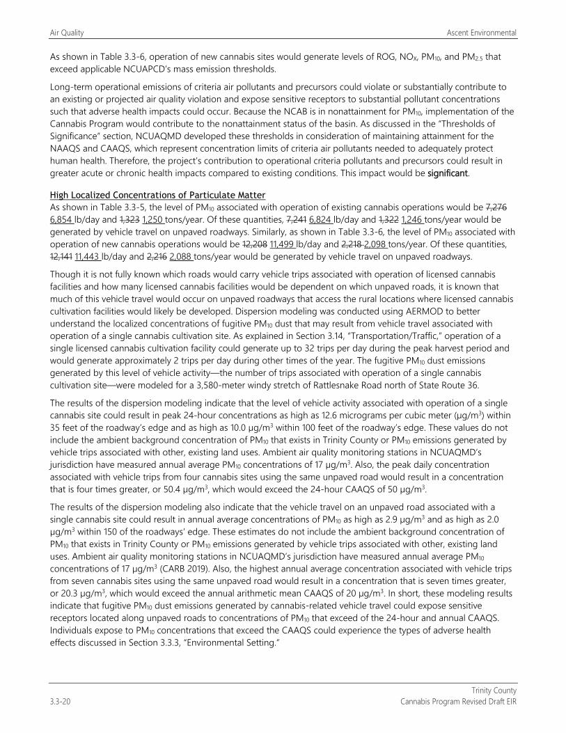
Air Quality Ascent Environmental
Trinity County 3.3-20 Cannabis Program Revised Draft EIR
As shown in Table 3.3-6, operation of new cannabis sites would generate levels of ROG, NOX, PM10, and PM2.5 that exceed applicable NCUAPCD’s mass emission thresholds.
Long-term operational emissions of criteria air pollutants and precursors could violate or substantially contribute to an existing or projected air quality violation and expose sensitive receptors to substantial pollutant concentrations such that adverse health impacts could occur. Because the NCAB is in nonattainment for PM10, implementation of the Cannabis Program would contribute to the nonattainment status of the basin. As discussed in the “Thresholds of Significance” section, NCUAQMD developed these thresholds in consideration of maintaining attainment for the NAAQS and CAAQS, which represent concentration limits of criteria air pollutants needed to adequately protect human health. Therefore, the project’s contribution to operational criteria pollutants and precursors could result in greater acute or chronic health impacts compared to existing conditions. This impact would be significant.
High Localized Concentrations of Particulate Matter As shown in Table 3.3-5, the level of PM10 associated with operation of existing cannabis operations would be 7,276 6,854 lb/day and 1,323 1,250 tons/year. Of these quantities, 7,241 6,824 lb/day and 1,322 1,246 tons/year would be generated by vehicle travel on unpaved roadways. Similarly, as shown in Table 3.3-6, the level of PM10 associated with operation of new cannabis operations would be 12,208 11,499 lb/day and 2,218 2,098 tons/year. Of these quantities, 12,141 11,443 lb/day and 2,216 2,088 tons/year would be generated by vehicle travel on unpaved roadways.
Though it is not fully known which roads would carry vehicle trips associated with operation of licensed cannabis facilities and how many licensed cannabis facilities would be dependent on which unpaved roads, it is known that much of this vehicle travel would occur on unpaved roadways that access the rural locations where licensed cannabis cultivation facilities would likely be developed. Dispersion modeling was conducted using AERMOD to better understand the localized concentrations of fugitive PM10 dust that may result from vehicle travel associated with operation of a single cannabis cultivation site. As explained in Section 3.14, “Transportation/Traffic,” operation of a single licensed cannabis cultivation facility could generate up to 32 trips per day during the peak harvest period and would generate approximately 2 trips per day during other times of the year. The fugitive PM10 dust emissions generated by this level of vehicle activity—the number of trips associated with operation of a single cannabis cultivation site—were modeled for a 3,580-meter windy stretch of Rattlesnake Road north of State Route 36.
The results of the dispersion modeling indicate that the level of vehicle activity associated with operation of a single cannabis site could result in peak 24-hour concentrations as high as 12.6 micrograms per cubic meter (µg/m3) within 35 feet of the roadway’s edge and as high as 10.0 µg/m3 within 100 feet of the roadway’s edge. These values do not include the ambient background concentration of PM10 that exists in Trinity County or PM10 emissions generated by vehicle trips associated with other, existing land uses. Ambient air quality monitoring stations in NCUAQMD’s jurisdiction have measured annual average PM10 concentrations of 17 µg/m3. Also, the peak daily concentration associated with vehicle trips from four cannabis sites using the same unpaved road would result in a concentration that is four times greater, or 50.4 µg/m3, which would exceed the 24-hour CAAQS of 50 µg/m3.
The results of the dispersion modeling also indicate that the vehicle travel on an unpaved road associated with a single cannabis site could result in annual average concentrations of PM10 as high as 2.9 µg/m3 and as high as 2.0 µg/m3 within 150 of the roadways’ edge. These estimates do not include the ambient background concentration of PM10 that exists in Trinity County or PM10 emissions generated by vehicle trips associated with other, existing land uses. Ambient air quality monitoring stations in NCUAQMD’s jurisdiction have measured annual average PM10 concentrations of 17 µg/m3 (CARB 2019). Also, the highest annual average concentration associated with vehicle trips from seven cannabis sites using the same unpaved road would result in a concentration that is seven times greater, or 20.3 µg/m3, which would exceed the annual arithmetic mean CAAQS of 20 µg/m3. In short, these modeling results indicate that fugitive PM10 dust emissions generated by cannabis-related vehicle travel could expose sensitive receptors located along unpaved roads to concentrations of PM10 that exceed of the 24-hour and annual CAAQS. Individuals expose to PM10 concentrations that exceed the CAAQS could experience the types of adverse health effects discussed in Section 3.3.3, “Environmental Setting.”
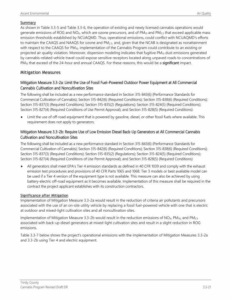
Ascent Environmental Air Quality
Trinity County Cannabis Program Revised Draft EIR 3.3-21
Summary As shown in Table 3.3-5 and Table 3.3-6, the operation of existing and newly licensed cannabis operations would generate emissions of ROG and NOX, which are ozone precursors, and of PM10 and PM2.5 that exceed applicable mass emission thresholds established by NCUAQMD. Thus, operational emissions5 could conflict with NCUAQMD’s efforts to maintain the CAAQS and NAAQS for ozone and PM2.5, and, given that the NCAB is designated as nonattainment with respect to the CAAQS for PM10, implementation of the Cannabis Program could contribute to an existing or projected air quality violation. Moreover, dispersion modeling indicates that fugitive PM10 dust emissions generated by cannabis-related vehicle travel could expose sensitive receptors located along unpaved roads to concentrations of PM10 that exceed of the 24-hour and annual CAAQS. For these reasons, this would be a significant impact.
Mitigation Measures
Mitigation Measure 3.3-2a: Limit the Use of Fossil Fuel–Powered Outdoor Power Equipment at All Commercial Cannabis Cultivation and Noncultivation Sites The following shall be included as a new performance standard in Section 315-843(6) (Performance Standards for Commercial Cultivation of Cannabis); Section 315-842(6) (Required Conditions); Section 315-838(6) (Required Conditions); Section 315-837(3) (Required Conditions); Section 315-835(2) (Regulations); Section 315-824(5) (Required Conditions); Section 315-827(4) (Required Conditions of Use Permit Approval); and Section 315-828(5) (Required Conditions):
Limit the use of off-road equipment that is powered by gasoline, diesel, or other fossil fuels where available. This requirement does not apply to generators.
Mitigation Measure 3.3-2b: Require Use of Low Emission Diesel Back-Up Generators at All Commercial Cannabis Cultivation and Noncultivation Sites The following shall be included as a new performance standard in Section 315-843(6) (Performance Standards for Commercial Cultivation of Cannabis); Section 315-842(6) (Required Conditions); Section 315-838(6) (Required Conditions); Section 315-837(3) (Required Conditions); Section 315-835(2) (Regulations); Section 315-824(5) (Required Conditions); Section 315-827(4) (Required Conditions of Use Permit Approval); and Section 315-828(5) (Required Conditions):
All generators shall meet EPA’s Tier 4 emission standards as defined in 40 CFR 1039 and comply with the exhaust emission test procedures and provisions of 40 CFR Parts 1065 and 1068. Tier 3 models or best available model can be used if a Tier 4 version of the equipment type is not available. This measure can also be achieved by using battery-electric off-road equipment as it becomes available. Implementation of this measure shall be required in the contract the project applicant establishes with its construction contractors.
Significance after Mitigation Implementation of Mitigation Measure 3.3-2a would result in the reduction of criteria air pollutants and precursors associated with the use of an on-site utility vehicle by replacing a fossil fuel-powered vehicle with one that is electric at outdoor and mixed-light cultivation sites and all noncultivation sites.
Implementation of Mitigation Measure 3.3-2b would result in the reduction emissions of NOX, PM10, and PM2.5
associated with back-up diesel generators at mixed-light cultivation sites and result in a slight reduction in ROG emissions.
Table 3.3-7 below shows the project’s operational emissions with the implementation of Mitigation Measures 3.3-2a and 3.3-2b using Tier 4 and electric equipment.
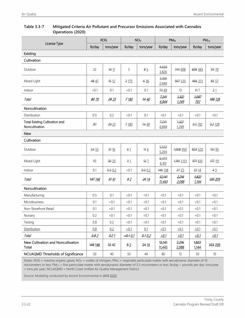
Air Quality Ascent Environmental
Trinity County 3.3-22 Cannabis Program Revised Draft EIR
Table 3.3-7 Mitigated Criteria Air Pollutant and Precursor Emissions Associated with Cannabis Operations (2020)
License Type ROG NOX PM10 PM2.5
lb/day tons/year lb/day tons/year lb/day tons/year lb/day tons/year
Existing
Cultivation
Outdoor 32 14 11 5 8 5 4,059 3,826 741 698 609 383 111 70
Mixed Light 48 47 15 12 2 175 6 36 3,109 2,949 567 535 466 313 85 57
Indoor <0.1 0.1 <0.1 0.1 73 69 13 11 7 2 1
Total 80 79 29 23 7 180 14 40 7,241 6,844
1,322 1,249
1,087 702 198 128
Noncultivation
Distribution 0.5 0.2 <0.1 0.1 <0.1 <0.1 <0.1 <0.1
Total Existing Cultivation and Noncultivation 80 29 23 7 180 14 40 7,241
6,844 1,322 1,249 0.5 702 0.2 128
New
Cultivation
Outdoor 54 53 21 16 6 1 11 6 5,522 5,204 1,008 950 829 520 151 95
Mixed Light 93 30 25 3 1 12 7 6,473 6,101 1,181 1,113 971 610 177 111
Indoor 0.1 0.3 0.2 <0.1 0.3 0.2 146 138 27 25 22 14 4 3
Total 147 146 51 41 9 2 24 14 12,141 11,443
2,216 2,088
1,822 1,144 333 209
Noncultivation
Manufacturing 0.5 0.1 <0.1 <0.1 <0.1 <0.1 <0.1 <0.1
Microbusiness 0.1 <0.1 <0.1 <0.1 <0.1 <0.1 <0.1 <0.1
Non-Storefront Retail 0.1 <0.1 <0.1 <0.1 <0.1 <0.1 <0.1 <0.1
Nursery 0.2 <0.1 <0.1 <0.1 <0.1 <0.1 <0.1 <0.1
Testing 0.8 0.2 <0.1 <0.1 <0.1 <0.1 <0.1 <0.1
Distribution 0.8 0.2 <0.1 0.1 <0.1 <0.1 <0.1 <0.1
Total 0.8 2 0.2 1 <0.1 0.1 0.1 0.2 <0.1 <0.1 <0.1 <0.1
New Cultivation and Noncultivation Total 149 148 51 42 9 2 24 14 12,141
11,443 2,216 2,088
1,822 1,144 333 209
NCUAQMD Thresholds of Significance 50 40 50 40 80 15 50 10 Notes: ROG = reactive organic gases; NOX = oxides of nitrogen; PM10 = respirable particulate matter with aerodynamic diameter of 10 micrometers or less; PM2.5 = fine particulate matter with aerodynamic diameter of 2.5 micrometers or less; lb/day = pounds per day; tons/year = tons per year; NCUAQMD = North Coast Unified Air Quality Management District.
Source: Modeling conducted by Ascent Environmental in 2019 2020
Ascent Environmental Air Quality
Trinity County Cannabis Program Revised Draft EIR 3.3-23
Implementation of Mitigation Measures 3.3-2a and 3.3-2b would reduce operational emissions of ROG, NOX, PM10, and PM2.5 at new and existing licensed cultivation and noncultivation sites. As shown in Table 3.3-7, implementation of these mitigation measures would reduce NOX below the threshold; however, operational emissions of ROG, PM10, and PM2.5 would not be reduced to less than the mass emission thresholds recommended by NCUAQMD. In addition, Tier 4 and electric equipment may not be available for all activities.
The County also considered the following measures to reduce fugitive PM10, and PM2.5 dust from vehicle travel on unpaved surfaces, including watering unpaved roadways at regular intervals (e.g., two times per day), application of dust suppressants, and paving.
Routine Watering of Roadways: The routine watering of the unpaved roads (two times a day) can reduce particulate matter emissions by as much as 55 percent based on modeling data provided in CalEEMod. It is anticipated that commercial cannabis uses could located on unpaved private roads that range from one mile to over 15 miles in length. This extent of unpaved roadways would be infeasible to routinely water twice a day to provide effective reduction of PM10 emissions. Supplying the amount of water that would be required during a period of low flows, the emissions from water trucks, and the additional wear and tear from heavy trucks traversing unpaved roads would each have impacts to the environment that would be significant and unavoidable. A single 4,000-gallon water truck used twice a day for 4 weeks would generate a water demand of 224,000 gallons for coverage of a limited road length. Additional trips would be required to refill and cover additional road lengths necessary to provide dust suppression for the entire length of the road. This additional water demand is considered excessive as just two refills of a single truck during the period in question would be the equivalent of annual irrigation of approximately 12,800 sq. ft. of cannabis (based on water demand factors used in Section 3.10, “Hydrology and Water Quality”) or over 2 years of water demand of a single-family residential unit (assuming a water demand of 100 gallons per day per resident for three residents). The cost of a 4,000-gallon water truck ranges from $53,500 (used) to $113,563 (new) (PavementGroup.com 2018; Commercial Truck Trader 2018).
Use of Dust Suppressants: Dust suppressants work by binding the particles together that form a protective layer that resists wind movement. As noted above, several of the current applications for new commercial cannabis operation sites are located on unpaved roads that range from 1 mile to over 15 miles in length. The cost of applying dust suppressant is approximately $2,202 per mile per year (www.dustoutus.com/dust-control-costs/ accessed 3/12/18), with attendant emissions from applicator trucks, and the additional wear and tear from heavy trucks traversing unpaved roads. Dust suppressants can result in water quality impacts due to leaching into streams and rivers and the nature of the chemicals used for dust suppression. The use of dust suppressants would have significant and unavoidable impacts to the environment at least as significant as the air quality impact that it attempts to mitigate, and thus is rejected as infeasible.
Paving of Roadways: Paving of roadways utilized by commercial cannabis cultivation sites would reduce PM10 emissions from roadway dust. The extent of roadways that would be required to be paved (1 to over 15 miles per site) would be substantial and would likely be cost prohibitive to construct and maintain. Using cost units for the Library Street improvement (two-lane roadway) in the City of Sacramento it is estimated that paving of existing roadways could cost approximately $1,212 a linear foot for a two-lane roadway (City of Sacramento 2008). Thus, paving just one mile of roadway could cost $6,399,360.
For these reasons, this impact would be significant and unavoidable.
Impact 3.3-3: Exposure of People to Objectionable Odors
Implementation of the Cannabis Program would license the operation of new commercial cultivation and noncultivation sites, as well as existing cultivation. The cultivation and processing of cannabis generates odors associated with the plant itself, which during maturation can produce substantial odors. Setbacks are required under the Cannabis Program, however, they do not preclude the generation of odorous emissions in such quantities as to cause detriment, nuisance, or annoyance to a substantial number of people. This impact would be significant.
Air Quality Ascent Environmental
Trinity County 3.3-24 Cannabis Program Revised Draft EIR
The occurrence and severity of odor impacts from cultivation sites licensed under the Cannabis Program would depend on numerous factors, including the nature, frequency, and intensity of the odor sources; wind speed and direction; topographic conditions; the proximity to off-site receptors; and the sensitivity of exposed receptors. Although exposure to offensive odors generally does not result in physical harm, the odors can be perceived as objectionable leading to considerable distress among the public and can result in citizen complaints to local governments and regulatory agencies.
Existing Licensed Commercial Cannabis Operations Odors are emitted at existing licensed commercial cannabis cultivation operations. Odors can be perceived and considered objectionable depending on the size and type (i.e., outdoor, mixed-light, or indoor) of cultivation operations, nearby receptors, the strain of cannabis being cultivated, the presence of nearby vegetation, and topographic and atmospheric conditions. Existing licensed cultivation operations are part of the existing environmental setting conditions of the county.
New Licensed Commercial Cannabis Operations Cannabis plants are known to emit odors, especially during the final stages of the growing cycle (i.e., typically beginning in August and continuing through harvest season in September and October). Dispersion modeling indicate that specific cannabis compounds may be detectable at a distance of two miles or more depending on weather conditions (Kern County 2017:4.3-66 and 4.3-67). The potential for detected odors to be considered objectionable and an adverse effect would depend on the size of the cannabis-related operation, the receptor, the strain of cannabis being cultivated/processed, the presence of nearby vegetation, and topographic and atmospheric conditions. As a result, an appropriate buffer distance at which odors could not be perceived is not considered feasible and would depend on site-specific conditions. Generally, the larger the size of the canopy area, the greater the potential for odor to be evident to off-site receptors. Many of the potential applicants seeking coverage under the Cannabis Program are seeking to operate outdoor cultivation sites or mixed-light cultivation facilities. Mixed-light cultivation sites could include structures that contain odors associated with cultivation. All cultivation operations would be required to be setback a minimum of 350 feet from adjacent residences such that attendant odors would less likely be detectable by people off-site.
Odors emitted by indoor cultivation and processing activities can be controlled through the use of active carbon filters, biofilters, plasma ion technology, air filters, and other manufactured odor control/masking substances (e.g., gels and sprays designed to mask odors). However, under the Cannabis Program, these types of controls are not required. While the Cannabis Program requires a minimum setback for cultivation sites of 350 feet from adjacent residences; a minimum setback for Type 3 cultivation operations (i.e., greater than 50 acres) of 500 feet from an adjacent property line; 500 feet of an authorized school bus stop; and 1,000 feet from a youth-oriented facility, a school, any church, residential treatment facility; it does not preclude the potential for off-site residential receptors to be exposed to odors emitted by mature cannabis plants that they find objectionable. As a result, this impact would be significant.
Mitigation Measures
Mitigation Measure 3.3-3: Implement Odor Control Plan for the Growing, Cultivating, Processing, Handling of Cannabis The following shall be included as new performance standards for Section 315-843(6) (Performance Standards for Commercial Cultivation of Cannabis), Section 315-824(5) (Required Conditions), Section 315-826(3) (Regulation of Nurseries), Section 315-828(5) (Required Conditions), Section 315-835(2) (Regulations), Section 315-837(3) (Required Conditions), and Section 315-842(6) (Required Conditions):
Cannabis sites shall develop and implement an odor control plan that contains the following requirements as appropriate for each cannabis use:
Identify and describe odor-emitting activities and the nature and characteristics of the emissions.
Ascent Environmental Air Quality
Trinity County Cannabis Program Revised Draft EIR 3.3-25
Location and distance of sensitive receptors (e.g., residents, youth-oriented facilities, schools, churches, residential treatment centers) from the site.
Demonstrate that the cannabis site’s distance to receptors, wind direction, and local topographic conditions would not result in detection of cannabis odors by off-site sensitive receptors that would create a nuisance.
If off-site odor nuisance impacts cannot be avoided without odor controls, identify Describe procedures and controls for reducing/controlling odors on-site, including the following as applicable to the cannabis use and license type (outdoor, mixed-light, and indoor):. The operator may propose a numeric odor detection threshold for on-site operations (such as dilution-to-threshold standard that is verified by persons of normal odor sensitivity as defined by European Standard EN 13725) subject to County review and approval.1
All fully enclosed and secure structures that contain cannabis plants or products that generate odors will employ mechanical ventilation controls, carbon filtration, or other equivalent or superior method(s) to eliminate the detection of cannabis off the parcel. This will include all drying and processing of cannabis plant material recently harvested.
Outdoor operations may include different plant strains and smaller grow areas or relocation of outdoor activities indoors or, in a mixed-light facility contained within an enclosed structure, use of site design or other technology and/or use of odor easements to address odor impacts.
Corrective actions to address County-verified off-site odor complaints will be identified. This may include immediate and complete harvest of the cannabis plants or identification of other methods to be applied as part of the current harvest or the next harvest to minimize off-site odor impacts so that they do not conflict with other applicable standards of the County’s Cannabis Program or State license requirements. relocation of outdoor cannabis plants to an enclosed structure if the plants are currently grown in moveable pots or planter boxes.
Significance after Mitigation Implementation of Mitigation Measure 3.3-3 would reduce the potential of odor nuisance impacts and would include corrective actions for cultivation sites that routinely generate nuisance odor impacts off-site. However, it is possible that nuisance odor impacts would occur occasionally before abatement for outdoor cultivation sites, especially in areas where outdoor cultivation sites are concentrated. There are no feasible mitigation measures for completely avoiding the potential for occasional odor nuisance impacts because there is no reliable method to contain odors on-site under all atmospheric conditions during harvest season. There are no effective mitigation measures to ensure to elimination of cannabis odors at harvest for outdoor cultivation operations. This impact would be significant and unavoidable.
1 The use of a dilution-to-threshold (D/T) standard is based on scientific publications on odor pollution control that have identified that odors
above 7 D/T will often result in complaints (i.e., objectionable), with 15 D/T often described as a nuisance, and odors above 30 D/T described as a serious nuisance (i.e., nauseating) (McGinley 2000; Huey et al. 1960).

Air Quality Ascent Environmental
Trinity County 3.3-26 Cannabis Program Revised Draft EIR
This page intentionally left blank.

Ascent Environmental Biological Resources
Trinity County Cannabis Program Revised Draft EIR 3.4-1
3.4 BIOLOGICAL RESOURCES This section addresses biological resources known or with potential to occur in Trinity County and describes potential effects of project implementation on those resources. The analysis includes a description of the existing environmental conditions, the methods used for assessment, the potential direct and indirect impacts of project implementation, and mitigation measures recommended to address impacts determined to be significant or potentially significant. Federal, state, and local regulations that pertain to biological resources are summarized.
The information presented in this section is based on review of existing and available information and is regional in scope. Data, analysis, and findings provided in this section are programmatic for broad application under the County Cannabis Program rather than site-specific.
NOP comments regarding biological resources were received from the California Department of Fish and Wildlife (CDFW), the California Department of Food and Agriculture (CDFA), Safe Alternatives for our Forest Environment, Down River Consulting, and several individuals. Comments pertained to impacts to sensitive habitats (e.g., watersheds, rivers, streams, wetlands, riparian habitat, forest habitat), plant and wildlife species (e.g., rare plants, anadromous fish, endangered wildlife species), and adverse effects from improper use of rodenticides in cannabis cultivation areas. These issues are addressed in the impact analysis below.
3.4.1 Regulatory Setting
FEDERAL
Federal Endangered Species Act Pursuant to the federal Endangered Species Act (ESA) (16 U.S. Code Section 1531 et seq.), the U.S. Fish and Wildlife Service (USFWS) and the National Oceanic and Atmospheric Administration’s (NOAA’s) National Marine Fisheries Service (NMFS) regulate the taking of species listed in the ESA as threatened or endangered. In general, persons subject to ESA (including private parties) are prohibited from “taking” endangered or threatened fish and wildlife species on private property, and from “taking” endangered or threatened plants in areas under federal jurisdiction or in violation of state law. Under Section 9 of the ESA, the definition of “take” is to “harass, harm, pursue, hunt, shoot, wound, kill, trap, capture, or collect, or to attempt to engage in any such conduct.” USFWS has also interpreted the definition of “harm” to include significant habitat modification that could result in take.
Clean Water Act Section 404 of the Clean Water Act (CWA) requires project proponents to obtain a permit from the U.S. Army Corps of Engineers (USACE) before performing any activity that involves any discharge of dredged or fill material into waters of the United States, including wetlands. Many surface waters and wetlands in California meet the criteria for waters of the United States. In accordance with Section 401 of the CWA, projects that apply for a USACE permit for discharge of dredged or fill material must obtain water quality certification from the appropriate Regional Water Quality Control Board (RWQCB) indicating that the action would uphold state water quality standards.
Bald and Golden Eagle Protection Act The Bald and Golden Eagle Protection Act, enacted in 1940 and amended multiple times since, prohibits the taking of bald and golden eagles without a permit from the Secretary of the Interior. Similar to the ESA, the Bald and Golden Eagle Protection Act defines “take” to include “pursue, shoot, shoot at, poison, wound, kill, capture, trap, collect, molest or disturb” (16 U.S. Code 668–668c). For the purpose of the act, disturbance that would injure an eagle, decrease productivity, or cause nest abandonment, including habitat alterations that could have these results, are considered take and can result in civil or criminal penalties.
Biological Resources Ascent Environmental
Trinity County 3.4-2 Cannabis Program Revised Draft EIR
Migratory Bird Treaty Act The Migratory Bird Treaty Act (MBTA), first enacted in 1918, provides for protection of international migratory birds and authorizes the Secretary of the Interior to regulate the taking of migratory birds. The MBTA provides that it shall be unlawful, except as permitted by regulations, to pursue, take, or kill any migratory bird, or any part, nest, or egg of any such bird. Under the MBTA, “take” is defined as “to pursue, hunt, shoot, wound, kill, trap, capture, or collect, or any attempt to carry out these activities.”
STATE
Porter-Cologne Water Quality Control Act Under the Porter-Cologne Water Quality Control Act, waters of the state fall under the jurisdiction of the appropriate RWQCB. RWQCBs must prepare and periodically update water quality control plans (basin plans). Each basin plan sets forth water quality standards for surface water and groundwater, as well as actions to control point and nonpoint sources of pollution to achieve and maintain these standards. The RWQCB’s jurisdiction includes federally protected waters as well as areas that meet the definition of “waters of the state.” “Waters of the state” is defined as any surface water or groundwater, including saline waters, within the boundaries of the state. RWQCB has the discretion to take jurisdiction over areas not federally protected under Section 401 of the CWA provided they meet the definition of waters of the state. Actions that affect waters of the state, including wetlands, must meet the RWQCB’s waste discharge requirements.
State Water Resources Control Board Order WQ 20179-002301-DWQ Attachment A (General Requirements and Prohibitions) of the State Water Resources Control Board (SWRCB) Order WQ 20179-002301-DWQ, General Waste Discharge Requirements and Waiver of Waste Discharge Requirements for Discharges of Wastes Associated with Cannabis Cultivation Activities, includes the following requirements (terms) for state-licensed cultivation sites that are associated with biological resources. The reader is referred to Section 3.10, “Hydrology and Water Quality,” for requirements associated with protection of water quality and surface water flows.
1. Prior to commencing any cannabis cultivation activities, including cannabis cultivation land development or alteration, the cannabis cultivator shall comply with all applicable federal, state, and local laws, regulations, and permitting requirements, as applicable, including but not limited to the following:
The Clean Water Act (CWA) as implemented through permits, enforcement orders, and self-implementing requirements. When needed per the requirements of the CWA, the cannabis cultivator shall obtain a CWA section 404 (33 U.S.C. § 1344) permit from the United States Army Corps of Engineers (Army Corps) and a CWA section 401 (33 U.S.C. § 1341) water quality certification from the State Water Board or the Regional Water Board with jurisdiction. If the CWA permit cannot be obtained, the cannabis cultivator shall contact the appropriate Regional Water Board or State Water Board prior to commencing any cultivation activities. The Regional Water Board or State Water Board will determine if the cannabis cultivation activity and discharge is covered by the Requirements in the Policy and Cannabis General Waste Discharge Requirements for Discharges of Waste Associated with Cannabis Cultivation Activities (Cannabis General Order).
The California Water Code as implemented through applicable water quality control plans (often referred to as Basin Plans), waste discharge requirements (WDRs) or waivers of WDRs, enforcement orders, and self-implementing requirements issued by the State Water Resources Control Board (State Water Board) or Regional Water Quality Control Boards (Regional Water Boards).
All applicable state, city, county, or local regulations, ordinances, or license requirements including, but not limited to those for cannabis cultivation, grading, construction, and building.
All applicable requirements of the California Department of Fish and Wildlife (CDFW).
All applicable requirements of the California Department of Forestry and Fire Protection (CAL FIRE), including the Board of Forestry.
Ascent Environmental Biological Resources
Trinity County Cannabis Program Revised Draft EIR 3.4-3
California Environmental Quality Act and the National Environmental Policy Act.
3. The cannabis cultivator shall apply for a Lake and Streambed Alteration Agreement (LSA Agreement) or consult with CDFW to determine if an LSA Agreement is needed prior to commencing any activity that may substantially:
divert or obstruct the natural flow of any river, stream, or lake;
change or use any material from the bed, channel, or bank of any river, stream, or lake; or
deposit debris, waste, or other materials that could pass into any river stream or lake.
“Any river, stream or lake," as defined by CDFW, includes those that are episodic (they are dry for periods of time) as well as those that are perennial (they flow year round). This includes ephemeral streams, desert washes, and watercourses with a subsurface flow. It may also apply to work undertaken within the flood plain of a body of water.
4. Cannabis cultivators shall not take any action which results in the taking of Special-Status Plants (state listed and California Native Plant Society 1B.1 and 1B.2), Fully Protected species (Fish and Game Code sections 3511, 4700, 5050, and 5515), or a threatened, endangered, or candidate species under either the California Endangered Species Act (ESA) (Fish & Game Code §§ 2050 et seq.) or the federal ESA (16 U.S.C. § 1531 et seq.). If a “take,” as defined by the California ESA (Fish and Game Code section 86) or the federal ESA (16 U.S.C. § 1532(21)), may result from any act authorized under this Policy, the cannabis cultivator must obtain authorization from CDFW, National Marine Fisheries Service, and United States Fish and Wildlife Service, as applicable, to incidentally take such species prior to land disturbance or operation associated with the cannabis cultivation activities. The cannabis cultivator is responsible for meeting all requirements under the California ESA and the federal ESA.
7. A California Licensed Timber Operator (LTO) shall be used if any commercial tree species are to be removed from the cannabis cultivation site. All timberland conversions shall be permitted and compliant with the Forest Practice Rules and CAL FIRE permitting requirements.
10. Prior to commencing any cannabis land development or site expansion activities the cannabis cultivator shall retain a qualified biologist to identify sensitive plant, wildlife species, or communities at the proposed development site. If sensitive plant, wildlife species, or communities are identified, the cannabis cultivator and Qualified Biologist shall consult with CDFW and CAL FIRE to designate a no-disturbance buffer to protect identified sensitive plant, wildlife species, and communities. A copy of the report shall be submitted to the appropriate Regional Water Board.
11. To prevent transfer of invasive species, all equipment used at the cannabis cultivation site, including excavators, graders, etc., shall be cleaned before arriving and before leaving the site.
30. In timberland areas, cannabis cultivators shall not remove commercial tree species or other vegetation within 150 feet of fish bearing water bodies or 100 feet of aquatic habitat for nonfish aquatic species (e.g., aquatic insects) prior to obtaining all applicable permits required from CAL FIRE, CDFW (i.e., LSA Agreement), and/or the Regional Water Board Executive Officer.
37. Cannabis cultivators shall comply with the minimum riparian setbacks described below for all land disturbance, cannabis cultivation activities, and facilities (e.g., material or vehicle storage, petroleum powered pump locations, water storage areas, and chemical toilet placement). The riparian setbacks shall be measured from the waterbody’s bankfull stage (high flow water levels that occur every 1.5 to 2 years) or from the top edge of the waterbody bank in incised channels, whichever is more conservative. Riparian setbacks for springheads shall be measured from the springhead in all directions (circular buffer). Riparian setbacks for wetlands shall be measured from the edge of wetland as delineated by a qualified professional with experience implementing the Corps of Engineers Wetlands Delineation Manual (with regional supplements). The Regional Water Board Executive Officer
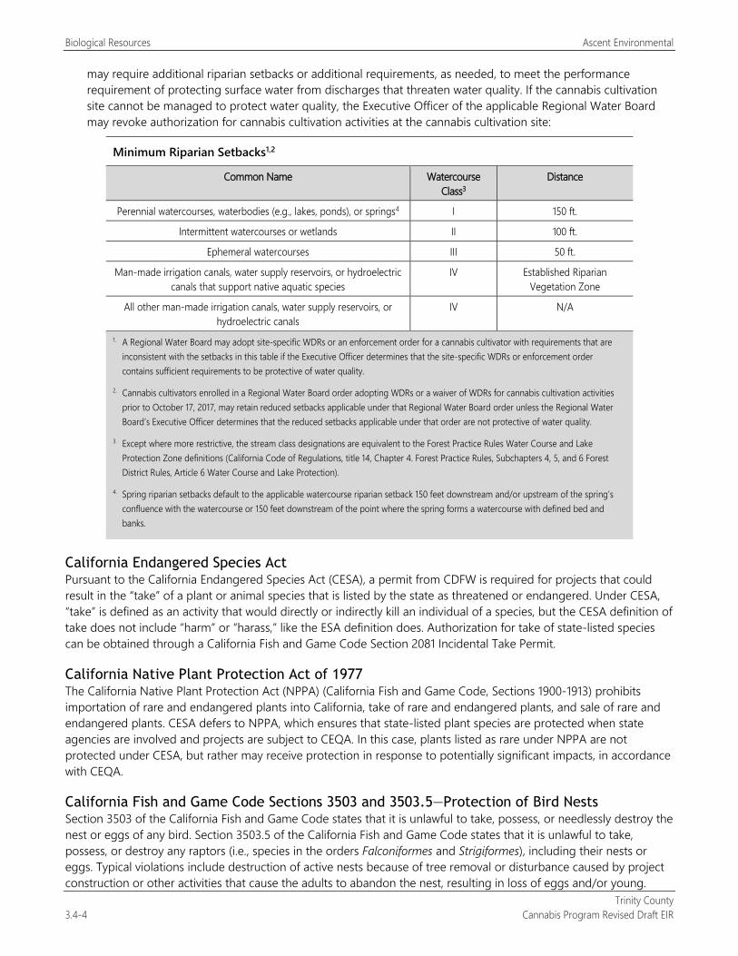
Biological Resources Ascent Environmental
Trinity County 3.4-4 Cannabis Program Revised Draft EIR
may require additional riparian setbacks or additional requirements, as needed, to meet the performance requirement of protecting surface water from discharges that threaten water quality. If the cannabis cultivation site cannot be managed to protect water quality, the Executive Officer of the applicable Regional Water Board may revoke authorization for cannabis cultivation activities at the cannabis cultivation site:
Minimum Riparian Setbacks1,2
Common Name Watercourse Class3
Distance
Perennial watercourses, waterbodies (e.g., lakes, ponds), or springs4 I 150 ft.
Intermittent watercourses or wetlands II 100 ft.
Ephemeral watercourses III 50 ft.
Man-made irrigation canals, water supply reservoirs, or hydroelectric canals that support native aquatic species
IV Established Riparian Vegetation Zone
All other man-made irrigation canals, water supply reservoirs, or hydroelectric canals
IV N/A
1. A Regional Water Board may adopt site-specific WDRs or an enforcement order for a cannabis cultivator with requirements that are inconsistent with the setbacks in this table if the Executive Officer determines that the site-specific WDRs or enforcement order contains sufficient requirements to be protective of water quality.
2. Cannabis cultivators enrolled in a Regional Water Board order adopting WDRs or a waiver of WDRs for cannabis cultivation activities prior to October 17, 2017, may retain reduced setbacks applicable under that Regional Water Board order unless the Regional Water Board’s Executive Officer determines that the reduced setbacks applicable under that order are not protective of water quality.
3. Except where more restrictive, the stream class designations are equivalent to the Forest Practice Rules Water Course and Lake Protection Zone definitions (California Code of Regulations, title 14, Chapter 4. Forest Practice Rules, Subchapters 4, 5, and 6 Forest District Rules, Article 6 Water Course and Lake Protection).
4. Spring riparian setbacks default to the applicable watercourse riparian setback 150 feet downstream and/or upstream of the spring’s confluence with the watercourse or 150 feet downstream of the point where the spring forms a watercourse with defined bed and banks.
California Endangered Species Act Pursuant to the California Endangered Species Act (CESA), a permit from CDFW is required for projects that could result in the “take” of a plant or animal species that is listed by the state as threatened or endangered. Under CESA, “take” is defined as an activity that would directly or indirectly kill an individual of a species, but the CESA definition of take does not include “harm” or “harass,” like the ESA definition does. Authorization for take of state-listed species can be obtained through a California Fish and Game Code Section 2081 Incidental Take Permit.
California Native Plant Protection Act of 1977 The California Native Plant Protection Act (NPPA) (California Fish and Game Code, Sections 1900-1913) prohibits importation of rare and endangered plants into California, take of rare and endangered plants, and sale of rare and endangered plants. CESA defers to NPPA, which ensures that state-listed plant species are protected when state agencies are involved and projects are subject to CEQA. In this case, plants listed as rare under NPPA are not protected under CESA, but rather may receive protection in response to potentially significant impacts, in accordance with CEQA.
California Fish and Game Code Sections 3503 and 3503.5—Protection of Bird Nests Section 3503 of the California Fish and Game Code states that it is unlawful to take, possess, or needlessly destroy the nest or eggs of any bird. Section 3503.5 of the California Fish and Game Code states that it is unlawful to take, possess, or destroy any raptors (i.e., species in the orders Falconiformes and Strigiformes), including their nests or eggs. Typical violations include destruction of active nests because of tree removal or disturbance caused by project construction or other activities that cause the adults to abandon the nest, resulting in loss of eggs and/or young.
Ascent Environmental Biological Resources
Trinity County Cannabis Program Revised Draft EIR 3.4-5
California Fish and Game Code Sections 3511, 4700, 5050, and 5515—Fully Protected Species Sections 3511, 4700, 5050, and 5515 of the California Fish and Game Code describe the take prohibitions for fully protected birds, mammals, reptiles and amphibians, and fish. Species listed under these statutes may not be taken or possessed at any time, and no incidental take permits can be issued for these species except for scientific research purposes or for relocation to protect livestock.
California Fish and Game Code Section 1602—Streambed Alteration All diversions, obstructions, or changes to the natural flow or bed, channel, or bank of any river, stream, or lake in California that supports wildlife resources are subject to regulation by CDFW under Section 1602 of the California Fish and Game Code. Under Section 1602, it is unlawful for any person, governmental agency, or public utility to do the following without first notifying CDFW:
substantially divert or obstruct the natural flow of, or substantially change or use any material from, the bed, channel, or bank of any river, stream, or lake, or
deposit or dispose of debris, waste, or other material containing crumbled, flaked, or ground pavement where it may pass into any river, stream, or lake.
The regulatory definition of a stream is a body of water that flows at least periodically or intermittently through a bed or channel that has banks and supports fish or other aquatic life. This definition includes watercourses with a surface or subsurface flow that supports or has supported riparian vegetation. CDFW’s jurisdiction within altered or artificial waterways is based on the value of those waterways to fish and wildlife. A CDFW streambed alteration agreement must be obtained for any action that would result in an impact on a river, stream, or lake.
Oak Woodlands Conservation Act The Oak Woodlands Conservation Act (SB 1334) was signed into California law on September 24, 2004. PRC Section 21083.4 requires counties to determine if a project within their jurisdiction may result in conversion of oak woodlands that would have a significant adverse effect on the environment. If the County determines that a project would result in a significant adverse effect on oak woodlands, mitigation measures to reduce the significant adverse effect of converting oak woodlands to other land uses are required.
LOCAL
Trinity County General Plan The Conservation Element of the Trinity County General Plan contains two objectives related to biological resources:
To conserve and maintain streams, lakes and forest open space as a means of providing natural habitat and for all species of wildlife existing in the County.
To protect the natural resources which are important to Trinity County and preserve areas which are important as commercial natural resources for future generations.
3.4.2 Environmental Setting This environmental setting section contains information of the following existing biological resources:
land cover types and associated biological habitat uses,
special-status species,
critical habitat,
sensitive natural communities,
invasive plant species and noxious weeds,
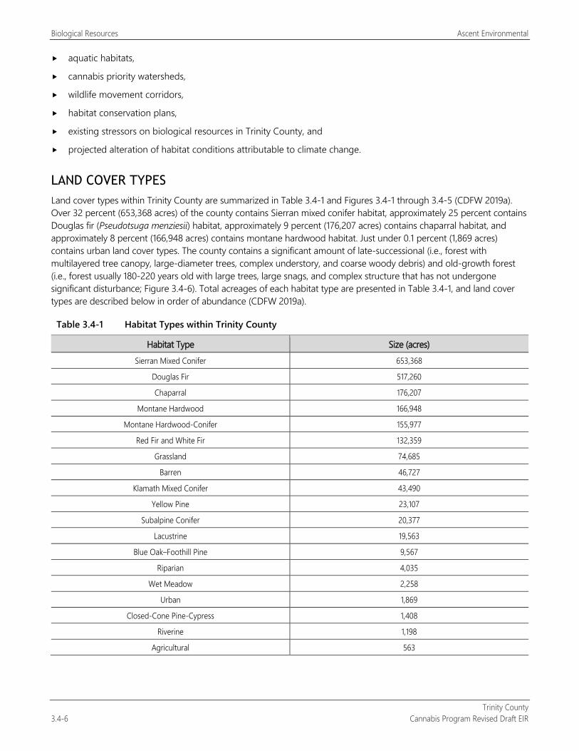
Biological Resources Ascent Environmental
Trinity County 3.4-6 Cannabis Program Revised Draft EIR
aquatic habitats,
cannabis priority watersheds,
wildlife movement corridors,
habitat conservation plans,
existing stressors on biological resources in Trinity County, and
projected alteration of habitat conditions attributable to climate change.
LAND COVER TYPES Land cover types within Trinity County are summarized in Table 3.4-1 and Figures 3.4-1 through 3.4-5 (CDFW 2019a). Over 32 percent (653,368 acres) of the county contains Sierran mixed conifer habitat, approximately 25 percent contains Douglas fir (Pseudotsuga menziesii) habitat, approximately 9 percent (176,207 acres) contains chaparral habitat, and approximately 8 percent (166,948 acres) contains montane hardwood habitat. Just under 0.1 percent (1,869 acres) contains urban land cover types. The county contains a significant amount of late-successional (i.e., forest with multilayered tree canopy, large-diameter trees, complex understory, and coarse woody debris) and old-growth forest (i.e., forest usually 180-220 years old with large trees, large snags, and complex structure that has not undergone significant disturbance; Figure 3.4-6). Total acreages of each habitat type are presented in Table 3.4-1, and land cover types are described below in order of abundance (CDFW 2019a).
Table 3.4-1 Habitat Types within Trinity County
Habitat Type Size (acres) Sierran Mixed Conifer 653,368
Douglas Fir 517,260
Chaparral 176,207
Montane Hardwood 166,948
Montane Hardwood-Conifer 155,977
Red Fir and White Fir 132,359
Grassland 74,685
Barren 46,727
Klamath Mixed Conifer 43,490
Yellow Pine 23,107
Subalpine Conifer 20,377
Lacustrine 19,563
Blue Oak–Foothill Pine 9,567
Riparian 4,035
Wet Meadow 2,258
Urban 1,869
Closed-Cone Pine-Cypress 1,408
Riverine 1,198
Agricultural 563
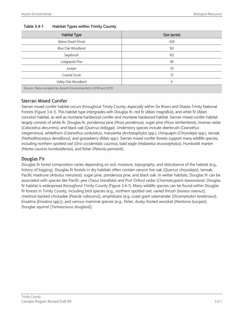
Ascent Environmental Biological Resources
Trinity County Cannabis Program Revised Draft EIR 3.4-7
Table 3.4-1 Habitat Types within Trinity County
Habitat Type Size (acres) Alpine Dwarf-Shrub 438
Blue Oak Woodland 162
Sagebrush 162
Lodgepole Pine 98
Juniper 59
Coastal Scrub 13
Valley Oak Woodland 6
Source: Data compiled by Ascent Environmental in 2018 and 2019
Sierran Mixed Conifer Sierran mixed conifer habitat occurs throughout Trinity County, especially within Six Rivers and Shasta-Trinity National Forests (Figure 3.4-1). This habitat type intergrades with Douglas fir, red fir (Abies magnifica), and white fir (Abies concolor) habitat, as well as montane hardwood-conifer and montane hardwood habitat. Sierran mixed conifer habitat largely consists of white fir, Douglas fir, ponderosa pine (Pinus ponderosa), sugar pine (Pinus lambertiana), incense cedar (Calocedrus decurrens), and black oak (Quercus kelloggii). Understory species include deerbrush (Ceanothus integerrimus), whitethorn (Ceanothus cordulatus), manzanita (Arctostaphylos spp.), chinquapin (Chrysolepis spp.), tanoak (Notholithocarpus densiflorus), and gooseberry (Ribes spp.). Sierran mixed conifer forests support many wildlife species, including northern spotted owl (Strix occidentalis caurina), bald eagle (Haliaeetus leucocephalus), Humboldt marten (Martes caurina humboldtensis), and fisher (Pekania pennanti).
Douglas Fir Douglas fir forest composition varies depending on soil, moisture, topography, and disturbance of the habitat (e.g., history of logging). Douglas fir forests in dry habitats often contain canyon live oak (Quercus chrysolepis), tanoak, Pacific madrone (Arbutus menziesii), sugar pine, ponderosa pine, and black oak. In wetter habitats, Douglas fir can be associated with species like Pacific yew (Taxus brevifolia) and Port Orford cedar (Chamaecyparis lawsoniana). Douglas fir habitat is widespread throughout Trinity County (Figure 3.4-1). Many wildlife species can be found within Douglas fir forests in Trinity County, including bird species (e.g., northern spotted owl, varied thrush [Ixoreus naevius], chestnut-backed chickadee [Poecile rufescens]), amphibians (e.g. coast giant salamander [Dicamptodon tenebrosus], Ensatina [Ensatina spp.]), and various mammal species (e.g., fisher, dusky-footed woodrat [Neotoma fuscipes], Douglas squirrel [Tamiasciurus douglasii]).
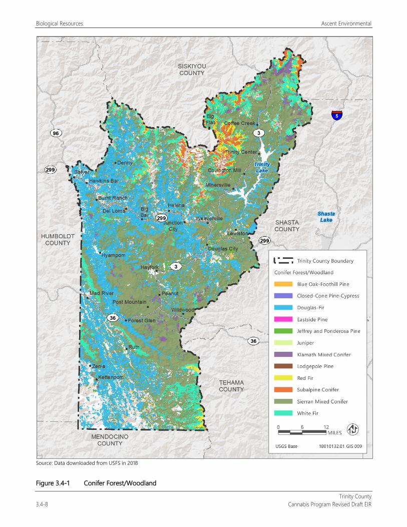
Biological Resources Ascent Environmental
Trinity County 3.4-8 Cannabis Program Revised Draft EIR
Source: Data downloaded from USFS in 2018
Figure 3.4-1 Conifer Forest/Woodland
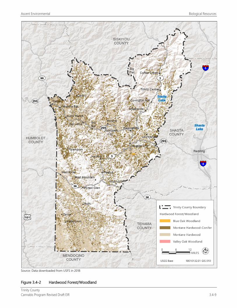
Ascent Environmental Biological Resources
Trinity County Cannabis Program Revised Draft EIR 3.4-9
Source: Data downloaded from USFS in 2018
Figure 3.4-2 Hardwood Forest/Woodland
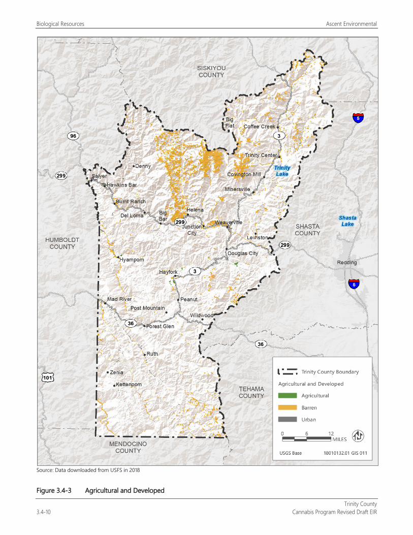
Biological Resources Ascent Environmental
Trinity County 3.4-10 Cannabis Program Revised Draft EIR
Source: Data downloaded from USFS in 2018
Figure 3.4-3 Agricultural and Developed
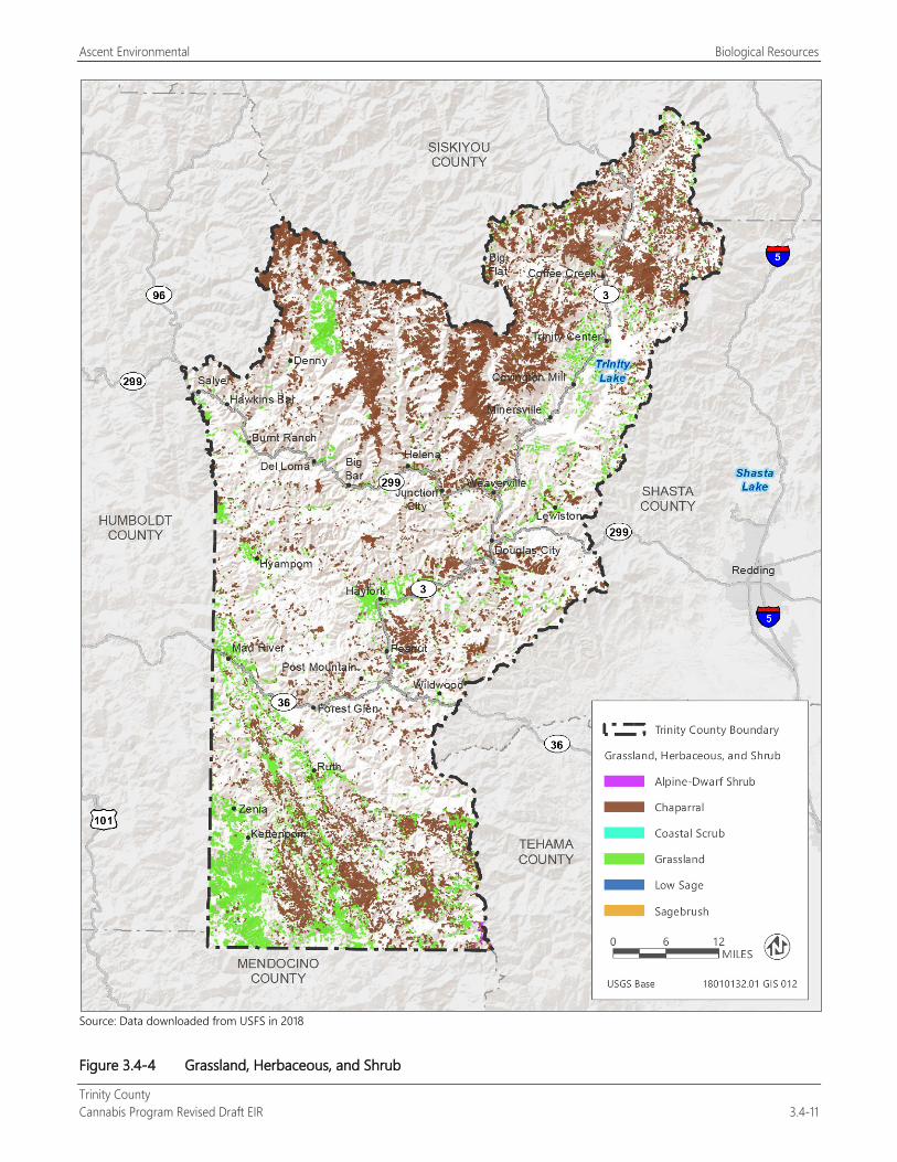
Ascent Environmental Biological Resources
Trinity County Cannabis Program Revised Draft EIR 3.4-11
Source: Data downloaded from USFS in 2018
Figure 3.4-4 Grassland, Herbaceous, and Shrub
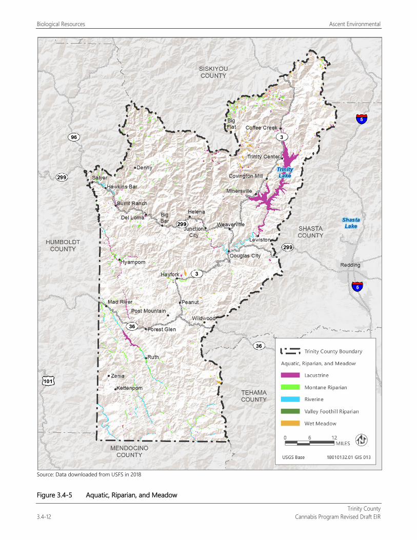
Biological Resources Ascent Environmental
Trinity County 3.4-12 Cannabis Program Revised Draft EIR
Source: Data downloaded from USFS in 2018
Figure 3.4-5 Aquatic, Riparian, and Meadow
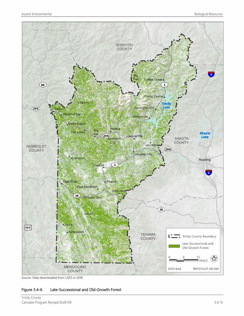
Ascent Environmental Biological Resources
Trinity County Cannabis Program Revised Draft EIR 3.4-13
Source: Data downloaded from USFS in 2018
Figure 3.4-6 Late-Successional and Old-Growth Forest
Biological Resources Ascent Environmental
Trinity County 3.4-14 Cannabis Program Revised Draft EIR
Chaparral Chaparral habitat within Trinity County includes mostly montane chaparral (139,066 acres), approximately 36,951 acres of mixed chaparral, and a small amount of chamise-redshank chaparral (190 acres). Chaparral habitat is concentrated in the northern and southern reaches of Trinity County and frequently occurs in areas with steep slopes (Figure 3.4-4). Plant assemblages for this habitat type vary based on elevation and geographic area; however, chaparral habitat generally includes manzanita, various ceanothus species (Ceanothus spp.), huckleberry oak, chinquapin, boxleaf silk tassel (Garrya buxifolia), and birch leaf mountain mahogany (Cercocarpus betuloides). Chamise-redshank chaparral can contain these species, but generally contain mostly chamise (Adenostoma fasciculatum). Chaparral provides important foraging habitat for mammals (e.g., deer and rabbits), as well as for many bird species. The physical structure of chaparral habitat also provides protection, cover, and nesting habitat for many wildlife species.
Montane Hardwood Montane hardwood habitats in Trinity County are dominated by broad-leaved hardwood tree species, primarily canyon live oak on canyon slopes, and huckleberry oak (Quercus vacciniifolia) at higher elevations. Other species associated with montane hardwood habitat include white fir, Jeffrey pine, Douglas fir, tanoak, Pacific madrone, bay laurel (Umbellularia californica), black oak, knobcone pine (Pinus attenuata), foothill pine (Pinus sabiniana), and Oregon white oak (Quercus garryana). Montane hardwood habitat in Trinity County is widespread and intergrades with montane hardwood-conifer, Douglas fir, and Sierran mixed conifer habitat within the county (Figure 3.4-2). Wildlife species that use acorns as a primary food source include Steller’s jay (Cyanocitta stelleri); acorn woodpecker (Melanerpes formicivorus); California quail (Callipepla californica); western gray squirrel (Sciurus griseus); black bear (Ursus americanus); and Columbian black-tailed deer (Odocoileus hemionus columbianus), a subspecies of mule deer (Odocoileus hemionus).
Montane Hardwood-Conifer Montane hardwood-conifer habitats contain at least one-third conifer and one-third broad-leaved hardwood trees. Species assemblages often include ponderosa pine, Douglas fir, cedar, black oak, tanoak, Pacific madrone, and Oregon white oak. Other potential species within this habitat type that are more specific to California north coast regions include golden chinquapin (Chrysolepis chrysophylla), canyon live oak, white fir, red alder (Alnus rubra), and knobcone pine. Montane hardwood-conifer habitat is widespread throughout the county (Figure 3.4-2). Species assemblages likely vary widely depending on location within Trinity County.
Red Fir and White Fir Red fir and white fir forest habitats are predominately monotypic (contain only one species), and intergrade into each other on an elevational gradient. These habitats occur largely within areas of higher elevation in Trinity County (Figure 3.4-1). Red fir habitat is used by northern goshawk (Accipiter gentilis), and both red and white fir habitats provide large snags, which are used by many wildlife species.
Grassland Grassland habitat within Trinity County includes both annual and perennial grassland types and occurs throughout the county (Figure 3.4-4). Annual grasses include wild oats (Avena spp.), soft chess (Bromus hordeaceus), ripgut brome (Bromus diandrus), Chinook brome (Bromus laevipes), and wild barley (Hordeum spp.). Perennial grasses include species such as California oatgrass (Danthonia californica), American dune grass (Elymus mollis), and Kentucky bluegrass (Poa pratensis). While dominated by grasses, grassland habitats are often interspersed with forbs species. Grasslands provide habitat for many wildlife species, including garter snakes (Thamnophis spp.), western fence lizard (Sceloporus occidentalis), voles (Microtus spp.), mice (Reithrodontomys spp. and Peromyscus spp.), and various bird species.
Barren Barren habitat is devoid of vegetation and can include rocky outcroppings, riverbanks, canyon walks, or areas associated with urbanization. Within the county, barren habitats are present along the Trinity, Mad, and Eel Rivers, in rocky, high-elevation areas in the Trinity Alps Wilderness Area, and adjacent to urban areas in Weaverville (Figure 3.4-3). Barren habitats vary widely in their composition and wildlife associations are also variable.
Ascent Environmental Biological Resources
Trinity County Cannabis Program Revised Draft EIR 3.4-15
Klamath Mixed Conifer Klamath mixed conifer habitat is restricted to northern California and southern Oregon. The habitat is found primarily in the northern and central portions of Trinity County, mostly within Shasta-Trinity National Forest (Figure 3.4-1). Klamath mixed conifer is like Sierran mixed conifer in that dominant conifers include white fir, Douglas fir, ponderosa pine, incense cedar, and sugar pine. Wildlife associations are like those of Sierran mixed conifer habitats (see above).
Yellow Pine Yellow pine habitat in Trinity County includes both Jeffrey pine and ponderosa pine. These habitat types are commonly pure stands of either species, but are often associated with each other, and other conifer species, such as sugar pine, white fir, red fir, incense cedar, and black cottonwood. Common understory species include huckleberry, scrub oak, manzanita, ceanothus, Fremont’s silk tassel (Garrya fremontii), Pacific dogwood, and coffeeberry. Wildlife species, such as squirrels and Columbian black-tailed deer, depend on pine nuts as a major food source. Species that use yellow pine habitats include nuthatches (Sitta spp.), brown creeper (Certhia americana), woodpeckers, and Humboldt’s flying squirrel (Glaucomys oregonensis). Yellow pine habitat in Trinity County is located in small patches, and intergrades with Sierran mixed conifer habitat (Figure 3.4-1).
Subalpine Conifer Subalpine conifer habitat typically includes open conifer forests with little to no understory vegetation at high elevations. Trees within subalpine conifer habitats are typically shorter than trees in other forest habitats. Conifer species associated with this habitat include mountain hemlock (Tsuga mertensiana), western white pine (Pinus monticola), whitebark pine (Pinus albicaulis), subalpine fir (Abies lasiocarpa), foxtail pine (Pinus balfouriana), and lodgepole pine (Pinus contorta). Wildlife associations are like those in other conifer habitats in the county. Subalpine conifer habitat within Trinity County is present along the northern boundary of the county, primarily within the Trinity Alps Wilderness Area (Figure 3.4-1).
Lacustrine Lacustrine habitat in Trinity County includes Trinity Lake, Lewiston Lake, Ruth Lake, various high-elevation lakes within the Trinity Alps Wilderness Area, and human-made lakes and ponds associated with urban and agricultural development (Figure 3.4-5). Trinity Lake and Lewiston Lake are reservoirs associated with dams on the Trinity River (Trinity Dam and Lewiston Dam, respectively), and Ruth Lake is a reservoir associated with the R.W. Matthews Dam on the Mad River.
Blue Oak-Foothill Pine Blue oak (Quercus douglasii) and foothill pine dominate the overstory of this habitat, and other species can include interior live oak, California buckeye (Aesculus californica), ceanothus, and manzanita. Blue oak-foothill pine habitat in Trinity County intergrades with montane hardwood and montane hardwood-conifer habitat (Figure 3.4-1). Wildlife associations are like montane hardwood habitats in the county.
Riparian Riparian habitat within Trinity County includes mostly montane riparian habitat. Riparian habitat occurs throughout the county adjacent to aquatic habitat (Figure 3.4-5). Montane riparian habitat contains black cottonwood (Populus trichocarpa), bigleaf maple (Acer macrophyllum), Pacific dogwood (Cornus nuttallii), boxelder (Acer negundo), and bay laurel. Valley foothill riparian habitat also contains western sycamore (Platanus racemosa), white alder (Alnus rhombifolia), and Oregon ash (Fraxinus latifolia). Riparian habitat provides very important habitat for wildlife species and often supports a great diversity of species. Sensitive species that utilize riparian habitat include foothill yellow-legged frog (Rana boylii), northern red-legged frog (Rana aurora), bank swallow (Riparia riparia), little willow flycatcher (Empidonax traillii brewsteri), and white-tailed kite (Elanus leucurus).
Biological Resources Ascent Environmental
Trinity County 3.4-16 Cannabis Program Revised Draft EIR
Wet Meadow Wet meadow habitat is present throughout Trinity County in association with aquatic features, such as rivers and creeks (Figure 3.4-5). Many different plant species can be associated with wet meadow habitats, including sedges (Carex spp.), rushes (Juncus spp.), bulrush (Scirpus spp.), willow (Salix spp.), and various grasses. Columbian black-tailed deer and Roosevelt elk (Cervus canadensis roosevelti) often feed in wet meadows, and waterfowl and other bird species also use the habitat. Special-status amphibian species, such as foothill yellow-legged frog and northern red-legged frog, can also be found within wet meadow habitat.
Urban In Trinity County, urban habitat makes up less than 1 percent of the total land cover within the county and occurs sporadically within unincorporated communities (Figure 3.4-3). Urban habitat includes urban landscaping, lawns, parks, and green zones. Common urban wildlife species include rock pigeon (Columba livia), house sparrow (Passer domesticus), European starling (Sturnus vulgaris), and racoon (Procyon lotor). Because much of the urban areas in Trinity County are located adjacent to more natural habitats, species such as gray fox (Urocyon cinereoargenteus), Columbian black-tailed deer, striped skunk (Mephitis mephitis), and a variety of resident and migratory songbirds are also common within surburban areas.
Closed-Cone Pine-Cypress Closed-cone pine-cypress habitat occurs within the Trinity Alps Wilderness Area in Trinity County (Figure 3.4-1). The dominant tree species within these habitats in Trinity County is knobcone pine. Various wildlife species use this habitat for foraging and cover, and great horned owl (Bubo virginianus) and red-tailed hawk have been known to nest within closed-cone pine habitats.
Riverine The preeminent riverine feature within Trinity County is the Trinity River, which is the largest tributary to the Klamath River and drains approximately 2,900 square miles of mountainous terrain. The county also includes portions of the Mad River, Van Duzen River, and Eel River watersheds and their tributaries (Figure 3.4-5).
Agricultural Agricultural land types within Trinity County include pasture, croplands, orchards, and vineyards. Agricultural land in Trinity County is largely concentrated along State Routes 3 and 299, including large areas of pastureland near Douglas City and Hayfork (Figure 3.4-3). Approximately 62 percent of agricultural land in Trinity County is used for cropland, and approximately 27 percent is used for pasture for livestock. Vineyards and orchards make up a very small portion of the total agricultural land in the county (approximately 62 acres) and are located near urban areas. Migrating waterfowl and shorebirds forage within pastureland in the county, including Aleutian cackling goose (Branta hutchinsii), greater white-fronted goose (Anser albifrons), tundra swan (Cygnus columbianus), marbled godwit (Limosa fedoa), long-billed curlew (Numenius americanus), sandpipers (Calidris spp.), and willet (Tringa semipalmata).
Alpine Dwarf-Shrub Alpine dwarf-shrub habitat is present along the southeastern county boundary (Figure 3.4-4). The most common shrubs occurring within this habitat type are oceanspray (Holodiscus discolor), Greene goldenweed (Ericameria greenei), and Klamath Mountain heather (Phyllodoce empetriformis).
Blue Oak Woodland Blue oak woodland habitat is uncommon in Trinity County (approximately 162 acres); however, this habitat type occurs in one area south of Douglas City (Figure 3.4-2)
Sagebrush Sagebrush habitat typically contains large, open, discontinuous stands of big sagebrush (Artemisia tridentata) of fairly uniform height. This habitat is uncommon in Trinity County; however, small amounts of the habitat (approximately 162 acres) is present along the eastern border of the county (Figure 3.4-4).
Ascent Environmental Biological Resources
Trinity County Cannabis Program Revised Draft EIR 3.4-17
Lodgepole Pine Lodgepole pine habitat can be found in small areas (less than 100 acres in Trinity County), within the northeastern portion of the county, primarily within the Trinity Alps Wilderness Area (Figure 3.4-1). Lodgepole pine forests typically lack understory vegetation and because of this, do not support a wide variety of wildlife species.
Juniper Juniper habitat is uncommon in Trinity County (approximately 59 acres); however, two juniper species are known to occur in the county: common juniper (Juniperus communis) and western juniper (Juniperus occidentalis; Figure 3.4-1). Juniper berries are an important food source for wintering birds.
Coastal Scrub Coastal scrub habitat is uncommon in Trinity County, with only 13 acres present in the southwestern portion of the county (Figure 3.4-4). Plant species associated with coastal scrub include lupine (Lupinus spp.), coyote brush (Baccharis pilularis), California coffeeberry (Frangula californica), blackberry (Rubus spp.), and poison oak (Toxicodendron diversilobum).
Valley Oak Woodland Valley oak (Quercus lobata) woodland is extremely uncommon in Trinity County, with only 6 acres present in the county (Figure 3.4-2). The only known occurrence of valley oak in Trinity County is near the Trinity-Mendocino County line (Calflora 2019).
SPECIAL-STATUS SPECIES Special-status species are plants and animals that are legally protected under CESA (California Fish and Game Code, Section 2050 et seq.), the federal ESA, or other regulations, as well as species considered sufficiently rare by the scientific community to qualify for such listing. For this program EIR, special-status species are defined as:
species listed or proposed for listing as threatened or endangered under ESA (50 CFR 17.12) for listed plants, (50 CFR 17.11) for listed animals, and various notices in the Federal Register for proposed species;
species that are candidates for possible future listing as threatened or endangered under ESA (75 CFR 69222);
species that are listed or proposed for listing by the State of California as threatened or endangered under CESA of 1984 (14 CCR Section 670.5);
plants considered by CDFW to be “rare, threatened, or endangered in California” and assigned a California Rare Plant Rank (CRPR);
species that meet the definition of rare or endangered under CEQA Guidelines, Section 15380;
animals fully protected in California (Fish and Game Code, Section 3511 for birds, Section 4700 for mammals, and Section 5050 for reptiles and amphibians); or
animals identified by CDFW as species of special concern.
Special-Status Plants A total of 98 103 special-status plant species occur within Trinity County (Table 3.4-2).
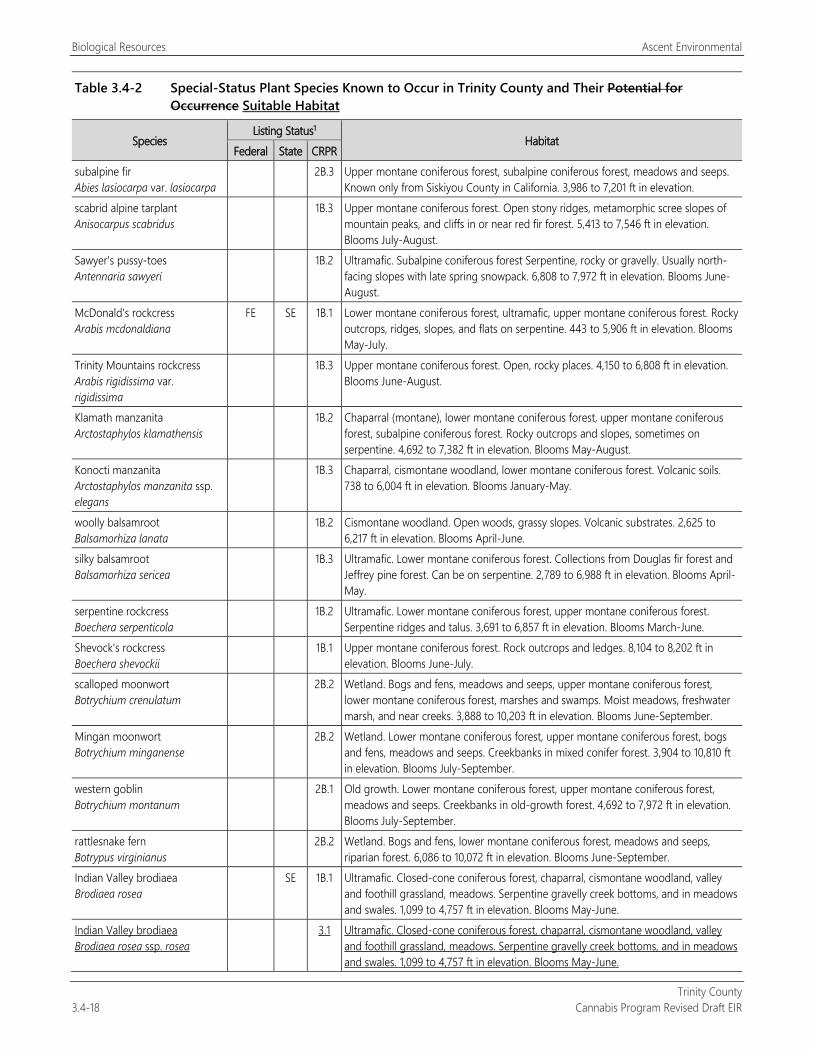
Biological Resources Ascent Environmental
Trinity County 3.4-18 Cannabis Program Revised Draft EIR
Table 3.4-2 Special-Status Plant Species Known to Occur in Trinity County and Their Potential for Occurrence Suitable Habitat
Species Listing Status1
Habitat Federal State CRPR
subalpine fir Abies lasiocarpa var. lasiocarpa
2B.3 Upper montane coniferous forest, subalpine coniferous forest, meadows and seeps. Known only from Siskiyou County in California. 3,986 to 7,201 ft in elevation.
scabrid alpine tarplant Anisocarpus scabridus
1B.3 Upper montane coniferous forest. Open stony ridges, metamorphic scree slopes of mountain peaks, and cliffs in or near red fir forest. 5,413 to 7,546 ft in elevation. Blooms July-August.
Sawyer's pussy-toes Antennaria sawyeri
1B.2 Ultramafic. Subalpine coniferous forest Serpentine, rocky or gravelly. Usually north-facing slopes with late spring snowpack. 6,808 to 7,972 ft in elevation. Blooms June-August.
McDonald's rockcress Arabis mcdonaldiana
FE SE 1B.1 Lower montane coniferous forest, ultramafic, upper montane coniferous forest. Rocky outcrops, ridges, slopes, and flats on serpentine. 443 to 5,906 ft in elevation. Blooms May-July.
Trinity Mountains rockcress Arabis rigidissima var. rigidissima
1B.3 Upper montane coniferous forest. Open, rocky places. 4,150 to 6,808 ft in elevation. Blooms June-August.
Klamath manzanita Arctostaphylos klamathensis
1B.2 Chaparral (montane), lower montane coniferous forest, upper montane coniferous forest, subalpine coniferous forest. Rocky outcrops and slopes, sometimes on serpentine. 4,692 to 7,382 ft in elevation. Blooms May-August.
Konocti manzanita Arctostaphylos manzanita ssp. elegans
1B.3 Chaparral, cismontane woodland, lower montane coniferous forest. Volcanic soils. 738 to 6,004 ft in elevation. Blooms January-May.
woolly balsamroot Balsamorhiza lanata
1B.2 Cismontane woodland. Open woods, grassy slopes. Volcanic substrates. 2,625 to 6,217 ft in elevation. Blooms April-June.
silky balsamroot Balsamorhiza sericea
1B.3 Ultramafic. Lower montane coniferous forest. Collections from Douglas fir forest and Jeffrey pine forest. Can be on serpentine. 2,789 to 6,988 ft in elevation. Blooms April-May.
serpentine rockcress Boechera serpenticola
1B.2 Ultramafic. Lower montane coniferous forest, upper montane coniferous forest. Serpentine ridges and talus. 3,691 to 6,857 ft in elevation. Blooms March-June.
Shevock's rockcress Boechera shevockii
1B.1 Upper montane coniferous forest. Rock outcrops and ledges. 8,104 to 8,202 ft in elevation. Blooms June-July.
scalloped moonwort Botrychium crenulatum
2B.2 Wetland. Bogs and fens, meadows and seeps, upper montane coniferous forest, lower montane coniferous forest, marshes and swamps. Moist meadows, freshwater marsh, and near creeks. 3,888 to 10,203 ft in elevation. Blooms June-September.
Mingan moonwort Botrychium minganense
2B.2 Wetland. Lower montane coniferous forest, upper montane coniferous forest, bogs and fens, meadows and seeps. Creekbanks in mixed conifer forest. 3,904 to 10,810 ft in elevation. Blooms July-September.
western goblin Botrychium montanum
2B.1 Old growth. Lower montane coniferous forest, upper montane coniferous forest, meadows and seeps. Creekbanks in old-growth forest. 4,692 to 7,972 ft in elevation. Blooms July-September.
rattlesnake fern Botrypus virginianus
2B.2 Wetland. Bogs and fens, lower montane coniferous forest, meadows and seeps, riparian forest. 6,086 to 10,072 ft in elevation. Blooms June-September.
Indian Valley brodiaea Brodiaea rosea
SE 1B.1 Ultramafic. Closed-cone coniferous forest, chaparral, cismontane woodland, valley and foothill grassland, meadows. Serpentine gravelly creek bottoms, and in meadows and swales. 1,099 to 4,757 ft in elevation. Blooms May-June.
Indian Valley brodiaea Brodiaea rosea ssp. rosea
3.1 Ultramafic. Closed-cone coniferous forest, chaparral, cismontane woodland, valley and foothill grassland, meadows. Serpentine gravelly creek bottoms, and in meadows and swales. 1,099 to 4,757 ft in elevation. Blooms May-June.
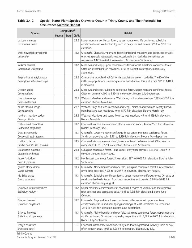
Ascent Environmental Biological Resources
Trinity County Cannabis Program Revised Draft EIR 3.4-19
Table 3.4-2 Special-Status Plant Species Known to Occur in Trinity County and Their Potential for Occurrence Suitable Habitat
Species Listing Status1
Habitat Federal State CRPR
buxbaumia moss Buxbaumia viridis
2B.2 Lower montane coniferous forest, upper montane coniferous forest, subalpine coniferous forest. Well-rotted logs and in peaty soil and humus. 3,199 to 7,218 ft in elevation.
small-flowered calycadenia micrantha
1B.2 Ultramafic. Chaparral, valley and foothill grassland, meadows and seeps. Rocky talus or scree; sparsely vegetated areas. occasionally on roadsides; sometimes on serpentine. 1,427 to 4,610 ft in elevation. Blooms June-September.
Wilkin's harebell Campanula wilkinsiana
1B.2 Meadows and seeps, upper montane coniferous forest, subalpine coniferous forest. Often on streambanks in meadows. 4,167 to 8,530 ft in elevation. Blooms July-September.
flagella-like atractylocarpus Campylopodiella stenocarpa
2B.2 Cismontane woodland. All California populations are on roadsides. The ID of the California populations is under question, but whatever this is, it is rare. 935 to 1,411 ft in elevation.
Oregon sedge Carex halliana
2B.3 Meadows and seeps, subalpine coniferous forest, upper montane coniferous forest. Often on pumice. 4,790 to 6,824 ft in elevation. Blooms July-September.
porcupine sedge Carex hystericina
2B.1 Wetland. Marshes and swamps. Wet places, such as stream edges. 1,985 to 3,150 ft in elevation. Blooms May-June.
bristle-stalked sedge Carex leptalea
2B.2 Wetland. Bogs and fens, meadows and seeps, marshes and swamps. Mostly known from bogs and wet meadows. 10 to 4,577 ft in elevation. Blooms March-July.
northern meadow sedge Carex praticola
2B.2 Wetland. Meadows and seeps. Moist to wet meadows. 49 to 10,499 ft in elevation. Blooms May-July.
holly-leaved ceanothus Ceanothus purpureus
1B.2 Chaparral, cismontane woodland. Rocky, volcanic slopes. 476 to 2,559 ft in elevation. Blooms February-June.
Shasta chaenactis Chaenactis suffrutescens
1B.3 Ultramafic. Lower montane coniferous forest, upper montane coniferous forest. Sandy or serpentine soils. 2,461 to 9,186 ft in elevation. Blooms May-September.
northern clarkia Clarkia borealis ssp. borealis
1B.3 Chaparral, cismontane woodland, lower montane coniferous forest. Often seen in roadcuts. 1,132 to 5,052 ft in elevation. Blooms June-September.
Great Basin claytonia Claytonia umbellata
2B.3 Subalpine coniferous forest. Talus slopes, stony flats, crevices. 5,594 to 11,483 ft in elevation. Blooms May-August.
Jepson's dodder Cuscuta jepsonii
1B.2 North coast coniferous forest. Streamsides. 397 to 9,006 ft in elevation. Blooms July-September.
golden alpine draba Draba aureola
1B.3 Ultramafic. Alpine boulder and rock field, subalpine coniferous forest. On serpentine or volcanic outcrops. 7,595 to 10,007 ft in elevation. Blooms July-August.
Mt. Eddy draba Draba carnosula
1B.3 Ultramafic. Subalpine coniferous forest, upper montane coniferous forest. On talus or small boulder-fields; known from both serpentine and granite. 6,348 to 9,843 ft in elevation. Blooms July-August.
Snow Mountain willowherb Epilobium nivium
1B.2 Upper montane coniferous forest, chaparral. Crevices of volcanic and metavolcanic rock outcrops and associated talus. 4,593 to 7,218 ft in elevation. Blooms June-October.
Oregon fireweed Epilobium oreganum
1B.2 Ultramafic. Bogs and fens, lower montane coniferous forest, upper montane coniferous forest. In and near springs and bogs; at least sometimes on serpentine. 1,640 to 7,349 ft in elevation. Blooms June-September.
Siskiyou fireweed Epilobium siskiyouense
1B.3 Ultramafic. Alpine boulder and rock field, subalpine coniferous forest, upper montane coniferous forest. On slopes in gravelly, serpentine soils. 5,495 to 8,005 ft in elevation. Blooms July-September.
Tracy's eriastrum Eriastrum tracyi
3.2 Chaparral, cismontane woodland, valley and foothill grassland. Gravelly shale or clay; often in open areas. 1,033 to 5,299 ft in elevation. Blooms May-July.
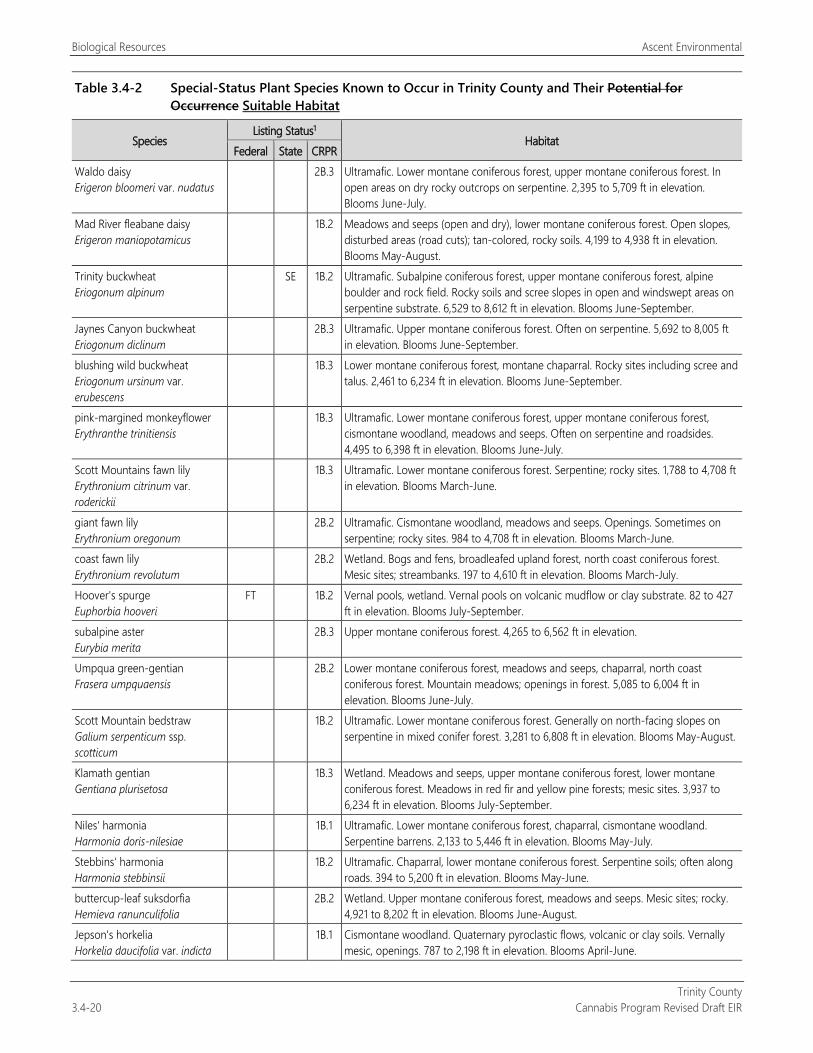
Biological Resources Ascent Environmental
Trinity County 3.4-20 Cannabis Program Revised Draft EIR
Table 3.4-2 Special-Status Plant Species Known to Occur in Trinity County and Their Potential for Occurrence Suitable Habitat
Species Listing Status1
Habitat Federal State CRPR
Waldo daisy Erigeron bloomeri var. nudatus
2B.3 Ultramafic. Lower montane coniferous forest, upper montane coniferous forest. In open areas on dry rocky outcrops on serpentine. 2,395 to 5,709 ft in elevation. Blooms June-July.
Mad River fleabane daisy Erigeron maniopotamicus
1B.2 Meadows and seeps (open and dry), lower montane coniferous forest. Open slopes, disturbed areas (road cuts); tan-colored, rocky soils. 4,199 to 4,938 ft in elevation. Blooms May-August.
Trinity buckwheat Eriogonum alpinum
SE 1B.2 Ultramafic. Subalpine coniferous forest, upper montane coniferous forest, alpine boulder and rock field. Rocky soils and scree slopes in open and windswept areas on serpentine substrate. 6,529 to 8,612 ft in elevation. Blooms June-September.
Jaynes Canyon buckwheat Eriogonum diclinum
2B.3 Ultramafic. Upper montane coniferous forest. Often on serpentine. 5,692 to 8,005 ft in elevation. Blooms June-September.
blushing wild buckwheat Eriogonum ursinum var. erubescens
1B.3 Lower montane coniferous forest, montane chaparral. Rocky sites including scree and talus. 2,461 to 6,234 ft in elevation. Blooms June-September.
pink-margined monkeyflower Erythranthe trinitiensis
1B.3 Ultramafic. Lower montane coniferous forest, upper montane coniferous forest, cismontane woodland, meadows and seeps. Often on serpentine and roadsides. 4,495 to 6,398 ft in elevation. Blooms June-July.
Scott Mountains fawn lily Erythronium citrinum var. roderickii
1B.3 Ultramafic. Lower montane coniferous forest. Serpentine; rocky sites. 1,788 to 4,708 ft in elevation. Blooms March-June.
giant fawn lily Erythronium oregonum
2B.2 Ultramafic. Cismontane woodland, meadows and seeps. Openings. Sometimes on serpentine; rocky sites. 984 to 4,708 ft in elevation. Blooms March-June.
coast fawn lily Erythronium revolutum
2B.2 Wetland. Bogs and fens, broadleafed upland forest, north coast coniferous forest. Mesic sites; streambanks. 197 to 4,610 ft in elevation. Blooms March-July.
Hoover's spurge Euphorbia hooveri
FT 1B.2 Vernal pools, wetland. Vernal pools on volcanic mudflow or clay substrate. 82 to 427 ft in elevation. Blooms July-September.
subalpine aster Eurybia merita
2B.3 Upper montane coniferous forest. 4,265 to 6,562 ft in elevation.
Umpqua green-gentian Frasera umpquaensis
2B.2 Lower montane coniferous forest, meadows and seeps, chaparral, north coast coniferous forest. Mountain meadows; openings in forest. 5,085 to 6,004 ft in elevation. Blooms June-July.
Scott Mountain bedstraw Galium serpenticum ssp. scotticum
1B.2 Ultramafic. Lower montane coniferous forest. Generally on north-facing slopes on serpentine in mixed conifer forest. 3,281 to 6,808 ft in elevation. Blooms May-August.
Klamath gentian Gentiana plurisetosa
1B.3 Wetland. Meadows and seeps, upper montane coniferous forest, lower montane coniferous forest. Meadows in red fir and yellow pine forests; mesic sites. 3,937 to 6,234 ft in elevation. Blooms July-September.
Niles' harmonia Harmonia doris-nilesiae
1B.1 Ultramafic. Lower montane coniferous forest, chaparral, cismontane woodland. Serpentine barrens. 2,133 to 5,446 ft in elevation. Blooms May-July.
Stebbins' harmonia Harmonia stebbinsii
1B.2 Ultramafic. Chaparral, lower montane coniferous forest. Serpentine soils; often along roads. 394 to 5,200 ft in elevation. Blooms May-June.
buttercup-leaf suksdorfia Hemieva ranunculifolia
2B.2 Wetland. Upper montane coniferous forest, meadows and seeps. Mesic sites; rocky. 4,921 to 8,202 ft in elevation. Blooms June-August.
Jepson's horkelia Horkelia daucifolia var. indicta
1B.1 Cismontane woodland. Quaternary pyroclastic flows, volcanic or clay soils. Vernally mesic, openings. 787 to 2,198 ft in elevation. Blooms April-June.
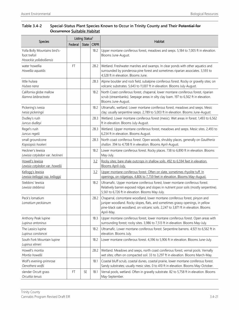
Ascent Environmental Biological Resources
Trinity County Cannabis Program Revised Draft EIR 3.4-21
Table 3.4-2 Special-Status Plant Species Known to Occur in Trinity County and Their Potential for Occurrence Suitable Habitat
Species Listing Status1
Habitat Federal State CRPR
Yolla Bolly Mountains bird's-foot trefoil Hosackia yollabolliensis
1B.2 Upper montane coniferous forest, meadows and seeps. 5,184 to 7,005 ft in elevation. Blooms June-August.
water howellia Howellia aquatilis
FT 2B.2 Wetland. Freshwater marshes and swamps. In clear ponds with other aquatics and surrounded by ponderosa pine forest and sometimes riparian associates. 3,593 to 4,528 ft in elevation. Blooms June.
little hulsea Hulsea nana
2B.3 Alpine boulder and rock field, subalpine coniferous forest. Rocky or gravelly sites; on volcanic substrates. 5,643 to 11,007 ft in elevation. Blooms July-August.
California globe mallow Iliamna latibracteata
1B.2 North Coast coniferous forest, chaparral, lower montane coniferous forest, riparian scrub (streambanks). Seepage areas in silty clay loam. 197 to 6,562 ft in elevation. Blooms June-August.
Pickering's ivesia Ivesia pickeringii
1B.2 Ultramafic, wetland. Lower montane coniferous forest, meadows and seeps. Mesic clay; usually serpentine seeps. 2,789 to 5,003 ft in elevation. Blooms June-August.
Dudley's rush Juncus dudleyi
2B.3 Wetland. Lower montane coniferous forest (mesic). Wet areas in forest. 1,493 to 6,562 ft in elevation. Blooms July-August.
Regel's rush Juncus regelii
2B.3 Wetland. Upper montane coniferous forest, meadows and seeps. Mesic sites. 2,493 to 6,234 ft in elevation. Blooms August.
small groundcone Kopsiopsis hookeri
2B.3 North coast coniferous forest. Open woods, shrubby places, generally on Gaultheria shallon. 394 to 4,708 ft in elevation. Blooms April-August.
Heckner's lewisia Lewisia cotyledon var. heckneri
1B.2 Lower montane coniferous forest. Rocky places. 738 to 6,890 ft in elevation. Blooms May-July.
Howell’s lewisia Lewisia cotyledon var. howellii
3.2 Rocky sites; bare shale outcrops in shallow soils. 492 to 6,594 feet in elevation. Blooms April–July.
Kellogg’s lewisia Lewisia kelloggii ssp. kelloggii
3.2 Upper montane coniferous forest. Often on slate, sometimes rhyolite tuff. In openings, on ridgetops. 4,806 to 7,759 feet in elevation. Blooms May–August.
Stebbins' lewisia Lewisia stebbinsii
1B.2 Ultramafic. Upper montane coniferous forest, lower montane coniferous forest. Relatively barren exposed ridges and slopes in nutrient poor soils (mostly serpentine). 5,561 to 6,726 ft in elevation. Blooms May-July.
Peck's lomatium Lomatium peckianum
2B.2 Chaparral, cismontane woodland, lower montane coniferous forest, pinyon and juniper woodland. Rocky slopes, flats, and sometimes grassy openings, in yellow pine-black oak woodland, on volcanic soils. 2,247 to 3,871 ft in elevation. Blooms April-May.
Anthony Peak lupine Lupinus antoninus
1B.3 Upper montane coniferous forest, lower montane coniferous forest. Open areas with surrounding forest; rocky sites. 3,986 to 7,513 ft in elevation. Blooms May-July.
The Lassics lupine Lupinus constancei
1B.2 Ultramafic. Lower montane coniferous forest. Serpentine barrens. 4,921 to 6,562 ft in elevation. Blooms July.
South Fork Mountain lupine Lupinus elmeri
1B.2 Lower montane coniferous forest. 4,396 to 5,906 ft in elevation. Blooms June-July.
Howell's montia Montia howellii
2B.2 Wetland. Meadows and seeps, north coast coniferous forest, vernal pools. Vernally wet sites; often on compacted soil. 33 to 3,297 ft in elevation. Blooms March-May.
Wolf's evening-primrose Oenothera wolfii
1B.1 Coastal bluff scrub, coastal dunes, coastal prairie, lower montane coniferous forest. Sandy substrates; usually mesic sites. 0 to 410 ft in elevation. Blooms May-October.
slender Orcutt grass Orcuttia tenuis
FT SE 1B.1 Vernal pools, wetland. Often in gravelly substrate. 82 to 5,758 ft in elevation. Blooms May-September.
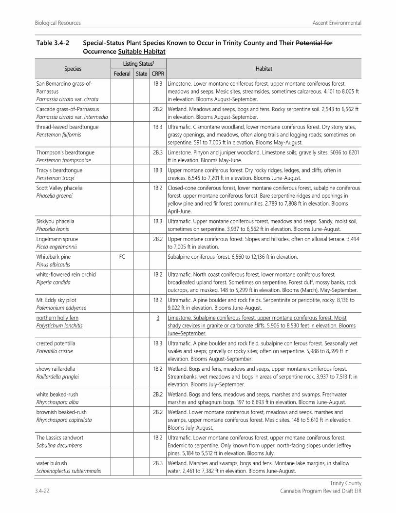
Biological Resources Ascent Environmental
Trinity County 3.4-22 Cannabis Program Revised Draft EIR
Table 3.4-2 Special-Status Plant Species Known to Occur in Trinity County and Their Potential for Occurrence Suitable Habitat
Species Listing Status1
Habitat Federal State CRPR
San Bernardino grass-of-Parnassus Parnassia cirrata var. cirrata
1B.3 Limestone. Lower montane coniferous forest, upper montane coniferous forest, meadows and seeps. Mesic sites, streamsides, sometimes calcareous. 4,101 to 8,005 ft in elevation. Blooms August-September.
Cascade grass-of-Parnassus Parnassia cirrata var. intermedia
2B.2 Wetland. Meadows and seeps, bogs and fens. Rocky serpentine soil. 2,543 to 6,562 ft in elevation. Blooms August-September.
thread-leaved beardtongue Penstemon filiformis
1B.3 Ultramafic. Cismontane woodland, lower montane coniferous forest. Dry stony sites, grassy openings, and meadows, often along trails and logging roads; sometimes on serpentine. 591 to 7,005 ft in elevation. Blooms May-August.
Thompson's beardtongue Penstemon thompsoniae
2B.3 Limestone. Pinyon and juniper woodland. Limestone soils; gravelly sites. 5036 to 6201 ft in elevation. Blooms May-June.
Tracy's beardtongue Penstemon tracyi
1B.3 Upper montane coniferous forest. Dry rocky ridges, ledges, and cliffs, often in crevices. 6,545 to 7,201 ft in elevation. Blooms June-August.
Scott Valley phacelia Phacelia greenei
1B.2 Closed-cone coniferous forest, lower montane coniferous forest, subalpine coniferous forest, upper montane coniferous forest. Bare serpentine ridges and openings in yellow pine and red fir forest communities. 2,789 to 7,808 ft in elevation. Blooms April-June.
Siskiyou phacelia Phacelia leonis
1B.3 Ultramafic. Upper montane coniferous forest, meadows and seeps. Sandy, moist soil, sometimes on serpentine. 3,937 to 6,562 ft in elevation. Blooms June-August.
Engelmann spruce Picea engelmannii
2B.2 Upper montane coniferous forest. Slopes and hillsides, often on alluvial terrace. 3,494 to 7,005 ft in elevation.
Whitebark pine Pinus albicaulis
FC Subalpine coniferous forest. 6,560 to 12,136 ft in elevation.
white-flowered rein orchid Piperia candida
1B.2 Ultramafic. North coast coniferous forest, lower montane coniferous forest, broadleafed upland forest. Sometimes on serpentine. Forest duff, mossy banks, rock outcrops, and muskeg. 148 to 5,299 ft in elevation. Blooms (March), May-September.
Mt. Eddy sky pilot Polemonium eddyense
1B.2 Ultramafic. Alpine boulder and rock fields. Serpentinite or peridotite, rocky. 8,136 to 9,022 ft in elevation. Blooms June-August.
northern holly fern Polystichum lonchitis
3 Limestone. Subalpine coniferous forest, upper montane coniferous forest. Moist shady crevices in granite or carbonate cliffs. 5,906 to 8,530 feet in elevation. Blooms June–September.
crested potentilla Potentilla cristae
1B.3 Ultramafic. Alpine boulder and rock field, subalpine coniferous forest. Seasonally wet swales and seeps; gravelly or rocky sites; often on serpentine. 5,988 to 8,399 ft in elevation. Blooms August-September.
showy raillardella Raillardella pringlei
1B.2 Wetland. Bogs and fens, meadows and seeps, upper montane coniferous forest. Streambanks, wet meadows and bogs in areas of serpentine rock. 3,937 to 7,513 ft in elevation. Blooms July-September.
white beaked-rush Rhynchospora alba
2B.2 Wetland. Bogs and fens, meadows and seeps, marshes and swamps. Freshwater marshes and sphagnum bogs. 197 to 6,693 ft in elevation. Blooms June-August.
brownish beaked-rush Rhynchospora capitellata
2B.2 Wetland. Lower montane coniferous forest, meadows and seeps, marshes and swamps, upper montane coniferous forest. Mesic sites. 148 to 5,610 ft in elevation. Blooms July-August.
The Lassics sandwort Sabulina decumbens
1B.2 Ultramafic. Lower montane coniferous forest, upper montane coniferous forest. Endemic to serpentine. Only known from upper, north-facing slopes under Jeffrey pines. 5,184 to 5,512 ft in elevation. Blooms July.
water bulrush Schoenoplectus subterminalis
2B.3 Wetland. Marshes and swamps, bogs and fens. Montane lake margins, in shallow water. 2,461 to 7,382 ft in elevation. Blooms June-August.
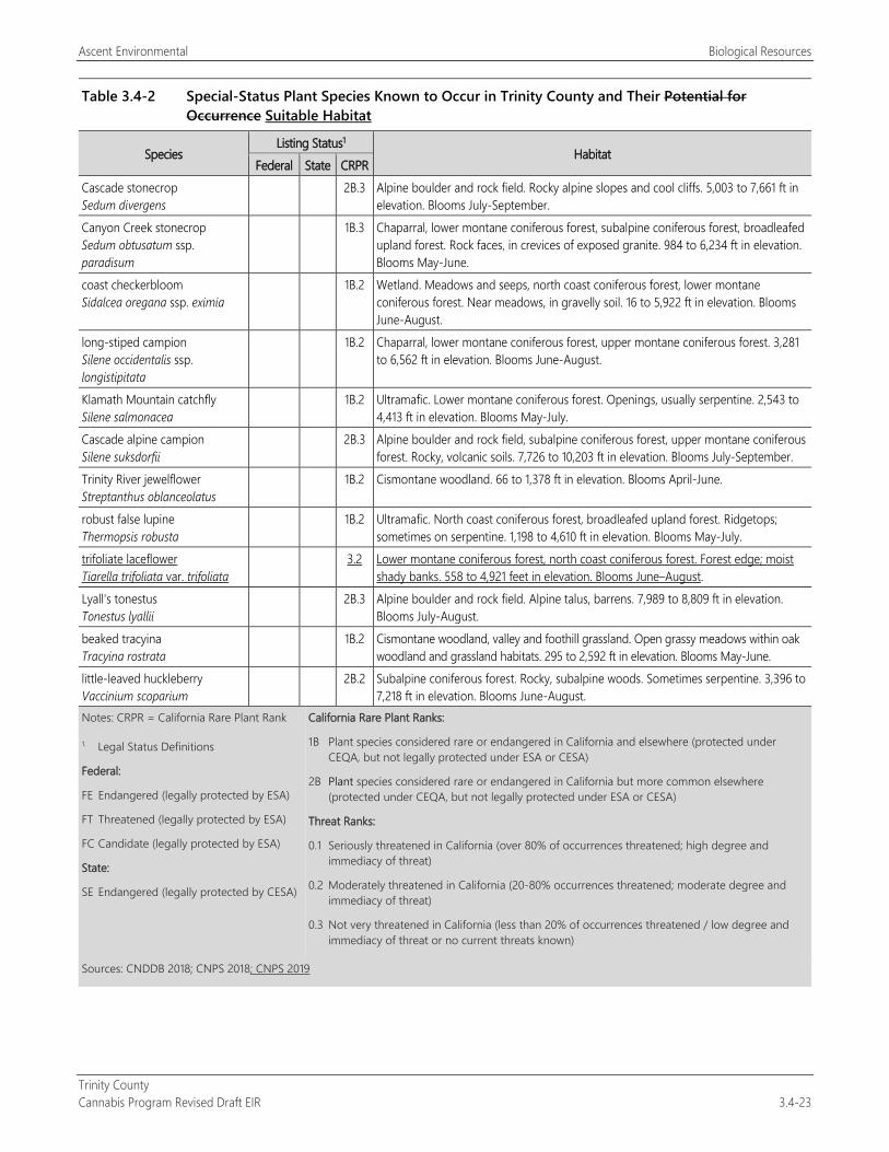
Ascent Environmental Biological Resources
Trinity County Cannabis Program Revised Draft EIR 3.4-23
Table 3.4-2 Special-Status Plant Species Known to Occur in Trinity County and Their Potential for Occurrence Suitable Habitat
Species Listing Status1
Habitat Federal State CRPR
Cascade stonecrop Sedum divergens
2B.3 Alpine boulder and rock field. Rocky alpine slopes and cool cliffs. 5,003 to 7,661 ft in elevation. Blooms July-September.
Canyon Creek stonecrop Sedum obtusatum ssp. paradisum
1B.3 Chaparral, lower montane coniferous forest, subalpine coniferous forest, broadleafed upland forest. Rock faces, in crevices of exposed granite. 984 to 6,234 ft in elevation. Blooms May-June.
coast checkerbloom Sidalcea oregana ssp. eximia
1B.2 Wetland. Meadows and seeps, north coast coniferous forest, lower montane coniferous forest. Near meadows, in gravelly soil. 16 to 5,922 ft in elevation. Blooms June-August.
long-stiped campion Silene occidentalis ssp. longistipitata
1B.2 Chaparral, lower montane coniferous forest, upper montane coniferous forest. 3,281 to 6,562 ft in elevation. Blooms June-August.
Klamath Mountain catchfly Silene salmonacea
1B.2 Ultramafic. Lower montane coniferous forest. Openings, usually serpentine. 2,543 to 4,413 ft in elevation. Blooms May-July.
Cascade alpine campion Silene suksdorfii
2B.3 Alpine boulder and rock field, subalpine coniferous forest, upper montane coniferous forest. Rocky, volcanic soils. 7,726 to 10,203 ft in elevation. Blooms July-September.
Trinity River jewelflower Streptanthus oblanceolatus
1B.2 Cismontane woodland. 66 to 1,378 ft in elevation. Blooms April-June.
robust false lupine Thermopsis robusta
1B.2 Ultramafic. North coast coniferous forest, broadleafed upland forest. Ridgetops; sometimes on serpentine. 1,198 to 4,610 ft in elevation. Blooms May-July.
trifoliate laceflower Tiarella trifoliata var. trifoliata
3.2 Lower montane coniferous forest, north coast coniferous forest. Forest edge; moist shady banks. 558 to 4,921 feet in elevation. Blooms June–August.
Lyall's tonestus Tonestus lyallii
2B.3 Alpine boulder and rock field. Alpine talus, barrens. 7,989 to 8,809 ft in elevation. Blooms July-August.
beaked tracyina Tracyina rostrata
1B.2 Cismontane woodland, valley and foothill grassland. Open grassy meadows within oak woodland and grassland habitats. 295 to 2,592 ft in elevation. Blooms May-June.
little-leaved huckleberry Vaccinium scoparium
2B.2 Subalpine coniferous forest. Rocky, subalpine woods. Sometimes serpentine. 3,396 to 7,218 ft in elevation. Blooms June-August.
Notes: CRPR = California Rare Plant Rank California Rare Plant Ranks:
1B Plant species considered rare or endangered in California and elsewhere (protected under CEQA, but not legally protected under ESA or CESA)
2B Plant species considered rare or endangered in California but more common elsewhere (protected under CEQA, but not legally protected under ESA or CESA)
Threat Ranks:
0.1 Seriously threatened in California (over 80% of occurrences threatened; high degree and immediacy of threat)
0.2 Moderately threatened in California (20-80% occurrences threatened; moderate degree and immediacy of threat)
0.3 Not very threatened in California (less than 20% of occurrences threatened / low degree and immediacy of threat or no current threats known)
1. Legal Status Definitions
Federal:
FE Endangered (legally protected by ESA)
FT Threatened (legally protected by ESA)
FC Candidate (legally protected by ESA)
State:
SE Endangered (legally protected by CESA)
Sources: CNDDB 2018; CNPS 2018; CNPS 2019
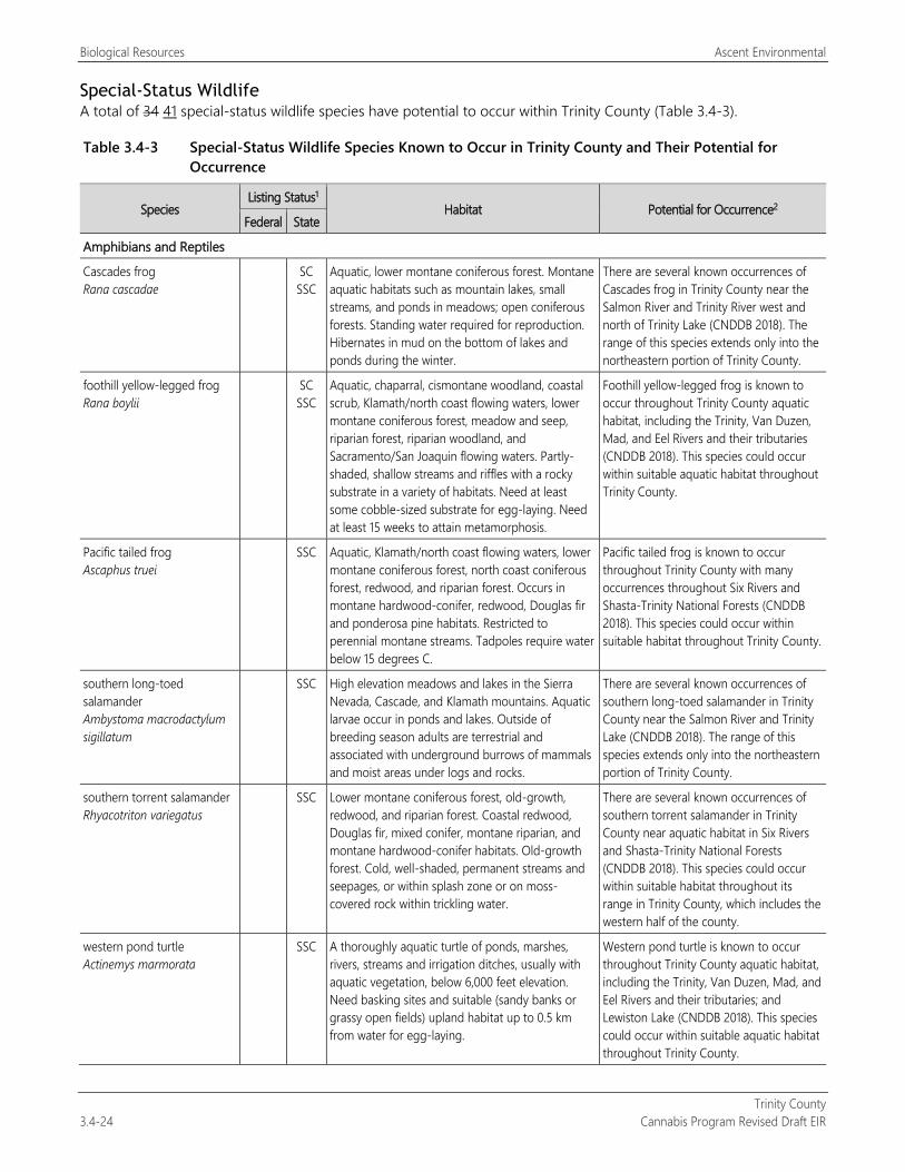
Biological Resources Ascent Environmental
Trinity County 3.4-24 Cannabis Program Revised Draft EIR
Special-Status Wildlife A total of 34 41 special-status wildlife species have potential to occur within Trinity County (Table 3.4-3).
Table 3.4-3 Special-Status Wildlife Species Known to Occur in Trinity County and Their Potential for Occurrence
Species Listing Status1
Habitat Potential for Occurrence2 Federal State
Amphibians and Reptiles
Cascades frog Rana cascadae
SC SSC
Aquatic, lower montane coniferous forest. Montane aquatic habitats such as mountain lakes, small streams, and ponds in meadows; open coniferous forests. Standing water required for reproduction. Hibernates in mud on the bottom of lakes and ponds during the winter.
There are several known occurrences of Cascades frog in Trinity County near the Salmon River and Trinity River west and north of Trinity Lake (CNDDB 2018). The range of this species extends only into the northeastern portion of Trinity County.
foothill yellow-legged frog Rana boylii
SC SSC
Aquatic, chaparral, cismontane woodland, coastal scrub, Klamath/north coast flowing waters, lower montane coniferous forest, meadow and seep, riparian forest, riparian woodland, and Sacramento/San Joaquin flowing waters. Partly-shaded, shallow streams and riffles with a rocky substrate in a variety of habitats. Need at least some cobble-sized substrate for egg-laying. Need at least 15 weeks to attain metamorphosis.
Foothill yellow-legged frog is known to occur throughout Trinity County aquatic habitat, including the Trinity, Van Duzen, Mad, and Eel Rivers and their tributaries (CNDDB 2018). This species could occur within suitable aquatic habitat throughout Trinity County.
Pacific tailed frog Ascaphus truei
SSC Aquatic, Klamath/north coast flowing waters, lower montane coniferous forest, north coast coniferous forest, redwood, and riparian forest. Occurs in montane hardwood-conifer, redwood, Douglas fir and ponderosa pine habitats. Restricted to perennial montane streams. Tadpoles require water below 15 degrees C.
Pacific tailed frog is known to occur throughout Trinity County with many occurrences throughout Six Rivers and Shasta-Trinity National Forests (CNDDB 2018). This species could occur within suitable habitat throughout Trinity County.
southern long-toed salamander Ambystoma macrodactylum sigillatum
SSC High elevation meadows and lakes in the Sierra Nevada, Cascade, and Klamath mountains. Aquatic larvae occur in ponds and lakes. Outside of breeding season adults are terrestrial and associated with underground burrows of mammals and moist areas under logs and rocks.
There are several known occurrences of southern long-toed salamander in Trinity County near the Salmon River and Trinity Lake (CNDDB 2018). The range of this species extends only into the northeastern portion of Trinity County.
southern torrent salamander Rhyacotriton variegatus
SSC Lower montane coniferous forest, old-growth, redwood, and riparian forest. Coastal redwood, Douglas fir, mixed conifer, montane riparian, and montane hardwood-conifer habitats. Old-growth forest. Cold, well-shaded, permanent streams and seepages, or within splash zone or on moss-covered rock within trickling water.
There are several known occurrences of southern torrent salamander in Trinity County near aquatic habitat in Six Rivers and Shasta-Trinity National Forests (CNDDB 2018). This species could occur within suitable habitat throughout its range in Trinity County, which includes the western half of the county.
western pond turtle Actinemys marmorata
SSC A thoroughly aquatic turtle of ponds, marshes, rivers, streams and irrigation ditches, usually with aquatic vegetation, below 6,000 feet elevation. Need basking sites and suitable (sandy banks or grassy open fields) upland habitat up to 0.5 km from water for egg-laying.
Western pond turtle is known to occur throughout Trinity County aquatic habitat, including the Trinity, Van Duzen, Mad, and Eel Rivers and their tributaries; and Lewiston Lake (CNDDB 2018). This species could occur within suitable aquatic habitat throughout Trinity County.
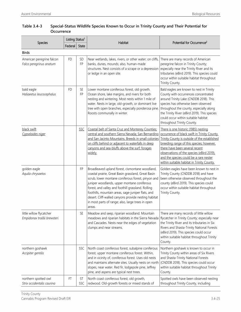
Ascent Environmental Biological Resources
Trinity County Cannabis Program Revised Draft EIR 3.4-25
Table 3.4-3 Special-Status Wildlife Species Known to Occur in Trinity County and Their Potential for Occurrence
Species Listing Status1
Habitat Potential for Occurrence2 Federal State
Birds
American peregrine falcon Falco peregrinus anatum
FD SD FP
Near wetlands, lakes, rivers, or other water; on cliffs, banks, dunes, mounds; also, human-made structures. Nest consists of a scrape or a depression or ledge in an open site.
There are many records of American peregrine falcon in Trinity County; especially near the Trinity River and its tributaries (eBird 2019). This species could occur within suitable habitat throughout Trinity County.
bald eagle Haliaeetus leucocephalus
FD SE FP
Lower montane coniferous forest, old growth. Ocean shore, lake margins, and rivers for both nesting and wintering. Most nests within 1 mile of water. Nests in large, old-growth, or dominant live tree with open branches, especially ponderosa pine. Roosts communally in winter.
Bald eagles are known to nest in Trinity County with occurrences concentrated around Trinity Lake (CNDDB 2018). This species has otherwise been observed throughout the county, especially along the Trinity River (eBird 2019). This species could occur within suitable habitat throughout Trinity County.
black swift Cypseloides niger
SSC Coastal belt of Santa Cruz and Monterey Counties; central and southern Sierra Nevada; San Bernardino and San Jacinto Mountains. Breeds in small colonies on cliffs behind or adjacent to waterfalls in deep canyons and sea-bluffs above the surf; forages widely.
There is one historic (1985) nesting occurrence of black swift in Trinity County. Trinity County is outside of the established breeding range of this species; however, there have been several recent observations of the species (eBird 2019), and the species could be a rare nester within suitable habitat in Trinity County.
golden eagle Aquila chrysaetos
FP Broadleaved upland forest, cismontane woodland, coastal prairie, Great Basin grassland, Great Basin scrub, lower montane coniferous forest, pinyon and juniper woodlands, upper montane coniferous forest, and valley and foothill grassland. Rolling foothills, mountain areas, sage-juniper flats, and desert. Cliff-walled canyons provide nesting habitat in most parts of range; also, large trees in open areas.
Golden eagles have been known to nest in Trinity County (CNDDB 2018) and have been otherwise observed throughout the county (eBird 2019). This species could occur within suitable habitat throughout Trinity County.
little willow flycatcher Empidonax traillii brewsteri
SE Meadow and seep, riparian woodland. Mountain meadows and riparian habitats in the Sierra Nevada and Cascades. Nests near the edges of vegetation clumps and near streams.
There are many records of little willow flycatcher in Trinity County; especially near the Trinity River and its tributaries in Six Rivers and Shasta-Trinity National Forests (eBird 2019). This species could occur within suitable habitat throughout Trinity County.
northern goshawk Accipiter gentilis
SSC North coast coniferous forest, subalpine coniferous forest, upper montane coniferous forest. Within, and in vicinity of, coniferous forest. Uses old nests and maintains alternate sites. Usually nests on north slopes, near water. Red fir, lodgepole pine, Jeffrey pine, and aspens are typical nest trees.
Northern goshawk is known to occur in Trinity County within areas of Six Rivers and Shasta-Trinity National Forests (CNDDB 2018). This species could occur within suitable habitat throughout Trinity County.
northern spotted owl Strix occidentalis caurina
FT ST SSC
North coast coniferous forest, old growth, redwood. Old-growth forests or mixed stands of
Spotted owls have been observed nesting throughout Trinity County, including
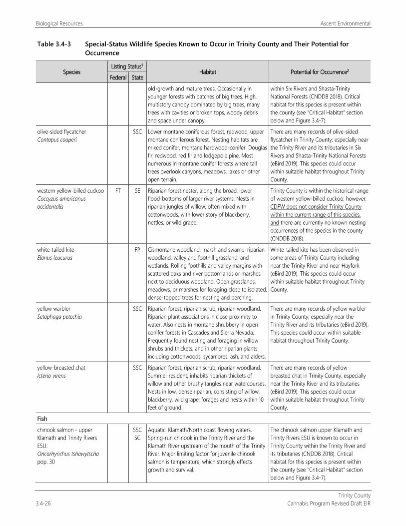
Biological Resources Ascent Environmental
Trinity County 3.4-26 Cannabis Program Revised Draft EIR
Table 3.4-3 Special-Status Wildlife Species Known to Occur in Trinity County and Their Potential for Occurrence
Species Listing Status1
Habitat Potential for Occurrence2 Federal State
old-growth and mature trees. Occasionally in younger forests with patches of big trees. High, multistory canopy dominated by big trees, many trees with cavities or broken tops, woody debris and space under canopy.
within Six Rivers and Shasta-Trinity National Forests (CNDDB 2018). Critical habitat for this species is present within the county (see “Critical Habitat” section below and Figure 3.4-7).
olive-sided flycatcher Contopus cooperi
SSC Lower montane coniferous forest, redwood, upper montane coniferous forest. Nesting habitats are mixed conifer, montane hardwood-conifer, Douglas fir, redwood, red fir and lodgepole pine. Most numerous in montane conifer forests where tall trees overlook canyons, meadows, lakes or other open terrain.
There are many records of olive-sided flycatcher in Trinity County; especially near the Trinity River and its tributaries in Six Rivers and Shasta-Trinity National Forests (eBird 2019). This species could occur within suitable habitat throughout Trinity County.
western yellow-billed cuckoo Coccyzus americanus occidentalis
FT SE Riparian forest nester, along the broad, lower flood-bottoms of larger river systems. Nests in riparian jungles of willow, often mixed with cottonwoods, with lower story of blackberry, nettles, or wild grape.
Trinity County is within the historical range of western yellow-billed cuckoo; however, CDFW does not consider Trinity County within the current range of this species, and there are currently no known nesting occurrences of the species in the county (CNDDB 2018).
white-tailed kite Elanus leucurus
FP Cismontane woodland, marsh and swamp, riparian woodland, valley and foothill grassland, and wetlands. Rolling foothills and valley margins with scattered oaks and river bottomlands or marshes next to deciduous woodland. Open grasslands, meadows, or marshes for foraging close to isolated, dense-topped trees for nesting and perching.
White-tailed kite has been observed in some areas of Trinity County including near the Trinity River and near Hayfork (eBird 2019). This species could occur within suitable habitat throughout Trinity County.
yellow warbler Setophaga petechia
SSC Riparian forest, riparian scrub, riparian woodland. Riparian plant associations in close proximity to water. Also nests in montane shrubbery in open conifer forests in Cascades and Sierra Nevada. Frequently found nesting and foraging in willow shrubs and thickets, and in other riparian plants including cottonwoods, sycamores, ash, and alders.
There are many records of yellow warbler in Trinity County; especially near the Trinity River and its tributaries (eBird 2019). This species could occur within suitable habitat throughout Trinity County.
yellow-breasted chat Icteria virens
SSC Riparian forest, riparian scrub, riparian woodland. Summer resident; inhabits riparian thickets of willow and other brushy tangles near watercourses. Nests in low, dense riparian, consisting of willow, blackberry, wild grape; forages and nests within 10 feet of ground.
There are many records of yellow-breasted chat in Trinity County; especially near the Trinity River and its tributaries (eBird 2019). This species could occur within suitable habitat throughout Trinity County.
Fish
chinook salmon - upper Klamath and Trinity Rivers ESU. Oncorhynchus tshawytscha pop. 30
SSC SC
Aquatic. Klamath/North coast flowing waters. Spring-run chinook in the Trinity River and the Klamath River upstream of the mouth of the Trinity River. Major limiting factor for juvenile chinook salmon is temperature, which strongly effects growth and survival.
The chinook salmon upper Klamath and Trinity Rivers ESU is known to occur in Trinity County within the Trinity River and its tributaries (CNDDB 2018). Critical habitat for this species is present within the county (see “Critical Habitat” section below and Figure 3.4-7).
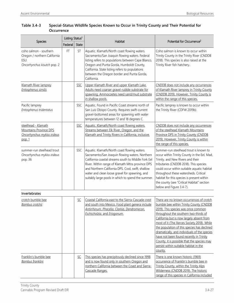
Ascent Environmental Biological Resources
Trinity County Cannabis Program Revised Draft EIR 3.4-27
Table 3.4-3 Special-Status Wildlife Species Known to Occur in Trinity County and Their Potential for Occurrence
Species Listing Status1
Habitat Potential for Occurrence2 Federal State
coho salmon - southern Oregon / northern California ESU Oncorhynchus kisutch pop. 2
FT ST Aquatic. Klamath/North coast flowing waters. Sacramento/San Joaquin flowing waters. Federal listing refers to populations between Cape Blanco, Oregon and Punta Gorda, Humboldt County, California. State listing refers to populations between the Oregon border and Punta Gorda, California.
Coho salmon is known to occur within Trinity County in the Trinity River (CNDDB 2018). This species is also raised at the Trinity River fish hatchery.
Klamath River lamprey Entosphenus similis
SSC Upper Klamath River and upper Klamath Lake. Adults need coarser gravel-rubble substrate for spawning. Ammocoetes need sand/mud substrate in shallow pools.
CNDDB does not include any occurrences of Klamath River lamprey in Trinity County (CNDDB 2019). However, Trinity County is within the range of this species.
Pacific lamprey Entosphenus tridentatus
SSC Aquatic. Found in Pacific Coast streams north of San Luis Obispo County. Requires swift-current gravel-bottomed areas for spawning with water temperatures between 12 and 18 degrees C.
Pacific lamprey is known to occur within the Trinity River (CDFW 2019b).
steelhead - Klamath Mountains Province DPS Oncorhynchus mykiss irideus pop. 1
SSC Aquatic. Klamath/North coast flowing waters. Streams between Elk River, Oregon, and the Klamath and Trinity Rivers in California, inclusive.
CNDDB does not include any occurrences of the steelhead Klamath Mountains Province DPS in Trinity County (CNDDB 2019). However, Trinity County is within the range of this species.
summer-run steelhead trout Oncorhynchus mykiss irideus pop. 36
SSC Aquatic. Klamath/North coast flowing waters. Sacramento/San Joaquin flowing waters. Northern California coastal streams south to Middle Fork Eel River. Within range of Klamath Mtns province DPS and Northern California DPS. Cool, swift, shallow water and clean loose gravel for spawning, and suitably large pools in which to spend the summer.
Summer-run steelhead trout is known to occur within Trinity County in the Eel, Mad, Trinity, and New Rivers and their tributaries (CNDDB 2018). This species could occur within suitable aquatic habitat throughout these watersheds. Critical habitat for this species is present within the county (see “Critical Habitat” section below and Figure 3.4-7).
Invertebrates
crotch bumble bee Bombus crotchii
SC Coastal California east to the Sierra-Cascade crest and south into Mexico. Food plant genera include Antirrhinum, Phacelia, Clarkia, Dendromecon, Eschscholzia, and Eriogonum.
There are no known occurrences of crotch bumble bee within Trinity County (CNDDB 2019). This species was once common throughout the southern two-thirds of California but is now largely absent from most of it (The Xerces Society 2018). While the population of this species has declined dramatically, and individuals of the species have not been found recently in Trinity County, it is possible that the species may persist within suitable habitat in the county.
Franklin’s bumble bee Bombus franklini
SC This species has precipitously declined since 1998 and is now found only in southern Oregon and northern California between the Coast and Sierra-Cascade Ranges.
There is one known historic (1969) occurrence of Franklin’s bumble bee in Trinity County, within the Trinity Alps Wilderness (CNDDB 2019). The historic range of this species in California included
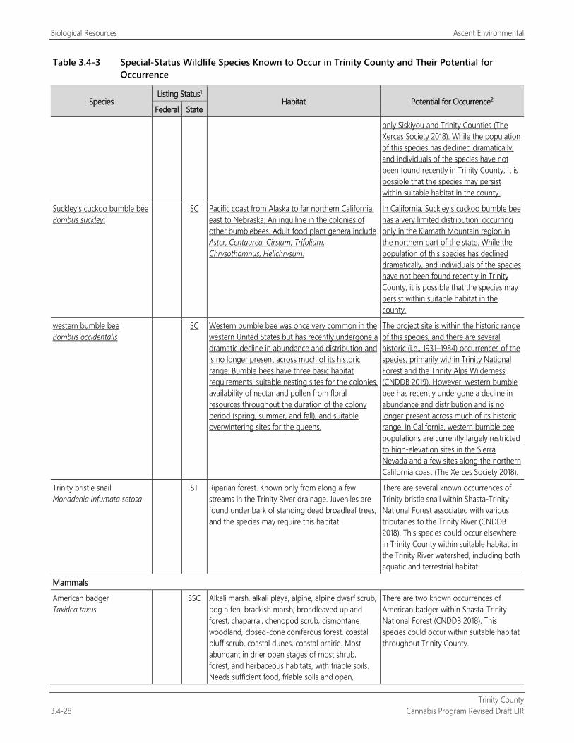
Biological Resources Ascent Environmental
Trinity County 3.4-28 Cannabis Program Revised Draft EIR
Table 3.4-3 Special-Status Wildlife Species Known to Occur in Trinity County and Their Potential for Occurrence
Species Listing Status1
Habitat Potential for Occurrence2 Federal State
only Siskiyou and Trinity Counties (The Xerces Society 2018). While the population of this species has declined dramatically, and individuals of the species have not been found recently in Trinity County, it is possible that the species may persist within suitable habitat in the county.
Suckley’s cuckoo bumble bee Bombus suckleyi
SC Pacific coast from Alaska to far northern California, east to Nebraska. An inquiline in the colonies of other bumblebees. Adult food plant genera include Aster, Centaurea, Cirsium, Trifolium, Chrysothamnus, Helichrysum.
In California, Suckley’s cuckoo bumble bee has a very limited distribution, occurring only in the Klamath Mountain region in the northern part of the state. While the population of this species has declined dramatically, and individuals of the species have not been found recently in Trinity County, it is possible that the species may persist within suitable habitat in the county.
western bumble bee Bombus occidentalis
SC Western bumble bee was once very common in the western United States but has recently undergone a dramatic decline in abundance and distribution and is no longer present across much of its historic range. Bumble bees have three basic habitat requirements: suitable nesting sites for the colonies, availability of nectar and pollen from floral resources throughout the duration of the colony period (spring, summer, and fall), and suitable overwintering sites for the queens.
The project site is within the historic range of this species, and there are several historic (i.e., 1931–1984) occurrences of the species, primarily within Trinity National Forest and the Trinity Alps Wilderness (CNDDB 2019). However, western bumble bee has recently undergone a decline in abundance and distribution and is no longer present across much of its historic range. In California, western bumble bee populations are currently largely restricted to high-elevation sites in the Sierra Nevada and a few sites along the northern California coast (The Xerces Society 2018).
Trinity bristle snail Monadenia infumata setosa
ST Riparian forest. Known only from along a few streams in the Trinity River drainage. Juveniles are found under bark of standing dead broadleaf trees, and the species may require this habitat.
There are several known occurrences of Trinity bristle snail within Shasta-Trinity National Forest associated with various tributaries to the Trinity River (CNDDB 2018). This species could occur elsewhere in Trinity County within suitable habitat in the Trinity River watershed, including both aquatic and terrestrial habitat.
Mammals
American badger Taxidea taxus
SSC Alkali marsh, alkali playa, alpine, alpine dwarf scrub, bog a fen, brackish marsh, broadleaved upland forest, chaparral, chenopod scrub, cismontane woodland, closed-cone coniferous forest, coastal bluff scrub, coastal dunes, coastal prairie. Most abundant in drier open stages of most shrub, forest, and herbaceous habitats, with friable soils. Needs sufficient food, friable soils and open,
There are two known occurrences of American badger within Shasta-Trinity National Forest (CNDDB 2018). This species could occur within suitable habitat throughout Trinity County.
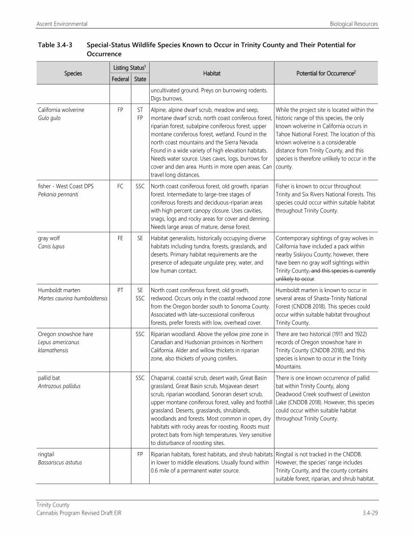
Ascent Environmental Biological Resources
Trinity County Cannabis Program Revised Draft EIR 3.4-29
Table 3.4-3 Special-Status Wildlife Species Known to Occur in Trinity County and Their Potential for Occurrence
Species Listing Status1
Habitat Potential for Occurrence2 Federal State
uncultivated ground. Preys on burrowing rodents. Digs burrows.
California wolverine Gulo gulo
FP ST FP
Alpine, alpine dwarf scrub, meadow and seep, montane dwarf scrub, north coast coniferous forest, riparian forest, subalpine coniferous forest, upper montane coniferous forest, wetland. Found in the north coast mountains and the Sierra Nevada. Found in a wide variety of high elevation habitats. Needs water source. Uses caves, logs, burrows for cover and den area. Hunts in more open areas. Can travel long distances.
While the project site is located within the historic range of this species, the only known wolverine in California occurs in Tahoe National Forest. The location of this known wolverine is a considerable distance from Trinity County, and this species is therefore unlikely to occur in the county.
fisher - West Coast DPS Pekania pennanti
FC SSC North coast coniferous forest, old growth, riparian forest. Intermediate to large-tree stages of coniferous forests and deciduous-riparian areas with high percent canopy closure. Uses cavities, snags, logs and rocky areas for cover and denning. Needs large areas of mature, dense forest.
Fisher is known to occur throughout Trinity and Six Rivers National Forests. This species could occur within suitable habitat throughout Trinity County.
gray wolf Canis lupus
FE SE Habitat generalists, historically occupying diverse habitats including tundra, forests, grasslands, and deserts. Primary habitat requirements are the presence of adequate ungulate prey, water, and low human contact.
Contemporary sightings of gray wolves in California have included a pack within nearby Siskiyou County; however, there have been no gray wolf sightings within Trinity County, and this species is currently unlikely to occur.
Humboldt marten Martes caurina humboldtensis
PT SE SSC
North coast coniferous forest, old growth, redwood. Occurs only in the coastal redwood zone from the Oregon border south to Sonoma County. Associated with late-successional coniferous forests, prefer forests with low, overhead cover.
Humboldt marten is known to occur in several areas of Shasta-Trinity National Forest (CNDDB 2018). This species could occur within suitable habitat throughout Trinity County.
Oregon snowshoe hare Lepus americanus klamathensis
SSC Riparian woodland. Above the yellow pine zone in Canadian and Hudsonian provinces in Northern California. Alder and willow thickets in riparian zone, also thickets of young conifers.
There are two historical (1911 and 1922) records of Oregon snowshoe hare in Trinity County (CNDDB 2018), and this species is known to occur in the Trinity Mountains.
pallid bat Antrozous pallidus
SSC Chaparral, coastal scrub, desert wash, Great Basin grassland, Great Basin scrub, Mojavean desert scrub, riparian woodland, Sonoran desert scrub, upper montane coniferous forest, valley and foothill grassland. Deserts, grasslands, shrublands, woodlands and forests. Most common in open, dry habitats with rocky areas for roosting. Roosts must protect bats from high temperatures. Very sensitive to disturbance of roosting sites.
There is one known occurrence of pallid bat within Trinity County, along Deadwood Creek southwest of Lewiston Lake (CNDDB 2018). However, this species could occur within suitable habitat throughout Trinity County.
ringtail Bassariscus astutus
FP Riparian habitats, forest habitats, and shrub habitats in lower to middle elevations. Usually found within 0.6 mile of a permanent water source.
Ringtail is not tracked in the CNDDB. However, the species’ range includes Trinity County, and the county contains suitable forest, riparian, and shrub habitat.
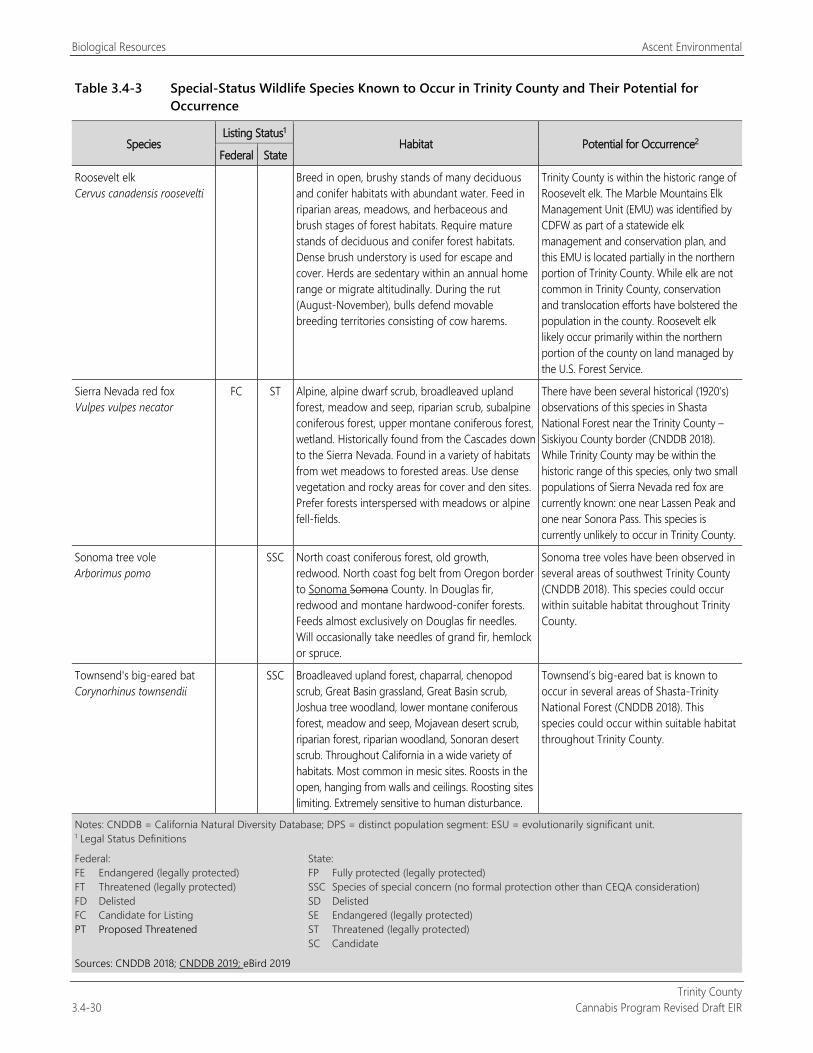
Biological Resources Ascent Environmental
Trinity County 3.4-30 Cannabis Program Revised Draft EIR
Table 3.4-3 Special-Status Wildlife Species Known to Occur in Trinity County and Their Potential for Occurrence
Species Listing Status1
Habitat Potential for Occurrence2 Federal State
Roosevelt elk Cervus canadensis roosevelti
Breed in open, brushy stands of many deciduous and conifer habitats with abundant water. Feed in riparian areas, meadows, and herbaceous and brush stages of forest habitats. Require mature stands of deciduous and conifer forest habitats. Dense brush understory is used for escape and cover. Herds are sedentary within an annual home range or migrate altitudinally. During the rut (August-November), bulls defend movable breeding territories consisting of cow harems.
Trinity County is within the historic range of Roosevelt elk. The Marble Mountains Elk Management Unit (EMU) was identified by CDFW as part of a statewide elk management and conservation plan, and this EMU is located partially in the northern portion of Trinity County. While elk are not common in Trinity County, conservation and translocation efforts have bolstered the population in the county. Roosevelt elk likely occur primarily within the northern portion of the county on land managed by the U.S. Forest Service.
Sierra Nevada red fox Vulpes vulpes necator
FC ST Alpine, alpine dwarf scrub, broadleaved upland forest, meadow and seep, riparian scrub, subalpine coniferous forest, upper montane coniferous forest, wetland. Historically found from the Cascades down to the Sierra Nevada. Found in a variety of habitats from wet meadows to forested areas. Use dense vegetation and rocky areas for cover and den sites. Prefer forests interspersed with meadows or alpine fell-fields.
There have been several historical (1920’s) observations of this species in Shasta National Forest near the Trinity County – Siskiyou County border (CNDDB 2018). While Trinity County may be within the historic range of this species, only two small populations of Sierra Nevada red fox are currently known: one near Lassen Peak and one near Sonora Pass. This species is currently unlikely to occur in Trinity County.
Sonoma tree vole Arborimus pomo
SSC North coast coniferous forest, old growth, redwood. North coast fog belt from Oregon border to Sonoma Somona County. In Douglas fir, redwood and montane hardwood-conifer forests. Feeds almost exclusively on Douglas fir needles. Will occasionally take needles of grand fir, hemlock or spruce.
Sonoma tree voles have been observed in several areas of southwest Trinity County (CNDDB 2018). This species could occur within suitable habitat throughout Trinity County.
Townsend's big-eared bat Corynorhinus townsendii
SSC Broadleaved upland forest, chaparral, chenopod scrub, Great Basin grassland, Great Basin scrub, Joshua tree woodland, lower montane coniferous forest, meadow and seep, Mojavean desert scrub, riparian forest, riparian woodland, Sonoran desert scrub. Throughout California in a wide variety of habitats. Most common in mesic sites. Roosts in the open, hanging from walls and ceilings. Roosting sites limiting. Extremely sensitive to human disturbance.
Townsend’s big-eared bat is known to occur in several areas of Shasta-Trinity National Forest (CNDDB 2018). This species could occur within suitable habitat throughout Trinity County.
Notes: CNDDB = California Natural Diversity Database; DPS = distinct population segment: ESU = evolutionarily significant unit. 1 Legal Status Definitions
Federal: FE Endangered (legally protected) FT Threatened (legally protected) FD Delisted FC Candidate for Listing PT Proposed Threatened
State: FP Fully protected (legally protected) SSC Species of special concern (no formal protection other than CEQA consideration) SD Delisted SE Endangered (legally protected) ST Threatened (legally protected) SC Candidate
Sources: CNDDB 2018; CNDDB 2019; eBird 2019
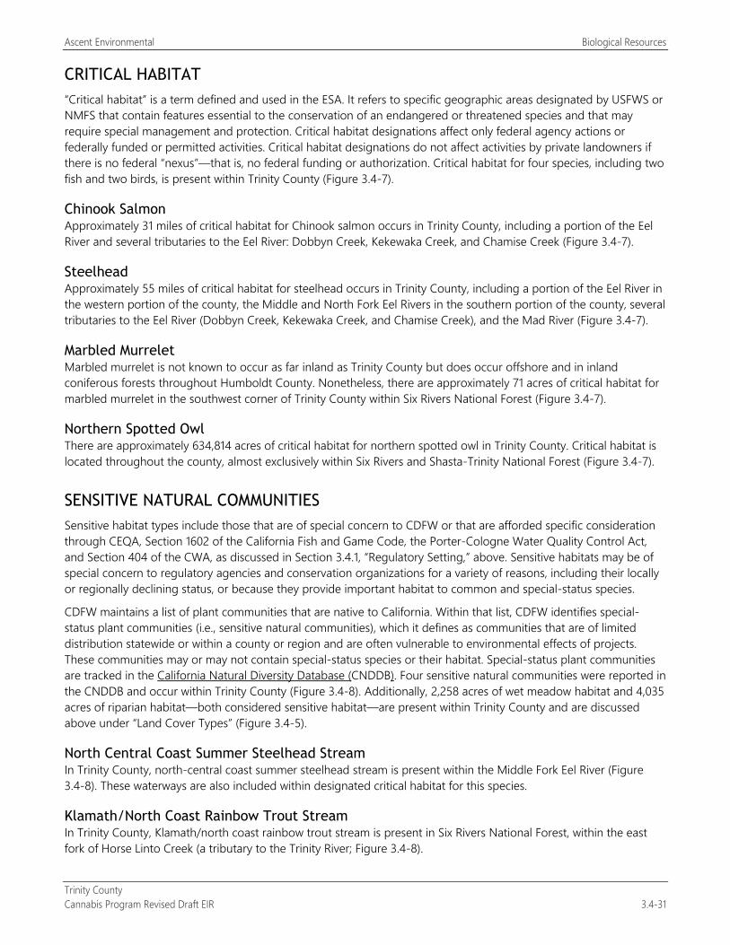
Ascent Environmental Biological Resources
Trinity County Cannabis Program Revised Draft EIR 3.4-31
CRITICAL HABITAT “Critical habitat” is a term defined and used in the ESA. It refers to specific geographic areas designated by USFWS or NMFS that contain features essential to the conservation of an endangered or threatened species and that may require special management and protection. Critical habitat designations affect only federal agency actions or federally funded or permitted activities. Critical habitat designations do not affect activities by private landowners if there is no federal “nexus”—that is, no federal funding or authorization. Critical habitat for four species, including two fish and two birds, is present within Trinity County (Figure 3.4-7).
Chinook Salmon Approximately 31 miles of critical habitat for Chinook salmon occurs in Trinity County, including a portion of the Eel River and several tributaries to the Eel River: Dobbyn Creek, Kekewaka Creek, and Chamise Creek (Figure 3.4-7).
Steelhead Approximately 55 miles of critical habitat for steelhead occurs in Trinity County, including a portion of the Eel River in the western portion of the county, the Middle and North Fork Eel Rivers in the southern portion of the county, several tributaries to the Eel River (Dobbyn Creek, Kekewaka Creek, and Chamise Creek), and the Mad River (Figure 3.4-7).
Marbled Murrelet Marbled murrelet is not known to occur as far inland as Trinity County but does occur offshore and in inland coniferous forests throughout Humboldt County. Nonetheless, there are approximately 71 acres of critical habitat for marbled murrelet in the southwest corner of Trinity County within Six Rivers National Forest (Figure 3.4-7).
Northern Spotted Owl There are approximately 634,814 acres of critical habitat for northern spotted owl in Trinity County. Critical habitat is located throughout the county, almost exclusively within Six Rivers and Shasta-Trinity National Forest (Figure 3.4-7).
SENSITIVE NATURAL COMMUNITIES Sensitive habitat types include those that are of special concern to CDFW or that are afforded specific consideration through CEQA, Section 1602 of the California Fish and Game Code, the Porter-Cologne Water Quality Control Act, and Section 404 of the CWA, as discussed in Section 3.4.1, “Regulatory Setting,” above. Sensitive habitats may be of special concern to regulatory agencies and conservation organizations for a variety of reasons, including their locally or regionally declining status, or because they provide important habitat to common and special-status species.
CDFW maintains a list of plant communities that are native to California. Within that list, CDFW identifies special-status plant communities (i.e., sensitive natural communities), which it defines as communities that are of limited distribution statewide or within a county or region and are often vulnerable to environmental effects of projects. These communities may or may not contain special-status species or their habitat. Special-status plant communities are tracked in the California Natural Diversity Database (CNDDB). Four sensitive natural communities were reported in the CNDDB and occur within Trinity County (Figure 3.4-8). Additionally, 2,258 acres of wet meadow habitat and 4,035 acres of riparian habitat—both considered sensitive habitat—are present within Trinity County and are discussed above under “Land Cover Types” (Figure 3.4-5).
North Central Coast Summer Steelhead Stream In Trinity County, north-central coast summer steelhead stream is present within the Middle Fork Eel River (Figure 3.4-8). These waterways are also included within designated critical habitat for this species.
Klamath/North Coast Rainbow Trout Stream In Trinity County, Klamath/north coast rainbow trout stream is present in Six Rivers National Forest, within the east fork of Horse Linto Creek (a tributary to the Trinity River; Figure 3.4-8).
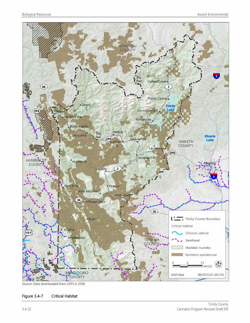
Biological Resources Ascent Environmental
Trinity County 3.4-32 Cannabis Program Revised Draft EIR
Source: Data downloaded from USFS in 2018
Figure 3.4-7 Critical Habitat
Ascent Environmental Biological Resources
Trinity County Cannabis Program Revised Draft EIR 3.4-33
Source: Data downloaded from USFS in 2018
Figure 3.4-8 Sensitive Natural Communities - Aquatic and Terrestrial Communities
Biological Resources Ascent Environmental
Trinity County 3.4-34 Cannabis Program Revised Draft EIR
Darlingtonia Seep Darlingtonia californica, or the California pitcher plant, is a unique, carnivorous plant that grows near streams and bogs and can tolerate serpentine or acidic soils. Darlingtonia seep habitat is present in various areas of Shasta-Trinity National Forest and the Trinity Alps Wilderness Area (Figure 3.4-8).
Upland Douglas Fir Forest Douglas fir occurs throughout Trinity County (Calflora 2019); however, upland Douglas fir forest refers to old-growth forests or stands of Douglas fir that are greater than 200 years old. There are two known occurrences of old-growth Douglas fir forest within Trinity County: one in the southwestern corner of the county and one along the South Fork Trinity River in Shasta-Trinity National Forest (CNDDB 2018, Figure 3.4-8). Features of old-growth Douglas fir forests include presence of Douglas fir trees with diameter at breast height of 40 inches or greater, coarse woody debris on the forest floor, and large snags or dead trees (Franklin and Spies 1991). The state rarity ranking for upland Douglas fir forest is S3.1, or very threatened, with only 10,000 to 50,000 acres remaining in California. There are likely old-growth Douglas fir forest stands in Trinity County in addition to those reported in the CNDDB (Figure 3.4-6).
Southern Oregon/Northern California Coho Salmon Stream In Trinity County, southern Oregon/northern California coho salmon habitat includes the South Fork Trinity River and Trinity River watersheds, which have been defined as sensitive communities for this species by CDFW (Figure 3.4-8).
INVASIVE PLANT SPECIES AND NOXIOUS WEEDS An invasive plant is one that is not native to a region, but rather is introduced, and tends to crowd out native vegetation and thereby adversely affect the wildlife that feeds on it. There are many invasive plant species in Trinity County and they occur throughout several different habitat types (Calflora 2019). Aggressive noxious weeds such as Scotch broom (Cytisus scoparius), French broom (Genista monspessulana), and knapweed (Centaurea sp.) can invade grasslands and exclude native grassland species. Invasive plant species such as English ivy (Hedera helix), knotweed (Fallopia sp. and Persicaria wallichii), tree of heaven (Ailanthus altissima), and Himalayan blackberry (Rubus armeniacus) can invade forest or riparian habitats and exclude native understory species.
AQUATIC HABITATS The preeminent aquatic feature within Trinity County is the Trinity River, which is the largest tributary to the Klamath River and drains approximately 2,900 square miles of mountainous terrain. The county also includes portions of the Mad River, Van Duzen River, and Eel River watersheds, and their tributaries (Figure 3.4-5). Other major aquatic features within the county include Trinity Lake and Lewiston Lake along the Trinity River, and Ruth Lake along the Mad River. Many of these aquatic features have nearby associated wetland habitat, including saline and freshwater wetlands, and approximately 4,035 acres of sensitive riparian habitat (See “Land Cover Types” section).
CANNABIS PRIORITY WATERSHEDS
SWRCB in coordination with CDFW have identified “Cannabis Priority Watersheds” throughout the state (SWRCB 2019). All Cannabis Priority Watersheds contain a high concentration of cannabis cultivation; noncompliant cannabis cultivation in these high-value areas has the potential to cause severe environmental impacts. Pursuant to CCR Section 8216 if SWRCB or CDFW notifies CDFA in writing that cannabis cultivation is causing significant adverse impacts on the environment in a watershed or other geographic area pursuant to Section 26069, Subdivision (c)(1), of the Business and Professions Code, CDFA shall not issue new licenses or increase the total number of plant identifiers within that watershed or area while the moratorium is in effect.
Ascent Environmental Biological Resources
Trinity County Cannabis Program Revised Draft EIR 3.4-35
A “Cannabis Priority Watershed” may also meet some or all of the following criteria:
Contains or supports critical habitat for terrestrial or aquatic species (See “Critical Habitat” section, above);
Contains water courses with low flow conditions where water levels recede or are at risk of receding into the “danger zone” for aquatic life. These are survival-level flows at which aquatic habitat and species will be harmed;
Contains a critical water supply, where excessive water usage or diversions present unreasonable stress or pose a significant threat to the long-term and sustainable water use;
Has complaints that allege cannabis cultivation that contributes to or causes natural resources violations, or that affects senior water right holders;
Is part of past or ongoing restoration efforts;
Is listed under Clean Water Act Section 303(d) as an impaired waterbody;
Contains surface water body that is listed as a fully appropriated stream; and
Contains a waterbody is designated as a “Wild and Scenic River” pursuant to the PRC Section 5093.
The current (2019) Cannabis Priority Watersheds in Trinity County are:
Upper South Fork Trinity River,
Middle South Fork Trinity River,
Lower South Fork Trinity River,
Upper Hayfork Creek, and
Lower Hayfork Creek.
WILDLIFE MOVEMENT CORRIDORS Trinity County contains several large areas of relatively undisturbed wildlife habitat, including protected forest within Six Rivers and Shasta-Trinity National Forests, Yolla Bolly-Middle Eel Reserve, Trinity Alps, Chanchellula, and North Fork Wilderness areas, and the major river systems throughout the county. While several rivers, including the Trinity and Mad Rivers are dammed, the rivers still provide value as movement corridors for fish and wildlife species. Columbian black-tailed deer critical winter habitat is present in the county, including CDFW’s North Coast and Klamath Mountains and Cascade Range Deer Conservation Units (Figure 3.4-9; CDFW 2015a).
Some of these important areas were mapped as Essential Connectivity Areas (ECA) for the California Essential Habitat Connectivity Project, which was commissioned by the California Department of Transportation and CDFW with the purpose of making transportation and land-use planning more efficient and less costly, while helping reduce dangerous wildlife-vehicle collisions (Spencer et al. 2010, Figure 3.4-10). The ECAs were not developed for the purposes of defining areas subject to specific regulations by CDFW or other agencies. As shown in Figure 3.4-10, ECAs occur within large portions of Trinity County, especially within rugged Wilderness areas. The ECAs are not regulatory delineations and are identified as lands likely important to wildlife movement between large, mostly natural areas at the statewide level. The ECAs form a functional network of wildlands that are important to the continued support of California’s diverse natural communities.
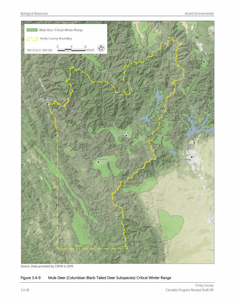
Biological Resources Ascent Environmental
Trinity County 3.4-36 Cannabis Program Revised Draft EIR
Source: Data provided by CDFW in 2019
Figure 3.4-9 Mule Deer (Columbian Black-Tailed Deer Subspecies) Critical Winter Range
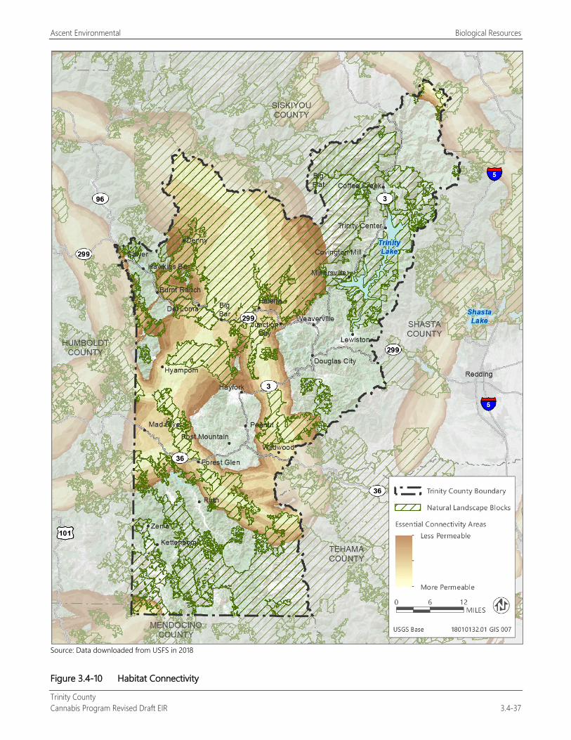
Ascent Environmental Biological Resources
Trinity County Cannabis Program Revised Draft EIR 3.4-37
Source: Data downloaded from USFS in 2018
Figure 3.4-10 Habitat Connectivity
Biological Resources Ascent Environmental
Trinity County 3.4-38 Cannabis Program Revised Draft EIR
HABITAT CONSERVATION PLANS Two habitat conservation plans (HCPs) have been adopted in Trinity County: the Green Diamond (formerly Simpson Timber) Resource Company California Timberlands Northern Spotted Owl HCP (Green Diamond Resource Company 1992, 2007) and the Humboldt Bay Municipal Water District (HBMWD) HCP (Humboldt Bay Municipal Water District 2004; Figure 3.4-11). Sierra Pacific Industries is currently preparing an HCP for management and harvest of the company’s timberland in California, some of which is located in Trinity County. Species proposed to be covered under the HCP are northern spotted owl and California spotted owl.
EXISTING STRESSORS ON BIOLOGICAL RESOURCES IN TRINITY COUNTY Historic and modern development in Trinity County that has resulted in adverse effects to natural resources in the region includes timber harvest (beginning in the mid-19th century), watershed alteration because of dam construction, mining, agricultural activities, urban development, and introduction of invasive plant and wildlife species. More recently, illegal cannabis cultivation operations within public and private lands have led to illegal water diversions, unpermitted removal of sensitive vegetation, and direct mortality to protected species from exposure to rodenticides and insecticides (Gabriel et al. 2012). As identified in Chapter 2, “Project Description,” there were approximately 3,927 cultivation sites (1,108.59 acres) that were identified in 2016 when the County began its licensing program. Approximately 44 percent of the 3,927 cultivation sites are located within designated Cannabis Priority Watersheds. Comparison of the 2016 mapping to 2018 satellite imagery of portions of the county has identified that the number of sites and acreage in unlicensed and illegal cannabis cultivation has increased since 2016.
PROJECTED ALTERATION OF HABITAT CONDITIONS ATTRIBUTABLE TO CLIMATE CHANGE Global climate change is a major challenge to the conservation of California’s natural resources. This section summarizes major projected climate change effects in the North Coast and Klamath region of California from the California State Wildlife Action Plan (CDFW 2015b). Resulting stresses to species and ecosystems from climate change effects include changes in the duration, frequency, or severity of extreme events, such as wildfire, storms, floods, and extreme temperatures. Also, longer-term climate trends and associated ecological vulnerabilities in response to these stresses may directly threaten sensitive habitats and species, particularly those with limited adaptive capacity (e.g., vegetation shifts and modified hydrology).
Vulnerability to climate change can be defined as the degree to which a system is exposed to, sensitive to, and unable to cope with or adapt to the adverse effects of change (CEC 2012). The degree of vulnerability of California’s wildlife to climate change will vary considerably depending on many factors, such as the intrinsic sensitivity of a given species and/or its habitat to climate exposure and related stresses, the adaptive capacity of species and habitat to these effects, and other existing environmental stresses unrelated to climate change.
Temperature Climatic changes along the northern California coastline, the North Coast Ranges, and Interior Coast Ranges are expected to include increased average temperatures of 1.7 to 1.9°C (3.0 to 3.4°F) by 2070, and 1.5 to 4.5°C (2.7 to 8.1°F) by 2099 (PRBO Conservation Science 2011; Cayan et al. 2008). Mean maximum and minimum temperatures are projected to increase by 2.5°C (4.5°F) and 2.3°C (4.1°F), respectively, and frequency of extremely hot days (exceeding long-term 95th percentile) is projected to increase by 27 days per year. Prolonged hot spells are projected to increase by 1.6 events per year and increase in duration by 3 days (Bell et al. 2004). Many of these changes will be slightly less pronounced in coastal regions and amplified in inland regions.
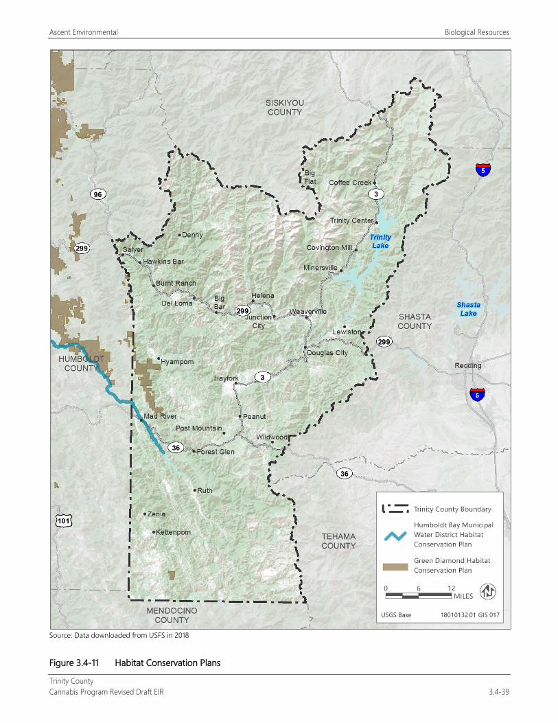
Ascent Environmental Biological Resources
Trinity County Cannabis Program Revised Draft EIR 3.4-39
Source: Data downloaded from USFS in 2018
Figure 3.4-11 Habitat Conservation Plans
Biological Resources Ascent Environmental
Trinity County 3.4-40 Cannabis Program Revised Draft EIR
Precipitation and Snowpack Within the North Coast counties, changes in annual precipitation are projected to vary by location with a subtle decrease throughout the century in most areas. Areas of heavy rainfall (203 centimeters [cm] [80 inches] or more per year) are projected to lose 13 to 18 cm (5 to 7 inches) by 2050 and 28 to 38 cm (11 to 15 inches) by the end of the century. Slightly drier places are projected to see a decrease of around 8 to 10 cm (3 to 4 inches) by 2050 and 15 cm (6 inches) of precipitation by 2100 (CalEMA 2012). In the Klamath Mountains, annual precipitation is projected to decline by approximately an inch by 2050 and 5 cm (2 inches) by 2100 (CalEMA 2012). March snow levels in the higher-elevation, mountainous portions of region could drop to almost zero by the 2090s, a decrease of 5 to 25 cm (2 to 10 inches) from 2010 levels. In areas with more snow, 8 to 13 cm (3 to 5 inches) of reduction will occur by 2050. In areas with currently little snow (<8 cm [<3 inches] per year), the snowpack is projected to be near zero by 2050 (CalEMA 2012).
Freshwater Hydrologic Regimes Projected loss of snowpack in this region would suggest a potential decrease in duration and magnitude of flows. While hydrologic changes have not been modeled, observational data show non-snowmelt-dominated streams in northwest California have been trending toward later stream flow timing. There could also be a shift in timing of heaviest runoff. Observational data from last 50 years shows that in nonsnowmelt streams, the center of mass of annual flow has shifted from 5 to 25 days later in the season (PRBO Conservation Science 2011).
Wildfire Risk Substantial increase in fire risk is projected throughout the region. Modest increases in area burned are projected for 2050. By 2100, the projected frequency increases dramatically, eight times greater in parts of Del Norte, Humboldt, and Mendocino Counties. Lake County and northern Mendocino County are projected to have up to 2.5 times greater wildfire frequency (CalEMA 2012).
3.4.3 Environmental Impacts and Mitigation Measures
METHODOLOGY The analysis of potential impacts to biological resources resulting from project implementation under the County Cannabis Program is based on the data review described previously in Section 3.4.2, “Environmental Setting.” The County Cannabis Program does not apply to tribal lands, or public lands managed by U.S. Forest Service, state parks, U.S. Bureau of Land Management, or CDFW. Impact mechanisms for development under the County Cannabis Program could include clearing of native vegetation; ground disturbance from construction of storage ponds, installation of irrigation systems and water storage, road and building construction, extension of electrical facilities and infrastructure, fencing, planting, and harvest activities; and operation of artificial lights and generators. Project implementation under the County Cannabis Program may include conversion of natural habitats. The reader is referred to Chapter 2, “Project Description,” for a further description of the development assumptions for the County Cannabis Program.
Federal agencies, including but not limited to USACE and USFWS, may not issue permits for activities associated with commercial cannabis activities. Consequently, projects under the County Cannabis Program would be required to avoid federally regulated resources including plant and wildlife species listed under ESA and waters of the United States as required under Attachment A (General Requirements and Prohibitions) of SWRCB Order WQ 20179-002301-DWQ.
THRESHOLDS OF SIGNIFICANCE Thresholds of significance are based on Appendix G of the State CEQA Guidelines. These thresholds were used because they address the biological resource conditions and associated policies and regulations in the county, as well as potential effects associated with commercial cannabis operations (land disturbance, building construction, and use of lighting).
Ascent Environmental Biological Resources
Trinity County Cannabis Program Revised Draft EIR 3.4-41
The project would result in a significant impact on biological resources if it would:
have a substantial adverse effect, either directly or through habitat modifications, on any species identified as a candidate, sensitive, or special-status species in local or regional plans, policies, or regulations, or by CDFW or USFWS;
have a substantial adverse effect on any riparian habitat or other sensitive natural community identified in local or regional plans, policies, or regulations or by CDFW or USFWS;
have a substantial adverse effect on state or federally protected wetlands (including, but not limited to, marsh, vernal pool, coastal, etc.) through direct removal, filling, hydrological interruption, or other means;
interfere substantially with the movement of any native resident or migratory fish or wildlife species or with established native resident or migratory wildlife corridors, or impede the use of native wildlife nursery sites;
conflict with any local policies or ordinances protecting biological resources, such as a tree preservation policy or ordinance; or
conflict with the provisions of an adopted Habitat Conservation Plan, Natural Community Conservation Plan, or other approved local, regional, or state habitat conservation plan.
ISSUES NOT DISCUSSED FURTHER
Special-Status Wildlife Species Three special-status wildlife species that were identified as having potential to occur within the county were determined to be unlikely to occur in Trinity County upon review of species range and occurrence records: California wolverine (Gulo gulo), gray wolf (Canis lupus), and Sierra Nevada red fox (Vulpes necator), and western yellow-billed cuckoo. While Trinity County is within the historic range of these species California wolverine and Sierra Nevada red fox; however, their current ranges are restricted and do not include Trinity County. Additionally, these All of these species have large home ranges and prefer large expanses of wilderness habitat. Most of this type of habitat is present within public lands managed by the U.S. Forest Service, where cultivation activities would not be permitted. If California wolverine or Sierra Nevada red fox any of these species becomes reestablished in Trinity County, they would likely be associated within this habitat, where they would not be adversely affected by cultivation activities. USFWS considers Trinity County as part of the range of western yellow-billed cuckoo. However, CDFW does not consider the county within the range of the species, and there are no known nesting occurrences of the species in the county (CNDDB 2018). These species are not discussed further; however, other special-status wildlife species that could be affected with implementation of the project are addressed in the discussion of Impact 3.4-2.
Consistency with Habitat Conservation Plans The HCPs within Trinity County are implemented by Green Diamond Resource Company and HBMWD. The Green Diamond HCP was intended to conserve habitat for and mitigate impacts on northern spotted owl within several hundred thousand acres of Green Diamond property. The HBMWD HCP covers flow release and management, diversion, maintenance, and excavation activities by HBMWD within the Mad River from the river mouth (in Humboldt County) to R.W. Matthews Dam in Trinity County. Covered species under the HCP include Chinook salmon, coho salmon, steelhead trout, and coast cutthroat trout.
Covered activities under these HCPs include timber harvest, other activities related to timber harvest including road construction and maintenance, and management of the Mad River. The HCPs cover activities conducted by private and municipal entities on mostly private land (Figure 3.4-10). Cannabis operations under the County Cannabis Program do not qualify as covered activities under these HCPs. Additionally, activities under the County Cannabis Program would not be permitted within the implementation areas of these HCPs (private land designated for timber harvest and aquatic habitat), and thus would not affect the successful implementation of the HCPs. This issue is not discussed further.
Biological Resources Ascent Environmental
Trinity County 3.4-42 Cannabis Program Revised Draft EIR
IMPACT ANALYSIS
Impact 3.4-1: Disturbance to or Loss of Special-Status Plant Species and Habitat
Potential land use conversion and development as part of the implementation of the Cannabis Program could result in disturbance to or loss of several special-status plant species, if they are present. Additionally, development under the Cannabis Program could result in introduction or spread of invasive plants during vegetation removal, ground disturbance, or introduction of off-site soils, which could result in exclusion of special-status plants. Because the loss of special-status plants could substantially affect the abundance, distribution, and viability of local and regional populations of these species, this would be a potentially significant impact.
A total of 103 98 special-status plants were identified as having potential to occur within Trinity County (Table 3.4-2). These plant species occur in a wide variety of habitat types, including coniferous forests, chaparral, scrub, coastal dunes, grasslands, wetlands, marshes, and riparian habitats. Cannabis-related activities may include ground disturbance, vegetation removal, roadway construction, construction of water storage facilities, infrastructure improvements, extension of electrical facilities, and grading, which could result in the direct loss of special-status plants or their habitat if they are present. The loss of special-status plants and their habitat could substantially affect the abundance, distribution, and viability of local and regional populations of these species. Term 10 of Attachment A (General Requirements and Prohibitions) of SWRCB Order WQ 20179-002301-DWQ requires site evaluations by a qualified biologist to determine if sensitive plant species occur on the site before development. Term 10 requires that the plant species be avoided and buffers be provided in consultation with CDFW and CAL FIRE. Avoidance of impacts to special-status plant species is also provided in Term 4.
Existing Licensed Commercial Cannabis Operations Figure 2-3 shows cultivation sites licensed in the county in 2018. Several of these sites have already cleared on-site vegetation and constructed cannabis cultivation facilities. Although these sites are part of the existing conditions, continued operation of these cultivation sites may result in new loss of special-status plants from expansion of operations through the proposed amendment to expand the Designated Area for cultivation activities (land clearing, storage facilities, nurseries, and other related uses) from 200 percent of the licensed cannabis canopy area to 250 percent. Thus, this impact associated with existing licensed cannabis cultivation operations would be potentially significant.
New Licensed Commercial Cannabis Operations Cultivation and noncultivation cannabis-related activities may include ground disturbance, vegetation removal, and grading, which could result in the direct loss of special-status plants or their habitat if they are present. The loss of special-status plants and their habitat could substantially affect the abundance, distribution, and viability of local and regional populations of these species. Additionally, there is potential for introduction or spread of invasive plants during vegetation removal, ground disturbance, or introduction of off-site soils. Introduction or spread of invasive plants could adversely affect special-status plant species by excluding them from suitable habitat. Therefore, project-related loss of special-status plant species would be a potentially significant impact.
Mitigation Measures
Mitigation Measure 3.4-1a: Conduct Preapproval Biological Reconnaissance Surveys The following shall be included as new performance standards for Section 315-843(6) (Performance Standards for Commercial Cultivation of Cannabis), Section 315-824(5) (Required Conditions), Section 315-826(3) (Regulation of Nurseries), Section 315-828(5) (Required Conditions), Section 315-835(2) (Regulations), Section 315-837(3) (Required Conditions), and Section 315-842(6) (Required Conditions). This mitigation measure will determine whether there is potential for 98 103 special-status plants, 28 38 special-status wildlife, or sensitive habitats identified in the Cannabis Program, EIR to be present within a proposed commercial cannabis operation seeking a permit or licensed from the County:
Ascent Environmental Biological Resources
Trinity County Cannabis Program Revised Draft EIR 3.4-43
Prior to approval of any application for commercial cannabis operations or renewal of an existing licensed cultivation site that is planning to expand its Designated Area, a biological reconnaissance survey shall be conducted within the proposed development area by a qualified biologist approved by the County. The survey area shall include the proposed development area, including areas of anticipated construction and ground disturbance, as well as staging areas, areas of anticipated light or noise impact, ingress and egress routes, and utility routes. The survey area shall be large enough to encompass areas subject to both direct and indirect impacts. The qualified biologist shall assess the habitat suitability of the proposed development area for all special-status plant, wildlife species, and sensitive habitats identified as having potential to occur in the county consistent with Term 10 under Attachment A (General Requirements and Prohibitions) of SWRCB Order WQ 2017-0023-DWQ. The biologist shall provide a letter report to the project applicant and the County with evidence to support a conclusion as to whether special-status species and sensitive habitats are present or are likely to occur within the proposed development area. At a minimum, the letter report shall include:
date, time, and weather conditions during the survey;
a description and explanation of whether the site conditions during the survey are considered typical or atypical;
a map depicting the proposed development area and the unique, rare, and special-status species, sensitive habitats, or sensitive natural communities found;
a vegetation map of the proposed development area using the National Vegetation Classification System (e.g., A Manual of California Vegetation) and an associated table, including acreage of vegetation types that could be adversely affected by project implementation;
a special-status species table generated from review of the CNDDB, the California Native Plant Society Inventory of Rare and Endangered Plants, lists maintained by USFWS, and the most recent, best-available range information for special-status species;
a description of survey methods and any protocols utilized during the survey; and
a list of common and special-status species and habitats observed in the proposed development area.
If the reconnaissance survey identifies no potential for special-status plant, wildlife species, or sensitive habitats to occur, the applicant will not be subject any additional biological resource protection measures identified in the ordinance.
If special-status species or sensitive habitats are present, the letter report will include a discussion of potential direct and indirect impacts on these resources, and the appropriate biological resource protection measures identified in Mitigation Measures 3.4-1b, 3.4-2a through 3.4-2mo, 3.4-4a, 3.4-4b, 3.4-5, and 3.4-6b will be included in the letter report and shall be implemented.
Mitigation Measure 3.4-1b: Conduct Special-Status Plant Surveys and Implement Avoidance Measures and Mitigation The following shall be included as new performance standards for Section 315-843(6) (Performance Standards for Commercial Cultivation of Cannabis), Section 315-824(5) (Required Conditions), Section 315-826(3) (Regulation of Nurseries), Section 315-828(5) (Required Conditions), Section 315-835(2) (Regulations), Section 315-837(3) (Required Conditions), and Section 315-842(6) (Required Conditions). Compliance documentation will be provided to the County as part of the application materials and may be combined with required compliance with SWRCB Order WQ 2019-0001-DWQ Order WQ 2017-0023-DWQ:
Prior to commencement of new development related to cannabis activities or the expansion of the Designated Area for existing licensed cultivation sites and during the blooming period for the special-status plant species with potential to occur on the site, a qualified botanist approved by the County shall conduct protocol-level surveys for special-status plants in all proposed disturbance areas following survey methods from CDFW’s Protocols for Surveying and Evaluating Impacts to Special Status Native Plant Populations and Natural Communities (CDFW 20092018a).
Biological Resources Ascent Environmental
Trinity County 3.4-44 Cannabis Program Revised Draft EIR
If special-status plants are not found, the botanist shall document the findings in a letter report to CDFW and the applicant, and no further mitigation will be required. Reports shall be submitted to CDFW via email at [email protected] and shall include the project applicant’s name, address, and Assessor’s Parcel Number in the subject line.
If special-status plant species are found, the qualified botanist shall consult with CDFW to designate a no-disturbance buffer that will be reflected in the application to the County. If the special-status plant species cannot be avoided, the application will be denied.
Mitigation Measure 3.4-1c: Implement Measures to Avoid Introduction or Spread of Invasive Plant Species The following shall be included as new performance standards for Section 315-843(6) (Performance Standards for Commercial Cultivation of Cannabis), Section 315-824(5) (Required Conditions), Section 315-826(3) (Regulation of Nurseries), Section 315-828(5) (Required Conditions), Section 315-835(2) (Regulations), Section 315-837(3) (Required Conditions), and Section 315-842(6) (Required Conditions). Compliance documentation will be provided to the County as part of the application materials and may be combined with required compliance with SWRCB Order WQ 2019-0001-DWQ Order WQ 2017-0023-DWQ to avoid the introduction or spread of plants classified as invasive plant species by the California Invasive Plant Council:
The application will include identification of invasive plant species that occur on the site to the extent practicable and where they are located, including noxious weed species prioritized by the Trinity County Weed Management Association. The application will identify specific measures to be employed for the removal invasive species and on-site management practices.
All invasive plant species shall be removed from the site using measures appropriate to the species to the extent practicable. For example, species that cannot easily reroot, resprout, or disperse seeds may be left on site in a debris pile. Species that resprout readily (e.g., English ivy) or disperse seeds (e.g., Pampas grass) should be hauled off-site and disposed of appropriately at a landfill site.
Applicants shall monitor annually to ensure successful removal and prevention of new infestations of invasive species.
Heavy equipment and other machinery shall be inspected for the presence of invasive species before on-site use, and shall be cleaned before entering the site, to reduce the risk of introducing invasive plant species.
Only weed-free erosion control materials and mulch shall be used on-site.
Significance after Mitigation Implementation of Mitigation Measure 3.4-1a, 3.4-1b, and 3.4-1c would reduce significant impacts on special-status plants to a less-than-significant level because it would require applicants to identify and avoid special-status plants and would prevent the spread of invasive weeds by removal of existing populations on-site and inspecting machinery. These mitigation measures are consistent with the requirements of Attachment A (General Requirements and Prohibitions) of SWRCB Order WQ 20179-002301-DWQ.
Impact 3.4-2: Disturbance to or Loss of Special-Status Wildlife Species and Habitat Potential land use conversion and development that may occur from implementation of the Cannabis Program could adversely affect several special-status wildlife species. Project implementation may include ground disturbance, vegetation removal, and overall conversion of wildlife habitat, which could result in the disturbance to or loss of individuals and reduced breeding productivity of these species. Special-status wildlife species are protected under the ESA, CESA, California Fish and Game Code, CEQA, and other regulations. The loss of special-status wildlife species and their habitat would be a significant impact.
A total of 34 41 special-status wildlife species were identified as having potential to occur in Trinity County, including reptiles, amphibians, nesting birds, and mammals (Table 3.4-3).
Ascent Environmental Biological Resources
Trinity County Cannabis Program Revised Draft EIR 3.4-45
Existing and New Licensed Commercial Cannabis Operations Conversion of wildlife habitat, ground disturbance, and vegetation removal as part of expansion of existing licensed cultivation sites from the proposed amendment of the size limitations on the Designated Area and construction and operation of new commercial cannabis uses under the Cannabis Program could result in the disturbance or loss of special-status wildlife, if present. These activities would be required to comply with Attachment A (General Requirements and Prohibitions) of SWRCB Order WQ 20179-002301-DWQ that require avoidance of special-status species and provide setbacks from activities near aquatic habitat. Potential effects of project implementation on special-status wildlife species known or with potential to occur within the county are discussed below.
Special-Status Amphibians Cascades frog (Rana cascadae) and foothill yellow-legged frog are candidates for listing under CESA, as well as CDFW species of special concern. Pacific tailed frog, southern long-toed salamander, and southern torrent salamander are also CDFW species of special concern. Cascades frog and southern long-toed salamander occur only in the northern half of Trinity County, and southern torrent salamander occurs only in the western half of the county. Foothill yellow-legged frog and Pacific tailed frog occur throughout the county, within or near suitable aquatic habitat (CNDDB 2018).
Cannabis operations are required to comply with the SWRCB Cannabis Cultivation Policy, which requires setback areas of at least 50 feet of surface water and requires water quality control measures. This order would help prevent direct effects on special-status amphibians within aquatic habitat but would not fully prevent direct effects on these species within upland habitat.
New cannabis-related development under the County Cannabis Program could result in the loss of or injury to special-status amphibians, if the species occur at the site, through disturbance to suitable upland habitat during ground disturbance activities, such as construction of storage ponds and installation of cultivation sites. This would be a potentially significant impact.
Mitigation Measures
Mitigation Measure 3.4-2a: Conduct Preconstruction Surveys for Special-Status Amphibians The following shall be included as new performance standards for Section 315-843(6) (Performance Standards for Commercial Cultivation of Cannabis), Section 315-824(5) (Required Conditions), Section 315-826(3) (Regulation of Nurseries), Section 315-828(5) (Required Conditions), Section 315-835(2) (Regulations), Section 315-837(3) (Required Conditions), and Section 315-842(6) (Required Conditions). Compliance documentation will be provided to the County as part of the application materials and may be combined with required compliance with SWRCB Order WQ 2019-0001-DWQ Order WQ 2017-0023-DWQ for the protection of special-status amphibian species from new development related to cannabis activities.
If special-status amphibians are detected during the initial biological reconnaissance survey (see Mitigation Measure 3.4-1a) or are determined to be likely to occur based on the presence of suitable habitat, consultation with CDFW shall be initiated to determine whether mitigation measures, such as project design modifications, relocation of the site, relocation of individual animals, or installation of exclusionary fencing, will be necessary and appropriate.
Regardless of detection during the initial biological reconnaissance survey, if suitable habitat for special-status amphibians is present within the proposed development area, a qualified biologist approved by the County and familiar with the life cycle of Cascades frog, foothill yellow-legged frog, Pacific tailed-frog, southern long-toed salamander, and southern torrent salamander shall conduct preconstruction surveys of proposed new development activities 48 hours before new development activities. Preconstruction surveys for special-status amphibians shall follow widely used and accepted standardized protocols that control for habitat type, seasonality, and environmental conditions, including the methods described in Considerations for Conserving Foothill Yellow-Legged Frog (CDFW 2018b), and Visual Encounter Survey Protocol for Rana Boylii in Lotic Environments (UC Davis 2017). Preconstruction surveys for special-status amphibian species shall be conducted throughout the proposed construction area and a at least a 400-foot buffer around the proposed development area. Surveys shall consist of
Biological Resources Ascent Environmental
Trinity County 3.4-46 Cannabis Program Revised Draft EIR
“visual encounter” as well as “walk and turn” surveys of areas beneath surface objects (e.g., rocks, leaf litter, moss mats, coarse woody debris) for salamanders, and visual searches for frogs. Preconstruction surveys shall be conducted within the appropriate season to maximize potential for observation for each species, and appropriate surveys will be conducted for the applicable life stages (i.e., eggs, larvae, adults).
If special-status amphibians are not detected during the preconstruction survey, then further mitigation is not required.
If special-status amphibians are detected during the preconstruction survey, work on the site shall not commence until the applicant has consulted then consultation with CDFW shall be initiated as described above. Injury to or mortality of special-status amphibians will be avoided by modifying project design, relocating the cultivation site, or relocating individual animals. If impacts to Cascades frog or foothill yellow-legged frog (both listed under CESA) are unavoidable, then the applicant will submit an incidental take permit (ITP) application to CDFW and receive take authorization before commencing development of the cultivation site. Conditions of incidental take authorization may include minimization measures to reduce impacts to individual Cascades frogs or foothill yellow-legged frogs, or compensation for loss of the species including but not limited to purchasing credits from a CDFW-approved mitigation bank.
Significance after Mitigation Implementation of Mitigation Measure 3.4-1a would apply to this impact and would determine if there is potential for the species to be present. Mitigation Measure 3.4-2a would reduce potential impacts on special-status amphibians to a less-than-significant level by requiring preconstruction surveys and the protection of special-status frogs and salamanders from injury, mortality, or other disturbance or application for an ITP from CDFW.
Western Pond Turtle Western pond turtle is a CDFW species of special concern. This species can be found in many different aquatic habitats, including ponds (natural or human-made), marshes, rivers, and irrigation ditches. Western pond turtle uses upland habitat for basking and egg-laying, including forest glades (i.e., forest clearings). There are several known occurrences of western pond turtle within the county, including along the Trinity, Van Duzen, Mad, and Eel Rivers and their tributaries and in Lewiston Lake (CNDDB 2018).
Cannabis-related development activities under the County Cannabis Program could result in the loss of or injury to western pond turtles, if the species occurs on the site, through disturbance to upland habitat during vegetation removal or ground disturbance activities, or disturbance to aquatic habitat during construction of water storage ponds and other features. This would be a potentially significant impact.
Mitigation Measures
Mitigation Measure 3.4-2b: Conduct Surveys for Western Pond Turtle and Relocate Individuals The following shall be included as new performance standards for Section 315-843(6) (Performance Standards for Commercial Cultivation of Cannabis), Section 315-824(5) (Required Conditions), Section 315-826(3) (Regulation of Nurseries), Section 315-828(5) (Required Conditions), Section 315-835(2) (Regulations), Section 315-837(3) (Required Conditions), and Section 315-842(6) (Required Conditions). Compliance documentation will be provided to the County as part of the application materials and may be combined with required compliance with SWRCB Order WQ 20179-002301-DWQ for the protection of western pond turtle from new development related to cannabis activities:
If pond turtles are detected during the initial biological reconnaissance survey (see Mitigation Measure 3.4-1a), preconstruction surveys, or are determined to be likely to occur, consultation with CDFW shall be initiated to determine whether additional measures, such as project design modifications, relocation of the site, relocation of individual animals by a qualified biologist with a valid CDFW Scientific Collecting Permit, or installation of exclusionary fencing, will be necessary and appropriate.
Regardless of detection during the initial biological reconnaissance survey, if suitable aquatic habitat for western pond turtle is present within the proposed development area, a qualified biologist approved by the County and
Ascent Environmental Biological Resources
Trinity County Cannabis Program Revised Draft EIR 3.4-47
familiar with the life history of western pond turtle shall conduct preconstruction surveys of proposed new development activities within 200 feet of any aquatic habitat 24 hours before such development activities.
If pond turtles are not detected during the preconstruction survey, then further mitigation is not required.
If pond turtles are detected during the preconstruction survey, then consultation with CDFW shall be initiated as described above. Injury or mortality of western pond turtle will be avoided by through project design modification modifying project design, cultivation site relocation, relocating the cultivation site, or relocation of the turtle by a qualified biologist with a valid CDFW Scientific Collecting Permit relocating the turtle. If relocation of western pond turtles is determined to be necessary, turtles shall be relocated to similar nearby habitat free of predators (e.g., racoon, coyote, raptors, bullfrog, nonnative turtles, other western pond turtles) as determined by the qualified biologist. If western pond turtles are relocated, a report shall be submitted electronically to CDFW within 15 days of the relocation. The report shall include the location, date, time, and duration of collection and release; the number of individuals relocated; and identification of the qualified biologist.
Significance after Mitigation Implementation of Mitigation Measure 3.4-1a would apply to this impact and would determine if there is potential for the species to be present. Mitigation Measure 3.4-2b would reduce potential impacts on western pond turtle to a less-than-significant level by requiring preconstruction surveys and the protection of western pond turtles from cannabis development-related injury, mortality, or other disturbance.
Nesting Raptors (Excluding Northern Spotted Owl) The county contains suitable nesting habitat and many known nesting occurrences for several raptor species, including American peregrine falcon, bald eagle, golden eagle, northern goshawk, and white-tailed kite. American peregrine falcon, bald eagle, golden eagle, and white-tailed kite are fully protected under California Fish and Game Code. Bald eagle is also listed as endangered under CESA. Bald and golden eagles are also protected under the Bald and Golden Eagle Protection Act. Northern goshawk is a CDFW species of special concern. Suitable nesting habitat for these species includes trees, snags, cliffs, and human-made structures (e.g., utility poles). Additionally, other raptor species (e.g. red-tailed hawk, red-shouldered hawk, osprey) could nest within Trinity County; these species and their nests are protected by California Fish and Game Code.
Project implementation associated with potential impacts to habitat and vegetation removal could disturb nesting raptors if they are present, potentially resulting in nest abandonment, nest failure, or mortality of chicks or eggs. Additionally, human presence associated with construction of cultivation sites, roads, and cultivation activities could result in increased noise and visual disturbance to nesting raptors. The potential loss of raptors and their nests would be a potentially significant impact.
Mitigation Measures
Mitigation Measure 3.4-2c: Conduct Preconstruction Nesting Raptor Surveys and Establish Protective Buffers The following shall be included as new performance standards for Section 315-843(6) (Performance Standards for Commercial Cultivation of Cannabis), Section 315-824(5) (Required Conditions), Section 315-826(3) (Regulation of Nurseries), Section 315-828(5) (Required Conditions), Section 315-835(2) (Regulations), Section 315-837(3) (Required Conditions), and Section 315-842(6) (Required Conditions). Compliance documentation will be provided to the County as part of the application materials and may be combined with required compliance with SWRCB Order WQ 20179-002301-DWQ for the protection of nesting raptors from new development related to cannabis activities:
To minimize the potential for loss of nesting raptors, tree removal activities shall occur only during the nonbreeding season (September 1–January 31).
Prior to removal of any trees or ground-disturbing activities between February 1 and August 31, a qualified biologist approved by the County shall conduct preconstruction surveys for nesting raptors and shall identify active nests within 500 feet of the proposed development area. The surveys shall be conducted between February 1 and August 31.
Biological Resources Ascent Environmental
Trinity County 3.4-48 Cannabis Program Revised Draft EIR
Impacts to nesting raptors, including direct impacts and indirect impacts (e.g., noise, presence of construction crews) shall be avoided by establishing appropriate buffers around active nest sites identified during preconstruction raptor surveys. Factors to be considered for determining buffer size will include the presence of natural buffers provided by vegetation or topography; nest height; locations of foraging territory; and baseline levels of noise and human activity. Buffer size if the qualified biologist and the applicant, in consultation with CDFW, determine that such an adjustment would not be likely to adversely affect the nest. The buffer areas shall be protected with construction fencing, and no activity shall occur within the buffer areas until the qualified biologist has determined, in coordination with CDFW, that the young have fledged, the nest is no longer active, or reducing the buffer would not likely result in nest abandonment. Monitoring of the nest by a qualified biologist approved by the County during and after construction activities (e.g., ground disturbance, vegetation removal, installation cultivation sites) will be required if the activity has potential to adversely affect the nest.
Removal of bald and golden eagle nests is prohibited regardless of the occupancy status under the federal Bald and Golden Eagle Protection Act. If bald or golden eagle nests are found during preconstruction surveys, then the nest tree shall not be removed.
Trees shall not be removed during the breeding season for nesting raptors unless a survey by the qualified biologist verifies that there is not an active nest in the tree.
Significance after Mitigation Implementation of Mitigation Measure 3.4-1a would apply to this impact and would determine if there is potential for the species to be present. Mitigation Measure 3.4-2c would reduce significant impacts on nesting raptors a less-than-significant level because active raptor nests would be avoided and protected from construction activities (e.g., ground disturbance, vegetation removal, installation of cultivation sites).
Northern Spotted Owl Northern spotted owl is listed as threatened under ESA and CESA. Northern spotted owl is known to occur throughout Trinity County coniferous forests (CNDDB 2018). Critical habitat for this species is present within the county (Figure 3.4-7). Large portions of this critical habitat are within public lands managed by U.S. Forest Service where new commercial cannabis operations would be prohibited under the County Cannabis Program.
Figure 3.4-12 presents the distribution of known occurrences of spotted owls throughout Trinity County and shows that the many occurrences are within areas where new cultivation is prohibited, including public land and land not zoned for cultivation. However, there are also many known occurrences located within land zoned for cultivation (Figure 3.4-12).
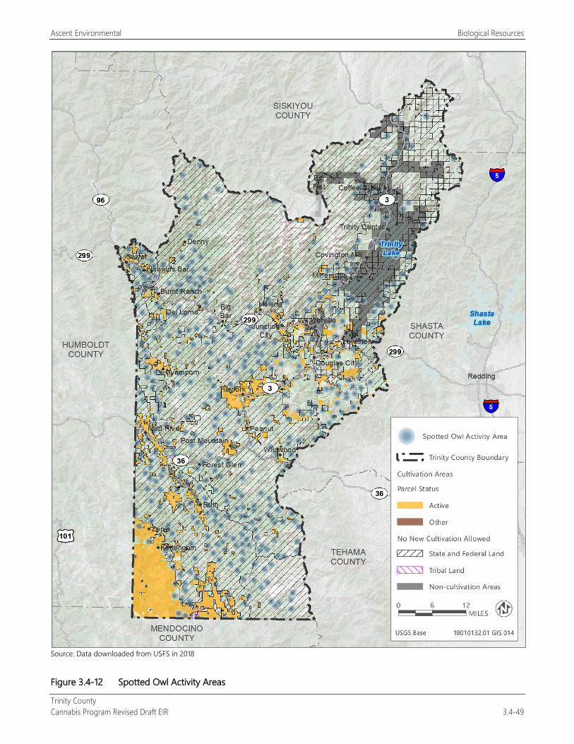
Ascent Environmental Biological Resources
Trinity County Cannabis Program Revised Draft EIR 3.4-49
Source: Data downloaded from USFS in 2018
Figure 3.4-12 Spotted Owl Activity Areas
Biological Resources Ascent Environmental
Trinity County 3.4-50 Cannabis Program Revised Draft EIR
Project implementation could result in potential impacts to habitat and vegetation removal, which could disturb nesting northern spotted owls if they are present, potentially resulting in nest abandonment, nest failure, or mortality of chicks or eggs. Additionally, human presence associated with construction of commercial cannabis operations, roads, and cultivation activities could result in increased noise and visual disturbance to nesting raptors. In addition to direct impacts to the species, new cannabis-related development under the Cannabis Program result in the loss or fragmentation of northern spotted owl habitat. The potential loss of northern spotted owls, their nests, and their habitat would be a potentially significant impact.
Mitigation Measures
Mitigation Measure 3.4-2d: Conduct Northern Spotted Owl Preconstruction Habitat Suitability Surveys and Determine Presence or Absence of the Species The following shall be included as new performance standards for Section 315-843(6) (Performance Standards for Commercial Cultivation of Cannabis), Section 315-824(5) (Required Conditions), Section 315-826(3) (Regulation of Nurseries), Section 315-828(5) (Required Conditions), Section 315-835(2) (Regulations), Section 315-837(3) (Required Conditions), and Section 315-842(6) (Required Conditions). Compliance documentation will be provided to the County as part of the application materials and may be combined with required compliance with SWRCB Order WQ 2019-0001-DWQ Order WQ 2017-0023-DWQ for the protection of northern spotted owl from new development related to cannabis activities:
To avoid the potential for loss of northern spotted owl and their nests, or loss or fragmentation of occupied or suitable habitat for northern spotted owl, removal of old-growth habitat shall be prohibited, as outlined in Mitigation Measure 3.4-4a.
If the area of proposed new development activities (e.g., any application for commercial cannabis operations or renewal of an existing licensed cultivation site that is planning to expand its Designated Area) is within suitable habitat for northern spotted owl (e.g., coniferous forest), and is within 1.3 miles (average species home range) of a known occurrence of northern spotted owl, as determined by a qualified biologist familiar with the species and protocol, and approved by the County, the following measures shall be followed:
Prior to removal of any trees, or ground-disturbing activities adjacent or within suitable nesting, roosting, or foraging habitat (e.g., forest clearings) for spotted owl, a qualified biologist approved by the County and familiar with the life history of the northern spotted owl shall conduct preconstruction surveys for nests within a 1.3-mile buffer around the site as described in Protocol for Surveying Proposed Management Activities That May Impact Northern Spotted Owls (USFWS 2012). Surveys shall take place between March 1 and August 31. Three complete surveys spaced at least 7 days apart must be completed by June 30. Six complete surveys over the course of 2 years must be completed to determine presence or absence of northern spotted owl.
If northern spotted owls are determined to be absent 1.3 miles from the site, then further mitigation is not required.
If northern spotted owls are determined to be present within 1.3 miles of the site, then it is presumed that habitat removal could cause harm to northern spotted owl populations in the area and could result in direct take of northern spotted owls. If northern spotted owls are determined to be present within 1.3 miles of the site, proposed cultivation activities, including expansion of an existing Designated Area, will not be permitted.
Significance after Mitigation Implementation of Mitigation Measure 3.4-1a would apply to this impact and would determine if there is potential for the species to be present. Mitigation Measure 3.4-2d would reduce significant impacts to a less-than-significant level because direct take of northern spotted owls and disturbance or fragmentation of northern spotted owl habitat would be avoided through preconstruction surveys and, if found, through prohibition of proposed cultivation activities consistent with the State Water Board Policy.
Ascent Environmental Biological Resources
Trinity County Cannabis Program Revised Draft EIR 3.4-51
Other Special-Status Bird Species Several additional special-status bird species could occur in the county, including little willow flycatcher, olive-sided flycatcher, western yellow-billed cuckoo, yellow warbler, and yellow-breasted chat. Western yellow-billed cuckoo is listed as threatened under the ESA and endangered under CESA. Little willow flycatcher is listed as endangered under CESA. Olive-sided flycatcher, yellow warbler, and yellow-breasted chat are all CDFW species of special concern.
Suitable habitat for these species, including riparian habitat, is present throughout the county (Figures 3.4-1, 3.4-2, and 3.4-3). Additionally, native migratory bird nests are protected by California Fish and Game Code, and many of these more common species could nest in many different habitats in Trinity County. Removal of vegetation, especially riparian vegetation, as well of conversion of natural habitats could disturb nesting birds if they are present, potentially resulting in nest abandonment, nest failure, or mortality of chicks or eggs. Additionally, human presence associated with construction of cultivation sites, roads, and cultivation activities could result in increased noise and visual disturbance to nesting birds. This would be a potentially significant impact.
Mitigation Measures
Mitigation Measure 3.4-2e: Conduct Preconstruction Special-Status Nesting Bird Surveys and Establish Protective Buffers The following shall be included as new performance standards for Section 315-843(6) (Performance Standards for Commercial Cultivation of Cannabis), Section 315-824(5) (Required Conditions), Section 315-826(3) (Regulation of Nurseries), Section 315-828(5) (Required Conditions), Section 315-835(2) (Regulations), Section 315-837(3) (Required Conditions), and Section 315-842(6) (Required Conditions). Compliance documentation will be provided to the County as part of the application materials and may be combined with required compliance with SWRCB Order WQ 2019-0001-DWQ Order WQ 2017-0023-DWQ for the protection of little willow flycatcher, olive-sided flycatcher, yellow warbler, yellow-breasted chat, or other bird nests from new development related to cannabis activities:
To minimize the potential for disturbance to or loss of little willow flycatcher, olive-sided flycatcher, western yellow-billed cuckoo, yellow warbler, yellow-breasted chat, or other bird nests, vegetation removal activities shall occur only during the nonbreeding season (September 1-January 31).
If little willow flycatcher is detected during the initial biological reconnaissance survey (see Mitigation Measure 3.4-1a) or is determined to be likely to occur based on the presence of suitable habitat, a protocol-level survey shall be conducted by a qualified biologist familiar with the species and the protocol prior to removal of any vegetation or any ground disturbance. The protocol-level survey shall utilize methods outlined in A Willow Flycatcher Survey Protocol for California (Bombay et al. 2003).
If little willow flycatcher is determined to be present during the protocol-level survey, no development activity shall occur during the breeding season (May 1 through August 31) in and within 300 feet of the little willow flycatcher habitat. Development activities within or adjacent to identified little willow flycatcher habitat shall not damage or destroy willows or other riparian shrubs unless agreed upon through consultation with CDFW.
If olive-sided flycatcher, yellow warbler, yellow-breasted chat, or other bird nests are detected during the initial biological reconnaissance survey (see Mitigation Measure 3.4-1a) or are determined to be likely to occur based on the presence of suitable habitat, Pprior to removal of any vegetation or any ground disturbance between February 1 and August 31, a qualified biologist approved by the County shall conduct preconstruction surveys for nests on any structure or vegetation planned for removal. The surveys shall be conducted no more than 7 days before construction commences. If no active nests are found during focused surveys, no further action under this measure will be required. If active nests are located during the preconstruction surveys, the biologist shall notify the Planning Director and CDFW. If deemed necessary by the Planning Director in consultation with CDFW, modifications to the project design to avoid removal of occupied habitat while still achieving project objectives may be required. If the County determines in consultation with CDFW that avoidance is not feasible or conflicts with project objectives, construction shall be prohibited within a minimum of 100 feet of the nest to avoid disturbance until the nest is no longer active.
Biological Resources Ascent Environmental
Trinity County 3.4-52 Cannabis Program Revised Draft EIR
Significance after Mitigation Implementation of Mitigation Measure 3.4-1a would apply to this impact and would determine if there is potential for the species to be present. Mitigation Measure 3.4-2e would reduce significant impacts to a less-than-significant level because little willow flycatcher, olive-sided flycatcher, western yellow-billed cuckoo, yellow warbler, yellow-breasted chat, and other bird nests would be avoided and protected from new development related to cannabis activities.
Trinity Bristle Snail Trinity bristle snail (Monadenia infumata setosa) is listed as threatened under CESA. There are many known occurrences of Trinity bristle snail within Shasta-Trinity National Forest associated with various tributaries to the Trinity River (CNDDB 2018). This species is thought to be associated primarily with the Trinity River watershed and occurs within riparian woodland and Klamath mixed conifer habitats; however, the range of this species is not well understood. This species is confined primarily to habitats where with shade, fairly low temperature, and fairly high humidity. The snails primarily live on the ground within leaf litter and are also known to climb trees and other plants.
New cannabis-related development under the Cannabis Program could result in the loss of or injury to Trinity bristle snail, if the species occurs at the site, through disturbance to suitable habitat during ground disturbance activities (e.g., construction of storage ponds, installation of cultivation sites) and vegetation or leaf-litter removal. Cannabis operations are required to comply with Attachment A (General Requirements and Prohibitions) of SWRCB Order WQ 20179-002301-DWQ, which requires setback areas of at least 50 feet from surface water and prohibits cultivation sites on slopes greater than 30 percent to prevent erosion and degradation of water quality. This order would help prevent direct effects to Trinity bristle snail within riparian and aquatic habitat because disturbance to river or stream banks and introduction of silt discharge would be avoided. However, the order would not prevent disturbance to the species within terrestrial habitat. Disturbance or loss of Trinity bristle snail or occupied habitat would be a potentially significant impact.
Mitigation Measures
Mitigation Measure 3.4-2f: Conduct Preconstruction Surveys for Trinity Bristle Snail The following shall be included as new performance standards for Section 315-843(6) (Performance Standards for Commercial Cultivation of Cannabis), Section 315-824(5) (Required Conditions), Section 315-826(3) (Regulation of Nurseries), Section 315-828(5) (Required Conditions), Section 315-835(2) (Regulations), Section 315-837(3) (Required Conditions), and Section 315-842(6) (Required Conditions). Compliance documentation will be provided to the County as part of the application materials and may be combined with required compliance with SWRCB Order WQ 20179-002301-DWQ for the protection of the Trinity bristle snail from new development related to cannabis activities:
If Trinity bristle snail is detected during the initial biological reconnaissance survey (see Mitigation Measure 3.4-1a) or are determined to be likely to occur due to the presence of suitable habitat, consultation with CDFW shall be initiated to determine whether mitigation measures, such as project design modifications, or relocation of the site, or relocation of individual animals, will be necessary and appropriate.
Regardless of detection during the initial biological reconnaissance survey, if suitable habitat for Trinity bristle snail is present within the proposed development area, a qualified biologist approved by the County and familiar with the species shall conduct preconstruction surveys of proposed new development activities within the period when the species is the most active (between May and October and between dusk and dawn) prior to new development activities. Preconstruction surveys shall be conducted using a widely used and accepted standardized protocol that controls for seasonality and environmental conditions, such as the Survey Protocol for Survey and Manage Terrestrial Mollusk Species from the Northwest Forest Plan (BLM 2003). Surveys shall be conducted throughout the proposed construction area and an appropriate buffer around the proposed development area as determined by the qualified biologist familiar with the species and survey protocols. Surveys shall consist of “walk and turn” surveys of areas beneath surface objects (e.g., rocks, leaf litter, moss mats, coarse woody debris).
If Trinity bristle snail or its habitat is not detected during the preconstruction survey, then further mitigation is not required.

Ascent Environmental Biological Resources
Trinity County Cannabis Program Revised Draft EIR 3.4-53
If Trinity bristle snail is detected during the preconstruction survey, then consultation with CDFW shall be initiated as described above. Injury or mortality of this species will be avoided by through project design modification or cultivation site relocation. modifying project design, relocating the cultivation site, or relocating individual animals.
If impacts to Trinity bristle snail are unavoidable, then the applicant will submit an ITP application to CDFW and receive authorization prior to commencing development of the cultivation site. Conditions of incidental take authorization may include minimization measures to reduce impacts to individual Trinity bristle snails, or compensation for loss of the species including but not limited to purchasing credits from a CDFW-approved mitigation bank.
Significance after Mitigation Implementation of Mitigation Measure 3.4-1a would apply to this impact and would determine if there is potential for the species to be present. Mitigation Measure 3.4-2f would reduce significant impacts to a less-than-significant level by requiring preconstruction surveys and the protection of Trinity bristle snail injury, mortality, or other disturbance; or application for an ITP from CDFW.
Special-Status Bumble Bees Franklin’s bumble bee (Bombus franklini), western bumble bee (Bombus occidentalis), crotch bumble bee (Bombus crotchii), and Suckley’s cuckoo bumble bee (Bombus suckleyi) are candidates for listing under CESA. Populations of these species have undergone significant declines (The Xerces Society 2018). While known occurrences within Trinity County exist only for western bumble bee and Franklin’s bumble bee, Trinity County is within the historic range of all four species (CNDDB 2019). Bumble bees have three basic habitat requirements: suitable nesting sites for the colonies, availability of nectar and pollen from floral resources throughout the duration of the colony period (spring, summer, and fall), and suitable overwintering sites for the queens. Additionally, although bumble bees can forage and disperse over long distances, isolated patches of habitat do not provide high-quality habitat for this species (The Xerces Society 2018). Viable bumble bee populations typically require approximately 750-2,500 acres of suitable habitat (The Xerces Society 2018). Potentially suitable nesting habitat for these species exists within Trinity County, specifically within contiguous grasslands and meadows with floral resources.
Cannabis-related development activities under the Cannabis Program could include vegetation removal and habitat conversion, which could result in the loss of special-status bumble bee habitat or direct loss of or injury to special-status bumble bees. This would be a potentially significant impact.
Mitigation Measures
Mitigation Measure 3.4-2g: Implement Measures to Avoid Take of Special-Status Bumble Bees or Obtain Incidental Take Coverage The following shall be included as new performance standards for Section 315-843(6) (Performance Standards for Commercial Cultivation of Cannabis), Section 315-824(5) (Required Conditions), Section 315-826(3) (Regulation of Nurseries), Section 315-828(5) (Required Conditions), Section 315-835(2) (Regulations), Section 315-837(3) (Required Conditions), and Section 315-842(6) (Required Conditions). Compliance documentation will be provided to the County as part of the application materials and may be combined with required compliance with SWRCB Order WQ 2019-0001-DWQ for the protection of special-status bumble bees from new development related to cannabis activities:
If special-status bumble bees are detected during the initial biological reconnaissance survey (see Mitigation Measure 3.4-1a) or are determined to be likely to occur due to the presence of suitable habitat, consultation with CDFW shall be initiated to determine whether mitigation measures, such as protocol-level surveys, project design modifications, or relocation of the site, will be necessary and appropriate.
If impacts to special-status bumble bees are determined to be unavoidable, then the applicant will submit an ITP application to CDFW and receive authorization prior to commencing development of the cultivation site. Conditions of incidental take authorization may include minimization measures to reduce impacts to individual bumble bees, or

Biological Resources Ascent Environmental
Trinity County 3.4-54 Cannabis Program Revised Draft EIR
compensation for loss of the species including but not limited to purchasing credits from a CDFW-approved mitigation bank.
Significance after Mitigation Implementation of Mitigation Measure 3.4-1a would apply to this impact and would determine if there is potential for the species to be present. Mitigation Measure 3.4-2g would reduce impacts on special-status bumble bees to a less-than-significant level by requiring protection of special-status bumble bees from injury, mortality, or other disturbance; or application for an ITP from CDFW.
American Badger American badger, which is a CDFW species of special concern, prefers open habitats with friable soils. Potentially suitable habitat for this species occurs throughout Trinity County. Future cannabis-related activities under the Cannabis Program could result in conversion of suitable habitat, vegetation removal, and ground-disturbance activities, which could cause the direct loss of badgers if currently occupying burrows within the site. Loss of American badger as a result of these activities would be a potentially significant impact.
Mitigation Measures
Mitigation Measure 3.4-2gh: Conduct Preconstruction American Badger Survey and Establish Protective Buffers The following shall be included as new performance standards for Section 315-843(6) (Performance Standards for Commercial Cultivation of Cannabis), Section 315-824(5) (Required Conditions), Section 315-826(3) (Regulation of Nurseries), Section 315-828(5) (Required Conditions), Section 315-835(2) (Regulations), Section 315-837(3) (Required Conditions), and Section 315-842(6) (Required Conditions). Compliance documentation will be provided to the County as part of the application materials and may be combined with required compliance with SWRCB Order WQ 2017-0023-DWQ Order WQ 2019-0001-DWQ for the protection of the American badger from new development related to cannabis activities:
Prior to the commencement of construction activities, a qualified wildlife biologist approved by the County shall conduct surveys of the suitable grassland or agricultural habitats slated for conversion within the site to identify any American badger burrows/dens. These surveys shall be conducted not more than 30 7 days prior to the start of construction. If occupied burrows are not found, further mitigation shall not be required. If occupied burrows are found, impacts to active badger dens shall be avoided by establishing exclusion zones around all active badger dens, within which construction related activities shall be prohibited until denning activities are complete or the den is abandoned. The qualified biologist shall monitor each den once per week to track the status of the den and to determine when it is no longer occupied.
Significance after Mitigation Implementation of Mitigation Measure 3.4-1a would apply to this impact and would determine if there is potential for the species to be present. Mitigation Measure 3.4-2gh would reduce impacts on American badger to a less-than-significant level because preconstruction surveys would be conducted and active badger dens would be protected from construction activities.
Fisher and Humboldt Marten Fisher is a CDFW species of special concern and is a candidate for listing under ESA. Humboldt marten is also a CDFW species of special concern, is a candidate for listing under CESA, and is proposed for listing under ESA. Fisher and Humboldt marten are both medium-sized carnivores within the weasel family. Suitable habitat for these species includes old-growth or mature coniferous forests, with high-percent canopy cover, and sufficient coarse woody debris on the forest floor. Dens for both species can include cavities within live trees or snags, rock piles, or woody debris piles. Fishers typically choose the largest feature within an area for denning. Most suitable habitat for these species in Trinity County is on public land managed by U.S. Forest Service where new commercial cannabis operations would be prohibited under the County Cannabis Program.
Ascent Environmental Biological Resources
Trinity County Cannabis Program Revised Draft EIR 3.4-55
Fishers, martens, and other carnivores (e.g., black bear, mountain lion) in Trinity County and surrounding counties have experienced highly publicized mortality because of exposure to rodenticides and insecticides used on illegal cannabis “trespass grow” sites (Gabriel et al. 2012). Second-generation anticoagulant rodenticides (i.e., those containing ingredients such as brodifacoum, bromadiolone, difethialone, and difenacoum) are used inappropriately and illegally within these “trespass grow” sites and carnivores can be exposed either directly (e.g., through poisoned bait), or indirectly after eating rodents that have been targeted by the poisons. Use of these rodenticides, which are restricted in California, requires licensing through the California Department of Pesticide Regulation (CDPR). The Cannabis Program requires adherence to California state law and to CDPR regulations that specifies proper application and storage of pesticides, rodenticides, and insecticides to protect human health and the environment. Specifically, the Cannabis Program includes the following requirements:
Any fuel, fertilizer, pesticide, fungicide, rodenticide, herbicide, or other substance toxic to wildlife, children, or pets shall be stored in a secured and locked structure or device. All use of pesticide products shall be in compliance with state pesticide laws and regulations enforced by the County Agricultural Commissioner’s Office, Trinity County Environmental Health, and CDPR (Section 315-843[6][g]).
Rodenticides that require a California Restricted Materials permit cannot be used. Those that are designated as federally Restricted Use Products can be used by only a certified applicator (Section 315-843[6][i]).
The following rodent repellents may be used in and around cannabis cultivation sites consistent with the label: Capsicum oleoresin, Putrescent Whole Egg Solids and Garlic (Section 315-843[6][j]).
In addition, state testing requirements for cannabis goods to be accepted limit the extent that pesticides can be used. The reader is referred to Chapter 2, “Project Description,” for a further description of state testing requirements.
Proper licensed use of these pest control substances would preclude impacts to fishers, martens, and other carnivores and the impact would be less than significant. Mitigation is not required.
Cannabis-related activities under the County Cannabis Program could result in loss of suitable habitat for fisher and Humboldt marten because of tree or other vegetation removal. Vegetation removal could also result in disturbance or direct loss to individuals or active dens. This would be a potentially significant impact.
Mitigation Measures
Mitigation Measure 3.4-2hi: Conduct Preconstruction Fisher and Humboldt Marten Survey and Preserve Active Den Sites The following shall be included as new performance standards for Section 315-843(6) (Performance Standards for Commercial Cultivation of Cannabis), Section 315-824(5) (Required Conditions), Section 315-826(3) (Regulation of Nurseries), Section 315-828(5) (Required Conditions), Section 315-835(2) (Regulations), Section 315-837(3) (Required Conditions), and Section 315-842(6) (Required Conditions). Compliance documentation will be provided to the County as part of the application materials and may be combined with required compliance with SWRCB Order WQ 2017-0023-DWQ Order WQ 2019-0001-DWQ for the protection of the fisher and Humboldt marten from new development related to cannabis activities:
To minimize the potential for loss of or disturbance to fisher and Humboldt marten habitat and dens, removal of old-growth habitat shall be prohibited, as outlined in Mitigation Measure 3.4-4a.
Prior to commencement of new development related to cannabis activities occurring within the fisher and Humboldt marten denning season (March 1 to July 31), including tree removal (non-old growth), a qualified wildlife biologist approved by the County will conduct preconstruction surveys of all suitable habitat within the site, and will identify sightings of individual fishers or martens, as well as potential dens.
If individuals or potential or occupied dens are not found, further mitigation will not be required.
If fisher or Humboldt marten are identified or if potential dens of these species are located, an appropriate method shall be used by the qualified wildlife biologist to confirm whether a fisher or marten is occupying the den. This may
Biological Resources Ascent Environmental
Trinity County 3.4-56 Cannabis Program Revised Draft EIR
involve use of remote field cameras, track plates, or hair snares. Other devices such as fiber optic scope may be utilized to determine occupancy. If no fisher or marten occupies the potential den, the entrance will be temporarily blocked so that no other animals occupy the area during ground disturbance, vegetation removal, or installation of cultivation sites, but only after it has been fully inspected. The blockage will be removed once these activities have been completed.
If a den is found to be occupied by a fisher or marten, a no-disturbance buffer will be placed around the occupied den location. The no-disturbance buffer will include the den tree (or other structure) plus a suitable buffer as determined by the biologist in coordination with CDFW. Construction activities in the no-disturbance buffer will be avoided until the nest is unoccupied as determined by a qualified wildlife biologist in coordination with CDFW.
Significance after Mitigation Implementation of Mitigation Measure 3.4-1a would apply to this impact and would determine if there is potential for the species to be present. Mitigation Measure 3.4-2hi would reduce impacts on fisher and Humboldt marten to a less-than-significant level because preconstruction surveys would be conducted and active dens would be protected from construction activities (e.g., vegetation removal, ground disturbance, installation of cultivation sites).
Ringtail Ringtail is fully protected under the California Fish and Game Code. Ringtail is a medium-sized carnivore and is one of two species within the procyonid family in North America (the other is racoon). Suitable habitat for this species includes riparian habitat, forest habitat, and shrub habitat in lower to middle elevations. Ringtail is usually found within close proximity (less than approximately 0.6 mile) of a permanent water source. Suitable nest habitat includes rock recesses, hollow trees, logs, snags, abandoned burrows, or woodrat nests. Cannabis-related activities under the Cannabis Program could result in conversion of suitable habitat, vegetation removal, and ground-disturbance activities, which could cause the direct loss of ringtail if present. Loss of ringtail because of project construction activities would be a potentially significant impact.
Mitigation Measures
Mitigation Measure 3.4-2ij: Conduct Preconstruction Surveys for Ringtail and Implement Avoidance Measures The following shall be included as new performance standards for Section 315-843(6) (Performance Standards for Commercial Cultivation of Cannabis), Section 315-824(5) (Required Conditions), Section 315-826(3) (Regulation of Nurseries), Section 315-828(5) (Required Conditions), Section 315-835(2) (Regulations), Section 315-837(3) (Required Conditions), and Section 315-842(6) (Required Conditions). Compliance documentation will be provided to the County as part of the application materials and may be combined with required compliance with SWRCB Order WQ 2017-0023-DWQ Order WQ 2019-0001-DWQ for the protection of the ringtail from new development related to cannabis activities:
Prior to commencement of new development related to cannabis activities occurring within the ringtail nesting season (not well defined but likely approximately March 1 to July 31), including tree or shrub removal, a qualified wildlife biologist approved by the County will conduct preconstruction surveys of all suitable habitat within the site, and will identify sightings of individual ringtails, as well as potential nests.
If individuals or potential or occupied nests are not found, further mitigation will not be required.
If ringtail are identified or if potential nests of this species are located, an appropriate method shall be used by the qualified wildlife biologist to confirm whether a ringtail is occupying the den. This may involve use of remote field cameras, track plates, or hair snares. Other devices such as a fiber optic scope may be utilized to determine occupancy. If no ringtail occupies the potential nest, the entrance will be temporarily blocked so that no other animals occupy the area during ground disturbance, vegetation removal, or installation of cultivation sites, but only after it has been fully inspected. The blockage will be removed once these activities have been completed.
If a nest is found to be occupied by a ringtail, a no-disturbance buffer will be placed around the occupied den location. The no-disturbance buffer will include the nest tree (or other structure) plus a suitable buffer as
Ascent Environmental Biological Resources
Trinity County Cannabis Program Revised Draft EIR 3.4-57
determined by the biologist in coordination with CDFW. Construction activities in the no-disturbance buffer will be avoided until the nest is unoccupied as determined by a qualified wildlife biologist in coordination with CDFW.
Significance after Mitigation Implementation of Mitigation Measure 3.4-1a would apply to this impact and would determine if there is potential for the species to be present. Mitigation Measure 3.4-2ij would reduce significant impacts to a less-than-significant level because preconstruction surveys would be conducted and ringtail and occupied reproductive sites would be avoided and protected from new development related to cannabis activities.
Oregon Snowshoe Hare Oregon snowshoe hare is a CDFW species of special concern. This species is known to occur in the Trinity Mountains (CNDDB 2018). This species occurs in montane riparian habitat, in alder and willow thickets and thickets of young conifers. Cannabis-related activities under the Cannabis Program could result in conversion of suitable habitat, vegetation removal, and ground-disturbance activities, which could cause the direct loss of Oregon snowshoe hare if present. Loss of Oregon snowshoe hare because of project construction activities would be a potentially significant impact.
Mitigation Measures
Mitigation Measure 3.4-2jk: Conduct Preconstruction Surveys for Oregon Snowshoe Hare and Implement Avoidance Measures The following shall be included as new performance standards for Section 315-843(6) (Performance Standards for Commercial Cultivation of Cannabis), Section 315-824(5) (Required Conditions), Section 315-826(3) (Regulation of Nurseries), Section 315-828(5) (Required Conditions), Section 315-835(2) (Regulations), Section 315-837(3) (Required Conditions), and Section 315-842(6) (Required Conditions). Compliance documentation will be provided to the County as part of the application materials and may be combined with required compliance with SWRCB Order WQ 2017-0023-DWQ Order WQ 2019-0001-DWQ for the protection of Oregon snowshoe hare from new development related to cannabis activities:
If it is determined during the initial biological reconnaissance survey (see Mitigation Measure 3.4-1a) that suitable habitat for Oregon snowshoe hare is present within a proposed cultivation area, then preconstruction surveys will be required. Prior to removal of any vegetation or any ground disturbance within suitable Oregon snowshoe hare habitat, a qualified biologist approved by the County shall conduct preconstruction surveys of all suitable habitat within the site.
If Oregon snowshoe hares or occupied reproductive sites are not found, further mitigation will not be required.
If Oregon snowshoe hares or potential or occupied reproductive sites are observed, a no-disturbance buffer will be placed around the occupied nest. The no-disturbance buffer will include the nest plus a suitable buffer as determined by the biologist in coordination with CDFW. Construction activities in the no-disturbance buffer will be avoided until the reproductive site is unoccupied as determined by the qualified biologist in coordination with CDFW.
Significance after Mitigation Implementation of Mitigation Measure 3.4-1a would apply to this impact and would determine if there is potential for the species to be present. Mitigation Measure 3.4-2jk would reduce significant impacts to a less-than-significant level because preconstruction surveys would be conducted and Oregon snowshoe hare and occupied reproductive sites would be avoided and protected from new development related to cannabis activities.
Special-Status Bats Two special-status bat species, pallid bat (Antrozous pallidus) and Townsend’s big-eared bat (Corynorhinus townsendii), could occur within the county. Both species are CDFW species of special concern. These species use a variety of habitats to roost, including caves, crevices, mines, hollow trees, and buildings. Potentially suitable roosting
Biological Resources Ascent Environmental
Trinity County 3.4-58 Cannabis Program Revised Draft EIR
habitat could be present within future cannabis operation sites. Tree and building removal could result in the direct loss of pallid bat and Townsend’s big-eared bat roosts and individuals. This would be a potentially significant impact.
Mitigation Measures
Mitigation Measure 3.4-2kl: Preconstruction Bat Survey and Exclusion The following shall be included as new performance standards for Section 315-843(6) (Performance Standards for Commercial Cultivation of Cannabis), Section 315-824(5) (Required Conditions), Section 315-826(3) (Regulation of Nurseries), Section 315-828(5) (Required Conditions), Section 315-835(2) (Regulations), Section 315-837(3) (Required Conditions), and Section 315-842(6) (Required Conditions). Compliance documentation will be provided to the County as part of the application materials and may be combined with required compliance with SWRCB Order WQ 2017-0023-DWQ Order WQ 2019-0001-DWQ for the protection of the pallid bat and Townsend’s big-eared bat from new development related to cannabis activities:
Before commencing any development related to cannabis activities, a qualified biologist approved by the County shall conduct surveys for roosting bats. If evidence of bat use is observed, the species and number of bats using the roost shall be determined. Bat detectors may be used to supplement survey efforts. If no evidence of bat roosts is found, then no further study will be required.
If pallid bats or Townsend’s big-eared bats are found in the surveys, a mitigation program addressing mitigation for the specific occurrence shall be submitted to the Planning Director and CDFW by the qualified biologist subject to the review and approval of the Planning Director in consultation with CDFW. Implementation of the mitigation plan shall be a condition of project approval. The mitigation plan shall establish a buffer area around the nest during hibernation or while females in maternity colonies are nursing young that is large enough to prevent disturbance to the colonies.
Significance after Mitigation Implementation of Mitigation Measure 3.4-1a would apply to this impact and would determine if there is potential for the species to be present. Mitigation Measure 3.4-2kl would reduce impacts on special-status bats to a less-than-significant level because preconstruction surveys would be conducted and active special-status bat roosts would be protected from new development related to cannabis activities.
Sonoma Tree Vole Sonoma tree vole (Arborimus pomo) is a CDFW species of special concern and is known to occur within the southwestern portion of Trinity County (CNDDB 2018). This species occurs in coniferous forest, riparian forest, and montane-hardwood conifer forest, usually in areas near streams with dense shrubs. Sonoma tree vole nests in trees using Douglas fir needles. Large portions of suitable habitat for this species occur within public lands managed by U.S. Forest Service where new commercial cannabis operations would be prohibited under the County Cannabis Program.
Cannabis-related development activities under the County Cannabis Program could include removal of trees and other vegetation, which could result in the loss of Sonoma tree vole habitat, or direct loss of or injury to voles. This would be a potentially significant impact.
Mitigation Measures
Mitigation Measure 3.4-2lm: Preconstruction Vole Survey and Relocation The following shall be included as new performance standards for Section 315-843(6) (Performance Standards for Commercial Cultivation of Cannabis), Section 315-824(5) (Required Conditions), Section 315-826(3) (Regulation of Nurseries), Section 315-828(5) (Required Conditions), Section 315-835(2) (Regulations), Section 315-837(3) (Required Conditions), and Section 315-842(6) (Required Conditions). Compliance documentation will be provided to the County as part of the application materials and may be combined with required compliance with SWRCB Order WQ 20179-002301-DWQ for the protection of the Sonoma tree vole from new development related to cannabis activities:

Ascent Environmental Biological Resources
Trinity County Cannabis Program Revised Draft EIR 3.4-59
To minimize the potential for loss of or disturbance to vole habitat and nests, removal of old-growth habitat shall be prohibited, as outlined in Mitigation Measure 3.4-4a.
Before commencing any tree or other vegetation removal activities, or ground-disturbance, a qualified biologist approved by the County shall conduct surveys for vole nests (e.g., nest searching within trees on the site, and confirming that nests belong to voles rather than squirrels or birds). If no evidence of vole nests is found, then no further study shall be required. A report summarizing the results of the surveys shall be prepared and submitted to the Planning Director and shall be subject to his review and approval in consultation with CDFW.
If occupied trees or nests are identified within 100 feet of the site, the biologist shall determine whether project development activities will adversely affect the voles, based on factors such as noise level of development activities, or line of sight between the tree and the disturbance source. If it is determined that development activities would not affect the voles, then development can proceed without protective measures.
If the biologist determines that development activities would likely disturb voles, the proposed area of disturbance shall be relocated a minimum of 200 feet from the nest.
Significance after Mitigation Implementation of Mitigation Measure 3.4-1a would apply to this impact and would determine if there is potential for the species to be present. Mitigation Measure 3.4-2lm would reduce impacts on special-status voles to a less-than-significant level because preconstruction surveys would be conducted and active vole nests would be protected from new development related to cannabis activities.
Effects of Nighttime Artificial Light On Special-Status Species Cannabis cultivation operations under the County Cannabis Program would be allowed to utilize artificial lighting systems for indoor and mixed-light cultivation. Artificial light can adversely affect many different wildlife species, especially nocturnal animals, such as bats. Bat behavior is affected by moonlight, so changes in light cycles can lead to changes in bat foraging behavior, emergence, roosting, breeding, and hibernation (Stone et al. 2015). Artificial light can also result in changes in amphibian mating behavior (Baker and Richardson 2006).
The Cannabis Program includes the following requirements that ensure nighttime lighting and glare impacts from cultivation are avoided:
All lighting associated with the operation shall be downcast, shielded and/or screened to keep light from emanating off-site or into the sky (Section 315-843[6][l]).
Those cultivations using artificial lighting from mixed-light cultivations shall shield greenhouses so that little to no light escapes. Light shall not escape at a level that is visible from neighboring properties between sunset and sunrise (Section 315-843[6][m]).
These performance standards are consistent with CCR Sections 8304(c) and 8304(g) regarding state licensing requirements for cultivation and nurseries.
This would avoid adverse levels of artificial light and avoid disturbance to wildlife species such as bats, amphibians, and birds and would reduce the impact to less than significant.
Mitigation Measures No mitigation is required.
Effects of Generator Noise on Special-Status Species While the County Cannabis Program would limit the operation of generators for cannabis cultivation operations, it would not prohibit their operation. Generator sound can range from approximately 52 decibels for the low end of a residential generator, to approximately 84 decibels for the high end of an industrial generator (USFWS 2006). Effects of anthropogenic noise on wildlife species is an issue that is complex and poorly understood. Anthropogenic noise can result in elevated stress levels in wildlife species, including the northern spotted owl (Hayward et al. 2011). Stress in wildlife species can cause reduced overall fitness and reduced reproductive success, which could have far-reaching
Biological Resources Ascent Environmental
Trinity County 3.4-60 Cannabis Program Revised Draft EIR
consequences for special-status or ESA- and CESA-listed species. While there has been concern for listed species like northern spotted owl, other avian species are also likely adversely affected by anthropogenic noise. Disturbance to or loss of spotted owl or other special-status wildlife species because of exposure to excessive project-generated sound could be a potentially significant impact.
Mitigation Measures
Mitigation Measure 3.4-2mn: Implement Generator Noise Reduction Measures Section 315-843(6)(b) will be modified as shown to include standards to protect wildlife (USFWS 2006):
The cultivation of cannabis shall not exceed the noise level standards as set forth in the County General Plan: 55 A-weighted decibels (dBA)from 7:00 a.m. to 7:00 p.m. and 50 dBA from 7:00 p.m. to 7:00 a.m. measured at the property line, except that generators associated with a commercial grow are not to be used between 10:00 p.m. and 7:00 a.m. (Section 315-843[6][b]). The following additional noise performance standards shall apply to generator use:
Project-generated sound must not exceed ambient nesting conditions by 20-25 dBA.
Project-generated sound, when added to existing ambient conditions, must not exceed 90 dBA.
Significance after Mitigation Implementation of Mitigation Measure 3.4-2mn would reduce significant impacts to a less-than-significant level because project-generated sound would not exceed levels known to result in disturbance to northern spotted owl and other special-status wildlife species. Disturbance to these species would be avoided.
Gray Wolf Gray wolf is listed as endangered under both ESA and CESA. Contemporary sightings of gray wolves in California have included a pack within nearby Siskiyou County; however, there have been no gray wolf sightings within Trinity County. Gray wolves have large home ranges and prefer large expanses of wilderness habitat. Most of this type of habitat is present within public lands managed by the U.S. Forest Service, where cultivation activities would not be permitted. If gray wolves become reestablished in Trinity County during the life of the County Cannabis Program, they would likely be associated with this habitat, where adverse effects from cultivation activities would be unlikely. However, due to the rural nature of Trinity County, it is possible that a gray wolf den could be present within or adjacent to a proposed commercial cannabis operation. Future cannabis-related activities under the Cannabis Program could result in conversion of suitable habitat, vegetation removal, and ground-disturbance activities, which could cause the direct loss of gray wolves if currently occupying a den within the site, or loss of suitable habitat. Loss of gray wolf as a result of these activities would be a potentially significant impact.
Mitigation Measures
Mitigation Measure 3.4-2o: Implement Measures to Avoid Take of Gray Wolf The following shall be included as new performance standards for Section 315-843(6) (Performance Standards for Commercial Cultivation of Cannabis), Section 315-824(5) (Required Conditions), Section 315-826(3) (Regulation of Nurseries), Section 315-828(5) (Required Conditions), Section 315-835(2) (Regulations), Section 315-837(3) (Required Conditions), and Section 315-842(6) (Required Conditions). Compliance documentation will be provided to the County as part of the application materials and may be combined with required compliance with SWRCB Order WQ 2019-0001-DWQ for the protection of gray wolf from new development related to cannabis activities:
If gray wolf is detected during the initial biological reconnaissance survey (see Mitigation Measure 3.4-1a) or is determined to be likely to occur due to the presence of suitable habitat and recent species range information, consultation with CDFW shall be initiated to determine whether mitigation measures, such as protocol-level surveys, project design modifications, relocation of the site, limited operating periods, or biological monitoring will be necessary and appropriate.
If impacts to gray wolf cannot be avoided, then proposed cultivation activities will not be permitted.
Ascent Environmental Biological Resources
Trinity County Cannabis Program Revised Draft EIR 3.4-61
Significance after Mitigation Implementation of Mitigation Measure 3.4-1a would apply to this impact and would determine if there is potential for the species to be present. Mitigation Measure 3.4-2o would reduce impacts on gray wolf to a less-than-significant level by requiring protection of gray wolf from injury, mortality, or other disturbance.
Roosevelt Elk Roosevelt elk is not a special-status species but is managed by CDFW in Trinity County. A portion of the Marble Mountains Roosevelt Elk Management Unit, implemented by CDFW, is located in northern Trinity County. Roosevelt elk have a limited range within Trinity County and occur primarily within Shasta-Trinity National Forest in the northern portion of the county. Occurrence data for this species is sparse in the county but Roosevelt elk are far less common than in Humboldt or Siskiyou County. Suitable habitat for this species includes deciduous and conifer forests, riparian areas, and meadows. Future cannabis operations under the County Cannabis Program cannot occur within most of the elk’s range because most of the land within the range is managed by U.S. Forest Service. While it is possible that Roosevelt elk could occur farther south within areas planned for cannabis cultivation, development of that habitat into cannabis operations would not significantly adversely affect the species and would not affect the quality of remaining habitat within its range. Because most of the Roosevelt elk’s range would be outside of land areas subject to the County Cannabis Program, impacts would be less than significant.
Mitigation Measures No mitigation is required.
Impact 3.4-3: Disturbance to or Loss of Special-Status Fisheries
Surface water diversions for commercial cannabis uses that may occur under the County Cannabis Program could adversely affect several special-status fish species. Special-status fish species are protected under ESA, CESA, and other regulations. The alteration of surface water conditions that support special-status fish species would be a potentially significant impact.
Four special-status fish species are known to occur in the county, including chinook salmon (upper Klamath and Trinity Rivers evolutionarily significant unit [ESU]), coho salmon (southern Oregon/northern California ESU), Pacific lamprey, and summer-run steelhead trout. Critical habitat for Chinook salmon and steelhead trout is present within the county (Figure 3.4-7). As shown in Table 3.10-8, cannabis cultivation water demands would make up over 90 percent of the total water demands of the Cannabis Program and could result in surface water flow impacts if surface water diversions are used.
All licensed cannabis cultivation operations are required to comply with the numeric and narrative instream flow requirements for all diversions of surface water and groundwater as part of compliance with Attachment A (Section 3 – Numeric and Narrative Instream Flow Requirements) of SWRCB Order WQ 20179-002301-DWQ. These requirements include design requirements for fish screens, diversion structures, off-stream storage reservoirs, and storage bladders.
Diversion provisions of the standards are based on three types of requirements to ensure sufficient instream flows:
dry season forbearance period and limitations on the wet season diversions,
narrative instream flow requirements, and
numeric instream flow requirements during the wet season
Instream flow requirements during the wet season were established by the SWRCB in consultation with CDFW for the protection of aquatic species life history needs, including endangered anadromous salmonids. Numeric instream flow requirements (minimum instream flows required to protect aquatic species) are established for each region in the state in Attachment A of SWRCB Order WQ 20179-002301-DWQ. Aquatic base flows have also been established to address instream flow impacts from groundwater diversions. The aquatic base flow is the set of chemical, physical, and biological conditions that represent limiting conditions for aquatic life in stream environments.
Biological Resources Ascent Environmental
Trinity County 3.4-62 Cannabis Program Revised Draft EIR
Surface water and groundwater diversions for cannabis cultivation operations are limited in the following manner:
Surface water diversions will be prohibited from April 1 to October 31 each year (forbearance period).
Surface water diversions may occur from November 1 to March 31 each year subject to the following requirements:
Surface water diversions will not occur until the real-time daily average flow is greater than the minimum monthly instream flow requirement at a compliance gage for 7 consecutive days or after December 15 when flows are greater than the numeric flow requirement.
Surface water diversions must bypass a minimum of 50 percent of the streamflow past the point of diversion as estimated based on the cultivator’s visual observation.
The SWRCB will monitor instream flows during the dry season and evaluate whether the number or location of groundwater diversions to determine whether imposition of a groundwater forbearance period or other measures. The SWRCB will notify cannabis cultivators of the possibility of a groundwater forbearance period or that other measures may be imposed to address the low-flow condition.
The SWRCB’s flow standards and diversion requirements were developed to protect fish spawning, migration, and rearing for endangered anadromous salmonids, and flows needed to maintain natural flow variability within each watershed. The diversion requirements would ensure that the individual and cumulative effects of water diversions and discharges associated with cannabis cultivation do not affect instream flows necessary for fish spawning, migration, and rearing for endangered anadromous salmonids, and flows needed to maintain natural flow variability (SWRCB 2017a). The policy was scientifically peer reviewed by four experts. The peer review determined that water quality, instream flow, and diversion requirements of the policy were based on sound scientific knowledge, methods, and data (SWRCB 2017b).
It is acknowledged that SWRCB has identified the following Cannabis Priority Watersheds in Trinity County due to water quality, low flow, and other related issues potentially associated with the operation of approximately 1,740 unlicensed cannabis cultivation sites in these watersheds:
Upper South Fork Trinity River,
Middle South Fork Trinity River,
Lower South Fork Trinity River,
Upper Hayfork Creek, and
Lower Hayfork Creek.
Pursuant to CCR Section 8216, if the SWRCB or CDFW notifies CDFA in writing that cannabis cultivation is causing significant adverse impacts on the environment in a watershed or other geographic area pursuant to Section 26069, Subdivision (c)(1), of the Business and Professions Code, CDFA shall not issue new licenses or increase the total number of plant identifiers within that watershed or area while the moratorium is in effect.
The reader is referred to Section 3.10, “Hydrology and Water Quality,” for a further discussion of potential alteration in surface water flows and water quality from cannabis operations.
Existing Licensed Commercial Cannabis Operations Figure 2-3 shows cultivation sites licensed in the county in 2018. These sites are operating and using water through surface water diversions or groundwater extractions. These sites are subject to the numeric and narrative instream flow requirements noted above and would not create new surface water flow impacts on fisheries. Thus, this impact would be less than significant.
New Licensed Commercial Cannabis Operations New cannabis cultivation operations would also be subject to the SWRCB numeric and narrative instream flow requirements. Ensuring local compliance with SWQRCB Order WQ 2019-0001-DWQ through implementation of
Ascent Environmental Biological Resources
Trinity County Cannabis Program Revised Draft EIR 3.4-63
Mitigation Measure 3.10-1a would ensure surface water impacts are mitigated to a less-than-significant level. However, SWRCB Order WQ 2019-002301-DWQ applies only to sites of 2,000 square feet or larger and water diversion on smaller sites can cause low flows in the county’s waterways. Low flows are associated with increased temperature and worsening water quality, both of which are existing issues in Trinity County. As noted above, there are five four watersheds in the county that are designated as Cannabis Priority Watersheds. Because the location and water demand on sites less than 2,000 square feet is unknown and cannot be regulated, there is potential for further degraded water quality conditions due to increase surface water diversion. This impact would be potentially significant.
Mitigation Measures
Mitigation Measure 3.4-3: Implement Mitigation Measures 3.10-1a and 3.10-3b.
Significance after Mitigation Implementation of Mitigation Measure 3.10-1a would amend the Cannabis Program to require compliance with the requirements of SWRCB Order WQ 20179-002301-DWQ, or any subsequent water quality standards to apply to all new commercial cannabis cultivation operations and not limited by a minimum cultivation area size. Mitigation Measure 3.10-3b would require the County to deny any application for cultivation that is located within a watershed that has a moratorium for state licenses in place pursuant to CCR Section 8216. These mitigation measures would be consistent with the General Plan Conservation Element recommendations. Compliance with the SWRCB numeric and narrative instream flow requirements and implementation of Mitigation Measures 3.10-1a and 3.10-3b would ensure that surface water flows are protected and would reduce this impact to less than significant.
Impact 3.4-4: Disturbance to or Loss of Riparian Habitat, Old-Growth Habitat, or Other Sensitive Natural Communities Potential land use conversion and development that may occur from implementation of the County Cannabis Program could adversely affect riparian habitat, old-growth habitat, and other sensitive natural communities if they are present on the site. Construction-related activities, including ground disturbance, old-growth habitat removal, removal of riparian vegetation, or disturbance of stream and river habitat would be a potentially significant impact.
Riparian habitat within the county can be found adjacent to aquatic habitat such as streams and rivers. A total of four sensitive natural communities are also present, including fish stream habitat (Klamath/North Coast summer steelhead stream, and Klamath/North Coast rainbow trout stream, and southern Oregon/northern California coho salmon stream), and two terrestrial plant communities (Darlingtonia seep and upland Douglas fir forest). See “Sensitive Natural Communities” for detailed descriptions of communities. The reader is referred to Section 3.10, “Hydrology and Water Quality,” for a further discussion of potential alteration in surface water flows and volumes from cannabis operations. Large portions of this habitat occurs on public lands managed by U.S. Forest Service where new commercial cannabis operations would be prohibited under the County Cannabis Program. Riparian habitat areas also occur near the Eel, Mad, and Trinity Rivers, and their tributaries. Steams supporting riparian and wetland vegetation are regulated by CDFW under Sections 1600-1616 of the California Fish and Game Code, which provides for the protection of fish, wildlife, and native plant resources.
Old-growth forest habitat, predominately Douglas fir, occurs throughout the county (Figure 3.4-6). Old-growth and late-successional forests include features such as very large trees, large snags, complex canopy structure (i.e., understory, midstory, overstory), and coarse woody debris (e.g., large logs) on the forest floor; all features that provide unique habitat for many wildlife species. Many special-status wildlife species, including fisher, marten, and Sonoma tree vole use old-growth forest habitat for nesting and movement corridors.
Approximately 168 acres of blue oak and valley oak woodland occurs within the county. Oak woodlands are considered under the state Oak Woodlands Conservation Act, which requires the County to determine whether proposed development would result in conversion of oak woodlands that would have a significant adverse effect on the environment.
Biological Resources Ascent Environmental
Trinity County 3.4-64 Cannabis Program Revised Draft EIR
Existing Licensed Commercial Cannabis Operations Figure 2-3 shows cultivation sites licensed in the county in 2018. Several of these sites have already cleared on-site vegetation and constructed cannabis cultivation facilities. Although these sites are part of the existing conditions, continued operation of these cultivation sites may result in new loss of sensitive natural communities from expansion of operations through the proposed amendment to expand the Designated Area for cultivation activities (land clearing, storage facilities, water storage, extension of electrical facilities, nurseries, and other related uses) from 200 percent of the licensed cannabis canopy area to 250 percent. Thus, this impact associated with existing licensed cannabis cultivation operations would be potentially significant.
New Licensed Commercial Cannabis Operations Cultivation and noncultivation cannabis-related activities may include ground disturbance, vegetation removal, and grading, which could result in the direct loss of sensitive natural communities if they are present. Therefore, project-related loss of special-status plant species would be a potentially significant impact.
Mitigation Measures
Mitigation Measure 3.4-4a: Identify, Avoid, and Protect Sensitive Natural Communities, Riparian Habitat, and Wetland Vegetation or Provide Compensation The following shall be included as new performance standards for Section 315-843(6) (Performance Standards for Commercial Cultivation of Cannabis), Section 315-824(5) (Required Conditions), Section 315-826(3) (Regulation of Nurseries), Section 315-828(5) (Required Conditions), Section 315-835(2) (Regulations), Section 315-837(3) (Required Conditions), and Section 315-842(6) (Required Conditions). Compliance documentation will be provided to the County as part of the application materials and may be combined with required compliance with SWRCB Order WQ 20179-002301-DWQ for the protection of sensitive natural communities and riparian habitat:
For projects that could disturb sensitive natural communities or riparian habitat, the application shall include a report prepared by a qualified biologist approved by the County that surveys the site for these sensitive resources identified from biological reconnaissance survey conducted under Mitigation Measure 3.4-1a, including riparian habitat associated with aquatic features; old-growth Douglas fir forests; oak woodlands; special-status fish stream habitats; and Darlingtonia seep habitat.
The report shall include requirements that before development activities commence, all sensitive areas identified above shall be flagged or fenced with brightly visible construction flagging and/or fencing under the direction of the qualified biologist to require that grading, excavation, other ground-disturbing activities, and vegetation removal will not occur within these areas. Foot traffic by construction personnel shall also be limited in these areas to prevent the introduction of invasive or weedy species. Periodic inspections during construction shall be conducted by the monitoring biologist to maintain the integrity of exclusion fencing/flagging throughout the period of construction involving ground disturbance.
If the report documents that site development would affect the bed, bank, channel, or associated riparian habitat subject to CDFW jurisdiction under California Fish and Game Code Section 1602, a Streambed Alteration Notification shall be submitted to CDFW, pursuant to Section 1600 et seq. of the California Fish and Game Code. If proposed activities are determined to be subject to CDFW jurisdiction, the applicant shall abide by the conditions of any executed agreement prior to any ground disturbance.
Subject to the review and approval of the County in consultation with CDFW, applicants shall compensate for permanent loss of riparian habitat at a minimum of a 2:1 ratio through contributions to a CDFW-approved wetland mitigation bank or through the development and implementation of a Compensatory Stream and Riparian Mitigation and Monitoring Plan for creating or restoring in-kind habitat in the surrounding area. If mitigation credits are not available, stream and riparian habitat compensation shall include establishment of riparian vegetation on currently unvegetated bank portions of streams affected by the project and enhancement of existing riparian habitat through removal of nonnative species, where appropriate, and planting additional native riparian plants to increase cover, continuity, and width of the existing riparian corridor along streams in the site and surrounding
Ascent Environmental Biological Resources
Trinity County Cannabis Program Revised Draft EIR 3.4-65
areas. Construction activities and compensatory mitigation shall be conducted in accordance with the terms of a streambed alteration agreement as required under Section 1602 of the California Fish and Game Code as well as the SWRCB Order WQ 20179-002301-DWQ.
The Compensatory Stream and Riparian Mitigation and Monitoring Plan shall include the following:
identification of compensatory mitigation sites and criteria for selecting these mitigation sites;
in-kind reference habitats for comparison with compensatory riparian habitats (using performance and success criteria) to document success;
monitoring protocol, including schedule and annual report requirements (compensatory habitat will be monitored for a minimum of 5 years from completion of mitigation, or human intervention [including recontouring and grading], or until the success criteria identified in the approved mitigation plan have been met, whichever is longer);
ecological performance standards, based on the best available science and including specifications for native riparian plant densities, species composition, amount of dead woody vegetation gaps and bare ground, and survivorship; at a minimum, compensatory mitigation planting sites must achieve 80 percent survival of planted riparian trees and shrubs by the end of the 5-year maintenance and monitoring period or dead and dying trees will be replaced and monitoring continued until 80 percent survivorship is achieved;
corrective measures if performance standards are not met;
responsible parties for monitoring and preparing reports; and
responsible parties for receiving and reviewing reports and for verifying success or prescribing implementation or corrective actions.
Mitigation Measure 3.4-4b: Restore Abandoned Cultivation and Nursery Sites The following shall be included as new performance standards for Section 315-843(6) (Performance Standards for Commercial Cultivation of Cannabis) and Section 315-826(3) (Regulation of Nurseries)for the protection of sensitive natural communities and riparian habitat:
Upon revocation of a use permit or abandonment of a licensed cultivation or nursery site, the permittee and/or property owner shall remove all materials, equipment, and improvements on the site that were devoted to cannabis use, including but not limited to concrete foundations and slabs; bags, pots, or other containers; tools; fertilizers; pesticides; fuels; hoop house frames and coverings; irrigation pipes; water bladders or tanks; pond liners; electrical lighting fixtures; wiring and related equipment; fencing; cannabis or cannabis waste products; imported soil or soil amendments not incorporated into native soil; generators; pumps; or structures not adaptable to noncannabis permitted use of the site. If any of the above described or related material or equipment is to remain, the permittee and/or property owner shall prepare a plan and description of the noncannabis continued use of such material or equipment on the site. The property owner shall be responsible for execution of the restoration plan that will reestablish the previous natural conditions of the site, subject to monitoring and periodic inspection by the County. Failure to adequately execute the plan shall be subject to the enforcement provisions by the County.
Significance after Mitigation Implementation of Mitigation Measure 3.4-1a would apply to this impact and would determine if there is potential for the sensitive natural communities to be present. Mitigation Measures 3.4-4a and 3.4-4b would reduce significant impacts to sensitive natural communities and riparian habitat to less-than-significant levels because it would require applicants to identify and avoid sensitive resources or provide compensation for the loss of riparian habitat through enhancement of existing populations, creation and management of off-site populations, conservation easements, or other appropriate measures and to restore cultivation and nursery sites upon revocation of a use permit or abandonment. These mitigation measures would be consistent with the General Plan Conservation Element recommendations.
Biological Resources Ascent Environmental
Trinity County 3.4-66 Cannabis Program Revised Draft EIR
Impact 3.4-5: Disturbance to or Loss of Waters of the United States Potential land use conversion and development under the County Cannabis Program could adversely affect waters of the United States, such as streams, rivers, lakes, and wetlands. This would be a potentially significant impact.
The county contains approximately 20,761 acres of aquatic habitat, including major rivers (e.g., Trinity, Mad, Van Duzen, Eel) and their tributaries, and lakes, as well as associated wetland habitat. All commercial cannabis cultivation would be required to meet the requirements of Attachment A (General Requirements and Prohibitions) SWRCB Order WQ 20179-002301-DWQ regarding setbacks and other protection measures for all water features.
Existing Licensed Commercial Cannabis Operations Figure 2-3 shows cultivation sites licensed in the county in 2018. Many of these sites have already cleared on-site vegetation and constructed cannabis cultivation facilities. Although these sites are part of the existing conditions, continued operation of these cultivation sites may result in new loss of waters of the United States from expansion of operations through the proposed amendment to expand the Designated Area for cultivation activities (land clearing, storage facilities, water storage, extension of electrical facilities, nurseries, and other related uses) from 200 percent of the licensed cannabis canopy area to 250 percent. Thus, this impact associated with existing licensed cannabis cultivation operations would be potentially significant.
New Licensed Commercial Cannabis Operations Future development under the County Cannabis Program must comply with the SWRCB Order WQ 20179-002301-DWQ, which prohibits cannabis cultivation within at least 50 feet of all surface water features. This requirement would prevent most disturbance to surface waters such as streams, rivers, lagoons, and lakes. However, future cannabis operations under the County Cannabis Program could result in the conversion of wetland habitat where such habitat occurs on the site. New development related to cannabis activities on the site, including vegetation removal and other ground disturbance, could result in the loss or degradation wetlands or other waters of the United States through fill or other disturbances. This would be a potentially significant impact.
Mitigation Measures
Mitigation Measure 3.4-5: Identify Wetlands and Other Waters of the United States and Avoid These Features The following shall be included as new performance standards for Section 315-843(6) (Performance Standards for Commercial Cultivation of Cannabis), Section 315-824(5) (Required Conditions), Section 315-826(3) (Regulation of Nurseries), Section 315-828(5) (Required Conditions), Section 315-835(2) (Regulations), Section 315-837(3) (Required Conditions), and Section 315-842(6) (Required Conditions). Compliance documentation will be provided to the County as part of the application materials and may be combined with required compliance with SWRCB Order WQ 20179-002301-DWQ for the protection of waters of the United States from new development related to cannabis activities:
The application shall include a report prepared by a qualified biologist approved by the County that surveys the site for sensitive resources, including wetlands, streams, and rivers identified from biological reconnaissance survey conducted under Mitigation Measure 3.4-1a. Wetlands and other waters of the United States are of special concern to resource agencies and are afforded specific consideration, based on Section 404 of the Clean Water Act and other applicable regulations.
If the report documents waters of the United States to be present, a delineation of waters of the United States, including wetlands that would be affected by the project, shall be prepared by a qualified biologist approved by the County through the formal Section 404 wetland delineation process. The delineation shall be submitted to and verified by USACE.
If, based on the verified delineation, it is determined that fill of waters of the United States would result from implementation of the project, authorization for such fill from USACE through the Section 404 permitting process would be required. USACE may not issue a Section 404 permit for activities associated with cannabis cultivation. If a Section 404 permit cannot be obtained, then the applicant shall modify the proposed project to avoid any wetlands or other waters of the United States by providing a buffer of at least 50 feet around these features.
Ascent Environmental Biological Resources
Trinity County Cannabis Program Revised Draft EIR 3.4-67
Significance after Mitigation Implementation of Mitigation Measure 3.4-1a would apply to this impact and would determine if there is potential for wetlands to be present. Mitigation Measure 3.4-5 would reduce impacts to wetlands and other waters of the United States to a less-than-significant level because it would require the proposed projects to avoid any wetlands or waters of the United States.
Impact 3.4-6: Interference with Resident or Migratory Wildlife Corridors or Native Wildlife Nursery Sites
Potential land use conversion and development under the County Cannabis Program could adversely affect resident or migratory wildlife corridors through habitat fragmentation, degradation of aquatic habitat (e.g., streams and rivers), or blockage of important wildlife migration paths. Impacts to movement corridors and habitat connectivity for these species would be potentially significant.
Impacts to wildlife movement would be limited to new commercial cannabis operations as existing licensed cannabis cultivation sites are part of the baseline conditions.
Aquatic Corridors Aquatic wildlife movement corridors within the county include all major rivers and their tributaries. Several anadromous fish species, including steelhead, coho salmon, and Chinook salmon, have runs within Trinity County’s rivers and streams from the spring to the fall. Adverse effects to these aquatic wildlife corridors could include degradation to streams and rivers (e.g., inadvertent fill) or improper surface water diversion, which could create isolated pools and decrease survival of young salmonids.
SWRCB Order WQ 20179-002301-DWQ establishes water resource protection requirements for cannabis cultivation operations (such as the use of best management practices intended to protect aquatic habitat and water quality). These requirements include a setback for cultivation activities of at least 50 feet from any surface water sources. Additionally, the Attachment A (Section 3 – Numeric and Narrative Instream Flow Requirements) of SWRCB Order WQ 20179-002301-DWQ restricts surface water diversions to allow for optimal flows for special-status fish species (see Impact 3.4-3). The reader is referred to Section 3.10, “Hydrology and Water Quality,” for a further discussion of potential alteration in surface water flows and water quality from cannabis operations.
Any future proposed construction of surface water diversion infrastructure or stream crossing could adversely affect resident or migratory wildlife corridors through habitat fragmentation, degradation of aquatic habitat (e.g., streams and rivers), or blockage of important wildlife migration paths. Impacts to movement corridors and habitat connectivity for these species would be potentially significant and would require approval and permits from CDFW and RWQCB.
Mitigation Measures
Mitigation Measure 3.4-6a: Implement Mitigation Measure 3.4-5: Identify Wetlands and Other Waters of the United States and Avoid These Features
Significance after Mitigation Implementation of Mitigation Measure 3.4-6a would reduce impacts to aquatic corridors to a less-than-significant level because it would require approval and permits from CDFW and RWQCB and result in no net loss of functions and acreage of wetlands, including aquatic corridors through avoidance of these features.
Terrestrial Corridors The county contains large areas of migratory winter range for Columbian black-tailed deer, including areas near the Trinity River, the Mad River, Trinity and Lewiston Lakes, and areas near Hayfork and Weaverville (Figure 3.4-9). Additionally, the range for resident mountain lions includes most of the county. Mountain lions occupy a variety of habitats but are most abundant in riparian habitats. Habitat use is typically associated with prey availability. Columbian black-tailed deer make up a large percentage of mountain lion diet. Mountain lion home ranges can be greater than 200 square miles, though home ranges typically range from 5 to 100 square miles (Allen et al. 2015). Existing and
Biological Resources Ascent Environmental
Trinity County 3.4-68 Cannabis Program Revised Draft EIR
proposed cannabis cultivation site locations overlap with migratory deer winter ranges and thus also overlap with mountain lion home ranges. Conditions within the county include existing barriers to movement for these species, including roads and highways (e.g., State Routes 299, 36, 3), fencing, and urban development in unincorporated communities like Weaverville. Future cannabis activities under the County Cannabis Program would likely not significantly alter the habitat quality and connectivity within the range of these species, as most development involves fencing in the immediate vicinity of the cannabis activity, leaving adjacent areas free from barriers. Additionally, SWRCB Order WQ 20179-002301-DWQ prohibits cannabis cultivation within at least 50 feet of any surface water. Deer migration areas, and thus mountain lion occurrences, are largely associated with waterways and riparian areas within the county. By requiring compliance with the SWRCB Cannabis Cultivation Policy through establishment of stream setbacks, development under the County Cannabis Program would have a less-than-significant impact on migratory corridors for Columbian black-tailed deer and mountain lion. No further mitigation is required.
Terrestrial wildlife movement corridors within the county, or essential connectivity areas, include much of the relatively intact natural landscape blocks within Shasta-Trinity and Six Rivers National Forest land (Figure 3.4-9). Forest species such as fisher and Humboldt marten require large contiguous blocks of forest habitat with a high degree of canopy cover, large structural features (e.g., logs, rock piles, snags), and a dense shrub layer (Sauder and Rachlow 2014; Zielinski et al. 2001). Home ranges can be up to 36 square miles for fisher, and up to 3 square miles for Humboldt marten. Future cannabis operations under the County Cannabis Program could result in tree and understory vegetation removal, forest floor clearing, and overall fragmentation of suitable habitat for fisher and Humboldt marten. If the character of previously occupied forest habitat changes, it is likely that these species would no longer use the habitat. Martens will avoid forest habitats without complex understory structure, which can result in decreased foraging success and increased vulnerability to predation (Moriarty et al. 2016). Cannabis cultivation construction activities could exclude fisher or Humboldt marten from previously occupied habitat, thus limiting the full range of the species, or limiting access to nesting dens. Because suitable habitat for these species includes old-growth habitat and large structural features like snags, the habitat, if lost, would not be replaced. This would be a potentially significant impact.
Mitigation Measures
Mitigation Measure 3.4-6b: Retention of Fisher and Humboldt Marten Habitat Features The following shall be included as new performance standards for Section 315-843(6) (Performance Standards for Commercial Cultivation of Cannabis), Section 315-824(5) (Required Conditions), Section 315-826(3) (Regulation of Nurseries), Section 315-828(5) (Required Conditions), Section 315-835(2) (Regulations), Section 315-837(3) (Required Conditions), and Section 315-842(6) (Required Conditions). Compliance documentation will be provided to the County as part of the application materials and may be combined with required compliance with SWRCB Order WQ 20179-002301-DWQ for the protection of the habitat for fisher and Humboldt marten:
To minimize the potential for loss of or disturbance to fisher and Humboldt marten habitat, removal of old-growth habitat shall be prohibited, as outlined in Mitigation Measure 3.4-4a.
Habitat features within non-old-growth habitat, such as large trees, large snags, coarse woody debris, and understory vegetation (e.g., shrubs), shall be retained within the site to the extent feasible, to maintain connectivity of fisher and marten habitat.
Mitigation Measure 3.4-6c: Implement Mitigation Measure 3.1-1b: Maintain Cultivation Parcel
Significance after Mitigation Implementation of Mitigation Measure 3.4-6b would reduce impacts to terrestrial wildlife movement corridors to a less-than-significant level because it would prohibit removal of old-growth habitat and would retain features important for habitat connectivity for the fisher and Humboldt marten. Implementation of Mitigation Measure 3.1-1b would also mitigate wildlife movement impacts by requiring that sites remain clear of trash and debris piles.

Ascent Environmental Archaeological, Historical, and Tribal Cultural Resources
Trinity County Cannabis Program Revised Draft EIR 3.5-1
3.5 ARCHAEOLOGICAL, HISTORICAL, AND TRIBAL CULTURAL RESOURCES
This section analyzes and evaluates the potential impacts of the project on known and unknown cultural resources. Cultural resources include districts, sites, buildings, structures, or objects generally older than 50 years and considered to be important to a culture, subculture, or community for scientific, traditional, religious, or other reasons. They include prehistoric resources, historic-era resources, and “tribal cultural resources” (the latter as defined by AB 52, Statutes of 2014, in PRC Section 21074).
Archaeological resources are locations where human activity has measurably altered the earth or left deposits of prehistoric or historic-era physical remains (e.g., stone tools, bottles, former roads, house foundations). Historical (or architectural) resources include standing buildings (e.g., houses, barns, outbuildings, cabins) and intact structures (e.g., dams, bridges, roads, districts), or landscapes. A cultural landscape is defined as a geographic area (including both cultural and natural resources and the wildlife therein) associated with a historic event, activity, or person or exhibiting other cultural or aesthetic values. Tribal cultural resources were added as a resource subject to review under CEQA, effective January 1, 2015, under AB 52. This category of resources includes site features, places, cultural landscapes, and sacred places or objects that are of cultural value to a tribe.
No comment letters regarding cultural resources were received in response to the NOP (see Appendix A).
3.5.1 Regulatory Setting
FEDERAL
Section 106 of the National Historic Preservation Act Federal protection of resources is legislated by (a) the National Historic Preservation Act (NHPA) of 1966 as amended by 16 U.S. Code 470, (b) the Archaeological Resource Protection Act of 1979, and (c) the Advisory Council on Historic Preservation. These laws and organizations maintain processes for determining the effects on historical properties eligible for listing in the National Register of Historic Places (NRHP).
Section 106 of the NHPA and accompanying regulations (36 CFR Part 800) constitute the main federal regulatory framework guiding cultural resources investigations and require consideration of effects on properties that are listed in, or may be eligible for listing in, the NRHP. The NRHP is the nation’s master inventory of known historic resources. It is administered by the National Park Service and includes listings of buildings, structures, sites, objects, and districts that possess historic, architectural, engineering, archaeological, and cultural districts that are considered significant at the national, state, or local level.
The formal criteria (36 CFR 60.4) for determining NRHP eligibility are as follows:
1. The property is at least 50 years old (however, properties under 50 years of age that are of exceptional importance or are contributors to a district can also be included in the NRHP);
2. It retains integrity of location, design, setting, materials, workmanship, feeling, and associations; and
3. It possesses at least one of the following characteristics:
a. Association with events that have made a significant contribution to the broad patterns of history (events).
b. Association with the lives of persons significant in the past (persons).
c. Distinctive characteristics of a type, period, or method of construction, or represents the work of a master, or possesses high artistic values, or represents a significant, distinguishable entity whose components may lack individual distinction (architecture).
d. Has yielded, or may be likely to yield, information important to prehistory or history (information potential).
Archaeological, Historical, and Tribal Cultural Resources Ascent Environmental
Trinity County 3.5-2 Cannabis Program Revised Draft EIR
Listing in the NRHP does not entail specific protection or assistance for a property, but it does guarantee recognition in planning for federal or federally assisted projects, eligibility for federal tax benefits, and qualification for federal historic preservation assistance. Additionally, project effects on properties listed in the NRHP must be evaluated under CEQA.
STATE
California Environmental Quality Act CEQA requires public agencies to consider the effects of their actions on “historical resources,” “unique archaeological resources,” and “tribal cultural resources.” Pursuant to PRC Section 21084.1, a “project that may cause a substantial adverse change in the significance of an historical resource is a project that may have a significant effect on the environment.” Section 21083.2 requires agencies to determine whether projects would have effects on unique archaeological resources.
Historical Resources “Historical resource” is a term with a defined statutory meaning (PRC Section 21084.1). Guidance related to identifying significant impacts on historical and archaeological resources is presented in the State CEQA Guidelines, Sections 15064.5(a) and (b). Under State CEQA Guidelines Section 15064.5(a), historical resources include the following:
1) A resource listed in, or determined to be eligible by the State Historical Resources Commission for listing in, the California Register of Historical Resources (CRHR) (PRC Section 5024.1).
2) A resource included in a local register of historical resources, as defined in PRC Section 5020.1(k) or identified as significant in a historical resource survey meeting the requirements of PRC Section 5024.1(g) will be presumed to be historically or culturally significant. Public agencies must treat any such resource as significant unless the preponderance of evidence demonstrates that it is not historically or culturally significant.
3) Any object, building, structure, site, area, place, record, or manuscript which a lead agency determines to be historically significant or significant in the architectural, engineering, scientific, economic, agricultural, educational, social, political, military, or cultural annals of California may be considered to be a historical resource, provided the lead agency’s determination is supported by substantial evidence in light of the whole record. Generally, a resource will be considered by the lead agency to be historically significant if the resource meets the criteria for listing in the CRHR (PRC Section 5024.1), including the following:
a) Is associated with events that have made a significant contribution to the broad patterns of California’s history and cultural heritage;
b) Is associated with the lives of persons important in our past;
c) Embodies the distinctive characteristics of a type, period, region, or method of construction, or represents the work of an important creative individual, or possesses high artistic values; or
d) Has yielded, or may be likely to yield, information important in prehistory or history.
4) The fact that a resource is not listed in or determined to be eligible for listing in the CRHR, not included in a local register of historical resources (pursuant to PRC Section 5020.1(k)), or identified in a historical resources survey (meeting the criteria in PRC Section 5024.1(g)) does not preclude a lead agency from determining that the resource may be a historical resource as defined in PRC Section 5020.1(j) or 5024.1.
Unique Archaeological Resources CEQA also requires lead agencies to consider whether projects will affect unique archaeological resources. PRC Section 21083.2(g) states that “unique archaeological resource” means an archaeological artifact, object, or site about which it can be clearly demonstrated that, without merely adding to the current body of knowledge, there is a high probability that it meets one or more of the following criteria:
Ascent Environmental Archaeological, Historical, and Tribal Cultural Resources
Trinity County Cannabis Program Revised Draft EIR 3.5-3
1. Contains information needed to answer important scientific research questions, and there is a demonstrable public interest in that information.
2. Has a special and particular quality such as being the oldest of its type or the best available example of its type.
3. Is directly associated with a scientifically recognized important prehistoric or historic event or person.
Tribal Cultural Resources CEQA also requires lead agencies to consider whether projects will affect tribal cultural resources. PRC Section 21074 states the following:
a) “Tribal cultural resources” are either of the following:
1) Sites, features, places, cultural landscapes, sacred places, and objects with cultural value to a California Native American tribe that are either of the following:
A) Included or determined to be eligible for inclusion in the CRHR.
B) Included in a local register of historical resources as defined in subdivision (k) of Section 5020.1.
2) A resource determined by the lead agency, in its discretion and supported by substantial evidence, to be significant pursuant to criteria set forth in subdivision (c) of Section 5024.1. In applying the criteria set forth in subdivision (c) of Section 5024.1 for the purposes of this paragraph, the lead agency shall consider the significance of the resource to a California Native American tribe.
b) A cultural landscape that meets the criteria of subdivision (a) is a tribal cultural resource to the extent that the landscape is geographically defined in terms of the size and scope of the landscape.
c) A historical resource described in Section 21084.1, a unique archaeological resource as defined in subdivision (g) of Section 21083.2, or a “nonunique archaeological resource” as defined in subdivision (h) of Section 21083.2 may also be a tribal cultural resource if it conforms with the criteria of subdivision (a).
California Register of Historical Resources All properties in California that are listed in or formally determined eligible for listing in the NRHP are eligible for listing in the CRHR. The CRHR is a listing of State of California resources that are significant within the context of California’s history. It is a statewide program with a scope and criteria for inclusion similar to those used for the NRHP. In addition, properties designated under municipal or county ordinances are also eligible for listing in the CRHR.
A historic resource must be significant at the local, state, or national level under one or more of the criteria defined in CCR Title 15, Chapter 11.5, Section 4850 to be included in the CRHR. The CRHR criteria are similar to the NRHP criteria and are tied to CEQA because any resource that meets the criteria below is considered a significant historical resource under CEQA. As noted above, all resources listed in or formally determined eligible for listing in the NRHP are automatically listed in the CRHR.
The CRHR uses four evaluation criteria:
1. Is associated with events or patterns of events that have made a significant contribution to the broad patterns of local or regional history, or the cultural heritage of California or the United States.
2. Is associated with the lives of persons important to local, California, or national history.
3. Embodies the distinctive characteristics of a type, period, region, or method of construction, or represents the work of a master, or possesses high artistic values.
4. Has yielded, or has the potential to yield, information important to the prehistory or history of the local area, California or the nation.
Similar to the NRHP, a resource must meet one of the above criteria and retain integrity. The CRHR uses the same seven aspects of integrity as the NRHP.
Archaeological, Historical, and Tribal Cultural Resources Ascent Environmental
Trinity County 3.5-4 Cannabis Program Revised Draft EIR
California Native American Historical, Cultural, and Sacred Sites Act The California Native American Historical, Cultural, and Sacred Sites Act applies to both state and private lands. The act requires that upon discovery of human remains, construction or excavation activity must cease and the county coroner must be notified. If the remains are of a Native American, the coroner must notify the Native American Heritage Commission (NAHC), which notifies and has the authority to designate the most likely descendant of the deceased. The act stipulates the procedures the descendants may follow for treating or disposing of the remains and associated grave goods.
Health and Safety Code, Sections 7052 and 7050.5 Section 7052 of the Health and Safety Code states that the disturbance of Native American cemeteries is a felony. Section 7050.5 requires that construction or excavation be stopped in the vicinity of discovered human remains until the coroner can determine whether the remains are those of a Native American. If the remains are determined to be those of a Native American, the coroner must contact the NAHC.
Public Resources Code, Section 5097 PRC Section 5097 specifies the procedures to be followed in the event of the unexpected discovery of human remains on nonfederal land. The disposition of Native American burial falls within the jurisdiction of the NAHC. Section 5097.5 of the code states the following:
No person shall knowingly and willfully excavate upon, or remove, destroy, injure, or deface any historic or prehistoric ruins, burial grounds, archaeological or vertebrate paleontological site, including fossilized footprints, inscriptions made by human agency, or any other archaeological, paleontological or historical feature, situated on public lands, except with the express permission of the public agency having jurisdiction over such lands. Violation of this section is a misdemeanor.
Public Resources Code Sections 21080.3 and 21082.3 AB 52, signed by the California governor in September 2014, established a new class of resources under CEQA—“tribal cultural resources”—defined in PRC Section 21074. Pursuant to PRC Sections 21080.3.1, 21080.3.2, and 21082.3, lead agencies undertaking CEQA review must, upon written request of a California Native American tribe, begin consultation before the release of an EIR, negative declaration, or mitigated negative declaration.
California Code of Regulations CCR Title 3, Food and Agriculture, Division 8, Cannabis Cultivation, Chapter 1, Cannabis Cultivation Program includes following requirements:
Section 8304(d): Immediately halt cultivation activities and implement section 7050.5 of the Health and Safety Code if human remains are discovered.
State Water Resources Control Board Order WQ 20179-002301-DWQ Attachment A (General Requirements and Prohibitions) of the State Water Resources Control Board (SWRCB) Order WQ 20179-002301-DWQ General Waste Discharge Requirements and Waiver of Waste Discharge Requirements for Discharges of Wastes Associated with Cannabis Cultivation Activities include the following requirements for state-licensed cultivation sites:
19. The cannabis cultivator shall not cultivate cannabis on tribal lands or within 600 feet of tribal lands without the express written permission of the governing body of the affected tribe or from a person deputized by the governing body of the affected tribe to authorize cannabis cultivation on tribal lands.
20. No cannabis cultivation activities shall occur within 600 feet of an identified tribal cultural resource site. The cannabis cultivator is solely responsible for identifying any tribal cultural resource sites within the cannabis cultivation area.
Ascent Environmental Archaeological, Historical, and Tribal Cultural Resources
Trinity County Cannabis Program Revised Draft EIR 3.5-5
21. Prior to land disturbance activities for new or expanded cannabis cultivation activities, the cannabis cultivator shall perform a records search of potential Native American archeological or cultural resources at a California Historical Resources Information System (CHRIS) information center. Any person who meets qualification requirements for access to the CHRIS may perform the initial CHRIS records search and document the results. The requirement to perform a CHRIS records search may be satisfied by using the results of a previous CHRIS records search completed within the previous 10 years for the specific parcel or parcels where new or expanded cannabis cultivation activities are proposed to occur.
Prior to land disturbance activities for new or expanded cannabis cultivation activities, the cannabis cultivator shall also request a search of the Sacred Lands Inventory that is maintained by the Native American Heritage Commission pursuant to Public Resources Code sections 5097.94, subdivision (a), and 5097.96 (Sacred Lands Inventory). If the Sacred Lands Inventory search reveals the presence or potential presence of Native American places of special or social significance to Native Americans, Native American known graves or cemeteries, or Native American sacred places, the cannabis cultivator shall consult with the tribe or tribes that are culturally affiliated with the area in which these Native American cultural resources exist or potentially exist prior to any ground disturbing activities. The information provided by tribes through consultation with the cannabis cultivator shall be maintained as confidential by the cannabis cultivator and its agents. A new Sacred Lands Inventory search is always required prior to ground disturbing activities for new or expanded cannabis cultivation.
The cannabis cultivator shall notify the Appropriate Person within seven days of receiving a CHRIS positive result or Sacred Lands Inventory positive result. The Appropriate Person is the Deputy Director for Water Rights (Deputy Director) if the cannabis cultivator is operating under the Cannabis Small Irrigation Use Registration (SIUR), the Executive Officer of the applicable Regional Water Board (Executive Officer) if the cannabis cultivator is operating under the Cannabis General Order or Cannabis General Water Quality Certification, or both if the cannabis cultivator is operating under both programs.
In the event that prehistoric archeological materials or indicators are identified in a CHRIS positive result, the cannabis cultivator shall also notify the Native American Heritage Commission within seven days of receiving the CHRIS positive result and request a list of any California Native American tribes that are potentially culturally affiliated with the positive result. The cannabis cultivator shall notify any potentially culturally affiliated California Native American tribes of the CHRIS positive result within 48 hours of receiving a list from the Native American Heritage Commission.
The cannabis cultivator shall promptly retain a professional archeologist to evaluate the CHRIS positive result and recommend appropriate conservation measures. In the event of a Sacred Lands Inventory positive result, the cannabis cultivator shall develop appropriate mitigation and conservation measures in consultation with the affected California Native American tribe, and shall promptly retain a professional archeologist to assist in this task in the event of a Sacred Lands Inventory positive result related to human remains or archeological resources. The cannabis cultivator shall submit proposed mitigation and conservation measures to the appropriate person(s) (Deputy Director for the Cannabis SIUR and Executive Officer for the Cannabis General Order or Cannabis General Water Quality Certification) for written approval. The appropriate person may require all appropriate measures necessary to conserve archeological resources and tribal cultural resources, including but not limited to Native American monitoring, preservation in place, and archeological data recovery.
In the event that prehistoric archeological materials or indicators are identified in a CHRIS positive result, or in the event of a Sacred Lands Inventory positive result, the cannabis cultivator shall also provide a copy of the final proposed mitigation and conservation measures to any culturally affiliated California Native American tribes identified by the Native American Heritage Commission. The appropriate person will carefully consider any comments or mitigation measure recommendations submitted by culturally affiliated California Native American tribes with the goal of conserving tribal cultural resources and prehistoric archeological resources with appropriate dignity.
Archaeological, Historical, and Tribal Cultural Resources Ascent Environmental
Trinity County 3.5-6 Cannabis Program Revised Draft EIR
Ground-disturbing activities shall not commence until all approved measures have been completed to the satisfaction of the Deputy Director and/or Executive Officer, as applicable.
22. If any buried archeological materials or indicators are uncovered or discovered during any cannabis cultivation activities, all ground-disturbing activities shall immediately cease within 100 feet of the find.
The cannabis cultivator shall notify the Appropriate Person within 48 hours of any discovery. The Appropriate Person is the Deputy Director if the cannabis cultivator is operating under the Cannabis SIUR, the Regional Water Board Executive Officer if the cannabis cultivator is operating under the Cannabis General Order or Cannabis General Water Quality Certification, or both if the cannabis cultivator is operating under both programs.
In the event that prehistoric archeological materials or indicators are discovered, the cannabis cultivator shall also notify the Native American Heritage Commission within 48 hours of any discovery and request a list of any California Native American tribes that are potentially culturally affiliated with the discovery. The cannabis cultivator shall notify any potentially culturally affiliated California Native American tribes of the discovery within 48 hours of receiving a list from the Native American Heritage Commission.
The cannabis cultivator shall promptly retain a professional archeologist to evaluate the discovery. The cannabis cultivator shall submit proposed mitigation and conservation measures to the appropriate person(s) (Deputy Director for the Cannabis SIUR and Regional Water Board Executive Officer for the Cannabis General Order or Cannabis General Water Quality Certification) for written approval. The appropriate person may require all appropriate measures necessary to conserve archeological resources and tribal cultural resources, including but not limited to Native American monitoring, preservation in place, and archeological data recovery.
In the event of a discovery of prehistoric archeological materials or indicators are discovered, the cannabis cultivator shall also provide a copy of the final proposed mitigation and conservation measures to any culturally affiliated California Native American tribes identified by the Native American Heritage Commission. The appropriate person will carefully consider any comments or mitigation measure recommendations submitted by culturally affiliated California Native American tribes with the goal of conserving prehistoric archeological resources and tribal cultural resources with appropriate dignity.
Ground-disturbing activities shall not resume within 100 feet of the discovery until all approved measures have been completed to the satisfaction of the Deputy Director and/or Executive Officer, as applicable.
23. Upon discovery of any human remains, cannabis cultivators shall immediately comply with Health and Safety Code section 7050.5 and, if applicable, Public Resources Code section 5097.98. The following actions shall be taken immediately upon the discovery of human remains:
All ground-disturbing activities in the vicinity of the discovery shall stop immediately. The cannabis cultivator shall immediately notify the county coroner. Ground disturbing activities shall not resume until the requirements of Health and Safety Code section 7050.5 and, if applicable, Public Resources Code section 5097.98 have been met. The cannabis cultivator shall ensure that the human remains are treated with appropriate dignity.
Per Health and Safety Code section 7050.5, the coroner has two working days to examine human remains after being notified by the person responsible for the excavation, or by their authorized representative. If the remains are Native American, the coroner has 24 hours to notify the Native American Heritage Commission.
Per Public Resources Code section 5097.98, the Native American Heritage Commission will immediately notify the persons it believes to be the most likely descended from the deceased Native American. The most likely descendent has 48 hours to make recommendations to the landowner or representative for the treatment or disposition, with proper appropriate dignity, of the human remains and any associated grave goods. If the Native American Heritage Commission is unable to identify a descendant; the mediation provided for pursuant to subdivision (k) of Public Resources Code section 5097.94, if invoked, fails to provide
Ascent Environmental Archaeological, Historical, and Tribal Cultural Resources
Trinity County Cannabis Program Revised Draft EIR 3.5-7
measures acceptable to the landowner; or the most likely descendent does not make recommendations within 48 hours; and the most likely descendants and the landowner have not mutually agreed to extend discussions regarding treatment and disposition pursuant to subdivision (b)(2) of Public Resources Code section 5097.98, the landowner or their authorized representative shall reinter the human remains and items associated with the Native American human remains with appropriate dignity on the property in a location not subject to further and future disturbance consistent with subdivision (e) of Public Resources Code section 5097.98. If the landowner does not accept the descendant’s recommendations, the landowner or the descendants may request mediation by the Native American Heritage Commission pursuant to Public Resources Code section 5097.94, subdivision (k).
LOCAL
Trinity County General Plan The Trinity County General Plan Land Use Element provides the following policies related to archaeological, historical, and tribal cultural resources:
Retain the rural character of Trinity County by limiting dwelling density based on retention of rural character and conservation of important resources, including historic sites and structures, and wildlife.
Protect and enhance the environment of Trinity County by insuring that all known significant archaeological and historic sites are not adversely impacted by hydroelectric development.
Trinity County Code of Ordinances Chapter 17 of the Trinity County Code of Ordinances discusses architectural review and preservation. This section applies to all districts or sites listed in the NRHP in addition to other sites of historic significance. The code states that review and approval must be obtained from the appropriate architectural review and preservation committee for any proposal to:
tear down, demolish, construct, alter, or remove any improvements, or any portion thereof, which lies within a historical districts or special treatment area or which has been designated as a landmark, or special treatment site;
alter any exterior architectural element within a historical district or special treatment area or site;
place, erect, alter, or relocate any sign within a historical district or on a special treatment site;
remove trees; or
locate, alter, or remove any item affecting the general appearance of historical district or special treatment area or site.
3.5.2 Environmental Setting The primary sources of information for this section are the A Class I Cultural Resources Overview and Existing Information Inventory for the Northwest California Integrated Resource Management Plan, BLM Redding and Arcata Field Offices (Far Western 2016) and the Trinity County Visitors and Development Bureau and Trinity County Chamber of Commerce (Trinity County Visitors and Development Bureau and Trinity County Chamber of Commerce 2019).
REGIONAL PREHISTORY
Paleoindian Period (13,400–12,800 cal BP) The Paleoindian Period is the earliest cultural manifestation along the North Coast and Klamath Mountains/North Coast Ranges and is illustrated by the fluted (Clovis-like) projectile points and chipped stone crescents. These have been found at the Borax Lake site near Clear Lake; however, well-defined assemblages have not been found elsewhere in northwest
Archaeological, Historical, and Tribal Cultural Resources Ascent Environmental
Trinity County 3.5-8 Cannabis Program Revised Draft EIR
California. Fluted points have been discovered near the coast in Mendocino County and in Siskiyou County, but in isolated contexts lacking strong associations with well-dated strata or other artifacts (Far Western 2016).
Borax Lake Pattern (10,000–6300 cal BP) Much more is known about the Borax Lake Pattern, as archaeological manifestations have been discovered and studied throughout the interior of northwest California. Borax Lake Pattern sites extend from Clear Lake Basin north into Humboldt and Trinity Counties, with many located in upland habitats. These assemblages include serrated bifaces, ovoid flake tools, handstones, millingslabs, and edge-flaked spalls. This diversified assemblage is commonly found in sites located across a wide range of environmental contexts, including ridgetops between 4,500 and 6,000 feet along Pilot Ridge and South Fork Mountain, in upland areas within Mendocino County, and along terraces adjacent to the Trinity River. Obsidian hydration data collected from both upland and lowland settings indicate that the pattern may have persisted in Humboldt and Trinity Counties until roughly 5000 calibrated years before present (cal BP).
Borax Lake Pattern sites are rare on the coast, largely because of sea level rise that has inundated most near-shore habitats dating to this interval. One exception is a site located near McKinleyville about 1 mile from the coast, where Borax Lake Pattern artifacts have been found. The artifacts consist of both flaked and ground stone tools, but no evidence of marine resource use (e.g., no shellfish remains). Due to the widespread prairie and marshland habitats in the area, and the large number of projectile points and butchering tools found, hunting and processing of large game (predominately Roosevelt elk) was probably a major activity at the site (Far Western 2016).
Mendocino Pattern (4500–1500 cal BP) The Mendocino Pattern first appears around 5,000 years ago in a limited number of places in northwest California, but it is not common until after about 4000 cal BP. Common artifacts include side-notched, corner-notched, and concave-base dart points (of the Willits and Mendocino series), handstones and millingslabs, various types of flake tools and cobble tools, and, in some cases, a limited number of cobble mortars and pestles.
The earliest manifestations of the Mendocino Pattern in the more northerly areas come from a variety of coastal and interior settings. Coastal evidence is available from Point St. George, Humboldt Bay, and the King Range of southern Humboldt County, but none of these sites pre-date 2500 cal BP. The sites appear to represent temporary hunting camps or seasonal encampments by people with a terrestrial orientation.
Up in the northern mountains, most of the sites are specialized hunting camps, which is significantly different from the earlier Borax Lake Pattern where the uplands were dominated by residential sites. The Mendocino Pattern hunting camps represent logistical forays from more substantial residential sites in the lowlands. Rather than representing a mobile system of settlement like the more southerly areas, a sedentary settlement system supported by the intensive harvest and storage of salmon and acorns emerged at about 2500 cal BP (Far Western 2016).
Tuluwat Pattern (post-1500 cal BP) After 1500 BP, several major changes occurred in northwestern California and southwestern Oregon, especially along the coast on Humboldt Bay and areas to the north. Site frequency increases dramatically, and many locations were used as permanent villages for the first time. Artifact assemblages are increasingly diverse and include many specialized woodworking tools (e.g., adzes, mauls, and wedges) used for the construction of substantial plank houses and canoes. Excavations at multiple sites north of Cape Mendocino, where offshore rocks and islands are plentiful, have yielded high frequencies of Tuluwat barbed projectile points and thin concave-based points used to tip composite harpoons used for taking both marine mammals and fish.
Ground and polished stone artifacts are also quite abundant, some exhibiting a great deal of artistic elaboration. Flanged pestles, well-made mauls (used with antler wedges), and notched net sinkers are common, while steatite bowls, zoöform clubs, and polished stone adze handles have also been found. Fishing gear is common, represented by various bone and antler spears, harpoons, and hooks. Shellfish were also important contributors to the diet but, unlike central and southern California, species from relatively deep in the intertidal like red abalone are essentially absent from the archaeological record (Far Western 2016).
Ascent Environmental Archaeological, Historical, and Tribal Cultural Resources
Trinity County Cannabis Program Revised Draft EIR 3.5-9
ETHNOGRAPHY
Klamath Mountains Region The Klamath Mountains are situated in the northeastern portion of Humboldt County, eastern Del Norte County, and the western portions of Siskiyou and Trinity Counties. Native American groups living in northwest California have long been associated with the larger Northwest Coast Culture Area, differing significantly from other groups in California. The Northwest Coast Culture Area extends from Canada and Alaska (including groups like the Tlingit and Kwakiutl) south to near Cape Mendocino, where groups like the Tolowa, Yurok, Wiyot, Karok, and Hupa represent the southernmost expression of the culture. The Yurok can be described as the nucleus of this expression in northwest California, as they had the strongest linkages with groups to the north in the areas of technology, art, and ceremonial life, while the neighboring Tolowa, Wiyot, Karok, and Hupa had a secondary degree of relatedness.
All of these groups lived in relatively high densities and occupied permanent coastal and interior riverine settlements. Many of the settlements were supported by the storage of acorns, and the use of large communal fish weirs. River canoes, large oceangoing canoes, composite harpoons, and redwood smoke houses also facilitated the harvest and storage of fish and marine mammals. Wealthy families owned many of these capital-intensive technologies, as well as important resource areas such as acorn groves, river eddies for obtaining fish, and portions of offshore sea lion rookeries.
Individual households possessing superior pools of labor could generate substantial food surpluses and other items of wealth, ultimately separating themselves from the less successful family units. Unlike most populations elsewhere in California, these northern groups lacked the tribelet organization and the concept of village and tribe was essentially nonexistent, as the individual or immediate family took precedence. There was a universal concept of privately owned property, including money, which was linked to differential wealth and power within the population (Far Western 2016).
The Tolowa, Yurok, Wiyot, Karok, and Hupa all lived in semisubterranean plank houses located in permanently occupied villages. Major villages were located in strategic foraging areas such as estuaries and lagoons, protected river mouths, and high-quality fishing areas along interior streams.
All groups lived in their permanent villages during the winter, relying on stored resources. With the advent of spring a variety of greens and root crops were harvested, and people took advantage of the spring salmon run. Fall brought the acorn harvest and the large salmon run, both of which were major resources for all people living in northwest California. Most of this harvest occurred during the fall, when the large weirs were constructed and produced a winter’s supply of fish in a relative short period of time.
Many items of wealth were obtained through exchange, such as the large obsidian blades and dentalia acquired from eastern and northern neighbors. In addition to other forms of treasure (e.g., redheaded woodpecker scalps), an active trade of subsistence commodities took place, with dried smelt, shellfish, and seaweed moving into the interior, and acorns and pine nuts coming back in exchange. Redwood dugout canoes were also an important trade item, originating among the coastal groups and distributed to those living in the interior.
The Wintuan family includes Wintu, Nomlaki, and Patwin. Analysis of historical linguistic indicates that proto-Wintun split apart between about 3,000 and 2,500 years ago in Oregon, while Wintu/Nomlaki became a discrete branch about 500 years later. The Patwin probably migrated down the Sacramento Valley first, and ultimately pushed up against Miwok territory in the Suisun/Carquinez area by about 1500 cal BP. The Wintu/Nomlaki moved south out of Oregon next, settled in the northern valley, divided into two distinct languages, and then spread up the various tributaries of the Sacramento and upper Trinity Rivers.
The estimated arrival of the Wintu fits fairly well with the emergence of the Shasta Pattern at 1500 cal BP, which represents a radical change in the archaeological record that one would expect with the arrival of a new people. An Oregon homeland is also consistent with the introduction of advanced salmon fishing technologies and large-scale riverine villages, as both of these phenomena were in existence at an earlier date in the northwest than in California. The displacement or assimilation of Chimariko speakers in the Trinity drainage, and Shasta speakers on the upper McCloud, indicates that the Wintu expansion was ongoing at the time of contact as well (Far Western 2016).
Archaeological, Historical, and Tribal Cultural Resources Ascent Environmental
Trinity County 3.5-10 Cannabis Program Revised Draft EIR
Trinity County The Wintu people occupied the Weaverville area for approximately 4,000 years. Closely related to the Nomlaki and Patwin to the south, the Chimariko to the west, and the Hupa to the northwest, the Wintu people lived along the Trinity River, where they found everything they needed to thrive. Seasonally, they hunted deer, elk, and small game; fished for salmon and steelhead; and harvested berries, seeds, and other plants. The Wintu were known for basketry that was both beautiful and useful, and traded with various native groups living in coastal and valley areas of California. The Wintu way of life was forever changed with the incursion of trappers and settlers ready to exploit this resource-rich area.
By the early 1800s nearly three-quarters of the Wintu people had been decimated by diseases to which they had no immunity. The Gold Rush brought even greater changes for the native people, most notably the loss of their traditional lands and culture (Trinity County Visitors and Development Bureau and Trinity County Chamber of Commerce 2019).
HISTORIC SETTING
Regional History As with the previous period, the events of the first half of the 19th century in northwestern California left little in the way of archaeological remains. The early trappers were followed in the 1840s by settlers encouraged to emigrate to the far West in response to federal land policies, such as the Preemption Act of 1841, which encouraged the transfer of lands from the public to the private domain. During this period, the United States became interested in annexation of California and sent “scientific expeditions” to the Pacific Coast. Even so, until 1846 California remained primarily a Mexican territory, and most of the population was of Mexican, Spanish, or Native American ancestry (Far Western 2016).
Direct and sustained contact between native and nonnative peoples in far northwestern California came relatively late compared to contact in the southern and central parts of the state. Even so, nonnative influences were felt early on, with the arrival of European trade goods and diseases like cholera, smallpox, and measles, spread between tribal groups.
The most common and readily identified archaeological markers of this period (1700s–1850s) are glass trade beads. Glass beads were introduced by the first European mariners, were distributed widely by the Spanish mission system, were used by the Russian-American Fur Company to purchase the land for Colony (Fort) Ross, and continued to be traded to native people in California by fur trappers, gold miners, settlers, and merchants well into the 19th century.
Trinity County Around 1830, explorer Jedediah Smith ventured into what is modern-day Trinity County. In 1848, Major P. B. Reading found gold in a river and named it “Trinity.” The discovery of gold brought thousands of immigrants from around the world, including about 3,000 Chinese laborers, and changed the face of the Trinity River forever. In 1850, the newly created California Legislature divided up modern-day Humboldt, Del Norte, and Trinity Counties to form the Trinity County that exists today (Trinity County Visitors and Development Bureau and Trinity County Chamber of Commerce 2019).
RECORDS SEARCHES, SURVEYS, AND CONSULTATION
Known Cultural Sites and Features In February 2019, a records search was performed at the Northeast Information Center of the California Historical Resources Information System (CHRIS) (File # D19-1). According to the results of the records search, approximately 2,500 cultural sites and features were recorded in Trinity County, and 1,130 cultural reports have been prepared. Approximately 450 of those reports have been prepared since 2000.
The approximately 2,500 cultural sites and features revealed by the records search included prehistoric archaeological sites, such as lithic scatters, bedrock milling features, habitation debris, burial sites, and petroglyphs; historic-era
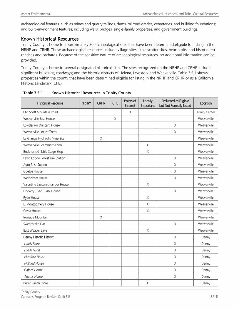
Ascent Environmental Archaeological, Historical, and Tribal Cultural Resources
Trinity County Cannabis Program Revised Draft EIR 3.5-11
archaeological features, such as mines and quarry tailings, dams, railroad grades, cemeteries, and building foundations; and built-environment features, including walls, bridges, single-family properties, and government buildings.
Known Historical Resources Trinity County is home to approximately 30 archaeological sites that have been determined eligible for listing in the NRHP and CRHR. These archaeological resources include village sites, lithic scatter sites, hearth pits, and historic-era ranches and orchards. Because of the sensitive nature of archaeological resources, no additional information can be provided.
Trinity County is home to several designated historical sites. The sites recognized on the NRHP and CRHR include significant buildings; roadways; and the historic districts of Helena, Lewiston, and Weaverville. Table 3.5-1 shows properties within the county that have been determined eligible for listing in the NRHP and CRHR or as a California Historic Landmark (CHL).
Table 3.5-1 Known Historical Resources in Trinity County
Historical Resource NRHP* CRHR CHL Points of Interest
Locally Important
Evaluated as Eligible but Not Formally Listed Location
Old Scott Mountain Road X Trinity Center
Weaverville Joss House X Weaverville
Lowder (or Duncan) House X Weaverville
Weaverville Locust Trees X Weaverville
La Grange Hydraulic Mine Site X Weaverville
Weaverville Grammar School X Weaverville
Buckhorn/Gribble Stage Stop X Weaverville
Fawn Lodge Forest Fire Station X Weaverville
Auto Rest Station X Weaverville
Goetze House X Weaverville
Weiheimer House X Weaverville
Valentine Lautenschlanger House X Weaverville
Dockery-Ryan-Clark House X Weaverville
Ryan House X Weaverville
E. Montgomery House X Weaverville
Costa House X Weaverville
Ironside Mountain X Weaverville
Sweepstake Flat X Weaverville
East Weaver Lake X Weaverville
Denny Historic District X Denny
Ladds Store X Denny
Ladds Hotel X Denny
Murdock House X Denny
Holland House X Denny
Gifford House X Denny
Adams House X Denny
Burnt Ranch Store X Denny
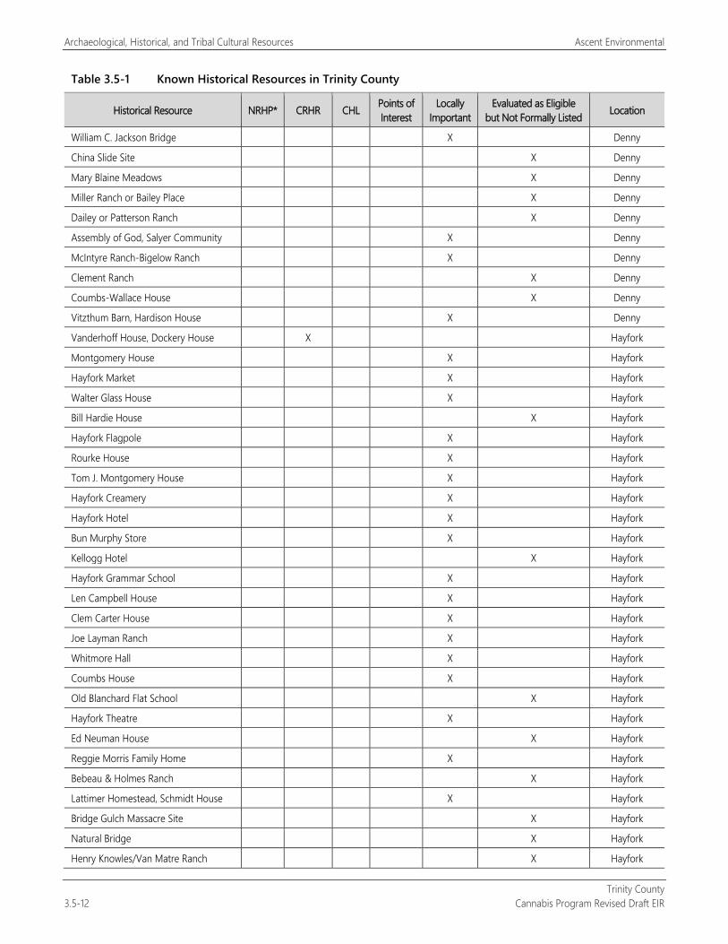
Archaeological, Historical, and Tribal Cultural Resources Ascent Environmental
Trinity County 3.5-12 Cannabis Program Revised Draft EIR
Table 3.5-1 Known Historical Resources in Trinity County
Historical Resource NRHP* CRHR CHL Points of Interest
Locally Important
Evaluated as Eligible but Not Formally Listed Location
William C. Jackson Bridge X Denny
China Slide Site X Denny
Mary Blaine Meadows X Denny
Miller Ranch or Bailey Place X Denny
Dailey or Patterson Ranch X Denny
Assembly of God, Salyer Community X Denny
McIntyre Ranch-Bigelow Ranch X Denny
Clement Ranch X Denny
Coumbs-Wallace House X Denny
Vitzthum Barn, Hardison House X Denny
Vanderhoff House, Dockery House X Hayfork
Montgomery House X Hayfork
Hayfork Market X Hayfork
Walter Glass House X Hayfork
Bill Hardie House X Hayfork
Hayfork Flagpole X Hayfork
Rourke House X Hayfork
Tom J. Montgomery House X Hayfork
Hayfork Creamery X Hayfork
Hayfork Hotel X Hayfork
Bun Murphy Store X Hayfork
Kellogg Hotel X Hayfork
Hayfork Grammar School X Hayfork
Len Campbell House X Hayfork
Clem Carter House X Hayfork
Joe Layman Ranch X Hayfork
Whitmore Hall X Hayfork
Coumbs House X Hayfork
Old Blanchard Flat School X Hayfork
Hayfork Theatre X Hayfork
Ed Neuman House X Hayfork
Reggie Morris Family Home X Hayfork
Bebeau & Holmes Ranch X Hayfork
Lattimer Homestead, Schmidt House X Hayfork
Bridge Gulch Massacre Site X Hayfork
Natural Bridge X Hayfork
Henry Knowles/Van Matre Ranch X Hayfork
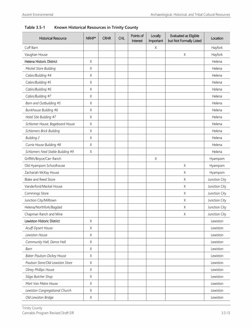
Ascent Environmental Archaeological, Historical, and Tribal Cultural Resources
Trinity County Cannabis Program Revised Draft EIR 3.5-13
Table 3.5-1 Known Historical Resources in Trinity County
Historical Resource NRHP* CRHR CHL Points of Interest
Locally Important
Evaluated as Eligible but Not Formally Listed Location
Cuff Barn X Hayfork
Vaughan House X Hayfork
Helena Historic District X Helena
Meckel Store Building X Helena
Cabin/Building #4 X Helena
Cabin/Building #5 X Helena
Cabin/Building #6 X Helena
Cabin/Building #7 X Helena
Barn and Outbuilding #5 X Helena
Bunkhouse Building #6 X Helena
Hotel Site Building #7 X Helena
Schlomer House, Bageboard House X Helena
Schlomers Brick Building X Helena
Building 2 X Helena
Currie House Building #8 X Helena
Schlomers Feed Stable Building #9 X Helena
Griffith/Boyce/Carr Ranch X Hyampom
Old Hyampom Schoolhouse X Hyampom
Zachariah McKay House X Hyampom
Blake and Reed Store X Junction City
Vanderford/Meckel House X Junction City
Commings Store X Junction City
Junction City/Milltown X Junction City
Helena/Northfork/Bagdad X Junction City
Chapman Ranch and Mine X Junction City
Lewiston Historic District X Lewiston
Acuff-Dysert House X Lewiston
Lewiston House X Lewiston
Community Hall, Dance Hall X Lewiston
Barn X Lewiston
Baker-Paulson-Dickey House X Lewiston
Paulson Store/Old Lewiston Store X Lewiston
Olney Phillips House X Lewiston
Siligo Butcher Shop X Lewiston
Mart Van Matre House X Lewiston
Lewiston Congregational Church X Lewiston
Old Lewiston Bridge X Lewiston
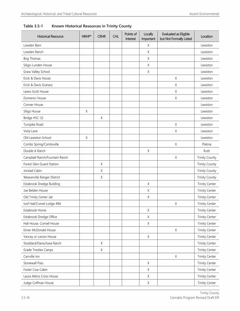
Archaeological, Historical, and Tribal Cultural Resources Ascent Environmental
Trinity County 3.5-14 Cannabis Program Revised Draft EIR
Table 3.5-1 Known Historical Resources in Trinity County
Historical Resource NRHP* CRHR CHL Points of Interest
Locally Important
Evaluated as Eligible but Not Formally Listed Location
Lowden Barn X Lewiston
Lowden Ranch X Lewiston
Brig Thomas X Lewiston
Siligo-Lunden House X Lewiston
Grass Valley School X Lewiston
Erick & Davis House X Lewiston
Erick & Davis Granary X Lewiston
Lewis-Scott House X Lewiston
Domenici House X Lewiston
Conner House Lewiston
Siligo House X Lewiston
Bridge #5C-32 X Lewiston
Turnpike Road X Lewiston
Viola Lane X Lewiston
Old Lewiston School X Lewiston
Combs Spring/Combsville X Platina
Double A Ranch X Ruth
Campbell Ranch/Fountain Ranch X Trinity County
Forest Glen Guard Station X Trinity County
Jorstad Cabin X Trinity County
Weaverville Ranger District X Trinity County
Estabrook Dredge Building X Trinity Center
Joe Belden House X Trinity Center
Old Trinity Center Jail X Trinity Center
Ioof Hall/Comet Lodge #84 X Trinity Center
Estabrook Home X Trinity Center
Estabrook Dredge Office X Trinity Center
Hall House, Cornell House X Trinity Center
Eimer McDonald House X Trinity Center
Yancey or Larson House X Trinity Center
Stoddard/Davis/Iowa Ranch X Trinity Center
Grade Trestles Camps X Trinity Center
Carrville Inn X Trinity Center
Stonewall Pass X Trinity Center
Foster Cow Cabin X Trinity Center
Laura Atkins Cross House X Trinity Center
Judge Coffman House X Trinity Center
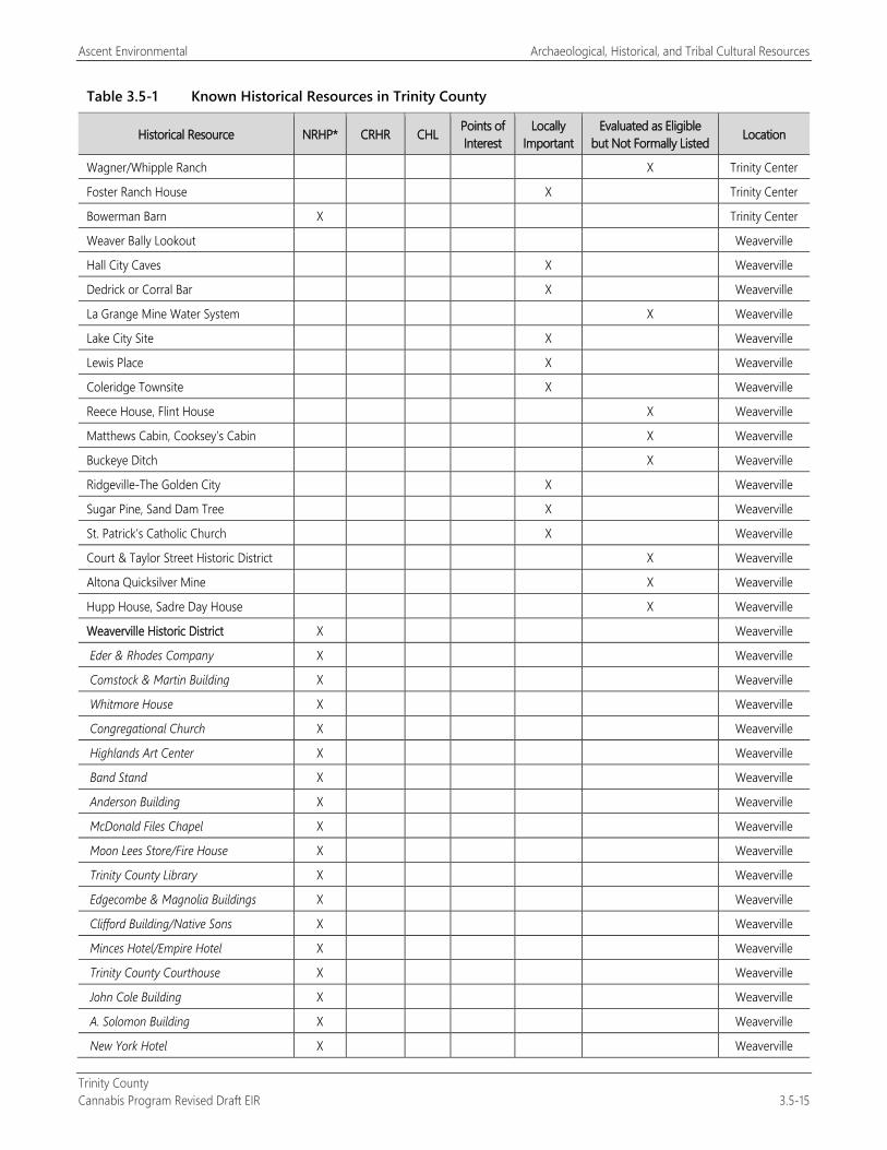
Ascent Environmental Archaeological, Historical, and Tribal Cultural Resources
Trinity County Cannabis Program Revised Draft EIR 3.5-15
Table 3.5-1 Known Historical Resources in Trinity County
Historical Resource NRHP* CRHR CHL Points of Interest
Locally Important
Evaluated as Eligible but Not Formally Listed Location
Wagner/Whipple Ranch X Trinity Center
Foster Ranch House X Trinity Center
Bowerman Barn X Trinity Center
Weaver Bally Lookout Weaverville
Hall City Caves X Weaverville
Dedrick or Corral Bar X Weaverville
La Grange Mine Water System X Weaverville
Lake City Site X Weaverville
Lewis Place X Weaverville
Coleridge Townsite X Weaverville
Reece House, Flint House X Weaverville
Matthews Cabin, Cooksey’s Cabin X Weaverville
Buckeye Ditch X Weaverville
Ridgeville-The Golden City X Weaverville
Sugar Pine, Sand Dam Tree X Weaverville
St. Patrick’s Catholic Church X Weaverville
Court & Taylor Street Historic District X Weaverville
Altona Quicksilver Mine X Weaverville
Hupp House, Sadre Day House X Weaverville
Weaverville Historic District X Weaverville
Eder & Rhodes Company X Weaverville
Comstock & Martin Building X Weaverville
Whitmore House X Weaverville
Congregational Church X Weaverville
Highlands Art Center X Weaverville
Band Stand X Weaverville
Anderson Building X Weaverville
McDonald Files Chapel X Weaverville
Moon Lees Store/Fire House X Weaverville
Trinity County Library X Weaverville
Edgecombe & Magnolia Buildings X Weaverville
Clifford Building/Native Sons X Weaverville
Minces Hotel/Empire Hotel X Weaverville
Trinity County Courthouse X Weaverville
John Cole Building X Weaverville
A. Solomon Building X Weaverville
New York Hotel X Weaverville
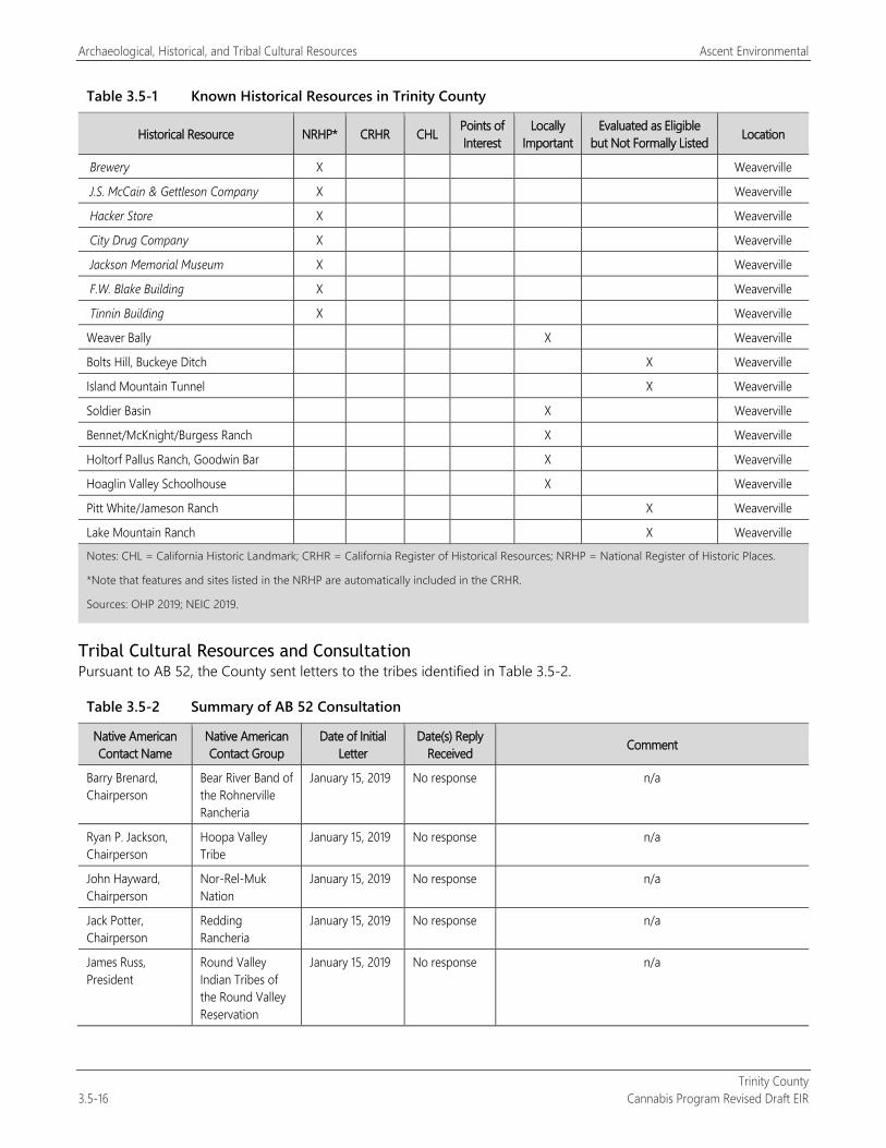
Archaeological, Historical, and Tribal Cultural Resources Ascent Environmental
Trinity County 3.5-16 Cannabis Program Revised Draft EIR
Table 3.5-1 Known Historical Resources in Trinity County
Historical Resource NRHP* CRHR CHL Points of Interest
Locally Important
Evaluated as Eligible but Not Formally Listed Location
Brewery X Weaverville
J.S. McCain & Gettleson Company X Weaverville
Hacker Store X Weaverville
City Drug Company X Weaverville
Jackson Memorial Museum X Weaverville
F.W. Blake Building X Weaverville
Tinnin Building X Weaverville
Weaver Bally X Weaverville
Bolts Hill, Buckeye Ditch X Weaverville
Island Mountain Tunnel X Weaverville
Soldier Basin X Weaverville
Bennet/McKnight/Burgess Ranch X Weaverville
Holtorf Pallus Ranch, Goodwin Bar X Weaverville
Hoaglin Valley Schoolhouse X Weaverville
Pitt White/Jameson Ranch X Weaverville
Lake Mountain Ranch X Weaverville
Notes: CHL = California Historic Landmark; CRHR = California Register of Historical Resources; NRHP = National Register of Historic Places.
*Note that features and sites listed in the NRHP are automatically included in the CRHR.
Sources: OHP 2019; NEIC 2019.
Tribal Cultural Resources and Consultation Pursuant to AB 52, the County sent letters to the tribes identified in Table 3.5-2.
Table 3.5-2 Summary of AB 52 Consultation
Native American Contact Name
Native American Contact Group
Date of Initial Letter
Date(s) Reply Received Comment
Barry Brenard, Chairperson
Bear River Band of the Rohnerville Rancheria
January 15, 2019 No response n/a
Ryan P. Jackson, Chairperson
Hoopa Valley Tribe
January 15, 2019 No response n/a
John Hayward, Chairperson
Nor-Rel-Muk Nation
January 15, 2019 No response n/a
Jack Potter, Chairperson
Redding Rancheria
January 15, 2019 No response n/a
James Russ, President
Round Valley Indian Tribes of the Round Valley Reservation
January 15, 2019 No response n/a
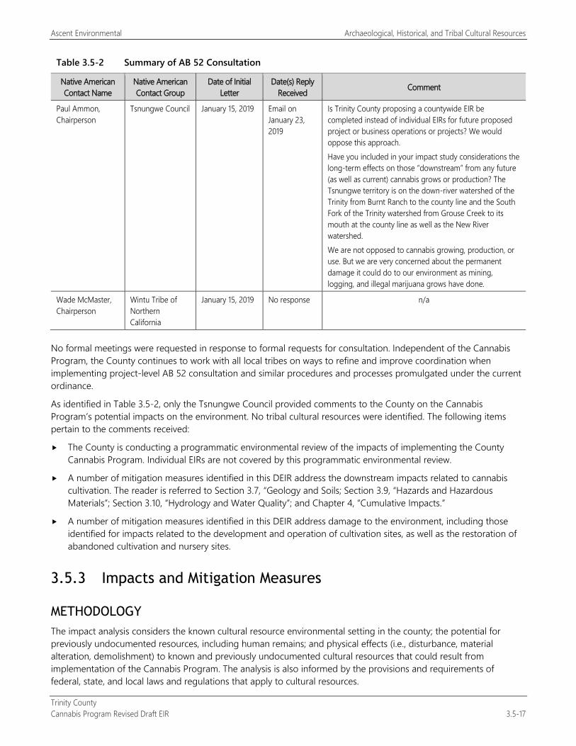
Ascent Environmental Archaeological, Historical, and Tribal Cultural Resources
Trinity County Cannabis Program Revised Draft EIR 3.5-17
Table 3.5-2 Summary of AB 52 Consultation
Native American Contact Name
Native American Contact Group
Date of Initial Letter
Date(s) Reply Received Comment
Paul Ammon, Chairperson
Tsnungwe Council January 15, 2019 Email on January 23, 2019
Is Trinity County proposing a countywide EIR be completed instead of individual EIRs for future proposed project or business operations or projects? We would oppose this approach. Have you included in your impact study considerations the long-term effects on those “downstream” from any future (as well as current) cannabis grows or production? The Tsnungwe territory is on the down-river watershed of the Trinity from Burnt Ranch to the county line and the South Fork of the Trinity watershed from Grouse Creek to its mouth at the county line as well as the New River watershed. We are not opposed to cannabis growing, production, or use. But we are very concerned about the permanent damage it could do to our environment as mining, logging, and illegal marijuana grows have done.
Wade McMaster, Chairperson
Wintu Tribe of Northern California
January 15, 2019 No response n/a
No formal meetings were requested in response to formal requests for consultation. Independent of the Cannabis Program, the County continues to work with all local tribes on ways to refine and improve coordination when implementing project-level AB 52 consultation and similar procedures and processes promulgated under the current ordinance.
As identified in Table 3.5-2, only the Tsnungwe Council provided comments to the County on the Cannabis Program’s potential impacts on the environment. No tribal cultural resources were identified. The following items pertain to the comments received:
The County is conducting a programmatic environmental review of the impacts of implementing the County Cannabis Program. Individual EIRs are not covered by this programmatic environmental review.
A number of mitigation measures identified in this DEIR address the downstream impacts related to cannabis cultivation. The reader is referred to Section 3.7, “Geology and Soils; Section 3.9, “Hazards and Hazardous Materials”; Section 3.10, “Hydrology and Water Quality”; and Chapter 4, “Cumulative Impacts.”
A number of mitigation measures identified in this DEIR address damage to the environment, including those identified for impacts related to the development and operation of cultivation sites, as well as the restoration of abandoned cultivation and nursery sites.
3.5.3 Impacts and Mitigation Measures
METHODOLOGY The impact analysis considers the known cultural resource environmental setting in the county; the potential for previously undocumented resources, including human remains; and physical effects (i.e., disturbance, material alteration, demolishment) to known and previously undocumented cultural resources that could result from implementation of the Cannabis Program. The analysis is also informed by the provisions and requirements of federal, state, and local laws and regulations that apply to cultural resources.
Archaeological, Historical, and Tribal Cultural Resources Ascent Environmental
Trinity County 3.5-18 Cannabis Program Revised Draft EIR
THRESHOLDS OF SIGNIFICANCE Based on Appendix G of the State CEQA Guidelines, the project would result in a significant impact on cultural resources if it would:
cause a substantial adverse change in the significance of a historical resource as defined in Section 15064.5 of the State CEQA Guidelines;
cause a substantial adverse change in the significance of an archaeological resource as defined in Section 15064.5 of the State CEQA Guidelines;
cause a substantial adverse change in the significance of a tribal cultural resource, defined in PRC Section 21074 as either a site, feature, place, cultural landscape that is geographically defined in terms of the size and scope of the landscape, sacred place, or object with cultural value to a California Native American tribe that is:
listed or eligible for listing in the CRHR or in a local register of historical resources as defined in PRC Section 5020.1(k); or
a resource determined by the lead agency, in its discretion and supported by substantial evidence, to be significant pursuant to criteria set forth in PRC Section 5024.1(c); or
disturb any human remains, including those interred outside of dedicated cemeteries.
ENVIRONMENTAL IMPACTS AND MITIGATION MEASURES
Impact 3.5-1: Cause a Substantial Adverse Change in the Significance of a Historic Resource
Cannabis operations associated with the implementation of the Cannabis Program could be located on lands that contain or are near historic resources. This could result in damage to or destruction of a historic building or structure, thereby resulting in a substantial adverse change in the significance of a historical resource as defined in Section 15064.5. This would be a potentially significant impact.
As described in Section 3.5.2, “Environmental Setting,” and Table 3.5-1, Trinity County is home to several designated historic sites and historic districts (Denny, Helena, Lewiston, and Weaverville) that are listed in or are eligible for listing in the NRHP or CRHR or as a CHL. Commercial cannabis operations could use these sites and potentially adversely affect the historic resources.
Existing Licensed Commercial Cannabis Operations Historical (or architectural) resources include standing buildings (e.g., houses, barns, cabins) and intact structures (e.g., dams, bridges). Trinity County contains several known historic resources, including federally recognized and state-recognized resources. Known historic resources within the county generally include civic and commercial or industrial buildings, bridges, barns, homes, and historic districts. These include the four historic districts in Denny, Helena, Lewiston, and Weaverville.
As of February 2019, approximately 60 objects, structures, buildings, and sites in the county are listed in the NRHP; approximately 60 are listed in the CRHR; one is listed as a California landmark; one is on the list of California Points of Historical Interest; approximately 60 are identified as locally important; and approximately 70 are eligible for listing but not currently listed. These resources meet the definition of historic resource under Section 15064.5(a) of the State CEQA Guidelines.
Commercial cannabis operations are currently present within Trinity County. In discussing impacts to historical resources from existing operations, it is unlikely that historically listed buildings are being used for cannabis operations in Trinity County. As described above in the local regulatory setting, review and approval must be obtained from the appropriate architectural review and preservation committee before any modifications of historical districts, special treatment areas, or special treatment sites. This condition further protects any modifications to historically listed buildings. However, it is possible that buildings over the age of 50 years old have not been evaluated and are currently being used for cannabis
Ascent Environmental Archaeological, Historical, and Tribal Cultural Resources
Trinity County Cannabis Program Revised Draft EIR 3.5-19
operations. The use of such buildings could result in a potentially significant impact if they have historic significance and have been altered in such a way that changes the significance of the buildings.
New Licensed Commercial Cannabis Operations The proposed program contains measures that would establish land use regulations for the cultivation, manufacture, testing, distribution, and storage of cannabis within the county. These actions would result in brush removal, grading, and irrigation to facilitate the cultivation of commercial cannabis; reuse of existing buildings or construction of new buildings for processing and manufacturing activities; and use of smaller sheds for storage of materials. These activities could occur in areas with known historical sites, or in areas where structures have not yet been evaluated for historical significance. Damage to or destruction of a building or structure that is a designated historic resource, that is eligible for listing as a historic resource, or that has not yet been evaluated could result in a change in its historical significance.
The Cannabis Program would require that licensed operations obtain Cal Cannabis cultivation licensing and comply with the SWRCB Attachment A (General Requirements and Prohibitions) of Order WQ 20179-002301-DWQ for cannabis cultivation. Term 21 of the General Requirements and Prohibitions requires that records searches be performed through the applicable CHRIS information center before land-disturbing activities. Any positive results identified in the records search would need to be further evaluated. Compliance with Term 21 of the SWRQCB’s General Requirements and Prohibitions would reduce impacts to known historical resources through identification of potential historical features and further evaluation.
Further, revisions to the Trinity County Cannabis Regulations (Ordinance Nos. 315-838 and 315-842) state that manufacturing activities would not be allowed within the Weaverville Historic District. As described above, there are three historic districts in Trinity County in addition to the Weaverville Historic District: the Denny, Helena, and Lewiston Historic Districts. Additionally, there are approximately 200 other known historical resources within the county. Any cannabis operations resulting from implementation of the proposed program that could result in damage, modification, or destruction of known historical resources would be a potentially significant impact.
Mitigation Measures
Mitigation Measure 3.5-1a: Conduct Historic Evaluations for Existing Operations The following shall be included as a new performance standard for Section 315-843(6) (Performance Standards for Commercial Cultivation of Cannabis) and Section 315-828(5) (Required Conditions):
Annual relicensing of cannabis operations licensed before 2019 shall require a one-time historic building evaluation, and the results of the evaluation shall be submitted to the County if buildings on-site are over 45 years old and are expected to be used in future operations. If the buildings are determined to be a significant historic resource, then the applicant shall be required to comply with historic resource protection standards set forth in Mitigation Measure 3.5-1b. This requirement does not apply to buildings that are currently being used as part of the cannabis operation.
Mitigation Measure 3.5-1b: Revise Ordinance to Include All Historic Districts and Additional Measures to Protect Historic Resources The following shall be included as new performance standards for Section 315-843(6) (Performance Standards for Commercial Cultivation of Cannabis), Section 315-824(5) (Required Conditions), Section 315-826(3) (Regulation of Nurseries), Section 315-828(5) (Required Conditions), Section 315-835(2) (Regulations), Section 315-837(3) (Required Conditions), and Section 315-842(6) (Required Conditions) for the protection of historic resources:
Cannabis cultivation operations shall not be permitted within the historic districts of Weaverville, Denny, Helena, and Lewiston.
Applicants shall identify and evaluate all historic-age (over 45 years in age) buildings and structures that are proposed to be removed or modified as part of cannabis operations. This shall include preparation of a historic structure report and evaluation of resources to determine their eligibility for recognition under federal, state, or County local official register of historic resources criteria. The evaluation shall be prepared by an architectural

Archaeological, Historical, and Tribal Cultural Resources Ascent Environmental
Trinity County 3.5-20 Cannabis Program Revised Draft EIR
historian or historical architect meeting the Secretary of the Interior’s Standards and Guidelines for Archeology and Historic Preservation, Professional Qualification Standards. The evaluation shall comply with State CEQA Guidelines Section 15064.5(b) and, if federal funding or permits are required, with Section 106 of the NHPA of 1966 (16 U.S. Code Section 470 et seq.).
If resources eligible for inclusion in the NRHP, CRHR, or local official register of historic resources are identified, an assessment of impacts on these resources shall be included in the report, as well as detailed measures to avoid impacts. If avoidance of a significant architectural/built environment resource is not feasible, additional mitigation options include, but are not limited to, specific design plans for historic districts or plans for alteration or adaptive reuse of a historical resource that follows the Secretary of the Interior’s Standards for the Treatment of Historic Properties with Guidelines for Preserving, Rehabilitation, Restoring, and Reconstructing Historic Buildings.
Significance after Mitigation Implementation of Mitigation Measure 3.5-1a would ensure that any buildings of potential historical value would be identified and would further prevent modifications that could result in a change in the historical significance of the buildings.
Implementation of Mitigation Measure 3.5-1b would reduce potentially significant impacts by amending the proposed cannabis program to include protection of historic resources within the county’s historic districts. Further, this mitigation ensures that actions will be taken to record, evaluate, avoid, or otherwise treat the resource appropriately, in accordance with pertinent laws and regulations. Implementation of Mitigation Measures 3.5-1a and 3.5-1b would reduce impacts to a less-than-significant level.
Impact 3.5-2: Disturb Unique Archaeological Features, Sites, or Materials
Cannabis operations associated with implementation of the Cannabis Program could be located on properties that contain known or unknown archaeological resources, and ground-disturbing activities could result in discovery or damage of previously undiscovered archaeological resources as defined in State CEQA Guidelines Section 15064.5. Implementation of existing state regulations would ensure that these potential impacts are addressed and mitigated. This would be a less than significant impact.
As described in Section 3.5.2, “Environmental Setting,” approximately 2,500 cultural sites that include prehistoric and historic archaeological resources have been identified in Trinity County. Evidence from previous archaeological survey work indicates that the following archaeological site types may be encountered throughout unsurveyed portions of the county: bedrock milling features, habitation debris, burial sites, petroglyphs, mines and quarry tailings, dams, and railroad grades.
Existing Licensed Commercial Cannabis Operations Existing commercial cannabis cultivation within Trinity County is required to be in compliance with SWRCB and Cal Cannabis regulations. Attachment A (General Requirements and Prohibitions) of SWRCB Order WQ 20179-002301-DWQ includes terms that require CHRIS records searches, NAHC record searches, archaeological evaluations (if necessary), and protection of discovered resources. Compliance with these regulations would ensure that existing cannabis cultivation operations that propose to expand their Designated Area from 200 percent to 250 percent would not adversely affect archaeological resources. Violations of these regulations would result in enforcement action from the County. Impacts would be less than significant.
New Licensed Commercial Cannabis Operations Trinity County is home to approximately 30 archaeological sites that have been determined eligible for listing in the NRHP and CRHR. These archaeological resources include village sites, lithic scatter sites, hearth pits, and historic-era ranches and orchards.
The Cannabis Program would require that licensed operations obtain Cal Cannabis cultivation licensing and comply with the SWRCB’s cannabis cultivation policies for cultivation activities. Attachment A (General Requirements and Prohibitions) of Order WQ 20179-002301-DWQ Terms 21 and 22 of the General Requirements and Prohibitions require CHRIS records searches, NAHC record searches, and archaeological surveys or evaluations (if necessary).
Ascent Environmental Archaeological, Historical, and Tribal Cultural Resources
Trinity County Cannabis Program Revised Draft EIR 3.5-21
Compliance with Terms 21 and 22 of the SWRCB General Requirements and Prohibitions would reduce impacts to known archaeological resources through requiring standard record searches, requiring archaeological evaluations of identified features, and implementing necessary measures to ensure the protection of archaeological resources. Noncultivation cannabis operations would be located within or near the existing communities where they would have potential to affect historic resources as identified for Impact 3.5-1.
Impacts to archaeological resources would be less than significant.
Mitigation Measures No mitigation is required.
Impact 3.5-3: Destruction of Human Remains
Previously undiscovered human remains could be discovered when soils are disturbed during construction of commercial cultivation and processing sites under the Cannabis Program. Compliance with California Health and Safety Code Sections 7050.5 and 7052, PRC Section 5097, and other state regulations associated with cannabis cultivation would make this impact less than significant.
As described in Section 3.5.2, “Environmental Setting,” approximately 2,500 cultural sites that include prehistoric and historic archaeological resources have been identified in Trinity County. Evidence from previous archaeological survey work indicates that burial sites may be encountered throughout unsurveyed portions of the county.
Existing Licensed Commercial Cannabis Operations Existing commercial cannabis operations within Trinity County would be in compliance with the SWRCB and Cal Cannabis regulations. The SWRCB includes terms that require compliance with the California Health and Safety Code Section 7050.5 and, if applicable, PRC Section 5097.98. Compliance with existing regulations would ensure that existing cannabis operations that propose to expand their Designated Area from 200 percent to 250 percent would have a less-than-significant impact related to the discovery of human remains.
New Licensed Commercial Cannabis Operations Grave sites and Native American remains can be located outside of dedicated cemeteries or burial sites. Ground-disturbing construction activities could uncover previously unknown human remains, which could be archaeologically or culturally significant. The Cannabis Program would allow for brush removal, grading, and irrigation to facilitate the development of cannabis uses. Large structures could be constructed for processing activities, and smaller sheds could be constructed to store materials. These activities would result in limited, shallow levels of soil disturbance; it is unlikely that unknown human remains would be unearthed by earth-disturbing activities associated with the proposed program because of the shallow soil disturbance required. Nevertheless, the potential exists for previously undiscovered human remains to be discovered when soils are disturbed.
California law recognizes the need to protect Native American human burials, skeletal remains, and items associated with Native American burials from vandalism and inadvertent destruction. The procedures for the treatment of Native American human remains are described in California Health and Safety Code Sections 7050.5 and 7052 and PRC Section 5097.
These statutes require that if human remains are discovered during any construction activities, potentially damaging ground-disturbing activities in the area of the remains shall be halted immediately, and the Trinity County coroner and NAHC shall be notified immediately, in accordance with PRC Section 5097.98 and Section 7050.5 of California’s Health and Safety Code. If the remains are determined by NAHC to be Native American, the guidelines of the NAHC shall be adhered to in the treatment and disposition of the remains. Following the coroner’s findings, the archaeologist, and the NAHC-designated Most Likely Descendant shall determine the ultimate treatment and disposition of the remains and take appropriate steps to ensure that additional human interments are not disturbed. The responsibilities for acting upon notification of a discovery of Native American human remains are identified in PRC Section 5097.94.
Archaeological, Historical, and Tribal Cultural Resources Ascent Environmental
Trinity County 3.5-22 Cannabis Program Revised Draft EIR
Compliance with California Health and Safety Code Sections 7050.5 and 7052 and PRC Section 5097 would provide an opportunity to avoid or minimize the disturbance of human remains, and to appropriately treat any remains that are discovered. Therefore, this impact would be less than significant.
Mitigation Measures No mitigation is required.
Impact 3.5-4: Cause a Substantial Adverse Change in the Significance of a Tribal Cultural Resource
Consultation with tribes did not identify any tribal cultural resources that could be affected by implementing the County Cannabis Program. The environmental concerns of the Tsnungwe Council are addressed in the technical sections of this EIR. Because no resources meet the criteria for a tribal cultural resource under PRC Section 21074, this impact would be less than significant.
AB 52 established a new class of resources under CEQA, tribal cultural resources, and requires that lead agencies undertaking CEQA review must, upon written request of a California Native American tribe, begin consultation after the lead agency determines that the application for the project is complete. As identified in Table 3.5-2, the County requested consultation with tribes in compliance with AB 52. The consultation resulted in the conclusion that there is no potential for commercial cannabis operations to affect tribal cultural resources (as defined in PRC Section 21074).
As described above in Section 3.5.2, “Environmental Setting,” no tribal cultural resources have been identified for this project. Only the Tsnungwe Council provided comments to the County on the Cannabis Program’s potential impacts on the environment. These issues are addressed in Section 3.7, “Geology and Soils”; Section 3.9, “Hazards and Hazardous Materials”; Section 3.10, “Hydrology and Water Quality”; and Chapter 4, “Cumulative Impacts.”
The Cannabis Program would require that licensed operations obtain Cal Cannabis cultivation licensing and comply with the SWRCB’s cannabis cultivation policies for cultivation activities. Attachment A (General Requirements and Prohibitions) of Order WQ 20179-002301-DWQ Terms 21 and 22 of the General Requirements and Prohibitions require CHRIS records searches, NAHC record searches, and archaeological surveys or evaluations (if necessary). Compliance with Terms 21 and 22 of the SWRCB General Requirements and Prohibitions would reduce impacts on known archaeological resources that may include tribal cultural resources through requiring standard record searches, requiring archaeological evaluations of identified features, and implementing necessary measures to ensure the protection of archaeological resources and tribal cultural resources. Therefore, the project would have a less-than-significant impact on tribal cultural resources as defined in PRC Section 21074.
Mitigation Measures No mitigation is required.
Ascent Environmental Energy
Trinity County Cannabis Program Revised Draft EIR 3.6-1
3.6 ENERGY This section was prepared pursuant to Section 15126 and Appendix G of the State CEQA Guidelines, which require that EIRs include a discussion of the potential energy impacts of projects. The analysis considers whether the Trinity County Cannabis Program would result in inefficient, wasteful, and unnecessary consumption of energy.
No comment letters regarding energy were received in response to the Notice of Preparation (see Appendix A).
3.6.1 Regulatory Setting Energy conservation is embodied in many federal, state, and local statutes and policies. At the federal level, energy standards apply to numerous products (e.g., the U.S. Environmental Protection Agency’s [EPA’s] EnergyStar™ program) and transportation (e.g., fuel efficiency standards). At the state level, Title 24 of the California Code of Regulations (California Energy Code) sets forth energy standards for buildings. Further, the state provides rebates or tax credits for installation of renewable energy systems and offers the Flex Your Power program to promote conservation in multiple areas. At the local level, individual cities and counties establish policies in their general plans and climate action plans related to the energy efficiency of new and existing development and related to land use planning and the use of renewable energy sources.
FEDERAL
Energy Policy and Conservation Act, and CAFE Standards The Energy Policy and Conservation Act of 1975 established nationwide fuel economy standards to conserve oil. Pursuant to this Act, the National Highway Traffic and Safety Administration, part of the U.S. Department of Transportation, is responsible for revising existing fuel economy standards and establishing new vehicle economy standards.
The Corporate Average Fuel Economy (CAFE) program was established to determine vehicle manufacturer compliance with the government’s fuel economy standards. Compliance with the CAFE standards is determined based on each manufacturer’s average fuel economy for the portion of their vehicles produced for sale in the country. EPA calculates a CAFE value for each manufacturer based on the city and highway fuel economy test results and vehicle sales. The CAFE values are a weighted harmonic average of the EPA city and highway fuel economy test results. Based on information generated under the CAFE program, the U.S. Department of Transportation is authorized to assess penalties for noncompliance. Under the Energy Independence and Security Act of 2007 (described below), the CAFE standards were revised for the first time in 30 years.
Energy Policy Act of 1992 and 2005 The Energy Policy Act of 1992 (EPAct) was passed to reduce the country’s dependence on foreign petroleum and improve air quality. EPAct includes several parts intended to build an inventory of alternative fuel vehicles (AFVs) in large, centrally fueled fleets in metropolitan areas. EPAct requires certain federal, state, and local government and private fleets to purchase a percentage of light-duty AFVs capable of running on alternative fuels each year. In addition, financial incentives are also included in EPAct. Federal tax deductions are allowed for businesses and individuals to cover the incremental cost of AFVs. States are also required by the act to consider a variety of incentive programs to help promote AFVs. The Energy Policy Act of 2005 provides renewed and expanded tax credits for electricity generated by qualified energy sources, such as landfill gas; provides bond financing, tax incentives, grants, and loan guarantees for clean renewable energy and rural community electrification; and establishes a federal purchase requirement for renewable energy.
Energy Ascent Environmental
Trinity County 3.6-2 Cannabis Program Revised Draft EIR
Energy Independence and Security Act of 2007 The Energy Independence and Security Act of 2007 is designed to improve vehicle fuel economy and help reduce U.S. dependence on oil. It represents a major step forward in expanding the production of renewable fuels, reducing dependence on oil, and confronting global climate change. The Energy Independence and Security Act of 2007 increases the supply of alternative fuel sources by setting a mandatory Renewable Fuel Standard requiring fuel producers to use at least 36 billion gallons of biofuel in 2022, which represents a nearly fivefold increase over current levels; and reduces U.S. demand for oil by setting a national fuel economy standard of 35 miles per gallon by 2020—an increase in fuel economy standards of 40 percent.
By addressing renewable fuels and the CAFE standards, the Energy Independence and Security Act of 2007 builds upon progress made by the Energy Policy Act of 2005 in setting out a comprehensive national energy strategy for the 21st century.
STATE
Warren-Alquist Act The 1975 Warren-Alquist Act established the California Energy Resources Conservation and Development Commission, now known as the California Energy Commission (CEC). The Act established state policy to reduce wasteful, uneconomical, and unnecessary uses of energy by employing a range of measures. The California Public Utilities Commission regulates privately owned utilities in the energy, rail, telecommunications, and water fields.
State of California Energy Action Plan CEC is responsible for preparing the State Energy Plan, which identifies emerging trends related to energy supply, demand, conservation, public health and safety, and the maintenance of a healthy economy. The current plan is the 2003 California Energy Action Plan (2008 update). The plan calls for the state to assist in the transformation of the transportation system to improve air quality, reduce congestion, and increase the efficient use of fuel supplies with the least environmental and energy costs. To further this policy, the plan identifies a number of strategies, including assistance to public agencies and fleet operators in implementing incentive programs for zero-emission vehicles and addressing their infrastructure needs; and encouragement of urban design that reduces vehicle miles traveled (VMT) and accommodates pedestrian and bicycle access.
Assembly Bill 2076: Reducing Dependence on Petroleum Pursuant to Assembly Bill (AB) 2076 (Chapter 936, Statutes of 2000), CEC and the California Air Resources Board (CARB) prepared and adopted a joint agency report in 2003, Reducing California’s Petroleum Dependence. Included in this report are recommendations to increase the use of alternative fuels to 20 percent of on-road transportation fuel use by 2020 and 30 percent by 2030, significantly increase the efficiency of motor vehicles, and reduce per capita VMT (CEC and CARB 2003). Further, in response to the CEC’s 2003 and 2005 Integrated Energy Policy Reports, Governor Davis directed CEC to take the lead in developing a long-term plan to increase alternative fuel use.
A performance-based goal of AB 2076 was to reduce petroleum demand to 15 percent below 2003 demand by 2030.
Integrated Energy Policy Report Senate Bill (SB) 1389 (Chapter 568, Statutes of 2002) required CEC to “conduct assessments and forecasts of all aspects of energy industry supply, production, transportation, delivery and distribution, demand, and prices. CEC shall use these assessments and forecasts to develop energy policies that conserve resources, protect the environment, ensure energy reliability, enhance the state’s economy, and protect public health and safety” (Public Resources Code Section 25301(a)). This work culminated in the Integrated Energy Policy Report (IEPR).
CEC adopts an IEPR every 2 years and an update every other year. The 2017 IEPR is the most recent IEPR, which was adopted March 16, 2018. The 2017 IEPR provides a summary of priority energy issues currently facing the state, outlining strategies and recommendations to further the state’s goal of ensuring reliable, affordable, and environmentally-responsible energy sources. Energy topics covered in the report include progress toward statewide
Ascent Environmental Energy
Trinity County Cannabis Program Revised Draft EIR 3.6-3
renewable energy targets and issues facing future renewable development; efforts to increase energy efficiency in existing and new buildings; progress by utilities in achieving energy efficiency targets and potential; improving coordination among the state’s energy agencies; streamlining power plant licensing processes; results of preliminary forecasts of electricity, natural gas, and transportation fuel supply and demand; future energy infrastructure needs; the need for research and development efforts to statewide energy policies; and issues facing California’s nuclear power plants.
Legislation Associated with Electricity Generation The state has passed legislation requiring the increasing use of renewables to produce electricity for consumers. California utilities are required to generate 33 percent of their electricity from renewables by 2020 (SB X1-2 of 2011); 52 percent by 2027 (SB 100 of 2018); 60 percent by 2030 (also SB 100 of 2018); and 100 percent by 2045 (also SB 100 of 2018). More detail about these regulations is provided in Section 3.8, “Greenhouse Gas Emissions and Climate Change.”
Senate Bill 350: Clean Energy and Pollution Reduction Act of 2015 The Clean Energy and Pollution Reduction Act of 2015 (SB 350) requires doubling of the energy efficiency savings in electricity and natural gas for retail customers through energy efficiency and conservation by December 31, 2030.
Assembly Bill 1007: State Alternative Fuels Plan AB 1007 (Chapter 371, Statues of 2005) required CEC to prepare a statewide plan to increase the use of alternative fuels in California. CEC prepared the State Alternative Fuels Plan (SAF Plan) in partnership with CARB and in consultation with other state, federal, and local agencies. The SAF Plan presents strategies and actions California must take to increase the use of alternative nonpetroleum fuels in a manner that minimizes the costs to California and maximizes the economic benefits of in-state production. The SAF Plan assessed various alternative fuels and developed fuel portfolios to meet California’s goals to reduce petroleum consumption, increase alternative fuel use, reduce greenhouse gas (GHG) emissions, and increase in-state production of biofuels without causing a substantial degradation of public health and environmental quality.
California Building Energy Efficiency Standards (Title 24, Part 6) The energy consumption of new residential and nonresidential buildings in California is regulated by the state’s Title 24, Part 6, Building Energy Efficiency Standards (California Energy Code). The California Energy Code was established by CEC in 1978 in response to a legislative mandate to create uniform building codes to reduce California’s energy consumption and provide energy efficiency standards for residential and nonresidential buildings. CEC updates the California Energy Code every 3 years with more stringent design requirements for reduced energy consumption, which results in the generation of fewer GHG emissions.
The 2019 California Energy Code was adopted by CEC on May 9, 2018, and will apply to projects constructed after January 1, 2020. The 2019 California Energy Code is designed to move the state closer to its zero-net energy goals for new residential development, as stated in its New Residential Zero Net Energy Action Plan 2015-2020 (CEC and CPUC 2015). It does so by requiring all new residences to install enough renewable energy to offset all the electricity needs of each residential unit (CCR, Title 24, Part 6, Section 150.1(c)4). CEC estimates that the combination of mandatory on-site renewable energy and prescriptively-required energy efficiency standards will result in a 53-percent reduction in new residential construction as compared to the 2016 California Energy Code. Nonresidential buildings are anticipated to reduce energy consumption by 30 percent as compared to the 2016 California Energy Code primarily through prescriptive requirements for high-efficiency lighting (CEC 2018a). The Energy Code is enforced through the local plan check and building permit process. Local government agencies may adopt and enforce additional energy standards for new buildings as reasonably necessary due to local climatologic, geologic, or topographic conditions, provided that these standards exceed those in the California Energy Code.
Energy Ascent Environmental
Trinity County 3.6-4 Cannabis Program Revised Draft EIR
Legislation Associated with Greenhouse Gas Reduction The state has passed legislation that aims to reduce GHG emissions, which often have an added benefit of reducing energy consumption. SB 32 requires a statewide GHG emission reduction of at least 40 percent below 1990 levels by no later than December 31, 2020. Executive Order B-30-15 sets a long-term target of reducing statewide GHG emissions by 80 percent below 1990 levels by 2050.
SB 375 aligns regional transportation planning efforts, regional GHG emission reduction targets, and land use and housing allocation. The Advanced Clean Cars program, approved by CARB, combines the control of GHG emissions and criteria air pollutants and the increase in the number of zero-emission vehicles into a single package of standards. The program’s zero-emission vehicle regulation requires battery, fuel cell and/or plug-in hybrid electric vehicles to account for up to 15 percent of California’s new vehicle sales by 2025.
Implementation of the state’s legislation associated with GHG reduction will have the co-benefit of reducing California’s dependency of fossil fuel and making land use development and transportation systems more energy efficient.
More details about legislation associated with GHG reduction are provided in the regulatory setting of Section 3.8, “Greenhouse Gas Emissions and Climate Change.”
California Code of Regulations The following energy-related requirements are included in the CCR, Title 3, Division 8, Chapter 1.
Section 8203. Renewal of License. Section G. Beginning January 1, 2022, an application for renewal of a license shall include the following records for each power source indicated on the application for licensure for the previous annual licensed period:
1. Total electricity supplied by local utility provider, name of local utility provider, and greenhouse gas emission intensity per kilowatt hour reported by the utility provider under section 398.4(c) of the Public Utilities Code for the most recent calendar year available at time of submission;
2. Total electricity supplied by a zero net energy renewable source, as set forth in section 398.4(h)(5) of the Public Utilities Code, that is not part of a net metering or other utility benefit;
3. Total electricity supplied from other unspecified sources, as defined in 398.2(e) of the Public Utilities Code, and other on-site sources of generation not reported to the local utility provider (e.g., generators, fuel cells) and the greenhouse gas emission intensity from these sources;
4. Average weighted greenhouse gas emission intensity considering all electricity use in subsections (1), (2), and (3).
Section 8305. Renewable Energy Requirements. Beginning January 1, 2023, all indoor, tier 2 mixed-light license types of all sizes, and nurseries using indoor or tier 2 mixed-light techniques, shall ensure that electrical power used for commercial cannabis activity meets the average electricity greenhouse gas emissions intensity required by their local utility provider pursuant to the California Renewables Portfolio Standard Program, division 1, part 1, chapter 2.3, article 16 (commencing with section 399.11) of the Public Utilities Code. As evidence of meeting the standard, licensees shall comply with the following:
(a) If a licensee’s average weighted greenhouse gas emission intensity as provided in section 8203(g)(4) is greater than the local utility provider’s greenhouse gas emission intensity, the licensee shall provide evidence of carbon offsets from any of the following sources to cover the excess in carbon emissions from the previous annual licensed period:
(1) Voluntary greenhouse gas offset credits purchased from any of the following recognized and reputable voluntary carbon registries:
(A) American Carbon Registry;
(B) Climate Action Reserve;
(C) Verified Carbon Standard.
(2) Offsets purchased from any other source are subject to verification and approval by the Department.
Ascent Environmental Energy
Trinity County Cannabis Program Revised Draft EIR 3.6-5
(b) New licensees, without a record of weighted greenhouse gas emissions intensity from the previous calendar year, shall report the average weighted greenhouse gas emissions intensity, as provided in section 8203(g)(4), used during their licensed period at the time of license renewal. If a licensee’s average weighted greenhouse gas emissions intensity is greater than the local utility provider’s greenhouse gas emissions intensity for the most recent calendar year, the licensee shall provide evidence of carbon offsets or allowances to cover the excess in carbon emissions from any of the sources provided in subsection (a).
Section 8306. Generator Requirements.
(a) For the purposes of this section, “generator” is defined as a stationary or portable compression ignition engine pursuant to title 17, division 3, chapter 1, subchapter 7.5, section 93115.4 of the California Code of Regulations.
(b) Licensees using generators rated at 50 horsepower and greater shall demonstrate compliance with either, as applicable, the Airborne Toxic Control Measure for stationary engines pursuant to title 17, division 3, chapter 1, subchapter 7.5, sections 93115 through 93115.15 of the California Code of Regulations, or the Airborne Toxic Control Measure for portable engines pursuant to title 17, division 3, chapter 1, subchapter 7.5, sections 93116 through 93116.5 of the California Code of Regulations. Compliance shall be demonstrated by providing a copy of one of the following to the department upon request:
(1) For portable engines, a Portable Equipment Registration Certificate provided by the California Air Resources Board; or
(2) For portable or stationary engines, a Permit to Operate, or other proof of engine registration, obtained from the Local Air District with jurisdiction over the licensed premises.
(c) Licensees using generators rated below 50 horsepower shall comply with the following by 2023:
(1) Either (A) or (B):
(A) Meet the “emergency definition for portable engines in title 17, division 3, chapter 1, subchapter 7.5, sections 93116.2(a)(12) of the California Code of Regulations, or the “emergency use” definition for stationary engines in title 17, division 3, chapter 1, subchapter 7.5, section 93115.4(a)(30); or
(B) Operation 80 hours or less in a calendar year; and
(2) Either (A) or (B):
(A) Meet Tier 3 with Level 3 diesel particulate partiuclate filter requirements pursuant to title 13, division 3, chapter 14, sections 2700 through 2711 of the California Code of Regulations;
(B) Meet Tier 4, or current engines requirements if more stringent, pursuant to title 40, chapter 1, subchapter U, part 1039, subpart B, section 1039.101 of the Code of Federal Regulations.
(d) All generators shall be equipped with non-resettable hour-meters. If a generator does not come equipped with a non-resettable hour-meter an after-market non-resettable hour-meter shall be installed.
LOCAL
Trinity County General Plan The Trinity County General Plan Circulation Element includes the following policies related to energy (Trinity County 2002):
Policy 3.2.A: Encourage public transit systems, vanpools, and carpools.
Policy 3.2.B: Acquire public transit vehicles to maintain an efficient and effective public transit system.
Policy 3.3.A: Encourage residents to walk and use bicycles.
Policy 4.2.A: Acquire bike storage and security facilities at appropriate locations as funding becomes available.
Energy Ascent Environmental
Trinity County 3.6-6 Cannabis Program Revised Draft EIR
3.6.2 Environmental Setting
PHYSICAL SETTING
Energy Facilities and Services in the County The Trinity Public Utilities District (PUD) is the primary electricity provider for Trinity County, along with Pacific Gas and Electric Company (PG&E). Trinity PUD procures all of its electricity from hydroelectric sources through the Trinity Dam (Trinity PUD 2019), which is considered to be renewable by the CEC (CEC 2018b). As of 2017, PG&E procured 33 percent of its electricity from renewable sources (CEC 2018c). There are no natural gas facilities within the county.
Alternative Fuels A variety of alternative fuels are used to reduce demand for petroleum-based fuel. The use of these fuels is encouraged through various state regulations and plans (e.g., Low Carbon Fuel Standard, AB 32 Scoping Plan). Conventional gasoline and diesel may be replaced (depending on the capability of the vehicle) with many transportation fuels, including:
biodiesel,
electricity,
ethanol (E-10 and E-85),
hydrogen,
natural gas (methane in the form of compressed and liquefied natural gas),
propane,
renewable diesel (including biomass-to-liquid),
synthetic fuels, and
gas-to-liquid and coal-to-liquid fuels.
California has a growing number of alternative fuel vehicles through the joint efforts of CEC, CARB, local air districts, federal government, transit agencies, utilities, and other public and private entities. As of January 2019, there are no alternative fueling stations in Trinity County (AFDC 2019).
ENERGY USE FOR TRANSPORTATION On-road vehicles use about 90 percent of the petroleum consumed in California. The California Department of Transportation projected 12 million gallons of gasoline and diesel were consumed in Trinity County in 2015, an increase of approximately 1.4 million gallons of fuel from 2010 levels (Caltrans 2008).
ENERGY USE AND CLIMATE CHANGE Scientists and climatologists have produced evidence that the burning of fossil fuels by vehicles, power plants, industrial facilities, residences, and commercial facilities has increased of the temperature of Earth’s atmosphere. For an analysis of GHG production and the project’s impacts on climate change, refer to Section 3.8, “Greenhouse Gas Emissions and Climate Change.”
Ascent Environmental Energy
Trinity County Cannabis Program Revised Draft EIR 3.6-7
3.6.3 Impacts and Mitigation Measures
METHODOLOGY This EIR evaluates the energy consumption of all cultivation and noncultivation operations that could be permitted under the Cannabis Program. The analysis focuses on a conservative estimate of energy-related impacts that could occur from the distinct types of cultivation and noncultivation activities that would be permitted under the Cannabis Program. Limitations and restrictions regarding the types, sizes, and intensity of cultivation and noncultivation operations are summarized in Chapter 2, “Project Description.” It is important to note that a single cultivation site could include multiple cultivation operations, each with a different license type.
The levels of energy consumption associated with construction of new cultivation and noncultivation operations were estimated. These estimates are measured in gallons of gasoline and gallons of diesel fuel used for worker trips, haul truck trips, and off-road equipment. Energy consumption was estimated using the California Emissions Estimator Model (CalEEMod) Version 2016.3.2 computer program for the types of indoor, outdoor, mixed-light, and noncultivation operations that could be approved under the Cannabis Program. Where detailed project-specific information is unknown, these estimates rely on default values in CalEEMod that are based on the climate in Trinity County.
The levels of energy consumption associated with operation of both existing and new licensed cultivation and noncultivation sites were also estimated using CalEEMod. For new licensed cannabis sites, CalEEMod default energy consumption rates were adjusted to account for the energy efficiency requirements required by the 2019 California Energy Code, which would result in a 30-percent reduction in energy consumption compared with the 2016 California Energy Code that is used by CalEEMod. Because CalEEMod default parameters assume that developed land uses consume natural gas and because propane is often used in Trinity County due to the lack of natural gas service, the level of natural gas consumption estimated by CalEEMod was converted to propane using an energy content-based conversion factor.
Other sources of operational energy consumption include off-road equipment and mobile sources. Off-road equipment includes the use of a utility vehicle (e.g., John Deere Gator) for outdoor and mixed-light cultivation sites, and a forklift for noncultivation operations. Back-up diesel generators were also assumed to be used at mixed-light cultivation sites. Gallons of gasoline and diesel associated with worker commute trips were estimated using CARB’s Emission Factor 2017 model, which provides fuel consumption rates by vehicle type. Trip generation rates were derived from development assumptions presented in Chapter 2, “Project Description,” and CalEEMod default trip lengths for Trinity County were used to estimate total VMT. Section 3.14, “Transportation/Traffic,” provides details pertaining to the derivation of trip generation by license type. Refer to Appendix C for energy consumption calculations.
Environmental effects associated with the potential extension of electrical service to cannabis sites are addressed in the technical sections of this DEIR.
THRESHOLDS OF SIGNIFICANCE The following significance criteria are based on State CEQA Guidelines Appendix G, which state that implementation of the project would have a potentially significant adverse impact if it would:
result in a potentially significant environmental impact due to wasteful, inefficient, or unnecessary consumption of energy, or wasteful use of energy resources, during project construction or operation;
conflict with or obstruct a state or local plan for renewable energy or energy efficiency; and/or
exceed the available capacities of energy supplies that require the construction of facilities.
These thresholds of significance were used because they are consistent with the state’s policies and regulations for the reduction of energy analysis demand to address the significant environmental effects of energy production and use (e.g., air quality and GHG emissions).
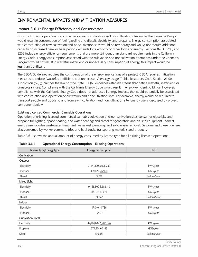
Energy Ascent Environmental
Trinity County 3.6-8 Cannabis Program Revised Draft EIR
ENVIRONMENTAL IMPACTS AND MITIGATION MEASURES
Impact 3.6-1: Energy Efficiency and Conservation
Construction and operation of commercial cannabis cultivation and noncultivation sites under the Cannabis Program would result in consumption of fuel (gasoline and diesel), electricity, and propane. Energy consumption associated with construction of new cultivation and noncultivation sites would be temporary and would not require additional capacity or increased peak or base period demands for electricity or other forms of energy. Sections 8203, 8205, and 8206 include energy efficiency requirements that are more stringent than standard requirements in the California Energy Code. Energy consumption associated with the cultivation and noncultivation operations under the Cannabis Program would not result in wasteful, inefficient, or unnecessary consumption of energy; this impact would be less than significant.
The CEQA Guidelines requires the consideration of the energy implications of a project. CEQA requires mitigation measures to reduce “wasteful, inefficient, and unnecessary” energy usage (Public Resources Code Section 21100, subdivision (b)(3)). Neither the law nor the State CEQA Guidelines establish criteria that define wasteful, inefficient, or unnecessary use. Compliance with the California Energy Code would result in energy-efficient buildings. However, compliance with the California Energy Code does not address all energy impacts that could potentially be associated with construction and operation of cultivation and noncultivation sites. For example, energy would be required to transport people and goods to and from each cultivation and noncultivation site. Energy use is discussed by project component below.
Existing Licensed Commercial Cannabis Operations Operation of existing licensed commercial cannabis cultivation and noncultivation sites consumes electricity and propane for lighting, space heating, and water heating; and diesel for generators and on-site equipment. Indirect energy use includes wastewater treatment, water well pumping, and solid waste removal. Gasoline and diesel fuel are also consumed by worker commute trips and haul trucks transporting materials and products.
Table 3.6-1 shows the annual amount of energy consumed by license type for all existing licensed operations.
Table 3.6-1 Operational Energy Consumption – Existing Operations
License Type/Energy Type Energy Consumption Units
Cultivation
Outdoor
Electricity 21,141,100 3,006,780 kWh/year
Propane 189,828 26,998 GGE/year
Diesel 62,119 Gallons/year
Mixed Light
Electricity 9,458,800 3,683,110 kWh/year
Propane 84,932 33,071 GGE/year
Diesel 74,742 Gallons/year
Indoor
Electricity 17,040 10,786 kWh/year
Propane 154 97 GGE/year
Cultivation Total
Electricity 30,617,020 6,700,676 kWh/year
Propane 274,914 60,166 GGE/year
Diesel 136,861 Gallons/year
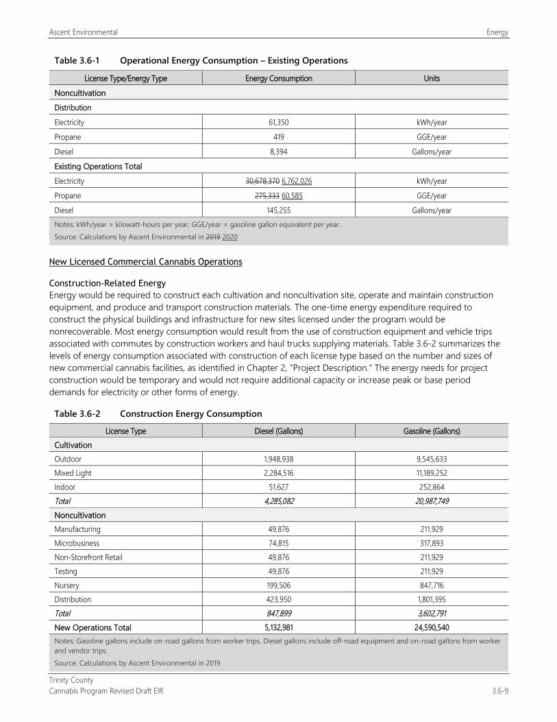
Ascent Environmental Energy
Trinity County Cannabis Program Revised Draft EIR 3.6-9
Table 3.6-1 Operational Energy Consumption – Existing Operations
License Type/Energy Type Energy Consumption Units
Noncultivation
Distribution
Electricity 61,350 kWh/year
Propane 419 GGE/year
Diesel 8,394 Gallons/year
Existing Operations Total
Electricity 30,678,370 6,762,026 kWh/year
Propane 275,333 60,585 GGE/year
Diesel 145,255 Gallons/year Notes: kWh/year = kilowatt-hours per year; GGE/year = gasoline gallon equivalent per year. Source: Calculations by Ascent Environmental in 2019 2020
New Licensed Commercial Cannabis Operations
Construction-Related Energy Energy would be required to construct each cultivation and noncultivation site, operate and maintain construction equipment, and produce and transport construction materials. The one-time energy expenditure required to construct the physical buildings and infrastructure for new sites licensed under the program would be nonrecoverable. Most energy consumption would result from the use of construction equipment and vehicle trips associated with commutes by construction workers and haul trucks supplying materials. Table 3.6-2 summarizes the levels of energy consumption associated with construction of each license type based on the number and sizes of new commercial cannabis facilities, as identified in Chapter 2, “Project Description.” The energy needs for project construction would be temporary and would not require additional capacity or increase peak or base period demands for electricity or other forms of energy.
Table 3.6-2 Construction Energy Consumption
License Type Diesel (Gallons) Gasoline (Gallons) Cultivation Outdoor 1,948,938 9,545,633 Mixed Light 2,284,516 11,189,252 Indoor 51,627 252,864 Total 4,285,082 20,987,749 Noncultivation Manufacturing 49,876 211,929 Microbusiness 74,815 317,893 Non-Storefront Retail 49,876 211,929 Testing 49,876 211,929 Nursery 199,506 847,716 Distribution 423,950 1,801,395 Total 847,899 3,602,791 New Operations Total 5,132,981 24,590,540 Notes: Gasoline gallons include on-road gallons from worker trips. Diesel gallons include off-road equipment and on-road gallons from worker and vendor trips. Source: Calculations by Ascent Environmental in 2019

Energy Ascent Environmental
Trinity County 3.6-10 Cannabis Program Revised Draft EIR
Operational Energy Operation of new commercial cannabis cultivation and noncultivation sites would consume electricity and propane for lighting, space heating, and water heating; and diesel for generators and on-site equipment. Indirect energy use would include wastewater treatment, water well pumping, and solid waste removal. Gasoline and diesel fuel would also be consumed by worker commute trips and haul trucks transporting materials and products. Electrical service may be obtained from on-site generation (solar or generators) and/or extension of electrical services and infrastructure by the Trinity PUD or PG&E. The extent of infrastructure improvements that may be required to extend electrical service from the Trinity PUD or PG&E is unknown. The technical sections of this DEIR address the potential environmental effects of electrical infrastructure extension.
All new buildings at individual cultivation and noncultivation sites would be constructed in accordance with the most recent building code (i.e., California Energy Code) at the time of construction, which includes energy efficiency requirements. Further, as described in “Regulatory Setting,” above, the Cannabis Cultivation Program Sections 8203 and 8305 set forth renewable energy requirements for new and relicensed sites. Under these requirements, all sites seeking license renewals must supply its total electricity from a zero net energy renewable source. All new mixed-light license types and nurseries must ensure that electrical power used for commercial cannabis activity meets the average electricity GHG emissions intensity required by their local utility provider pursuant to the California Renewables Portfolio Standard Program, Division 1, Part 1, Chapter 2.3, Article 16 (commencing with Section 399.11) of the Public Utilities Code. Commercial cannabis cultivation and noncultivation sites built under the Cannabis Program would use more renewable energy than other types of agricultural or manufacturing buildings because of the requirements of the Cannabis Cultivation Program Section 8306.
Table 3.6-3 shows the annual amount of operational energy consumed by license type for all cultivation and noncultivation operations that could be licensed under the Cannabis Program.
Table 3.6-3 Operational Energy Consumption – New Operations
License Type/Energy Type Energy Consumption Units
Cultivation
Outdoor
Electricity 33,852,900 3,908,730 kWh/year
Propane 231,093 26,682 GGE/year
Diesel 84,504 Gallons/year
Mixed Light
Electricity 15,206,600 7,329,070 kWh/year
Propane 103,806 50,031 GGE/year
Diesel 155,638 Gallons/year
Indoor
Electricity 32,752 20,614 kWh/year
Propane 223 141 GGE/year
Cultivation Total
Electricity 49,092,252 11,258,414 kWh/year
Propane 335,122 76,854 GGE/year
Diesel 240,143 Gallons/year
Noncultivation
Manufacturing
Electricity 22,086 kWh/year
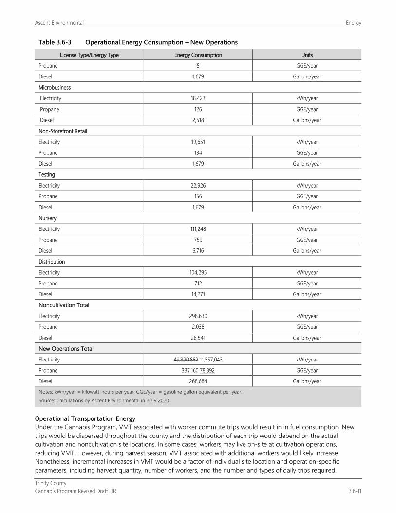
Ascent Environmental Energy
Trinity County Cannabis Program Revised Draft EIR 3.6-11
Table 3.6-3 Operational Energy Consumption – New Operations
License Type/Energy Type Energy Consumption Units
Propane 151 GGE/year
Diesel 1,679 Gallons/year
Microbusiness
Electricity 18,423 kWh/year
Propane 126 GGE/year
Diesel 2,518 Gallons/year
Non-Storefront Retail
Electricity 19,651 kWh/year
Propane 134 GGE/year
Diesel 1,679 Gallons/year
Testing
Electricity 22,926 kWh/year
Propane 156 GGE/year
Diesel 1,679 Gallons/year
Nursery
Electricity 111,248 kWh/year
Propane 759 GGE/year
Diesel 6,716 Gallons/year
Distribution
Electricity 104,295 kWh/year
Propane 712 GGE/year
Diesel 14,271 Gallons/year
Noncultivation Total
Electricity 298,630 kWh/year
Propane 2,038 GGE/year
Diesel 28,541 Gallons/year
New Operations Total
Electricity 49,390,882 11,557,043 kWh/year
Propane 337,160 78,892 GGE/year
Diesel 268,684 Gallons/year
Notes: kWh/year = kilowatt-hours per year; GGE/year = gasoline gallon equivalent per year. Source: Calculations by Ascent Environmental in 2019 2020
Operational Transportation Energy Under the Cannabis Program, VMT associated with worker commute trips would result in in fuel consumption. New trips would be dispersed throughout the county and the distribution of each trip would depend on the actual cultivation and noncultivation site locations. In some cases, workers may live on-site at cultivation operations, reducing VMT. However, during harvest season, VMT associated with additional workers would likely increase. Nonetheless, incremental increases in VMT would be a factor of individual site location and operation-specific parameters, including harvest quantity, number of workers, and the number and types of daily trips required.

Energy Ascent Environmental
Trinity County 3.6-12 Cannabis Program Revised Draft EIR
The annual fuel demand by license type for all cultivation and noncultivation operations that could be licensed under the Cannabis Program is included in Table 3.6-4 below.
Table 3.6-4 Gasoline and Diesel Consumption Associated with New Cultivation and Noncultivation Operations (2020)
Operation Type Gasoline (gal/year) Diesel (gal/year)
Cultivation 2,048,448 1,272,762 14,390 8,941
Noncultivation 17,800 125
Total 2,066,248 1,290,562 14,515 9,066 Notes: gal/year = gallons per year. Source: Calculations by Ascent Environmental in 2019 2020
Summary The project would increase energy demand for temporary construction activities for new cultivation and noncultivation sites. However, construction activities would be relatively minor and would not increase long-term, ongoing demand for energy or fuel.
According to the State CEQA Guidelines, the means to achieve the goal of conserving energy include decreasing overall energy consumption, decreasing reliance on oil, and increase reliance on renewable energy sources.
All buildings constructed under the Cannabis Program would be built to the California Energy Code in effect at the time of construction and compliance with the CCR requirements for energy efficiency for cultivation operations.
Also, the energy-related requirements in Sections 8203, 8205, and 8206 are more stringent than standard requirements in the California Energy Code. For these reasons, energy consumption associated with construction and operation of cannabis facilities licensed under the program would not be considered wasteful, inefficient, or unnecessary. This impact would be less than significant.
Moreover, implementation of Mitigation Measures 3.3-1b, 3.3-1c, 3.3-2a, 3.3-2b, 3.8-1c, and 3.8-1d, which would reduce emissions of criteria air pollutants and GHG emissions would also have result in lower energy consumption.
Mitigation Measures No mitigation is required.
Impact 3.6-2: Consistency With Plans for Renewable Energy and Energy Efficiency
Renewable energy generation requirements pursuant to the Cannabis Program would result in an increase renewable energy use, which would directly support the goals and strategies in the state’s 2008 Update Energy Action Plan (EAP). Constructing and operating project buildings in compliance with the 2019 California Energy Code would improve energy efficiency compared to building built to earlier iterations of the Code. Therefore, construction and operation of cannabis facilities licensed under the program would not conflict with or obstruct a state or local plan for renewable energy or energy efficiency. No impact would occur.
Relevant plans that pertain to the efficient use of energy include the EAP, which focuses on energy efficiency; demand response; renewable energy; the supply and reliability of electricity, natural gas, and transportation fuels; and achieving GHG reduction targets (CEC and CPUC 2008).
Existing and New Licensed Commercial Cannabis Operations As discussed in Impact 3.6-1, although implementation of the Cannabis Program has the potential to result in the consumption of energy resources during construction and operation of cultivation and noncultivation sites, the requirements of the Cannabis Cultivation Program (i.e., Sections 8203 and 8305) to ensure relicensed and new sites use renewable energy and compliance with the 2019 California Energy Code would align with the EAP. Therefore, the

Ascent Environmental Energy
Trinity County Cannabis Program Revised Draft EIR 3.6-13
project would not conflict with or obstruct a state or local plan for renewable energy or energy efficiency. No impact would occur.
Further, implementation of Mitigation Measures 3.3-1b, 3.3-1c, 3.3-2a, 3.3-2b in Section 3.3, “Air Quality,” and Mitigation Measures 3.8-1c, and 3.8-1d in Section 3.8, “Greenhouse Gas Emissions and Climate Change,” would result in reductions to energy consumption.
Mitigation Measures No mitigation is required.
Impact 3.6-3: Demand for Energy Services and Facilities
Infrastructure and capacity for energy services and facilities exist within portions of the county for commercial cannabis operations resulting from the Cannabis Program. State cannabis regulations requires all sites conducting cultivation or supportive activities ensure that electrical power used for commercial cannabis activity meets the average electricity GHG emissions intensity required by their local utility provider pursuant to the California Renewables Portfolio Standard Program. Compliance could involve the use of a zero net energy renewable source such as solar. These requirements would reduce new energy demand. Thus, this impact would be less than significant.
Existing and New Licensed Commercial Cannabis Operations The existing electrical infrastructure is provided and operated by PG&E and Trinity PUD is in close proximity to the communities and developed areas of the county. Due to the existing and anticipated development patterns of cannabis cultivation across the county, it is anticipated that cultivation sites under the Cannabis Program would obtain energy supply through a combination of connections to available electrical infrastructure and/or onsite solar photovoltaic systems, as well as the use of back-up generators. The extent of infrastructure improvements that may be required to extend electrical service from the Trinity PUD or PG&E is unknown. The technical sections of this DEIR address the potential environmental effects of electrical infrastructure extension. The use of solar photovoltaic systems at cultivation sites was observed during field review of county cannabis cultivation sites. Noncultivation operations are anticipated to connect to existing electrical infrastructure based on their anticipated locations in or near communities. State requirements such as SB 350 requires energy utilities to increase energy efficiency and manage peak demand using various strategies such as energy efficiency financing and tiered service rates. CCR Sections 8203 and 8205 would further promote the use of renewable energy that would reduce the demand for potential expansion of electrical distribution infrastructure in the county. This is anticipated to reduce demand statewide through increased energy efficiency. Energy demands in the county are not anticipated to substantially increase in the future due to a reduction in population from 13,404 in 2019 to 13,232 by 2040 (California Department of Finance 2019). Thus, the impact to energy services and facilities would be less than significant.
Mitigation Measures No mitigation is required.

Energy Ascent Environmental
Trinity County 3.6-14 Cannabis Program Revised Draft EIR
This page intentionally left blank.
Ascent Environmental Geology and Soils
Trinity County Cannabis Program Revised Draft EIR 3.7-1
3.7 GEOLOGY AND SOILS This section describes current conditions relative to geology and soils in Trinity County. It includes a description of soils and mineral resources, analysis of environmental impacts, and recommendations for mitigation measures for any significant or potentially significant impacts.
Comment letters submitted in response to the Notice of Preparation for this EIR addressed issues pertaining to adverse effects in associated with erosion and sedimentation from existing roads used by cannabis cultivation operations, grading impacts, and concerns regarding the lack of a countywide grading ordinance. Geologic and soil stability issues associated with implementation of the Cannabis Program are addressed below. The County’s consideration of a countywide grading ordinance is a separate project and is not considered in this DEIR.
3.7.1 Regulatory Setting
FEDERAL
National Earthquake Hazards Reduction Act In October 1977, the U.S. Congress passed the Earthquake Hazards Reduction Act to reduce the risks to life and property from future earthquakes in the United States. To accomplish this, the act established the National Earthquake Hazards Reduction Program (NEHRP). The mission of the NEHRP includes improved understanding, characterization, and prediction of hazards and vulnerabilities; improved building codes and land use practices; risk reduction through post‐earthquake investigations and education; development and improvement of design and construction techniques; improved mitigation capacity; and accelerated application of research results. The NEHRP designates the Federal Emergency Management Agency as the lead agency of the program and assigns several planning, coordinating, and reporting responsibilities.
STATE
Alquist-Priolo Earthquake Fault Zoning Act The Alquist-Priolo Earthquake Fault Zoning Act of 1972 (PRC Section 2621-2630) intends to reduce the risk to life and property from surface fault rupture during earthquakes by regulating construction in active fault corridors, and by prohibiting the location of most types of structures intended for human occupancy across the traces of active faults. The act defines criteria for identifying active faults, giving legal support to terms such as active and inactive, and establishes a process for reviewing building proposals in Earthquake Fault Zones. Under the Alquist-Priolo Act, faults are zoned and construction along or across these zones is strictly regulated if they are “sufficiently active” and “well-defined.” A fault is considered sufficiently active if one or more of its segments or strands shows evidence of surface displacement during Holocene time (defined for purposes of the act as within the last 11,000 years). A fault is considered well defined if its trace can be clearly identified by a trained geologist at the ground surface or in the shallow subsurface, using standard professional techniques, criteria, and judgment. Before a project can be permitted in a designated Alquist‐Priolo Earthquake Fault Zone, cities and counties must require a geologic investigation to demonstrate that proposed buildings would not be constructed across active faults. The law addresses only the hazard of surface fault rupture and is not directed toward other earthquake hazards.
Seismic Hazards Mapping Act The intention of the Seismic Hazards Mapping Act of 1990 (PRC Sections 2690–2699.6) is to reduce damage resulting from earthquakes. While the Alquist-Priolo Act addresses surface fault rupture, the Seismic Hazards Mapping Act addresses other earthquake-related hazards, including ground shaking, liquefaction, and seismically induced landslides. The act’s provisions are similar in concept to those of the Alquist-Priolo Act: The state is charged with identifying and mapping areas at risk of strong ground shaking, liquefaction, landslides, and other corollary hazards,
Geology and Soils Ascent Environmental
Trinity County 3.7-2 Cannabis Program Revised Draft EIR
and cities and counties are required to regulate development within mapped Seismic Hazard Zones. Under the Seismic Hazards Mapping Act, permit review is the primary mechanism for local regulation of development.
California Building Code The California Building Code (CBC) (CCR Title 24) is based on the International Building Code. The CBC has been modified from the International Building Code for California conditions, with more detailed and/or more stringent regulations. Specific minimum seismic safety and structural design requirements are set forth in Chapter 16 of the CBC. The CBC identifies seismic factors that must be considered in structural design. Chapter 18 of the CBC regulates the excavation of foundations and retaining walls, while Chapter 18A regulates construction on unstable soils, such as expansive soils and areas subject to liquefaction. Appendix J of the CBC regulates grading activities, including drainage and erosion control. The CBC contains a provision that provides for a preliminary soil report to be prepared to identify “the presence of critically expansive soils or other soil problems which, if not corrected, would lead to structural defects.”
State Water Resources Control Board Regulations for Cannabis Cultivation Coverage under the North Coast Regional Water Quality Control Board (RWQCB) Order R1-2015-0023, described below under “Local,” is set to be terminated by July 19, 2019, at which point discharges related to cannabis cultivation must be covered under the State Water Resources Control Board (SWRCB) Cannabis Policy under Order WQ 2019-002301-DWQ, General Waste Discharge Requirements and Waiver of Waste Discharge Requirements for Discharges of Waste Associated with Cannabis Cultivation Activities. Dischargers enrolled under the North Coast RWQCB order may generally continue to operate their facility with their existing order’s setback, although new or expanded areas must comply with the state order, which is summarized as follows.
The Cannabis General Order provides a statewide tiered approach for permitting discharges and threatened discharges of waste from cannabis cultivation and associated activities. The tier structure consists of two tiers:
Tier 1 outdoor commercial cultivation activities disturb an area equal to or greater than 2,000 square feet and less than 1 acre (43,560 square feet).
Tier 2 outdoor commercial cultivation activities disturb an area equal to or greater than 1 acre.
For the purposes of this regulation, land disturbances refers to areas where natural conditions have been modified in a way that may result in an increase in turbidity in water discharged from the site. Land disturbance includes all activities whatsoever associated with developing or modifying land for cannabis cultivation related activities or access. Land disturbance activities include, but are not limited to, construction of roads, buildings, water storage areas and excavation, grading, and site clearing.
Tier 1 and Tier 2 enrollees must characterize the risk designation based on the slope of disturbed areas and the proximity to a water body. Applicants must comply with the riparian setback and slope limits and are classified as low, moderate, or high risk, as described below:
Low Risk: A cannabis cultivation site is classified as low risk if no part of the disturbed area is located on a slope of 30 percent or greater. Such cannabis cultivators shall register as low risk and submit a Site Management Plan.
Moderate Risk: A cannabis cultivation site is classified as moderate risk if any part of the disturbed area is located on a slope greater than 30 percent and less than 50 percent. Such cannabis cultivators shall register as moderate risk and submit a Site Erosion and Sediment Control Plan.
High Risk: A cannabis cultivation site is classified as high risk if any part of the disturbed area exists within the riparian setback limits. Such cannabis cultivators shall register as high risk, submit a Disturbed Area Stabilization Plan, and shall address the compliance issue as described below. Because such cannabis cultivators pose a higher risk to water quality and will require a higher level of RWQCB oversight, they are subject to a higher application and annual fee. When the cannabis cultivation site is reconfigured to comply with the riparian setbacks, the cannabis cultivator can request the RWQCB reclassify the site to a lower risk level and allow a lower annual fee to be assessed.
Ascent Environmental Geology and Soils
Trinity County Cannabis Program Revised Draft EIR 3.7-3
To obtain coverage under the waiver or enroll under the general order, the discharger is required to submit an online application and application fee and relevant technical reports. Technical report requirements are based on tier and risk level. The reader is referred to Section 3.10, “Hydrology and Water Quality,” for a further description of this order.
Paleontological Resources Paleontological resources are classified as nonrenewable scientific resources and are protected by state statute (PRC Chapter 1.7, Section 5097.5, Archeological, Paleontological, and Historical Sites and Appendix G). No state or local agencies have specific jurisdiction over paleontological resources. No state or local agency requires a paleontological collecting permit to allow for the recovery of fossil remains discovered because of construction-related earth moving on state or private land in a project site.
LOCAL
North Coast Regional Water Quality Control Board Cannabis Cultivation Waste Discharge Regulatory Program The North Coast RWQCB’s Order R1-2015-0023, The Cannabis Cultivation Waste Discharge Regulatory Program (Order R1-2015-0023, or Order), addresses water quality impacts from cannabis cultivation and associated activities or other operations with similar environmental effects on private property in the North Coast Region. Nonpoint source pollution, also known as polluted runoff, is the leading cause of water quality impairments in the North Coast. The majority of the streams in the North Coast are affected by excess sediment, nutrients, and elevated temperatures. The problems are often associated with poorly planned forest clearing, earth-moving activities, and other land use management practices, resulting in polluted stormwater runoff to streams. Dry-season surface water diversions intensify these water quality impacts. The regulatory program has several components: A Waiver of Waste Discharge Requirements; Third Party Programs, Inspections, Enforcement, and Education; and Outreach.
The Order includes enforceable requirements that cultivators need to become familiar with to ensure their operations do not affect water resources. Below is a summary of primary elements of the Order:
1. A tiered enrollment structure relative to the potential threat to water quality. Tier 1 is a low-threat tier based on compliance with defined standard conditions and site characteristics. Tier 2 is a management tier, which requires the development and implementation of a water resource protection plan. Tier 3 is a cleanup tier, which requires the development and implementation of a cleanup and restoration plan.
2. Standard conditions to protect water quality, in conjunction with a list of best management practices (BMPs), provide a framework for cultivators to assess their sites for appropriate tiers and determine what management measures are necessary to protect water quality. All BMPs in the order are considered enforceable conditions under the Order as applicable to a given site. The draft Order includes standard conditions regarding:
a. Site maintenance, erosion control and drainage features b. Stream crossing maintenance and improvement c. Stream and wetland buffers d. Spoils management e. Water storage and use f. Irrigation runoff g. Fertilizers and soil amendments h. Pesticides i. Petroleum products and other chemicals j. Cultivation-related wastes k. Refuse and human waste, and l. Remediation, cleanup, and restoration activities.
Geology and Soils Ascent Environmental
Trinity County 3.7-4 Cannabis Program Revised Draft EIR
3. Associated procedural forms including a notice of intent of enrollment, a monitoring and reporting form, and a checklist for remediation and restoration work in streams or wetlands.
4. General Prohibitions including discharges or threatened discharges to surface waters.
5. A framework for nongovernmental third-party programs to assist cultivators with enrollment, compliance activities, and monitoring and reporting.
6. A framework for development and implementation of water resource protection and cleanup and restoration plans.
With adoption of the SWRCB’s Cannabis Policy, the North Coast RWQCB is set to terminate in July 2019.
Trinity County General Plan The Trinity County General Plan Conservation Element has the following applicable objectives and recommendations related to geologic and soil stability:
Objective: To conserve and maintain streams, lakes and forest open space as a means of providing natural habitat and for all species of wildlife existing in the County.
Prevent land uses which result in siltation, and pollution of lakes and streams should be carefully monitored, and if necessary corrected to assure clean and productive habitat.
Objective: To preserve quality and quantity of the existing water supply in Trinity County and adequately plan for the expansion and retention of valuable water supplies for future generations.
Disapprove of any development which may pollute the existing streams and lakes or become the source of silt which washes down into water areas.
The General Plan Open Space Element has the following applicable objectives and recommendations related to geologic and soil stability:
Objective: To preserve and maintain open space as a means of providing natural habitat for all species of wildlife is the prime objective.
Present land uses which result in siltation and pollution of lakes and streams should be carefully monitored, and if necessary corrected to assure a clean and productive habitat.
Objective: To preserve the quantity and quality of the existing water supply in Trinity County and adequately plan for the expansion and retention of valuable water supplies for future generations.
Disapprove of any development which may pollute the existing streams and lakes or become the source of silt which washes down into water areas.
The General Plan Safety Element has the following applicable objectives and policies related to geologic and seismic hazards:
S.4.1 Objective: Promote safety from seismic or geologic hazards.
(B) Geologic hazards and seismic safety shall be considered in the preparation of environmental documents as required by the California Environmental Quality Act.
(D) Areas in excess of 30 percent slope shall require submittal of engineered plans for all construction and grading, at the discretion of the Trinity County Planning Department. These plans shall address roads, utility corridors, and similar off-site improvements, as well as erosion control.
(F) Construction and grading activities shall be done in a manner that minimizes adverse effects on the stability of any slope.
(G) The County shall not allow development on existing unconsolidated landslide debris.
Ascent Environmental Geology and Soils
Trinity County Cannabis Program Revised Draft EIR 3.7-5
Trinity County Code of Ordinances
Improvement and Grading Requirements Chapter 12.12 provides construction improvement standards for roadways in decomposed granite areas of the county in order to protect soil, water, and fishery resources of the county. This chapter includes limits on the roadway grades, drainage, and culvert design standards to minimize erosion potential and revegetation and maintenance requirements (Section 12.12.040).
On April 16, 2019, the Board of Supervisors adopted Chapter 15.24 to the Code of Ordinances, which established restrictions on mass grading in order to address soil and geologic stability issues from recent construction activities in the county (e.g., water storage ponds, pad grading, and roadway construction for cannabis cultivation sites). This chapter prohibits any activity that consists of a volume of graded material greater than 800 cubic yards and/or any contiguous or noncontiguous surface area to be graded that is greater than 20,000 square feet. This extent of grading may be allowed subject to the approval of a Director’s Use Permit or a Conditional Use Permit. Under no circumstances are grading activities allowed that:
create a hazard to public health and safety;
generate a threat to the stability or use of adjacent properties;
damage public or private utilities;
damage public or private roadways or other transportation facilities;
cause damage to, or obstruction of, watercourses or drainage facilities;
create observable degradation of the water quality of any water body;
damage existing septic systems and water supply wells; or
damage survey markers, monuments, benchmarks, or geodetic marks.
Septic Systems Section 15.16.170 requires that all new and replacement water supply and sanitary sewage systems shall be designed to minimize or eliminate infiltration of floodwater into the system and discharge from systems into floodwaters. On-site waste disposal systems must be located to avoid contamination during a flood event. Section 16.48.122 contains criteria for determining lot size, usable acreage, percolation standards, and other standards that must be met to construct on-site waste disposal systems.
3.7.2 Environmental Setting
GEOLOGY AND TOPOGRAPHY Northern California is home to mountain ranges throughout most of the region. The Klamath Mountains province includes Trinity County is comprised generally of older rocks, many of which are sedimentary (e.g., sandstone, chert, slate, and schist). Klamath Mountains province include the Siskiyou Mountains, the Marble Mountains, the Scott Mountains, the Trinity Mountains, the Trinity Alps, the Salmon Mountains, and the northern Yolla-Bolly Mountains. Trinity County is home to the Trinity Alps mountain range located in the eastern part of the county. The Trinity Alps are composed of granite peaks with elevations of 2,000 feet at the creek drainages and 9,000 feet at the summits (USFS 2019).
Geology and Soils Ascent Environmental
Trinity County 3.7-6 Cannabis Program Revised Draft EIR
DRAINAGE The major rivers and associated watersheds in the county are the Mad, the Van Duzen, the North Fork of the Eel, and the Trinity and its tributaries and the North Fork, Stuart Fork, East Fork, and South Fork. A hydrologic map of the county is depicted in Figure 3.10-1. These waterways and their watersheds extend beyond Trinity County’s boundaries and include portions of Humboldt County and Mendocino County.
SOILS Trinity County has a variety of soils. These include Typic Xerofluvents, young soils that form from alluvium found on river floodplains; Skalan-Goldridge Families Complex Deep soils, formed from metasedimentary rocks and are found on mountain sideslopes of from 20-60 percent and are moderately slow permeability and are well drained; Goldridge Family Deep soils, formed from metasedimentary rocks and found on mountain sideslopes from 20–45 percent; Maymen Family Rock Outcrop Metasedimentary Complex soils, formed from metasedimentary rocks found on upper mountain sideslopes from 60-80 percent that are moderately permeable and somewhat excessively drained; Hugo Family Deep and Clallam Family Moderately Deep soils, found on private lands north of the Trinity River and were formed from metasedimentary rocks that are moderately permeable and are well drained; and Skalan-Kistirn-Holland Families Deep soils, formed from metasedimentary rocks and are found on mountain sideslopes of 35-70percent with low permeability and are well drained (TCRCD 2005).
SEISMICITY Most earthquakes originate along fault lines. A fault is a fracture in the Earth’s crust along which rocks on one side are displaced relative to those on the other side due to shear and compressive crustal stresses. Most faults are the result of repeated displacement that may have taken place suddenly and/or by slow creep. The state of California has a classification system that designates faults as either active, potentially active, or inactive, depending on how recently displacement has occurred along them. Faults that show evidence of movement within the last 11,000 years (the Holocene geologic period) are considered active, and faults that have moved between 11,000 and 1.6 million years ago (comprising the later Pleistocene geologic period) are considered potentially active.
A review of available published geologic and seismic hazards maps indicates that there are Quaternary and Late Quaternary fault lines within the county that have moved between 11,000 and 1.6 million years ago. These are fault lines that geologists believe are a potential source of future great earthquakes. These fault lines are located in the southern portion of the county and include the Grogan, Mule Ridge, and Lake Mountain faults.
Seismic hazards resulting from earthquakes include surface fault rupture, ground shaking, and liquefaction. Each of these potential hazards is discussed below.
Surface Fault Rupture Surface rupture is the surface expression of movement along a fault. Structures built over an active fault can be torn apart if the ground ruptures. The potential for surface rupture is based on the concepts of recency and recurrence. Surface rupture along faults is generally limited to a linear zone a few meters wide. The Alquist-Priolo Act (see the Regulatory Setting discussion above) was created to prohibit the location of structures designed for human occupancy across, or within 50 feet of, an active fault, thereby reducing the loss of life and property from an earthquake. There are fault lines located in the southern portion of the county but they are not considered surface rupture faults. However, the possibility exists for surface rupture in a severe seismic shaking.
Ground Shaking The intensity of seismic shaking, or strong ground motion, during an earthquake is dependent on the distance and direction from the epicenter of the earthquake, the magnitude of the earthquake, and the geologic conditions of the surrounding area. Ground shaking could potentially result in the damage or collapse of buildings and other structures. Earthquake intensities generally associated with this amount of ground shaking are typically between VI
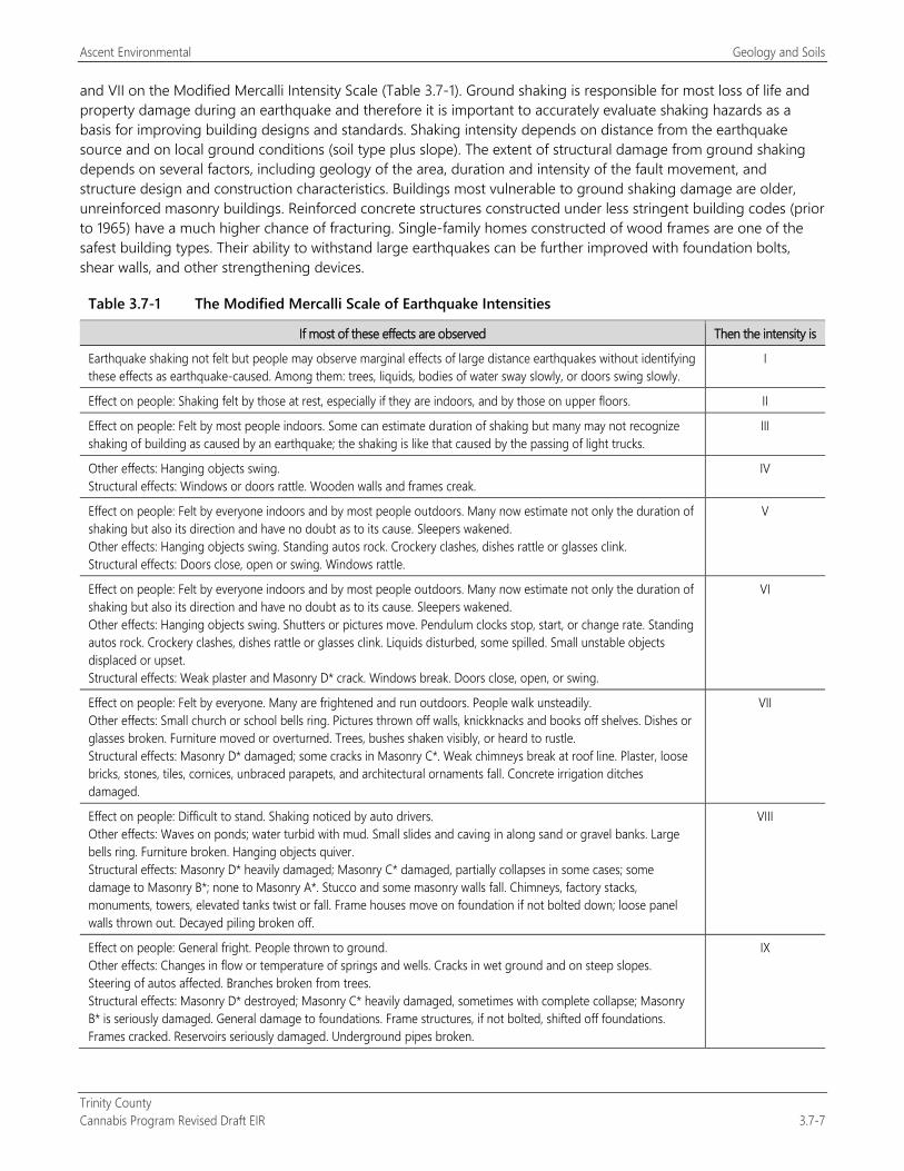
Ascent Environmental Geology and Soils
Trinity County Cannabis Program Revised Draft EIR 3.7-7
and VII on the Modified Mercalli Intensity Scale (Table 3.7-1). Ground shaking is responsible for most loss of life and property damage during an earthquake and therefore it is important to accurately evaluate shaking hazards as a basis for improving building designs and standards. Shaking intensity depends on distance from the earthquake source and on local ground conditions (soil type plus slope). The extent of structural damage from ground shaking depends on several factors, including geology of the area, duration and intensity of the fault movement, and structure design and construction characteristics. Buildings most vulnerable to ground shaking damage are older, unreinforced masonry buildings. Reinforced concrete structures constructed under less stringent building codes (prior to 1965) have a much higher chance of fracturing. Single-family homes constructed of wood frames are one of the safest building types. Their ability to withstand large earthquakes can be further improved with foundation bolts, shear walls, and other strengthening devices.
Table 3.7-1 The Modified Mercalli Scale of Earthquake Intensities
If most of these effects are observed Then the intensity is
Earthquake shaking not felt but people may observe marginal effects of large distance earthquakes without identifying these effects as earthquake-caused. Among them: trees, liquids, bodies of water sway slowly, or doors swing slowly.
I
Effect on people: Shaking felt by those at rest, especially if they are indoors, and by those on upper floors. II
Effect on people: Felt by most people indoors. Some can estimate duration of shaking but many may not recognize shaking of building as caused by an earthquake; the shaking is like that caused by the passing of light trucks.
III
Other effects: Hanging objects swing. Structural effects: Windows or doors rattle. Wooden walls and frames creak.
IV
Effect on people: Felt by everyone indoors and by most people outdoors. Many now estimate not only the duration of shaking but also its direction and have no doubt as to its cause. Sleepers wakened. Other effects: Hanging objects swing. Standing autos rock. Crockery clashes, dishes rattle or glasses clink. Structural effects: Doors close, open or swing. Windows rattle.
V
Effect on people: Felt by everyone indoors and by most people outdoors. Many now estimate not only the duration of shaking but also its direction and have no doubt as to its cause. Sleepers wakened. Other effects: Hanging objects swing. Shutters or pictures move. Pendulum clocks stop, start, or change rate. Standing autos rock. Crockery clashes, dishes rattle or glasses clink. Liquids disturbed, some spilled. Small unstable objects displaced or upset. Structural effects: Weak plaster and Masonry D* crack. Windows break. Doors close, open, or swing.
VI
Effect on people: Felt by everyone. Many are frightened and run outdoors. People walk unsteadily. Other effects: Small church or school bells ring. Pictures thrown off walls, knickknacks and books off shelves. Dishes or glasses broken. Furniture moved or overturned. Trees, bushes shaken visibly, or heard to rustle. Structural effects: Masonry D* damaged; some cracks in Masonry C*. Weak chimneys break at roof line. Plaster, loose bricks, stones, tiles, cornices, unbraced parapets, and architectural ornaments fall. Concrete irrigation ditches damaged.
VII
Effect on people: Difficult to stand. Shaking noticed by auto drivers. Other effects: Waves on ponds; water turbid with mud. Small slides and caving in along sand or gravel banks. Large bells ring. Furniture broken. Hanging objects quiver. Structural effects: Masonry D* heavily damaged; Masonry C* damaged, partially collapses in some cases; some damage to Masonry B*; none to Masonry A*. Stucco and some masonry walls fall. Chimneys, factory stacks, monuments, towers, elevated tanks twist or fall. Frame houses move on foundation if not bolted down; loose panel walls thrown out. Decayed piling broken off.
VIII
Effect on people: General fright. People thrown to ground. Other effects: Changes in flow or temperature of springs and wells. Cracks in wet ground and on steep slopes. Steering of autos affected. Branches broken from trees. Structural effects: Masonry D* destroyed; Masonry C* heavily damaged, sometimes with complete collapse; Masonry B* is seriously damaged. General damage to foundations. Frame structures, if not bolted, shifted off foundations. Frames cracked. Reservoirs seriously damaged. Underground pipes broken.
IX
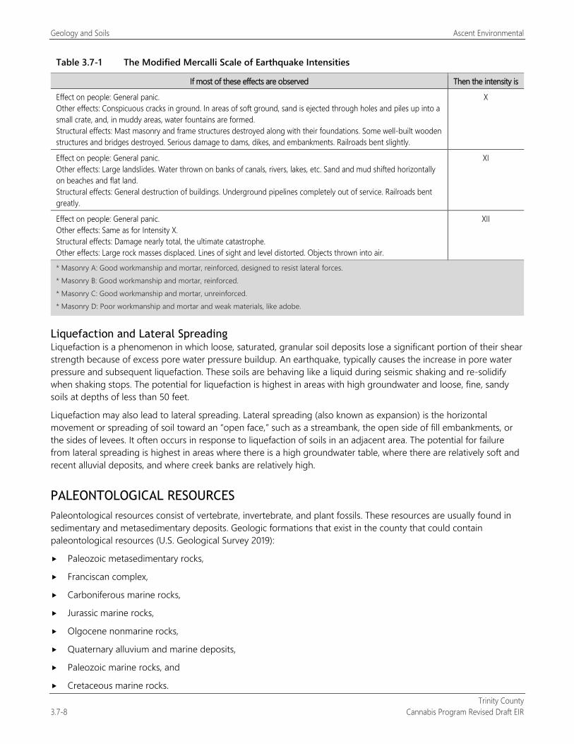
Geology and Soils Ascent Environmental
Trinity County 3.7-8 Cannabis Program Revised Draft EIR
Table 3.7-1 The Modified Mercalli Scale of Earthquake Intensities
If most of these effects are observed Then the intensity is
Effect on people: General panic. Other effects: Conspicuous cracks in ground. In areas of soft ground, sand is ejected through holes and piles up into a small crate, and, in muddy areas, water fountains are formed. Structural effects: Mast masonry and frame structures destroyed along with their foundations. Some well-built wooden structures and bridges destroyed. Serious damage to dams, dikes, and embankments. Railroads bent slightly.
X
Effect on people: General panic. Other effects: Large landslides. Water thrown on banks of canals, rivers, lakes, etc. Sand and mud shifted horizontally on beaches and flat land. Structural effects: General destruction of buildings. Underground pipelines completely out of service. Railroads bent greatly.
XI
Effect on people: General panic. Other effects: Same as for Intensity X. Structural effects: Damage nearly total, the ultimate catastrophe. Other effects: Large rock masses displaced. Lines of sight and level distorted. Objects thrown into air.
XII
* Masonry A: Good workmanship and mortar, reinforced, designed to resist lateral forces. * Masonry B: Good workmanship and mortar, reinforced. * Masonry C: Good workmanship and mortar, unreinforced. * Masonry D: Poor workmanship and mortar and weak materials, like adobe.
Liquefaction and Lateral Spreading Liquefaction is a phenomenon in which loose, saturated, granular soil deposits lose a significant portion of their shear strength because of excess pore water pressure buildup. An earthquake, typically causes the increase in pore water pressure and subsequent liquefaction. These soils are behaving like a liquid during seismic shaking and re-solidify when shaking stops. The potential for liquefaction is highest in areas with high groundwater and loose, fine, sandy soils at depths of less than 50 feet.
Liquefaction may also lead to lateral spreading. Lateral spreading (also known as expansion) is the horizontal movement or spreading of soil toward an “open face,” such as a streambank, the open side of fill embankments, or the sides of levees. It often occurs in response to liquefaction of soils in an adjacent area. The potential for failure from lateral spreading is highest in areas where there is a high groundwater table, where there are relatively soft and recent alluvial deposits, and where creek banks are relatively high.
PALEONTOLOGICAL RESOURCES Paleontological resources consist of vertebrate, invertebrate, and plant fossils. These resources are usually found in sedimentary and metasedimentary deposits. Geologic formations that exist in the county that could contain paleontological resources (U.S. Geological Survey 2019):
Paleozoic metasedimentary rocks,
Franciscan complex,
Carboniferous marine rocks,
Jurassic marine rocks,
Olgocene nonmarine rocks,
Quaternary alluvium and marine deposits,
Paleozoic marine rocks, and
Cretaceous marine rocks.
Ascent Environmental Geology and Soils
Trinity County Cannabis Program Revised Draft EIR 3.7-9
3.7.3 Environmental Impacts and Mitigation Measures
METHODOLOGY The following program-level analysis is based upon generalized geology and soils mapping and data available. The footprint and design details of any site-specific commercial cannabis projects are not known at this time. Specific requirements of existing laws and regulations described in the regulatory setting are assessed for their ability to avoid or reduce the exposure of people or structures to substantial adverse effects.
THRESHOLDS OF SIGNIFICANCE Thresholds of significance are based on Appendix G of the State CEQA Guidelines. These thresholds were used because they address geology, soil, paleontological, and mineral resources considered important by the state, CEQA, and Trinity County and address whether the implementation of the Cannabis Program could create an impact.
A geology and soils impact would be significant if implementation of the Cannabis Program would:
directly or indirectly cause potential substantial adverse effects, including the risk of loss, injury, or death involving:
rupture of a known earthquake fault, as delineated on the most recent Alquist-Priolo Earthquake Fault Zoning Map issued by the State Geologist for the area or based on other substantial evidence of a known fault;
strong seismic ground shaking;
seismic-related ground failure, including liquefaction; or
landslides;
result in substantial soil erosion or the loss of topsoil;
be located on a geologic unit or soil that is unstable, or that would become unstable as a result of the project, and potentially result in on- or off-site landslide, lateral spreading, subsidence, liquefaction, or collapse;
be located on expansive soil, as defined in Table 18-1-B of the Uniform Building Code (1994, as updated), creating substantial direct or indirect risks to life or property;
have soils incapable of adequately supporting the use of septic tanks or alternative wastewater disposal systems where sewers are not available for the disposal of wastewater; or
directly or indirectly destroy a unique paleontological resource or site or unique geologic feature
ENVIRONMENTAL IMPACTS AND MITIGATION MEASURES
Impact 3.7-1: Loss, Injury or Death Resulting from Seismic Hazards
Implementation of the Cannabis Program could expose additional people and structures in a region susceptible to existing seismic hazards. New development from implementation of the Cannabis Program would not exacerbate existing seismic hazards and would comply with state and local regulatory design requirements related to seismic hazards (e.g., building codes and other laws and regulations), such that the exposure of people or structures to risk of loss, injury or death resulting from rupture of a known earthquake fault or strong seismic shaking would be avoided or reduced. This impact would be less than significant.
The California Supreme Court decision in California Building Industry Association v. Bay Area Air Quality Management District has resulted in changes in the interpretation of CEQA with regard to the effects of existing environmental conditions on a project’s future users or residents. The effects of the environment on a project are outside the scope of CEQA unless the project would exacerbate these conditions, as concluded by the California Supreme Court (see
Geology and Soils Ascent Environmental
Trinity County 3.7-10 Cannabis Program Revised Draft EIR
California Building Industry Association v. Bay Area Air Quality Management District [2015] 62 Cal.4th 369, 377 [“we conclude that agencies generally subject to CEQA are not required to analyze the impact of existing environmental conditions on a project’s future users or residents. But when a project risks exacerbating those environmental hazards or conditions that already exist, an agency must analyze the potential impact of such hazards on future residents or users.”]). Changes to the State CEQA Guidelines to reflect this decision were adopted on December 28, 2018. CEQA cannot be used by a lead agency to require a developer or other agency to obtain an EIR or implement mitigation measures solely because the occupants or users of a new project would be subjected to the level of hazards specified.
Existing Licensed Commercial Cannabis Operations The existing licensed operations in the county would not lead to any new structures or additional people located within a region susceptible to existing seismic hazards. The fault lines in the southern portion of the county have been in existence for the past 11,000 to 1.6 million years. The existing licensed operations were required to comply with state building codes for seismic shaking. This requires the structures to use the BMPs to address seismic hazards. This impact is less than significant.
New Licensed Commercial Cannabis Operations The new licensed operations have the potential to add new structures and additional people in a region of existing seismic hazards. Development would be designed and constructed in accordance with the seismic design requirements of the 2016 CBC and Alquist-Priolo Fault Hazard Regulations. The CBC standards require the design of structures to consider seismic hazards present at the site and the intended use, or nature of occupancy, of the structure. Alquist-Priolo requires that no buildings intended for human occupancy would be allowed on or within 50 feet of an active fault trace.
Requirements associated with the 2016 CBC and Alquist-Priolo Fault Hazard Regulation contain building specification and siting requirements that avoid the risks of loss, injury, or death resulting from seismic hazard. Because new development associated with the proposed program would implement and comply with existing state and local regulatory requirements related to seismic hazards, this impact would be less than significant.
Mitigation Measures No mitigation is required.
Impact 3.7-2: Create Geologic Hazard and Soil Stability Issues and Associated Soil Erosion Impacts
Parts of Trinity County are characterized by steep slopes, landslides, expansive soils, and other related conditions that can result in geologic and soil stability hazards. Development of cannabis uses from implementation of the Cannabis Program could result in geologic and soil stability issues resulting slope failures and soil erosion and sedimentation. This impact would be potentially significant.
As noted in Section 3.7.2, “Environmental Setting,” the county topography, slope, and soil conditions could result in geologic stability and soil erosion issues should grading and development be conducted with proper engineering and design. As discussed above in Section 3.7.1, “Regulatory Setting,” and Section 3.10, “Hydrology and Water Quality,” the SWRCB Order WQ 20179-002301-DWQ contains requirements for cannabis cultivation on sites greater than 2,000 square feet. These requirements include plans that address site erosion and sediment control, disturbed areas stabilization, site closure procedures, and monitoring and reporting requirements. In addition, the Order contains requirements for land development maintenance, erosion control, drainage features, stream crossing installation and maintenance, soil disposal and spoils management, and roadway design and maintenance.
County Code of Ordinances Chapter 12.12 provides construction improvement standards for roadways in decomposed granite areas of the county that would apply to all cannabis uses. This chapter includes limits on the roadway grades, drainage and culvert design standards to minimize erosion potential, and revegetation and maintenance requirements (Section 12.12.040). Recently adopted Chapter 15.24 of the Code of Ordinances establishes
Ascent Environmental Geology and Soils
Trinity County Cannabis Program Revised Draft EIR 3.7-11
restrictions on mass grading. This chapter prohibits any activity that consists of a volume of graded material greater than 800 cubic yards and/or any contiguous or noncontiguous surface area to be graded that is greater than 20,000 square feet. This extent of grading may be allowed subject to the approval of a Director’s Use Permit or a Conditional Use Permit that would apply to activities in the Cannabis Program. As described under Section 3.7.1, “Regulatory Setting,” under no circumstances are grading activities allowed that could create a public health hazard, damage facilities and roadways, or degrade water quality.
The Cannabis Program includes the following standards that address water quality for cultivation operations:
The cultivation of cannabis shall not create erosion or result in contaminated runoff into any stream, creek, river, or body of water. If the designated area has more than a 35 percent slope, the applicant shall apply for a Tier 2 cultivation under the North Coast RWQCB Order #2015-0023, or regulations established by the SWRCB (Section 315-843[6][d]).
Applicant shall obtain coverage under the General Permit for Discharges of Storm Water Associated with Construction Activity for construction projects that disturb 1 or more acres of land surface, specifically for new site preparation and development (Section 315-843[6][o]).
Existing Licensed Commercial Cannabis Operations Figure 2-3 shows cultivation sites licensed in the county in 2018. On several of these sites, onsite vegetation has already been cleared and cannabis cultivation facilities have already been constructed. Although these sites are part of the existing conditions, continued operation of cultivation sites that are not participating in the North Coast RWQCB’s Order R1-2015-0023 or the SWRCB Order WQ 20179-002301-DWQ would continue to result in geologic and soil stability issues. Field review of existing cannabis cultivation sites in the county identified slope stability issues associated with terrace construction on some sites as well as a lack of erosion control features onsite or associated access roadways. The Cannabis Program also includes a proposed amendment to expand the Designated Area for cultivation activities (land clearing, storage facilities, water storage, nurseries, extension of electrical facilities, and other related uses) from 200 percent of the licensed cannabis canopy area to 250 percent. Expansion of existing operations could result in further stability impact. Thus, this impact associated with existing licensed cannabis cultivation operations would be potentially significant.
New Licensed Commercial Cannabis Operations Development of new commercial cannabis cultivation sites could involve preparation of level surfaces such as terraces, construction of water detention features for water storage, and other site improvements. Site preparation and construction of these features would require activities such as grading, placement of fill, and excavation. These types of land disturbance activities could lead to geologic and soil stability issues that create accelerated erosion and sedimentation contributing to further degraded conditions in county impaired waterways, including from decomposed granite that has high potential for erosion and stability issues.
Topography in much of the county is rugged and steep, with slopes exceeding angles of 35 degrees. This enhances the risk of runoff erosion associated with new commercial cannabis cultivation site preparation and construction, especially during storm and high-flow events. Poorly constructed unpaved roads are prone to accelerated wear and erosion that can lead to catastrophic failure. Road failure, especially at culverts or other types of watercourse crossings, can degrade water quality and destroy riparian habitats. Terraces or water storage ponds that do not consider local topography and soil conditions might also be subject to failures that degrade local waterways. In some cases, these issues could be addressed through compliance with the SWRCB Order WQ 20179-002301-DWQ and Code of Ordinance Chapters 12.12 and 15.24 that would involve the implementation of soil stability and erosion control features for sites and related improvements (water storage, roadways, drainage improvements, noted above; however, because the SWRCB Order and Code of Ordinance Chapter 15.24 do not apply to sites smaller than 2,000 square feet or the movement of less than 800 cubic yards of soil, sites that are not subject to the requirements would continue to contribute to detrimental effect to aquatic life and the natural functioning of local ecosystems. Harvest activities could also result in on-site needs for proper septic systems to accommodate season workers.
Geology and Soils Ascent Environmental
Trinity County 3.7-12 Cannabis Program Revised Draft EIR
Development carried out under the Cannabis Program would also include construction of new facilities for the manufacturing, processing, and dispensing of cannabis. Construction activities would include clearing, grading, and excavation for new or expanded facilities. Excavations might relate to the construction of foundations, roads and driveways, and utility trenches. These developments would be restricted to appropriately zoned areas. If the disturbance occur over an area of 1 acre or greater, the North Coast RWQCB requires compliance with the Construction General Permit. Construction site erosion control methods and other BMPs would be included in the development of a storm water pollution prevention plan, per the requirements of the General Permit. Implementation of BMPs during construction would safeguard against violation of the General Permit and associated erosion and sedimentation impacts.
It is unknown if new development would meet the 1-acre criterion for compliance with the North Coast RWQCB Construction General Permit. Trinity County does not require any site-specific erosion and sediment control measures, such as those typically required through a grading permit program although a new grading ordinance, Chapter 15.24, will take effect May 17, 2019. Similarly, the size of new cannabis cultivation sites is unknown, and the requirements outlined in SWRCB Order WQ 20179-002301-DWQ are not applicable for cultivation sites that are less than 2,000 square feet. Thus, this impact would be potentially significant.
Mitigation Measures
Mitigation Measure 3.7-2: Implement Mitigation Measure 3.10-1a: Demonstrate Compliance with Water Resource Standards
Significance after Mitigation As described in Section 3.10, “Hydrology and Water Quality,” implementation of Mitigation Measure 3.10-1a would require all existing and new commercial cannabis activities in the county to comply with the conditions of SWRCB Order WQ 20179-002301-DWQ or otherwise avoid water quality impacts regardless of the site size. This would also include ensuring that sites are geologically stable and do not result in operational soil erosion and sedimentation impacts. This would be consistent with the intent and protection provisions of County Code of Ordinances Chapters 12.12. and 15.24, related to soil stability, drainage control, and erosion minimization. Therefore, geologic and soil stability impacts would be less than significant.
Impact 3.7-3: Create Adverse Soil Conditions Resulting from Use of Septic Tanks or Alternative Wastewater Disposal Systems
Implementation of the Cannabis Program would lead to the installation of septic tanks and onsite sewage disposal systems. Portions of the county may contain areas with soils not suitable for wastewater treatment. Such systems must be sited, designed, and constructed in accordance with applicable local requirements. Because the siting and design of wastewater disposal systems is governed by existing requirements, there would be a less-than-significant impact.
As noted in Section 3.7.1, “Regulatory Setting,” the County Code of Ordinances includes regulations of onsite sewage treatment to ensure proper design and protection of public health.
Existing Licensed Commercial Cannabis Operations The existing operations under the Cannabis Program have the potential to construct new buildings. These buildings could require the installation of septic disposal systems. The design and installation of these systems are regulated under Section 15.16.170 of the County Code of Ordinances under the review of the Environmental Health Division of Trinity County. The SWRCB also sets out requirements in its Water Quality Control Policy for Siting, Design, Operation, and Maintenance of Onsite Wastewater Treatment Systems that must also be met. Compliance with the permit approvals would reduce the impact of creating adverse soil conditions. This impact would be less than significant.
Ascent Environmental Geology and Soils
Trinity County Cannabis Program Revised Draft EIR 3.7-13
New Licensed Commercial Cannabis Operations Depending on their location new licensed commercial cannabis operations may require onsite septic disposal systems. The design and installation of these systems are regulated under Section 15.16.170 of the County Code of Ordinances under the review of the Environmental Health Division of Trinity County. The SWRCB also sets out requirements in its Water Quality Control Policy for Siting, Design, Operation, and Maintenance of Onsite Wastewater Treatment Systems that must also be met. Compliance with the permit approvals would reduce the impact of creating adverse soil conditions. This impact would be less than significant.
Mitigation Measures No mitigation is required.
Impact 3.7-4: Adverse Effects to Paleontological Resources
Expansion of existing commercial cannabis uses and development of new commercial cannabis uses under the Cannabis Program could result in the accidental damage of previously undiscovered paleontological resources. This impact would be potentially significant.
As noted in Section 3.7.2, “Environmental Setting,” there are geologic features in the county that have potential to contain paleontological resources. Paleontological resources are classified as nonrenewable scientific resources and are protected by state statute.
Existing and New Licensed Commercial Cannabis Operations Ground disturbance from the expansion of existing commercial cannabis operations and the development of new commercial cannabis uses may include vegetation removal, grading, and cut and fill for roads, water storage ponds, and building pads. This could result in damage to or destruction of previously undiscovered and important paleontological resources. This impact would be potentially significant.
Mitigation Measures
Mitigation Measure 3.7-4: Protect Discovered Paleontological Resources The following shall be included as a new performance standard for Section 315-843(6) (Performance Standards for Commercial Cultivation of Cannabis), Section 315-824(5) (Required Conditions), Section 315-826(3) (Regulation of Nurseries), Section 315-828(5) (Required Conditions), Section 315-835(2) (Regulations), Section 315-837(3) (Required Conditions), and Section 315-842(6) (Required Conditions):
If a paleontological discovery is made during construction, the contractor shall immediately cease all work activities in the vicinity (within approximately 100 feet) of the discovery and shall immediately contact the County.
A qualified paleontologist shall be retained to observe all subsequent grading and excavation activities in the area of the find and shall salvage fossils as necessary. The paleontologist shall establish procedures for paleontological resource surveillance and shall establish, in cooperation with the project developer, procedures for temporarily halting or redirecting work to permit sampling, identification, and evaluation of fossils. If major paleontological resources are discovered that require temporarily halting or redirecting of grading, the paleontologist shall report such findings to the County. The paleontologist shall determine appropriate actions, in cooperation with the applicant and the County, that ensure proper exploration and/or salvage. It is encouraged that the Eexcavated finds shall first be offered to a state-designated repository such as the Museum of Paleontology, University of California, Berkeley, or the California Academy of Sciences. Otherwise, the finds may shall be offered to the County for purposes of public education and interpretive displays. The paleontologist shall submit a follow-up report to the County that shall include the period of inspection, an analysis of the fossils found, and the present repository of fossils.

Geology and Soils Ascent Environmental
Trinity County 3.7-14 Cannabis Program Revised Draft EIR
Significance after Mitigation Implementation of Mitigation Measure 3.7-4 would reduce potential loss of paleontological resources from site development to a less-than-significant level because it would ensure that discovered resources are evaluated and protected.
Ascent Environmental Greenhouse Gas Emissions and Climate Change
Trinity County Cannabis Program Revised Draft EIR 3.8-1
3.8 GREENHOUSE GAS EMISSIONS AND CLIMATE CHANGE This section presents a summary of regulations applicable to greenhouse gas (GHG) emissions; a summary of climate change science and GHG sources in California; and quantification of project-generated GHGs and discussion about their contribution to global climate change. In addition, mitigation measures are recommended to reduce the contribution of facilities developed under the Cannabis Program to climate change.
No comment letters regarding GHG emissions were received in response to the Notice of Preparation (see Appendix A).
3.8.1 Regulatory Setting
FEDERAL In Massachusetts et al. v. Environmental Protection Agency et al., 549 U.S. 497 (2007), the Supreme Court of the United States ruled that carbon dioxide (CO2) is an air pollutant as defined under the federal Clean Air Act and that the U.S. Environmental Protection Agency (EPA) has the authority to regulate GHG emissions.
In 2010, EPA started to address GHG emissions from stationary sources through its New Source Review permitting program, including operating permits for “major sources” issued under Title V of the federal Clean Air Act.
In October 2012, EPA and the National Highway Traffic Safety Administration, on behalf of the U.S. Department of Transportation, issued final rules to further reduce GHG emissions and improve corporate average fuel economy standards for light-duty vehicles for model years 2017 and beyond (77 Federal Register [FR] 62624). These rules would increase fuel economy to the equivalent of 54.5 miles per gallon, limiting vehicle emissions to 163 grams of CO2 per mile for the fleet of cars and light-duty trucks by model year 2025 (77 FR 62630). However, on April 2, 2018, the EPA administrator announced a final determination that the current standards are not appropriate and should be revised. It is not yet known what revisions will be adopted or when they will be implemented (EPA 2018).
In 2015, EPA unveiled the Clean Power Plan. The purpose of the plan was to reduce CO2 emissions from electrical power generation by 32 percent relative to 2005 levels within 25 years. EPA is proposing to repeal the Clean Power Plan because of a change to the legal interpretation of Section 111(d) of the federal Clean Air Act, on which the Clean Power Plan was based. The comment period on the proposed repeal closed April 26, 2018. A final ruling by EPA has not yet been issued.
STATE
Statewide GHG Emission Targets and the Climate Change Scoping Plan Reducing GHG emissions in California has been the focus of the state government for approximately two decades (State of California 2018). GHG emission targets established by the state legislature include reducing statewide GHG emissions to 1990 levels by 2020 (Assembly Bill 32 of 2006) and reducing them to 40 percent below 1990 levels by 2030 (Senate Bill [SB] 32 of 2016). Executive Order S-3-05 calls for statewide GHG emissions to be reduced to 80 percent below 1990 levels by 2050. Executive Order B-55-18 calls for California to achieve carbon neutrality by 2045 and achieve and maintain net negative GHG emissions thereafter. These targets are in line with the scientifically established levels needed in the United States to limit the rise in global temperature to no more than 2 degrees Celsius, the warming threshold at which major climate disruptions, such as super droughts and rising sea levels, are projected; these targets also pursue efforts to limit the temperature increase even further to 1.5 degrees Celsius (United Nations 2015:3).
California’s 2017 Climate Change Scoping Plan (2017 Scoping Plan), prepared by the California Air Resources Board (CARB), outlines the main strategies California will implement to achieve the legislated GHG emission target for 2030 and “substantially advance toward our 2050 climate goals” (CARB 2017:1, 3, 5, 20, 25–26). It identifies the reductions
Greenhouse Gas Emissions and Climate Change Ascent Environmental
Trinity County 3.8-2 Cannabis Program Revised Draft EIR
needed by each GHG emission sector (e.g., transportation, industry, electricity generation, agriculture, commercial and residential, pollutants with high global warming potential, and recycling and waste). CARB and other state agencies are currently developing a Natural and Working Lands Climate Change Implementation Plan consistent with the carbon neutrality goal of Executive Order B-55-18.
The state has also passed more detailed legislation addressing GHG emissions associated with industrial sources, transportation, electricity generation, and energy consumption, as summarized below.
Cap-and-Trade Program CARB administers the state’s cap-and-trade program, which covers GHG emission sources that emit more than 25,000 metric tons of CO2 equivalent per year (MTCO2e/year), such as refineries, power plants, and industrial facilities. This market-based approach to reducing GHG emissions provides economic incentives for achieving GHG emission reductions.
Transportation-Related Standards and Regulations As part of its Advanced Clean Cars program, CARB established more stringent GHG emission standards and fuel efficiency standards for fossil fuel–powered on-road vehicles. In addition, the program’s zero-emission vehicle regulation requires battery, fuel cell, and plug-in hybrid electric vehicles to account for up to 15 percent of California’s new vehicle sales by 2025 (CARB 2016a:15). By 2025, when the rules will be fully implemented, GHG emissions from the statewide fleet of new cars and light-duty trucks will be reduced by 34 percent and cars will emit 75 percent less smog-forming pollution than the statewide fleet in 2016 (CARB 2016b:1).
Executive Order B-48-18, signed into law in January 2018, requires all state entities to work with the private sector to have at least 5 million zero-emission vehicles on the road by 2030, as well as 200 hydrogen fueling stations and 250,000 electric vehicle–charging stations installed by 2025. It specifies that 10,000 of these charging stations must be direct-current fast chargers.
CARB adopted the Low Carbon Fuel Standard (LCFS) in 2007 to reduce the carbon intensity of California’s transportation fuels. The LCFS applies to fuels used by on-road motor vehicles and by off-road vehicles, including construction equipment (Wade, pers. comm., 2017).
In addition to regulations that address tailpipe emissions and transportation fuels, the state legislature has passed regulations to address the amount of driving by on-road vehicles. Since passage of SB 375 in 2008, CARB requires metropolitan planning organizations to adopt plans showing reductions in GHG emissions from passenger cars and light trucks in their respective regions for 2020 and 2035 (CARB 2018a:1). These plans link land use and housing allocation to transportation planning and related mobile-source emissions. The Trinity County Transportation Commission is not one of the 18 federally designated metropolitan planning organizations in California required to prepare an SCS (King, pers. comm., 2017).
Under SB 743 of 2013, the Governor’s Office of Planning and Research (OPR) proposed changes to the State CEQA Guidelines, including the addition of Section 15064.3, which require that CEQA transportation analysis move away from focusing on vehicle delay and level of service (OPR 2017a:77–90). In support of these changes, OPR published its Technical Advisory on Evaluating Transportation Impacts in CEQA, which recommends that the transportation impact of a project be based on whether the project would generate a level of vehicle miles traveled (VMT) per capita (or VMT per employee) that is 15 percent lower than that of existing development in the region (OPR 2017b:12–13). OPR’s technical advisory explains that this criterion is consistent with Section 21099 of the California Public Resources Code, which states that the criteria for determining significance must “promote the reduction in greenhouse gas emissions” (OPR 2017b:18). This metric is intended to replace the use of delay and level of service to measure transportation-related impacts. More detail about SB 743 is provided in the “Regulatory Setting” section of Section 3.14, “Transportation/Traffic.” The California Natural Resources Agency adopted OPR’s proposed addition of Section 15064.3 to the State CEQA Guidelines in November 2018.

Ascent Environmental Greenhouse Gas Emissions and Climate Change
Trinity County Cannabis Program Revised Draft EIR 3.8-3
Legislation Associated with Electricity Generation The state has passed legislation requiring the increasing use of renewables to produce electricity for consumers. California utilities are required to generate 33 percent of their electricity from renewables by 2020 (SB X1-2 of 2011); 52 percent by 2027 (SB 100 of 2018); 60 percent by 2030 (also SB 100 of 2018); and 100 percent by 2045 (also SB 100 of 2018).
Building Energy Efficiency Standards (Title 24, Part 6) The energy consumption of new residential and nonresidential buildings in California is regulated by the state’s Title 24, Part 6, Building Energy Efficiency Standards (California Energy Code). The California Energy Commission (CEC) updates the California Energy Code every 3 years with more stringent design requirements for reduced energy consumption, which results in the generation of fewer GHG emissions. The current California Energy Code (2016) is scheduled to be replaced by the 2019 standards on January 1, 2020. The 2019 California Energy Code will require builders to use more energy-efficient building technologies for compliance with increased restrictions on allowable energy use. Additionally, new residential units will be required to include solar panels, sized to offset the estimated electrical requirements of each unit (CCR, Title 24, Part 6, Section 150.1[c]14). CEC estimates that the combination of required energy-efficiency features and mandatory solar panels in the 2019 California Energy Code will result in new residential buildings that use 53 percent less energy than those designed to meet the 2016 California Energy Code. The CEC also estimates that the 2019 California Energy Code will result in new commercial buildings that use 30 percent less energy than those designed to meet the 2016 standards, primarily through the transition to high-efficacy lighting (CEC 2018a).
California Code of Regulations The following requirements are included in the CCR, Title 3, Division 8, Chapter 1.
Section 8203. Renewal of License. Section G. Beginning January 1, 2022, an application for renewal of a license shall include the following records for each power source indicated on the application for licensure for the previous annual licensed period:
1. Total electricity supplied by local utility provider, name of local utility provider, and greenhouse gas emission intensity per kilowatt hour reported by the utility provider under section 398.4(c) of the Public Utilities Code for the most recent calendar year available at time of submission;
2. Total electricity supplied by a zero net energy renewable source, as set forth in section 398.4(h)(5) of the Public Utilities Code, that is not part of a net metering or other utility benefit;
3. Total electricity supplied from other unspecified sources, as defined in 398.2(e) of the Public Utilities Code, and other on-site sources of generation not reported to the local utility provider (e.g., generators, fuel cells) and the greenhouse gas emission intensity from these sources;
4. Average weighted greenhouse gas emission intensity considering all electricity use in subsections (1), (2), and (3).
Section 8305. Renewable Energy Requirements. Beginning January 1, 2023, all indoor, tier 2 mixed-light license types of all sizes, and nurseries using indoor or tier 2 mixed-light techniques, shall ensure that electrical power used for commercial cannabis activity meets the average electricity greenhouse gas emissions intensity required by their local utility provider pursuant to the California Renewables Portfolio Standard Program, division 1, part 1, chapter 2.3, article 16 (commencing with section 399.11) of the Public Utilities Code. As evidence of meeting the standard, licensees shall comply with the following:
(a) If a licensee’s average weighted greenhouse gas emission intensity as provided in section 8203(g)(4) is greater than the local utility provider’s greenhouse gas emission intensity, the licensee shall provide evidence of carbon offsets from any of the following sources to cover the excess in carbon emissions from the previous annual licensed period:
Greenhouse Gas Emissions and Climate Change Ascent Environmental
Trinity County 3.8-4 Cannabis Program Revised Draft EIR
(1) Voluntary greenhouse gas offset credits purchased from any of the following recognized and reputable voluntary carbon registries:
(A) American Carbon Registry;
(B) Climate Action Reserve;
(C) Verified Carbon Standard.
(2) Offsets purchased from any other source are subject to verification and approval by the Department [Trinity County Planning Department Cannabis Division].
(b) New licensees, without a record of weighted greenhouse gas emissions intensity from the previous calendar year, shall report the average weighted greenhouse gas emissions intensity, as provided in section 8203(g)(4), used during their licensed period at the time of license renewal. If a licensee’s average weighted greenhouse gas emissions intensity is greater than the local utility provider’s greenhouse gas emissions intensity for the most recent calendar year, the licensee shall provide evidence of carbon offsets or allowances to cover the excess in carbon emissions from any of the sources provided in subsection (a).
LOCAL
North Coast Unified Air Quality Management District The North Coast Unified Air Quality Management District (NCUAQMD) Regulation VII, “Greenhouse Gas Mitigation & Control” includes GHG control measures for methane emissions generated by municipal solid waste landfills and emissions of refrigerants from stationary, non-residential refrigeration equipment, and from the installation and servicing of stationary refrigeration and air conditioning appliances.
NCUAQMD does not recommend any thresholds of significance for evaluating GHGs emitted by proposed projects.
Trinity County General Plan The Trinity County General Plan Circulation Element and Safety Element includes the following policies related to GHG emissions and climate change:
Policy 3.2.A: Encourage public transit systems, vanpools, and carpools.
Policy 3.2.B: Acquire public transit vehicles to maintain an efficient and effective public transit system.
Policy 3.3.A: Encourage residents to walk and use bicycles.
Policy 4.2.A: Acquire bike storage and security facilities at appropriate locations as funding becomes available.
Policy S.5.2.A: Adequate clearances of fuels surrounding structures will be maintained as required by federal, state and local adopted standards.
Policy S.5.4.A: Adequate water supply, including fire hydrants, for fire suppression must be provided for all developments, as determined by the local fire district, California Department of Forestry, Trinity County Subdivision Ordinance, and the Trinity County Fire Safe Ordinance 1162.
Policy S.5.4.B: Require development to meet all federal, state and local regulations for fire protection; including the encouragement of upgrading existing structures to adopted standards.
Policy S.5.4.C: Development of property not served by a community water system shall maintain sufficient water supplies on site to be used for the sole purpose of fire protection. Water supplies may be stored in the form of ponds, storage tank not less than 2,500 gallons, or other means acceptable to the affected agency responsible for fire protection.
Ascent Environmental Greenhouse Gas Emissions and Climate Change
Trinity County Cannabis Program Revised Draft EIR 3.8-5
3.8.2 Environmental Setting
THE PHYSICAL SCIENTIFIC BASIS OF GREENHOUSE GAS EMISSIONS AND CLIMATE CHANGE Certain gases in the earth’s atmosphere, classified as GHGs, play a critical role in determining the earth’s surface temperature. Solar radiation enters the atmosphere from space. A portion of the radiation is absorbed by the earth’s surface, and a smaller portion of this radiation is reflected toward space. The absorbed radiation is then emitted from the earth as low-frequency infrared radiation. The frequencies at which bodies emit radiation are proportional to temperature. The earth has a much lower temperature than the sun; therefore, the earth emits lower frequency radiation. Most solar radiation passes through GHGs; however, infrared radiation is absorbed by these gases. As a result, radiation that otherwise would have escaped back into space is instead “trapped,” resulting in a warming of the atmosphere. This phenomenon, known as the greenhouse effect, is responsible for maintaining a habitable climate on earth.
Prominent GHGs contributing to the greenhouse effect are CO2, methane, nitrous oxide, hydrofluorocarbons, perfluorocarbons, and sulfur hexafluoride. Human-caused emissions of these GHGs in excess of natural ambient concentrations are found to be responsible for intensifying the greenhouse effect and leading to a trend of unnatural warming of the earth’s climate, known as global climate change or global warming. It is “extremely likely” that more than half of the observed increase in global average surface temperature from 1951 to 2010 was caused by the anthropogenic increase in GHG concentrations and other anthropogenic forcing (IPCC 2014:5).
Climate change is a global problem. GHGs are global pollutants, unlike criteria air pollutants and toxic air contaminants, which are pollutants of regional and local concern. Whereas most pollutants with localized air quality effects have relatively short atmospheric lifetimes (approximately 1 day), GHGs have long atmospheric lifetimes (1 year to several thousand years). GHGs persist in the atmosphere long enough to be dispersed around the globe. Although the lifetime of any GHG molecule depends on multiple variables and cannot be determined with any certainty, it is understood that more CO2 is emitted into the atmosphere than is sequestered by ocean uptake, vegetation, and other forms of sequestration. Of the total annual human-caused CO2 emissions, approximately 55 percent are estimated to be sequestered through ocean and land uptake every year, averaged over the last 50 years, whereas the remaining 45 percent of human-caused CO2 emissions remain stored in the atmosphere (IPCC 2013:467).
The quantity of GHGs in the atmosphere responsible for climate change is not precisely known, but it is enormous. No single project alone would measurably contribute to an incremental change in the global average temperature or to global or local climates or microclimates. From the standpoint of CEQA, GHG impacts relative to global climate change are inherently cumulative.
GREENHOUSE GAS EMISSION SOURCES As discussed previously, GHG emissions are attributable in large part to human activities. The total GHG inventory for California in 2016 was 429 million metric tons of CO2 equivalent (MMTCO2e) (CARB 2018b). This is less than the 2020 target of 431 MMTCO2e (CARB 2018c:1). Table 3.8-1 summarizes the statewide GHG inventory for California.
As shown in Table 3.8-1, transportation, industry, and electricity generation are the largest GHG emission sectors.
Emissions of CO2 are byproducts of fossil fuel combustion. Methane, a highly potent GHG, primarily results from off-gassing (the release of chemicals from nonmetallic substances under ambient or greater pressure conditions) and is largely associated with agricultural practices and landfills. Nitrous oxide is also largely attributable to agricultural practices and soil management. CO2 sinks, or reservoirs, include vegetation and the ocean, which absorb CO2 through sequestration and dissolution (CO2 dissolving into the water), respectively, two of the most common processes for removing CO2 from the atmosphere.
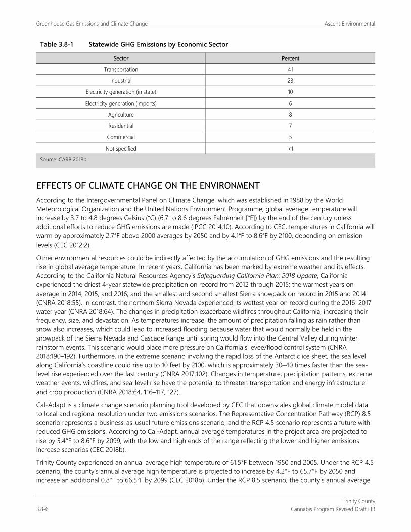
Greenhouse Gas Emissions and Climate Change Ascent Environmental
Trinity County 3.8-6 Cannabis Program Revised Draft EIR
Table 3.8-1 Statewide GHG Emissions by Economic Sector
Sector Percent
Transportation 41
Industrial 23
Electricity generation (in state) 10
Electricity generation (imports) 6
Agriculture 8
Residential 7
Commercial 5
Not specified <1
Source: CARB 2018b
EFFECTS OF CLIMATE CHANGE ON THE ENVIRONMENT According to the Intergovernmental Panel on Climate Change, which was established in 1988 by the World Meteorological Organization and the United Nations Environment Programme, global average temperature will increase by 3.7 to 4.8 degrees Celsius (°C) (6.7 to 8.6 degrees Fahrenheit [°F]) by the end of the century unless additional efforts to reduce GHG emissions are made (IPCC 2014:10). According to CEC, temperatures in California will warm by approximately 2.7°F above 2000 averages by 2050 and by 4.1°F to 8.6°F by 2100, depending on emission levels (CEC 2012:2).
Other environmental resources could be indirectly affected by the accumulation of GHG emissions and the resulting rise in global average temperature. In recent years, California has been marked by extreme weather and its effects. According to the California Natural Resources Agency’s Safeguarding California Plan: 2018 Update, California experienced the driest 4-year statewide precipitation on record from 2012 through 2015; the warmest years on average in 2014, 2015, and 2016; and the smallest and second smallest Sierra snowpack on record in 2015 and 2014 (CNRA 2018:55). In contrast, the northern Sierra Nevada experienced its wettest year on record during the 2016–2017 water year (CNRA 2018:64). The changes in precipitation exacerbate wildfires throughout California, increasing their frequency, size, and devastation. As temperatures increase, the amount of precipitation falling as rain rather than snow also increases, which could lead to increased flooding because water that would normally be held in the snowpack of the Sierra Nevada and Cascade Range until spring would flow into the Central Valley during winter rainstorm events. This scenario would place more pressure on California’s levee/flood control system (CNRA 2018:190–192). Furthermore, in the extreme scenario involving the rapid loss of the Antarctic ice sheet, the sea level along California’s coastline could rise up to 10 feet by 2100, which is approximately 30–40 times faster than the sea-level rise experienced over the last century (CNRA 2017:102). Changes in temperature, precipitation patterns, extreme weather events, wildfires, and sea-level rise have the potential to threaten transportation and energy infrastructure and crop production (CNRA 2018:64, 116–117, 127).
Cal-Adapt is a climate change scenario planning tool developed by CEC that downscales global climate model data to local and regional resolution under two emissions scenarios. The Representative Concentration Pathway (RCP) 8.5 scenario represents a business-as-usual future emissions scenario, and the RCP 4.5 scenario represents a future with reduced GHG emissions. According to Cal-Adapt, annual average temperatures in the project area are projected to rise by 5.4°F to 8.6°F by 2099, with the low and high ends of the range reflecting the lower and higher emissions increase scenarios (CEC 2018b).
Trinity County experienced an annual average high temperature of 61.5°F between 1950 and 2005. Under the RCP 4.5 scenario, the county’s annual average high temperature is projected to increase by 4.2°F to 65.7°F by 2050 and increase an additional 0.8°F to 66.5°F by 2099 (CEC 2018b). Under the RCP 8.5 scenario, the county’s annual average
Ascent Environmental Greenhouse Gas Emissions and Climate Change
Trinity County Cannabis Program Revised Draft EIR 3.8-7
high temperature is projected to increase by 4.3°F to 65.8°F by 2050 and increase an additional 5.4°F to 71.2°F by 2099 (CEC 2018b).
Trinity County experienced an average precipitation of 60.4 inches per year between 1950 and 2005. Under the RCP 4.5 scenario, the county is projected to experience an increase of 13.3 inches to 73.7 inches per year by 2050 and decrease to 5.3. inches per year by 2099 (CEC 2018b). Under the RCP 8.5 scenario, the county is projected to experience an increase of 10.5 inches to 70.9 inches per year by 2050 and decrease to 65.7 inches per year by 2099 (CEC 2018b).
3.8.3 Environmental Impacts and Mitigation Measures
METHODOLOGY This EIR evaluates the GHG emissions of all cultivation and noncultivation sites that could be permitted under the Cannabis Program. The analysis focuses on a conservative estimate of GHG-related impacts that could occur from the distinct types of cultivation and noncultivation operations that would be licensed under the Cannabis Program. Limitations and restrictions regarding the types, sizes, and intensity of permitted cultivation and noncultivation operations are summarized in Chapter 2, “Project Description.” It is important to note that a single cultivation site could include multiple cultivation operations, each with a different license type.
Under CEQA, GHG emissions and their contribution to global climate change are inherently cumulative. To that end, an individual project participates in this potential impact by its incremental contribution, combined with the cumulative contributions of all other sources of GHGs, which, when taken together, cause potential global climate change impacts. Therefore, the cumulative global climate change analysis presented in this section of the EIR analyzes the GHG emissions associated with construction and operation of commercial cannabis cultivation and noncultivation operations that would be licensed and developed under the Cannabis Program.
The California Emissions Estimator Model (CalEEMod) Version 2016.3.2 was used to estimate GHG emissions associated with the construction and operation of the types of indoor, outdoor, mixed-light, and noncultivation operations that could be licensed under the Cannabis Program, including size limits; and default values in CalEEMod based on the climatic conditions in the county. Construction-related emissions were estimated for individual license types. For details about construction assumptions, refer to Appendix C.
CalEEMod was also used to estimate operational GHG emissions associated with landscaping equipment, fertilizer use, and paint for paved parking lots; electricity consumption, including water consumption; off-road equipment, the generation of solid waste; and changes to vegetation coverage, application of fertilizer. It was assumed that all cultivation and noncultivation licenses would be permitted by 2020, representing a conservative estimate that all license types would be fully operational by 2020. CalEEMod default energy consumption rates were adjusted to account for the energy efficiency improvements required by the 2019 California Energy Code, which would result in a 30 percent reduction in energy consumption compared with the 2016 California Energy Code that is included in CalEEMod. Default energy consumption assumes a mix of electricity and natural gas, however, there are no natural gas lines in Trinity County and instead, on-site propane tanks are often used. The level of natural gas consumption estimated by CalEEMod was converted to propane using an energy content-based conversion factor and associated emissions were estimated using Climate Registry 2017 emission factors for propane (The Climate Registry 2017).
Off-road equipment includes the use of a small utility vehicle (e.g., John Deere Gator) for outdoor and mixed-light cultivation sites, and a forklift for noncultivation operations. Back-up diesel generators were also assumed to be used at mixed-light cultivation sites. GHG emissions were also estimated for anticipated loss in carbon sequestration due to the removal of vegetation at both cultivation and noncultivation sites.
Mobile-source emissions were estimated using CARB’s Emission Factor 2017 model. Trip generation rates were derived from development assumptions presented in Chapter 2, “Project Description,” and CalEEMod default trip lengths for Trinity County were used. Section 3.14, “Transportation/Traffic,” includes details pertaining to the derivation of trip generation by license type. Refer to Appendix C for modeling assumptions and calculations.
Greenhouse Gas Emissions and Climate Change Ascent Environmental
Trinity County 3.8-8 Cannabis Program Revised Draft EIR
GHG emissions associated with construction and operation of cultivation and noncultivation sites under the Cannabis Program were evaluated for consistency with adopted regulations, plan, and policies aimed at reducing GHG emissions. This includes the 2017 Scoping Plan. This approach is consistent with one of the pathways to compliance presented in the California Supreme Court (Court) ruling, Center for Biological Diversity v. California Department of Fish and Wildlife. The Court identified three pathways to evaluate the cumulative significance of a proposed land use development. One pathway suggests looking at compliance with regulatory programs designed to reduce GHG emissions from particular activities, especially regarding the goals of AB (and now SB) 32.
THRESHOLDS OF SIGNIFICANCE State CEQA Guidelines Section 15064 and relevant portions of Appendix G recommend that a lead agency consider a project’s consistency with relevant, adopted plans and discuss any inconsistencies with applicable regional plans, including plans to reduce GHG emissions. Under Appendix G of the State CEQA Guidelines, implementing a project would result in a cumulatively considerable contribution to climate change if it would:
generate GHG emissions, either directly or indirectly, that may have a significant impact on the environment, or
conflict with any applicable plan, policy or regulation of an agency adopted for the purpose of reducing the emissions of GHGs.
For the purposes of this analysis, as described in “Methodology” above, the project’s potential to result in a cumulatively considerable contribution to climate change would occur if the project conflicted with any applicable plan, policy, or regulation of an agency adopted for the purposes of reducing GHG emissions. In this instance, the plan that the project would need to demonstrate consistency with includes the 2017 Scoping Plan.
ENVIRONMENTAL IMPACTS AND MITIGATION MEASURES
Impact 3.8-1: Generation of Greenhouse Gas Emissions
Operation of existing licensed commercial cannabis cultivation and noncultivation sites, as well as construction and operation of new cultivation and noncultivation sites permitted under the Cannabis Program, would result in the generation of GHG emissions. Although there are state regulations that would require the project to reduce GHG emissions (i.e., Sections 8203 and 8305 of CCR Title 3, Division 8, Chapter 1) these regulations would not take effect under 2022 and 2023, respectively. The Cannabis Program does not include performance standards that reduce GHG emissions. Therefore, implementation of the Cannabis Program could conflict with an applicable plan, policy, or regulation of an agency adopted for the purpose of reducing GHG emissions. This impact would be potentially significant.
Existing Licensed Commercial Cannabis Operations Operation of existing permitted cultivation and noncultivation sites generates GHG emissions through area sources, energy consumption, mobile sources, water consumption, wastewater and waste generation. During operation of cultivation and noncultivation sites, GHGs are emitted by haul trucks transporting products, worker commute trips, and electricity and propane that supply power for well pumps and grow lights. Use of off-road equipment such as utility vehicles (e.g., John Deere Gator) would also generate of GHG emissions. It is acknowledged that continued operation of these cultivation sites could result in some minor construction activities through the proposed amendment that would allow expansion of the Designated Area for cultivation activities from 200 percent of the licensed cannabis canopy area to 250 percent (20 percent increase). However, the total cannabis canopy allowed would not be increased. Thus, no expansion of operation of the existing cultivation sites was assumed.
As described in the “Regulatory Setting” above, state regulations require all cultivation sites seeking license renewals to obtain zero net energy renewable electricity by January 1, 2022. Compliance with this state regulation can be achieved at cultivation sites by receiving electric power over the grid that is supplied by Trinity PUD, which supplies 100 percent renewable electricity; with on-site renewable systems; or by purchasing carbon offset credits.
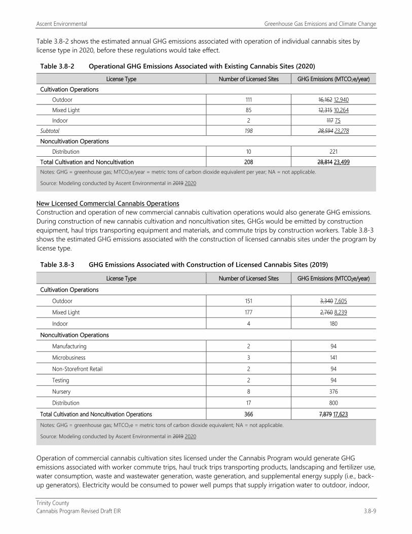
Ascent Environmental Greenhouse Gas Emissions and Climate Change
Trinity County Cannabis Program Revised Draft EIR 3.8-9
Table 3.8-2 shows the estimated annual GHG emissions associated with operation of individual cannabis sites by license type in 2020, before these regulations would take effect.
Table 3.8-2 Operational GHG Emissions Associated with Existing Cannabis Sites (2020)
License Type Number of Licensed Sites GHG Emissions (MTCO2e/year) Cultivation Operations Outdoor 111 16,162 12,940 Mixed Light 85 12,315 10,264 Indoor 2 117 75 Subtotal 198 28,594 23,278 Noncultivation Operations Distribution 10 221 Total Cultivation and Noncultivation 208 28,814 23,499 Notes: GHG = greenhouse gas; MTCO2e/year = metric tons of carbon dioxide equivalent per year; NA = not applicable.
Source: Modeling conducted by Ascent Environmental in 2019 2020
New Licensed Commercial Cannabis Operations Construction and operation of new commercial cannabis cultivation operations would also generate GHG emissions. During construction of new cannabis cultivation and noncultivation sites, GHGs would be emitted by construction equipment, haul trips transporting equipment and materials, and commute trips by construction workers. Table 3.8-3 shows the estimated GHG emissions associated with the construction of licensed cannabis sites under the program by license type.
Table 3.8-3 GHG Emissions Associated with Construction of Licensed Cannabis Sites (2019)
License Type Number of Licensed Sites GHG Emissions (MTCO2e/year)
Cultivation Operations
Outdoor 151 3,340 7,605
Mixed Light 177 2,760 8,239
Indoor 4 180
Noncultivation Operations
Manufacturing 2 94
Microbusiness 3 141
Non-Storefront Retail 2 94
Testing 2 94
Nursery 8 376
Distribution 17 800
Total Cultivation and Noncultivation Operations 366 7,879 17,623
Notes: GHG = greenhouse gas; MTCO2e = metric tons of carbon dioxide equivalent; NA = not applicable.
Source: Modeling conducted by Ascent Environmental in 2019 2020
Operation of commercial cannabis cultivation sites licensed under the Cannabis Program would generate GHG emissions associated with worker commute trips, haul truck trips transporting products, landscaping and fertilizer use, water consumption, waste and wastewater generation, waste generation, and supplemental energy supply (i.e., back-up generators). Electricity would be consumed to power well pumps that supply irrigation water to outdoor, indoor,
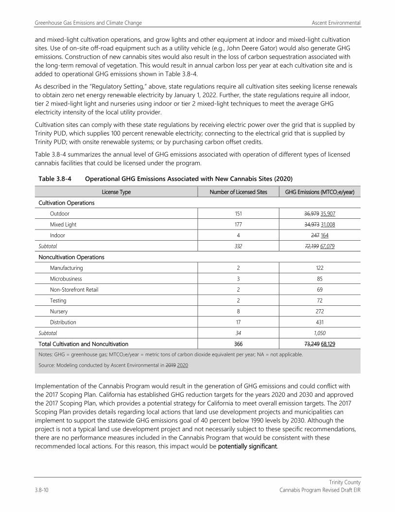
Greenhouse Gas Emissions and Climate Change Ascent Environmental
Trinity County 3.8-10 Cannabis Program Revised Draft EIR
and mixed-light cultivation operations, and grow lights and other equipment at indoor and mixed-light cultivation sites. Use of on-site off-road equipment such as a utility vehicle (e.g., John Deere Gator) would also generate GHG emissions. Construction of new cannabis sites would also result in the loss of carbon sequestration associated with the long-term removal of vegetation. This would result in annual carbon loss per year at each cultivation site and is added to operational GHG emissions shown in Table 3.8-4.
As described in the “Regulatory Setting,” above, state regulations require all cultivation sites seeking license renewals to obtain zero net energy renewable electricity by January 1, 2022. Further, the state regulations require all indoor, tier 2 mixed-light light and nurseries using indoor or tier 2 mixed-light techniques to meet the average GHG electricity intensity of the local utility provider.
Cultivation sites can comply with these state regulations by receiving electric power over the grid that is supplied by Trinity PUD, which supplies 100 percent renewable electricity; connecting to the electrical grid that is supplied by Trinity PUD; with onsite renewable systems; or by purchasing carbon offset credits.
Table 3.8-4 summarizes the annual level of GHG emissions associated with operation of different types of licensed cannabis facilities that could be licensed under the program.
Table 3.8-4 Operational GHG Emissions Associated with New Cannabis Sites (2020)
License Type Number of Licensed Sites GHG Emissions (MTCO2e/year)
Cultivation Operations
Outdoor 151 36,979 35,907
Mixed Light 177 34,973 31,008
Indoor 4 247 164
Subtotal 332 72,199 67,079
Noncultivation Operations
Manufacturing 2 122
Microbusiness 3 85
Non-Storefront Retail 2 69
Testing 2 72
Nursery 8 272
Distribution 17 431
Subtotal 34 1,050
Total Cultivation and Noncultivation 366 73,249 68,129
Notes: GHG = greenhouse gas; MTCO2e/year = metric tons of carbon dioxide equivalent per year; NA = not applicable.
Source: Modeling conducted by Ascent Environmental in 2019 2020
Implementation of the Cannabis Program would result in the generation of GHG emissions and could conflict with the 2017 Scoping Plan. California has established GHG reduction targets for the years 2020 and 2030 and approved the 2017 Scoping Plan, which provides a potential strategy for California to meet overall emission targets. The 2017 Scoping Plan provides details regarding local actions that land use development projects and municipalities can implement to support the statewide GHG emissions goal of 40 percent below 1990 levels by 2030. Although the project is not a typical land use development project and not necessarily subject to these specific recommendations, there are no performance measures included in the Cannabis Program that would be consistent with these recommended local actions. For this reason, this impact would be potentially significant.

Ascent Environmental Greenhouse Gas Emissions and Climate Change
Trinity County Cannabis Program Revised Draft EIR 3.8-11
Mitigation Measures
Mitigation Measure 3.8-1a: Implement Mitigation Measures 3.3-1a, 3.3-1b, and 3.3-1c Details of these mitigation measures are provided in Section 3.3, “Air Quality.”
Mitigation Measure 3.3-1a prohibits the burning of vegetation that has been cleared for cultivation purposes. Mitigation Measure 3.3-1a is consistent with a local action measure recommended in Appendix B, Local Action, of the 2017 Scoping Plan, which reads, “Promote alternatives to open pile burning as disposal options for woody biomass wastes” (CARB 2017:B-6).
Mitigation Measure 3.3-1b requires diesel engine exhaust controls for heavy-duty construction equipment through the use of Tier 4 diesel engines, or Tier 3 or best available construction equipment if Tier 4 is not available. Mitigation Measure 3.3-1b is consistent with a local action measure recommended in Appendix B, Local Action, of the 2017 Scoping Plan, which reads, “Require construction vehicles to operate with the highest tier engines commercially available” (CARB 2017:B-8).
Mitigation Measure 3.3-1c requires the use of renewable diesel in all diesel-powered construction equipment if commercially available within Trinity County. Mitigation Measure 3.3-1c is consistent with a local action measure recommended in Appendix B, Local Action, of the 2017 Scoping Plan, which reads, “Increase use of electric and renewable fuel-powered construction equipment and require renewable diesel fuel where commercially available” (CARB 2017:B-8). The use of renewable diesel results in a GHG reduction associated with diesel-powered equipment by 67 percent (SMAQMD 2015).
Mitigation Measure 3.8-1b: Implement Mitigation Measures 3.3-2a and 3.3-2b Mitigation Measure 3.3-2a limits the use of fossil fuel-powered outdoor power equipment at all commercial cannabis cultivation and noncultivation sites where available. Mitigation Measure 3.3-2b requires the use of low emission diesel generators at all cultivation and noncultivation sites, which are typically more fuel efficient, resulting in fewer GHG emissions.
Mitigation 3.8-1c: Renewable Electricity Requirements The following shall be included as a new performance standard in Section 315-843(6) (Performance Standards for Commercial Cultivation of Cannabis); Section 315-842(6) (Required Conditions); Section 315-838(6) (Required Conditions); Section 315-837(3) (Required Conditions); Section 315-835(2) (Regulations); Section 315-824(5) (Required Conditions); Section 315-827(4) (Required Conditions of Use Permit Approval); and Section 315-828(5) (Required Conditions):
All electricity sources used for commercial cannabis cultivation, manufacturing, microbusinesses, non-storefront retail, testing, nurseries, and distribution shall be from renewable sources by conforming to one or more of the following standards:
Grid-based electricity supplied from 100 percent renewable sources
On-site power supplied fully by renewable source (e.g., photovoltaic system)
On-site power supplied by partial or wholly non-renewable source with purchase of carbon offset credits
Or some combination of the above.
This mitigation measure is consistent with a local action measure recommended in Appendix B, Local Action, of the 2017 Scoping Plan, which reads, “Require on-site renewable energy generation” (CARB 2017:B-8).
Mitigation Measure 3.8-1d: Lighting Efficiency Requirements The following shall be included as a new performance standard for Section 315-843(6) (Performance Standards for Commercial Cultivation of Cannabis); Section 315-842(6) (Required Conditions); Section 315-838(6) (Required Conditions);

Greenhouse Gas Emissions and Climate Change Ascent Environmental
Trinity County 3.8-12 Cannabis Program Revised Draft EIR
Section 315-837(3) (Required Conditions); Section 315-835(2) (Regulations); Section 315-824(5) (Required Conditions); Section 315-827(4) (Required Conditions of Use Permit Approval); and Section 315-828(5) (Required Conditions):
Only light-emitting diodes (LEDs) or double-ended high-pressure sodium (HPS) fixtures shall be used in all existing and new mixed-light cultivation operations (i.e., sites not seeking relicensing).
Only high efficacy lighting shall be used in all existing and new noncultivation operations (i.e., sites not seeking relicensing).
Examples of high efficacy lighting include:
Pin-based linear fluorescent or compact fluorescent light sources using electronic ballasts;
Pulse-start metal halide light sources;
HPS light sources;
Luminaries with hardwired high frequency generator and induction lamp; and
LEDs.
LED or HPS lighting has been considered feasible in cannabis cultivation sites by numerous studies conducted by utility providers throughout California (SDG&E 2016). This is consistent with a local action measure recommended in Appendix B, Local Action, of the 2017 Scoping Plan, which reads, “Require the use of energy-efficient lighting for all street, parking, and area lighting” (CARB 2017:B-10).
Significance after Mitigation Implementation of Mitigation Measure 3.8-1a would reduce construction-generated GHG emissions by 67 percent at all new licensed cultivation and noncultivation sites. Implementation of Mitigation Measure 3.8-1b would reduce GHG emissions associated with off-road equipment. Implementation of Mitigation Measures 3.8-1c and 3.8-1d would require all cannabis cultivation and noncultivation sites to reduce their GHG emissions through the use of electrified off-road equipment, higher performing back-up generators, renewable energy, high-efficacy lighting. These requirements would apply to all new cultivation and noncultivation sites under the Cannabis Program and would apply to all existing cultivation and noncultivation site when seeking annual relicensing.
With implementation of these mitigation measures, the Cannabis Program would be consistent with the 2017 Scoping Plan’s Local Action recommendations for reducing GHG emissions. All cultivation and noncultivation sites permitted under the Cannabis Program would align with applicable plans and policies adopted for the purpose of reducing GHG emissions. The GHG emissions associated with project implementation would not be a considerable contribution to global climate change and would be less than significant.
Ascent Environmental Hazards and Hazardous Materials
Trinity County Cannabis Program Revised Draft EIR 3.9-1
3.9 HAZARDS AND HAZARDOUS MATERIALS This section describes the potential impacts of the Trinity County Cannabis Program Project related to hazardous materials and public health. The analysis includes a description of the existing environmental conditions, the methods used for assessment, and the potential direct and indirect impacts of project implementation. Hazards associated with air pollutants is addressed in Section 3.3, “Air Quality,” traffic hazards are addressed in Section 3.14, “Transportation/Traffic,” and wildfire hazards are addressed in Section 3.16, “Wildfire.”
Comments regarding the use and storage pesticides and rodenticides were provided on the NOP. These issues are addressed in the impact analysis below as well as in Section 3.4, “Biological Resources,” and Section 3.10, “Hydrology and Water Quality.”
3.9.1 Regulatory Setting
FEDERAL
Management of Hazardous Materials Various federal laws address the proper handling, use, storage, and disposal of hazardous materials, as well as requiring measures to prevent or mitigate injury to health or the environment if such materials are accidentally released. The U.S. Environmental Protection Agency (EPA) is the agency primarily responsible for enforcement and implementation of federal laws and regulations pertaining to hazardous materials. Applicable federal regulations pertaining to hazardous materials are primarily contained in Code of Federal Regulations (CFR) Titles 29, 40, and 49. Hazardous materials, as defined in the code, are listed in 49 CFR 172.101. Management of hazardous materials is governed by the following laws.
The Toxic Substances Control Act of 1976 (15 U.S. Code [USC] Section 2601 et seq.) regulates the manufacturing, inventory, and disposition of industrial chemicals, including hazardous materials. Section 403 of the Toxic Substances Control Act establishes standards for lead-based paint hazards in paint, dust, and soil.
The Resource Conservation and Recovery Act of 1976 (RCRA) (42 USC 6901 et seq.) is the law under which EPA regulates hazardous waste from the time the waste is generated until its final disposal (“cradle to grave”).
The Comprehensive Environmental Response, Compensation, and Liability Act of 1980 (also called the Superfund Act or CERCLA) (42 USC 9601 et seq.) gives EPA authority to seek out parties responsible for releases of hazardous substances and ensure their cooperation in site remediation.
The Superfund Amendments and Reauthorization Act of 1986 (Public Law 99-499; USC Title 42, Chapter 116), also known as SARA Title III or the Emergency Planning and Community Right-to-Know Act of 1986 (EPCRA), imposes hazardous materials planning requirements to help protect local communities in the event of accidental release.
The Spill Prevention, Control, and Countermeasure (SPCC) rule includes requirements for oil spill prevention, preparedness, and response to prevent oil discharges to navigable waters and adjoining shorelines. The rule requires specific facilities to prepare, amend, and implement SPCC Plans. The SPCC rule is part of the Oil Pollution Prevention regulation, which also includes the Facility Response Plan rule.
Transport of Hazardous Materials The U.S. Department of Transportation (DOT) regulates transport of hazardous materials between states and is responsible for protecting the public from dangers associated with such transport. The federal hazardous materials transportation law, 49 USC 5101 et seq. (formerly the Hazardous Materials Transportation Act 49 USC 1801 et seq.) is the basic statute regulating transport of hazardous materials in the United States. Hazardous materials transport regulations are enforced by the Federal Highway Administration, the U.S. Coast Guard, the Federal Railroad Administration, and the Federal Aviation Administration.
Hazards and Hazardous Materials Ascent Environmental
Trinity County 3.9-2 Cannabis Program Revised Draft EIR
Worker Safety The federal Occupational Safety and Health Administration (OSHA) is the agency responsible for assuring worker safety in the handling and use of chemicals identified in the Occupational Safety and Health Act of 1970 (Public Law 91-596, 9 USC 651 et seq.). OSHA has adopted numerous regulations pertaining to worker safety, contained in CFR Title 29. These regulations set standards for safe workplaces and work practices, including standards relating to the handling of hazardous materials and those required for excavation and trenching.
Comprehensive Environmental Response, Compensation, and Liability Act CERCLA (42 USC Section 9601 et seq.) was established to protect the public and the environment from the effects of past hazardous waste disposal activities and new hazardous material spills. It created a tax on the chemical petroleum industries to generate funds to clean up abandoned or uncontrolled hazardous waste sites for which no responsible party could be identified. CERCLA also granted authority to EPA to respond directly to hazardous waste spills and required those responsible for a spill or accidental release of hazardous materials to report the release to EPA.
SARA (Public Law 99-499) amended some provisions of CERCLA. It increased the focus on human health problems posed by hazardous waste releases, stressed the importance of permanent remedies and innovative treatment technologies in cleaning up hazardous waste sites, and encouraged greater citizen participation in making decisions on how sites should be cleaned up.
Emergency Response/Evacuation Plans The State of California passed legislation authorizing the Office of Emergency Services (Cal OES) to prepare a Standard Emergency Management System program, which sets forth measures by which a jurisdiction should handle emergency disasters. Noncompliance with the program could result in the state withholding disaster relief from the noncomplying jurisdiction in the event of an emergency disaster. The preservation of life, property and the environment is an inherent responsibility of local, state, and federal government.
Resource Conservation and Recovery Act RCRA (42 USC Section 6901 et seq.) sets national goals for protecting human health and the environment from the potential hazards of waste disposal, conserving energy and natural resources, reducing the amount of waste generated, and ensuring that wastes are managed in an environmentally sound manner. To achieve these goals, the RCRA established three interrelated programs: the solid waste program, the hazardous waste program, and the underground storage tank (UST) program.
The hazardous waste program established a system for controlling hazardous wastes from the time they are generated to the time they are disposed of (“cradle-to-grave” management). Under the RCRA, owners and operators of hazardous waste treatment, storage, and disposal facilities must follow a set of standards (e.g., facility design and operations, contingency planning and emergency preparedness, and recordkeeping) to minimize risk and impacts on human health and the environment, codified in 40 CFR, Part 264. Commercial cannabis cultivators would be subject to RCRA to the extent that they generate hazardous waste or store hazardous materials in USTs.
Emergency Planning and Community Right-to-Know Act – Toxic Release Inventory Section 313 of the EPCRA established the Toxic Release Inventory (TRI). TRI is a publicly available database containing information on disposal and other releases of toxic chemicals from industrial facilities. As stipulated in 40 CFR Part 372, owners or operators of facilities that release toxic chemicals above a certain threshold (25,000 pounds or more per year) are required to submit information about: (1) on-site releases and other disposals of toxic chemicals; (2) on-site recycling, treatment, and energy recovery associated with TRI chemicals; (3) off-site transfers of toxic chemicals from TRI facilities to other locations; and (4) pollution prevention activities at facilities. It is unlikely that cannabis cultivators could release toxic chemicals above the threshold requiring reporting under TRI (California Department of Food and Agriculture 2017).
Ascent Environmental Hazards and Hazardous Materials
Trinity County Cannabis Program Revised Draft EIR 3.9-3
Federal Insecticide, Fungicide, and Rodenticide Act Pesticides are regulated under the Federal Insecticide, Fungicide, and Rodenticide Act by EPA. This includes labeling and registration of pesticides as to how they may be used. EPA delegates pesticide enforcement activities in California to the California Department of Pesticide Regulation (CDPR), under Title 3 of the California Code of Regulations (CCR) and the California Food and Agriculture Code. CDPR registers pesticides for use in California, and licenses pesticide applicators and pilots, advisors, dealers, brokers, and businesses.
Currently, no pesticides are registered for use on cannabis. Therefore, commercial cultivators are limited to only using pesticides that are exempt from residue-tolerance requirements and are either; (1) registered and labeled for a use that is broad enough to include use on cannabis (e.g., unspecified green plants), or (2) exempt from registration requirements as a minimum-risk pesticide under Section 25(b) of the Federal Insecticide, Fungicide, and Rodenticide Act.
Hazardous Materials Transportation Act DOT has developed regulations in CFR Titles 10 and 49 pertaining to the transport of hazardous substances and hazardous wastes. The Hazardous Materials Transportation Act is administered by the Research and Special Programs Administration of the DOT. The act provides the DOT with a broad mandate to regulate the transport of hazardous materials, with the purpose of adequately protecting the nation against risk to life and property that is inherent in the commercial transportation of hazardous materials. DOT regulations that govern the transportation of hazardous materials are applicable to any person who transports, ships, causes to be transported or shipped, or who is involved in any way with the manufacture or testing of hazardous materials packaging or containers.
Occupational Safety and Health Administration Worker Safety Requirements OSHA is responsible for ensuring worker safety. OSHA sets federal standards for implementation of workplace training, exposure limits, and safety procedures for handling hazardous substances and addressing other potential industrial hazards. OSHA also establishes criteria by which each state can implement its own health and safety program. The Hazard Communication Standard (CFR Title 29, Part 1910) requires that workers be informed of the hazards associated with the materials they handle. These standards include exposure limits for a wide range of specific hazardous materials, including pesticides, as well as requirements that employers provide personal protective equipment (i.e., protective equipment for eyes, face, or extremities; protective clothing; respiratory devices) to their employees wherever it is necessary (i.e., when required by the label instructions) (29 CFR Section 1910.132). Workers must be trained in safe handling of hazardous materials, use of emergency response equipment, and building emergency response plans and procedures. Containers must be labeled appropriately, and material safety data sheets must be available in the workplace. Commercial cannabis operations would be required to comply with OSHA regulations and standards, including worker personal protective equipment requirements (California Department of Food and Agriculture 2017).
STATE
Management of Hazardous Materials In California, both federal and state community right-to-know laws are coordinated through Cal OES. The federal law, SARA Title III or EPCRA, described above, encourages and supports emergency planning efforts at the state and local levels and to provide local governments and the public with information about potential chemical hazards in their communities. Because of the community right-to-know laws, information is collected from facilities that handle (e.g., produce, use, store) hazardous materials above certain quantities. The provisions of EPCRA apply to four major categories:
emergency planning,
emergency release notification,
reporting of hazardous chemical storage, and
inventory of toxic chemical releases.
Hazards and Hazardous Materials Ascent Environmental
Trinity County 3.9-4 Cannabis Program Revised Draft EIR
The corresponding state law is Chapter 6.95 of the California Health and Safety Code (Hazardous Materials Release Response Plans and Inventory). Under this law, qualifying businesses are required to prepare a Hazardous Materials Business Plan, which would include hazardous materials and hazardous waste management procedures and emergency response procedures, including emergency spill cleanup supplies and equipment. At such time as the applicant begins to use hazardous materials at levels that reach applicable state and/or federal thresholds, the plan is submitted to the administering agency.
The California Department of Toxic Substances Control (DTSC), a division of the California Environmental Protection Agency, has primary regulatory responsibility over hazardous materials in California, working in conjunction with EPA to enforce and implement hazardous materials laws and regulations. As required by Section 65962.5 of the California Government Code, DTSC maintains a hazardous waste and substances site list for the state, known as the Cortese List. Individual regional water quality control boards (RWQCBs) are the lead agencies responsible for identifying, monitoring, and cleaning up leaking USTs.
Transport of Hazardous Materials and Hazardous Materials Emergency Response Plan The State of California has adopted DOT regulations for the movement of hazardous materials originating within the state and passing through the state; state regulations are contained in 26 CCR. State agencies with primary responsibility for enforcing state regulations and responding to hazardous materials transportation emergencies are the California Highway Patrol and the California Department of Transportation. Together, these agencies determine container types used and license hazardous waste haulers to transport hazardous waste on public roads.
California has developed an emergency response plan to coordinate emergency services provided by federal, state, and local governments and private agencies. Response to hazardous materials incidents is one part of the plan. The plan is managed by Cal OES, which coordinates the responses of other agencies in the project area.
Management of Construction Activities Through the Porter-Cologne Water Quality Act and the National Pollutant Discharge Elimination System (NPDES) program, RWQCBs have the authority to require proper management of hazardous materials during project construction. For a detailed description of the Porter-Cologne Water Quality Act, the NPDES program, and the role of the Central Valley RWQCB, see Section 3.10, “Hydrology and Water Quality.”
The State Water Resources Control Board adopted the statewide NPDES General Permit in August 1999. The state requires that projects disturbing more than one acre of land during construction file a Notice of Intent with the RWQCB to be covered under this permit. Construction activities subject to the General Permit include clearing, grading, stockpiling, and excavation. Dischargers are required to eliminate or reduce non-stormwater discharges to storm sewer systems and other waters. A storm water pollution prevention plan must be developed and implemented for each site covered by the permit. It must include best management practices (BMPs) designed to prevent construction pollutants from contacting stormwater and keep products of erosion from moving off‐site into receiving waters throughout the construction and life of the project; the BMPs must address source control and, if necessary, pollutant control.
Worker Safety The California Division of Occupational Safety and Health (known as Cal/OSHA) assumes primary responsibility for developing and enforcing workplace safety regulations within the state. Cal/OSHA standards are typically more stringent than federal OSHA regulations and are presented in Title 8 of the CCR. Cal/OSHA conducts onsite evaluations and issues notices of violation to enforce necessary improvements to health and safety practices.
Title 8 of the CCR also includes regulations that provide for worker safety when blasting and explosives are utilized during construction activities. These regulations identify licensing, safety, storage, and transportation requirements related to the use of explosives in construction.
California Accidental Release Prevention Program The goal of the California Accidental Release Prevention Program (CCR Title 19, Division 2, Chapter 4.5) is to reduce the likelihood and severity of consequences of any releases of extremely hazardous materials. Any business that handles
Ascent Environmental Hazards and Hazardous Materials
Trinity County Cannabis Program Revised Draft EIR 3.9-5
regulated substances (chemicals that pose a major threat to public health and safety or the environment because they are highly toxic, flammable, or explosive, including ammonia, chlorine gas, hydrogen, nitric acid, and propane) must prepare a risk management plan. The risk management plan is a detailed engineering analysis of the potential accident factors present at a business and the measures that can be implemented to reduce this accident potential. The plan must provide safety information, hazard data, operating procedures, and training and maintenance requirements. The list of regulated substances is found in Article 8, Section 2770.5 of the program regulations.
Hazardous Waste Control Law and Universal Waste Rule Under CCR Title 22 and the California Hazardous Waste Control Law, DTSC regulated the generation, transportation, treatment, storage, and disposal of hazardous waste. California’s Universal Waste Rule allows individuals and business to transport, handle, and recycle certain common hazardous wastes, termed universal wastes, in a manner that differs from the requirements for most hazardous wastes. Universal wastes include televisions, computers, and other electronic devices, as well as batteries, fluorescent lamps, mercury thermostats, and other mercury-containing equipment. The hazardous waste regulations (CCR Title 22, Division 4.5, Chapter 11) identify seven categories of hazardous wastes that can be managed as universal wastes. Any unwanted item that falls within one of these waste streams can be handled, transported and recycled following the simple requirements set forth in the universal waste regulations.
California Department of Pesticide Regulation Guidance Detailed implementing regulations for the CDPR pesticide regulatory program are codified in 3 CCR Division 6. CDPR oversees state pesticide laws, including pesticide labeling, and is vested by EPA to enforce federal pesticide laws in California. CDPR also oversees the activities of the county agricultural commissioners related to enforcement of pesticide regulations and related environmental laws and regulations locally.
As identified in 3 CCR Division 6, CDPR evaluates proposed pesticide products and registers those pesticides that it determines can be used safely. In addition, CDPR oversight includes:
Licensing of pesticide professionals;
Site-specific permits required before restricted-use pesticides may be used in agriculture;
Strict rules to protect workers and consumers;
Mandatory reporting of pesticide use by agricultural and pest control businesses;
Environmental monitoring of water and air; and
Testing of fresh produce for pesticide residues.
The regulations require that employers of pesticide workers provide protective clothing, eyewear, gloves, respirators, and any other required protection, and require employers to ensure that protective wear is worn according to product labels during application. The regulations also require that employers provide field workers with adequate training in pesticide application and safety; communicate pesticide-related hazards to field workers; ensure that emergency medical services are available to field workers; and ensure adherence to restricted-entry intervals between pesticide treatments (3 CCR Section 6764). CDPR requires that the application of pesticides or other pest control in connection with the indoor or outdoor cultivation of cannabis complies with 3 CCR Division 6 (commencing with Section 11401) of the Food and Agricultural Code and its implementing regulations (Business and Professions Code 19332[f]).
Pesticide Use in Cannabis Cultivation Cannabis pests vary according to cultivar (variety), whether the plants are grown indoors or outdoors, and where the plants are grown geographically. Pesticides legal for use on cannabis must have active ingredients that are exempt from residue tolerance requirements and are either exempt from registration requirements or registered for a use that is broad enough to include use on marijuana. Residue tolerance requirements are set by EPA for each pesticide on each food crop and is the amount of pesticide residue allowed to remain in or on each treated crop with “reasonable certainty of no harm.” Some pesticides are exempted from the tolerance requirements when they are found to be safe. Some of these pesticides are bacterial-based insect pathogens (e.g., Bacillus thuringiensis) or
Hazards and Hazardous Materials Ascent Environmental
Trinity County 3.9-6 Cannabis Program Revised Draft EIR
biofungicides (e.g., Bacillus subtilis, Gliocladium virens). Active ingredients exempt from registration requirements are mostly food-grade essential oils such as peppermint oil or rosemary oil (CDPR 2015).
CDPR designates certain pesticide active ingredients as California “Restricted Materials” when they determine those pesticides are especially hazardous to human health or the environment and require permitting. Such permits will not be issued for cannabis cultivation sites.
In accordance with the Medical Cannabis Regulation and Safety Act and Adult Use of Marijuana Act, CDPR is required to develop guidelines for the use of pesticides in the cultivation of cannabis and establish limits for residue levels in harvested cannabis and cannabis products. However, CDPR is preempted by federal law from registering a pesticide for sale and use that is not first registered by EPA. As discussed above, EPA has not registered any pesticides for use on cannabis. Federal law also prohibits CDPR from establishing maximum pesticide tolerances for any cannabis that is used in food.
Testing Standards for Cannabis Goods Upon taking physical possession of a cannabis goods batch, cannabis distributors are required under CCR Title 16, Division 42, Section 5304, to have the cannabis tested by a licensed testing laboratory. Testing facilities must be an accredited laboratory that perform tests consistent with the requirements of CCR Section 5702. Cannabis must be sampled for the following constituents:
cannabinoids;
foreign material;
heavy metals;
microbial impurities;
mycotoxins;
moisture content and water activity;
residual pesticides;
residual solvents and processing chemicals;
terpenoids, if applicable; and
homogeneity, if applicable.
Pesticide Contamination Prevention Act The Pesticide Contamination Prevention Act (Sections 13145–13152 of the Food and Agricultural Code) requires CDPR to:
Obtain environmental fate and chemistry data for agricultural pesticides before they can be registered for use in California;
Identify agricultural pesticides with the potential to pollute groundwater;
Sample wells to determine the presence of agricultural pesticides in groundwater;
Obtain, report, and analyze the results of well sampling for pesticides by public agencies;
Formally review any detected pesticide to determine whether its use can be allowed; and
Adopt use modifications to protect groundwater from pollution if formal review indicates that continued use can be allowed.
The act requires CDPR to develop numerical values for water solubility, soil adsorption coefficient, hydrolysis, aerobic and anaerobic soil metabolism, and field dissipation of pesticides to protect groundwater, based in part on data submitted by pesticide registrants.
Ascent Environmental Hazards and Hazardous Materials
Trinity County Cannabis Program Revised Draft EIR 3.9-7
The act also states that CDPR shall establish a list of pesticides that have the potential to pollute groundwater, called the Groundwater Protection List. Any person who uses a pesticide that is listed on the Groundwater Protection List is required to file a report with the county agricultural commissioner, and pesticide dealers are required to make quarterly reports to CDPR of all sales of pesticides on the list to persons not otherwise required to file a report. The Pesticide Contamination Prevention Act ensures that pesticides allowed for use in California, including those that may be used in cannabis cultivation, will have been studied by CDPR for their potential to contaminate groundwater and the environment.
Cannabis Cultivation Regulations CCR Title 3, Food and Agriculture, Division 8, Cannabis Cultivation, Chapter 1, Cannabis Cultivation Program includes following requirements for the handling of pesticides:
Section 8307(a): Licensees shall comply with all pesticide laws and regulations enforced by the Department of Pesticide Regulation.
Section 8307(b): For all pesticides that are exempt from registration requirements, licensees shall comply with all pesticide laws and regulations enforced by the Department of Pesticide regulation and with the following pesticide application and storage protocols:
(1) Comply with all pesticide label directions;
(2) Store chemicals in a secure building or shed to prevent access by wildlife;
(3) Contain any chemical leaks and immediately clean up any spills;
(4) Apply the minimum amount of product necessary to control the target pest;
(5) Prevent offsite drift;
(6) Do not apply pesticides when pollinators are present;
(7) Do not allow drift to flowering plants attractive to pollinators;
(8) Do not spray directly to surface water or allow pesticide product to drift to surface water. Spray only when wind is blowing away from surface water bodies;
(9) Do not apply pesticides when they may reach surface water or groundwater; and
(10) Only use properly labeled pesticides. If no label is available consult the Department of Pesticide Regulation.
Cannabis Manufacturing Regulations CCR Title 17, Division 1, Chapter 13, includes following hazardous material and safety requirements manufacturing processes for cannabis:
Section 40223(b): Ethanol extraction operations shall be approved by the local fire code official and shall be operated in accordance with applicable Division of Occupational Safety and Health (Cal/OSHA) regulations and any other state and local requirements.
Section 40225 (Closed-Loop Extraction System Requirements):
(a) Chemical extractions using CO2; a volatile solvent; or chlorofluorocarbon, hydrocarbon, or other fluorinated gas shall be conducted in a professional closed loop extraction system designed to recover the solvents. The system shall be commercially manufactured and bear a permanently affixed and visible serial number. The system shall be certified by a California-licensed engineer that the system was commercially manufactured, safe for use with the intended solvent, and built to codes of recognized and generally accepted good engineering practices, such as:
(1) The American Society of Mechanical Engineers (ASME);
(2) American National Standards Institute (ANSI);
Hazards and Hazardous Materials Ascent Environmental
Trinity County 3.9-8 Cannabis Program Revised Draft EIR
(3) Underwriters Laboratories (UL); or
(4) The American Society for Testing and Materials (ASTM).
(b) Professional closed loop systems, other equipment used, the extraction operation, and facilities must be approved for use by the local fire code official and comply with any required fire, safety, and building code requirements related to the processing, handling, and storage of the applicable solvent or gas.
(c) The certification document required pursuant to subsection (a) shall contain the signature and stamp of a California-licensed professional engineer and the serial number of the extraction unit being certified.
(d) The licensee shall establish and implement written procedures to document that the closed loop extraction system is maintained in accordance with the equipment manufacturer specifications and to ensure routine verification that the system is operating in accordance with specifications and continues to comply with fire, safety, and building code requirements.
(e) A licensee shall develop standard operating procedures, good manufacturing practices, and a training plan prior to producing extracts. Any personnel using solvents or gases in a closed loop system to create extracts must be trained on how to use the system, have direct access to applicable safety data sheets, and handle and store solvents and gases safely.
(f) The extraction operation shall be operated in an environment with proper ventilation, controlling all sources of ignition where a flammable atmosphere is or may be present, and shall be operated in accordance with applicable Division of Occupational Safety and Health (Cal/OSHA) regulations and any other state and local requirements.
(g) No closed loop extraction system operation shall occur in an area zoned as residential.
Section 40280 (Training Program)
(a) The licensee shall implement a training program to ensure that all personnel present at the premises are provided information and training that, at minimum, covers the following topics:
(1) Within 30 days of the start of employment:
(A) Health and safety hazards;
(B) Hazards presented by all solvents or chemicals used at the licensed premises as described in the safety data sheet for each solvent or chemical;
(C) Emergency response procedures;
(D) Security procedures;
(E) Record keeping requirements; and
(F) Training requirements.
(2) Manufacturing and production personnel, prior to independently engaging in any cannabis manufacturing process:
(A) An overview of the cannabis manufacturing process and standard operating procedure(s);
(B) Quality control procedures;
(C) The product quality plans developed in accordance with Section 40253;
(D) Proper and safe usage of equipment or machinery;
(E) Safe work practices applicable to an employee’s job tasks, including appropriate use of any necessary safety or sanitary equipment;
(F) Cleaning and maintenance requirements;
Ascent Environmental Hazards and Hazardous Materials
Trinity County Cannabis Program Revised Draft EIR 3.9-9
(G) Emergency operations, including shutdown; and
(H) Any additional information reasonably related to an employee’s job duties.
LOCAL
Trinity County General Plan Safety Element The Safety Element (2014) sets forth goals, objectives, and policies for airport safety, flood risks or dam failures, hazardous materials, seismic or geological hazards, wildfires and structures, air quality, climate change, and military operation area. Applicable policies related to hazards are provided below.
Airport Safety Adopt appropriate zoning for properties near airports or within the safety zones established in the CLUPs that
provides activities and purposes compatible with airport operations.
Prevent creation of hazards to flight. Reduce obstructions to airspace required for flight to, from, and around airports, consider wildlife hazards and other forms of interference with safe flight, navigation, or communication.
Maintain useful open land as described in the Trinity County Airport Land Use Compatibility Plan (ALUCP) to minimize the severity of injury to aircraft occupants in the event of an off-airport emergency landing.
Hazardous Materials Transport of hazardous materials shall be regulated by the California State Highway Patrol under CCR Title
13:1150-13:1194, and CFR Title 49.
Encourage residents of Trinity County to be responsible in the handling of household hazardous materials by properly storing and disposing of them.
Trinity County Code of Ordinances Chapter 8.24 (Herbicides) of the County Code of Ordinances regulates the application of any herbicides, pesticides, chemicals, poisons or any substance that is so labeled that the substance could be hazardous to any of the aforementioned from improper use. The code requires that aerial application or ground application obtain from the County Health Department and the County Agriculture Commissioner a herbicide/pesticide application permit. A permit for ground application is necessary only for application to one acre or more or within two hundred fifty feet of any stream bed or intermittent stream bed. Section 8.24.120 prohibits the use of any amount of phenoxy herbicides (family of chemicals related to the growth hormone indoleacetic acid. When sprayed on broad-leaf plants they induce rapid, uncontrolled growth ["growing to death"]), including, but not limited to, 2,4,5-T,2,4-D, Silvex, or any matter containing the chemical Dioxin.
Chapter 8.80 (Underground Storage Tanks) provides a permitting process for the regulation of USTs.
Trinity County Airport Land Use Compatibility Plan The ALUCP (ALUC 2009) sets forth the criteria and policies that the Trinity County Airport Land Use Commission (ALUC) uses in assessing the compatibility between the public use airports and land use development and activities in the areas surrounding them (ALUC 2009). State law requires that the County, because of its authority over land uses within the ALUC planning area, modify the general plan and any affected specific plans to be consistent with the ALUCP.
3.9.2 Environmental Setting For purposes of this section, the term “hazardous materials” refers to both hazardous substances and hazardous wastes. A “hazardous material” is defined in the CFR as “a substance or material that … is capable of posing an unreasonable risk to health, safety, and property when transported in commerce” (49 CFR 171.8). California Health and Safety Code Section 25501 defines a hazardous material as follows:
Hazards and Hazardous Materials Ascent Environmental
Trinity County 3.9-10 Cannabis Program Revised Draft EIR
“Hazardous material” means any material that, because of its quantity, concentration, or physical, or chemical characteristics, poses a significant present or potential hazard to human health and safety or to the environment if released into the workplace or the environment. “Hazardous materials” include, but are not limited to, hazardous substances, hazardous waste, and any material which a handler or the administering agency has a reasonable basis for believing that it would be injurious to the health and safety of persons or harmful to the environment if released into the workplace or the environment.
“Hazardous wastes” are defined in California Health and Safety Code Section 25141(b) as wastes that:
… because of their quantity, concentration, or physical, chemical, or infectious characteristics, [may either] cause, or significantly contribute to an increase in mortality or an increase in serious illness [or] pose a substantial present or potential hazard to human health or the environment when improperly treated, stored, transported, disposed of, or otherwise managed.
Accidental Spills and Illegal Disposal of Hazardous Waste Cal OES keeps a record of hazardous spills in the state. According to the 2018 report, Trinity County had 8 hazardous materials spills (Cal OES 2019). These spills have been remediated.
Transport of Hazardous Materials Hazardous materials, hazardous wastes, and petroleum products are a subset of the goods routinely shipped along the transportation corridors in the Planning Area. In California, unless specifically exempt, it is unlawful for any person to transport hazardous wastes unless the person holds a valid registration issued by the DTSC. DTSC maintains a list of active registered hazardous waste transporters throughout California, and the California Department of Public Health regulates the haulers of hazardous waste. Three agencies maintain searchable databases that track hazardous material releases in reportable quantities: EPA maintains the Hazardous Materials Incident Report System that contains data on hazardous material spill incidents reported to DOT; Cal OES maintains the California Hazardous Materials Incident Report System that contains information on reported hazardous material accidental releases or spills; and the State Water Resource Control Board’s Site Cleanup Program maintains information on reported hazardous material accidental releases or spills. SR 299 is used to transport a range of hazardous cargo including flammable liquids, corrosive materials, compressed and/or poisonous gases, explosives, flammable solids, and irritating materials.
Naturally Occurring Asbestos Asbestos is a term used for several types of naturally occurring fibrous minerals found in many parts of California. Asbestos is commonly found in ultramafic rock, including serpentine, and near fault zones. The amount of asbestos that is typically present in these rocks ranges from less than 1 percent up to about 25 percent, and sometimes more. Asbestos is released from ultramafic and serpentine rock when it is broken or crushed. This can happen when cars drive over unpaved roads or driveways which are surfaced with these rocks and when land is graded for building purposes. Trinity County is home to serpentine rock conditions and has the potential for naturally occurring asbestos.
Schools Children are particularly susceptible to long-term effects from emissions of hazardous materials. Therefore, locations where children spend extended periods of time, such as schools, are particularly sensitive to hazardous air emissions and accidental release associated with the handling of extremely hazardous materials, substances, or wastes. There are 18 schools within Trinity County (Trinity County Office of Education 2019).
Airports Trinity County is served by five public airports: Hyampom, Hayfork, Ruth, Trinity Center, and Weaverville. Land use computability and associated safety considerations are addressed in the Trinity County ALUCP.
Ascent Environmental Hazards and Hazardous Materials
Trinity County Cannabis Program Revised Draft EIR 3.9-11
Existing Hazards from Cultivation Predominantly unregulated for years, thousands of cannabis cultivators have developed cultivation sites in remote areas of California. Illegal cannabis cultivators have discharged pesticides, fertilizers, fuels, trash, and human waste around the sites, which then discharges into waters of the state. In the North Coast region, the state has invested millions of dollars to restore streams damaged by decades of timber harvesting.
3.9.3 Environmental Impacts and Mitigation Measures
METHODOLOGY Impacts related to hazardous materials were analyzed qualitatively based on a review of the cannabis cultivation and processing practices and associated equipment and materials that may be used as part of the Cannabis Program. The analysis focused on the potential of the Cannabis Program to create hazards to humans through the transport, use, exposure, or accidental release of hazardous materials and exposure to other hazards. These were analyzed in the context of existing laws and regulations, and the extent to which these existing regulations and policies adequately address and minimize the potential impacts of the hazards associated with the proposed program. Permit applications must include operations and security plans that contains information showing that the activities meet or exceed minimum legal standards for proper storage of fertilizers, pesticides, and other regulated products to be used on the parcel.
Because new sites for potential cannabis operations are yet unknown, physical surveys of such sites could not be conducted. Rather, this program-level analysis is based on hazards typically associated with certain land uses and an overall understanding of the key safety concerns that could result from implementation of the Cannabis Program.
THRESHOLDS OF SIGNIFICANCE An impact related to hazards and hazardous materials would be significant if implementation of the Cannabis Program would:
create a significant hazard to the public or the environment through the routine transport, use, or disposal of hazardous materials;
create a significant hazard to the public or the environment through reasonably foreseeable upset and/or accident conditions involving the release of hazardous materials into the environment;
emit hazardous emissions or handle hazardous or acutely hazardous materials, substances, or waste within one-quarter mile of an existing or proposed school;
be located on a site which is included on a list of hazardous materials sites compiled pursuant to Government Code Section 65962.5 and, as a result, would it create a significant hazard to the public or the environment;
for a project located within an airport land use plan or, where such a plan has not been adopted, within two miles of a public airport or public use airport, would the project result in a safety hazard or excessive noise for people residing or working in the project area; or
impair implementation of or physically interfere with an adopted emergency response plan or emergency evacuation plan.
Issues related to wildfire hazards are discussed in Section 3.16, “Wildfire.”
Hazards and Hazardous Materials Ascent Environmental
Trinity County 3.9-12 Cannabis Program Revised Draft EIR
ENVIRONMENTAL IMPACTS AND MITIGATION MEASURES
Impact 3.9-1: Create a Significant Hazard Through Transport, Use, or Disposal of Hazardous Materials
Activities conducted under the Cannabis Program could create a hazard through the routine transport, use, or disposal of hazardous materials during construction or operational activities. However, compliance with existing, applicable rules and regulations specifically designed to protect public health would be sufficient to preclude significant hazardous materials impacts. This impact would be less than significant.
Commercial cannabis operations involve the use of pesticides, herbicides, rodenticides, and other chemicals for growing and manufacturing of cannabis and cannabis products. As described in Section 3.9.1 “Regulatory Setting,” commercial cannabis cultivation operations are regulated to protect public health and through storage and restriction requirements of the use of pesticides, herbicides, and rodenticides, as well as testing requirements of cannabis goods to ensure contamination does not occur (CCR Sections 5304, 8307[a], and 8307[b]).
Cannabis Program provides the following public health and environmental protections:
Any fuel, fertilizer, pesticide, fungicide, rodenticide, herbicide or other substance toxic to wildlife, children, or pets shall be stored in a secured and locked structure or device. All use of pesticide products shall be in compliance with state pesticide laws and regulations enforced by the County Agricultural Commissioner’s Office, Trinity County Environmental Health and CDPR (Section 315-843[6][g]).
Hazardous materials and wastes from agricultural businesses are regulated by Trinity County Environmental Health and DTSC (Trinity County Certified Unified Program Agency [CUPA]) (Section 315-843[6][h]).
Rodenticides that require a California Restricted Materials permit cannot be used, those that are designated as federally Restricted Use Products can only be used by a certified applicator (Section 315-843[6][i]).
The following rodent repellents may be used in and around cannabis cultivation sites consistent with the label: Capsicum oleoresin, Putrescent Whole Egg Solids and Garlic (Section 315-843[6][j]).
Applicants must apply for CUPA associated with handling hazardous materials. For Trinity County, this process is administered through DTSC (Section 315-842[4][G]).
Any employees of a cannabis manufacturing facility operating potentially hazardous equipment shall be trained on the proper use of equipment and on the proper hazard response protocols in the event of equipment failure. In addition, employees handling edible cannabis products or ingredients shall be trained on proper food safety practices (Section 315-842[4][H]).
For Type 6 (state license type) licenses the following requirements must be met to qualify for a Director's Use Permit. Applicants who meet these requirements must obtain an approved Director's Use Permit before starting operations, including infrastructure and building improvements specific to the use (Section 315-842[4][L]).
The manufacturing business:
Operates under a Type N or Type P (state license type) license
Utilizes extractions with butter or food-grade oils, provided that the resulting extract or concentrate shall be used solely in the manufacture of the licensee's infused product, and shall not be sold to any other licensee
Utilizes extractions methods such as Rosin Pressing, Bubble/Water Hash or Kief/Dry Sifting
Any postextraction methods that involve substances included in Title 8, Industrial Relations, Division I, Department of Industrial Relations, Chapter 3.2, California Occupational Safety and Health Regulations (Cal/OSHA) Subchapter I, Regulations of the Director of lndustrial Relations, Article 5, Hazardous Substances Information and Training (Refs & Annos) CCR Section 339, The Hazardous Substances List, may require a Conditional Use Permit, as determined by the Director

Ascent Environmental Hazards and Hazardous Materials
Trinity County Cannabis Program Revised Draft EIR 3.9-13
Cannabis testing facilities shall comply with all safety standards and requirements for cannabis testing facilities identified by the state, and shall ensure the safety of its employees and the proper disposal of all chemicals and byproducts pursuant to California Department of Public Health guidelines, California Division of Occupational Safety and Health requirements, California Department of Transportation, DTSC (Trinity County CUPA), and Trinity County Department of Environmental Health (Section 315-824[3][b][x]).
Existing Licensed Commercial Cannabis Operations Existing licensed cannabis operations would continue to be required to comply with CCR Sections 5304, 8307(a) and 8307(b) as well as the requirements under the Cannabis Program. Compliance with existing applicable rules and regulations would prevent any impacts related to hazardous materials from the existing licensed commercial cannabis operations; therefore, this impact would be less than significant.
New Licensed Commercial Cannabis Operations Development associated with the new licensed commercial cannabis operations could temporarily increase the regional transport, use, storage, and disposal of hazardous materials and petroleum products (such as diesel fuel, lubricants, paints and solvents, and cement products containing strong basic or acidic chemicals) that are commonly used at construction sites. Hazardous waste generated during construction may consist of welding materials, fuel and lubricant containers, paint and solvent containers, and cement products containing basic or acidic chemicals. However, these types of routine uses are regulated and would be used, store, and disposed of in accordance with applicable federal, state, and local laws.
Operation of new licensed commercial cannabis operations, including cultivation, manufacturing, and other related operations, could also involve the use of hazardous materials, such as fuel for power equipment and generators, pesticides, rodenticides, and chemicals and gases for extraction activities. Cultivation may employ rechargeable batteries to power operations associated with the use of solar power. Eventually the batteries would no longer hold a significant charge and would need to be properly managed at the end of their life. In California, all types of batteries are considered to be a hazardous waste and are managed under the Universal Waste Rule, unless determined they do not exhibit a characteristic of a hazardous waste. Compliance with existing laws and regulations related to transport, use, and disposal of hazardous materials would avoid creating a substantial hazard to the public.
The operation of businesses that use, create, or dispose of hazardous materials is regulated and monitored by the federal, state, and local regulations that provide a high level of protection to the public and the environment from the hazardous materials manufactured within, transported to, and disposed within the region. RCRA, Title 22 of the CCR, and the Hazardous Waste Control Law regulated the generation, transportation, treatment, storage, and disposal of hazardous waste. These laws impose regulatory systems for handling hazardous waste in a manner that protects human health and the environment, including requirements for the classification of materials, packaging, hazard communication. The California Environmental Protection Agency oversees the regulation and management of hazardous materials on a statewide level through DTSC. Use of hazardous materials requires permits and monitoring to avoid hazardous waste release through the local CUPA. Additionally, businesses that generate hazardous waste are required to have an EPA identification number to monitor and track hazardous waste activities.
Depending on the size of the new licensed commercial cannabis operation and nature of activities, licensees may be required to prepare a hazardous material business plan and/or hazardous materials management plan. Additionally, new licensees under the program would be required to comply with OSHA and Cal/OSHA requirements, such as providing personal protective equipment, as necessary, to protect the health of workers.
As noted above, the new licensed commercial cannabis operations would be required to comply with state and Cannabis requirements for the storage and use of hazardous materials. In addition, manufacturing operations would be required comply with CCR Section 40223(b) and 40225 regarding the proper handling of gases and chemical associated with extraction operations and CCR Section 40280 that requires proper safety and cleanup activities of employees.
With enforcement of existing hazardous materials regulations and the requirements of the Cannabis Program, this impact would be less than significant.
Hazards and Hazardous Materials Ascent Environmental
Trinity County 3.9-14 Cannabis Program Revised Draft EIR
Mitigation Measures No mitigation is required.
Impact 3.9-2: Create Potential Human Hazards From Exposure to Existing Onsite Hazardous Materials
Construction activities that disturb subsurface materials could encounter previously unidentified contamination from past practices, placement of undocumented fill, or even unauthorized disposal of hazardous wastes. Encountering these hazardous materials could expose workers, the public, or the environment to adverse effects depending on the volume, materials involve, and concentrations. This impact would be potentially significant.
Construction activities that disturb subsurface materials could encounter previously unidentified contamination from past practices, placement of undocumented fill, or even authorized disposal of hazardous wastes. Encountering these materials could expose workers, the public, or the environment to adverse effects depending on the volume, materials involved, and concentrations. In addition, construction activities could expose naturally occurring asbestos. Trinity County contains ultramafic rock along with other rock types that could contain naturally occurring asbestos. This could trigger a referral to the North Coast Unified Air Quality Management District for appropriate standards and recommendations for review based on specific procedures for determining rock composition and the applicability of health and safety control measures. The reader is referred to Section 3.3, “Air Quality,” for a further discussion of naturally occurring asbestos hazards.
Existing Licensed Commercial Cannabis Operations The existing licensed commercial cannabis cultivation operations in Trinity County that have been constructed are not likely to encounter or create new hazardous materials or contamination issues. The use of hazardous materials onsite are required to be used in compliance with federal, state, and local regulations regarding the handling of hazardous materials to reduce the threat of exposure (see Impact 3.9-1). Thus, this impact would be less than significant for existing commercial cannabis operations.
New Licensed Commercial Cannabis Operations The Cannabis Program would allow the development of new licensed commercial cannabis operations on sites where existing or past industrial or commercial land uses have operated.
If contaminated soils and/or groundwater (i.e., identifiable by soil staining or odors) are encountered during construction activities, work would need to cease until appropriate worker health and safety precautions are implemented. A qualified hazardous materials specialist would need to be notified for an evaluation and the appropriate regulatory agency would be contacted. If deemed necessary by the appropriate agency, remediation would be undertaken in accordance with existing federal, state, and local regulations/requirements.
To properly address potential hazards on a new site, a Phase I Environmental Site Analysis (ESA) would be required. A Phase I ESA includes on-site visits to examine current conditions; an evaluation of possible risks posed by surrounding properties; interviews for site history; an examination of local planning files to check on prior land uses and permits granted; file searches with agencies having authority relative to water quality and/or soil contamination; examination of historic aerial photography of the site and adjacent properties; a review of current topographic maps to determine drainage patters; and an examination of chain-of-title for environmental lines and/or activities and land use limitations. If the Phase I ESA detects the presence, or potential presence of contamination, a site-specific Phase II ESA is generally conducted to test soil and/or groundwater. The Phase II ESA could lead to remediation of contaminated sites under federal and state regulations. There are no general regulations that requires the conduction of a Phase I ESA, or subsequent investigation of potential contamination. Therefore, because it cannot be assumed these practices would occur, the impacts related to changes in land use would be potentially significant.
Ascent Environmental Hazards and Hazardous Materials
Trinity County Cannabis Program Revised Draft EIR 3.9-15
Mitigation Measures
Mitigation Measure 3.9-2a: Prepare Environmental Site Assessments The following shall be included as new performance standards for Section 315-843(6) (Performance Standards for Commercial Cultivation of Cannabis), Section 315-824(5) (Required Conditions), Section 315-826(3) (Regulation of Nurseries), Section 315-828(5) (Required Conditions), Section 315-835(2) (Regulations), Section 315-837(3) (Required Conditions), and Section 315-842(6) (Required Conditions):
Applications for new cannabis activities on sites that contain existing or previous commercial, business park, or industrial uses sites shall include a site assessment for the presence of potential hazardous materials, including an updated review of environmental risk databases. If this assessment indicates the presence or likely presence of contamination, the applicant shall prepare a Phase I ESA in accordance with the American Society for Testing and Materials’ E-1527-05 standard. For work requiring any demolition, the Phase I ESA shall make recommendations for any hazardous building materials survey work that shall be done. All recommendations included in a Phase I ESA prepared for a site shall be implemented to protect public health. If a Phase I ESA indicates the presence or likely presence of contamination, the applicant shall prepare a Phase II ESA, and recommendations of the Phase II ESA shall be fully implemented before ground disturbance, which will be made a condition of approval for the project.
Mitigation Measure 3.9-2b: Prepare a Hazardous Materials Contingency Plan for Construction Activities The following shall be included as new performance standards for Section 315-843(6) (Performance Standards for Commercial Cultivation of Cannabis), Section 315-824(5) (Required Conditions), Section 315-826(3) (Regulation of Nurseries), Section 315-828(5) (Required Conditions), Section 315-835(2) (Regulations), Section 315-837(3) (Required Conditions), and Section 315-842(6) (Required Conditions):
Applications for new licensed commercial cannabis on commercial, business park, or industrial sites shall include a hazardous materials contingency plan for review and approval by Trinity County Division of Environmental Health. The plan shall describe the necessary actions that would be taken if evidence of contaminated soil or groundwater is encountered during construction. The contingency plan shall identify conditions that could indicate potential hazardous materials contamination, including soil discoloration, petroleum or chemical odors, and presence of underground storage tanks or buried building material. The plan shall include the provision that, if at any time during constructing the project, evidence of soil and/or groundwater contamination with hazardous material is encountered, the project applicant shall immediately halt construction and contact Trinity County Division of Environmental Health. Work shall not recommence until the discovery has been assessed/treated appropriately (through such mechanisms as soil or groundwater sampling and remediation if potentially hazardous materials are detected above threshold levels) to the satisfaction of Trinity County Division of Environmental Health, RWQCB, and DTSC (as applicable). The plan, and obligations to abide by and implement the plan, shall be incorporated into the conditions of approval for the project.
Significance after Mitigation With enforcement of the above mitigation measures and adherence to existing hazardous materials regulations, impacts from any existing hazardous materials would be minimized. Preparation of, and compliance with, a Phase I ESA for properties at risk of potential hazardous materials and/or waste contamination would avoid adverse impacts (Mitigation Measure 3.9-2a). This would minimize the risk of an accidental release of hazardous substances that could adversely affect human health or the environment. Mitigation Measure 3.9-2b would establish a hazardous materials contingency plan to address potential soil and groundwater contamination and ensure remediation, if discovered during construction activities consistent with County General Plan Safety Element policies. This impact would be reduced to a less-than-significant level.
Hazards and Hazardous Materials Ascent Environmental
Trinity County 3.9-16 Cannabis Program Revised Draft EIR
Impact 3.9-3: Create a Significant Hazard to the Public or Environment Due to Upset and Accident Conditions
Commercial cannabis operations would not generally require intensive use of hazardous materials. Existing regulations effectively reduce the potential for individual projects to create a hazard to the public or the environment through reasonably foreseeable upset and accident conditions involving the release of hazardous materials. This impact would be less than significant.
As described in Impact 3.9-1, commercial cannabis operations do involve the use of pesticides, herbicides, rodenticides, and other chemicals for growing and manufacturing of cannabis and cannabis products. As described in Section 3.9.1 “Regulatory Setting,” commercial cannabis cultivation operations are regulated to protect public health and through storage and restriction requirements of the use of pesticides, herbicides, and rodenticides, as well as testing requirements of cannabis goods to ensure contamination does not occur (CCR Sections 5304, 8307[a], and 8307[b]).
Existing Licensed Commercial Cannabis Operations Existing licensed cannabis operations would continue to be required to comply with CCR Sections 5304, 8307(a) and 8307(b) as well as the Cannabis Program (Sections 315-843[6][g], 315-843[6][h], 315-843[6][i], and 315-843[6][j]). that provide public health and environmental protections:
Compliance with existing applicable rules and regulations would prevent any impacts related to hazardous materials from the existing licensed commercial cannabis operations; therefore, this impact would be less than significant.
New Licensed Commercial Cannabis Operations Operation of new licensed commercial cannabis operations, including cultivation, manufacturing, and other related operations, could also involve the use of hazardous materials, such as fuel for power equipment and generators, pesticides, rodenticides, and chemicals and gases for extraction activities.
As described in Impact 3.9-1, the operation of businesses that use, create, or dispose of hazardous materials is regulated and monitored by the federal, state, and local regulations that provide a high level of protection to the public and the environment from the hazardous materials manufactured within, transported to, and disposed within the region. RCRA, Title 22 of the CCR, and the Hazardous Waste Control Law regulated the generation, transportation, treatment, storage, and disposal of hazardous waste. These laws impose regulatory systems for handling hazardous waste in a manner that protects human health and the environment, including requirements for the classification of materials, packaging, hazard communication.
As noted above, the new licensed commercial cannabis operations would be required to comply with state and Cannabis requirements for the storage and use of hazardous materials. In addition, manufacturing operations would be required comply with CCR Section 40223(b) and 40225 regarding the proper handling of gases and chemical associated with extraction operations and CCR Section 40280 that requires proper safety and cleanup training of employees.
With enforcement of existing hazardous materials regulations and the requirements of the Cannabis Program, this impact would be less than significant.
Mitigation Measures No mitigation is required.
Impact 3.9-4: Emit Hazardous Emissions or Handle Hazardous Materials Within 0.25 Mile of a School
Cultivation sites are not anticipated to use large quantities of hazardous materials. Materials used in noncultivation cannabis operations would be used in accordance with applicable regulations to limit the potential for accident or upset conditions. Setbacks from school sites are required in the Cannabis Program. This impact would be less than significant.
Ascent Environmental Hazards and Hazardous Materials
Trinity County Cannabis Program Revised Draft EIR 3.9-17
As noted in Impacts 3.9-1 and 3.9-3, the use and handling of hazardous materials by commercial cannabis operations is covered by several regulations to protect public health (CCR Sections 5304, 8307[a], 8307[b], 40223b], and 40225).
Existing Licensed Commercial Cannabis Operations The existing licensed commercial cannabis cultivation operations may contain small amounts of hazardous materials that are regulated. Existing cannabis cultivation occurs in remote rural areas, far from high traffic areas with a strong public presence (such as schools). The Cannabis Program requires that cultivation sites be located at least 1,000 feet from schools.
As much of these existing operations are located more in rural areas, this impact would be less than significant.
New Licensed Commercial Cannabis Operations The Cannabis Program includes the following regulations for commercial cannabis operations that specify buffers from schools:
Cultivation is prohibited within 1,000 feet of a youth-oriented facility, a school, any church, or residential treatment facility (Section 315-843[5][a]).
Cannabis manufacturing facilities shall not be allowed within 1,000 feet of a youth-oriented facility, school, church, or residential treatment facility. Cannabis manufacturing facilities shall not be within 500 feet from an authorized school bus stop, unless a variance is obtained (Section 315-842[4][B]).
Non-storefront retail premises and activities are not allowed within 1,000 feet of a youth-oriented facility, school, church, or residential treatment facility, and not allowed within 500 from an authorized school bus stop unless a variance is obtained (Section 315-835[2][J]).
Testing facilities shall not be within 1,000 feet of a youth-oriented facility, a school, any church, or residential treatment facility or within 500 feet of an authorized school bus stop and will be measured from footprint of buildings to edge of parcel boundary if sensitive receptors are present (Section 315-824[3][b][i]).
Cannabis nurseries shall not be located within 1,000 feet of a youth-oriented facility, school, church, or residential treatment facility or within 500 feet of an authorized school bus stop. Variances are allowed upon review of the Planning Commission (Section 315-826[3][a][ii]).
Cannabis distribution facilities shall not be allowed within 1,000 feet of a youth-oriented facility, school, church, or residential treatment facility or within 500 feet of an authorized school bus stop, unless a variance is obtained (Section 315-828[3][B]).
For new schools that may be developed, the California Education Code, including Section 17213(b) of the Education Code, establishes requirements for assessments and approvals that address the potential for existing contamination on the site, and whether nearby land uses might reasonably be anticipated to emit hazardous air emissions or handle hazardous materials. Assessment of existing contamination is conducted in coordination with DTSC’s School Property Evaluation and Cleanup Division, which is responsible for accessing, investigating, and cleaning up proposed school sites. This division ensures that selected properties are free of contamination or, if the properties were previously contaminated, that they have been cleaned up to a level that protects the students and staff who would occupy a new school. All proposed school sites that would receive state funding for acquisition or construction are required to go through a rigorous environmental review and cleanup process under DTSC’s oversight.
The potential to emit hazardous emissions or handle hazardous or acutely hazardous materials, substances, or waste within 0.25 mile of an existing or proposed school would be a less-than-significant impact.
Mitigation Measures No mitigation is required.
Hazards and Hazardous Materials Ascent Environmental
Trinity County 3.9-18 Cannabis Program Revised Draft EIR
Impact 3.9-5: Result in a Safety Hazard or Excessive Noise for People Residing or Working in a Project Area That Is Located Within 2 Miles of a Public Airport or Public Use Airport
Applications for new licensed commercial cannabis operations development near public airports would be required to comply with the Trinity County ALUCP. Further, development subject to the Cannabis Program would not result in new sensitive land uses or attract dense populations. The Cannabis Program would not create a safety hazard or excessive noise exposure for people working or residing near a public airport. This impact would be less than significant.
Trinity County is served by five public airports: Hyampom, Hayfork, Ruth, Trinity Center, and Weaverville. Land use computability and associated safety considerations are addressed in the Trinity County ALUCP.
Existing Licensed Commercial Cannabis Operations The existing licensed commercial cannabis operations in Trinity County were previously subject to criteria and policies set forth in the ALUCP when previously assessing land use compatibility. Any future modification of these existing sites would still be required to comply with the ALUCP, resulting in a less-than-significant impact.
New Licensed Commercial Cannabis Operations New licensed commercial cannabis operations are also required to comply with any policies set forth in the ALUCP. These criteria explain the types, densities, and heights of land uses permitted within each airport land use compatibility zone to provide for both safe airport operation and land use compatibility. Compliance with these regulations would allow for commercial cannabis operations, such as cultivation, distribution, or manufacturing, to occur in the proper zoning areas. This can reduce the risk of safety hazards for people and activities within 2 miles of a public or private airport. Thus, this impact would be less than significant.
Mitigation Measures No mitigation is required.
Impact 3.9-6: Impair Emergency Response or Evacuation Plans
Existing and future licensed commercial cannabis operations that would be allowed under the Cannabis Program could impair implementation of, or physically interfere with, emergency response plans or emergency evacuation if roadways and driveways are not designed properly. This impact would be potentially significant.
Commercial cannabis operations would locate on existing parcels and would not require the creation of new subdivisions that could result in potential conflicts with emergency response.
Existing Licensed Commercial Cannabis Operations Existing licensed commercial cannabis operations that have been constructed would not lead to temporary construction lane closures or other aspects that would impair emergency response or evacuation plans. However, there is potential for modification of existing cultivation sites through expansion of the Designated Area that could result in temporary construction related lane closures, increasing truck traffic, and impeding existing services. These activities would not lead to substantial hinderance to emergency response activities or physically interfere with established evacuation routes. As described in Impacts 3.14-3 and 3.14-4, some existing cannabis operations may have been located on substandard roadways that would hinder emergency response or evacuation. Relicensing of these operations would continue to expose these areas to these hazards. Thus, this impact would be potentially significant.
New Licensed Commercial Cannabis Operations Construction and operation of new licensed commercial cannabis operations could result in temporary lane closures, increased truck traffic, and safety issues if located on substandard roadways that are not adequately maintained. This would hinder emergency response or evacuation. Thus, this impact would be potentially significant.

Ascent Environmental Hazards and Hazardous Materials
Trinity County Cannabis Program Revised Draft EIR 3.9-19
Mitigation Measures Mitigation Measure 3.9-6: Implement Mitigation Measures 3.14-3 and 3.14-4.
Significance after Mitigation Implementation of Mitigation Measures 3.14-3 and 3.14-4 would require that existing licensed and new commercial cannabis sites meet County roadway and access design and fire safety requirements set forth in County Code of Ordinances Chapters 8.30 and 12.10. The reader is referred to Section 3.14, “Transportation/Traffic,” for a further analysis of roadway impacts. This impact would be reduced to a less-than-significant level.

Hazards and Hazardous Materials Ascent Environmental
Trinity County 3.9-20 Cannabis Program Revised Draft EIR
This page intentionally left blank.
Ascent Environmental Hydrology and Water Quality
Trinity County Cannabis Program Revised Draft EIR 3.10-1
3.10 HYDROLOGY AND WATER QUALITY This section identifies the regulatory context and policies related to hydrology and water quality, describes the existing hydrologic conditions in Trinity County, and evaluates potential project-related impacts related to hydrology and the water quality of receiving waters.
Comment letters submitted in response to the NOP for this EIR addressed issues pertaining to adverse effects in flood zones; impacts on water supplies and groundwater; and cumulative effects regarding water diversion, water discharge, and grading issues. These issues are addressed below.
3.10.1 Regulatory Setting
FEDERAL
Clean Water Act The U.S. Environmental Protection Agency (EPA) is the lead federal agency responsible for water quality management. The Clean Water Act (CWA) is the primary federal law that governs and authorizes water quality control activities by EPA, as well as the states. Various elements of the CWA address water quality. These are discussed below.
CWA Water Quality Criteria/Standards Pursuant to federal law, EPA has published water quality regulations under Title 40 of the CFR. Section 303 of the CWA requires states to adopt water quality standards for all surface waters of the United States. As defined by the act, water quality standards consist of designated beneficial uses of the water body in question and criteria that protect the designated uses. Section 304(a) requires EPA to publish advisory water quality criteria that accurately reflect the latest scientific knowledge on the kind and extent of all effects on health and welfare that may be expected from the presence of pollutants in water. Where multiple uses exist, water quality standards must protect the most sensitive use. As described in the discussion of state regulations below, the State Water Resources Control Board (SWRCB) and its nine regional water quality control boards (RWQCBs) have designated authority in California to identify beneficial uses and adopt applicable water quality objectives.
CWA Section 303(d) Impaired Waters List Under Section 303(d) of the CWA, states are required to develop lists of water bodies that do not attain water quality objectives after implementation of required levels of treatment by point source dischargers (municipalities and industries). Section 303(d) requires that the state develop a total maximum daily load (TMDL) for each of the listed pollutants. The TMDL is the amount of the pollutant that the water body can receive and still comply with water quality objectives. The TMDL is also a plan to reduce loading of a specific pollutant from various sources to achieve compliance with water quality objectives. In California, implementation of TMDLs is achieved through water quality control plans, known as Basin Plans, of the RWQCBs. See the “State” section, below.
CWA Section 404 In accordance with Section 404 of the CWA, the U.S. Army Corps of Engineers (USACE) regulates discharge of dredged or fill material into waters of the United States. Waters of the United States and their lateral limits are defined in Title 33, Part 328.3(a) of the CFR to include navigable waters of the United States, interstate waters, all other waters where the use or degradation or destruction of the waters could affect interstate or foreign commerce, tributaries to any of these waters, and wetlands that meet any of these criteria or that are adjacent to any of these waters or their tributaries. Any activity resulting in the placement of dredged or fill material within waters of the United States requires a permit from USACE. In accordance with Section 401 of the CWA, projects that apply for a USACE permit for discharge of dredged or fill material must obtain water quality certification from the appropriate RWQCB indicating that the project will uphold
Hydrology and Water Quality Ascent Environmental
Trinity County 3.10-2 Cannabis Program Revised Draft EIR
water quality standards. Waters of the United States and wetland protection requirements of the CWA administered by USACE are further discussed in Section 3.4, “Biological Resources.”
National Pollutant Discharge Elimination System The National Pollutant Discharge Elimination System (NPDES) permit program was established in the CWA to regulate municipal and industrial discharges to surface waters of the United States. NPDES permit regulations have been established for broad categories of discharges, including point source waste discharges and nonpoint source stormwater runoff. Each NPDES permit identifies limits on allowable concentrations and mass emissions of pollutants contained in the discharge. Sections 401 and 402 of the CWA contain general requirements regarding NPDES permits.
“Nonpoint source” pollution originates over a wide area rather than from a definable point. Nonpoint source pollution often enters receiving water in the form of surface runoff and is not conveyed by way of pipelines or discrete conveyances. Two types of nonpoint source discharges are controlled by the NPDES program: discharges caused by general construction activities and the general quality of stormwater in municipal stormwater systems. The goal of the NPDES nonpoint source regulations is to improve the quality of stormwater discharged to receiving waters to the maximum extent practicable. The RWQCBs in California are responsible for implementing the NPDES permit system (see the “State” section, below).
Federal Antidegradation Policy The federal antidegradation policy, established in 1968, is designed to protect existing uses of waters and water quality and national water resources. The federal policy directs states to adopt a statewide policy that includes the following primary provisions:
existing instream uses and the water quality necessary to protect those uses shall be maintained and protected;
where existing water quality is better than necessary to support fishing and swimming conditions, that quality shall be maintained and protected unless the state finds that allowing lower water quality is necessary for important local economic or social development; and
where high-quality waters constitute an outstanding national resource, such as waters of national and state parks, wildlife refuges, and waters of exceptional recreational or ecological significance, that water quality shall be maintained and protected.
National Wild and Scenic Rivers Systems The National Wild and Scenic Rivers System was created by Congress in 1968 (Public Law 90-542; 16 U.S. Code 1271 et seq.) to preserve certain rivers with outstanding natural, cultural, and recreational values in a free-flowing condition for the enjoyment of present and future generations. The act is notable for safeguarding the special character of these rivers, while also recognizing the potential for their appropriate use and development. It encourages river management that crosses political boundaries and promotes public participation in developing goals for river protection.
Rivers may be designated by Congress or, if certain requirements are met, the Secretary of the Interior. Each river is administered by either a federal or state agency. Designated segments need not include the entire river and may include tributaries. For federally administered rivers, the designated boundaries generally average one-quarter mile on either bank in the lower 48 states and one-half mile on rivers outside national parks in Alaska to protect river-related values.
Rivers Classified as Wild, Scenic, or Recreational Wild river areas are those rivers or sections of rivers that are free of impoundments and generally inaccessible except by trail, with watersheds or shorelines essentially primitive and waters unpolluted. These represent vestiges of primitive America.
Scenic river areas are those rivers or sections of rivers that are free of impoundments, with shorelines or watersheds still largely primitive and shorelines largely undeveloped, but accessible in places by roads.

Ascent Environmental Hydrology and Water Quality
Trinity County Cannabis Program Revised Draft EIR 3.10-3
Recreational river areas are those rivers or sections of rivers that are readily accessible by road or railroad, that may have some development along their shorelines, and that may have undergone some impoundment or diversion in the past.
Regardless of classification, each river in the national system is administered with the goal of protecting and enhancing the values that caused it to be designated. Designation neither prohibits development nor gives the federal government control over private property. Recreation, agricultural practices, residential development, and other uses may continue. Protection of the river is provided through voluntary stewardship by landowners and river users and through regulation and programs of federal, state, local, or tribal governments. In most cases, not all land within boundaries is, or will be, publicly owned, and the act limits how much land the federal government can acquire from willing sellers. Visitors to these rivers are cautioned to be aware of and respect private property rights.
The act purposefully strives to balance dam and other construction at appropriate sections of rivers with permanent protection for some of the country’s most outstanding free-flowing rivers. To accomplish this, it prohibits federal support for actions such as the construction of dams or other instream activities that would harm the river’s free-flowing condition, water quality, or outstanding resource values. However, designation does not affect existing water rights or the existing jurisdiction of states and the federal government over waters as determined by established principles of law.
National Flood Insurance Act The Federal Emergency Management Agency (FEMA) is tasked with responding to, planning for, recovering from, and mitigating against disasters. The Federal Insurance and Mitigation Administration within FEMA is responsible for administering the National Flood Insurance Program (NFIP) and administering programs that aid with mitigating future damages from natural hazards.
FEMA prepares Flood Insurance Rate Maps (FIRMs) that delineate the regulatory floodplain to assist local governments with the land use planning and floodplain management decisions needed to meet the requirements of NFIP. Floodplains are divided into flood hazard areas, which are areas designated per their potential for flooding, as delineated on FIRMs. Special Flood Hazard Areas are the areas identified as having a 1-percent chance of flooding in each year (otherwise known as the 100-year flood). In general, the NFIP mandates that development is not to proceed within the regulatory 100-year floodplain, if the development is expected to increase flood elevation by 1 foot or more.
Safe Drinking Water Act As mandated by the Safe Drinking Water Act (Public Law 93‐523), passed in 1974, EPA regulates contaminants of concern to domestic water supply. Such contaminants are defined as those that pose a public health threat or that alter the aesthetic acceptability of the water. These types of contaminants are regulated by EPA primary and secondary maximum contaminant levels (MCLs). MCLs and the process for setting these standards are reviewed triennially. Amendments to the Safe Drinking Water Act enacted in 1986 established an accelerated schedule for setting drinking water MCLs. EPA has delegated responsibility for California’s drinking water program to the California Department of Health Services (DHS). DHS is accountable to EPA for program implementation and for adoption of standards and regulations that are at least as stringent as those developed by EPA.
STATE
Porter-Cologne Water Quality Control Act California’s primary statute governing water quality and water pollution issues with respect to both surface waters and groundwater is the Porter-Cologne Water Quality Control Act of 1970 (Porter-Cologne Act). The Porter-Cologne Act grants SWRCB and each of the nine RWQCBs power to protect water quality and is the primary vehicle for implementation of California’s responsibilities under the CWA. The applicable RWQCB for the proposed project is the Central Valley North Coast RWQCB. SWRCB and the Central Valley North Coast RWQCB have the authority and responsibility to adopt plans and policies, regulate discharges to surface water and groundwater, regulate waste
Hydrology and Water Quality Ascent Environmental
Trinity County 3.10-4 Cannabis Program Revised Draft EIR
disposal sites, and require cleanup of discharges of hazardous materials and other pollutants. The Porter-Cologne Act also establishes reporting requirements for unintended discharges of any hazardous substances, sewage, or oil or petroleum products.
Each RWQCB must formulate and adopt a Basin Plan for its region. The Basin Plans must conform to the policies set forth in the Porter-Cologne Act and established by SWRCB in its state water policy. The Porter-Cologne Act also provides that an RWQCB may include within its Basin Plan water discharge prohibitions applicable to particular conditions, areas, or types of waste.
NPDES Construction General Permit for Stormwater Discharges Associated with Construction Activity SWRCB adopted the statewide NPDES General Permit for Storm Water Discharges Associated with Construction and Land Disturbance Activities (General Permit) in August 1999. The state requires that projects disturbing more than 1 acre of land during construction file a Notice of Intent with the RWQCB to be covered under this permit. Construction activities subject to the General Construction Permit include clearing, grading, stockpiling, and excavation. Dischargers are required to eliminate or reduce nonstormwater discharges to storm sewer systems and other waters. A storm water pollution prevention plan (SWPPP) must be developed and implemented for each site covered by the permit. The SWPPP must include best management practices (BMPs) designed to prevent construction pollutants from contacting stormwater and keep products of erosion from moving off‐site into receiving waters throughout the construction and life of the project; the BMPs must address source control and, if necessary, pollutant control.
State Drinking Water Standards Title 22, Division 4, Chapter 15, of the CCR establishes parameters for safe drinking water throughout the state. These drinking water standards are similar to, but in many cases more stringent than, federal standards. Title 22 contains both primary standards, and secondary standards related to aesthetics (taste and odor). These standards include limits for water quality parameters that may be found in runoff from permitted or unpermitted cultivation sites, such as heavy metals, pesticides, petroleum hydrocarbons, color, foaming agents, turbidity, and total dissolved solids/specific conductance.
Policy for Implementation of Toxics Standards in Inland Surface Waters, Enclosed Bays, and Estuaries of California In 1994, SWRCB and EPA agreed to a coordinated approach for addressing priority toxic pollutants in inland surface waters, enclosed bays, and estuaries of California. In March 2000, SWRCB adopted the Policy for Implementation of Toxics Standards for Inland Surface Waters, Enclosed Bays, and Estuaries of California, commonly referred to as the State Implementation Policy. This policy implements National Toxics Rule and California Toxics Rule criteria and applicable Basin Plan objectives for toxic pollutants. When an RWQCB issues any permit allowing the discharge of any toxic pollutant(s) in accordance with the CWA or the Porter-Cologne Act, the permit’s promulgation and implementation must be consistent with the State Implementation Policy’s substantive or procedural requirements. Any deviation from the State Implementation Policy requires the concurrence of EPA if the RWQCB is issuing any permit under the CWA. Consistency with the State Implementation Policy would occur when water permits are issued for proposed program activities.
California Pesticide Management Plan for Water Quality The California Pesticide Management Plan for Water Quality is a joint effort between the California Department of Pesticide Regulation (CDPR), county agricultural commissioners, SWRCB, and the RWQCBs to protect water quality from pesticide pollution. To reduce the possibility of pesticides entering groundwater or surface water, a four-stage approach was designed by CDPR and SWRCB. Stage 1 involves educational outreach to the community to prevent pesticide contamination in water supplies. Stage 2 occurs after pesticides are detected in a water supply, and an appropriate response is selected that is safe and site specific. If Stage 2 is not effective, then Stage 3 tactics are employed, which include implementing restricted material use permit requirements, regulations, and other regulatory authority by CDPR and the county agricultural commissioners. In addition, SWRCB and the RWQCBs can employ
Ascent Environmental Hydrology and Water Quality
Trinity County Cannabis Program Revised Draft EIR 3.10-5
Stage 4 and a variety of water quality control planning programs and other regulatory measures to protect water quality as necessary.
Surface Water Protection Program CDPR implements the California Pesticide Management Plan for surface water protection through its Surface Water Protection Program, under a Management Agency Agreement with SWRCB. The Surface Water Protection Program is designed to characterize pesticide residues, identify contamination sources, determine flow of pesticides to surface water, and prepare site-specific mitigation measures. The program addresses both agricultural and nonagricultural sources of pesticide residues in surface waters. It has preventive and response components that reduce the presence of pesticides in surface waters. The preventive component includes local outreach to promote management practices that reduce pesticide runoff. Prevention also relies on CDPR’s registration process, in which potential adverse effects on surface water quality, and particularly those in high-risk situations, are evaluated. The response component includes mitigation options to meet water quality goals, recognizing the value of self-regulating efforts to reduce pesticides in surface water as well as regulatory authorities of CDPR, SWRCB, and the RWQCBs.
Pesticide Contamination Prevention Act The Pesticide Contamination Prevention Act (Sections 13145–13152 of the Food and Agricultural Code) requires CDPR to:
obtain environmental fate and chemistry data for agricultural pesticides before they can be registered for use in California;
identify agricultural pesticides with the potential to pollute groundwater;
sample wells to determine the presence of agricultural pesticides in groundwater;
obtain, report, and analyze the results of well sampling for pesticides by public agencies;
formally review any detected pesticide to determine whether its use can be allowed; and
adopt use modifications to protect groundwater from pollution if formal review indicates that continued use can be allowed.
The act requires CDPR to develop numerical values for water solubility, soil adsorption coefficient, hydrolysis, aerobic and anaerobic soil metabolism, and field dissipation of pesticides to protect groundwater, based in part on data submitted by pesticide registrants.
The act also states that CDPR shall establish a list of pesticides that have the potential to pollute groundwater, called the Groundwater Protection List. Any person who uses a pesticide that is listed on the Groundwater Protection List is required to file a report with the county agricultural commissioner, and pesticide dealers are required to make quarterly reports to CDPR of all sales of pesticides on the list to persons not otherwise required to file a report. The Pesticide Contamination Prevention Act ensures that pesticides allowed for use in California, including those that may be used in cannabis cultivation, will have been studied by CDPR for their potential to contaminate groundwater and the environment.
Groundwater Protection Program CDPR implements the Pesticide Contamination Prevention Act through its Groundwater Protection Program, which is coordinated with SWRCB under the California Pesticide Management Plan. The Groundwater Protection Program evaluates and samples pesticides to determine whether they may contaminate groundwater, identifies areas sensitive to pesticide contamination, and develops mitigation measures to prevent the movement of pesticides. CDPR may adopt regulations to carry out these mitigation measures. CDPR conducts four groundwater monitoring programs. The first monitors whether pesticides on the Groundwater Protection List with the potential to pollute have been found in groundwater. The second type is four-section monitoring, which monitors wells near a contaminated well. The third monitoring type is sensitive-area monitoring that identifies areas sensitive to pesticide pollution. The fourth type is investigative monitoring, used to identify and understand the factors that affect pesticide movement into groundwater.
Hydrology and Water Quality Ascent Environmental
Trinity County 3.10-6 Cannabis Program Revised Draft EIR
State Water Rights System SWRCB administers a water rights system for the diversion of surface waters (springs, streams, and rivers), including diversion of water from subterranean streams flowing in known and definite channels. The granting of a water right provides permission to withdraw water from a river, stream, or groundwater source for a “reasonable” and “beneficial” use. Water right permits and licenses identify the amounts, conditions, and construction timetables for a proposed diversion. Before issuing the permit, SWRCB must consider all prior rights and the availability of water in the basin, as well as the flows needed to preserve instream uses such as recreation and fish and wildlife habitat. Water rights are administered using a seniority system based on the date of applying for the water right—commonly referred to as “first in time, first in right.” Junior water rights holders may not divert water in a manner that would reduce the ability of senior water rights holders to exercise their water right.
All surface water used for cannabis cultivation must be associated with a valid water right, whether the cultivator personally holds such a water right or it is held by the water purveyor supplying the cultivation operation (e.g., a municipal water system or a water delivery service).
California Water Code The California Water Code is enforced by the California Department of Water Resources (DWR) and SWRCB. The mission of DWR is “to manage the water resources of California in cooperation with other agencies, to benefit the State’s people, and to protect, restore, and enhance the natural and human environments” DWR is responsible for promoting California’s general welfare by ensuring beneficial water use and development statewide.
Diversion Water Use California Water Code Section 5101 requires each person or organization that uses diverted surface water or pumped groundwater from a known subterranean stream after December 31, 1965, to file with SWRCB an initial Statement of Water Diversion and Use before July 1 of the following year. Supplemental Statements are required at 3-year intervals following the filing of an Initial Statement if there is continued diversion of water.
The main purpose of the Statement Program is to create a central repository for records of diversions of water. This repository differs from the records of appropriated water rights that are registered, permitted, and licensed. A Statement is not a confirmed water right; it is only a statement of diversion and use.
Groundwater Management Groundwater management is outlined in the California Water Code, Division 6, Part 2.75, Chapters 1–5, Sections 10750 through 10755.4. The Groundwater Management Act was first introduced in 1992 as AB 3030 and has since been modified by SB 1938 in 2002, AB 359 in 2011, and the Sustainable Groundwater Management Act (SGMA) (SB 1168, SB 1319, and AB 1739) in 2014. The intent of the acts is to encourage local agencies to work cooperatively to manage groundwater resources within their jurisdictions and to provide a methodology for developing a Groundwater Management Plan.
Sustainable Groundwater Management Act of 2014 The SGMA became law on January 1, 2015, and applies to all groundwater basins in the state (Water Code Section 10720.3). By enacting the SGMA, the legislature intended to provide local agencies with the authority and the technical and financial assistance necessary to sustainably manage groundwater within their jurisdiction (Water Code Section 10720.1).
The SGMA requires DWR to categorize each groundwater basin in the state as high-, medium-, low-, or very low priority (Water Code Sections 10720.7, 10722.4). All basins designated as high- or medium-priority basins must be managed by a groundwater sustainability agency under a groundwater sustainability plan that complies with Water Code Section 10727 et seq. There are no groundwater basins of medium or high priority in Trinity County.
Ascent Environmental Hydrology and Water Quality
Trinity County Cannabis Program Revised Draft EIR 3.10-7
California Nondegradation Policy In 1968, as required under the federal antidegradation policy described previously, SWRCB adopted a nondegradation policy aimed at maintaining high quality for waters in California. The nondegradation policy states that the disposal of wastes into state waters shall be regulated to achieve the highest water quality consistent with maximum benefit to the people of the state and to promote the peace, health, safety, and welfare of the people of the state. The policy provides as follows:
a) Where the existing quality of water is better than required under existing water quality control plans, such quality would be maintained until it has been demonstrated that any change would be consistent with maximum benefit to the people of the state and would not unreasonably affect present and anticipated beneficial uses of such water.
b) Any activity which produces waste or increases the volume or concentration of waste and which discharges to existing high‐quality waters would be required to meet waste discharge requirements (WDRs).
California Wild and Scenic River Designation Subject to a declaration that rivers with “extraordinary scenic, recreational, fishery, or wildlife values” should be preserved in their free-flowing state as the “highest and most beneficial use,” the California State Legislature created a California Wild and Scenic Rivers System in 1972, now administered by the California Resources Agency. While the U.S. Congress had created a national system designating the same rivers in 1968, the California system is intended to enhance local coordination of riparian management.
Under the California system, rivers were classified as wild, scenic, or recreational, according to the following criteria as stated in PRC Section 5093.53:
Wild rivers are those “free of impoundments and generally inaccessible except by trail, with watersheds or shorelines essentially primitive and waters unpolluted.”
Scenic rivers are those “free of impoundments, with shorelines or watersheds still largely primitive and shorelines largely undeveloped, but accessible in places by roads.”
Recreational rivers are those “readily accessible by road or railroad, that may have some development along their shorelines, and that may have undergone some impoundment or diversion in the past.”
California Administrative Code Title 22 of the California Administrative Code (Article 16, Section 64449) defines secondary drinking water standards, which are established primarily for reasons of consumer acceptance (i.e., taste) rather than for health issues.
California Well Standards DWR Bulletins 74-81 and 74-90 authorized the establishment of well standards and regulations pertaining to the construction, alteration, and destruction of wells. California Water Code Section 13750.5 requires that those responsible for the construction, alteration, or destruction of water wells, cathodic protection wells, groundwater monitoring wells, or geothermal heat exchange wells possess a C-57 Water Well Contractor’s License. The Contractors State License Board issue this license. California Water Code Section 13751 requires that anyone who constructs, alters, or destroys a water well, cathodic protection well, groundwater monitoring well, or geothermal heat exchange well must file with DWR a report of completion within 60 days of the completion of the work.
State Water Resources Control Board Regulations for Cannabis Cultivation Coverage under the North Coast RWQCB Order R1-2015-0023, described below under “Local,” is set to be terminated by July 19, 2019, at which point discharges related to cannabis cultivation must be covered under the SWRCB Cannabis Policy under Order WQ 2019-002301-DWQ, General Waste Discharge Requirements and Waiver of Waste Discharge Requirements for Discharges of Waste Associated with Cannabis Cultivation Activities. Dischargers enrolled under the North Coast RWQCB order may generally continue to operate their facility with their existing order’s setback, although new or expanded areas must comply with the state order, which is summarized as follows.
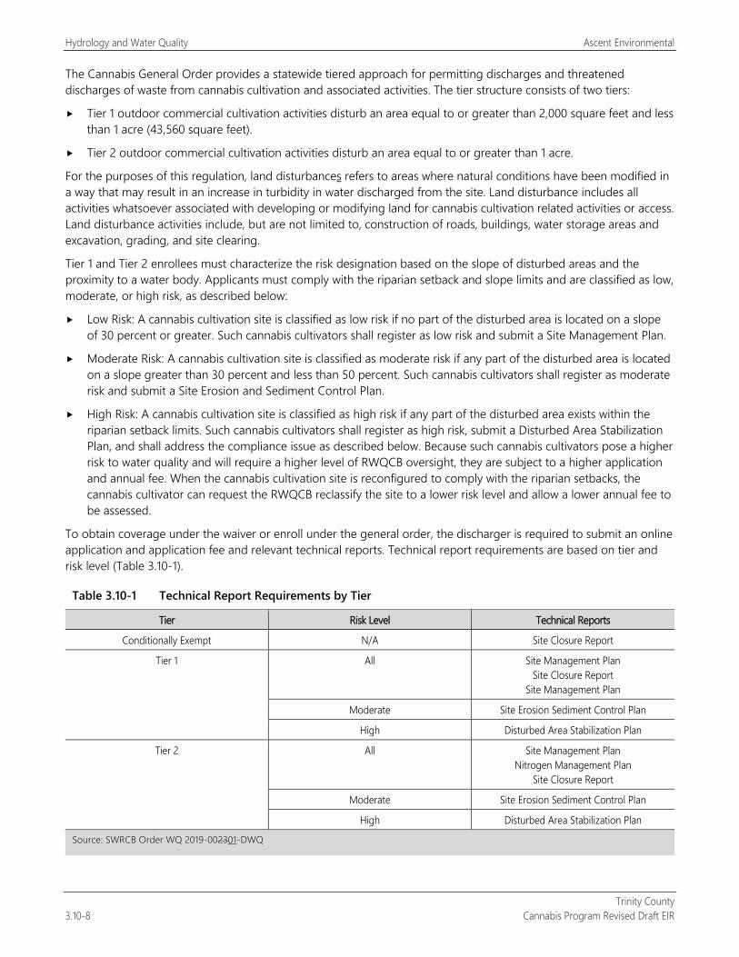
Hydrology and Water Quality Ascent Environmental
Trinity County 3.10-8 Cannabis Program Revised Draft EIR
The Cannabis General Order provides a statewide tiered approach for permitting discharges and threatened discharges of waste from cannabis cultivation and associated activities. The tier structure consists of two tiers:
Tier 1 outdoor commercial cultivation activities disturb an area equal to or greater than 2,000 square feet and less than 1 acre (43,560 square feet).
Tier 2 outdoor commercial cultivation activities disturb an area equal to or greater than 1 acre.
For the purposes of this regulation, land disturbances refers to areas where natural conditions have been modified in a way that may result in an increase in turbidity in water discharged from the site. Land disturbance includes all activities whatsoever associated with developing or modifying land for cannabis cultivation related activities or access. Land disturbance activities include, but are not limited to, construction of roads, buildings, water storage areas and excavation, grading, and site clearing.
Tier 1 and Tier 2 enrollees must characterize the risk designation based on the slope of disturbed areas and the proximity to a water body. Applicants must comply with the riparian setback and slope limits and are classified as low, moderate, or high risk, as described below:
Low Risk: A cannabis cultivation site is classified as low risk if no part of the disturbed area is located on a slope of 30 percent or greater. Such cannabis cultivators shall register as low risk and submit a Site Management Plan.
Moderate Risk: A cannabis cultivation site is classified as moderate risk if any part of the disturbed area is located on a slope greater than 30 percent and less than 50 percent. Such cannabis cultivators shall register as moderate risk and submit a Site Erosion and Sediment Control Plan.
High Risk: A cannabis cultivation site is classified as high risk if any part of the disturbed area exists within the riparian setback limits. Such cannabis cultivators shall register as high risk, submit a Disturbed Area Stabilization Plan, and shall address the compliance issue as described below. Because such cannabis cultivators pose a higher risk to water quality and will require a higher level of RWQCB oversight, they are subject to a higher application and annual fee. When the cannabis cultivation site is reconfigured to comply with the riparian setbacks, the cannabis cultivator can request the RWQCB reclassify the site to a lower risk level and allow a lower annual fee to be assessed.
To obtain coverage under the waiver or enroll under the general order, the discharger is required to submit an online application and application fee and relevant technical reports. Technical report requirements are based on tier and risk level (Table 3.10-1).
Table 3.10-1 Technical Report Requirements by Tier
Tier Risk Level Technical Reports
Conditionally Exempt N/A Site Closure Report
Tier 1 All Site Management Plan Site Closure Report
Site Management Plan
Moderate Site Erosion Sediment Control Plan
High Disturbed Area Stabilization Plan
Tier 2 All Site Management Plan Nitrogen Management Plan
Site Closure Report
Moderate Site Erosion Sediment Control Plan
High Disturbed Area Stabilization Plan
Source: SWRCB Order WQ 2019-002301-DWQ
Ascent Environmental Hydrology and Water Quality
Trinity County Cannabis Program Revised Draft EIR 3.10-9
A summary of the types of information included in the technical reports is provided as follows.
Site Management Plan A Site Management Plan describes how the cannabis cultivator is complying with the requirements listed in Attachment A of SWRCB Order WQ 2019-002301-DWQ. These requirements include a description of how the requirements are implemented property wide, including requirements implemented to address discharges from legacy activities and water diversions, as well as WDRs related to cannabis cultivation. Dischargers must also indicate how the best practical treatment or control (BPTC) measures included in the Cannabis Policy will be implemented. The Site Management Plan may include a schedule to achieve compliance, but all work must be completed by the onset of the winter period each year.
Best Practical Treatment or Control The requirements related to water diversion and waste discharge for cannabis cultivation cover the following 10 BPTC categories:
1. Riparian and wetland protection and management
2. Water diversion, storage, and use
3. Irrigation runoff
4. Land development and maintenance, erosion control, and drainage features
5. Soil disposal
6. Stream crossing installation and maintenance
7. Fertilizer and soil use and storage
8. Cultivation-related waste disposal
9. Refuse and human waste disposal
10. Winterization
Site Erosion and Sediment Control Plan A Site Erosion and Sediment Control Plan describes how the cannabis cultivator will implement the site erosion and sediment control requirements listed in Attachment A of SWRCB Order WQ 2019-002301-DWQ. The report must include an analysis of slope stability and is subject to approval by the RWQCB. When required, the Site Erosion and Sediment Control Plan is to be prepared by a qualified individual (i.e., a registered professional per the Cannabis Policy requirements).
Disturbed Area Stabilization Plan A Disturbed Area Stabilization Plan describes how BPTC measures will be implemented to achieve the goal of stabilizing the disturbed area to minimize the discharge of sediment off-site and complying with the riparian setback requirements. The report must be approved by the RWQCB Executive Officer before implementation. When required, the Disturbed Area Stabilization Plan shall be prepared by a qualified professional.
Nitrogen Management Plan A Nitrogen Management Plan is required for the cannabis cultivation site. The plan provides calculations of all the nitrogen applied to the cannabis cultivation area (dissolved in irrigation water, originating in soil amendments, and applied fertilizers) and describes procedures to limit excessive fertilizer application.
Site Closure Report A Site Closure Report describes how the site will be decommissioned to prevent sediment and turbidity discharges that degrade water quality. If construction activities are proposed in the Site Closure Report, a project implementation schedule shall be included in the report. A Notice of Termination must be submitted (Attachment C of Attachment A of SWRCB Order WQ 2019-002301-DWQ) with the Site Closure Report.
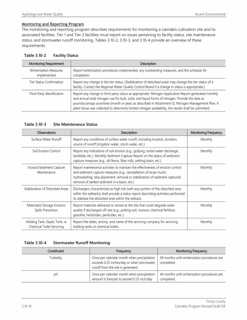
Hydrology and Water Quality Ascent Environmental
Trinity County 3.10-10 Cannabis Program Revised Draft EIR
Monitoring and Reporting Program The monitoring and reporting program describes requirements for monitoring a cannabis cultivation site and its associated facilities. Tier 1 and Tier 2 facilities must report on issues pertaining to facility status, site maintenance status, and stormwater runoff monitoring. Tables 3.10-2, 3.10-3, and 3.10-4 provide an overview of these requirements.
Table 3.10-2 Facility Status
Monitoring Requirement Description
Winterization Measures Implemented
Report winterization procedures implemented, any outstanding measures, and the schedule for completion.
Tier Status Confirmation Report any change in the tier status. (Stabilization of disturbed areas may change the tier status of a facility. Contact the Regional Water Quality Control Board if a change in status is appropriate.)
Third Party Identification Report any change in third party status as appropriate. Nitrogen Application Report generated monthly and annual total nitrogen use for bulk, solid, and liquid forms of nitrogen. Provide the data as pounds/canopy acre/time (month or year) as described in Attachment D, Nitrogen Management Plan. If plant tissue was collected to determine limited nitrogen availability, the results shall be submitted.
Table 3.10-3 Site Maintenance Status
Observations Description Monitoring Frequency
Surface Water Runoff Report any conditions of surface water runoff, including location, duration, source of runoff (irrigation water, storm water, etc.).
Monthly
Soil Erosion Control Report any indications of soil erosion (e.g., gullying, turbid water discharge, landslide, etc.). Monthly Sediment Capture Report on the status of sediment capture measures (e.g., silt fence, fiber rolls, settling basin, etc.).
Monthly
Erosion/Sediment Capture Maintenance
Report maintenance activities to maintain the effectiveness of erosion control and sediment capture measures (e.g., reinstallation of straw mulch, hydroseeding, tarp placement, removal or stabilization of sediment captured, removal of settled sediment in a basin, etc.)
Monthly
Stabilization of Disturbed Areas Dischargers characterized as high risk (with any portion of the disturbed area within the setbacks) shall provide a status report describing activities performed to stabilize the disturbed area within the setback.
Monthly
Material(s) Storage Erosion/ Spills Prevention
Report materials delivered or stored at the site that could degrade water quality if discharged off-site (e.g., potting soil, manure, chemical fertilizer, gasoline, herbicides, pesticides, etc.).
Monthly
Holding Tank, Septic Tank, or Chemical Toilet Servicing
Report the dates, activity, and name of the servicing company for servicing holding tanks or chemical toilets.
Monthly
Table 3.10-4 Stormwater Runoff Monitoring
Constituent Frequency Monitoring Frequency
Turbidity Once per calendar month when precipitation exceeds 0.25 inches/day or when stormwater runoff from the site is generated
All months until winterization procedures are completed.
pH Once per calendar month when precipitation amount is forecast to exceed 0.25 inch/day
All months until winterization procedures are completed.
Ascent Environmental Hydrology and Water Quality
Trinity County Cannabis Program Revised Draft EIR 3.10-11
Annual reports are required to be submitted to the North Coast RWQCB. The Cannabis Policy includes informal and formal enforcement actions to address a violation or threatened violation of water rights and/or water quality law, regulations, policies, plans, or orders. These actions include a notice of violation, cleanup and abatement orders, cease and desist order, revocation of water rights permits, and modifications or rescission of WDR permits.
Numeric and Instream Flow Requirements Attachment A of SWRCB Order WQ 2019-002301-DWQ establishes principles and guidelines (Requirements) for cannabis cultivation activities to protect water quality and instream flows, in consultation with California Department of Fish and Wildlife (CDFW) and the California Department of Food and Agriculture (CDFA). The Requirements are divided into five main categories:
Section 1, General Requirements and Prohibitions, and Cannabis General Water Quality Certification
Section 2, Requirements Related to Water Diversions and Waste Discharge for Cannabis Cultivation
Section 3, Numeric and Narrative Instream Flow Requirements (including Gaging)
Section 4, Watershed Compliance Gage Assignments
Section 5, Planning and Reporting
Instream flow requirements were established by SWRCB in consultation with CDFW for the protection of aquatic species life history needs, including endangered anadromous salmonids. Numeric instream flow requirements (minimum instream flows required to protect aquatic species) are established for each region in the state in Attachment A of SWRCB Order WQ 20179-002301-DWQ. Aquatic base flows have also been established to address instream flow impacts from groundwater diversions (further discussed below). SWRCB’s flow standards and diversion requirements were developed to protect fish spawning, migration, and rearing for endangered anadromous salmonids, and flows needed to maintain natural flow variability within each watershed. The diversion requirements would ensure that the individual and cumulative effects of water diversions and discharges associated with cannabis cultivation do not affect instream flows necessary for fish spawning, migration, and rearing for endangered anadromous salmonids, and flows needed to maintain natural flow variability (SWRCB 2017a). The policy was scientifically peer reviewed by four experts. The peer review determined that water quality, instream flow, and diversion requirements of the policy were based on sound scientific knowledge, methods, and data (SWRCB 2017b).
General Requirements and Prohibitions in Attachment A of SWRCB Order WQ 2019-002301-DWQ implement existing SWRCB authorities and address issues such as compliance with state and local permits, discharge prohibitions, riparian setbacks, protection of tribal cultural resources, and SWRCB’s right to access properties for inspections.
Detailed information related to the requirements that pertain to hydrology and water quality is provided below.
Instream Flow Requirements
Flow and Gaging Requirements The instream flow requirements apply to cannabis cultivators throughout the state. The numeric instream flow requirements are developed at compliance gages statewide. The instream flow requirements may be updated over time, as reasonably necessary. Interested parties may submit scientifically defensible information (e.g. instream flow studies) that supports modification to the instream flow requirements to the Deputy Director of SWRCB for consideration during updates to the Cannabis Policy. There are 11 gages identified in Attachment A of SWRCB Order WQ 2019-002301-DWQ that are located within Trinity County. Seven are located on the Trinity River, one on Rush Creek, one on Indian Creek, and two on the Mad River.
Surface Water Diversion Forbearance Period Absent restrictions on water diversion, the individual and cumulative effects of water diversions for cannabis cultivation during the dry season are likely to significantly decrease instream flow and, in some instances, reduce hydrologic connectivity or completely dewater the stream.
Hydrology and Water Quality Ascent Environmental
Trinity County 3.10-12 Cannabis Program Revised Draft EIR
Minimum flows that provide habitat connectivity are needed to maintain juvenile salmonid passage conditions in late spring and early summer. Instream flows are also needed to maintain habitat conditions necessary for juvenile salmonid viability throughout the dry season, including adequate dissolved oxygen concentrations, low stream temperatures, and high rates of invertebrate drift from riffles to pools. Further, many species depend on spring recession flows as migratory or breeding cues. SWRCB has established a surface water diversion forbearance period (April 1 to October 31 each year) to ensure adequate flows are maintained throughout the dry season and protect aquatic species, aquatic habitat, and water quality.
Wet Season Surface Water Instream Flow Requirements Minimum instream flow requirements during the wet season are needed for the protection of aquatic species life history needs. For threatened and endangered anadromous salmonids, minimum flows are needed to address life history needs, such as:
1. maintaining natural abundance and availability of spawning habitat;
2. minimizing unnatural adult exposure, stress, predation, and delay during adult spawning migration; and
3. sustaining high-quality and abundant juvenile salmonid winter rearing habitat.
To meet the timeline, scale, and purpose of SWRCB Order WQ 2019-002301-DWQ, SWRCB, in consultation with CDFW, has determined that the Tessmann Method is the best methodology to develop interim instream flow requirements. The Tessmann Method develops instream flow requirements by using percentages of historical mean annual and mean monthly natural streamflow. For the development of long-term instream flow requirements, SWRCB, in consultation with CDFW, will evaluate other scientifically robust methods that are more reflective of regional variability and the needs of target species. SWRCB applied the Tessmann Method to a predicted historical flow data set sourced from a flow modeling effort conducted by the U.S. Geological Survey (USGS) in cooperation with The Nature Conservancy and Trout Unlimited (USGS flow modeling data). The interim instream flow requirements were calculated for compliance gages throughout the state. The Tessmann Method and the USGS flow modeling data allow for instream flow requirements to be calculated at additional compliance points throughout the state. This allows SWRCB to use the Tessmann Method and the USGS flow modeling data to calculate or adjust a flow requirement, as needed, throughout the state.
Maintain High-Flow Events To preserve the annual first flush flow event, the surface water diversion period for cannabis cultivation will not occur until the real-time daily average flow is greater than the minimum monthly instream flow requirement at a compliance gage for 7 consecutive days or after December 15 when flows are greater than the numeric flow requirement, whichever occurs first. Surface water diversions must bypass a minimum of 50 percent of the streamflow past the point of diversion. SWRCB will monitor other high-flow events that occur throughout the wet season to evaluate whether additional requirements are needed to maintain high-flow variability during other periods of the wet season.
Groundwater Requirements
To address potential impacts of groundwater diversions on surface flow, SWRCB’s Deputy Director for Water Rights may require a forbearance period or other measures for cannabis groundwater diversions in areas where such restrictions are necessary to protect instream flows. Such areas may include watersheds with high surface water-groundwater connectivity, large numbers of cannabis groundwater diversions, and/or groundwater diversions in close proximity to streams. An aquatic base flow was developed at each compliance gage during the surface water forbearance period (dry season) to inform the need for additional actions to address impacts associated with cannabis groundwater diversions. The aquatic base flow was established in consultation with CDFW. The aquatic base flow is established using USGS flow modeling data to calculate mean monthly flows and applying the New England Aquatic Base Flow Standard methodology at the compliance gages in the nine priority regions. The aquatic base flow is the set of chemical, physical and biological conditions that represent limiting conditions for aquatic life in stream environments. This allows SWRCB to apply the standard to the USGS flow modeling data to calculate an aquatic base flow Requirement at additional compliance points, as needed, throughout the state. SWRCB will monitor instream
Ascent Environmental Hydrology and Water Quality
Trinity County Cannabis Program Revised Draft EIR 3.10-13
flows during the dry season and evaluate the number and location of cannabis groundwater diversions to determine whether imposition of a groundwater forbearance period or other measures are necessary to address potential localized effects of groundwater diversions.
Compliance Gages and Requirements Compliance gage assignments have been developed for all watershed areas throughout the state. Numeric instream flow Requirements are applied at a subset of existing gages reported on two websites: (1) the USGS – National Water Information System or (2) DWR – California Data Exchange Center.
Watershed areas that do not have existing gages are assigned a compliance gage for a different location in the same watershed or for a nearby watershed with similar flow characteristics. Cannabis cultivators in ungaged watersheds may be required to install a gage if information indicates that use of the assigned gage does not adequately protect instream flows. Cannabis cultivators in watersheds without an assigned gage may be required to install a gage if information indicates that a gage is necessary to adequately protect instream flows. SWRCB will monitor where cannabis cultivation diversions are located to track areas where locally concentrated cannabis cultivation water diversions within a watershed may adversely affect instream flows.
Many dams in California have existing instream flow requirements through the Federal Energy Regulatory Commission licensing program or through Biological Opinions issued by the National Marine Fisheries Service or the U.S. Fish and Wildlife Service, or through water right decisions. Cannabis cultivators shall comply with either existing instream flow requirements (e.g., SWRCB Orders, Biological Opinions, Federal Energy Regulatory Commission Licensing Program) or the Tessmann instream flow Requirements, whichever is greater.
The instream flow requirement compliance gages are located in areas that are generally representative of the water availability and total demand occurring upstream of the gaging location or in a similar watershed. However, impacts may still occur in areas where there is significant localized cannabis cultivation compared to water availability or where the compliance gage does not accurately reflect the demand in a paired watershed. To help ensure diversion of water for cannabis cultivation does not negatively affect the flows needed for fish spawning, migration, and rearing, or the flows needed to maintain natural flow variability, the cannabis cultivator shall maintain a minimum bypass of at least 50 percent of the streamflow past the cannabis cultivator’s point of diversion, in addition to the applicable numeric instream flow requirements.
Land Development and Maintenance, Erosion Control, and Drainage Features Section 2 of the Requirements in Attachment A of SWRCB Order WQ 2019-002301-DWQ addresses land development and maintenance, erosion control, and drainage features. These Requirements place limitations on earthmoving, including prohibition of grading on slopes that exceed 50 percent; dust control measures; methods to limit the potential for leaks of hazardous or toxic materials into soils and waterways; erosion prevention and sediment capture measures; and standards for drainages associated with access roads, culverts, and land development.
Stream Crossing Installation and Maintenance The requirements in Attachment A of SWRCB Order WQ 2019-002301-DWQ place limitations of work in watercourses and permanently ponded areas. Standard practices are provided to address design of watercourse crossings and necessary maintenance activities. Guidance is also provided to address temporary watercourse diversion and dewatering.
Soil Disposal and Spoils Management The Requirements address the storage of soil, construction, and waste materials associated with cannabis cultivation.
Exemptions SWRCB Order WQ 2019-002301-DWQ includes an exemption for when activities are considered to pose a low threat to water quality: personal use cannabis cultivators, indoor commercial cultivation activities, and outdoor commercial cultivation activities that disturb less than 2,000 square feet. Personal use cannabis cultivators are generally not subject to commercial cultivation regulations; indoor and operations that disturb less than 2,000 square feet are considered to be conditional exemption.
Hydrology and Water Quality Ascent Environmental
Trinity County 3.10-14 Cannabis Program Revised Draft EIR
Cannabis cultivation activities that disturb an area (in aggregate) less than 2,000 square feet on one parcel or on contiguous parcels managed as a single operation may be conditionally exempt from enrolling under the order but are required to obtain coverage under the waiver of WDRs. This exemption does not limit SWRCB’s authority to inspect the site, evaluate the exemption status, or evaluate other water quality or water right regulatory requirements.
California Forest Practice Rules of 2017 The California Forest Practice Rules of 2017 (Title 14, CCR Chapters 4, 4.5, and 10) implements the provision of the Z’berg-Nejedly Forest Practice Act of 1973. The Cannabis Policy requires access roads to be constructed consistent with the requirements in CCR Title 14, Chapter 4. The Handbook for Forest Ranch and Rural Roads (Road Handbook) describes how to implement these regulations and provides a guide for planning, designing, constructing, reconstructing, upgrading, maintaining, and closing wildland roads. Development of the Road Handbook was funded in part by SWRCB, EPA, and the California Department of Forestry and Fire Protection.
The Road Handbook recommends limited road slopes for safety, maintenance, and drainage issues. Road alignments should be designed with gentle to moderate slopes to minimize damage to the roadbed, allow for frequent and effective road surface drainage, and for safety. Roads with a slope of less than 1 percent can be difficult to drain and may develop potholes and other signs of impaired drainage. Steep roads are more likely to suffer from erosion and road surface damage, especially if they are used when wet. Steep roads can be more difficult to drain because surface runoff may flow down the road in wheel ruts rather than off the outside edge where it can be discharged and dissipated. In snow zones, steep roads may represent a safety hazard if they are used during cold weather periods. New road alignments should be constructed with slopes of 3–8 percent or less wherever possible. Forest roads should generally be kept below 12 percent except for short pitches of 500 feet or less where road slopes may go up to 20 percent. These steeper road slopes should be paved or rock surfaced, and equipped with adequate drainage. Existing roads that do not comply with these limits require additional inspection by a Qualified Professional, as defined in the Policy, to determine if improvements are needed.
State Cannabis Regulations
Cannabis Cultivation Licensing Requirements CCR Section 8102, Annual License Application Requirements, states:
(dd) If applicable, the applicant shall provide evidence that the proposed premises is not located in whole or in part in a watershed or other geographic area that the State Water Resources Control Board or the Department of Fish and Wildlife has determined to be significantly adversely impacted by cannabis cultivation pursuant to section 8216.
CCR Section 8216, License Issuance in an Impacted Watershed, states:
If the State Water Resources Control Board or the Department of Fish and Wildlife notifies the department in writing that cannabis cultivation is causing significant adverse impacts on the environment in a watershed or other geographic area pursuant to section 26069, subdivision (c)(1), of the Business and Professions Code, the department shall not issue new licenses or increase the total number of plant identifiers within that watershed or area while the moratorium is in effect.
CCR Section 8307, Pesticide Use Requirements, states:
(a) Licensees shall comply with all pesticide laws and regulations enforced by the Department of Pesticide Regulation.
(b) For all pesticides that are exempt from registration requirements, licensees shall comply with all pesticide laws and Page 36 of 73 regulations enforced by the Department of Pesticide regulation and with the following pesticide application and storage protocols: (1) Comply with all pesticide label directions; (2) Store chemicals in a secure building or shed to prevent access by wildlife; (3) Contain any chemical leaks and immediately clean up any spills; (4) Apply the minimum amount of product necessary to control the target pest; (5) Prevent offsite drift; (6) Do not apply pesticides when pollinators are present; (7) Do not allow drift to flowering plants attractive to pollinators; (8) Do not spray directly to surface water or allow pesticide
Ascent Environmental Hydrology and Water Quality
Trinity County Cannabis Program Revised Draft EIR 3.10-15
product to drift to surface water. Spray only when wind is blowing away from surface water bodies; (9) Do not apply pesticides when they may reach surface water or groundwater; and (10) Only use properly labeled pesticides. If no label is available consult the Department of Pesticide Regulation.
Microbusiness Licensing Requirements CCR Section 5504. License Issuance in an Impacted Watershed, states:
If the State Water Resources Control Board or the Department of Fish and Wildlife finds, based on substantial evidence, that a licensed microbusiness’ cannabis cultivation is causing significant adverse impacts on the environment in a watershed or other geographic area, the Bureau shall not issue new microbusiness licenses that include cultivation activities or increase the total number of plant identifiers within that watershed or area.
Manufacturing Licensing Requirements CCR Section 40240, Grounds, Building, and Manufacturing Premises, states:
(a) Exterior facility and grounds. The licensee shall ensure the facility exterior and grounds under the licensee’s control meet the following minimum standards:
(5) Waste treatment and disposal systems shall be provided and maintained so as to prevent contamination in areas where cannabis products may be exposed to such a system’s waste or waste by-products.
(b) Interior facility. The licensee shall ensure construction, design, and maintenance of the interior of the manufacturing premises as follows:
(3) Plumbing system and fixtures.
(A) Water supply. Running water shall be supplied as required by Health and Safety Code section 114192 in all areas where required for the processing of cannabis products; in all areas used for the cleaning of equipment, utensils, and packaging materials; and for employee sanitary facilities. Any water that contacts cannabis, components, cannabis products, contact surfaces, or packaging materials shall be potable.
(B) Plumbing. Plumbing systems shall meet the requirements of Health and Safety Code section 114190.
(C) Sewage disposal. The sewage system shall be maintained and kept in good repair so that it does not pose a potential source of contamination to cannabis products, contact surfaces, or packaging materials.
(D) Toilet facilities. Each manufacturing premises shall provide employees with access to toilet facilities that meet the requirements of Health and Safety Code section 114250. Toilet facilities shall be kept clean and shall not pose a potential source of contamination of cannabis, components, cannabis products, contact surfaces, or packaging materials.
(E) Hand-washing facilities. Each manufacturing premises shall provide handwashing facilities that meet the requirements of Health and Safety Code section 113953, subdivision (a) through (d). (F) Waste disposal. The premises shall provide waste disposal in accordance with Health and Safety Code sections 114244(a), 114244(c), and 114245.1. Cannabis waste shall be disposed of in accordance with Section 40290 of these regulations.
LOCAL
North Coast Regional Water Quality Control Board Basin Plan The North Coast RWQCB Basin Plan provides the basis for protecting water quality in California. Basin Plans are mandated by both the CWA and the Porter-Cologne Act. Sections 13240–13247 of the Porter-Cologne Act specify the required contents of a regional basin plan.
Hydrology and Water Quality Ascent Environmental
Trinity County 3.10-16 Cannabis Program Revised Draft EIR
The Basin Plan is the North Coast RWQCB’s master water quality control planning document. It designates beneficial uses and water quality objectives for waters of the state, including surface waters and groundwater. It also includes programs of implementation to achieve water quality objectives. Beneficial uses designated within the North Coast Region include municipal and domestic supply, agricultural supply, industrial service supply, industrial process supply, groundwater recharge, freshwater replenishment, navigation, hydropower generation, water contact recreation, noncontact water recreation, commercial and sport fishing, aquaculture, and various habitats. The Basin Plan was most recently updated in 2011. Please see the discussion of SWRCB above concerning management of cannabis operations.
North Coast Regional Water Quality Control Board Sediment TMDL Implementation Policy As part of its efforts to control sediment waste discharges and restore sediment impaired water bodies, the RWQCB adopted the Total Maximum Daily Load Implementation Policy Statement for Sediment Impaired Receiving Waters in the North Coast Region, which is also known as the Sediment TMDL Implementation Policy, on November 29, 2004. This policy was adopted through Resolution R1-2004-0087.
The Sediment TMDL Implementation Policy states that RWQCB staff shall control sediment pollution by using existing permitting and enforcement tools. The goals of the policy are to control sediment waste discharges to impaired water bodies so that the TMDLs are met, sediment water quality objectives are attained, and beneficial uses are no longer adversely affected by sediment.
The Sediment TMDL Implementation Policy also directs staff to develop: (1) a Work Plan that describes how and when permitting and enforcement tools are to be used, (2) a Guidance Document on Sediment Waste Discharge Control, (3) a Sediment TMDL Implementation Monitoring Strategy, and (4) a Desired Conditions Report.
North Coast Regional Water Quality Control Board Water Quality Control Policy for Siting, Design, Operation, and Maintenance of On-Site Wastewater Treatment Systems On-site wastewater treatment systems (OWTS), commonly known as septic systems, primarily treat domestic wastewater and employ subsurface disposal. On June 19, 2012, SWRCB adopted Resolution No. 2012-0032, adopting the Water Quality Control Policy for Siting, Design, Operation, and Maintenance of Onsite Wastewater Treatment Systems (OWTS Policy). The OWTS Policy uses a risk-based, tiered approach for the regulation and management of OWTS installations and replacements and sets the level of performance and protection expected from OWTS. Most notably the policy establishes a framework that promotes Local Agency Management Plans developed for local governments to implement. The revision of Chapter 4 of the Basin Plan to incorporate the statewide OWTS Policy, with modification, has been approved by the Office of Administrative Law and is now in effect.
North Coast Regional Water Quality Control Board Cannabis Cultivation Waste Discharge Regulatory Program The North Coast RWQCB’s Order R1-2015-0023, The Cannabis Cultivation Waste Discharge Regulatory Program (Order R1-2015-0023, or Order), addresses water quality impacts from cannabis cultivation and associated activities or other operations with similar environmental effects on private property in the North Coast Region. The RWQCBs are the principal state agencies with primary responsibility for the coordination and control of water quality. Nonpoint source pollution, also known as polluted runoff, is the leading cause of water quality impairments in the North Coast. The majority of the streams in the North Coast are affected by excess sediment, nutrients, and elevated temperatures. The problems are often associated with poorly planned forest clearing, earth-moving activities, and other land use management practices, resulting in polluted stormwater runoff to streams. Dry-season surface water diversions intensify these water quality impacts. The regulatory program has several components: A Waiver of Waste Discharge Requirements; Third Party Programs, Inspections, Enforcement, and Education; and Outreach.
The Order includes enforceable requirements that cultivators need to become familiar with to ensure their operations do not affect water resources. Below is a summary of primary elements of the Order:
1. A tiered enrollment structure relative to the potential threat to water quality. Tier 1 is a low-threat tier based on compliance with defined standard conditions and site characteristics. Tier 2 is a management tier, which
Ascent Environmental Hydrology and Water Quality
Trinity County Cannabis Program Revised Draft EIR 3.10-17
requires the development and implementation of a water resource protection plan. Tier 3 is a cleanup tier, which requires the development and implementation of a cleanup and restoration plan.
2. Standard conditions to protect water quality, in conjunction with a list of BMPs, provide a framework for cultivators to assess their sites for appropriate tiers and determine what management measures are necessary to protect water quality. All BMPs in the order are considered enforceable conditions under the Order as applicable to a given site. The draft Order includes standard conditions regarding:
a. Site maintenance, erosion control and drainage features b. Stream crossing maintenance and improvement c. Stream and wetland buffers d. Spoils management e. Water storage and use f. Irrigation runoff g. Fertilizers and soil amendments h. Pesticides i. Petroleum products and other chemicals j. Cultivation-related wastes k. Refuse and human waste, and l. Remediation, cleanup, and restoration activities.
3. Associated procedural forms including a notice of intent of enrollment, a monitoring and reporting form, and a checklist for remediation and restoration work in streams or wetlands.
4. General Prohibitions including discharges or threatened discharges to surface waters.
5. A framework for non-governmental third-party programs to assist cultivators with enrollment, compliance activities, and monitoring and reporting.
6. A framework for development and implementation of water resource protection and cleanup and restoration plans.
With adoption of SWRCB’s Cannabis Policy, the North Coast RWQCB is set to terminate in July 2019.
Trinity County General Plan The Trinity County General Plan Conservation Element has the following applicable objectives and recommendations related to water resources:
Objective: To conserve and maintain streams, lakes and forest open space as a means of providing natural habitat and for all species of wildlife existing in the County.
Prevent land uses which result in siltation, and pollution of lakes and streams should be carefully monitored, and if necessary corrected to assure clean and productive habitat.
Objective: To preserve quality and quantity of the existing water supply in Trinity County and adequately plan for the expansion and retention of valuable water supplies for future generations.
Carefully screen all sewage disposal facilities whether private, individual or public in order to maintain water purity.
Disapprove of any development which may pollute the existing streams and lakes or become the source of silt which washes down into water areas.
The General Plan Open Space Element has the following applicable objectives and recommendations related to water resources:
Objective: To preserve and maintain open space as a means of providing natural habitat for all species of wildlife is the prime objective.
Hydrology and Water Quality Ascent Environmental
Trinity County 3.10-18 Cannabis Program Revised Draft EIR
Present land uses which result in siltation and pollution of lakes and streams should be carefully monitored, and if necessary corrected to assure a clean and productive habitat.
Objective: To preserve the quantity and quality of the existing water supply in Trinity County and adequately plan for the expansion and retention of valuable water supplies for future generations.
Carefully screen all sewage disposal facilities whether private, individual or public in order to maintain water purity throughout the County.
Disapprove of any development which may pollute the existing streams and lakes or become the source of silt which washes down into water areas.
The General Plan Safety Element has the following applicable objective and policy related to water resources:
S.2.1 Objective: Reduce loss of life and property by establishing development standards for areas subject to flooding.
(A) Require all development to meet federal, state and local regulations for floodplain management protection; including the encouragement of upgrading existing structures to meet adopted standards.
Trinity County Code of Ordinances
Water Wells Chapter 15.20 requires a permit be obtained for to construct, repair, modify or destroy any well. Section 15.20.060 requires that a report of completion be provided to the County that provides a detailed log of the well, static water level, well capacity, and drawdown in feet per hour. Well construction, repair, modification, or destruction are generally required to meet the standards set forth in Chapter II of the DWR Bulletin No. 74, "Water Well Standards." Section 16.48.124 provides standards for on-site water availability. These standards include 4-hour pump test production rates and summertime water availability,
Septic Systems Section 15.16.170 requires that all new and replacement water supply and sanitary sewage systems shall be designed to minimize or eliminate infiltration of floodwater into the system and discharge from systems into floodwaters. On-site waste disposal systems must be located to avoid contamination during a flood event. Section 16.48.122 contains criteria for determining lot size, usable acreage, percolation standards, and other standards that must be met to construct on-site waste disposal systems.
Flood Hazard Zoning
The Trinity County Zoning Ordinance flood hazard zoning district allows for an agricultural uses not involving construction of structures or other uses that would limit the flow of floodwaters, except for within the floodways.
Improvement and Grading Requirements Chapter 12.12 provides construction improvement standards for roadways in decomposed granite areas of the county in order to protect soil, water, and fishery resources of the county. This chapter includes limits on the roadway grades, drainage, and culvert design standards to minimize erosion potential and revegetation and maintenance requirements (Section 12.12.040).
On April 16, 2019, the Board of Supervisors adopted Chapter 15.24 to the Code of Ordinances, which established restrictions on mass grading in order to address soil and geologic stability issues from recent construction activities in the county (e.g., water storage ponds, pad grading, and roadway construction for cannabis cultivation sites). This chapter prohibits any activity involving a volume of graded material greater than 800 cubic yards and/or any contiguous or noncontiguous surface area to be graded that is greater than 20,000 square feet. This extent of grading may be allowed subject to the approval of a Director’s Use Permit or a Conditional Use Permit. Under no circumstances are grading activities allowed that:
create a hazard to public health and safety;
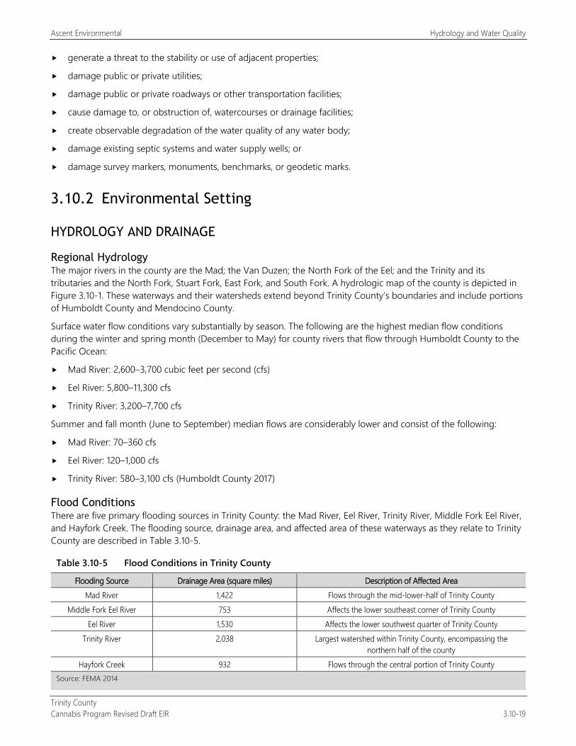
Ascent Environmental Hydrology and Water Quality
Trinity County Cannabis Program Revised Draft EIR 3.10-19
generate a threat to the stability or use of adjacent properties;
damage public or private utilities;
damage public or private roadways or other transportation facilities;
cause damage to, or obstruction of, watercourses or drainage facilities;
create observable degradation of the water quality of any water body;
damage existing septic systems and water supply wells; or
damage survey markers, monuments, benchmarks, or geodetic marks.
3.10.2 Environmental Setting
HYDROLOGY AND DRAINAGE
Regional Hydrology The major rivers in the county are the Mad; the Van Duzen; the North Fork of the Eel; and the Trinity and its tributaries and the North Fork, Stuart Fork, East Fork, and South Fork. A hydrologic map of the county is depicted in Figure 3.10-1. These waterways and their watersheds extend beyond Trinity County’s boundaries and include portions of Humboldt County and Mendocino County.
Surface water flow conditions vary substantially by season. The following are the highest median flow conditions during the winter and spring month (December to May) for county rivers that flow through Humboldt County to the Pacific Ocean:
Mad River: 2,600–3,700 cubic feet per second (cfs)
Eel River: 5,800–11,300 cfs
Trinity River: 3,200–7,700 cfs
Summer and fall month (June to September) median flows are considerably lower and consist of the following:
Mad River: 70–360 cfs
Eel River: 120–1,000 cfs
Trinity River: 580–3,100 cfs (Humboldt County 2017)
Flood Conditions There are five primary flooding sources in Trinity County: the Mad River, Eel River, Trinity River, Middle Fork Eel River, and Hayfork Creek. The flooding source, drainage area, and affected area of these waterways as they relate to Trinity County are described in Table 3.10-5.
Table 3.10-5 Flood Conditions in Trinity County
Flooding Source Drainage Area (square miles) Description of Affected Area Mad River 1,422 Flows through the mid-lower-half of Trinity County
Middle Fork Eel River 753 Affects the lower southeast corner of Trinity County Eel River 1,530 Affects the lower southwest quarter of Trinity County
Trinity River 2,038 Largest watershed within Trinity County, encompassing the northern half of the county
Hayfork Creek 932 Flows through the central portion of Trinity County Source: FEMA 2014
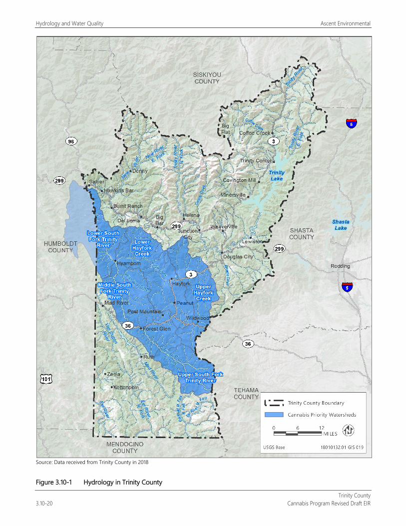
Hydrology and Water Quality Ascent Environmental
Trinity County 3.10-20 Cannabis Program Revised Draft EIR
Source: Data received from Trinity County in 2018
Figure 3.10-1 Hydrology in Trinity County
Ascent Environmental Hydrology and Water Quality
Trinity County Cannabis Program Revised Draft EIR 3.10-21
The flood season on the Trinity River usually lasts from October through April. Over 90 percent of yearly precipitation falls during these months. Statistically, December is the wettest month with 20 percent or more of the rain. Floods on the Trinity River are somewhat controlled by the dams upstream of Lewiston.
Some historical flood records date back to 1862, but USGS has maintained gages on the Trinity River since 1912. The greatest flood recorded for the area occurred in December 1955. Floods have also been recorded for the years 1862, 1926, 1928, 1937, 1940, 1941, 1948, 1950, 1958, 1960, 1963, 1964, 1972, 1974, 1981, 1983, 1986, 1996, and 2006. Flooding that occurring in December 1955 and 1964 were notably destructive, and damaged roads, personal property, homes, and other buildings (FEMA 2014).
100-Year Floodplain Standard measurement of floodplains includes demarcation of areas expected to be flooded during floods with these recurrence intervals, as determined by USACE. FEMA has adopted the 100-year (1-percent annual chance) flood as the base for floodplain management purposes. FEMA has mapped flood-prone areas. The maps provide the basis for regulating floodplains in conformance with the NFIP. The County has adopted floodplain regulations to continue participation in the NFIP. Trinity County’s 100-year floodplains are shown in Figure 3.10-2.
Groundwater Hydrology Bulletin 118 is California’s official publication on the occurrence and nature of groundwater statewide. Bulletin 118 defines the boundaries and describes the hydrologic characteristics of California’s groundwater basins and provides information on groundwater management and recommendations for the future. Within Trinity County, there are five groundwater basins designated by DWR: Wilson Point Area, Hettenshaw Valley, DinsmoresDinsmore Town Area, Hyampom Valley, and Hayfork Valley Groundwater Basin. These are depicted in Figure 3.10-3 and further described below. Outside of these groundwater basins groundwater occurs in fractured bedrock conditions.
Based on well permitting data, the County has identified the following low groundwater production areas:
Weaverville area, including Oregon Mountain, Brown’s Mountain, and Tucker Hill areas;
land areas south of Douglas City near Indian Creek, Reading Creek, and Hayfork Summit;
Hayfork area, including Brady Road, Reservoir Road, Barker Valley, and Wildwood Road;
land areas south of Denny near New River;
land areas along Trinity Dam Road;
Steiner Flat;
land areas near Lower South Fork Trinity River near Hyampom;
land areas near Mad River Road and County Line Road; and
Hettenshaw Valley.
Hayfork Valley Groundwater Basin The Hayfork Valley Groundwater Basin is an irregularly shaped basin, with the main valley trending east-west along Hayfork Creek. The alluvial valleys of Salt Creek and Big Creek are also part of the basin. The community of Hayfork is located within the central portion of the basin. The Hayfork Valley Groundwater Basin cover 3,300 acres and has an estimated capacity of 1,500 acre-feet (DWR 2004a).
Hyampom Valley Groundwater Basin The Hyampom Valley Groundwater Basin is located along the South Fork Trinity River north of the community of Hyampom. This groundwater basin covers 1,350 acres and has an estimated 84 acre-feet available for agricultural use and 44 acre-feet available for municipal and industrial uses (DWR 2004b).
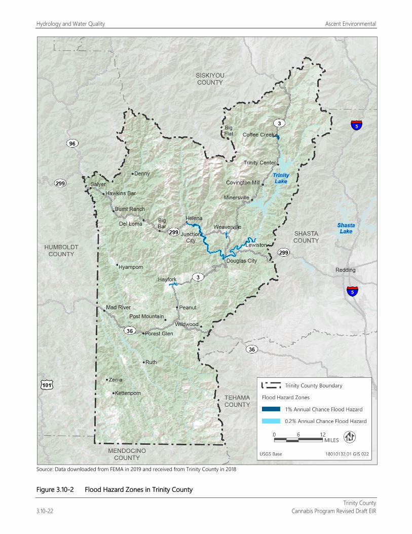
Hydrology and Water Quality Ascent Environmental
Trinity County 3.10-22 Cannabis Program Revised Draft EIR
Source: Data downloaded from FEMA in 2019 and received from Trinity County in 2018
Figure 3.10-2 Flood Hazard Zones in Trinity County
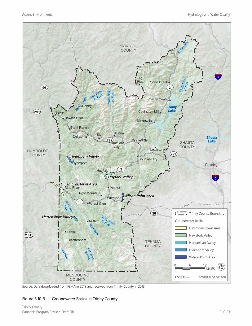
Ascent Environmental Hydrology and Water Quality
Trinity County Cannabis Program Revised Draft EIR 3.10-23
Source: Data downloaded from FEMA in 2019 and received from Trinity County in 2018
Figure 3.10-3 Groundwater Basins in Trinity County
Hydrology and Water Quality Ascent Environmental
Trinity County 3.10-24 Cannabis Program Revised Draft EIR
DinsmoresDinsmore Town Area Groundwater Basin The DinsmoresDinsmore Town Area Groundwater Basin occupies a southeast-trending alluvial valley within a short reach of the Van Duzen River in the vicinity and downstream of the community of DinsmoresDinsmore. This groundwater basin covers 2,300 acres and is estimated to contain 46 acre-feet of groundwater available for agricultural use and 78 acre-feet available for municipal and industrial uses (DWR 2004c).
Hettenshaw Valley Groundwater Basin The Hettenshaw Valley Groundwater Basin is a northwest-trending basin located along a tributary of the Van Duzen River. This groundwater basin covers 850 acres and is estimated to contain 1 acre-foot of water capacity (DWR 2004d).
Wilson Point Area Groundwater Basin The Wilson Point Area Groundwater Basin is a north-trending alluvial basin located within a short reach of Hayfork Creek near Wilson Point. This groundwater basin has an estimated capacity of 700 acre-feet. Groundwater extraction for agricultural use is estimated to be 30 acre-feet. Groundwater extraction for municipal and industrial uses is estimated to be 4 acre-feet (DWR 2004e).
WATER QUALITY
Surface Water Quality The state and federal wild and scenic rivers programs and TMDL designations are programs aimed at waterway protection and rehabilitation, respectively. A summary of the waterways subject to these programs is described as follows.
Federally Designated The Trinity and Eel Rivers are designated as federal wild and scenic rivers in Trinity County. A description of these waterways and their outstandingly remarkable values is provided below.
Trinity River The designated reaches of the Trinity River include:
from the confluence with the Klamath River to 100 yards below Lewiston Dam,
the North Fork from the Trinity River confluence to the southern boundary of the Salmon-Trinity Primitive Area,
the South Fork from the Trinity River confluence to the California State Highway 36 Bridge crossing, and
the New River from the Trinity River confluence to the Salmon-Trinity Primitive Area.
The Trinity River is designated as having outstandingly remarkable values for fisheries (National Wild and Scenic Rivers System 2017a).
Eel River The designated reaches of the Eel River include:
from the mouth of the river to 100 yards below Van Ardsdale Dam,
the Middle Fork from its confluence with the main stem to the southern boundary of the Yolla Bolly Wilderness Area,
the South Fork from its confluence with the main stem to the Section Four Creek confluence,
the North Fork from its confluence with the main stem to Old Gilman Ranch, and
the Van Duzen River from the confluence with the Eel River to Dinsmoure Bridge.
The Eel River is designated as having outstandingly remarkable values for fisheries and recreation (National Wild and Scenic Rivers Systems 2017b).
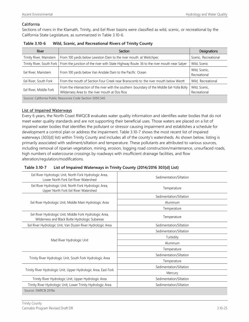
Ascent Environmental Hydrology and Water Quality
Trinity County Cannabis Program Revised Draft EIR 3.10-25
California Sections of rivers in the Klamath, Trinity, and Eel River basins were classified as wild, scenic, or recreational by the California State Legislature, as summarized in Table 3.10-6.
Table 3.10-6 Wild, Scenic, and Recreational Rivers of Trinity County
River Section Designations Trinity River, Mainstem From 100 yards below Lewiston Dam to the river mouth at Weitchpec Scenic, Recreational Trinity River, South Fork From the junction of the river with State Highway Route 36 to the river mouth near Salyer Wild, Scenic
Eel River, Mainstem From 100 yards below Van Arsdale Dam to the Pacific Ocean Wild, Scenic, Recreational
Eel River, South Fork From the mouth of Section Four Creek near Branscomb to the river mouth below Weott Wild, Recreational
Eel River, Middle Fork From the intersection of the river with the southern boundary of the Middle Eel-Yolla Bolly Wilderness Area to the river mouth at Dos Rios
Wild, Scenic, Recreational
Source: California Public Resources Code Section 5093.545
List of Impaired Waterways Every 6 years, the North Coast RWQCB evaluates water quality information and identifies water bodies that do not meet water quality standards and are not supporting their beneficial uses. Those waters are placed on a list of impaired water bodies that identifies the pollutant or stressor causing impairment and establishes a schedule for development a control plan or address the impairment. Table 3.10-7 shows the most recent list of impaired waterways (303[d] list) within Trinity County and includes all of the county’s watersheds. As shown below, listing is primarily associated with sediment/siltation and temperature. These pollutants are attributed to various sources, including removal of riparian vegetation, mining, erosion, logging road construction/maintenance, unsurfaced roads, high numbers of watercourse crossings by roadways with insufficient drainage facilities, and flow alteration/regulation/modifications.
Table 3.10-7 List of Impaired Waterways in Trinity County (2014/2016 303[d] List)
Eel River Hydrologic Unit, North Fork Hydrologic Area, Lower North Fork Eel River Watershed Sedimentation/Siltation
Eel River Hydrologic Unit, North Fork Hydrologic Area, Upper North Fork Eel River Watershed Temperature
Eel River Hydrologic Unit, Middle Main Hydrologic Area Sedimentation/Siltation
Aluminum Temperature
Eel River Hydrologic Unit, Middle Fork Hydrologic Area, Wilderness and Black Butte Hydrologic Subareas Temperature
Eel River Hydrologic Unit, Van Duzen River Hydrologic Area Sedimentation/Siltation
Mad River Hydrologic Unit
Sedimentation/Siltation Turbidity
Aluminum Temperature
Trinity River Hydrologic Unit, South Fork Hydrologic Area Sedimentation/Siltation
Temperature
Trinity River Hydrologic Unit, Upper Hydrologic Area, East Fork Sedimentation/Siltation
Mercury Trinity River Hydrologic Unit, Upper Hydrologic Area Sedimentation/Siltation
Trinity River Hydrologic Unit, Lower Trinity Hydrologic Area Sedimentation/Siltation Source: SWRCB 2019a
Hydrology and Water Quality Ascent Environmental
Trinity County 3.10-26 Cannabis Program Revised Draft EIR
Cannabis Priority Watersheds SWRCB, in coordination with CDFW, has identified “Cannabis Priority Watersheds” throughout the state. All Cannabis Priority Watersheds contain a high concentration of cannabis cultivation; noncompliant cannabis cultivation in these high-value areas has the potential to cause severe environmental impacts. Pursuant to CCR Section 8216, if SWRCB or CDFW notifies CDFA in writing that cannabis cultivation is causing significant adverse impacts on the environment in a watershed or other geographic area pursuant to Section 26069, subdivision (c)(1), of the Business and Professions Code, CDFA shall not issue new licenses or increase the total number of plant identifiers within that watershed or area while the moratorium is in effect.
A “Cannabis Priority Watershed” may also meet some or all of the following criteria:
Contains or supports critical habitat for terrestrial or aquatic species. “Critical habitat” is a term defined and used in the federal and California Endangered Species Acts, and refers to specific geographic areas that contain features essential to the conservation of an endangered or threatened species and that may require special management and protection. Critical habitat may also include areas that are not currently occupied by the species but will be needed for its recovery;
Contains water courses with low-flow conditions where water levels recede or are at risk of receding into the “danger zone” for aquatic life. These are survival-level flows at which aquatic habitat and species will be harmed;
Contains a critical water supply, where excessive water usage or diversions present unreasonable stress or pose a significant threat to the long-term and sustainable water use;
Has complaints that allege cannabis cultivation that contributes to or causes natural resources violations, or that affects senior water right holders;
Is part of past or ongoing restoration efforts;
Is listed under CWA Section 303(d) as an impaired waterbody;
Contains surface water body that is listed as a fully appropriated stream; and
Contains a waterbody is designated as a “Wild and Scenic River” pursuant to PRC Section 5093.
The current (2019) Cannabis Priority Watersheds in Trinity County are provided as follows and are shown in Figure 3.10-1 and Figure 3.10-4 (SWRCB 2019b).
Upper South Fork Trinity River: This watershed consists of approximately 73,642 acres within the county. There is one unlicensed cultivation site that was identified in this watershed in 2016.
Middle South Fork Trinity River: This watershed consists of approximately 145,780 acres within the county. There were 865 cannabis cultivation sites identified in this watershed in 2016. As of the end of 2018 there were 79 County-licensed cultivation sites in the watershed.
Lower South Fork Trinity River: This watershed consists of approximately 56,076 acres within the county. There were 47 cannabis cultivation sites identified in this watershed in 2016. As of the end of 2018 there were 16 County-licensed cultivation sites in the watershed.
Upper Hayfork Creek: This watershed consists of approximately 105,672 acres within the county. There were 307 cannabis cultivation sites identified in this watershed in 2016. As of the end of 2018 there were 54 County-licensed cultivation sites in the watershed.
Lower Hayfork Creek: This watershed consists of approximately 142,135 acres within the county. There were 520 cannabis cultivation sites identified in this watershed in 2016. As of the end of 2018 there were 68 County-licensed cultivation sites in the watershed.
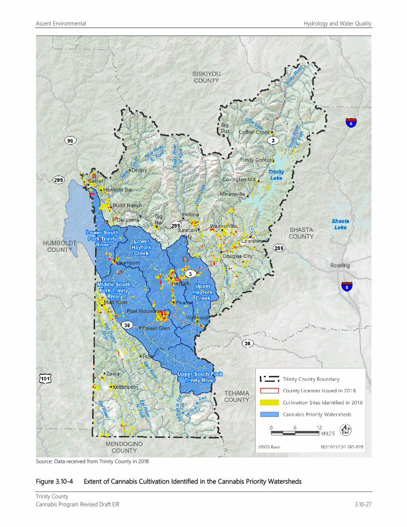
Ascent Environmental Hydrology and Water Quality
Trinity County Cannabis Program Revised Draft EIR 3.10-27
Source: Data received from Trinity County in 2018
Figure 3.10-4 Extent of Cannabis Cultivation Identified in the Cannabis Priority Watersheds
Hydrology and Water Quality Ascent Environmental
Trinity County 3.10-28 Cannabis Program Revised Draft EIR
Groundwater Quality Groundwater quality can be affected by many things, but the chief controls on the characteristics of groundwater quality are the source and chemical composition of recharge water, properties of the host sediment, and history of discharge or leakage of pollutants.
Hayfork Valley Groundwater Basin is predominately calcium-magnesium bicarbonate water (DWR 2004a). Other groundwater basins within the county are not known to be subject to groundwater quality issues (DWR 2004b, 2004c, 2004d, 2004e).
EXISTING STRESSORS ON HYDROLOGY AND WATER QUALITY FROM CULTIVATION Predominantly unregulated for years, thousands of cannabis cultivators have developed cultivation sites in remote areas of California near streams. In many cases, the routine cannabis cultivation practices result in damage to streams and wildlife. These practices (e.g., clearing trees, grading, and road construction) have been conducted in a manner that causes large amounts of sediment to flow into streams during rains along with decomposed granite flowing into the streams. The cannabis cultivators have also discharged pesticides, fertilizers, fuels, trash, and human waste around the sites, which then discharges into waters of the state. In the North Coast region, the state has invested millions of dollars to restore streams damaged by decades of timber harvesting. Cannabis cultivation is now reversing the progress of these restoration efforts (SWRCB 2017b). The extent of unlicensed cannabis cultivation in the Cannabis Priority Watersheds is shown in Figure 3.10-4.
In addition to these water quality discharge–related impacts, cannabis cultivators also impair water quality by diverting water from streams in the dry season, when flows are low. Diversion of flow during the dry season has caused complete elimination of streamflows. The effects of these diversions have been exacerbated in recent years by periods of drought (SWRCB 2017b). Water quality–related constituents of concern associated with cannabis cultivation discharges include nitrogen, pathogens (represented by coliform bacteria), phosphorus, salinity, and turbidity. Water quality can be affected by excessive use of fertilizer, soil amendments, or other sources. The constituents have the potential to discharge to groundwater by infiltration and to other waters of the state by either surface runoff or groundwater seepage (SWRCB 2017b).
3.10.3 Environmental Impacts and Mitigation Measures
METHODOLOGY Evaluation of potential hydrologic and water quality impacts is based on a review of existing documents and studies that address water resources in the vicinity of the project. Information obtained from these sources was reviewed and summarized to describe existing conditions and to identify potential environmental effects, based on the standards of significance presented in this section. In determining the level of significance, the analysis assumes that the project would comply with relevant federal, state, and local laws, ordinances, and regulations.
THRESHOLDS OF SIGNIFICANCE An impact on hydrology or water quality would be significant if implementation of the Cannabis Program would:
violate any water quality standards or WDRs or otherwise substantially degrade surface water or groundwater quality;
substantially decrease groundwater supplies or interfere substantially with groundwater recharge such that the project may impede sustainable groundwater management of the basin;
substantially alter the existing drainage pattern of the site or area, including through the alteration of the course of a stream or river, in a manner that would:
Ascent Environmental Hydrology and Water Quality
Trinity County Cannabis Program Revised Draft EIR 3.10-29
result in substantial erosion or siltation on- or off-site,
result in flooding on-site or off-site,
create or contribute runoff water that would exceed the capacity of existing or planned stormwater drainage systems or provide substantial additional sources of polluted runoff, or
impede or redirect flood flows;
result in flood hazard, tsunami, or seiche zones, or risk release of pollutants due to project inundation; or
conflict with or obstruct implementation of a water quality control plan or sustainable groundwater management plan.
These thresholds were used because they address possible impacts anticipated with the implementation of the Cannabis Program on surface water and groundwater resources in the county.
ISSUES NOT EVALUATED FURTHER Trinity County is not located in an area subject to tsunamis.
Environmental impact analyses under CEQA generally are not required to analyze the impact of existing environmental conditions on a project’s future users or residents, but when a proposed project risks exacerbating environmental hazards or conditions that already exist, an agency must analyze the potential impact of such hazards on future residents or users. In those specific instances, it is the project’s impact on the environment and not the environment’s impact on the project that compels an evaluation of how future residents or users could be affected by exacerbated conditions (California Building Industry Association v. Bay Area Air Quality Management District (2015) 62 Cal. 4th 369). Allowable uses within zoning pertinent to the Cannabis Program would be similar to those currently allowed within agricultural, industrial, and commercial areas. Thus, the Cannabis Program would allow for commercial cannabis operations to occur within specific zones of the county (see Chapter 2, “Project Description”) but would not exacerbate any existing conditions related to the potential for seiche or dam failure. These topics are not discussed further.
The SGMA requires governments and water agencies of high- and medium-priority basins to halt overdraft and bring groundwater basins into balanced levels of pumping and recharge. Groundwater basins in Trinity County and considered to be of low priority, and thus are not subject to development of a sustainable groundwater management plan.
ENVIRONMENTAL IMPACTS AND MITIGATION MEASURES
Impact 3.10-1: Degrade Water Quality
Commercial cannabis operations in the county that may occur under the Cannabis Program have the potential to modify surface drainage and flows in such a manner that increased sedimentation and erosion could take place, leading to water quality degradation. This could further affect waterways subject to the 303(d) list and North Coast RWQCB Sedimentation TMDL. The long-term operational use of pesticides, fertilizers, other chemicals, and roadway use can also have a negative effect on water quality and ultimately affect the health and sustainability of organisms that rely on high-quality waters. As a result, the impact would be potentially significant.
Cannabis cultivation can degrade water quality in various ways, including discharges of sediment to surface water from roads or other land improvements; discharges of fertilizers, pesticides, and other chemicals to surface waters or groundwater; discharges of fertilizers and pesticides to surface water or groundwater; spills or leaks of fuels, lubricants, hydraulic oil, or other chemicals associated with pumps, construction, or other equipment; and discharges of trash, household refuse, or domestic wastewater. In addition, construction of ponds, and grading for other water storage devices and structures can lead to erosion and thus further degradation of surface water quality during construction. Due to past and current practices, hydrologic units in Trinity County are subject to the 303(d) list of impaired waterways and associated with the North Coast RWQCB Sedimentation TMDL. Generally, listing of the waterways is associated with sedimentation, siltation, temperature, and turbidity. In addition, the Upper South Fork
Hydrology and Water Quality Ascent Environmental
Trinity County 3.10-30 Cannabis Program Revised Draft EIR
Trinity River, Middle South Fork Trinity River, Lower South Fork Trinity River, Upper Hayfork Creek, and Lower Hayfork Creek are listed as Cannabis Priority Watersheds in Trinity County.
As discussed above in Section 3.10.1, “Regulatory Setting,” SWRCB Order WQ 20179-002301-DWQ contains requirements for cannabis cultivation on sites greater than 2,000 square feet. These requirements include plans that address site erosion and sediment control, disturbed areas stabilization, nitrogen management, implementation of BPTC, site closure procedures, and monitoring and reporting requirements. In addition, the Order contains requirements for land development maintenance, erosion control, drainage features, stream crossing installation and maintenance, soil disposal and spoils management, and roadway design and maintenance. Because new cannabis cultivation operations must comply with the WDR, further degradation of water quality from a grow site 2,000 square feet or greater in size would be minimized. Cannabis operations are also subject to Chapter 12.12 of Trinity County Code of Ordinances that requires roadways constructed in decomposed granite areas to meet grade, culvert design, and revegetation requirements to address erosion. Chapter 15.24 of the County Code of Ordinances restricts mass grading activities and requires permitting and protection of water quality for any activity that would handle 800 cubic yards or greater of material or grades a surface area of 20,000 square feet or greater.
The Cannabis Program includes the following standards that address water quality for cultivation operations:
The cultivation of cannabis shall not create erosion or result in contaminated runoff into any stream, creek, river, or body of water. If the designated area has more than a 35 percent slope, the applicant shall apply for a Tier 2 cultivation under the North Coast RWQCB Order #2015-0023, or regulations established by SWRCB (Section 315-843[6][d]).
Applicant shall obtain coverage under the General Permit for Discharges of Storm Water Associated with Construction Activity for construction projects that disturb 1 or more acres of land surface, specifically for new site preparation and development (Section 315-423[6][o]).
Existing Licensed Commercial Cannabis Operations Figure 3.10-4 shows cultivation sites licensed in the county in 2018 that are located in Cannabis Priority Watersheds as well as located elsewhere in the county. On several of these sites on-site vegetation has already been cleared and cannabis cultivation facilities have already been constructed and are operating. Although these sites are part of the existing conditions, continued operation of cultivation sites that are not participating in the North Coast RWQCB’s Order R1-2015-0023 or SWRCB Order WQ 20179-002301-DWQ would continue to result in water quality degradation. Field review of existing cannabis cultivation sites in the county identified slope stability issues associated with terrace construction on some sites as well as a lack of water quality control features on-site or associated access roadways. Expansion of existing operations could result in further water quality impacts. Thus, this impact associated with existing licensed cannabis cultivation operations would be potentially significant.
New Licensed Commercial Cannabis Operations Development of new commercial cannabis cultivation and noncultivation sites could involve preparation of level surfaces such as terraces, construction of water detention features for water storage, building construction, extension of electrical facilities, and other site improvements. Site preparation and construction of these features would require activities such as grading, placement of fill, and excavation. These types of land disturbance activities could lead to accelerated erosion and sedimentation (especially in areas of decomposed granite) that causes poor water quality from high turbidity, total suspended solids, and total dissolved solids in local waterways, thus contributing to further degraded conditions in already impaired waterways. Placement of cannabis cultivation facilities within the 100-year floodplain of rivers and streams can also result in direct discharge of pollutants to the waterway during a flood event.
Channel morphology, substrate composition, gradient, and type of riparian vegetation, among other factors, influence the velocity and flow of surface water, and therefore the ability of a river or stream to move sediment. When the volume and pattern of surface water discharge are altered from their natural character, increases or decreases in the force of moving water will result, translating to increases or decreases in the rate of erosion. During the winter months, Trinity County experiences substantial rainfall and, at high elevations, snowfall. Snowmelt in the spring leads to large streamflow volumes in the rivers and streams of the county. Topography in much of the county
Ascent Environmental Hydrology and Water Quality
Trinity County Cannabis Program Revised Draft EIR 3.10-31
is rugged and steep, with slopes exceeding angles of 35 degrees. This confluence of physiographic conditions enhances the risk of runoff erosion associated with new commercial cannabis site preparation and construction, especially during storm and high-flow events. Poorly constructed unpaved roads are prone to accelerated wear and erosion that can lead to catastrophic failure. Road failure, especially at culverts or other types of watercourse crossings, can degrade water quality and destroy riparian habitats. Terraces or water storage ponds that do not consider local topography and soil conditions might also be subject to failures that degrade local waterways. In some cases, these issues would be addressed through compliance with SWRCB Order WQ 2017-0023-DWQ 2019-0001-DWQ and County Code of Ordinances Chapters 12.12 and 15.24; however, because SWRCB Order 2017-0023-DWQ applies only to sites of if the site is less than 2,000 square feet, the operation may be conditionally exempt from enrolling under the order and instead be required to obtain coverage under the waiver of WDRs. or greater, sites that are not subject to the requirements would continue to contribute to detrimental effect on aquatic life and the natural functioning of local ecosystems. Operation and harvest activities would involve the use of pesticides, fertilizers, and other materials that could affect water quality. Cannabis cultivation sites could also result in on-site needs for proper septic systems to accommodate season workers.
Development carried out under the Cannabis Program would also include construction of new facilities for the manufacturing, processing, and dispensing of cannabis. Construction activities would include clearing, grading, and excavation for new or expanded facilities. Excavations might relate to the construction of foundations, roads and driveways, and utility trenches. These developments would be restricted to appropriately zoned areas. Industrial pollutants related to the construction of facilities could become exposed to stormwater drainage and in turn enter or contaminate local surface water or groundwater. If the disturbance occurs over an area of 1 acre or greater, the North Coast RWQCB requires compliance with the Construction General Permit. Construction site erosion control methods and other BMPs would be included in the development of a SWPPP, per the requirements of the General Permit. Implementation of BMPs during construction would safeguard against violation of the General Permit and associated water quality impacts.
Trinity County does not require any site-specific erosion and sediment control measures, such as those typically required through a grading permit program. Similarly, the size of new cannabis cultivation sites is unknown, and the requirements outlined in SWRCB Order WQ 2017-0023-DWQ are not applicable for cultivation sites that are less than 2,000 square feet. Thus, for sites that are not subject to these standards and requirements, it would be expected that cannabis operations would cause degradation of water quality, as already documented in Trinity County. This impact would be potentially significant.
Mitigation Measures
Mitigation Measure 3.10-1a: Demonstrate Compliance with Water Resource Standards The following shall be included as new performance standards for Section 315-843(6) (Performance Standards for Commercial Cultivation of Cannabis). Compliance documentation will be provided to the County as part of the application materials and may be combined with required compliance with SWRCB Order WQ 20179-002301-DWQ:
All cultivation sites (new and licensed renewals) are required to demonstrate compliance with all applicable the requirements of SWRCB Order WQ 2019-0001-DWQ WQ 2017-0023-DWQ or any subsequent water quality standards that apply to all new commercial cannabis cultivation operations and will not limited by a minimum area of disturbance cultivation area size as part of application review and at annual licensed renewal. This will include documentation, Site Management Plan, and an improvement plan grading details prepared by a qualified professional to help ensure that any grading of the site will be stable and describing how stabilization will be achieved. The documentation will also identify the location of all water quality control features for the site and associated access roads. Roadway design, water quality control, and drainage features shall be designed and maintained to accommodate peak flow conditions and will be consistent with the Five Counties Salmonid Conservation Roads Maintenance Manual The Road Handbook, per CCR Title 14, Chapter 4. Compliance with water diversion standards and restrictions of SWRCB Order WQ 2017-00232019-0001-DWQ will also be provided to the
Hydrology and Water Quality Ascent Environmental
Trinity County 3.10-32 Cannabis Program Revised Draft EIR
County. The County will annually inspect compliance with this measure as part of license issuance or license renewal to confirm compliance.
On-site sewage systems shall be designed to accommodate employees and seasonal employees during harvest consistent with the requirements of County Code of Ordinances Section 16.48.122.
The following shall be included as a new performance standard for Section 315-843(6) (Performance Standards for Commercial Cultivation of Cannabis), Section 315-824(5) (Required Conditions), Section 315-826(3) (Regulation of Nurseries), Section 315-828(5) (Required Conditions), Section 315-835(2) (Regulations), Section 315-837(3) (Required Conditions), and Section 315-842(6) (Required Conditions):
Applications will identify drainage and water quality controls for the site, including roads leading to and from a site, that ensure no sedimentation or other pollutants leave the site as part of project construction and operation. Compliance with this requirement may be combined with the NPDES Construction General Permit compliance measures. Roadway design, water quality control, and drainage features shall be designed and maintained to accommodate peak flow conditions and will be consistent with the Five Counties Salmonid Conservation Roads Maintenance Manual. The County will annually inspect compliance with this measure as part of license issuance or license renewal to confirm compliance.
Mitigation Measure 3.10-1b: Prohibit Cultivation in Floodplains The following shall be included as a new performance standard for Section 315-843(6) (Performance Standards for Commercial Cultivation of Cannabis):
Cultivation sites shall not place any structures or involve any grading that alters the capacity of the 100-year floodplain. No storage of pesticides, fertilizers, fuel, or other chemicals will be allowed within the 100-year floodplain. All cultivation uses (plants, planter boxes and pots, and related materials) will be removed from the 100-year floodplain between November 1 and April 1 each year.
Significance after Mitigation Mitigation Measure 3.10-1a would require all existing and new commercial cannabis activities in the county to comply with the conditions of SWRCB Order WQ 20179-002301-DWQ or otherwise avoid water quality impacts. These conditions were developed in consultation with California Department of Fish and Wildlife to ensure that the individual and cumulative effects of water diversions and discharges associated with cannabis cultivation do not affect fish spawning, migration, and rearing for endangered anadromous salmonids. The provisions of SWRCB Order WQ 20179-002301-DWQ were scientifically peer reviewed by four experts. The peer review determined that water quality, instream flow, and diversion requirements of the Policy were based on sound scientific knowledge, methods, and data (SWRCB 2017b). This would also include ensuring that sites are stable and do not result in operational water quality impacts. Mitigation Measure 3.10-1b would avoid direct discharge of pollutants during a flood event. Therefore, impacts on surface water and groundwater quality would be less than significant.
Impact 3.10-2: Result in Groundwater Supply Impacts
Commercial cannabis operations in the county that may occur under the Cannabis Program have the potential to deplete local groundwater supplies and affect adjacent wells as a result of cultivation water demands. Trinity County Ordinance provisions include requirements for pump testing. While these requirements would address the potential effects of short-term well operation, it is not known if operation of wells for cannabis operations over an extended period could result in isolated locations that affect the operability of adjacent wells. As a result, this impact would be potentially significant.
The Cannabis Program and state regulations require each commercial cannabis cultivation operation to obtain and disclose a legal water supply source. Possible water supplies include domestic water service from a local service provider, existing riparian water rights to utilize surface water on the site, approved surface water diversions, rain water capture to storage facilities, and groundwater.
Ascent Environmental Hydrology and Water Quality
Trinity County Cannabis Program Revised Draft EIR 3.10-33
In areas where groundwater is available, and depending on the location of extraction and condition of local groundwater resources, it is possible for drawdown at a well in one location to affect groundwater elevations in other wells. One of the most important factors is distance; larger parcels generally have larger areas to draw from, thereby reducing the potential to adversely affect adjacent properties. The close proximity of wells to other wells, and structure and volume of the groundwater basin (among many factors), can influence if a well would affect other wells. The effect of wells in fractured bedrock on groundwater elevations is dependent on the connectivity of fracture and joint sets in the bedrock. No mapping of subsurface features, including fracture locations, orientations, or depths, has been completed on a countywide scale, nor would this be feasible given that these are subsurface structures and are unique and variable from location to location. Thus, groundwater management in these types of conditions is best conducted through managing the distances between wells and through well testing.
As noted above in Section 3.10.2, “Environmental Setting,” the County has identified the following low groundwater production areas. As shown in Figure 2-4, there are several existing licensed and unlicensed cannabis cultivation sites in the areas of Weaverville, Hayfork, and the Mad River where groundwater has been identified as limited.
Weaverville area, including Oregon Mountain, Brown’s Mountain, and Tucker Hill areas;
land areas south of Douglas City near Indian Creek, Reading Creek, and Hayfork Summit;
Hayfork area;
land areas south of Denny near New River;
land areas along Trinity Dam Road;
Steiner Flat;
land areas near Lower South Fork Trinity River near Hyampom;
Hayfork Summit;
Barker Valley and Wildwood Road;
land areas near Mad River Road and County Line Road; and
Hettenshaw Valley.
The Cannabis Program includes the following standard, which addresses water quality for cultivation operations:
Applicants shall comply with all state laws, including SB 94, regarding surface water, including but not limited to, water used for the cultivation of cannabis needs to be sourced on-site from a permitted well or diversion. If using a permitted well, a copy of the Trinity County well permit shall be provided. The cultivation of cannabis shall not utilize water that has been or is illegally diverted from any stream, creek, river, or water source. If water is hauled it shall be for emergencies, as defined as a sudden, unexpected occurrence, and a bill of sale shall be kept on file from a water district or legal water source (Section 315-843[6][c]).
Trinity County Environmental Health is currently requiring well production rates for cannabis cultivation sites to be at least 3 gallons per minute.
Existing Licensed Commercial Cannabis Operations Figure 2-3 shows cultivation sites licensed in the county in 2018. Several of these sites are under operation, and their groundwater use is part of the existing conditions. Continued operation of these cultivation sites would not result in new groundwater use that would result in significant groundwater resource impacts. However, continued cultivation operations in combination with new cultivation sites could result in groundwater impacts. Thus, this impact would be potentially significant.
New Licensed Commercial Cannabis Operations New commercial cannabis operations (cultivation and noncultivation uses) could use groundwater and further increase the local demand of limited groundwater supplies. The Cannabis Program requires a well permit to be
Hydrology and Water Quality Ascent Environmental
Trinity County 3.10-34 Cannabis Program Revised Draft EIR
obtained from the County for cultivation activities. The County standards for wells are related to pump rates. These tests are designed to prevent drawdown on adjacent properties; however, it is not possible to ensure that, over the long term and in variable hydrologic conditions, some isolated wells would not be affected by adjacent cannabis operations. Given this uncertainty, this impact would be potentially significant.
Mitigation Measures
Mitigation Measure 3.10-2: Conduct Groundwater Monitoring and Adaptive Management The following shall be included as a new performance standard for Section 315-843(6) (Performance Standards for Commercial Cultivation of Cannabis), Section 315-824(5) (Required Conditions), Section 315-826(3) (Regulation of Nurseries), Section 315-828(5) (Required Conditions), Section 315-835(2) (Regulations), Section 315-837(3) (Required Conditions), and Section 315-842(6) (Required Conditions) associated with projects using groundwater as a water supply source:
As part of the application and license renewal process, applicants shall provide the County with groundwater monitoring data for existing on-site well facilities that documents well production and changes in groundwater levels during each month of the year. Should this monitoring data identify potential drawdown impacts on adjacent well(s), surface waters, and waters of the state and sensitive habitats, and indicate a connection to operation of the on-site wells, the cannabis operators, in conjunction with the County, shall develop adaptive management measures to allow for recovery of groundwater levels that would protect adjacent wells and habitat conditions that could be adversely affected by declining groundwater levels. Adaptive management measures may include forbearance (e.g., prohibition of groundwater extraction from the months of May to October), water conservation measures, reductions in on-site cannabis cultivation, alteration of the groundwater pumping schedule, or other measures determined appropriate. Adaptive management measures will remain in place until groundwater levels have recovered and stabilized based on annual monitoring data provided to the County as part of subsequent annual inspections. Any monitoring cannabis cultivation irrigation wells that demonstrate hydrologic connection to surface waters shall be subject to surface water diversion requirements and restrictions in SWRCB Order WQ 2019-0001-DWQ. Wells shall also be sited outside of the stream setbacks as set forth in SWRCB Order WQ 2019-0001-DWQ.
Significance after Mitigation Mitigation Measure 3.10-2 would require the reporting of annual monitoring of groundwater conditions to the County as part of the annual inspections required under the ordinance. This monitoring would identify if on-site well operations are resulting in groundwater drawdown impacts and what adaptive measures would be implemented to recover groundwater levels and protect adjacent wells. Because implementation of this mitigation measure would be required as part of annual commercial cannabis operations permit renewals, it would provide ongoing protection of local groundwater resources. Thus, implementation of Mitigation Measure 3.10-2 would reduce this impact to a less-than-significant level.
Impact 3.10-3: Result in Diversion of Surface Water
New commercial cannabis cultivation operations in the county that may occur under the Cannabis Program could result in decreased flow rates on county streams and rivers because of surface water diversion. Low flows are associated with increased temperature and may also aggravate the effects of water pollution. Compliance with SWRCB Order WQ 2019-002301-DWQ requires that certain flow and gaging requirements be met and that a surface water diversion forbearance period be implemented. However, these requirements apply only to cultivation sites that are of 2,000 square feet or greater. Because the location and size of additional cannabis cultivation sites are unknown, there is potential that surface water flows could decrease, causing degraded water quality conditions. This impact would be potentially significant.
As noted in Section 3.10.2, “Environmental Setting,” the Eel, Trinity, and Mad Rivers are designated as impaired waterways because low flows affect temperature and water quality. In addition, SWRCB has identified the following watersheds as Cannabis Priority Watersheds in Trinity County because of water quality, low flow, and other related issues. The description below identifies the estimated number of licensed and unlicensed cultivation sites in each watershed (see Figure 3.10-4):
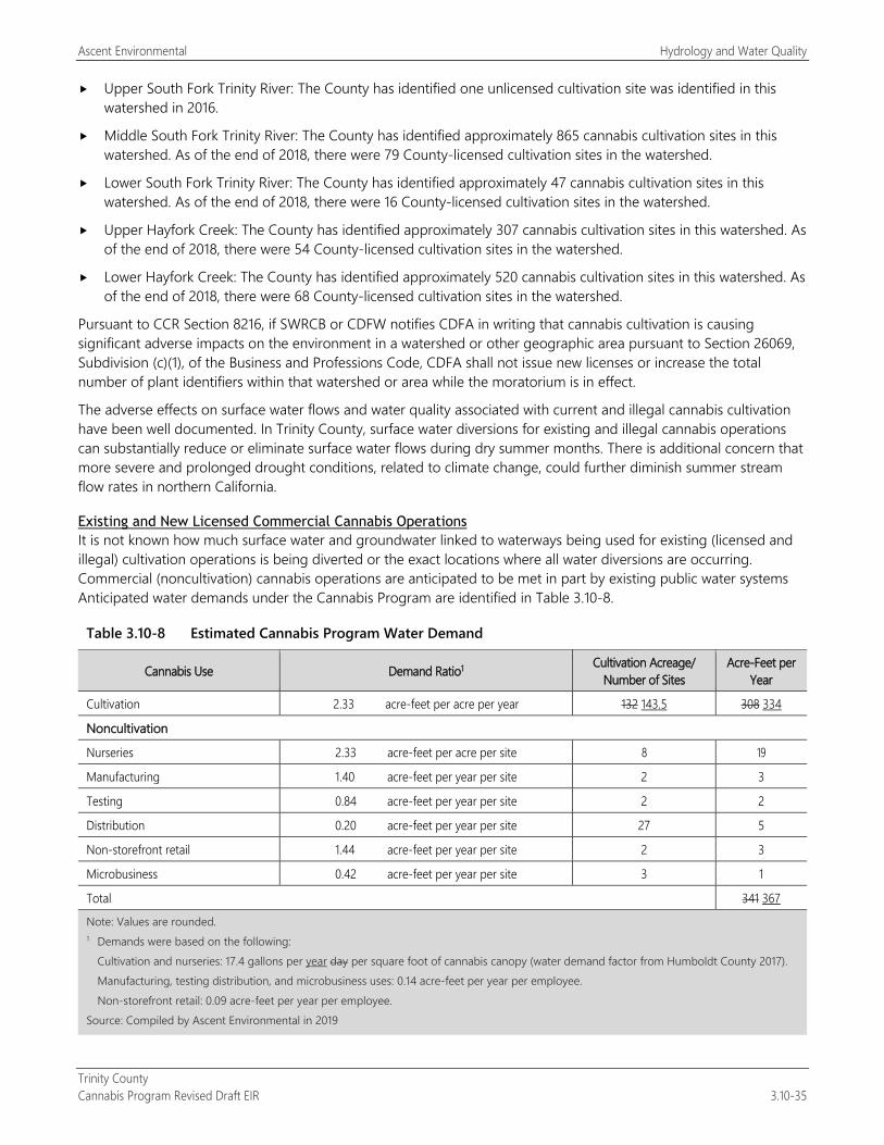
Ascent Environmental Hydrology and Water Quality
Trinity County Cannabis Program Revised Draft EIR 3.10-35
Upper South Fork Trinity River: The County has identified one unlicensed cultivation site was identified in this watershed in 2016.
Middle South Fork Trinity River: The County has identified approximately 865 cannabis cultivation sites in this watershed. As of the end of 2018, there were 79 County-licensed cultivation sites in the watershed.
Lower South Fork Trinity River: The County has identified approximately 47 cannabis cultivation sites in this watershed. As of the end of 2018, there were 16 County-licensed cultivation sites in the watershed.
Upper Hayfork Creek: The County has identified approximately 307 cannabis cultivation sites in this watershed. As of the end of 2018, there were 54 County-licensed cultivation sites in the watershed.
Lower Hayfork Creek: The County has identified approximately 520 cannabis cultivation sites in this watershed. As of the end of 2018, there were 68 County-licensed cultivation sites in the watershed.
Pursuant to CCR Section 8216, if SWRCB or CDFW notifies CDFA in writing that cannabis cultivation is causing significant adverse impacts on the environment in a watershed or other geographic area pursuant to Section 26069, Subdivision (c)(1), of the Business and Professions Code, CDFA shall not issue new licenses or increase the total number of plant identifiers within that watershed or area while the moratorium is in effect.
The adverse effects on surface water flows and water quality associated with current and illegal cannabis cultivation have been well documented. In Trinity County, surface water diversions for existing and illegal cannabis operations can substantially reduce or eliminate surface water flows during dry summer months. There is additional concern that more severe and prolonged drought conditions, related to climate change, could further diminish summer stream flow rates in northern California.
Existing and New Licensed Commercial Cannabis Operations It is not known how much surface water and groundwater linked to waterways being used for existing (licensed and illegal) cultivation operations is being diverted or the exact locations where all water diversions are occurring. Commercial (noncultivation) cannabis operations are anticipated to be met in part by existing public water systems Anticipated water demands under the Cannabis Program are identified in Table 3.10-8.
Table 3.10-8 Estimated Cannabis Program Water Demand
Cannabis Use Demand Ratio1 Cultivation Acreage/ Number of Sites
Acre-Feet per Year
Cultivation 2.33 acre-feet per acre per year 132 143.5 308 334
Noncultivation
Nurseries 2.33 acre-feet per acre per site 8 19
Manufacturing 1.40 acre-feet per year per site 2 3
Testing 0.84 acre-feet per year per site 2 2
Distribution 0.20 acre-feet per year per site 27 5
Non-storefront retail 1.44 acre-feet per year per site 2 3
Microbusiness 0.42 acre-feet per year per site 3 1
Total 341 367
Note: Values are rounded. 1 Demands were based on the following:
Cultivation and nurseries: 17.4 gallons per year day per square foot of cannabis canopy (water demand factor from Humboldt County 2017). Manufacturing, testing distribution, and microbusiness uses: 0.14 acre-feet per year per employee. Non-storefront retail: 0.09 acre-feet per year per employee.
Source: Compiled by Ascent Environmental in 2019
Hydrology and Water Quality Ascent Environmental
Trinity County 3.10-36 Cannabis Program Revised Draft EIR
As described in Section 3.10.1, “Regulatory Setting,” SWRCB Order WQ 2019-002301-DWQ requires that water diversions for licensed cultivation operations occur only when determined to be available by SWRCB, based on an online database that must be checked daily. In addition, there is a mandatory water diversion forbearance period during the dry months of the year when waterway flows low. SWRCB’s flow standards and diversion requirements were developed to protect fish spawning, migration, and rearing for endangered anadromous salmonids, and flows needed to maintain natural flow variability within each watershed. The diversion requirements would ensure that the individual and cumulative effects of water diversions and discharges associated with cannabis cultivation do not affect instream flows necessary for fish spawning, migration, and rearing for endangered anadromous salmonids, and flows needed to maintain natural flow variability (SWRCB 2017a). The policy was scientifically peer-reviewed by four experts. The peer review determined that water quality, instream flow, and diversion requirements of the policy were based on sound scientific knowledge, methods, and data (SWRCB 2017b).
However, SWRCB Order WQ 2019-002301-DWQ applies only to sites of 2,000 square feet or larger, and water diversion on smaller sites can contribute to causing low flows in the county’s waterways. Low flows are associated with increased temperature and worsening water quality, both of which are existing issues in Trinity County. Dilution is the primary mechanism by which the concentrations of contaminants (e.g., copper, lead) discharged from industrial facilities and other point and some nonpoint sources are reduced. However, during a low-flow event, there is less water available to dilute effluent loadings, resulting in higher instream concentration of pollutants. Ensuring local compliance with SWQRCB Order WQ 2019-0001-DWQ through implementation of Mitigation Measure 3.10-1a would ensure surface water impacts are mitigated to a less-than-significant level. Because the location and water demand on sites less than 2,000 square feet is unknown and cannot be regulated, there is potential for further degraded water quality conditions due to increased surface water diversion and further impacts on impaired waterways as well as designated Cannabis Priority Watersheds in the county. This impact would be potentially significant.
Mitigation Measures
Mitigation Measure 3.10-3a: Implement Mitigation Measure 3.10-1a: Demonstrate Compliance with Water Resource Standards
Mitigation Measure 3.10-3b: Prohibit Commercial Cannabis Operations in Watersheds under a CDFA Moratorium The following shall be included as a new performance standard for Section 315-843(6) (Performance Standards for Commercial Cultivation of Cannabis), Section 315-824(5) (Required Conditions), Section 315-826(3) (Regulation of Nurseries), Section 315-828(5) (Required Conditions), Section 315-835(2) (Regulations), Section 315-837(3) (Required Conditions), and Section 315-842(6) (Required Conditions) associated with projects using groundwater as a water supply source:
Prior to the issuance of a license and/or use permit, the County will determine if the application site is located within a watershed on which the CDFA has placed a moratorium on state licensing pursuant to CCR Section 8216. The County will reject the application should the site be located in such a watershed. Noncultivation uses may still be allowed if the applicant can demonstrate that the project’s water source is groundwater that is not hydrologically connected to the watershed to the satisfaction of the County.
Significance after Mitigation Implementation of Mitigation Measure 3.10-3a would require that all commercial cannabis operations comply with the water diversion requirements and restrictions of SWRCB Order WQ 2019-002301-DWQ, which contains instream flow requirements and a period of surface water diversion forbearance during dry months. These gage requirements have been determined by SWRCB to limit adverse effects on surface waterways due to low flows. Implementation of Mitigation Measure 3.10-3b would ensure that the County prohibits any new commercial cannabis uses that could further affect critical watersheds identified by SWRCB and CDFW. Thus, this impact would be mitigated to a less-than-significant level.
Ascent Environmental Hydrology and Water Quality
Trinity County Cannabis Program Revised Draft EIR 3.10-37
Impact 3.10-4: Result in Alteration of Drainage Conditions and Floodplains
Commercial cannabis cultivation operations in the county that may occur under the Cannabis Program have the potential to alter natural drainage conditions and floodplains, which could alter flood flows and create new sources of flooding. This impact would be significant.
Cannabis cultivation facilities placed within natural drainage courses and the 100-year floodplain can result in alteration of peak flow conditions and create new sources of flooding.
Existing Licensed Commercial Cannabis Operations Figure 2-3 shows cultivation sites licensed in the county in 2018. On several of these sites, on-site vegetation has already been cleared and cannabis cultivation facilities have already been constructed. Although these sites are part of the existing conditions, any expansion of existing operations could obstruct flood flows, resulting in the alteration of peak flow conditions and the floodplain and affecting upstream and downstream areas. Thus, this impact associated with existing licensed cannabis cultivation operations would be significant.
New Licensed Commercial Cannabis Operations Placement of new cannabis cultivation sites within the 100-year floodplain of rivers and streams could result in alteration of peak flow conditions and the floodplain and affect upstream and downstream areas. This impact would be significant.
Mitigation Measures
Mitigation Measure 3.10-4: Implement Mitigation Measure 3.10-1b: Prohibit Cultivation in Floodplains
Significance after Mitigation Implementation of Mitigation Measure 3.10-4 would ensure that cultivation activities avoid alteration of floodplain conditions. Therefore, impacts on flooding would be less than significant.

Hydrology and Water Quality Ascent Environmental
Trinity County 3.10-38 Cannabis Program Revised Draft EIR
This page intentionally left blank.
Ascent Environmental Land Use and Planning
Trinity County Cannabis Program Revised Draft EIR 3.11-1
3.11 LAND USE AND PLANNING This land use analysis evaluates consistency of the Trinity County Cannabis Program Project with applicable land use plans and policies. The physical environmental effects associated with the project, many of which pertain to issues of land use compatibility (e.g., noise, aesthetics, air quality), are evaluated in other sections of Chapter 3 of this DEIR.
No comment letters regarding land use were received in response to the NOP (see Appendix A).
3.11.1 Regulatory Setting
FEDERAL No federal plans, policies, regulations, or laws related to land use are applicable to the project.
STATE
State Planning and Zoning Laws California Government Code Section 65300 et seq. establishes the obligation of cities and counties to adopt and implement general plans. The general plan is a comprehensive, long-term, and general document that describes plans for the physical development of a city or county of any land outside its boundaries that, in the city’s or county’s judgement, bears relation to its planning. Cities typically identify a “sphere of influence” in their general plans; these are areas outside the city corporate boundaries that comprise the probable future boundary and service area of the city. The general plan addresses a broad range of topics, including at a minimum land use, circulation, housing, conservation, open space, noise, and safety. In addressing these topics, the general plan identifies the goals, objectives, policies, principles, standards, and plan proposals that support the city’s or county’s vision for the area.
The State Zoning Law (California Government Code, Section 65800 et seq.) establishes that zoning ordinances, which are laws that define allowable land uses within a specific zone district, are required to be consistent with the general plan.
Local general plan policies and zoning ordinances, as they relate to the project, are summarized below.
State Aeronautics Act The State Aeronautics Act (Public Utilities Code Section 21001) sets forth requirements for airport land use compatibility planning around public use airports. The California Airport Land Use Planning Handbook (California Department of Transportation 2011) provides guidance for determining consistency between a general plan and an Airport Land Use Compatibility Plan (ALUCP). The ALUCP contains policies relating to airport noise, the height of structures, trees, and other objects near an airport that affect the use of that airport, and potential safety risks both to people on the ground and to the occupants of aircraft. General Plan amendments must be consistent with any applicable ALUCP unless a local governing body overrules the plan by a two-thirds vote and makes specific findings. Prior to amendment of a general plan, a local agency must refer the proposed amendment to the Airport Land Use Commission (ALUC).
Land Use and Planning Ascent Environmental
Trinity County 3.11-2 Cannabis Program Revised Draft EIR
LOCAL
Trinity County General Plan Land Use Element The Trinity County General Plan Land Use Element identifies the following findings and policies in the areas of cultural, economic, and environmental:
Cultural The rural character of the county should be retained. Development occurring in the communities should be in
character with the rest of the community. Individual rights, as well as community rights, must be considered and protected by county staff and public servants. Public participation in the planning process be guaranteed.
Economic Important timber, agriculture, recreation, scenic, mineral, and wildlife resources should be protected for use.
These resources are critical to the economic well-being of Trinity County.
Industrial and Commercial Development, especially those directly related to the resources found in Trinity County, should be encouraged. Prime sites for new industrial development should be reserved in each part of the county.
Environmental Construction should be encouraged on safe, non-critical natural areas. Floodprone areas should be used for
recreation, agricultural, and other resource production activities. Community development should be kept out of floodprone areas. No use should adversely affect the capacity of the stream, river, channel, tributary, or floodway.
Important wildlife habitat areas should be protected and enhanced. Activities allowed in these areas should be designed to be compatible with its protection.
Trinity County recognizes the importance of its wildlife and feels Resource lands are areas where man should assume a role of becoming a part of the animal's environment. Department of Fish and Game depredation permits should be limited to only those species and individual animals posing a direct threat to man or livestock. For example, permits would be obtainable for wild dogs or coyotes in sheep and cattle areas, but would not be available for deer that compete for pasture. Similarly, permits would not be available for deer entering home gardens in Resource areas, or for bears that get into domestic garbage pits or destroy uncovered plastic pipes. The Resource dweller should reduce or adequately fence these attractions.
Douglas City Community Plan The Douglas City Community Plan details land use and community design goals for the future of the community. These goals include:
To maintain the identity of existing neighborhood areas; and
To encourage the development of the community core area as a viable center for the area’s commercial and social life.
Junction City Community Plan The Junction City Community Plan is designed to insure that the community character is retained. The plan sets the following goals:
To maintain the identity of existing neighborhood areas;
To encourage the development of the community core area as a viable center for the area’s commercial and social life; and
To maintain the existing lifestyle of the area’s residents as the community grows.
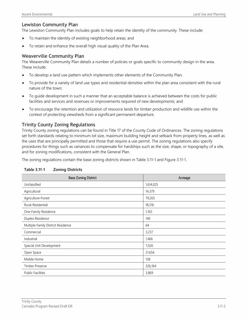
Ascent Environmental Land Use and Planning
Trinity County Cannabis Program Revised Draft EIR 3.11-3
Lewiston Community Plan The Lewiston Community Plan includes goals to help retain the identity of the community. These include:
To maintain the identity of existing neighborhood areas; and
To retain and enhance the overall high visual quality of the Plan Area.
Weaverville Community Plan The Weaverville Community Plan details a number of policies or goals specific to community design in the area. These include:
To develop a land use pattern which implements other elements of the Community Plan;
To provide for a variety of land use types and residential densities within the plan area consistent with the rural nature of the town;
To guide development in such a manner that an acceptable balance is achieved between the costs for public facilities and services and revenues or improvements required of new developments; and
To encourage the retention and utilization of resource lands for timber production and wildlife use within the context of protecting viewsheds from a significant permanent departure.
Trinity County Zoning Regulations Trinity County zoning regulations can be found in Title 17 of the County Code of Ordinances. The zoning regulations set forth standards relating to minimum lot size, maximum building height and setback from property lines, as well as the uses that are principally permitted and those that require a use permit. The zoning regulations also specify procedures for things such as variances to compensate for hardships such as the size, shape, or topography of a site, and for zoning modifications, consistent with the General Plan.
The zoning regulations contain the base zoning districts shown in Table 3.11-1 and Figure 3.11-1.
Table 3.11-1 Zoning Districts
Base Zoning District Acreage
Unclassified 1,614,025
Agricultural 14,379
Agriculture-Forest 79,203
Rural-Residential 18,516
One-Family Residence 1,163
Duplex Residence 140
Multiple Family District Residence 64
Commercial 3,237
Industrial 1,466
Special Unit Development 7,026
Open Space 21,654
Mobile Home 138
Timber Preserve 326,164
Public Facilities 3,869
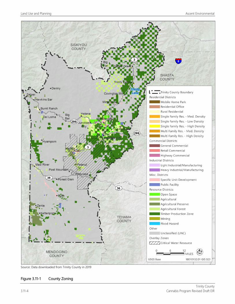
Land Use and Planning Ascent Environmental
Trinity County 3.11-4 Cannabis Program Revised Draft EIR
Source: Data downloaded from Trinity County in 2019
Figure 3.11-1 County Zoning
Ascent Environmental Land Use and Planning
Trinity County Cannabis Program Revised Draft EIR 3.11-5
3.11.2 Environmental Setting The county encompasses 2,051,988 acres, approximately 76 percent of which is under federal ownership consisting of the Shasta-Trinity, Six Rivers, and Mendocino National Forests and four wilderness areas: Yolla Bolly-Middle Eel, Trinity Alps, Chanchelula, and North Fork (Figure 2-2). There are 26 unincorporated communities in the county: Coffee Creek, Trinity Center, Covington Mill, Minersville, Weaverville, Lewiston, Junction City, Helena, Big Flat, Big Bar, Del Loma, Burnt Ranch, Hawkins Bar, Denny, Salyer, Douglas City, Hayfork, Hyampom, Peanut, Wildwood, Post Mountain, Forest Glen, Mad River, Ruth, Zenia, and Kettenpom. These unincorporated communities consist of residential, commercial, office, and industrial uses under the jurisdiction of the County. There are no incorporated cities within the county. Trinity Lake, Ruth Lake, and Lewiston Lake provide many recreational opportunities. These include camping, fishing, and enjoyment of the lakes. The lakes have areas for visitors to walk and hike.
Trinity County contains more than 1.7 million acres of forest land (see Table 3.4-1 and Figures 3.4-1 and 3.4-2 in Section 3.4, “Biological Resources”), covering approximately 83 percent of the county’s total land area. Within these forest lands are public lands, including national forests, and four wilderness areas. County lands zoned Timberland Production Zone are shown in Figure 3.11-1. Forest resources, much like agricultural resources, are dependent on the quality of the climate and soils. Trinity County’s mild and wet climate is conducive to timber production.
Trinity County’s 2016 Crop Report identified timber production as the county’s highest value agricultural commodity at $10,020,241 (74 percent of the county’s total agricultural production in 2016) (Trinity County 2016).
3.11.3 Environmental Impacts and Mitigation Measures
METHODOLOGY Evaluation of potential land use impacts is based on a review of the planning documents pertaining to the project study area.
THRESHOLDS OF SIGNIFICANCE A land use impact would be significant if implementation of the Trinity County Cannabis Program would:
physically divide an established community or
cause a significant environmental impact due to a conflict with any land use plan, policy, or regulation adopted for the purpose of avoiding or mitigating an environmental effect.
ENVIRONMENTAL IMPACTS AND MITIGATION MEASURES
Impact 3.11-1: Potential for Physical Division of an Established Community
The Cannabis Program contains requirements that would manage conditions that create public nuisances by enacting restrictions on the location, type, and size of cannabis cultivation sites and commercial activities in the county, as well as other requirements such as setbacks, security, and other protective measures. Because the project would include the above requirements, land use conflicts that could result in the division of established communities would not occur. Therefore, this impact would be less than significant.
One of the purposes of the Cannabis Program is to regulate existing and future commercial cannabis operations to control potential land use conflicts. The Cannabis Program includes requirements for applicants to obtain use permits in some circumstances to ensure further review for land use compatibility. Some cannabis uses are prohibited in portions of the county, including the Whiskeytown-Shasta-Trinity National Recreation Area, lease lots within the Ruth
Land Use and Planning Ascent Environmental
Trinity County 3.11-6 Cannabis Program Revised Draft EIR
Lake Community Services District, the Historic District of Weaverville, the Coffee Creek Volunteer Fire District, the Trinity Center Community Services District, and a portion of the Lewiston Community Services District.
The Cannabis Program includes the following regulations specifying buffers from sensitive land uses to reduce potential land use conflicts and other public nuisances:
Cultivation is prohibited within 1,000 feet of a youth-oriented facility, a school, any church, or residential treatment facility (Section 315-843[5][a]).
Cultivation is not allowed within residential zoning designations (Section 315-843[5][a][v]).
Cultivation is prohibited within 500 feet of an authorized school bus stop (Section 315-843[5][a][ii]).
Cannabis manufacturing facilities shall not be allowed within 1,000 feet of a youth-oriented facility, school, church, or residential treatment facility. Cannabis manufacturing facilities shall not be within 500 feet from an authorized school bus stop, unless a variance is obtained (Section 315-842[4][B]).
Non-storefront retail premises and activities are not allowed within 1,000 feet of a youth-oriented facility, school, church, or residential treatment facility, and not allowed within 500 from an authorized school bus stop unless a variance is obtained (Section 315-835[2][J]).
Testing facilities shall not be within 1,000 feet of a youth-oriented facility, a school, any church, or residential treatment facility or within 500 feet of an authorized school bus stop and will be measured from footprint of buildings to edge of parcel boundary if sensitive receptors are present (Section 315-824[3][b][i]).
Cannabis nurseries shall not be located within 1,000 feet of a youth-oriented facility, school, church, or residential treatment facility or within 500 feet of an authorized school bus stop. Variances are allowed upon review of the Planning Commission (Section 315-826[3][a][ii]).
Cannabis distribution facilities shall not be allowed within 1,000 feet of a youth-oriented facility, school, church, or residential treatment facility or within 500 feet of an authorized school bus stop, unless a variance is obtained (Section 315-828[3][B]).
Existing Licensed Commercial Cannabis Operations Cannabis is defined by the state (Health and Safety Code Section 11362.777[a] and Business and Professions Code Section 26067[a]) as an agricultural product. As identified in Chapter 2, “Project Description,” existing cannabis cultivation operations include structures and features that are similar to other agricultural activities. These include water storage ponds, accessory structures (e.g., barns and nurseries), housing, fencing, and roads that are contained within each parcel. These structure and feature types are common in the county. These features would not create barriers or physical features (e.g., new highways or land use type that would obstruct existing public access and movement) that could physically divide an established community. Thus, existing or modified cannabis cultivation operations would not result in the physical division of an established community. This impact would be less than significant.
New Licensed Commercial Cannabis Operations Implementation of the Cannabis Program would also involve commercial cannabis supporting land uses that include additional cultivation, retail, manufacturing, distribution, microbusinesses, nurseries, and testing facilities. New noncultivation operations would generally be required to be placed in areas zoned for commercial, agricultural, or industrial uses and would complement these areas as their activities would be located within buildings and would operate with similar levels of employment and hours of operation. These operations would be contained within buildings and would not create new barriers or physical features that could physically divide an established community.
Because the commercial cannabis operations would consist of facilities that complement existing land uses, it would not create new barriers or physical features that could physically divide an established community within Trinity County. The Cannabis Program also includes setbacks and performance standards to reduce potential land use conflicts and other public nuisances. Therefore, this impact is less than significant.
Ascent Environmental Land Use and Planning
Trinity County Cannabis Program Revised Draft EIR 3.11-7
It is acknowledged that commercial cannabis operations under the Cannabis Program may result in physical impacts that can be considered nuisances within the county, such as increased nighttime lighting, odors, noise, and traffic. These issues are evaluated in Section 3.1, “Aesthetics,” Section 3.3, “Air Quality,” Section 3.12, “Noise,” and Section 3.14, “Transportation/Traffic,” respectively.
Mitigation Measures No mitigation is required.
Impact 3.11-2: Conflict with Relevant Zoning, Plans, and Policies for the Purpose of Avoiding an Environmental Effect
The Cannabis Program would amend the County Code of Ordinances that implements the General Plan land use policy direction, and would be consistent with General Plan land use provisions. Further, the Cannabis Program contains permitting requirements that provides a mechanism for the County to ensure compliance with relevant plans and policies. Therefore, this impact would be less than significant.
The Cannabis Program contains measures that establish land use regulations for the cultivation, manufacture, retail uses, testing, distribution, and storage of commercial cannabis that further refines the County’s existing regulations. Land uses within the county are regulated by the County General Plan, the County Code of Ordinances, community plans, and the ALUCP to ensure uses are compatible with existing development.
Existing and New Licensed Commercial Cannabis Operations
County General Plan and County Code of Ordinances The Cannabis Program includes requirements for applicants to obtain licensing and, in some cases, use permits for commercial cannabis activities. All existing and proposed commercial cannabis activities would be required to obtain licensing and/or permits to achieve full compliance with the Cannabis Program. Because the applicants would be required to obtain necessary approvals, the County would have a mechanism for control of land use changes.
The County Code of Ordinances is the regulatory device for implementing development in a manner that is consistent with the General Plan and is also more specific than the General Plan in terms of allowed uses. The Cannabis Program is intended to implement and be consistent with existing General Plan policy provisions. For example, cultivation activities associated with cannabis are similar to those of other agricultural crop production. Consequently, the Cannabis Program allows outdoor cannabis cultivation in agricultural zones that are typically associated with agricultural land use designations. Similarly, some noncultivation commercial cannabis uses are a commercial or industrial use, and the Cannabis Program allows this type of use in the appropriate zones that are typically associated with land use type.
Furthermore, the Cannabis Program does not include any changes to the General Plan policies or land use designations. The reader is referred to Sections 3.1 through 3.16 for mitigation measures that assist in the implementation of policies and recommendations that address environmental issues. Therefore, this impact would be less than significant.
Community Plans As noted above, the County has adopted community plans that have unique land use goals and policies intended to provide detailed guidance on the long-term development of these areas.
Subsequent cannabis uses under the Cannabis Program would be required to comply with the relevant requirements of the community plans. The Cannabis Program does not include any changes to community plan policies or land use designations, and therefore would not conflict with community plans. Therefore, this impact would be less than significant.
Mitigation Measures No mitigation is required.

Land Use and Planning Ascent Environmental
Trinity County 3.11-8 Cannabis Program Revised Draft EIR
This page intentionally left blank.
Ascent Environmental Noise
Trinity County Cannabis Program Revised Draft EIR 3.12-1
3.12 NOISE This section includes a summary of applicable regulations related to noise and vibration, a description of ambient-noise conditions in Trinity County, and an analysis of potential short-term construction and long-term operational noise impacts associated with the with activities anticipated to result from implementation of the proposed ordinance. Mitigation measures are recommended as necessary to reduce significant noise impacts. Supporting data and calculations are provided in Appendix D, “Noise Measurement Data and Noise Modeling Calculations.”
No comment letters regarding noise were received in response to the NOP (see Appendix A).
3.12.1 Regulatory Setting
FEDERAL
U.S. Environmental Protection Agency Office of Noise Abatement and Control The U.S. Environmental Protection Agency (EPA) Office of Noise Abatement and Control was originally established to coordinate federal noise control activities. In 1981, EPA administrators determined that subjective issues such as noise would be better addressed at more local levels of government. Consequently, in 1982 responsibilities for regulating noise control policies were transferred to state and local governments. However, documents and research completed by the EPA Office of Noise Abatement and Control continue to provide value in the analysis of noise effects.
STATE
California General Plan Guidelines The State of California General Plan Guidelines 2017, published by the California Governor’s Office of Planning and Research (2017), provides guidance for the compatibility of projects within areas of specific noise exposure. Acceptable and unacceptable community noise exposure limits for various land use categories have been determined to help guide new land use decisions in California communities. In many local jurisdictions, these guidelines are used to derive local noise standards and guidance. Citing EPA materials and the State Sound Transmissions Control Standards, the state’s general plan guidelines recommend interior and exterior Community Noise Equivalent Level of 45 and 60 decibels (dB) for residential units, respectively (OPR 2017:378).
LOCAL
Trinity County General Plan The Noise Element of the Trinity County General Plan (Trinity County 2003) contains the following standards regarding noise that may be applicable to the project:
Transportation Noise Sources Policy 4.2.1 New noise-sensitive land uses impacted by existing or projected future transportation noise sources
shall include mitigation measures so that resulting noise levels do not exceed the standards shown in Table VI (presented as Table 3.12-1 in this EIR).
Policy 4.2.2 Noise created by new transportation noise sources shall be mitigated so that resulting noise levels do not exceed the standards shown in Table VI (presented as Table 3.12-1 in this EIR) at noise sensitive land uses.
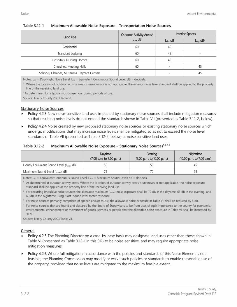
Noise Ascent Environmental
Trinity County 3.12-2 Cannabis Program Revised Draft EIR
Table 3.12-1 Maximum Allowable Noise Exposure - Transportation Noise Sources
Land Use Outdoor Activity Areas1
Ldn, dB Interior Spaces
Ldn, dB Leq, dB2
Residential 60 45 -
Transient Lodging 60 45 -
Hospitals, Nursing Homes 60 45 -
Churches, Meeting Halls 60 - 45
Schools, Libraries, Museums, Daycare Centers - - 45
Notes: Ldn = Day-Night Noise Level; Leq = Equivalent Continuous Sound Level; dB = decibels. 1 Where the location of outdoor activity areas is unknown or is not applicable, the exterior noise level standard shall be applied to the property
line of the receiving land use. 2 As determined for a typical worst-case hour during periods of use. Source: Trinity County 2003:Table VI.
Stationary Noise Sources Policy 4.2.3 New noise-sensitive land uses impacted by stationary noise sources shall include mitigation measures
so that resulting noise levels do not exceed the standards shown in Table VII (presented as Table 3.12-2, below).
Policy 4.2.4 Noise created by new proposed stationary noise sources or existing stationary noise sources which undergo modifications that may increase noise levels shall be mitigated so as not to exceed the noise level standards of Table VII (presented as Table 3.12-2, below) at noise sensitive land uses.
Table 3.12-2 Maximum Allowable Noise Exposure – Stationary Noise Sources1,2,3,4
Daytime (7:00 a.m. to 7:00 p.m.)
Evening (7:00 p.m. to 10:00 p.m.)
Nighttime (10:00 p.m. to 7:00 a.m.)
Hourly Equivalent Sound Level (Leq), dB 55 50 45
Maximum Sound Level (Lmax), dB 75 70 65
Notes: Leq = Equivalent Continuous Sound Level; Lmax = Maximum Sound Level; dB = decibels. 1 As determined at outdoor activity areas. Where the location of outdoor activity areas is unknown or not applicable, the noise exposure
standard shall be applied at the property line of the receiving land use. 2 For recurring impulsive noise sources the allowable maximum (Lmax) noise exposure shall be 70 dB in the daytime, 65 dB in the evening, and
60 dB in the nighttime using "Fast" sound level meter response. 3 For noise sources primarily comprised of speech and/or music, the allowable noise exposure in Table VII shall be reduced by 5 dB. 4 For noise sources that are found and declared by the Board of Supervisors to be from uses of such importance to the county for economic,
environmental enhancement or movement of goods, services or people that the allowable noise exposure in Table VII shall be increased by 10 dB.
Source: Trinity County 2003:Table VII.
General Policy 4.2.5 The Planning Director on a case-by-case basis may designate land uses other than those shown in
Table VI (presented as Table 3.12-1 in this EIR) to be noise-sensitive, and may require appropriate noise mitigation measures.
Policy 4.2.6 Where full mitigation in accordance with the policies and standards of this Noise Element is not feasible, the Planning Commission may modify or waive such policies or standards to enable reasonable use of the property, provided that noise levels are mitigated to the maximum feasible extent.

Ascent Environmental Noise
Trinity County Cannabis Program Revised Draft EIR 3.12-3
3.12.2 Concepts Related to Evaluation of Noise
ACOUSTIC FUNDAMENTALS Before discussing the noise setting for the project, background information about sound, noise, vibration, and common noise descriptors is needed to provide context and a better understanding of the technical terms referenced throughout this section.
Sound, Noise, and Acoustics Sound can be described as the mechanical energy of a vibrating object transmitted by pressure waves through a liquid or gaseous medium (e.g., air) to a human ear. Noise is defined as loud, unexpected, annoying, or unwanted sound.
In the science of acoustics, the fundamental model consists of a sound (or noise) source, a receiver, and the propagation path between the two. The loudness of the noise source and obstructions or atmospheric factors affecting the propagation path to the receiver determines the sound level and characteristics of the noise perceived by the receiver. The field of acoustics deals primarily with the propagation and control of sound.
Frequency Continuous sound can be described by frequency (pitch) and amplitude (loudness). A low-frequency sound is perceived as low in pitch. Frequency is expressed in terms of cycles per second, or hertz (Hz) (e.g., a frequency of 250 cycles per second is referred to as 250 Hz). High frequencies are sometimes more conveniently expressed in kilohertz, or thousands of hertz. The audible frequency range for humans is generally between 20 Hz and 20,000 Hz.
Sound Pressure Levels and Decibels The amplitude of pressure waves generated by a sound source determines the loudness of that source. Sound pressure amplitude is measured in micro-Pascals (mPa). One mPa is approximately one hundred billionth (0.00000000001) of normal atmospheric pressure. Sound pressure amplitudes for different kinds of noise environments can range from less than 100 to 100,000,000 mPa. Because of this large range of values, sound is rarely expressed in terms of mPa. Instead, a logarithmic scale is used to describe sound pressure level (SPL) in terms of decibels.
Addition of Decibels Because decibels are logarithmic units, SPLs cannot be added or subtracted through ordinary arithmetic. Under the decibel scale, a doubling of sound energy corresponds to a 3-dB increase. In other words, when two identical sources are each producing sound of the same loudness at the same time, the resulting sound level at a given distance would be 3 dB higher than if only one of the sound sources was producing sound under the same conditions. For example, if one idling truck generates an SPL of 70 dB, two trucks idling simultaneously would not produce 140 dB; rather, they would combine to produce 73 dB. Under the decibel scale, three sources of equal loudness together produce a sound level approximately 5 dB louder than one source.
A-Weighted Decibels The decibel scale alone does not adequately characterize how humans perceive noise. The dominant frequencies of a sound have a substantial effect on the human response to that sound. Although the intensity (energy per unit area) of the sound is a purely physical quantity, the loudness or human response is determined by the characteristics of the human ear.
Human hearing is limited in the range of audible frequencies as well as in the way it perceives the SPL in that range. In general, people are most sensitive to the frequency range of 1,000–8,000 Hz and perceive sounds within this range better than sounds of the same amplitude with frequencies outside of this range. To approximate the response of the human ear, sound levels of individual frequency bands are weighted, depending on the human sensitivity to those
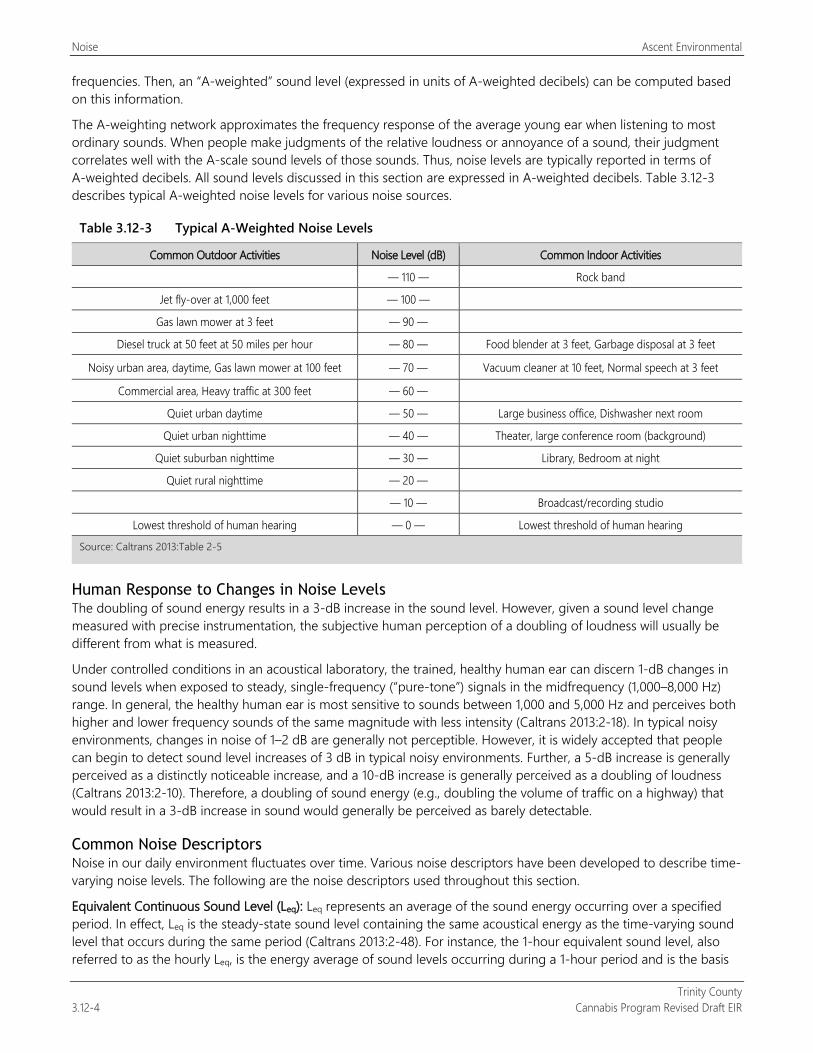
Noise Ascent Environmental
Trinity County 3.12-4 Cannabis Program Revised Draft EIR
frequencies. Then, an “A-weighted” sound level (expressed in units of A-weighted decibels) can be computed based on this information.
The A-weighting network approximates the frequency response of the average young ear when listening to most ordinary sounds. When people make judgments of the relative loudness or annoyance of a sound, their judgment correlates well with the A-scale sound levels of those sounds. Thus, noise levels are typically reported in terms of A-weighted decibels. All sound levels discussed in this section are expressed in A-weighted decibels. Table 3.12-3 describes typical A-weighted noise levels for various noise sources.
Table 3.12-3 Typical A-Weighted Noise Levels
Common Outdoor Activities Noise Level (dB) Common Indoor Activities
— 110 — Rock band
Jet fly-over at 1,000 feet — 100 —
Gas lawn mower at 3 feet — 90 —
Diesel truck at 50 feet at 50 miles per hour — 80 — Food blender at 3 feet, Garbage disposal at 3 feet
Noisy urban area, daytime, Gas lawn mower at 100 feet — 70 — Vacuum cleaner at 10 feet, Normal speech at 3 feet
Commercial area, Heavy traffic at 300 feet — 60 —
Quiet urban daytime — 50 — Large business office, Dishwasher next room
Quiet urban nighttime — 40 — Theater, large conference room (background)
Quiet suburban nighttime — 30 — Library, Bedroom at night
Quiet rural nighttime — 20 —
— 10 — Broadcast/recording studio
Lowest threshold of human hearing — 0 — Lowest threshold of human hearing
Source: Caltrans 2013:Table 2-5
Human Response to Changes in Noise Levels The doubling of sound energy results in a 3-dB increase in the sound level. However, given a sound level change measured with precise instrumentation, the subjective human perception of a doubling of loudness will usually be different from what is measured.
Under controlled conditions in an acoustical laboratory, the trained, healthy human ear can discern 1-dB changes in sound levels when exposed to steady, single-frequency (“pure-tone”) signals in the midfrequency (1,000–8,000 Hz) range. In general, the healthy human ear is most sensitive to sounds between 1,000 and 5,000 Hz and perceives both higher and lower frequency sounds of the same magnitude with less intensity (Caltrans 2013:2-18). In typical noisy environments, changes in noise of 1–2 dB are generally not perceptible. However, it is widely accepted that people can begin to detect sound level increases of 3 dB in typical noisy environments. Further, a 5-dB increase is generally perceived as a distinctly noticeable increase, and a 10-dB increase is generally perceived as a doubling of loudness (Caltrans 2013:2-10). Therefore, a doubling of sound energy (e.g., doubling the volume of traffic on a highway) that would result in a 3-dB increase in sound would generally be perceived as barely detectable.
Common Noise Descriptors Noise in our daily environment fluctuates over time. Various noise descriptors have been developed to describe time-varying noise levels. The following are the noise descriptors used throughout this section.
Equivalent Continuous Sound Level (Leq): Leq represents an average of the sound energy occurring over a specified period. In effect, Leq is the steady-state sound level containing the same acoustical energy as the time-varying sound level that occurs during the same period (Caltrans 2013:2-48). For instance, the 1-hour equivalent sound level, also referred to as the hourly Leq, is the energy average of sound levels occurring during a 1-hour period and is the basis
Ascent Environmental Noise
Trinity County Cannabis Program Revised Draft EIR 3.12-5
for noise abatement criteria used by California Department of Transportation (Caltrans) and Federal Transit Administration (Caltrans 2013:2-47, FTA 2006:2-19).
Maximum Sound Level (Lmax): Lmax is the highest instantaneous sound level measured during a specified period (Caltrans 2013:2-48; FTA 2006:2-16).
Day-Night Noise Level (Ldn): Ldn is the energy average of A-weighted sound levels occurring over a 24-hour period, with a 10-dB “penalty” applied to sound levels occurring during nighttime hours between 10 p.m. and 7 a.m. (Caltrans 2013:2-48, FTA 2006:2-22).
Sound Propagation When sound propagates over a distance, it changes in level and frequency content. The manner in which a noise level decreases with distance depends on the following factors:
Geometric Spreading Sound from a localized source (i.e., a point source) propagates uniformly outward in a spherical pattern. The sound level attenuates (or decreases) at a rate of 6 dB for each doubling of distance from a point source. Roads and highways consist of several localized noise sources on a defined path and hence can be treated as a line source, which approximates the effect of several point sources, thus propagating at a slower rate in comparison to a point source. Noise from a line source propagates outward in a cylindrical pattern, often referred to as cylindrical spreading. Sound levels attenuate at a rate of 3 dB for each doubling of distance from a line source.
Ground Absorption The propagation path of noise from a source to a receiver is usually very close to the ground. Noise attenuation from ground absorption and reflective-wave canceling provides additional attenuation associated with geometric spreading. Traditionally, this additional attenuation has also been expressed in terms of attenuation per doubling of distance. This approximation is usually sufficiently accurate for distances of less than 200 feet. For acoustically hard sites (i.e., sites with a reflective surface between the source and the receiver, such as a parking lot or body of water), no excess ground attenuation is assumed. For acoustically absorptive or soft sites (i.e., those sites with an absorptive ground surface between the source and the receiver, such as soft dirt, grass, or scattered bushes and trees), additional ground-attenuation value of 1.5 dB per doubling of distance is normally assumed. When added to the attenuate rate associated with cylindrical spreading, the additional ground attenuation results in an overall drop-off rate of 4.5 dB per doubling of distance. This would hold true for point sources, resulting in an overall drop-off rate of up to 7.5 dB per doubling of distance.
Atmospheric Effects Receivers located downwind from a source can be exposed to increased noise levels relative to calm conditions, whereas locations upwind can have lowered noise levels, as wind can carry sound. Sound levels can be increased over large distances (e.g., more than 500 feet) from the source because of atmospheric temperature inversion (i.e., increasing temperature with elevation). Other factors such as air temperature, humidity, and turbulence can also affect sound attenuation.
Shielding by Natural or Human-Made Features A large object or barrier in the path between a noise source and a receiver attenuate noise levels at the receiver. The amount of attenuation provided by shielding depends on the size of the object and the frequency content of the noise source. Natural terrain features (e.g., hills and dense woods) and human-made features (e.g., buildings and walls) can substantially reduce noise levels. A barrier that breaks the line of sight between a source and a receiver will typically result in at least 5 dB of noise reduction (Caltrans 2013:2-41; FTA 2006:5-6, 6-25). Barriers higher than the line of sight provide increased noise reduction (FTA 2006:2-12). Vegetation between the source and receiver is rarely effective in reducing noise because it does not create a solid barrier unless there are multiple rows of vegetation (FTA 2006:2-11).
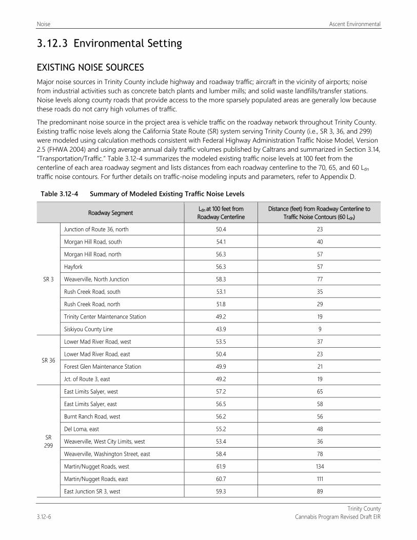
Noise Ascent Environmental
Trinity County 3.12-6 Cannabis Program Revised Draft EIR
3.12.3 Environmental Setting
EXISTING NOISE SOURCES Major noise sources in Trinity County include highway and roadway traffic; aircraft in the vicinity of airports; noise from industrial activities such as concrete batch plants and lumber mills; and solid waste landfills/transfer stations. Noise levels along county roads that provide access to the more sparsely populated areas are generally low because these roads do not carry high volumes of traffic.
The predominant noise source in the project area is vehicle traffic on the roadway network throughout Trinity County. Existing traffic noise levels along the California State Route (SR) system serving Trinity County (i.e., SR 3, 36, and 299) were modeled using calculation methods consistent with Federal Highway Administration Traffic Noise Model, Version 2.5 (FHWA 2004) and using average annual daily traffic volumes published by Caltrans and summarized in Section 3.14, “Transportation/Traffic.” Table 3.12-4 summarizes the modeled existing traffic noise levels at 100 feet from the centerline of each area roadway segment and lists distances from each roadway centerline to the 70, 65, and 60 Ldn traffic noise contours. For further details on traffic-noise modeling inputs and parameters, refer to Appendix D.
Table 3.12-4 Summary of Modeled Existing Traffic Noise Levels
Roadway Segment Ldn at 100 feet from Roadway Centerline
Distance (feet) from Roadway Centerline to Traffic Noise Contours (60 Ldn)
SR 3
Junction of Route 36, north 50.4 23
Morgan Hill Road, south 54.1 40
Morgan Hill Road, north 56.3 57
Hayfork 56.3 57
Weaverville, North Junction 58.3 77
Rush Creek Road, south 53.1 35
Rush Creek Road, north 51.8 29
Trinity Center Maintenance Station 49.2 19
Siskiyou County Line 43.9 9
SR 36
Lower Mad River Road, west 53.5 37
Lower Mad River Road, east 50.4 23
Forest Glen Maintenance Station 49.9 21
Jct. of Route 3, east 49.2 19
SR 299
East Limits Salyer, west 57.2 65
East Limits Salyer, east 56.5 58
Burnt Ranch Road, west 56.2 56
Del Loma, east 55.2 48
Weaverville, West City Limits, west 53.4 36
Weaverville, Washington Street, east 58.4 78
Martin/Nugget Roads, west 61.9 134
Martin/Nugget Roads, east 60.7 111
East Junction SR 3, west 59.3 89
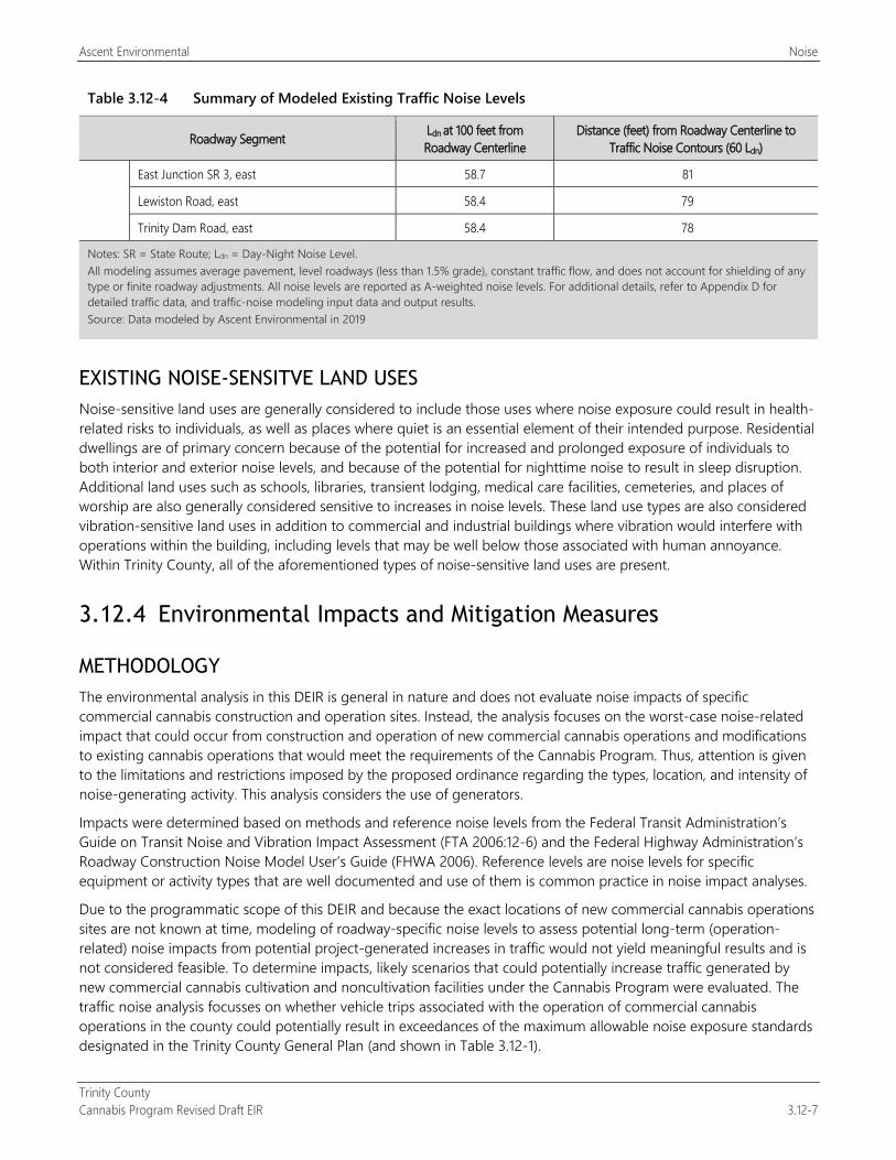
Ascent Environmental Noise
Trinity County Cannabis Program Revised Draft EIR 3.12-7
Table 3.12-4 Summary of Modeled Existing Traffic Noise Levels
Roadway Segment Ldn at 100 feet from Roadway Centerline
Distance (feet) from Roadway Centerline to Traffic Noise Contours (60 Ldn)
East Junction SR 3, east 58.7 81
Lewiston Road, east 58.4 79
Trinity Dam Road, east 58.4 78
Notes: SR = State Route; Ldn = Day-Night Noise Level. All modeling assumes average pavement, level roadways (less than 1.5% grade), constant traffic flow, and does not account for shielding of any type or finite roadway adjustments. All noise levels are reported as A-weighted noise levels. For additional details, refer to Appendix D for detailed traffic data, and traffic-noise modeling input data and output results. Source: Data modeled by Ascent Environmental in 2019
EXISTING NOISE-SENSITVE LAND USES Noise-sensitive land uses are generally considered to include those uses where noise exposure could result in health-related risks to individuals, as well as places where quiet is an essential element of their intended purpose. Residential dwellings are of primary concern because of the potential for increased and prolonged exposure of individuals to both interior and exterior noise levels, and because of the potential for nighttime noise to result in sleep disruption. Additional land uses such as schools, libraries, transient lodging, medical care facilities, cemeteries, and places of worship are also generally considered sensitive to increases in noise levels. These land use types are also considered vibration-sensitive land uses in addition to commercial and industrial buildings where vibration would interfere with operations within the building, including levels that may be well below those associated with human annoyance. Within Trinity County, all of the aforementioned types of noise-sensitive land uses are present.
3.12.4 Environmental Impacts and Mitigation Measures
METHODOLOGY The environmental analysis in this DEIR is general in nature and does not evaluate noise impacts of specific commercial cannabis construction and operation sites. Instead, the analysis focuses on the worst-case noise-related impact that could occur from construction and operation of new commercial cannabis operations and modifications to existing cannabis operations that would meet the requirements of the Cannabis Program. Thus, attention is given to the limitations and restrictions imposed by the proposed ordinance regarding the types, location, and intensity of noise-generating activity. This analysis considers the use of generators.
Impacts were determined based on methods and reference noise levels from the Federal Transit Administration’s Guide on Transit Noise and Vibration Impact Assessment (FTA 2006:12-6) and the Federal Highway Administration’s Roadway Construction Noise Model User’s Guide (FHWA 2006). Reference levels are noise levels for specific equipment or activity types that are well documented and use of them is common practice in noise impact analyses.
Due to the programmatic scope of this DEIR and because the exact locations of new commercial cannabis operations sites are not known at time, modeling of roadway-specific noise levels to assess potential long-term (operation-related) noise impacts from potential project-generated increases in traffic would not yield meaningful results and is not considered feasible. To determine impacts, likely scenarios that could potentially increase traffic generated by new commercial cannabis cultivation and noncultivation facilities under the Cannabis Program were evaluated. The traffic noise analysis focusses on whether vehicle trips associated with the operation of commercial cannabis operations in the county could potentially result in exceedances of the maximum allowable noise exposure standards designated in the Trinity County General Plan (and shown in Table 3.12-1).
Noise Ascent Environmental
Trinity County 3.12-8 Cannabis Program Revised Draft EIR
THRESHOLDS OF SIGNIFICANCE
Based on Appendix G of the State CEQA Guidelines, the proposed ordinance would result in a potentially significant noise impact if it would:
result in generation of a substantial temporary or permanent increase in ambient noise levels in the vicinity of the project in excess of standards established in the local general plan or noise ordinance, or applicable standards of other agencies;
result in generation of excessive groundborne vibration or groundborne noise levels; or
for a project located within the vicinity of a private airstrip or an airport land use plan or, where such a plan has not been adopted, within 2 miles of a public airport or public use airport, expose people residing or working in the project area to excessive noise levels.
ISSUES NOT DISCUSSED FURTHER The Cannabis Program would not result in the development of new residential land uses near private air strips or public commercial airports in Trinity County. Thus, aircraft-related noise impacts are not discussed further in this DEIR.
No major sources of vibration would be potentially constructed as a result of the Cannabis Program and construction of any future commercial cannabis operations would not include vibration-intensive activities such as blasting or pile driving. Thus, the project would not result in the exposure of sensitive receptors to levels of excessive vibration or vibration levels and ground vibration–related impacts are not discussed further in this DEIR.
ENVIRONMENTAL IMPACTS AND MITIGATION MEASURES
Impact 3.12-1: Create Short-Term, Construction-Related Noise
Construction of new commercial cannabis operations that may occur under the Cannabis Program could involve the use of heavy off-road equipment that could increase noise levels at nearby land uses and expose noise-sensitive receptors to noise levels that exceed County noise standards and/or result in sleep disturbance at residential receptors during evening and nighttime hours. This impact would be significant.
Construction of commercial cannabis cultivation sites and their ancillary facilities may require earthwork and use of heavy equipment, which has the potential to result in a temporary increase in noise levels in the vicinity of the site. Generally, the intensity of construction activity for commercial cannabis cultivation sites would be similar to that of agricultural development, residential renovation, or a building addition project. Establishment of the new cultivation sites may involve the use of off-road construction equipment for grubbing and removal of existing vegetation, breaking ground, initial plowing, terracing, and/or grading to establish a gravel pad or foundation and lifting supplies and building materials. It is assumed that new commercial cannabis noncultivation sites may also require earth-moving construction activities (tree removal, vegetation clearing, grading) at a similar scale and intensity to that of new cannabis cultivation sites.
Existing Licensed Commercial Cannabis Operations Existing licensed commercial cannabis operations have already been constructed; and thus, no new noise-generating construction activity would occur at these sites. However, it is acknowledged that continued operation of these cultivation sites could result in some minor construction activities through the proposed amendment that would allow expansion of the Designated Area for cultivation activities from 200 percent of the licensed cannabis canopy area to 250 percent (20 percent increase). Similar to construction noise impacts for new licensed commercial cannabis uses, this impact would be significant.
Ascent Environmental Noise
Trinity County Cannabis Program Revised Draft EIR 3.12-9
New Licensed Commercial Cannabis Operations Implementation of the Cannabis Program could result in the development of approximately 246 acres up to 170 acres of new commercial cannabis cultivation operations and 34 44 new commercial cannabis noncultivation operations (e.g., testing, processing, manufacturing, distribution, and retail nurseries) (see Table 2-3).
Due to the relatively small size of these operations, it is anticipated that one piece of heavy off-road equipment would be used at a time (e.g., loader, grader, scraper, dozer, or something with a comparable engine size and power rating). A single unit of these types of equipment generates a reference noise level of 85 dB Lmax at a distance of 50 feet (FHWA 2006:3). Applying a usage factor (percentage of time that the equipment is operating at full power) of 0.4, as advised in Federal Highway Administration guidance (FHWA 2006), would result in a predicted noise level of 81 dB Leq at the same distance.
It is anticipated that construction activity would last approximately 4 weeks at each cultivation site, and the use of heavy off-road equipment at a single new cultivation site would occur for approximately 2 weeks. The Trinity County Code of Ordinances does not formally exempt construction-generated noise from applicable standards is the construction activity takes place during daytime hours; however, Trinity County considers construction noise occurring during the daytime hours (i.e., between 7:00 a.m. and 7:00 p.m.) to be exempt from Trinity County General Plan noise standards (Hubbard, pers. comm., 2019). Several cities and counties in California exempt construction noise from local noise standards if the noise-generating construction activity is performed during daytime hours.
The hours during which construction equipment would operate is unknown; thus, it is conservatively assumed that construction could occur throughout the daytime and nighttime hours and potentially result in sleep disturbance at nearby residential land uses.
The Cannabis Program would require that each cultivation site be set back 350–500 feet (depending on license type) from residences on neighboring properties, and 1,000 feet from youth-oriented facilities, schools, churches, or residential treatment facilities. Through distance alone, the noise level generated by the construction equipment would attenuate to approximately 59 dB Leq and 63 dB Lmax at 350 feet, 55 dB Leq and 59 dB Lmax at 500 feet, and 47 dB Leq and 51 dB Lmax at 1,000 feet. Additional noise reduction would be provided by any intervening topography, dense stands of trees, or human-made structures located between the cultivation site and off-site receptors. However, the conservative approach of not factoring in any additional noise attenuation that these intervening factors may provide was taken.
However, as detailed above, the noise levels at surrounding noise-sensitive land uses resulting from construction activities occurring outside of the exempt daytime hours could potentially surpass evening, and nighttime maximum allowable Leq standards (i.e., 50 and 45 dB Leq, respectively) established in the Trinity County General Plan for stationary noise sources.
Construction would be temporary in nature; however, construction is not limited to the daytime hours under the proposed ordinance; and thus, noise sensitive receptors could be exposed to excessive noise levels that exceed Trinity County General Plan noise standards and disrupt sleep during nighttime construction activities. This impact would be significant.
Mitigation Measures
Mitigation Measure 3.12-1: Implement Construction Noise Mitigation The following shall be included as a new performance standard for Section 315-843(6) (Performance Standards for Commercial Cultivation of Cannabis), Section 315-824(5) (Required Conditions), Section 315-826(3) (Regulation of Nurseries), Section 315-828(5) (Required Conditions), Section 315-835(2) (Regulations), Section 315-837(3) (Required Conditions), and Section 315-842(6) (Required Conditions):
All outdoor construction activity and use of heavy equipment outdoors shall take place between 7:00 a.m. and 7:00 p.m.
Noise Ascent Environmental
Trinity County 3.12-10 Cannabis Program Revised Draft EIR
Significance after Mitigation Implementation of Mitigation Measure 3.12-1 would ensure that surrounding noise-sensitive receptors would not be exposed to construction noise during the more noise-sensitive evening and nighttime hours and that sleep disturbance would not occur during these times of the day at residential land uses. Thus, this impact would be reduced to a less-than-significant level.
Impact 3.12-2: Creation of Long-Term Nontransportation Operational Noise
Commercial cannabis cultivation operations in the county that may occur under the Cannabis Program could generate increased noise levels as a result of the use of specialized, mechanized equipment, as determined necessary for individual sites. However, the use of mechanized equipment would be temporary and periodic in nature and adjacent land uses would not be exposed to noise levels that exceed noise standards in the Trinity County General Plan. Additionally, the setback requirements in the Cannabis Program would prevent sensitive uses from being exposed to excessive noise levels during each harvest. Therefore, this impact would be less than significant.
The following analysis applies to existing and new licensed commercial cannabis operations.
Existing and New Licensed Commercial Cannabis Operations Noise levels associated with the operation of a cannabis cultivation sites (i.e., off-road utility vehicles, generators, gas-powered pumps and trimming tools) would be highest during the harvest phases. The number of harvests per year would vary according to the method of cultivation used. Discrete harvests are assumed to occur over a 4-week period and would require up to 105 workers during that time. The largest harvest period would be the fall harvest when outdoor, mixed-light, and indoor cultivation sites are harvesting during the same period. Additionally, outdoor harvesting activity at outdoor and mixed-light cultivation sites is anticipated to occur during daytime hours.
The use of large tractors on cultivation sites is not anticipated, but an off-road utility vehicle (e.g., GatorTM) may be used to transport equipment or haul harvested cannabis from the planting area to the on-site buildings for trimming and additional processing. For off-the-grid cultivation sites, and mixed-light operations that require longer periods of higher intensity lighting, generators would likely be used to supply power the lighting systems. However, the Cannabis Program states that activity related to cannabis cultivation shall not generate noise levels that exceed the noise level standards set forth in the Trinity County General Plan, as measured at the property line. The Cannabis Program also prohibits the use of generators at a commercial grow site during the noise-sensitive hours between 10:00 p.m. and 7:00 a.m.
The loudest power equipment that may be used during harvest would be motorized trimmers for trimming cannabis plants, though it is anticipated that most trimming would be conducted by hand. A mechanized trimmer generates a 81 dB at a distance of 3 feet (Berger, Neitzel, and Kladden 2010). This noise level is similar to the noise level generated by landscape maintenance equipment typically used at residential land uses such as lawn mowers. It is anticipated that outdoor trimming activity would occur only between the hours 7:00 a.m. and 7:00 p.m.
The Cannabis Program would require that each cultivation site and noncultivation uses be set back at between 350 and 500 feet, depending on license type, from residences on neighboring properties, and 1,000 feet from youth-oriented facilities, schools, churches, or residential treatment facilities. At these distances, the exterior noise levels generated by a motorized trimmer would attenuate, through distance alone, to approximately 27 dB at 350 feet, 23 dB at 500 feet, and 15 dB at 1,000 feet. These noise levels would be less than the Trinity County General Plan standard of 55 dB for stationary noise standards daytime hours (i.e., 7:00 a.m. and 7:00 p.m.). Additional noise reduction would be provided by any intervening topography, dense stands of trees, or human-made structures located between the cultivation sites and off-site receptors.
Commercial noncultivation cannabis uses would operate within buildings that would attenuate their operational noise. In addition, these uses would be required to comply with County General Plan noise requirements.
Thus, because adjacent land uses would not be exposed to noise levels that exceed applicable noise standards in the County’s General Plan, this impact would be less than significant.
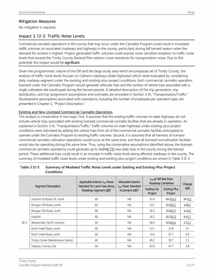
Ascent Environmental Noise
Trinity County Cannabis Program Revised Draft EIR 3.12-11
Mitigation Measures No mitigation is required.
Impact 3.12-3: Traffic Noise Levels
Commercial cannabis operations in the county that may occur under the Cannabis Program could result in increased traffic volumes on associated roadways and highways in the county, particularly during fall harvest season when the demand for workers is highest. Project-generated traffic volumes could expose noise-sensitive receptors to traffic noise levels that exceed the Trinity County General Plan exterior noise standards for transportation noise. Due to this potential, this impact would be significant.
Given the programmatic nature of the EIR and the large study area which encompasses all of Trinity County, the analysis of traffic noise levels focuses on Caltrans roadways (state highways) which were evaluated by considering daily roadway segment under the existing and existing-plus-project conditions. Each commercial cannabis operation licensed under the Cannabis Program would generate vehicular trips and the number of vehicle trips associated with a single cultivation site would peak during the harvest periods. A detailed description of the trip generation, trip distribution, and trip assignment assumptions and estimates are provided in Section 3.14, “Transportation/Traffic.” Development assumptions associated with operations, including the number of employees per operation type, are presented in Chapter 2, “Project Description.”
Existing and New Licensed Commercial Cannabis Operations This analysis is conservative in two ways. First, it assumes that the existing traffic volumes on state highways do not include vehicle trips associated with existing licensed commercial cannabis facilities that are already in operation. As explained in Section 3.14, “Transportation/Traffic,” traffic volumes on state highways under existing-plus-project conditions were estimated by adding the vehicle trips from all of the commercial cannabis facilities anticipated to operate under the Cannabis Program to existing traffic volumes. Second, it is assumed that all harvests at licensed commercial cannabis cultivation operations would occur at the same time, and that all licensed noncultivation facilities would also be operating during this same time. Thus, using the conservative assumptions identified above, the licensed commercial cannabis operations could generate up to 11,0148,710 new daily trips in the county during the harvest period. These additional trips could result in an increase in traffic noise levels along affected roadways in the county. The summary of modeled traffic noise levels under existing and existing-plus-project conditions are shown in Table 3.12-5.
Table 3.12-5 Summary of Modeled Traffic Noise Levels under Existing and Existing-Plus-Project Conditions
Segment Description Applicable Exterior Ldn Noise
Standard for Land Uses along Roadway Segment (dB)1
Allowable Exterior Ldn Noise Standard
Increment (dB) 2
Ldn at 100 feet from Roadway Centerline Change
(dB) Existing No Project
Existing Plus Project
SR 3
Junction of Route 36, north 60 NA 50.4 60.559.6 10.19.2
Morgan Hill Road, south 60 NA 54.1 61.060.2 6.96.1
Morgan Hill Road, north 60 NA 56.3 61.660.9 5.34.6
Hayfork 60 NA 56.3 62.762.0 6.45.7
Weaverville, North Junction 60 NA 58.3 61.060.6 2.72.3
Rush Creek Road, south 60 NA 53.1 53.8 0.7
Rush Creek Road, north 60 NA 51.8 52.7 0.9
Trinity Center Maintenance Station 60 NA 49.2 50.7 1.5
Siskiyou County Line 60 NA 43.9 47.7 3.8
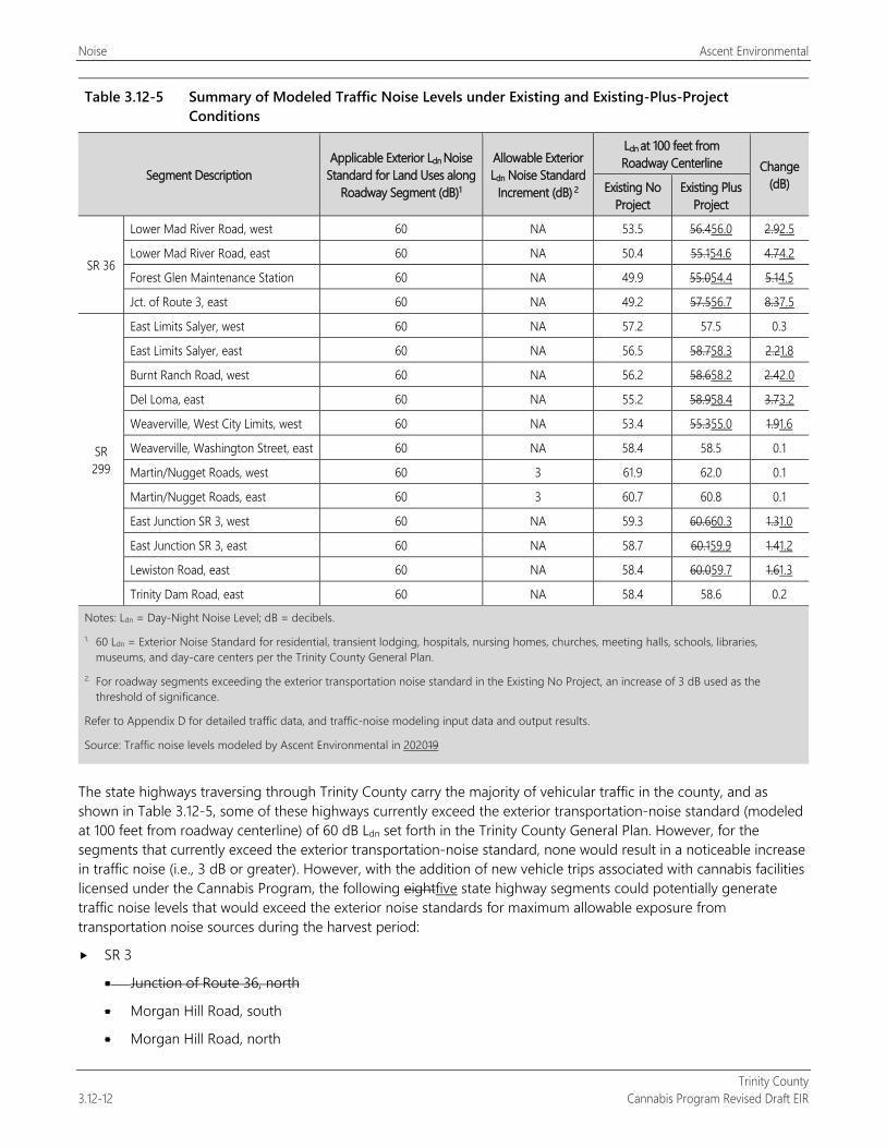
Noise Ascent Environmental
Trinity County 3.12-12 Cannabis Program Revised Draft EIR
Table 3.12-5 Summary of Modeled Traffic Noise Levels under Existing and Existing-Plus-Project Conditions
Segment Description Applicable Exterior Ldn Noise
Standard for Land Uses along Roadway Segment (dB)1
Allowable Exterior Ldn Noise Standard
Increment (dB) 2
Ldn at 100 feet from Roadway Centerline Change
(dB) Existing No Project
Existing Plus Project
SR 36
Lower Mad River Road, west 60 NA 53.5 56.456.0 2.92.5
Lower Mad River Road, east 60 NA 50.4 55.154.6 4.74.2
Forest Glen Maintenance Station 60 NA 49.9 55.054.4 5.14.5
Jct. of Route 3, east 60 NA 49.2 57.556.7 8.37.5
SR 299
East Limits Salyer, west 60 NA 57.2 57.5 0.3
East Limits Salyer, east 60 NA 56.5 58.758.3 2.21.8
Burnt Ranch Road, west 60 NA 56.2 58.658.2 2.42.0
Del Loma, east 60 NA 55.2 58.958.4 3.73.2
Weaverville, West City Limits, west 60 NA 53.4 55.355.0 1.91.6
Weaverville, Washington Street, east 60 NA 58.4 58.5 0.1
Martin/Nugget Roads, west 60 3 61.9 62.0 0.1
Martin/Nugget Roads, east 60 3 60.7 60.8 0.1
East Junction SR 3, west 60 NA 59.3 60.660.3 1.31.0
East Junction SR 3, east 60 NA 58.7 60.159.9 1.41.2
Lewiston Road, east 60 NA 58.4 60.059.7 1.61.3
Trinity Dam Road, east 60 NA 58.4 58.6 0.2
Notes: Ldn = Day-Night Noise Level; dB = decibels. 1. 60 Ldn = Exterior Noise Standard for residential, transient lodging, hospitals, nursing homes, churches, meeting halls, schools, libraries,
museums, and day-care centers per the Trinity County General Plan. 2. For roadway segments exceeding the exterior transportation noise standard in the Existing No Project, an increase of 3 dB used as the
threshold of significance.
Refer to Appendix D for detailed traffic data, and traffic-noise modeling input data and output results.
Source: Traffic noise levels modeled by Ascent Environmental in 202019
The state highways traversing through Trinity County carry the majority of vehicular traffic in the county, and as shown in Table 3.12-5, some of these highways currently exceed the exterior transportation-noise standard (modeled at 100 feet from roadway centerline) of 60 dB Ldn set forth in the Trinity County General Plan. However, for the segments that currently exceed the exterior transportation-noise standard, none would result in a noticeable increase in traffic noise (i.e., 3 dB or greater). However, with the addition of new vehicle trips associated with cannabis facilities licensed under the Cannabis Program, the following eightfive state highway segments could potentially generate traffic noise levels that would exceed the exterior noise standards for maximum allowable exposure from transportation noise sources during the harvest period:
SR 3
Junction of Route 36, north
Morgan Hill Road, south
Morgan Hill Road, north
Ascent Environmental Noise
Trinity County Cannabis Program Revised Draft EIR 3.12-13
Hayfork
Weaverville, North Junction
SR 299
East Junction SR 3, west
East Junction SR 3, east
Lewiston Road, east
For these reasons, it is anticipated that the project could expose noise-sensitive receptors along these segments of the state highway system to traffic noise levels that exceed applicable Trinity County General Plan exterior noise standards during the harvest period. Due to this potential result, this impact would be significant.
Mitigation Measures The typical approach to mitigate traffic noise levels is to construct structures (e.g., soundwalls, berms, or some berm-wall combination) between the roadway segment and the affected noise-sensitive receptors. However, this method would be infeasible given the extensive length of the affected state highway segments (i.e., over 435 contiguous miles along SR 3), and the number of sensitive receptors along these highway segments. Even if landowners were offered to have protective noise barriers constructed on their property, it cannot be assured the all of the landowners of the affected properties residences would allow for the construction of a noise barrier. Additionally, if any soundwalls were proposed within Caltrans right-of-way, implementation of the improvements would not fall within Trinity County’s jurisdictional control, and while the appropriate jurisdictions can and should implement feasible mitigation to reduce impacts, it cannot be guaranteed that these improvements would be implemented. Moreover, some noise barriers could potentially result in other types of environmental impacts (e.g., aesthetic impacts) or adversely affect the potential for a highway segment to be designated as a scenic highway.
It should be noted that the methodology used to estimate the number of trips that could potentially be generated by the project was based on the conservative assumptions discussed above and represents a worst-case scenario. Additionally, the levels of traffic noise modeled and shown in Table 3.12-5 would occur only during the peak harvest time (i.e., 4 weeks per year). However, as stated above, there is no feasible mitigation to address the potential long-term traffic noise levels generated by the project. This impact would be significant and unavoidable.

Noise Ascent Environmental
Trinity County 3.12-14 Cannabis Program Revised Draft EIR
This page intentionally left blank.
Ascent Environmental Public Services
Trinity County Cannabis Program Revised Draft EIR 3.13-1
3.13 PUBLIC SERVICES This section discusses public service resources in Trinity County; describes the applicable federal, state, and local regulations and policies related to public services; describes the existing conditions of public services within the area; and analyzes the potential near- and long-term impacts from implementation of the Cannabis Program on public services. Utility impacts are addressed in Section 3.15, “Utilities and Service Systems.” Wildfire impacts are addressed in Section 3.16, “Wildfire.”
No comment letters regarding public services were received in response to the Notice of Preparation (see Appendix A).
3.13.1 Regulatory Setting
FEDERAL No federal laws, regulations, or programs were identified related to public services and the Cannabis Program. Several federal agencies have jurisdiction over law enforcement and fire protection on federal lands in California, related to unpermitted cultivation operations. The U.S. Forest Service (USFS) responds to fires in National Forests. Because cannabis use and cultivation remains illegal under federal law, several federal agencies investigate and prosecute cannabis use, cultivation, and distribution on federally managed lands. Federal agencies involved in law enforcement in California include USFS, whose Law Enforcement and Investigations division conducts law enforcement operations on federal lands, including eradication of unpermitted cannabis cultivation on National Forest lands. Both the U.S. Bureau of Land Management and the National Park Service law enforcement programs target cannabis cultivation on federally managed lands.
In addition to law enforcement on federal lands, there are federal agencies that investigate and prosecute cannabis business activities generally. The Federal Bureau of Investigation, as the nation’s foremost law enforcement agency, also works in California to investigate federal crimes and crimes that occur across state lines, including drug trafficking. The U.S. Drug Enforcement Administration enforces federal controlled substances laws and regulations, including enforcement activities related to cannabis.
STATE
California Health and Safety Code State fire regulations are set forth in Sections 13000 et seq. of the California Health and Safety Code. This includes regulations for building standards (as also set forth in the California Building Code), fire protection and notification systems, fire protection devices such as extinguishers and smoke alarms, and fire suppression training.
California Occupational Safety and Health Administration In accordance with California Code of Regulations (CCR), Title 8 Section 1270, “Fire Prevention,” and Section 6773, “Fire Protection and Fire Equipment,” the California Occupational Safety and Health Administration has established minimum standards for fire suppression and emergency medical services. The standards include guidelines on the handling of highly combustible materials, fire hose sizing requirements, restrictions on the use of compressed air, access roads, and the testing, maintenance and use of all firefighting and emergency medical equipment.
California Code of Regulations The California Building Standards Code, 24 CCR, serves as the basis for the design and construction of buildings in California. The California Building Code (Title 24, Part 2) covers all aspects of building design and required safety features for all 1 types of buildings, including fire protection systems, fire and smoke protection features, means of egress, and structural design and materials. Title 24, Part 3 is the Electrical Code, which contains standards for electrical systems, including safety features such as overcurrent protection, surge arresters, and proper wiring methods.
Public Services Ascent Environmental
Trinity County 3.13-2 Cannabis Program Revised Draft EIR
California Fire Code The California Fire Code is the primary means for authorizing and enforcing procedures and mechanisms to ensure the safe handling and storage of any substance that may pose a threat to public health and safety. The California Fire Code establishes minimum requirements to safeguard the public health, safety, and general welfare from the hazards of fire, explosion, or dangerous conditions in new and existing buildings. The California Fire Code also contains requirements related to emergency planning and preparedness, fire service features, building services and systems, fire resistance–rated construction, fire protection systems, and construction requirements for existing buildings, as well as specialized standards for specific types of facilities and materials. Structures used for indoor cultivation of cannabis and cannabis-supportive uses (e.g., manufacturing, distribution, processing, microbusinesses, and retail nurseries) would be subject to applicable sections of the California Fire Code.
Emergency Response/Evacuation Plans The State of California passed legislation authorizing the Office of Emergency Services to prepare a Standard Emergency Management System program, which sets forth measures by which a jurisdiction should handle emergency disasters. Noncompliance with the program could result in the state withholding disaster relief from the noncomplying jurisdiction in the event of an emergency disaster. The preservation of life, property and the environment is an inherent responsibility of local, state, and federal government.
Cannabis Licensing Agencies There are three state licensing agencies that regulate the commercial cannabis market:
Bureau of Cannabis Control, housed within the Department of Consumer Affairs. The Bureau licenses testing labs, distributors, dispensaries, and microbusinesses.
CalCannabis Cultivation Licensing (CalCannabis), housed within the Department of Food and Agriculture. CalCannabis licenses cannabis cultivators, nurseries, and processors.
Manufactured Cannabis Safety Branch, housed within the Department of Public Health. The MCSB licenses manufacturers of cannabis products, including edibles.
Regulations associated public services are described below.
CalCannabis Licensing CCR Section 8102(aa): An attestation that the local fire department has been notified of the cultivation site if the
application is for an indoor license type.
CCR Section 8109: Licensees shall notify the department and law enforcement authorities within three (3) calendar days of discovery of any diversion, theft, loss of, or criminal activity related to licensee’s cannabis or nonmanufactured cannabis products.
Bureau of Cannabis Control Licensing CCR Section 5501(i): An attestation that the local fire department has been notified of the cultivation site if the
application is for an indoor license type.
CCR Section 5036(a): A licensee shall notify the Bureau and local law enforcement within 24 hours of discovery of any of the following situations:
(1) The licensee discovers a significant discrepancy, as defined in section 5034 of this division, in its inventory.
(2) The licensee discovers diversion, theft, loss, or any other criminal activity pertaining to the operations of the licensee.
(3) The licensee discovers diversion, theft, loss, or any other criminal activity by an agent or employee of the licensee pertaining to the operations of the licensee.

Ascent Environmental Public Services
Trinity County Cannabis Program Revised Draft EIR 3.13-3
(4) The licensee discovers loss or unauthorized alteration of records related to cannabis goods, customers, or the licensee’s employees or agents.
(5) The licensee discovers any other breach of security.
CCR Section 5036(b): The notification to the Bureau pursuant to subsection (a) of this section shall be submitted on the Notification and Request Form, BCC-LIC-027 (New 10/18), which is incorporated herein by reference, and shall include the date and time of occurrence of the theft, loss, or criminal activity, the name of the local law enforcement agency that was notified, and a description of the incident including, where applicable, the item(s) that were taken or lost.
CCR Section 5418(h): Immediately upon request by the Bureau or any law enforcement officer, the licensed retailer’s delivery driver shall provide:
(1) All delivery inventory ledgers from the time the licensed retailer’s delivery driver left the licensed premises up to the time of the request;
(2) All delivery request receipts for cannabis goods carried by the driver, in the delivery vehicle, or any deliveries that have already been made to customers; and
(3) The log of all stops from the time the licensed retailer’s delivery driver left the licensed premises up to the time of the request.
CCR Section 5424(d): If a licensed retailer identifies any evidence of theft, diversion, or loss, the licensed retailer shall notify the Bureau and law enforcement.
CCR Section 5424(e): If a significant discrepancy as defined in section 5034 of this division is discovered between a licensed retailer’s physical inventory and the licensed retailer’s inventory records, the licensed retailer shall notify the Bureau and law enforcement.
CCR Section 5042 Limited Access Areas
(a) Licensees shall ensure that only employees of the licensee and other authorized individuals access the limited-access areas of the licensed premises.
(b) For the purpose of this section, authorized individuals include outside vendors, contractors, or other individuals conducting business that requires access to the limited-access areas.
(c) An individual who enters the limited-access area and is not employed by the licensee shall be escorted by an employee of the licensee at all times while within the limited-access area.
(d) A licensee shall maintain a record of all authorized individuals who are not employees of the licensee who enter the limited-access areas. The record shall include the name of the individual, the company the individual works for, the reason the individual entered the limited-access area, the date, and the times the individual entered and exited the limited-access area. These records shall be made available to the Bureau immediately upon request.
(e) A licensee shall not receive consideration or compensation for permitting an individual to enter the limited-access areas.
(f) Entrances to all limited-access areas shall have a solid door and a lock meeting the requirements of section 5046 of this division. The door shall remain closed when not in use during regular business hours.
CCR Section 4053 License Employee Badge Requirement
All agents, officers, or other persons acting for or employed by a licensee shall display a laminated or plastic-coated identification badge issued by the licensee at all times while engaging in commercial cannabis activity. The identification badge shall, at a minimum, include the licensee’s “doing business as” name and license number, the employee’s first name, an employee number exclusively assigned to that employee for identification purposes, and a color photograph of the employee that clearly shows the full front of the employee’s face and that is at least 1 inch in width and 1.5 inches in height.

Public Services Ascent Environmental
Trinity County 3.13-4 Cannabis Program Revised Draft EIR
CCR Section 5044 Video Surveillance System
(a) Each licensed premises shall have a digital video surveillance system with a minimum camera resolution of 1280 × 720 pixels.
(b) The video surveillance system shall at all times be able to effectively and clearly record images of the area under surveillance.
(c) Each camera shall be permanently mounted and in a fixed location. Each camera shall be placed in a location that allows the camera to clearly record activity occurring within 20 feet of all points of entry and exit on the licensed premises, and allows for the clear and certain identification of any person and activities in all areas required to be filmed under subsection (d) of this section.
(d) Areas that shall be recorded on the video surveillance system include the following:
(1) Areas where cannabis goods are weighed, packed, stored, loaded, and unloaded for transportation, prepared, or moved within the licensed premises;
(2) Limited-access areas;
(3) Security rooms;
(4) Areas storing a surveillance-system storage device with at least one camera recording the access points to the secured surveillance recording area; and
(5) Entrances and exits to the licensed premises, which shall be recorded from both indoor and outdoor vantage points.
(e) Licensed retailers and licensed microbusinesses authorized to engage in retail sales shall also record point-of-sale areas and areas where cannabis goods are displayed for sale on the video surveillance system. At each point-of-sale location, camera placement must allow for the recording of the facial features of any person purchasing or selling cannabis goods, or any person in the retail area, with sufficient clarity to determine identity.
(f) Cameras shall record continuously 24 hours per day and at a minimum of 15 frames per second (FPS).
(g) The physical media or storage device on which surveillance recordings are stored shall be secured in a manner to protect the recording from tampering or theft.
(h) Surveillance recordings shall be kept for a minimum of 90 calendar days.
(i) Surveillance recordings are subject to inspection by the Bureau, and shall be kept in a manner that allows the Bureau to view and obtain copies of the recordings at the licensed premises immediately upon request. The licensee shall also send or otherwise provide copies of the recordings to the Bureau upon request within the time specified by the Bureau.
(j) Recorded images shall clearly and accurately display the time and date. Time is to be measured in accordance with the standards issued by the United States National Institute of Standards and Technology.
(k) The video surveillance system shall be equipped with a failure notification system that provides notification to the licensee of any interruption or failure of the video surveillance system or video surveillance-system storage device.
(l) If multiple licensed premises are contained within the same building, a single video surveillance system covering the entire building may be used by all of the licensees under the following conditions:
(1) Each applicant or licensee shall disclose on their premises diagram where the surveillance recordings are stored.
(2) Each applicant or licensee shall include in their security operating procedures, submitted with the application pursuant to section 5002(c)(29)(D) of this division, an explanation of how the video

Ascent Environmental Public Services
Trinity County Cannabis Program Revised Draft EIR 3.13-5
surveillance system will be shared, including who is responsible for monitoring the video footage and storing any video recordings.
(3) All licensees shall have immediate access to the surveillance recordings to produce them pursuant to subsection (i) of this section.
(4) All licensees shall be held responsible and subject to discipline for any violations of the video surveillance requirements.
CCR Section 5045 Security Personnel
(a) A licensed retailer or licensed microbusiness authorized to engage in retail sales shall hire or contract for security personnel who are at least 21 years of age to provide on-site security services for the licensed retail premises during the hours of operation. All security personnel hired or contracted for by the licensee shall be licensed by the Bureau of Security and Investigative Services and shall comply with Chapters 11.4 and 11.5 of Division 3 of the Business and Professions Code.
(b) Notwithstanding subsection (a) of this section, a licensed non-storefront retailer or licensed microbusiness who is not engaged in storefront retail sale is not required to hire or contract for security personnel. (c) If multiple licensed premises are contained within the same building, security personnel may be shared by all of the licensees to cover the entire building under the following conditions:
(1) Each licensee shall include in their security operating procedures, submitted with the application pursuant to section 5002(c)(29)(D) of this division, an explanation of how security personnel will be shared, including who is responsible for employing or contracting the security personnel.
(2) All licensees shall be held responsible and subject to discipline for any violations of the security personnel requirements.
CCR Section 5046 Locks
A licensee shall ensure that the limited-access areas described in section 5042 of this division can be securely locked using commercial-grade, nonresidential door locks. A licensee shall also use commercial-grade, nonresidential door locks on all points of entry and exit to the licensed premises.
CCR Section 5047 Alarm Systems
(a) A licensee shall maintain an alarm system as defined in Business and Professions Code section 7590.1(n) at the licensed premises.
(b) A licensee shall ensure a licensed alarm company operator or one or more of its registered alarm agents installs, maintains, monitors, and responds to the alarm system.
(c) Upon request, a licensee shall make available to the Bureau all information related to the alarm system, monitoring, and alarm activity.
(d) If multiple licensed premises are contained within the same building, a single alarm system covering the entire building may be used by all of the licensees under the following conditions:
(1) Each licensee shall include in their security operating procedures, submitted with the application pursuant to section 5002(c)(29)(D) of this division, an explanation of how the alarm system will be shared, including who is responsible for contracting with the alarm company.
(2) All licensees shall have access to and be able to provide the information under subsection (c) of this section.
(3) All licensees shall be held responsible and subject to discipline for any violations of the alarm system requirements.

Public Services Ascent Environmental
Trinity County 3.13-6 Cannabis Program Revised Draft EIR
Manufacture Cannabis Safety Branch Licensing CCR Section 40131(l): A copy of the signed closed-loop system certification and a document evidencing approval
of the extraction operation by the local fire code official required pursuant to Section 40223 or 40225, if applicable.
CCR Section 40200 Security Plan
Every licensee shall develop and implement a written security plan. At a minimum, the security plan shall include a description of the security measures to:
(a) Prevent access to the manufacturing premises by unauthorized persons and protect the physical safety of employees. This includes, but is not limited to:
(1) Establishing physical barriers to secure perimeter access and all points of entry into a manufacturing premises (such as locking primary entrances with commercial-grade, non-residential door locks, or providing fencing around the grounds and driveway, and securing any secondary entrances including windows, roofs, or ventilation systems);
(2) Installing a security alarm system to notify and record incident(s) where physical barriers have been breached;
(3) Establishing an identification and sign-in/sign-out procedure for authorized personnel, suppliers, and visitors;
(4) Maintaining the premises such that visibility and security monitoring of the premises is possible; and
(5) Establishing procedures for the investigation of suspicious activities.
(b) Prevent against theft or loss of cannabis and cannabis products. This includes but is not limited to:
(1) Establishing an inventory system to track cannabis and cannabis products and the personnel responsible for processing it throughout the manufacturing process;
(2) Limiting access of personnel within the premises to those areas necessary to complete job duties, and to those time-frames specifically scheduled for completion of job duties, including access by outside vendors, suppliers, contractors or other individuals conducting business with the licensee that requires access to the premises;
(3) Supervising tasks or processes with high potential for diversion, including the loading and unloading of cannabis transportation vehicles; and
(4) Providing areas in which personnel may store and access personal items that are separate from the manufacturing areas.
(c) Secure and back up electronic records in a manner that prevents unauthorized access and that ensures the integrity of the records is maintained.
CCR Section 40205 Video Surveillance
(a) At minimum, a licensed premises shall have a digital video surveillance system with a minimum camera resolution of 1280 × 720 pixels. The video surveillance system shall be able to effectively and clearly record images of the area under surveillance.
(b) To the extent reasonably possible, all video surveillance cameras shall be installed in a manner that prevents intentional obstruction, tampering with, or disabling.
(c) Areas that shall be recorded on the video surveillance system include the following:
(1) Areas where cannabis or cannabis products are weighed, packed, stored, quarantined, loaded and unloaded for transportation, prepared, or moved within the premises;
(2) Limited-access areas;

Ascent Environmental Public Services
Trinity County Cannabis Program Revised Draft EIR 3.13-7
(3) Security rooms;
(4) Areas containing surveillance-system storage devices, which shall contain at least one camera to record the access points to such an area; and
(5) The interior and exterior of all entrances and exits to the premises.
(d) The surveillance system shall record continuously 24 hours per day and at a minimum speed of 15 frames per second.
(e) Any on-site surveillance system storage devices shall be located in secure rooms or areas of the premises in an access-controlled environment.
(f) The licensee shall ensure that all surveillance recordings are kept for a minimum of 90 days.
(g) All video surveillance recordings shall be available on the licensed premises and are subject to inspection by the Department and shall also be copied and sent, or otherwise provided, to the Department upon request.
(h) The video recordings shall display the current date and time of recorded events. Time is to be measured in accordance with the U.S. National Institute of Standards and Technology standards. The displayed date and time shall not significantly obstruct the view of recorded images.
(i) If multiple licensed premises are contained within the same building, a single video surveillance system covering the entire building may be used by all of the licensees under the following conditions:
(1) Each applicant or licensee shall disclose on their premises diagram where the surveillance recordings are stored;
(2) Each applicant or licensee shall include in their security operating procedures an explanation of how the video surveillance system will be shared, including who is responsible for monitoring the video footage and storing any video recordings;
(3) All licensees shall have immediate access to the surveillance recordings to produce them pursuant to the requirements of this section;
(4) All licensees shall be held responsible and subject to discipline for any violations of the video surveillance requirements.
CCR Section 40207 Notification of Theft, Loss, or Diversion
If a licensee finds evidence of theft or diversion of cannabis or cannabis products, the licensee shall report the theft or diversion to the Department and local law enforcement within 24 hours of the discovery. The notice to the Department shall be in writing and shall include the date and time of the incident; a description of the incident, including items that were taken or missing; and the name of the local law enforcement agency that was notified of the incident.
CCR Section 40223(b): Ethanol extraction operations shall be approved by the local fire code official and shall be operated in accordance with applicable Division of Occupational Safety and Health (Cal/OSHA) regulations and any other state and local requirements.
CCR Section 40225 Closed-Loop Extraction System Requirements
(a) Chemical extractions using CO2; a volatile solvent; or chlorofluorocarbon, hydrocarbon, or other fluorinated gas shall be conducted in a professional closed loop extraction system designed to recover the solvents. The system shall be commercially manufactured and bear a permanently affixed and visible serial number. The system shall be certified by a California-licensed engineer that the system was commercially manufactured, safe for use with the intended solvent, and built to codes of recognized and generally accepted good engineering practices, such as:
(1) The American Society of Mechanical Engineers (ASME);
Public Services Ascent Environmental
Trinity County 3.13-8 Cannabis Program Revised Draft EIR
(2) American National Standards Institute (ANSI);
(3) Underwriters Laboratories (UL); or
(4) The American Society for Testing and Materials (ASTM).
(b) Professional closed loop systems, other equipment used, the extraction operation, and facilities must be approved for use by the local fire code official and comply with any required fire, safety, and building code requirements related to the processing, handling, and storage of the applicable solvent or gas.
(c) The certification document required pursuant to subsection (a) shall contain the signature and stamp of a California-licensed professional engineer and the serial number of the extraction unit being certified.
(d) The licensee shall establish and implement written procedures to document that the closed loop extraction system is maintained in accordance with the equipment manufacturer specifications and to ensure routine verification that the system is operating in accordance with specifications and continues to comply with fire, safety, and building code requirements.
(e) A licensee shall develop standard operating procedures, good manufacturing practices, and a training plan prior to producing extracts. Any personnel using solvents or gases in a closed loop system to create extracts must be trained on how to use the system, have direct access to applicable safety data sheets, and handle and store solvents and gases safely.
(f) The extraction operation shall be operated in an environment with proper ventilation, controlling all sources of ignition where a flammable atmosphere is or may be present, and shall be operated in accordance with applicable Division of Occupational Safety and Health (Cal/OSHA) regulations and any other state and local requirements.
(g) No closed loop extraction system operation shall occur in an area zoned as residential.
LOCAL
Trinity County Community Wildfire Protection Plan The Trinity County Fire Safe Council (FSC) developed the first comprehensive Trinity County Community Wildfire Protection Plan (CWPP) between 1999 and 2005. This effort began with a countywide process that resulted in the Recommendations on Trinity County Values at Risk from Fire and Pre-Fire Fuels Treatment Opportunities drawn from Community Meetings 1999/2000 (February 2001). These recommendations were used to develop the first complete Trinity County CWPP, which was accepted by the Trinity County Fire Chiefs’ Association, Trinity County Board of Supervisors and the California Department of Forestry and Fire Protection (CAL FIRE) in September 2005. The CWPP was updated in 2010 and became the primary document to guide the FSC, its member organizations and partners, in the selection and implementation of strategic fuels reduction projects and public outreach as they have sought to improve cooperation and coordination in all aspects of wildfire management in Trinity County. FSC members include representatives from local, state and federal land management agencies, nongovernmental organizations including the local volunteer fire departments and citizens. The most recent update of the CWPP was completed in 2015 (Trinity County 2015).
Trinity County Code of Ordinances Chapter 8.30 regulations have been prepared and adopted for the purpose of establishing minimum wildfire protection standards in conjunction with building, construction and development in Trinity County. The future design and construction of structures, subdivisions and developments in the county shall provide for basic emergency access and perimeter wildfire protection measures as specified in the following articles. These measures shall provide for emergency access; signing and building numbering; private water supply reserves for emergency fire use; and vegetation modification. The fire protection standards which follow shall specify the minimum standards for such measures.
Ascent Environmental Public Services
Trinity County Cannabis Program Revised Draft EIR 3.13-9
3.13.2 Environmental Setting
LAW ENFORCEMENT Police protection services in the county are provided by the County Sheriff’s Department and the California Highway Patrol. The primary responsibility of the California Highway Patrol is traffic safety, and the primary responsibility of the Sheriff’s Department is protection of persons and property. The main offices of both services are located in Weaverville, with a Sheriff’s Department substation located at the intersection of Hyampom Road and State Route 3 in Hayfork.
FIRE PROTECTION Local fire protection and emergency medical services are provided by the following fire districts and station sites:
Trinity Center,
Lewiston,
Hayfork,
Hawkins Bar,
Southern Trinity,
Coffee Creek,
Junction City,
Post Mountain,
Salyer,
Zenia-Kettenpom,
Weaverville,
Douglas City,
Barker Valley,
Down River, and
Forest Glen.
The local fire districts participate in the “Mutual Aid” response program, which includes CAL FIRE and USFS.
CALFIRE and USFS provide wildland fire protection in the county. CAL FIRE maintains both ground and air forces and can reach any fires within the state in no more than 20 minutes. CAL FIRE has a station on Tule Creek Road. USFS operates lookouts to provide early detection of fire. USFS and CAL FIRE provide an automatic air support dispatch system from Redding during the summer.
Fire Hazards From Existing Illegal Cannabis Cultivation The illegal, unpermitted cultivation of cannabis is currently occurring throughout the county and has created potential fire hazards because of failure to comply with state and local regulations related to building, electrical, and fire regulations (e.g., CCR Title 14; CCR Title 24, Part 2 and 3). This condition adversely affects public services, particularly fire protection, given that cultivation often occurs in remote and wooded areas of the county. Indoor cannabis cultivation typically involves the use of high intensity grow lights, as well as various other pieces of equipment (e.g., water pumps, humidity control, temperature control), which can create a large electrical load. If the load exceeds the system capacity (e.g., as may occur in a building with outdated or inadequate wiring), it could result in an electrical fire (California Department of Food and Agriculture 2017:4.11-11).
3.13.3 Environmental Impacts and Mitigation Measures
METHODOLOGY Evaluation of potential public service impacts was based on a review of documents and regulatory standards . Impacts on public services that would result from the project were identified by comparing existing service capacity and facilities against future demand associated with project implementation. The reader is also referred to the impact analysis provided in Section 3.16, “Wildfire.”
Public Services Ascent Environmental
Trinity County 3.13-10 Cannabis Program Revised Draft EIR
THRESHOLDS OF SIGNIFICANCE A public services and recreation impact would be significant if implementation of the project would:
result in substantial adverse physical impacts associated with the provision of new or physically altered governmental facilities, or the need for new or physically altered governmental facilities, the construction of which could cause significant environmental impacts, to maintain acceptable service ratios, response times, or other performance objectives for any of the public services:
fire,
police protection,
schools,
parks, or
other public facilities.
ISSUES NOT DISCUSSED FURTHER As described in Chapter 1, “Introduction,” implementation of the Cannabis Program would not substantially increase population levels in the county. Thus, there would not be additional use of schools or parks and recreation facilities such that new or expansion of facilities would be necessary. Likewise, there would not be an increased demand on fire or law enforcement demand associated with population growth. There would be no impacts. Thus, issues pertaining to impacts on public services related to population growth are not discussed further.
ENVIRONMENTAL IMPACTS AND MITIGATION MEASURES
Impact 3.13-1: Result in Substantial Adverse Physical Impacts Associated with the Need for New or Physically Altered Fire Protection Facilities
Commercial cannabis operations and production that would result with implementation of the Cannabis Program could increase the demand for fire protection services, but because of the nature of the activities would not trigger the need for new or altered fire protection facilities. Compliance with existing building, electrical, commercial cannabis regulations, and fire code regulations would be required for all activities under the Cannabis Program. However, existing and new commercial cannabis operations could create or worsen emergency response if roadways and driveways are not designed properly. This impact would be potentially significant.
Commercial cannabis operations could create fire hazards from electrical sources and the storage and use of flammable materials and other power equipment that would also generate fire risk. Commercial cannabis operations would be regulated for fire protection measures consistent with building and fire codes and through state licensing requirements for cultivation (CCR Section 8102[aa] and CCR 5501[i]) and for manufacturing operations associated with extraction facilities (CCR Sections 40223[b] and 40225). The Cannabis Program would also include the following standards for fire protection:
Fire plans must be prepared by the applicant and approved by the Weaverville Fire District Chief or a designee of the Trinity County Board of Supervisors. An approved fire plan must be submitted with an application for the appropriate Use Permit (Manufacturing) (Section 315-842[4][F]).
Type 7 (volatile manufacturing) applicants are required to obtain a Conditional Use Permit before starting operations, including infrastructure and building improvements specific to the use, and the following additional requirements must be met (Manufacturing) (Section 315-842[4][J]):
Extractions must be in closed loop system as defined and prescribed by State of California.
Ascent Environmental Public Services
Trinity County Cannabis Program Revised Draft EIR 3.13-11
Wastewater shall be disposed of into an adequate sewage system, as prescribed by Trinity County Environmental Health Division and pursuant to California State regulations.
The facility must be setback a minimum of I00 feet from all adjacent property lines. Application for a variance from this provision will be considered concurrently with application for a Conditional Use Permit from the Trinity County Planning Commission.
All building structures must have operational automatic fire sprinklers.
Existing Licensed Commercial Cannabis Operations Existing licensed commercial cannabis operations that have been constructed would not create new fire hazards. These sites are required to comply with fire standards that include CCR Title 24, Part 2, Chapter 7A, which requires buildings to be fire resistant (roof material, decking material, accessory structures, and venting to resist the intrusion of flame and ember); PRC Section 4291, which addresses defensible space and fuel modification standards; and provision of sufficient fire equipment and emergency access standards. These requirements would apply to expansion of these sites that may occur from the proposed amendment that would allow expansion of the Designated Area for cultivation activities from 200 percent of the licensed cannabis canopy area to 250 percent (20 percent increase). Compliance with these requirements would ensure that adequate on-site fire protection measures are provided and would avoid the need for expanded fire protection services that would necessitate the construction of new fire protection facilities (e.g., fire stations).
However, some existing cannabis operations may have been located on substandard roadways that would hinder emergency response or evacuation. Relicensing of these operations would continue to expose these areas to these fire access hazards. The reader is referred to Section 3.14, “Transportation/Traffic,” for further discussion of roadway issues. Thus, this impact would be potentially significant.
New Licensed Commercial Cannabis Operations New cannabis cultivation and noncultivation uses would be required to comply with existing regulations for fire safety and protection. These requirements include CCR Title 24, Part 2, Chapter 7A, which requires buildings to be fire resistant (roof material, decking material, accessory structures, and venting to resist the intrusion of flame and ember); PRC Section 4291, which addresses defensible space and fuel modification standards; and provision of sufficient fire equipment and emergency access standards. Compliance with these requirements would ensure that adequate on-site fire protection measure are provided and would avoid the need for expanded fire protection services that would necessitate the construction of new fire protection facilities (e.g., fire stations). State regulations for manufacturing include CCR Section 40131(l), which requires a copy of the signed closed-loop system certification and a document evidencing approval of the extraction operation by the local fire code official required pursuant to Section 40223 or 40225, if applicable. Compliance with these regulations would reduce the risk of volatile manufacturing causing fire risk. Compliance with these requirements would ensure that adequate on-site fire protection measure are provided and would avoid the need for expanded fire protection services that would necessitate the construction of new fire protection facilities (e.g., fire stations).
However, construction and operation of new licensed commercial cannabis operations could result in temporary lane closures, increased truck traffic, and safety issues if located on substandard roadways that are not adequately maintained. This would hinder emergency response or evacuation. Thus, this impact would be potentially significant.
Mitigation Measures
Mitigation Measure 3.13-1: Implement Mitigation Measures 3.14-3 and 3.14-4.
Significance after Mitigation Implementation of Mitigation Measures 3.14-3 and 3.14-4 would require that existing licensed and new commercial cannabis sites meet county roadway and access design and fire safety requirements set forth in County Code of Ordinances Chapters 8.30 and 12.10. The reader is referred to Section 3.14, “Transportation/Traffic,” for a further analysis of roadway impacts. This impact would be reduced to a less-than-significant level.
Public Services Ascent Environmental
Trinity County 3.13-12 Cannabis Program Revised Draft EIR
Impact 3.13-2: Result in Substantial Adverse Physical Impacts Associated with the Need for New or Physically Altered Law Enforcement Facilities
Commercial cannabis production and operation under the Cannabis Program would be required to include onsite security measures that would address safety of the facilities and would not require increased law enforcement services that would result in the need for new or altered facilities. Potential impacts related to law enforcement services would be less than significant.
Commercial cannabis operations are a target for potential crime. The Cannabis Program would include the following standards for security:
All buildings where cannabis is cultivated or stored shall be secured to prevent unauthorized entry (Cultivation) (Section 315-843[6][f]).
Security plan shall be developed which is compliant with state requirements and submitted with an application and must be sufficient to restrict access to only those intended and to deter trespass and theft of cannabis or cannabis products (Manufacturing) (Section 315-842[4][D]).
A safety and security plan shall be submitted and accepted by the County. This plan shall be updated annually. All security protocols shall be implemented prior to commencing operations (Testing) (Section 315-824[5][f]).
Security plan shall be developed which is compliant with state requirements and submitted with an application and must be sufficient to restrict access to only those intended to deter trespass and theft of Cannabis or Cannabis products shall be provided and maintained. The Security plan shall be approved by the Board of Supervisors, or its designee (Distribution) (Section 315-828[3][D]).
As further described in Section 3.13.1, “Regulatory Setting,” state cannabis regulations include the following security requirements for testing, distribution, retail, and microbusinesses:
Sections 5042 and 5043: standards that limit access to authorized personnel, documentation of authorized individuals, and employee badge requirements.
Section 5044: requirements for the provision of video surveillance system.
Section 5045: standards for provision of security personnel.
Sections 5046 and 5047: requirements for locks for all points of entry and exit and the provision of alarm systems.
State cannabis regulations include the following security requirements for manufacturing uses:
Section 40200: development and implementation of a security plan that include requirements for a security alarm system and documentation of authorized individuals.
Section 40205: requirements for the provision of video surveillance system.
Existing Licensed Commercial Cannabis Operations Existing licensed commercial cannabis operations that have been constructed would not create new law enforcement issues and would be required to continue to comply with state and Cannabis Program security requirements identified above. Compliance with these measures would ensure that law enforcement and safety measures are incorporated into each site and there would be no need for expanded law enforcement facilities. Thus, this impact would be less than significant.

Ascent Environmental Public Services
Trinity County Cannabis Program Revised Draft EIR 3.13-13
New Licensed Commercial Cannabis Operations New cultivation and noncultivation uses could attract criminal activities that could increase the demand for law enforcement services. Compliance with the Cannabis Program performance standards identified above would require secure access to sites and implementation of security plans to protect sites from trespass and burglary. CCR Sections 5042, 5043, 5046, 5047, 40200, and 40205 require on-site security measures. These standards would minimize the potential for criminal activities through controlled access for authorized personnel and locked door requirements at noncultivation sites (CCR Sections 5042 and 5043), security measures that include video surveillance, security personnel, and lock and alarm system requirements (CCR Sections 5044, 5045, 5046, and 5047). Manufacturing sites are required to provide a security plan that implements access controls to the building, alarm system requirements, and video surveillance (CCR Sections 40200 and 40205). Implementation of these measures would ensure protection of sites that would not require the need to expand law enforcement services and facilities.. Thus, this impact would less than significant.
Mitigation Measures No mitigation is required.

Public Services Ascent Environmental
Trinity County 3.13-14 Cannabis Program Revised Draft EIR
This page intentionally left blank.
Ascent Environmental Transportation/Traffic
Trinity County Cannabis Program Revised Draft EIR 3.14-1
3.14 TRANSPORTATION/TRAFFIC
This section describes the applicable federal, state, and local regulations and policies related to transportation and circulation; discusses the existing roadway network and transportation facilities in the county; describes existing transportation and circulation conditions within the county; and analyzes the potential impacts from project activities on transportation and circulation.
No comment letters regarding transportation were received in response to the NOP (see Appendix A).
3.14.1 Regulatory Setting
FEDERAL There are no federal laws or regulations addressing transportation and circulation that are relevant to the project.
STATE
California Department of Transportation Concept Reports Transportation Concept Reports (TCRs) have been completed by Caltrans for the state highway system traversing the county. TCRs are Caltrans’s long-range planning documents completed for each state highway route that describe the conceptual improvement options for each given transportation route or corridor. The TCRs identify existing route conditions and future needs. Each TCR includes a route summary, segment summaries, existing and forecasted travel data, route maps, and a list of planned, programmed, and needed projects for each highway over the next 20 years. TCRs identify how a highway will be developed and managed so that it delivers a targeted level of service (Concept LOS) that is feasible to attain over a 20-year planning horizon. Concept LOS represents the minimum acceptable service conditions over the next 20 years.
State Route 299 Transportation Concept Report In 2009, Caltrans released the State Route (SR) 299 Transportation Concept Report, which includes portions of SR 299 within the study area. The section of SR 299 west of the City of Redding and extending through Trinity County is primarily rural two-lane conventional highway, limited access points, passing through several small communities where the highway serves as a “main street.” Issues along this section of SR 299 identified in the TCR include road alignment and terrain constraints that prevent Surface Transportation Assistance Act truck access, limited shoulder widths, few passing opportunities, winter weather conditions, and seasonal congestion in Weaverville.
The Concept LOS for SR 299 within Caltrans District 2 is the C/D threshold. When LOS is projected to fall below LOS C, improvements should be pursued.
The facility concept is a general term used to describe the number of lanes and degree of access control on a state route. The 20-year facility concept for the majority of SR 299 in Trinity County is to remain as a two-lane conventional highway. However, traffic volumes are forecast to increase and cause operation of SR 299 through Weaverville to fall at or below target LOS. The 20-year facility concept of SR 299 through Weaverville has yet to be established, and it is stated in the TCR that capacity expansion and/or operational improvements needed to address LOS will be identified and developed in cooperation with the Trinity County Transportation Commission and other interested stakeholders. Recent completion of Lance Gulch Roadway has provided an alternative travel pattern that has improved LOS operations.
State Route 36 Transportation Concept Report In 2012, Caltrans released the State Route 36 Transportation Concept Report that includes portions of SR 36 within the study area. The western portion of SR 36 between the Pacific Coast and Red Bluff, which extends through Humboldt,
Transportation/Traffic Ascent Environmental
Trinity County 3.14-2 Cannabis Program Revised Draft EIR
Trinity, and Shasta Counties and into Tehama County, is a two-lane rural highway that passes through the coastal mountain range and into the northern Central Valley. Many sections of highway have limited lane and shoulder widths, curvilinear alignment, low design speeds, and pass through remote mountainous terrain with no available services. The route passes through several small communities where it serves as a “main street” and route serves as a critical link to access basic services.
The Concept LOS for SR 36 within Caltrans District 2 is the C/D threshold. When LOS is projected to fall below LOS C, improvements should be pursued. The facility concept is a general term used to describe the number of lanes and degree of access control on a SR 36. The 20-year facility concept of SR 36 in Trinity County is to remain as a two-lane conventional highway.
State Route 3 Turnout Study The State Route 3 Turnout Study evaluates potential opportunities to develop improved (paved) turnouts for slow moving vehicles to pull out of traffic to allow passing on SR 3 in Trinity County between the communities of Weaverville and Coffee Creek. The section of SR 3 addressed within the study is located within mountainous terrain and generally curvilinear in alignment. The majority of the highway is located within the Shasta Trinity National Forest. The study recommends a total of five locations for improvement within the study area. The recommended locations offer the fewest constraints and therefore should prove to be the most cost effective to develop.
California Department of Transportation Statewide Transportation Improvement Program The California Statewide Transportation Improvement Program (STIP) is a multiyear, statewide, intermodal program of transportation projects that is consistent with the statewide transportation plan and planning processes, and metropolitan plans. The STIP is prepared by Caltrans in cooperation with the Metropolitan Planning Organizations and Regional Transportation Planning Agencies. The STIP contains all capital and noncapital transportation projects or identified phases of transportation projects for funding under the Federal Transit Act and Title 23 of the U.S. Code.
California Department of Transportation Interregional Transportation Improvement Program Caltrans’ 5-year Interregional Transportation Improvement Program is prepared pursuant to Government Code 14526, Streets and Highways Code Section 164, and the California Transportation Commission’s STIP Guidelines. Regional agencies work with Caltrans to identify projects that will address improvements to the interregional transportation system and improve the movement of people, vehicles, and goods between regions.
Senate Bill 743 Senate Bill (SB) 743, passed in 2013, required the California Governor’s Office of Planning and Research (OPR) to develop new CEQA guidelines that address traffic metrics under CEQA. As stated in the legislation, upon adoption of the new guidelines, “automobile delay, as described solely by level of service or similar measures of vehicular capacity or traffic congestion shall not be considered a significant impact on the environment pursuant to this division, except in locations specifically identified in the guidelines, if any.” .New guidelines were adopted on December 28, 2018. The guidelines indicate that congestion will no longer be considered a significant impact and vehicle miles traveled (VMT) will be the primary metric used to identify transportation impacts; lead agencies will have an opt-in period until July 1, 2020, but can use VMT in place of congestion immediately if they choose.
REGIONAL
Trinity County 2016 Regional Transportation Plan The Trinity County Transportation Commission (TCTC) is designated as a Regional Transportation Planning Agency and is responsible for area wide transportation planning in Trinity County. TCTC is required by California law to adopt and submit an approved Regional Transportation Plan (RTP) to the California Transportation Commission every 5 years.
In October 2017, the Trinity County 2016 RTP was adopted. The 2016 RTP guides transportation investments in the county over the next 20 years. Development of the update to the RTP was a cooperative effort between TCTC,
Ascent Environmental Transportation/Traffic
Trinity County Cannabis Program Revised Draft EIR 3.14-3
Caltrans, and additional stakeholders, including but not limited to Native American tribes, the U.S. Forest Service, and the general public.
The purpose of the 2016 RTP is to accomplish the following objectives:
Provide an assessment of the current modes of transportation and the potential of new travel options within the region
Predict the future needs for travel and goods movement
Identify and document specific actions necessary to address the region's mobility and accessibility needs
Identify guidance and documentation of public policy decisions by local, regional, state and federal officials regarding transportation expenditures and financing
Provide information for the development of the Federal Transportation Improvement Program, the Regional Transportation Improvement Program, and the Interregional Transportation Improvement Program
Help identify project purposes and needs
Promote consistency between the California Transportation Plan, the RTP and other transportation plans developed by cities, counties, districts, private organizations, tribal governments, and state and federal agencies in responding to statewide and interregional transportation issues and need
Involve the public, federal, state and local agencies, as well as local elected officials, early in the transportation planning process so as to include them in discussions and decisions on the social, economic, air quality and environmental issues related to transportation
The 2016 RTP includes an assessment of existing and future countywide transportation deficiencies, establishes the goals, objectives, and policies that address transportation issues by mode, evaluates transportation improvement options, and provides as financially constrained list of future transportation projects within the county.
LOCAL
Trinity County General Plan The Trinity County General Plan Circulation Element (Trinity County 2002) contains the following objectives and policies regarding transportation and circulation that may be applicable to the project:
Objective 1.4: Develop road systems, which are compatible with the areas they serve.
Policy 1.4.C: Projects or land uses that will generate heavy commercial traffic or high trip volumes shall be mitigated as determined by the decision-making body.
Policy 1.4.D: Land uses or densities which could result in unsafe road conditions shall be mitigated as determined by the decision-making body.
Objective 1.6: Identify anticipated street and road congestion/capacity problems before they become critical in order to program preventative measures and reduce the cost of correction.
Policy 1.6. A: The minimum acceptable Level of Service (LOS) standard for roadway and intersection operation in Trinity County is “D.” No public highway or roadway should be allowed to fall to or below LOS “E.”
Policy 1.6.B: Traffic analysis, engineering judgment and/or special studies should be utilized to assess whether roadways or intersections are operating near or at LOS “E.” If a roadway or intersection is at or near LOS “E,” improvements or other strategies to remedy the condition should be considered a priority.
Objective 1.8: Provide safe passing zones on state highways and county roads.
Policy 1.8.G: Require on and off-site road improvements at the time of land division in order to provide for the safe and efficient movement of traffic.
Transportation/Traffic Ascent Environmental
Trinity County 3.14-4 Cannabis Program Revised Draft EIR
Policy 1.8.H: Development projects shall comply with all applicable county and State roadway conditions and/or standards.
Policy 1.8.1: All roads serving new land divisions, or commercial, industrial or multiple family development requiring discretionary County approvals in the Weaverville and Hayfork Fire Protection Districts shall be County-maintained roads; however, upon approval by the affected fire district, roads shall be paved, but may be privately owned and maintained by a road maintenance association.
Objective 1.18: Coordinate plans, programs and projects for the County, State and Federal transportation.
Policy 1.18.D: Consider potential impacts to all components of the transportation system that may result from a proposed project. Require mitigation of identified impacts if the project is to be approved.
Objective 7.1: Determine and, as appropriate, address the probable transportation impacts of proposed land use projects.
Policy 7.1.A Require, as appropriate, on- and off-site road improvements at the time of land division in order to provide for the safe and efficient movement of traffic.
Policy 7.1.B: Development projects shall comply with all applicable county and State roadway conditions and/or standards.
Policy 7.1.C: Ensure to the extent possible that the costs of street and highway improvements necessitated by new development are borne by the responsible party or parties.
Policy 7.1.D: Ensure that county road and state highway right-of-way needs will be met in conjunction with development project approvals.
Policy 7.1.E: Review land use development projects of all public and private project proponents determine impacts to the road system and require improvements as necessary.
Trinity County Code of Ordinances The Trinity County Code of Ordinances contains the following policies regarding transportation and circulation that may be applicable to the project:
Chapter 8.30: These regulations have been prepared and adopted for the purpose of establishing minimum wildfire protection standards in conjunction with building, construction and development in Trinity County. The future design and construction of structures, subdivisions and developments in the county shall provide for basic emergency access and perimeter wildfire protection measures as specified in the following articles. These measures shall provide for emergency access; signing and building numbering; private water supply reserves for emergency fire use; and vegetation modification. The fire protection standards which follow shall specify the minimum standards for such measures.
Chapter 12.10: The following policy of the American Association of State Highway and Transportation Officials is adopted by reference: "A Policy on Geometric Design of Highways and Streets, 1990." Also adopted by this reference are all future amendments thereto and subsequent editions thereof. The policy and standards adopted in this chapter shall only apply to construction and reconstruction of county highways, streets and roads either performed by or contracted through the Trinity County department of transportation.
2015 Bikeway Master Plan The 2015 Bikeways Master Plan promotes the development of a unified bicycle system throughout Trinity County that serves the needs of bicycle commuters, students, users of nonmotorized rolling modes of transportation, seniors and recreational bicyclists with safe connections to other regional nonmotorized systems. The Bikeway Master Plan identifies Improvements for three Class I facilities in Weaverville and Class III improvements for various Caltrans, county, and community facilities. Additional bikeways needs are described as follows:
“Share the Road” signs are needed on SR 3, SR 36, and SR 299 to alert motorists that bicycles may be on the roadway. These signs should be installed every 2–3 miles and at the county boundaries.
Ascent Environmental Transportation/Traffic
Trinity County Cannabis Program Revised Draft EIR 3.14-5
“Share the Road” signs and the Trinity County bike route logo should be posted on county roads that serve as spur bikeways from the state route network. These spur routes are used by bicyclists to reach remote communities, campgrounds, and other places of interest.
3.14.2 Environmental Setting This section describes the existing environmental setting, which is the baseline scenario upon which project-specific impacts are evaluated. The environmental setting for transportation includes baseline descriptions for roadway, bicycle, pedestrian, and transit facilities.
EXISTING ROADWAY NETWORK The roadway system in Trinity County totals approximately 2,190 centerline miles and consists of private roadways, 202 miles of state highways, 700 miles of county roadways, and 1,288 miles of roadway owned and operated by the federal government (largely in the national forest).
State Routes Trinity County is served by SR 3, SR 36, and SR 299 which are described in detail below.
State Route 3 SR 3 serves as the primary north-south roadway in the county, connecting central and northern Trinity County with Weaverville. SR 3 traverses north-south through Trinity County, beginning at SR 36 just south of Peanut and passing out of Trinity County over Scott’s Mountain north of Trinity Lake and passes through the communities of Hayfork, Douglas City, Weaverville, Trinity Center, and Coffee Creek as well as several other smaller communities. Between Douglas City and Weaverville, SRs 3 and 299 are the same route. SR 3 between Douglas City and Hayfork as well as between Slate Creek and Trinity Center includes sharp curves, limited passing opportunities, and is not maintained during winter months over Scott’s Mountain. Within Weaverville, SR 3 provides access between the central commercial district and Weaverville Elementary School, residential areas, and the Weaverville – Lonnie Pool Airport.
State Route 36 SR 36 traverses east-west through the southern portion of the county, entering Trinity County near Wildwood from the east and crossing into Humboldt County west of Mad River. SR 36 passes through the communities of Forest Glen and Mad River; however, the majority of this roadway passes through undeveloped forest land. SR 36 provides access to Fortuna in Humboldt County to the west and Red Bluff in Tehama County to the east, as well as Hayfork and Weaverville (via SR 3). Additionally, SR 36 provides access for residents of Southern Trinity County to Eureka. The capacity of SR 36 is limited by horizontal and vertical curves, narrow lane and shoulder widths, and by the limited passing opportunities.
State Route 299 SR 299 traverses east-west through Trinity County, from Redding to the east and crossing into Humboldt County to the west. SR 299 connects the Trinity County communities of Lewiston, Douglas City, Weaverville, Junction City, Big Flat, Big Bar, Burnt Ranch, and Salyer, in addition to several other smaller communities. SR 299 carries local (intraregional), recreational, commuter, and commercial traffic. SR 299 has been classified as a National Forest scenic byway and is heavily utilized for access to and along the Trinity River. It is also classified as a Focus Route by Caltrans because of its importance as an interregional route (for both auto and truck traffic) between the Northern Sacramento Valley and the North Coast.
SR 299 has limited passing opportunities, particularly west of Weaverville. Only six passing lanes exist (four eastbound, two westbound) on SR 299 between Willow Creek and Douglas City, a stretch of 65 miles. The distance between passing lanes for eastbound traffic is 26 miles (Hawkins Bar to Big Flat), while the distance for westbound traffic is a 52-mile gap between passing lanes (Oregon Mountain to Willow Creek) (TCTC 2017).
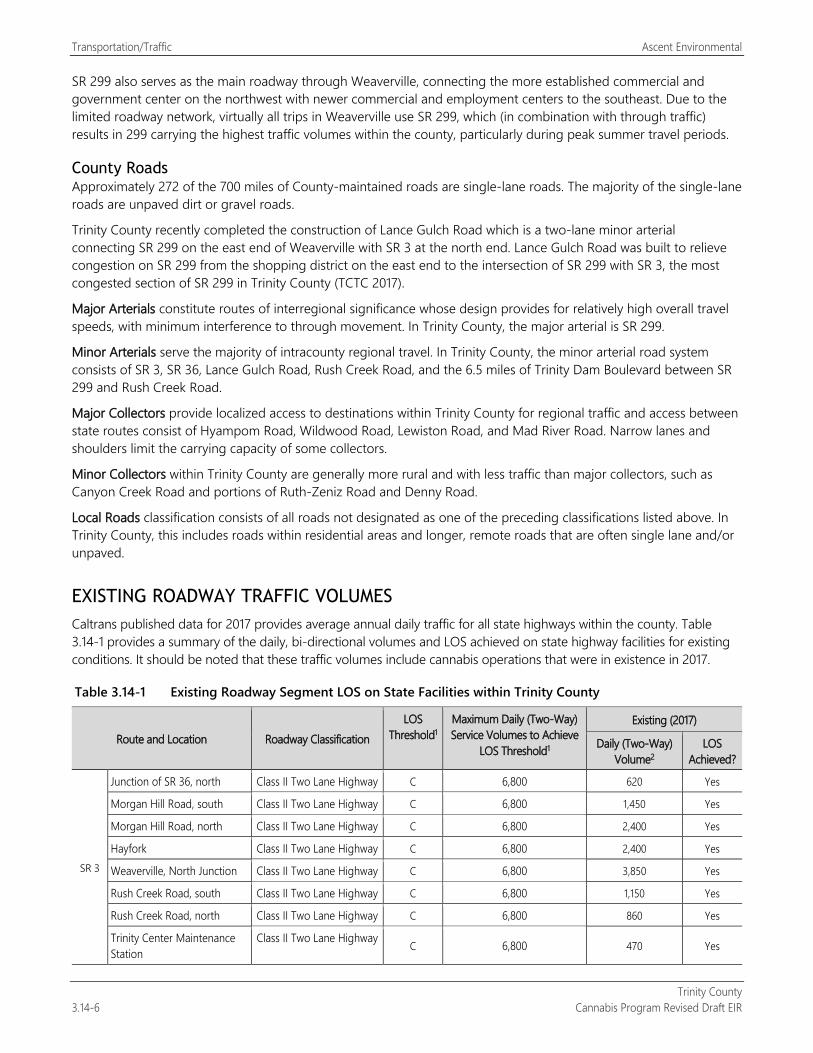
Transportation/Traffic Ascent Environmental
Trinity County 3.14-6 Cannabis Program Revised Draft EIR
SR 299 also serves as the main roadway through Weaverville, connecting the more established commercial and government center on the northwest with newer commercial and employment centers to the southeast. Due to the limited roadway network, virtually all trips in Weaverville use SR 299, which (in combination with through traffic) results in 299 carrying the highest traffic volumes within the county, particularly during peak summer travel periods.
County Roads Approximately 272 of the 700 miles of County-maintained roads are single-lane roads. The majority of the single-lane roads are unpaved dirt or gravel roads.
Trinity County recently completed the construction of Lance Gulch Road which is a two-lane minor arterial connecting SR 299 on the east end of Weaverville with SR 3 at the north end. Lance Gulch Road was built to relieve congestion on SR 299 from the shopping district on the east end to the intersection of SR 299 with SR 3, the most congested section of SR 299 in Trinity County (TCTC 2017).
Major Arterials constitute routes of interregional significance whose design provides for relatively high overall travel speeds, with minimum interference to through movement. In Trinity County, the major arterial is SR 299.
Minor Arterials serve the majority of intracounty regional travel. In Trinity County, the minor arterial road system consists of SR 3, SR 36, Lance Gulch Road, Rush Creek Road, and the 6.5 miles of Trinity Dam Boulevard between SR 299 and Rush Creek Road.
Major Collectors provide localized access to destinations within Trinity County for regional traffic and access between state routes consist of Hyampom Road, Wildwood Road, Lewiston Road, and Mad River Road. Narrow lanes and shoulders limit the carrying capacity of some collectors.
Minor Collectors within Trinity County are generally more rural and with less traffic than major collectors, such as Canyon Creek Road and portions of Ruth-Zeniz Road and Denny Road.
Local Roads classification consists of all roads not designated as one of the preceding classifications listed above. In Trinity County, this includes roads within residential areas and longer, remote roads that are often single lane and/or unpaved.
EXISTING ROADWAY TRAFFIC VOLUMES Caltrans published data for 2017 provides average annual daily traffic for all state highways within the county. Table 3.14-1 provides a summary of the daily, bi-directional volumes and LOS achieved on state highway facilities for existing conditions. It should be noted that these traffic volumes include cannabis operations that were in existence in 2017.
Table 3.14-1 Existing Roadway Segment LOS on State Facilities within Trinity County
Route and Location Roadway Classification LOS
Threshold1 Maximum Daily (Two-Way) Service Volumes to Achieve
LOS Threshold1
Existing (2017)
Daily (Two-Way) Volume2
LOS Achieved?
SR 3
Junction of SR 36, north Class II Two Lane Highway C 6,800 620 Yes
Morgan Hill Road, south Class II Two Lane Highway C 6,800 1,450 Yes
Morgan Hill Road, north Class II Two Lane Highway C 6,800 2,400 Yes
Hayfork Class II Two Lane Highway C 6,800 2,400 Yes
Weaverville, North Junction Class II Two Lane Highway C 6,800 3,850 Yes
Rush Creek Road, south Class II Two Lane Highway C 6,800 1,150 Yes
Rush Creek Road, north Class II Two Lane Highway C 6,800 860 Yes
Trinity Center Maintenance Station
Class II Two Lane Highway C 6,800 470 Yes
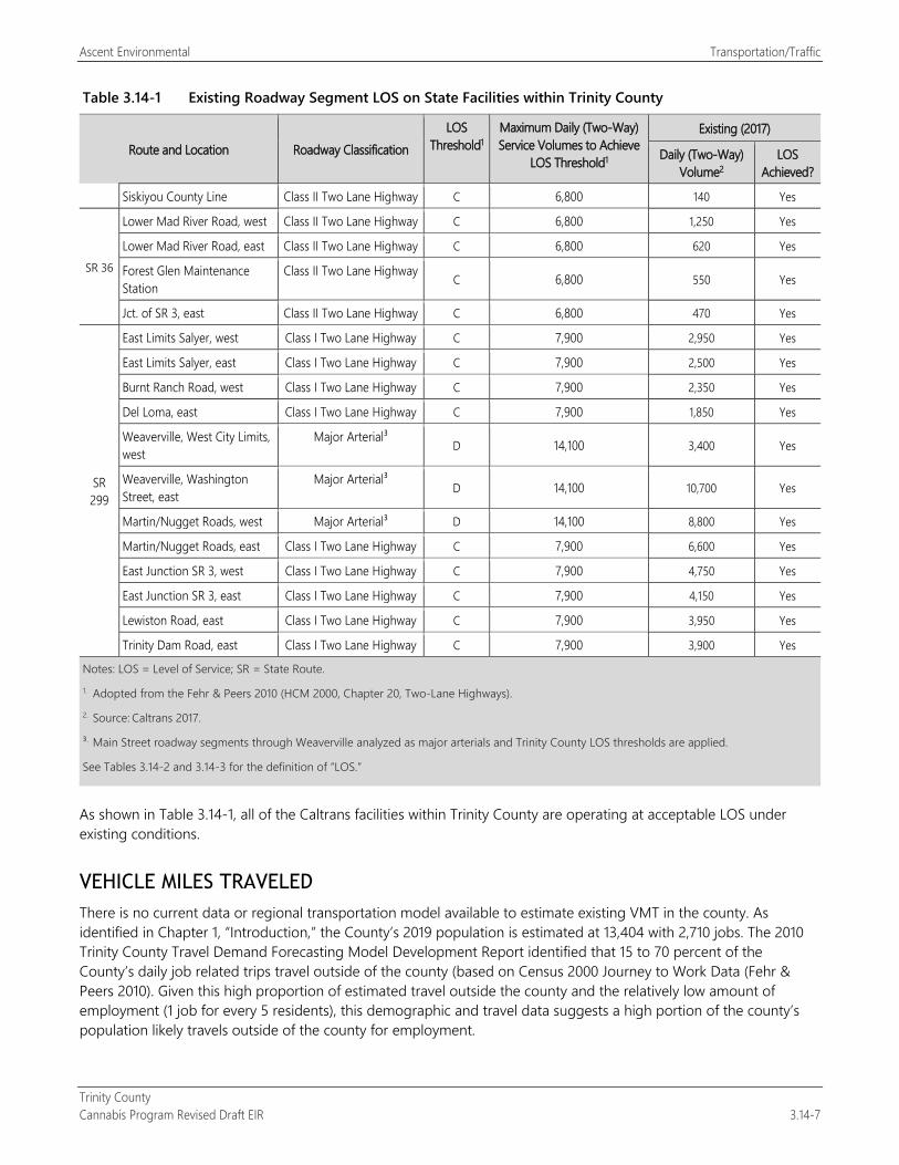
Ascent Environmental Transportation/Traffic
Trinity County Cannabis Program Revised Draft EIR 3.14-7
Table 3.14-1 Existing Roadway Segment LOS on State Facilities within Trinity County
Route and Location Roadway Classification LOS
Threshold1 Maximum Daily (Two-Way) Service Volumes to Achieve
LOS Threshold1
Existing (2017)
Daily (Two-Way) Volume2
LOS Achieved?
Siskiyou County Line Class II Two Lane Highway C 6,800 140 Yes
SR 36
Lower Mad River Road, west Class II Two Lane Highway C 6,800 1,250 Yes
Lower Mad River Road, east Class II Two Lane Highway C 6,800 620 Yes
Forest Glen Maintenance Station
Class II Two Lane Highway C 6,800 550 Yes
Jct. of SR 3, east Class II Two Lane Highway C 6,800 470 Yes
SR 299
East Limits Salyer, west Class I Two Lane Highway C 7,900 2,950 Yes
East Limits Salyer, east Class I Two Lane Highway C 7,900 2,500 Yes
Burnt Ranch Road, west Class I Two Lane Highway C 7,900 2,350 Yes
Del Loma, east Class I Two Lane Highway C 7,900 1,850 Yes
Weaverville, West City Limits, west
Major Arterial³ D 14,100 3,400 Yes
Weaverville, Washington Street, east
Major Arterial³ D 14,100 10,700 Yes
Martin/Nugget Roads, west Major Arterial³ D 14,100 8,800 Yes
Martin/Nugget Roads, east Class I Two Lane Highway C 7,900 6,600 Yes
East Junction SR 3, west Class I Two Lane Highway C 7,900 4,750 Yes
East Junction SR 3, east Class I Two Lane Highway C 7,900 4,150 Yes
Lewiston Road, east Class I Two Lane Highway C 7,900 3,950 Yes
Trinity Dam Road, east Class I Two Lane Highway C 7,900 3,900 Yes
Notes: LOS = Level of Service; SR = State Route. 1. Adopted from the Fehr & Peers 2010 (HCM 2000, Chapter 20, Two-Lane Highways). 2. Source: Caltrans 2017.
³. Main Street roadway segments through Weaverville analyzed as major arterials and Trinity County LOS thresholds are applied.
See Tables 3.14-2 and 3.14-3 for the definition of “LOS.”
As shown in Table 3.14-1, all of the Caltrans facilities within Trinity County are operating at acceptable LOS under existing conditions.
VEHICLE MILES TRAVELED There is no current data or regional transportation model available to estimate existing VMT in the county. As identified in Chapter 1, “Introduction,” the County’s 2019 population is estimated at 13,404 with 2,710 jobs. The 2010 Trinity County Travel Demand Forecasting Model Development Report identified that 15 to 70 percent of the County’s daily job related trips travel outside of the county (based on Census 2000 Journey to Work Data (Fehr & Peers 2010). Given this high proportion of estimated travel outside the county and the relatively low amount of employment (1 job for every 5 residents), this demographic and travel data suggests a high portion of the county’s population likely travels outside of the county for employment.
Transportation/Traffic Ascent Environmental
Trinity County 3.14-8 Cannabis Program Revised Draft EIR
PLANNED TRANSPORTATION IMPROVEMENTS The Caltrans 1998 Interregional Transportation Strategic Plan (ITSP) published by identifies SR 299 as a High Emphasis Route and is a Focus Route. Focus Routes are a subset of the High Emphasis Routes and are the highest priority for completion to minimum facility standards by approximately 2020. The Interregional Transportation Improvement Program, as established by SB 45, funds projects identified in the ITSP. The ITSP identifies a long-term improvement for passing lanes on SR 299 in Trinity County from post-mile 11.1 to 57.7 (Salyer to SR 3 east junction). Several curve realignments and turnout projects on SR 299 are also included.
EXISTING BIKE AND PEDESTRIAN FACILITIES With the completion of the two-lane miles of bikeways along Lance Gulch Road, Trinity County now has approximately 9.6 miles of existing bikeways. Bike lanes exist along SR 3 and SR 299 through Weaverville and on Washington Street and Lance Gulch Road. The county also has numerous recreational trails that are not designed or expected to meet Caltrans Class I standards. Additional existing and proposed bikeway and pedestrian trails are located in the communities of Hayfork, Junction City, Lewiston, Douglas City, and Weaverville. There are also numerous wilderness hiking trails in the county.
EXISTING TRANSIT SERVICE Trinity Transit is the public transit operator for Trinity County. Transit currently operates four fixed-route services (Lewiston to Weaverville, Hayfork to Weaverville, and two intercity routes between Weaverville and Redding and Weaverville and Willow Creek). All routes operate Monday through Friday and the first and third Saturday of the month. Additionally, intercity bus service operates between Willow Creek in Humboldt County and Redding in Shasta County
3.14.3 Environmental Impacts and Mitigation Measures This section describes the analysis techniques, assumptions, and results used to identify potential significant impacts of the proposed project on the transportation system. Transportation impacts are described and assessed, and mitigation measures are recommended for impacts identified as significant or potentially significant.
METHODS AND ASSUMPTIONS State CEQA Guidelines Section 15064.3 establishes that significance for transportation impacts is to be based on VMT instead of a congestion metric (such as LOS). Public Resources Code (PRC) Section 21099(b)(2) directs that automobile delay and congestion as determined through a LOS analysis “shall not” be considered a significant impact on the environment upon certification of the updated State CEQA Guidelines. The updated State CEQA Guidelines were certified by the Secretary of the Natural Resources Agency on December 28, 2018; and thus, in accordance with PRC Section 21099(b)(2), LOS (i.e., automobile delay) is no longer considered a valid impact analysis metric for the purposes of CEQA.
While not required under CEQA, an operational LOS analysis was conducted and disclosed in Impact 3.14-2.
Due to the countywide scope of the Cannabis Program and because the exact locations of all future commercial cannabis operations are not known at this time, the analysis does not evaluate specific intersections, but addresses traffic operations on state highway segments within Trinity County that are representative of the county’s overall transportation network. Traffic volumes on the selected roadway segments were used to determine the overall usage and congestion. The analysis considers both congestion and VMT.
LOS Analysis Thresholds LOS is a qualitative measure describing operational conditions within a traffic stream, based on service measures such as speed and travel time, freedom to maneuver, traffic interruptions, comfort, and convenience. Letters designate
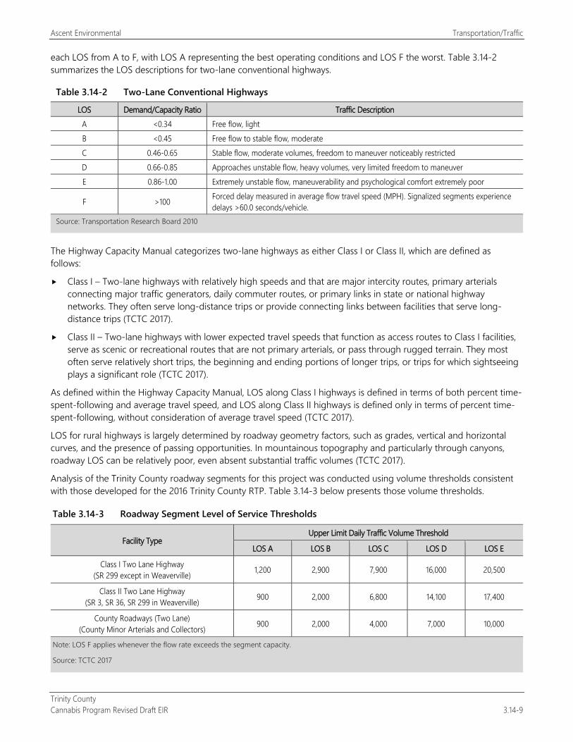
Ascent Environmental Transportation/Traffic
Trinity County Cannabis Program Revised Draft EIR 3.14-9
each LOS from A to F, with LOS A representing the best operating conditions and LOS F the worst. Table 3.14-2 summarizes the LOS descriptions for two-lane conventional highways.
Table 3.14-2 Two-Lane Conventional Highways
LOS Demand/Capacity Ratio Traffic Description A <0.34 Free flow, light B <0.45 Free flow to stable flow, moderate C 0.46-0.65 Stable flow, moderate volumes, freedom to maneuver noticeably restricted D 0.66-0.85 Approaches unstable flow, heavy volumes, very limited freedom to maneuver E 0.86-1.00 Extremely unstable flow, maneuverability and psychological comfort extremely poor
F >100 Forced delay measured in average flow travel speed (MPH). Signalized segments experience delays >60.0 seconds/vehicle.
Source: Transportation Research Board 2010
The Highway Capacity Manual categorizes two-lane highways as either Class I or Class II, which are defined as follows:
Class I – Two-lane highways with relatively high speeds and that are major intercity routes, primary arterials connecting major traffic generators, daily commuter routes, or primary links in state or national highway networks. They often serve long-distance trips or provide connecting links between facilities that serve long-distance trips (TCTC 2017).
Class II – Two-lane highways with lower expected travel speeds that function as access routes to Class I facilities, serve as scenic or recreational routes that are not primary arterials, or pass through rugged terrain. They most often serve relatively short trips, the beginning and ending portions of longer trips, or trips for which sightseeing plays a significant role (TCTC 2017).
As defined within the Highway Capacity Manual, LOS along Class I highways is defined in terms of both percent time-spent-following and average travel speed, and LOS along Class II highways is defined only in terms of percent time-spent-following, without consideration of average travel speed (TCTC 2017).
LOS for rural highways is largely determined by roadway geometry factors, such as grades, vertical and horizontal curves, and the presence of passing opportunities. In mountainous topography and particularly through canyons, roadway LOS can be relatively poor, even absent substantial traffic volumes (TCTC 2017).
Analysis of the Trinity County roadway segments for this project was conducted using volume thresholds consistent with those developed for the 2016 Trinity County RTP. Table 3.14-3 below presents those volume thresholds.
Table 3.14-3 Roadway Segment Level of Service Thresholds
Facility Type Upper Limit Daily Traffic Volume Threshold
LOS A LOS B LOS C LOS D LOS E
Class I Two Lane Highway (SR 299 except in Weaverville) 1,200 2,900 7,900 16,000 20,500
Class II Two Lane Highway (SR 3, SR 36, SR 299 in Weaverville) 900 2,000 6,800 14,100 17,400
County Roadways (Two Lane) (County Minor Arterials and Collectors) 900 2,000 4,000 7,000 10,000
Note: LOS F applies whenever the flow rate exceeds the segment capacity.
Source: TCTC 2017
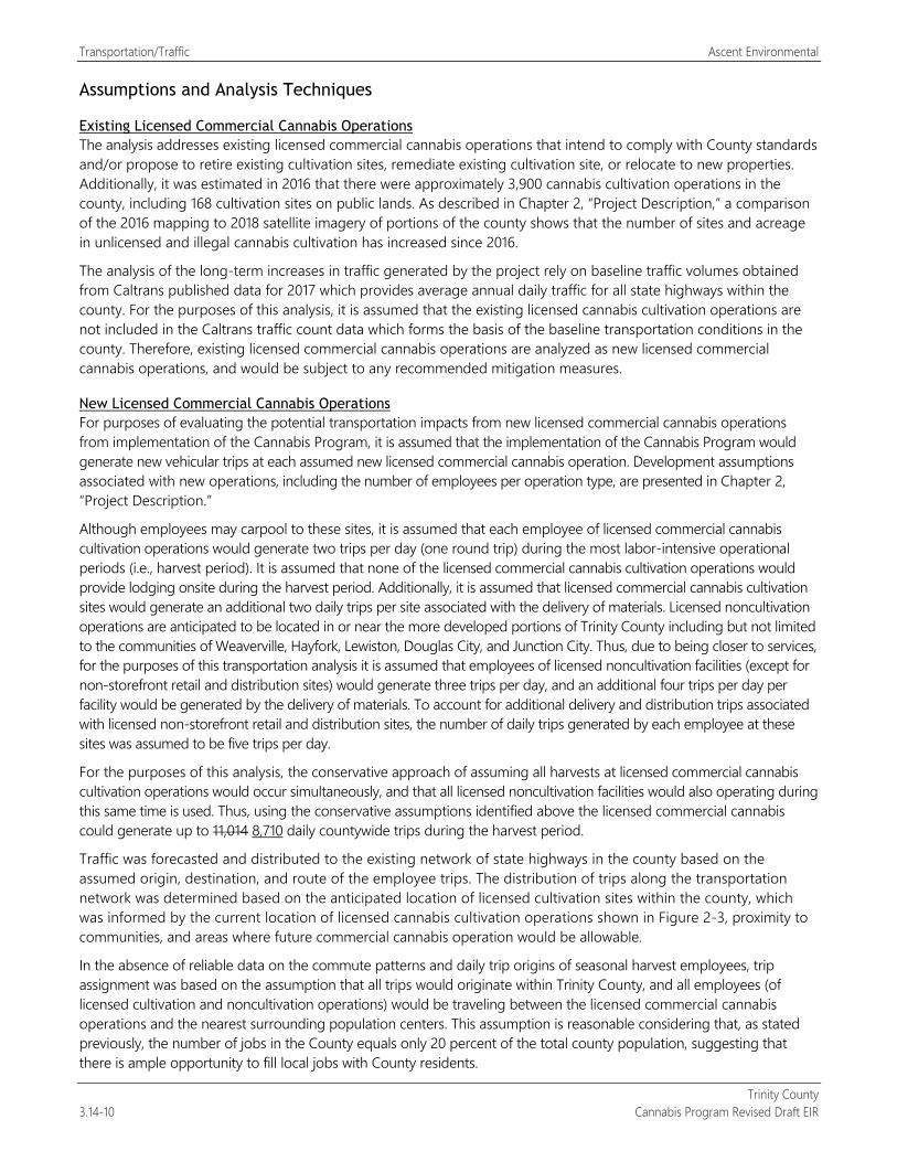
Transportation/Traffic Ascent Environmental
Trinity County 3.14-10 Cannabis Program Revised Draft EIR
Assumptions and Analysis Techniques
Existing Licensed Commercial Cannabis Operations The analysis addresses existing licensed commercial cannabis operations that intend to comply with County standards and/or propose to retire existing cultivation sites, remediate existing cultivation site, or relocate to new properties. Additionally, it was estimated in 2016 that there were approximately 3,900 cannabis cultivation operations in the county, including 168 cultivation sites on public lands. As described in Chapter 2, “Project Description,” a comparison of the 2016 mapping to 2018 satellite imagery of portions of the county shows that the number of sites and acreage in unlicensed and illegal cannabis cultivation has increased since 2016.
The analysis of the long-term increases in traffic generated by the project rely on baseline traffic volumes obtained from Caltrans published data for 2017 which provides average annual daily traffic for all state highways within the county. For the purposes of this analysis, it is assumed that the existing licensed cannabis cultivation operations are not included in the Caltrans traffic count data which forms the basis of the baseline transportation conditions in the county. Therefore, existing licensed commercial cannabis operations are analyzed as new licensed commercial cannabis operations, and would be subject to any recommended mitigation measures.
New Licensed Commercial Cannabis Operations For purposes of evaluating the potential transportation impacts from new licensed commercial cannabis operations from implementation of the Cannabis Program, it is assumed that the implementation of the Cannabis Program would generate new vehicular trips at each assumed new licensed commercial cannabis operation. Development assumptions associated with new operations, including the number of employees per operation type, are presented in Chapter 2, “Project Description.”
Although employees may carpool to these sites, it is assumed that each employee of licensed commercial cannabis cultivation operations would generate two trips per day (one round trip) during the most labor-intensive operational periods (i.e., harvest period). It is assumed that none of the licensed commercial cannabis cultivation operations would provide lodging onsite during the harvest period. Additionally, it is assumed that licensed commercial cannabis cultivation sites would generate an additional two daily trips per site associated with the delivery of materials. Licensed noncultivation operations are anticipated to be located in or near the more developed portions of Trinity County including but not limited to the communities of Weaverville, Hayfork, Lewiston, Douglas City, and Junction City. Thus, due to being closer to services, for the purposes of this transportation analysis it is assumed that employees of licensed noncultivation facilities (except for non-storefront retail and distribution sites) would generate three trips per day, and an additional four trips per day per facility would be generated by the delivery of materials. To account for additional delivery and distribution trips associated with licensed non-storefront retail and distribution sites, the number of daily trips generated by each employee at these sites was assumed to be five trips per day.
For the purposes of this analysis, the conservative approach of assuming all harvests at licensed commercial cannabis cultivation operations would occur simultaneously, and that all licensed noncultivation facilities would also operating during this same time is used. Thus, using the conservative assumptions identified above the licensed commercial cannabis could generate up to 11,014 8,710 daily countywide trips during the harvest period.
Traffic was forecasted and distributed to the existing network of state highways in the county based on the assumed origin, destination, and route of the employee trips. The distribution of trips along the transportation network was determined based on the anticipated location of licensed cultivation sites within the county, which was informed by the current location of licensed cannabis cultivation operations shown in Figure 2-3, proximity to communities, and areas where future commercial cannabis operation would be allowable.
In the absence of reliable data on the commute patterns and daily trip origins of seasonal harvest employees, trip assignment was based on the assumption that all trips would originate within Trinity County, and all employees (of licensed cultivation and noncultivation operations) would be traveling between the licensed commercial cannabis operations and the nearest surrounding population centers. This assumption is reasonable considering that, as stated previously, the number of jobs in the County equals only 20 percent of the total county population, suggesting that there is ample opportunity to fill local jobs with County residents.
Ascent Environmental Transportation/Traffic
Trinity County Cannabis Program Revised Draft EIR 3.14-11
The analysis focuses on the three state highways (SRs 3, 36, and 299) serving Trinity County during the peak of the cannabis harvest season and uses daily, two-way roadway segment volumes to determine LOS in the Existing and Existing Plus Project scenarios for the state highways within Trinity County. These highways serve as the backbone of the county roadway network, carrying the majority of county through traffic, and trips connecting communities and destination centers. The volume thresholds recommended in the 2016 Trinity County RTP and detailed above, are used as the basis of the roadway capacity LOS analysis.
Vehicle Miles Traveled
Methodology for Determining VMT Threshold of Significance
State CEQA Guidelines Section 15064.3 Section 15064.3 was added to the State CEQA Guidelines effective December 28, 2018, as part of a comprehensive guidelines update. The section addresses the determination of significance for transportation impacts, which requires that the analysis be based on VMT instead of a congestion metric (such as LOS). The change in the focus of transportation analysis is the result of legislation (SB 743, Statutes of 2013) and is intended to change the focus from congestion to, reduction in greenhouse gas (GHG) emissions, encouraging mixed-use development, and promotion of multimodal transportation networks. Pursuant to State CEQA Guidelines Section 15064.3(c), this change in analysis may be implemented now and is mandated to be addressed beginning July 1, 2020. Because the Cannabis Program would apply to commercial cannabis projects after the date on which VMT is required to be considered, it is included in the analysis in this EIR.
State CEQA Guidelines Section 15064.3(b) identifies four criteria for analyzing the transportation impacts of a project. To determine how the Cannabis Program should be considered, each of the criteria is discussed below.
Section 15064.3(b)(1) addresses land use projects. The proposed project is the readoption and amendment of a set of land use regulations for all cannabis activities and operations within Trinity County being implemented by the County as part of the Cannabis Program. The projects regulated under the Cannabis Program would generally be considered “land use projects.” Section 15064.3(b)(1) states that projects with specified proximity to “major” or “high quality” transit should be presumed to cause a less-than-significant transportation impact. Trinity County does not have transit service that meets these criteria; therefore, this presumption would not apply to projects regulated under the Cannabis Program. This section also states that projects that would decrease VMT in the project area as compared to existing conditions should also be presumed to have a less-than-significant effect.
Section 15064.3(b)(2) addresses transportation projects. The proposed project is a set of proposed land use regulations for all cannabis activities and operations within Trinity County being implemented by the County as part of the Cannabis Program. As such, it does not fall within this category of “transportation projects”; thus, this section does not apply.
State CEQA Guidelines Section 15064.3(b)(3), Qualitative Analysis, explains that there may be conditions under which a qualitative rather than quantitative analysis of VMT is appropriate. This section states that if existing models or methods are not available to estimate the VMT for the particular project being considered, a lead agency may analyze the project’s VMT qualitatively. As part of the Trinity County 2010 RTP, Fehr & Peers developed a countywide Travel Demand Model (TDM) that was calibrated to 2009 conditions using the existing roadway system and 2004 land use data. This model is somewhat dated and does not reflect the introduction of the legal cannabis industry and any data on the demographics of industry employees. Additionally, the Trinity County TDM does not include an agricultural land use category (i.e., the land use that would most closely approximate the trip generation and VMT of cultivation operations and nursery facilities). Therefore, because the Trinity County TDM has not been updated since 2010, is based on land use data from 2004, and does not include a land use category that would closely approximate cannabis cultivations and nursery operations, application of the TDM for the purposes of this project was determined to be lacking in supporting substantial evidence and therefore inappropriate to use.
Section 15064.3(b)(4), Methodology, explains that the County has discretion to choose the most appropriate methodology to evaluate VMT subject to other applicable standards such as State CEQA Guidelines Section 15151
Transportation/Traffic Ascent Environmental
Trinity County 3.14-12 Cannabis Program Revised Draft EIR
(standards of adequacy for EIR analyses). In support of CEQA Guidelines Section 15064.3, OPR has issued a Technical Advisory on Evaluating Transportation Impacts in CEQA (OPR 2018). The Technical Advisory outlines recommended procedures and methods for evaluating transportation impacts for residential, office, and retail projects. However, it does not offer guidance for a programmatic project like the subject Cannabis Program, which involves implementing a set of land use regulations for cannabis activities and operations within Trinity County.
The OPR Technical Advisory notes by way of background (page 2) that there are three primary ways of reducing GHG emissions for the transportation sector: increasing vehicle efficiency, reducing fuel carbon content, and reducing the amount of vehicle travel. Local jurisdictions are not able to influence or control the first two, but through careful land use planning, local governments can ensure reductions in vehicle travel. The Technical Advisory highlights the relationship between reduction of VMT and reduction of GHG emissions, which is a key component of SB 743.
Additionally, the Technical Advisory states that absent substantial evidence indicating that a project would generate a potentially significant level of VMT, or inconsistency with a sustainable community strategy (SCS) or general plan, projects that generate or attract fewer than 110 trips per day generally may be assumed to cause a less-than-significant transportation impact (OPR 2018). A SCS has not been prepared for the region in which Trinity County is located, so consistency with a SCS is not a factor in this analysis. This EIR is a programmatic EIR that looks at the combined effect of all future cannabis operations under the Cannabis Program; thus, this EIR does not rely on this screening threshold for small projects. However, it is noted that any individual projects under the Cannabis Program that would not exceed 110 trip per day would be assumed, using OPR guidance, to result in a less-than-significant VMT impact.
Most importantly for consideration herein, the Technical Advisory, which focuses on residential, office, and retail uses, suggests that projects that reduce VMT would be less than significant. For projects that increase VMT, the general guidance is based on whether per capita VMT would be 15 percent below existing per capita VMT, in which case it would generally be considered less than significant. Thus, VMT can increase, so long as per capita VMT associated with the increase is 15 percent or more “efficient” than the existing per capita VMT.
Taking into consideration the four criteria detailed in Section 15064.3(b) for analyzing the transportation impacts and their applicability to the Cannabis Program and the recommendations of the Technical Advisory, and a lack of quantitative tools in Trinity County, a qualitative analysis allowed by Section 15064.3(b)(3) provides the most applicable approach for analyzing the change in VMT resulting from implementation of the Cannabis Program.
Given the absence of a quantitative method or applicable Technical Advisory scenario, this EIR relies on fundamental CEQA principles for defining a qualitative threshold of significance for VMT. A significant effect on the environment is defined in CEQA as a “substantial or potentially substantial adverse change in the environment” (PRC Section 21068). In the case of VMT, an adverse change would be if the VMT of the project increased and was likely to exceed the 15 percent below per capita VMT threshold recommended in the Technical Advisory.
THRESHOLDS OF SIGNIFICANCE The significance criteria used to evaluate the project impacts to transportation and traffic under CEQA are based on Appendix G of the CEQA Guidelines.
Impacts on the roadway system would be significant if implementation of the Trinity County Cannabis Program would:
conflict with a program, plan, ordinance, or policy addressing roadway facilities;
conflict with a program, plan, ordinance or policy addressing transit, bicycle, and pedestrian facilities;
substantially increase hazards because of a geometric design feature (e.g., sharp curves or dangerous intersections) or incompatible uses (e.g., farm equipment);
result in inadequate emergency access; or
result in a net increase in VMT due to new uses or employment that is less efficient VMT efficient (per capita) for the County.
Ascent Environmental Transportation/Traffic
Trinity County Cannabis Program Revised Draft EIR 3.14-13
ISSUES NOT DISCUSSED FURTHER Airports within Trinity County include the Hayfork Airport, Hyampom Airport, Ruth Airport, Trinity Center Airport, and Weaverville – Lonnie Pool Airport, a number of which are within 2 miles of potential existing and new potential commercial cannabis sites. However, the project would not result in a change in air traffic patterns or contribute to an increase in demand for air travel. As a result, this issue is not evaluated further. The reader is referred to Section 3.9, “Hazards and Hazardous Materials,” for a further discussion of airport operations and hazards.
The project would not include actions that would limit or adversely affect rail traffic, infrastructure, or activities in Trinity County. Thus, rail transportation facilities are not evaluated further. Similarly, transit, bike, and pedestrian facilities and activities would not be affected by the project. Due to the rural character of much of the transportation network and the anticipated dispersion of the individual cultivation sites throughout the county, the project would not generate demand for transit, bike, or pedestrian facilities. Therefore, the project would not create any conflicts with adopted policies, plans, or programs regarding public transit, bicycle or pedestrian facilities, or otherwise decrease the performance or safety of such facilities. Thus, transit, bike, and pedestrian facilities are not evaluated further.
ENVIRONMENTAL IMPACTS AND MITIGATION MEASURES
Impact 3.14-1: Construction Related Increase in Traffic
New licensed commercial cannabis operations in the county that may occur under the Cannabis Program would involve construction activities. These construction activities would result in an increase in vehicular trips associated with construction workers traveling to and from construction sites. However, the increase in trips associated with construction at new licensed commercial cannabis operations would be minimal and would not create operational safety issues. , dispersed throughout the larger roadway network serving the county, and staggered over an extended period of time. Thus, this impact would be less than significant.
Construction activities can result in temporary operational traffic impacts due to construction worker, material delivery and equipment.
Existing Licensed Commercial Cannabis Operations Existing licensed commercial cannabis operations are assumed to have already been constructed; and thus, would have not contributed any new construction related vehicle trips to the county roadway network. It is acknowledged that continued operation of these cultivation sites could result in some minor construction activities through the proposed amendment that would allow expansion of the Designated Area for cultivation activities from 200 percent of the licensed cannabis canopy area to 250 percent (20 percent increase). These construction activities would consist of minor additions to the existing facilities and not involve large-scale construction equipment use or traffic. Traffic would be distributed throughout county roadway network, which has low traffic volumes on the local roadways, and would not substantially affect the effectiveness/performance of the existing circulation system that could create a new safety issue. Thus, potential construction activities at existing cultivation sires would result in a less-than-significant impact.
New Licensed Commercial Cannabis Operations Implementation of the Cannabis Program may result in development of new licensed commercial cannabis operations. Generally, the intensity of construction activity for new licensed commercial cannabis cultivation operation would be on scale with a residential renovation or building addition project requiring approximately two to four construction workers and would not last more than 4 weeks at each cultivation site. No substantive truck haul trips would be generated by the construction. Following adoption of the Cannabis Program, permitted construction activities would commence. It is unknown when construction activities associated with the new permitted commercial cannabis operations would occur, and how the construction at individual sites would overlap. However, it is assumed that the construction of new cultivation sites would occur over several years as individual permits are issued.
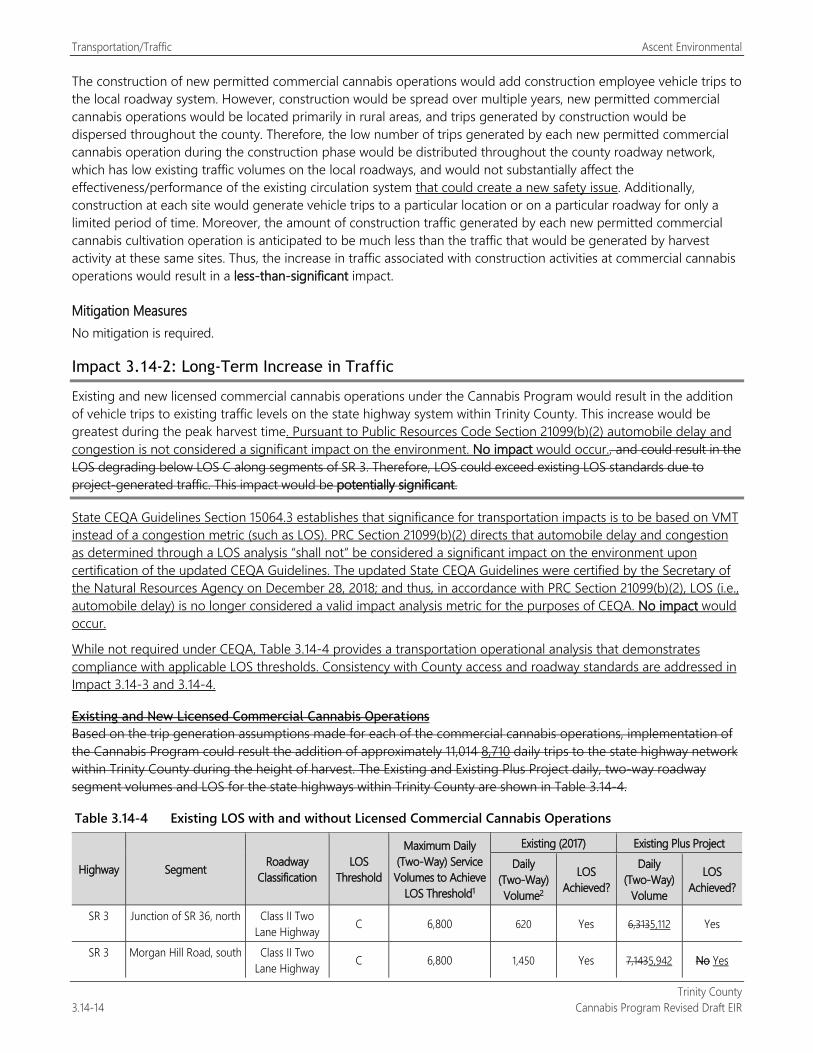
Transportation/Traffic Ascent Environmental
Trinity County 3.14-14 Cannabis Program Revised Draft EIR
The construction of new permitted commercial cannabis operations would add construction employee vehicle trips to the local roadway system. However, construction would be spread over multiple years, new permitted commercial cannabis operations would be located primarily in rural areas, and trips generated by construction would be dispersed throughout the county. Therefore, the low number of trips generated by each new permitted commercial cannabis operation during the construction phase would be distributed throughout the county roadway network, which has low existing traffic volumes on the local roadways, and would not substantially affect the effectiveness/performance of the existing circulation system that could create a new safety issue. Additionally, construction at each site would generate vehicle trips to a particular location or on a particular roadway for only a limited period of time. Moreover, the amount of construction traffic generated by each new permitted commercial cannabis cultivation operation is anticipated to be much less than the traffic that would be generated by harvest activity at these same sites. Thus, the increase in traffic associated with construction activities at commercial cannabis operations would result in a less-than-significant impact.
Mitigation Measures No mitigation is required.
Impact 3.14-2: Long-Term Increase in Traffic
Existing and new licensed commercial cannabis operations under the Cannabis Program would result in the addition of vehicle trips to existing traffic levels on the state highway system within Trinity County. This increase would be greatest during the peak harvest time. Pursuant to Public Resources Code Section 21099(b)(2) automobile delay and congestion is not considered a significant impact on the environment. No impact would occur., and could result in the LOS degrading below LOS C along segments of SR 3. Therefore, LOS could exceed existing LOS standards due to project-generated traffic. This impact would be potentially significant.
State CEQA Guidelines Section 15064.3 establishes that significance for transportation impacts is to be based on VMT instead of a congestion metric (such as LOS). PRC Section 21099(b)(2) directs that automobile delay and congestion as determined through a LOS analysis “shall not” be considered a significant impact on the environment upon certification of the updated CEQA Guidelines. The updated State CEQA Guidelines were certified by the Secretary of the Natural Resources Agency on December 28, 2018; and thus, in accordance with PRC Section 21099(b)(2), LOS (i.e., automobile delay) is no longer considered a valid impact analysis metric for the purposes of CEQA. No impact would occur.
While not required under CEQA, Table 3.14-4 provides a transportation operational analysis that demonstrates compliance with applicable LOS thresholds. Consistency with County access and roadway standards are addressed in Impact 3.14-3 and 3.14-4.
Existing and New Licensed Commercial Cannabis Operations Based on the trip generation assumptions made for each of the commercial cannabis operations, implementation of the Cannabis Program could result the addition of approximately 11,014 8,710 daily trips to the state highway network within Trinity County during the height of harvest. The Existing and Existing Plus Project daily, two-way roadway segment volumes and LOS for the state highways within Trinity County are shown in Table 3.14-4.
Table 3.14-4 Existing LOS with and without Licensed Commercial Cannabis Operations
Highway Segment Roadway Classification
LOS Threshold
Maximum Daily (Two-Way) Service Volumes to Achieve
LOS Threshold1
Existing (2017) Existing Plus Project Daily
(Two-Way) Volume2
LOS Achieved?
Daily (Two-Way)
Volume
LOS Achieved?
SR 3 Junction of SR 36, north Class II Two Lane Highway C 6,800 620 Yes 6,3135,112 Yes
SR 3 Morgan Hill Road, south Class II Two Lane Highway C 6,800 1,450 Yes 7,1435,942 No Yes
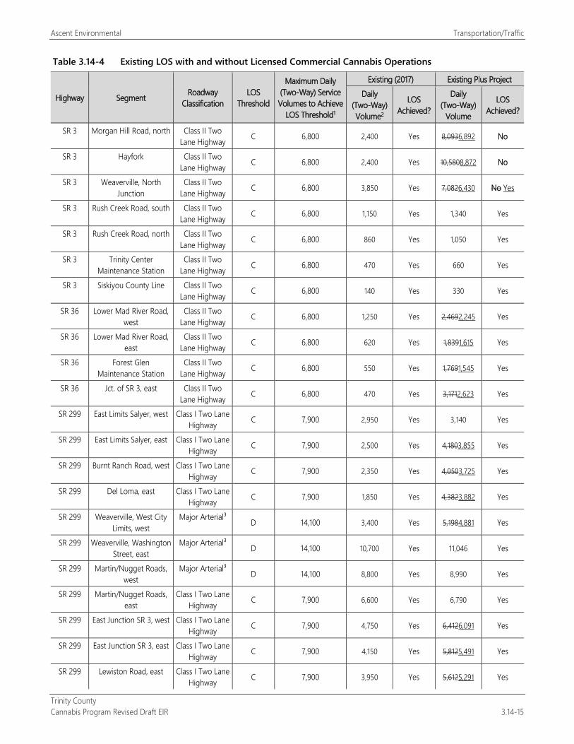
Ascent Environmental Transportation/Traffic
Trinity County Cannabis Program Revised Draft EIR 3.14-15
Table 3.14-4 Existing LOS with and without Licensed Commercial Cannabis Operations
Highway Segment Roadway Classification
LOS Threshold
Maximum Daily (Two-Way) Service Volumes to Achieve
LOS Threshold1
Existing (2017) Existing Plus Project Daily
(Two-Way) Volume2
LOS Achieved?
Daily (Two-Way)
Volume
LOS Achieved?
SR 3 Morgan Hill Road, north Class II Two Lane Highway C 6,800 2,400 Yes 8,0936,892 No
SR 3 Hayfork Class II Two Lane Highway C 6,800 2,400 Yes 10,5808,872 No
SR 3 Weaverville, North Junction
Class II Two Lane Highway C 6,800 3,850 Yes 7,0826,430 No Yes
SR 3 Rush Creek Road, south Class II Two Lane Highway C 6,800 1,150 Yes 1,340 Yes
SR 3 Rush Creek Road, north Class II Two Lane Highway C 6,800 860 Yes 1,050 Yes
SR 3 Trinity Center Maintenance Station
Class II Two Lane Highway C 6,800 470 Yes 660 Yes
SR 3 Siskiyou County Line Class II Two Lane Highway C 6,800 140 Yes 330 Yes
SR 36 Lower Mad River Road, west
Class II Two Lane Highway C 6,800 1,250 Yes 2,4692,245 Yes
SR 36 Lower Mad River Road, east
Class II Two Lane Highway C 6,800 620 Yes 1,8391,615 Yes
SR 36 Forest Glen Maintenance Station
Class II Two Lane Highway C 6,800 550 Yes 1,7691,545 Yes
SR 36 Jct. of SR 3, east Class II Two Lane Highway C 6,800 470 Yes 3,1712,623 Yes
SR 299 East Limits Salyer, west Class I Two Lane Highway C 7,900 2,950 Yes 3,140 Yes
SR 299 East Limits Salyer, east Class I Two Lane Highway C 7,900 2,500 Yes 4,1803,855 Yes
SR 299 Burnt Ranch Road, west Class I Two Lane Highway C 7,900 2,350 Yes 4,0503,725 Yes
SR 299 Del Loma, east Class I Two Lane Highway C 7,900 1,850 Yes 4,3823,882 Yes
SR 299 Weaverville, West City Limits, west
Major Arterial³ D 14,100 3,400 Yes 5,1984,881 Yes
SR 299 Weaverville, Washington Street, east
Major Arterial³ D 14,100 10,700 Yes 11,046 Yes
SR 299 Martin/Nugget Roads, west
Major Arterial³ D 14,100 8,800 Yes 8,990 Yes
SR 299 Martin/Nugget Roads, east
Class I Two Lane Highway C 7,900 6,600 Yes 6,790 Yes
SR 299 East Junction SR 3, west Class I Two Lane Highway C 7,900 4,750 Yes 6,4126,091 Yes
SR 299 East Junction SR 3, east Class I Two Lane Highway C 7,900 4,150 Yes 5,8125,491 Yes
SR 299 Lewiston Road, east Class I Two Lane Highway C 7,900 3,950 Yes 5,6125,291 Yes
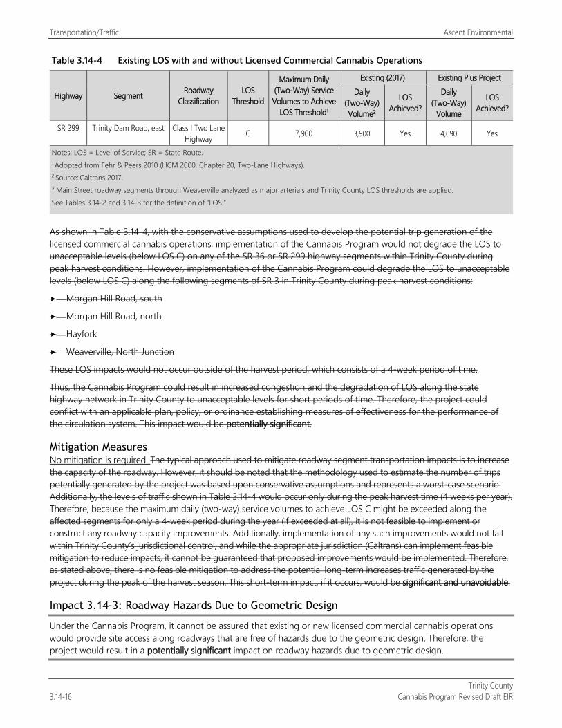
Transportation/Traffic Ascent Environmental
Trinity County 3.14-16 Cannabis Program Revised Draft EIR
Table 3.14-4 Existing LOS with and without Licensed Commercial Cannabis Operations
Highway Segment Roadway Classification
LOS Threshold
Maximum Daily (Two-Way) Service Volumes to Achieve
LOS Threshold1
Existing (2017) Existing Plus Project Daily
(Two-Way) Volume2
LOS Achieved?
Daily (Two-Way)
Volume
LOS Achieved?
SR 299 Trinity Dam Road, east Class I Two Lane Highway C 7,900 3,900 Yes 4,090 Yes
Notes: LOS = Level of Service; SR = State Route. 1 Adopted from Fehr & Peers 2010 (HCM 2000, Chapter 20, Two-Lane Highways). 2 Source: Caltrans 2017. ³ Main Street roadway segments through Weaverville analyzed as major arterials and Trinity County LOS thresholds are applied. See Tables 3.14-2 and 3.14-3 for the definition of “LOS.”
As shown in Table 3.14-4, with the conservative assumptions used to develop the potential trip generation of the licensed commercial cannabis operations, implementation of the Cannabis Program would not degrade the LOS to unacceptable levels (below LOS C) on any of the SR 36 or SR 299 highway segments within Trinity County during peak harvest conditions. However, implementation of the Cannabis Program could degrade the LOS to unacceptable levels (below LOS C) along the following segments of SR 3 in Trinity County during peak harvest conditions:
Morgan Hill Road, south
Morgan Hill Road, north
Hayfork
Weaverville, North Junction
These LOS impacts would not occur outside of the harvest period, which consists of a 4-week period of time.
Thus, the Cannabis Program could result in increased congestion and the degradation of LOS along the state highway network in Trinity County to unacceptable levels for short periods of time. Therefore, the project could conflict with an applicable plan, policy, or ordinance establishing measures of effectiveness for the performance of the circulation system. This impact would be potentially significant.
Mitigation Measures No mitigation is required. The typical approach used to mitigate roadway segment transportation impacts is to increase the capacity of the roadway. However, it should be noted that the methodology used to estimate the number of trips potentially generated by the project was based upon conservative assumptions and represents a worst-case scenario. Additionally, the levels of traffic shown in Table 3.14-4 would occur only during the peak harvest time (4 weeks per year). Therefore, because the maximum daily (two-way) service volumes to achieve LOS C might be exceeded along the affected segments for only a 4-week period during the year (if exceeded at all), it is not feasible to implement or construct any roadway capacity improvements. Additionally, implementation of any such improvements would not fall within Trinity County’s jurisdictional control, and while the appropriate jurisdiction (Caltrans) can implement feasible mitigation to reduce impacts, it cannot be guaranteed that proposed improvements would be implemented. Therefore, as stated above, there is no feasible mitigation to address the potential long-term increases traffic generated by the project during the peak of the harvest season. This short-term impact, if it occurs, would be significant and unavoidable.
Impact 3.14-3: Roadway Hazards Due to Geometric Design
Under the Cannabis Program, it cannot be assured that existing or new licensed commercial cannabis operations would provide site access along roadways that are free of hazards due to the geometric design. Therefore, the project would result in a potentially significant impact on roadway hazards due to geometric design.
Ascent Environmental Transportation/Traffic
Trinity County Cannabis Program Revised Draft EIR 3.14-17
Agencies with the responsibility for roadway design and operation within the county, including Caltrans and Trinity County, have adopted and enforce roadway design standards. Chapter 12.10: Design Policies of the Trinity County Code of Ordinances formally adopts the American Association of State Highway and Transportation Officials roadway standards as detailed in A Policy on Geometric Design of Highways and Streets (1990) and all future amendments and subsequent editions of this document. The use and enforcement of these design standards prevents the development of transportation infrastructure that would substantially increase hazards because of a design feature. These standards address a variety of roadway elements, including safety and hazards.
Existing Licensed Commercial Cannabis Operations Field review of existing cannabis cultivation sites in the county identified roadway facilities that were not properly designed to accommodate the existing extent of vehicle use and the handling of stormwater drainage resulting in roadway damage and safety hazards. It cannot be assured that all of the existing licensed commercial cannabis cultivation operations currently provide roadway access in compliance with county roadway design standards and continued use of these roadways could increase traffic safety hazards. Therefore, existing licensed commercial cannabis cultivation operations have resulted in a potentially significant impact related to hazards because of geometric roadway design.
New Licensed Commercial Cannabis Operations New licensed commercial cannabis operations could result in the development of roadway facilities that are not properly designed to accommodate traffic volumes and stormwater drainage conditions. In addition, new commercial cannabis operations could be placed in areas of the county where the existing roadway system is not properly designed or maintained. Therefore, the project would result in a potentially significant impact related to hazards because of geometric roadway design.
Mitigation Measures
Mitigation Measure 3.14-3: Provide Site Access Free of Hazards Due to Geometric Roadway Design The following shall be included as new performance standards for Section 315-843(6) (Performance Standards for Commercial Cultivation of Cannabis), Section 315-824(5) (Required Conditions), Section 315-826(3) (Regulation of Nurseries), Section 315-828(5) (Required Conditions), Section 315-835(2) (Regulations), Section 315-837(3) (Required Conditions), and Section 315-842(6) (Required Conditions):
Applications for new commercial cannabis activities and license renewals for existing cannabis operations shall provide documentation showing that roadways providing site access are is in compliance with Chapter 12.10: Design Policies of the Trinity County Code of Ordinances. New roadway water quality control and drainage features or new drainage features on existing roadways shall be designed to accommodate peak flow conditions and will be consistent with the Road Handbook, per CCR Title 14, Chapter 4 Five Counties Salmonid Conservation Roads Maintenance Manual and SWRCB Order WQ 2019-0001-DWQ 2017-0023-DWQ.
Significance after Mitigation With implementation of Mitigation Measure 3.14-3, existing and new commercial cannabis operations in the county would be required to be in compliance with Chapter 12.10: Design Policies of the Trinity County Code; and thus, access to existing and new commercial cannabis operations would not be located along roadways that are hazardous due to the geometric design of the roadway. This impact would be reduced to a less-than-significant level.
Impact 3.14-4: Conflict with Adequate Emergency Access
Under the Cannabis Program, it cannot be assured that existing and new commercial cannabis operations would provide adequate emergency access. Therefore, the project would result in a potentially significant impact on emergency access.
Trinity County has adopted and enforces roadway design standards as detailed in Chapter 12.10: Design Policies of the Trinity County Code of Ordinances. These standards address a variety of roadway elements, including safety and
Transportation/Traffic Ascent Environmental
Trinity County 3.14-18 Cannabis Program Revised Draft EIR
hazards. Emergency access to commercial cannabis operations would be provided primarily via existing public and private roadways, and access driveways. The County’s emergency access standards are detailed in Chapter 8.30 – Fire Safe Ordinance of the County Code of Ordinances. As detailed in Chapter 8.30, road and street networks, whether public or private, provide for safe access for emergency wildland fire equipment and civilian evacuation concurrently, and shall provide unobstructed traffic circulation during a wildfire emergency consistent with Section 8.30.130 through Section 8.30.240. These regulations do not apply to existing structures, roads, streets and private lanes or facilities; however, the following activities would require compliance with the Fire Safe Ordinance:
Permitting or approval of new parcels;
Application for a building permit for new construction, not relating to existing structure;
Application for a use permit;
Road construction, including construction of a road that does not currently exist, or extension of an existing road.
Existing Licensed Commercial Cannabis Operations As described in Impact 3.14-3, field review of existing cannabis cultivation sites in the county identified roadway facilities that were not properly designed to accommodate the existing extent of vehicle use and the handling of stormwater drainage resulting in roadway damage and safety hazards. These conditions could also impact emergency access and conflict with the requirements of Chapter 8.30 of County Code of Ordinances. Thus, this impact would be potentially significant.
New Licensed Commercial Cannabis Operations New licensed commercial cannabis operations could result in the development of roadway facilities that are not properly designed to accommodate traffic volumes and impact emergency access in conflict with Chapter 8.30 of the County Code of Ordinances. In addition, new commercial cannabis operations could be placed in areas of the county where the existing roadway system is not properly designed or maintained. Therefore, the project would result in a potentially significant impact.
Mitigation Measures
Mitigation Measure 3.14-4: Provide Adequate Emergency Access The following shall be included as new performance standards for Section 315-843(6) (Performance Standards for Commercial Cultivation of Cannabis), Section 315-824(5) (Required Conditions), Section 315-826(3) (Regulation of Nurseries), Section 315-828(5) (Required Conditions), Section 315-835(2) (Regulations), Section 315-837(3) (Required Conditions), and Section 315-842(6) (Required Conditions):
Applications for new commercial cannabis activities and license renewals for existing cannabis operations shall provide documentation showing that site access is in compliance with Chapter 8.30 – Fire Safe Ordinance of the Trinity County Code.
Significance after Mitigation With implementation of Mitigation Measure 3.14-4, existing and new commercial cannabis operations in the county that may occur under the proposed ordinance would be required to be in compliance with Chapter 8.30 – Fire Safe Ordinance of the Trinity County Code of Ordinances; and thus, would provide adequate emergency access. This impact would be reduced to a less-than-significant level.
Ascent Environmental Transportation/Traffic
Trinity County Cannabis Program Revised Draft EIR 3.14-19
Impact 3.14-5: Result in a Net Increase in and inefficient VMT travel for the Proposed Cannabis Program
New commercial cannabis operations resulting from implementation of the Cannabis Program would alter VMT conditions in the county. Based on the trip generation assumptions made for each of the commercial cannabis operations, implementation of the Cannabis Program could result in approximately 11,014 8,710 daily trips within Trinity County during the height of harvest. It is likely that implementation of the Cannabis Program would reduce the distance between existing and future cultivation operations through the creation of new noncultivation facilities within county that currently are located outside the county. The Cannabis Program would also increase employment opportunities in a county that has relatively few such opportunities and, based on the 2010 Trinity County Travel Demand Forecasting Model Development Report, showed a large percent of residents commuting out of the county on a daily basis. While no quantitative models or other current data are available to determine the relative VMT effects of the Cannabis Program, this data suggest that VMT may be reduced and, if not, would likely be substantially more efficient than the current condition of commuting out of the county for employment and industry needs currently not provided in the county. Any other conclusion would be speculative. Therefore, this impact would be less than significant.
Existing and New Licensed Commercial Cannabis Operations Existing and new cannabis cultivation and noncultivation operations and activities resulting from implementation of the Cannabis Program would alter VMT conditions in the county. As detailed above, based on the trip generation assumptions made for each of the commercial cannabis operations, implementation of the Cannabis Program could result in approximately 11,014 8,710 daily trips within Trinity County during the height of harvest. VMT would vary based on the specific locations of commercial cannabis operations, the origin of employee and delivery trips, and the number of employees and trips (which would be variable throughout the year). There are no updated models available based on current data in Trinity County to determine VMT. Therefore, VMT generated under the Cannabis Program cannot be meaningfully quantified.
Implementation of the Cannabis Program would result in the addition of new noncultivation facilities within the county, which is currently devoid of testing, manufacturing, and retail facilities. The nearest testing, manufacturing, and retail facilities are located in Humboldt and Sonoma Counties. The placement of such facilities within the county close to existing and future cultivation operations would allow cultivators to avoid transporting cannabis outside of the county that would reduce VMT between the cultivation, testing, manufacturing, and sale of cannabis projects. Implementation of Cannabis Program is also anticipated to generate 471945 total jobs in the county (26 15 percent increase in the 2019 county job base of 2,710) that would assist in reducing county VMT that currently leaves the county for employment (estimated to range from 15 to 70 percent county-wide in the 2010 Trinity County Travel Demand Forecasting Model Development Report). While no data is available to definitively conclude that VMT would decrease (or increase) in the county, given that the Cannabis Program would likely reduce the lengths of commutes compared to current conditions for people out-commuting for jobs, as well as for people procuring services related to the cannabis industry, it is reasonable to conclude that trips would be more VMT-efficient (less VMT per capita) than current conditions. Whether the VMT is 15 percent per capita less than current conditions is impossible to determine, based on available data. However, on balance, given that this Program may reduce overall VMT and likely substantially reduces per capita VMT, implementation of the Cannabis Program is likely to result in a less-than-significant impact related to VMT.
Mitigation Measures No mitigation is required.

Transportation/Traffic Ascent Environmental
Trinity County 3.14-20 Cannabis Program Revised Draft EIR
This page intentionally left blank.
Ascent Environmental Utilities and Service Systems
Trinity County Cannabis Program Revised Draft EIR 3.15-1
3.15 UTILITIES AND SERVICE SYSTEMS This section provides an overview of wastewater, water, electricity, and solid waste services in Trinity County, and a discussion of how the Cannabis Program would affect these services. Comments received in response to the notice of preparation pertained to adequate water supply and sewer service. These issues are discussed below.
Surface water, drainage, and groundwater water resources is addressed in Section 3.10, “Hydrology and Water Quality.” Section 3.6, “Energy,” contains information related to energy use in Trinity County.
This section describes municipal utilities and service systems. Operation of individual septic systems and potential water quality impacts are addressed in Section 3.10, “Hydrology and Water Quality.”
3.15.1 Regulatory Setting
FEDERAL There are no federal plans or programs that address utilities and service systems and that would apply to the project.
STATE
Cannabis Licensing Agencies There are three state licensing agencies that regulate the commercial cannabis market:
Bureau of Cannabis Control, housed within the California Department of Consumer Affairs. The bureau licenses testing labs, distributors, dispensaries, and microbusinesses.
CalCannabis Cultivation Licensing (CalCannabis), housed within the California Department of Food and Agriculture (CDFA). CalCannabis licenses cannabis cultivators, nurseries, and processors.
Manufactured Cannabis Safety Branch, housed within the California Department of Public Health. The branch licenses manufacturers of cannabis products, including edibles.
Regulations associated with utilities and service systems are described below.
Water The following state regulations are applicable to the project as they relate to water supply.
Cultivation Licensing CCR Sections 8102 and 8107 outline water supply requirements for cultivators, nurseries, and processors. These requirements include identification of applicable water sources (retail water supplier, groundwater well, rainwater catchment system, or diversion from a surface waterbody) used for cultivation activities. If water is sourced from a retail water supply source, the name of the retail water supplier and a copy of the most recent bill must be provided. Depending on the type of water supplier, more information may be necessary.
Bureau of Cannabis Control Licensing CCR Sections 5501 and 5503 provide water requirements for microbusiness applications that include cultivation activities. These requirements include identification of applicable water sources (retail water supplier, groundwater well, rainwater catchment system, or diversion from a surface waterbody) used for cultivation activities. If water is sourced from a retail water supply source, the name of the retail water supplier and a copy of the most recent bill must be provided. Depending on the type of water supplier, more information may be necessary.
Utilities and Service Systems Ascent Environmental
Trinity County 3.15-2 Cannabis Program Revised Draft EIR
Manufactured Cannabis Safety Branch Licensing CCR Section 40240 contains water requirements for cannabis manufacturing and products. According to these regulations, running water must be supplied in all areas necessary for the processing of cannabis products; the cleaning of equipment, utensils, and packaging materials; and for employee sanitary facilities. Any water that contacts cannabis, components, cannabis products, contact surfaces, or packaging materials shall be potable.
Wastewater The following state regulations are applicable to the project as they relate to wastewater treatment.
Manufactured Cannabis Safety Branch Licensing CCR Section 40240 contains wastewater requirements for cannabis manufacturing and products. According to these regulations, sewage disposal must be maintained and kept in good repair.
Solid Waste The following state regulations are applicable to the project as they relate to solid waste.
Cultivation, Nursery, and Processor Licensing CCR Sections 8108 and 8308 of the CalCannabis regulations outline requirements for solid waste management for cultivators, nurseries, and processors. Under these regulations a permit applicant’s cannabis waste management plan must identify methods for managing cannabis waste, including on-premises composting, collection and processing by an agency, or self-hauling to a permitted facility. If a local agency, a waste hauler franchised or contracted by a local agency, or a private waste hauler permitted by a local agency is being used to collect and process cannabis waste, a licensee must provide evidence of a subscription service. If the permitee is self-hauling, for each delivery of cannabis waste by the licensee, a copy of a certified weight ticket or receipt documenting delivery prepared by a representative(s) of the solid waste facility receiving the self-hauled cannabis waste. Transportation of self-hauled cannabis waste shall only be performed by the licensee or employees of the licensee.
Bureau of Cannabis Control Licensing CCR Section 5054 of the Bureau of Cannabis Control regulations provides methods for disposal of cannabis manufacturing products. These regulations require that to be rendered as cannabis waste for proper disposal, cannabis goods must first be destroyed on the licensed premises. This includes, at a minimum, removing or separating the cannabis goods from any packaging or container and rendering it unrecognizable and unusable. A licensee must report all cannabis waste activities, up to and including disposal, into the state’s track-and-trace system.
Manufactured Cannabis Safety Branch Licensing The Manufactured Cannabis Safety Branch regulation require a licensee to have a written cannabis waste management plan (see CCR Section 40290). This requires that all disposed cannabis is entered into the track-and-trace system. Cannabis waste may be collected from a licensee in conjunction with a regular organic waste collection route used by the local agency, a waste hauler franchised or contracted by the local agency, or a private waste hauler permitted by the local agency. If a local agency, a waste hauler franchised or contracted by the local agency, or a private waste hauler permitted by the local agency is being used to collect and process cannabis waste, a licensee must provide evidence of a subscription service. If the licensee choses to self-haul solid wastes, copies of a certified weight ticket or receipt from the solid waste facility must be made available upon request.
Track-and-Trace System The California Cannabis Track-and-Trace system is the program used statewide to record the inventory and movement of cannabis and cannabis products through the commercial cannabis supply chain. The system uses unique identifier tags that are used for plants and packages inventories, defined as follows:
Plants are immature or flowering. All plants must enter the system through immature plant lost lots (up to 100 plants per lot). Each immature plant must be labelled with the lot unique identifier. Individual flowering plants are assigned a plant tag.
Ascent Environmental Utilities and Service Systems
Trinity County Cannabis Program Revised Draft EIR 3.15-3
Packages are created from immature plants, harvest batches, testing lab samples, production batches, and other packages. Any amount of cannabis or cannabis product that may be sold, manufactured, or transferred, must be placed into one or more packages, each package having a unique identifier tag created for it.
As part of the annual state licensing procedures, either CalCannabis Cultivation Licensing, the Bureau of Cannabis Control, or the California Department of Public Health will send system-training registration information to the applicant. Applicants are strongly encouraged to complete the required user training while their annual license application is being reviewed. Once an annual license is approved and the license holder and/or designated account manager have completed the required training, the applicant may access the tracking systems.
California Integrated Waste Management Act The California Waste Management Act of 1989 requires state, county, and local governments to substantially decrease the volume of waste disposed at landfills by the year 2000 and beyond. The act requires each county to submit an Integrated Waste Management Plan to the California Integrated Waste Management Board that includes an adopted Source Reduction and Recycling Element from each of its cities as well as a county-prepared Source Reeducation and Recycling Element for the unincorporated area. The element identifies existing and future quantities and types of solid waste, an inventory of existing disposal sites, a determination of the plan’s economic feasibility, enforcement programs, and implementation schedule.
SB 1383 and AB 1826 have established additional waste reductions for organic waste. SB 1383 was placed in code and requires 50-percent reduction in organic waste levels from 2014 levels by 2020 and 75-percent reduction by 2025. AB 1826 requires business recycling of organic waste.
LOCAL
Trinity County General Plan Land Use Element The Trinity County General Plan Land Use Element identifies the following findings and policies associated with utilities and services:
All community services districts (water and sewer districts) should be reviewed for adequacy of services, appropriateness of boundaries, and consideration of future expansion. Where problems are seen, recommendations should be made for the appropriate changes and implemented in coordination with this General Plan. In general, existing boundaries except where development already exists and the need for the extension of the service is evident. The only exception should be where a planned unit development is proposed that can bear the burden of facility expansion or where the maximum ultimate development of the land within the utility district will not exceed the present capacity of the utility.
Trinity County General Plan Conservation Element The Conservation Element of the Trinity County General Plan contains several objectives related to water resources:
To conserve the land resources of Trinity County and to protect water resources as well
To protect and conserve the lakes, streams and reservoirs of the County as potable and agricultural water, for recreation areas but more important as wildlife habitat which will be beneficial to the residents, present and future of Trinity County.
Trinity County Environmental Health The Trinity County Environmental Health Division is the local agency responsible for regulating all waste and currently does not have a legal method of cannabis waste disposal within the county. Thus, all current cannabis plant waste is disposed of outside of the county. A cannabis waste ordinance is currently being drafted.
Utilities and Service Systems Ascent Environmental
Trinity County 3.15-4 Cannabis Program Revised Draft EIR
Trinity County Code of Ordinances Chapter 15.20 requires a permit be obtained to construct, repair, modify or destroy any well. Section 15.20.060 requires that a report of completion be provided to the County that provides a detailed log of the well, static water level, well capacity, and drawdown in feet per hour. Well construction, repair, modification, or destruction are generally required to meet the standards set forth in Chapter II of the California Department of Water Resources Bulletin No. 74, "Water Well Standards."
Sections 16.48.121 and 16.48.122 regulate public and individual sewage disposal system designs and approvals.
3.15.2 Environmental Setting
WASTEWATER Wastewater services in Trinity County are provided primarily by septic systems. Municipal wastewater treatment services are available in the communities of Weaverville, Lewiston, and Hayfork. These systems are described as follows.
Weaverville Sanitary District provides wastewater collection and treatment for Weaverville, California. The district maintains 50 miles of pipeline, one lift station, and one treatment plant. All of the collection system pipelines are either transite or plastic pipe and range from 4 inches to 15 inches in diameter. The treatment plant process is activated sludge with secondary clarification and has an average daily flow of about 0.3 million gallons per day (mgd) (WSD 2019), which is below the facility design flow of 0.5 mgd. The treatment plant is located at 630 Mountain View St. Weaverville, CA (WSD 2019).
The community of Lewiston contains three existing sewer collection, treatment, and disposal facilities: the Lewiston Park Mutual Water Company, the Trinity Dam Mobile Home Park, and Lewiston Community Services District (CSD). The existing system contains a small wastewater treatment plant, percolation beds, and oxidation ponds. A project was approved in 2018 to resolve outstanding violations associated with the three existing services systems (Lewiston CSD 2018).
The Trinity County Waterworks District #1 operates a wastewater treatment plant within the community of Hayfork. The sewer system is permitted to process an average wet weather flow of 0.25 mgd. As of 2016, the average flow is approximately 30 percent of capacity (Trinity County 2016).
WATER Municipal water is supplied through community and transient noncommunity water systems. Community water systems serve at least 15 service connections used by year-round residents or regularly serves 25 year-round residents. Community water systems include:
Trinity Center Municipal Water Company Trinity County Waterworks District #1
Weaverville Community Services District Salyer Heights Water Supply
Salyer Mutual Water Company Burnt Ranch Estates
Trinity Village Mutual Water Indian Creek Trailer Park
Seymour’s Mutual Water System Covington Mill Municipal Water Company
Trinity Knolls Mutual Water Company Treasure Creek Woods Municipal Water Company
Rush Creek Mutual Water System Pine Cove Recreational Vehicle Park
Lewiston Community Services District Bucktail Mutual Water Company
Ascent Environmental Utilities and Service Systems
Trinity County Cannabis Program Revised Draft EIR 3.15-5
Water systems in Trinity County also include nontransient noncommunity and transient noncommunity water systems. Nontransient noncommunity water systems serve at least the same 25 nonresidential individuals during 6 months of the year; transient noncommunity water systems serve at least 25 nonresidential individuals during 60 or more days per year.
Requests for information on current water system operations and capacities were requested from the community water systems identified above. The following information was received:
The Rush Creek Mutual Water System receives its water from Rush Creek and has capacity for two additional water connections (Taylor, pers. comm., 2019).
The Weaverville CSD identified adequate capacity for 1,600 additional water connections (Scribner, pers. comm., 2019).
The Weaverville CSD has appropriative water rights under two permits for 2,120 acre-feet of surface water supply. In 2019, the Weaverville CSD used 461.28 acre-feet under these permits (SWRCB 2020a, 2020b). The Weaverville CSD also has pre-1914 water rights and diverted 931.61 acre-feet in 2019 under these rights.
The Trinity County Waterworks District No. 1 has four appropriative water right permits for a total of 5,616.5 acre-feet of surface water supply. In 2019, the Trinity County Waterworks District No. 1 used 100 acre-feet in 2019 (SWRCB 2020c).
The Lewiston CSD has an appropriative water right permit for 543 acre-feet of surface water supply. In 2019, the Lewiston CSD used 59.41 acre-feet under this permit (SWRCB 2019).
Rural areas outside of water systems procure water from surface diversions and groundwater wells. See Section 3.10, “Hydrology and Water Quality,” for more information.
SOLID WASTE DISPOSAL Trinity County contains nine transfer stations: Big Bar Transfer Station, Burnt Ranch Transfer Site, Hayfork Transfer Site, Hobel Transfer Stations, Junction City Transfer Site, Ruth Transfer Site, Van Duzen Transfer Station, Hyampon Transfer Station, and Weaverville Transfer Station (CalRecycle 2019a). The County operates the Weaverville Inert Cell Solid Waste Disposal Site, which accepts up to 25 cubic yards of inert waste per year (CalRecycle 2015). This site has a total permitted disposal capacity of 63,000 cubic yards, which would accommodate its permitted waste rate well into the future (CalRecycle 2015).
3.15.3 Environmental Impacts and Mitigation Measures
METHODOLOGY The analysis of potential impacts on utilities and service systems resulting from project implementation under the Cannabis Program is based on a review of available data provided in this section and information obtained from applications submitted for commercial cannabis operations. Data from submitted permits was used to determine trends related to the type of permit sought and the general location of the permit types. The reader is referred to Chapter 2.0, “Project Description,” for a description of assumptions regarding the extent of new commercial cannabis operations in the county that may occur under the Cannabis Program.
Please see Section 3.10, “Hydrology and Water Quality,” for a discussion related to methods and assumptions to determine water supply demands for cannabis cultivation uses as well as an evaluation of groundwater resource impacts.
THRESHOLDS OF SIGNIFICANCE A utilities and service systems impact would be significant if implementation of the Cannabis Program would:
Utilities and Service Systems Ascent Environmental
Trinity County 3.15-6 Cannabis Program Revised Draft EIR
require or result in the relocation or construction of new or expanded water, or wastewater treatment or storm water drainage, electric power, natural gas, or telecommunications facilities, the construction or relocation of which could cause significant environmental effects;
result in a determination by the water provider that serves or may serve the project that it has insufficient water supplies available to serve the project and reasonably foreseeable future development during normal, dry and multiple dry years;
result in a determination by the wastewater treatment provider that serves or may serve the project that it has inadequate capacity to serve the project’s projected demand, in addition to the provider’s existing commitments;
generate solid waste in excess of state or local standards or in excess of the capacity of local infrastructure;
negatively affect the provision of solid waste services or impair the attainment of solid waste reduction goals; or
fail to comply with federal, state, or local management and reduction statutes and regulations related to solid waste.
These thresholds were used because they address possible impacts anticipated with the implementation of the Cannabis Program. The reader is referred to Sections 3.1 through 3.16 regarding the environmental effects of infrastructure facilities that may occur from implementation of the Cannabis Program.
ENVIRONMENTAL IMPACTS AND MITIGATION MEASURES
Impact 3.15-1: Increase Demand on Wastewater Treatment Systems
New commercial cannabis facilities that would be allowed under the Cannabis Program could result in increased wastewater service demand for public wastewater systems that may not have adequate capacity. Commercial cannabis operations involving manufacturing and testing that could result with implementation of the Cannabis Program would generate wastewater that may contain contaminants that cannot be adequately treated by existing public wastewater treatment systems. This impact would be potentially significant.
As identified in Chapter 2, “Project Description,” the Cannabis Program would allow for a range of commercial cannabis uses that may be located within and outside of the county’s CSDs where public wastewater service is available. These uses can generate a range of wastewater flows as well as contaminants that could affect wastewater treatment facilities. Manufacturing operations would be required to comply with CCR Section 40240. The Cannabis Program includes the following requirements for wastewater service:
Type 7 applicants are required to obtain a Conditional Use Permit before starting operations, including infrastructure and building improvements specific to the use, and the following additional requirements must be met (Manufacturing) (Section 315-842[4][J]):
Extractions must be in closed loop system as defined and prescribed by State of California.
Wastewater shall be disposed of into an adequate sewage system, as prescribed by Trinity County Environmental Health Division and pursuant to California state regulations.
The facility must be setback a minimum of I00 feet from all adjacent property lines. Application for a variance from this provision will be considered concurrently with application for a Conditional Use Permit from the Trinity County Planning Commission.
All building structures must have operational automatic fire sprinklers.
Existing Licensed Commercial Cannabis Operations Figure 2-3 shows cultivation sites licensed in the county in 2018. These sites are required to comply with County Code of Ordinances Sections 16.48.121 and 16.48.122 to regulate public and individual sewage disposal system designs.
Ascent Environmental Utilities and Service Systems
Trinity County Cannabis Program Revised Draft EIR 3.15-7
Since these facilities are existing or are already permitted and are part of the baseline condition, no new wastewater service impacts are expected. Thus, this impact would be less than significant.
New Licensed Commercial Cannabis Operations The impact analysis below addresses wastewater treatment capacity and impacts on wastewater facilities from new licensed commercial cannabis operations.
Impacts on Wastewater Treatment Capacity The Cannabis Program prohibits cannabis cultivation within Trinity County Waterworks District #1, Weaverville CSD and Lewiston CSD. New cultivation operations would be required to receive approval for an individual septic facility and comply with the County standards set forth in the County Code of Ordinances Section 16.48.122. Therefore, cultivation activities would not be expected to affect any municipal wastewater systems.
Increased demand on public wastewater treatment facilities within Trinity County would be associated with manufacturing, microbusiness, non-storefront retail, testing, nursery, and distribution. As shown in Table 2-3, new commercial cannabis operations may occur near the communities of Weaverville (manufacturing, testing, and distribution), Hayfork (manufacturing, microbusiness, non-storefront retail, testing, nursery, and distribution), and Lewiston (distribution). These noncultivation uses may be located within the service areas of existing wastewater treatment facilities. The providers are required to maintain and operate their wastewater facilities consistent with wastewater discharge permitting from the North Coast Regional Water Quality Control Board. Planning and funding for future improvements wastewater conveyance and treatment facilities and the associated environmental review would be conducted by CSDs. While few new facilities are expected to be developed throughout the county (see Table 2-3 for a breakdown of each facility type), it is unknown if adequate capacity would be available at existing wastewater treatment facilities because the location, type, and wastewater generation rates of future facilities is unknown and capacity could be exceeded. Thus, this impact would be potentially significant.
Impacts on Wastewater Facilities Manufacturing activities generally refer to the preparation of concentrates, such as oils, butter, or black or brown sticky substances that have high levels of tetrahydrocannabinol and other cannabinoids (commonly referred to as THC and CBDs, respectively). Procuring the active ingredients from the cannabis plants can be achieved through a variety of methods, most typically through agitation (spinning or shaking), temperature (extreme cold), or combustion. Combustion requires a solvent, such as butane or carbon dioxide/ethanol. Materials remaining upon completion of concentrate procurement include plant materials and spent solvents. Disposal of leftover plant materials into wastewater discharge connected to municipal wastewater treatment plants can cause sanity sewer overflow events and otherwise compromise the functioning of systems; disposal of chemicals and other byproducts of cannabis processing can interfere with sewage treatment operations and can result in explosive atmospheres in wastewater pipelines.
Because new commercial cannabis facilities would increase wastewater treatment demands and potentially stress sewer systems, this impact would be potentially significant.
Mitigation Measures
Mitigation Measure 3.15-1a: Prepare a Treatment Program for Noncultivation Activities The following shall be included as new performance standards for Section 315-824(5) (Required Conditions), Section 315-828(5) (Required Conditions), Section 315-835(2) (Regulations), Section 315-837(3) (Required Conditions), and Section 315-842(6) (Required Conditions):
Applicants for new commercial noncultivation cannabis operations shall prepare a materials management plan that will address each permit type sought within a site. Compliance with state licensing that addresses these items may be used to demonstrate compliance with this measure. The plan shall include:
a detailed description of activities and processes occurring on site, including:
Utilities and Service Systems Ascent Environmental
Trinity County 3.15-8 Cannabis Program Revised Draft EIR
equipment type and number,
detailed standard operating procures for processes,
chemical requirements and reactions,
cleaning procedures for equipment,
required pretreatment requirements for discharge to a public wastewater treatment system, and
disposal methods for all materials (e.g., plant materials, solvents, empty containers).
Identification of type and quantity of items produced, including:
material Safety Data Sheets for all chemical substances occurring on site,
manifests for each chemical describing quantities purchased, date used, and quantities disposed,
facility site plan with storage map, showing where hazardous materials will be stored,
an inventory of all emergency equipment with the location and description of items, including:
personal protective equipment,
fire extinguishing systems,
spill control equipment and decontamination equipment, and
communication and alarm systems.
An employee training plan that includes:
emergency response procedures and incident reporting, and
chemical handling procedures.
The materials management plan shall be submitted to Trinity County Division of Environmental Health and public agencies or private enterprises accepting waste materials, including CSDs and waste transfer stations. Commercial cannabis permits shall not be granted without approval of the materials management plan from relevant agencies and identification and construction of any required pretreatment facilities for wastewater.
Mitigation Measure 3.15-1b: Verification of Adequate Wastewater Service and Necessary Improvements for Public Wastewater Systems The following shall be included as new performance standards for Section 315-824(5) (Required Conditions), Section 315-828(5) (Required Conditions), Section 315-835(2) (Regulations), Section 315-837(3) (Required Conditions), and Section 315-842(6) (Required Conditions):
Applicants not relying on septic systems shall determine whether sufficient public wastewater treatment capacity exists for a proposed project. These determinations must ensure that the proposed development can be served by its existing or planned treatment capacity and wastewater conveyance through approval of the relevant service provider. If adequate capacity does not exist, the application will be denied.
Significance after Mitigation Mitigation Measures 3.15-1a and 3.15-1b would ensure that commercial cannabis operations verify that adequate wastewater service exists for the site and that anticipated wastewater effluent quality from noncultivation operations would not adversely affect current wastewater treatment facilities of service providers and provide pretreatment of wastewater discharges if required. This impact would be reduced to a less-than-significant level.
Ascent Environmental Utilities and Service Systems
Trinity County Cannabis Program Revised Draft EIR 3.15-9
Impact 3.15-2: Increase Demand of Public Water Supplies
New commercial cannabis facilities that would be allowed under the Cannabis Program would result in increased water demand from public water systems that may require additional water distribution facility improvements. However, existing regulations require that adequate water supplies are available that could exceed supply and related infrastructure. This impact would be potentially significant.
State licensing regulations require cultivators, nurseries, processors, and microbusinesses that include cultivators to submit the source of water as part of the permit application process. If the permit applicant indicates that a retail water source is used, the name of the water supplier and the most recent bill must be submitted. This provides proof of existing pipelines and other water infrastructure, and it can generally be assumed that the infrastructure within an individual site is sufficient upon completion of permitting requirements. As described in Section 3.10, “Hydrology and Water Quality,” licensed commercial cannabis cultivation and noncultivation uses (existing and new) could generate an annual water demand of approximately 341 acre-feet countywide. New commercial cannabis uses may be located within public water systems and may request domestic water services from these providers, including the Weaverville CSD, Trinity County Waterworks District No. 1 , and the Lewiston CSD. These water service providers have appropriative water rights that total 8,284.50 acre-feet annually and are currently using approximately a total of 620.70 acre-feet annually. Thus, adequate public water supplies exist with these service providers to accommodate the anticipated water demands of the Cannabis Program.
The Cannabis Program includes the following requirements regarding water supply provision:
Applicants shall comply with all state laws, including SB 94, regarding surface water, including but not limited to, water used for the cultivation of cannabis needs to be sourced on-site from a permitted well or diversion. If using a permitted well, a copy of the Trinity County well permit shall be provided. The cultivation of cannabis shall not utilize water that has been or is illegally diverted from any stream, creek, river, or water source. If water is hauled it shall be for emergencies, as defined as a sudden, unexpected occurrence, and a bill of sale shall be kept on file from a water district or legal water source (Cultivation) (Section 315-843[6][c]).
Existing Licensed Commercial Cannabis Operations The Cannabis Program prohibits cannabis cultivation within Weaverville CSD and Lewiston CSD. Thus, most existing cultivation operations are required to obtain their water supply through permitted surface water diversion, groundwater, and/or rainwater catchment. All licensed cannabis cultivation operations are required to comply with the numeric and narrative instream flow requirements for all diversions of surface water and groundwater as part of compliance with Attachment A (Section 3 – Numeric and Narrative Instream Flow Requirements) of State Water Resources Control Board (SWRCB) Order WQ 20179-002301-DWQ. These requirements include design requirements for fish screens, diversion structures, off-stream storage reservoirs, and storage bladders.
Diversion provisions of the standards are based on three types of requirements to ensure sufficient instream flows:
dry season forbearance period and limitations on the wet season diversions,
narrative instream flow requirements, and
numeric instream flow requirements during the wet season.
These water diversions are part of baseline conditions. It is acknowledged that SWRCB have identified the following Cannabis Priority Watersheds in Trinity County that provide water supply to the CSDs:
Upper South Fork Trinity River,
Middle South Fork Trinity River,
Lower South Fork Trinity River,
Upper Hayfork Creek, and
Lower Hayfork Creek.

Utilities and Service Systems Ascent Environmental
Trinity County 3.15-10 Cannabis Program Revised Draft EIR
Pursuant to CCR Section 8216 if SWRCB or the California Department of Fish and Wildlife notifies CDFA in writing that cannabis cultivation is causing significant adverse impacts on the environment in a watershed or other geographic area pursuant to Section 26069(c)(1) of the Business and Professions Code, CDFA shall not issue new licenses or increase the total number of plant identifiers within that watershed or area while the moratorium is in effect. Given the uncertainty of public water system availability, this impact would be potentially significant.
The reader is referred to Section 3.10, “Hydrology and Water Quality,” for a further discussion of impacts from potential alteration in surface water flows and water quality from cannabis operations.
New Licensed Commercial Cannabis Operations New commercial cannabis cultivation (where allowed) and noncultivation operations located within a retail water supplier’s area may obtain water service (if available). The provision of adequate water supply and distribution facilities from a retail water supplier are under the jurisdiction of the CSD or water company. As noted above and in Section 3.10, “Hydrology and Water Quality,” the county contains watersheds that are experiencing low flow conditions that may constrain public water supplies. For example, potential future restrictions on the Hayfork Creek watersheds could constrain Trinity County Waterworks District #1 water supplies. Potential environmental impacts associated with obtaining additional water supply and facility water distribution facility improvements that may be required to service commercial cannabis uses would vary based on the extent of the improvements and their location in relation to the natural environment. Significant environmental impacts may include changes in visual character; light and glare; direct or indirect impacts on agricultural resources; construction and operational air quality impacts; impacts on habitat, water quality, and special-status plant and animal species; disturbance of archaeological, historic, and tribal cultural resources; construction and operational impacts on water quality; and construction-related traffic. The nature and extent of these potential impacts from water supply improvements by the retail water supplier is not known. These improvements may require environmental review under CEQA by the retail water supplier prior to service. Given the uncertainty of water distribution facility improvements adequate water service from these retail water suppliers, this impact would be potentially significant.
Mitigation Measures
Mitigation Measure 3.15-2: Verify Adequate Water Supply and Service for Municipal Water Service The following shall be included as new performance standards for Section 315-843(6) (Performance Standards for Commercial Cultivation of Cannabis), Section 315-824(5) (Required Conditions), Section 315-826(3) (Regulation of Nurseries), Section 315-828(5) (Required Conditions), Section 315-835(2) (Regulations), Section 315-837(3) (Required Conditions), and Section 315-842(6) (Required Conditions):
Applicants for new commercial cannabis operations that plan to obtain water from a retail water supply will obtain, and provide to the County, written verification from the water service provider that adequate water supply and water distribution facilities are or will be is available to serve the site including peak operations (e.g., growing season harvest). If adequate capacity does not exist, the application will be denied.
Significance after Mitigation As noted above, adequate public water supplies exist to serve future commercial cannabis uses. Implementation Mitigation Measure 3.15-2 would require verification of adequate public water supply service for new commercial cannabis operations proposing to use retail water supply service. Thus, this impact would be reduced to less than significant. While the above mitigation measure would assist in verification of public water supplies and avoidance of water service impacts if adequate capacity does not exist, the County cannot ensure that the water service providers will be able to obtain water supplies or facilities to accommodate potential future commercial cannabis operations. As noted above, there are four watersheds that have been identified as Cannabis Priority Watersheds and could be restricted from providing additional water supply. Possible environmental impacts from constructing and operating new or expanded water facilities by the public water service providers are identified above. The nature and extent of these potential environmental impacts are not known. Because of these uncertainties, this impact would be significant and unavoidable.
Ascent Environmental Utilities and Service Systems
Trinity County Cannabis Program Revised Draft EIR 3.15-11
Impact 3.15-3: Generate Amounts of Solid Waste in Excess of Landfill Capacity, Violate Existing Statutes Related to Solid Waste, or Result in Adverse Environmental Effects
Cannabis cultivation and noncultivation operations under the Cannabis Program would generate solid waste from involving cannabis plant and product waste as well as noncannabis waste. Consistent with state cannabis licensing regulations, licensees must maintain accurate and comprehensive records regarding cannabis waste that account for, reconcile, and evidence all activity related to the generation or disposition of cannabis waste. Waste management plans and other regulations would ensure that solid waste (cannabis and noncannabis waste) that is hauled offsite is disposed of properly. However, improper management of onsite composting of cannabis waste could result adverse environmental effects. This impact would be potentially significant.
Cannabis cultivation and noncultivation operations under the Cannabis Program would generate solid waste from involving cannabis plant and product waste as well as noncannabis waste. As described in Section 3.15.1, “Regulatory Setting,” CCR Sections 8108 and 8308 require cultivation, nurseries, and processing facilities to have a cannabis waste management plan that identifies methods for managing cannabis waste, including on-premises composting, collection and processing by an agency, or self-hauling to a permitted facility. Transportation of self-hauled cannabis waste shall only be performed by the licensee or employees of the licensee. CCR Section 5054 provides methods for disposal of cannabis products. These regulations require that to be rendered as cannabis waste for proper disposal, cannabis goods must first be destroyed on the licensed premises. This includes, at a minimum, removing or separating the cannabis goods from any packaging or container and rendering it unrecognizable and unusable. A licensee must report all cannabis waste activities, up to and including disposal, into the state’s track-and-trace system. CCR Section 40290 requires that all disposed cannabis is entered into the track-and-trace system for manufacturing uses in a manner similar to CCR Sections 8108 and 8308.
Existing and New Licensed Commercial Cannabis Operations Cultivation sites are required to comply with state cannabis regulations CCR Sections 8108 and 8308 regarding the proper handling of cannabis waste noted above. It is acknowledged that cannabis waste materials cannot currently be disposed of at county solid waste facilities. The County is currently evaluating options for cannabis waste disposal facilities within the county.
Noncultivation uses are anticipated to generate approximately 195 tons per year of noncannabis related solid waste (assuming 8.93 pounds per day per industrial employee type and 10.53 pounds per day per commercial employee type) (CalRecycle 2019b). As noted above, there are several transfer station facilities in the county that could accommodate this waste. The Weaverville Inert Cell Solid Waste Disposal Site has a total permitted disposal capacity of 63,000 cubic yards, which would accommodate its permitted waste rate well into the future (CalRecycle 2015). Based on the availability of these facilities it is not expected that implementation of the Cannabis Program would require construction or expansion of solid waste facilities that could trigger environmental impacts.
Cannabis operations may conduct onsite composting of cannabis waste under state regulations. Improper design and management of compost sites could result in adverse environmental effects related to odor, water quality, fire hazards, and pest issues. Thus, impacts associated with onsite composting could be potentially significant.
Mitigation Measures
Mitigation Measure 3.15-3: Implement a Cannabis Waste Composting Management Plan The following shall be included as new performance standards for Section 315-843(6) (Performance Standards for Commercial Cultivation of Cannabis), Section 315-824(5) (Required Conditions), Section 315-826(3) (Regulation of Nurseries), Section 315-828(5) (Required Conditions), Section 315-835(2) (Regulations), Section 315-837(3) (Required Conditions), and Section 315-842(6) (Required Conditions):
Applicants for new commercial cannabis operations and relicensed sites will develop and implement a cannabis waste composting management plan if the operator proposes to dispose of cannabis waste through onsite
Utilities and Service Systems Ascent Environmental
Trinity County 3.15-12 Cannabis Program Revised Draft EIR
composting. The plan shall meet all state requirements and the following requirements that will be confirmed by the County during inspections.
Designation of the composting area on a site plan that is contained within the site boundaries (must be located within the Designated Area for cultivation operations) that is of adequate size to accommodate site cannabis waste needs.
Identification of water quality control features that ensure no discharge of cannabis waste or other pollutants.
Details on routine management and equipment used in the composting area that ensures proper composting and control of odors, potential fuel hazards, and pests for the life of the cannabis operation.
Significance after Mitigation Implementation Mitigation Measure 3.15-3 would require that on-site composting is managed in a manner to avoid adverse environmental impacts through water quality, odor, and pest control that would be monitored by the County. This impact would be reduced to a less-than-significant level.
Ascent Environmental Wildfire
Trinity County Cannabis Program Revised Draft EIR 3.16-1
3.16 WILDFIRE This section describes the potential impacts of the Trinity County Cannabis Program Project related to wildfire hazards. The evaluation provided in this section is based, in part, on review of the applicable documents from the U.S. Forest Service (USFS), the California Department of Forestry and Fire Protection (CAL FIRE), and Trinity County.
The California Department of Fish and Wildlife provided comments on the Notice of Preparation that recommended cleared vegetation be required to be removed from sites to limit the risk of fire. This is addressed in the analysis below.
3.16.1 Regulatory Setting
FEDERAL
U.S. Forest Service As described in Chapter 2, “Project Description,” there are three national forests in the county: Shasta-Trinity, and Six Rivers, and Mendocino. USFS responds to fires in national forests. Each of these national forests have established policies and guidelines that address wildfire (also referred to as wildland fire).
Shasta-Trinity Land and Resource Management Plan The 1995 Management Plan identifies the following policies and guidelines related to fire management (USFS 1995a):
Wildland fires will receive an appropriate suppression response that may range from confinement to control. Unless a different suppression response is authorized in this Plan, or subsequent approved Plans, all suppression responses will have an objective of "control."
All wildland fires, on or threatening private land protected by agreement with the State of California, will receive a "control" suppression response.
Activity fuels that remain after meeting wildlife, riparian, soil, and other environmental needs will be considered surplus and a potential fire hazard. The amount and method of disposal will be determined in the ecosystem analysis.
Plan and implement fuel treatments emphasizing those treatments that will replicate fire’s natural role in the ecosystems.
Natural fuels will be treated in the following order of priority: (1) public safety, (2) high investment situations (structural improvements, powerlines, plantations, etc.); (3) known high fire occurrence areas; and (4) coordinated resource benefits, i.e., ecosystem maintenance for natural fire regimes.
Consider fuelbreak construction investments when they complement Forest health/biomass reduction needs, very high and extensive resource values are at risk and to protect Forest communities.
Design fire prevention efforts to minimize human-caused wildfires commensurate with the resource values-at-risk.
Six Rivers Forest Land and Resource Management Plan The 1995 Management Plan identifies the following policies and guidelines related to fire management (USFS 1995b):
14-1 All wildfires will receive a suppression response that is appropriate to meet the management area objectives. The response will be safe, timely, and cost efficient.
Wildfire Ascent Environmental
Trinity County 3.16-2 Cannabis Program Revised Draft EIR
14-2 When properly equipped Forest Service engines and trained personnel are available, they will take fire suppression action to protect structures within the Forest's area of responsibility for all reported fires that involve a threat to life or pose a threat to National Forest resources.
14-3 Concentrations of fuels created by management activities will be reduced to acceptable levels and arrangements based on the site specific wildfire risk and the needs of other resources. The selected treatment methods should consider resource values and environmental limitations (for example, topography, accessibility) as well as costs.
14-4 Prescribed fire will be used in natural fuels treatment for various benefits including: a) enhancement of diversity in the structure and composition of plant communities; b) reduction of fire hazard; c) area enhancement for the production and protection of commercial timber yields; d) enhancement of the production of plants and other materials for Native American gathering; and e) enhancement of other resource outputs such as wildlife habitat, forage, and browse.
14-5 When prescriptions for timber, wildlife, and other resource management projects call for burning as a method of accomplishment, the risk of fire damage to adjacent resource and property values will be evaluated and plans developed to minimize negative impacts.
14-6 Naturally ignited fires may be managed as prescribed fires, as determined on a case-by-case basis through an assessment of hazard and risk and the direction found in the area specific fire management plan.
14-7 Structural components such as snags, duff, and coarse woody debris should be protected from wildfire and suppression damage to the extent possible. Trees and snags should be felled only if they pose a threat to firefighter safety or contribute to the risk of wildfire spread.
14-8 Those suppression actions which are likely to cause more damage to critical resources (for example, threatened and endangered plant or animal species, and their habitats) than the fire itself will be carefully evaluated and alternative actions considered. Resource management experts will be involved to evaluate potential suppression damage compared to potential wildfire damage.
14-9 Appropriate resource management experts will be included in developing project level hazard reduction plans. These plans should identify levels of coarse woody debris and snags (of adequate size and in sufficient amounts) to meet the habitat requirements of species of concern. Additionally, these plans must provide for the safety of firefighting personnel and produce a fuel profile that supports land allocation objectives.
14-10 Resource management activities should be designed and implemented so that the wildfire hazard level of the surrounding area is not increased to an unacceptable level.
14-11 For areas in the matrix that are located in the rural interface, fire management activities should be coordinated with local governments, agencies, and landowners during watershed analysis to identify additional factors which may affect hazard reduction goals. Hazard reduction may become more important in the rural interface and areas adjacent to structures, dwellings or other amenities.
Mendocino Forest Land and Resource Management Plan The 1995 Management Plan identifies the following policies and guidelines related to fire management (USFS 1995c):
1. Provide for protection from wildfire through timely detection and suppression response with appropriate forces, such that cost plus net resource loss due to wildfire is minimized. All wildfires will be contained, confined, or controlled in accordance with specific management area direction.
2. Utilize the appropriate suppression response (i.e., confine, contain, or control) for naturally occurring unplanned ignitions outside Wilderness.
3 Design fuel treatment and fire suppression strategies, practices, and activities to meet Aquatic Conservation Strategy objectives, and to minimize disturbance of riparian ground cover and vegetation. Strategies should recognize the role of fire in ecosystem function and identify those instances where fire suppression or fuels management activities could be damaging to long-term ecosystem function.
Ascent Environmental Wildfire
Trinity County Cannabis Program Revised Draft EIR 3.16-3
4 Locate incident bases, camps, helibases, staging areas, helispots and other centers for incident activities outside riparian reserves. If the only suitable location for such activities is within the riparian reserve, an exemption may be granted following review and recommendation by a resource advisor. The advisor will prescribe the location, use conditions, and rehabilitation requirements. Use an interdisciplinary team to redetermine suitable incident base and helibase locations.
5. Minimize delivery of chemical retardant, foam, or additives to surface waters. An exception may be warranted in situations where overriding immediate safety imperatives exist, or, following review and recommendation by a resource advisor, when an escape would cause more long term damage.
6. Immediately establish an emergency team to develop a rehabilitation treatment plan needed to attain aquatic conservation strategy objectives whenever riparian reserves are significantly damaged by wildfire or a prescribed fire burning outside prescribed parameters.
7. Limit the size of all fires within riparian reserves, When watershed and/or landscape analysis, or province-level plans are completed and approved, some natural fires may be allowed to burn under prescribed conditions. Rapidly extinguishing smoldering coarse woody debris and duff should be considered to preserve these ecosystem elements. In Riparian Reserves, water drafting sites Should be located and managed to minimize adverse effects on riparian habitat and water quality as consistent with Aquatic Conservation Strategy objectives.
8. Treat fuels to reduce the potential rate of spread and fire intensity so the planned initial attack organization can meet initial attack objectives.
9. Integrate multi-resource management objectives into fire hazard reduction efforts. Design prescribed bum projects and prescriptions to contribute to attainment of Aquatic Conservation Strategy objectives.
10. Emphasize fuels treatment efforts for fire hazard reduction purposes in the following areas:
Natural Fuels: a. continuous, mature brush stands of more than 150 acres adjacent to or within areas of urban interface, resource investments, or high fire hazards; b. Continuous, mature brush stands more than 25 years old; c. continuous, mature brush stands with dead-to-live ratios greater than 35%. d. forested areas with excessive accumulations of natural fuels.
Activity Fuels: a. in zones of urban interface or other high fire hazard areas; b. where treatment is necessary before initiating other multi-resource management projects, e.g., reforestation.
11. Encourage cooperative agreements with other agencies and organizations to provide cost efficient and effective fire prevention, fife detection, fuels management, and fire suppression programs Cooperate with local landowners and local, state, and federal agencies in preparing and implementing coordinated resource plans.
12. Consider the particular needs for the specific vegetative communities and sensitive plants where prescribed burning is used as a vegetation management tool (e.g. within the “shrub hardwood” type). Vary or adjust the frequency, intensity, and timing of prescribed burning proposals as necessary to protect specific vegetation types, botanical diversity, and the viability of sensitive plant species.
STATE
Assembly Bill 301 Assembly Bill 301 was enacted to amend Section 4213.1 of, and to add Section 4213.2 to, the Public Resources Code related to fire prevention. Section 4213.1 requires CAL FIRE to notify an owner of property, through Fire Prevention Fee billing process, that if selling the habitable structure or structures, a division of the fee may be negotiated as one of the terms of sale. Section 4213.2 allows the owner of a property with one or more habitable structures subject to the fee, if selling the property, to negotiate a division of the fee as one of the terms of the sale. However, payment of the total fee liability remains the responsibility of the person who owns the habitable structure on July 1 of the year the fee is due.
Wildfire Ascent Environmental
Trinity County 3.16-4 Cannabis Program Revised Draft EIR
Assembly Bill X1 29 Assembly Bill X1 29 was enacted to add Chapter 1.5 (commencing with Section 4210) to part 2 of Division 4 of the Public Resources Code. Existing law requires the state to have primary financial responsibility for preventing and suppressing fires within State Responsibility Areas (SRAs).
Public Resources Code Section 4291 PRC Section 4291 requires that a person who owns, leases, controls, operates, or maintains a building or structure in, upon, or adjoining a mountainous area, forest-covered lands, brush-covered lands, grass-covered lands, or land that is covered with flammable material to maintain defensible space of 100 feet from each side and from the front and rear of the structure. The amount of fuel modification necessary shall take into account the flammability of the structure as affected by building material, building standards, location, and type of vegetation. Fuels shall be maintained in a condition so that a wildfire burning under average weather conditions would be unlikely to ignite the structure.
California Building Code CCR Title 24, Part 2, Section 701A.3.2 (New Buildings Located in Any Fire Hazard Severity Zone) requires that new buildings located in any Fire Hazard Severity Zone within SRAs, any local agency Very-High Fire Hazard Severity Zone, or any Wildland-Urban Interface Fire Area designated by the enforcing agency for which an application for a building permit is submitted, shall comply with all the requirements of Chapter 7A. These requirements include the following:
roofing design to be fire resistant and constructed to prevent the intrusion of flames and embers (Section 704A.1);
attic ventilation designed to be resistant to the intrusion of flames and embers into the attic area of the structure (Section 704A.2);
exterior walls design (including vents, window, and door) with noncombustible or ignition-resistant material and resist the intrusion of flame and ember (Section 704A.3);
decking be designed with ignition-resistant material (Section 704A.4); and
ancillary buildings and structures comply with the above provisions (Section 704A.5).
California Fire Code The California Fire Code is the primary means for authorizing and enforcing procedures and mechanisms to ensure the safe handling and storage of any substance that may pose a threat to public health and safety. The California Fire Code establishes minimum requirements to safeguard the public health, safety, and general welfare from the hazards of fire, explosion, or dangerous conditions in new and existing buildings. The California Fire Code also contains requirements related to emergency planning and preparedness, fire service features, building services and systems, fire resistance–rated construction, fire protection systems, and construction requirements for existing buildings, as well as specialized standards for specific types of facilities and materials. Structures used for indoor cultivation of cannabis and cannabis-supportive uses (e.g., manufacturing, distribution, processing, microbusinesses, and retail nurseries) would be subject to applicable sections of the California Fire Code.
Emergency Response/Evacuation Plans The State of California passed legislation authorizing the Office of Emergency Services to prepare a Standard Emergency Management System program, which sets forth measures by which a jurisdiction should handle emergency disasters. Non-compliance with the program could result in the state withholding disaster relief from the non-complying jurisdiction in the event of an emergency disaster. The preservation of life, property and the environment is an inherent responsibility of local, state, and federal government.
Ascent Environmental Wildfire
Trinity County Cannabis Program Revised Draft EIR 3.16-5
CAL FIRE Shasta-Trinity Unit Strategic Fire Plan The Shasta-Trinity Unit Strategic Fire Plan (2018) is a living document that is to be updated yearly with addendums. These addendums reflect the unit's progress on meeting statewide and unit priority goals and objectives as identified in the 2010 Strategic Fire Plan for California.
The plan recognizes that wildland fires are a natural and necessary occurrence in California. The plan’s goal is to create a state that is more resistant and resilient to the damaging effects of catastrophic wildfire while recognizing the beneficial aspects of fire. The goal is also to enhance the protection of lives, property and natural resources from wildland fire, as well as improve environmental resistance to wildland fire. Community protection includes safeguarding and protecting the public, emergency responders, private property, resources and other improvements.
This plan is divided into battalions, or geographical boundaries, where fuel, weather, topography and fire history specific to each battalion are identified. Firefighting strategies and tactics are pre-planned and evaluated for success and actions such as fire prevention education and pre-fire inspections are pursued to educate the public to enhance life safety and fire protection capabilities. Through identifying communities and assets at risk, project areas can be targeted for hazard reduction and mitigation. These projects are completed in collaboration with stakeholders such as private landowners, fire safe councils, fire wise communities, resource conservation districts and other federal, state and local agencies.
Trinity County served by Battalion 6. Battalion 6 projects and priorities include the following that involve assistance from other organizations (CAL FIRE 2018a):
Trinity County Resource Conservation District (TRCD) and Hayfork Water Shed Center, in conjunction with the Trinity County Fire Safe Council, have taken lead roles in implementing fuels reduction projects and pre-fire activities within the battalion. All communities have been identified as a community at risk and are registered National Fire Protection Association Firewise Communities. TRCD assisted in updating a map book of the county, created pre-fire attack maps with water sources, structures locations, roads, staging areas and gates.
TRCD in partnership with the U.S. Bureau of Land Management created the Weaverville Community Forest, a stewardship to reduce the fuel loading on the west side of Weaverville. The plan is to expand the Community Forest to include additional areas to the west and north of Weaverville and include USFS property. The local volunteer department has received grant funding to assist landowners in defensible space clearances. Defensible space inspections are coordinated with the local projects to enhance the overall project success.
The Hayfork Water Shed Center is implementing projects that started with fuel breaks and defensible space clearances. The second phase of the projects will include a combination of hand, mechanical and prescribed fire to treat large blocks (over 1,000 acres) of the U.S. Bureau of Land Management and private lands.
A complete list of fire prevention projects is provided in Appendix A of the Plan.
CAL FIRE Humboldt-Del Norte Unit Strategic Fire Plan Humboldt-Del Norte Unit is located along the California coastline and includes Humboldt, Del Norte, and portions of Trinity Counties. The Unit extends north to south approximately 180 miles and inland approximately 50 miles. This encompasses 1,928,267 acres of state responsibility lands and 1,927,410 acres of direct protection area.
While it covers small portions of Trinity County, it does identify proposed fuel breaks, defensible space area for structures, and an evacuation corridor for the southwest portion of the county (CAL FIRE 2018b).
Cannabis Licensing Agencies There are three state licensing agencies that regulate the commercial cannabis market:
Bureau of Cannabis Control, housed within the Department of Consumer Affairs. The Bureau licenses testing labs, distributors, dispensaries, and microbusinesses.
Wildfire Ascent Environmental
Trinity County 3.16-6 Cannabis Program Revised Draft EIR
CalCannabis Cultivation Licensing (CalCannabis), housed within the Department of Food and Agriculture. CalCannabis licenses cannabis cultivators, nurseries, and processors.
Manufactured Cannabis Safety Branch, housed within the Department of Public Health. It licenses manufacturers of cannabis products, including edibles.
Regulations associated fire protection are described below.
CalCannabis Licensing CCR Section 8102(aa): An attestation that the local fire department has been notified of the cultivation site if the
application is for an indoor license type.
Bureau of Cannabis Control Licensing CCR Section 5501(i): An attestation that the local fire department has been notified of the cultivation site if the
application is for an indoor license type.
Manufacture Cannabis Safety Branch Licensing CCR Section 40131(l): A copy of the signed closed-loop system certification and a document evidencing approval
of the extraction operation by the local fire code official required pursuant to Section 40223 or 40225, if applicable.
CCR Section 40223(b): Ethanol extraction operations shall be approved by the local fire code official and shall be operated in accordance with applicable Division of Occupational Safety and Health (Cal/OSHA) regulations and any other state and local requirements.
CCR Section 40225 Closed-Loop Extraction System Requirements
(a) Chemical extractions using CO2; a volatile solvent; or chlorofluorocarbon, hydrocarbon, or other fluorinated gas shall be conducted in a professional closed loop extraction system designed to recover the solvents. The system shall be commercially manufactured and bear a permanently affixed and visible serial number. The system shall be certified by a California-licensed engineer that the system was commercially manufactured, safe for use with the intended solvent, and built to codes of recognized and generally accepted good engineering practices, such as:
(1) The American Society of Mechanical Engineers (ASME);
(2) American National Standards Institute (ANSI);
(3) Underwriters Laboratories (UL); or
(4) The American Society for Testing and Materials (ASTM).
(b) Professional closed loop systems, other equipment used, the extraction operation, and facilities must be approved for use by the local fire code official and comply with any required fire, safety, and building code requirements related to the processing, handling, and storage of the applicable solvent or gas.
(c) The certification document required pursuant to subsection (a) shall contain the signature and stamp of a California-licensed professional engineer and the serial number of the extraction unit being certified.
(d) The licensee shall establish and implement written procedures to document that the closed loop extraction system is maintained in accordance with the equipment manufacturer specifications and to ensure routine verification that the system is operating in accordance with specifications and continues to comply with fire, safety, and building code requirements.
(e) A licensee shall develop standard operating procedures, good manufacturing practices, and a training plan prior to producing extracts. Any personnel using solvents or gases in a closed loop system to create extracts must be trained on how to use the system, have direct access to applicable safety data sheets, and handle and store solvents and gases safely.
Ascent Environmental Wildfire
Trinity County Cannabis Program Revised Draft EIR 3.16-7
(f) The extraction operation shall be operated in an environment with proper ventilation, controlling all sources of ignition where a flammable atmosphere is or may be present, and shall be operated in accordance with applicable Division of Occupational Safety and Health (Cal/OSHA) regulations and any other state and local requirements.
(g) No closed loop extraction system operation shall occur in an area zoned as residential.
LOCAL
Trinity County General Plan The Trinity County General Plan Safety Element lays out policies that address wildfire hazards. These policies are listed below:
Roads shall be constructed to provide adequate width, grade, and turn-around space for emergency vehicles by complying with appropriate federal, state and local adopted standards. Construction of roads shall protect water quality, slope stability, and threat to natural and cultural resources.
Encourage owners of existing private roads to provide identification signage for emergency access purposes.
Subdivisions creating new development shall place signage as set fourth in the Trinity County Subdivision Ordinance, Fire Safe Ordinance and additional local ordinances.
Adequate clearances of fuels surrounding structures will be maintained as required by federal, state, and local adopted standards.
Use both public and private land, when applicable, as buffer zones around communities and greenbelts to establish regional fuel breaks.
Identify and publicize, for each community, potential safety zones and evacuation routes.
Evacuation routes and safety zone location shall be kept at the Office of Emergency Services, which is responsible for the evacuation process.
Adequate water supply, including fire hydrants, for fire suppression must be provided for all developments, as determined by the local fire district, California Department of Forestry, Trinity County Subdivision Ordinance, and the Trinity County Fire Safe Ordinance 1162.
Require development to meet all federal, state and local regulations for fire protection; including the encouragement of upgrading existing structures to adopted standards.
Development of property not served by a community water system shall maintain sufficient water supplies on site to be used for the sole purpose of fire protection. Water supplies may be stored in the form of ponds, storage tank not less than 2,500 gallon, or other means acceptable to the affected agency responsible for fire protection.
All agencies shall coordinate and cooperate with the objectives of the Trinity County Fire Safe Council to identify existing critical fire hazard areas and areas where new fuel breaks and fuels reduction projects should be developed to the extent feasible.
Consideration shall be given to visual and economic impacts of fuel breaks and hazard fuels reduction projects.
The County should collaborate with Federal, State, and local agencies to develop and maintain the identified fuel breaks and fuels reduction projects.
Work with the Trinity County Fire Safe Council to identify, develop, and (when possible) secure funding for neighborhood fire/fuel reductions programs.
Collaborate with Federal, State, and Local agencies to address fuel hazard issues resulting form fire that has previously occurred.
Wildfire Ascent Environmental
Trinity County 3.16-8 Cannabis Program Revised Draft EIR
Trinity County Community Wildfire Protection Plan The Trinity County Fire Safe Council developed the first comprehensive Trinity County Community Wildfire Protection Plan (CWPP) between 1999 and 2005. This effort began with a countywide process that resulted in the Recommendations on Trinity County Values at Risk from Fire and Pre-Fire Fuels Treatment Opportunities drawn from Community Meetings 1999/2000 (February 2001). These recommendations were used to develop the first complete Trinity County CWPP, which was accepted by the Trinity County Fire Chiefs’ Association, Trinity County Board of Supervisors and CAL FIRE in September 2005. The CWPP was updated in 2010 and became the primary document to guide the Trinity County Fire Safe Council, its member organizations and partners, in the selection and implementation of strategic fuels reduction projects and public outreach as they have sought to improve cooperation and coordination in all aspects of wildfire management in Trinity County. Council members include representatives from local, state, and federal land management agencies, non-governmental organizations including the local volunteer fire departments and citizens. The most recent update of the CWPP was completed in 2015 (Trinity County 2015).
Trinity County Code of Ordinances Chapter 8.30 regulations have been prepared and adopted for the purpose of establishing minimum wildfire protection standards in conjunction with building, construction and development in Trinity County. The future design and construction of structures, subdivisions and developments in the county shall provide for basic emergency access and perimeter wildfire protection measures as specified in the following articles. These measures shall provide for emergency access; signing and building numbering; private water supply reserves for emergency fire use; and vegetation modification. The fire protection standards which follow shall specify the minimum standards for such measures.
3.16.2 Environmental Setting
FOREST CONDITIONS AND EXTENT OF WILDFIRE POTENTIAL Wildfire is a natural disturbance regime that functions to cycle nutrients, reduce surface and ladder fuels, and renew ecosystems. However, fire suppression to protect forest and other resource values has been the dominant approach to managing fire on public and private lands. Most fires in the state occur during late summer and early fall, but the fire season is getting longer and more extreme. Ignition sources consist of natural sources (lighting) and human (e.g., vehicles, electrical, and arson). Wind affects fire behavior and the dispersal of smoke produced by fires. Along with the major seasonal Pacific westerlies, winds also follow daily patterns that play an important role in the mountain regions, like the county. Currently, wildfires are of a scale and intensity beyond the range of historic variability. The regional and landscape scale impacts of these fires include changes in vegetation patterns, loss of remaining old growth forest in reserves, adverse impacts to air quality and its associated effects on public health, economic losses and danger to human life (Trinity County 2014).
Wind direction and intensity during wildfires are important because air quality is poorest immediately adjacent to and downwind of such fires. Fires near populated areas may pose an increased risk of air quality-related health problems. Mountain-to-valley breezes may also distribute smoke. At night, the air drains down-slope, but during the day winds reverse and blow upslope, carrying the polluted air. Mountain areas may become smoky in late afternoon or early evening for this reason. By morning, however, cold, dense nighttime air has traveled down-slope and polluted valleys and mountain basins. This may cause ground-level inversions to form as the land radiates heat. Mountain basins or valleys, such as the Weaverville Basin and the Sacramento Valley, have high smoke impact potential creating public health issues (Trinity County 2014). This condition was recently experienced during the 2018 fire season when smoke from northern California fires elevated particulate matter levels in the Sacramento Valley Air Basin to unhealthy levels.
In addition to smoke, wildfires result in the loss of vegetation that destabilizes soils and slopes that can result soil erosion and mud slides during storm events.
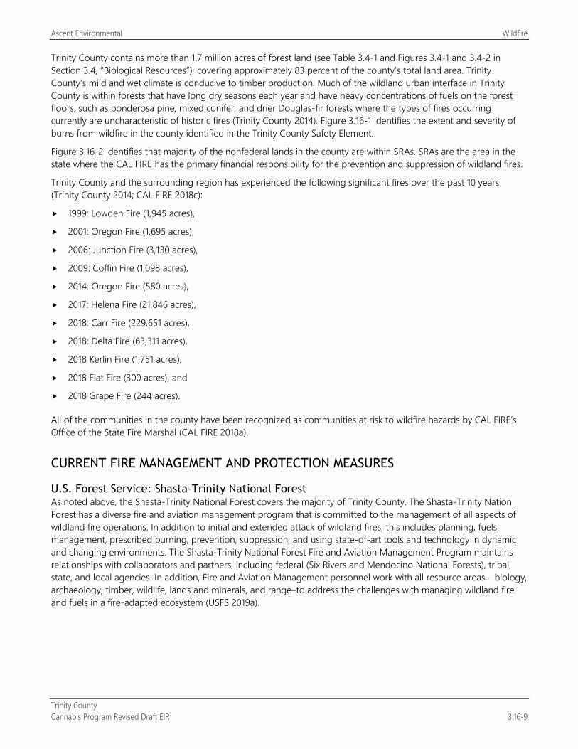
Ascent Environmental Wildfire
Trinity County Cannabis Program Revised Draft EIR 3.16-9
Trinity County contains more than 1.7 million acres of forest land (see Table 3.4-1 and Figures 3.4-1 and 3.4-2 in Section 3.4, “Biological Resources”), covering approximately 83 percent of the county’s total land area. Trinity County’s mild and wet climate is conducive to timber production. Much of the wildland urban interface in Trinity County is within forests that have long dry seasons each year and have heavy concentrations of fuels on the forest floors, such as ponderosa pine, mixed conifer, and drier Douglas-fir forests where the types of fires occurring currently are uncharacteristic of historic fires (Trinity County 2014). Figure 3.16-1 identifies the extent and severity of burns from wildfire in the county identified in the Trinity County Safety Element.
Figure 3.16-2 identifies that majority of the nonfederal lands in the county are within SRAs. SRAs are the area in the state where the CAL FIRE has the primary financial responsibility for the prevention and suppression of wildland fires.
Trinity County and the surrounding region has experienced the following significant fires over the past 10 years (Trinity County 2014; CAL FIRE 2018c):
1999: Lowden Fire (1,945 acres),
2001: Oregon Fire (1,695 acres),
2006: Junction Fire (3,130 acres),
2009: Coffin Fire (1,098 acres),
2014: Oregon Fire (580 acres),
2017: Helena Fire (21,846 acres),
2018: Carr Fire (229,651 acres),
2018: Delta Fire (63,311 acres),
2018 Kerlin Fire (1,751 acres),
2018 Flat Fire (300 acres), and
2018 Grape Fire (244 acres).
All of the communities in the county have been recognized as communities at risk to wildfire hazards by CAL FIRE’s Office of the State Fire Marshal (CAL FIRE 2018a).
CURRENT FIRE MANAGEMENT AND PROTECTION MEASURES
U.S. Forest Service: Shasta-Trinity National Forest As noted above, the Shasta-Trinity National Forest covers the majority of Trinity County. The Shasta-Trinity Nation Forest has a diverse fire and aviation management program that is committed to the management of all aspects of wildland fire operations. In addition to initial and extended attack of wildland fires, this includes planning, fuels management, prescribed burning, prevention, suppression, and using state-of-art tools and technology in dynamic and changing environments. The Shasta-Trinity National Forest Fire and Aviation Management Program maintains relationships with collaborators and partners, including federal (Six Rivers and Mendocino National Forests), tribal, state, and local agencies. In addition, Fire and Aviation Management personnel work with all resource areas—biology, archaeology, timber, wildlife, lands and minerals, and range–to address the challenges with managing wildland fire and fuels in a fire-adapted ecosystem (USFS 2019a).
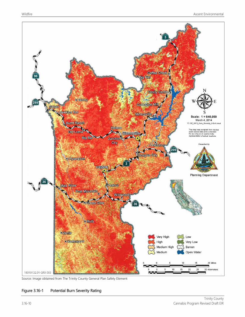
Wildfire Ascent Environmental
Trinity County 3.16-10 Cannabis Program Revised Draft EIR
Source: Image obtained from The Trinity County General Plan Safety Element
Figure 3.16-1 Potential Burn Severity Rating
Ascent Environmental Wildfire
Trinity County Cannabis Program Revised Draft EIR 3.16-11
Source: 2007 CAL FIRE data downloaded in 2019
Figure 3.16-2 State Responsibility Areas in Trinity County
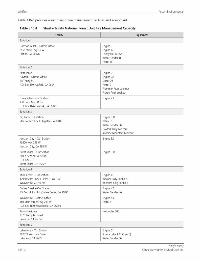
Wildfire Ascent Environmental
Trinity County 3.16-12 Cannabis Program Revised Draft EIR
Table 3.16-1 provides a summary of fire management facilities and equipment.
Table 3.16-1 Shasta-Trinity National Forest Unit Fire Management Capacity
Facility Equipment
Battalion 1
Harrison Gulch – District Office 2555 State Hwy 36 W Platina, CA 96076
Engine 311 Engine 12 Trinity IHC (Crew 11) Water Tender 11 Patrol 11
Battalion 2
Battalion 2 Hayfork – District Office 111 Trinity St. P.O. Box 159 Hayfork, CA 96041
Engine 21 Engine 22 Dozer 29 Patrol 21 Plummer Peak Lookout Pickett Peak Lookout
Forest Glen – Out Station #3 Forest Glen Drive P.O. Box 1176 Hayfork, CA 96041
Engine 23
Battalion 3
Big Bar – Out Station Star Route 1 Box 10 Big Bar, CA 96010
Engine 331 Patrol 31 Water Tender 36 Hayfork Bally Lookout Ironside Mountain Lookout
Junction City – Out Station 43600 Hwy 299 W Junction City, CA 96048
Engine 32
Burnt Ranch – Out Station 200 A School House Rd. P.O. Box 27 Burnt Ranch, CA 95527
Engine 334
Battalion 4
Mule Creek – Out Station 47950 State Hwy 3 Or P.O. Box 1190 Weaverville, CA 96093
Engine 41 Weaver Bally Lookout Bonanza King Lookout
Coffee Creek – Out Station 1 S Derrick Flat Rd. Coffee Creek, CA 96091
Engine 42 Water Tender 46
Weaverville – District Office 360 Main Street Hwy 299 W P.O. Box 1190 Weaverville, CA 96093
Engine 43 Patrol 41
Trinity Helibase 3325 Pettijohn Road Lewiston, CA 96052
Helicopter 506
Battalion 5
Lakeshore – Out Station 20207 Lakeshore Drive Lakehead, CA 96051
Engine 51 Shasta Lake IHC (Crew 5) Water Tender 56
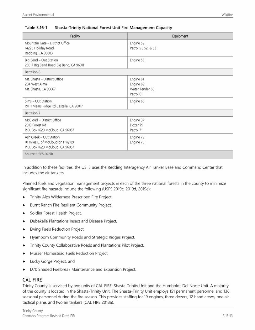
Ascent Environmental Wildfire
Trinity County Cannabis Program Revised Draft EIR 3.16-13
Table 3.16-1 Shasta-Trinity National Forest Unit Fire Management Capacity
Facility Equipment
Mountain Gate – District Office 14225 Holiday Road Redding, CA 96003
Engine 52 Patrol 51, 52, & 53
Big Bend – Out Station 25017 Big Bend Road Big Bend, CA 96011
Engine 53
Battalion 6
Mt. Shasta – District Office 204 West Alma Mt. Shasta, CA 96067
Engine 61 Engine 62 Water Tender 66 Patrol 61
Sims – Out Station 19111 Mears Ridge Rd Castella, CA 96017
Engine 63
Battalion 7
McCloud – District Office 2019 Forest Rd P.O. Box 1620 McCloud, CA 96057
Engine 371 Dozer 79 Patrol 71
Ash Creek – Out Station 10 miles E. of McCloud on Hwy 89 P.O. Box 1620 McCloud, CA 96057
Engine 72 Engine 73
Source: USFS 2019b
In addition to these facilities, the USFS uses the Redding Interagency Air Tanker Base and Command Center that includes the air tankers.
Planned fuels and vegetation management projects in each of the three national forests in the county to minimize significant fire hazards include the following (USFS 2019c, 2019d, 2019e):
Trinity Alps Wilderness Prescribed Fire Project,
Burnt Ranch Fire Resilient Community Project,
Soldier Forest Health Project,
Dubakella Plantations Insect and Disease Project,
Ewing Fuels Reduction Project,
Hyampom Community Roads and Strategic Ridges Project,
Trinity County Collaborative Roads and Plantations Pilot Project,
Musser Homestead Fuels Reduction Project,
Lucky Gorge Project, and
D70 Shaded Fuelbreak Maintenance and Expansion Project.
CAL FIRE Trinity County is serviced by two units of CAL FIRE: Shasta-Trinity Unit and the Humboldt-Del Norte Unit. A majority of the county is located in the Shasta-Trinity Unit. The Shasta-Trinity Unit employs 151 permanent personnel and 136 seasonal personnel during the fire season. This provides staffing for 19 engines, three dozers, 12 hand crews, one air tactical plane, and two air tankers (CAL FIRE 2018a).
Wildfire Ascent Environmental
Trinity County 3.16-14 Cannabis Program Revised Draft EIR
Local Fire Protection In addition to federal and state fire protection services, local fire protection is provided by the following fire districts and station sites:
Trinity Center, Coffee Creek, Weaverville,
Lewiston, Junction City, Douglas City,
Hayfork, Post Mountain, Barker Valley,
Hawkins Bar, Salyer, Down River, and
Southern Trinity, Zenia-Kettenpom, Forest Glen.
3.16.3 Environmental Impacts and Mitigation Measures
METHODOLOGY The Trinity County Cannabis Program would establish the local regulatory framework for the consideration and approval of commercial cannabis uses in the unincorporated areas of the county outside of public owned lands. Thus, a site-specific analysis of the effect of new cannabis uses on exacerbating existing wildfire hazards cannot be accurately conducted. This analysis evaluates the effect of continued operation of commercial cannabis cultivation and the development of new cannabis operations countywide on existing wildfire hazards based on published technical studies and materials provided by federal, state, and local agencies. The analysis also considers the effectiveness of existing regulations to address potential fire hazards that cannabis uses could create.
THRESHOLDS OF SIGNIFICANCE Land areas that would be subject to the Cannabis Program are located within SRAs and on lands considered to have high fire severity. The following thresholds were used to determine if implementation of the Cannabis Program could result in a significant environmental effects related to wildfire. These thresholds are consistent with State CEQA Guidelines Appendix G and address physical environmental effects related to wildfire hazards (emergency response and evacuation, exacerbating the existing wildfire hazards, and exposure to post-fire hazards).
A wildfire impact would be significant if implementation of the Cannabis Program would:
expose people or structures, either directly or indirectly, to a significant risk of loss, injury, or death involving wildfires;
substantially impair an adopted emergency response plan or emergency evacuation plan;
due to slope, prevailing winds, and other factors, exacerbate wildfire risks, and thereby expose project occupants to pollutant concentrations from a wildfire or the uncontrolled spread of a wildfire;
require the installation of associated infrastructure (such as roads, fuel breaks, emergency water sources, power lines or other utilities) that may exacerbate fire risk or that may result in temporary or ongoing impacts to the environment; or
expose people or structures to significant risks, including downslope or downstream flooding or landslides, as a result of runoff, post-fire slope instability, or drainage changes.
ISSUES NOT DISCUSSED FURTHER Impacts related to the potential for the implementation of the Cannabis Program to substantially impair an adopted emergency response plan, emergency evacuation plan or otherwise impair emergency access and evacuation have been addressed under Impact 3.9-6 in Section 3.9, “Hazards and Hazardous Materials”; Impact 3.13-1 in Section 3.13, “Public Services”; and Impact 3.14-4 in Section 3.14, “Transportation/Traffic.” The reader is referred to those impact discussions.
Ascent Environmental Wildfire
Trinity County Cannabis Program Revised Draft EIR 3.16-15
While the analysis below addresses potential exacerbation of wildfire hazards from associated infrastructure improvements (e.g., extension of electrical facilities, roads, fuel breaks, drainage, and general site development) from future commercial cannabis uses, the reader is referred to Sections 3.1 through 3.15 regarding the physical environmental effects of these improvements associated with overall site development.
ENVIRONMENTAL IMPACTS AND MITIGATION MEASURES
Impact 3.16-1: Exposure of People or Structures Directly or Indirectly to a Significant Risk of Loss Involving Wildfire Hazards or Exacerbate Wildfire Risk and Expose Project and Public to Pollutant Concentrations from Uncontrolled Spread of a Wildfire
Trinity County is highly susceptible to wildfires. Implementation of the Cannabis Program could create new fire hazards from creation of new fuel and ignition sources and expose people and structures to increased wildfire hazards and unhealthy air quality conditions from smoke. This impact would be potentially significant.
As described under Section 3.16.2, “Environmental Setting,” the majority of the county is forested that has high wildfire risk and has experienced wildfires each year since 1999. The construction and operation of commercial cannabis uses under the Cannabis Program would introduce new ignition sources that could increase wildfire hazards associated with electrical sources, storage of flammable materials, power equipment use, and debris piles from cleared vegetation.
Commercial cannabis operations would be regulated for fire avoidance and protection measures consistent with building and fire codes (CCR Title 24, Part 2, Chapter 7A and PRC Section 4291), Trinity County Code of Ordinances Chapter 8.30 that provide wildfire protection standards for emergency access, signing and building numbering; private water supply reserves for emergency fire use and vegetation modification. State licensing requirements also include fire avoidance and protection measures for cultivation (CCR Section 8102[aa] and CCR 5501[i]) and for manufacturing operations associated with extraction facilities (CCR Sections 40223[b] and 40225).
The Cannabis Program would include the following standards for fire protection:
Any fuel, fertilizer, pesticide, fungicide, rodenticide, herbicide or other substance toxic to wildlife, children, or pets shall be stored in a secured and locked structure or device (Section 315-843[6][g]).
Fire plans must be prepared by the applicant and approved by the Weaverville Fire District Chief or a designee of the Trinity County Board of Supervisors. An approved fire plan must be submitted with an application the appropriate Use Permit (Manufacturing) (Section 315-842[4][F]).
For Type 7 applicants (volatile manufacturing) are required to obtain a Conditional Use Permit before starting operations, including infrastructure and building improvements specific to the use, and the following additional requirements must be met (Manufacturing) (Section 315-842[4][J]):
Extractions must be in closed loop system as defined and prescribed by State of California.
Wastewater shall be disposed of into an adequate sewage system, as prescribed by Trinity County Environmental Health Division and pursuant to California state regulations.
The facility must be setback a minimum of I00 feet from all adjacent property lines. Application for a variance from this provision will be considered concurrently with application for a Conditional Use Permit from the Trinity County Planning Commission.
All building structures must have operational automatic fire sprinklers.
Existing Licensed Commercial Cannabis Operations Figure 2-3 shows cultivation sites licensed in the county in 2018. There are approximately 113 acres of existing cultivation site development (defined as “Designated Area” under the Cannabis Program) and 10 distribution facilities in the county (Table 2-3). These sites are required to renew their licenses annually under the Cannabis Program. Field
Wildfire Ascent Environmental
Trinity County 3.16-16 Cannabis Program Revised Draft EIR
review identified that some existing cultivation sites contained dry vegetative debris piles from original site clearing that was often placed adjacent to the site’s perimeter where forest conditions exist. Continued operation of these cultivation sites may further increase this existing fire hazard from expansion of debris piles through the proposed amendment to expand the Designated Area for cultivation activities (land clearing, storage facilities, nurseries, and other related uses) from 200 percent of the licensed cannabis canopy area to 250 percent. Dry vegetative debris piles are potential fuel sources that could initiate wildfires if exposed to an ignition source. This could increase the potential for wildfire hazards that could pose direct risks to the public and structures as well as smoke conditions that may create unhealthy levels of particulate matter. Exposure to PM2.5 can result in significant health problems including aggravated asthma, increase susceptibility to respiratory infections, and cause heart attacks and arrhythmias in people with heart disease (Sacramento Metropolitan Air Quality Management District 2019). Thus, this impact associated with existing licensed cannabis cultivation operations would be potentially significant.
New Licensed Commercial Cannabis Operations As shown in Table 2-3, implementation of the Cannabis Program would allow up to 246.16 217.26 acres of new cannabis cultivation development activity in the county. Like existing cultivation operations in the county, new cannabis cultivation operations could create dry vegetative debris piles from site clearing that is located adjacent to off-site forest conditions. Dry vegetative debris piles are potential fuel sources that could initiate wildfires if exposed to an ignition source. This could increase the potential for wildfire hazards that could pose direct risks to the public and structures as well as smoke conditions that may create unhealthy levels of particulate matter. Thus, this impact associated with new licensed cannabis cultivation operations would be potentially significant.
Implementation of the Cannabis Program would provide for noncultivation operations that would consist of manufacturing, microbusiness, non-storefront retail, testing, and distribution (Table 2-3). These uses, which would be located in buildings to be located in or adjacent to the communities of Douglas City, Hayfork, Junction City, and Weaverville. This development would be required to meet the fire protection and prevention measures identified above associated with building design, operations, and defensible space. Compliance with these standards would ensure that these uses would not exacerbate existing wildfire hazards in the county. Thus, the impact from noncultivation cannabis operations would be less than significant.
Mitigation Measures
Mitigation Measure 3.16-1: Implement Mitigation Measure 3.1-1b: Maintain Cultivation Parcel
Significance after Mitigation Implementation of Mitigation Measures 3.1-1b would require license applications for new cultivation sites and requests for license renewal maintain the parcel clear of trash and debris piles. No trash or debris will be allowed to accumulate on the parcel for a period greater than two weeks for the life of the license. The County will inspect compliance with this measure prior to license renewal. This will eliminate the potential for new sources of fuel that could increase wildfire hazards. Mitigation Measure 3.1-1b is consistent with Trinity County Safety Element policies that identify the need for fuel reduction. Therefore, the impact would be less than significant.
Impact 3.16-2: Installation and Operation of Associated Infrastructure That May Exacerbate Fire Risk
Implementation of the Cannabis Program would include the development on-site and off-site infrastructure improvements to support commercial cannabis uses that could create new fire hazards. This impact would be potentially significant.
The construction and operation of commercial cannabis uses under the Cannabis Program would include improvements such as buildings, water structures, extension of electrical facilities and associated improvements by the Trinity Public Utility District and Pacific Gas and Electric Company, maintenance of fuel breaks, and roadway improvements (on-site and off-site) that could introduce new ignition sources that could increase wildfire hazards. As
Ascent Environmental Wildfire
Trinity County Cannabis Program Revised Draft EIR 3.16-17
noted in Impact 3.16-1, the majority of the county is forested that has high wildfire risk and has experienced wildfires each year since 1999.
Existing and New Licensed Commercial Cannabis Operations Commercial cannabis operations (including infrastructure improvements) would be regulated for fire avoidance and protection measures consistent with building and fire codes (CCR Title 24, Part 2, Chapter 7A and PRC Section 4291), Trinity County Code of Ordinances Chapter 8.30 that provide wildfire protection standards for emergency access, signing and building numbering; private water supply reserves for emergency fire use and vegetation modification. State licensing requirements also include fire avoidance and protection measures for cultivation (CCR Section 8102[aa] and CCR 5501[i]) and for manufacturing operations associated with extraction facilities (CCR Sections 40223[b] and 40225).
The Cannabis Program would include the following standards for fire protection:
Any fuel, fertilizer, pesticide, fungicide, rodenticide, herbicide or other substance toxic to wildlife, children, or pets shall be stored in a secured and locked structure or device (Section 315-843[6][g]).
Fire plans must be prepared by the applicant and approved by the Weaverville Fire District Chief or a designee of the Trinity County Board of Supervisors. An approved fire plan must be submitted with an application the appropriate Use Permit (Manufacturing) (Section 315-842[4][F]).
However, potential extension of electrical facilities and on-site construction and maintenance activities could create new ignition sources. Thus, the impact would be potentially significant.
Mitigation Measures
Mitigation Measure 3.16-2a: Implement Fire Prevention Measures for New Power Lines and Electrical Facilities The following shall be included as a new performance standard for Section 315-843(6) (Performance Standards for Commercial Cultivation of Cannabis), Section 315-824(5) (Required Conditions), Section 315-826(3) (Regulation of Nurseries), Section 315-828(5) (Required Conditions), Section 315-835(2) (Regulations), Section 315-837(3) (Required Conditions), and Section 315-842(6) (Required Conditions):
New power lines extended to sites shall be placed underground. If power lines cannot be placed underground, fuel breaks shall be provided along power lines and any stand-alone electrical facilities in a manner that would avoid ignition of adjacent vegetation to the satisfaction of the County and CAL FIRE. Fuel breaks shall be maintained and verified by the County as part of annual license renewal.
Mitigation Measure 3.16-2b: Implement Fire Prevention Measures for On-Site Construction and Maintenance Activities The following shall be included as a new performance standard for Section 315-843(6) (Performance Standards for Commercial Cultivation of Cannabis), Section 315-824(5) (Required Conditions), Section 315-826(3) (Regulation of Nurseries), Section 315-828(5) (Required Conditions), Section 315-835(2) (Regulations), Section 315-837(3) (Required Conditions), and Section 315-842(6) (Required Conditions):
The operation of outdoor motorized equipment on-site for construction and maintenance activities shall be required to be covered under a fire protection plan that includes the following provisions:
Fire watch personnel responsible for watching for the occurrence of fire during and after equipment use shall be identified.
Equipment shall be located so that exhausts do not discharge against combustible materials.
Equipment shall not be refueled while in operation and not until after a cooldown period.
Water and tools dedicated to fire fighting shall be on hand in the area of onsite construction and maintenance activities at all times.
Designated smoking areas with cigarette disposal receptacles that are burn resistant.
Wildfire Ascent Environmental
Trinity County 3.16-18 Cannabis Program Revised Draft EIR
Significance after Mitigation Implementation of Mitigation Measures 3.16-2a and 3.16-2b would require that power lines and electrical facilities maintain fuel breaks and that the use of outdoor motorized equipment be conducted in a manner to avoid accidental fire. Therefore, the impact would be less than significant.
Impact 3.16-3: Expose People to Increased Risk of Landslide from Post-Fire Slope Instability
Previous wildfires in Trinity County have resulted in the loss of vegetation on sloped terrain. This condition could result in soil erosion and slope failure. Development of commercial cannabis uses under the Cannabis Program in these areas could exacerbate this condition and increase the risk of erosion and slope failure. This impact would be potentially significant.
As described under Section 3.16.2, “Environmental Setting,” the county has experienced wildfires each year since 1999, that including large wildfires in 2018 (Carr, Delta, Kerlin, Flat, and Grape). The areas associated with these recent fires include moderate to steep slope conditions that lost most, and in some cases, all of the previous vegetation.
As noted in Section 3.7, “Geology and Soils,” and Section 3.10, “Hydrology and Water Quality,” the State Water Resources Control Board (SWRCB) Order WQ 20179-002301-DWQ and County Code of Ordinances Chapters 12.12. and 15.24 contain requirements for soil stability and erosion control for cannabis cultivation sites. These requirements include plans that address site erosion and sediment control, disturbed areas stabilization, site closure procedures, and monitoring and reporting requirements. In addition, the SWRCB Order contains requirements for land development maintenance, erosion control, drainage features, stream crossing installation and maintenance, soil disposal and spoils management, and roadway design and maintenance.
The Cannabis Program includes the following standards that address water quality for cultivation operations:
The cultivation of cannabis shall not create erosion or result in contaminated runoff into any stream, creek, river, or body of water. If the designated area has more than a 35 percent slope, the applicant shall apply for a Tier 2 cultivation under the North Coast Regional Water Quality Control Board Order #2015-0023, or regulations established by the SWRCB (Section 315-843[6][d]).
Applicant shall obtain coverage under the General Permit for Discharges of Storm Water Associated with Construction Activity for construction projects that disturb 1 or more acres of land surface, specifically for new site preparation and development (Section 315-843[6][o]).
Existing and New Licensed Commercial Cannabis Operations Commercial cannabis operations that locate or relocate to burned areas could further destabilize soil and slope conditions from grading for cultivation sites, development of structures, and roadway construction. Field review of the methods used in the development existing cannabis cultivation sites in the county identified slope stability issues associated with terrace construction as well as a lack of erosion control features on-site or associated access roadways. Thus, this impact would be potentially significant.
Mitigation Measures
Mitigation Measure 3.16-3: Implement Mitigation Measure 3.10-1a: Demonstrate Compliance with Water Resource Standards
Significance after Mitigation Implementation of Mitigation Measure 3.10-1a would require all existing and new commercial cannabis cultivation activities in the county to comply with the conditions of SWRCB Order WQ 20179-002301-DWQ or otherwise avoid water quality impacts. This would also include ensuring that sites are geologically stable and do not result in operational soil erosion impacts.. Therefore, the impact would be less than significant.
Trinity County Cannabis Program Revised Draft EIR 4-1
4 CUMULATIVE IMPACTS
4.1 INTRODUCTION TO THE CUMULATIVE ANALYSIS This chapter provides an analysis of cumulative impacts of the proposed Trinity County Cannabis Program taken together with other past, present, and probable future projects producing related impacts, as required by Section 15130 of the State CEQA Guidelines. The goal of such an exercise is twofold: first, to determine whether the overall long-term impacts of all such projects would be cumulatively significant; and second, to determine whether the incremental contribution to any such cumulatively significant impacts by the project would be “cumulatively considerable” (and thus significant). (See State CEQA Guidelines Section 15130[a]–[b], Section 15355[b], Section 15064[h], and Section 15065[a] and Communities for a Better Environment v. California Resources Agency [2002] 103 Cal. App. 4th 98, 120.) In other words, the required analysis intends first to create a broad context in which to assess cumulative impacts, viewed on a geographic scale beyond the project site itself, and then to determine whether the project’s incremental contribution to any significant cumulative impacts from all projects is itself significant (i.e., “cumulatively considerable”).
Cumulative impacts are defined in State CEQA Guidelines Section 15355 as “two or more individual effects which, when considered together, are considerable or which compound or increase other environmental impacts.” A cumulative impact occurs from “the change in the environment which results from the incremental impact of the project when added to other closely related past, present, and reasonably foreseeable probable future projects. Cumulative impacts can result from individually minor but collectively significant projects taking place over a period of time” (State CEQA Guidelines Section 15355[b]).
Consistent with State CEQA Guidelines Section 15130, the discussion of cumulative impacts in this DEIR focuses on significant and potentially significant cumulative impacts. Section 15130(b) of the State CEQA Guidelines provides, in part, the following:
The discussion of cumulative impacts shall reflect the severity of the impacts and their likelihood of occurrence, but the discussion need not provide as great detail as is provided for the effects attributable to the project alone. The discussion should be guided by the standards of practicality and reasonableness, and should focus on the cumulative impact to which the identified other projects contribute rather than the attributes of other projects which do not contribute to the cumulative impact.
4.2 CUMULATIVE SETTING
4.2.1 Geographic Scope of the Cumulative Analysis The geographic area that could be affected by the project and is appropriate for a cumulative impact analysis varies depending on the environmental resource topic, as presented in Table 4-1.
Table 4-1 Geographic Scope of Cumulative Impacts
Resource Topic Geographic Area
Aesthetics Trinity County
Agriculture and Forestry Resources Trinity County Shasta-Trinity, Six Rivers, and Mendocino National Forests State
Air Quality Regional (North Coast Air Basin) Local (immediate project vicinity – pollutant emissions that are highly localized)
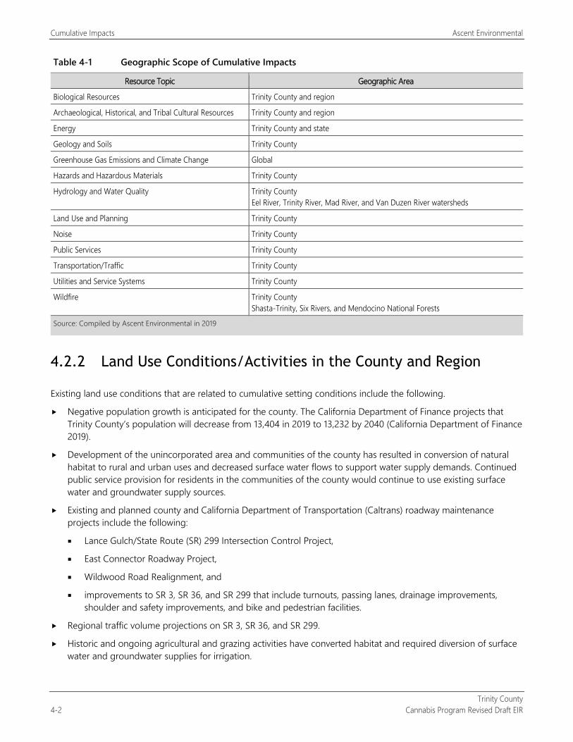
Cumulative Impacts Ascent Environmental
Trinity County 4-2 Cannabis Program Revised Draft EIR
Table 4-1 Geographic Scope of Cumulative Impacts
Resource Topic Geographic Area
Biological Resources Trinity County and region
Archaeological, Historical, and Tribal Cultural Resources Trinity County and region
Energy Trinity County and state
Geology and Soils Trinity County
Greenhouse Gas Emissions and Climate Change Global
Hazards and Hazardous Materials Trinity County
Hydrology and Water Quality Trinity County Eel River, Trinity River, Mad River, and Van Duzen River watersheds
Land Use and Planning Trinity County
Noise Trinity County
Public Services Trinity County
Transportation/Traffic Trinity County
Utilities and Service Systems Trinity County
Wildfire Trinity County Shasta-Trinity, Six Rivers, and Mendocino National Forests
Source: Compiled by Ascent Environmental in 2019
4.2.2 Land Use Conditions/Activities in the County and Region
Existing land use conditions that are related to cumulative setting conditions include the following.
Negative population growth is anticipated for the county. The California Department of Finance projects that Trinity County’s population will decrease from 13,404 in 2019 to 13,232 by 2040 (California Department of Finance 2019).
Development of the unincorporated area and communities of the county has resulted in conversion of natural habitat to rural and urban uses and decreased surface water flows to support water supply demands. Continued public service provision for residents in the communities of the county would continue to use existing surface water and groundwater supply sources.
Existing and planned county and California Department of Transportation (Caltrans) roadway maintenance projects include the following:
Lance Gulch/State Route (SR) 299 Intersection Control Project,
East Connector Roadway Project,
Wildwood Road Realignment, and
improvements to SR 3, SR 36, and SR 299 that include turnouts, passing lanes, drainage improvements, shoulder and safety improvements, and bike and pedestrian facilities.
Regional traffic volume projections on SR 3, SR 36, and SR 299.
Historic and ongoing agricultural and grazing activities have converted habitat and required diversion of surface water and groundwater supplies for irrigation.
Ascent Environmental Cumulative Impacts
Trinity County Cannabis Program Draft EIR 4-3
Historic and ongoing timber production has resulted in the modification of forest resources, impacts on wildlife and associated habitat conditions, and degraded water quality and fisheries conditions in county watersheds.
Historic and ongoing mining activities have resulted in habitat removal and modification of hydrologic conditions that have affected wildlife and associated habitat conditions and degraded water quality.
Forest management activities consisting of fuels management, forest thinning, fuel breeks, and other similar actions by the U.S. Forest Service (USFS), the California Department of Forestry and Fire Protection (CAL FIRE), and local fire districts are ongoing and would occur into the future. These forest management activities have the potential to affect special-status plant and wildlife species and habitat as well as watershed conditions. Planned USFS forest management projects in the county include the following:
Trinity Alps Wilderness Prescribed Fire Project,
Burnt Ranch Fire Resilient Community Project,
Soldier Forest Health Project,
Dubakella Plantations Insect and Disease Project,
Ewing Fuels Reduction Project,
Hyampom Community Roads and Strategic Ridges Project,
Trinity County Collaborative Roads and Plantations Pilot Project,
Musser Homestead Fuels Reduction Project,
Lucky Gorge Project, and
D70 Shaded Fuelbreak Maintenance and Expansion Project.
Existing cannabis cultivation and related activities have adversely affected natural habitats, biological resources, and water resources in the county (described further below).
Commercial cannabis activities occur in Humboldt and Mendocino Counties and will continue in the future.
4.2.3 Existing Cannabis Cultivation Operations in Trinity County
Trinity County did not permit commercial cannabis cultivation in the county until the adoption of Ordinance 315-816 EXT(A1) on August 30, 2016. In 2016, the County conducted an evaluation and mapping using satellite imagery and geographic information system mapping data to estimate the extent of existing cultivation sites in the county. The analysis identified 3,927 unpermitted cannabis sites on approximately 1,109 acres. Of the sites, 168 cultivation sites (23 acres) were located on public lands (e.g., USFS lands owned by the federal government). Comments on the notice of preparation suggest that there could be over 7,000 sites in the county. However, these comments provided no data or technical information for the basis of this estimate.
From adoption of Ordinance 315-816 EXT(A1) through December 2018, the County has issued 286 commercial cannabis operation licenses (Hubbard, pers. comm., 2018). Figure 2-4 identifies the locations of current County-licensed sites; the locations of unlicensed and illegal cultivation sites are based on the results of 2016 cannabis cultivation mapping. Comparison of the 2016 mapping to 2018 satellite imagery of portions of the county shows that the number of sites and acreage in unlicensed and illegal cannabis cultivation has increased since 2016.
As discussed in Section 3.4, “Biological Resources,” and Section 3.10, “Hydrology and Water Quality,” historic and ongoing illegal cannabis cultivation practices have resulted in damage to streams and wildlife. More recently, illegal cannabis cultivation operations within public and private lands have led to illegal water diversions, unpermitted removal of sensitive vegetation, and direct mortality to protected species from exposure to rodenticides and insecticides. In addition, these practices (e.g., clearing trees, grading, and road construction) have been conducted in
Cumulative Impacts Ascent Environmental
Trinity County 4-4 Cannabis Program Revised Draft EIR
a manner that causes large amounts of sediment to flow into streams during rains. The illegal cannabis cultivators have also discharged pesticides, fertilizers, fuels, trash, and human waste around the sites, that then washes into waters of the state. Furthermore, diversion of flow during the dry season may have caused complete elimination of stream flows in some areas of the county. Water quality related constituents of concern associated with cannabis cultivation discharges include nitrogen, pathogens (represented by coliform bacteria), phosphorus, salinity, and turbidity. Water quality can be affected by excessive use of fertilizer, soil amendments, or other sources.
Cultivation operations that do not participate in the Cannabis Program are currently and would continue to be considered illegal upon readoption of the Cannabis Program. Enforcement activities would be taken by the County in coordination with other agencies that could result in bringing some cultivation operations into compliance with County and state standards and the closure and remediation of other operations. The removal of illegal cultivation sites is ongoing, and consideration of general locations where this would occur and number of future illegal sites is unknown and cannot be known at this time. Compliance with state and County cannabis regulations may be viewed by some cannabis operators as cost prohibitive and elect to operate illegally. While it is acknowledged that illegal cannabis operations would continue to occur in the county after adoption and implementation of the Cannabis Program into the future, details on the full extent of the environmental effects of existing illegal cannabis operations are considered speculative and are not assessed in this evaluation of cumulative impacts.
4.3 CUMULATIVE IMPACT ANALYSIS The following sections contain a discussion of the cumulative effects anticipated from implementation of the Trinity County Cannabis Program, together with related projects and land use activities in the region, for each of the 16 environmental issue areas evaluated in this DEIR. The analysis conforms with Section 15130(b) of the State CEQA Guidelines, which specifies that the “discussion of cumulative impacts shall reflect the severity of the impacts and their likelihood of occurrence, but the discussion need not provide as great detail as is provided for the effects attributable to the project alone. The discussion should be guided by the standards of practicality and reasonableness, and should focus on the cumulative impact to which the identified other projects contribute rather than the attributes of other projects which do not contribute to the cumulative impact.”
When considered in relation to other reasonably foreseeable projects, cumulative impacts on some resources would be significant and more severe than those caused by the project alone.
For purposes of this EIR, the project would result in a significant cumulative effect if:
the cumulative effects of related projects and land use activities (past, current, and probable future projects) are not significant and the incremental impact of implementing the Trinity County Cannabis Program is substantial enough, when added to the cumulative effects of related projects, to result in a new cumulatively significant impact; or
the cumulative effects of related projects and land use activities (past, current, and probable future projects) are already significant and implementation of the Trinity County Cannabis Program makes a considerable contribution to the effect. The standards used herein to determine a considerable contribution are that either the impact must be substantial or it must exceed an established threshold of significance.
This cumulative analysis assumes that individual commercial cannabis operations comply with state and County cannabis regulations and all mitigation measures identified in Sections 3.1 through 3.16 are adopted and implemented. The analysis herein analyzes whether, after implementation of project-specific mitigation and performance criteria that minimize environmental effects, the residual impacts of the project would cause a cumulatively significant impact or would contribute considerably to existing/anticipated (without the project) cumulatively significant effects. Where the project would so contribute, additional mitigation is recommended where feasible.
Ascent Environmental Cumulative Impacts
Trinity County Cannabis Program Draft EIR 4-5
4.3.1 Aesthetics The cumulative context for aesthetic resources is Trinity County. Trinity County is a rural/forested county with 26 unincorporated communities. Because of its varied topography, the county offers a range of scenic features, including forests, wilderness areas, rivers and other waterways, recreation areas, rural communities, and scenic roadways. Construction of new facilities or modification of existing facilities, continued agricultural operations, and roadway and other infrastructure improvements in the county would continue to alter scenic resources and permanently affect the visual character of the overall county. In addition, nighttime light pollution would continue to occur in from existing development in the county’s communities. Thus, there is a potentially significant cumulative impact in regard to aesthetics.
As shown in Figure 2-3, there are existing licensed cultivation sites along SR 3 and SR 299. Field review identified that some existing cultivation sites are visible from these highways. Cultivation sites within the forested portion of SR 3 were highly visible because the clearing of the site, planting of cannabis, structures, water storage facilities, and debris piles contrasted with the surrounding forested condition. Other cultivation sites were visible because of the use of black tarp as part of the perimeter fencing, which is visually disharmonious with the surrounding natural or rural visual character. Although these sites are part of the existing visual conditions along these scenic corridors, continued operation of these cultivation sites may further affect public scenic views from expansion of operations through the proposed amendment to expand the Designated Area for cultivation activities (land clearing, storage facilities, nurseries, and other related uses) from 200 percent of the licensed cannabis canopy area to 250 percent. Implementation of the Cannabis Program would also allow up to 246.16 217.26 acres of new cannabis cultivation development activity in the county. New cannabis cultivation operations could be located in areas similar to existing licensed sites, further altering scenic resources and viewsheds in the county through site clearing, construction of structures and fencing, and other activities.
Implementation of Mitigation Measure 3.1-1a would offset project impacts on scenic views and visual character by requiring the screening of new cultivation sites and the establishment of screening features at existing cultivation sites, ensuring that these features do not dominate the scenic view. Mitigation Measures 3.1-1b and 3.1-1c would require that the cultivation parcel site conditions be maintained clean of trash and debris piles and that fencing blend with the surrounding conditions of the parcel. These mitigation measures would be consistent with the intent of Circulation Element Policy 1.15D and recommendations of the Open Space Element that would offset the Cannabis Program’s contribution to cumulative aesthetic impacts. Noncultivation cannabis uses would be similar in scale and appearance to existing development in these communities and would be required to meet design policies and standards set forth in the Trinity County General Plan, Hayfork Community Plan, Douglas City Community Plan, Junction City Community Plan, Lewiston Community Plan, Weaverville Community Plan, and County Code of Ordinances. Thus, the project’s contribution to cumulative impacts on scenic vistas, scenic resources, and visual character of the county would not be cumulatively considerable.
Mixed-light and indoor cultivation operations use lighting to extend the photoperiod for the cannabis plants. Such lighting may create a nuisance to adjacent and nearby properties, residences, and/or motorists traveling on nearby roadways. Artificial night lighting used for cannabis cultivation operations could result in adverse ecological effects on terrestrial and aquatic resources. Commercial cannabis cultivation lighting could contribute to cumulative impacts on nighttime views or disturb neighboring residents.
The Cannabis Program includes the following requirements that ensure nighttime lighting and glare impacts are avoided and would offset the Cannabis Program’s contribution to cumulative lighting impacts:
All lighting associated with the operation shall be downcast, shielded and/or screened to keep light from emanating off-site or into the sky (Section 315-843[6][l]).
Those cultivations using artificial lighting from mixed-light cultivations shall shield greenhouses so that little to no light escapes. Light shall not escape at a level that is visible from neighboring properties between sunset and sunrise (Section 315-843[6][m]).
Thus, the project’s contribution to cumulative impacts on light and glare would not be cumulatively considerable.
Cumulative Impacts Ascent Environmental
Trinity County 4-6 Cannabis Program Revised Draft EIR
4.3.2 Agriculture and Forestry Resources
CUMULATIVE AGRICULTURAL RESOURCE IMPACTS By California standards, Trinity County’s agricultural production is small. The county produced approximately $13.5 million of the state’s $20 billion of annual farm goods in 2016. Trinity County is ranked 56th in the state of counties for gross value for agricultural production in 2016 without timber production and 54th including timber (CDFA 2016). No significant cumulative impacts have been identified.
As described in Section 3.2, “Agriculture and Forestry Resources,” Health and Safety Code Section 11362.777(a) and Business and Professions Code Section 26067(a) define medical and adult-use cannabis as agricultural products, and cannabis is defined by the state as an agricultural product; therefore, implementing the Cannabis Program would not result in conversion of farmland to nonagricultural uses or conflict with existing zoning for agricultural use or a Williamson Act contract. Thus, the project’s contribution to cumulative agricultural resource impacts would not be cumulatively considerable.
CUMULATIVE FOREST RESOURCE IMPACTS Trinity County contains more than 1.7 million acres of forest land (see Table 3.4-1 and Figures 3.4-1 and 3.4-2 in Section 3.4, “Biological Resources”), covering approximately 83 percent of the county’s total land area. Within these forest lands are public lands, including national forests, and four wilderness areas. County lands zoned Timberland Production Zone (TPZ) are shown in Figure 3.2-2. Trinity County’s 2106 Crop Report identified timber production as the county’s highest value agricultural commodity at $10,020,241 (74 percent of the county’s total agricultural production in 2016) (Trinity County 2016). No existing significant cumulative impacts associated with the loss of forestry resources have been identified.
Licensed commercial cannabis operations under the Cannabis Program would be excluded from lands zoned TPZ (326,168 acres), as well as public lands, including the Shasta-Trinity, Six Rivers, and Mendocino National Forests and four wilderness areas (Yolla Bolly-Middle Eel, Trinity Alps, Chanchelulla, and North Fork) that encompass 2,051,988 acres for a grand total of 2,378,156 acres of protected forest land the county’s total land area. These protected areas make up most of the forest conditions in the county as shown in Figures 2-2, 3.2-2, and 3.4-1. New licensed commercial cannabis operations could result in additional loss of forest lands. As identified in Table 2-3, the Designated Areas of all new licensed cannabis cultivation operations could remove up to 246.16 217.26 acres of forest land (assuming it is all located on forested sites) within the same areas of the county where cultivation currently occurs. This would result in loss of 0.014 0.012 percent of the county’s total forest land acreage. As noted above, the majority of forest conditions in the county are protected from licensed cannabis activities under the Cannabis Program. Thus, the project’s contribution to cumulative impacts on forest resources would not be cumulatively considerable.
4.3.3 Air Quality
The cumulative setting for air quality is the North Coast Air Basin (NCAB). The NCAB includes Trinity County, Humboldt County, Mendocino County, and northern Sonoma County. The North Coast Unified Air Quality Management District regulates air pollutant point sources in the NCAB. The ambient concentrations of air pollutant emissions are determined by the amount of emissions released by the sources of air pollutants and the atmosphere’s ability to transport and dilute such emissions. The NCAB is in attainment for all of the California ambient air quality standards (CAAQS) and national ambient air quality standards (NAAQS) for criteria air pollutants, except the 24-hour CAAQS for respirable particulate matter (PM10). Monitoring results have shown that the principal pollutant in the NCAB is PM10. Primary sources of PM10 in the NCAB are on-road and off-road vehicles (engine exhaust and fugitive dust generated by travel on paved and unpaved roads), open burning of vegetation (both residential and commercial), residential wood stoves, and stationary industrial sources (factories). Anticipated future PM10 conditions in the NCAB is a significant cumulative impact.
Ascent Environmental Cumulative Impacts
Trinity County Cannabis Program Draft EIR 4-7
Implementation of the Cannabis Program would result in peak emissions of PM10 during the harvest season from road dust, which would contribute to the existing nonattainment status with respect to the CAAQS for PM10 in the NCAB. As discussed in Section 3.3, “Air Quality,” feasible mitigation measures are not available to offset project-generated PM10 emissions from unpaved roadway use. Thus, the project’s contribution to this significant cumulative impact would be cumulatively considerable. Mitigation is not available to reduce the Cannabis Program’s contribution to a less-than-considerable level for the reasons discussed in the project-level analysis. Thus, this cumulative impact would remain cumulatively considerable and significant and unavoidable.
As discussed in Section 3.3, “Air Quality,” Trinity County’s portion of the NCAB is in attainment for all criteria air pollutants and ozone precursors. Ozone impacts are the result of cumulative emissions from numerous sources in the region and transport from outside the region. Ozone is formed in chemical reactions involving oxides of nitrogen (NOX), reactive organic gases (ROG), and sunlight. Only the largest individual sources emit NOX and ROG in amounts that could have a measurable effect on ambient ozone concentrations by themselves. None of the cannabis cultivation or noncultivation sites would be large enough to generate such amounts of NOX and ROG. Because the region is in attainment for both the CAAQS and the NAAQS for ozone precursors (i.e., NOX and ROG) and the relatively amount of cumulative air pollutants, emissions from cumulative development would not be cumulatively considerable.
To the extent that potential land uses within the cumulative context may occur, the level of odor-producing uses in adjacent communities is anticipated to be minimal. Odor impacts are not typically additive, in any event, as areas affected by isolated local odor sources typically do not overlap with other areas affected by other isolated local odor sources. However, it is acknowledged that existing illegal cannabis cultivation sites are a source of odors during the harvest season. Sources of odors related to the Cannabis Program may include odors emitted by cannabis plants during final stages of cultivation and processing, and the burning of cleared vegetation during the construction of new cannabis facilities.
Implementation of Mitigation Measure 3.3-1a prohibits the burning of vegetative material during the construction of new cannabis facilities and state cannabis regulations (CCR Section 8108) prohibit the burning of cannabis waste material. Implementation of Mitigation Measure 3.3-3 would reduce the potential for off-site receptors to be exposed to objectionable odors associated with operation of cannabis operations located in buildings. However, mitigation measures are not available to reduce impacts related to objectionable odors from outdoor cannabis cultivation during cultivation. While the Cannabis Program would require a minimum setback of 1,000 feet from youth-oriented facilities, schools, churches, and residential treatment facilities; and 350 feet from residences; it does not preclude the potential for off-site residential receptors to be exposed to objectionable odors emitted by mature cannabis plants. As discussed in Impact 3.3-3, dispersion modeling indicate that specific cannabis compounds may be detectable at a distance of 2 miles or more depending on weather conditions (Kern County 2017:4.3-66 and 4.3-67). Implementation of the Cannabis Program would result in an increase in the number and potentially the density of commercial cannabis outdoor, mixed-light, and indoor cultivation operations throughout the county that are a significant source of cannabis odor, thereby increasing the potential cultivation-related odor sources throughout the county. Thus, the project’s contribution to cumulative odor impacts would be cumulatively considerable and significant and unavoidable.
4.3.4 Biological Resources The cumulative setting for biological resources includes Trinity County and adjacent migration and movement corridors, including rivers and streams and the Pacific Flyway for migratory birds. Additionally, the cumulative context includes the Pacific Ocean to account for migration of anadromous fish (e.g., steelhead, Chinook salmon, coho salmon). While Trinity County is one of the most rural counties in the state, past development in the region, including timber harvest (beginning in the mid-19th century) and cannabis cultivation, has resulted in substantial loss and degradation of native habitat, including old-growth Douglas fir forest, and the degradation of aquatic habitat and water quality of county watersheds.
Cumulative Impacts Ascent Environmental
Trinity County 4-8 Cannabis Program Revised Draft EIR
While Trinity County is not anticipated to see significant population growth and associated development, some development activities and maintenance of roadways and infrastructure are anticipated. As noted above, USFS, CAL FIRE, and local fire districts have planned forest management projects that could result in significant impacts on biological resources. Historic and on-going illegal cultivation activities have resulted in significant impacts on the biological resources and conditions in the region. Overall, because of these conditions and other land use activities (e.g., agriculture), there are significant cumulative effects on special-status wildlife, special-status plants, natural communities, waters of the United States, and migratory corridors within the county.
Implementation of the County Cannabis Program would include ground disturbance, vegetation removal, and conversion of wetland habitat, which could result in the direct loss of special-status plants or their habitat. This would contribute to significant cumulative impacts in Trinity County. Implementation of Mitigation Measures 3.4-1a, 3.4-1b, and 3.4-1c would offset the project’s contribution to this impact because they would require applicants to identify and avoid special-status plants and avoid the establishment of invasive species. Thus, after implementation of Mitigation Measures 3.4-1a and 3.4-1b, the project’s contribution to significant cumulative impacts on special-status plants would not be cumulatively considerable.
Implementation of the County Cannabis Program would result in impacts related to the disturbance or loss of special-status wildlife species and habitat (see Section 3.4, “Biological Resources”). This would contribute to significant cumulative impacts, because they would include ground disturbance, vegetation removal, and overall conversion of wildlife habitat in Trinity County where adverse effects on special-status wildlife species and habitat are significant. Mitigation Measures 3.4-2a through 3.4-2om, 3.10-1a and 3.10-3b would address impacts because actions including preconstruction surveys, establishment of protective buffers, limits on surface water diversion, and avoidance of individual animals would reduce the potential impacts of injury, mortality or other disturbance on individual animals and habitat. These mitigation measures would offset the project’s contribution to cumulative special-status wildlife species and habitat impacts. Thus, after implementation of these mitigation measures, the project’s contribution to significant cumulative impacts on special-status wildlife and habitat would not be cumulatively considerable.
Actions under the County Cannabis Program could adversely affect riparian habitat, old-growth habitat, and other sensitive natural communities if they are present on the commercial cannabis operation sites. A majority of this habitat area is in land areas (e.g., public lands) where new commercial cannabis operations would be prohibited under the County Cannabis Program. Implementation of Mitigation Measures 3.4-4a and 3.4-4b would offset the project’s contribution to this significant cumulative impact on sensitive natural communities, riparian habitat, and wetland vegetation because it would require applicants to identify and avoid sensitive resources or provide compensation for the loss of riparian habitat through enhancement of existing populations, creation and management of off-site populations, conservation easements, or other appropriate measures and to restore cultivation sites if they are abandoned. Thus, after implementation of mitigation measures, the project’s contribution to significant cumulative impacts on sensitive natural communities would not be cumulatively considerable.
Implementation of the County Cannabis Program would include land use conversion that could adversely affect waters of the United States, such as streams, rivers, lakes, and wetlands. This would contribute to significant cumulative impacts in Trinity County. Implementation of Mitigation Measure 3.4-5 would offset the project’s contribution to this significant cumulative impact because it would require avoidance of impacts on waters of the United States. Thus, after implementation of Mitigation Measure 3.4-5, the project’s contribution to significant cumulative impacts on waters of the United States would not be cumulatively considerable.
Actions under the County Cannabis Program would include land use conversion that could adversely affect resident or migratory wildlife corridors through habitat fragmentation, degradation of aquatic habitat (e.g., streams and rivers), or blockage of important wildlife migration paths (see Impact 3.4-6). This would contribute to significant cumulative impacts in Trinity County. Implementation of Mitigation Measures 3.4-6a and 3.4-6b would offset the project’s contribution to this significant cumulative impact because they would prohibit the removal of old-growth habitat and retain features critical for habitat connectivity. Thus, after implementation of Mitigation Measures 3.4-6a and 3.4-6b, the project’s contribution to significant cumulative impacts on migratory corridors would not be cumulatively considerable.
Ascent Environmental Cumulative Impacts
Trinity County Cannabis Program Draft EIR 4-9
4.3.5 Archaeological, Historical, and Tribal Cultural Resources The cumulative context for the cultural resources analysis considers a broad regional system of which the resources are a part. The cumulative context for historical resources is the Klamath Mountain region where common patterns of historic-era settlement have occurred over roughly the past two centuries. The cumulative context for archaeological resources, human remains, and tribal cultural resources is the former territory of the wintu tribes, which stretches out into neighboring counties. While Trinity County is not anticipated to see significant population growth and associated development, some development activities, continued agricultural operations, illegal cannabis cultivation, and maintenance of roadways and infrastructure are anticipated that could result in cumulative impacts on cultural resources. As noted above, USFS, CAL FIRE, and local fire districts have planned forest management projects that could result in significant impacts on cultural resources. Thus, there are significant cumulative impacts on cultural resources.
Ground-disturbing activities associated with the Cannabis Program, in combination with other development in the region, could cause a substantial adverse change in the significance of a historical resource (see Section 3.5, “Archaeological, Historical, and Tribal Cultural Resources”). These impacts could contribute to significant cumulative cultural resources. Implementation of Mitigation Measures 3.5-1a and 3.5-1b would offset the Cannabis Program contribution by requiring historical evaluations upon relicensing and would require implementation of protective measures of significant resources identified. Archaeological resource impacts would be offset through compliance with Attachment A (General Requirements and Prohibitions) of Order WQ 20179-002301-DWQ Terms 21 and 22 of the General Requirements and Prohibitions that requires protection of the archaeological or tribal cultural resource. The Cannabis Program, in combination with other development in the region could contribute to the disturbance of human remains because of project-related construction activities. However, compliance with California Health and Safety Code Sections 7050.5 and 7052 and California Public Resources Code Section 5097 would ensure that treatment and disposition of the remains occurs in a manner consistent with the California Native American Heritage Commission guidance. No tribal cultural resources were identified during the County’s consultation process with tribes identified in Table 3.5-2. Thus, upon implementation Mitigation Measures 3.5-1a and 3.5-1b, the project’s contribution to cumulative impacts on historic resources would not be cumulatively considerable.
4.3.6 Energy The cumulative context for energy is Trinity County. Energy consumption is related to construction activities and operational-related energy demand from existing and new land uses. Construction-related energy would be used during construction activities and would not represent a long-term increase in energy demand. As noted above, Trinity County is not anticipated to see significant population growth and associated development. Thus, no significant cumulative impacts are expected.
The project would increase energy demand for temporary construction activities for new cultivation and noncultivation sites. However, construction activities would be relatively minor and would not increase long-term, ongoing demand for energy or fuel. According to the State CEQA Guidelines, the means to achieve the goal of conserving energy include decreasing overall energy consumption, decreasing reliance on oil, and increase reliance on renewable energy sources.
All buildings constructed under the Cannabis Program would be built to the California Energy Code in effect at the time of construction and compliance with the CCR requirements for energy efficiency for cultivation operations.
Also, the energy-related requirements in CCR Sections 8203, 8205, and 8206 are more stringent than standard requirements in the California Energy Code. For these reasons, energy consumption associated with construction and operation of cannabis facilities licensed under the program would not be considered wasteful, inefficient, or unnecessary. Thus, the Cannabis Program’s contribution to this cumulative impact on energy demand would not be cumulatively considerable.
Cumulative Impacts Ascent Environmental
Trinity County 4-10 Cannabis Program Revised Draft EIR
Moreover, implementation of Mitigation Measures 3.3-1b, 3.3-1c, 3.3-2a, 3.3-2b, 3.8-1c, and 3.8-1d, which were required to reduce emissions of criteria air pollutants and greenhouse gas emissions would also have result in lower energy consumption. Mitigation Measures 3.3.1-b, 3.3-1c, 3.3-2a, and 3.3-2b in Section 3.3, “Air Quality,” would result in energy efficiency and reduced consumption related to construction equipment through requirements of higher-rated Tiers for diesel engines, the use of renewable diesel if commercially available in reasonable proximity, and electrification of equipment used for operations as appropriate. Mitigation Measures 3.8-1c and 3.8-1d in Section 3.8, “Greenhouse Gas Emissions and Climate Change,” would result in reductions to energy consumption. Specifically, the use of high-efficacy lighting in all mixed-light cultivation operations and noncultivation operations would reduce electricity demand. Options for compliance with Mitigation Measure 3.8-1c include the installation of a renewable energy systems on-site that entirely or partially powers individual sites as well as connecting to the electrical grid. Trinity County’s local electricity provider, Trinity Public Utilities District (Trinity PUD), supplies its customers with 100-percent renewable electricity.
The existing electrical infrastructure is provided and operated by Pacific Gas and Electric Company (PG&E) and Trinity PUD in close proximity to the communities and developed areas of the county. Due to the existing and anticipated development patterns of cannabis cultivation across the county, it is anticipated that cultivation sites under the Cannabis Program would obtain energy supply through a combination of connections to available electrical infrastructure and/or on-site solar photovoltaic systems, as well as the use of backup generators. The extent of infrastructure improvements that may be required to extend electrical service from the Trinity PUD or PG&E is unknown. The technical sections of this DEIR address the potential environmental effects of electrical infrastructure extension. Furthermore, the cultivation operations that can use the existing energy grid in the county would be supplied by PG&E and Trinity PUD, which is anticipated to maintain sufficient capacity to provide power to through the lifetime of cultivation and noncultivation sites. Thus, the Cannabis Program’s contribution to this cumulative impact related to expansion of energy infrastructure would not be cumulatively considerable.
4.3.7 Geology and Soils Geotechnical impacts tend to be site specific rather than cumulative in nature and each site would be subject to, at a minimum, site development and construction standards relative to seismic and other geologic conditions that are prevalent within the region (see Section 3.7, “Geology and Soils,” for a discussion of these standards). Due to past and current practices, hydrologic units in Trinity County are subject to the 303(d) list of impaired waterways and associated with the North Coast Regional Water Quality Control Board (RWQCB) sedimentation total maximum daily load. Generally, listing of the waterways is associated with sedimentation, siltation, and turbidity. While Trinity County is not anticipated to see significant population growth and associated development, some development activities, existing illegal cannabis cultivation, unstable geologic conditions from post wildfire conditions, and maintenance of roadways and infrastructure are anticipated to result in potentially significant cumulative impacts associated with geologic and soil stability. Implementation of Mitigation Measure 3.10-1a would require all existing and new commercial cannabis activities in the county to comply with the conditions of State Water Resources Control Board (SWRCB) Order WQ 20179-002301-DWQ or otherwise avoid water quality impacts. This would also include ensuring that sites are geologically stable and do not result in operational soil erosion and sedimentation impacts. This would offset Cannabis Program contributions to this cumulative impact. Thus, the Cannabis Program’s contribution to this cumulative impact related to geologic and soil stability would not be cumulatively considerable.
The cumulative context for the paleontological resources covers a broad regional system of which the resources are a part. Because all significant paleontological resources are unique and non-renewable members of finite classes, all adverse effects erode a dwindling resource base. The loss of any one site affects all others in a region because these resources are best understood in the context of the entirety of the system of which they are a part. The project, in combination with other development in the region, could cause damage to or destruction of undiscovered paleontological resources (see Impact 3.7-4). Implementation of Mitigation Measure 3.7-4 would offset the project’s contribution to the loss of paleontological resources because it would ensure that discovered resources are evaluated and protected. Thus, after implementation of Mitigation Measure 3.7-4, the Cannabis Program’s contribution to paleontological resources would not be cumulatively considerable.
Ascent Environmental Cumulative Impacts
Trinity County Cannabis Program Draft EIR 4-11
4.3.8 Greenhouse Gas Emissions and Climate Change GHG emissions and their contribution to global climate change are inherently cumulative and are addressed in Section 3.8, “Greenhouse Gas Emissions and Climate Change.”
4.3.9 Hazards and Hazardous Materials The cumulative context for hazards and hazardous materials is the historic and existing land uses and existing illegal cannabis cultivation countywide that contribute to the potential for contamination and other hazardous conditions. As further discussed in Section 3.16, “Wildfire,” Trinity County and the surrounding region has experienced the numerous significant fires over the past 10 years that have resulted in focused efforts by USFS, CAL FIRE, and local fire districts to conduct fuel modification and improve evacuation routes. Thus, there are significant cumulative impacts related to hazards in the county. The reader is referred to Section 3.16, “Wildfire,” for a discussion of cumulative wildfire impacts.
Impacts related to hazards and hazardous materials, as discussed in Section 3.9, “Hazards and Hazardous Materials,” are associated with transport, use, or disposal of hazardous materials; exposure to existing on-site hazardous conditions; and hazards to the public or environment because of upset and accident conditions. Topics related to the transport, use, or disposal of hazardous materials and hazard to the public or environment because of upset and accident conditions are subject to existing regulations that would reduce the potential for individual projects to create a hazard to the public or environment. Preparation of, and compliance with, a Phase I Environmental Site Analysis for properties at risk of potential hazardous materials and/or waste contamination would avoid adverse impacts (Mitigation Measure 3.9-2a). This would minimize the risk of an accidental release of hazardous substances that could adversely affect human health or the environment. Mitigation Measure 3.9-2b would establish a hazardous materials contingency plan to address potential soil and groundwater contamination and ensure remediation, if discovered during construction activities consistent with County General Plan Safety Element policies. Implementation of mitigation measures 3.14-3 and 3.14-4 would require that existing licensed and new commercial cannabis sites meet County roadway and access design and fire safety requirements set forth in County Code of Ordinances Chapters 8.30 and 12.10 to ensure that emergency access and evacuation are maintained. These mitigation measures would offset the Cannabis Program’s contribution to cumulative hazard impacts. Thus, the project’s contribution to this impact would not be cumulatively considerable.
4.3.10 Hydrology and Water Quality The cumulative context for hydrology and water quality is the surface water (watersheds of the Eel River, Trinity River, Mad River, and Van Duzen River) and groundwater in Trinity County. As discussed in Section 3.10, “Hydrology and Water Quality,” watersheds in the county are currently on the North Coast RWQCB’s list of impaired water bodies. These watersheds include the Eel River, Trinity River, and Mad River because of various issues such as temperature, nutrients, and presence of heavy metals (see Table 3.10-7). These water quality impacts have been the result of historic timber activities, road construction, agricultural activities, and development activities in the county and region. In addition to the designation of impaired watersheds, the region also includes Cannabis Priority Watersheds that contain a high concentration of cannabis cultivation that have the potential to cause environmental impacts. Pursuant to CCR Section 8216, if SWRCB or the California Department of Fish and Wildlife notifies the California Department of Food and Agriculture (CDFA) in writing that cannabis cultivation is causing significant adverse impacts on the environment in a watershed or other geographic area pursuant to Section 26069(c)(1) of the Business and Professions Code, CDFA shall not issue new licenses or increase the total number of plant identifiers within that watershed or area while the moratorium is in effect.
Cannabis Priority Watersheds in Trinity County include the following:
Upper South Fork Trinity River (consists of one unlicensed cultivation site),
Middle South Fork Trinity River (consists of approximately 865 unlicensed cultivation sites),
Cumulative Impacts Ascent Environmental
Trinity County 4-12 Cannabis Program Revised Draft EIR
Lower South Fork Trinity River (consists of approximately 47 unlicensed cultivation sites),
Upper Hayfork Creek (consists of approximately 307 unlicensed cultivation sites), and
Lower Hayfork Creek (consists of approximately 520 unlicensed cultivation sites).
Cannabis Priority Watersheds in Humboldt County include the following:
Lower Van Duzen River,
Lower South Fork Eel River,
Middle South Fork Eel River,
Horse Linto Creek-Trinity River,
Mattole River, and
Lower South Fork Trinity River.
Thus, there are significant cumulative water quality impacts in the county’s watersheds.
The cumulative conditions groundwater includes current and potential future uses of groundwater by local community service districts and individual users. Generally, groundwater is available in many parts of the county, particularly in areas that overlay the five groundwater basins. Groundwater is present outside of these areas and occurs in fractured bedrock conditions; however, data pertaining to groundwater quantity and quality are limited. The following are low groundwater production areas:
Weaverville area, including Oregon Mountain, Brown’s Mountain, and Tucker Hill areas;
land areas south of Douglas City near Indian Creek, Reading Creek, and Hayfork Summit;
Hayfork area, including Brady Road, Reservoir Road, Barker Valley, and Wildwood Road;
land areas south of Denny near New River;
land areas along Trinity Dam Road;
Steiner Flat;
land areas near Lower South Fork Trinity River near Hyampom;
land areas near Mad River Road and County Line Road; and
Hettenshaw Valley.
Depending on the location of extraction and condition of local groundwater resources, it is possible for drawdown at a well in one location to affect groundwater elevations in other wells. Conversely, it is possible for wells that are near to each other to have no related effect. Thus, there is potential for significant cumulative impacts associated with water resources in Trinity County.
New and modifications to existing commercial cannabis operations in the county that may occur under the Cannabis Program would require ground-disturbing activities that could result in erosion and sedimentation, leading to degradation of surface water quality (see Impact 3.10-1). In addition, commercial cannabis operations that may occur under the Cannabis Program have the potential to modify surface drainage and flows in such a manner that increased sedimentation and erosion could take place, leading to water quality degradation. The long-term operational use of pesticides, fertilizers, and other chemicals can also have a negative effect on water quality and ultimately affect the health and sustainability of organisms that rely on high-quality waters. Mitigation Measure 3.10-1a would require all existing and new commercial cannabis activities in the county to comply with the conditions of SWRCB Order WQ 20179-002301-DWQ or otherwise avoid water quality impacts. This would also include ensuring that sites are stable and do not result in operational water quality impacts. As described in Section 3.10, “Hydrology and Water Quality,” the SWRCB Order WQ 20179-002301-DWQ conditions were developed in consultation with California Department of Fish and Wildlife to ensure that the individual and cumulative effects of water diversions and
Ascent Environmental Cumulative Impacts
Trinity County Cannabis Program Draft EIR 4-13
discharges associated with cannabis cultivation do not affect fish spawning, migration, and rearing for endangered anadromous salmonids. The provisions of SWRCB Order WQ 20179-002301-DWQ were scientifically peer reviewed by four experts. The peer review determined that water quality, instream flow, and diversion requirements of the policy were based on sound scientific knowledge, methods, and data. Mitigation Measure 3.10-1b would ensure that cultivation activities avoid direct discharge of pollutants during a flood event. These mitigation measures would offset the Cannabis Program’s contribution to cumulative water quality impacts. Thus, the project’s contribution to cumulative impacts on surface water quality would not be cumulatively considerable.
The project could result in an increase in demand for local groundwater resources that could contribute to cumulative groundwater supply and impacts in areas of the county with limited groundwater resources (e.g., fractured bedrock conditions). Mitigation Measure 3.10-2 would require the reporting of annual monitoring of groundwater conditions to the County as part of the annual inspections required under the ordinance. This monitoring would identify if on-site well operations are resulting in groundwater drawdown impacts and what adaptive measures would be implemented to recover groundwater levels and protect adjacent wells. Because implementation of this mitigation measure would be required as part of annual commercial cannabis operations permit renewals, it would provide ongoing protection of local groundwater resources and offset cumulative groundwater impacts. Thus, the project’s contribution to cumulative impacts on groundwater would not be cumulatively considerable.
Implementation of the Cannabis Program could alter drainage patterns that may contribute to cumulatively significant drainage and flooding impacts within the county watersheds. Implementation of Mitigation Measure 3.10-1b would ensure that cultivation activities avoid alteration of floodplain conditions. Thus, the Cannabis Program’s contribution to cumulative impacts on drainage and flooding would not be cumulatively considerable.
Surface water diversion for future cannabis irrigation under the Cannabis Program could substantially reduce or eliminate surface water flows on individual tributaries that are already affected by existing illegal cannabis cultivation operations that divert surface water. Low flows are associated with increased temperature. In addition, low flows also aggravate the effects of water pollution (see Impact 3.10-3 for more information regarding the effects of low-flow conditions on water quality). As noted in Section 3.10, “Hydrology and Water Quality,” several watersheds are currently impaired by historic land use activities (e.g., timber production). Dilution is the primary mechanism by which the concentrations of contaminants discharged from point and some non-point sources are reduced. However, during a low-flow event, there is less water available to dilute effluent loadings, resulting in higher instream concentration of pollutants. This occurs along waterways listed as impaired under Section 303(d) of the federal Clean Water Act and designated Cannabis Priority Watersheds in Trinity and Humboldt Counties , thereby resulting in a considerable contribution to an existing cumulative impact. Implementation of Mitigation Measure 3.10-3a would require that all commercial cannabis operations comply with the water diversion requirements and restrictions of SWRCB Order WQ 2019-002301-DWQ, which contains instream flow requirements and a period of surface water diversion forbearance during dry months. These gage requirements have been determined by SWRCB to limit adverse effects on surface waterways due to low flows. Implementation of Mitigation Measure 3.10-3b would ensure that the County prohibits any new commercial cannabis uses that could further affect critical watersheds identified by SWRCB and the California Department of Fish and Wildlife. These mitigation measures would offset the Cannabis Program’s contribution to cumulative surface water impacts. Thus, the Cannabis Program’s contribution to cumulative impacts on surface water would not be cumulatively considerable.
4.3.11 Land Use and Planning The cumulative setting for land use is Trinity County. It is anticipated that any development and public projects would be reviewed for consistency with adopted land use plans, policies, and regulations by the County in accordance with the requirements of CEQA, the State Zoning and Planning Law, and the State Subdivision Map Act, all of which require findings of plan and policy consistency prior to approval of entitlements for development. Thus, no significant cumulative land use impact would occur.
Cumulative Impacts Ascent Environmental
Trinity County 4-14 Cannabis Program Revised Draft EIR
Implementation of the Cannabis Program would also involve commercial cannabis supporting land uses that include additional cultivation, retail, manufacturing, distribution, microbusinesses, nurseries, and testing facilities. New noncultivation operations would generally be required to be placed in areas zoned for commercial, agricultural, or industrial uses and would complement these areas as their activities would be located within buildings and would operate with similar levels of employment and hours of operation. These operations would be contained within buildings and would not create new barriers or physical features that could physically divide an established community. Because the commercial cannabis operations would consist of facilities that complement existing land uses, it would not create new barriers or physical features that could physically divide an established community within Trinity County. The Cannabis Program also includes setbacks and performance standards to reduce potential land use conflicts and other public nuisances.
Subsequent commercial cannabis uses under the Cannabis Program would be required to comply with the relevant requirements of the County plans that include the General Plan, community plans, and zoning requirements. The Cannabis Program does not include any changes to community plan policies, land use designations, and zoning and therefore would not conflict with land use plans and regulations that address environmental issues.
These topics are discussed in Section 3.11, “Land Use and Planning.” Inconsistencies with adopted land use plans and policies and division of established communities would be site-specific and would not occur in a way that would result in a cumulative impact. Thus, the Cannabis Program’s contribution to cumulative impacts on land use and planning would not be cumulatively considerable.
4.3.12 Noise
Exposure to noise is a localized issue; cumulative noise impacts would be possible in instances where a receptor or group of receptors could be exposed to excessive noise from multiple sources (construction and operation). The extent to which cumulative impacts may exist would be based on site-specific conditions, considering all noise sources, including those associated with commercial cannabis activities. In light of the uncertainty regarding many of the exact locations where commercial cannabis operations would occur and whether other substantial noise sources exist that could combine to create a cumulative impact, however, it is difficult to determine whether and where significant cumulative impacts could exist or the extent to which the Cannabis Program may contribute to them. Traffic volumes are anticipated to increase on state highways in the county. The Caltrans transportation concept reports for 299 and 36 estimate daily traffic volumes would increase 9–15 percent on SR 299 and 19–29 percent on SR 36 by 2025 and 2030 (Caltrans 2012, 2016). This increase in daily traffic volume is not large enough to generate a perceptible change in traffic noise levels along these highway corridors.
Implementation of Mitigation Measure 3.12-1 would ensure that surrounding noise-sensitive receptors would not be exposed to construction noise during the more noise-sensitive evening and nighttime hours and that sleep disturbance would not occur during these times of the day at residential land uses. As identified in Impact 3.12-2, the Cannabis Program would require that each cultivation site and noncultivation uses be set back at between 350 and 500 feet, depending on license type, from residences on neighboring properties, and 1,000 feet from youth-oriented facilities, schools, churches, or residential treatment facilities. At these distances, the exterior noise levels generated by a cannabis operations would attenuate, through distance alone, to approximately 27 decibels (dB) at 350 feet, 23 dB at 500 feet, and 15 dB at 1,000 feet. These noise levels would be less than the Trinity County General Plan standard of 55 dB for stationary noise standards daytime hours (i.e., 7:00 a.m. and 7:00 p.m.) and would not be considerable. Thus, the Cannabis Program’s contribution to cumulative construction and stationary noise impacts would not be cumulatively considerable.
As shown in Table 3.12-5, some of these highways currently exceed the exterior transportation-noise standard (modeled at 100 feet from roadway centerline) of 60 dB Ldn set forth in the Trinity County General Plan. This traffic noise condition would continue under cumulative conditions through 2025 and 2030 based on future traffic volume data (Caltrans 2012, 2016). The addition of new vehicle trips associated with cannabis facilities licensed under the Cannabis Program would substantially contribute to excessive noise levels (above the County’s maximum allowable
Ascent Environmental Cumulative Impacts
Trinity County Cannabis Program Draft EIR 4-15
exposure from transportation noise sources) during the harvest period for segments along SR 3 and SR 299 (see Impact 3.12-3). The typical approach to mitigate traffic noise levels is to construct structures (e.g., soundwalls, berms, or some berm-wall combination) between the roadway segment and the affected noise-sensitive receptors. However, this method would be infeasible given the extensive length of the affected state highway segments (i.e., over 45 contiguous miles along SR 3), and the number of sensitive receptors along these highway segments. Even if landowners were offered to have protective noise barriers constructed on their property, it cannot be assured that all the landowners of the affected properties would allow for the construction of a noise barrier. Additionally, if any soundwalls were proposed within Caltrans right-of-way, implementation of the improvements would not fall within Trinity County’s jurisdictional control, and while the appropriate jurisdictions can and should implement feasible mitigation to reduce impacts, it cannot be guaranteed that these improvements would be implemented. Moreover, some noise barriers could potentially result in other types of environmental impacts (e.g., aesthetic impacts) or adversely affect the potential for a highway segment to be designated as a scenic highway. Thus, the project’s contribution to cumulative traffic noise impacts would be cumulatively considerable and significant and unavoidable.
4.3.13 Public Services The cumulative context for public services is Trinity County. Changes in county land use conditions, maintenance, and needs for upgrades of law enforcement and local fire protection services could result in the need for physical alterations and construction facilities. This significant cumulative impact would be addressed by the County and local fire districts at the time such projects are proposed. However, it is acknowledged that illegal cannabis cultivation operations have created increased fire risk in the county through the creation of new fuel sources (e.g., storage of equipment fuel and debris piles) and ignition sources (e.g., lighting and power facilities and wiring that are not installed to applicable electrical and fire requirements).
Cannabis cultivation and noncultivation uses would be required to comply with existing regulations for fire safety and protection. These requirements include CCR Title 24, Part 2, Chapter 7A, which requires buildings to be fire resistant (roof material, decking material, accessory structures, and venting to resist the intrusion of flame and ember); PRC Section 4291, which addresses defensible space and fuel modification standards; and provision of sufficient fire equipment and emergency access standards. State regulations for cannabis manufacturing include CCR Section 40131(l), 40223, and 40225 reduce the risk of volatile manufacturing causing fire risk. Compliance with these measures would offset the fire protection service demands.
Commercial cannabis operations could contribute to crime countywide and the need for expanded law enforcement services and facilities. Implementation of Cannabis Program and state cannabis regulations would offset this demand through on-site security measures that include restricting access, use of alarms, and security staff, video cameras, and other related requirements.
Violation of the requirements and performance standards of the Cannabis Program and state cannabis regulations, including failure to obtain and maintain in good standing with a required license or use permit, would be considered a public nuisance and unlawful and subject to injunction, abatement, or any other administrative, civil, or criminal remedy available to the County under the applicable state and County laws. Implementation of Mitigation Measures 3.14-3 and 3.14-4 would require that existing licensed and new commercial cannabis sites meet County roadway and access design and fire safety requirements set forth in County Code of Ordinances Chapters 8.30 and 12.10 that would offset potential contribution to cumulative emergency access and evacuation impacts associated with fire protection services. Thus, the project’s contribution to cumulative public service impacts would not be cumulatively considerable.
4.3.14 Transportation/Traffic The cumulative context for transportation and circulation is Trinity County and regional traffic conditions on SR 3, SR 36, and SR 299. The Caltrans transportation concept reports for SR 299 and SR 36 estimate daily traffic volumes would increase 9–15 percent on SR 299 by 2025 and 19–29 percent on SR 36 by 2030 (Caltrans 2012, 2016). The transportation concept reports identify at SR 36 and SR 299 would operate at acceptable level of service (LOS) (C or
Cumulative Impacts Ascent Environmental
Trinity County 4-16 Cannabis Program Revised Draft EIR
better) with the exception of a segment of SR 299 from Weaverville to the Shasta County line that would operate at a LOS D outside of Weaverville and LOS E/F within Weaverville (Caltrans 2012).
The construction of new permitted commercial cannabis operations would add construction employee vehicle trips to the local roadway system. However, construction would be spread over multiple years, new permitted commercial cannabis operations would be located primarily in rural areas, and trips generated by construction would be dispersed throughout the county. Therefore, the low number of trips generated by each new permitted commercial cannabis operation during the construction phase would be distributed throughout the county roadway network, which has low existing traffic volumes on the local roadways, and would not substantially affect the effectiveness/performance of the circulation system that would create safety issues under cumulative conditions.
As shown in Table 3.14-4, implementation of the Cannabis Program would add traffic to SR 3, SR 36, and SR 299. Like project impacts identified in Impact 3.14-2, the Cannabis Program would result in a substantial contribution to the operation of SR 3 resulting in unacceptable LOS during the peak harvest conditions under cumulative conditions. The Cannabis Program would also result in a cumulatively considerable contribution to anticipated deficient LOS operations on SR 299 (Weaverville to Shasta County line). Implementation of any roadway improvements would not fall within Trinity County’s jurisdictional control, and while the appropriate jurisdiction (Caltrans) can implement feasible mitigation to reduce impacts, it cannot be guaranteed that proposed improvements would be implemented. Therefore, as stated above, there is no feasible mitigation to address the potential long-term increases traffic generated by the project during the peak of the harvest season. Thus, the project’s contribution to cumulative traffic operational impacts would be cumulatively considerable and significant and unavoidable.
It is anticipated that vehicle miles traveled (VMT) would remain similar to existing conditions identified in Section 3.14, “Transportation/Traffic.” The 2010 Trinity County Travel Demand Forecasting Model Development Report identified that 15–70 percent of the county’s daily job-related trips travel outside of the county. Given this high proportion of estimated travel outside the county and the relatively low amount of employment (one job for every five residents), this demographic and travel data suggests a high portion of the county’s population likely travels outside of the county for employment. Land use and demographic conditions for the county are not anticipated to change substantially under cumulative conditions.
Implementation of the Cannabis Program would result in the addition of new noncultivation facilities within the county that would allow cultivators to avoid transporting cannabis outside of the county that would reduce VMT between the cultivation, testing, manufacturing, and sale of cannabis projects. Implementation of Cannabis Program is also anticipated to generate 945 471 total jobs in the county that would assist in reducing county VMT that is anticipated to continue to travel outside the county for employment under cumulative conditions. Thus, the project’s contribution to cumulative public service impacts would not be cumulatively considerable.
Field review of existing cannabis cultivation sites in the county identified roadway facilities that were not properly designed to accommodate the existing extent of vehicle use and the handling of stormwater drainage resulting in roadway damage and safety hazards. This roadway condition is anticipated to worsen in the future due to a lack of adequate maintenance. Thus, there is a significant cumulative impact associated with transportation and circulation.
New licensed commercial cannabis operations could result in the development of roadway facilities that are not properly designed to accommodate traffic volumes and stormwater drainage conditions. In addition, new commercial cannabis operations could be placed in areas of the county where the existing roadway system is not properly designed or maintained and could contribute to cumulative impacts on emergency access in conflict with Chapter 8.30 of the County Code of Ordinances. Implementation of Mitigation Measures 3.14-3 and 3.14-4 would require that existing licensed and new commercial cannabis sites participate in private roadway maintenance and roadways meet County roadway and access design and fire safety requirements set forth in County Code of Ordinances Chapters 8.30 and 12.10 that would offset potential contribution to cumulative emergency access and evacuation impacts. Thus, the project’s contribution to cumulative public service impacts would not be cumulatively considerable.
Ascent Environmental Cumulative Impacts
Trinity County Cannabis Program Draft EIR 4-17
4.3.15 Utilities and Service Systems
WASTEWATER SERVICE The cumulative context for wastewater treatment requirements, capacity, and related infrastructure is Trinity County. Community service districts are anticipated to conduct maintenance and improvements to wastewater treatment facilities and conveyance facilities. Outside of community service districts that provide public wastewater service, wastewater treatment is accommodated through individual sewage disposal systems. Thus, there are potential significant cumulative impacts in associated with future wastewater service.
As discussed in Impact 3.15-1, the Cannabis Program prohibits cannabis cultivation within Trinity County Waterworks District #1, Weaverville Community Services District (CSD) and Lewiston CSD. commercial cultivation operations would be required to receive approval for an individual septic and comply with the County standards set forth in the County Code of Ordinances Section 16.48.122. Thus, cumulative impacts on wastewater treatment facilities within Trinity County would be associated with manufacturing, microbusiness, non-storefront retail, testing, nursery, and distribution. As shown in Table 2-3, new commercial cannabis operations may occur near the communities of Weaverville (manufacturing, testing, and distribution), Hayfork (manufacturing, microbusiness, non-storefront retail, testing, nursery, and distribution), and Lewiston (Distribution). The providers are required to maintain and operate their wastewater facilities consistent with wastewater discharge permitting from the North Coast RWQCB. Planning and funding for future improvements wastewater conveyance and treatment facilities and the associated environmental review would be conducted by CSDs. Manufacturing activities generally refer to the preparation of concentrates, such as oils, butter, or black or brown sticky substances that have high levels of tetrahydrocannabinol and other cannabinoids (commonly referred to as THC and CBDs, respectively).
Procuring the active ingredients from the cannabis plants can be achieved through a variety of methods, most typically through agitation (spinning or shaking), temperature (extreme cold), or combustion. Combustion requires a solvent, such as butane or carbon dioxide/ethanol. Materials remaining upon completion of concentrate procurement include plant materials and spent solvents. Disposal of leftover plant materials into wastewater discharge connected to municipal wastewater treatment plants can cause sanity sewer overflow events and otherwise compromise the functioning of systems; disposal or chemicals and other byproducts of cannabis processing can interfere with sewage treatment operations and can result in explosive atmospheres in wastewater pipelines. In addition, cultivation of cannabis includes the use of chemicals such as pesticides, herbicides, and fertilizers may contain organic or volatile organic chemicals, heavy metals, and nutrients. This may result in chemicals and associated constituents to be transported into the sewer systems.
Mitigation Measures 3.13-1a and 3.13-1b would ensure that commercial cannabis operations verify that adequate public wastewater service exists for the site and that anticipated wastewater effluent quality from noncultivation operations would not adversely affect current wastewater treatment facilities of service providers and provide pretreatment of wastewater discharges if required. Mitigation Measure 3.10-1a requires that on-site sewage systems shall be designed to accommodate employees and seasonal employees during cultivation harvest consistent with the requirements of County Code of Ordinances Section 16.48.122. These mitigation measures would offset the Cannabis Program’s contribution to cumulative wastewater service impacts. Thus, the Cannabis Program’s contribution to cumulative impacts on wastewater service would not be cumulatively considerable.
PUBLIC WATER SUPPLY The cumulative context for water supplies and infrastructure needs are the water supply service providers in Trinity County. There are 16 local water service providers in the county. Land areas outside of water systems procure water from surface diversions and groundwater wells. s described in Section 3.10, “Hydrology and Water Quality,” licensed commercial cannabis cultivation and noncultivation uses (existing and new) could generate an annual water demand of approximately 341 acre-feet countywide. New commercial cannabis uses may be located within public water systems and may request domestic water services from these providers, including the Weaverville CSD, Trinity County
Cumulative Impacts Ascent Environmental
Trinity County 4-18 Cannabis Program Revised Draft EIR
Waterworks District No. 1 , and the Lewiston CSD. These water service providers have appropriative water rights that total 8,284.50 acre-feet annually and are currently using approximately a total of 620.70 acre-feet annually. Thus, adequate public water supplies exist with these service providers to accommodate the anticipated water demands of the Cannabis Program.
As noted in Section 3.10, “Hydrology and Water Quality,” the county contains watersheds that are experiencing low-flow conditions that may constrain public water supplies. For example, potential future restrictions on the Hayfork Creek watersheds could constrain Trinity County Waterworks District #1 water supplies. Surface water supplies for Eel River, South Fork of the Trinity River, Trinity River, Van Duzen River, and Mad River have been fully appropriated. Potential environmental impacts associated with obtaining additional water supply and facility improvements would vary based on the extent of the improvements and their location in relation to the natural environment. The nature and extent of these potential impacts from water supply improvements by the retail water supplier is not known. Given the uncertainty of adequate water service from these retail water suppliers, this cumulative impact would be significant.
Mitigation Measure 3.15-2 would require verification of adequate public water supply service for new commercial cannabis operations proposing to use retail water supply service. Thus, the Cannabis Program’s contribution to cumulative impacts on water service would not be cumulatively considerable. New commercial cannabis cultivation (where allowed) and noncultivation operations located within a retail water supplier’s area may obtain water service (if available). The provision of adequate water supply and distribution facilities from a retail water supplier are under the jurisdiction of the water service providers. Implementation of Mitigation Measure 3.13-2 would require verification of adequate water supply for new commercial cannabis operations proposing to use retail water supply service. While the above mitigation measure would assist in addressing water supply impacts, the County cannot ensure that the water service providers would be able to obtain additional water supplies or facilities to accommodate potential future commercial cannabis operations. As noted above, there are four watersheds that have been identified as Cannabis Priority Watersheds and could be restricted from providing additional water supply. Surface water supplies for Eel River, South Fork of the Trinity River, Trinity River, Van Duzen River, and Mad River have been fully appropriated. Given that it is unknown whether the public water service providers would have adequate water supply to meet future development needs and potential commercial cannabis operations located within their service boundaries, the Cannabis Program’s contribution to water supply would be cumulatively considerable and significant and unavoidable.
SOLID WASTE SERVICE Trinity County contains nine transfer stations: Big Bar Transfer Station, Burnt Ranch Transfer Site, Hayfork Transfer Site, Hobel Transfer Stations, Junction City Transfer Site, Ruth Transfer Site, Van Duzen Transfer Station, Hyampon Transfer Station, and Weaverville Transfer Station. Burnt Rach Transfer Site and Weaverville Transfer Station. The County operates the Weaverville Inert Cell Solid Waste Disposal Site with available capacity based on its permitted capacity of up to 25 cubic yards a day with a total capacity of 63,000 cubic yards. As described in Impact 3.15-3, licensees must maintain accurate and comprehensive records regarding cannabis waste that account for, reconcile, and evidence all activity related to the generation or disposition of cannabis waste. Each of the three state licensing agencies regulates the disposal of cannabis waste. As discussed in Section 3.15.1, “Regulatory Setting,” CalCannabis and the Manufacture Cannabis Safety Branch require the development and implementation of solid waste management plans; the Bureau of Cannabis Control provides methods for disposal of cannabis manufacturing products. County transfer stations and landfill facilities have available capacity to accommodate noncannabis waste. The state ensures that cannabis plants and products are accounted for throughout the supply chain. Implementation of Mitigation Measure 3.15-3 would ensure that potential onsite cannabis waste compositing impacts are offset through management and water quality controls. Because waste management plans and other regulations ensure that materials are disposed of properly, impacts on the capacity of local infrastructure, attainment of solid waste reduction goals, and compliance with solid waste regulations would not be cumulatively considerable.
Ascent Environmental Cumulative Impacts
Trinity County Cannabis Program Draft EIR 4-19
4.3.16 Wildfire The cumulative context for wildfire hazards consists of the forest conditions of Trinity County and the Shasta-Trinity, Six Rivers, and Mendocino National Forests. Trinity County contains more than 1.7 million acres of forest land (see Table 3.4-1 and Figures 3.4-1 and 3.4-2 in Section 3.4, “Biological Resources”), covering approximately 83 percent of the county’s total land area. Figure 3.16-1 identifies the extent and severity of burns from wildfire in the county identified in the Trinity County Safety Element. Figure 3.16-2 identifies that majority of the nonfederal lands in the county are within State Responsibility Areas (SRAs). SRAs are the area in the state where the CAL FIRE has the primary financial responsibility for the prevention and suppression of wildland fires. Trinity County and the surrounding region has experienced significant fires over the past 10 years that has involved 325,551 acres in the county, USFS lands, and the surrounding region (Trinity County 2014; CAL FIRE 2018). As identified above and in Section 3.16, “Wildlife,” the cumulative setting includes forest management activities consisting of fuels management, forest thinning, fuel breeks, and other similar actions by USFS, CAL FIRE, and local fire districts are ongoing and would occur into the future. However, it is acknowledged that illegal cannabis cultivation operations have created increased fire risk in the county through the creation of new fuel sources (e.g., storage of equipment fuel and debris piles) and ignition sources (e.g., lighting and power facilities and wiring that are not installed to applicable electrical and fire requirements). Exposure to wildfire hazards under cumulative conditions would be significant.
Implementation of the Cannabis Program would allow up to 246.16 217.26 acres of new cannabis cultivation development activity in the county. Like existing cultivation operations in the county, new cannabis cultivation operations could create dry vegetative debris piles from site clearing that is located adjacent to off-site forest conditions. Dry vegetative debris piles are potential fuel sources that could further contribute to cumulative wildfire hazards if exposed to an ignition source. Noncultivation operations would be located in buildings to be located in or adjacent to the communities of Douglas City, Hayfork, Junction City, and Weaverville. This development would be required to meet the fire protection and prevention measures identified above associated with building design, operations, and defensible space. Compliance with these standards would ensure that these uses would not contribute to wildfire hazards in the county. Implementation of Mitigation Measure 3.1-1b would require license applications for new cultivation sites and requests for license renewal maintain the parcel clear of trash and debris piles. No trash or debris will be allowed to accumulate on the parcel for a period greater than 2 weeks for the life of the license. The County will inspect compliance with this measure prior to license renewal. This would offset the potential for new sources of fuel that could increase wildfire hazards. Mitigation Measure 3.1-1b is consistent with Trinity County Safety Element policies that identify the need for fuel reduction. Mitigation Measures 3.16-2a and 3.16-2b require fire protection measures to address potential ignition sources related to electric facilities, power lines, and on-site maintenance activities. Thus, the Cannabis Program’s contribution to cumulative impacts on wildfire hazards would not be cumulatively considerable.
As described under Impact 3.16-3, previous wildfires in Trinity County have resulted in the loss of vegetation on sloped terrain. This condition could result in soil erosion and slope failure that future wildfires could worsen. Development of commercial cannabis uses under the Cannabis Program in these areas could contribute this condition and increase the risk of erosion and slope failure under cumulative conditions. Implementation of Mitigation Measure 3.10-1a would require all existing and new commercial cannabis cultivation activities in the county to comply with the conditions of SWRCB Order WQ 20179-002301-DWQ or otherwise avoid water quality impacts. This would also include ensuring that sites are geologically stable and do not result in operational soil erosion impacts. Thus, the Cannabis Program’s contribution to cumulative impacts on postfire hazards would not be cumulatively considerable.

Cumulative Impacts Ascent Environmental
Trinity County 4-20 Cannabis Program Revised Draft EIR
This page intentionally left blank.
Trinity County Cannabis Program Revised Draft EIR 5-1
5 ALTERNATIVES
5.1 INTRODUCTION State CEQA Guidelines Section 15126.6(a) requires EIRs to describe:
a range of reasonable alternatives to the project, or to the location of the project, which would feasibly attain most of the basic objectives of the project but would avoid or substantially lessen any of the significant effects of the project, and evaluate the comparative merits of the alternatives. An EIR need not consider every conceivable alternative to a project. Rather, it must consider a range of potentially feasible alternatives that will avoid or substantially lessen the significant adverse impacts of a project, and foster informed decision making and public participation. An EIR is not required to consider alternatives that are infeasible. The lead agency is responsible for selecting a range of project alternatives for examination and must publicly disclose its reasoning for selecting those alternatives. There is no ironclad rule governing the nature or scope of the alternatives to be discussed other than the rule of reason.
This section of the State CEQA Guidelines also provides guidance regarding what the alternatives analysis should consider. Subsection (b) further states the purpose of the alternatives analysis is as follows:
Because an EIR must identify ways to mitigate or avoid the significant effects that a project may have on the environment (Public Resources Code [PRC] Section 21002.1), the discussion of alternatives shall focus on alternatives to the project or its location which are capable of avoiding or substantially lessening any significant effects of the project, even if these alternatives would impede to some degree the attainment of the project objectives, or would be more costly.
The State CEQA Guidelines require that the EIR include sufficient information about each alternative to allow meaningful evaluation, analysis, and comparison with the project. If an alternative would cause one or more significant effects in addition to those that would be caused by the project as proposed, the significant effects of the alternative must be discussed, but in less detail than the significant effects of the project as proposed (State CEQA Guidelines Section 15126.6[d]).
The State CEQA Guidelines further require that the “no project” alternative be considered (State CEQA Guidelines Section 15126.6[e]). The purpose of describing and analyzing a no project alternative is to allow decision makers to compare the impacts of approving a proposed project with the impacts of not approving the proposed project. If the no project alternative is the environmentally superior alternative, CEQA requires that the EIR “shall also identify an environmentally superior alternative among the other alternatives” (State CEQA Guidelines Section 15126[e][2]).
In defining “feasibility” (e.g., “feasibly attain most of the basic objectives of the project”), State CEQA Guidelines Section 15126.6(f)(1) states, in part:
Among the factors that may be taken into account when addressing the feasibility of alternatives are site suitability, economic viability, availability of infrastructure, general plan consistency, other plans or regulatory limitations, jurisdictional boundaries (projects with a regionally significant impact should consider the regional context), and whether the proponent can reasonably acquire, control or otherwise have access to the alternative site (or the site is already owned by the proponent). No one of these factors establishes a fixed limit on the scope of reasonable alternatives.
In determining what alternatives should be considered in the EIR, it is important to consider the objectives of the project, the project’s significant effects, and unique project considerations. These factors are crucial to the development of alternatives that meet the criteria specified in Section 15126.6(a). Although, as noted above, EIRs must contain a discussion of “potentially feasible” alternatives, the ultimate determination as to whether an alternative is feasible or infeasible is made by the lead agency’s decision-making body, here the Trinity County Board of Supervisors. (See PRC Sections 21081.5, 21081[a][3].)
Alternatives Ascent Environmental
Trinity County 5-2 Cannabis Program Revised Draft EIR
5.2 CONSIDERATIONS FOR SELECTION OF ALTERNATIVES
5.2.1 Attainment of Project Objectives
As described above, one factor that must be considered in selection of alternatives is the ability of a specific alternative to attain most of the basic objectives of the project (State CEQA Guidelines Section 15126.6[a]). Chapter 2, “Project Description,” articulated the following County’s project objectives:
regulate cannabis operations in a manner that ensures that the county is a safe place for all residents to live and work,
protect the county’s quality of life and natural environment,
ensure that cannabis operations avoid environmental damage and detrimental impacts on communities and neighborhoods,
regulate cannabis operations to protect the county’s reputation as a tourist destination, and
align the County’s commercial cannabis regulations with state requirements.
5.2.2 Summary of Project Impacts
Sections 3.1 through 3.16 and Chapter 4 of this DEIR identify the environmental impacts of the project. Potentially feasible alternatives were developed with consideration of avoiding or lessening the significant adverse effects of the project. The following list is composed of significant or potentially significant impacts associated with the Cannabis Program.
AESTHETICS Implementation of the Cannabis Program has the potential to alter localized public views of scenic vistas or
resources from tree and vegetation removal and the construction of fencing and on-site structures. Mitigation has been recommended to reduce this impact to less than significant (Impact 3.1-1).
Implementation of the Cannabis Program could result in the expansion of cannabis cultivation operations in areas where the expanded operations would conflict with the rural and natural character of the county. Mitigation has been recommended to reduce this impact to less than significant (Impact 3.1-2).
AIR QUALITY Construction-generated emissions from later projects under the Cannabis Program could exceed the maximum
daily emission threshold for oxides of nitrogen (NOX) and the annual mass emission threshold for respirable particulate matter with an aerodynamic diameter of 10 micrometers or less (PM10) recommended by the North Coast Unified Air Quality Management District (NCUAQMD). Mitigation has been recommended to reduce this impact. However, this mitigation measure would not completely offset this impact. Therefore, the impact would be significant and unavoidable (Impact 3.3-1).
Operation of commercial cannabis cultivation and noncultivation operations would generate emissions of reactive organic gases (ROG), NOX, PM10, and fine particulate matter with an aerodynamic diameter of 2.5 micrometers or less (PM2.5) that exceed applicable daily and annual mass emission thresholds established by NCUAQMD. Emissions of ozone precursors (i.e., ROG and NOX) and of PM2.5 could conflict with NCUAQMD’s efforts to maintain the California ambient air quality standards and national ambient air quality standards for ozone and

Ascent Environmental Alternatives
Trinity County Cannabis Program Draft EIR 5-3
PM2.5. Mitigation has been recommended to reduce this impact. However, this mitigation measure would not completely offset this impact. Therefore, the impact would be significant and unavoidable (Impact 3.3-2).
The project’s contribution to cumulative air quality impacts emissions would be cumulatively considerable and significant and unavoidable.
The cultivation and processing of cannabis generates odors associated with the plant itself, which during maturation can produce substantial odors. Mitigation has been recommended to reduce this impact. However, this mitigation measure would not completely offset the odor impact. Therefore, the impact would be significant and unavoidable (Impact 3.3-3).
The project’s contribution to cumulative impacts from exposure of people to objectionable odors would be cumulatively considerable and significant and unavoidable.
BIOLOGICAL RESOURCES Potential land use conversion and development as part of the implementation of the Cannabis Program could
result in disturbance to or loss of several special-status plant species, if they are present. Additionally, development under the Cannabis Program could result in introduction or spread of invasive plants during vegetation removal, ground disturbance, or introduction of off-site soils, which could result in exclusion of special-status plants. Mitigation has been recommended to reduce this impact to less than significant (Impact 3.4-1).
Potential land use conversion and development that may occur from implementation of the Cannabis Program could adversely affect several special-status wildlife species. Mitigation has been recommended to reduce this impact to less than significant (Impact 3.4-2).
Surface water diversions for commercial cannabis uses that may occur under the County Cannabis Program could adversely affect several special-status fish species. Mitigation has been recommended to reduce this impact to less than significant (Impact 3.4-3).
Potential land use conversion and development that may occur from implementation of the County Cannabis Program could adversely affect riparian habitat, old-growth habitat, and other sensitive natural communities if they are present on the site. Mitigation has been recommended to reduce this impact to less than significant (Impact 3.4-4).
Potential land use conversion and development under the County Cannabis Program could adversely affect waters of the United States, such as streams, rivers, lakes, and wetlands. Mitigation has been recommended to reduce this impact to less than significant (Impact 3.4-5).
Potential land use conversion and development under the County Cannabis Program could adversely affect resident or migratory wildlife corridors through habitat fragmentation, degradation of aquatic habitat (e.g., streams and rivers), or blockage of important wildlife migration paths. Mitigation has been recommended to reduce this impact to less than significant (Impact 3.4-6).
ARCHAEOLOGICAL, HISTORICAL, AND TRIBAL CULTURAL RESOURCES Cannabis operations associated with the implementation of the Cannabis Program could be located on lands that
contain or are near historic resources. This could result in damage to or destruction of a historic building or structure, thereby resulting in a substantial adverse change in the significance of a historical resource. Mitigation has been recommended to reduce this impact to less than significant (Impact 3.5-1).

Alternatives Ascent Environmental
Trinity County 5-4 Cannabis Program Revised Draft EIR
GEOLOGY AND SOILS Development of cannabis uses from implementation of the Cannabis Program could result in geologic and soil
stability issues resulting slope failures and soil erosion and sedimentation. Mitigation has been recommended to reduce this impact to less than significant (Impact 3.7-2).
Expansion of existing commercial cannabis uses and development of new commercial cannabis uses under the Cannabis Program could result in the accidental damage of previously undiscovered paleontological resources. Mitigation has been recommended to reduce this impact to less than significant (Impact 3.7-4).
GREENHOUSE GAS EMISSIONS AND CLIMATE CHANGE Operation of existing licensed commercial cannabis cultivation and noncultivation sites, as well as construction
and operation of new cultivation and noncultivation sites permitted under the Cannabis Program, would result in the generation of greenhouse gas (GHG) emissions. Although state regulations would require the project to reduce GHG emissions (i.e., Sections 8203 and 8305 of CCR Title 3, Division 8, Chapter 1), these regulations would not take effect until 2022 and 2023, respectively. The Cannabis Program does not include performance standards that reduce GHG emissions. Mitigation has been recommended to reduce this impact to less than significant (Impact 3.8-1).
HAZARDS AND HAZARDOUS MATERIALS Construction activities that disturb subsurface materials could encounter previously unidentified contamination
from past practices, placement of undocumented fill, or even unauthorized disposal of hazardous wastes. Mitigation has been recommended to reduce this impact to less than significant (Impact 3.9-2).
Existing and future licensed commercial cannabis operations that would be allowed under the Cannabis Program could impair implementation of, or physically interfere with, emergency response plans or emergency evacuation if roadways and driveways are not designed properly. Mitigation has been recommended to reduce this impact to less than significant (Impact 3.9-6).
HYDROLOGY AND WATER QUALITY Commercial cannabis operations in the county that may occur under the Cannabis Program have the potential to
modify surface drainage and flows in such a manner that increased sedimentation and erosion could take place, leading to water quality degradation. This could further affect waterways subject to the 303(d) list and North Coast Regional Water Quality Control Board Sedimentation total maximum daily load. The long-term operational use of pesticides, fertilizers, and other chemicals can also have a negative effect on water quality and ultimately affect the health and sustainability of organisms that rely on high-quality waters. Mitigation has been recommended to reduce this impact to less than significant (Impact 3.10-1).
Commercial cannabis operations in the county that may occur under the Cannabis Program have the potential to deplete local groundwater supplies and affect adjacent wells as a result of cultivation water demands. Mitigation has been recommended to reduce this impact to less than significant (Impact 3.10-2).
New commercial cannabis cultivation operations in the county that may occur under the Cannabis Program could result in decreased flow rates on county streams and rivers because of surface water diversion. Low flows are associated with increased temperature and may also aggravate the effects of water pollution. Mitigation has been recommended to reduce this impact to less than significant (Impact 3.10-3).
Commercial cannabis cultivation operations in the county that may occur under the Cannabis Program have the potential to alter natural drainage conditions and floodplains, which could alter flood flows and create new sources of flooding. Mitigation has been recommended to reduce this impact to less than significant (Impact 3.10-4).
Ascent Environmental Alternatives
Trinity County Cannabis Program Draft EIR 5-5
NOISE Construction of new commercial cannabis operations that may occur under the Cannabis Program could involve
the use of heavy off-road equipment that could increase noise levels at nearby land uses and expose noise-sensitive receptors to noise levels that exceed County noise standards and/or result in sleep disturbance at residential receptors during evening and nighttime hours. Mitigation has been recommended to reduce this impact to less than significant (Impact 3.12-1).
Commercial cannabis operations in the county that may occur under the Cannabis Program could result in increased traffic volumes on associated roadways and highways in the county, particularly during fall harvest season when the demand for workers is highest. Project-generated traffic volumes could expose noise-sensitive receptors to traffic noise levels that exceed the Trinity County General Plan exterior noise standards for transportation noise. No feasible mitigation is available to reduce this impact. Therefore, the impact would be significant and unavoidable (Impact 3.12-3).
The project’s contribution to cumulative traffic noise impacts would be cumulatively considerable and significant and unavoidable.
PUBLIC SERVICES Commercial cannabis operations could create or worsen emergency response if roadways and driveways are not
designed properly. Mitigation has been recommended to reduce this impact to less than significant (Impact 3.13-1).
TRANSPORTATION/TRAFFIC Existing and new licensed commercial cannabis operations under the Cannabis Program would result in the
addition of vehicle trips to existing traffic levels on the state highway system within Trinity County. This increase would be greatest during the peak harvest time and could result in the level of service (LOS) degrading below LOS C along segments of State Route (SR) 3. No feasible mitigation is available to reduce this impact. Therefore, the impact would be significant and unavoidable (Impact 3.14-2).
The project’s contribution to cumulative traffic impacts on SR 3 and SR 299 would be cumulatively considerable and significant and unavoidable.
Under the Cannabis Program, it cannot be assured that existing or new licensed commercial cannabis operations would provide site access along roadways that are free of hazards due to the geometric design. Mitigation has been recommended to reduce this impact to less than significant (Impact 3.14-3).
Under the Cannabis Program, it cannot be assured that existing and new commercial cannabis operations would provide adequate emergency access. Mitigation has been recommended to reduce this impact to less than significant (Impact 3.14-4).
UTILITIES AND SERVICE SYSTEMS New commercial cannabis facilities that would be allowed under the Cannabis Program could result in increased
wastewater service demand for public wastewater systems that may not have adequate capacity. Commercial cannabis operations involving manufacturing and testing that could result with implementation of the Cannabis Program would generate wastewater that may contain contaminants that cannot be adequately treated by existing public wastewater treatment systems. Mitigation has been recommended to reduce this impact to less than significant (Impact 3.15-1).
Alternatives Ascent Environmental
Trinity County 5-6 Cannabis Program Revised Draft EIR
Commercial cannabis facilities that would be allowed under the Cannabis Program would result in increased water demand from public water systems. Mitigation has been recommended to reduce this impact to less than significant to reduce this impact. However, this mitigation measure would not completely offset this impact. Therefore, the impact would be significant and unavoidable (Impact 3.15-2).
The project’s contribution to cumulative public water supply impacts would be cumulatively considerable and significant and unavoidable.
Cannabis operations may conduct onsite composting of cannabis waste under state regulations. Improper design and management of compost sites could result in adverse environmental effects related to odor, water quality, fire hazards, and pest issues. Mitigation has been recommended to reduce this impact to less than significant (Impact 3.15-3).
WILDFIRE Trinity County is highly susceptible to wildfires. Implementation of the Cannabis Program could create new fire
hazards from creation of new fuel and ignition sources and expose people and structures to increased wildfire hazards and unhealthy air quality conditions from smoke. Mitigation has been recommended to reduce this impact to less than significant (Impact 3.16-1).
Implementation of the Cannabis Program would include the development of on-site and off-site infrastructure improvements to support commercial cannabis uses that could create new fire hazards. Mitigation has been recommended to reduce this impact to less than significant (Impact 3.16-2).
Previous wildfires in Trinity County have resulted in the loss of vegetation on sloped terrain. This condition could result in soil erosion and slope failure. Development of commercial cannabis uses under the Cannabis Program in these areas could exacerbate this condition and increase the risk of erosion and slope failure. Mitigation has been recommended to reduce this impact to less than significant (Impact 3.16-3).
5.3 ALTERNATIVES CONSIDERED BUT NOT EVALUATED FURTHER As described above, State CEQA Guidelines Section 15126.6(c) provides that the range of potential alternatives for the project shall include those that could feasibly accomplish most of the basic objectives of the project and could avoid or substantially lessen one or more of the significant effects. Alternatives that fail to meet the fundamental project purpose need not be addressed in detail in an EIR.
The EIR should also identify any alternatives that were considered by the lead agency, but were rejected during the planning or scoping process and briefly explain the reasons underlying the lead agency’s determination.
The following alternative was considered but are not evaluated further in this DEIR.
5.3.1 Ban on Commercial Cannabis Operations in the County Under this alternative, the County would implement a ban on commercial cannabis operations and cannabis cultivation. No new commercial cannabis cultivation, processing, or distribution facilities would be allowed within the county. This alternative would also result in the cessation of commercial cannabis operations currently allowed under the County’s existing ordinances and would require the restoration of existing sites to pre-existing conditions. Enforcement activities would be undertaken by the County and other agencies to shut down existing commercial cannabis operations. However, it is anticipated that illegal cannabis operations would continue to some extent in the county because of the size and forested condition of the county that make it difficult to detect cannabis cultivation operations.
This alternative is not considered to be feasible. It would not be consistent with any of the objectives of the Cannabis Program.
Ascent Environmental Alternatives
Trinity County Cannabis Program Draft EIR 5-7
5.4 ALTERNATIVES SELECTED FOR DETAILED ANALYSIS The following alternatives were selected for analysis based on the environmental analysis and ability to attain the basic objectives of the project. These alternatives are described in further detail and analyzed below.
Alternative 1: No Project Alternative. This alternative would consist of continued implementation of the existing ordinances that make up the Cannabis Program without the proposed amendment to Section S315-843(1)(i) to increase the Designated Area for cultivation activities.
Alternative 2: Siting Limitation for Commercial Cannabis Sites Alternative. This alternative would modify the Cannabis Program and restrict the siting of new commercial cannabis cultivation and noncultivation uses to sites that have already been developed or otherwise disturbed (graded and vegetation removed). No new commercial cultivation would be allowed in the following Cannabis Priority Watersheds designated by the State Water Resources Control Board (SWRCB): Upper South Fork Trinity River, Middle South Fork Trinity River, Lower South Fork Trinity River, Upper Hayfork Creek, and the Lower Hayfork Creek.
Alternative 3: Restricted Commercial Cannabis Cultivation Alternative. This alternative would modify the Cannabis Program provisions for commercial cultivation to reduce the total number of cultivation licenses allowed from 530 to 280. All other aspects of the Cannabis Program would remain in place.
Alternative 4: Reduced Commercial Cannabis Operations Alternative. This alternative would modify the Cannabis Program in the following manner:
Restrict the siting of new commercial cannabis cultivation and noncultivation uses to sites that have already been developed or otherwise disturbed (graded and vegetation removed). No new commercial cultivation would be allowed in the following Cannabis Priority Watersheds designated by the SWRCB: Upper South Fork Trinity River, Middle South Fork Trinity River, Lower South Fork Trinity River, Upper Hayfork Creek, and the Lower Hayfork Creek.
Reduce the total number of cultivation licenses allowed from 530 to 280.
Require new commercial cannabis cultivation operations to be operated within an enclosed building or greenhouse structure with a controlled ventilation and odor control system.
Further details on these alternatives, and an evaluation of environmental effects relative to the project, are provided below.
5.4.1 Alternative 1: No Project This alternative would consist of continued implementation of the existing ordinances that make up the Cannabis Program:
cultivation (Ordinances 315-823, 315-829, 315-830, 315-841, and 315-843),
testing (Ordinance 315-824),
nurseries (Ordinances 315-826, 315-827, and 315-833),
distribution (Ordinances 315-828 and 315-834),
non-storefront retail (Ordinance 315-835),
microbusiness (Ordinance 315-837), and
manufacturing (Ordinances 315-838 and 315-842).
The No Project Alternative would not include the proposed amendment to Section S315-843(1)(i) to increase the Designated Area (land area used to support the cultivation operation) from 200 percent to 250 percent of the licensed cannabis canopy area for cultivation activities. This would result in the potential for approximately 287 acres a total of 264 acres of land area disturbed for cannabis cultivation (a reduction of approximately 72 66 acres as compared to the proposed Cannabis Program).
Alternatives Ascent Environmental
Trinity County 5-8 Cannabis Program Revised Draft EIR
AESTHETICS Like the proposed Cannabis Program, new commercial cannabis cultivation operations under Alternative 1 could alter localized views of scenic vistas or resources. Noncultivation uses would be similar in scale and appearance to existing development in the county’s communities and would be required to meet design policies and standards set forth in the Trinity County General Plan, community plans, and County Code of Ordinances. Mitigation has been identified (Mitigation Measures 3.1-1a, 3.1-1b, and 3.1-c) to reduce this impact to less than significant. Nighttime lighting and glare impacts would be less than significant for Alternative 1 and the proposed Cannabis Program through compliance with lighting standards in Ordinance 315-843 that are consistent with CCR Sections 8304(c) and 8304(g) regarding state licensing requirements for cultivation. The magnitude of this impact would be less under Alternative 1 than under the project because Alternative 1 would reduce the extent of land disturbance associated with cultivation.
AGRICULTURE AND FORESTRY RESOURCES As described in Section 3.2, “Agriculture and Forestry Resources,” Health and Safety Code Section 11362.777(a) and Business and Professions Code Section 26067(a) define medical and adult-use cannabis as agricultural products, and cannabis is defined by the state as an agricultural product. Thus, the Cannabis Program would not result in conversion of farmland to nonagricultural uses or conflict with existing zoning for agricultural use or a Williamson Act contract. The magnitude of Alternative 1’s agricultural impact would be similar to that of the Cannabis Program because Alternative 1 would permit and regulate cannabis uses to the same extent (use types and limits on total cultivation licensing) as the project.
Like the project, Alternative 1 would not result in the substantial loss of forestry resources as the majority of forest conditions in the county are protected from licensed cannabis activities under the County’s ordinances. Alternative 1 could further reduce the potential of loss forest conversion by as much as approximately 72 66 acres as it would restrict the Designated Area to 200 percent of the licensed cannabis canopy area for cultivation activities (the project proposes 250 percent). The magnitude of this impact would be less under Alternative 1 than under the project because Alternative 1 would reduce the extent of potential forest loss associated with cultivation.
AIR QUALITY Construction activities under Alternative 1 would result in significant and unavoidable air quality impacts comparable to those that would occur under the project because the potential for construction of commercial cannabis uses in the county under Alternative 1 would be similar to that under the project. Alternative 1 would reduce the extent of potential construction-related air pollutant emissions as a result of having a smaller Designated Area for cultivation operations (approximately 72 66 acres) compared to that of the project. The magnitude of this impact would be less under Alternative 1 than under the project because Alternative 1 would reduce the extent of construction air pollutant emissions generated from land disturbance associated with cultivation.
The extent of commercial cannabis operations would be the same under Alternative 1 and the project and would result in significant and unavoidable operational air quality impacts at buildout under project and cumulative conditions. The magnitude of this impact would be similar under Alternative 1 and the project.
Alternative 1 and the project would have the potential to generate the same amount of licensed cultivation canopy, processing activities, nurseries, and manufacturing that would be the source of odors. This impact would be significant and unavoidable for the proposed Cannabis Program and Alternative 1 under project and cumulative conditions. The magnitude of this impact would be similar under Alternative 1 and the project.
BIOLOGICAL RESOURCES Like the proposed Cannabis Program, commercial cannabis operations under Alternative 1 would result in significant impacts on habitat conditions, special-status plant and animal species, sensitive natural communities, and wildlife movement from the conversion of habitat to commercial cannabis uses and associated development of buildings and

Ascent Environmental Alternatives
Trinity County Cannabis Program Draft EIR 5-9
water storage facilities, infrastructure improvements, construction of new roadways, vegetation removal, and grading. Mitigation has been identified to reduce these impacts to less than significant (Mitigation Measures 3.4-1a, 3.4-1b, 3.4-2a through 3.4-2om, 3.4-4a, 3.4-4b, 3.4-5, 3.4-6a, 3.4-6b, 3.10-1a, and 3.10-1b). Alternative 1 would reduce the potential habitat conversion by approximately 72 66 acres as it would restrict the Designated Area to 200 percent of the licensed cannabis canopy area for cultivation activities (the project proposes 250 percent). The magnitude of this impact would be less under Alternative 1 than under the project because Alternative 1 would reduce the extent of land disturbance associated with cultivation and the potential to affect biological resources.
ARCHAEOLOGICAL, HISTORICAL, AND TRIBAL CULTURAL RESOURCES Alternative 1 and the project would have the potential to result in significant impacts on historic, archaeological, and tribal cultural resources from the creation and/or expansion of commercial cannabis uses that would involve the development of buildings and water storage facilities, demolition or alteration of historic buildings, infrastructure improvements, roadways, and grading. Compliance with Attachment A (General Requirements and Prohibitions) of Order WQ 20179-002301-DWQ Terms 21 and 22 of the General Requirements and Prohibitions require archaeological and tribal cultural resources evaluated and protected. Mitigation has been identified to reduce historic resource impact to less than significant (Mitigation Measures 3.5-1a and 3.5-1b). The magnitude of this impact would be less under Alternative 1 than under the project because Alternative 1 would reduce the extent of land disturbance associated with cultivation and the potential to affect archaeological, historical, and tribal cultural resources.
ENERGY The project and Alternative 1 would result in the same extent of commercial cannabis operations and would have a less-than-significant impact on energy use through compliance with the California Energy Code and CCR Sections 8203, 8205, and 8206 at buildout. The magnitude of this impact would be less under Alternative 1 than under the project because Alternative 1 would reduce the potential construction energy use by restricting the Designated Area to 200 percent of the licensed cannabis canopy area for cultivation activities (the project proposes 250 percent).
GEOLOGY AND SOILS Like the proposed Cannabis Program, commercial cannabis operations under Alternative 1 would result in significant impacts on geology and soil stability and paleontological resources from the creation and/or expansion of commercial cannabis uses that would involve the development of buildings and water storage facilities, infrastructure improvements, construction of new roadways, vegetation removal, and grading. These activities could destabilize soil conditions and damage undiscovered paleontological resources. Mitigation has been identified to reduce these impacts to less than significant (Mitigation Measures 3.10-1a and 3.7-4). Alternative 1 would further reduce these impacts by approximately 72 66 acres as it would restrict the Designated Area to 200 percent of the licensed cannabis canopy area for cultivation activities (the project proposes 250 percent). The magnitude of this impact would be less under Alternative 1 than under the project because Alternative 1 would reduce the extent of land disturbance associated with cultivation that could create soil instability or damage paleontological resources.
GREENHOUSE GAS EMISSIONS AND CLIMATE CHANGE The project and Alternative 1 would result in the same extent of commercial cannabis operations and would have a significant impact on GHG emissions from the operation of existing licensed commercial cannabis cultivation and noncultivation sites, as well as construction and operation of new cultivation and noncultivation sites. The project and Alternative 1 could conflict with state policies and regulations adopted for the purpose of reducing GHG emissions. Mitigation has been identified to reduce these impacts to less than significant (Mitigation Measures 3.3-1a through 3.3-1c, 3.3-2a, 3.3-2b, and 3.8-1c through 3.8-1d). Alternative 1 would further reduce construction-related GHG emissions by maintaining the Designated Area to 200 percent of the licensed cannabis canopy area for cultivation

Alternatives Ascent Environmental
Trinity County 5-10 Cannabis Program Revised Draft EIR
activities (the project proposes 250 percent). The magnitude of this impact would be less under Alternative 1 than under the project because Alternative 1 would reduce the extent of GHG emissions related to construction activities.
HAZARDS AND HAZARDOUS MATERIALS Alternative 1 and the project would have the same extent of commercial cannabis operations that could result in significant impacts related to the accidental release of hazardous materials and contamination from site development as well as emergency access and evacuation. Mitigation has been identified to reduce these impacts to less than significant (Mitigation Measures 3.9-2a, 3.9-2b, 3.14-3, and 3.14-4). The magnitude of this impact would be similar under Alternative 1 and the project because the extent of commercial cannabis uses under Alternative 1 would be the same as under the Cannabis Program.
HYDROLOGY AND WATER QUALITY Alternative 1 would result in significant water quality impacts from the construction (e.g., soil erosion and sedimentation in stormwater) and operation (e.g., sedimentation, fertilizers, pesticides, and fuels in stormwater) of cannabis uses. These impacts would be similar to those that would occur under the project. Mitigation has been identified to reduce this impact to less than significant (Mitigation Measures 3.10-1a and 3.10-1b). Compared to the project, Alternative 1 would result in 72 66 fewer acres of development; consequently, the magnitude of this impact, and the likelihood that water quality would be affected. would be less under Alternative 1 than under the project.
The project and Alternative 1 would result in the same extent of commercial cannabis operations, which could deplete local groundwater supplies and affect adjacent wells from groundwater extraction. Mitigation has been identified to reduce this impact to less than significant (Mitigation Measure 3.10-2). The magnitude of this impact would be similar under Alternative 1 and the project because the extent of potential groundwater use would be the same for both.
Alternative 1 and the project would have the same extent of commercial cannabis operations and have the potential to result in decreased flow rates in county streams and rivers from surface water diversion. Low flows are associated with increased temperature and may also aggravate the effects of water pollution. Mitigation has been identified to reduce this impact to less than significant (Mitigation Measures 3.10-1a and 3.10-3b). The magnitude of this impact would be similar under Alternative 1 and the project because both would use surface water and have the same water demands.
Like the project, Alternative 1 would have the same potential to result in significant drainage and flooding impacts from cannabis uses located in the floodplain. Mitigation has been identified to reduce this impact to less than significant (Mitigation Measure 3.10-1b). The magnitude of this impact would be similar under Alternative 1 and the project.
LAND USE AND PLANNING Like the project, commercial cannabis operations under Alternative 1 would be contained within their parcels and/or buildings and would not create new barriers or physical features that could physically divide an established community. The project would also not result in any conflicts with environmental protection provisions of the County General Plan, the County Code of Ordinances, community plans, and zoning. The magnitude of this impact would be similar under Alternative 1 and the project.
NOISE Alternative 1 would result in construction activities that would result in significant noise impacts that are similar to those that would occur under the project because it would include the same extent of cannabis uses. Mitigation has been identified to reduce this impact to less than significant (Mitigation Measure 3.12-1). Alternative 1 would reduce the extent of potential construction noise as a result of having a smaller Designated Area for cultivation operations
Ascent Environmental Alternatives
Trinity County Cannabis Program Draft EIR 5-11
(approximately 72 66 acres) compared to that of the project. The magnitude of this impact would be less under Alternative 1 than under the project because Alternative 1 would reduce the extent of construction noise from land disturbance/construction area associated with cultivation operations.
Like the project, Alternative 1 would have the same extent of commercial cannabis uses and would not result in significant operational noise impacts. The magnitude of this impact would be similar under Alternative 1 and the project.
The project and Alternative 1 would result in the same extent of commercial cannabis operations that would generate significant and unavoidable operational traffic noise impacts at buildout under project and cumulative conditions. The magnitude of this impact would be similar under Alternative 1 and the project.
PUBLIC SERVICES Like the project, Alternative 1 would not result in significant law enforcement impacts but could result in significant impacts related fire hazards and emergency access because it would include the same extent of cannabis uses. Mitigation has been identified to reduce this impact to less than significant (Mitigation Measures 3.1-1b, 3.14-3, and 3.14-4). The magnitude of this impact would be similar under Alternative 1 and the project because the extent of commercial cannabis operations would be the same for both.
TRANSPORTATION/TRAFFIC The project and Alternative 1 would result in the same extent of commercial cannabis operations that would generate significant and unavoidable operational traffic impacts at buildout under project and cumulative conditions. The magnitude of this impact would be similar under Alterative 1 and the project.
Alternative 1 would result in the same extent of commercial cannabis operations as the project and could result in the development or use of roadways that are not designed properly for use, drainage, and emergency access. Mitigation has been identified to reduce this impact to less than significant (Mitigation Measures 3.14-3 and 3.14-4). The magnitude of this impact would be similar under Alternative 1 and the project.
UTILITIES AND SERVICE SYSTEMS Like the project, Alternative 1 would have the same extent of commercial cannabis uses that could potentially affect public wastewater service systems. Mitigation has been identified to reduce this impact to less than significant (Mitigation Measures 3.15-1a and 3.15-1b). The magnitude of this impact would be similar under Alternative 1 and the project.
The project and Alternative 1 would result in the same extent of commercial cannabis uses, which could increase public water system demand that would be mitigated to less than significant with Mitigation Measure 3.15-2. While mitigation was identified to reduce this impact, the impact would remain significant and unavoidable under project and cumulative conditions. The magnitude of this impact would be similar under Alternative 1 and the project.
The project and Alternative 1 would result in the same extent of commercial cannabis uses, which could result in adverse environmental effects from onsite composting of cannabis waste. Mitigation has been identified to reduce this impact to less than significant (Mitigation Measure 3.15-3). The magnitude of this impact would be similar under Alternative 1 and the project.
WILDFIRE Like the proposed Cannabis Program, Alternative 1 would have the same extent of commercial cannabis uses and could result in significant impacts on wildfire-related hazards from creation of new fuel and ignition sources, as well as potential destabilization of land areas previously burned. Mitigation has been identified to reduce these impacts to
Alternatives Ascent Environmental
Trinity County 5-12 Cannabis Program Revised Draft EIR
less than significant (Mitigation Measures 3.1-1b, 3.10-1a, 3.16-2a, and 3.16-2b). The magnitude of this impact would be similar under Alternative 1 and the project.
5.4.2 Alternative 2: Siting Limitation for Commercial Cannabis Sites This alternative would include a new performance standard in all the ordinances of the Cannabis Program that would require all new commercial cannabis cultivation and noncultivation uses to be located on sites that have already been developed or otherwise disturbed (graded and vegetation removed). Ordinance 315-843 would also include an additional performance standard that establishes a moratorium on the issuance of new commercial cultivation in the following Cannabis Priority Watersheds designated by the SWRCB: Upper South Fork Trinity River, Middle South Fork Trinity River, Lower South Fork Trinity River, Upper Hayfork Creek, and the Lower Hayfork Creek. As described in Section 3.10, “Hydrology and Water Quality,” Cannabis Priority Watersheds are designated due to a high concentration of cannabis cultivation; noncompliant cannabis cultivation in these areas has the potential to cause adverse effects on the watersheds.
AESTHETICS Like the proposed Cannabis Program, new commercial cannabis cultivation operations under Alternative 2 could alter localized views of scenic vistas or resources. Noncultivation uses would be similar in scale and appearance to existing development in the county’s communities and would be required to meet design policies and standards set forth in the Trinity County General Plan, community plans, and County Code of Ordinances. Mitigation has been identified (Mitigation Measures 3.1-1a, 3.1-1b, and 3.1-c) to reduce this impact to less than significant. Alternative 2’s impact would be further reduced as it would limit commercial cannabis uses to existing disturbed sites and would not require substantial vegetation/tree removal that could alter the existing visual character of the area. Nighttime lighting and glare impacts would be less than significant for Alternative 2 and the proposed Cannabis Program through compliance with lighting standards in Ordinance 315-843 that are consistent with CCR Sections 8304(c) and 8304(g) regarding state licensing requirements for cultivation. The magnitude of this impact would be less under Alternative 2 than under the project because Alternative 2 would place commercial cannabis operations on existing disturbed sites and not involve substantial vegetation/tree removal.
AGRICULTURE AND FORESTRY RESOURCES As described in Section 3.2, “Agriculture and Forestry Resources,” Health and Safety Code Section 11362.777(a) and Business and Professions Code Section 26067(a) define medical and adult-use cannabis as agricultural products, and cannabis is defined by the state as an agricultural product. Alternative 2 and proposed Cannabis Program would both not result in the conversion of agricultural uses or conflict with Williamson Act contracts and agricultural zoning. Related to the project, this impact would be of similar magnitude under Alternative 2.
Like the project, Alternative 2 would not result in the substantial loss forestry resources as the majority of forest conditions in the county are protected from licensed cannabis activities under the County’s ordinances. Alternative 2 would avoid conversion by limiting commercial cannabis development to disturbed sites. The magnitude of this impact would be less under Alternative 2 than under the project because Alternative 2 would place commercial cannabis operations on existing disturbed sites and not involve the loss of forest resources.
AIR QUALITY Construction activities under Alternative 2 would result in significant and unavoidable air quality impacts similar to those that would occur under the project. Alternative 2 would avoid conversion by limiting commercial cannabis development to disturbed sites. The magnitude of this impact would be less under Alternative 2 than under the project because Alternative 2 would place commercial cannabis operations on existing disturbed sites and not involve substantial vegetation/tree removal activities during construction.
Ascent Environmental Alternatives
Trinity County Cannabis Program Draft EIR 5-13
The extent of commercial cannabis operations would be the same under Alternative 1 and the project and would result in significant and unavoidable operational air quality impacts at buildout under project and cumulative conditions. The magnitude of this impact would be similar under Alternative 2 and the project.
Alternative 2 and the project would have the potential to generate the same amount of licensed cultivation canopy, processing activities, nurseries, and manufacturing that would be the source of odors. This impact would be significant and unavoidable for the proposed Cannabis Program and Alternative 2 under project and cumulative conditions. The magnitude of this impact would be similar under Alternative 2 and the project.
BIOLOGICAL RESOURCES Like the proposed Cannabis Program, commercial cannabis operations under Alternative 2 could result in significant impacts on special-status plant and animal species and wildlife movement from the conversion of habitat to commercial cannabis uses and associated development of buildings and water storage facilities, infrastructure improvements, construction of new roadways, vegetation removal, and grading. Mitigation has been identified to reduce these impacts to less than significant (Mitigation Measures 3.4-1a, 3.4-1b, 3.4-2a through 3.4-2om, 3.4-4a, 3.4-4b, 3.4-5, 3.4-6a, 3.4-6b, 3.10-1a, and 3.10-1b). Alternative 2 would further reduce biological impacts by limiting commercial cannabis development to disturbed sites. The magnitude of this impact would be less under Alternative 2 than under the project because Alternative 2 would place commercial cannabis operations on existing disturbed sites, which would minimize biological resource impacts. It would also prohibit new commercial cannabis cultivation in designated Cannabis Priority Watersheds located in the county.
ARCHAEOLOGICAL, HISTORICAL, AND TRIBAL CULTURAL RESOURCES Alternative 2 and the project would have the potential to result in significant impacts on historic, archaeological, and tribal cultural resources from the creation and/or expansion of commercial cannabis uses that would involve the development of buildings and water storage facilities, demolition or alteration of historic buildings, infrastructure improvements, roadways, and grading. Compliance with Attachment A (General Requirements and Prohibitions) of Order WQ 20179-002301-DWQ Terms 21 and 22 of the General Requirements and Prohibitions require archaeological and tribal cultural resources evaluated and protected. Mitigation has been identified to reduce historic resource impact to less than significant (Mitigation Measures 3.5-1a and 3.5-1b). The magnitude of this impact would be less under Alternative 2 than under the project because Alternative 2 would place commercial cannabis operations on existing disturbed sites, which would reduce the potential for archaeological, historical, and tribal cultural resource impacts from accidental discovery.
ENERGY The project and Alternative 2 would result in the same extent of commercial cannabis operations and would have a less-than-significant impact on energy use through compliance with the California Energy Code and CCR Sections 8203, 8205, and 8206 at buildout. The magnitude of this impact would be less under Alternative 2 than under the project because Alternative 2 would place commercial cannabis operations on existing disturbed sites and reduce potential construction energy use associated with tree and vegetation removal.
GEOLOGY AND SOILS Like the proposed Cannabis Program, commercial cannabis operations under Alternative 2 would result in significant impacts on geologic and soil stability and paleontological resources from the creation and/or expansion of commercial cannabis uses that would involve the development of buildings and water storage facilities, infrastructure improvements, construction of new roadways, vegetation removal, and grading. These activities could destabilize soil conditions and damage undiscovered paleontological resources. Mitigation has been identified to reduce these impacts to less than significant (Mitigation Measures 3.10-1a and 3.7-4). The magnitude of this impact would be less

Alternatives Ascent Environmental
Trinity County 5-14 Cannabis Program Revised Draft EIR
under Alternative 2 than under the project because Alternative 2 would place commercial cannabis operations on existing disturbed sites and not involve substantial vegetation/tree removal that could destabilize soils. It would also prohibit new commercial cannabis cultivation in designated Cannabis Priority Watersheds located in the county.
GREENHOUSE GAS EMISSIONS AND CLIMATE CHANGE The project and Alternative 2 would result in the same extent of commercial cannabis operations and would have a significant impact on GHG emissions from the operation of existing licensed commercial cannabis cultivation and noncultivation sites, as well as construction and operation of new cultivation and noncultivation sites. The project and Alternative 2 could conflict with state policies and regulations adopted for the purpose of reducing GHG emissions. Mitigation has been identified to reduce these impacts to less than significant (Mitigation Measures 3.3-1a through 3.3-1c, 3.3-2a, 3.3-2b, and 3.8-1c through 3.8-1d). Alternative 2 would further reduce construction-related GHG emissions because it would place commercial cannabis operations on existing disturbed sites and reduce tree and vegetation removal construction activities. The magnitude of this impact would be less under Alternative 2 than under the project because Alternative 2 would reduce the extent of GHG emissions related to construction activities.
HAZARDS AND HAZARDOUS MATERIALS Alternative 2 and the project would have the same extent of commercial cannabis operations that could result in significant impacts related to the accidental release of hazardous materials and contamination from site development as well as emergency access and evacuation. Mitigation has been identified to reduce these impacts to less than significant (Mitigation Measures 3.9-2a, 3.9-2b, 3.14-3, and 3.14-4). The magnitude of this impact would be similar under Alternative 2 and the project because the extent of commercial cannabis uses under Alternative 2 would be the same as under the Cannabis Program.
HYDROLOGY AND WATER QUALITY Alternative 2 would result in significant water quality impacts from the construction (e.g., soil erosion and sedimentation in stormwater) and operation (e.g., sedimentation, fertilizers, pesticides, and fuels in stormwater) of cannabis uses. These impacts would be similar to those that would occur under the project. Mitigation has been identified to reduce this impact to less than significant (Mitigation Measures 3.10-1a and 3.10-1b). Compared to the project, Alternative 2 would reduce the extent of potential water quality impacts because it would place commercial cannabis operations on existing disturbed sites and not involve substantial vegetation/tree removal that could destabilize soils. In addition, no new cannabis cultivation would be allowed in the designated Cannabis Priority Watersheds in the county. Consequently, the magnitude of this impact would be less under Alternative 2 than under the project.
The project and Alternative 2 would result in the same extent of commercial cannabis operations, which could deplete local groundwater supplies and affect adjacent wells from groundwater extraction. Mitigation has been identified to reduce this impact to less than significant (Mitigation Measure 3.10-2). The magnitude of this impact would be similar under Alternative 2 and the project because the extent of groundwater use would be the same for both.
Alternative 2 and the project would have the same extent of commercial cannabis operations and have the potential to result in decreased flow rates in county streams and rivers from surface water diversion. Low flows are associated with increased temperature and may also aggravate the effects of water pollution. Mitigation has been identified to reduce this impact to less than significant (Mitigation Measures 3.10-1a and 3.10-3b). The magnitude of this impact would be less under Alternative 2 than under the project because Alternative 2 would prohibit new commercial cannabis cultivation in designated Cannabis Priority Watersheds in the county.
Like the project, Alternative 2 would have the same potential to result in significant drainage and flooding impacts from cannabis uses located in the floodplain. Mitigation has been identified to reduce this impact to less than
Ascent Environmental Alternatives
Trinity County Cannabis Program Draft EIR 5-15
significant (Mitigation Measure 3.10-1b). The magnitude of this impact would be less under Alternative 2 than under the project because Alternative 2 would prohibit new commercial cannabis cultivation in designated Cannabis Priority Watersheds in the county.
LAND USE AND PLANNING Like the project, commercial cannabis operations under Alternative 2 would be contained within their parcels and/or buildings and would not create new barriers or physical features that could physically divide an established community. The project would also not result in any conflicts with environmental protection provisions of the County General Plan, the County Code of Ordinances, community plans, and zoning. The magnitude of this impact would be similar under Alternative 2 and the project.
NOISE Alternative 2 would result in construction activities that would result in significant noise impacts similar to those that would occur under the project because the extent of cannabis uses would be the same for both. Mitigation has been identified to reduce this impact to less than significant (Mitigation Measure 3.12-1). The magnitude of this impact would be similar under Alternative 2 and the project because the extent of development potential would be the same for both.
Like the project, Alternative 2 would have the same extent of commercial cannabis uses and would not result in significant operational noise impacts. The magnitude of this impact would be similar under Alternative 2 and the project.
The project and Alternative 2 would result in the same extent of commercial cannabis operations that would generate significant and unavoidable operational traffic noise impacts at buildout under project and cumulative conditions. The magnitude of this impact would be similar under Alternative 2 and the project.
PUBLIC SERVICES Like the project, Alternative 2 would not result in significant law enforcement impacts but could result in significant impacts related fire hazards and emergency access because it would include the same extent of cannabis uses. Mitigation has been identified to reduce this impact to less than significant (Mitigation Measures 3.1-1b, 3.14-3, and 3.14-4). The magnitude of this impact would be similar under Alternative 2 and the project because the extent of commercial cannabis operations would be the same for both.
TRANSPORTATION/TRAFFIC The project and Alternative 2 would result in the same extent of commercial cannabis operations that would generate significant and unavoidable operational traffic impacts at buildout under project and cumulative conditions. The magnitude of this impact would be similar under Alternative 2 and the project.
Alternative 2 would result in the same extent of commercial cannabis operations as the project and could result in the development or use of roadways that are not designed properly for use, drainage, and emergency access. Mitigation has been identified to reduce this impact to less than significant (Mitigation Measures 3.14-3 and 3.14-4). The magnitude of this impact would be similar under Alternative 2 and the project.
UTILITIES AND SERVICE SYSTEMS Like the project, Alternative 2 would have the same extent of commercial cannabis uses that could potentially affect public wastewater service systems. Mitigation has been identified to reduce this impact to less than significant
Alternatives Ascent Environmental
Trinity County 5-16 Cannabis Program Revised Draft EIR
(Mitigation Measures 3.15-1a and 3.15-1b). The magnitude of this impact would be similar under Alternative 2 and the project.
The project and Alternative 2 would result in the same extent of commercial cannabis uses, which could increase public water system demand that would be mitigated to less than significant with Mitigation Measure 3.15-2. While mitigation was identified to reduce this impact, the impact would remain significant and unavoidable under project and cumulative conditions. The magnitude of this impact would be similar under Alternative 2 and the project.
The project and Alternative 2 would result in the same extent of commercial cannabis uses, which could result in adverse environmental effects from onsite composting of cannabis waste. Mitigation has been identified to reduce this impact to less than significant (Mitigation Measure 3.15-3). The magnitude of this impact would be similar under Alternative 2 and the project.
WILDFIRE Like the proposed Cannabis Program, Alternative 2 would have the same extent of commercial cannabis uses and could result in significant impacts on wildfire-related hazards from creation of new fuel and ignition sources, as well as potential destabilization of land areas previously burned. Mitigation has been identified to reduce these impacts to less than significant (Mitigation Measures 3.1-1b, 3.10-1a, 3.16-2a, and 3.16-2b). The magnitude of this impact would be similar under Alternative 2 and the project.
5.4.3 Alternative 3: Restricted Commercial Cannabis Cultivation
This alternative would modify the Cannabis Program provisions for commercial cultivation in Ordinance 315-843 to reduce the total number of cultivation licenses allowed from 530 to 280. This would reduce the total allowed licensed canopy for cultivation by approximately 68 62 acres and the Designated Area by approximately 169 175 acres as compared to the proposed Cannabis Program. All other aspects of the Cannabis Program would remain in place.
AESTHETICS Like the proposed Cannabis Program, new commercial cannabis cultivation operations under Alternative 3 could alter localized views of scenic vistas or resources. Noncultivation uses would be similar in scale and appearance to existing development in the county’s communities and would be required to meet design policies and standards set forth in the Trinity County General Plan, community plans, and County Code of Ordinances. Mitigation has been identified (Mitigation Measures 3.1-1a, 3.1-1b, and 3.1-c) to reduce this impact to less than significant. Nighttime lighting and glare impacts would be less than significant for Alternative 3 and the proposed Cannabis Program through compliance with lighting standards in Ordinance 315-843 that are consistent with CCR Sections 8304(c) and 8304(g) regarding state licensing requirements for cultivation. The magnitude of this impact would be less under Alternative 3 than under the project because Alternative 3 would reduce the total extent of commercial cannabis cultivation development to 280 licenses (approximate reduction of 169 175 acres of Designated Area for cannabis cultivation operations).
AGRICULTURE AND FORESTRY RESOURCES As described in Section 3.2, “Agriculture and Forestry Resources,” Health and Safety Code Section 11362.777(a) and Business and Professions Code Section 26067(a) define medical and adult-use cannabis as agricultural products, and cannabis is defined by the state as an agricultural product. Alternative 3 and proposed Cannabis Program would both not result in the conversion of agricultural uses or conflict with Williamson Act contracts and agricultural zoning. Related to the project, this impact would be of similar magnitude under Alternative 3.
Like the project, Alternative 3 would not result in the substantial loss forestry resources as the majority of forest conditions in the county are protected from licensed cannabis activities under the County’s ordinances. Alternative 3

Ascent Environmental Alternatives
Trinity County Cannabis Program Draft EIR 5-17
would further reduce the potential loss of forestry resources by reducing the total extent of commercial cannabis cultivation development to 280 licenses (approximate reduction of 169 175 acres of Designated Area for cannabis cultivation operations). The magnitude of this impact would be less under Alternative 3 than under the project.
AIR QUALITY Construction activities under Alternative 3 would result in significant and unavoidable air quality impacts comparable to those that would occur under the project because of the anticipated ozone precursor (NOx) emissions from construction activities even with the reduction of cultivation sites (see Table 3.3-3). The magnitude of this impact would be less under Alternative 3 than under the project because Alternative 3 would reduce the total extent of construction air pollutant emissions from commercial cannabis cultivation development to 280 licenses (approximate reduction of 169 175 acres of Designated Area for cannabis cultivation operations).
The project and Alternative 3 would result in new commercial cannabis operations that could generate significant and unavoidable operational air quality impacts at buildout under project and cumulative conditions. Although Alternative 3 would reduce operational air pollutant emissions, it would still exceed thresholds associated with cannabis operations (NOx, PM10, and PM2.5) (see Tables 3.3-5 and 3.3-6). The magnitude of this impact would be less under Alternative 3 than under the project because Alternative 3 would reduce the total extent of commercial cannabis cultivation operational air pollutant emissions to 280 licenses.
Alternative 3 and the project would create licensed cultivation canopy, processing activities, nurseries, and manufacturing that would be the source of odors. This impact would be significant and unavoidable for the proposed Cannabis Program and Alternative 3 under project and cumulative conditions. The magnitude of this impact would be less under Alternative 3 than under the project because it would reduce the total extent of commercial cannabis cultivation development, and the related odor impacts, to 280 licenses (approximate reduction of 68 62 acres of cannabis canopy).
BIOLOGICAL RESOURCES Like the proposed Cannabis Program, commercial cannabis operations under Alternative 3 would result in impacts on habitat conditions, special-status plant and animal species, sensitive natural communities, and wildlife movement from the conversion of habitat to commercial cannabis uses and associated development of buildings and water storage facilities, infrastructure improvements, construction of new roadways, vegetation removal, and grading. Mitigation has been identified to reduce these impacts to less than significant (Mitigation Measures 3.4-1a, 3.4-1b, 3.4-2a through 3.4-2om, 3.4-4a, 3.4-4b, 3.4-5, 3.4-6a, 3.4-6b, 3.10-1a, and 3.10-1b). Alternative 3 would further reduce biological impacts by reducing the total extent of commercial cannabis cultivation development to 280 licenses (approximate reduction of 169 175 acres of Designated Area for cannabis cultivation operations). The magnitude of this impact would be less under Alternative 3 than under the project.
ARCHAEOLOGICAL, HISTORICAL, AND TRIBAL CULTURAL RESOURCES Alternative 3 and the project would have the potential to result in significant impacts on historic, archaeological, and tribal cultural resources from the creation and/or expansion of commercial cannabis uses that would involve the development of buildings and water storage facilities, demolition or alteration of historic buildings, infrastructure improvements, roadways, and grading. Compliance with Attachment A (General Requirements and Prohibitions) of Order WQ 20179-002301-DWQ Terms 21 and 22 of the General Requirements and Prohibitions require archaeological and tribal cultural resources evaluated and protected. Mitigation has been identified to reduce historic resource impact to less than significant (Mitigation Measures 3.5-1a and 3.5-1b). The magnitude of this impact would be less under Alternative 3 than under the project because Alternative 3 would reduce the total extent of commercial cannabis cultivation development to 280 licenses (approximate reduction of 169 175 acres of Designated Area for cannabis cultivation operations), which would reduce the potential for archaeological, historical, and tribal cultural resource impacts from accidental discovery.

Alternatives Ascent Environmental
Trinity County 5-18 Cannabis Program Revised Draft EIR
ENERGY Both the project and Alternative 3 would result in the new commercial cannabis operations and would have a less-than-significant impact on energy use through compliance with the California Energy Code and CCR Sections 8203, 8205, and 8206 at buildout. The magnitude of this impact would be less under Alternative 3 than under the project because Alternative 3 would reduce the extent of commercial cannabis cultivation construction and operational energy use to 280 licenses.
GEOLOGY AND SOILS Like the proposed Cannabis Program, commercial cannabis operations under Alternative 3 would result in significant impacts on geologic and soil stability and paleontological resources from the creation and/or expansion of commercial cannabis uses that would involve the development of buildings and water storage facilities, infrastructure improvements, construction of new roadways, vegetation removal, and grading. These activities could destabilize soil conditions and damage undiscovered paleontological resources. Mitigation has been identified to reduce these impacts to less than significant (Mitigation Measures 3.10-1a and 3.7-4). The magnitude of this impact would be less under Alternative 3 than under the project because Alternative 3 would reduce the total extent of commercial cannabis cultivation development to 280 licenses (approximate reduction of 169 175 acres of Designated Area for cannabis cultivation operations), reducing the likelihood of soil instability and damage to paleontological resources.
GREENHOUSE GAS EMISSIONS AND CLIMATE CHANGE The project and Alternative 3 would result in commercial cannabis operations that would have a significant impact on GHG emissions from the operation of existing licensed commercial cannabis cultivation and noncultivation sites, as well as construction and operation of new cultivation and noncultivation sites. The project and Alternative 3 could conflict with state policies and regulations adopted for the purpose of reducing GHG emissions. Mitigation has been identified to reduce these impacts to less than significant (Mitigation Measures 3.3-1a through 3.3-1c, 3.3-2a, 3.3-2b, and 3.8-1c through 3.8-1e). The magnitude of this impact would be less under Alternative 3 than under the project because Alternative 3 would reduce the extent of commercial cannabis cultivation construction and operational GHG emissions to 280 licenses.
HAZARDS AND HAZARDOUS MATERIALS Alternative 3 and the project would include new commercial cannabis operations that could result in significant impacts related to the accidental release of hazardous materials and contamination from site development as well as emergency access and evacuation. Mitigation has been identified to reduce these impacts to less than significant (Mitigation Measures 3.9-2a, 3.9-2b, 3.14-3, and 3.14-4). The magnitude of this impact would be less under Alternative 3 than under the project because Alternative 3 would reduce the total extent of commercial cannabis cultivation development that could accidentally release hazardous materials to 280 licenses (approximate reduction of 169 175 acres of Designated Area for cannabis cultivation operations).
HYDROLOGY AND WATER QUALITY Alternative 3 would result in significant water quality impacts from the construction (e.g., soil erosion and sedimentation in stormwater) and operation (e.g., sedimentation, fertilizers, pesticides, and fuels in stormwater) of cannabis uses similar to those that would occur under the project. Mitigation has been identified to reduce this impact to less than significant (Mitigation Measures 3.10-1a and 3.10-1b). Alternative 3 would reduce the extent potential water quality as it would reduce the total extent of commercial cannabis cultivation development and land disturbance to 280 licenses (approximate reduction of 169 175 acres of Designated Area for cannabis cultivation operations). The magnitude of this impact would be less under Alternative 3 than under the project.
Ascent Environmental Alternatives
Trinity County Cannabis Program Draft EIR 5-19
The project and Alternative 3 would result in commercial cannabis operations that could deplete local groundwater supplies and affect adjacent wells from groundwater extraction. Mitigation has been identified to reduce this impact to less than significant (Mitigation Measure 3.10-2). The magnitude of this impact would be less under Alternative 3 than under the project because Alternative 3 would reduce the total extent of commercial cannabis cultivation groundwater demand to 280 licenses (approximate reduction of 68 62 acres of cannabis canopy).
Alternative 3 and the project would have the potential to result in decreased flow rates on county streams and rivers from surface water diversion. Low flows are associated with increased temperature and may also aggravate the effects of water pollution. Mitigation has been identified to reduce this impact to less than significant (Mitigation Measures 3.10-1a and 3.10-3b). The magnitude of this impact would be less under Alternative 3 than under the project because Alternative 3 would reduce the total extent of commercial cannabis cultivation water demand to 280 licenses (approximate reduction of 68 62 acres of cannabis canopy).
Like the project, Alternative 3 would have the same potential to result in significant drainage and flooding impacts from cannabis uses located in the floodplain. Mitigation has been identified to reduce this impact to less than significant (Mitigation Measure 3.10-1b). The magnitude of this impact would be similar under Alternative 3 and the project.
LAND USE AND PLANNING Like the project, commercial cannabis operations under Alternative 3 would be contained within their parcels and/or buildings and would not create new barriers or physical features that could physically divide an established community. The project would also not result in any conflicts with environmental protection provisions of the County General Plan, the County Code of Ordinances, community plans, and zoning. The magnitude of this impact would be similar under Alternative 3 and the project.
NOISE Alternative 3 would result in construction activities that would result in significant noise impacts similar to those that would occur under the project. Mitigation has been identified to reduce this impact to less than significant (Mitigation Measure 3.12-1). The magnitude of this impact would be less under Alternative 3 than under the project because Alternative 3 would reduce the total extent of construction noise from commercial cannabis cultivation development to 280 licenses (approximate reduction of 169 175 acres of Designated Area for cannabis cultivation operations).
Like the project, Alternative 3 would create commercial cannabis uses and would not result in significant operational noise impacts. The magnitude of this impact would be similar under Alternative 3 and the project.
The project and Alternative 3 would result in commercial cannabis operations that would generate significant and unavoidable operational traffic noise impacts at buildout under project and cumulative conditions. The magnitude of this impact would be less under Alternative 3 than under the project because Alternative 3 would reduce the extent of commercial cannabis cultivation daily traffic volumes during the harvest period as a result of fewer cultivation sites by 4,962 daily trips, which would reduce traffic noise impacts on the SR 3 corridor in the community of Hayfork under project conditions.
PUBLIC SERVICES Like the project, Alternative 3 would not result in significant law enforcement impacts but could result in significant impacts related fire hazards and emergency access. Mitigation has been identified to reduce this impact to less than significant (Mitigation Measures 3.1-1b, 3.14-3, and 3.14-4). The magnitude of this impact would be less under Alternative 3 than under the project because Alternative 3 would reduce the total extent of commercial cannabis cultivation development and associated public service demand to 280 licenses (approximate reduction of 169 175 acres of Designated Area for cannabis cultivation operations).
Alternatives Ascent Environmental
Trinity County 5-20 Cannabis Program Revised Draft EIR
TRANSPORTATION/TRAFFIC Alternative 3 would avoid significant project operational traffic impacts under project conditions to SR 3 and would reduce cumulative traffic impacts because it would reduce the total extent of traffic generated by commercial cannabis cultivation development by 4,962 daily trips during the harvest period as compared to the project. The magnitude of this impact would be less under Alternative 3 than under the project.
Commercial cannabis operations under Alternative 3 would be similar to those under the project and could result in the development or use of roadways that are not designed properly for use, drainage, and emergency access. Mitigation has been identified to reduce this impact to less than significant (Mitigation Measures 3.14-3 and 3.14-4). The magnitude of this impact would be similar under Alternative 3 and the project.
UTILITIES AND SERVICE SYSTEMS Like the project, Alternative 3 would have commercial cannabis uses that could potentially affect public wastewater service systems. Mitigation has been identified to reduce this impact to less than significant (Mitigation Measures 3.15-1a and 3.15-1b). The magnitude of this impact would be less under Alternative 3 than under the project because Alternative 3 would reduce the extent of commercial cannabis cultivation development wastewater generation potential to 280 licenses.
The project and Alternative 3 would result in public water system demand from commercial cannabis operations that would be mitigated to less than significant with Mitigation Measure 3.15-2. While mitigation was identified to reduce this impact, the impact would remain significant and unavoidable under project and cumulative conditions. The magnitude of this impact would be less under Alternative 3 than under the project because Alternative 3 would reduce the extent of public water service demands for commercial cannabis cultivation development to 280 licenses (approximate reduction of 68 62 acres of cannabis canopy).
The project and Alternative 3 would result in potential adverse environmental effects from onsite composting of cannabis waste. Mitigation has been identified to reduce this impact to less than significant (Mitigation Measure 3.15-3). The magnitude of this impact would be less under Alternative 3 than under the project because Alternative 3 would reduce the extent of commercial cannabis cultivation development waste generation potential to 280 licenses.
WILDFIRE Like the proposed Cannabis Program, Alternative 3 could result in significant impacts on wildfire-related hazards from creation of new fuel and ignition sources, as well as potential destabilization of land areas previously burned. Mitigation has been identified to reduce these impacts to less than significant (Mitigation Measures 3.1-1b, 3.10-1a, 3.16-2a, and 3.16-2b). The magnitude of this impact would be less under Alternative 3 than under the project because Alternative 3 would reduce the extent of commercial cannabis cultivation development that could be a potential source of a new fire hazard to 280 licenses (approximate reduction of 169 175 acres of Designated Area for cannabis cultivation operations).
5.4.4 Alternative 4: Reduced Commercial Cannabis Operations
This alternative would modify the Cannabis Program in the following manner:
Restrict the siting of new commercial cannabis cultivation and noncultivation uses to sites that have already been developed or otherwise disturbed (graded and vegetation removed). Ordinance 315-843 would also include an additional performance standard that establishes a moratorium on the issuance of new commercial cultivation in the following Cannabis Priority Watersheds designated by the SWRCB: Upper South Fork Trinity River, Middle South Fork Trinity River, Lower South Fork Trinity River, Upper Hayfork Creek, and the Lower Hayfork Creek.
Amend Ordinance 315-843 to reduce the total number of cultivation licenses allowed from 530 to 280.
Ascent Environmental Alternatives
Trinity County Cannabis Program Draft EIR 5-21
Amend Ordinance 315-843 to require new commercial cannabis cultivation operations to be operated within an enclosed building or greenhouse structure with a controlled ventilation and odor control system.
AESTHETICS Like the proposed Cannabis Program, new commercial cannabis cultivation operations under Alternative 4 could alter localized views of scenic vistas or resources. Noncultivation uses would be similar in scale and appearance to existing development in the county’s communities and would be required to meet design policies and standards set forth in the Trinity County General Plan, community plans, and County Code of Ordinances. Mitigation has been identified (Mitigation Measures 3.1-1a, 3.1-1b, and 3.1-c) to reduce this impact to less than significant. Alternative 4’s impact would be further reduced as it would limit commercial cannabis uses to existing disturbed sites and would reduce the total extent of commercial cannabis cultivation development to 280 licenses (approximate reduction of 169 175 acres of Designated Area for cannabis cultivation operations). Nighttime lighting and glare impacts would be less than significant for Alternative 4 and the proposed Cannabis Program through compliance with lighting standards in Ordinance 315-843 that are consistent with CCR Sections 8304(c) and 8304(g) regarding state licensing requirements for cultivation. The magnitude of this impact would be less under Alternative 4 than under the project.
AGRICULTURE AND FORESTRY RESOURCES As described in Section 3.2, “Agriculture and Forestry Resources,” Health and Safety Code Section 11362.777(a) and Business and Professions Code Section 26067(a) define medical and adult-use cannabis as agricultural products, and cannabis is defined by the state as an agricultural product. Alternative 4 and proposed Cannabis Program would both not result in the conversion of agricultural uses or conflict with Williamson Act contracts and agricultural zoning. Related to the project, this impact would be of similar magnitude under Alternative 4.
Like the project, Alternative 4 would not result in the substantial loss forestry resources as the majority of forest conditions in the county are protected from licensed cannabis activities under the County’s ordinances. Alternative 4 could further reduce the potential loss of forestry resources as it would limit commercial cannabis uses to existing disturbed sites and would reduce the total extent of commercial cannabis cultivation development to 280 licenses (approximate reduction of 169 175 acres of Designated Area for cannabis cultivation operations). The magnitude of this impact would be less under Alternative 4 than under the project.
AIR QUALITY Construction activities under Alternative 4 would result in significant and unavoidable air quality impacts comparable to those that would occur under the project because of the anticipated ozone precursor (NOx) emissions from construction activities even with the reduction of cultivation sites (see Table 3.3-3). The magnitude of this impact would be less under Alternative 4 than under the project because it would reduce the total extent of construction air pollutant emissions from commercial cannabis cultivation development to 280 licenses (approximate reduction of 169 175 acres of Designated Area for cannabis cultivation operations).
The project and Alternative 4 would result in new commercial cannabis operations that could generate significant and unavoidable operational air quality impacts at buildout under project and cumulative conditions. Although Alternative 4 would reduce operational air pollutant emissions, it would still exceed thresholds associated with cannabis operations (NOx, PM10, and PM2.5) (see Tables 3.3-5 and 3.3-6). The magnitude of this impact would be less under Alternative 4 than under the project because Alternative 4 would reduce the total extent of commercial cannabis cultivation operational air pollutant emissions to 280 licenses.
Alternative 4 and the project would create licensed cultivation canopy, processing activities, nurseries, and manufacturing that would be the source of odors. This impact would be significant and unavoidable for the proposed Cannabis Program. The magnitude of this impact would be less under Alternative 4 than under the project because Alternative 4 would reduce the total extent of commercial cannabis cultivation development to 280 licenses

Alternatives Ascent Environmental
Trinity County 5-22 Cannabis Program Revised Draft EIR
(approximate reduction of 68 62 acres of cannabis canopy) and would require new commercial cannabis cultivation to be operated within an enclosed building or greenhouse structure with a controlled ventilation and odor control system.
BIOLOGICAL RESOURCES Like the proposed Cannabis Program, commercial cannabis operations under Alternative 4 would result in impacts on habitat conditions, special-status plant and animal species, sensitive natural communities, and wildlife movement from the conversion of habitat to commercial cannabis uses and associated development of buildings and water storage facilities, infrastructure improvements, construction of new roadways, vegetation removal, and grading. Mitigation has been identified to reduce these impacts to less than significant (Mitigation Measures 3.4-1a, 3.4-1b, 3.4-2a through 3.4-2om, 3.4-4a, 3.4-4b, 3.4-5, 3.4-6a, 3.4-6b, 3.10-1a, and 3.10-1b). The magnitude of this impact would be less under Alternative 4 than under the project because Alternative 4 would place commercial cannabis operations on existing disturbed sites and reduce the total extent of commercial cannabis cultivation development to 280 licenses (approximate reduction of 169 175 acres of Designated Area for cannabis cultivation operations). It would also prohibit new commercial cannabis cultivation in designated Cannabis Priority Watersheds located in the county.
ARCHAEOLOGICAL, HISTORICAL, AND TRIBAL CULTURAL RESOURCES Alternative 4 and the project would have the potential to result in significant impacts on historic, archaeological, and tribal cultural resources from the creation and/or expansion of commercial cannabis uses that would involve the development of buildings and water storage facilities, demolition or alteration of historic buildings, infrastructure improvements, roadways, and grading. Compliance with Attachment A (General Requirements and Prohibitions) of Order WQ 20179-002301-DWQ Terms 21 and 22 of the General Requirements and Prohibitions require archaeological and tribal cultural resources evaluated and protected. Mitigation has been identified to reduce historic resource impact to less than significant (Mitigation Measures 3.5-1a and 3.5-1b). The magnitude of this impact would be less under Alternative 4 than under the project because Alternative 4 would place commercial cannabis operations on existing disturbed sites and reduce the total extent of commercial cannabis cultivation development to 280 licenses (approximate reduction of 169 175 acres of Designated Area for cannabis cultivation operations), which would reduce the potential for archaeological, historical, and tribal cultural resource impacts from accidental discovery.
ENERGY The project and Alternative 4 would result in the new commercial cannabis operations that would have a less-than-significant impact on energy use through compliance with the California Energy Code and CCR Sections 8203, 8205, and 8206 at buildout. The magnitude of this impact would be less under Alternative 4 than under the project because Alternative 4 would reduce the extent of commercial cannabis cultivation construction and operational energy use to 280 licenses.
GEOLOGY AND SOILS Like the proposed Cannabis Program, commercial cannabis operations under Alternative 4 would result in significant impacts on geologic and soil stability and paleontological resources from the creation and/or expansion of commercial cannabis uses that would involve the development of buildings and water storage facilities, infrastructure improvements, construction of new roadways, vegetation removal, and grading. These activities could destabilize soil conditions and damage undiscovered paleontological resources. Mitigation has been identified to reduce these impacts to less than significant (Mitigation Measures 3.10-1a and 3.7-4). The magnitude of this impact would be less under Alternative 4 than under the project because Alternative 4 would place commercial cannabis operations on existing disturbed sites and reduce the total extent of commercial cannabis cultivation development to 280 licenses (approximate reduction of 169 175 acres of Designated Area for cannabis cultivation operations). It would also prohibit new commercial cannabis cultivation in designated Cannabis Priority Watersheds located in the county. This would

Ascent Environmental Alternatives
Trinity County Cannabis Program Draft EIR 5-23
reduce the extent of land disturbance associated with cultivation that could create soil instability or damage paleontological resources.
GREENHOUSE GAS EMISSIONS AND CLIMATE CHANGE The project and Alternative 4 would result in commercial cannabis operations that would have a significant impact on GHG emissions from the operation of existing licensed commercial cannabis cultivation and noncultivation sites, as well as construction and operation of new cultivation and noncultivation sites. The project and Alternative 4 could conflict with state policies and regulations adopted for the purpose of reducing GHG emissions. Mitigation has been identified to reduce these impacts to less than significant (Mitigation Measures 3.3-1a through 3.3-1c, 3.3-2a, 3.3-2b, and 3.8-1c through 3.8-1e). The magnitude of this impact would be less under Alternative 4 than under the project because Alternative 4 would reduce the extent of commercial cannabis cultivation construction and operational GHG emissions to 280 licenses.
HAZARDS AND HAZARDOUS MATERIALS Alternative 4 and the project would include new commercial cannabis operations that could result in significant impacts related to the accidental release of hazardous materials and contamination from site development as well as emergency access and evacuation. Mitigation has been identified to reduce these impacts to less than significant (Mitigation Measures 3.9-2a, 3.9-2b, 3.14-3, and 3.14-4). The magnitude of this impact would be less under Alternative 4 than under the project because Alternative 4 would reduce the total extent of commercial cannabis cultivation development that could accidentally release hazardous materials to 280 licenses approximate reduction of 169 175 acres of Designated Area for cannabis cultivation operations).
HYDROLOGY AND WATER QUALITY Alternative 4 would result in the construction and operational activities that would result in significant water quality impacts from the construction (e.g., soil erosion and sedimentation in stormwater) and operation (e.g., sedimentation, fertilizers, pesticides, and fuels in stormwater) of cannabis uses similar to those that would occur under the project. Mitigation has been identified to reduce this impact to less than significant (Mitigation Measures 3.10-1a and 3.10-1b). Alternative 4 would reduce the extent potential water quality as it would place commercial cannabis operations on existing disturbed sites and reduce the total extent of commercial cannabis cultivation development and land disturbance to 280 licenses approximate reduction of 169 175 acres of Designated Area for cannabis cultivation operations). It would also prohibit new commercial cannabis cultivation in designated Cannabis Priority Watersheds located in the county. The magnitude of this impact would be less under Alternative 4 than under the project.
The project and Alternative 4 would result in the commercial cannabis operations that could deplete local groundwater supplies and affect adjacent wells from groundwater extraction. Mitigation has been identified to reduce this impact to less than significant (Mitigation Measure 3.10-2). The magnitude of this impact would be less under Alternative 4 than under the project because Alternative 4 would reduce the total extent of groundwater demand from commercial cannabis cultivation development to 280 licenses approximate reduction of 68 62 acres of cannabis canopy).
Alternative 4 and the project would have the potential to result in decreased flow rates on county streams and rivers from surface water diversion. Low flows are associated with increased temperature and may also aggravate the effects of water pollution. Mitigation has been identified to reduce this impact to less than significant (Mitigation Measures 3.10-1a and 3.10-3b). The magnitude of this impact would be less under Alternative 4 than under the project because Alternative 4 would place commercial cannabis operations on existing disturbed sites and reduce the total extent of water demand from commercial cannabis cultivation development to 280 licenses (approximate reduction of 68 62 acres of cannabis canopy). It would also prohibit new commercial cannabis cultivation in designated Cannabis Priority Watersheds located in the county.
Alternatives Ascent Environmental
Trinity County 5-24 Cannabis Program Revised Draft EIR
Like the project, Alternative 4 would have the same potential to result in significant drainage and flooding impacts from cannabis uses located in the floodplain. Mitigation has been identified to reduce this impact to less than significant (Mitigation Measure 3.10-1b). The magnitude of this impact would be similar under Alternative 4 and the project.
LAND USE AND PLANNING Like the project, commercial cannabis operations under Alternative 4 would be contained within their parcels and/or buildings and would not create new barriers or physical features that could physically divide an established community. The project would also not result in any conflicts with environmental protection provisions of the County General Plan, the County Code of Ordinances, community plans, and zoning. The magnitude of this impact would be similar under Alternative 4 and the project.
NOISE Alternative 4 would result in construction activities that would result in significant noise impacts similar to those that would occur under the project. Mitigation has been identified to reduce this impact to less than significant (Mitigation Measure 3.12-1). The magnitude of this impact would be less under Alternative 4 than under the project because Alternative 4 would reduce the total extent of construction noise from commercial cannabis cultivation development to 280 licenses.
Like the project, Alternative 4 would create commercial cannabis uses and would not result in significant operational noise impacts. The magnitude of this impact would be similar under Alternative 4 and the project.
The project and Alternative 4 would result in commercial cannabis operations that would generate significant and unavoidable operational traffic noise impacts at buildout under project and cumulative conditions. The magnitude of this impact would be less under Alternative 4 than under the project because Alternative 4 would reduce the extent of commercial cannabis cultivation daily traffic volumes during the harvest period as a result of fewer cultivation sites by 4,962 daily trips that would reduce traffic noise impacts on the SR 3 corridor in the community of Hayfork under project conditions.
PUBLIC SERVICES Like the project, Alternative 4 would not result in significant law enforcement impacts but could result in significant impacts related fire hazards and emergency access. Mitigation has been identified to reduce this impact to less than significant (Mitigation Measures 3.1-1b, 3.14-3, and 3.14-4). The magnitude of this impact would be less under Alternative 4 than under the project because Alternative 4 would reduce the total extent of commercial cannabis cultivation development and associated public service demand to 280 licenses (approximate reduction of 169 175 acres of Designated Area for cannabis cultivation operations).
TRANSPORTATION/TRAFFIC Alternative 4 would avoid significant project operational traffic impacts under project conditions to SR 3 and would reduce cumulative traffic impacts because it would reduce the total extent of traffic generated by commercial cannabis cultivation development by 4,962 daily trips during the harvest period as compared to the project. The magnitude of this impact would be less under Alternative 4 than under the project.
Commercial cannabis operations under Alternative 4 would be similar to those under the project and could result in the development or use of roadways that are not designed properly for use, drainage, and emergency access. Mitigation has been identified to reduce this impact to less than significant (Mitigation Measures 3.14-3 and 3.14-4). The magnitude of this impact would be similar under Alternative 4 and the project.
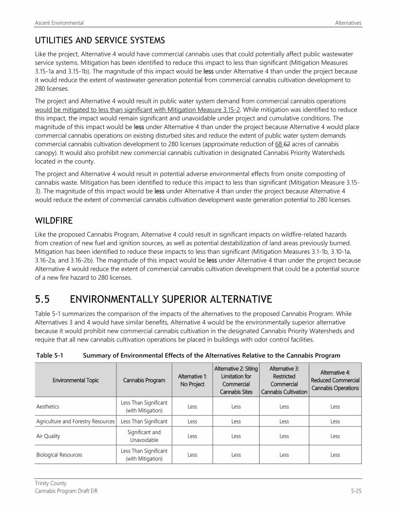
Ascent Environmental Alternatives
Trinity County Cannabis Program Draft EIR 5-25
UTILITIES AND SERVICE SYSTEMS Like the project, Alternative 4 would have commercial cannabis uses that could potentially affect public wastewater service systems. Mitigation has been identified to reduce this impact to less than significant (Mitigation Measures 3.15-1a and 3.15-1b). The magnitude of this impact would be less under Alternative 4 than under the project because it would reduce the extent of wastewater generation potential from commercial cannabis cultivation development to 280 licenses.
The project and Alternative 4 would result in public water system demand from commercial cannabis operations would be mitigated to less than significant with Mitigation Measure 3.15-2. While mitigation was identified to reduce this impact, the impact would remain significant and unavoidable under project and cumulative conditions. The magnitude of this impact would be less under Alternative 4 than under the project because Alternative 4 would place commercial cannabis operations on existing disturbed sites and reduce the extent of public water system demands commercial cannabis cultivation development to 280 licenses (approximate reduction of 68 62 acres of cannabis canopy). It would also prohibit new commercial cannabis cultivation in designated Cannabis Priority Watersheds located in the county.
The project and Alternative 4 would result in potential adverse environmental effects from onsite composting of cannabis waste. Mitigation has been identified to reduce this impact to less than significant (Mitigation Measure 3.15-3). The magnitude of this impact would be less under Alternative 4 than under the project because Alternative 4 would reduce the extent of commercial cannabis cultivation development waste generation potential to 280 licenses.
WILDFIRE Like the proposed Cannabis Program, Alternative 4 could result in significant impacts on wildfire-related hazards from creation of new fuel and ignition sources, as well as potential destabilization of land areas previously burned. Mitigation has been identified to reduce these impacts to less than significant (Mitigation Measures 3.1-1b, 3.10-1a, 3.16-2a, and 3.16-2b). The magnitude of this impact would be less under Alternative 4 than under the project because Alternative 4 would reduce the extent of commercial cannabis cultivation development that could be a potential source of a new fire hazard to 280 licenses.
5.5 ENVIRONMENTALLY SUPERIOR ALTERNATIVE Table 5-1 summarizes the comparison of the impacts of the alternatives to the proposed Cannabis Program. While Alternatives 3 and 4 would have similar benefits, Alternative 4 would be the environmentally superior alternative because it would prohibit new commercial cannabis cultivation in the designated Cannabis Priority Watersheds and require that all new cannabis cultivation operations be placed in buildings with odor control facilities.
Table 5-1 Summary of Environmental Effects of the Alternatives Relative to the Cannabis Program
Environmental Topic Cannabis Program Alternative 1: No Project
Alternative 2: Siting Limitation for Commercial
Cannabis Sites
Alternative 3: Restricted
Commercial Cannabis Cultivation
Alternative 4: Reduced Commercial Cannabis Operations
Aesthetics Less Than Significant (with Mitigation) Less Less Less Less
Agriculture and Forestry Resources Less Than Significant Less Less Less Less
Air Quality Significant and Unavoidable Less Less Less Less
Biological Resources Less Than Significant (with Mitigation) Less Less Less Less
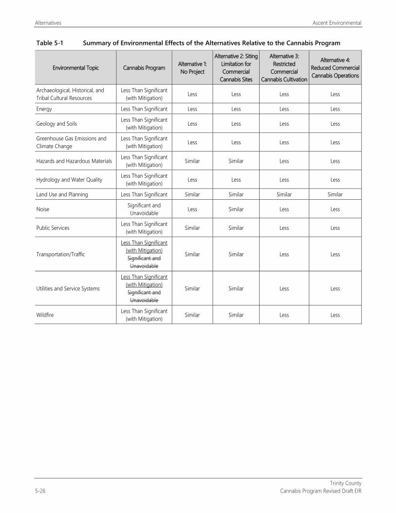
Alternatives Ascent Environmental
Trinity County 5-26 Cannabis Program Revised Draft EIR
Table 5-1 Summary of Environmental Effects of the Alternatives Relative to the Cannabis Program
Environmental Topic Cannabis Program Alternative 1: No Project
Alternative 2: Siting Limitation for Commercial
Cannabis Sites
Alternative 3: Restricted
Commercial Cannabis Cultivation
Alternative 4: Reduced Commercial Cannabis Operations
Archaeological, Historical, and Tribal Cultural Resources
Less Than Significant (with Mitigation) Less Less Less Less
Energy Less Than Significant Less Less Less Less
Geology and Soils Less Than Significant (with Mitigation) Less Less Less Less
Greenhouse Gas Emissions and Climate Change
Less Than Significant (with Mitigation) Less Less Less Less
Hazards and Hazardous Materials Less Than Significant (with Mitigation) Similar Similar Less Less
Hydrology and Water Quality Less Than Significant (with Mitigation) Less Less Less Less
Land Use and Planning Less Than Significant Similar Similar Similar Similar
Noise Significant and Unavoidable Less Similar Less Less
Public Services Less Than Significant (with Mitigation) Similar Similar Less Less
Transportation/Traffic
Less Than Significant (with Mitigation) Significant and Unavoidable
Similar Similar Less Less
Utilities and Service Systems
Less Than Significant (with Mitigation) Significant and Unavoidable
Similar Similar Less Less
Wildfire Less Than Significant (with Mitigation) Similar Similar Less Less
Trinity County Cannabis Program Revised Draft EIR 6-1
6 OTHER CEQA-MANDATED SECTIONS
6.1 GROWTH INDUCEMENT PRC Section 21100(b)(5) specifies that the growth-inducing impacts of a project must be addressed in an EIR. Section 15126.2(e) of the State CEQA Guidelines provides the following guidance for assessing growth-inducing impacts of a project:
Discuss the ways in which the proposed project could foster economic or population growth, or the construction of additional housing, either directly or indirectly, in the surrounding environment. Included in this are projects which would remove obstacles to population growth (a major expansion of a wastewater treatment plant might, for example, allow for more construction in service areas). Increases in the population may tax existing community service facilities, requiring construction of new facilities that could cause significant environmental effects. Also, discuss the characteristics of some projects which may encourage and facilitate other activities that could significantly affect the environment, either individually or cumulatively. It must not be assumed that growth in any area is necessarily beneficial, detrimental, or of little significance to the environment.
A project can induce growth directly, indirectly, or both ways. Direct growth inducement would result if a project involved construction of new housing. Indirect growth inducement would result, for instance, if implementing a project resulted in any of the following:
substantial new permanent employment opportunities (e.g., commercial, industrial, or governmental enterprises);
substantial short-term employment opportunities (e.g., construction employment) that indirectly stimulates the need for additional housing and services to support the new temporary employment demand; or
removal of an obstacle to additional growth and development, such as removing a constraint on a required public utility or service (e.g., construction of a major sewer line with excess capacity through an undeveloped area).
Growth inducement itself is not an environmental effect but may foreseeably lead to environmental effects. If substantial growth inducement occurs, it can result in secondary environmental effects, such as increased demand for housing, demand for other community and public services and infrastructure capacity, increased traffic and noise, degradation of air or water quality, degradation or loss of plant or animal habitats, conversion of agricultural and open-space land to urban uses, and other effects.
6.1.1 Growth-Inducing Impacts of the Project
The California Department of Food and Agriculture estimated that cannabis production in the state in the year 2016 was approximately 13.5 million pounds, with no anticipated increases in overall production from implementation of Medical Cannabis Regulation and Safety Act (MCRSA) and Adult Use of Marijuana Act (AUMA) by the year 2018 (CDFA 2017). Estimates for state cannabis consumption in 2018 under the MCRSA and the AUMA range from 1.4 million pounds (Truth Enterprises 2016) to 2.5 million pounds, which is far below the state’s current cannabis production capability. Thus, substantial growth in legal cannabis cultivation operation statewide or in the county is not expected to occur. As of the end of 2018 the County had issued 286 cultivation licenses. The Cannabis Program would cap the extent of cultivation licenses to 530.
Implementation of the Cannabis Program is intended to regulate commercial cultivation, distribution, testing, manufacturing, and retail uses in a manner consistent with the existing character and goals of the County and state cannabis regulations. As identified in Chapter 2, “Project Description,” the total number of cannabis cultivation licenses would be capped at 530. Table 2-3 identifies the anticipated extent of development and employment

Other CEQA-Mandated Sections Ascent Environmental
Trinity County 6-2 Cannabis Program Revised Draft EIR
associated with commercial cultivation and noncultivation uses under the Cannabis Program. The project would not substantially increase population growth in the surrounding region because it is not anticipated to require the construction of large numbers of new housing units. Many of the employees necessary during commercial cannabis cultivation and harvest activities are already present within the county and adjoining counties (Humboldt, Mendocino, and Sonoma), as evidenced by the level of commercial cannabis cultivation and noncultivation uses in these counties. Additionally, the project would not remove barriers to population growth because no new or expanded (beyond what is currently planned) public infrastructure facilities would be installed. Potential development associated with the Cannabis Program is not anticipated to meaningfully affect employment or other growth in the region, given the size of the regional economy and current conditions. The reader is referred to Chapter 1, “Introduction,” for a further discussion of the growth potential of the county. The project would result in increased revenue within the county, both for residents and for the County itself, and the increased revenue for the County is anticipated to increase the County’s ability to process, monitor, and enforce cannabis-related activities within the county, per the County’s requirements. Therefore, the project would not contribute to substantial population growth or be considered growth-inducing.
Cultivation operations that are not part of the Cannabis Program would continue to be considered illegal upon readoption of the program. Enforcement activities that would be taken by the County in coordination with other agencies would bring some cultivation operations into compliance with County and state standards and would result in the closure of other operations, along with restoration of the cultivation sites. The removal of illegal cultivation sites is ongoing, and the exact number and location of future sites cannot be known at this time. Cannabis operators who view compliance with state and County cannabis regulations as cost prohibitive may elect to operate illegally. While it is acknowledged that illegal cannabis operations would continue to occur in the county after the Cannabis Program is adopted and implemented, details on the extent of future illegal cannabis operations cannot be accurately estimated and are considered speculative.
6.2 SIGNIFICANT AND UNAVOIDABLE ADVERSE IMPACTS PRC Section 21100(b)(2)(A) states that an EIR shall include a detailed statement setting forth “in a separate section: any significant effect on the environment that cannot be avoided if the project is implemented.” Accordingly, this section provides a summary of significant environmental impacts of the project that cannot be mitigated to a less-than-significant level.
Sections 3.1 through 3.16 of this DEIR describe the potential environmental impacts of the project and recommend various mitigation measures to reduce impacts, to the extent feasible. Chapter 4, “Cumulative Impacts,” determines whether the incremental effects of this project are significant when viewed in connection with the effects of past projects, other current projects, and probable future projects. After implementation of the recommended mitigation measures, which require modification of draft language within the Cannabis Program, most of the impacts associated with implementation of the project would be reduced to a less-than-significant level. The following impacts are considered significant and unavoidable; that is, no feasible mitigation is available to reduce the project’s impacts to a less-than-significant level.
AIR QUALITY Construction-generated emissions from later projects under the Cannabis Program (Impact 3.3-1)
Generation, during commercial cannabis cultivation and noncultivation operations, of emissions of reactive organic gases, oxides of nitrogen, respirable particulate matter with an aerodynamic diameter of 10 micrometers or less, and fine particulate matter with an aerodynamic diameter of 2.5 micrometers or less that exceed applicable daily and annual mass emission thresholds established by the North Coast Unified Air Quality Management District (Impact 3.3-2)
Ascent Environmental Other CEQA-Mandated Sections
Trinity County Cannabis Program Revised Draft EIR 6-3
Project contribution to cumulative air quality impacts emissions
Generation, during the cultivation and processing of cannabis, of odors associated with the plant itself, which during maturation can produce substantial odors (Impact 3.3-3)
Project contribution to cumulative impacts from exposure of people to objectionable odors
NOISE If commercial cannabis operations occur in the county under the Cannabis Program, the possible exposure of
noise-sensitive receptors to traffic noise levels that exceed the Trinity County General Plan exterior noise standards for transportation noise (Impact 3.12-3)
Project contribution to cumulative traffic noise impacts
TRANSPORTATION/TRAFFIC The addition of vehicle trips to existing traffic levels on the state highway system in Trinity County, which, during
the peak harvest time, could result in the level of service (LOS) degrading below LOS C along segments of State Route (SR) 3 (Impact 3.14-2)
Project contribution to cumulative traffic impacts on SR 3 and SR 299
UTILITIES AND SERVICE SYSTEMS Increased demand from public water systems for commercial cannabis facilities allowed under the Cannabis
Program (Impact 4.15-2)
Project contribution to cumulative public water supply impacts
6.3 SIGNIFICANT AND IRREVERSIBLE ENVIRONMENTAL CHANGES The State CEQA Guidelines require a discussion of any significant irreversible environmental changes that would be caused by the project. Specifically, State CEQA Guidelines Section 15126.2(d) states:
Uses of nonrenewable resources during the initial and continued phases of the project may be irreversible, since a large commitment of such resources makes removal or nonuse thereafter unlikely. Primary impacts and, particularly, secondary impacts (such as highway improvement which provides access to a previously inaccessible area) generally commit future generation to similar uses. Also, irreversible damage can result from environmental accidents associated with the project. Irretrievable commitments of resources should be evaluated to assure that such current consumption is justified.
The project would result in the irreversible and irretrievable commitment of energy and material resources during construction and operation, including the following:
construction materials, including such resources as soil, rocks, wood, concrete, glass, roof shingles, and steel;
land area committed to new commercial cannabis–related facilities;
water supply for project construction and operation; and
energy expended in the form of electricity, gasoline, diesel fuel, and oil for equipment and transportation vehicles that would be needed for project construction and operation.

Other CEQA-Mandated Sections Ascent Environmental
Trinity County 6-4 Cannabis Program Revised Draft EIR
The use of these nonrenewable resources is expected to account for a minimal portion of the region’s resources and would not affect the availability of these resources for other needs within the region. Construction activities would not result in inefficient use of energy or natural resources. Construction contractors selected would use best available engineering techniques, construction and design practices, and equipment operating procedures. Long-term project operation would not result in substantial long-term consumption of energy and natural resources because buildings would be designed using current energy efficient technologies as required by applicable building codes. The reader is referred to Section 3.6, “Energy,” for an analysis of the Cannabis Program’s impacts on energy use.

Trinity County Cannabis Program Revised Draft EIR 7-1
7 REPORT PREPARERS Trinity County (Lead Agency) Kim Hunter .......................................................................................................................................................................... Director of Planning Leslie Hubbard ................................................................................................................................................... Deputy Director of Planning Margie DeRose ............................................................................................................................................................................. Senior Planner David Colbeck ................................................................................................................................... Environmental Compliance Specialist
Ascent Environmental, Inc. (CEQA Compliance) Gary Jakobs ................................................................................................................................................................................................ Principal Patrick Angell ............................................................................................................................................................................ Project Manager Cori Resha Megan Diliberti ............................................................................................................................... Assistant Project Manager Jim Merk ..................................................................................................................................................................................... Technical Review Megan Diliberti ......................................................... Aesthetics, Geology and Soils, Hazards and Hazardous Materials, Wildfire Marianne Lowenthal ............................................ Hydrology and Water Quality, Utilities and Service Systems, Public Services Alta Cunningham ........................................................................................ Archaeological, Historical, and Tribal Cultural Resources Patrick Angell ........................................................................................ Agriculture and Forestry Resources, Land Use and Planning Hannah Kornfeld ................................................................. Air Quality, Energy, Greenhouse Gas Emissions and Climate Change Zachary Miller.................................................................................................................................................... Noise, Transportation/Traffic Austin Kerr .................................................................................................................................... Senior Air Quality/GHG/Noise Specialist Allison Fuller ...................................................................................................................................................................... Biological Resources Linda Leeman .............................................................................................................................................................................. Senior Biologist Michele Mattei ................................................................................................................................................................... Publishing Specialist Lisa Merry .......................................................................................................................................................................................... GIS Specialist Brian Perry .............................................................................................................................................................................. Graphics Specialist
Pacific Watershed Associates Bill Weaver............................................................................................................................................................................................ Senior Staff

Report Preparers Ascent Environmental
Trinity County 7-2 Cannabis Program Revised Draft EIR
This page intentionally left blank.
Trinity County Cannabis Program Revised Draft EIR 8-1
8 REFERENCES Executive Summary No references were used.
Chapter 1 Introduction California Department of Finance. 2019. Report P-1 State Population Projections (2010–2060. Accessed January 24,
2019.
California Employment Development Department. 2019. Historical Civilian Labor Force, Trinity County. Accessed January 18, 2019.
Chapter 2 Project Description and Alternatives Ascent Environmental. 2018 (December). Technical Memorandum for Trinity County Commercial Cannabis
Development and Operation Assumptions.
California Bureau of Cannabis Control. 2018. Search of database of active cannabis licenses in Trinity County. Available: https://www.bcc.ca.gov/clear/license_search.html. Accessed December 20, 2018.
California Department of Food and Agriculture. 2017 (November). CalCannabis Cultivation Licensing Draft Program Environmental Impact Report. State Clearinghouse No. 2016082077. Sacramento, CA. Prepared by Horizon Water and Environment, Oakland, CA.
———. 2018. Search of database of active cannabis cultivation licenses in Trinity County. Available: https://aca6.accela.com/CALCANNABIS/Cap/CapHome.aspx?module=Licenses. Accessed December 19, 2018.
CDFA. See California Department of Food and Agriculture.
Dumouchel, Robert. Associate Planner. City of Eureka, Eureka, CA. December 5, 2018—email correspondence to Megan Diliberti at Ascent Environmental regarding Evio Cannabis Laboratory facility.
Hubbard, Leslie. Deputy Director. Trinity County Planning Department, Weaverville, CA. December 2018—Trinity County cannabis licensing data through December 2018 provided to Pat Angell at Ascent Environmental.
Humboldt County. 2017 (September). Humboldt County Code Regulating Commercial Cannabis Activities Draft Environmental Impact Report. State Clearinghouse No. 2017042022. Prepared by Ascent Environmental, Sacramento, CA.
North State Resources. 2016. Mapping of cannabis cultivation sites in Trinity County in 2016. Redding, CA. Prepared for Trinity County.
Santa Barbara County. 2017 (October). Cannabis Land Use Ordinance and Licensing Program Draft Environmental Impact Report. State Clearinghouse No. 2017071016. Prepared by Santa Barbara County and AMEC Foster Wheeler.
Chapter 3 Environmental Impacts and Mitigation Measures No references cited.
Section 3.1 Aesthetics Wild and Scenic Rivers. 2017. California. Available: https://www.rivers.gov/california.php.
Section 3.2 Agricultural Resources CAL FIRE. See California Department of Forestry and Fire Protection.
References Ascent Environmental
Trinity County 8-2 Cannabis Program Revised Draft EIR
California Department of Food and Agriculture. 2016. California Agricultural Statistics Review 2016–2017. Available: https://www.nass.usda.gov/Statistics_by_State/California/Publications/Annual_Statistical_Reviews/2017/2016cas-all.pdf. Accessed January 10, 2019.
California Department of Forestry and Fire Protection. 2019 (January 10). Forest Legacy Program Project Map. Available : http://calfire.ca.gov/resource_mgt/resource_mgt_forestryassistance_legacy
CDA. See California Department of Food and Agriculture.
Trinity County. 2016. Trinity County: Department of Agriculture/Weights and Measures 2016 Crop Report..
Section 3.3 Air Quality and Odors California Air Resources Board. 2000 (October). Risk Reduction Plan to Reduce Particulate Matter Emissions from Diesel-
Fueled Engines and Vehicles. Available: https://www.arb.ca.gov/diesel/documents/rrpFinal.pdf. Accessed March 8, 2017.
———. 2012 (December). Miscellaneous Process Methodology 7.10: Unpaved Road Dust, Non-Farm Roads. Available: https://www.arb.ca.gov/ei/areasrc/fullpdf/full7-10_2012.pdf. Accessed March 4, 2019.
———. 2013. California Almanac of Emissions and Air Quality—2013 Edition. Available: http://www.arb.ca.gov/aqd/almanac/almanac13/almanac13.htm. Accessed January 4, 2017.
———. 2016 (May 4). Ambient Air Quality Standards. Available: https://www.arb.ca.gov/research/aaqs/aaqs2.pdf. Accessed January 4, 2017.
———. 2017. Inhalable Particulate Matter and Health. Available: https://www.arb.ca.gov/research/aaqs/common-pollutants/pm/pm.htm. Accessed February 7, 2019.
———. 2019. iADAM: Air Quality Data Statistics. Available: http://www.arb.ca.gov/adam/. Accessed March 5, 2019.
California Geological Survey. 2002. Guidelines for Geologic Investigations of Naturally Occurring Asbestos in California. Special Publication 124.
California Office of Environmental Health and Hazard Assessment. 2015 (February). Air Toxic Hot Spots Program—Risk Assessment Guidelines: Guidance Manual for Preparation of Health Risk Assessments. Available: http://oehha.ca.gov/media/downloads/crnr/2015guidancemanual.pdf.
CARB. See California Air Resources Board.
Churchill, R. K., and R. L. Hill. 2000 (August). A General Location Guide for Ultramafic Rocks in California—Areas More Likely to Contain Naturally Occurring Asbestos. California Department of Conservation.
City of Denver. 2018 (August 9). Cannabis Environmental Best Management Practices. Draft Section for Review: Air Quality. Department of Public Health & Environment. Available: https://www.denvergov.org/content/dam/denvergov/Portals/771/documents/EQ/MJ%20Sustainability/DRAFT%20Air%20Quality%20Section.pdf.
City of Sacramento. 2008. North Natomas Finance Plan Update. Sacramento, CA.
Commercial Truck Trader. 2018. Water Truck Sales. Available: https://www.commercialtrucktrader.com/. Accessed March 13, 2018.
Davis, Jason. Division manager/deputy air pollution control officer. Permitting & Planning Division, North Coast Unified Air Quality Management District, Eureka, CA. February 20, 2019—e-mail to Hannah Kornfeld of Ascent Environmental about CEQA thresholds of significance.
EPA. See U.S. Environmental Protection Agency.
Hubbard, Leslie. Deputy director. Trinity County Planning Department, Weaverville, CA. December 2018—Trinity County cannabis licensing data through December 2018 provided to Pat Angell at Ascent Environmental.
Ascent Environmental References
Trinity County Cannabis Program Revised Draft EIR 8-3
Huey, N. A., L. C. Broering , G. A. Jutze, and C. W. Gruber. 1960. Objective Odor Pollution Control Investigations. Journal of the Air Pollution Control Association 10:6:441–446. DOI: 10.1080/00022470.1960.10467955.
Kern County. 2017 (July). Kern County Cannabis Land Use Ordinance Project Draft Environmental Impact Report. State Clearinghouse No. 2017011058. Bakersfield, CA.
Lakes Environmental Software. 2018. AERMOD View. Gaussian Plume Air Dispersion Model. Available: https://www.weblakes.com/. Accessed March 7, 2019.
McGinley, C. M. 2000. Enforceable Permit Odor Limits. St. Croix Sensory. Stillwater, MN. Presented at the Air and Waste Management Association Environmental Permitting Symposium II, Chicago, IL, November 14–16, 2000.
Midwest Research Institute. 2006 (November 1). Background Document for Revisions to Fine Fraction Ratios Used for AP-42 Fugitive Dust Emission Factors. Available: https://www3.epa.gov/ttnchie1/ap42/ch13/bgdocs/b13s02.pdf. Accessed March 4, 2019.
NCUAQMD. See North Coast Unified Air Quality Management District.
North Coast Unified Air Quality Management District. n.d. Air Quality Planning & CEQA. Available: http://www.ncuaqmd.org/index.php?page=aqplanning.ceqa#T4. Accessed March 1, 2019.
———. 1995 (May 11). Particulate Matter (PM10) Attainment Plan. Available: http://www.ncuaqmd.org/files/NCUAQMD%20Attainment%20Plan%205-95.pdf. Accessed February 22, 2019.
———. 2015 (July 9). Regulation I Rule 110—New Source Review (NSR) and Prevention of Significant Deterioration (PSD). Available: http://www.ncuaqmd.org/files/rules/reg%201/Rule%20110.pdf. Accessed February 22, 2019.
OEHHA. See California Office of Environmental Health and Hazard Assessment.
PavementGroup.com 2018. Cost estimates for used 4,000-gallon water truck. Available: https://www.pavementgroup.com/. Accessed March 13, 2018.
Public Health Ontario. 2018 (April). Evidence Brief: Odours from Cannabis Production. Available: https://www.publichealthontario.ca/-/media/documents/eb-cannabis-production-odours.pdf?la=en.
Sacramento Metropolitan Air Quality Management District. 2015 (May). LUTRANews 9(2). Available: http://www.airquality.org/LandUseTransportation/Documents/LUTRANewsQ22015.pdf#search=propel%20fuels. Accessed October 10, 2016.
———. 2016 (August). CEQA Guide. Available: http://airquality.org/Businesses/CEQA-Land-Use-Planning/CEQA-Guidance-Tools. Accessed March 1, 2019.
SMAQMD. See Sacramento Metropolitan Air Quality Management District.
Trinity County. 2014 (November). Trinity County General Plan. Safety Element. Weaverville, CA.
U.S. Environmental Protection Agency. 2012 (April). 2008 Ground-Level Ozone Standards: Region 9 Final Designations. Available: https://www3.epa.gov/region9/air/ozone/index.html. Accessed January 4, 2017.
———. 2016. Criteria Air Pollutants. Available: https://www.epa.gov/criteria-air-pollutants#self. Last updated October 19, 2016. Accessed January 4, 2017.
———. 2018. American Meteorological Society/Environmental Protection Agency Regulatory Model Improvement Committee modeling system (AERMOD), Version 18081. Available: https://www.epa.gov/scram/air-quality-dispersion-modeling-preferred-and-recommended-models#aermod. Accessed March 7, 2019.
Weather Underground. 2019. Weather History for KPO54 (Weaverville, CA)—January, 2016. Available: https://www.wunderground.com/history/airport/KO54/2016/1/1/DailyHistory.html?hdf=1. Accessed March 7, 2019.
References Ascent Environmental
Trinity County 8-4 Cannabis Program Revised Draft EIR
Western Regional Climate Center. 2016. Sacramento Executive AP, California (047630), Period of Record Monthly Climate Summary, Period of Record: 11/10/1941 to 06/09/2016. Available: http://www.wrcc.dri.edu/cgi-bin/cliMAIN.pl?ca7630. Accessed January 4, 2017.
WRCC. See Western Regional Climate Center.
Section 3.4 Biological Resources Allen, L. M., L. M. Elbroch, D. S. Casady, and H. U. Wittmer. 2015. Feeding and Spatial Ecology of Mountain Lions in
the Mendocino National Forest, California. California Fish and Game 101:51–65.
Baker, B. J., and J. M. L. Richardson. 2006. The Effect of Artificial Light on Male Breeding-Season Behavior in Green Frogs, Rana clamitans melanota. Canadian Journal of Zoology 84:1528–1532.
Bell, J. L., L. C. Sloan, and M. A. Snyder. 2004. Regional Changes in Extreme Climatic Events: A Future Climate Scenario. Journal of Climate 17:81–87.
BLM. See U.S. Bureau of Land Management.
Bombay, H. L., T. M. Benson, B. E. Valentine, and R. A. Stefani. 2003 (May). A Willow Flycatcher Survey Protocol for California. Available: https://www.birdpop.org/docs/pubs/Bombay_et_al_2003_A_WIFL_Protocol_for_CA.pdf. Accessed July 25, 2019.
CalEMA. See California Emergency Management Agency.
Calflora. 2019. Calflora database. Available: http://www.calflora.org/. Accessed January 24 and 29, 2019.
California Department of Fish and Wildlife. 2009. Protocols for Surveying and Evaluating Impacts to Special Status Native Plant Populations and Natural Communities. Available: https://nrm.dfg.ca.gov/FileHandler.ashx?DocumentID=18959. Accessed January 30, 2019.
California Department of Fish and Wildlife. 2015a. California Deer Conservation and Management Plan. Available: https://nrm.dfg.ca.gov/FileHandler.ashx?DocumentID=95105. Accessed January 28, 2019.
———. 2015b. California State Wildlife Action Plan, 2015 Update: A Conservation Legacy for Californians. Edited by A. G. Gonzales and J. Hoshi. Prepared with assistance from Ascent Environmental, Sacramento, CA. Available: https://www.wildlife.ca.gov/SWAP/Final.
———. 2018a. Protocols for Surveying and Evaluating Impacts to Special Status Native Plant Populations and Natural Communities. Available: https://nrm.dfg.ca.gov/FileHandler.ashx?DocumentID=18959. Accessed July 23, 2019.
———. 2018b. Considerations for Conserving Foothill Yellow-Legged Frog. Available: https://nrm.dfg.ca.gov/FileHandler.ashx?DocumentID=157562&inline. Accessed July 25, 2019.
———. 2019a. California Wildlife Habitat Relationships System. Operated and maintained by the Biogeographic Data Branch in cooperation with the California Interagency Wildlife Task Group. Sacramento, CA. Available: http://www.dfg.ca.gov/biogeodata/cwhr/. Accessed January 24, 2019.
———. 2019b. Pacific lamprey life history account. Available: https://nrm.dfg.ca.gov/FileHandler.ashx?DocumentID=104360&inline. Accessed May 14, 2019.
California Emergency Management Agency. 2012. California Adaptation Planning Guide: Understanding Local and Regional Characteristics.
California Energy Commission. 2012. Our Changing Climate: Vulnerability & Adaptation to the Increasing Risks of Climate Change in California. Available: <http://www.energy.ca.gov/2012 publications/CEC-500-2012-007/CEC-500-2012-007.pdf>.
California Native Plant Society. 2018. Inventory of Rare and Endangered Plants of California (online edition, v8-03 0.39). Available: http://www.rareplants.cnps.org. Accessed November 8, 2018.
Ascent Environmental References
Trinity County Cannabis Program Revised Draft EIR 8-5
———. 2019. Inventory of Rare and Endangered Plants of California (online edition, v8-03 0.39). Available: http://www.rareplants.cnps.org. Accessed July 22, 2019.
California Natural Diversity Database. 2018. Rarefind 5. Commercial Version dated November 2, 2018. California Natural Heritage Division, California Department of Fish and Wildlife, Sacramento, CA. Accessed November 8, 2018.
———. 2019. Rarefind 5. Commercial Version dated June 30, 2019. California Natural Heritage Division, California Department of Fish and Wildlife, Sacramento, CA. Accessed July 23, 2019.
Cayan, D. R., E. P. Maurer, M. D. Dettinger, M. Tyree, and K. Hayhoe. 2008. Climate Change Scenarios for the California Region. Climatic Change 87 (Suppl 1):S21–S42.
CDFW. See California Department of Fish and Wildlife.
CEC. See California Energy Commission.
CNDDB. See California Natural Diversity Database.
CNPS. See California Native Plant Society.
eBird. 2019. eBird. Ithaca, NY. Available: http://www.ebird.org. Accessed January 22, 2019.
Franklin, J. F., and T. A. Spies. 1991. Ecological Definitions of Old-Growth Douglas-Fir Forests. In Wildlife and Vegetation of Unmanaged Douglas-Fir Forests, technical coordination by L. F. Ruggiero, K. B. Aubry, A. B. Carey, and M. H. Huff, pages 61–69. General Technical Report PNW-GTR-285. U.S. Forest Service Pacific Northwest Research Station, Portland, OR.
Gabriel M. W., L. W. Woods, R. Poppenga, R. A. Sweitzer, C. Thompson, S. M. Matthews, J. M. Higley, S. M. Keller, K. Purcell, R. H. Barrett, G. M. Wengert, B. N. Sacks, and D. L. Clifford. 2012. Anticoagulant Rodenticides on our Public and Community Lands: Spatial Distribution of Exposure and Poisoning of a Rare Forest Carnivore. PLoS One 7:1–15.
Green Diamond Resource Company. 1992. Habitat Conservation Plan for the Northern Spotted Owl on the California Timberlands of the Simpson Timber Company. Available: https://greendiamond.com/responsible-forestry/certification/FSC/reports/1992%20NSO%20HCP_Part%20A.pdf. Accessed May 2017.
———. 2007. Final Environmental Assessment: Green Diamond Resource Company, California Timberlands Amendments to the Northern Spotted Owl Habitat Conservation Plan. Prepared by CH2MHILL, Sacramento, CA.
Hayward, L. S., A. E. Bowles, J. C. Ha, and S. K. Wasser. 2011. Impacts of Acute and Long-Term Vehicle Exposure on Physiology and Reproductive Success of the Northern Spotted Owl. Ecosphere 2:1–20.
Humboldt Bay Municipal Water District. 2004 (April). Habitat Conservation Plan for Its Mad River Activities. Prepared by Trinity Associates and the Humboldt Bay Municipal Water District, Arcata, CA.
Moriarty, K. M., C. W. Epps, and W. J. Zielinski. 2016. Forest Thinning Changes Movement Patterns and Habitat Use by Pacific Marten. The Journal of Wildlife Management 80:621–633.
PRBO Conservation Science. 2011. Projected Effects of Climate Change in California: Ecoregional Summaries Emphasizing Consequences for Wildlife. Version 1.0. Available: <http://data.prbo.org/apps/bssc/uploads/Ecoregional021011.pdf>.
Sauder, J. D., and J. L. Rachlow. 2014. Both Forest Composition and Configuration Influence Landscape-Scale Habitat Selection by Fishers (Pekania pennanti) in Mixed Coniferous Forests of the Northern Rocky Mountains. Forest Ecology and Management 314:75–84.
Spencer, W. D., P. Beier, K. Penrod, K. Winters, C. Paulman, H. Rustigian-Romsos, J. Strittholt, M. Parisi, and A. Pettler. 2010. California Essential Habitat Connectivity Project: A Strategy for Conserving a Connected California.
References Ascent Environmental
Trinity County 8-6 Cannabis Program Revised Draft EIR
Prepared for California Department of Transportation, California Department of Fish and Game, and Federal Highway Administration. Available: https://nrm.dfg.ca.gov/FileHandler.ashx?DocumentID=18366.
State Water Resources Control Board. 2017a (October 17). Board Meeting Session Item 6, Consideration of a Proposed Resolution Adopting the Cannabis Cultivation Policy - Principles and Guidelines for Cannabis Cultivation. Sacramento, CA.
———. 2017b (October). State Water Resources Control Board. Responses to 2017 Peer Review Comments on Draft Cannabis Cultivation Policy - Principles and Guidelines for Cannabis Cultivation. October 2017. Sacramento, CA.
———. 2019. California Priority Watersheds [tool map]. Available: https://www.waterboards.ca.gov/water_issues/programs/cannabis/california_priority_watersheds.html. Accessed May 14, 2019.Stone, E. L., S. Harris, and G. Jones. 2015. Impacts of Artificial Lighting on Bats: A Review of Challenges and Solutions. Mammalian Biology 80:213–219.
SWRCB. See State Water Resources Control Board.
UC Davis. See University of California, Davis.
University of California, Davis. 2017 (June). Visual Encounter Survey Protocol for Rana boylii in Lotic Environments. Available: https://watershed.ucdavis.edu/files/CWS%20FYLF%20VES%20Survey%20Protocol-Final.pdf. Accessed July 25, 2019.
U.S. Bureau of Land Management. 2003. Survey Protocol for Survey and Manage Terrestrial Mollusk Species from the Northwest Forest Plan. Available: https://www.blm.gov/or/plans/surveyandmanage/files/11-mollusks_v3_enclosed2.pdf. Accessed July 25, 2019.
U.S. Fish and Wildlife Service. 2006. Transmittal of Guidance: Estimating the Effects of Auditory and Visual Disturbance to Northern Spotted Owls and Marbled Murrelets in Northwestern California. Arcata Fish and Wildlife Office, Arcata, CA.
———. 2012. Protocol for Surveying Proposed Management Activities That May Impact Northern Spotted Owls. Available: https://www.fws.gov/yreka/ES/2012RevisedNSOprotocol-2-15-12.pdf. Accessed January 30, 2019.
USFWS. See U.S. Fish and Wildlife Service.
The Xerces Society. 2018. A Petition to the State of California Fish and Game Commission to List the Crotch Bumble Bee (Bombus crotchii), Franklin’s Bumble Bee (Bombus franklini), Suckley Cuckoo Bumble Bee (Bombus suckleyi), and Western Bumble Bee (Bombus occidentalis occidentalis) as Endangered under the California Endangered Species Act. Available: https://nrm.dfg.ca.gov/FileHandler.ashx?DocumentID=161902&inline. Accessed July 23, 2019.
Zielinski, W. J., K. M. Slauson, C. R. Carroll, C. J. Kent, and D. G. Kudrna. 2001. Status of American Martens in Coastal Forests of the Pacific States. Journal of Mammalogy 82:478–490.
Section 3.5 Cultural, and Tribal Cultural Resources Far Western. See Far Western Anthropological Research Group.
Far Western Anthropological Research Group. 2016. A Class I Cultural Resources Overview and Existing Information Inventory for the Northwest California Integrated Resource Management Plan. U.S. Bureau of Land Management, Redding and Arcata Field Offices.
NEIC. See Northeast Information Center.
Northeast Information Center. 2019 (February 5). Records Search of Trinity County (I.C. File #D19-1).
OHP. See Office of Historic Preservation.
Ascent Environmental References
Trinity County Cannabis Program Revised Draft EIR 8-7
Office of Historic Preservation. 2019. California Historical Resources. Available: http://ohp.parks.ca.gov/ListedResources/?view=county&criteria=53. Accessed January 7, 2019.
Trinity County Visitors and Development Bureau and Trinity County Chamber of Commerce. 2019. Trinity History. Available: http://visittrinity.com/history/. Accessed January 7, 2019.
Section 3.6 Energy AFDC. See Alternative Fuels Data Center.
Alternative Fuels Data Center. 2019. Alternative Fueling Station Counts by State. Available: https://afdc.energy.gov/states/ca. Accessed January 8, 2019.
California Department of Finance. 2019. Report P-1 State Population Projections (2010–2060). Accessed January 24, 2019.
California Department of Transportation. 2008. 2007 California Motor Vehicle Stock, Travel and Fuel Forecast.
California Energy Commission. 2018a (March). 2019 Building Energy Efficiency Standards frequently asked questions. Available: http://www.energy.ca.gov/title24/2019standards/documents/2018_Title_24_2019_Building_Standards_FAQ.pdf. Accessed August 20, 2018.
———. 2018b (July). 2017 Power Content Label: Trinity Public Utilities District. Available: https://www.energy.ca.gov/pcl/labels/2017_labels/Trinity_2017_PCL_.pdf. Accessed January 9, 2019.
———. 2018c (July). 2017 Power Content Label: Pacific Gas and Electric Company. Available: https://www.energy.ca.gov/pcl/labels/2017_labels/PG_and_E_2017_PCL.pdf. Accessed January 9, 2019.
California Energy Commission and California Air Resources Board. 2003 (August). Reducing California’s Petroleum Dependence. Available: https://www.arb.ca.gov/fuels/carefinery/ab2076final.pdf. Accessed May 14, 2019.
California Energy Commission and California Public Utilities Commission. 2008. 2008 Update Energy Action Plan.
———. 2015 (June). New Residential Zero Net Energy Action Plan 2015–2020. Available: http://www.cpuc.ca.gov/general.aspx?id=10740. Accessed March 5, 2019.
Caltrans. See California Department of Transportation.
CEC. See California Energy Commission.
CEC and CARB. See California Energy Commission and California Air Resources Board.
CEC and CPUC. See California Energy Commission and California Public Utilities Commission.
Trinity County. 2002 (May). Trinity County General Plan. Circulation Element. Weaverville, CA.
Trinity Public Utilities District. 2019. Renewable Energy. Available: https://www.trinitypud.com/about/renewable-energy.aspx. Accessed January 9, 2019.
Trinity PUD. See Trinity Public Utilities District.
Section 3.7 Geology and Soils TCRCD. See Trinity County Resource Conservation District.
Trinity County Resource Conservation District. 2005 (December 31). Downriver Fire & Fuel Management Plan. Weaverville, CA.
U.S. Forest Service. 2019. Geology: Where the Earth’s Crust Collides, Serpentine Is Born. Available: https://www.fs.fed.us/wildflowers/beauty/serpentines/geology.shtml. Accessed January 28, 2019.
USFS. See U.S. Forest Service.
References Ascent Environmental
Trinity County 8-8 Cannabis Program Revised Draft EIR
U.S. Geological Survey. 2019. Geological Units in Trinity County. Available: https://mrdata.usgs.gov/geology/state/fips-unit.php?code=f06105. Accessed February 21, 2019.
Section 3.8 Greenhouse Gas Emissions and Climate Change California Air Resources Board. 2016a (October). 2016 ZEV Action Plan. Available: https://www.gov.ca.gov/wp-
content/uploads/2017/09/2016_ZEV_Action_Plan.pdf. Accessed February 25, 2019.
———. 2016b. Facts about the Advanced Clean Cars Program. Available: https://www.arb.ca.gov/msprog/zevprog/factsheets/advanced_clean_cars_eng.pdf. Accessed February 25, 2019.
———. 2017 (November). California’s 2017 Climate Change Scoping Plan: The Strategy for Achieving California’s 2030 Greenhouse Gas Target. Available: https://www.arb.ca.gov/cc/scopingplan/scoping_plan_2017.pdf. Accessed February 25, 2019.
———. 2018a. SB 375 Regional Greenhouse Gas Emissions Reduction Targets. Approved by the California Air Resources Board March 22, 2018. Available: https://www.arb.ca.gov/cc/sb375/finaltargets2018.pdf. Accessed February 25, 2019.
———. 2018b (July 11). California Greenhouse Gas Emission Inventory. 2018 Edition. Available: https://www.arb.ca.gov/cc/inventory/data/data.htm?utm_medium=email&utm_source=govdelivery. Accessed February 25, 2019.
———. 2018c (July 11). California Greenhouse Gas Emissions for 2000 to 2016: Trends of Emissions and Other Indicators. Available: https://www.arb.ca.gov/cc/inventory/pubs/reports/2000_2016/ghg_inventory_trends_00-16.pdf. Accessed February 25, 2019.
California Energy Commission. 2012. Our Changing Climate 2012: Vulnerability & Adaptation to the Increasing Risks from Climate Change in California. Available: http://www.energy.ca.gov/2012publications/CEC-500-2012-007/CEC-500-2012-007.pdf. Accessed February 25, 2019.
———. 2018a (March). 2019 Building Energy Efficiency Standards: Frequently Asked Questions. Available: http://www.energy.ca.gov/title24/2019standards/documents/2018_Title_24_2019_Building_Standards_FAQ.pdf. Accessed August 23, 2018.
_______. 2018b. Cal-Adapt Annual Averages Tool. Available: http://cal-adapt.org/tools/annual-averages. Accessed December 2018.
California Natural Resources Agency. 2017 (May). Draft Report: Safeguarding California Plan: 2017 Update. Available: http://resources.ca.gov/wp-content/uploads/2017/05/DRAFT-Safeguarding-California-Plan-2017-Update.pdf. Accessed February 25, 2019.
———. 2018 (January). Safeguarding California Plan: 2018 Update. Available: http://resources.ca.gov/docs/climate/safeguarding/update2018/safeguarding-california-plan-2018-update.pdf. Accessed February 25, 2019.
CARB. See California Air Resources Board.
CEC. See California Energy Commission.
The Climate Registry. 2017 (March 15). 2017 Default Emission Factors.
CNRA. See California Natural Resources Agency.
EPA. See U.S. Environmental Protection Agency.
Governor’s Office of Planning and Research. 2017a (November). Proposed Updates to the CEQA Guidelines. Available: http://opr.ca.gov/docs/20171127_Comprehensive_CEQA_Guidelines_Package_Nov_2017.pdf. Accessed February 25, 2019.
Ascent Environmental References
Trinity County Cannabis Program Revised Draft EIR 8-9
———. 2017b (November). Technical Advisory on Evaluating Transportation Impacts in CEQA. Available: http://www.opr.ca.gov/docs/20171127_Transportation_Analysis_TA_Nov_2017.pdf. Accessed February 25, 2019.
Intergovernmental Panel on Climate Change. 2013. Chapter 6, Carbon and Other Biogeochemical Cycles. Pages 465–570 in Climate Change 2013: The Physical Science Basis. Working Group I Contribution to the Fifth Assessment Report of the Intergovernmental Panel on Climate Change. Available: http://www.climatechange2013.org/images/report/WG1AR5_ALL_FINAL.pdf. Accessed February 25, 2019.
———. 2014. Climate Change 2014 Synthesis Report: Summary for Policymakers. Available: https://www.ipcc.ch/report/ar5/syr/. Accessed February 25, 2019.
IPCC. See Intergovernmental Panel on Climate Change.
King, Heather. Air pollution specialist. California Air Resources Board, Sacramento, CA. May 26, 2017—e-mail to Austin Kerr of Ascent Environmental regarding which metropolitan planning organizations are required to prepare a Sustainable Communities Strategy pursuant to Senate Bill 375 of 2008.
OPR. See Governor’s Office of Planning and Research.
Sacramento Metropolitan Air Quality Management District. 2015 (May). LUTRANews 9(2). Available: http://www.airquality.org/LandUseTransportation/Documents/LUTRANewsQ22015.pdf#search=propel%20fuels. Accessed October 10, 2016.
San Diego Gas & Electric Company. 2016 (July 15). SDG&E Cannabis Agriculture Energy Demand Study Final Report. Prepared for San Diego Gas & Electric Company. Submitted by Evergreen Economics. Available: http://www.calmac.org/publications/SDG%26E_Cannabis_Ag_Energy_Demand_Final_Report_071516ES.pdf. Accessed March 6, 2019.
SDG&E. See San Diego Gas & Electric Company.
SMAQMD. See Sacramento Metropolitan Air Quality Management District.
State of California. 2018. California Climate Change Legislation. Available: http://www.climatechange.ca.gov/state/legislation.html. Accessed February 25, 2019.
United Nations. 2015. Paris Agreement. Available: https://unfccc.int/sites/default/files/english_paris_agreement.pdf. Accessed February 25, 2019.
U.S. Environmental Protection Agency. 2018 (April 2). EPA Administrator Pruitt: GHG Emissions Standards for Cars and Light Trucks Should be Revised. Available: https://www.epa.gov/newsreleases/epa-administrator-pruitt-ghg-emissions-standards-cars-and-light-trucks-should-be. Accessed February 25, 2019.
Wade, Samuel. Branch chief. Transportation Fuels Branch, Industrial Strategies Division, California Air Resources Board, Sacramento, CA. June 30, 2017―e-mail to Austin Kerr of Ascent Environmental regarding whether the Low Carbon Fuel Standard applies to fuels used by off-road construction equipment.
Section 3.9 Hazards and Hazardous Materials ALUC. See Trinity County Airport Land Use Commission.
California Department of Food and Agriculture. 2017 (November). CalCannabis Cultivation Licensing Draft Program Environmental Impact Report. State Clearinghouse No. 2016082077. Sacramento, CA. Prepared by Horizon Water and Environment, Oakland, CA.
California Department of Pesticide Regulation. 2015. Pesticide Use on Marijuana.
California Governor’s Office of Emergency Services. 2019. Spill Release Reporting: 2018 HazMat Spill Reports. Available: https://www.caloes.ca.gov/for-businesses-organizations/how-we-help/hazmat-spill-release-reporting. Accessed January 15, 2019.
Cal OES. See California Governor’s Office of Emergency Services.
References Ascent Environmental
Trinity County 8-10 Cannabis Program Revised Draft EIR
CDPR. See California Department of Pesticide Regulation.
Trinity County Airport Land Use Commission. 2009 (November 12). Trinity County Airport Land Use Compatibility Plan.
Trinity County Office of Education. 2019. School Directory. Available: http://www.tcoek12.org/index.php/school-districts/school-directory. Accessed January 11, 2019.
Section 3.10 Hydrology and Water Quality California Department of Water Resources. 2004a (February). Hayfork Valley Groundwater Basin. Available:
https://water.ca.gov/LegacyFiles/pubs/groundwater/bulletin_118/basindescriptions/1-6.pdf Accessed May 6, 2019.
————. 2004b (February). Hyampom Valley Groundwater Basin. Available: https://water.ca.gov/LegacyFiles/groundwater/bulletin118/basindescriptions/1-35.pdf Accessed May 6, 2019.
————. 2004c (February). Dinsmores Town Area Groundwater Basin. Available: https://water.ca.gov/LegacyFiles/groundwater/bulletin118/basindescriptions/1-34.pdf. Accessed May 6, 2019.
————. 2004d (February). Hettenshaw Valley Groundwater Basin. Available: https://water.ca.gov/LegacyFiles/groundwater/bulletin118/basindescriptions/1-36.pdf. Accessed May 6, 2019.
————. 2004e (February). Wilson Point Area Groundwater Basin. Available: https://water.ca.gov/LegacyFiles/groundwater/bulletin118/basindescriptions/1-62.pdf. Accessed May 6, 2019.
DWR. See California Department of Water Resources.
Federal Emergency Management Agency. 2014 (December 22). Flood Insurance Study: Trinity County, California and Incorporated Areas. Revised. Available: https://www.trinitycounty.org/sites/default/files/Planning/documents/FEMA%20Trinity%20River%20Flood%20Study.pdf. Accessed January 2018.
FEMA. See Federal Emergency Management Agency.
Humboldt County. 2017 (September) Draft Environmental Impact Report for the Amendments to Humboldt County Code Regulating Commercial Cannabis Activities. Eureka, CA. State Clearinghouse No. 201742022. Prepared by Ascent Environmental, Sacramento, CA.
National Wild and Scenic Rivers System. 2017a. Trinity River. Available: https://rivers.gov/rivers/Trinity.php. Accessed: May 2019.
————. 2017b. Eel River. Available: https://rivers.gov/rivers/Eel.php: May 2019.
State Water Resources Control Board. 2017a (October 17). Board Meeting Session Item 6, Consideration of a Proposed Resolution Adopting the Cannabis Cultivation Policy - Principles and Guidelines for Cannabis Cultivation. Sacramento, CA.
———. 2017b (October). Responses to 2017 Peer Review Comments on Draft Cannabis Cultivation Policy - Principles and Guidelines for Cannabis Cultivation. Sacramento, CA.
———. 2019a. The Integrated Report - 303(d) List of Water Quality Limited Segments and 305(b) Surface Water Quality Assessment. Available: https://www.waterboards.ca.gov/northcoast/water_issues/programs/tmdls/303d/. Accessed: May 2019.
———. 2019b. California Priority Watersheds. Available: https://www.waterboards.ca.gov/water_issues/programs/cannabis/california_priority_watersheds.html. Accessed: May 2019.
SWRCB. See State Water Resources Board.
Section 3.11 Land Use and Planning California Department of Transportation. 2011 (October). California Airport Land Use Planning Handbook.
Ascent Environmental References
Trinity County Cannabis Program Revised Draft EIR 8-11
Trinity County. 2016. Trinity County Department of Agriculture/Weights and Measures 2016 Crop Report.
Section 3.12 Noise Berger, E. H., R. Neitzel, and C. A. Kladden. 2010 (July 6). Noise Navigator Sound Level Database [Microsoft Excel].
University of Washington, Department of Environmental and Occupational Health Services. Seattle.
California Department of Transportation. 2013 (September). Technical Noise Supplement. Division of Environmental Analysis. Sacramento, CA. Prepared by ICF Jones & Stokes.
Caltrans. See California Department of Transportation.
Federal Highway Administration. 2004. Traffic Noise Model, Version 2.5. Available: https://www.fhwa.dot.gov/environment/noise/traffic_noise_model/tnm_v25/index.cfm. Accessed February 21, 2019.
———. 2006 (January). Roadway Construction Noise Model User’s Guide. Washington, DC. Prepared by the Research and Innovative Technology Administration, Cambridge, MA.
Federal Transit Administration. 2006 (May). Transit Noise and Vibration Impact Assessment. Washington, DC. Available: https://www.transit.dot.gov/sites/fta.dot.gov/files/docs/FTA_Noise_and_Vibration_Manual.pdf. Accessed February 21, 2019.
FHWA. See Federal Highway Administration.
FTA. See Federal Transit Administration.
Governor’s Office of Planning and Research. 2017 (July). State of California General Plan Guidelines. Sacramento, CA. Available: http://opr.ca.gov/docs/OPR_COMPLETE_7.31.17.pdf. Accessed February 21, 2019.
Hubbard, Leslie. Deputy director of Planning. Trinity County Planning Department, Weaverville, CA. April 24, 2019—interpretation of general plan noise policies.
OPR. See Governor’s Office of Planning and Research.
Trinity County. 2003 (October). Trinity County General Plan Noise Element. Available: http://docs.trinitycounty.org/Departments/Planning/Noise%20Element.pdf. Accessed February 21, 2019.
Section 3.13 Public Services California Department of Food and Agriculture. 2017. CalCannabis Cultivation Licensing Draft Program Environmental
Impact Report. State Clearinghouse No. 2016082077. Prepared by Horizon Water and Environment, Oakland, CA.
Trinity County. 2015. Trinity County Community Wildfire Protection Plan Update 2015. Available: http://www.tcrcd.net/fsc/pdf/CWPP_2015_Update_Final.pdf. Accessed January 2019.
Section 3.14 Transportation and Circulation California Department of Transportation. 2017. 2016 and 2017 Traffic Count Data.
California Employment Development Department 2019. Current Employment Statistics – Trinity County. Available: https://data.edd.ca.gov/en/Industry-Information-/Current-Employment-Statistics-Trinity-County/6b52-r82t. Accessed May 19, 2019.
Caltrans. See California Department of Transportation.
Fehr & Peers. 2010 (August). Trinity County Travel Demand Forecasting Model Development Report. Prepared for County of Trinity, CA. Available: https://www.trinitycounty.org/sites/default/files/DOT/documents/Appendix%202%20Travel%20Demand%20Model.pdf. Accessed February 21, 2019.
References Ascent Environmental
Trinity County 8-12 Cannabis Program Revised Draft EIR
Governor’s Office of Planning and Research. 2018 (November). Technical Advisory on Evaluating Transportation Impacts in CEQA.
OPR. See Governor’s Office of Planning and Research.
TCTC. See Trinity County Transportation Commission.
Transportation Research Board. 2010. Highway Capacity Manual 2010.
Trinity County. 2002 (May 1). Trinity County General Plan Circulation Element. Available: http://docs.trinitycounty.org/Departments/Planning/Circulation%20Element.pdf. Accessed February 21, 2019.
Trinity County Transportation Commission. 2017 (October 17). Final 2016 Regional Transportation Plan, Trinity County, California. Available: https://www.trinitycounty.org/sites/default/files/DOT/documents/Proposed%20Final%202016%20RTP.pdf. Accessed February 21, 2019.
Section 3.15 Utilities and Service Systems California Department of Resources Recycling and Recovery. 2015. Weaverville Inert Cell Solid Waste Disposal Site
permit application. Available: https://www2.calrecycle.ca.gov/swfacilities/Directory/53-AA-0038/Document. Accessed May 19, 2019.
———. 2019a. Solid Waste Information System facility/site search results for Weaverville Inert Cell Solid Waste Disposal Site. Available: https://www2.calrecycle.ca.gov/swfacilities/Directory/53-AA-0038. Accessed January 2019.
———. 2019b. Estimated Solid Waste Generation Rates. Available: https://www2.calrecycle.ca.gov/WasteCharacterization/General/Rates. Accessed May 19, 2019.
CalRecycle. See California Department of Resources Recycling and Recovery.
Lewiston Community Services District. 2018 (March). Environment Assessment: Lewiston Community Services District Wastewater Collection, Treatment, and Disposal Project. Lewiston, CA. Prepared by U.S. Department of Agriculture, Rural Development, Yreka, CA; U.S. Bureau of Reclamation, Shasta Lake, CA; and Stantec, Redding, CA.
Lewiston CSD. See Lewiston Community Services District.
Scribner, Wes. General manager. Weaverville Community Services District, Weaverville, CA. May 16, 2019—email to Megan Diliberti of Ascent Environmental regarding water supply available for additional connections.
State Water Resources Control Board. 2020a. (March) 2019 Progress Report for Weaverville Community Services District. Permit No. 020757.
. 2020b. (March) 2019 Progress Report for Weaverville Community Services District. Permit No. 105528.
———. 2020c. (March) 2019 Progress Report for Trinity County Waterworks District No 1. Permit No. 020625.
———. 2019. (April) 2018 Report of License for Lewiston Community Service District. License No. 006566
SWRCB. See State Water Resources Control Board.
Taylor, Robert. Rush Creek Mutual Water System, Weaverville, CA. May 15, 2019—email to Megan Diliberti of Ascent Environmental regarding water supply available for additional connections.
Trinity County. 2016. 2014–2019 Housing Element Update. Available: https://www.trinitycounty.org/sites/default/files/Planning/documents/2014-2019%20Housing%20Element%20Update%20%28adopted%208-16-16%29.pdf. Accessed January 2019.
Weaverville Sanitary District. 2019. Home. Available: http://www.weavervillesd.com/. Accessed January 2019.
WSD. See Weaverville Sanitary District.
Ascent Environmental References
Trinity County Cannabis Program Revised Draft EIR 8-13
Section 3.16 Wildfire CAL FIRE. See California Department of Forestry and Fire Protection.
California Department of Forestry and Fire Protection. 2018a. Shasta-Trinity Unit 2018 Strategic Fire Plan. Available: http://cdfdata.fire.ca.gov/pub/fireplan/fpupload/fpppdf1624.pdf.
———. 2018b. Humboldt-Del Norte Unit 2018 Strategic Fire Plan. Available: http://cdfdata.fire.ca.gov/pub/fireplan/fpupload/fpppdf1615.pdf.
———. 2018c. 2018 Statewide Incidents Map. Available: https://www.google.com/maps/d/viewer?ll=40.67614721027209%2C-123.0346045&hl=en&z=9&source=embed&ie=UTF8&mid=1HacmM5E2ueL-FT2c6QMVzoAmE5M19GAf.
Sacramento Metropolitan Air Quality Management District. 2019. Wildfire Smoke Information. Available: http://www.airquality.org/residents/public-outreach/wildfire-smoke-information. Accessed March 7, 2019.
Trinity County. 2014 (November). Trinity County Safety Element. Weaverville, CA.
———. 2015. Trinity County Community Wildfire Protection Plan. Trinity County Resource Conservation District and the Watershed Research and Training Center. Prepared for Trinity County Fire Safe Council. Available: http://www.tcrcd.net/fsc/pdf/CWPP_2015_Update_Final.pdf.
U.S. Forest Service. 1995a. Shasta-Trinity National Forest Land and Resource Management Plan. Available: https://www.fs.usda.gov/detailfull/stnf/landmanagement/planning/?cid=stelprdb5108815&width=full.
———. 1995b. Six Rivers National Forest Land and Resource Management Plan. Available: https://www.fs.usda.gov/detailfull/srnf/landmanagement/planning/?cid=stelprdb5084033&width=full.
———. 1995c. Mendocino National Forest Land and Resource Management Plan. Available: https://www.fs.usda.gov/detailfull/mendocino/landmanagement/planning/?cid=fsbdev3_004518&width=full.
———. 2019a. Shasta-Trinity National Forest Fire Management. Available: https://www.fs.usda.gov/main/stnf/fire.
———. 2019b. Shasta-Trinity National Forest Fire Management Organization. Available: https://www.fs.usda.gov/detail/stnf/fire/?cid=fseprd588258.
———. 2019c. Shasta-Trinity National Forest Schedule of Proposed Action. Available: https://www.fs.fed.us/sopa/components/reports/sopa-110514-2019-01.pdf.
———. 2019d. Six Rivers National Forest Schedule of Proposed Action. Available: https://www.fs.fed.us/sopa/components/reports/sopa-110510-current.pdf.
———. 2019e. Mendocino National Forest Schedule of Proposed Action. Available: https://www.fs.fed.us/sopa/components/reports/sopa-110508-current.pdf.
USFS. See U.S. Forest Service.
Chapter 4 Cumulative Impacts CAL FIRE. See California Department of Forestry and Fire Protection.
California Department of Finance. 2019. Report P-1: State Population Projections (2010–2060).
California Department of Food and Agriculture. 2016. California Agricultural Statistics Review 2016–2017. Available: https://www.nass.usda.gov/Statistics_by_State/California/Publications/Annual_Statistical_Reviews/2017/2016cas-all.pdf. Accessed January 10, 2019.
California Department of Forestry and Fire Protection. 2018. 2018 Statewide Incidents Map. Available: https://www.google.com/maps/d/viewer?ll=40.67614721027209%2C-123.0346045&hl=en&z=9&source=embed&ie=UTF8&mid=1HacmM5E2ueL-FT2c6QMVzoAmE5M19GAf.
California Department of Transportation. 2012. State Route 36 Transportation Concept Report. District 2. Redding, CA.
References Ascent Environmental
Trinity County 8-14 Cannabis Program Revised Draft EIR
———. 2016. State Route 299 Transportation Concept Report. District 2. Redding, CA.
Caltrans. See California Department of Transportation.
CDFA. See California Department of Food and Agriculture.
Hubbard, Leslie. Deputy director. Trinity County Planning Department, Weaverville, CA. December 2018—Trinity County cannabis licensing data through December 2018 provided to Pat Angell at Ascent Environmental.
Kern County. 2017 (July). Kern County Cannabis Land Use Ordinance Draft Environmental Impact Report. State Clearinghouse No. 2017011058. Bakersfield, CA.
Trinity County. 2014 (November). Trinity County Safety Element. Weaverville, CA.
———. 2016. Trinity County Department of Agriculture/Weights and Measures 2016 Crop Report. Weaverville, CA.
Chapter 5 Alternatives No references were used.
Chapter 6 Other CEQA Sections California Department of Food and Agriculture. 2017 (November). CalCannabis Cultivation Licensing Draft Program
Environmental Impact Report. State Clearinghouse No. 2016082077. Sacramento, CA. Prepared by Horizon Water and Environment, Oakland, CA.
CDFA. See California Department of Food and Agriculture.
Truth Enterprises. 2016 (August). Economic Impact Study of the Cannabis Sector in the Greater Sacramento Area. Sacramento, CA. Prepared by University of the Pacific Center for Business and Policy Research.