Embed Size (px)
Citation preview
The Cultural Landscape Foundationconnecting people to places™
tclf.org
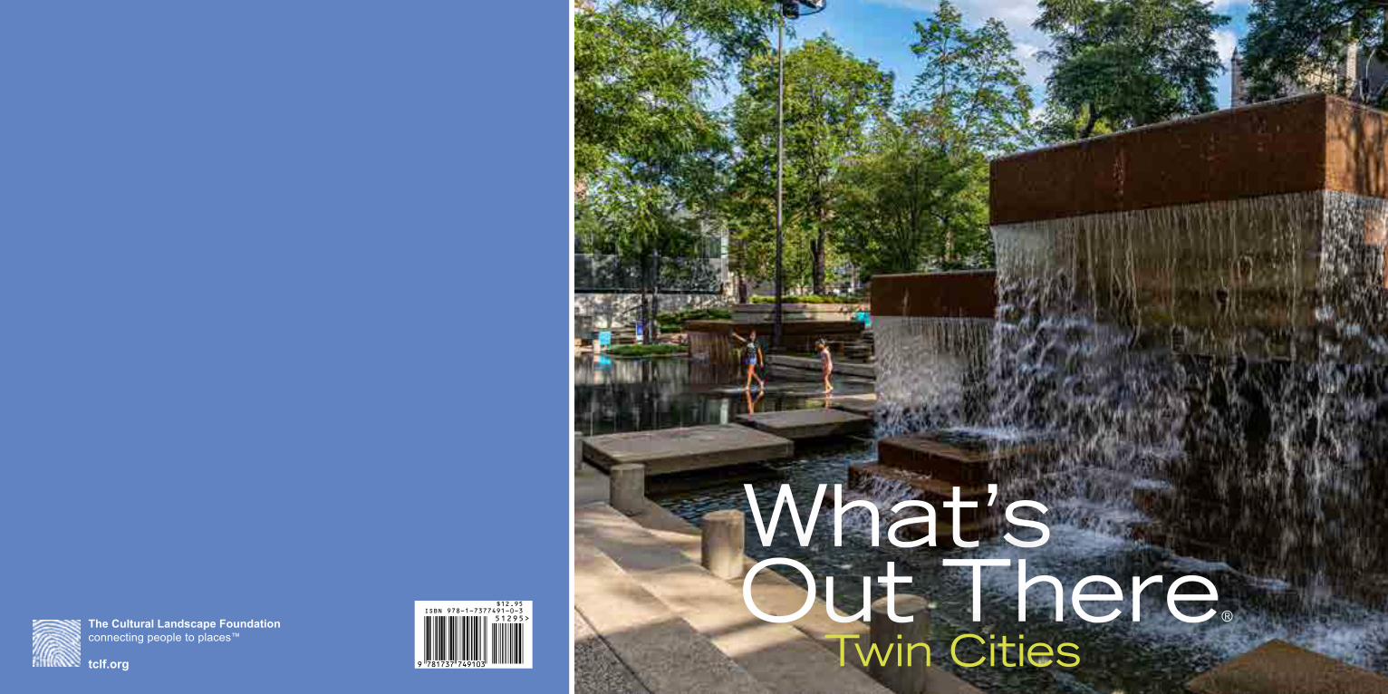
What’sOut There®
Twin Cities9 781737 749103
51295>ISBN 978-1-7377491-0-3
$12.95
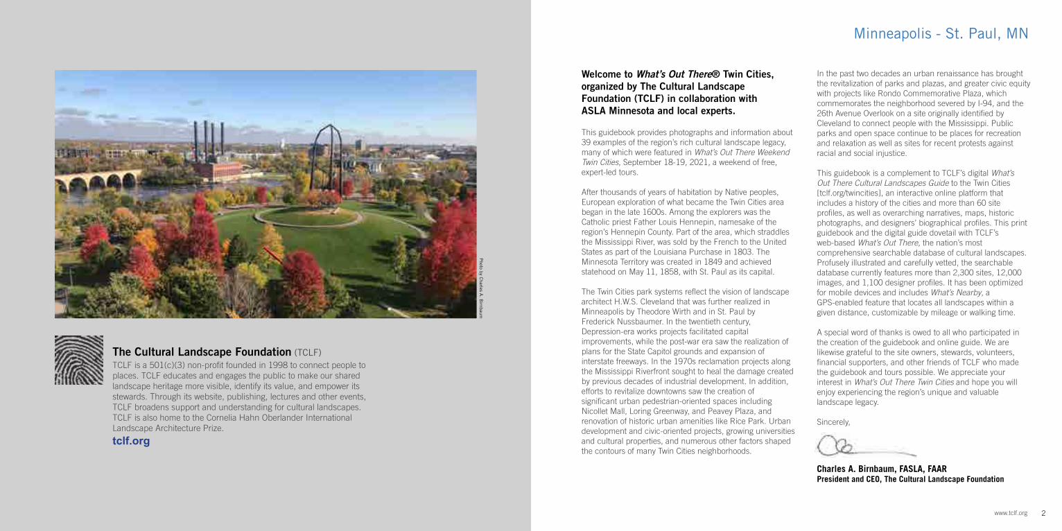
Photo by C
harles A. B
irnbaum
2www.tclf.org
The Cultural Landscape Foundation (TCLF)TCLF is a 501(c)(3) non-profit founded in 1998 to connect people to places. TCLF educates and engages the public to make our shared landscape heritage more visible, identify its value, and empower its stewards. Through its website, publishing, lectures and other events, TCLF broadens support and understanding for cultural landscapes. TCLF is also home to the Cornelia Hahn Oberlander International Landscape Architecture Prize.
tclf.org
Minneapolis - St. Paul, MN
Welcome to What’s Out There® Twin Cities, organized by The Cultural Landscape Foundation (TCLF) in collaboration with ASLA Minnesota and local experts.
This guidebook provides photographs and information about 39 examples of the region’s rich cultural landscape legacy, many of which were featured in What’s Out There Weekend Twin Cities, September 18-19, 2021, a weekend of free, expert-led tours.
After thousands of years of habitation by Native peoples, European exploration of what became the Twin Cities area began in the late 1600s. Among the explorers was the Catholic priest Father Louis Hennepin, namesake of the region’s Hennepin County. Part of the area, which straddles the Mississippi River, was sold by the French to the United States as part of the Louisiana Purchase in 1803. The Minnesota Territory was created in 1849 and achieved statehood on May 11, 1858, with St. Paul as its capital.
The Twin Cities park systems reflect the vision of landscape architect H.W.S. Cleveland that was further realized in Minneapolis by Theodore Wirth and in St. Paul by Frederick Nussbaumer. In the twentieth century, Depression-era works projects facilitated capital improvements, while the post-war era saw the realization of plans for the State Capitol grounds and expansion of interstate freeways. In the 1970s reclamation projects along the Mississippi Riverfront sought to heal the damage created by previous decades of industrial development. In addition, efforts to revitalize downtowns saw the creation of significant urban pedestrian-oriented spaces including Nicollet Mall, Loring Greenway, and Peavey Plaza, and renovation of historic urban amenities like Rice Park. Urban development and civic-oriented projects, growing universities and cultural properties, and numerous other factors shaped the contours of many Twin Cities neighborhoods.
In the past two decades an urban renaissance has brought the revitalization of parks and plazas, and greater civic equity with projects like Rondo Commemorative Plaza, which commemorates the neighborhood severed by I-94, and the 26th Avenue Overlook on a site originally identified by Cleveland to connect people with the Mississippi. Public parks and open space continue to be places for recreation and relaxation as well as sites for recent protests against racial and social injustice. This guidebook is a complement to TCLF’s digital What’s Out There Cultural Landscapes Guide to the Twin Cities [tclf.org/twincities], an interactive online platform that includes a history of the cities and more than 60 site profiles, as well as overarching narratives, maps, historic photographs, and designers’ biographical profiles. This print guidebook and the digital guide dovetail with TCLF’s web-based What’s Out There, the nation’s most comprehensive searchable database of cultural landscapes. Profusely illustrated and carefully vetted, the searchable database currently features more than 2,300 sites, 12,000 images, and 1,100 designer profiles. It has been optimized for mobile devices and includes What’s Nearby, a GPS-enabled feature that locates all landscapes within a given distance, customizable by mileage or walking time.
A special word of thanks is owed to all who participated in the creation of the guidebook and online guide. We are likewise grateful to the site owners, stewards, volunteers, financial supporters, and other friends of TCLF who made the guidebook and tours possible. We appreciate your interest in What’s Out There Twin Cities and hope you will enjoy experiencing the region’s unique and valuable landscape legacy.
Sincerely,
Sincerely,
Charles A. Birnbaum, FASLA, FAARPresident and CEO, The Cultural Landscape Foundation
33
34
32
35
36
3
4
7
8
5
6
11
12
9
10
13
16
17
20
21
18
19
24
25
22
23
14
15
29
30
31
27
28
1
2
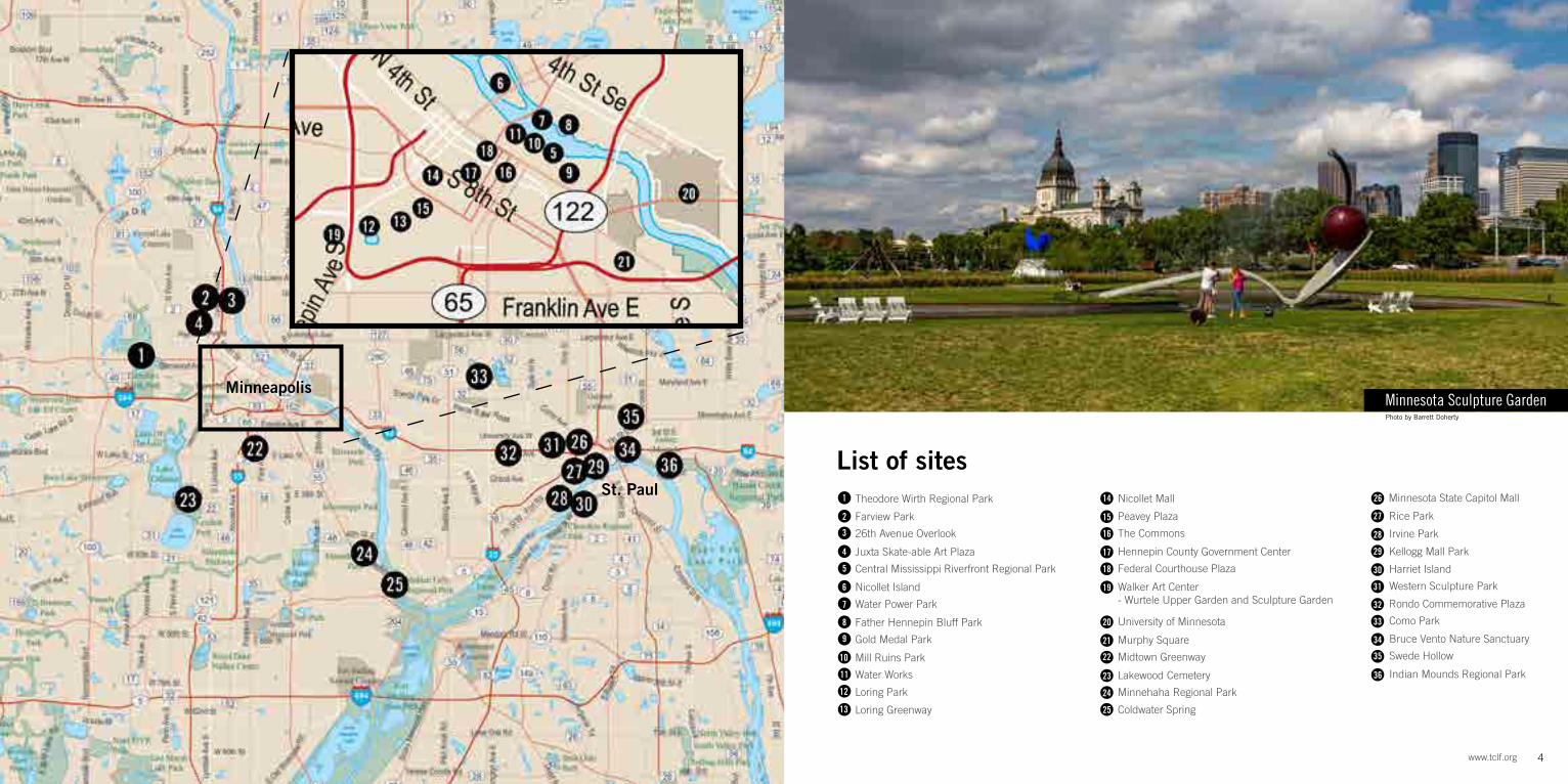
Theodore Wirth Regional Park
Farview Park
26th Avenue Overlook
Juxta Skate-able Art Plaza
Central Mississippi Riverfront Regional Park
Nicollet Island
Water Power Park
Father Hennepin Bluff Park
Gold Medal Park
Mill Ruins Park
Water Works
Loring Park
Loring Greenway
Nicollet Mall
Peavey Plaza
The Commons
Hennepin County Government Center
Federal Courthouse Plaza
Walker Art Center- Wurtele Upper Garden and Sculpture Garden
University of Minnesota
Murphy Square
Midtown Greenway
Lakewood Cemetery
Minnehaha Regional Park
Coldwater Spring
Rice Park
Irvine Park
Kellogg Mall Park
Harriet Island
Western Sculpture Park
26 Minnesota State Capitol Mall
4www.tclf.org
Minnesota Sculpture GardenPhoto by Barrett Doherty
List of sites
Rondo Commemorative Plaza
Como Park
Bruce Vento Nature Sanctuary
Swede Hollow
Indian Mounds Regional Park
Minneapolis
St. Paul
5 The Cultural Landscape Foundation
Twin Cities
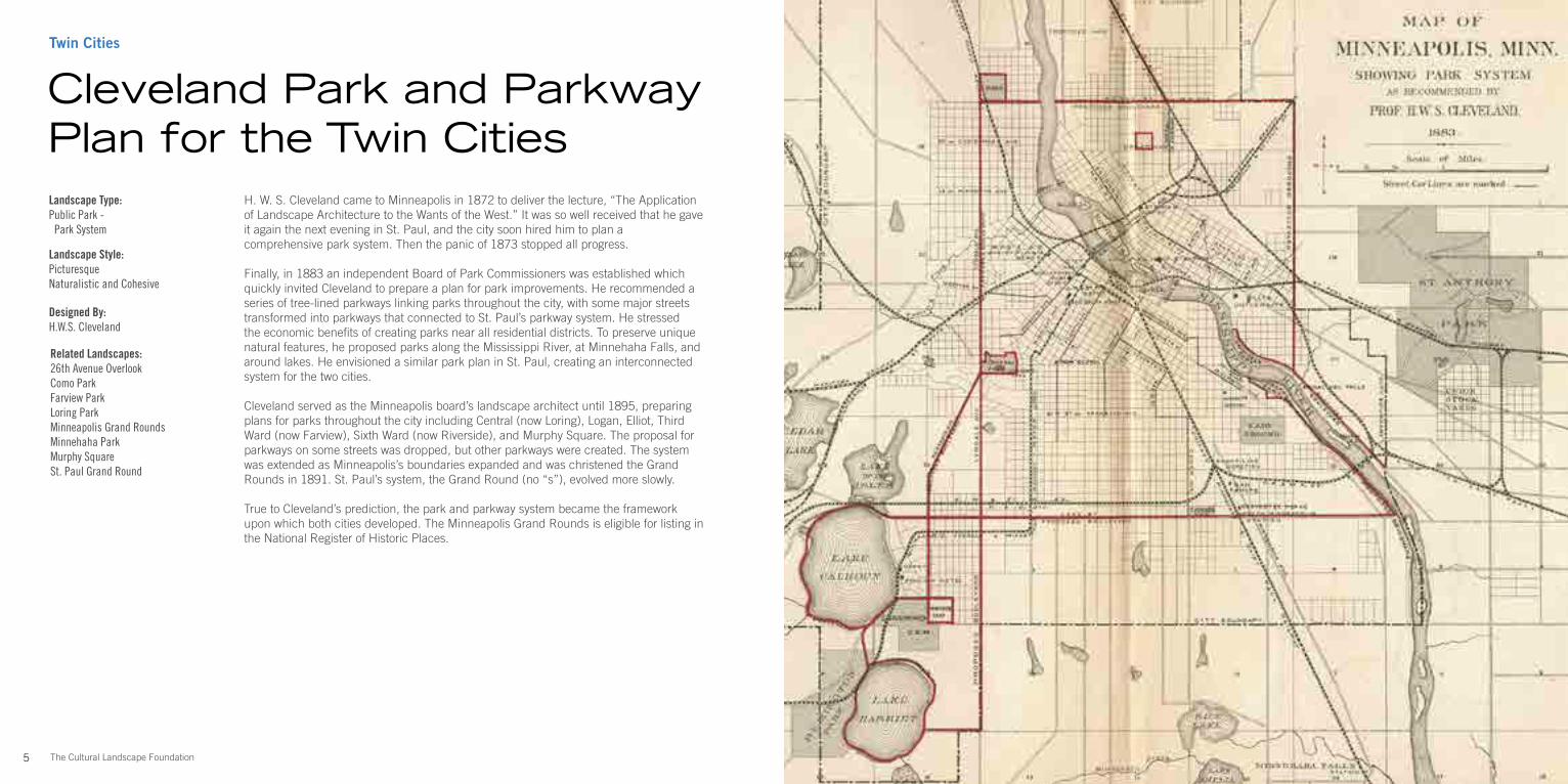
H. W. S. Cleveland came to Minneapolis in 1872 to deliver the lecture, “The Application of Landscape Architecture to the Wants of the West.” It was so well received that he gave it again the next evening in St. Paul, and the city soon hired him to plan a comprehensive park system. Then the panic of 1873 stopped all progress.
Finally, in 1883 an independent Board of Park Commissioners was established which quickly invited Cleveland to prepare a plan for park improvements. He recommended a series of tree-lined parkways linking parks throughout the city, with some major streets transformed into parkways that connected to St. Paul’s parkway system. He stressed the economic benefits of creating parks near all residential districts. To preserve unique natural features, he proposed parks along the Mississippi River, at Minnehaha Falls, and around lakes. He envisioned a similar park plan in St. Paul, creating an interconnected system for the two cities.
Cleveland served as the Minneapolis board’s landscape architect until 1895, preparing plans for parks throughout the city including Central (now Loring), Logan, Elliot, Third Ward (now Farview), Sixth Ward (now Riverside), and Murphy Square. The proposal for parkways on some streets was dropped, but other parkways were created. The system was extended as Minneapolis’s boundaries expanded and was christened the Grand Rounds in 1891. St. Paul’s system, the Grand Round (no “s”), evolved more slowly.
True to Cleveland’s prediction, the park and parkway system became the framework upon which both cities developed. The Minneapolis Grand Rounds is eligible for listing in the National Register of Historic Places.
Landscape Type:Public Park - Park System
Landscape Style:Picturesque Naturalistic and Cohesive
Designed By:H.W.S. Cleveland
Related Landscapes:26th Avenue OverlookComo ParkFarview ParkLoring ParkMinneapolis Grand RoundsMinnehaha ParkMurphy SquareSt. Paul Grand Round
Cleveland Park and Parkway Plan for the Twin Cities
8The Cultural Landscape Foundation
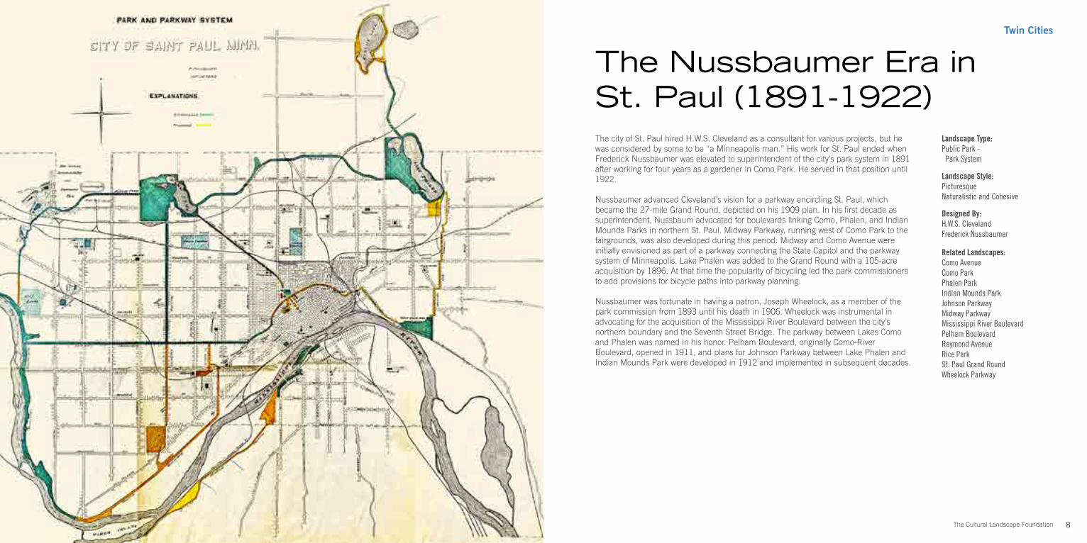
The city of St. Paul hired H.W.S. Cleveland as a consultant for various projects, but he was considered by some to be “a Minneapolis man.” His work for St. Paul ended when Frederick Nussbaumer was elevated to superintendent of the city’s park system in 1891 after working for four years as a gardener in Como Park. He served in that position until 1922.
Nussbaumer advanced Cleveland’s vision for a parkway encircling St. Paul, which became the 27-mile Grand Round, depicted on his 1909 plan. In his first decade as superintendent, Nussbaum advocated for boulevards linking Como, Phalen, and Indian Mounds Parks in northern St. Paul. Midway Parkway, running west of Como Park to the fairgrounds, was also developed during this period. Midway and Como Avenue were initially envisioned as part of a parkway connecting the State Capitol and the parkway system of Minneapolis. Lake Phalen was added to the Grand Round with a 105-acre acquisition by 1896. At that time the popularity of bicycling led the park commissioners to add provisions for bicycle paths into parkway planning.
Nussbaumer was fortunate in having a patron, Joseph Wheelock, as a member of the park commission from 1893 until his death in 1906. Wheelock was instrumental in advocating for the acquisition of the Mississippi River Boulevard between the city’s northern boundary and the Seventh Street Bridge. The parkway between Lakes Como and Phalen was named in his honor. Pelham Boulevard, originally Como-River Boulevard, opened in 1911, and plans for Johnson Parkway between Lake Phalen and Indian Mounds Park were developed in 1912 and implemented in subsequent decades.
Landscape Type:Public Park - Park System
Landscape Style:Picturesque Naturalistic and Cohesive
Designed By:H.W.S. ClevelandFrederick Nussbaumer
Related Landscapes:Como AvenueComo ParkPhalen ParkIndian Mounds ParkJohnson ParkwayMidway ParkwayMississippi River BoulevardPelham BoulevardRaymond AvenueRice ParkSt. Paul Grand RoundWheelock Parkway
The Nussbaumer Era in St. Paul (1891-1922)
Twin Cities
9 The Cultural Landscape Foundation
Twin Cities
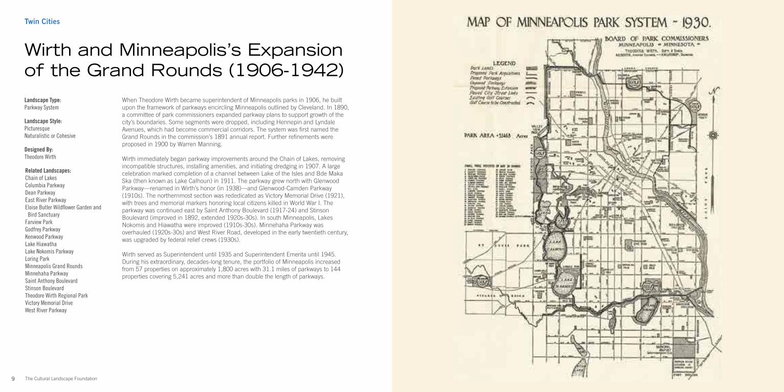
When Theodore Wirth became superintendent of Minneapolis parks in 1906, he built upon the framework of parkways encircling Minneapolis outlined by Cleveland. In 1890, a committee of park commissioners expanded parkway plans to support growth of the city’s boundaries. Some segments were dropped, including Hennepin and Lyndale Avenues, which had become commercial corridors. The system was first named the Grand Rounds in the commission’s 1891 annual report. Further refinements were proposed in 1900 by Warren Manning.
Wirth immediately began parkway improvements around the Chain of Lakes, removing incompatible structures, installing amenities, and initiating dredging in 1907. A large celebration marked completion of a channel between Lake of the Isles and Bde Maka Ska (then known as Lake Calhoun) in 1911. The parkway grew north with Glenwood Parkway—renamed in Wirth’s honor (in 1938)—and Glenwood-Camden Parkway (1910s). The northernmost section was rededicated as Victory Memorial Drive (1921), with trees and memorial markers honoring local citizens killed in World War I. The parkway was continued east by Saint Anthony Boulevard (1917-24) and Stinson Boulevard (improved in 1892, extended 1920s-30s). In south Minneapolis, Lakes Nokomis and Hiawatha were improved (1910s-30s). Minnehaha Parkway was overhauled (1920s-30s) and West River Road, developed in the early twentieth century, was upgraded by federal relief crews (1930s).
Wirth served as Superintendent until 1935 and Superintendent Emerita until 1945. During his extraordinary, decades-long tenure, the portfolio of Minneapolis increased from 57 properties on approximately 1,800 acres with 31.1 miles of parkways to 144 properties covering 5,241 acres and more than double the length of parkways.
Wirth and Minneapolis’s Expansion of the Grand Rounds (1906-1942)Landscape Type:Parkway System
Landscape Style:PicturesqueNaturalistic or Cohesive
Designed By:Theodore Wirth
Related Landscapes:Chain of LakesColumbia ParkwayDean ParkwayEast River ParkwayEloise Butler Wildflower Garden and Bird SanctuaryFarview ParkGodfrey ParkwayKenwood ParkwayLake HiawathaLake Nokomis ParkwayLoring ParkMinneapolis Grand RoundsMinnehaha ParkwaySaint Anthony BoulevardStinson BoulevardTheodore Wirth Regional ParkVictory Memorial DriveWest River Parkway
12The Cultural Landscape Foundation
Photo by Barrett Doherty
Minneapolis-North Theodore Wirth Pkwy
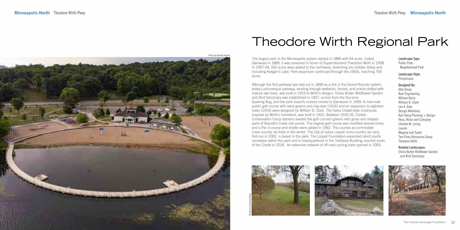
The largest park in the Minneapolis system started in 1889 with 64 acres. Called Glenwood in 1890, it was renamed in honor of Superintendent Theodore Wirth in 1938. In 1907-09, 500 acres were added to the northwest, stretching into Golden Valley and including Keegan’s Lake. Park expansion continued through the 1950s, reaching 759 acres.
Although the first parkway was laid out in 1890 as a link in the Grand Rounds system, today’s picturesque parkway, winding through wetlands, forests, and prairie dotted with mature oak trees, was built in 1910 to Wirth’s designs. Eloise Butler Wildflower Garden and Bird Sanctuary was established in 1907, across from the five-acre Quaking Bog, and the park board’s nursery moved to Glenwood in 1909. A nine-hole public golf course with sand greens and clay tees (1916) and an expansion to eighteen holes (1919) were designed by William D. Clark. The Swiss Chalet-style clubhouse, inspired by Wirth’s homeland, was built in 1922. Between 1933-35, Civilian Conservation Corps laborers seeded the golf course’s greens with grass and shaped parts of Bassett’s Creek into ponds. The original golf course was modified several times, and a Par 3 course and shelter were added in 1962. The courses accommodate cross-country ski trails in the winter. The City of Lakes Loppet cross-country ski race, first run in 2002, is based in the park. The Loppet Foundation expanded silent sports recreation within the park and is headquartered in the Trailhead Building, erected south of the Chalet in 2018. An extensive network of off-road cycling trails opened in 2005.
Theodore Wirth Regional Park
Theodore Wirth Pkwy Minneapolis-North
Landscape Type:Public Park - Neighborhood Park
Landscape Style:Picturesque
Designed By:Alta GroupBarr EngineeringWilliam BarryWilliam D. ClarkLeo A. DalyDesign WorkshopKari Haug Planning + DesignHess, Roise and CompanyCharles M. LoringLoucksMagney and TuslerTwo Pines Resources GroupTheodore Wirth
Related Landscapes:Eloise Butler Wildflower Garden and Bird Sanctuary
Pho
tos
by C
harl
ene
Roi
se
13 The Cultural Landscape Foundation
Photo by Joe Passe
621 N 29th Ave Minneapolis-NorthMinneapolis-North 621 N 29th Ave
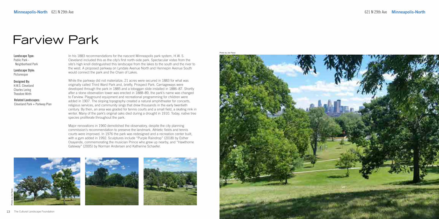
In his 1883 recommendations for the nascent Minneapolis park system, H.W. S. Cleveland included this as the city’s first north-side park. Spectacular vistas from the site’s high knoll distinguished this landscape from the lakes to the south and the river to the west. A proposed parkway on Lyndale Avenue North and Hennepin Avenue South would connect the park and the Chain of Lakes.
While the parkway did not materialize, 21 acres were secured in 1883 for what was originally called Third Ward Park and, briefly, Prospect Park. Carriageways were developed through the park in 1885 and a toboggan slide installed in 1886–87. Shortly after a stone observation tower was erected in 1888–89, the park’s name was changed to Farview. Playground equipment and recreational programming for children were added in 1907. The sloping topography created a natural amphitheater for concerts, religious services, and community sings that drew thousands in the early twentieth century. By then, an area was graded for tennis courts and a small field, a skating rink in winter. Many of the park’s original oaks died during a drought in 1910. Today, native tree species proliferate throughout the park.
Major renovations in 1960 demolished the observatory, despite the city planning commission’s recommendation to preserve the landmark. Athletic fields and tennis courts were improved. In 1976 the park was redesigned and a recreation center built, with a gym added in 1992. Sculptures include “Purple Raindrop” (2018) by Esther Osayande, commemorating the musician Prince who grew up nearby, and “Hawthorne Gateway” (2005) by Norman Andersen and Katherine Schaefer.
Farview ParkLandscape Type:Public Park - Neighborhood Park
Landscape Style:Picturesque
Designed By:H.W.S. ClevelandCharles LoringTheodore Wirth
Pho
tos
by J
oe P
asse
Related Landscapes:Cleveland Park + Parkway Plan
16The Cultural Landscape Foundation
Pho
tos
by B
arre
tt D
oher
ty
Minneapolis-North 1/2 block east of Pacific St on N 26th Ave 2007 N Emerson Ave Minneapolis-North
Identified as the first public skatepark in Minneapolis at the time of its completion in May 2019, the 4,200 square foot plaza was one result of an ambitious four-year, $14 million campaign to build a new design headquarters and update the campus of Juxtaposition Arts (JXTA), a non-profit youth art and design education center, gallery, retail shop, and artists’ studio space. Rather than leave the site of the new building empty for four years, a prominent corner lot in North Minneapolis, JXTA designed and build a plaza that combined art, flexible open space, sustainable stormwater management, and skateboarding.
This student-led design, with assistance from City of Skates, the University of Minnesota Landscape Architecture Department, and the City of Minneapolis, consists of moveable furniture for multi-use purposes and skate features like a bank to wallride with cantilevered manual pad, bank to curb, and two round quarter pockets. Serving as a backdrop is an 840-foot-long mural by Bronx-based graffiti artist Tats Cru, created during his residency in spring 2019. Three rain gardens, connected by a trench drain, occupy approximately fifteen percent of the site, infiltrating stormwater runoff from JXTA’s building and adjacent buildings to the west and north. The native plant gardens with red osier dogwood, sedum “Autumn Joy” and prairie dropseed were designed and planted by youth apprentices to improve the site’s scenic and ecological values. The plaza’s development and design are a tribute to the unique and vivacious character of North Minneapolis community.
Juxta Skate-able Art PlazaLandscape Type:Public ParkPlaza
Designed By:City of SkateJXTA - Environmental Design Lab Minneapolis Parks & Recreation BoardUMN Landscape Architecture Department
15 The Cultural Landscape Foundation
Pho
tos
by B
arre
tt D
oher
ty
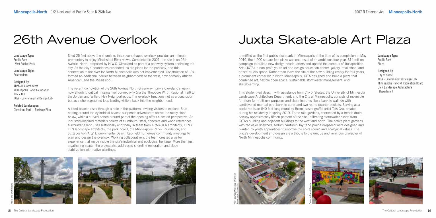
Sited 25 feet above the shoreline, this spoon-shaped overlook provides an intimate promontory to enjoy Mississippi River views. Completed in 2021, the site is on 26th Avenue North, proposed by H.W.S. Cleveland as part of a parkway system encircling the city. As the city’s boundaries expanded, so did plans for the parkway, and this connection to the river for North Minneapolis was not implemented. Construction of I-94 formed an additional barrier between neighborhoods to the west, now primarily African American, and the Mississippi.
The recent completion of the 26th Avenue North Greenway honors Cleveland’s vision, now affording critical missing river connectivity (via the Theodore Wirth Regional Trail) to the Jordan and Willard Hay Neighborhoods. The overlook functions not as a conclusion but as a choreographed loop leading visitors back into the neighborhood.
A tilted beacon rises through a hole in the platform, inviting visitors to explore. Blue netting around the cylindrical beacon suspends adventurers above the rocky slope below, while a curved bench around part of the opening offers a seated perspective. An industrial-inspired materials palette of aluminum, steel, concrete and wood references surrounding land uses historically and today. A team from 4RM+ULA architects, TEN x TEN landscape architects, the park board, the Minneapolis Parks Foundation, and Juxtaposition Arts’ Environmental Design Lab held numerous community meetings to plan and design the overlook. Working collaboratively, the team created a visitor experience that made visible the site’s industrial and ecological heritage. More than just a gathering space, the project also addressed shoreline restoration and slope stabilization with native plantings.
26th Avenue OverlookLandscape Type:Public Park - Vest Pocket Park
Landscape Style:Postmodern
Designed By:4RM+ULA architectsMinneapolis Parks FoundationTEN x TEN JXTA - Environmental Design Lab
Pho
to c
ourt
esy
Mis
siss
ippi
Wat
ersh
ed
Man
agem
ent
Org
aniz
atio
n
Related Landscapes:Cleveland Park + Parkway Plan
18The Cultural Landscape Foundation
Photo by Barrett Doherty
Minneapolis-Riverfront East and West Banks of Mississippi, Plymouth Ave N to I-35W
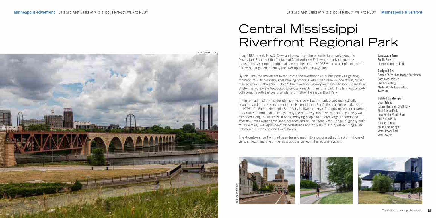
In an 1883 report, H.W.S. Cleveland recognized the potential for a park along the Mississippi River, but the frontage at Saint Anthony Falls was already claimed by industrial development. Industrial use had declined by 1963 when a pair of locks at the falls was completed, opening the river upstream to navigation.
By this time, the movement to repurpose the riverfront as a public park was gaining momentum. City planners, after making progress with urban renewal downtown, turned their attention to the area. In 1977, the Riverfront Development Coordination Board hired Boston-based Sasaki Associates to create a master plan for a park. The firm was already collaborating with the board on plans for Father Hennepin Bluff Park.
Implementation of the master plan started slowly, but the park board methodically acquired and improved riverfront land. Nicollet Island Park’s first section was dedicated in 1976, and Father Hennepin Bluff Park followed in 1980. The private sector converted underutilized industrial buildings along the periphery into new uses and a parkway was extended along the river’s west bank, bringing people to an area largely abandoned after flour mills were demolished decades earlier. The Stone Arch Bridge, originally built for a railroad, was repurposed for pedestrians and bicycles in 1997, establishing a link between the river’s east and west banks.
The downtown riverfront had been transformed into a popular attraction with millions of visitors, becoming one of the most popular parks in the regional system.
Pho
tos
by B
arre
tt D
oher
ty
Central Mississippi Riverfront Regional Park
East and West Banks of Mississippi, Plymouth Ave N to I-35W Minneapolis-Riverfront
Landscape Type:Public Park - Large Municipal Park
Designed By:Damon Farber Landscape ArchitectsSasaki AssociatesSRF ConsultingMartin & Pitz AssociatesTed Wirth
Related Landscapes:Boom IslandFather Hennepin Bluff ParkFirst Bridge ParkLucy Wilder Morris Park Mill Ruins ParkNicollet Island Stone Arch BridgeWater Power ParkWater Works
20The Cultural Landscape Foundation
Pho
tos
by C
harl
ene
Roi
se
Minneapolis-Riverfront Nicollet Island 204 SE Main St Minneapolis-Riverfront
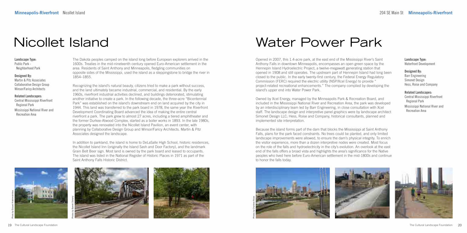
Opened in 2007, this 1.4-acre park, at the east end of the Mississippi River’s Saint Anthony Falls in downtown Minneapolis, encompasses an open green space by the Hennepin Island Hydroelectric Project, a twelve-megawatt generating station that opened in 1908 and still operates. The upstream part of Hennepin Island had long been closed to the public. In the early twenty-first century, the Federal Energy Regulatory Commission (FERC) required the electric utility (NSP/Xcel Energy) to provide “project-related recreational enhancements.” The company complied by developing the island’s upper end into Water Power Park.
Owned by Xcel Energy, managed by the Minneapolis Park & Recreation Board, and included in the Mississippi National River and Recreation Area, the park was developed by an interdisciplinary team led by Barr Engineering, in close consultation with Xcel staff. The landscape design and interpretive panel graphics were by landscape architect Simonet Design LLC; Hess, Roise and Company, historical consultants, planned and implemented site interpretation.
Because the island forms part of the dam that blocks the Mississippi at Saint Anthony Falls, plans for the park faced constraints. No trees could be planted, and only limited landscape improvements were allowed, to ensure the dam’s physical integrity. To enrich the visitor experience, more than a dozen interpretive nodes were created. Most focus on the role of the falls and hydroelectricity in the city’s evolution. An overlook at the east end of the falls offers a broad vista and highlights the area’s significance for the Native peoples who lived here before Euro-American settlement in the mid-1800s and continue to honor the falls today.
Water Power ParkLandscape Type:Waterfront Development
Designed By:Barr EngineeringSimonet DesignHess, Roise and Company
19 The Cultural Landscape Foundation
The Dakota peoples camped on the island long before European explorers arrived in the 1600s. Treaties in the mid-nineteenth century opened Euro-American settlement in the area. Residents of Saint Anthony and Minneapolis, fledgling communities on opposite sides of the Mississippi, used the island as a steppingstone to bridge the river in 1854–1855.
Recognizing the island’s natural beauty, citizens tried to make a park without success, and the land ultimately became industrial, commercial, and residential. By the early 1960s, riverfront industrial activities declined, and buildings deteriorated, stimulating another initiative to create a park. In the following decade, the three-acre “Bicentennial Park” was established on the island’s downstream end on land acquired by the city in 1944. This land was transferred to the park board in 1978, the same year the Riverfront Development Coordinating Board advanced the idea of making the entire central riverfront a park. The park grew to almost 27 acres, including a tiered amphitheater and the former Durkee-Atwood Complex, started as a boiler works in 1893. In the late 1980s, the property was renovated into the Nicollet Island Pavilion, an event center, with planning by Collaborative Design Group and Winsor/Faricy Architects. Martin & Pitz Associates designed the landscape.
In addition to parkland, the island is home to DeLaSalle High School, historic residences, the Nicollet Island Inn (originally the Island Sash and Door Factory), and the landmark Grain Belt Beer sign. Most land is owned by the park board and leased to occupants. The island was listed in the National Register of Historic Places in 1971 as part of the Saint Anthony Falls Historic District.
Nicollet IslandLandscape Type:Public Park - Neighborhood Park
Designed By:Martin & Pitz AssociatesCollaborative Design GroupWinsor/Faricy Architects
Related Landscapes:Central Mississippi Riverfront Regional ParkMississippi National River and Recreation Area
Pho
to b
y E
duar
d K
rakh
mal
niko
v
Pho
tos
by B
arre
tt D
oher
ty
Related Landscapes:Central Mississippi Riverfront Regional ParkMississippi National River and Recreation Area
21 The Cultural Landscape Foundation
Photo by Charles A. Birnbaum
420 SE Main St Minneapolis-RiverfrontMinneapolis-Riverfront 420 SE Main St
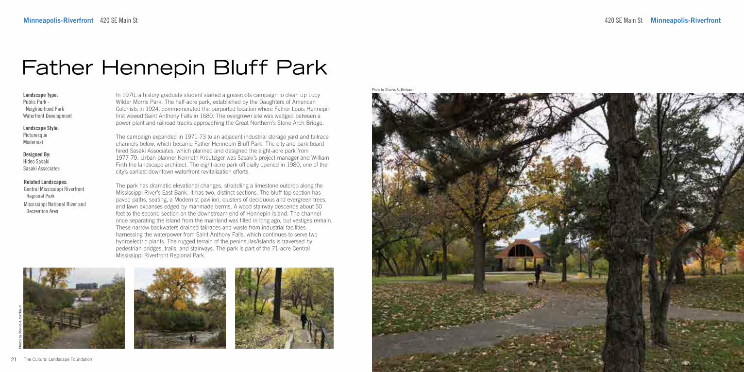
In 1970, a history graduate student started a grassroots campaign to clean up Lucy Wilder Morris Park. The half-acre park, established by the Daughters of American Colonists in 1924, commemorated the purported location where Father Louis Hennepin first viewed Saint Anthony Falls in 1680. The overgrown site was wedged between a power plant and railroad tracks approaching the Great Northern’s Stone Arch Bridge.
The campaign expanded in 1971-73 to an adjacent industrial storage yard and tailrace channels below, which became Father Hennepin Bluff Park. The city and park board hired Sasaki Associates, which planned and designed the eight-acre park from 1977-79. Urban planner Kenneth Kreutziger was Sasaki’s project manager and William Firth the landscape architect. The eight-acre park officially opened in 1980, one of the city’s earliest downtown waterfront revitalization efforts.
The park has dramatic elevational changes, straddling a limestone outcrop along the Mississippi River’s East Bank. It has two, distinct sections. The bluff-top section has paved paths, seating, a Modernist pavilion, clusters of deciduous and evergreen trees, and lawn expanses edged by manmade berms. A wood stairway descends about 50 feet to the second section on the downstream end of Hennepin Island. The channel once separating the island from the mainland was filled in long ago, but vestiges remain. These narrow backwaters drained tailraces and waste from industrial facilities harnessing the waterpower from Saint Anthony Falls, which continues to serve two hydroelectric plants. The rugged terrain of the peninsulas/islands is traversed by pedestrian bridges, trails, and stairways. The park is part of the 71-acre Central Mississippi Riverfront Regional Park.
Father Hennepin Bluff ParkLandscape Type:Public Park - Neighborhood ParkWaterfront Development
Landscape Style:PicturesqueModernist
Designed By:Hideo SasakiSasaki Associates
Related Landscapes:Central Mississippi Riverfront Regional ParkMississippi National River and Recreation Area
Pho
tos
by C
harl
es A
. B
irnb
aum
24The Cultural Landscape Foundation
Photo by August Schwerdfeger
Minneapolis-Riverfront Second St and S 11th Ave
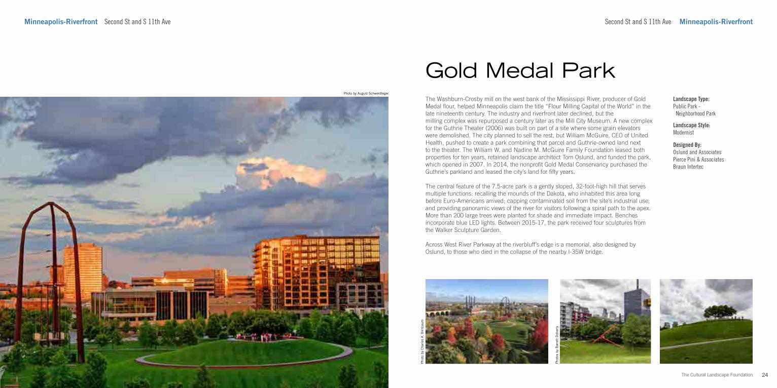
The Washburn-Crosby mill on the west bank of the Mississippi River, producer of Gold Medal flour, helped Minneapolis claim the title “Flour Milling Capital of the World” in the late nineteenth century. The industry and riverfront later declined, but the milling complex was repurposed a century later as the Mill City Museum. A new complex for the Guthrie Theater (2006) was built on part of a site where some grain elevators were demolished. The city planned to sell the rest, but William McGuire, CEO of United Health, pushed to create a park combining that parcel and Guthrie-owned land next to the theater. The William W. and Nadine M. McGuire Family Foundation leased both properties for ten years, retained landscape architect Tom Oslund, and funded the park, which opened in 2007. In 2014, the nonprofit Gold Medal Conservancy purchased the Guthrie’s parkland and leased the city’s land for fifty years.
The central feature of the 7.5-acre park is a gently sloped, 32-foot-high hill that serves multiple functions: recalling the mounds of the Dakota, who inhabited this area long before Euro-Americans arrived; capping contaminated soil from the site’s industrial use; and providing panoramic views of the river for visitors following a spiral path to the apex. More than 200 large trees were planted for shade and immediate impact. Benches incorporate blue LED lights. Between 2015-17, the park received four sculptures from the Walker Sculpture Garden.
Across West River Parkway at the riverbluff’s edge is a memorial, also designed by Oslund, to those who died in the collapse of the nearby I-35W bridge.
Gold Medal Park
Second St and S 11th Ave Minneapolis-Riverfront
Landscape Type:Public Park - Neighborhood Park
Landscape Style:Modernist
Designed By:Oslund and AssociatesPierce Pini & AssociatesBraun Intertec
Pho
tos
by B
arre
tt D
oher
ty
Pho
to b
y C
harl
es A
. B
irnb
aum
26The Cultural Landscape Foundation
Minneapolis-Riverfront 102 Portland Ave S 333 1st St S Minneapolis-Riverfront
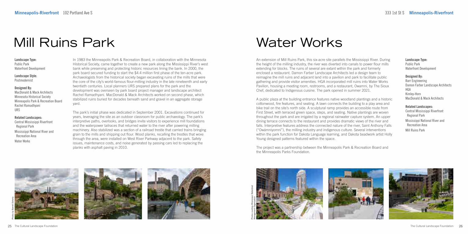
An extension of Mill Ruins Park, this six-acre site parallels the Mississippi River. During the height of the milling industry, the river was diverted into canals to power flour mills extending for blocks. The ruins of several are extant within the park and formerly enclosed a restaurant. Damon Farber Landscape Architects led a design team to reimagine the mill ruins and adjacent land into a pavilion and park to facilitate public gathering and provide visitor amenities. HGA incorporated mill ruins into Water Works Pavilion, housing a meeting room, restrooms, and a restaurant, Owamni, by The Sioux Chef, dedicated to Indigenous cuisine. The park opened in summer 2021.
A public plaza at the building entrance features native woodland plantings and a historic cottonwood, fire features, and seating. A lawn connects the building to a play area and bike trail on the site’s north side. A sculptural ramp provides an accessible route from First Street, with terraced green space, steps, and seating. Native plantings are woven throughout the park and are irrigated by a regional rainwater capture system. An upper dining terrace connects to the restaurant and provides dramatic views of the river and falls. Interpretive features address the connected nature of the river, Saint Anthony Falls (“Owámniyomni”), the milling industry and indigenous culture. Several interventions within the park function for Dakota Language learning, and Dakota beadwork artist Holly Young designed patterns featured within the space.
The project was a partnership between the Minneapolis Park & Recreation Board and the Minneapolis Parks Foundation.
Water WorksLandscape Type:Public ParkWaterfront Development
Designed By:Barr EngineeringDamon Farber Landscape ArchitectsHGAKimley-HornMacDonald & Mack Architects
25 The Cultural Landscape Foundation
In 1983 the Minneapolis Park & Recreation Board, in collaboration with the Minnesota Historical Society, came together to create a new park along the Mississippi River’s west bank while preserving and protecting historic resources lining the bank. In 2000, the park board secured funding to start the $4.4 million first phase of the ten-acre park. Archaeologists from the historical society began excavating ruins of the mills that were the core of the city’s world-famous flour-milling industry in the late nineteenth and early twentieth centuries. Local planners URS prepared plans for the park and the development was overseen by park board project manager and landscape architect Rachel Ramadhyani. MacDonald & Mack Architects worked on second phase, which stabilized ruins buried for decades beneath sand and gravel in an aggregate storage yard.
The park’s initial phase was dedicated in September 2001. Excavations continued for years, leveraging the site as an outdoor classroom for public archaeology. The park’s interpretive paths, overlooks, and bridges invite visitors to experience mill foundations and the waterpower tailraces that returned water to the river after powering milling machinery. Also stabilized was a section of a railroad trestle that carried trains bringing grain to the mills and shipping out flour. Wood planks, recalling the trestles that wove through the area, were installed on West River Parkway adjacent to the park. Safety issues, maintenance costs, and noise generated by passing cars led to replacing the planks with asphalt paving in 2010.
Mill Ruins ParkLandscape Type:Public ParkWaterfront Development
Landscape Style:Postmodernist
Designed By:MacDonald & Mack ArchitectsMinnesota Historical SocietyMinneapolis Park & Recreation BoardRachel RamadhyaniURS
Related Landscapes:Central Mississippi Riverfront Regional ParkMississippi National River and Recreation AreaWater Works
Related Landscapes:Central Mississippi Riverfront Regional ParkMississippi National River and Recreation AreaMill Ruins Park
Pho
tos
cour
tesy
Mis
siss
ippi
Wat
ersh
ed
Man
agem
ent
Org
aniz
atio
n
Pho
tos
by B
arre
tt D
oher
ty
27 The Cultural Landscape Foundation
Photo by Barrett Doherty
1382 Willow Street Minneapolis-DowntownMinneapolis-Downtown 1382 Willow Street
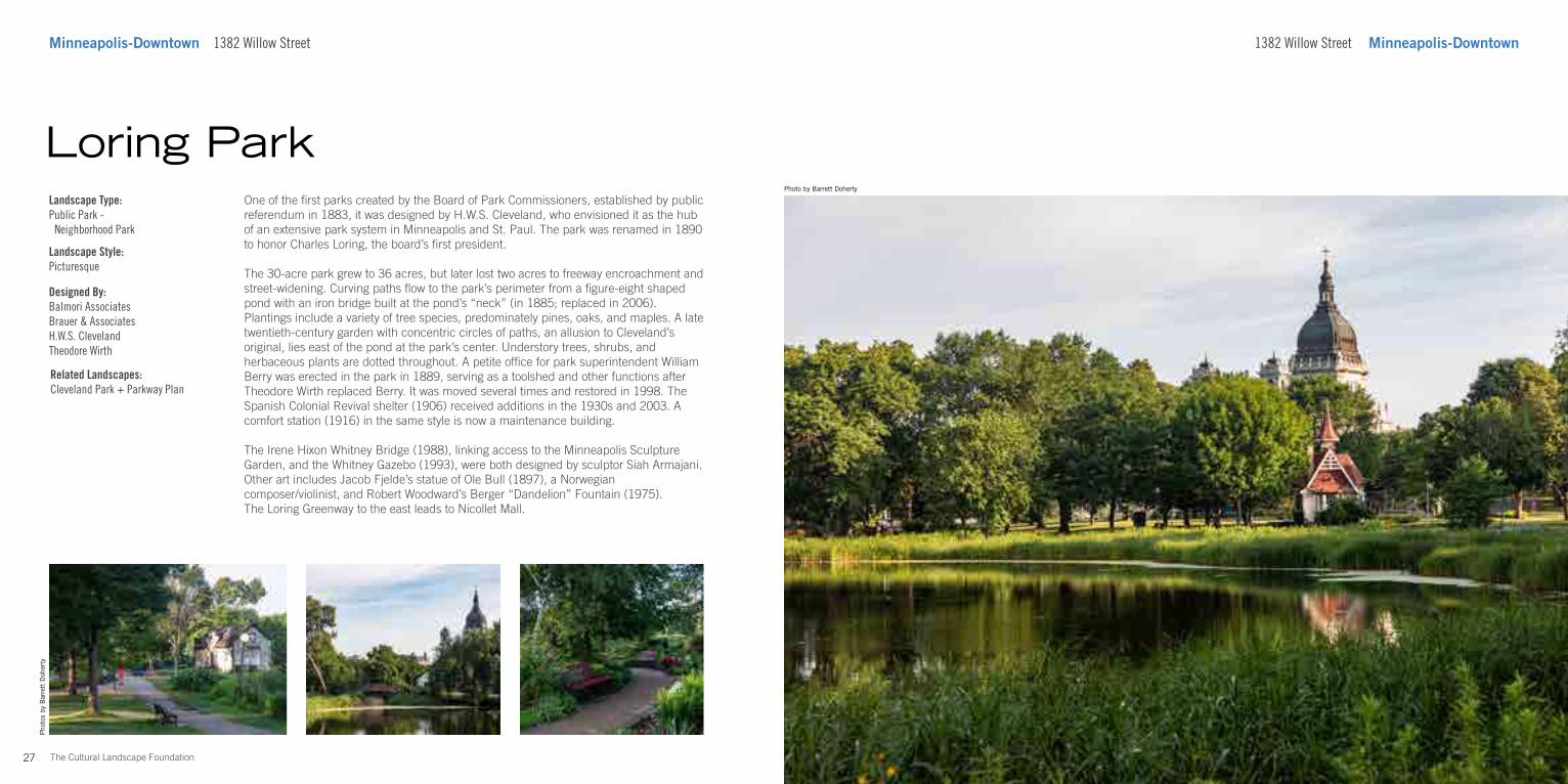
One of the first parks created by the Board of Park Commissioners, established by public referendum in 1883, it was designed by H.W.S. Cleveland, who envisioned it as the hub of an extensive park system in Minneapolis and St. Paul. The park was renamed in 1890 to honor Charles Loring, the board’s first president.
The 30-acre park grew to 36 acres, but later lost two acres to freeway encroachment and street-widening. Curving paths flow to the park’s perimeter from a figure-eight shaped pond with an iron bridge built at the pond’s “neck” (in 1885; replaced in 2006). Plantings include a variety of tree species, predominately pines, oaks, and maples. A late twentieth-century garden with concentric circles of paths, an allusion to Cleveland’s original, lies east of the pond at the park’s center. Understory trees, shrubs, and herbaceous plants are dotted throughout. A petite office for park superintendent William Berry was erected in the park in 1889, serving as a toolshed and other functions after Theodore Wirth replaced Berry. It was moved several times and restored in 1998. The Spanish Colonial Revival shelter (1906) received additions in the 1930s and 2003. A comfort station (1916) in the same style is now a maintenance building.
The Irene Hixon Whitney Bridge (1988), linking access to the Minneapolis Sculpture Garden, and the Whitney Gazebo (1993), were both designed by sculptor Siah Armajani. Other art includes Jacob Fjelde’s statue of Ole Bull (1897), a Norwegian composer/violinist, and Robert Woodward’s Berger “Dandelion” Fountain (1975). The Loring Greenway to the east leads to Nicollet Mall.
Loring ParkLandscape Type:Public Park - Neighborhood Park
Landscape Style:Picturesque
Designed By:Balmori AssociatesBrauer & AssociatesH.W.S. ClevelandTheodore Wirth
Pho
tos
by B
arre
tt D
oher
ty
Related Landscapes:Cleveland Park + Parkway Plan
30The Cultural Landscape Foundation
Pho
tos
by B
arre
tt D
oher
ty
Minneapolis-Downtown Loring Greenway Nicollet Mall Minneapolis-Downtown
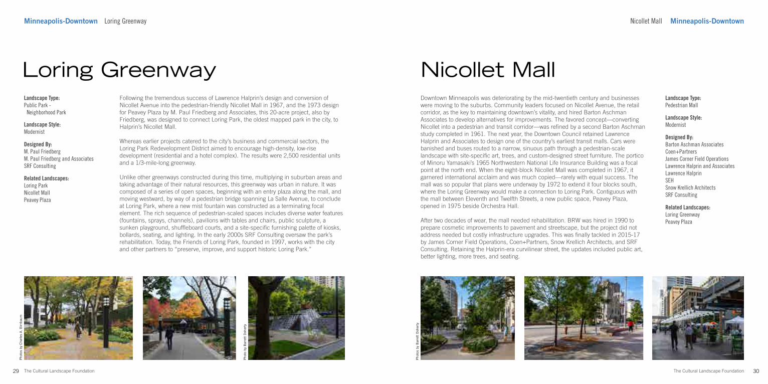
Downtown Minneapolis was deteriorating by the mid-twentieth century and businesses were moving to the suburbs. Community leaders focused on Nicollet Avenue, the retail corridor, as the key to maintaining downtown’s vitality, and hired Barton Aschman Associates to develop alternatives for improvements. The favored concept—converting Nicollet into a pedestrian and transit corridor—was refined by a second Barton Aschman study completed in 1961. The next year, the Downtown Council retained Lawrence Halprin and Associates to design one of the country’s earliest transit malls. Cars were banished and buses routed to a narrow, sinuous path through a pedestrian-scale landscape with site-specific art, trees, and custom-designed street furniture. The portico of Minoru Yamasaki’s 1965 Northwestern National Life Insurance Building was a focal point at the north end. When the eight-block Nicollet Mall was completed in 1967, it garnered international acclaim and was much copied—rarely with equal success. The mall was so popular that plans were underway by 1972 to extend it four blocks south, where the Loring Greenway would make a connection to Loring Park. Contiguous with the mall between Eleventh and Twelfth Streets, a new public space, Peavey Plaza, opened in 1975 beside Orchestra Hall.
After two decades of wear, the mall needed rehabilitation. BRW was hired in 1990 to prepare cosmetic improvements to pavement and streetscape, but the project did not address needed but costly infrastructure upgrades. This was finally tackled in 2015-17 by James Corner Field Operations, Coen+Partners, Snow Krellich Architects, and SRF Consulting. Retaining the Halprin-era curvilinear street, the updates included public art, better lighting, more trees, and seating.
Nicollet MallLandscape Type:Pedestrian Mall
Landscape Style:Modernist
Designed By:Barton Aschman AssociatesCoen+PartnersJames Corner Field OperationsLawrence Halprin and AssociatesLawrence HalprinSEHSnow Krellich ArchitectsSRF Consulting
29 The Cultural Landscape Foundation
Pho
tos
by C
harl
es A
. B
irnb
aum
Following the tremendous success of Lawrence Halprin’s design and conversion of Nicollet Avenue into the pedestrian-friendly Nicollet Mall in 1967, and the 1973 design for Peavey Plaza by M. Paul Friedberg and Associates, this 20-acre project, also by Friedberg, was designed to connect Loring Park, the oldest mapped park in the city, to Halprin’s Nicollet Mall.
Whereas earlier projects catered to the city’s business and commercial sectors, the Loring Park Redevelopment District aimed to encourage high-density, low-rise development (residential and a hotel complex). The results were 2,500 residential units and a 1/3-mile-long greenway.
Unlike other greenways constructed during this time, multiplying in suburban areas and taking advantage of their natural resources, this greenway was urban in nature. It was composed of a series of open spaces, beginning with an entry plaza along the mall, and moving westward, by way of a pedestrian bridge spanning La Salle Avenue, to conclude at Loring Park, where a new mist fountain was constructed as a terminating focal element. The rich sequence of pedestrian-scaled spaces includes diverse water features (fountains, sprays, channels), pavilions with tables and chairs, public sculpture, a sunken playground, shuffleboard courts, and a site-specific furnishing palette of kiosks, bollards, seating, and lighting. In the early 2000s SRF Consulting oversaw the park’s rehabilitation. Today, the Friends of Loring Park, founded in 1997, works with the city and other partners to “preserve, improve, and support historic Loring Park.”
Loring GreenwayLandscape Type:Public Park - Neighborhood Park
Landscape Style:Modernist
Designed By:M. Paul FriedbergM. Paul Friedberg and AssociatesSRF Consulting
Related Landscapes:Loring ParkNicollet MallPeavey Plaza
Related Landscapes:Loring GreenwayPeavey Plaza
Pho
to b
y B
arre
tt D
oher
ty
32The Cultural Landscape Foundation
Photo by Barrett Doherty
Minneapolis-Downtown 1101 Nicollet Mall
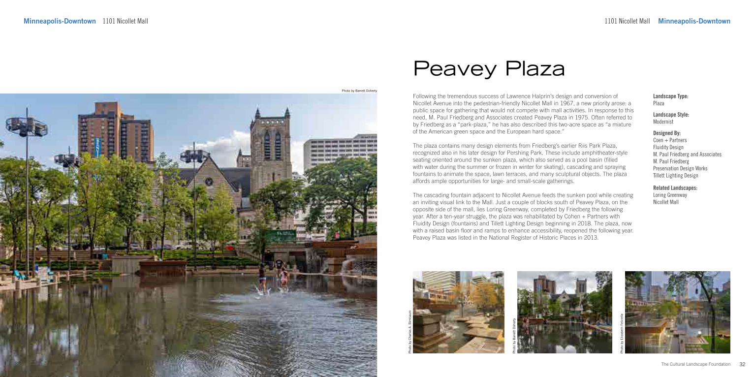
Following the tremendous success of Lawrence Halprin’s design and conversion of Nicollet Avenue into the pedestrian-friendly Nicollet Mall in 1967, a new priority arose: a public space for gathering that would not compete with mall activities. In response to this need, M. Paul Friedberg and Associates created Peavey Plaza in 1975. Often referred to by Friedberg as a “park-plaza,” he has also described this two-acre space as “a mixture of the American green space and the European hard space.”
The plaza contains many design elements from Friedberg’s earlier Riis Park Plaza, recognized also in his later design for Pershing Park. These include amphitheater-style seating oriented around the sunken plaza, which also served as a pool basin (filled with water during the summer or frozen in winter for skating), cascading and spraying fountains to animate the space, lawn terraces, and many sculptural objects. The plaza affords ample opportunities for large- and small-scale gatherings.
The cascading fountain adjacent to Nicollet Avenue feeds the sunken pool while creating an inviting visual link to the Mall. Just a couple of blocks south of Peavey Plaza, on the opposite side of the mall, lies Loring Greenway, completed by Friedberg the following year. After a ten-year struggle, the plaza was rehabilitated by Cohen + Partners with Fluidity Design (fountains) and Tillett Lighting Design beginning in 2018. The plaza, now with a raised basin floor and ramps to enhance accessibility, reopened the following year. Peavey Plaza was listed in the National Register of Historic Places in 2013.
Pho
to b
y B
arre
tt D
oher
ty
Peavey Plaza
1101 Nicollet Mall Minneapolis-Downtown
Landscape Type:Plaza
Landscape Style:Modernist
Designed By:Coen + PartnersFluidity DesignM. Paul Friedberg and AssociatesM. Paul FriedbergPreservation Design WorksTillett Lighting Design
Related Landscapes:Loring GreenwayNicollet Mall
Pho
to b
y C
harl
es A
. B
irnb
aum
Pho
to b
y E
lizab
eth
Felic
ella
34The Cultural Landscape Foundation
Pho
to b
y B
arre
tt D
oher
ty
Minneapolis-Downtown 425 Portland Ave S 300 S 6th St Minneapolis-Downtown
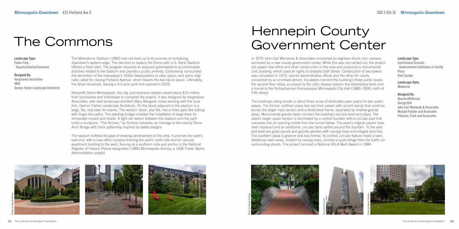
In 1970 John Carl Warnecke & Associates envisioned an eighteen-block civic campus anchored by a new county government center. While this was not carried out, the project did spawn new office and other construction in the area and produced a monumental civic building, which used air rights to straddle Sixth Street. Construction of two towers was completed in 1975, one for administrative offices and the other for courts, connected by an enclosed atrium. Escalators connect the building’s three public levels: the second-floor lobby, accessed by the city’s skyway system; the street/plaza level; and a tunnel to the Richardsonian Romanesque Minneapolis City Hall (1889–1906) north of Fifth Street.
The building’s siting results in about three acres of dedicated open space for two public plazas. The formal, northern plaza has red brick pavers with accent bands that continue across the larger main section and a street-level frame, separated by shallow granite steps. Monumental granite stairs connect the building’s second level and plaza. The plaza’s larger upper section is dominated by a central fountain with a circular pool that cascades into an opening visible from the tunnel below. The plaza’s original pavers have been replaced and an additional, circular band added around the fountain. To the east and west are grass panels and granite planters with canopy trees and integral benches. The southern plaza is greener and less formal. Its central, circular feature holds a lawn. Additional lawn areas, shaded by canopy trees, provide a quiet refuge from the traffic on surrounding streets. The project received a National ASLA Merit Award in 1984.
Hennepin County Government Center
Landscape Type:Institutional Grounds - Governmental Institution or FacilityPlazaRoof Garden
Landscape Style:Modernist
Designed By:Beamer/WilkinsonGeorge BellJohn Carl Warnecke & AssociatesMichael Painter and AssociatesPeterson, Clark and Associates
33 The Cultural Landscape Foundation
Pho
tos
by B
arre
tt D
oher
ty
The Metrodome Stadium (1982) had not lived up to its promise of revitalizing downtown’s eastern edge. The decision to replace the Dome with U.S. Bank Stadium offered a fresh start. The program required an adjacent greensward to accommodate activities related to the stadium and provide a public amenity. Controversy surrounded the demolition of the newspaper’s 1930s headquarters to clear space, and plans origi-nally called for closing Portland Avenue, which bisects the two-block space. Ultimately, the street remained, leaving a 4.2-acre park that opened in 2016.
Nonprofit Green Minneapolis, the city, and business leaders raised about $15 million from businesses and individuals to complete the project. It was designed by Hargreaves Associates, with lead landscape architect Mary Margaret Jones working with the local firm, Damon Farber Landscape Architects. On the block adjacent to the stadium is a large, flat, oval lawn for events. The western block, also flat, has a more park-like setting with finger-like paths. The planting budget enabled the installation of large trees for immediate impact and shade. A light-rail station between the stadium and the park holds a sculpture, “The Arches,” by Andrew Leicester, an homage to the nearby Stone Arch Bridge with brick patterning inspired by textile designs.
The stadium fulfilled the goal of drawing development to the area. It anchors the park’s east end, with a new office complex framing the park’s north side and an upscale apartment building to the west. Serving as a southern vista and anchor is the National Register of Historic Places designated (1985) Minneapolis Armory, a 1936 Public Works Administration project.
The CommonsLandscape Type:Public Park - Squares/Greens/Commons
Designed By:Hargreaves AssociatesHKGiDamon Farber Landscape Architects
Pho
to b
y K
en L
und
Pho
to b
y B
arre
tt D
oher
ty
36The Cultural Landscape Foundation
Pho
tos
by B
arre
tt D
oher
ty
Minneapolis-Downtown 300 S 4th St 725 Vineland Pl Minneapolis-Downtown
The museum moved to its new building in 1971. Across a street to the north was an open field, once a formal garden, owned by the Minneapolis Park Board. The museum and park board collaborated on developing the 7.5-acre sculpture garden that opened in 1988. The grid of four outdoor galleries enclosed by tall evergreen hedges was laid out by Edward Larrabee Barnes Associates, with Quennell Rothchild & Partners (QR+P). A lawn to the north features the iconic Spoonbridge and Cherry by Claus Oldenberg and Coosje van Bruggen with QR+P. Barnes also designed the Cowles Conservatory, with interior gardens by Michael van Valkenburgh Associates and Barbara Stauffacher Solomon. Van Valkenburgh returned in 1992 to design a 3.5-acre northern garden addition: a simple arc path with a hedgerow and lindens between the original and the addition, a 50-foot by 100-foot plaza for temporary displays, and a 300-foot-long steel arbor with perennial borders.
An addition by Herzog & de Meuron with local architects HGA and French landscape architect Michel Desvigne opened in 2005. With the Guthrie’s 2006 departure a sloping “Open Field” was transformed in 2010 by architects VJAA and HGA and landscape architect Coen+Partners.
To improve flexibility and sustainability the gardens were redesigned in 2017 by Oslund and Associates. While formal “bones” were respected, walls and fences were removed to improve access, the conservatory became a pavilion, and a meadow improved stormwater management. The Open Field was revised again as the Wurtele Upper Garden by Inside Outside, working with HGA to integrate the landscape and an inviting new northern entry to the museum.
Landscape Type:Public ParkInstitutional Grounds - Cultural Institution
Landscape Style:Modernist
Designed By:Edward Larrabee Barnes AssociatesCoen+PartnersMichel DesvigneHerzog & de MeuronHGAInside OutsideMinneapolis Park & Recreation BoardOslund and AssociatesQuennell Rothschild + PartnersBarbara Stauffacher SolomonMichael van Valkenburgh AssociatesVJAA
35 The Cultural Landscape Foundation
Pho
tos
by B
arre
tt D
oher
ty
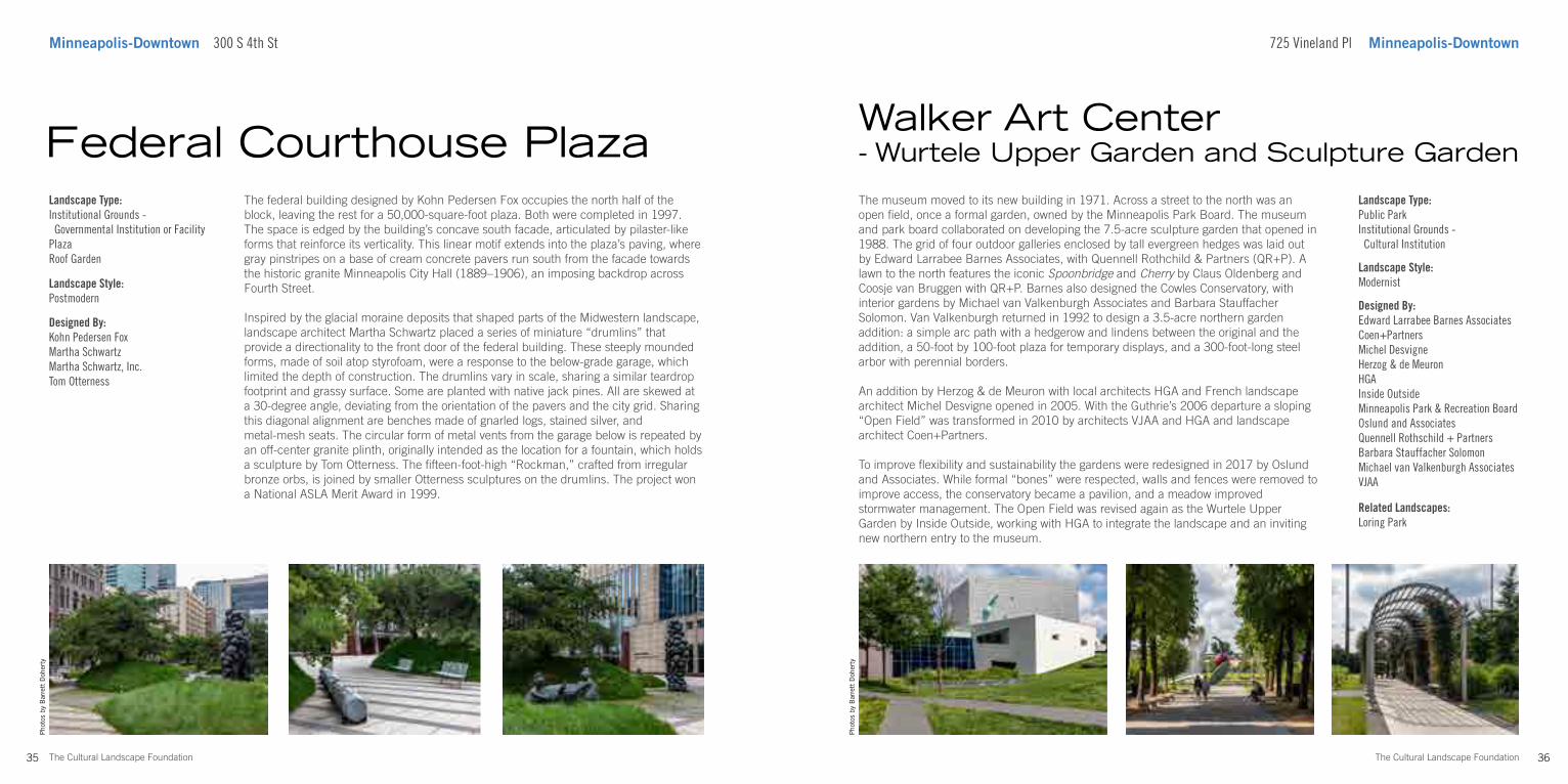
The federal building designed by Kohn Pedersen Fox occupies the north half of the block, leaving the rest for a 50,000-square-foot plaza. Both were completed in 1997. The space is edged by the building’s concave south facade, articulated by pilaster-like forms that reinforce its verticality. This linear motif extends into the plaza’s paving, where gray pinstripes on a base of cream concrete pavers run south from the facade towards the historic granite Minneapolis City Hall (1889–1906), an imposing backdrop across Fourth Street.
Inspired by the glacial moraine deposits that shaped parts of the Midwestern landscape, landscape architect Martha Schwartz placed a series of miniature “drumlins” that provide a directionality to the front door of the federal building. These steeply mounded forms, made of soil atop styrofoam, were a response to the below-grade garage, which limited the depth of construction. The drumlins vary in scale, sharing a similar teardrop footprint and grassy surface. Some are planted with native jack pines. All are skewed at a 30-degree angle, deviating from the orientation of the pavers and the city grid. Sharing this diagonal alignment are benches made of gnarled logs, stained silver, and metal-mesh seats. The circular form of metal vents from the garage below is repeated by an off-center granite plinth, originally intended as the location for a fountain, which holds a sculpture by Tom Otterness. The fifteen-foot-high “Rockman,” crafted from irregular bronze orbs, is joined by smaller Otterness sculptures on the drumlins. The project won a National ASLA Merit Award in 1999.
Federal Courthouse PlazaLandscape Type:Institutional Grounds - Governmental Institution or FacilityPlazaRoof Garden
Landscape Style:Postmodern
Designed By:Kohn Pedersen FoxMartha SchwartzMartha Schwartz, Inc.Tom Otterness
Related Landscapes:Loring Park
Walker Art Center- Wurtele Upper Garden and Sculpture Garden
37 The Cultural Landscape Foundation
Photo by Barrett Doherty
University Ave SE and 15th Ave SE Minneapolis-SoutheastMinneapolis-Southeast University Ave SE and 15th Ave SE
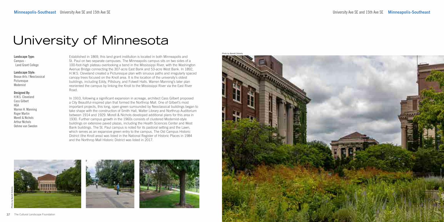
Established in 1869, this land grant institution is located in both Minneapolis and St. Paul on two separate campuses. The Minneapolis campus sits on two sides of a 100-foot-high plateau overlooking a bend in the Mississippi River, with the Washington Avenue Bridge connecting the 307-acre East Bank and 53-acre West Bank. In 1892, H.W.S. Cleveland created a Picturesque plan with sinuous paths and irregularly spaced canopy trees focused on the Knoll area. It is the location of the university’s oldest buildings, including Eddy, Pillsbury, and Folwell Halls. Warren Manning’s later plan reoriented the campus by linking the Knoll to the Mississippi River via the East River Road.
In 1910, following a significant expansion in acreage, architect Cass Gilbert proposed a City Beautiful-inspired plan that formed the Northrop Mall. One of Gilbert’s most important projects, this long, open green surrounded by Neoclassical buildings began to take shape with the construction of Smith Hall, Walter Library and Northrup Auditorium between 1914 and 1929. Morell & Nichols developed additional plans for this area in 1930. Further campus growth in the 1960s consists of clustered Modernist-style buildings on extensive paved plazas, including the Health Sciences Center and West Bank buildings. The St. Paul campus is noted for its pastoral setting and the Lawn, which serves as an expansive green entry to the campus. The Old Campus Historic District (the Knoll area) was listed in the National Register of Historic Places in 1984 and the Northrop Mall Historic District was listed in 2017.
University of MinnesotaLandscape Type:Campus - Land Grant College
Landscape Style:Beaux-Arts / NeoclassicalPicturesqueModernist
Designed By:H.W.S. ClevelandCass GilbertHGAWarren H. ManningRoger MartinMorell & NicholsArthur NicholsOehme van Sweden
Pho
tos
by B
arre
tt D
oher
ty
40The Cultural Landscape Foundation
Pho
tos
by B
arre
tt D
oher
ty
Minneapolis-South Midtown Greenway Midtown Greenway Minneapolis-South
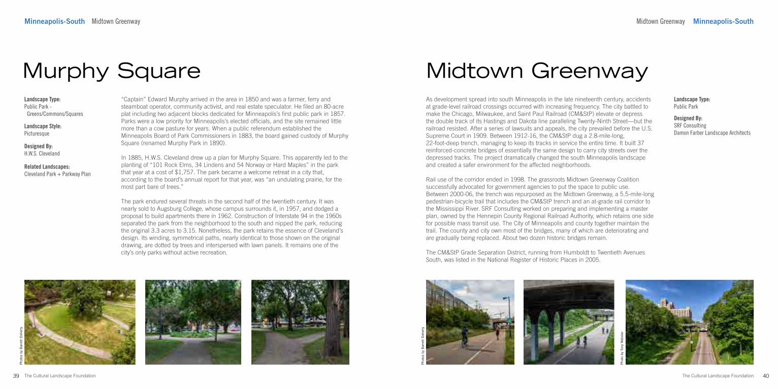
As development spread into south Minneapolis in the late nineteenth century, accidents at grade-level railroad crossings occurred with increasing frequency. The city battled to make the Chicago, Milwaukee, and Saint Paul Railroad (CM&StP) elevate or depress the double track of its Hastings and Dakota line paralleling Twenty-Ninth Street—but the railroad resisted. After a series of lawsuits and appeals, the city prevailed before the U.S. Supreme Court in 1909. Between 1912-16, the CM&StP dug a 2.8-mile-long, 22-foot-deep trench, managing to keep its tracks in service the entire time. It built 37 reinforced-concrete bridges of essentially the same design to carry city streets over the depressed tracks. The project dramatically changed the south Minneapolis landscape and created a safer environment for the affected neighborhoods.
Rail use of the corridor ended in 1998. The grassroots Midtown Greenway Coalition successfully advocated for government agencies to put the space to public use. Between 2000-06, the trench was repurposed as the Midtown Greenway, a 5.5-mile-long pedestrian-bicycle trail that includes the CM&StP trench and an at-grade rail corridor to the Mississippi River. SRF Consulting worked on preparing and implementing a master plan, owned by the Hennepin County Regional Railroad Authority, which retains one side for possible mass transit use. The City of Minneapolis and county together maintain the trail. The county and city own most of the bridges, many of which are deteriorating and are gradually being replaced. About two dozen historic bridges remain.
The CM&StP Grade Separation District, running from Humboldt to Twentieth Avenues South, was listed in the National Register of Historic Places in 2005.
Midtown GreenwayLandscape Type:Public Park
Designed By:SRF Consulting Damon Farber Landscape Architects
39 The Cultural Landscape Foundation
Pho
tos
by B
arre
tt D
oher
ty
“Captain” Edward Murphy arrived in the area in 1850 and was a farmer, ferry and steamboat operator, community activist, and real estate speculator. He filed an 80-acre plat including two adjacent blocks dedicated for Minneapolis’s first public park in 1857. Parks were a low priority for Minneapolis’s elected officials, and the site remained little more than a cow pasture for years. When a public referendum established the Minneapolis Board of Park Commissioners in 1883, the board gained custody of Murphy Square (renamed Murphy Park in 1890).
In 1885, H.W.S. Cleveland drew up a plan for Murphy Square. This apparently led to the planting of “101 Rock Elms, 34 Lindens and 54 Norway or Hard Maples” in the park that year at a cost of $1,757. The park became a welcome retreat in a city that, according to the board’s annual report for that year, was “an undulating prairie, for the most part bare of trees.”
The park endured several threats in the second half of the twentieth century. It was nearly sold to Augsburg College, whose campus surrounds it, in 1957, and dodged a proposal to build apartments there in 1962. Construction of Interstate 94 in the 1960s separated the park from the neighborhood to the south and nipped the park, reducing the original 3.3 acres to 3.15. Nonetheless, the park retains the essence of Cleveland’s design. Its winding, symmetrical paths, nearly identical to those shown on the original drawing, are dotted by trees and interspersed with lawn panels. It remains one of the city’s only parks without active recreation.
Murphy SquareLandscape Type:Public Park - Greens/Commons/Squares
Landscape Style:Picturesque
Designed By:H.W.S. Cleveland
Related Landscapes:Cleveland Park + Parkway Plan
Pho
to b
y To
ny W
ebst
er
42The Cultural Landscape Foundation
Pho
to b
y B
arre
tt D
oher
ty
Minneapolis-South 3600 Hennepin Ave Minnehaha Park Dr S Minneapolis-South
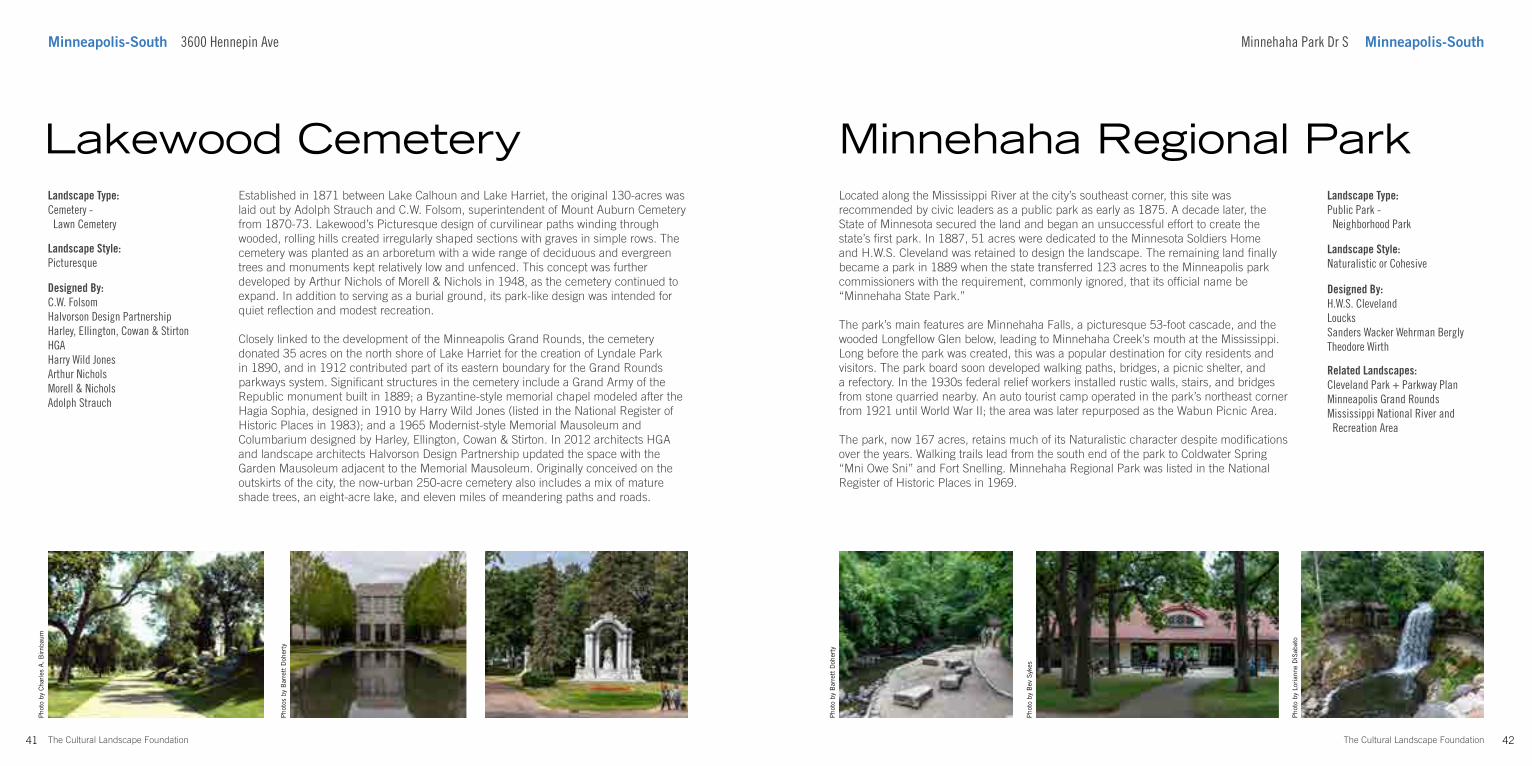
Located along the Mississippi River at the city’s southeast corner, this site was recommended by civic leaders as a public park as early as 1875. A decade later, the State of Minnesota secured the land and began an unsuccessful effort to create the state’s first park. In 1887, 51 acres were dedicated to the Minnesota Soldiers Home and H.W.S. Cleveland was retained to design the landscape. The remaining land finally became a park in 1889 when the state transferred 123 acres to the Minneapolis park commissioners with the requirement, commonly ignored, that its official name be “Minnehaha State Park.”
The park’s main features are Minnehaha Falls, a picturesque 53-foot cascade, and the wooded Longfellow Glen below, leading to Minnehaha Creek’s mouth at the Mississippi. Long before the park was created, this was a popular destination for city residents and visitors. The park board soon developed walking paths, bridges, a picnic shelter, and a refectory. In the 1930s federal relief workers installed rustic walls, stairs, and bridges from stone quarried nearby. An auto tourist camp operated in the park’s northeast corner from 1921 until World War II; the area was later repurposed as the Wabun Picnic Area.
The park, now 167 acres, retains much of its Naturalistic character despite modifications over the years. Walking trails lead from the south end of the park to Coldwater Spring “Mni Owe Sni” and Fort Snelling. Minnehaha Regional Park was listed in the National Register of Historic Places in 1969.
Minnehaha Regional ParkLandscape Type:Public Park - Neighborhood Park
Landscape Style:Naturalistic or Cohesive
Designed By:H.W.S. ClevelandLoucksSanders Wacker Wehrman BerglyTheodore Wirth
41 The Cultural Landscape Foundation
Pho
tos
by B
arre
tt D
oher
ty
Established in 1871 between Lake Calhoun and Lake Harriet, the original 130-acres was laid out by Adolph Strauch and C.W. Folsom, superintendent of Mount Auburn Cemetery from 1870-73. Lakewood’s Picturesque design of curvilinear paths winding through wooded, rolling hills created irregularly shaped sections with graves in simple rows. The cemetery was planted as an arboretum with a wide range of deciduous and evergreen trees and monuments kept relatively low and unfenced. This concept was further developed by Arthur Nichols of Morell & Nichols in 1948, as the cemetery continued to expand. In addition to serving as a burial ground, its park-like design was intended for quiet reflection and modest recreation.
Closely linked to the development of the Minneapolis Grand Rounds, the cemetery donated 35 acres on the north shore of Lake Harriet for the creation of Lyndale Park in 1890, and in 1912 contributed part of its eastern boundary for the Grand Rounds parkways system. Significant structures in the cemetery include a Grand Army of the Republic monument built in 1889; a Byzantine-style memorial chapel modeled after the Hagia Sophia, designed in 1910 by Harry Wild Jones (listed in the National Register of Historic Places in 1983); and a 1965 Modernist-style Memorial Mausoleum and Columbarium designed by Harley, Ellington, Cowan & Stirton. In 2012 architects HGA and landscape architects Halvorson Design Partnership updated the space with the Garden Mausoleum adjacent to the Memorial Mausoleum. Originally conceived on the outskirts of the city, the now-urban 250-acre cemetery also includes a mix of mature shade trees, an eight-acre lake, and eleven miles of meandering paths and roads.
Lakewood CemeteryLandscape Type:Cemetery - Lawn Cemetery
Landscape Style:Picturesque
Designed By:C.W. Folsom Halvorson Design PartnershipHarley, Ellington, Cowan & StirtonHGAHarry Wild JonesArthur NicholsMorell & NicholsAdolph Strauch
Pho
to b
y B
ev S
ykes
Pho
to b
y Lo
rian
ne D
iSab
ato
Related Landscapes:Cleveland Park + Parkway PlanMinneapolis Grand RoundsMississippi National River and Recreation Area
Pho
to b
y C
harl
es A
. B
irnb
aum
44The Cultural Landscape Foundation
Photo by Barrett Doherty
Minneapolis-South 5601 Minnehaha Park Dr S
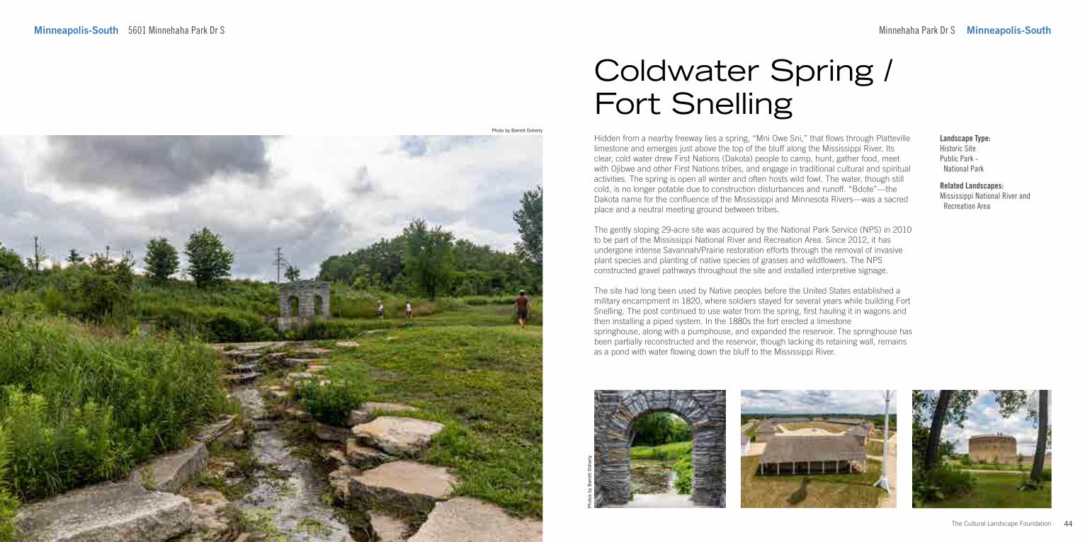
Hidden from a nearby freeway lies a spring, “Mni Owe Sni,” that flows through Platteville limestone and emerges just above the top of the bluff along the Mississippi River. Its clear, cold water drew First Nations (Dakota) people to camp, hunt, gather food, meet with Ojibwe and other First Nations tribes, and engage in traditional cultural and spiritual activities. The spring is open all winter and often hosts wild fowl. The water, though still cold, is no longer potable due to construction disturbances and runoff. “Bdote”—the Dakota name for the confluence of the Mississippi and Minnesota Rivers—was a sacred place and a neutral meeting ground between tribes.
The gently sloping 29-acre site was acquired by the National Park Service (NPS) in 2010 to be part of the Mississippi National River and Recreation Area. Since 2012, it has undergone intense Savannah/Prairie restoration efforts through the removal of invasive plant species and planting of native species of grasses and wildflowers. The NPS constructed gravel pathways throughout the site and installed interpretive signage.
The site had long been used by Native peoples before the United States established a military encampment in 1820, where soldiers stayed for several years while building Fort Snelling. The post continued to use water from the spring, first hauling it in wagons and then installing a piped system. In the 1880s the fort erected a limestone springhouse, along with a pumphouse, and expanded the reservoir. The springhouse has been partially reconstructed and the reservoir, though lacking its retaining wall, remains as a pond with water flowing down the bluff to the Mississippi River.
Pho
tos
by B
arre
tt D
oher
ty
Coldwater Spring / Fort Snelling
Minnehaha Park Dr S Minneapolis-South
Landscape Type:Historic SitePublic Park - National Park
Related Landscapes:Mississippi National River and Recreation Area
45 The Cultural Landscape Foundation
Photo by Barrett Doherty
75 Rev Dr Martin Luther King Jr Blvd Saint Paul-DowntownSaint Paul-Downtown 75 Rev Dr Martin Luther King Jr Blvd
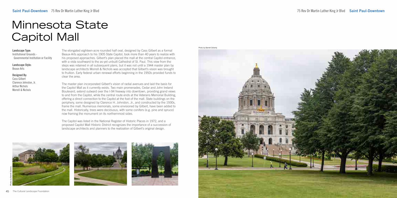
The elongated eighteen-acre rounded half oval, designed by Cass Gilbert as a formal Beaux-Arts approach to his 1905 State Capitol, took more than 40 years to realize with his proposed approaches. Gilbert’s plan placed the mall at the central Capitol entrance, with a vista southward to the as-yet unbuilt Cathedral of St. Paul. This view from the steps was retained in all subsequent plans, but it was not until a 1944 master plan by landscape architects Morrell & Nichols was accepted that Gilbert’s vision was brought to fruition. Early federal urban renewal efforts beginning in the 1950s provided funds to clear the area.
The master plan incorporated Gilbert’s vision of radial avenues and laid the basis for the Capitol Mall as it currently exists. Two main promenades, Cedar and John Ireland Boulevard, extend outward over the I-94 freeway into downtown, providing grand views to and from the Capitol, while the central route ends at the Veterans Memorial Building, offering a direct connection to the Capitol at the foot of the mall. State buildings on the periphery, some designed by Clarence H. Johnston, Jr., and constructed by the 1930s, frame the mall. Numerous memorials, some envisioned by Gilbert, have been added to the mall. Historically, trees were deciduous, with some conifers (e.g. pine and spruce) now framing the monument on its northernmost sides.
The Capitol was listed in the National Register of Historic Places in 1972, and a proposed Capitol Mall Historic District recognizes the importance of a succession of landscape architects and planners to the realization of Gilbert’s original design.
Minnesota State Capitol MallLandscape Type:Institutional Grounds - Governmental Institution or Facility
Landscape Style:Beaux-Arts
Designed By:Cass GilbertClarence Johnston, Jr.Arthur NicholsMorrell & Nichols
Pho
tos
by B
arre
tt D
oher
ty
48The Cultural Landscape Foundation
Pho
tos
by B
arre
tt D
oher
ty
Saint Paul-Downtown 109 W 4th St 251 Walnut St Saint Paul-Downtown
This 3.58-acre park gently slopes from east to west, framed with deciduous trees and a central fountain, a 1978 replica of the original cast. Once pasture, this one-block square is at the center of a neighborhood of stately homes, some of which are the city’s earliest frame and stone houses. Located close to central downtown, the land was donated to the city by John Irvine in 1849 to create a small public square. Irvine then platted and sold residential parcels to prospective homeowners around the green. Minnesota’s first Governor Alexander Ramsey later built a large limestone house across from the park. In 1871, when the St. Paul Board of Park Commissioners was appointed, the land was graded and improvements made, including installation of a fountain and pool, laying of sidewalks, and the planting of small flowering trees, shrubs, and herbaceous plants.
Over time, wealthy residents moved up the hill to the Summit Avenue area, and the neighborhood began a slow but steady decline. This was evidenced when the central fountain was removed in 1927 along with other fixtures, which were scrapped for metal. In the early 1970s, the city undertook a revitalization effort in collaboration with the neighborhood association and constructed a new gazebo, reconstructed the fountain and pool, and added new limestone walls at the corners. “Irvine Park” today refers to both the neighborhood and the park. The neighborhood was listed in the National Register of Historic Places in 1973 and designated a local historic district in 1981.
Irvine ParkLandscape Type:Public Park - Squares, Greens and Commons
Landscape Style:Beaux-Arts
47 The Cultural Landscape Foundation
Pho
tos
by B
arre
tt D
oher
ty
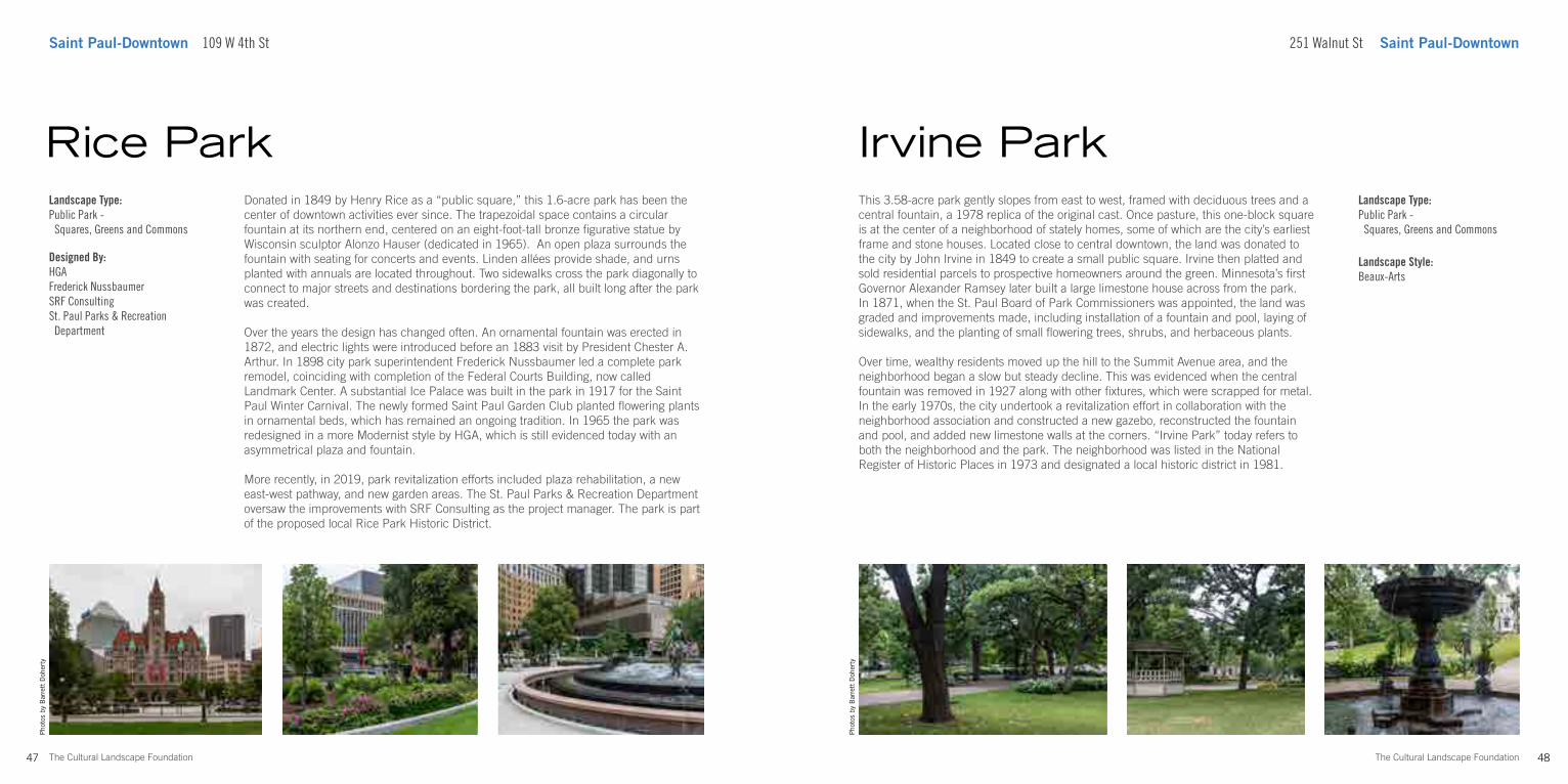
Donated in 1849 by Henry Rice as a “public square,” this 1.6-acre park has been the center of downtown activities ever since. The trapezoidal space contains a circular fountain at its northern end, centered on an eight-foot-tall bronze figurative statue by Wisconsin sculptor Alonzo Hauser (dedicated in 1965). An open plaza surrounds the fountain with seating for concerts and events. Linden allées provide shade, and urns planted with annuals are located throughout. Two sidewalks cross the park diagonally to connect to major streets and destinations bordering the park, all built long after the park was created.
Over the years the design has changed often. An ornamental fountain was erected in 1872, and electric lights were introduced before an 1883 visit by President Chester A. Arthur. In 1898 city park superintendent Frederick Nussbaumer led a complete park remodel, coinciding with completion of the Federal Courts Building, now called Landmark Center. A substantial Ice Palace was built in the park in 1917 for the Saint Paul Winter Carnival. The newly formed Saint Paul Garden Club planted flowering plants in ornamental beds, which has remained an ongoing tradition. In 1965 the park was redesigned in a more Modernist style by HGA, which is still evidenced today with an asymmetrical plaza and fountain.
More recently, in 2019, park revitalization efforts included plaza rehabilitation, a new east-west pathway, and new garden areas. The St. Paul Parks & Recreation Department oversaw the improvements with SRF Consulting as the project manager. The park is part of the proposed local Rice Park Historic District.
Rice ParkLandscape Type:Public Park - Squares, Greens and Commons
Designed By:HGAFrederick NussbaumerSRF ConsultingSt. Paul Parks & Recreation Department
50The Cultural Landscape Foundation
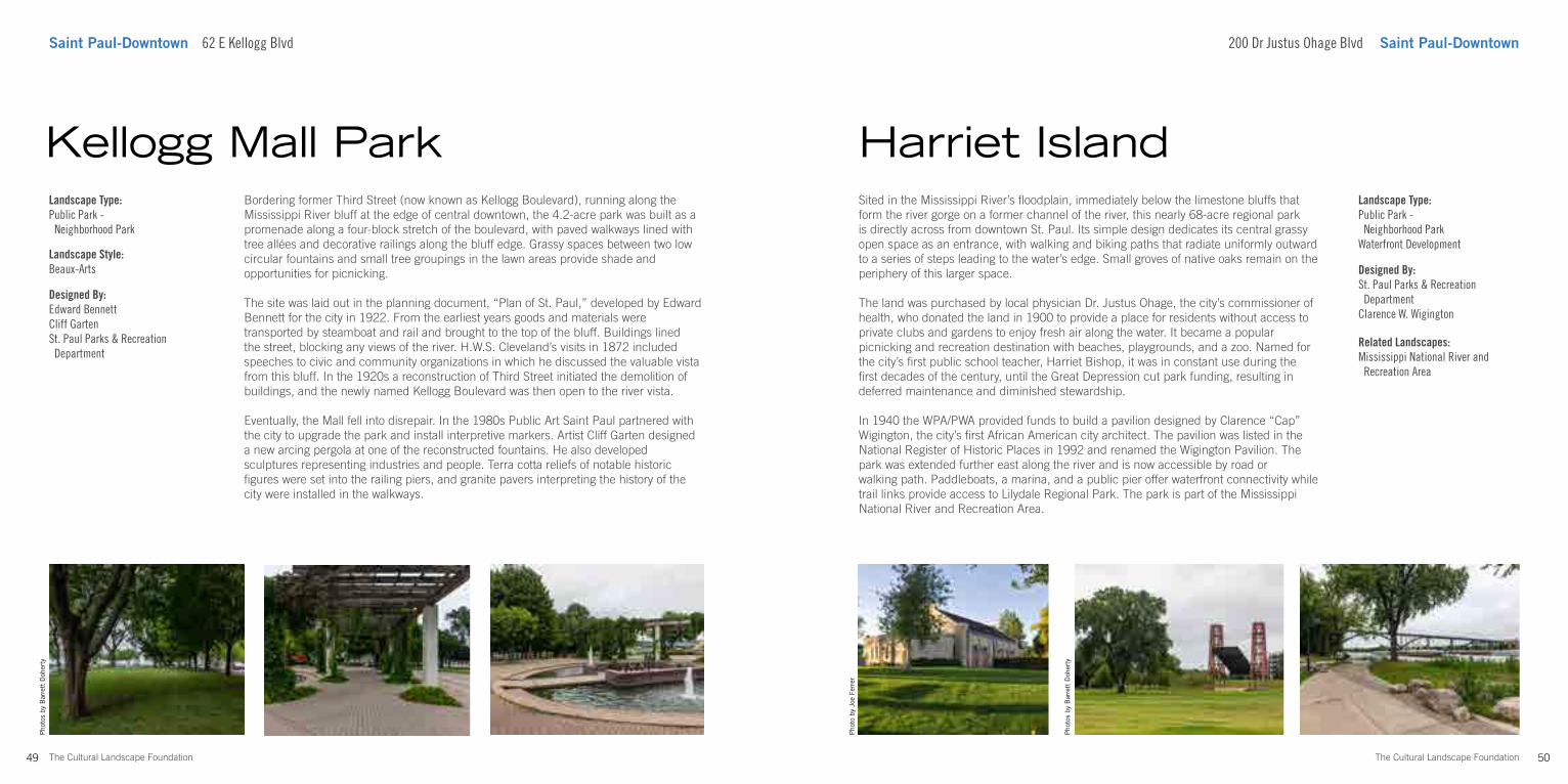
Saint Paul-Downtown 62 E Kellogg Blvd 200 Dr Justus Ohage Blvd Saint Paul-Downtown
Sited in the Mississippi River’s floodplain, immediately below the limestone bluffs that form the river gorge on a former channel of the river, this nearly 68-acre regional park is directly across from downtown St. Paul. Its simple design dedicates its central grassy open space as an entrance, with walking and biking paths that radiate uniformly outward to a series of steps leading to the water’s edge. Small groves of native oaks remain on the periphery of this larger space.
The land was purchased by local physician Dr. Justus Ohage, the city’s commissioner of health, who donated the land in 1900 to provide a place for residents without access to private clubs and gardens to enjoy fresh air along the water. It became a popular picnicking and recreation destination with beaches, playgrounds, and a zoo. Named for the city’s first public school teacher, Harriet Bishop, it was in constant use during the first decades of the century, until the Great Depression cut park funding, resulting in deferred maintenance and diminished stewardship.
In 1940 the WPA/PWA provided funds to build a pavilion designed by Clarence “Cap” Wigington, the city’s first African American city architect. The pavilion was listed in the National Register of Historic Places in 1992 and renamed the Wigington Pavilion. The park was extended further east along the river and is now accessible by road or walking path. Paddleboats, a marina, and a public pier offer waterfront connectivity while trail links provide access to Lilydale Regional Park. The park is part of the Mississippi National River and Recreation Area.
Harriet IslandLandscape Type:Public Park - Neighborhood ParkWaterfront Development
Designed By:St. Paul Parks & Recreation DepartmentClarence W. Wigington
49 The Cultural Landscape Foundation
Pho
tos
by B
arre
tt D
oher
ty
Bordering former Third Street (now known as Kellogg Boulevard), running along the Mississippi River bluff at the edge of central downtown, the 4.2-acre park was built as a promenade along a four-block stretch of the boulevard, with paved walkways lined with tree allées and decorative railings along the bluff edge. Grassy spaces between two low circular fountains and small tree groupings in the lawn areas provide shade and opportunities for picnicking.
The site was laid out in the planning document, “Plan of St. Paul,” developed by Edward Bennett for the city in 1922. From the earliest years goods and materials were transported by steamboat and rail and brought to the top of the bluff. Buildings lined the street, blocking any views of the river. H.W.S. Cleveland’s visits in 1872 included speeches to civic and community organizations in which he discussed the valuable vista from this bluff. In the 1920s a reconstruction of Third Street initiated the demolition of buildings, and the newly named Kellogg Boulevard was then open to the river vista.
Eventually, the Mall fell into disrepair. In the 1980s Public Art Saint Paul partnered with the city to upgrade the park and install interpretive markers. Artist Cliff Garten designed a new arcing pergola at one of the reconstructed fountains. He also developed sculptures representing industries and people. Terra cotta reliefs of notable historic figures were set into the railing piers, and granite pavers interpreting the history of the city were installed in the walkways.
Kellogg Mall ParkLandscape Type:Public Park - Neighborhood Park
Landscape Style:Beaux-Arts
Designed By:Edward BennettCliff GartenSt. Paul Parks & Recreation Department
Related Landscapes:Mississippi National River and Recreation Area
Pho
tos
by B
arre
tt D
oher
ty
Pho
to b
y Jo
e Fe
rrer
Pho
tos
by B
arre
tt D
oher
ty 387 Marion St Saint Paul-West
51 The Cultural Landscape Foundation
Saint Paul-West 387 Marion St
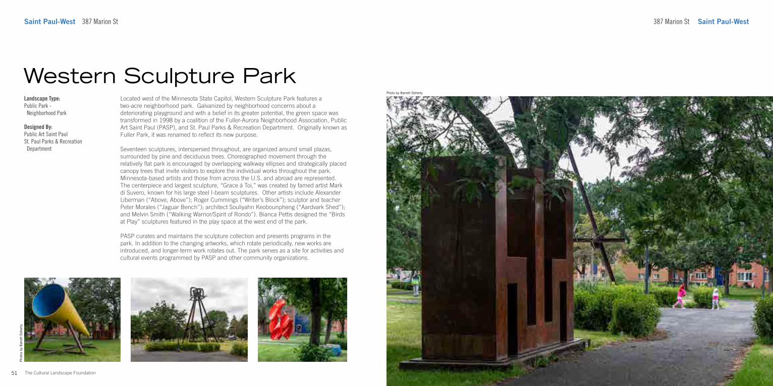
Located west of the Minnesota State Capitol, Western Sculpture Park features a two-acre neighborhood park. Galvanized by neighborhood concerns about a deteriorating playground and with a belief in its greater potential, the green space was transformed in 1998 by a coalition of the Fuller-Aurora Neighborhood Association, Public Art Saint Paul (PASP), and St. Paul Parks & Recreation Department. Originally known as Fuller Park, it was renamed to reflect its new purpose.
Seventeen sculptures, interspersed throughout, are organized around small plazas, surrounded by pine and deciduous trees. Choreographed movement through the relatively flat park is encouraged by overlapping walkway ellipses and strategically placed canopy trees that invite visitors to explore the individual works throughout the park. Minnesota-based artists and those from across the U.S. and abroad are represented. The centerpiece and largest sculpture, “Grace á Toi,” was created by famed artist Mark di Suvero, known for his large steel I-beam sculptures. Other artists include Alexander Liberman (“Above, Above”); Roger Cummings (“Writer’s Block”); sculptor and teacher Peter Morales (“Jaguar Bench”); architect Souliyahn Keobounpheng (“Aardvark Shed”); and Melvin Smith (“Walking Warrior/Spirit of Rondo”). Bianca Pettis designed the “Birds at Play” sculptures featured in the play space at the west end of the park.
PASP curates and maintains the sculpture collection and presents programs in the park. In addition to the changing artworks, which rotate periodically, new works are introduced, and longer-term work rotates out. The park serves as a site for activities and cultural events programmed by PASP and other community organizations.
Western Sculpture ParkLandscape Type:Public Park - Neighborhood Park
Designed By:Public Art Saint PaulSt. Paul Parks & Recreation Department
Photo by Barrett Doherty
54The Cultural Landscape Foundation
Photo courtesy TEN x TEN
Saint Paul-West 820 Concordia Ave
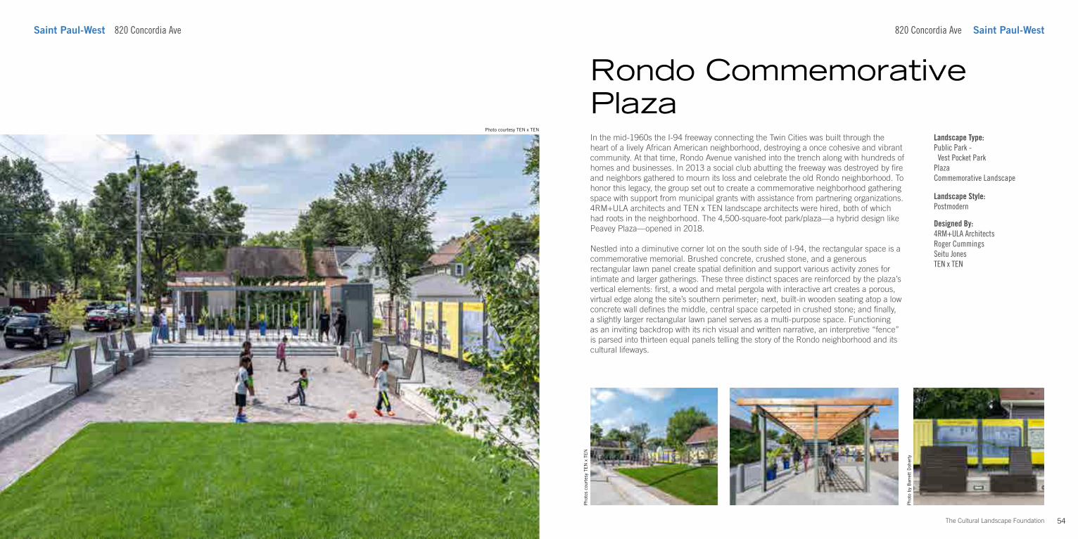
In the mid-1960s the I-94 freeway connecting the Twin Cities was built through the heart of a lively African American neighborhood, destroying a once cohesive and vibrant community. At that time, Rondo Avenue vanished into the trench along with hundreds of homes and businesses. In 2013 a social club abutting the freeway was destroyed by fire and neighbors gathered to mourn its loss and celebrate the old Rondo neighborhood. To honor this legacy, the group set out to create a commemorative neighborhood gathering space with support from municipal grants with assistance from partnering organizations. 4RM+ULA architects and TEN x TEN landscape architects were hired, both of which had roots in the neighborhood. The 4,500-square-foot park/plaza—a hybrid design like Peavey Plaza—opened in 2018.
Nestled into a diminutive corner lot on the south side of I-94, the rectangular space is a commemorative memorial. Brushed concrete, crushed stone, and a generous rectangular lawn panel create spatial definition and support various activity zones for intimate and larger gatherings. These three distinct spaces are reinforced by the plaza’s vertical elements: first, a wood and metal pergola with interactive art creates a porous, virtual edge along the site’s southern perimeter; next, built-in wooden seating atop a low concrete wall defines the middle, central space carpeted in crushed stone; and finally, a slightly larger rectangular lawn panel serves as a multi-purpose space. Functioning as an inviting backdrop with its rich visual and written narrative, an interpretive “fence” is parsed into thirteen equal panels telling the story of the Rondo neighborhood and its cultural lifeways.
Pho
to b
y B
arre
tt D
oher
ty
Rondo Commemorative Plaza
820 Concordia Ave Saint Paul-West
Landscape Type:Public Park - Vest Pocket ParkPlazaCommemorative Landscape
Landscape Style:Postmodern
Designed By:4RM+ULA ArchitectsRoger CummingsSeitu JonesTEN x TEN
Pho
tos
cour
tesy
TE
N x
TE
N
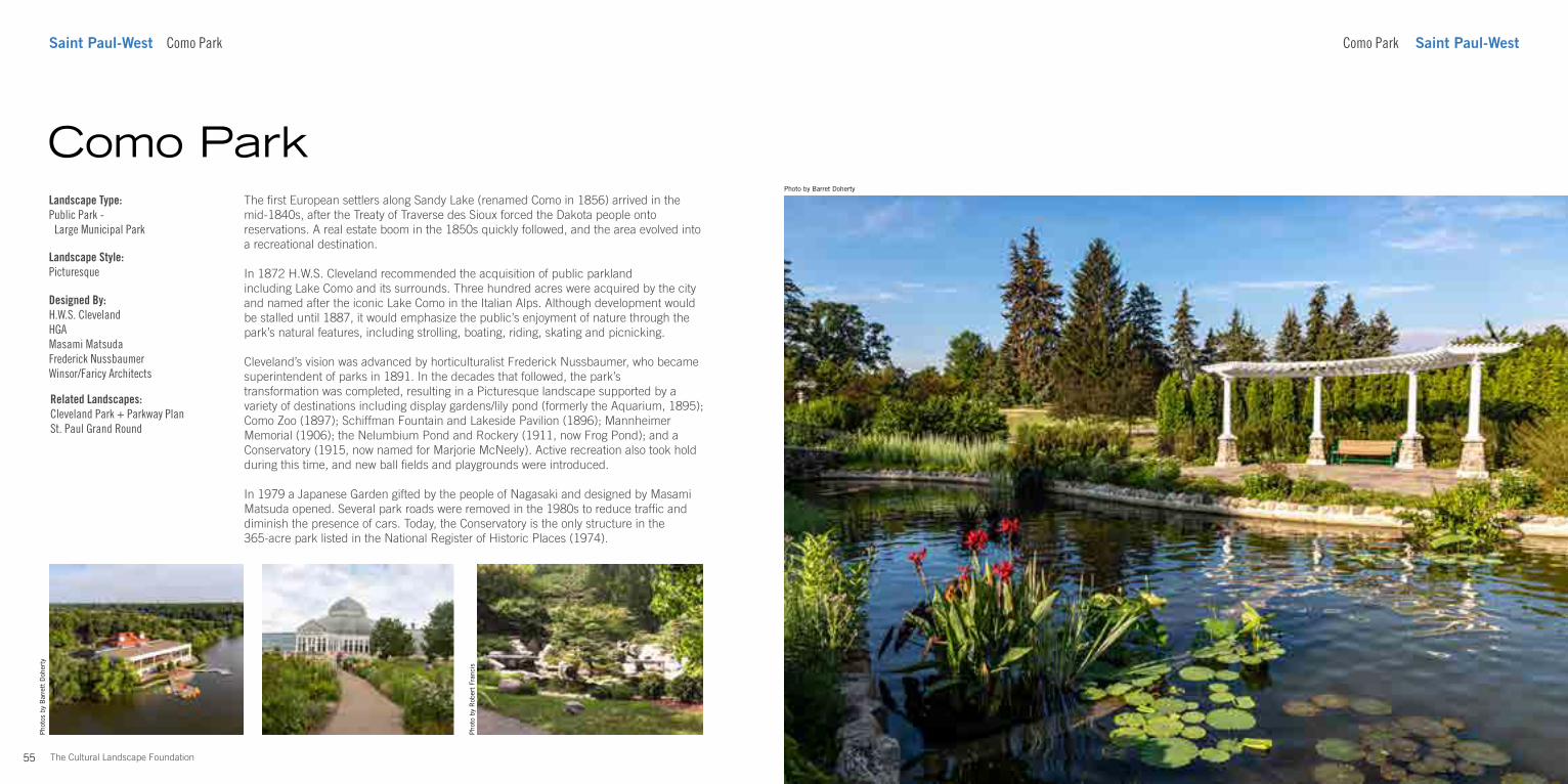
55 The Cultural Landscape Foundation
Photo by Barret Doherty
Como Park Saint Paul-WestSaint Paul-West Como Park
The first European settlers along Sandy Lake (renamed Como in 1856) arrived in the mid-1840s, after the Treaty of Traverse des Sioux forced the Dakota people onto reservations. A real estate boom in the 1850s quickly followed, and the area evolved into a recreational destination.
In 1872 H.W.S. Cleveland recommended the acquisition of public parkland including Lake Como and its surrounds. Three hundred acres were acquired by the city and named after the iconic Lake Como in the Italian Alps. Although development would be stalled until 1887, it would emphasize the public’s enjoyment of nature through the park’s natural features, including strolling, boating, riding, skating and picnicking.
Cleveland’s vision was advanced by horticulturalist Frederick Nussbaumer, who became superintendent of parks in 1891. In the decades that followed, the park’s transformation was completed, resulting in a Picturesque landscape supported by a variety of destinations including display gardens/lily pond (formerly the Aquarium, 1895); Como Zoo (1897); Schiffman Fountain and Lakeside Pavilion (1896); Mannheimer Memorial (1906); the Nelumbium Pond and Rockery (1911, now Frog Pond); and a Conservatory (1915, now named for Marjorie McNeely). Active recreation also took hold during this time, and new ball fields and playgrounds were introduced.
In 1979 a Japanese Garden gifted by the people of Nagasaki and designed by Masami Matsuda opened. Several park roads were removed in the 1980s to reduce traffic and diminish the presence of cars. Today, the Conservatory is the only structure in the 365-acre park listed in the National Register of Historic Places (1974).
Como ParkLandscape Type:Public Park - Large Municipal Park
Landscape Style:Picturesque
Designed By:H.W.S. ClevelandHGAMasami MatsudaFrederick NussbaumerWinsor/Faricy Architects
Pho
to b
y R
ober
t Fr
anci
s
Related Landscapes:Cleveland Park + Parkway PlanSt. Paul Grand Round
Pho
tos
by B
arre
tt D
oher
ty
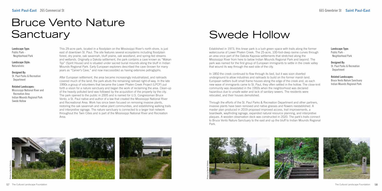
58The Cultural Landscape Foundation
Pho
tos
by B
arre
tt D
oher
ty
Saint Paul-East 265 Commercial St 665 Greenbrier St Saint Paul-East
Established in 1973, this linear park is a lush green space with trails along the former watercourse of Lower Phalen Creek. The 25-acre, 100-foot-deep ravine curves through an area once part of the Dakota Kaposia settlements that stretched along the Mississippi River from here to below Indian Mounds Regional Park and beyond. The park was named for the first group of European immigrants to settle in the creek valley that wound its way through the east side of the city.
In 1850 the creek continued to flow through its bed, but it was soon diverted underground to allow industries and railroads to build on the former marsh land. European settlers built small frame houses along the edge of the creek and, as each new wave of immigrants came to St. Paul, they often settled in the hollow. The close-knit community was devastated in the 1950s when the neighborhood was declared hazardous due to unsafe water and lack of sanitary sewers. The residents were relocated, and their houses demolished.
Through the efforts of the St. Paul Parks & Recreation Department and other partners, invasive plants have been removed and native grasses and flowers reestablished. A master plan produced in 2019 proposed improved access, trail improvements, a boardwalk, wayfinding signage, expanded natural resource planning, and interpretive plaques. A wooden observation deck was constructed in 2020. The park’s trails connect to Bruce Vento Nature Sanctuary to the east and up the bluff to Indian Mounds Regional Park.
Swede HollowLandscape Type:Public Park - Neighborhood Park
Designed By:St. Paul Parks & Recreation Department
57 The Cultural Landscape Foundation
Pho
tos
by B
arre
tt D
oher
ty
This 29-acre park, located in a floodplain on the Mississippi River’s north shore, is just east of downtown St. Paul. The site features several ecosystems including floodplain forest, dry prairie, oak savannah, bluff prairie, oak woodland, and spring-fed streams and wetlands. Originally a Dakota settlement, the park contains a cave known as “Wakan Tipi” (Spirit House) and is situated under sacred burial mounds along the bluff in Indian Mounds Regional Park. Early European explorers described the cave (known for many years as “Carver’s Cave,” and now inaccessible) as having extensive petroglyphs.
After European settlement, the area became increasingly industrialized, and railroads covered much of the land; the park abuts the remaining railroad right-of-way. In the late 1990s a group of volunteers that became the Lower Phalen Creek Project (LPCP) put forth a vision for a nature sanctuary and began the work of reclaiming the area. Clean-up of the heavily polluted land was followed by the acquisition of the property by the city. The park opened to the public in 2005 and is named for U.S. Congressman Bruce Vento, a St. Paul native and author of a law that created the Mississippi National River and Recreational Area. Work has since been focused on removing invasive plants, restoring the oak savannah and native plant communities, and establishing walking trails and interpretive signage. The nature sanctuary is connected to a larger trail network throughout the Twin Cities and is part of the Mississippi National River and Recreation Area.
Bruce Vento Nature SanctuaryLandscape Type:Public Park - Neighborhood Park
Landscape Style:Naturalistic
Designed By:St. Paul Parks & Recreation Department
Related Landscapes:Mississippi National River and Recreation AreaIndian Mounds Regional ParkSwede Hollow
Related Landscapes:Bruce Vento Nature SanctuaryIndian Mounds Regional Park
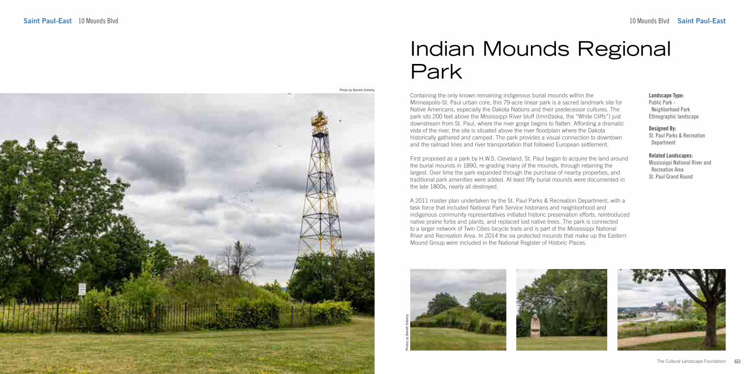
60The Cultural Landscape Foundation
Photo by Barrett Doherty
Saint Paul-East 10 Mounds Blvd
Containing the only known remaining indigenous burial mounds within the Minneapolis-St. Paul urban core, this 79-acre linear park is a sacred landmark site for Native Americans, especially the Dakota Nations and their predecessor cultures. The park sits 200 feet above the Mississippi River bluff (Imnížaska, the “White Cliffs”) just downstream from St. Paul, where the river gorge begins to flatten. Affording a dramatic vista of the river, the site is situated above the river floodplain where the Dakota historically gathered and camped. The park provides a visual connection to downtown and the railroad lines and river transportation that followed European settlement.
First proposed as a park by H.W.S. Cleveland, St. Paul began to acquire the land around the burial mounds in 1890, re-grading many of the mounds, through retaining the largest. Over time the park expanded through the purchase of nearby properties, and traditional park amenities were added. At least fifty burial mounds were documented in the late 1800s, nearly all destroyed.
A 2011 master plan undertaken by the St. Paul Parks & Recreation Department, with a task force that included National Park Service historians and neighborhood and indigenous community representatives initiated historic preservation efforts, reintroduced native prairie forbs and plants, and replaced lost native trees. The park is connected to a larger network of Twin Cities bicycle trails and is part of the Mississippi National River and Recreation Area. In 2014 the six protected mounds that make up the Eastern Mound Group were included in the National Register of Historic Places.
Pho
tos
by B
arre
tt D
oher
ty
Indian Mounds Regional Park
10 Mounds Blvd Saint Paul-East
Landscape Type:Public Park - Neighborhood ParkEthnographic landscape
Designed By:St. Paul Parks & Recreation Department
Related Landscapes:Mississippi National River and Recreation AreaSt. Paul Grand Round
Lead Sponsors
61 The Cultural Landscape Foundation
Presenting Sponsors
Supporting Sponsors
Friends
tclf.org/twincitiesFor more about What’s Out There Twin Cities
What’s Out There®
is the most comprehensive searchable database of North America’s historic designed landscapes, with thousands of sites and images, and is optimized for iPhones and similar handheld devices. It includes What’s Nearby, a GPS-enabled function that locates all landscapes within a certain distance, customizable by mileage or walking time.
tclf.org/placesLearn more about the sites in this guideand What’s Out There.
tclf.org/publicationsGet more guidebooks in the What’s Out There series.
This guidebook is the result of the scholarly support and photography produced by Barbara Bezat, Barrett Doherty, Charles Birnbaum, Amy Mino, and Charlene Roise. The design is by Justin Clevenger, with all photos by The Cultural Landscape Foundation unless otherwise noted. Additional review was provided by Richard Arey, David Lanegran, Jean Garbarini, Dena Tasse Winter and Nord Wennerstrom.
ANOVA Charlene Roise, Historian, LLC
Confluence Damon Farber
Photos [Left and Cover] by Barrett Doherty.
Forms + Surfaces
Hess, Roise LS Black Development
Maglin Site Furniture
Bachman’s Coen + Partners
Fluidity Design Consultants
JTH Lighting Alliance Snow Kreilich Architects
TEN x TEN
O2 Design
SRF Consulting Group William C. Joas, AWM
WSB
Solhem Companies
SGA Group
Landscape Forms
Stantec
HGA
Ryan Companies Plaisted Companies
TKDA