Embed Size (px)
Citation preview

Journal Pre-proof
Climatic control on stacking and connectivity of fluvial successions: Upper CretaceousBajo Barreal Formation of the Golfo San Jorge basin, Patagonia
José Matildo Paredes, Sergio Roberto Giordano, Sabrina Ximena Olazábal, MauroNicolás Valle, José Oscar Allard, Nicolás Foix, Maisa Andrea Tunik
PII: S0264-8172(19)30565-3
DOI: https://doi.org/10.1016/j.marpetgeo.2019.104116
Reference: JMPG 104116
To appear in: Marine and Petroleum Geology
Received Date: 10 June 2019
Revised Date: 28 October 2019
Accepted Date: 29 October 2019
Please cite this article as: Paredes, José.Matildo., Giordano, S.R., Olazábal, S.X., Valle, Mauro.Nicolá.,Allard, José.Oscar., Foix, Nicolá., Tunik, M.A., Climatic control on stacking and connectivity of fluvialsuccessions: Upper Cretaceous Bajo Barreal Formation of the Golfo San Jorge basin, Patagonia,Marine and Petroleum Geology (2019), doi: https://doi.org/10.1016/j.marpetgeo.2019.104116.
This is a PDF file of an article that has undergone enhancements after acceptance, such as the additionof a cover page and metadata, and formatting for readability, but it is not yet the definitive version ofrecord. This version will undergo additional copyediting, typesetting and review before it is publishedin its final form, but we are providing this version to give early visibility of the article. Please note that,during the production process, errors may be discovered which could affect the content, and all legaldisclaimers that apply to the journal pertain.
© 2019 Published by Elsevier Ltd.

Page 1
Climatic control on stacking and connectivity of fluvial 1
successions: Upper Cretaceous Bajo Barreal Formation of the 2
Golfo San Jorge basin, Patagonia. 3
4
José Matildo PAREDES(a,*), Sergio Roberto GIORDANO(b), Sabrina Ximena 5
OLAZÁBAL (a), Mauro Nicolás VALLE(a,c), José Oscar ALLARD(a), Nicolás FOIX(a,c) 6
and Maisa Andrea TUNIK(c,d) 7
8
(a) Universidad Nacional de la Patagonia San Juan Bosco. Ruta Nº 1 S/N, Km 4 (9005), 9
Com. Riv., Chubut, Argentina. 10
(b) SINOPEC ARGENTINA E&P, Inc. Manuela Saenz 323, C1107BPA, Buenos Aires, 11
Argentina. 12
(c) CONICET (Consejo Nacional de Investigaciones Científicas y Técnicas), 13
Argentina. 14
(d) CONICET, Instituto de Investigación en Paleobiología y Geología and Universidad 15
Nacional de Río Negro, General Roca, Río Negro, Argentina. 16
17
18
19
20
21
* Corresponding author. 22
E-mail address: [email protected] , [email protected] (J.M. Paredes) 23
24
25

Page 2
Abstract: 26
Climate impact on alluvial organization owing to its control on water availability and 27
sediment delivery within the catchment, but temporal changes in stacking patterns are 28
often interpreted to reflect changes in subsidence and base level. To test for evidence of 29
climatic control on the stacking pattern, we study an outcrop succession with two styles 30
of stacking within the Upper Cretaceous Bajo Barreal Formation in the Cerro Ballena 31
anticline, Golfo San Jorge Basin, Argentina. The 385 m thick and 2.5 km wide exposure 32
has layer-cake geometry, lacking either large-scale erosional surfaces, fluvial terraces, 33
or evident paleosols, dismissing either local tectonic activity or base-levels shifts. 34
Rooted in a paleohydrological study recognizing upward increasing in both channel 35
width and flow depth of formative rivers, we use spectral gamma-ray logs, x-ray 36
diffraction in mudstones, and sandstone petrography to understand the controls on the 37
stacking pattern. At the base, Section A consists of small-scale, isolated channels fills in 38
a siliciclastic floodplain with sand:mud ratio of ~ 1:6, whereas the overlying Section B 39
has a sand-mud ratio of ~1:3, with larger-scale channels and greater inter-connectivity 40
within a volcaniclastic floodplain. Upward reduction in K percentage through Section A 41
parallel with increasing kaolinite content, and mudstone samples from Section B 42
contains a higher proportion of kaolinite than Section A samples, evidencing an upward 43
increase in paleo-weathering in humid conditions. Detrital components of Section A 44
indicate several volcanic sources (e.g., basic-intermediate components derived from the 45
Middle Jurassic Bahía Laura Group and acidic components sourced from the Andes 46
Cordillera), whereas Section B exclusively contains acidic clasts derived from the 47
Andes Cordillera. Simultaneous changes in detrital constituents, suspended load type, 48
and increasing scale of the rivers in Section B occur coeval with increases in channel 49
inter-connectivity, here related to the increase of river discharge and sediment supply in 50

Page 3
a humid climate, favoring more frequent avulsions or higher channel migration rates in 51
a relatively flat geomorphic scenario. The study demonstrates, combining independent 52
lines of evidence, that climate change can impact the stacking and connectivity of 53
potential sandstone reservoirs. 54
55
56
Keywords: outcrop gamma-ray spectra, chemical weathering, kaolinite variation, 57
detrital provenance changes, humid climate, upper Cretaceous, Patagonia 58
59

Page 4
1. Introduction 60
Ancient fluvial systems contain significant hydrocarbon accumulations on many 61
continental basins, representing up to 20 % of the remaining reserves of hydrocarbons 62
of the world. Advances in the understanding of fluvial successions come from several 63
inter-related disciplines, as 3-D seismic surveys (Posamentier et al., 2007; Ethridge and 64
Schumm, 2007; Reijenstein et al., 2011) modelling studies (Karssenberg et al., 2001; 65
Hajek and Wolinsky, 2012; Keogh et al., 2014; Chamberlin and Hajek, 2015) and field-66
based studies (Labourdette, 2011; Allen et al., 2014; Ghinassi et al., 2016, among 67
others). Outcrop analogs contribute to a better understanding of the controls on the 68
alluvial organization and evolution of coeval fluvial reservoirs by analyzing changes in 69
the alluvial architecture, channel-scale stacking styles and relationship with adjacent 70
floodplain facies (Pranter and Sommer, 2011; Rittersbacher et al., 2014; Pranter et al., 71
2014; Paredes et al., 2016). Notably, changes in stacking styles (e.g., isolated versus 72
densely amalgamated channel belts) constitute a common feature identified both in 73
outcrops and subsurface, commonly used to assess relative aggradation rates in fluvial 74
successions (Allen, 1978; Bridge and Leeder, 1979). Those changes are generally 75
related to changes in the ratio of accommodation to sediment supply (Wright and 76
Marriott, 1993; Shanley and McCabe, 1994; Olsen et al., 1995; Kjemperud et al., 2008), 77
although mentions to other variables as vegetation types exist (Davies and Gibling, 78
2010; Davies et al., 2011). Alternatively, Hajek and Heller (2012) pointed out that 79
changes in amalgamation in fluvial successions, and hence connectivity of potential 80
sandstone reservoirs, may result from variations in flow depth and style of the involved 81
rivers, being an autogenic process that might not require coeval changes in subsidence 82
or base level. 83

Page 5
To assess paleoclimatic reconstruction of ancient successions, outcrop spectral 84
gamma-ray (SGR) combined with facies analysis and geochemistry proved to be useful 85
(Myers and Wignall, 1987; Ruffell et al., 2003; Ghasemi-Nejad et al., 2010), being also 86
a critical tool to highlight relationships between texture, composition and provenance 87
(North and Boering, 1999; Corbeanu et al., 2001; Evans et al., 2007; Šimíček et al., 88
2012), and for stratigraphic analysis (Myers and Bristow, 1989; Parkinson, 1996). 89
Outcrop SGR also allows correlating outcrop sections with wire-line data using the 90
vertical variation of K, U, and Th (Hampson et al., 2005; Keeton et al., 2015). 91
The study succession of the Bajo Barreal Formation at Cerro Ballena anticline is a 92
good outcrop analog to subsurface alluvial successions and can be used to test the 93
relative importance of allogenic forcing factors on the alluvial organization and of 94
stacking pattern because it has a scale that is comparable to that of hydrocarbon 95
reservoirs (2.5 km wide x 385 m thick) and has well-exposed facies relationships. A 96
siliciclastic section with isolated, small scale channel bodies at the base (Section A, 180 97
m thick sensu Figari et al., 1998) characterize the Cerro Ballena exposures, covered by 98
densely-stacked channel belts encased in a fine-grained volcaniclastic floodplain 99
(Section B, 250 m thick sensu Figari et al., 1998). In this research, we provide results of 100
detailed outcrop SGR logging of the Cerro Ballena exposures, complemented with x-ray 101
diffraction analysis and sandstone petrography within channel fills. These data, 102
integrated with paleo-hydraulical estimations derived from measurements of cross-bed 103
set thickness in channel fill and measurements of channel sizes (Paredes et al., 2018a), 104
aimed at tracing climatically controlled variations in the overall stacking of the fluvial 105
succession. The main purpose of this paper is to understand the stratigraphic 106
organization of the fluvial succession and to discuss the main controls on the stacking 107
pattern. Our key research questions were: What were the first-order controls on the 108

Page 6
stacking pattern? What evidence is available to assess paleoclimate at the time of 109
deposition? Can the distinctive lithological sections with different stacking patterns be 110
correlated with the subsurface using outcrop SGR logs, and, if so, can the identified log-111
motifs be linked to any change in the forcing-factors of the fluvial system? 112
This research shows how a combination of different techniques can be used to better 113
understand the allogenic and autogenic controls on the alluvial architecture and stacking 114
styles of fluvial successions, with implications for oilfield development. 115
116
2. Geological setting 117
118
The Golfo San Jorge basin, located in Central Patagonia between 45 and 47° S latitude, 119
has produced approximately 10 billion barrels of oil (1500 million m3) during its more 120
than 100 years of development history, currently providing up to 48 % of the liquid 121
hydrocarbons of the country production (Secretaría de Energía, 2017). Up to 90 % of 122
those hydrocarbons are recovered from coarse-grained facies in channel fills within the 123
Upper Cretaceous Bajo Barreal Formation, and subsurface equivalents. 124
The Golfo San Jorge basin formed as response to the Gondwana breakup (Uliana 125
et al., 1989; Fitzgerald et al., 1990), with several phases of extensional reactivation 126
during the Cretaceous (Paredes et al., 2018b; Giampaoli, 2019), followed by a process 127
of positive inversion tectonics along the San Bernardo fold belt (Fig. 1), which rose up 128
mainly during Neogene times (Peroni et al., 1995; Homovc et al., 1995). 129
130

Page 7
131
Figure 1: (A) Location map of the Golfo San Jorge basin in southern Argentina. (B) 132
Location of the study area, oilfields, and principal localities. The Cerro Ballena anticline 133
(star) is located in the San Bernardo fold belt area. LH= Las Heras city; CV= Cañadón 134
Vasco oilfield. EC=El Cordón oilfield. 135
136
The initial basin infill is represented by a siliciclastic lacustrine succession included 137
within the Late Jurassic-Early Cretaceous Las Heras Group (Lesta et al., 1980), 138
preserved in active half-grabens, and overlying a Middle-Jurassic volcanic-139
volcaniclastic sequence known as Bahía Laura Group (Feruglio, 1949) or Lonco Trapial 140
Group (Lesta and Ferello, 1972). The remaining of the Cretaceous sedimentation 141
corresponds to the Late Barremian-Maastrichtian Chubut Group (). Initial sedimentation 142
of the Chubut Group occurred in a wide lake (Pozo D-129 Formation, Barremian? to 143
Aptian) which was sourced from the north by fluvial systems within the Matasiete 144
Formation (Paredes et al., 2007; Allard et al., 2015). The fluvial Castillo Formation 145
(Albian) overlies both units, characterized by an elevated content of reworked ash on 146
floodplains and channel fills (Umazano et al., 2012; Paredes et al., 2015), being 147
replaced in the subsurface of the basin by the Mina del Carmen Formation (Lesta, 148

Page 8
1968). The overlying Bajo Barreal Formation has been extensively studied because of 149
its prolific hydrocarbon production and remaining potential (Feruglio, 1949; Lesta and 150
Ferello, 1972). Toward the basin margins, the Bajo Barreal Formation is covered by the 151
fluvial Laguna Palacios Formation (Sciutto, 1981) and by Campanian to Maastrichtian 152
deposits of the Lago Colhué Huapi Formation (Casal et al., 2015; Vallati et al., 2016), 153
being subsequently overlaid by marine and continental Cenozoic sedimentary rocks 154
(Fig. 2). 155
156
157
158
Figure 2: Stratigraphic column of the Golfo San Jorge basin. 159
160
3. The Bajo Barreal Formation 161
162

Page 9
Deposition of the Bajo Barreal Formation (Lesta and Ferello, 1972) occurred in an 163
endorheic basin over an area exceeding 150,000 km2, with maximum thickness up to 164
1,300 meters. Due to its wide distribution, the paleoenvironment interpretations change 165
across the basin, being represented by lacustrine fan-deltas, volcaniclastic alluvial fans, 166
meandering and braided rivers, and ephemeral rivers (Brown et al., 1982; Barcat et al., 167
1989; Hechem et al., 1990; Legarreta et al., 1993; Hechem, 1997; Di Benedetto et al., 168
2006; Umazano et al., 2008; Georgieff et al., 2009). Outcrop analysis along most of the 169
San Bernardo fold belt recognized a Lower Member and an Upper Member, a 170
distinction based on the floodplain composition and the scale of the sandbodies. The 171
Lower Member is characterized by channelized sandstones interbedded with fine-172
grained (very fine sand-size) tuffaceous strata, whereas the Upper Member is composed 173
of larger-scale, isolated channel sandbodies surrounded by grey siltstones and 174
siliciclastic mudstones (Figari et al., 1990; Rodríguez, 1993). Most sedimentological 175
outcrop studies indicate the occurrence of fluvial systems with considerable discharge 176
variation (Umazano et al., 2008; Paredes et al., 2016) or ephemeral rivers (Hechem, 177
1994), whereas a palynological assemblage recovered in the subsurface of the basin 178
(Archangelsky et al., 1994) from the Lower Bajo Barreal Formation indicate humid, 179
continental mild to warm climate. 180
The Cerro Ballena anticline constitutes the western limb of a faulted, plunging anticline, 181
whose axial trace is oriented NNW-SSE (Fig. 3). Figari et al. (1998) established the 182
principal subdivisions of the Bajo Barreal Formation at Cerro Ballena anticline, 183
identifying three main stratigraphic intervals defined according to the occurrence of 184
discontinuities, lithofacies types and stacking patterns, named A, B, and C in ascending 185
order. Exposures of Sections A and B occur in the core and western limb of the Cerro 186
Ballena (Fig. 3) and constitute the main subject of this research, while Section C is 187

Page 10
partially identified in the southern plunge of the anticline and mainly southward of the 188
Deseado river (Figari et al., 1998). 189
190
Figure 3: (A) Simplified geological map of the area of the Cerro Ballena anticline, 191
southwestern Golfo San Jorge Basin (after Figari et al., 1998). (B) Satellite image of the 192
Cerro Ballena anticline, with the location of the position of the SGR logs (Logs X, Y 193
and Z). Local roads are indicated as dotted lines. Image from Google EarthTM. 194
195
A detailed characterization of the fluvial succession was provided by Bridge et al. 196
(2000) using photomosaics and detailed sedimentological logs, where measurements of 197
geometry, lithofacies, and spatial distribution of channel bodies provided support for 198
paleo-hydraulic reconstructions, complemented with a line drawing of internal surfaces 199
of selected sandbodies. They also provided an Ar/Ar age of 91 +/- 0.49 Ma from a 200
distinctive level that separates Sections A and B, interpreted as an ignimbrite (Bridge et 201
al., 2000). 202

Page 11
203
204
Figure 4: Field appearance and interpreted channel bodies over gigapans of the Bajo 205
Barreal Formation in the Cerro Ballena anticline. Pale brown polygons outline 206
interpreted channel belts, whereas a distinctive marker bed that separates the Section A 207
of the overlying Section B is indicated as a red, dotted line. The location and an 208
approximate trace of the three outcrop SGR logs are indicated. 209
210
Page 12
In a recent re-evaluation of the Cerro Ballena exposures, Paredes et al. (2018a) 211
interpreted an anabranching fluvial system with seven distinctive fluvial styles, 212
considerable spatio-temporal variation in channel geometries and dominance of 213
avulsion deposits (Fig. 5). Paredes et al. (2018a: their Fig. 14) identified a systematic 214
vertical (temporal) increase in single-channel dimensions of the formative rivers 215
through Section A and B using GPS measurements on extremes of the channels (see 216
Fig. 5B).. Data using empirical equations derived from modern rivers (Leclair and 217
Bridge, 2001; Leclair, 2002; Bridge and Tye, 2000; Bridge and Mackey, 1993) also 218
allowed identify an increase in both average flow depth (dm), mean bankfull channel 219
depth (db), and mean bankfull channel width of single channels (Wc) from Section A to 220
Section B (Fig. 5B), with values of Wc very close to those obtained using GPS 221
measurements of width of single channels (Paredes et al., 2018a: their Table II). 222
Converging results of both measurements of single-channel dimensions and use of 223
empirical relations derived from set thickness of cross-beds within channel fills were 224
considered as supporting evidence of discharge increase towards Section B, a trend that 225
was associated with a climatic shift toward more humid climatic conditions (Paredes et 226
al., 2018a). Based on current understanding, the present research aims to complement 227
the previous results using several techniques (i.e., spectral gamma-ray logs, x-ray 228
diffraction analysis, sandstone petrography), to find further evidence of climatic change 229
in the analyzed fluvial succession, or alternatively to test other forcing factors that could 230
be relevant to understand the alluvial organization of the fluvial succession. 231

Page 13
232
Figure 5: (A) Panel showing mapped stratigraphy and facies architecture in the Bajo 233
Barreal Formation along the western flank of the Cerro Ballena anticline, with the 234
position of the measured spectral gamma-ray logs X, Y, and Z. Average paleoflow data 235
and subdivisions of Section A are indicated (modified of Paredes et al., 2018a). (B) 236
Summary of measurements of single-channel sizes and paleohydrological estimations 237
derived from measurements of thickness set of dune-scale cross-beds in single-channel 238
fills. We obtained the width of single channels using GPS data on 58 channels of 239
Section A, and on 160 channels of Section B. Cross-set thickness data were obtained 240

Page 14
from 11 channels of Section A, and on 30 channels of Section B (after Paredes et al., 241
2018a). 242
243
4. Methodology 244
245
4.a. Outcrop spectral gamma-ray logs. 246
Three outcrop gamma-ray logs (Log X, Log Y, and Log Z in Fig. 5) were obtained 247
along the cliff face, through approximately 385 m of the Bajo Barreal Formation, with 248
measurements using a vertical separation of 50 centimeters. We adopted a counting time 249
of 2 minutes during the fieldwork. Weathering and local rubble coverage of the fine-250
grained sections led to the need for extensive trenching to achieve unweathered surface 251
exposures. The natural radioactivity of the rock units was measured with a hand-held 252
spectral gamma-ray scintillometer (Radiation Solutions model RS-125), which allows to 253
show the result as the numerical value recorded by the spectroscope either as counts per 254
minute over the determined sample time or as the content of radioactive elements in the 255
sample (% of K2O or ppm of U and Th). 256
257
4.b. X-Ray diffraction analysis 258
The mineralogical compositions and clay identification of eighteen mudstone samples 259
were determined via x-ray diffraction (XRD) analysis. Samples were collected from 260
mudstones showing distinctive values in both Total GR and K values in the SGR logs, 261
in order to find a link between K values in SGR log and clay types. Clays were 262
separated using standard techniques, mounted in on glass slides and analyzed by x-ray 263
diffraction including both air-dried and glycolate treatment. Clay minerals were 264
identified according to Moore and Reynolds (1997), and I/S, mixed-layer clays after 265

Page 15
Srodon (1984). The following 001 peaks in the glycolate samples were used for 266
identifying specific clays: smectite 17 Å, illite 10 Å, kaolinite 7.2 Å, chlorite 14 Å, and 267
4.26 for quartz; 001 peak height relative to the background was used as a relative 268
indicator of the abundance of smectite. Kaolinite relative abundance compared to 269
chlorite based on the 3.57/3.53 Å peak heights ratio in glycolate samples (Chamley, 270
1989). 271
272
4.c. Sandstone petrography 273
Thirty-one sandstone samples from the Bajo Barreal Formation at Cerro Ballena 274
exposures were collected from sedimentological logs X and Y. All samples represent 275
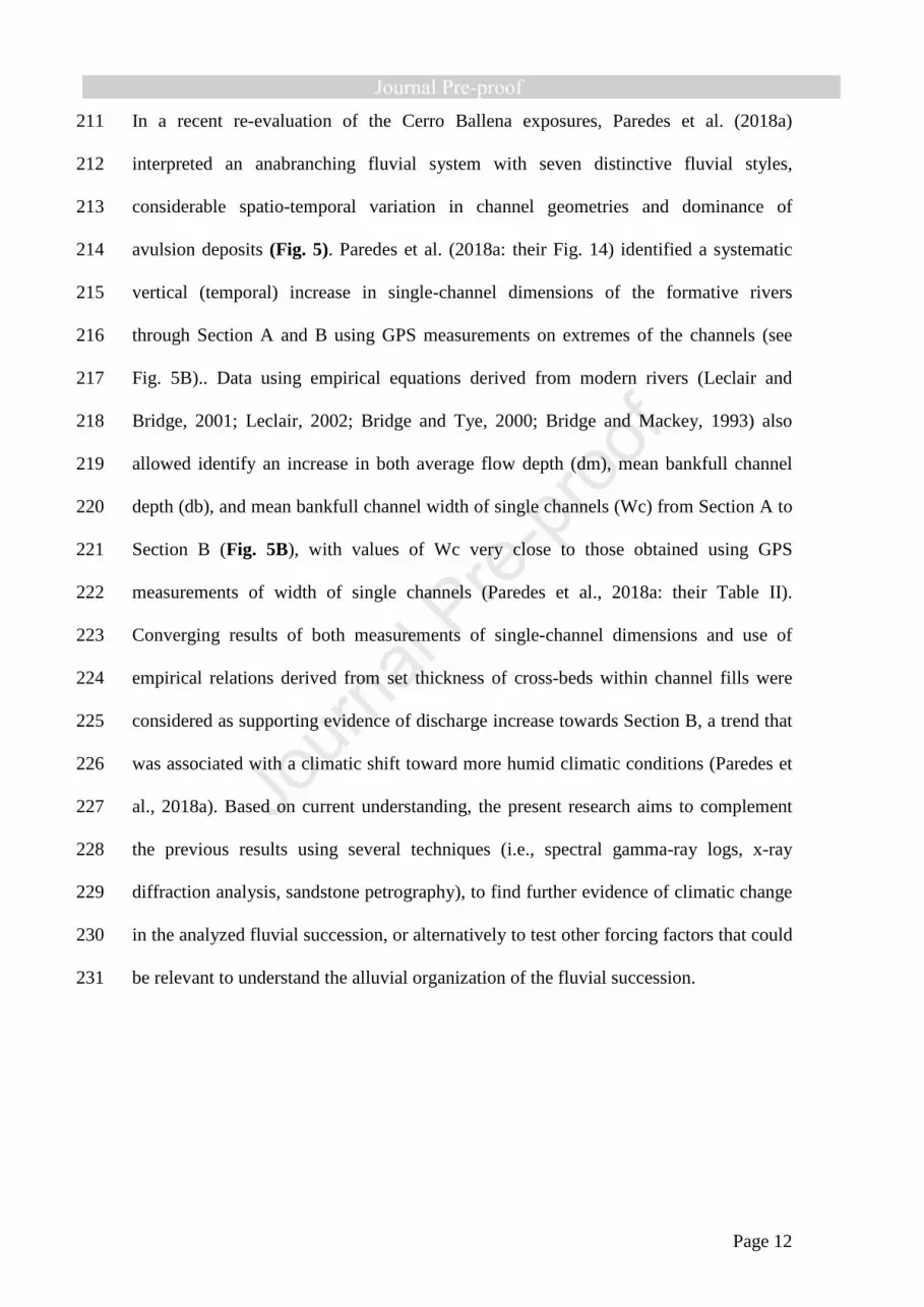
the fine- to medium-grained, typically cross-stratified sandstones that are distinctive of 276
channel fills in the Bajo Barreal Formation. The modal composition of the Cerro 277
Ballena samples was analyzed by counting 500 points per thin section in a rectangular 278
grid of 1 mm of spacing, following the Gazzi-Dickinson methodology (Ingersoll et al., 279
1984; Zuffa, 1985). The thin sections were impregnated with blue epoxy resin before 280
thin section preparation for the recognition of microscopy porosity. To discriminate 281
dolomite from calcite, thin sections were stained with Alizarin Red-S (Dickson, 1966). 282
Rounding and sphericity of grains were evaluated visually, based on the approach by 283
Powers (1953). 284
285
5. Outcrop spectral gamma-ray logs 286
287
The three outcrop SGR logs from the Cerro Ballena anticline (location in Fig. 4) are 288
shown in Figures 6-8, together with the sedimentary log. 289
290

Page 16
291
Figure 6: Outcrop gamma-ray logs through the Bajo Barreal Formation in the Cerro 292
Ballena anticline. See the location of Log X in Fig. 5. The diagrams show, from left to 293
right, lithology, grain size, and then the gamma-ray data: Total GR (ppm), potassium (K 294
%), uranium (ppm U), thorium (Th ppm). Unexposed sections hidden beneath talus, 295
where SGR data could not be collected, are shown as gaps. 296
297

Page 17
298
Figure 7: Sedimentary log and gamma-ray data for Log Y (247 m). Location in Fig. 5. 299
The diagram shows, from left to right, lithology (code facies as in Fig. 6), grain size, 300
and then the gamma-ray data: Total GR (ppm), potassium (K %), uranium (ppm U), 301
thorium (Th ppm). The main subdivisions of Section A, physically correlated, and 302
walked out along the exposures, are indicated using operational markers. 303
304
Page 18
305
Figure 8: Sedimentary log and outcrop gamma-ray data for Log Z (210 m). Location in 306
Fig. 5. The diagram shows, from left to right, lithology (code facies as in Fig. 6), grain 307
size, and then the gamma-ray data: Total GR (ppm), potassium (K %), uranium (ppm 308
U), thorium (Th ppm). Sampled intervals of fine-grained lithologies for x-ray diffraction 309
studies are marked right to the sedimentological log. 310
311
5.a. SGR counts, lithology and grain size trends 312
313
SGR data from the Cerro Ballena anticline show moderately high radioactivity (dose 314
rate: 45.6 - 180.0 nGy/h; Total GR: 42.4 - 175.0 ppm) and concentration of K (0.4 - 315
3.4%), U (0 – 17.6 ppm) and Th (4.1 – 22.1 ppm). The Total GR log is dominated by 316

Page 19
the potassium content shown by the high correlation (using the Pearson correlation 317
coefficient -r- as a measure of a linear relationship between variables) between 318
potassium log and the total counts (r=0.78) although U also shows high correlations 319
with total counts (r=0.75), and Th displays the less direct relation with total counts 320
(r=0.37). The generally weak correlation between elements (Th-K r=0.20; Th-U r=0.17; 321
U-K r=0.35) suggests that the sum radioactivity is sourced from multiple mineral 322
carriers. The control of the K content on Total GR values is also identified due to 323
similar shapes of the K and Total GR logs for the whole sections, indicating that K-324
bearing minerals are responsible for the majority of the total gamma radiation from 325
these rocks. 326
For our purposes, we grouped the SGR data according to the described lithology and 327
grain size in seven main facies categories, as follow: LITH1: Conglomerates, LITH2: 328
Sandstones, LITH3: Siliciclastic siltstones, LITH4: Siliciclastic mudstones, LITH5: 329
Fine-grained tuffs, LITH 6: Tuffaceous siltstones, LITH 7: Coarse-grained lahar 330
deposits. A correlation matrix for Total GR and the three radioactive components is 331
shown for the overall data, and for the seven selected facies categories (Fig. 9A). A 332
statistical summary of the collected gamma-ray data, arranged by lithology/grain size, 333
and stratigraphic interval (Section) is shown in Fig. 9B. 334
335

Page 20
336
Figure 9. (A) Correlation matrix for radioactive elements determined by SGR in the 337
entire dataset, and for each assigned facies category along with the three SGR logs. (B) 338
Mean values for total radioactivity, potassium (% K), uranium (ppm U) and thorium 339
(ppm Th) contents of Log X, Log Y, and Log Z. Mean Th/K and Th/U ratios are also 340
indicated. StD, standard deviation. 341
342
Th measurements show increasing values from conglomerates to mudstones, although 343
the statistical overlapping is important, whereas U values show decreasing record from 344
conglomerates to mudstones, although the U trend is less defined than for Th element. 345
Moreover, the distinctive marker bed that separated Sections A and B (identified as 346
LITH 7) shows very low values of K and total GR. 347
In conglomerates and sandstones, U and Total GR show high correlations (sandstones 348
r=0.83; conglomerates r=0.90), evidencing that the main contributor to the total 349
radioactivity is the U element. High-radioactivity in conglomerates and sandstones is 350

Page 21
generally attributed to the contents of mica, K-feldspars, lithic fragments, and heavy 351
minerals (Rider, 1999). However, in our study area, high values of U in conglomerates 352
and sandstones are probably associated either with diagenesis or with fluid migration 353
and not with the occurrence of heavy minerals in the fine-grained matrix, due to the 354
characteristic oil staining of the matrix of coarse-grained facies, observed during the 355
fieldwork. Although some trends can be identified using the concentration of U in 356
sandstones and the Th distribution evidence some relation with grain size (Fig. 9.B), the 357
considerable overlap of values and small differences between facies categories do not 358
allow to make lithological distinction using solely basic statistics. 359
360
5.b. SGR correlations and log motifs 361
362
The lateral correlation of the outcrop SGR logs (Fig. 10) use as a datum the distinctive 363
volcaniclastic marker bed showed in Fig. 5. Paredes et al. (2018a) divided the Section A 364
into several major zones of tens of meters according to its sandstone content (indicated 365
as M1, S1, M2, S2, and M3 in ascending order). The major subdivisions of Section A 366
can be traced confidently between the outcrop SGR logs with minimum thickness 367
variations, evidencing a layer-cake distribution of the main packages. Moreover, we 368
correlate outcrop SGR data with Well V and Well W of the Cerro Wenceslao oilfield 369
using two distinctive log motifs identified within Section A. In the lowermost part of the 370
fine-grained succession of Section A, a upward reduction of GR values in subdivision 371
M1-B can be compared with an equivalent GR motif identified in Well W. A second 372
distinctive GR motif occurs in the S2 subdivision (Fig. 10), associated with an upward 373
reduction in both GR and K values. 374

Page 22
The three sedimentological logs in Section B contain a larger “sand:mud” ratio (Log 375
X=0.45; Log Y=0.38; Log Z=0.31, as measured in the vertical sections). The higher 376
sandstone content produces a more irregular motif in U and Total GR logs in Section B, 377
revealing an intricate pattern that makes it challenging to attempt lithological 378
predictions or grain-size trends using SGR data alone. 379
380
381
Figure 10: SGR-log stratigraphic correlation between outcrop gamma-ray logs obtained 382
in the Cerro Ballena anticline (Logs X, Y, and Z) and wells V and W of the Cerro 383
Wenceslao oilfield. The horizontal datum corresponds to the tuffaceous marker bed 384
(MB) located at the base of Section B. The described lithologies are indicated to the left 385
of the GR logs. Major sub-divisions and distinctive log patterns observed in Section A 386
and B are also represented. An upward decrease in Total GR and K counts can be 387
observed throughout S2 and M3 packages of Section A, which can be confidently 388

Page 23
identified in the subsurface. See the inset map for location. Key: SP=spontaneous 389
potential, AT90= deep resistivity. 390
391
6. Clay mineralogy and SGR record 392
393
We select ten mudstone samples for analysis by x-ray diffraction from Section A, and 394
eight additional samples were collected from Section B. As mentioned, the sampling 395
procedure was guided by observed trends in both Total GR and K values in the outcrop 396
SGR logs, testing a possible link between K values in SGR log and clay minerals. 397
398
6.a. Trends in Clay composition within Section A. 399
In fine-grained samples from Section A in Log Z (Fig. 11), the whole-rock composition 400
is dominated by quartz (about 32-60 %) and clay minerals (37-65 %), with minor 401
amounts of K feldspar (traces to 1 %), plagioclases (1-3 %), and calcite in three samples 402
(traces to 2 %). The main clay minerals in all ten samples are smectite (45-79 %), 403
kaolinite (1-55 %), and a single sample contains mixed-layer illite-smectite (99 %). X-404
ray diffraction data indicate that although feldspars are present, clay minerals are 405
volumetrically the most important source of K2O, suggesting that clay mineral 406
distribution and type will be the primary control on K2O distribution in the K log. 407
Samples from the basal levels of S2 stratigraphic interval are dominated by smectite, 408
whereas clay minerals gradually change upward from smectite to kaolinite through S3, 409
and parallel the gradual and systematic upward reduction in both the GR and K content. 410

Page 24
411
Figure 11: Whole-rock and clay-sized fraction x-ray diffraction (XRD) data obtained in 412
outcrop SGR Log Z (location in Figure 8). Quartz and clay minerals are the 413
predominant components. Clay mineral assemblages of the M3 sub-unit are dominated 414
by Al2O3-rich kaolinite, whereas the S2 sub-unit contains more proportion of smectite. 415
416
6.b. Trend in Clay composition within Section B 417
With increasing sandstone content within Section B, we recognize an extra level of 418
heterogeneity associated with the U enrichment in porous media (Osmond and 419
Ivanovich, 1992), favoring the general lack of predictable GR trends in this stratigraphic 420
interval, and making correlation from GR log pattern very difficult. We collected eight 421
samples from a 25 m thick section within Section B in Log Z (location in Fig. 8) in 422
order to test genetic relationships between GR-SGR values and clay minerals, after 423
identifying a log trend of increasing, and then decreasing values in both Total GR and K 424

Page 25
logs (Fig. 12). Thus, we analyze the samples in the likelihood that they contained a 425
systematic variation in clay content regarding the measured Total GR and K content. 426
Whole-rock composition of the samples show elevated quartz content (range 48-80%) 427
and clay minerals (19-49 %), with subordinate amounts of K feldspar (traces to 2 %), 428
plagioclases in two samples (2-5 %), calcite in three samples (traces to 12 %), and 429
ankerite (4 %) and hematite (1 %) in a single sample. The main clay minerals are 430
represented by kaolinite in all samples (34-98 %), smectite in three samples (18-66 %), 431
minor content of illite in six samples (1-8 %), and a single sample contain mixed-layer 432
illite-smectite (10 %). Crystallinity is good in kaolinite, good to regular in illite, regular 433
to poor in smectite, and poor in I/S samples. Moreover, samples showing high kaolinite 434
content (e.g., samples CB-11 and CB-18) record the lowermost Total GR values and K 435
content within the sampled interval. Those samples containing smectite show 436
intermediate to high SGR counts, whereas the illite content, to a certain extent, shows 437
direct correspondence with the count in K (e.g., from samples CB-11 to CB-13). 438

Page 26
439
Figure 12: Whole-rock and clay-sized fraction x-ray diffraction (XRD) data obtained in 440
outcrop SGR Log Z (location in Figure 8). All samples contain high kaolinite content, 441
suggesting an increase in the weathering rate regarding Section A samples. 442
443
7. Detrital sandstone composition 444
445
Point-count results were tabulated and recalculated, and the entire dataset is shown in 446
the Supplementary Material. A general description of the detrital constituents is 447
provided next, after Olazábal et al. (2019). 448
Detrital quartz is generally sub-rounded to sub-angular with variable grain size ranging 449
between coarse- to fine-grained. Grains are predominantly monocrystalline, with 450
embayed volcanic and fluid inclusions. Polycrystalline quartz is present in low 451
proportion, displaying mainly straight to curved sutured contacts between individual 452

Page 27
crystals, with more than three sub-grains displaying preferred crystallographic fabric, 453
probably of metamorphic origin. 454
K-feldspars are in all samples more abundant than plagioclase. Distinctive orthoclase 455
and sanidine grains are present in most samples, whereas the plagioclase composition 456
varies from oligoclase to andesine. Both components are altered and corroded and 457
partially dissolved. 458
Volcanic rock fragments are abundant. Basic and intermediate volcanic rocks were 459
identified based on lathwork and microlithic textures (Ingersoll and Cavazza, 1991), 460
whereas the occurrence of porphyritic and felsitic textures suggests acidic lava flows as 461
the likely source. Lithic fragments with vitreous and eutaxitic textures are indicative of 462
a pyroclastic source, and the occurrence of pumice components and glass shards reflects 463
coeval, acidic volcanic activity (Umazano et al., 2009; Tunik et al., 2015). Metamorphic 464
rock fragments are rare, where present they are of high-medium metamorphic rank 465
(Garzanti and Vezzoli, 2003). 466
The proportion of matrix is generally low (less than 2 %), consisting of interstitial clay 467
minerals and pseudomatrix (Dickinson, 1970; Dunn, 1992). Biotite, muscovite, zircon, 468
and heavy minerals are minor constituents of all sandstones. The most abundant types 469
of cement are carbonates (calcite, dawsonite, and dolomite), whereas clay coatings are 470
common, with the limited occurrence of iron oxide cement. Several samples of Section 471
B and the marker bed show dawsonite, as a pervasive alteration of detrital components. 472
The porosity evaluated on thin sections occurs as both secondary and altered primary 473
types. Most of the secondary porosity form moldic pores, but dissolution pores were 474
formed as a result of both dissolution of framework grains and calcite cement, and 475
fracture pores are locally found. 476

Page 28
According to Folk et al. (1970), the analyzed sandstones from Section A (Fig. 13B) 477
correspond to feldspathic litharenites (n=7), litharenites (n=1) and feldarenites (n=1) 478
with modal averages Q20F33L47 and Lm1Lv99Ls0. Sandstones from Section A are 479
mineralogically and texturally immature, with an average of 32 % of intergranular 480
material (matrix and cement) and 56% of detrital components. The lithic fraction (Fig. 481
13.A) mainly consist of lithic clasts of acidic volcanic rocks (average abundance of 19 482
%), pyroclastic fragments (46 %) and highly altered pyroclastic fragments (18 %); all 483
the samples contain intermediate to basic volcanic fragments (14 %), whereas fragments 484
of metamorphic and plutonic origin are uncommon (2 %) and sedimentary fragments 485
are scarce (<<1 %). 486
In contrast, samples from Section B (n=18) correspond entirely to litharenites with 487
modal averages of Q31F7L62 and Lm1Lv99Ls1. The detrital framework, on average, 488
represents 40%, whereas intergranular components are up to 48 %. The lithic fraction 489
consists of pyroclastic fragments (53 %), acidic volcanic rocks (average abundance of 490
22 %) and highly altered pyroclastic fragments (23 %), whereas fragments of 491
metamorphic and plutonic origin are uncommon (2 %) and sedimentary fragments are 492
scarce (<<1 %). Samples from Section B show a significative reduction in K content (7 493
% average), whereas basic-intermediate components are below 3 % in seven samples 494
(Fig. 13A). 495
496
Interpretation: Data indicate that sandstone samples from Section A and Section B 497
correspond to different petrofacies (Ingersoll, 1978) and can be compared with previous 498
petrographical results of the Bajo Barreal Formation. Ibañez et al. (2015) identified 499
feldspar litharenites and litharenites from samples along exposures of the Bajo Barreal 500
Formation in the Cerro Guadal oilfield, located 26 km toward NNW; their data overlap 501

Page 29
the field of compositions in the QFL diagram (Folk et al., 1980) of samples obtained in 502
Section A of the Cerro Ballena. Limarino and Giordano (2016) analyzed arenites from 503
subsurface samples of the Bajo Barreal Formation with comparable detrital components 504
to those recognized in Section A, identifying two distinctive petrofacies, referred as VF 505
and VP. Limarino and Giordano (2016) consider both petrofacies as indicative of 506
provenance from volcanic terrains, discriminating VF and VP petrofacies by the relative 507
proportion of plagioclase and k-feldspar within the sandstones. The VP petrofacies 508
contain a percentage of plagioclase twice that of k-content and are considered related to 509
source areas located in the Deseado Region, whereas in the VF petrofacies the K-510
content is similar to the plagioclase percentage, being sourced from the Andes 511
Cordillera (Limarino and Giordano, 2016). Sandstone samples of Section A do not fix 512
with the previous characterization of petrofacies VP and VF, because they contain a 513
more substantial proportion of basic-intermediate components, and plagioclase 514
percentages are similar to k-feldspar content. Thus, we consider that the detrital 515
composition of sandstone samples from Section A reflects a mixture of components, 516
with dominant acidic components derived from the Andes Cordillera, and contribution 517
from basic-intermediate volcanic-volcaniclastic rocks derived from the underlying Bajo 518
Pobre Formation of the Bahía Laura Group (Clavijo, 1986; Panza and Haller, 2002; 519
Cobos and Panza, 2003), outcropped few kilometers southward of the study area. All 520
samples from Section B corresponds to petrofacies VF of Limarino and Giordano 521
(2016), and thus they are linked to a source area dominated by acidic volcanic rocks 522
derived from the Andes Cordillera. 523
524

Page 30
525
Figure 13: Detrital petrographic composition of sandstone samples from Section A and 526
Section B of the Bajo Barreal Formation at Cerro Ballena Anticline, Santa Cruz 527
province. (A) Vertical trends of total quartz, total feldspars, and total lithics, expressed 528
as a percent of total detrital components, and source of lithic components. The sample 529
position indicated left to the figure, is shown in Figures 6 and 7. Notice the abrupt 530
reduction in basic-intermediate volcanic components in Section B and the 531
corresponding upward increase of components derived from acid volcanic sources. (B) 532
Ternary diagrams of sandstones (after Folk et al., 1970). Qt, total quartz; F, total 533
feldspar; L, lithic fragments. 534
535
8. Discussion 536
Page 31
537
The evolution of the Bajo Barreal Formation is discussed here with particular attention 538
to the links between stacking styles, the trends in spectral gamma-ray log and clay 539
composition as well as depositional controls. 540
541
8.a. Origin of trends in SGR logs and clay minerals 542
Section A. The upward reduction in K and total GR through S-2 and S-3 sub-units of 543
Section A can be linked to the observed clay minerals. Higher potassium values in basal 544
levels of S2 sub-unit is probably a result of the substitution of K in the structure of 545
smectites before undergoing diagenesis (Drief and Nieto, 2000). The upward increase in 546
Al 2O3-enriched kaolinite through Section A (Fig. 11) constitutes the likely reason for 547
lower radiation values in both Total GR and K logs in mudstone samples, probably 548
reinforced by leaching from feldspars during kaolinite formation (Parkinson, 1996). 549
Limarino et al. (2017) analyzed the diagenetic evolution of subsurface sandstone 550
samples of the Bajo Barreal Formation at depths ranging from ~500 m to up to 2500 m, 551
identifying a complex evolutive history with seven diagenetic stages. Although clay 552
transformations during the burial of the studied succession cannot be ruled out, the 553
Cerro Ballena is located very close to the southern basin boundary and has been covered 554
by limited (if any) Cenozoic strata, with Cenozoic uplifting linked to the building of the 555
San Bernardo Fold Belt. Consequently, we consider that the succession has not 556
undergone significative burial, probably less than 500 m, and clay mineral variations are 557
attributed to changes in the chemical weathering rate in the early diagenesis. 558
We thus consider that the upward K reduction throughout Section A identified in SGR 559
logs and the corresponding increase in kaolinite values are associated with the increase 560
of paleo-weathering in humid conditions, while the low total GR counts values toward 561

Page 32
the top of Section A are associated with both enhanced continental leaching and 562
changes in clay type. Several studies (Senkayi et al.,1987; Thiry, 2000; Sáez et al., 563
2003; Worden and Morad, 2003; among others) pointed out that kaolinite can result 564
from the alteration of volcanic-volcaniclastic components under warm and humid 565
climatic conditions, whereas smectite can be formed from the alteration of volcanic or 566
volcaniclastic material or a variety of authigenic processes and climatic conditions 567
(Chamley, 1989; McKinley et al., 2003; Galán, 2006). The single sample containing I/S 568
mixed layer may results from moderate chemical weathering under surficial conditions 569
(Chamley, 1989), and can occur during the transformation of smectite under seasonal 570
climates due to pedogenetic processes (Wilson, 1999; Raucsik and Varga, 2008) or 571
from altered volcanic materials (Lindgreen and Surlyk, 2000; Shoval, 2004). 572
Section B. Increasing, and then decreasing GR counts and K content in the sampled 573
stratigraphic interval of Section B show close correspondence with the variations in the 574
kaolinite-smectite ratio (Fig. 12). Our results suggest that reading of Total GR and K 575
counts can be linked with vertical changes in clay minerals within the study succession 576
in accordance with previous studies that related abundance of clay minerals in 577
sedimentary rocks to the ratios of K, Th and U (Myers and Bristow, 1989; Slatt et al., 578
1992; Ruffell and Worden, 2000). However, the small number of XRD measurements in 579
Section B prevents more detailed statistical correlations between clay content and SGR 580
values. The results indicate an overall higher kaolinite content that samples collected in 581
Section A, supporting the inferences of higher weathering rate toward upper levels of 582
the analyzed succession (Millot, 1970; Weaver, 1989). Besides, to date, no paleosol 583
studies have been carried out in the Cerro Ballena. Although during the fieldwork we do 584
not find evidence of either mature paleosols or distinctive soil horizons, more research 585
on the paleosols of the Bajo Barreal Formation in this area is needed to evaluate subtle 586

Page 33
changes in soil-forming processes and mineralogy. Probably, future research in 587
micromorphological and geochemical characteristics of poorly-evolved paleosols can 588
improve our understanding of the analyzed fluvial strata. 589
590
8.b. Origin of changes in detrital provenance 591
The vertical compositional trend observed within the sandstone samples reveals a 592
precise change in detrital modes at the boundary between Section A and Section B. 593
Particularly, we noted a noticeable upward reduction in both potassium content and 594
basic-intermediate igneous components (see Fig. 13), and the increase in unstable, 595
acidic volcanic components, demonstrating changes in bedload composition in the 596
rivers of Section B. These changes occur synchronously to the observed change in 597
floodplain composition from epiclastic-derived, grey-colored mudstones and siltstones 598
of Section A to red-colored, tuffaceous siltstones in Section B, and parallel the increase 599
in channel proportion (Figari et al., 1998). Floodplain construction within the Bajo 600
Barreal Formation has been associated with reworking by the water of epiclastic and 601
volcaniclastic components during floods (Umazano et al., 2008), while only a minor 602
proportion of ash-size beds are related to direct airfall derived from distal volcanic 603
activity (Paredes et al., 2016). As detrital composition changes occur as a result of 604
erosion and unroofing, in a conformable succession, such changes in composition are 605
gradual and continuous (Graham et al., 1986). On the contrary, significant breaks in 606
sedimentation can be identified by sudden changes in clast composition across an 607
erosion surface (Colombo, 1994; Miall and Arush, 2001), and are useful to define 608
sequence boundaries. 609
From the above considerations, several likely explanations emerge concerning the 610
observed changes in the detrital modes. Synchronous changes both in bedload 611

Page 34
mineralogy and in suspended-load types should require a significant reorganization in 612
the drainage network toward the hinterlands, which would lead to the incorporation of a 613
considerable amount of unstable, volcaniclastic-derived components in the flanks of the 614
Andes Cordillera. Alternatively, stream piracy of a larger-scale catchment in a closer 615
position to the study site could also be effective in producing sudden mineralogical 616
changes, providing instantaneously large volumes of pyroclastic-acidic components, 617
with the dilution of the basic-intermediate components. Besides, it is also possible that 618
coeval changes in detrital provenance, suspended-load components, and the scale of the 619
channels could have been triggered by a sudden reorganization of the channel network 620
linked to increased volumes of water being transferred within the catchment in more 621
humid conditions. These impacts could be even reinforced due to the relative low 622
permeability of tephra components that built up the floodplains of Section B in relation 623
to epiclastic components of floodplains in Section A, reducing the infiltration capacity 624
of the floodplain and favouring runoff increases during floods or heavy rains (e.g., 625
Swanson et al., 1982; Smith, 1991). In this scenario, the increase in both water and 626
sediment supply within the channel network in a relatively flat geomorphic scenario 627
can, in turn, led to either increasing frequency of channel avulsion (Bryant et al., 1995) 628
or increasing migration rates (Leeder, 1978; Mack and Leeder, 1998) favoring greater 629
interconnectivity among channel deposits. 630
631
8.c) Negligible influence of local tectonics or base level on stacking and connectivity 632
In alluvial settings, the recognition of depositional sequences relies on the identification 633
and correlation of subaerial unconformities and contrasting stacking patterns. Classical 634
models of fluvial depositional sequences define three systems tracts similar to that 635
observed in marine environments (Legarreta and Uliana, 1993; Wright and Marriott, 636

Page 35
1993; Shanley and McCabe, 1994), but other studies proposed a model of fluvial 637
depositional sequences composed of only two systems tracts (Martinsen et al., 1999; 638
Catuneanu, 2006). In the two-stage scenario, contrasting stacking pattern allows 639
defining high- and low-accommodation systems tracts in fluvial sequence stratigraphy, 640
defined by variations in the overbank/fluvial channel ratio (Martinsen et al., 1999) and 641
by variations in the geometry of the involved channel belts (Labourdette, 2011). 642
Sediments within Section A can be interpreted as a high-accommodation systems tract 643
due to the low interconnectivity of the channel belts, with a stacking density of 12%. 644
Channel belts of Section A are narrower than those of Section B, which can be 645
associated with higher aggradation rate of floodplain materials in relation to avulsion 646
frequency or channel migration rates. The sequence boundary is established by 647
changing stacking patterns between Sections A and B, and also by the precise change in 648
detrital composition (Miall and Arush, 2001). 649
On the other hand, Section B is considered a low-accommodation systems tract owing 650
to the elevated connectivity of channel belts. Averaged stacking density of Section B is 651
32%, reflecting reduced aggradation floodplain rate in relation to the lateral shift of the 652
channel belts onto the floodplain. Besides, fluvial sequence models related to both base 653
level shift and tectonic requires the occurrence of large incisional relief at base of 654
amalgamated channel complexes (Miall, 2002) and coeval occurrence of mature 655
paleosols in interfluves (Atchley et al., 2004; Hampson et al., 2005) to support base 656
level shifts and the development of sequence boundaries Field observations and SGR 657
correlations show that mudstone strata are virtually parallel in the Cerro Ballena area, 658
indicating deposition of the stratigraphic intervals over a relatively flat relief. Lack of 659
degradational features (e.g., incised valleys, fluvial terraces) also constitute indirect 660
evidence of an aggradational system. The correlation of outcrop gamma-ray logs with 661

Page 36
well-logs of the Cerro Wenceslao oilfield (Fig. 10) indicates a layer-cake geometry of 662
the studied fluvial succession over up to 15 km that we interpreted as evidence of 663
negligible local tectonic activity in this part of the basin. Parallel seismic packages and 664
no thickness variation of stratigraphic intervals within the Bajo Barreal Formation 665
across faults (not shown) in the Cerro Wenceslao oilfield also reflect a lack of tectonic 666
activity during deposition. However, it is worth mentioning that Upper Cretaceous 667
tectonic activity in the Andean margin (Folguera and Ianizzoto, 2004; Folguera et al., 668
2011) would have increased the rate of production of volcanic particles and relief 669
generation, which in turn could have produced larger volumes of volcaniclastic particles 670
and a distinctive mineralogy in the coeval drainage systems. Hence, although the fluvial 671
succession displays an overall aggradational pattern and shows no changes in the flow 672
direction (Fig. 5), sudden variations in detrital modes and floodplain composition could 673
be indirect evidence of coeval volcanic activity in the hinterlands (see Paredes et al., 674
2018a). 675
676
8.d) Climatic control on staking and connectivity 677
Climate changes occur in a quasi-periodic way at several scales (e.g., Milankovich 678
cyclicity, see Imbrie et al., 1984), conditioning the delivery of water and sediment to 679
fluvial basins, and vegetation cover (Leeder et al. 1998; Blum and Tornvist, 2000; Blum 680
and Hattier-Womack, 2009). River systems respond to climatic shifts in different forms, 681
and the nature and amplitude of the climatic shifts necessary to generate a distinctive 682
signal in current fluvial systems are currently not fully understood (Tandon and Sinha, 683
2007). Climate and channel stacking constitute a recurrent (and challenging) issue in the 684
last decades (Olsen, 1994; Blum and Tornqvist, 2000; Heller et al., 2015) and a subject 685
Page 37
of active research (Foreman et al., 2012; Allen et al., 2013; Foreman, 2014; Simpson 686
and Castelltort, 2014; Colombera et al., 2017; among others). 687
A detailed characterization of the channel fills in the Cerro Ballena exposures was 688
provided by Paredes et al. (2018a), identifying an upward increase in both channel-fill 689
width and flow depth toward Section B. In the study area, stratigraphic intervals with 690
higher interconnectivity of channel deposits (Section B) contain wider and thicker 691
channel bodies than intervals of lower interconnectivity of channel deposits (Section A). 692
Based on the results of paleohydrological estimations (see Fig. 5), an upward shift 693
toward more humid conditions was proposed. Further evidence of wetter conditions 694
toward the uppermost part of the Cerro Ballena section has been presented in this 695
research using outcrop spectral gamma-ray logs and x-ray diffraction analysis, where 696
trends of change in both Total GR log and K contents seen to parallel changes in clay 697
minerals in floodplain facies (see Figs. 9-10). Mainly, upward increases in kaolinite 698
content through Section A are considered reliable evidence of increasing chemical 699
weathering. Moreover, the observed (inverse) relation between Total GR values and 700
kaolinite content in XRD analysis demonstrated that potassium hosted in clay minerals 701
is the primary source of the radiation in the fine-grained fraction. 702
Hajek and Heller (2012) pointed out that increases in water availability promote the 703
further erosive capacity of the flow during floods and preservation of wider channel 704
belts, removing a higher proportion of fines during floods and increasing the overall 705
connectivity of channel deposits. The proposal implicitly states that climatic shifts can 706
directly impact the connectivity of fluvial successions, through the generation of 707
broader and deeper channel belts with higher connectivity during periods of high water 708
availability. On the contrary, we can speculate on the occurrence of minor-scale, 709
isolated single channels during stages of reduced water availability. As channel sizes are 710
Page 38
related to water availability and discharge of the formative rivers, our study 711
demonstrates that a shift toward more humid conditions upward in the Cerro Ballena 712
exposures has favored higher connectivity of the channelized sandstones. Besides, the 713
study succession lacks age constraints necessary to infer aggradation rates; hence, 714
temporal changes in accommodation regarding stacking density cannot be adequately 715
evaluated. Furthermore, a recent evaluation of the inverse relation between channel-716
deposit proportion (and geometries) and floodplain aggradation rate values, do not 717
follow the predicted behavior in fossil examples (Colombera et al., 2015), revealing the 718
need of a profound revision of the fundamental principles of current fluvial stratigraphic 719
models. In this regard, the present research demonstrates, using several independent 720
lines of evidence, that climatic changes can control the variation in stacking density. 721
722
8.e) Implication for subsurface studies 723
724
In the subsurface, the results derived from this outcrop example can be applied to 725
understand the origin of channel deposits of variable scale identified in stratigraphic 726
intervals with different sand:mud ratio. Seismic attributes directly image the geometry 727
of potential reservoirs, and constitute a common technique during oilfield development 728
(Wood, 2007; Hubbard et al., 2011; El-Mowafi and Marfurt, 2016), providing relevant 729
information for hydrocarbon production. In the Chubut Group of the Golfo San Jorge 730
basin, it is common during oilfield development to identify stratigraphic intervals with 731
vertical changes in the stacking pattern of channelized deposits (e.g., Catuneanu, 2019: 732
his Fig. 14). Well-log information of upper levels of the Mina del Carmen Formation in 733
the El Cordón oilfield (Fig. 14A, location in Fig. 1) show channel fills separated by 734
thick floodplain fines, whereas in the Caleta Olivia Member of the Cañadón Seco 735
Page 39
Formation (equivalent to the Lower Bajo Barreal Formation) channels are thicker and 736
floodplain fines are in lower proportion. The visualization of channel belts was 737
performed using spectral decomposition volumes (see Partyka et al., 1999), allowing to 738
define channel margins, true width of the channels, and patterns of displacement of 739
channel belts in the interval of interest. A blend of frequencies from individual volumes 740
in the range of 24-56 Hz was imaged, visualizing the geometries of channel belts from a 741
seismic horizon (H2) within the Mina del Carmen Formation (location in Fig. 1) and 742
from the top of the Mina del Carmen Formation (H1). In the seismic volume around H1, 743
we considered, due to a large number of channelized features, that most of the 744
geobodies belong to the Caleta Olivia Member. 745

Page 40
746
Figure 14: Variability in stacking of the Bajo Barreal Formation in the El Cordón 747
oilfield (location in Fig. 1). (A) The stratigraphic pattern of Mina del Carmen and 748
Cañadón Seco formations, with alternating packages of high and low sand:mud ratio. 749

Page 41
(B) Techniques of channel visualizations applied to a seismic horizon within the Mina 750
del Carmen Formation (H2) and to a seismic horizon close to the top of the Mina del 751
Carmen Formation (H1). (C) Comparison of channel dimensions of channel fills 752
visualized in the Mina del Carmen Formation and Caleta Olivia Member of the 753
Cañadón Seco Formation. 754
755
By using spectral decomposition in the H2 seismic horizon (Upper Mina del Carmen 756
Formation) several low-sinuosity fluvial channels with variable orientation are 757
identified, with channel-body widths in the order of 140-200 m. On the other hand, 758
fluvial channels imaged within the Caleta Olivia Member are of high-sinuosity and 759
larger scale, with channel-fill widths up to 450 m, and channel-belt widths commonly 760
up to 2500 m. Hence, stratigraphic intervals of higher sand:mud ratio display wider 761
fluvial channels that those of lower sand:mud ratio, where narrow fluvial channels 762
predominate. Although the natural variability of the fluvial systems is extremely high, 763
and no general rules can be derived from this single example, our analysis of the Bajo 764
Barreal Formation have provided a reliable example in which the stacking (and hence 765
inter-connectivity) of fluvial channels occur synchronously with variations in the scale 766
(true width, flow depth?) and style of the formative rivers. From this, the identification 767
of climatic cycles in the subsurface can be attempted through the integration of spectral 768
gamma-ray logs and clay mineralogy changes plus imaging of fluvial geobodies using 769
seismic attributes. The integration of results derived from the present approach, with 770
palaeohydrological estimations derived from morphometric parameters of imaged 771
channel belts using empirical relations obtained for current rivers (Reijenstein et al., 772
2011; Wood, 2007; Musial et al., 2012) constitute a promising field of research in order 773

Page 42
to assess climatic variation associated with changes in channel dimensions in the 774
subsurface environment. 775
776
9. Concluding Remarks 777
778
Fluvial deposits of the Bajo Barreal Formation (Upper Cretaceous) record deposition of 779
contrasting styles of stacking (e.g., isolated vs. highly interconnected channel fills) 780
among two distinctive lithological sections in the Cerro Ballena anticline. Rooted in a 781
published sedimentological study that recognized increases in both channel width and 782
flow depth upward of the studied succession, and hence the temporal increase in river 783
discharge and water availability, we collect information recording three spectral 784
gamma-ray logs, eighteen x-ray diffraction data of mudstone samples, and petrography 785
of sandstones within 31 channel fills. The conclusion includes the following. 786
1. We interpreted a nearly flat geomorphic scenario for the study succession based 787
in the correlation of distinctive log motifs within the Section A in outcrop 788
spectral gamma-ray logs, with subsurface gamma-ray logs in the Cerro 789
Wenceslao oilfield, distant up to 12 km from the outcrops. The layer-cake 790
distribution, lack of either large-scale erosional surfaces, terraces, or evident 791
paleosol successions, and relatively constant paleoflow directions (the later 792
feature identified in Paredes et al., 2018) suggest lack of either local tectonic 793
activity or base-level shifts during deposition. 794
2. The integration of results derived from the SGR logs and XRD diffraction 795
analysis revealed a genetic link between both Total GR values and K content 796
with the proportion of different clay minerals. An upward K reduction through 797
Section A identified using spectral gamma-ray logs parallel with the increase in 798

Page 43
kaolinite content in XRD analysis of mudstones. Increase in kaolinite content is 799
also the likely reason of lower radiation values observed in the Total GR log 800
toward upper levels of Section A. Within Section B, mudstone samples have 801
higher proportion of kaolinite content that samples in Section A. These results 802
can be integrated with previous paleohydrological estimations of the studied 803
succession, supporting a climatic shift toward more humid conditions in upper 804
levels of the Cerro Ballena Anticline. 805
3. The detrital provenance of Section A indicates the mixing of volcanic 806
components, which were derived mainly from acidic sources in the coeval 807
Andes Cordillera, with basic-intermediate sources derived from the middle 808
Jurassic Bahía Laura Group in the Deseado Massif. Samples from Section A are 809
feldspathic litharenites, litharenites and feldsarenites with modal averages 810
Q20F33L47 and Lm1Lv99Ls0, and moderate contribution of intermediate to basic 811
volcanic fragments (average 14%). Samples from Section B contain an 812
abundance of volcaniclastic, mainly pyroclastic, compositions derived 813
exclusively from the Andes Cordillera, corresponding to litharenites with a 814
modal average of Q31F7L62 and Lm1Lv99Ls1, and reflect a significative reduction 815
in both K content and intermediate-basic components. 816
4. A major reorganization of the fluvial system occurs at the boundary between 817
Section A and Section B, where synchronic changes in (i) bedload composition, 818
(ii) suspended-load type, and (iii) channel sizes (width, flow depth) is coincident 819
with changes in the stacking density and inter-connectivity of fluvial channels. 820
The most probable reason for the upward increase of the sand:mud ratio is a 821
significative increase in both sediment supply and discharge of the rivers, which 822
could generate either the increasing frequency of channel avulsion or higher 823

Page 44
channel migration rates. Thus, our approach combining several independent 824
techniques indicate that climate changes can directly impact on the stacking and 825
connectivity of potential sandstone reservoirs. 826
5. The integration of outcrop methodologies presents future research opportunities 827
and challenges for subsurface environments. Our example of an oil-bearing 828
fluvial succession in the nearby El Cordón oilfield reveals that stratigraphic 829
intervals with high sand:mud ratio is characterized by large-scale fluvial 830
channels with a meandering pattern, whereas intervals of low sand:mud ratio 831
show low-sinuosity, narrow fluvial channels. Thus, it is likely that the 832
correspondence between vertical stacking changes, as identified in wire-line 833
logs, and variation in the style and scale of the fluvial channels using seismic 834
attributes, can be integrated with geochemical information linked to temporal 835
variations in the chemical weathering throughout (geochemical profiles, XRD, 836
SGR logs), being helpful to identify climatic cycles in the subsurface record. 837
838
ACKNOWLEDGMENTS 839
840
We want to thank SINOPEC ARGENTINA E&P for permission to publish the results. 841
The Departamento de Geología (FCNyCS-UNPSJB) is acknowledged for logistic 842
support. The authors are indebted to landowners of estancia Cañadon Vasco (family 843
Bain) for access to outcrops. M.E. Covo is thanked for preparing Fig. 14. We are 844
sincerely grateful for the detailed and insightful reviews provided by Dr. Luis A. 845
Spalletti (UNLP, CONICET) and Giorgio Basilici (UNICAMP-Brazil), and Associate 846
Editor Dr. Luca Colombera, whose comments helped us to improve clarity and focus. 847
848

Page 45
REFERENCES 849
850
Allard, J.O., Paredes J.M., Foix N., Giacosa R.E., 2015. Conexión cretácica entre las 851
cuencas del Golfo San Jorge y Cañadón Asfalto (Patagonia): paleogeografía, 852
implicancias tectonoestratigráficas y su potencial en la exploración de hidrocarburos. 853
Rev. Asoc. Geol. Arg. 72, 21-37. 854
Allen, J.R.L., 1978. Studies in fluviatile sedimentation: an exploratory quantitative 855
model for architecture of avulsion-controlled alluvial suites: Sedimentary Geology 21, 856
129-147. 857
Allen, J.P., Fielding, C.R., Rygel, M.C., Gibling, M.R., 2013. Deconvolving signals 858
of tectonic and climatic controls from continental basins: an example from the late 859
Paleozoic Cumberland Basin, Atlantic Canada. J. Sediment. Res. 83, 847-872. 860
Allen, J.P., Fielding, C.R., Gibling, M.R., Rygel, M.C., 2014. Recognizing products 861
of palaeoclimate fluctuations in the fluvial stratigraphic record: an example from the 862
Pennsylvanian to lower Permian of Cape Breton Island, Nova Scotia. Sedimentology 863
61, 1332-1381. 864
Archangelsky, S., Bellosi, E., Jalfin, G.A., Perrot, C., 1994. Palynology and alluvial 865
facies from mid-Cretaceous of Patagonia, subsurface of San Jorge Basin, Argentina. 866
Cret. Res. 15, 127-142. 867
Atchley, S.C., Nordt, L.C., Dworkin, S.I., 2004. Eustatic control on alluvial sequence 868
stratigraphy: a possible example from the Cretacous-Tertiary transition of the Tornillo 869
Basin, Big Bend National Park, west Texas, USA. J. Sediment. Res. 74, 391-404. 870
Barcat, C., Cortiñas, J., Nevistic, V., Zucchi, H., 1989. Cuenca Golfo San Jorge. In: 871
Chebli, G., Spalletti, L.A. (Eds.), Cuencas Sedimentarias Argentinas, Universidad 872
Nacional de Tucumán, Serie Correlación Geológica, 6, pp. 319-345. 873

Page 46
Blum, M.D., Tornqvist, T.E., 2000. Fluvial responses to climate and sea-level change: 874
a review and look forward. Sedimentology 47, 2-48. 875
Blum, M.D., Hattier-Womack, J., 2009. Climate change, sea-level change, and fluvial 876
sediment supply to deepwater systems. In: Kneller, B., Martinsen, O.J., McCaffrey, B. 877
(Eds.), External Controls on Deep Water Depositional Systems: Climate, Sea-Level, 878
and Sediment Flux: SEPM Special Publication 92, pp. 15-39. 879
Bridge, J.S., Mackey, S.D., 1993. A theoretical study of fluvial sandstone body 880
dimensions. In: Flint, S.S., Bryant, I.D. (Eds.), Geological Modeling of Hydrocarbon 881
Reservoirs, vol. 15. International Association of Sedimentologists, Special Publication, 882
pp. 213-236. 883
Bridge, J.S., Leeder, M.R., 1979. A simulation model of alluvial stratigraphy. 884
Sedimentology 26, 617-644. 885
Bridge, J.S., Tye, R.S., 2000. Interpreting the dimensions of ancient fluvial channel 886
bars, channels, and channel belts from wireline-logs and cores. AAPG (Am. Assoc. Pet. 887
Geol.) Bull. 84, 1205-1228. 888
Bridge, J.S., Jalfin, G.A., Georgieff, S.M., 2000. Geometry, lithofacies, and spatial 889
distribution of Cretaceous fluvial sandstone bodies, San Jorge Basin, Argentina: 890
outcrops analog for the hydrocarbon-bearing Chubut Group. Journal of Sedimentary 891
Research 70: 319-337. 892
Brown, L.F., Barcat, C., Fisher, L.W., Nevistic, A., 1982. Seismic stratigraphic and 893
depositional systems analysis: new exploration approaches applied to the Gulf of San 894
Jorge Basin, Argentina. In: 1st Congreso Nacional de Hidrocarburos, Petróleo y Gas, 895
pp. 127-156 Mar del Plata. 896
Bryant, M., Falk, P., Paola, C., 1995. Experimental study of avulsion frequency and 897
rate of deposition. Geology 23, 365-368. 898

Page 47
Casal, G.A., Allard, J.O., Foix, N., 2015. Análisis estratigráfico y paleontológico del 899
Cretácico Superior en la Cuenca del Golfo San Jorge: nueva unidad litoestratigráfica 900
para el Grupo Chubut. Rev. Asoc. Geol. Arg. 72, 81-99. 901
Catuneanu, O., 2006. Principles of Sequence Stratigraphy. Elsevier, Oxford, 375 p. 902
Catuneanu, O., 2019. Scale in sequence stratigraphy. Marine and Petroleum Geology 903
106, 128-159. 904
Chamberlin, E.P., Hajek, E.A., 2015. Interpreting paleo-avulsion dynamics from 905
multistorey sand bodies. Journal of Sedimentary Research 85, 82-94. 906
Chamley, H., 1989. Clay Sedimentology. Springer, Berlin, p. 623. 907
Clavijo R., 1986. Estratigrafía del cretácico inferior en el sector occidental de la Cuenca 908
Golfo San Jorge. Boletín de Informaciones Petroleras 9, 15-32. Buenos Aires. 909
Cobos, J.C., Panza, J.L., 2003. Hola geológica 4769-1 (El Pluma). Serv. Geol. Min. 910
Argent. Bol. 319, 1-89 (Buenos Aires). 911
Colombera, L., Mountney, N.P., Williams, W.D., 2015. A meta-study of relationships 912
between fluvial channel-body stacking pattern and aggradation rate: implications for 913
sequence stratigraphy. Geology 43(4), 283-286. 914
Colombera, L., Arévalo, O.J., Mountney, N.P., 2017. Fluvial-system response to 915
climate change: The Paleocene-Eocene Tremp Group, Pyrenees, Spain. Global and 916
Planetary Change 157, 1-17. 917
Colombo, F., 1994. Normal and reverse unroofing sequences in syntectonic 918
conglomerates as evidence of progressive basinward deformation. Geology 22, 235-919
238. 920
Corbeanu, R.M., Soegaard, K., Szerbiak, R.B., Thurmond, J.B., McMechan, G.A., 921
Wang, D., Snelgrove, S., Forster, C.B., Menitove, A., 2001. Detailed internal 922
architecture of a fluvial channel sandstone determined from outcrop, cores and 3-D 923

Page 48
ground-penetrating radar: example from the middle Cretaceous Ferroan Sandstone, east-924
central Utah. AAPG (Am. Assoc. Pet. Geol.) Bull. 85, 1583-1608. 925
Davies, N.S., Gibling, M.R., 2010. Cambrian to Devonian evolution of alluvial 926
systems: the sedimentological impact of the earliest land plants. Earth-Science Reviews 927
98, 171-200. 928
Davies, N.S., Gibling, M.R., Rygel, M.C., 2011. Alluvial facies during the Palaeozoic 929
greening of the land: case studies, conceptual models and modern analogues. 930
Sedimentology 58, 220-258. 931
Dickinson, W.R., 1970. Interpreting detrital modes of graywacke and arkose. J. of 932
Sediment. Petr. 40, 695-707. 933
Dickson, J.A.D., 1966. Carbonate identification and genesis as revealed by staining. J. 934
of Sediment. Petr. 36, 491-505. 935
Di Benedetto, L., Georgieff, S.M., Potas, G., 2006. Stratigraphic correlation and 936
sedimentary analogs: Ballena Hill outcrops and Cañadón Vasco oil field, Southern flank 937
of San Jorge Basin, Argentina. Simposio Bolivariano de Hidrocarburos, Cartagena de 938
Indias, Colombia. 939
Drief, A., Nieto, F., 2000. Chemical composition of smectites formed in clastic 940
sediments. Implications for the smectite-illite transformation. Clay Minerals 35, 665-941
678. 942
Dunn, T.L., 1992. Infiltrated materials in Cretaceous volcanogenic sandstones, San 943
Jorge Basin, Argentina. In: Houseknecht, D.W., Pittman, E.D., Lidz, B.H. (Eds.) Origin, 944
Diagenesis and Petrophysics of Clay Minerals in Sandstones, SEPM (Society for 945
Sedimentary Geology) Special Publication 47, 159-174. 946

Page 49
El-Mowafy H.Z., Marfurt, K.J., 2016. Quantitative seismic geomorphology of the 947
middle Frio fluvial systems, south Texas, United States. AAPG (Am. Assoc. Pet. Geol.) 948
Bull. 100 (4), 537-564. 949
Ethridge, F.G., Schumm, S.A., 2007. Fluvial seismic geomorphology. In: Davies, R., 950
Posamentier, H.W., Wood, L.J., Cartwright, J. (Eds.). Seismic geomorphology: 951
Application to hydrocarbon exploration and production: Geological Society of London, 952
Special Publication 277, 205-222. 953
Evans, R., Mory A.J., Tait, A.M., 2007. An outcrop gamma ray study of the 954
Tumblagooda Sandstone, Western Australia. Journal of Petroleum Sciences and 955
Engineering 57, 37-59. 956
Feruglio, E., 1949. Descripción geológica de la Patagonia. Yacimientos Pet. Fisc. 2, 1-957
349 (Buenos Aires). 958
Figari, E.G., Hechem, J.J., Homovc, J.F., 1990. Arquitectura depositacional de las 959
“Areniscas Verdes” de la Formación Bajo Barreal, provincia del Chubut, Argentina. In: 960
3rd Reunión Argentina de Sedimentología, 1, pp. 130-138 (San Juan). 961
Figari, E.G., Courtade, S.F., Calegari, R., Arroyo H., Constantini, L., 1998. 962
Estructura y estratigrafía del Cerro Ballena, Faja Plegada meridional de la Cuenca del 963
Golfo San Jorge. X Congreso Latinoamericano de Geología y VI Congreso Nacional de 964
Geología Económica, Vol. I, 18-23. Buenos Aires. 965
Fitzgerald, M.G., Mitchum, R.M., Uliana, M.A., Biddle, K.T., 1990. Evolution of 966
the San Jorge Basin, Argentina. AAPG (Am. Assoc. Pet. Geol.) Bull. 74, 879-920. 967
Folguera, A., Iannizzotto, N., 2004. The Lagos La Plata and Fontana fold-and-thrust 968
belt: long-lived orogenesis at the edge of western Patagonia. J. S. Am. Earth Sci. 16, 969
541-566. 970
Folguera, A., Orts, D., Spagnuolo, M., Rojas Vera, E., Litvak, V., Sagripanti, L., 971
Page 50
Ramos, M.E., Ramos, V.A., 2011. A review of late Cretaceous to Quaternary 972
palaeogeography of the southern Andes. Biol. J. Linn. Soc. 103, 250-268. 973
Folk, R.L., Andrews, P.B., Lewis, D., 1970. Detrital sedimentary rock classification 974
and nomenclature for use in New Zealand. N. Z. J. Geol. Geophys. 13, 937-968. 975
Foreman, B.Z., 2014. Climate-driven generation of a fluvial sheet sand body at the 976
Paleocene-Eocene boundary in north-west Wyoming (USA). Basin Research 26, 225-977
241. 978
Foreman, B.Z., Heller, P.L., Clementz, M.T., 2012. Fluvial response to abrupt global 979
warming at the Palaeocene/Eocene boundary. Nature 491, 92-95. 980
Galán, E., 2006. Genesis of clay minerals. In: Berhaya, F., Theng, B.K.G., Lagaly, G. 981
(Eds.), Handbook of Clay Science, Developments in Clay Science, vol. 1. Elsevier, The 982
Netherlands, pp. 1129-1162. 983
Garzanti, E., Vezzoli, G., 2003. A classification of metamorphic grains in sands based 984
in their composition and grade. Journal of Sedimentary Research 73, 830-837. 985
Georgieff, S.M., Sosa Gómez, J.A., Ferreira, L., Vides, M.E., Ibañez, L.M., 986
Ovejero, R., Bossi, G.E., Richter, G.A.V., Anis, K.B., Pieroni, E.M., Moyano, S., 987
2009. Characterization of fluvial sandstones in the Cerro Guadal Norte oil field, Golfo 988
San Jorge Basin, Santa Cruz, Argentina. 9th International Conference on Fluvial 989
Sedimentology, pp. 35-36 (San Miguel de Tucumán, Argentina). 990
Ghasemi-Nejad, E., E.P. Ardakani and A. Ruffell, 2010. Palaeoclimate change 991
recorded in Upper Cretaceous (Albian-Cenomanian) Kazhdumi Formation Borehole 992
SPECTRAL Gamma-Ray Logs, South Pars Gas field, Persian Gulf. Paleogeography, 993
Palaeoclimatology, Palaeoecology 291, 338-347. 994
Ghinassi, M., Ielpi, A., Aldinucci, M., Fustic, M., 2016. Downstream-migrating 995
fluvial point bars in the rock record. Sedimentary Geology 334, 66-96. 996

Page 51
Giampaoli, P., 2019. Cretaceous extensional systems of the Golfo San Jorge basin: 997
insights from the analysis of fault length and displacement data. J. S. Am. Earth Sci. 92, 998
298-309. 999
Gibson, T.G., Bybell, L.M., Mason, D.B., 2000. Stratigraphic and climatic 1000
implications of clay mineral changes around the Paleocene/Eocene boundary of the 1001
northeastern US margin. Sediment. Geol. 134, 65-92. 1002
Graham, S.A., Tolson, R.B., Decelles, P.G., Ingersoll, R.V., Bargar, E., Caldwell, 1003
M., Cavazza, W., Edwards, D.P., Follo, M.F., Handschy, J.F., Lemke, L., Moxon, 1004
I., Rice, R., Smith, G.A., White, J., 1986. Provenance modeling as a technique for 1005
analyzing source terrane evolution and controls on foreland sedimentation. In: Allen, 1006
P.A., Homewood, P., (Eds.) Foreland Basins: International Association of 1007
Sedimentologists, Special Publication 8, p. 425-436. 1008
Hajek, E.A., Heller, P.L., 2012. Flow-depth scaling in alluvial architecture and 1009
nonmarine sequence stratigraphy: example from the Castlegate Sandstone, Central 1010
Utah, U.S.A: J. Sediment. Res. 82, 121-130. 1011
Hajek, E.A., Wolinsky, M.A., 2012. Simplified process modeling of river avulsion and 1012
alluvial architecture: connecting models and field data. Sediment. Geol. 257, 1-30. 1013
Hampson, G.J., Davies, W., Davies, S.J., Howell, J.A., Adamson, K.R., 2005. Use of 1014
spectral gamma-ray data to refine subsurface fluvial stratigraphy: late Cretaceous strata 1015
in the Book Cliffs, Utah, USA. Journal of the Geological Society, London 162: 603-1016
621. 1017
Hechem, J.J., 1994. Modelo predictivo de reservorios en un sistema fluvial efímero del 1018
Chubutiano de la cuenca del Golfo San Jorge, Argentina. Rev. Asoc. Arg. de Sediment. 1019
1, 3-14. 1020

Page 52
Hechem, J.J., 1997. Arquitectura y paleodrenaje del sistema fluvial efímero de la 1021
Formación Bajo Barreal, cuenca del Golfo San Jorge, Argentina. In: 1st Congreso 1022
Latinoamericano de Sedimentología, Actas 1, pp. 315-323 (Isla Margarita, Venezuela). 1023
Hechem, J.J., Homovc, J.F., Figari, E.G., 1990. Estratigrafía del Chubutiano 1024
(Cretácico) en la Sierra de San Bernardo, cuenca del Golfo San Jorge, Argentina. In: 1025
11th Congreso Geológico Argentino, Actas 3, pp. 173-176 (San Juan). 1026
Heller, P.L., Ratigan, D., Trampush, S., Noda, A., McElroy, B., Drever, J., 1027
Huzurbazar, S., 2015. Origins of bimodal stratigraphy in fluvial deposits: an example 1028
from the Morrison Formation (Upper Jurassic), western U.S.A. J. Sediment. Res. 85, 1029
1466-1477. 1030
Homovc, J.F., Conforto, G.A., Lafourcade, P.A., Chelotti, L.A., 1995. Fold Belt in 1031
the San Jorge basin, Argentine: an example of tectonic inversion. In: Buchanan, J.G., 1032
Buchanan, P.G. (Eds.), Basin Inversion. Geological Society of London, Special 1033
Publication, vol. 88, pp. 235-248. 1034
Hubbard, S.M., Smith, D.G., Nielsen, H., Leckie, D.A., Fustic, M., Spencer, R.J., 1035
Bloom, L., 2011. Seismic geomorphology and sedimentology of a tidally influenced 1036
river deposit, Lower Cretaceous Athabasca oil sands, Alberta, Canada. AAPG (Am. 1037
Assoc. Pet. Geol.) Bull. 95, 1123-1145. 1038
Ibañez, L.M., Ovejero, R., Georgieff, S.M., Ferreira, L., Bossi, G., 2015. Petrografía 1039
y porosidad de areniscas portadoras de petróleo. Formación Bajo Barreal (Cretácico), 1040
Cuenca Golfo San Jorge, Argentina. Acta Geol. Lilloana 27, 29-51. 1041
Imbrie, J.; Hays, J.D.; Martinson, D.G.; McIntyre, A.; Mix, A.C.; Moreley, J.J.; 1042
Pisias, N.G.; Prell, W.L.; Shackleton, N.J. 1984. The orbital theory of Pleistocene 1043
climate: support from the revised chronology of the d18O record. In: Berger, A.; Imbrie, 1044

Page 53
J.; Hays, J.; Kukla, G.; Saltzman, B. (Eds.) Milankovitch and climate. Dordrecht, 1045
Reidel, p. 269-306. 1046
Ingersoll, R.V., 1978. Petrofacies and petrologic evolution of the Late Cretaceous fore-1047
arc basin, northern and central California. J. of Geol. 86, 335-352. 1048
Ingersoll, R.V., Cavazza, W., 1991. Reconstruction of Oligo-Miocene volcaniclastic 1049
dispersal patterns in North-Central New Mexico using sandstone petrofacies. In: Fisher, 1050
R.V., Smith, G.A. (Eds.), Sedimentation in Volcanic Settings, SEPM (Society for 1051
Sedimentary Geology) Special Publication 45, 227-236. 1052
Ingersoll, R.V., Bullard, T.F., Ford, R.L., Grimm, J.P., Pickle, J.D., Sares, S.W., 1053
1984. The effect of grain size on detrital modes: a test of the Gazzi-Dickinson point-1054
counting method. J. Sediment. Petr. 54, 103-116. 1055
Karssenberg, D., Tornqvist, T.E., Bridge, J.S., 2001. Conditioning a process-based 1056
model of sedimentary architecture to well data. J. Sediment. Res. 71, 868-879. 1057
Keeton, G.I., Pranter, M.J., Cole R.D., Gustason, E.R., 2015. Stratigraphic 1058
architecture of fluvial deposits from borehole images, spectral-gamma-ray response, and 1059
outcrop analogs, Piacense Basin, Colorado. AAPG (Am. Assoc. Pet. Geol.) Bull. 99, 1060
1929-1956. 1061
Keogh, K.J., Leary, S., Martinius, A.W., Scott, A.S.J., Riordan, S., Viste, I., 1062
Gowland, S., Taylor, A.M., Howell, J., 2014. Data capture for multiscale modelling of 1063
the Lourinhã Formation, Lusitanian Basin, Portugal: an outcrop analogue for the 1064
Statfjord Group, Norwegian North Sea. In: Martinius, A.W., Howell, J.A., Good, T.R. 1065
(Eds.), Sediment-Body Geometry and Heterogeneity: Analogue Studies for Modelling 1066
the Subsurface, vol. 387. Geological Society of London, Special Publications, pp. 27-1067
56. 1068
Page 54
Kjemperud, A.V., Schomacker, E.R., Cross, T.A., 2008. Architecture and 1069
stratigraphy of alluvial deposits, Morrison Formation (Upper Jurassic), Utah: AAPG 1070
(Am. Assoc. Pet. Geol.) Bull. 92, 1055-1076. 1071
Labourdette, R., 2011. Stratigraphy and static connectivity of braided fluvial deposits 1072
of the lower Escanilla Formation, south central Pyrenees, Spain. AAPG (Am. Assoc. 1073
Pet. Geol.) Bull. 95, 585-617. 1074
Leclair, S.F., 2002. Preservation of cross strata due to migration of subaqueous dunes: 1075
an experimental investigation. Sedimentology 49, 1157-1180. 1076
Leclair, S.F., Bridge, J.S., 2001. Quantitative interpretation of sedimentary structures 1077
formed by river dunes. J. Sediment. Res. 71, 713-716. 1078
Leeder, M.R., 1978. A quantitative stratigraphic model for alluvium, with special 1079
reference to channel deposit density and interconnectedness. Can. Soc. Pet. Geol. Mem. 1080
5, 587-596. 1081
Leeder, M.R., Harris, T., Kirkby, M.J., 1998. Sediment supply and climate change: 1082
implications for basin stratigraphy. Bas. Res. 10, 7-18. 1083
Legarreta, L., Uliana, M., Larotonda, C.A., Meconi, G.R., 1993. Approaches to 1084
nonmarine sequence stratigraphy - theoretical models and examples from Argentine 1085
basins. In: Eschard, R., Doliez, B. (Eds.), Subsurface Reservoir Characterization from 1086
Outcrop Observations. Collection Colloques et Séminaires, vol. 51. Editions Technip, 1087
Paris, pp. 125-145. 1088
Lesta, P., 1968. Estratigrafía de la Cuenca del Golfo San Jorge. In: 3rd Jornadas 1089
Geológicas Argentinas, Actas 1, pp. 251-280 (Buenos Aires). 1090
Lesta, P., Ferello, R., 1972. Región Extraandina del Chubut y norte de Santa Cruz. In: 1091
Leanza, A. (Ed.), Geología Regional Argentina. Academia Nacional de Ciencias, 1092
Córdoba, pp. 601-654. 1093

Page 55
Lesta, P., Ferello, R., Chebli, G., 1980. Chubut extraandino. In: Turner, J.C. (Ed.), II 1094
Simposio de Geología Regional Argentina, Academia Nacional de Ciencias, vol. 2, pp. 1095
1307-1387 (Córdoba). 1096
Limarino, C.O., Giordano, S.R., 2016. Unraveling multiple provenance areas using 1097
sandstone petrofacies and geochemistry: An example in the southern flank of the Golfo 1098
San Jorge Basin (Patagonia, Argentina). J. S. Am. Earth. Sci. 66, 208-231. 1099
Limarino, C.O., Giordano, S.R., Rodriguez Albertani, R.J., 2017. Diagenetic model 1100
of the Bajo Barreal Formation (Cretaceous) in the southwestern flank of the Golfo de 1101
San Jorge basin (Patagonia, Argentina). Mar. Petrol. Geol. 88, 907-931. 1102
Lindgreen, H., Surlyk, F., 2000. Upper Permian-Lower Cretaceous clay mineralogy of 1103
East Greenland: provenance, palaeoclimate and volcanicity. Clay Miner. 35, 791-806. 1104
Mack, G.H., Leeder, M.R., 1998. Channel shifting of the Rio Grande, southern Rio 1105
Grande rift: implications for alluvial stratigraphic models. Sed. Geol. 117, 207-219. 1106
Martinsen, O., Ryseth, A., Hansen, W.H., Fleshe, H., Torkildsen, G., Idil, S., 1999. 1107
Stratigraphic base level and fluvial architecture: Ercson Sandstonw (Campanian), Rock 1108
Springs Uplift, SW Wyoming, USA. Sedimentology, 46: 235-259. 1109
McKinley, G.A., Follows, M.J., Marshall, J., Fan, S., 2003. Interannual variability in 1110
air sea O2 fluxes and the determination of CO2 sinks using atmospheric O2/N2. Geophys. 1111
Res. Lett. 30, 1101-1104. 1112
Miall, A.D., 2002. Architecture and sequence stratigraphy of Pleistocene fluvial 1113
systems in the Malay Basin based on seismic time-slice analysis. AAPG (Am. Assoc. 1114
Pet. Geol.) Bull. 86, 1201-1216. 1115
Miall, A.D., Arush, M., 2001. The Castlegate Sandstone of the Book Cliffs, Utah: 1116
sequence stratigraphy, paleogeography, and tectonic controls. J. Sediment. Res. 71, 537-1117
548. 1118

Page 56
Millot, G., 1970. Geology of clays. Springer, New York (429pp.). 1119
Moore, D., Reynolds, Jr., R., 1997. X-ray Diffraction and the Identification and 1120
Analysis of Clay Minerals (2nd Ed.) Oxford University Press, New York, p. 332. 1121
Musial, G., Reynaud, J.Y., Gingras, M.K., Féniès, H., Labourdette, R., Parize, O., 1122
2012. Subsurface and outcrop characterization of large tidally influenced point bars of 1123
the cretaceous McMurray formation (Alberta, Canada). Sediment. Geol. 279, 156-172. 1124
Myers, K.J., Bristow, C.S., 1989. Detailed sedimentology and gamma-ray log 1125
characteristics of a Namurian deltaic succession, II: gamma ray logging. In: Whateley, 1126
M.K.G., Pickering, K.T. (Eds.). Deltas: Sites and Traps for Fossil Fuels. Geological 1127
Society, Special Publication 41, 81-88. 1128
Myers, K.J., Wignall, P.B., 1987. Understanding Jurassic organic-rich mudrocks; new 1129
concepts using gamma-ray spectroscopy and palaeo-ecology; examples from the 1130
Kimmeridge Clay of Dorset and the Jet Rock of Yorkshire. In: Leggett, J.K., and G.G. 1131
Zuffa, (eds.) Marine Clastic Sedimentology; Concepts and Case Studies. Graham & 1132
Trotman, London, 172-189. 1133
North, C.P, Boering, M., 1999. Spectral gamma-ray logging for facies discrimination 1134
in mixed fluvial-eolian successions: a cautionary tale. AAPG (Am. Assoc. Pet. Geol.) 1135
Bull. 83, 155-169. 1136
Olazábal, S.X., Paredes, J.M., Valle, M.N., Allard, J.O., Foix, N., Tunik, M.A., 1137
2019. Variaciones composicionales de arenitas de la Formación Bajo Barreal en el cerro 1138
Ballena (Santa Cruz). VII Jornadas de Ciencias de la Tierra Eduardo Musacchio, p.21-1139
22. Comodoro Rivadavia. 1140
Olsen, H., 1994. Orbital forcing on continental depositional systems – lacustrine and 1141
fluvial cyclicity in the Devonian of East Greenland. In: de Boer, P.L., Smith, D.G. 1142

Page 57
(Eds.) orbital Forcing and Cyclic Sequences. IAS (Int. Ass. Sediment.) Special 1143
Publication 19, 429-438. 1144
Olsen, T., Steel, R., Høgseth, K., And Røe, S.-L., 1995. Sequential architecture in a 1145
fluvial succession: Sequence stratigraphy in the Upper Cretaceous Mesaverde Group, 1146
Price Canyon, Utah: J. Sediment. Res. 65, 265-280. 1147
Osmond, J.K., Ivanovich, M., 1992. Uranium-series mobilization and surface 1148
hydrology. In: Ivanovich, M., Harmon, R.S. (Eds.), Uranium-series Disequilibrium: 1149
Applications to Earth Marine and Environmental Sciences. Clarendon Press, Oxford, 1150
pp. 259-289. 1151
Panza, J.L., Haller, M.J., 2002. El volcanismo Jurásico. In: Haller, M.J. (Ed.) 1152
Geología y Recursos Naturales de Santa Cruz. Relatorio del XV Congreso Geológico 1153
Argentino. El Calafate, I: 89-101. Buenos Aires. 1154
Paredes, J.M., Foix, N., Colombo Piñol, F., Nillni, A., Allard, J.O., Marquillas, 1155
R.A., 2007. Volcanic and climatic controls on fluvial style in a high-energy system: The 1156
Lower Cretaceous Matasiete Formation, Golfo San Jorge basin, Argentina. Sediment. 1157
Geol. 202, 96-123. 1158
Paredes, J.M., Foix, N., Allard, J.O., Colombo, F., Tunik, M.A., 2015. Alluvial 1159
architecture of reworked pyroclastic deposits in peri-volcanic basins: Castillo Formation 1160
(Albian) of the Golfo San Jorge Basin, Argentina. Rev. Asoc. Geol. Arg. 72, 42-62. 1161
Paredes, J.M., Foix, N., Allard, J.O., 2016. Sedimentology and alluvial architecture of 1162
the Bajo Barreal Formation (Upper Cretaceous) in the Golfo San Jorge Basin: outcrop 1163
analogues of the richest oil-bearing fluvial succession in Argentina. Mar. Petrol. Geol. 1164
72, 317-335. 1165
Paredes, J.M., Foix, N., Allard J.O., Valle, M.N., Giordano, S.R., 2018a. Complex 1166
alluvial architecture, paleohydraulics and controls of a multichannel fluvial system, 1167

Page 58
Bajo Barreal Formation (Upper Cretaceous) in the Cerro Ballena anticline, Golfo San 1168
Jorge basin, Patagonia. J. S. Am. Earth Sci. 85, 168-190. 1169
Paredes, J.M., Aguiar, M., Ansa, A., Giordano, S.R., Ledesma, M., Tejada, S., 1170
2018b. Inherited discontinuities and fault kinematics of a multiphase, non-colinear 1171
extensional setting: Subsurface observations from the South Flank of the Golfo San 1172
Jorge Basin, Patagonia. J. S. Am. Earth Sci. 81, 87-107. 1173
Parkinson, D.N., 1996. Gamma ray spectrometry as a tool for stratigraphical 1174
interpretation: examples from the western European Lower Jurassic. In: Hesselbo, S.P., 1175
Parkinson, D.N. (Eds.), Sequence Stratigraphy in British Geology. Geological Society, 1176
Special Publication 103, 231-255. 1177
Partyka, G., Gridley, J., Lopez, J.A., 1999. Interpretational applications of spectral 1178
decomposition in reservoir characterization. The Leading Edge 18, 353-360. 1179
Peroni, G., Hegedus, A., Cerdan, J., Legarreta, L., Uliana, M., Laffite, G., 1995. 1180
Hydrocarbon accumulation in an inverted segment of the Andean Foreland: San 1181
Bernardo Belt, Central Patagonia. In: Tankard, A., Suarez, R., Welsink, H. (Eds.), 1182
Petroleum Basins of South America. AAPG (Am. Assoc. Pet. Geol.) Mem. 62, 403-419, 1183
Tulsa. 1184
Posamentier, H.W., R. Davies, R., Wood, L.J., Cartwright, J., 2007. Seismic 1185
geomorphology-An overview. In: Davies, R., Posamentier, H.W., Wood, L.J., 1186
Cartwright, J. (Eds.). Seismic geomorphology: Application to hydrocarbon exploration 1187
and production: Geological Society of London, Special Publication 277, 1-20. 1188
Powers, M.C., 1953. A new roundness scale for sedimentary particles: J. Sediment. 1189
Petr. 23, 117-119. 1190
Pranter, M.J., Sommer, M.K., 2011. Static connectivity of fluvial sandstones in a 1191
lower coastal-plain setting: An example from the Upper Cretaceous lower Williams 1192

Page 59
Fork Formation, Piceance Basin, Colorado. AAPG (Am. Assoc. Pet. Geol.) Bull. 95, 1193
899-923. 1194
Pranter, M.J., Hewlett, A.C., Cole, R.D., Wang, H., Gilman, J., 2014. Fluvial 1195
architecture and connectivity of the Williams Fork Formation: use of outcrop analogues 1196
for stratigraphic characterization and reservoir modelling. In: Martinius, A.W., Howell, 1197
J.A., Good, T.R. (Eds.), Sediment-body Geometry and Heterogeneity: Analogue Studies 1198
for Modelling the Subsurface, vol. 387. Geological Society of London, Special 1199
Publications, pp. 57-83. 1200
Raucsik, B., Varga, A., 2008. Climato-environmental controls on clay mineralogy of 1201
the Hettangian-Bajocian successions of the Mecsek Mountains, Hungary: an evidence 1202
for extreme continental weathering during the early Toarcian oceanic anoxic event. 1203
Palaeogeogr. Palaeoclimatol. Palaeoecol. 265, 1-13. 1204
Reijenstein, H.M., Posamentier, H.W., Bhattacharya, J.P., 2011. Seismic 1205
geomorphology and high-resolution seismic stratigraphy of inner-shelf fluvial, 1206
estuarine, deltaic, and marine sequences, gulf of Thailand. AAPG (Am. Assoc. Pet. 1207
Geol.) Bull. 95, 1959-1990. 1208
Rittersbacher, A., Buckley, S.J., Howell, J.A., Hampson, G.J., Vallet, J., 2014. 1209
Helicopter-based laser scanning: a method for quantitative analysis of large-scale 1210
sedimentary architecture. In: Martinius, A.W., Howell, J.A., Good, T.R. (Eds.), 1211
Sediment-body geometry and Heterogeneity: Analogue Studies for Modelling the 1212
Subsurface, vol. 387. Geological Society of London, Special Publications, pp. 185-202. 1213
Rodríguez, J.F., 1993. La depositación de las areniscas verdes (Formación Bajo 1214
Barreal-Cretácico Tardío) y sus implicancias tafonómicas. In: 12th Congreso Geológico 1215
Argentino and 2nd Congreso de Exploración de Hidrocarburos. Asociación Geológica 1216
Argentina, pp. 194-199 (Mendoza). 1217

Page 60
Rosholt, J.N., 1992. Mobilisation and weathering. In: Ivanovich, M., Harmon, R.S. 1218
(Eds.), Uranium-series Disequilibrium: Applications to Earth. Marine and 1219
Environmental Sciences. Clarendon Press, Oxford, pp. 167-178. 1220
Ruffell, A.H., Worden, R.H., 2000. Palaeoclimate analysis using spectral gamma-ray 1221
data from the Aptian (Cretaceous) of southern England and southern France. 1222
Palaeogeogr. Palaeoecol. Palaeoclimatol. 155, 265-283. 1223
Ruffell, A.H., Worden. R.H., Evans, R., 2003. Paleoclimate controls on spectral 1224
gamma-ray radiation from sandstones. IAS Special Publications, 34: 93-108. 1225
Sáez, A., Inglès, M., Cabrera, L., de las Heras, A., 2003. Tectonic -1226
palaeoenvironmental forcing of clay-mineral assemblages in nonmarine settings: the 1227
Oligocene-Miocene as Pontes Basin (Spain). Sediment. Geol. 159, 305-324. 1228
Sciutto, J.C., 1981. Geología del Codo del Río Senguerr, Chubut, Argentina. In: 8th 1229
Congreso Geológico Argentino, Actas 3, pp. 203-219 (San Luis). 1230
Secretaría de Energía, 2017. Informe estadístico anual 2016 del sector energético. 1231
Ministerio de Energía y Minería. Secretaría de Planeamiento Energético Estratégico, pp. 1232
43. 1233
Senkayi, A.L., Ming, D.W., Dixon, J.B., Hossner, L.R., 1987. Kaolinite, opal CT, and 1234
clinoptilolite in altered tuffs interbedded with lignite in the Jackson Group, Texas. Clays 1235
Clay Miner. 35, 281-290. 1236
Shanley, K.W., McCabe, P.J., 1994. Perspectives on the sequence stratigraphy of 1237
continental strata. AAPG (Am. Assoc. Pet. Geol.) Bull. 78, 544-568. 1238
Shoval, S., 2004. Deposition of volcanogenic smectite along the southeastern Neo-1239
Tethys margin during the oceanic convergence stage. Appl. Clay Sci. 24, 299-311. 1240
Šimíček, D., Bábek, O., Leichmann, J., 2012. Outcrop gamma-ray logging of 1241
siliciclastic turbidites: separating the detrital provenance signal from facies in the 1242

Page 61
foreland-basin turbidites of the Moravo-Silesian basin, Czech Republic. Sediment. 1243
Geol. 262, 50-64. 1244
Simpson, G., Castelltort, S., 2012. Model shows that rivers transmit high-frequency 1245
climate cycles to the sedimentary record. Geology 40, 1131-1134. 1246
Slatt, R. M., Jordan, D.W., D’Agostino, A., Gillespie, R.H., 1992. Outcrop gamma-1247
ray logging to improve understanding of subsurface well log correlations. In: Hurst, A., 1248
Griffiths, C.M., Worthington, P.F. (Eds.), Geological applications of wireline logs II: 1249
Geological Society (London) Special Publication 65: 3-19. 1250
Smith, G.A., 1991. Facies sequences and geometries in continental volcaniclastic 1251
sediments. In: Fisher, R.V., Smith, G.A. (Eds.), Sedimentation in Volcanic Settings. 1252
Special Publication, vol. 45. Society of Economic Paleontologists and Mineralogists, 1253
pp. 109-121. 1254
Srodon J., 1984. X-ray powder diffraction identification of illitic materials. Clays Clay 1255
Min. 32, 337-349. 1256
Swanson, F.J., Collins, B., Dunne, T., Wicherski, B.P., 1982. Erosion of tephra from 1257
hillslopes near Mt. St. Helens and other volcanoes. Proceedings of the Symposium on 1258
Erosion Control in Volcanic Areas, Public Works Research Institute, Japan, Technical 1259
Memorandum, vol. 1908, pp. 183-221. 1260
Tandon, S.K., Sinha, R., 2007. Geology of large river systems. In: Gupta, A. (Ed.) 1261
Large Rivers: Geomorphology and Management. John Wiley & Sons, pp. 7-28. 1262
Thiry, M., 2000. Palaeoclimatic interpretation of clay minerals in marine deposits: an 1263
outlook from the continental origin. Earth-Sci. Rev. 49, 201-221. 1264
Tunik, M.A., Paredes, J.M., Fernandez, M.I., Foix, N., Allard, J.O., 2015. Análisis 1265
petrográfico de areniscas de la Formación Castillo (Albiano) en la faja plegada de San 1266
Bernardo, Cuenca Golfo San Jorge, Argentina. Rev. Asoc. Geol. Arg. 72, 63-80. 1267

Page 62
Umazano, A.M., Bellosi, E.S., Visconti, G., Melchor, R.N., 2008. Mechanism of 1268
aggradation in fluvial systems influenced by explosive volcanism: an example from the 1269
Upper Cretaceous Bajo Barreal Formation, San Jorge Basin, Argentina. Sediment. Geol. 1270
203, 213-228. 1271
Umazano, A.M., Bellosi, E.S., Visconti, G., Jalfin, G.A., Melchor, R.N., 2009. 1272
Sedimentary record of a Late Cretaceous volcanic arc in Central Patagonia: 1273
petrography, geochemistry and provenance of fluvial volcaniclastic deposits of the Bajo 1274
Barreal Formation, San Jorge Basin, Argentina. Cret. Res. 30, 749-766. 1275
Umazano, A.M., Bellosi, E.S., Visconti, G., Melchor, R.N., 2012. Detecting allocyclic 1276
signals in volcaniclastic fluvial successions: facies, architecture and stacking pattern 1277
from the Cretaceous of central Patagonia, Argentina. J. S. Am. Earth Sci. 40, 94-115. 1278
Uliana, M.A., Biddle, K.T., Cerdán, J., 1989. Mesozoic extension and the formation 1279
of Argentine sedimentary basins. In: Tankard, A.J., Balkwill, H.R. (Eds.), Extensional 1280
Deformation and Stratigraphy of the North Atlantic Margins. AAPG (Am. Assoc. Pet. 1281
Geol.) Mem. 46, 599-614, Tulsa. 1282
Vallati, P., Casal, G., Foix, N., Allard, J.O., De Sosa Tomás, A., Calo, M., 2016. 1283
First report of a Maastrichtian palynoflora from the Golfo San Jorge Basin, central 1284
Patagonia, Argentina. Ameghiniana, 53 (4): 495-505. 1285
Weaver, C.E., 1989. Clays, Muds, and Shales. Developments in Sedimentology, vol. 1286
44, Elsevier, Amsterdam (819pp.). 1287
Wilson, M.J., 1999. The origin and formation of clay minerals in soils: past, present 1288
and future perspectives. Clay Miner. 34, 7-25. 1289
Wood, L.J., 2007. Quantitative seismic geomorphology of Pliocene and Miocene 1290
fluvial systems in the northern Gulf of Mexico: J. Sediment. Res. 77, 713-730. 1291

Page 63
Worden, H., Morad, S., 2003. Clay minerals in sandstones. In: Worden, H., Morad, S. 1292
(Eds.), Minerals Cements in Sandstones, International Association of Sedimentologists, 1293
Special Publication, vol. 34. Blackwell Publishing Ltd, Oxford, UK, pp. 3-41. 1294
Wright, V.P., Marriott, S.B., 1993. The sequence stratigraphy of fluvial depositional 1295
systems: the role of floodplain sediment storage: Sediment. Geol. 86, 203-210. 1296
Zuffa, G.G., 1985. Optical analyses of arenites: influence of methodology on 1297
compositional results. In: Provenance of Arenites. Springer, Netherlands, pp. 165-189. 1298

Highlights
Two contrasting stacking styles are recognized in the Cerro Ballena anticline
Vertical reduction in K content using outcrop SGR logs parallel the increase in
kaolinite
Changes in stacking occur synchronically to detrital composition changes
Vertical changes in stacking density are linked to a climatic shift toward wetter and
humid conditions
Climate changes can impact the stacking and connectivity of potential sandstone
reservoirs

Conflict of Interest and Authorship Conformation Form
Regarding to the paper entitled “Climatic control on stacking and connectivity of fluvial successions: Upper Cretaceous Bajo Barreal Formation of the Golfo San Jorge basin, Patagonia” by J. M. Paredes, Giordano, S.R., Olazábal, S.X., Valle, M., Foix, N. Allard, J.O. & Tunik, M.A., submitted for publication to the Journal Marine and Petroleum Geology, the authors state that:
• All authors of the current manuscript have participated in (a) conception and design, or analysis and interpretation of the data; (b) drafting the article or revising it critically for important intellectual content; and (c) approval of the final version.
• This manuscript has not been submitted to, nor is under review at, another
journal or other publishing venue.
• The authors have no affiliation with any organization with a direct or indirect financial interest in the subject matter discussed in the manuscript


