Embed Size (px)
Citation preview

Varis
can
and
Alpi
ne te
rran
es o
f the
Circ
um-P
anno
nian
Reg
ion
Varis
can
and
Alpi
ne te
rran
es o
f the
Circ
um-P
anno
nian
Reg
ion
Jozef Vozár
Fritz Ebner, Anna Vozárová, János Haas, †Sándor Kovács, Milan Sudar, Miroslav Bielik & Csaba Péró
Variscan and Alpine terranes Variscan and Alpine terranes of the Circum-Pannonian Regionof the Circum-Pannonian Region
Joze
f Voz
ár (C
hief
Edi
tor)
, Frit
z Eb
ner,
Anna
Voz
árov
á, J
ános
Haa
s,
†Sán
dor K
ovác
s, M
ilan
Suda
r, M
irosl
av B
ielik
& C
saba
Pér
ó (E
ds.)
Slovak Academy of Sciences, Geological Institute BRATISLAVA, 2010
ISBN: 978-80-970578-5-5

Jozef Vozár
Fritz Ebner, Anna Vozárová, János Haas, Sándor Kovács,Milan Sudar, Miroslav Bielik & Csaba Péró
Variscan and Alpine terranes of theCircum-Pannonian Region
Slovak Academy of Sciences, Geological Institute BRATISLAVA 2010

TERRANESMAPS OF TECTONOSTRATIGRAPHIC TERRANES AND THEIR PALEOENVIRONMENTALCAPA, TISIA, DACIA, ADRIA-DINARIAVARISCAN AND ALPINE EVOLUTIONALPS-CARPATHIANS-DINARIDES-BALKANIDES
Monography supported by Ministry of Education of Slovak Republic, the Slovak Research and Development SupportAgency Project APVT 51-002804 and APVV- 0438-06 andVEGA 2/0072/08, 1/0461/09, 2/0107/09
As the Editor-in-Chief in my name and on behalf of the other scientific editors and all authors of this
monographic work I express my gratitude and at the same time cordially commemorate our friends – authors,
who worked with us and unfortunately, had not possibility to live with publication of this book!
They left our geological and civil world however, their help in compiling the maps and texts of the
monograph was of critical importance and highly contributed to this work:
Péro Mioć (Ljubljana, 2001), Jakob Pamić (Zagreb, 2004), Stanko Buser (Ljubljana, 2007), Stanko
Wybraniec (Warsaw, 2009), Branislav Krstić (Beograd, 2010) and Sándor Kovács (Budapest, 2010).
Honour to their memory!
October 2010
Jozef Vozár

Reviewers
Jan Golonka (University of Science and Technology, Kraków)Jindřich Hladil (Institute of Geology AS CR, Praha) György Less (University of Miskolc)Jozef Michalík (Geological Institute of SAS, Bratislava)Stefan Schmid (ETH, Zürich)
Technical redaction: Eva PetríkováLanguage revision: Martin C. Styan
Published by Slovak Academy of Sciences, Geological Institute © 2010Printed by MASHA - Press, Bratislava
ISBN 978-80-970578-5-5EAN 9788097057855

List of Editors
JOZEF VOZÁRGeological Institute, Slovak Academy of Sciences, Dúbravská cesta 9, 840 05 Bratislava, Slovak Republic; [email protected]
FRITZ EBNERUniversity of Leoben, Department of Applied Geosciences and Geophysics, Peter Tunnerstrasse 5, A-8700 Leoben, Austria;[email protected]
ANNA VOZÁROVÁComenius University, Faculty of Natural Sciences, Department of Mineralogy and Petrology, Mlynská dolina, pav. G, 842 15 Bratislava,Slovak Republic; [email protected]
JÁNOS HAASEötvös Loránd University, Geological Research Group, Pázmány Péter sétány 1/c, 1117 Budapest, Hungary; [email protected]
†SÁNDOR KOVÁCSEötvös Loránd University, Geological Research Group, Pázmány Péter sétány 1/c, 1117 Budapest, Hungary
MILAN SUDARUniversity of Beograd, Faculty of Mining and Geology, Department of Paleontology, Kamenička St. 6, P.O. Box 227, 11000 Beograd,Serbia; [email protected]
CSABA PÉRÓEötvös Loránd University, Geological Research Group, Pázmány Péter sétány 1/c, 1117 Budapest, Hungary; [email protected]
MIROSLAV BIELIK1. Comenius University, Department of Applied and Environmental Geophysics, Faculty of Natural Sciences, Mlynská dolina,pav. G, 842 15 Bratislava, Slovak Republic; [email protected]. Geophysical Institute, Slovak Academy of Sciences, Dúbravská cesta 9, 840 05 Bratislava, Slovak Republic
List of Contributors
ALASONATI TAŠÁROVÁ ZUZANAChristian-Albrechts-Universität zu Kiel, Institut für Geowissenschaften, Kiel, Germany
ALJINOVIČ DUNJAUniversity of Zagreb, Faculty of Mining, Geology and Petroleum Engineering, Zagreb, Croatia
BALEN DRAžENUniversity of Zagreb, Faculty of Science, Zagreb, Croatia
BELAK MIRKOCroatian Geological Survey, Zagreb, Croatia
BIELIK MIROSLAV1. Comenius University, Department of Applied and Environmental Geophysics, Faculty of Natural Sciences, Bratislava, Slovak Republic2. Geophysical Institute, Slovak Academy of Sciences, Bratislava, Slovak Republic
†BUSER STANKOUniversity of Ljubljana, NTF, Geological Departement, Ljubljana, Slovenia
DÉREROVÁ JANAGeophysical Institute, Slovak Academy of Sciences, Bratislava, Slovak Republic
EBNER FRITZUniversity of Leoben, Department of Applied Geosciences and Geophysics, Leoben, Austria
GAETANI MAURIZIODipartimento di Scienze della Terra dell’Universita degli Studi di Milano, Milano, Italy
GAWLICK HANS-JÜRGENUniversity of Leoben, Department of Applied Geosciences and Geophysics, Leoben, Austria
GÖTZE HANS-JÜRGENChristian-Albrechts-Universität zu Kiel, Institut für Geowissenschaften, Kiel, Germany
GRAD MAREKUniversity of Warsaw, Institute of Geophysics, Faculty of Physics, Warsaw, Poland
GRĂDINARU EUGENUniversity of Bucharest, Faculty of Geology and Geophysics, Bucharest, Romania
GUTERCH ALEKSANDERPolish Academy of Sciences, Institute of Geophysics, Warsaw, Poland
HAAS JÁNOSEötvös Loránd University, Geological Research Group, Budapest, Hungary
JAMIĆIĆ DOMAGOJCroatian Geological Survey, Zagreb, Croatia

JANIK TOMASPolish Academy of Sciences, Institute of Geophysics, Warsaw, Poland
JURKOVŠEK BOGDANGeological Survey of Slovenia, Ljubljana, Slovenia
KARAMATA STEVANSerbian Academy of Sciences and Arts, Beograd, Serbia
KOLAR-JURKOVŠEK TEAGeological Survey of Slovenia, Ljubljana, Slovenia
†KOVÁCS SÁNDOREötvös Loránd University, Geological Research Group, Budapest, Hungary
KRÄUTNER HANS-GEORGIsarstrasse 2E, D-83026 Rosenheim, Germany
†KRSTIĆ BRANISLAVDjoke Vojvodica 6, Beograd-74, SRB-11160 Serbia
MELLO JÁNState Geological Institute of Dionýz Štúr, Bratislava, Slovak Republic
NOVAK MATEVžGeological Survey of Slovenia, Ljubljana, Slovenia
OGORELEC BOJANGeological Survey of Slovenia, Ljubljana, Slovenia
PÉRÓ CSABAEötvös Loránd University, Geological Research Group, Budapest, Hungary
POLÁK MILANState Geological Institute of Dionýz Štúr, Bratislava, Slovak Republic
SKABERNE DRAGOMIRGeological Survey of Slovenia, Ljubljana, Slovenia
SREMAC JASENKAUniversity of Zagreb, Department of Geology, Faculty of Mining, Geology and Petroleum Engineering, Zagreb, Croatia
SUDAR MILANUniversity of Beograd, Faculty of Mining and Geology, Department of Paleontology, Beograd, Serbia
SZEDERKÉNYI TIBORJózef Attila University Szeged, Department of Mineralogy, Petrology and Geochemistry, Szeged, Hungary
TRAJANOVA MIRKAGeological Survey of Slovenia, Ljubljana, Slovenia
VOZÁR JOZEFGeological Institute, Slovak Academy of Sciences, Bratislava, Slovak Republic
VOZÁROVÁ ANNAComenius University, Faculty of Natural Sciences, Department of Mineralogy and Petrology, Bratislava, Slovak Republic
ZEYEN HERMANNUniversité de Paris-Sud, Département des Sciences de la Terre, Scientifique d’Orsay, France
†WYBRANIEC STANISŁAWPolish Geological Institute, Warsaw, Poland

Contents
Preface
Terrane philosophy – Application of the terrane concept to the Circum-Pannonian Region†Sándor Kovács, Fritz Ebner, Stevan Karamata
Devonian—Carboniferous pre-flysch and flysch environments in the Circum-Pannonian RegionFritz Ebner, Anna Vozárová, †Sándor Kovács, Hans-Georg Kräutner, †Branislav Krstić, Tibor Szederkényi, Domagoj Jamičić, Dražen Balen, Mirko Belak, Mirka Trajanova
Late Variscan (Carboniferous to Permian) environments in the Circum-Pannonian RegionAnna Vozárová, Fritz Ebner, †Sándor Kovács, Hans-Georg Kräutner, Tibor Szederkényi,†Branislav Krstić, Jasenka Sremac, Dunja Aljinović, Matevž Novak, Dragomir Skaberne
Triassic environments in the Circum-Pannonian Region related to the initial Neotethyan rifting stage†Sándor Kovács, Milan Sudar, Stevan Karamata, János Haas, Csaba Péró, Eugen Grădinaru, Hans-Jürgen Gawlick, Maurizio Gaetani, Ján Mello, Milan Polák, Dunja Aljinović, Bojan Ogorelec, Tea Kolar-Jurkovšek, Bogdan Jurkovšek, †Stanko Buser
Jurassic environments in the Circum-Pannonian RegionJános Haas, †Sándor Kovács, Stevan Karamata, Milan Sudar, Hans-Jürgen Gawlick,Eugen Grădinaru, Ján Mello, Milan Polák, Csaba Péró, Bojan Ogorelec, †Stanko Buser
Gravity and seismic modeling in the Carpathian-Pannonian RegionMiroslav Bielik, Zuzana Alasonati Tašárová, Jozef Vozár, Hermann Zeyen, Alexander Gutterch,Marek Grad, Tomasz Janik, †Stanisław Wybraniec, Hans-Jürgen Götze, Jana Dérerová
AppendixTectonostratigraphic Terrane and Paleoenvironments Maps
7
9
13
51
87
157
203

TERRANES
7
PREFACE
The monograph Variscan and Alpine terranes of the Circum-Pannonian Region is the result of many years ofcooperation in the geological community of the Carpatho-Balkan countries (CBGA – Carpathian-Balkan Geo-logical Association). The idea of compiling and publishing “maps of tectonostratigraphic terranes and their pa-leoenvironment” for the Circum-Pannonian Region including the territory of Austria, Hungary, Slovakia,Slovenia, Croatia, Serbia, Roumania and partly also Italy and Bulgaria was presented by Sándor Kovács, StevanKaramata and Fritz Ebner during the 16th CBGA Congress in Vienna (1998) as a continuation of the terrane mapprogramme (co-ordinated by F. Ebner, F. Neubauer and G. Rantitsch) of UNESCO-IGCP No. 276 Project led byD. Papanikolaou, F.P. Sassi and A. Sinha.
Working groups consisting of national representatives of the Circum-Pannonian Region compiled parts ofthe maps. This was followed by consultations and working out of the final version of the four sheets (see list ofauthors on the maps in appendix and chapters of this book). This work was co-ordinated by Sándor Kovács. Thefirst version of the maps were presented on the 17th CBGA Congress – Bratislava (2002). The map series wasprinted by the Hungarian Geological Survey of Hungary in Budapest in 2004 and presented at the 32nd IGC inFlorence in the same year. Director of the Institute, Károly Brezsnyánszky played a decisive role in the finaledition and printing of the maps.
The maps display the present-day structural setting of the terraines of the Circum-Pannonian Region. Fourtime-slices demonstrating the major evolutionary stages are presented: Devonian—Early Carboniferous – Varis-can preorogenic “preflysch” stage; Late Carboniferous—Permian – Late Variscan “molasse” stage; Middle toLate Triassic – Initial Neotethyan rifting stage; Middle Jurassic – maximum Neotethyan spreading stage. Inthe year 2006 during the 19th CBGA Congress in Belgrade the team of the authors decided to publish a mono-graph as an explanatory text to tectonostratigraphic maps of the whole region. The task of the co-ordination ofthis work was undertaken by representative of Slovakia on behalf of the Slovak Academy of Sciences, Geologi-cal Institute, Geophysical Institute and Comenius University – Faculty of Natural Sciences, Bratislava. Theproject was supported by the Slovak Research and Development Agency (APVV) and the Ministry of Educationof the Slovak Republic.
The members of the Editorial Board were as follows: Jozef Vozár (Editor in Chief) and scientific Editors – FritzEbner, Anna Vozárová, Sándor Kovács, János Haas, Milan Sudar, Csaba Péró and Miroslav Bielik. The editorsin co-operation with the authors of the individual chapters worked in the 2007—2010 interval and have com-pleted the edition in August 2010, before the 19th CBGA Congress in Thessalonica.
The monograph presents paleotectonic evolution in time and space of the stratigraphic range of Devonian toJurassic. It is an explanatory text giving the characteristics of the megatectonic units ALCAPA, TISIA, DACIA,ADRIA-DINARIA, their evolution based on the features of their type-profiles, type-localities and regional ex-tension of several defined tectonic and litostratigraphic units – groups, formations, members which are pre-sented on the Tectonostratigraphic terrane and Paleoenvironment maps of the Circum-Pannonian Region (underthe same cover).
The pre-Neogene basement of the Pannonian Basin and its Alpine-Carpathian-Dinaridic surrounding are con-stituted by five Alpine megaterranes, which are underlain by previously amalgamated Variscan terranes, or formedoceanic crust of the Neotethys. Those of continental origin belonged to different margins of Neotethys. Some ofthem even include terranes of smaller rank originating from opposite margins of Neotethys, as well as remnants ofits oceanic crust, thus representing multiple composite terranes. They achieved their present-day position duringlong-lasting complex terrane movements (strike-slip faultings, rotations) from Late Jurassic to Early Miocene. Ter-ranes moved earlier could be involved in later nappe stackings.
A major lineament – the Mid-Hungarian Line (or Zagreb-Zemplín Line) traverses the basement of the Pannon-ian Basin. The Megaterrenes ALCAPA (NW) and TISIA-DACIA (SE) are juxtaposed along it.
The multiple composite ALCAPA Megaterrane (Csontos et al. 1992) on the N includes units of the EasternAlps (Austroalpine and Penninic), units of the Western Carpathians (Tatro-Veporic or Central West Carpathian,Gemeric-Silicic-Meliatic or Inner West Carpathian), the mostly South-Alpine related Transdanubian Range Unitand the Dinaridic-related Mid-Transdanubian-Bükk-Darnó units. The Austroalpine and Tatro-Veporic unitswere formed on the Variscan Mediterranean Crystalline Zone (cf. Neubauer & von Räumer 1993), whereas theTransdanubian Range and Bükk units on the Variscan Carnic-Dinaridic microplate (cf. Vai 1994, 1998). Sinceaccording to the present knowledge it is hard to define any boundary between Dinaridic and Austroalpine units,within the Bükk-Gemer units (cf. Less & Mello (Eds.) 2004), we use herein the Zagorje-Bükk-Gemer CompositeTerrane, mostly following the term Zagorje-Bükk-Meliata Zone proposed by Pamić et al. 2002; Pamić 2003 andSchmid et al. 2008. Tectonic relics of the Meliata ocean are known from different part of the dominant tectoniczones Darnó – mid-Hungarian and Sava, continual to the Vardar zone. The Bükk-Darnó units, although theyare unambigously of Dinaridic origin, form now part of the Western Carpathian Mts, as typical exotic terranes.

8
TERRANES
The large, microcontinent-sized Tisia Megaterrane forms a single Alpine terrane in the SE-part of the Pan-nonian domain. Its rocks crop out only in isolated inselbergs in NE Croatia and SW Hungary, but to a muchlarger extent in the Apuseni Mts of Romania. Its Alpine facies zones were developed on Variscan granitoid-metamorphic zones: the Mecsek Zone on the former continuation of the Moldanubian Zone (Klötzli et al. 2004;Buda et al. 2004), whereas the more southern zones formed on the former continuation of the MediterraneanCrystalline Zone. In the Triassic it belonged to the northern (European) margin of Neotethys, from where it be-came separated in the Middle Jurassic due to the beginning of Penninic rifting. From that time onward it existed asa large, independent terrane until the Early Miocene. It reached its present position after various rotations only bythe end of the Early Miocene (Csontos et al. 1992; Márton 2000).
The Adria-Dinaria Megaterrane includes the Southern Alps, the Outer Dinarides, the western ophiolite beltof the Balkan Peninsula (Dinaridic Ophiolite Belt) and some units inbetween, as well as the continental block ofthe Drina-Ivanjica Unit (Dimitrijević 2001; Karamata 2006). It developed on the Variscan Carnic-Dinaridic micro-plate (Vai, op. cit.) and in the Mesozoic it was a segment of the Adriatic margin of Neotethys. In the southern partof it (the Adriatic Carbonate Platform) carbonate platform evolution continued throughout from the Middle—LateTriassic to the latest Cretaceous (Vlahović et al. 2005).
The Vardar Megaterrane includes the eastern ophiolite zone of the Balkan Peninsula, (the Vardar/AxiosZone, which is not regarded as part of the Dinarides; cf. Dimitrijević 2001 and Karamata 2006), and the continen-tal Jadar Block. The Vardar Zone is interpreted as a Paleotethyan remnant, which existed already in Paleozoictimes (Karamata 2006). The Jadar Block was emplaced into the area of the Vardar Megaterrane during the LateCretaceous from the neighbourhood of the Sana-Una Unit, where the original setting of the Bükk Unit of NE Hun-gary can also be supposed (Filipović et al. 2003). The Transylvanides of the Southern Apuseni Mts and of the EastCarpathians in Romania are also thought to represent a displaced continuation of the Vardar Zone (Kräutner 1997;Gradinaru, in the present volume).
The Dacia Megaterrane includes the nappe systems of the Eastern and Southern Carpathians in Romania andthe East Serbian Carpatho-Balkanides in Serbia. They were formed on different Variscan terranes and representedthe European (Carpatho-Balkanide) margin of Neotethys.
Geophysical research is very important for the study of the deep-seated geological structure and tectonics ofthe Circum-Pannonian Region. From this point of view the last chapter deals with an overview of the last resultsbased on a combined interpretation of the potential field and seismic data in the 2D and 3D space. The gravitystripped image and the seismic distribution of the region revealed significant differences not only of the nature butalso of the crustal and lithospheric thicknesses of the Megaterranes ALCAPA and Tisia-Dacia from the surround-ing Megaterranes. Interpretation of seismic profiles was the background for the tectonic description of two collid-ing lithospheric plates. The northern one is represented by the older European tectonic units of the East Europeancraton and Trans European Suture Zone. The southern one – overthrusting – is built up by the younger tectonicunits of the Western Carpathians and the back-arc Pannonian Basin System (generating the Megaterrane ALCAPAand Tisia-Dacia). It is suggested that the present day complex structure is a result of the complicated continentalcollision between microplates ALCAPA and Tisia-Dacia and the south margin of the European Platform, whichwas accompanied by thermal back-arc extension beneath the Pannonian Basin System.
The individual parts and chapters were reviewed by Jan Golonka, Stefan Schmid, Jozef Michalík and GyörgyLess. The Editors are grateful to them for their critical notes and suggestions.
Jozef Vozár

Terrane philosophy
9
Chapter 1
Terrane ph ilosophy — Application of the terrane concept to theCircum-Pannonian Region
U � �
Historical review — short overview of theevolution of the terrane concept
A decade after the advent of the plate tectonic concept(by the late 70’s and early 80’s) it became evident thatorogenic belts may be built up by crustal fragments (orblocks or slivers) showing very different evolutionaryhistories. The agglomeration/accretion of such fragmentscannot be explained either by the global principles ofplate tectonics or by local nappe movements. This newchallenge has arose along the NE Pacific coast throughinvestigations of the North American Cordilleran Chain(cf. Jones et al. 1977; Coney et al. 1981). Such crustalfragments were termed “terranes” and the orogenic beltsbuilt of them “orogenic collages” or “terrane collages”(for details see Howell 1989). Paleontological and fa-cies studies revealed that very different (boreal and trop-ical) units may be juxtaposed here along the strike ofthe Cordillera, some of them having been displaced upto thousands of kilometers (cf. Tozer 1982). This wasalso confirmed by paleomagnetic investigations (Mon-ger & Irving 1980; Irving et al. 1980). These and otherearly terrane studies were compiled into the first com-prehensive terrane map, i.e. the “Preliminary tectono-stratigraphic terrane map of the Circum-Pacific region”by (Howell et al. 1985).
Although the first applications of the terrane conceptwere not free of problems and even the term “terrane”already appeared in the early 19th century (see the criti-cism by ªengör & Dewey 1990), “terranology” became awidely accepted new challenge in geotectonic analysis,described as “practical plate tectonics” or “plate tecton-ics at mapping scale”. The application of the conceptspread in a few years over many parts of the world (see, forexample, the reviews in the volume edited by Dewey etal. 1990) and a second comprehensive terrane map, thatof the Circum-Atlantic region (ed. Keppie & Dallmeyer1990), appeared, including a new definition of the term“terrane” (see below).
For a better understanding of the metamorphic andmagmatic evolution of pre-Alpine complexes in the Pan-nonian basement, the recognition of terranes in the Euro-pean Variscides (Matte 1986; Ziegler 1986; Franke 1989;Matte et al. 1990) and in the Pre-Alpine basement of theAlps (Frisch & Neubauer 1989; von Raumer & Neubauer1993), as well as the reconstruction of their evolution
was of fundamental importance. Equally important wasthe recognition that continental terranes found south ofthe Rheic Ocean suture represent Gondwana-derivedcontinental blocks, rifted away from the northern Gond-wana margin following the Pan-African orogeny (cf.Oczlon 1993 and references therein).
Partly induced by these Variscan terrane projects, theterrane map programme (co-ordinated by F. Ebner, F.Neubauer and G. Rantitsch) of IGCP Project No. 276:“Paleozoic geodynamic domains in the Alpine-Hima-layan Tethys and their Alpidic evolution” (led by D.Papanikolaou, F.P. Sassi and A. Sinha) became realized(Papanikolaou, (Ed.) 1997). The project “Tectonostrati-graphic terrane and paleoenvironment maps of the Cir-cum-Pannonian Region” resulted from this programme.The maps were published in 2004 by the HungarianGeological Institute in 2004 (Kovács et al., Eds.), andtheir present explanatory book by the Geological Insti-tute of the Slovak Academy of Sciences in 2010 (Vozáret al., Eds.).
The “philosophy of terranology”
In the course of discrimination and characterization oftectonostratigraphic terranes we largely followed the ter-rane definition by Keppie & Dallmeyer 1990: “A terraneis redefined as an area characterized by an internal conti-nuity of geology (including stratigraphy, fauna, struc-ture, metamorphism, igneous petrology, metallogeny,geophysical properties, and paleomagnetic record), thatis bounded by faults or melanges representing a trenchcomplexes, or a cryptic suture across which neighbour-ing terranes may have a distinct geological record notexplicable by facies changes (i.e. exotic terranes), or mayhave a similar geological record (i.e. proximal terranes)that may only be distinguished by the presence of a ter-rane boundary representing telescoped oceanic litho-sphere”. Simply stated, a terrane is a fault-bounded crustalblock whose differences from neighboring blocks cannotbe explained by lateral transitions in sedimentary facies,metamorphic history, structure, etc.
Following Kovács et al. (2000), in the case where notraces of oceanic lithosphere can be proven along themutual boundary between two crustal blocks havingmajor differences in their geologic evolution that is

TERRANES
10
inexplicable by lateral transitions, they are taken to bejuxtaposed along a terrane boundary and recognizedas separate terranes. On the other hand, in the casewhere two blocks show similar evolution and yet trac-es (however small) of telescoped oceanic lithospherecan be proven between them, they are also regarded asseparate terranes. According to the first case, most ofthe individual nappes within nappe systems (likeTirolicum+Bavaricum in the Northern CalcareousAlps which are distinquished by their Mesozoic sedi-mentary evolution) cannot be considered as “ter-ranes”, as the differences in their evolution can beexplained by lateral facies transitions.
A terrane originates by tectonic separation of acrustal block/fragment from its former geologic posi-tion as a result of rifting or strike-slip dispersion (bothof which could be combined with rotation) and is dis-placed until eventually being docked by amalgam-ation or accretion into a new geologic array. Theminimal age of transport and docking is constrainedby the oldest sedimentary succession that overlaps theboundary between two (or more) terranes (the so-called “overstep sequence”) or by plutonic igneousbodies intruding both (or more) adjacent terranes (so-called “stitching plutons”). A later terrane which cameinto existence by amalgamation and accretion offormer terranes is called a “composite terrane”. Thesecan be multiply “composite”, like the major terranesof the Circum-Pannonian Region, for which we use theterm “megaterrane” (see below).
A complex terrane analysis (e.g. Howell 1989; Kara-mata et al. 1996; Ebner et al. in Papanikolaou 1997;Sinha 1997; Kovács et al. 2000) includes the followinginvestigations methods to identify the contrasting evo-lution of adjacent crustal blocks and their possible orig-inal relationships:
– sedimentary evolution (as reflected by stratigraphy);– magmatic evolution;– metamorphic evolution;– structural evolution/deformational history;– paleobiogeography;– paleomagnetic positions.Metamorphism and ductile deformation usually accom-
pany one another (“tectonometamorphic evolution”).
Terranes and major tectonostratigraphicunits of the Circum-Pannonian Region
In the Circum-Pannonian Region five large compositeterranes can be distinguished. These amalgamated andaccreted during long-lasting terrane movements (suchas closing of oceanic basins, rotations, large-scale strike-slip dislocations) from the Middle Jurassic (the begin-ning of subduction in the NW termination of Neotethys)untill the Early Miocene (docking to the Eurasian plate).In the basement of the Pannonian Basin all terrane bound-aries are overlapped by the thick Neogene to Quarterna-
ry fill of the basin, the accumulation of which began inthe Middle Miocene.
In our classification we apply the term “megaterrane”to these five multiply composite terranes:
ALCAPA Megaterrane (Eastern Alps, Central WestCarpathians, basement of the northern part of PannonianBasin represented by isolated outcrops, e.g. the Pelso Com-posite Teranne);
Adria-Dinaria Megaterrane; Vardar Megaterrane, including the Transylvanides
of Romania; Tisia Megaterrane; Dacia Megaterrane (East and South Carpathians, East
Serbian Carpatho-Balkanides).These megaterranes include both composite and sin-
gle terranes. In the Pannonian basement the most charac-teristic example of the former case is the Pelso CompositeTerrane (=southern part of ALCAPA Megaterrane), whichincludes the Transdanubian Range block as a single ter-rane (=Bakonyia Terrane in Kovács et al. 2000). Anotherexample is the composite Gemer-Bükk-Zagorje Terrane(=Zagorje-Bükk-Meliata Composite Terrane of Pamić etal. 2002 and Pamić 2003).
A characteristic example of the inapplicability ofclassical plate tectonic concepts (e.g. simple openingand closing of oceanic basins) in the Circum-Pannon-ian Region north of the Dinaridic-Vardar (Bosnian-Ser-bian) sector is the dispersion in various directions ofsmall-sized oceanic remnants derived from the NW-endof Neotethys. This is comparable to parts of the terranecollage in the North American Cordillera, where the ter-rane concept was born. In this Circum-Pannonian casean accretionary complex formed during Middle—LateJurassic (partial?) closure of Neotethys, the NW-end ofwhich was then so strongly disrupted by Late Meso-zoic—Tertiary tectonic movements that small remnantsof it were dispersed and can be found practically in allmountain ranges around the Pannonian Basin (NorthernCalcareous Alps of Eastern Alps, “Innermost West Car-pathians – Bükk Mts, Eastern Carpathians and South-ern Apuseni Mts).
Individual nappes of nappe systems (or sometimeseven whole nappe systems) generally cannot be consid-ered as “terranes” (apart from even minor oceanic rem-nants ripped up during thrusting), if their differences instratigraphy can simply be explained by lateral faciestransitions. For such tectonic “units” we apply in ourdescriptions the terms nappe/facial zone/unit and par-tial nappe/subzone/subunit.
Large continental blocks/zones in the Circum-Pan-nonian Region which originated on opposite marginsof an oceanic basin existed during a certain period ofEarth history and obviously can be considered as “ter-ranes”. Examples of such continental margins are theAdriatic and Carpatho-Balkanide/European margins ofthe NW end of Neotethys ocean and the Austroalpineand Helvetic/European margins of the Piedmont-Lig-urian ocean. However, the most specific “terranologi-

Terrane philosophy
11
cal” feature of the region, i.e., the structures juxtaposingthese basement terranes from opposite oceeanic mar-gins is the Mid-Hungarian or Zagreb-Zemplín Linewhich is hidden below the thick Neogene+Quarternaryfill of the Pannonian Basin. Presently, the Dinaridic re-lated Zagorje-Bükk zone occurs to the north of thisline, whereas the European related Mecsek zone occursto the south; presenting a textbook example of dis-placed/exotic terranes!
References
Coney P.J., Jones D.L. & Monger J.W.H. 1980: Cordilleran sus-pect terranes. Nature 288, 329—333.
Dewey J.F., Gass I.G., Curry G.B., Harris N.B.W. & Sengör A.M.C.(Eds.) 1990: Allochthonous terranes. Phil. Trans. Roy. Sci.London A331, 455—647.
Ebner F., Neubauer F. & Rantitsch G. (Eds.) 1996/1997: TerraneMap of the Alpine-Himalayan Belt. 1:2,500,000. In: Papani-kolaou D. (Ed.): IGCP Project No. 276: Terrane Maps andTerrane Descriptions. Ann. Géol. Pays Hellén., 1—37.
Howell D.G. 1989: Tectonics of suspect terranes. Chapman andHall, London—New York, 1—232.
Howell D.G., Jones D.L. & Schermer E.R. 1985: Tectonostrati-graphic terranes of the Circum-Pacific region. In: HowellD.G. (Ed.): Tectonostratigraphic terranes of the Circum-Pa-cific region: Houston, Circum-Pacific Council for Energyand Mineral Resources. Earth Sci. Ser. l, 3—30.
Irving E., Monger J.W.H. & Yole R.W. 1980: New paleomag-netic evidence for displaced terranes in British Columbia.In: Strangway D.W. (Ed.): Continental crust and mineraldeposits. Geol. Assoc. Canada, Spec. Pap. 20, 441—456.
Jones D.L., Silberling N.J. & Hillhouse J. 1977: Wrangellia – adisplaced terrane in northwestern North America. Canad. J.Earth Sci. 14/11, 2565—2577.
Karamata S., Ebner F. & Krstić B. 1996: Terranes – Definition ofthe terrane and importance for geologic interpretations. In:Knežević V. & Krstić B. (Eds.): Terranes of Serbia: Theformation of the geologic framework of Serbia and the adja-cent regions. Beograd, 23—24.
Keppie J.D. & Dallmeyer R.D. 1990: Introduction to terraneanalysis and the tectonic map of pre-Mesozoic terranes inCircum-Atlantic Phanerozoic orogens. Abstracts, IGCPMEETING 233, Göttingen, 1—24.
Kovács S., Haas J., Császár G., Szederkényi T., Buda G. & Nagy-marosy A. 2000: Tectonostratigraphic terranes in the pre-Neogene basement of Hungarian part of the Pannonian area.Acta Geol. Hung. 43, 225—328.
Matte Ph. 1986: Tectonics and plate tectonics model for theVariscan belt of Europe. Tectonophysics 126, 329—374.
Matte Ph. 1991: Accretionary history and crustal evolution ofthe Variscan belt of Western Europe. Tectonophysics 196,309—337.
Matte Ph., Maluski H., Rajlich P. & Franke W. 1990: Terraneboundaries in the Bohemian Massif: Result of large-scaleVariscan shearing. Tectonophysics 177, 151—170.
Monger J.W.H. & Irving E. 1980: Northward displacement ofnorth-central British Columbia. Nature 285, 289—294.
Neubauer F. & Raumer J.F. 1993: The Alpine Basement – Link-age between Variscides and East-Mediterranean MountainBelts. In: Raumer J.F. & Neubauer F. (Eds.): Pre-Mesozoicgeology in the Alps. Springer-Verlag, 641—664.
Oczlon M.S. 1994: North Gondwana origin for exotic Variscanrocks in the Rhenohercynian zone of Germany. Geol. Rdsch.83/3, 20—30.
Pamić J. 2003: The allochthonous fragments of the Internal Dinar-idic units in the western part of the Pannonian Basin. ActaGeol. Hung. 46, 1, 41—62.
Pamić J., Kovács S. & Vozár J. 2002: The Internal Dinaridic frag-ments into the collage of the South Pannonian Basin. Pro-ceedings of the XViith Congress of Carpatho-Balkan Geol.Assoc. Geol. Carpathica, Spec. Issue 53, 9—11.
Papanikolaou D. (Ed.) (1997): IGCP Project No. 276: TerraneMaps and Terrane Descriptions. Ann. Géol. Pays Hellén. 37(1996—1997), 193—599.
Sinha A.K. 1997: The concept of terrane and its application inHimalayan and adjoining region. In: Sinha A.K., Sassi F.P. &Papanikolaou D. (Eds.): Geodynamic domains in the Alpine-Himalayan Tethys. Oxford & IBH Publishing CO. PVT. LTD.,New Delphi—Calcutta, 1—44.
Tozer E.T. 1982: Marine Triassic faunas of North America: Theirsignificance for assessing plate and terrane movements. Geol.Rdsch. 71/3, 1077—1104.


Devonian–Carboniferous pre-flysch and flysch environments
13
Chapter 2
Devonian–Carboniferous pre-flysch and flysch environmentsin the Circum-Pannonian Region
� � U � ��U
ć � � čić � ž � �
Abstract: The following Devonian—Carboniferous paleogeographic and Variscan orogenic domains were recognized
in the Circum-Pannonian Region: Oceanic and arc related environments – Noric Bosnian/Carnic-Dinaric Zone
(carbonate dominated passive continental margins) – Inovo Zone (Devonian siliciclastic dominated stable
continental margins) – Quartzphyllite Complexes – Carpatho-Balkanic intracontinental rift systems – Variscan
Flysch Zone – Carboniferous anorogenic turbiditic siliciclastic sediments at stable margins (Bükk-Jadar Zone) –
Carboniferous foredeeps and remnant basins (Veitsch/Nötsch-Szabadbattyán-Ochtiná Zone) related to metamorphic
zones (Mediterranean Crystalline Zone) formed already during an Early Carboniferous (Late Devonian) orogenic
event. The syn-orogenic Variscan Flysch Zone formed in the suture at the leading edge of the colliding terranes
(Noric Composite Terrane and Variscan Carpatho-Balkanic terranes) along the Laurussian margin (Eastern and
Southern Alps, Western and Eastern Carpathians, Carpatho-Balkanides) N to W of the bay of the Carboniferous
Paleotethys. This collision was connected with deformation and partly low grade metamorphism and occurred
during a Serpukhovian-Bashkirian orogenic event which is also indicated by an unconformable Moscovian/
Kasimovian continental molasse. The Variscan deformation of the East Bosnian Durmitor and Central Bosnian
Terranes, situated in the Carboniferous SW of the Paleotethys, is only weak and not documented in a sufficient
way. Bükk, Sana Una, Jadar Block and Drina-Ivanjica Terranes remained during the Carboniferous subsiding
passive margins in shallowing upward systems. Therefore they lack any Variscan deformation, their turbiditic
siliciclastic environments cannot be assigned as syn-orogenic flysch deposits and they are covered within Bashkirian-
Moskovian times conformably by marine shallow water sediments.
Introduction
The Circum-Pannonian Region (CPR) is made up of five
Megaterranes: Alcapa, Tisia, Dacia, Vardar and Adria-Di-
naria. These Megaterranes include Alpine, Variscan and
pre-Variscan tectonostratigraphic units consting of terranes
(Fig.�1). For unravelling the complex geological evolu-
tion a group of geoscientists working in the CPR prepared
a set of “Tectonostratigraphic Terrane and Paleoenviron-
ment Maps of the Circum Pannonian Area” (Kovács et al.
2004). This set of maps includes a map of the “Variscan
pre-flysch (Devonian—Early Carboniferous) environments”
(Ebner et al. 2004; http://www.geologicacarpathica.sk).
The Carboniferous syn-orogenic flysch environments are
not shown in this or another map, but they are documented
in the stratigraphic columns (Figs.�2—6). This paper focuss-
es on the Devonian—Carboniferous pre- and syn-orogenic
sedimentary evolution and its implication for the Variscan
orogeny in the CPR.
We specified in this paper those tectonostratigraphic
units as “terranes” which follow one of the two terrane
categories in the original terrane definition by Keppie
& Dallmeyer (1990):
(1) Exotic terranes: although no oceanic remnants
can be proven between them, the difference in the evo-
lution of the presently adjacent crustal blocks/fragments
is so large, that it cannot be explained by lateral facies
transition (typical examples: the two sides of the Peri-
adriatic/Balaton and Mid-Hungarian Lines/Lineaments;
that is these are displaced terranes due to strike-slip
and related rotational dispersions).
(2) Proximal terranes: even if they show similar evo-
lution, there could be very narrow traces of telescoped
oceanic lithosphere (remnants of an oceanic basin), which
separated them for certain time of the earth history.
If a later terrane came into existence by amalgam-
ation and accretion of former terranes it is a “composite
terrane”. These can be multiple “composite”, like the
major terranes of the Circum-Pannonian Region, for which
we use the term “megaterrane”.
During our terrane analysis we followed the method
described in Howell’s (1989) classic monograph. For
traditional units their differences regarding geological
evolution can be explained by lateral facies transition
we use the terms nappe/(facies)zone/unit, for smaller rank
units outlier/subzone/subunit.
In the following text Variscan tectonostratigraphic
units and terranes will be marked by Italic letters. Gen-
erally the nomenclature for Variscan units and terranes
follows that used in the IGCP No.�276 Terrane Maps
and Terrane Descriptions (Ed. Papanikolaou 1997; Eb-
ner et al. 1997).
Some Carboniferous turbiditic sililiclastic sequences
in the Bükk-Jadar-Dinaric domains, previously named
TERRANES
14
as flysch, are devoid of any Variscan deformation. Wetherefore do not interpret them as syn-orogenic flyschsensu strictu and place the term “flysch” within quota-tion marks where we referred to the original descrip-tions. The post-Variscan molasse stage of the CPR issummarized in Vozárová et. al. (2006, 2008). For a bet-ter understanding of the late Variscan history some in-formation related to the pre-Devonian and post-Variscanhistory of the CPR are also included in this paper.
Devonian–Carboniferous sedimentary sequencesin the Circum-Pannonian Region (CPR)
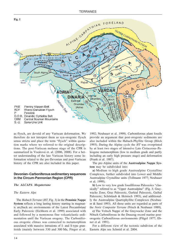
The ALCAPA Megaterrane
The Eastern Alps
The Habach Terrane (HT, Fig. 3) in the Penninic NappeSystem reflects a long lasting history starting in magmat-ic arc/back arc environments of the Latest Precambrian/Early Paleozoic (Eichhorn et al. 1999) associated withand followed by a montonous fine volcaniclastic sedi-mentation until the Variscan orogeny. The Carbonifer-ous orogenic climax was connected to metamorphismassociated with massive intrusions of I- and S-type gran-itoids (mainly between 330 and 300 Ma, Finger et al.
1992; Neubauer et al. 1999). Carboniferous plant fossilsprovide an argument that post-orogenic sediments arealso included within the Habach-Phyllite Group (Höck1993). During the Alpine cycle the HT was overprintedby at least two stages of intensive Late Cretaceous—Pa-leogene metamorphism (low to medium grade and partlyincluding an early high pressure stage) and deformation(Frank et al. 1987).
The pre-Alpine units of the Austroalpine Nappe Sys-tem may be subdivided into:
a) Medium to high grade Austroalpine CrystallineComplexes, further subdivided into Lower and MiddleAustroalpine Crystalline units (Tollmann 1977; Neubaueret al. 1999);
b) Low to very low grade fossiliferous Paleozoics “clas-sically” referred to as “Upper Austroalpine” (Fig. 3; Gray-wacke Zone, Graz Paleozoic, Gurktal Paleozoic, GailtalPaleozoic; Schönlaub & Heinisch 1993), and additional-ly the Austroalpine Quartzphyllite Complexes (Neubau-er & Sassi 1993). All these units are regarded as parts ofthe Noric Composite Terrane (Frisch & Neubauer 1989);
c) The Veitsch Nappe of the Graywacke Zone and theNötsch Carboniferous in the Drauzug record marine post-orogenic Carboniferous environments (Flügel 1977; Eb-ner et al. 1991).
For a different view of the tectonic subdivion of theEastern Alps see Schmid et al. 2004.
Fig. 1

Devonian–Carboniferous pre-flysch and flysch environments
15
The Austroalpine Crystalline Complexes suffered amedium-high grade metamorphism of Early Carbonifer-ous age. At some sites this metamorphism is pre-dated bySilurian/Devonian and older metamorphic events (Neu-bauer & Frisch 1993; Neubauer et al. 1999). Syn- to post-orogenic Variscan granitoids are frequent (Finger et al.1992) and in some tectonic units an independent meta-morphic/magmatic event is constrained as Permian/Ear-ly Triassic in age, meaning that it occurred between theVariscan and Alpine cycle (Schuster et al. 1999). Duringthe Cretaceous orogeny major parts of the AustroalpineCrystalline Complexes were overprinted by an Alpinelow grade amphibolite grade or locally even eclogitemetamorphic grade overprint (Hoinkes et al. 1999).
In the Graywacke Zone (GWZ) of Styria the NoricNappe consists of some hundreds of meters of ignim-britic Blasseneck porphyroid (Late Ordovician), Siluri-an limestones, black shales and basic volcanics. Platy,flaser/nodular and sometimes organodetritic limestoneswere deposited in the Devonian; mostly the sequencesend at the transition of the Early- to the Middle Devo-nian. 200—300 m thick carbonate sequences reach theFrasnian or even the Famennian in the surroundings ofEisenerz. They are dated by some findings of micro-(conodonts, tentaculites) and macrofossils (trilobites,cephalopods, crinoids and stromatoporoids). Major partsof the limestones are metasomatized to siderite/anker-ite that formed the famous siderite deposit of the “StyrianErzberg”. After a break in sedimentation lasting untilthe Late Tournaisian the Devonian limestones are over-lain by a thin limestone breccia with mixed conodontfaunas and the 100—150 m thick fine-clastic Eisenerz Fm(Late Viséan—Serpukhovian) (Schönlaub 1982; Schön-laub & Heinisch 1993).
In the western parts of the GWZ, Salzburg and Tyrol, acarbonate facies prevailed in Devonian times and contin-ued until the early Late Devonian (Wildseeloder Unit). Itcomprises shallow water dolomites (Schwaz and Spiel-berg dolomite) with small reefal bodies and is covered bypelagic limestones, cherts and shales of Frasnian age. Thesiliciclastic Glemmtal Unit, however, includes the somehundreds of meters thick Schattberg Fm with proximalturbidites, and the Lohnersbach Fm with much finer dis-tal turbidite intercalations. Beginning with the Late Em-sian the clastics were affected by basaltic volcanism. Thismagmatism produced a large variety of lavas, sills, pyro-clastics and tuffites which are partly explained in termsof seamounts that sometimes emerged above the sea-lev-el. Generally the geochemistry is of transitional to alkaliintraplate type. An exception is the 200 m thick tholeiiticMaishofen basalt sill complex. An Early Carboniferousage for the top of the sometimes flysch-like volcaniclas-tics is suggested (Heinisch et al. 1987; Schlaegel-Blaut1990; Heinisch & Schönlaub 1993).
The Variscan fold and thrust belt of the GWZ is un-conformably covered by continental Permocarbonifer-ous coarse grained molasse sediments (Krainer 1993;Vozárová et al. 2006).
The Graz Paleozoic (GP) builds up a stack of Alpinenappes with their individual Cretaceous metamorphicoverprint (very low grade – lower amphibolite meta-morphic facies; Rantitsch et al. 2005). In terms of stratig-raphy it includes a volcaniclastic – carbonatic pelagicfootwall which differentiated during the Late Silurian/Early Devonian into carbonate shallow water complex-es and deeper, much more basinal environmentswith ± calcareous shales, siltstones and alkaline volca-nics. In the uppermost (Rannach-Hochlantsch) tectonicunit the some hundreds of meters thick shallow waterRannach Group is made up of fossiliferous (corals, bra-chiopods, algae) limestones, dolomites, and silt-/sand-stones of shelf areas with coastal and lagoonal domainsand coral-brachiopod bioherms. Around the Middle-/LateDevonian boundary the shallow water facies is replacedby pelagic limestones, rich in conodonts and cephalo-pods (Forstkogel Grp.). Locally this up to 100 m pelagiccarbonate sediments may reach the Early Serpukhovian.Sometimes the Late Devonian sedimentation of pelagiclimestones (Steinberg Fm) terminated within the Fras-nian/Famennian in a stratigraphic gap, above which sed-imentation started again with pelagic limestones (UpperSanzenkogel Fm) during the late Early Carboniferous.After another hiatus at the top of the Forstkogel Grp. ma-rine carbonate and pelitic sedimentation (Dult Grp.) con-tinued during the Bashkirian. As the GP is only coveredby Upper Cretaceous Gosau sediments the existence of aVariscan deformation and low grade metamorphism issuggested only and lacks any field evidence (Ebner &Rantitsch 2000; Ebner et al. 2000).
The low grade metamorphic Gurktal Paleozoic (GUP)in Carinthia/Austria and Slovenia N of the PeriadriaticLineament exhibits thick Ordovician to Upper Silurianvolcaniclastic sequences. From the latest Silurian to theLate Devonian 400 m thick clastics with m- to deca-mthick carbonatic intercalations, dated by Early and Mid-dle Devonian conodonts, were deposited. They contrastwith the >500 m thick phyllitic/metadiabasic Magdalens-berg facies which already began within the (?)MiddleOrdovician. Locally pre-orogenic sedimentation contin-ued until the late Early Carboniferous (Mioč & Ramovš1973; Hinterlechner-Ravnik & Moine 1977; Neubauer& Herzog 1985; Schönlaub & Heinisch 1993; Kolar-Jur-kovšek & Jurkovšek 1996). Continental molasse beganafter Variscan deformation within the Late Moscovian—Early Gzhelian (Stephanian). Cretaceous low grade meta-morphism is suggested for both the Austrian and theSlovenian parts of the GUP (Rantitsch & Russegger 2000;Fodor et al. 2004).
The Austroalpine Quartzphyllite Complexes includeOrdovician to (?)Lower Carboniferous volcanosedimen-tary formations. Upper Ordovician quartzporphyric for-mations, Silurian basic volcanics and black shales arethe most significant intercalations within the quartz-phyllite. Upper Silurian to Lower Devonian clastic sed-iments resulted from a renewed rift phase, Middle toUpper Devonian limestones record carbonate platforms.

TERRANES
16
The Variscan orogeny was accompanied by thrust tec-tonics, formation of a foredeep with flysch deposits infront of the incoming thrust sheets and a low grade meta-morphic overprint (Neubauer & Sassi 1993).
Late Carboniferous shallow marine, siliciclastic andcarbonate fossil rich sequences began within the LateTournaisian/Viséan in the Veitsch Nappe (VN) of the east-ern GWZ and the Nötsch Carboniferous (NC) in the Drau-zug. Deformation and low grade metamorphic overprintof the VN are exclusively of Alpine (Cretaceous) age(Ratschbacher 1987; Rantitsch et al. 2004). In spite of itstectonically isolated position the age of the deformationof the NC is not clear. Anchizonal illite crystallinity andanthracitic coal rank indicate metamorphic peak condi-tions of ca. 260 °C and 6 km burial (Rantitsch 1995).
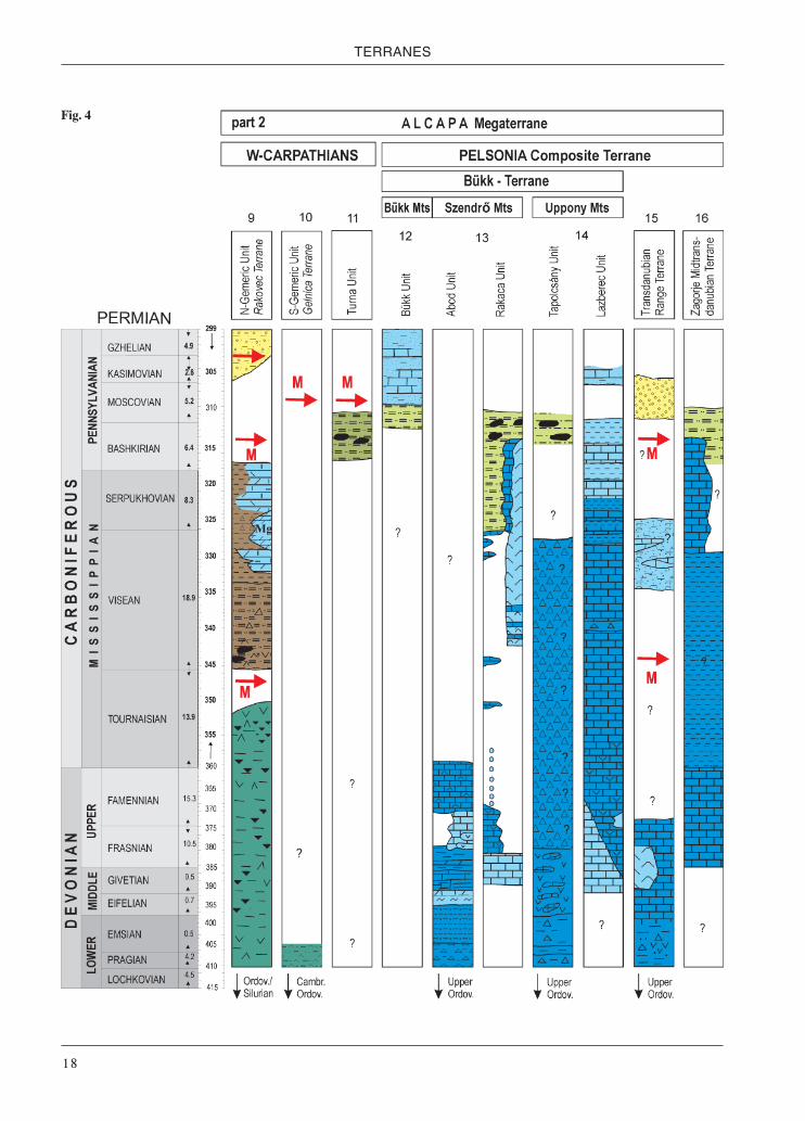
The Western Carpathians
Syn-orogenic Carboniferous basins in the Western Car-pathians reflect the beginning of the Variscan continent-continent collision (Fig. 4). Intensive metamorphic andmagmatic processes prevented a complete unequal con-solidation of the continental crust, which hence was fur-ther deformed during post-collisional relaxation. Fragmentsof newly formed Variscan continental crust were subse-quently incorporated into the major Alpine tectonic units(Tatricum, Veporicum, Zemplinicum and Gemericum), to-gether with relics of the syn- to post-orogenic Late Paleo-zoic basin fills. With respect to the tectonothermal impactsthese fragments reveal the metamorphic zonation of theVariscan crust: the Central Western Carpathian Crystal-line Zone (within the Tatricum, Veporicum, Zemplinicum),the Northern Gemeric Zone (within the Northern Gemeri-cum) and the Inner Western Carpathian Crystalline Zone(within the Southern Gemericum) (Vozárová 1998).
The Alpine Tatric and Veporic Nappe System in-clude a set of medium to high grade metamorphic pre-Alpine terranes (paragneisses, calc-alkaline to tholeiiticbasic and acidic orthogneisses, banded amphibolites,migmatites, granulite facies rocks) besides some lowgrade metamorphic units amalgamated during theVariscan cycle. The most significant tectonofacies indi-cate passive and active margins, initial island arcs andoceanic crust. The low grade units are composed of abimodal volcanic suite within immature clastic sedi-ments. The low-grade Predná Ho a and the Jánov GrúňComplexes (the Veporic Unit in the Nízke Tatry Mts)consist of siliciclastic metasediments associated withacid/intermediate and basic metavolcanites. Based onmicrofloral data the sedimentation age of the PrednáHo a Complex is ranged to Devonian (Bajaník et al.1979) and the Jánov Grúň Complex generally to EarlyPaleozoic (Planderová & Miko 1977). Possibly they arefills of ?Silurian—?Devonian continental intraplate rifts(Miko 1981; Bezák et al. 1998).
Devonian? in the Tatric and Veporic Units has not largearea extension in general. In the Malé Karpaty Mts TatricUnit, the Pernek Group meta-ophiolites are partly associ-ated with deep-water metasediments. The magmatic con-cordia age of the SHRIMP zircon dating of ametagabbro-dolerite from the Pernek meta-ophiolitesproved 371±4 Ma (Putiš et al. 2009). Based on geochem-ical and Nd isotope evidences, the most of the metabasaltshave composition very close to that of typical ocean ridgebasalts, crystallized from depleted mantle source( Nd370= ca. + 9, Ivan et al. 2007). Another group of me-tabasalts, associated with marbles and siliciclasticmetasediments (Kuchyňa Nappe, Putiš et al. 2004) repre-sent E-MORB, and within-plate metabasalts, indicatingthe rifting stage of the inferred back-arc basin setting.
Fig. 2

Devonian–Carboniferous pre-flysch and flysch environments
17
Fig. 3
TERRANES
18
Fig. 4

Devonian–Carboniferous pre-flysch and flysch environments
19
The Malé Karpaty meta-ophiolite age fairly corrobo-rates the ages of the low-grade volcano-sedimentary Hla-vinka Complex in the Považský Inovec Mts dated onuraninite by CHIME to 394±2 Ma, compared to the iron-bearing e.g. Lahn-Dill-type volcano-sedimentary com-plexes (Kohút & Havrila 2006; Kohút 2006).
Some low-grade metamorphic complexes (metapelites,-graywackes, -carbonates, mafic to intermediate metavol-canoclastics) imbricated within the Kohut Terrane (Ve-poric Unit), include ?Carboniferous magnesites in places(the Sinec and Lovinobaňa complexes, Bezák 1982;Bezák et al. 1998). Variscan deformation/low grade meta-morphism was Intra-Carboniferous before the overstep ofthe volcano-terrestrial molasse formations palynological-ly dated as Early Gzhelian—Asselian (Late Stephanian—Autunian; Planderová 1980; Vozár & Vozárová 1997,1988). Early Carboniferous anatectic granitoid magma-tism (360—340 Ma; Kohút et al. 1997; Krá et al. 1997) isrepresented by per- to subaluminous granodiorites andgranites (Broska & Uher 2001).
The crystalline rocks of the Zemplinic Unit (Byšta Ter-rane) and their Late Paleozoic and Mesozoic cover maybe correlated, on the basis metamorphic petrology andMesozoic facies, with parts of the Tatro-Veporic domain(Vozárová 1989; Faryad 1995; Vozárová & Vozár 1996).The Byšta Terrane is composed of paragneisses and mica-schists, amphibolites, migmatites and orthogneisses. Theexistence of granitoids and low-grade metapelites andacid metavolcanics is indicated within the pebble mate-rial of the Moscovian-Kasimovian overlap sequence.Deformation and metamorphism occurred before the ear-ly Moscovian (Westphalian C) as is indicated by pebblesin post-Variscan conglomerates (Grecula & Együd 1982;Vozárová & Vozár 1988).
The Northern Gemeric Zone (NGZ) includes thegneiss-amphibolite complex of the Klatov Terrane (KT),interpreted in terms of an oceanic crust environment.The low-grade Rakovec Grp. of the Rakovec Terrane(RT) is undated and predominantly composed of tholei-itic metabasalts and metavolcaniclastics associated witha smaller amount of sandy-pelitic and Fe-rich metased-iments and small bodies of metagabbrodiorites/-kerato-phyres with geochemical characteristics close toE-MORB/OIT and island arc basalts (Ivan 1994). Relicsof Tournaisian-Viséan flysch of the basal Ochtiná Grp.and thrust wedges of the KT and RT represent a part of aVariscan collision suture (Vozárová & Vozár 1996, 1997).Ordovician 40Ar/39Ar cooling ages of detrital white micawithin the Lower Carboniferous Hrádok Fm documentOrdovician crustal pieces found within this suture (Vozá-rová et al. 2005).
At the SW and E-SE boundary of the NGZ the syn-orogenic Tournaisian—Lower Viséan Hrádok and ČrmeFm (lower part of the Ochtiná Grp.) have been preservedas relics. In spite of the orogenic/metamorphic reductiontheir present tickness is estimated as >1000 m. The wholeTournaisian-Serpukhovian Ochtiná Grp. was deformedunder low-pressue greenschist facies conditions before
being overlapped by a new Bashkirian—Lower Moscoviansedimentary delta fan/shallow-marine to paralic cycle(Rudňany, Zlatník and Hámor Fm). The metamorphicgrade did not exceed the boundary between the anchizoneand lower limit of the greenschist facies. Fine-grainedmuscovite from the Hrádok Fm reflects the complex Al-pine (87—142 Ma) overprint (Vozárová et al. 2005).
The Gelnica Terrane (GT) of the South Gemeric Zone,as a part of the Inner Western Carpathian Crystalline Zoneis made up of thick Lower Paleozoic flysch sequencescomprising acidic and intermediate volcaniclastics (Gel-nica Grp.) (Fig. 4). It is tectonically overlain by the undat-ed Štós Fm, a flyschoid, rhythmical sequence of metapelite/metasandstone. Micropaleontological and U/Pb clasticzircon and SHRIMP datings within the GT suggest a wide,Cambrian—Ordovician/Lower Silurian, age range for thevolcaniclastics, besides Proterozoic ages from detrital zir-cons (Cambel et al. 1977; Ščerbak et al. 1988; Vozárováet al. 1998; Soták et al. 1999; Vozárová et al. 2009). Thelow- pressure greenschist metamorphism and deforma-tion (Sassi & Vozárová 1987; Faryad 1991; Molák &Buchart 1996) occurred before the start of the deposi-tion of the Early Ghzelian—Asselian (Late Stephanian—Autunian) continental sedimentary cover (Planderová1980; Vozár & Vozárová 1997). Based on structuraldata, the Alpine deformation (Snopko & Reichwalder1970) and polystage Late Jurassic/Cretaceous low-graderecrystallization and tectonic overprint were supposed(Lexa et al. 2003). 40Ar/39Ar dating of metamorphic whitemica confirmed unambiguously the Early Cretaceousage of the whole South Gemeric Zone (Vozárová, Frankin preparation).
The Turnaicum Nappe of the innermost Western Car-pathians contains flysch sediments in form of the Bash-kirian Turiec Fm found in the Slovenské Rudohorie Mts(Brusnik anticline). Borehole BRU-1 (Ebner et al. 1990;Vozárová & Vozár 1992) indicates the nappe characterof the Turna Unit above Meliatic Late Jurassic olis-tostromes. This flysch was tectonized during a Late Car-boniferous Variscan orogenic phase, as is indicated bythe strong deformation and angular unconformity of con-tinental red-beds (Ebner et al. 1990; Vozárová & Vozár1992).
The Pelsonia Composite Terrane
The Pelsonia Composite Terrane was formed duringAlpine times by amalgamation of the Bükk (Bükk, Szen-drő, Uppony Mts) and Transdanubian Range Terranes inHungary and the Zagorje(-Midtransdanubian) Terrane inCroatia. All these Alpine terranes also include pre-Meso-zoic units (Kovács et al. 1997, 2000; Pamić et al. 1997).
Szendrő, Bükk and Uppony Mts – Bükk Terrane
The Paleozoic evolution in the Szendrő Mts is charac-terized by the Abod and Rakaca Subunits. The pre-Mid-dle Devonian sequence of the Abod Subunit consists of

TERRANES
20
black, euxinic radiolarian lydites and siliceous slates, gra-phitic phyllites (?Silurian to Early Devonian) and grey,partly turbiditic sandstones (?Late Ordovician). In theMiddle Devonian a carbonate – siliciclastic ramp didform, with coral bioherms besides deeper water depositsthat bear conodonts. In the Late Devonian a carbonateplatform developed in restricted areas only, while pelagicbasinal carbonate sedimentation, influenced by basic vol-canism (“cipollino”) was more widespread (Frasnian—Fa-mennian; Kovács 1994; Fülöp 1994; Ebner et al. 1998).
Within the Rakaca Subunit two marble formations(Rakacaszend Marble Fm ?Middle Devonian—Early Fras-nian; Rakaca Marble Fm Late Viséan—Early Bashkirian)are separated by a stratigraphic gap. The time interval ofthis gap is indicated by conodonts of pelagic fissure fill-ings within the Rakaca Marble. The Rakaca Marble isinterfingering with and overlain by the Szendrő PhylliteFm and in some parts the phyllite occur also between thetwo marble formations. The “flysch” sedimentation (Szen-drő Phyllite Fm) did not start before the Late Viséan orlater (Ebner et al. 1991, 1998).
In the Uppony Mts, that is within the Tapolcsány Sub-unit, the biostratigraphic constraints are very poor, ex-cept for the limestone olistoliths of two olistostromehorizons. Quartzites and graywackes probably representthe beginning of sedimentation within the Late Ordov-ician (Ebner et al. 1998). Black radiolarian lydites andsiliceous slates were deposited below the CCD. Basicvolcanics, probably in a seamount setting, are associat-ed with the deep-water sediments. Limestone olistolithsof pelagic and slope facies in a volcanic matrix extendin age from Wenlockian to Lochkovian (Kovács 1989;Gnoli & Kovács 1992). Light grey to grey siliceousshales/slates may have been deposited until the LateDevonian—Early Carboniferous. A second olistostromehorizon in a fine grained siliciclastic, and marly matrixand pelagic limestone olistoliths (dated by Emsian toEarly Famennian conodonts), are tentatively assignedto the middle part of the Carboniferous, that is to the“flysch” stage (Kovács 1992).
In the Lázbérc Subunit the sequence began by the build-up of a ?Middle Devonian to Early Frasnian carbonateplatform followed by pelagic carbonate sedimentationassociated with basic volcanism until the end of the Fa-mennian. Above the partly volcanogenic carbonate sed-iments, referred to as “cipollino” in their metamorphosedstage, condensed pelagic “flaser limestones” reach theViséan, with a characteristic lydite horizon deposited inthe Early Viséan (Ebner et al. 1998). From the Late Viséanto the Early Bashkirian mixed carbonate-siliciclastic sed-imentation took place in a ramp environment, withoutany turbiditic activity. A > 100 m thick slaty/marly se-quence, with some sandstone intercalations, can be as-signed to the higher part of the Bashkirian. A < 100 mthick sequence of calcareous sandstones—sandy lime-stones with small lydite and quartz pebbles (Derenek Fm)can be assigned to the “post-Variscan” marine molassestage. However, no biostratigraphic data are available
(Kovács 1992; Fülöp 1994; Ebner et al. 1998; Pelikán2005).
The stratigraphic base of the sequence outcropping inthe Bükk Mts is the pre-Upper Moscovian (pre-Po-dolskian) “flyschoid” Szilvásvárad Fm, characterized bya distal turbiditic shale-sandstone sequence. It is regard-ed as a partial equivalent of or the continuation of theSzendrő Phyllite Fm (Árkai 1983). It is followed by LateMoscovian—Ghzelian fossiliferous limestones and silici-clastics of the shallow marine Mályinka Fm, its upperparts having been eroded down to different levels. Noorogenic movements could be detected between the twoformations (Ebner et al. 1991; Fülöp 1994; Pelikán 2005).
In the Transdanubian Range Terrane Emsian to Fras-nian pelagic limestones, with stylolinids and conodontsand coeval stromatolitic carbonate platforms, overlie theBalaton Phyllite Group (Late Ordovician—Early Devo-nian). The youngest marine formation is the Szabadbat-tyán Fm (black shales, bituminous fossiliferous limestoneand rare sandstone) of Late Viséan age and a smaller de-gree of metamorphism. It was deposited after the firstVariscan tectonothermal event. Another tectonic eventoccurred before the sedimentation of the Late Bashkiri-an—Early Ghzelian (Westphalian—Stephanian) plant bear-ing terrestrial Füle conglomerate (Lelkes-Felvári 1978;Fülöp 1994). The Variscan thermal overprint was verylow to low grade (Árkai & Lelkes-Felvári 1987).
In the Zagorje – Midtransdanubian Terrane, andabove the pre-Variscan Medimurje medium grade meta-morphic complex, the protoliths of the Mt Medvednicametamorphic sequence are found. These consist of medi-um to fine grained clastics, calcarenites and fossiliferous(conodonts) limestones of Late Devonian to Late Trias-sic age. They originated within marine shelf and pelagicenvironments. Diabase dykes and sills are probably ofMiddle Triassic age. The whole complex underwent awell documented Early Cretaceous very low to low-grademetamorphism (122—110 Ma; Belak et al. 1995; Pamić& Tomljenović 1998). At least parts of the Devonian-Carboniferous formations, dated by conodonts(Đur anović 1973), are included within the metamor-phosed “Medvednica Series” (Pamić & Tomljenović1998). They can be regarded as equivalents of coevalformations in the Szendrő Paleozoic of the Bükk Terrane.
The TISIA Megaterrane
The Tisia Megaterrane behaved as one large terrane duringAlpine evolution. However, earlier it consisted of several ter-ranes amalgamated during the Variscan orogeny. The individ-ual terranes are petrologically different and reveal differentmetamorphic PT conditions. The Carboniferous orogeny wasaccompanied by syn- to post-collisional granitoids (Buda et al.2004). Several smaller units of lower metamorphic grade(Fig. 4) and relics of oceanic crust are imbricated within thelarger medium to high grade metamorphic Variscan terranes(Szederkényi 1996 and in Kovács et al. 1997, 2000; Pamić etal. 1997).

Devonian–Carboniferous pre-flysch and flysch environments
21
Some small very low to low grade metamorphic units(Szalatnak, Horváthertelend, Ófalu, Tázlár) which arepart of the Kunságia Terrane in the Hungarian Mecsek-Great Plain unit are remnants of nappes wedged intomedium to high grade metamorphics (Szederkényi 1974;Árkai et al. 1996). They represent slices of a Silurian—?Lower Carboniferous pelitic-psammitic pre-flysch se-quence with some calcareous and volcanic (basalts,porphyroids) intercalations. With the exception of someconodonts, fossils are missing (Kozur 1984; Szederké-nyi et al. 1991). Some occurrences of pre-Upper Car-boniferous basic/ultramafic rocks are also imbricatedwithin the metamorphic terranes. In Hungary these areregarded as parts or equivalents of the Gyód Serpen-tinite Fm of the W-Mecsek Mts (Szederkényi et al. 1991;Kovács et al. 2000).
In the territory of Hungary the Moslavina (Drava)Slavonia Terrane is only known from drillings. In north-ern Croatia it crops out in the Moslovačka Gora Mt (inour map it is still included in the Tisia Terrane, butSchmid et al. (2008) put it in the Sava Zone (Prošara,Motajica mountains, etc., because of its Late Cretaceousmetamorphism) and the Papuk-Krndija Mts. Devonian—Permian sediments are only known from the Radlovaccomplex of the Papuk-Krndija Mts, which unconform-ably overlies the pre-Variscan Psunj-Krdija metamor-phics. This metaclastic Radlovac complex is intrudedby metadiabases/-gabbros (Jamičić 1983; Pamić &Jamičić 1986). The lower part of the complex is com-posed of graphitic metagraywackes and slates, quartz-sericite schists and arenitic metasandstones. The upperpart contains fossil plants of Late Bashkirian—EarlyMoscovian (Westphalian B and C) and is made up ofcoarse grained mylonitic metagraywackes and slateswhich grade into pink clastics (Brkić et al. 1974). TheRadlovac complex was metamorphosed under very-lowto low grade metamorphic conditions, presumably dur-ing the Variscan cycle (Jamičić 1983). However, the ra-diometric ages, widely ranging form 416.0 ± 9 Ma to203.9± 6.9 Ma (Pamić 1998), are inconsistent.
The pre-Mesozoic units of the Alpine Codru NappeSystem outcropping in the Apuseni Mts represents theeastern continuation of the Hungarian Szeged-Békés (Co-dru) Terrane. Paleozoic sequences are only preserved in afew areas. The Arieseni Unit of the Codru Nappe Systemis formed by an ?Early Carboniferous metapelitic/-psam-mitic-conglomeratic sequence (Arieseni Fm). Variscanlow grade metamorphism and deformation are evident.The onset of the post-Variscan overstep sequences rang-es between Late Moscovian (Westphalian D) and the Per-mian (ref. in Kräutner 1997). In the Biharia Nappe SystemDevonian or ?Latest Precambrian metabasalts occur inthe Radna (Biharia) unit, whereas the Highis-Poiana unitis formed mostly by a sequence of metaconglomerates,metasandstones and metapelites assigned to the LateCarboniferous. Its low-grade metamorphism is thoughtto be Alpine. The Variscan pile of the Biharia Nappe Sys-tem is intruded by Permian granitoids.
The DACIA Megaterrane
The Eastern Carpathians
Pre-Alpine metamorphic units/terranes, formingVariscan nappe structures occur in the Bucovino-GeticSystem of the Eastern Carpathians (Fig. 5). These unitsextend southwards into the Southern Carpathians of Ro-mania and the Carpatho-Balkanides of E-Serbia (Kräut-ner 1997; Kräutner & Krstić 2002, 2003). The Variscannappes mainly include fragments of the pre-Variscanmetamorphic Carpian Terrane, made up of Latest Prot-erozoic polymetamorphic rocks of sedimentary and vol-canosedimentary origin (Kräutner 1980). Paleozoicsediments are developed in the Tulghes Terrane (part ofthe Bucovinian and Subbucovinian Nappes) and in theRodna Terrane (part of the Infrabucovinian Nappe).
In the Tulghes Terrane (TT) sedimentation of theTulghes Grp. started during the Early Ordovician withsiliciclastic sediments and continued with basinal andslope psammites and pelites, associated with basalts oftholeiitic signature and MORB affinity, until the Siluri-an. It is not clear whether sedimentation persisted intothe Devonian and Early Carboniferous.
In the Rodna Terrane (RT) pre-Variscan retrogradegneisses (Bretila Grp.) are covered by low grade meta-morphic Silurian—Lower Carboniferous sediments(Fig. 5) in which some individual stratigraphic levelscan be outlined on the basis of palynological data (Ilies-cu & Kräutner 1976, 1978; Kräutner & Vaida 1993).Above the Silurian volcaniclastic Repeda Grp. the trans-gression of a new sedimentary cycle (Cimpoiasa Grp.)started with the Lower and/or Middle Devonian GuraFantanii Fm with conglomerates, quartzites and carbon-ate metasandstones. It is followed until the ?early LateDevonian by the Negoiescu Fm, up to 500 m thick green-schists, metabasalts and metakeratophyre tuffs with smallamounts of carbonate layers/lenses at the top. The LateDevonian and parts of the Early Carboniferous are rep-resented by the Prislopas Fm, divided into a quartzite-conglomerate subformation (300 m) and anothersubformation (300 m) at the top dominated by meta-dolomite, marble and metapelites. Finally the pre-oro-genic sequence is closed by the Fata Muntelui Fm, a550 m thick clastic sequence of alternating meta-graywacke and feldspar metasandstones (Kräutner 1989,1997).
The Variscan orogeny, assigned to the “Sudetic” event(Kräutner 1997) was polyphase and with greenschistmetamorphic facies conditions producing retrogrademetamorphism in the pre-Ordovician medium-grademetamorphic complexes (Kräutner 1997). In the RTVariscan metamorphism developed under low pressureconditions, while in the TT a medium-pressure to low-pressure gradient was recorded (Kräutner et al. 1975).Post-Variscan (?)Late Carboniferous—Permian overstepsequences of continental intramontane type are onlylocally preserved.

TERRANES
22
Fig. 5

Devonian–Carboniferous pre-flysch and flysch environments
23
The Carpatho-Balkanides of E-Serbia and Bulgaria
In the Southern Carpathians of Romania and the Car-patho-Balkanides of E-Serbia and Bulgaria pre-Alpineunits or terranes occur within the Bucovino-Getic andthe Danubian Alpine nappe systems (Kräutner 1997;Kräutner & Krstić 2002, 2003). Some of these pre-Alpineterranes have a more restricted extent and therefore theyare only specific for small segments of the belt. In the pastdetailed correlations of tectonostratigraphic units or ter-ranes failed, mainly due to the following reasons:
(1) Nappe contacts (both pre-Alpine and Alpine), clear-ly exposed N of the Danube, are partly obliterated by young-er (mostly Neogene) orogen-scale shear zones in Serbiaand Bulgaria; (“nappe structure” versus “block structure”);
(2) In the earlier Romanian, Serbian and Bulgarian lit-erature no distinction was made between Alpine, Variscanand older structural elements;
(3) South of the Danube important Alpine structuralunits without northern continuation (e.g. Kraishte andTumba-Penkjovci) are successively interposed betweenbelt scale structural elements (e.g. Supragetic and Getic);
(4) In Romania, Serbia and Bulgaria some main Al-pine units include different pre-Mesozoic lithologiesand Variscan tectonic units (e.g. Getic and Kučaj).
These difficulties were overcome by representing astructural model, published in a map covering the areabetween Oravita/Romania, Niš/Serbia and Sofia/Bulgaria(Kräutner & Krstić 2002, 2003). According to this mod-el the following correlation of Alpine tectonic units andnational terminologies is used (Table 1). These Alpinezones include the described Variscan terranes whichamalgamated during the Carboniferous between theSerbo-Macedonian Zone and the Proto-Moesian Plate(Haydoutov et al. 1997; Karamata et al. 1997).
In the Danubian Nappe System (Fig. 5) the metamor-phic units include several pre-Mesozoic crustal piecesjoined together by Variscan thrusting and Early Paleozoicobduction. During the Devonian a second Paleozoic sedi-mentary cycle started. Three main sedimentation areas,corresponding to individual Variscan terranes, can bedistinguished:
(1) The Valea de Braz Terrane occurs in the N part of theLower Danubian Nappes. It includes conglomerates, sand-
stones, shales, concordant rhyolitic layers and macroflora(Valea de Brazi Fm, Stanoiu 1982; Berza & Iancu 1994);
(2) The Inovo Terrane is widespread within the StaraPlanina (Upper Danubian Nappes). It is marked by sev-eral hundreds of m thick, predominantly Devonian,marine coarse to fine grained metaclastics with turbid-ites and olistostromes (Inovo Fm in Serbia, Dalgi-DjalFm in Bulgaria; Krstić et al. 1999, 2004). These are dis-cordantly deposited onto Late Proterozoic to Early Cam-brian low-grade metamorphic volcano-sedimentaryisland-arc formations (e.g. Berkovica) and unconform-ably overlain by Upper Bashkirian—Moscovian (West-phalian) lacustrine sediments;
(3) In the western Upper Danubian Nappes, however, theUpper Devonian—Lower Carboniferous Ideg Terrane de-veloped. It is composed of a volcano-sedimentary sequenceincluding Late Devonian metabasic rocks, covered by thefossil (incl. conodont) rich sparry Ideg Lmst of Tournai-sian age (300 m; Cordarcea et al. 1960). During the Viséanpelites and fine grained psammites follow (Sevastru Fm;Nastaseanu in Kräutner et al. 1981). Variscan low grademetamorphism and deformation occurred before the onsetof early Moscovian (Westphalian C) continental molasseenvironments (Kräutner et al. 1981).
The Bucovino-Getic Nappe System, also extendinginto the E-Carpathians, includes several metamorphicunits made up of pre-Variscan terranes formed in differ-ent geotectonic settings. Pre-Variscan medium grademetamorphism is proven by Tremadocian siliciclasticoverstep sequences (Kučaj).
In the Supragetic Nappe System thick low grade Pale-ozoic volcano-sedimentary units were assigned to thePoiana Rusca Terrane (Romania) and the Locva-Rano-vac-Vlasina Terrane (Banat, Serbia and Elesnica Unitin Bulgaria).
In the Poiana Rusca Terrane a rift developed abovethe polymetamorphic Precambrian Carpian Terrane withtwo distinct sedimentary cycles (Kräutner et al. 1973,1981; Kräutner 1997). A Silurian metavolcano-sedimen-tary sequence (Batrâna Grp.) is unconformably followedby a second cycle, beginning with the Lower DevonianGovajdia Grp. This consists of a lower formation of meta-quartzsandstones and an upper basinal formation ofgraphite schists with intercalations of limestones. The
C A R P A T H O - B A L K A N I D E S
Southern Carpathians Balkanides Romania Serbia Bulgaria
Bucovino-Getic Units Serbo-Macedonian Serbo-Macedonian Jablanica Supragetic Ranovac-Vlasina Elesnica
Not present Tumba-Penkjovci Penkjovci, Poletinci Not present Lužnica/Kraishte Kraishte, Osogovo
Sasca-Gornjak Sasca-Gornjak Not present Getic Kučaj Sredna Gora
Danubian Units Upper Danubian Stara Planina - Porec Stara Planina Lower Danubian Vrska Cuka - Miroc Kutlov-Mihailovgrad, Belogradcik

TERRANES
24
following Middle and Upper Devonian Ghelar Grp. is avolcano-sedimentary rift type sequence, including sub-marine basaltic volcanic structures, which are surround-ed by volcaniclastics. At some places the volcanics arecovered by massive reefal marbles interfingering with peri-reefal carbonates. Locally intercalations of quartz-kerato-phyre tuffs indicate bimodal volcanic character. LahnDill- and Teliuc-Ghelar type iron ore deposits are relat-ed to submarine volcanic rises (Kräutner 1977). Towardsthe end of the Late Devonian up to 200 m thick carbon-ate members and up to 20 m thick greenschists devel-oped. The Lower Carboniferous Pades Grp. begins with1000—2000 m thick dolomite and limestone (Hunedoara-Luncani Fm), covered by the Gladna Schist Fm consist-ing of a rhythmic alternation of phyllite and quartzosemetasandstone which could be primarily a flysch se-quence. In the upper part, some basaltic and acidic tuffsare intercalated (Fata Rosie Fm) and a set of rhyolite dykescrosscuts the whole sequence. Deformation and metamor-phism are assigned to the Variscan orogeny, pre-datingthe Early Moscovian (Westphalian C; Kräutner 1997).
In the Locva-Ranovac-Vlasina Terrane (LRVT) a firstsedimentary cycle includes an Ordovician-Silurian green-schist formation of volcano-sedimentary origin (LocvaGrp.). The Devonian is transgressive and begins with aquartzite member covered by a thick basic metavolcanicpile of within plate character (Krstić et al. 2004, 2005a),interlayered with pelitic-psammitic metasediments andsome metakeratophyric tuffs (Lescovita Fm, Valea Satu-lui Fm, in Romania; Maier 1974; Visarion & Iancu1984). The Latest Devonian and Early Carboniferousconsists of alternating phyllite, sericitic quartzite, chlo-rite/sericite schists with local intercalations of basic/acidicmetatuffs and metagabbros. Ordovician to Carboniferousages are indicated by palynomorphs in Romania (Maier& Visarion 1976; Visarion & Iancu 1984) and Serbia(Krstić et al. 2004). The LRVT is interpreted as an intra-continental rift zone, but a back arc environment wasalso discussed (Krstić et al. 2005a). During the Variscanorogeny the terrane underwent polyphase deformationand low grade metamorphism (350 °C, ~3 kb; Ivanović2000). The onset of sedimentation of the post-Variscancontinental cover falls into the Latest Moscovian—EarlyGzhelian (Stephanian).
The Tumba-Penkjovci unit is sandwiched between theLRVT attributed to the Supragetic Nappe System and theTithonian-age Ruj flysch attributed to the Lužnica/Kraishteunit. In Serbia the Devonian of the Tumba-Penkjovci Unitis made up of 250 m thick pelagic limestones interlay-ered by shales and cherts. Lower Devonian ages wereproved by tentaculites and conodonts (Krstić et al. 2004).The unit extends into Bulgaria (Penkjovci-Strmolka-Von-ska-Polentinci) where the entire Devonian is dominatedby carbonate sediments and followed by terrigenous flyschsediments, similar to the flysch of the Kučaj Terrane.
The Getic Nappe in Romania continues to the KučajUnit of Serbia and to the Sredna Gora in Bulgaria (Ta-ble 1). The pre-Alpine units include several pre-Variscan
and Variscan crustal fragments, docked during the Car-boniferous and covered by an identical Permian overstepsequence. Medium grade blastomylonitic belts, with lens-es of pre-Variscan eclogites and serpentinites, specificallyoccur in parts of the Variscan terrane collage. Paleozoicsediments prevail only south of the Danube. In Serbia theyare assigned to the Kučaj Terrane, which also extends intoBulgaria (Ljubas, Iskar) and Romania (Buceava Fm).
In the Kučaj Terrane (KUT) sedimentation began in theTremadocian with near-shore/shallow sea siliciclastics(Krstić & Maslarević 1990), followed by basinal Siluriangraptolite schists (Krstić et al. 2005b), and ~100 m shalesand siltstones with intercalations of cherts, limestones,channel-sandstone and some turbidites. Sedimentationprevailed until the Late Frasnian, as indicated by con-odonts from dolomitic limestones at the top. Until theViséan these series are overlain by up to a 600 m thicksiliciclastic flysch. Towards the north, the KUT is tecton-ically superposed by Variscan nappes (Homolje, Jelova,Minis, Ravensca Nappes) and extends only in a narrowzone referred to as the “Homolje Paleozoic” which con-tinues to the Romanian Buceava Fm (Streckeisen 1934;Iancu & Maruntiu 1989). It consists of a basal metacon-glomerate and variegated metasandstones cut by smallbodies of metadiorite and metagabbro (Iancu & Maruntiu1989). The Early Carboniferous olistostrome of the KUTalso occurs in some small tectonic windows (Radovica,Drencova) below the above mentioned Variscan nappes.As indicated by the onset of continental molasse sedi-mentation Variscan deformation predates Latest Bash-kirian—Earliest Moscovian (Westphalian B). The KUTalso includes batholiths of Variscan I-type granitoids(Sichevita-Neresnica, 310—292 Ma; Gornjani, 304 Ma).
The Serbo-Macedonian Zone (SMZ) is located be-tween the Vardar Zone (VZ) on the west, and the Car-patho-Balkanides and the Rhodope Massif in the east.Some authors (Dimitrijević 1997; Sandulescu 1984) re-gard it as part of the Supragetic Nappe System. In fact thelithologies have strong affinities with those of the Su-pragetic Carpian sequence. Although both units derivedfrom the same Alpine microplate, the SMZ overthruststhe ophiolitic Vardar Zone (exposed in tectonic windowsat Paraćin, Kupinovac, Jastrebac) towards the west, whilethe Supragetic Units obviously belong to the east-ver-gent Carpathian system (Kräutner & Krstić 2002). Thetwo units are separated by a prominent, some hundredmeters wide, dextral (Vršac and Dušanovo) mylonite zone.
The SMZ consists of high to medium grade metamor-phics of Precambrian and Early Paleozoic meta-sedi-mentary and magmatic assemblages, originating fromdifferent geotectonic settings and representing individ-ual units. They were metamorphosed before Variscandocking in amphibolite or epidote-amphibolite grade,some in eclogite or granulite facies. During the Variscanorogeny the metamorphism encompassed the entireSMZ. It developed up to medium grade (Karamata &Krstić 1994) and generated large areas of greenschistsfacies overprint. From the Paleozoic (Vlajna, Bujanovac)

Devonian–Carboniferous pre-flysch and flysch environments
25
to the Tertiary (Surdulica) the SMZ was repeatedly in-truded by granitoids. The oldest post-Variscan coverbelongs to the Permian or Middle Triassic.
The VARDAR Megaterrane
The Vardar Megaterrane (also Vardar Composite Ter-rane, Karamata et al. 1997) is regarded as an indepen-dent Alpine oceanic domain with a complex internalstructure that includes the continental Jadar Block Ter-rane, besides some other smaller continental fragments(e.g. Kopaonik Block; Karamata 2006). The Veleš Se-ries Terrane (VST; Fig. 6) represents an inherited relicof a Paleozoic ocean. For another interpretation seeSchmid et al. (in print).
At present the VST is included within the Main VardarOphiolitic Suture Zone (Karamata 2006). The oldest partsof the VST are dated by pollen as Devonian to EarlyCarboniferous in age (Grubić & Ercegovac 1975). The~500 m thick lower part of the VST above serpentinitebegins with amphibolite and chlorite/sericite schists,with thin lenses of quartzite. In the ~500 m thick mid-dle part phyllite and quartz/sericite/chlorite schists in-clude thick beds and lenses of microcrystallinelimestone, marble and quartzite. The ~400 m thick up-per part is dominated by marble. Most likely this volca-no-sedimentary association formed in an island arcsetting (Karamata 2006). The age of metamorphism (upto greenschist and amphibolite metamorphic grade) isnot clear. According to Karamata (2006) the VST wastransported above oceanic crust and docked to unitsmore to the E during the Late Jurassic.
The Jadar Block Terrane (JBT) is an exotic terranedisplaced into the Vardar Zone in the Late Cretaceous(Filipović et al. 2003). The JBT inculdes autochtho-nous and allochthonous (Likodra Nappe) elements, withindividual Late Paleozoic evolutions (Fig. 6). In the au-tochthonous unit a >1000 m thick sequence of alternat-ing arenites and siltstones with rare microconglomerates(Vlašić Fm) was deposited from ?Middle Devonian toCarboniferous times in a deep water basin. Late Devo-nian and Tournaisian ages were obtained due palyno-morphs (Ercegovac & Pešić 1993). Thin intercalationswith cherty limestone are dated by conodonts of LatestTournaisian and Early Viséan age. The Late Viséan andSerpukhovian part with sedimentological “flysch” char-acteristics includes trace and plant fossils. In the NE ofthe JBT (Ub-area) the Middle Devonian to Viséan sedi-ments are formed by conodont bearing pelagic lime-stones (~100 m thick Družetić Fm) of an intrabasinalswell. The Carboniferous part of this formation has athickness of 15 m only (Filipović 1974; Filipović et al.1975). A regressive phase starts at the beginning of theSerpukhovian at the top of the “flysch” with the StupnicaSandstone Fm and continued until the early Bashkirian(conglomeratic Županjac Fm) formations (Filipović et al.1975, 2003; Filipović 1995; Protić et al. 2000; Krstić atal. 2005).
After a stratigraphic hiatus a new sedimentary cyclewith the characteristics of continental and marine mo-lasse sediments and gravity slided materials starts withthe Ivovik Fm (20—50 m) within the Moscovian. Its siltymatrix includes Devonian and Lower Carboniferouslimestone clasts, plant bearing horizons and levels ofLate Moscovian marine brachiopod and fusulinid fau-nas. The Kriva Reka Fm in the southern part of the JBTis predominatly composed of massive limestones withfusulinids and conodonts indicating a Late Moscovianto Earliest Asselian age (Protić et al. 2000; Filipović etal. 2003; Krstić at al. 2005).
The allochthonous unit (Likodra nappe) is dominatedby a shallowing upwards siliciclastic sequence. The?Lower Carboniferous “flysch” (laminated sandstonesand siltstones with trace fossils only) is followed by theĐjulim Fm (30 m), an alternation of bedded limestoneswith siltstones and shales. Conodonts indicate Early Ser-pukhovian to Early Bashkirian ages. The Rudine Fm(60—80 m), composed of bioherm-type massive beddedlimestone with corals and other reef-builders, calcareousalgae, brachiopods and other fossils, is also part of theEarly Bashkirian. The following Stojkovići Fm (20—60 m)consists of thick siltstones/sandstones with megafloraand Bashkirian brachiopods. At the top is the StoliceLimestone Fm (>100 m) consisting of a biohermal lime-stone with Bashkirian fusulinids, corals, calcareous al-gae, bryozoans, etc. (Filipović 1995; Protić et al. 2000;Filipović et al. 2003; Krstić at al. 2005). The Carbonif-erous of the JBT is covered by a shallow marine MiddlePermian overstep sequence.
The metamorphic degree in the JBT is generally theanchimetamorphic zone, except the SW marginal zonewhich is metamorphosed within the lower greenschistmetamorphic facies (Dobrić et al. 1981). The thrusting ofthe Likodra nappe occurred during the “Saalic” phasebefore the Middle Permian transgression (Filipović 1995).
The ADRIA-DINARIA Megaterrane
The Adria-Dinaria Megaterrane (Figs. 1, 6) consistsof the Drina-Ivanjica Terrane, the Dinaric Ophiolite Belt,the East Bosnian-Durmitor Terrane, the Central BosnianTerrane, the Sana-Una Terrane, the Adriatic-Dinaric Plat-form ( = Dalmatian-Herzegovinian Composite Terrane,Karamata et al. 1997) and the Southern Alps. The latterare separated from the Dinarides by a Miocene strike slipzone only (Karamata & Krstić 1996; Neubauer et al. 1997;Karamata et al. 1997; Pamić et al. 1997; Haas et al. 2000;Pamić & Jurković 2002; Karamata 2006). All the abovementioned terranes are of Alpine age. However, theyinclude pre-Mesozoic sequences and the informationregarding the Devonian—Carboniferous sedimentary se-quences and grade of Variscan metamorphism is poorand not sufficiently well investigated in some areas. Nev-ertheless the grade of Variscan metamorphism and de-formation seem to be weak or even absent in some areasof the Dinarides.

TERRANES
26
The Dinarides
In the Drina-Ivanjica Terrane (DIT) the footwall of thePaleozoic is an intensely folded pre-Variscan low grademetamorphic volcanosedimentary ?Late Precambrian—
?Early Ordovician complex (Drina Fm). Silurian andDevonian sediments are not yet recorded in the autoch-thonous cover. The 500—600 m thick Carboniferous se-quence (“Golija Fm”) begins with lydites, pelites andlimestone intercalations containing Tournaisian and
Fig. 6

Devonian–Carboniferous pre-flysch and flysch environments
27
et al. 1990). Above the Prača Beds the Carboniferoussequence resembles that found in the autochthonousunits of the Jadar Bock Terrane. It includes a LowerCarboniferous “flysch” sequence, 400 m thick MiddleCarboniferous massive limestones and olistostromes(Filipović & Jovanović 1994; Karamata et al. 1996; Krstićet al. 2005a; Karamata 2006).
The Carboniferous of the EBDT is overlain by Mid-dle Permian clastics and the Late Permian BellerophonFm (Pešić et al. 1988). The lack of strong Variscan de-formations is generally accepted. The metamorphic over-print up to greenschist facies is restricted to areas closeto post Middle Permian granitoids (Dimitrijević 1997;Karamata et al. 1997).
The pre-Variscan sequence in the Central BosnianTerrane (CBT) is metamorphosed up to lower amphib-olite facies conditions. Low grade metamorphic clasticsare followed in the Late Silurian by fossiliferous (cor-als, conodonts, bryozoans) limestones and dolomites ofa carbonate platform. Pelagic limestones with conodontsoccur in the Famennian and the Tournaisian. In all lev-els bodies, lenses and (?) sills of rhyolites are frequent(Karamata & Krstić 1997; Krstić et al. 2005a; Hrvatovićet al. 2006). The post-Carboniferous sequence beganwithin Late Permian coarse clastics, evaporites and theBellerophon Fm (Hrvatović et al. 2006).
The existence of a Variscan deformation/metamor-phism is not yet certain (Hrvatović 1998).
Pamić & Jurković (2002) report four geochronologicalgroups within the Paleozoic rocks. Subordinate Variscan(343±13 Ma), post-Variscan (278.8—247 Ma), early Cre-taceous and Eocene-Oligocene groups of ages can hardlybe interpreted in respect to Variscan events. According toHrvatović (1998) major folding and metamorphism prob-ably commenced within the Triassic.
In the Sana-Una Terrane (SUT) the Carboniferous“flysch” predominates. In the Sana region this “flinch”is overlain by bedded limestones with conodonts of lateViséan age. They are correlated with the Đjulim Fm ofthe allochthonous Jadar Block Terrane. A new (“post-Variscan”) sedimentary cycle starts with shallow water lime-stones (Stara Rijeka Fm) of Bashkirian age which rarelyyield marine shallow water fossils and fusulinids. The fol-lowing Eljdiste Fm (sandy and marly limestones) includesa rich brachiopod fauna. In the Una region the Blagaj Fmabove the Carboniferous “flysch”, an olistostromatic unitwith Devonian, Lower and Middle Carboniferous lime-stone clasts with foraminifers, corals and conodonts, iscorrelated with the “molasse” type Ivovik Fm from theautochthonous Jadar Block Terrane. Disconformities be-tween the Blagaj Fm and the Carboniferous “flysch” arenot yet proven. These sequences are covered by MiddlePermian clastics (red breccias and conglomerates, sand-stones, shales and evaporites) followed by Lower Triassicformations (Karamata et al. 1997; Grubić et al. 2000; Pro-tić et al. 2000; Grubić & Protić 2003; Krstić et al. 2005a).
Within the Adriatic Dinaric Platform Middle Car-boniferous to Permian Paleozoic formations occur in the
Early Viséan conodonts. The Middle Viséan to EarlySerpukhovian is composed of an alternation of pelagicconodont bearing limestones and clastic sediments in-terfingering with olistostromatic clastics with limestoneblocks of Devonian and Viséan ages. Basic lava flowsand tuffs are another important features. The top of theVariscan sequence is formed by a siliciclastic “flysch”(Birač Fm; 350—700 m) with typical sedimentary struc-tures, floras and ammonoidea of Early Bashkirian age(Filipović & Sikošek 1999; Krstić et al. 2005a). Mos-covian olistostromes are observed in some localities inNE Bosnia. They include components with Tournaisian,Bashkirian and Lower Moscovian foraminifers.
The non-metamorphic to anchimetamorphic Carbon-iferous is transgessively overlain by Lower Triassic redbeds (Kladnica Fm) without any distinct discordance(Dimitrijević 2001). Since the tectonic features are al-most the same within the whole Carboniferous—Triassicsequence it is concluded that Variscan tectogenesis didnot play an important role within the DIT (Ćirić & Gaert-ner 1962; Filipović & Sikošek 1999).
In the DIT metamorphism and deformation was polys-tage. The oldest deformations (NW verging and foldsand thrusts) should be placed somewhere between theMiddle Carboniferous and the (?)Middle Permian. Themetamorphism is up to the greenschist facies, but thereis no proof of any Variscan thermal overprint (Djocović1985; Karamata et al. 1997; Pamić & Jurković 2002).
The Paleozoic of the East Bosnian-Durmitor Ter-rane (EBDT) outcrops in the Lim and Tara areas (SWSerbia, N and NE Montenegro) and in the Prača region(SE Bosnia). In the Lim and Tara area the low grademetamorphic Middle Devonian to Late Carboniferoussequence consists of sandstone, shale, limestone, con-glomerate lenses and sporadically quartz keratophyre.Late Devonian to Early Carboniferous pelagic lime-stones and silty sediments may represent the end of thepre-flysch stage pre-dating the Carboniferous “flysch”(up to 700 m thick turbiditic graywackes, siltstones andshales). Some Devonian limestones are regarded as rep-resenting olistoliths. The “flysch” is superposed by fineclastics with olistoliths with limestone blocks dated byconodonts and foraminifera between the Late Viséanand the Bashkirian. At the top shallow water limestoneswith corals, brachiopods, fusulinids and algae indicatea new sedimentary cycle, similar to the evolution in theJadar Block Terrane (Krstić et al. 2005a).
In the Prača area all the records of Silurian/Devonianlimestones are found as olistoliths situated within theLower Carboniferous “flinch”. The olistoliths includepelagic limestones with conodonts, tentaculites or reeflimstones (the former Kleck Lmst. Fm) with corals andhydrozoans. The Early Carboniferous is proved by somefossil findings (goniatites, flora, ichnofossils). The fa-mous fauna of the Prača Beds with autochthonous andallochthonous elements (goniatite, brachiopod, coral,pelecypod) derives from shales and limestone lenses;plants of Early Viséan age are from sandstones (Ramovš
TERRANES
28
Gorski Kotar, Velbit and Lika Mts. They are of “post-Variscan” age and similar to the Auernig Fm and Ratten-dorf Fm in the eastern Southern Alps (Ramovš et al. 1989).Therefore they are regarded as overstep sediments abovean unkown basement (Karamata et al. 1997; Pamić et al.1997). They include Moscovian fossiliferous limestones,Kasimiovian sandstones and Gzhelian conglomerates. Insome limestone pebbles Devonian and Early Carbonifer-ous fossils were found (Ramovš et al. 1989; Sremac &Aljinović 1997; Pamić & Jurcović 2000).
The Eastern Southern Alps
In the eastern Southern Alps (Fig. 6) the classical, fos-siliferous Paleozoic domains are concentrated in the Car-nic Alps, along the Austrian-Italian and the S-KarawankenMts near the Austrian—Slovenian border. They are part ofthe Noric Composite Terrane (Frisch & Neubauer 1989)or of the Carnic-Dinaric Microplate (Vai 1994, 1998).
In the Carnic Alps the oldest strata dated by megafos-sils are Late Ordovician in age. The Ordovician/Silurianboundary level is dominated by stratigraphic gaps, theSilurian by a strong facies differentiation. The Devonianfacies zones are presently distributed into individualnappes or tectonic slices. Carbonate platform organdet-ric limestones only developed until the Frasnian/Famen-nian boundary. Then they were replaced uniformly bycephalopod limestones, lasting with very reduced thick-nesses until the Tournaisian/Early Viséan. Variegatedshales, cherts and siltstones (Zollner Fm) were accumu-lated within the most basinal facies realm (Herzog 1988;Kreutzer 1990, 1992; Schönlaub & Heinisch 1993; Schön-laub & Histon 2000).
The pre-flysch sediments are followed by 1000 m thicksliciclastic flysch (Hochwipfel Fm; Spalletta et al. 1980;Ebner 1991a,b; Heinisch & Schönlaub 1993; Vai 1998;Perri & Spalletta 1998; Schönlaub & Histon 2000). In theItalian part conodonts point to pelagic sedimentation untilthe Late Viséan (Spalletta & Perri 1998). Volcaniclasticand basic volcanics (Dimon Fm), representing intraplatealkalibasalts, occur at the base of the Hochwipfel Fm(Läufer et al. 1993). The age of the Hochwipfel Fm, Mid-dle Viséan—Serpukhovian, is indicated by a plant bear-ing horizon and other sites with plants, as well as the upto 10 m thick intercalation of the Kirchberg Limestonewith conodonts from the Viséan/Serpukhovian bound-ary (v. Ameron et al. 1984; Flügel & Schönlaub 1990;v. Ameron & Schönlaub 1992).
The Variscan climax (Carnic phase, Vai 1975) oc-curred between the Bashkirian and Early Moscovian. Itformed a south-verging fold and thrust belt (Venturini1990). Variscan deformation is documented by a spec-tacular angular unconformity. The oldest post-Variscansediments (Waidegg Fm, Malinfier horizon) of theMyatchkovo Substage of the Moscovian Stage are trans-gessively followed by the marine/terrestrial molasse typecover of the Auernig Grp., mainly belonging to the Ka-zimovian and Gzhelian Stages (Fenninger et al. 1976;
Venturini 1990, 1991). The stratigraphy and facies inthe Slovenian part of the S-Karawanken Mts are similarto the Carnic Alps (Ramovš 1971, 1990; Schönlaub1971; Buser 1980). The thermal overprint only reachesanchizonal conditions and is regarded as equal or high-er than the Alpine thermal overprint (Läufer 1996; Ran-titsch 1997).
Reconstruction and relationships between theDevonian–Carboniferous facies realms withinthe CPR
Hudge areas of the Alcapa, Tisia, and Dacia Megater-ranes are made up of Variscan-age medium to high grademetamorphics which are pervasively intruded by syn- topost-orogenic I- and S-type granitoids (Finger et al. 1992;Neubauer & Frisch 1993; Balogh et al. 1994; Szederké-nyi in Kovács et al. 1997, 2000; Buda et al. 2004). Majordeformation and metamorphism occurred during theVariscan orogeny, that is largely within the Early Car-boniferous. However, these units also include pre-Variscanelements and an Alpine metamorphic overprint is alsofrequent. The nature of the protoliths and relation to theindividual geotectonic cycles often cannot be restored ina sufficient way. These units were affiliated to the Medi-terranean Crystalline Zone (Flügel 1990) and part ofthe Moldanubian and Median Crystalline Zones (Matte1986, 1991; Franke 1989; Ebner et al. 2004; Buda 2004;http://www.geologicacarpathica.sk).
The non- to low grade metamorphic Paleozoic unitsgenerally began within the Ordovician and their formerbasement is not known. Late Ordovician porphyroids areimportant for interregional lithostratigraphic correlations.The Silurian is made up of marine clastic and volcanosed-imentary units, basic alkaline volcanics, black shales,lydite and limestones which became more dominant to-wards the Late Silurian. Devonian-Carboniferous pre-flysch sediments are mainly formed by carbonatic-clasticsequences of shelf and passive continental slope envi-ronments. Oceanic including arc related domains and in-tracontinental rift formations are restricted. Siliciclasticsuccessions, sometimes of flysch type, predominatelyfollow the shelf and passive continental margins withinthe Early Carboniferous. However, in some areas of theCarpatho-Balkanides siliciclastic flysch was already de-posited within the Late Devonian. Despite the intensivediscussions concerning the primary position of these Pa-leozoic series some major facies domains were recognized(Frisch & Neubauer 1989; Flügel 1990; v. Raumer &Neubauer 1993; Vai 1994, 1998; Neubauer et al. 1997;Ebner et al. 2006, 2007).
Devonian—Early Carboniferous pre-flysch environments
The individual Devonian-Early Carboniferous pre-flysch (pre-orogenic) environments are distributed asfollows (see also map of Ebner et al. (2004).

Devonian–Carboniferous pre-flysch and flysch environments
29
Oceanic and arc related environments
The existence of Devonian—Carboniferous (Paleotethyan)oceanic environments is strongly under discussion andareas with extensive ophiolitic crust are missing in theCPR. However, we also include arc related volcano-sedi-mentary units and back arc environments in this domain.
Within the Eastern Alps candidates for Variscan oce-anic environments are found within the medium grade Mid-dle Austroalpine Crystalline Units. The Plankogel Terraneis a Paleozoic suture (melange) zone in which ocean floorelements accreted to the continental margin of Laurussia.The Koriden Gneiss complex (Koriden Terrane) interpret-ed as metamorphic flysch was formed in an accretionarywedge setting on the northern margin of this convergentsystem (Frisch & Neubauer 1989; Neubauer et al. 1997).
In the Western Carpathians the gneiss-amphibolitecomplex of the Klatov Terrane is interpreted in terms ofoceanic crust. Due to the Alpine overprint the entire geo-chronology is problematic. The undated Rakovec Grp.(Rakovec Terrane) is mainly made up of basic metavol-canics, smaller amounts of tholeiitic basalts and interme-diate/acidic volcanics and interpreted in terms of anensimatic island arc situated on back arc oceanic crust(Ivan 1994; Vozárová & Vozár 1997). The S-GemericGelnica and Štós Fm represent a longlasting Paleozoicvolcanosedimentary environment. The Gelnica Grp. isdated by microfossils to the range from the Ordovician tothe ?Early Devonian and possibly the Štós Fm may con-tinue until Late Devonian—?Lower Carboniferous (Snop-ková & Snopko 1979; Vozárová et al. 1998; Soták et al.1999). Quantities of redeposited acidic and intermedi-ate volcaniclastic material, derived from coeval mag-matic arcs (Vozárová & Ivanička 1996), are insufficientlypresent beside mature detritus from the continental mar-gin as well as basic and ultrabasic debris. This indicatesthat the sediments may represent a long lasting forearcbasin flysch, connected with an active continental mar-gin (Vozárová 1993). The newest zircon SHRIMP agedata indicate Cambrian—Ordovician (Vozárová et al.2007). Sediments of the Štós Fm represent distal turbid-ites with very rare basalt fragments (olistoliths?). TheŠtós Fm is unconformably covered by the Lower Permi-an continental deposits. This suggests that the Štós Fmis either an equivalent of the Devonian-Early Carbonif-erous flysch or an integral part of the Gelnica Grp.
In the Tisia Megaterrane some small oceanic occur-rences are imbricated within the Variscan metamorphicdomains. They are relics of oceanic crust obducted be-fore the onset of Variscan metamorphism (Szederkényi inKovács et al. 1997, 2000).
In the East Carpathians the upper parts of the TulghesTerrane exhibt some magmatic, sedimentary and metallo-genetic features which could be compared with the Gelni-ca Grp. But in contrast to the Tulghes Grp. the Gelnica Gr.was connected with an active continental margin settingand not with an extension setting. For the Tulghe Groupin Romania, the lithostratigraphic sequence indicates an
evolution of sedimentation from a siliciclastic platform toa basinal environment with turbiditic fans and intercalatedlava flows and tuffs of basaltic composition during Or-dovician-Silurian times. The continental breakdown ismarked by intensive volcanic activity of bimodal char-acter. The mafic parts of the magmatic activity are tholei-ites of within-plate character. In the late deep basinalstage, the flysch deposits are followed by pelitic sedimentsassociated with submarine basaltic flows of tholeiitic sig-nature and MORB affinity. In conclusion, the depositionof the Tulghe Group appears to have occurred in a pre-vailing extensive environment, which evolved from anepicontinental platform to a rifting basin with a final stageof crustal thinning. This evolution can be placed either inan immature back-arc basinal setting, or in a continentalrifting system. There are no data about how the Tulghes-Gelnica Terrane evolved later in Devonian and Carbonif-erous times (Kräutner & Bindea 2002).
In the Carpatho-Balkanides of E-Serbia the Variscanterranes include fragments of layered oceanic crust cov-ered by island-arc volcanics (Tisovita, Deli Jovan, Zag-lavak). They are interpreted as obducted parts of adismembered latest Proterozoic oceanic crust (Kräutner1999; Kräutner & Krstić 2002). Only small tectonic lens-es of undated serpentinites in the South Carpathians(Vadul Dobri in the Poiana Rusca Mts; Agadâci in Ba-nat) could possibly represent remnants of Devonian—Lower Carboniferous oceanic crust.
The several hundreds of m-thick Veles-Series of theVardar Zone is composed of basic metavolcanics,quartzite, schists and marbles. They are considered torepresent back arc and island arc sediments of an ocean-ic system that forms a Paleozoic precursor of the Vardarocean (Karamata et al. 1997; Karamata 2006).
Carbonate dominated Devonian—Lower Carboniferouspassive continental magins (Noric Bosnian/Carnic-Dinaric Zone)
Neubauer & Frisch (1989) affiliated the low grade tounmetamorphosed Devonian of the Eastern and easternSouthern Alps to a passive continental margin relatedto the Noric Composite Terrane (NCT). In parts of theMiddle Austroalpine Crystalline Units the medium gradeMicaschist-Marble Complex (Neubauer & Frisch 1989;Frisch & Neubauer 1993) may also be part of this terraneand correlated with biostratigraphically well dated De-vonian sequences of the NCT. Due to some similaritiesto the Bosnian Paleozoics Flügel (1990) referred to thisdomain as the Noric Bosnian Zone, in which strong re-lationships occur to the Bükk, the Jadar Block and Cen-tral Bosnian Terranes (Ebner et al. 1998, 2006; Filipovićet al. 2003). But earlier Vai (1994, 1998) referred someparts of the Noric Bosnian Zone (Carnic Alps, Dinaridesand Bükk Mts) to the Carnic Dinaridic Zone, with ma-rine post-Variscan and Early Alpine (Middle—Later Per-mian) development. This was due the fact that thebiofacies of the Eastern Alps was attributed to the Bohe-

TERRANES
30
mian and Rhenish domain opposite to that of the CarnicAlps as part of the Uralian biofacies, although the litho-facies is similar in some features (Vai 1991, 1998). Allthese areas were summarized in the Devonian—Early Car-boniferous map of the CPR (Ebner et al. 2004, http://www.geologicacarpathica.sk) in one unit related to theNoric—Bosnian or Carnic-Dinaridic zones. In accountof a diverse Late Carboniferous to Permian evolutionwe prefer to distinguish a “Noric” evolution in the East-ern Alps in contrast to the “Dinaridic” evolution in theeastern Southern Alps, Bükk, Jadar Block and CentralBosnian Terranes.
The Devonian evolution of the entire domain is that ofrifted passive continental margins. Monotonous volca-niclastic sequences (quartzphyllite units) of the outerpassive margin interfingered with carbonate pelagic andplatform environments that evolved after the end of themajor rift stage within the late Early Devonian and extin-guished significantly during the early Late Devonian.Nevertheless, pelagic domains with flaser- and nodularlimestones and deep water basinal environments withshales and lydite occurred beside these carbonate plat-forms until the Early Carboniferous (Ebner 1991a; Vai1998). Generally the limestones are well dated by fossils.Conodonts are most useful for the pelagic limestones –corals, stromatopora and brachiopods for the carbonateplatform areas. The facies patterns implies spatially andtemporarily enhanced rates of subsidence in an exten-sional regime. If volcanism occurred, it was related torifting and was mostly of alkaline geochemical character(Loeschke & Heinisch 1993). Devonian volcanism ismissing in the eastern Southern Alps but it is well pro-nounced in the Eastern Alps and the Uppony Mts.
The differences between the Devonian sediments of theNoric and Dinaridic evolution are significant. Besides theabsence of volcanics and the lack of dolomite the onlyweak terrestrial sediment input is the main characteristicfeature for the Carnic Alps. A strongly differentiated car-bonate facies also represented the transition from a rela-tively thin pelagic domain to more than 1000 m thickshallow water complexes with a pronounced facies transi-tion of reef, back reef and intertidal lagoonal domains.Besides this a nearly carbonate free cherty/pelitic basinalenvironment developed in a progressive but not uniform-ly deepening basin. The maximum of the barrier-type reefformation was within the Givetian to Frasnian and endednear the Frasnian/Famennian boundary by drowning andthe evolution of an uniform pelagic carbonate cephalo-pod-trilobite-ostracode-conodont facies (Kreutzer 1990,1992; Schönlaub & Heinisch 1993; Schönlaub & Histon2000). In the S-Karawanken Mts atoll-like reef complexesonly reached some 300 m (Rantitsch 1990).
In the Eastern Alps reef growth was less pronounced.The Lower—Middle Devonian shallow water complexesreflect the evolution of lagoons and shorelines, rich indolomite, strongly influenced by clastic sediment inputand some intercalations of alkaline basic volcanics. Or-gandetritic shallow water formations with coral-stro-
matopora and brachiopod faunas are of biohermal char-acter; nevertheless a very few reef complexes did form.The shallow water complexes also drowned in the Fras-nian and were followed by pelagic environments (Hub-mann et al. 2006).
The Devonian of the Bükk Terrane has strong affinitiesto both, the Eastern Alps and the Carnic Alps. In the Szen-drő Mts the Middle Devonian of the Abod Subunit isidentical to coral-bearing formations of the Rannach Grp.in the Graz Paleozoic due to fine grained siliciclastic in-put and identical coral faunas (Mihály 1978; Ebner et al.1998). Within the northern and southern marble zones ofthe Rakaca Subunit a carbonate platform evolved fromthe ?Middle Devonian/Early Frasnian until its drowningin the Late Frasnian.
In the Uppony Mts the Talpolcsány Subunit in gener-al, has a close relationship to the basinal facies of theCarnic Alps with quartzites and graywackes at the baseand deep-water siliceous pelitic±euxinic sediments (Zoll-ner Fm) from the Silurian onwards until the Early Car-boniferous. The only exception is the basic volcanism inthe Uppony Mts. However, limestone olistoliths in thevolcanic matrix are identical with contemporaneous for-mations in the Carnic Alps. In the Lázbérc subunit thecarbonate platform drowned at the end of the Famennianas indicated by volcanogenic influenced pelagic lime-stones (“cipollino”; Kovács 1989; Ebner et al. 1998).
The Devonian of the Jadar Block Terrane exhibits ba-sin (Jadar Trough) and swell (West Serbian Sill; WesternSerbian facies) geometries (Krstić et al. 1988; Flügel1990). The latter, is formed in some parts by Middle andUpper Devonian nodular limestones and shales with pe-lagic faunas (cephalopods, condonts). It has strong affin-ities to parts of the Graz Paleozoic and the Bükk Terrane,respectively, and to the pelagic facies of the Carnic Alps.
A characteristic feature of the Central Bosnian Terrane(Bosnian Swell) is the intensive keratophyric volcanism(Karamata et al. 1996; Hrvatović et al. 2006) while thelate Lower Devonian brachiopod limestone, Middle De-vonian reef, and Upper Devonian flaser limestones re-semble those of the Carnic Alps. This is opposite to theCroatian Trough (Medvednica Mts near Zagreb) wherethe fine clastic input of the Devonian metaclastites andthe inclusion of clayey limestones are more similar to theEastern Alps (Krstić et al. 1988; Flügel 1990).
In the Eastern and eastern Southern Alps as well as theBükk Terrane the Devonian pre-flysch environmentslasted in pelagic sequences of pelites, lydites and nodu-lar/flaser limestones of restricted thickness until Viséan/Serpukhovian times (Ebner 1991; Ebner et al. 1991,1998; Schönlaub & Histon 2000). This transgressivetrend is indicative for wide parts of the Alpine-Mediter-ranean Paleozoics as demonstrated by the propagationof “Goniatitico Rosso” and a succeeding (lydite)-radi-olarite facies (Vai 1998). This trend is also responsiblefor the Jadar Block Terrane where a thin condensedpelagic carbonate sequence with conodonts and cepha-lopods continued across the Devonian-Carboniferous

Devonian–Carboniferous pre-flysch and flysch environments
31
boundary until the Serpukhovian (Filipović 1974; Fili-pović et al. 1975) and also the Drina-Ivanjica Terranewith Late Tournaisian and Early Viséan black pelites,lydite and pelagic conodont bearing limestones (Filipović& Sikošek 1999).
In some areas pelagic limestones include subaerial ero-sional gaps and karstification across the Devonian-Car-boniferous boundary. The time span of these gaps mayextend from Frasnian to Early Viséan times in maximum,but mostly it ends within the Late Tournaisian (Ebner1991a). During the Carboniferous transgression mixedconodont faunas infiltrated the paleokarst relief. Suchkarst reliefs burried by pelagic carbonate sediments areimpressively documented within the Carnic Alps, S-Kara-wanken Mts and the Eastern Alps (Graz Paleozoic,Graywacke Zone; Tessensohn 1974; Ebner 1991a; Eb-ner et al. 1991; Schönlaub et al. 1991). In contrast, Vai(1998) also discussed a model with submarine gaps andthe filling of extensional cracks for the eastern SouthernAlps. In the Szendrő Mts (Rakaca Subunit) the Late Fras-nian to Middle Viséan is represented by a hiatus. Pelagicfissure fillings/neptunian dykes with mixed conodontfaunas of all missing zones bear witness to pelagic sed-imentation during this time. This hiatus can be explainedby strong submarine currents, which permanently sweptthe pelagic lime from the surface of the drowned platforminto fissures/cracks which opened sporadically (Kovács1992).
At the Devonian-Carboniferous boundary the O andCorg isotopic patterns of carbonate reflect global glacialeustatic oscillations. These may be responsible for shortlived stratigraphic gaps and for changes in the oceanicenvironment leading to the formation of thin intercala-tions of black shales (Kaiser 2005). As the gaps do notoccur in the entire area it is concluded that Late Devo-nian/Early Carboniferous synsedimentary movementsmay exceed the magnitude of oceanic oscillations andmay be regarded as the major reason for subaerial ero-sion and karstification. The 18O values of apatite inconodonts indicate tropical—subtropical conditions withtemperatures between 22—30 °C for the surface seawaterof the Carnic Alps (Kaiser 2005). In some sections of theGraz Paleozoic with continuous sedimentation the be-ginning of the Early Carboniferous transgression ismarked by a lydite or lydite-phosphorite horizon. A ly-dite horizion in the same position was also found in theLázbérc Subunit of the Uppony Mts (Kovács 1992; Eb-ner et al. 1998).
In some parts of the Noric Bosnian/Carnic Dinaric Zonethe pelagic carbonate facies reaches the Latest Tournai-sian—Viséan and was superposed by flysch type silici-clastics. In the Graz Paleozoic, Bükk Terrane and partsof the Jadar Block Terrane±continous carbonate pelagicsedimentation lasted until the Serpukhovian and was fol-lowed by shallow water limestones, or siliciclastics. Ero-sional disconformities and stratigraphic gaps are frequentat these levels but until now no angular unconformitieswere recorded (Ebner 1991b; Kovács 1992; Filipović et
al. 1995; Ebner et al. 1998, 2000; Protić et al. 2000; Fi-lipović et al. 2003).
In some places of the Szendrő Mts (Rakaca Subunit)Upper Viséan basinal limestone covers after a hiatus theDevonian platform, elsewhere the sililciclastic “flysch”was directly sedimented onto the platform. The south-ern marble zone of the Rakaca Subunit is intercalatedbetween a Late Viséan and Early Bashkirian basinal fa-cies or is interfingered through a brecciated transitionalslope facies with the basinal facies. In spite of metamor-phism and lack of fossils the Late Viséan to Early Bash-kirian age of this platform is well constrained. A morediverse situation is found S of Rakacaszend, where thelower part of the platform interfingers with Lower Viséancrinoidal limestone, thus indicating the slope setting ofa “Walsourtian reef” (Kovács 1992).
Siliciclastic dominated Devonian stable continentalmargins (Inovo Zone)
(1) Kučaj Terrane of E-Serbia and W-Bulgaria.The sequence follows graptolite schists within the Loch-
kovian. It is composed of approximatly 100 m thick hemi-pelagic shales, siltstones, cherts, limestones, channelsandstones and occasional turbidite layers. This channeledslope environment changed to a syn-orogenic flyschwithin the Late Devonian (Krstić et al. 2004, 2005a).
(2) Inovo Fm of the Stara Planian Porec Unit of E-Ser-bia and W-Bulgaria.
The clastic Inovo Fm of the Stara Planina Porec Unit(=Upper Danubian Unit), some hundreds of meters thick,is dominated by coarse grained turbiditic clastics withintercalations of thin bedded finer sediments formed onthe lower part of a passive continental slope. Debris/grain flows, turbidites and olistostromes are frequent.Late Silurian to early Middle Devonian stratigraphiclevels were dated by palynomorphs and plants (Krstić etal. 1999, 2004, 2005a). Equivalents of the Inovo Fm oc-cur in the S part of Upper Danubian Porec segment (Rav-na Reka Fm), the Lower Danubian Kutlov Unit (SredogrivFm) and the Belogradcik Unit (Raianovska Fm).
Quartzphyllite Complexes
The biostratigraphic control of Quartzphyllite Com-plexes of the Eastern and Southern Alps is poor. Theseunits are regarded as the fills of Early Ordovican to EarlyCarboniferous basins affiliated to marginal parts of theNoric Composite Terrane (Frisch & Neubauer 1989; Neu-bauer & Sassi 1993). After a renewed pulse of rifting dur-ing the Silurian and Lower Devonian the early basinalrift environments were followed by passive continentalmargins with Middle to Upper Devonian carbonate plat-forms. Similar evolutions may be identified in the lowgrade metamorphic sequences of the Pelsonia CompositeTerrane (Transdanubian Range Terrane; Zagreb-Mid-transdanubian Terrane/Mt Medvednica metamorphic se-quence) and some small low grade tectonic inclusions of

TERRANES
32
pelitic-psammitic sequences with a few calcareous andvolcanic (basalts, porphyroids) intercalations in the Ti-sia Megaterrane. All these complexes, except the MtMedvednica metamorphic sequence, were deformed andmetamorphosed during the Variscan orogeny.
Carpatho-Balkanic Intracontinental Rift Zones (CBRZ)
Intracontinental rift basins of Rheno-Hercynian type (asnamed in the Devonian—Early Carboniferous map of theCPR; Ebner et al. 2004a, http://www.geologicacarpathica.sk)evolved during the Devonian above pre-Variscan meta-morphics and different Silurian sediments of the EasternCarpathianas (Rodna Terrane), Carpatho-Balkanides (Poia-na Rusca Terrane, Locva-Ranovac-Vlasina Terrane; IdegTerrane) and possibly within the Tisia Megaterrane (Apus-eni Mts). During the Early/Middle Devonian the begin-ning of a renewed rifting phase is documented by coarsegrained clastics and psammito-pelitic sediments followedby basaltic and keratophyric volcanics. Small intercala-tions of partly reef-derived limestones occurred in bothareas within the Late Devonian (East Carpathians: Cim-poiasa Grp.; South Carpathians: Ghelar Grp.). These riftsediments were topped by thick Early Carboniferous (Tour-naisian) shallow water carbonate sediments (Eastern Car-pathians: 300 m thick upper part of the calcareous/dolomitePrislopas Fm; Southern Carpathians: 300 m thick sparryIdeg Lmst. in the Danubian Unit and the >1000 m thickHunedoara-Luncani dolomite in the Pades Group of theBucovino-Getic Nappe System). The Variscan pile is closedby thick siliciclastics interpreted as syn-orgenic flysch.
The Bistri a Terrane in the Eastern Carpathians is nowdevoid of a Devonian—Lower Carboniferous cover. Thiszone is interpreted as a continental rise which was orig-inally situated between the Rodna rift in the EasternCarpathians and the Poinana Rusca rift of the SouthernCarpathians. Nevertheless, Early Carboniferous palyno-morphs in limestones (formerly called Tibau Fm), actu-ally interpreted as infiltrations within the Precambrianbasement rocks (Rebra Grp.), demonstrate that the Bistri aTerrane was at least partially covered by sediments dur-ing the Late Carboniferous (Kräutner 1997). In the SouthCarpathians a similar continental rise may be suspectedin the Supragetic Bocsa Nappe (Banat), interposed be-tween the rift sytems of the Poiana Rusca and Locva-Ranovac-Vlasina Terranes.
Although the lithological sequences in the Rodna Ter-rane, Poiana Rusca Terrane and Locva-Ranovac-Vlasi-na Terrane are roughly similar, some local individualitiessupport their origin in different sedimentation basins.Differences mainly involve the amount and type of car-bonate deposits, detrital input, flysch development andmetallogeny associated with rift volcanism:
In the Poiana Rusca Terrane carbonate deposits pre-dating the flysch-like sedimentation are extremely thick(>1000 m) and the Lower Carboniferous rhythmic detri-tal input is large, suggesting a relatively high subsidencerate. Intensive metallogeny with iron ores of the Lahn-
Dill and Teliuc-Ghelar types as well as base metal veinsystems are related to the late rhyolitic phases. In theRodna Terrane carbonate and flysch-like deposits are lessdeveloped, probably due to a lower subsidence rate. Lahn-Dill type iron ores show only a small incipient develop-ment. In the Locva-Ranovac-Vlasina Terrane carbonatedeposits are missing, late flysch-like development is in-tensive, the initial clastic sediments are locally feldsparrich and the specific metallogeny is missing.
Devonian/Carboniferous siliciclastic turbiditic environ-ments
In the CPR the pre-flysch sediments are followed dur-ing the late Early Carboniferous by siliciclastic turbidit-ic sequences. Partly they were interpreted as syn-orogenicflysch. They are not documented in the CPR terrane maps(Kovács et al. 2004, http://www.geologicacarpathica.sk).The only exception is the Kučaj flysch which alreadybegan within the Late Devonian and which is thereforeshown in the Devonian—Early Carboniferous map togeth-er with the pre-flysch environments (Ebner et al. 2004,http://www.geologicacarpathica.sk).
Flysch environments interpreted as syn-orogenic (VariscanFlysch Zone)
Flysch sensu strictu forms in a syn-orogenic collision-al setting. Therefore, typical flysch sequences were in-cluded immediately after sedimentation in the evolvingorogenic belt and indicated at the top by changes to-wards post-orogenic molasse sediments and a clear un-conformity (Füchtbauer 1988).
The existence of Variscan flysch in the Eastern Alps isthe subject of discussion. Shales of the Dult Grp. in theGraz Paleozoic show scarce evidence of olistostromes,pelagic limestone/lydite breccias and allodapic lime-stones (Ebner et al. 2000). Possibly the clastic sequencesof the Dornerkogel Fm could be interpreted as syn-oro-genic flysch (Neubauer et al. 2001). But because of thelack of an unconfomity within the Paleozoic sequenceuntil the Early Bashkirian and the absence of a Variscanmolasse the existence of of such a syn-orogenic flyschbasin is quite speculative. In the western Graywacke Zonea Carboniferous age for the top of the sililciclastics withextensive basaltic formations is not documented. In theeastern Graywacke Zone blackshales (Eisenerz Fm) areyounger than Late Viséan and in the Gurktal Paleozoicthe youngest limestone intercalations within clastic se-quences are of Viséan age. The unconformable superpo-sition with continental molasse indicates that the possibleinterval for the Variscan deformation is latest Viséan—Kasimovian (Krainer 1992, 1993; Schönlaub & Heinisch1993). For the Austro- and Southalpine QuartzphylliteComplexes syn-orogenic flysch before basin closure andlow grade metamorphism (350—320 Ma; Viséan to Bash-kirian) is suggested but not proved (Neubauer & Sassi1993). Possibly, the “Diabaszug of Eisenkappel” (pillow

Devonian–Carboniferous pre-flysch and flysch environments
33
lavas, sills, tuffite, clastic sediments) also has a Carbonif-erous age (Schönlaub & Histon 2000).
The sedimentation of the pelagic pre-flysch in the east-ern Southern Alps (Carnic Alps, S Karawanken Mts) last-ed until the Tournaisian/Viséan boundary and predatesthe beginning of the 600—1000 m thick syn-orogenic flysch(Hochwipfel Fm; Tessensohn 1971; Spalletta et al. 1980;Ebner 1991b; Vai 1998; Schönlaub & Histon 2000). Lo-cally this change still took place during the Late Viséan(Spalletta & Perri 1998). The transition to a flysch envi-ronment was the subject of intensive debates until therecognition of a wide variety of paleokarst features andrelated structures (e.g. collapse breccias, fissures, silicretregolite, paleo-speleothems, polymetallic-baryte-fluoritemineralizations). This was caused by a global sea-leveldrop during the Tournaisian. Presumably starting withinthe Early Viséan the transgression of the Hochwipfel Fmwas due to sea-level rise and/or syn-sedimentary tecton-ics affecting the collapse and drowning of the emergedcarbonate blocks (Tessensohn 1974; Schönlaub et al.1991; Schönlaub & Histon 2000). In Slovenia some tensof meters thick micritic limestones and only rare olis-tostromes indicate distal positions of the flysch basin incontrast to the Carnic Alps. Another special feature inSlovenia is the inclusion of porphyroidic materials in asequence with Early Carboniferous conodonts (Ramovš1971, 1990; Schönlaub 1971).
The flysch character is well demonstrated by turbid-ites, pebbly mudstones, chaotic debris flows, limestoneand chert breccias, olistostromes and olistoliths (Tessen-sohn 1971; Spalletta et al. 1980). Two distinct types ofmud supported breccias and conglomerates occur at thebase of the flysch. Monomictic angular, grey-black chertbreccias represent intrabasinal formations just before thematerial became involved in debris flows. The polymic-tic type has rounded cherts, granites and metamorphicsfrom the extrabasinal hinterland which were reworkedbefore transportation to the remaining syn-orogenic sed-imentary basin (Spalletta & Venturini 1988). Olistolithlimestone clasts also yield shallow water fossils (Hexa-phyllia, fusulinids and algae). They derived from a car-bonate shelf primarily situated N of the Carnic domainwhich was later totally destroyed by tectonic activities(Flügel & Schönlaub 1990). The basic volcanics of theDimon Fm represent intraplate alkalibasalts at the climaxof the extensional period before the environment turnedto an active plate tectonic margin in a collisional regime(Läufer et al. 1993; Schönlaub & Histon 2000). Plant re-mains suggest that that age of the Hochwipfel flysch isMiddle Viséan to Serpukovian (v. Ameron et al. 1984;v. Ameron & Schönlaub 1992). It is followed by theVariscan deformation and the onset of the Auernig mo-lasse within the Late Mitachkovo substage of the Mos-covian stage (Schönlaub & Histon 2000).
Whether the Štós Fm in the S-Gemeric basement ofthe West Carpathians was part of the Gelnica Grp., orwhether it represents Carboniferous-age syn-orogenicflysch, was already discussed. In the Silica Unit the Bash-
kirian Turiec Fm represents a syn-orogenic flysch (Eb-ner et al. 1990; Vozárová & Vozár 1992). It consists ofblack phyllites, metasiltstones and metasandstones withcarbonate olistostromes and Td—e turbidite layers ofvolcaniclastics of the subalkaline rhyolite-dacite mag-matic group. Paraconglomerates are predominantlymade up of intraformational detritus. The olistostromeconsists of carbonate olistoliths ranging from tens ofmeters to a decimeter in size. They contain conodontmixed faunas of Bashkirian and Emsian-Tournaisianages. Sporomorph assemblages from the matrix are ofBashkirian (Namurian B—Westphalian A) age (Plande-rová in Vozár et al. 1989). The pelagic carbonate blocksindicate a passive margin setting of Noric Bosnian/Car-nic Dinaridid-type as the source area opposite to an ac-tive continental margin as the hinterland of the acidicvolcaniclastics and phyllitic materials. Based on sedi-mentological criteria and age the Turiec Fm was correlatedwith the Szendrő Phyllite Fm as well as the Carbonifer-ous flysch complexes of the Carnic Alps.
The Eastern and Southern Carpathians have a simi-lar late Variscan sedimentary record. Shallow water car-bonates at the top of the Carpathian rift basins aresuperposed by some hundreds of meters thick silicil-clastic sediments. The Fata Muntelui Fm of the EasternCarpathians is composed of coarser grained feldspar richpsammites in comparison to the Sevastru Fm of theSouthern Carpathians which is mainly composed ofblack phyllite with fine grained inclusions of metap-sammite. In the Pades and Lescovica Fms quartzitic se-quences prevail and layers of mafic magmatic rocks occurin the upper part. Besides some lithological features asyn-orogenic flysch setting is constrained by the Variscanlow grade metamorphic overprint and the unconform-able superposition by continental molasse within theearly Moscovian (Westphalian C; (Kräutner 1989, 1997;Kräutner & Nastaseanu 1990)).
In the Carpatho-Balkanides a syn-orogenic flyschsystem (Kučaj-Zvonce flysch) is well established in theGetic Kučaj-Sreda Gora units of E-Serbia and W-Bulgaria.In the Kučaj Terrane a 100 m thick Devonian channeledslope facies prevailing until the Late Frasnian is followedby Carboniferous siliciclastic flysch about 600 m thick.It represents various sedimentologically well constrainedrealms of an upwards retrogradational system with innerto outer fan and even basinal environments and the re-spective olistostromatic and turbidite facies zones. Ex-ceptions are the Rtanj and Suva Planina with aprogradational succession from the outer and mid fancomplex towards a channeled supra fan and inner fanslope. Sedimentation took place within a N—S elongatedbasin. In spite of locally different directions in sedimenttransport the main source areas are suggested in the E andNE. The minimum age of the flysch, as constrained bypalynomorphs and conodonts is Viséan. The Variscanevent is documented by a low grade metamorphic over-print and unconformable superposition of continentalclastics, dated as Late Kasimovian to Early Gzhelian (Ste-

TERRANES
34
fanian B and C) by plants (Maslarević & Krstić 1987a,b;Krstić & Maslarević 1990; Krstić et al. 2004, 2005a).
The terrigenous flysch of the Tumba-Penkjovci (alsodescribed as Lužnica) Unit in E-Serbia is similar to thatof the Kučaj Terrane. However the paleogeographic re-lationships are not clear. The Alpine units hosting thiszone are correlated with the Penkjovci-Poletinci (de-scribed also as W-Kraishte) Zone in Bulgaria where the>1000 m thick pelitic-psammitic Katina Fm, with someintercalations of limestone and lydite, is dated by con-odonts as Famennian to Tournaisian. Further south con-glomeratic levels are also included (Technov 1989).
Carboniferous turbiditic siliciclastic sediments on stablemargins interpreted as anorogenic (Bükk-Jadar Zone)
Turbiditic sliciclastic sediments, often with typical sed-imentological flysch features, are conformably followedby shallow marine fossiliferous sediments in the Bükk,Sana Una, Jadar Block and the Central Bosnian DurmitorTerranes. The turn to these shallow water environments isconnected with shallowing upward trends in the turbiditicsequences and sometimes also with distinct stratigraphicgaps. There is no proof of any tectonic unconformity orbreak in metamorphism before the beginning of this newsedimentary cycle, which was often assigned in the liter-ature as “molasse” type or “post-Variscan”. We do notregard the turbiditic siliciclastics with the lack of anyVariscan overprint as syn-orogenic flysch. As these ano-rogenic turbiditic sequences were described as flysch inthe past we further use the term “flysch” in the previouschapter but within quotation marks. Ebner (1991b) namedthese turbiditic sililciclastics as “filling up type flysch”.It may represent the evolution of a long lasting passivelysubsiding continental margin which later changed into ashallowing margin (Ebner 1991b; Karamata & Vujonović2000; Ebner et al. 2006).
Anorogenic turbiditic siliciclastics are well described inthe Bükk Terrane. The Szendrő Phyllite Fm did not startbefore the Late Viséan or later in the Rakaca Subunit of theSzendrő Mts. However, after cessation of carbonate depo-sition in the Early Bashkirian, turbiditic siliciclastic depo-sition took over. Taking into account the situation in thenearby Bükk Mts it possibly continued until Early Mos-covian times. The sequence shows a fining-upward char-acter. The lower proximal part is rich in olistostromes withintraformational and older limestone clasts, whereas itsmiddle and upper parts are of a more distal turbidic type(Kovács 1992; Fülöp 1994; Ebner et al. 1998). These partsare identical in facies and pre-metamorphic mineral com-position to the “flysch” of the Bükk Mts. Conodonts indi-cating Middle Devonian to Lower Bashkirian ages wererecorded from the olistolithic limestone materials (Kovács1992; Fülöp 1994). Their opposite structural orientationindicates individual structural settings during the Alpine(Cretaceous) orogeny. The lithofacies is as in the CarnicAlps but the tectonofacies is anorogenic. Definite similar-ities particularly between the Carboniferous formations of
the Szendrő Unit and the Medvednica Unit of the Zagorje-Midtransdanubian Terrane should also be mentioned.However, a detailed comparative study is missing.
Fine grained sililciclastic sediments of the Éleskő Fmin the Talpolcsány Subunit of the Uppony Mts includeDevonian olistolithic materials. They are tentatively in-terpreted as part of Middle Carboniferous siliciclasticsformerly described as “flysch” (Kovács 1992).
The distal turbiditic shale-sandstone Szilvásvárad Fm,pre-Late Moscovian (pre-Podolskian) in age, is the old-est formation in the Bükk Mts. It could be partially anequivalent or continuation of the Szendrő Phyllite Fm(Árkai 1983). It is followed by Upper Moscovian—Gzhelian fossiliferous limestones and siliciclastics of theshallow marine Mályinka Fm, the upper parts of whichhave been eroded to different levels. There is no evidencefor any orogenic movements or a metamorphic eventbetween the two environments (Árkai 1983; Ebner et al.1991; Fülöp 1994; Pelikán 2005).
In the autochthonous units of the Jadar Block Ter-rane (JBT) a >1000 m thick siliciclastic sequence (VlasićFm) was deposited besides pelagic limestones from the?Middle Devonian until the Serpukhovian. Tournaisianto Serpukhovian levels are proved by fossils. The upperturbididtic parts include life-traces and drifted plant fos-sils. A regressive trend (Early Serpukhovian—Early Bash-ikrian) associated with the “Erzgebirge” event causedconglomerates and sandstones followed by a stratigraphicgap at the top of the Vlasić Fm. The beginning of the new(“post Variscan”) sedimentary cycle was during the LateMoscovian with graviational transported “wildflysch”sediments (Ivovik Fm) which were activated by the “As-turian” event and deposited in “molasse” depressions nearto elevated areas in the Ub region. Nevertheless, no angu-lar unconformities were observed between the Vlasić andIvovik Fms (Filipović 1995; Protić et al. 2000; Filipovićet al. 2003; Krstić et al. 2005).
Bluish grey limestones with intercalations of shales(Đjulim Fm) with the significant Serpukhovian—LowerBashkirian Declinognathodus-Idiognathoides condont-fauna are found at the top of the Carboniferous turbiditicsiliciclastics occurring in the allochthonous units of theJBT. The sedimentary evolution ends without any discon-formity with carbonate formations, rich in shallow waterfossils, within the Moscovian (Filipović 1995; Filipovićet al. 2003; Krstić et al. 2005). On the other hand, a definiteangular discordance (about 30°) can be recognized bet-wen the Kriva Reka Formation and the overlying MiddlePermian siliciclastics—evaporites (Filipović et al. 2003).
The Carboniferous siliciclastic evolution of the SanaUna Terrane exhibits laminated silt- and sandstones.These are topped in the Sana Unit by Serpukhovian—Mos-covian fossiliferous limestones similar to those of the Ja-dar Block allochthonous. They contrast with the sequenceof the Una Unit which include a stratigraphic gap beweenthe Bashkirian siliciclastics and the Upper Moscovian olis-tostromatic Blagaj Fm which can compared with the JadarBlock autochtonous units (Protić et al. 2000).
Devonian–Carboniferous pre-flysch and flysch environments
35
In summary there are strong affinities between theBükk, Jadar Block and Sana Una Terranes and a Variscandeformation is not evident within the Bashkirian—Mos-covian sequence (Ebner et. al. 1991, 1998; Filipović1995; Protić et al. 2000; Filipović et al. 2003). The Ran-nach nappe of the Graz Paleozoic is another domainwhere stratigraphic gaps are frequent within the Car-boniferous but no angular unconfomities are evident atleast until tle Late Bashkirian (Ebner et al. 2000). Onthe other hand the sedimentological characteristics ofthe turbiditic sequences are a connecting feature to thesyn-orogenic flysch of the Carnic Alps and KarawankenMts. But the latter reveals a distinct Intra-Late Carbon-iferous deformation event (Carnic phase) and a well es-tablished angular unconfomity at the contact to thepost-orogenic marine/terrestrial Auernig molasse whichis similar in bio-/lithofacies to the Mályinka Fm in theBükk Terrane, the Ivovik/Kriva Reka Fm in the JadarBlock autochthonous and the Blagaj Fm of the Una Unit(Ebner et al. 1991, 1998; Protić et al. 2000; Filipović etal. 2003). On the other hand, equivalents of the LowerPermian Rattendorf Group and Trogkofel Fm of the Car-nic Alps are missing in all the three units, indicatinguplift, some tectonic movements and erosion prior tothe Middle Permian.
Turbiditic siliciclastic Carboniferous is also known fromthe East Bosnian Durmitor Terrane (EBT) and the Dri-na-Ivanjica Terrane (DIT). However oberservations onthe sedimentary character, the age and the influence ofthe Variscan orogeny are scarce. In the EBT Early Car-boniferous to Bashkirian siliciclastic sequences (Kara-mata & Vujnović 2000) are superposed by olistostomesand shallow water limestones similar to the Jadar BlockTerrane (Filipović 1995; Krstić et al. 2005). Significantlythe post-Carboniferous sediments began within the Mid-dle/Late Permian. In the DIT Tournaisian pelitic/lyditicpre-flysch sediments are followed by Carboniferous si-liciclastics which include olistoliths with Silurian andDevonian carbonate blocks. As there is no sedimentaryrecord from the Bashkirian—Triassic the interpretation ofthe Late Variscan history is quite speculative but couldbe similar to that of the EBT (Filipović & Sikošek 1999).
Carboniferous foredeep and remnant basins (Veitsch/Nötsch-Szabadbattyán-Ochtiná Zone)
The Veitsch/Nötsch-Szabadbattyán-Ochtiná Zone(VNSOZ) situated in the ALCAPA Megaterrane is notshown in the Devonian—Early Carboniferous terrane mapof the CPR (Ebner et al. 2004; http://www.geologica-carpathica.sk). The sedimentation of this zone began dur-ing the Late Tournaisian/Viséan, that is after the LateDevonian—Early Carboniferous climax of the Variscanorogeny when the internal metamorphic zones of theIntraalpine Variscides (Mediterranean Crystalline Zone,MCZ, sensu Flügel 1990) were formed. The VNSOZ ispost-tectonic in respect to the MCZ and includes marineforedeeps (Eastern Alps, Transdanubian Range Terrane)
as well as remnant basins (West Carpathians). The VNSOZis contemporaneous to the much more externally situ-ated pelagic domains of the Noric Bosnian/Carnic-Dina-ridic zones which were deformed during Intra-LateCarboniferous tectonic phases. At least the Veitsch Nappeof the Graywacke Zone in the Eastern Alps lacks all signsof Variscan deformation and metamorphism (Ratschba-cher 1987; Ebner 1992; Ebner et al. 2006).
In the Eastern Alps the Late Devonian/Early Carbonif-erous climax was connected with medium grade metamor-phism. After deformation, metamorphism and intrusion ofsyn-orogenic granitoids (Finger et al. 1992; Neubauer etal. 1999) marine, molasse like fore deep environments didform in the Veitsch Nappe of the Graywacke Zone and theNötsch Carboniferous of the Drauzug (Flügel 1977; Neu-bauer & Vozárová 1990; Krainer 1992, 1993; Ebner 1992;Neubauer & Handler 2000).
The sequence of the Veitsch Nappe resembles the evo-lution of a shallow carbonate/clastic shelf, sometimesinterfingering with hypersalinar lagoons, lensoid bio-herms and basic volcanics. The sequence began with theSteilbachgraben Fm, up to 230 m of graphitic metapelites—psammites, limestones/dolomite, and sparry magnesitewithin the Late Viséan. Devonian ages of detrital micascan be related to a pre-Carboniferous metamorphic sourcearea which was part of the MCZ (Neubauer & Handler2000). The bedded to massive limestones of the Ser-pukhovian to Bashkirian Triebenstein Fm are about300 m thick. At the top there is the Moscovian Sunk-Fm(50—150 m) made up of coarsening upwards siliciclasticdeposits with plant fossils and seams/lenses of graphite.It was formed along a regressive shore line with distribu-tary bay and river dominated delta environments (Ratsch-bacher 1987; Krainer 1992, 1993). Heavy mineral spectraderived from a metamorphic hinterland are dominated byanatectic granitoids (Ratschbacher & Nievoll 1984).
The Nötsch Carboniferous in the Drauzug consists ofLate Viséan—Kasimovian sediments, deposited in a shelf/upper continental slope environment. Two clastic for-mations (Erlachgraben Fm some 100 m; Nötsch Fm,400—600 m) are intercalated by the Badstub Fm (350—400 m). The latter has a green matrix of reworked am-phibolite, rounded crystalline and a few limestone clastswith conodonts of Late Viséan—Early Serpukhovian age.Fossils (brachiopods, bivalves, trilobites, gastropods,corals, crinoids, bryozoans, few cephalopods, ostracods,small foraminifers, few conodonts, plants and trace fos-sils) are frequent (Schönlaub 1985; Schönlaub & Flügel1990; Krainer 1992, 1993).
The Szabadbattyán Fm (Late Viséan) in the Transdanu-bian Range Terrane is made up of ~100 m thick black,bituminous limestones with intercalations of shales andsandstones and marine shallow water fossils (corals, bra-chiopods, algae). The continental Füle conglomerat (LateBashkirian—Early Gzhelian; Westphalian/Stephanian),occurring in a short distance to Szabadbattyán, is the prooffor an Intra-Late Carboniferous tectonic event betweenthe two formations (Lelkes-Felvári 1987).

TERRANES
36
Parts of the Mediterranen Crystalline Zone of the West-ern Carpathians were formed during Late Devonian/Ear-ly Carboniferous tectonics and metamorphism in acollision zone suturing units of the Western CarpathianCrystalline Zone and the North Gemeric Zone (formationof the Spiš Composite Terrane by amalgamation of theKlatov and Rakovec Terranes; Vozárová & Vozár 1996,1997). The sedimentation of the Ochtiná Grp. of the NorthGemeric Zone started after amalgamation and metamor-phism of the Spiš Composite Terrane.
The basal Hrádok Fm and Črme Fm are proximal todistal flysch complexes above an unknown basement.The turbidite clastic wedges derived from both sides ofthe supposed suture and covered the rest of the intrasu-ture remnant basin. The Hrádok Fm consists of dark-grey and black metaconglomerates, -sandstones, and-pelites interlayered with metabasalts, -dolerites and ba-salt metavolcaniclastics of tholeiitic N-MORB affinity.Thin layers of lydites and siliceous metapelites are rare.Slabs of ultramafic rocks (?oceanic crust fragments) havealso been reported. Turbidity current flows, gravity slidesand grain flows are indicated by typical sedimentarystructures as the dominant sediment transporting mech-anisms. A monotonous complex of dark-grey metapelitesabove the coarse-grained basal part yielded microfloralassemblages of Late Tournaisian-Viséan age (Bajaník& Planderová 1985).
In the E and SE part of the North Gemeric Zone thedistal flysch of the Črme Fm is composed of alternatingmetapelites, fine-grained metasandstones, basic to inter-mediate metavolcanites/meta-volcaniclastics, subsidiarymetacarbonates and lydites. Small amounts of acidicvolcaniclastic detritus are unevenly dispersed. The Tour-naisian-Viséan age was indicated by microfloral assem-blages (Snopková in Bajaník et al. 1984).
The shallowing upwards trend is a characteristic fea-ture of the Ochtiná Group. The upper lithostratigraphicunit, the Lubeník Fm, consists of black metapelites,dolomite schists and well-bedded dolomites, which werepartly metasomatized to massive coarse-grained mag-nesites. Dolomites and dolomite limestones are rich infossils (echinodermata, lamellibranchiata, foraminifera,bryozoa, algae etc.). In summary, foraminifera indicateLate Viséan (Plašienka & Soták 2001), trilobites Ser-pukhovian (Bouček & Přibyl 1960) and marine algae(Mamet & Mišík 2003) resp. conodonts Late Viséan toSerpukhovian ages (Kozur et al. 1976).
Near Košice shallow-marine sediments of the LubeníkFm with magnesites are tectonically isolated from theČrme Fm. Due to some specific differences (occurrenceof redeposited carbonate fragments; absence of fauna)they are named the Bankov Beds (Vozárová 1996).
The whole Tournaisian-Serpukhovian sequence wasdeformed and weakly metamorphosed before the Bash-kirian. The new Bashkirian-Lower Moscovian sedimen-tary cycle is represented by a delta fan/shallow-marine toparalic overlapped sequence (the Hámor Fm) which oc-curs only in tectonically reduced fragments. These sedi-
ments are lithologically similar to the Sunk Fm in theEastern Alps. Due to the strong Alpine tectonics the base-ment-cover contacts are preserved only in some places.
Paleogeographic reconstruction, discussion andconclusions
Paleogeographic zonationThe outlined features in stratigraphy, sedimentary, oro-
genic and metamorphic facies characterize the followingdomains as the important Variscan paleogeographic zoneswithin the Devonian—Carboniferous evolution of the CPR(Flügel 1990; Neubauer & Vozárová 1990; Neubauer &Handler 2000; Ebner et al. 2006):
Mediterranean Crystalline Zone (MCZ; Flügel 1990;= Peri-Mediterranean Metamorphic Belt Neubauer &Handler 2000) and part of the Moldanubian Zone (Matte1986; Matte et al. 1991; Buda et al. 2004; Klötzli et al.2004)
Oceanic and arc related zones (OAZ) Veitsch-Nötsch-Szabadbattyán-Ochtiná Zone (VNSOZ) Noric Bosnian/Carnic-Dinaric Zone (NBZ/CDZ) Carpatho-Balkanic Intracontinental Rift Zone (CBRZ) Inovo Zone (IZ) Variscan Flysch Zone (VFZ) Bükk-Jadar Zone (BJZ)
Mediterranean Crystalline Zone (MCZ)
The metamorphism and deformation of the MCZ andparts of the Moldanubian Zone with the medium to high-grade metamorphic complexes of ALCAPA and TISIAare mainly of Late Devonian/Early Carboniferous age.However, sometimes they directly follow Silurian/Devo-nian and older metamorphic events. This suggests anearly Variscan orogeny which was related to the activeLaurussian margin (Neubauer & v. Raumer 1993; Neu-bauer et al. 1999; Neubauer & Handler 2000). The MCZextends from the Eastern Alps to the Carpathian arc andincludes a major Carboniferous suture zone primarily sit-uated between parts of the MCZ and the fossil bearingNBZ/CDZ to the south. This orogenic collage was analy-sed in terms of terrane tectonics by Frisch & Neubauer(1989), Vozárová & Vozár (1996, 1997), Neubauer et al.(1997), Szederkényi in Kovács et al. (1997, 2000), Kräut-ner (1997) and Neubauer & Handler (2000). The Variscanmetamorphic complexes of the Dacia-Megaterrane (Ser-bian Macedonian Massif, metamorphic units of the Roma-nian Bucovino-Getic and Danubian Units) were accretedto the Proto-Moesian or the East European Plate duringthe Carboniferous. The intensity of the medium—highgrade metamorphic impact depends on the position inthe Variscan pile. This metamorphism also retrogradedthe pre-Variscan metamorphic units which exhibited ahigher metamorphic grade. Locally these complexes areintruded by granitoids of Late Carboniferous to EarlyPermian age (Krstić & Karamata 1994; Kräutner 1997).

Devonian–Carboniferous pre-flysch and flysch environments
37
Oceanic and arc related domains (OAZ)
Oceanic and arc related environments in the CPR areremnants of the Mid-Paleozoic Paleo-tethyan oceanic do-mains between Laurussia and Gondwana (Frisch & Neu-bauer 1989; v. Raumer 1998; Neubauer 2002; v. Raumeret al. 2003). As dismembered elements they are includedin the MOZ. They may form parts of the South GemericUnit, and occur as small slices along suture zones and ter-rane boundaries in the Tisia-Megaterrane and the Carpatho-Balkanides. The Vardar Zone is regarded as an oceanicsystem which still remained open during the Variscan oro-genic period (Karamata et al. 1997; Karamata 2006).
All the oceanic domains are hard to correlate and theaffiliation to well defined Paleozoic oceanic systems isquite speculative due to the fragmentation during Variscanaccretion and severe Alpine tectonics after the consoli-dation of the Variscan crust. Paleomagnetic data fromindividual terranes of the Carpatho-Balkanic Variscanterrane collage suggest that during the Early Devoniansome terranes were situated most probably along the samelatitude but differ strongly in paleolatitude (Table 2):Stara Planina Terrane 4°N, Kučaj Terrane and Locva-Vlasina-Ranovac Terrane 39°S (Milićević 1996; Krstićet al. 1996). This suggests a north-south oceanic separa-tion in this segment between Laurasia and Gondwana ofat least 35° of latitude (~4000 km). After the Carbonifer-ous collision the Kučaj Terrane had a paleolatitude of8°N (Karamata 2006).
Veitsch-Nötsch-Szabadbattyán-Ochtiná Zone (VNSOZ)
The VNSOZ in the ALCAPA-Megaterrane evolved af-ter the formation of the MCZ in its foreland (Veitsch/
Nötsch, Szabadbattyán) or as a remnant basin, related tosequential suturing of the Variscan orogenic belt in theWestern Carpathians (Flügel 1977, 1990; Neubauer &Vozárová 1990; Ebner et al. 1991, 1998; Ebner 1992;Vozárová 1996). Fragments of ultramafic rocks anddoleritic dykes inside the huge turbiditic filling of thelower part of the Ochtiná Gr. indicate oceanic crust prov-enance. Mixing of this detritus with the quartzose to quart-zolitic character of the bulk of the Ochtiná metasandstonesimplies recyclying of sedimentary and metasedimentarysources without a significant contribution from unroof-ing of the deep crustal basement. Subaqueous ashflowtuffs (basic to intermediate), apparently derived from pre-sumed arc eruptions were indicated. The uplifted interi-or was the source of older increments of the orogenicsuture (465 Ma 40Ar/39Ar ages of clastic mica, Vozárováet al. 2005). As convergence proceeded, the synorogenicturbidite sedimentation in the remnant basin (Turnaisian—Viséan) was succeeded by shallow-water carbonate-silici-clastic (Serpukhovian) and deltaic siliciclastic (Moscovian)sedimentation. This evolution reflects the change of basinarchitecture, from turbiditic remnant ocean basin to shal-low-water/deltaic foreland basin floored by a continentalsubstratum.
The primary basement of the VNSOZ is partly uncer-tain. However, there is some evidence for a primary De-vonian—?Early Carboniferous metamorphic basement inthe Veitsch Nappe of the Eastern Alps (Neubauer & Han-dler 2000) and that the Rakovec and Klátov Terranesamalgamated after or partly ?diachronous to the onsetof the Carboniferous Ochtiná Group in the Western Car-pathians. Naturally, the basement beneath such late-sy-norogenic sedimentary sequences is usually uncertainbecause they were detached and overrode the continen-
Terrane/Unit Age Latitude References N margin Gondwana Early Devonian 10°S Kent & Van der Voo Noric Bosnian Terrane Graz Paleozoic Emsian 8°S Fenninger et al. 1997
Silurian 47°S Schätz et al. 2002 W-Graywacke Zone
Middle Devonian 24°S Schätz et al. 2002 Devonian/Carboniferous 30°S Schätz et al. 2002 Viséan 14°S Scholger & Mauritsch 1994 Carnic Alps Late Pennsylvanian 14°S–4°N Heinz & Mauritsch 1980
Nötsch Carboniferous Viséan 4°N Heinz & Mauritsch 1980 Krs et al. 1993
Western Carpathians Late Paleozoic 7–8°S Scholger & Mauritsch 1994
Carpatho-Balkanic Terranes Locva-Ranovac- Paleozoic 30/40°S Karamata 2006 Vlasina Terrane Lower Devonian 39°S
Late Bashkirian– 5°N Pantić & Dulić 1991 Ranovac Terrane
Early Gzhelian Milićević 1996 Stara Planina Terrane Early Devonian 4°N Karamata 2006
Ordovician 29–25°S Silurian 20–14°S Early Devonian 16°S Krstić et al. 1996a,b Late Devonian 5°S Milićević 1996, 1998 Latest Moskovian– 5°N
Kučaj Terrane
Early Gzhelian
Jadar Block Terrane Latest Moskovian– Early Gzhelian
4°S Pantić & Dulić 1991 Milićević 1996

TERRANES
38
tal margin. There is no proof of a Variscan deformationof the VNSOZ in the Veitsch Nappe (Ratschbacher 1987)whereas basin closure due to continuation of conver-gence is documented by a hiatus during the Lower Bash-kirian (Namurian B—C) in the Western Carpathians(Vozárová 1996).
Noric Bosnian (NBZ) /Carnic-Dinaric Zone (CDZ)
(Flügel 1990) first summarized the entire domain, whichrepresents the carbonate dominated Devonian—Early Car-boniferous passive continental margin of the Noric Com-posite Terrane (Frisch & Neubauer 1989 = Noric-BosnianTerrane Neubauer & Handler 2000), as the Noric Bos-nian Zone. Characteristically, it includes parts of the East-ern and eastern Southern Alps which have strong affintiesto the Bükk, Jadar Block, and Central Bosnian Terranes.According to Vai (1994, 1998) significant differences inthe Permian distinguish the Eastern Alps with the “Noric”evolution in contrast to the “Carnic-Dinaridic” evolu-tion in the other domains.
It is not known, whether all these domains formed aconnected facies realm/terrane or if they were part ofindividual terranes of similar type (e.g. European HunicTerranes Stampfli 2000; v. Raumer et al. 2003) whichwere separated by the opening of the Paleotethys fromthe Peri-Gondwana margin. Anyhow, sedimentation dur-ing the drift stage of the terranes until the Early Carbon-iferous was dominated by predominantly carbonatepelagic and platform environments sometimes interfin-gering with monotonous clastic sequences at the outerpassive margins (Quartzphyllite zones). Carbonate plat-form environments were extinguished within Frasniantimes and were replaced by an uniform pelagic and basi-nal facies with flaser (nodular) limestones, shales andlydites (Vai 1998). Local stratigraphic gaps between theLate Devonian and the Viséan resulted from erosion/karstification and synsedimentary block movements(Ebner 1991a; Schönlaub & Histon 2000). Acidic tointermediate volcanics are significant for the Devonian/Early Carboniferous of the Central Bosnian Terranes(Karamata et al. 1997; Hrvatović 2006). Significantlyoverall the pelagic limestones were followed during thelate Early Carboniferous, except for the Central Bos-nian Terrane, by siliciclastic turbiditic sediments whichwere interpreted either as syn-orogenic flysch or anoro-genic sliciclastic sediments on stable margins (Ebner1991b; Ebner et al. 2006).
Carpatho-Balkanic Intracontinental Rift Zone (CBRZ)
The CBRZ in the Carpatho-Balkanides and EasternCarpathians (described as Intercontinenal rifting zonesof Rheno Hercynian type in the CPR map Ebner et al.2004, http://www.geologicacarpathica.sk) evolved abovea pre-Variscan metamorphic basement (Kräutner 1997;Karamata et al. 1997). Lower Devonian siliciclastic de-posits are followed by marine psammito-pelitic sediments,
intercalated with rift related bimodal volcanics, until theLate Devonian/Early Carboniferous. These sequences areoverlain by thick shallow water carbonate sediments, thatpredate the onset of clastic flysch type siliciclastics dur-ing the Viséan. These rift basins of similar character wereaffiliated to individual Variscan terranes. However, theRodna Terrane in the Eastern Carpathians and the IdegTerrane in the South Carpathians could have been con-nected before Alpine dispersion (Kräutner 1997). It issuggested that this Rodna Rift was separated from theSouth Carpathian rift basins in Supragetic position (Poi-ana Rusca Terrane, Locva-Ranovac-Vlasina Terrane) bya submerged continental ridge of Carpian metamorphics(Bistrita Terrane). The two Carpatho Balkanic rift se-quences of the Supra Getic Unit, (Poiana Rusca Terraneand Locva-Ranovac-Vlasina Terrane), were possibly alsoseparated from each other during the Middle Paleozoicby an other submerged ridge (Bocsa Nappe). In the Ser-bian literature the Locva-Ranovac-Vlasina Terrane hasan alternative interpreation as a back arc environment(Krstić et al. 2005a; Karamata 2006).
Inovo zone (IZ)
In the Devonian—Early Carboniferous map of the CPR(Ebner et al. 2004a, http://www.geologicacarpathica.sk)all non to low grade metamorphosed Devonian to LowerCarboniferous siliciclastic units were summarized byone colour and further differentiated into flysch typeand non flysch type depositional enviroments. We dis-tance ourselves from this concept in this paper because:
(1) We affiliated the siliciclastics of the South Gemericzone to arc related and oceanic domains.
(2) There are no autochthonous Devonian sedimentsin the Drina-Ivanjica Terrane and the oldest Carbonifer-ous (Tournaisian) pelitic-lyditic-carbonate sediments arethere of pelagic pre-flysch type Filipović & Sikošek(1999).
Flügel (1990) affiliated the two environments men-tioned above beside some Western Mediterranean Pale-ozoics into the Betic Serbian Zone which represents anarea with long lasting Paleozoic (Silurian—Bashkirian)clastic deep water facies on stable continental marginswith remnants of deep sea fan complexes.
Devonian clastic deep water sediments of this charac-ter are found in the Carpatho-Balkanides in the Kučajand Inovo Terrane where the predominantly sililciclasticsediments turned to syn-orogenic flysch type sedimentsduring the Late Devonian/Carboniferous (Krstić et al.1999, 2004, 2005a). However, it is suggested that theKučaj and Inovo Terrane had separate depocentres asconstrained by paleomagnetic data (Milićević 1996). Inthe Carpatho-Balkanides the Middle Devonian faciespattern of the individual Variscan terranes of the Bucovi-no-Getic is complex (Fig. 7). Besides continental drylands (Serbian Macedonian Massif and Kraishte units)continental slope environments which are dominated byfine siliciclastic sediments are related to Carpatho-Bal-

Devonian–Carboniferous pre-flysch and flysch environments
39
kanic Rift Zones and stable continental margins of theIZ, occurring in the Kučaj and Inovo Terranes.
Variscan Flysch Zone (VFZ)
The formation of the VFZ began within the late EarlyCarboniferous. This zone was established on top of partsof the NBZ/CDZ (Eastern and eastern Carnic Alps) andthe CBRZ. The only exception is the Kučaj Terranewhere syn-orogenic flysch was already deposited dur-ing the Late Devonian (Ebner 1991b; Krstić et al. 2005a;Ebner et al. 2006).
The formation of Viséan—Bashkirian syn-orgenic flysch(Fig. 8) in the Eastern and eastern Southern Alps is dueto the flexuring down of the NW-parts of the NoricComposite and related Terranes and N-directed A-sub-duction just before their accretion to the already conso-lidated MCZ to the Laurussian continental margin(Neubauer & Handler 2000; Schönlaub & Histon 2000).Closing of the flysch basins by deformation, sometimeslow grade metamorphism, and an unconformable super-position by molasse sediments was the result of this In-tra-Late Carboniferous (Serpukhovian—Moscovian)collision in the Alpine to Carpathian segment. With thesole exception of the marine/terrestrial Auernig Fm ofthe Carnic Alps the molasse is continental (Vozárová etal. 2006). Olistoliths are mainly derived from the pre-orogenic passive continental margin of the Noric Com-posite Terrane. The flysch of the Turna Unit is suggestedto have formed in a similar position (Ebner et al. 1990;Vozárová & Vozár 1992). The syn-orogenic flysch en-vironments of the Eastern Carpathians and the Carpatho-Balkanides were formed in a similar geodynamicenvironment before the Intra-Carboniferous amalgam-ation of the Carpatho-Balkanic Variscan terranes to theE-European and Proto-Moesian plate. Overall the post-orogenic molasse is of continental type (Kräutner 1997;Karamata et al. 1997; Ebner et al. 2006; Vozárová et al.2006). To the W the VFZ may extend to the W-Medi-terranean areas (Engel 1984; Ebner 1991b). Blocks ofEarly Carboniferous fossiliferous shallow water lime-stones in the VFZ of the Mt Noire and Carnic Alps indi-cate a paleogeographic relation of the flysch basin withVNSOZ-type domains on the Laurussian margin (Engel1984; Ebner 1991b; Flügel & Schönlaub 1991). Syn-orogenic flysch of the VFZ may be followed to the eastalong the Laurussian magin as far as to the N-Dobrogea,Caucasian Main- and Forerange zone and the ScythianPlatform (Ebner 1991b).
Bükk-Jadar Zone (BJZ)
The impact of the Intra-Late Carboniferous collisiondiminished in a southeasterly direction from the East-ern Alps and eastern Southern Alps and seems to bemissing in the Bükk, Sana Una and Jadar Block Ter-ranes or to be only weak in the Drina-Ivnajica or prob-lematic in the East Bosnian Durmitor and Central Bosnian
Terranes. At least the Bükk, Sana Una and Jadar BlockTerranes may be situated during the Carboniferous onthe back side of the drifting Noric Bosnian and relatedterranes and close to the Paleotethys ocean (Fig. 8).These parts (summarized as the BJZ) represent subsid-ing but still passive continental margins. First the sedi-mentation became turbiditic and olistostromatic butsignificantly the sequences were not subsequently de-formed. This anorogenic turbiditic facies was terminat-ed during the Bashkirian by stratigraphic gaps and aturn to characteristic marine shallow water sediments.Major tectonic deformation, unconformities and meta-morphic overprint are totally missing (Ebner 1991b;Ebner et al. 2006; Vozárová et al. 2006).
Remarkable, but in their consequences already un-known, are the affinities of the Bükk Terrane, situated atthe ?northwesternmost part of the BJZ, to the Rannachnappe of the Graz Paleozoic. In the latter Carboniferouscarbonate sedimentation lasted until the Bashkirian andan orogenic impact is not known during this time (Eb-ner 1976; Ebner et al. 1991, 1998, 2000, 2006). Anotherenigma is the occurrence of marine Permian and other“Southalpine” Triassic clasts in Upper Cretaceous “Go-sau”-conglomerates covering the Graz Paleozoic. Thesepebbles are absolute exotic for the Eastern Alps and canbe considered for a primary position of parts of the GrazPaleozoic close to domains with a marine Permomeso-zoic cover of South Alpine/Dinaric type (Flügel 1980;Ebner et al. 1991; Ebner & Rantitsch 2000).
In respect to their Late Devonian/Carboniferous evo-lution the Bükk, Sana Una and Jadar Block terranes wereprimarily situated close together. During the Alpine open-ing of oceanic tracts and late orogenic Late Cretaceous—Tertiary strike slip movements, they became separatedfrom each others and displaced as terranes to their presentpositions (Protić et al. 2000; Filipović et al. 2003). Tak-ing into account the sedimentary facies, orogenic zona-tion and paleomagnetic data the Eastern Alps and easternSouthern Alps should have a closer but more westernposition to the Laurussian Early Carboniferous collisionzone (Fig. 8). The sedimentation of Bellerophon type lime-stones in the Late Permian was another characteritic fea-ture pointing to the paleogeographic realtionships withinthe JBZ as well as to the Carnic Alps (Pešić et al. 1988;Filipović et al. 2003). Further to the SE the turbiditicsequences of BJZ-type may extend as far as to Chios,Karburun and the Pontides (Ebner 1991b).
Orogenic eventsDuring the past the Variscan orogenic events in the
CPR were affiliated to the “classical” Variscan tectonicphases (Bretonic, Sudetic, Asturian) established for otherparts of the Central European Variscan belt. Knowingthe problems by doing this, Vai (1975) established theCarnic phase between the Late Serpukhovian and EarlyMoscovian as the major orogenic phase for the CarnicAlps. Due to the poor stratigraphic constraints, the prob-lematic use of tectonic phases defined for other paleo-

TERRANES
40
geographic domains and the geodynamically diversepositions of the orogenic zones, we distinguish the fol-lowing tectonic events and domains in the CPR (Ebneret al. 2006):
(1) Accretion of terranes to the Laurussian margin ac-companied by a predominantly medium grade metamor-phism during an (Late Devonian-) Early Carboniferousorogeny. These metamorphic terranes are presently partof the Mediterranean Crystalline Zone. Post-orogenic ma-rine sedimentation in respect to this event started within
the late Early Carboniferous and is represented in theVeitsch-Nötsch-Szabadbattyán-Ochtiná Zone.
(2) A Mid- to Intra-Late Carboniferous (Serpukhovian/Bashkirian) collisional event occurred at the end of thesyn-orogenic flysch stage in the Eastern Alps, the easternSouthern Alps, the Western and Eastern Carpathians andthe Carpatho-Balkanides. During this event the Noric Com-posite and related terranes collided with parts of the Med-iterranean Crystalline Zone of the Laurussian margin. TheVariscan terranes of the Carpatho-Balkanic segment col-
Fig. 7

Devonian–Carboniferous pre-flysch and flysch environments
41
lided with each other and/or Proto-Moesia. Post-orogenicmarine and continental molasse began within the easternSouthern Alps within the Late Moscovian. The onset ofcontinental molasse in the other domains of the CPR-Variscan belt began during the Kasimovian-Gzhelian.
(3) The Carboniferous sequences of the Bükk, SanaUna und Jadar Block Terranes are characterized by tur-bididitic and olistostromatic siliciclastics without anyVariscan deformation. Possibly they were also part ofthe before mentioned colliding terranes but with a posi-tion on the anorogenic “back side” of the terranes closerto the Paleotethys. Therefore no distinct Variscan defor-mation or metamorphism was detected. The change ofthe “Variscan to the post-Variscan stage” is marked byshallowing upwards trends, stratigraphic hiati (Late Bash-kirian—Early Moscovian) and the sedimentologicalchange of turbiditic siliciclastic sediments to carbonateshallow water sediments, only.
(4) The Veles Series Terrane was not affected byCarboniferous deformation/metamorphism. It remainedas an inherited island arc element in the MesozoicVardar ocean until its inclusion into the Main VardarOphiolite Zone during the Late Jurassic (Karamata2006). For another interpretation see Schmid et al.(2007 in print).
(5) The Intra-Carboniferous tectonic evolution of theCentral Bosnian, East Bosnian Durmitor and Drina-Ivanjica Terranes which were later included in the NEborderzone of Gondwana SW of the Paleotethys is notdocumented in a sufficient way. The Variscan impactseems to be partly missing or of very weak intensity(Karamata 2006).
(6) Persisting Gondwana—Laurussia convergence duringthe Late Carboniferous—Early Permian after the climax ofthe Variscan orogeny gave rise to the exhumation of theVariscan belt, which was dissected by far ranging strikeslip faults (the global Pangean transform zone Smith &Livermore 1991). These processes were related to theindentation of Gondwana derived elements in sectors ofthe Variscan belt (“Paleo-Alpine” indenter; Neubauer &Handler 2000) and may be responsible for some Permiantectonic events occurring in parts of the CPR (Vozárováet al. 2006).
Origin of terranesElements of the Variscan CPR terrane collage derived
from the Mid-Paleozoic oceanic domains between Lau-russia and Gondwana and from the northern margin ofGondwana (v. Raumer 1998; Neubauer 2002). Duringthe Late Silurian a group of terranes (Gotic TerranesGolonka et al. 2006 cum lit., European Hunic TerranesStampfli 2000; v. Raumer et al. 2003) was separated bythe opening of the Paleotethys from the Peri-Gondwanamargin. The accretion of these terranes to the activeLaurussian margin during the Devonian/Early Carbon-iferous marks the onset of the Variscan orgeny followedby a final intra Late Carboniferous continent/continentcollision due to the continuous N-drift of Gondwana(Matte 1986, 1991; Frisch & Neubauer 1989; Franke etal. 1995; Stampfli 1996; Neubauer 2002; v. Raumer etal. 2003). Another model (Vai 1991, 1998) suggests arelatively stable epicontinental sea during the Early Pa-leozoic which was later disturbed by oblique dextralrift perturbation for the CPR. Thus the Carnic-Dinaric
Fig. 8

TERRANES
42
Plate was separated from Gondwana during the Mid-Paleozoic and during the Early Carboniferous by theopening of a new branch of the Paleotethys from theUralian/Kazakhstan Plate. The dextral displacement fi-nally resulted in the collision of the Carnic-DinaricPlate with central Europe.
However, the positions of the individual terranesduring the Variscan evolution is quite speculative.The scarce paleomagnetic data, suggesting somepaleogeographic positions of the individual terranes,are summarized in Table 2.
The Eastern Alps and Carnic Alps, have a quite diversebiofacies. Therfore Vai (1991, 1998) affiliated the East-ern Alps to the Bohemian and the Carnic Alps to theUralian biofacies. However, this contrast is weakened bythe consideration of fauna exchange and paleo-oceaniccurrents Schönlaub (1993). This and the strongly scatter-ing picture of the Paleozoic paleomagnetic data (Table 2)suggest that these areas were not assembled in one singleterrane (Noric Terrane, v. Raumer & Neubauer 1993) butrather in a group of terranes with similar sedimentary char-acter (part of the European Hunic Terranes, Stampfli2000; v. Raumer et al. 2003).
The Carpatho-Balkanic terranes with intracontinentalrift environments (Rodna Terrane, Poiana Rusca Ter-rane, Locva-Ranovac-Vlasina Terrane) may derive fromrifting systems primarily situated on the southern contin-uation of Variscan Europe, now involved in the Alpineorogen. These rift systems were separated by more or lessemerged continental rises (Bistrita Terrane, BocsaNappe). North of the Alpine front, such types of Variscanstructures including rifting zones may be recognised inthe sequence of the Rheno-Hercynian and Saxo-Thurin-gian zones separated by the “Mitteldeutsche Schwelle”.
The Carpatho-Balkanic terranes which docked duringthe Carboniferous to the Moesian Plate derived from oce-anic domains situated during the Early Paleozoic betweenGondwana and the continental masses that later becameEurasia in the north. Some relics of oceanic crust alongthe boundaries of the Variscan terranes are most probablyparts of Cadomian oceanic crust, typical for pre-Variscanterranes in the Carpatho-Balkanides (Haydoutov et al.2004). The primary position of the individual terraneswas far from each others. In summary the terranes weretransported during the Paleozoic until the Late Carbonif-erous from up to 30—40°S to a near equatorial position(Karamata 2006). The Kucai/Ranovac Terranes had apalaeolatitude of 5°N and a Laurasian position due toEurasian flora after the Variscan collision during theMoscovian/Kasimovian (Pantić & Dulić 1991; Mili-ćević1996; Karamata 2006). Some paleogeographicallyfixed positions of the individual terrane wanderpathsare outlined in Table 2.
The history of the terranes SW of the CarboniferousPaleotethys which were later included in the GondwanaNE margin is not well constrained. It is suggested that allunits derived rather from different parts and not from onePaleozoic superunit (Karamata & Vujonović 2000). First
the Central Bosnian Terrane docked to the Dinaride Blockduring ?Early Carboniferous—Middle Permian (Karama-ta et al. 1997; Karamata 2006). This is followed by theEast Bosnian Durmitor and Drina-Ivanjica Terranes, butwith uncertain age. During the Carboniferous the SanaUna Terrane was still connected with the Jadar BlockTerrane and closely associated with the later NE marginof Gondwana as indicated by a latitude of 4°S and Gond-wana type flora (Pantić & Dulić 1991).
Post Variscan (Pennsylvanian) configurationAfter the peak of Variscan deformation and metamor-
phism the CPR (Fig. 8) was part of Pangea and located inthe north and west of the eastward opening bay of the stillopen parts of the Paleotethys. Moesia, Rhodopes, the pre-Mesozoic units of Alcapa and Tisia were sutured in the Nto the Laurasian arm of Pangea whereas Adria and adja-cent terranes in the W were situated close to Gondwana(Flügel 1990; Vai 1998; Karamata et al. 2003; Karamata2006; Golonka et al. 2006). Karamata (2006: Fig. 6) lo-cates the Central Bosnian, East Bosnian Durmitor andDrina-Ivanjica Terranes on the SW margin of the Paleote-thys close to Adria. The Sana Una, Jadar Block and BükkTerranes are still connected with each others and locatedin a much more western position of the end of the Paleote-thys. However, the termination of the Paleotethys at thistime is still an open question. The collision zone of theNoric Composite Terrane to the central European margin(Southern and Eastern Alps) was clearly located furtherto the west. The northern part of the present day Tisia-Megaterrane was part of the European Helvetic-Moldanu-bian zone (Kloetzi et al. 2004), whereas the southern partof Tisia (Slavonia) has affinities to the West CarpathianTatro-Veporic Crystalline (Buda et al. 2004). The exist-ence of Variscan medium grade and granitoid zones inthe S Pannonian domain (Tisia-Megaterrane) and the mostremarkable feature that the modern Western Carpathiansand Tisia are separated by non-metamorphic areas of Di-naridic origin are due to major Tertiary terrane move-ments (Csontos et al. 1992). The feature of the terraneconcept in the pre-Neogene basement of the PannonianBasin is, that, separated by the Mid-Hungarian or Zagreb-Zemplín Line, the Zagorje-Bükk Zone on the north isrelated to the southerly Carnic-Dinaridic Zone, whereason the south the Mórágy Complex in the basement of theAlpine Mecsek Zone, is related to the northerly Moldanu-bian Zone. So, here is a textbook example of “displacedterranes”!
Paleomagnetic data indicating the geographical po-sitions of the Variscan collision zone are scarce (Ta-ble 2). Nevertheless, during Moscovian—Kasimovian theJadar Block Terrane had a latitude of 4°S on the Gond-wana side of Paleotethys and parts of the E-Serbian Car-patho-Balkanides with a paleo-latitude of 5°N weresituated on the Laurussian margin of the Paleotethys(Pantić & Dulić 1991; Milićević 1996). The Inner Car-pathian parts had a nearly equatorial position duringLate Carboniferous (Krs et al. 1996).

Devonian–Carboniferous pre-flysch and flysch environments
43
Acknowledgments: The authors thank all colleaguesand individual national working groups of the formerIGCP No. 5 (leaders H.W. Flügel and F.P. Sassi) andNo. 276 (leader D. Papanikolaou) for fruitful coopera-tion over decades. Further we acknowledge the supportof the coordinators (S. Kovács, S. Karamata, J. Vozár),the discussions of the colleagues of the “Joint Ventureon Circumpannonian Terrane Maps” and the effort ofK. Breznyánsky for printing the maps at the HungarianGeological Institute. The autors express their thanks alsoto the reviewers Prof. I. Filipović (Belgrade), Prof. J.Golonka (Kraków) and Prof. Stefan Schmid (Bern) fortheir critical reviews, comments and helpful suggestions.Prof. R. Scholger (Leoben) contributed thankfully tothe collection of the paleomagnetic data. M. Šipková(Slovak Acad. Sci.) is thanked for the professional prep-aration of the computer graphics. Parts of the investiga-tions were supported by the Austrian Science Fund(FWF) due to Grant P10277, the Slovak Science Fund(APVV) due to Grant No. APVV-0438-06 and APVT-51-002804 and in Hungary by the National ResearchFund (OTKA), Grants No. T37595 and T47121.
References
Ameron H.W. van, Flajs G. & Hunger G. 1984: Die «Flora derMarinelli-Hütte» (Mittleres Visé) aus dem Hochwipfelflyschder Karnischen Alpen (Italien). Mededelingen Rijks Geol.Dienst 37, 3, 1—41.
Ameron H.W. van & Schönlaub H.P. 1992: Pflanzenfossilien ausdem Karbon von Nötsch und der Hochwipfel-Formation derKarnischen Alpen (Österreich). Jb. Geol. B.—A. 135, 195—216.
Árkai P. 1983: Very low- and low-grade Alpine regionalmetamorphism of the Paleozoic and Mesozoic formationsof the Bükkium, NE-Hungary. Acta Geol. Hung. 26, 1—2,83—101.
Árkai P. & Lelkes-Felvári G. 1987: Very low- and low-grademetamorphic terranes of Hungary. In: Flügel H.W., SassiF.P. & Grecula P. (Eds.): Pre-Variscan and Variscan eventsin the Alpine-Mediterranean Mountain Belt. Miner. Slovaca,Monogr. 487, 51—68.
Árkai P., Balogh K. & Dunkl I. 1995: Timing of low-temperaturemetamorphism and cooling of the Paleozoic and Mesozoicformations of the Bükkium, innermost Western Carpathians,Hungary. Geol. Rdsch. 84, 334—344.
Balogh K., Svingor E. & Cvetković V. 1994: Ages and intensitiesof metamorphic processes in the Batocina area, SMM. ActaMineral. Petrogr. Szeged, XXXV, 81—94.
Bajaník Š., Biely A., Miko O. & Planderová E. 1979: AboutPaleozoic volcano-sedimentary complex of Predná Ho a(Nízke Tatry Mts.). Geol. Práce, Spr. 73, 7—28 (in Slovak).
Bajaník Š. & Planderová E. 1985: Stratigraphic position of thelower part of the Ochtiná Fm. (between Magnezitovce andMagura). Geol. Práce, Spr. 82, 67—76 (in Slovak).
Bajaník Š., Vozárová A., Snopková P. & Straka P. 1984:Lithostratigraphy of the Črme Group. Manuscript, ArchivesD. Štúr Ins. Geol., Bratislava, 1—156 (in Slovak).
Belak M., Pamić J., Kolar-Jurkovšek T., Pécskay Z. & Karan D.1995: Alpine low-grade regional metamorphic complex ofMt. Medvednica, northwest Croatia. 1st Croatian Geol.Congr. Proc. 1, 57—70.
Berza T. & Iancu V. 1994: Variscan events in the basement of theDanubian Nappes (South Carpathian). Rom. J. Tectonics &Reg. Geol. 75, Suppl. 2, 93—104.
Bezák V. 1982: Metamorphic and granitoid complexes in the KohútZone of Veporides. Geol. Práce, Spr. 78, 65—70 (in Slovak).
Bezák V. 1994: Proposal of the new division of the WestCarpathian crystalline based on the Hercynian tectonicbuilding reconstruction. Miner. Slovaca 26, 1—6.
Bezák V., Jacko S., Ledru P. & Siman P. 1998: Hercyniandevelopment of the Western Carpathians. In: Rakús M. (Ed.):Geodynamic development of the Western Carpathians.Monography, Bratislava 290, 27—34.
Bouček B. & Přibyl A. 1960: Revision der Trilobiten aus demslowakischen Oberkarbon. Geol. Práce, Spr. 20, 5—50.
Broska I. & Uher P. 2001: Whole-rock chemistry and genetictypology of the Western Carpathians Variscan granites. Geol.Carpathica 52, 79—90.
Brkić M., Jamičić D. & Pantić N. 1974: Carboniferous depositsin Mount Papuk (northeastern Croatia). Geol. Vjesnik 27,53—58 (in Croatian).
Buda G., Koller F. & Ulrych J. 2004: Petrochemistry of Variscangranitoids of Central Europe: Correlation of Variscangranitoids of the Tisia and Pelsonia Terranes with granitoidsof the Moldanubicum, Western Carpathian and SouthernAlps. A review: Part I. Acta Geol. Hung. 47, 17—138.
Buser S. 1980: Geological map of SFRJ 1:100,000. Geology ofthe Celovec-Klagenfurt. Zvezni Geološki Zavod Beograd, 103.
Cambel B., Sčerbak N.P., Kamenický L., Bartnickij J.N. & Vese skýJ. 1977: Nekotoryje svedenija po geochronológie krysta-linikuma Západných Karpát na osnove dannych U-Th-Pbmetoda. Geol. Zbor. Geol. Carpath., Bratislava 28, 243—259(in Russian).
Cordarcea A., Raileanu G. & Nastaseanu S. 1960: LowerCarboniferous of the Ideg Valley. Acad. R.P.R. Stud. Cerc.Geol. Ser. Geol. 5, 407—419 (in Romanian).
Csontos L., Nagymarosy A., Horváth F. & Kovács M. 1992:Tertiary evolution of the Intra-Carpathian area: a model.Tectonophysics 208, 221—241.
Ćirić B. & Gaertner H.R. 1962: Sur le probleme des variscides enYougoslavie. Inst. Res. Geol. Geof. XX, 279—288.
Dimitrijević M.D. 1997: Geology of Yugoslavia. Geol. Inst.»Gemini», Spec. Publ., Beograd, 1—187.
Dimitrijevic M.D. 2001: Triassic carbonate platform of the Drina-Ivanjica element. Acta Geol. Hung. 34, 1—2.
Dobrić C., Karamata S. & Pešić L. 1981: The metamorphic gradeof the Paleozoic rocks in the Jadar area (Serbia). Záp. Srp.Geol. Druš. 1980, 67—70 (in Serbian, English summary).
Đoković I. 1985: The use of structural analysis in determiningthe fabric of palaeozoic formations in the Drina-Ivanjicaregion. Ann. Geol. Penins. Balk. 49, 11—160 (in Serbian,English summary).
Đur anović Ž. 1973: About the Paleozoic and the Triassic ofMedvednica Mountain and the area near Dvor na Uni on thebasis of conodonts. Geol. Vjesnik 25, 29—49 (in Croatian).
Ebner F. 1976: Stratigraphie des Karbon der Rannachfazies imPaläozoikum von Graz, Österreich. Mitt. Österr. Geol. Gessel.69, 163—196.
Ebner F. 1991a: Circummediterranean Carboniferous preflyschsedimentation. Giron. Geol. 53, 197—208.
Ebner F. 1991b: Circummediterranean Carboniferous flyschsedimentation. Mem. Géol. Lausanna 10, 55—69.
Ebner F. 1992: Correlation of marine Carboniferous sedimentaryunits of Slovakia, Hungary and Austria. Spec. Vol. IGCPProject No. 276, (Dionýz Štúr Inst.), Bratislava, 37—47.
Ebner F. & Rantitsch G. 2000: Das Gosaubecken von Kainach –ein Überblick. Mitt. Gessel. Geol. Bergbaustud. Österr. 43,157—172.
Ebner F., Vozárová A., Straka P. & Vozár J. 1990: Carboniferousconodonts from Brusník Anticline (Southern Slovakia). In:Minaříková D. & Lobitzer H. (Eds.): Thirty years of geologicalcooperation between Austria and Czechoslovakia. ÚÚG—GBA,Prague—Vienna, 249—252.
Ebner F., Kovács S. & Schönlaub H.P. 1991: Das klassische Karbonin Österreich und Ungarn – ein Vergleich der sedimentärenfossilführenden Vorkommen. Jubiläumsschrift 20 JahreGeol. ZuSouthern Alpsmmenarbeit Österreich-Ungarn 1,263—294.
Ebner F., Neubauer F. & Rantitsch G. (Eds.) 1997: Terrane mapsof the Alpine Himalayan Belt, IGCP No. 276, sheet 1

TERRANES
44
Southern and Southeastern Europe. Ann. Geol. Pays Hellén.37, (1996/97), 219—243.
Ebner F., Kovács S. & Schönlaub H.P. 1998: Stratigraphic andfacial correlation of the Szendrő-Uppony Paleozoic (NEHungary) with the Carnic Alps-South Karawanken Mts. andthe Graz Paleozoic (Southern Alps and Central Eastern Alps);some paleogeographic implications. Acta Geol. Hung. 41,4, (1998), 355—388.
Ebner F., Hubmann B. & Weber L. 2000: Die Rannach- undSchöckel-Decke des Grazer Paläozoikums. Mitt. Gessel. Geol.Bergbaustud. Österr. 44, 1—44.
Ebner F., Pamić J., Kovács S., Szederkényi T., Vai G.B., VenturiniC., Kräutner H.G., Karamata S., Krstić B., Sudar M., Vozár J.,Vozárová A. & Mioč P. 2004: Variscan Preflysch (Devonian—Early Carboniferous) Environments. In: Kovács S. et al.(Eds.): Tectonostratigraphic terrane and paleoenvironmentmaps of the Circum-Pannonian Region, 1:2,500,000. Geol.Inst. Hung., Budapest.
Ebner F., Rantisch G., Russegger B., Vozárová A. & Kovács S.2006a: A three component (organic carbon, pyritic sulfur,carbonat content) model as a tool for lithostratigraphiccorrelation of Carboniferous sediments in the Alpine-Carpathian-North Pannonian realm. Geol. Carpathica 57,243—256.
Ebner F., Vozárová A., Kovács S., Kräutner H.G., Krstić B.,Szederkényi T., Sremac J., Tomljenović B. & Trajanova M.2006b: Devonian—Carboniferous pre-flysch and flyschenvironments in the Circum Pannonian Region. Proc. XVIIIth
CBGA Congr. Belgrade, 114—117.Ebner F., Vozárová A. & Kovács S. 2007: Die variszische
Orogenese im Circum-Pannonischen Raum – reflektiert anDevon-Karbon-Sedimenten. Jb. Geol. B.—A. 147, 315—329.
Eichhorn R., Höll R., Loth G. & Kennedy A. 1999: Implicationsof U-Pb SHRIMP zircon data on the age and evolution ofthe Felbertal tungsten deposit (Tauern Window, Austria).Geol. Rdsch. 88, 496—512.
Engel W. 1984: Migration of folding and flysch sedimentationon the Southern Flank of the Variscan Belt (Montagne Noire,Mouthoumet Massif, Pyrenees). Z. Dtsch. Geol. Gesell. 135,279—292.
Ercegovac M. & Pešić L. 1993: Prvi nalazak palinomorphi uklastitima Jadarskog paleozoika. Zap. Srp. Geol. Druš. 1982,61—64.
Faryad S.W. 1991: Metamorphism of the Early Paleozoicsedimentary rocks in the Gemericum. Miner. Slovaca 23,315—324.
Faryad S.W. 1995: Constraints on P-T conditions on metamorphiccomplexes in the Gemericum. Miner. Slovaca 27, 9—19.
Fenninger A., Schönlaub H.P., Holzer H.-L. & Flajs G. 1976: Zuden Basisbildungen der Auernigschichten in den KarnischenAlpen (Österreich). Verh. Geol. B.—A. 1976, 243—255.
Fenninger A., Hubmann B., Moser B. & Scholger R. 1997:Diskussion zur paläogeographischen Position des GrazerTerrane aufgrund neuer paläomagnetischer Daten aus demUnterdevon. Mitt. Naturwiss. Ver. Steiermark 127, 33—43.
Filipović I. 1974: The paleozoic beds of Northwestern Serbia.Geologija, Ljubljana 17, 229—252,
Filipović I. (Ed.) 1995: The Carboniferous of NorthwesternSerbia. Mem. Serv. Geol. “Gemini” XXV, Belgrade, 1—104.
Filipović I. & Jovanović D. 1994: Variscan olistostromes ofWestern Serbia and Eastern Bosnia. Geol. Ann. Balk. Poluos.58, 65—72.
Filipović I. & Sikošek B. 1999: Prevariscan and variscan sucsessionin the Drina Antiklinorium of the Drina-Ivanjica Paleozoic.Bull. T. CXIX de l’Academie Serbe Sci. Nat. 39, 61—71.
Filipović I., Pajić V. & Stojanović-Kuzenko S. 1975: Biostratigrafijadevona severozapadne Srbije. Rasprave Zavoda za geol. Igeof. Istrazivanja 12, 5—91 (in Serbian).
Filipović I., Jovanović D., Pelikán P., Kovács S., Less G. &Sudar M. 1998: Late Variscan evolution of the Jadar andBükkium Terranes: A Comparison. XVI. Carp.-Balkan Geol.Ass. Abstr., Vienna, 163.
Filipović I., Jovanović D., Sudar M., Pelikán P., Kovács S., LessGy. & Hips K. 2003: Comparison of the Variscan—Early
Alpine evolution of the Jadar Block (NW Serbia) and“Bükkium” (NE Hungary) terranes: some paleogeographicimplications. Slovak Geol. Mag. 9, 1, 3—21.
Finger F., Frasl G., Haunschmid B., Quadt A. v., Schermaier A.,Schindlmayer A. & Steyrer H.P. 1992: Late PaleozoicPlutonism in the Eastern Alps. ALCAPA Field Guide, KFUGraz, 37—45.
Flügel E. & Schönlaub H.P. 1990: Exotic limestone clasts in theCarboniferous of the Carnic Alps and Nötsch. In: VenturiniC. & Krainer K. (Eds.): Field workshop on Carboniferousto Permian sequence in the Pramollo-Nassfeld Basin (CarnicAlps). Proceedings, 15—19.
Flügel H.W. 1977: Paläogeographie und und Tektonik des alpinenVariszikums. Neu. Jb. Geol. Paläont. Mh. 1977, 659—674.
Flügel H.W. 1980: Alpines Paläozoikum und alpidische Tektonik.Mitt. Österr. Geol. Gessel. 71, 72, 25—36.
Flügel H.W. 1990: Das voralpine Basement im Alpin-Mediterranen Belt – Überblick und Problematik. Jb. Geol.B.—A. 133, 181—221.
Fodor L., Balogh K., Dunkl I., Horváth P., Koroknai B., Márton E.,Pécskay Z., Trajanova M., Vrabec M., Vrabec M. & ZupančičN. 2004: Deformation and exhumation of magmatic andmetamorphic rocks of the Pohorje-Kozjak Mts. (Slovenia):constraints from structural geology, geochronology, petrology,and paleomagnetism. Geolines 17, 31—32.
Frank W., Höck V. & Miller C. 1987: Metamorphic and tectonichistory of the Central Tauern Window. In: Flügel H.W. &Faupl P. (Eds.): Geodynamic of the Eastern Alps. Deuticke,Vienna, 34—54.
Franke W. 1998: Tectonostratigraphic units in the Variscan belt ofCentral Europe. Geol. Soc. Amer., Spec. Pap. 230, 67—90.
Franke W., Dallmeyer R.D. & Weber K. 1995: Geodynamicevolution. In: Dallmeyer R.D., Franke W. & Weber K. (Eds.):Pre-Permian geology of Central and Eastern Europe. Springer,Berlin-Heidelberg-New York, 579—593.
Frisch W. & Neubauer F. 1989: Pre-Alpine terranes and tectoniczoning in the eastern Alps. Geol. Soc. Amer., Spec. Pap.230, 91—100.
Füchtbauer H. (Ed.) 1988: Sedimente und Sedimentgesteine.Sed. Petrology II, Schweizerbart, Stuttgart, 1—1141.
Fülöp J. 1994: Geology of Hungary. Paleozoic II. Academic Press,Budapest, 1—445.
Gnoli M. & Kovács S. 1992: The oldest megafossils of Hungary:Silurian orthocone nautiloids from Stráz Hill, Uppony Mts.,NE Hungary. Ann. Rep. Hung. Geol. Inst. 1990, 386—393.
Golonka J., Oszczypko N. & Ślączka A. 2000: Late Carboniferous—Neogene geodynamic evolution and paleogeography of thecircum-Carpathian region and adjacent areas. Ann. Soc. Geol.Pol. 70, 107—136.
Golonka J., Gahagan L., Krobicki M., Marko F., Oszczypko N. &Ślączka A. 2006: Plate tectonic evolution and paleogeographyof the Circum-Carpathian Region. In: Golonka J. & Picha F.(Eds.): The Carpathians and their foreland: Geology andhydrocarbon resources. AAPG Mem. 84, 11—46.
Grecula P. & Együd K. 1982: Lithostratigraphy of Late Paleozoicand Early Triassic strata of the Zemplínske vrchy Mts. (SESlovakia). Miner. Slovaca 14, 221—239 (in Slovak).
Grubić A. & Ercegovac M. 1975: Starost veleških slojeva i njihovznačaj za tumačenje evolucije Vardarske zone. ZapisniciSGD 1974, Vanr. Zbor 25.12.1974, 183—201 (in Serbian,French summary).
Grubić A. & Protić Lj. 2003: Novi prilozi za geologiju i meta-logeniju rudnika gvozdja Ljubija. Grubić A. & Cvijic P. (Eds.).Rudarski Inst. Prijedor, 1—137.
Grubić A., Protić Lj., Filipović I. & Jovanović D. 2000: Newdata on the Paleozoic of the Sana-Una Area. Proceedings ofthe International Symposium of the Dinarides and the VardarZone. Acad. Sci. Arts Republic Srpska, Dept. Nat. Math.and Technical Sci. I, Banja Luka, 49—54.
Haas J., Mioč P., Pamić J., Tomljenović B., Árkai P., Berci-MakkA., Koroknai B., Kovács S. & R.-Felgenhauer E. 2000:Complex structural pattern of the Alpine-Dinaric-Pannoniantriple junction. Int. J. Earth Sci. 89, 377—389.
Haydoutov I., Gochev P., Kozhoukharov D. & Yanev S. 1997:

Devonian–Carboniferous pre-flysch and flysch environments
45
Terranes in the Balkan area. Ann. Geol. Pays Hellen. 37,(1996/97), 479—484.
Haydoutov I., Kolcheva K., Daieva L.-A., Savov I. & CarriganC. 2004: Island arc origin of the varigated formations of theeast Rhodope, Bulgaria – implications for the evolution ofthe Rhodope Massif. Ofioliti 29, 145—157.
Heinisch H., Sprenger W. & Weddige K. 1987: Neue Daten zurAltersstellung der Wildschönauer Schiefer und des Basaltvulkanismus im ostalpinen Paläozoikum der KitzbühlerGrauwackenzone (Österreich). Jb. Geol. B.—A. 130, 163—173.
Heinz H. & Mauritsch H.J. 1980: Paläomagnetische Untersuchun-gen an der Periadriatischen Naht. Mitt. Geol. Gessel. Wien 71,1980, 269—274.
Herzog U. 1988: Das Paläozoikum zwischen Poludnig und Ois-ternig in den Östlichen Karnischen Alpen. Carinthia II SH47, 1—123.
Hinterlechner-Ravnik A. & Moine B. 1977: Geochemical char-acteristics of the metamorphic rocks of the Pohorje Moun-tains. Geologija 20, 107—140.
Hoinkes G., Koller F., Rantitsch G., Dachs E., Höck V., NeubauerF. & Schuster R. 1999: Alpine metamorphism of the East-ern Alps. Schweiz. Mineral. Petrogr. Mitt. 79, 155—181.
Hrvatović H. 1998: Structural data on the metamorphic complexof the Mid-Bosnian Schist Mountains. Abstr. XVIth Congr.Carp.-Balkan Geol. Ass. Vienna, 220.
Hrvatović H., Ćorić S., Schönlaub H.-P., Suttner T. & Corradini C.2006: The conodonts from Paleozoic of the Mid-Bosnian SchistMountains, Central Dinarides (Bosnia and Herzegovina). Proc.XVIIIth CBGA Congr. Belgrade, 226—228.
Hubmann B., Suttner T.J. & Messner F. 2006: Geologic frame ofPaleozoic Reefs with spezial emphasis on Devonian reef-architecture of the Graz Paleozoic. Joannea Geol. Paläont.8, 42—72.
Höck V. 1993: The Habach-Formation and the Zentralgneis –A key in Understanding the Palaeozoic evolution of theHohe Tauern (Eastern Alps). In: Raumer J.F. v. & Neubau-er F. (Eds.): Pre-Mesozoic geology in the Alps. Springer,Berlin, Heidelberg, 361—374.
Howell D.G. 1989: Tectonics of suspect terranes – mountainbuilding and continental growth. Topics in the EarthSciences. Chapman & Hall, London, 3, 1—232.
Iancu V. & Maruntiu M. 1989: Toronita zone and problems ofthe Pre-Alpine metamorphic basement of the Getic andDanubian realms. D.S. Inst. Geol. Geofiz. 74, 223—237.
Iliescu V. & Kräutner H.G. 1976: The Silurian age of the RepedeaSeries from the Rodna Mts., based on palynological associations.D.S. Inst. Geol. Geofiz. 62, 4, 15—23 (in Romanian).
Iliescu V. & Kräutner H.G. 1978: Contribution to the knowledgeof the age of the Rusia Series (East Carpathians). D.S. Geol.Geofiz. 64, 4, 7—15 (in Romanian).
Iliescu V., Minzatu S., Vijedea E., Tanasescu A., Ioncica M.,Andar A. & Anastase N. 1973: Le Devonien-CarbonifereInferieur epimetamorphique de Poana Rusca. D.S. Inst. Geol.LIX/4, 5—63.
Ivan P. 1994: Early Paleozoic of the Gemeric Unit (Inner WesternCarpathians): Geodynamic setting as inferred from metabasaltsgeochemistry data. Mitt. Österr. Gessel. 86, 23—31.
Ivan P., Méres Š. & Pin Chr. 2007: Pre-Variscan oceanic crust inthe Tatric Unit of the Western Carpathians: geochemical andNd isotope evidence. Géol. France 2, 107.
Ivanović M. 2000: Petrology of the Paleozoic metamorphic rocksin the area between rivers Mlava and Pek. MSc Thesis Univ.Beograd, Fac. Min. Geol., 1—104 (in Serbian, English abstract).
Jovanović R. 2002: Basic characteristics of lower TriassicContinental red Beds of Western Serbia and their analysesand interpretation. Geol. Ann. Balk. Pol. 62, 305—324.
Jamičić D. 1983: Structural fabric of the metamorphosed rocksof Mt. Krndija and the southern part of Mt. Papuk. Geol.Vjesnik 36, 51—72 (in Croatian).
Kaiser S.I. 2005: Mass extinctions, climatic and oceanographicchanges at the Devonian/Carboniferous boundary. PhD Diss.Univ. Bochum, 1—156.
Karamata S. 2006: The geological development of the BalkanPeninsula related to the approach, collisional and compression
of Gondwanan and Eurasian units. In: Robertson A.H.F. &Moutrakis D. (Eds.): Tectonic development of the EasternMediterranean Region. Geol. Soc., Spec. Publ. 260, 155—178.
Karamata S. & Krstić B. 1996: Terrranes of Serbia and neighbour-ing areas. In: Knežević V. & Krstić B. (Eds.): Terranes ofSerbia. Ann. Geol. Pays Hellén. 25—44.
Karamata S. & Vujonović L. 2000: Short reviev of Paleozoicunits of the Dinarides and the northwestern part of the Vardarzone. Slovak Geol. Mag. 6, 314—317.
Karamata S., Krstić B., Dimitrijević M.D., Knežević V., DimitrijevićM.N. & Filipović I. 1994: Terranes between the Adriaticand the Carpatho-Balkan arc. Bull. CVIII de l’Acad SerbeSci. Et Arts, Classe Sci. Math. Nat. 35, 47—68.
Karamata S., Krstić B., Dimitrijević M.D., Dimitrijević M.N.,Knežević V., Stojanov R. & Filipović I. 1997: Terranesbetween the Moesian Plate and the Adriatic Sea. Ann. Geol.Pays Hellén. 37, (1996/97), 429—477.
Kent D.V. & Van der Voo R. 1900: Paleozoic paleogeographyfrom paleomagnetism of the Atlantic-bordering continents.In: McKerrow W. & Scotese C.R. (Eds.): Paleozoic paleo-geography and biogeography. Geol. Soc. Mem. 12, 43—48.
Keppie J.D. & Dallmeyer R.D. 1990: Introduction to terrane anal-ysis and the tectonic map of pre-Mesozoic terranes in circum-Atlantic Phanerozoic orogens. IGCP Meeting Abstr.,Göttingen, 233.
Klötzli U.S., Buda G. & Skiöld T. 2004: Zircon typology,geochronology and whole rock Sr-Nd isotope systematicsof the Mecsek Mountain granitoids in the Tisia terrane(Hungary). Miner. Petrology 81, 113—134.
Kohút M., Todt W., Janák M. & Poller U. 1997: Thermochron-ometry of the Variscan basement exhumation in the Ve káFatra Mts. (Western Carpathians, Slovakia). Terra Abstracts,EGU 9, Strassbourg 9, 1, 494.
Kolar-Jurkovšek T. & Jurkovšek B. 1996: Lower DevonianConodonts from the Pohorje Mountains (Eastern Alps,Slovenia). Jb. Geol. B.—A. 139, 4, 467—471.
Kohút M. 2006: Do we have a remnant of the Hanseatic Terraneand/or Rhenohercynian Ocean in the Western Carpathians?– A case study from the Devonian of the Považský InovecMts. Geolines 20, 67—68.
Kohút M. & Havrila M. 2006: Devonian in the Považský InovecMts.: Lithology and geodynamic consequence in the WesternCarpathians Paleozoic evolution. Miner. Slovaca 38, 1;Geovestník, 8—9 (in Slovak).
Kovács S. 1989: Devonian olistostrome with limestone olis-toliths and volcanic matrix from Straza Hill, Uppony Mts.,northeastern Hungary. Neu. Jb. Geol. Paläont. Mh. 1989,2, 109—127.
Kovács S. 1992: Stratigraphy of the Szendrő-Uppony Paleozoic(Northeastern Hungary). In: Vozár J. (Ed.): Special volumeto the problems of the Paleozoic domains. IGCP Project No.276, GÚDŠ, Bratislava, 93—108.
Kovács S., Szederkényi T., Árkai B., Buda G., Lelkes-Felvári G.& Nagymarosi A. 1997: Explanation to the terrane map ofHungary. Ann. Geol. Pays Hellén. 37, (1996/97), 271—330.
Kovács S., Haas J., Császár G., Szederkényi T., Buda G. &Nagymarosy A. 2000: Tectonostratigraphic terranes in thepre-Neogene basement of Hungarian part of the Pannonianarea. Acta Geol. Hung. 43, 225—328.
Kovács S., Breznyánsky K., Ebner F., Pamić J., Gaetani M., VaiG.B., Kräutner H.G., Vozár J., Vozárová A. & Karamata S.2004: Tectono-stratigraphic Terrane and paleoenvironmentmaps of the Circum-Pannonian Region. 32nd IGC Florence2004, Sci. Sessions, Abstr. 2, 1245.
Kozur H., Mock R. & Mostler H. 1976: Stratigraphische Neueein-stufung der Karbonatgesteine der unteren Schichtenfolge vonOchtiná (Slowakei) in das oberste Visé und Serpukhovian(Namur A). Geol. Paläont. Mitt., Innsbruck 6, 1—29.
Kozur H. & Mock R. 1977: Erster Nachweis von Conodonten imPaleozoikum (Karbon) der Westkarpaten. Časopis pro min-eralogii a geologii, Praha 22, 299—305.
Kozur H. 1984: Fossililen aus dem Silur von Ungarn (vorläufigeMitteilung). Radovi Geoinstituta 17, 163—174.
Krainer K. 1992: Fazies, Sedimentationsprozesse und Paläogeo-

TERRANES
46
graphie im Karbon der Ost- und Südalpen. Jb. Geol. B.—A.135, 99—193.
Krainer K. 1993: Late- and Post-Variscan sediments of the Easternand Southern Alps. In: Raumer J.F. v. & Neubauer F. (Eds.):Pre-Mesozoic geology in the Alps. Springer Int., 537—564.
Krá J., Hess C., Kober B. & Lippolt H.J. 1997: 207Pb206/Pb and40Ar/39Ar data from plutonic rocks of the Strážovské vrchyMts. Basement, Western Carpathians. In: Grecula P., HovorkaD. & Putiš M. (Eds.): Geological evolution of the WesternCarpathians. Miner. Slovaca, Monogr. 370, 253—260.
Kräutner H.G. 1977: Hydrothermal-sedimentary iron ores relatedto submarine volcanic rises: the Teliuc-Ghelar type as acarbonatic equivalent of the Lahn-Dill type. In: Klemm D.D.& Schneider H.J. (Eds.): Time- and strata-bound ore deposits.Springer, Verlag, Berlin, Heidelberg, New York, 232—253.
Kräutner H. 1997: Alpine and pre-Alpine terranes in the Roma-nian Carpathians and Apuseni Mts. Ann. Geol. Pays Hellén.37, (1996/97), 331—400.
Kräutner H.G. & Bindea G. 2002: Structural units in the Pre-Alpine basement of the Eastern Carpathians. Geol. Carpathica53, 143—146/CD.
Kräutner H.G. & Krstić B. 2002: Alpine and Pre-Alpine structur-al Units within the Southern Carpathians and the WesternBalcanides. Proc. XVIIth CBGA Congr., CD, Bratislava 2002.
Kräutner H.G. & Krstić B. 2003: Geological map of the Car-patho-Balkanides between Mehadia, Oravita, Nis and Sofia.Geoinstitut, Belgrade.
Kräutner H.G. & Vaida M. 1993: Devonian spores in the Rusiatectonic window (East Carpathians): Their geological sig-nificance. Rom. J. Stratigraphy 75, 1—4.
Kräutner H.G., Muresan M., Iliescu V., Minzatu S., Vijedea E.,Tanasescu A., Ioncica M., Andar A. & Anastase N. 1973:Le Devonien-Carbonifere Inferieur epimetamorphique dePoana Rusca. D.S. Inst. Geol. LIX/4, 5—63.
Kräutner H.G., Sassi F.P., Zirpoli G. & Zulian N.T. 1975: The pres-sure characters of the pre-Alpine metamorphisms in the EastCarpathians (Romania). Neu. Jb. Miner. Abh. 125, 278—296.
Kräutner H.G., Nastaseanu S., Berza T., Stanoiu I. & Iancu V.1981: Metamorphosed Paleozoic in the South Carpathiansand its relations with the Pre-Paleozoic basement. Guide-book series 16 (Exc B1) 22 Congr. Carpatho-Balkan. Geol.Assoc. Bucuresti, 1—166.
Kreutzer H.L. 1990: Mikrofazies, Stratigraphie und Paläogeogra-phie des Zentralkarnischen Hauptkammes zwischen Seewarteund Cellon. Jb. Geol. B.—A. 133, 275—343.
Kreutzer H.L. 1992: Palinspastische Entzerrung und Neu-gliederung des Devons in den Zentralkarnischen Alpen auf-grund von neuen Untersuchungen. Jb. Geol. B.—A. 134,261—272.
Krstić B. & Maslarević L. 1990: Depositional environment of themarine Paleozoic in the Hercynid Kučaj Zone, Eastern Ser-bia. Bull. CII de l’Acad. Serbe Sci. et des Arts Cl. Sci. Math.Nat., Sci. Nat. 32, 29—37.
Krstić B., Karamata S. & Milićević V. 1996: The Carpatho-Bal-kanide terranes – a correlation. In: Knežević V. & Krstić B.(Eds.): Terranes of Serbia. Fac. Mining Geol., Belgrade,71—76.
Krstić B., Grubić A., Ramovš A. & Filipović I. 1988: The Devo-nian of Yugoslavia. Canad. Soc. Petrol. Geol., Mem. 14, 1,499—506.
Krstić B., Ercegovac M., Maslarević Lj., Djajić S. & MilivojevićJ. 1999: On the age of the marine Inovo Formation of StaraPlanina, Eastern Serbia, dated by palynomorphs. Bull. CXII,Acad. Serbe, Sci. Mat. Nat., Sci. Nat., Belgrade 39, 91—97.
Krstić B., Maslarević Lj., Ercegovac M., Sudar M. & Đajić S.2004: Devonian in the Carpatho-Balkanides of Eastern Ser-bia. Bull. T. CXXVIII Acad. Serbe Sci. Arts, Cl. Sci. Mat.Nat., Sci. Nat. 42, 7—16.
Krstić B., Filipović I., Maslarević Lj., Sudar M. & Ercegovac M.2005a: Carboniferous of the Central Part of Balkan Penin-sula. Bull. T. CXXX, Acad. Serbe Sci. Arts, Cl. Sci. Mat. Nat.,Sci. Nat. 43, 41—56.
Krstić B., Maslarević Lj. & Sudar M. 2005b: On the graptoliteschists formation (Silurian—Lower Devonian) in the Car-
patho-Balkanides of eastern Serbia. Ann. Géol. De la Pénin-sule Balkanique 66, (2004—2005), 1—8.
Läufer A.L. 1996: Variscan and Alpine tectonostratigraphic evo-lution of the Carnic Alps (Southern Alps) – structural anal-ysis, Illite Cristallinity, K-Ar and Ar-Ar geochronology.Tübinger Geowiss. Arbeiten Reihe A 26, 1—102.
Läufer A., Loeschke J. & Vianden B. 1993: Die Dimon-Serie derKarnischen Alpne (Italien) – Stratigraphie, petrographie undgeodynamische interpretation. Jb. Geol. B.—A. 136, 137—162.
Lelkes-Felvári G. 1978: Petrographische Untersuchung einigerprepermischer Bildungen der Balaton-Linie. Geol. Hung.,Ser. Geol., Budapest 18, 193—295.
Lexa O., Schulmann K. & Ježek J. 2003: Cretaceous collision andindentation in the West Carpathians: View based on structuralanalysis and numerical modelling. Tectonics 22, 1066,doi:10.1029/2002TC0011472
Loeschke J. & Heinisch H. 1993: Palaeozoic volcanism of theEastern Alps and its palaeotectonic significance. In: RaumerJ.F. & Neubauer F. (Eds.): Pre-Mesozoic geology in theAlps. Springer Verlag, Berlin, Heidelberg, 441—455.
Maier O. 1974: Geological and petrographical study of the crys-talline Locva Massif. Stud. Tech. Econ. Ser. 1 5, 1—173 (inRomanian).
Maier O. & Visarion A. 1976: The age of the crystalline schists ofthe Locva Massif. D.S. Inst. Geol. Geofiz. 62, 4, 11—22 (inRomanian).
Mamet B. & Mišík M. 2003: Marine Carboniferous algae frommetacarbonates of the Ochtiná Formation (Gemeric Unit,Western Carpathians). Geol. Carpathica 54, 3—8.
Matte P. 1986: Tectonics and plate tectonic model for the VariscanBelt in Europe. Tectonophysics 126, 329—374.
Matte P. 1991: Accretionary history and crustal evolution of theVariscan belt in Europe. Tectonophysics 196, 309—337.
Maslarević L. & Krstić B. 1987a: The Kucaj-Zvonce Flysch. In:Dimitrijević & Dimitrijević (Eds.): The Turbiditic Basins ofSerbia. Serb. Acad. Sci. Arts, Monographs 576, Depar. Nat.Math. Sci. 61, 210—237.
Maslarević L. & Krstić B. 1987b: Paleozoic Olistostromes in theKucaj-Zvonce Flysch of the Yugoslavian Carpatho-Bal-kanides. Geol. Vjesnik 40, 217—232.
Mihály S. 1978: Die Mitteldevonischen Tabulaten des SzendröerGebirges. Geol. Hung. Ser. Geol. 118, 115—191.
Milićević V. 1996: Kučaj Terrane in Paleozoic time. In: KneževićV. & Krstić B. (Eds.): Terranes of Serbia. 87—89.
Milićević V. 1998: Palinspastics of the Hercynides in the KučajZone of Eastern Serbia. Posebna izdanja Geoinstituta Spec.Publ. 26, 1—129 (in Serbian).
Milosavljević M. 1993: Lower Devonian metaclastics of theMorava Zone. Vesnik Ser. A.—B, Geol., Hidrogeol., Inz. Geol.45, 141—159.
Milosavljević M., Puškarov J., Kalenić M., Karamata S. & PopovicD. 1994: The age of protolites of the rocks of the Serbian-Macedonian Massif the discovery of Middle Proterozoiczirkons. Alpinedata. Nafta Zagreb 49, 371—390.
Miko O. 1981: Srednopaleozojskaja vulkanogenno-Southern Alps-dočnaja tolšča Janovogo Grunja v veporidnom kristalinikeNizkych Tatr. Geol. Zbor., Geol. Carpath. 32, 465—474 (inRussian).
Mioč P. & Ramovš A. 1973: Erster Nachweis des Unterdevons imKozjak-Gebirge (Posruck), Westlich von Maribor (Centralal-pen). Bull. Sci. Cons. Acad. Sci. Yugosl. (A) 18, 7—9, 135—136.
Molák B. & Buchardt B. 1996: Stable isotope composition ofcarbon in selected carbonaceous units of Slovakia with ref-erence to Úrkút (Hungary) and Copperbelt (Zambia) exam-ples. Slovak Geol. Mag. 1, 27—44.
Nastaseanu S. & Kräutner H.G. 1990: Geotraverse D in the SouthCarpathians: Stratigraphic Correlation Forms. Rend. Soc.Geol. Ital. 12, 359—383.
Němejc F. 1946: Contribution to knowledge of floral remnants andstratigraphical division of Permo-Carboniferous of Slovakia.Rozpr. II. Třídy České Akad. Věd, Praha 56, 15, 1—34 (in Czech).
Němejc F. 1953: Introduction to stratigraphy of Coal Basins ofCzechoslovakia based on Macroflora. Czechoslov. Acad.Sci., Prague, 1—173.

Devonian–Carboniferous pre-flysch and flysch environments
47
Neubauer F. 2002: Evolution of late Neoproterozoic to early Pale-ozoic tectonic elements in Central and Southeast Europeanmountain belts: review and synthesis. Tectonophysics 352,87—103.
Neubauer F. & Frisch W. 1993: The Austro-Alpine MetamorphicBasement East of the Tauern Window. In: Raumer J.F.v. &Neubauer F. (Eds.): Pre-Mesozoic geology in the Alps. SpringerVerlag, Berlin, Heidelberg, 515—536.
Neubauer F. & Handler R. 2000: Variscan orogeny in the EasternAlps and Bohemian Massif: How do these units correlate.Mitt. Österr. Geol. Gessel. 92, 33—59.
Neubauer F. & Raumer J.F.v. 1993: The Alpine Basement – link-age between Variscides and East- Mediterannean MountainBelts. In: Raumer J.F.v. & Neubauer F. (Eds.): Pre-Mesozoicgeology in the Alps. Springer Verlag, Berlin, Heidelberg,641—663.
Neubauer F. & Sassi F.P. 1993: The Austro-Alpine Quartzphyl-lites and Related Palaeozoic Formations. In: Raumer J.F.v. &Neubauer F. (Eds.): Pre-Mesozoic geology in the Alps.Springer, Berlin-Heidelberg-New York, 423—439.
Neubauer F. & Vozárová A. 1990: The Nötsch-Veitsch-Northge-meric Zone of Alps and Carpathians: correlation, paleogeog-raphy and significance for Variscan orogeny. In: MinařikováD. & Lobitzer H. (Eds.): Thirty years of geological coopera-tion between Austria Czechoslovakia: Festive Volume. Geol.Surv., Praha—Wien, 161—171.
Neubauer F., Hoinkes G., Sassi F.P., Handler R., Höck V., KollerF. & Frank W. 1999: Pre-Alpine metamorphism of the East-ern Alps. Schweiz. Mineral. Petrogr. Mitt. 79, 41—62.
Neubauer F., Handler R. & Friedl G. 2001: 40Ar/39Ar ages ofdetrital mica from a Carboniferous peripheral foreland basin,Austria: constraints for Variscan paleogeographic and tec-tonic models. 21st IAS 2001 Meeting/Davos, 183.
Neubauer F., Ebner F., Frisch W. & Sassi F.P. 1997: Terranes andtectonostratigraphic units in the Alps. Ann. Geol. Pays Hellén.37, (1996/97), 219—244.
Palinkaš L., Majer V., Balogh K., Bermanec V. & Jurković I.1996: Geochronology and thermochronometry of the meta-morphism in the Inner Dinarides, Mid-Bosnian Schist Mts.IGCP 356, poster session 2.53.
Pamić J. 1998: Crystalline basement of the South PannonianBasin based on surface and subsurface data. Nafta Zagreb49, 371—390.
Pamić J. & Jamičić D. 1986: Metabasic intrusive rocks from thePaleozoic Radlovac complex of Mt. Papuk in Slavonija(northern Croatia). Rad JAZU Zagreb 424, 97—125.
Pamić J. & Jurković I. 2002: Paleozoic tectonostratigraphic unitsof the northwest and Central Dinarides an the adjoiningSouth Tisia. Int. J. Earth Sci. 91, 538—554.
Pamić J. & Tomljenović B. 1998: Basic geological data from theCroatian part of the Zagorje-Mid-Transdanubian Zone. ActaGeol. Hung. 41, 389—400.
Pamić J., Jelaska V., Gušić I., Šikić K., Belak M. & Tomić V.1997: Tectonostratigraphic units and terranes between theAdriatic Sea and the Southern Pannonian Basin. Ann. Geol.Pays Hellén. 37, (1996/97), 401—427.
Pamić J., Balogh K., Hrvatović H., Balen D., Jurković I. & Palin-kaš L. 2004: K—Ar and 40Ar—39Ar ages of the Paleozoicmetamorphic complex from the Mid-Bosnian Schist Mts.,Central Dinarides in Bosnia and Herzegovina. Miner. Pe-trology 82, 65—79.
Pantić N. & Dulić I. 1991: Jungkarbonische Floren der Balkanhal-binsel und ihre palaeobiogeographische Bedeutung. Proc. ofthe Pan-European Palaeobotanical Conference, Vienna,371—375.
Papanikolaou D. (Ed.) 1997: IGCP Project No. 276. Terranemaps and terrane descriptions. Ann. Géol. Pays Hellén. 37,193—599.
Pelikán P., Less G., Kovács S., Pentelenyi L. & Sasdi L. 2005:Explanatory book of the geological map of the Bükk Mts.,1: 50,000. Hung. Geol. Inst., Budapest, 1—284.
Perri M. & Spalletta C. 1998: Conodont distribution at the Tour-naisian/Viséan Boundary in the Carnic Alps (Southern Alps,Italy). Paleont. Pol., 58.
Pešić L., Ramovš A., Sremac J., Pantić-Prodanović S., Filipović I.,Kovács S. & Pelikán P. 1988: Upper Permian deposits of theJadar region and their position within the western Paleot-ethys. In: Cassinis G. (Ed.): Proc. Field Conf. «Permian andPermian-Triassic boundary in the south-alpine segment ofthe Western Tethys, and additional regional reports». Mem.Soc. Geol. Ital. 36, (1986), 211—219.
Petrík I. 2000: Multiply sources of the West-Carpathian Variscangranitoids: A review of Rb/Sr and Sm/Nd data. Geol. Car-pathica, Banja Luka 51, 3, 145—158.
Planderová E. 1980: New results about age of “Rožňava-ŽelezníkGroup”. Geol. Práce, Spr. 74, 113—128.
Planderová E. & Miko O. 1977: New information on the age ofthe Veporic crystalline rocks obtained on the basis of pollenanalyses. Miner. Slovaca 9, 275—292.
Plašienka D., Grecula P., Putiš M., Kováč M. & Hovorka D.1997: Evolution and structure of the Western Carpatians: anoverview. In: Grecula P., Hovorka D. & Putiš M. (Eds.):Geological evolution of the Western Carpathians. Miner.Slovaca, Monogr., 1—24.
Plašienka D. & Soták J. 2001: Stratigraphic and tectonic positionof Carboniferous sediments in the Furmanec (Muráň Plateau,Western Carpathians). Miner. Slovaca 33, 29—44.
Protić L., Filipović I., Pelikán P., Jovanović D., Kovács S., SudarM., Hips K., Less G. & Cvijic R. 2000: Correlation of theCarboniferous, Permian and Triassic sequences of the JadarBlock, Sana-Una and “Bükkium” terranes. Acad. Sci. ArtsRep. Srpska Coll. Monogr. 1, 61—69.
Putiš M., Hrdlička M. & Uher P. 2004: Lithology and granitoidmagmatism in Lower Paleozoic complex of the Malé Kar-paty Mts. Miner. Slovaca 23, 183—194 (in Slovak, Englishsummary).
Putiš M., Ivan P., Kohút M., Spišiak J., Siman P., Radvanec M., UherP., Sergeev S., Larionov A., Méres Š., Demko R. & Ondrejka M.2009: Meta-igneous rocks of the West-Carpathian basement,Slovakia: indicator of Early Paleozoic extension and shorteningevents. Bull. Soc. Géol. France 180, 6, 461—471.
Rakusz G. 1932: Die Oberkarbonischen Fosilien von Dobšináand Nagyvisnyo. Geol. Hung., Ser. Paleont. 8, 1—219.
Ramovš A. 1971: Karbonat-Sedimente im Unterkarbon-Flyschin den Südkarawanken (NW Jugoslawien). Neu. Jb. Geol.Paläont. Abh. 138, 150—156.
Ramovš A. 1990: Conodonten aus dem Unterkarbon von Jezer-sko, Zentral-Karawanken, Slowenien. Geologica et Palae-ont., Marburg 24, 89—107.
Ramovš A., Hinterlechner-Ravnik A., Kalenic M., Karamata S.,Kochansky-Devidé V., Mirković M., Petrovski P., SremacJ., Krstić B., Kulenović E. & Temkova V. 1990: Strati-graphic correlation forms of the Yugoslav Paleozoic. Rend.Soc. Geol. Ital. 12, 359—383.
Rantitsch G. 1990: Fazies und Diagenese devonischer Riffkalkedes Seeberger Aufbruchs (Kärnten, Österreich). Dipl. The-sis Univ. Graz, 1—120.
Rantitsch G. 1995: Niedriggradige Metamorphose im Karbonvon Nötsch (Österreich). Jb. Geol. B.—A. 138, 433—440.
Rantitsch G. 1997: Thermal history of the Carnic Alps (SouthernAlps, Austria) and its paleogeographic implications. Tec-tonophysics 272, 213—232.
Rantitsch G. & Russegger B. 2000: Thrust-related very low grademetamorphism within the Gurktal Nappe Complex (EasternAlps). Jb. Geol. B.—A. 142, 219—225.
Rantitsch G., Grogger W., Teichert Ch., Ebner F., Hofer Ch.,Maurer E.-M., Schaffer B. & Toth M. 2004: Conversion ofcarbonaceous material to graphite within the GreywackeZone of the Eastern Alps. Int. J. Earth Sci. 93, 959—973.
Rantitsch G., Sachsenhofer R.F., Hasenhüttl Ch., Russegger B. &Rainer Th. 2005: Thermal evolution of an extensional de-tachment as constrained by organic metamorphic data andthermal modeling: Graz Paleozoic Nappe Complex (EasternAlps). Tectonophysics 411, 57—72.
Ratschbacher L. 1987: Stratigraphy, tectonics, and paleogeog-raphy of the Veitsch nappe (Greywacke Zone, Eastern Alps,Austria): A rearrangement. Miner. Slovaca, Monogr. 1987,407—417.
TERRANES
48
Ratschbacher L. & Nievoll J. 1984: Die Ausagegekraft vonSchwermineraldaten aus der Veitscher Decke (Steiermark,Österreich). Jb. Geol. B.—A. 128, 151—173.
Raumer J.F.v. 1998: The Paleozoic evolution in the Alps: fromGondwana to Pangea. Geol. Rdsch. 87, 407—435.
Raumer J.F.v. & Neubauer F. 1993: Late Precambrian andPalaeozoic Evolution of the Alpine Basement – An over-view. In: Raumer J.F.v. & Neubauer F. (Eds.): Pre-Mesozoicgeology in the Alps. Springer Verlag, Berlin, Heidelberg,625—639.
Raumer J.F., Stampfli G.M. & Bussy F. 2003: Gondwana-de-rived microcontinents — the constituents of the Variscan andAlpine collisional orogens. Tectonophysics 365, 7—22.
Sandulescu M. 1984: Geotectonics of Romania. Edit Tehnica,Bucuresti, 1—334 (in Romanian).
Sassi F.P. & Vozárová A. 1987: The pressure character of theHercynian metamorphism in the Gemericum (West Car-pathians, Czechoslovakia). Rend. Soc. Ital. Miner. Petrolo-gy 42, 73—81.
Ščerbak N.P., Bartnickij J.N., Mickevič N.J., Stepanjuk L.M.,Cambel B. & Grecula P. 1988: U-Pb radiometric data of theModra granodiorite from the Malé Karpaty Mts. and theEarly Paleozoic porphyroide of the Spišsko-gemerskérudohorie Mts. (Western Carpathians). Geol. Zbor., Geol.Carpath. 39, 427—436 (in Russian, English abstract).
Schätz M., Tait J., Bachtads V., Heinisch H. & Soffel H. 2002:Palaeoozoic geography of the Alpine realm, new paleo-magnetic data from the Northern Greywacke Zone, EasternAlps. Int. J. Earth Sci. 91, 979—992.
Schlaegel-Blaut P. 1990: Der basische Vulkanismus der NördlichenGrauwackenzone, Oberostalpines Paläozoikum. Abh. Geol.B.—A. 43, 1—149.
Schmid S.M., Fügenschuh B., Kissling E. & Schuster R. 2004:tectonic map and overall architecture of the Alpine orogen.Eclogae Geol. Helv. 97, 1, 93—117.
Schmid S.M., Bernoulli D., Fügenschuh B., Matenco L., ScheferS., Schuster R., Tischler M. & Ustaszewski K. 2008: TheAlps-Carpathians-Dinarides-connection: a correlation oftectonic units. Swiss. J. Geosci., 139—183.
Scholger R. & Mauritsch H.J. 1994: Paleozoic paleomagnetismof the Alps in Austria. New Trends in Geomagnetism IVBiennial Meeting/Prague, 32.
Schönlaub H.P. 1971: Stratigraphische und lithologische Unter-suchungen im Devon und Unterkarbon der Karawanken(Jugoslawischer Anteil). Neu. Jb. Geol. Paläont. Abh. 138,157—168.
Schönlaub H.P. 1982: Die Grauwackenzone in den EisenerzerAlpen (Österreich). Jb. Geol. B.—A. 124, 361—423.
Schönlaub H.P. 1993: Stratigraphy, biogeography and climatic re-lationships of the Alpine Paleozoic. In: Raumer J.F.v. &Neubauer F. (Eds.): Pre-Mesozoic geology in the Alps. 65—91.
Schönlaub H.P. 1985: Das Karbon von Nötsch und sein Rahmen.Jb. Geol. B.—A. 127, 673—692.
Schönlaub H.P. & Heinisch H. 1993: The classic fossiliferousPalaeozoic Units of the Eastern and Southern Alps. In:Raumer J.F.v. & Neubauer F. (Eds.): Pre-Mesozoic geologyin the Alps. Springer Int., 395—422.
Schönlaub H.P. & Histon K. 2000: The Paleozoic evolution ofthe Southern Alps. Mitt. Österr. Geol. Gessel. 92, 15—34.
Schönlaub H.P., Klein P., Magaritz M., Rantitsch G. & ScharbertS. 1991: Lower Carboniferous Paleokarst in the Carnic Alps(Austria, Italy). Facies 25, 91—118.
Schuster R., Scharbert S. & Abart R. 1999: Permo-Triassic crustalextension during openuing of the Neotethyan ocean in theAustroalpinne-South Alpine realm. Tübinger Geowiss. Arb.52, 5—6.
Smith A.G. & Livermoore R.A. 1991: Pangea in Permian toJurassic time. Tectonophysics 187, 135—179.
Snopko L. & Reichwalder P. 1970: Tectonic map of the Spišsko-gemerské rudohorie Mts. D. Štúr Inst. Geol., Bratislava, 1970.
Soták J., Vozárová A. & Ivanička J. 1999: New microfossilsfrom the early Paleozoic formation of the Gemericum(Foraminiferida). Geol. Carpathica 50, 72—74.
Soták J., Vozárová A. & Ivanička J. 2000: A new microfossils
from the early Paleozoic formations of the Gemericum. Slo-vak Geol. Mag. 6, 2—3, 2000, 275—277.
Soták J., Vozárová A. & Ivanička J. 2002: Early Paleozoic micro-fossils from the inner Western Carpathians (Gemericum, Fora-minifera, Southern Alpmmosphaeracea). Geol. Carpathica53, 69—71.
Sremac J. & Aljinović D. 1997: Upper Paleozoic fossils fromclastic sedimentary rocks in the Gorski Kotar region. Geol.Croatica 50, 187—193.
Spalletta C., Vai G.B. & Venturini C. 1980: Il flysch erinico nellageologia dei Monti Paularo e Dimon (Alpi Carniche). Mem.Soc. Geol. Ital. 20, 243—265.
Spalletta C. & Venturini C. 1988: Conglomeratic sequences in theHochwipfel Formation: A new palaeogeographic hypothesisan the Hercynian Flysch stage in the Carnic Alps. Jb. Geol.B.—A. 131, 637—647.
Stampfli G.M. 2000: Tethyan oceans. In: Bozkurt E., Wichester J.A.& Piper I.D.A. (Eds.): Tectonics and magmatism in Turkeyand the surrounding area. Geol. Soc., Spec. Publ. 173, 1—23.
Stanoiu I. 1972: Attempt to establish the Paleozoic sequence of theouter side of the Danubian Autochthonus concerning mainlythe upper part of the Motru Valley (South Carpathians). D.S.Inst. Geol. LVII/4, 57—71 (in Romanian).
Stanoiu I. 1982: Preliminary date on a macrofauna association inthe crystalline Tusu Formation (Danubian Authtonous). D.S.Inst. Geol. Geofiz. LXVII/3, 167—172.
Streckeisen A. 1934: Sur la tectonique des Carpathes Meridionales.Ann. Inst. Geol. Rom. XVI, 327—481.
Szederkény T. 1974: Paleozoic magmatism and tectogenesis inSoutheast Transdanubia. Acta Geol. Hung. 18, 305—313.
Szederkény T., Árkai P. & Lelkes-Felvári G. 1991: Crystallinegroundfloor of the Great Plain and South Transdanubia,Hungary. Serb. Acad. Sci. Arts. Math. Sci. 62, 261—272.
Tenchov Y.G. 1990: Stratigraphic correlation forms of the Paleo-zoic in Bulgaria. Rend. Soc. Geol. Ital. 12, (1989), 423—433.
Tessensohn F. 1971: Der Flysch-Trog und seine Randbereicheim Karbon der Karawanken. Neu. Jb. Geol. Paläont. Abh.138, 169—220.
Tessensohn F. 1974: Zur Fazies paläozoischer Kalke in denKarawanken (Karawankenkalke II). Verh. Geol. B.—A. 1974,89—130.
Tollmann A. 1977: Die Geologie von Österreich, Bd.1, DieZentralalpen. Deuticke, Wien, 1—765.
Vai G.B. 1975: Hercynian basin evolution of the Southern Alps. In:Squyres C. (Ed.): Geology of Italy. E.S.S.L.A.R. 2, 293—298.
Vai G.B. 1991: Palaeozoic strike-slip rift pulses and palaeogeog-raphy in the circum-Mediterranean Tethyan realm. Palaeo-geogr. Palaeoclimatol. Palaeoecol. 87, 223—252.
Vai G.B. 1998: Field trip trough the Southern Alps: an introduc-tion with geologic settings, paleogeography and Paleozoicstratigraphy. Giorn. Geol., ser 3a, 60, Spec. Issue, ECOSVIISA Field trip Guidebook, 1—38.
Venturini C. 1990: Geologia delle Alpi Carniche Centro Orientali.Comune Udine Ed. Mus. Friuli St. Nat. 36, 1—220.
Venturini C. 1991: Introduction to the geology of the PramolloBasin (Carnic Alps) and its surroundings. In: Venturini C. &Krainer K. (Eds.): Field workshop on Carboniferous to Per-mian sequence in the Pramollo-Nassfeld Basin (Carnic Alps).Giorn. Geol. Ital. 53, 1, 13—47.
Veselinović M. 1973: Monograptus hercynicus Perner from East-ern Serbia (Yugoslavia). Zapisnici Srpskog geol. Društva1972, Beograd, 119—125 (in Serbian, English summary).
Visarion A. & Iancu V. 1984: Sur l’age Devonien—Carbonifere desformations faiblement metamphisees de la nappe de Moniom.D.S. Inst. Geol. Geofiz. 69, 145—154 (in Romanian).
Vozárová A. 1989: Petrology of crystalline rocks of Zemplinicum.In: Papanikolaou D. & Sassi F. (Eds.): IGCP 276, Newsletter,No. 1, Geol. Soc., Greece, 97—104.
Vozárová A. 1990: Development of metamorphism in theGemeric/Veporic contact zone (Western Carpathians). Geol.Zbor., Geol. Carpath., Bratislava 41, 5, 475—502.
Vozárová A. 1993b: Provenance of the Gelnica Group meta-sandstones and relationship to paleotectonics of the sedimen-tary basin. Západ. Karpaty, Ser. Miner., Petrol., Geoch.,

Devonian–Carboniferous pre-flysch and flysch environments
49
Metalog., 16, D. Štúr Inst. Geol., Bratislava, 7—54 (in Slo-vak, English resume).
Vozárová A. 1996: Tectono-sedimentary evolution of Late Pa-leozoic sedimentary basins based on interpretation oflithostratigraphic data (Western Carpathians, Slovakia). Slo-vak Geol. Mag., 3—4, D. Štúr Publ., Bratislava, 251—271.
Vozárová A. 1998: Late Carboniferous to Early Permian timeinterval in the Western Carpathians: Northern Tethys mar-gin. In: Crasquin-Soleau S., Izart A., Vaslet D. & De Wever(Eds.): Peri-Tethys: stratigraphic correlation. 2. Geodiversitas20, 621—641.
Vozárová A. & Vozár J. 1988: Late Paleozoic in West Carpathians.Monogr., D. Štúr Inst. Geol., 1—314.
Vozárová A. & Vozár J. 1992: Tornaicum and Meliaticum inborehole BRU-1, Southern Slovakia. Acta Geol. Hung. 35,2, 97—116.
Vozárová A. & Ivanička J. 1996: Geodynamic setting of GelnicaGroup acid volcanism. Slovak Geol. Mag., 3—4, D. ŠtúrPubl., Bratislava, 245—250.
Vozárová A. & Vozár J. 1996: Terranes of West Carpathian-North Panonian Domain. Slovak Geol. Mag. 1, 61—83.
Vozárová A. & Vozár J. 1997: Terranes of the Western Carpathian-North Panonian Domain. In: Papanikolau D. (Ed.): Terranemap and terrane descriptions. IGCP No. 276., Ann. Géol.Pays Helén. 37, 245—270.
Vozárová A., Soták J. & Ivanička J. 1998: Cambro-Ordovicianfossils (conodonts, foraminifers, chitinous schields) from themetamorphic series of the Gemericum (Western Carpathians).In: Tenths Meeting of European Union of Geosciences, Ab-stracts, Vol. 4. Cambridge Univ. Press, New York, 1—266.
Vozárová A., Frank W., Krá J. & Vozár J. 2005: 40Ar/39Ar dat-ing of detrital mica from the Late Paleozoic sandstones inthe Western Carpathians, Slovak Republic. Geol. Carpathica56, 463—472.
Vozárová A., Ebner F., Kovács S., Kräutner H.G., SzederkényiT., Krstić B., Sremac J., Tomljenović B., Novak M. &Skaberne D. 2006: Late Variscan (Latest Carboniferous—Early Permian) late- and post-orogenic environments in theCircum Pannonian Region. Proc. XVIII th CBGA Congr.Belgrade, 651—654.
Vozárová A., Ebner F., Kovács S., Kräutner H.G., SzederkenyiT., Krstic B., Karamata S., Sremac J., Tomljenovic B., NovakM. & Skaberne D. 2008: Late Variscan (Latest Carbonifer-ous to Permian) Environments in the Circum PannonianRegion. Geol. Carpathica (in prep.).
Vozárová A., Šarinová K., Larionov A., Presnyakov S. & SergeevS. 2009: Late Cambrian/Ordovician magmatic arc typevolcanism in the Southern Gemericum basement, WesternCarpathians, Slovakia: U-Pb (SHRIMP) data from zircons. Int.J. Earth Sci., doi: 10.1007/s 00531-009-0454-0 (in print).

Late Variscan environments in the Circum-Pannonian Region
51
Chapter 3
Late Variscan (Carboniferous to Permian) environments in theCircum-Pannonian Region
� � U � �
� U ć � � č � ž
�
Abstract: The Pennsylvanian-Cisuralian late-orogenic and post-orogenic paleoenvironments of the Circum-
Pannonian Region (CPR) include tectono-stratigraphic sequences developed from the Upper Bashkirian-
Moscovian marine early molasse stage up to the Guadalupian-Lopingian post-orogenic stage, with gradual
connection to the beginning of the Alpine (Neotethyan) sedimentary cycle. Shallow marine siliciclastic or
carbonate siliciclastic overstep sequences started in the internal part of the Variscan orogenic belt during the
latest Serpukhovian and Bashkirian—Moscovian. They overlapped unconformably the variably metamorphosed
Variscan basement, or weakly deformed and metamorphosed foreland and syn-orogenic flysch sediments of
Mississippian to Early Pennsylvanian age. The post-Variscan rifting largely affected the Variscan orogenic belt
by reactivation of the Variscan lithosphere. The late- to post-orogenic terrestrial sequences started within the
internal part of the Variscan orogenic belt during the Middle/Late Pennsylvanian. It continued gradually to
terrestrial-shallow water carbonate-siliciclastic sequences in its external part through the Permian. According to
the present configuration, the Alpine (Neotethyan) northward shifting transgression started during the
Guadalupian/Lopingian in the South and during the Early Triassic in the North.
Introduction
The Pennsylvanian—Permian succession of the Circum-
Pannonian Region (CPR) records the change from the
Pangaean configuration and compressive regime inher-
ited from the Variscan orogeny, to the development of a
broad zone of strike-slip and extensional basins. The
subsequent thermal subsidence led to the gradual coa-
lescence of these isolated basins. Large evaporitic sabkha
and salt pan to shallow water environments were formed
at the beginning of the Alpine orogenic cycle. This was
caused by the post-Cisuralian—Early Triassic extension
and transgression of the shallow Neotethys Sea over the
large CPR area.
The geological relationships of the CPR were demon-
strated in a set of “Tectonostratigraphic Terrane and
Paleoenvironment Maps of the Circum Pannonian Re-
gion” (published by the Geological Institute of Hungary,
Budapest; Kovács et al. (Eds.) 2004) for four selected
time slices. The presented text is a short explanation and
interpretation which is dedicated to the Pennsylvanian-
Cisuralian late- and post-Variscan orogenic stage. The
Guadalupian—Lopingian Epoch is not documented in this
map, although it is very important for interpretation of
the beginning of the Alpine orogenic cycle. As the trans-
gression of the Tethys Sea prograded during the
Guadalupian—Lopingian up to Early Triassic gradually
from the South to the North (according to the present
position of units), the distribution of these sediments in
the CPR realm is an important phenomenon for the inter-
pretation of Variscan and Alpine geodynamic evolution.
To minimize this lack we include brief information on
the Guadalupian—Lopingian environments in the Penn-
sylvanian—Cisuralian explanation text.
In the present fabric all Variscan and pre-Variscan tec-
tonostratigraphic units/terranes are included within the
Alpine mega-crustal blocks: ALCAPA, TISIA, DACIA,
VARDAR and ADRIA-DINARIA Megaterranes (Fig.�1).
The focus of Map�2 (“Late Variscan (latest Carbonifer-
ous to Early Permian environments”; Vozárová et al.
2004; http://www.geologicacarpathica.sk)) is to deci-
pher the Late Carboniferous—Permian late- to post-
Variscan events and paleogeographical reconstruction
within the CPR realm. The explanatory text and strati-
graphic columns (Figs.�2—6) also accumulates descrip-
tion of the Guadalupian—Lopingian environments, with
the main aim of entering the relations with the begin-
ning of the Alpine geodynamic cycle.
The Carboniferous/Permian (C/P) sequences were de-
scribed in their present position within the qualifying
Megaterranes, with respect to their facies and lithostrati-
graphic development, sea-level fluctuations, palinspas-
tic reconstruction and disconformities. Corresponding to
the explanatory text of the previous Map�1 “Variscan pre-
Flysch (Devonian/Carboniferous) environments” (Ebner
et al. 2008) the Variscan tectono-stratigraphic units/ter-
ranes are marked by italic letters. Therefore, the nomina-
tion of the tectonic units generally follows the terms of
terrane tectonics as used for IGCP No.�276 “Terrane Maps
and Terrane Descriptions” (Ed. Papanikolaou 1997). The
description of the Variscan terranes/units is in order to
their position in the Alpine structural framework.

TERRANES
52
Fig. 1
Fig. 2

Late Variscan environments in the Circum-Pannonian Region
53
Pennsylvanian to Permian sedimentarysequences in the Circum-Pannonian Region
The ALCAPA Megaterrane
The Eastern Alps
For the tectonic subdivision of the Eastern Alps weuse the “classical” tectonic subdivision of Tollmann(1987).
In the Eastern Alps the basement of the internal zones(i.e. the Austroalpine and Penninic Nappe System of theTauern Window) is covered with post-orogenic UpperPaleozoic sediments (Fig. 3). Generally, the post-Variscansediments display two sedimentary cycles, strongly in-fluenced by climatic changes, vertical tectonics and fi-nally the transgression of the Neotethys Sea:
1. Upper Pennsylvanian/Lower Permian clastic fill-ings of intramontane basins and acid volcanics (UpperAustroalpine units),
2. Guadalupian-Lopingian continental deposits merg-ing into “Permoskythian” shallow marine sediments ofthe transgressing Neotethys Sea (Lower and Middle Austro-alpine and Penninic units).
Lower and Middle Austro-Alpine and Penninic NappeSystem
All late to post/Variscan sequences (Fig. 3, col. 1—2)have been deformed and overprinted by Alpine (Creta-ceous) metamorphism to phengite- and muscoviteschists, metaarkoses, quartzites and porphyroids. Basedon the lithological correlations, the whole sequence isgenerally divided into: i) the lower, coarse-grained Guad-alupian?—Lopingian “Alpine Verrucano” (includingrhyolitic volcanic materials) and ii) the upper, finer-grained Scythian quarzites (“Skythquarzite”)*.
*Note: The Early/Lower Triassic period is also known as theScythian epoch, within the time span between 251±0.4 and245±1.5 million years ago (ICS Geological time table). It isdivided into the Induan and Olenekian stages. The name of“Scythian quartzite” is used for the designation of mineralogi-cally mature, continental quartzose clastic sediments, mainlyoverlapping the Variscan crystalline complexes, as well as thepost-Variscan sedimentary sequences in the internal part of theAlpine-Carpathian Variscan orogenic domain. A lithostratigraphicsynonym for these sequences is the Germanic Lower TriassicBuntsandstein.
Compared to the “Skythquarzite” the Permian sedi-ments are immature, rich in feldspars, and locally frag-ments of acidic rocks and detritus from underlyingcrystalline complexes. Due to the strong Alpine defor-mation and overprinting the mutual relationship be-tween these two sedimentary complexes is unclear. Onthe basis of distinct differences in mineralogical maturi-ty a disconformity between them could be suggested.
Further information is given in Tollmann (1964, 1972,1977), Oberhauser (1980), Krainer (1993).
Upper Austroalpine Nappes
In the Upper Austroalpine units (Fig. 3, col. 3—8) thepost-Variscan sediments rest with an angular unconfor-mity above the low- and very low grade Paleozoic sedi-ments of the Graywacke Zone (Noric Nappe), the StolzalpeNappe of the Gurktal Thrust System and the SteinachNappe. The Graz Paleozoic has no post-Variscan UpperPaleozoic sediments.
Gurktal Nappe System (Stolzalpe Nappe)
The Variscan basement in this region is composed ofdeformed and weakly metamorphosed sedimentary andvolcanic rocks of Ordovician to Mississippian age. Theyoungest rocks of the Variscan basement are representedby more than 20 m of shales and cherts resting on theUpper Devonian limestones. Based on conodonts, theserocks are assigned to the Late Tournaisian or Tournai-sian/Visean age (Neubauer & Herzog 1985). This Variscanbasement is unconformably overlain by a more than 400 mthick succession of grey, freshwater clastics, designatedas the Stangnock Formation (Krainer 1989a,b; Fritz et al.1990). The lowermost part is composed of polymict con-glomerates rich in gneiss clasts, and intercalated, imma-ture, coarse-grained sandstones of a proximal fluvialenvironment. Based on petrological and geochronologi-cal investigations, these gneiss clasts were compared withthe “Middle Austro-Alpine crystalline basement” (Frim-mel 1986; Frank 1987). The main part of the successionconsists of several indistinctly developed fining-upwardmegasequences containing gravelly braided river systemdeposits at the base, grading upward into a gravel-sandyfacies with characteristic features of meandering riversystems. The sandstones contain small amounts of volca-nic rock fragments and volcanic quartz indicating theonset of volcanic activity during the latest Pennsylva-nian. Several meters of thick dark shales containing abun-dant well preserved plant fossils are developed at the topof these megasequences. About 80 species of plant fos-sils have been described from the interbedded shales andthus suggest the Kasimovian—Gzhelian age (Tenchov1980; Krainer 1989a,b, 1992, 1993; Fritz et al. 1990).Current directions show in the present geographic orien-tation a distinct eastward trend indicating that the sedi-ments of the Stangnock Formation were deposited in anapproximately E-W-trending intermontane basin. Thesharp erosional contact at the base of the megasequenceis interpreted as a result of synsedimentary block faulting(Krainer 1993).
Nonmarine clastic sediments of the Kasimovian—Gzhe-lian age unconformably overlie the Variscan basementof the Upper Austroalpine Steinach Nappe in the Bren-ner area. The poorly exposed succession is composed ofgrey coloured channel, bar and overbank sediments. Thin

TERRANES
54
anthracite seams occur in places. Overbank shales con-tain well preserved plant fossils. Some assemblages con-tain about 30 taxa suggesting the Kasimovian age. Thefacies and mineralogical composition of the sedimentsare very similar to the Stangnock Formation of the Gurk-tal Nappe, the sediments were probably deposited in thesame intramontane basin (Krainer 1990).
The Permian sequence is divided into two lithostrati-graphic cycles, separated by a major hiatus, interpretedby Krainer (1993) as a consequence of the Saalian move-
ments. Proximal to distal alluvial red-beds, grading intofine-grained sandflat-playa complexes with caliche crustand thin algal layers in some places, characterize theCisuralian (lower cycle) throughout these tectonic units(the Laas Formation in the Drauzug, the Werchzirm For-mation in the Gurktal Nappe). In most cases, these sedi-ments overlie with angular unconformity the Variscancrystalline basement (the Gailtal metamorphic rocks inthe Drauzug), or different weakly metamorphosed Varis-can metasediments. At the NW margin of the Stolzalpe
Fig. 3

Late Variscan environments in the Circum-Pannonian Region
55
Nappe, the Cisuralian red-beds overstepped the UpperPennsylvanian sediments of the Stangnock Formation.Flora from the basal parts of these red-beds proved theCisuralian age (van Ameron et al. 1982; Fritz et al. 1990).Generally, the sediments are rich in clasts derived fromthe local basement (polymict conglomerates, lithic aren-ites and greywackes).
In the Drauzug, Stolzalpe Nappe of the Gurktal ThrustSystem and the westernmost part of the Northern Calcar-eous Alps, rhyolitic volcanics (ignimbrites, pyroclasticflows) with thicknesses up to 100 m are widespread. Basedon the palynological data from lacustrine sediments withinthe equivalent Bolzano Volcanic Complex of the South-ern Alps, the Permian age reaches up to Late Artinskian—Kungurian (Hartkopf-Fröder & Krainer 1990).
The Guadalupian-Lopingian siliciclastic red-bed sed-iments of the ephemeral braided river and playa systemof the Gröden Formation overlie the Cisuralian sedi-ments with the hiatus caused by block faulting. Accord-ing to Krainer (1993) this hiatus corresponds to theboundary between lower and upper sedimentary cycles.In Drauzug and Gurktal Nappe the maximum thicknessof the Gröden Formation is ca. 350 m. These sedimentscontain large amounts of redeposited acid volcaniclas-tic fragments derived from the underlying Cisuraliansequence. The Scythian disconformity is represented bythe transition to the “Alpine Buntsandstein Formation”which is characteristic in the Drauzug and StolzalpeNappe of the Gurktal Thrust System.
Along the Periadriatic Lineament some Upper Permi-an granitic intrusions are present within the basement ofthe Drau Range (Nötsch and Eisenkappel granites; Ex-ner 1984).
Graywacke Zone
The whole Carboniferous sequence of the VeitschNappe is composed of syn- to late-orogenic sedimentswhich were developed in the narrow post-early orogenic(post-Bretonian event) foredeep and remnant basin zonedescribed as the Nötsch-Veitsch-Szabadbattyán-OchtináZone (NVSOZ; Ebner et al. 2008). For this reason all Car-boniferous sequences from the Veitsch Nappe up to theMoscovian are described together with the Devonian-Carboniferous pre-flysch and flysch environments in theCircum Pannonian Region (Ebner et al. 2008).
In the Veitsch Nappe of the Graywacke Zone, UpperPermian Alpine Verrucano occurs only within the thinAlpine Silbersberg thrust-sheet (Neubauer et al. 1993).
In the Noric Nappe of the Graywacke Zone the Variscanpre-orogenic sequence continues locally until Visean/Namurian levels (Schönlaub 1982). The Variscan pile isoverlain with an angular unconformity by conglomer-atic formations (Präbichl Formation) which grade up-wards in the continental red-beds and sabkha sediments(Hochfilzen Group). At the base of the Calcareous Alpsthere are thick evaporates (“Haselgebirge”), dated bysporomorphs (Klaus 1965), including some basic mag-
matic material representing the early Alpine rifting stage.Compared to the Drazug and Stolzalpe Nappe of theGurktal Thrust System, the mutual transition from con-tinental coarse-grained Guadalupian-Lopingian sedi-ments to lagoonal-sabkha facies is proved at the basementof the Northern Calcareous Alps.
The Western Carpathians
Structural fragments of newly formed epi-Variscancrust were incorporated in the paleo-Alpine WesternCarpathian units. Like most of the other collisional foldbelts, the Western Carpathians have been traditionallydivided into external and internal structural zones. Theage of the main Alpine events and the intensity of defor-mational and metamorphic effects is the main differ-ence between the distinguished structural zones. Theseare: i) The internal zone, consisting of the HP/LT LateJurassic subduction event and Early/middle Cretaceouscollision, followed by the nappe stacking. This pre-LateCretaceous nappe system comprises the crystalline mas-sifs with their Late Paleozoic overstep sequences. ii) Theexternal zone, the Late Cretaceous/Early Paleocene toOligocene/Early Miocene subduction/accretion andcollision events. Mišík (in Mišík et al. 1985) subdivid-ed the internal zone of the Western Carpathians into the“Central” and “Inner” part. This triple division of theWest Carpathian orogenic belt is more acceptable fromthe standpoint of the Variscan geodynamic evolutionand consequently of the Alpine tectono-thermal cycle.
In the Western Carpathians different types of Variscanbasement were overstepped by the post-orogenic Carbon-iferous/Permian sedimentary sequences. Regardless of theirlithological composition and the grade and timing of theVariscan metamorphic overprint, the Alpine-West Car-pathian basement can be subdivided into three zones(Vozárová 1998): the Central Western Carpathian Crystal-line Zone (CWCZ), the North Gemeric Zone (NGZ) and theInner Western Carpathian Zone (IWCZ). Relics of theseVariscan crustal fragments are preserved within the mainAlpine crustal nappe units together with their characteris-tic post-Variscan overstepped sequences (Fig. 4).
Central Western Carpathian Crystalline Zone
Fragments from the medium to high-grade crystallinebasement (the CWCZ crust) are inferred as integral partsof the following Alpine nappe units: Tatricum, North-ern Veporicum, Southern Veporicum, Zemplinicum andHronicum (Fig. 4. col. 9—13).
The Zemplinicum Pennsylvanian sequence consists offour partial lithostratigraphic units (Čerhov, Luhyňa, Tŕňa,Kašov Formations; in Bouček & Přibyl 1959; Grecula &Együd 1982; Vozárová 1986). Their stratigraphic rangewas established according to macrofloral (Němejc 1953;Němejc & Obrhel 1958) and microfloral findings (Plande-rová et al. 1981). Polymict conglomerates, with grain-supported structure and relatively well-rounded pebble

TERRANES
56
Fig.
4

Late Variscan environments in the Circum-Pannonian Region
57
material derived from the underlying Zemplinic crystal-line basement (the Byšta Terrane; Vozárová & Vozár 1996),lie unconformably on the basement and build up the dom-inant lithofacies of the Čerhov Formation (400—600 mthick). They are interpreted mostly as braided-river depos-its. Their lithology consists of repeated small fining-up-ward sedimentary cycles with the prevalent conglomeraticor sandy-conglomeratic components. Minor black shaleand siltstone intercalations occur in the upper part of thesequence. The dating, Late Moscovian—Kasimovian, isbased on dominant microflora. The gradually evolvingLuhyňa Formation (~200 m thick) consists of fine-grainedlacustrine sediments – sandstones, mudstones and shalesof grey to black colour, interrupted by the episodic eventsof distal-fan streams. The Kasimovian age was provedmainly by macroflora. Microfloral assemblages also con-firm the Kasimovian range. Cyclothems with thin coalseams represent the Tŕňa Formation. The Kasimovian agewas inferred from plant findings. The Tŕňa Formation(~800 m thick) can be divided into two large cycles, sev-eral hundreds of m thick. The lower cycle contains sevenlimnic-fluvial cyclothems with coal seams of variablethickness (from several cm up to 160 cm). Generally, thesediments are rich in clastic mica, plant debris, fragmentsof tree trunks and barks. The distinct cyclicity of fining-upward type, with sets of layers of black shales with thincoal seams and occasionally dark clayey lenses and nod-ules of limestones, indicate the limnic-fluvial and swampenvironments. The second large cycle is characterizedby alluvial stream-channel lithofacies, with dominantsandstones and absence of the coal-bearing association.Several levels of calc-alkaline rhyolite-dacite and theirvolcaniclastics are typical of this part of the sequence.Thick layers of rhyolite-dacite volcaniclastics (incl. ig-nimbrites) and alluvial, stream-channel and flood plainsediments with dominant sandstones are the dominantlithology of the Kašov Formation (~300 m thick). Basedon the microfloral assemblage, the Kašov Formation wasassigned to the Kasimovian—Gzhelian.
The Southern Veporicum Carboniferous post-orogen-ic sequence is represented by the upward-coarsening Kasi-movian-Gzhelian sediments of the Slatviná Formation(~800 m thick). Their direct contact with the basement(the Kohút Terrane; Vozárová & Vozár 1996) is hard toprove, due to either Alpine tectonic reworking or the con-tact-thermal effects of the Alpine granitoids. The wellpreserved cyclical structure, as a multiplied vertical al-ternation of grey metasandstones, dark grey/blackmetapelites and their regional unification in two largecoarsening upward regressive cycles indicate the mutualprograding from lacustrine-deltaic to fluvial environ-ments. This prograding trend is in contrast to the rapidchange of sediment colour, from black or dark grey tolight grey/light green, due to changes of climatic condi-tions, as well as sedimentary environments. In reaches ofstillwater anoxic conditions tended to develop, and thisled to the formation of black shales. Abundant carbon-ized plant detritus, relics of tissue fragments and spores
of terrestrial plants are indicative of the proximity of aplant covered continent. Conspicuous stratification andcycles, tabular and relatively uniform sandstone strataare the main sedimentary features. Most others were de-stroyed by the Alpine regional deformation and meta-morphism and by consequent thermal relaxation(Vozárová 1990). On the basis of pollen (Planderová &Vozárová 1978) the sediments are classified as Kasimo-vian—Gzhelian.
The Hronicum has been defined as a rootless mega-struc-tural Alpine unit consisting of two partial nappes: Šturecand Choč Nappes (according to Andrusov et al. 1973).Due to their internal structure and mutual relationships aswell as facies characteristics these partial nappes have beendistinguished as mainly Triassic complexes. Both HronicNappe subunits contain Upper Paleozoic volcano-sedimen-tary formations, preserved variably as a consequence oftectonic reduction during the nappe thrusting. The remainsof these sequences are known in many mountain ranges inthe Western Carpathians, and their tectonic position is al-ways equal, between the Veporic/Fatric and Northern Ge-meric or higher Mesozoic nappe units.
There is no evidence of the underlying pre-Upper Penn-sylvanian sediments, or of the immediate crystalline base-ment. Tectonic slices of granitoid blastomylonites foundin the basal part of the Šturec Nappe might be partly in-dicative for its composition (Andrusov 1936; Vozárová& Vozár 1979). Data obtained through petrofacies analy-sis of clastic sediments proved proximity to a dissectedmagmatic arc source area (the hypothetical Ipoltica Ter-rane; Vozárová & Vozár 1996). The Upper PensylvanianNižná Boca Formation (400—500 m thick) is generally aregressive clastic sequence with a distinct tendency ofupward coarsening. The most typical feature is the nu-merous small repeating fining-upward sedimentary cy-cles. Abundant graded-bedded sandstones with minormudstone intercalations, as well as layers rich in plantdetritus indicate a fluvial-lacustrine delta association. Thesequences of the fine-grained sandstones, mudstones andshales of grey to black colour correspond to lacustrinelithofacies. Syngenetic, mostly subaerial dacite volcan-ism is represented by abundant redeposited volcanogenicmaterial mixed with non-volcanic detritus and more orless by thin layers of dacitic tuffs and exceptionally bysmall lava flows of dacite.
The rift-related sediments of the Hronicum showed atrend towards of older and older supplies of detrital micain an upward direction. The 40Ar/39Ar cooling ages ofdetrital white mica from the Nižná Boca Formation, fromthe stratigraphically lowest sample, yielded age of309±3 Ma. The samples from the middle and upper por-tion of the Nižná Boca Formation delivered successive-ly older ages of 318±2 Ma and 329±2 Ma respectively(Vozárová et al. 2005). The time gap between the aver-age cooling in the source area and the age of sedimenta-tion in the basal part of the Nižná Boca Formation maynot exceed ~5 Myr, whereas at the top of the same for-mation this time difference reaches about ~ 20 Myr.

TERRANES
58
These cooling ages of the source area reflect the devel-opment of the Hronicum terrestrial rift and heterogene-ity of source area, with gradual rifting and cooling ofthe lithosphere. Macroflora from the uppermost part ofthe Nižná Boca Formation indicates the latest Moscov-ian-Kasimovian age (Sitár & Vozár 1973). Planderová(1979) also distinguished Kasimovian-Gzhelian micro-flora assemblages.
The Carboniferous/Permian boundary in the CWCZ iseither unconformable, where the Permian sediments di-rectly overlie crystalline basement, or conformable, wherethe uppermost Pennsylvanian sediments continuouslyprograde into the Cisuralian. Sharp change in sedimentcolour is related to rapid increase of aridity. The coarse-grained continental sediments of the Tatricum and North-ern Veporicum have an unconformable base. The TatricumPermian sediments are not very thick, and are preservedonly in isolated areas (e.g. High Tatra, Low Tatra, andMalé Karpaty Mts), with more important occurrences inthe Považský Inovec and Malá Fatra Mts. Common fea-tures of these successions include: unconformable over-stepping of medium- to high-grade Variscan crystallinebasement; continental, proximal to distal braided-alluvi-al sediments (conglomerates, coarse-grained sandstones).The sediments lack fossils. Scarce presence of rhyolitesand their volcaniclastics show a calc-alkaline trend. TheU-Pb isotope data from the rhyolites of the Považský Ino-vec Mts gave an age of ~280 Ma (Archangelskij in Roj-kovič 1997).
In the Northern Veporicum, the Lower Permian se-quence is represented by the lower part of the ubietováGroup, comprising the Brusno and Predajná Formations(Vozárová 1979). The Brusno Formation (150—750 mthick) mostly represents arkosic fluvial sandy sedimentsdeposited in low-sinuosity rivers. Coeval rift-related vol-canic activity resulted in calc-alkaline dacite effusions,associated with pyroclastic flows (ignimbrites) and epi-clastic deposits. Rare andesite/basalts and their volca-niclastics show affinity to a tholeiitic magmatic trend.The Cisuralian age of the Brusno Formation is only pro-vided by the poor assemblage of monosaccate spores. Insitu U-Pb (SHRIMP) zircon dating document the Cisura-lian (Artinskian—Kungurian) age of the Brusno Forma-tion volcanism, with concordia ages of 272.9± 5.9 Maand 279±4 Ma respectively (Vozárová et al. 2010). ThePredajná Formation (350—450 m thick) overlaps discon-formably the Brusno Formation. A hiatus, as a conse-quence of the Saalian movements, is documented by achange of drainage system, distinct differences in com-position of detritus (mica schists, paragneisses, microg-ranites and reworked Brusno volcanites). Sedimentsindicate alluvial fan to piedmont flood plain environ-ments with isolated distal ephemeral lakes. Two region-al megacycles with polymict conglomerates at the base,both reflect the synsedimentary tectonic. The secondcycle is partially reduced due to pre-Triassic erosion.The Cisuralian age was deduced according to the poormicroflora (Planderová in Planderová & Vozárová 1982).
Representatives of those Permian successions whichare lying conformable on the Upper Pennsylvanian in-clude the Cisuralian deposits in the Southern Vepori-cum, Zemplinicum and Hronicum tectonic units.
The strongly deformed and metamorphosed SouthernVeporicum metasediments (200—500 m thick) consist ofcoarse-grained arkosic metasandstones and rare metacon-glomerates with abundant granitic detritus (e.g. the Rima-va Formation; Vozárová & Vozár 1982). Occasional lavaflows of calc-alkaline rhyolites with their tuffs are present.
The Cisuralian sediments of the Zemplinicum (theCejkov and Černochov Formations) were deposited inan alluvial fan setting alternating with floodplain orephemeral lake deposits with calcrete horizons, all show-ing the typical features of semiarid/arid climatic condi-tions. Several layers of calc-alkaline rhyolite tuffs arepartly present in the formation. The Cisuralian age ofthe Cejkov Formation (<400 m) is based on the abun-dance of the species from the genus Potonieisporitesand Vittatina (Planderová et al. 1981).
The Hronicum Permian sequence (the Malužiná For-mation; Vozárová & Vozár 1988) comprises a thick suc-cession of alternating conglomerates, sandstones andshales. Lenses of dolomite, gypsum and calcrete/calichehorizons occur locally. The sediments of the MalužináFormation ( ~ 2000 m thick) were deposited in braidedalluvial and fluvial-lacustrine environments under a semi-arid/arid climate. Fining-upward cycles of the order ofseveral meters, as well as three regional megacycles (third-order cycles related to synsedimentary tectonics) are rec-ognized. The basal part of each megacycle compriseschannel-lag and point-bar deposits, associated laterallywith floodplain and levee sequences. The upper part ofeach megacycle is characterized by playa, rare continen-tal sabkha and ephemeral lake deposits. An importantphenomenon is the polyphase synsedimentary rift-relatedandesite-basalt volcanism with a continental tholeiiticmagmatic trend (Vozár 1997; Dostal et al. 2003). TheCisuralian microfloral assemblages correspond approxi-mately to the first and second megacycles (Planderová &Vozárová 1982). This assumption is supported by the206Pb/238U and 207Pb/235U dating of 263±11 Ma from ura-nium-bearing layers of the upper part of the secondmegacycle (Legierski in Rojkovič 1997). The impor-tant magnetostratigraphic data, confirming the positionof the Illawara Reversal Horizon were obtained from theupper part of the second megacycle (Vozárová & Túnyi2003). On the basis of these magnetostratigraphical andbiostratigraphical results, the third Malužiná megacycleis considered to be of Late Permian age. The establishedpaleomagnetic latitudes of the Hronicum Permian sedi-ments as well as the volcanic rocks indicate a positionbelow the equator – 7°S of the equator (Krs et al. 1996).
The A-type Permian-Triassic granites occur within theintra-Veporic strike-slip zone (the Hrončok Granite; Petríket al. 1995) and along the Southern Veporic-NorthernGemeric tectonic contact (the Turčok Granite; Uher &Gregor 1992). The age of the A-type group magmatites is

Late Variscan environments in the Circum-Pannonian Region
59
known from the conventional zircon dating: 239±1.4 Mafor the Hrončok Granite (Putiš et al. 2000) and 278±1 Mafor its fine-grained microaplitic equivalent (Kotov et al.1996).
Northern Gemeric Zone
The Northern Gemeric Upper Bashkirian—Moscovian(Fig. 4, col. 14) basal polymict conglomerates overstepthe different lithological members of the Mississippiansyn-orogenic sequence, as well as the thrust wedges oftwo pre-Carboniferous terranes (the Spiš Composite Ter-rane comprising the Klátov and Rakovec Terranes;Vozárová & Vozár 1996). Within the Northern GemericZone the continental post-orogenic sedimentation start-ed during the Early Permian. All post-orogenic rock com-plexes within the NGZ were deformed and metamorphosedduring the Alpine tectonothermal events under very-lowto low-grade greenschist facies conditions.
The shallow-water to paralic Upper Bashkirian-Mos-covian formations overstepped unconformably bothNGZ pre-Carboniferous crystalline complexes (Klátovand Rakovec Terranes) as well as the eastern part of theoccurrences the Early Carboniferous syn-orogenic ČrmeFormation (a part of the Veitsch-Nötsch-Szabadbattyán-Ochtiná Zone; Ebner et al. 2008). Due to very narrowspatial and compositional relationships between the ma-rine Upper Bashkirian-Moscovian and the syn-orogenicMississippian sequence, these formations were de-scribed in more detail together with the Carboniferousforedeep and remnant basins (Ebner et al. 2008). Impor-tant indications are two breaks in sedimentation. Thefirst, was during the Early Pennsylvanian (Bashkirian)and the second one in the Late Pennsylvanian (Kasimov-ian—Ghzelian). Both hiati in sedimentation were connect-ed with gradual reconstruction of the NGZ sedimentaryrealm, first in a transpressional and the second time in atranstensional tectonic setting. This assumption is doc-umented by different pre-transgressive erosion steps ofindividual pre-Pennsylvanian sequences and by theirreworked detritic material.
The marine post-orogenic sequence (8—170 m thick)started with delta-fan boulder to coarse-grained polymictconglomerates (the Rudňany Formation), with rock frag-ments derived from all pre-Pennsylvanian complexes ofthe NGZ. The 370—380 Ma 40Ar/39Ar cooling age datafrom white clastic mica and gneiss pebble (Vozárová etal. 2005) indicates perfectly the age of the first step of theVariscan collisional suturing in the NGZ. After initialrapid sedimentation the littoral to shallow-neritic lime-stones and fine-grained clastic sediments were associatedwith basalts and their volcaniclastics (the Zlatník Forma-tion; up to 400 m thick). Termination of this Late Bash-kirian—Moscovian peripheral basin is reflected bycyclical paralic sediments (the Hámor Formation). Thelower part of the Late Bashkirian sequence is well bio-stratigraphically fixed, based on macrofauna: brachio-pods, bryozoans, crinoids, gastropods, corals, ammonites
and mainly trilobites (Rakusz 1932; Bouček & Přibyl1960), Neuropteris plant debris (Němejc 1953) and Idio-gnatoides sinuatus conodonts (Kozur & Mock 1977).
The origin of the Cisuralian basin was related to thepost-Asturian transtension regime. Coarse clastic sedi-ments derived from the collisional belt predominate,and these are associated with bimodal andesite/basalt-rhyolite volcanism. The basal part of the Permian succes-sion (the Knola Formation) contains mostly poorly-sorted conglomerates and breccias of variable thickness(100—350 m). The deposited mudflows were partiallyeroded by alluvial stream channels. The age of the sed-iments is not well dated, due to the lack of fossils. Theoverlying Petrova Hora Formation (750—900 m thick)comprises clastic sediments arranged into fining-upwardalluvial cycles. Depositional environments are repre-sented by fluvial and floodplain environments, alter-nating with playa-lake settings in the topmost parts ofthe megacycles. Bimodal volcanics and volcaniclasticsare the significant member of the Petrova Hora Forma-tion. Analyses of the volcanic horizons indicate that ac-tivity was polyphase. The Artinskian—Kungurian (“UpperRotliegend”) microflora was found in the upper part ofthe Petrová Hora Formation (Planderová in Planderová& Vozárová 1982). Th-U-Pb dating of monazite con-firm the Artinskian-Kungurian age 278±11 Ma of rhyo-lite tuffs (Rojkovič & Konečný 2005).
The Cisuralian-age terrigenous and terrigenous-volcan-ogenic sequence is overlain by a relatively mature sandy-conglomeratic horizon, containing pebbly material derivedfrom the underlier. The evidence of this “cannibalistic”erosion might have been a consequence of the break insedimentation at the end of the Cisuralian (Saalian move-ments) and the beginning of the Alpine sedimentary cy-cle. However, the biostratigraphic evidence supportingthis assumption is missing. Deposition is represented pre-dominantly by alluvial stream-channel deposits gradingupwards to salt pan/nearshore sabkha/lagoonal facieswith anhydrite-gypsum and salt breccia horizons, associ-ated with small accumulations of sylvite (in the No-voveská Huta Formation, Kántor 1972 in Vozárová 1997).There is a gradual transition from the Guadalupian-Lop-ingian siliciclastic-evaporitic sequence up to the LowerTriassic siliciclastic-carbonate sediments. The paleomag-netic latitudes of the Northern Gemeric Permian sedimentsand volcanics indicate their position at a paleolatitude of8°S of the equator (Krs et al. 1996).
Inner Western Carpathian Crystalline Zone
The Permian post-orogenic sequences were recognizedwithin several Alpine tectonic units in the Inner WesternCarpathians (Fig. 4, col. 15—17). The lowermost InnerWestern Carpathian Alpine unit is represented by theSouthern Gemericum, which is overthrust by the outliersof the Meliaticum, Turnaicum and Silicicum Nappes. Thewhole stack of the Alpine Inner Western Carpathiannappes is characterized by the distinct northern vergency.

TERRANES
60
The superficial presence of the Variscan basement wasacknowledged only within the Southern Gemericum.
The Southern Gemericum basement is mostly com-posed of thick Lower Paleozoic volcanogenic flysch(the Gelnica Terrane; Vozárová & Vozár 1996, 1997).In situ U-Pb SHRIMP zircon dating applied to synsedi-mentary metavolcanic rocks contributed to specifica-tion of the Southern Gemeric crystalline basementstratigraphy. The Cambrium-Ordovician evolution ofmagmatic arc is documented by magmatic zircon agesreflecting two magmatic events: i) first from 517 to480 Ma with the concordia age 492±1.7 Ma and, ii) sec-ond with prevalent data from 478 to 442 Ma with theconcordia ages of 466±1.5 Ma and 464±1.7 Ma, respec-tively (Vozárová et al. 2009a). The obtained zircon agesrather correspond with biostratigraphical data, basedmainly on agglutinated foraminifers (Vozárová et al.1998; Soták et al. 1999). Within this tectonic unit, theLower Permian continental Rožňava Formation was pre-served as a relict basin filling related to the initial stageof post-Variscan rifting. This formation unconformablyoverlies the low-grade Lower Paleozoic volcano-sedi-mentary complex of the Gelnica Terrane. The RožňavaFormation (300—400 m thick) is subdivided into twolarge cycles, with conglomerate horizons at the base ofeach and of a sandstone-mudstone member in their up-per part. Sediments were deposited as stream-channeland sheet-flood deposits. Both of the conglomeratichorizons interfinger with rhyolite-dacite subaerial vol-caniclastics and rare lava flows. The volcanites are clas-sified as calc-alkaline rhyolites/rhyolite-dacites and theyare markedly enriched in B, Zr and Rb and only slightlyenriched in La and Y and depleted in Ba, Sr and V. Re-sults based on the zircon typology indicate the A-typehigh-temperature alkaline magma (Broska et al. 1993;Šmelko 2007). According to monazite ages the RožňavaFormation volcanogenic horizon corresponds to the Artin-skian—Kungurian (average monazite age 276 ± 25 Ma;Vozárová et al. 2008). The in situ U-Pb (SHRIMP) mag-matic zircon dating tabled this volcanism to the Kun-gurian (273± 2.8 Ma and 275± 2.9 Ma concordia ages;Vozárová et al. 2009b). The chemical composition ofthese volcanic rocks tends to be of calc-alkaline to alka-line magmatic type. The Cisuralian age of the RožňavaFormation is also confirmed by the presence of microf-lora (Planderová 1980).
The gradually prograding Štítnik Formation (~400 mthick) is a monotonous complex of cyclically alternatingsandstones, siltstones and shales. Lenses of calcareoussandstones and dolomitic limestones with intercalationsof shales occur only in its upper part. Thin lenses ofphosphatic sandstones are rare. The phosphatic sand-stones contain intraclasts of microphosphorites as wellas fine-grained apatite crystals within the cement. Thesediments contain a relatively high amount of rhyolite/dacite detritus (most probably redeposited from theRožňava Formation). The sedimentary environment isinterpreted as alluvial-lacustrine and lacustrine, with
ephemeral high-alkaline lakes in some places, gradinginto near-shore, lagoonal facies. In contrast to this, thephosphatic sandstones originated in ephemeral eutrophiclakes as a result of phosphorus concentrations due to ironredox cycling (Vozárová & Rojkovič 2000). The Guada-lupian-Lopingian age determinations are known onlyfrom the uppermost part of the Štítnik Formation (plantand bivalve test remains – Šuf 1963; microflora assem-blages – Planderová 1980).
Generally, the Southern Gemeric Permian sequencecontains a high amount of mineralogically mature de-tritus (quartz, metaquartzites), mainly in its basal part.Conspicuous upward fining is accompanied by decreas-ing of mineral maturity (enrichment in clastic mica, phyl-litic fragments and acid volcaniclast).
Mineralogically and geochemically specialized Ssgranites (Broska & Uher 2001) are the integral part ofthis crustal block. These granites have very high initial87Sr/86Sr isotopes ratios, > 0.720 (Kovách et al. 1986;Cambel et al. 1990), which indicates a mature continen-tal metasedimentary protolith. The Permian—Triassic agewas obtained by zircon single grain analysis (250±18 Ma;Poller et al. 2002). The Permian age was confirmed byRb-Sr whole rocks and mineral dating (Cambel et al.1990), monazite microprobe dating (276 ± 13 Ma,263±28 Ma; Finger & Broska 1999; Finger et al. 2003)and Re-Os isotope molybdenite dating (262.2± 0.9 and263.8±0.8 Ma; Kohút & Stein 2005).
Bôrka Nappe (Meliaticum)
A high pressure/low temperature accretionary wedgerock complex of the Meliaticum suture, assigned toa single tectonic unit termed the Bôrka Nappe, consistsof a variable, discontinuous and intensely tectonically-segmented rock package of the ocean bottom andthinned continental crust including Permian complexesamong other fragments (Mello et al. 1998). Two tectonicslices of the Permian metasediments have been recog-nized, namely: i) the Bučina Formation, composed offelsitic rhyolite-dacites and their volcaniclastics, mixedwith non-volcanic quartzose detritus; and, ii) the JasovFormation, composed predominantly of siliciclasticquartzose metasediments, with rare acid volcanics andvolcaniclastics at the base. Conglomerates are rich inquartz and metasiliciclastic fragments.
Petrological features of the Permian metasediments,as well as metapelites, marbles and metabasalts from theMesozoic part of the Bôrka Nappe sequence, point totwo dominating metamorphic evolutionary stages (Maz-zoli & Vozárová 1998), the first HP/LT stage (P±1.3 GPa,T ~ 550 °C) and the second LP one (P ~ 0.5 GPa andT~ 400 °C). Both Permian sedimentary formations arelithologically similar to the Cisuralian sediments of theSouthern Gemericum. They are interpreted as represent-ing fragments of the initial rift-related basin filling,which were involved in the subduction process duringclosure of the Meliata Ocean.

Late Variscan environments in the Circum-Pannonian Region
61
Turnaicum (Slovenská skala Nappe)
In the Turnaicum, the Brusník Formation continentalred-beds unconformably overlie the Bashkirian syn-oro-genic flysch turbiditic strata. Most probably they are ofGuadalupian-Lopingian age (no biostratigraphical ma-terial was found and it remains undated). The mutualupward prograding of polymict siliciclastic sedimentsinto the Perkupa Formation evaporites is characteristic.The Brusník Formation is dominated by coarse-grainedsiliciclastics and has a distinct fining-upward tendency,with violet and greyish-violet colour. The whole se-quence is composed of three large fining-upward cy-cles, with mudstone and scarce lenses of carbonates atthe top, however, carbonates were found only in a thirdpart of them. The sediments are structurally immature.The prevalent depositional system corresponds to allu-vial fan environment. Supracrustal provenance is docu-mented by fragments of metapelites, metasandstones,lydites and metaquartzites. Sediments are rich in quartzand synsedimentary acid volcanic material.
The Guadalupian—Lopingian/Lower Scythian evapor-ites are the integral part of the Turnaicum as well asmostly Mesozoic Silicicum Nappe system. They havebeen referred to the Perkupa Formation. The main oc-currence is in the Slovak Karst, on the territory of Slova-kia (Mello et al. 1997) and in the Aggtelek-RudabányaUnit of the Aggtelek Karst in northern Hungary (Kovácset al. 1989). Evaporites in both areas are concordantlyoverlain by the Bódvaszillas Beds (red and grey sand-stones and shales – Griesbachian). This uniform Mid-dle—Late Permian/Scythian sedimentary pattern is anintegral part of the Alpine sedimentary cycle.
The Pelsonia Composite Terrane
The Pelsonia Composite Terrane (Fig. 4, col. 18—23)consists of the Transdanubian Range Unit (the BakonyaTerrane), Zagorje-Mid-Transdanubian Unit, Bükk Unit(Bükkia Terrane) and the Aggtelek-Rudabánya Unit. It isbounded by the Rába-Hurbanovo-Diósjenő Line and theRožňava Line to the North and by the Mid-Hungarian Lin-eament to the South (Haas et al. 2001). The juxtapositionoccurred during the Late Cretaceous—Early Paleogene.
Pre-Variscan and Variscan basements are not knownin the Aggtelek-Rudabánya Unit. The Guadalupian—Lopingian in the Aggtelek-Bódva Nappes is character-ized by accumulation of a thick evaporite sequenceunder arid climatic conditions (the Perkupa Formation)related to the transgression of the Neotethys Sea at thebeginning of the Alpine sedimentary cycle.
Bükkia Terrane
The shallow-marine Mályinka Formation developscontinuously from the flyschoid, deep-water siliciclasticsediments of the Szilvásvárad Formation, apparently with-out any break in sedimentation. In the older literature the
Szilvásvárad turbiditic silicilastics were correlated as theHochwipfel flysch. However, Ebner et al. (2008) do notrefer to these sediments as syn-orogenic flysch due to thelack of any Variscan overprint. The Mályinka Formationconsists of fossiliferous shales (brachiopods, crinoids andsometimes trilobites, bivalves, gastropods), sandstonesand scarce conglomerates, with three major limestonehorizons (two in Late Moscovian, one in Gzhelian). Thelimestone horizons (each of them several tens of meters)are mostly very rich in fossils (fusulinids, corals, calcare-ous algae, etc.). The formation represents the time equiv-alent of the Auernig Group of the Carnic Alps (Ebner etal. 1991), however, there is no evidence for Variscan oro-genic events. On the other hand, similarly to the JadarBlock and Sana-Una Terranes, an uplift and erosion tookplace in the Early Permian.
During the Permian the Bükkia Terrane (Bükk Parau-tochthon Unit) might have been located in the inner partof the western Tethys (Protić et al. 2000; Filipović et al.2003). There is a gap in the Cisuralian. The Guadalupianformations, representing the beginning of the Neotethy-an sedimentary cycle, overlie the eroded surface of a shal-low marine Upper Pennsylvanian series. Mostly the wholeKasimovian-Gzhelian part had been eroded and the over-lying Szentlélek Formation rests directly on the UpperMoscovian sediments. The Szentlélek Formation se-quence begins with the 170—250 m-thick sandstone andsiltstone formation. Whitish-grey and variegated sand-stone characterizes the basal part of the lower member ofthe formation. Quartz grains are predominant in the sand-stone. The quantity of mica, feldspar and acidic volcani-clasts is subordinate. Violet and brownish-red sandstonemakes up the middle part of the sequence, containingincreasing amounts of clastic muscovite.
The lower and middle part of the lower member wasformed in a fluvial environment. The upper part of thelower member consists of lilac to reddish siltstone andfine-grained sandstone that formed in an alluvial and/orcoastal plain environment. This part of the Permian suc-cession can be correlated with the Val Gardena (Gröden)Formation in the Southern Alps.
The upper member of the Szentlélek Formation is madeup of an alternation of greenish-grey claystones, dolo-mite, gypsum and anhydrite layers. Evaporites predomi-nate in the lower third of the formation. Above the dolomiticlimestone horizon dolomites become increasingly impor-tant. Dolomitic layers contain foraminifera and ostracodefossils. The small number of species and large number ofspecimens suggest a high-salinity environment. The os-tracode assemblage is indicative of the Guadalupian(Fülöp 1984). The lithofacies and fossils indicate an al-ternation of the sabkha and subtidal lagoonal environ-ments. The features of this member are very similar tothose of the coeval Fiamazza facies of the BellerophonFormation in the Southern Alps. Similar facies were alsoreported from the Jadar Block (Filipović et al. 2003).
The evaporitic dolomite series passes gradually upwardinto dark grey bituminous limestone, ~ 170—260 m thick
TERRANES
62
(Nagyvisnyó Limestone). In the lower part of the forma-tion limestone and dolomite layers alternate, showing anupward-decreasing trend of dolomitization. Corals andcalcareous sponges were found in the topmost bed of thelower member. Above this bed medium-bedded, dark greyto black limestone predominates, punctuated by thin blackshale layers. In the upper part of the formation limestoneand marl layers alternate, and marl with calcareous nod-ules is typical. In some layers brachiopods and molluscscan be found in large quantities, while trilobites are rare.The formation is very rich in microfossils. Calcareous al-gae (Mizzia, Gymnocodium etc.) commonly occur in rock-forming quantity (Fülöp 1994). The quantity of benthicforaminifera is also remarkable (Bérczi-Makk et al. 1995).The ostracode assemblage is extremely rich in species aswell (Kozur 1985). On the basis of the fossils the Nagyvis-nyó Limestone can be assigned to the latest Guadalupian—Lopingian (Kozur 1985; Fülöp 1994). The large amountof dasycladacean algae in the Nagyvisnyó Limestone clear-ly indicates a euphotic, subtidal, low-energy inner shelfdepositional environment. The faunal assemblage suggestsnormal-salinity marine conditions. The formation showsclose similarities with the Badiota facies of the Bellero-phon Formation in the Southern Alps, the Slovenian ŽažarFormation, the Croatian Velebit Formation and especiallythe Dinaridic (W Serbian) Jadar Formation (Pešić et al.1988; Filipović et al. 2003; Sremac 2005).
Bakonyia Terrane (Transdanubian Range Unit)
Very low to low grade metamorphism of the thick Ear-ly Paleozoic succession took place in the second part ofthe Mississippian (320—340 Ma). The Pennsylvanianmolasse-type terrestrial deposits that contain clasts of thepreviously metamorphosed Lower Paleozoic basementwere not affected by metamorphism. In the Cisuralian(274±1.7 Ma) peraluminous, S- or S/A-type alkali gran-odioritic magma intruded into the Variscan metamorphiccomplex, leading to the formation of granite, granodior-ite and quartz diorite intrusions, all along the BalatonLineament that is considered to be a continuation of thePeriadriatic Lineament (Buda et al. 2004).
Uplifting and denudation due to the Late Pennsylva-nian—Cisuralian orogenic movements were followed byregional subsidence in the Guadalupian. In this stage,remarkably thick terrestrial series began to accumulatein the southwestern part of the Transdanubian Range.The northeastern part of the Transdanubian Range wassubjected to marine inundation. Alluvial, coastal plain,peritidal and subtidal lagoon facies occurred coevally.This pattern is very similar to that which developed inthe Southern Alps at the same time (Val GardenaFormatio=Bellerophon Formation) (Haas et al. 1988).
In the Balaton Highland area, continental red-bedscovering a considerable area represent the Guadalupi-an—Lopingian (Balatonfelvidék Sandstone – an equiv-alent of the Val Gardena Sandstone in the Southern Alps).In this area its thickness may reach 500—800 m. There is
a significant north-eastward reduction of the formationthickness to ~150 m only.
Generally, the sequence begins with a coarse clasticmember which is made up of conglomerate—sandstone—siltstone cycles bounded by unconformities. The con-glomerate pebbles are derived from Lower Paleozoicmetamorphic rocks and dacite. In some parts of the Bala-ton Highland coarse polymict breccia (fanglomerate) oc-curs at the base of the formation. The upper member of theformation consists of sandstone—siltstone cycles, occasion-ally with intraformational conglomerate at the base of thecycles. The sand grains consist predominantly of rock frag-ments and quartz. As a rule, the percentage of feldspar grainsis less than 20 modal %. The matrix is illitic with hematiteand micritic dolomite or gypsum. Matrix-supported con-glomerates in the lower segment member are formed byproximal, upper alluvial fan facies. The clast-supportedsandy conglomerate indicates the middle fan. Cycles withsandstone and siltstone beds, which are characteristic ofthe upper part of the formation, mark a distal fan environ-ment, from alluvial plain to coastal plain. The commonlyoccurring cross-bedded sandstone beds are channel de-posits (point bar, channel bar, channel fill) and the silt-stone layers are floodplain sediments (Majoros 1983). Thesequence is poor in fossils, but coalified plants, imprints ofleaves and stems, and silicified trunks occasionally occur.In the Balaton Highland the Guadalupian—Lopingiansporomorph assemblage has been found 250—300 m be-neath the P/T boundary (Barabás-Stuhl 1975).
NE of the Balaton Highland an evaporitic formationconsists of siltstone, dolomite, anhydrite and gypsum.These appear above the red sandstone and partly inter-fingering with them (Tabajd Evaporite). Dolomite andanhydrite form concretions, nodules, laminae and thinbeds within the red or greenish-grey siltstones. The sed-imentary environment of the evaporitic siltstone forma-tion was the coastal sabkha where sulphate precipitationand dolomitization took place in the ground-water fluc-tuation zone under arid conditions. Sporomorphs, foundin some layers are essentially the same, as the assem-blage from the upper segment of the red sandstone for-mation (Barabás-Stuhl 1975).
In the northeastern part of the Transdanubian Range theupper segment of the Permian is represented by a cyclicallagoonal facies consisting predominantly of dolomite (Din-nyés Dolomite). It is underlain by the evaporitic siltstoneunit and interfingers with it. The thickness of the forma-tion is 200—300 m. It consists of grey and dark grey, bitu-minous dolomite with interlayers of nodular anhydrite orgypsum. The evaporate nodules indicate sabkha facies ina periodically desiccated lagoon. The laminated or locallyfenestral, laminated bituminous dolomites represent inter-tidal—supratidal facies. The peloidal, calcareous algal, for-aminiferal or ostracodal wackestone microfacies indicatethe subtidal lagoon environment, whereas the oolitic, bio-clastic grainstones point to ooid shoals. The lagoonal do-lomite is rich in calcareous algae, foraminifera and ostracods(Góczán et al. 1987). This microfauna and the algal associ-

Late Variscan environments in the Circum-Pannonian Region
63
ation were reported in the Tethys region from the easternpart of the Southern Alps as far as China in the Guadalupi-an—Lopingian.
Zagorje-Midtransdanubian Terrane
Between Balaton and the Mid-Hungarian Lineament,the basement of the Cenozoic sequences is made up ofUpper Paleozoic-Mesozoic formations, significantly dif-ferent from the corresponding horizons of the neighbour-ing structural units. This strongly sheared zone was namedZagorje-Midtransdanubian Zone by Pamić & Tomljenović(1998) and recently the Sava Composite Unit by Haas etal. (2000).
The Permian sequences show significant facies rela-tionships with coeval formations of the Carnic Alps, theSouth Karawanken, the Sava Folds and the Inner Dinar-ides. It indicates the original location of these shearedblocks in the junction area of the Southern Alps andDinarides (Haas et al. 2001).
The Cisuralian succession consists predominantly offine siliciclastic sediments (grey quartz sandstone anddark grey shale) with interlayers of fossiliferous, darkgrey, dolomitic limestones and subordinately, lenses ofreef talus breccia. Algae and foraminifera were found inthe carbonate layers (Bérczi-Makk & Kochansky-Devidé1981). This carbonate-clastic sequence can be fairly wellcorrelated with the Trogkofel strata of the South Ka-rawanken. Above this succession light grey dolomiteand dolomitic limestone are exposed. They are assignedto the Guadalupian—Lopingian.
The TISIA Megaterrane
The TISIA Megaterrane forms the basement of the Pan-nonian Basin south of the Mid-Hungarian Lineament. Thislithospheric fragment broke off from the southern marginof Variscan Europe during Jurassic times. After complicat-ed drifting and rotation it took its present position duringthe Early Miocene (Balla 1986; Csontos et al. 1992; Hor-váth 1993). This pre-Neogene basement crops out only intwo relatively small, isolated mountains in South Trans-danubia – the Mecsek and Villány Mts. Within the crys-talline basement of the TISIA Megaterrane, three pre-Alpineterranes have been distinguished, separated from each oth-er by major fracture zones (Szederkenyi 1997). Their post-Variscan sequence is represented in the Mecsek-VillányZone column (Fig. 5, col. 24).
Slavonia-Dravia Terrane
The Slavonia-Dravia Terrane is located in the south-eastern part of Transdanubia, extending southward intoeastern Croatia. It is necessary to mention that every part ofthe Slavonia-Dravia unit in Hungary is covered by young-er formations and it is confirmed by deep-drillings.
Babócsa Subunit: A non-metamorphic Pennsylvanianmolasse-type sequence oversteps unconformably in south-
ern part of the crystalline basement as erosional rem-nants above them. The crystalline rocks are identicalwith the medium-grade crystalline rocks of the DravaBasin as well as the Papuk-Krndija Mountains of EastCroatia (Pamić & Lanphere 1991). The Teseny Sand-stone Formation consists of a cyclic grey and dark greyconglomerate, sandstone, siltstone, shale and thin an-thracitic coal seams. Rich plant remnants indicate theLate Moscovian—Kasimovian age.
A Pennsylvanian “molasse-type” sequence shows pooraffinity to the Radlovac Formation (Pamić 1998) and anexcellent one to the Apuseni Mountains Pennsylvanianformations (Bleahu et al. 1976). Certain relationships arerecognized with the coal-bearing Carboniferous complex-es of Silesia and Germany. Permian deposits are unknownin this subunit.
Baksa Subunit: Similarly to the Babócsa Subunit thePennsylvanian “molasse-type” sandstone sequence hadunconformably overlain the crystalline basement. Thisthick coal-bearing grey-coloured sandstone-claystone se-quence of Late Moscovian and Kasimovian age containsa rich flora characterized by typical ferns, Equisetum andSphaenophyllum (Hetényi et al. 1971). This sedimentaryformation is overlain by a complex of violet-brown silt-stone and fine-grained sandstone. Several thin rhyolitetuffs and dolomitic marl intercalations also occur. Am-phibian footprints suggest Kasimovian-Gzhelian age(Barabás-Stuhl 1975).
The Late Pennsylvanian strata pass without a sharpboundary into the Permian sequence, which representsa thick and complete Cisuralian “red-beds” formation(Barabás-Stuhl 1988). This characteristic sedimentaryrock-column is finished by a thick acidic volcanic andvolcano-sedimentary rock-complex. It is represented bya rhyolitic lava complex and related pyroclastics (ign-imbrites, tuffs) more than ~800 m thick. After a consid-erable gap, the Early Triassic conglomerates and redsandstones settled down on the erosional surface of thevolcanic mass (Fazekas et al. 1981, 1987).
The crystalline complex of the Baksa Subunit has thesame affinity to the Babócsa Subunit, namely the crys-talline complexes of the East Slavonian Papuk, RavnaGora, Psunj, Krndija and Moslovacka Gora Mountains.Significant similarity can be recognized in lithology,lithostratigraphy and metamorphic evolution to theCsongrád Subunit of the Békésia Terrane. There is stillno acceptable explanation for this similarity.
Kunságia Terrane
The Kunságia Terrane extends over the area locatedbetween the Middle Hungarian Lineament and the Villá-nyi-Mecsekalja-Szigetvar Fracture Zone. An eastwardcontinuation towards the Apuseni Mts can be postulat-ed, but true connection between them is still lacking.
Mórágy Subunit: There are five smaller and variablebodies, which represent several types of thrust outliers,mostly of Variscan nappe remnants wedged into the crys-

TERRANES
64
Fig.
5

Late Variscan environments in the Circum-Pannonian Region
65
talline rocks of the Mórágy Subunit. Grey, non-metamor-phosed fossil and occasionally organic matter rich sand-stones (the Nagykörös Sandstone) are wedged into theNE continuation of the Mecsekalja Line. They are tenta-tively regarded as Pennsylvanian. Nearly a complete Per-mian rock-column overstep sequence covers the granitoiddeep-basement of the Western Mecsek Mountains. A con-tinuous and undisturbed “molasse” sequence about~3200 m thick consists of four sedimentary and one vol-canic formation. They are the Korpád Sandstone, GyűrűfűRhyolite, Cserdi Conglomerate, Boda Aleurolite andKővágószőlős Sandstone Formations (Fülöp 1994). Thelast of them contains a uranium-bearing level.
The Korpád Sandstone consists of predominantly red,coarse-grained sandstone and polymict conglomerates.The whole sequence displays cyclicity, with intercala-tion of red-brownish mudstones at the top of individualcycles. On the basis of sporomorph and macroflora theage of this formation is Cisuralian (Barabás-Stuhl 1981).The Gyűrűfű Rhyolite is a rather monotonous complexof lava flow alternating with ignimbrites. The top part ofthis formation is characterized by an erosional surface(Fazekas et al. 1987). The whole rock Rb-Sr age is277±45 Ma (Balogh & Kovách 1973). The Cserdi Con-glomerate transgressively overlies the eroded surface ofthe Gyűrűfű Rhyolite. A fluvial cyclic red-beds (con-glomerate—sandstone—siltstone) sequence gradually pass-es upward into the overlying Boda Siltstone. Theformation is made up of thick, monotonous, reddish-brown siltstone with scarce intercalations of fine-grainedsandstone and dolomitic marls. Sedimentary structuresindicate lacustrine environment in an arid/semiarid cli-mate. The phyllopods proved the Cisuralian age (Fülöp1994). According to the sporomorphs the formation be-longs to the Guadalupian—Lopingian (Barabas-Stuhl1981). The Guadalupian-Lopingian age is thus betterconstrained. The youngest Kővágószőlős SandstoneFormation consists of well-bedded fluviatile coarse- tofine-grained sandstone and a lacustrine-paludal siltstone.Numerous grey interlayers contain the Guadalupian-Lop-ingian macroflora (Heer 1877). After a small hiatus, foundon the top of the Permian rock-column, the Early Triassicred-bed layers (so-called Jakabhegy Sandstone Forma-tion), overstep the Permian formations. In other parts ofthe Mórágy Subunit (northern part of the Great Hunga-rian Plain and Tolna County of SE Transdanubia) smallremnants of the Cisuralian Korpád Sandstone Formationwith thin Gyűrűfű Rhyolite lava overlay the crystallinecomplex (Vajta and surroundings). The younger Permianrocks are missing in this area.
The crystalline complex of the Mórágy Subunit showssimilarity in lithology, lithostratigraphy, metamorphicevolution and tectonic setting to the basement of Szol-nok-Debrecen Upper Cretaceous-Paleogene flysch (Ebes)and the northernmost hills of Apuseni Mountains (Bükk,Ciko, Salaj Magura, Meszes). The Permian sequences ofthe Western Mecsek show a rather unique development.Any other thick and continuous Permian rock formations
can be found in the Pannonian Basin. In the Villány andApuseni Mountains small isolated relics of the Permianrock complexes are settled on the erosional surface of theMórágy- and Kőrös Subunits, as-well-as on the crystallinecomplex of the Békésia Unit (Vajta, Kecskemét, Nagykőrös,Kelebia, Kiskunmajsa, Tótkomlós, Nagyszénás, Battonya,Kékkut, Balaton Highland).
Kőrös Subunit: It forms the crystalline basement of so-called Villány Zone (except the crystalline basement ofstrictly regarded Villány Mountains, which belongs tothe Slavonia-Dravia Terrane). The Kőrös Subunit formsa ~250 km long synclinorium structure with migmatite-granitoid bodies in its axial zone, similarly to the MórágySubunit. Within this zone, there are five elongated small(15—25 km long) S- and I-type biotite metagranite-gran-odiorite bodies (Buda 1985, 1995). This subunit alsocontains small enclaves of crystalline rock bodies (am-phibolite and eclogite and low-grade metamorphic rocks).
As an overstep sequence the Cisuralian red sandstone(the Korpád Sandstone Formation) and thin rhyolite lavaflows overlay it (the north-eastern continuation of VillányPermian association up to the Danube River). The youngerPermian sedimentation was missing in this area (Fülöp1994). The crystalline rocks of the Kőrös Subunit corre-spond to south-western continuation of the so-called Bi-hor Autochthon (Bleahu et al. 1975).
Békésia Terrane
Remnants of the Upper Paleozoic overstep sequencesare rare within the Békésia Variscan basement. They arepresent only within the Kelebia and Batonya Subunits.
Kelebia Subunit: It is made up of low- and medium-grade, strongly-folded two-micaschists with rare chloriteschist intercalations. This rock complex shows mainlythe effect of Barrowian metamorphism, with a weakVariscan thermal overprinting in some places. The Ci-suralian rhyolite lava (Gyűrűfű Rhyolite Formation) andsmall erosive remnants of the Korpád Sandstone Forma-tion overlap the erosional surface of the metamorphicbasement rocks in the north Serbian area (the Kelebialocality). Another independent Cisuralian rhyolite vol-canic body was found at Kiskunmajsa (Fazekas et al. 1981)
Due to their metamorphic grade and structural stylethe Kelebia crystalline rocks form a rather individualstructural rock mass. The north Serbian (Vojvodina) crys-talline basement shows similar development near Subo-tica and Sombor.
Battonya Subunit: Biotite-muscovite granodiorite withenclaves of medium- and high-grade metamorphic rocksoccur on both (NW and SE) sides of the broad granitoidbody (25—30 km wide) and characterize this subunit.According to Buda (1995) these peraluminous rocks showmixed crustal/mantle origin of the destructive plate mar-gin setting. On the erosional surface of the BattonyaSubunit a huge Gyűrűfű Rhyolite Formation volcanodeveloped with a diameter of at least ~30 km at its base.Due to the powerful pre-Triassic erosion this volcano

TERRANES
66
was eroded nearly to its root. The age of volcanism, datedby the Rb-Sr whole rocks method gave very wide timespan around 240± 45 Ma (Balogh & Kovách 1973).
The Apuseni Mountains
The Apuseni Mts are the product of several tectoniccycles, the last of which, the Alpine cycle has been bestdefined and precisely delimited. The Alpine orogenygave rise to two geological units, the Northern Apuseniand the Southern Apuseni, differing in the character andage of Alpine sedimentary sequences as well as the tim-ing of tectonothermal processes. Variscan post-orogenicsediments are known only within the Northern ApuseniMts. In the Northern Apuseni Mts three main zones canbe differentiated on the basis of their structural and pa-leogeographical history: 1. Bihor Autochthon, 2. CodruNappe System, 3. Biharia Nappe System (Bleahu et al.1981). These main Alpine zones represent the easterncontinuation of the TISIA Megaterrane basement units ofthe Pannonian Basin (Fig. 5, col. 25—28).
Bihor “Autochthon”
The Permian deposits represent the oldest sedimentarycover of the pre-Alpine metamorphic basement. This isassigned to the Somes Terrane, consisting of paragneiss-es, mica schists, leptyno-amphibolite sequence and mig-matites, considered pre-Variscan (Kräutner 1997). TheVariscan deformational and tectono-thermal events aremostly represented by retrogressive greenschist faciesmetamorphism (Kräutner 1997; Dallmeyer et al. 1994:316—306 Ma 40Ar—39Ar ages) and penetration of late oro-genic igneous intrusions (Muntele Mare Granitoids,278 Ma zircon age; Pana et al. 2002). In some areas adistinct Alpine thermal overprinting was recorded (ca.100—120 Ma 40Ar—39Ar ages; Dallmeyer et al. 1994).
The Permian overstep sequence is mostly representedby quartzitic breccia containing fragments from the meta-morphic basement, scarce bodies of rhyolites and acidwelded pyroclastics. Locally, the breccia is underlain byargillaceous silty shales and vermicular sandstones.
Codru Nappe System (Békés-Codru of TISIA)
Most of the Codru Alpine Units are cover nappes, con-taining sedimentary sequences ranging from the Permianto the Early Cretaceous (Bleahu et al. 1981). Fragmentsof the pre-Permian terranes were conserved only in thedeeper units of the nappe system: the Codru Terrane inthe Finis-Gârda Nappe and the Variscan low-grade LowerCarboniferous metapsamites and metapsefites (ArieseniFormation) in the Arieseni Nappe. The Codru Complexconsists of polymetamorphic ortho-amphibolites, parag-neisses, micaschists and quartzites (40Ar—39Ar ages of405 Ma for amphibole, 373 Ma for muscovite; Dallmeyeret al. 1994). Integral parts of the Codru Complex are peg-matites (K-Ar ages of 356 Ma for muscovite; Pavelescu et
al. 1975) and intrusive bodies of trondhjemite, quartz-diorite and orthoclase granite, microcline and muscovitegranites (Codru Granitoids). Variscan and Alpine defor-mational events are documented by retrogressive green-schist facies overprint.
Post-Variscan overstep sequences are preserved in mostof the Codru Nappe System, excluding the uppermostunits (Vascau and Golesti Nappes) formed only by Meso-zoic deposits. They are represented by the Permian vari-coloured sediments, locally associated with acid and basicvolcanic rocks. Changes of facial development and char-acter of volcanism in different tectonic units suggest thatin the Codru Nappe System distinct parts of an intracon-tinental rift basin are preserved, ranging from the conti-nental edge of the Bihor realm (Bihor “Autochthonous”and Valani Nappe) through a slope (Finis-Gârda Nappe)to the main basin zone (Dieva-Batrânescu and Moma-Arieseni Nappes). In the lower part of the nappe pile, thedeposits underwent a weak Alpine metamorphism.
Within the Finis-Gârda Nappe the Permian overstep se-quence includes, from the bottom to the top, the followingformal lithostratigraphic units (Bleahu et al. 1981): (1) theLaminated Conglomerate Formation (latest Pennsylva-nian—Cisuralian) consisting of oligomictic metaconglom-erates, associated with laminated metasandstones andpurplish metapelites; (2) the Vermicular Sandstone For-mation composed mainly of red lithic sandstones withbioglyphes (burrow fillings), interbedded with shales andsandy shales; (3) the Rhyolitic Formation formed mainlyof ignimbrites (Stan 1981), locally interbedded with tuffsand tuffaceous sandstones; (4) the Feldspathitic Forma-tion represented by feldspathitic sandstones.
The lithological sequence of the Arieseni Nappe(Bleahu et al. 1981) starts with (1) the Laminated Con-glomerate Formation, followed by (2) the VermicularSandstone Formation which shows its largest develop-ment in this unit. The equivalent of the Rhyolitic Forma-tion (3) consists mainly of detrital feldspathitic sediments,and ignimbrites/rhyolites occur only as subsidiary ele-ment. Sporadic occurrences of basalts may be mentioned.On the top of the whole sequence the Oligomictic Forma-tion (4) was distinguished. It may be considered a litho-stratigraphic equivalent of the Feldspathitic Formationof the Finis-Gârda realm. Here the quartzose character ofthe sandstones becomes more evident and the amount ofthe feldspar component decreases.
In the Moma and Dieva-Batrânescu Nappes the riftingrelated bimodal volcanism show the largest extent. Thesedimentary pile (Bleahu et al. 1981) includes from thebase to the top: (1) the Laminated Conglomerate Forma-tion; (2) the Volcanic Formation, in which three membershave been distinguished. The Lower Rhyolite Member(2a) includes mainly ignimbrites (also cinerites in theMoma Nappe) in which the dacitic rocks are associatedtowards the upper part (in the Dieva-Batrânescu Nappe).The Mafic Member (2b) is formed of basalts, andesite-basalts, spilitic rocks and anamesite flows, associated withintercalations of basaltic tuffs (Stan 1987). Spilitization

Late Variscan environments in the Circum-Pannonian Region
67
and hydrothermal alteration are largely extended process-es, so that most of the available analytical data (Stan 1980,1983) are not suitable for discrimination of tectonic en-vironments. These volcanics are interbedded with shales,silty shales, siltstones and fine reddish-violet sandstones.In the Moma Nappe, the amount of detrital rocks is high-er than in the Dieva-Batrânescu unit. The Upper Rhy-olitic Member (2c) (or “feldspathitic member with upperrhyolites”) consists prevailingly of detrital material rep-resented by conglomerates, feldspathitic and arkosic sand-stones and shales. Several levels of rhyolitic ignimbritesand acid tuffs are present. The rhyolitic roots of thesevolcanics are crosscutting the Mafic Member. A decreaseof volcanic material marks the transition to the Oligo-mictic Formation (3) on the top of the Permian sequence(only in the Dieva-Batrânescu Nappe).
Biharia Nappe System
This nappe system includes the uppermost Alpine unitsof the Northern Apuseni, comprising from the bottom tothe top: (1) the Highis-Poiana Nappe, (2) the BihariaNappe (incl. Radna Nappe of the Drocea Mts), (3) theMuncel-Lupsa Nappe and (4) the Baia de Aries Nappe.All these nappes are constituted mainly of metamorphicrocks, assigned to different pre-Alpine terranes, whichunderwent successively pre-Variscan, Variscan and Al-pine tectono-thermal overprints. In the Biharia Terrane,considered a pre-Variscan ophiolitic crustal fragment(Dimitrescu 1994), the pre-Variscan granitoids are re-corded in the Gilau and Biharia Mts (described as Lun-ca Larga Granitoids – Balintoni 1994; 490 Ma zirconage – Pana et al. 2002). In its western part (Radna Unit;Balintoni 1986) the Biharia Terrane was intruded bythe Highis Granitoids during the Permian (266—264 Mazircon age – Pana et al. 2002).
Post-Variscan overstep sequences are represented bylargely extended detrital deposits, mainly conglomerates,assigned to the Late Pennsylvanian. They are intensivelyoverprinted by a low-grade Alpine metamorphism. Lo-cally this pile is covered by the Permian deposits, some-how similar in facial development to the Permian depositsof the Codru realm.
(1) In the Highis-Poiana Nappe the Upper Carbonifer-ous deposits were described as the Paiuseni Formation(in the Highis and Biharia Mts). In the Highis Mts thePaiuseni Formation is represented mainly by metacon-glomerates with intercalations of fine-grained metasedi-ments and scarce occurrences of acid metatuffs.Supplementary intercalations of metaquarzites, chlorite-carbonate schists, marbles and metarhyolites occur. Thewhole sequence is penetrated by intrusive bodies of rhy-olites, microgranites, gabbros and diorites, assigned tothe Permian. The Paiuseni Formation is unconformablycovered by Permian metasandstones and metasiltstonesassigned to the Cladova Formation (“Black Series”). Itmay represent an equivalent of the Vermicular SandstoneFormation of the Codru realm. The black rock colour is
due to a distinct thermal contact effect which produced amartitized hematite pigment.
(2) In the Biharia Nappe, the Late Pennsylvanian is rep-resented by a metaconglomerates and phyllites sequence,described in this unit as the “Gritty-Conglomeratic Forma-tion” (Bleahu et al. 1981). It covers unconformably differ-ent parts of the Biharia Terrane. Towards the east, no LatePaleozoic sediments are recorded, the Biharia Terranebeing directly overstepped by the low-grade metasedi-ments of the Lower Triassic Belioara Formation.
(3) In the Muncel-Lupsa Nappe no post-Variscan over-step sequences are known.
(4) In the Baia de Aries Nappe the Permian cover de-posits occur only in its easternmost part (Baisoara), wherered conglomerates locally cover the metamorphic rocksof the pre-Variscan Baia de Aries Terrane. These con-glomerates may be an equivalent of the Laminated Con-glomerate Formation of the Codru realm.
The common feature of the post-Variscan sequence with-in the Northern Apuseni nappe units is the pre-Triassicstratigraphic hiatus and the discordant position of the min-eralogically mature Lower Triassic quartzose sediments,overlapping different parts of the Permian sequence.
The DACIA Megaterrane
The Eastern Carpathians
Within the Infra-Bucovinian, Sub-Bucovinian, andBucovinian Nappe Systems the Variscan cycle is repre-sented by Lower Paleozoic to the Lower Carboniferouscontinental rifting related formations (the Rodna andBistrita Terranes). They were deformed and metamor-phosed probably during the intra-Late Carboniferous(Sudetian) movements under LP-LT conditions in theInfra-Bucovinian realm, and MP-LT conditions in theBucovinian and Sub-Bucovinian domains (Kräutner etal. 1975). During the subsequent Variscan shortening,these low-grade metamorphic rocks were involved in anextensive Variscan nappe system (Kräutner 1997).
Pennsylvanian/Permian late- and post-orogenic Varis-can sequences are not preserved in most parts of theEastern Carpathians. Relics of continental or marine sedi-ments occur only in restricted parts of the BucovinianNappe System (Fig. 5, col. 29—30). They overstep mostlythe Precambrian continental crust, which was overprintedin greenschist facies during the Variscan metamorphicevent.
In the Bucovinian and Sub-Bucovinian Nappes onlycontinental breccias of reworked basement material oc-cur, reaching thicknesses of some tens of meters (Haghi-mas Breccia; Muresan 1970). They are transgressivelyoverlain by the Lower Triassic siliciclastic sediments.In the Eastern Rodna Mts red quartzose breccia alsooccur, grading into the Lower Triassic conglomeratesand sandstones. Thus the Guadalupian/Lopinghian agemay be envisaged for these continental deposits.

TERRANES
68
In the Infra-Bucovinian area, Late Pennsylvanian andCisuralian deposits are locally found. The Late Pennsyl-vanian consists of grey sandstones and microconglomer-ates (Neagra Sarului/Borcut-Ulm Formation), exposedonly in the Sarul-Dornei/Neagra Sarului Nappe. The Ci-suralian reddish conglomerates with scarce intercalationsof sandstones and siltstones occur in the same unit. In thedeepest Infra-Bucovinian units (Poleanca Unit) of theNorthern Maramures and Rahov Mts, the Cisuralian is rep-resented by red and grey siltstones, sandstones and con-glomerates, interlayered with rhyolites and basalts. TheGuadalupian/Lopinghian reddish conglomerates prograd-ing into the Lower Triassic siliciclastics are known fromthe Infra-Bucovinian Petriceaua Unit (Maramures Mts).
The Southern Carpathians
The main Alpine structural units of the Southern Car-pathians, the Supragetic, Getic and Danubian NappeSystems, are all composed of post-Variscan, Pennsylvan-ian—Cisuralian continental deposits, which unconformablyoverstep different Precambrian—Cambrian and low-gradeLower Paleozoic crystalline rock complexes, as well asthe Variscan nappe structures in which these are in-volved. Molasse-like sedimentation started in the LateMoscovian and prograded continuously to the Cisura-lian (Fig. 5, col. 31—36). The post-Variscan overstep se-quences, as well as the metamorphic basement complexesare discordantly covered by the Lower Jurassic deposits,in which the Alpine sedimentation cycle starts in thispart of the orogenic belt.
The post-Variscan overstep sequence formed in twoprinciple domains with distinct internal structures, pos-sibly separated by emerged ridges (Kräutner 1996:fig. 3). Thus the Lower Danubian realm corresponds tothe eastern mostly emerged continental one. The UpperDanubian realm includes two molasse basins (Presacinasedimentation zone in the East and Sirinia sedimenta-tion zone in the West) separated by a small emergedzone (Iablanita—Rudaria). In the eastern Getic realm sed-imentary rocks do not document the Late Paleozoic sed-imentation. This presupposed emerged zone separatedthe sedimentation zone of the western Getic realm fromthe adjacent Resita and Sasca-Gornjak area (Resita sed-imentation zone). The Supragetic area included an east-ernmost basin system (Ranovac, south of the Danube).
Lower Danubian: Permian red conglomerates andsandstones are reported only from two restricted areas(South Retezat Mts, Tismana-Vâlcan Mts).
Upper Danubian: The Upper Moscovian—Kasimov-ian sediments occur only in the Sirinia Zone (Nastaseanuet al. 1981; Kräutner et al. 1981; Cucuiova Formationaccording to Stan 1987). They consist of grey-blackishdetrital sequences with coal beds. Sedimentary brecciasand polymict conglomerates with crystalline rock detri-tus constitute most of the lower part of this sequence,while in the upper part sandstones, sandy shales andshales prevail. Age constrains are given by plant fossils
(Bitoianu 1973) including Neuropteridae, Alethop-teridae (Late Moscovian) and Pecopteridae (Kasimov-ian). Locally basic pyroclastics lava flows (basalts,basaltic andesites, rarely andesite) are intercalated inthe middle part of the sequence (Stan 1987).
The Cisuralian follows after a short stratigraphic hiatus.It is widespread in both the Sirinia and Presacina Zonesand covers unconformably Carboniferous sediments andolder rocks. The Cisuralian has been assigned accordingto flora remnants and lamellibranches (Nastaseanu et al.1973). In the Presacina zone the red-beds sequence con-sists of a lower conglomerate-sandstone member (300 m)and an upper sandy-clayey member (500 m).
In the Sirinia Zone red alluvial and lacustrine conglom-erates, sandstones and shales with lenses of limnic lime-stones represent the basal part of this sequence. It alsoincludes a few basic volcanics, pointing to a bimodalcharacter of the Permian volcanism. The middle part main-ly consists of rhyolite-dacite volcanics and their pyro-clastic rocks. Red-beds with conglomerate, sandstone andshales form the top of the sequence. In the rhyolitic-dac-itic pile, two volcanic assemblages have been distin-guished (Stan et al. 1986; Stan 1987): the lower PovalinaFormation, formed by mixed dacitic conglomerates andmicroconglomerates, alternating with red sandstones,shales, sporadically limestones, with ignimbritic rhyo-dacitic bodies; the upper Trescovat Formation, formedby rhyolitic ignimbrites.
Eastern Getic Nappe: Permian red conglomerates areexposed in a restricted area (Cioclovina, Eastern SebesMts; Stilla 1985). A Jurassic overstep sequence coversmost of the older metamorphic complexes.
Western Getic Nappe and Resita Nappe: In the Resitasedimentation zone a widespread post-Variscan over-step sequence formed, ranging in age from the Moscov-ian to the Cisuralian.
The Late Pennsylvanian is represented by coarse-grained deposits of continental facies in which three suc-cessive lithostratigraphic and biofacies units have beenrecognized (Nastaseanu et al. 1981; Kräutner et al. 1981):(i) The Doman Beds (Moscovian) – 300 m thick, formedof basal continental conglomerates and breccias with blocksand pebbles of crystalline rocks. The Doman conglomer-ates are massive, without obvious bedding, suggesting atorrential sedimentation of piedmont type. They passgradually into (ii) the Lupacu-Batrân Beds – 200—400 mthick, represented by siliciclastic fluvial sandstone-con-glomerate complex, which prograde to sandy shales withpaleoflora remnants and coal beds. The plants recov-ered indicate the Late Moscovian—Kasimovian (Bitoianu1973). The Lupacu-Batrân Beds also extend into themarginal parts of the Resita sedimentation zone (Secuarea), where the coarse-grained Doman and Lower Lu-pacu-Batrân Beds as well as the Lupac Beds are miss-ing. (iii) The Lupac Beds – 150—300 m thick, arelacustrine sediments represented by black shales andargillaceous sandstones with ferruginous concretionsand coal intercalations. They contain rich plant rem-

Late Variscan environments in the Circum-Pannonian Region
69
nants indicating the Kasimovian (Bitoianu 1973; Dra-gastan et al. 1997).
The Cisuralian sediments follow concordantly, with-out a break in sedimentation. The sequence consists oftwo formations (Nastaseanu et al. 1981), both assignedto the Cisuralian on the basis of macroflora (Nastaseanuet al. 1973) and palynological records (Antonescu &Nastaseanu 1976).
The lower, Black Clay Formation (150—300 m), con-sists of black argillaceous rocks, with intercalations offluvial sandstones, conglomerates and occasionallylacustrine limestones. The upper, Red Sandy-Conglom-erate Formation (1000—1500 m), is represented by a se-quence of conglomerates, sandstones and red clays.
Supragetic Nappe: In Romanian territory only smalloccurrences of the Upper Pennsylvanian overstep se-quences were preserved: (i) Doman Beds like conglom-erates interbedded with coarse-grained sandstones in theBocsa Unit; (ii) metric and decimetric alternations ofconglomerates and grey sandstones similar to the Lu-pacu-Batrân Beds lithofacies at Brebu and Valeapai;(iii) in the Valeapai sequence, the Permian deposits areabsent and hornblende dacites and their pyroclasticsare characteristic.
Serbian Carpatho-Balkanides
The East Serbian units are directly connected withthe Southern Carpathians and Balkanides and Krajiš-tides (Fig. 5, col. 31—36). Regarding the different Pale-ozoic successions, several Variscan tectonostratigraphicunits (Terranes) have been distinguished in Eastern Ser-bia. They had individual geological histories up theend of the Visean and a common history after dockingin Late Paleozoic times. From the western to the easternpart of the Serbian Carpatho-Balkanides the followingterranes (units) has been defined: Ranovac-Vlasina-Oso-govo (Suprageticum), Kučaj (Geticum), Stara Planina-Poreč (Upper Danubicum) and Vrška Čuka-Miroč (LowerDanubicum) (Krstić & Karamata 1992; Karamata & Krstić1996; Kräutner & Krstić 2001). The Pennsylvanian-Per-mian terrestrial sediments, which correspond to part ofthe Moscovian and to the Kasimovian—Gzhelian, over-lay unconformably different older rocks. They belongfrom the Riphean—Cambrian to the Lower Paleozoic low-grade metamorphic rocks and Tournaisian-Visean flyschto passive continental margin formations.
Vrška Čuka-Miroč Terrane (Lower Danubian)
This easternmost unit of the Serbian Carpatho-Bal-kanides is characterized by the absence of Mississippiansyn-orogenic flysch deposits. The post-Variscan stagestarted with the Kasimovian-Gzhelian continental se-quence, which unconformably overlaps the Riphean—Cambrian greenschists (Krstić et al. 2005). The basal partof this sequence consists of polymict alluvial conglom-erates, containing rock debris from the underlying schists,
granites and metaquartzites. Fluvial-lacustrine sandstoneand shales with scarce thin coal seams prograde upward,with an overall thickness of ~ 230 m. The Kasimovian/Gzhelian age is deduced from macroflora remains: Pe-copteridae, Neuropteridae, Cordaitea (in Krstić et al.2005). Within the uppermost part of this succession areconglomerates, which contain limestone cobbles withCambrian trilobite fauna. This material is exotic to theunderlying basement and appears to have been transport-ed from the region north or northeast of Vrška Čuka. TheKasimovian/Gzhelian deposits gradually pass upwardsinto Permian red-beds (Vrška Čuka), or they are overlainby the Liassic sediments (Miroč area).
Stara Planina-Poreč Terrane (Upper Danubian)
Fluvial and lacustrine sediments of Late Bashkirian—Moscovian age unconformably overlie the Tournaisian-Visean flysch sequence in the northern (Poreč) part of theStara Planina-Poreč Terrane. The lower part of the Mos-covian sequence is composed of polymict conglomer-ates (over 300 m thick) with gneiss, greenschist andmetaquartzite pebbles (braided river or fan delta depos-its; Krstić & Maslarević 1997). The upper part of thissuccession consists of lacustrine sandstones and shales,which contains Moscovian macroflora. The presumed ageis deduced from the macrofloral remains: Asterophyllitesequisetiformis, A. charaeformis, Mariopteris sauveuri,Lepidodendron simile, Calamites cistii, Paripteris gi-gantea, Sigillaria scutellata, etc. (Krstić et al. 2005).
Permian rocks are red sandstone and shale, alternatingwith pyroclastics and volcanic flows, wich lie discordantlyover pyroxene gabbro of Glavica (at Donji Milanovac)and green schists on the left side of the Porečka reka.Bogdanović & Rakić (1980) thus distinguish two Permi-an horizons: terrigene and volcanic-sedimentary.
The terrigene horizon forms the lower part of the Per-mian with conglomerate breccia at the base to sand-stone and shale to red sandstone and shale intercalatedwith freshwater limestone on the top. The volcanic-sed-imentary horizon is composed of red sandstone, shale,volcanic breccia, tuffs and rhyolite/dacite extrusions.
The Moscovian of the Stara Planina region consists onlyof volcano-sedimentary limnic sediments (dacite-andesiteand their volcaniclastics, mixed with siliciclastic sedi-ments). They unconformably overlie the Devonian sedi-ments, basic and acid magmatites, as well as the Proterozoicgreenschists. Thin coal seams within dark shales are anintegral part of this succession. The ?Ducmantian—Bolso-vian is inferred from the rich macroflora (Krstić & Maslare-vić 1970; Krstić et al. 2005). After a long stratigraphichiatus the Moscovian sediments in the Stara Planina re-gion were overlapped by the Permian continental red-beds.
Kučaj Terrane (Geticum)
The post-Variscan continental sedimentation startedduring the Kasimovian—Gzhelian. The continental, flu-

TERRANES
70
vial-lacustrine deposits overstep unconformably on thethick low-grade metamorphosed Tournaisian-Viseanflysch succession (Krstić et al. 2004, 2005). The Kasi-movian—Gzhelian fining upward sequence consists ofpolymict conglomerates, graywackes and shales withscarce coal seams and occasionally siderite nodules. TheKasimovian—Gzhelian age corresponds to the macrof-loral remains: Asterophyllites equisetiformis, Annular-ia stellata, Asterotheca asborescens, Alethopterisbohemica, Callipteridium gigas, Cordaites borrassifo-lius, etc. (Pantić 1955a,b). Gradual transition into thePermian red-beds is characteristic (Krstić et al. 2005).
Ranovac-Vlasina-Osogovo Terrane (Suprageticum)
The terrestrial Kasimovian-Gzhelian sediments, up to150 m thick, unconformable overlapped the low-gradePaleozoic complex (Ordovician?—Visean?). They con-sist of polymict conglomerates and coarse-grained sand-stones alternating with microconglomerates and shaleswith occasional thin coal seams. The associated fossilplant assemblage corresponds to the Kasimovian—Gzhe-lian and is identical to that in the adjacent Kučaj Unit.The Kasimovian—Gzhelian fluvial and lacustrine sedi-ments pass upward into the Permian red-beds.
Serbian-Macedonian Massif
The Serbian-Macedonian Massif (composite terrane)represents a unit composed of amalgamated terranes lo-cated between the Vardar Zone in the West, the Car-patho-Balkanides and the Rhodope Massif in the East.It is finally influenced by the eastward subduction ofthe west situated Vardar Ocean, during the (Middle-)Late Jurassic to Late Cretaceous.
Precambrian and Lower Paleozoic (Cambrian to Devo-nian) sedimentary and magmatic rock assemblages, orig-inated in different geotectonic settings and representseparate tectonic units, that is terranes. They are com-posed of volcanic-sedimentary (rift?) association oftholeiitic WP basalts and psamitic-pelitic sediments, con-tinental slope turbiditic sediments, terrigenous sedimentson plateaus, shallow water (shelf) carbonate (calcitic anddolomitic) sediments, all penetrated by basaltic (WP)dykes, as well as continental sands and clays. The young-er formations are more abundant in the western and north-ern parts of this composite domain. The Massif wasrepeatedly intruded by granitoids (from Ordovician toCenozoic). The whole Massif has a poly-tectonometamor-phic history, but during the Variscan orogeny all the unitswere equalized under medium-grade metamorphic con-ditions (Karamata & Krstić 1996). The metamorphic suitecomprises gneisses, micaschists, amphibolites, marbles,quartzites, locally with eclogitic and granulitic faciesrelicts. S-type granite intrusion at Bujanovac and Ograždenprobably belong to the Carboniferous, but exact datingdoes not exist. The oldest post-Variscan cover sedimentsare ?Permian quartzose sandstones and clays (in the Mace-
donian part), or Middle Triassic limestones (in the Ser-bian part). However, they are not the characteristic post-Variscan sediments, consequently, they are not presentedin the lithostratigraphic column.
The VARDAR Megaterrane
The VARDAR Megaterrane is considered an indepen-dent Alpine oceanic domain with a very complex inter-nal structure. The relics of Carboniferous island arcsequence (the Veles Series) and oceanic crust, inheritedfrom an Early Paleozoic domain and transported anddocked to units to the E during the Late Jurassic, formthe Main Vardar Belt (Karamata 2006). The KopaonikBlock represents a crust remnant detached from the north-eastern border of Gondwana during the Late Triassic. Itcreated a ridge separating the Main Vardar Ocean fromthe Western Marginal Vardar Ocean Basin in the Westthat existed from the Late Jurassic and was closed in thelatest Cretaceous (Vardar Zone Western Belt – VZWB;Karamata 2006). To this newly formed VZWB, the JadarBlock Terrane was incorporated in the Late Cretaceous(Filipović et al. 2003; Karamata 2006).
The Carboniferous of the Vardar Zone is stratigraphi-cally poorly documented. The only known complex isVeles “Series” represented by variable rocks: amphibo-lites, different greenschists metamorphic rocks, serpen-tinites, quartzites, microcrystalline limestones, marbles.Its protholite was composed of basalts and their volca-niclastics mixed with siliciclastic sediments and associ-ated with pelagic limestones and cherts, formed mostlikely in back-arc setting (Krstić et al. 2005). The wholesequence was metamorphosed under P-T conditionsranging from amphibolite to greenschist facies, presum-ably during the middle Carboniferous. Palynomorphs,which were extracted from the part greenschists rocks,gave the Carboniferous age (Grubić & Ercegovac 1975).
Jadar Block Terrane
The Pennsylvanian sedimentary complexes containboth, the autochthonous and allochthonous nappe unitsof the Jadar Block Terrane (Fig. 6, col. 37—38).
Autochthonous unit: After a stratigraphic hiatus theLate Carboniferous continental to shallow marine sedi-ments disconformably overlie the anchimetamorphosedDevonian-Mississippian turbidite siliciclastic and pe-lagic complexes (Ramovš et al. 1990; Krstić et al. 2005).The following shallow-water marine or continental sed-iments reflect regression after climax of the Variscanorogenesis. The lower part of this sequence (the IvovikFormation) contains Devonian and Mississippian lime-stone clasts in a silty matrix. The upper part is character-ized by several different facies. Fossiliferous lagoonalto shallow marine silty carbonates and siltstones rich inplant, fusulinid and brachiopod remains are characteris-tic. The fauna corresponds to the Late Moscovian of theDonetsk and Moscow Basins and Russian Platform. In
Late Variscan environments in the Circum-Pannonian Region
71
the western part the shallow marine sediments are inter-fingering with continental deposits. The Moscovian(Podolsky Horizon) age was proved by fusulinid fauna.The youngest Carboniferous sediments were found onlyin the southern part of the Jadar Block Unit. They corre-spond to shallow marine massive limestones, which arerich in Late Moscovian and Kasimovian-Gzhelian fusuli-nids and conodonts (the Kriva Reka Formation).
Allochthonous unit: Pennsylvanian sediments wererecognized in the Likodra Nappe. They continuouslyfollowed above the Mississippian deep-water turbiditicsiliciclastic sediments and transitional Serpukhovian-Bashkirian fossiliferous limestones and siltstones (theDjulim Formation). In the older literature these turbidit-ic siliciclastics were assigned as “Kulm” flysch facies.However, Ebner et al. (2008) do not refer to these sedi-ments as syn-orogenic flysch due to the lack of anyVariscan overprint. They are conformably overlain bythe Upper Bashkirian massive and bedded limestonerich in fusulinid fauna (the Rudine Formation). Thesesediments vertically alternate with a complex of lime-stones and siltstones, which contain rich plant remainsas well as fusulinids and brachiopods of Bashkirian-Early Moscovian age (the Stojkovići Formation). TheBashkirian fauna assemblages are similar to those of theDonetsk Basin, Russian Platform and Urals. The LowerMoscovian association corresponds more to the Canta-brian Mts fauna in NW Spain. The youngest lithostrati-graphic unit in the Likodra Nappe is a complex ofrecrystallized limestones (the Stolice Formation) rich inBashkirian microfauna (Krstić et al. 2005).
After a stratigraphic hiatus the Pennsylvanian forma-tions in both, autochthonous and allochthonous units,are transgressively covered by the Guadalupian-Lopin-gian continental clastics, which were followed by theBellerophon limestone facies. The Variscan and Alpineevolution of the Jadar Block Unit can be compared withthose sequences in the Bükkia Terrane (Filipović et al.2003).
The ADRIA-DINARIA Megaterrane
The ADRIA-DINARIA Megaterrane consists of theDrina-Ivanjica Terrane, the Dinaric Ophiolite Belt, theEast Bosnian-Durmitor Terrane, the Central BosnianTerrane, the Sana-Una Terrane, the Adriatic-Dinaric Plat-form ( =Dalmatian-Herzegovinian Composite Terrane;Karamata et al. 1997) and the Southern Alps. The latterare separated from the Dinarides by a Miocene strike-slip zone only (Karamata et al. 1997; Pamić et al. 1997;Haas et al. 2000; Pamić & Jurković 2002; Karamata2006). All these terranes are of Alpine age. However,they include pre-Mesozoic sequences. The informationregarding the Devonian-Carboniferous sedimentary se-quences are summarized by Ebner et al. (2008). In theADRIA-DINARIA Megaterrane the grade of Variscanmetamorphism and deformation seems to be weak oreven absent. Similar tectono-sedimentary development
during the Carboniferous and Permian occurred in theDinarides and Southern Alps realm.
The Dinarides
The Carboniferous and Permian sequences of the Di-narides are represented within several Alpine terranes. Inthe eastern Dinarides they occur in two different terranes:the Drina-Ivanjica (W and SW Serbia) and the East Bos-nian-Durmitor (the Lim area of SW Serbia, N and NEMontenegro). The Carboniferous in the central Dinar-ides (Prača Unit) still remains as a part of the East Bos-nian-Durmitor Unit. In the Central Bosnian Mts thePennsylvanian—Permian continental to shallow watersedimentary sequences are missing. During the LatePennsylvanian—Permian, this part of the Dinarides be-longed to the Gondwana passive margin of the Paleo-Vardar Ocean (Karamata 2006).
Drina-Ivanjica Terrane
Carboniferous deep-water siliciclastic sedimentarysequences of Drina-Ivanjica Terrane (Dimitrijević inKaramata et al. 1997) conformably overlie the pre-Mis-sissippian low-grade to anchimetamorphic complexes.Main occurrences are known from the Drina Anticlinori-um and in the western part of the Ivanjica Block. ThisVisean-Serpukhovian olistostrome flysch trough wasclosed during the Early Bashkirian times. The lateVariscan “molasse-like” sediments are unknown. TheCarboniferous succession is directly unconformably over-lain by the Lower Triassic continental clastic sediments.Whole Paleozoic complexes underwent the distinct Al-pine overprinting up to condition of the greenschist fa-cies. The Alpine metamorphism based on radiometric datarange from 170—160 Ma to 130—120 Ma ages (Milovano-vić 1984).
East Bosnian-Durmitor Terrane
Within the East Bosnian-Durmitor Terrane, the silici-clastic turbidite and olistostrome sedimentation also ex-isted during the Bashkirian time (Krstić et al. 2005).This deep-water turbiditic siliciclastic environment wasgradually changed upward into the shallow-water car-bonate platform environment. The uppermost part ofthe Carboniferous succession consists of shallow ma-rine limestones, rich in corals, brachiopods, rostroconchs,fusulinids and algae, corresponding to the Moscovianand Kasimovian—Gzhelian (Krstić et al. 2005). The mu-tual substitution of deep-water siliciclastic and carbon-ate platform sedimentation is spatially and temporallyunequal. Lithological and stratigraphic equivalents ofthese carbonate sediments are known in the Jadar BlockTerrane. However, Variscan metamorphism is not proved.The regional greenschist facies metamorphism seems tobe the Alpine (Dimitrijević in Karamata 1997). The Car-boniferous sedimentary sequences are unconformably

TERRANES
72
covered by the Guadalupian-Lopingian clastics, in thePrača area, with Lower Triassic clastics and limestonesalso occurring in the Lim and Tara area (Krstić et al. 2005).
Central Bosnian Terrane
The post-Carboniferous sequence began with theGuadalupian-Lopingian coarse clastics, evaporites andthe Bellerophon Formation (Hrvatović et al. 2006). Theydetermine the beginning of the Alpine sedimentary cy-clus. The presence of a Variscan deformation and/or meta-morphism is not proved. Major folding and metamorphismprobably commenced within the Triassic (Hrvatović 1998).
Sana-Una Terrane
The oldest formation in the Sana-Una Unit are Lowerand middle Carboniferous turbidites (Javorić FlyschFormation), mostly composed of metasandstones, meta-siltstones and with olistostromes of variable thickness.
Turbidites (with thickness of ca. 250 m) contain rede-posited composite brachiopodal fauna of the Bashkirianor Moscovian age, as well as remains of paleoflora. Theprevailing turbidite sedimentation ceased from time totime, or was replaced with fluxoturbidites or olistostrom-al shocks. A longer interval of the bottom clayey-siltysedimentation involved the development of the primarysiderite iron ore beds (Ljubija, Prijedor). The olistostromesare mainly composed of limestone olistoliths of differentage (Devonian, Lower Carboniferous, middle Carbonif-erous). Their thickness varies from 1 to 90 m (Grubić &Protić 2003). The whole Carboniferous sequence is an-chimetamorphosed, but no Variscan deformation andmetamorphic event was proved (Krstić et al. 2005).
The relatively long stratigraphic hiatus was ended bythe unconformably resting Guadalupian-Lopingian con-tinental clastics (red breccias and conglomerates, sand-stones, shales and evaporites), which were followed bythe transgressive Lower Triassic clastic formation (Kara-mata et al. 1997).
Adriatic-Dinaridic Platform
The geotectonic belt of the Internal and External Di-narides extends for about 1000 km from the SouthernAlps to the Hellenides in Greece. It was derived primari-ly from Late Paleozoic—Triassic rifting off the Gondwa-na margin (Vlahović et al. 2005; Balini et al. 2006).During the Mesozoic—Cenozoic time, the region of theExternal Dinarides, which includes the karst regions ofSlovenia, Croatia, Hercegovina and Montenegro, com-prised the carbonate platform often called the AdriaticCarbonate Platform (e.g. Vlahović et al. 2005) or as AdriaTerrane by Pamić et al. (1997).
Paleozoic rocks outcrop in the Dinarides at several local-ities in Croatia: Lika Region, Velebit Mts, Gorski Kotar,the Banovina Region, Medvednica Mts and in oil explor-atory-wells in Zebanec (Hrvatsko Zagorje) (Sremac 2005).
The Lika Region and the Velebit Mts represent thebest known and the most completely developed Car-boniferous-Permian sequence in Croatia, showing par-tial analogy with the Carnian Alps. In the Lika Regionpredominantly shallow marine Carboniferous depositsare documented by numerous floral and faunal fossilfindings (for references see Sremac 1991, 2005).
In the Velebit Mts lower and upper late to post-Variscan cycles can be recognized. In the lower cycleKasimovian-Gzhelian argillaceous shales intercalatewith fusulinid sandstones, oolitic grainstones, limemudstones and quartz-conglomerates and probably rep-resent shallow marine setting related to the tectonicallyactive area. At some localities sedimentation from theLate Pennsylvanian concordantly continued to LowerPermian deposits represented by lenses of SakmarianRattendorf limestones isolated within clastics.
The upper cycle Middle—Upper Permian to Triassicrocks of the Velebit Mts have an undefined position inrelation to the lower cycle and comprise two distinct strati-graphic units: probably Lower Guadalupian (possiblypartly Cisuralian in lower parts) clastic Košna Formation(partly equivalent of clastic Trogkofel Limestone), andthe Guadalupian-Lopingian Velebit Formation (carbon-ates) in ascending order. The Velebit Formation repre-sents a well defined platform carbonate sequence. Shallowsubtidal, intertidal and supratidal sabkha environmentscan be recognized. Transgressive/regressive cycles werecaused by glacio-eustatic sea-level oscillations (for thereferences see Sremac 1991, 2005; Aljinović et al. 2003;Aljinović et al. 2008).
The Gorski Kotar Region is represented by predominant-ly clastic deposition. The clastic sedimentary complexconsists of an isolated occurrence of Kasimovian—Gzhe-lian Triticites sandstones and of Permian orthoquartziticto polymict conglomerates, sandstones and thin-bed-ded sandstone-shale intercalations. These sedimentswere deposited near the active tectonic belt, mainly asfan delta deposits. According to the microfossil assem-blage in resedimented limestone blocks and clasts, espe-cially according to pyritized albaillellacean radiolarians(Sremac & Aljinović 1997; Aljinović & Kozur 2003),the Guadalupian age can be inferred for the entire Pale-ozoic clastic sedimentary complex of Gorski Kotar, thuscorrelated with the lower cycle of late to post-Variscansediments.
The Velebit Mts and Gorski Kotar Region started todevelop as a part of the Carboniferous to Cisuralian epeir-ic platform formed by northern Gondwana accumulat-ing shallow marine carbonates and terrigenous clastics.In the Late Cisuralian this primary setting was punctu-ated by intermittent rift-related extensional tectonicsthat broke the platform into several horsts and grabensisolated from the main carbonate platforms in the South-ern Alps, whereas the clastic rocks in the Gorski Kotar inwestern Croatia filled the Permian inter-platform basins(grabens) prior to the Early Triassic carbonate deposi-tion (Sremac 2005; Aljinović et al. 2008).

Late Variscan environments in the Circum-Pannonian Region
73
In the region of the Adria units in Slovenia, the UpperPennsylvanian-Permian sequence occurs in the frameworkof two structural units: i) the Trnovo Nappe that is partlypreserved west of Ljubljana, and ii) the Hrušica Nappe thatpasses over in the overthrust structure of the External Di-narides. The stratigraphic position of these beds below theVal Gardena (=Gröden) Formation is only partly defined.The main reason are complex tectonic conditions, lack ofstratigraphic marker horizons and fossils within the mo-notonous clastic sedimentary rocks, dark grey shale, greylithic quartz sandstones and quartz conglomerates.
The sedimentary succession, which is at least 1650 mthick, was divided into three lithological units: the lowershale, the sandstone conglomerate and upper shale(Mlakar 1987, 1994, 2003; Mlakar et al. 1993). Incon-testably dated are only rocks of the sandstone subunit,attributed on the basis of fossil plant remains to EarlyPennsylvanian (Kolar-Jurkovšek & Jurkovšek 1985,1986, 1990, 2002). A strong erosional unconformity isfound within the sandstone-conglomerate unit, divid-ing the sedimentary succession into two parts. The low-er part, consisting of the lower shale and basal part ofthe sandstone-conglomerate unit constitute a regression,deltaic-fluvial sequence (Mlakar et al. 1993). The ero-sion unconformity is overlain by coarse-grained con-glomerate with larger limestone clasts and blocks thathave partly been dated, and attributed to Silurian, De-vonian and Late Moscovian ages (Ramovš & Jurkovšek1976; Ramovš 1990). Conglomerates above the erosionsurface are most probably a product of alluvial fans and/or fan deltas. They constitute a transgressive sequence(the upper shale unit) representing the second sedimen-tary cycle. In the upper shale unit the sequence of themarine ingressions with dominant clastic sedimentationis expected. This sequence is unconformable overlainby the clastic Val Gardena Formation (=Gröden Forma-tion), even the contact is mostly tectonic. The Val Gar-dena Formation red-beds (fluvial-lacustrine and playaenvironment) are passing into the Bellerophon Forma-tion (Skaberne 2002).
The sedimentary rocks of the Ortnek Formation or theso called “clastic Trogkofel beds” occur below the ValGardena Formation south of the Sava Folds, in LowerCarniola at Ortnek (Ramovš 1963, 1968). In its basalpart, quartz conglomerates followed by quartz sand-stones are developed. They pass gradually into shalymudstones with lenses of various (coral, brachiopod andfusulinid, brecciated crinoidal) massive-reef limestones,calcareous breccias and angular conglomerates. The fau-na dates these rocks to the Sakmarian—Artinskian. Themacrofauna shows close relations with the South-Al-pine assemblages, whereas most of the fusulinid micro-fauna are more similar to the Asian faunal province.
The Southern Alps
In the eastern Southern Alps (Carnic Alps, Karawan-ken, Southern Karawanken Mts), Pennsylvanian-Permian
sediments overlie unconformably the Variscan base-ment. This basement was folded and, in the western part,slightly metamorphosed during the Moscovian. Withinthese late and post-Variscan sedimentary sequences, twocycles can be recognized. They are separated by a mainunconformity (Cassinis et al. 1988; Massari et al. 1988).
The Eastern Southern Alps (Carnic Alps, SouthernKarawanken and Julian Alps)
The deformed Variscan basement in the Carnic Alpsand Karawanken Mountains terminated by the syn-oro-genic flysch of the Hochwipfel Formation (Ebner et al.2008) is unconformably overlain by a thick sequence ofthe Upper Pennsylvanian and Cisuralian deltaic and shal-low marine siliciclastic and carbonate sediments (Fig. 6,col. 44). They were deposited in discrete basins formedby block and wrench faulting subsequent to the final phaseof Variscan activity (Venturini 1982, 1990a,b; Krainer1993). The lowermost cycle is composed of Kasimov-ian—Gzhelian to Cisuralian deltaic to shallow marine sed-iments. The uppermost cycle begins with continental toshallow marine clastics of the Gröden Formation.
The basal Bombaso Formation is formed by immaturecoarse-grained clastic wedges, rich in pebbles of radi-olarian cherts, arenites, volcanics and Silurian to LowerMississippian limestones (Fenninger et al. 1976; Ven-turini 1990). The Pramollo Member has been regardedfor a long time as the base of the Bombaso Formation.The new field investigations indicate a clear relationshipto the Hochwipfel Formation (Schönlab & Histon 2000).
The overlying Auernig Group (with maximum thick-ness of 1200 m) consists of quartz-rich conglomerates(deltaic-beach environment), trough- and hummocky-crossbedded sandstones (shoreface), bioturbated silt-stones, shales and fossiliferous limestones. In the upperpart of the Auernig Group, the studied lithofacies formclastic-carbonate transgressive and regressive cycles. Ingeneral, sea-level lowstands are marked by coarse-grainedclastic sediments, whereas sea-level highstands aremarked by limestones (Krainer 1993). Cycle formation isrelated to eustatic sea-level changes caused by the Gond-wana glaciation (Massari & Venturini 1990). Sedimentsof the Auernig Group contain a rich Kasimovian-Gzhe-lian association of fauna and plant fossils (Passini 1963;Gauri 1965 – brachiopods; Kochansky-Devide & Ra-movš 1966; Kodsi 1967 – bryozoans; Kahler 1983,1985; Wagner 1984; Fritz & Boersma 1986 – flora;Flügel 1987 – sponges; Hahn et al. 1989 – trilobites;Flügel & Krainer 1992; Krainer 1995; Samankassou2003 – algae; Forke 2007 – fusulinids).
The Permian forms a thick sequence of different, inmost cases shallow marine carbonates and clastic sedi-ments, divided into the Rattendorf Group and TrogkofelGroup, which were marked by Krainer (1993) as the lowercycle, and the upper cycle with the Tarvis Breccia,Gröden Formation and Bellerophon Formation, from thebase to the top.
TERRANES
74
The Rattendorf Group sedimentary assemblages weredeposited in shallow marine environments, with sedi-mentary patterns changed from near-coast and inner shelfto outer shelf. The basal, Schulterkofel (=Lower Pseu-doschwagerina) Formation (Krainer 1995) of the latestGzhelian age is a sequence of thin clastic sediments(sandstone, siltstone, seldom conglomerates) and near-coastal to inner shelf limestones (Homan 1969; Flügel1974, 1977; Buggisch et al. 1976). Four transgressive/regressive cycles have been recognized (Homann 1969;Samankassou 1997; Forke et al. 1998), similar to theAuernig Group, caused by glacio-eustatic sea-levelchanges of the Gondwana glaciation (Krainer 1993). TheGrenzland Formation is a clastic sequence of quartz-rich conglomerates, cross-bedded sandstones, siltstonesand red shales, with thin intercalations of limestones.These sediments were deposited in a shallow marinenear-coastal environment. Based on fauna and plant fos-sils the Grenzland Formation is of Middle Asselian toEarly Sakmarian age (Fritz & Boersma 1984; Kahler1985; Boersma & Fritz 1986; Forke 2002).
Time equivalents to the Grenzland Formation, inwhich siliciclastic facies predominate, crop out in thefamous locality of Permian rocks and fossils in the South-ern Karawanken – the Dolžanova Soteska and BornFormations (Forke 2002). There, dark bedded biodetrit-ic limestones, marls and sandy crinoidal siltstones areoverlain by a grey and red limestone facies. Massivebioturbated wackestones of the lower part of this unitgrade upward into crinoidal wackestones and bioclasticwacke- to packstones with more diverse fauna. They arefollowed by thick-bedded greyish to pale red limestones,which pass into the characteristic dark red bioclasticgrainstones. Especially, the latter are exceptionally richin productid and spiriferid brachiopods, as well as inother fossils of different groups (Heritsch 1933; Ramovš1963; Hahn et al. 1989). The top of the unit is brecciatedand it shows clear karst features that indicate subaerialexposure. The described unit, as well as the followingmixed clastic-carbonate succession, with biohermal bod-ies (coral patch-reefs), have traditionally been regardedas the “carbonate and clastic Trogkofel beds” (Heritsch1933, 1939; Ramovš 1968; Kochansky-Devidé 1970;Buser 1974, 1980; Kahler & Kahler 1980; Kahler 1983).However, detailed studies of fusulinid assemblages re-vealed an older, Middle-Late Asselian age (Buser & Forke1996; Forke 2002).
The upper part of the Rattendorf Group sequence isrepresented by the open marine platform carbonate witha few thin clastic intercalations (the Zweikofel Forma-tion; Flügel 1971, 1977; Flügel et al. 1971; Krainer 1995).The Late Sakmarian age is based on fusulinids (Kahler1985; Forke 2002).
Sediments of the Rattendorf Group are overlain by~400 m of thick-bedded and massive limestones of theTrogkofel Group (Trogkofel, Tressdorf, Goggau Lime-stones – Flügel 1980, 1981). All these limestones weredeposited in shallow, restricted and open marine shelf-
lagoons with only minor bathymetric differences. Onthe basis of fusulinids, the lower part of the TrogkofelLimestones is dated to the Early Sakmarian, the Tress-dorf Limestone to the Early Artinskian and the GoggauLimestone as the Late Artinskian (Flügel 1980; Kahler& Kahler 1980; Kahler 1986; Forke 2002).
In the Southern Karawanken, equivalents of theZweikofel Formation and Trogkofel Limestone are onlyknown from tectonically isolated occurrences (Ramovš& Kochansky-Devidé 1979; Novak & Forke 2005). Theyoungest (Late Artinskian) fusulinid fauna could beidentified in thick-bedded light grey to white limestonesand breccia, correlated with the Goggau Limestone, at Ja-vornišky rovt and Krajnska Gora (Novak & Forke 2005).Fig. 7 displays the composite lithostratigraphic columnof the late to post-Variscan deposits in the Slovenian partof Southern Alps, correlated with Carnic Alps.
After a hiatus, due to block faulting movements, theGuadalupian-Lopingian sediments discordantly over-lie the Trogkofel Group sequence, with the Tarvis Brec-cia in its basal part. It is interpreted as a scarp foot fandeposit and proximal debris flows and ranges from a fewmeters up to about 200 m. Limestone clasts derived fromthe underlying Trogkofel Group are the most frequentpebble material. Intercalations of red siltstones and clay-stones with caliche concretions are interpreted as being apart of evaporitic sedimentation within a coastal sabkha(Kober 1984). The Tarvis Breccia probably correspondsto the Misellina Zone (Buggisch & Flügel 1980) and isreferred to as the “Saalian orogenic phase”.
The boundary between the Tarvis Breccia and theoverlying Gröden Formation conglomerates is markedby the first appearance of rhyolitic volcanic clasts. TheGröden Formation (0—800 m) rests upon rock complex-es of different ages, including the Tarvis Breccia,Auernig Group, Hochwipfel Formation and even Devo-nian reef limestones, indicating strong block faultingtectonics. The Gröden Formation sediments are of fluvi-al, playa and shallow water origin (Buggisch 1978; Ori& Venturini 1981; Farabegoli et al. 1986). Only in theeastern Julian Alps (surroundings of Bled) the “Neo-schwagerina Limestones” occur as the time equivalentof the Val Gardena (=Gröden) clastic sedimentary rocks.Fine-grained limestone breccia and small massive build-ups indicate a gently dipping carbonate ramp. Beddedshallow platform carbonates dominate in the upper parts(Flügel et al. 1984). Rich fusulinoidean fauna placesthis sequence in the Early Capitanian stage (upper partof Neoschwagerina craticulifera Zone; Kochansky-Devidé & Ramovš 1955). It could be inferred that thesebeds represent the same transgressive episode, confinedwithin the Val Gardena Formation on a wide area of theeastern Southern Alps and Dinarides (Venturini 1990;Sremac 2005).
In the upper part, the Val Gardena (=Gröden) Forma-tion is interfingering with the Bellerophon Formationfacies. This sequence is composed of evaporitic sedi-ments at the base (sabkha), followed by bituminous do-

Late Variscan environments in the Circum-Pannonian Region
75
Fig. 6. Composite lithostratigraphic column of the late to post-Variscan deposits in the Slovenian part of Southern Alps, correlatedwith Carnic Alps.

TERRANES
76
lomites, well-bedded organodetritic grainstones (open-marine shelf) and bioclastic mudstones (restricted shelf),rich in faunal fragments (Buggisch 1974).
The Dolomites and Western Southern Alps
Dolomites
Late to post-Variscan sedimentation started during thelowermost Permian and was controlled by the strong ex-tensional block-faulting tectonic and volcanic activity(Fig. 6, col. 45). As in the Carnic Alps and Karawankenthe sequence shows two evolutionary stages, which areseparated by a major unconformity: i) the lower cycle(Cisuralian)—Ponte Gardena/Waidbruck Conglomerate
and the acidic Bolzano Volcanic Complex; b) upper cy-cle Guadalupian?—Lopingian – Gröden Formation andBellerophon Formation.
The low-grade metamorphic Variscan basement (Brix-en quartzphyllite) is locally overstepped by coarse-grained alluvial fan conglomerates (Ponte Gardena/Waidbruck conglomerate) of very variable thickness(maximum 200 m) deposited under semiarid climaticconditions. In many places, the Variscan basement isdirectly covered by the Bolzano Volcanic Complex orthe Gröden Formation prograding gradually to the Bel-lerophon Formation. The Bolzano Volcanic Complexconsists of lati-andesitic to rhyolitic volcanic rocks (la-vas, ignimbrites, tuffs) with several intercalations of fluvi-al and lacustrine sediments. At the top of this sequence,
Fig. 7

Late Variscan environments in the Circum-Pannonian Region
77
lacustrine sediments composed of black siltstones andshales, thin algal layers and thin silica layers occur. Withinthese sediments Artinskian-Kungurian palynomorph as-semblages were found (Hartkopf-Fröder & Krainer 1990).Radiometric age determinations on biotite showed agesof ~270 Ma for the Bolzano Volcanic Complex (D’Amicoet al. 1980; D’Amico 1986). In the Carnic Alps and South-ern Karawanken Mts age-equivalent sediments lack anyvolcanic material. The Guadalupian-Lopingian sedimentsof the upper cycle unconformable overlie the BolzanoVolcanic Complex or the Variscan basement directly.They are similar to those of the Carnic Alps and the South-ern Karawanken Mts and can be divided into two lithos-tratigraphic units: the Gröden Formation (Val GardenaSandstone) and Bellerophon Formation.
Lombardy
Late- to post-Variscan sediments (Fig. 6, col. 45) withsynsedimentary volcanic rocks were deposited in severalgraben-like basins (Collio, Tione, W-Trompia, Boario,Treggiovo, and Orobic Basins) and overstepped the Varis-can basement (Cassinis 1985, 1986; Cassinis & Perotti1997). The Upper Pennsylvanian-Cisuralian part of thesequence (lower cycle) is represented by thick fluvialand lacustrine sediments, rhyodacitic volcanic rocks andtheir pyroclastic flows (Collio Formation, TreggiovoFormation) divided into several members (Cassinis1966; Ori et al. 1986). Flora and mainly microflora sug-gest a Late Artinskian age (Ufimian) for the Collio For-mation, and a younger age (Kungurian—Ufimian) for theTreggiovo Formation (Remy & Remy 1978; Cassinis &Doubinger 1991; Barth & Mohr 1994). The tetrapodfootprints (Ceoleoni et al. 1986, 1987, 1988) assem-blages are similar to those of the Oberhof and RotterodeFormations of the German Rotliegend (the “Upper Au-tunian” by Haubold & Katzung 1975; Haubold 1996).The time interval covered by the tetrapod-bearing sedi-ments is constrained by the radiometric data obtainedfrom volcanic rocks at the base and the top of the Collioand Treggiovo successions, which are from ~283±1 Mafor the base of the Collio, up to 280±2 Ma for the top-most volcanic horizon (mean 206Pb/238U age; Schaltegger& Brack 1999). The second cycle (?Guadalupian—Lopin-gian) is characterized by clastic red-beds of a fluvial sed-imentary system (Verrucano Lombardo), time equivalentof the Gröden Formation (Val Gardena Sandstone) andthe Bellerophon Formation in the Dolomites (Cassinis1966; Ori et al. 1986; Cassinis et al. 1988).
The depositional and geodynamic domainsin the Circum-Pannonian realm during the
Pennsylvanian–Permian
The ensuing locking of the Variscan subduction sys-tem and the subsequent Pennsylvanian-Permian disin-tegration of the Variscan fold belt was probably thecombined result of dextral shear, gravitational collapse
of the over-thickened crust, and possibly back-arc ex-tension related to post-orogenic steepening and decayof the N-dipping Paleotethys subduction zone (Jowett &Jarvis 1984). However, the Late Pennsylvanian and Ci-suralian fault systems are clearly multi-directional, and af-fected not only the Variscan fold belt, but also large partsof its foreland. It is likely that dextral translation of Gond-wana margin relative to Laurussia was the principal mech-anism that governed their development (Ziegler 1988).
The post-Variscan period brought an intense crustalreequilibration and reorganization under an alternatingtranstensional and transpressional tectonic regime. Thecrustal reequilibration and tectonic activity was con-trolled by subsidence of intramontane basins, mostlywith a major strike-slip component in their deforma-tional history. Following the main phases of Variscancompression, thermal relaxation of the crust occurred inPennsylvanian—Cisuralian times, creating the rifts andgraben that allowed accumulation of the first stage ofpost-orogenic sedimentation.
Contemporaneous deep-crustal fracturing triggeredwidespread intrusive and extrusive magmatism character-ized by a highly variable chemical composition – conti-nental tholeiitic andesite/basalts, calc-alkaline to alkalineacid to intermediate volcanites and their volcaniclastics.The extensive rift-related tectonics and related exten-sional magmatic activity probably in response to chang-es in the regional stress field and subsequent thermalequilibration of the lithosphere have played an impor-tant role in the geodynamic evolution of sedimentarybasins. Synsedimentary volcanism was an importantsource of the clastic filling of sedimentary basins as wellas a very important stratigraphic marker.
Within the ambit of the CPR several Pennsylvanian—Permian paleogeographic zones were recognized, basedon spatial relation to the Variscan orogenic belt, thetiming of sedimentation, character of sedimentary envi-ronments and the structural type of sedimentary basins(Fig. 8). The following geodynamic domains can be gen-erally distinguished:
1. Continental strike-slip and rift-related basins ofthe internal part of the Variscan orogenic domain;
2. Continental and marine shallow-water extension-al basins of the external part of the Variscan orogenicdomain;
3. Continental to marine shallow-water basins relatedto passive margin domain.
The established geodynamic domains of this area cor-respond to paleogeographic and paleotectonic recon-structions, published by Scotese & McKerrow (1990),Rakús et al. (1998), Golonka (2000, 2002), Golonka etal. (2000, 2006).
Distinctive aspects of the Carboniferous-Permian sed-imentary basins associated with strike-slip setting arelongitudinal and lateral asymmetry shape, episodic rap-id subsidence, strong lateral facies changes with localunconformities, and stratigraphic and facial contrastamong different basins within the same sedimentary realm.

TERRANES
78
Basin fill was derived from multiple basin-margin sourc-es that changed through time as a result of continuedlateral movement along the basin-margin faults. Rift-re-lated basins provide many common tectono-sedimentaryelements; including, asymmetry along low-angle and lis-tric border faults with large accumulation on one side,fault movements contemporaneous with sediment infillwith facies coarsening along the border fault, and rapiderosion of basement rocks. For both tectonic settings in-tensive synsedimentary volcanism is characteristic. Dueto later erosion, reworked volcanic materials became anintegral part of the sedimentary filling sources.
Continental strike-slip and rift-related basins of theinternal part of the Variscan orogenic domain
Within the main part of ALCAPA (Eastern Alps,CWCZ in the Western Carpathians), TISIA and DACIAMegaterranes (Eastern and Southern Carpathians), thepost-orogenic Pennsylvanian—Cisuralian sequences arerepresented mostly by continental coarse-grained clas-tic sediments, generally. In the Moscovian sequenceslacustrine-deltaic and fluvial-limnic environments aredominant, with coal seams formed in the humid climate.The Cisuralian is characteristized by the braided alluvialand playa/aeolian environments in arid/semiarid cli-mate. The post-orogenic sedimentary basins were estab-lished in transpressional/transtensional and extensional
setting first in the Moscovian-Kasimovian (Phase 1) and later inthe Cisuralian (Phase 2). Thesynsedimentary volcanism wasdominantly acidic- to intermedi-ate and/or rhyolite-basalt bimo-dal calc-alkaline, rich inignimbrites and explosive prod-ucts. In the axial part of exten-sional, rift-related basins thevolcanites of the continentaltholeiitic magmatic suite aredominant (Hronicum in the Cen-tral Western Carpathians; Momaand Dieva Nappes in NorthernApuseni Mts).
The post-orogenic sedimentarysequences of the internal part ofthe Variscan orogenic domainoverstepped their metamorphicbasement with angular unconfor-mities. With respect to their cre-ation the following types ofbasement are recognized: 1. medi-um- to high-grade crystalline corecomplexes with huge masses ofsyn- and late orogenic magmatites(Variscan terranes in the CentralWestern Carpathians, Lower andMiddle Austroalpine, in the Pen-
ninic system Habach Terrane, Tisia crystalline basementunits, Bihor Autochthon and Codru Nappe System in theApuseni Mts, units in the Bucovinian-Getic CompositeTerrane in the Eastern and Southern Carpathians; = Medi-terranean Crystalline Zone; Ebner et al. 2008), 2. Variscanlow-grade metamorphic complexes derived from the Low-er Paleozoic volcano-sedimentary sequences of differenttectono-environment – oceanic domain, pre-flysch stage,marine intracontinental rift-related settings (Quartzphyl-lite Unit, part of Graywacke Zone and Gurktal Nappe andDrauzug in the Eastern Alps, part of Tisia crystalline base-ment, Biharia Nappe System in Apuseni Mts and partlycrystalline basement of the Western, Eastern and SouthernCarpathians) and Mississippian foreland and remnant ba-sins (Nötsch-Veitsch-Szabadbattyán-Ochtiná Zone in theWestern Carpathians and Eastern Alps; Ebner et al. 2008).
The sedimentary filling of these basins contains clas-tic detritus derived from the immediate basement and isgenerally characteristic of a rapid sedimentation, low-grade of mineral and structural maturity, sedimentarycyclicity (VI. and III. order cycles) and distinct synsed-imentary volcanism. The stratigraphy of the continen-tal Pennsylvanian-Cisuralian succession in the CPR isbased on lithostratigraphic or allostratigraphic princi-ples. The reason for this is the lack of proper guide fos-sils of regional importance.
The Variscan fold belt was apparently characterizedby considerable relief which became progressively de-
Fig. 8

Late Variscan environments in the Circum-Pannonian Region
79
graded during the Cisuralian. The erosion products ac-cumulated in intramontane basins, many of which hadbeen established starting in the Permian. In these ba-sins, sedimentation was only temporarily interrupted atthe end of the Cisuralian (i.e. Saalian unconformity) andresumed with the accumulation of coarse fluviatile clas-tics under increasingly arid conditions. The changes ofthe source area and directions of sedimentary transportwere reflected within sedimentary formations. In manyplaces, however, there is no clear distinction between“Autunian and Saxonian sediments”, due to the lack offossils and the poorly-defined chronostratigraphic-bios-tratigraphic boundary (Lower Rotliegend—Upper Rotlie-gend 265—290 Ma in continental formations, Menning1995). Following the main stages of Variscan compres-sion, thermal relaxation of the crust occurred in EarlyPermian times, creating the rifts and grabens that allowedaccumulation of the first phase of sedimentation.
Extension of rifting in the internal zone of the CPRVariscides occurred coevally with thrusting and strike-slip faulting further to the South. The timing and extentof individual stages of extension and rifting throughoutthe internal part of the CPR Variscides rift systems is stilluncertain, as the dating of Pennsylvanian and Cisuralianred-beds is imprecise. There is no doubt that the thermalsignature of the Permian rifting was a significant controlof the subsequent Mesozoic evolution of the CPR litho-sphere. The beginning of the Alpine cycle in this zonewas shifted from the Late Permian up to the Early Trias-sic. The Permian sediments in the whole zone of the inter-nal part of the Variscan orogenic domain are discordantlyoverlapped by the extremely mineral mature sedimentsof the Early Triassic “Buntsandstein” facies.
Continental and marine shallow-water extensional basinsof the external part of the Variscan orogenic domain
The Pennsylvanian and/or Permian basins were gen-erated in the zone of atypical or typical Variscan flyschdomain. The late Variscan deformation of the Missis-sippian flysch sequence is characteristic, partly with aslight metamorphic overprint. Post-orogenic sedimen-tation began during the Late Moscovian and Kasimov-ian—Gzhelian with shallow water siliciclastic-carbonatesedimentation with a distinct unconformity. Sedimen-tation continued gradually to the dominant carbonatefacies up to the Artinskian-Kungurian (Southern Alps).In contrast to this, in the Turnaic Unit (Inner WesternCarpathians) the Bashkirian flysch sediments are un-conformably overstepped by the Guadalupian-Lopin-gian continental red-beds prograding gradually into theevaporites. In the Southern Gemeric Unit, the long last-ing Early Paleozoic flysch of the Gelnica Terrane isunconformably overstepped by mineralogically matureCisuralian continental sediments associated with therhyodacite volcanism. Similarly, in a part of the Car-patho-Balkanides the Mississippian siliciclastic turbid-ite sequences are disconformably covered by the
continental Moscovian (Stara Planina-Poreč Unit) orKasimovian-Gzhelian clastic sediments associated withacid to intermediate volcanites and thin coal seams insome horizons (Kučaj, Vrška Čuka-Miroč, Ranovac-Vla-sina-Osogovo Terranes). The Pennsylvanian formationseither gradually prograde into the Cisuralian coarse-grained clastic sediments or are followed by long last-ing breaks in sedimentation (Poreč region).
In the area of the Dolomites and Western SouthernAlps, the Variscan post-orogenic rift-related sedimenta-ry sequences directly overlap the variably metamor-phosed and deformed Variscan crystalline basement.
Gradual sedimentation and progradation from conti-nental to sabcha-lagoonal/shallow marine environmentis characteristic of sedimentary basins in this geody-namic domain.
Continental to marine shallow-water basins related topassive margin domain
The gradual continuation of deep-water turbidite si-liciclastic sedimentation from the Mississippian up tothe Bashkirian or Moscovian is characteristic of thisgeodynamic zone. Later, sedimentation is followed ei-ther by shallowing and interfingering with shallow wa-ter carbonate and siliciclastic-carbonate formations orbreaking of sedimentation and stratigraphic hiatus. TheVariscan regional metamorphism and deformation isunknown in this realm. This zone includes vast areas ofthe ADRIA-DINARIA Megaterrane, the Dinarides(Velebit Mts, Sana-Una, Central and Eastern Bosnian,Drina-Ivanjica Terranes), the Jadar Block in Vardar Zoneand the Bükk Composite Terranes.
The relatively long lasting stratigraphic hiatus in thisgeodynamic domain was the time equivalent of the ther-mal relaxation and subsidence of lithosphere, which wereintroduced during the Pennsylvanian—Cisuralian withinthe internal and external Variscan orogenic domain byan intensive phase of wrench faulting. On the other hand,in the vast area of the ADRIA-DINARIA Megaterranea period of increased rifting activity started during theLate Permian. This is reflected in the development of ashort lasting period of continental, mainly braided allu-vial coarse-grained sedimentation in the Guadalupian.This continental sedimentation continued progressivelyinto the Lopingian—Induan sabkha-lagoonal and shal-low water evaporite – carbonate shelf. All these forma-tions are an integral part of the Alpine sedimentary cycle.The development of a new interior rift system in this do-main paved the way for the later Mesozoic break-up ofPangea and reorganization of plate boundaries (Ziegler1988). It necessary to mention, that some parts of theAdria-Dinaria domain (the Jadar Block and Drina-Ivanji-ca Terrane) contain information about the existence ofpre-Guadalupian thrusting or thrust-faulting and possi-ble deformation (the supposed thrusting of the LikodraNappe during the “Saalic” phase before the Middle Per-mian transgression; Filipović 1995).

TERRANES
80
Conclusions
Within the ambit of the Circum Pannonian Regionseveral Pennsylvanian—Permian paleogeographic zoneswere recognized, based on spatial relationship to theVariscan orogenic belt, the timing of sedimentation,character of sedimentary environments and the structur-al type of sedimentary basins.
Continental strike-slip and rift-related basins of theinternal part of the Variscan orogenic domain were de-veloped within the main part of the ALCAPA (EasternAlps, Western Carpathians), TISIA and DACIA Megater-ranes (Eastern and Southern Carpathians in Romania andSerbia-Bulgaria). The post-orogenic Pennsylvanian—Low-er Permian sequences are generally represented mostlyby continental coarse-grained clastic sediments. Acidic-to intermediate and/or rhyolite-basalt bimodal calc-alka-line synsedimentary volcanism, rich in ignimbrites andexplosive products, was dominant. In the axial part ofrift-related basins the volcanites of the continental tholei-itic magmatic suite were associated.
Continental and marine shallow-water extensionalbasins of the external part of the Variscan orogenicdomain were developed within minor parts of the AL-CAPA (Inner Western Carpathians), DACIA (the Car-patho-Balkanides) and ADRIA Megaterranes (the easternand western part of the Southern Alps, Dolomites). ThePennsylvanian and/or Permian basins were generated inthe zone of atypical or typical Variscan flysch. The lateVariscan deformation of the Mississippian flysch se-quence, partly with a slight metamorphic overprint ischaracteristic. Generally, post-orogenic sedimentationstarted in the Late Moscovian/Kasimovian-Gzhelianwith an unconformable lying marine shallow water si-liciclastic-carbonate sequence. Sedimentation contin-ued gradually to the dominant carbonate facies up tothe Artinskian-Kungurian (Southern Alps). In a part ofthis domain (Carpatho-Balkanides) the Mississippianflysch sequences are disconformably covered by thecontinental Moscovian/Kasimovian-Gzhelian or Cisura-lian (Southern Gemeric Unit in the IWCZ) clastic sedi-ments associated with acid to intermediary volcanites.In some part of this domain, the Bashkirian flysch sed-imentation is followed by a long lasting break in sedi-mentation (Poreč region in Carpatho-Balkanides, TurnaicUnit in IWCZ), which is documented by the Guadalupi-an-Lopingian unconformity of continental red-beds over-step sequence.
Continental to marine shallow-water basins relatedto passive margin domain are characterized by the grad-ual continuation of deep-water turbidite siliciclastic sed-imentation from the Mississippian up to the Bashkirianor Moscovian. In the Kasimovian—Gzhelian the sedimen-tation is followed by shallowing with shallow water car-bonate and siliciclastic/carbonate formations or breakingof sedimentation and stratigraphic hiatus. The Variscanregional metamorphism and deformation is unknown inthis realm. This zone includes vast areas of the ADRIA-
DINARIA Megaterrane – the Dinarides (Velebit Mts,Sana-Una, Central and Eastern Bosnian, Drina-IvanjicaTerranes), the Jadar Block in the Vardar Zone and theBükk Composite Terranes in the ALCAPA Megaterrane.
Acknowledgments: The authors thank all colleaguesof the national working groups of the former IGCP No. 5(leaders H.W. Flügel and F.P. Sassi) and No. 276 (leaderD. Papanikolaou) for fruitful cooperation after decades.Further we acknowledge the support of the coordinators(S. Kovács, S. Karamata, J. Vozár), the discussions of thecolleagues of the “Joint Venture on the Circumpannon-ian Terrane Map” and the effort of K. Breznyánsky forprinting the maps at the Hungarian Geological Institute.The authors express their thanks to the reviewers Prof. J.Golonka (Kraków), Prof. S. Opluštil (Prague), and J. Hladil(Prague) for their critical reviews, comments and helpfulsuggestions. M. Šipková and E. Petríková are thanked forthe professional preparation of the computer graphics.Parts of the investigations were supported by the SlovakScience Fund (APVV) due to Grant No. APVV-0438-06,the Austrian Science Fund (FWF) due to Grant P10277and in Hungary by the National Research Fund (OTKA),Grants No. T37595, and T47121.
References
Aljinović D., Isozaki Y. & Sremac J. (in print): The Occurrence ofGiant Bivalve Alatoconchidae from the Yabeina Zone (UpperGuadalupian, Permian) in European Tethys. Gondwana Res.
Aljinović D., Kolar-Jurkovšek T. & Jurkovšek B. 2006: TheLower Triassic shallow marine succession in Gorski KotarRegion (External Dinarides, Croatia): Lithofacies and con-odont dating. Riv. Ital. Paleont. Stratigr. 112, 35—53.
Aljinović D., Sremac J. & Ibrahimpašić H. 2003: Permian andLower Triassic facies of Velebit Mt. and the Gorski Kotarregion (NW part of External Dinarides). In: Vlahović I. &Tišljar J. (Eds.): Evolution of depositional environmentsfrom the Palaeozoic to the Quaternary in the Karst Dinar-ides and the Pannonian Basin. Field Trip Guidebook of the22nd Int. Assoc. Sedimentology Meeting (Opatija), 183—206.
Aljinović D. & Kozur H. 2003: Resedimented Carboniferousand Lower Permian radiolarians in Roadian (Middle Permi-an) deepwater clastic complex of Gorski Kotar Region(Croatia). In: Vlahović I. (Ed.). L 22nd IAS Meeting of Sed-imentology – Opatija 2003, Abstr. 4.
Ameron H.W.J. van, Angerer H. & Mostler H. 1982: Über eineAutuno-Stephanische Flora aus den Kristbergschichten imMontafon, Vorarlberg (Östereich). Jb. Geol. Bundesanst. 124,283—323.
Andrusov D. 1936: Subtatric Nappes in the Western Carpathians.Carpathica 1, 3—50 (in Slovak).
Andrusov D., Bystrický J. & Fusan O. 1973: Outline of thestructure of the West Carpathians. Guidbook for GeologicalExcursion, X. Congress of CBGA, Bratislava, 1—44.
Antonescu E. & Nastaseanu S. 1976: Contributions palynologiquesa la connaissance du Permian du Banat. D.S. Inst. Geol. Geofiz.,Bucuresti 63, 73—114.
Balini M., Jurkovšek B. & Kolar-Jurkovšek T. 2006: New La-dinian ammonoids from Mt. Svilaja (External Dinarides,Croatia). Riv. Ital. Paleont. Stratigr. 112, 383—395.
Balintoni I. 1986: Petrologic and tectonic features of the Highis-Drocea crystalline massif (Apuseni Mts.). D.S. Inst. Geol.Geofiz. Bucuresti 70—71, 5, 5—21.
Balintoni I. 1994: Structure of the Apuseni Mts. Rom. J. Tect.Regional Geol. 72, 2, 51—58.
à
Late Variscan environments in the Circum-Pannonian Region
81
Balla Z. 1986: Analysis of the anti-clockwise rotation of theMecsek Mountains (Southwest Hungary) in the Cretaceous:interpretation of paleomagnetic data in the light of the geol-ogy. Geophys. Transact. 32, 2, 147—181.
Balogh Kad. & Kovach Á. 1973: Determination of the Battonyaquartz porphyries age by Rb/Sr method. ATOMKI Közl. 15,4, 245—249 (in Hungarian, English summary).
Barabás-Stuhl Á. 1975: Data to biostratigraphy of the Late Paleo-zoic formations in Transdanubia. Földt. Közl. 105, 320—334(in Hungarian).
Barabás-Stuhl Á. 1981: Microflora of the Permian and LowerTriassic sediments of the Mecsek Mts. (South Hungary).Acta Geol. Hung. 24, 1, 49—97.
Barabás-Stuhl Á. 1988: Report on investigations of the Permianformations of South Baranya and Villány Mountains.Manuscr. Mecsek Ore Mining Co., Pécs (in Hungarian).
Barth S. & Mohr B.A.R. 1994: Palynostratigraphically deter-mined age of the Tregiovo sedimentary complex in relationto radiometric emplacement ages of the Atesina volcaniccomplex (Permian, Southern Alp, N. Italy). Neu. Jb. Geol.Paläont. Abh. 192, 273—292.
Bitoianu C. 1973: La flore du Carbonifere supérieur de la Rou-manie. 7e IKK, Krefeld 1971, Comte rendu 2, 115—127.
Bérczi Makk A., Csontos L. & Pelikán P. 1995: Data on theUpper Permian Foraminifer fauna of the Nagyvisnyó Lime-stone Formation from borehole Mályinka-8 (Northern Hun-gary). Acta Geol. Hung. 38, 185—250.
Bérczi-Makk A. & Kochansky-Devidé V. 1981: Marine Lower-Middle Permian in the oil exploratory well Újfalu-1 (SWHungary). Acta Geol. Hung. 24/1, 117—128.
Bleahu M. 1962: Recherches géologiques dans le bassin supérieurde Valea Ruscova (Monts du Maramure ). D.S. Com. Geol.XVL, 1—63.
Bleahu M., Borco M. & Savu H. 1968: Carte géologique1: 200,000. Note explicative pour le feuille 17 Brad. Géol.,Bucuresti, 1—58.
Bleahu M., Lupu M., Patrulius D., Bordea S., Stefan A. & PaninS. 1981: The structure of the Apuseni Mts. Inst. Geol. Geofiz.,Bucuresti, Guidbook Series 23, 1—103.
Boersma M. & Fritz A. 1990: Die Paläofloren Kärntens: Oberkar-bon/Unterperm. In: Fritz A., Boersma M. & Krainer K. (Eds.):Steinkohlenzeitliche Pflanzenfossilien aus Kärnten. Carin-thia II. Sonderh. 49, 133—172.
Bogdanović P. & Rakić M. 1980: Geology of the sheet DonjiMilanovac, Oršova, Baja de Arama and Turnu Severin,1 : 100,000, L 34—129, L 34—117, L 34—118, L 34—130,Federal Geol. Surv., Beograd, p. 26.
Bosellini A. 1965: Lineamenti strutturali delle Alpi meridionalidurante il Permo-Trias. Mem. Mus. Soc. Nat. Venezia Trid.XXVIII, Venezia, 15, 1—72.
Bouček B. & Přibyl A. 1959: Geological setting in Zemplínskevrchy Hills (Eastern Slovakia). Geol. Práce, Zoš. 52, 185—222(in Czech).
Bouček B. & Přibyl A. 1960: Revision der Trilobiten aus demslowakischen Oberkarbon. Geol. Práce, Spr. 20, 5—15.
Broska I., Vozár J., Uher P. & Jakabská K. 1993: Zircon typologyfrom the Permian rhyolite-dacite and their volcaniclastics(Western Carpathians). In: Rakús M. & Vozár J. (Eds.):Geodynamic evolution and deep structure of the WesternCarpathians. D. Štúr Inst. Geol., Bratislava, 151—158 (in Slovak).
Broska I. & Uher P. 2001: Whole-rock chemistry and genetictypology of the West Carpathian Variscan Granites. Geol.Carpathica 52, 79—90.
Buda Gy. 1985: The origin of the collision type Variscan grani-toids (on the examples of the granitoids of Hungary, West-ern Carpathians and Central Bohemia Massif). C.Sc. Thesis,Eötvös Univ., Budapest (in Hungarian).
Buda Gy. 1995: Correlation of Middle European Variscan grani-toids. Habil. Thesis, Eötvös Univ., Budapest (in Hungarian).
Buda Gy., Koller F. & Ulrych J. 2004: Petrochemistry of Variscangranitoids of Central Europe: Correlation of Variscan gran-itoids of the Tisia and Pelsonia Terranes with granitoids ofthe Moldanubicum, Western Carpathians and Southern Alps.A review: Part I. Acta Geol. Hung. 47, 117—138.
Buggisch W. 1974: Die Bellerophonschichten der Reppwand (Gar-tenkofel) (Oberperm, Karnische Alpen). Untersuchungen zurFazies und Geochemie. Carinthia II. 164 (84), 17/26.
Buggisch W. 1978: Die Grödener Schichten (Perm, Südalpen).Sedimentologische und geochemische Untersuchungen zurUnterscheidung mariner und kontinentaler Sedimente. Geol.Rdsch. 67, 149—180.
Buggisch W. & Flügel E. 1980: Die Trogkofel-Schichten derKarnischen Alpen. Verbreitung, geologische Situation undGeländebefund. In: Flügel E. (Ed.): Die Trogkofel-Stufeim Unterperm der Karnischen Alpen. Carinthia II. Sonderh.36, 13—50.
Buggisch W., Flügel E., Leitz F. & Tietz G.F. 1976: Die fazielle undpaläogeographische Entwicklung im Perm der KarnischenAlpen un in den Randgebieten. Geol. Rdsch. 65, 649—690.
Buser S. 1974: Neue Ferstellungen im Perm der westlichenKarawanken. Carinthia II. 164 (84), 27—37.
Buser S. 1980: Explanation text to sheet Celovec (Klagenfurt) ofBasic geologic map SFR Yugoslavia 1: 100,000. Geol. Surv.Yugosl., Belgrade, 1—62.
Buser S. & Forke H. 1996: Lower Permian conodonts from theKaravanke Mts. (Slovenia). Geologija 38 (1994/95), 153—171.
Buser S., Grad K., Ogorelec B., Ramovš A. & Šlibar L. 1988:Stratigraphical, paleontological and sedimentological char-acteristic of upper Permian beds in Slovenia, NW Yugosla-via. Mem. Soc. Geol. Ital. 34 (1986), 195—210.
Cambel B., Krá J. & Burchart J. 1990: Isotope geochronologyof the Western Carpathians. Monograph, VEDA, Bratislava,1—183 (in Slovak, English summary).
Cassinis G. 1966: La Formazione di Collio nell’area-tipo dell’altaVal Trompia (Permiano inferiore bresciano). Riv. Ital. Pa-leont. Stratigr. 72, 507—590.
Cassinis G. 1985: Il Permiano nel Gruppo dell’Adamello allaluce delle ricerche sui coevi terreni delle aree contermini.Mem. Soc. Geol. Ital. 26 (1983), 119—132.
Cassinis G. 1986: The western continental area of the PermianSouthalpine Tethys. In: “Field Conference on Permian andPermian-Triassic boundary in the South-Alpine segment ofthe Western Tethys”. Field Guidbook. Soc. Geol. Ital., Com-mercial Pavese, Pavia, 35—37.
Cassinis G. & Doubinger J. 1991: On the geological time of thetypical Collio and Tregiovo continental beds in the southal-pine Permian (Italy), and some additional observation. AttiTicin. Sci. Terra (Pavia) 34, 1—20.
Cassinis G., Massari F., Neri C. & Venturini C. 1988: The conti-nental Permian in the Southern Alp (Italy). A review. Z. Geol.Wiss. 16, 1117—1126.
Cassinis G. & Perotti C.R. 1997: Tectonics and sedimentation inthe western sector of the Permian continental Collio Basin,Southern Alp, Italy. In: Prace Panstwowego Instytutu Geo-logicznego, CLVII. Proc. Of the XIII. Intern. Congr. of theCarboniferous and Permian, 1995, Krakow, Poland, Part2, Warszawa, 25—32.
Cassinis G., Massari F., Neri C. & Venturini C. 1988: The continen-tal Permian in the Southern Alps (Italy). A review. Z. Geol.Wiss. 16, 1117—1126.
Ceoloni P., Conti M.A., Mariotti N. & Nicosia U. 1986: NewPermian tetrapod footprints from Collio Formation. Mem.Soc. Geol. Ital. 39, 45—65.
Ceoloni P., Conti M.A., Mariotti N., Mietto P. & Nicosia U.1987: Tetrapod footprints from Collio Formation (Lom-bardy, Northern Italy). Mem. Sci. Geol. 39, 213—233.
Ceoloni P., Conti M.A., Mariotti N., Mietto P. & Nicosia U.1988: Tetrapod footprint faunas from Southern and CentralEurope. Z. Geol. Wiss. 16, 895—906.
Csontos L., Nagymarossi A., Horváth F. & Kováč M. 1992:Tertiary evolution of the Intra-Carpathian area: a model.Tectonophysics 208, 221—241.
Dallmeyer D.R., Neubauer F., Handler R., Fritz H., Müller W.,Pana D. & Putiš M. 1996: Tectonothermal evolution of inter-nal Alps and Carpathians: Evidence from 40Ar/39Ar mineraland whole rock data. Eclogae Geol. Helv. 89, 203—227.
Dallmayer R.D., Neubauer F., Pana D. & Fritz H. 1994: Variscanvs. Alpine tectonothermal evolution within the Apuseni Mts.,
è

TERRANES
82
Romania: Evidence from 40Ar/39Ar mineral ages. Rom. J.Tect. Regional Geol. 75, 2, 65—76.
D’Amico C. 1986: Volcanic sequence in Trentino-Alto Adige.In: Italian IGCP 203 Group, “Field Conference on Permianand Permian-Triassic boundary in the South-Alpine seg-ment of the Western Tethys”, Soc. Geol. Ital. & IGCP Proj.No. 203, 4—12 July 1986, Brescia. Field Guide-book. Ti-politogr. Comm. Pavese, Pavia, 16—22.
D’Amico C., Del Moro A., Freddo A. & Pardini G. 1980: Studioradiometrico delle ignimbriti riolitische atesine, GruppoSuperiore. Rend. Soc. Ital. Miner. Petrol. 36, 703—716.
Dimitrijević M.D. 1995: Geology of Yugoslavia. Monograph,Barex, Beograd, 1—205 (in Serbian).
Dostal J., Vozár J., Keppie J.D. & Hovorka D. 2003: Permianvolcanism in the Central Western Carpathians (Slovakia):Basin-and-Range type rifting in the southern Laurussianmargin. Int. J. Earth Sci. (Geol. Rdsch.) 92, 27—35.
Dimistrescu R. 1994: Les schistes cristallines des séries de Bihariaet de Muncel dans le Bihor Méridional. Rom. J. Petrology76, 159—165.
Ebner F., Pamić J., Kovács S., Szederkenyi T., Vai G.B., Ven-turini C., Kräutner H.G., Karamata S., Krstić B., Sudar M.,Vozár J., Vozárová A. & Mioć P. 2004: Variscan Preflysch(Devonian—Early Carboniferous) environments. In: KovácsS. et al. (Eds.): Tectonostratigraphic Terrane and Paleoen-vironment Maps of the Circum-Pannonian Region,1: 2,500,000. Geol. Inst. Hung., Budapest.
Ebner F., Vozárová A., Kovács S., Kräutner H.G., Krstić B.,Szederkenyi T., Jamićić D., Balen D., Belak M. & Trajano-va M. 2008: Devonian—Carboniferous pre-flysch and flyschenvironments in the Circum Pannonian Region. Geol. Car-pathica 59, 159—195.
Exner Ch. 1984: Petrographie und Tektonik des Granitzuges vonNötsch (Kärnten). Jb. Geol. Bundesanst. 127, 557—570.
Farabegoli E., Flügel E., Levanti D., Noe S., Pasini M., PerriM.C. & Venturini C. 1986: The Tarvisio Breccia and ValGardena Sandstone: Lithostratigraphie and Paleoenviron-ments. The Permian/Triassic Boundary—Carnic and Comeli-co. In: Field Conference on Permian and Permian-TriassicBoundary in the South-Alpine Segment of the WesternTethys. Excursion Guidebook. Soc. Geol. Ital., Commer-ciale Pavese, Pavia, 55—72.
Fazekas V., Majoros Gy. & Szederkény T. 1981: Late Paleozoicsubsequent volcanism in Hungary. IGCP Pr. 5, Newsleter 3,61—69.
Fazekas V., Majoros Gy. & Szederkény T. 1987: Lower Permianvolcanic sequences of Hungary. Acta Geol. Hung. 30, 1,21—34.
Fenninger A., Schönlaub H.P., Holzer H.L. & Flajs G. 1976: Zudem Basisbildungen der Auernigschichten in der Karnis-chen Alpen (Österreich). Verh. Geol. Bundesanst. Wien 1976,243—255.
Filipović I., Jovanović D., Sudar M., Pelikán P., Kovács S., LessGy. & Hips K. 2003: Comparison of the Variscan—EarlyAlpine evolution of the Jadar Block (NW Serbia) and “Bük-kium” (NE Hungary) terranes; some paleogeographic im-plications. Slovak Geol. Mag. 9, 1, 3—21.
Finger F. & Broska I. 1999: The Gemeric S-type granites insoutheastern Slovakia: Late Paleozoic or Alpine intrusions?Evidence from electron-microprobe dating of monazite.Schweizer. Mineral. Petrogr. Mitt. 79, 439—443.
Finger F., Broska I., Haunschmid B., Hraško L., Kohút M., KrennE., Petrík I., Riegel G. & Uher P. 2003: Electron-micro-probe dating of monazites from Western Carpathian base-ment granitoids: plutonic evidence for an important Permianrifting event subsequent to Variscan crustal anatexis. Int. J.Earth. Sci. 92, 86—98.
Flügel E. 1971: Palökologische Interpretation des Zottachkopf-Profiles mit Hilfe von Kleinforaminiferen (Oberer Pseudo-schwagerinen-Kalk, unteres Perm: Karnische Alpen).Carinthia II. Sonderh. 28, 61—96.
Flügel E. 1974: Facies Interpretation der unterpermischen Sedimentein den Karnischen Alpen. Carinthia II. 164 (84), 43—62.
Flügel E. 1977: Environmental models for Upper Paleozoic benthic
calcareous algal communities. In: Flügel E. (Ed.): Fossil algae.Springer, Berlin—Heidelberg—New York—Wien, 314—343.
Flügel E. 1980: Der mikrofazies der Kalke in den Trogkofel-Schichten der Karnische Alpen. In: Flügel E. (Ed.): DieTrogkofel-Stufe im Unterperm der Karnischen Alpen. Car-inthia II. Sonderh. 36, 51—99.
Flügel E. 1981: Lower Permian Tubiphytes/Archaeolithoporellabuild-ups in the Southern Alps (Austria and Italy). In: Toom-ey D.F. (Ed.): European fossil reef models. SEPM Spec.Publ. 30, 143—160.
Flügel H.W. 1987: Sphinctozoen aus den Auernigschichten desNassfeldes (Oberkarbon, Karnische Alpen, Österreich). Fa-cies 16, 143—156.
Flügel E. & Flügel-Kahler E. 1980: Algen aus den Kalken derTrogkofel-Schichten der Karnischen Alpen. In: Flügel E.(Ed.): Die Trogkofel-Stufe im Unterperm der KarnischenAlpen. Carinthia II. Sonderh. 36, 113—182.
Flügel E., Homann W. & Tietz G.F. 1971: Litho- und Biofazieseines Detailprofils in den Oberen Pseudoschwagerinen-Schichten (Unterperm) der Karnischen Alpen. Verh. Geol.Bundesanst. Wien 1971, 10—42.
Flügel E., Kochansky-Devidé V. & Ramovš A. 1984: A MiddlePermian calcisponge/algal/cement reef: Straža near Bled,Slovenia. Facies 10, 179—256.
Flügel E. & Krainer K. 1991: Allogenic and autogenic controlsof reef mound formation: Late Carboniferous auloporidcoral build-ups from the Carnic Alps, Italy. Neu. Jb. Geol.Paläont. Mh. 185, 39—62.
Fülöp J. 1984: The history of mineral resources of Hungary. Mono-graph, Muszaki Könyvkiadó, Budapest, 1—179 (in Hungarian).
Fülöp J. 1994: Geology of Hungary. Palezoic II. AkadémiaiKiadó, Budapest, 1—447.
Fülöp J. 1994: Geology of Hungary. Paleozoic II. Monogr.,Akadémiai Kiadó, Budapest, 222—229 (in Hungarian).
Forke H. 2002: Biostratigraphic subdivision and correlation ofUppermost Carboniferous/Lower Permian sediments in theSouthern Alps: Fusulinoidean and conodont faunas fromthe Carnic Alps (Austria/Italy), Karavanke Mountains (Slo-venia), and Southern Urals (Russia). Facies 47, 201—276.
Frank W. 1987: Evolution of the Austroalpine elements in theCretaceous. In: Flügel H.W. & Faupl P. (Eds.): Geodynam-ics of the Eastern Alps. Deuticke, Vienna, 379—406.
Fritz A. & Boersma M. 1984: Funderberichte über Pflanzenfossilienaus Kärnten 1984, Beitrag 8: Grenzlandbänke (Rudniksattel,Unterperm), Karnische Alpen. Carinthia II. 174 (94), 59—69.
Fritz A., Boersma M. & Krainer K. 1990: Steinkohlenzeitliche Pflan-zenfossilien aus Kärnten. Carinthia II. Sonderh. 49, 1/189.
Frimmel H. 1986: Petrographie, Gefügenmerkmale und geochro-nologische Daten von Kristallingeröllen aus dem Oberkarbonder Gurktaler Decke im Vergleich zum benachbarten Altkri-stallin. Mitt. Gessel. Geol. Bergbaustud. Österr. 32, 39—65.
Gauri Kl. 1965: Uralian stratigraphy, trilobites and brachiopodsof the western Carnic Alps (Austria). Jb. Geol. Bundesanst.Sonderb. 11, 1—94.
Golonka J. 2000: Cambrian-Neogene plate tectonic maps. Wy-davnictwa Universytetu Jagiellonskiego, Krakow, 1—125.
Golonka J. 2002: Plate-tectonic maps of the Phanerozoic. In:Kiesling W., Flügel E. & Golonka J. (Eds.): Phanerozoicreef patterns. SEPM Spec. Publ. 72, 21—75.
Golonka J., Gahagan L., Krobicki M., Marko F., Osczypko N. &Ślączka A. 2006: Plate-tectonic evolution and paleogeogra-phy of the circum-Carpathian region. In: Golonka J. & PíchaF.J. (Eds.): The Carpathians and their foreland: Geologyand hydrocarbon resources. AAPG Mem. 84, 11—46.
Góczán F., Haas J. & Oravecz-Scheffer A. 1987: Permian-Trias-sic boundary in the Transdanubian Central Range. Acta Geol.Hung. 30, 35—58.
Gräf W. & Ramovš A. 1965: Rugose Korallen aus dem Jungpaläo-zoikum Sloweniens (NW Jugoslawien). Geologija 8, 160—189.
Grecula P. & Együd K. 1982: Lithostratigraphy of Upper Paleo-zoic and Lower Triassic strata of the Zemplínske vrchy Hills(SE Slovakia). Miner. Slovaca 14, 3, 221—239 (in Slovak).
Haas J., Tóth-Makk Á., Góczán F., Oraveczné-Scheffer A.,Oravecz J. & Szabó I. 1988: Lower Triassic key sections in

Late Variscan environments in the Circum-Pannonian Region
83
the Transdanubian Mid-Mountains. Ann. Inst. Geol. Publ.Hung. 65, 1—356.
Haas J., Mioć P., Pamić J., Tomljenović B., Árkai P., Bérczi-Makk A., Koroknai B., Kovács S. & Rálisch-Felgenhauer E.2000: Complex structural pattern of the Alpine-Dinaridic-Pannonian triple junction. Int. J. Earth Sci. 89, 377—389.
Haas J., Hámor G., Jámbor Á., Kovács S., Nagymarosy A. &Szederkényi T. 2001: Geology of Hungary. In: Haas J. (Ed.):Monography. Eötvös University Press, Budapest, 1—308.
Hahn G., Hahn R. & Ramovš A. 1983: A new contribution on theGzhelian trilobites in the western Karavanke Mountains.Geologija 26, 109—115.
Hahn G. & Hahn R. 1987: Trilobiten aus der Karbon von Nötschund aus den Karnischen Alpen Österreichs. Jb. Geol. Bunde-sanst. 129, 567—619.
Hahn G., Hahn R. & Schneider G. 1989: Neue Trilobitenfunde ausder Waidegg Formation (hohes Oberkarbon) der KarnischenAlpen (Österreich). Jb. Geol. Bundesanst. 132, 645—664.
Hahn G., Hahn R. & Ramovš A. 1990: Trilobiten aus dem Unter-Perm (Trogkofel-Kalk, Sakmarium) der Karawanken in Slo-wenien. Geologica et Palaeont. 24, 139—171.
Hartkopf-Fröder C. & Krainer K. 1990: Fluviatile und lakustrineSedimente innerhalb der permischen Bozener Quartzpor-phyrabfolge (Südtirol/Italien): Ihre biostratigraphische undpaläoekologische Bedeutung. Sediment. ‘90, Bonn (Abstr.),Geol. Inst., Univ. Bonn, 1—3.
Hauboldt H. 1996: Ichnotaxonomie und Klassifikation von Tet-rapodenfährten aus dem Perm. Hallesches Jhb. Geowiss. B 18,23—88.
Hauboldt H. & Katzung G. 1975: Die Position der Autun/SaxonGrenze (Unteres Perm) in Europa und Nordamerika. Schr.Geol. Wiss. 3, 87—138.
Heer O. 1877: On Permian plants occuring in the environs ofPécs. Ann. Hung. Geol. Inst. 5, 1, 1—16.
Heritsch F. 1933: Die Stratigraphy von Oberkarbon und Perm inden Karnischem Alpen. Mitt. Geol. Gessel. Wien 26, 162—189.
Heritsch F. 1938: Die stratigraphische Stellung des Trogkofelka-lkes. Neu. Jb. Min. etc., Bd. 79, Abt. B, 63—186.
Heritsch F. 1939: Karbon und Perm in den Südalpen und dieSüdosteuropa. Geol. Rdsch. 30, 529—587.
Homan W. 1969: Fazielle Gliederung der Unteren Pseudoschwa-gerinenkalke (Unter Perm) der Karnischen Alpen. Neu. Jb.Geol. Paläont. Mh. 1969, 265—280.
Horváth F. 1993: Towards a mechanical model for the formationof the Pannonian basin. Tectonophysics 226, 333—357.
Hrvatović H. 1998: Structural data on the metamorphic complexof the Mid-Bosnian Schist Mountains. Abstr. XVIth Congr.Carp.-Balkan Geol. Ass., Vienna, 220.
Hrvatović H., Ćorić S., Schönlaub H.P., Suttner T. & CorradiniC. 2006: The conodonts from Paleozoic of the Mid-BosnianSchist Mountains, Central Dinarides (Bosnia and Herzegovi-na). Proc. XVIIIth CBGA Congr., Belgrade, 226—228.
Italian IGCP 203 Group (Eds.) 1986: Permian and Permian-Triassicboundary in the South-Alpine segment of the western Tethys.Field Guide-Book. SGI & IGCP Proj. 203, Pavia, 1—182.
Jelen M., Budkovič T. & Grad K. 1981: Crucisaccites variosul-catus Gjupina from Permian beds of the uranium deposit ofŽirovski vrh. Geologija 24/2, 319—325 (in Slovenian).
Jowett E.C. & Jarvis G.T. 1984: Formation of foreland rifts. Sed.Geol. 41, 51—72.
Kahler F. 1983: Fusuliniden aus Karbon und Perm der Karnis-chen Alpen und der Karawanken. Carinthia II. Sonderh.41, 1—107.
Kahler F. 1985: Oberkarbon und Unterperm der Karnischen Al-pen. Ihre Biostratigraphie mit Hilfe der Fusuliniden. Carin-thia II. Sonderh. 42, 1—93.
Kahler F. 1986: Ein Normalprofil der Fusuliniden-Stratigraphieim Oberkarbon und Unterperm der Karnischen Alpen. Carin-thia II. 176 (96), 1—17.
Kahler F. & Kahler G. 1980: Fusuliniden aus den Kalken derTrogkofel-Schichten der Karnischen Alpen. In: Flügel E.(Ed.): Die Trogkofel-Stufe im Unterperm der KarnischeAlpen. Carinthia II. Sonderh. 36, 183—254.
Karamata S. 2006: The geological development of the Balkan Pen-
insula related to the approach, collision and compression ofGondwanan and Eurasian units. In: Robertson A.H.F. & Moun-trakis D. (Eds.): Tectonic development of the Eastern Mediter-ranean Region. Geol. Soc. London, Spec. Publ. 260, 155—178.
Karamata S. & Krstić B. 1996: Terranes of Serbia and neigh-bouring areas. In: Kniezević V. & Krstić B. (Eds.): Terranesof Serbia. Fac. Min. Geol. Univ. Belgrade, Comm. Geol.Serb. Acad. Sci. Arts., Belgrade, 25—40.
Karamata S., Krstić B., Dimitrijević D.M., Dimitrijević M.N.,Knezević V., Stojanov R. & Filipović I. 1997: Terranesbetween the Moesian Plate and Adriatic Sea. In: Papani-kolaou D. (Ed.): IGCP Project No. 276. Terrane maps andterrane descriptions. Ann. Géol. Pays Hellén. 37, 193—599.
Klaus W. 1965: Zur Einstufung alpiner Saltztone mittels Sporen.Verh. Geol. Bundes. Anst. Sh. G, 288—292.
Kober V. 1984: Zur Genese der Tarviser Breccie in den Karawan-ken, NW-Jugoslawien. Sonderveröffentl. Geol. Inst. Univ.Köln 56, 1—155.
Kohút M. & Stein H. 2005: Re-Os molybdenite dating of gran-ite-related Sn-W-Mo mineralization at Hnilec, Gemeric Su-perunit, Slovakia. Miner. Petrology 85, 117—129.
Kochansky-Devidé V. 1965: Die ältesten FusulinidenschichtenSloweniens. Geol. Vjesnik 18/2 (1964), 333—336.
Kochansky-Devidé V. 1970: Die Kalkalgen des Karbons vomVelebit-Gebirge (Moskovien und Kasimovien). Paleont.Jugosl. 10, 1—32.
Kochansky-Devidé V. 1971: Upper Carboniferous biostratigra-phy in the western Karawanken based on microfossils. Raz-prave 4. Razr. SAZU XIV/6, 205—211 (in Slovenian).
Kochansky-Devidé V. 1965: Die ältesten FusulinidenschichtenSloweniens Geol. Vjesnik 18/2 (1964), 333—336.
Kochansky-Devidé V. & Ramovš A. 1966: Stratigraphic evolu-tion based on the Upper Carboniferous microfossils in thewestern Karawanken. Razprave 4. razr. SAZU 9, 299—333(in Slovenian).
Kochansky-Devidé V., Buser S., Cajhen J. & Ramovš A. 1973:Detailliertes Profil durch die Trogkofel-Schichten am BacheKosutnik in den Karawanken. Razprave 4. razr. SAZU 16,169—200 (German summary).
Kodsi G.M. 1967: Die Fauna der Bank’s des Auernig (Oberkarbon;Karnische Alpen, Österreich). Carinthia II. 157 (77), 59—81.
Kolar-Jurkovšek T. & Jurkovšek B. 1985: New Palaeozoic mac-roflora from the Sava Folds area between Ljubljana andLitija (Slo-venia, NW Yugoslavia)). Razprave 4. razr. SAZU26, 199—218 (in Slovenian).
Kolar-Jurkovšek T. & Jurkovšek B. 1986: Carboniferous (West-phalian) Macroflora from Zavrsnik. Rud.-Metalur. Zbor.(Ljubljana) 33/1—2, (in Slovenian).
Kolar-Jurkovšek T. & Jurkovšek B. 1990: Carboniferous Mac-roflora between Janče and Polšnik in the Sava Folds. Rud.-Metalur. Zbor. (Ljubljana) 37/3, 367—389 (in Slovenian).
Kolar-Jurkovšek T. & Jurkovšek B. 1993: Frasnian and Visean—Namurian conodont fauna at Praprotno, Slovenia. Riv. Ital.Paleont. Stratigr. V. 99, 4, 427—440.
Kotov A.B., Miko O., Putiš M., Korikovsky S.P., BereznayaN.G., Krá J. & Krist E. 1996: U/Pb dating of zircons ofpostorogenic acid metavolcanics and metasubvolcanics: arecord of Permian-Triassic taphrogeny of the Western Car-pathian basement. Geol. Carpathica 47, 73—79.
Kovách Á., Svingor E. & Grecula P. 1986: Rb/Sr isotopic ages ofgranitoid rocks from the Spiš-Gemer metalliferous Mts., WestCarpathians, Eastern Slovakia. Miner. Slovaca 18, 1—14.
Kovács S., Breznyansky K., Ebner F., Pamić J., Gaetani M., VaiG.B., Kräutner H.G., Vozár J., Vozárová A. & Karamata S.2004: Tectono-stratigraphic Terrane and PaleoenvironmentMaps of the Circum-Pannonian Region. 32nd IGC Florence2004, Sci. Sessions, Abstr. 2, 1245.
Kozur H. 1985: Biostratigraphic evaluation of the Upper Paleo-zoic conodonts, ostracods and Holothurian sclerites of theBükk Mts. Part II: Upper Paleozoic ostracods. Acta Geol.Hung. 28, 225—256.
Kozur H. & Mock R. 1977: Erster Nachweis von Conodonten imPaleozoikum (Karbon) der Westkarpaten. Čas. Mineral. Geol.22, 3, 299—305.

TERRANES
84
Krainer K. 1989a: Molassesedimentation im Oberkarbon der Os-talpen am Beispiel der Stangnock-Formation am NW-Randder Gurktaler Decke (Östereich). Zbl. Geol. Paläontol. TeilI., 807—820.
Krainer K. 1989b: Die fazielle Entwicklung der Oberkarbonsed-imente (Stangnock-Formation) am NW-Rand der GurktalerDecke. Carinthia II. 179 (99), 371—382.
Krainer K. 1990: Ein Beitrag zum Oberkarbon der SteinacherDecke (“Karbon des Nosslacher Joches“, Tirol). Mitt. Ges.Geol. Bergbaustud. Österr. 36, 87—99.
Krainer K. 1992: Facies, Sedimentationsprozesse und Paläogeog-raphie im Karbon der Ost- und Südalpen. Jb. Geol. Bunde-sanst. 135, 99—103.
Krainer K. 1993: Late- and Post-Variscan Sediments of the East-ern and Southern Alps. In: von Raumer J.F. & Neubauer F.(Eds.): Pre-Mesozoic Geology in the Alps. Monograph,Springer Verlag, 537—564.
Kräutner H.G. 1989: Stratigraphic correlation forms in the EastCarpathians (Romania). Rend. Soc. Geol. Ital. 12, 305—312.
Kräutner H.G. 1996: Alpine and Pre-Alpine terranes in the Ro-manian South Carpathians and equivalents south of theDanube. In: Knezević V. & Krstić B. (Eds.): Terranes ofSerbia. Belgrade, 53—58.
Kräutner H.G. 1997: Alpine and Pre-Alpine terranes in the Ro-manian Carpathians and Apuseni Mts. In: Papanikolaou D.(Ed.): IGCP Project No. 276. Terrane maps and terranedescriptions. Ann. Géol. Pays Hellén. 37, 331—400.
Kräutner H.G., Sassi F.P., Zirpoli G. & Zulian T. 1975: Thepressure characters of the pre-Alpine metamorphisms in theEast Carpathians (Romania). Neu. Jb. Mineral., Abh. 125,3, 278—296.
Kräutner H.G., Nastaseanu S., Berza T., Stanoiu I. & Iancu V.1981: Metamorphosed Paleozoic in the South-Carpathiansand its relations with the Pre-Paleozoic basement. Guide-book series, 16 (Exc. B1, 22-Congr. Carpatho-Balkan Geol.Assoc., 1981), Bucuresti, 1—116.
Kräutner H.G. & Krstić B. 2001: Correlation of Alpine and Pre-Alpine structural units within the Southern Carpathians and theEastern Balkanides. In: Ádám A., Szarka L. & Szendröi J.(Eds.): Pancardi 2001. Pancardi, II, Abstracts, Sopron, CP-14.
Krs M., Krsová M. & Pruner P. 1996: Paleomagnetism and pa-leogeography of Western Carpathians from the Permian tothe Neogene. In: Morris A. & Tarling D.H. (Eds.): Paleo-magnetism and tectonophysics of the Mediterranean Re-gion. Geol. Soc., Spec. Publ. 105, 175—184.
Krstić B. & Maslarević Lj. 1970: Westphallian Volcanogenic-Sedimentary Series on Stara Planina (Eastern Serbia).Vjesnik, Series A 28, 431—436.
Krstić B. & Karamata S. 1992: Terranes of the Serbian Carpatho-Balkanides. Comptes Rendus des Seances de la Soc. Serb.de Geol., livre jubilaire (1891—1991), Beograd, 57—74.
Krstić B. & Maslarević Lj. 1997: The Palaeozoic of Đerdap.Geology of Đjerdap area. In: Grubić A. & Berza T. (Eds.):Geology in the Danube Gorges (Yugoslavia and Romania).International Symposium, 25—28, Geoinstitut, Special edi-tion, Belgrade-Bucharest.
Krstić B., Maslarević Lj., Ercegovac M., Sudar M. & Đajić 2004:Devonian in the Carpatho-Balkanides of Eastern Serbia. Bull.T. CXXX, Acad. Serbe Sci. Arts, Cl. Sci. Math. Nat., Sci. Nat.42, 7—16.
Krstić B., Filipović I., Maslarević Lj., Sudar M. & Ercegovac M.2005: Carboniferous of the Central part of the Balkan Penin-sula. Bull. T. CXXX, Acad. Serbe Sci. Arts, Cl. Sci. Math.Nat., Sci. Nat. 43, 42—56.
Kullmann J. & Ramovš A. 1980: Cephalopoden aus dem Oberkar-bon (Gzhelium) und Unterperm der Karawanken. Geologicaet Palaeontologica 14, 195—208.
Kutterolf S. 2001: Die klastischen Sedimente der karbonen Hoch-wipfel- und Auernig-Formation der Ostkarawanken (Öster-reich/Slowenien); Sedimentologie, Geochemie und Provenanz.Doktordissertation. Fak. Geo-Biowiss. Univ. Stuttgart, 1—182.
Majoros Gy. 1983: Lithostratigraphy of the Permian formationsof the Transdanubian Central Mountains. Acta Geol. Hung.26, 7—20.
Massari F., Conti M.A., Fontana D., Helmold K., Mariotti N.,Neri C., Nicosia U., Ori G.G., Pasini M. & Pittau P. 1988:Die Val Gardena Sandstone and Bellerophone Formation inthe Bletterbach Gorge (Alto Adige, Italy): biostratigraphyand sedimentology. Mem. Sci. Geol. 40, 229—273.
Massari F. & Venturini C. 1990: The significance of the AuernigGroup cyclicity. In: Venturini C. (Ed.): Field workshop onCarboniferous to Permian sequence of the Pramolo-Nassfeldbasin (Carnic Alps). Guidbook. Arti Grafishe Friulani, 81—86.
Mazzoli C. & Vozárová A. 1998: Subduction related processesin the Bôrka Nappe (Inner Western Carpathians): a geochem-ical and petrological approach. In: M. Rakús (Ed.): Geody-namic development of the Western Carpathians, Monogr.Dionýz Štúr Publish., Bratislava, 89—106.
Mlakar I. 1987: A contribution to the knowledge of the geolog-ical structure of the Sava Folds and their southern border.Geologija 28, 29, (1985/86), 157—182 (in Slovenian).
Mlakar I. 1994: On the problems of the Litija ore field. Geologija36, (1993), 249—338 (in Slovenian).
Mlakar I. 2003: The problems of Paleozoic beds and reconstruc-tion of the Middle Permian sedimentary basin in WesternSlovenia. Geologija 46/1, 5—39 (in Slovenian).
Mlakar I., Skaberne D. & Drovenik M. 1993: On the geologicalstructure and mineralization in Carboniferous rocks north ofLitija, Slovenia. Geologija 35, (1992), 229—286 (in Slovenian).
Mello J. (Ed.), Elečko M., Pristaš J., Reichwalder P., Snopko L.,Vass D., Vozárová A., Gaál . et. al. 1997: Explanation text tothe geological map of the Slovenský Kras, 1:50,000. D. ŠtúrInst. Geol., Bratislava, 1—255 (in Slovak, English summary).
Milovanović D. 1984: Petrology of the Drina-Ivanjica Paleozoic– low grade rocks. Glasnik Prirodn. Muzeja, Beograd A 39,13—139 (in Serbian).
Mišík M., Chlupáč I. & Cicha I. 1985: Stratigraphical and Histor-ical Geology. Slovak Pedagogic. Publ. House, Bratislava,1—575 (in Slovak).
Menning M. 1995: A numerical time scale for the Permian andTriassic periods. In: Scholle P.A., Peryt T.M. & Ulmer-ScholleD.S. (Eds.): The Permian of Northern Pangea. Paleogeogr.Paleoclimatol. Stratigr. Vol. 1. Springer, Berlin, 77—97.
Muresan M. 1970: Sur la présence du Paléozoique supérieur nonmétamorphisé sous facies continental, dans la Zone Cris-tallino-Mésozoique des Carpathes Orientales. D.S. Com. StatGeol., Inst. Geol., Bucuresti 56/4, 5—17.
Nastaseanu S. & Boldur C. 1964: Observation concernant laprésence du Carbonifere et du Dogger a Valeapai. D.S. Com.Geol. L. 2, Bucuresti, 13—71.
Nastaseanu S., Stanoiu I. & Bitoianu C. 1973: Corelares formati-unilor hercinice (Westphalian-Permian) des partes vesticaa carpatilor Meridionali. Ann. Inst. Geol. (Bucuresti) 40,71—109 (in Roumanian).
Nastaseanu S., Bercia I., Iancu V., Vlad S. & Hîrtopanu I. 1981:The structure of the South Carpathians (Mehedinti-Banatarea). IGG Guidebook Ser. 22, Bucuresti, 1—100.
Nastaseanu S. & Kräutner H.-G. 1990: Geotraverse G in theSouth Carpathians: stratigraphic correlation forms. Rend.Soc. Geol. Ital. 12, 339—348.
Němejc F. 1953: Introduction to stratigraphy of coal basins ofCzechoslovakia based on Macroflora. Monogr., Acad. Sci.,Prague, 1—173 (in Czech).
Němejc F. & Obrhel J. 1958: Evaluation of some plant impres-sions from Permian-Carboniferous of Slovakia. Zpr. Geol.Výzk. 1957, ÚÚG, Prague, 165—166 (in Czech).
Neubauer F. & Herzog 1985: Das Karbon der StolzalpendeckeMittelkärtens – Implicationen für die variszische Orogen-ese im Ostalpin. Anz. Österr. Akad. Wiss. Math.-Naturwiss.K1. 1985, 105—109.
Neubauer F., Handler R., Hermann S. & Paulus G. 1994: Tec-tonostratigrapy and structure of the eastern Graywacke Zone,Eastern Alps. Mitt. Österr. Geol. Gesell. 87, 61—74.
Novak M. & Forke H.C. 2005: Updated fusulinid biostratigraphyof Late Paleozoic rocks from the Karavanke Mts. (Slovenia).In: Hubmann B. & Piller W.E. (Eds.): 75. Jahrestagung derPaläontologischen Gesellschaft, Graz, 27. Aug.—2. Sept. 2005:Beitragskurzfassungen. Berichte des Institutes für Erdwissen-
è
àè

Late Variscan environments in the Circum-Pannonian Region
85
schaften Karl-Franzens-Universität Graz, Bd. 10. Institut fürErdwissenschaften, Bereich Geologie und Paläntologie, Karl-Franzens-Universität, Graz, 90—91.
Oberhauser R. (Ed.) 1980: Die geologische Aufbau Östereichs.Springer, Berlin—Heidelberg—New York—Wien, 1—699.
Ori G.G. & Venturini C. 1981: Facies continentali permiane nelleAlpi Carniche. Rend. Soc. Geol. Ital. 3, 21—24.
Ori G.G., Dalla S. & Cassinis G. 1986: Depositional history of thePermian continental sequence in the Val Trompia-PassoCroce Domini area (Brescian Alps, Italy). Mem. Soc. Geol.Ital. 34, 141—154.
Pamić J. & Lanphere M. 1991: Hercynian magmatic and meta-morphic rocks in the areas of Pamuk, Psunja, Krndije and inthe Pannonian basement in Slavonia. Geologija 34, 81—253(in Croatian).
Pamić J., Jelaska V., Gušić I., Šikić K., Belak K. & Tomić V. 1997:Tectonostratigraphic Units and Terranes between the AdriaticSea and Southern Pannonian Basin. In: Papanikolaou D. (Ed.):IGCP Project No. 276. Terrane Maps and Terrane Descrip-tions. Ann. Géol. Pays Hellén. 37, 193—599.
Pamić J. & Tomljenović B. 1998: Basic geological data from theCroatian part of Zagorje – Midtransdanubian Zone. ActaGeol. Hung. 40, 1, 37—56.
Pana D.I., Heaman L.M., Creaser R.A. & Erdmer P. 2002: Pre-Alpine crust in the Apuseni Mts., Romania: insights fromSm-Nd and U-Pb data. J. Geol. 110, 341—354.
Pantić N. 1955a: Contribution a la connaissance de la paleoflora deSerbie (I). Zb. Rad. Geol. Inst. “Jovan Ujović” 8, 203—219(in Serbian, French summary).
Pantić N. 1955b: Annex to cognition of paleofloras of Serbia(II). Geol. An. Balkan. Poluostr. 23, 75—89 (in Serbian,English summary).
Pavelescu L., Pop G., Ailenei G., Ene I., Soroiu M. & Poescu G.1975: K-Ar age determinations from the Apuseni and BanatMts. Rev. Roum. Géophys. 19, 67—79.
Pešić L., Ramovš A., Sremac J., Pantić-Prodanović S., FilipovićI., Kovács S. & Pelikán P. 1988: Upper Permian deposits ofthe Jadar region and their position within the Western Pale-otethys. Mem. Soc. Geol. Ital. 34, 211—219.
Petrík I., Broska I., Bezák V. & Uher P. 1995: The Hrončok typegranite, a Hercynian A-type granite in schear zone. Miner.Slovaca 27, 351—363 (in Slovak, English summary).
Planderová E. 1979: Biostratigraphic determination of Carbon-iferous in the Choč Nappe based on palynology. Geol. Práce,Spr. 72, 31—61 (in Slovak).
Papanikolaou D. (Ed.) 1997: IGCP Project No. 276. Terrane mapsand terrane descriptions. Ann. Géol. Pays Hellén. 37, 193—599.
Planderová E. 1980: New results about age of the “Rožňava-ŽelezníkGroup”. Geol. Práce, Spr. 74, 113—128 (in Slovak).
Planderová E. & Vozárová A. 1978: Upper Carboniferous in theSouthern Veporicum. Geol. Práce, Spr. 70, 129—141 (inSlovak, English summary).
Planderová E. & Vozárová A. 1982: Biostratigraphical correla-tion of the Late Paleozoic in the West Carpathians. In: SassiF.P. (Ed.): Newsletter 4, IGCP Pr. No. 5, Padova, 67—71.
Planderová E., Sitár V., Grecula P. & Együd K. 1981: Biostrati-graphical evaluation of graphitic shales of Zemplín Hills.Miner. Slovaca 13, 97—128 (in Slovak).
Poller U., Uher P., Broska I., Plašienka D. & Janák M. 2002: FirstPermian-Early Triassic ages for tin-bearing granites fromthe Gemeric unit (Western Carpathians, Slovakia): connec-tion to the post-collisional extension of the Variscan orogenand S-type granite magmatism. Terra Nova 14, 41—48.
Protić L., Filipović I., Pelikán P., Jovanović D., Kovács S., SudarM., Hips K., Less Gy. & Cvijić R. 2000: Correlation of theCarboniferous, Permian and Triassic sequences of the JadarBlock, Sana-Una and “Bükkium” Terranes. In: Karamata S.& Janković S. (Eds.): Proceedings of the International Sym-posium Geology and Metallogeny of the Dinarides andVardar Zone. Acad. Scien. Arts. Rep. Srpska, Collectionand Monographs 1, Dept. Nat., Mat. and Techn. 1, 61—69.
Putiš M., Kotov A.B., Uher P., Salnikova E.B. & Korikovsky S.2000: Triassic age of the Hrončok pre-orogenic A-type gran-ite related to continental rifting: a new results of U/Pb iso-
tope dating (Western Carpathians). Geol. Carpathica 51,59—66.
Rakusz Gy. 1932: Die oberkarbonischen Fosilien von Dobšináund Nagyvisnyo. Geol. Hung., Ser. Paleont. 8, 1—219.
Ramovš A. 1963: Biostratigraphy der Trogkofel-Stufe in Jugosla-wien. Neu. Jb. Geol. Paläontol. Monatsch. 1963, 382—388.
Ramovš A. 1968: Biostratigraphy der klastishen Entwicklungder Trogkofelstufe in der Karawanken und Nachbargebi-eten. Neu. Jb. Geol. Paläontol. Abh. 131, 72—77.
Ramovš A. 1990: Lower Devonian and Lower CarboniferousConodonts in the Pebbles of the Lower Permian Conglom-erate at Podlipoglav, east of Ljubljana, Yugoslavia. Geologi-ja, Abstr. 31, 32.
Ramovš A. & Kochansky-Devidé V. 1979: Die Entwicklung desJungpaläozoikums in der Umgebung von Ortnek in Un-terkrain. Razpr. 4. raz. SAZU 8, 323—416.
Ramovš A. & Jurkovšek 1976: Middle Carboniferous Pebblesand Cobbles from the Trogkofel Quartz Conglomerate atPodlipoglav. Geologija 19, 34—44 (in Slovenian).
Ramovš A., Hinterlechner-Ravnik A., Kalenić M., Karamata S.,Kochansky-Devidé V., Krstić B., Kulenović E., MirkovićM., Petkovsky P., Sremac J. & Temkova V. 1990: Strati-graphic correlation forms of the Yugoslav Paleozoic. Rend.Soc. Geol. Ital. 12 (1989), 359—383.
Remy W. & Remy R. 1978: Die Flora des Perms im Trompia-Talund die Grenze Saxon-Thuring in den Alpen. ArgumentaPalaebot. Münster 5, 57—90.
Rojkovič I. 1997: Uranium mineralization in Slovakia. Acta Geol.Univers. Comen., Monogr., Bratislava, 1—117.
Rojkovič I. & Konečný P. 2005: Th-U-Pb dating of monazitefrom the Cretaceous uranium vein mineralization in the Per-mian rocks of the Western Carpathians. Geol. Carpathica 56,6, 493—502.
Scotese C.R. & McKerrow W.S. 1990: Revised world maps andintroduction. In: McKerrow W.S. & Scotese C.R. (Eds.):Paleozoic Paleogeography and Biogeography. Geol. Soc.Mem. 12, 1—21.
Sitár V. & Vozár J. 1973: Die ersten Makrofloren Funde in demKarbon der Choč Einheit in der Niederen Tatra (Westkar-paten). Geol. Zbor. Geol. Carpath. 24, 2, 441—448.
Schaltegger U. & Brack P. 1999: Short-lived events of extensionand volcanism in the Lower Permian of the Southern Alps(Northern Italy, Southern Switzerland). J. Conf., EUG 10,March 28th—April 1st, Abstract Vol., Strasbourg, 296—297.
Schönlaub H.P. 1982: Die Grauwackenzone in den EisenerzerAlpen (Österreich). Jb. Geol. B.—A. 124, 361—423.
Schönlaub H.P. & Histon K. 2000: The Paelozoic evolution ofthe Southern Alps. Mitt. Österr. Geol. Ges. 92, 15—34.
Skaberne D. 2002: Facies, evolution and interpretation of sedi-mentary environment of the uranium-bearing BrebovnicaMember of the Val Gardena Formation in the Žirovski vrharea (W Slovenia). Geologija 45/1, 163—188 (in Slovenian).
Soták J., Vozárová A. & Ivanička J. (1999): New microfossilsfrom the Early Paleozoic formations of the Gemericum.Geol. Carpathica, Spec. Issue 50, 72—74.
Sremac J. 1991: Zone Neoschwagerina craticulifera in the Mid-dle Velebit Mt. (Croatia, Yugoslavia). Geologija 34, 7—55.
Sremac J. 2005: Equatorial shelf of the Paleozoic Supercontinent– Cradle of the Adriatic Carbonate Platform. Geol. Croatica58, 1—20.
Stan N. 1983: Permian volcanism in the Codru-Moma Mts. Re-vue Roum. Géol. Géophys. Géogr., Ser. Géol. 27, 23—28.
Stan N. 1984: Contributions to the mineralogical and petrochem-ical study of the ignimbritic rocks from the Codru-MomaMts. (Apuseni Mts.). D.S. Inst. Geol. Geofiz. 68, 1, 221—232.
Stan N. 1987: Upper Carboniferous and Permian volcanics fromRomania. In: Flügel H.W., Sassi F.P. & Grecula P. (Eds.):Pre-Variscan and Variscan events in the Alpine-Mediterra-nean Belt. Miner. Slovaca – Monograph, Alfa-Bratislava,445—456.
Stan N. & Udrescu C. 1980: L’étude pétrochimique des rochesspilitiques de Codru-Moma (Monts Apuseni – Roumanie).Ler genese. Revue Roum. Géol. Géophys. Géogr., Ser. Géol.24, 83—98.
è

TERRANES
86
Stan N., Colios E. & Bratosin I. 1986: Permian ignimbritic rocks ofthe South Banat (Svinita—Baia Noua—Tîlva Frasinului). D.S.Inst. Geol. Geofiz., Mineralog. Petrolog. Geochem. 70—71,203—216.
Stilla Al. 1985: Géologie de la région de Hateg-Cioclovina-Pui-Banita (Carpathes Méridionales). An. Inst. Geol. Geofiz.Bucuresti 66, 91—179.
Szederkény T. 1997: Metamorphic formations of the Hungarianpart of Tisza Unit (Tiia Composite Terrane) and their cor-relation. In: Haas J. (Ed.): Fülöp József emlékkönyv. AkadémiaiKiadó, Budapest, 133—147 (in Hungarian).
Šuf J. 1963: Ergebnisse der geologischen Untersuchungen imGebiete von Štítnik. Geol. Práce, Spr. 27, 63—68 (in Czech,German summary).
Tenchov Y. 1980: Die paläozoische Megaflora von Österreich. EineÜbersicht. Verh. Geol. Bundesants. Wien 1980, 161—174.
Tollmann A. 1964: Das Permoskyth in den Ostalpen sowie Alterund Stellung des “Haselgebirge”. Neu. Jb. Geol. Paläont.Mh. 5, 270—299.
Tollmann A. 1972: Alter und Stellung des Alpinen Verrucano inden Ostalpen. Verh. Geol. Bundesanst. Wien 1972, 83, 95.
Tollmann A. 1977: Geologie von Östereich, Bd. I.: Die Zentral-alpen. Deuticke, Wien, 1—766.
Tollmann A. 1987: The Alpidic Evolution of the Eastern Alps.In: Flügel H.W. & Faupl P. (Eds.): Geodynamics of theEastern Alps. Deuticke, Wien, 361—378.
Uher P. & Gregor T. 1992: The Turčok granite a product ofpost-orogenic magmatism. Miner. Slovaca 24, 301—304 (inSlovak).
Venturini C. 1982: Il Bacino tardoercinico di Pramolo (AlpiCarniche): un evoluzione regolata dalla tettonica sinsedi-mentaria. Mem. Soc. Geol. Ital. 24, 23—42.
Venturini C. 1990: Geologia delle Alpi Carniche centro orientali.Edizione del Museo Friulano di Storia Naturale 36, Udine,1—222.
Visarion A. & Dimitrescu R. 1971: Contribution a la determina-tion de l’agede certains schistes cristallinesdes Monts Apuse-ni. An. St. Univ., Al. I. Cuza, serie nuoua, S:II (Geol.) XVII,1—13 (in Roumanian).
Visarion A. & Iancu V. 1984: Sur’ lâge Dévonien-Carbonifereinférieur des formations faiblement métamorphosées de lanappe de Moniom (Banat). D.S. Inst. Geol. Geofiz. Bucuresti69 (3), 145—154.
Vlahović I., Tišljar J., Velić I. & Matičec D. 2005: Evolution ofthe Adriatic Carbonate Platform: Palaeogeography, mainevents and depositional dynamics. Palaeogeogr. Palaeocli-matol. Palaeoecol. 22, 333—360.
Vozár J. 1997: Rift-related volcanism in the Permian of the West-ern Carpathians. In: Grecula P., Hovorka D. & Putiš M.(Eds.): Geological evolution of the Western Carpathians.Miner. Slovaca – Monograph, Bratislava, 225—234.
Vozárová A. 1979: Lithofacial characteristics of the Permiansequence in the northwestern part of the Veporicum. Zá-pad. Karpaty, Sér. Min. Petr. Geoch. Metal. 6, 61—116 (inSlovak).
Vozárová A. 1986: To problem of the Carboniferous/Permianlithostratigraphic subdivision in the Zemplínske vrchy Hills:characteristics of the Luhyňa Formation. Reg. Geol. Západ.Karpát, Spr. Geol. Výsk. 21, 39—46 (in Slovak).
Vozárová A. 1990: Development of metamorphism in the Ge-meric/Veporic contact zone (Western Carpathians). Geol.Zbor. Geol. Carpath. 41, 475—502.
Vozárová A. 1997: Upper Permian—Lower Triassic evaporites in
the Western Carpathians (Slovakia). Slovak Geol. Mag. 3,3, 223—230.
Vozárová A. 1998: Late Carboniferous to Early Permian timeinterval in the Western Carpathians: Northern Tethys mar-gin. Geodiversitas 20, 4, 621—641.
Vozárová A., Frank W., Krá J. & Vozár J. 2005: 40Ar/39Ar dat-ing of detrital mica from the Upper Paleozoic sandstones inthe Western Carpathians. Geol. Carpathica 56, 463—472.
Vozárová A. & Rojkovič I. 2000: Permian lacustrine phosphaticsandstone in the Southern Gemeric Unit, Western Car-pathians, Slovakia. Geol. Carpathica 51, 4, 265—278.
Vozárová A. & Túnyi I. 2003: Evidence of Illawara Reversal inthe Permian sequence of the Hronic Nappe (Western Car-pathians, Slovakia). Geol. Carpathica 54, 229—236.
Vozárová A. & Vozár J. 1979: Crystalline rocks at basal part of theChoč Nappe. Geol. Práce, Spr. 72, 195—198 (in Slovak).
Vozárová A. & Vozár J. 1982: New lithostratigraphic units in thesouthern part of the Veporicum. Geol. Práce, Spr. 79, 27—54(in Slovak).
Vozárová A. & Vozár J. 1988: Late Paleozoic in West Carpathians.D.Š. Inst Geol., Monograph, Bratislava, 1—314.
Vozárová A. & Vozár J. 1996: Terranes of West Carpathians—North Pannonian Domain. Slovak Geol. Mag. 1, 96, 61—83.
Vozárová A. & Vozár J. 1997: Terranes of the West-Carpathian-North Pannonian Domain. In: Papanikolau D. & Sassi F.P.(Eds.): Terrane maps and Terrane descriptions. Monograph,Ann. Geol. Hellén. 37, Athenes, 245—270.
Vozárová A., Soták J. & Ivanička J. (1998): A new microfaunafrom the Early Paleozoic of the Gemericum (foraminifera):constrains for another fossils or subfossils. In: Rakús M.(Ed.): Geodynamic development of the Western Carpathians.Monogr., D. Štúr Publ., Bratislava, 63—74.
Vozárová A., Vozár J., Ebner F., Pamić J., Kovács S., Szederke-nyi T., Vai G.B., Venturini C., Kräutner H.G., Karamata S.,Krstić B., Sudar M. & Mioć P. 2004: Late Variscan (LateCarboniferous to Early Permian) environments. In: Kovácset al. (Eds.): Tectonostratigraphic Terrane Paleoenviron-mental Maps of the Circum-Pannonian Region, 1:2,500,000.Geol. Surv. Hung., Budapest.
Vozárová A., Konečný P., Vozár J. & Šmelko M. 2008: UpperJurassic-Lower Cretaceous tectonothermal event in the South-ern Gemeric Permian rocks deduced from electron micro-probe dating of monazite. Geol. Carpathica 59, 89—102.
Vozárová A., Šarinová K., Larionov A., Presnyakov S. & SergeevS. 2009a: Late Cambrian/Ordovician magmatic arc typevolcanism in the Southern Gemericum basement, WesternCarpathians, Slovakia: U-Pb (SHRIMP) data from zircons.Int. J. Earth Sci. doi: 10.1007/s 00531-009-0454-0 (in print).
Vozárová A., Šmelko M. & Paderin I. 2009b: Permian singlecrystal U-Pb zircon age of the Rožňava Formation volcanites(Southern Gemeric Unit, Western Carpathians, Slovakia).Geol. Carpathica 60, 6, 439—448.
Vozárová A., Lepekhina E., Vozár J. & Rodionov N. 2010: Insitu U-Pb (SHRIMP) zircon age dating from the Permianvolcanites of the Northern Veporicum. In: Kohút M. (Ed.):Konferencie, Sympóziá, Semináre. Dating 2010. State Geol.Inst. D. Štúr, Bratislava, 49.
Wagner R.H. 1984: Megafloral zones of the Carboniferous. IX.Congr. Int. Strat. Geol. Carb., CR 2, 109—134.
Ziegler P.A. 1988: Evolution of the Arctic-North Atlantic andthe western Tethys. AAPG Mem. 43, 1—198.
Ziegler P.A. 1993: Plate-moving mechanisms; their relative im-portance. J. Geol. Soc. London 150, 927—940.
è
à

Triassic environments in the Circum-Pannonian Region
87
Chapter 4Triassic environments in the Circum-Pannonian Region relatedto the initial Neotethyan rifting stage
U � � � � �
ă a � � � �
� ć � � �
� U
Abstract: The present review provides an explanation to the Triassic sheet of the “Tectonostratigraphic terrane
and paleoenvironment maps of the Circum-Pannonian Region” series. Five multiple composite terranes (named
herein as megaterranes) are distinguished in the region regarding their Variscan and Alpine evolution: ALCAPA
(including the Gemer-Bükk-Zagorje Composite Terrane at its southernmost part), Dacia, Tisia, Adria-Dinaria and
Vardar. We present in this review their Early Alpine/early Neotethyan evolution, beginning with the Middle
Permian transgression on the eastern part of the Carnic-Dinaridic microplate, which gradually reached the Peritethyan
region by the early Middle Triassic (except some parts of the Dacia Megaterrane), when intense carbonate
production started. The Neotethyan oceanic rifting began in the Middle-Late Anisian by the disrupture and break-
down of the Steinalm-type carbonate ramp. However, establishment of new oceanic crust has been proven from
the latest Anisian/earliest Ladinian (Oertlispongus inaequispinosus radiolarian zone) onward.
In the Ladinian the paleogeographical pattern of the Neotethys NW-end became fully established: an oceanic
domain in the middle, and its continental margins: the European or Carpatho-Balkanide developed on the
Variscan Mediterranean Crystalline Zone and on the continuation of the Moldanubian Zone, and the Adriatic one
developed on the Variscan Carnic-Dinaridic microplate. The former included the northern and central parts of the
present ALCAPA Megaterrane, the Tisia Megaterrane and the Dacia Megaterrane; whereas the latter included the
southern parts of the ALCAPA Megaterrane (the Bakonyia Terrane and the Zagorje-Bükk-Gemer Composite
Terrane). The Early-Middle Anisian carbonate ramp stage was ended by a drowning event in the Late Anisian. It
was followed by development of an articulated see-bottom, when platforms (Wetterstein-type) and basins (Reifling
and Buchenstein Formations) came into being on both margins. Additionally, as the main difference compared to
the European margin, on the Adriatic margin Anisian synsedimentary tectonic movements resulted in emersion
and erosion of certain blocks, marked by Richthofen-, Uggowitz- and Otarnik-type conglomerates and breccias,
that were followed by intense, controversially interpreted (island arc or early rift type?), mainly calc-alkaline
volcanism with the paroxism in the Ladinian (formerly known in the Dinarides as the “Porphyrite-Chert Formation”).
During the Carnian “Raibl or Lunz event”, related to humid climate, the basins in between the Wetterstein
platforms became filled up mainly by siliciclastics and on the smoothed surface intense carbonate production
(Dachstein Limestone, “Main Dolomite”) took place from the Late Carnian till the end of the Triassic (which
continued on large parts of the Adriatic-Dinaridic Carbonate Platform till the end of the Mesozoic).
Well-expressed facies polarity shown by the gradual Neotethyan transgression from the Middle Permian to the
earliest Middle Triassic and by Late Triassic facies zones (Hallstatt/Bódvalenke Limestone on the distal drowned
part of the continental margin���Dachstein Limestone with reef facies on the outer shelf zone���Hauptdolomit
or “Main Dolomite” on the inner shelf zone���Carpathian Keuper or Keuper-like continental siliciclastics in thePeritethyan zone) is the best indicator of the existence of displaced/exotic terranes in the Circum-Pannonian
Region, regarding especially the two sides of the Periadriatic-Balaton and Zagreb-Zemplín or Mid-Hungarian
lineaments. Thus, the Pannonian basement represents a school/textbook example of such a kind of terrane,
brought about mainly by sizeable Tertiary (pre-Middle Miocene) strike-slip and rotational displacements, or
dispersions. However, at the NE border of the Zagorje-Bükk-Gemer Composite Terrane the lateral displacement,
regarding dispersed remnants of the Hallstatt – Meliata Zone, should have preceded the Cretaceous nappe
stacking.
The Bosnian-Serbian sector in the southern part of the Circum-Pannonian Region represents the NW-most part of
the complex Neotethyan suture zone(s) extending from SE Asia up to here over a length of some 12,000�km.
Further to the N, or NW and NE only small fragments (representing typical examples of disrupted terranes) of the
Neotethyan accretionary complexes can be found in the area of the “Carpathian loop” (Zagorje-Bükk/Darnó and
Meliata Units, Transylvanides), dispersed due to late Mesozoic to Tertiary tectonic movements; a fact, which
cannot be neglected in Early Mesozoic paleogeographical reconstructions.
Key words: Circum-Pannonian Region, Alps, Carpathians, Dinarides, Pannonian Basin, Triassic, Neotethys,
tectonostratigraphic terranes, paleogeography.

TERRANES
88
Introduction
The Circum-Pannonian Region lies within the loop-like widening (“Carpathian loop”: Balla 1984) of theAlpine orogeny in southern Central Europe and north-ern Balkan Peninsula. It is built up by five megater-ranes (ALCAPA, Adria-Dinaria, Vardar, Tisia, Dacia;Fig. 1A), which are mostly covered by the several kmthick Neogene-Quaternary sedimentary (and partlyvolcanic) fill in large parts of the Pannonian Region.To demonstrate the buildup of the basin basement andits connections to the surrounding Alpine-Carpathian-Dinaridic mountain chains, a set (four sheets) of pale-oenvironment maps were compiled by representativesof eight countries lying in the region, which show theDevonian to Jurassic environments according to thepresent terrane pattern, brought about by Late Meso-zoic to Tertiary terrane movements by the end of EarlyMiocene (Nagymarosy in Kovács et al. 2000). Thesewere published by the Hungarian Geological Institutefor the 32nd Geological World Congress held in Flo-rence (Kovács et al. 2004b). The focus of map 3 [“Ini-tial Neotethyan Rifting (Middle-Late Triassic)environments”] and its present explanatory text is theenvironments formed due to the early stage of Neot-ethyan rifting: oceanic domain and its continentalmargins formed on the former, Variscan terranes/tec-tonostratigraphic units (cf. Ebner et al. 2008), as wellas how their present distribution reflects subsequentterrane dispersions in the Circum-Pannonian Region,with special regard to the pre-Tertiary basement of thePannonian Basin.
The description of the tectonostratigraphic terranes/units in the chapter “Regional descriptions…” aims tocharacterize the major events of Triassic evolution in timeand space, to demonstrate their polarity within eachmegaterrane, which characteristically reflects their exoticnature against neighbouring terranes, like in the pre-Neo-gene basement of the Pannonian Basin. Where available,the most important biostratigraphic constraints of eventsare given. Additionally, the characterization of terranes/units is also shown on sets of colour stratigraphic andfacial charts.
Tectonostratigraphic basis
Alpine terranes and major tectonostratigraphicunits of the Circum-Pannonian Region
In the Circum-Pannonian Region five large compos-ite terranes can be distinguished. They amalgamatedand accreted during long-lasting terrane movements(closing of oceanic basins, rotations, large-scale strike-slip dislocations) from the Middle Jurassic (beginningof subduction in the NW termination of Neotethys) tillthe Early Miocene (docking to the Eurasian plate). Inthe basement of the Pannonian Basin all terrane bound-
aries are sealed by the thick Neogene to Quaternary fillof the basin, the accumulation of which began in theMiddle Miocene.
In our subdivision we apply the term “megaterrane”for these five multiple composite terranes (Fig. 1A):
ALCAPA Megaterrane (Eastern Alps, Central West-ern Carpathians, basement of the northern part ofPannonian Basin with isolated outcrops, such as thePelso Composite Teranne);
Adria-Dinaria Megaterrane; Vardar Megaterrane, incl. the Transylvanides of Ro-
mania; Tisia Megaterrane; Dacia Megaterrane (Eastern and Southern Carpath-
ians, East Serbian Carpatho-Balkanides).These megaterranes include further (partly also mul-
tiple) composite terranes, as well as single terranes. Inthe Pannonian basement the most characteristic exampleof the former case is the Pelso Composite Terrane(= southern part of ALCAPA Megaterrane), which in-cludes the Transdanubian Range block as a single ter-rane (=Bakonyia Terrane in Kovács et al. 2000), as wellas the likewise composite Gemer-Bükk-Zagorje Terrane(=Zagorje-Bükk-Meliata Zone in Pamić et al. 2002 andPamić 2003).
A characteristic example (comparable to the case ofthe British Cordilleras in North America, where the ter-rane concept was born (Howell et al. 1985; Howell 1989and references therein) of the non-applicability of theclassical plate tectonic concept (e.g. simple opening andclosing of oceanic basins) in the Circum-Pannonian Re-gion is the dispersion of small-sized oceanic remnantsderiving from the NW-end of Neotethys practically inevery directions to the north of the Dinaridic-Vardar(Bosnian-Serbian) sector. In this case the accretionarycomplex formed during Middle-Late Jurassic (partial)closure NW-end of Neotethys had been so strongly dis-rupted and dispersed by Late Mesozoic-Tertiary tectonicmovements, that its small remnants can be found in prac-tically all mountain ranges around the Pannonian Basin(Northern Calcareous Alps of Eastern Alps, “InnermostWestern Carpathians” – Bükk Mts, Eastern Carpathiansand Southern Apuseni Mts).
Individual nappes of nappe systems (or sometimeseven whole nappe systems) generally cannot be consid-ered as “terranes” (apart from even minor oceanic rem-nants ripped up during thrusting), if their differences instratigraphy can simply be explained by lateral faciestransitions. For such “units” we apply in our descrip-tions the terms nappe/facial zone/unit and partialnappe/subzone/subunit.
Large continental blocks/zones in the Circum-Pan-nonian Region which formed the opposite margins ofoceanic zones that existed during a certain period ofEarth history (like the Adriatic and Carpatho-Balkanide/European margins of the NW end of Neotethys Ocean,or Austroalpine and Helvetic/European margins of thePiemont-Ligurian-Penninic Ocean) can obviously be

Triassic environments in the Circum-Pannonian Region
89
considered as “terranes”. However, the most specific“terranological” feature of the area is hidden below thethick Neogene + Quaternary fill of the Pannonian Ba-sin; in its basement, separated by the Mid-Hungarian orZagreb-Zemplín Line, the Dinaridic related Zagorje-Bükk Zone occurs presently on the north, whereas theEuropean related Mecsek Zone occurs presently on thesouth; a textbook example of displaced/exotic terranes!This sharp difference in the Devonian to Jurassic evolu-tion of the two now adjacent terranes/zones is especiallyreflected by the following events: 1) intense Variscansyncollisional granitization and amphibolite facies meta-morphism in the pre-Alpine basement of the Mecsek Zoneversus no evidence for Variscan metamorphism in theZagorje-Bükk Zone; 2) Late Variscan continental molassedeposition in the Mecsek Zone versus shallow marinesedimentation in the Zagorje-Bükk Zone; 3) onset ofNeotethyan transgression with the sabkha stage only atthe beginning of Middle Triassic in the Mecsek Zone,but already in the Middle Permian in the Zagorje-Bükk
Zone; 4) no Triassic volcanism in the Mecsek Zone ver-sus intense Ladinian-Carnian volcanism in the Zagorje-Bükk Zone; 5) up to several km thick siliciclasticdeposition in the Mecsek half-graben zone (Late Trias-sic—early Middle Jurassic), deriving from a northerlylying granitoid-metamorphic provenance, where theZagorje-Bükk Zone is now found, with marine sedimen-tation already from the Middle Permian onward; 6) for-mation of a Neotethyan accretionary complex in theZagorje-Bükk Zone (at its original site, in the Dinarides)in the Middle—Late Jurassic, versus typical rifted marginevolution (related to the Penninic Ocean opening) in theMecsek Zone from the late Middle Jurassic onward, withparoxism of alkaline rift-type basalt volcanism in the EarlyCretaceous.
Likewise as the previous, dispersed small (few km2
sized or even smaller) remnants of the NW end at theNeotethys Ocean in the Circum-Pannonian Region(northward of the Bosnian-Serbian sector) represent typi-cal disrupted terranes (in sense of Howell 1989).
Fig. 1

TERRANES
90
Tectonostratigraphic terranes and units of theCircum-Pannonian Region discriminated accord-ing to Triassic and Jurassic development(also for the Jurassic — Chapter 6)
ALCAPA MEGATERRANEPenninic Terrane (only in the Jurassic–Cretaceous)Austroalpine–Western Carpathian CompositeTerraneEastern AlpsNorthern Calcareous AlpsBavaricumTirolicumHallstatt Facies Belt (reworked Jurassic Hallstatt Mél-ange; formerly “Lower Juvavicum”)Zlambach/Pötschen Facies ZoneHallstatt Limestone Facies ZoneMeliata Facies ZoneLower Austroalpine and Central Alpine MesozoicDrau RangeLienz Dolomites and Gailtal AlpsNorthern Karawanks
Tatro-Veporic Composite Terrane (Central WestCarpathians)Pieniny Klippen Belt (only in the Jurassic—Cretaceous)TatricumVeporicumZemplinicumHronicumSilicicumPelso Composite Terrane
Bakonyia Terrane (Transdanubian Range Unit)Gemer-Bükk-Zagorje Terrane (composite)
Gemeric Units (composite)GemericumMeliaticum (Bôrka, Meliata s.s. and Jaklovce Units)(Inner West Carpathians)TurnaicumSilicicum s.s.Aggtelek and Rudabánya Units (composite)Aggtelek UnitBódva Unit s.l.Szőlősardó SubunitBódva Unit s.s.Tornakápolna Facies Unit (Bódva Valley OphioliteComplex) (disrupted terrane)Martonyi (Torna s.s.) UnitBükk Units (composite)Bükk Parautochthon UnitMónosbél UnitSzarvaskő UnitDarnó UnitZagorje-Mid-Transdanubian Units (composite)Mid-Transdanubian Units (composite)South Karawanks UnitJulian-Savinja UnitSouth Zala UnitJulian Carbonate PlatformKalnik UnitMedvednica Unit
ADRIA-DINARIA MEGATERRANESouth Alpine UnitsAdria Units
Adriatic Carbonate PlatformCentral Bosnian Mountains UnitSlovenian Basin and Bosnian Flysch Zone
Dinaridic UnitsEast Bosnian-Durmitor UnitDinaridic Ophiolite BeltDrina-Ivanjica Unit
VARDAR MEGATERRANESana-Una and Banija-Kordun UnitJadar Block UnitVardar Zone Western BeltKopaonik Block and Ridge UnitMain Vardar Zone
TransylvanidesSimic Metaliferi Mts Nappe System (Southern ApuseniMts)Transylvanian Nappe System (Per ani, Olt andHăghima Nappes in the Eastern Carpathians)
TISIA MEGATERRANE (TISZA MEGAUNIT)Mecsek and Villány-Bihor UnitsMecsek and Villány UnitsBihor UnitPapuk-Békés-Codru UnitPapuk UnitBékés UnitNorthern Bačka UnitCodru Nappe SystemBiharia UnitBiharia Nappe System
DACIA MEGATERRANEDanubian-Vrška Čuka-Stara Planina (-Prebalkan)
TerraneSouthern CarpathiansLower Danubian UnitUpper Danubian UnitEast Serbian Carpatho-BalkanidesVrška Čuka-Miroč Unit (Lower Danubian)Stara Planina-Poreč Unit (Upper Danubian)
Ćivćin-Ceahlău-Severin-Krajina Terrane (only inthe Jurassic—Cretaceous)Eastern CarpathiansĆivćin-Ceahlău-Black Flysch UnitsSouthern CarpathiansSeverin UnitEast Serbian Carpatho-BalkanidesKrajina Unit
Bucovinian-Getic-Kučaj (-Sredno Gora) TerraneEastern CarpathiansLower Infrabucovinian UnitsUpper Infrabucovinian UnitsSubbucovinian UnitBucovinian UnitSouthern CarpathiansGetic-Supragetic UnitsEast Serbian Carpatho-BalkanidesKučaj Unit (Getic)Ranovac-Vlasina Unit (Supragetic) (No Mesozoic pre-served)
Kraishte TerraneEast Serbian Carpatho-BalkanidesLužnica Unit (West Kraishte)Serbian-Macedonian Unit (Former Variscan Terrane,only Triassic deposits)

Triassic environments in the Circum-Pannonian Region
91
Preceding evolutionary history
The Variscan tectogenesis and orogenesis (the young-est event of which took place in ?Bashkirian or EarlyMoscovian time (Castellarin & Vai 1981) brought abouta pattern of Variscan tectonostratigraphic zones/terranes(Neubauer & Raumer 1993; Vai 1994, 1998, 2003;Kovács 1998; and Ebner et al. 2008 for latest reviews)which basically influenced the subsequent Neotethyan(“Early Alpine”) paleogeography. During the contem-poraneous assembly of the Pangea supercontinent, thewestern part of the Prototethyan domain was closed, an
event that can be traced eastwards up to the eastern partof the present Alpine and Western Carpathian domains(Ebner et al. 2008). However, from the present Dinaridicdomain eastward a huge V-shaped embayment ofPanthalassa Ocean should have remained open (Flügel1990; Karamata 2006; see Fig. 3), called “Paleotethys”(Stampfli et al. 1998 and 2001, partly). Postulated tracesof this Paleotethys domain (although no ophiolites andrelated sediments of this age have been proven as yet)are shown on our Late Variscan map (Vozárová et al.2004, 2009) in the Main Vardar Zone (cf. Karamata2006). Despite the lack of known ophiolites of this age,
Fig. 3. The starting point of theNeotethyan evolution: Paleo-geography of the western end ofPaleotethys domain during theLate Variscan stage (Early Per-mian). (After Flügel H.W. 1990,modified after Karamata 2006concerning the position ofSerbo-Macedonian Zone). Leg-end: 1 – Gondwana (Arm – Ar-menia; Elb – Elburz), Laurentia,Fennosarmatia; 2 – Metamorphiczones; 3 – Marine Carboniferouson Gondwana; 4 – Circum-Atlan-tic pre-Mesozoic zones; 5 – Betic-Serbian Zone; 6 – Nötsch-Ochtiná Zone (Carboniferous);7 – Mediterranean zones (IB –Iberia; SF – Southern France;IN – Istambul Nappe; Ka – East-ern and Southern Carpathians;SMM – Serbo-Macedonian Zone;B – Balkanides; Do – NorthDobrogea; M – Moesian Plat-form; Tk – Trans-Caucasus.
Fig. 2. The starting point of theNeotethyan evolution: the LateVariscan situation in the latestCarboniferous (slightly modifiedafter Vai 1998). Abbreviations:NHF – Northern HercynianFront; SHF – Southern Hercyn-
ian Front; AA – Austroalpine domain; CARP.-BALK. – Carpatho-Balkanides; MVZ – Main Vardar Zone; SA – Southern Alps;SM – Serbo-Macedonian Zone. The Southern Alps-Adria-Dinaria together formed the Carnic-Dinaridic microplate.
Caucasus: Fr – Fore Range; Mr – Main Range; SV – Svanetian Zone. Pelagonian-Anatolian microplate: Pe – Pelagonian units (?);Sa – Sakaryan microcontinent; Me – Menderes-Cyclades “massif”; K – Kirsehir “massif”; B – Bitlis “massif”).

TERRANES
92
Fig. 4
Fig. 5
Fig. 4. Middle-Late Permian—Early Triassic to Early Jurassic fa-cies polarity in the Circum-Pannonian Region (from the propagat-ing Neotethys domain towards the continental margins/hinterland)(base map simplified after Kovács et al. 2000).

Triassic environments in the Circum-Pannonian Region
93
the existence of an oceanic domain between the laterAdriatic and Carpatho-Balkanide margins is required byany Pangea reconstruction purely for geometrical reasons(Flügel 1990; Vai 1994, 1998, 2003).
Following a major regression in late Early Permian orearly Middle Permian times (Vai & Venturini 1997), theNeotethyan transgression (i.e. Early Alpine sedimentarycycle) began in the Middle Permian (Filipović et al. 2003;Aljinović et al. 2008) with coastal plain, then sabkha stage,in the eastern part of the former Variscan Carnic-Dinaridicmicroplate (in the sense of Vai 1994, 1998), recorded inthe area of Variscan “non-orogenic environments” (Jadar,Bükk, Sana-Una; Ebner et al. 2008). In this time the open-ing of the eastern part of the Neotethys Ocean along thenorthern margin of Gondwana already began, as recordedin Oman (Robertson 2004; Richoz et al. 2005).
The NW-ward propagating Neotethyan oceanic riftingreached the domain of Hellenides in the late Early Trias-sic, as indicated by the appearence of red, pelagic lime-stones associated partly with basalts (Kaufmann 1976;Migiros & Tselepidis 1990; Germani 1997), and ex-tended to the Dinarides-Carpathians-Alps in the MiddleTriassic. Its “southern” (Adriatic/Apulian) continentalmargin was formed on the former Variscan Carnic-Dinaridic microplate (or Noric-Bosnian Zone in sense ofFlügel 1990), and the “northern” (European) margin onthe Moldanubian Zone and Mediterranean CrystallineZone. The most continentward (Peritethyan) zones be-came flooded by the prograding Neotethyan sea by theearly Middle Triassic, as indicated by the youngest sabkhastage corresponding to the Germanic “Röt”, or (as in someparts of the Dacia Megaterrane) only in the Early Juras-sic. This process resulted in a well-expressed facies polar-ity (Fig. 4), which is one of the best indicators of displacedterranes in the Circum-Pannonian Region.
By the Ladinian time, the paleogeographical patternrelated to the initial rifting stage of the NeotethyanOcean – a young, rifted ocean and its continental mar-gins – was fully established in the Circum-PannonianRegion.
The Latest Triassic continental rifting phenomena (for-mation of half-graben structures and extensional basins)in the external (Peri-Tethyan in part) zones were consid-ered as preliminaries to the opening of an entirely differ-ent, Atlantic-related (Penninic) oceanic opening in theJurassic, which considerably changed the Triassic paleo-geographic pattern in the Circum-Pannonian Region(Haas et al. in present volume).
The description of tectonostratigraphic terranes/unitsin the next chapter aims to characterize the major eventsof Triassic evolution in time and space, to demonstratetheir polarity within each megaterrane, which character-istically reflects their exotic nature against neighbouringterranes, such as those in the pre-Neogene basement ofthe Pannonian Basin. Where available, the most impor-tant biostratigraphic constraints of events are given. Ad-ditionally, the characterization of terranes/units is alsoshown on sets of colour stratigraphic and facial charts.
Regional descriptions: Triassicstratigraphy and evolution of
tectonostratigraphic terranes/units of theCircum-Pannonian Region
The ALCAPA Megaterrane
Austroalpine—Western Carpathian Composite Terrane
The Eastern Alps
The presented Triassic stratigraphic and facies descrip-tions for the Eastern Alps mirror the facies belts from proxi-mal, Europe-near facies zones to distal shelf areas inrespect to tectonic events in Triassic and Jurassic times(Tollmann 1976; Lein 1987; Gawlick et al. 1999a—b; Krys-tyn 1999). They follow mostly in their nomenclature theofficial Stratigraphic Table of Austria, which was pre-sented by Piller et al. (2004) in a first version based onTollmann (1985), but also with some changes derivedfrom new results.
Following a major post-Variscan regression and crustalextension (e.g. Schuster & Stüwe 2008), sedimentationstarted in the Late Permian with coarse-grained sili-ciclastics in the north (Alpine Verrucano) and evapor-ites to the south (Haselgebirge) (Tollmann 1976, 1985)due to early crustal extension (Schuster et al. 2001). Inthe Early Triassic, siliciclastic sedimentation continuedwith the Alpine Buntsandstein sedimentation in the northand with the Werfen Beds sedimentation to the south.Around the Early Triassic to Middle Triassic boundarycarbonate production started forming carbonate ramps(Werfen Limestone, Gutenstein and Steinalm Forma-tions). These shallow water carbonate sedimentats andthe overlying hemipelagic carbonates (Gallet et al. 1998),which represent a partial drowning event, dominated inthe Northern Calcareous Alps in the Middle Triassic. Inthe late Middle to early Late Triassic the Wettersteincarbonate platform was formed. This platform was over-lain by the siliciclastics of the Lunz and Raibl Forma-tions or by the Reingraben Formation (Halobia Beds) inthe Hallstatt realm. On top (Tuvalian) of this siliciclasticevent a new carbonate ramp was formed (Opponitz andWaxeneck Formations). During the Norian and Rhaetianoptimum climatic and geodynamic conditions producedthe classic Late Triassic Hauptdolomit/Dachstein carbon-ate platform.
The Northern Calcareous Alps
The Northern Calcareous Alps, a part of the compli-cated Austroalpine Megaunit, are an elongated fold-and-thrust belt with complex internal structures (Frisch et al.1998). The classic tectonic subdivision of the NorthernCalcareous Alps into the Lower Bavaricum, Intermedi-ate Tirolicum and Upper Juvavicum (Plöchinger 1980;Tollmann 1985; Gawlick 2000a—b with references;Mandl 2000-with references) became controversial be-

TERRANES
94
cause it contradicts modern stratigraphic, structural,metamorphic and geochronological data. So Frisch &Gawlick (2003) performed a palinspastic restoration forthe time before the Miocene lateraltectonic extrusion,which shows good continuity of structures, facies anddiagenetic-metamorphic zones. This new nappe conceptwas presented on the basis of the central Northern Cal-careous Alps, and subdivided these Northern Calcare-ous Alps into three subunits: Lower and UpperBavaricum Subunit, Lower and Upper Tirolicum Sub-unit, separated by the Late Jurassic Trattberg thrust, andthe metamorphic Ultra-Tirolicum Unit (Frisch & Gawlick2003). The Hallstatt (Juvavicum) nappe(s) formed thehighest unit (Gawlick et al. 1999b; Krystyn 1999), butit was completely destroyed by erosion after nappe stack-ing. In the Northern Calcareous Alps only remnants ofthese Hallstatt nappes exist. These remnants are repre-sented by components up to kilometer-size in theMiddle-Upper Jurassic radiolaritic wildflysch sediments(“Hallstatt Mélange” belonging to the Upper TirolicumUnit). Destruction of the continental margin started fromthe oceanic side in late Early Jurassic times (Gawlick &Frisch 2003; Gawlick & Schlagintweit 2006; Missoni& Gawlick in print), and affected the Tirolicum units inMiddle to Late Jurassic times and prograded towardsthe shelf (Bavaricum units) until Mid-Cretaceous times(Faupl 1997).
Internal deformation ofcentral parts of the NorthernCalcareous Alps during thesubsequent Cretaceous andTertiary tectonic phases wasrelatively minor. In the Barre-mian, in the classical view, apulse of thrusting and upliftof the Northern CalcareousAlps should have been asso-ciated with siliciclastic fly-schoid sedimentation (Faupl& Tollmann 1979) and remo-bilization of the Juvavicumnappes (Gawlick et al. 1999a).New results show, that the Ear-ly Cretaceous basins are fore-land basins, which were simplyfilled up. No tectonic move-ments in Early Cretaceoustimes (Roßfeld time) can beconfirmed in the Tirolic realm(Missoni & Gawlick in print).The Cretaceous tectonicthrusting movements affectedmostly the Bavaricum units ofthe Northern Calcareous Alpsby forming new flyschoid ba-sins (Faupl 1997; Faupl &Wagreich 2000). In Late Cret-aceous times the Gosauic sed-
imentary cycle started (e.g. Tollmann 1976; Wagreich1995; Faupl 1997), partly with lateral movements of someblocks and extensional tectonics. The Eocene final clo-sure of the Penninic realm resulted in northward thrust-ing of the entire Northern Calcareous Alps and inreactivation of older thrusts. Continued N-S convergenceand E—W extension in the Late Tertiary caused the disin-tegration of the Eastern Alps along strike-slip faults andminor extensional and compressional features (Ratsch-bacher et al. 1991; Linzer et al. 1995; Frisch et al. 1998).
Bavaricum
In the northern Bavaricum Permian and Lower Triassicsediments are mostly missing due to younger tectonicmovements (Tollmann 1985). The thickness of theMiddle and Upper Triassic formations can only beroughly estimated in respect to the polyphase tectonichistory, but could be around 4—5 km (Brandner 1984)(location on Fig. 5; Fig. 7, col. A3).
In the Bavaricum, carbonate production started aroundthe Early—Middle Triassic boundary with carbonate rampsediments above the Alpine Buntsandstein (Stingl 1989)and the evaporitic Reichenhall Formation followed by theshallow-water carbonates. The lower, Gutenstein Forma-tion was formed in a restricted, periodically hypersalinelagoonal area. The upper, Steinalm Formation represented
Fig. 6

Triassic environments in the Circum-Pannonian Region
95
Fig. 7

TERRANES
96
sediments of more open marine conditions partly form-ing small buildups and reefal structures, mostly of cal-careous algae and microbial mats. The Gutenstein andSteinalm Formations are named the Virgloria Formationin the Bavaricum of the western Northern CalcareousAlps (Piller et al. 2004). In late Anisian times a largepart of this carbonate ramp was drowned and widespreadbasinal carbonate sedimentation took place (grey, chertylimestones of the Reifling Formation) (Bechstädt &Mostler 1974, 1976; Krystyn 1991; Krystyn & Lein1996). In the Late Ladinian (Langobardian) thehemipelagic area was separated from the open shelf areaby the onset of the Wetterstein carbonate platforms tothe south (Krystyn & Lein 1996). In intraplatform ba-sins between these shallow water areas the fine-grainedsiliciclastic influenced Partnach Formation was depos-ited. Around the Ladinian-Carnian boundary, after a re-gressive/transgressive cycle the Wetterstein carbonateplatform (Arlberg and Wetterstein Formations) was alsoestablished in the Bavaricum units (Brandner & Resch1981; Krystyn & Lein 1996). South of the rapidly south-ward (in direction to the Tirolicum) prograding plat-form (Raming Formation as slope deposits – Lein 1989)a basinal area prevailed in Early Carnian (Cordevolian)times. The youngest sediments in these basinal areaswere organic rich grey, cherty limestones of the GöstlingFormation. In the Julian, the Lunz/Raibl event (Schlager& Schöllnberger 1974; Lein et al. 1997) drowned theWetterstein carbonate platform nearly in the whole areaand siliciclastic sediments (Lunz and Raibl Formations)were deposited (Tollmann 1976, 1985; Krainer 1985a).These siliciclastics filled the basinal areas in betweenthe Wetterstein carbonate platforms. This resulted in auniform topography at the end of the siliciclastic event.In the Late Carnian, the siliciclastic input decreased rap-idly and a new carbonate ramp was established (Opponitz-Waxeneck carbonate ramp). The transition between thelower Upper Carnian “Raibl Formation” and the moresouthernward partly evaporitic Opponitz Formation isgradual. Around the Carnian-Norian boundary this car-bonate ramp passed into the Upper TriassicHauptdolomit/Dachstein carbonate platform (for detailssee Gawlick & Böhm 2000). In the Bavaricum nappesthe Hauptdolomit ranges from the uppermost Carnian—lowermost Norian to the Middle—Late Norian, withintraplatform basins in the Middle—Late Norian (SeefeldFormation) (Satterley & Brandner 1995). In the latestNorian the newly increasing siliciclastic influence re-sulted in a deepening of the restricted Hauptdolomitlagoon, and in the formation of the Plattenkalk. In EarlyRhaetian the lagoon deepened by the siliciclastic in-put, and the Kössen Basin (Kössen Formation) wasformed (stratigraphic details in Golebiowski 1990, 1991).The Kössen Formation was partly overlain in the LateRhaetian by shallow water, partly reefal carbonates(Oberrhätkalk – Flügel 1981). These shallow water car-bonates prograded in the Bavaricum unit from north tosouth accordind to the present geographical direction.
Tirolicum
In the Tirolicum the stratigraphic and facies evolutionreflect an intermediate setting of the passive margin sedi-mentary succession in comparison to the Bavaricum andthe Hallstatt Facies Belt (Fig. 7, col. A4—5). Permian andLower Triassic sediments are also mostly missing due tolater tectonic movements (Tollmann 1985), especially inthe Lower Tirolicum. The thickness of the Middle andUpper Triassic formations can be roughly estimated as inthe Bavaricum.
In this unit carbonate production began in the LateOlenekian, slightly earlier than in the Bavaricum (Mostler& Rossner 1984), followed by the evaporitic ReichenhallFormation in both Tirolicum subunits around theOlenekian-Anisian boundary. High carbonate productionalso started around the Early-Middle Triassic boundarywith carbonate ramp sediments (Gutenstein and SteinalmFormations) above the Alpine Buntsandstein/WerfenFormation and the evaporitic Reichenhall Formation. Thelower, Gutenstein Formation was partly formed in a re-stricted shallow water area. The upper, Steinalm Forma-tion represents sediments of more open marine conditionspartly forming small buildups and reefal structures, mostlyof calcareous algae and microbial mats. In late Anisiantimes a large part of this carbonate ramp drowned andwidespread basinal sedimentation, mostly dolomitized,took place (Reifling Formation) (e.g. Missoni et al. 2001– Upper Tirolicum). The siliciclastic influenced PartnachFormation was deposited partly in the Lower Tirolicum,whereas in the Upper Tirolicum the Wetterstein carbon-ate platform began to form in the Late Ladinian (Krystyn& Lein 1996). Transitional to the hemipelagic areas, theRaming and Grafensteig Formations (Hohenegger & Lein1977) were formed. This platform was drowned in Juliantimes by the Lunz/Raibl event (Schlager & Schöllnberger1974) in nearly the whole area. Siliciclastic sediments(e.g. Raibl Formation, Reingraben Formation, Cidarislimestone) were deposited. As in the Bavaricum units,these siliciclastics filled the basinal areas between theWetterstein carbonate platforms. This resulted in a uni-form topography at the end of the siliciclastic event. Inthe Late Carnian the siliciclastic input decreased rapidlyand a new carbonate ramp was established. The partlyevaporitic Opponitz Formation in the Lower Tirolicumpassed gradually into the more open marine, Wetterstein-type Waxeneck Formation in the Upper/Ultra Tirolicum.Around the Carnian-Norian boundary this carbonate ramppassed into the classic Upper Triassic Hauptdolomit/Dachstein carbonate platform (Hauptdolomit – LowerTirolicum; Dachstein Limestone – Upper Tirolicum). Inthe Tirolicum the Hauptdolomit and Dachstein Limestoneranged from the lowermost Norian to the Middle-LateNorian, without visible intraplatform basins in theMiddle—Late Norian. In the latest Norian the newly in-creasing siliciclastic influence resulted in deepening ofthe restricted Hauptdolomit lagoon and the formation ofthe Plattenkalk. In the Early Rhaetian the lagoon deep-

Triassic environments in the Circum-Pannonian Region
97
ened by siliciclastic input, and the Kössen Basin (KössenFormation) was formed, intercalated by the Lithodendronreef limestone (Golebiowski 1990, 1991). The KössenFormation was partly overlain in the Late Rhaetian byshallow water, partly reefal carbonates (Oberrhätkalk).The Rhaetian Dachstein carbonate platform (Flügel 1981;Schäfer & Senowbari-Daryan 1981) prograded from theUpper Tirolicum Unit to the north reaching the LowerTirolicum.
The southern part of the Upper Tirolicum and parts ofthe Ultra Tirolicum represented the transitional area fromthe lagoonal area to the open marine shelf (reef rim andtransitional zone to the Hallstatt Facies Zone). Up to thelate Middle Triassic the sedimentary succession is simi-lar to those of the other parts of the Tirolicum. In theEarly Ladinian the transition of the Reifling Formationto the Hallstatt Limestone is partly visible. The forma-tion of the Wetterstein carbonate platform started in theLate Ladinian with a rapid progradation to the south (Ra-ming Formation, Lein 1989). The Lunz/Raibl event af-fected these areas only with fine-grained siliciclastics(Reingraben Beds). In some areas shallow water organ-isms survived and built the Julian Leckkogel Formation(Dullo & Lein 1982). The Leckkogel Formation passedgradually to the Upper Carnian Waxeneck Formation(Lein in Krystyn et al. 1990) and later to the reefal area ofthe Norian to earliest Rhaetian reefal Dachstein limestone(Zankl 1969; Flügel 1981). In fact in this paleogeographicarea a mixture of basinal sediments, fore reef to back reefsediments, partly lagoonal sediments occurred reflectingthe changes of sea-level fluctuations and some exten-sional tectonic movements (Lein 1985; Gawlick 1998,2000a). In Late Norian times in some areas of this belthemipelagic basinal sequences were deposited in newlyformed basinal settings (Mürztal facies, Aflenz facies –Lein 1982, 1985, 2000; Tollmann 1985).
The Ultra Tirolicum in the sense of Frisch & Gawlick(2003) represents the metamorphosed Triassic to Juras-sic successions, representing mostly the reef rim and thetransitional area to the Hallstatt Facies Belt. However,the Ultra Tirolicum is not really a single, homogenousnappe, it is formed by many slides—nappes of differentfacies and age ranges.
Hallstatt Facies Belt (reworked Jurassic Hallstatt Mélange)
The eroded Juvavicum represents the Jurassic accre-tionary prism in the area of the Northern Calcareous Alps(Frisch & Gawlick 2003). Remnants of this nappe com-plex are only present in the Middle to Late Jurassicradiolaritic trench-like (wildflysch) basins in front of thepropagating thrust belt in the Northern Calcareous Alps.In those radiolaritic wildflysch basins all sedimentaryrocks of the Hallstatt Facies Belt from the transitionalarea to the Triassic carbonate platform to the Meliata Fa-cies Zone occur. Some blocks show the effect of trans-ported metamorphism (Gawlick & Höpfer 1999; Missoni& Gawlick in print).
The Hallstatt Facies Belt (i.e. Hallstatt Zone) is subdivedinto three facies zones: a) Zlambach/Pötschen FaciesZone (grey Hallstatt facies, Zlambach/Pötschen facies)b) Hallstatt Limestone Facies Zone (red Hallstatt facies orHallstatt Salzberg facies) and c) Meliaticum (Lein 1987;Gawlick et al. 1999a), with some complications relatedto the Pötschen facies.
Zlambach/Pötschen Facies Zone
Lower Triassic as well as Early and Middle Anisiansediments of this facies belt are not preserved in con-tinuous sections. Fine-grained siliciclastic sediments ofthe Werfen Formation occur as components togetherwith components of the Gutenstein and Steinalm For-mations and the complete reconstructable hemipelagicLate Anisian to Early Jurassic succession of this faciesbelt (Gawlick 1996). Upper Anisian to Ladinian Reiflinglimestone is also proved in small scale components oflate Middle Jurassic mass-flow deposits (Gawlick 1996,2000b). The continuous preserved sections start in thelowermost Carnian (Fig. 7, col. A7) with well bedded,chert rich limestone or hemipelagic dolomites (Gawlick1998). The Julian Halobia Beds are partly preserved insome sections but do not form a uniform sedimentarylayer in this facies belt (Mandl 1984). In the Late Carnianto Middle Norian mostly the well-bedded chertyhemipelagic limestone of the Pötschen Formation (e.g.Mostler 1978) was deposited (Lein 1985) in more distalshelf areas, probably transitional to the red Hallstatt fa-cies (Lein 1981; Lein & Gawlick 1999), whereashemipelagic dolomites and bedded cherty limestone oc-cur in the more proximal shelf close to the transitionalarea of carbonate platforms and ramps. Here the carbon-ate platform facies and evolution is reflected in the car-bonate basinal facies (Reijmer & Everaas 1991). Due tosea-level fluctuations shallow water conditions are alsovisible in some places (Gawlick 1998). In Late Sevatian—Early Rhaetian times due to strong extensional tecton-ics the sedimentary facies became complex, and differentlithologies of the Pedata Formation were formed, in-cluding the Pedata Plattenkalk, Pedata dolomite andPedata limestone (Mandl 1984; Gawlick 1998, 2000a).The basinal areas of the Mürzalpen facies and Aflenz fa-cies were also formed during this time interval (Lobitzer1974; Lein 1982). In Rhaetian times the marly ZlambachFormation was deposited, and it passed gradually to theLower Jurassic Dürrnberg Formation (Gawlick et al. 2001).The youngest known sediments in the Hallstatt FaciesZone are thick cherty to marly successions of the Toarcianto Aalenian Birkenfeld Formation (Missoni & Gawlickin print).
Hallstatt Limestone Facies Zone
As a distal continuation of the grey Hallstatt facies thered Hallstatt facies (Lein 1987) started to be individualwith the drowning of the Steinalm carbonate ramp/plat-

TERRANES
98
form in late Anisian times (Fig. 7, col. A8). The SteinalmFormation followed stratigraphically the lower AnisianGutenstein Formation. The existence of the Werfen Bedsis proved by components in the Upper Triassic HallstattLimestone (Lein 1981). The hemipelagic sedimentarysuccessions started in Late Anisian with the extremelycondensed red Schreyeralm limestone (e.g. Krystyn et al.1971; Tollmann 1985), followed by the Grauvioletter-Graugelber Bankkalk (Ladinian), the Hellkalk (UpperLadinian to Lower Carnian), Halobia Beds (Julian), theRoter Bankkalk (Tuvalian), the Massiger Hellkalk(Lacian), the Hangendrotkalk (Alaunian), the Hangend-graukalk (Sevatian) (Krystyn 1980) and the Zlambachmarls (Rhaetian), which passed gradually into the LowerJurassic Dürrnberg Formation and later into the BirkenfeldFormation (see above).
Meliata Facies Zone
The Meliata Facies Zone (Fig. 7, col. A9) representedthe most distal part of the shelf area and the continentalslope as well as the transition to the Neotethys Ocean. Rareremnants of this facies belt in the Northern Calcareous Alpsare described from the eastern Northern Calcareous Alps(Mandl & Ondrejičková 1991, 1993; Kozur & Mostler1992) and from the central Northern Calcareous Alps(Gawlick 1993). These remnants occur partly as metamor-phosed isolated slides (Florianikogel area) or as brecciacomponents. In a general stratigraphic, reconstructed suc-cession the Middle Triassic radiolarites and partly chertymarls were followed by Early Carnian Halobia Beds andUpper Carnian to Sevatian Hallstatt Limestone (red andgrey). Younger sediments are so far not proven, but we canexpected a similar sedimentary succession as in the HallstattFacies Zone. The Meliata Facies Zone should be the firstfacies belt with continental crust, which is incorporated inthe accretionary prism formed due to the closure of theNeotethys Ocean in this area (late Early Jurassic asmentionend by Gawlick & Frisch 2003 or Gawlick &Schlagintweit 2006 and Missoni & Gawlick in print).
Lower Austroalpine and Central Alpine Mesozoic
The Lower Austroalpine and Central Alpine Mesozoic(Fig. 7, col. A1) represented in Triassic times the most proxi-mal (Peritethyan) facies zone in the Eastern Alps in transi-tion to the facies belts of the German Basin (Tollmann1977). Therefore the facies evolution is rather similar tothose of the Lienz Dolomites and Gailtal Alps. Due to in-tense tectonic movements the occurrences show incom-plete sequences and metamorphic overprint (like theBrenner Mesozoic; Lein & Gawlick 2003 with references).Lein & Gawlick (2003) presented data, which show clearly,that all former reconstructions of the sedimentary succes-sions must be revisited. However, the sedimentary succes-sion in these nearshore zones starts in the Lower Triassicwith quartzites (Alpine “Buntsandstein”), followed by sedi-ments of a restricted lagoonal area (Gutenstein Formation).
The Steinalm Formation is not separated from theGutenstein Formation. Upsection follows the clay-rich andpartly dolomitic Reifling Formation, overlain by Partnachbeds and later by the Wetterstein Formation. In the lateEarly Carnian the Wetterstein platform was drowned andoverlain by the siliciclastics of the North Alpine RaiblFormation. In the Late Carnian siliciclastic influence de-creased and the Opponitz Formation with differentsiliciclastic layers was formed. Partly the Opponitz Forma-tion is included in the North Alpine Raibl Formation. Inthe Late Triassic of the western Eastern Alps theHauptdolomit, overlain by the Kössen Formation and the“Oberrhätkalk”, is dominant, whereas in the eastern East-ern Alps (as in the Semmering Triassic; see Lein 2001 forlatest review) the Carpathian Keuper facies occurs.
Drau Range
The Drau Range consists of four different tectonic unitsoriginating from a facies belt, which is comparable to thewestern Northern Calcareous Alps and proximal shelf ar-eas of western Lombardy (Bechstädt 1978; Lein et al.1997). The sedimentary sequence of the Lienz Dolomites(Fig. 7, col. A2) can be correlated with those of the west-ern Lombardy, that of the Gailtal Alps with the transi-tional area between western Lombardy and Vorarlbergp.p., meaning the Lower Bavaricum, whereas the North-ern Karawanks can be correlated with the UpperBavaricum of the western Northern Calcareous Alps(Lechtal Nappe). The Dobratsch Unit can be correlatedwith the (Lower) Tirolic Inntal Nappe of the western North-ern Calcareous Alps (for details of these correlations –see Lein et al. 1997). The sedimentary sequence of theDobratsch is described by Colins & Nachtmann (1974).
The units of the Drau Range form, together with otherunits in the south (e.g. Steiner/Kamnik Alps, Koschutaand Hahnkogel Units with exotic basinal sediments –Krystyn et al. 1994 – in total “Juvavicum p.p.”, Gawlicket al. 1999b), a complex mélange area (mega shear-zone)formed as a result of polyphase lateral movements alongthe Periadriatic Lineament (Gawlick et al. 2006).
The Lienz Dolomites and Gailtal Alps
In the Lienz Dolomites and Gailtal Alps (Fig. 7,col. A2—3) carbonate sediments following the AlpineBuntsandstein (Krainer 1985b) and the evaporiticReichenhall Formation, started around the Early-MiddleTriassic boundary with the Virgloria and Alplspitz For-mations (Brandner 1972; Piller et al. 2004) equivalentto the Gutenstein and Steinalm Formations. These sedi-ments were formed in a restricted, periodically hypersa-line shallow water area. The following organic rich andpartly hemipelagic Fellbach Formation (Upper Anisianto Upper Ladinian – Lienz Dolomites, Upper Anisianto Lower Carnian – Gailtal Alps) is a time equivalentof the Reifling Formation and the Partnach Formation.In the Late Ladinian (Langobardian) this area was sepa-

Triassic environments in the Circum-Pannonian Region
99
rated from the open shelf area by the onset of theWetterstein carbonate platform to the south, and sedi-ments of a partly restricted shallow marine facies weredeposited (Abfaltersbach and Arlberg Formations), partlywith evaporites (Abfaltersbach Formation). These forma-tions represented the restricted lagoonal areas of theWetterstein carbonate platform (Zeeh et al. 1988).
In the Julian the Lunz/Raibl event drowned theWetterstein carbonate platform in the whole area. Thesiliciclastic Raibl Formation was deposited (e.g. Cerny1982). In the Late Carnian the siliciclastic input decreasedrapidly and a new carbonate ramp was established. TheOpponitz Formation is not distinguished in this area, sothe Raibl Formation (partly evaporitic) existed until theCarnian-Norian boundary representing a proximal carbon-ate ramp. Around the Carnian-Norian boundary this car-bonate ramp passed gradually into the classic Upper TriassicHauptdolomit. In the Lienz Dolomites and Gailtal Alpsthe Hauptdolomit ranges from the uppermost Carnian—low-ermost Norian to the Middle—Upper Norian (Tichy 1975),with intraplatform basins in the Middle—Late Norian(Seefeld Formation) (Czurda 1973). In the latest Norian thenewly increasing siliciclastic influence resulted in a deep-ening of the restricted Hauptdolomit lagoon and in theformation of the Plattenkalk. In Early Rhaetian the lagoondeepened by siliciclastic input, and the Kössen Basin(Kössen Formation) was formed. The Kössen Formationwas partly overlain in the Late Rhaetian by shallow water,partly reefal carbonates (Oberrhätkalk).
The Northern Karawanks
In the Northern Karawanks the Triassic successionstarted with the Alpine Buntsandstein, Werfen and theevaporitic Reichenhall Formations (Krainer 1985b;Štrucl 1971). Carbonate production started around theEarly-Middle Triassic boundary with carbonate rampsediments equivalent to the Gutenstein and SteinalmFormations, named Virgloria Formation in this area (Pilleret al. 2004), partly with Pb-Zn ores (e.g. Topla ore de-posit, Štrucl 1974). These sediments were formed in arestricted, periodically hypersaline lagoonal area. Thedrowning of this shallow water carbonate ramp in theNorthern Karawanks took place in the Late Anisian. Thefollowing Reifling Formation (Upper Anisian to UpperLadinian) and Partnach Formation (Upper Ladinian toLower Carnian) (Lein et al. 1997) were overlain by LowerCarnian shallow water carbonates of the Wettersteincarbonate platform (Ladinian – Štrucl 1971; Bole2002), that evolves in this area in a classic shallowingupward manner: the basinal Partnach Formation wasoverlain by allodapic limestone, equivalent to theRaming Formation, followed by reefal limestone andlater by lagoonal carbonates of the Wetterstein carbon-ate platform (Lein et al. 1997). In the Julian the Lunz/Raibl event drowned the Wetterstein carbonate platformin the whole area. The siliciclastic Raibl Formation (e.g.Štrucl 1971; Jurkovšek 1978; Jelen & Kušej 1982; Kaim
et al. 2006) was partly formed under freshwater condi-tions. In the Late Carnian the siliciclastic input decreasedrapidly, and a new carbonate ramp was established. TheOpponitz Formation is not distinguished in this area, sothe Raibl Formation (partly evaporitic) probably ex-tended until the Carnian-Norian boundary representinga proximal carbonate ramp (Hagemeister 1988). Aroundthe Carnian-Norian boundary this carbonate ramp passedgradually into the classic Upper Triassic Hauptdolomitcarbonate platform. In the Northern Karawanks theHauptdolomit ranges from the lowermost Norian to theMiddle—Upper Norian. In the latest Norian the newlyincreasing siliciclastic influence resulted in a deepen-ing of the restricted Hauptdolomit lagoon and in the for-mation of the Plattenkalk. In the Lower Rhaetian thislagoon deepened by the siliciclastic input, and the KössenBasin (Kössen Formation) was formed. Oberrhätkalk isvery rare in the Northern Karawanks.
Tatro-Veporic Composite Terrane (Central WesternCarpathians)
Triassic stratigraphic and facial pattern of the CentralWestern Carpathians are very similar to the Eastern Alps.It is, in fact, the eastern (NE) continuation of the samefacial zones from Europe-near facies zones to distal shelf.Only names and definitions of the individual zones orunits are different – Tatricum, Veporicum (Fatricum),Hronicum and Silicicum. The position of the Zempli-nicum is questionable and the Pieniny Klippen Belt situ-ated between Central and Outer Western Carpathians hasa special position.
Moreover, there exist in the Central Western Carpathians(in comparison to the Eastern Alps) some “special” facies– for example, the variegated Carpathian Keuper in theNorian of the Tatric, Fatric and Veporic zones.
Integration of the Pieniny Klippen Belt into the Cen-tral Western Carpathians is questionable. The Pieniniansedimentary zones opened only in the Jurassic. Triassicrocks in the Pieniny Klippen Belt are known mainly inthe form of small detritus, pebbles or blocks in youngersediments. These were often derived from “exotic”sources. Triassic (mainly Upper Triassic) formations ina larger extent are present only in the Drietoma (Klape),Manín and Haligovce sequences, which are included tothe Pieniny Klippen Belt, but they are considered tohave Central Carpathian origins.
Pieniny Klippen Belt
The Pieniny Klippen Belt is the most complicatedunit of the Western Carpathians (Andrusov 1959, 1968,1974; Birkenmajer 1986; Golonka 2007; Golonka et al.2008; Golonka & Picha 2008 and others). It did not yetexist in the Triassic. The Klippen in which Triassic rocksare present originated in the Central Western Carpathiansand became part of the Pieniny Klippen Belt tectoni-cally only later.

TERRANES
100
Fig. 8
Fig. 9

Triassic environments in the Circum-Pannonian Region
101
Anisian-Ladinian ramp carbonates are present only ina limited area of the Haligovce outliers. The Norian isrepresented by the Carpathian Keuper Formation withcharacteristic lagoonal sedimentation only in theDrietoma sequence. The Rhaetian is represented by blackorganodetritic and coral limestone and shales (locationon Fig. 5; Fig. 8, col. 1). Triassic formations are not knownin other klippen sequences.
Tatricum
The Tatricum, which is the deepest tectonic unit of theCentral Western Carpathians, is composed of a crystal-line core and its sedimentary cover, consisting of UpperPaleozoic and mainly Mesozoic sequences.
The Tatric depositional area was probably a continua-tion of the Helvetic and Lower Austroalpine domains.
The Lower Triassic sediments in the Tatricum are themost completely developed in the area of the “core moun-tains” of the Western Carpathians. Lower Triassic silici-clastic sediments lay discordantly on crystalline rocks ofthe core complex. They are represented by the LúžnaFormation, consisting of variegated siliciclastic rocks:conglomerates, silicified sandstones, quartzites and shaleswith a thickness up to 100 m. Early Triassic sedimenta-tion was typified by fluvial sediments, which graduallychanged to coastal to shallow marine deposition.
At the beginning of the Anisian restricted carbonate rampsedimentation began, and extended almost over the wholeTatric area. It was characterized by grey to black GutensteinLimestone of various types. Deposition of ramp carbon-ates continued in the Ladinian, as represented by theRamsau Dolomites. In the upper part of this cycle, in alimited area (Ve ká Fatra Mts) slates alternating with dolo-mites (Došnianske Formation; Planderová & Polák 1976)were deposited. They continued in the Carnian. This inter-val probable corresponds probably to the Lunz Formation,which is not present in most parts of the Tatric area.
The Norian in the Tatric Unit is represented by the“Carpathian Keuper” Formation (Fig. 8, col. 2), whichconsists of siliciclastic sediments, composed of basalconglomerates, coarse-grained quartzites and variegatedshales in the upper part. Thin layers of dolomites occuronly rarely.
The uppermost Rhaetian is missing in the Šiprúntrough, and there is a stratigraphic hiatus. On the con-trary, on the North-Tatric ridge in the Tatra Mts remnantsof continental sedimentation (Tomanová Formation) arepresent (Michalík et al. 1976). Rhaetian in the TríbečMts and Strážovská hornatina Mts is developed only ru-dimentarily as crinoidal and bioclastic coquina limestone.
Veporicum
This unit includes elements of a crystalline complex,as well its Upper Paleozoic and Mesozoic cover. TwoMesozoic units are present in the Northern Veporicum:the Ve ký Bok sequence (metamorphosed) and the Krížna
Nappe. Andrusov et al. (1973) described the Fatricumtectonic unit (Fig. 8, col. 3), which includes a group ofthe Sub-Tatric nappes: Krížna, Beliansky and VysockýNappes. The Mesozoic of the Southern Veporicum is rep-resented by the metamorphosed Foederata Series.
Lower Triassic sediments of the Northern Veporicum(Fig. 8, col. 5) directly overlie the Permian siliciclastics.Their character is almost identical to those of the Tatricum.They consist of light silicified sandstones and arkoses.Variegated shales prevail in the upper part. The maxi-mum thickness reaches approximately 80 m in the North-ern Veporicum.
At the beginning of the Anisian the supratidal and tidalplatform sedimentation of partly bituminose GutensteinLimestone started, accompanied by bioturbated limestone(“calcaire vermiculaire”). It continued during the wholeAnisian. In the Lower Ladinian sedimentation of theRamsau Dolomites began, often of stromatolitic-type,relative rich in Dasycladacea, which progresses to a well-ventilated and agitated shallow platform facies. In theLongobardian the Podhradcké Limestone occurs sporadi-cally. It consists of dark-grey to black bioclastic lime-stone with detritus of crinoids, bivalves and remnants ofconodonts. Most parts of the sedimentary sequence be-came anchimetamorphosed in the Northern Veporic.
The siliciclastic Lunz Beds deposited in the Carnian, areonly rudimentary in the Veporic Unit. Their maximum thick-ness reaches up to 20 m. The Upper Carnian is representedby Main Dolomite (Hauptdolomit), which was depositedunder semiaridic conditions.
The Norian is represented by the Carpathian KeuperFormation, composed mainly of variegated red and greenclaystones, shales alternating with tabular, grey-yellowdolomites. More frequent layers of psammitic and peliticsediments occur in the lower part of the complex. Thinintercalations of evaporites are the component of this for-mation. Maximum thickness of the formation does notexceed 100 meters. Carpathian Keuper Formation sed-imented in lagoonal, significantly aridic environment.
The Rhaetian is characterized mainly by the KössenBeds, consisting of black, bituminose marly shales,oolitic, crinoidal, mainly bioclastic limestones with shellsof bivalves, brachiopods and corals.
The Triassic of the Southern Veporicum (Fig. 8, col. 6)is represented by the low-grade metamorphosedFoederata Group (Rozlozsnik 1935; Plašienka 1993;Madarás in Mello et al. 2000a,b). The Lower and MiddleTriassic sediments are similar to those of the NorthVeporic Ve ký Bok sequence: light and greenish quartz-ites, at the base sporadically with conglomerates, higherup sericitic shales with beds of platy quartzites orgreywackes dominate.
The Middle Triassic carbonate sequence usually be-gins with rauhwackes and dolomites, followed by darkplaty limestones of Gutenstein type, with dark calcare-ous shales (Anisian). They are gradually replaced upwardby light, intensively metamorphosed limestones(Anisian—Ladinian).

TERRANES
102
Deepening of the sedimentation area in the (Ladinian?)—Carnian interval is documented by a sequence of dark toblack shaly limestones, cherty limestones and dark marlyshales with intercalations of sandstones and layers of darklimestones. From this sequence Straka (1981) determinedLower—Middle Carnian conodonts: Gondolella polygna-thiformis, Gladigondolella tethydis, etc.
The Uppermost part of the Foederata Group (UpperCarnian—Norian) consists of light massive dolomites(“Hauptdolomit”), up to 100 m in thickness.
The Foederata Group facially resembles the basinalsequences of the Hronicum (former Biely Váh facies, orHomôlka sequence); therefore no wonder that sinceSchönenberg (1946) some geologists have considered itas the root zone of the Hronic nappes.
Zemplinicum
The tectonic unit of Zemplinicum became amalgam-ated to the Central Western Carpathian block only dur-ing the youngest, Neogene phases of tectonicdevelopment. The unit consists of a Variscan crystallinebasement and its Upper Paleozoic—Mesozoic cover (Polákin Bezák et al. 2004b, p. 47). According to Vozárová &Vozár (1988), the Zemplinicum represents the continua-tion of the Veporicum. Its Lower Triassic, developingwith continuity from Upper Paleozoic continentalsiliciclastics, is likewise formed by continental sand-stones, phyllitic slates, sandy conglomerates and yellow-ish grey dolomitic clayey shales with thin gypsumintercalations (Lúžňa Fm; Vozárová & Straka 1989). Theevaporitic upper part of the sequence probably belongsto the lowermost Anisian. The upper Lower or MiddleAnisian to Lower Ladinian? carbonate succession(Ladmovce Fm) is represented in its lower part by darkgrey, massive or thick bedded, partly bioturbated lime-stone, and in its upper part by light coloured dolomiteswith intercalations of dolomites, in places also with clayeyshales, rauchwackes and breccias. From this upper part aLate Anisian conodont fauna (Gondolella excelsa, G.cornuta) was reported (Straka in Vozárová & Straka 1989).Younger Triassic formations are not preserved (Fig. 8,col. 4).
Some 10—15 km SW of the surface outcrops of Zem-plinicum, in the area of Hungary, Ladinian-Carnian Wet-terstein and Norian-Rhaetian Dachstein type platformcarbonates were discovered in drill cores near Sárospatak(Pentelényi et al. 2003). Due to the discontinuous record,it is unclear, if they represented the continuation of theTriassic of the Zemplinicum, or a unit of higher positionabove it. In the latter case, the situation would resemblethat of the Muráň Nappe above the Veporicum.
Hronicum
The Hronicum represents the highest Paleoalpine covernappe system in the majority of the Central WesternCarpathians. Only three tectonic outliers of the Silicum
s.l. (the Drienok, Muráň and Vernár Nappes) are lyingabove (higher) in the central and eastern part of the Cen-tral Western Carpathians (see below). The Hronicum nappesystem is composed of numerous nappes and duplexes,containing Upper Paleozoic sediments and volcanics,dominantly Triassic carbonate sediments which origi-nated in variegated facial environments of the Hronicsedimentation area – on carbonate platforms, in intra-platform basins and on the slopes between them. Jurassicand Lower Cretaceous sediments are preserved to muchsmaller extent.
Some nappes of the Hronic Unit are monofacial (e.g.with basinal facies, former so-called Biely Váh facies),others are combined-polyfacial. A tendency to assignnappes, or partial nappes derived from carbonate plat-forms or from the slope areas (typically with theWetterstein, Raming, Schreyeralm and even ReiflingLimestone) to the “higher” (highest) Subtatric or Gemeric(later Silicic) nappe system caused long lasting prob-lems in the delimitation and classification of the Hronic.This was the case of the Strážov, Veterník, Havranica,Jablonica, Nedzov, Tematín and Tlstá Nappes (and someother small tectonic outliers), which were considered bythe majority of authors to be more “southern” elementsthan the Hronic. The idea of the structure and paleo-geography of such a “narrowly” defined Hronic was thenvery simple (Andrusov et al. 1973, p. 33—34): “TheHronic is the major tectonic unit overthrust on to theVeporic and Fatric... from the south over the Veporicand Fatric into the Tatric area”. The Choč and ŠturecNappes were considered not only as two different “de-velopments” (basinal Biely Váh and carbonate platformČierny Váh facies), but as only partial units of theHronicum, as well.
A different paleogeographical and structural idea of thenappe system of the Hronic Unit (based mainly on theMiddle and partly Upper Triassic facies differences) waspresented by Havrila in several works (Havrila & Buček1992; Havrila 1993; in Plašienka et al. 1997b; Kováč &Havrila 1998; and mainly in Kohút et al. 2008). The nappesof the Hronic Unit were derived, according to him, fromtwo basins and two carbonate platforms belonging exclu-sively to the Hronic sedimentation area (Fig. 8, cols. 7—8).
In the western part of the Central Western Carpathiansthere are the Dobrá Voda and Homôlka Nappes, derivedfrom the Dobrá Voda Basin, and the Považie Nappe (origi-nally Havranica, Jablonica, Nedzov and Strážov Nappe)derived from the Mojtín-Harmanec carbonate platform.The Veterlín and Ostrá Malenica Nappes have an inter-mediate position between both groups (and facially mixedsuccession).
This new interpretation of the Hronicum, with specialregard from the former “Strážov Nappe”, plays a criticalrole in recent paleogeographical interpretations of theCentral and Inner Western Carpathians: Csontos & Vörös(2004) in their large-scale overview of the Mesozoic platetectonic evolution of the Carpatho-Pannonian-Dinaridicdomain, based on the former “North Gemeride” interpreta-
Triassic environments in the Circum-Pannonian Region
103
tion of the “Strážov Unit”, placed the “Meliatic oceanicdomain” even to the N of the eventual Strážov domain(although not supported by the stratigraphy of that...).
In the central and eastern part of the Central WesternCarpathians there are distributed nappes derived fromthe Biely Váh Basin – Choč, Svarín and other nappeswith local names (Bystrá, Svíbová and Okošená) andnappes derived from the Čierny Váh carbonate platform– Boca and Malužiná Nappes. The Tlstá and ŠturecNappes are derived from the eastern part of the Mojtín—Harmanec carbonate platform and from the transitionalarea to the Biely Váh Basin, respectively.
The Lower Triassic sedimentary rocks of the Hronicumare represented by the siliciclastic Šuňava Formation,consisting of quartzose sandstones, sandstones and shales.The Middle Triassic commences with Lower AnisianGutenstein dolomites and limestones. The basic archi-tectural element is formed by Ramsau Dolomite of LateAnisian—Early Ladinian age. Typical deep water depos-its are represented by Middle/Upper Anisian to Ladinian/Lower Carnian Reifling Limestones, and sometimes byUpper Anisian Schreyeralm Limestones. In some partsthe light coloured Wetterstein Limestones represent thistime horizon. The middle part of the Carnian mostly con-sists of the siliciclastic Lunz Formation. The UpperCarnian and Norian is built up by thick and massiveHauptdolomit, which represents the uppermost litho-stratigraphic unit of the Hronicum in most of the CoreMountains (Janočko et al. 2006). At several places thesequence terminates with limestones and shales (DachsteinLmst., Norovica Lmst. Formation, Kössen Beds) Norian—Rheatian in age.
Silicicum s.l. (Vernár, Muráň and Drienok Nappes, former“North Gemeride units”)
The structurally highest nappes of the Central West-ern Carpathians (Stratená, Muráň, Strážov, etc.) were pre-viously included in the “Gemericum” (Andrusov et al.1973; Andrusov 1975) or the “North Gemeride units”(Mahe 1973). At the same time the Mesozoic of theSlovak Karst area (lying south and above the GemerPaleozoic; “Gemericum” s.s., which term is applied evennowadays) was classified as the “South Gemeride Unit”(Mahe 1973). The discovery of the Mesozoic age (Kozur& Mock 1973) of fragmentarily preserved deep watersediments (radiolarites, shales) and ophiolites initiateda major challenge in the geotectonic concepts about thesouthern part of the Western Carpathians, nowadayscalled the “Inner Western Carpathians” (since Mock1980b). A decade later Mahe (1984 and especially 1986,p. 39) classified the former “North Gemeride units” (afterthe “Spiš Nappe” of Andrusov 1968) as “Spišcum” (SpišNappe) including the Strážov, Muráň and Besník Nappes.
Recently, however, the distantly lying Strážov Nappehas been included in the Hronicum (Havrila 1993 andother works, see above), where it is described also herein(see above).
On the other hand, the Stratená Nappe, although alreadythrusted onto the Veporicum, is described herein as part ofthe Gemer-Bükk-Zagorje Composite Terrane and of theSilicicum s.s. within that, as Meliatic rocks (radiolarites,etc.) occur below it (Havrila & Ožvoldová 1996).
The Muráň Nappe lying just west of the “Gemericum”(e.g. Gemer Paleozoic) is described here, as it clearlylies above the Veporicum and no oceanic remnants canbe found below it (Vojtko 2000, p. 339 assigned ques-tionably a slightly metamorphosed siliciclastic-evapor-itic sequence beneath the Muráň Triassic to the MeliataUnit; however, that contains no trace of ophiolites ordeep water sediments). Apart from the Hronic Unit, slicesof Carboniferous sediments assigned to Gemeric Unitwere reported from beneath the Muráň nappe (Plašienka& Soták 2001). We should add, that besides its well-known Dachstein facies, Hallstatt facies was recentlydiscovered in the Muráň nappe (Mello unpubl.), whichrecalls its facial affiliation to the Juvavic-Silicic units.
As mentioned above (in chapter “Hronicum”), thereexist only three tectonic outliers of the Silicicum s.l.(the Muráň, Vernár and Drienok Nappes) in the CentralWestern Carpathians (compare for example Bezák et al.2004a,b). They are lying above the Hronic Unit- or di-rectly above the Veporic Unit in the case of the MuráňNappe, if the Hronic (and Gemeric) is missing.
The problematics of these nappes (and especially ofthe Vernár Nappe) have been dealt with in detail by Hav-rila (in Mello et al. 2000a,b, p. 90—105, p. 189—194). Heaccepts assignment of these nappes to the Silicicum, butnevertheless speculates about the “transitional” charac-ter of the Vernár, Drienok and the “lower” Muráň Nappe(only the “upper” Muráň Nappe is according him the au-thentic Silicicum).
The Vernár Nappe (location on Fig. 5; Fig. 9, col. 10)which has a relatively simple structure and the positionon the northern margin of the former “North Gemeric syn-cline” was originally ranged to the Gemericum or ChočNappe (Hronicum), by some authors to the Veporicumand recently has been assigned to the Silicicum (Melloet al. 2000a—b). The uncertainity with classification was(and still is) also due to its particular facial develop-ment – acid volcanics in the Lower Triassic, MiddleTriassic sequences similar to the Silicicum and UpperTriassic ones similar to the Hronicum.
The Muráň Nappe (Fig. 9, col. 11) is a distinct nappeoutlier about 150 km2 in size, which was overthrustedfrom the former “Gemeric” to the Veporic area. Like theSilica, Stratená, Drienok and Vernár Nappes, it has re-cently been assigned to the Silicic (and not to theGemeric) Unit.
Though in the past considered as a coherent nappebody, it is getting more and more evident that the MuráňNappe (or nappe outlier) consists of several parts or par-tial units – “lower” and “upper” Muráň Nappe of Havrila(in Mello et al. 2000b), “Turnaicum”(?) of Vojtko (2000)and Dudlavá skala slice with Hallstatt Limestone (Mellounpubl.).

TERRANES
104
The Drienok Nappe (Fig. 9, col. 9) is a tectonic outlierof the Silicic Unit in middle Slovakia (SE of BanskáBystrica) lying above the Hronic, or Veporic Unit. It wasformally delimited and named by Bystrický (1964b), andwas recently studied and described by Mello et al. (inPolák et al. 2003).
The stratigraphic and facial evolution of the threeabove mentioned nappes is comparable to the nappes ofthe Silicicum s.s. of the Inner Western Carpathians (e.g.the Silica and Stratená Nappes). Nevertheless, there ex-ist some differences or peculiarities, in which they partlydiffer. The first is the existence of acid volcanic activityin the Early Triassic in the Vernár and Drienok Nappes(Mello et al. 2000b; Polák et al. 2003), the second is thepresence of terrigenous sedimentation in the MiddleCarnian in the Vernár Nappe (Lunz event). Concerningthe final emplacement of these units, Plašienka (1997)and Plašienka et al. (1997a) proposed a post-Gosau (lat-est Cretaceous) final emplacement of at least the Muráňand Stratená Nappes onto the Veporicum.
Pelso Composite Terrane (Pelsonia)
Whereas in the northern part of the multiple compos-ite ALCAPA Megaterrane the strike-ward continuationof Austroalpine units/zones in the Central Western Car-pathians (Tatro-Veporic Composite Terrane) is wellestablished (Häusler et al. 1993), in its southern part large-scale facies offsets can be recognized both towards theNorthern Calcareous Alps on the north and towards theSouthern Alps and Dinarides on the south (Kázmér &Kovács 1985; Schmidt et al. 1991; Haas et al. 1995a).This part includes the predominantly South Alpine andDinaridic related crustal blocks/fragments, typically rep-resenting displaced (exotic) terranes, which are comprisedtogether as the “Pelso Composite Terrane” (after the PelsoMegaunit of Fülöp et al. 1987). These crustal fragmentsgeographically at present (more or less) form part of theWest Carpathian Mountains and can be considered as the“Inner Western Carpathian—North Pannonian terranecollage” (Vozárová & Vozár 1996, 1997).
The largest of these blocks is the Transdanubian RangeUnit (=Bakonyia Terrane, Kovács et al. 2000), boundon the NW and N by the Rába and Hurbanovo lines(interpreted as sinistral strike-slip faults (Vozár 1996)and sealed in its most part by Middle Miocene, but onthe E by Upper Oligocene sediments; (Nagymarosy inKovács et al. 2000), whereas on the S by the BalatonLine, interpreted as dextral strike-slip fault and repre-senting the continuation of the Periadriatic Lineament(Fodor et al. 1998; Haas et al. 2000b). Although thisunit structurally lies in an “Upper Austroalpine” posi-tion (Horváth 1993), its Permo-Mesozoic stratigraphyand facies does not correspond to any unit of the North-ern Calcareous Alps. On the other hand, it shows closeaffinity to the central and western parts of the SouthernAlps, allowing a fitting with 10—20 km accuracy (Haas& Budai 1995; Vörös & Galácz 1998).
For more about the facies offsets see the chapter “Ge-mer-Bükk-Zagorje Composite Terrane”.
Bakonyia Terrane (Transdanubian Range Unit)
The main part of the Transdanubian Range (Keszthely,Bakony, Vértes, Gerecse and Buda Mts) is made up ofTriassic formations (location on Fig. 5; Fig. 10, col. 20),showing striking affinity with the corresponding forma-tions in the Southern Alps (Haas & Budai 1995). Thethickness of the Triassic formations may exceed 4 km.Classic exposures of the Lower and Middle Triassic areknown in the southern part of the Bakony Mts, namelythe Balaton Highland.
In the northeastern part of the Transdanubian Range,above Upper Permian shallow marine, lagoonal dolomites,the Triassic succession begins with shallow subtidal lime-stones and marls, representing shallow to deeper rampdeposits. Southwestward, these sediments were replacedby marl of mud shoal facies and dolomite of restrictedlagoon facies (Haas et al. 1988; Broglio-Loriga et al.1990).
These formations are covered by a siltstone-sandstonesequence which indicates an intensified terrigenous in-put (Campil event in the Southern Alps). Deposition oc-curred in a subtidal ramp setting. This evolutionary stagewas completed by a sea-level fall and a coeval decreaseof terrigenous input, resulting in the formation of peritidal-lagoonal dolomites. During the next sea-level rise a marlsuccession was deposited on the outer ramp below thewave base.
In the Early Anisian the termination of terrigenous in-put led to deposition of pure carbonates on the ramp (Haas& Budai 1995), and dolomite was formed in a restricted,periodically hypersaline inner ramp lagoon. It is overlainby laminated and thick-bedded, strongly bioturbated lime-stone. The dolostones above it probably reflect an in-creasing restriction and drier climatic conditions.
In the Middle Anisian, in connection with the Neo-tethys rifting, extensional tectonic movements began(Budai & Vörös 1992). This phase was followed by anonset of volcaniclastic deposition from distant volca-nic centers during the Late Anisian.
In the southwestern part of the Transdanubian Range(Balaton Highland), intrashelf basins began to form dur-ing Pelsonian times (Balatonites balatonicus zone, withconodont fauna lacking eupelagic elements). Peritidal-subtidal carbonates were deposited on the most elevatedblocks, whereas in the basins the dolomite progressed intothe cherty Felsőörs Limestone of basin facies (Vörös 2003).
The Anisian-Ladinian boundary interval is character-ized by pelagic limestones and appearance of eupelagicconodont fauna. The limestones are intercalated by vol-canic tuff layers. It is followed by red cherty limestone,and tuffaceous limestone (Buchenstein Formation). Prod-ucts of the Middle Triassic volcanism are mainlyrhyodacite-trachyte pyroclastics, predominantly crys-tal tuffs (Harangi et al. 1996). Until the earliest Carnian,

Triassic environments in the Circum-Pannonian Region
105
deposition of pelagic cherty limestone continued in theBalaton Highland area. In the northeastern part of theTransdanubian Range the volcanic activity is indicatedonly by very thin tuff horizons. During the Ladinian toearliest Carnian, platform dolomite with dasycladaceanalgae (Budaörs Dolomite) was formed in that area.
In the Early Carnian (Julian) the input of a great amountof clay and silt from distal source areas and carbonatemud from the ambient shallow banks resulted in the depo-sition of a thick marl succession in the basins (Haas 1994).Rising sea level in the late Early Carnian led to drowningof significant parts of the platforms. This was followed bya significant platform progradation in the middle part ofthe Carnian. In the Late Carnian the remnant intra-plat-form basins were filled up with carbonates and shales.
In the latest Carnian large carbonate platforms beganto form (Balog et al. 1997). In the early stage of the plat-form evolution cyclic dolomite (Fődolomit Formation,an equivalent of the Hauptdolomit – Dachstein Dolo-mite or Dolomia Principale) was formed under semiaridconditions.
In small outcrops east of the Danube and in the BudaHills in the easternmost part of the Transdanubian Range,in addition to the platform carbonates cherty limestoneand dolomite of slope and intraplatform basin facies alsoappear in the Carnian and continue in the Norian—Rhaetian(Mátyáshegy Formation) and locally even into the EarlyJurassic (Csővár Limestone) (Haas et al. 1997, 2000a).
At the end of the Middle Norian, in the southwesternpart of the Transdanubian Range extensional basins be-gan to form leading to stabilization of the restrictedsubtidal conditions in this area. Thin-bedded dolomitewas formed in this environment in the area of the South-ern Bakony and the Keszthely Hills. In the Late Norian, asignificant climatic change led to enhanced influx of fineterrigenous material and deposition of organic-rich marlin the restricted basin (Kössen Formation) (Haas 2002).
In the central part of the Transdanubian Range thecarbonate platform evolution continued until the endof the Triassic or locally even in the earliest Jurassic.However, the more humid climatic conditions led tocessation of the dolomitization therefore the FődolomitFormation was followed by the Dachstein Limestone(Haas & Demény 2002).
Gemer-Bükk-Zagorje Terrane (composite)
To the ENE of the block of Transdanubian Range Unitcrustal blocks of more complex affinity (mostly Dinaridic-Hellenidic, but on the north also uppermost Austroalpine)are in contact with the Central Western Carpathian units(Tatro-Veporic Composite Terrane). This region is referredto as “Gemer-Bükk area” (Less & Mello 2004). Units(Fig. 9, cols. 12—19; Fig. 11, cols. 24—34) building up thisarea show northern (Austroalpine) structural vergency onthe north (“Gemeric nappe system” – or “Inner WesternCarpathians”), whereas on the south they show southern(Dinaridic) one (“Bükk nappe system”). However, in the
middle vergencies are alternating (Haas & Kovács 2001,Fig. 4).
The area of the “Gemer-Bükk units” contains the NW-most occurrences of some typical Neotethyan formations,characteristic for the Hellenides-Dinarides: Upper Permianmarine “Bellerophon Limestone” in the Bükk Mts, MiddleTriassic early rift-type basalt volcanism with peperiticfacies (Darnó Hill) and calc-alkaline, andesitic facies(Bükk Mts), Bódvalenke-type limestones (transition be-tween Hallstatt Limestone and red radiolarite) in theBódva Unit of Rudabánya Hills, Jurassic redeposited,platform-derived carbonates (western Bükk Mts andDarnó Hill region).
A 400—500 km facies offset of these “Gemer-Bükkunits” is well expressed both towards the north (e.g.against the SE end of the Northern Calcareous Alps andits Paleozoic basement) and the south (e.g. against theNW end of the Dinarides):
– Carboniferous (Nötsch-) Veitsch-Ochtiná Zone, richin magnesite deposits (Neubauer & Vozárová 1990);
– Paleozoic of the Szendrő and Uppony Units in NEHungary against the Paleozoic of Graz and of Carnic Alps(Ebner et al. 1998);
– Triassic Hallstatt facies (Haas et al. 1995a).To explain the Dinaridic connections of the Late Paleo-
zoic and Early Mesozoic of the Bükk Mts, proven at thattime already by deep drilling evidence, Wein (1969) intro-duced the term “Igal-Bükk Zone”. However, as boreholesin the vicinity of Igal village explored only Triassic plat-form carbonates, but no formations of paleogeographicalmeaning, Fülöp et al. (1987) introduced the term “Mid-Transdanubian Zone” for Transdanubian (e.g. lying W ofthe Danube River) part of this zone. Later, already in courseof the compilation of the Circum-Pannonian terrane maps,Pamić & Tomljenović (1998) introduced the compositeterm “Zagorje-Mid-Transdanubian Zone”. To express theconnections to the surface outcrops in the Bükk Mts andthe whole Gemer-Bükk area (especially because of theMesozoic Neotethyan ophiolites), Pamić et al. (2002, 2004)and Pamić (2003) proposed the term “Zagorje-Bükk-Meliata Zone/Composite Terrane”. As ophiolites make uponly part of the units incorporated into the “Gemer-Bükkarea”, many of them reflecting the Paleozoic and Meso-zoic facies offsets discussed above, we use herein the term“Gemer-Bükk-Zagorje Zone/Composite Terrane”, form-ing the SE-most part of the large, multiple compositeALCAPA Megaterrane.
Kázmér & Kovács (1985) in the first escape model pro-posed a contemporaneous (Tertiary) origin for both fa-cies offsets, and this model was further developed by Balla(1988). This model was contradicted in the Gemeric sec-tor (e.g. along the Lubeník-Margecany fault) by the fact,that here the Gemeric units were thrust over the Veporicunits already by the Late Cretaceous (Plašienka et al.1997a). Therefore a much earlier origin for the sinistralfacies offset should be supposed (intra-Jurassic, as sug-gested by Frank & Schlager (2006) on the example of theEastern Alps, especially of the Drau Range).

TERRANES
106
Following former paleogeographic considerations(Andrusov, Balogh), Kovács (1983, 1984) supposed acommon origin for the Bükkian and Gemeric ophioliticunits (“Meliaticum”), a idea found in many subsequentworks. However, although both originated from the Neot-ethys Ocean (but from its different parts), they clearlydiffer in their structural settings and partly also in com-position. The Darnó and Szarvaskő Units, on one hand,are involved in the Dinaridic, southvergent Bükk nappesystem (Haas & Kovács 2001). On the other hand, theGemeric ophiolites (for which the term Meliaticum s.s.should be maintained; see below and in Ivan & Mello2001 and Kronome 2002) are involved in the Austroal-pine, northvergent Gemeric (Inner Western Carpathian)nappe system.
Different surface and borehole geological data on theSlovak and Hungarian sides of the Slovak Karst – Agg-telek Karst area (Less & Mello 2004) led to different in-terpretations of the architecture and structural orientationof tectonostratigraphic units building up this terrain. Itshould be noted, that already Roth (1939) and Balogh &Pantó (1953) recognized the opposite structural vergen-cies at the northern and southern margins of the karstarea, confirmed by recent studies (Mello & Reichwalder1979; Plašienka et al. 1997a; Péró et al. 2003). In Slovakterritory the superposition of ophiolite-bearing units(Meliaticum) very low to low-grade metamorphosedunit (Turnaicum) non-metamorphosed unit (Silicicums.s.) can be recognized from below upward (as in the Brus-ník area: Vozárová & Vozár 1992; Mello et al. 1997 andreferences therein). On the contrary, on the Hungarianside (Aggtelek Karst) the metamorphosed unit of inter-mediate position is missing and ophiolite slabs (Tor-nakápolna Facies Unit) occur directly in the sole thrustof the non-metamorphosed Aggtelek Unit formed alongUpper Permian evaporites (Réti 1985; Kovács et al. 2004a,and references therein).
Inner Western Carpathian composite Unit
The Inner Western Carpathians (by trinomial subdivi-sion) are generally considered the innermost part of theWestern Carpathians. They occupy the same place where35 years ago only the Gemeric Unit was known. Situatedsouth of the Lubeník-Margecany line (Fig. 1B) they dif-fer not only facially from the zones situated more to thenorth (Central and Outer Western Carpathians), but alsobecause the Alpine subduction—collisional events tookplace here much earlier than in the northerly situatedzones. The Meliata domain of the Neotethys was closedhere during the Late Jurassic epoch (Kozur 1991).
We can deduce that the Inner Western Carpathians arenot simply overthrusted onto the Veporic Unit of theCentral Western Carpathians, but there must also havebeen a lateral shift between them (Frank & Schlager 2006).The structure of the Inner Western Carpathians is com-posed (from its base upwards) of four main tectonic units,the Gemericum, Meliaticum, Turnaicum and Silicicum
s.s. The Inner Western Carpathians represent a segment(composite terrane at smallest rank) of the WesternCarpathians, in which all the remnants of the oceaniczone (Meliaticum), of the adjacent slopes (Gemericumand Turnaicum) and of the shelf (Silicicum s.s.) are pre-served (Mello et al. 1998).
Gemericum s.s.
The Gemericum is the lowermost tectonic unit (Alpineterrane) in the nappe pile of the Inner Western Carpathians(Mock 1980a). The tectonic units of Meliaticum,Turnaicum and Silicicum s.s. are laying in tectonic su-perposition above it.
The Gemericum (Fig. 9, col. 13) consists mainly of Pa-leozoic slightly metamorphosed sedimentary and volca-nic rocks (Gelnica, Rakovec, Klátov, Ochtiná, Dobšiná andKrompachy Groups – see Paleozoic chapters, and Ebneret al. 2008; Vozárová et al. 2009). Mesozoic (exclusivelyLower and Middle Triassic) cover is preserved only at sev-eral places (mainly around Petrovo and Kobeliarovo vil-lages and around Krompachy) under the Bôrka Nappe ofthe Meliaticum.
Lower Triassic deposits of the Gemeric Unit are verysimilar to other Inner Western Carpathian units, repre-sented by rocks of the Werfen Group: at the base varie-gated sandstones and shales with bodies of evaporites(Nová Ves and Kobeliarovo Formations), higher upmarlstones and limestones. The Middle Triassic is rep-resented mainly by Gutenstein dolomite and limestone,partly with light (recrystallized) limestone. Locally (inPetrovo village) cherty (?Reifling) limestones are pre-served.
Meliaticum
The Meliaticum represents a disrupted terrane, whichderived from the oceanic domain of the NW-most part ofNeotethys, including the deepest part of its continentalslope (cf. its interpretation in the chapter Northern Cal-careous Alps). It opened in the Middle Anisian and closedin the Late Jurassic. The unit occurs prevailingly in theform of a mélange consisting of a discontinuous systemof slices fringing the southern margin of the Gemericum,or in the form of tectonic inliers from beneath the Turňaor Silica Nappes. Several occurrences are also known fromthe northern part of the Gemericum (Danková, Galmus,Jaklovce and Murovaná skala). A unique feature of thisterrane among other Neotethyan ophiolitic mélange com-plexes (cf. the descriptions of the Dinaridic Ophiolite Beltand Vardar terranes), is that small (but often of km-sized)blocks occur usually accompanied by Upper Permian(evaporites) or Lower Triassic (marls) ductile rocks thatform the base of the overlying Silicic and ?Turnaic Units(Hovorka 1985). The earliest interpretations of the “Me-liata Series” (Čekalová 1954; Bystrický 1964a; see inMello et al. 1997) were based on this fact. According toseveral researchers (Mock 1980a; Mello 1996, and others)
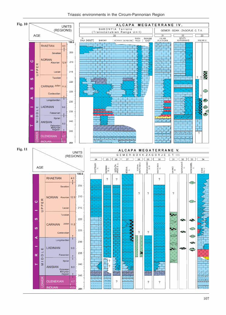
Triassic environments in the Circum-Pannonian Region
107
Fig. 10
Fig. 11

TERRANES
108
two units are included in it: the Meliata Group s.s. andBôrka Nappe.
The Meliata Group s.s. (occurring at localities Drž-kovce, Honce, Meliata, Jaklovce, etc.) is a relict of sedi-ments and volcanics originated in a basin with oceaniccrust. The Meliata Group s.s. was defined as a complex ofdark argillaceous shales of Jurassic age, up to severalhundred meters thick, with thin beds of dark and greenish-red radiolarites (Bathonian—Callovian) and spotted marl-stones with intercalation of sandstones, which areconsidered to be Liassic. The olistostrome bodies in shalycomplex contain clasts and blocks, mainly of Triassicage, attaining the size of up to several hundred meters indiameter. The petrology and stratigraphy of the Meliati-cum at the Meliata and Jaklovce localities were describedin detail by Mock et al. (1998).
However, the Triassic blocks represent two depositionalsettings: the distal (deepest) part of the continental slopeand the ocean floor (Ivan & Mello 2001; Kronome 2002).The former is represented by the Meliata type section itself(Mock et al. 1998), where light coloured crystalline lime-stone (of “meta-Steinalm” type), containing neptuniandykes of similarly metamorphosed Pelsonian red, pelagiclimestone (age proven by conodonts; Kozur & Mock 1973)is followed by red radiolarite (however, with a fault con-tact). In accordance with the interpretation of theMeliaticum in the Northern Calcareous Alps (see above),we retain the term Meliata Unit s.s. (Fig. 9, col. 15) for thissetting. Because of the fault contact between the crystal-line limestone and red radiolarite, based on Dumitrică &Mello (1982) and a continuous outcrop near Držkovce,Grill et al. (1984) proposed the term “Držkovce Facies” forthis setting (for an idealized facies model, as it is not knownin the area of Aggtelek Karst and Rudabánya Hills; seebelow). Dumitrică & Mello (1982) demonstrated the pres-ence of the youngest Anisian—Early Ladinian radiolarianzone (Oertlispongus inaequispinosus zone) in the area ofthe Slovak Karst from a red radiolarite block near Držkovce.The northwesternmost occurrence of the Meliaticum wasproven by Ladinian red radiolarites occurring beneath theStratená Nappe (Havrila & Ožvoldová 1996), that is al-ready thrust onto a Veporic basement.
The true ocean floor setting is represented by theJaklovce locality, where MOR-type basalt (Ivan 2002)occurs in association with red radiolarite in an outcropalong the railway. From here Mello et al. (1995) reportedIllyrian to Longobardian conodonts and radiolarians(Gondolella excelsa, Eptingium manfredi). For this set-ting the term Jaklovce Unit is used herein (Fig. 9, col. 16).
The second subunit, immediately overlying tectoni-cally the Gemer Paleozoic and partly also the Mesozoicsequences, represents a remnant of the subductional-accretional complex, which is designated as the BôrkaNappe (Leško & Varga 1980; redefined by Mello et al.1996, 1997, 1998). The occurrences of Late Paleozoic—Mesozoic metamorphosed sequences (types Dúbrava andHačava) are placed here. They are found along the north-ern margin of the Slovak Karst between Jasov and Sirk, as
well as in the Nižná Slaná depression. Their characteris-tic feature is the Late Jurassic medium to high pressuremetamorphism with low thermal gradient (Mazzoli et al.1992; Mello et al. 1998). In the type of metamorphismthe Bôrka Nappe differs from the underlying Gemeric, aswell as overlying Turnaic or Silicic s.s. Units. Lithologicalcomposition is variable: abundant metabasites (predomi-nantly glaucophanites and light-coloured crystalline lime-stones with volcanic material) are attributed to the Triassicbased on lithostratigraphic correlation (Fig. 9, col. 14),whereas slates are assigned to the Jurassic.
On the basis of study of the protolith and geochemicalcharacteristics of metabasites (glaucophanites) of the BôrkaNappe, Ivan & Kronome (1996) concluded that they arevery variegated and do not belong to a unique group.
Tectonic slices with amphibolite facies assemblageswere reported, as a further member of the Meliata Unitbesides the above mentioned metamorphed rocks. Theirmetamorphic characteristics, indicate that they representfragments of an older basement unit, which was involvedin a subduction zone (Faryad 2000).
Turnaicum
Nappes of the anchi- to epimetamorphosed Turnaicum(Turňa Nappe and Slovenská skala Nappe; Fig. 9,cols. 17—18) occur in the wider region of the SlovakKarst, as a rule above the Meliaticum and below theSilicicum s.s. They are represented by rocks of MiddleCarboniferous to Late Triassic and/or Jurassic in age(Mello et al. 1996). A kind of Turnaicum is also knownfrom the Hungarian territory where it participates thestructure of the Rudabánya Hills (“Torna Series”: Less1981 in Grill et al. 1984; Kovács et al. 1989; Less 2000);see Martonyi Unit below after Grill (1988), however, ina different setting and with different interpretation.
The Lower Triassic is represented by the “Werfen”Formation with a composition similar to that found inthe Silica Nappe, but metamorphosed. Carbonate rampfacies (Gutenstein and Steinalm Formations) character-ize the Lower and partly the Middle Anisian. After thecollapse in the Pelsonian, on the contrary to the Silici-cum, they were not restored anymore. Therefore in thehigher Middle and Upper Triassic only basinal and slopefacies (grey, bedded cherty limestones – Reifling andPötschen Limestones) predominate. In the Carnian man-ifestations of basic volcanic activity (Dvorník Member)also occur.
Silicicum s.s.
It is the uppermost and innermost unit of the InnerWestern Carpathians, thrust over the Turnaicum andMeliaticum and more northerly also over the Gemericum.Several tectonic outliers of the Silicicum s.l. (Muráň,Vernár and Drienok Nappes) can also be found over theVeporic and Hronic units – see the chapter “CentralWestern Carpathians” above.

Triassic environments in the Circum-Pannonian Region
109
The Silicicum s.s. is represented in Slovakia by theStratená Nappe (on the north; Fig. 9, col. 12) and theSilica Nappe on the south (Fig. 9, col. 19). In Hungarythe Aggtelek Unit represents the continuation of thelatter (see below). Although the Stratená Nappe is al-ready thrust onto the Central Western Carpathian base-ment (Veporicum), it is placed here, as Meliatic rocks(proven by Ladinian red radiolarites: Havrila & Ožvol-dová 1996) still occur below it. Their stratigraphic suc-cessions range from the (?Middle)—Late Permian to LateJurassic. The oldest – of Permian to earliest Triassicage – is the Perkupa Evaporite Formation, on whichthe Silica Nappe was overthrust (or slid down) to itspresent-day position. The Lower Triassic formations arepredominantly siliciclastic in the lower part, consistingof variegated sandstones and shales (Bódvaszilas Forma-tion), higher up the carbonate constituent (marlstones andlimestones of the Szin Formation) increases.
The Middle and Upper Triassic is built up by a bulkycarbonate complex, in places attaining a thickness ofnearly 2 km. Carbonate ramp and platform facies (the lat-ter being dissected into reefs and lagoons) are representedby the Gutenstein, Steinalm, Wetterstein and Dachsteinlimestones and dolomites, whereas rocks deposited onthe adjacent slopes and in basinal environments formthe Reifling, Nádaska, Schreyeralm, Raming, Hallstatt,Pötschen and Aflenz Limestones and Zlambach Marls.
The pre-rift stage (Early to Middle Anisian) of car-bonate ramp facies is represented by the euxinic la-goonal Gutenstein Formation, then by the open lagoonalSteinalm Formation with rich dasycladacean algae as-sociation (Bystrický 1964a, 1986).
As a result of rifting processes taking place in theMeliatic domain, the uniform Steinalm carbonate rampwas dissected and extensional intrashelf basins wereformed during the Middle and Late Anisian, in whichreddish Schreyeralm or grey Reifling Limestones,whereas on their slopes Raming and varicolouredNádaska Limestones were deposited. In other areas, how-ever, carbonate platform building continued, as indi-cated by the continuous succession of dasycladaceanalgae zones (Physoporella pauciforata+Oligoporellapilosa Diplopora annulatissima D. annulatazones) (Bystrický 1964a, 1986). In most (e. g. the north-ern or northwestern parts of the present Stratená andSilica Nappes) of these areas carbonate platform bulding(rimmed with reefs) was continuous till the end of theNorian/Rhaetian (Wetterstein, Tisovec and DachsteinLimestones, Mello 1974, 1975a). The intrashelf basinswere overgrown by the prograding Wetterstein reefs inthe Late Ladinian (Mello 1975b). No siliciclastic eventis recognizable in the Carnian. The only sign ofshallowing in the Julian(?) is the presence of horizonswith large oncoids (up to 2 cm) in the uppermost part ofthe Wetterstein Limestone.
The southern, or southwestern parts of the present Silicaand Stratená Nappes were broken drown in the LateCarnian and pelagic, red or pinkish Hallstatt and grey
Pötschen Limetones were deposited till the Late Norian(Mišík & Borza 1976; Mello et al. 1997, 2000a,b).
Both the Stratená Nappe to the north and the SilicaNappe to the south show a more or less expressed south-ern facies polarity concerning their Middle (WettersteinLimestone lagoonal facies reefal facies NádaskaLimestone of slope facies in the former) and Upper Tri-assic (Dachstein Limestone Hallstatt Limestone inboth) formations (Mello et al. 1996, 2000a,b). However,they both show definite N-vergent structures bearingevidence of thrusting over the Gemer Paleozoic (andother underlying) units (Plašienka et al. 1997a). Theduplication of Silicic s.s. units both on the N and on theS and likely the opposing structural vergencies recog-nized Slovak and Hungarian territories can be best ex-plained by the pre-Late Cretaceous (likely intra-Jurassic)sinistral strike-slip duplex proposed by Frank & Schlager(2006) on the example of the Eastern Alps.
The Aggtelek Unit in NE Hungary (see below) forms adirect continuation of the Silica Nappe of SE Slovakia,with southerly deepening facies polarity (Grill et al.1984; Kovács et al. 1989; Less 2000) and predominantlyS-vergent structural polarity (see below).
Aggtelek and Rudabánya Units (composite)
As a result of re-mapping of the Aggtelek Karst andRudabánya Hills, Grill et al. (1984) and Grill (1989)worked out a three-fold nappe structure of the area. Ac-cordingly, the non-metamorphosed Aggtelek and BódvaUnits in highest position, showing definite southwarddeepening polarity, were attributed to the Silicicum inits original sense (as introduced by Kozur & Mock1973). Oceanic remnants of the Tornakápolna Unit (dis-rupted terrane) are found only as blocks in the evapor-itic sole of the former units, and were attributed to theMeliaticum (Réti 1985). The metamorphosed Torna(Less 1981 in Grill et al. 1984) or Martonyi (Grill 1989)Unit was considered to occur in the deepest position.The latest review of this period on the structural investi-gations of the area was presented by Less (2000). Re-cent structural studies (Fodor & Koroknai 2000; Hips2001; Péró et al. 2002, 2003; Kövér et al. 2008) con-firmed the predominantly S-vergent structures of the area,known already since Balogh & Pantó (1953). However,it became clear, that the Aggtelek and Bódva Units donot form a coherent nappe sheet and the present posi-tion of the metamorphosed Martonyi Unit has also beenformed by younger thrustings (Kövér et al. 2008).Kovács et al. (2000) termed these tectonostratigraphicunits together as the “Aggtelekia Composite Terrane”.
In the pre-rift stage (from ?Middle—Late Permian toMiddle Anisian; Kovács 1984) these units were not yetfacially separated, therefore their evolution in this timeinterval can be characterized together.
Following a probably Middle Permian continental red-bed stage, represented only by an uncertain outcrop(Kovács & Hips 1998; after pers. comm. by A. Vozárová),

TERRANES
110
Neotethyan transgression began with a sabkha stage (Per-kupa Evaporite Formation) in the Late Permian, underarid climatic conditions. According to bivalve-biostrati-graphic data (the oldest Claraia zone is missing), thePermian-Triassic boundary lies within the uppermost partof the formation (Hips 1996).
Fully marine conditions were established in the EarlyTriassic from the Claraia clarai zone onward (shallowmarine “Werfen Group”). At first a pure siliciclastic innerramp environment formed, represented by the redBódvaszilas Sandstone Formation, containing shallowmarine fossils (bivalves) and sedimentary features (ripplemarks). In the higher part of the Early Triassic, due to theprograding transgression, the area shifted to the deeperouter ramp domain, with mixed carbonate-siliciclasticsedimentation (Szin Marl Formation, containing the am-monoid guide form Tirolites cassianus). By the end ofthe Early Triassic, the input of fine-grained siliciclasticswas strongly reduced and carbonate deposition becamepredominant. The inner ramp became restricted, withbioturbated (“vermicular”) limestone and marls (SzinpetriLimestone Formation) accumulated under disaerobic con-ditions, but still containing some ammonoids and bivalvesin their lower part (Hips 1996, 1998).
Following the cessation of siliclastic input, fully re-stricted, euxinic lagoon environment came into exist-ence on the inner ramp, with deposition of dark grey toblack carbonates (Gutenstein Formation; mainly lime-stones in the Aggtelek Unit, mainly dolomites in theBódva Unit) in the early part of the Early Anisian. In thelater part of the Early Anisian the area became part ofthe outer ramp, the lagoon was open with well-oxygen-ated and wave-agitated conditions and accumulation ofdasycladacean (Physoporella pauciforata, Diploporahexaster, etc.) and stromatolitic limestone (SteinalmLimestone, partly dolomitized), in the subtidal and in-tertidal zones, respectively.
In the Middle Anisian (in some places probably evenin the late Early Anisian), due to beginning of the Neot-ethyan rifting, the disrupture of the Steinalm carbonateramp began (synrift stage), with differentiation of thefuture tectonostratigraphic units. This is indicated bythe onset of pelagic (Bódva Unit s.s.) and slope(Szőlősardó Subunit) sedimentation, whereas morenortherly the carbonate platform building continued(Aggtelek Unit). In the Early Ladinian even newlyformed oceanic crust can be recorded (TornakápolnaFacies Unit).
The following text describes the evolution of thesenewly formed environments, characterizing the future“tectonostratigraphic units” individually.
Aggtelek Unit
Carbonate platform building in the outer shelf andshelf margin setting continued (location on Fig. 5;Fig. 11, col. 24). In the Late Anisian the first true, rimmedplatform formed (Aggtelek reef, Velledits et al. in print)
facing SE-ward towards the Szőlősardó-Bódva domains.This pre-Wetterstein-type reef can be regarded as thereefal facies of the northerly lying Steinalm lagoon.
Building of the carbonate platform (Wetterstein For-mation) continued throughout the Ladinian (Diploporaannulata dasycladacean zone) and Carnian (Poiki-loporella duplicata dasycladacean zone), till the earlypart of the Late Carnian. In the Carnian the elongatedAlsóhegy carbonate platform (Alsóhegy Subunit) was builtwith a reef facies on the south, facing towards the Bódvapelagic domain, and a lagoon northward (Kovács 1979;Péró et al. 2003). Building of the carbonate platform wasnot broken in the middle part of the Carnian by anysiliciclastic event; instead, it continued (Physoporellaheraki dasycladacean subzone; Kovács 1979; Piros2002). In front of the western part of this platform acharacteristic slope facies developed coevally (DerenkLimestone, Derenk Subunit; Fig. 11, col. 25).
Break-down of the Wetterstein shelf margin took placein the early part of the Late Carnian and deposition ofpelagic Hallstatt Limestone commenced till the LateNorian, where it was followed by some Zlambach Marl(Kovács et al. 1989; Kovács 1997; Less 2000).
Bódva Unit s.l.
As a result of the disrupture and breakdown of theformer Steinalm carbonate ramp, a slope environment(Szőlősardó Facies Unit) and a deep water pelagic do-main (Bódva Facies Unit) formed on attenuated conti-nental crust came into existence (Kovács 1984; Grill etal. 1984). As they interfinger with each other, they rep-resent the same structural unit (Bódva Unit s.l. of theRudabánya Hills), therefore we distinguish a SzőlősardóSubunit and a Bódva Unit s.s.
Szőlősardó Subunit
Following the break-down of the outer part of theSteinalm carbonate ramp during the Middle and LateAnisian, a distally steepened slope environment devel-oped, characterized by a varicoloured limestone forma-tion (Nádaska Limestone Formation), with different signsof sediment gravity movements. It ranges maximallyfrom the Middle Anisian (Gondolella bulgarica con-odont dominance zone) to the early part of the MiddleCarnian (Gondolella auriformis conodont range zone),and may interfinger with the grey, partly cherty ReiflingLimestone. A remarkable, marly-shaly succession sev-eral tens of meters thick of the Szőlősardó Marl Forma-tion in the middle part of the Carnian represents thesiliciclastic “Raibl event” (with the characteristic bi-valve Halobia rugosa). The slope setting of theSzőlősardó Subunit ceased after the break-down of theAggtelek shelf margin (early part of the Late Carnian)and grey, cherty pelagic limestone (Pötschen Limestone)was deposited during the rest of the Carnian and theEarly Norian (Fig. 11, col. 26).

Triassic environments in the Circum-Pannonian Region
111
Bódva Unit s.s.
In the most distal part of the down-breaking Steinalmramp, nearest to the rift zone, a deep water sedimentarydomain formed during the Middle and Late Anisian,where the characteristic Bódvalenke Limestone repre-senting a transitional facies between the Hallstatt faciesand the red radiolarite was deposited. In some places,the break-down could happen even in the late EarlyAnisian (Bithynian), as indicated by an uncertain am-monoid fauna, containing Nicomedites? sp. (det. Krys-tyn in Kovács et al. 1989). The typical version of theBódvalenke Limestone, which follows the SteinalmLimestone with some transitional facies, is formed byalternation of purplish red or pinkish, micritic limestonebeds and red chert beds, with mm-thick purplish-red shaleintercalations, and of interbedded whitish calciturbid-ites consisting of juvenile pelecypod (Posidonia) co-quinas with their recrystallized matrix. In some places(e.g. the Szárhegy-East section; Kovács et al. 1989) theBódvalenke Limestone passes upward into radiolarite,witnessing subsidence below the CCD. Deposition ofthe Bódvalenke Limestone also continued up to theearly part of the Late Carnian (Gondolella polygnathi-formis conodont interval zone) and then (with a remark-able hiatus in some sections) was followed by theHallstatt Limestone (Fig. 11, col. 27), indicating con-tinuation of the oxydative environment, but also, asopposed to that of the Aggtelek Unit, an uneven, highlydissected sea-floor topography, as witnessed by frequent“intraconglomerates” related to sediment gravity move-ments. Variegated marls (green to purplish red) of theTelekes-völgy Group (Haas et al. present volume) mayrepresent some kind of the uppermost Triassic Zlam-bach Marl (Grill 1988). The Bódvalenke-type lime-stones represent transitional facies between coeval red,Hallstatt-type limestones and red radiolarites and theyare common constituents of inner Dinaridic—inner Hel-lenidic ophiolite mélanges, however, associated withbasalts, as already in the Darnó Unit (see below) (Skourt-sis-Coroneou et al. 1995; Kovács et al. in print b).
Tornakápolna Facies Unit (Bódva Valley OphioliteComplex) (disrupted terrane)
This facies unit does not represent an independent struc-tural unit, but remnants of a Neotethyan oceanic assem-blage, tectonically incorporated as slices or blocks intoUpper Permian evaporites at the sole thrust of the Aggtelekand (?)Bódva Units. These include mainly serpentinites,gabbros and basalts of MORB-affinity (Réti 1985;Horváth 2000). The drill-core section of the boreholeTornakápolna 3 is regarded, as the type section of the“complex” (Réti 1985; Kovács in Haas 2004, Fig. 263;for the setting at the base of the Aggtelek Unit see alsothe section of borehole Szin 1 on Fig. 262 therein), inwhich some sedimentary rocks also occur: latest Anisian—Lower Ladinian red pelagic mudstones and radiolarites
in one horizon within pillow basalts, containing radi-olarians of the Oertlispongus inaequispinosus radiolar-ian zone (Kozur & Réti 1986; Dosztály & Józsa 1992), aswell as black siliceous shales and sandy shales in onetectonic block-slice within serpentinites (Fig. 11, col. 28).The latter proved to be barren of radiolarians, but bylithological comparison with the Darnó drill core sec-tions, can be considered Jurassic (Kovács in Haas 2004;Kovács et al. in print). In some shear zones (but not over-all) ophiolites and evaporites form true “autoclasticmélange” (Dimitrijević et al. 2003). The continuous pas-sage from the Upper Permian evaporites embracing theseophiolite blocks into the shallow marine Lower Triassicformations is documented in the work by Hips (1996;incl. also the above mentioned drill core sections).
The Bódva Valley Ophiolite Complex in its geologi-cal setting and surrounding rocks (its fragments beingsubsequently included into Upper Permian evaporitesafter obduction) clearly differs from the Darnó OphioliteComplex of the Bükk Composite Units and may corre-spond to the Gemeric Meliata ophiolites, if they are de-fined by the Šankovce borehole (Bystrický 1964a; Gaálin Vass et al. 1986) or by the Jaklovce occurrence (Mocket al. 1998). However, current structural interpretations(Plašienka et al. 1997a; Less 2000; for latest discussionsee Less in Dosztály et al. 2002) are still widely different,implying the necessity of further joint correlational works.
Martonyi (Torna auct.) Unit
This unit (first distinguished by Less 1981 in Grill etal. 1984 as “Torna Series“, but named by Grill (1989) asthe “Martonyi Unit“) includes anchizonal to epizonalmetamorphosed (Árkai & Kovács 1986) Triassic series,which occur in the NE part of the Rudabánya Hills, en-closed by the Darnó fault zone. Its known sequence(Fig. 11, col. 30) begins with Lower to Middle AnisianGutenstein Dolomite and Steinalm Limestone, similarlyto the Aggtelek and Bódva Units. The Steinalm ramp wasdisrupted and broken down in Middle to Late Anisian,and deposition of grey limestone of basinal facies, lack-ing chert (Becskeháza Subunit) or having chert only inthe upper part of the section (Esztramos Subunit) tookplace under quiet conditions (practically without signsof sediment gravity movements) till the end of theLadinian or beginning of the Carnian. Carbonate sedi-mentation was interrupted in the middle part of theCarnian by a fine siliciclastic input representing the “Raiblevent”, resulting in a shale sequence a few meters thick.Basinal carbonate sedimentation renewed in the early partof the Late Carnian, then grey, cherty limestone (PötschenLimestone s.l.) were deposited till the end of Early Norian,followed by variegated limestone with red chert in theMiddle to Late Norian.
A specific, more deep water development is repre-sented by the Bódvarákó Subunit, in which the open-lagoonal Steinalm ramp stage stayed out and theGutenstein Dolomite (Fig. 11, col. 29) was immediately

TERRANES
112
followed by the anoxic deep water Bódvarákó Forma-tion: dark grey to black, cherty limestone alternatingwith claystones or marls in the Middle to Upper Anisian,and dark grey, strongly silicified limestone and blackcherts up to the Upper Ladinian. The continuation ofthe sequence, although tectonically separated, in theCarnian and Norian was likely the same, as above (Fodor& Koroknai 2000).
Bükk Units (composite)
Bükk Parautochthon Unit
The Upper Permian shallow marine carbonates areoverlain by lowermost Triassic ooidal limestone (in morethan 100 m thickness). Until the end of the Early Trias-sic, either carbonate or siliciclastic dominated ramp sedi-mentation alternated. The succession shows a deepeningupward trend. A bioturbated limestone unit appears atthe top of the Lower Triassic (Hips & Pelikán 2002).
In the Anisian a dolomite ramp was formed. It is cappedlocally by dolomite conglomerates or breccias with red,terrestrial clay intercalations (Velledits 1999, 2004).Updoming can be regarded as a sign of the initiation ofrifting and related volcanic activity in connection withthe Neotethyan opening (Velledits 2006).
In the Early Ladinian intense calc-alkaline volcanicactivity took place. A volcanic complex (Szentistván-hegy Metaandesite or “porphyrite”) hundreds of metersthick was accumulated, consisting of lava rocks, ag-glomerates, tuffs, ignimbrites and various volcanoclasticsediments (Szoldán 1990; Harangi et al. 1996).
The rifting manifested also in facies differentiation,platform and intraplatform basin environments was es-tablished in the Late Ladinian. A larger part of the moun-tains is built up of an anchi- to epizonal metamorphosed(Árkai et al. 1995) carbonate platform sequence, whichincludes both the Wetterstein and Dachstein evolution-ary stages, so that is probably extends from the Ladinianto the Rhaetian (Riedel et al. 1988; Flügel et al. 1992;Velledits 2000). In the coeval basins grey cherty lime-stones were accumulated, which extend according toconodont biostratigraphic data from the latest Ladinianto the Rhaetian (Kovács in Velledits 2000). A secondvolcanic activity represented by within-plate basalts(Szoldán 1990; Harangi et al. 1996) took place in thebasin environments, mostly in the Late Ladinian, butmanifesting in places up to the Late Carnian (Velleditset al. 2004; Pelikán 2005).
The platforms were drowned by the latest Triassic, andvariegated limestones were deposited locally, which mayextend into the Jurassic (Fig. 11, col. 34).
Mónosbél Unit
Within the Middle—Late Jurassic fine siliciclastic-car-bonate turbiditic Mónosbél complex of proximal-typeslide blocks of up to several 10 m diameters (drilled
thickness) occur in the area of Darnó Hill, which consistof reddish, cherty, Bódvalenke-type limestone and chert,and reddish, amygdaloidal basalt. Radiolarian data(Dosztály & Józsa 1992; Dosztály 1994) constrain theage of these blocks as Ladinian-Carnian. The eastern-most occurrence of such blocks on the surface is knownin the central part of the southern Bükk Mts (basalt, redchert, Upper Carnian Hallstatt-type limestone; Dimitri-jević et al. 2003, Pl. II, Fig. 4), which is quite exotic tothe Triassic sequence of the Bükk Parautochthon Unit(Fig. 11, col. 33).
Szarvaskő Unit
In an olistostrome horizon of this basically Jurassiccomplex (Gulácsi in Haas 2001) Ladinian to Carnian redradiolarite blocks occur (Dosztály & Józsa 1992; Dosztály1994; Fig. 11, col. 32). Rare occurrences of Norian, con-odont-bearing grey limestone blocks are also known.
Darnó Unit
In a Jurassic accretionary complex (Haas et al. presentvolume), as documented by drill-core sections, abyssalsediments (red pelagic mudstones and radiolarites) insmaller amounts alternate with basalts in larger amounts.The radiolarites are partly of Ladinian-Carnian age(Dosztály & Józsa 1992; Dosztály 1994; Józsa et al.1996; Józsa & Kovács in Haas 2004; Kovács et al. 2008).The basalts are of two types: the early rift-type is red-dish or greenish and rich in calcite amygdals, and con-tains contact metamorphosed Bódvalenke-typelimestone inclusions. These latters are reddish, recrys-tallized limestone blocks of a few cm to a few 10 cm indiameter, with red chert. Some radiolarian data (Dosz-tály 1994; Józsa et al. 1996) also point to their Ladinian-Carnian age (Fig. 11, col. 31). This mixture of basaltwith red micritic limestone, formed due to the interac-tion of hot lava flow with cold lime mud on the seafloor, represents a typical peperitic facies and is comparable to those occurring in the Kalnik Mt, NW Croatia(Kiss et al. 2008), where they are known to a much largerextent (Palinkaš et al. 2008; Kovács et al. in print a).The other type of basalt lacks signs of mixing with cal-careous lime mud and resembles the Jurassic Szarvaskő-type (Haas et al. present volume).
Zagorje-Mid-Transdanubian Units
These units represent the southwestern part of theGemer-Bükk-Zagorje Composite Terrane and crop outon the surface in the Zagorje region (Medvednica,Ivanščica and Kalnik Mts) in NW Croatia. Their subsur-face extension, also in to Hungary (“Mid-TransdanubianUnit”; Fülöp et al. 1987) is quite well known due toplenty of deep-drilling data (Bérczi-Makk et al. 1993;Pamić & Tomljenović 1998; Haas et al. 2000b). Struc-turally, the Julian Alps – South Karawanks and Sava

Triassic environments in the Circum-Pannonian Region
113
folds (Mioč 1981), thrust during the Oligocene?—Mi-ocene southward onto the nortwestern part of Dinarides,are also regarded as the western extension of this zone(Haas et al. in the present volume), therefore they areincluded (Figs. 1B and 5) and described herein. Detailson the borehole data of the subsurface continuation ofthese units into Hungary (“Mid-Transdanubian Unit”of Fülöp et al. 1987) can be found in the mentionedpublications by Bérczi-Makk et al. (1993) and Haas etal. (2000b), which are summarized below.
Mid-Transdanubian Units (composite)
In the northern part of the Mid-Transdanubian Com-posite Unit non-metamorphosed Permian and Triassicformations form the pre-Tertiary basement, whereasslightly metamorphosed Permian, Triassic and Jurassicformations occur in the south-western part of the unit.Ophiolite mélange was encountered in a few wells in anarrow strip along the southern structural contact of theunit (Bérczi-Makk et al. 1993; Haas et al. 2000b).
South Karawanks Unit
A great number of wells encountered Triassic forma-tions in the same zone, making it possible to compile ageneralized succession. The Lower Triassic is made upof lilac-coloured variegated shale that is overlain by aninterval of alternating limestone, dolomite and shale,representing shallow ramp and lagoon facies. Shallowmarine dolomite typifies the Anisian. Coeval platformand basin facies characterize the Ladinian to Carnianinterval. Wetterstein-type limestone represents the plat-form facies. The basin facies is typified by grey chertylimestone, marl and volcanic tuff in several horizons inthe Ladinian, and marl and siltstone in the Carnian. TheNorian to Rhaetian is represented by Dachstein-typeplatform carbonates (Bérczi-Makk et al. 1993).
The Triassic sequence of the South Karawanks is typi-fied by Werfen-type Lower Triassic, shallow marineAnisian dolomite, coeval platform carbonates (Schlernand Conzen Dolomite) and basin facies consisting of marlwith volcanic tuff (Wengen Fm) in the Ladinian, marl,limestone and sandstone (Raibl Group) in the Carnian,and Hauptdolomit and Dachstein Limestone in the Norianto Rhaetian (Gianolla et al. 1998; Cozzi 2000) that isvery similar to what was encountered in the wells southof the Balaton Line.
Julian-Savinja Unit
South of the above-described narrow strip there is arelatively wide zone where, beneath a Tertiary cover, pre-dominantly non-metamorphosed Triassic platform car-bonates were encountered. The Middle and Upper Triassicis characterized by typical shallow ramp – platform fa-cies, namely Steinalm-Wetterstein type and Dachsteintype facies, respectively (Bérczi-Makk et al. 1993).
South Zala Unit
In the Mid-Transdanubian area the South Zala Unit,located south of the above described non-metamorphicunits consists of Upper Permian evaporitic carbonates,Triassic carbonates of basin and slope facies and MiddleJurassic hemipelagic shale and volcanoclastics affectedby low-grade metamorphism. Possibly, the Medvednicaand the South Zala Units are parts of the same tectono-stratigraphic unit.
Julian Carbonate Platform
The Julian Carbonate Platform (Fig. 10, col. 21) wasformed after disintegration of the Slovenian CarbonatePlatform during the Anisian (Buser 1989; Buser et al.2008). From then it acted as a distinguished paleogeo-graphic unit up to the Early Jurassic.
Accordingly, the Scythian and Anisian beds are simi-lar to those in southern and central Slovenia. In theScythian shallow water carbonate and siliciclastic depos-its alternate in an up to 300 m thick succession. Frequentoolitic beds and in places evaporites are very characteris-tic (Dolenec et al. 1981; Ramovš 1989b; Kolar-Jurkovšek& Jurkovšek 1995; Lucas et al. 2008).
The Anisian stage is represented mostly by beddeddolomite. However, in Bled and locally in the WesternKaravanks massive and bedded algal-reef limestonesoccur as well (Ramovš 1987a; Flügel et al. 1993). Thesebeds are up to 600 m thick. In some places massive lime-stone beds continue upwards into the Ladinian stage.
The Ladinian stage is characterized by a very varie-gated succession of sandstones, marls, shales, limestonewith cherts, and also volcanic, mostly tuffaceous rocks(Ramovš 1989a). Among the volcanic rocks, quartzkeratophyre, porphyry, and tuffs of ignimbritic charac-ter occur. In the Western Karawanks (Fig. 10, col. 22)and in places in the Julian Alps horizon of breccia-con-glomerate some tens of meters thick – the Uggowitz(Ugovica) Beds – underlies the Cordevolian dolomite.
The Cordevolian substage is represented by succes-sion up to 1000 m thick of light coloured massive andbedded limestone with diplopore algae and rarely cor-als and hydrozoans as the most common fossils (Ra-movš & Turnšek 1984; Ramovš 1987b; Ramovš & Šribar1992). The Julian and Tuvalian beds, known as TamarFormation (=“Raibl Beds”), are up to 200 m thick. Theywere deposited in a shallow restricted shelf. Dark marlylimestone with marl intercalations is predominating overdolomite (Ogorelec et al. 1984; Ramovš 1987b). In places,limestone beds with alga Clypeina bešići occur(Dobruskina et al. 2001; Kolar-Jurkovšek & Jurkovšek2003; Kolar-Jurkovšek et al. 2005). Overlying the lime-stone beds, locally pelitic tuff occurs, while the upper-most part of the Tuvalian succession already indicatesdeposition of the Main Dolomite (Hauptdolomit) withstromatolitic beds (Buser 1979). In the deeper environ-ments of the Julian Platform towards the Slovenian Ba-

TERRANES
114
sin, micritic limestones (Jurkovšek et al. 1984; Kolar-Jurkovšek 1991; Celarc & Kolar-Jurkovšek 2008, etc.),dolomites, and limestones with chert nodules were de-posited (Jurkovšek et al. 1984).
In the Norian and Rhaetian the Dachstein Limestonein Lofer facies predominates, reaching a thickness of upto 1500 m (Buser 1979; Ogorelec & Rothe 1993). Thenorthern part of Triglav also consists of this limestone.Widely extended coral-reef complexes are also a verysignificant constituent parts of this platform (Turnšek1997).
Kalnik Unit
The ophiolitic mélange of the Kalnik Unit (Fig. 10,col. 23) a disrupted terrane of oceanic origin crops outin all the three mountains mentioned, but its subsurfaceextension into the territory of Hungary is also provenby borehole data (Haas et al. 2000b). Its matrix is com-posed of fine-grained siliciclastics (mostly dark grey toblack shales), the age of which is Middle Jurassic basedon intercalated radiolarites (Halamić et al. 1999). Them- to km-sized blocks in this matrix include ultramafics,basalts, gabbros and deep water sediments (radiolarites,silicified limestones) (Pamić 1997; Pamić & Tomlje-nović 1998). Triassic red radiolarites, interlayered withbasalts or lying on top of them, range in age from thelatest Anisian—Early Ladinian (Oertlispongus inaequi-spinosus, Falcispongus calcaneum, etc.) to LateCarnian—Middle Norian (several Capnuchosphaera spe-cies, Capnodoce sp., etc.; Halamić & Goričan 1995;Goričan et al. 2005). Triassic basalts are frequentlyamygdaloidal and represent peperitic facies with red,micritic limestone inclusions, from which conodontswere reported in the Kalnik Mt (Kolar-Jurkovšek inPalinkaš et al. 2008). In the NW part of the MedvednicaMt (Orešje quarry) well-preserved Late Anisian con-odonts (platformless forms of Gondolella excelsa, fig-ured as “Paragondolella cf. excelsa”) were found in redlimestone inclusions in MOR-type basalt (Kolar-Jurkovšek in Halamić et al. 1999). Triassic early rift typebasalts are thought to be related to sea-floor spreadingin a back-arc basin setting, initiated around the Anisian-Ladinian boundary (Goričan et al. 2005). A whole sub-marine volcanic complex with abundant peperitic facieswas reconstructed in the Kalnik Mt, having equivalentsin NW Bosnia (Vareš region, Dinaridic Ophiolite Belt)and in NE Hungary (Darnó Unit) (Palinkaš et al. 2008;Kiss et al. 2008). A suddenly broken down shelf marginsetting is represented by the Belski dol section in theeastern part of Ivanščica Mt, where Anisian lightcoloured platform limestone is directly overlain by redradiolarite of the latest Anisian—Early LadinianOertlispongus inaequispinosus zone (Halamić &Goričan 1995; Goričan et al. 2005). In Ivanščica MtGrgasović & Sokač (2003) also reported blocks ofAnisian reef limestones suggesting shallow marine car-bonate sedimentation.
Medvednica Unit
Apart from Devonian and Carboniferous limestonesthe metamorphosed “Medvednica Complex” (Pamić &Tomljenović 1998), also includes Triassic conodont-bearing limestones (reported as Ladinian to Carnian,but also typical Norian “metapolygnathoids”; Đur a-nović 1973).
The ADRIA-DINARIA Megaterrane
South Alpine Units
In the area of the Southern Alps (location on Fig. 5;Fig. 12, cols. 35—38) the Alpine (Neotethyan) cycle be-gins with a westward Late Permian transgression. Accord-ingly, the continental, predominantly fluvial Gröden (ValGardena) Sandstone was step by step overlain by sabkhaand shallow lagoon facies of the Bellerophon Formationin the eastern part of the Southern Alps (Dolomites, Car-nic Alps). This trend continued after the Permian-Triassicboundary event leading to inundation of Eastern Lom-bardy and formation of the shallow ramp deposits of theWerfen Formation, 300—400 m in thickness that trans-gressively overlies continental and marine Upper Permi-an formations (Gaetani 1979; Gaetani et al. 1998).
The Lower Triassic sequence was deposited in a shal-low ramp setting that was characterized by mixed sili-ciclastic and carbonate deposition. The sea-floor wasusually located below the fair-weather wave base but itwas frequently subjected to storm currents. The succes-sion is made up of transgressional-regressional cycles.The first transgressional cycle starts at the Permian-Tri-assic boundary with a characteristic oolite horizon thatis overlain by marl and mudstone. This basal memberpinches out westward in Lombardy (Assereto et al. 1973;Brandner & Mostler 1982; Broglio-Loriga et al. 1990).Predominantly shallow subtidal carbonates with storminterlayers were formed during the second cycle in theDolomites that also pinch out westward. Siliciclasticsprevail in the next cycle (Campil Member) all over theSouth Alpine domain probably as a result of a signifi-cant climatic change. The fourth transgressional cycleled to formation of a deeper ramp facies (Val BadiaMember), containing rich ammonite fauna (Tirolitescassianus) in the area of the Dolomites. It progressesinto a shallow inner ramp facies westward and south-ward (Broglio-Loriga et al. 1990). The area of thewesternmost Southern Alps (Ticino) was not yet reachedby the transgression, and the whole Lower Triassic isrepresented by continental, Buntsandstein-type sili-ciclastics (“Servino”; Pisa 1974; Gaetani et al. 1987;Sciunnach et al. 1999).
The Werfen Formation is comformably overlain byLower Anisian cyclic peritidal-shallow subtidal dolo-mites (Lower Serla Dolomite). In the Western Dolomitesand in NE Carnia it is covered by Upper Anisian con-glomerates – Richthofen Conglomerate, Uggowitz

Triassic environments in the Circum-Pannonian Region
115
(Ugovizza) Breccia – indicating uplift in the Late Anisianthat resulted in intense erosion. As a consequence, in theseareas the Werfen Formation became deeply eroded or it iscompletely lacking.
As a result of the next relative sea-level rise in thelater part of the Late Anisian platform carbonates (ContrinFormation) began forming on the structural highs andbasinal carbonates in the intraplatform basins. The tec-tonic activity reached its maximum intensity in theLadinian when a platform carbonate succession severalkm thick was deposited (Bosellini 1984; Doglioni 1988)whereas deposition of pelagic carbonates (BuchensteinFormation) with pyroclastic intercalations (“pietraverde”) continued in the basins. Predominantly in theDolomites, intense mafic volcanism (shoshonites) tookplace coevally and was accompanied by formation ofmagmatic intrusions. In the Late Ladinian to EarlyCarnian the Ladinian intraplatform basins were progres-sively filled up by volcanics (pillow lavas, hyaloclastics)and volcanoclastics. In parallel to the upfilling, the plat-forms (Cassian Dolomite) prograded onto the basin de-posits (San Cassian Formation). The volcanic chain wassituated south of the area of the present Southern Alps,in the basement of the Po Basin, as revealed by AGIPwells (Brusca et al. 1982).
In the Late Carnian large areas of the South Alpinedomain became subaerially exposed (Gnaccolini & Jadoul1990) and than covered by fine siliciclastics, carbonatesand evaporites suggesting arid climatic conditions (RaiblFormation). In Lombardy a delta complex developed con-temporaneously.
The Raibl Formation is overlain by cyclic peritidal-subtidal dolomites (Dolomia Principale) all over theSouth Alpine realm in a thickness of km-scale (Bosellini& Hardie 1988; Jadoul et al. 1992). In the Norian, severalkm thick incipient stage of the opening of the Piemont-Penninic ocean branch (Alpine Tethys) led to disinte-gration of the platform and formation of fast subsidingbasins and structural highs in Lombardy (Jadoul et al.2004). As a result the thickness of the Upper Triassicsuccession is extremely variable (from 0.5 to 4 km). Firstbasinal carbonates were deposited in the basins coevalwith the formation of the Dolomia Principale (AralaltaGroup – Jadoul 1985). During the Late Norian toHettangian a cyclic shale-carbonate succession was formed(Riva di Solto Shale and Zu Limestone; Jadoul et al.1992). In the Dolomites development of carbonate plat-forms continued till the end of the Triassic. In the CarnicFore-Alps, in the eastern part of the Southern Alps, amongcarbonate platforms made up of Norian DolomiaPrincipale and Rhaetian Dachstein Limestone, smallintraplatform basins occur (Carulli et al. 1998; Cozzi &Podda 1998). In the basins Norian cherty dolomite andRhaetian to Liassic limestone were formed. The plat-forms are bounded by N-S and NE-SW-trending syn-sedimentary listric faults (Cozzi 2000). Development ofthese basins was related to a further step of the Neotethysopening.
Adria Units
Adriatic Carbonate Platform
The Mesozoic Adriatic-Dinaridic Carbonate Platform(ADCP; Fig. 12, col. 39) of Pamić et al. (1998) or theAdriatic Carbonate Platform (ADCP) of Velić et al. (2004)was built on large part of the Variscan “Carnic-Dinaridicmicroplate” (in sense of Vai 1994, 1998, 2003) or south-ern part of the “Noric-Bosnian Terrane” (in sense of Flügel1990; Neubauer & Raumer 1993; Ebner et al. 2007), char-acterized by mostly marine Late Carboniferous and Per-mian sedimentation (Vozárová et al. 2009). Building of acoherent, immense carbonate platform (one of the largestsin the Tethys domain) began in the Late Triassic (Norian—Rhaetian) and continued (with local differentiations:short-lived basins or emersions, the latter being indicatedby bauxite horizons) until the end of the Cretaceous.
From the Late Permian to the end of the Anisian, thearea of Slovenia was an integrated part of an extensiveand shallow carbonate platform (the Slovenian Carbon-ate Platform, Buser 1989; Buser et al. 2008). At the end ofthe Anisian the Slovenian Carbonate Platform disinte-grated into the Adriatic-Dinaridic Carbonate Platform onthe south and the Julian Carbonate Platform on the north,separated in-between by the Slovenian Basin (Cousin1973; Buser 1989). This basin extended from Tolmin,through Ljubljana and Zagreb to Bosnia (into the BosnianFlysch Zone).
Sediments of the Adriatic-Dinaridic Platform (Slove-nian part) are lie on the carbonate-clastic succession ofthe uniform Slovenian Carbonate Platform (Buser 1989),that existed until the end of Anisian.
The transition from the Permian to the Lower Triassicis continuous as limestone and dolomite. The P-T bound-ary is characterized by the extinction of the Permian fos-sils and defined by the first appearance datum (FAD) ofthe conodont species Hindeodus parvus (Kolar-Jurkov-šek & Jurkovšek 2007). The boundary is also marked bya strong enrichment of the light 13C in carbonate rocks(Dolenec et al. 2004). The Tesero horizon occurs at theP-T boundary interval and reaches the thickness from0.5 m to a few meters.
Scythian beds south of the Periadriatic lineament arerelatively uniform. Their thickness is very varied, from40 to 600 m. Alternation of siliciclastic and carbonaterocks, particularly limestone with admixtures of silicatedetritic grains is noticed in the lower part of the succes-sion. Red oolitic limestone or dolomite are characteris-tic lithotypes (Grad & Ogorelec 1980; Ramovš 1989b;Dozet 2000). Echinoderms, gastropods (Natiria costata)and the foraminifera Meandrospira pusilla are frequentfossils (Aničić & Dozet 2000). Oolitic lithofacies con-tains conodont association of the Smithian Obliqua Zonerepresented by shallow water genera (Kolar-Jurkovšek& Jurkovšek 1996).
Beds and lenses of evaporitic minerals, gypsum andanhydrite occur in some places (Čar et al. 1980). Upwards

TERRANES
116
in the Scythian succession the siliciclastic componentis reducing in amount. Dark biomicritic and marly lime-stone is prevailing over dolomite, with rare stromatoliticlaminae.
The Anisian succession is rather uniform, representedmostly by bedded dolomite, often showing signs ofintratidal sedimentation (Grad & Ogorelec 1980). Sub-ordinately biomicritic limestone also occurs, contain-ing the foraminifera Meandrospira dinarica andGlomospira densa. The Anisian deposits reach a thick-ness of up to 600 m.
The previously uniform Slovenian Carbonate Platformbecame finally disintegrated into two parts: the JulianCarbonate Platform to the north, and the Adriatic-Dinaridic Carbonate Platform to the south. Therefore sig-nificant facies differences can already be observed in theAnisian, especially on the slope zones of both carbonateplatforms to the Slovenian Basin.
In the lower part of the Ladinian succession basinalfacies prevail: micritic limestone and cherty limestone,which may be partly dolomitized. They are overlain byshallow water carbonates characterized by Diplopora as-sociation, sandstones and by tuffs of the spilite-kerato-phyre association.
The lower part of the Carnian is represented by mostlydolomitized platform carbonates, some hundreds of metersin thickness, rich in Dasycladaceae. In some places pale-okarst features can be recognized. The Julian and Tuval-ian beds were deposited in a shallow restricted lagoonalenvironment and are up to 400 m thick. They are repre-sented by dark, marly limestones, intercalated by silici-clastics (marly siltstones and sandstones) and also by tuffand tuffitic beds and coal (Cigale 1978; Buser 1979).Southern Slovenia was partly a land area in the Tuvalian.In a phase of emergence bauxites and siliciclastics of theBorovnica Formation were deposited (Buser 1996). Onthe northern margin of the Adriatic Carbonate Platformand towards the Slovenian Basin deposition of black,marly limestone, rich in thick-shelled mollusc fauna, tookplace (Buser 1979; Jelen 1990).
The Norian and Rhaetian stages are represented by theMain Dolomite (Hauptdolomit), up to 1200 m in thick-ness and characterized by Lofer facies (Ogorelec & Rothe1993). Locally, only in the upper 200 m of the succes-sion, Dachstein Limestone is preserved. Megalodontidsare the most characteristic fossils. Both the Main Dolo-mite (Hauptdolomit) and the Dachstein Limestone showclear evidence of paleokarstification in places.
In Croatia the area of the future Adriatic CarbonatePlatform (ADCP) began to develop as a part of the UpperCarboniferous to Lower Permian epeiric platform alongthe northern Gondwana margin (Tišljar et al. 1991; Velićet al. 2003). In the Middle Permian this primary settingwas punctuated by intermittent extensional tectonic move-ments, which began to break the platform into severalhorsts and grabens. Some of the Permian highs (horsts)with dominant carbonate precipitation (for exampleVelebit Mts) were probably isolated from the main car-
bonate platforms in the Southern Alps and possibly ex-perienced continuous carbonate sedimentation from thePermian to Early Triassic. Some Permian inter-platformareas (grabens) were filled with clastics before the EarlyTriassic shallow marine dominantly carbonate deposi-tion had begun (for example the Gorski Kotar region).
The ADCP platform basement can be divided intothree major megasequences: 1) Middle Permian—UpperLadinian or Carnian 2) Norian—Upper Cretaceous and3) Paleocene—Middle Eocene (Velić et al. 2001, 2003).
The first megasequence began with Middle to UpperPermian platform carbonate deposits that were in someplaces (Velebit Mts) conformably overlain by LowerTriassic strata. The oldest Lower Triassic deposits inCroatia were documented (by means of conodonts) inthe Gorski Kotar Region but without the continuoustransition from Permian (Aljinović et al. 2006).
The Lower Triassic deposits are usually divided intotwo lithostratigraphic units: mainly red shales, sand-stones and oolitic grainstones containing representa-tives of the characteristic bivalve genus Claraia areconsidered as Lower Scythian “Seis (=Siusi) beds” anddominantly grey clayey/silty limestones and marls asUpper Scythian “Campil beds” of the Southern Alps(according to the old, rather chronostratigraphic conno-tation of these terms, no longer used there). Accordingto the similar lithological characteristics of the LowerTriassic (Scythian) deposits in the wide Dinaric area,especially by the presence of oolitic grainstones andshallow water structures, deposition in a wide shallowepeiric sea was suggested (Aljinović 1995; Marjanac2000; Jelaska et al. 2003).
In the Middle Triassic, the area of the future AdriaticCarbonate Platform proceeded to disintegrate due to riftrelated tectonic movements, forming the huge isolatedplatform – the Adria Microplate (Velić et al. 2003) orSouthern Tethyan Megaplatform (STM) (Vlahović et al.2005). This carbonate platform represents the foundationof the future Adriatic Carbonate Platform, the building ofwhich continued till the end of the Cretaceous.
The Middle Triassic rifting disintegrated the area intohighs (horsts) and grabens. Some rift-related highs expe-rienced continuous shallow marine carbonate depositionusually with algal limestone type sediments (Herak 1974;Grgasović & Sokač 2003), while between the upliftedblocks the influence of a deeper environment has beenrecognized mostly by the presence of ammonoids or pe-lagic microorganisms in grey, cherty limestones (Sakač1992; Balini et al. 2006). As a consequence of the riftrelated tectonic movements, the resedimented intrafor-mational breccia facies (analogous to the RichthofenConglomerate of the Southern Alps) occurred in manyplaces (for example the “Otarnik breccia” at the base ofthe intraplatform succession at the Svilaja Mt; Marjanac2000; Jelaska et al. 2003).
Widespread volcanic and volcaniclastic rocks (basalts,andesites and dacites, which were largely transformed intometabasalt – mainly spilite, metaandesite – mainly

Triassic environments in the Circum-Pannonian Region
117
keratophyre and metadacite – mainly quartzkeratophyre,e.g. Pamić 1982, 1984) are also interpreted as a conse-quence of the rifting phase. The magmatic activity reachedits paroxism during the Ladinian. In S Bosnia, along theNE margin of the Adriatic-Dinaridic Carbonate Platformplutonic rocks, among which intermediate ones predomi-nate over basic and acidic ones, are represented by variet-ies of gabbro, diorite, granodiorite, granite, albite-syeniteand albite-granite. The largest Triassic plutonic body isthe Jablanica gabbro-norite pluton occurring SW of theBosnian Schist Mountains in an area of 20 km2 (Pamić2000; Trubelja et al. 2004; Robertson et al. 2009).
In the Svilaja Mt volcaniclastic deposits – ignimbritesand tuffs called “pietra verde” occurred in the sedimentsuccessions of the deeper marine areas (grabens). In suchdepositional environments they are conformably over-lain by bioclastic, grey cherty limestones and dolomiteswith calcareous algal skeletons, foraminifers, radiolar-ians, gastropods, bivalves and brachiopods (Marjanac2000; Jelaska et al. 2003; Balini et al. 2006).
The Middle/Late Triassic boundary is mostly charac-terized by a relatively long emersion phase includingcommon bauxite occurrences (Vlahović et al. 2005)marking the end of the first megasequence (Velić et al.2001, 2003; Vlahović et al. 2005). In the Carnian terres-trial red conglomerates, sandstones and shales occurredlocally (Vlahović et al. 2005), probably on the upliftedblocks. In some places the Middle/Upper Triassic tran-sition was practically continuous within shallow ma-rine environments (Central Croatia; Vlahović et al. 2005).
A transgression at the end of the Carnian led to theestablishment of shallow carbonate platform conditionsover a huge area called “Southern Tethyan Megaplat-form” including the later Adriatic Carbonate Platform.Development of the Dachstein-type platform can be con-sidered as the beginning of the second megacycle that ischaracterized by carbonate platform evolution which wascontinuous over large areas until the Late Cretaceous inthe territory of the Adriatic-Dinaridic Carbonate Platform(Velić et al. 2003).
The Upper Triassic platform carbonates are exposedalmost continuously along the NE margin of the Adriatic-Dinaridic Carbonate Platform from Slovenia to southernMontenegro and northern Albania (Dragičević & Velić2002). Two typical lithofacies of these platform carbon-ates are distinguished. There are predominantly dolomitesuccessions corresponding to the Hauptdolomit orDolomia Principale, and there are limestones only sub-ordinately dolomitized corresponding to the DachsteinLimestone. Generally the lower part of the Upper Triassicplatform carbonates are dolomitic whereas the upper partis usually limestone containing the typical megalodontidand foraminifera assemblage of the Dachstein Limestone.This thick carbonate sequence represents typical depos-its of the isolated carbonate platform but it should not beascribed to the Adriatic Carbonate Platform s.s. Duringthat period the entire area of the Southern TethyanMegaplatform was still united (Vlahović et al. 2005). The
Upper Triassic platform carbonates are directly overlainby Lower Jurassic platform carbonates (usually fossilifer-ous limestones) or their dolomitized equivalents.
The huge Southern Tethyan Megaplatform was partlydisintegrated during the Late Liassic, resulting in the for-mation of several basins and platforms, among which isalso the Adriatic Carbonate Platform (AdCP; Velić et al.2003; Vlahović et al. 2005).
In Montenegro, at the SW part of the Adriatic-Dinaridic Carbonate Platform, due to the neighbour-hood of the Budva Zone (not extending to the area of ourmap) which later evolved into a Mesozoic deep-waterseaway, Early Anisian siliciclastic flysch/wildflysch-typesediments (cf. Dimitrijević M.N. 1967; Radoičić 1987)were reported, too.
Central Bosnian Mountains Unit
The Upper Permian shallow water, fossiliferousBellerophon limestone, cavernous limestones and locallyevaporites (gypsum, anhydrite) grade into the siliciclasticand rarely cavernous limestone of the Travnik Forma-tion, of the Permian-Triassic boundary interval in age(Karamata et al. 1997; Hrvatović 1999). Gradually devel-oping from this formation or directly lying over the Pa-leozoic basement Lower Triassic sandstones and siltstonesfollow (location on Fig. 5; Fig. 13, col. 41). The Anisianis represented by massive ramp-type limestone. In theLadinian the “volcanogenic-sedimentary formation”(shales, cherts, and with the volcanic members of “within-plate” character as are spilites, rare keratophyres and py-roclastic rocks) was formed in basin areas. Thegabbro-diorite-albite-granite body of Radovan Mt is re-lated to this Triassic magmatic activity. During theLadinian and in the whole Upper Triassic monotonousreefal, platform-type limestones and dolomites were de-posited (Karamata et al. 1997).
Slovenian Basin and Bosnian Flysch Zone
In the Late Permian in the region of Slovenia the wideSlovenian Carbonate Platform became established, andremained stable up to the Late Anisian. In the Late Anisianthe platform started to disintegrate along regional faults(Buser 1989; Buser et al. 2008). However, carbonates stillcontinued to be deposited on elevated blocks. In theintermediate basins deposition of deeper marine reddishand light grey nodular limestone of Han Bulog-type tookplace. This event was the beginning of the later total de-struction of the carbonate platform.
Owing to the “Idrija tectonic phase”, in the Ladinian acomplete tectonic disintegration of the Slovenian Carbon-ate Platform took place. Certain areas became submergeddeep below the sea, while others became land. Smallerremains of the former carbonate platform persisted only inrare localities. The region in central Slovenia was the deep-est submerged, and this signifies the beginning of the laterSlovenian Basin (Fig. 12, col. 40). In deeper parts the

TERRANES
118
Pseudogailtal beds were deposited. They consist of alter-nation of shaly mudstones, greywackes and tuffs with rarebeds of dark grey limestone. Dark grey layered and platylimestones often accompanied by green tuffaceous beds of“pietra verde”-type contain Ladinian conodonts, as wellas radiolarians (Goričan & Buser 1990; Placer & Kolar-Jurkovšek 1990; Kolar-Jurkovšek 1991).
Variegated conglomerates were accumulated on up-lift land areas. During Ladinian, in an area of trencheswith intermediate horsts, the world famous hydrother-mal-volcanogenic synsedimentary mercury deposit wasformed at Idrija.
During the Late Ladinian or Early Carnian a compres-sional phase set in. The area of central Slovenia still re-mained deeply buried, and it passed into the SlovenianBasin. The volcanism ceased completely. North of thedeeper sea region the stable Julian Carbonate Platform wasformed, comprising the present South Karawanks, Julianand Kamnik-Savinja Alps. South of the Slovenian Basinthe Adriatic-Dinaridic Carbonate Platform came into be-ing, comprising the present External Dinarides. In the west-ern part of the Slovenian Basin, dark grey platy limestoneswith chert and the “Amphiclina Beds” were deposited(Buser et al. 2008). In their lower part, at the basin margindark grey massive reef limestones occur, rich in spongesand corals (Turnšek 1997). In their upper part siliciclastics
alternate with bedded limestones. The limestones containUpper Carnian to Lower Norian conodonts (Krivic & Buser1979; Kolar-Jurkovšek 1991; Ramovš 1998).
In the central and eastern Slovenian parts of theSlovenian Basin dark grey bedded micritic limestoneswith variously thin layers of marl occur, containing inplaces Carnian conodonts (Kolar-Jurkovšek 1991), andrarely ammonoids.
The Slovenian Basin became stable in the Norian andRhaetian (Buser et al. 2008; Rožič et al. 2009). The sealevel rose considerably, and over the entire area of thebasin uniform depositional conditions were established.Platy and layered limestones with chert nodules andlenses were deposited, and were later completely alteredinto the Bača Dolomite known as the most typical rockof the Slovenian Basin. In the eastern part of the basinNorian conodonts were found (Ogorelec & Dozet 1997).Intraplatform trenches stretched from the basin into theJulian Carbonate Platform also in Norian and Rhaetian,in which white micritic limestone with chert nodulescontaining monotids and conodonts were deposited(Kolar-Jurkovšek et al. 1983).
The Bosnian Flysch Zone s.s. (in Bosnia) embraces unitsthat were deposited on the northern slope of the Adriatic-Dinaridic Carbonate Platform and of terranes accretedbefore the Permian/Triassic (i.e. the Bosnian Schist Moun-
Fig. 12

Triassic environments in the Circum-Pannonian Region
119
tains). Sedimentation is dated from Middle Jurassic to LateCretaceous; presence of Upper Triassic formations is ques-tionable (Pamić et al. 1998; Karamata et al. 2004).
Dinaridic Units
The eastern margin of Adria, i.e. the base of the Dalma-tian-Herzegovinian Composite Unit ( = the Adriatic-Dinaridic Carbonate Platform) and amalgamated units(the Central Bosnian Mountains and the Drina-Ivanjica),together with the Dinaridic Ophiolite Belt and the EastBosnian-Durmitor Unit, form the Dinarides. Up to the LateTriassic units of the first group (Dalmatian-HerzegovinianComposite Unit, Central Bosnian Mountains and Drina-Ivanjica Units) were subjected to significant geologicalevents, such as the subduction of the oceanic lithospherein the Vardar Ocean.
From the west to the east, Triassic formations occur inthe following units: in the Central Bosnian MountainsUnit in the East Bosnian-Durmitor Unit, in the DinaridicOphiolite Belt and in the Drina-Ivanjica Unit.
East Bosnian-Durmitor Unit
The principal subunits of this unit are the Durmitor,Ćehotina and Bjelasica Subunits (Fig. 13, col. 42); the
Lim Subunit will also be described here, although it couldrepresent a possible part of the Dinaridic Ophiolite Beltthrust over the East Bosnian-Durmitor Unit (Dimitrijević1997). This Lim Subunit is not equivalent to the LimZone of An elković (1982) and Sudar (1986). Triassicsequences in these subunits do not show much differ-ence, so they will be described together. The followingdifferences are found. In the Bjelasica Subunit UpperScythian beds are the oldest, and Ladinian ones are theyoungest outcropping; Anisian-Ladinian volcanic rocksof rhyolitic to andesite-basaltic composition and calc-alkaline affinity are associated with polymetallic ore de-posits. In the Lim Subunit clastic beds older than Scythian,below the Anisian and Ladinian pelagic carbonate andvolcanic succession, and also Upper Triassic depositsabove them, are not known (Dimitrijević 1997).
The Upper Permian “Bellerophon limestones” are over-lain by red Lower Scythian siliciclastics, often with car-bonate matrix, and varicoloured marlstones. UpperScythian shallow marine carbonate-terrigenous depositsare composed of sandy and marly “bioturbated” lime-stones, with oolites and occasionally micaceous sand-stones. The thickness of the Lower Triassic deposits is250—500 m.
Shallow water carbonate ramp deposition prevailed inthe Anisian. It commonly began with sandy limestones
Fig. 13

TERRANES
120
and dolomites of Gutenstein-type, formed in a restricted,periodically hypersaline lagoonal area. They are over-lain by different types of massive, Steinalm-type lime-stones, characteristic for the ramp areas of calm shallowsea and more open marine conditions.
The Upper Anisian red Bulog limestones, which indi-cate drowning of this carbonate ramp, were not formedeverywhere. Anisian deposits have a thickness of about300 m, but only 5—10 m of this is represented by Buloglimestones.
Submarine volcanism began in places at the end of theEarly Triassic (Visitor Mt), or before, during or after thedeposition of Bulog limestones in other places. Calc-al-kaline volcanic rocks are scarce in the west, where theyform km-long flows. These are more numerous in thesoutheast and at first appear as typical submarine flowsinterlayered with volcanic breccias, tuffs, tuffites, lime-stones, and marly sediments. The succession mostly endswith red limestones and cherts, but in some places thevolcanic rocks are directly overlain by Ladinian red lime-stones. Large masses of dacites with andesites and rhyo-lites are located to the northwest.
The pelagic Ladinian sediments are exposed over largeareas in the northwestern part of the unit. They beginwith dark red chert, sporadically interbedded with shales,tuffs and marlstones. Overlying them or directly over theAnisian beds follow red limestones with varicolouredcherty nodules and intercalations. The basinal succes-sion is topped by the Wetterstein Limestone with mas-sive platform reefal limestone and dolomite lenses, richin fauna and flora.
The transition to the Upper Triassic is everywheregradual, without change in the platform depositional re-gime. The Upper Ladinian to Lower Carnian deposits areanalogous to Wetterstein Limestone. Then Upper Carnian-Norian Dachstein platform-type carbonates follow, withreef and lagoonal Loferite facies. The Rhaetian has notbeen proved. Upper Triassic limestones are 500—700 mthick.
Dinaridic Ophiolite Belt
The Early-Middle Triassic rifting, resulting from con-tinuous subduction of the oceanic lithosphere of the mainVardar Ocean (Karamata 2006) was intensified in the lateMiddle Triassic and was followed by the formation of amarginal sea between the main part of the Adria and theCentral Bosnian Mountains Unit on the southwest andthe Drina-Ivanjica Unit at the northeast. This basinevolved during the late Middle—Late Triassic—Early Ju-rassic into the Dinaridic Ophiolite basin (Fig. 13, col. 43)and its continuation to the south, represented by the ophi-olite complexes of the Mirdita Zone in Albania, and ofthe northern Pindos Mts and western Othrys Mts in North-ern Greece. Their boundary is a transform fault now cov-ered by the Neogene deposits of the Metohija depression.
The Triassic formations (limestone, terrigenous, sili-ceous and oceanic crust rocks, etc.) in that basin are not
preserved and exposed on their original places. They arefound only as blocks, olistoliths and olistoplakae, in theolistostrome/mélange of this basin (Dimitrijević et al.2003; Karamata 2006, etc.).
Besides the other kind of Triassic rocks which derivedfrom the Drina-Ivanjica Unit, in the area marked now inthe Dinaridic Ophiolite Belt (in the Zlatibor and ZlatarMts, etc.) the Triassic carbonate rocks of the Grivska For-mation and limestone of Hallstatt facies are present. Bothformations were deposited, from the Upper Triassic, on themargin/slope of the Drina-Ivanjica carbonate platform.
The first type, namely the Grivska Formation is quitespecific, it is everywhere in tectonic relationship withits surroundings, and is known only as olistoliths andolistoplakae inside the olistostrome/mélange of theDinaridic Ophiolite Belt. It has also been found rarelyunder olistoplakae of the Drina-Ivanjica carbonate plat-form succession (Dimitrijević 1997). It consists of platyto thin-bedded mostly turbiditic grey limestones, char-acterized by grey, brownish to black chert nodules andinterbeds, silicification, structures of submarine slides,some cross-lamination, and thin siltstone beds, etc. Thisformation is interpreted as the product of hemipelagicdeposition on the proximal slope environments of theDrina-Ivanjica carbonate platform toward the presentsouthwest, to the oceanic tract of the Dinaridic OphioliteBelt (Dimitrijević 1997). According to the available data,the age of the formation is supposed with a very widestratigraphic range, from the latest Middle Triassic tothe Middle (?Late) Jurassic. Its Triassic part was docu-mented by conodonts ranging from latest Ladinian toMiddle Norian (An elković & Sudar 1990; Sudar 1996;Sudar unpubl. data).
The second type, the Upper Triassic red, light grey toyellowish limestones of Hallstatt facies are present inthe wide region of Zlatar Mt, and in the surroundings ofSarajevo (Trebević Mt), etc. The age of these rocks wasestablished by Sudar (1986) in the Lim Zone of An el-ković (1982), but their mentioned regions according toSerbian terrane literature (e.g. Karamata et al. 1997, etc.)belong to the Dinaridic Ophiolite Belt. These pelagiccarbonate deposits represent products of deep waterdeposition on the more distal parts of the continentalslope of Drina-Ivanjica carbonate platform, or on its toetowards the deep sea or oceanic realm of the DinaridicOphiolite Belt basin. They represent transitional depos-its between the hemipelagic limestone of the GrivskaFormation, and the different types of siliceous rocksdeposited on the oceanic crust of this basin. From theselimestones in the Trebević Mt and Zlatar Mt all con-odont zones of the Carnian and Norian were documented(Sudar 1986 and unpubl. data).
Apart from the mentioned carbonate rocks, the area ofthe Zlatibor and Zlatar Mts belonging the DinaridicOphiolite Belt, also contains various types of Triassicsiliceous rocks deposited in different parts of this basin.The age determinations of these mostly radiolaritic de-posits connected with basalts of the ophiolite sequence
Triassic environments in the Circum-Pannonian Region
121
confirm, that a relatively deep sea existed in the DinaridicOphiolite basin already in the Ladinian and Late Triassictimes.
In the ophiolite-related basalt-radiolarite locality nearVisoka village (basin of the rivers Mali Rzav and Lju-bišnja, Zlatibor Mt), an Upper Ladinian radiolarian as-semblage of the Muelleritortis cochleata zone wasreported by Vishnevskaya & Đerić (2006) and Vishnevs-kaya et al. (2009).
In the locality Potpeć, along the Bistrica-Priboj roada slide block of red cherty limestone overlying amygda-loidal basalt, and with intercalations of red chert andviolet-red shales, appears in the olistostrome/mélange.It was first reported by Popević (1970) as part of theJurassic “Diabase-Chert Formation”. However, after thefinding of latest Anisian—Lower Ladinian radiolariansof Oertlispongus inaequispinosus zone, this block wasassigned as “another olistolith from the porphyrite-chertassemblage occuring also in the Diabase-Chert Forma-tion ...” (Obradović & Goričan 1988, p. 54), because ofits Triassic age. At the western side of the road Gostilje-Sirogojno descending to the Katušnica River (ZlatiborMt) a similar olistolith is exposed. On that locality ba-saltic pillow lavas are associated with red cherty lime-stone, intercalations of violet to red shales, and with redcherts, which yielded Carnian radiolarians (Dosztályunpubl. data). Such blocks are known in the Hungariangeological literature (Haas 2004) as “Bódvalenke-typeolistoliths”. It is interesting to note, that this kind ofolistolith has a much wider distribution on the surfacein the Othrys and North Pindos ophiolite complexes ofGreece (Kovács et al. in print).
Three kilometers west of Sjenica a ten meters-sized chertolistolith is exposed, at the margins slightly sheared. Itoccurs in Jurassic argillaceous-silty-radiolaritic matrix,together with other olistostrome components, such as analbite-granite olistolith, olistoliths of basalts and differ-ent carbonate blocks. The cherts in this olistolith are bed-ded, reddish to green, locally with thin interlayers ofsiliceous shale. They contain uppermost Carnian to up-per Middle Norian radiolarians (Goričan et al. 1999).
Drina-Ivanjica Unit
In the Triassic succession of the Drina-Ivanjica Unittwo different types of the sediments can be recognized –the first, older one (Lower Triassic—end of Anisian), whichbelongs to the pre-platform continental and ramp deposi-tion, and the second, younger one (Ladinian—end of Tri-assic), which marked the sedimentation of a bank-typecarbonate platform (Dimitrijević & Dimitrijević 1991;Fig. 13, col. 44).
On the Paleozoic rocks, low to very low metamor-phosed, deposition of the Early Alpine succession beganwith lowermost Triassic Kladnica Clastics, deposited pre-vailingly in braided river systems and with the greatestknown thickness of about 250 m. They are, most proba-bly unconformably, overlain by up to 180 m thick “Sei-
sian” Clastics (Dimitrijević & Dimitrijević 1991) or ŽunićiClastitcs (Radovanović 2000) which represent products ofa siliciclastic inner ramp environment. Both of these de-posits are largely eroded or reduced during the sliding ofthe post-Paleozoic cover into the subduction trough.
The upper Lower Triassic is represented by the depos-its of “Bioturbate Formation”, in which micrites (almosteverywhere with bioturbations) and marlstones prevail,but siliciclastic sediments, dolomites and locally oo-lites, are also present. At the beginning their deposi-tional area shifted to the deeper outer ramp domain, withmixed siliciclastic-carbonate sedimentation. Later, bythe end of the Early Triassic, the input of fine-grainedsiliciclastics was strongly reduced and carbonate depo-sition on a restricted inner ramp took place.
In the area of Sirogojno the enigmatic volcanogenic-sedimentary Sirogojno Formation occurs, with a thicknessof about 350 m. It consists of different pinkish tuffaceousand coarse-grained siliciclastics, tuffs, volcanic breccia,and andesite which build a specific olistoplaka with com-pletely unknown original position and without respectiveextension in the adjoining areas. The age is questionable,no fossils are found in the formation – it has been re-garded as Lower Triassic (however, such an early volcan-ism?). The floor and the roof are made of the “BioturbateFormation”, but both contacts are clearly tectonic.
The Anisian Ravni Formation lies over the UpperScythian limestone with a total thickness of about 400 m.It consists of three members: Utrina Micrite of Guten-stein-type (deposited on inner ramp in subtidal, fullyrestricted, oxygen-depleted lagoon environment), De-dovići Biosparite (Steinalm-type limestone depositedin the shallow subtidal to intertidal lagoon of the outerramp with open circulation and with well oxygenatedand rather high water energy conditions), and LučićiOncosparite (Steinalm-type limestone formed in a la-goon with poorly differentiated bottom in the subtidaland intertidal zones, respectively). In the last two mem-bers conodonts of the Paragondolella bulgarica zoneof Pelsonian age were found (Sudar 1996).
In the Late Anisian the Steinalm-type carbonate rampwas drowned and the hemipelagic Bulog Limestone For-mation was deposited. It is pink to red, nodular limestonewith abundant hardgrounds. In the Klisura quarry typesection near Sirogojno the formation reaches 17—19 mthickness, and begins with a hardground and neptuniandykes over the Dedovići Biosparite. It includes severalhorizons rich in ammonoids of the Late Anisian Parace-ratites trinodosus zone (Mudrenović 1995). Conodontsof the Late Anisian, Early Illyrian Paragondolellabifurcata and Pridaella cornuta zones are abundant(Sudar 1996). The formation is terminated by adecollement surface in the quarry. Over it (only there) afew decimeters thick greenish tuff (“pietra verde”) fol-lows, towards the Upper Ladinian Klisura Member (slopefacies of the prograding Wetterstein-type platform). Inother places the Bulog Limestone is split into irregularinterbeds or fissures in the uppermost parts of the Lučići

TERRANES
122
Oncosparites and in the Dedovići Biosparite (Ravni For-mation).
Carbonate platform evolution began in the Ladinianwith the Wetterstein Limestone Formation. The forma-tion consists of remains of destroyed reef flats and skel-etons of patch reefs, back-reef sands and deposits ofinter-reef lagoons. The thick bedded transitional faciesin the locality Klisura Quarry contains rare conodontsof the Paragondolella foliata zone (lowermost Carnian,Lower Cordevolian; Sudar 1996).
The deposition continued in the Late Triassic withDachstein-type platform carbonates, exposed in a widearea of the Zlatibor Mt. They consists of the followingmembers or formations according to Dimitrijević & Di-mitrijević (1991): “Dachstein Formation” or “DachsteinReef Complex” (high-energy marginal domain withgrains mainly of patch-reef origin; inside it is possibleto distinguish patch-reefs, reef sand, inter-reef lagoon,reef flat, reef framework, and reef slope facies), “Ilidža(Vapa) Formation” (limestone with abundant black peb-bles and corrosion cavities originated in the back-reefdepositonal environment), and “Lofer Formation” (?Car-nian to Rhaetian peritidal-lagoonal Lofer cyclothemsof the low-energy inner platform domain).
Triassic deposits of this unit are structurally superim-posed over the southwestern border of the Drina-IvanjicaUnit, as the northeastern part of the Adria-DinariaMegaterrane, as well as parts of the Dinaridic OphioliteBelt, as in the Zlatibor and Zlatar Mts area. They wereoriginally deposited onto the Paleozoic basement, butduring the Late Jurassic subduction and closing of theDinaridic Ophiolite trough, they slid into it in the form ofblocks, olistoliths and huge olistoplakae (Dimitrijević &Dimitrijević 1991; Dimitrijević 1997, etc.).
In the area SE of Zvornik, on the both sides of DrinaRiver, strongly recrystallized pelagic grey to dark greylimestones of the Zvornik Limestone Formation occur,with conodonts of the Paragondolella regale, Para-gondolella bulgarica and Neogondolella cornuta zonesdocumenting the Early to Late Anisian age (Sudar 1986).In the same narrow zone, but on the eastern side of DrinaRiver, metamophosed grey cherty limestones of LateCarnian (Paragondolella polygnathiformis and Para-gondolella nodosa zones) and Early Norian age (Epigon-dolella abneptis zone) are exposed (Sudar 1986). Thesemetacarbonates do not show any sedimentological andpaleontological similarities with the other carbonatedeposits of the Drina-Ivanjica Unit. They are probablynot in their original position, and could represent therelics of the NE margin/slope of the original Dinaridicmicrocontinent (Drina-Ivanjica Unit), in direction of theVardar Zone Western Belt.
The VARDAR Megaterrane
The Vardar Megaterrane includes the following units/terranes from the west to east: Vardar Zone Western Belt,Kopaonik Block and Ridge Unit and the Main Vardar
Zone. During the Triassic and Jurassic they occupiedlarge areas, but in the latest Cretaceous and Tertiarythey were compressed to narrow belts. Besides these,the Vardar Zone Western Belt now includes the isolatedgeotectonic units of Sana-Una and Banija-Kordun, aswell as of the Jadar Block. They both represent frag-ments with a very similar or practically equivalent LatePaleozoic and Early Mesozoic geological evolution.Their present geological position (as wedges stuck intogeologically different surroundings) was achieved by(Late Cretaceous-) Tertiary strike-slip movements.
Sana-Una and Banija-Kordun Units
The Early Alpine succession (Protić et al. 2000) beginswith the Middle Permian Tomašica Formation (differentsiliciclastics with dolomites, rauchwackes and gypsum).According to the present data, Upper Permian formationsare not known in this unit.
The Radomirovac Formation of Early Triassic age ismade up of shallow ramp siliciclastic and carbonate al-ternations, with sporadic appearance of ooidal lime-stones in different horizons and of bioturbatedlimestones in the uppermost level (Derviš Kula Mem-ber). Stratified light grey to grey coloured dolomitesand dolomitic limestones dominate in the Japra Forma-tion of Anisian age. Alternation of cherts, tuffs (“pietraverde”), marlstones, cherty limestones and limestoneswith Daonella and Posidonia build up the Donji VolarFormation of Ladinian age. The Upper Triassic is most-ly built of shallow water dolomites and limestones withmegalodontids (Podvidača Formation; Protić et al.2000), but Norian and Rhaetian dolomites with chertsare also present (Hrvatović 1999; location on Fig. 5;Fig. 14, col. 45).
Jadar Block Unit
The Early Alpine succession of this exotic block ter-rane encloses formations from Middle Permian to LowerJurassic age. The depositional history was unique overthe whole area of the Jadar Block and very similar to thatof the “Bükkium” Terrane in Northern Hungary (Filipo-vić et al. 2003), and also, of the Sana-Una (Protić et al.2000) and Banija-Kordun Units.
The shallow marine “Bituminous Limestone” of LatePermian age passes mostly without break in sedimentationinto the Lower Triassic ooidal limestones (Svileuva For-mation). However, according to the latest investigations atectonic contact between these two formations has beenestablished, too (Sudar et al. 2007). No indications of the“boundary clay” have been found as yet.
The overlying Obnica Formation begins withsiliciclastic or carbonate dominated shallow ramp sedi-mentation and with a deepening upwards trend. Besidesabundant mollusc fauna these sediments contain theconodonts of the Parachirognathodus-Furnishius andNeospathodus triangularis—Neospathodus homeri

Triassic environments in the Circum-Pannonian Region
123
zones of Smithian and Early Spathian age (Budurov &Pantić 1974; Sudar 1986). The formation ends with thinbedded dark grey limestones, rich in bioturbations, spo-radically dolomitic, silty or clayey, with ooids in somebeds (Bioturbate Limestone Member).
These rocks pass gradually into grey coloured, brecci-ated, massive or bedded dolomites and dolomitic lime-stones of Anisian age (Jablanica Formation, dolomiteramp). Locally, on their top conglomerates made predomi-nantly of dolomites with terrestrial clay intercalationsare present. They indicate local uplifts (Podbukovi Con-glomerate Member).
During the Early Ladinian, an intense calc-alkalinevolcanic activity in connection to the rift volcanism tookplace, with effusions of metaandesites (“porphyrite”) andits pyroclastics (Tronoša Formation; Fig. 14, col. 46).
In the Late Triassic time different environments existed.Platform limestones of the Lelić Formation, gradually de-veloped from Ladinian, were karstified and passed intoreefal limestones. Laterally, grey cherty limestones of theGučevo Limestone Formation were deposited in basinalenvironments of deep borderland or slope. They containabundant “filaments” and conodonts of Carnian and Nori-an age (Paragondolella foliata, Paragondolella poly-gnathiformis, Paragondolella nodosa, Metapolygnathusabneptis, and Epigondolella postera zones; Sudar 1986).
Vardar Zone Western Belt
Because of the widening of the Dinaridic marginalsea and the continuous southwestwards subduction ofthe Vardar Ocean lithosphere in the Carnian(?)—Norian,a new oceanic realm was formed behind the KopaonikBlock and Ridge Unit (i.e. SW of that). The basin prob-ably opened during the Early Norian (Karamata et al.1999, 2000; Karamata 2006). Identical continental slopeformations composed mainly of fine-grained and rarecoarser grained terrigenous rocks, with some limestoneintercalations, marbles and basaltic lava flows on thewestern flank of the Kopaonik Block and at the easternflank of the Studenica slice (the margin of the Drina-Ivanjica Unit), also occur on both sides of the basin.
In the western basin of the Vardar Zone, the precursorof the Vardar Zone Western Belt different Triassic pe-lagic deposits ranging from the continental slope to thedeep sea or oceanic realm occur (Fig. 14, col. 47).
In the Ovčar-Kablar Gorge, after Ovčar Banja in direc-tion to Požega, an olistolith of the volcanogenic-sedi-mentary formation (formerly known as “Porphyrite-ChertFormation”, Obradović & Goričan 1988, and others) ispresent. It is in tectonic contact with the Triassic (?Ladin-ian, Carnian) massive shallow water limestones. The olis-tolith is made of folded, purple to grey platy limestones,red radiolarites, tuff, siliceous shales and green tuffaceouscherts (“pietra verde”-type). The age, based on radiolar-ians from cherts of this locality, is latest Illyrian to EarlyLadinian Oertlispongus inaequispinosus zone (Obra-dović et al. 1986, 1988; Obradović & Goričan 1988).
MORB-type pillow lavas in the Ovčar-Kablar Gorge(after Čačak, near the first dam) and in the locality Buk-ovi (Maljen Mt), are interlayered and covered by deepwater red cherts and/or siliceous shales with radiolariansof Carnian and Late Carnian to Middle Norian age (Obra-dović et al. 1986, 1988; Obradović & Goričan 1988; Vish-nevskaya & Đerić 2006; Vishnevskaya et al. 2009).
The basin, developed into the western basin of theVardar Ocean and became the main oceanic realm of theVardar Ocean (i.e. Neotethys), during the Jurassic (Kara-mata 2006, etc.).
Kopaonik Block and Ridge Unit
This unit (Fig. 14, col. 48) was formed at the beginningof the Late Triassic when it was detached from the conti-nental units or continental slope units west of it, prob-ably from the eastern parts of the Drina-Ivanjica Unit. Itconsists of terrigenous continental slope formation, theso-called “Central Kopaonik Series”, which comprises(?)Middle Triassic marbles, basaltic volcanics (Memovićet al. 2004), and in middle and in higher levels limestoneinterlayers. Upward, this formation grades into cherty lime-stones (best exposed on the eastern slopes of KopaonikMt and in the vicinity of Trepča). The specific “CentralKopaonik Series” appears all around the Kopaonik gra-nodiorite massif of Oligocene age, which intruded it, andis composed of phyllitoids (dominantly sericite-chloriteschists), chlorite-epidote-actinolite schists, and thin-bed-ded grey, cherty crystalline limestones.
The above mentioned “series” was previously consid-ered to be Paleozoic. After the first discovery of UpperTriassic conodonts in the northern (Mićić et al. 1972)and southern Kopaonik Mt (Klisić et al. 1972), Sudar(1986) confirmed the Carnian age of the “Central Kopa-onik Series” (Paragondolella polygnathiformis zone inthe middle Cordevolian-lower Tuvalian and Paragon-dolella nodosa zone in the middle and upper Tuvalian),and pointed out the presence of Norian stage (LacianMetapolygnathus abneptis and Alaunian Epigondolellapostera zones) in the metamorphics of the “MetamorphicTrepča Series”.
The determined conodonts from these Upper Triassiccherty metalimestones occur both in the “CentralKopaonik Series” and “Metamorphic Trepča Series”,overthrusted by ophiolite complexes. They are stronglyrecrystallized and ductilely deformed, with CAI values5—7. These limestones also show strong, rather xenotopicrecrystallization with well expressed preferred orienta-tion (foliation/S1 schistosity) in thin sections and theycorrespond to a higher degree of type C metasparites/marbles which forms at temperature above 300 °C. Nev-ertheless, by comparison the published data about lime-stone textural alteration and with previously publishedmetamorphic petrological data from NE Hungary, at leasta Szendrő-type (min. 400 °C, but less then 500 °C, tem-perature and 300 MPa pressure) can be supposed for theregional metamorphism of the Triassic conodont-bear-

TERRANES
124
ing cherty limestone series of Kopaonik Mt (Sudar &Kovács 2006).
In the Fruška Gora Mt, besides members of the ophio-lite complex, a thick series of variously metamorphosedrocks is exposed (Čanović & Kemenci 1999). These sed-imentary rocks, metamorphosed under zeolite to green-schist facies conditions, originated in deep waterenvironments, show identical features to the Triassic“schistes lustrés” identified in the broad Kopaonik Mtregion (Grubić & Protić 2000). The series is mostly dis-tributed on the main ridge and southern slopes of themountain. It comprises different types of schists (sericite-chlorite, sericite, albite, actinolite types, etc.), phyllites,metasandstones, metasiltstones, metacherts, bedded toschistose marbly limestones and dolomites, “calcschists”,and siliceous (cherty) microcrystalline limestones. Ac-cording to findings of microfauna (Đur anović 1971)namely conodonts, foraminifera, radiolarians in the meta-morphosed cherty limestones, Middle? and Late Triassicage (Carnian, Norian) has been determined.
The characteristics of the metamorphosed series of theFruška Gora Mt are described herein, in the Kopaonik
Block and Ridge Unit, because of obvious similaritieswith the conodont-bearing cherty limestones, that is Tri-assic “schistes lustrés” in the broad area of Kopaonik Mt(Central Kopaonik, near Trepča, vicinity of the StudenicaMonastery, etc.; Grubić 1995). However, it is necessaryto point out the fact that Fruška Gora Mountain, as “blockor ridge”, is now part of the Vardar Zone Western Belt inthe geological sense.
Main Vardar Zone
The main basin of the Vardar Ocean, as the remnant ofthe westernmost part of the Proto- and later Paleotethys,is squeezed and deeply eroded, finally also covered byTithonian reef limestone (far to the south, close to Lo-jane, southernmost Serbia, and the Demir Kapija, south-ern Macedonia) and Lower Cretaceous “paraflysch”.There are only indications (Fig. 14, col. 49) that it exist-ed during Triassic time (the lens of Devonian—LowerCarboniferous Veleš series and the early Middle Jurassicage of the metamorphic sole of ophiolitic rocks south ofRazbojna).
Fig. 14

Triassic environments in the Circum-Pannonian Region
125
The relicts of the Main Vardar Ocean are exposed as anarrow discontinuous belt on the east along the bound-ary of the Serbian-Macedonian Composite Terrane andas much wider areas on the west on the eastern and evenwestern slopes and in the sagged parts of the KopaonikBlock and Ridge Unit, as well as parts of this unit at thenorth and south. On the east ultramafic rocks are exposed,with rare amphibolites at their base, and westward gab-bros, sheeted dyke complex and basalts follow. On thewest, mainly to the east of the Kopaonik Block and RidgeUnit, but locally also west of them, there are large massesof mostly serpentinized ultramafics with rare gabbro. Theserpentinized ultramafics overthrusted the (?Paleozoic)—Triassic of the “Central Kopaonik Series”. Their emplace-ment was probably due to a younger compression whenthey were squeezed out and thrusted westward. By theseprocesses these serpentinized ultramafics from the MainVardar Zone were brought close (or even together) to theserpentinized ultramafics from the Vardar Zone WesternBelt. In general, it is now impossible to distinguish theultramafics according to their provenance they can, onlybe separated in some places. For example, the ultramaficsat Troglav (Bogutovačka Banja, central Serbia) and closeto Banjska (near Kosovska Mitrovica, southern Serbia)
are considered to be younger in age (Haas et al. in thepresent volume) since the amphibolites at their metamor-phic soles belong to the Vardar Zone Western Belt.
Transylvanides
The Transylvanides (Transylvanian Dacides, Săndu-lescu 1984) are the highest overthrust units both in theSouthern Apuseni Mts and in the Eastern Carpathians.They are typical obducted nappes or nappe outliers withoceanic crust and/or Mesozoic deposits (Săndulescu1984, 1994; Patrulius 1996; Patrulius et al. 1996). TheTransylvanides include two distinct groups of units,namely the Simic Metaliferi Mts Nappe System locatedin the Southern Apuseni Mts and the unrootedTransylvanian Nappe System from the inner zones of theEastern Carpathians (Săndulescu & Dimitrescu 2004).
The Southern Apuseni ophiolitic suture zone repre-sents a complex tectonic collage of mainly obductednappes, which are made up of sedimentary Jurassic andCretaceous formations, at the sole of which Jurassic—Lower Cretaceous magmatic complexes of ophiolitic orisland arc character were conserved (Ianovici et al. 1976;Savu 1980, 1983; Bleahu et al. 1981; Lupu 1983; Săn-
Fig. 15

TERRANES
126
dulescu 1984). The Meso-Cretaceous and Laramiantectogeneses accomplished the structural framework ofthe Simic Metaliferi Mts Nappe System, which isoverthrusted on the Inner Dacides (including the North-ern Apusenides and Sialic Metaliferi Mts) part of the TisiaMegaterrane, by Săndulescu 1984).
The Southern Apuseni ophiolitic suture zone (orMure zone) can be followed eastwards in the basementof the Transylvanian Basin (Rădulescu et al. 1976; Săn-dulescu & Visarion 1978; Ionescu et al. 2009). Fartherto the west the continuation of the suture zone, althoughdissected by the huge South Transylvanian (Mure ) dex-tral strike-slip zone (Săndulescu 1984, 1988; Balla 1984;Ratschbacher et al. 1993) is structurally connected tothe Vardar Zone, first recognized by An elković & Lupu(1967). Continuation in the pre-Tertiary basement ofVojvodina into the eastern part of the Vardar Zone (MainVardar Zone) is proven by borehole data (Kemenci &Čanović 1997).
As documented in the Eastern Carpathians, the riftingof the Transylvanide oceanic domain started in the MiddleTriassic.
Simic Metaliferi Mts Nappe System (SouthernApuseni Mts)
Proper Triassic sedimentary series, including remnantsof the oceanic basement, are absent in the SouthernApuseni ophiolitic suture zone. Only a few Triassicolistoliths were found in the Barremian-Lower AptianBejan Wildflysch in the Bejan Unit by Lupu et al. (1983)and Lupu & Lupu (1985). They consist of Upper Trias-sic pelagic, light grey, micritic limestone with halobiids(location on Fig. 5; Fig. 15, col. 57). Having in view theoccurrence of Triassic olistoliths, Săndulescu (1984) as-sumed that the Bejan Unit had a paleogeographic posi-tion near the Bucovinian domain.
Transylvanian Nappe System (Per ani, Olt andHăghima Nappes in the Eastern Carpathians)
The main units of the unrooted Transylvanian NappeSystem in the East Carpathians, which were obductedduring the Meso-Cretaceous tectogenesis, are Per ani,Olt and Hăghima Nappes (Săndulescu 1975b, 1984;Patrulius et al. 1979, 1996; Săndulescu et al. 1981;Patrulius 1996). They have different stratigraphic suc-cessions and ophiolitic complexes in their basal part,excepting the Per ani Nappe where an ophiolitic com-plex is lacking. The Per ani and Olt Nappes includeonly rocks of Triassic and Early Jurassic age, whereasthe Hăghima Nappe is made up exclusively of a Middleand Upper Jurassic to Lower Cretaceous succession.
Săndulescu & Russo-Săndulescu (1981), Russo-Săndulescu et al. (1981, 1983) and Hoeck et al. (2009)discussed the structural position, age, petrological andgeochemical features of the allochthonous basic and ul-trabasic rocks belonging to the Transylvanian nappes or
to the olistoplakae and olistoliths included in the LowerCretaceous wildflysch of the Bucovinian Nappe. For themost of them, the Triassic age is well constrained by theirclose relationships with the Triassic sedimentary rocks.For others, such as the pillow basalts at Lacu Ro u inter-preted as a thrust slice underneath the Hăghima Nappe,or for the serpentinites in Rarău Mt a Callovian-Oxfordianage is assigned by Săndulescu (1984).
Patrulius (1996, posthumous paper), based on the fa-cies features of the Triassic and Lower Jurassic forma-tions of the Transylvanian nappes, also of the olistolithsand olistoplakae embedded in the Bucovinian LowerCretaceous Wildflysch Formation, defined several “in-dependent” sedimentary series, as follows: the Zimbru,the Olt, the Lup a and the Hăghini “Series”.
In the Zimbru “Series”, outcropping in the Piatra Zim-brului klippe in the Rarău Mt (Fig. 15, col. 50), Ladinianred jaspers and variegated radiolarites with thin beds oflimestones (13 m thick) are overlain by variegated chertylimestone shales, 7 m thick. The rich radiolarian faunashows a Late Illyrian-Fassanian age (Dumitrică 1991).Upsection, the Lower Carnian Zimbru Limestone, 80 mthick, consists of light grey micritic limestones with somepink layers, with conodonts and Halobia lumachelles,and bioclastic reef detritus in the upper part. The UpperCarnian—Norian Popi Limestone, at least 60 m thick, isrepresented by dark-coloured bioclastic-biomicritic lime-stones with chert nodules, which interfinger with light-grey, pinkish and glauconitic nodular limestones. Its ageis proved by conodonts, halobiids, ammonoids and bra-chiopods (Mutihac 1966, 1968; Patrulius et al. 1971;Turcule 2004, and references therein; Iordan 1978;Mirău ă & Gheorghian 1978). The Upper Norian is presentin small olistoliths of “Salinaria Marls” with Monotissalinaria. The dark grey to black Rhaetian (“Kössen”)limestones contain rich fauna (e.g. Rhaetina gregaria;Patrulius et al. 1971; Iordan 1978; Turcule 2004). Out-side the Rarău Syncline scarce and minor remnants of theZimbru “Series” are represented by: Upper Norian greysandy limestone with “Monotis”substriata and Rhaetiangrey limestone with Rhaetina gregaria in the HăghimaSyncline; Middle Norian dark grey shales and thin-bed-ded limestones with Halobia fallax, as well as Rhaetianblack limestones with large megalodonts in the Per aniMts (Fig. 15, col. 51).
The Olt “Series”, occurring mainly in the Olt Nappe(Per ani Mts; Fig. 15, col. 52), some 200 m thick, startswith an ophiolitic complex, which includes blocks ofserpentinites (probably emplaced in the Jurassic), gab-bros, dolerites and basalts, mainly as variolitic pillowlavas associated with volcanoclastics, radiolarian jaspers,argillaceous shales and red or grey nodular limestones. Inthe Pârâul Rotund klippe the pillow-lava sequence in-cludes red limestone with Anisian conodonts: G.bulgarica, G. bifurcata, and foraminifera: Pilamminadensa, Trochammina alpina, etc., pointing to a Pelsonianage (Mirău ă, in Patrulius et al. 1996). The ophiolitic com-plex is capped by island-arc volcanics, with bostonitic

Triassic environments in the Circum-Pannonian Region
127
porphyries and andesites (Cioflică et al. 1965; Patrulius1996; Patrulius et al. 1996; Hoeck et al. 2009). The white,massive limestones, overlying the volcanics, contain aconodont assemblage near their base with Gondolellatrammeri (Ladinian). In some klippen the Hallstatt Lime-stone covers the whole Lower Carnian—Upper Norian in-terval, in others underlies white massive carbonates, isinterbedded with them, or lies on the top of them (Patruliuset al. 1966, 1971, 1996; Patrulius 1967, 1996). Otherklippen have red encrinitic limestone and white-greyencrinitic calcarenites (“Drnava facies”) with abundantbrachiopod faunas of Rhaetian age.
In the Hăghima Syncline the Olt “Series” includesonly small olistoliths and boulders consisting ofserpentinites (emplaced probably in Jurassic), varioliticpillow lavas, Upper Carnian and Middle Norian HallstattLimestone and marly limestones with Monotis haueri(Grasu 1971, and references therein).
Upper Ladinian-Norian Hallstatt-type olistoliths withvery rich faunas (Turcule 2004, and references therein)and Carnian-Norian light-coloured reefoid limestoneolistoliths were found in the Lower CretaceousBucovinian Wildflysch in the Rarău Syncline.
In the Rarău Syncline (Fig. 15, col. 53), apart fromthe large Breaza Outlier consisting of serpentinites(probably emplaced in the Jurassic), there are also otheroutliers and numerous olistoliths composed of maficand ultramafic rocks (Săndulescu 1973; Săndulescu &Russo-Săndulescu 1981; Russo-Săndulescu et al. 1981,1983). In the Măcie stream, the pillow basalts includeblocks of limestones ranging in age from Ladinian toNorian (Mutihac 1968; Iordan 1978; Gheorghian 1978;Turcule 1991a; Popescu 2008), and even Middle Lias-sic (Turcule 1991b). There are good biostratigraphicreasons to assume that in the area in which the Olt Nappehas its origin, the volcanic activity lasted at least till theEarly Jurassic (Turcule 1991b).
In the outer-shelf zone Lup a “Series” of the Per aniNappe, at least 500 m thick, the Triassic succession ofthe Lup a Outlier (Fig. 15, col. 54) starts with the SpathianWerfen Limestone, that consists of grey argillaceous tomarly silty shales and siltstones with interbedded siltyand sandy limestones with Costatoria costata and scarceTirolites sp., and a palynologic assemblage belonging tothe Densoisporites nejburgii zone (Antonescu et al. 1976).The Middle Triassic starts with grey vermicular, anddark-grey argillaceous, Gutenstein/Annaberg-type lime-stone (Lower Anisian), and is followed by the LowerSchreyeralm Limestone with red cherts, sometimes nod-ular, with Balatonites sp. (Pelsonian). Upsection, the dark-grey to almost black limestone (Pelsonian) is followedby the Upper Schreyeralm Limestone (Illyrian—Fassani-an), which may contain cherty nodules and bands too.The succession is capped by Ladinian light-coloured,massive limestone followed by bedded grey limestone.
In the Col ii Nada ului klippe (Fig. 15, col. 55), theblack limestone is followed by Schreyeralm Limestone(Pelsonian), with a thin basal breccia horizon, and the
sequence is closed by dasycladacean Steinalm Limestone(Pelsonian and maybe also Illyrian; Patrulius et al. 1971,1979, 1996).
In the Hăghini “Series” (Fig. 15, col. 56) some 200 mthick, Upper Scythian(?) yellowish quartzitic micro-conglomerates are followed by red fine siliciclastics,than Anisian dolomite, grey-black limestone, and mas-sive, light-coloured, Steinalm-like limestones follow.Upwards, the thin, pink-grey micritic limestone withabundant juvenile specimens of halobiids, assumed tobe Ladinian in age, is unconformably overlain by Up-per Hettangian red limestones.
As stated by Patrulius (1996), the Triassic to LowerJurassic rock sequence of the Hăghini “Series” has closeaffinities to the corresponding one of the BucovinianNappe, and it was assumed, that among the Transylvanianunits the Hăghini Nappe was closest to the area, fromwhich the Bucovinian Nappe was derived. On the otherhand the Zimbru “Series” with its Wetterstein-like ZimbruLimestone, its Norian rocks with terrigenous materialsand especially its black Rhaetian limestones with Kössenfauna can be best compared to the rock-sequences of theLower Codru Nappes (Northern Apuseni Mts). In conse-quence, Patrulius (1996) assumed that the original posi-tion of the Olt and Lup a “Series” was between the westernZimbru “Series” and the eastern Hăghini “Series”.
The TISIA Megaterrane (Tisza Megaunit)
The greater part of this microcontinent-sized terraneforms the pre-Tertiary basement of the southeastern partof the Pannonian Basin in Hungary, Croatia and Serbia,continuing to Romania, where it crops out in the ApuseniMountains over large surface area. Isolated outcrops inthe SW part of the terrane can be found in the Mecsek andVillány Hills of southern Hungary, just W of the DanubeRiver, and in the Papuk and Psunj Mts of NE Croatia.
Based on the types of Mesozoic development of thewhole terrane and on the structure of the Northern Apu-seni Mts (Bleahu et al. 1981), the following WSW—ENEstriking tectono-facial (or “tectonostratigraphic” in termsof terranology) zones can be distinguished within it (fromthe NW to SE; Bleahu et al. 1994):
Mecsek Zone; Villány-Bihor Zone; Papuk-Békés-Lower Codru Zone; Northern Bačka-Upper Codru Zone; Biharia Zone.
Thrusting of the pre-Alpine basement of the Villány-Bihor Zone (of the so-called “Bihor Autochthonous”) ontothe metamorphosed continuation of the Mesozoic of theMecsek Zone is proven by the Sáránd 1 borehole in Hun-gary, near to the Romanian border (Árkai et al. 1998),with mean metamorphic ages of 91.5 and 81.1 Ma.
A significant Late Cretaceous (95—82 Ma) tectono-metamorphic event reaching up to amphibolite faciesconditions was recorded in the Szeged Basin (Horváth &Árkai 2002; Lelkes-Felvári et al. 2003); it was presum-
TERRANES
128
ably related to the overthrust of the Codru Nappe Systemonto the Villány-Bihor Zone.
The Romanian part of the megaterrane was called theNorthern Apuseni Unit (Bleahu 1976a—b), Western Daci-des (Săndulescu 1980), but is now named the InnerDacides (Săndulescu 1984). It is divided into the lower-most Bihor Parautochthonous with thick pre-Alpinecrystalline basement and Permian—Upper Cretaceous sed-imentary cover, the Codru Nappe System that usuallyincludes N to NW-vergent detached (cover) nappes withPermian—Lower Cretaceous sedimentary sequences, andthe highest Biharia Nappe System that includes pre-Al-pine basement nappes with scarce low-grade metamor-phic Permo-Triassic cover.
The common post-nappe sedimentary cover of the North-ern Apuseni Unit is the Coniacian-Maastrichtian GosauFormation which is overthrusted by the N—NW-vergentnon-metamorphic Simic Metaliferi Mts Nappe System inthe southern part of the Apuseni Mountains. It is to beexpected, that certain parts of the Codru Nappe Systemwere detached from the Biharia Nappe System basement(Patrulius et al. 1971). The Arie eni Nappe (which is iden-tical with the Biharia Nappe), can be correlated to the Di-eva and perhaps Moma(?) Nappes. At least the Triassic ofVa cău and Cole ti Nappes has a more outer shelf facies,than the Lower Codru Nappes. This review is mostly basedon the detailed correlational work by Bleahu et al. 1994.
Mecsek and Villány-Bihor Units
Facies characteristics of the Triassic formations in theMecsek (location on Fig. 5; Fig. 16, col. 58) and Villány(Fig. 16, col. 59) Facies Zones in Hungary are similar,and this allows a common description for them. The out-cropping areas in the Mecsek Mountain and Villány Hillsprovided a predominant part of the data however hydro-carbon exploratory wells proved the continuation of bothfacies units in the basement of the Great Plain (Bleahu etal. 1971, 1994; Bérczi-Makk 1986, 1998).
During Triassic times, the Tisia was located on the north-ern Tethyan shelf margin east of the dry lands of the Bo-hemian Massif and Vindelician High.
The Lower Triassic sequence is a continuation of LatePermian fluvial sedimentation. The lowermost Triassicsiliciclastic sediments (Jakabhegy Sandstone; compara-ble with the Germanic Buntsandstein) are divided intothree lithological units (Barabás-Stuhl 1993; Konrád1998; Barabás & Barabás-Stuhl 2005). The basal unit iscomposed of coarse conglomerate with pebbles of quartz-ite, rhyolite, granite and shales. Based on various sedi-mentological characteristics, fluvial transport from theNE (according to the present-day co-ordinates) can beinterpreted (Konrád 1998). The second lithological unit(“pale sandstone”) consists of fining-upward cycles: thinconglomerates, cross-bedded sandstones, capped by silt-stones. The topmost unit of the Jakabhegy Sandstoneconsists of siltstones and fine-grained sandstones withpaleosol horizons, representing a series of facies from ter-
restrial to alluvial and coastal plain environments (Kon-rád 1998). Intercalations of aeolian dune sands have alsobeen recognized. Based on sporomorphs the topmost partof the formation is of earliest Anisian age (Barabás-Stuhl1993). Lower Triassic siliciclastic sediments have alsobeen explored in the drillings of the Great HungarianPlane (Bérczi-Makk 1986, 1998).
Rising sea level led to the gradual flooding of the wholeTisia Megaterrane and the development of a mixedsiliciclastic-carbonate ramp system in the Early Anisian(Török 1998). Three large-scale sedimentary cycles havebeen recognized within the Middle Triassic sequences(Török 2000). The earliest sediments of the first sedimen-tary cycle are greenish-red siltstones. Gypsum to anhy-drite pseudomorphs, desiccation pores and cracks indicatea peritidal origin of the sandstone-siltstone-dolomitecycles (Török 2000). Sporomorphs indicate Early Anisiandeposition (Barabás-Stuhl 1993). The covering anhydriteand gypsum layers are coastal plain to sabkha deposits(Török 1998), that are overlain by dolomitized peritidalcarbonates. This formation is considered as the “Hun-garian Röt”, corresponding to the Röt in the GermanicBasin (Török 2000).
The second cycle consists of Anisian mid- and outerramp deposits. Flaser-bedded limestone and marlstoneswith numerous tempestites indicate permanent storm ac-tivity (Wellenkalk). The Bithynian-Pelsonian age of thesebeds is based on crinoids (Hagdorn et al. 1997) and pa-lynomorphs (Götz et al. 2003).
In the Mecsek Mts and Villány Hills the deepest facies ischaracterized by crinoidal-brachiopod beds, representingouter ramp deposits (Török 1993). Increased connectionto the open sea is indicated by ammonoids of the BinodosusSubzone, and abundant conodonts still includingGondolella bulgarica, which indicates the Upper Pelsonian.However, eupelagic elements are missing from the con-odont fauna (Kovács & Rálish-Felgenhauer 2005).
In the Upper Anisian (Illyrian) significant spatial dif-ferences occur in the grade of dolomitization and faciesdevelopment. The evaporitic “Middle Muschelkalk”event seems to be represented by a hiatus in the Mecsekhowever gypsum pseudomorphs were reported from thedolomites (Konrád 1998).
The uppermost Muschelkalk (Ladinian) is characterizedby bituminous oncoidal packstones and bivalve shell bedsof backshoal origin (Török 1993). These are overlain bylaminated organic carbon-rich calcareous marls. The suc-cession contains abundant but very low diversity ostracodand gastropod fauna, as well as characeans and plant frag-ments (Monostori 1996), indicating freshwater conditionsprobably due to a climate change that is also reflected inthe gradually enhanced terrestrial input (Haas et al. 1995b).
The Late Triassic, representing the third major sedi-mentary cycle, is characterized by a differentiation of fa-cies units within the Tisia. A rapidly subsiding half-grabenstructure developed in the Eastern Mecsek Mts, resultingin the formation of several hundred meters (up to 500 m)of arkosic sandstones and siltstones (Karolinavölgy Sand-

Triassic environments in the Circum-Pannonian Region
129
stone). Continuation of these half-graben structures inthe basement of the Great Plain is proven by deep drillingevidence (Bérczi-Makk et al. 1996). Various depositionalenvironments include lacustrine, fluvial and deltaic set-tings (Nagy 1968). The upward transition of these beds tothe Jurassic Gresten-type sequence is continuous. Subse-quent very different burial depths in the Mecsek half-graben and on the Villány ridge can be shown by thesharply different Colour Alteration Indexes (CAI) ofAnisian conodonts in the two zones (Kovács et al. 2006).
The Villány Unit is characterized by a thin, coastal-continental Upper Triassic succession akin to the “Car-pathian Keuper” facies of the European shelf of the Tethys.In the Villány Hills, Ladinian dolomite is conformablyoverlain by a formation made up of an alternation of yel-lowish-grey dolomitic marl and dolomite, brownish- orgreenish-grey sandy siltstone, and greyish-white quartza-renite. In the upper part of the 15—40 m-thick formationthe dolomite layers disappear and greenish-reddish var-iegated siltstone becomes predominant. Marine fossilsare completely absent from these layers. Above the Mid-dle Triassic carbonates a few wells also encountered sim-ilar sequences in the basement of the Great Plain(Bérczi-Makk et al. 1996).
Bihor Unit
The Triassic sequence of the Bihor Unit in Romania(location on Fig. 5; Fig. 17, col. 63) has a typical tripar-tite development with mixed Germanic and Alpine char-acter: continental Lower Triassic, shallow marinecarbonatic Middle Triassic to Lower Carnian and conti-nental Upper Triassic. The underlier of the Triassic for-mations is usually represented by pre-Alpine crystallineschists, but going to the south, different Permian forma-tions appear in between.
The Scythian is made up of fluvial and deltaic, partlylimnic siliciclastics (continental redbeds or “Buntsand-stein” stage). It has a typical coarse basal conglomeratemember. Sediment transport directions are usually fromNE to SW. Red, sometimes green, shales of tidal flat andshallow marine facies characterize the lowermost Ani-sian, with rich Triadispora crassa assemblage (Anto-nescu 1970; Antonescu et al. 1976), that is overlain byevaporitic dolomite, akin to the Röt in the Germanicfacies.
The Lower Anisian is characterized by mixed shallowramp facies (Diaconu & Dragastan 1969; Dragastan et al.1982) while the end Lower—Middle Anisian is representedby a lower and an upper dolomite sequence with thickdark, vermicular limestones and dolomites (Bucea andPadi -Călineasa Formations) in between (Ianovici et al.1976; Patrulius 1976). These formations (<800 m) weredeposited on a deeper, restricted ramp, and are equiva-lent to the Germanic “Wellenkalk”.
The Illyrian shows maximum deepening with basinallimestones, with calcarenitic and coquina storm-beds,slumps and mud-flows (brachiopods, crinoids, daonel-
lids, conodonts and ammonoids) and siliciclastic sedi-ments (Luga Formation). The Late Illyrian displaysstrong affinities with the Germanic Basin, with the oc-currence of reptiles of poor swimming capacity (Notho-saurus, Tanystropheus; Jurcsák 1978, and the referencestherein), also known from the Germanic Basin (“insularextension of the Vindelician Land”, by Patrulius, inIanovici et al. 1976; Patrulius et al. 1979).
Wetterstein-type platform carbonates indicating strongAlpine (Tethyan) influence and corresponding to the Up-per Illyrian (Diplopora annulata, D. annulatissima) toCordevolian interval, are thicker in the south, with reefbuildups, and with thinner (usually dolomitized)dasycladacean back-reef lagoon in the north (Mantea1969, 1985; Popa & Dragastan 1973; Popa 1981). In themarginal Central Bihor the platform building “was inter-rupted by three coarse continental sequences”, Zugăi,Ordâncu a, Scări a (Baltre & Mantea 1995), which areinterpreted as the proximity of the continental hinterlandthe “Bihor Land” (Bleahu et al. 1994), although the ZugăiFormation can also be interpreted as a paleokarstifiedhorizon upon the Wetterstein Formation, underlying theGresten sandstones.
The carbonate platform is followed by a long erosionalgap (paleokarst) in the Late Triassic. The Upper Triassicis sporadically represented by a < 100 m thick fine-grained siliciclastic continental-shallow marine(?) suc-cession (the Carpathian Keuper-type Scări a Formation,Patrulius & Bleahu 1967).
Papuk-Békés-Codru Unit
Papuk Unit
The Lower Triassic in the Papuk Mts of Croatia is bi-partite (Fig. 16, col. 61). The lower unit consists of lilacand white continental quartzites directly overlying Varis-can granites and metamorphic rocks. The upper unit ismade up of the shallow marine “Werfen Shales”, with acharacteristic Upper Scythian bivalve fauna (Unionitesfassaensis, Eomorphotis cf. hinnitidea, etc.; Šikić & Brkić1975; names revised by K. Hips, pers. comm.), providingbiostratigraphic evidence, that marine transgression tookhere place earlier, than in the northerly lying Villány andMecsek areas. Carbonate ramp conditions were estab-lished in the Anisian: first dark grey Gutenstein-type do-lomites, then light coloured Steinalm-type dolomites.Facies differentiation took place in the further part of theMiddle Triassic: a Reifling-type basin was formed in thecentral part of the mountains, with grey, cherty limestones,whereas in other parts light coloured, Wetterstein-typedolomites were deposited (replaced by dark grey dolo-mites in the westermost part), in some places containingthe dasycladacean algae Diplopora annulata. Grey shaleintercalations (up to a few meters thick) with the bivalveDaonella lommeli may correspond to the Partnach bedsof the Northern Calcareous Alps. The further part of theTriassic sequence is exposed only in the westermost part

TERRANES
130
of the mountains, in the valley of Pakra Creek, wheregrey sandstones and shales of a few tens of meters in thick-ness may correspond to the Carnian Lunz Formation, andthe overlying black, stromatolitic dolomites (in ca. 200 mthickness) to a special type of the Alpine Hauptdolomit.The uppermost part of the Triassic sequence consists ofblack shales (in the lower part) and black, marly lime-stones (in the upper part), representing the Alpine KössenFormation, with the same, rich fauna, as in the equivalentsin the Northern Calcareous Alps and in the Western Car-pathians (Šikić et al. 1975; Šikić, in Bleahu et al. 1994).
Békés Unit
Lower and Middle Triassic rocks were explored south-east of the Codru overthrust in the Békés(-Codru) Unit(Fig. 16, col. 60), in the basement of the Great Plain inHungary. The basement of the Szeged Basin and the BékésBasin belongs to this unit.
In the Békés Basin the Lower Triassic is represented bygrey and lilac continental sandstones (Jakabhegy Forma-tion). Lower Anisian “Werfen-type” variegated or red
Fig. 16
shales were encountered in both basins. In the SzegedBasin, the higher part of the Anisian and the Ladinian isrepresented by shallow marine, lagoonal dolomites. Inthe Békés Basin similar dolomites are covered by greyshallow marine marls and limestone with calcareous al-gae of Late Ladinian age and light grey dolomites ofCarnian to Norian age.
Northern Bačka Unit
In the SSE-part of sporadically Tisia Megaterrane, in theterritory of Serbia, CH-prospecting boreholes explored amarine Triassic succession representing outer shelf and shelfmargin settings, comparable with the higher Tirolicumunits in the Northern Calcareous Alps (Čanović & Kemenci1988; Kemenci & Čanović 1997) and to the higher Codruunits of SporadicallyApuseni Mts (Bleahu et al. 1994).
Sporadically reported evaporites may be either Late Per-mian or earliest Triassic in age. The (?Permo-) Scythiansuccession begins with a quartz conglomerate – quartzsandstone formation, without fossils, followed by a shal-low marine mixed carbonate-siliciclastic formation, con-

Triassic environments in the Circum-Pannonian Region
131
sisting of shales, marls, marly limestones and dolomites.The latter contains a foraminifera ssociation characteristicfor the higher Scythian (Meandrospira pusilla, M. cheni,etc.) and Myophoria-type bivalve shells. The Anisian isrepresented by Steinalm-type ramp carbonates withdasycladaceans (Physoporella pauciforata) and foramin-ifera. At the Anisian/Ladinian transition dark grey, Reifling-type marly limestones were deposited. The Ladinian toNorian (?Rhaetian) is made up of thick Wetterstein-, thenDachstein-type platform carbonates, with both reefal (cal-careous sponges, hydrozoans, corals) and lagoonal(dasycladaceans Teutloporella herculea in the former,Diplopora muranica in the latter) facies (Čanović &Kemenci 1988; Kemenci & Čanović 1997; Fig. 16, col. 62).
Codru Nappe System
In the Codru Nappe System of Romania, the LowerTriassic is represented by continental redbeds, withmarine influences in the upper part. After an Early-Mid-dle Anisian outer and middle shelf period a huge Rei-fling-type intrashelf basin developed (Ro ia and IzbucFormations, by Patrulius et al. 1976) which was infilledfrom Cordevolian to Lacian. Starting from the Tuval-ian—Alaunian the heteropic Carpathian Keuper, Haupt-dolomit, Dachstein Limestone and Wand Limestoneappear passing on from the lower nappes to the higherones (Fig. 17, cols. 64—72). The Kössen event occursonly in the Lower Codru Nappes.
Red sandstone of fluvial-deltaic facies represents theLower Triassic, the base conglomerate member is lessdevelopped, as in the Bihor Unit. However, in the FiniNappe (Highi Mts) and the Dieva Nappe (Codru Mts) agrey shallow marine succession occurs in the upper partof the Scythian with bivalves, and Tirolites sp. too(Patrulius et al. 1979).
Shallow marine mixed ramp facies characterize theLower Anisian. In the Middle Anisian a large carbonateramp developed and predominantly monotonous greydolomite (Sohodol Formation) or dark grey anoxic dolo-mites (Bulz Formation) were formed. Only in the south(Va cău Nappe) the well-oxygenated outer shelf appears,with Steinalm Limestone around 50 m thick (Patrulius etal. 1979; Bucur 2001).
The platform drowned in the Early Illyrian (Gondolel-la constricta cornuta zone in sense of Kovács, 1994)(Reifling event), and a large basin came into being(Ro ia Limestone). This resulted in extreme narrowingof the platform facies zones, and their shifting towardsthe continental hinterland. The basinal, frequently cher-ty grey limestones with shales contain pelagic elements,such as radiolarians, filaments, conodonts, ammonoids,daonellids. The basin evolution continued in the La-dinian—Early Carnian, while in the relatively elevatedareas and slopes periodically with Raming and Wetter-stein influence (Moma Nappe), or on the top prograda-tion of the Wetterstein platform (Vălani Nappe, Arie eniNappe/Corbe ti Outlier). In the most distal, hemipelagic
Fig. 17

TERRANES
132
basin (Va cău Nappe) the deposition starts with Illyrian-Julian (the latter is indicated by G. auriformis) red“Schreyeralm Limestone” (Bleahu et al. 1970, 1972, 1994;Patrulius et al. 1971, 1979), on the top of it Ro ia Lim-estone appears too.
The top of the Ro ia Limestone reaches the Alaunianwith Gondolella steinbergensis, Metapolygnathus ab-neptis abneptis, etc. (Patrulius et al. 1979; Panin et al.1982) The last remnants of Ro ia Basin were filled upby the grey, siliciclastic-marly Codru Formation afterthe Early Lacian in the north ( easa Nappe), or was fol-lowed by the Wand Limestone in the south (Va căuNappe). The Middle Lacian—Lower Alaunian CodruFormation (Grădinaru 2005) is proper to the ApuseniMts, and differs from the Middle Carnian Lunz-Rein-graben infillings of the East Alpine—Western CarpathianReifling Basins.
Development of the considerable platform resumed inthe Late Carnian when reefal (Dachstein Reef Limestone)and reef slope (Wand Limestone) facies were formed onthe outer shelf, with Late Rhaetian lagoon (loferiticcycles) on the top, as documented in the Cole ti Nappe(Panin & Tomescu 1974; Patrulius et al. 1979; Bleahu etal. 1994; Baltre 1998; Bucur & Săsăran 2001).
The latest Norian—Rhaetian is also represented by theCarpathian Keuper and Kössen Formation in the Fini -Gârda Nappe and Următ Outlier, and by limestones withInvolutina in the Va cău Nappe.
Due to the extreme narrowing of the inner shelf facieszone because of strengthening terrigenous material sup-ply from proximal continental hinterland (Bihor Land),the typical Hauptdolomit is almost absent (restricted onlyto the Arie eni Nappe/Corbe ti Outlier and Vetre Nappe).A special transitional facies from the Dachstein Lime-stone to the Carpathian Keuper in the Late Alaunian-Sevatian is documented ( easa-Ferice Nappe; Bordea etal. 1978; Bleahu et al. 1984; tefănescu et al. 1985).
In the Lower Codru Nappes typical Carpathian Keu-per is common, with red-purplish, sometimes grey orgreenish continental siliciclastic sedimentation, with in-terbedded evaporites and light coloured micritic dolo-mites-limestones. Its age is Tuvalian—Rhaetian (VălaniNappe) or restricted to the Late Alaunian—Sevatian (Fini ,
easa-Ferice, Următ Nappes).In the Fini , easa-Ferice, Următ and Dieva Nappes
Kössen-type restricted basin facies represents the Rhae-tian, that is overlain after a probable gap by sandstone anddark grey Gryphaea shale (Sinemurian). “Oberrhätkalk”appears only in the Dieva Nappe (Bordea & Bordea 1973;Bordea et al. 1975).
Biharia Unit
Biharia Nappe System
The Arie eni Nappe was assigned to the Biharia NappeSystem by Balintoni (1994), who proved the correspon-dence of the Biharia and the Arie eni Series. As was dis-
cussed above, the Arie eni/Corbe ti Outlier belongs tothe Hauptdolomit facies Belt.
The Vulturese-Belioara Series, which was traditionallyinterpreted as low-grade metamorphosed Middle Paleo-zoic cover of the medium-grade Upper Precambrian—LowerPaleozoic crystalline basement, also has possible inter-pretations as a Triassic sequence (Borco & Borco 1962;Patrulius et al. 1971; Balintoni 1994). It starts with pinkquartzitic conglomerates, sandstones and sericitic schists(Scythian?), followed by well-bedded, black, graphiticdolomite and massive pinkish-yellowish dolomite (Up-per Scythian? or Anisian?). The third formation is a thick-bedded light marble, partly dolomitic (Middle Triassic,or even younger?). Its Variscan basement displays a Me-sozoic rejuvenation (100.6 Ma, Dallmeyer et al. 1994).In such an interpretation Dimitrescu (in Ianovici et al.1976) suggested, that the Vulturese-Belioara Series mightbe compared to the Föderata-Struženik Series of the West-ern Carpathians.
The DACIA Megaterrane
The Dacia Megaterrane, which includes only some ofthe Dacidian units (Median, Outer and Marginal Dacides,by Săndulescu 1984) within the Eastern and SouthernCarpathians, generally has a more external character,than the ALCAPA or Tisia Megaterranes. Triassic suc-cessions are found only in the Median Dacides. In theEastern Carpathians, the Median Dacides are represent-ed by the Central Eastern Carpathian Nappe System(Bucovinian Nappe, Subbucovinian Nappe and the In-frabucovinian Units; Săndulescu et al. 1981), whereasin the Southern Carpathians they include the Getic Nappeand the Supragetic units (Săndulescu 1976b, 1988).
Generally, the Triassic sedimentary series are strati-graphically incomplete, marked by discontinuities andhave reduced thicknesses, that prove swell-type sedimen-tary environments during the Triassic (Patrulius 1967;Săndulescu 1984). Their actual scattered occurrences,mostly in the Southern Carpathians, are due to the exten-sive pre-Jurassic erosion that affected the areas of theMedian Dacides.
Within the Dacia Megaterrane, in the region of the EastSerbian Carpatho-Balkanides Triassic successions can berecognized in the following terranes/units from east to west:(1) Danubian-Stara Planina-Vrška Čuka (-Prebalkan) Ter-rane with Stara Planina-Poreč Unit (Upper Danubian),(2) Bucovinian-Getic-Kučaj (-Sredno Gora) Terrane withKučaj Unit (Getic), and (3) Kraishte Terrane with LužnicaUnit (West Kraishte). All these terranes/units had differentevolutions before the Early Carboniferous, but since theend of that period (most likely from the end of Viséan)shared a common development. The unit boundaries aremostly covered by Permian and younger formations or byAlpine overthrusts. Along the unit boundaries, where ex-posed, locally serpentinite lenses (likely belonging to theJurassic Krajina Terrane) occur, indicating the previousexistence of oceanic areas between them (Karamata et al.

Triassic environments in the Circum-Pannonian Region
133
1997). In other words, all these units behaved during theTriassic as a single terrane, made up of former Variscanterranes, which amalgamated and docked to Moesia(Megaterrane) in Carboniferous times (Karamata 2006) andbecame again separated in the Middle—Late Jurassic bythe opening of the Severin-Krajina oceanic domain be-tween them (see: Haas et al. in present volume).
Danubian-Vrška Cuka-Stara Planina (-Prebalkan)Terrane
South Carpathians – Lower Danubian and UpperDanubian Units
In the Danubian units from Romania (Marginal Dacidesin the sense of Săndulescu 1984), with the most externalposition and lying on the European continental margin,the Triassic formations are completely missing. The lackof Triassic sedimentary series is due either to non-deposi-tion or to erosion. The oldest Mesozoic deposits, over-stepping the crystalline rocks, are Hettangian-Sinemuriancontinental “Gresten Beds”.
East Serbian Carpatho-Balkanides – Stara Plani-na-Poreč Unit (Upper Danubian)
While in the northern, Poreč part of the Stara Planina-Poreč Unit (location on Fig. 5; Fig. 19, col. 78), the Tri-assic sediments are absent (Maslarević & Krstić 2001), inthe Stara Planina region (Jelovica-Visočka Ržana sec-tion) the Lower Triassic overlies various units of the Top-li Dol Formation (Permian red clastics; Maslarević &Čendić 1994) or Riphean-Cambrian schists.
These lowermost Lower Triassic siliciclastic sediments,named the Temska Formation (Maslarević & Čendić1994) mark a new megasequence of fluvial sedimenta-tion deposited in semi-arid or arid climate with stormepisodes of heavy rains. These are deposits of braidedrivers, the middle part is an alluvial fan and others arerelated to that of meandering rivers. The major facies arechannels with bars (longitudinal and transversal), andinterchannel fine-grained facies (flood plain, naturallevee, crevasse, and crevasse splay) (Maslarević & Krstić2001). These sediments, 300—400 m in thickness, areoverlain by the marine siliciclastic Zavoj Formation de-posited on tidal flats of the shallow shelf and with LowerScythian flora (Urošević in Maslarević & Čendić 1994).
The Zavoj Formation is overlain by micaceous sand-stones, partly clayey, and dolomitic limestones repre-senting the upper part of the Lower Triassic. With thesedeposits the carbonate production began on a ramp en-vironment. These “shelly limestones” (also known as“myophorian” or “gervilleian limestones”) in most casesoccur with rough surfaces with abundant bioturbationsand fossil coquinas.
The following Anisian carbonate deposits are madeof lowermost Anisian platy, “folded limestones” withbivalves, Pelsonian thick-bedded “brachiopod lime-
stones” with numerous brachiopods and conodonts ofthe Paragondolella bulgarica zone (Sudar unpubl. data)and the uppermost-lying Illyrian, so-called “crinoidlimestones” with crinoid calyces and stems, and calcar-eous algae.
The crinoid limestones are followed by massive,slightly dolomitic limestones with gastropods, bivalvesand brachiopods of Ladinian age. These rocks representthe end of the Triassic development in this part of StaraPlanina Mts region. The thickness of the Middle Trias-sic is about 250 m, only some fifteen meters of which isLadinian.
More eastwards in the Stara Planina Mts, the very con-densed Upper Triassic has been preserved only in theSenokos area. On the basis of the different associationsof contained bivalves, brachiopods and foraminifera,the following lithological units can be distinguished:Carnian siltstones, sandstones, and sandy and dolomiticlimestones, Norian dolomites, dolomitic limestones andlimestones, and Rhaetian biosparites, oolite and dolo-mitic limestones, and algal limestones. UpwardsRhaetian-Liassic terrigenous siliciclastics follow (“redseries”, Urošević & An elković 1970; Senokos Forma-tion, Urošević & Radulović 1990). They were depos-ited in alluvial, lacustrine, or marshy environments, withvery varied lateral lithology. The thickness of the unitis from 30 to 350 m.
Bucovinian-Getic-Kučaj (-Sredno Gora) Terrane
Bucovinian, Subbucovinian and several Infrabucovinian(Iacobeni, Poleanca, Pentaia, Petriceaua, Vaser, etc.) Unitsare distinguished. They form a pile of thrust nappes stackedduring the Meso-Cretaceous tectogenesis, assigned to theCentral Eastern Carpathian Nappe System (Săndulescu1984). The Triassic series are generally incomplete in allunits but have the most extended occurrences in theBucovinian Nappe. The diversity of facies demonstrates acomplex paleogeography of the Bucovinian realm duringthe Triassic (Patrulius et al. 1971; Săndulescu 1984).
Infrabucovinian Units
The Infrabucovinian Units (location on Fig. 5; Fig. 18,col. 73), the lowest in the Central Eastern CarpathianNappe System, are represented in the Maramure Mts bythe following units from the outer to inner side: Vaser-Belopotok, Pentaia ( tevioara), Pietriceaua, Poleancaand Stâni oara (Săndulescu 1984, 1985). In the Vaser-Belopotok Unit, the Triassic sequences are missing. Inthe Pentaia Unit the Triassic succession starts with con-tinental Scythian quartzose sandstones (“Buntsand-stein” -like) succeeded by Middle Triassic dolomitesand bituminous limestones with sills of basalts and tuf-fites. The Poleanca Unit has Scythian light-colouredquartzose sandstones and Middle Triassic well-beddedgrey bituminous and massive dolomites. The PietriceauaUnit has Scythian light-coloured quartzose sandstones

TERRANES
134
and variegated shales, followed by Middle to Upper(?)Triassic massive dolomites, bituminous limestones anddolomites, grey bedded limestones, red limestones andmassive limestones locally dolomitized. In the Stâni oaraOutlier Scythian(?) quartzose sandstones are followedby Middle Triassic massive dolomites and limestones. Inthe Iacobeni Unit the Triassic succession starts with con-tinental Scythian conglomerates and quartzose sandstonesfollowed by red shales with platy limestones and then byGutenstein-type grey bedded bituminous dolomites withyellowish massive dolomites in the middle part. The suc-cession continues with Ladinian variegated limestones,sometimes nodular, and chloritic shales, with dolomitelenses in the upper part, and ends with Upper Triassic(?)light marmoraceous limestones (Săndulescu 1976a; Pope-scu & Popescu 2005a; Popescu 2008).
The Triassic succession from the Măgurele Scales in-cludes a basal Anisian sequence with dark-coloured lime-stones and dolomitic limestones. Upsection, the successionis made up of dark-coloured bituminous dolomites andlimestones, platy grey limestones with hydrozoans andsolenoporacean algae, and grey dolomitic limestones withhalobiids, the whole sequence being assigned to the
Ladinian (Săndulescu 1976a; Popescu & Popescu 2005a;Popescu 2008). The Upper Triassic is generally missing.
Subbucovinian Unit
In the Subbucovinian Nappe (Săndulescu 1976a,1985; Fig. 18, col. 74), the Triassic succession starts witha thin sequence of Scythian whitish quartzose sandstones(“Buntsandstein” -like), either overlying Permian con-tinental red siliciclastics or directly the crystalline base-ment. The Middle Triassic is represented by Anisianmassive grey dolomites which are covered by Ladinianred siltites with radiolaritic cherts, and grey platy lime-stones. The Upper Triassic is usually absent.
In the Tome ti tectonic window, the succession startswith a thin siliciclastic sequence of redbeds followed bya sequence, around 200 m thick, of Middle Triassic mas-sive dolomites (Grasu 1976). A sequence of variegatedradiolarites and shales, around 100 m thick, unconform-ably overlying the older Triassic succession, supports aMiddle—Upper(?) Jurassic sequence. A Ladinian age isassigned for the radiolarites, but Callovian—Oxfordianradiolarians were identified by Dumitrică (unpubl. data).
Fig. 18

Triassic environments in the Circum-Pannonian Region
135
Bucovinian Unit
The Triassic series of the Bucovinian Nappe is largelyoccurring in the Rarău and Hăghima Synclines, and alsoin the Per ani Mts (Fig. 18, col. 75).
The Bucovinian Triassic series in the Rarău Syncline(Mutihac 1968; Turcule 1971, 2004, and the referenc-es therein; Săndulescu 1973, 1974, 1976a; Tomescu &Săndulescu 1978; Grasu et al. 1995; Popescu 2004,2008) starts with continental redbeds grading upwardsto marine shallow water carbonates. The first sequence,with variable thickness from 5 to 25 m, has basal con-glomerates and quartzose sandstones with intercalationsof red shales more frequent towards the upper part. Thefirst carbonate sequence, 50 to 150 m thick, is made upof Lower Anisian massive dolomites, locally platy andfossiliferous in the basal part (Costatoria costata, Ento-lium discites). In some places, the dolomites directlycover the crystalline basement. The carbonate sedimen-tation continued with Steinalm-type algal limestones,up to 100 m thick, but only locally preserved. They con-tain dasycladacean algae (Physoporella-Oligoporellagroup, Diplopora annulatissima, D. annulata), foramin-
ifera indicative for the Pelsonian-Ladinian interval. Thepresence of some Ladinian radiolarites is very contro-versial. Upper Triassic successions are missing, mostlydue to erosion before the deposition of the Middle Ju-rassic Tătarca Breccia.
The Bucovinian Triassic series in the Hăghima Syn-cline (Patrulius 1967; Pelin 1969; Patrulius et al. 1969,1971, 1979; Grasu 1971; Săndulescu 1974, 1975a; Baltre1975, 1976; Popescu & Popescu 2005b; Popescu 2008)is similar to the Triassic series in the other regions withinthe Bucovinian Nappe. It starts with a continentalsiliciclastic sequence of variable thickness, 5 to 30 m,and includes quartzose conglomerates and sandstones,variegated siltstones and shales, but commonly conglom-erates and sandstones. The following sequence, reachingup to 250 m in thickness in the region of Lacu Ro u, andreduced only to some tens of meters in thickness on theeastern margin of the Hăghima Syncline, is made up ofgrey to white-yellowish weathering, massive dolomites.Locally this sequence is transgressive and rests directlyon the crystalline basement. In some places there is agradual transition from the siliciclastic sequence to themassive dolomites with a package, 10 to 20 m thick, in-
Fig. 19

TERRANES
136
cluding platy limestones with intercalations of micaceoussiltstones, and platy dolomitic limestones and dolomites.The fauna from this transitional package (Pelin 1969 andGrasu 1971) includes Costatoria costata, Unionitesfassaensis, etc. The palynological investigations doneby Antonescu et al. (1976) obtained components of theTriadispora crassa zone (uppermost Spathian(?)—Aegean). The microfacies investigations (Dragastan &Grădinaru 1975; Popescu & Popescu 2005b; Popescu2008) provided a rich uppermost Spathian-Aegean fora-minifera assemblage. From the platy dolomites underly-ing the massive dolomites comes Beneckeia tenuis (underCeratites semipartitus, by Pelin 1969), indicative for theAegean Lower Röt Formation in the Germanic Basin(Kozur 1999). Continuing upwards there are Steinalm-type, white massive limestones, locally dolomitized(Baltre 1975). The sequence ends with Upper Triassic(?)light-coloured carbonates with frequent halobiid fila-ments and dasycladacean algae (Săndulescu 1975a).
The Bucovinian crystalline basement in the westernlimb of the Hăghima Syncline is intruded by the well-known Ditrău alkaline intrusive complex, wich includestwo rock assemblages. The older one (231—227 Ma,Upper Ladinian to Lower Carnian) consists of mantlederived gabbro-dioritic magma with mantle xenoliths.The younger one (216—212 Ma, Lower Norian) showsmixing and mingling with crustal syenite magma due torising of the older magma (Dallmeyer et al. 1997; Kräut-ner & Bindea 1998).
The Pelsonian-Norian white limestones from the RarăuSyncline (Piatra oimului) formerly assumed to be Bu-covinian (e.g. Patrulius 1967; Grasu et al. 1995; Turcule2004), are in olistolith position, slid onto Callovian—Oxfordian radiolarites of the Bucovinian Nappe, and thusbelong to the Transylvanian Unit (Patrulius 1996; Pope-scu & Popescu 2004; Popescu 2008).
In the Per ani Mts, the Bucovinian Triassic series isoverstepping on the crystalline basement. In the easternpart of the Gârbova massif, the succession starts eitherwith a thin siliciclastic sequence or directly with thedolomite sequence, up to 200 m thick, with stromatoliticand loferitic structures (Grădinaru & Dragastan, unpubl.data) of Early Anisian-Pelsonian age, locally includingalso the latest Scythian. On the western side of theGârbova Massif the succession has a basal siliciclasticsequence of redbeds, 10 to 15 m thick, followed by asequence, 20 to 40 m thick, with thin-bedded, grey-bluish,silty or micritic limestones and silty shales. A richsporopollenic assemblage of the Triadispora crassa zonewas inventoried by Antonescu et al. (1976) (latestScythian(?) to Early Anisian age, correlative with thethe Röt palynoflora from the Germanic Basin). The oc-currence of the ammonoid Beneckeia tenuis fully sup-port the Early Anisian age (Grădinaru, unpubl. data).The upper part of the platy limestone sequence gradeslaterally and vertically into dolomites, which alternateor are interfingering with Steinalm-type massive lime-stones, up to 100 m thick. The dasycladacean algae are
diagnostic for the Pelsonian—Lower Illyrian (Grădinaru& Dragastan, unpubl. data). The succession ends with asequence of variegated, nodular limestones with cherts,bearing radiolarians, sponge spicules and halobiids, upto 50 m thick. The biofacies (Grădinaru & Dragastan,unpubl. data), together with the conodonts, holothuriansclerites and foraminifera (Mirău ă & Gheorghian 1978)indicate a latest Anisian to Ladinian age. Comparingthe successions on the both sides of the Gârbova massif,it is possible to trace the eastward progressive transgres-sion of the dolomite sequence on the crystalline base-ment, and also a deepening upward sedimentation.
The Southern Carpathians
The Triassic formations are restricted to Sasca-GornjakNappe (continuing in Eastern Serbia, Săndulescu 1984),which is a narrow unit stretched between the Suprageticand the Getic units in the western Banat region, and arebetter developed in the easternmost part of the GeticNappe, namely in the Bra ov region (Săndulescu 1964,1966; Patrulius 1969). They are included in two distinctsedimentary series, the “Bra ov Series” and “Sasca Se-ries”, respectively. The Triassic sedimentary series of thesetwo units are very different in their lithostratigraphy andalso in their paleobiogeographic affinities. Small occur-rences of Triassic deposits, ascribed to the “Făgăra Se-ries” are also found in the Supragetic units in Romania.
Getic—Supragetic Units
The “Bra ov Series” occurs in the easternmost part ofthe Getic Nappe, in the Vulcan-Holbav and Cristian-Râ nov regions (Fig. 18, col. 76). Olistoliths are embed-ded in the Albian Bucegi Conglomerate (Patrulius 1963).The Hettangian-Sinemurian continental “Gresten Beds”overstep the Triassic terrains from the easternmost part ofthe Getic Nappe.
In the Vulcan-Holbav region, the succession startswith Scythian redbeds-type siliciclastics, around 300 mthick, with a basal coarse-grained sequence, 25—100 mthick, and ending with grey-yellowish to blackish shalesand interlayers of quartzose sandstones and red clays(Săndulescu 1966). The terminal part contains a palyno-logical assemblage characteristic for the Triadisporacrassa zone (topmost Spathian(?)—Lower Anisian; An-tonescu et al. 1976). The succession continues upwardswith a Plattenkalk-type sequence, around 25 m thick,made up of brown-yellowish marls and platy marly lime-stones, upsection alternating with platy bituminous lime-stones. This sequence yielded Costatoria costatapraegoldfusii, and is correlated with the Lower AnisianGermanic Röt (Patrulius unpubl. data). The sequenceends with Anisian Gutenstein-type medium to thick-bedded dark grey limestones.
In the Cristian-Râ nov region, the Scythian siliciclas-tic sequence does not occur. The “Bra ov Series” is repre-sented only by a carbonatic succession which includes
Triassic environments in the Circum-Pannonian Region
137
the following units (Grădinaru, unpubl. data): (1) a lowersequence, around 150 m thick, including light grey bed-ded bituminous limestones, with roe-like cherty spher-ules in the upper part; (2) a second sequence, 25 m thick,with light grey, bedded, sometimes laminated, bitumi-nous limestones, bearing thin layers of dark grey cherts;(3) a third sequence, about 40 m thick, dark grey beddedlimestones alternating with marly shales; (4) a fourth se-quence, more than 50 m thick nodular limestones withthin layers of marly shales; (5) a fifth sequence, at least100 m thick, Wetterstein-type, light-grey to whitish ree-fal-lagoonal massive bioclastic limestones (Bra ov Lime-stone, by Jekelius 1936). Unit 2 contained Balatonitesstenodiscus, Acrochordiceras undatum, etc., whereas unit3 contained B. balatonicus, Bulogites reiflingensis, Ac-rochordiceras carolinae, etc. These two assemblages areindicative of the Pelsonian Balatonicus and BinodosusSubzones (in the sense of Mietto & Manfrin 1995). Fromunits 1 and 2 rich Pelsonian radiolarian faunas, are de-scribed by Dumitrică (1982, 1991). A rich Pelsoniansporopollenic assemblage together with acritarch species,was described by Antonescu (1970) and Antonescu et al.(1976), which is comparable to that of the Wellenkalk inthe Germanic Basin. Unit 4, which may be correlated withthe Reifling Limestone, includes rich ammonoid assem-blages of the Illyrian Trinodosus Subzone (Paraceratitestrinodosus, etc.) and Avisianum Subzone (Aplococerasavisianum, etc.). Rich assemblages with conodonts, foram-ifera and holothurian sclerites are described by Mirău ă& Gheorghian (1978). Unit 5 mainly occurs in the DealulMelcilor Hill in Bra ov town, but only in the Cristianregion the Wetterstein-type limestone conformably over-lies the Reifling-type nodular limestone (Grădinaru un-publ. data). A very rich Ladinian—(?Lower Carnian) fauna,with Sphinctozoa, corals, gastropods, bivalves (e.g. Da-onella lommeli), crinoids, echinoids, brachiopods, andonly scarse cephalopods, was described by Jekelius (1936)and Kühn (1936). Dasycladacean algae (e.g. ?Diploporaannulata, Teutloporella infundibuliformis) have alsobeen recorded. Later investigations (Dragastan & Grădi-naru 1975) yielded further fauna, such as Dictyocoeliamanon and Colospongia catenulata. The higher part ofthe Triassic is lacking here as almost in the whole Bu-covinian Nappe System.
The two Triassic successions from the Vulcan-Holbavand Cristian-Râ nov regions share different depositionalenvironments, an inner shelf with high terrigenous influxin the Vulcan-Holbav region, and a much deeper openmarine basinal environment for the Cristian-Râ nov dur-ing the Middle and Late Anisian, shallowing-upward to areefal-lagoonal environment.
In southern region of the Leaota Mts the crystallinebasement is covered by a small patch of Werfen Lime-stone-type succession. The olistolith from Gâlma Ialomi ei(Bucegi Mts), has platy limestones with Costatoria cos-tata, Unionites fassaensis, etc. In the Lotru Mts (Lupu &Lupu 1967), the lower redbed-type siliciclastic sequence(Werfen Quartzite auct.), more than 100 m thick, of Per-
mian(?)—Scythian age, is followed by a Werfen Lime-stone-type sequence (Costatoria costata praegoldfussi,Hoernesia socialis, and palynological flora with Triadis-pora crassa and Perotrilites minor) of Early Anisian age(Antonescu et al. 1976; Patrulius, unpubl. data). The find-ing that the Werfen Limestone auct. from the Getic Nappehas an Early Anisian age, and thus it is correlatable withthe Lower Röt from the Germanic Basin, as mainly dem-onstrated by its palynological Triadispora crassa zone,represents an outstanding achievement for knowledge ofthe chronostratigraphy of the basal sequences of the“Bra ov Series” and thus for the Triassic paleogeographicreconstruction in the Carpathian regions.
Small scattered patches of Triassic sedimentary se-quences are also found in the Supragetic domain in theeasternmost Făgăra Mts (Săndulescu 1966) and in Po-iana Mărului tectonic scale.
The very scattered occurrences of Triassic sedimen-tary successions, dispersed from the Lotru Mts, in thecentral part of the Southern Carpathians, to the Bra ovregion in the easternmost part of the Getic Nappe, dem-onstrate that a significant extension of the Triassic sedi-mentary area existed in the central and eastern part ofthe Getic domain. The same conclusion can also bedrawn for the eastern Supragetic domain.
The “Sasca Series” in the Sasca-Gornjak Nappe(Fig. 18, col. 77) overlaps Verrucano-type Permian depos-its. Data on the lithology and biostratigraphy are found inMirău ă & Gheorghian (1993), Bucur (1997) and Bucur etal. (1994, 1997). The Triassic succession begins with Low-er Scythian coarse-grained continental siliciclastics, around150 m thick. They are followed by a deepening-upwardmarine carbonatic sequence, around 100 m thick. It startswith the Dealul Redut Dolomite Member made up of light-coloured dolomitic limestones with thin encrinitic layers.The foraminifera Meandrospira pussila and the dasycla-dacean algae indicate a Spathian—Early Anisian age. Thefollowing Valea Susara Limestone Member, made up ofSteinalm-type dasycladacean limestones, is dated to thePelsonian—Early Illyrian by a rich assemblage of foramin-ifera (Meandrospira dinarica, Pilammina densa, etc.) andalgae (Diplopora subtilis, Oligoporella pilosa, etc.). Thesuccession ends with the Valea Cerbului Limestone Mem-ber made up of dark black to wheathered bluish-grey, “fil-ament”-bearing bituminous limestones. The conodonts(Gondolella bakalovi, G. transita, etc.), foraminifera (Tur-riglomina mesotriasica) and holothurian sclerites provethe Late Illyrian-Early Ladinian age. The ammonoid faunaincludes Latemarites sp., Parakellnerites cf. loczyi, ?Kell-nerites sp. (Vörös, pers. comm.), and Aplococeras avisian-um, etc. and Daonella sp. (Bădălu ă, unpubl. data). Theammonoid assemblage is characteristic for the IllyrianReitzi and Avisianum Subzones.
East Serbian Carpatho-Balkanides – Kučaj Unit (Getic)
The lowermost Triassic continental siliciclastic sedi-ments in the Kučaj Unit (Fig. 19, col. 79) do not uniformly

TERRANES
138
overlie the Permian terrestrial rocks. In many places, theoverlapping deposits are of Middle Jurassic age.
In the Sasca-Gornjak Subunit on the westernmost partof the Kučaj Unit, lowermost Scythian rocks resemblingthe Temska Formation of the Stara Planina region men-tioned above, are represented by basal quartz conglom-erates and white or pink sandstones that pass upwardsinto subarkosic rocks (Maslarević & Krstić 2001). Thesequence has features characteristic of gravel- and sand-dominated braided rivers. The continental siliciclasticsare overlain by shallow marine deposits (sandstones ofgreywacke and subgreywacke types), which contain fos-sil macroflora (Sumorovac Formation; Urošević & Gabre1986). The overlying upper part of the Scythian is rep-resented by the Krepoljin Formation made of sandydolomites or dolomites and limestones, sometimes withbioturbations. These rocks were deposited in a subtidalor boundary to intertidal ramp setting, partly in restrictedlagoon environment.
The most characteristic and well-preserved MiddleTriassic and partly Carnian succession of mentioned sub-unit can be seen in the Ždrelo section of the GornjakGorge (vicinity of Žagubica), with a thickness of about200 meters (Urošević & Sudar 1991a,b).
The Anisian Ždrelo Formation, deposited in shallowsubtidal regions on a carbonate ramp with periodical deep-ening, is composed of: (1) lowermost Anisian light co-loured dolomitic limestones with crinoid calyces andstems; (2) grey, bedded, nodular Pelsonian limestonesand shale with brachiopods, bivalves, foraminifera andconodonts of the upper part of the Paragondolella bul-garica zone; (3) white limestones containing Upper Pel-sonian calcareous algae and foraminifera, and (4) Illyrianblack, bedded micrites, and sparites with ammonites, for-aminifera and conodonts (Neogondolella cornuta zone)(Urošević & Gabre 1986).
The overlying Ladinian and Lower Carnian rocks areincluded in the Lomnica Formation (Urošević & Gabre1986). They were deposited in subtidal conditions in arestricted lagoonal environment, open to the basin. Theformation can be divided into the following members ofdifferent ages: (1) lowermost Ladinian (Lower Fassani-an Neogondolella excentrica and Upper FassanianNeogondolella transita conodont zones) dark-grey toblack micrite, microsparite and platy (mm-thick) darkmarlstone; fine-grained dolomites, ferruginous platy,dark-grey to black marlstones, and dark marly limestones(biomicrites and biosparites with many filaments andforaminifera, e.g. Nodobacularia vujisici), and (3) low-er Carnian micrites and microsparites with abundantforaminiferal fauna and conodonts of the CordevolianPg. foliata zone (Urošević & Sudar 1991a—b) with Par-agondolella foliata, Pg. polygnathiformis, Sephardiel-la mungouensis – it is interesting to note, that the faunacontains no components of the eupelagic Gladigon-dolella-apparatus, recalling the Balkanide province ofBudurov et al. 1985). The Carnian strata in this sectionhave a thickness of about ten meters. They are apparent-
ly conformably and transgressively overlain by Bajo-cian (Middle Jurassic) oolitic limestones which mark anew depositional cycle.
According to Urošević & Gabre (1986), in other partsof the Sasca-Gornjak Subunit of the Kučaj Unit, thefollowing lithological units are present over the abovementioned Lower and Middle Triassic deposits: Wet-terstein Formation (platform limestones of Ladinian-Cordevolian age, lateral equivalent of the LomnicaFormation, deposited in a back-reef lagoon), RapatnaFormation (Lower Carnian to Norian quartz sandstonesdeposited in a shallow subtidal environment); Golu-bac Formation (Carnian limestones, sporadically sandyand dolomitic with oncoids; deposited in a shallowwater basin with low energy and open circulation; theyare the lateral equivalent of the Rapatna Formation);Dachstein Formation (shallow water platform Carnian—Norian and partly Rhaetian limestones and dolomiteswith Lofer facies).
In the eastern parts of the Kučaj Unit Lower Triassicand Anisian deposits, with the same characteristics as inother parts, are developed only on the Vidlič Mt (nearPirot) and on the Vlaška and Greben Mts (vicinity ofZvonačka Banja).
Kraishte Terrane – East Serbian Carpatho-Balkanides
Lužnica Unit (West Kraishte)
In this unit (Fig. 19, col. 80), exposed only on the RujMt and on its northeastern extension, Lower Triassicrocks (conglomerates, sandstones and limestones) over-lie Permian red siliciclastics. Anisian nodular and mas-sive limestones with indeterminate pelagic bivalves andforaminifera, are exposed only in the core of the Talambasanticline (Dimitrijević 1997).
Along the Serbian-Bulgarian border, on the Ploče Hill,separated from (?)Devonian by a Neogene belt, low-grademetamorphic conglomeratic sandstone and sericite-chlo-rite schist, interstratified with calcschist occur, consid-ered Upper Scythian. They are overlain by beds of Anisianlimestones, locally dolomitic and much crushed, followedby platy to thin-bedded limestones interbedded with chert(?Ladinian) (Dimitrijević 1997).
Younger Triassic deposits are missing in this unit (Di-mitrijević 1997).
Serbian-Macedonian Unit (Former Variscan Terrane,only Triassic deposits)
In the region of central Serbia, west of the East SerbianCarpatho-Balkanides, the Serbian-Macedonian Unitranges in a N-S extension, with some Triassic deposits(Fig. 19, col. 81) preserved. It is also included into theDacia Megaterrane.
Before the Permian, probably in the middle part of theCarboniferous, the Ranovac-Vlasina Unit with all other

Triassic environments in the Circum-Pannonian Region
139
units to the east (Kučaj, Stara Planina, etc.) were amal-gamated and docked with the eastern margin of theSerbian-Macedonian Unit (Karamata 2006), thereforein their further evolutionary history they did no longerbehaved as distinct terranes. In this unit locally LowerTriassic shallow water quartz sandstones, claystones etc.,as well as Middle Triassic limestones at Poslonska Mtare preserved, representing an overstep sequence on themetamorphic basement (Karamata & Krstić 1996).
Discussion and conclusions: Triassicevolution and paleogeography in the
Circum-Pannonian Region — implicationsfor terranology
Early Alpine/Neotethyan evolution in the Circum-Pannonian Region
The Late Variscan (Paleotethyan) marine sedimenta-ry cycle (Late Moscovian to Artinskian; Vai & Venturi-ni 1997; Vozárová et al. 2009) ended with a majorregression, as recorded in the surface occurrences of the“Carnic-Dinaridic microplate” (in sense of Vai 1994,1998; see Fig. 2 herein). The beginning of the Alpine/Neotethyan sedimentary cycle is marked in this regionby Middle Permian basal conglomerates and breccias,like the Tarvis (Tarvisio) Breccia in the Carnic Alps(Vai & Venturini 1994, 1998) or the Bobova Breccia inthe Jadar Block Unit/Terrane and its equivalent in theBükk Parautochthon Unit/Terrane (Filipović et al. 2003).These either unconformably (like in the Carnic Alps) oreven disconformably (like in the Jadar Block Terrane)lie over the marine Late Variscan deposits and are fol-lowed by coastal plain, then sabkha deposits, still mostlikely of Middle Permian age. Upper Permian shallowmarine carbonates (“Bellerophon Formation”) provideevidence of the establishment of fully marine condi-tions (see references cited). At the some time, formationof remarkable extensional grabens in more distant con-tinental areas (like the Collio basins in the western partsof the Southern Alps) indicates the continental riftingstage (Cassinis 1966; Cassinis et al. 1980; Wopfner1984). Starting with this event, the propagating Neot-ethyan sea step-by-step inundated the eroded surface ofthe former terrane collage brought about by the Variscantectogenesis (Ebner et al. 2008; Vozárová et al. 2009),reaching the Peritethyan areas (Alpi Ticino in the west-ernmost Southern Alps, Bavaricum and Tatricum of theAustroalpine and Tatro-Veporic Composite Terranes,Mecsek and Villány-Bihor Zones of Tisia Megaterrane)by the earliest Middle Triassic (Early Anisian), as markedby the youngest “initial” sabkha event, correspondingto the Germanic “Röt”. The gradual inundation by thepropagating Neotethyan sea, (which represented thebeginning of the Alpine sedimentary cycle (see also
Vozárová et al. 2009), is one of the best facies polarityindicator in the Circum-Pannonian area (Fig. 4). How-ever, the type of the initial deposits of the propagatingsea was strongly influenced by climatic changes (arid orhumid), for example:
– Late Permian arid, sabkha stage (coeval with theshallow marine “Bellerophon Formation”): PerkupaEvaporite Formation in the Aggtelek and Silica s.s. Unitsof the Gemer-Bükk-Zagorje Composite Terrane, Hasel-gebirge of the Hallstatt Facies Zone in the NorthernCalcareous Alps, Fiammazza facies and Tabajd Evapor-ite in the Southern Alps and in the Transdanubian RangeUnit (=Bakonyia Terrane).
– Late Scythian humid stage with mixed siliciclastic-carbonatic shallow marine ramp deposits (Werfen For-mation in part), overlying Lower Scythian continental“Buntsandstein-type” deposits: northern part of theTirolicum in the Northern Calcareous Alps, Hronicum inthe Central Western Carpathians, Papuk-Békés-CodruZone of the Tisia Megaterrane.
However, a considerable part of the Dacia Megaterrane(Danubian and Getic Units in the Southern Carpathians,Lower Infrabucovinian Units in the Eastern Carpathians)was not yet affected by this Neotethyan transgression andbecame inundated only in the Early to Middle Jurassic(Haas et al. in this volume).
Except in the parts of the Peritethyan zone mentionedabove, in which the sabkha stage took place in the earli-est part of Anisian, very intense biogenic carbonate pro-duction began in the Early Anisian, first in restrictedlagoonal conditions (Gutenstein Formation and relatedcarbonates; Hips 2007), then in open lagoonal environ-ments (Steinalm Formation). The activity of this “car-bonate factory” resulted in the building of several kmthick carbonate ramp, then carbonate platform sequencesuntill the end of the Triassic, sealing the Variscan terranepattern (Ebner et al. 2008).
The Neotethyan oceanic rifting, which began furthereast already in the Middle—Late Permian along the north-ern margin of Gondwana, as recorded in the classical Omanophiolite complexes (De Wewer et al. 1988; Béchennecet al. 1990; Baud et al. 2001; Robertson 2004, 2007;Richoz et al. 2005), and extended NW-ward reaching thedomain of the Hellenides and Albanides in the late EarlyTriassic (Kaufmann 1976; Migiros & Tselepidis 1990;Germani 1997), and the domain of the Circum-Pannonianterranes only in the Middle Triassic. This rifting prob-ably cut the Paleotethyan subduction zone (continuingfrom the Hellenides to Sicily) “at an angle” (Stampfli inBaud et al. 1991; Kovács 1992), although a branch ofPaleotethys should have remained open in the domain ofthe Main Vardar Zone during the Late Paleozoic to EarlyTriassic (cf. Karamata 2006). However, proof of its forma-tion is still missing.
This Neotethyan rifting is best documented in the west-ern ophiolite belt of the Balkan Peninsula, representedon our map by the Dinaridic Ophiolite Belt (Kovács et al.in print). The continental margins of this young rifted

TERRANES
140
ocean were formed on the terrane collage brought aboutby the Variscan tectogenesis: the European (Austroal-pine-Carpatho-Balkanide) on the continuation of theMoldanubian Zone and Mediterranean Crystalline Zone(Neubauer & Raumer 1993; Kovács 1998; Buda et al.2004; Klötzli et al. 2004), and the Adriatic one on theformer Variscan Carnic-Dinaridic microplate (which wasnot attached to Gondwana!; see Fig. 2).
In the Ladinian time the Neotethyan configuration(which started to form in our area already in the MiddlePermian, as recorded on the Carnic-Dinaridic microplate)was already fully established (Fig. 20).
The disruption of the former Steinalm-type carbonateramps and the break-down of near-rift continental margindomains resulted in development of true rimmed plat-forms (Wetterstein-type), the oldest of which (LateAnisian to earliest Ladinian) is known in the AggtelekUnit, NE Hungary (Velledits et al. in print). Behind theplatform margin zones, in more inner shelf settings orbetween isolated platforms, extensional basins wereformed coevally with the Neotethyan rifting, representedby the Reifling Limestone in the Bavaricum of the North-ern Calcareous Alps (Bechstädt & Mostler 1974) and inthe Hronicum of the Western Carpathians (Michalík1994), and by the Buchenstein Formation in the South-ern Alps (Brusca et al. 1982; Bosellini 1991). However,these basins of more inner shelf setting never developedto an oceanic rift stage and were filled up during theCarnian siliciclastic Raibl event (see below).
Although huge, several km thick and rather similar car-bonate platform masses were built up during the Middleand Late Triassic both on the European and Adriatic mar-gins of Neotethys, two events basically distinguish them:
1. Intense synsedimentary tectonic movements duringthe Anisian on the Adriatic margin, preceding the MiddleTriassic volcanic activity. These led to emersion of cer-tain blocks and their erosion down to different strati-graphic horizons, in some cases even down to the Variscanbasement rocks, and resulted in the accumulation of brec-cia and conglomerate horizons, locally reaching several10s or up to a 100 m in thickness (Richthofen Conglom-erate and Uggowitz (Ugovizza) Breccia in the SouthernAlps: Farabegoli et al. 1985, Gianolla et al. 1998 andVelledits 2004 for a latest review; Otarnik Breccia on theAdriatic-Carbonate Platform: Jelaska et al. 2003).
2. Intense volcanism on the Adriatic margin, reachingits paroxism in the Ladinian (called in the former Yugo-slavian literature the “Porphyrite-Chert Formation”).
The thickness of the accumulated lavas, lavabrecciasand pyroclastics may reach hundreds of meters.Geochemically these volcanics show a calc-alkaline, is-land-arc type character and their interpretation is contro-versial: related to aborted rifting (Bechstädt et al. 1978;Pamić 1983, 1984; Haas & Budai 1995; Harangi et al.1996) or to subduction (Bebien et al. 1978; Castellarin etal. 1980; Castellarin & Rossi 1981; Kubovics et al. 1990;Kovács 1992; Knežević & Cvetković 2000; Karamata2006). The second possibility can be explained by a
NE-ward subduction in the pre-Late Carnian Paleotethyswestern end extending from the Outer Hellenidic do-main through the Lagonegro Basin to the Sicani Basinof Sicily (Kovács 1992; Stampfli & Borel 2002, partly).Alternatively, Karamata (2006) explains it by a SW-wardsubduction of the Paleotethys branch postulated in theMain Vardar Zone (Vozárová et al. 2009).
These events left only minor (the volcanics) or hardlyany (the emersional breccias and conglomerates) traceson the European margin.
During the Carnian siliciclastic ”Raibl event”, asso-ciated with humid climate, the Reifling and BuchensteinBasins were filled up, and morphological differencesbetween the two shelves were removed. However, theTriassic sequences of the Adriatic-Dinaridic CarbonatePlatform suggest a major erosion, cutting down to dif-ferent levels, represented by mostly red-coloured terres-trial deposits (conglomerates, sandstones and the oldestbauxites; as the end of the first megacycle: Velić et al.2001, 2003).
By the Late Carnian all these events recorded on theshelves (except deep water, pelagic sedimentation inthe deeply subsided marginal zones adjacent to the Neot-ethyan rift zone) came to an end, and rather uniformcarbonate shelves, marked by thick Dachstein/Haupt-dolomit-type carbonate platform sequences were formedboth on the European margin (except parts of the DaciaMegaterrane, which were not yet inundated by the Neot-ethyan sea) and on the Adriatic margin. However, fromthe Neotethyan regions (“Central Austroalpine”, Tatri-cum, Mecsek and Villány-Bihor Zones) the Neotethyansea was withdrawn (likewise the sea from the Germanicepicontinental region) and continental (“Keuper-like”)or mixed continental – shallow marine (CarpathianKeuper), predominantly siliciclastic sediments weredeposited, probably with major hiatuses.
Controversially, in the depositional area of units repre-senting the western end of Paleotethys in SE Europe,eastward outside of the Dacia Megaterrane of the Cir-cum-Pannonian Region, pelagic sedimentation came toan end in the Late Carnian and predominantly siliciclas-tic, flysch-type turbiditic sedimentation began (continu-ing into the Early—Middle Jurassic), marking the onset ofPaleotethyan subduction (Alba Flysch in North Dobro-gea, Grădinaru 1993, 2000; Glogova and Sini Vir Forma-tions in Eastern Stara Planina, Budurov et al. 1995, 2004;Lipačka Formation in Strandža Mts, Čatalov 1990). There-fore any connection of the Transylvanides via the Bu-covino-Getic and other units of the Dacia Megaterrane tothese Paleotethys western terminations (as opposed to themodel proposed by Stampfli & Borel 2002) can be ruledout (Săndulescu 1976b, 1980, 1984; Kräutner 1997;Schmid et al. 2008).
The formation of extensional basins in the zones nearthe Peritethyan region (western Southern Alps, western partof Transdanubian Range Unit, Bavaricum) may be alreadyan early sign of the Jurassic Atlantic-related Penninic rift-ing (see more details in Haas et al. present volume).

Triassic environments in the Circum-Pannonian Region
141
Implications for terranology
The Tethyan suture zones in the Alpine-Himalayan orog-eny can be followed continuously from SE Asia up to theAdria-Dinaria and Vardar Megaterranes in the southernneighbourhood of the Pannonian Basin, over a distance ofabout 12,000 km (for a detailed overview on the sectorfrom Oman to Serbia see Robertson 2004, and even fromfurther east, from the Himalayas towards the west Robertson2007). In other words, the Bosnian-Serbian cross section(see Karamata 2006, and Robertson et al. 2009 for latestreviews) shown in the southern part of our map series is thelast one, where the suture zone(s) of the Neotethys can stillbe seen largely undisturbed by younger dispersions. Fur-ther to the north, where the mountain chains form a loop-like enwidening around the Pannonian Basin (Balla 1984),smaller remnants of the upper Middle Jurassic to lowerUpper Jurassic Eohellenic accretionary complexes becameinvolved in Cretaceous Paleoalpine nappe stackings, andwere then further dispersed by large-scale Tertiary strike-slip and rotational movements (Schmid et al. 2008). To
the W and N of the intervened Tisia Megaterrane, theSW-most surface occurrences of the Zagorje-Bükk-GemerComposite Terrane in NW Croatia (Kalnik, Medvednica,Ivanščica Mt) still preserved their continuity with theDinarides-Vardar Zone (Pamić 1997), but further to the NEin the Gemer-Bükk sector (Darnó and Szarvaskő Units inthe Dinaridic Bükkian nappe system, Meliata Unit in theAustroalpine Gemeric nappe system or Inner WesternCarpathians) only km- to m-sized, highly dispersed out-crops can be found. The westernmost record in the North-ern Calcareous Alps is a cm-sized Triassic radiolarite clast(Gawlick 1993). The same is true for the Transylvanides ofthe Eastern Carpathians, where Neotethyan relics occur assimilarly km- to m-sized blocks within the Lower Creta-ceous wildflysch of the Bucovinian Nappe, or as outlierson that. Therefore to the north of the Bosnian-Serbian sec-tor in the Circum-Pannonian there are insufficient data fromthese small outcrops (although all of them can be consid-ered as “small disrupted terranes” of Neotethyan origin)for modelling Triassic rifting and Jurassic subduction pro-cesses, in spite of the great number of various, often dia-
Fig. 20
Fig. 20. Late Triassic (Norian) paleogeographic reconstruction of the Neotethys NW-end. Base map (Pangean frame) after Flügel1990 (see Fig. 3 herein). Legend and abbreviations: 1 – Precambrian shields; 2 – Tethyan oceanic domains: D – Darnó Unit,DOB – Dinaridic Ophiolite Belt, K – Kalnik Unit, L – Lagonegro Basin, M – Meliata Unit, Mal – Maliak Zone, Mr – Mirdi-ta Zone, MVZ – Main Vardar Zone, Si – Sicani Basin, Tr – Transylvanides, VZWB – Vardar Zone Western Belt; 3 – Cimme-rian continental blocks: B – Bitlis, K – Kir ehir, Me – Menderes, Sa – Sakarya, Pel? – “Pelagonia” (only Flambouron Nappe);4 – European margin: AA – Austroalpine domain, Ba – Balkanides, EC – Eastern Carpathians, M – Moesia, SC – SouthernCarpathians, SMM – Serbo-Macedonian “Massif”, TIS – Tisia, TV – Tatro-Veporicum (Central West Carpathians); 5 – Adri-atic margin: ADCP – Adriatic-Dinaridic Carbonate Platform, SA – Southern Alps; 6 – Spreading axis; 7 – Active Paleotethy-an subduction zone: Do – North Dobrogea, Cr – South Crimea, FR – Fore Range of Caucasus, MR – Main Range of Caucasus;8 – Inactive (pre-Late Carnian) Paleotethyan subduction zone. Emerged Variscan areas in the European foreland: BM – BohemianMassif, MM – Małopolska Massif. For an alternative model of opening of DOB – (Dinaridic Ophiolite Belt) (by SW-ward subduc-tion in the Main Vardar Zone) see Karamata 2006.

TERRANES
142
metrically contrasting models that have been published inthe past three decades.
The contrasting evolution of the SE and NW parts ofthe Pannonian basement, e.g. between the Mecsek Zoneforming the NW margin of Tisia Megaterrane and theZagorje-Bükk-Gemer Composite Terrane on the SE partof the multiple composite ALCAPA Megaterrane is alsowell reflected by the Early Alpine/Neotethyan evolu-tion in the (Middle—Late Permian) Triassic time (cf. thepolarity of Neotethyan transgression shown on Fig. 4).These differences can be summarized as follows:
The transgression reached the southern zone of Tisiaat least in the Late Scythian (in a humid climate period),as proven by fossils, but is came to the northern zones(Mecsek, Villány-Bihor) only in the earliest Anisian(sabkha stage, corresponding to the German Röt). In con-trast, in the Zagorje-Bükk Zone marine conditions exist-ed already in the Permian, with sabkha stage in the MiddlePermian.
Intense Middle Triassic volcanism in the Zagorje-Bükk Zone; but, in contrast, no trace of it in the Mecsekand Villány-Bihor Zones.
Beginning of siliciclastic sedimentation and forma-tion of half-graben structures in the Mecsek Zone in theLate Triassic, in which up to 4.5 km thick predominant-ly siliciclastic sediments were accumulated by the Ba-thonian (atypical, grey “Keuper” in the Late Triassic,Gresten facies with significant coal measures in the ear-liest Liassic, Fleckenmergel in the Liassic to early Dog-ger). The provenance of the siliciclastic detritus wasfrom a northerly lying granitoid-metamorphic area(Nagy 1969; Haas & Péró 2004), in which direction,however, the Zagorje-Bükk Zone is now situated, withmarine sedimentation since the Middle—Late Permianand comprising also ophiolites since the Middle Trias-sic. Derivation of the siliciclastic detritus from theVillány-Bihor Middle Triassic carbonate ridge, lying tothe south, can evidently be ruled out.
These sharp contradictions in the early Neotethyan evo-lution of terranes presently juxtaposed along the Mid-Hun-garian Line also provide definite evidence, that thepre-Neogene basement of the Pannonian Basin representsa textbook example of exotic/displaced terranes.
Acknowledgments: The research of the authors from Hun-gary was supported by the National Research Fund, GrantsNo. T 47121 (SK, KB) and K 61872 (JH, BK), and by theAustrian-Hungarian bilateral Scientific and Technologi-cal programme Project No. AT-8/2007; in Serbia (MS, SK)by the Ministry of Science of the Republic of Serbia,Projects No. 146009 and 146013; in Romania (EG) by theRomanian Academy, Grant No. 188, 77/2005-74/2006,and by CNCSIS Project No. 1669/2007-2008; in Austriaby the Hungarian-Austrian bilateral Scientific and Tech-nological programme Project No. HU 14/2005 and HU5/2008; in Croatia MZOŠ Project 195-0000000-3202; inSlovenia by the Slovenian Research Agency (programmenumbers P1-0011, P1-025 and Project No. J1-9465).
References
Aljinović D. 1995: Storm influenced shelf sedimentation – anexample from the Lower Triassic (Scythian) siliciclastic andcarbonate succession near Knin (southern Croatia and West-ern Bosnia and Herzegovina). Geol. Croatica 48, 17—32.
Aljinović D., Kolar-Jurkovšek T. & Jurkovšek B. 2006: TheLower Triassic shallow marine succession in Gorski Kotarregion (External Dinarides, Croatia): lithofacies and con-odont dating. Riv. Ital. Paleont. Stratigr. 112, 35—53.
Aljinović D., Isozaki Y. & Sremac J. 2008: The occurrence ofgiant bivalve Alatoconchidae from the Yabeina Zone (Up-per Guadalupian, Permian) in European Tethys. GondwanaResearch 13, 275—287.
An elković M. 1982: Geology of Yugoslavia – Tectonics. Univ.Belgrade, Beograd, 1—692 (in Serbian).
An elkovič M.Ž. & Lupu M. 1967: Die Geologie der Šumadija-und Mure -Zone. Geotect., Stratigr., Paleogeogr., Paleontol.,Carp.-Balk. Geol. Assoc. 8th Congr., Beograd 1, 15—28.
An elković M. & Sudar M. 1990: The importance of Triassic andJurassic carbonate rocks for the structural features betweenPriboj and Sjenica. 12 Kongr. Geol. Jugosl., 1., Stratigr.,Sedimentol., Paleontol., Beograd, 33—42 (in Serbian, Englishsummary).
Andrusov D. 1959: Geology of the Czechoslovak Carpathians.Vol. 2. Vyd. Slov. Akad. Vied, Bratislava, 1—376 (in Slovak).
Andrusov D. 1968: Grundriss der tektonik der NördlichenKarpaten. Verl. Slow. Akad. Wiss., Bratislava, 1—188.
Andrusov D. 1974: The Pieniny Klippen Belt. In: Mahe M.(Ed.): Tectonics of the Carpathian Balkan Regions. Geol.Ústav D. Štúra, Bratislava, 145—158.
Andrusov D. 1975: Aperçu bref du bâti des Carpathes occidentales.In: General Proc. Carp.-Balk. Geol. Assoc. 10th Congr. Geol.Ústav D. Štúra, Bratislava, 95—108.
Andrusov D., Bystrický J. & Fusán O. 1973: Outline of the struc-ture of the West Carpathians. Guide-book for Geol. Exc.,Carp.-Balk. Geol. Assoc. 10th Congr., Geol. Ústav D. Štúra,Bratislava, 1—48.
Aničić B. & Dozet S. 2000: Younger Paleozoic and Mesozoicrocks in the northern Krško depression borderland, Slovenia.Geologija 43, 13—36 (in Slovenian, English summary).
Antonescu E. 1970: Étude de la microflore de l’Anisien de la valléedu Cristian (Bra ov). Mém. Inst. Géol., Bucure ti 13, 1—46.
Antonescu E., Patrulius D. & Popescu I. 1976: Corrélationpalynologique préliminaire de quelques formations deRoumanie attribuées au Trias inférieur. Dări de Seamă, Inst.Geol. Geofiz. 62, 5, 3—30.
Árkai P. & Kovács S. 1986: Diagenesis and regional metamor-phism of the Mesozoic of Aggtelek-Rudabánya Mts. (North-east Hungary). Acta Geol. Hung. 29, 349—373.
Árkai P., Balogh K. & Dunkl I. 1995: Timing of low-tempera-ture metamorphism and cooling of the Paleozoic and Meso-zoic formations of the Bükkium, innermost WesternCarpathians, Hungary. Geol. Rdsch. 84, 334—344.
Árkai P., Bércziné Makk A. & Hajdú D. 1998: Alpine progradeand retrograde metamorphisms in an overthrusted part of thebasement, Great Plain, Pannonian Basin, Eastern Hungary.Acta Geol. Hung. 41, 179—210.
Assereto R., Bosellini A., Fantini Sestini N. & Sweet W.C. 1973:The Permian-Triassic boundary in the Southern Alps. In:Logan A. & Hills V. (Eds.): The Permian and Triassic Sys-tems and their mutual boundary. Mem. Canad. Soc. Pet.Geol. 2, 176—199.
Balini M., Jurkovšek B. & Kolar-Jurkovšek T. 2006: New Ladinianammonoids from Mt. Svilaja (External Dinarides, Croatia).Riv. Ital. Paleont. Stratigr. 112, 383—395.
Balintoni I. 1994: Stucture of the Apuseni Mountains. Rom. J.Tect. Reg. Geol. 75, Suppl. no. 2, ALCAPA II Field Guide-book, 51—58.
Balla Z. 1984: The Carpathian loop and the Pannonian basin: akinematic analysis. Geophys. Trans., Budapest 30, 313—353.
Balla Z. 1988: Late Eocene tectonic pattern of the Carpatho-Pannonian region and its bearing on the Mesozoic recon-
Triassic environments in the Circum-Pannonian Region
143
structions of the Tethys. Földt. Közl. 118, 11—26 (in Hunga-rian, English summary).
Balog A., Haas J., Read J.F. & Coruh C. 1997: Shallow marinerecord of orbitally forced cyclicity in a Late Triassic car-bonate platform, Hungary. J. Sed. Res. 67, 661—675.
Balogh K. & Pantó G. 1953: Das ungarische und das angrenzendesüdslovakische Mesozoikum. Sbor. Ústř. Úst. Geol., Praha20, 613—660 (in Czech, German summary).
Baltre A. 1975: Der Obere Anis vom Lacul Ro u (Ostkarpaten):Algen, Foraminiferen, Sedimentologie und Diagenese. 14th
European Micropaleont. Coll., Romania, 1975. Micropaleon-tological Guide to the Mesozoic and Tertiary of the RomanianCarpathians. Inst. Geol. Geophys., Bucharest, 115—121.
Baltre A. 1976: Middle Triassic, supratidal and intertidal dolo-mites in the Hăghima Massif (East Carpathians): carbonatesedimentation and diagenesis. In: Internat. Coll. on carbon-ate rocks and evaporites. Inst. Geol. Geophys., GuidebookSer., Bucharest 15, 65—69.
Baltre A. 1998: Rhaetian carbonate cycles in the NorthernApuseni Mountains (the Va cău Plateau). Rev. Roum. Géol.42, 125—130.
Baltre A. & Mantea Gh. 1995: Sedimentologic evolution of BihorCarbonate Platform. Travaux ICSOBA, Acad. Sci., Zagreb22, 24, 43—59.
Barabás-Stuhl Á. 1993: Palynological revaluation of Lower Trias-sic and Lower Anisian formations of Southeast Transdanubia.Acta Geol. Hung. 36, 405—458.
Barabás A. & Barabás-Stuhl Á. 2005: Geology of the Lower Tri-assic Jakabhegy Sandstone Formation, Hungary, SE Trans-danubia. Acta Geol. Hung. 48, 1—47.
Baud A., Jenny C., Papanikolau D., Sideris H. & Stampfli G.1991: New observations on Permian stratigraphy in Greeceand geodynamic interpretation. Bull. Geol. Soc. Greece 25,187—206.
Baud A., Béchennec F., Cordey F., Le Métour J., Marcoux J., MauryR. & Richoz S. 2001: Permo-Triassic deposits: from shallowwater to base of slope. Field Guidebook. Excursion B01, Con-ference on the Geology of Oman. Muscat, Oman, 1—40.
Bebien J., Blanchet R., Cadet J.P., Charvet J., Chorowicz J.,Lapierre H. & Rampnoux J.P. 1978: Le volcanisme Triasiquedes Dinarides en Yougoslavie: sa place dans l’évolutiongéotectonique périméditerranéenne. Tectonophysics 47,159—176.
Béchennec F., Le Métour J., Rabu D., Bourdillon-De-Grissac Ch.,De Wewer P., Beurrier M. & Villey M. 1990: The HawasinaNappes: stratigraphy, palaeogeography and structural evolu-tion of a fragment of the south-Tethyan passive continentalmargin. In: Robertson A.H.F., Searle M.P. & Ries A.C. (Eds.):The geology and tectonics of the Oman Region. Geol. Soc.London, Spec. Publ. 49, 213—223.
Bechstädt Th. 1978: Faziesanalyse permischer und triadischerSedimente des Drauzuges als Hinweis auf eine großräumigeLateralverschiebung innerhalb des Ostalpins. Jb. Geol. B.—A.121, 1—121.
Bechstädt Th. & Mostler H. 1974: Mikrofazies und Mikrofaunamitteltriadischer Beckensedimente der Nördlichen KalkalpenTirols. Geol. Paläont. Mitt. Innsbruck 4, 5/6, 1—74.
Bechstädt Th. & Mostler H. 1976: Riff-Becken-Entwicklung inder Mitteltrias der westlichen Nördlichen Kalkalpen. Z. Dtsch.Geol. Gesell. 127, 271—289.
Bechstädt Th., Brandner R., Mostler H. & Schmidt K. 1978: Abortedrifting in the Triassic of the Eastern and Southern Alps. Neu.Jb. Geol. Paläont. Abh. 156, 2, 157—178.
Bérczi-Makk A. 1986: Mesozoic formation types of the GreatHungarian Plain. Acta Geol. Hung. 29, 3—4, 261—282.
Bérczi-Makk A. 1998: The stratigraphy of the Triassic and Juras-sic formations of the Great Hungarian Plain and Tokaj Mts.In: Bérczi I. & Jámbor Á. (Eds.): Stratigraphy of the Hunga-rian Geological Formations. MOL Rt. – Magyar Áll. Földt.Int., Budapest, 281—296 (in Hungarian).
Bérczi-Makk A., Haas J., Rálisch-Felgenhauer E. & Oravecz-Scheffer A. 1993: Upper Paleozoic-Mesozoic formations ofthe Mid-Transdanubian Unit and their relationships. Acta Geol.Hung. 36, 3, 263—296.
Bérczi-Makk A., Császár G. & Nusszer A. 1996: Stratigraphy andgeological evolution of the Mesozoic basement of the MecsekZone in the Central Part of Great Hungarian Plain (East Cen-tral Hungary). Földt. Közl. 126, 185—207 (in Hungarian,English summary).
Bezák V. (Ed.), Broska I., Ivanička J., Reichwalder P., Vozár J.,Polák M., Havrila M., Mello J., Biely A., Plašienka D., PotfajM., Konečný V., Lexa J., Kaličiak M., Žec B. & Vass D.2004a: Tectonic map of Slovak Republic 1 : 500,000.Ministerstvo životného prostredia SR, Štátny Geol. Ústav D.Štúra, Bratislava.
Bezák V. (Ed.), Broska I., Elečko M., Havrila M., Ivanička J.,Janočko J., Kaličiak M., Konečný V., Lexa J., Mello J., PlašienkaD., Polák M., Potfaj M. & Vass D. 2004b: Explanations to thetectonic map of Slovak Republic 1:500,000. Štátny Geol. ÚstavD. Štúra, Bratislava, 1—71 (in English and Slovak).
Birkenmajer K. 1986: Stages and structural evolution of the PieninyKlippen Belt, Carpathians. Stud. Geol. Pol. 88, 7—32.
Bleahu M. 1976a: Structural position of the Apuseni Mountains inthe Alpine system. Rev. Roum. Géol. Géophys. Géogr., Ser.Géol. 20, 7—19.
Bleahu M. 1976b: Structure géologique des Apuseni septentrionaux.Rev. Roum. Géol. Géophys. Géogr., Ser. Géol. 20, 27—39.
Bleahu M., Patrulius D., Tomescu C., Bordea J., Panin t. & RădanS. 1970: Nouvelles données sur la stratigraphie des dépôtstriasiques des Monts Apuseni. Dări de Seamă, Inst. Geol. 56,4, 29—41 (in Romanian, French summary).
Bleahu M., Istocescu D. & Diaconu M. 1971: Formationsprénéogenes de la partie occidentale des Monts Apuseni etleur position structurale. Dări de Seamă, Inst. Geol. 57, 5—12(in Romanian, French summary).
Bleahu M., Tomescu C. & Panin t. 1972: Contribution a labiostratigraphie des dépôts triasiques du Plateau de Va cău(Monts Apuseni). Dări de Seamă, Inst. Geol. 58, 3, 5—25 (inRomanian, French summary).
Bleahu M., Lupu M., Patrulius D., Bordea S., tefan A. & Panin t.1981: The structure of the Apuseni Mountains. Carp.-Balk.Geol. Assoc. 12th Congr., Guide to excursion B3. Inst. Geol.Geofiz., Guidebook Ser., Bucharest, 23, 1—106.
Bleahu M., Panin t., tefănescu M., Stan N., Popescu A., TomescuC. & tefan A. 1984: Geological map of R.S. Romania, sheet55a Dumbrăvi a 1:50,000. Inst. Geol. Geofiz., Bucure ti (inRomanian).
Bleahu M., Mantea Gh., Bordea S., Panin t., tefănescu M., ŚikićK., Haas J., Kovács S., Péró Cs., Bérczi-Makk A., KonrádGy., Nagy E., Rálisch-Felgenhauer E. & Török Á. 1994:Triassic facies types, evolution and paleogeographic rela-tions of the Tisza Megaunit. Acta Geol. Hung. 37, 187—234.
Bole B. 2002: Carbonate rocks of Mt. Peca, Slovenia. Geologija45, 59—69 (in Slovenian, English summary).
Borco M. & Borco E. 1962: Recherches géologique etpétrographique dans le région Runc-Segagea-V. Ierii-Sat (Bassinde V. Iara, Monts Apuseni). Dări de Seamă, Com. Geol., Inst.Geol. 47, 131—148 (in Romanian, French summary).
Bordea S. & Bordea J. 1973: Nouvelles données stratigraphiqueset structurales au NW des Monts Bihor. Dări de Seamă, Inst.Geol. Geofiz. 59, 5, 5—12 (in Romanian, French summary).
Bordea S., Bleahu M. & Bordea J. 1975: Nouvelles donnéesstratigraphiques et structurale sur le Bihor de l’Ouest. L’Unitéd’Următ et l’Unité de Vetre. Dări de Seamă, Inst. Geol. Geofiz.61, 5, 61—83 (in Romanian, French summary).
Bordea J., Iordan M., Tomescu C. & Bordea S. 1978: Contribu-tions biostratigraphiques sur le Trias supérieur de l’unité deFerice (Monts Bihor). Dări de Seamă, Inst. Geol. Geofiz. 64,4, 63—78 (in Romanian, French summary).
Bosellini A. 1984: Progradation geometries of carbonate platforms:examples from the Triassic of the Dolomites, Northern Italy.Sedimentology 31, 1—24.
Bosellini A. 1991: Geology of the Dolomites. An introduction.Guidebook. Dolomieu Conference on Carbonate Platformsand Dolomitization. Ortisei/St. Ulrich, 1—41.
Brandner R. 1972: “Südalpines” Anis in den Lienzer Dolomiten(Drauzug) – (ein Beitrag zur alpin-dinarischen Grenze). Mitt.Gesell. Geol. Bergbaustud. Österr. 21, 143—162.
è
à

TERRANES
144
Brandner R. 1984: Meeresspiegelschwankungen und Tektonik inder Trias der NW-Tethys. Jb. Geol. B.—A. 126, 435—475.
Brandner R. & Resch W. 1981: Reef development in the MiddleTriassic (Ladinian and Cordevolian) of the Northern Lime-stone Alps near Innsbruck, Austria. SEPM Spec. Publ. 30,203—231.
Brandner R. & Mostler H. 1982: Der Geologische Aufbau desSchlerngebietes und seiner weiteren Umgebung. In: MostlerH. (Ed.): Excursionführer zur 4. Jahrestag der Österr. Geol.Ges., Seis am Schlern, Südtirol, 1982. Österr. Geol. Gesell.,Innsbruck, 1—42.
Brandner R. & Sperling M. 1995: Zur “Terrane“ – Geschichteder Lienzer Dolomiten (Drauzug) aus stratigraphischer undstruktureller Sicht. In: Hauser Ch. (Ed.): Geologie von Osttirol.Arbeitstagung Geol. B.—A. Lienz. Geol. B.-A., Wien, 1995,23—35.
Broglio-Loriga C., Góczán F., Haas J., Lenner K., Neri C.,Oraveczné Scheffer A., Posenato R., Szabó I. & Tóthné MakkÁ. 1990: The Lower Triassic sequences of the Dolomites(Italy), Transdanubian Mid-Mountains (Hungary), their cor-relation. Mem. Sci. Geol. 42, 41—103.
Brusca C., Gaetani M., Jadoul F. & Viel G. 1982: Ladinian-Carnianpaleogeography and metallogenesis of the Southern Alps.Mem. Soc. Geol. Ital. 22, 65—82 (in Italian).
Bucur I.I. 1997: The Mesozoic deposits from the Re i a-MoldovaNouă zone (Southern Carpathians). Cluj Univ. Press, 1—214(in Romanian, English summary).
Bucur I.I. 2001: Upper Triassic deposits of Va cău Plateau. In:Bucur I.I., Filipescu S. & Săsăran E. (Eds.): Algae and car-bonate platforms in western part of Romania. Field Trip Guide-book, 4th Regional Meeting of IFAA (Cluj-Napoca, Romania,Aug. 29—Sept. 5, 2001). Cluj Univ. Press, 19—29.
Bucur I.I., Strutinski C. & Pop-Stratila D. 1994: Middle Triassiccarbonate deposits and calcareous algae from the Sasca Zone(Southern Carpathians, Romania). Facies 30, 9—14.
Bucur I.I., Strutinski C. & Paica M. 1997: A new occurrence ofTriassic deposits NE of Oravi a (Southern Carpathians, Ro-mania) and its paleotectonic significance. Geol. Carpathica48, 39—48.
Bucur I.I. & Săsăran E. 2001: Triassic loferites of Cole ti Nappe(Va cău). In: Bucur I.I., Filipescu S. & Săsăran (Eds.): Al-gae and carbonate platforms in western part of Romania.Field Trip Guidebook, 4th Regional Meeting of IFAA, Cluj-Napoca, Romania (Aug. 29—Sept. 5, 2001). Cluj Univ. Press,129—135.
Buda Gy., Koller F. & Ulrych J. 2004: Petrochemistry of Variscangranitoids of Central Europe: Correlation of Variscangranitoids of the Tisia and Pelsonia Terranes with granitoidsof the Moldanubicum, Western Carpathian and Southern Alps.A review: Part I. Acta Geol. Hung. 47, 17—138.
Budai T. & Vörös A. 1992: Middle Triassic history of the BalatonHighland: extensional tectonics, basin evolution. Acta Geol.Hung. 35, 237—250.
Budurov K. & Pantić S. 1974: Die Conodonten der CampillerSchichten von Brassina (Westserbien). I. Stratigraphie undConodonten-Zonen. Bull. Geol. Inst., Ser. Paleont., Sofia23, 105—113.
Budurov K.J., Gupta V.J., Sudar M.N. & Buryi G.I. 1985: Con-odont zonation, biofacies and provinces in the Triassic. J.Geol. Soc. India 26, 2, 84—94.
Budurov K., Trifonova E., Petrunova L. & Zagorchev I. 1995:New data on the Lower and Middle Triassic of the East-Balkan (Tethyan) type, East Stara Planina Mountains. Carp.-Balk. Geol. Assoc., 15th Congr. Spec Publ. Geol. Soc. Greece4, 1, 170—174.
Budurov K., Ivanova D., Koleva-Rekalova E., Petrunova L.,Tchoumatchenco P., Yaneva M. & Zagorchev I. 2004: Trias-sic and Jurassic in East Stara Planina Mts. (Bulgaria) and theproblems of their boundary. Proc. Intern. Symp. Earth Sys-tem Sci. 2004, Istambul, 337—344.
Buser S. 1979: Triassic beds in Slovenia. In: Drobne K. (Ed.):Guidebook, 16th European Micropaleont. Coll. Zagreb-Bled.Croat. Geol. Soc. and Slov. Geol. Soc., Ljubljana, 17—26.
Buser S. 1989: Development of the Dinaric and Julian Carbonate
Platforms and of the intermediate Slovenian Basin (NW Yugo-slavia). Mem. Soc. Geol. Ital. 40, 313—320.
Buser S. 1996: Geology of western Slovenia and its paleogeographicevolution. In: Drobne K., Goričan S. & Kotnik D. (Eds.): Therole of impact processes in the geological and biological evo-lution of planet Earth. Intern. Workshop (Sept. 27—Oct. 2,1996), Postojna/Slovenia. Znanst. SAZU, Ljubljana, 111—123.
Buser S., Kolar-Jurkovšek T. & Jurkovšek B. 2008: The SlovenianBasin during the Triassic in the light of conodont data. Boll.Soc. Geol. Ital. 127, 257—263.
Bystrický J. 1964a: Slovenský kras. Stratigraphie und Dasyclada-ceaen des Gebirges Slovenský Kras. Ústř. Úst. Geol., Bra-tislava, 1—204 (in Slovak, German summary).
Bystrický J. 1964b: Stratigraphy and Triassic development ofthe Drienok Series. Zpr. Geol. Výsk. R. 1963, Bratislava 2,94—96 (in Slovak).
Bystrický J. 1986: Stratigraphic ranging and zonation of DasycladalAlgae in the West Carpathians Mts., Triassic. Miner. Slovaca18, 289—321.
Carulli G.B., Cozzi A., Longo Salvador G., Ponton M. & Podda F.1998: Evidence of synsedimentary tectonic activity duringthe Norian—Lias (Carnian Prealps, Northern Italy). Mem. Soc.Geol. Ital. 53, 403—415.
Cassinis G. 1966: The Collio Formation in the type-locality atthe upper Trompic valley. Riv. Ital. Paleont. Stratigr. 72,507—588 (in Italian).
Cassinis G., Elter C., Rau A. & Tongiorgi M. 1980: Verrucano:a tectofacies of the Alpine-Mediterranean Southern Europe.Mem. Soc. Geol. Ital. 20(1979), 135—149.
Castellarin A., Lucchini F., Rossi P.L., Simboli G., Bosellini A. &Sommavilla E. 1980: Middle Triassic magmatism in theSouthern Alps. II.: A geodynamic model. Riv. Ital. Paleont.Stratigr. 85, 1111—1124.
Castellarin A. & Rossi P.L. 1981: The Southern Alps: An abortedMiddle Triassic mountain chain? Eclogae Geol. Helv. 74,313—316.
Castellarin A. & Vai G.B. 1981: Importance of Hercynian tecton-ics within the framework of the Southern Alps. J. Struct.Geol. 3, 477—486.
Celarc B. & Kolar-Jurkovšek T. 2008: The Carnian-Norian basin-platform system of the Martuljek mountain group (JulianAlps, Slovenia): progradation of the Dachstein carbonate plat-form. Geol. Carpathica 59, 211—224.
Cerny I. 1982: Geochemie und Sedimentologie der RaiblerSchichten im Raum Förolach (Gailtal, Kärnten). Carinthia II172/92, 63—76.
Cigale M. 1978: Carnian beds in the Idrija region. Geologija 21,61—75 (in Slovenian, English summary).
Cioflică G., Patrulius D., Ionescu J. & Uduba a G.G. 1965: Triassicallochthonous ophiolites from Per ani Mountains. Stud. Cerc.Geol. Geofiz. Geogr., Ser. Geol. 10, 161—182 (in Romanian).
Colins E. & Nachtmann W. 1974: Die permotriadische Schichtfolgeder Villacher Alpe (Dobratsch), Kärnten. Geol. Paläont. Mitt.Innsbruck 4, 3, 1—43.
Cousin M. 1973: Le sillon Slovene: les formations triasiques,jurassiques et néocomiennes au Nord-Est de Tolmin (Slovénieoccidentale, Alpes méridionales) et leurs affinités dinariques.Bull. Soc. Géol. France 7, 15, 327—339.
Cozzi A. 2000: Synsedimentary tensional features in Upper Trias-sic shallow-water platform carbonates of the Carnian Prealps(northern Italy) and their importance as palaeostress indica-tors. Basin Res. 12, 133—146.
Cozzi A. & Podda F. 1998: A platform to basin transition in theDolomia Principale of the M. Pramaggiore area, CarnianPrealps, Northern Italy. Mem. Soc. Geol. Ital. 53, 387—402.
Csontos L. & Vörös A. 2004: Mesozoic plate tectonic reconstruc-tion of the Carpathian region. Palaeogeogr. Palaeoclimatol.Palaeoecol. 210, 1—56.
Czurda K. 1973: Parameter und Prozesse der Bildung bituminöserKarbonate (Bituminöser Hauptdolomit). Mitt. Gesell. Geol.Bergbaustud. Österr. 21, 235—250.
Čanović M. & Kemenci R. 1988: The Mesozoic of the PannonianBasin in Vojvodina (Yugoslavia). Ed. Matica Srpska, NoviSad, 1—337 (in Serbian, English summary).
è

Triassic environments in the Circum-Pannonian Region
145
Čanović M. & Kemenci R. 1999: Geologic setting of the Pre-Tertiary basement in Vojvodina (Yugoslavia) Part II: Thenorth part of the Vardar zone in the south of Vojvodina. ActaGeol. Hung. 42, 427—449.
Čar J., Gregorič V., Ogorelec B. & Orehek S. 1980: Sedimentologi-cal development of Scythian beds in the Idrija mercury de-posit. Rud. Met. Zb. 27, 3—20 (in Slovenian, English summary).
Čatalov G. 1990: Geology of Strandža Zone in Bulgaria. Publ.House Bulg. Acad. Sci., Sofia, 1—263 (in Bulgarian, Englishsummary).
Čekalová V. 1954: Geological conditions in western part of theSouthslovakian Karst. Geol. Práce, Spr. 1, 48—49 (in Slovak).
Dallmeyer R.D., Neubauer F., Pană D. & Fritz H. 1994: Variscanvs. Alpine tectonothermal evolution within the Apuseni Moun-tains, Romania: evidence from 40Ar/39Ar mineral ages.ALCAPA II. Field Guidebook. Rom. J. Tect. Reg. Geol. 75,Suppl. 2, 65—76.
Dallmeyer D.R., Kräutner H.-G. & Neubauer F. 1997: Middle—Late Triassic 40Ar/39Ar hornblende ages for early intrusionswithin the Ditrău Alkaline massif, Romania: implications forAlpine rifting in the Carpathian Orogen. Geol. Carpathica48, 347—352.
De Wewer P., Bourdillon-de-Grissac Ch. & Béchennec F. 1988:Découverte de radiolaires permiennes au bord Sud de la Tethys(nappes d’Hawasina, Sultanat d’Oman). C. Acad. Sci. Paris,Ser. 2, 307, 1383—1388.
Diaconu M. & Dragastan O. 1969: Triassic calcareous algae fromthe Apuseni Mountains (Rumania). Rev. Palaeobot. Palynol.9, 63—101.
Dimitrijević M.D. 1995: The Kopaonik block – its position in theVardar Zone. In: Dokmanović B. & Rakić B. (Eds.): Geologyand metallogeny of the Kopaonik Mt., Symposium, Kopa-onik—Beograd. Republ. Društv. Fond Geol. Istr. Srbije, Beo-grad, 33—40 (in Serbian, English summary).
Dimitrijević M.D. 1997: Geology of Yugoslavia. Geol. Inst. Gemini,Spec. Publ., Barex, Belgrade, 1—187.
Dimitrijević M.N. 1967: Sedimentologic problems of MiddleTriassic flysch in the terraines between Scutari Lake and theAdriatic Sea. Geol. Glasn. 5, 223—310 (in Serbian, Englishsummary).
Dimitrijević M.N. & Dimitrijević M.D. 1991: Triassic carbonateplatform of the Drina-Ivanjica element (Dinarides). Acta Geol.Hung. 34, 15—44.
Dimitrijević M.N., Dimitrijević M.D., Karamata S., Sudar M.,Gerzina N., Kovács S., †Dosztály L., Gulácsi Z., Pelikán P. &Less Gy. 2003: Olistostrome/mélanges – an overview of theproblems and preliminary comparison of such formations inYugoslavia and Hungary. Slovak Geol. Mag. 9, 3—21.
Dobruskina I.A., Jurkovšek B. & Kolar-Jurkovšek T. 2001: Up-per Triassic flora from “Raibl beds” of Julian Alps (Italy) andKaravanke Mts. Geologija, Slovenia 44, 263—290.
Doglioni C. 1988: Examples of strike-slip tectonics on platform-basin margin. Tectonophysics 156, 293—302.
Dolenec T., Ogorelec B. & Pezdič J. 1981: Upper Permian andScythian beds in the Tržič area. Geologija 24, 217—238 (inSlovenian, English summary).
Dolenec T., Ogorelec B., Dolenec M. & Lojen S. 2004: Carbonisotope variability and sedimentology of the Upper Permiancarbonate rocks and changes across the Permian—Triassicboundary in the Masore section (Western Slovenia). Facies50, 287—299.
Dosztály L. 1994: Mesozoic radiolarian investigations in North-ern Hungary. Unpubl. Thesis, Hung. Geol. Inst., Budapest,1—108 (in Hungarian).
Dosztály L. & Józsa S. 1992: Geochronological evaluation of Me-sozoic formations of Darnó Hill at Recsk on the basis of radi-olarians and K-Ar age data. Acta Geol. Hung. 35, 371—393.
Dosztály L., Józsa S., Kovács S., Less Gy., Pelikán P. & Péró Cs.2002: North-East Hungary. In: Vozár J., Vojtko R. & Sliva L.(Eds.): Guide to geological excursions. Carp.-Balk. Geol.Assoc. 17th Congr., Bratislava, 104—117.
Dozet S. 2000: Višnja gora formation, central Slovenia. Rud. Met.Zb. 47, 137—154 (in Slovenian, English summary).
Dragastan O. & Grădinaru E. 1975: Some Triassic Algae, Fora-
miniferae, Sphinctozoa and microproblematicae from theEastern Carpathians and North Dobrogea. St. Cerc. Geol.Geofiz. Geogr., Ser. Geol. 20, 247—254 (in Romanian, En-glish summary).
Dragastan O., Diaconu M., Popa E. & Damian R. 1982: Biostratig-raphy of the Triassic formations in the east of the PădureaCraiului Mountains. Dări de Seamă, Inst. Geol. Geofiz. 67, 4,29—61.
Dragičević I. & Velić I. 2002: The northeastern margin of theAdriatic Carbonate Platform. Geol. Croatica 55, 185—232.
Dullo W.-C. & Lein R. 1982: Facies and environment of theLeckkogel Beds (Carnian; Alps). Facies 6, 5—36.
Dumitrică P. 1982: Triassic Oertlisponginae (Radiolaria) fromEastern Carpathians and Southern Alps. Dări de Seamă, Inst.Geol. Geofiz. 67, 3, 57—74.
Dumitrică P. 1991: Middle Triassic Tripedurnulidae, n. fam.,(Radiolaria) from the Eastern Carpathians (Romania) andVicentinian Alps (Italy). Rev. Micropaléont. 34, 4, 261—278.
Dumitrică P. & Mello J. 1982: On the age of the Meliata Groupand the Silica Nappe radiolarites (localities Držkovce andBohúňovo). Geol. Práce, Spr. 77, 17—28.
Đur anović Ž. 1971: Ein Beitrag zur Lithologie und Stratigraphieder Kristallinen Gesteine der Fruška Gora (Sirmien—Jugoslawien). Bull. Sci., Cons. Acad. Sci. Arts RSF Yugosl.,Sect. A, Beograd 16, 5—6, 137—138.
Đur anović Ž. 1973: About the Paleozoic and the Triassic ofMedvednica Mountain and the area near Dvor na Uni on thebasis of Conodonts. Geol. Vjesnik 25, 29—49 (in Croatian,English summary).
Ebner F., Kovács S. & Schönlaub H.P. 1998: Stratigraphic andfacial correlation of the Szendrő-Uppony Paleozoic (NEHungary) with the Carnic Alps—South Karawanken Mts andGraz Paleozoic (Southern Alps and Central Eastern Alps);some paleogeographic implications. Acta Geol. Hung. 41,355—388.
Ebner F., Vozárová A. & Kovács S. 2007: Die variszischeOrogenese im Circum-Pannonischen Raum – reflektiert anDevon-Karbon-Sedimenten. Jb. Geol. B.—A. 147, 315—329.
Ebner F., Vozárová A., Kovács S., Kräutner H.G., Krstič B.,Szederkényi T., Jamčič D., Balen D., Belak M. & TrajanovaM. 2008: Devonian—Carboniferous pre-flysch and flyschenvironments in the Circum Pannonian Region. Geol.Carpathica 59, 159—195.
Farabegoli E., Jadoul F. & Martines M. 1985: Anisian stratigra-phy and palaeogeography of western Julian Alps (SouthernAlps – Italy). Riv. Ital. Paleont. Stratigr. 91, 147—196 (inItalian, English summary).
Faryad S.W. 2000: Tectonic slices with amphibolite facies as-semblages: a further member of the Meliata unit. Miner.Slovaca 32, 173—174.
Faupl P. 1997: Austria. In: Moores E.M. & Fairbridge R.W.(Eds.): Encyclopedia of European and Asian regional geol-ogy. Chapman & Hall, London, 51—63.
Faupl P. & Tollmann A. 1979: Die Roßfeldschichten: Ein Beispielfür Sedimentation im Bereich einer tektonisch aktivenTiefseerinne aus der kalkalpinen Unterkreide. Geol. Rdsch.68, 93—120.
Faupl P. & Wagreich M. 2000: Late Jurassic to Eocenepalaeogeography and geodynamic evolution of the EasternAlps. Mitt. Österr. Geol. Gesell. 92, 79—94.
Filipović I., Jovanović D., Sudar M., Pelikán P., Kovács S., LessGy. & Hips K. 2003: Comparison of the Variscan—EarlyAlpine evolution of the Jadar Block (NW Serbia) and“Bükkium” (NE Hungary) terranes; some paleogeographicimplications. Slovak Geol. Mag. 9, 23—40.
Flügel E. 1981: Paleoecology and facies of Upper Triassic reefsin the Northern Calcareous Alps. SEPM Spec. Publ. 30,291—359.
Flügel E., Velledits F., Senowbari—Daryan B. & Riedel P. 1992:Rifforganismen aus “Wettersteinkalken” (Karn?) des Bükk-Gebirges, Ungarn. Geol. Paläont. Mitt. Innsbruck 18, 35—62.
Flügel E., Ramovš A. & Bucur I. 1993: Middle Triassic (Anisian)limestones from Bled, Northwestern Slovenia: microfaciesand microfossils. Geologija 36, 157—181.

TERRANES
146
Flügel H.W. 1990: Das voralpine Basement im Alpin-Mediter-ranen Belt. Überblick and Problematik. Jb. Geol. B.—A. 133,181—221.
Fodor L., Jelen B., Márton E., Škaberne D., Čar J. & Vrabec M.1998: Miocene—Pliocene tectonic evolution of the SlovenianPeriadriatic fault: Implications for Alpine-Carpathian extru-sion models. Tectonics 17, 690—709.
Fodor L. & Koroknai B. 2000: Ductile deformation and revisedstratigraphy of the Martonyi Subunit (Torna Unit, Ruda-bánya Mts), Northeastern Hungary. Geol. Carpathica 51,355—369.
Frank W. & Schlager W. 2006: Jurassic strike slip versus subduc-tion in the Easern Alps. Int. J. Earth Sci. 95, 431—450.
Frisch W., Kuhlemann J., Dunkl I. & Brügel A. 1998: Palinspasticreconstruction and topographic evolution of the Eastern Alpsduring late Tertiary tectonic extrusion. Tectonophysics 297,1—15.
Frisch W. & Gawlick H.-J. 2003: The nappe structure of the cen-tral Northern Calcareous Alps and its disintegration duringMiocene tectonic extrusion – a contribution to understand-ing the orogenic evolution of the Eastern Alps. Int. J. EarthSci. 92, 712—727.
Fülöp J., Brezsnyánszky K. & Haas J. 1987: The new map of basinbasement of Hungary. Acta Geol. Hung. 30, 3—20.
Gaetani M. (Ed.) 1979: Riccardo Assereto and Giulio Pisa FieldSymposium on Triassic stratigraphy of the Southern Alps.Field Guide Book, IGCP Project 4, 1979, Bergamo, Milano,1—79.
Gaetani M., Gianotti R., Jadoul F., Ciarapica G., Cirilli S., LualdiA., Passeri L.M., Pellegrini M. & Tannoia G. 1987: UpperCaboniferous, Permian and Triassic in the Larnia area. Mem.Soc. Geol. Ital. 32, 5—48 (in Italian).
Gaetani M., Gnaccolini M., Jadoul F. & Garzanti E. 1998: Multiordersequence stratigraphy in the Triassic system of the WesternSouthern Alps. In: Mesozoic and Cenozoic sequence stratig-raphy of European basins. SEPM Spec. Publ. 60, 701—717.
Gallet Y., Krystyn L. & Besse J. 1998: Upper Anisian to LowerCarnian magnetostratigraphy from the Northern CalcareousAlps (Austria). J. Geophys. Res. 103, 605—621.
Gawlick H.-J. 1993: Triassische Tiefwasserfazieskomponenten(Kieselkalke, Radiolarite) in der jurassischen Strubbergbrekzieam Tennengebirgsnordrand (Nördliche Kalkalpen, Austria).Jb. Geol. B.—A. 136, 347—350.
Gawlick H.-J. 1996: Die früh-oberjurassischen Brekzien derStubbergschichten im Lammertal – Analyse und tektonischeBedeutung (Nördliche Kalkalpen Österreich). Mitt. Gesell.Geol. Bergbaustud. Österr. 39—40, 119—186.
Gawlick H.-J. 1998: Obertriassische Brekzienbildung und Schol-lengleitung im Zlambachfaziesraum (Pötschenschichten) –Stratigraphie, Paläogeographie und diagenetische Überprä-gung des Lammeregg—Schollenkomplexes (Nördliche Kal-kalpen, Salzburg). Jb. Geol. B.—A. 141, 147—165.
Gawlick H.-J. 2000a: Paläogeographie der Ober—TriasKarbonatplattform in den Nördlichen Kalkalpen. Mitt. Gesell.Geol. Bergbaustud. Österr. 44, 45—95.
Gawlick H.-J. 2000b: Sedimentologie, Fazies und Stratigraphieder obertriassischen Hallstätter Kalke des Holzwehralm-Schollenkomplexes (Nördliche Kalkalpen, Salzburger Land).Jb. Geol. B.—A. 142, 11—31.
Gawlick H.-J. & Höpfer N. 1999: Stratigraphie, Fazies undHochdruck-Mitteltemperatur-Metamorphose der HallstätterKalke der Pailwand (Nördliche Kalkalpen, Österreich). Z.Dtsch. Geol. Gesell. 150, 641—671.
Gawlick H.-J., Frisch W., Vecsei A., Steiger T. & Böhm F. 1999a:The change from rifting to thrusting in the Northern Calcar-eous Alps as recorded in Jurassic sediments. Geol. Rdsch. 87,644—657.
Gawlick H.-J., Krystyn L., Lein R. & Mandl G.W. 1999b:Tectonostratigraphic concept for the Juvavic Domain. TübingerGeowiss. Arbeiten, Reihe A 52, 95—99.
Gawlick H.-J., Suzuki H. & Missoni S. 2001: Nachweis vonunterliassischen Beckensedimenten in Hallstätter Fazies (Dür-rnberg-Formation) im Bereich der Hallein-BerchtesgadenerHallstätter Zone und des Lammer Beckens (Hettangium-
Sinemurium). Mitt. Gesell. Geol. Bergbaustud. Österr. 45,39—55.
Gawlick H.-J. & Frisch W. 2003: The Middle to Late Jurassiccarbonate clastic radiolaritic flysch sediments in the North-ern Calcareous Alps: sedimentology, basin evolution andtectonics – an overview. Neu. Jb. Geol. Paläont. Abh. 230,163—213.
Gawlick H.-J. & Schlagintweit F. 2006: Berriasian drowning ofthe Plassen carbonate platform at the type-locality and itsbearing on the Eoalpine orogenic dynamics in the NorthernCalcareous Alps (Austria). Int. J. Earth Sci. 95, 451—462.
Gawlick H.-J., Missoni S., Auer M., Schlagintweit F., Suzuki H. &Weyer D. 2006: The mega-imbricate zone south of MariaElend (Karavank Mountains, Austria) – a contribution for abetter understanding of the polyphase tectonic history alongthe eastern Periadriatic Lineament. In: Sudar M., ErcegovacM. & Grubić A. (Eds.): Proc. XVIIIth Congr. Carp. Balk.Geol. Assoc. (Belgrade, Sept. 3—6, 2006), 163—166.
Germani D. 1997: New data on ammonoids and biostratigraphy ofthe classical Spathian Kçira sections (Lower Triassic, Alba-nia). Riv. Ital. Paleont. Stratigr. 103, 267—292.
Gianolla P., De Zanche V. & Mietto P. 1998: Triassic sequencestratigraphy in the Southern Alps (Northern Italy): definitionof sequences and basin evolution. In: Mesozoic and Ceno-zoic sequence stratigraphy of European basins. SEPM Spec.Publ. 60, 719—747.
Gnaccolini M. & Jadoul F. 1990: Carbonate platform, lagoon anddelta high-frequency cycles from the Carnian of Lombardy(Southern Alps, Italy). Sed. Geol. 67, 1—2, 143—159.
Golebiowski R. 1990: The Alpine Kössen Formation, a key forEuropean topmost Triassic correlations. A sequence – endecostratigraphic contribution to the Norian-Rhaetian discus-sion. Albertiana 8, 25—35.
Golebiowski R. 1991: Becken und Riffe der alpinen Obertrias.Lithostratigraphie und Biofazies der Kössener Formation.In: Nagel D. & Rabeder G. (Eds.): Exkursionen im Jung-paläozoikum und Mesozoikum Österreichs. Österr. Paläont.Gesell., Wien, 79—119.
Golonka J. 2007: Late Triassic and Early Jurassic paleogeographyof the world. Paleogeogr. Paleoclimatol. Paleoecol. 244,297—307.
Golonka J., Krobicki M. & Michalík J. 2008: Western Carpathianbasins. In: McCann T. (Ed.): The geology of Central Eu-rope. Volume 2: Mesozoic and Cenozoic. Geol. Soc., Lon-don, 896—900.
Golonka J. & Picha F.J. (Eds.) 2008: The Carpathians and theirforeland: Geology and hydrocarbon resources. Amer. Assoc.Petrol. Geol. Mem. 84, 1—600.
Goričan Š. & Buser S. 1990: Middle Triassic radiolarians fromSlovenia (Yugoslavia). Geologija 31—32 (1988/89), 133—197.
Goričan Š., Karamata S. & Batoćanin-Srećković D. 1999: UpperTriassic (Carnian—Norian) Radiolarians in cherts of Sjenicaand the time span of the oceanic realm ancestor of the DinaridicOphiolite Belt. Bull. T. 119, Serbian Acad. Sci. Aarts., Cl. Sci.Math. Nat., Sci. Nat., Beograd 39, 141—149.
Goričan Š., Halamić J., Grgasović T. & Kolar-Jurkovšek T. 2005:Stratigraphic evolution of Triassic arc-backarc system in north-western Croatia. Bull. Soc. Géol. France 176, 3—22.
Götz A.E., Török Á., Feit-Burkhardt S. & Konrád Gy. 2003:Palynofacies patterns of Middle Triassic ramp deposits (MecsekMts., S Hungary): a powerful tool for high-resolution se-quence stratigraphy. Mitt. Gesell. Geol. Bergbaustud. Österr.46, 77—90.
Grad K. & Ogorelec B. 1980: Upper Permian, Scythian and Anisianrocks in the Žiri area. Geologija 23, 189—220 (in Slovenian,English summary).
Grădinaru E. 1993: Mesozoic rocks in Central and North Dobrogea:an overview. In: Săndulescu M., Avram E. & Grădinaru E.(Eds.): IGCP Project 343, Stratigraphic Correlation ofEpicratonic PeriTethyan Basins, Guide-Book to DobrogeaField Excursions (1—3 Oct. 1993), Bucharest, Romania. Inst.Geol. Rom., Bucharest, 1—24.
Grădinaru E. 2000: Introduction to the Triassic Geology of NorthDobrogea Orogene – an overview of the Triassic System in

Triassic environments in the Circum-Pannonian Region
147
the Tulcea Unit and the ammonoid biostratigraphy. In:Grădinaru E. (Ed.): Workshop on the Lower—Middle Triassic(Olenekian—Anisian) Boundary (7—10 June 2000), Tulcea,Romania, Conference and Field Trip, Vol. 2, Field Trip Sec-tion. Inst. Geol. Rom., Bucharest, 1—35.
Grădinaru E. 2005: From the thesaurus of the museum collections.II.: Early Norian ammonoids from Ro ia-Sohodol region(Apuseni Mts). Acta Palaeontol. Rom. 5, 181—189.
Grasu C. 1971: Recherches géologiques dans le sedimentairemésozoique du bassin supérieur de Bicaz (CarpatesOrientales). Lucr. St. Cerc. Biol. Geol. Geogr. “Stejarul”(Piatra Neamt) 4, 7—55.
Grasu C. 1976: Le sédimentaire mésozoique de la partie méridio-nale de Izvorul Mure ului. Le probleme de nappe sub-bu-covinienne. An. Muz. t. Nat. Piatra Neam , Geol., Geogr. 3,43—53 (in Romanian, French summary).
Grasu C., Catană C., Turcule I. & Ni ă M. 1995: Pétrographiemésozoique du “Synclinal marginal extern”. Ed. Acad. Rom.,Bucure ti, 1—192 (in Romanian).
Grgasović T. & Sokač B. 2003: Review on fossil dasycladaceanassociations in the Triassic of Croatia. Acta Micropalaeont.Sinica 20, 75—79.
Grill J. 1988: Jurassic formations of the Rudabánya Mts. Ann. Rep.Geol. Inst. Hung. 1986, 69—103 (in Hungarian, English sum-mary).
Grill J. 1989: Structural evolution of the Aggtelek—RudabányaMountains, NE Hungary. Ann. Rep. Geol. Inst. Hung. 1987,411—432 (in Hungarian, English summary).
Grill J., Kovács S., Less Gy., Réti Zs., Róth L. & Szentpétery I.1984: Geology and evolution of the Aggtelek-RudabányaMts. Földt. Kutatás 24, 4, 49—56 (in Hungarian, Englishsummary).
Grubić A. 1995: Schistes lustrés in the Kopaonik area. In:Dokmanović B. & Rakić B. (Eds.): Geology and metallogenyof the Kopaonik Mt., Symposium, Kopaonik—Beograd,Republ. Društv. Fond Geol. Istr. Srbije, Beograd, 159—168(in Serbian, English summary).
Grubić A. & Protić Lj. 2000: Deep-water Triassic sediments of theVardar Zone and Fruška Gora Mt. In: Karamata S. & JankovićS. (Eds.): Proc. of the Int. Symp. “Geology and metallogenyof the Dinarides and the Vardar Zone”. Acad. Sci. Arts Repub.Srpska, Coll. and Monogr., Dep. Nat., Math. Tech. Sci., BanjaLuka—Srb. Sarajevo 1, 87—92.
Haas J. 1994: Carnian basin evolution in the Transdanubian CentralRange, Hungary. Zbl. Geol. Paläont. Teil I. 1994, 1233—1252.
Haas J. (Ed.), Haas J., Hámor G., Jámbor Á., Kovács S., NagymarosyA. & Szederkényi T. 2001: Geology of Hungary. EötvösKiadó, Budapest, 1—317.
Haas J. 2002: Origin and evolution of Late Triassic backplatformand intraplatform basins in the Transdanubian Range, Hun-gary. Geol. Carpathica 53, 159—178.
Haas J. (Ed.) 2004: Geology of Hungary. Triassic. Eötvös Kiadó,Budapest, 1—384 (in Hungarian).
Haas J., Tóthné Makk Á., Góczán F., Oraveczné Scheffer A.,Oravecz J. & Szabó I. 1988: Lower Triassic key sections inthe Transdanubian Mid-Mountains. Ann. Inst. Geol. Hung.65, 2, 1—356 (in Hungarian, English summary).
Haas J. & Budai T. 1995: Upper Permian—Triassic facies zones inthe Transdanubian Range. Riv. Ital. Paleont. Stratigr. 101,249—266.
Haas J., Kovács S., Krystyn L. & Lein R. 1995a: Significance ofLate Permian—Triassic facies zones in terrane reconstructionsin the Alpine-North Pannonian domain. Tectonophysics 242,19—40.
Haas J., Kovács S. & Török Á. 1995b: Early Alpine shelf evolu-tion in the Hungarian segment of the Tethys margin. ActaGeol. Hung. 38, 95—110.
Haas J., Tardiné Filácz E., Oraveczné Scheffer A., Góczán F. &Dosztály L. 1997: Stratigraphy and sedimentology of an UpperTriassic toe—of—slope and basin succession at Csővár 1, NorthHungary. Acta Geol. Hung. 40, 111—177.
Haas J., Korpás L., Török Á., Dosztály L., Góczán F., Hámor-Vidó M., Oravecz-Scheffer A. & Tardi-Filácz E. 2000a: Up-per Triassic basin and slope facies in the Buda Mts. based on
study of core drilling Vérhalom tér, Budapest. Földt. Közl.130, 371—421 (in Hungarian).
Haas J., Mioč P., Pamić J., Tomljenović B., Árkai P., Bérczi-MakkA., Koroknai B., Kovács S. & Rálisch-Felgenhauer E. 2000b:Complex structural pattern of the Alpine-Dinaridic-Pannoniantriple junction. Int. J. Earth Sci., Abstr. 89, 377—389.
Haas J. & Kovács S. 2001: The Dinaridic-Alpine connection – asseen from Hungary. Acta Geol. Hung. 44, 345—362.
Haas J. & Péró Cs. 2004: Mesozoic evolution of the Tisza Mega-unit. Int. J. Earth Sci. 93, 297—313.
Haas J., Kovács S., Karamata S., Sudar M., Gawlick H.-J., GrădinaruE., Mello J., Polák M., Péró Cs., Ogorelec B. & †Buser S. (inprint): Jurassic environments in the Circum-Pannonian re-gion. In the present volume.
Hagdorn H., Konrád Gy. & Török Á. 1997: Crinoids from theMuschelkalk of the Mecsek Mountains and their stratigraphicalsignificance. Acta Geol. Hung. 40, 391—410.
Hagemeister A. 1988: Zyklische Sedimentation auf einer stabilenKarbonatplattform: die Raibler Schichten (Karn) desDrauzuges/Kärnten (Österreich). Facies 18, 83—122.
Halamić J. & Goričan Š. 1995: Triassic radiolarites from Mts.Kalnik and Medvednica (Northwestern Croatia). Geol. Croa-tica 48, 129—146.
Halamić J., Goričan Š., Slovenec D. & Kolar-Jurkovšek T. 1999:A middle Jurassic radiolarite-clastic succession from theMedvednica (northwestern Croatia). Geol. Croatica 52,29—57.
Harangi Sz., Szabó Cs., Józsa S., Szoldán Z., Árváné Sós E., BallaM. & Kubovics I. 1996: Mesozoic igneous suites in Hungary:implications for genesis and tectonic setting in the nortwesternpart of Tethys. Int. Geol. Rev. 38, 336—360.
Häusler H., Plašienka D. & Polák M. 1993: Comparison of Meso-zoic successions in the Central Eastern Alps and the CentralWestern Carpathians. Jb. Geol. B.—A. 136, 715—739.
Havrila M. 1993: Contribution to solution of paleogeography ofthe Hronicum sedimentation area. In: Erdélyi G. & Vető I.(Eds.): 8th Meeting of the Association of European Geo-logical Societies, Abstract of papers. Hung. Geol. Soc., Buda-pest, 1—22.
Havrila M. & Buček. S. 1992: Slope detrital sedimets of the Hronicunit. Manuscript – Archive, Geol. Ústav D. Štúra, Bratislava,1—22 (in Slovak).
Havrila M. & Ožvoldová L. 1996: Meliaticum in the Stratenskáhornatina Hills. Slovak Geol. Mag. 2, 335—339.
Herak M. 1974: Paläogeographie und Fazies-Entwicklung währendder Trias in den Dinariden Kroatiens. Schriftr. Erdwiss. Komm.Osterr. Akad. Wiss., Springer—Verlag, Wien, New York, 2,101—106.
Hips K. 1996: Stratigraphical and facies evaluation of the LowerTriassic formations in the Aggtelek-Rudabánya Mountains,NE Hungary. Acta Geol. Hung. 39, 369—411.
Hips K. 1998: Lower Triassic storm-dominated ramp sequence innorthern Hungary: an example of evolution from homoclinalthrough distally steepened ramp to Middle Triassic flat-toppedplatform. In: Wright V.P. & Burchette T.P. (Eds.): CarbonateRamps. Geol. Soc. London, Spec. Publ. 149, 315—338.
Hips K. 2001: The structural setting of Lower Triassic formationsin the Aggtelek-Rudabánya Mountains (Northeastern Hun-gary) as revealed by geologic mapping. Geol. Carpathica52, 287—299.
Hips K. 2007: Facies pattern of western Tethyan Middle Triassicblack carbonates: The example of Gutenstein Formation inSilica Nappe, Carpathians, Hungary, and its correlation toformations of adjoining areas. Sed. Geol. 194, 1—2, 99—114.
Hips K. & Pelikán P. 2002: Lower Triassic shallow marine succes-sion in the Bükk Mountains, NE Hungary. Geol. Carpathica53, 351—367.
Hoeck V., Ionescu C., Balintoni I. & Koller F. 2009: The EasternCarpathians “ophiolites” (Romania): Remnants of a Triassicocean. Lithos 108, 1—4, 151—171.
Hohenegger J. & Lein R. 1977: Die Reiflinger Schichten des Schneeberg—Nordostabfalles und ihre Foraminiferenfauna. Teil 1: Geologie,Stratigraphie und Systematik (exklusive Lagenina). Mitt. Gesell.Geol. Bergbaustud. Österr. 24, 203—261.
èï
ï
ï

TERRANES
148
Horváth F. 1993: Towards a quantitative model for the PannonianBasin. Tectonophysics 226, 333—358.
Horváth P. 2000: Metamorphic evolution of gabbroic rocks of theBódva Valley Ophiolite Complex, NE Hungary. Geol.Carpathica 51, 121—129.
Horváth P. & Árkai P. 2002: Pressure-temperature path ofmetapelites from the Algyő-Ferencszállás area, SE Hungary:thermobarometric constrains from coexisting mineral assem-blages and garnet zoning. Acta Geol. Hung. 45, 1—27.
Hovorka D. 1985: Ultramafic rocks of the Western Carpathians,Czechoslovakia. Geol. Ústav D. Štúra, Bratislava, 1—259.
Howell D.G. 1989: Tectonics of suspect terranes. Chapman andHall, London, New York, 1—232.
Howell D.G., Jones D.L. & Schermer E.R. 1985: Tectono-stratigraphic terranes of the Circum-Pacific region. In: HowellD.G. (Ed.): Tectonostratigraphic terranes of the Circum-Pa-cific region. Circum-Pacific Council for Energy and MineralResources, Earth Sci. Ser., Houston l, 3—30.
Hrvatović H. 1999: Geological guide through Bosnia andHerzegovina. Geol. Surv. Sarajevo, Geološki Glasnik 24,1—204 (in Bosnian).
Ianovici V., Borco M., Patrulius D., Lupu M., Dimitrescu R. &Savu H. 1976: La géologie des Monts Apuseni. Ed. Acad.Rom. Soc. Rep., Bucure ti, 1—631 (in Romanian, French sum-mary).
Ionescu C., Hoeck V., Tomek C., Koller F., Balintoni I. & Be u iuL. 2009: New insights into the basement of the TransylvanianDepression (Romania). Lithos 108, 1—4, 172—191.
Iordan M. 1978: The Triassic brachiopods from Rarău Synclineand the Per ani Mountains areas. Dări de Seamă, Inst. Geol.Geofiz. 64, 3, 69—84.
Ivan P. 2002: Relics of the Meliata ocean crust: geodynamicimplications of mineralogical, petrological and geochemi-cal proxies. Geol. Carpathica 53, 245—256.
Ivan P. & Kronome B. 1996: Protolith and geodynamic setting ofthe HP/LT metamorphosed basic rocks from the northernmargin of the Bôrka nappe (Meliatic Unit, Inner WesternCarpathians). Slovak Geol. Mag. 3—4, 331—334.
Ivan P. & Mello J. 2001: Tectonic subunits in the Bôrka Nappe(Inner Western Carpathians): Their lithostratigraphy and origi-nal position in the structure of the ancient Meliata oceanbasin. Geolines 13, 64—65.
Jadoul F. 1985: Norian stratigraphy and palaeogeography of theWestern Bergamo Prealps. Riv. Ital. Paleont. Stratigr. 91,479—511 (in Italian).
Jadoul F., Berra F. & Frisia S. 1992: Stratigraphic and paleonto-logic evolution of a carbonate platform in an extensionaltectonic regime: example of the Dolomia Principale in Lom-bardy (Italy). Riv. Ital. Paleont. Stratigr. 98, 29—44 (inItalian, English summary).
Jadoul F., Galli M.T., Berra F., Cirilli S., Ronchi P. & Paganoni A.2004: The Late Triassic—Early Jurassic of the Lombardy Ba-sin: stratigraphy, palaeogeography and palaeontology. FieldTrip Guide Book, P68, 32nd Intern. Geol. Congr. (Florence),Roma 6, 1—36.
Janočko J., Pereszlényi M., Vass D., Bezák V., Jačko S. Jr., JačkoS., Kohút M., Polák M. & Mello J. 2006: Geology and hy-drocarbon resources of the Inner Western Carpathians,Slovakia and Poland. In: Golonka J. & Picha F.J. (Eds.): TheCarpathians and their Foreland. Geology and hydrocarbonresources. AAPG Mem. 84, Chapter 18, 569—603.
Jekelius E. 1936: Der weisse Triaskalk von Bra ov und seine Fauna.An. Inst. Com. Geol. Rom., Bucure ti 17(1932), 1—106.
Jelaska V., Kolar-Jurkovšek T., Jurkovšek B. & Gušić I. 2003:Triassic beds in the basement of the Adriatic-Dinaridic carbon-ate platform of Mt. Svilaja (Croatia). Geologija 46, 225—230.
Jelen B. 1990: The Karnian bivalves (Mollusca) from Lesno brdo,Slovenia, NW Yugoslavia and their paleobiological signifi-cance. Geologija 31/32, 11—27 (in Slovenian, English sum-mary).
Jelen M. & Kušej J. 1982: Quantitative palynological analysis ofJulian clastic rocks from the lead-zinc deposit of Mežica.Geologija, Ljubljana 25/2, 213—227.
Józsa S., Dosztály L., Gulácsi Z. & Kovács S. 1996: Ophiolites of
Szarvaskő, Darnó Hill and Bódva Valley. In: (org. by) Hun-garian National Committee for Technological Development(OMFB) (et. al): Workshop “Magmatic Events in Rifted Ba-sins” under the aegis of IGCP Project 369 (14—21 July 1996,Budapest, Mecsek, Bükk). Hungarian National Committeefor Technological Development (OMFB), Budapest, 1—16.
Jurcsák T. 1978: Des nouveaux résultats dans l’étude des Sauriensfossiles d’Ale d (départ. Bihor, Roumanie). Nymphaea(Oradea) 6, 15—60 (in Romanian, French summary).
Jurkovšek B. 1978: Biostratigraphy of the Carnian beds in theMežica area. Geologija 21, 173—208 (in Slovenian, Englishsummary).
Jurkovšek B., Ogorelec B., Kolar-Jurkovšek T., Jelen B., Šribar L.& Stojanovič B. 1984: The geological structure of the areasouth of Vršič with special regard to the development ofCarnian beds. Rud. -Metalur. Zbor. 31, 301—334 (in Slovenian,English summary).
Kaim A., Jurkovšek B. & Kolar-Jurkovšek T. 2006: New associa-tions of Carnian gastropods from Mežica region in theKaravanke Mountains of Slovenia. Facies 52/3, 469—482.
Karamata S. 2006: The geological development of the Balkan Pen-insula related to the approach, collision and compression ofGondwanan and Eurasian units. In: Robertson A.H.F. &Mountrakis D. (Eds.): Tectonic development of the EasternMediterranean Region. Geol. Soc. London, Spec. Publ. 260,155—178.
Karamata S. & Krstić B. 1996: Terranes of Serbia and neighbouringareas. In: Knežević V. & Krstić B. (Eds.): Terranes of Serbia.Facult. Min. Geol., Univ. Belgrade, Comm. Geod., SerbianAcad. Sci. Arts., Beograd, 25—40.
Karamata S., Ebner F. & Krstić B. 1996: Terranes – definition ofthe Terrane and importance for geologic interpretations. In:Knežević V. & Krstić B. (Eds.): Terranes of Serbia: The for-mation of the geologic framework of Serbia and the adjacentregions. Facult. Min. Geol., Univ. Belgrade, Comm. Geod.,Serbian Acad. Sci. Arts, Beograd, 23—24.
Karamata S., Krstić B., Dimitrijević M.D., Dimitrijević M.N.,Knežević V., Stojanov R. & Filipović I. 1997: Terranesbetween the Moesian plate and the Adriatic Sea. In:Papanikolaou D. & Sassi F.P. (Eds.): IGCP Project 276.Terrane maps and terrane descriptions. Ann. Géol. PaysHellén., 1e Ser. 37, 429—477.
Karamata S., Dimitrijević M.N. & Dimitrijević M.D. 1999: Oce-anic realms in the central part of the Balkan Peninsula duringthe Mesozoic. Slovak Geol. Mag. 5, 173—177.
Karamata S., Olujić J., Protić Lj., Milovanović D., Vujnović L.,Popević A., Memović E., Radovanović Z. & Resimić-ŠarićK. 2000: The Western Belt of the Vardar Zone – the rem-nant of a marginal sea. In: Karamata S. & Janković S. (Eds.):Proceedings of the International Symposium “Geology andmetallogeny of the Dinarides and the Vardar Zone”. Acad.Sci. Arts Repub. Srpska, Coll. and Monogr., Dep. Nat., Math.Tech. Sci., Banja Luka—Srb. Sarajevo 1, 131—135.
Karamata S., Vasić N., Olujić J., Vishnevskaya V., Marchenko T.,Vujnović L. & Micić V. 2004: The bedded chert sequence ofUzlomac (Bosnia) an association formed at the continentalslope beneath the Dinaridic Upper Triassic—Jurassic carbon-ate platform. Bull. T. 119, Serbian Acad. Sci. Arts, Cl. Sci.Math. Nat., Sci. Nat., Beograd 42, 363—378.
Kaufmann G. 1976: Perm und Trias im östlichen Mittelgriechenlandund auf einigen Ägäischen Inseln. Z. Deutsch. Geol. Gesell.127, 387—398.
Kázmér M. & Kovács S. 1985: Permian-Paleogene paleogeogra-phy along the eastern part of the Insubric-Periadriatic Linea-ment system: evidence for continental escape of theBakony-Drauzug. Acta Geol. Hung. 28, 71—84.
Kemenci R. & Čanović M. 1997: Geologic setting of the Pre-Tertiary basement in Vojvodina. Part I: The Tisza Mega-Unitof North Vojvodina. Acta Geol. Hung. 40, 1—36.
Keppie J.D. & Dallmeyer R.D. 1990: Introduction to terrane analysisand the tectonic map of pre-Mesozoic terranes in Circum-Atlantic Phanerozoic orogens. Abstracts GCP Meetings,Göttingen, 233, 24.
Kiss G., Molnár F. & Palinkaš L. 2008: Volcanic facies and hydro-

Triassic environments in the Circum-Pannonian Region
149
thermal processes in Triassic pillow basalts from the DarnóUnit, NE Hungary. Geol. Croatica 61, 385—394.
Klisić M., Mićić I., Pajić V., Simić D. & Kandić M. 1972: Contri-bution to the stratigraphy of the Trepča metamorphic series.Zapisnici Srp. Geol. Druš. za 1968, 1969 i 1970 (Zbor 10.XII. 1968), Beograd, 105—107 (in Serbian, Cyrillic).
Klötzli U.S., Buda Gy. & Skiöld T. 2004: Zircon typology, geo-chronology and whole rock Sr-Nd isotope systematics of theMecsek Mountain granitoids in the Tisia terrane (Hungary).Miner. Petrology 81, 113—134.
Kneżević V. & Cvetković V. 2000: Triassic rifting magmatism ofthe Dinarides. In: Karamata S. & Janković S. (Eds.): Proceed-ings of the International Symposium “Geology andmetallogeny of the Dinarides and the Vardar Zone” (Zvornik,3—6 October, 2000). Acad. Sci. Arts Rep. Srpska, Coll. andMonogr., Dept. Nat., Math. Tech. Sci., Banja Luka—Srb.Sarajevo 1, 149—160.
Kohút M., Plašienka D., Putiš M., Ivan P., Méres Š., Havrila M.,Uher P. & Michalík J. 2008: Structure of the “core moun-tains” of western Slovakia (Malé Karpaty and Považský Ino-vec Mts.). In: Németh Z. & Plašienka D. (Eds.): Proceedingsand Excursion Guide of SlovTec 08 (6th Meeting of theCETeG & 13th Meet. of the Czech TSG), 23—26 April 2008,Upohlav, PKB, Slovakia. Štátny Geol. Ústav D. Štúra, Bra-tislava, 159—186 (Havrila – Hronicum: 174—178).
Kolar-Jurkovšek T. 1991: Microfauna of Middle and Upper Tri-assic in Slovenia and its biostratigraphic significance.Geologija 33, 21—170 (in Slovenian, English summary).
Kolar-Jurkovšek T., Buser S. & Jurkovšek B. 1983: Upper Trias-sic Beds of the Western Part of the Pokljuka Plateau (NWYugoslavia). Rud. -Metalur. Zbor. 30, 151—185 (in Slovenian,English summary).
Kolar-Jurkovšek T. & Jurkovšek B. 1996: Contribution to theknowledge of the Lower Triassic conodont fauna in Slovenia.Razprave IV. razr. SAZU, Ljubljana 37, 1, 3—21.
Kolar-Jurkovšek T. & Jurkovšek B. 2003: Clypeina besici Pantić(Chlorophyta, Dasycladales) from the “Raibl Beds” of theWestern Karavanke Mountains (Slovenia). Geol. Carpathica54, 237—242.
Kolar-Jurkovšek T., Gazdźicki A. & Jurkovšek B. 2005: Con-odonts and foraminifera from the “Raibl Beds” (Carnian) ofthe Karavanke Mountains, Slovenia: stratigraphical andpalaeobiological implications. Geol. Quart. 49, 429—438.
Kolar-Jurkovšek T. & Jurkovšek B. 2007: First record of Hindeodus—Isarcicella population in Lower Triassic of Slovenia.Palaeogeogr. Palaeoclimatol. Palaeoecol. 252, 72—81.
Konrád Gy. 1998: Synsedimentary tectonic events in Middle Tri-assic evolution of the SE Transdanubian part of Tisza Unit.Acta Geol. Hung. 41, 327—342.
Kováč P. & Havrila M. 1998: Inner structure of Hronicum. SlovakGeol. Mag. 4, 275—280.
Kovács S. 1979: Geological buildup of the South GemerianAlsóhegy. Őslénytani Viták, Budapest 24, 33—58 (in Hun-garian, English summary).
Kovács S. 1983: The “Tisia problem” and the plate tectonic con-cept. Contributions based on the distribution of the early Me-sozoic facies zones. An. Inst. Geol. Geofiz., Bucure ti 60, 75—83.
Kovács S. 1984: North Hungarian Triassic facies types: A review.Acta Geol. Hung. 27, 251—264.
Kovács S. 1992: Tethys “western ends” during the Late Paleozoicand Triassic and their possible genetic relationships. ActaGeol. Hung. 35, 329—369.
Kovács S. 1997: Middle Triassic rifting and facies differentiationin Northeast Hungary. In: Sinha A.K. (Ed.): Geodynamicdomains in the Alpine-Himalayan Tethys. Oxford & IBHPublishing Co. Pvt. Ltd., New Delhi—Calcutta, 375—397.
Kovács S. 1998: Events preceding the opening of the MesozoicTethys in the East Mediterranean Region. In: PapanikolaouD. & Sassi F.P. (Eds.): IGCP Project 276, Newsletter No. 6.Geol. Soc. Greece, Spec. Publ. 3, 122—139.
Kovács S., Less Gy., Piros O., Réti Zs. & Róth L. 1989: Triassicformations of the Aggtelek-Rudabánya Mouintains (North-eastern Hungary). Acta Geol. Hung. 32, 31—63.
Kovács S. & Hips K. 1998: Stratigraphy of the Late Paleozoic
formations of the Bükk and Aggtelek-Rudabánya Mountains.In: Bérczi I. & Jámbor Á. (Eds.): Stratigraphy of the Hunga-rian Geological Formations. MOL Rt. – Magyar Áll. Földt.Int., Budapest, 149—153 (in Hungarian).
Kovács S., Szederkényi T., Haas J., Buda Gy., Császár G. &Nagymarosy A. 2000: Tectonostratigraphic terranes in thepre-Neogene basement of the Hungarian part of the Pannonianarea. Acta Geol. Hung. 43, 225—328.
Kovács S., Less Gy., Hips K., Piros O. & Józsa S. 2004a: Aggtelek—Rudabánya Units. In: Haas J. (Ed.): Geology of Hungary. Tri-assic. Eötvös Kiadó, Budapest, 197—288 (in Hungarian).
Kovács S., Brezsnyánszky K., Ebner F., Pamić J., Gaetani M., VaiG.B., Kräutner H.G., Vozár J., Vozárová A. & Karamata S.2004b: Tectono-stratigraphic terrane and paleoenvironementmaps of the Circum-Pannonian Region. 32nd IGC Florence2004, Sci. Sessions, Abstracts, Firenze 2, 1245.
Kovács S. & Rálisch-Felgenhauer E. 2005: Middle Anisian(Pelsonian) platform Conodonts from the Triassic of theMecsek Mts. (South Hungary). Their taxonomy and strati-graphic significance. Acta Geol. Hung. 48, 69—105.
Kovács S., Rálisch-Felgenhauer E. & Bóna J. 2006: Conodontcolour alteration related to a half-graben structure: an ex-ample from the Mesozoic of the Mecsek and Villány Hillsarea (Tisza Megaunit, Southern Hungary). Geol. Carpathica57, 257—268.
Kovács S., Haas J., Szebényi G., Gulácsi Z., Józsa S., Pelikán P.,Bagoly-Árgyelán G., Görög Á., Ozsvárt P., Gecse Zs. & SzabóI. 2008: Permo-Mesozoic formations of the Recsk-Darnó Hillarea: stratigraphy and structure of the Pre-Tertiary basementof the Paleogene Recsk Ore Field. Geosci., Publ. Univ.Miskolc, Ser. A, Mining 73, 33—56.
Kovács S., Less Gy. & Kövér Sz. (in print a): Type section of theTriassic Bódvalenke Limestone Formation (Rudabánya Mts,NE Hungary) – the northwestermost occurrence of aNeotethyan deep water facies. Földt. Közl.
Kovács S., Haas J., Molnár F., Palinkaš L., Kiss G., Ozsvárt P., JózsaS., †Dosztály L., Gulácsi Z., Kövér Sz., Mikes T., Halamić J.,Hrvatović H., Sudar M., Jovanović D., Đerić N., Migiros G.,Papanikolaou D. & Tselepidis V. (in print b): Reassessment ofthe Mesozoic complexes of Darnó Hill (NE Hungary) andcomparisons with Neotethyan accretionary complexes of theDinarides and Hellenides – preliminary data. Földt. Közl.
Kövér Sz., Fodor L. & Kovács S. 2008: Structural position andsedimentary connections of Jurassic formations of the RudabányaHills – an overview of old conceptions and a new workinghypothesis. Ann. Rep. Geol. Inst. Hung. 2006, 97—120 (inHungarian, English summary).
Kozur H. 1991: The evolution of the Meliata—Hallstatt ocean andits significance for the early evolution of the Eastern Alps andWestern Carpathians. Palaeogeogr. Palaeoclimatol. Palaeo-ecol. 87, 109—135.
Kozur H. 1999: The correlation of the Germanic Buntsandsteinand Muschelkalk with the Tethyan Scale. In: Bachmann G.I.& Lerche I. (Eds.): Epicontinental Triassic. Zbl. Geol. Paläont.Teil I. 1999, 701—726.
Kozur H. & Mock R. 1973: Zum Alter und zur tektonischen Stellungder Meliata-Serie des Slowakischen Karstes. Geol. Zbor. Geol.Carpath. 24, 365—374.
Kozur H. & Réti Zs. 1986: The first paleontological evidence ofTriassic ophiolites in North Hungary. Neu. Jb. Geol. Paläont.5, 284—292.
Kozur H. & Mostler H. 1992: Erster paläontologischer Nachweisvon Meliaticum und Süd—Rudabányaicum in den Nördli-chen Kalkalpen (Österreich) und ihre Beziehungen zu denAbfolgen in den Westkarpaten. Geol. Paläont. Mitt. Inns-bruck 18, 87—129.
Krainer K. 1985a: Beitrag zur Mikrofazies, Geochemie undPaläogeographie der Raibler Schichten der östlichen GailtalerAlpen und des Karwendel. Archiv Lagerstättenforsch. Geol.B.—A., Wien 6, 129—142.
Krainer K. 1985b: Zur Sedimentologie des Alpinen Buntsandsteinsund der Werfener Schichten (Skyth) Kärntens. Geol. Paläont.Mitt. Innsbruck 14, 2, 21—81.
Kräutner H.-G. 1997: Alpine and pre-Alpine terranes in the Ro-

TERRANES
150
manian Carpathians and Apuseni Mts. In: Papanikolaou D. &Sassi F.P. (Eds.): IGCP Project 276. Terrane maps and terranedescriptions. Ann. Géol. Pays Hellén., 1e Ser. 37, 271—330.
Kräutner H.-G. & Bindea G. 1998: Timing of the Ditrău Alkalineintrusive Complex (Eastern Carpathians, Romania). SlovakGeol. Mag. 4, 213—221.
Krivic K. & Buser S. 1979: Excursion M. Hudajužna in the BačaValley – Carnian stage. In: Drobne K. (Ed.): Guidebook16th European Micropaleontol. Coll. Zagreb-Bled. Croat.Geol. Soc., Slov. Geol. Soc., Ljubljana, 229—232.
Kronome B. 2002: Some constraints to internal division of theMeliata Unit s.l. (Inner Western Carpathians, Slovakia) basedon petrographic study and field relations. Geol. Carpathica,Spec. Issue 53, CD-ROM.
Krystyn L. 1980: Triassic Conodont localities in the SalzkammergutRegion (Northern Calcareous Alps), mit Beiträgen von B.Plöchinger und H. Lobitzer. In: Schönlaub H.P. (Ed.): Sec-ond European Conodont Symposium – ECOS II, Field-TripB. Abh. Geol. B.—A. 35, 61—98.
Krystyn L. 1991: Die Fossillagerstätten der alpinen Trias. In: NagelD. & Rabeder G. (Eds.): Exkursionen im Jungpaläozoikumund Mesozoikum Österreich. Österr. Paläont. Gesell., Wien,24—78.
Krystyn L. 1999: The northwestern margin of the Triassic Tethys –an overview. Tübinger Geowiss. Arbeiten, Reihe A 52, 86—87.
Krystyn L., Schäffer G. & Schlager W. 1971: Über die Fossil-Lagerstätten in den triadischen Hallstätter Kalken der Ostalpen.Neu. Jb. Geol. Paläont. Abh. 137, 284—304.
Krystyn L., Lein R., Mello J., Riedel P. & Piller W. 1990: “TisovecLimestone” – an example of the problems of lithostrati-graphic correlation between the Northern Calcareous Alpsand the central West Carpathians. In: Minaríková D. & Lo-bitzer H. (Eds.): Thirty years of geological cooperation be-tween Austria and Czechoslovakia. Fed. Geol. Surv., Geol.Surv., Vienna—Prague, 125—136.
Krystyn L., Lein R., Schlaf J. & Bauer F.K. 1994: Über ein neuesobertriadisch-jurassisches Intraplattformbecken in den Süd-karawanken. Jubiläumsschrift 20 Jahre Geologische Zusam-menarbeit Österreich—Ungarn. Teil 2. Geol. B.—A. – MagyarÁll. Földt. Int., Wien—Budapest, 409—416.
Krystyn L. & Lein R. 1996: Triassische Becken – und Plattform-sedimente der östlichen Kalkalpen. Exkursionsführer Sedi-ment ’96. Berichte der Geol. B.—A., Wien 33, 1—23.
Kubovics I., Szabó Cs., Harangi Sz. & Józsa S. 1990: Petrologyand petrochemistry of Mesozoic magmatic suites in Hungaryand adjecent areas, an overview. Acta Geod. Geoph. Mont.Hung. 25, 345—371.
Kühn O. 1936: Die Anthozoen, Hydrozoen, Tabulaten undBryozoen der Trias von Bra ov (Kronstadt). An. Inst. Com.Geol. Rom., Bucure ti 17(1932), 109—132.
Lein R. 1981: Deckschollen aus Hallstätter Buntkalken inSalzbergfazies in den Mürztaler Alpen südlich von Mariazell(Steiermark). Mitt. Gesell. Geol. Bergbaustud. Österr. 27,207—235.
Lein R. 1982: Paläogeographie und tektonische Deformation desAflenzer Troges im Bereich der westlichen Mürztaler Alpensüdlich Mariazell (Steiermark). Jahresbericht 1981 Hochs-chulschwerpkt., S 15, Leoben, 203—221.
Lein R. 1985: Das Mesozoikum der Nördlichen Kalkalpen alsBeispiel eines gerichteten Sedimentationsverlaufes infolgefortschreitender Krustenausdünnung. Arch. Lagerstätter-forschung. Geol. B.—A. 6, 117—128.
Lein R. 1987: Evolution of the Northern Calcareous Alps duringTriassic times. In: Flügel H.W. & Faupl P. (Eds.): Geodynamicsof the Eastern Alps. Franz Deuticke, Vienna, 85—102.
Lein R. 1989: Neufassung des Begriffes Raminger Kalk (Oberladin—Unterkarn) auf mikrofazieller Grundlage. In: Krainer K. (Ed.):4. Treffen dtsprach. Sedimentologen, Innsbruck 1989. Zbl.Geol. Paläont. Teil I. 1989, 9/10, 2.
Lein R. 2000: Die Hallstätter Trias der Mürztaler Alpen. Mitt.Gesell. Geol. Bergbaustud. Österr. 44, 289—296.
Lein R. 2001: Neue Daten zur Mitteltrias—Schichtfolge desSemmeringsystems. Geol. B.—A. Arbeitstagung 2001 (Neuberga.d. Mürz). Geol. B.—A., Wien, 61—62.
Lein R., Gawlick H.-J. & Krystyn L. 1997: Paläogeographie undtektonische Herkunft des Drauzuges – Eine Diskussion aufder Basis von Fazies – und Conodont Colour AlterationIndex (CAI) – Untersuchungen. Zbl. Geol. Paläont. Teil I.1996, 471—483.
Lein R. & Gawlick H.-J. 1999: Die tektonische Stellung der Hall-stätter Schichtfolge des Naßwald-Halbfensters – Neuergeb-nisse auf der Grundlage von stratigraphischen, faziellen undConodont Colour Alteration Index (CAI) Untersuchungen(Ober—Trias, Nördliche Kalkalpen). Mitt. Gesell. Geol. Berg-baustud. Österr. 42, 181—186.
Lein R. & Gawlick H.-J. 2003: Zur tektonischen Stellung derBasalschuppen der Kalkkögel (Brenner—Mesozoikum) aufder Basis von Conodont—Colour—Alteration—Index—(CAI)—Untersuchungen. Geol. Bundesanst. Arbeitstagung, Blatt 148,Brenner. Geol. B.—A., Wien 111—116.
Lelkes-Felvári Gy., Frank W. & Schuster R. 2003: Chronologicalconstraints on Variscan, Permian—Triassic and eo-Alpine (Cre-taceous) evolution of the Great Hungarian Plain basement.Geol. Carpathica 54, 299—315.
Leško B. & Varga I. 1980: Alpine elements in the West Carpathianstructure and their significance. Miner. Slovaca 12, 97—130.
Less Gy. 2000: Polyphase evolution of the structure of the Aggtelek-Rudabánya Mountains (NE Hungary), the southernmost ele-ment of the Inner Western Carpathians – a review. SlovakGeol. Mag. 6, 260—268.
Less Gy. & Mello J. (Eds.), Elečko M., Kovács S., Pelikán P.,Pentelényi L., Peregi Zs., Pristaš J., Radócz Gy., Szentpétery I.,Vass D., Vozár J. & Vozárová A. 2004: Geological map of theGemer-Bükk Area 1:100,000. Hung. Geol. Inst., Budapest.
Linzer H.G., Ratschbacher L. & Frisch W. 1995: Transpressionalcollision structures in the upper crust: the fold—thrust belt ofthe Northern Calcareous Alps. Tectonophysics 242, 41—61.
Lobitzer H. 1974: Fazielle Untersuchung an norischen Karbonat-plattformbecken (Dachsteinkalk—Aflenzer Kalk) im südöstli-chen Hochschwabgebiet (Nördliche Kalkalpen, Österreich).Mitt. Geol. Gesell. Wien 66/67, 75—92.
Lucas S.G., Kolar-Jurkovšek T. & Jurkovšek B. 2008: First recordof a fossil amphibian in Slovenia (Lower Triassic, Olenekian).Riv. Ital. Paleont. Stratigr. 114, 323—326.
Lupu M. 1983: The Mesozoic history of the South Apuseni Moun-tains. An. Inst. Geol. Geofiz., Bucure ti 60, 115—124.
Lupu M. & Lupu D. 1967: La présence du Werfénien dans lesCarpates Méridionales centrales (Valea lui Stan). Stud. Cerc.Geol., Geofiz., Geogr., Ser. Geol. 12, 461—464 (in Roma-nian, French summary).
Lupu M., Kräutner H., icleanu N., Bo tinescu S., Bandrabur T.,Kräutner Fl., Horvath A. & Nicolae I. 1983: Geologicalmap of Romania. Sheet Deva 1:50,000. Inst. Geol. Geofiz.,Bucure ti.
Lupu M. & Lupu D. 1985: L’olistolite de calcaire néotriassique deBejan (au Nord de Deva—Monts Apuseni du Sud). Dări deSeamă, Inst. Geol. Geofiz. 69, 5, 37—40.
Mahe M. (Ed.) 1973: Tectonic map of the Carpathian-Balkanmountain system and adjacent areas 1:1,000,000. Carp.-Balk.Assoc. Tect. Commission. Geol. Ústav D. Štúra, Bratislava/UNESCO Paris, Warszawa.
Mahe M. 1984: The West Carpathians. In: Mahe M. & MalkovskýM. (Eds.): Explanations to tectonic map of Czechoslovakia1:500,000. Geol. Ústav D. Štúra, Bratislava, 29—50.
Mahe M. 1986: Geological pattern of the Czechoslovak Car-pathians – Paleoalpine Units 1. Veda, Vyd. Slov. Akad. Vied,Bratislava, 1—503 (in Slovak).
Mandl G.W. 1984: Zur Trias des Hallstätter Faziesraumes – einModell am Beispiel Salzkammergut (Nördliche Kalkalpen,Österreich). Mitt. Gesell. Geol. Bergbaustud. Österr. 30/31,133—176.
Mandl G.W. 2000: The Alpine sector of the Tethyan shelf –Examples of Triassic to Jurassic sedimentation and deforma-tion from the Northern Calcareous Alps. Mitt. Österr. Geol.Gesell., Wien 92, 61—77.
Mandl G.W. & Ondrejičková A. 1991: Über eine triadischeTiefwasserfazies (Radiolarite, Tonschiefer) in den NördlichenKalkalpen – ein Vorbericht. Jb. Geol. B.—A. 134, 309—318.

Triassic environments in the Circum-Pannonian Region
151
Mandl G.W. & Ondrejičková A. 1993: Radiolarien und Conodontenaus dem Meliatikum im Ostabschnitt der NördlichenKalkalpen (Österreich). Jb. Geol. B.—A. 136, 841—871.
Mantea Gh. 1969: Géologie de la partie nord-ouest des MontsBihor (région de Ferice). Stud. Cerc. Geol., Geofiz., Geogr.,Ser. Geol. 14, 511-522 (in Romanian, French summary).
Mantea Gh. 1985: Geological studies in the upper basin of theSome ul Cald Valley and the Valea Seacă Valley region(Bihor-Vlădeasa Mountains). An. Inst. Geol. Geofiz., Bucure ti66, 5—89.
Marjanac T. 2000: Triassic of Dalmatia – Evidence of a failed rift(Muć section). PANCARDI 2000. Vijesti Hrvatskoga Geolo-škog Društva 37, 2, 117—126.
Maslarević Lj. & Čendić R. 1994: Braided river deposits at StaraPlanina (Eastern Serbia). Radovi Geoinst., Beograd 30, 51—63(in Serbian, English summary).
Maslarević Lj. & Krstić B. 2001: Continental Permian and LowerTriassic red beds of the Serbian Carpatho-Balkanides. NaturaBresciana, Ann. Mus. Civ. Sci. Nat., Monografia 25, 245—252.
Mazzoli C., Sassi R. & Vozárová A. 1992: The pressure characterof the Alpine metamorphism in the Central and Inner West-ern Carpathians (Czechoslovakia). Spec. Vol. IGCP Project276. Dionýz Štúr Inst. Geol., Bratislava, 109—117.
Mello J. 1974: Facial development and facial relations of the Slo-vak Karst Middle and Upper Triassic (West Carpathians,Southern part of Gemerids). Schrift. Erdwiss. Komm. Österr.Akad. Wiss. 2, 147—155.
Mello J. 1975a: Triassische Biohermenkalke im östlichen Teil desSlowakischen Karstes. Geol. Zbor. Geol. Carpath. 26, 21—46.
Mello J. 1975b: Pelagic and reef sediment relations of the MiddleTriassic in the Silica nappe and transitional strata nature (theSlovak karst, West Carpathians). Geol. Zbor. Geol. Carpath.26, 237—252.
Mello J. 1996: Meliaticum – geological development, position andrelation to surrounding units. Geol. Práce, Spr. 101, 41—43.
Mello J. (Ed.), Elečko M., Pristaš J., Reichwalder P., Snopko L.,Vass D. & Vozárová A. 1996: Geological map of the Slovens-ký kras Mts, 1:50,000. Regional geological maps of Slovakia.Vyd. Min. Život. Prostr. Slov. Rep. – Geol. Služba Slov. Rep.,Bratislava.
Mello J. (Ed.), Elečko M., Pristaš J., Reichwalder P., Snopko L.,Vass D., Vozárová A., Gaál ., Hanzel V., Hók J., Kováč P.,Slavkay M. & Steiner A. 1997: Explanations to the geologi-cal map of the Slovenský kras Mts 1:50,000. Vyd. D. Štúra,Geol. Služba Slov. Rep., Bratislava, 1—256 (in Slovak, En-glish summary).
Mello J. (Ed.), Filo I., Havrila M. Ivanička J., Madarás J., NémethZ., Polák M., Pristaš J., Vozár J., Koša E. & Jačko S. Jr.2000a: Geological map of the Slovenský Raj-Galmus Mts.and Hornád Depression, 1:50,000. Regional geological mapsof Slovakia. Vyd. Min. Život. Prostr. Slov. Rep. – ŠtátnyGeol. Ústav D. Štúra, Bratislava.
Mello J. (Ed.), Filo I., Havrila M., Ivan P., Ivanička J., Madarás J.,Németh Z., Polák M., Pristaš J., Vozár J., Vozárová A., LiščákP., Kubeš P., Scherer S., Siráňová Z., Szalaiová V. & ŽákováE. 2000b: Explanatory text to the geological map of theSlovenský raj, Galmus Mts. and Hornád Depression 1:50,000.Vyd. D. Štúra, Štátny Geol. Ústav D. Štúra, Bratislava, 1—304(in Slovak, English summary).
Mello J. & Reichwalder P. 1979: Geological profiles through theSE part of the Spišsko-gemerské Rudohorie Mts. and theadjacent part of the Slovak Karst. In: Mahe M. (Ed.): Tec-tonic profiles through the West Carpathians. Conf. Symp.Sem., Geol. Ústav D. Štúra, Bratislava, 199—202 (in Slovak,English summary).
Mello J., Polák M. & Ondrejičková A. 1995: Mesozoic radiolaritesof central and inner part of the West Carpathians. Carp.-Balk. Geol. Assoc. 15th Congr. Reports, Geol. Soc. Greece 4,1, 232—236.
Mello J., Reichwalder P. & Vozárová A. 1998: Bôrka Nappe:high-pressure relic from the subduction-accretion prism ofthe Meliata ocean (Inner Western Carpathians, Slovakia). Slo-vak Geol. Mag. 4, 261—273.
Memović E., Cvetković V., Kneżević V. & Zakariadze G. 2004:
The Triassic metabasalts of Dudin Krš, near KosovskaMitrovica, Serbia. Geol. An. Balk. Poluos. 65, (2002—2003),85—91.
Michalík J. 1994: Notes to the paleogeography and paleotectonicsof the Western Carpathian area during early Mesozoic time.Mitt. Österr. Geol. Gesell. 86, (1993), 101—110.
Michalík J., Planderová E. & Sýkora M. 1976: To the stratigraphicand paleogeographic position of the Tomanová Formationof the Upper Triassic of the West Carpathians. Geol. Zbor.Geol. Carpath. 27, 299—318.
Mićić I., Urošević D., Kandić M., Klisić M. & Simić D. 1972:Findings of Triassic conodont fauna in the metamorphic com-plex of Kopaonik Mt. Zapisnici Srp. Geol. Druš. za 1968,1969 i 1970 (Zbor 10. XII 1968), Beograd, 103—104 (inSerbian, Cyrillic).
Mietto P. & Manfrin S. 1995: A high resolution Middle Triassicammonoid standard scale in the Tethys Realm. A preliminaryreport. Bull. Soc. Géol. France 166, 5, 539—563.
Migiros G. & Tselepidis V. 1990: Der erste Nachweis von HallstatterKalken in der North-Pindos-Decke (NW-Griechenland). Neu.Jb. Geol. Paleont. 1990, 4, 248—256.
Mioč P. 1981: Tectonic relation between the Sava Nappe andsurrounding units in Slovenija and its position in the structureof the Dinarides. Nafta, Zagreb 32, 543—548.
Mirău ă E. & Gheorghian D. 1978: Étude microfaunistique desformations triasiques (transylvaines, bucoviniennes, et gé-tiques) des Carpates Orientales. Dări de Seamă, Inst. Geol.Geofiz. 64, 3, 109—162.
Mirău ă E. & Gheorghian D. 1993: Nouvelle données biostrati-graphiques concernant les dépôts triasiques de Sasca Mon-tană (zone de Re i a—Moldova Nouă, Banat). Rom. J. Stratigr.75, 29—32.
Mišík M. & Borza K. 1976: Obere Trias bei Silická Brezová(Westkarpaten). Acta Geol. Geogr. Univ. Comenianae, Geol.,Bratislava 30, 5—49.
Missoni S., Steiger T. & Gawlick H.-J. 2001: Das Gschirrkopffen-ster in den Berchtesgadener Kalkalpen (Deutschland) undseine Interpretation: Neuergebnisse auf der Basis von stratig-raphischen und faziellen Untersuchungen. Mitt. Gesell. Geol.Bergbaustud. Österr. 45, 89—110.
Missoni S. & Gawlick H.-J. (in print): Jurassic subduction versusJurassic strike slip/Cretaceous nappe stack concept and Meso-zoic to Cenozoic geodynamic evolution of the Northern Cal-careous Alps as proven in the Berchtesgaden Calcareous Alps.Int. J. Earth Sci.
Mock R. 1980a: Gemericum – definition and delimitation. Miner.Slovaca 12, 228 (in Slovak).
Mock R. 1980b: Novel knowledge and some problems as regardsthe geology of the inner West Carpathians. Földt. Kutatás 23,3, 11—15 (in Hungarian, English summary).
†Mock R., Sýkora M., Aubrecht R., Ožvoldová L., Kronome B.,Reichwalder R.P. & Jablonský J. 1998: Petrology and stratig-raphy of the Meliaticum near the Meliata and Jaklovce vil-lages, Slovakia. Slovak Geol. Mag. 4, 223—260.
Monostori M. 1996: Ostracods and charophytes from the TriassicKantavár Formation, Mecsek Mts., Hungary. Acta Geol. Hung.39, 311—317.
Mostler H. 1978: Ein Beitrag zur Mikrofauna der Pötschenkalke ander Typlokalität unter besonderer Berücksichtigung derPoriferenspiculae. Geol. Paläont. Mitt. Innsbruck 7, 3, 1—128.
Mostler H. & Rossner R. 1984: Mikrofazies und Palökologie derhöheren Werfener Schichten (Untertrias) der NördlichenKalkalpen. Facies 10, 87—144.
Mudrenović V. 1995: Cephalopods from the Bulog Limestones ofSirogojno. Geol. An. Balk. Polous. 59, 203—214 (in Serbianand English).
Mutihac V. 1966: Problems of stratigraphy and tectonics regard-ing the Rarău syncline (Eastern Carpathians). Stud. Cerc. Geol.Geofiz. Geogr., Ser. Geol. 11, 483—496 (in Romanian).
Mutihac V. 1968: Structure géologique de la partie nord du syn-clinal marginal extern (Carpates Orientale). Ed. Acad. Rom.,Bucure ti, 1—127 (in Romanian).
Nagy E. 1968: Triasbildungen des Mecsek Gebirges. Ann. Inst.Geol. Hung. 51, 1, 1—239 (in Hungarian, German summary).

TERRANES
152
Nagy E. 1969: Paläogeographie. In: Unterlias-Kohlenserie desMecsek Gebirges (Geologie). Ann. Inst. Geol. Hung. 51, 2,289—317.
Neubauer F. & Vozárová A. 1990: The Nötsch-Veitsch-NorthGemeric Zone of Alps and Carpathians: Correlation, paleo-geography and significance for Variscan orogeny. In:Minaríková D. & Lobitzer H. (Eds.): Thirty years of geo-logical cooperation between Austria and Czechoslovakia.Ústř. Úst. Geol., Praha, 167—170.
Neubauer F. & Raumer J.F. 1993: The Alpine Basement – Link-age between Variscides and East-Mediterranean mountainbelts. In: Raumer J.F. & Neubauer F. (Eds.): Pre-Mesozoicgeology in the Alps. Springer—Verlag, Heidelberg, 641—664.
Obradović J., Milovanović D. & Vasić N. 1986: Point No. 1, Lo-cality: Čačak—Ovčar Banja, Siliceous rocks from Diabase-chert formation. In: Guide-book with Abstracts, 3rd
International Conference on Siliceous deposits, IGCP Project187. Yugosl. Comm. IGCP, Project 187 “Siliceous deposits”,Beograd, 51—54.
Obradović J. & Goričan Š. 1988: Siliceous deposits in Yugoslavia:occurrences, types and ages. In: Hein J.R. & Obradović J.(Eds.): Siliceous deposits of the Tethys and Pacific regions.Springer—Verlag, New York, 51—64.
Obradović J., Milovanović D. & Vasić N. 1988: Siliceous rocks inMesozoic from Serbia in association with Diabase—chert andPorphyrite—chert formation. Glasnik Prir. Muz, Ser. A,Beograd 42/43, 23—49 (in Serbian, English summary).
O’Dogherty L. & Gawlick H.-J. 2008: Pliensbachian Radiolaria inthe Teltschengraben (Northern Calcareous Alps, Salzkam-mergut area, Austria) and their evidence for the reconstruc-tion of Liassic Tethys. Stratigraphy 5, 1, 63—81.
Ogorelec B., Jurkovšek B., Šribar L., Jelen B., Stojanovič B. & MišičM. 1984: Carnian beds at Tamar and at Log pod Mangartom.Geologija 27, 107—158 (in Slovenian, English summary).
Ogorelec B. & Rothe P. 1993: Mikrofazies, Diagenese undGeochemie des Dachsteinkalkes und Hauptdolomits in Süd-West-Slowenien. Geologija 35, 81—181.
Ogorelec B. & Dozet S. 1997: Upper Triassic, Jurassic and LowerCretaceous beds in Eastern Sava Folds – Section Laze atBoštanj (Slovenia). Rud. -Metalur. Zbor. 44, 223—235 (inSlovenian, English summary).
Palinkaš A.L., Bermanec V., Borojević Šoštarić S., Kolar-JurkovšekT., Strmić Palinkaš S., Molnár F. & Kniewald G. 2008: Vol-canic facies analysis of a subaqueous basalt lava-flow com-plex at Hruškovec, NW Croatia – Evidence of advancedrifting in the Tethyan domain. J. Volcanol. Geotherm. Res.178, 4, 644—656.
Pamić J. 1982: Triassic magmatism of the Dinarides. Nafta, Zagreb,1—236 (in Croatian English abstract).
Pamić J. 1984: Triassic magmatism of the Dinarides in Yugosla-via. Tectonophysics 109, 273—307.
Pamić J. 1997: The northwesternmost outcrops of the Dinaridicophiolites: a case study of Mt. Kalnik. Acta Geol. Hung. 40,37—56.
Pamić J. 2000: Triassic Jablanica gabbro pluton in north Herce-govina. In: Pamić J. & Tomljenović B. (Eds.): Outline of thegeology of the Dinarides and South Tisia. Pancardi 2000:Field trip guidebook, Dubrovnik. Vijesti Hrvatskoga Geo-loškog Društva, Spec. Issue, Zagreb, 77—80.
Pamić J. 2003: The allochtonous fragments of the Internal Dinaridicunits in the western part of the South Pannonian Basin. ActaGeol. Hung. 46, 41—62.
Pamić J.J., Gušić V. & Jelaska V. 1998: Geodynamic evolution ofthe Central Dinarides. Tectonophysics 297, 251—268.
Pamić J. & Tomljenović B. 1998: Basic geologic data on the Croatianpart of the Zagorje-Mid-Transdanubian Zone. Acta Geol.Hung. 41, 389—400.
Pamić J., Kovács S. & Vozár J. 2002: The Internal Dinaridic frag-ments into the collage of the South Pannonian Basin. Geol.Carpathica, Spec. Issue 53, 9—11.
Pamić J., Kovács S. & Vozárová A. 2004: The role of the Dinaridesin the evolution in the Pannonian-Carpathians-Dinarides do-main. Manuscript, MÁFI Archive, Budapest, No. 21278, 1—36.
Panin t. & Tomescu C. 1974: Nouvelles contributions a la
biostratigraphie des dépôts triasiques du Plateau de Va cău.Dări de Seamă, Inst. Geol. Geofiz. 60, 4, 51—57 (in Roma-nian, French summary).
Panin t., Bleahu M., Tomescu C., Mirău ă E. & tefănescu M.1982: Structure of the Va cău Plateau. Dări de Seamă, Inst.Geol. Geofiz. 67, 5, 109—124.
Patrulius D. 1963: Les olistolithes du Massif des Bucegi (CarpatesOrientales). Assoc. Géol. Carp.-Balk. 5eme Congr. (4—19 Sept.1961), Comm. Sci., 2eme Sect.: Stratigr., Bucarest 3, 2, 129—146(in Romanian, French summary).
Patrulius D. 1967: Le Trias des Carpates Orientales de Roumanie.Geol. Zbor. Geol. Carpath. 18, 233—244.
Patrulius D. 1976: Les formations mésozoiques des monts Apuseniseptentrionaux: corrélation chronostratigraphique et faciale.Rev. Roum. Géol. Géophys. Géogr., Ser. Géol. 20, 49—57.
Patrulius D. 1996: The Triassic and Lower Jurassic formations ofthe Transylvanian Nappe System (East Carpathians – Roma-nia). Mém. Inst. Géol. Rom. 36, 21—30.
Patrulius D., Popa-Dimian E. & Dumitru-Popescu Il. 1966: Lesérie mésozoique et les nappes de décollement transylvainedans les environs de Comana (Monts Per ani). An. Com. Geol.,Bucure ti 35, 397—444 (in Romanian, French summary).
Patrulius D. & Bleahu M. 1967: Le Trias des Monts Apuseni. Geol.Zbor. Geol. Carpath. 18, 245—255.
Patrulius D., Popa E. & Popescu Il. 1969: Structure de la nappebucovinienne dans la partie méridionale du Massif cristallinmoldave (Carpates Orientales). An. Com. Geol., Bucure ti37, 71—117 (in Romanian, French summary).
Patrulius D., Bleahu M., Popescu Il. & Bordea S. 1971: The Triassicformations of the Apuseni Mountains and of East CarpathianBend. 2nd Triassic Coll. Carp.-Balk. Geol. Assoc., Guidebookto excursions. Geol. Inst. Guidebook Ser., Bucharest 8, 1—86.
Patrulius D., Gheorghian D. & Mirău ă E. 1976: Corrélation bichro-nologique du Calcaire de Ro ia, formation triasique du systémedes nappes de Codru (Monts Apuseni). Dări de Seamă, Inst.Geol. Geofiz. 62, 4, 121—133.
Patrulius D., Bleahu M., Antonescu E., Baltre A., Bordea S., BordeaJ., Gheorghian D., Iordan M., Mirău ă E., Panin t., Popa E.& Tomescu C. 1979: The Triassic Formations of the BihorAutochton and Codru nappe-system (Apuseni-Mountains).3rd Triassic Coll. Carp.-Balk. Geol. Assoc., Guidebook to FieldTrips. Inst. Geol. Geofiz., Bucharest, 1—31.
Patrulius D., Popescu Il., Mirău ă E. & Gheorghian D. 1996: Theklippen of the Per ani Mountains (East Carpathians). Mém.Inst. Géol. Rom. 31—52.
Pelikán P. (with contrib.), Budai T. (Eds.), Less Gy., Kovács S.,Pentelényi L. & Sásdi L. 2005: Geology of the Bükk Moun-tains. Explanatory book to the Geological map of the BükkMountains 1:50,000. Hung. Geol. Inst., Budapest, 1—284 (inHungarian and English).
Pelin M. 1969: Sur le Trias du Massif de Hăghima – la creteCiofronca (Carpates Orientales). Anal. Univ. Bucure ti 18,47—54 (in Romanian, French summary).
Pentelényi L., Haas J., Pelikán P., Piros O. & Oraveczné SchefferA. 2003: Re-evaluation of the Triassic formations in the Hun-garian part of the Zemplén Unit. Földt. Közl. 133, 1—19 (inHungarian, English summary).
Péró Cs., Kovács S., Less Gy. & Fodor L. 2002: Tectonic setting ofthe Triassic Hallstatt (s.l.) facies in NE Hungary. Proceed.17th Carp.-Balk. Geol. Congr. Geol. Carpathica, Spec. Issue,53, 24—25.
Péró Cs., Kovács S., Less Gy. & Fodor L. 2003: Geological settingof Triassic “Hallstatt” (s.l.) facies in NE Hungary. Ann. Univ.Sci. Budapest., Sect. Geol. 35, 58—60.
Piller W., Egger H., Erhart C.W., Gross M., Harzhauser M.,Hubmann B., van Husen D., Krenmayr H.-G., Krystyn L.,Lein R., Lukeneder A., Mandl G.W., Rögl F., Roetzel R.,Rupp C., Schnabel W., Schönlaub H.P., Summesberger H.,Wagreich M. & Wessely G. 2004: Die stratigraphische Tabellevon Österreich 2004 (sedimentäre Schichtfolgen). Kommissionfür die paläontologische und stratigraphische ErforschungÖsterreichs der Österreichischen Akademie der Wissenschaftenund Österreichische Stratigraphische Kommission, 1. Auflage,Wolkersdorf.
ï
ï
è
è
à

Triassic environments in the Circum-Pannonian Region
153
Piros O. 2002: Anisian to Carnian carbonate platform facies anddasycladacean biostratigraphy of the Aggtelek Mts, North-eastern Hungary. Acta Geol. Hung. 45, 119—151.
Pisa G. 1974: Stratigraphische Tabelle der südalpinen Trias.Schriftenr. Erdwiss. Komm. Österr. Akad. Wiss. 2, 157—158.
Placer L. & Kolar-Jurkovšek T. 1990: The age of the Pseudozilianbeds in the east part of the Sava folds. Rud. -Metalur. Zbor.37, 529—534 (in Slovenian, English summary).
Planderová E. & Polák M. 1976: On the age of the Triassic dolo-mite-shaly beds from the (Tatric) envelope sequence of Ve káFatra Mts. Geol. Práce, Spr. 65, 75—79 (in Slovak).
Plašienka D. 1993: Structural patttern and partitioning of defor-mation in the Veporic Foederata cover unit (Central WesternCarpathians). In: Rakús M. & Vozár J. (Eds.): Geodynamicmodel and deep structure of the Western Carpathians. Conf.,Symp., Sem., Geol. Ústav D. Štúra, Bratislava, 269—277.
Plašienka D. 1997: Cretaceous tectonochronology of the Cen-tral Western Carpathians (Slovakia). Geol. Carpathica 48,99—111.
Plašienka D., Grecula P., Kováč M. & Hovorka D. 1997a: Evolu-tion and structure of the Western Carpathians: an overview.In: Grecula P., Hovorka D. & Putiš M. (Eds.): Geologicalevolution of the Western Carpathians. Monograph, Miner.Slovaca Corporation, Geokomplex, Bratislava, 1—24.
Plašienka D., Havrila M., Michalík J., Putiš M. & Reháková D.1997b: Nappe Structure of the western part of the CentralCarpathians. In: Plašienka D., Hók J., Vozár J. & Elečko M.(Eds.): Alpine evolution of the Western Carpathians and re-lated areas. Intern. Conf., Abstracts, Introductory articles tothe Excursion. Geol. Survey Slov. Rep., D. Štúr Publ., Bra-tislava, 139—161.
Plašienka D. & Soták J. 2001: Stratigraphic and tectonic positionof Carboniferous sediments in the Furmanec Valley (MuráňPlateau, Central Western Carpathians). Miner. Slovaca 33,29—44 (in Slovak, English summary).
Plöchinger B. 1980: Die Nördlichen Kalkalpen. In: Oberhauser R.(Ed.): Der geologische Aufbau Österreichs. Springer Verlag,Wien—New York, 217—264.
Polák M. (Ed.), Filo M., Havrila M., Bezák V., Kohút M., KováčP., Vozár J., Mello J., Maglay J., Elečko M., Vozárová A.,Olšavský M., Siman P., Buček S., Siráňová Z., Hók J., RakúsM., Lexa J., Šimon L., Pristaš J., Kubeš P., Zakovič M., LiščákP., Žáková E., Boorová D. & Vaněková H. 2003: Explana-tions to geological map of Starohorské vrchy Mts., Čier ažMts. and northern part of the Zvolenská kotlina Depression1:50,000. Štátny Geol. Ústav D. Štúra, Bratislava, 1—218 (inSlovak, English summary).
Popa E. 1981: La biostratigraphie des formations mésozoiques dela partie orientale de Pădurea Craiului (Monts Apuseni). An.Inst. Geol. Geofiz., Bucure ti 58, 203—282.
Popa E. & Dragastan O. 1973: Anisian-Ladinian calcareous algaeand foraminifera from the eastern part of Pădurea Craiului(Apuseni Mountains). Stud. Cerc. Geol., Geofiz., Geogr., Ser.Geol. 18, 425—442 (in Romanian, French summary).
Popescu D.A. 2004: Triassic carbonates from north of Rarău Syn-cline (East Carpathians): microfacies and paleogeographicalimplications. Acta Palaeont. Rom. 4, 373—384.
Popescu D.A. 2008: Geology and microfacies of Triassic carbon-ate deposits between Moldova Valley and Trotu Valley. Ed.Sedcom Libris, Ia i, 1—221 (in Romanian).
Popescu D.A. & Popescu L.G. 2004: Microfacies of the Triassiclimestones in the Piatra oimului klippe (Transylvanian nappes,Rarău Syncline, Eastern Carpathians, Romania). Stud. Univ.Babe -Bolyai, Geol., Cluj-Napoca 49, 1, 87—105.
Popescu D.A. & Popescu L.G. 2005a: Microfacies of the MiddleTriassic carbonates in the Infrabucovinian nappes (the northcompartment of the Crystalline-Mesozoic Area, EasternCarpathians). Anal. Univ. “ tefan cel Mare” Suceava, Sec .Geogr. 14, 5—20 (in Romanian, English summary).
Popescu D.A. & Popescu L.G. 2005b: The Olenekian carbonates ofthe Bucovinian nappe (the central sector of the Hăghima syn-cline, Eastern Carpathians): lithology and microfacies. Stud.Univ. Babe -Bolyai, Geol., Cluj-Napoca 50, 1/2, 53—62.
Popević A. 1970: A contribution to the knowledge of the Diabase—
Chert formation in the neighbourhood of the Priboj Bath. Geol.An. Balk. Poluos. 35, 137—150 (in Serbian, English summary).
Protić Lj., Filipović I., Pelikán P., Jovanović D., Kovács S., SudarM., Hips K., Less Gy. & Cvijić R. 2000: Correlation of theCarboniferous, Permian and Triassic sequences of the JadarBlock, Sana-Una and “Bükkium” Terranes. In: Karamata S.& Janković S. (Eds.): Proceedings of the International Sym-posium “Geology and metallogeny of the Dinarides and theVardar Zone” (Zvornik, 3—6 October, 2000). Acad. Sci. ArtsRep. Srpska, Coll. and Monogr., 1, Dept. Nat., Math. Tech.Sci., Banja Luka—Srb. Sarajevo 1, 61—69.
Radoičić R. 1987: Preplatform and first carbonate platform de-velopment stages in the Dinarides (Montenegro-Serbia sec-tor, Yugoslavia). Mem. Soc. Geol. Ital. 40, 355—358.
Radovanović Z. 2000: Explanatory notes, Sheet Prijepolje 2, GMFR Yugoslavia 1 : 50,000. Arhiv Geol. Surv. “Gemini”,Beograd, 1—95 (in Serbian, unpublished).
Rădulescu D., Cornea I., Săndulescu M., Constantinescu P., RădulescuFl. & Pompilian A. 1976: Structure de la croute terrestre enRoumanie. Essai d’interprétation des etudes seismiquesprofondes. An. Inst. Geol. Geofiz., Bucure ti 50, 5—36.
Ramovš A. 1987a: The Anisian reef development between KranjskaGora and Mojstrana (Slovenia, NW Yugoslavia). RazpraveIV. Razr. SAZU, Ljubljana 27, 3—13.
Ramovš A. 1987b: Ausbildung der Karn-Stufe in östlichen Teilder nördlichen Julischen Alpen. Geologija 30, 67—82 (inSlovenian, German summary).
Ramovš A. 1989a: Ausbildung der Ladin-Stufe (Mitteltrias) inden nördlichen Julischen Alpen. Geologija 31/32, 241—266(in Slovenian, German summary).
Ramovš A. 1989b: Development of the Scythian (Lower Triassic)in the Northern Julian Alps (Slovenia). Rud.-Metalur. Zbor.36, 623—636 (in Slovenian, English summary).
Ramovš A. 1998: Conodonten—Stratigraphie der Obertrias vonSlowenien. Ergebnisse einiger Untersuchungen. Geologija40, 223—232.
Ramovš A. & Turnšek D. 1984: Lower Carnian reef buildups inthe Northern Julian Alps (Slovenia, NW Yugoslavia). RazpraveIV. Razr. SAZU, Ljubljana 25, 4, 161—200.
Ramovš A. & Šribar L. 1992: The Cordevolian reef on the Menina,Kamnik—Savinja Alps, Slovenia. Geologija 35, 73—80 (inSlovenian, English summary).
Ratschbacher L., Frisch W., Linzer H.-G. & Merle O. 1991: Lat-eral extrusion in the Eastern Alps. Part 2: Structural analysis.Tectonics 10, 257—271.
Ratschbacher L., Linzer H.-G., Moser F., Strusievicz R.O., Bede-lean H., Har N. & Mogo P.A. 1993: A Cretaceous to Mi-ocene thrusting and wrenching along the central SouthCarpathians due to a corner effect during collision and oro-cline formation. Tectonics 12, 855—873.
Reijmer J.J.G. & Everaas S.L. 1991: Carbonate platform faciesreflected in carbonate basin facies (Triassic, Northern Calcar-eous Alps, Austria). Facies 25, 253—278.
Réti Zs. 1985: Triassic ophiolite fragments in an evaporitic mélange,Northern Hungary. Ofioliti 10, 411—422.
Richoz S., Baud A., Krystyn L. & Twitchett R. 2005: Permo-Triassic deposits of the Oman Mountains: from basin andslope to the shallow platform. Post-Conference ExcursionA13, Int. Assoc. of Sedimentology, 24th Regional Meeting(Jan. 2005), Muscat, 1—65.
Riedel P., Senowbary-Daryan B., Kovács S. & Pelikán P. 1988:The age of the Bánya-hegy reef limestone, Bükk Mts., NEHungary. Ann. Rep. Hung. Geol. Inst. 1986, 105—115 (inHungarian and English).
Robertson A.H.F. 2004: Development of concepts concerning thegenesis and emplacement of Tethyan ophiolites in the EasternMediterranean and Oman regions. Earth Sci. Rev. 6, 331—387.
Robertson A.H.F. 2007: Overwiew of tectonic settings related tothe rifting and opening of Mesozoic ocean basins in the East-ern Tethys: Oman, Himalayas and Eastern Mediterranean re-gions. In: Karner G.D., Manatschal G. & Pinhiero L.M. (Eds.):Imaging and modelling continental lithosphere extension andbreakup. Geol. Soc. London, Spec. Publ. 282, 325—388.
Robertson A., Karamata S. & Šarić K. 2009: Overview of ophiolites
ï
û

TERRANES
154
and related units in the Late Paleozoic—Early Cenozoic mag-matic and tectonic development of Tethys in the northernpart of the Balkan region. Lithos 108, 1—36.
Roth Z. 1939: Geology of Silica surroundings near Rožňava.Rozpravy II. Tř. České Akad. 49, 1, 1—23 (in Czech).
Rožič B., Kolar-Jurkovšek T. & Šmuk A. 2009: Late Triassicsedimentary evolution of Slovenian Basin (eastern SouthernAlps): description and correlation of the Slatnik Formation.Facies Issue 1, 55, 137—155.
Rozlozsnik P. 1935: Die geologischen Verhältnisse der Gegendvon Dobšiná. Geol. Hung., Ser. Geol. 5, 1—118.
Russo-Săndulescu D., Udrescu C. & Mede an A. 1981: Petro-chemical characteristics of the Mesozoic ophiolites of theRarău-Hăghima marginal syncline. Dări de Seamă, Inst. Geol.Geofiz. 66, 1, 153—185.
Russo-Săndulescu D., Săndulescu M., Udrescu C., Bratosin I. &Mede an A. 1983: Le magmatisme d’age mésozoique dansles Carpates Orientales. An. Inst. Geol. Geofiz., Bucure ti 61,245—252.
Sakač K. 1992: Discoptychites oenensis n. sp. and the accompany-ing ammonite fauna from Anisian deposits in Brotinja, Lika,Central Croatia. Natura Croatica, 27—40.
Săndulescu M. 1966: Structure géologique des terrains mésozoiquesa l’extérieur du massif cristallin de Făgăra . Dări de Seamă,Com. Geol., Inst. Geol. 52, 2, 177—208 (in Romanian, Frenchsummary).
Săndulescu M. 1973: Contributions a la connaissance de la struc-ture géologique du synclinal de Rarău (secteur central). Dăride Seamă, Inst. Geol. 59, 5, 59—92 (in Romanian, Frenchsummary).
Săndulescu M. 1974: Corrélation des séries mésozoique dessynclinaux du Rarău et de Hăghima (Carpates Orientales).Dări de Seamă, Inst. Geol. 60, 5, 119—142 (in Romanian,French summary).
Săndulescu M. 1975a: Étude géologique de la partie centrale etseptentrionale du synclinal de Hăghima (Carpates Orientales).An. Inst. Geol. Geofiz., Bucure ti 45, 1—200 (in Romanian,French summary).
Săndulescu M. 1975b: Essai de synthese structurale des Carpates.Bull. Soc. Géol. France, Sér. 7, 17, 299—358.
Săndulescu M. 1976a: Contributions a la conaissance de lastratigraphie et de la position tectonique des séries mésozoiquedu bassin supérieur de la vallée de la Moldova (CarpatesOrientales). Dări de Seamă, Inst. Geol. Geofiz. 62, 5, 149—176(in Romanian, French summary).
Săndulescu M. 1976b: La corrélation structurale du tronçon ori-ental avec celui méridional des Carpates Roumaines. Dări deSeamă, Inst. Geol. Geofiz. 62, 5, 177—194.
Săndulescu M. 1980: Analyse géotectonique des chaînes alpinessituées autour de la Mer Noire occidentale. An. Inst. Geol.Geofiz., Bucure ti 56, 253—262.
Săndulescu M. 1984: Geotectonics of Romania. Ed Tehnică,Bucure ti, 1—337 (in Romanian).
Săndulescu M. 1985: Contributions a la connaissance des nappescrétacées des Monts du Maramure (Carpathes Orientales).Dări de Seamă, Inst. Geol. Geofiz. 69, 5, 83—96.
Săndulescu M. 1988: Les problemes tectoniques de la courbureinterne des Carpates roumaines. Dări de Seamă, Inst. Geol.Geofiz. 72—73, 5, 283—299.
Săndulescu M. 1994: Overview on Romanian geology. Rom. J.Tect. Reg. Geol. 75, suppl. 2, 3—16.
Săndulescu M. & Visarion M. 1978: Considérations sur la structuretectonique du soubassement de la dépression de Transylvanie.Dări de Seamă, Inst. Geol. Geofiz. 64, 5, 153—173.
Săndulescu M., Kräutner H.G., Balintoni I., Russo-Săndulescu D.& Micu M. 1981: The structure of the East Carpathians(Moldavia-Maramure area). 12th Congr. Carp.-Balk. Geol.Assoc., Guide to Excursion B1. Geol. Geoph. Inst., Guide-book Ser., Bucharest 21, 1—92.
Săndulescu M. & Russo-Săndulescu D. 1981: The ophiolites fromthe Rarău and Hăghima syncline. Their structure, position,age and geotectonic evolution. Dări de Seamă, Inst. Geol.Geofiz. 66, 5, 91—101.
Săndulescu M. & Dimitrescu R. 2004: Geological structure of the
Romanian Carpathians. Field Trip Guide Book – B12, 32nd
Internat. Geol. Congr., (Florence—Italy, August 20—28,2004), Firenze, 1—48.
Satterley A.K. & Brandner R. 1995: The genesis of Lofer cycles ofthe Dachstein Limestone, Northern Calcareous Alps, Austria.Geol. Rdsch. 84, 287—292.
Savu H. 1980: Genesis of the Alpine cycle ophiolites from Roma-nia and their associated calc-alkaline and alkaline volcanics.An. Inst. Geol. Geofiz., Bucure ti 56, 55—73.
Savu H. 1983: Geotectonic and magmatic evolution of the MureZone (Apuseni Mountains, Romania). An. Inst. Geol. Geofiz.,Bucure ti 61, 253—262.
Schäfer P. & Senowbari-Daryan B. 1981: Facies development andpaleoecologic zonation of four upper Triassic patch—reefs,Northern Calcareous Alps near Salzburg, Austria. SEPM Spec.Publ. 30, 241—259.
Schlager W. & Schöllnberger W. 1974: Das Prinzip stratigra-phischer Wenden in der Schichtfolge der Nördlichen Kal-kalpen. Mitt. Geol. Gesell. Wien 66/67, 165—193.
Schmid S.M., Bernoulli D., Fügenschuh B., Matenco L., ScheferS., Schuster R., Tischler M. & Ustaszewski K. 2008: TheAlpine-Carpathian-Dinaridic orogenic system: correlation andevolution of tectonic units. Swiss J. Geosci. 101, 1, 139—183.
Schmidt Th., Blau J. & Kázmér M. 1991: Large-scale strike-slipdisplacement of the Drauzug and the Transdanubian Moun-tains in early Alpine history: evidence from Permo-Mesozoicfacies belts. Tectonophysics 200, 213—232.
Schönenberg R. 1946: Geologische Untersuchungen am Nord-westrand des Zips – Gömörer Erzgebirges (Karpaten). Z.Deutsch. Geol. Gesell. 98, 70—119.
Schuster R. & Stüwe K. 2008: Permian metamorphic event in theAlps. Geology 36, 603—606.
Sciunnach D., Garzanti E., Posenato R. & Rodeghiero F. 1999:Stratigraphy of the Servino Formation (Lombardy, SouthernAlps): towards a refined correlation with the Werfen Forma-tion of the Dolomites. Mem. Sci. Geol. 51, 103—118.
Šikić K. & Brkić M. 1975: Lower Triassic of Papuk and Krndija.Geol. Vjesnik 28, 133—141 (in Croatian, English summary).
Šikić K., Brkić M., Šimunić A. & Grimani M. 1975: Mesozoic succes-sion of the Papuk Mts. Scientific Committee for Oil of the CroatianAcademy of Science and Art, Geol. Geoph. Geochem. Section,Ser. A, Zagreb 4, 87—96 (in Croatian, English summary).
Sinha A.K. 1997: The concept of terrane and its application inHimalayan and adjoining region. In: Sinha A.K., Sassi F.P. &Papanikolaou D. (Eds.): Geodynamic domains in the Alpine-Himalayan Tethys. Oxford & IBH Publ. Co. Pvt. Ltd., NewDelhi—Calcutta, 1—44.
Skourtsis-Coroneou V., Tselepidis V., Kovács S. & Dosztály L.(1995): Triassic pelagic sedimentary evolution in some geo-tectonic units in Greece and Hungary: a comparison. Proc.Carp.-Balk. Geol. Assoc. 15th Congr. Geol. Soc. Greece, Spec.Publ. 4, 275—281.
Stampfli G.M., Mosar J., De Bono A. & Vavasis I. 1998: LatePaleozoic, early Mesozoic plate tectonics of the western Tethys.Bull. Geol. Soc. 32, 113—120.
Stampfli G.M., Mosar J., Faure Ph., Pillevuit A. & Vannay J.-C.2001: Permo-Mesozoic evolution of the Western Tethysrealm: the Neo-Tethys East-Mediterranean Basin connec-tion. In: Ziegler P.A., Cavazza W., Robertson A.H.F. &Crasquin-Soleau S. (Eds.): Peri-Tethys Memoir 6. Peri-Tethyan rift/wrench basins and passive margins. Mém. Mus.Nat. Hist. Natur. 186, 51—108.
Stampfli G.M. & Borel G.D. 2002: A plate tectonic model for thePaleozoic and Mesozoic constrained by dynamic plate bound-aries and restored synthetic oceanic isochrons. Earth Planet.Sci. Lett. 196, 17—33.
tefănescu M., Panin t. & Tomescu C. 1985: A new tectonicimage of the Mesozoic deposits of the Codru-Moma Moun-tains between Cri u Negru and Rîpoasa valleys (NorthernApuseni). Dări de Seamă, Inst. Geol. Geofiz. 69, 5, 101—107.
Stingl V. 1989: Marginal marine sedimentation in the basal alpineBuntsandstein (Skythian) in the western part of the NorthernCalcareous Alps (Tyrol/Salzburg, Austria). Palaeogeogr.Palaeoclimatol. Palaeoecol. 72, 249—262.
à
à
à
à
ï
ï
ï
ï
è
è

Triassic environments in the Circum-Pannonian Region
155
Straka P. 1981: On the age of the Foederata sequence. Geol. Práce.Spr. 75, 57—62.
Štrucl I. 1971: On the geology of the easten part of the NorthernKaravankes with special regard to the Triassic lead-zinc de-posits. In: Müller G. (Ed.): Sedimentology of parts of CentralEurope. 8th Int. Sediment. Congr., Heidelberg, 285—301.
Štrucl I. 1974: Die Entstehungsbedingungen der Karbonatgesteineund Blei-Zincvererzungen in dem Anisschichten von Topla.Geologija 17, 299—397 (in Slovenian, German summary).
Sudar M. 1986: Triassic microfossils and biostratigraphy of theInner Dinarides between Gučevo and Ljubišnja Mts., Yugo-slavia. Geol. An. Balk. Poluos. 50, 151—394 (in Serbian,English summary).
Sudar M. 1996: Triassic conodonts of Zlatibor. In: DimitrijevićM.D. (Ed.): Geology of Zlatibor. Geoinst., Pos. Izd., Beograd18, 25—26 (in Serbian, English summary).
Sudar M.N. & Kovács S. 2006: Metamorphosed and ductilelydeformed conodonts from Triassic limestones situated be-neath Ophiolite Complexes: Kopaonik Mountain (Serbia) andBükk Mountaints (NE Hungary) – a preliminary compari-son. Geol. Carpathica 57, 157—176.
Sudar M., Jovanović D. & Kolar-Jurkovšek T. 2007: Late Per-mian conodonts from Jadar Block (Vardar Zone, northwest-ern Serbia). Geol. Carpathica 58, 145—152.
Szoldán Zs. 1990: Middle Triassic magmatic sequences from dif-ferent tectonic settings in the Bükk Mts (NE Hungary). ActaMineral. Petrogr. (Szeged) 31, 25—42.
Tichy G. 1975: Fossilfunde aus dem Hauptdolomit (Nor, Trias)der östlichen Gailtaler Alpen (Kärnten, Österreich). Ann.Naturhist. Mus. Wien 79, 57—100.
Tišljar J., Vlahović I., Sremac J., Velić I., Veseli V. & StankovićD. 1991: Excursion A – Velebit Mt., Permian—Jurassic. In:Vlahović I. & Velić I. (Eds.): Some aspects of the shallowwater sedimentation on the Adriatic Carbonate Platform(Permian to Eocene). Excursion Guidebook; 2nd Internat.Symp. on the Adriatic Carbonate Platform – relations withadjacent regions. Croatian Geol. Inst., Zagreb, 1—49.
Tollmann A. 1976: Analyse des klassischen nordalpinen Meso-zoikums. Deuticke, Wien, 1—580.
Tollmann A. 1977: Geologie von Österreich, Band 1. Deuticke,Wien, 1—766.
Tollmann A. 1985: Geologie von Österreich, Band 2. Deuticke,Wien, 1—710.
Tomescu C. & Săndulescu M. 1978: Note concernant l’âge descalcaires associés aux couches des jaspes de la region deTătarca-Breaza (Synclinal de Rarău-Carpates Orientales). Dăride Seamă, Inst. Geol. Geofiz. 64, 4, 193—198 (in Romanian,French summary).
Török Á. 1993: Storm influenced sedimentation in the HungarianMuschelkalk. In: Hagdorn H. & Seilacher A. (Eds.):Muschelkalk, Schöntaler Symposium, 1991. Jb. Ges. Nat.Württemberg, Korb (Goldschneck), Stuttgart 2, 133—142.
Török Á. 1998: Controls on development of Mid-Triassic ramps:examples from southern Hungary. In: Wright V.P. & BurchettT.P. (Eds.): Carbonate ramps. Geol. Soc. London, Spec. Publ.149, 339—367.
Török Á. 2000: Muschelkalk carbonates in southern Hungary: anoverview and comparison to German Muschelkalk. Zbl. Geol.Paläont. Teil I. 1998, 1085—1103.
Trubelja F., Burgath K.-P. & Marchig V. 2004: Triassic magmatismin the aea of the Central Dinarides (Bosnia and Herzegovina):Geochemical resolving of tectonic setting. Geol. Croatica57, 159—170.
Turcule I. 1971: Recherches géologiques sur les dépôts jurassiqueset éocrétacés de la cuvette de Rarău-Breaza. Stud. Tehn. Econ.,Inst. Geol., Ser. I., Bucure ti 10, 1—141 (in Romanian, Frenchsummary).
Turcule I. 1991a: Sur quelques faunes des mollusques et desbrachiopodes néotriasiques des calcaires blancs, associés auxvolcanites ophiolithiques dans le synclinal mésozoiques de Rarău(Carpates Orientales Roumaines). Lucr. Sem. Geol. “GrigoreCobălcescu” (Ia i) 3, 15—35 (in Romanian, French summary).
Turcule I. 1991b: Considérations géologiques sur les ophiolitesde la colline Măcie (Synclinal de Rarău, Carpates Orientales
Roumaines). Stud. Cerc. Geol. 36, 19—27 (in Romanian, Frenchsummary).
Turcule I. 2004: Transylvanian Triassic paleontology of Rarău.Ed. Arvin Print, Bucure ti/Bucharest, 1—175 (in Romanian,English summary).
Turnšek D. 1997: Mesozoic corals of Slovenia. Zbirka ZRC SAZU,Ljubljana 16, 1—512.
Urošević D. & An elković J. 1970: L’étage rétien dans la montagnede Stara planina. Vesnik Zav. Geol. Geofiz. Istraž. Ser. A.,Beograd 28, 301—305 (in Serbian, French summary).
Urošević D. & Gabre R. 1986: Les unites litostratigraphiques dessediments triassiques (Region Carpatho-Balcanique interne).11. Kongr. Geol. Jugoslavije, Tara, 2., Stratigr., Paleontol.,Reg. Geol., Beograd, 141—155 (in Serbian, French summary).
Urošević D. & Radulović V. 1990: The uppermost Rhaetian—LowerLiassic continental terrigenous Senokos Formation in theYugoslavian Carpatho-Balkanides (Stara Planina Mts.). Geol.Paläont. Mitt. Innsbruck 17, 25—30.
Urošević D. & Sudar M. 1991a: Ladinian and Carnian Sedimentsin Ždrelo Section, Eastern Serbia, Yugoslavia. Geol. An. Balk.Poluos. 55, 57—66 (in Serbian and English).
Urošević D. & Sudar M. 1991b: Triassic Conodont Fauna of theYugoslavian Carpatho-Balkanides. Geol. An. Balk. Poluos.55, 147—159 (in Serbian and English).
Vai G.B. 1994: Crustal evolution and basement elements in theItalian area: paleogeography and characterization. Boll. Geof.Teor. Appl. 36, 411—434.
Vai G.B. 1998: Field trip trough the Southern Alps: an introduc-tion with geologic settings, palaeogeography and Palaeozoicstratigraphy. In: Perri M.C. & Spalletta C. (Eds.): SouthernAlps Field Trip Guidebook. ECOS 7. Giorn. Geol. Ser. 3a,Spec. Issue 60, 1—38.
Vai G.B. 2003: Development of the palaeogeography of Pangeafrom Late Carboniferous to Early Permian. Palaeogeogr.Palaeoclimatol. Palaeoecol. 196, 125—155.
Vai G.B. & Venturini C. 1997: Moscovian and Artinskian rocks inthe frame of the cyclic Permo-Carboniferous deposits of theCarnic Alps and related areas. In: Crasquin S. & De Wewer P.(Eds.): Peri-Tethyan stratigraphic correlations 1. Geodiversitas19, 173—186.
Vass D. (Ed.), Bodnár J., Elečko M., Gaál ., Hanáček J., HanzelV., Lexa J., Mello J., Pristaš J. & Vozárová A. 1986: Explana-tions to the geological map of the Rimava Depression andadjoining parts of the Slovenského rudohoria Mts. 1:50,000.Geol. Úst. D. Štúra, Bratislava, 9—177.
Velić I., Vlahović I., Dragicević I. & Matičec D. 2001: Adriatic Car-bonate Platform from the Middle Permian to the Middle Eocene– a paleogeographic overview. In: Dragicević I. & Velić I.(Eds.): 1st Scientific Meeting Carbonate Platform or CarbonatePlatforms of Dinarids (Oct. 1—2, 2001). Abstracts. CroatianGeol. Inst., Zagreb, 22 (in Croatian, English summary).
Velić I., Tišljar J., Vlahović I., Matičec D. & Bergant S. 2003:Evolution of the Istrian part of the Adriatic Carbonate Plat-form from the Middle Jurassic to the Santonian and forma-tion of the flysch basin during the Eocene: Main events andregional comparison. In: Vlahović I. & Tišljar J. (Eds.):Evolution of depositional environments from the Palaeozoicto the Quaternary in the Karst Dinarides and the PannonainBasin. Field Trip Guidebook 22nd IAS Meeting of Sedimen-tology, Opatija 2003. Croatian Geol. Inst., Zagreb, 3—17.
Velić I., Tišljar J., Vlahović I., Matičec D. & Bergant S. 2004:Introductions to the Adriatic Carbonate Platform. In: JuračićM., Palinkaš L., Barjaktarević Z., Buljan R., Bergant S., JurakV., Gušić I., Marjanac T., Matičec D., Mezga A., Pavisa T.,Sestanovic S., Šoštarić-Borojević S., Strmić S., Sremac J.,Tišljar J. & Vlahović I. (Eds.): Adriatic-Dinaridic MesozoicCarbonate Platform, environments and facies from Permianto recent time. 32nd Intern. Geol. Congr. (Italia, Florence,August 20—28, 2004), 3—7.
Velledits F. 1999: Anisian terrestrial deposits in the sequences ofthe Northern Bükk Mts. (Anisian-Ladinian layers of theAlsó-Sebes-víz key-section and Miskolc 10 bore-hole=Zsófiatorony). Földt. Közl. 129, 327—361 (in Hun-garian, English summary).
ï
èè
è

TERRANES
156
Velledits F. 2000: Evolution of the area from the Berva Valley tothe Hór Valley in the Middle—Upper Triassic. Földt. Közl.130, 47—93 (in Hungarian, English summary).
Velledits F. 2004: Anisian terrestrial sediments in the Bükk Mts.(NE Hungary) and their role in the Triassic rifting of theVardar-Meliata branch of the Neo-Tethys ocean. Riv. Ital.Paleont. Stratigr. 110, 659—679.
Velledits F. 2006: Evolution of the Bükk Mts. (NE Hungary)during the Middle—Late Triassic asymmetric rifting of theVardar-Meliata branch of the Neo-Tethys Ocean. Int. J. EarthSci. 95, 395—412.
Velledits F., Pelikán P., Hips K., Harangi Sz., Haas J., Józsa S. &Kovács S. 2004: Evolution of the Bükk Unit. In: Haas J.(Ed.): Geology of Hungary. Triassic. Eötvös Kiadó, Buda-pest, 139—197 (in Hungarian).
Velledits F., Péró Cs., Blau J., Senowbari-Daryan B., Kovács S.,Piros O., Pocsai T., Szügyi-Simon H., Dumitrică P. & PálfyJ. 2009: The oldest Triassic platform margin reef from theAlpine—Carpathian Triassic, Aggtelek, NE Hungary. Manu-script.
Vishnevskaya V. & Đerić N. 2006: Ophiolite-related and non-ophiolite radiolarites of the Balkan Peninsula. In: Proc. of theMesozoic ophiolite belts of northern part of the Balkan Pen-insula, Int. Symp. Ophiolites 2006 (Belgrade—Banja Luka),Serbian Acad. Sci. Arts, Comm. Geod., Acad. Sci. Arts Rep.Srpska, Comm. Geosci., Belgrade—Banja Luka, 139—143.
Vishnevskaya V.S., Đerić N. & Zakariadze G.S. 2009: New dataon Mesozoic Radiolaria of Serbia and Bosnia, and implica-tions for the age and evolution of oceanic volcanic rocks inthe Central and Northern Balkans. Lithos 108, 72—105.
Vlahović I., Tišljar J., Velić I. & Matičec D. 2005: Evolution of theAdriatic Carbonate Platform: Paleogeography, main eventsand depositional dynamics. Palaeogeogr. Palaeoclimatol.Palaeoecol. 220, 333—360.
Vojtko R. 2000: Are there tectonic units derived from the Meliata-Hallstatt trough incorporated into the tectonic stucture of theTisovec Karst? (Muráň karstic plateau, Slovakia). Slovak Geol.Mag. 6, 335—346.
Vörös A. & Galácz A. 1998: Jurassic paleogeography of theTransdanubian Central Range (Hungary). Riv. Ital. Paleont.Stratigr. 104, 69—84.
Vörös A., (Ed.), Budai T., Kovács S., Lelkes Gy., Pálfy J., PirosO., Szabó I. & Szente I. 2003: The Pelsonian Substage onthe Balaton Highland (Middle Triassic, Hungary). Geol.Hung., Ser. Palaeont. 55, 1—195.
Vozár J. 1996: Map of pre-Tertiary basement of the Danube re-
gion on the territory of the Slovak Republic. In: Amann G.,Handler R., Kurz W. & Steyrer H.P. (Eds.): 6th Symp.Tektonik—Strukturgeol.—Kristallingeol. Facultas Univ.-Verl.,Salzburg. Ext. Abstracts, 455—457.
Vozárová A. & Vozár J. 1988: Late Paleozoic in the WestCarpathians. Geol. Ústav D. Štúra, Bratislava, 1—314.
Vozárová A. & Straka P. 1989: Mezozoikum. In: Baňacký V.(Ed.), Elečko M., Kaličiak M., Straka P., Škvarka L., ŠuchaP., Vass D., Vozárová A. & Vozár J.: Explanation to geo-logical map of the Southern Part of East Slovakian Lowlandand Zemplín Hills 1:50,000. Dionýz Štúr Inst. of Geology,Bratislava, 40—43 (in Slovak, English summary).
Vozárová A. & Vozár J. 1992: Tornaicum and Meliaticum inbore-hole Brusník BRU-1, Southern Slovakia (Brusník Anti-cline, Rimava Depresion). Acta Geol. Hung. 35, 97—116.
Vozárová A. & Vozár J. 1996: Terranes of West Carpathians—North Pannonian Domain. Slovak Geol. Mag. 1, 61—83.
Vozárová A. & Vozár J. 1997: Terranes of the West-Carpathian-North Pannonian Domain. In: Papanikolau D. & Sassi F.P.(Eds.): IGCP Project 276. Terrane maps and terrane descrip-tions. Ann. Géol. Pays Hellén., 1e Ser. 37, 245—270.
Vozárová A., Vozár J., Ebner F., †Pamić J., Kovács S., SzederkényiT., Vai G.B., Venturini C., Kräutner H.-G., Karamata S.,Krstić B., Sudar M. & †Mioč P. 2009: Tectonostratigraphicterrane and paleoenvironment map of the Circum PannonianRegion. Late Variscan (Latest Carboniferous to Early Per-mian) environments 1:2,500,000. Geol. Inst. Hung., Budapest.
Vozárová A., Ebner F., Kovács S., Kräutner H.-G., SzederkényiT., Krstić B., Sremac J., Aljinovič D., Novak M. & ŠkaberneD. 2009: Late Variscan (Carboniferous to Permian) environ-ments in the Circum Pannonian Region. Geol. Carpathica60, 71—104.
Wagreich M. 1995: Subduction tectonic erosion and Late Creta-ceous subsidence along the Austroalpine margin (Eastern Alps,Austria). Tectonophysics 242, 63—78.
Wein Gy. 1969: Tectonic review of the Neogene-covered areas ofHungary. Acta Geol. Hung. 13, 399—436.
Wopfner H. 1984: Permian deposits of the Southern Alps as productof initial alpidic taphrogenesis. Geol. Rdsch. 73, 259—277.
Zankl H. 1969: Der Hohe Göll. Aufbau und Lebensbild einesDachsteinkalk—Riffes in der Obertrias der nördlichenKalkalpen. Abh. Senckenberg. Naturforsch. Gessell. 519,1—123.
Zeeh S., Bechstädt T. & Maul B. 1988: Fazies und frühe Diageneseim obersten Wettersteinkalk (Drauzug, Nördliche Kalkalpen).Bochumer Geol. Geotechn. Arb. 29, 245—247.

Jurassic environments in the Circum-Pannonian Region
157
Chapter 5
Jurassic environments in the Circum-Pannonian Region
� U � � �
� ă � � � �
� U
Abstract: In the Jurassic due to important plate tectonic processes remarkable changes took place in the setting
of the tectonostratigraphic units/terranes in the Circum-Pannonian (Alpine-Carpathian-Pannonian-Dinaridic)
domain. These changes were mostly controlled by coeval closure of the westernmost part of the Neotethys
Ocean in the eastern Mediterranean region and opening of the Piedmont-Penninic Ocean as an eastern continuation
of the early Atlantic Ocean in the western Mediterranean area. The aim of the present paper is to briefly
summarise the main characteristics of the Jurassic successions of the tectonostratigraphic units/terranes refering
to the recognised affinities and relationships among the units. Demonstration of the stratigraphy and basic facies
pattern are assisted by simplified lithofacies columns for the units defined. This review may provide a base for
an interpretation of the Jurassic evolutionary history of the studied domain and better paleogeographic
reconstructions. A brief summary of the evolutionary history is given.
Key words: Jurassic, Alps, Carpathians, Pannonian Basin, Dinarides, Tethys, terranes, facies.
Introduction
Coeval closure of the westernmost part of the Neotethys
Ocean in the eastern Mediterranean region and opening
of the Piedmont-Penninic Ocean as an eastern continua-
tion of the early Atlantic Ocean in the western Mediterra-
nean area resulted in a new plate configuration in the
Circum-Pannonian (Alpine-Carpathian-Pannonian-Di-
naridic) domain in the Jurassic, discussed controversial-
ly (Stampfli et al. 1991; Dercourt et al. 1993; Plašienka
2000; Stampfli & Borel 2002; Haas & Péró 2004; Cson-
tos & Vörös 2004). Spreading of the Piedmont-Penninic
Ocean (“Alpine Tethys” – e.g. Stampfli et al. 2001; Bill
et al. 2002; Schmid et al. 2004) with formation of oceanic
crust since late Early Jurassic (e.g. Ratschbacher et al.
2004) and early Middle Jurassic (e.g. Bill et al. 2002) led
to separation of the Austroalpine-West Carpathian and
the Tisza Megaunits (Tisia terrane) (e.g. Géczy 1973;
Kovács 1984; Haas & Péró 2004) from other parts of the
European plate. In the late Early Jurassic to Middle Ju-
rassic subduction initiated in the Neotethys realm (e.g.
Gawlick et al. 2008) that resulted in the formation of
accretionary complexes in the Vardar Zone, Dinaridic
Ophiolite Belt/Mirdita Ophiolite Zone (e.g. Dimitrijević
1997; Dimitrijević et al. 2003; Karamata 2006; Gawlick
et al. 2008) and Meliata-Hallstatt Zone (Gawlick et al.
1999) in the Middle—Late Jurassic. The accretionary com-
plex and the out-of-sequence nappes in the more proxi-
mal part of the former continental margin are locally
covered by platform carbonates of Kimmeridgian to Ber-
riasian age.
Due to further tectonic shortening after closure of the
westernmost Neotethys and the Piedmont-Penninic oce-
anic basins since Late Cretaceous and lateral displace-
ments of plate fragments during the Cretaceous and Ter-
tiary, the Jurassic formations moved relatively far from
their original position leading to significant changes in
their relationships and paleogeographic setting (e.g.
Săndulescu 1984; Balla 1987a; Royden & Báldi 1988;
Ratschbacher et al. 1991; Csontos 1995; Kováč et al.
1998; Neubauer et al. 1999; Fodor et al. 1999; Haas &
Kovács 2001; Csontos & Vörös 2004; Frank & Schlager
2006; Schmid et al. 2008). Essential characteristics of
the Jurassic formations of the tectonostratigraphic units/
terranes are presented below which provides the basis
for the reconstruction of the provenance of the terranes
that will be briefly summarised in the last part of the
present paper. Setting and names of the terranes and
structural units referred in the text and locations of the
lithofacies columns are presented in Fig.�1.
Characteristics of Jurassic formations of theterranes
The ALCAPA Megaterrane
Penninic Units
The Jurassic sedimentary successions of the Penninic
Units represent the distal continuation of the Lower
Austroalpine successions towards the newly formed Pen-
ninic Ocean, but finer-grained. Accordingly, the sedi-
mentary evolution of this unit is more or less the same
than that of the Lower Austroalpine passive continental
margin. The sedimentary successions are generally high-
ly deformed and metamorphosed, form different nappes
and lack mostly in determinable fossils (details in Toll-

TERRANES
158
mann 1977). In the Lower Jurassic quartzites, arkoses andphyllites (Hochstegenquarzit, Schwarzkopfquarzit) dom-inate in both windows beside conglomerates and Bünd-ner schists. First ophiolites occur in upper part of theLower Jurassic (Ratschbacher et al. 2004). In the MiddleJurassic the fine-grained Bündner schists are dominatingbeside sandstones (Idalpsandstone). Rare radiolarites (e.g.in the Idalp region) may be contemporaneous with the
radiolarites in the Swiss or French Alps (Bathonian toOxfordian – Bill et al. 2002). In Late Jurassic the sedi-mentation changed from shaly/siliceous sediments tomore carbonatic ones; Hochstegen limestone/dolomiteand Klammkalk in the Tauern and Rechnitz windows(Oxfordian to Tithonian); Falknis and Sulzfluh limestonein the Engadin window (Oxfordian to Tithonian) (Toll-mann 1977; Piller et al. 2004).
Fig.
1. T
erra
nes
and
stru
ctur
al u
nits
in
the
C.-
P. r
egio
n an
d lo
catio
n of
the
lith
ofac
ies
colu
mns
.

Jurassic environments in the Circum-Pannonian Region
159
Fig. 2. E
aste
rn A
lpin
e U
nits
.

TERRANES
160
Austroalpine—West Carpathian Composite Terrane
The Eastern Alps
Northern Calcareous Alps (NCA)
At the Triassic/Jurassic boundary carbonate produc-tion rate significantly reduced in connection with theenvironmental crisis leading to mass extinction. Lack ofsufficient sediment supply led to drowning of the Haupt-dolomite/Dachstein Carbonate Platform. Later on a horstand graben morphology developed (Bernoulli & Jenkyns1974; Eberli 1988; Krainer et al. 1994) and triggered brec-cia formation (Fig. 2) along submarine slopes and escarp-ments, mainly in Pliensbachian to Early Toarcian times(Böhm et al. 1995). An increasing pelagic influence wasmanifest in the Early to Middle Jurassic sediments of theNCA (Garrison & Fischer 1969; Böhm 1992). Brecciaformation in late Early Jurassic times was mostly inter-preted as a result of opening of the Penninic Ocean (e.g.Bernoulli & Jenkyns 1974; Eberli 1988; Krainer et al.1994). The lower part of the Lower Jurassic sequences ofthe Lower Austroalpine show the typical features of arifted margin (e.g. Eberli 1988) the Bavaric and TirolicUnits were only slightly influenced by these rifting pro-cesses. In contrast, late Early Jurassic tectonic movementsaffected mainly the Tirolic Unit and resulted in a com-pletely new paleogeographic setting, whereas the Bavar-ic to Lower Austroalpine Units show only mild or noinfluence of these tectonic processes. This change in thelate Early Jurassic was interpreted by many authors alsoas a result of the opening of the Penninic Ocean (e.g.Eberli 1988; Krainer et al. 1994). In contrast, Frisch &Gawlick (2003) attributed this “event” to the onset ofsubduction of the Neotethys Ocean.
Due to the subduction processes in the Neotethys realmand contemporaneous out-of-sequence thrusting in themore continentward parts (Juvavic and Tirolic Nappes),the sedimentation pattern in the NCA changed dramati-cally in the Middle Jurassic (Gawlick & Frisch 2003),and not in the Oxfordian as formerly assumed (Tollmann1985). Significant sedimentation resumed with the depo-sition of the Ruhpolding Radiolarite Group, which docu-mented the change from condensed carbonates to almostpurely siliceous sediments (Fig. 2). In the Middle Juras-sic the sedimentary evolution in the southern part of theTirolic Unit (Upper Tirolic Nappe with Bajocian to Ox-fordian Hallstatt Mélange) clearly differed from those inthe northern part (Lower Tirolic Nappe with OxfordianTauglboden Mélange). The main difference of Hallstattand Tauglboden Mélanges was the earlier onset and thedifferent composition of huge mass-flows in the HallstattMélange basins. The mélanges are interpreted as carbon-ate-clastic-radiolaritic trench fills formed in sequence dueto the closure of parts of the Neotethys Ocean.
The Plassen Carbonate Platform (PCP, Kimmeridgianto Early Berriasian) developed above the trenches in ashallowing-upward cycle during tectonically active pe-
riods in a convergent regime (Gawlick & Schlagintweit2006). In the Late Kimmeridgian to Early Berriasian hugemasses of shallow-water carbonates were formed (Fig. 2).The platform carbonates are covered by calpionellid-ra-diolaria wackestones to packstones of Late Berriasian age.A siliciclastic influenced drowning sequence sealed thehighly differentiated PCP (Schrambach Formation). Theonset, evolution and drowning of the PCP took place in atectonic active regime. The tectonic evolution of the NCAduring Kimmeridgian to Berriasian times and the finaldrowning of the PCP can be interpreted as a result offurther tectonic shortening and uplift of the accretionaryprism after the closure of parts of the Neotethys Ocean.This led to erosion of siliciclastic material, which reachedat this time the inner parts of the NCA.
Bavaric Nappe Group
In the early part of the Early Jurassic the sedimentationwas mainly controlled by the Late Triassic topography(Böhm 2003; Gawlick & Frisch 2003). Block tilting wasmild in this area. The Rhaetian shallow-water carbonateswere overlain by red and grey crinoidal limestones in theHettangian and Sinemurian (Fig. 2), partly with a gap (Ebli1997). On top of the Rhaetian Kössen Formation chertyand marly bedded limestones were deposited (Scheibel-berg Formation or Schattwalder Formation). These sedi-ments progressed gradually to the hemipelagic AllgäuFormation (Sinemurian to ?Bathonian). In the deposition-al areas of the Adnet and Enzesfeld Formations condensedsedimentation prevailed partly until the late Middle Juras-sic (Adnet Formation: Sinemurian to Toarcian; Vilserkalk:Toarcian to Callovian), and condensed red limestones wereformed subsequently (Steinmühl or Klaus limestone types– Bajocian to Tithonian) (Krystyn 1971, 1972). In theUpper Bavaric Nappe, i.e. in the basinal transitional areasto the Lower Tirolic Unit only the deposition of the organ-ic rich Sachrang Member indicates a slight tectonic influ-ence in the Early Toarcian, in contrast to the strongertectonic influence occured in the Tirolic Units. In the Call-ovian to Oxfordian these depositional areas deepened thatresulted in the deposition of cherty limestones, chertymarls, and radiolarites (Fig. 2). In basinal areas on top ofthe Allgäu Formation dark grey cherty marls and chertylimestones were deposited, formerly interpreted as early tolate Middle Jurassic Allgäu Formation (Ebli 1997; Pilleret al. 2004), but in fact they are time equivalents of theRuhpolding Radiolarite Group in the sense of Gawlick &Frisch (2003). On the Early to Middle Jurassic topograph-ic highs red condensed limestones or condensed radiolar-ites were deposited (Callovian to Kimmeridgian). In theKimmeridgian the siliceous sedimentation passed gradu-ally to marly and than more limy sedimentation, which ischaracteristic for the Tithonian to Early Berriasian (Am-mergau Formation, Aptychus beds). Typical Aptychus bedsoccured in the Late Tithonian. These sediments may re-flect the tectonic movements in the Tirolic Units and anenormous amount of fine-grained carbonate export from

Jurassic environments in the Circum-Pannonian Region
161
the PCP to the Penninic realm. This time synchroneitysuggests that coeval tectonic subsidence and sheddingof huge amount of carbonate material from the platformareas of the PCP may have been responsible for the greatthickness of the Oberalm Formation/Aptychus beds (Gaw-lick & Schlagintweit 2006) rather than enhanced nanno-plankton productivity in the whole Tethys (e.g. Colacicchi& Bigozzi 1995).
Tirolic Nappe Group
In the Early Liassic the sedimentation was controlledby the topography of the Late Triassic Hauptdolomite/Dachstein Carbonate Platform (Böhm 2003; Gawlick &Frisch 2003). On top of the Rhaetian shallow-water car-bonates red condensed limestones of the Adnet Group(Hettangian to Toarcian; Böhm 1992, 2003) were depos-ited, partly with a gap. On top of the Rhaetian KössenFormation cherty and marly bedded limestones (Scheibel-berg Formation – Hettangian to Toarcian, KendlbachFormation – Hettangian; Böhm 1992, 2003; Ebli 1997;Krainer & Mostler 1997), whereas in the transitional ar-eas to the Rhaetian Kössen Basin crinoidal or spongespicule rich limestones of the Enzesfeld Formation weredeposited (Hettangian to Sinemurian; Böhm 1992). InLate Pliensbachian and Early Toarcian a horst and gra-ben morphology developed (Bernoulli & Jenkyns 1974;Krainer et al. 1994) and triggered breccia formation alongsubmarine slopes and escarpments (Böhm et al. 1995).On the horsts the Toarcian and most of the Middle Juras-sic is characterised by starving sedimentation and ferro-manganese crusts or there is a hiatus, whereas the grabenswere filled with deep-water carbonates and breccias, whichwere formed at near fault scarps. Neptunian dykes devel-oped in various places. In these newly formed basinalareas grey bedded limestones of the Allgäu Formationwere deposited, whereas the topographic highs were cov-ered by condensed red limestones of the Klaus Formation(e.g. Krystyn 1972) (Fig. 2).
This sedimentation pattern changed dramatically inlate Middle Jurassic (Gawlick & Frisch 2003) when ra-diolarian cherts and radiolarian rich marls and limestonesof the Ruhpolding Radiolarite Group began forming(Diersche 1980) (Fig. 2).
In the Bajocian the sedimentary evolution in the south-ern part of the Tirolic Unit differed from that in the north-ern part. Deep-water trenches were formed in front ofadvancing nappes. The southern parts of the NCA re-ceived mass-flow deposits and large slides derived fromthe Hallstatt zone (Gawlick & Frisch 2003). The thick-ness of the basin fills may reach 2000 m (Gawlick 1996;Gawlick et al. 2007). The Tauglboden trench in the northwas subjected to high subsidence and sedimentation ratesin the Oxfordian (Schlager & Schlager 1973; Gawlick &Frisch 2003). A rise was eroded and supplied the Taugl-boden trench to its north with mass-flow deposits andslides. These two groups significantly differ, since theHallstatt Mélange trenches formed earlier and exhibited
a different composition of its huge mass-flows. However,both basins formed syntectonically suggesting a substan-tial relief between the basin axis and the source area. Thethird type of radiolarite basin, the Sillenkopf Basin (Mis-soni et al. 2001a), remained a starved basin in the Kim-meridgian in the southern NCA. This basin contains theearliest ophiolitic detritus deriving from the accreted orobducted(?) Neotethys Ocean floor (Missoni 2003).
Gawlick et al. (1999) interpreted all these patterns ofsedimentation as a reflection of nappe movements in theNCA in late Middle to Late Jurassic times and related itto the Kimmeridgian orogeny according to earlier au-thors (see “Jurassic gravitational tectonics” – Plöchinger1976; Tollmann 1981, 1985, 1987; Mandl 1982). Thisorogenic event (e.g. Lein 1985, 1987a) was related to theclosure of parts of the Neotethys Ocean. According toother authors (e.g. Wächter 1987; Channell et al. 1992;Frank & Schlager 2006) these Upper Jurassic coarse clas-tic sediments should be related to strike-slip faulting.
The Hallstatt Mélange as erosional product of the todayeroded Juvavic nappes was formed in the late Early toearly Late Jurassic interval as a result of a successive short-ening of the Triassic to Early Jurassic distal shelf area (Hall-statt Zone). In front of advancing and rising nappes a lot ofdifferent trenches were formed and filled up by variousdeposits. These trenches were overthrusted and incorpo-rated into the accretionary prism subsequently.
In the Tirolic Units of the NCA establishment of theshallow-water PCP started on the frontal parts of the risingand advancing nappes (Gawlick et al. 1999, 2005). Fromthere these platforms prograded towards the adjacent radi-olarite basins (Gawlick & Frisch 2003; Gawlick et al. 2005).This resulted in a complex basin and rise topography withshallow-water and deep-water areas with different types ofsediments (Gawlick & Schlagintweit 2006). In the Kim-meridgian a huge carbonate platform was formed in theUpper Tirolic Unit, whereas in the Lower Tirolic Unit theformation of Kimmeridgian shallow-water carbonates wasrestricted to its northern part (Gawlick et al. 2007). Thewhole PCP cycle lasted from the Kimmeridgian till theEarly Berriasian platform drowning. From the Late Titho-nian onwards due to the break up of rises large amount ofcarbonate debris was shed into the adjacent basins, andfurther to the Bavaric Units and to the Lower Austroalpineforming there the Oberalm Formation (Aptychus beds)(Fig. 2). The “Barmstein limestones” that are made up ofproximal reef debris with allochthonous components(Plöchinger 1976; Steiger 1981; Gawlick et al. 2005) rep-resent mass-flows and turbiditic layers in a basinal succes-sion (Oberalm Formation) with components derivingmostly from the adjacent autochthonous PCP, althougholder clasts also occur (Schlagintweit & Gawlick 2007).
Hallstatt facies belt (reworked Jurassic HallstattMélange)
In the area of the NCA, the eroded Juvavicum repre-sents the Jurassic accretionary prism (Frisch & Gawlick

TERRANES
162
2003). Remnants of this nappe complex are only presentin the Middle to Late Jurassic radiolaritic trenches whereall sedimentary rock types of the Hallstatt facies beltfrom the transitional area to the Triassic platform and tothe Meliata facies zone occur (Fig. 2).
Zlambach/Pötschen facies zone
The Rhaetian marly Zlambach Formation progressesgradually to the Lower Jurassic Dürrnberg Formation(Gawlick et al. 2001) that is made up of marly sedimentsin its basal part (Hettangian) that gradually progress intocherty limestones (Sinemurian), cherty marls and radi-olarites (Pliensbachian) (O’Dogherty & Gawlick 2008).The Toarcian is represented by dark grey marly lime-stones and grey marls (Missoni 2003) (Fig. 2). In theMiddle Jurassic the Zlambach/Pötschen facies zone wasincorporated into an accretionary prism.
Hallstatt limestone facies zone
The Zlambach Marl (Rhaetian) progresses graduallyinto the Lower Jurassic Dürrnberg Formation (for smallvariations and transitional successions in this typical sed-imentary sequence see Krystyn 1970, 1987; Tollmann1985; Lein 1987b; Gawlick 1998). The Dürrnberg For-mation passes also gradually from marly sediments (Het-tangian) to cherty limestones (Sinemurian) and chertymarls to radiolarites (Pliensbachian) (O’Dogherty & Gaw-lick 2008). Toarcian sediments are dark grey marly lime-stones and grey marls (Missoni 2003). In the MiddleJurassic the Hallstatt facies zone was incorporated intoan accretionary prism. Resedimented remnants of theseearly trenches formed in this area occur in the Florianiko-gel Formation (Piller et al. 2004) and the SandlingalmFormation (Gawlick et al. 2007; Fig. 2).
Meliata facies zone
The Meliata facies zone represents the most distal partof the shelf area and the continental slope as well as thetransition to the Neotethys Ocean. Rare remnants of thesefacies belt are described from the eastern (Kozur & Mos-tler 1992; Mandl & Ondrejičková 1993) and central partof the NCA (Gawlick 1993). These remnants occur partlyas metamorphosed isolated slides (Florianikogel area) oras breccia components in the Hallstatt Mélange (Gawlick1993). The Meliata facies zone should have been the first,which was incorporated into the accretionary prism.
Drau Range Unit
Lienz Dolomites and Gailtal Alps
In the Lienz Dolomites Jurassic sediments are only pre-served on top of the Oberrhätkalk. In contrast to the Ba-varic and the Tirolic Units of the NCA the shallow-waterOberrhätkalk drowned partly, and was overlain by the
Allgäu Formation (partly with breccias) or the Adnet For-mation (Fig. 2). Contemporaneously the Lavantaler brec-cia was formed (Hettangian to Sinemurian – Schlager1963; Blau & Schmidt 1988) in contrast to similar butyounger breccias in the Tirolic Units. This clearly showsthat the Lienzer Dolomiten represent a transitional areabetween the Bavaric Units and the Lower Austroalpine,where parts of the Türkenkogel and Tarntaler brecciasstarted to form in this time (Tollmann 1977; Häusler1988). These breccias are overlain by the PliensbachianAdnet and the Klaus Formations (Tollmann 1977; Blau& Schmidt 1988). The overlying sequences are not verywell investigated (Tollmann 1977) the correlation withother Middle to Upper Jurassic sequences is poorly con-strained (Piller et al. 2004). The radiolarian-rich red cher-ty limestones may correlate with the cherty sediments ofthe Ruhpoldinger Radiolarite Group and the red nodularcrinoFigid-rich limestones may correlate with the UpperJurassic Steinmühl Formation. The following Calpionel-la-rich reddish-greyish limestones progress into the LowerCretaceous and can be correlated with the Oberalm For-mation or Aptychus beds.
Northern Karawanks
The Jurassic sedimentation (Teller 1888; Tollmann1977) started with deposition of red limestones of theAdnet Group which progress into red condensed lime-stones of the Klaus Formation. The radiolarian-rich redcherty limestone may correlate with the cherty sedimentsof the Ruhpoldinger Radiolarite Group, and the red nod-ular crinoid-rich limestone may correlate with the UpperJurassic Steinmühl Formation. The following Calpionel-la-rich, reddish-greyish limestones progress into the Low-er Cretaceous and can be correlated with the OberalmFormation or Aptychus beds (Suette 1978; Bauer et al.1983).
West Carpathian Composite Terrane
Pieniny Klippen Belt
The Klippen belt is the most complicated unit of theWestern Carpathians that continues eastward in the North-Eastern Carpathians, Ukraina and in the Eastern Car-pathians, Romania. Two markedly different sequences arepresent: the deep-water Pieniny (-Kysuca) sequence andthe shallow-water Czorsztyn sequence (Andrusov 1968;Birkenmajer 1977, 1998; Golonka & Krobicki 2004)(Fig. 3) however, there are transitional sequences too.
Hettangian sediments occur only in the Pieniny (-Ky-suca), Drietoma and Klape sequences, but continuoussuccessions are not exposed. The Kopienec Formationis similar to the Gresten facies. Similar rock types occurin the Sinemurian to Pliensbachian in the Manín andHaligovce sequences, with increasing amount of coarsebioclastic material. In the Czorsztyn and Drietoma tran-sitional sequences the Sinemurian to Toarcian is rep-

Jurassic environments in the Circum-Pannonian Region
163
Legend to Figs. 3—15 see in Chapter 4.
Fig. 3
TERRANES
164
resented by deep-water dark-grey, mottled, marly lime-stones similar to the Allgäu facies. In the Pieniny (-Kysu-ca) sequence black shales reflecting euxinic environmentalso occur (Zázrivá beds). Deepening took place in theLate Pliensbachian to Toarcian when variegated marlylimestones (Kozince beds) were formed, which progressinto Adnet-type red nodular limestones. Aalenian is rep-resented by sandy limestones, calcareous sandstones (An-drusov 1968) with intercalations of the Posidonia beds(Szlachtowa Formation).
Upper Bathonian to Oxfordian is represented in thePieniny (-Kysuca), Drietoma and Manín sequences byvariegated radiolarian limestones and radiolarites. TheKimmeridgian is characterised in almost all sequencesby red, nodular, Saccocoma limestones (Czorsztyn Lime-stone, Vršatec Limestone) that is overlain by Tithonianto Valanginian marly, cherty pelagic limestones (Pien-iny Formation). In the Pieniny sequence the whole Ba-thonian to Tithonian interval is represented by radiolariancherts.
In the Pienides in the Transcarpathian Flysch Zone ofthe Eastern Carpathians, Pieniny-type klippen contain-ing pelagic Jurassic to Cretaceous and ?Paleocene se-quences occur only in the frontal scales of the BotizaNappe (Săndulescu 1984; Fig. 10). The Jurassic succes-sion includes in ascending stratigraphic order: basic cin-erites with a basal breccia of variolitic basalts andhyalobasalts of ?Callovian age, radiolarites (Callovian—Oxfordian), detrital limestones with fragments of basicrocks (Oxfordian—?Lower Kimmeridgian) and “Couchesa Apthychus” (Kimmeridgian—?Berriasian; Săndulescu etal. 1982).
Tatricum
The sedimentation area of the different Tatric unitswas most probably the continuation of the Lower Austro-alpinic units of the Eastern Alps (Putiš et al. 2008). Dif-ferentiation of the Tatric sedimentation area commencedin the latest Triassic to earliest Jurassic. Intense exten-sional tectonics led to development of the ŠiprúňTrough in the Middle to Late Liassic (Plašienka 1998).The sedimentary records in the eastern segment of thenorthern Tatric Ridge in the High Tatra is reflected inthe presence of the continental Rhaetian Tomanova For-mation, and Pisany Sandstone that is followed by crinoi-dal and sandy limestones. The western segment of thenorthern Tatric Ridge controlled the sedimentation recordof the Malé Karpaty Mts (Plašienka 1991, 1995). In theEarly Liassic the South Tatric Ridge emerged at thesouthern part of the Šiprúň area (Červená Magura se-quence, Donovaly sequence). This paleogeographic set-ting is reflected in the sedimentological features of theUpper Liassic siliciclastic rocks, crinoidal and Hierlatz-type limestones and also of the Dogger crinoidal andsandy limestones (Fig. 3). During the Pliensbachian toToarcian an intensive extension took place and charac-teristic Allgäu facies developed. In the Bathonian to
Oxfordian radiolarian limestones and radiolarites wereformed. The deep-water sedimentation continued in theEarly Cretaceous with deposition of pelagic limestones(Lúčivná Fm).
In the Tatric Unit an intense segmentation took placein the latest Triassic which resulted in erosion and non-deposition over a predominant part of the area. Rudimen-tary occurrences are present only in the western part ofthe unit (Fig. 3). During the Early Liassic differentiationof the sedimentary basin continued; longitudinal basins(troughs) separated by rigdes were formed. The sedimen-tation was controlled by extensional tectonics until thePliensbachian, when the Šiprúň Basin developed.
The Hettangian to Sinemurian sequences of the TatricUnit are characterized by shallow-water slope facies ofcrinoidal and sandy-crinoidal limestones with differentabundance of siliciclastic component. In the eastern partof the unit Hettangian to Sinemurian sequences are miss-ing. In the central part of the unit during the Sinemurianand partly in the Pliensbachian mottled Hierlatz-type lime-stones were formed. In the Pliensbachian deepening tookplace in the Šiprúň Basin which was reflected in deposi-tion of 100—250 m “Fleckenmergel” (Allgäu facies), whichcontinued in the Toarcian and Aalenian (Fig. 3). In theBathonian to Oxfordian radiolarian limestones, clay-stones and radiolarites were formed up to 30 m in thick-ness (Polák et al. 1998).
In the other, relatively elevated parts of the Tatricsedimentation area contribution of terrestrial siliciclas-tic material was remarkable. The sediments consist ofvariegated, crinoidal and crinoidal-sandy limestones de-posited in ventilated, strongly agitated environments.
The sedimentation conditions became more and moreuniform during the Late Jurassic. Deep-water sedimen-tation prevailed during the Kimmeridgian to MiddleTithonian, when mottled, up to 10 m thick nodular Sac-cocoma limestones were formed. The Upper Tithonianis represented in the whole Tatric area by light marly,cherty Calpionella limestones that belong to the LúčivnáFormation (Upper Tithonian to Lower Aptian).
The geological setting is significantly different in thearea of the Malé Karpaty Mts that is characterised by theBorinka sequence (Plašienka 1987) (Fig. 3). Shallow-water, biodetritic and sandy limestones to sandstones(Prepadlé Formation of the Borinka sequence) depositedduring the Sinemurian to Pliensbachian. The upper partof Borinka sequence is made up mostly by carbonatebreccia. Lateral equivalent of the Prepadlé Formation isthe Korenec Formation, which is composed of turbiditicclaystones, marlstones, sandstones and sandy limestones.The most characteristic formation in the Borinka se-quence is the Marianka Fm, which is composed of blackshales indicating anoxic conditions with intercalationsof crinoidal-sandy limestones, breccias and manganif-erous beds. The age of this formation is Toarcian to Kim-meridgian(?). The uppermost part of the Borinkasequence (Somár Fm; Toarcian to Tithonian?) is madeup of polymict breccias composed of various rock-types
à

Jurassic environments in the Circum-Pannonian Region
165
(granitic and metamorphic rocks, carbonates, silici-clasts).
Fatricum—Veporicum
The Krížna Nappe of the Fatricum is characterized bya continuous sedimentary succession from the UpperPaleozoic to the Upper Cretaceous (Cenomanian). Ac-cording to the lithofacies subdivision of the Krížna nappesensu Mahe (1964) the Zliechov sequence was depos-ited from Early Jurassic to Albian and is characterizedby shallow-marine Hettangian to Sinemurian, deeper-
water shales and carbonates in the Pliensbachian—Toar-cian, deep-water radiolarian limestones, radiolarites inthe Middle to early Late Jurassic, hemipelagic limestonesand marly limestones in the Kimmeridgian to the earlypart of the Early Cretaceous. Mahe (1964) and Maheet al. (1967) distinguished the shallow-water Belianskaand Vysoká sequences of the Krížna Nappe.
In the Vysoká sequence the Late Triassic sedimentationprogressed continuously into the Jurassic. The Fatra For-mation is overlain by the Hettangian to Sinemurian Kopie-niec Formation of slope facies. It consists of 100—150 mthick dark-grey calcareous sandstones, sandy shales and
Fig. 4

TERRANES
166
crinoidal limestones rich in quartz sand. At the end of thePliensbachian the sedimentation area differentiated (Fig. 3).
In the Zliechov sequence the Pliensbachian is repre-sented by up to 150 m thick Allgäu facies (Andrusov1964, 1965) (Fig. 3). Pink to red Adnet-type nodularlimestones formed in Toarcian. The Upper Toarcian toAalenian is made up of dark-grey, spotted, cherty lime-stones with intercalations of black shales (Mišík 1964;Soták & Plašienka 1996). In the shallower-water sequencesthe Sinemurian to Pliensbachian is made up of crinoidallimestones. Its uppermost part consists of pink, pinkish-grey crinoidal limestones containing irregular nodulesof pink biomicritic limestones (Prístodolok Limestone).Condensed Ammonitico Rosso facies with hardgroundswere formed in the Toarcian to Bajocian.
The Bathonian to Lower Kimmeridgian is character-ised by deep-water facies (Ždiar Fm) over the whole Ve-poric area. This succession is composed of up to 50 mthick radiolarian limestones, claystones and radiolar-ites (Polák & Ondrejičková 1993; Polák et al. 1998). Itis overlain by Kimmeridgian to Lower Tithonian Sac-cocoma limestones, which is composed of red, pink,brownish-grey nodular and tabular limestones with com-mon intercalations of shale beds. The Upper Tithonianto Lower Berriasian is represented by Calpionella lime-stones (Osnica Fm).
Hronicum
Hettangian rocks occur only in the Nízke Tatry Mts.This sequence consists of grey to black limestones, most-ly well-stratified. The limestones have biosparitic orbiomicritic texture. Crinoidal limestones occur in somelevels. Grey, black or brownish chert nodules or evenchert layers are common. Slope facies of the mottled thick-crinoidal Hierlatz-type limestones represent the Sinemuri-an to Toarcian (Fig. 4). The uppermost part of the Toarcianto Aalenian is a condensed sequence composed of redlimestones with hardgrounds and rich ammonite faunas(Mahe 1985). This is overlain by radiolarian limestonesand variegated radiolarites. The age of this formation isLate Toarcian to Oxfordian (Polák & Ožvoldová 2001)(Fig. 4). During Late Oxfordian to Kimmeridgian red, nod-ular Saccocoma limestones were formed. Sedimentationof Biancone-type pink, light grey, marly limestones start-ed in Tithonian and continued until the Hauterivian.
Pelso Composite Terrane (Pelsonia)
Bakonyia Terrane (Transdanubian Range Unit)
The process of segmentation and unequal subsidenceof the carbonate platforms was initiated around the Trias-sic/Jurassic boundary. In the Bakony Mts, the shallowmarine carbonate deposition continued in the Hettan-gian, 100—150 m-thick, oolitic-oncoidal limestones wereformed (Fig. 5). In contrast, in the Gerecse Mts, the top-most part of the Triassic and lower part of Hettangian are
missing; the Dachstein Limestone is overlain by pinkishlimestones with brachiopods, and ammonites (Fig. 5). Inthe Csővár block, deposition of pelagic grey cherty lime-stones continued in the Early Jurassic (Pálfy et al. 2001,2007).
In the Sinemurian intense extensional tectonic move-ments initiated forming a substantial relief (Galácz &Vörös 1972; Galácz 1988; Vörös & Galácz 1998; Császáret al. 1998). In the Bakony area (Géczy 1971) a variablefacies pattern developed in the Early Sinemurian: lightred, nodular limestones, grey, cherty limestones withsponge spicules, or crinoidal, brachiopodal grainstones(Hierlatz Limestone) were deposited (Fig. 5). Neptuniandykes of generally Sinemurian to Pliensbachian age arecommon. An Ammonitico Rosso-type facies is character-istic in the troughs. Condensed sequences with gaps andhardgrounds are typical on the top of the paleo-highs,whereas lithoclastic, crinoidal-brachiopodal grainstonescharacterise the fault-controlled, step-like slopes.
In the Toarcian an anoxic event caused the formationof black shales and manganese ores in some restrictedsub-basins (Jenkyns et al. 1991; Vörös & Galácz 1998).In the Toarcian to Aalenian interval pelagic argillaceouscarbonate sedimentation prevailed in the basins. Bosi-tra/radiolaria limestones and red nodular limestones arecharacteristic. In the sequences of the paleo-highs thisstratigraphic interval is represented by a gap or condensedcarbonate layers only a few-meter in thickness (Fig. 5).
A new phase of tectonic mobility began in the Bajo-cian manifested in the formation of a new generation ofneptunian dykes, the accumulation of synsedimentarybreccia and redeposited mostly crinoidal calcarenites(Galácz 1988). In the basins the deposition of Ammo-nitico Rosso-type limestones continued, whereas in thedeepest parts of the basins radiolarites began forming.
In the Bathonian to Oxfordian deposition of radiolar-ites extended over the top of the paleo-highs (Vörös &Galácz 1998). The thickness of radiolarites in the south-western part of the Transdanubian Range exceeds 150 m,in the Bakony not more than 5—50 m, and in the Gerecseusually only a few m. In the Late Oxfordian the deposi-tion of radiolarites ended (Fig. 5). At the same time, dueto resuming tectonic mobility, facies types of highs, ba-sins and slopes similar to those in the Early Jurassicwere re-established; Ammonitico Rosso-type basin fa-cies, crinoidal calcarenite slope facies, locally also mega-breccias were formed and new neptunian dykes wereopened. The Kimmeridgian to Middle Tithonian inter-val is characterised by pelagic red nodular Saccocomalimestone, 5—15 m-thick. The Upper Tithonian to Val-anginian is represented by white cherty limestones ofBiancone facies in the SW part of the area progressingNE-ward into more condensed white, pinkish or reddishCalpionella limestones (Fülöp 1964).
In the Gerecse Mts clasts of Tithonian platform car-bonates appear in a breccia horizon in the Berriasian.
Jurassic sedimentation and tectonics of the Trans-danubian Range Unit show an intermediate character

Jurassic environments in the Circum-Pannonian Region
167
between the South Alpine and the NCA reflecting itspaleogeographic setting. The thickness pattern of theradiolarites at its western side may have been in closeconnection with the Piedmont-Penninic oceanic domain.Appearance of clasts of Tithonian platform carbonatesand detritus of ophiolitic origin in the Lower Cretaceousdeposits in the Gerecse Mts suggests close relationshipto the Lower Tirolic in the NCA (Haas & Császár 1987;Pober & Faupl 1988; Faupl & Wagreich 1992; Császár& Bagoly-Árgyelán 1994).
Gemer-Bükk-Zagorje Composite Terrane
Meliata, Turna, Silica Units
In the Meliata, Turna and Silica Units (innermost West-ern Carpathians) pelagic sedimentation prevailed in theJurassic.
The Meliata Unit is made up mostly of dark shaleswith turbiditic sandstones, claystones, radiolarite inter-calations and olistostrome beds (Fig. 4). This is a trenchfill mélange complex of Middle Jurassic age containingblocks of various types of Triassic limestones, marbles,red radiolarites, cherty limestones, basic volcanics andserpentinites (Kozur & Mock 1985; Mock et al. 1993;Rakús et al. 1998).
From the Turna Unit Jurassic dark shales, radiolar-ites and olistostromes are reported (Mello et al.1997).
In the Silicic area the carbonate platforms drowned atthe Triassic-Jurassic boundary. The Jurassic sedimenta-tion began with deposition of variegated breccias, Hier-latz and Adnet limestones and continued with depositionof the Allgäu Formation in the Lower Jurassic. Batho-nian-Oxfordian radiolarites with olistostromes is theyoungest Jurassic formation (Fig. 4).
Fig. 5

TERRANES
168
Aggtelekia Composite Terrane
In the Aggtelek and Rudabánya Mts, Jurassic forma-tions are preserved in the Bódva Unit. Probably Jurassicshales occur in the metamorphosed Martonyi Unit and ser-pentinite slices are known in the Tornakápolna Unit, i.e. inthe evaporitic sole of the Aggtelek-Silica Nappe System.
In the Rudabánya Mts there are three groups contain-ing Jurassic formations of different development, namely
the Telekesvölgy Group, the Telekesoldal Group and theCsipkéshegy Group.
Bódva Unit
In the Telekesvölgy Group there are two Jurassic litho-facies units (Fig. 6). One of them consists of grey, bio-turbated marls to marly limestones, alternating withshales and allodapic crinoidal limestone beds, the lat-
Fig. 6

Jurassic environments in the Circum-Pannonian Region
169
ters being partly chertified. Based on lithological anal-ogies it is considered as a variant of the Liassic “spottymarl” (“Fleckenmergel”) (Grill 1988). The other litho-facies is made up of dark grey to black, manganese sili-ceous mudstones and shales, containing large amountof sponge spicules and radiolarians. Based on radiolar-ians, the age of the formation extends from Bajocian toBathonian (Ozsvárt, in Kövér et al. 2009).
Telekesoldal Unit
The Telekesoldal Group is made up of a lower, shalymudstone or shale – siliceous marl unit, and of an upper,turbiditic-olistostromal unit (Grill 1988) (Fig. 6). The low-er unit consists of grey to dark grey, partly siliceous shalymudstones and shales, and grey siliceous marls, in itshigher part with black chert intercalations and rhyolitebodies. Based on radiolarian and dinoflagellate data Ba-jocian—Bathonian age of this segment of the formationwas evidenced (Dosztály 1994; Kövér et al. 2009).
The upper unit is characterized by sandstone turbid-ites and (intraformational) olistoliths in its lower part,and by limestone-rhyolite olistostromes with very rarebasalt clasts (Kovács 1988) and limestone olistoliths inits middle and upper part, in a dark grey shale matrix.Based on dinoflagellates this unit is Callovian in age(Kövér et al. 2009).
This group represents a fragment of a Middle to LateJurassic Neotethyan accretionary complex with acidicsubvolcanic bodies and/or olistoliths, probably of Juras-sic age (Harangi et al. 1996).
The Telekesoldal Group shows some similarity withthe Mónosbél Unit of the Bükkia Composite Terrane,the latter also contains olistostromes with rhyolite frag-ments. Similarities can be recognized also to the Melia-ta Unit of SE Slovakia that is typified by dark grey shalewith sandstone turbidites and rare intercalations of blackradiolarite (Mock et al. 1998).
Csipkéshegy Unit
The Csipkéshegy Group is characterized by dark greyshale matrix with debrites (“microolistostromes”) con-taining clasts of the Triassic of Bódva Unit (especiallyBódvalenke-type limestone and red chert clasts) and Ju-rassic platform-derived carbonate turbidites; Kövér et al.2009). The latters are common in the Mónosbél Unit ofthe Bükkia CT (Haas et al. 2006); moreover, Bódvalen-ke-type limestone blocks are also present there (Dimitri-jević et al. 2003).
Tornakápolna Unit
In a borehole (Tornakápolna 3) dark grey to blacksiliceous shales and silicified sandstones were found(Fig. 6) between two large serpentinite slices showingmarked lithological similarity with Jurassic formationsexposed in cores in the Darnó Unit. The serpentinite
blocks penetrated by the same borehole can be also con-sidered as having been emplaced in the Jurassic (com-pare with the description of the Dinaridic Ophiolite Beltand Vardar Zone). The serpentinites are of lherzoliticorigin (Réti 1985).
Martonyi Unit
Strongly sheared, schistose “spotty marl” (exposed ina small quarry near Tornaszentjakab) might be corre-sponded to formations of similar lithology in the Tele-kes Valley sections and can be tentatively assigned tothe Liassic(?).
Bükkia Composite Terrane
Bükk Parautochthon Unit
Following the disintegration and drowning of the Trias-sic carbonate platforms, variegated (pinkish, yellowish)micritic limestones with red cherts and purple crinoidallimestones were deposited in some places. It is likely thatthe deposition of these pelagic limestones continued dur-ing the Early and Middle Jurassic; however, biostrati-graphic evidences for this are still lacking.
Variegated radiolarites (red, brown or green) uniformlycover all former depositional settings: the variegatedlimestones, the Upper Triassic grey, cherty limestones, orthey are even directly resting on platform carbonates.Slump structures and slide blocks of purple crinoidallimestones and of Upper Triassic reef limestones are com-mon within the radiolarite. Based on radiolarians, theage of the radiolarite formation is Callovian to Oxford-ian (Csontos et al. 1991; Pelikán 2005) (Fig. 6). The radi-olarites are overlain by a dark grey shale sequence ofdistal turbiditic character, in a few 100 m thickness.
Mónosbél Unit
This unit was originally recognized in the SW BükkMts (Csontos 1988, 1999), but recent investigationshave proven also its presence beneath the Darnó Units.str. (Haas & Kovács 2001; Dosztály et al. 2002; Kovácset al. 2008) and above the Bükk Parautochthon Unit. Itconsists of dark grey to black shales and bluish greysiliceous shales, which can be considered as a matrix,and two types of redeposited carbonates intercalatedinto them: platform-derived bioclastic, oolitic limestones(Haas et al. 2006), and grey, marly, cherty micritic lime-stones, deriving from a basinal depositional area (Fig. 6).Gravity flows (“microolistostromes”) are also commonwith cm-sized micaceous sandstone clasts, rich in gra-nitic and rhyolitic rock fragments (Árgyelán & Gulácsi1997); their age has not yet been determined.
In the Szarvaskő area, western part of Bükk Mts, theMónosbél Unit occurs beneath the ophiolitic SzarvaskőUnit s.s. and above the Bükk Parautochthon Unit. It con-sists of dark grey or black shales, black radiolarites con-

TERRANES
170
taing Bathonian to Oxfordian radiolarians, and olis-tostromes with limestone, radiolarite and basalt clasts.There are two types of carbonate turbidites: oolitic andbioclastic (Dosztály et al. 1998; Haas et al. 2006).
In the SW Bükk Mts the Mónosbél Unit is made up ofsandstones, dark shales and radiolarite and micritic-pe-loidal limestones (Oldalvölgy Limestone) that is over-lain by olistostromes with limestone, radiolarite,sandstone, siltstone, phyllite, rhyolite, andesite and ba-salt components (Pelikán 2005). Platform-derived rede-posited oolites containing Bajocian to Bathonianforaminifera (Bérczi-Makk 1999; Haas et al. 2006) char-acterise the upper part of the succession (BükkzsércLimestone) that are usually present in the form of com-ponents of debris flows or large slided blocks (Pelikán& Dosztály 2000; Haas et al. 2006). This platform fores-lope to basin succession occurs structurally on top ofthe Bükk Parautochthon Unit (Csontos 1999).
Szarvaskő Unit
The Szarvaskő Unit s.str. occurs in uppermost structur-al position in the Szarvaskő area, on top of the MónosbélUnit and is made up of siliciclastic rocks (shales, sand-stones) and mafic effusive (pillow basalts) and intrusiverocks (massive basalts, dolerites, gabbros) (Fig. 6). Lime-stone turbidites are missing. The lower part of its recon-structed sequence (according to Gulácsi, in Dosztály etal. 1998 and in Haas et al. 2001) is made up by shales andturbiditic sandstones and higher up by olistostromes con-tainig sandstone olistoliths. This sequence is intruded bymafic magmatic rocks. The upper part of the sequence ismade up of shales and 300—600 m thick pillow basalt.Another olistostrome horizon occurs here, with radiolar-ite blocks, which yielded both Triassic and Jurassic (Call-ovian to Oxfordian) ages (Dosztály et al. 1998). Around165 Ma K/Ar age was measured on basalts, and 168±8 Maon gabbros (Árva-Sós et al. 1987).
Darnó Unit
This unit is made up by a Jurassic accretionary com-plex, in which both Triassic and Jurassic magmatites anddeep-sea sediments occur. Basalt bodies predominate,which are separated by abyssal sediments (Fig. 6). Redradiolarites and pelagic mudstones yielded alternativelyTriassic (Ladinian to Carnian) and Jurassic (Bathonian toCallovian) radiolarian fauna. Bluish grey siliceous shales,similar to that in the underlying Mónosbél Unit arethought to be of Jurassic age. Greenish basalts, macro-scopically similar to those in the Szarvaskő Unit are be-lieved to be Jurassic in age (Józsa et al. 1996; Kovács etal. 2008). Gabbros yielded Middle Jurassic ages (175 Ma;Dosztály & Józsa 1992). Blocks of Upper Permian black,algal limestones which are typical in the Bükk Parau-tochthon Unit were encountered in this unit (Kiss 1958;Fülöp 1994) and also in the underlying Mónosbél Unit.In contrast, Upper Permian evaporites provide the “ma-
trix” of the “ophiolitic mélange” in the TornakápolnaUnit of the Aggtelekia C.T., suggesting a fundamentaldifference between the two “mélange” complexes.
Zagorje-Mid-Transdanubian Composite Terrane
Julian Unit
The Upper Triassic platform carbonates are overlain byshallow marine Lower Jurassic deposits. At the contactred emersion breccias occur, locally (Babić 1981). TheLiassic succession is made up of alternation of biosparitic,oolitic, and micritic limestones, subordinately also bystromatolitic and loferitic beds. The Julian CarbonatePlatform was broken into several variously subsidedblocks in the Late Liassic. On them, condensed pelagicsedimentation took place (Buser 1986; Jurkovšek et al.1990; Šmuc 2005). At many localities Ammonitico Ros-so-type limestones deposited with Fe-Mn nodules. Dog-ger and Malm red and brownish micritic limestones withchert nodules, a few tens of meters in thickness overlaythe manganese horizon that is followed by Biancone-type limestones in the Berriasian.
Zagorje-Mid-Transdanubian Unit
Sheared and dislocated eastern continuation of theSouth Karawanks and Julian and Savinja Alps and In-ternal Dinarides occur in this composite unit that is usu-ally covered by Tertiary formations in the PannonianBasin.
In the Ivanšćica Mts that can be assigned to the Julian-Savinja Unit, the Upper Triassic or locally Lower Jurassicshallow marine formations are unconformably overlainby deep-water carbonates, graded siliciclastics and shaleswith radiolarites and tuffaceous interlayers, Tithonian toTuronian in age (Šimunić & Šimunić 1992).
No Jurassic formations have been encountered so farin the subsurface part either of the South Karavanks orthe Julian-Savinja Units.
South to the Julian-Savinja Unit, slightly metamor-phosed Jurassic formations, of deep-sea slope and basinfacies were encountered in Transdanubia, Hungary thatwere assigned to the South Zala Unit (Fig. 5). Middle toUpper Jurassic radiolarians were found in dark grey ra-diolarite in one of the wells (Dosztály, in Rálisch-Fel-genhauer 1998).
Remnants of a Jurassic accretionary complex of theNeotethys are known in the Medvednica and Kalnik Mtsin Croatia that was assigned to the Kalnik Unit (Pamić etal. 2002; Halamić et al. 2005). Along with basalts Trias-sic and Jurassic radiolarian chert and Calpionella lime-stone were reported from the Medvednica Mts. Theophiolitic mélange that is similar to that in the DarnóUnit probably continues in the Pannonian Basin in a nar-row zone within the Zagorje-Mid-Transdanubian Unitalong the Mid-Hungarian Lineament (Haas & Kovács2001).

Jurassic environments in the Circum-Pannonian Region
171
The ADRIA-DINARIA Megaterrane
South Alpine Units
In spite of significant Alpine shortening since the Mid-dle Jurassic the original facies relationships are usuallyvisible, providing a suitable base for reconstruction ofthe paleogeographic setting, as a rule. Based on thick-ness and development of the Jurassic succession the fol-lowing basic facies units can de distinguished withinthe South Alpine domain: Lombardian Basin in the westwhich was located in the neigbourhood of the Liguria-Piedmont Ocean; Trento Plateau; Belluno Trough inthe east. Further east, the Friuli Platform belongs to theAdriatic-Dinaridic Carbonate Platform (Fig. 7).
In the Hettangian to Pliensbachian dark grey well-bed-ded cherty (spongolitic) limestones (Moltrasio Fm) andAdnet-type limestones were deposited. Development ofnorth-south trending major listric faults led to formation ofasymmetric sub-basins (Bernoulli 1964). East of the Luga-no – M. Grona fault, nearly 4 km-thick hemipelagic sili-ceous limestones, carbonate turbidites and olistoliths weredeposited in the Generoso Basin during the Hettangianto Sinemurian (Bernoulli 1964; Baumgartner et al. 2001).In contrast, west of the major fault zone on the LuganoHigh, only a 100 m-thick succession was formed in theRhaetian to Liassic interval, shallow-water limestones inthe Rhaetian and pelagic limestone in the Pliensbachian.The extensional tectonics is constrained here by multi-generation neptunian dykes (Baumgartner et al. 2001).
The Lombardian Basin was separated from the TrentoPlateau by the Garda fault. On the Trento Plateau depo-sition of shallow-water carbonates continued in the Ear-ly Jurassic till the end of Pliensbachian. The DolomiaPrincipale is overlain by massive to thick-bedded shal-low-water limestones predominantly oolitic, oncoidalgrainstones (Calcari Grigi), interrupted at the end of thePliensbachian leading to a regional unconformity (Sartiet al. 1992). In the Belluno Trough deposition of chertylimestones (Soverzene Fm) prevailed in the Hettangianto Pliensbachian (Winterer & Bosellini 1981).
The Tethys-wide Toarcian anoxic event is reflected indeposition of organic-rich shales (“fish shale”) in theLombardian Basin and dark siliceous limestones (Mi-sone and Tenno Fm) on the Trento Plateau. In the Bel-luno Trough thin-bedded cherty limestones (Igne Fm)were formed coevally (Winterer & Bosellini 1981).
The Toarcian to Lower Cretaceous in the Lombardianbasin is characterized by deep-water sediments (Chiariet al. 2007). Condensed red nodular limestones (RossoAmmonitico Lombardo) and cherty limestones (SognoFm) were deposited in the Toarcian to Aalenian andradiolarites in the Bajocian to Early Oxfordian (Baum-gartner et al. 1995). The Upper Oxfordian to Lower Ti-thonian is characterised by red nodular, cherty limestones(Rosso ad Aptici). The Upper Tithonian to the lowerpart of the Lower Cretaceous is made up of white chertyCalpionella limestones (Maiolica or Biancone facies).
On the Trento Plateau the shallow-water conditions inthe Toarcian to Aalenian led to deposition of more than100 m thick cross-bedded oolites (Vigilio Oolite). Drown-ing of the platform happened at the beginning of the Ba-jocian coeval with the onset of radiolarite deposition inthe Lombardian Basin (Baumgartner et al. 1995). Theoolites were covered by condensed pelagic limestones(Rosso Ammonitico Inferiore – Upper Bajocian to LowerCallovian). It is overlain by cherty radiolarian limestoneswith bentonite interlayers (Upper Callovian to Oxford-ian), red nodular limestones (Rosso Ammonitico Superi-ore – Kimmeridgian to Lower Tithonian) and whitecherty Calpionella limestones (Biancone – Upper Ti-thonian to Lower Aptian).
In the Belluno Trough limestones consisting predom-inantly of redeposited shallow-marine carbonate grains,mostly oolites were formed in the Bajocian to Batho-nian. The thickness of the redeposited carbonates (Va-jont Limestone) may reach 600 m (Bosellini et al. 1981).The Friuli Platform was the source area of the VajontLimestone (Clari & Masetti 2002) which is overlain byAmmonitico Rosso and Biancone facies.
Adria Units
Adriatic-Dinaridic Carbonate Platform (ADCP)
In the Adriatic (Apulian) domain development of thetropical carbonate platforms continued after the Triassicuntil the late Early Jurassic, when extensional tectonicsled to formation of the Adriatic basin that separated theAdriatic (ADCP) and the Apulian Carbonate Platforms. Onthe ADCP shallow marine conditions prolonged more orless for the Jurassic and also for the Cretaceous. An ex-tremely thick platform carbonate succession was formedthat extends over a very large area form Italy (Friuli Plat-form) through Slovenia, Croatia, Bosnia, Herzegovina, andMontenegro to North Albania (Vlahović et al. 2005).
The Upper Triassic peritidal dolomites (Main Dolo-mite) progress gradually into Lower Jurassic dolomites,still formed in peritidal environments (Ogorelec & Rothe1992). In the marginal part of the platform (Herzegovina,Montenegro, western Slovenia) where the Rhaetian isrepresented by Dachstein Limestone (Dragičević & Velić2002), limestones occur also in the lower part of theLower Liassic sequence. In places, up to some tens ofmeters thick breccia occur at the contact, which indi-cate short emersion periods and development of pale-okarstic surfaces (Buser 1978; Ogorelec & Rothe 1992).
In the Sinemurian to Toarcian Lithiotis limestone oc-cur widespread in the ADCP (Buser & Debeljak 1996;Meço & Aliaj 2000; Vlahović et al. 2005), e.g. in Slove-nia, Croatia (Velebit) to the Albanian Alps. Rare coralbuildups and crinoid biostromes occur (Turnšek 1997).In the late Early Jurassic dark grey bio- and pelmicriticlimestone deposited in more quiet shelf and in smallerlagoons reductive conditions prevailed (Vlahović et al.2005). Along the NE margin of the platform oolitic lime-

TERRANES
172
stones were typically formed under high-energy condi-tions (Dragičević & Velić 2002).
During the Pliensbachian to Toarcian various deposi-tional environments characterized the shallow carbon-ate shelf. In the Middle Jurassic large areas becamesubaerially exposed along the NE margin of the plat-form. Ooid shoal facies are typical in the outer platformand peritidal to shallow subtidal facies in the inner plat-form (Vlahović et al. 2005).
In the Kimmeridgian synsedimentary tectonics causedsignificant facies differentiation (Fig. 7). Some parts ofthe platform emerged and bauxite deposited on the karsti-fied surface (W Istria). Coevally in the area of Velika Ka-pela Mt an intraplatform basin developed where darkcherty limestones with tuff interlayers were deposited(Velić et al. 2002).
In the Late Jurassic large areas of the ADCP (Slovenia,Croatia, Montenegro, Albania) were characterized by dep-osition of algal-foraminiferal carbonates formed in an in-ner platform environment. Coral-stromatoporid reefcomplex developed in the platform margin zone in a thick-
ness of maximum 500 m (Oxfordian—Kimmeridgian)(Turnšek et al. 1981; Turnšek 1997). The Kimmeridgianto Tithonian succession is also characterised by ooliticlimestones, locally.
Slovenian Basin and Bosnian Zone
Pelagic deposits of Jurassic age can be found at thefoothills of Julian Alps (Šmuc 2005; Šmuc & Goričan2005) (Tolmin Nappe according to Krystyn et al. 1999)and in the western part of Southern Karawank Mts (Ko-schuta and Hahnkogel Units according to Krystyn 1994).To some extent they also occur in eastern Sava Folds.Sedimentation took place under deep-water conditions.
Hettangian to Pliensbachian is represented by max.300 m thick platy limestones with chert nodules that areintercalated by thin layers of muddy marlstone. It is over-lain by Toarcian black shale (Perbla Fm) that progressesupwards into siliceous limestones (Aalenian) and a thicksuccession of limestone breccias and graded oolitic lime-stones (Tolmin Fm) of Early Bajocian to Early Callovian
Fig. 7

Jurassic environments in the Circum-Pannonian Region
173
age (Fig. 7) which were deposited along the trough mar-gins at the toe-of-slopes via gravity flows (Rožič & Popit2006). The Upper Callovian to Lower Tithonian sequenceconsists of clayey shales with chert intercalations, radi-olarites and cherty limestones in a thickness of tens ofmeters (Buser 1979; Ogorelec & Dozet 1997). The Titho-nian-Berriasian is characterised by 50 m thick light co-loured micritic Calpionella limestones with chert nodules.
Middle to Upper Jurassic carbonate lithoclastic slopedeposits and redeposited oolitic limestones very simi-lar to that in the Slovenian Basin were reported fromCroatia (Dragičević & Velić 2002; Bucković et al. 2004;Bucković 2006). In the Pre-Karst and Bosnian Flyschzone in the territory of Herzegovina and Montenegroplatform derived sediments of slope and toe-of-slopefacies were accumulated during the Late Triassic(?) toearliest Cretaceous (Berriasian) interval (Pamić 1993;
Pamić et al. 1998; Dragičević & Velić 2002). The suc-cession (Vranduk Group – Olujić 1978) is made up ofturbiditic series consisting of graded calcarenites (mostlyoolites), graded arenites alternating with argillaceousmicritic limestones and pelagic carbonates, shales andintercalating radiolarites.
Dinaridic Units
Central Bosnian Mountains Unit
As in the Upper Triassic the whole Jurassic of this unitis represented by limestones and dolomites of shallow-water carbonate platform facies (Fig. 8). In this very mo-notonous carbonate sequence only Lower to UpperJurassic (to Valanginian) is sporadically proven (Kara-mata et al. 1997; Hrvatović 1999).
Fig. 8

TERRANES
174
East Bosnian-Durmitor Unit
Durmitor Subunit
Triassic deposition continued without break in theJurassic in the western part of the subunit. Lower Juras-sic begins with shallow-water limestones. These are over-lain by deeper marine marly limestones interbedded withred marlstones. The upward transition into grey or grey-green marly biomicrites reflects a gradual deepening.The overlying Middle Jurassic limestones are red, brecci-ated and the sequence terminates by varicoloured inter-layers of platy cherty marlstones and detrital limestoneswith foraminifera and radiolarians. The entire Lower—Middle Jurassic succession is only 40—60 m thick (Dimi-trijević 1997).
Reef and near-reef facies containing gastropods, pele-cypods, hydrozoans and algae also occur. In the Titho-nian two flysch troughs developed along the margins ofthis platform (Dimitrijević 1997). The Suha Flysch oc-curs along the front of the Durmitor Nappe (Fig. 8). TheMiddle Jurassic marly limestone are overlain in placeswith a gap. Later a few meters of limestone breccia, withchert nodules were deposited. It was followed by depo-sition of marly and sandy limestones alternating withvaricoloured marlstones. These rocks contain Late Ti-thonian and possibly also Valanginian pelagic micro-fossils. They are overlain by a flysch sequence that ismade up of graded calcareous microrudites, sandstonesdisplaying graded bedding and cross lamination, marlylimestones with calpionellids, and marlstones.
Near to the margin of the Ćehotina Subunit the around100 m thick Lever Tara flysch trough developed in theTithonian to Berriasian (Fig. 8). The sedimentary succes-sion shows a fining upward trend with basal calcareousrudites and microconglomerates, which progress gradu-ally upsection upward into siltstones, and finally marl-stones. It is significant that rudites and sandstones containnumerous mafic rock fragments and chert detritus derivedfrom the ophiolite mélange. Limestone fragments in ru-dites contain algae.
Ćehotina Subunit
The principal differences between the Jurassic of theDurmitor and Ćehotina Subunits is that in the latter onethe Lower Jurassic basin facies is overthrusted by ophi-olitic mélange from Dinaridic Ophiolite Belt (Dimitri-jević 1997).
Lim Subunit
After the Late Triassic hiatus, the deposition continuedduring the Early and Middle Jurassic only in the west-ern part of the subunit. Hettangian-Sinemurian is repre-sented by silicified limestones with chert interbeds andnodules (Fig. 8). Estimated thickness of the whole Low-er Jurassic strata is more than 100 m. The 250 m thick
Middle Jurassic sequence shows similar features. Marlylimestones with chert intercalations and nodules are char-acteristic for the Oxfordian to Kimmeridgian deposits.Thick-bedded oolitic limestones and biosparites with lam-inated bituminous biomicrosparite intercalations are typ-ical. The greatest preserved thickness is 550 m, althoughthese strata are missing over large areas.
According to Dimitrijević (1997) the overthrusted Ox-fordian to Kimmeridigian ophiolitic mélange from Di-naridic Ophiolite Belt is made up of marlstone-siltstonematrix with clasts and blocks of sandstones, cherts andmagmatites (syenite, spilite, diabase, serpentinite). Thegreatest estimated thickness of the olistostrome/mélangeis 350 m.
Dinaridic Ophiolite Belt (DOB)
During the Early to Middle Jurassic, the marginal oce-anic basin formed in course of the Middle-Late Triassicevolved into the wide Dinaridic Ophiolite Belt basin(Karamata 2006) and its southward continuation, after atransform fault covered in the Metohija depression, toAlbania (Mirdita Belt, Shallo 1994) and Northern Greece(Jones & Robertson 1991).
The DOB is primarily characterized by the ophioliticmélange, i.e. “Diabase-Chert Formation” in former Yugo-slavian geological literature. It was considered as a volca-nogeno—sedimentary sequence with normal “bed-to-bed”deposits, the opinion which persisted up to recent times.However, the chaotic fabric of these rocks of differentage and provenance makes that it can not be regarded asa “normal formation”. These chaotic associations of dif-ferent sedimentary rocks and rocks of ophiolite affinity(magmatics and ultramafics) represent olistostrome/mé-lange deposits of sedimentary origin (in sense of Dimi-trijević et al. 2003, etc.), or oceanic trench assemblages(in sense of Karamata et al. 1999, etc.). Jurassic depositsand fragments of the continental slope and the oceaniccrust, primary in the different parts of this basin are pre-serverd only as blocks or olistoliths varying in size andwith chaotic composition in the complex of olistostrome/mélange (Dimitrijević et al. 2003). The ophiolitic assem-blages are always dismembered, two or three rock-typesoccur together mainly in very large bodies (Karamata etal. 1999, etc.).
The Jurassic carbonate successions of the DOB consist,besides the cherty limestones of Jurassic part of theGrivska Formation, of Lower Jurassic pelagic limestonesin Ammonitico Rosso-facies, which were formed ondrowned platform. In the Middle (?Upper) Jurassic bio-clastic, rarely ooidal carbonate turbidites deriving from aplatform margin occur in deep-water radiolarites (Fig. 8).
In the wider regions of the Zlatar Mt several types ofthe Jurassic siliceous rocks are present. According tothe preliminary researches some of them probably couldbe deposited on deeper part of continental slope. Theothers are the products of the deposition from the oce-anic basin or eventually from the margin of abyssal plain.

Jurassic environments in the Circum-Pannonian Region
175
The first type are more or less folded red, green or blackcherts and radiolarites with one to two beds of calcaren-ites (calcrudites) mainly in the upper part of the sequenceare of ?Late Aalenian to Callovian age (Obradović &Goričan 1988, etc.), partly they reach the Kimmeridgianor Early Tithonian (Đerić & Vishnevskaya 2006).
During the late Early Jurassic subduction started inthe provenance area of the Dinaridic ophiolites. Theinversion from a previous extensional regime to a com-pressional one is indicated by the obduction of ultrama-fic/ophiolitic units over parts of the oceanic crust locatedaside the oceanic ridge, or over the previously accretedoceanic trench complex.
The km-dakm sized ultramafic massifs are particularlyimportant for the DOB. The largest of them are the mas-sifs of Zlatibor Mt and the Konjuh-Krivaja, together withOzren, Brezovica-Kodža Balkan and others. These most-ly plate-shaped bodies are composed of lherzolite withsubordinate harzburgite and rare dunite, strongly serpen-tinized on the margins. They were introduced as hot mass-es, producing conspicuous metamorphic (amphibolite togreenschist) soles. The age of metamorphism of the am-phibolites in the basement of the obducted ultramaficslices in this belt (from Central Bosnia to Northwest Greece)was determined as 181—157 Ma by K/Ar and 174—162 Maby Ar/Ar method (Lanphere et al. 1975; Karamata & Lovrić1978; Okrush et al. 1978; Dimo-Lahitte et al. 2001, etc.);both methods yielded very similar results. Therefore themetamorphic soles in the DOB and further in Albania andGreece, originated in a time interval 181—157 Ma (= lateEarly Jurassic to Middle Jurassic).
The most characteristic constituents of the olis-tostrome/mélange of DOB are as follows: (a) small blocks(up to few m-dam), mostly sandstones-subgreywackes(=ophiolitic sandstones), rarely limestones, which slidedinto the trench probably from the adjacent Drina-Ivanji-ca Unit, (b) small blocks (up to few dekameters) of rocksderived from the oceanic crust which were scratched ofby subduction, e.g. Triassic and Jurassic cherts and radi-olarites, ophiolitic magmatic rocks: basalts or spilites,less frequently diabases and gabbros, Triassic deep-watercarbonates, rare blocks of sheeted dyke complex, (c) ex-otic blocks, m-dam in size of albite granite and otherkind of granite, conglomerates of unusual composition,hydrothermally altered ultramafic rocks, etc., (d) largeplate-shaped bodies, i.e. “massifs” of ultramafites, butmany smaller blocks occur, too and (e) different types ofshallow-water limestones: (e1) plate- to lense-shaped Tri-assic shallow marine limestone bodies slided into or overthe trench assemblage, (e2) rather monotonous thin-bed-ded pelagic, basinal limestones with cherty interlayers,lenses and nodules, and with rare intercalations of cal-carenite of latest Ladinian to Middle (?Late) Jurassic age,or (e3) Upper Triassic Hallstatt and Lower Jurassic pelag-ic grey and reddish Ammonitico Rosso-type limestones.The mentioned bodies and components of the ophiolitic-radiolaritic mélange are in argillaceous/sandy-silty topartly radiolaritic matrix (Fig. 8) which until now, were
dated only in central DOB as Middle Jurassic (Gawlicket al. 2007).
In Dalmatian-Herzegovinian Composite Terrane andCentral Bosnian Mountains Unit (Fig. 8) a unique se-quence of Lower to Upper Jurassic (Lower Cretaceous)hemipelagic sediments was deposited (Karamata et al.2004, etc.). This unit, earlier regarded as Triassic—Juras-sic in age, is a sequence of bedded cherts and radiolar-ites with rare interlayers and blocks (?olistoliths) ofsiliceous limestones, and extremly rare inflows of tur-biditic terrigenous material. Geographically, this chertsunit up to hundred of km long and up to few km wide (orthick respectively), are exposed in NW and central Bos-nia, but similar rocks occur locally, also further at south-east. Up to now, from these bedded chert formation,radiolarians of the Aalenian—Lower Bajocian, Upper Ba-jocian—Bathonian and Callovian—Kimmeridgian agewere documented (Vishnevskaya & Đerić 2006). Theoverlain sediments of this unit are Tithonian-Valangin-ian-Hauterivian siliceous limestones alternating withspongiolithe-radiolarites, spongiolithes and other con-tinental slope deposits (Vishnevskaya & Đerić 2006).
Subsequent to Late Jurassic closure of the DOB intheir eastern and central parts the olistostrome/mélangecomplex was covered by uppermost Tithonian-Valang-inian shallow-water transgressive deposits about 1000 mthick (i.e. “Pogari Series”). These sequences are com-posed mostly of coarse and unsorted siliciclastics, con-taining pebbles of all rocks from the ophiolitic mélange;they grade into sandstone with subordinate marly shale,that laterally interfinger with platform limestones.
The VARDAR Megaterrane
Jadar Block, Sana-Una and Banija-Kordun Units
The Upper Triassic rocks of the Lelić Formation oc-cur only in a few places in the area of the Jadar BlockUnit and pass gradually into red and grey coloured,thick-bedded lowermost Lower Jurassic limestones withforaminifera (Filipović et al. 2003) (Fig. 9).
In the Sanski Most area, south to Blaha river (Sana-Unaand Banija-Kordun Unit) Upper Jurassic (Oxfordian toTithonian) shallow-water deposits occur (Hrvatović 1999)(Fig. 9).
Vardar Zone Western Belt (VZWB)
The Late Triassic opening was followed by spreadingof the VZWB which continued during the whole Juras-sic and the basin became the main oceanic realm of theVardar Ocean (i.e. Neotethys) (Karamata et al. 2005;Karamata 2006). In the direction of the subduction largemasses of trench deposits (i.e. olistostrome/mélange withargillaceous-silty matrix and gravity slides from theoceanic crust and the continental margin) accumulatedin this basin. From the oceanic area derive (a) blocks ofbasalts (pillow or rarely compact lavas), of MORB or of

TERRANES
176
IA type, altered by low-grade ocean-floor metamorphism,(b) bedded green and reddish radiolarite/cherts, with doc-umented Carnian to Norian, Middle (Late Bajocian—Ear-ly Callovian) and Late Jurassic radiolarians, (c) gabbro,rare as small-rounded fragments, and (d) ultramafics, some-times silicified, as very small-rounded fragments or ashuge masses, as well as associated metamorphic rocks intheir base. From the margins of the oceanic realm (a) sand-stones, coarse to fine-grained greywackes, mostly asrounded or ellipsoidal blocks, up to few meters in diame-ter, which dominate in many parts of the belt, and (b) lime-stones of Middle—Late Triassic, Late Jurassic and LateCretaceous age; some are as large lense- or plate-like lime-stone slabs slided into the basin. Large olistoplakae ofsedimentary rocks are absent in the olistostrome/mélangesof the both belts of the Vardar Zone (Fig. 9).
According to the age of metamorphic soles beneath theultramafics the closing of this basin began 157—146 Ma
ago (Karamata & Popević pers. comm.). The youngestbasaltic rocks, members of the ophiolite complexes, in-clude Campanian limestone blocks (Filipović pers.comm.); also basaltic pillow lavas are interlayered withUpper Campanian—Lower Maastrichtian sandy lime-stones (Karamata et al. 2005). The diabase of the sheet-ed dyke unit below these basalts is dated (K/Ar age) at80 Ma. The first sequences that cover the trench depos-its of the VZWB are rudist limestones grading into Up-per Maastrichtian to Eocene flysch. Accordingly, theWestern oceanic basin of the Vardar Ocean (Neotethys)was closed by the end of the Maastrichtian (Karamata2006).
Along the western flank of the Kopaonik Block andRidge Unit the Jurassic is represented by the olistostrome/mélange of the VZWB. Along the eastern flank of thesame unit the Jurassic deposits are presented only locallyas olistostrome/mélange which were thrusted together
Fig. 9

Jurassic environments in the Circum-Pannonian Region
177
with ultramafics onto older formations in the Maastrich-tian to the Late Oligocene interval.
Main Vardar Zone
The units of this eastern branch, i.e. of the Main VardarZone today are represented by trench deposits and ophi-olitic rocks, together with metamorphics at its marginformed during the closing of the Vardar Ocean. In the LateJurassic this basin became probably completely closed andwas subject to strong erosion. The initiation of the finalclosure can be dated at around 185 Ma (182—187, accord-ing to the age of amphibolites, Karamata pers. comm.).
The Middle-Upper Jurassic olistostrome/mélange ofthis unit consists of very fine-grained siltstone matrixwith clasts and olistoliths (Fig. 9). They represent the rel-ics of ophiolitic rocks (ultramafics lenses with very raremetamorphic sole, gabbros, basalts of IA type, diabases)of this belt occurring at its east and west borders. Ophi-olitic rock-assemblage is of tholeiitic affinity, but calc-alkaline granitoids and dioritoids indicate the existenceof an intraoceanic island arc environment (Resimić-Šarićet al. 2000). Also, in the trench deposits the relics of thecontinental margin and of oceanic crust are present: main-ly greywackes and rare cherts/radiolarites, dark or whitesilicified limestones (unknow age) and Upper Jurassiclimestones. This chaotic rock association is transgres-sively overlain by Tithonian reef limestones, exposed inthe southern part of this area. In a synforme, between theabove-mentioned ophiolitic associations in Central Ser-bia, a Lower Cretaceous basin succession (“paraflysch”)was formed (Dimitrijević 1997). This belt, i.e. the relicsof the main basin of the Vardar Ocean can be traced fromCentral Serbia northward up to the important transcur-rent fault running along the southern margin of Tisia (be-low the Neogene deposits) and further, after eastwarddisplacement in the Southern Apuseni Mountains (MureZone; Transylvanides), as well as southward to Mace-donia and Greece.
Transylvanides
The Transylvanides (Transylvanian Dacides, Săndules-cu 1984) are the highest overthrust units both in the East-ern Carpathians, and in the Southern Apuseni Mts. Theyare typical obducted nappes or nappe outliers with ocean-ic crust and/or Mesozoic deposits (Patrulius et al. 1966,1972; Patrulius 1971a; Săndulescu 1975a,b, 1984, 1994;Hoeck et al. 2009). The Transylvanides include two dis-tinct groups of units, i.e. the Simic Metaliferi Mts NappeSystem located in the Southern Apuseni Mts, and the un-rooted Transylvanian Nappe System from the inner zonesof the Eastern Carpathians (Săndulescu & Dimitrescu 2004).
Southern Apuseni (Simic Metaliferi Nappe System)
The Southern Apuseni ophiolitic suture zone (or MureZone) can be followed eastwards in the basement of the
Transylvanian Basin (Rădulescu et al. 1976; Săndulescu& Visarion 1978; Ionescu et al. 2009). Farther to the westthe continuation of the ophiolitic suture zone, althoughdissected by the huge South Transylvanian (Mure ) dex-tral strike-slip zone (Săndulescu 1975b, 1984, 1988; Balla1984; Ratschbacher et al. 1993) is structurally connectedto the Vardar Zone.
The Southern Apuseni ophiolitic suture zone repre-sents a complex tectonic collage of mainly obductednappes (Simic Metaliferi Mts Nappe System, by Săn-dulescu 1984), which are made up of Jurassic and Creta-ceous sedimentary formations, at the base of whichmagmatic complexes of ophiolitic or island arc characterwere conserved (Ianovici et al 1976; Bleahu et al. 1981;Lupu 1983; Săndulescu 1984; Săndulescu & Dimitrescu2004).
The ophiolites of the Southern Apusenides include(1) a gabbroic intrusive section, (2) a sheeted dyke com-plex showing transition to (3) a volcano-sedimentarycover (Fig. 10). Mantle rocks are absent, and thus theseophiolites represent only the upper oceanic crust. Small,discontinuous gabbroic bodies occurring in the Techereu-Drocea Nappe show both layered and isotropic textures,and include scarce ultramafic cumulates, melagabbros,gabbros, and rare gabbronorites associated with ferrogab-bros. The sheeted dyke complex is formed by basalticand subordinate basaltic-andesitic dykes. The volcano-sedimentary cover (Savu et al. 1981; Savu 1983) is by farthe most abundant portion in the ophiolitic sequence andincludes massive and pillow-lava basalts, with pillow brec-cias and related arenites occurring between several of thedifferent lava flows. The entire ophiolite sequence displaysMORB patterns suggesting a mid-ocean ridge setting.
In the Cri Nappe the basic volcano-sedimentary suc-cession includes basaltic lava flows, tuffites, volcanicsands and aglomerates, violaceous argillites and sand-stones, violaceous and green radiolarian cherts, and rareintercalations of marly limestones. The radiolarian as-semblages suggest ages from Callovian to Tithonian(Dumitrică, in Lupu et al. 1993). Similar basic volcano-sedimentary successions, dated by radiolarians (Dumi-trică, in Bleahu et al. 1981 and Cioflică et al. 1981), arealso found in the higher nappes.
Several K/Ar datings on the ophiolites are providedby Nicolae et al. (1992), falling between 138.9±6.0 and167.8± 5.0 Ma. The oldest radiometric age is in agree-ment with the Callovian age of the oldest radiolarianassemblages identified in the basic volcano-sedimenta-ry series. Consequently, Middle Jurassic age is general-ly accepted for the lower sections of ophiolites in theSouthern Apusenides, while the upper basic volcano-sedimentary series is Callovian to Tithonian (Lupu etal. 1993, 1995).
In the Techereu-Drocea and Fene Nappes, and also inthe Trascău Mts, the ophiolites are overlain by island arccalc-alkaline rocks ranging from basalts through basalticandesites, andesites, and dacites to rhyolites. Some gran-itoid intrusions with calc-alkaline affinity are located in
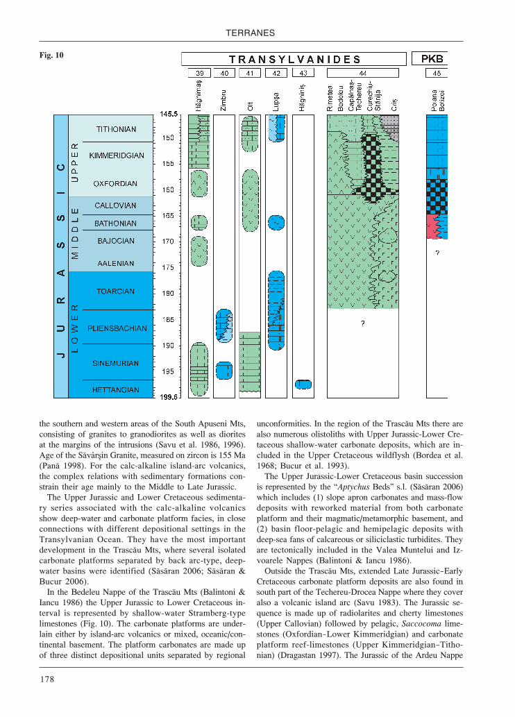
TERRANES
178
the southern and western areas of the South Apuseni Mts,consisting of granites to granodiorites as well as dioritesat the margins of the intrusions (Savu et al. 1986, 1996).Age of the Săvâr in Granite, measured on zircon is 155 Ma(Pană 1998). For the calc-alkaline island-arc volcanics,the complex relations with sedimentary formations con-strain their age mainly to the Middle to Late Jurassic.
The Upper Jurassic and Lower Cretaceous sedimenta-ry series associated with the calc-alkaline volcanicsshow deep-water and carbonate platform facies, in closeconnections with different depositional settings in theTransylvanian Ocean. They have the most importantdevelopment in the Trascău Mts, where several isolatedcarbonate platforms separated by back arc-type, deep-water basins were identified (Săsăran 2006; Săsăran &Bucur 2006).
In the Bedeleu Nappe of the Trascău Mts (Balintoni &Iancu 1986) the Upper Jurassic to Lower Cretaceous in-terval is represented by shallow-water Stramberg-typelimestones (Fig. 10). The carbonate platforms are under-lain either by island-arc volcanics or mixed, oceanic/con-tinental basement. The platform carbonates are made upof three distinct depositional units separated by regional
unconformities. In the region of the Trascău Mts there arealso numerous olistoliths with Upper Jurassic-Lower Cre-taceous shallow-water carbonate deposits, which are in-cluded in the Upper Cretaceous wildflysh (Bordea et al.1968; Bucur et al. 1993).
The Upper Jurassic-Lower Cretaceous basin successionis represented by the “Aptychus Beds” s.l. (Săsăran 2006)which includes (1) slope apron carbonates and mass-flowdeposits with reworked material from both carbonateplatform and their magmatic/metamorphic basement, and(2) basin floor-pelagic and hemipelagic deposits withdeep-sea fans of calcareous or siliciclastic turbidites. Theyare tectonically included in the Valea Muntelui and Iz-voarele Nappes (Balintoni & Iancu 1986).
Outside the Trascău Mts, extended Late Jurassic—EarlyCretaceous carbonate platform deposits are also found insouth part of the Techereu-Drocea Nappe where they coveralso a volcanic island arc (Savu 1983). The Jurassic se-quence is made up of radiolarites and cherty limestones(Upper Callovian) followed by pelagic, Saccocoma lime-stones (Oxfordian—Lower Kimmeridgian) and carbonateplatform reef-limestones (Upper Kimmeridgian—Titho-nian) (Dragastan 1997). The Jurassic of the Ardeu Nappe
Fig. 10

Jurassic environments in the Circum-Pannonian Region
179
(Mantea & Tomescu 1986) and the Vulcan Outlier (Bor-dea 1972) includes Ammonitico Rosso-type limestones(Oxfordian—Kimmeridgian) and Stramberg-type lime-stones (Tithonian—Berriasian).
East Carpathian Units
The main units of the unrooted Transylvanian NappeSystem in the Eastern Carpathians, which were obductedduring the Meso-Cretaceous tectogenesis, are the Per ani,Olt and Hăghima Nappes (Săndulescu 1984). They havedifferent lithostratigraphic successions and ages of theophiolitic complexes from the basal part of the nappes,excepting the Per ani Nappe where an ophiolitic com-plex is lacking. For the most part of them, the Triassic ageis well constrained by their close relationships with Tri-assic sedimentary rocks. The pillow basalts in Lacu Ro uinterpreted as a thrust slice underneath the HăghimaNappe, and the serpentinites in Rarău Mts are assigned tothe Callovian—Oxfordian (Săndulescu 1984).
The Hăghima Nappe, having the most internal paleo-geographic position in the Transylvanian realm, is madeup of a continuous sequence from the Upper Jurassic toLower Cretaceous (Săndulescu 1975a). The AmmoniticoRosso-type limestones (Upper Oxfordian—Middle Kim-meridgian) are followed by a siliciclastic sequence madeup of siltstones and marly shales (Upper Kimmeridgian—Lower Tithonian), and thick, massive Stramberg-typelimestones (Grasu 1971; Dragastan 1975) (Fig. 10).
The Per ani and Olt Nappes from the Per ani Mts aremade up of Triassic and Early to Middle Jurassic sedi-mentary rocks.
Based on the facies characteristics of the Triassic andLower Jurassic formations of the Transylvanian nappes,also of the olistoliths and olistoplakae embedded in theBucovinian Lower Cretaceous wildflysch, Patrulius(1996, posthumous paper) defined several independentsedimentary “Series”. They are as follows: the Zimbru“Series” (lower olistoplaka of the Rarău Mt), the Olt“Series” (Olt Nappe incl. the lower olistoplaka of thePer ani Mts), the Lup a “Series” (Per ani Nappe s.s.) andthe Hăghini “Series” (Hăghini Nappe, incl. upper olis-toplaka of the Rarău Mt).
In the Zimbru “Series” the Lower Jurassic includes:Lower Sinemurian, massive argillaceous, dark limestones(Turcule 1971); Pliensbachian sandy limestones andsilty marly shales (Stănoiu 1967a), which are olistolithswithin the Lower Cretaceous wildflysch (Fig. 10).
In the Olt “Series” of the Olt Nappe in the Per ani MtsLower Sinemurian Adnet Limestone unconformablyoverlies Upper Triassic Hallstatt-type limestones (Patru-lius et al. 1996). In the central Per ani Mts, also in theHăghima and Rarău Mts, there are several olistoliths ofred Middle Hettangian to Pliensbachian limestones as-sumed to have been derived from the Olt Nappe (Fig. 10).
In the Lup a “Series” of the Per ani Nappe the MiddleTriassic Schreyeralm-type limestone is unconformablyoverlain by the Gresten-type Racila Formation, around
300 m in thickness. Its lower member consists of coarse-grained limy sandstones and crinoidal sandy limestones(Upper Sinemurian? to Pliensbachian); the upper one iscomposed of grey marls and limestones with interbedsof violet sandy siltstone and oolitic limestone (Toar-cian—?Aalenian) (Fig. 10).
In the Hăghini “Series”, the Middle Triassic lime-stones in the Rarău Mts is overlain by thin Upper Het-tangian red, argillaceous-sandy encrinitic or oolitic topisolitic limestones (Fig. 10), which also fill narrow nep-tunian dikes in the Steinalm Limestone. On Norian mas-sive limestones of the Piatra oimului Outlier LowerJurassic bauxites occur, locally.
In the Rarău Syncline olistoliths with varied Jurassiclithologies were encountered, i.e. Toarcian dark sandy-limestones, grey-yellowish marlstones and siltstones,fine-grained limy sandstones and marly siltstones; Aale-nian grey marls with concretions of marlstones andoolitic limestones Bajocian dark limy-sandstones andsandy-limestones, bioclastic limestones and marls; Ba-thonian silty-oolitic limestones, sandy-limestones andlimy sandstones (Popescu & Patrulius 1964; Stănoiu1967a; Mutihac 1968; Turcule 2004). In the HăghimaSyncline olistoliths that are made up of Pliensbachiansandy limestones and argillaceous sandstones, Toarcianblack limestones or sandy-limestones and Middle Ju-rassic limy-sandstones and encrinitic limestones (Grasu1971; Săndulescu 1975a; Preda 1976) were reported.
From among the allochthonous deposits the Callov-ian-Hauterivian Carhaga Formation is of special impor-tance. It is made up of several sheet-olistoliths (Patruliuset al. 1976). The sequence includes the following mem-bers: (1) Callovian grey, reddish ammonite-bearing lim-estones with angular pebbles of crystalline schists;(2) Callovian and/or Oxfordian red radiolarites and lime-stones with radiolaria; (3) Upper Jurassic light-grey, pinkand red marls and marly limestones with spongiolithiccherts and interbedded conglomerates or breccia withpebbles of crystalline schists, thin layers of bentonite;(4) Tithonian light-grey or pink marls with small lensesof calcarenites and bedded white allodapic calcareniteswith brown cherts; (5) Uppermost Tithonian-Berriasiangrey-bluish glauconitic marls and light-grey ammonite-rich limestones with calpionellids and radiolaria; (6) Va-langinian and Hauterivian ammonite-rich soft marls.According to Săndulescu (1984), the olistoliths of theCarhaga Formation are presumably derived from a swellor they could be linked to the Olt or Per ani Nappes.
The TISIA Megaterrane (TISZA)
Mecsek Unit
Thin coal interlayers already appear in the fluvial suc-cession in the latest Rhaetian. At the beginning of theLiassic fluvial-lacustrine-palustrine sedimentation con-tinued but paralic coal-swamp deposits became predom-inant in the sedimentary record (Mecsek Coal) (Fig. 11).

TERRANES
180
The formation is made up of a cy-clic alternation of arkosic sandstone,siltstone, claystone and coal layers(Gresten facies). The thickness ofthe coal-bearing series is usually150—300 m; in the southern part ofthe Mecsek Mts, however, it mayattain 1200 m. This asymmetricthickening was the consequence ofthe formation of an extensional half-graben (Nagy 1969, 1971).
The basal (partially Rhaetian)part of the Mecsek Coal was formedpredominantly in lacustrine as wellas lacustrine/deltaic facies. TheHettangian middle member of theformation is mainly fluvial withchannel, flood plain and swamp fa-cies; however, passing upward, co-quinas of brackish-water molluscsappear in increasing frequency. TheLower Sinemurian upper member ofthe Mecsek Coal may have been de-posited in a tidal flat marsh envi-ronment. In the middle member ofthe Mecsek Coal thin (0.5—1.5 m)rhyolitic tuffite interlayers occur(Némedi-Varga 1983). In some lay-ers of the upper member remnants ofcrinoids also appear, indicating atemporary establishment of normalsalinity conditions.
The coal formation is overlain byfine-grained sandstone and darkgrey shale with upward-thinningsandstone interlayers showing adeepening upward trend. The thick-ness of the formation in the MecsekMts is 250—500 m.
deposited under open marine conditions in the deeper zoneof the open shelf. In the Pliensbachian grey, fine to medi-um-grained sandstone punctuated by thin shale interbedswas deposited. Chert nodules and grey, bituminous lime-stone and crinoidal limestone interbeds are common. Inthe rapidly subsiding southern zone of the Mecsek Mtsarea the thickness of the formation may attain 1000 m, andonly 70 m in its northern zone. The depositional environ-ment may have been a relatively deep, pelagic basin.
Upsection, silty marl becomes predominant again andthe share of sandstone decreases. This approximately150 m-thick formation represents the Lower and MiddleToarcian. In the Lower Toarcian a 10 m-thick, black shaleintercalation with thin sandstone and crinoidal limestoneinterlayers as well as thin-shelled pelagic bivalves andfish remnants can be found suggesting anoxic bottom-water conditions (Dulai et al. 1992).
Above the black shale intercalation the typical “Fleck-en-mergel” facies resumes. The Upper Toarcian to Mid-
During the later part of the Sinemurian water depthcontinued to increase. Coevally the continental sourcearea moved even farther away from the site of deposi-tion. In accordance with this paleogeographic settingan open marine deep basin had been the site of deposi-tion until the middle part of the Jurassic. In this basinfine-grained terrigenous material and pelagic biogenicooze were deposited together; however, their ratio con-tinuously changed. This heavily bioturbated marl se-quence is similar to the “Fleckenmergel” (Allgäu facies).In the rapidly subsiding southern zone of the Mecsekhalf-graben its thickness may attain 2000 m, whereas inthe northern part of this structural unit, as well as in thesubsurface parts of the Mecsek Zone (i.e. in the base-ment of the Transdanubian area and the Great Plain), itis generally only 150—300 m (Bércziné Makk 1998).
In the upper part of the Sinemurian the carbonate con-tent increases and grey, slightly bioturbated marl and cal-careous marl become characteristic. This formation was
Fig. 11

Jurassic environments in the Circum-Pannonian Region
181
dle Bajocian is characterised by a rather monotonous,200—500 m-thick sequence consisting of grey, stronglybioturbated marl, calcareous marl, and silty marl. It con-tains predominantly pelagic fossil elements (Vadász1935). In the southern and northern margins of the “Mec-sek Basin” grey and red crinoidal-brachiopodal lime-stone has been encountered.
At the end of the Bajocian the sedimentation charac-ter fundamentally changed: the amount of terrigenousmaterial and the sedimentation rate significantly de-creased; continuous and probably accelerated subsid-ence led to increased water depth. A significant changetook place also in the fossil assemblage that is manifest-ed in the appearance and then prevalence of Mediterra-nean elements (Géczy 1973; Vörös 1993a). Reflectingthe changes in the depositional regime the spotty marl(“Fleckenmergel”) facies is overlain by greenish-yel-lowish-reddish marl, then by red calcareous marl andfinally by nodular, argillaceous limestone rich in poorly-preserved ammonoids and pelagic microfossils (Fig. 11).This 10—20 m-thick formation of Bathonian age (Galácz1995) may have been deposited in a deep, pelagic, starvedbasin.
The next unit consists of deep-water brownish- andgreenish-grey, thin-bedded, siliceous calcareous marl ofCallovian and probably Early Oxfordian age. It also con-tains altered pyroclastics but only in a small quantity.The thickness of this formation does not exceed 10—20 m.The calcareous marl passes upward into Oxfordian sili-ceous limestone (Nagy 1986). In the basal part of theformation brownish-greenish, highly silicified radiolar-ite occurs. Above it, the 30—120 m-thick formation is madeup of thin-bedded, yellowish-grey, reddish, and greenishcherty limestone.
The Kimmeridgian to Lower Tithonian interval is rep-resented by 10 to 50 m thick red, nodular, locally chertySaccocoma limestones with ammonoids and aptychiwith features of the Mediterranean Ammonitico Rossofacies.
The red nodular limestone passes upward into UpperTithonian-Berriasian greyish- or yellowish-white, thin-bedded limestone and argillaceous limestone, locallywith intraclasts and chert nodules, similar to the Medi-terranean Biancone (Maiolica) facies. Its thickness mayattain 100 m. The site of deposition may have been adeep pelagic basin. Intrabreccia intercalations in the pe-lagic sequences and the chronostratigraphically mixedmicrofossil assemblage indicate a significant gravity massflow activity resulting in the redeposition of the uncon-solidated and semiconsolidated sediments (Nagy 1986).In the upper part of the formation, in addition to the rede-posited carbonate grains, fine pyroclastics and volcanicbombs appear in the layers, indicating the intensificationof volcanic activity in the Berriasian (Nagy 1986).
The changes in the sedimentary pattern and fossil as-semblages at the end of the Bajocian can be related tothe separation of the Tisia Megaterrane from the Euro-pean plate (Haas & Péró 2004).
Villány-Bihor Unit
The Jurassic sequence of the Villány-Bihor Zone isknown mainly in the Villány Mts in Hungary, and in theBihor Parautochthon in Northern Apuseni Mts in Roma-nia. Core data are only available for Malm formations inthe Pannonian Basin. In the Villány Mts, unconformablyoverlying the Upper Triassic rocks, the Jurassic seriesbegins with quartzarenite beds, grading upward into shal-low marine, sandy, crinoidal limestone with conglomer-ate interlayers (Fig. 11). In the conglomerate quartziteand dolomite components are recognised, indicating theproximity of a continental hinterland. The sandy, pebblylayers are overlain by yellowish-grey limestone, followedby grey, strongly bioturbated, thick-bedded, cherty, crinoi-dal limestone. Only 8—10 m-thick limestone formationcan be assigned to the Pliensbachian (Vörös 1989). Abovea hiatus a thin, yellow, sandy limestone bed, rich in Ba-thonian ammonites, occurs. It is overlain by an extremelycondensed limestone layer (Géczy 1982). Most of theammonites are characteristic of the European province; asmaller part of the assemblage, however, is Mediterra-nean (Géczy 1973).
The ammonite-bearing limestone is overlain by 300 mof thick-bedded, grey, brownish- or yellowish-grey lime-stone (Fig. 11). It is characterised by a peloidal and oolitic-oncoidal texture. In the lower part of the formation pelagicelements prevail in the microfossil assemblage. In theupper part, however, a typical shallow marine biofaciesappears and the pelagic elements disappear. The age ofthe formation is Oxfordian—Tithonian and its upper mem-ber may extend into the Berriasian (Bodrogi et al. 1993).
In the Bihor Unit, Jurassic deposits are found in thePădurea Craiului and Bihor Mts (Preda 1962, 1971; Patru-lius et al. 1972; Patrulius 1976a; Ianovici et al. 1976;Patrulius et al. 1976; Popa 1981; Mantea 1985; Popa etal. 1985; Dragastan et al. 1986).
In the Pădurea Craiului Mts, the Lower Jurassic succes-sion, around 250 m thick, unconformably overlies theLadinian Wetterstein-type limestone. A continental se-quence (100—180 m) occurs at the base of the successionconsisting of red argillaceous-silty shales locally includ-ing breccia with boulders of Triassic limestones. Upsec-tion there is another development that is similar to theGresten Sandstone. It is composed of micaceous quartzit-ic sandstones with interbeds of refractory clays in thelower part, with quartzitic conglomerates at the top (Het-tangian), with vegetal remains. The continental series isfollowed by a marine sequence (Fig. 12). It starts with abasal member (40—60 m) consisting of micaceous andfine-grained quartzitic sandstones, locally with marly-argillaceous micaceous siltstones (?Upper Hettangian—Lower Sinemurian). It is overlain by massive orthick-bedded Gryphaea limestones (5—35 m) with crinoi-dal layers (Upper Sinemurian—Lower Pliensbachian), andan upper successsion (3—40 m) of spongiolitic cherty lime-stones, silty or marly with brachiopods and ammonites(Upper Pliensbachian); a third member (5—15 m) of grey-

TERRANES
182
blackish condensed marls and marly/silty limestones withphosphate concretions, with abundant belemnites andammonites Gresten type (celto-suab) fauna (Toarcian).
The Middle Jurassic, which is strongly condensed inthe Pădurea Craiului Mts, rarely more than 10 m in thick-ness, with several breaks in sedimentation (Fig. 12) in-cludes the following carbonate units: (1) blackish,sometimes spotted marls (“Fleckenmergel”) and marly/silty limestones, less than 2 m in thickness (Lower Aale-
nian); (2) blackish spotted marly limestones (“Flecken-kalk”), with phosphate ooids and nodules, 0.8—3 m (Up-per Aalenian); (3) red-violaceous ferruginous oolitic/silty limestones and marls of minette-type (Lower Bajo-cian); (4) Entolium limestones (Middle Bajocian—Mid-dle Bathonian), and nodular limestones (0.2—0.5 m) withan abundant polyzonal ammonite fauna (Upper Batho-nian—Lower Callovian); (5) reddish to grey-greenish mar-ly or silty limestones (Middle and Upper Callovian).
Fig.
12

Jurassic environments in the Circum-Pannonian Region
183
During the Upper Jurassic, a carbonate platform wasestablished on the territory of the Bihor Unit. In the areaof the Pădurea Craiului Mts, the carbonate deposits,100—300 m thick, show two distinct facies zones with apassage zone: (1) a NW zone with basinal dark-greycherty limestones progress into pelagic Saccocoma lime-stones (Vad and Gălă eni Limestone, Oxfordian-lowerTithonian) followed by Stramberg-type, massive lime-stones (Cornet Limestone, Tithonian) or oolitic lime-stones (A tileu Limestone, Tithonian); (2) a SW zone withmassive, whitish limestones with corals and hydrozoans(Farcu Limestone, Oxfordian—lower Tithonian) followedby grey, bedded micritic/oncolitic limestones of lagoon-al facies (Albioara Limestone, Tithonian); (3) a transi-tional zone where all carbonate facies are found inascending order (Fig. 12).
Békés-Codru Unit
Surface occurrences of Jurassic formations of this unitcan be found in the Codru Nappe System in NorthernApuseni Mts (classed together with the Bihor Unit asInner Dacides by Săndulescu 1984) and in the PapukMts, Croatia. Jurassic sequences explored in the base-ment of the Békés Basin, Hungary can also be assignedto this unit.
In the Apuseni Mts, Jurassic formations are known inthe Codru-Moma, Pădurea Craiului and Bihor Mts (Patru-lius 1976a; Patrulius, in Ianovici et al. 1976 and Bleahuet al. 1981).
The Jurassic succession in the Vălani Nappe, Bihor Mts(Patrulius 1971b) includes: disconformable massive orthick bedded quartzitic-micaceous sandstones, 100 mthick, locally with basal conglomerates (Hettangian); asequence, only few meters thick, of dark shales (?Hettan-gian—Lower Sinemurian) and blackish bioclastic lime-stones (?Upper Sinemurian—Pliensbachian); after asignificant stratigraphic gap (Toarcian and the MiddleJurassic) the sedimentation resumed in the Late Jurassicwith bedded Saccocoma and Calpionella limestones in-terfingering with massive limestones of platform-edge andreef talus facies (Farcu and Cornet Limestones) (Fig. 12).
The Jurassic succession of the Fini Nappe is the mostcomplete in the Codru Nappe System. In the easa Valley,in the central area of the Codru Mts, a Rhaetian Kössen-type formation is overlain by 150 m thick silty shales(“Fleckenmergel”) (Lower Sinemurian), succeeded by a75 m thick calcareous formation, with grey silty limestonesin the lower, and red, sometimes nodular limestones in theupper part (Upper Sinemurian—Pliensbachian). In the Mo-neasa (SW Codru) area, the succession begins with a 200 mthick black sandstone unit with shales grading upwards toblack encrinitic limestones (Black Moneasa Limestone)(?Hettangian—Lower Sinemurian). It is overlain by encri-nitic, thick-bedded nodular and breccious red limestonesabout 80 m in thickness (Red Moneasa Limestone, UpperSinemurian—Pliensbachian) showing lithofacies compara-ble with the Adnet Limestone, but it has a Gresten type
(celto-suab) fauna. The Lower Jurassic formations areoverlain by pelagic, light grey micritic and cherty cal-carenitic limestones (Oxfordian—Kimmeridgian) fol-lowed by the Valea Mare Formation (Patrulius et al.1976), around 1000 m thick, including a pre-flysch fa-cies of marls and marly limestones with Aptychus andcalpionellids on the base (Tithonian—Berriasian).
The Următ Outlier in the Bihor Mts is made up of theLower Sinemurian-Pliensbachian “Următ Beds”. This se-quence starts with grey sandstones, which is succeededby encrinitic-micritic limestones containing basic volca-nic detritus, Gryphaea and brachiopods. This is followedby a siliciclastic turbiditic sequence with olistoliths andslumps, without fossils. The “Următ Beds” is overlain byKimmeridgian Saccocoma limestones (Bordea et al. 1975;Tomescu & Bordea 1976).
In the uppermost units of the Codru Nappe Systemonly Lower to lower Middle Jurassic deposits are present.In the Va cău Nappe (Codru-Moma Mts) (Panin et al.1974) the Jurassic succession unconformably overliesNorian-Rhaetian basinal limestones and includes: (1) alower sequence, 80 m thick, of pink-greenish micritic/crinoidal limestones associated with greenish marlylimestones and limy sandstones (Sinemurian); (2) a de-trital sequence that transgressively covers the lower se-quence and the Upper Triassic limestones. It consists oflimy sandstones, Holzschiefer-like black argillites withsideritic concretions, greenish cinerites, lenses of blackencrinitic limestones, platy black limestones with lay-ered cherts (Toarcian—?Aalenian). In the Cole ti Nappe(Codru-Moma Mts) (Panin et al. 1974), the Upper Trias-sic Dachstein Limestone has Lower to Middle Jurassicneptunian dykes.
In the basement of the Békés Basin, southeastern Hun-gary, Lower Jurassic red limestone was encountered in afew wells; it was identified as the Moneasa Limestone ofthe Fini Nappe (Bérczi-Makk 1998).
In a number of wells in the Békés Basin Upper Jurassicto Lower Cretaceous formations were found. The severalhundred m-thick series consists of grey and red clayeymarl, marl, calcareous marl and limestone layers with sand-stone intercalations in the upper part of the formation(Bérczi-Makk 1986).
In the Papuk Mts, Jurassic formations (overlying theUpper Triassic Kössen Formation) are known only atthe western edge of mountains, near Daruvar (Šikić et al.1975). It is a condensed succession (max. 100 m thick).
The Lower-Middle Liassic is represented by grey-pink-ish, crinoidal limestones, sometimes with chert nodules.The pelagic fossils (Bositra) appear in Upper Liassic mi-critic limestones. The thickness of the Lower Jurassic is25 m. The Middle Jurassic—Oxfordian (40 m) is typifiedby grey, pinkish, brownish-red Bositra limestones. Redand grey radiolarian chert beds are common. The Kim-meridgian—Middle Tithonian is represented by thick bed-ded grey limestone (10 m) with radiolarian chert bedswhich are overlain by Tithonian—Berriasian thin bedded,micritic cherty Calpionella-bearing limestones (20 m).

TERRANES
184
The DACIA Megaterrane
Danubian-Vrška Čuka-Stara Planina (-Prebalkan)Terrane
South Carpathian Units
The Danubian-Stara Planina-Vrška Čuka (-Prebalkan)Terrane corresponds in Romania to the Marginal Dacidesin sense of Săndulescu (1984). This terrane, together withthe neighbouring Moesia, represents a segment of theEuropean—?Asian margin, located outside the “external”Severin-Ceahlău ocean basin, which separated them fromthe Getic microcontinent. This terrane can be subdividednorth of the Danube into a Lower (External), and an Up-per (Internal) group of Alpine nappes (Stănoiu 1973; Berza1998; Iancu et al. 2005).
North to the Danube, the Jurassic-Lower Cretaceoussedimentary series overlie Variscan crystallines, rem-nants of a Variscan oceanic basement and Upper Paleo-zoic molasse deposits with sharp disconformity.
Lower (External) Danubian Nappes
Two distinct Mesozoic sedimentary zones were former-ly defined in the External Danubian realm, the Cerna andCo u tea Zones (Codarcea 1940; Năstăseanu 1979). TheCerna Zone (=Mehedin i-Retezat Zone, by Stănoiu 1973)is the equivalent of the Lower Danubian of Berza et al.(1983). Two Alpine tectonic units are recognized in theLower Danubian, i.e. the Lainici Unit, in the upper posi-tion, and the Schela Unit, below (Berza 1998). The sedi-mentary series of the Co u tea Zone is assigned to a distincttectonic unit, i.e. the Co u tea Nappe (Stănoiu 1996).
In the External Danubian realm, the Jurassic succes-sions are incomplete and discontinuous. The Lower Ju-rassic is represented by Gresten-type deposits in all areas(Fig. 13). In the Mehedin i Mts, the 50—350 m thick Baiade Aramă Formation yielded a rich flora (Drăghici et al.1964; Bădălu ă et al. 1988). In the Schela Unit, the strong-ly deformed and metamorphosed Lower Jurassic SchelaFormation starts with very coarse-grained metaconglo-merates succeeded by quartzitic and arkosic metasand-stones, graphitous phyllites in places with chloritoid, andpyrophyllitic schists with anthracite lenses (Manolescu1932; Semaka 1965). The Middle Jurassic marks the on-set of the marine sedimentation. It is represented by fos-siliferous limy sandstones and gritty limestones, 20 m inthickness (Stănoiu 1973).
The calcareous sedimentation which started in the Mid-dle Callovian and lasted in most part of the Early Creta-ceous characterized the Cerna Basin which covered thewhole area of the Lower Danubian (Stănoiu 2000). Sub-sequent to the Middle Callovian transgression, uniformpelagic sequences were settled all over the Cerna Basin.By the end of Kimmeridgian the paleogeographic pat-tern significantly changed; a central deep-water basinbordered by two carbonate platforms developed. The cen-
tral basin is typified by a continuous succession: (1) theMiddle Callovian to Lower Kimmeridgian Cerna VârfFormation (150—200 m thick) that is made up of strati-fied, blackish micritic limestones, with chert in the lowerpart; (2) the Upper Kimmeridgian to Neocomian Ponico-va Formation (200—300 m thick) consisting of greyishlimestones with Saccocoma in the lower part and calpi-onellids in the upper part.
The two marginal carbonate platforms are character-ized by shallow-water carbonate facies in the UpperKimmeridgian—Tithonian (Fig. 13). Emersion at the Juras-sic-Cretaceous boundary led to subaerial alteration andaccumulation of ferrilithic deposits. In the Mehedin i Mtsand SW Vâlcan Mts, the sedimentation resumed with theuppermost Tithonian?—Lower Berriasian Sohodol Forma-tion, a mixed siliciclastic-carbonate sequence with alluvi-al terrigenous deposits and lenticular intercalations ofpaludal or brackish micritic limestones.
In the NE Godeanu Mts, the Lainici Unit includes theLower—Middle Jurassic Albele Sandstone and the UpperJurassic—Lower Cretaceous Stănule i Limestone (Gherasiet al. 1986), which correspond to the deep-water basinfacies of the Cerna Basin (Stănoiu 2000).
The Co u tea Nappe is mainly occurring in the Mehe-din i Plateau, and includes also the Jurassic-Lower Creta-ceous allochthonous occurrences from the Tople -CazaneZone. The Jurassic to Lower Cretaceous has a continuousbasinal succession: (1) a 500 m thick Lower Jurassic Gres-ten-type sequence consisting of siltstone, grey-blackishmicaceous argillites with spherosiderites and grey orblackish quartz-feldspar sandstones; (2) a 30—50 m thickMiddle Jurassic siltic-argillitic deep-water sequence; (3) a20—50 m thick Middle Callovian-Lower Oxfordian deep-water sequence of argillites and grey siltstone grading tothin-bedded micritic limestones or marly limestones toits top; (4) a 10—30 m thick Upper Oxfordian—Kimmerid-gian sequence of cherty micritic limestones with clayintercalations at the top; (5) a 20—50 m thick Upper Kim-meridgian—Upper Tithonian—?Neocomian pelagic lime-stone sequence (Fig. 13).
Upper (Internal) Danubian Nappes
The facies of the Jurassic to Lower Cretaceous sedi-mentary series (Răileanu 1960; Rusu 1970; Popa et al.1977; Năstăseanu 1979; Avram 1984; Stănoiu 1997; Pop1998; Grigore 2000) demonstrate a complex paleogeo-graphy of the Internal Danubian realm. The most part ofthe Upper Danubian Nappes are exposed in the westernpart of the Danubian tectonic window (Iancu et al. 2005).Three major facies zones of Jurassic deposition existed inthe western Upper Danubian in the eastern Banat area,namely Sirinia, Presacina and Fene Zones (Fig. 13).
In the Sirinia Zone, the onlapping Gresten-type Het-tangian? to Lower Sinemurian deposits (50—450 m thick)start with coarse conglomerates succeeded by sandstonesand shales with coal seams (Semaka 1970). The marinedeposition started in the Late Sinemurian with two dis-
Jurassic environments in the Circum-Pannonian Region
185
tinct facies: (1) the Cozla-Bigăr sandy-marly facies, and(2) the Munteana sandy-calcareous facies.
The Cozla-Bigăr facies succession includes: UpperSinemurian calcareous and marly sandstones; Pliensba-chian limy or quartzose sandstones, siltstones and marlyshales; Toarcian thick-bedded whitish quartzose sand-stones, around 100 m thick, with levels of black silty claysgrading upwards to black fine-grained calcareous sand-stones with intercalations of argillaceous siltstones, 150 mthick; Aalenian massive, coarse-grained sandstones, lo-cally microconglomerates, grading upwards to limy sand-stones, 200 m thick (Fig. 13).
The Munteana facies is a condensed calcareous-silici-clastic succession rich in ammonites (Popa et al. 1977;Popa & Patrulius 1996; Callomon & Grădinaru 2005).The lower sequence (~60 m thick) consists of Upper Sine-murian to Pliensbachian sandy bioclastic—Fe-oolitic lime-stones, sandstones and siltstones, silty crinoidal limestones.The upper sequence (~20 m thick) is made up of Toarcianto ?Aalenian bedded sandy limestones and marly silt-stones grading upwards to sandstones (Fig. 13).
In the Sirinia Zone the Bajocian is typified by carbon-ates, 5 to 20 m in thickness. The Bathonian-Lower Call-ovian is represented by two facies: (1) the Bigăr faciescontaining marls and nodular limestones, 200 m in thick-ness; (2) extremely condensed (0.40 m thick) Fe-ooliticlimestones rich in ammonites (Răileanu 1960; Patrulius& Popa 1971; Galácz 1994).
From the Middle Callovian the pelagic carbonate sed-imentation became uniform in the Svini a Zone. TheMiddle to Upper Callovian red nodular limestones arefollowed by Oxfordian to Lower Kimmeridgian radiolar-itic marly limestones and calciturbidites, with bandedand nodular radiolarian cherts (25 m thick). The UpperKimmeridgian to Middle Tithonian is represented by red-dish or grey-greenish clayey nodular limestone with de-bris flow intercalations and coarse-grained calciturbiditessucceeded by thin bedded greenish pelagic limestoneswith rare intercalations of fine-grained calciturbidites(Greben Formation). It is followed from the Upper Titho-nian by Maiolica-type, light grey, cherty Calpionellalimestones (Năstăseanu 1979; Avram 1984).
The Jurassic succession in the Presacina Nappe corre-sponds to the Presacina facies zone of Năstăseanu (1979)and Năstăseanu et al. (1981). The Gresten-type LowerJurassic is represented by a fining-upward terrigenous se-quence, 800 to 1100 m thick, starting with Hettangian-Sinemurian conglomerates and sandstones, and continueswith Pliensbachian-Toarcian grey-blackish sandstonesgrading upwards to black clays. The siliciclastic sequenceends with Aalenian thick-bedded sandstones (100 to250 m thick). The open-marine carbonate sedimentationstarted in the Early Bajocian with deposition of calcare-ous sandstones (10 m thick). It was followed by the dep-osition of a condensed sequence (1.5 m thick), of darkgrey ammonite-rich, commonly oolitic limestones in theLate Bajocian—Early Bathonian. The remaining MiddleJurassic succession (around 15 m thick) consists of cher-
ty limestones. The Upper Jurassic succession (less than150 m thick) is pelagic, with bedded or massive, chertyradiolarian limestones (Oxfordian—Lower Kimmeridgian),nodular Saccocoma limestones (Upper Kimmeridgian—Lower Tithonian) and cherty Calpionella limestones andmarlstones (Upper Tithonian—Berriasian) (Fig. 13).
The Jurassic succession of the Fene facies zone as de-scribed by Năstăseanu (1979) is made up of two distinctJurassic successions which are allocated to different tec-tonic units (Berza et al. 1994). The Arjana Nappe includesexclusively a volcano-sedimentary sequence, 200 to 500 mthick, assigned to the Middle and Upper Jurassic (up toOxfordian). Pelagic carbonate deposits are intercalatedwith alkaline bimodal volcanic rocks (Gherasi & Hann1990; Russo-Săndulescu et al. 1996) (Fig. 13).
East Serbian Carpatho-Balkanides
South to the Danube, Jurassic sediments of the Danu-bian-Vrška Čuka-Stara Planina (-Prebalkan) Terrane arepresent in the Vrška Čuka-Miroč (Lower Danubian) andStara Planina-Poreč (Upper Danubian) Units (Karamataet al. 1997).
Vrška Čuka-Miroč Unit (Lower Danubian)
After the Late Carboniferous and Permian the area ofthis unit was a dry land until the Early Jurassic. In theHettangian-Sinemurian shallow depressions were filledby basal clastics and later by estuarine-lagoonal coal-bearing facies with sandstones, shales and semi-anthra-cite beds (Fig. 14). The Pliensbachian strata correspondto the shallow-water Gresten facies of the Eastern Alps.In the Toarcian deep-water black shales and carbonatelayers are present. The Lower Jurassic unit may reach300 m in thickness.
The whole area was submerged during the MiddleJurassic. Prevailingly up to 50 m thick neritic sediments(sandstones passing upward into sandy carbonates) weredeposited.
The Upper Jurassic sequence is 240 m thick in north-west but only 100 m in southeast. It consists of the shal-low-marine Oxfordian and Kimmeridgian carbonate rocks,followed by typical Tithonian reef and near-reef facies(Fig. 14). In these regions the Callovian—Kimmeridgianis made up of hemipelagic nodular limestones with chert.They are overlain by Tithonian to Berriasian deep-waterlimestones (Dimitrijević 1997) (Fig. 14).
Stara Planina-Poreč Unit (Upper Danubian)
After deposition of continental clastic sediments fromRhaetian to Lower Jurassic a new depositional cycle be-gan with deposition of terrigenous-carbonate successionsin depressions (Fig. 14). They are composed of marineconglomerates, sandstones, and shales including phos-phorite concretions, oolitic iron ores. These deposits arefollowed by Pliensbachian formations after a short break.

TERRANES
186
They have variable thickness from 10 to 250 m and areconformably overlain by some 50 m of almost black Toar-cian shales followed by a hiatus.
The transgressive Middle Jurassic is composed of quartzconglomerates and sandstones, later calcareous sand-stones (20—250 m), which are followed by Bathonian sand-stones and shales (15—20 m) and deeper marine Callovianlimestones and marlstones. This sequence is overlain bygrey and reddish Oxfordian and Kimmeridgian cherty
limestones, marly limestones, and radiolarites (max. 50 mthick). It is followed by Tithonian pelagic nodular lime-stones with cherts (~250 m thick). Reef facies also occurin the Tithonian, locally (Dimitrijević 1997) (Fig. 14).
Ćivćin-Ceahlău-Severin-Krajina Terrane
This terrane which is corresponding to the Outer Dacidesof Săndulescu (1984), can be divided into the following
Fig.
13

Jurassic environments in the Circum-Pannonian Region
187
segments: Eastern Carpathians (Ćivćin-Ceahlău-BlackFlysch Units), Southern Carpathians (Severin Unit), andEast Serbian Carpatho-Balkanides (Krajina Unit).
Ćivćin-Ceahlău-Black Flysch Units
These nappes originate from a Jurassic to Cretaceous(para)oceanic trench/trough, which was situated alongthe European margin (Severin—Ceahlău Ocean) (Săn-dulescu 1980, 1994). They are built up of a basic mag-matic basement that is covered by pelagic and flyschsediments. The greatest part of Jurassic formations canbe found in the innermost Black Flysch Nappe, whilethe main Ceahlău nappe is made up predominantly ofLower Cretaceous flysch (Săndulescu 1984, 1990).
The mafic complex of the Black Flysch Nappe is older,as the sedimentary formations. The within-plate conti-nental mafic complex is made up of submarine basaltflows and cineritic basic rocks (redeposited basalts, lime-stone breccias, Schalstein are also known), and are in-
truded by doleritic dykes and sills (Russo-Săndulescu etal. 1998). The oldest dated sedimentary rocks are pelagiclimestones with Saccocoma of Kimmeridgian or withcalpionellids of Tithonian age. Thus Middle Jurassic (orperhaps Lower Jurassic) age of the lowermost part of themafic complex is assumed, while Tithonian age of itsuppermost part is proved. In the external scales, the maficcomplex is covered by the Black Flysch (Tithonian—Neo-comian). It is preceded by the Mihailec-Vârtop Forma-tion (basal Malm) that consists of calcareous breccias andallodapic limestones (Fig. 13).
The Sinaia Beds is the most characteristic and wide-spread formation of the Ceahlău Nappe. Its oldest mem-ber, 100 to 200 m thick, has a preflysch character. It ismade up by grey-greenish marly shales, with scatteredintercalations of micaceous sandstone and calcareousbreccias (Tithonian). Dismembered slices or lenses (bou-dins) up to kilometer in size are squeezed into the lowerand middle parts of the Sinaia Beds. In these boudinsred and green cherts and shales are genetically linked to
Fig. 14

TERRANES
188
Fig.
15

Jurassic environments in the Circum-Pannonian Region
189
pillowed basalts (Azuga Beds, Upper Jurassic, up to theTithonian; tefănescu et al. 1979) (Fig. 13).
Severin Unit
In the Southern Carpathians the Severin Nappe corre-sponds to the Ceahlău Nappe in the Eastern Carpathians.The Severin Nappe of Codarcea (1940) is a tectonic mé-lange including Jurassic oceanic crust rocks and Titho-nian—Lower Cretaceous turbidites (Stănoiu 1997).
The ophiolitic complex is made up of peridotites (ser-pentinites), gabbros, dolerites, basalts and tuffs (Mărun iu1983; Savu 1985). It is overlain by red, green or greyshales, interbedded with basic tuffites and basalts, redand green radiolarites, cherty or marly limestone, andsandstones of the Azuga Beds (Upper Jurassic, up to theTithonian, Fig. 13). The deposition of the thick SinaiaBeds, with distal turbidites and Calpionella-pelagic lime-stones, began at the end of the Jurassic (late Tithonian)and continued in the Neocomian (Stănoiu 1978).
Krajina Unit
In the East Serbian Carpatho-Balkanides the KrajinaUnit (Grubić 1983; Dimitrijević 1997; Karamata et al.1999; Kräutner & Krstić 2006) corresponds to the Seve-rin Unit of Southern Carpathians in Romania.
The lowermost succession is classed to the “Azugabeds” that is made up of pelagic sediments (grey andpink siltstones, dark shales and sandstones with red cherts)and basalts. They are overlain by Upper Tithonian-Berri-asian flysch-type sediments: Sinaia Flysch (dark grey cal-carenite, olistostrome breccia-conglomerate and micabreccia) and its lateral equivalents, the “quasi-Sinaia Beds”which are more pelagic in character (Fig. 14).
The Kiloma tectonic window with Kiloma Metadia-base Formation (Tithonian-Neocomian basic metavol-canics, black shales and quartzites) belongs also to thisunit and may be equivalent to the Eastern CarpathianBlack Flysch Nappe.
Bucovinian-Getic-Kučaj (-Sredno Gora) Terrane
This terrane, which corresponds to the Median Dacidesof Săndulescu (1984), can be subdivided into the follow-ing regions: Eastern Carpathians (Central Eastern Car-pathian Nappe System), Southern Carpathians (Getic Unit)and East Serbian Carpatho-Balkanides (Kučaj Unit).
Bucovinian, Subbucovinian, Infrabucovinian Units
The Bucovinian, Subbucovinian and InfrabucovinianUnits form a Mid-Cretaceous nappe stack, assigned tothe Central Eastern Carpathian Nappe System (Săndules-cu 1984). After a Late Triassic continental period, in theEarly Jurassic condensed shelf sediments, punctuated byerosional gaps, were formed. The Early and Middle Juras-sic sedimentation (Mutihac 1968; Patrulius et al. 1968,
1972; Grasu 1971; Turcule 1971, 2004; Săndulescu1973, 1974, 1975a, 1976, 1984; Pop 1987) suggests aswell-type regime for the entire area, while during theLate Jurassic it was drowned and pelagic deposits andflysch sequences began forming. The Jurassic successionis typified by frequent unconformities that are overlainby transgressive sequences. The thickness of the forma-tions significantly decreases from the internal Bucovinianzone to the most external Infrabucovinian zone.
The Bucovinian Jurassic succession is the most repre-sentative and complete, infilling two large synclines inHăghima and Rarău Mts. In the Hăghima Syncline thesuccession starts with bauxites deposited on karstic surfac-es of Middle Triassic carbonatic rocks, locally. Red ooliticor encrinitic limestones and reddish platy limestones (5 to10 m thick) occur in the basal part of the marine sequence,which are assigned to Sinemurian and Lower Pliensba-chian (Patrulius 1964; Grasu 1971; Săndulescu 1975a).These are unconformably overlain by a Middle—UpperPliensbachian Gresten-type sequence starting with basalconglomerates succeeded by dark-coloured sandy lime-stones, calcareous sandstones and fine-grained clayey sand-stones. The Toarcian-Bathonian sequence, 20 to 270 mthick, is made up of grey-bluish sandy limestones with spon-giolithic cherts succeeded by micaceous, silty marls andfine-grained sandstones. Blackish micaceous sandy lime-stones and argillaceous-silty sequences with Bositra occurin southern regions (Dinu 1971; Grasu & Turcule 1978).
In the Rarău Syncline, the Lower Jurassic deposits areabsent and the Middle Jurassic deposits are unconform-ably overlying the Middle Triassic carbonate rocks. Theystart with a 40 m thick breccia sequence, followed by red-dish sandy, micritic or oolitic limestones (Stănoiu 1967b).
In the Subbucovinian Nappe and Infrabucovinian Units,the Lower and Middle Jurassic deposits are poorly devel-oped or absent (Fig. 15). Ferruginous quartzitic conglom-erates of supposed Lower Jurassic age and Middle Jurassicblackish calcareous sequences with Bositra occur in theSubbucovinic domain (Săndulescu 1974). Lower Juras-sic Gresten-type deposits, represented by metamorphosedblack siltstones and argillites with thin bedded sand-stones are known only in the most external Infrabucovin-ian Units, while Middle Jurassic sandy limestones occur inthe Iacobeni Unit (Săndulescu 1976).
During the Callovian and Oxfordian the whole Bu-covinian and Subbucovinian domains and partially theInfrabucovinian domain were affected by a major trans-gression. Variegated radiolarites with intercalations ofshales, siltstones, sometimes with tuffites and basic cin-erites, are well developed in the Bucovinian, and locallyin the Subbucovinian and Infrabucovian series (Stănoiu1967b; Turcule 1978; Dumitrică 1995).
In the eastern zone of the Hăghima Syncline, the ?Cal-lovian—?Oxfordian is represented by the Antaluc For-mation (Patrulius et al. 1976). It is a dark-coloured,homogenous silty-argillaceous sequence (max. 120 mthick) with fine-grained micaceous sandstones, calcaren-ites and sideritic marly limestone intercalations.

TERRANES
190
In the Per ani Mts, the Bucovinian sedimentary serieshas a thin Jurassic succession with frequent gaps(Fig. 15). A lower sequence, ( ~25 m thick) starts withtransgressive Upper Pliensbachian reddish-yellowishsandy oolitic limestones, upsection with Lower Toar-cian grey-blackish silty marls and marly limestones, andUpper Toarcian to Aalenian ferruginous oolitic andsandy ammonitic limestones (Patrulius 1996; Popa &Patrulius 1996). The Bathonian sequence (70 m thick)consists of whitish pseudoolitic or bioclastic limestones,and quartzose sandstones which unconformably over-lay older formations. The Callovian to Oxfordian se-quence is composed of reddish argillites and radiolarites,with grey sandstone, cherty limestone interlayers andthin intercalations of bentonites, and Kimmeridgian-Tithonian Aptychus-bearing greenish marly-sandy-limysequence (350 m thick) (Turcule & Grasu 1973; Patru-lius et al. 1976).
During the Tithonian the sedimentation became morediversified in the Bucovinian domain (Fig. 15). Along itsexternal part a flysch trough developed, site of depositionof the Tithonian-Berriasian Pojorâta Beds (200—300 mthick) (Săndulescu 1973), whereas in the more externalTarni a tectonic scale, the Tithonian?—Neocomian ClifeleBeds are made up of polymictic sandstones and silty-shaly sequences, with polymictic breccias (Săndulescu1981). The inner zone was the sedimentation area of theTithonian—Lower Valanginian Aptychus Beds (50—100 mthick) with a lower sandy-marly sequence succeeded by alimy-marly sequence (Turcule 1971; Săndulescu 1973,1976; Pop 1987). In the external zones of the HăghimaSyncline, the Tithonian-Neocomian is represented by theLunca Formation (max. 700 m thick) that is composed ofAptychus marls with intercalations of sandstones, cal-carenites and cherts (Patrulius et al. 1969; Grasu 1971;Grasu & Turcule 1973; Săndulescu 1975a).
In the Per ani Mts, the Stejaru Flysch (Tithonian—Neo-comian) is made up of two members: (1) limy sandstones,marlstones and marls, with calpionellids, and (2) a gritty-limy flysch above it ( tefănescu & tefănescu 1981).
Contemporaneously, in the Subbucovinian Nappepolymictic breccias with Calpionella limestones andmarly sequences were formed, whereas in the Infrabu-covinian Units shallow-water Clypeina-bearing carbon-ates were deposited (Săndulescu 1973, 1976).
A Callovian—Oxfordian (160 Ma) nepheline-syeniteintrusion (Ditrău) and dykes of Jurassic age are knownin the Bucovinian and Subbucovinian nappes. (Kräut-ner & Bindea 1998).
Getic Nappe and Supragetic Units
The Jurassic formations have the widest distributionin the Getic Nappe while in the Supragetic Units thereare only scarce and very incomplete successions.
Although there are similar facies in various areas andtime intervals, the different zones show distinct sedi-mentary features, which suggest complexity of the Ju-
rassic paleogeography in the Getic domain (Codarcea& Pop 1970; Patrulius et al. 1972) (Fig. 15).
After a Late Triassic uplift, the sedimentation startedin the early part of the Early Jurassic with Gresten-typedeposits overlain by hemipelagic Toarcian deposits.From the Late Callovian onward, troughs formed whichwere characterized by a continuous sedimentation lead-ing to deposition of thick successions with hemipelagicto pelagic sediments. In contrast, thin sequences withmany gaps were formed on swells. In the central andeastern areas of the Getic domain carbonate platformsbegan to form in the latest Jurassic.
Complete successions occur in the western area(Răileanu et al. 1964; Bădălu ă 1976; Năstăseanu et al.1981; Bucur 1997) (Fig 15). Coarse clastics occur at thebase of the Gresten-type sequence, they are followed bysandstones, siltstones and clays containing coal seamsand vegetal remains (Steierdorf Formation) of Hettangianto Sinemurian age (Semaka 1965; Givulescu 1998; Popa& Van Konijnenburg-Van Cittert 2006). Pliensbachianblack bituminous shales containing spherosiderites andcoal lenses (~ 200 m thick) are overlain by a Toarciansilty argillaceous ammonitic sequence (10 to 15 m thick)(Mutihac 1959). In the Middle Liassic alkaline trachyteand basalt volcanism took place. In the central area thereis a 90 m thick continuous succession from the Aalenianto Lower Callovian, with hemipelagic Bositra spotty marlsand marly limestones. In the eastern marginal area, a trans-gression took place during the Middle Jurassic that re-sulted in depositon of basal coarse-grained sandstonesand later on, in the Bathonian to Early Callovian sand-stones and marly limestones (Boldur et al. 1964).
The Middle Callovian consists of sandy limestoneswith cherts (15 to 20 m thick). In the eastern marginalarea crinoidal limestones, or glauconitic sandy limestonesdeveloped coevally (Răileanu & Năstăseanu 1965). Theygrade upwards into Upper Callovian—Lower Oxfordianmedium-bedded, dark grey marls (80 to 100 m thick).The occurrence of Kosmoceras in this formation demon-strates close connection of this unit to the Boreal realm(Patrulius & Popa 1971; Bădălu ă 1976).
The Upper Oxfordian to Lower Berriasian interval ischaracterized by pelagic and allodapic limestones, band-ed or nodular cherts (250 to 300 m thick); Upper Oxford-ian—Lower Kimmeridgian), Ammonitico Rosso-typeSaccocoma limestones (50 to 100 m thick; Upper Kim-meridgian—Lower Tithonian), Maiolica-type limestones(100 to 200 m thick; Upper Tithonian—Middle Berriasian).
In the Re i a and Sasca-Gornjak Nappes the Bajocian?to Callovian formations lie transgressively either onPermian or Middle Triassic rocks with basal microcon-glomerates, sandstones, bioclastic and cherty nodularlimestones (Bucur et al. 1997). In the Supragetic do-main a carbonate platform developed in the Middle Ju-rassic (Bucur 1997) (Fig. 15).
In the central part of the Southern Carpathians (Fig. 15)the Jurassic succession starts also with a Lower JurassicGresten-type formation (100 to 125 m thick). It grades

Jurassic environments in the Circum-Pannonian Region
191
upwards to a Middle Jurassic mixed siliciclastic-carbon-ate sequence, around 100 m thick. The Oxfordian—LowerKimmeridgian is represented by marly and cherty-calcar-eous successions which is overlain by Stramberg-typemassive reefal limestones (Stilla 1985). In other areas theJurassic transgression started in different times, and insome places the pre-Jurassic basement is directly coveredby Stramberg-type limestones.
In the eastern part of the Southern Carpathians (Fig. 15),the Jurassic of the Getic domain is typified by various fa-cies and complex stratigraphic relationships (Săndulescu1964, 1984; Patrulius et al. 1968, 1976; Patrulius 1969,1976b; Săndulescu et al. 1986). In the Cristian and Holbavregions the Lower Jurassic is represented by Gresten-typedeposits, reaching 250 m in thickness. The coal-bearingsuccession with refractory clays occurs in the Hettangian-Sinemurian interval (Semaka 1965; Philippe et al. 2006)although in the Holbav region the coal accumulationlasted till the Lower Toarcian (Antonescu 1973). In theCristian region the marine influences initiated in the earli-est Sinemurian, while in the Pliensbachian—Toarcian themarine sedimentation became general, leading to deposi-tion of micaceous hemipelagic sandstones. Alkaline vol-canic rocks (rhyolitic ignimbrites, basalts and trachytes)are common (Săndulescu et al. 1986).
The Middle Jurassic is transgressive and shows differ-ent facies in the eastern Getic domain (Patrulius 1969;Lazăr 2006) (Fig. 15). In some part of this domain theBajocian is typified by shallow-water fossiliferous mixedsiliciclastic-carbonate deposits, of variable thickness,from 3 to 55 m. It directly overlays the crystalline base-ment. The Bathonian—Lower Callovian interval is con-densed, less than 1.5 m thick. It consists of ammoniticlimestones with ferruginous ooids and nodules. Thestarved sedimentation and planktonic foraminifera dem-onstrate the onset of marked deepening of the regionthat progressed with the deposition of the radiolarites.In other parts of the domain, quartzose conglomeratesand sandstones transgressively onlap the Toarcian mi-caceous sandstones. The Lower Bathonian silty claysand marls are followed by Upper Bathonian—LowerCallovian marly-silty and limy deposits with Bositra(more than 100 m thick). Locally, on elevated areas ofthe crystalline basement, a transgressive carbonate se-quence occurs. It starts with a basal breccia and continuesupwards with alternating Middle to Late Callovian red-dish micritic limestones and brown-yellowish bioclastic-sandy limestones (Simionescu 1899).
A deep-water sedimentary sequence with cherty lime-stones and variegated radiolarites (less than 1.5 m thick)occasionally with basic volcaniclastics characterize theMiddle Callovian to Oxfordian interval (Beccaro & Lazăr2007). In some places the Callovian radiolarites are un-conformably overlain by pelagic limestones and marls ofLate Oxfordian to Neocomian age (Pre-Leaota Group; lessthan 100 m thick). Lower Kimmeridgian AmmoniticoRosso-type limestones (less than 10 m thick) occur onlylocally. The Late Kimmeridgian to Early Valanginian
interval is represented by a thick succession (up to 900 m)of Stramberg-type limestones.
In contrast to the eastern Getic Units where a mostlycomplete Jurassic to Lower Cretaceous sequence is present,in the eastern Supragetic Units the Jurassic to Lower Creta-ceous deposits are almost absent, suggesting a swell-typeregime of the Supragetic domain (Săndulescu 1966). Lo-cally the Middle Triassic rocks are unconformably over-lain by a thin sequence with Lower Jurassic coal-bearingdeposits and marine encrinitic limy sandstones.
Kučaj Unit (Getic)
In the Bajocian basal clastics and oolitic limestoneswere formed transgressively above a Middle Triassic toCarnian basement. After that, in the largest, eastern partof the unit shallow-water sediments of a carbonate plat-form were developed up to the Aptian. In the westernregions of the unit Callovian-Tithonian deep-water de-posits are present (Fig. 14).
Kraishte Terrane
East Serbian Carpatho-Balkanides
The Kraishte Terrane is primarily present on the territo-ry of Bulgaria and the Lužnica Unit of the East SerbianCarpatho-Balkanides as prolongation of the west Kraish-te. It is characterized mainly by thick flysch deposits inthe Upper Jurassic (Ruj flysch) and a specific basement(e.g. Diabase-Phyllitoid and other units).
Lužnica Unit (West Kraishte)
Lower Triassic deposits are transgressively covered byLower Jurassic quartz conglomerates, micaceous sand-stones (with coal deposits) and shales. This sequence isconformably overlain by Middle Jurassic coarse grainedsandstones and sandy limestones sporadically with ooliticiron ores (20 m). Then follow 50—100 m thick Oxford-ian—Kimmeridgian limestones with chert nodules, andsubordinately dolomitic limestones and dolomites.
The Ruj flysch principally characterizes the unit (Dimi-trijević 1997). Sedimentation is initiated by ?Middle Ju-rassic pre-flysch followed by sandstones, olistostromesand calcarenites. Reef limestones and cherty limestoneswere formed during Tithonian. Discontinuous bodies ofblack non-flysch shales, and olistoliths of Upper Jurassiclimestones of various shape and size (up to 1000 m3) arealso characteristic. Total thickness of the formation ismore than 1700 m in the proximal part.
Jurassic evolutionary history
In the Late Triassic to Early Jurassic spreading in theNeotethys realm still continued. Closure of the westernNeotethys realm started in the late Early to Middle Ju-

TERRANES
192
rassic and it was usually completed by the Late Jurassic.However, in connection with the opening of the centralAtlantic Ocean a new oceanic branch started to open bycontinental rifting from the Late Triassic and progressedto ocean opening from the late Early Jurassic onward(Piedmont-Penninic Ocean or “Alpine Tethys” – Frisch1979; Dercourt at al. 1986; Stampfli et al. 1991; Frischet al. 1998; Dercourt et al. 2000; Plašienka 2002; Stampfli& Borel 2002; Csontos & Vörös 2004; Golonka 2004;Golonka & Krobicki 2004; Haas & Péró 2004). Thisresulted in dismembering of some parts of the EurasianPlate and reorganisation of the plate fragments betweenthe Eurasian and Gondwana plates. So, coeval develop-ment of the two ocean systems controlled basically theJurassic evolution of the Circum-Pannonian region.
During Early to Middle Jurassic the ocean basin wichseparated Eurasia (with attached units) and Gondwana(Adria/Apulia) was still large, in spite of narrowing be-cause of subduction that took place along an intraoce-anic subduction zone (e.g. Nicolas & Boudier 1999; Dilek& Flower 2003; Karamata 2006; Koller at al. 2006). Onthe margin of the Adria/Apulia, evolution of huge car-bonate platforms continued during the entire Jurassic (andeven during the Cretaceous) exporting large amount ofcarbonate mud and grain to the newly formed trenches;some of them became part of the Neotethyan accretion-ary complex in the course of the subduction and ophio-lite obduction. This process was accompanied by intensegravity mass movements that resulted in the formation ofdeep-water chaotic deposits (Gawlick et al. 1999; Dimitri-jević et al. 2003) in the trenches. In the Late Jurassicclosure of this basin was mostly completed and it wasfollowed by strong erosion. The nappe stacks as well asthe ophiolites were covered by platform limestones dur-ing Kimmeridgian to Berriasian.
Large parts of the huge Late Triassic carbonate plat-forms developed all around the Neotethys margin drownedat the Triassic-Jurassic boundary. In the early part of theEarly Liassic the western Penninic-Piedmont related partof Apulia/Adria (western part of the South Alps and theTransdanubian Range) were subject to intense rifting thatresulted in the formation of rift-related basins. Coevallylarge extensional basins came into existence along theEuropean margin (Helvetic, Pieniny, Mecsek, Getic-KučajUnits) – site of deposition of fluvial-deltaic- and paral-ic coal swamp facies (Gresten facies) in the Rhaetian toEarly Sinemurian interval. This process can be consid-ered as an incipient stage of evolution of the Piedmont-Penninic Ocean. The continental to shallow-marinesiliciclastic sedimentation was followed by depositionof bioturbated shale in an upward deepening basin fromthe Late Sinemurian to the Bathonian. Both Tatric Unitof the Western Carpathians and Villány-Bihor Unit ofthe later Tisia Megaterrane preserved their swell posi-tion and large parts of these areas were subaerially ex-posed for shorter or longer time.
Double effect of continuing Neotethys rifting and incip-ient rifting (sinistral transtension) of the Piedmont-Pen-
ninic Ocean (Frisch 1979; Ratschbacher et al. 2004) result-ed in step by step disruption and drowning of the stillexisting platforms between the two oceanic basins duringthe Early Jurassic (Plašienka 1998; Gawlick et al. 1999;Haas 2002). In the Pliensbachian/Toarcian most of the car-bonate platforms were subject to drowning in the studiedregion with exception of the huge Adriatic Carbonate Plat-form that maintained during the entire Jurassic and evenduring the Cretaceous (Dragičević & Velić 2002).
In connection with the opening of the Atlantic Ocean,spreading of the Piedmont-Penninic Ocean led to sepa-ration of the Austroalpine—Central Western Carpathianand the Tisia Megaterranes from other parts of the Euro-pean plate (Faupl & Wagreich 2000; Golonka & Kro-bicki 2004; Haas & Péró 2004). However, according tothe relevant paleomagnetic data, prior to the Hauterivi-an the Tisia Megaterrane moved together with the Euro-pean plate and its real dismembering and remarkablerotation began only at that time (Márton 2000).
The Penninic Ocean continued eastward in the sup-posed “Vahicum” (Penninic-Vahic Trough), althoughremnants of the oceanic basement are missing (Plašienka1998, 2000). Further eastward in the Krichevo-Ceahlău-Severin zone the rifting processes began in the EarlyJurassic along the European margin and led to the sep-aration of a continental sliver corresponding to the Bu-covinian-Getic-Kučaj Terrane of the Eastern and SouthernCarpathians and East Serbian Carpatho-Balkanides (Săn-dulescu 1984, 1988). It was accompanied with forma-tion of volcano-sedimentary sequences and intrusions.The oceanic basin reached its maximum extension atthe end of the Middle Jurassic coeval with onset of thesubduction. A significant crustal shortening took placein the latest Tithonian to earliest Cretaceous.
In the late Early Jurassic to Middle Jurassic, parallel toopening of the Piedmont-Penninic Ocean, subduction ofthe Neotethys initiated, which resulted in the formationof accretionary wedges by the Late Jurassic (Mello et al.1996; Karamata et al. 2005; Halamić et al. 2005; Gawlicket al. 2008). More of less displaced remnants of them arepreserved in the Vardar Zone, Dinaridic Ophiolite Belt,Mure Ophiolite Zone, Darnó-Szarvaskő Units and Meli-ata-Hallstatt Zone.
During the late Middle to Late Jurassic period deep-seaconditions prevailed over a predominant part of the Alca-pa, Tisia and Dacia Megaterranes. However, at the begin-ning of the Callovian a significant change took place inthe sedimentation pattern, deposition of condensed pelag-ic carbonates were followed by deposition of radiolarites.
At the same time gravity mass-flow deposition initi-ated in the southern part of the NCA and somewhat laterin the Oxfordian in the northern part, indicating the clo-sure of the Neotethys in this region. The mass-flow de-posits were covered by platform carbonates (PlassenCarbonate Platform) of Kimmeridgian to Early Berria-sian age (Gawlick & Schlagintweit 2006). Similarly, inthe Main Vardar Zone the accretionary complex wastransgressively overlain by Tithonian reef limestones

Jurassic environments in the Circum-Pannonian Region
193
(Karamata et al. 2000) as well as the Mirdita ophiolitesas southward continuation of the DOB (Schlagintweitet al. 2008). The Pogari Series (North Bosnia) also con-taines blocks of Tithonian platform carbonates. Extend-ed Late Jurassic to earliest Early Cretaceous carbonateplatforms topped the island volcanic arcs in the MureZone, feeding with debris the oceanic basins where pe-lagic sediments (Aptychus beds) where deposited (Săsă-ran 2006; Săsăran & Bucur 2006).
In the pelagic basins the radiolarian rich deposits wereusually overlain by red and grey Saccocoma limestonesin the Kimmeridgian to Early Tithonian and Biancone-type Calpionella limestones in the Late Tithonian toEarly Cretaceous.
The Tatric and Veporic (Fatric) Units of the Austroal-pine—Central West Carpathian Terrane (Plašienka 1998)as well as the Villány-Bihor Unit in the Tisia Megater-rane (Haas & Péró 2004) and also parts of the Bucovin-ian-Getic-Kučaj Terrane (Median Dacides) (Săndulescu1984) that were located relatively far both from the Pen-ninic and the Neotethys realms still preserved their rela-tively elevated (swell) position.
In the Getic and Lower Danubian Units in the SouthernCarpathians, the Oxfordian to Early Kimmeridgean pe-lagic deposits were covered by Late Kimmeridgian toTithonian Stramberg-type platform carbonates with reefdeposits. Tithonian reef limestones were formed in theStara Planina-Poreč and Vrska Čuka-Miroč Units of theEast Serbian Carpatho-Balkanides.
Conclusions
During the Jurassic as a consequence of the openingof the Atlantic related Piedmont-Penninic Ocean nearto the western end of the still developing Neotethys apeculiar geodynamic situation came into existence inthe Circum-Pannonian Region.
In the earliest Jurassic paleo-position of the structuralunits i.e. the later terranes did not changed significantlycomparing to their Middle to Late Triassic setting. Thebasic geodynamic changes began in the late Early toMiddle Jurassic when the opening of the Piedmont-Pen-ninic (-Vahic), and Ceahlău-Severin Oceans resulted indismembering of parts of the Eurasian plate margin lead-ing to formation of several continental plate fragments(Austroalpine—Central Western Carpathian, Tisia, Bu-covinian-Getic-Kučaj) which played important role in thesubsequent history.
The next main evolutionary stage was subduction inthe Neotethys realm in the latest Early Jurassic to earlyLate Jurassic period. Radiometric age data for amphibo-lite facies metamorphic soles (data see in the descriptionof the Dinaridic Ophiolite Belt and Vardar Zone; Kara-mata 2006) beneath large ultramafic bodies constrainJurassic thrusting of the oceanic basement. Middle to earlyLate Jurassic obduction was directed onto the Adriatic/Apulian margin (Schmid et al. 2008; Gawlick et al. 2008)
and it was post-dated by the overlying latest Jurassic plat-form carbonates. These processes resulted in the forma-tion of ophiolite nappes and accretionary complexes ofcomplicated internal structure and history of develop-ment. In the course of this processes (i.e. the “Eohellenicphase”; Jakobshagen 1986) the oceanic sediments weresubject to strong deformation, the attenuated continentalcrust crushed and nappe-stacks were formed which wasaccompanied by metamorphism of the deepest nappe.Basins developed in connection with the nappe stackingwere filled up by reworked material of the nappes.
The suture zone of the Neotethys can be continuous-ly followed in the Serbian-Bosnian sector of the Dinar-ides—Vardar Zone, although it was subject to multistagenappe stacking and multiple redeposition of the com-ponents of the ophiolite mélange after the Jurassic.
In the Transilvanides, representing also a segment ofthe Neotethys, remnants of the oceanic basin (island arcand back-ark complexes and flysch) occur in nappesthat were emplaced onto the SE margin of the TisiaMegaterrane (Metaliferi Mts, Southern Apuseni) in theLate Cretaceous. Displaced remnants of the oceanic base-ment also appear in the Eastern Carpathians, Dacia Mega-terrane in the Mid-Cretaceous obducted TransylvanianNappe System, and in smaller or larger blocks in theLower Cretaceous Bucovinian wildflysch.
Deformations and nappe stackings due to closure ofthe Neotethys (Jurassic to Cretaceous/Paleogene) andthe various Jurassic-Cretaceous oceanic basins of theLigurian-Piedmont-Penninic realm (Late Cretaceous toNeogene) and accordingly interactions among the mi-crocontinental blocks led to significant displacements/rotations. However, real terrane disruption and large scaledispersion of the northwestern Neotethys remnants tookplace mainly in the Tertiary via NE-ward movement ofthe Gemer-Bükk-Zagorje Composite Terrane between thePeriadriatic and the Mid-Hungarian lineaments, in theMid-Hungarian shear zone (Csontos & Nagymarosy1998). That is why displaced parts of the Kalnik Unit,that is the NW-most remnant of the Neotethys suture zoneof the Adria-Dinaria Megaterrane, can be found in theterritory of NE Hungary (Bükk-Darnó area).
On two sides of the Mid-Hungarian shear zone (Gemer-Bükk-Zagorje Composite Terrane) real exotic terranesconstruct the basement of the Pannonian basin: the Ba-konyia Terrane (Transdanubian Range Unit) represent-ing a dislocated fragment of Adria and the TisiaMegaterrane which belonged to the European margin un-til the Middle Jurassic. Differences in the paleogeographicsetting of these terranes are reflected in their significant-ly different development in the Devonian to Jurassic in-terval. This characteristic pattern of the basement makesthe Pannonian Basin one of the best examples for theexotic terranes which are demonstrated on the sheets ofthe terrane map series of the Circum-Pannonian Region.
Acknowledgments: The work presented in this study wassupported by the Hungarian National Research Found

TERRANES
194
(OTKA) Grants No. T 47121 (SK) and K 61872 (JH), andby the Austrian-Hungarian bilateral Scientific and Tech-nological programme Project No. AT-8/2007. The re-search of the authors from Serbia (SK, MS) was supportedby the Ministry of Science of the Republic of Serbia,Projects No. 146013 and 146009; in Austria (HJG) bythe Austrian-Hungarian bilateral Scientific and Tech-nological programme Projects No. HU 14/2005 andHU 5/2008; in Romania (EG) by the Romanian Acade-my, Grant No. 188, 77/2005—74/2006, and by CNCSISProject No. 1669/2007—2008.Reviews of Prof. J. Golonka and Doc. J. Michalík im-proved the manuscript.
References
Andrusov D. 1964, 1965: Geologie der tschechoslowakischenKarpaten. I—II. Verl. Slowak. Akad. Wiss., Bratislava, Akad-emie-Verlag, Berlin, I, 1—263; II, 1—433.
Andrusov D. 1968: Grundriss der Tektonik der Nördlichen Kar-paten. Verl. Slowak. Akad. Wiss., Bratislava, 1—188.
Antonescu E. 1973: Quelques données sur la palynologie duLias sous facies de Gresten de Roumanie. Palynology ofMesophite, Proceedings of the 3rd International Palynolog-ical Conference. Ed. Nauka, Moscow, 13—27.
Árgyelán G. & Gulácsi Z. 1997: Acidic extrusive and plutonicrock fragments in the siliciclastic sediments of the Darnóand Szarvaskő Unit. Terra Nostra, Sediment’97 Kurzfas-sungen, 1—3.
Árva-Sós E., Balogh K., Ravasz-Baranyai L. & Ravasz Cs. 1987:K/Ar dates of Mesozoic igneous rocks in some areas ofHungary. Ann. Rep. Hung. Geol. Inst. 1985, 295—307 (inHungarian with English abstract).
Avram E. 1984: Remarques stratigraphiques sur la formation deMurguceva (Tithonique supérieur-Hauterivien) de la régionde Svini a (Banat), basées sur l’étude des Calpionelles. Dăride Seamă, Inst. Geol. Geofiz. 68, 4, 17—34.
Babić Lj. 1981: The origin of “Krn breccia” and the role of theKrn area in the Upper Triassic and Jurassic history of theJulian Alps. Vesnik Zavoda za geol. i geof. istraž., A. Geologi-ja 38/39, 59—88.
Bădălu ă A. 1976: Précisions biostratigraphiques sur la sériemésozoique d’Anina (Zone Ré i a, Banat). Dări de Seamă,Inst. Geol. Geofiz. 62, 4, 73—84.
Bădălu ă A., Preda I. & Culda V. 1988: Sur le Liasique du sommetCulmea Obîr ia (zone Obîr ia Clo ani – Monts Mehedin i).Anal. Univ. Buc., Geol. 37, 23—30.
Balintoni I. & Iancu V. 1986: Lithostratigraphic and tectonicunits in the Trascău Mountains north of Mînăstirea valley.Dări de Seamă, Inst. Geol. Geofiz. 70—71, 5, 63—86.
Balla Z. 1984: The Carpathian loop and the Pannonian basin: akinematic analysis. Geophys. Trans. 30, 313—353.
Balla Z. 1987: Cenozoic paleomagnetic data for the Carpatho-Pannonian region in the light of Miocene rotation kinemat-ics. Tectonophysics 139, 67—98.
Bauer F.K., Cerny I., Exner C., Holzer H.-L., Van Husen D.,Loeschke J., Suette G. & Tessensohn F. 1983: Erläuterungenzur geologischen Karte der Karawanken 1: 25000, Ostteil.Geol. B.—A. 1—86.
Baumgartner P.O., Martire L., Goričan Šp., O’Dogherty L., ErbaE. & Pillevuit A. 1995: New Middle and Upper Jurassicradiolarian assemblages co-occuring with ammonites andnannofossils from the Southern Alps (Northern Italy). In:Baumgartner P.O., O’Dogherty L., Goričan Šp., Urquhart E.,Pillevuit A. & De Wever P. (Eds.): Middle Jurassic to lowerCretaceous Radiolaria of Tethys: Occurrences, systematics,biochronology. Mém. Géol. (Lausanne) 23, 1—1143.
Baumgartner P.O., Bernoulli D. & Martire L. 2001: Mesozoic
pelagic facies of the Southern Alps: Palaeotectonics andpalaeoceanography. In: Funk H. & Wortmann U.G. (Eds.):Excursion guides. IAS 2001, Davos: Excursion A1, 1—19.
Beccaro P. & Lazăr I. 2007: Oxfordian and Callovian radiolariansfrom the Bucegi Massif and Piatra Craiului Mountains (SouthernCarpathians, Romania). Geol. Carpathica 58, 4, 305—320.
Bérczi-Makk A. 1986: Mesozoic formation types of the GreatHungarian Plain. Acta Geol. Hung. 29, 261—282.
Bérczi-Makk A. 1998: The stratigraphy of the Triassic and Jurassicformations of the Great Hungarian Plain and the TokajMountains. In: Bérczi I. & Jámbor Á. (Eds.): The stratigraphyof the geological formations of Hungary. MOL Rt-MÁFI,Budapest, 281—298 (in Hungarian).
Bérczi-Makk A. 1999: Foraminiferal stratigraphy of Jurassic bedsin Bükkzsérc (N-Hungary). Földt. Közl. 129, 363—392.
Bernoulli D. 1964: Zur Geologie des Monte Generoso. EinBeitrag zur Kenntnis der südalpinen Sedimente. Beitr. Geol.Karte Schweiz, N.F. 118, 1—134.
Bernoulli D. & Jenkyns H.C. 1974: Alpine, Mediterranean andCentral Atlantic Mesozoic facies in relation to the earlyevolution of the Tethys. SEPM Spec. Publ. 19, 129—160.
Berza T. 1998: The South Carpathians. Monograph of SouthernCarpathians. Reports on Geodesy 7, 37, 85—91.
Berza T., Kräutner H.-G. & Dimitrescu R. 1983: Nappe Structurein the Danubian Window of the Central South Carpathians.An. Inst. Geol. Geofiz. 60, 31—39.
Berza T., Balintoni I., Iancu V., Seghedi A. & Hann H.P. 1994:South Carpathians. In: Berza T. (Ed.): Geological Evolutionof the Alpine-Carpathian-Pannonian system, ALCAPA II,Field Guidebook. Rom. J. Tect. Reg. Geol. 75, 2, 37—49.
Bill M., O’Dogherty L., Guex J., Baumgartner P. & Masson H.2001: Radiolarite ages in Alpine-Mediterranean ophiolites:constraints on the oceanic spreading and the Tethys-Atlanticconnection. Bull. Geol. Soc. Amer. 113, 129—143.
Birkenmajer K. 1977: Jurassic and Cretaceous lithostratigraphicunits of the Pieniny Klippen Belt, Carpathians, Poland. Stud.Geol. Pol. 45, 1—159.
Birkenmajer K. 1998: Evolution trends in basinal deposits ofJurassic-Early Cretaceous age – Examples from the WesternCarpathians and the Northern Calcareous Alps. Acta Geol.Hung. 41, 283—311.
Blau J. & Schmidt T. (1988): Tektonisch kontrollierte Sedimentationim Unterlias der Lienzer Dolomiten (Österreich, Osttirol, Kärnten).Mitt. Gesell. Geol. Bergbaustud. Österr. 34/35, 185—207.
Bleahu M., Lupu M., Patrulius D., Bordea S., tefan A. & Panint. 1981: The Structure of the Apuseni Mountains. Guide to
excursion B3, 12th Congr. CBGA. Inst. Geol. Geophys.Guidebook Series, Bucharest, 23, 1—103.
Bodrogi I., Conrad M.A. & Lobitzer H. 1993: Lower CretaceousDasycladales from the Villány zone, Southwest Hungary.Biogeographical significance. In: Barattolo F., De Castro P.& Parente M. (Eds.): Studies on benthic fossil algae. Boll.Soc. Paleont. Ital., Spec. Vol. 1, 59—68.
Böhm F. 1992: Mikrofazies und Ablagerungsmilieu des Liasund Dogger der Nordöstlichen Kalkalpen. Erlanger Geol.Abh. 121, 55—217.
Boldur C., Stănoiu I. & Stilla Al. 1964: Considérations sur leDogger de la structure Ple iva (Zone de Re i a-MoldovaNouă, Banat). Dări de Seamă, Com. Geol., Inst. Geol. 50, 2,93—97 (in Romanian with French summary).
Bordea S. 1972: Nouvelles données stratigraphiques et tectoniquesdans la zone de Grohot-Tomnatec (Monts Métalliferes). Dăride Seamă, Inst. Geol. 58, 5, 5—23 (in Romanian with Frenchsummary).
Bordea S., Bordea J., Georgescu V., Mantea G. & Puricel R.1968: La présence d’une faune hauterivienne dans le massifcalcaire de Cetea-Plea a, de la zone de Galda-Rîme i. Dăride Seamă, Com. Geol., Inst. Geol. 54, 1, 223—237 (inRomanian with French summary).
Bordea S., Bleahu M. & Bordea J. 1975: Nouvelles donnéesstratigraphiques et structurale sur le Bihor de l’Ouest. L’Unitéd’Următ et l’Unité de Vetre. Dări de Seamă, Inst. Geol.Geofiz. 61, 5, 61—83 (in Romanian with French summary).
Bosellini A., Masetti D. & Sarti M. 1981: A Jurassic “Tongue of
è

Jurassic environments in the Circum-Pannonian Region
195
the ocean” infilled with oolitic sands: the Belluno Trough,Venetian Alps, Italy. Mar. Geol. 44, 59—95.
Bucković D. 2006: Jurassic limestone units of Sošice, Mt.Žumberak, Croatia; sedimentary signatures of the platformto basin transition. Central European Geology (Acta Geol.Hung.) 49, 355—372.
Bucković D., Tešović B.C. & Gušić I. 2004: Late Jurassicpaleoenvironmental evolution of the Western Dinarides(Croatia). Geol. Carpathica 55, 1, 3—18.
Bucur I.I. 1997: The Mesozoic deposits from the Re i a-MoldovaNouă zone (Southern Carpathians). Ed. Univ. Cluj, Cluj-Napoca, 1—214 (in Romanian with English summary).
Bucur I.I., Bia T. & Ogrean I. 1993: Microfacies and microfossilsin the calcareous olistoliths from Cetea (Apuseni Mountains).Preliminary note. Studia Univ. Babe -Bolyai, Geol. 38, 2,77—81.
Bucur I.I., Strutinski C. & Paica M. 1997: A new occurrence ofTriassic deposits NE of Oravi a (Southern Carpathians,Romania) and its paleotectonic significance. Geol. Carpathica48, 1, 39—48.
Buser S. 1978: The Jurassic strata of Trnovski gozd, Hrušica andLogaška planota. Rud.-Met. Zb. (Ljubljana) 4, 385—406.
Buser S. 1979: Jurassic beds in Slovenia. In: Drobne K. (Ed.):16th European Micropaleont. Coll. Guidebook. Croat. Geol.Soc. and Slov. Geol. Soc., Ljubljana 27—36.
Buser S. 1986: Geological map of SFRJ 1:100,000, Sheet Tolminand Udine, Explanatory text. Zv. Geol. Zav. Beograd, 1—103.
Buser S. & Debeljak I. 1996: Lower Jurassic beds with bivalvesin south Slovenia. Geologija 37/38, 23—62.
Callomon J.H. & Grădinaru E. 2005: From the thesaurus of themuseum collections. I. Liassic ammonites from Munteana(Svini a Zone, Southern Carpathians, Romania). ActaPalaeontol. Rom. 5, 49—65.
Channell J.E.T., Brandner R., Spieler A. & Stoner J.S. 1992:Paleomagnetism and paleogeography of the NorthernCalcareous Alps (Austria). Tectonics 11, 792—810.
Chiari M., Cobianchi M. & Picotto V. 2007: Integrated stratigraphy(radiolarians and calcareous nannofossils) of the Middle andUpper Jurassic Alpine radiolarites (Lombardian Basin, Italy):Constraints to their genetic interpretation. Palaeogeogr.Palaeoclimatol. Palaeoecol. 249, 233—270.
Cioflică G., Savu H., Nicolae I., Lupu M. & Vlad . 1981: Alpineophiolitic complexes in South Carpathians and South ApuseniMountains. Guide to excursion A3, Carp.-Balk. Geol. Assoc.,12th Congr. Inst. Geol. Geophys. Guidebook Series, Bucharest,18, 1—80.
Clari P. & Masetti D. 2002: The Trento Ridge and Belluno Basin.In: Santantonio M. (Ed.): 6th Internat. Symp. on the JurassicSystem, Mondello, Sicily, Italy. General field trip guidebook, 271—315.
Codarcea A. 1940: Vues nouvelles sur la tectonique du BanatMéridional et du Plateau de Mehedin i. An. Inst. Geol. Rom.Bucure ti, 20, 1—74.
Codarcea A. & Pop Gr. 1970: Eléments géosynclinaux mésozo-iques dans le domaine gétique des Carpathes Méridionales.Acta Geol. Hung. 14, 301—315.
Colacicchi R. & Bigozzi A. (1995): Event stratigraphy and car-bonate platform-basin interrelations during the Jurassic inthe Central Apennines. Palaeopelagos 5, 111—128.
Császár G. & Bagoly-Árgyelán G. 1994: Stratigraphic and mi-cromineralogic investigations on Cretaceous formations ofthe Gerecse Mts. and their paleogeographic implications.Cretaceous Research 15, 417—434.
Császár G., Galácz A. & Vörös A. 1998: Jurassic of the GerecseMountains, Hungary: facies and Alpine analogies. Földt.Közl. 128, 397—435 (in Hungarian with English abstract).
Csontos L. 1988: Étude géologique d’une portion des CarpathesInternes: le massif du Bükk (Stratigraphie, structures, méta-morphisme et géodinamique). Thése de Doctorat, Univer-sité de Lille Flanders-Artois 250, 1—327.
Csontos L. 1995: Cenozoic tectonic evolution of the Intra-Car-pathian area: a review. Acta Vulcanol. 7, 1—13.
Csontos L. 1999: Structural outline of the Bükk Mts. (N Hungary).Földt. Közl. 129, 611—651 (in Hungarian with English abstract).
Csontos L., Dosztály L. & Pelikán P. 1991: Radiolarians from theBükk Mts. Ann. Rep. Hung. Geol. Inst. 1985, 357—409 (inHungarian with English abstract).
Csontos L. & Nagymarosy A. 1998: The Mid-Hungarian line: azone of repeated tectonic inversions. Tectonophysics 297,51—71.
Csontos L. & Vörös A. 2004: Mesozoic plate tectonic recon-struction of the Carpathian region. Palaeogeogr. Palaeo-climatol. Palaeoecol. 210, 1—56.
Dercourt J., Zonenshain L.P., Ricou L.E., Kazmin V.G., Le Pi-chon X., Knipper A.L., Grandjacquet C., Sbortshikov I.M.,Geyssant J., Lepvrier C., Pechersky D.H., Boulin J., SibuetJ.-C., Savostin L.A., Sorokhtin O., Westphal M., BazhenovM.L., Lauer J.P. & Biju-Duval B. 1986: Geological evolu-tion of the Tethys belt from the Atlantic to the Pamirs sincethe Lias. Tectonophysics 123, 241—315.
Dercourt J., Ricou L.E. & Vrielynck B. (Eds.) 1993: Atlas Tethyspalaeoenvironmental maps. Gauthier-Villars, Paris, 1-307.
Dercourt J., Gaetani M., Vrielynck B., Barrier E., Biju-Duval B.,Brunet M.F., Cadet J.P., Crasquin S., Săndulescu M. (Eds.)2000: Atlas Peri-Tethys. Palaeogeographical Maps. CCGM/CGMW, Paris.
Đerić N. & Vishnevskaya V. 2006: Some Jurassic to Cretaceousradiolarians of Serbia. In: Proc. Mesozoic ophiolite belts ofnorthern part of the Balkan Peninsula, Int. Symp., Belgrade-Banja Luka, May 31—June 6, 2006. Serbian Acad. Sci. Arts,Comm. Geod., Acad. Sci. Arts Rep. Srpska, Comm. Geosci.,29—35.
Diersche V. 1980: Die Radiolarite des Oberjura im Mittelabschnittder Nördlichen Kalkalpen. Geotekt. Forsch. 58, 1—217.
Dilek Y. & Flower M.F.J. 2003: Arc-trench rollback and forearcaccretion: 2. A model template for ophiolites in Albania,Cyprus, and Oman. In: Dilek Y. & Robertson P.T. (Eds.):Ophiolites in earth history. Geol. Soc. London, Spec. Publ.218, 43—68.
Dimitrijević M.D. 1997: Geology of Yugoslavia. Geol. Inst.Gemini, Spec. Publ., Barex Belgrade, 1—187.
Dimitrijević M.N., Dimitrijević M.D., Karamata S., Sudar M.,Gerzina N., Kovács S., Dosztály L., Gulácsi Z., Pelikán P. &Less G. 2003: Olistostrome/mélanges – an overview of theproblems and preliminary comparison of such formations inYugoslavia and Hungary. Slovak Geol. Mag. 9, 3—21.
Dimo-Lahitte A., Monie P. & Vergely P. 2001: Metamorphicsoles from the Albanian ophiolites: Petrology, 40Ar/39Argeochronology, and geodynamic evolution. Tectonics 20,78—96.
Dinu C. 1971: Présence du facies avec Bositra buchi (Römer) auflanc est du synclinal de Hăghima , aux sources du Trotu .Bul. Soc. t. Geo. Rom. 13, 213—217 (in Romanian withFrench summary).
Dosztály L. 1994: Mesozoic radiolarian investigations in North-ern Hungary. Manuscript, Hung. Geol. Inst, Budapest (inHungarian).
Dosztály L. & Józsa S. 1992: Geochronological evaluation of Me-sozoic formations of Darnó Hill at Recsk on the basis of radi-olarians and K-Ar age data. Acta Geol. Hung. 35, 371—393.
Dosztály L., Gulácsi Z. & Kovács S. 1998: Stratigraphy of Juras-sic formations in Northern Hungary. In: Bérczi I. & Jámbor Á.(Eds.): Stratigraphy of geological formations in Hungary. MOLRt-MÁFI, Budapest, 309—318 (in Hungarian).
Dosztály L., Józsa S., Kovács S., Less Gy., Pelikán P. & Péró Cs.2002: North-East Hungary. In: Vozár J., Vojtko R. & SlivaL. (Eds.): Guide to Geological Excursions, 17th Congress ofthe Carpathian-Balkan Geol. Assoc., Bratislava, 104—117.
Dragastan O. 1975: Upper Jurassic and Lower Cretaceous micro-facies from the Bicaz Valley basin (East Carpathians). Mem.Inst. Géol. Géophys. 21, 1—87.
Dragastan O. 1997: Transylvanides – A Jurassic-Cretaceous paleo-environmental and depositional model. Acta Palaeont. Rom.1, 37—44.
Dragastan O., Purecel R. & Brustur T. 1986: The Upper Jurassicand Lower Cretaceous formations from the Bihor Moun-tains – Central Southern Sector (Northern Apuseni). An.Univ. Buc., Geol. 35, 57—70.
è
ï

TERRANES
196
Drăghici C., Mercus D. & Semaka A. 1964: Zur Kenntnis derLias-Ablagerungen von Cernavîrf- Mehedin i-Hochebene/Rumänien. Neu. Jb. Geol. Paläont. Mh. 7, 447—457.
Dragičević I. & Velić I. 2002: The northeastern margin of theAdriatic Carbonate Platform. Geol. Croatica 55, 185—232.
Dulai A., Suba Zs. & Szarka A. 1992: Toarcian (Lower Jurassic)organic-rich black shale in the Réka Valley, Mecsek Hills,Hungary. Földt. Közl. 122, 67—87 (in Hungarian with En-glish text).
Dumitrică P. 1995: Biostratigraphy of the radiolarites at Pojorîta(Rarău Syncline, East Carpathians. In: Baumgartner P.O.,O’Dogherty L., Goričan Šp., Urquhart E., Pillevuit A. & DeWever P. (Eds.): Middle Jurassic to Lower Cretaceous Radi-olaria of Tethys: Occurrences, systematics, biochronology.Mém. Géol. Lausanne 23, 907—914.
Eberli G. 1988: The evolution of the southern continental mar-gin of the Jurassic Tethys Ocean as recorded in the AllgäuFormation of the Austroalpine nappes of Graubünden (Swit-zerland). Eclogae Geol. Helv. 81, 175—214.
Ebli O. 1997: Sedimentation und Biofazies an passiven Kontinen-talrändern: Lias und Dogger des Mittelabschnittes der Nördli-chen Kalkalpen und des frühen Atlantik (DSDP site 547B,Marokko). Münchner Geowiss. Abh. Reihe A 32, 1—255.
Faupl P. & Wagreich M. 1992: Cretaceous flysch and pelagicsequences of the Eastern Alps: correlations, heavy minerals,and palaeogeographic implications. Cretaceous Research13, 387—403.
Faupl P. & Wagreich M. 2000: Late Jurassic to Eocene Palaeo-geography and Geodynamic evolution of the Eastern Alps.Mitt. Österr. Geol. Gesell. 92, 79—94.
Fodor L., Csontos L., Bada G., Györfi I. & Benkovics L. 1999:Cenozoic tectonic evolution of the Pannonian basin systemand neighbouring orogens: a new synthesis of paleostressdata. In: Durand B., Jolivet L., Horváth F. & Séranne M.(Eds.): The Mediterranean basins: Cenozoic extension with-in the Alpine Orogen. Geol. Soc. London, Spec. Publ. 156,295—334.
Frank W. & Schlager W. 2006: Jurassic strike slip versus subduc-tion in the Eastern Alps. Int. J. Earth Sci. 95, 431—450.
Frisch W. 1979: Tectonic progradation and plate tectonic evolu-tion of the Alps. Tectonophysics 60, 121—139.
Frisch W., Kuhlemann J., Dunkl I. & Brügel A. 1998: Palinspas-tic reconstruction and topographic evolution of the EasternAlps during the late Tertiary tectonic extrusion. Tectono-physics 297, 1—15.
Frisch W. & Gawlick H.-J. 2003: The nappe structure of thecentral Northern Calcareous Alps and its disintegration dur-ing Miocene tectonic extrusion – a contribution to under-standing the orogenic evolution of the Eastern Alps. Int. J.Earth Sci. 92, 712—727.
Fülöp J. 1964: Unterkreide (Berrias—Apt) Bildungen des Bakony-gebirges. Geol. Hung. Ser. Geol. 13, 1—194 (in Hungarianwith German text).
Fülöp J. 1994: Geology of Hungary. Palaeozoic II. Akad. KiadóBudapest, 1—447 (in Hungarian).
Galácz A. 1988: Tectonically controlled sedimentation in theJurassic of the Bakony Mountains (Transdanubian CentralRange, Hungary). Acta Geol. Hung. 31, 313—328.
Galácz A. 1994: The age of the ammonite fauna from the classicMiddle Jurassic locality of Swinitza (Banat). Palaeopela-gos, Spec. Publ. 1, 167—179.
Galácz A. 1995: Ammonite stratigraphy of the Bathonian redlimestone of the Mecsek Mts., South Hungary. Ann. Univ.Sci. Budapest, Sec. Geol. 30, 111—150, 225—230.
Galácz A. & Vörös A. 1972: Jurassic history of the Bakony Mts.and interpretation of principal lithological phenomena. Földt.Közl. 102, 122—135 (in Hungarian with English abstract).
Garrison R.E. & Fischer A.G. 1969: Deep water Limestones andRadiolarites of the Alpine Jurassic. SEPM Spec. Publ. 14,20—56.
Gawlick H.-J. 1993: Triassische Tiefwasserfazieskomponenten(Kieselkalke, Radiolarite) in der jurassischen Strubberg-brekzie am Tennengebirgsnordrand (Nördliche Kalkalpen,Austria). Jb. Geol. B.—A. 136, 347—350.
Gawlick H.-J. 1996: Die früh-oberjurassischen Brekzien der Stub-bergschichten im Lammertal – Analyse und tektonischeBedeutung (Nördliche Kalkalpen, Österreich). Mitt. Gesell.Geol. Bergbaustud. Österr. 39/40, 119—186.
Gawlick H.-J. 1998: Obertriassische Brekzienbildung und Schol-lengleitung im Zlambachfaziesraum (Pötschenschichten) –Stratigraphie, Paläogeographie und diagenetische Überprä-gung des Lammeregg-Schollenkomplexes (Nördliche Kal-kalpen, Salzburg). Jb. Geol. B.—A. 141, 147—165.
Gawlick H.-J., Frisch W., Vecsei A., Steiger T. & Böhm F. 1999:The change from rifting to thrusting in the Northern Calcar-eous Alps as recorded in Jurassic sediments. Geol. Rdsch.87, 644—657.
Gawlick H.-J. & Höpfer N. 1999: Stratigraphie, Fazies und Hoch-druck-Mitteltemperatur-Metamorphose der Hallstätter Kalkeder Pailwand (Nördliche Kalkalpen, Österreich). Ztschr. dt.Geol. Gesell. 150, 641—671.
Gawlick H.-J., Suzuki H. & Missoni S. 2001: Nachweis von unter-liassischen Beckensedimenten in Hallstätter Fazies (Dürrn-berg-Formation) im Bereich der Hallein—BerchtesgadenerHallstätter Zone und des Lammer Beckens (Hettangium—Sine-murium). Mitt. Gesell. Geol. Bergbaustud. Österr. 45, 39—55.
Gawlick H.-J. & Frisch W. 2003: The Middle to Late Jurassic car-bonate clastic radiolaritic flysch sediments in the Northern Cal-careous Alps: sedimentology, basin evolution and tectonics –an overview. Neu. Jb. Geol. Paläont. Abh. 230, 163—213.
Gawlick H.-J., Schlagintweit F. & Missoni S. 2005: Die Barm-steinkalke der Typlokalität nordwestlich Hallein (hohes Ti-thonium bis tieferes Berriasium; Salzburger Kalkalpen) –Sedimentologie, Mikrofazies, Stratigraphie und Mikropaläon-tologie: neue Aspekte zur Interpretation der Entwicklungsge-schichte der Ober-Jura-Karbonatplattform und der tektonischenInterpretation der Hallstätter Zone von Hallein – Bad Dürrn-berg. Neu. Jb. Geol. Paläont. Abh. 236, 351—421.
Gawlick H.-J. & Schlagintweit F. 2006: Berriasian drowning ofthe Plassen carbonate platform at the type-locality and itsbearing on the Eoalpine orogenic dynamics in the NorthernCalcareous Alps. Int. J. Earth Sci. 95, 451—462.
Gawlick H.-J., Schlagintweit F. & Suzuki H. 2007: Stratigraphischeund fazielle Entwicklung der Ober-Jura bis Unter-KreideSchichtfolge des Höherstein-Plateaus und seiner Unterlagerungsowie seine tektonische Abrenzung vom Sandling-Massiv –Implikationen zur Rekonstruktion des Block-Puzzles der zen-tralen Nördlichen Kalkalpen, der Gliederung der spätmittel-bis oberjurassischen karbonatklastischen Radiolaritflyschbeck-en und der Entwicklung der Plassen-Karbonatplattform desKimmeridgium bis Berriasium (Salzkammergut, Österreich).Neu. Jb. Geol. Paläont. Abh. 243, 1—70.
Gawlick H.-J., Frisch W., Hoxha L., Dumitrică P., Krystyn L.,Lein R., Missoni S. & Schlagintweit F. 2008: Mirdita Zoneophiolites and associated sediments in Albania reveal Neote-thys Ocean origin. Int. J. Earth Sci. 97, 865—881.
Géczy B. 1971: The Pliensbachian of the Bakony Mountains.Acta Geol. Hung. 15, 117—125.
Géczy B. 1973: Plate tectonics and paleogeography in the East-Mediterranean Mesozoic. Acta Geol. Hung. 17, 421—428.
Géczy B. 1982: Les Ammonites jurassiques de Villány. Földt.Közl. 112, 363—371 (in Hungarian with French abstract).
Gherasi N., Berza T., Seghedi A., Stepan M. & Iancu V. 1986: Thegeological structure of the northern slope of the GodeanuMountains (South Carpathians). Dări de Seamă, Inst. Geol.Geofiz. 70—71, 5, 63—85 (in Romanian with English summary).
Gherasi N. & Hann H.P. 1990: Structure and petrography of theregion west of arcu massif (Eastern Banat). Dări de Seamă,Inst. Geol. Geofiz. 74, 5—27.
Givulescu R. 1998: La flore fossile du Jurassique inférieurd’Anina. Ed. Acad. Rom., Bucure ti, 1—92 (in Romanianwith French summary).
Golonka J. 2004: Plate tectonic evolution of the southern marginof Eurasia in the Mesozoic and Cenozoic. Tectonophysics381, 235—273.
Golonka J. & Krobicki M. 2004: Jurassic paleogeography of thePieniny and Outer Carpathian basins. Riv. Ital. Paleont.Stratigr. 110, 5—14.

Jurassic environments in the Circum-Pannonian Region
197
Grasu C. 1971: Recherches géologiques dans le sedimentaire mé-sozoique du bassin supérieur de Bicaz (Carpates Orientales).Lucr. ta . Cerc. Biol., Geol., Geogr. “Stejarul” Piatra Neamt,4, 7—55.
Grasu C. & Turcule I. 1973: Quelques précisions concernant lastratigraphie et la position structurale des Couches a Apty-chus dans le synclinal Hăghima (Carpates Orientales). Stud.Cerc. Geol. Geogr. Biol., Geol.-Geogr., Muz. t. Nat. PiatraNeam 2, 65—74 (in Romanian with French summary).
Grasu C. & Turcule I. 1978: Observations géologiques dans larégion méridionale du synclinal Hăghima . An. Muz. t.Nat. Piatra Neam , Geol.—Geogr. 4, 59—74 (in Romanianwith French summary).
Grigore D. 2000: Kimmeridgian and Lower Tithonian sequencesfrom East and South Carpathians – Romania. An. Inst.Geol. Rom. 72, 2, 37—45.
Grill J. 1988: Jurassic formations of the Rudabánya Mts. Ann.Rep. Hung. Geol. Inst. 1986, 69—103 (in Hungarian withEnglish abstract).
Grubić A. 1983: Tectonic feature and Mesozoic-Cainozoic his-tory of East Serbia (Yugoslavia). Ann. Inst. Geol. Geophys.60, 57—64.
Haas J. 2002: Origin and evolution of Late Triassic backplatformand intraplatform basins in the Transdanubian Range, Hun-gary. Geol. Carpathica 53, 3, 159—178.
Haas J. & Császár G. 1987: Cretaceous of Hungary: Paleogeo-graphic implication. Rend. Soc. Geol. Ital. 9, 203—208.
Haas J. (Ed.), Haas J., Hámor G., Jámbor Á., Kovács S., Nagy-marosy A. & Szederkényi T. 2001: Geology of Hungary.Eötvös University Press, Budapest, 1—317.
Haas J. & Kovács S. 2001: The Dinaridic-Alpine connection –as seen from Hungary. Acta Geol. Hung. 44, 345—362.
Haas J. & Péró Cs. 2004: Mesozoic evolution of the Tisza Mega-unit. Int. J. Earth Sci. 93, 297—313.
Haas J., Görög Á., Kovács S., Ozsvárt P., Matyók I. & Pelikán P.2006: Displaced Jurassic foreslope and basin deposits ofDinaridic origin in Northeast Hungary. Acta Geol. Hung.49, 125—163.
Halamić J., Marchig V. & Goričan Šp. 2005: Jurassic radiolariancherts in north-western Croatia: geochemistry, material prov-enance and depositional environment. Geol. Carpathica 56,2, 123—136.
Harangi Sz., Szabó Cs., Józsa S., Szoldán Zs., Árváné Sós E.,Balla M. & Kubovics I. 1996: Mesozoic igneous suites inHungary: implications for genesis and tectonic setting in thenortwestern part of Tethys. Int. Geol. Rev. 38, 336—360.
Häusler H. 1988: Unterostalpine Jurabreccien in Österreich. Ver-such einer sedimentologischen und paläogeographischenAnalyse nachtriadischer Breccienserien im unterostalpinenRahmen des Tauernfensters (Salzburg – Tirol). Jb. Geol.B.—A. 131, 21—125.
Hoeck V., Ionescu C., Balintoni I. & Koller F. 2009: The EasternCarpathians “ophiolites” (Romania): Remnants of a Triassicocean. Lithos 108, 151—171.
Hrvatović H. 1999: Geological guide through Bosnia and Herze-govina. Geol. Surv. Sarajevo 24, 1—204 (in Bosnian).
Iancu V., Berza T., Seghedi A., Gheuca I. & Hann H.-P. 2005:Alpine polyphase tectono-metamorphic evolution of theSouth Carpathians: A new overview. Tectonophysics 410,337—365.
Ianovici V., Borco M., Patrulius D., Lupu M., Dimitrescu R. &Savu H. 1976: La géologie des Monts Apuseni. Ed. Acad. Soc.Rom. Bucure ti 1—631 (in Romanian with French summary).
Ionescu C., Hoeck V., Tomek Č., Koller F., Balintoni I. & Be u iuL. 2009: New insights into the basement of the Transylva-nian Depression (Romania). Lithos 108, 172—191.
Jakobshagen V. 1986: Geologie von Griechenland. GebrüderBorntraeger, Berlin, Stuttgart, 1—363.
Jenkyns H.C., Géczy B. & Marschall J.D. 1991: Jurassic manga-nese carbonates of Central Europe and the Early Toarciananoxic event. J. Geol. 99, 137—149.
Jones G. & Robertson A.H.F. 1991: Tectono-stratigraphy andevolution of the Mesozoic Pindos ophiolite and related units,northwestern Greece. J. Geol. Soc. London 148, 267—288.
Józsa S., Dosztály L., Gulácsi Z. & Kovács S. 1996: Ophiolites ofSzarvaskő, Darnó Hill and Bódva Valley. Excursion guideIGCP 369. Workshop of Rift Magmatism, Budapest, 1—16.
Jurkovšek B., Šribar L., Ogorelec B. & Kolar-Jurkovšek T. 1990:Pelagic Jurassic and Cretaceous beds in the western part ofthe Julian Alps. Geologija 31/32, 285—328 (in Slovenianwith English summary).
Karamata S. 2006: The geological development of the BalkanPeninsula related to the approach, collision and compres-sion of Gondwanan and Eurasian units. In: Robertson A.H.F.& Mountrakis D. (Eds.): Tectonic development of the East-ern Mediterranean Region. Geol. Soc. London, Spec. Publ.260, 155—178.
Karamata S. & Lovrić A. 1978: The age of metamorphic rocksof Brezovica and its importance for the explanation of ophi-olite emplacement. Bulletin T. 111, Acad. Serbe Sci. Arts,Cl. Sci. Math. Nat., Sci. Nat. 17, 1—9.
Karamata S., Krstić B., Dimitrijević M.D., Dimitrijević M.N.,Knežević V., Stojanov R. & Filipović I. 1997: Terranesbetween the Moesian plate and the Adriatic Sea. In: Papa-nikolaou D. (Ed.): IGCP Project No. 276 – Terrane mapsand terrane descriptions. Ann. Géol. Pays Hellén., 1e Ser.,37(1996-1997), 429—477.
Karamata S., Dimitrijević M.N. & Dimitrijević M.D. 1999: Oce-anic realms in the central part of the Balkan Peninsula dur-ing the Mesozoic. Slovak Geol. Mag. 5, 3, 173—177.
Karamata S., Dimitrijević M.D., Dimitrijević M.N. & MilovanovićD. 2000: A correlation of Ophiolitic belts and Oceanic realmsof the Vardar Zone and the Dinarides. In: Karamata S. &Janković S. (Eds.): Proc. Int. Symp. “Geology and Metallog-eny of the Dinarides and the Vardar Zone”. Acad. Sci. ArtsRep. Srpska, Collect. Monogr., I, Dep. Nat., Math. Tech. Sci.1, 191—194.
Karamata S., Vasić N., Olujić J., Vishnevskaya V., MarchenkoT., Vujnović L. & Micić V. 2004: The bedded chert se-quence of Uzlomac (Bosnia) an association formed at thecontinental slope beneath the Dinaridic Upper Triassic—Ju-rassic carbonate platform. Bulletin T. 119, Acad. Serbe Sci.Arts, Cl. Sci. Math. Nat., Sci. Nat. 42, 363—378.
Karamata S., †Sladić-Trifunović M., Cvetković V., MilovanovićD., Šarić K., Olujić J. & Vujnović L. 2005: The western beltof the Vardar Zone with special emphasis to the ophiolitesof Podkozarje – the youngest ophiolitic rocks of the Bal-kan Peninsula. Bulletin T. 130, Acad. Serbe Sci. Arts, Cl.Sci. Math. Nat., Sci. Nat. 43, 85—96.
Kiss J. 1958: Untersuchungen der Vererzung des Darnóbergesim Mátragebirge. Földt. Közl. 88, 27—41 (in Hungarian withGerman abstract).
Koller F., Hoeck V., Meisel T., Ionescu C., Onuzi K. & Ghega D.2006: Cumulates and gabbros in southern Albanian ophio-lites: their bearing on regional tectonic setting. Geol. Soc.London, Spec. Publ. 260, 267—299.
Kováć M., Nagymarosy A., Oszczypko N., Csontos L., SlączkaA., Mărun eanu M., Ma enco L. & Márton E. 1998: Palins-pastic reconstruction of the Carpathian-Pannon region dur-ing the Miocene. In: Rakús M. (Ed.): GeodynamicDevelopment of the Western Carpathians. Geologický ÚstavDionýza Štúra, Bratislava, 198—217.
Kovács S. 1984: North Hungarian facies types: a review. ActaGeol. Hung. 27, 251—264.
Kovács S. 1988: Olistostromes and other deposits connected tosubaqueous mass-gravity transport in the North HungarianPaleo-Mesozoic. Acta Geol. Hung. 31, 265—287.
Kovács S., Haas J., Szebényi G., Gulácsi Z., Pelikán P., Bagoly-Árgyelán G., Józsa S., Görög Á., Ozsvárt P., Gecse Zs. &Szabó I. 2008: Permo-Mesozoic formations of the Recsk-DarnóHill area: Stratigraphy and structure of the pre-Tertiary base-ment of the Paleogene Recsk ore-field. In: Földessy J. & HartaiÉ. (Eds.): Recsk and Lahóca, geology of the paleogene orecomplex. Geosciences, Miskolc University Press, 73, 33—56.
Kövér Sz., Haas J., Ozsvárt P., Görög Á., Götz A.E. & Józsa S.2009: Lithofacies and age data of the Uppermost Triassic-Jurassic foreslope and basin sediments of Rudabánya Hills,NE Hungary. Geol. Carpathica 60, 351—379.
ï
à

TERRANES
198
Kozur H. & Mock R. 1985: Erste nachweis von Jura in derMeliata-Einheit der Südlichen Westkarpaten. Geol. Paläont.Mitt. Innsbruck 13, 223—238.
Kozur H. & Mostler H. 1992: Erster paläontologischer Nachweisvon Meliaticum und Südrudabanyaicum in den NördlichenKalkalpen (Österreich) und ihre Beziehungen zu den Ab-folgen in den Westkarpaten. Geol. Paläont. Mitt. Innsbruck18, 87—129.
Krainer K., Mostler H. & Haditsch J.G. 1994: Jurassische Beckenbil-dung in den Nördlichen Kalkalpen bei Lofer (Salzburg)unter besonderer Berücksichtigung der Manganerz-Genese.Abh. Geol. B.—A. 50, 257—293.
Krainer K. & Mostler H. 1997: Die Lias-Beckenentwicklung derUnkener Synklinale (Nördliche Kalkalpen, Salzburg) unterbesonderer Berücksichtigung der Scheibelberg Formation.Geol. Paläont. Mitt. Innsbruck 22, 1—41.
Kräutner H.-G. & Bindea G. 1998: Timing of the Ditrău Alkalineintrusive Complex (Eastern Carpathians, Romania). SlovakGeol. Mag. 4, 4, 213—221.
Kräutner H.-G. & Krstić B. 2003: Geological Map of the Car-patho-Balkanides between Mehadia, Oravi a, Niš and Sofia.Geoinstitut, Belgrade and Republic of Serbia, Ministry forScience and Enviromental Protection – Directorate forEnviromental Protection, Beograd.
Krystyn L. 1970: Zur Conodonten-Stratigraphie in den Hallstät-ter Kalken des Salzkammergutes (Österreich). Verh. Geol.B.—A. 1970, 497—502.
Krystyn L. 1971: Stratigraphie, Fauna und Fazies der Klaus-Schichten (Aalenium-Oxford) in den östlichen Nordalpen.Verh. Geol. B.—A. 1971, 486—509.
Krystyn L. 1972: Die Oberbajocium- und Bathonium-Ammo-niten der Klaus-Schichten des Steinbruches Neumühle beiWien (Österreich). Ann. Naturhist. Mus. Wien 76, 195—310.
Krystyn L. 1987: Zur Rhät-Stratigraphie in den Zlambachschich-ten (vorläufiger Bericht). Sitz. Ber. Österr. Akad. Wiss.,Math.-naturwiss. Kl., Abt. 1, 196, 21—36.
Krystyn L. 1999: The northwestern margin of the Triassic Tethys –an overview. Tübinger Geowiss. Arbeiten, Reihe A, 52, 86—87.
Krystyn L., Lein R., Schlaf J. & Bauer F.K. 1994: Über ein neuesobertriadisch-jurassisches Intraplattformbecken in den Süd-karawanken. Jubiläumsschrift 20 Jahre Geologische Zusam-menarbeit Österreich—Ungarn. Geol. B.—A, Wien. Teil 2,409—416.
Lanphere M.A., Coleman R.G., Karamata S. & Pamić J. 1975:Age of amphibolites associated with alpine peridotites in theDinaride ophiolite zone, Yugoslavia. Earth Planet. Sci. Lett.26, 271—276.
Lazăr I. 2006: Middle Jurassic from Bucegi – western slope. Pale-ontology and paleoecology. Ars Docendi, Bucure ti, 1—185(in Romanian).
Lein R. 1985: Das Mesozoikum der Nördlichen Kalkalpen alsBeispiel eines gerichteten Sedimentationsverlaufes infolgefortschreitender Krustenausdünnung. Arch. f. Lagerstätter-forschung. Geol. B.—A., Wien, 6, 117—128.
Lein R. 1987a: Zur Verbreitung der Hallstätter Zone beiderseitsdes Pyhrn-Passes. Oö. Geonachrichten 2, Folge 2, 21—37.
Lein R. 1987b: Evolution of the Northern Calcareous Alps dur-ing Triassic times. In: Flügel H.W. & Faupl P. (Eds.): Geo-dynamics of the Eastern Alps. Deuticke, Wien, 85—102.
Lupu M. 1983: The Mesozoic history of the South ApuseniMountains. An. Inst. Geol. Geofiz. 60, 115—124.
Lupu M., Avram E., Antonescu E., Dumitrică P., Lupu D. &Nicolae I. 1993: The Neojurassic and the Cretaceous of theDrocea Mts: The stratigraphy and the structure of the ensialicmarginal basin. Rom. J. Tect. Reg. Geol. 75, 53—66.
Lupu M., Antonescu E., Avram E., Dumitrică P. & Nicolae I.1995: Comment on the age of some ophiolites from theNorth Drocea Mts. Rom. J. Tect. Reg. Geol. 76, 21—25.
Mahe M. 1964: Die Gliederung des zentralkarpatischen Meso-zoikums und seine Beziehung zu den Ostalpinen Einheiten.Věst. Ústř. Úst. Geol., Praha 39, 5, 353—361.
Mahe M. 1985: Geologická stavba Strážovských vrchov. Geo-logický ústav Dionýza Štúra, Bratislava, 1—221 (in Slovak,English summary).
Mahe M. & Buday T. (Eds.) 1968: Regional geology of Czecho-slovakia, Part 2: The West Carphathians. Geol. Surv. Czecho-slovakia, Ed. Academia, Prague, 1—723.
Mandl G.W. 1982: Jurassische Gleittektonik im Bereich der Hall-stätter Zone zwischen Bad Ischl und Bad Aussee (Salzkam-mergut, Österreich). Mitt. Gesell. Geol. Bergbaustud. Österr.28, 11, 55—76.
Mandl G.W. & Ondrejičková A. 1993: Radiolarien und Con-odonten aus dem Meliatikum im Ostabschnitt der Nördli-chen Kalkalpen (Österreich). Jb. Geol. B.—A. 136, 841—871.
Manolescu G. 1932: Das Alter der Schela-Formation. Bul. Soc.Roum. Géol. 1, 169—175.
Mantea G. 1985: Geological studies in the upper basin of theSome ul Cald valley and the Valea Seacă valley region (Bi-hor – Vlădeasa Mountains). An. Inst. Geol. Geofiz. 66, 7—89.
Mantea G. & Tomescu C. 1986: Geological structure of the centralarea of the Metaliferi Mountains, Bal a-Ardeu-Cib Zone. Dăride Seamă, Inst. Geol. Geofiz. 70—71, 5, 129—148.
Mártonné Szalay E. 2000: The Tisza Megatectonic Unit in thelight of paleomagnetic data. Acta Geol. Hung. 43, 329—343.
Mărun iu M. 1983: Contributions to the petrology of ophioliticperidotites and related rocks of the Mehedin i Mts (SouthCarpathians). An. Inst. Geol. Geofiz. 61, 215—222.
Meço S. & Aliaj Sh. 2000: Geology of Albania. Beitrage zurregionalan Geologie der Erde, Gebr. Borntraeger, Band28, 1—246.
Mello J., Ivan P., Reichwalder P., Vozárová A. & Vozár J. 1997:Geodynamický vývoj vnútorných Západných Karpát počasmladšieho paleozoika až jury. Čiastková záverečná správa.Archív GS SR, Bratislava (in Slovak, English summary).
Mello J., Reichwalder P. & Vozárová A. 1998: Bôrka Nappe:high-pressure relic from the subduction-accretion prism ofthe Meliata ocean (Inner Western Carpathians, Slovakia).Slovak Geol. Mag. 4, 261—273.
Mišík M. 1964: Lithofazielles Studium des Lias der GrossenFatra und des westlichen Teils der Niederen Tatra. SbornikGeol. Vied, Západné Karpaty 1, 7—92.
Missoni S. 2003: Zur Geologie der Berchtesgadener Alpen. Un-veröffentl. Diss. Montanuniversität Leoben 1—202.
Missoni S., Schlagintweit F., Suzuki H. & Gawlick H.-J. 2001:Die oberjurassische Karbonatplattformentwicklung im Be-reich der Berchtesgadener Kalkalpen (Deutschland) – eineRekonstruktion auf der Basis von Untersuchungen polymik-ter Brekzienkörper in pelagischen Kieselsedimenten (Sil-lenkopf-Formation). Zbl. Geol. Paläont. 2000, 117—143.
Mock R. et al. 1993: Problematika meliatika v oblasti Spišsko-gemerského rudohoria a v Slovenskom krase. Manuscript,Archive Geofond, Bratislava.
Mock R., Sýkora M., Aubrecht R., Ožvoldová L., Kronome B.,Reichwalder P. & Jablonský J. 1998: Petrology and stratig-raphy of the Meliaticum near the Meliata and Jaklovce vil-lages, Slovakia. Slovak Geol. Mag. 4, 223—260.
Mutihac V. 1959: Geological studies in the median part of Re i a-Moldova Nouă zone (Banat). Ed. Acad. Rom., Bucure ti1—106 (in Romanian).
Mutihac V. 1968: The geological structure of the northern sectorof the of the Eastern Carpathian Outer Marginal Syncline.Ed. Acad. Rom., Bucure ti 1-127 (in Romanian with En-glish summary).
Nagy E. 1969: Unterlias-Kohlenserie des Mecsek-Gebirges. Geolo-gie. Paläogeographie. Ann. Inst. Geol. Hung. 51, 2, 289—317(in Hungarian with German summary).
Nagy E. 1971: Unterlias-Kohlenserie des Mecsek-Gebirges. La-gerstättenkunde. Ann. Inst. Geol Hung. 51, 3, 1—235 (inHungarian with German summary).
Nagy I. 1986: Investigation of Calpionellides from the MecsekMountains (S Hungary). Acta Geol. Hung. 29, 45—64.
Năstăseanu S. 1979: Géologie des Monts Cerna. An. Inst. Geol.Geofiz., Bucure ti 54, 153—280.
Năstăseanu S., Bercia I., Iancu V., erban V. & Hârtopanu I. 1981:The structure of the South Carpathians (Mehedin i-BanatArea). CBGA 12 Congr., Bucharest-Romania 1981. Guide-book Series, Inst. Geol. Geophys., Bucharest, 22, 1—100.
Némedi-Varga Z. 1983: Parallelisierungsmöglichkeiten innerhalb

Jurassic environments in the Circum-Pannonian Region
199
der Mecseker Steinkohlenformation. Publ. Techn. Univ.Heavy Industry, Miskolc, Ser. A. (Mining), 38, 75—97.
Neubauer F., Genser J. & Handler R. 1999: The Eastern Alps:Results ofd a two-stage collision process. In: Neubauer F. &Höck V. (Eds.): Aspects of geology in Austria, Vienna. Mitt.Österr. Geol. Gesell. 92, 117—134.
Nicolae I., Soroiu M. & Bohnomme M.G. 1992: Ages K-Ar dequelques ophiolites des Monts Apuseni du Sud et leur signi-fication géologique (Roumanie). Géol. Alpine 68, 77—83.
Obradović J. & Goričan Šp. 1988: Siliceous deposits in Yugosla-via: Occurrences, types and ages. In: Hein J.R. & ObradovićJ. (Eds.): Siliceous deposits of the Tethys and Pacific Re-gions. Springer—Verlag, New York, 51—64.
O’Dogherty L. & Gawlick H.-J. 2008: Pliensbachian Radiolariain the Teltschengraben (Northern Calcareous Alps, Salzkam-mergut area, Austria) and their evidence for the reconstruc-tion of Liassic Tethys. Stratigraphy 5, 63—81.
Ogorelec B. & Dozet S. 1997: Upper Triassic, Jurassic, and Low-er Cretaceous Beds in Eastern Sava Folds – Section Laze atBoštanj (Slovenia). Rud.-Metal. Zb. 44, 223—235.
Okrush M., Seidel E., Kreuzer H. & Harre W. 1978: Jurassic ageof metamorphism at the base of the Brezovica peridotite(Yugoslavia). Earth Planet. Sci. Lett. 39, 291—297.
Olujić J. 1978: Mesozoic flysches of Bosnia and Herzegovinaand their genesis. Unpubl. Report, Arch. Zav. Geol., Saraje-vo (in Serbian).
Pálfy J., Demény A., Haas J., Hetényi M., Orchard M.J. & VetőI. 2001: Carbon isotope anomaly and other geochemicalchanges at the Triassic-Jurassic boundary from a marinesection in Hungary. Geology 29, 1047—1050.
Pálfy J., Demény A., Haas J., Carter E.S., Görög Á., Halász D.,Oravecz-Scheffer A., Hetényi M., Márton E., Orchard M.J.,Ozsvárt P., Vető I. & Zajzon N. 2007: Triassic/Jurassicboundary events inferred from integrated stratigraphy ofthe Csővár section, Hungary. Palaeogeogr. Palaeoclima-tol. Palaeoecol. 244, 11—33.
Pamić J. 1993: Eoalpine to Neoalpine magmatic and metamor-phic processes in the northwestern Vardar Zone, the east-ernmost Periadriatic Zone and the southwestern PannonianBasin. Tectonophysics 226, 503—518.
Pamić J. & Tomljenović B. 1998: Basic geologic data from theCroatian part of the Zagorje-Mid-Transdanubian Zone. ActaGeol. Hung. 41, 389—400.
Pamić J., Kovács S. & Vozár J. 2002: The Internal Dinaridicfragments into the collage of the South Pannonian Basin.Geol. Carpathica, Spec. Issue 53, 9—11.
Pană D. 1998: Petrogenesis and tectonics of the basement rocksof the Apuseni Mountains Significance for the Alpine Tec-tonics of the Carpathian-Pannonian Region. Unpubl. PhDThesis, Univ. of Alberta, Canada, 1—356.
Panin t., Patrulius D. & Tomescu C. 1974: Sur la présence deroches jurassiques dans le Plateau de Va cău (Monts Apuse-ni). Dări de Seamă, Inst. Geol. 60, 5, 55—59 (in Romanianwith French summary).
Patrulius D. 1964: Sur la présence de calcaires liasiques a Involu-tina dans le basin supérieur du Trotu (Carpates Orientales).Dări de Seamă, Com. Geol., Inst. Geol. 50, 2, 331—336 (inRomanian with French summary).
Patrulius D. 1969: La géologie du Massif des Bucegi et du Cou-loir de Dîmbovicioara. Ed. Acad. Rom. 1—321 (in Roma-nian with French summary).
Patrulius D. 1971a: Introduction to the Triassic Geology of Ro-mania. In: Patrulius D. et al. (Eds.): The Triassic Formationsof the Apuseni Mountains and of the East Carpathian Bend.2nd Triassic Coll. Carpatho-Balkan Assoc. Guidebooks toexcursions, Geol. Inst., Bucure ti, 8, 5—54.
Patrulius D. 1971b: L’Unité de Vălani: un nouvel élément struc-tural du systeme des nappes de Codru (Monts Apuseni).Dări de Seamă, Inst. Geol. 57, 155—171 (in Romanian withFrench summary).
Patrulius D. 1976a: Les formations mésozoiques des Monts Apus-eni septentrionaux: corrélation chronostratigraphiques et fa-ciale. Rev. Roum. Géol. Géophys. Géogr., Géol. 20, 49—57.
Patrulius D. 1976b: Upper Jurassic—Lower Cretaceous carbonate
rocks in the eastern part of the Getic carbonate platform andthe adjacent flysch troughs. In: Internat. Colloquium onCarbonate Rocks and Evaporites, Romania. Guidebook Se-ries 15. Inst. Geol. Geophys., Bucharest, 71—80.
Patrulius D. 1996: The Triassic and Lower Jurassic formations ofthe Transylvanian Nappe System (East Carpathians – Ro-mania). Mem. Inst. Geol. Rom. 36, 21—30.
Patrulius D., Popa-Dimian E. & Dumitru-Popescu I. 1966: Lesséries mésozoiques et la nappe de décollement transylvainedans les environs de Comana (Monts Per ani). An. Com.Geol., Inst. Geol., (Bucure ti) 35, 397—444 (in Romanianwith French summary).
Patrulius D., tefănescu M., Popa E. & Popescu Il. 1968: Geolo-gy of the Inner Zones of the Carpathian Bend. Internat.Geol. Congr., 23 Sess., Prague 1968. Guide to Excursion50 AC, Romania. Inst. Geol., Bucharest 1—50.
Patrulius D., Popa E. & Popescu Il. 1969: Structure de la nappebucovinienne dans la partie méridionale du Massif cristallinmoldave (Carpates Orientales). An. Com. Geol. 37, 71—117(in Romanian with French summary).
Patrulius D. & Popa E. 1971: Lower and Middle Jurassic Ammo-nite Zones in the Romanian Carpathians. Ann. Inst. Geol.Publ. Hung. 54, 2, 131—147.
Patrulius D., Popa E., Popescu Il., Săndulescu J. & Lupu D. 1972:R.S. Romania, Atlas lithofacial, III. Jurassique, 1/200,000.Inst. Géol., Bucharest.
Patrulius D., Neagu Th., Avram E. & Pop Gr. 1976: The Juras-sic-Cretaceous boundary beds in Romania. An. Inst. Geol.Geofiz. 50, 71—125.
Patrulius D., Popescu Il., Mirău ă E. & Gheorghian D. 1996: Theklippen of the Per ani Mountains (East Carpathians). Mem.Inst. Geol. Rom. 36, 31—52.
Pelikán P. & Dosztály L. 2000: Jurassic formations of the Bükkzsércboreholes (SW Bükk Mts., NE Hungary) and their structur-al setting. Földt. Közl. 130, 25—46.
Pelikán P., Budai T. (Eds.) Less Gy., Kovács S., Pentelényi L. &Sásdi L. 2005: Geology of the Bükk Mountains. ExplanatoryBook of the Geological Map of the Bükk Mountains (1:50,000).Magyar Állami Földtani Intézet, Budapest 1—284.
Philippe M., Barbacka M., Grădinaru E., Iamandei E., IamandeiS., Kázmér M., Popa M., Szakmány Gy., TchoumatchencoP. & Zatoń M. 2006: Fossil wood and Mid-Eastern Europeterrestrial palaeobiogeography during the Jurassic-EarlyCretaceous interval. Rev. Palaeobot. Palynol. 142, 15—32.
Piller W., Egger H., Erhart C.W., Gross M., Harzhauser M., Hub-mann B., van Husen D., Krenmayr H.-G., Krystyn L., LeinR., Lukeneder A., Mandl G.W., Rögl F., Roetzel R., Rupp C.,Schnabel W., Schönlaub H.P., Summesberger H., WagreichM. & Wessely G. 2004: Die stratigraphische Tabelle vonÖsterreich 2004 (sedimentäre Schichtfolgen). Kommissionfür die paläontologische und stratigraphische ErforschungÖsterreichs der Österreichischen Akademie der Wissen-schaften und Österreichische Stratigraphische Kommission.1. Auflage, Wolkersdorf.
Plašienka D. 1987: Lithological, sedimentological and paleotecton-ic pattern of the Borinka Unit in the Little Carpathians. Miner.Slovaca 19, 217—230 (in Slovak with English summary).
Plašienka D. 1991: Mesozoic paleotectonic evolution of the Tatri-cum in the Malé Karpaty Mts. Abstracts. International Con-ference Malé Karpaty Mts. Smolenice 1991. Dionýz ŠtúrInst. Geol., Bratislava.
Plašienka D. 1995: Mesozoic evolution of Tatric units in theMalé Karpaty and Považský Inovec Mts.: implications forthe position of the Klape and related units in Western Slova-kia. Geol. Carpathica 46, 101—112.
Plašienka D. 1998: Paleotectonic evolution of the Central WesternCarpathians during the Jurassic and Cretaceous. In: Rakús M.(Ed.): Geogynamic development of the Western Carpathians.Geol. Surv., Slovak Republic, Bratislava, 107—130.
Plašienka D. 2000: Paleotectonic controls and tentative palins-pastic restoration of the Carpathian realm during the Meso-zoic. Slovak Geol. Mag. 6, 200—204.
Plašienka D. 2002: Origin and growth of the West Carpathian oro-genic wedge during Mesozoic. Geol. Carpathica 53, 132—135.
à
ï
è
ï

TERRANES
200
Plöchinger B. 1976: Die Oberalmer Schichten und die Platznahmeder Hallstätter Masse in der Zone Hallein-Berchtesgaden,mit Beiträgen von K. Bader und H. Holzer. Neu. Jb. Geol.Paläont. Abh. 151, 304—324.
Pober E. & Faupl P. 1988: The chemistry of detrital chromianspinels and its implications for the geodynamic evolution ofthe Eastern Alps. Geol. Rdsch. 77, 641—670.
Polák M. & Ondrejičková A. 1993: Lithology, microfacies andbiostratigraphy of radiolarian limestones, radiolarites in theKrížna nappe of the Western Carpathians. Miner. Slovaca25, 6, 391—410.
Polák M., Ondrejičková A. & Wieczorek J. 1998: Lithobio-stratigraphy of the Ždiar Formation of the Krížna nappe(Tatry Mts.). Slovak Geol. Mag. 4, 1, 35—52.
Polák M. & Ožvoldová L. 2001: Lithostratigraphy of radiolarianlimestones and radiolarites of the Hronicum in the Strážovskévrchy Mts. Slovak Geol. Mag. 7, 85—89.
Pop Gr. 1987: Calpionellids and age of some basinal deposits ofthe Rarău Syncline (East Carpathians). Dări de Seamă, Inst.Geol. Geofiz. 72—73, 4, 55—71.
Pop Gr. 1998: Tithonian praecalpionellids and calpionellids fromthe South Carpathians: stratigraphic distribution and biozo-nation. An. Inst. Geol. Rom. 70, 76—80.
Popa E. 1981: La biostratigraphie des formations mésozoiquesde la partie orientale de Pădurea Craiului (Monts Apuseni).Dări de Seamă, Inst. Geol. Geofiz. 68, 203—282.
Popa E., Năstăseanu S. & Antonescu E. 1977: Nouvelles don-nées conçernant la biostratigraphie du Jurassique inférieurde la zone de Sirinia (Banat). Dări de Seamă, Inst. Geol.Geofiz. 63, 4, 7—24.
Popa E., Bleahu M. & Dragastan O. 1985: Contributions a labiostratigraphie des dépôts jurassiques du Bihor central(Apuseni du Nord). Dări de Seamă, Inst. Geol. Geofiz. 69,4, 39—56.
Popa E. & Patrulius D. 1996: Lower Jurassic ammonites in theRomanian Carpathians. Mem. Inst. Geol. Rom. 36, 53—63.
Popa M.E. & Van Konijnenburg-Van Cittert H.A. 2006: Aspectsof Romanian Early—Middle Jurassic palaeobotany and pa-lynology. Part VII. Successions and floras. Progress in Nat-ural Science (Spec. Issue) 16, 203—212.
Popescu G. & Patrulius D. 1964: Cretaceous stratigraphy andexotic klippes of Rarău. An. Com. Geol., Inst. Geol. 34, 2,73—180 (in Romanian).
Preda I. 1962: Geological study of Ro ia-Meziad region (PădureaCraiului Mountains). Ed. Acad. Rom., Bucure ti 1—108 (inRomanian).
Preda I. 1971: Der Lias des Pădurea Craiului. Ann. Inst. Geol.Publ. Hung. 54, 2, 429—432.
Preda I. 1976: Contributions a la connaissance du Lias et duDogger des Monts Hăghima (Carpates Orientales). An. Muz.
t. Nat. Piatra Neam , Geol.—Geogr. 3, 19—41 (in Roma-nian with French summary).
Rădulescu D., Cornea I., Săndulescu M., Constantinescu P., Rădu-lescu Fl. & Pompilian A. 1976: Structure de la croűte terrestreen Roumanie. Essai d’interprétation des études sismiques pro-fondes. An. Inst. Geol. Geofiz. 50, 5—36.
Răileanu Gr. 1960: Recherches géologiques dans la region Svini a-Fa a Mare. An. Com. Geol., Bucure ti 26—28, 347—383.
Răileanu Gr., Năstăseanu S. & Boldur C. 1964: Le sédimentairepaléozoique et mésozoiques du domaine gétique de la partieSW des Carpates Méridionales. An. Com. Geol., Inst. Geol.34, 2, 5—58 (in Romanian with French summary).
Răileanu Gr. & Năstăseanu A. 1965: Contributions a la connais-sance du Callovien de la Zone de Re i a. Rev. Roum. Géol.Géophys. Géogr., Géol. 9, 1, 13—21.
Rakús M., Potfaj M. & Vozárová A. 1998: Basic paleogeographicand paleotectonic units of the Western Carpathians. In: RakúsM. (Ed.): Geodynamic development of the Western Car-pathians, Geol. Surv. Slovak Republic, Bratislava, 15—26.
Rálisch-Felgenhauer E. 1998: The stratigraphy of the Mid-Trans-danubian Paleozoic and Mesozoic formations. In: Bérczi I.& Jámbor Á. (Eds.): The stratigraphy of the geological for-mations of Hungary. MOL Rt-MÁFI, Budapest, 155—171(in Hungarian).
Ratschbacher L., Frisch W., Linzer H.G. & Merle O. 1991: Lat-eral extrusion in the Eastern Alps. Tectonics 10, 257—271.
Ratschbacher L., Linzer H.-G., Moser F., Strusievicz R.O., Bede-lean H., Har N. & Mogo P.A. 1993: A Cretaceous to Mio-cene thrusting and wrenching along the central SouthCarpathians due to a corner effect during collision and oro-cline formation. Tectonics 12, 855—873.
Ratschbacher L., Dingeldey C., Miller C., Hacker B.R. & McWil-liams M.O. 2004: Formation, subduction, and exhumationof Penninic oceanic crust in the Eastern Alps: time con-straints from 40Ar/39Ar geochronology. Tectonophysics394, 155—170.
Resimić-Šarić K., Karamata S., Popević A. & Balogh K. 2000:The eastern branch of the Vardar Zone – the scar of theMain Vardar ocean. In: Karamata S. & Janković S. (Eds.):Proc. Int. Symp. “Geology and Metallogeny of the Dinar-ides and the Vardar Zone”. Acad. Sci. Arts Repub. Srpska,Collect. Monogr., I, Dep. Nat., Math. Tech. Sci., 1, 81—85.
Réti Z. 1985: Triassic ophiolite fragments in an evaporitic me-lange, Northern Hungary. Ofioliti 10, 411—422.
Royden L.H. & Báldi T. 1988: Early Cenozoic tectonics andpaleogeography of the Pannonian and surrounding regionsIn: Royden L.H. & Horváth F. (Eds.): The Pannonian Ba-sin. AAPG Mem. 45, 1—16.
Rožič B. & Popit T. 2006: Redeposited limestones in the Middleand Upper Jurassic successions of Slovenian basin. Geologija49, 219—234.
Russo-Săndulescu D., Udrescu C. & Stoian M. 1996: Jurassicalkaline and subalkaline magmatites from the inner Danu-bian Domain: geochemistry and evolution. An. Inst. Geol.Rom. 69, 150—153.
Russo-Săndulescu D., Stoian M. & Ilinca A. 1998: Petrogenesisof the Jurassic alkali-subalkali magmatites in the “BlackFlysch” Nappe – Maramure . An. Inst. Geol. Rom. 70,120—122.
Rusu A. 1970: Biozones de calpionelles dans le Tithonique-Néo-comien de la zone Svini a (Banat). St. Cerc. Geol. Geofiz.Geogr., Geol. 15, 489—497 (in Romanian with French sum-mary).
Săndulescu M. 1964: Structure géologique du massif de Postă-varu-Runcu (Monts du Bra ov). An. Com. Geol., Inst. Geol.34, 2, 381—432 (in Romanian with French summary).
Săndulescu M. 1966: Structure géologique des terrains mésozo-iques a l’extérieur du massif cristallin de Făgăra . Dări deSeamă, Com. Geol., Inst. Geol. 52, 2, 177—208 (in Roma-nian with French summary).
Săndulescu M. 1973: Contributions a la connaissance de la struc-ture géologique du synclinal de Rarău (secteur central). Dăride Seamă, Inst. Geol. 59, 5, 59—92 (in Romanian with Frenchsummary).
Săndulescu M. 1974: Corrélation des séries mésozoiques dessynclinaux de Rarău et de Hăghima (Carpates Orientales).Dări de Seamă, Inst. Geol. 60, 5, 119—142 (in Romanianwith French summary).
Săndulescu M. 1975a: Étude géologique de la partie centrale etseptentrionale du synclinal de Hăghima (Carpates Orien-tales). An. Inst. Geol. Geofiz. 45, 1—200 (in Romanian withFrench summary).
Săndulescu M. 1975b: Essai de synthése structurale des Car-pathes. Bull. Soc. Géol. France (7), 17, 299—358.
Săndulescu M. 1976: Contributions a la connaissance de la stratig-raphie et de la position tectonique des séries mésozoiques dubassin supérieur de la vallée de la Moldova (Carpates Orien-tales). Dări de Seamă, Inst. Geol. Geofiz. 62, 5, 149—176 (inRomanian with French summary).
Săndulescu M. 1980: Analyse géotectonique des chaînes alpinessituées autour de la Mer Noire occidentale. An. Inst. Geol.Geofiz. 56, 5—54.
Săndulescu M. 1981: Nouvelles données sur les formations mé-sozoiques de la region de Tarni a-Ostra (Carpathes Orien-tales). Dări de Seamă, Inst. Geol. Geofiz. 66, 5, 91—101.
Săndulescu M. 1984: Geotectonics of Romania. Ed. Tehnică,Bucure ti 1—337 (in Romanian).
Săndulescu M. 1988: Structure and tectonic history of the Northern
à
è
ï
ï
ï ï
ï
ï
ï
à
à
à
à
à
û

Jurassic environments in the Circum-Pannonian Region
201
Margin of Tethys between the Alps and the Caucasus. In:Rakús M., Dercourt J. & Nairn A.E.M. (Eds.): Evolution of theNorthern Margin of Tethys. The Results of IGCP Project 198,Vol. II. Mém. Soc. Géol. France, Nouv. Sér. 154, 2, 3—16.
Săndulescu M. 1990: Le flysch crétacé de la zone du Mont Ceahlăuet du Bassin du Bicaz (Carpathes Orientales). Dări de Seamă,Inst. Geol. Geofiz. 74, 4, 31—44.
Săndulescu M. 1994: Overview on Romanian Geology. Rom. J.Tect. Reg. Geol., Bucharest 75, (suppl.) 2, 3—16,
Săndulescu M. & Visarion M. 1978: Considérations sur la struc-ture tectonique du soubbassement de la dépression de Tran-sylvanie. Dări de Seamă, Inst. Geol. Geofiz. 64, 5, 153—173.
Săndulescu M., Neagu Th. & Antonescu E. 1982: Contributions ala connaissance des klippes de type pienin de Poiana Botizei(Maramure ). Dări de Seamă, Inst. Geol. Geofiz. 67, 4, 79—96.
Săndulescu M., Russo-Săndulescu D., Udrescu C. & Mure an A.1986: Position structurale, pétrologie et ambiance géotecto-nique des magmatites mésozoiques de ara Bîrsei. Dări deSeamă, Inst. Geol. Geofiz. 70—71, 5, 197—221.
Săndulescu M. & Dimitrescu R. 2004: Geological structure ofthe Romanian Carpathians. Field Trip Guide Book – B12,32nd Internat. Geol. Congr., Florence, Italy. APAT – ItalianAgency for the Environmental Protection and TechnicalServices, Roma, 1—48.
Sarti M., Bosellini A. & Winterer E.L. 1992: Basin geometry andarchitecture of a Tethyan passive margin, Southern Alps,Italy: implications for rifting mechanisms. In: Watkins J.S.,Feng Z. & McMillen K.J. (Eds.): Geology and geophysicsof continental margins. AAPG Mem. 53, 241—258.
Săsăran E. 2006: Upper Jurassic—Lower Cretaceous limestonesfrom Trascău Mountains. Presa Univ. Clujeană, 1—249 (inRomanian).
Săsăran E. & Bucur I. 2006: Upper Jurassic—Lower Cretaceousisolated platforms from Trascău Mountains (Southern Apuse-ni, Romania). In: Sudar M., Ercegovac M. & Grubić A.(Eds.): Proceedings of the 18th Congress of Carpathian-Balkan Geological Association Belgrade 2006, 514—517.
Savu H. 1983: Geotectonic and magmatic evolution of the MureZone (Apuseni Mountains, Romania). An. Inst. Geol. Geofiz.61, 253—262.
Savu H. 1985: Tectonic position and origin of Alpine ophiolitesin the Mehedin i Plateau (South Carpathians) with specialregard to those in the Podeni-Isverna-Nadanova region. Dăride Seamă, Inst. Geol. Geofiz. 69, 5, 57—71.
Savu H., Udrescu C. & Neac u V. 1981: Geochemistry and geo-tectonic setting of ophiolites and island arc volcanics of theMure Zone (Romania). Ofioliti 6, 269—286.
Savu H., Vâjdea E. & Romanescu O. 1986: The radiometric age(K-Ar) and the origin of the Săvîr in granitoid massif andof other Late Kimmerian intrusions from the Mure Zone.Dări de Seamă, Inst. Geol. Geofiz. 70—71, 1, 419—429.
Savu H., Grabari G. & Stoian M. 1996: New data concerning thestructure, petrology and geochemistry of the Late Kimme-rian granitoid massif of Săvâr in (Mure Zone). Rom. J.Petrology 77, 71—82.
Schlager W. 1963: Zur Geologie der östlichen Lienzer Dolo-miten. Mitt. Gesell. Geol. Bergbaustud. 13, 41—120.
Schlager W. & Schlager M. 1973: Clastic sediments associatedwith radiolarites (Tauglbodenschichten, Upper Jurassic,Eastern Alps). Sedimentology 20, 65—89.
Schlagintweit F. & Gawlick H.-J. 2007: Analysis of late Jurassicto Early Cretaceous algal debris-facies of the Plassen car-bonate platform in the Northern Calcareous Alps (Germa-ny, Austria) and in the Kurbnesh area of the Mirdita zone(Albania): a tool to reconstruct tectonics and paleogeogra-phy of eroded platforms. Facies 53, 209—227.
Schlagintweit F., Gawlick H.-J., Missoni S., Hoxha L., Lein R. &Frisch W. 2008: The eroded Late Jurassic Kurbnesh carbon-ate platform in the Mirdita Ophiolite Zone of Albania and itsbearing on the Jurassic orogeny of the Neotethys realm. SwissJ. Geosci., (Eclogae Geol. Helv.) 101, 125—138.
Schmid S.M., Fügenschuh B., Kissling B. & Schuster R. 2004:Transect IV. In: Cavazza W., Roure F., Spakman W., StampfliG.M. & Ziegler P.A. (Eds.): TRANSMED Atlas – The
Mediterranean Region from Crust to Mantle. Springer, Ber-lin, Heidelberg, (CD-ROM).
Schmid S.M., Bernoulli D., Fügenschuh B., Ma enco L., ScheferS., Schuster R., Tischler M. & Ustaszewski K. 2008: TheAlpine-Carpathian-Dinaride-orogenic system: correlationand evolution of tectonic units. Swiss J. Geosci., (EclogaeGeol. Helv.) 101, 139—183.
Semaka A. 1965: Zur Kenntnis der Nilssonia orientalis-Flora inden Südkarpaten. Acta Paleobotanica Polonica 6, 2, 27—38.
Semaka A. 1970: Geologisch-Paläobotanische Untersuchungenim SO-Banater Danubikum. Mem. Inst. Geol. 11, 1—71.
Shallo M. 1994: Outline of the Albanian ophiolites. Ofioliti 19,57—75.
Šikić K., Brkić M., Šimunić Al. & Grimani M. 1975: Mesozoicdeposits of the Papuk Highlands. II Godišnji ZnanstveniSkup. Znanst. Sav. Naftu Jug. Akad. Znan. Umjetn., Zagreb,87—96.
Simionescu I. 1899: Geological and paleontological studies inSouth Carpathians. III. Callovian fauna from Valea Lupului(Rucăr). Acad. Rom., Publ. Fond. V. Adamachi, Bucuresti,3, 189—230 (in Romanian).
Šimunić An. & Šimunić Al. 1992: Mesozoic of the HrvatskoZagorje area in the southwestern part of the Pannonian Ba-sin (northwestern Croatia). Acta Geol. Hung. 35, 83—96.
Šmuc A. 2005: Jurassic and Cretaceous stratigraphy and sedi-mentary evolution of the Julian Alps, NW Slovenia. ZRCPublishing, ZRC SAZU, Ljubljana, 1—98.
Šmuc A. & Goričan Šp. 2005: Jurassic sedimentary evolution ofa carbonate platform into a deep-water basin, Mt. Mangart(Slovenian-Italian border). Riv. Ital. Paleont. Stratigr. 111,45—70.
Soták J. & Plašienka D. 1996: Upper Triassic—Lower Jurassic sed-iments of the Lučatin unit in the Northern Veporicum: facialdiversity and tectonic stacking. Slovak Geol. Mag. 3—4/96,273—277.
Stampfli G., Borel G. & Baud A. 1991: Tethyan margins inspace and time. Palaeogeogr. Palaeoclimat. Palaeoecol.87, 373—409.
Stampfli G., Mosar J., Favre Ph., Pillevuit A. & Vannay J.-C.2001: Permo-Mesozoic evolution of the western Tethysrealm: the Neo-Tethys East Mediterranean Basin connec-tion. In: Ziegler P.A., Cavazza W., Robertson A.H.F. &Crasquin-Soleau S. (Eds.): Peri-Tethys Memoir 6: Peri-Tethyan Rift/Wrench Basins and Passive Margins. Mém. Mus.Nat. Hist. Natur. (Paris), 186, 51—108.
Stampfli G. & Borel G. 2002: A plate-tectonic model for thePaleozoic and Mesozoic constrained by geodynamic plateboundaries and restored synthetic oceanic isochrones. EarthPlanet. Sci. Lett. 196, 17—33.
Stănoiu I. 1967a: Contributions a la connaissance du Lias et del’Aalenian grâce au materiel exotique associé aux dépôts detype wildflysch du synclinal de Rarău (Carpates Orientales).Dări de Seamă, Com. Geol., Inst. Geol., 53, 1, 457—463 (inRomanian with French summary).
Stănoiu I. 1967b: Nouvelles données stratigraphiques sur le Ju-rassiques de la région de Valea Tătarca—Valea Lucava (par-tie septentrionale du synclinal de Rarău, Carpates Orientale).Dări de Seamă, Com. Geol., Inst. Geol. 53, 1, 465—470 (inRomanian with French summary).
Stănoiu I. 1973: Zone de Mehedin i-Retezat: une zone paléo-géographique et tectonique distincte des Carpates Méridi-onales. Dări de Seamă, Inst. Geol. 64, 5, 127—171 (inRomanian with French summary).
Stănoiu I. 1978: Les calpionelles des Couches de Sinaia de larégion située entre les vallées de Motru et de Co u tea (Car-pates Méridionales). Dări de Seamă, Inst. Geol. Geofiz. 64,4, 183—191 (in Romanian with French summary).
Stănoiu I. 1996: The Co u tea Nappe – a new Laramic tectonicunit in the Mehedin i Plateau (South Carpathians). An. Univ.Bucur., Geol. 45, 79—86.
Stănoiu I. 1997: Jurassic-Cretaceous tectonics of south-westernpart of the Southern Carpathians. In: Grubić A. & Berza T.(Eds.): Geology of Djerdap area. Geoinstitut, Spec. Publ.,Beograd 25, 281—285.
ï
à
ï
à

TERRANES
202
Stănoiu I. 2000: The new paleogeographic, stratigraphic andfacies model of Cerna Basin (Danubian – South Car-pathians). Stud. Cercet. Geol. 45, 149—165 (in Romanianwith English summary).
tefănescu M., Săndulescu M. & Micu M. 1979: Flysch depositsin the Eastern Carpathians. Guidebook for the Field Worksof the Group 3.1, 1979. Inst. Geol. Geophys. 1—58.
tefănescu M. & tefănescu M. 1981: Detailed geological data onthe sector between the Covasău Valley and the Vîrghi Valleyand their implications. Dări de Seamă, Inst. Geol. Geofiz. 66,5, 123—145 (in Romanian with English summary).
Steiger T. 1981: Kalkturbidite im Oberjura der Nördlichen Kal-kalpen (Barmsteinkalke, Salzburg, Österreich). Facies 4,215—348.
Stilla Al. 1985: Géologie de la région de Ha eg-Cioclovina-Pui-Băni a (Carpathes méridionales). An. Inst. Geol. Geofiz. 66,91—179.
Suette G. 1978: Litho- und biostratigraphische Gliederung desJura und Neokom der Nordkarawanken. Unveröffentl. Dis-sertation Univ. Graz.
Teller F. 1888: Kössener Schichten, Lias und Jura in den Ost-karawanken. Verh. Geol. R.—A. 1882, 110—117.
Tollmann A. 1977: Geologie von Österreich, Band 1. Deuticke,Wien, 1—766.
Tollmann A. 1981: Oberjurassische Gleittektonik als Hauptfor-mungsprozeß der Hallstätter Region und neue Daten zurGesamttektonik der Nördlichen Kalkalpen in den Ostalpen.Mitt. Österr. Geol. Gesell. 74/75, 167—195.
Tollmann A. 1985: Geologie von Österreich, Band 2. Deuticke,Wien, 1—710.
Tollmann A. 1987: Late Jurassic/Neocomian gravitational tec-tonics in the Northern Calcareous Alps in Austria. In: FlügelH.W. & Faupl P. (Eds.): Geodynamics of the Eastern Alps.Deuticke, Wien, 112—125.
Tomescu C. & Bordea S. 1976: Sur la présence de quelquesammonites du Sinémurien inférieur dans l’Unité d’Următ(Valea Mare-Monts Bihor). Dări de Seamă, Inst. Geol. Geofiz.62, 3, 175—182 (in Romanian with French summary).
Turcule I. 1971: Recherches géologiques sur les dépôts juras-siques et eocrétacés de la cuvette de Rarău-Breaza. Stud.Tehn. Econ., Inst. Geol., Ser. J., (Bucure ti), 10, 1—141 (inRomanian with French summary).
Turcule I. 1978: Quelques aspects des jaspes du synclinal deRarău (Carpates Orientales). An. Muz. t. Nat. Piatra Neam ,Geol. Geogr. 4, 81—91 (in Romanian with French summary).
Turcule I. 2004: Paleontology of Jurassic and Cretaceous inRarău. Ed. Junimea, Ia i, 1—286 (in Romanian).
Turcule I. & Grasu C. 1973: Sur la présence du Malm dans lepaleoautochthon des Monts Per ani (Carpates Orientales).Stud. Cercet. Geol. Geogr. Biol., Geol.-Geogr., Muz. t. Nat.Piatra Neam 2, 51—57 (in Romanian with French summary).
Turnšek D. 1997: Mesozoic corals of Slovenia. ZRC SAZU, ZRCSer. 16, 1—512.
Turnšek D., Buser S. & Ogorelec B. 1981: An Upper Jurassic reefcomplex from Slovenia, Yugoslavia. In: Toomey D.F. (Ed.):European fossil reef models. SEPM Spec. Publ. 30, 361—369.
Vadász E. 1935: Das Mecsek Gebirge. Stádium, Budapest 1—208(in Hungarian with German summary).
Velić I., Tišljar J., Vlahović I., Velić J., Koch G. & Matičec D.2002: Paleogeographic variability and depositional envi-ronments of the Upper Jurassic carbonate rocks of VelikaKapela Mt. (Gorski Kotar Area, Adriatic Carbonate Plat-form, Croatia). Geol. Croatica 55, 121—138.
Vishnevskaya V. & Đerić N. 2006: Ophiolite-related and non-ophiolite radiolarites of the Balkan Peninsula. In: Proc.Mesozoic ophiolite belts of northern part of the Balkan Pen-insula, Int. Symp. Ophiolites 2006, Belgrade-Banja Luka,May 31—June 6, 2006. Serbian Acad. Sci. Arts, Comm. Geod.,Acad. Sci. Arts Rep. Srpska, Comm. Geosci. 139—143.
Vlahović I., Tišljar J., Velić I. & Matičec D. 2005: Evolution ofthe Adriatic Carbonate Platform: Palaeogeography, mainevents and depositional dynamics. Palaeogeogr. Palaeocli-matol. Palaeoecol. 220, 333—360.
Vörös A. 1989: Conclusions on Brachiopoda. In: Rakús M., Der-court J. & Nairn A.E.M. (Eds.): Evolution of the NorthernMargin of Tethys, 1. Mém. Soc. Géol. France, Nouv. Sér.154, 79—83.
Vörös A. 1993: Jurassic microplate movements and brachiopodmigrations in the western part of the Tethys. Palaeogeogr.Palaeoclimatol. Palaeoecol. 100, 125—145.
Vörös A. & Galácz A. 1998: Jurassic palaeogeography of theTransdanubian Central Range. Riv. Ital. Paleont. Stratigr.104, 69—83.
Wächter J. 1987: Jurassische Massflow- und Internbreccien undihr sedimentär-tektonisches Umfeld im mittleren Abschnittder Nördlichen Kalkalpen. Bochumer Geol. Geotech. Arb.27, 1—239.
Winterer E.L. & Bosellini A. 1981: Subsidence and sedimenta-tion on Jurassic passive ontinental margin, Southern Alps,Italy. Amer. Assoc. Petrol. Geol. Bull. 65, 394—421.

Gravity and seismic modeling
203
Chapter 6
Gravity and seismic modeling in the Carpathian-PannonianRegion
� ����� ����� �����
����� ����� ����� UUUUU ł �����
�����
Abstract: An overview of the results based on a combined interpretation of the potential field and seismic data
in the 2D and 3D space in the Carpathian-Pannonian Region is presented here. The interpretation of the gravity
anomalies is based on the unified and homogenized gravity database from different countries. An integrated 2D
modeling of the surface heat flow, geoid, gravity, and topography data simultaneously was applied with the aim
to determine the lithospheric thermal structure along nine transects crossing the Western and Eastern Carpathians,
Pannonian Basin and European Platform. The results indicate pronounced differences in the lithospheric
thickness across the chain, as well as along strike of the Carpathian arc. Furthermore, the first 3D density model
of the Western Carpathian-Pannonian Region was constructed based on the results of the newest seismic
experiments. The temperature and density distribution in the uppermost mantle was calculated using a combination
of petrological, mineralogical and geophysical information. This calculation was performed in order to enhance
the 3D gravity modeling, particularly in the Pannonian Basin. The Pannonian Basin is characterized by an
asthenospheric upwelling and thus by anomalous temperatures and densities in the uppermost mantle. The 3D
model enabled also to perform gravity stripping that was applied as an additional analysis of the gravity field.
It allows to identify the sources of the anomalies, to separate their effects and localize the lithospheric
inhomogeneities. The gravity stripped image of the region revealed significant differences of the nature of the
microplates ALCAPA and Tisza-Dacia from the surrounding regions. Due to the different methodologies and
data used for the modeling, the results from the 2D and 3D modeling are slightly different. This is particularly
true concerning the resulting densities and depth to the major boundaries, such as Moho and lithosphere-
asthenosphere, mainly in the Pannonian region. Nevertheless, the results are compatible and their main features
are in agreement. In both models, a thick lithosphere (up to 130—150�km) is modeled underneath the Western
Carpathians. Based on the 2D integrated modeling, the lithosphere reaches thickness of up to 240 km underneath
the foreland of the Eastern Carpathians. Such lithospheric root is interpreted as a remnant of a subducted slab
of the European plate. This is in contrast to the Western Carpathians, where no lithospheric root is observed/
modeled. The lithospheric thickness varies from ~160�km underneath the Eastern Alps, to 90—140�km below
the Bohemian Massif, 115—160�km beneath the Polish platform and 180—200�km under the East European
Craton. The lithosphere is very thin in the Pannonian Basin, where it reaches thickness of 60—100�km. The
recent results of modeling of refracted and reflected waves with use 2D ray tracing technique for profiles
CEL01, CEL04, CEL05, CEL06 and CEL11 are shown in the last part of the chapter. Obtained P-wave velocity
models of the crust and uppermost mantle are very complex and show differentiation of the seismic structure.
The seismic models: (a) improved the knowledge on the crustal thickness and the crustal structure, which
reflects the Alpine consolidation within the microplate ALCAPA and its junction with the European platform;
(b) solved the problem of the definition of horizontal and vertical crustal boundaries and inhomogeneities
(crustal composition) in the different tectonic units; (c) estimated the deep-seated tectonic contact between the
Western Carpathians and ALCAPA on the one side and the European platform on the other hand; (d) terminated
the amount of the Tertiary accretionary prism of the Outer Western Carpathians and its position compared to the
platform; (e) distinguished of the physical differences of the crustal structure of the different tectonic units; and
(f) helped to draft the geodynamic block model of the Carpathian-Pannonian Region. The depth of the Moho
discontinuity in the studied region is changing from about 25 to about 45�km. Beneath some profiles, reflectors
in the lithospheric mantle were found 10—20�km below the Moho, following its shape and generally dipping to
the north. Interpretation of seismic profiles was the background for the tectonic description of two colliding
lithospheric plates. The northern one is represented by older European tectonic units consists of the EEC and
TESZ. The southern one – overthrusting – is built up by younger tectonic units of the Western Carpathians
and the back-arc Pannonian Basin System (generating the microplates ALCAPA and Tisza-Dacia). It is suggested
that present day complex structure is a result of the complicated continental collision between microplates
ALCAPA and Tisza-Dacia and the south margin of the European Platform, which was accompanied by thermal
back-arc extension beneath the Pannonian Basin System.
Key words: gravity, seismics, geothermics, topography, crust, lithosphere, Moho discontinuity, density and
seismic modeling, geological models, Carpathian-Pannonian Region.

TERRANES
204
Introduction
The Carpathian Mountain belt (Fig. 1), extending over1300 km, is surrounded by the Pannonian Basin system,Eastern Alps, Phanerozoic European Platform and thePrecambrian East European Craton (EEC) (Fennosarma-tian Craton). The last two units are north of the WesternCarpathians separated by Trans-European Suture Zone(TESZ). The present structural pattern of the Carpathianswas formed by the Late Jurassic to Tertiary subduction-collision orogenic processes in the Tethyan mobile beltbetween the stable European Platform in the NE andApulia/Adria-related continental blocks (ALCAPA andTisza-Dacia) drifting from the SW (e.g. Kováč 2000).Thanks to its complicated structure and evolution, thisarea of Central Europe has attracted much scientific in-terest. Hence, it has a good coverage of geophysical, geo-logical and petrological data, the collection of whichbegan in the early 1970s. The latest geophysical resultscome from several international seismic experiments thatwere conducted here in the last decades (POLONAISE1997, CELEBRATION 2000, ALP 2002, SUDETES2003). The aim of these experiments was the investiga-tion of the lithospheric structure and a construction of 3Dgeodynamic models (e.g. Guterch et al. 2003a).
The station-complete Bouguer anomaly (Fig. 2) used inthis work was compiled based on the nationally acquired
data of Slovakia, Poland, Hungary, Czech Republic andAustria by Bielik et al. (2006). The unification and ho-mogenization of the gravity data were necessary due todifferent techniques, data processing methods and datumsthat had been used in the past in different countries.
Two-dimensional (2D) numerical models were con-structed using an integrated interpretation of heat flow,absolute topographic elevation, geoid and gravity data(Zeyen et al. 2002 and Dérerová et al. 2006). The advan-tage of this method is that determination of the 2D ther-mal structure of the lithosphere is based not only onsurface heat flow data, but takes into account also thedependence of density on temperature through the co-efficient of thermal expansion and seismic constrains.The main aim of this 2D integrated geophysical model-ing was to calculate models of the lithospheric thick-ness and the actual temperature distribution along ninetransects crossing the Carpathians chain (Western andEastern Carpathians) and its surrounding tectonic units(Bohemian Massif and European Platform). These cal-culations have served as a basis for geodynamical re-constructions of the Carpathian-Pannonian Region andfor a better understanding of the lithospheric processesgoverning its geodynamical evolution.
Alasonati Tašarová et al. (2008 and 2009) presentedthe first three-dimensional (3D) combined gravity andseismic modeling in the Western Carpathian-Pannonian
Fig. 1. Tectonic map of the Carpathian-Pannonian Region (modified after Kováč et al. 2000).

Gravity and seismic modeling
205
Region, based mainly on the CELEBRATION 2000 data.This large-scale lithospheric model comprises also thesurrounding units – European Platform and EasternAlps. The model extends down to a depth of 250 kmand was developed along 36 parallel cross-sections. TheBouguer gravity anomaly was forward-modeled usingthe Interactive Gravity and Magnetic System (IGMAS).Additionally, the thermal and density distribution inthe shallow upper mantle were estimated along selectedprofiles using a 2D approach of Afonso (2006).
New geological models of the Western Carpathians andPannonian Basin System based on the seismic modelingalong the selected CELEBRATION 2000 profiles CEL01,CEL04, CEL05, CEL06 and CEL11 were constructed byJanik et al. (in review). These geological models are basedon the already published results of the 2D seismic model-ing (Janik et al. 2005, 2009; Malinowski et al. 2005;Hrubcová et al. 2005, 2008; Grad et al. 2006, 2007; Środaet al. 2006; Guterch et al. 2007).
The last part of this chapter summarizes the CELE-BRATION 2000 experiment, together with the newly pro-posed geological interpretation. It is focused on thesouthwestern portion of the EEC – southern Baltica,TESZ, the Western Carpathian Mountains and the Pan-nonian Basin System.
In general, this chapter presents results that have beenobtained in the Carpathian-Pannonian Region duringthe past decade by means of the above-mentioned meth-ods: the integrated 2D modeling, the 3D gravity-seis-mic modeling and the 2D seismic modeling of refractedand reflected waves. The first section of our paper deals
with a description of the main patterns, which can beobserved in the station-complete Bouguer gravity anom-aly. In the sections that follow, we analyze and discussthe results of the 2D integrated modeling, 3D combinedgravity – seismic lithospheric modeling, 2D seismicmodeling and geological models along the CELEBRA-TION 2000 profiles CEL01, CEL04, CEL05, CEL06 andCEL11. The last section is concentrated on a discussionof the results obtained.
Gravity anomaly patterns
The regional gravity signal of the station-completeBouguer anomaly (Fig. 2) reflects the main tectonic unitsof the Alpine-Carpathian-Pannonian Region. The region-al gravity field has two characteristic phenomena: theAlpine-Carpathian gravity low and the Pannonian gravi-ty high.
The Alpine-Carpathian gravity low consists of theAlpine gravity low and the Carpathian gravity low. TheAlpine gravity low reflects the highest topography ofthe Alps and a very thick crust related to it (Meurers inBielik et al. 2006). The Alpine crustal root reaches athickness of up to 50 km (e.g. Behm et al. 2007), whichis characterized by a pronounced Bouguer gravity min-imum of <—180 mGal (1 mGal=1 10—5 m/s2). This Al-pine gravity low changes into the Carpathian gravitylow that correlates with outcrops of the Carpathian Fore-deep and external Carpathian tectonic units (the OuterCarpathian Flysch zone). The prevailing sources of the
Fig. 2. Bouguer gravityanomaly of the CELEBRA-TION 2000 region. Legend:AGL – Alpine gravity low,VB – Vienna Basin gravitylow, MK – Malé Karpaty Mts,PI – Považský Inovec Mts,T – Tríbeč Mts, OWCGL –Outer Western Carpathian grav-ity low, IWCGL – Inner West-ern Carpathian gravity low,DVGH – Danube—Váh grav-ity high, DB – Danube Basin,K – Kolárovo gravity high,SSGH – South Slovakian grav-ity high, ESGH – EastSlovakian gravity high, KEB– Komárno elevation block,DRB – Danube-Rába Basin,MHL – Mid-Hungarian Line,ZB – Zala Basin, TCR – Trans-carpathian Central Range,NCR – North Central Range,AR – Aggtelek-RudabányaMts, DTI – Danube-Tisza In-terfluve, BB – Békés basin,MT – Makó Trough, NA –Nyír anomaly, M – Mecsek Mts.

TERRANES
206
low are the Outer Carpathian Flysch sediments and athicker crust. The Carpathian gravity low consists of theWestern Carpathian gravity low (WCGL), the EasternCarpathian gravity low (ECGL) and the Southern Car-pathian gravity low (SCGL). In comparison to the ECGLand SCGL ( —100 mGal), the WCGL with its largestamplitude of —60 mGal is rather small. The Western Car-pathian low consists of two different parts: the OuterWestern Carpathian gravity low (OWCGL) and the In-ner Western Carpathian gravity low (IWCGL). Theirsources are also different. The OWCGL is a superposi-tion of the gravity effects of the low density sedimenta-ry infill of the Western Carpathian Foredeep and OuterWestern Carpathian Flysch zone, as well as a minor crust-al thickening beneath the highest topography of theWestern Carpathians. The Inner Western Carpathian grav-ity low is related to the Central Western Carpathians.The source of this negative signal is still a matter ofdebate. According to some authors (Buday 1991), it isrelated to a greater crustal thickness, which is producedby the continuation of the European plate further be-neath the Carpathians. However, this anomaly is alsobeing associated with porous Flysch and molasse de-posits of low-density and low-density granitoid rocksin the Tatric area (e.g. Ibrmajer 1958; Tomek et al. 1979;Pospíšil & Filo 1980; Obernauer & Kurkin 1983; Pospí-šil & Mikuška 1983; Alasonati Tašárová et al. 2009).The Eastern and Southern Carpathians are characterizedby a more pronounced gravity low of —120 mGal. Thisis caused by a larger thickness of the flysch and mollasesediments (up to 20 km), thicker crust (40—50 km) andthe lithospheric anomalous masses. The influence of thedeep-seated TESZ beneath the Eastern Carpathians onthe regional gravity field cannot be excluded.
The regional gravity field of the Pannonian Basin hasa complex pattern, which is represented mainly by pos-itive gravity anomalies. In some places, local negativeanomalies (with small wavelengths and amplitudes) canalso be observed. Hence, generally it is referred to as aregional Pannonian Gravity high. It is quite large(600 km 300 km) and it correlates with two main tec-tonic units, the Inner Western Carpathians and the Pan-nonian Basin System. In the westernmost part of the InnerWestern Carpathians, the positive local anomalies arecaused by the Core Mountains (Malé Karpaty Mts (MK),Považský Inovec Mts (PI) and Tríbeč Mts (T) (Fig. 2).The sources of these anomalies are the Alpine-Paleozoicrocks, which constitute the Core Mountains. Furthermore,other local positive gravity signals that are observed inthe Danube Basin (DB) region are related to the eleva-tions of pre-Tertiary basement and deeper density inho-mogeneities within this basement (e.g. Kolárovo anomaly(K)). In the region between Komárno and Štúrovo, thepositive anomalies reflect the Mesozoic rocks of the Ko-márno elevation block and/or the Transdanubian CentralRange, when taken more broadly. In the Danube Basinthe negative gravity effects can also be observed. Theyare related to the Tertiary (partly Paleogene) cover of the
basin and the intramountain depressions. The SouthernSlovakian gravity high (SSGH) is divided into three parts,the western, central and eastern. Positive anomalies arecaused by elevation of the pre-Tertiary basement (west-ern part); the youngest basaltic volcanism related to base-ment uplift – e.g. Blhovce gravity anomaly (central part);the basaltic volcanics, Paleozoic metamorphites and theCore Mountains (eastern part). Local negative anomaliesresult from low-density depression infills and granites.The Eastern Slovakian gravity high (ESGH) is mostlyreflecting the deep structure of the lithosphere (Mohoand density anomalous crustal body), Core Mountainsand neovolcanics (Pospíšil 1980; Bielik 1988a,b). Localnegative anomalies are associated with depressions andthe central volcanic zone.
Most of the Pannonian Basin System is covered byyoung sediments. The remaining areas are formed by thePaleozoic and Mesozoic basement. In spite of the pres-ence of low-density sedimentary anomalous masses, theregion is characterized by a regional gravity high of 0 to30 mGal. This is mainly related to deep density inhomo-geneities, such as the Moho depth. The positive effect ofthe shallow Moho, as well as the upper and lower crustalanomalous bodies of higher densities (Core Mountains,pre-Tertiary basement outcrops and elevations, basalticvolcanism, metamorphic and basic rocks), cancel the neg-ative gravity effects of the sediments and the shallowestupwelling asthenosphere (see also Gravity stripping sec-tion). Analyzing the Pannonian Gravity High in detail, itis obvious that its characteristic features are elongatedanomalies striking NE-SW (Kloška in Bielik et al. 2006).The Mid-Hungarian gravity high is the most pronouncedone. It is related to the Mid-Hungarian Line (MHL), whichbelongs to the Zagreb-Kulcs-Hornád line. These NE-SWtrending anomalies are due to topography and structureof the pre-Tertiary basement (Fülöp & Dank 1987). Notethat the highest anomaly values are not observed overthe highest density basement (built by dolomite and crys-talline limestone), but over the deepest sub-basins of thePannonian Basin System. The Pannonian Basin Systemin the W/NW is characterized by lower gravity valuesthan those in the S and SE, although the thickness ofsedimentary infill is larger in the S and SE part (e.g. BékésBasin, Makó Trough) than in the W and NW (e.g. ZalaBasin). This phenomenon could reflect high-density lowercrust and Moho, which are shallower in the S/SE (Bielik1988a,b; Szabó & Páncsics 1999). A thinner crust wasimaged in the seismic data in the S/SE of the PannonianBasin System (Figs. 11—15) and modeled in the 3D grav-ity model (Fig. 8c). Thus, the positive Bouguer anomalyvalues in the S/SE of the Pannonian Basin are mainlyrelated to the thinned crust.
Some regional relative gravity lows with small ampli-tudes, caused by Danube-Rába Basin (DRB) and the ZalaBasin (ZB), can also be observed in the gravity field. TheTransdanubian Central Range (TCR) is characterized byMesozoic rocks on the surface, while the North CentralRange is characterized by Paleozoic and Mesozoic rocks
≥

Gravity and seismic modeling
207
(Fülöp & Dank 1987). The gravity zone of the Aggtelek-Rudabánya Mts (AR) is associated with the outcrops ofthe Mesozoic rocks. The Danube-Tisza Interfluve (DTI)is a result of young sediments and Paleozoic and Meso-zoic rocks in the basement. The Trans-Tisza anomaly(TTA) is related to the superposition of effects of Neo-gene sediments, Flysch belt and Paleozoic to Mesozoicrocks in the basement. The Nyír anomaly (NA) is causedby thick layer of Neogene volcanic and sedimentary rockscovering the basement. The outcrop of Paleozoic and Me-sozoic rocks is reflected in the gravity anomaly of theMecsek Mts (M) by positive signal (Fig. 2).
Two dimensional integrated modeling
The Western Carpathians belong to the regions with goodcoverage of geophysical data (e.g. Šefara et al. 1987; Bucha& Blížkovský 1994). However, the results of different geo-physical methods that were used for determination of thestructures and geodynamic interpretation, have generallybeen interpreted separately. The first map of the lithos-pheric thickness in central Europe based on the geother-mal modeling was published by Čermák (1982, 1994).Afterwards, the lithospheric thickness was calculated byBabuška et al. (1987, 1988), using the interpretation ofteleseismic P-wave delay times. Praus et al. (1990) definedthe lithospheric thickness by means of magnetotelluricsounding in different localities. These data were complet-ed by supplementary magnetotelluric measurements, whichwere published in the works of Ádám et al. (1990, 1996)and Ádám (1996). Seismic tomography models of the 3Dupper mantle velocity structure can also be used to esti-mate the thickness of the lithosphere (Spakman 1990;Spakman et al. 1993; Goes 1999; Wortel & Spakman 2000).However, only a few large-scale profiles across the Car-pathian-Pannonian region have not been allowed tomake a detail interpretation of the lithospheric thick-ness. Moreover, throughout analysis of the results whichwere obtained in the above-mentioned studies, pointedout problems related to the interpretation of the lithos-pheric thickness based on different geophysical data.
The main problem by determination of the lithospher-ic temperatures is the unknown distribution of the ra-dioactive heat production. As it has been shown byZeyen & Bielik (2000), varying only the upper-crustalheat production within typical bounds can produce largedifferences of the calculated temperatures at the crust-mantle boundary (for the same surface heat flow). As aconsequence, also the estimated lithospheric thicknessvaries. Also, the surface heat flow determinations sufferfrom relatively large uncertainties (10—20 %). This isdue to the generally irregular distribution of data pointsand a possible strong influence of near-surface effects,such as paleoclimatic variations and ground-water flow(Kukkonen et al. 1998).
Therefore, it was important to consider other constrain-ing data. Independent knowledge about the lithospheric
thickness may come from different sources, mainly seis-mic and magnetotelluric models. These determinations,however, do not necessarily coincide with the thermaldefinition of lithospheric thickness and should be usedas additional information with care. The analysis of theabove mentioned differences and problems related to theinterpretation of the lithospheric thickness by means ofdifferent geophysical fields led Zeyen et al. (2002) andDérerová et al. (2006) to the application of an integratedlithospheric modeling using a numerical code CAGES(Zeyen & Fernandez 1994). This method was applied inorder to determine a 2D thermal and density structures ofthe lithosphere. It used not only the surface heat flowdata, but also it took into account the dependence ofdensity on temperature through the coefficient of ther-mal expansion and seismic constrains. The above-men-tioned works presented 2D numerical models of thelithospheric thickness and the actual temperature distri-bution along 9 transects: I, II, III, IV, V, VI, VII VIII andIX. The transects cross the Western and Eastern Car-pathians, Pannonain Basin System, and European Plat-form (Fig. 3). Selected profiles are shown in Fig. 4 and alithospheric thickness map compiled based on the resultsof the 2D integrated modeling is presented in Fig. 5. Themodeling results were used for geodynamical interpreta-tions of lithospheric processes governing the geodynam-ical evolution of the Carpathian-Pannonian Region.
Input data
A detailed description of the method and its fundamentsis given in the paper published by Zeyen & Fernandez(1994). Topography of the studied region has been tak-en from the GTOPO30 database (Gesch et al. 1999) hav-ing estimated errors of less than 20 m (see e.g. http://www.ngdc.noaa.gov/mgg/topo/report/s7/s7Bi.html).The free air gravity anomalies were taken from theTOPEX 2-min and TOPEX 1-min gravity dataset (ftp://topex.ucsd.edu/pub, (Sandwell & Smith 1997)). Geoid datacome from the EGM96 global model (Lemoine et al. 1998,http://cddis.gsfc.nasa.gov/926/egm96/contents.html). Inorder to avoid effects of sublithospheric density varia-tions on the geoid, it has been removed the geoid signa-ture corresponding to the spherical harmonics developeduntil degree and order 8 (Bowin 1991). The surface heatflow density data were compiled from the worldwidedata set of Pollack et al. (1993) and the maps of heatflow published by Šefara et al. (1996), Čermák et al.(1992), Krá1 (1995), Gordienko & Zavgorodnyaya(1996), Lenkey (1999) and Majorowicz (2004). Themaps of the pre-Tertiary substratum relief published byKilényi et al. (1989) and Fülop & Dank (1986), andseismic data (Tomek et al. 1989; Posgay et al. 1990)give a good knowledge of the Neogene sedimentaryfill. The thickness of the Carpathian mollase foredeepsediments was compiled using data published by Tomeket al. (1987, 1989), Cornea et al. (1981), Poprawa &Nemčok (1989), Krejčí & Jurová (1997), Matenco (1997)

TERRANES
208
and Kováč (2000). The model of the Outer CarpathianFlysch belt sediments was obtained using data from Po-prawa & Nemčok (1989), Mocanu & Radulescu (1994),Sandulescu (1994), Krejčí & Jurová (1997), Matenco(1997), Kováč (2000) and Poprawa et al. (2002). The depthof the boundary between upper and lower crust variesbetween 17 and 21 km (Bielik et al. 1990a,b; Bezák et al.1995, 1997). The deepest part of the upper-lower crustalboundary has been interpreted beneath the Pieniny Klip-pen belt. The depth for the crust-mantle boundary (Moho)in Slovakia, was taken from Beránek & Zátopek (1981),Mayerová et al. (1985, 1994), Šefara et al. (1987, 1996),Bucha & Blížkovský (1994); in Hungary from Horváth(1993) and in Poland from Guterch et al. (1986), Bojdys& Lemberger (1986). The lithosheric thickness for thefirst input models was adopted from the papers publishedby Horváth (1993) and Šefara et al. (1996). These authorsconstructed lithospheric thickness map for the Pannon-ian Basin and surrounding territories based on seismo-logical (Babuška et al. 1987, 1990; Spakman 1990),geothermal (Čermák et al. 1991; Mocanu & Radulescu1994) and magnetotelluric (Praus et al. 1990; Ádám etal. 1990) data.
Since the models are two-dimensional for temperaturesand one-dimensional for topography, it was importantfor the judgment of the results to have some measure ofthe 3D variability of the input data. For this reason, Zeyen
et al. (2002) and Dérerová et al. (2006), showed the to-pography, gravity and surface heat flow not only alongthe transects (Fig. 4) but added uncertainty bars whichindicate the 1 deviation in a stripe of 25 km width toboth sides of the transects for topography and gravitydata and 50 km for heat flow data (accounting for theirsmaller number and the inherently larger scale of theanomalies of interest). An initial density models werecalculated taking into account also the results obtainedby former papers related to density rock (e.g. Pospíšil &Filo 1980; Pospíšil & Vass 1983; Bojdys & Lemberger1986; Šefara et al. 1987, 1996; Bielik et al. 1994, 1998;Lillie et al. 1994; Bielik 1995, 1998; Szafián et al. 1997;Szafián 1999) and geothermal (Čermák 1994; Majcin1994; Majcin et al. 1998) parameters in the study region.
Modeling results
The thermal and density-related parameters alongtransects were obtained by forward modeling until a rea-sonable fit between the observed and modeled data wasachieved (Fig. 4). Since the method used was a trial-and-error method, a large number of models were calculated.This allowed us to estimate the uncertainty of the lithos-pheric thickness to about 10—15 %, i.e. in most parts ofthe model about ± 10—15 km. In the thickened areas, thelithospheric thickness varies by ±20 km.
Fig. 3. The location of the interpreted transects I, II, III, IV, V, VI, VII, VIII, and IX (after Zeyen et al. (2002) and Dérerová et al. (2006)).

Gravity and seismic modeling
209
The integrated modeling of surface heat flow, gravimet-ric and topographic data, using geological and crustal seis-mic data as constraints, allowed Zeyen et al. (2002) andDérerová et al. (2006) to establish a new model of the litho-spheric structure of the Carpathian-Pannonian Region andparts of their surrounding tectonic units. They presented anew map of the lithospheric thickness in the Carpathian-Pannonian Region, which is shown in Fig. 5. The resultingmap is a compilation of our results and partly the resultspublished earlier by Babuška et al. (1988), Horváth (1993)and Lenkey (1999).
In general, it can be observed in Fig. 5 that the litho-spheric thickness decreases from the old and cold Bohe-mian Massif and Polish platform through the Carpathianorogen to the young and hot area of the Pannonian Ba-sin System. The lithospheric thickness underneath theBohemian Massif varies from about 120 to 90 km. In
the Bohemian Massif some anomalous high densitybody was needed to explain the gravity data. Similarinterpretation was also suggested by Blížkovský et al.(1994). The lithospheric thickness underneath the Eu-ropean Platform varies from about 120 km up to 150 km.The most interesting and important variations in lithos-pheric thickness can be seen not only across the chainbut as well as along-strike of the Carpathians arc. It canbe observed that the lithospheric thickness increasesalong the strike of the Carpathians from the Western tothe Eastern Carpathians. lithospheric thickness starts toincrease in the eastern segment of the Western Car-pathians (up to 150 km), and reaches a maximum valueof 240 km in the Eastern Carpathian foreland. Note thatthe relatively small thickening of the lithosphere in thecentral and eastern segments of the Western Carpathiansis also accompanied by small crustal thickening, while
Fig. 4. Lithospheric models along selected profiles. Surface heat flow for all profiles (a), Free-air gravity anomaly for all profiles (b),Topography (c-for profiles I and IV; d-for profiles VI, VII and VIII), Geoid (c-for profiles VI, VII and VIII) with dots corresponding tomeasured data with uncertainty bars and solid lines to calculated values; Lithospheric structures (d-for profiles I and IV; e-for profiles VI,VII and VIII). Keys for the Profiles I and IV: 1 – Pannonian Basin sediments, 2 – Volcanics, 3 – Hungarian Central Mts, 4 – InnerCarpathian Flysch, 5 – Outer Carpathian Molasse and Flysch, and sedimentary cover of European Platform, 6 – Carpatho-Pannonianupper crust, 7 – European Platform upper crust, 8 – Carpatho-Pannonian lower crust, 9 – European Platform lower crust, 10 – anomalybody, 11 – Carpatho-Pannonian Lower Lithosphere, 12 – European Platform Lower Lithosphere, 13 – Asthenosphere.
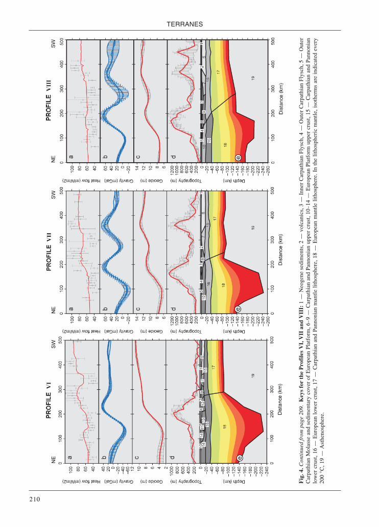
TERRANES
210
Fig.
4. C
ontin
ued
from
pag
e 20
9. K
eys f
or th
e Pr
ofile
s V
I, V
II a
nd V
III:
1 –
Neo
gene
sed
imen
ts, 2
– v
olca
nics
, 3 –
Inn
er C
arpa
thia
n Fl
ysch
, 4 –
Out
er C
arpa
thia
n Fl
ysch
, 5 –
Out
erC
arpa
thia
n M
olas
se a
nd s
edim
enta
ry c
over
of
Eur
opea
n Pl
atfo
rm, 6
—9 –
Car
path
ian
and
Pann
onia
n up
per
crus
t, 10
—14
– E
urop
ean
Plat
form
upp
er c
rust
, 15
– C
arpa
thia
n an
d Pa
nnon
ian
low
er c
rust
, 16
– E
urop
ean
low
er c
rust
, 17
– C
arpa
thia
n an
d Pa
nnon
ian
man
tle li
thos
pher
e, 1
8 –
Eur
opea
n m
antle
lith
osph
ere.
In
the
litho
sphe
ric
man
tle, i
soth
erm
s ar
e in
dica
ted
ever
y20
0 °C
, 19
– A
sthe
nosp
here
.

Gravity and seismic modeling
211
the thickest crust and the highest topography in the East-ern Carpathians is shift about 50 km southwest from thecentrum of the lithospheric root. This thickening was in-terpreted by Zeyen et al. (2002) and Dérerová et al. (2006)as remnants of a slab, which started to break off in theMiocene. But the existence of the lithospheric root doesnot also exclude the process of lithospheric delamina-tion and/or the dipping of the lithosphere-asthenosphereboundary in consequence of the gravity load changes ofunstable lithosphere.
Under the western segment of the Western Carpathians(in the transition zone to the Bohemian Massif and EasternAlps), no lithospheric thickening was observed (Fig. 5).The values vary from 100 to 120 km only. In the Miocene,the lithosphere fragment of microplate ALCAPA movedtowards the east along the left-lateral strike-slipSalzachtal-Ennstal-Mariazell-Puchberg fault zone in theEastern Alps and along the similar Mur-Mürz-Leitha faultzone towards the northeast at the Alpine-Carpathianboundary (Ratschbacher et al. 1991a,b; Fodor 1995;Linzer 1996; Lankreijer et al. 1999). This means that therelative movement of the microplate ALCAPA changedfrom E to NE as a result of lateral extrusion into the open“Carpathian bay”. This scenario could explain the absenceof lithosphere thickening in the transition between Alpsand Carpathians since the movement was mainly strike-
Fig. 5. Lithosphere thickness map of the Carpathian-Pannonian Region (compiled after the results of Zeyen et al. (2002), Dérerováet al. (2002), Babuška et al. (1988), Horváth (1993), and Lenkey (1999).
slip along a deep-reaching fault following the contact ofthe Bohemian Massif and the Western Carpathians.
The Pannonian Basin lithosphere resulting from themodels presented by Zeyen et al. (2002) and Dérerová etal. (2006) is thicker than usually supposed (e.g. Horváth1993; Lenkey 1999). These models do not support athinning to less than about 70 km. Therefore, part of thesurface heat flow has to be explained by an increase inradioactive heat production in the Pannonian upper crustand sediments. Indications for extreme thinning of thelithosphere to only 40 km (Ádám & Bielik 1998) may belocal features under a few narrow sub-basins, not detectedon their profiles. However, the regional difference of10—20 km, although not far from the estimateduncertainties of our models, may be significant. Differenthypotheses may be put forward to explain this difference.The simplest would be that seismic, magnetotelluric andthermal analyses do not see the same variations ofphysical properties and that therefore different methodsgive the lithosphere-asthenosphere boundary at differenttemperatures. On the other hand, it is claimed that thealkaline volcanism trace elements show a less depleteduppermost mantle than normal (e.g. Rosenbaum et al.1997). The Zeyen et al. (2002) and Dérerová et al. (2006)models showed mainly that the lower lithosphere has tobe denser than a normal lithosphere of 60 km thickness.

TERRANES
212
They interpreted this higher density by lower temperatures;however, it could be also due to less depleted, possiblyplume-related material. Nevertheless, in order for thisargument to be valid, the less depleted material should notform the asthenosphere, in which case the average densityof the lithosphere would have to be even larger in order toexplain the observed low elevation.
Three-dimensional density model
The forward modeling of the Bouguer gravity anomalywas performed using the Interactive Gravity and Magnet-ic System (IGMAS) (e.g. Götze 1976; Götze & Lahmeyer1988). The modeled geological bodies are in IGMASapproximated by polyhedra of constant density. The struc-tures are defined and modeled along 2D cross-sectionsthat are automatically connected via triangulation into avolume. Thus, the geometry of the geological bodies be-tween the cross-sections is interpolated. Therefore, in or-der to obtain more reliable results, a greater number of 2Dplanes must be included. The cross-sections within one3D model are always parallel and their separation is vari-
able. Constraining data can be visualized in IGMAS in-teractively along the modeled cross-sections by means ofthe GIS functions (e.g. Schmidt & Götze 1999). This is agreat advantage during the modeling of large areas whileincluding many various datasets.
The model presented was developed along 36 cross-sections, separated by 10 to 20 km across the WesternCarpathians and Pannonian Basin (the focus of the mod-eling) and 40 km in the surrounding Bohemian Massifand Eastern Alps. The model reaches the depth of 250 km.The direction of the modeled cross-sections is identicalto one of the seismic profiles from the CELEBRATION2000 experiment (CEL05 profile).
Constraning data and density determination
In the year 2000, a large-scale international CentralEuropean Lithospheric Experiment based on Refraction(CELEBRATION 2000) was conducted. It was a joint ex-periment of 28 institutions of Europe and North America(Guterch et al. 2003b). The data were collected along ~17profiles, giving a total length of 8900 km. Seven of theseprofiles were used for the combined 3D gravity-seismic
Fig. 6. Bouguer anomaly modified after Bielik et al. (2006). PBS – Pannonian BasinSystem, PKB – Pieniny Klippen Belt, IWC – Inner Western Carpathians, OWC –Outer Western Carpathians, CF – Carpathian Foredeep, HCM – Colly Cross Mts,BSB – Bruno-Silesian Block, TTZ – Teisseyere-Tornquist Zone, VF – VariscanFront (modified after Alasonati-Tašárová et al. 2008). In the upper right corner thelocation of the cross-sections of the 3D model (grey lines) and of the CELEBRATION2000 experiment (blue lines) are shown.
modeling: CEL01, CEL02, CEL03,CEL04, CEL05, CEL09 and CEL 10(Fig. 6) (Malinowksi et al. 2005; Janiket al. 2005; Hrubcová et al. 2005, 2008;Środa et al. 2006; Grad et al. 2006). Theresults from other two seismic experi-ments that followed the CELEBRA-TION 2000, namely the ALP 2002 andSUDETES 2003 (e.g. Behm et al. 2007;Růžek et al. 2007), were also consid-ered. Moreover, the above-mentionedresults from 2D integrated modeling ofZeyen et al. (2002) and Dérerová et al.(2006 and references therein) served asa starting point for the 3D gravity mod-eling. First of all, these results con-strained one of the two input parametersused for the gravity modeling, namelythe geometry of the modeled structures(i.e. depth to the main boundaries). Thedensity, which is the second input pa-rameter, can be constrained by geologi-cal data. The results from boreholemeasurements provide the best informa-tion on the composition of the rocks.However, such measurements are onlysparse and restricted to the uppermostpart of the upper crust. At larger depthsand for large-scales models, other infor-mation constraining the compositionmust be used. Seismic velocities can beconverted into densities using variousempirical relationships. Although largeuncertainties may be associated withsuch velocity-density relationships,
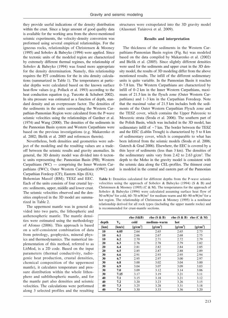
Gravity and seismic modeling
213
they provide useful indications of the density distributionwithin the crust. Since a large amount of good quality datais available for the working area from the above-mentionedseismic experiments, the velocity-density conversion waspreformed using several empirical relationships. For theigneous rocks, relationships of Christensen & Mooney(1995) and Sobolev & Babeyko (1994) were applied. Sincethe tectonic units of the modeled region are characterizedby extremely different thermal regimes, the relationship ofSobolev & Babeyko (1994) was found more appropriatefor the density determination. Namely, this relationshiprequires the P/T conditions for the in situ density calcula-tions (summarized in Table 1). The temperatures at partic-ular depths were calculated based on the known surfaceheat-flow values (e.g. Pollack et al. 1993) according to theheat conduction equation (e.g. Turcotte & Schubert 2002).In situ pressure was estimated as a function of depth, stan-dard density and an overpressure factor. The densities ofthe sediments in the units surrounding the Western Car-pathian-Pannonian Region were calculated from the P-waveseismic velocities using the relationships of Gardner et al.(1974) and Wang (2000). The densities of the sediments inthe Pannonian Basin system and Western Carpathians werebased on the previous investigations (e.g. Makarenko etal. 2002; Bielik et al. 2005 and references therein).
Nevertheless, both densities and geometries were sub-ject of the modeling and the resulting values are a trade-off between the seismic results and gravity anomalies. Ingeneral, the 3D density model was divided into 6 tecton-ic units representing the: Pannonian Basin (PB); WesternCarpathians (WC) – comprising the Inner Western Car-pathians (IWC); Outer Western Carpathians (OWC) and
structures were extrapolated into the 3D gravity model(Alasonati Tašárová et al. 2009).
Results and interpretation
The thickness of the sediments in the Western Car-pathians-Pannonian Basin region (Fig. 8a) was modeledbased on the data compiled by Makarenko et al. (2002)and Bielik et al. (2005). Since slightly different densitieswere used for the sediments and upper crust in the 3D den-sity model, the results of 3D modeling differ from the abovementioned results. The infill of the different sedimentaryunits is quite variable. In the Pannonian Basin it reaches0—7.8 km. The Western Carpathians are characterized byinfill of 0—2 km in the Inner Western Carpathians, maxi-mum of 21.5 km in the flysch zone (Outer Western Car-pathians) and 1—3 km in the Carpathian Foredeep. Notethat the maximal value of 21.5 km includes both the sedi-ments of the Outer Western Carpathian Flysch zone andthe TESZ cover, which contains the Upper Paleozoic toMesozoic strata (Środa et al. 2006). The southern part ofthe Polish Basin, which was included in the 3D model, hassedimentary infill of ~7 km. The border between the TESZand the EEC (Lublin Trough) is characterized by 5 to 8 kmof sedimentary cover, which is comparable to what hasbeen inferred from the seismic models (Środa et al. 2006;Guterch & Grad 2006). Elsewhere, the EEC is covered by athin layer of sediments (less than 3 km). The densities ofthe sedimentary units vary from 2.42 to 2.63 g/cm3. Thedepth to the Moho in the gravity model is consistent withthe seismic data along the CEL-profiles. The thinnest crustis modeled in the central and eastern part of the Pannonian
Table 1: Densities calculated for different depths from the P-wave seismicvelocities using the approach of Sobolev & Babeyko (1994) (S & B) andChristensen & Mooney (1995) (C & M). The temperatures for the approach ofSobolev & Babeyko (1994) were calculated assuming surface heat flow of50 mW/m2 for cold, 60—70 mW/m2 for medium-warm and 80—90 mW/m2 for ahot region. The relationship of Christensen & Mooney (1995) is a nonlinearrelationship derived for all rock types (including the upper mantle rocks) andis recommended for crust-mantle sections.
Carpathian Fordeep (CF); Eastern Alps (EA);Bohemian Massif (BM); TESZ and EEC.Each of the units consists of four crustal lay-ers: sediments, upper, middle and lower crust.The seismic velocities observed and the den-sities employed in the 3D model are summa-rized in Table 2.
The uppermost mantle was in general di-vided into two parts, the lithospheric andasthenospheric mantle. The mantle densi-ties were estimated using the methodologyof Afonso (2006). This approach is basedon a self-consistent combination of datafrom petrology, geophysics, mineral phys-ics and thermodynamics. The numerical im-plementation of this method, referred to asLitMod, is a 2D code. Based on the inputparameters (thermal conductivity, radio-genic heat production, crustal densities,chemical composition of the uppermostmantle), it calculates temperature and pres-sure distribution within the whole lithos-phere and sublithospheric mantle, and forthe mantle part also densities and seismicvelocities. The calculations were performedalong 3 selected profiles and the resulting
rho (S&B) rho (S & B) rho (S & B) rho (C & M)
depth Vp cold medium–warm hot
[km] [km/s] [g/cm3] [g/cm3] [g/cm3] [g/cm3] 10 6.05 2.64 2.65 2.65 2.73 10 6.1 2.66 2.67 2.68 2.75 10 6.2 2.70 2.71 2.72 2.79 20 6.3 2.76 2.78 2.79 2.82 20 6.4 2.81 2.82 2.84 2.85 20 6.5 2.85 2.87 2.88 2.89 30 6.6 2.91 2.93 2.95 2.94 30 6.7 2.95 2.97 3.00 2.97 30 6.8 3.00 3.02 3.04 3.00 30 6.9 3.04 3.07 3.09 3.03 30 7.0 3.09 3.12 3.14 3.06 30 7.15 3.17 3.19 3.21 3.11 40 7.1 3.15 3.18 3.21 3.12 40 7.2 3.20 3.23 3.26 3.15 40 7.3 3.25 3.28 3.31 3.18 40 7.4 3.30 3.33 3.36 3.20

TERRANES
214
Basin. The minimum crustal thickness of ~22 km is lo-cated along the CEL05 profile (Grad et al. 2006) and itsvicinity (Fig. 8c). The Danube Basin is characterized by
Table 2: Observed P-wave seismic velocities from the CEL-profiles and densitiesemployed in the 3D density model. The acronyms stand for: PB – PannonianBasin, (O)WC – (Outer) Western Carpathians, TESZ – Trans-European SutureZone, EEC – East European Craton, BM – Bohemian Massif, EA – Eastern Alps.
Fig. 7. A representative cross-section from the 3D density model, correspondingto the profile CEL01. The upper frame shows the observed (red) and modeled(black) Bouguer anomaly. The lower frame shows the bodies modeled andtheir density values. The blue lines are boundaries interpreted from the seismicmodel of Środa et al. (2006).
for the middle- and lower-crustal layers. Themicroplate ALCAPA is separated from the Eu-ropean platform by the Pieniny Klippen Belt(PKB), extending through the whole crust.North of the PKB, the Outer Carpathians andthe Carpathian Foredeep are underlain by thecrust of the TESZ (Fig. 7). The TESZ consistsof several terranes, which have been accretedto the south-western margin of the EEC dur-ing Paleozoic by rifting (Pharaoh et al. 2006and references therein). The history and ori-gin of these terranes is still a matter of debate.Thus, in the gravity model, the various ter-ranes are not yet distinguished. They are ap-proximated by one body only. Concerningits deep structure based on geophysical dataavailable, TESZ clearly forms a pronouncedboundary between the thick, old and coldlithosphere of the EEC and younger, warmerand thinner lithosphere of the PhanerozoicEuropean Platform. This region is also char-acterized by a strong seismic anisotropy ofthe upper and middle crust, reaching up to12 % (Środa 2006; Janik et al. 2009). Thisphenomenon explains inconsistencies be-tween seismic and gravity data reported byAlasonati Tašárová et al. (2008). Moreover, ahigh-velocity body was interpreted in the tran-
sition area between the TESZ and EEC in the middlecrust underneath the Lublin high (EEC). This body wasmodeled as a high-velocity body along the profiles CEL01,
crustal thickness of 28—30 km, increasing to35 km toward the west. The Central WesternCarpathians have 28—35 km thick crust, whilethe crust beneath the Outer Western Car-pathians and the Carpathian Foredeep is 35to 43 km thick. The maximum crustal thick-ness of ~ 50 km is modeled beneath theTESZ/EEC along the CEL05 profile (e.g.Guterch & Grad 2006) and Eastern Alps (e.g.Behm et al. 2007).
Similarly to the crust, also the lithosphericmantle resulting from our best-fitting modelis extremely thin in the Pannonian Basin.The LAB reaches here depths of 60—100 km.The lithospheric thickness is gradually in-creasing toward the west and north. In gen-eral, the lithosphere is ~160 km thick in theEastern Alps, ~ 140 km in the BohemianMassif and Western Carpathians. The thick-est lithosphere (~200 km) is included in theEast European Craton.
Summarizing the crustal inhomogeneities,as it is obvious from Table 2 and Fig. 7, theresulting densities are lower in the WesternCarpathian-Pannonian Region (microplatesALCAPA and Tisza Dacia) than in the sur-rounding units. This holds particularly true
Units P-wave velocity [km/s]
rho-employed [g/cm3]
sediments PB 2.3–4.5 2.42 upper crust PB 5.8–6.0 (6.2–6.3*) 2.67 middle crust PB 6.0–6.4 2.71 lower crust PB 6.25–6.55 2.86 sediments (CF) <4.0 2.48 sediments (OWC) <3.0–5.6 2.59/2.63 upper crust WC 5.65–6.15 2.67 middle crust WC 5.95–6.4 2.75 lower crust WC 6.4–6.75 2.91 sediments TESZ 2.0–5.3 2.5–2.6 upper crust TESZ 5.5–6.2 2.71–2.72 middle crust TESZ 6.2–6.6 2.96 lower crust TESZ 6.6–7.1 3.13 HVB TESZ (15–30 km depth) 7.15 3.12 sediments EEC 2–5.4 2.58 upper crust EEC 6–6.4 2.76 middle crust EEC 6.4–6.65 2.9 lower crust EEC 6.7–7.05 3.05 sediments BM 2.5–5.4 2.5 upper crust BM 5.8–6.4 2.74 middle crust BM 6.3–6.7 2.9 lower crust BM 6.8–7.4 3 sediments EA ?5.5 2.47 upper crust EA 5.8–6.2 2.7 middle crust EA 6.4–6.8 2.85 lower crust EA 6.8–7.4 3

Gravity and seismic modeling
215
Fig. 8. The depth to the bottom of the sedimentary basins (a) to the Moho (c); the calculated gravity effects of the sediments (b); andthe Moho (d). The thick lines mark the units of the Western Carpathians shown also in Fig. 6.
CEL02, and CEL03 (Malinowski et al. 2005; Janik etal. 2005; Środa et al. 2006). Moreover, the velocitiesalong the CEL05 (Grad et al. 2006) are in this regionelevated. A high-density body in the middle crust isrequired also by the gravity modeling in order to repro-duce the gravity anomaly in this region. In the densitymodel, this body is a 3D structure, stretching from theCEL05 profile in the south to ~60 km north of the pro-file CEL01. It is characterized by high velocities of 7 to7.15 km/s and a density of 3.12 g/cm3. These values sug-gest mafic composition, similar to olivine gabbro orgarnet granulite (Sobolev & Babeyko 1994; Christensen& Mooney 1995). Grabowska (personal communication)assumes this intrusion to be caused by metamorphic pro-cesses, resulting in the increase of the density and vari-ations of magnetic properties of rocks forming thecrystalline crust of this unit.
Gravity stripping
The gravity stripping was performed in order to ana-lyze different components of the gravity signal. The grav-ity effects of the sedimentary infill, depth to the Mohoand the effect of the low-density upwelling asthenos-phere in the Pannonian Basin were calculated using thefinal 3D density model. These calculations were per-formed in IGMAS using relative density values (Ala-sonati Tašárová et al. 2009).
The sediment stripped map (Fig. 9a) of the PannonianBasin is generally characterized by a positive anomalyof 20—50 mGal. Particularly the eastern part of the PBSis characterized by pronounced residual gravity high,which is related to the extremely shallow Moho in thisregion (Fig. 8c). In contrary, the Central Western Car-pathians reflects a negative effect of the thick low-density

TERRANES
216
upper and middle crust. The thickness of the upper andmiddle crust reaches in the density model 25 km. A com-plete stripped map (Fig. 9b) was calculated by removingthe gravity effects of the sediments, Moho and the low-density uppermost part of the upwelling asthenospherefrom the Bouguer anomaly. In contrast to the sedimentstripped map, it clearly shows similarities of the PBS andWestern Carpathians. The Moho in the Pannonian Basinis some 10 km shallower than in the Western Carpathians.When its gravity effect is accounted for (together withthe low-density upwelling asthenosphere in the PBS),both microplates ALCAPA and Tisza-Dacia are charac-terized by residual anomalies, which are much lower thanin the surrounding regions. The greatest gradient coin-cides with the location of the PKB (Fig. 9b), separatingthe microplate ALCAPA from the platform. This suggeststhat the lithospheric structure of the microplates ALCA-PA and Tisza-Dacia is in terms of density distributionquite different from the surrounding units. Also, it can bereflecting different degree of crustal consolidation. It fol-lows that the ALCAPA and Tisza-Dacia are characterizedby low-density unconsolidated crust, whereas the Euro-pean Platform has a consolidated crust of high-densities.
Two-dimensional seismic modeling in the Carpathian-Pannonian Region and its geological interpretation
For an objective geophysical and geological study ofthe structure and dynamics of the Carpathian-Pannon-ian Region, it is very important to investigate it in com-
parison with the surrounding tectonic units: the Pre-cambrian EEC, the Paleozoic European Platform (PP)and the Eastern Alps (Fig. 10). For this purpose, as itwas already mentioned above, the seismic experimentCELEBRATION 2000 was conducted (Guterch et al.2003b). In this section, the profiles CEL01, CEL04,CEL05, CEL06 and CEL11 are analyzed and discussed(Fig. 10). Models of the main profiles CEL01, CEL04and CEL05 are limited to profile-km 350—550 alongtheir southern parts (these profiles are originally about600—1400 km long). The additional profiles CEL06 andCEL11 are 340 and 430 km long. In the Western Car-pathians, the topography reaches up to 1500 m a.s.l.,being mostly between 500 and 1000 m. In the surround-ing tectonic units of the Western Carpathians the to-pography is rather flat, being 200—300 m in TESZ andPaleozoic European Platform, and 100—200 m in Pan-nonian Basin System.
The modeling of the crustal and uppermost mantle struc-ture was performed using 2D ray tracing technique. Thecorrelation and picking of refracted and reflected seismicphases was done using ZPLOT package (Zelt 1994). Themodeling of travel times, rays and synthetic seismogramswas performed using the SEIS83 package (Červený &Pšenčík 1984), supported by the programs MODEL andXRAYS (Komminaho 1998). The initial models of the sed-imentary cover and shallow basement for some of the indi-vidual profiles were constrained by the use of boreholeinformation and earlier geophysical studies, includinghigh-resolution seismic reflection surveys. This informa-
Fig. 9. The sediment stripped gravity (a) was obtained by subtracting the gravity effect of the sediments (Fig. 8b) from the completeBouguer anomaly (Fig. 6). The residual lithospheric gravity anomaly (b) was calculated by removing the gravity effects of the Moho(Fig. 8d) and the low-density uppermost part of the upwelling asthenosphere from the sediment stripped gravity.

Gravity and seismic modeling
217
tion provided a much more detailed model of the upper-most 5—10 km of sedimentary cover than can be obtainedfrom the refraction profiles alone. The initial models of theshallow structure were only slightly adjusted (in the senseof seismic velocity and depth of boundaries) during theray tracing procedure. The overall velocity models for allprofiles were successively altered by trial and error, andthe travel times were iteratively recalculated until agree-ment was reached between the observed and model-de-rived P wave travel times.
The seismic data used for modeling along the mainprofiles were of good quality, since with dense systemof sources and receivers. For the modeling, clear firstarrivals and later refracted/reflected phases were used.With the data of such a quality the velocity and depthuncertainties of the models derived by 2D forward mod-eling are on the order of ±0.1 km/s and ±1 km, wherethe crustal structure is relatively simple, and ±0.2 km/sand ±2 km for the complicated structure, respectively
(e.g. Janik et al. 2002, 2009; Grad et al. 2003, 2009a,b).For the additional profiles the uncertainties in velocityand depth were slightly larger than for the main profiles(CEL01, CEL04 and CEL05).
Crustal and upper most mantle seismic models
The final 2D models derived for the structure alongall profiles are shown in Figs. 11—15 (vertical exaggera-tion is 2.5 :1 for the models, and about 23:1 for topog-raphy). All five profiles were jointly interpreted withverification and control the models at crossing points.Where necessary, the models for the main profiles werereinterpreted to better fit the crossing points; howeverthese changes were not usually significant.
The study revealed pronounced lateral variations of Vp
velocity in the crust and uppermost mantle, as well asvariations of the Moho depth (Figs. 11—15), which canbe associated with the different tectonic units crossed
Fig. 10. A – Location of the CELEBRATION 2000 seismic profiles in SE Poland, Slovakia and Hungary (after Guterch et al. 2000,2003) with shot points (big red dots) and receiver positions (small black dots). Profiles discussed in this paper are marked in white boxesand numbers in small yellow boxes refer to shot points along these profiles in the study area marked by violet rectangle. Profiles fromPOLONAISE’97 (P3, P4, P5), SUDETES 2003 (S02, S03, S04, S05, S09) and other experiments (TTZ, LT-4, LT-5, LT-3, LZW, VIII)are also shown. B – Location of discussed in the paper seismic profiles CEL01, CEL04, CEL05, CEL06 and CEL11 on the backgroundof geological map of the Central Europe modified from Środa et al. (2006) and Janik et al. (2009) with elements for Carpathian-Pannonian Basin area after Kováč et al. (1994, 2000), European platform after Dadlez et al. (1994, 2000), Dadlez (2003), Belka etal. (2002) and Verniers et al. (2002), and for Mid-Hungarian Line after Fodor et al. (1999). BCT – Bükk Composite Terrane, BM –Bohemian Massif, BSU – Bruno-Silesian Unit, CDF – Caledonian Front, CSVZ – Central Slovak Volcanic zone, ESB – EastSlovakian Basin, HCF – Holy Cros Fault, HCM – Holy Cross Mts, KLF – Kraków-Lubliniec Fault, KU – Kuiavian Unit, NU –Narol Unit, PKB – Pieniny Klippen Belt, PU – Pomeranian Unit, RŁU – Radom-Łysogóry Unit, TESZ – Trans-European SutureZone, USU – Upper Silesian Unit. Areas covered by: brown – Outer Carpathians, blue – Central Western Carpathians, EasternCarpathians, Alps and Dinarides, Apuseni and Transdanubian range, yellow – Pannonian Basin System, orange – Neogene volcanics.

TERRANES
218
by the seismic profiles. The Moho topography within25—45 km depth in a relatively short distance (see alsoMalinowski et al. 2008, 2009; Grad et al. 2009a). In thesouthern part of the area, the “Pannonian Basin System”crust consists of 3—7 km thick sediments, and two crustallayers with velocities Vp 6.6 km/s. In the upper section,the velocities are 5.9—6.3 km/s, and in the lower section6.3—6.6 km/s. In the upper crust, beneath profile CEL05in ALCAPA, a high velocity body (HVB, Vp 6.4 km/s)was detected in the uppermost 5 km, at a location corre-sponding to the Bükk Composite Terrane (BCT) (seeFigs. 10, 13). The total thickness of the ALCAPA crustisslightly larger by 1—2 km than that of the Tisza-Daciaterrane. In the northern part of the area, we observe a10—20 km thick uppermost crust with a relatively lowvelocity (Vp<6.0 km/s), connected with TESZ and theCarpathian Foredeep. Together with ca. 6.2—6.5 km/sand6.5—6.9 km/s they have a total thickness of 30—45 km(north of the PKB). The sub-Moho velocities have inaverage values of 7.8—8.0 km/s for the “Pannonian ba-sin System” (part of the study area) while in the WesternCarpathians, the TESZ and the East European Cratonthey are slightly higher, 8.0—8.1 km/s. Beneath profilesCEL01, CEL04, CEL05 and CEL11 some reflectors inthe upper mantle were visible 10—20 km below the in-terpreted Moho, approximately parallel with it and gen-erally dipping to the north.
The derived seismic models show clear that the Tertia-ry sedimentary filling of the Outer Western CarpathianFlysch zone (OWCFZ) has a large thickness, in some partsmore than 15—18 km. In this area beneath the sediments ofthe OWCFZ, it is suggested by Ryłko (2005) that the oldersediments represent the Paleozoic Platform cover. The re-sults of the seismic interpretation indicate that the totalthickness of both tectonic units (OWCFZ and PaleozoicPlatform cover) could reach up more than 23—25 km.
Summary of seismic results of CELEBRATION 2000profiles in the study with representative crustal modelsfor the whole Carpathian-Pannonian Basin System re-gion, the TESZ and the East European Craton (the mi-croplates Tisza-Dacia and ALCAPA, the Outer WesternCarpathians, the Western Carpathian Foredeep, theTESZ and the East European Craton) are shown inFig. 16. A typical model of the East European Craton isshown for reference. Some of the characteristic featuresof the region investigated include a relatively thin sed-imentary cover with velocities Vp=2.3—5.0 km/s and acrystalline basement with velocities Vp> 6.0 km/s atdepths 1—5 km. The crystalline crust of the EEC con-sists of three layers with P-wave velocities of 6.1—6.4,6.5—6.8 and 6.9—7.2 km/s for the upper, middle and lowercrust, respectively. The compilation of the CELEBRA-TION 2000 data for the study area is compiled in theMoho depth map (Fig. 17).
Fig. 11. Two-dimensional model of seismic P-wave velocity (after Środa et al. 2006) in the crust and uppermost mantle derived byforward ray tracing modeling using the SEIS83 package (Červený & Pšenčík 1984) along the CELEBRATION 2000 profile CEL01.Those parts of the boundaries that have been constrained by reflected and/or refracted arrivals are marked by thick lines. Thin linesrepresent velocity isolines with values in km/s shown in white boxes. Position of large-scale crustal blocks is indicated. Black trianglesshow positions of shot points. Blue arrows show crossings with other profiles. Vertical exaggeration is ~2.5:1 for the models, andabout 23:1 for topography.
≥
≤

Gravity and seismic modeling
219
Fig. 13. Two-dimensional models of seismic P-wave velocity (after Grad et al. 2006) in the crust and uppermost mantle derived byforward ray tracing modeling using the SEIS83 package along the CELEBRATION 2000 profile CEL05. Other explanation as in Fig. 11.
Fig. 12. Two-dimensional models of seismic P-wave velocity (after Środa et al. 2006) in the crust and uppermost mantle derived byforward ray tracing modeling using the SEIS83 package along the CELEBRATION 2000 profile CEL04. Other explanation as in Fig. 11.

TERRANES
220
Fig. 15. Two-dimensional models of seismic P-wave velocity (after Janik et al. in print) in the crust and uppermost mantle derived byforward ray tracing modeling using the SEIS83 package along the CELEBRATION 2000 profile CEL11. Other explanation as in Fig. 11.
Fig. 14. Two-dimensional models of seismic P-wave velocity (after Janik et al. in print) in the crust and uppermost mantle derived byforward ray tracing modeling using the SEIS83 package along the CELEBRATION 2000 profile CEL06. Other explanation as in Fig. 11.

Gravity and seismic modeling
221
Fig. 16. Summary of seismic results of CELEBRATION2000 profiles in the study area showing representativecrustal models for microplates TISZA-DACIA, ALCAPA,the Outer Carpathians and Carpathian Foredeep),together with the East European Craton for reference.
Fig. 17. Moho depth map of the study area based on the CELEBRATION 2000 data, including CEL08 (Malinowski et al. (2010)).
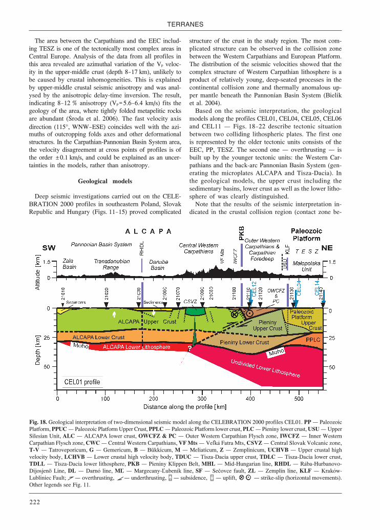
TERRANES
222
The area between the Carpathians and the EEC includ-ing TESZ is one of the tectonically most complex areas inCentral Europe. Analysis of the data from all profiles inthis area revealed are azimuthal variation of the Vp veloc-ity in the upper-middle crust (depth 8—17 km), unlikely tobe caused by crustal inhomogeneities. This is explainedby upper-middle crustal seismic anisotropy and was anal-ysed by the anisotropic delay-time inversion. The result,indicating 8—12 % anisotropy (Vp=5.6—6.4 km/s) fits thegeology of the area, where tightly folded metapelitic rocksare abundant (Środa et al. 2006). The fast velocity axisdirection (115°, WNW—ESE) coincides well with the azi-muths of outcropping folds axes and other deformationalstructures. In the Carpathian-Pannonian Basin System area,the velocity disagreement at cross points of profiles is ofthe order ±0.1 km/s, and could be explained as an uncer-tainties in the models, rather than anisotropy.
Geological models
Deep seismic investigations carried out on the CELE-BRATION 2000 profiles in southeastern Poland, SlovakRepublic and Hungary (Figs. 11—15) proved complicated
structure of the crust in the study region. The most com-plicated structure can be observed in the collision zonebetween the Western Carpathians and European Platform.The distribution of the seismic velocities showed that thecomplex structure of Western Carpathian lithosphere is aproduct of relatively young, deep-seated processes in thecontinental collision zone and thermally anomalous up-per mantle beneath the Pannonian Basin System (Bieliket al. 2004).
Based on the seismic interpretation, the geologicalmodels along the profiles CEL01, CEL04, CEL05, CEL06and CEL11 – Figs. 18—22 describe tectonic situationbetween two colliding lithospheric plates. The first oneis represented by the older tectonic units consists of theEEC, PP, TESZ. The second one – overthrusting – isbuilt up by the younger tectonic units: the Western Car-pathians and the back-arc Pannonian Basin System (gen-erating the microplates ALCAPA and Tisza-Dacia). Inthe geological models, the upper crust including thesedimentary basins, lower crust as well as the lower litho-sphere of was clearly distinguished.
Note that the results of the seismic interpretation in-dicated in the crustal collision region (contact zone be-
Fig. 18. Geological interpretation of two-dimensional seismic model along the CELEBRATION 2000 profiles CEL01. PP – PaleozoicPlatform, PPUC – Paleozoic Platform Upper Crust, PPLC – Paleozoic Platform lower crust, PLC – Pieniny lower crust, USU – UpperSilesian Unit, ALC – ALCAPA lower crust, OWCFZ & PC – Outer Western Carpathian Flysch zone, IWCFZ – Inner WesternCarpathian Flysch zone, CWC – Central Western Carpathians, VF Mts – Ve ká Fatra Mts, CSVZ – Central Slovak Volcanic zone,T-V – Tatroveporicum, G – Gemericum, B – Bükkicum, M – Meliaticum, Z – Zemplinicum, UCHVB – Upper crustal highvelocity body, LCHVB – Lower crustal high velocity body, TDUC – Tisza-Dacia upper crust, TDLC – Tisza-Dacia lower crust,TDLL – Tisza-Dacia lower lithosphere, PKB – Pieniny Klippen Belt, MHL – Mid-Hungarian line, RHDL – Rába-Hurbanovo-Dijosjenö Line, DL – Darnó line, M – Margecany- ubeník line, SF – Sečovce fault, ZL – Zemplín line, KLF – Kraków-Lubliniec Fault; – overthrusting, – underthrusting, – subsidence, – uplift, – strike-slip (horizontal movements).Other legends see Fig. 11.

Gravity and seismic modeling
223
Fig. 19. Geological interpretation of two-dimensional seismic model along the CELEBRATION 2000 profiles CEL04. Legends see Fig. 11.
Fig. 20. Geological interpretation of two-dimensional seismic model along the CELEBRATION 2000 profiles CEL05. Legends see Fig. 11.

TERRANES
224
tween PP and microplate ALCAPA) a specific type ofthe crust. The particularity of the upper and lower crustis characterized by the values of the seismic velocities,which cannot be included neither into the ALCAPA crustand nor into the European Platform crust (see Fig. 15,column for the Outer Carpathians and Carpathian Fore-deep). In the geological models, we marked this crust asthe Pieniny crust. From a geological point of view thePieniny crust is not part of the EP. It is rather a part of theALCAPA foredeep as individual Pieniny terrane, whichhad in the alpine orogen independent tectonic history.The Pieniny crust is mainly significant for the Jurassic-Cretaceous development, which is reflected in the for-mation of the Pieniny Klippen Belt (PKB) and itsremnants. These remnants are preserved in the PKB zone(Andrusov 1967, 1968; Scheibner 1967; Andrusov &Scheibner 1968; Birkenmajer 1977, 1985, 1986; Birken-majer & Dudziak 1991; Golonka 2004; Golonka & Kro-bicki 2004). Note that that the time of opening od thePieniny ocean (Upper Jurassic—Lower Cretaceous) havebeen following by the close the Meliata ocean (UpperJurassic) (Kozur & Mock 1985; Kovács 1988; Kozur &Mostler 1992; Rakús M. 1998; Mello et al. 1998; Mocket al. 1998; Haas et al. 2001).
The lithospheric plates are separated by crustal and/orlithospheric fault zones (lines). The PKB is probably a deep-seated boundary (contact) between the colliding EP (EECand PP) lithospheric plates and the microplate ALCAPA.
Fig. 21. Geological interpretation of two-dimensional seismic model along the CELEBRATION 2000 profiles CEL06. Legends see Fig. 11.
Moreover, the PKB in the upper crust separates the Innerand Outer Western Carpathians. The lithospheric bound-ary between the microplates ALCAPA and Tisza-Dacia isrepresented by the Midle Hungarian line (MHL).
In the microplate ALCAPA, several faults, were inter-preted. The Tertiary transform fault Rába-Hurbanovo-Dijosjenö Line (RHDL) separates the Western Carpathiansand the Pelsó Megaunit. The easternmost part of theRHDL (W-E direction) continues into the system of Darnóline (DL), which has the NE-SW direction (Fig. 23). TheDL represents the Tertiary contact between the Gemeri-cum, Meliaticum and Bükkicum. This zone reflects theshortening area of the Meliata ocean. The remnants ofthis ocean are preserved in the form of the northvergentslices lying on the Gemericum. The overthrusting of theGemericum over the southern Veporicum is along theMargecany- ubeník line (Andrusov 1958; Vozár &Šantavý 1999). The Bükkicum (interpreted high veloci-ty body – CEL04 and CEL05) ‘sensu stricto’ is not partof the Pelsó Megaunit, but instead, it is a tectonic frag-ment of Dinaric affinity and has been placed to its presentposition through rotations and left-lateral shear along theDL (Csontos 1999; Kovács et al. 2000; Ebner et al. 2008;Vozár et al. 2009). It can be observed mainly on profilesCEL04 and CEL05 (Figs. 19 and 20). The higher West-ern Carpathian nappes (Hronicum, Silicicum a Turnai-cum) can not be interpreted by means of the seismicrefraction cross-sections. In the PP lithospheric plate, the

Gravity and seismic modeling
225
Kraków-Lubliniec Fault (KLF) is a boundary between theUpper Silesian Unit and Małopolska Unit.
Some dominant structures of the Western Carpathianshave been reflected in the seismic reflect profiles suchas flower structures (Vozár & Šantavy 1999). The PKB,RHDL, DL can be included among them. They havemostly NE-SW direction, and they represent the sinis-tral (left-lateral) fault zones. It means that the move-ments of the Western Carpathian tectonic units alongthese fault zones have been mostly laterally. This move-ment was illustrated in the models of the profiles CEL01,CEL04, CEL05 and CEL06.
The geological interpretation of seismic models seemsto indicate (e.g. profile CEL01, CEL04, CEL05, CEL06,CEL11) the underthrusting of the older EP (EEC and PP)lithosphere beneath the microplate ALCAPA in the east-ern segment. However, it seems that the direction of thrust-ing is more ambiguous west of the junction of the Easternand Western Carpathians. Of all the sections CEL11 pro-file shows characteristics (thick wedge like shape of thecrust and abrupt change in MOHO topography aroundthe collision zone, in other words under the Carpathians).The CEL11 profile crosses along a NE-SW strike the junc-tion of the Western and Eastern Carpathians. It may be anindication that indeed significant convergence and un-derthrusting happened only south of this zone along theEastern Carpathians (Grad et al. 2006; Kovács & Szabó2008), whereas the other profiles display less evidence
Fig. 22. Geological interpretation of two-dimensional seismic model along the CELEBRATION 2000 profiles CEL11. Legends see Fig. 11.
for convergence and classic subduction they rather showevidence for lateral displacements along the WesternCarpathians. In general it seems to be that the under-thrusting of the PP is less beneath the Western Carpathiansas in the Eastern Carpathians. Northern dipping reflec-tors in the upper mantle seem to be common in the ana-lyzed profiles that confirm their common existence as itwas already proposed by Grad et al. (2006). Their north-ward dipping direction, nevertheless, remains enigmaticif we accept present geodynamical paradigms, as it shouldrather be southward directed. The origin driven Cainozoicasthenospheric flow of Kovács et al. (2008) may explainthese horizons as the manifestation of the eastwardly es-caping asthenospheric material diving under the Car-pathians.
The geological and seismic models also indicatedifferent thickness of the flysch sediments and sedimen-tary platform cover in the Outer Western Carpathians.As it is a problem to separate the mentioned both tec-tonic units in the seismic field, they were interpretedjointly in the geological models. Note that the large thick-nesses (18 km) of both sedimentary tectonic units aresuggested in the easternmost part of the Western Car-pathians (profile CEL05) and in the junction zone ofthe Western and Eastern Carpathians (profile CEL11).
The special double-reflections recognized for shotpoint 24170 in CEL04 may be further discussed in thelight of Hajnal et al. (1996) who already described that

TERRANES
226
both the LAB and the MOHO are considerably elevatedbeneath the area. The layering in MOHO depth may bealso interpreted as a result of basaltic underplating, how-ever, basaltic occurrences are not known from the areaand typical Plio-Pleistocene alkaline basaltic localitiesare also distant (i.e. Kovács & Szabó 2008).
The thicknesses of the Tertiary sediments of the DanubeBasin, Zala Basin, East Slovakian Basin and the northernpart of the Great Hungarian Plain, and some other parts ofthe Pannonian Basin System were interpreted too. In thestudy region the largest crustal thickness (52 km) wasfound under the easternmost part of the Holly cross Mts(Fig. 17). This crustal depression has a NE-WS direction.The direction of the 44 km isoline correlates with themain axis of the TESZ. The southern surface boundaryof the TESZ is characterized by the very high gradientof the degreasing of the Moho depth to the west. Thegradient separates the region of the largest crustal thick-ness with the elevation of the Moho. This 32 km eleva-tion is observed over the USU. It is worth mentioningthat the largest thickening of the crust in the WesternCarpathians is not beneath the highest topography inthe High Tatras, but it is moved NE from this area. TheOuter Western Carpathians are characterized by a thickercrust (42—44 km) in comparison with the Inner WesternCarpathians. It is very interesting that this deepest zoneis interrupted by the elevation of the Moho. The crustalthickness here is only 32 km. In the Inner Western Car-
pathians, the thickness of the crust varies from 30 km inthe south to 36 km in the north. The Pannonian BasinSystem is characterized by the thinnest crust (only 22 km)in the whole study area. The thinnest crust with its cen-trum spreads over the Great Hungarian Plain. The thick-est crust in the Pannonain Basin System was interpretedunder the Transdanubian range (i.e. Bakony Mts). Theseresults agree with the former results published in the pa-pers of Horváth (1993), Šefara et al. (1996), Lenkey (1999).
Discussion and conclusions
A comparison between the results obtained by meansof the integrated modeling algorithm with the above-mentioned earlier results reveals in general a smallerdifference between the thicknesses of the lithosphereunderneath the European platform and the PannonianBasin. The large published lithospheric thicknessesnorth of the Western Carpathians, in combination witha relatively thin crust (<40 km), would imply a too highgravity anomaly or a topography below sea level. Thenewest results of the seismic refraction modeling, whichwere made in frame of international project CELEBRA-TION 2000 (Malinowksi et al. 2005; Janik et al. 2005;Środa et al. 2006; Grad et al. 2006), proved the resultsrelate to the thickness of the crust in the European plat-form. These authors had to correct the former results of
Fig. 23. The geodynamic block model of the Carpathian-Pannonian Basin System Region (compiled after the results presented here andresults published by Vozár et al. 2009). Legend: MHL – Mid-Hungarian line, D – Darnó line, Di – Dijósjenö line, H – Hurbanovoline, R – Rába line; thick arrows – direction of the main horizontal movement.
≈≈

Gravity and seismic modeling
227
the crustal thickness (especially underneath the TransEuropean transion zone – TESZ) published by (Guterchet al. 1986a,b). For the Pannonian Basin, in contrast, thethin lithosphere with a not very thin crust would resultin a high topography or a too low gravity.
The modeling suggests important differences in litho-spheric thickness along the strike of the Western Car-pathian orogen. Beneath the central and eastern segmentsof the Western Carpathians the lithosphere increases inthickness to a maximum of 140—150 km. The lithospherethickening was interpreted as a small remnant of a sub-ducted slab. Remnants of deep subduction and slab de-tachment below the Carpathian-Pannonian Region havebeen detected earlier (Spakman et al. 1993) and were in-dicated by Lillie et al. (1994), Bielik (1995) and Nemčoket al. (1998). The results published by Wortel & Spak-man (2000) showed that along the Carpathian arc a con-tinuous slab is imaged along the Carpathian arc. Thisslab seems to be detached except for the south-easternCarpathians and can be followed down to the bottom ofthe upper mantle. A flat-lying, high-velocity anomaly atthe bottom of the upper mantle has been interpreted assubducted lithosphere that sunk into the deeper mantleas a result of rollback and slab detachment along-strikeof the Carpathian arc.
Unlike the central and eastern segments of the WesternCarpathians, a clear lithospheric thickening is not compat-ible with the data in the western segment of the WesternCarpathians. The differences in lithospheric thickness inthese both segments of the Western Carpathians could beexplained by the different geodynamic evolution of theseareas. A general NS directed compression in the Oligocenebrought the central and eastern segment into frontal colli-sion with the European platform, whereas, due to the dif-ferent direction of the plate boundaries, the westernsegment suffered a transpressional deformation (Decker &Peresson 1996). During the Miocene, the relative platemovement changed to SW—NE and brought the westernsegment into a left-lateral strike-slip movement along theMur-Mürz Fault Zone (Peresson & Decker 1997; Šefara etal. 1998). Lankreijer et al. (1999) suggested that this changewas due to a blocking of the convergence in the collidingAlpine region by the very strong Bohemian core with athick lithosphere. The compressional deformation in thecentral and eastern segments, however, continued. It couldexplain the absence of a subducting slab and of lithospher-ic thickening in the Western Carpathian-Bohemian Mas-sif-Eastern Alps junction. The seismic tomography models(Wortel & Spakman 2000) of the 3D upper mantle velocitystructure of the Mediterranean-Carpathian region, haveindicated slab detachment in the Carpathian-PannonianRegion, in particular eastward lateral migration of this pro-cess along the plate boundary. Eastward-directed extru-sion caused by collision in the Eastern Alps (~30 millionyears) may have contributed to the initiation of subduc-tion along the convergent plate boundary and the subse-quent migration (Jiříček 1979; Ratschbacher et al. 1991).Rollback presumably caused further east-north-eastward
migration of the trench, which led to collision with thecontinental margin (first ~30 million years) in the north, inthe area of the present central Western Carpathians. Thisprovided the local cause for slab detachment (Tomek &Hall 1993; Kováč et al. 1998), which from there started tomigrate eastward toward the Vrancea zone. The rollback ofthe convergent plate boundary led to the subduction ofthe oceanic embayment, and came to a stop when all aroundthe embayment, the trench system reached the surround-ing continental margin. The remnants of the oceanic em-bayment were found in the lower part of the upper mantle(Wortel & Spakman 2000). Usually, it is supposed that aslab should break in the area of strongest bending, i.e. nearthe surface (Wong A Ton & Wortel 1997). The Zeyen et al.(2002) and Dérerová et al. (2006) results suggest however,that a certain lithospheric thickening can still be observedtoday. This could be explained in three ways: the slabdetachment did not happen in the area of strongest bend-ing, a possibility that does not seem very convincing. Alsoa second possibility, that of a remnant cooling in the sur-roundings of the former slab position is not very likely,since hot asthenospheric material should immediately fillthe space behind the sinking slab, heating up also the sur-rounding areas. It could finally mean that the convergentmovement between the European plate and the Pannonianregion continued during some short time after the slabbreakdown. The maximum thickening of about 40 km inthe Western Carpathians could have been attained in 2—4million years given a convergence rate of 1—2 cm per year.
The geophysical study of Zeyen et al. (2002) and Dére-rová et al. (2006) allowed to image with relatively goodresolution the variations of lithospheric thickness alongthe Carpathian chain from the transition to the Alps inthe NW to the Vrancea zone in the SE. The results corre-spond well to the geodynamic ideas concerning the evo-lution of the slab that is supposed to have broken off andsunk into the asthenosphere during time, starting in theNW about 15 Ma ago and still being attached to the over-lying lithosphere in the Vrancea zone. This is reflectedby an increasing thickness of the lithosphere towards theregions of recent break-off. Where high resolution seis-mic data are available, the model shows similar features(Vrancea zone). In other areas, low resolution large-scaletomographic models are complemented by these modelswith more details within the lithosphere. They also ob-tained new values for the lithospheric thickness in thePannonian Basin that are some 20 km larger than thick-nesses predicted by other authors. If this result is accept-ed, it could mean that on the scale of the whole-basin theback-arc thinning is less important than supposed. It could,however, also be interpreted as an effect of less depleted,plume-related lithosphere.
The results from the 2D integrated modeling indicate aminimum lithospheric thickness of 75—80 km underneaththe Pannonian Basin, whereas according to the results ofpetrological and geophysical modeling with LitMod, thelithosphere of the Pannonian Basin has a minimal thick-ness of 60 km. The difference of some 15 km is mainly
TERRANES
228
caused by different parameters used to model the highsurface heat flow in the Pannonian region. To reproducethe high heat flow values of more than 100 mW/m2, ei-ther a high heat production rate for the crustal layers mustbe assumed or the LAB must be modeled shallower than80 km. Zeyen et al. (2002) and Dérerová et al. (2006)both assume heat production rates of up to 3.5 µW/m3 forthe sedimentary and upper crustal layers. Such high val-ues have been indeed measured in some rocks. For in-stance, certain types of granites, granitoids, or shales arecharacterized by heat production rates even higher than3.5 µW/m3 (e.g. Menon et al. 2003). However, the limiteddata published from the Western Carpathians (Cermák etal. 1977) suggest that this value is too high to be taken asan average for the sediments and upper crust in the re-gion. A new compilation that is based on more than 2000samples worldwide (Vila et al. 2010) also shows averagevalues of radiogenic heat production for the sedimentaryand igneous rocks (e.g. granitoids, granites) to be lowerthan values assumed during the 2D integrated modeling.Moreover, the recent volcanism in this area also suggestsa possible non-steady component for heat transfer at shal-low depths. Hence, the LAB was modeled shallower inthe 3D gravity model. The minimal depth of 60 km in thePannonian Basin agrees also with results from other esti-mations, such as seismological and magnetotelluric cal-culations (e.g. Praus et al. 1990; Babuška & Plomerová1992; Horváth 1993). Additionally, petrological analy-sis of the upper mantle xenoliths confirm a significantmantle uplift (50—60 km) to have occurred beneath thePannonian Basin System (Falus et al. 2000). However,considering the advantages/disadvantages of both ap-proaches analyzed, the results of the 2D integrated and3D gravity modeling are generally in agreement and with-in the uncertainty range. More insight into this discus-sion will bring results of an integrated 3D modeling.
The magnetotelluric results (e.g. Horváth 1993; Ádám1996; Lenkey 1999; Ádám & Wesztergom 2001; Hor-váth et al. 2006) also suggest that the lithospheric thick-ness in the central part of the Pannonian Back-arc Basinsystem is about 20 km less in comparison with the 2Dintegrated modeling results. The valitidy of the magne-totelluric data could be supported by the relation betweenthe asthenospheric depth and the regional surface heatflow according to Ádám (1978). On the present, takinginto account all existing geophysical results related tothe determination of the lithospheric thickness models inthe Carpathian-Pannonian Basin region, it is very hard tosay which results reflect the real lithospheric thicknessmore correct. We can state only that the advantage of the:(a) magnetotelluric approach is the direct physical mea-surements, (b) 2D integrated modeling consists in fittingof four different parameters: gravity, heat flow, topogra-phy and geoid at the same time and (c) combination ofthe 3D gravity modeling (IGMAS) with LitMod rests onthe three-dimensional solution and taking into accountthe mineralogical and petrological composition of thematle lithosphere and asthenosphere.
Summary results of the seismic and geological interpre-tation brought much new knowledge about the structureand dynamics of the Carpathian-Pannonian lithosphere:
Structural position of the Outer Western CarpathianFlysch zone represents the Tertiary overthrusting of themulti-nappes of the flysch sequence on the Carpathianforeland and bend EP. The overthrusting of the WesternCarpathians onto the EP was documented.
The total thickness of both tectonic units (OWCFZand Paleozoic Platform cover) has an extremely largethickness (23—25 km).
The representative seismic crustal models (Fig. 16)for microplates TISZA-DACIA, ALCAPA, the OuterCarpathians and Carpathian Foredeep), together withthe East European Craton showed the large differencesin their structure and composition.
The Moho depth map of the study area correctedsome older and probably incorrect interpretation on thecrustal thickness.
The area between the Carpathians and the EEC in-cluding TESZ is one of the tectonically most complexareas in Central Europe. The results indicate 8—12 %anisotropy, here.
The crustal collision region (contact zone betweenEP and microplate ALCAPA) is indicated by a specifictype of the crust. This crust was interpreted as the Pieninycrust. The definition of the Pieniny crust between theALCAPA and PP microplates is a new original discovery.
The PKB, except that it separates the Inner and OuterWestern Carpathians, represents also a deep-seated bound-ary (contact) between the colliding EP lithospheric plateand the microplate ALCAPA.
Acknowledgments: The results were obtained in theframework of different projects. The 2D modelling studywas funded in Slovakia by: APVT Grant (No. APVT-51-002804), APVV Grants (No. APVV-0438-06, ESF-EC-0006-07), and VEGA Grants (No. 1/0461/09, 2/0107/09,2/0072/08). The 3D gravity modeling, which was per-formed in Germany, was financially supported by theDeutsche Forschungsgemeinschaft (Project TA 553/1-1).In Poland, the CELEBRATION 2000 project supportedby the State Committee for Scientific Research (KBN,Grant PCZ 06/21/2000), the Ministry of the Environ-ment, the National Fund for Environmental Protectionand Water Management (862/2005/Wn), and Polish Oiland Gas Company through the Association for DeepGeological Investigation in Poland (ADGIP). The au-thor Bielik also thanks to Kloska, Meurers and Švan-cara in cooperation with preparing observed gravity map.
References
Ádám A. 1978: Geothermal effect in the formation of electricallyconducting zones and temperature distribution in the Earth.Phys. Earth Planet. Int. 17, 2, 21—28.
Ádám A., Nagy Z., Nemesi L. & Varga G. 1990: Electricalconductivity anomalies along the Pannonian Geotraverse
à

Gravity and seismic modeling
229
and their geothermal relation. Acta Geod. Geophys. Mont.Hung. 25, 291—307.
Ádám A. 1996: Regional magnetotelluric (MT) anisotropy in thePannonian basin (Hungary). Acta Geod. Geophys. Hung.31, 191—216.
Ádám A., Szarka L., Prácser E. & Varga G. 1996: Mantle plumesor EM distortions in the Pannonian Basin? (Inversion of thedeep magnetotelluric (MT) soundings along the Pannoniangeotraverse). Geophys. Trans. 40, 45—78.
Ádám A. & Bielik M. 1998: The crustal and upper-mantlegeophysical signature of narrow continental rifts in thePannonian basin. Geophys. J. Int. 134, 157—171.
Ádám A. & Wesztergom V. 2001: An attempt to map the depth ofelectrical asthenosphere by deep magnetotelluric measurementsin the Pannonian Basin (Hungary). Acta Geol. Hung. 44,167—192.
Afonso J.C. 2006: Thermal, density, seismological, and rheologicalstructure of the lithospheric-sublithospheric mantle fromcombined petrological-geophysical modeling: Insights onlithospheric stability and the initiation of subduction. Ph.D.Thesis, Carleton Univ., Ottawa.
Alasonati Tašárová Z., Bielik M. & Götze H.-J. 2008: Strippedimage of the gravity field of the Carpathian-Pannonian regionbased on the combined interpretation of the CELEBRATION2000 data. Geol. Carpathica 59, 3, 199—209.
Alasonati Tašárová Z., Afonso J.C., Bielik M., Götze H.-J. & HókJ. 2009: The lithospheric structure of the Western Carpathian-Pannonian region based on the CELEBRATION 2000seismic experiment and gravity modeling. Tectonophysics475, 454—469, doi: 10.1016/j.tecto.2009.06.03
Andrusov D. 1958: Geológia československých Karpát 1. Vyd. Slov.Akad. Vied, Bratislava, 7—304 (in Slovak, German summary).
Andrusov D. 1967: Aperçu général sur la géologie des Carpathesoccidentals. Bull. Soc. Géol. France 7/1965, 1029—1062.
Andrusov D. 1968: Grundriss der Tektonik der NördlichenKarpaten. SAV, Bratislava, 188.
Andrusov D. & Scheibner E. 1968: Classification of “Klippes”or “Klippen”. Rep. of XXIIIrd sess. Int. Geol. Congr.Czechoslovakia 1968, Proc. of sect. 3 – Orogenic belts.Ústř. Úst. Geol., Praha, 93—102.
Babuška V., Plomerová J. & Šílený J. 1987: Structural model of thesubcrustal lithosphere in central Europe. In: Fuchs K. &Froidevaux C. (Eds.): Composition, structure and evolution ofthe lithosphere-asthenosphere system. Geodyn. 16, 239—251,AGU, Washington, D.C.
Babuška V., Plomerová J. & Pajdušák P. (1988): Lithosphere-asthenosphere in central Europe: Models derived from Presiduals, paper presented at Proc. 4th EGT Workshop: TheUpper Mantle, Commission of the European Communities,European Science Foundation.
Babuška V., Plomerová J. & Granet M. 1990: The deep lithospherein the Alps: A model inteferred from P residuals. Tectonophysics176, 137—165.
Behm M., Brückl E. & Chwatal Tybo H. 2007: Application ofstacking and inversion techniques to 3D wide-anglereflection and refraction seismic data of the Eastern Alps.Geophys. J. Int. 170, 1, 275—298,doi: 10.1111/j.1365-246X.2007.03393.x
Belka Z., Valverde-Vaquero P., Dhorr W., Ahrendt H., WemmerK., Franke W. & Schäffer J. 2002: Accretion of the firstGondwana-derived terranes at the margin of Baltica. In:Winchester J.A., Pharaoh T.C. & Verniers J. (Eds.): Palaeozoicamalgamation of Central Europe. Geol. Soc. London, Spec.Publ. 201, 19—36.
Beránek B. & Zátopek A. 1981: Earth’s crust structure inCzechoslovakia and in Central Europe by methods ofexplosion seismology. In: Zátopek A. (Ed.): Geophysicalsyntheses in Czechoslovakia. VEDA, Bratislava, 243—270.
Bezák V., Šefara J., Bielik M. & Kubeš P. 1995: Lithosphericstructure in the Western Carpathians: geophysical andgeological interpretation. Miner. Slovaca 27, 169—178 (inSlovak, English summary).
Bezák V., Šefara J., Bielik M. & Kubeš P. 1997: Models of theWestern Carpathian Lithosphere. In: Grecula P., Hovorka
D. & Putiš M. (Eds.): Geological evolution of the WesternCarpathians. Miner. Slovaca, Corporation-Geocomplex, a.s.,Geofyzika Bratislava and Geol. Surv. Slovak Republic,Bratislava, 25—34.
Bielik M. l988a: A preliminary stripped gravity map of thePannonian basin. Physics Earth Planet. Int. 51, 185—189.
Bielik M. l988b: Analysis of the stripped gravity map of thePannonian basin. Geol. Carpathica 39, 99—108.
Bielik M. 1995: Continental convergence in the Carpathian regionby density modeling. Geol. Carpathica 46, 3—12.
Bielik M. 1998: Analysis of the gravity field in the Western andEastern Carpathian junction area: density modeling. Geol.Carpathica 49, 75—83.
Bielik M. 1999: Geophysical features of the Slovak WesternCarpathians: a review. Geol. Quart. 43, 3, 251—262.
Bielik M., Fusán O., Burda M., Hübner M. & Vyskočil V. 1990a:Density models of the West Carpathians. Contr. Geophys.Inst. Slov. Acad. Sci. 20, 103—113.
Bielik M., Majcin D., Fusán O., Burda M., Vyskočil V. & Trešl J.(1990b): Density and geothermal modeling of the WesternCarpathian Earth’s crust. Geol. Carpathica 42, 315—322.
Bielik M., Blížkovský M., Burda M., Fusán O., Hübner M., HerrmannH., Novotný A., Suk M., Tomek Č. & Vyskočil V. 1994:Density models of the Earth’s Crust along seismic profiles. In:Bucha V. & Blížkovský M. (Eds.): Crustal structure of theBohemian Massif and the West Carpathians. Springer-Verlag,Academia, Berlin—Heidelberger—New York—Praha, 177—188.
Bielik M., Šefara J., Kováč M., Bezák V. & Plašienka D. 2004:The Western Carpathians – interaction of Hercynian andAlpine processes. Tectonophysics 393, 63—86.
Bielik M., Makarenko I., Starostenko V., Legostaeva O., DérerováJ., Šefara J. & Pašteka R. 2005: New 3D gravity modeling inthe Carpathian-Pannonian region. Contr. Geophys. Geodesy35, 1, 65—78.
Bielik M., Kloska K., Meurers B., Švancara J., Wybraniec S. &CELEBRATION 2000 Potential Field Working Group 2006:Gravity anomaly map of the CELEBRATION 2000 region.Geol. Carpathica 57, 3, 145—156.
Birkenmajer K. 1977: Jurassic and Cretaceous lithostratigraphicunits of the Pieniny Klippen belt, Carpathians, Poland. Stud.Geol. Pol. 45, 7—159.
Birkenmajer K. 1985: Major strike-slip faults of the PieninyKlippen Belt and the Tertiary rotation of the Carpathians.Publ. Inst. Geophys. Pol. Acad. Sci. 26, 101—115.
Birkenmajer K. 1986: Stages of structural evolution of the PieninyKlippen Belt, Carpathians. Stud. Geol. Pol. 88, 6, 7—32.
Birkenmajer K. & Dudziak J. 1991: Middle to Late Palaeocenenannoplankton zones in the Jarmuta formation, PieninyKlippen Belt Carpathians. Bull. Acad. Pol. Sci., Ser. Sci. Ter.39, 47—54.
Blížkovský M., Suk M. & Burda M. 1994: Review of the deepstructure research in the Bohemian Massif and West Carpathians.In: Bucha V. & Blížkovský M. (Eds.): Crustal structure of theBohemian Massif and the Western Carpathians. Academia,Praha and Springer, Berlin, 1—4.
Bojdys G. & Lemberger M. 1986: Gravimetric modeling as a methodof lithosphere examinations on example of Carpathians.Geologia 33, 7—106 (in Polish, English summary).
Bowin C. 1991: The Earth’s gravity field and plate tectonics.Tectonophysics 187, 69—89.
Bucha V. & Blížkovský M. (Eds.) 1994: Crustal structure of theBohemian Massif and the West Carpathians. Springer-Verlag,Academia, Berlin—Heidelberger—New York—Praha, 177—188.
Buday T., Bezák V., Potfaj M. & Suk M. 1991: Discussion on theinterpretation of reflection seismic profiles in the WesternCarpathians. Miner. Slovaca 23, 275—276 (in Czech).
Čermák V. 1982: Regional pattern of the lithosphere thickness inEurope. In: Čermák V. & Haenel R. (Eds.): Geothermicsand geothermal energy. Schweizerbarth, Stuttgart, 1—10.
Čermák V. 1994: Results of heat flow studies in Czechoslovakia.In: Bucha V. & Blížkovský M. (Eds.): Crustal structure ofthe Bohemian Massif and the West Carpathians. Springer—Verlag, Berlin, 85—118.
Čermák V., Vaňková V., Matolín M. & Bartošek J. 1977: Heat

TERRANES
230
production data fromairborne and laboratory measurementsof gamma-ray activity of rocks. Stud. Geophys. Geodaet.21, 70—80.
Čermák V., Král M., Krešl M., Kubík J. & Šafanda J. 1991: Heatflow, regional geophysics and lithosphere structure inCzechoslovakia and adjacent part of Central Europe. In:Hurtig E. & Rybach L. (Eds.): Terrestrial heat flow and thelithosphere structure. Springer, Berlin, 133—165.
Čermák V., Král M., Kubík J., Šafanda J., Krešl M., Kuferová L.,Jancí J., Lizon I. & Marušiak I. 1992: Subsurface temperatureand heat flow density maps on the territory of theCzechoslovakia. In: Hurtig E. & Čermak V. (Eds.): Geothermalatlas of Europe. 21—24.
Červený V. & Pšenčík I. 1984: SEIS83 – Numerical modeling ofseismic wave fields in 2-D laterally varying layered structuresby the ray method. In: Engdal E.R. (Ed.): Documentation ofEarthquake algorithms. Rep. SE-35, World Data Cent. A forSolid Earth Geophysics, Boulder, Colo., 36—40.
Christensen N.I. & Mooney W.D. 1995: Seismic velocity structureand composition of the continental crust: A global view. J.Geophys. Res. 100(B7), 9761—9788.
Cornea L., Radulescu F., Pompilian A. & Sava A. 1981: Deepseismic soundings in Romania. Pageoph 119, 1144—1165.
Csontos L. 1999: Structural outline of the Bükk Mts. (N-Hungary).Bull. Hung. Geol. Soc. 129, 611—651.
Dadlez R. 2003: Mesozoic thickness pattern in the Mid-PolishTrough. Geol. Quart. 47, 3, 223—240.
Dadlez R., Kowalczewski Z. & Znosko J. 1994: Some keyproblems of the pre-Permian tectonics of Poland. Geol. Quar.38, 2, 169—189.
Dadlez R., Marek S. & Pokorski J. 2000: Geological Map ofPoland without Cainozoic deposits, 1:1,000,000. Polish Geol.Inst., Warsaw.
Decker K. & Peresson H. 1996: Tertiary kinematics in the Alpine-Carpathian-Pannonian system: links between thrusting,transform faulting and crustal extension. In: Wessely G. &Liebl W. (Eds.): Oil and gas in Alpidic Trustbelts and Basisof Central and Eastern Europe. EAEG Spec. Publ., 69—77.
Dérerová J., Zeyen H., Bielik M. & Salman K. 2006: Applicationof integrated geophysical modeling for determination ofthe continental lithospheric thermal structure in the easternCarpathians. Tectonics, 25, TC3009,doi:10.1029/2005TC001883
Ebner F., Vozárová A., Kovács S., Kräutner H.-G., Krstić B.,Szederkényi T., Jamičić D., Balen D., Belak M. & TrajanovaM. 2008: Devonian-Carboniferous pre-flysch and flyschenvironments in the Circum Pannonian Region. Geol.Carpathica 59, 2, 159—195.
Falus G., Szabó C. & Vaselli O. 2000: Mantle upwelling withinthe Pannonian Basin: evidence from xenolith lithology andmineral chemistry. Terra Nova 12, 6, 295—302.
Fodor L., Csontos L., Bada G., Györfi I. & Benkovics L. 1999:Tertiary tectonic evolution of the Pannonian basin system andneighbouring orgenes: a new synthesis of palaeostress data. In:Durand B., Jolivet L., Horváth F. & Séranne M. (Eds.): TheMediterrianean Basins: Tertiary extension with Alpine Orogen.Geol. Soc., Spec. Publ., London 156, 295—334.
Fodor L. 1995: From transpression to transtension: Oligocene-Miocene structural evolution of the Vienna basin and theEast Alpine-Western Carpathian junction. Tectonophysics242, 151—182.
Fülöp J. & Dank V. (Eds.) 1987: Geological map of Hungarywithout Cainozoic. Geol. Inst. Hung. Budapest.
Gardner G.H.F., Gardner L.W. & Gregory A.R. 1974: Formationvelocity and density – The diagnostic basics for stratigraphictraps. Geophysics 29, 6, 770—778.
Gesch D.B., Verdin K.L. & Greenlee S.K. 1999: New land surfacedigital elevation model covers the Earth. EOS, Trans., AGU80, 6, 69—70.
Goes S., Spakman W. & Bijwaard H. 1999: A lower mantle sourcefor Central European volcanism. Science 286, 1928—1931.
Golonka J. 2004: Plate tectonic evolution of the southern marginof Eurasia in the Mesozoic and Cenozoic. Tectonophysics381, 235—273.
Golonka J. & Krobicki M. 2004: Jurassic paleogeography of thePieniny and Outer Carpathian basins. Riv. Ital. Paleont.Stratigr. 110, 5—14.
Gordienko V.V. & Zavgorodnyaya O.V. 1996: Estimation ofheat flow in Poland. Acta Geophys. Pol. 44, 173—180.
Götze H.-J. 1976: Ein numerisches Verfahren zur Berechnungder gravimetrischen und magnetischen Feldgrößen fürdreidimensionale Modellkörper. Dissertation, TechnicalUniversity Clausthal, Germany.
Götze H.-J. & Lahmeyer B. 1988: Application of three-dimensional interactive modeling in gravity and magnetics.Geophysics 53, 8, 1096—1108.
Grad M., Jensen S.L., Keller G.R., Guterch A., Thybo H., JanikT., Tiira T., Yliniemi J., Luosto U., Motuza G., NasedkinV., Czuba W., Gaczyński E., Środa P., Miller K.C., Wilde-Piórko M., Komminaho K., Jacyna J. & Korabliova L. 2003:Crustal structure of the Trans-European suture zone regionalong POLONAISE’97 seismic profile P4. J. Geophys. Res.108 (B11), 2541.
Grad M., Guterch A., Keller G.R., Janik T., Hegedus E., Vozár J.,Ślączka A., Tiira T. & Yliniemi J. 2006: Lithospheric structurebeneath trans-Carpathian transect from Precambrian platformto Pannonian basin: CELEBRATION 2000 seismic profileCEL05. J. Geophys. Res., 111 (B03301).
Grad M., Guterch A., Keller G.R., POLONAISE ’97 &CELEBRATION 2000 Working Groups 2007: Variationsin lithospheric structure across the margin of Baltica inCentral Europe and the role of the Variscan and Carpathianorogenies. Geol. Soc. Amer., Mem. 200, 341—356.
Grad M., Tiira T. & ESC Working Group 2009a: The Mohodepth map of the European plate. Geophys. J. Int. 176,279—292, doi: 10.1111/j.1365-246X.2008.03919.x
Grad M., Brückl E., Majdański M., Behm M., Guterch A.,CELEBRATION 2000 & ALP 2002 Working Groups2009b: Crustal structure of the Eastern Alps and theirforeland: seismic model beneath the CEL10/Alp04 profileand tectonic implications. Geophys. J. Int. 177, 279—295,doi: 10.1111/j.1365-246X.2008.04074.x
Guterch A., Grad M., Materzok R. & Perchuč E. 1986a: Deepstructure of the Earth’s crust in the contact zone of thePaleozoic and Precambrium platforms in Poland (Tornqiust-Teysseyre zone). Tectonophysics 128, 251—279.
Guterch A., Grad M., Materzok R., Perchuč E. & ToporkiewiczS. (1986b): Results of seismic crustal studies in Poland.Publ. Inst. Geophys. Pol. Acad. Sci. A17 (192), 84—89 (inPolish with English summary).
Guterch A., Grad M., Keller G.R., Posgay K., Vozár J., ŠpičákA., Brueckl E., Hajnal Z., Thybo H. & Selvi O. 2000:CELEBRATION 2000, huge seismic experiment in CentralEurope. Geol. Carpathica 51, 6, 413—414.
Guterch A., Grad M., Špičák A., Brückl E., Hegedüs E., KellerG.R., Thybo H., CELEBRATION 2000, ALP 2002 &SUDETES 2003 working groups 2003a: Special contributions:An overview of recent seismic refraction experiments incentral Europe. Stud. Geophys. Geod. 47(3), 651—657.
Guterch A., Grad M., Keller G.R., Posgay K., Vozár J., ŠpičákA., Bruckl E., Hajnal Z., Hegedus E., Thybo H., Selvi O. &CELEBRATION 2000 Experiment team 2003b:CELEBRATION 2000 seismic experiment. Stud. Geophys.Geod. 47, 659—669.
Guterch A. & Grad M. 2006: Lithospheric structure of the TESZin Poland based on modern seismic experiments. Geol.Quart. 50, 1, 23—32.
Guterch A., Grad M. & Keller G.R. 2007: Crust and lithosphericstructure – Long range controlled source seismic experimentsin Europe. In: Schubert G., Romanowicz B. & DziewońskiA. (Eds.): Treatise on geophysics. Elsevier, Amsterdam 1,533—558.
Guterch A., Grad M. & Keller R.G. 2001: Seismologists celebratethe new millennium with an experiment in Central Europe.EOS 82 (45), 529, 534—535.
Haas J., Hámor G., Jámbor Á., Kovács S., Nagymarosy A. &Szederkényi T. 2001: Geology of Hungary. Eötvös UniversityPress, Budapest, 1—317.

Gravity and seismic modeling
231
Hajnal Z., Reilkoff B., Posgay K., Hegedus E., Takacs E., AsudehI., Mueller S., Ansorge J. & DeIaco R. 1996: Crustal-scaleextension in the central Pannonian basin. Tectonophysics264, 191—204.
Horváth F. 1993: Towards a kinematic model for the formationof the Pannonian basin. Tectonophysics 226, 333—357.
Hrubcová P., Środa P., Špičák A., Guterch A., Grad M., KellerG.R., Brückl E. & Thybo H. 2005: Crustal and uppermostmantle structure of the Bohemian Massif based onCELEBRATION 2000 data. J. Geophys. Res., 110 (B11305).
Hrubcová P., Środa P. & CELEBRATION 2000 Working Group2008: Crustal structure at the easternmost termination of theVariscan belt based on CELEBRATION 2000 and ALP 2002data. Tectonophysics 460, 55—75,doi: 10.1016/j.tecto.2008.07.009
Ibrmajer J. 1958: Gravimetric map of the ČSSR at the scale1: 200,000. Geofond, Praha (in Czech).
Janik T., Yliniemi J., Grad M., Thybo H., Tiira T. & POLONAISEP2 Working Group 2002: Crustal structure across the TESZalong POLONAISE’97 seismic profile P2 in NW Poland.Tectonophysics 360, 129—152.
Janik T., Grad M., Guterch A., Dadlez R., Yliniemi J., Tiira T.,Keller G.E., Gaczyński G.R. & CELEBRATION 2000Working Group 2005: Lithospheric structure of the Trans-European Suture Zone along the TTZ-CEL03 seismic transect(from NW to SE Poland). Tectonophysics 411, 129—156.
Janik T., Grad M., Guterch A. & CELEBRATION 2000 WorkingGroup 2009: Seismic structure of the lithosphere betweenthe East European Craton and the Carpathians from the netof CELEBRATION 2000 profiles in SE Poland. Geol. Quart.53, 1, 141—158.
Janik T., Grad M., Guterch A., Vozár J., Bielik M., Vozárová A.,Hegedűs E., Kovács C.A., Kovács I. & CELEBRATION2000 Working Group 2011: Crustal structure of the WesternCarpathians and Pannonian Basin System: seismic modelsfrom CELEBRATION 2000 data and geological implication.J. Geodynamics (in print).
Jirček R. 1979: Tektogenetický vývoj karpatského oblúku behomoligocénu a neogénu. In: Mahe M. (Ed.): Tektonické profilyZápadných Karpát. GÚDŠ, Bratislava, 205—214.
Kilényi E. & Šefara J. (Eds.) 1989: Pre-Tertiary basement countourmap of the Carpathian Basin beneath Austria, Czechoslovakiaand Hungary. ELGI, Budapest.
Komminaho K. 1998: Software manual for programs MODELand XRAYS – a graphical interface for SEIS83 programpackage. Univ. Oulu, Dept. Geophys., Report No. 20.
Kováč M. 2000: Geodynamický, paleografický a štruktúrny vývojkarpatsko panónskeho regiónu v miocéne. Nový poh ad naneogénne panvy Slovenska. Veda, Bratislava, 1—202 (inSlovak).
Kováč M., Nagymarosy A., Oszczypko N., Slaczka A., CsontosL., Marunteanu M., Matenco L. & Márton M. 1998: Palins-pastic reconstruction of the Carpathian-Pannonian regionduring the Miocene. In: Rákus M. (Ed.): Geodynamic devel-opment of the Western Carpathians. Geol. Surv., Bratislava,189—217.
Kovács S. 1988: Olistostromes and other deposits connected tosubaqueous mass761 gravity transport in the North HungarianPaleo-Mesozoic. Acta Geol. Hung. 31, 762, 265—287.
Kovács S., Szederkényi T., Haas J., Hámor G. & Nagymarosy A.2000: Tectonostratigraphic terranes in the pre-neogenebasement of the Hungarian part of the Pannonian area. ActaGeol. 43, 225—328.
Kovács I. & Szabó C. 2008: Middle Miocene volcanism in thevicinity of the Middle Hungarian zone: evidence for aninherited enriched mantle source. J. Geodynamics 45, 1—17.
Kovács I., Falus Gy., Hidas K. et al. 2008: Geophysical ResearchAbstracts 10, EGU2008. In: Kovács I. & Szabó C. (Eds.):Middle Miocene volcanism in the vicinity of the MiddleHungarian zone: evidence for an inherited enriched mantlesource. J. Geodynamics 45, 1—17.
Kozur H. & Mock R. 1985: Erste nachweis von Jura in derMeliata-Einheit der Südlichen Westkarpaten. Geol. Paläont.Mitt. Innsbruck 13, 223—238.
Kozur H. & Mostler H. 1992: Erster paläontologischer Nachweis vonMeliaticum und Südrudabanyaicum in den Nördlichen Kalkalpen(Österreich) und ihre Beziehungen zu den Abfolgen in denWestkarpaten. Geol. Paläont. Mitt. Innsbruck 18, 87—129.
Král M. 1995: Geothermal maps of Slovakia, in Atlas of geothermalenergy of Slovakia. Franko O., Remšík A. & Fendek M.(Eds.). GÚDŠ, Bratislava, 125.
Krejčí O. & Jurová Z. 1997: Structural map of the basement ofthe Flysch nappe sediments. Czech Geol. Surv., Brno.
Kukkonen I.T., Gosnold W.D. & Šafanda J. 1998: Anomalouslylow heat flow density in eastern Karelia, Baltic Shield: a possiblepalaeoclimatic signature. Tectonophysics 291, 235—249.
Lankreijer A., Bielik M., Cloetingh S. & Majcin D. (1999): Rheologypredictions across the Western Carpathians, Bohemian Massifand the Pannonian Basin: implications for tectonic scenarios.Tectonics 18, 1139—1153.
Lemoine F.G., Kenyon S.C., Factor J.K., Trimmer R.G., PavlisN.K., Chinn D.S., Cox C.M., Klosko S.M., Luthcke S.B.,Torrence M.H., Wang Y.M., Williamson R.G., Pavlis E.C.,Rapp R.H. & Olson T.R. 1998: The Development of theJoint NASA GSFC and NIMA Geopotential Model EGM96.NASA Goddard Space Flight Center, Greenbelt, Maryland.
Lenkey I. 1999: Geothermics of the Pannonian basin and its bearingon the tectonics of basin evolution. Netherlands ResearchScool of Sedimentary geology publication No. 990112. VrijeUniversiteit Amsterdam, 215.
Lillie R., Bielik M., Babuška V. & Plomerová J. 1994: Gravitymodeling of the Lithosphere in the Eastern Alpine-WesternCarpathian-Pannonian region. Tectonophysics 231, 4, 215—235.
Linzer H.G. 1996: Kinematics of retreating subduction along theCarpathian arc, Romania. Geology 24, 167—170.
Majcin D. 1994: Thermal state of West Carpathian Lithosphere.Stud. Geophys. Geodaet. 4, 345—364.
Majcin D., Dudášová V. & Tsvyashchenko V.A. 1998: Tectonicsand temperature field along the carpathian profile 2T. Contr.Geophys. Inst. Slov. Acad. Sci. 28/2, 107—114.
Majorowicz J.A. 2004: Thermal lithosphere across the Trans-European Suture Zone in Poland. Geol. Quart. 48, 1—13.
Makarenko I., Legostaeva O., Bielik M., Starostenko V., DérerováJ. & Šefara J. 2002: 3D gravity effects of the sedimentarycomplexes in the Carpathian-Pannonian region. Geol. Car-pathica, Spec. Issue 53.
Malinowski M., Zelazniewicz A., Grad M., Guterch A. & JanikT. 2005: Seismic and geological structure of the crust in thetransition from Baltica to Palaeozoic Europe in SE Poland– CELEBRATION 2000 experiment, profile CEL02. Tec-tonophysics 401(1—2), 55—77.
Malinowski M., Grad M., Guterch A. & CELEBRATION 2000Working Group 2008: Three-dimensional seismic model-ing of the crustal structure between East European Cratonand the Carpathians in SE Poland based on CELEBRATION2000 data. Geophys. J. Int.,doi: 10.1111/j.1365-246X.2008.03742.x
Malinowski M., Środa P., Grad M., Guterch A. & CELEBRATION2000 Working Group 2009: Testing robust inversion strategiesfor three-dimensional Moho topography based onCELEBRATION 2000 data. Geophys. J. Int. 179, 1093—1104,doi: 10.1111/j.1365-246X.2009.04323.x
Malinowski M., Środa P., Grad M., Guterch A. & CELEBRATION2000 Working Group 2010: Testing robust inversion strategiesfor three-dimensional Moho topography based onCELEBRATION 2000 data. Geophys. J. Int. 179, 1093—1104,doi: 10.1111/j.1365-246X.2009.04323.x
Matenco L.C. 1997: Tectonic evolution of the outer RomanianCarpathians. Constraints from kinematic analysis and flexuralmodeling. PhD Thesis, Vrije Universiteit, Amsterdam, 1—160.
Mayerová M., Nakládalová Z., Ibrmajer I. & Herrmann H. 1985:Planary distribution M-discontinuity in Czechoslovakia fromthe results of DSS profiling measurements and technicalexplosion. In: Sbor. Referátů 8. Celostát. Konferencegeofyziků, České Budejovice, Sekce S1, Manuscript,Geofyzika, Brno, 41—53 (in Czech).
Mayerová M., Novotný M. & Fejfar M. 1994: Deep seismic sound-ing in Czechoslovakia. In: Bucha V. & Blížkovský M. (Eds.):

TERRANES
232
Crustal structure of the Bohemian Massif and the West Car-pathians. Academia Press – Springer—Verlag, 13—20.
Mello J., Reichwalder P. & Vozárová A. 1998: Bôrka Nappe:high-pressure relic from the subduction-accretion prism ofthe Meliata ocean (Inner Western Carpathians, Slovakia).Slovak Geol. Mag. 4, 261—273.
Menon R., Senthil Kumar P., Koti Reddy G. & Srinivasan R. 2003:Radiogenic heat production of Late Archaean Bundelkhandgranite and some Proterozoic gneisses and granitoids of centralIndia. Curr. Sci. 85, 5, 634—638.
Mocanu V. & Radulescu F. 1994: Geophysical features of theRomanian territory, in ALCAPA II. In: Berza T. (Ed.):Geological evolution of the Alpine-Carpathian-Pannoniansystem. Rom. J. Tect. Reg. Geol., 17—36.
Mock R., Sýkora M., Aubrecht R., Ožvoldová L., Kronome B. &Plašienka D. 1998: Paleotectonic evolution of the CentralWestern Carpathians during the Jurassic and Cretaceous. In:Rakús M. (Ed.): Geogynamic 814 development of the West-ern Carpathians. Geol. Surv., Slovak Republic, Bratislava,107—130.
Obernauer D. & Kurkin M. 1983: Deep geophysical profiles acrossthe West Carpathians (central part). Proc. of the 29th Intern.Geoph. Symposium, Balatonszemes, Part I., Budapest,423—434.
Peresson H. & Decker K. 1997: Far-field effects of Late Miocénesubduction in the Eastern Carpathians: EW compression andinversion of structures in the Alpine-Carpathian-Pannonianregion. Tectonics 16, 1, 38—56.
Pharaoh T.C., Winchester J.A., Verniers J., Lassen A. & SeghediA. 2006: The Western accretionary margin of the EasternEuropean Craton: an overview. In: Gee D.G. & StephensonR.A. (Eds.): European lithosphere dynamics. Geol. Soc.London, Mem. 32, 291—311.
Pollack H.N., Hurter S.J. & Johnson J.R. 1993: Heat flow fromthe Earth’s interior: Analysis of the global data set. Rev.Geophys. 31, 267—280.
Poprawa D. & Nemčok J. 1989: Geological atlas of the WesternOuter Carpathians and their foreland. PIG, Warszawa; GÚDŠ,Bratislava; ÚÚG, Praha.
Poprawa D., Malata T. & Oszczypko N. 2002: Tectonic evolu-tion of the Polish part of Outer Carpathian sedimentary ba-sins – constraints from subsidence analysis. Przegl. Geol.30, 1092—1108.
Posgay K., Hegedús E. & Tímár Z. 1990: The identification ofmantle reflections below Hungary from deep seismicprofiling. In: Leven J.H., Finlayson D.M., Wright C., DooleyJ.C. & Kennett B.L.N. (Eds.): Seismic probing of continentsand their margins. Tectonophysics 173, 379—385.
Pospíšil L. 1980: Interpretation of gravity field in the EastSlovakian Neogene area. Miner. Slovaca 12, 421—440 (inSlovak with English summary).
Pospíšil L. & Filo M. 1980: The West Carpathian central gravityminimum and its interpretation. Miner. Slovaca 12, 149—164(in Slovak with English summary).
Pospíšil L. & Mikuška J. 1983: Deep geophysical profil es across theWest Carpathians (central part). Proc. of the 29th Intern. Geoph.Symposium, Balatonszemes, Part I., Budapest, 435—444.
Pospíšil L. & Vass D. 1983: Vplyv stavby litosféry na vznik avývoj vnútrohorských a tylových molasových panví Karpát.Geol. Práce, Spr. 79; GÚDŠ, Bratislava, 169—184.
Praus O., Pěčová J., Petr V., Babuška V. & Plomerová J. 1990:Magnetotelluric and seismo-logical determination of lithos-phere-asthenosphere transition in central Europe. Phys. EarthPlanet. Int. 60, 212—228.
Rakús M. (Ed.) 1998: Geodynamic development of the WesternCarpathians. GÚDŠ, Bratislava, 198—217.
Ratschbacher L., Frisch W., Linzer H.G. & Merle O. 1991a:Lateral extrusion in the Alps, Part 2. Structural analysis.Tectonics 10, 257—271.
Ratschbacher L., Merle O., Davy P. & Cobbold P. 1991b: Lateralextrusion in the Eastern Alps, Part 1. Boundary conditionsand experiments scaled for gravity. Tectonics 10, 245—256.
Rosenbaum J.M., Wilson M. & Downes H. 1997: Multipleenrichment of the Carpathian-Pannonian mantle: Pb-Sr-Nd
isotope and trace element constraints. J. Geophys. Res. 102,14947—14962.
Růžek B., Hrubcová P., Novotný M., Špičák A. & Karousová O.2007: Inversion of travel times obtained during active seismicrefraction experiments CELEBRATION 2000, ALP 2002 andSUDETES 2003. Stud. Geophys. Geodaet. 51, 1, 141—164.
Sandulescu M. 1994: Overview on Romanian geology. Rom. J.Tect. Reg. Geol. 75, 3—15.
Sandwell D.T. & Smith W.H.F. 1997: Marine gravity from Geosatand ERS 1 Satellite Altimetry. J. Geophys. Res. 102, B5,10039—10054.
Scheibner E. 1967: Nižná subunit – new stratigraphical sequenceof the Klippen belt (W. Carpathians). Geol. Zbor. Geol.Carpath. 18, 13—136.
Schmidt S. & Götze H.-J. 1999: Integration of data constraints andpotential field modeling – an example from southern LowerSaxony, Germany. Physics Chem. Earth (A) 24, 3, 191—196.
Šefara J., Bielik M., Bodnár J., Čížek P., Filo M., Gnojek I.,Grecula P., Halmešová S., Husák ., Janoštík M., Král M.,Kubeš P., Kurkin M., Leško B., Mikuška J., Muška P., Ober-nauer D., Pospíšil L., Putiš M., Šutora A. & Velich 1987:Structure-tectonic map of the Inner Western Carpathiansfor the prognoses of the ore deposits – geophysical inter-pretations. Explanation to the collection of the maps, Manu-script No. 267 (in Slovak).
Šefara J., Bielik M., Konečný P., Bezák V. & Hurai V. 1996: Thelatest stage of development of the Western Carpathianlithosphere and its interaction with asthenosphere. Geol.Carpathica 47, 339—347.
Šefara J., Bielik M. & Bezák V. 1998: Interpretation of the WestCarpathians lithosphere on the basis of geophysical data. In:Rákus M. (Ed.): Geodynamic development of the WesternCarpathians. GSSR, Bratislava, 273—280.
Sobolev S.V. & Babeyko A.Y. 1994: Modeling of mineralogicalcomposition, density and elastic wave velocities in anhydrousmagmatic rocks. Surv. Geophys. 15, 5, 515—544.
Spakman W. 1990: Tomographic images of the upper mantlebelow central Europe and the Mediterranean. Terra Nova 2,542—553.
Spakman W., van der Lee S. & van der Hilst R. 1993: Travel-time tomography of the European-Mediterranean mantledown to 1400 km. Phys. Earth Planet. Int. 79, 3—74.
Środa P. 2006: Seismic anisotropy of the upper crust insoutheastern Poland-effect of the compressional deformationat the EEC margin: Results of CELEBRATION 2000 seismicdata inversion. Geophys. Res. Lett. 33, L22302,doi:10.1029/2006GL027701
Środa P., Czuba W., Grad M., Guterch A., Tokarski A.K., JanikT., Rauch M., Keller G.R., Hegedüs E., Vozár J. &Celebration 2000 Working Group 2006: Crustal and uppermantle structure of the Western Carpathians fromCELEBRATION 2000 profiles CEL01 and CEL04: seismicmodels and geological implications. Geophys. J. Int. 167,737—760.
Szabó Z. & Páncsics Z. 1999: Bouguer gravity anomaly map ofHungary corrected using variable density. Geophys. Trans.42, 1—2, 29—40.
Szafián P. 1999: A case study in the Pannonian basin and thesurrounding mountain belt. Netherlands Research Scool ofSedimentary geology publication No. 990101. VrijeUniversiteit Amsterdam, 154.
Szafián P., Horváth F. & Cloetingh S. 1997: Gravity constrains onthe crustal structure and slab evolution along a transcarpathiantransect. Tectonophysics 272, 233—247.
Tomek Č., Švancara J. & Budík L. 1979: The depth and theorigin of the West Carpathian gravity low. Earth Planet.Sci. Lett. 44, 39—42.
Tomek Č., Dvořáková L., Ibrmajer I., Jiříček R. & Koráb T.1987: Crustal profiles of active continental collision belt:Czechoslovak deep seismic reflection profiling in the WestCarpathians. Geophys. J.R. Astr. Soc. 89, 383—388.
Tomek Č., Ibrmajer I., Koráb T., Biely A., Dvořáková L., Lexa J.& Zbořil A. 1989: Crustal structures of the West Carpathianson deep reflection seismic line 2T. Miner. Slovaca 1/2, 3—26

Gravity and seismic modeling
233
(in Slovak with English summary).Tomek Č. & Hall J. 1993: Subducted continental margin imaged
in the Carpathian of Czechoslovakia. Geology 21, 535—538.Turcotte D.L. & Schubert G. 2002: Geodynamics: Application
of continuum physics to geological problems. John Wiley,Hoboken, N.J., 1—450.
Verniers J. et al. 2002: The Cambrian to mid Devonian basindevelopment and deformation history of East Avalonia, estof the Midlands Microcraton: new data and a review. In:Winchester J.A., Pharaoh T.C. & Verniers J. (Eds.): Palaeozoicamalgamation of Central Europe. Geol. Soc. London, Spec.Publ. 201, 47—93.
Vila M., Fernandez M. & Jimenez-Munt I. 2010: Radiogenicheat production variability of some common lithologicalgroups and its significance to lithospheric thermal modeling.Tectonophysics 490, 3—4, 152—164,doi: 10.1016/j.tecto.2010.05.003
Vozár J. & Šantavý J. (Eds.) 1999: Atlas hlbinných reflexnýchseizmických profilov Západných Karpát a ich interpretácia.Ministerstvo životného prostredia SR, 76.ISBN 80-88974-06-2
Wang Z. 2000: Velocity-density relationships in sedimentary
rocks. Geophysics reprint series. Soc. Explor. Geophys. 19,19, 258—268.
Wong A Ton, S.Y.M. & Wortel M.J.R. 1997: Slab detachment incontinental collision zones: an analysis of controllingparameters. Geophys. Res. Lett. 24, 16, 2095—2098.
Wortel M.J.R. & Spakman W. 2000: Subduction and slabdetachment in the Mediterranean-Carpathian region. Science290, 1910—1917.
Zelt C.A. 1994: Software package ZPLOT. Bullard Laboratories,University of Cambridge.
Zeyen H. & Fernandez M. 1994: Integrated lithospheric modelingcombining thermal, gravity and local isostasy analysis:Application to the NE Spanish Geotransect. J. Geophys.Res. 95, 2701—2711.
Zeyen H. & Bielik M. 2000: Study of the lithosphere structure inthe Western Carpathian-Pannonian region based onintegrated modeling. Geophys. J. 5, 70—82.
Zeyen H., Dérerová J. & Bielik M. 2002: Determination of thecontinental lithosphere thermal structure in the westernCarpathians: Integrated modeling of surface heat flow, grav-ity anomalies and topography. Phys. Earth Planet. Int. 134,89—104.
à

How to Cite this Book
The full reference to the book should be:
Vozár, J., Ebner, F., Vozárová, A., Haas, J., †Kovács, S., Sudar, M., Bielik, M. & Péró, Cs. (Eds.) 2010:�Variscan and
Alpine terranes of the Circum-Pannonian Region. Geological Institute, SAS, Bratislava, pp. 7—233.
The reference to a Chapter with the indicated authorship should be, for example:
Miroslav Bielik, Zuzana Alasonati Tašárová, Jozef Vozár, Hermann Zeyen, Alexander Gutterch, Marek Grad,
Tomasz Janik, †Stanisław Wybraniec, Hans-Jürgen Götze, Jana Dérerová 2010: Gravity and seismic modeling in
the Carpathian-Pannonian Region. In: Vozár J. et al. (Eds.): Variscan and Alpine terranes of the Circum-Pannonian
Region. Geological Institute, SAS, Bratislava, pp. 202—233.
Technical redaction: Eva Petríková
Language revision: Martin C. Styan
Published by Slovak Academy of Sciences, Geological Institute © 2010
Printed by MASHA - Press, Bratislava
ISBN 978-80-970578-5-5
EAN 9788097057855


Varis
can
and
Alpi
ne te
rran
es o
f the
Circ
um-P
anno
nian
Reg
ion
Varis
can
and
Alpi
ne te
rran
es o
f the
Circ
um-P
anno
nian
Reg
ion
Jozef Vozár
Fritz Ebner, Anna Vozárová, János Haas, †Sándor Kovács, Milan Sudar, Miroslav Bielik & Csaba Péró
Variscan and Alpine terranes Variscan and Alpine terranes of the Circum-Pannonian Regionof the Circum-Pannonian Region
Joze
f Voz
ár (C
hief
Edi
tor)
, Frit
z Eb
ner,
Anna
Voz
árov
á, J
ános
Haa
s,
†Sán
dor K
ovác
s, M
ilan
Suda
r, M
irosl
av B
ielik
& C
saba
Pér
ó (E
ds.)
Slovak Academy of Sciences, Geological Institute BRATISLAVA, 2010
ISBN: 978-80-970578-5-5


